Imperial gazetteer of India ..
408
-
Upload
khangminh22 -
Category
Documents
-
view
2 -
download
0
Transcript of Imperial gazetteer of India ..

DS
1.^'•


HIE
IMPERIAL GAZETTEER
OE INDIA
\'()L. IX
P^.()i\I[rR in CENTRAL INDIA
NEW EDITIOX
irULlSHFJ) UNDER THE AUTHORITY OF HIS MAJESTY'SSECRETARY OF STATE FOR INDIA IX COUNCIL
OXl'OkD
AT TlIK CLARKNDOX TRESS
1908

HENRY FROWDE, M.A.
FUBMSHER TO THE UNIVERSITY OF OXFORD
LONDON, EDINBURGH
NEW YORK AND TORON lO

if05"
331/-
INTRODlC'roRN NOI F.S
\OTKS ON 'rKANSIjri-.kA'I'KXN
a has the souiul ol a in ' \vt)ii)an.'
;1 has the sound of ^? in 'father.'
e lias tlie vowel-sound in 'grey."
i has the sound of/ in ' pin.'
i has the sound of / in ' pob'ce.'
o has the sound of ^ in ' bone.'
u has the sound of // in ' bull."
u has the sound of // in ' flute.'
ai has the vowel-sound in ' mine."
an has the vowel-sound in ' house.'
It should be slated thai no atlenipt has been made lo distinguish
between the long and short sounds of e and in the Dravidian
languages, which possess the vowel-sounds in ' bet ' and ' hot ' in
addition to those given above. Nor has it been thought necessary
tc> mark vowels as long in cases where mistakes in pronunciation
were not likely to be made.
C(>//St>JU7J//S
Most Indian languages have different forms for a nunibii- of con-
sonants, such as (i, /. ;-, i^c. marked in scientific works b) the use
of dots or italics. As the luiropean ear distinguishes these with
difificulty in ordinary pronunciation, it has been considered undesir-
able to embarrass the reader with them : and only two notes are
required. In the fust place, the Arabic /c, a strong guttural, has
been represented by /• instead of </, which is often used. Secondly,
it should be remarked that aspirated consonants are common : and,
in particular, d/i and /// (except in liurma) never have the sound of
/// in ' this " or 'thin," but should be ])ronounccd as in ' woodhouse"
and ' boathook."
»_ > ..y^j- -^

iv IXTKODUCTORY XOTES
Biiruicse Words
Burmese and some of the languages on the tVontier of China have
the following special sounds :
—
aw lias the \on'el-sound in 'law."
o and ii are pronounced as in German.
gy is pronounced almost like / in 'jewel."
ky is pronounced almost like ch in 'church."
ih is jironounced in some ca^es as in ' this." in some cases as in
' thin.'
w after a consonant has the force of iiw. Thus, yiva and /«'<•
are disyllables, pronounced as if written yiiwa and piiive.
It should also be noted that, whereas in Indian words the accent
or stress is distributed almost equally on each syllable, in IJurmese
there is a tendency to throw special stress on the last syllable.
(ieneral
The names of some places—e.g. Calcutta, liombay, Lucknow,
(!awnpore—have obtained a popular fixity of spelling, while special
forms have been officially prescribed for others. Names of persons
are often spelt and pronounced diflerently in diflerent parts of India ;
but the variations have been made as few as possible by assimilating
forms almost alike, especially where a particular spelling has been
generally adopted in English books.
NOTKS ON Money, Pricks, Wi;ioirrs and Mkasirks
As the currency of India is based upon the rupee, all statements
with regard to money throughout the Gazetteer have necessarily been
expressed in rupees, nor has it been found possible to add generally
a conversion into sterling. Down to about 1873 ^^^^ S^ld value of
the rupee (containing 165 grains of pure silver) was approximately
equal to 2s., or one-tenth of a £ ; and for that period it is easy to
convert rupees into sterling by striking off the fmal cipher (Rs. r,ooo
= £100). Hut after 1873, owing to the depreciation of silver as
ccjmpared with gold throughout the world, there came a serious and
progressive fall in the exchange, until at one time the gold value of
the rupee dro[)ped as low as i.v. In order lo provide a remedy for
the heavy loss caused lo the (lovernment of India in respect of its
gold payments to l)e made in luigland, .md also lo relieve foreign
trade and finance from ihe inconvenience due to constant and
unforeseen (luctuations in exchange, it was resolved in 1893 to close
the mints to the free coinage of silver, and thus force up the value of
the rupee by restricting the ( irculatioi). The intention was to raisi-

INTRODUCTORY NOTES v
the exchange value of the rupee to i^. 4^., and then introduce a gold
standard (though not necessarily a gold currency) at the rate of Rs. 15
= £1. This policy has been completely successful. From 1899 on-
wards the value of the rupee has been maintained, with insignificant
fluctuations, at the proposed rate of i^. 4^. ; and consequently since
that date three rupees have been equivalent to two rupees before 1873.
For the intermediate period, between 1873 and 1899, it is manifestly
impossible to adopt any fixed sterling value for a constantly changing
rupee. But since 1899, if it is desired to convert rupees into sterling,
not only must the final cipher be struck off (as before 1873), but
also one-third must be subtracted from the result. Thus Rs. 1,000
= £100—^ = (about) £67.
Another matter in connexion with the expression of money state-
ments in terms of rupees requires to be explained. The method of
numerical notation in India differs from that which prevails through-
out Europe. Large numbers are not punctuated in hundreds of thou-
sands and millions, but in lakhs and crores. A lakh is one hundred
thousand (written out as 1,00,000), and a crore is one hundred lakhs
or ten millions (written out as 1,00,00,000). Consequently, accord-
ing to the exchange value of the rupee, a lakh of rupees (Rs. 1,00,000)
may be read as the equivalent of £10,000 before 1873, and as the
equivalent of (about) £6,667 after 1899; while a crore of rupees
(Rs. 1,00,00,000) may similarly be read as the equivalent of
£1,000,000 before 1873, and as the equivalent of (about) £666,667
after 1899.
Finally, it should be mentioned that the rupee is divided into
16 annas, a fraction commonly used for many purposes by both
natives and Europeans. The anna was formerly reckoned as \\d.
;
it may now be considered as exactly corresponding to id. The
anna is again subdivided into 12 pies.
The various systems of weights used in India combine uniformity
of scale with immense variations in the weight of units. The scale
used generally throughout Northern India, and less commonly in
Madras and Bombay, may be thus expressed : one maund = 40 seers;
one seer = 16 chittaks or 80 tolas. The actual weight of a seer
varies greatly from District to District, and even from village to
village ; but in the standard system the tola is 180 grains Troy
(the exact weight of the rupee), and the seer thus weighs 2-057 lb.,
and the maund 82-28 lb. This standard is used in otificial reports
and throughout the Gazetteer.
For calculating retail prices, the universal custom in India is to
express them in terms of seers to the rupee. Thus, when prices
change, what varies is not the amount of money to be paid for the
IX t

vi INTRODUCTOR Y NOTES
same quantity, but the quantity to be obtained for the same amount
of money. In other words, prices in India are quantity prices, not
money prices. When the figure of quantity goes up, this of course
means that the price has gone down, which is at first sight perplexing
to an Enghsh reader. It may, however, be mentioned that quantity
prices are not ahogether unknown in England, especially at small
shops, where pennyworths of many groceries can be bought. Eggs,
likewise, are commonly sold at a varying number for the shilling.
If it be desired to convert quantity prices from Indian into English
denominations without having recourse to money prices (which would
often be misleading), the following scale may be adopted— based
upon the assumptions that a seer is exactly 2 lb., and that the value
of the rupee remains constant at is. ^d. : i seer per rupee = (about)
3 lb. for 2s. ; 2 seers per rupee = (about) 6 lb. for 2^'. ; and so on.
The name of the unit for square measurement in India generally
is the bigha, which varies greatly in different parts of the country.
But areas have always been expressed throughout the Gazetteer either
in square miles or in acres.
MAPS
Northern, Central, and Southern Burma . to face p. 240
Calcutta \ 00f
,,288Environs of Calcutta )
Central Indl\ at end

IMPERIAL GAZETTEEROF INDIA
VOLUME IX
Bomjur,— Frontier police outpost in Liikhimpur District, Eastern
Bengal and Assam, situated in 28° 7' N. and 95° 43' E., on the left
bank of the Dibang river. The outpost is about 20 miles north of
Sadiya, and is connected with it by a road cut through dense tree forest,
which has to be cleared for some little distance from the roadway for
fear of ambuscades from the hill tribes. Bomjur is the most advanced
point on the north-east frontier of the Indian Empire, and is situated
among wild and magnificent scenery.
Bomong.—One of the three circles into which the (^hittagong Hill
Tracts, Eastern Bengal and Assam, are divided for administrative pur-
poses. It occupies the south of the District, lying between 21° 11' and
22° 30' N. and 92° 6' and 92° 42' E., with an area of 2,064 square
miles. It is bounded on the north by the Chakma circle ; on the south
and west by the District boundary ; and on the east by forest Reserves.
The country consists of a succession of hill ranges and valleys covered
with forest. The population (1901) is 44,075, having increased by
12-9 per cent, since 1891. Most of the people are Maghs, or Ara-
kanese. There are 74 villages, of which Bandarban is the residence
of the Bomong, an hereditary title attaching to the chief who admin-
isters the circle. The present chief is named Cholaphru Chaudhri.
Bonai.—Tributary State of Orissa, Bengal, lying between 21° 39'
and 22° 8' N. and 84° 30' and 85° 23' E., with an area of 1,296' square
miles. It is bounded on the north by the State of Gangpur and Singh-
bhum District ; on the east by Keonjhar ; and on the south and west
by Bamra. Bonai is shut in on all sides by rugged forest-clad hills,
intersected by a few passes or gorges which connect it with the
surrounding* States. The space within is not one extensive valley but
is interspersed here and there with liills. Most of the hills are densely
wooded to the summit, and except at the regular passes are inaccessible to
beasts of burden. The principal peaks are Mankarnacha (3,639 feet),
' This figure, which differs from the area sliown in the Census Report of 1901, was
supplied by the Surveyor-Cieneral.
VOL. IX. E

2 BONA!
Badamgarh (3,525 feet), and Kumritar (3,490 feet). Hog, bear,
tiger, leopard, elephant, deer, and peafowl are met with in the forests.
The BrahmanT, the only large river, flows from north to south through
the centre of the State. It receives the drainage of the surrounding hill
streams, and waters a beautiful and spacious valley containing large
groves of mango and other fruit trees.
Bonai was ceded to the British Government in 1803 under the Treaty
of Deogaon by RaghujI Bhonsla of Nagpur, to whom it was restored by
a special engagement in 1806. It reverted to the British Government
under the provisional agreement concluded with Madhuji Bhonsla
(Appa Sahib) in 18 18, and was finally ceded by the treaty of 1826.
The State is ordinarily administered, subject to certain restrictions,
by the Raja, who is required to pay a tribute and to render military
service in time of war. Indra Deo, the grandfather of the present
chief, received the title of Bahadur for his services in suppressing the
Keonjhar rising. During the minority of the present chief the State is
under the direct management of Government. The total revenue is
Rs. 1,30,000, and the tribute is Rs. 500 per annum. The ruling family
claims to have come from Ceylon, but appears to be of aboriginal
Bhuiya origin. In 1905 the State was transferred from Chota Nagpur
to Orissa. The relations of the chief with the British Government are
regulated by a sanad granied. in 1899, and reissued in 1905 with a few
verbal changes due to the transfer of the State to Orissa. Under this
sanad the chief was formally recognized and permitted to administer his
territory subject to prescribed conditions, and the tribute was fixed for
a further period of twenty years, at the end of which it is liable to revi-
sion. The chief is under the general control of the Commissioner of
Orissa, who is Superintendent of the Tributary Mahals, as regards all
important matters of administration, including the settlement and collec-
tion of land revenue, the imposition of taxes, the administration of
justice, arrangements connected with excise, salt, and opium, and dis-
putes in which other States are concerned ; and he cannot levy import
and export duties or transit dues, unless they are specially authorized
by the Lieutenant-Governor. He is permitted to levy rents and certain
other customary dues from his subjects, and is empowered to pass
sentences of imprisonment up to five years and of fine to the extent of
Rs. 200 ; but sentences of imprisonment for more than two years and of
fine exceeding Rs. 50 require the confirmation of the Commissioner.
The recorded [)opulation increased from 32,120 in 1891 to 38,277in 1901, the growth being due partly to a more accurate enumeration
and partly to the country having been rendered more accessible by
the Bengal-Nagpur Railway. The inhabitants reside in 217 villages, the
most jjopulous of which are situated in the central valley along the
banks of the Brahmani : for llir whole State the di'nsity is 30 persons
BONAI 3
per square mile. Hindus number 26,371 and Animists 11,745. T'^e
population consists chiefly of aborigines, the most numerous tribes
being Bhuiyas, Gonds, Hos, Kharias, Mundas, and Pans. The Bhuiyas
and Gonds are the most influential classes ; they have always shown
a very inde})endent attitude towards the Raja, and within the last
thirty years one rebellion of the Bhuiyas and two of the Gonds have
taken place. The headman of the Bhuiyas, who is called saont^ claims
the prerogative of bestowing on the Raja the tlka or sign of investiture,
a claim which is, however, not recognized by the chief. The two head-
men or leaders of the Gonds are respectively called mahdpatra anddandpdt. The saont, the mahapdti-a, and the dattdpdi are the only three
fief-holders or sub-proprietors under the Raja, each possessing several
villages and having to render military service to the Raja if required,
besides paying a fixed yearly rental. There is some immigration of
Kols, Mundas, and Oraons from Singhbhum, and of Kaltuyas (Kol-
thas) and Agarias from Sambalpur. These tribes take leases of jungle-
clad tracts and reclaim them, and the area under cultivation is thus
being rapidly extended. The Kaltuya settlers, who are mostly paid
labourers under the BhuiySs, are very industrious and intelligent culti-
vators ; in some places they bank up the hill streams and utilize for
irrigation the water thereby stored up. Rice is the staple product ;
three successive crops are grown in the year—the gorCidhdn or the
earliest highland autumn rice, the ordinary autumn crop, and the winter
rice. Among the minor crops are pulses, maize, and oilseeds ; castor-
oil plants and sugar-cane are largely grown on homestead lands; and
cotton is also extensively cultivated. Pasturage is plentiful. Bonai
possesses large forests, full of valuable trees, such as sdl [Shorea
rohusta), dsan {Terminalia tomenfosa), pidsdl {Pterocarpi/s A/arsupium),
sissfi {Dalbergia Sissoo), and kusum {Schlekhera /rijuga). Since these
have been made accessible by the opening of the Bengal-Nagpur Rail-
way, they have formed a valuable .source of income to the State. Minorforest products of value are lac, iasar cocoons, and sabai grass {Isc/ioe-
7num atigustifo/imn). Gold is found in small quantities in the bed andbanks of the BrahmanI; the sand is washed by Jhora Gonds, but their
daily earnings range only from 2 to 4 annas. In 1896 the Bengal Goldand Silver Company took a prospecting lease from the Raja for three
years, paying a premium of Rs. 25,000, but the enterprise was abandonedas unprofitable. Iron is found, but is extracted only for local use.
Brass pots and ornaments, pots of a soft black stone, and coarse cotton
cloths are manuflictured, but in quantities hardly sufficient to meet the
local demand. The chief imports are European cotton fabrics, salt,
kerosene oil, machine-made thread, and tobacco ; and the chief exports
are oilseeds, hides, horns, lac, tasar cocoons, timber, g/iJ, sabai grass,
and wax. These articles are carried to the railway on i)ack-bullocks or by
B 2
4 BONAI
coolies ; for want of good roads, carts are seldom used. An unmetalled
and unbridged road connects Bonaigarh with Raurkela station on the
Bengal-Nagpur Railway, a distance of about 45 miles.
The police force consists of 6 officers and 27 men, besides a body of
village chauklddrs and goraits. A dispensary is maintained by the State
at Bonaigarh, and at the same place there is a jail with accommodation
for 50 prisoners. The State also maintains eleven lower primary
schools.
Bonaigarh.—Head-quarters of Bonai State, Bengal, situated in
21° 49' N. and 84° 58' E. Population (1901), 1,850. Bonaigarh,
which contains the residence of the Raja, a dispensary, and a jail, is
surrounded on three sides by the Brahman! river, and is further
defended by a high mud wall and moat. It is connected by an
unbridged and unmetalled road about 45 miles in length with Raurkela
station on the Bengal-Nagpur Railway. The site, which is very pictur-
esque, is 505 feet above sea-level.
Bongong.— Subdivision and village in Jessore District, Bengal. See
Bangaon.
Boondee.—State and capital thereof in Rajputana. See Bundi.
Boondelcund.—Historic area in the United Provinces and Central
India. See Bundelkhand.Boram.—Village in the head-quarters subdivision of Manbhum
District, Bengal, situated in 23°22'N. and 86° 8' E. It is noteworthy
on account of the Jain remains in the neighbourhood, on the right bank
of the Kasai river. Amid heaps of debris and ruins stand three fine
brick temples. The tower of the largest rises from a base of 26 feet
square to a height of (at present) about 60 feet ; the upper portion has
fallen, but the proportions in other temples of the same type suggest
that the original building must have been about one-third higher than the
present ruins. The chamber ()ccuj)ies only 9 square feet ; the images
have been removed. The bricks of which these temples are made are
beautifully fashioned, and appear to have been finished by grinding.
In this respect, and in their style of ornament and workmanship,
these temples resemble the great Buddhist temi)le of Buddh Gaya
in Bihar.
^Archaeological Survey Report^ vol. viii, pp. 184-6.]
Borgaon.—Village in the Valva tdluka of Satara District, Bombay,
situated in \-f 5' N. and 74° 23' E., 5I mites north-east of Islanipur and
5 miles north-west of Valva. Population (1901), 5,498. It is a large
agricultural village on the right bank of the Kistna. To the north,
adjoining the river, is an interesting modern temple with r(jund-arched
cloisters (jf brick covered with morlar. The land in the neighliourhood
includes some of the finest Kistna valley black soil.
Borgaon.— Village in the Chikodi taluka of Belgaum District,

BORGHAT S
Bombay, situated in i6° 35' N. and 74° n' I'-- Population (1901),
5,495. The village is purely agricultural, and contains a boys' school
with 77 pupils.
Borghat.—Pass across the AVestern Ghats in Poona District, Bom-
bay, 40 miles south-east of 15ombay, and about the same distance north-
west of Poona, situated in 18° 47'' N. and 73° 2\' E. The summit is
1,831 feet above the level at its base, or 2,027 feet above the sea. The
south-east line of the Great Indian Peninsula Railway here climbs
the Ghats from the Konkan to the Deccan. The average gradient is
I in 48. The total length of tunnelling is 2,535 y^^rds. There are
8 viaducts, varying from 52 to 168 yards in length, and from 45 to
139 feet in height. The total quantity of cuttings was 1,623,102 cubic
yards, and of embankments 1,849,934 cubic yards. The maximum
height of the embankments is 74 feet. There are 18 bridges of various
spans from 7 to 30 feet, and 58 culverts of from 2 to 6 feet span. The
estimated cost of the work was 60 lakhs, or an average of 4 lakhs per
mile. It was completed in February, 1861, within five years from the
date of its commencement.
In former times the Borghat was considered the key of the Deccan.
In 1804 General Wellesley gave Bombay greater facilities of access to
the Deccan by making the 15orghat practicable for artillery, and con-
structed a good road from the top of the ghat to Poona. A good
carriage road up the ghat was not, however, completed until 1830, when
it was opened by Sir John Malcolm, then Governor of Bombay. ' Onthe loth of November, 1830,' he wrote, ' I opened the Borghat, which,
though not quite completed, was sufficiently advanced to enable me to
drive down with a party of gentlemen in several carriages. It is
impossible for me to give a correct idea of this splendid work, which
may be said to break down the wall between the Konkan and the
Deccan. It will give facility to commerce, be of the greatest con-
venience to troops and travellers, and lessen the expense of European
and other articles to all who reside in the Deccan.' Thirty years after-
wards another Governor of Bombay, Sir Bartle Frere, at the opening of
the Borghat railway incline, which reaches by one long lift of 15^ miles
the height of 1,831 feet, recalled Sir John Malcolm's words and said :
' When I first saw the ghat some years later, we were very proud in
Bombay of our mail-cart to Poona, the first, and at that time, I believe,
the only one running in India ; but it was some years later before the
road was generally used for wheeled carriages. I remember that we
met hardly a single cart between Khandala and Poona; long droves of
pack-bullocks had still exclusive possession of the road, and probably
more carts now pass up and down the ghCxt in a week than were then to
be seen on it in a whole year. But the days of mail and bullock-carts, as
well as of pack-bullocks, are now drawing to a close.' I'.ullock-carts,
6 BORGHAT
however, still continue to do a fair business in spite of the completion
of the railway.
Bori.—Subdivision and tahs'tl of Loralai District, Baluchistan,
lying between 30° 18' and 30° 48' N. and 67° 42' and 69° 45' E., with
an area of 2,072 square miles and a population (1901) of 18,174, an
increase of 6,396 since 1891. The head-quarters are at Loralai
town (population, 3,561). The villages number 128. The land revenue
amounted in 1903-4 to Rs. 6r,ooo. Bori consists of a long valley,
forming the catchment area of two branches of the Anambar river.
It has rich soil and is well cultivated, and fine orchards are to be seen
in some of the villages. The majority of the people are agriculturists.
Among the Sargara Kakars of Dirgi a curious custom exists of allotting
a share of land to every married woman at periodical distributions.
Borivli.—Village in the Salsette tdhika of Thana District, Bombay,
situated in 19° 14' N, and 72° 51' E., on the Bombay, Baroda, and
Central India Railway, about 22 miles north of Bombay. Popu-
lation (1901), 182. Borivli is a convenient centre for visiting several
places of interest. The Kanheri caves lie up the Tulsi valley about five
miles to the east. At Mandapeshvar, called Monpezier or Monpager
by the Portuguese, about 2 miles north of Borivli, are situated a
notable white Portuguese watch-tower, and a set of Brahmanic caves,
over a thousand years old, one of the latter being specially interesting
from having been used as a Catholic chapel. On the top of the rock
in which the caves are cut stands a large and high-roofed Portuguese
cathedral, lately repaired, and extensive ruined buildings belonging to
a college and monastery. In a mango orchard, at Eksar, in rich wooded
country about a quarter of a mile south of Mandapeshvar and a mile
north-west of Borivli, are six great blocks of stone about 8 feet high by
3 feet broad. They are memorial stones richly carved with belts of small
figures, the record of sea- and land-fights probably of the eleventh and
twelfth centuries. About half a mile to the -east of Borivli station,
close to the border-lands of Poinsar and the deserted village of
Magathan, are some Buddhist rock-cut cisterns and some half-under-
ground Buddhist caves. A few hundred yards to the east lie some
Buddhist tombs and the remains of a Buddhist monastery, probably of
the fifth or sixth century. At Akurli, about 2 miles to the south-east,
in rugged bush-land, rises a large mound of black trap, on the top of
which are some quaint rough carvings and Pali letters, perhaps two
thousand years old. Two miles farther south, in thickly wooded
uplands, is the great Jogeshvari cave, a Brahmanic work probably of
the seventh century. The railway can be joined at Goregaon station,
which is about 3 miles north-west of the Jogeshvari cave.
Borkhera.— Thakurdt in the Malwa Agency, Central India.
Borsad Taluka.—Southern taluka of Kaira District, Bombay,

HOWRIXGPET 7
lying between 22° 14' and 22° 33' N. and 72° 39' and 73*^5' E., with
an area of 204 square miles. It contains one town. Boksau (p(jpu-
lation, 13,001), the head-quarters, and 92 villages. Topulation in
1901 was 137,889, compared with 162,143 i*^ 1891. It is the most
thickly populated tCiluka in the District, with a density of 673 persons
per square mile. 'I'he land revenue and cesses amounted in 1903-4 to
nearly 4-2 lakhs. Owing to its intersection by Baroda and Cambayterritory, the tdluka is very broken and irregular in shape. The Mahi is
the only river. It flows along the southern boundary, and is throughout
the whole distance tidal ; but the shallowness of its channel, its shifting
sand-banks, and the force of its tidal wave, make it useless for boats.
Except in the south, along the banks of the Mahi, the whole is a highly
cultivated plain sloping gently westwards, intersected by rich hedgerows
and adorned by groves of magnificent trees. The water-supply is good.
Borsad Town.—Head-quarters of the idluka of the same name in
Kaira District, Bombay, situated in 22° 25' N. and 72°54'E. Popu-
lation (1901), 13,001. The town is protected by a double line of
fortifications, the outer of which is in disrepair, the inner in fair pre-
servation. These fortifications are modern, having been constructed
by Rangoji, a Maratha leader, who fixed his head-quarters here in
1 741. The fort was constantly the scene of fighting till 1748, when,
after a siege of five months, the Claikwar captured the town and made
Rangoji prisoner. Borsad is the seat of a Presbyterian mission. Since
1889 it has been a municipal town with an average income, during
the decade ending 1901, of Rs. 8,000. In 1903-4 its income was
Rs. 12,000, including grants for education. A well, built in 1497, with
7 storeys and 13 arches, is of archaeological interest. The town con-
tains a Sub-Judge's court, a dispensary, and 9 schools (6 for boys and
3 for girls) with 783 and 298 pupils respectively, including an English
mission school, belonging to the Irish Presbyterians, with 64 pupils.
Botad.—Fortified town in the State of Bhaunagar, Kathiawar,
Bombay, situated in 22° 10' N. and 71° 42' E., on the Bhavnagar-
Wadhwan Railway. Population (1901), 8,857. The town is said to
have been founded by the Jhalas of Kondh, a branch of the Dhran-
gadhra family. At no great distance is the shrine and tomb of the
Musalman saint Pir Hamir Khan. The Botad traders are rich and
enterprising, and include many wealthy bankers. Near the Satpura
hills not far from the town is a fine reservoir known as the Phatsar.
There is one ginning factory at Botad.
Bowringpet.—South-eastern taluk of Kolar District, Mysore, lying
between 12° 46' and 13° 5' N. and 78° 6' and 78° 29' E., with an area
<^>f 337 square miles. The population in 1901 was 128,193, compared
with 71,042 in 1891. The taluk contains two towns, Kol.\r Gold
Fields (population 38,204), and Bowringpet (2,893), ^^^ head-quarters ;

8 BOWRINGPET
and 409 villages. The land revenue demand in 1903-4 was Rs. 1,38,000.
The Palar river runs through the east, forming the large Betmangala
and Ramasagara tanks. The west is crossed from north to south by
the low flat hills of the Kolar auriferous band, west of which is a stream
running south to the Ponnaiyar. The southern border abuts upon the
Eastern Ghats, and is rugged and jungly. The entire aspect of the
region has been changed, especially since 1885, by the success of
the gold-mines, and what w'as a desolate waste has become a great
industrial centre.
Boya.—Village in the Daur valley in the Northern Wazlristan
Agency, North-West Frontier Province, lying in 32° 57'' N. and69° 57' E., on the right bank of the Tochi river at an elevation of
3,600 feet. It contains 62 houses of the Boya Khel Tappizad Dauris,
and is garrisoned by the Northern Wazlristan militia.
Brahmagiri.—Hill in the Molakalmuru taluk of Chitaldroog District,
Mysore, situated in 14° 48' N. and 76° 49' E. Here, in 1892, were
discovered Asoka edicts engraved on a great boulder. Isila, to the
authorities of which they are addressed, may be the ' Sidda- ' of
Siddapura, the village close by on the west. A fort on the hill, called
Haneyakote, was held by the Chola chiefs of Nidugal, when it was
taken by the Hoysala king Ballala at the end of the twelfth centur)'.
Brahmagiri Ranged—A range of mountains in Southern India,
forming the south boundary of Coorg and separating it from the
\\'ynaad. They are also known as the Marenad range. Brahmagiri
or Davasibetta, the highest point, is 4,500 feet above the sea, and the
source of the Lakshmantirtha river.
Brahmakund.—A deep pool in the Brahmaputra on the eastern
border of Lakhimpur District, Eastern Bengal and Assam, situated in
27° 51' N. and 96° 23' E. Parasu Rama, one of the ten incarnations
of Vishnu, is said to have surrendered at this pool the axe with which
he destroyed the Kshattriyas, and it is in consequence visited by
Hindu pilgrims from every part of India. The pool is situated at the
place where the river emerges from the mountains, and is surrounded
on every side by hills. The journey from Sadiya takes four or five days
for ordinary travellers, but is not attended Ijy any risk. The return
journey down stream can be completed in two days.
Brahmanabad {Binnbra-ke-Thul).—Ruined city in the Sinjhoro
tdluka of Thar and Parkar District, Sind, Bombay, situated in
25° 52' N. and 68° 52' E., about 11 miles south-east of Shahdadpur
in Hyderabad, and 21 miles from Hala. It once stood on the old
course of the Indus, and was strongly fortified. Outlying suburbs con-
nected it with the cities of Depur and I )alari - the former the royal,
' l^ralimaf;iri is .nifo the name uf the jjcak in the \V(.stciii Ghats from which the
river Cauvery takes its rise.
brAhmanbAria town 9
the latter the (official quarter, Brahmanabad itself being the commercial
centre. The ruins of its fortifications measure 4 miles in circumference.
Excavations prove that the inhabitants had attained to great skill
in the arts, for the sculptures, engraved gems, carved ivory, earthenware,
and coloured glass found among the ruins show both advanced taste
and workmanship ; while the arrangement and regularity of the streets
and the solid proportions of the buildings attest great architectural
excellence. Legends say that the city was founded prior to the seventh
century, and was destroyed by the gods in punishment for the iniquities
of 'King Dolora.' History so far confirms this tradition as to make
mention of an unjust ruler, by name Dolora Amrani, in the eleventh
century. That the destruction of the city was as sudden as it was
complete is proved by the discovery of whole households overwhelmed
together, men and women at their work, and cattle in their stalls. Nomarks of conflagration are discernible, nor—since household goods and
valuables remain /'// situ—can the ruin of the city be referred to the
invasion of an enemy or desertion by the inhabitants. The legend,
therefore, is probably so far correct that Brahmanabad was destroyed
by natural agency—most probably by the earthquake which about the
same time diverted the course of the Indus.
\Journal of the Bombay Branch of the Royal Asiatic Society, vol. v,
1857), 'An Account of the Ancient and Ruined City of Brahmanabad
in Sind,' by A. F. Bellasis ; Annual Report of the Archaeological
Survey of India (1903-4), 'Brahmanabad—Mansura in Sind,' by
H. Cousens.
Brahmanbaria Subdivision.—Subdivision in the north of Tippera
District, Eastern Bengal and Assam, lying between 23° 36' and
24° 16' N. and 90° 43' and 91° 20' E., with an area of 769 square
miles. The subdivision is an alluvial tract, laid out for the most part
in well-cultivated fields ; but to the east the country is more undulating,
and contains a number of low hills covered with scrub-wood. In 1901
the population was 677,084, compared with 590,097 in 189 1. The
density was 880 persons per square mile, which exceeds the average
for the District. The subdivision contains one town, Br.\hmanb.\ria
(19,915), the head-quarters; and 1,319 villages.
Brahmanbaria Town.—Head-cjuarters of the subdivision of the
same name in Tippera District, Eastern Bengal and Assam, situated
in 23"" 59' N. and 91° 7' E., on the north bank of the Titas river.
Population (1901), 19,915. Brahmanbaria was constituted a muni-
cipality in 1868. '['he income during the decade ending 1901-2
averaged Rs. 8,000, and the expenditure Rs. 7,000. In 1903-4 the
income was Rs. 9,000, mainly derived from a tax on persons (or
property tax) ; and the expenditure was Rs. 8,000. Brahmanbaria
is connected by steamer with the Assam-Bengal Railway at Akhaurii,

lo BRAHMAyBARIA TOWN
and a considerable trade in rice and jute passes through it to Bhairab
Bazar in Mymensingh District.
Brahmani.—River of Bengal, formed by the junction of the South
Koel and the Sankh rivers in Gangpur State, Orissa, in 22° 15' X. and
84° 47' E. The united stream, assuming the name of Brahmani, passes
through the Orissa Tributary States of Bonai, Talcher, and Dhenkanal,
and enters Cuttack District near Garh Balarampur. It then follows
a very winding easterly course, and reaches the Bay of Bengal by two
mouths, the Dhamra estuary and the Maipara river, in 20° 47' N. and
86° 58' E., after a length of 260 miles. The principal branch of the
Brahmani is the Kimiria. which takes off on its right bank opposite
Rajendrapur village in Cuttack District, and, after mixing its waters
with the Genguti, Kelo, and Birupa (the last an offshoot of the
Mahanadi), falls again into the parent stream at Indpur under the
name of the Birupa. As it approaches the sea the Brahmani receives
on its left bank the Kharsua, and a short distance below this point its
waters unite with those of the Baitarani, forming the Dhamra. Theconfluence of the South Koel and the Sankh, which marks the point
of origin of the Brahmani, is the prettiest spot in Gangpur State, and
is said by local tradition to be the scene of the amour of the sage
Parasara with the fisherman's daughter Matsya Gandha, who became
the mother of Vyasa, the reputed compiler of the Vedas and the
Mahabharata. The Brahmani is crossed by the Orissa High-level
Canal, which derives from it a portion of its water-supply, and is
spanned by a fine bridge on the Bengal-Nagpur Railway.
Brahmapuri.—Tahsll in Chanda District, Central Provinces. See
BRAMHAPURi.
Brahmapuri.—Village in the Pandharpur tdliika of Sholapur District,
B(jmbay, situated in 17° 34' N. and 75^ 34' E., on the Bhima, about
16 miles south-east of Pandharpur town. Population (1901), 1,274.
Brahmapuri has an old temple of Siddheswar enclosed in a paved
court. In 1695 Aurangzeb, annoyed at the continued Maratha raids
in the North Deccan, encami)ed with his grand army at Brahmapuri,
where he established his chief store, built a cantonment, and held
his court. From Brahmapuri the operations of his armies and
the affairs of his empire were directed for five years. In 1700
the Brahmapuri cantonment was vacated, and Aurangzeb marched
lo Satnra.
Brahmaputra ('Son of Brahma').— River of Tibet and North-
eastern India, which for its size and utility to man ranks among the
most important in the world. Its total estimated length is about
r,8oo miles, and its drainage area about 361,200 square miles, while
during the rains the flood di.scharge at Goalpara is said to be more
than half a million cubic feet of water jjcr second. An element of

BRAILMAPUTRA 1
1
romance hangs over the river, as u certain portion of its course has
never been actually explored, though there is little doubt that the
Tsan-po, or great river of Tibet, pours its waters through the Dihanginto the river which is known as the Brahmaputra in the Assam Valley.
The source of the Tsan-po is in 31^ 30' N. and 82° E., near the upper
waters of the Indus and the Sutlej, and a little to the east of the
Manasarowar Lake. It has been traced almost continuously for a
distance of 850 miles eastwards to Gya-la-Sindong, which is barely
150 miles from the Assam frontier, but no explorer has yet succeeded
in following the river right down to its junction with the Brahmaputra.
It was at one time thought that the Tsan-po might be identical with
the great river of Burma, the Irrawaddy, but explorations which termi-
nated in 1882 proved that the course of the Tsan-po could not lie east
of a place called Sama in the Zayul valley. It was then suggested
that the river that flowed past Sama was not identical with the stream
that runs westward from the Brahmakund to Sadiya, but was a tributary
of the Tsan-po, which flowed to the west of Sama into the plains of
Burma. This theory was completely disproved by the explorations
of Mr. Needham, who in 1885-6 marched from Sadiya up the so-
called Brahmaputra to Rima, a village east of Sama, and proved that
the river at Rima and the river that flowed past Sadiya were the
same. The Tsan-po having no outlet towards Burma in any direction,
there is little room for doubt with regard to its identity with the
Brahmaputra. Granted this premise, it seems probable that the chan-
nel by which it makes its way through the Himalayas is the Dihang,
which is by far the largest river that falls into the Brahmaputra from
the north, and at the point of junction considerably exceeds in volume
the river flowing from the east, which, as it follows the same direction
as the united stream in its passage down the valley, has been wrongly
styled the Brahmaputra by the Assamese. In 1886-7 the Tsan-po was
visited by a native explorer, who stated that he followed its course for
nearly 100 miles south of Gya-la-Sindong to a place called Onlet, which
is only 8 miles from Miri Padam and 43 miles from the Assam frontier.
At first sight, it may seem strange that a geographical problem of such
interest as the identity of the Tsan-po and the Dihang should still
remain unsettled, and that such a small strip of territory should be
allowed to remain unexplored. The hills through which the Dihang
makes its way present, however, great difficulties to the explorer, and
are inhabited by fierce and hostile tribes of whom little is known.
Activity in that region is politically undesirable ; and even if no opposi-
tion was offered to the expedition, it is possible that an advance and
subsecjuent retirement would be construed into a sign of weakness,
which might embolden the hill tribes to make incursions on the frontier
of Assam.

12 BRAHMAPUTRA
The Dihang at Pobha joins a river flowing from the east, which
is sometimes styled the Brahmaputra, sometimes the Luhit. This
river rises to the north-east of the hills inhabited by the Mishmis,
and is known at Rima as the Zayul Chu. Near Sadiya, shortly above
its junction with the Dihang, it receives the Noa Diking from the
southern, and the Dibang and Sesseri from the northern bank. The
most important tributaries that fall into the river west of the Dihang
are : on the north bank, the Subansiri, Bhareli, Dhansiri, Bar-
NADi, Manas, Sankosh, Dharla, and Tista ; and on the south
bank the Burhi Diking, Disang, Dikho, Jhanzi, Dkansiri Kulsi,
and Jinjiram.
Below Dibrugarh the Brahmaputra at once assumes the character-
istics by which it is generally known. It rolls along through the plain
with a vast expanse of water, broken by innumerable islands, and
exhibiting the operations of alluvion and diluvion on a gigantic scale.
It is so heavily freighted with suspended matter that the least impedi-
ment in its stream causes a deposit, and may give rise to a wide-
spreading almond-shaped sand-bank. On either side, the great river
throws out large branches, which rejoin the main channel after a
divergence of many miles. One of these divergent channels takes
off from the main stream, under the name of the Kherkutia Suti,
opposite Burhi Dihingmukh. It receives the great volume of the
Subansiri, and is then called the Luhit, and thus reinforced, rejoins
the main stream nearly opposite Dhansirimukh. The great island
or char of Majuli, with an area of 485 square miles, is enclosed
between it and the main stream. Another large divergent channel
is the Kalang, which takes off from the south bank opposite Bish-
nath in Darrang District, and traverses the whole of Nowgong District
west of that point, rejoining the Brahmaputra a short distance above
Gauhati.
Unlike many rivers that flow through flat low-lying plains, instead
of creeping along in a sluggish channel, the Brahmaputra in the Assam
Valley has a comparatively swift current, and possesses no high
permanent banks. At certain points in its course it passes between
or by rocky eminences, which give a temporary fixity to its channel,
as at Bishnath, Silghat, Tezpur, Singriparbat, Gauhati, Hathimura,
Goali)ara, and Dhubri. Where not so controlled, it sends its shifting
channels over a vast extent of country, without forming any single
continuous river trough.
After a course of 450 miles south west down tlic Assam Valley,
the Brahma[)utra sweeps southward round the spurs of the Garo
Hills, wliirh form the outwork of the watershed separating it
from the river system of the Surma in Sylhet. It enters Rangpur
District in 25" 47' N. and 8y° 49' IC, and its southerly course con-
BRAHMAPUTRA 13
tinues thence for al)out 148 miles, under the name of the Jamuna,through the open plains of ICastern liengal, as far as its confluence
with the Padma, or main stream of the Ganges, at Goalundo in
23° 51' N. and 89° 46' E. 'I'he united rivers subsequently join the
Meghna estuary opposite ('handpur, in 23° 13' N. and 90° 33' E.
The main stream of the Ikahmajnitra ff)rmerly flowed south-east across
the centre of Mymensingh District, and, after discharging its silt into
the Sylhet swamps and receiving the Surma, united directly with the
Meghna. This is the course shown on the maps of Rennell's survey
of 1785; and it was not till the beginning of the nineteenth century
that, having raised its bed and lost its velocity, the river was no longer
able to hold its own against the Meghna, and, being forced to find
another outlet for its banked-up waters, suddenly broke westwards
and joined the Ganges near Goalundo. The old bed still retains its
name, but has been steadily silting up, a process which was expedited
by the great earthquake of 1897. 'I'he entire lower portion of the
Brahmaputra may be described as an elaborate network of interlacing
channels, many of which run dry in the cold season, but are filled
to overflowing during the annual period of inundation. Numerousislands are formed by the river during its course, most of which are
mere sandbanks deposited during one rainy season to be swept away
by the inundation of the following year. The principal tributaries
after leaving the Assam Valley are the Dharla and Tista on its right
bank ; the latter joins it a few miles to the south-west of Chilmari
in Rangpur District.
In agricultural and commercial utility, the Brahmaputra ranks next
after the Ganges, and with the Indus, among the rivers of India.
Unlike those two rivers, however, its waters are not largely utilized
for artificial irrigation, nor are they confined within embankments.
The natural overflow of the periodic inundation is sufficient to supply
a soil which receives, in addition, a heavy rainfall ; and this natural
overflow is allowed to find its own lines of drainage. The plains of
Eastern Bengal, watered by the Brahmaputra, yield abundant crops
of rice, jute, and mustard, year after year, without undergoing any
visible exhaustion.
The Brahmaputra is navigable by steamers as high up as Dibrugarh,
about 800 miles from the sea; and in its lower reaches its broad surface
is covered with country craft of all sizes and rigs, down to dug-out
canoes and timber-rafts. It is remarkable that there is comparatively
little boat traffic in the Assam Valley itself, (ioalpara is the great
emporium of the boat trade, and Gauhati is ordinarily the extreme
point reached by boats of large burthen. Nearly all the boats which
resort to Goalpara and Gauhati come from Bengal or the United
Provinces. Large cargo steamers with their attendant flats and a daily
14 BRAHMAPUTRA
service of smaller and speedier passenger vessels ply on the Brahma-
putra between Cioalundo and Dibrugarh. The upward journey takes
four and a half days to complete, the downward three. The principal
places passed in the upward journey are, on the right bank, Sirajganj,
a great emporium for jute and other agricultural produce, Dhubri,
Tezpur, and Bishnath ; and on the left bank, Goalpara, Gauhati, Sil-
ghat, and Dibrugarh. There are, however, eighteen other ghats at
which steamers call, the most important being Shikarighat for Golaghat,
Kakilamukh for Jorhat, and Disangmukh for Sibsagar. The down-
ward traffic chiefly consists of tea, coal, oilseeds, timber, hides, lac,
and raw cotton from Assam ; and jute, oilseeds, tobacco, rice, and
other food-grains from Eastern Bengal.
Brahmaur {Bnxhmaptira).—Village in the Brahmaur u'azdrat, and
the ancient capital of the Chamba State, Punjab, situated in 32° 27' N.
and 76° 2>Y E., on the Budhil, a tributary of the Ravi. Population
(1901), 263. It contains three ancient temples, of which the largest is
of stone and dedicated to Manimahesh, an incarnation of Siva, with an
inscription of 141 7. The second temple of stone is dedicated to the
Narsingh or lion incarnation of Vishnu ; and the third, mostly of wood,
is dedicated to Lakshana Devi, with an inscription of Meru Varma,
a ruler of Brahmaur in the seventh century. This temple exhibits a
mass of elaborately carved woodwork.
[A. Cunningham, Archaeological Survey Reports, vol. xiv, pp. 109-15,
and vol. xxi, pp. 7-13 ; Indian Antiquary, vol. xvii, pp. 7-13.]
Brahui Range, Central.—A mountain range in Baluchistan, occu-
pying the northern part of the Jhalawan and the whole of the Sarawan
country in the Kalat State and part of the Administered areas, and
forming the upper portion of the great system to which Pottinger gave
the name of the Brahooick Mountains. It lies between 27° 57' and
30° 36' N. and 66° 31' and 67° 52" E., including the whole of the mass
of mountainous country between the Mula on the south and the Pishin
Lora and Zhob rivers on the north. Between the Mula river and
Quetta the strike is north and south, but a few miles north of the latter
place the ranges turn sharply to the east and south-east to meet the
Sulaiman Mountains. The total length of the arc thus formed is about
225 miles and the breadth about 70 miles. The general formation is a
series of parallel ranges, containing in their midst those narrow valleys
w^hich form the upper highlands of Baluchistan. All the highest peaks
in the Province arc situated in this system. They include Khalifat
(11,440 feet), a magnificent mountain liaving a sheer drop of 7,000 feet
to the Shahrig valley ; Zarghun to the north of Quetta (11,738 feet);
Takatu (11,375 feel); the Koh-i-maran (10,730 feet); and the Harboi
hill, the highest point of which is Kakku (9,830 feet). None of the
ranges has an altitude of less than 6,000 feet. They are composed
THE BRAnUTS IS
chiefly of massive limestone— well exposed in Takatu and Khalifat—
which passes into an enormous thickness of shales. Zarghun consists
of conglomerate belonging to the Siwalik series. Coal is found towards
Harnai. The southern parts of the range are inhabited by tribes of
Brahuis, while to the north live Afghans, chiefly Kakars. Near the
north-east end of the range lies Ziarat, the Provincial summer head-
quarters. The railway traverses the Bolan and Harnai Passes. Another
important pass is the Mula. Unlike most of the other ranges of the
Province, the Central Brahui range is comparatively well clothed with
vegetation, especially the Ziarat, Zarghun, and Harboi hills. All the
principal ' reserved ' forests in Administered areas are situated on it.
Juniper is most abundant, the trees being of great age; but the largest
grow to a height of only about 60 or 70 feet. The timber is used
for fuel and in a few places for building purposes.
Brahuis, The.—A confederacy of tribes occupying the Sarawan and
Jhalawan country of the Kalat State in Baluchistan, and headed by the
Khan of Kalat. The Brahuis are divided into two main divisions, each
under its own leader : the Sarawans living to the north of Kalat under
the Raisani chief, and the Jhalawans to the south under the Zahri chief.
The Sarawan division includes among its principal tribes the Raisani,
Shahwani, Muhammad Shahi, Bangukai, Kurd, Lehri, and Sarparra.
The Langav, though not occupying a position of equality with those
just named, are also reckoned among the Sarawans. Among the Jhala-
wans are the Zahri, Mengal, Mirwari, Bizanjau, Muhammad Hasni or
Mamasani, and several others. At the head of each tribe is a chief,
who has below him subordinate leaders of clans, sections, &:c. Thewhole tribe is united by common blood-feud rather than by kinship.
When occasion arises, intersectional combinations take place. Theinternal administration of each tribe is independent, cases being settled
by the chief in consultation with his headmen. The crystallization of
the tribal groups into the Brahui confederacy was completed by Nasir
Khan I, each tribe being bound to furnish a number of armed men,
and intertribal cases being referred to the ruler. That the Brahuis are
essentially nomads and flockowners is well indicated by their proverb :
'God is God, but a sheep is a different thing." The Muhammadanreligion which they profess is largely overgrown with animistic super-
stitions. Hospitality is common, but is not so profuse as among the
Baloch.
The origin of the Brahuis is as much an enigma to the ethnologist as
their language has been to the philologist. The theory that their name
is derived from the old Persian words ba ro/ii, 'a hillman,' may be
rejected. Their own, and the most plausible, explanation is tliat the
word Brahui is derived from the eponym of one of their forefathers,
firaho^ which is a not uncommon modification nf the name BrCihim or

1
6
THE BRAHUIS
Jbrdh'iin at the present day. Early Baloch poems also describe them as
the Brdho. In the light of anthropometrical measurements recently
made, Mr. Risley classes the Brahuis as Turko-Iranians. It seems not
unlikely that they also contain remnants of those hordes of broad-headed
nomadic people who came into India at the beginning of the Christian
era and are known by the generic term of Scythians. We first find the
Brahuis in authentic history divided into groups clustering round Kalat
under a chief drawn from their senior branch, the Mirwaris, and called
Mir Umar. Driving out the Jat population of the Jhalawan country, they
made themselves masters of the whole region between Mastung and
Las Bela. Only Mir Umar's descendants are now regarded as true
Brahuis. They include the Ahmadzais, the ruling family, with their
collaterals the Iltazais ; the Sumalanis, Kalandaranis, Gurgnaris, Kam-
baranis, Mirwaris, and Rodenis. As the power of the chiefs expanded,
the name Brahui was extended to the various groups which were in-
cluded in the confederacy from time to time, numbers of J-its, Afghans,
and Baloch being thus absorbed.
The Brahui is of middle size, square-built and sinewy, with a sharp
face, high cheek-bones, and long, narrow eyes. His nose is thin and
pointed. His manner is frank and open. Though active, hardy, and
roving, he is not comparable with the Baloch as a warrior, but he
makes a good scout. The songs and ballads of the people celebrate no
days on which hundreds were killed, as in the case of the latter. With
few exceptions the Brahui is mean, parsimonious, and avaricious, and he
is exceedingly idle. He is predatory but not a pilferer, vindictive but
not treacherous, and generally free from religious bigotry. His extreme
ignorance is proverbial in the country-side :' If you have never seen
ignorant hobgoblins and mountain imps, come and look at the Brahui.'
The Brahui wears a short smock descending to the knees and fastening
on the right shoulder, wide trousers often dyed black or brown, and a
felt cap or a turban. His fcjot-covering consists of sandals or embroi-
dered heavy shoes. He is fond of having a waistcoat over his smock,
and he also wears a black overcoat {shdl). A woman's dress consists
of a long shift profusely embroidered in front. If married, she wears
a kind of corset, lacing behind. Her hair is done in two plaits joined
at the back and covered by a long cotton scarf.
The Brahui language has long been an interesting puzzle to the philo-
logist. Like the liascjue of luirope it stands alone among alien tongues,
a mute witness to ethnical movements occurring before the rise of
authentic history. It has no literature of its own, and our limited
knowledge of it is due to luiropean scholars. Some have connected
Brahui with the Aryan group, others with the Kol language of Central
India; while others, among whom is Dr. Trumpp, place it with the
Dravidian tongues of Southern India. Dr. Caldwell refused Brahui a
BRIXDABA\' 1
7
place in his list of Dravidian tongues, though he admitted that it con-
tained a Dravidian element. Tlie latest inquiries, however, confirm its
connexion with Dravidian. Among its most striking points of likeness
to the South-Indian group are some of its pronouns and numerals, the
use of post-positions instead of prepositions, the absence of a compari-
son of adjectives by suffixes, the lack of the relative pronoun except as
borrowed, and the negative conjugation of the verb.
Bramhapuri {Brahmafurl).—Northern fa //si/ of Chanda District,
Central Provinces. In 1901 its area was 3.324 square miles, and its
population 220,453 persons. In 1905 a new ta/isl/ was constituted at
Garhchiroli, to which 2,527 square miles, including fifteen zaminddri
estates with a total area of over 2,000 square miles, were transferred
from Bramhapuri, the Bramha{)uri ta/isi/ at the same time receiving a
small accession of 100 square miles of territory from Chanda. Therevised totals of area and population of the Bramhapuri ta/isU are
897 square miles and 115,049 persons. The population in 1891 of the
area now constituting the /a//jf/ was 144,157. The density is 128 per-
sons per square mile, and the tafis'i/ contains 340 inhabited villages. Its
head-quarters are at Bramhapuri, a village of 4,238 inhabitants, 77 miles
from Chanda town by road. The ta/is'i/ contains 443 square miles of
(iovernment forest. The land revenue demand in 1903-4 for the area
now constituting the ta/isl/ was approximately Rs. 82,000. Bramhapuri
is almost wholly rice country, and contains a number of fine irrigation
tanks in the larger villages.
Brindaban (from brindii, Oamum sanctum., and ban., 'a grove').
—
Town in the District and ta/isl/ of Muttra, United Provinces, situated
in 27° 33' N. and 77° 42' E., near the Jumna, and connected by a
metalled road and the branch line of the Cawnpore-Achhnera Railway
with Muttra city. Population (1901), 22,717, of whom only 1,409 are
Muhammadans. The town has no political history, but according to
tradition was the place where Krishna passed most of his youth and
where his mistress, Radha, loved to dwell. It is visited annually by
thousands of Hindu pilgrims from the most distant i)arts of India.
It contains about 1,000 temples, and the peacocks and monkeys with
which the neighbourhood abounds enjoy special endowments. Thetown itself dates from the sixteenth century, when several holy men
from different parts of India settled here, and four of the existing
temples were built about that time. The finest of these is the temple
of Govind Deva, built in 1590 by Raja Man Singh of Amber (Jaipur),
a magnificent building of red sandstone, cruciform, with a vaulted roof.
It has been restored by the British Covernment. The develo[)ment
of various \'aishnava cults connected with the worship of Krishna lias
caused the growl h of the place. Some large temples were erected in
the nineteenth century, one of which was built on the model of Southern
VOL. IX. c
I
8
BRINDABAN
Indian temples, at a cost of 45 lakhs, by the great banking firm or Seths
of Muttra. Another large temple is still under construction by the
Maharaja of Jaipur. The town lies some distance from the Jumna,
surrounded by sacred groves of trees, most of which contain shrines.
The river face has been improved by handsome ghats of stone steps.
There are branches of the Church Missionary Society and the American
Methodist Mission ; and the latter society maintains a dispensary, apart
from the District board dispensary.
Brindaban has been a municipality since 1866. During the ten years
ending 1901 the income and expenditure averaged Rs. 24,000. In
1903-4 the income was Rs. 26,000, chiefly from octroi (Rs. 19,000);
and the expenditure was Rs. 28,000. There is a considerable industry
in calico printing, and second-hand flannel is largely imported from
Marwar and BTkaner to be renovated. The town, however, depends
on the pilgrim trafific for its prosperity. There are two municipal and
four aided schools for boys with 296 pupils in 1904, besides a small
girls' school maintained by the American Methodist Mission.
Broach District {Bharuch).—District in the Northern Division of
the Bombay Presidency, lying between 21° 25' and 22° 15' N. and
72° 31' and 73° 10' E., with an area of 1,467 square miles. It is
bounded on the north by the river Mahi, which separates it from the
territory of Cambay ; on the east and south-east by the Native States of
Baroda and Rajpipla ; on the south by the river Kim, dividing it from
Surat District. To the west lies the Gulf of Cambay, along the shore
of which the District stretches for a distance of 54 miles. The nameis derived from Bharukachha, a corruption of Bhrigu Kachha, ' the
field of Bhrigu,' the eponymous hero of Broach city.
The District forms an alluvial plain 54 miles in length, sloping gently
westwards to the shores of the Gulf of Cambay, and varying in breadth
from 20 to 40 miles. With the exception of a fewysical
hillocks of sand-drift along the coast, and some
mounds in the neighbourhood of Broach city, the
level of the plain is unbroken by any rising ground. The Mah! and
Kim—the former a river of 300 miles in length, with a drainage area
estimated at from 15,000 to 17,000 square miles, and the latter with
a course of 70 miles and a drainage area of about 700 square miles
—
form respectively the northern and southern boundaries of the District.
Hetwccn these limits are two other rivers which discharge their waters
through the Broach plain into the Gulf of Cambay— the Dhadhar about
20 miles south of the Mahl, and the Narbada between the Dhadharand the Kim. The Dhadhar passes through the Broach plain for 24
miles, or about one-third of the entire length of its course ; and the
Narbada flows for the last 70 miles of its course through the District,
gradually widening into an estuary, whose shores when they fall away

BROACH DISTRICT 19
into the Gulf of Cambay are more than 13 miles apart. The water' of
these rivers is not made use of for irrigation ; and though each has
a tidal estuary extending for several miles inland, none of them, except
the Narbada, and for a short distance the Dhadhar, is serviceable for
purposes of navigation. Owing to the height of the banks of its rivers,
the District is, for drainage purposes, to a great extent dependent oncreeks or backwaters running inland, either directly from the coast-line
or from the banks of rivers at points in their course below the limit of
tidal influence. Of the salt-water creeks or backwaters, the three most
important are the Mota, breaking off from the Dhadhar river about
6 miles west of the town of Amod ; the Bhukhi, running inland from
the right bank of the Narbada, about 15 miles west of the city of
Broach ; and the Wand, an inlet from the shore of the Gulf of Cambay,
about 8 miles north of the mouth of the Kim river.
The surface of the plain consists, over almost its entire area, of black
cotton soil, highly fertile and well cultivated. This black soil covers
deposits of brown clay, containing nodular limestone above and gravel
and sand underneath. AVithin 30 miles of the coast hardly any rocks
are to be seen. Farther inland, the gravels and clays of the Nummulitic
series begin to appear, and in the south of the District trap crops out.
Conglomerate and limestone are also found in this tract, but otherwise
the plain of Broach contains no minerals.
Except for a small tract of waste land 161 acres in extent, lately set
apart for the growth of babul trees, the District is withcjut forests ; and
only in a few villages is the plain well covered with trees. The palmyra
palm, the only liquor-yielding tree, is largely found south of the Nar-
bada. The fruit trees are the mango, guava, and tamarind. On an
island in the Narbada, about 12 miles above Broach, is a famous banyan
or vad tree, known as the Kabir vad, because, as the story goes, it
sprang from a twig which the sage Kablr once used for cleaning his
teeth. About the year 1780 this tree is said to have had 350 large and
more than 3,000 small stems, the principal of which enclosed a space
nearly 2,000 feet in circumference. During the march of an army this
tree had been known to shelter 7,000 men. Nearly fifty years later
(April, 1825) Bishop Heber wrote of it: 'Though a considerable part
of the tree has, WMthin the last few years, been washed away, enough
remains to make it one of the most notable groves in the world.' Since
then it has suflfered much from age and flood.s, and, owing to the dense
undergrowth which conceals the ramifications of its stems, it is no
longer so notable an object as formerly. Hibiscus, Crotalaria, Indigo-
/era, Buiea, Cassia, Vicoa, Leucas, and Tricholepis are the chief flowering
plants.
Cultivation is too general to allow much scope for wild animals.
The hog, wolf, and antelope almost exhaust the list. The only indi-
C 2

20 BROACH DISTRICT
genoub game-birds are the grey partridge, the bush-quail, and the grey
duck. The District is well supplied with fish—fresh-water, salt-water,
and migratory.
The District is as healthy as any part of Gujarat, and the climate is
more pleasant than in those parts situated farther from the sea. Thehottest months are March and April. In the cold season frost is not
unknown, and is sometimes, as in 1835 ^"^ 1903, sutificiently severe
to destroy the crops. The temperature varies from 46° in December
to 112'^ in May. The annual rainfall over the whole District averages
35 inches, varying from 32 in the Y^.zwioX. petha to 42 at head-quarters.
By tradition Broach District once formed part of the Mauryan
empire, the famous ruler of which, Chandragupta, is said to have
resided at Suklatirtha. It then passed into the hands
of the princes known as the Sahas or Western Ksha-
trapas. Gurjar and Rajput rulers followed, subject to the overlordship
of the Chalukyas of Kalyan and their successors the Rashtrakutas.
It was subsequently included in the kingdom of Anhilvada until the
^Nlusalman conquest in 1298. For nearly five hundred years the
District remained subject to the Musalmans, in four periods, the early
Musalnian governors of Gujarat (1298-1391) being succeeded by the
Ahmadabad kings (1391-1572), who were replaced by the Delhi
emperors (1572-1736), and finally by independent chiefs (1736-72).
During the third period. Broach was visited by the EngUsh merchants
Aldworth and Withington, and in 1616 a house was hired for an
English factory. A Dutch factory followed about 1620. At the end of
the seventeenth century the Marathas twice raided the city of Broach.
But soon after the accession of the British to political power at Surat,
certain questions of revenue gave rise to a dispute with the ruler of
Broach, and in 17 71 a force was sent from Surat against his capital.
This expediti(jn, which was not begun till May, resulted in failure; but
during the ensuing rainy season tlie Nawab of Ikoacli visited Bombay
and agreed to pay to the English a sum of 4 lakhs. This, however, he
failed to do, and in November, 1772, a second expedition was sent
against Broach. The city was taken with little difficulty, though with
the loss of General W'edderburn, the commander of the force. Theterritory accjuired by the capture of the city comprised 162 villages.
In 1783 the country under Broach, which by treaty and conquest had
come to include the lands of Anklesvar, Hansot, Dehejbara, and Amod,
was by the Treaty of Salbai handed over to the Marathas—the original
ctmquest to Mahadji Sindhia, and the new acquisitions to the Peshwa.
For nineteen years these territories remained under Maratha rule, till
in 1803, in consequence of the Treaty of Bassein, Sindhia's possessions
in Gujarat were invaded by a British force, and the city of Broach was
again taken. Xo further territorial changes took place till 1818, when,

POPULATION 21
under the terms of the Tnaty of Poonu, three tahikos were added to
the District. Since that date the history of Broach has been marked
by three events—in 1823 an outbreak of Kolls took place; in 1857
a riot between the Parsis and Miisalmans ; and in 1886 a Tataora
rising, leading to the murder of the I )istrict Superintendent of police.
Jain, Hindu, and Muhammadan buildings of archaeological interest
are to be met with in Broach city, the most noteworthy being the JamaMasjitl, profusely ornamented and sculptured in the Jain style.
The earliest year for which an estimate of the population is available
is 1820, when the number of inhabitants was returned at 229,527, or
173 to the square mile. In 1851 the number was
290,984, or 200 to the s(|uare mile. At the last four
enumerations, the population was: (1872) 350,322, (1881) 326,930,
(1891) 341,490, and (1901) 291,763. The Census of 1901 shows
that the population of the District, after considerable fluctuations
between 1872 and that date, is now 199 to the square mile. The
decline in 1881 was due to failure of the crops in 1878 and to a severe
outbreak of cholera, which reduced the population by 7 per cent. The
decrease in 1901 was due to famine and plague. The District includes
five taliikas, with area and population as follows :
—
Population.
Tahtka.

22 BROACH DISTRICT
a single entrance for each ' close,' which is shut at night for the protec-
tion of cattle. Formerly, many of the villages were surrounded by walls
of mud or burnt brick as a shelter against the attacks of freebooters.
The towns are Broach, the head-quarters, Amod, Anklesvar, Hansot,
and Jambusar. Hindus number 195,922, or 67 per cent, of the total
;
Musalmans, 63,408, or 22 per cent. ; Animists, 25,294, or 8 per cent.
;
Jains, 3,254 ; and Parsis, 3,127. Gujarat! is spoken by 93 per cent, of
the people.
The chief Hindu castes are : KolTs (62,000), Kunbis (19,000),
Dhers (15,000), Rajputs (13,000), and Brahmans (12,000). Bhils,
returned partly as Hindus and partly as Animists at the Census,
number 35,000. The Musalmans who claim a foreign origin comprise
four classes—Saiyid, Mughal, Pathan, and Shaikh. Of those whose
origin is traced to Hindu converts, the most important are the Bohras,
who include two main classes, distinct from each other in occupation
and in sect : one engaged in trade, who are mostly Ismaili Shiahs ; the
other employed almost entirely in tilling the fields, belonging to the
Sunni sect, and forming nearly half of the entire Musalman population
of the District. The latter do not marry with other Musalmans. Thetotal number of Bohras is 31,000. The other classes of converted
Hindus are Molesalams (formerly Rajputs), Maliks, Momnas, and
Shaikhs. The Shaikhs number altogether 12,000. With the excep-
tion of the Bohras, who are a well-to-do body, the Broach Musal-
mans are for the most part in a depressed condition. There is also
a peculiar Musalman community called Nagoris, who have long been
settled in the District. They are said to derive their name from
their former home, Nagor, a town in Malwa, and are now carters
and labourers.
The chief agricultural classes of Broach District are Patidars (also
called Kunbis), Girasias, Kachhias, Malls, and Kolis ; the trading
classes are Vaishnava Banias, as well as Shrawaks or Jains, Bohras of
the Shiah sect, and ParsTs. The Patidars, as peaceable as they are
industrious, form the most respectable part of the rural population;
they are well acquainted with the qualities and powers of all varieties of
the soil. The Girasias afford an instance of a complete change from
the fierceness and turlnilence of a martial class to the (juietness,
obedience, and industry of tillers of the soil. The Kachhias are skilful
market-gardeners. The Kolis, who stand lower in the social scale than
the Kunbis, formerly bore a bad reputation as plunderers, but they are
now a reformed race. In many villages they are as steady and hard-
working cultivators as any in the District. A few Parsis are engaged in
agriculture, and are said to be active and skilful husbandmen. Most of
the members of this class deal in merchandise, and together with the
Shrawaks form the two most wealthy sections of the trading com-
AGRICULTURE 23
munity. Agriculture supports 60 per cent, of the population, 16 per
cent, are supported by industries, and 2 per cent, by commerce.
The number of Christians has increased during the last decade from
128 to 719. Of these, 685 are native ("hristians. The Christian popu-
lation is found mainly in Broach city and ialuka. Two missions are at
work in the District : the Irish Presbyterian at Broach, which supports
a hospital, two dispensaries, an industrial school, two orphanages, and
two primary schools ; and the Cermaii Baptist Mission at Anklesvar,
which supports an orphanage and an agricultural settlement.
The soil is chiefly black, but there are also tracts of brown soil in
Anklesvar, Amod, and Jambusar. Both kinds are rich, the chief black-
soil crops being cotton, y'(?7^v7r, sesamum, tur, wheat,
and rice; while i>ajra, Jowdr, and pulse are grown in
the lighter soils. Tobacco is raised on the alluvial lands of the Narbada.
The early crops are sown in June, and, except cotton, which is seldom
ready for picking before February, are harvested in October and Nov-
ember. The late crops are sown in October and reaped in February.
A field of black soil requires only one ploughing, and is seldom
manured. Light soils, on the other hand, are ploughed three or four
times, and are generally manured. The entire set of implements used
on a farm may be valued at from Rs. 15 to Rs. 20.
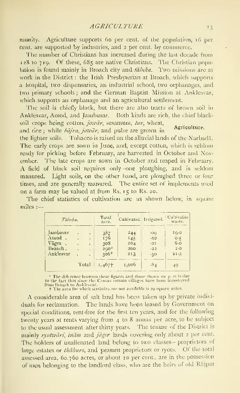
The chief statistics of cultivation are as shown below, in stjuare
miles :
—
Agriculture.
Taluka.

24 BROACH DISTRICT
families. A peasant proprietor is either a member of a cultivating com-
munity, or an independent holder with an individual interest in the
land he tills. Of the whole number of villages in the District, the lands
of 244, or 59-5 per cent., were in 1862 held by corporations of share-
holders, and the remaining 166 villages, or 40-5 per cent., by individual
cultivators. In 1903-4, 209 were held under the former conditions,
and 197 by individuals. Cotton -eiwd^ jowdr are extensively sown in the
District, occupying 365 and 180 square miles respectively. Wheat
(ri8) is also largely grown, especially in the Vagra and Jambusar
tdlukas. Next in importance come sesamum (31), rice (23), and
bdjra (16). Tobacco is one of the important crops in the Broach tii/uka,
and hitig {lathvriis sativus) is also largely grown (66 square miles).
Since 181 2 attempts have been made from time to time to improve
the cultivation and preparation of cotton. So far the result has been to
show that foreign varieties will not thrive in the District. In the matter
of ginning, considerable improvements have been made. By the intro-
duction of the Platt-Macarthy roller-gin in 1864, the old native hand-
gin {charkhd) has been entirely supplanted. During the decade ending
1903-4, 24 lakhs was advanced to the ryots under the Land Improve-
ment and Agriculturists' Loans Acts, of which 11 lakhs was lent in
1900-r and 8-6 lakhs in 1 899-1 900.
The domestic animals are cows, buffaloes, oxen, horses, asses, sheep,
and goats. The cattle are of two breeds : the small indigenous bullock,
and the large bullock of Northern Gujarat. The smaller breed of
bullocks, generally driven in riding carts, are worth from Rs, 80 to
Rs. 120 each. Prosperous cultivators pay much attention to the
appearance and condition of their cattle.
Only an infinitesimal portion of the District (533 acres in 1903-4)
is irrigated. The chief sources of supply are 39 Government ' minor
'
works, 1,153 wells, and 100 tanks. Nine drainage channels were
recently excavated by famine labour in the District at a cost of
Rs. 42,000.
There are no forests in the District; but a tract of about 10,000
acres in extent has recently been set apart for the rearing of babul
and other trees.
With the excej)tion of a conglomerate stone and limestone in
the Anklesvar td/uka, the plain of Broach is destitute of mineral
resources.
The English and the Dutch were tempted to establish factories at
Broach, owing to its reputation for the manufacture of fine silk and
cotton goods. Competition with the machine-made^^ *. *". article has so reduced the number of weavers of
communications.hand-made fabrics that, at the Census of 1901, the
weavers employed in the local mills were twice as numerous as the

TRADE AND COMMUNICATIONS 25
hand-workers. There are four cotton-spinning and weaving-mills at
Broach, with 62,000 si)indles and 859 looms, giving employment to
2,212 operatives, and producing annually 5,000,000 pounds of yarn
and 3,000,000 pounds f)f cloth. Some roughly finished hardware,
mainly knives and tools, is made at Amod.The trade guilds of Broach include the leading capitalists of the city,
the bankers and money-changers, cotton-dealers, agents, and those
engaged in the business of insurance ; other unions represent the
smaller trades, and are conducted on the panchdyat system commonin some parts of India. Details of the constitution and objects of
these associations are given in the article on Ahmadab.^d District,
where the system is more fully developed than in Broach. One of the
main sources of revenue of the chief guild of Broach city is a tax of
from 4 to 8 annas per bale of cotton. Except in the case of cotton
bills, there is also a charge of one anna on every bill of exchange
negotiated. The receipts from these taxes are applied to objects
of charity and religion. The chief institution maintained is the
hospital {pdiijrdpol) for old and sick animals, supjiorted at a yearly
cost of about Rs. 5,300. Tn addition to fees and fines levied upon
members for breaches of trade rules, some of the guilds adopt special
means for collecting funds. Money-changers, grain-dealers, grocers, and
tobacco merchants make the observance of their trade holidays— the
2nd, the nth, and the last day of each fortnight—a source of revenue
to the general body. On the occasion of these holidays, only one shop
is allowed to remain open in each market. The right to open this
shop is put up to auction, and the amount bid is kept for caste
purposes. Similarly, the bankers, cotton-dealers, insurers, and brick-
layers have, for trade purposes, imposed a tax on the members of their
craft or calling. In the case of other classes, the necessary sums are
collected by subscription among the members of the caste.
Formerly the Gujarat and Malwa trade passed through the ports of
Broach and Tankari ; but since the opening of the railway, trade to the
sea-coast has greatly diminished. Eighteen hundred years ago Broach
was one of the chief seats (jf trade between India and Western Asia.
Gold and silver, slaves, pearls, Italian and Persian wines, and dates
were largely imported ; and rice, ^hi, cotton, oil, and sugar were
exported, besides sandal-wood, ebony, and muslins. This trade con-
tinued until the seventeenth century, when it began to centre in Surat,
and subsequently moved to Bombay. Only a small coasting trade now
remains. Cotton, wheat, and piece-goods are the chief exports, while
yarn, metals, sugar, piece-goods, and timber are imported. In 1903-4
the port of Broach had an import trade of 18 lakhs and an export
trade of 13 lakhs, while Tankari on the Dhadhar river had a total
import and export trade combined of 5 lakhs.

26 BROACH DISTRICT
External communication is now effected by the Bombay, Baroda,
and Central India Railway, which passes through the Anklesvar and
Broach tdlukas, crossing the Narbada by a fine bridge of 25 spans. Abranch of the Rajpipla State Railway connects Anklesvar with Nan-
dod. The former traverses the District for 27 miles and the latter for
6i miles. Passengers from Kathiawar can also arrive by sea. TheDistrict possesses 37 miles of metalled roads and 138 miles of un-
metalled roads. About 28 miles of the former class are maintained
by the Public Works department. Avenues of trees are planted along
52 miles. The estuaries of the rivers Narbada and Dhadhar afford
shelter to coasting vessels during the stormy months of the monsoon.
There were in 1820 five seaports, of which only two. Broach and
Tankari, are still seats of trade.
The years 1630, 1631, and 1755 are said to have been seasons of
scarcity, in which, owing to the failure of crops, remissions of revenue
. were granted. In 1 760-1, 1773, and 1786-7 portions
of the District verged so closely upon famine that the
revenue had to be very largely remitted. The great famine of 1790
was caused by the entire failure of the monsoon. The year 1819 was
marked by excessive rainfall, and 1838, 1840, and 1868 by total or
partial failure of rain. In 18 12 the District suffered from the ravages
of locusts, and in 1835 from frost. Years of partial drought have also
been numerous. In 1878 the autumnal crops failed in two of the
western tdlukas, on account of excessive rainfall ; all the fields sown
after a certain period were attacked by swarms of grubs. Between 1899
and 1902 the District suffered from severe famine due to insufficient
rain. Relief works, opened in September, 1899, were continued till
October, 1902. The highest daily average on works was 106,215 in
February, 1900, and on gratuitous relief 72,473 in August, 1900. Themortality rose to 87 per 1,000. Nearly 30 lakhs of revenue was
remitted and over 22 lakhs' was advanced to cultivators.
For administrative purposes the District is divided into five tdlukas :
namely, Amod, Broach, Anklesvar, Jamp.usar, and Vagra, the petty
subdivision {petha) of Hansot being included in
Anklesvar. The administration in revenue matters
is entrusted to a Collector and two Assistants, of whom one is a
Covenanted Civilian.
For judicial purposes the District was formerly included within the
jurisdiction of the Judge of Surat. It now contains one District Judge
with full powers, and 4 Subordinate Judges. Criminal justice is
administered by 8 Magistrates. The District is not remarkable for
serious offences against property ; but among the Bohras and Bhils
outbursts of violence are not uncommon.' 'I'liis fi[;ure is for the wbulc fninine period from Sejit. i, lSgg,to (Jet. ;^i, 1902.

ADMINISTRATIOX 27
At the time of the introduction of British rule (1803), there was in
many villages an association of members of the pro])rietary b(jdy, by
which the amount of the state demand was distributed according to
a fixed pro])ortion among the members. The peculiarities of this joint
tenure (l'hdk:;ddri) have, to some extent, disaj)peared before the system
of collecting the revenue direct from the different shareholders.
At first the land revenue demand was fixed after an inspection of
the crops by revenue superintendents or desais. This system led to
numerous abuses. In r8ii the territory forming the original Broach
District—namely, the talukas of Broach, Anklesvar, and Hansot— was
surveyed. Later, the survey was extended to the remaining ialukas
received under the Treaty of Poona in 181 8. The first settlement in
simple Government villages was made with the village headmen, and
aimed at ascertaining the value of the crop in each holding. But in
1837 a new settlement was attempted, regulated by the character of the
soil and the range of local prices. The year 1848 saw the settlement
revised owing to the fall in prices, and in 1 870-1 a fresh settlement on
the lines adopted elsewhere in the Presidency was introduced. Under
this settlement the realizations were about 19-I lakhs. The revision
survey, completed since 1901, shows a decrease in cultivation of over
4,000 acres, and, in assessment, of 4 per cent. The average rates of
assessment are :* dry ' land, Rs. 4-0 (maximum Rs. 6-8, minimum
Rs. 3-0) ; rice land, Rs. 5-14 (maximum Rs. 5-4, minimum Rs. 3-0)
;
and garden land, Rs. 8-11 (maximum Rs. lo-o, minimum Rs. 7-0).
Collections of revenue, in thousands of rupees, have been as follows :
—

28 BROACH DISTRICT
There are 7 police stations. The District contains 6 subsidiary jails
and 12 lock-ups, with accommodation for 255 prisoners. The daily
average prison population in 1904 was 48, of whom 8 were females.
Broach stands first as regards literacy among the twenty-four Districts
of the Presidency, and 15-3 per cent, of the population (28-3 males and
1-8 females) could read and write in 1901. In 1 880-1 there were 218
schools attended by 12,724 pupils, who had increased to 17,276 in
1890-1, and numbered 16,888 in 1901. In 1903-4, 328 public and
private schools were attended by 17,424 pupils, including 2,967 girls.
Out of 299 public institutions, 252 are managed by local boards, 32 by
municipalities, one by Government, 9 are aided and 5 unaided. The
public schools include one high school, 5 middle and 293 primary
schools. The expenditure in 1903-4 was nearly i^ lakhs, of which
Rs. 16,000 was derived from fees, and 83 per cent, was devoted to
primary education.
Besides a hospital at Broach city the District contains 8 dispensaries,
with accommodation for 74 in-patients. Including 538 in-patients, 51,500
persons were treated in 1904, and 1,699 operations were performed.
The expenditure was Rs. 15,000, of which Rs. 9,000 was met from
Local and municipal funds.
The number of persons successfully vaccinated in 1903-4 was 7,186,
representing a proportion of 25 per 1,000, which is slightly below the
average for the Presidency.
[Sir J. M. Campbell, Bombay Gazetteer, vol. ii, Surat and Broach
(T877).]
Broach Taluka.— Central tdbika of Broach District, Bombay,
lying between ix' 38' and 21° 56' N. and 72° 45' and 73° 10' E., with
an area of 303 square miles. The population in 1901 was 110,189,
compared with 112,906 in 1891. The density, 364 persons per square
mile, is the highest in the District, and greatly exceeds the average. It
contains one town. Broach (population, 42,896), its head-quarters; and
105 villages. The land revenue and cesses amounted in 1903-4 to
nearly 6 lakhs. Almost the whole of the taluka is a flat rich plain
of black soil stretching towards the north bank of the Narbada, 43
miles of whose course lie within its limits. The remainder consists
of a few islands in the bed of the river, and a narrow strip of land
on the southern bank, nearly opposite the city of Broach. The supply
of tank and well water is defective.
Broach City {Bhan/kac/i/m, ox B/iari/ch).— Head-cjuarters of the Dis-
trict of ilie same name in Gujarat, Bombay, situated in 21° 42' N. and
72'^ 59' Iv, on the right bank of the Narbada river, about 30 miles
from its mouth, and on the Bombay, Baroda, and Central India
Railway. The area, including suburbs, is 2^ square miles. In 1777
the city is said to have contained 50,000 inhabitants; in 1812, 37,716.

BROACH CITY ic)
The Census of 1872 returned Z''^i^)'h- • thai of 1881, 37,281 ; that of
1891, 40,168; and that of 1901, 42,896, c(imjirising 26,852 Hindus,
12,022 Muhanimadans, and 2,153 Parsis. The only classes caHing for
special notice are, among Hindus, the Bhargav Brahmans, who claim
to be descendants of the sage Bhrigu. The Parsis, from the number
and antiquity of their ' towers of silence,' are supposed to have settled
at Broach as far back as the eleventh century. Formerly ship-builders
and skilled weavers, they have suffered from the decay of both trades.
Many of them migrated to Bombay to improve their circumstances;
and the frugality of those that are left enables them to keep out of
pauperism. The Musalmans are for the niost i)ari in a condition
of povert)-.
Seen from the southern bank of the Narbada, or approached by the
railway bridge from the south, the massive stone wall, rising from
the water's edge and lining the river bank for about a mile, and the
buildings standing out from the high ground behind, give the cit)-
a marked and picturesque appearance. The fortifications, though
by local tradition ascribed to Siddha Raja Jayasingha of Anhilvada
(twelfth century), were, according to the author of the Mirdt-i-
Sikandari, built in 1526 under the orders of Sultan Bahadur, king of
Ahmadabad. In the middle of the seventeenth century (1660) the
walls are said to have been destroyed by the emperor Aurangzeb, and
about twenty-five }ears later to have been rebuilt by the same monarch
as a protection against the attacks of the Marathas. Of late jears
the fortifications on the land side have been allowed to fall into
disrepair, and in some places almost ever)- trace of them has dis-
appeared. On the southern side, where protection is required against
the floods of the river, the city wall is kept in good order. Built of
large blocks of stone, the river face of the wall, raised from 30 to
40 feet high, stretches along the bank for about a mile. It is provided
with (wo. gates, and the top forms a broad pathway. The circuit of the
wall includes an area of three-eighths of a square mile, which in the
centre rises to a height of from 60 to 80 feet above the surrounding
country. This mound, from the broken bricks and other debris dug
out of it, shows signs of being, in part at least, of artificial construction.
At the same time the presence of one or two small hillocks to the north
of the city favours the opinion that it may have been the rising ground
on the river bank wliich led the early settlers to choose Broach as the
site for a city. Within the walls the streets are narrow, and in some
places steep. The houses are generally two storeys high, with walls
of brick and tiled roofs. In the eastern part of the city are some large
family mansions, said to have been built in i 790. In the suburbs the
houses have a meaner appearance, many of them being not more than
one storey high, with walls of wattle and daub.

30 BROACH CITY
^Vith the exception of a stone mosque constructed out of an older
Hindu temple, the city contains no buildings of interest. To the west
are the groves of the well-wooded suburbs of Vejalpur, and northwards
two lofty mounds with Muhammadan tombs relieve the line of the level
plain, while on the north-east rows of tamarind-trees mark where a
hundred years ago was the Nawab's garden with 'summer pavilions,
fountains, and canals.' To the east are the spots that, to a Hindu,
give Broach a special interest, the site of king Bali's sacrifice and the
temple of Bhrigu Rishi. About 200 yards from the bastion, at the
north-west corner of the fort, is the tomb of Brigadier David Wedder-
burn, who was killed at the siege of Broach on November 14, 1772.
Two miles west of the fort are a few large and massive tombs, raised
to members of the Dutch factory. Beyond the Dutch tombs are the
five ParsI ' towers of silence ' : four being old and disused, and the fifth
built lately by a rich merchant of Bombay.
I'he city of Broach was, according to local legend, originally founded
by the sage Bhrigu, and called Bhrigupur or Bhrigu's city. In the first
century of the Christian era the sage's settlement had given its name
Barugaza to a large province, and had itself become one of the chief
ports in Western India. In the early part of the seventh century,
according to the Chinese pilgrim Hiuen Tsiang, it contained ten
Buddhist convents, with 300 monks and 10 temples. Half a century
later Broach was a place of sufficient importance to attract some of the
earliest Musalman expeditions against Western India. Under the
Rajput dynasties of Anhilvada (a.d. 750-1300) Broach was a flourish-
ing seaport. During the troubles that followed the overthrow of the
.Vnhilvada kings, the city would seem to have changed hands on more
than one occasion. But with the exception of two years (1534-6),
during which it was held by the officers of the emperor Humayiin,
Broach remained (1391 to 1572) under the Musalman dynasty of
Ahmadabad. About this time the city was twice (1536 and 1546)
plundered by the Portuguese, who, except for its streets ' so narrow
most of them that two horsemen could not pass at the same time,'
admired the city * with its magnificent and lofty houses, with their
costly lattices, the famous ivory and black-wood workshops, and its
townsmen well skilled in mechanics -chiefly weavers, who make the
finest cloth in the world' {Decadas de Coiito, v. 325). In 1573 Broach
was surrendered to Akbar by Muzaffar Shah III, the last of the line of
Ahmadabad kings. Ten years later Muzaffar Shah recovered the city,
but held it only for a few months, when it again fell into the hands
of tlie emperor of Delhi. In r6i6 a British factory, and about 1620
a Dutch factory, were established at Broach. In 1660 some of the
fortifications of the city were razed to the ground by the order of
Aurangzcb. In this defenceless state it was twice, in 1675 and 1686,

BROACH CITY 31
plundered by the Marathas. After the second attack Aurangzeb
ordered that the walls should be rebuilt and the city named Sukhabad.
In 1736 the Musalman commandant of the port was raised by Nizam-
ul-niulk to the rank of Nawab. In April, i 771, an attempt on the part of
the English to take Broach failed; but in November, 1772, a second
force was sent against the city, and this time it was stormed and
captured. In 1783 it was handed over to Sindhia, but was retaken
in 1803 by the British, and since that time it has remained in their
possession.
Broach has a high school with an attendance of 212, a middle school
with 186 pupils, and 19 vernacular schools, 11 for boys with 1,636
pupils and 8 for girls with 761. The municipality, established in 1852,
had an average income of a lakh during the decade ending 1901. In
1903-4 the income was Rs. 91,000, chiefly derived from octroi
(Rs. 50,000). Besides the ordinary Government revenue offices, the
city contains a Sub-Judge's court, a civil hospital, a library, and a
railway dispensary.
The city has been surveyed, with a view to protect the rights of both
the Government and the public. The drinking-water used by the
inhabitants of the intramural quarters comes in part from the Narbada.
There are also many good wells in the city ; and, unlike Surat and
Ahmadabad, the custom of having cisterns in dwelling-houses for the
storage of rain-water is not general.
Broach is one of the oldest seaports in Western India. Eighteen
hundred years ago it was a chief seat of the trade then carried on
between India and the ports of Western Asia. In more recent times,
though the trade of Gujarat has never again centred in the harbours
of this District, Broach so far maintained its position that in the seven-
teenth century it sent ships eastward to Java and Sumatra, and west-
ward to Aden and the Red Sea. Later on the foreign trade of Gujarat
collected in Surat, until from Surat it was transferred to Bombay.
The cotton formerly exported from Broach to China and Bengal was
sent through Surat and Bombay ; and as far back as 181 5 the Broach
ports ceased to have any foreign commerce. They now possess only
a coasting trade south to Bombay and the intermediate ports, and
north as far as Mandvi in Cutch. The total value of the sea-borne
trade of Broach in 1903-4 was 31 lakhs, of which 18 lakhs repre.sented
imports and 13 lakhs exports. The chief articles of trade with the
south are, exports—flowers of the mahua tree, wheat, and cotton ;
imports—molasses, rice, betel-nuts, timber, coal, iron, and coco-nuts.
To the west and north the exports are grain, cotton seed, mahua
flowers, tiles, and firewood : the imports, chiefly stone for building.
In ancient times cloth is mentioned as one of the chief articles of
export from Broach ; and in the seventcenlh century, when the English

32 BROACH CITY
and Dutch first settled in Gujarat, it was the fame of its cloth manu-
factures that led them to establish factories at Broach. The kinds
of cloth for which Broach was specially known at that time would seem
to have been bafias, broad and narrow dimities, and other fine calicoes.
The gain to the European trader of having a factory at Broach was that
he might ' oversee the weavers, buying up the cotton yarn to employ
them all the rains, when he sets on foot his investments, that they may
be ready against the season for the ships.' About the middle of the
seventeenth century the District is said to have produced more manu-
factures, and those of the finest fabrics, than the same extent of country
in any other part of the world, not excepting Bengal. In consequence
of the increasing competition of the produce of steam factories in
Bombay, Ahmadabad, and Broach itself, hand-loom weaving in Broach
has greatly declined. There are four cotton-spinning and weaving-
mills, with a nominal capital (in 1904) of 14 lakhs, and containing
859 looms and 62,000 spindles. The out-turn of yarn and cloth is
5-4 and 3-1 million pounds, and 2,212 persons are employed.
Bubak.—Town in the Sehwan tCxluka of Larkana District, Sind,
Bombay, situated in 26° 27' N. and 67° 46' E., 3 miles from a station
on the North-Western Railway. Population (1901), 3,300. The town
was constituted a municipality in 1854 and had an average income of
Rs. 5,000 during the decade ending 1901. In 1903-4 the income was
Rs. 6,000. Carpets of good quality are manufactured. The town
contains a central warehouse for bhang, which is grown under licence in
the neighbourhood. Owing to floods caused by the overflow of the
Manchhar Lake, some of the zamlnddrs have been of late years con-
siderably impoverished. The public health is also affected by the
same cause. In 1869 Bubak suffered severely from cholera. Thetown contains an English school and one vernacular school, attended
respectively by 15 and 72 pupils.
Buckingham Canal.—A salt-water navigation canal, tidal to a great
extent wherever the river bars are open, which extends for 262 miles
along the east coast of the Madras Presidency from Pedda Ganjam
(15° 39' N. and 80° 15' E.) in Guntur District, southwards through
Madras City and on to Merkanam (12° 12' N. and 79° 57' E.) in South
Arcot. At Pedda Cianjam it communicates with the fresh-water high-
level canals of the delta system of the Kistna river, and so with the
Godavari delta canals, and thus opens up water communication with
the port of Cocanada, making a total length of 462 miles of main
navigable canal. The Buckingham Canal runs within three miles of the
coast throughout its entire length, and many portions of it are within
half a mile of the sea. It utilizes some portic^n of the i'ulicat Lake.
The excavation of the section from Madras City to this lake was
begun as long ago as 1806 as a private enterpri.se, and was known, after
BUDAUN DISTRICT 33
Its originator, as Cochrane's Canal. In 1S37 this was taken over byGovernment, Init up to 1876 only 5! lakhs had been spent in extending
it. It was at this time called the East Coast Canal. In the great
famine of 1876-8 it was resolved to take up the completion of the
undertaking as a relief work, and an expenditure of over 29 lakhs was
incurred. It was renamed the Buckingham Canal after the Duke of
Buckingham and Chandos, then Governor of Madras. Up to date the
total capital cost has amounted to 90 lakhs. The chief difficulty in
maintaining it in order was that, as it crossed the whole drainage of the
country, it was extremely liable to be silted up. Between 1883 and
1891 large expenditure was incurred in remedying this tendency. In
ordinary years the traffic upon it, though it amounts to i2-| millions
of tons, is insufficient to meet the working expenses, and a deficit
of about Rs. 20,000 occurs. The railway along the coast, which has
been opened since the canal was constructed, has robbed it of the long-
distance traffic which it was originally designed to carry. The chief
traffic along it at present is salt from the various coast factories and
firewood from SrIharikota to Madras City, but in bad seasons it is
of value in connecting the two fertile deltas with the poorer country
farther south. Cargo boats and boats belonging to Government and
private individuals ply along it. Wharves have been constructed at
intervals for their use, and there are also a series of travellers' bunga-
lows upon the banks.
Budalin.—North-eastern township of the Lower Chindwin District,
Upper Burma, lying on the east of the Chindwin river, between 22° 14'
and 22° 37' N. and 94° 56' and 95° 35" E., with an area of 451 square
miles. The population was 50,847 in 1891, and 55,447 in 1901,
distributed in 196 villages. Budalin (po[)ulation, 2,577), an inland
village, 20 miles due north of Monywa, is the head-quarters. Thetownship lies on an elevated plain, and is not well watered ; but rice,
JoiVilr, sesamum, and peas are grown. The area cultivated in
1903-4 was 182 square miles, and the land revenue and thathameda
amounted to Rs. 1,20,800.
Budaun District {Baddyuii).—South-western District of the
Bareilly Division, United Provinces, lying between 27*^ 40' and28° 29' N. and 78° 16' and 79° 31' E., with an area of 1,987 square
miles. It is bounded on the north by Moradabad ; on the north-east
by the State of Rampur and Bareilly District ; on the south-east by
Shahjahanpur ; and on the south-west by the Ganges, which divides it
from the Districts of Bulandshahr, Aligarh, Etah,
and Farrukhabad. The greater part consists of aaspects
level plain crossed by numerous rivers, and muchof it requires little irrigation when the rainfall is normal. A high ridge
of sand, rarely more than 4 or 5 miles broad, running through the
VOL. IX. D

34 BUDA UN DISTRICT
District from north-west to south-east, once formed the old high bank
of the Ganges. Between this and the present course of the river is
a low tract of country, traversed by a chain of swamps oxjhils, and by
the river Mahawa. The fertile plain north-east of the sandy ridge is
watered by the Sot or Yar-i-Wafadar, a river which enters the Bisaull
tahsil from Moradabad and flows diagonally across the District, piercing
the sandy tract. Although the Mahawa flows in a deep channel, it is
liable to sudden floods, which do much damage, and it receives spill-
water from the Ganges. The Sot is fringed by ravines and seldom
inundates its banks. In the north-east the Ramganga forms the
boundary for about 36 miles, and is joined by the Aril.
The District consists entirely of Gangetic alluvium, varying from pure
sand to stiff clay. Kankar or calcareous limestone is found in places.
Budaun is well wooded, and the whole of the rich upland tract
is studded with beautiful mango groves. In the north of the Ganges
khddar there is thick dhdk jungle {Butea frotidosd) ; and the north-east
corner still contains part of the celebrated dhdk jungle which formerly
sheltered the Katehriya Rajputs in their frequent contests with the
Musalman rulers of Delhi. On the sandy ridge vegetation is scanty,
and thatching grass and kdns {Saccharum spontaneum) spring up where
cultivation is neglected.
A tiger was killed in 1893 near the Ganges, but this is an extremely
rare event. Antelope, wild hog, and nilgai are common, and wolves
cause more damage to human life than in any other District of the
United Provinces. Black partridge, quail, water-fowl, and sand-grouse
abound, and florican are occasionally met wath.
The climate of Budaun resembles that of other Districts in Rohil-
khand, being somewhat cooler and moister than in the adjacent portions
of the Doab, owing to the neighbourhood of the hills. The average
monthly temperature varies from 53° to 60*^ in January to 88° and 93°
in May and June.
The annual rainfall over the whole District averages 34 inches,
varying from more than 36 in the east to 3 1 in the west. Fluctuations
in the amount are large; in 1883 only 17 inches fell, and in 1874 as
much as 56 inches.
Budaun owes its name, according to tradition, to one Buddh, an
Ahar prince, who founded the city at the beginning of the tenth
century. \Vhen the forces of Islam were beginning
to spread eastwards into India, it was held, as recorded
in an ins(ri[)li()n found at Jiudaun, by the Rathor, I.akhana I'ala,
eleventh in descent from (Chandra, the founder of the dynasty'. 'Ihe
half-legendary hero, Saiyid Salar, is said to have stayed for a time in
Budaun ; hut authentic history commences with the victory of Kutb-ud-
' I'-p>i^mphia Indica, vul. i, \i. 6_'',.

HISrORY35
din Aibak in 1 196, who slew the Raja and sacked the city, Shams-iid <h'n
Altainsh obtained the government of the new dependency, wliieh lie
exchanged in 12 10 for tlie throne of Delhi. Under his successors,
Budaun ranked as a place of great importance ; and in 1 236 it gave
a second emperor to Delhi in the person of Rukn-ud-dln, whose hand-
some mosque, the Jama Masjid Shamsi, still adorns the city of which
he had been governor. During the thirteenth and fourteenth centuries
the annals of ikidaun are confined to the usual local insurrections andbloody repressions which form the staple of Indian history before the
advent of the IMughals. In 1415 Mahabat Khan, the governor, rose in
rebellion, and the emperor, Khizr Khan, marched against him in vain.
After a rule of eleven years' duration, the rebellious vassal was com-
pelled in 1426 to surrender to Mubarak Shah, Khizr Khan's successor.
Alam Shah, the last of the Saiyids, retired to the city in 1450; and
during his stay his WazTr joined with Pjahlcjl Lodi in depriving him of all
his dominions, except Budaun, which he was permitted to retain until
his death in 1479. His son-in-law, Husain Shah of Jaunpur, then took
possession of the District ; but liahlol LodT soon compelled the intruder
to restore it to the Delhi empire. After the establishment of the
Mughal power, Humayun appointed governors of Sambhal and Budaun;
but they disagreed, and the Sambhal governor, having taken Budaun by
siege, put his rival to death. Under the administrative organization of
Akbar, Budaun was formed in 1556 into a sarkdr of the.S'/7^a/^ of Delhi,
which was granted as a fief to Kasim All Khan. In Shah Jahan's time
the seat of government was removed to Bareilly. The rise of the
Rohilla power, which centred in the latter town, accelerated the decline
of Budaun. In 17 19, during the reign of Muhammad Shah, Muham-mad Khan Bangash annexed the south-eastern portion of the District,
including the city, to Farrukhatwd, while the Rohillas, under All
Muhammad, subsequently seized ujjon the remainder. In 1 754, however,
the Rohillas recovered \\\q. par^anas \s\\\^\\ had been united to Farrukh-
abad. Budaun fell, with the rest of Rohilkhand, into the power of the
Nawab of Oudh in 1774, and was ceded to the British with other
territory in 1801. Shortly afterwards a revolt took place, which was
speedily repressed, and the Mutiny of 1857 alone disturbs the peaceful
course of civil administration.
News of the outbreak at Meerut reached Budaun on May 15. Afortnight later the treasury guard mutinied, plundered the treasury, and
broke open the jail. The civil officers then found themselves com-
pelled to leave for Futehgarh. On June 2 the Bareilly mutineers
marched in, and on the lylh Abdur Rahim Khan assumed the govern-
ment. As usual, disturbances broke out between the Hindus and the
Musalman leaders ; and in July and August the Muhammadans fought
two regular battles with the Rajputs, whom they completely defeated.
36 BUDAUN DISTRICT
At the end of August several European fugitives crossed the Ganges
into the District, and were protected at Dataganj by the landholders.
After the fall of Walidad Khan's fort at Malagarh in Bulandshahr, that
rebel chieftain passed into Budaun in October, but found it advisable to
proceed to Fatehgarh. On November 5 the Musalmans defeated the
Ahars at Gunnaur, and took possession of that tahsl/, hitherto held by
the police. Towards the close of January, 1858, the rebels, under
Niyaz Muhammad, marched against Fatehgarh, but were met by Sir
Hope Grant's force at Shamsabad and dispersed. Niyaz Muhammadthen returned to Budaun. On April 27 General Penny's force defeated
the rebels at Kakrala, though the general himself was killed in the
action ; while Major Gordon fell upon them in the north, near Bisaull.
Their leaders fled to Bareilly, and managers were at once appointed
to the various parganas on behalf of the British Government. By
May 1 2 Budaun came once more into our hands, though Tantia Topi,
with his fugitive army, afterwards crossed this portion of Rohilkhand
into Oudh on the 27th. Brigadier Coke's column entered the District
on June 3, and Colonel Wilkinson's column from Bareilly on the 8th.
Order was then permanently restored.
The principal archaeological remains are at Budaun Town, where a
series of tombs, mosques, and other religious buildings remain to
mark the former importance of the place.
The District contains 11 towns and 1,087 villages. Owing to un-
favourable seasons the population fell considerably between 1872 and
1 88 1, but has risen since. The numbers at the last
four enumerations were as follows : (1872) 934,670,
(1881) 906,541, (189T) 925,982, and (1901) 1,025,753. There are
five tahsils—Gunnaur, Bisauli, Sahasw.\n, Budaun, and Dataganj—the head-quarters of each being at a place of the same name. The
principal towns are the municipalities of Budaun, Sah.\swan, Ujhani,
and the 'notified area' of Bilsi. The following table gives the chief
statistics of population in 1901 :
—
TahsU.
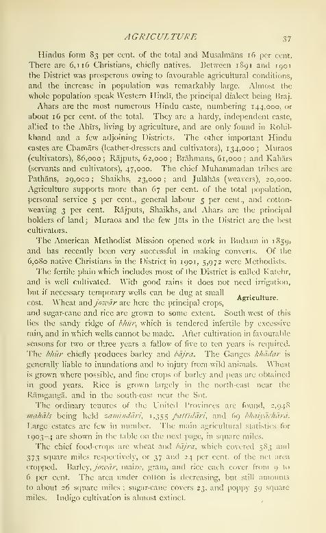
AGRICULTURE 37
Hindus form 83 per cent, of the total and Musalmans 16 per cent.
There are 6,116 Christians, chiefly natives. Between 1891 and 1901
the District was prosperous owing to favourable agricultural conditions,
and the increase in population was remarkably large. Almost the
whole population speak Western Hindi, the principal dialect being Ikaj.
Ahars are the most numerous Hindu caste, numbering 144,000, or
about 16 per cent, of the total. They are a hardy, independent caste,
allied to the Ahlrs, living by agriculture, and are only found in Rohil-
khand and a few adjoining Districts. The other important Hindu
castes are Chamars (leather-dressers and cultivators), 134,000; Muraos
(cultivators), 86,000; Rajputs, 62,000; Brahmans, 61,000; and Kahars
(servants and cultivators), 47,000. The chief Muhammadan tribes are
Pathans, 29,000 ; Shaikhs, 23,000 ; and Julahas (weavers), 20,000.
Agriculture supports more than 67 per cent, of the total population,
personal service 5 per cent., general labour 5 per cent., and cotton-
weaving 3 per cent. Rajputs, Shaikhs, and Ahars are the principal
holders of land ; Muraos and the few Jats in the District are the best
cultivators.
The American Methodist Mission opened work in Budaun in 1S59,
and has recently been very successful in making converts. Of the
6,080 native Christians in the District in 1901, 5,972 were Methodists.
The fertile plain which includes most of the District is called Katehr,
and is well cultivated. With good rains it does not need irrigation,
but if necessary temporary wells can be dug at small . . .
. _ . . Agriculture,cost. Wheat and yV?7<.''(/r are here the principal crops,
and sugar-cane and rice are grown to some extent. South-west of this
lies the sandy ridge of bhut% which is rendered infertile by excessive
rain, and in which wells cannot be made. After cultivation in favourable
seasons for two or three years a fallow of five to ten years is required.
']'he bhur chiefly produces barley and bajra. The Ganges khiidar is
generally liable to inundations and to injury from wild animals. A\'heat
is grown where possible, and fine crops of barley and peas are obtained
in good years. Rice is grown largely in the north-east near the
R.imganga, and in the south-east near the Sot.
'I'he ordinary tenures of the United Provinces arc found, 2,948
mahdls being held za/iuiidari, 1,355 pt^ti'ni^t'it and 69 bhaiydchCira.
Large estates are few in number. The main agricultural statistics for
1903-4 are shown in the fable on the next page, in square miles.
The chief food-crops are wheat and bajra, which covered 5 S3 and
373 square miles respectively, or 37 and 24 per cent, of the net area
cropped. V>vcc\Q.^,jowdr, maize, gram, antl rice each cover from 9 to
6 per cent. The area under cotton is decreasing, but still amounts
to about 26 square miles ; sugar-cane covers 23, and poppy 59 square
miles. Indigo cultivation is almost extinct.
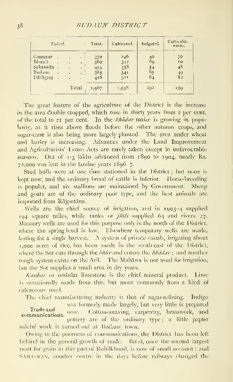
38 BUDAUN DISTRICT
Tahsil.
ADMJXISTRATION 39
direction of commerce, has no trade at all. Agricultural j^roduce,
chiefly grain and sugar, is exported with ditificulty. The imports include
clotli, salt, and metals. A large fair is held annually at Kakora, which
is attended by 150,000 people.
The branch of the Oudh and Rohilkhand Railway from Bareilly andAligarh cuts through two jxjrtions of the north of the District. Anarrow-gauge line from Bareilly through Jkidaun, opened in 1906,
crosses the Ganges and joins the Cawnpore-Achhnera Railway at Soron
in Ktah District.
A good deal has been done in recent years to improve the roads
in the District, which contains 120 miles of metalled and 445 miles
of unmetalled roads. The former are maintained by the Public Worksdepartment, but the cost of all but 2)7^ miles is met from Local funds.
There are avenues of trees on 1 26 miles. The chief roads are that
leading from Bareilly to Hathras and Muttra, which passes through
Budaun town, and a road from Budaun to Aonla railway station,
l^'eeder roads to other stations have been made, but communications
in the south and east of the District are still backward.
A native historian records a famine in 1761, during which large
numbers of people died and many emigrated. In 1803-4, soon after
the commencement of British rule, the harvest failed
and many farmers absconded. In the great famine
of 1837-8 Budaun suffered the extreme of misery: thousands died
of starvation, grain rose to unattainable prices, and the police found
themselves powerless to preserve order. The scarcity of i860 i was
less serious ; but relief works were opened and remissions made, and
similar measures were re([uired in 1868 9. In 1877 a deficiency in
the rainfall caused some distress, but timely rain in October gave relief.
The famine of 1896-7 did not affect Budaun appreciably.
The Collector is usually assisted by a member of the Indian Civil
Service (when available), and by four Deputy-(\)llectors ..., . , ,. ,,,-,,-• • , , Administration.
recruited ni India. A fa/ist/dar is stationed at the
head-tiuarters of each /a//sl/, and an officer of the Opium department
at Ikidaun town.
There are four regular Munsifs, and the District is included in the
Civil Judgeship of Shahjahanpur and in the Sessions Judgeship of
Moradabad. Sessions cases are tried by the Additional Judge of the
latter District. lUulaun holds a bad reputation for violent crimes and
for dacoitv. Femali' infanticide was formerly strongly suspected, and
entailed the maintenance oi a special poliic ; but in 1904 only 1.141
names remained on the register of persons proclaimed under the Act.
The area now forming Budaun was, at the cession in iSoi, included
in Moradabad. \'arious changes were made, and in 1823 a District
of Sahaswan was formed, which also c(>mi)viscd part> (.)l the present

40 BUDA UN DISTRICT
Districts of Etah and Aligarh. By 1845 the District had assumed its
present shape. The early settlements were for short periods, and were
based on the previous demand or on a system of competition. Rights
in land were verj' lightly prized and were freely transferred. Operations
under the improved system, laid down by Regulation VII of 1822,
commenced with estates which were being directly managed by the
Collector owing to the resignation of proprietors or the failure to find
purchasers at sales. The first regular settlement under Regulation IX
of 1833 was made between 1834 and 1838. It was preceded by a
survey, and rights were completely recorded. The land was valued as
the basis of the assessment and a demand of 9 lakhs was fixed. The
next revision took place between 1864 and 1870, on the usual lines.
Soils were classified and the rent paid for each class of land carefully
ascertained. A rate, usually in excess of this, was assumed as the
basis of assessment, and applied village by village, with modifications
where necessary. The revenue was raised from 9-3 to 10-3 lakhs, and
the new assessment was subsequently found to have been very light.
The latest revision was carried out between 1893 and 1898. In this
the assessment was made on the recorded rentals, which were found
to be, on the whole, reliable. Land was again classified into circles
according to the quality of its soil, and rates for each class were
ascertained by analysis of the rents actually paid for different kinds
of holdings. These rates were used in checking and correcting the
recorded rent-rolls. In assessing, the revenue was fixed at less than
half the accepted 'assets' in cases where there was reason to believe
that these could not be collected over a series of years. The new
revenue is 13-2 lakhs, representing 46-3 per cent, of the 'assets.' Theincidence is a little more than R. i an acre, varying from t t annas
to about Rs. 1-6.
Receipts from land revenue and from all sources have been, in
thousands of rupees :
—
BUDAUN TOWN 41
rural and road police. The District jail contained a daily average
of 317 prisoners in 1903.
Budaun is the most backward District in the United Provinces as
regards the literacy of its population, of whom only i-6 (2-8 males and
0-2 females) could read and write in 1901. The number of public
institutions rose from 160 with 4,686 pupils in 1880-1, to 171 with
7,002 pupils in 1900-1, In 1903-4 there were 168 public schools
with 7,909 pupils, of whom 802 were girls, and also 211 private schools
with 2,199 pupils. Two cf the public schools were managed by
Government, and 165 by the District and municipal boards. Thetotal ex])enditure on education was Rs. 43,000, of which Rs. 35,000
was provided by Local funds and Rs. 8,000 from fees.
There are 10 hospitals and dispensaries, with accommodation for
113 in-patients. In 1903 the number of cases treated was 108,000,
of whom 1,500 were in-patients, and 3,500 operations were performed.
The expenditure was Rs. 19,000, chiefly met from Local funds.
About 34,000 persons were successfully vaccinated in 1903-4, rq^re-
senting a proportion of 33 per 1,000 of population. Vaccination is
compulsory only in the municipalities.
[Disfn'it Gazetteer (1879, under revision) ; J. S. Meston, Seti/emetit
Report (1901).]
Budaun Tahsil.— Head-quarters /a/wV of Budaun District, United
Provinces, comprising the par^aims of Budaun and UjhanT, and lying
between 27° 50' and 28° 12' N. and 78° 48' and 79° 19' E., with an
area of 385 square miles. Population increased from 226,673 in 1891
to 243,141 in rgoi. There are 377 villages and two towns: Bud.\un
(population, 39,031), the District and /a//jJ/ head-quarters, and Ujhani
(7,917). The demand for land revenue in 1903-4 was Rs. 2,78,000,
and for cesses Rs. 39,000. The density of population, 632 persons per
square mile, is the highest in the District. A large portion of the taJisil
is situated in the fertile Katehr tract, and is watered by the Sot. In the
north-cast this slopes to the valley of the Aril, and still contains portions
of the famous forest which once surrounded Aonla in Bareilly District.
South-west of the Katehr lies a high ridge of sandy land, 3 or 4 miles
wide, from which a stretch of precarious alluvial khddar reaches to the
Ganges on the south-west border. In 1903-4 the area under cultiva-
tion was 341 square miles, of which 65 were irrigated. Wells supply
two-thirds of the irrigated area.
Budaun Town {BadiiyF/n).— Headquarters of the District and ta/is'i/
f)f the same name, United Provinces, situated in 28*^ 2'N. and 79*^ 7'K.,
on a branch of the Rohilkhand and Kumaun Railway from Bareilly to
Soron, and on the road from Bareilly to Muttra. Population (1901),
39)03i. of whom 2 1,995 were Musalmiins and 16,033 Hindus. Accord-
ing to tradition, the town was founded by a mythical Raja l?uddh. an

42 BUDAUN TOWN
Ahar by caste, about a. d. 905, or by a descendant of his namedAjayapala. An inscription, dating probably from the early part of the
twelfth century, records the founding of a temple and mentions a list of
eleven Rathor kings reigning at Budaun, which is called Vodamayuta'.
Legend relates that the town was taken by Saiyid Salar in 1028 ; but
the first historical event is its capture by Kutb-ud-dm in 11 96, when the
last Hindu king was slain. Budaun then became an important post on
the northern boundary of the Delhi empire, and its governors were
chosen from distinguished soldiers who had constantly to face revolts
by the turbulent Katehriya Rajputs. Two of its governors in the
thirteenth century, Shams-ud-din Altamsh and his son Rukn-ud-din
Firoz, passed from Budaun to the throne at Delhi. In the fifteenth
century Alahabat Khan, the governor, imitated tlie example of the
Jaunpur ruler and became independent for a time. About 1450 Ala-
ud-din, the last of the Saiyid kings of Delhi, after abdicating the throne,
retired to Budaun, where he lived for twenty-eight years. In 157 1 the
town was destroyed by fire ; and in the reign of Shah Jahan, nearly
a century later, the governor of the sarkdr was transferred to Bareilly,
and the importance of Budaun declined. For a time it was included
in the State formed early in the eighteenth century by the Nawab of
Farrukhabad ; but it then passed to the Rohillas. In 1838 it became
the head-quarters of a British District. On the outbreak of the Mutiny
in May, 1857, the treasury guard at Budaun rose, and being joined by
the townspeople broke open the jail, and burned the civil station. Anative government was then established and remained in power till
General Penny's victory at Kakrala in the following .\pril, when the
rebel governor fled the city, and order was again re-established.
Budaun stands about a mile east of the river Sot, and consists of two
parts, the old and new town. In the former are the remains of the old
fort, with massive ramparts once so wide that four carriages could be
driven abreast. The Jama Masjid, built in 1223 by Shams-ud-din
Altamsh, largely from the materials of the temple referred to above, is
an immense building 276 feet long by 216 broad, with a central domerestored in Akbar's time. It stands high and is an imposing feature in
the landscape for many miles. Numerous smaller mosques and dar-
gdhs remain as memorials of the palmy days of Pathan and Mughal
rule^ In the neighbourhood are graveyards filled with mouldering
tombs, chief among which may be mentioned that of Sultan Ala-ud-din
and his wife. Budaun is also famous as having been the birthplace of
the historian Badayunl, the rival of Abul Fa/.l. The chief modern
public buildings are the 1 )istrict courts, the jail, a commodious dis-
pensary, two large sarais, and a small le[)er asylum ; and a park is nowbeing laid (JUt. IJudaun is a centre for the work of the American
' lipii^raphia /itiiua, miI. i, |). (y_).-' Journal, .lsia/i\ Sihic/y of JUir^ul. \o\. \li.

BUDnil GAYA 43
Methodist Mission in the District. 'Ihe municipality was constituted
in 1884. During the ten years ending 1 900-1 the income averaged
Rs. 35,500 and the expenditure Rs. 34,500. In 1903-4 tlie income
was Rs. 57,000, including Rs. 32,000 from octroi and Rs. 15,000 from
rents ; and the expenditure was Rs. 56,000. 'I'he municipality has
Rs. 10,000 invested. Jkidaun is not now a great trade centre; but its
former proximity to the railway, as compared with Bilsl, has given it
some advantages which may increase now that a line actually passes
through it. The grain market, called Carmichaelganj after a former
Collector, belongs to the municipality. Papier mache j)en-bo\es
made here have .some reputation. The District school has 160 pupils,
a mission school 120, and the /a/isl/i school 270. The municipality
manages 10 schools and aids i() others, attended by nujre than 1,000
pupils.
Buddh Gaya {BoJ/i Gayii).—Milage in the head-quarters sul)-
division of (laya District, Bengal, situated in 24° 42' N. and 85° o' E.,
about 7 miles south of Gaya town, on the west bank of the Phalgu or
Lilajan river. Population (1901), 502. The name signifies either the
Gaya of Buddha or the Gaya of the bod/ii ('enlightenment'). The
place is sometimes, hf)wever, called Muhabodhi, or 'the great enlighten-
ment,' a name which is also given to the bodhi-druma or sacred plpal-
tree at Buddh Gaya.
It was under this tree that Sakyamuni, after many years of search
after truth, conquered Mara and attained to Buddhahood, i.e. became
freed from the circle of rebirths ; and worship consefjuently centred
around the bodhi-ixee from the earliest period of Buddhism. King
A.soka (third century n:c.)is said to have erected a temple near this
holy tree, and one of the bas-reliefs of the Bharhut stilj>n (second
century B. c.) gives a representation of the tree and its surroundings as
they then were. It shows a. ptpal-ixee, with a rvv// or stone platform in
front, adorned with umbrellas and garlanils, and surrounded by some
building with arched windows resting on pillars ; while close to it stood
a single pillar with a Per.sepolitan capital crowned with the figure of an
elephant. When the stone pavement of the present temple was dug up
during its restoration, foundations of an older building were discovered
beneath it, which, in the opinion of General Cunningham, represent the
remains of the original temple built by Asoka. The ancient stone
railing which now surrounds the temple certainly belongs for the greater
part to about the same time as Asoka's reign ; and this railing and the
bases of some columns which mark the place where lUidtlha used to
take exercise form the only remains now extant of so early a period.
The railing is adorned with various sculj)tures, among which the larger
reliefs generally represent events in Buddha's life or his former births.
On one of these jtilhus, which has been ivniovcd from the ienii)le pre-

44 BUDDH GAYA
cincts to the math of the viahaut of Buddh Gaya, there is a figure of
the Sun-god standing on his chariot drawn by four horses. The holy
tree stands west of the temple. The present one is certainly not of
very great age, but it is evidently an offshoot of an older tree ; and
General Cunningham even found portions of the trunk and roots of
a pipal-\.ree very deep down below the surface. Under its shadow is
the ancient Vajrasana or adamantine throne of Buddha, which maybelong to about the same time as the railing, though it contains a muti-
lated inscription of later date. Its outer faces are covered with Brah-
mani geese, alternating with the usual honeysuckle ornament, and its
upper surface has a geometrical pattern carved upon it. Except for
these earlier remains, all the Buddhist sculptures, which have been
found in great numbers around the temple, belong to the latest phase
of Buddhism in India (a.d. 800 to 1200), and afford a striking illustra-
tion of what that religion had become before its final overthrow by the
Muhammadans.
The present temple was restored in i88r by the Bengal Government,
and in its main features represents the structure as it must have existed
as early as a.d. 635, when the Chinese pilgrim, Hiuen Tsiang, saw it.
It consists of a main tower rising to the height of 180 feet in the form
of a slender pyramid, which springs from a square platform on the four
corners of which are similar towers of smaller size. The outside walls
have niches for the reception of statues, and access to the temple is
obtained through an eastern gate supported by pillars, which opens on
to an anteroom in front of the sanctum. At the western wall of the
sanctuary is a vedi or altar upon which is placed the principal image,
a large mediaeval statue representing Buddha seated under the bodhi-
tree with various other images on each side. The main figure has been
gilded over, and the Hindu custodians of the shrine have marked its
forehead with the sectarian mark of the Vaishnavas, in order to repre-
sent it as the Buddha incarnation of Vishnu. The worship of this
image by Hindus is comparatively recent, and apparently does not
date farther back than the restoration of the temple in 1881.
The ground floor is about 20 feet below the modern surface level.
Scarcely more than one quarter of the old site has been excavated ; but,
as far as can be judged from the present state of the ruins, the entire
area of the main enchjsure of the temple has been laid open. It was
filled with an enormous amount of smaller shrines, chaityas, votive
stupas, and tlie like, the foundations of which are still extant. South of
the temple is an old tank, called IJuddhpokhar ; and north west, at a
place ncnv called Amar Singh's I'ort, remains of the ancient monastery
of Buddh (iaya have been discovered. Very little of these remains
can, however, be seen at present, and here as in other places further
excavation on a systematic scale mav yield valuable results.

BUDGE-BUDGR 45
Apart from the temple and its surroundings, the remains near Ikiddh
Gaya are seanty. There are none to be found at the spcjt where,
according to tradition, Buddha was sheltered by the serpent-king
Muchilinsa, and where Hiuen Tsiang saw a statue re{)resenling the
scene ; but at Bakraur, where some of the pillars of the Buddh Gaya
railing have been placed inside a small Hindu math, are the remains of
a stupa which marked the site where Buddha once api)eared in the
shape of an elephant. The so-called Pragbodhi cave, where Ikiddha
spent some time before he went down to Uruvilva, the present BuddhGaya, is situated on the western slope of the Mora hills, midway
between Buddh Gaya and Gaya town ; and the brick foundations of
ancient stupas may be observed from the cave on the hills.
Buddh Gaya is now a place of Hindu as well as of Buddhist worship;
and the Hindu pilgrims who offer pindas to their ancestors at the holy
shrines of Gaya visit it on the fourth day of their pilgrimage and per-
form the usual propitiatory ceremonies, the principal vedi being another
pipal XxeQ north of the temple. It cannot now be determined to what
age this adoption by the Hindus of a Buddhist site goes back, but it is
certainly several centuries old ; and it is not improbable that Hindu
worship at the place began before the final overthrow of liuddhism,
during the syncretistic period which preceded that event.
[L. S. S. O'Malley, District Gazetteer of Gaya (Calcutta, 1906)
;
Sir A. Cunningham, yJ/rj'/w/W/// (1892) ; Dr. Rajendralala Mitra, Buddh
Gaya (Calcutta, 1878).]
Buddhpur.—Village in the head-quarters subdivision of ManbhumDistrict, Bengal, situated in 22° 58' N. and 86° 42' E., on the Kasai
river. Population (1901), 160. Extending for two miles along the
bank are several ruins of what are thought to have been Jain tem[)lcs.
A number of carved slabs of stone are scattered about : and an
extensive collection of octagonal headstones is believed to mark the
graves of the early setders. About 4 miles to the north, at Pakbira, is
a group of temples with a colossal figure, about 9 feet high, supposed
to represent one of the Tirthankaras, or deified saints of the Jains.
Budge-Budge {BaJ-BaJ).—Town in the head-quarters subdivision of
the District of the Twenty-four Parganas, Bengal, situated in 22° 29' N.
and 88° 11' E., on the east bank of the Hooghly river, 14 miles below
Calcutta. Population (1901), 13,051. The remains of a fort, which
was captured from the forces of Siraj-ud-daula by Clive in 1756, are
still visible. Budge-Budge is a growing place ; it is the oil depot of
Calcutta, and contains a large jute-mill and a cotton-mill. It was con-
stituted a municipality in 1900. The income during the four years
ending in 1903-4 averaged Rs. 20,000, and the expenditure Rs. r4,ooo.
In 1903-4 the income was Rs. 24,000, mainly derived from a tax on
houses and lands ; and the expenditure was Rs. 16,000.

46 BUDHANA TAHSIL
Budhana Tahsil.— South-western tahsl/ of Mu/aftarnagar District,
United Provinces, lying between 29° 12' and 29° 26' N. and 77° 9' and
77° 42' E., with an area of 287 square miles. The population increased
from 172,688 in 1891 to 197,034 in 1901. There are two towns
with a population exceeding 5,000
—
Kandhla (11,573), and Budhana
(6,664), the /a/i^J/ head-quarters ; and 149 villages. In 1903-4 the
demand for land revenue was Rs. 4,09,000, and for cesses Rs. 50,000.
The tahsil is the most thickly populated in the District, supporting
686 persons per square mile, as compared with a District average
of 527 ; it is also the most closely cultivated. The Eastern Jumna
Canal and the Deoband branch of the Upper Ganges ("anal provide
irrigation. In 1903-4 the area under cultivation was 235 square miles,
of which 104 were irrigated.
Budhana To"wn.— Head-quarters of the tahsil of the same name in
Muzaffarnagar District, United Provinces, situated in 29° 17' N. and
77° 29' E., 19 miles south-west of Muzaffarnagar town. Population
(1901), 6,664. During the Mutiny the place was held by the rebels,
but was retaken in September, 1857. It lies close to the Hindan, but
the main site is raised, and is fairly healthy. The town is administered
under Act XX of 1856, with an income of Rs. t,ooo. Besides the
tohsl/i, it contains three schools and a dispensary.
Budihal.— Village in the Hosdurga taluk of Chitaldroog District,
Mysore, situated in 13° 37' N. and 76° 25 E., 16 miles south-east of
Hosdurga town. Population (1901), 1,118. The fort was built here
about the fifteenth century by a chief who was invested with authority
by the king of Vijayanagar. After the fall of that power, the Tarikere
chiefs seized the place, but it was taken from them by the Sultan of
Bijapur, and subsetjuently formed a district of the province of Sira
under the Mughals. The poligdr of Chitaldroog and the Marathas
in turn held it, until it was taken by Haidar All in 1761. The Marathas
again seized it in 1771, but it was recovered in 1774. In 1790 it
was once more in the hands of the Marathas, but was restored at the
peace of 1792. It was one of the last places at which the insurgents
under the '^xxWi^xQ. poligdr created disturbances in 1831.
Biidikote.--A'illage in the Bowringpet taluk of Kolar District, Mysore,
situated in 12° 54' N. and 78° 8' E., 8 miles south-west of Bowringpet.
Population (1901), 1,460. There is a 15ana inscription of the ninth
century. J'^udikote was the birthplace of Haidar AU, and formed
the jagh- of his fatlier Fateh Muhammad on his appointment as
l-'aujdar of Kolar under the Subahdar of Sira.
Bugti Country.—Tribal area in Haluchistan. See Makri-Bugti
( "OUN'IKV.
Bukkur {Bakliar).— I'^ortified island in the river Indus, in Sukkur
District, Sind, Bcjnibay, situated in 27'' 43' N. and 68° 56' E., between

lU'Kh'CR 47
the towns of Sukkur and Rohri. Population (1901), 8,062. lUikkur
is a rock of limestone, oval in shape, 800 yards long by 300 wide,
and about 25 feet in height. The channel sei)arating it from the Sukkur
shore is not more than 100 yards wide, and, when the river is at its
lowest, about 15 feet deep in the middle. In 1903 this channel dried
up for the first time on record. The eastern channel, or that wliich
divides it from Rohri, is much broader, l)eing, during the same state of
the river, about 400 yards wide, with a depth of 60 feet in the middle.
The Government telegraph line from Rohri to Sukkur crosses the river
here by the island of Bukkur, and the railway passes by a cantilever
bridge over the wider branch. The Lansdowne Bridge, which crosses
the Indus via Bukkur, was completed in 1889 at a cost of 38-2 lakhs.
The largest span between Bukkur and Rohri is 820 feet. A little to the
north of Bukkur, and separated from it by a narrow channel of easy
passage, is the small isle of Khwaja Khizr, or Jind Pir, containing
a shrine of much sanctity ; while to the south of Bukkur is another
islet known as Sadh Bela, covered with foliage, and also possessing
some sacred shrines. Almost the whole of the island of Bukkur is
occupied by the fortress, the walls of which are double, and from 30 to
35 feet high, with numerous bastions ; they are built partly of burnt and
unburnt brick, are loopholed, and have two gateways, one facing Rohri
on the east, and the other Sukkur on the west. The fort presents a fine
appearance from the river, but the walls are now in disrepair. Until
1876, Bukkur was used as a jail subsidiary to that at Shikarpur.
That Bukkur, owing to its insular position, must always have been
considered a stronghold of some importance under native rule is evi-
denced by its being so frequently a bone of contention between different
States. So early as 1327, when Sind was an apanage of the Delhi
empire, Bukkur seems to have been a place of note, from the fact that
trustworthy persons were employed by the emperor Muhammad bin
Tughlak to command here. During the rule of the Samma princes,
the fort seems to have changed hands several times, being occasionally
under their rule, and at times under that of Delhi. In the reign of
Shah Beg Arghiin, the fortifications of Bukkur appear to have been
partially, if not wholly, rebuilt, the fort of AU)r being broken up to
supply the requisite material. In 1574 the place was delivered up
to Keshu Khan, a servant of the Mughal emperor Akbar. In 1736
the fortress fell into the hands of the Kalhora princes, and at a sub-
sequent date into that of the Afghans, by whom it was retained till
captured by Mir Rustam Khan of Khairpur. In 1839, during the first
Afghan \\'ar, the fort of Bukkur was ceded by the Khairpur Mirs to the
British, to be occupied by them, and it so remained till the conquest
of the whole province in 1843. Bukkur was the principal British
arsenal in Sind during the Afghan and Sind campaigns.

48 BULANDSHAHR DISTRICT
Bulandshahr District.—District in the Meerut Division, United
Provinces, lying between 28° 4" and 28°43'N. and 77° 18' and 78° 28'
E., with an area of 1,899 square miles. It is situated^^^^^ in the Doab or alluvial plain between the Ganges
and Jumna, which form its eastern and western boun-
daries, dividing it from Moradabad and Budaun, and from the Punjab
Districts of Delhi and Gurgaon, respectively. On the north and south
lie Meerut and Aligarh Districts. The central portion forms an elevated
plain, flanked by strips of low-lying land, called khddar, on the banks of
the two great rivers. The Jumna khddar is an inferior tract, from
5 to 10 miles wide, except in the south, where the river flows close to its
eastern high bank. The swampy nature of the soil is increased in the
north by the two rivers, Hindan and Bhuriya, but flooding from the
Jumna has been prevented by the embankments protecting the head-
works of the Agra Canal. The Ganges khddar is narrower, and in
one or two places the river leaves fertile deposits which are regularly
cultivated. Through the centre of the upland flows the East Kali
Nadi, in a narrow and well-defined valley which suffers from flooding
in wet years. The western half contains a sandy ridge, now marked by
the Mat branch of the Upper Ganges Canal and two drainage lines
known as the Patwai and Karon or Karwan. The eastern portion is
drained by another channel called the Chhoiya. The whole of this
tract is a fertile stretch of country, which owes much to the extension
of canal-irrigation.
The soil is entirely alluvium in which kankar is the only stone found,
while the surface occasionally bears saline efflorescences.
The flora of the District presents no peculiarities. At one time thick
jungle covered with dhak {Butea frofidosa) was common ; but the
country was denuded of wood for fuel when the East Indian Railway
was first opened, and trees have not been replanted. The commonestand most useful trees are the />a/)ul and kikar [Acacia arabica and
A. eburnia). The shlshain {Dalbergia Sissoo), nlm {Melia Azadirachta),
Sixxdpipal {Ficus religiosa) are also common. In the east the landlords
have encouraged the plantation of fine mango groves.
Wild hog and hog deer are common in the khddar. Both antelope
and nilgai are found in the uplands, but are decreasing owing to the
spread of cultivation. The leopard, wolf, and hyena are occasionally
met with. In the cold season duck and snipe collect in large numbers
on the ponds and marshes. Fish are not much consumed in the Dis-
trict, though plentiful in the rivers.
The climate resembles that of Meerut District, but no meteoro-
logical observations are made here, except a record of rainfall. Theextension of canal-irrigatifjn has increased malaria, but its effects have
been mitigated by the iiii[)rovement of the drainage system.

llJSrORY 49
Thf annual rainfall a\trai;(;s about 26 inches, <jf which 24 inches are
usually measured between June i and the end of October. Large
variations occur in different years, the fall varying from under 15 inches
to over 40 inches. There is not much difference between the amounts
in different parts of the District, but the eastern half receives slightly
more than the western.
The early traditions of the people assert that the luodern District oi
Hulandshahr formed a portion of the Pandava kingdom of Hastinapur,
and that after that city had been cut away by the
(langes the tract was administered by a governor who
resided at the ancient town of Ahar. Whatever credence may be
placed in these myths, we know from the evidence of an inscription that
the District was inhabited by Gaur Brahmans and ruled over by the
(.lupta dynasty in the fifth century of our era. Few glimpses of light
have been cast upon the annals of this region before the advent of
the Muhammadans, with whose approach detailed history begins for the
whole of Northern India. In 10 18, when Mahmud of Ghazni arrived
at Baran (as the town of Bulandshahr is sometimes called to the
present day), he found it in possession of a native prince named Har
Dat. The presence of so doughty an apostle as Alahmud naturally
affected the Hindu ruler; and accordingly the Raja himself and 10,000
followers came forth, says the Musalman historian, 'and proclaimed
their anxiety for conversion and their rejection of idols.' This timely
repentance saved their lives and property for the time ; but Mahmud's
raid was the occasion for a great immigration towards the Doab of
fresh tribes who still hold a place in the District. In 1193 Kutb-ud-din
appeared before Baran, w^hich was for some time strenuously defended
by the Dor Raja, Chandra Sen ; but through the treachery of his
kinsman, Jaipal, it was at last captured by the Musalmans. The
traitorous Hindu accepted the faith of Islam and the Chaudhriship of
Baran, where his descendants still reside, and own some small landed
property. The fourteenth century is marked as an epoch when many
of the tribes now inhabiting Bulandshahr first gained a footing in the
region. Numerous Rajput adventurers poured into the defenceless
country and expelled the Meos from their lands and \illages. This was
also the period of the early Mongol invasions ; so that the condition of
the Doab was one of extreme wretchedness, caused by the combined
ravages of pestilence, war, and famine, with the usual concomitant of
internal anarchy. The firm establishment of the Mughal dynasty gave
a long respite of tranquillity and comparatively settled government to
these harassed provinces. They shared \\\ the administrative recon-
struction of Akbar ; their annals are devoid of incident during the
flourishing reigns of his great successors. Here, as in so many other
Districts, the proselytizing zeal of Aurangzeb has left permanent effects
VOL. IX. K
50 BULAXDSHAHR DISTRICT
in the large number of Musalman converts ; but Bulandshahr was
too near the court to afford much opportunity for those rebelHons
and reconquests which make up the chief elements of Mughal history.
During the disastrous decline of the imperial power, which dates from the
accession of Bahadur Shah in 1707, the country round Baran was a prey
to the same misfortunes which overtook all the more fertile provinces of
the empire. The Gujars and Jats, always to the front upon every
occasion of disturbance, exhibited their usual turbulent spirit ; and
many of their chieftains carved out principalities from the villages of
their neighbours. But as Baran was at this time a dependency of
Koil, it has no proper history of its own during the eighteenth century,
apart from that of Aligarh District. Under the Maratha rule it
continued to be administered from Koil ; and when that town with the
adjoining fort of AlTgarh was captured by the British in 1803, Buland-
shahr and the surrounding country were incorporated in the newly
formed District.
The Mutiny of 1857 was ushered in at Bulandshahr by the revolt of
the 9th Native Infantry, which took place on May 21, shortly after
the outbreak at Aligarh. The officers were compelled to fly to Meerut,
and Bulandshahr was plundered by a band of rebellious Gujars. Its
recovery was a matter of great importance, as it lies on the main road
from Agra and Aligarh to Meerut. Accordingly, a small body of volun-
teers was dispatched from Meerut for the purpose of retaking the town,
which they were enabled to do by the aid of the Dehra Gurkhas.
Shortly afterwards, however, the Gurkhas marched off to join General
A\'ilson's column, and the Gujars once more rose. Walidad Khanof Malagarh put himself at the head of the movement, which proved
strong enough to drive the small European garrison out of the District,
From the beginning of July till the end of September Walidad held
Bulandshahr without opposition, and commanded the line of com-munication with Agra, Meantime internal feuds went on as briskly
as in other revolted Districts, the old proprietors often ousting by force
the possessors of their former estates. But on September 25 Colonel
(ireathed's flying column set out from Ghaziabad for Bulandshahr,
whence ^^'alIdad was expelled after a sharp engagement and forced to
fly across the Granges. On October 4 the District was regularly occu-
pied by Colonel Farquhar, and order was rapidly restored. The police
were at once reorganized, while measures of repression were ado[)tcd
against the refractory Gujars, many of whom still continued underarms. It was necessary to march against rebels in l^^tah early in 1858
;
but the tranquillity of Bulandshahr itself was not again disturbed.
'J'liroughout the progress of the Mutiny, the Jats almost all took the
side of Government, while the Gujars and Musalman Rajputsproved our most irreconcilable enemies.

POPULA TION SI
Two important copperplate inscriptions have been found in the
District, one dated a. d. 465-6 of Skanda Gupta, and another giving
the hneage of the Dor Rajas. There are also ancient remains at
Ahar and Bulandshahr. A dargah was built at Bulandshahr in 1193,
when the last 1 )or Raja was defeated by the Muhammadans ; and the
town contains other buildings of the Muhammadan period.
The number of towns and villages in the District is 1,532. Popula-
tion has increased considerably. The numbers at the last four enumera-
tions were as follows : (1872)937,427, (1881) 924,822,
(1891) 949,914, and (1901) 1,138,101. The tempo-
rary decline between 1872 and 1881 was due to the terrible outbreak
of fever in 1879, which decimated the people. The increase of nearly
20 per cent, during the last decade was exceeded in only one District
in the Provinces. There are four tahslls—Anupshahr, Bulandshahr,SiKANDARABAD, and Khurja—the head-quarters of each being at a
town of the same name. These four towns are also municipalities, andthe last three are the chief places in the District.
The principal statistics in 1901 are given below :
—
Population.
Tahsll.

53 BULANDSHAHR DISTRICT
Mewatls are immigrants from Mewat ; and among other castes pecu-
liar to this and a few other Districts may be mentioned the Orbs
(weavers), 4,000, and Aherias (hunters), 4,000. The Musalmans of
nominally foreign extraction are less numerous than those descended
from Hindu converts. Shaikhs number 24,000 : Pathans, 1 7,000
;
Saiyids, 6,000 ; and Mughals only 3,000 : while Musalman Rajputs
number 34,000; Barhais (carpenters), 15,000; Telis (oil-pressers),
11,000; and Lobars (blacksmiths), 11,000. About 51 per cent, of
the population are supported by agriculture. Rajputs, both Musal-
man and Hindu, Jats, Saiyids, and Banias are the largest landholders;
and Rajputs, Brahmans, and Jats the principal cultivators. General
labour supports 11 per cent, of the total population, personal service
9 per cent., weaving 3 per cent., and grain-dealing 3 per cent.
Of the 4,480 native Christians in 1901, 4,257 belonged to the
American Methodist Episcopal Church, which started work here in
1887. Most of them are recent converts, chiefly from the lower castes.
The Zanana Bible and Medical Mission and the Church Missionary
Society have a few stations in the District.
Excluding the Jumna and Ganges khadars, the chief agricultural
defect is the presence of barren nsar land covered with saline efflor-
escences called re/i, which occurs in badly-drained
localities, and spreads in wet years. The District
is remarkable for the absence of grazing-grounds, fodder-crops being
largely grown. Where conditions are so uniform, the chief variations
are due to the methods employed by different castes, among whomAhirs and Jats take the first place. The Ahirs devote most attention
to the area near the village site and prefer well-irrigation, while the
Jats do equal justice to all good land and use canal water judiciously.
The Lodhas come next and are as industrious as the Jats, but lack
their physique. Giijars are usually inferior.
The tenures are those common to the United Provinces ; but the
District is marked by the number of large estates. Out of 3,440
mahdls at the last settlement, 2,446 were zamlnddri or joint zaniin-
ddri, 546 bhaiydchdrd^ and 448 pattlddri or imperfect pattlddri.
The main statistics of cultivation in 1903-4 are shown below, in
stjuare miles ;
—
Agriculture.
TahsU,

AGRTCUr.ruRE 53
The chief food crops and tlio area occupied by each in square miles
were: wheat (424), gram (199), mai/.e {188), barley {221), Jowar (156),
and l>djra (121). The area under maize has trebled during the last
twenty-five years. Bajra is chiefly grown on inferior soil in the
Sikandarabad and Khurja tahsils. The other important crops are
cotton (103) and sugar-cane (63), both of which are rapidly increas-
ing in importance. On the other hand, the area under indigo has
declined from r2o scjuare miles in 18S5 to 25 in 1903-4.
I'^rom 1870 to 1874 a model farm was maintained at Hulandshahr,
and attempts were made to introduce lCgyi)tian cotton ; but tliese were
not successful. The chief improvements effected have been the exten-
sion of canal-irrigation, and its correction by means of drainage cuts.
Much has also been done to straighten and deepen the channels of
the rivers described above, especially the East Kali Nadl. These
have led to the extended cultivation of the more valuable staples.
Very few advances have been made under the Agriculturists' Loans
Act, and between 1891 and 1900 only Rs. 30,000 was given under
the Land Improvement Loans Act. In 1903-4 the loans were
Rs. 1,700. The agricultural show held annually at Bulandshahr town
has done much to stimulate interest in small improvements.
An attempt was made in 1865 to improve the cattle by importing
bulls from Hariana ; but the zauilndars were not favourable. Theordinary cattle are poor, and the best animals are imported from
Rajputana, Mewar, or Bijnor. Horse-breeding has, however, become
an important pursuit, and there are twenty stallions owned by Govern-
ment in this District. The zamindCirs of all classes are anxious to
obtain their services, and strong handsome colts and fillies are to be
seen in many parts. Mules are also bred, and ten donkey stallions
have been supplied. .Since 1903 horse and mule-breeding operations
have been controlled by the Army Remount department. Sheep
and goats are kept in large numbers, but are of the ordinary inferior
type.
The District is exceptionally well provided with means of irrigation.
The main channel of the Upper Ganges Canal passes through the
centre from north to .south. Near the eastern border irrigation is
supplied by the Anupshahr branch of the same canal, while the western
half is watered by the Mat branch. The Lower Ganges Canal
has its head-works in this District, leaving the right bank of the Ganges
at the village of Naraura. Most of the wells in use are masonry,
and water is raised almost univer.sally in leathern buckets worked by
bullocks. In 1903-4 canals irrigated 323 square miles and wells 310.
Other sources are insignificant.
Salt was formerly manufactured largely in the Jumna khadat\ but
none is made now. The extraction of sodium sulphate has also b<'cn

54 BULANDSHAHR DISTRICT
forbidden. There are sixty factories where crude saltpetre is pro
duced, and one refinery. Where kankar occurs in compact masses,
it is quarried in blocks and used for building purposes.
Till recently Bulandshahr was one of the most important indigo-
producing Districts in the United Provinces. There were more than
1 20 factories in 1891 ; but the trade has fallen offTrade and
considerably, and in 1002 there were only 47, whichcommunications.
, ,;'
^ , ^ . ' .'
'
employed about 3,800 hands. Cotton is ginned and
pressed at 12 factories, which employ more than 900 hands; and this
industry is increasing. The owners of the factories have imported the
latest machinery from England. Other manufactures are not of great
importance; but the calico-printing of Jahangir.^bad, the muslins of
SiKANDARABAD, the pottery of Khurja, the rugs of Jewar, and the
wood-carving of Bulandshahr and Shikarpur deserve mention for
their artistic merits. There is also a flourishing glass industry in
the Bulandshahr tahs'i/, where bangles and small phials and bottles
are largely made. Cotton cloth is woven as a hand industry in
many places.
Grain and cotton form the principal exports ; the weight of cleaned
cotton exported is nearly 4,000 tons, having doubled in the last twenty-
five years. The imports include piece-goods, metals, and salt. Anup-
shahr is a depot for the import of timber and bamboos rafted downthe Ganges ; but Khurja and Dibai have become the largest com-
mercial centres, owing to their proximity to the railway. Local trade is
carried on at numerous small towns, where markets are held once or
twice a week.
The East Indian Railway runs from south to north through the
western half of the District. For strategic reasons it was built on
the shortest possible alignment, and thus passes some distance from the
principal towns ; but a branch line is under construction, which will
connect Khurja and Bulandshahr and join the Oudh and Rohilkhand
Railway at Hapur in Mcerut District. A branch of the Oudh and
Rohilkhand Railway from AlTgarh to Moradabad and Bareilly crosses
the south-east corner.
There are 163 miles of metalled and 495 miles of unmetalled
roads. The whole length of metalled roads is in charge of the Public
Works department, but the cost of 109 miles of these, and the whole
cost of the unmetalled roads, is met from Local funds. Avenues of
trees arc maintained on 257 miles. The ])rincipal line is that of the
grand trunk road from Calcutta to Delhi, l)ranches of which leave
Bulandshahr_for^Meerut and Anupshahr. The only parts where com-
munications are defective are the northern Jumna khadar and the
north-eastern and south-eastern corners of the District.
liiilandshahr shared in the many famines which devastated the
ADMINISTRA TION 5 5
Upper Doab before British rule, and during the early years of tlie
nineteenth century scarcity occurred several times.
In 1837 famine was severe, and its effects were
increased by immigration from Hariana and Marwar and the Districts
of Etawah and Mainpuri. The worst-affected tracts were the areas
along the Jumna ; but the construction of the grand trunk road provided
employment for many, and other works were opened. In 1S60 the
same tracts suffered, being largely inhabited by Gujars, still impoverished
owing to their lawlessness in the Mutiny. The Mat branch canal was
started as a relief work. About Rs. 32,000 was spent on relief and
Rs. 50,000 advanced for purchase of bullocks and seed, much of which
was repaid later, and spent in constructing dispensaries. In 1868-9,
though the rains failed, there was a large stock of grain, and the spread
of irrigation enabled spring crops to be sown. In 1877 and 1896-7 no
distress was felt except among immigrants, and able-bodied labourers
could always find work. In the latter period aUjne 1,518 wells were
made, and the high price of grain was a source of profit.
The ordinary staff consists of a Collector, assisted by one member
of the Indian Civil Service and three Deputy-Collectors recruited in
India. There is a tahslldCxr at the head-quarters of. .
each of the four tahs'ih. Bulandshahr is also the
head-quarters of an Executive Engineer of the Upper Ganges Canal.
For purposes of civil jurisdiction the District is divided between
two Judgeships. The Sikandarabad tahsil belongs to the munsifl of
Ghaziabad in Meerut District, and appellate work is disposed of by the
Judge of Meerut. The rest of the District is divided into two mitnsi/ls,
with head-quarters at Bulandshahr and Khurja, subordinate to the
Judge of Allgarh. The additional Sessions Judge of Allgarh exer-
cises criminal jurisdiction over Bulandshahr. The District has a bad
reputation for crime, cattle-theft being especially common. Murders,
robberies, and dacoities are also numerous. The Giljars are largely
responsible for this lawlessness, being notorious for cattle-lifting.
Part of the District was acquired by cession from the Nawab WazTr
of Oudh in 1801, and part was contiuered from the Marathas in 1803.
For twenty years the area now included lay parti)- in Allgarh, and partly
in Meerut or South Saharanpur Districts. In 18 19, owing to the law-
lessness of the Gujars, a Joint-INIagistrate was stationed at Bulandshahr,
and in 1823 a separate District was formed. The early land revenue
settlements were of a summary nature, each lasting one, three, four, or
five years. Talukdars, who were found in possession of large tracts,
were gradually set aside. Operations under Regulation VII of 1822
were completed in only about 600 villages, and the first regular settle-
ment was made between 1834 and 1837. The next settlement was
commenced befttre the Mutiny, and was completed in 1865 : but the
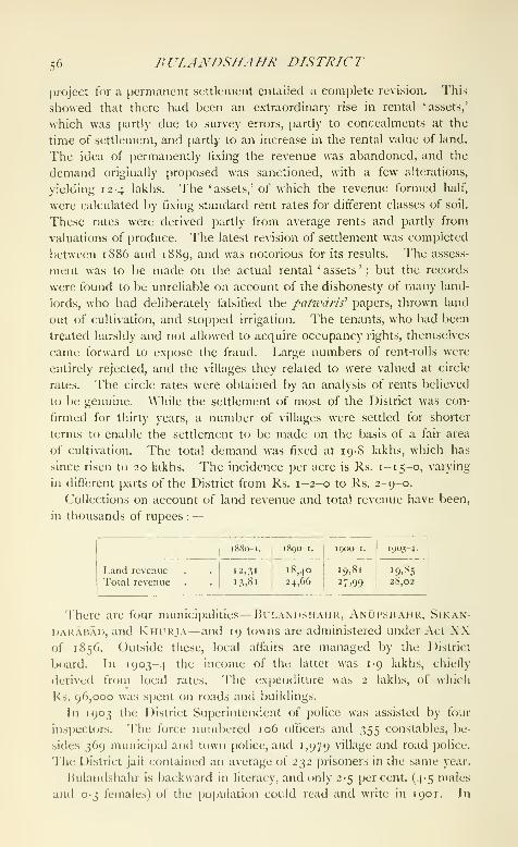
=;fi BULANDSHAHR DISTRTCT
project for a permanent settlement entailed a complete revision. This
showed that there had been an extraordinary rise in rental 'assets,'
which was partly due to survey errors, partly to concealments at the
time of settlement, and partly to an increase in the rental value of land.
The idea of permanently fixing the revenue was abandoned, and the
demand originally proposed was sanctioned, with a few alterations,
yielding 12-4 lakhs. The 'assets,' of which the revenue formed half,
were calculated by fixing standard rent rates for different classes of soil.
These rates were derived partly from average rents and partly from
valuations of produce. The latest revision of settlement was completed
between 1886 and 1889, and was notorious for its results. The assess-
ment was to be made on the actual rental ' assets ' ; but the records
were found to be unreliable on account of the dishonesty of many land-
lords, who had deliberately falsified the patwaris' papers, thrown land
out of cultivation, and stopped irrigation. The tenants, who had been
treated harshly and not allowed to acquire occupancy rights, themselves
came forward to expose the fraud. Large numbers of rent-rolls were
entirely rejected, and the villages they related to were valued at circle
rates. The circle rates were obtained by an analysis of rents believed
to be genuine. \\'hile the settlement of most of the District was con-
firmed for thirty years, a number of villages were settled for shorter
terms to enable the settlement to be made on the basis of a fair area
of cultivation. The total demand was fixed at 19-8 lakhs, which has
since risen to 20 lakhs. The incidence per acre is Rs. 1-15-0, varying
in different parts of the District from Rs. 1-2-0 to Rs. 2-9-0.
Collections on account of land revenue and total revenue have been,
in thousands of rupees :—

nUf.AXnSIfAHR TOW'X 57
1881 there were 130 public scliools with 4,4X0 pupils, and llic miiubers
rose in 1901 to 171 schools with 7,989 pupils. In 1903-4 there were
187 public schools with 10,801 j)upils, of whom 57 were girls, and also
271 private schools with 4,157 pu])ils. The total expenditure on
education was Rs. 49,000, of which Local and municipal funds supplied
Rs. 38,000, and fees Rs. 11,000. Of the public schools, two were
managed by Government antl 1 17 l)y the 1 )istrict and municipal boards.
The District has nine hospitals and dispensaries, with accommoda-
tion for roc; in-[)atients. In 1903 the number of cases treated was
101,000, of whom 2,300 were in-patients, and 8,400 operations were
performed. The expenditure in the same year was Rs. 18,000, chieflv
from Local funds.
In 1903-4, 39,000 perscms were successfully vaccinated, represent-
ing a proportion of 34 per 1,000 of population. Vaccination is com-
pulsory only in the municipalities.
[F. S. Growse, Bulamishahr (Benares, 1884) ; T. Stoker, Settlement
Report (1891); H. R. Nevill, District Gazetteer (igo^).\
Bulandshahr Tahsil.—Central ta/isi/ of Bulandshahr District,
United Provinces, comprising the pa/-gii>ias of Baran, Agauta, Siyana,
and Shikarpur, and lying between 28° 14' and 28° 43' N. and 77° 43'
and 78° 13' E., with an area of 477 square miles. The population rose
from 281,928 in 1891 to 332,262 in 1901. There are 379 villages and
five towns, including Bulandshahr (population, 18,959), the District
and ta/isll head-<]uarters, Shikarpur (12,249), Siv.\x.\ (7,615).
Ciui.AOTHi (7,208), and Auran(;ab.\[) (5,916). The demand for land
revenue in 1903-4 was Rs. 5,65,000, and for cesses Rs. 94,000. This is
the finest tahsil in the District, and the density of population, 696
persons per square mile, is considerably above the District average
(599). The East Kali NadI flows from north to south through the
western portion of the tahsil, and formerly caused much damage by
flooding in wet years. It has been straightened and deepened, and is
no longer used as a canal escape, with very beneficial results. Thenorthern pargana of Agauta is the most fertile. There are marshy
tracts in the north-east of the tahsil, and sandy areas in the south-east.
Irrigation is su|)[)lied by the Upi)er Ganges Canal east of the Kali Xadi.
In 1903-4 the area under cultivation was 376 square miles, of which
191 were irrigated. A\'ell-irrigation supplies two-thirds of this area, and
is more important here than in the other tahsils of the District.
Bulandshahr Town.— Head-tpiartcrs of the District and tah.'.'tl
of the same name. United Provinces, situated in 28° 15' X. and
77° 52' E., on the grand trunk road, 10 miles east of the Chola station
on the East Indian Railway. Population (1901), 18,959, of whom
9,139 are Hindus and 9,071 AEusalmans. The old name of the town
was Baran, and it received the nickname Unchanagar or Bulandshahr

58 BVLANDSHAHR TOWN
(* high town ') from its elevated position on a bank near the KaU Nadl.
It is a place of considerable antiquity, and is said to have been founded
by a Tomar chief of Ahar named Parmal, or according to another
account by a man named Ahibaran, from whom its name was derived.
Buddhist remains of the fifth to seventh centuries have been found here,
besides coins of much older date. In the eleventh century the town
was the head-quarters of Har Dat, a Dor chieftain who ruled in this
part of the Doab, with territory extending as far as Hapur and Meerut.
In 1018 Mahmud of Ghazni crossed the Jumna and reached Baran.
In the words of the Persian historian, Har Dat ' reflected that his safety
would be best secured by conforming to the religion of Islam, since
God's sword was drawn from the scabbard and the whip of punishment
was uplifted. He came forth, therefore, with 10,000 men, who all pro-
claimed their anxiety for conversion and their rejection of idols.' Thetown was given back to Har Dat, but from a copperplate inscription the
Dors appear to have been superseded for a time. They were restored;
and Chandra Sen, the last Hindu ruler, died while gallantly defend-
ing his fort against Kutb-ud-dTn, the general of Muhammad CJhorT,
in 1 193. The town is famous in later times as the birthplace of
the historian, Zia-ud-din Barni, who flourished in the first half of the
fourteenth century. There are a few tombs and mosques of the Mu-hammadan period, but none of importance. At the commencement of
British rule, Bulandshahr was a small town. A few good houses stood
on the elevation now known as the Balae Kot, and Chamars and
Lodas lived in huts at the base. The establishment of the District
head-quarters here caused a rapid growth ; and the town has been muchimproved by the energy and taste of its inhabitants, encouraged by
several Collectors, especially the late Mr. F. S. Growse. The Chauk or
central market has been i)rovided with a brick terrace and is adorned
with carved stone, while the houses and shops surrounding it are elegant
specimens of domestic architecture. The rich landlords of the District
have also erected several fine houses and gateways and a town hall,
all of which are remarkable for the excellence of the stonework they
contain. Close to the courts is a handsome building called the LoweMemorial, in memory of a former Collector, which is used as a shelter
for people attending the courts. A fine bathing ghat has been madeon the river bank at the eastern entrance of the town. A dispensary
and a female hospital were built in 1895. Jiesides the ordinary District
staff, an Executive Engineer of the Ganges Canal has his head-quarters
here. There are also stations of the American Methodist, Church
Missionary Society, and Zanana liible and Medical Missions.
Bulandshahr has been a municipality since 1865. During the ten
years ending 1901 the income and expenditure averaged Rs. 18,000.
In 1903-4 the income was Rs. 21,000, chiefly derived from octroi
BULDANA DISTRICT 59
(Rs. 18,000); and the expenditure was Rs. 24,000. Wood-carving of
some artistic merit is turned out. The distance from the railway has
hitherto prevented the growth of trade, which is of local nature. Aline is, however, now under construction. A high school ctjntains
more than 200 pupils and a tahs'dl school 230, while f<jur primary
schools have 220 more.
Buldana District {BuUluuia).— District in lierar, lying between19° 51' and 21' i' N. and 75"^ 59' and 76° 52' E., with an area (A
2,809 square miles. This article describes the District as it existed upto 1905, but a statement at the end shows the additions then made.
It is bounded on tlie north by the Puma river ; on the east by Akolaand Basim Districts; on the south by the Nizam's Dominions; and onthe west by the Nizam's Dominions and the Khandesh District of the
Bombay Presidency. Of the three taluks into which it is divided,
Chikhll and Mehkar are in the Balaghat and Malkapur is in the
Payanghat. The general contour of the country in
the two former taluks may be described as a succes-rnysica
^ aspects,sion of small plateaux, highest on the north, where they
rise from the central valley of Berar, and gradually decreasing in eleva-
tion towards the south. The town of Buldana is situated near the
northern edge of the highest plateau, 2,190 feet above sea-level.
Towards the eastern side of the District, the country consists of un-
dulating highlands, favoured with soil of a high quality. The small
fertile valleys between the plateaux are watered by streams during the
greater part of the year, while wells of particularly good and pure
water are numerous. These valleys contain all the best village sites.
It is not necessary to describe m detail the Malkapur taluk, for the
description of the Payanghat in the article on Bkrar is in all respects
applicable to its conditions.
The principal river which takes its rise in the District is the Penganga,
which rises in the hills near Deulgliat, runs in a south-easterly direction
past Mehkar, and then enters Basim 1 )istrict. The Puma rises in the
Ajanta Hills to the west of the District, enters it a little to the north of
Deulgaon Raja, and traverses the Mehkar taluk in a south-easterly direc-
tion, its course running parallel to, and south of, that of the Penganga.
These two rivers are important members of the Godavari system, but
they do not acquire their importance until after they have left the
District. The other rivers of liuldana are the Nalganga, the Biswa or
Vishvaganga, and the Cihan, all of which rise near the northern edge of
the Buldana plateau, and llow southwards into the Puma of the Berar
valley, which is not to be confounded with the Godavari Purna already
mentioned.
The District contains the only natural lake in l>erar, the salt lake of
L0N.\R, situated in the south of the Mehkar taluk. «^

6o BUT,DANA DTSTRICT
The two northern taluk!; are coveretl with the Deccan trap flow,
which is, however, overlaid nearly everywhere, but especially in the
valleys, with rich soil of varying depth. The hollow in which the Lonar
lake lies exhibits some of the characteristics of a volcanic crater, but is
believed to be due to a gaseous explosion, which occurred some time
after the deposit of the trap. The Malkapur taluk, beyond the lower
slopes of the Buldana plateau, is covered with a deep layer of rich and
exceedingly fertile black loam.
The vegetation of the forest area will be described in the account of
the forests. In cultivated tracts the commonest trees are the mango, the
viahud {Bassia latifoUa), the p'lpal {Ficus religiosa), the banyan, the
/)a/)n/ {Acacia arabica), and the /liivar {Acacia leucophloea). The weed
vegetation in cultivated ground is that characteristic of the Deccan
generally, and includes small Compositae, Legu??ii>iosae, Rubiaceae, and
JMalvaceae.
In the hills, bears, tigers, leopards, hyenas, wolves, sdmbhar, nJ/gai,
and wild hog are found; in the valleys wild hog and antelope; and,
about the banks of the Purna, spotted deer and m/gai. The only
monkey in the District is the langur.
The climate of the Malkapur taluk is intensely hot and dry in the
months of March, April, and May ; but the nights are usually cool. For
the next four months the temperature is considerably lower, but occa-
sionally the combination of fairly high temperatures with humidity has
an enervating effect. In the taluks of ('hikhli and Mehkar, which are
situated in the Balaghat, the climate is cooler than that of Malkapur ;
the hot season sets in later, and the heat is never so intense as in the
Payanghat. Buldana is, owing to its elevation, the coolest and most
pleasant station in Berar. The rainy season in the Balaghat taluks is
temperate and pleasant, and the cold season throughout the 1 )istrict,
particularly in the Balaghat taluks, is cool and invigorating.
In respect of rainfall the District is divided into two natural divisions :
the Malkapur taluk in the Payanghat, and the Chikhli and Mehkar
taluks in the Balaghat. Rainfall statistics for Malkapur are not avail-
able, but the figure given for Akola (34 inches) may be accepted as
correct for this area. In the taluks of the Balaghat the rainfall is
heavier, that recorded in 1901, which was a normal year, being
44 inches. For some years past there has been a failure, either partial
or complete, of the late rains.
Ikildana, though it has occasionally been the scene of historical
events, has little or no connected history of its own. RonANKHF.n
has been the site of two battles: one fought in 1437^'
between Khalaf Hasan liasri, (X)mmanding the army
of Ala-ud-din Shah P.ahniani II, and NasTr Khan i'Tiniki, Sultan of
I^handesh ; and the other in 1590, l)etween iUn-han Nizam Shah

ropui.ATiox r,,
and Janial Khan the MahdavT, who supi)oited the claims of Ismail
to the ihrone of Ahmadnagar against those of his father Kurhan.
Burhan was victorious and Jamal Khan was slain. In 1724 Shakar-
khelda was the scene of the battle to which it owes its present name of
Fathkhki.da. Mubariz Khan, governor of Malwa, instigated by a
party in the Mughal court at Delhi, invaded Berar and attacked Asaf
Jah, the first Nizam. Asaf Jah gained a complete victory and Mubariz
Khan and his two sons fell. This battle established the virtual inde[)en-
dence of the Nizams in the Deccan. Daulat Rao Sindhia and Raghuji
Bhonsla were encamped at Malkapur when, in August, 1803, they
allowed the British envoy to depart and received General Wellesley's
declaration of war. A month or two later General Wellesley traversed
the District while i)ursuing them from Assaye to Argaon. The condi
tion of the country was at this time very unsatisfactory. During the
next fifty years there was some improvement ; but the local officials
were seldom strong enough to keep the peace, and the town of
Malkapur was more than once the scene of faction fights which
arose out of religious disputes.
After the Assignment in 1853 Buldana formed jiart of the West Berar
District, but was formed in 1864 into an independent charge, styled the
South-west Berar District—a clumsy designation which was changed
in the following year to the Mehkar District. In 1867 Buldana was
selected as the head-quarters of the District, to which it thenceforth
gave its name.
Lonar and Mehkar contain two of the finest Hemadpanli temples in
Berar, and there is an inferior temple in the same style at Kothali.
The mosques of Fathkhelda and Rohankhed were built in 1581 and
1582, evidently from the designs of one architect, by Khudawand Khan
the Mahdavi, the supporter of Jamal Khan and the young Ismail
Nizam Shah.
The number of towns and villages in the District is 876. The popu-
lation at each of the last four enumerations has been : (1867) 366,309,
{1881) 439>763> (1891) 481,021, and (1901) 423,616.p^p^j^jj^j^^
The decline in 1901 was due to the famine of
1899-1900. The District is divided into the three taluks of
ChikhlT, Mehkar, and MAi.KAriR, the head-quarters of which are
at the places from which each is named. The chief towns are
Malkapur, Nandura, and Deulgaon Raja.
The table on the next page gives particulars of area, towns and
villages, and population in 1901.
The District stands third among the six Districts of Berar in the
density of its population, the two Balaghat taluks being less densely
populated than the Payanghat taluk of Malkapur. More than 90
per cent, of the people are Hindus. The language of the District is
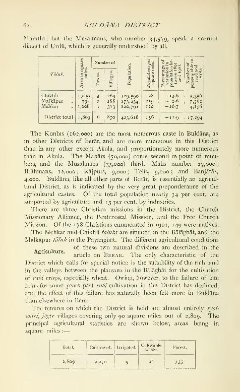
62 BULDANA DISTRICT
Tvlarathi : but the Musalmans, who number 34,579, speak a corrupt
dialect of Urdii, which is generally understood by all.
Taluk.

AGRICULTURE 6.^
The staple food-grain is jowar (great millet), the area under which
in 1903-4 was 495 square miles. The area under cotton, the most
profitable crop to the cultivator, was 615 square miles, and oilseeds
occupied 205 and wheat 264 square miles.
The increase in the cultivated area during the last thirty years has
been less than one per cent., the rich lands in this District being among
the first to be reoccupied after the Assignment. It cannot be said that
much improvement has been made in methods of cultivation or in the
quality of the crops sown. On the contrary, the cultivator has nowgiven up the fine long-stapled cotton for which Berar was formerly well-
known, in favour of a coarser but more prolific short-stapled variety.
The ad\"antagcs offered by the Loans Acts were not much appreciated
before the famine of 1899-1900 ; but since that year they have become
more generally known. In the three years ending 1902 the total
advances amounted to 1-2 lakhs. Increased prosperity rather than
any disinclination to apply for loans is responsible for a subsequent
fall in the demand.
The principal breeds of cattle arc the Khamgaon variety of the
Berari breed in the Chikhll taluk^ and the Umarda variety elsewhere;
but since the famine of 1899-1900 large numbers of cattle of the
Sholfipuri and Nimari breeds have been imported, and in the south
of the District the characteristics of the local varieties are muchmodified by the admixture of blood from cattle found in the northern
Districts of Hyderabad State. Buffaloes are chiefly of the Nagpuri
strain, except in the Mehkar idluk, where the Dakhani breed prevails.
The ponies, sheep, and goats bred locally are very inferior, and call
for no special notice.
Irrigated land in Buldana, as elsewhere in l>erar, bears a very small
proportion to the area under cultivation ; the 9 square miles irrigated
in T 903-4 were supplied entirely from wells, and were devoted chiefly
to the raising of garden crops.
Forest lands are divided, as elsewhere in Berar, according as they
are reserved for the supply of timber and fuel, for fodder, or for
pasture. The area of these classes is 155, 4, and 174 square miles
respectively. A belt of forest land of the first class, extending along
the Ajanta Hills from west to east, is continuous with the forest lands
of Khamgaon in Akola District. The principal trees are snlai
{Boswe/Iia thurifera), kndia {Lagerstroe?fiia parviflord)^ khair {Acacia
Catechu)^ ber {Zizyphus Jujuba), char {BucJuviatiia latifolia), and other
species. Teak occurs along the crests of the ridges and in sheltered
ravines, in which, as they widen, pa/ds {Butca frondosa) and other
species of little value appear. East of the Malkapur-Buldana road, the
principal species are anjau {Hardwickia biuata), salai, and khair. Theraiiinas, or fodder reserves, are grass lands with a scrub growth of

64 BULDANA DISTRICT
acacia and palas : and the tree vegetation of the grazing lands consists
of acacias, palds, lendia, dhaura (Aj/ogeissus laiifolia), her, char, and
tendu {Diospyros /nciatioxylofi).
No minerals arc now of economic value. Salts and alkalis were
formerly procured by evaporation from the Lonar lake, but the
industry has long since been abandoned. In the Ain-i-Akbarl it was
thus described: 'It [the Lonar lake] contains the essential materials
for the manufacture of glass and soap, and saltpetre is here produced
and yields a considerable revenue.'
Arts and manufactures are unimportant. In the larger villages of the
Mehkar tdhik cotton cloths and blankets, which command a local sale,
are woven on hand-looms, and there are similariraaeano
looms, but in smaller numbers, in the more acces-communication. .
sible taluks of Chikhli and Malkapur. The prmcipal
industry is naturally the preparation of cotton for the market, and the
District contains nine ginning factories and three cotton jjresses, all
worked by steam.
The principal exports are raw cotton, oilseeds, and grain and pulse ;
and the principal imports are grain and pulse, coal and coke, sugar, and
salt. The main trade is with Bombay, whither nearly all the raw
cotton is exported by rail, and whence the imports, except coal and
coke, are mainly received. The commerce of the District has hitherto
been largely carried along the main roads to stations on the Nagpur
branch of the Great Indian Peninsula Railway ; but the southern
portion of the District is now accessible from Jalna on the Hyderabad
and Godavari Valley Railway, and some of the trade has been di\erted
to this route, though Bombay still remains its objective. The weekly
markets, held almost exclusively at old pari::;aiia towns, arc the impor-
tant centres of local trade ; and the principal classes engaged in com-
merce are the Marwaris and the Vanis, though most classes are
represented.
The Nagpur branch ol the Great Indian Peninsula Railway, which
traverses the northern porticni of the Malkapur ialuk from west to east,
has a length in this District of about 28 miles. 'i"he total length of
metalled roads is 107 miles and of unmetalled roads 82 miles. Except
36 miles of unmetalled roads maintained from Local funds, the rest are
in charge of the I'ublic \\'orks dei)artnicnl.
The District is neither more nor less fortunate than other parts of
Berar in respect of liability to famine, and has suffered equally with
... . them in the past. The famine of 180^ was a vervAdministration. 111 ,
severe calamity, and there was then no government ma position to afford any relief. In 1896-7 the District suffered from
scarcity, and the fann'ne of 1 899-1 900 was felt at least as severely in
Buldana as in any pari of the pro\incc. In July, 1900, when the

AD.}flXlSTA'.lT/0.y 65
famine was at its height, 11 7,409 persons were on relief works and
39,455 in receipt of gratuitous relief, and it is calculated that 28 per
cent, of the cattle died.
The three' tdii/ks, at the head-cjuarters of each of which there is a
ta/tsi/ddr, have already been mentioned. Buldana town, though the
headquarters of the District, is not the head-quarters
of a ta/uk, but is situated in the Chikhli td/itk. The Administration,
superior staff of the District consists of the usual officers, but the
Forest officer has charge also of the forests in Akola District. AnAssistant or E.xtra-Assistant Commissioner, exercising the powers of
a first-class magistrate, holds his court at Malkapur.
For judicial purposes this District forms, with Akola, the Civil and
Sessions District of West Berar, in which are stationed a District and
Sessions Judge and an Additional District and Sessions Judge. Sub-
ordinate Judges hold their courts at Buldana and Khamgaon, and
Munsifs are stationed at Malkapur and Mchkar. Serious offences
against property occur somewhat more frequently than elsewhere in
Berar. Dacoity was very common in times past, owing to the number
of Bhils in the District ; and at one time a corps of Hill Rangers,
under a British officer, was maintained principally for the purpose of
suppressing this class of crime. But organized dacoities by hereditary
professional gangs are now a thing of the past, and the condition of
the District as regards crime is in no way abnormal.
From the Ain-i-Akbari we learn that in Akbar's reign the demand on
account of land revenue in the parganas which now compose the
District of Buldana was 12-4 lakhs. At the time of the Assignment in
1853, the demand in these parganas was only a little more than 3 lakhs,
so much had the province suffered from wars, disturbances, and mis-
government. The demand in 1903-4 was 12-2 lakhs, which sum is
absolutely rather lower than Akbar's demand, and relatively very muchlighter. The first regular settlement of the District after the Assign-
ment was begun in 1862 in the Malkapur /d/uk, and completed in
1870 in the Mehkar ^d/uk, and this settlement was revised between
1891 and 1897. Dand revenue at the revised rates of assessment has
been levied for some years in the Malkapur fd/nk, and since 1900 in
Mehkar ; but the new rates have only just been applied to Chikhli, where
their introduction was delayed owing to the effects of the famine of
1899-1900. So far as ' dry ' land is concerned, the new assessment has
an average incidence of 1 5 annas 9 pies per acre, varying from 8 annas
to Rs. 2-12-0. Land irrigated by channels from streams and tanks is
assessed at a maximum combined soil and water rate of Rs. 8 per acre.
Land served by wells sunk before the original settlement pay the
highest rate levied on ' dry ' land in the village in which it is situated,
* The District now (1907) contains live talttls.
VOL. l.\. I-

66 BULDANA district
but should the well have been made subsequently the land is treated in
all respects as ' dry ' land. Rice lands are assessed at a maximum rate
of Rs. 6 per acre.
Collections on account of land revenue and revenue from all sources
have been, in thousands of rupees :—
•
BULSAR TOWN 67
On the reconstitution of the six Districts of Berar in August, 1905,
Huldana received the Khamgaon and Jalgaon taluks from Akola
District. The present area of Buldana District is 3,662 scjuare miles,
and the population of that area in 1901 was 613,756.
[F. W. Francis, Taluk Settlement Reports ; Malkdpur, Khdmgaou,
And /dlgaou (1892) ; Chikhli (1896) ; and Mehkar (1898).]
Buldana Town.—Head-quarters of the District of the same name in
Berilr, situated in 20^ 32' N. and 76° 14' E., 2,190 feet above sea-level.
Population (1901), 4,137. The municipality was established in 1893.
The receipts and expenditure from 1894 to 1901 averaged Rs. 12,000.
The income in 1903-4 was Rs. 12,300, mainly derived from taxes and
cesses; and the expenditure was Rs. 10,400, the princi[)al heads being
water-supply and education. The town owes what little importance it
possesses to its selection as the head-quarters of a District.
Bulsar Taluka.—Southern taliika of Surat District, Bombay, lying
between 20" 28' and 20° 46' N. and 72° 52' and 73" 8' E., with an area
of 208 s(juare miles. It contains one town, Bulsar (population, 12,857),
the head-quarters; and 95 villages. The population in 1901 was 83,476,
compared with 87,889 in 1901. Land revenue and cesses amounted in
1903-4 to nearly 2-8 lakhs. There are no alienated villages in the
taluka. The whole surface is irregular, seamed with river-beds, and
rising into rocky uplands. Situated on the sea-coast, the climate is
considered healthy at all times of the year, but the eastern parts are
malarious at certain seasons. Tithal, a village on the coast, is resorted
to as a sanitarium by visitors from Bombay. The taluka is abundantly
watered by rivers and streams.
Bulsar Town {IValsdd, Valsdd).—Fort and head-quarters of the
tdluka of the same name in Surat District, Bombay, situated in
20° 37' N. and 72° 56' E., about 40 miles south of Surat and 115
north of Bombay, on the estuary of the navigable though small river
Auranga, and on the railway between Surat and Bombay. Population
(1901), 12,857. Of the Musalmans, the greater number are Tais, or
converted HinduSj who are engaged chiefly in cloth-weaving, and are,
as a rule, well-to-do. The municipality dates from 1855. The income
during the decade ending 1901 averaged Rs. 29,000 ; in 1903-4 it was
Rs. 25,000. Bulsar is well placed for trade, both by sea and by land.
The total value of its coast trade, exclusive of Government stores, in
1903-4, w^as 12 lakhs, of which 7^ lakhs represented the value of
exports and 4^ lakhs that of imports. The chief imports are piece-
goods, tobacco, wheat, fish, and sugar ; the chief exports are timber,
grain, molasses, oil, firewood, and tiles. The export of timber is the
staple of Bulsar trade. The wood brought from the Dang forests is
exported by sea to Dholera, Bhaunagar, and the other ports of Kathi-
awar. There are manufactures of cloth for wearing apparel, silk for
F 2
68 BULSAR TOWN
women's robes, and of bricks, tiles, and pottery. The town contains
a Sub-Judge's court, a dispensary, and two English schools, of which
one is a high school, attended by loi and 159 pupils. It has also
9 vernacular schools, 6 for boys and 3 for girls, attended respectively by
412 and 219 pupils.
Bumbra-ke-Thul.—The modern name of Brahmanabad, a ruined
town in Thar and Parkar District, Sind, Bombay.
Bundala.—Village in the District and tahsll of Amritsar, Punjab,
situated in 31° 32' N. and 74° 59' E., ir miles south-east of Amritsar
city. Population (1901), 4,500. The place is of little commercial im-
portance, and is chiefly noticeable for its famous monastery of Jogls.
Bundelkhand (British).—A tract of country in the United Pro-
vinces, which includes the Districts of Jalaun, Jhansi, Hamirpur,
and Banda, with those parts of Allahabad which lie south. ©f the
Jumna and Ganges. It thus consists of an area of about 11,600 square
miles, lying south-west of the Jumna from its junction with the Cham-
bal. The name is taken from that of the Bundela Thakurs, the most
important clan inhabiting it. The word Bundela is popularly derived
from bund, 'a drop,' in allusion to the attempted sacrifice of himself
by the founder of the clan, a Gaharwar. His son was born from
the drops of blood which fell on the altar of Vindhyabasini Devi at
Bindhachal {see Mirzapur City). Other derivations are from
Vindhya, or from bdndi, 'a slave-girl.'
The northern range of the Eastern Vindhyas called Bindhachal cuts
across the south of Jhansi, Banda, and Allahabad, with many outlying
hills, but nowhere rises above 2,000 feet. The base
asoec^s°^ ^^^ ^^^'^^ "^^^^^ °" gneiss, while the hills them-
selves are of sandstone, overlaid south of these
Provinces by basalt, the Deccan trap, which has also spread north
in dikes. From the hills numerous streams flow north or north-east
towards the Jumna, of which the most important are the Betwa,
Dhasan, Birma, Ken, Baghain, Paisuni, and Southern Tons. Thegeological formation of Southern Bundelkhand has greatly influenced
the soil of the alluvial plain lying between the hills and the Jumna.This contains a large proportion of disintegrated trap, which gives it
a dark colour ; it is especially adapted for growing wheat, and is knownas 'black soil,' and in the vernacular as mar. A variety of lighter
colour and differing qualities is known as kdbar. From Jhansi to Lalit-
pur a soil called rakar is found, the prevailing colour of which is
largely red or yellow, owing to the presence of iron in the disintegrated
gneiss. Another soil of red colour is formed from disintegrated sand-
stone in situ, and though productive is easily exhausted, as it is very
shalhjw. Black soil is retentive of moisture, but rccjuires irrigation
in unfavourable seasons, and in dry weather oj^ens out in large cracks.
BRITTSH BUXDET.KIfAND 69
During the rains unmetalled roads arc almost impassable owing to the
tenacious mud formed on them. A native proverl) says that klhar is
too wet to plough one morning, m\^ too dry and hard to pUnigh the
next day.
In l^anda, as in other tracts crossed i)y the Vindhyas, many varieties
of stone implements have been found, the relics of prehistoric man '.
The earliest traditions connected with British Bundel-
khand relate that it was ruled over by Gaharwar Raj- '^'
puts. Nothing certain is known of these; but some (jf the numeroustanks formed by throwing embankments across the narrow ends of
valleys are attributed to them, namely, tho.se where the embankmentsare formed of uncut stone. The largest is the Bijainagar lake, situated
about three miles east of Mahoba. According to tradition the Gahar-
wars were followed by Parihars, who were in turn succeeded by Chan-dels, a clan which has left many memorials of its rule. Nothing but
the name is known of Nanika or Nannuka, described in several inscrip-
tions as the founder of the dynasty ; but he probably flourished in the
first half of the ninth century .v. d. The fourth Raja, Rahila {circa
890-910), seems to have extended his dominions, and he constructed
the Rahilya Sagar ' lake ') at Mahoba, with a fine temple, now in
ruins, on its embankment. The earliest dated inscriptions are those
of Dhanga (950-99), who appears to have been the most powerful of
the early Chandels. He assisted Jaipal of Lahore in his unsuccessful
invasion of the Ghazni kingdom in 978, and according to his inscrip-
tions was recognized as overlord by the rulers of most of Central,
Southern, and Eastern India ; but this is clearly an exaggeration.
His successor, Ganda (999-1025), who appears as Nanda Rai in the
Muhammadan histories, also assisted Jaipal of Lahore against Mahmfidof (ihazni ; and according to Firishta he killed the king of Kanauj
in 102 1, but surrendered to Mahmud in 1023, when he was in pos-
session of fourteen forts. Klrtti Varmma I, the eleventh king (1049-1 100), seems to have been reigning when his son, Sallakshana, conquered
Kama, king of Chedi or Southern Kosala. He is als(j the earliest
Chandel whose coins, copied from those of the Chedi kings, are known.
Tradition assigns to him the construction of the Kirat Sagar at Mahoba,
and some buildings at Ajaigarh. Madan ^'armma, the fifteenth king
(i 130-65), was a vigorous ruler, who extended the sway of the Chamlels.
He again subdued the Chedi kingdom, which had become independent,
and is said to have con(]uered GujarfU. His immediate successor,
ParamardI Deva or Parmal (i 165-1203), is still remembered, as during
his reign Prithwl Raj of Delhi conquered Bundelkhanil in 1182, and
the Chandel power received a second blow in 1203, when Kutb-ud-din
'
J. \\\s&\i-Q^\n:\.c,Journal, Asiatic So<iety of Bengal, 1S83, p. JJI, ami J. CuckLiirn,
ibid., iSy4, pt. iii, p. 21.

70 BRITISH BVXDEIKHAND
raided the country. Popular tradition holds that Paramardi lost his
kingdom through disobeying the four conditions laid on the founder
of the race—not to drink wine, not to put Brahmans to death, not
to form improper marriage connexions, and to preserve the name of
Varmma. The Chandel dominion lay between the Dhasan on the
west, the sources of the Ken on the south, the Jumna on the north,
and the Vindhya Hills on the east. At times it extended as far west
as the Betwa. Kalinjar, Khajraho, Mahoba, and Ajaigarh were its
great fortresses. In inscriptions the country is sometimes called Jejaka-
bhukti, which has been contracted into Jijhoti, from which the Jijhotia
Brahmans, who still inhabit the tract, take their name. The kingdom
of Chi-ki-to, described by Hiuen Tsiang in the seventh century as lying
north-east of Ujjain, has been identified with Jejaka.
After the Musalman conquest the Chandels became petty Rajas.
The country was held for a short time by Mewatis, probably in the
first half of the thirteenth century, and then by Bhars. Tradition
shows the latter as owning a large part of the Eastern Doab and Central
Oudh, and the Persian historians record the conquest by Ulugh Khan,
in 1248, of a king Dalakl-wa-MalakI, reigning from Kara to Kalinjar.
The name appears to be a compound of two names, Dal and Bal, which
are known from tradition. The Bhars are locally said to have been
driven out by a Muhammadan, and replaced by the Khangars, formerly
servants of the Chandels.
The Bundelas claim to be descended from Pancham, a (iaharwar
who attempted to sacrifice himself, as noted above ; but their real
origin is obscure. They probably began to acquireThe Bundelas. ^
,. c , 1 , r , ,,y ,power m the lourteenth century, first setthng at a
place called Mau, which has not been definitely identified, and then
taking Kalinjar and KalpI ; but some writers place them a century
earlier. As their power increa.sed, chiefly in western Bundelkhand
(Central India), the Bundelas constantly came into collision with the
Muhammadans. About 1507 Rudra Pratap became chief, and is
said to have been formally appointed governor by Babar. From his
sons most of the great Bundela families derive their descent. In
1545 Sher Shah, Sur, invaded Ikmdelkhand, and lost his life while
besieging Kalinjar. Kirat Singh, the last (Chandel Raja, was put to
death by Islam Shah, who took the fort ; but it again fell into the
hands of the Bundelas, till in 1569 Akbar got possession of it. The
Bundelas, who were now divided, still held considerable power and
were often successful in resisting the imperial troops. Bir Singh Deo,
who ruled at Orchha, and commenced the fort at Jhansi, incurred
the special anger of Akbar by planning the murder of Abul Fazl at
the instigation of prince .Sallm, afterwards the empercjr Jahangir ; and
though he remained in favour during the reign of the latter, he rebelled

THE nrxDErAs 71
against Shah Jahan, and liis territory was CDnfisrated. The central
part of l*>unt](lkhan(l was ruled by ("ham]iat Rai from Mahoha. Ifc
joined in Hlr Singh Deo's revolt, and, thougli atta( ked by forces from
Agra, from Allahabad, and from the Deccan, maintained a guerrilla
warforc near the Betwa. He finally accepted service under the emperor
and obtained the pargana of Kunch in Jalaun, and, in return for assis-
tance given to Aurangzeb at the battle of Samogarh, received further
grants, but lost favour and was assassinated by his wife's, relations.
Champat Rai's son, Chhatarsal, soon became chief leader of the
Kundclas, and in a few years held the whole of western Bundelkhand,
and gradually extended his power, taking Kalinjar and most of what is
now British Bundelkhand. He defeated the imperial troops again and
again, and in 1707, on the accession of Shah Alam P.ahadur, was con-
firmed in all the acquisitions he had made. In 1723 Muhammad KhanBangash of Farrukhabad, while governor of Malwa, was ordered to
bring the Bundelas to order; and in 1727, after his transfer to Alla-
habad, he attacked them again, laying waste the whole country.
Unable to resist the invasion, Chhatarsal called in the Marathas in
1729, and Muhammad Khan barely escaped with his life, glad to
promise never to enter Bundelkhand again. When Chhatarsal died,
about 1734, he bequeathed one-third of his territory (Jhansi and Jalaun)
to the Marathas, and the rest was divided among his heirs. Bundel-
khand was valuable to the Marathas, as it lay on the road from the
Deccan to the Doab, and the Peshwa BajT Rao made constant use
of it, the Bundelas binding themselves by treaty to co-operate with
him. In 1747 the Peshwa further extended his possessions in this
region by a fresh treaty, and nearly twenty years later troops from
here assisted Shuja-ud-daula of Oudh in his unsuccessful struggle
with the British. British troops first entered Bundelkhand in 1776,
when war broke out with the Marathas after the Treaty of Purandhar,
but they passed through without retaining any hold on the country.
The Bundelas then succeeded in freeing themselves to some extent
from the Maratha power. A Gosain or religious mendicant named
Himmat Bahadur, who had already commanded troops, now began
to rise into power ; and he combined with All Bahadur, an illegitimate
grandson of Baji Rao, who was in command at dwalior, to crush
the Bundela chiefs. A long struggle took place between 1790 and
1802, when All Bahadur died while attempting to take Kalinjar. By
the Treaty of Bassein in 1802 the Peshwa ceded territory to the British,
some of which was afterwards exchanged for part of the Maratha
possessions in Bundelkhand. Another portion of these possessi(jns
was acquired under a later treaty. The subordinate Maratha chiefs,
however, refused to recognize these treaties : and Shamsher Bahadur,
son of All Bahadur, proceeded to lay waste Bundelkhand and the
72 BRITISH BUNDELKHAND
British Districts of Mirzapur and Benares. Himniat Bahadur then
abandoned the Marathas and came over to the British, who granted
him a large tract along the Jumna between Allahabad and Kalpl.
British troops co-operated with Himmat Bahadur and drove Shamsher
Bahadur across the Betwa, and in 1803 took Kalpi. Shamsher Bahadur
became titular Nawab of Banda with a pension of four lakhs, and by
the end of 1804 the country was fairly quiet. The fort of Kalinjar
was captured in 181 2. Subsequent additions to British territories took
place by lapse, and Jhansi city was finally acquired from Sindhia in
exchange for Gwalior fort and Morar in 1886.
The population of British Bundelkhand fell from 2,693,000 in 1891
to 2,456,000 in 1 901, a decrease of nearly 9 per cent. Excessive rain-
fall and cloudy weather in the early years of the
decade brought on rust, which damaged the spring
crops and caused great loss to the people. The failure of the rains
in 1895 and 1896 resulted in severe famine, and a virulent cholera
epidemic broke out. The density is only 212 persons per square mile,
being less than one-half the density in the United Provinces generally.
Of the total population, 2,297,000, or more than 93 per cent., are
Hindus, and only 143,000, or less than 6 per cent., are Muhamma-dans, who form 14 per cent, of the population in the United Provinces
as a whole. British Bundelkhand extends to the jungles of Central
India, and its inhabitants have a strong infusion of Dravidian blood.
The principal jungle tribes are the Kols, Khangars, and Saharias,
who have become nominally Hinduized. I'he change is, however,
more noticeable in regard to social customs, such as marriage rules,
than in religious beliefs, which continue strongly animistic. A few
estates are still owned by Marathas, but the effects of their rule
have almost disappeared. In 15anda and Allahabad the liaghell and
Awadhl dialects of Eastern Hindi are spoken, while in Hamlrpur,
Jhansi, and Jalaun the vernacular is the liundeli dialect of Western
Hindi.
While in the United Provinces, as a whole, the autumn crops cover
an area rmly about 16 per cent, greater than the spring crops, in
. . Bundelkhand they are nearly double. About one-Agriculture, .1 •
1 f ^u 4.• • - J .1
ttiird of the autumn crop is jmvar and one-seventh
cotton, and from 50 to 80 per cent, of the spring crop is gram. These
proportions vary according to the seasons, and after good rain the rabi
area is largely increased. Irrigation from wells is difficult owing to the
low spring-level, and the storage tanks made by closing valleys do not
command large areas. There is only one canal, drawn from the Betwa,
a protective work which chiefly serves Jalaun. In 1903 4, only about
4 per cent, of the cultivated area was irrigated, compared with one-third
for the United Provinces as a whole. Bundelkhand is thus peculiarly
AGRICULTURE 73
liable to suffer from deficient rainfall. A canal from the Ken to serve
Handa District has recently been completed ; and schemes to increase the
water available in the Betwa Canal, which is at present insufficient or
the demand, and to open other sources are under consideration. Other
calamities are the prevalence of rust after a wet or cloudy winter, and
the growth of a weed or grass called kajis, which spreads rapidly and
can be eradicated only with difficulty. Famine has thus been severely
felt again and again ; and the failure of the rains in 1896, which followed
successive bad years, was especially disastrous.
The liability to good and bad cycles of agricultural conditions is
coupled with peculiarities in the nature and disposition of the people.
Though perhaps not more extravagant than the inhabitants of the rest
of the United Provinces, they are distinctly less provident ; and the
careful cultivation and saving habits of the Jats, Kurmis, Kachhis,
Muraos, and Koirls of other Districts are not found in Bundelkhand.
This may be traced partly to the liability to vicissitudes already referred
to, and partly to the effects of tlie revenue system of the Marathas, whopossessed the tract before the British. The most common method was
to assess a village annually at fixed rates on soil or crops, and to makedeductions for bad seasons, after a valuation of the crops of each
holding. This was a system of rack-renting, as the rates were the
highest which could be paid in a good season, and it is obviously not
a system under which either the standard of comfort or the prosperity
of a community would be likely to increase. Except in part of the
I^litpur tahsll of Jhansi, the land was chiefly held by individual culti-
vators, and talukdars or large holders of land were few. British rule
conferred proprietary rights on the village headmen who were found
managing land and collecting rents, and on a few relations of these whoshared in the headman's special holding or reduced rent. Instead of
the demand being regulated by the season, a rigid system of collecting
a fixed amount was introduced ; land became a transferable security,
and the owners, unaccustomed to their new conditions, got freely into
debt, and lost their holdings. It was estimated that in Banda, most of
which became British territory early in the nineteenth century, an aggre-
gate equal to twice or thrice the area of the District changed hands
during the next forty years. Most of Jhansi District was acquired
later, when more experience had been gained in revenue administration,
and sale of land was not allowed till 1862 ; but even here sufficient
allowances were not made. Some landowners had been in debt since
the Maratha rule. After the Mutiny, revenue was collected from manyfrom whom it had already been extorted by the Orchha or Jhansi rebels.
In 1867 the crops failed, and in 1868-9 there was fiimine and great loss
of cattle. In 1872 many cattle were lost from murrain. Although the
settlement had appeared light, it became necessary to re-examine the

74 BRITISH BUNDELKHAND
condition of the District in 1876. After much discussion the Jhansi
Encumbered Estates Act (XVI of 1S82) was passed, and a Special
Judge was empowered to examine claims and reduce excessive interest.
The sale of a whole estate operated as a discharge in bankruptcy to
extinguish all debts due. Many estates were cleared by the sale of
a portion only. A striking feature of the proceedings was the rapid
increase in the value of land.
The experiment, though apparently successful, had no lasting effect.
Bundelkhand suffered from another series of bad years, commencing
with rust and blight in 1892-3, excessive rain in 1894, and drought in
1895 and 1896. Even in Banda, where the last settlement was made,
not on actual ' assets,' but on a fair average area of cultivation, the
population decreased by 10^ per cent, between 1891 and 1901. Debt
had become serious in all parts of the tract. The Jhansi legislation has
therefore been revived, with modifications suggested by the experience
gained, in (United Provinces) Act I of 1903, which has been applied to
the whole of British Bundelkhand. In addition to this, two new safe-
guards have been adopted. By (United Provinces) Act II of 1903
permanent alienations of land are forbidden where the alienor is
a member of one of certain agricultural tribes, unless in favour of
another member of the same tribe, or where both parties reside in
the same District and are both members of agricultural tribes. Except
where permanent alienation is allowed, mortgages and leases are subject
to the condition that possession of the land involved cannot be trans-
ferred for more than twenty years. Sales in execution of decrees passed
by civil or revenue courts (other than those of the Special Judges who
have been appointed) are forbidden, but such decrees may be liquidated
by usufructuary mortgages for terms not exceeding twenty years. Large
reductions of revenue have been made, and the assessment of all parts
of Bundelkhand is being revised. The new demand, instead of being
fixed for thirty years, will be liable to further revision whenever the
cultivated area fluctuates considerably.
[V. A. Smith, ' History of Bundelkhand,' Journal, Asiatic Society of
Bengal (1881), p. i ; A. Cunningham, Archaeological Survey Reports,
vols, vii and xxi ; C. A. Silberrad, Journal, Asiatic Society of Bengal
(1902), p. 99; E. G. Jenkinson, Settlement Report of Jhansi {\^i\)\
A. Cadell, Settlement Report of Bilndd (i88r).]
Bundelkhand Agency.—A collection of Native States in the
C'entral India Agency, under a Political Agent, lying between 33° 49'
and 26" 18' N. and 78° 11' and 81° 3' E., with an area of about 9,852
square miles. It is bounded on the north by the Jalaun, Hamlrpur,
and Banda Districts of the United Provinces ; on the south by the
Saugor and Damoh Districts of the (Central Provinces ; on the east by
the Baghelkhand Agency ; and on the west by the Jhansi District of
BUNDELKHAND AGENCY 75
the United Provinces and by part of Gwalior. Of the total area, about
8,000 scjuare miles lie in the level country to the west of the Panna
range, while the remainder falls in the rugged tract formed by that
branch of the Vindhyas. Except in the small portion lying north
of Datia, the principal rock up to the I'unna range is gneiss. In the
area north of Datia and surrounding Samthar, however, this formation
is covered with alluvium. In the Panna range sandstones and other
rocks of the \'indhyan series are well represented. The mineral riches
of this tract may be consitlerable, but have as yet been imperfectly
examined, 'i'he soil is generally of much lower fertility than in Malwa,
being mainly of the lighter classes known as kdbar and rdnkar.
The population in 1901 was 1,308,316, giving a density of 133persons per square mile. Hindus numbered 1,225,740, or 94 per cent.
;
Musalmans, 46,356; Animists (chiefly Gonds), 22,952; Jains, 12,207;
and Christians, 608. The Agency contains 4,244 villages and 10 towns,
of which 7 are the capitals of States, the remaining 3 being Nowgonocantonment (11,507), Skoni:)HA (5,542), and Nadk'.aon (4,443).
For the early history of this tract see British Bundelkhanu. Thepolitical charge was created in 1802 after the Treaty of Bassein, a
Political officer being attached to the forces operating in Bundelkhand
for the purpose of introducing order into the civil administration. In
181 1, when the country was settled, an Agent to the Governor-General
for Bundelkhand was appointed, with head-quarters at Banda. In 181
8
the head-quarters were moved to Kalpi, in 1824 to Hamlrpur, andin 1832 back to Banda. In 1835 the control passed to the newly
appointed Lieutenant-Governor of the North-Western Provinces, whose
head-quarters were at Agra. In 1849 the superior control was handed
over to the Commissioner for the Saugor and Nerbudda Territories?
a Political Assistant at Jhansi holding inuiiediate charge under his
orders. The Assistant was soon after moved to Nowgong, which is
still the head-quarters, the superior control being transferred to the
Resident at Gwalior, who at this time held an independent charge
directly under the Supreme Government. In 1854, on the creation
of the Central India A(;encv, the control passed to the Agent to the
Governor-General for Central India. From 1862 to 187 1 the Baghel-
khand charge was held conjointly with that of lUmdelkhand, the Political
Assistant being replaced in 1865 by a Political Agent. In 1888
Khaniadhana was made over to the Resident at Gwalior, and in 1896
the Chauhe JagTrs with Baraunda and with Jaso were transferred to
Baghelkhand. There are now 9 States, 13 estates, and the isolated
pargaua of Ai.ampur belonging to the Indore State in the Bundelkhand
Agency. Of these, only 3 are held under treaties: namely, Orchh.a,
Datia, and Samthar. The remainder are sanad holdings : namely,
Panna, Charkhari, Ajaigarh, Bijmvar, Baoni, Chhatarpur,

76 BUNDELKHAND AGENCY
SarTla, Dhurwai, Bijna, Tori-Fatehpur, Banka-Pahari, Jigni,
LuGASi, BIhat, Beri, Ai.ipura, Gaurihar, Garrauli, and Naigavvan
Rebai. The jdgir of Bilheri, subordinate to the Chhatarpur State,
is held under British guarantee. The chiefs of the treaty States exercise
full powers. The sanad States were created on British assumption of
the paramount power, after the Treaty of Bassein. The minor States
were, during the early years of the nineteenth century, tributary to All
Bahadur of Banda, a grandson of the Peshwa. The policy of the
British Government was to confirm these chiefs in possession of such
territory as they held under All Bahadur, subject to conditions of
allegiance and fidelity, the renunciation of all views of future aggrandize-
ment, and the abandonment of all lands acquired subsequent to the
death of All Bahadur. In return for compliance with these 'conditions,
the chiefs received sanads or deeds confirming them in possession of
their States. The conditions vary slightly in the case of different
grants ; but in all cases they bind the chief to submission and loyalty,
and require him to govern well, to deliver up criminal refugees, and
to seize thieves and robbers and surrender them to the British
authorities. The rulers are at the same time liable to such control,
not inconsistent with their engagements, as the British Government
may see fit to exercise ; their rights and powers are limited to such as
have been expressly conferred, while the exercise of judicial powers is
subject to such restrictions as may be laid down by the Government
of India. In practice the chiefs of the senior sanad States—Panna,
Charkharl, Ajaigarh, Bijawar, Baonl, and Chhatarpur— are usually
invested with full criminal powers, subject to a reference in cases in
which the sentences involve death, transportation, or imprisonment for
life. The minor chiefs are ordinarily permitted to exercise powers up
to those of a magistrate of the first class in British India, according to
their capability and experience. The Political Agent has the right to
reserve for trial by himself all serious cases and such other cases as he
may consider it advisable to deal with personally. Those chiefs who
have not been specially empowered are required to refer to the Political
officer all cases of heinous crime. In 1862 sanads of adoption were
granted to all the chiefs, guaranteeing them the privilege of adopting
heirs in case of failure of issue, such adoption being conditional on the
payment of certain succession dues (nazardna), which vary in individual
cases, but ordinarily entail a payment as relief of a quarter of a year's
net revenue on each direct succession, and half a year's net revenue
in cases of adoption.
The Jhansi-Manikpur section of the Great Indian Peninsula Railway
passes along the north of the Agency, which is intersected by two
high roads. One of these strikes north-west and south-east from
Jhansi, connecting (iwalior, Datia, Nowgong, Chhatarpur, and Satna
;
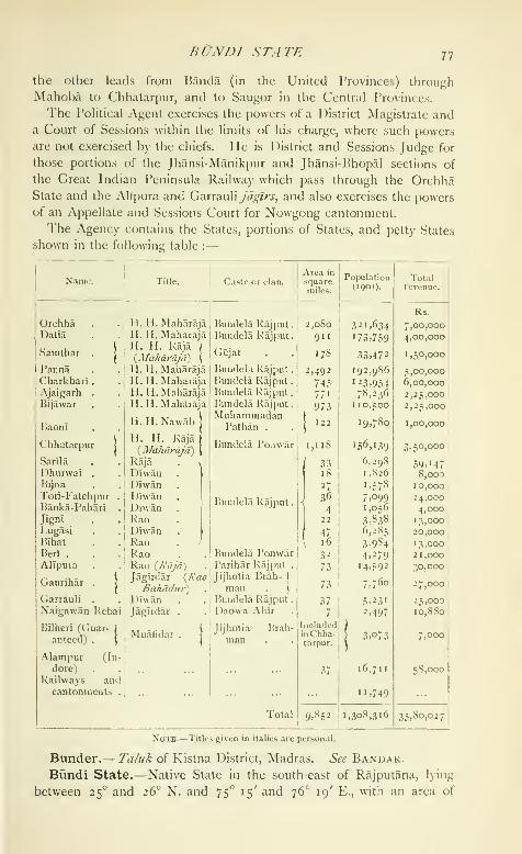
BUNDI STATE 11
the other leads from Banda (in the United Provinces) through
Mahoba to Chhatarpur, and to Saugor in the Central Provinces.
The Political Agent exercises the powers of a District Magistrate anda Court of Sessions within the limits of his charge, where such powers
are not exercised by the chiefs. He is District and Sessions Judge for
those portions of the Jhansi-Manikpur and Jhansi-JMiopal sections of
the Great Indian Peninsula Railway which pass through the OrchhaState and the Alipura and Garrauliy'(/i,7/'j-, and also exercises the powersof an Appellate and Sessions Court for Nowgong cantonment.
The Agency contains the States, portions of States, and petty States
shown in the following table :
—
Name.
78 BtJNDI STATE
2,220 square miles. It is bounded on the north by Jaipur and Tonk
;
on the west by Udaipur ; and on the south and east by Kotah. Theterritory may be roughly described as an irregular rhombus, traversed
throughout its whole length from south-west to north-east by a double
line of hills, constituting the central Bundi range, which divides the
country into two almost equal portions. For many miles the precipitous
scarp on the southern face of this range forms anPhysical almost impassable barrier between the plain countryaspects. ^ r J
on either side. There are four passes : namely, one
at the town of Bundi, through which runs the road from Deoli to
Kotah ; another a little farther to the east near Jainwas, through which
the direct road to Tonk passes ; a third between Ramgarh and Khat-
garh, where the Mej river has cut a channel for itself; and the fourth
near Lakheri in the north-east. The highest peak of the range (1,793
feet above the sea) is at Satur, 10 miles west of Bundi town. TheChambal, though it never enters Bundi territory, forms for very nearly
the whole distance the southern and eastern boundaries of the State
;
it varies in breadth from 200 to 400 yards, and in places, notably at
Keshorai Patan, where it is crossed by a ferry, attains considerable
depth. Its principal tributary from the Bundi side is the Mej. Thelatter, rising in Mewar at an elevation of about 1,700 feet above sea-
level, flows almost due north for 13 miles, till it enters Bundi territory
near the village of Negarh. Thence it proceeds in a north-easterly
direction a little beyond Dablana, where it inclines almost due east for
about 16 miles ; and then, turning abruptly south, it cuts its way
through the central range, and emerging near Khatgarh, bends with
a long and tortuous sweep again to the east, and continuing more or
less parallel with the range, falls into the Chambal in the north-east
corner of the State. In this way the Mej drains both the northern
and southern portions of the State ; its chief tributary in the former
is the Bajaen and in the latter the Kural.
The western portion of Bundi is occupied by schists belonging to
the Aravalli system, among which are a few outliers of quartzite belong-
ing to the Delhi system. At the capital, sandstones of Upper Vindhyan
age are faulted down against the Aravalli schists, and a few outliers of
the same sandstones are found resting upon the schists in the northern
side of the fault. Traces of copper have been found near Dutunda
;
and iron was formerly worked to a small extent near Bhaironpura,
7 nn'lcs north-east of the capital, and also in the north-west corner of
the State at I'agara.
The Bundi jungles were in old days famous for their big game. Todtells us that Maharao Raja Bishan Singh, who died in 182 1, 'had slain
upwards of 100 lions with his own hand, besides many tigers ; and
boars innumerable liad been victims to his lance.' There arc now no
HISTOR Y 79
lions in the Stale, but tigers and black bears are still found in parts,
while leopards are numerous. Sdmbar [Ccrvus unicolor) and chital
(C axis) died in large numbers during the drought (jf iSQQ-iyoo, but
are now again on the increase.
The climate is but moderately healthy ; fevers and rheumatism
prevail to a considerable extent. Statistics of rainfall are available only
since 1890 and for the capital. The annual rainfall averages about
20 inches, and has varied from nearly 42 inches in 1900 to 13 inches
in 1890.
The chief of liundi is the head of the Hara sept of the great clan of
Chauhan Rajputs, and the country occupied by this sept has for the
last five or six centuries been known as Haraoti.
The Chauhans came from Northern India to Sam-
bhar, a town now held jointly b)- the chiefs of Jaipur and Jodhpur,
about the beginning of the eighth century, and after ruling there and at
Ajmer, gained the kingdom of Delhi. The last Hindu king of Delhi
was the famous Prithwi Raj Chauhan, who was killed in 1192 in
a battle with Muhammad Ghorl. While, however, the Chauhans were
still ruling at Sambhar towards the end of the tenth century, one
Lachhman Raj or Lakhan, the younger son of Wakpati Raj, alias
Manik Rai I, set out to found a kingdom for himself and proceeded
south-west to Nauol. Here his descendants ruled for at)out 200 years,
when Manik Rai H migrated with some of the clan and settled downin the south-east corner of Mewar at or near Bumbaoda, Menal, ivic.
The sixth in descent from Manik Rai H was Rao Hado or Har Raj,
from whom the sept take the name of Hara. This account differs from
that given by the Bundi bards, and by Colonel Tod in his Rajasihan,
but is based on inscriptions found at Nadol, Achalgarh, and Menal.
The local authorities say the name ' Hara ' was assumed in consequence
of a miracle performed in the fifth century by Asapura Devi, the
guardian goddess of the Chauhans, over the bones {Iiadd) of Bhanuraj,
the son of the Raja of Hansi, who had been devoured by some demon.
According to Tod, the date was about 1022 and the demon was no less
a person than Mahmud of Ghazni, who killed and dismembered the
Chauhan chief, but the latter was restored to life by the goddess.
About 1342 Rao Dewa or Deoraj, the second chief after Har Raj, took
the town now called Bundi from the Minas, and made them acknow-
ledge him as their lord. He may be considered the founder of the
State, and since his time there have been twenty-one chiefs of Bundi.
Constant feuds and battles with Mewar took place in the fifteenth
century, but the most dangerous enemy of the Haras was the powerful
Muhammadan dynasty of Malwa. An army sent by the Sultan of
Mandu besieged and took Bundi about 1457, Rao Bairi Sal and manyof his nobles falling in its defence. The Rao's youngest son. Sham

So BUNDI STATE
Singh, was carried off by the invaders, and brought up as a Musalman
under the name of Samarkand. Shortly afterwards the Haras com-
menced plundering the territories of Mandu, and another army was
sent against them under the command of Samarkand, who took Bundi
and ruled there for some years, till he was killed by Rao Narayan Das.
The next chief of note was Rao Surjan, with whose accession in 1554commenced a new era for the Bundi State. During the preceding
200 years the Hara chiefs had, while possessing a certain amount of
independence, been to a considerable extent vassals of the Ranas of
Udaipur. Their services had been requisitioned by the latter in times
of emergency, and had been given as much on account of the relation-
ship engendered by marriages between the two houses as from any
feeling of dependence. Rao Surjan had, possibly as governor on behalf
of the Rana, obtained possession of the famous fortress of Rantham-BHOR, which was much coveted by Akbar. According to Musalman
historians, the emperor besieged it in person and took it in a month;
but the Hindu version is that the siege was ineffectual, and that Akbar
obtained by stratagem and courtesy what he had failed to secure by
force of arms. In any case the fort passed into the possession of the
emperor, and the Bundi chief is said to have received as a reward the
government of fifty-two districts including Benares, and the commandof 2,000. By this transaction the Bundi State threw in its lot with the
Muhammadan emperors, and from this period (1569) the Hara chief
bore the title of Rao Raja. Several of Surjan's successors took service
with the emperors of Delhi, obtained high rank, and received large
grants of land, which were alternately resumed and restored as they
lost or gained favour, or took the wrong or right side in the struggle
for empire.
In the beginning of the seventeenth century occurred the partition
of Haraoti and the formation of Kotah as a separate State. Rao Raja
Ratan Singh, chief of Bundi, had given in jdglr to his son, MadhoSingh, the town of Kotah and its dependencies. They joined the
imperial army at Burhanj)ur when Jahangir's son, Khurram, was
threatening rebellion against his father ; and for services then rendered,
Ratan Singh obtained the government of Burhanpur, and Madho Singh
received Kotah and its dependencies, to be held by him and his heirs
direct from the crown. After Ratan Singh came Rao Raja Chhatarsal,
who was one of the most gallant chiefs of liundi. He took part in
many battles in the Deccan (such as Daulatilbad, Bidar, Gulbarga, &c.),
and was finally killed leading the vanguard of the army of Dara against
Aurangzeb in 1658. The new em[)eror naturally transferred all the
resentment he harboured against Chhatarsal to his son and successor
Bhao Singh, but after vainly attempting to ruin him, decided to use
him, and gave him the gcjvcrnmcnt of Aurangabad. In 1707, in the

HISTORY 8r
battle for Aurangzeb's vacant throne, Budh Singh, chief of Bundi, held
a prominent post, and by his conduct and courage contributed largely
to the victory which left Shah Alam Bahadur Shah without a rival.
For these services Budh Singh was made a Maharao Raja, a title borne
by his successors to this day. Shortly afterwards occurred a bitter feud
with Jaipur, and Budh Singh was driven out of his country and died in
exile. His son, Umed Singh, after many gallant efforts, succeeded,
with the assistance of Malhar Rao Holkar, in recovering his patrimony
in 1 748 ; but he had to make over to the Marathas, as payment for
their services, the town and district of I'atan. In 1 7 70 Umed Singh
abdicated in favour of his son, Ajit Singh, who, three years later, killed
Rana Ari Singh of Udaipur when out shooting with him. Centuries
before, a dying sail is said to have prophesied that ' the Rao and the
Rana should never meet at the ahainx or spring hunt without death
ensuing,' and the prophecy has indeed proved true; for in 1531 RaoSiiraj Mai and Rana Ratan Singh were shooting together in the Bundi
jungles and killed each other, while in 1773, as above stated, Ajit
Singh of Bundi killed Rana Ari Singh. In consequence of these
unfortunate incidents there is a feud between the two houses, which is
not yet forgotten. Ajit lived for only a few months after the event last
mentioned, and was succeeded by his son, Bishan Singh, who gave
most efficient assistance to Colonel INIonson in his disastrous retreat
before the army of Holkar in 1804, thereby bringing on himself the
special vengeance of the Maratha leader. From that time up to 181
7
the Marathas and Pindaris constantly ravaged the State, exacting
tribute and assuming supremacy.
On February 10, 181 8, a treaty was concluded with Bishan Singh by
which the State of Bundi was taken under British protection. Thetribute formerly paid to Holkar was remitted, and the lands held by
that chief in Bundi were also restored to Bishan Singh, who further
agreed to pay to the British Government the tribute he had been
paying to Sindhia. This was fixed at Rs. 80,000 a year, of which one-
half was on account of Sindhia's share (two-thirds) of the revenue of the
Patan district, which Government intended to restore to Bundi, under
the belief that it had been usurped by Sindhia. When, however, it was
found that Sindhia had not usurped this portion of the Patan district,
but had received it from the Peshwa, to whom it had been ceded by
Bundi for assistance rendered in expelling a usurper, the tribute i)ayable
by Bundi was reduced to Rs. 40,000 a year. So it remained till 1S47,
when, with the consent of Sindhia, his share of the Patan district was
made over in perpetuity to the Bundi chief on payment of a further sum
of Rs. 80,000 a year to be credited to Gwalior. Under the treaty of
i860 with Sindhia, the sovereignty of the tract in question was trans-
ferred to the ]5ritish Government, from whom Bundi now holds it as
VOL. IX.

82 BUNDI STATE
a perpetual fief, subject to a payment of Rs. 80,000 a year, in addition
to the tribute of Rs. 40,000 payable under the treaty of i8r8.
Bishan Singh died in 1821 and was succeeded by his son RamSingh, then ten years of age. The murder of his minister, Kishan
Ram, in 1830 by an armed party from Jodhpur would have probably
caused hostilities between the two States but for the intervention of the
British Government. Maharao Raja Ram Singh's attitude towards the
British Government during the Mutiny of 1857 was one of apathy and
lukewarmness, which in the case of the rising of the State troops at
Kotah amounted almost to an open support of the rebels' cause, due
in some measure to the fact that the chief was not on good terms with
the ISIaharao of Kotah. He, however, received in 1862 the usual sanad
conferring on him the right of adoption, was created a G. C.S.I, and
a Counsellor of the Empire in 1877, and a CLE. in 1878. His rule
was old-fashioned but popular, and was remarkable for the strict
integrity he evinced in all his actions. He himself was described as
the most conservative prince in conservative Rajputana, and a grand
specimen of a true Rajput gentleman. He died full of years and
honours in 1889, having ruled for nearly sixty-eight years, and was
succeeded by his son, Raghubir Singh, the present Maharao Raja, whowas invested with full governing powers in 1890. The only recent
event of importance has been the great famine of 1899- 1900, Theadministration is conducted largely on the same old-fashioned lines.
His Highness was made a K. C.S.I, in 1897 and a G.C.I.E. in 1901,
and is entitled to a salute of 17 guns; he has no surviving sons, and
his nearest relation is his brother.
The number of towns and villages in the Slate is 819, and the poj^u-
lation at each of the three enumerations was: (1881) 254,701, (1891)
„ , ^. 295,675, and (1901) 171,227. The decrease of 42 perPopulation. yj> 10' \ j j 1 ^ 1
,^
cent, dunng the last decade was due to the great
famine of 1 899-1 900, and to the outbreak of a severe type of fever
which followed it. The State is divided into twelve tahstls and con-
tains two towns, BuNDi and Naenwa. The table on the next page
gives the chief statistics of population in 1901.
In 1901 Hindus numl)ered 156,359, or over 91 per cent, of the total ;
Musalmans, 8,377, or nearly 5 per cent.; and Jains, 6,482, or nearly
4 per cent. The language mainly spoken is known as Haraoti, a form
of Jaijiurl, which is one of the four main groui)s of Rajasthani.
The most numerous caste in the State is that of the Minas, num-bering 22,000, or about 13 per cent, of the total. They once possessed
a good deal of this territory, and were noted as daring and expert
plunderers, dacoity being their profession and their pastime ; they have
now settled down and become very fair agriculturists and soldiers.
A wild tract of country in the vicinity of the cantonment of Deoli is

AGNicrrrrRE 83
called the Mina Klierar ; it c(>nsi^>ts of several villages belonging to the
Bundi, Jaipur, and Mewar States, which are inhabited by I'arihar
Minas, or Minas who claim descent from the Parihar Rajputs who used
to rule at Mandor in Jodhpur. Owing to the civilizing influence of
the Deoli Irregular For( e, now the 42nd (Deoli) regiment, the Mina
Kherar is at the present time as peaceable as it was formerly turbulent.
After the Mfnas come the Gujars (18,000), who are cattle-dealers and
breeders and agriculturists; the Brahmans (17,000), the Malis or
gardeners (13,000), the Mahajans or bankers and traders (ir,4oo), and
the Chamars or workers in leather (10,700). Taking the population as
a wht)le, more than 55 per rent, live solely by the land, and many moreare partially agriculturists.
Subdivision.
84 BUNDI STATE
The area irrigated is about 70 square miles, almost entirely from
wells, of which there are about 10,000. Leathern buckets drawn up
with a rope and pulley by bullocks moving down an inclined plane are
universally used for lifting the water. The only irrigation tanks are
those at Hindoli and Dugari, which are said to irrigate 240 and
600 acres respectively.
Large tracts of Bundi are woodland, and the total forest area is re-
turned as about 890 square miles. The commonest trees are the khair
{Acacia Catechu), khejra {Prosopis spicigera), babul {Acacia arabica),
dhak {Butea frofidosa), inahud (Bassia latifolia), gu/ar {Ficus glottie-
rata\ sal {Shorea robusta\ goiya {Tretna orientals), film {Melia
Azadirachfa), plpal {Ficus re/igiosa), bar {Ficus bengale?isis), aonla
{Phyllanthus Emblica\ tamarind, and tendu {Diospyros tomentosd).
The forests are not systematically worked, but are fairly protected.
The net forest revenue is about Rs. 4,000.
The iron mines in the north-west corner were at one time extensively
worked, but are now deserted. Limestone admirably adapted for
building purposes is found in several parts.
The manufactures are unimportant. There is a cotton-press belong-
ing to the State at Baori, 10 miles from Deoli, in
iradean which on an average about 44,000 maunds of cottoncommumcations. ° '*^'
are pressed yearly at a profit to the Darbar of about
Rs. 21,000. In the working season 60 hands are employed.
The chief exports are cotton, oilseeds, spices, opium, hides, gum,
wool, and ghl ; while the chief imports include piece-goods, sugar,
rice, salt, and metals.
There is no railway in the State, the nearest stations being Naslrabad
on the Rajputana-Malwa line, 87 miles north-west of Bundi town, and
Baran on the Indian Midland Railway, 65 miles to the south-east.
The Nagda-Muttra line, now under construction, will, however, traverse
the eastern portion of the territory, while the proposed Baran-Ajmer-
Marwar Railway, the earthwork of which was practically completed
during the famine of 1899-1900, is to run close to the capital. Thetotal length of metalled roads is nearly 47 miles, and of unmetalled
roads 9f miles, all maintained by the State. There are, in addition,
the usual country tracks. The only British post office is situated at
the cai)ital, but the Darbar has a local postal system of its own.
Famine is an exceptional occurrence. Distress is said to have pre-
vailed in 1833-4, while in 1868-9 there was great scarcity of fodder and
two-thirds of the cattle perished. The State sufferedFamine. ^ r, i
• -i 1 r •
severely in 1899-1900, and it was not until the famine
had well advanced that the Darbar made any practical effort to relieve the
prevailing distress, (irain, fodder, and water were alike deficient. One-
half of the cattle are said to have died, and, excluding cholera and
ADMINISTR. I TION 85
small-pox, the death-rate among human beings was higher than it
should have been. More than 3,000,000 units were relieved on works,
and 754,000 in poorhouses ; the total direct expenditure by the Darbar
exceeded 3-7 lakhs, while land revenue to the extent of 4 lakhs was
remitted. In addition, a further sum of about i-8 lakhs, granted by the
committee of the Indian Charitable Relief Fund, was spent in giving
extra food to the people and providing them with bullocks, grain, &c.
The State is governed by the Maharao Raja, assisted by a council,
which is divided into five departments under five working members.
The twelve tahslls are each under a tahsildar, and,, 1 J- • •
1 X J - • J 7 7 Administrationsmaller subdivisions are under patwans and shahnas.
For the guidance of the various courts of justice the State has its owncriminal and civil codes, based on Hindu law, the customs of the
country, and the similar enactments of British India. The lowest court
is that of the kotwdl, whose jurisdiction is confined to the capital ; this
official disposes of petty civil suits not exceeding Rs. 25 in value, and
on the criminal side can pass a sentence of one month's imprisonment
or fine up to Rs. 11. Next come the courts of the tahs'ilddrs^ of the
two kiladars or governors of the forts of Taragarh (at the capital) and
Naenwa, and of an official known as \.\\ejag'ir bakhshi, who disposes of
petty cases occurring in the estates of \htjaglrdars. These courts have
the same criminal powers as the kottvdl, and decide civil suits not exceed-
ing Rs. 200 in value. The superior civil and criminal courts, namely
those of the Hakim dhvdiii and Hakim faujdari, are located at the
capital ; they hear appeals against the decisions of all the courts men-
tioned above, and try cases beyond their powers. The civil court
decides suits not exceeding Rs. 2,000 in value, while the criminal court
can punish with imprisonment up to one year and fine up to Rs. 100.
The highest court is that of the council, the final appellate authority
in the State ; it disposes of all cases beyond the powers of the two
tribunals last mentioned, and when presided over by the Maharao Raja
can pass sentence of death.
The normal revenue is nearly 6 lakhs, the chief sources being land
(including tribute from Jdgtrddrs), about 3-6 lakhs ; and customs,
1-8 lakhs. The ordinary expenditure is about 5-6 lakhs, the main items
being: cost of establishment (civil and judicial), 1-3 lakhs; army andpolice, i'3 lakhs; tribute, i'2 lakhs; and household expenditure (in-
cluding the chief's privy purse), 12 lakhs. Owing principally to the
famine of 1899-iyoo, the State owes about a lakh to the British
Government, but has ample assets.
Bundi has had a silver coinage of its own since the time of Shah
Alam II, and there have been various issues under different names. Upto 1901 four kinds of rupees were current in the State: namely, the old
rupee struck between 1759 and 1S59 ; the Gyorah sana or rupee of the

86 BUNDI STATE
eleventh year of Akbar II ; the Ram shahi, struck between 1859 and
1886, and named after the late chief; and the Katdr shahi, first coined
in 1886, and so called from the dagger {katdr) on its obverse. Of these
coins, the Gydrah sana was always largely mixed with alloy, and was
therefore used for charitable purposes, weddings, &c. ; but the other
rupees were at one time or another of the same value as the British
rupee. The Bundi rupees depreciated to such an extent that, in
1899-1900, 162 of them exchanged for 100 British rupees. In 1901
the Darbar declared that in future the sole legal tender, besides British
coin, would be the Chehra shiihi, which it proceeded to coin and issue.
This rupee is said to be of pure silver, and now exchanges for i^\
British annas.
The land revenue was formerly collected partly in cash and partly in
kind, but since 1881 has been paid entirely in cash at rates then fixed
by the Darbar. There are said to be 142 different rates for 'wet' and
99 for ' dry ' land ; they vary with the quality of the soil, the distance of
the field from the village site, &c. The maximum and minimum rates
per acre are : for ' wet ' land Rs. 14-14-0 and Rs. 2-3-0, and for ' dry
'
land Rs. 8 and 2^ annas respectively, all in the local currency. In the
khdlsa area, comprising about two-thirds of the State, the cultivator, so
long as he pays the demand regularly, is not disturbed in his possession.
The bhumids, now few in number, are always Rajputs ; they hold a few
acres of land rent-free, and in return render miscellaneous services.
They receive small quantities of grain from the cultivators of their
villages, and every third year pay from one-third to one-half of their
income to the Darbar. The chauth-battas, so called from the rent
payable by them having been fixed at one-fourth of the produce of
their fields, are also Rajputs, and their number is comparatively large.
They now hold their land at a reduced rate and perform the same duties
as the bhuniids^ but they receive no perquisites from their villages and
are excused the tribute to the Darbar every third year. Lands are held
on Jdgir tenure by relations and connexions of the chief, by other
Rajputs, and in some cases by officials in lieu of salary. Some of the
jdgirddrs hold their lands rent-free, but the majority pay tribute ; all have
to perform service when called on, both in person and with their con-
tingents, but the number of the latter is dependent rather on the will of
the chief than on any fixed rating. All jdi^lr estates are liable to be
resumed for misconduct. Kliairat lands, or those granted to Brahmans
or religious and charitable institutions, are held rent-free and cannot
be alienated. If tlie holder has no male issue, the land is resumed.
The military force consists of 350 regulars (100 cavalry, 200 infantry,
and 50 artillerymen) and 400 irregular infantry ; there are 48 service-
able guns.
'J'hc police force consists of 722 men, all unmounted. Of these, 79

BUNDI TOWN 87
do duty at the capital and the remainder are distributed over 13 thdnas
in the rest of the State. The Central jail has accommodation for 149prisoners, and there are small lock-ups at the head-quarters of each
tahstl.
In respect of the literacy of its population Bundi stands fifteenth
among the twenty States and chicfships of Rajputana, with 25 per cent.
(4-7 males and o-i females) able to read and write. Only two educa-
tional institutions are maintained by the State : namely, a high school at
the capital, and a small vernacular school at Naenwa, which are attended
by 200 boys, of whom 60 study English. There are said to be about
12 indigenous schools under private management. The total State
expenditure on education is about Rs. 3,000 a year.
There is but one hospital, at the capital ; it is maintained by the
Darbar at a cost varying from Rs. 1,800 to Rs. 2,500 a year. Vaccination
is nowhere compulsory, and is everywhere backward. A staff of two
vaccinators is kept up, which in 1904-5 successfully vaccinated only
561 persons, or about 3 per i,oco of the population, while the average
number vaccinated in each of the previous five years was but 164.
yKajputdna Gazetteer, vol. i (1879, under revision).]
Bundi To"wn.— Capital of the State of the same name in Rajput-
ana, situated in 25° 27' N. and 75° 39' E., about 100 miles south-east
of Ajmer city. It is said to be named after a Mina chieftain called
Bunda, from whose grandson it was taken by Rao Dewa about 1342.
Population (1901), 19,313. The town possesses a combined post and
telegraph office, a jail, a high school attended by r6o boys, and a hospital
with accommodation for 11 in-patients, in which 9,362 cases were
treated in 1904 and 343 operations were performed.
Bundi is one of the most picturesque towns in Rajputana. It is
situated in a gorge nearly surrounded by wooded hills, and is entirely
enclosed within walled fortifications through which ingress and egress
are obtained by means of four gateways ; namely, the Bhairon Gate on
the west, the Chaogan Gate on the south, the Baton Pol on the east, and
the Shukl Baori (iate on the north. The streets and houses rise and
fall with the unevenness of the ground, and some of the suburbs have
crept upwards on both of the northern slopes. The principal bazar,
nearly 50 feet in width, runs throughout the whole length of the town,
but the other streets are narrow and very irregular. The palace, rising
up above the town in pinnacled terraces on the slope of a hill having an
elevation of over 1,400 feet above sea-level, is a striking feature of the
place. Tod writes that, throughout Rajputana, which boasts many fine
palaces, that of Bundi
'is allowed to possess the first rank, for which it is indebted to situation
not less than to the splendid additions which it has continually received :
for it is an aggregate of palaces, each having the name of its founder,

88 BUNDI TOWN
and yet the whole so well harmonizes and the character of the architec-
ture is so uniform that its breaks or fantasies appear only to arise from
the peculiarity of the position and serve to diversify its beauties.'
Above the palace is the fort of Taragarh, and a spur of the same hill is
surmounted by a large and very handsome chhatri, called the Suraj or
' sun-dome,' whose cupola rests on sixteen pillars and is about 20 feet in
diameter. Beyond this to the north-west lies the Phul Sagar or ' flower
tank,' and a small palace, the summer residence of the chief ; and to the
south-west of this is the Naya Bagh or Bajrangbilas. To the north-east
of the town is another tank, the Jet Sagar or Bara Talao, on the embank-
ment of which stands an open palace called the Sukh Mahal ; and a little
farther on is the Sar Bagh, the place of cremation for the Bundi chiefs.
Immediately to the east of the town rises anabrupt cliff 1,426 feet above
the sea ; and on its summit is a small mosque said to have been built
before the Hara Rajputs came here, and called after Mlran, a Muham-madan saint, whose tomb is at Ajmer.
Bundu.—Town in the Khunti subdivision of Ranch! District,
Bengal, situated in 23° 10' N. and 85° 36' E. Population (1901), 5,469.
Bundu is the centre of the lac industry in the District and a flourish-
ing trade mart.
Buner.—A tract of country lying between 34° 22' and 34° 37' N.
and 72° 15' and 72° 48 E., on the north-east border of Peshawar Dis-
trict, North-West Frontier Province. Its boundaries are : on the north.
Swat Kohistan ; on the west, Swat and Sam Ranizai ; on the south,
dependent tribes and Peshawar District ; on the east, the Black Moun-
tain and Hazara District. Political control is exercised by the Deputy-
Commissioner of Peshawar through the Assistant Commissioner at
Mardan. Buner comprises the basin of the Barandu river, which
joins the Indus near Amb. The main valley of the Barandu is about
10 miles broad, well cultivated and level; and though the side valleys
are narrower and less fertile, they are better wooded. The aloofness of
the inhabitants, arising from the fact that no trade arteries pierce the
country, is very marked. They are, however, recognized by the clans
who live between Buner and Peshawar District, such as the Gaduns,
Salarzai, Khudu Khel, &c., as the head of their confederacy.
The history of the tract is given in the article dealing with Swat.
Buner with the neighbouring countries was included in the ancient
kingdom of Udyana, and abounds in archaeological remains of great
interest, which date from the Buddhist era. The places most interest-
ing from an archaeological view in Buner, or in the territory of tribes
dependent on it, are Mahaban, Banj, Asgrani, Panjkotai, (iumbatai, and
Girarai. Mahaban has been conjecturally identified with Aornos, the
rock besieged by Alexander ; but the latest view, that of 1 )r. Stein, whovisited Mahaban under tribal escort in 1904, is that llie lopogra[)hy of
BURDlVAy DIVISION 89
Aornos is inapplicable to Mahabaii, and that the real Aornos, if there be
such a place, must be sought elsewhere. In the same tour lianj was
examined ; and the suggestion has been made that it is the famous
place of Buddhist pilgrimage, at which a shrine was built to commemo-rate the offering of his body by the Buddha to feed a starving tigress.
The buildings described by the ('hinese pilgrims are now completely in
ruins and all sculptures have been removed.
The ruins at Asgram are of some interest, and the place has been
identified with the Asigramma of I'tolemy. Buner proper was traversed
by Dr. Stein in January, 1898, with the force dispatched for the punish-
ment of the Bunerwals. In the report then published reasons were set
forth for the identification of Panjkotai with the site of the famous
Mahawana monastery described by the Chinese pilgrims, of Gumbatai
(Tursak) with the Mosu monastery and shrine, and of Girarai with the
shrine commemorating Buddha's ransoming of a dove, also a place
of pilgrimage.
Bunera.—-Estate and chief town thereof in Udaipur State, Rajputana.
See Bankka.
Burdwan Division.^A Division or Commissionership in Bengal,
lying between 21° 36' and 24° 35' N. and 86° n' and 88° 30' E. TheDivision, which covers an area commonly known as West Bengal,
includes all the Districts of Bengal proper west of the Bhagirathi, the
earliest known channel of the Ganges, and corresponds roughly to
the ancient Rarh and Tamralipta. The Bhagirathi, called in its lower
reaches the Hooghly, separates it from the Presidency Division, and it
extends along the right bank of this river to its mouth in the Bay of
Bengal. It is bounded on the south and west by the sub-provinces
of Orissa and Ch(jta Nagpur, and on the north by the Santal Parganas
and Murshidabiid District.
Though outside the Gangetic delta, the eastern portion of the tract is
low and of alluvial formation. Farther west, laterite begins to predomi-
nate, and the surface rises and becomes more and more undulating and
rocky until at last, in the west of Birbhum, Burdwan, Ixinkura, and
Midnapore, it embraces the eastern fringe of the Chota Nagpur plateau.
Since the Division was constituted in 1854, the head-quarters have
been several times moved between Burdwan, Howrah, Hooghly, and
Chinsura. They were finally transferred to Chinsura in 1896. Thetable on next page gives details of the area, population, and land revenue
of the six Districts of which the Division is composed.
The recorded population fell from 7,604,661 in 1S72 to 7,393,954 in
1 88 1, but rose again to 7,689,189 in 1891. The greater portion of the
Division suffered severely from the ravages of the notorious Burdwan
fever {see Burdw.\n District), which broke out nearly half a century
ago and caused a terrible mortality. During the last twenty years the
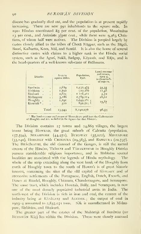
9° BURBWA.y DIVISION
disease has gradually died out, and the population is at present rapidly
increasing. There are now 591 inhabitants to the square mile. In
1 90 1 Hindus constituted 83 per cent, of the population, Musalmans
13 per cent., and Animists 3^per cent., while there were 9,463 Chris-
tians, of whom half were natives. The Division is peopled largely by
castes closely allied to the tribes of Chota Nagpur, such as the Bagdi,
Bauri, Kaibartta, Kora, Mai, and Santal. It is also the home of several
distinctive castes with claims to a higher rank in the Hindu social
system, such as the Aguri, Sukli, Sadgop, Kayasth, and Raju, and is
the head-quarters of a well-known sub-caste of Brahmans.
District.
BURDIVAN DISTRICT gi
at the time of the Permanent Settlement, and the present land revenue
of the Division thus exceeds that of the great Patna Divisi(jn, which
has nearly double its area and population.
Burdwan District.— District in the Burdwan Division of Bengal,
lying between 22° 56' and 23° 53' N. and 86° 48' and 88° 25' E., with
an area of 2,689 scjuare miles. It is bounded on the north by the
Santcil Parganas, Birbhum, and Murshidabad ; on the east by Nadia;
on the south by Hooghly, Midnapore, and Bankura ; and on the west
by Manbhum. The administrative head-quarters are at BurimvanTown.
About half of the 1 )istrict is flat, and in the east along the banks of
the Bhagirathi the soil is waterlogged and swampy. In the north-west,
however, the surface undulates, and it is here that the
famous RanTuani coal-field is situated. This cornerysica
... ... . aspects.of the District is one of the busiest industrial tracts
in Bengal, and its coal and iron-fields are thronged by miners from
the neighbouring Districts.
The principal rivers are the Damodar, the Dhalkisor or Dwarkeswar,
the Kharl, the Banka, and the Ajay, all eventually flowing into the
Bhagirathi or Hooghly, which demarcates the eastern boundary of
the District. The Barakar, though not properly speaking a river
of Burdwan, passes along the north-western boundary for a few miles
before its junction with the Damodar. The Ajay touches Burdwan at
its extreme north-western corner, and forms its northern boundary till
shortly before its junction with the Bhnglrathi. The Dwarkeswar runs
for about 5 miles along the southern corner of the District. The Kharl,
a tortuous stream rising in the Galsi thana, joins the Bhagirathi some
6 miles north of Kalna. The Banka, which also rises in the Galsi thdfia
and passes through the town of Burdwan, flows into the Kharl shortly
before its junction with the Bhagirathi. The Kunur, which rises in
the Farldpur outpost, is a tributary of the Ajay ; and the Singaran,
which flows through the Raniganj thana, joins the Damodar.
The District is covered by alluvium, except in the Asansol subdivi-
sion, where Gondwana rocks are exposed. These strata extend into the
Districts of Bankura, the Santal Parganas, and Manbhum, the outcrop
covering an area of 500 square miles ; they have a dip of from 5° to 25°
to the south, and along the southern boundary are turned up and cut off
by a great fixult. The total thickness is estimated at 11,000 feet; and
the strata are divisible into the Talchers at the ba.se, the Damodar in
the centre, and the Panchet at the top. The Talchers consist oi fine
silty shales and soft sandstones, among which occur, generally towards
the base of the group, well-rolled pebbles and boulders of gneiss and
other metamorphic rocks. The Damodar series is subdivided, in
ascending order, into the liarakar sta^e, the ironstone shales, and the

92 BURDWAX DISTRICT
Ranlganj stage. The Barakars consist chiefly of sandstones, conglomer-
ates, and coal-seams of somewhat irregular character, thinning out at
short distances ; black carbonaceous shales with numerous bands of
clay ironstone constitute the ironstone shales ; and the Ranlganj beds
are made up of coarse and fine sandstones, mostly false-bedded and
feldspathic, and shales and coal-seams, which are frequently continuous
over considerable areas. The Panchet group is composed of greenish
and grey shales at the base, superimposed by red clays and coarse sand-
stones. All these groups have yielded plant fossils ; and the Panchet
rocks contain, in addition, reptilian and fish remains.
In land under rice cultivation are found the usual marsh weeds ot
the Gangetic plain and many sedges. On ponds and in ditches and
still streams float aquatic plants and many submerged water-weeds.
The District contains no forests, but the laterite country is in places
clothed with coppices of sal {^Shorea robusta). The villages and towns
are surrounded by the usual shrubberies of semi-spontaneous and sub-
economic shrubs and small trees. Species of figs, notably the plpal
and the banyan, make up, along with bamboos, tamarind, red cotton-tree
{Bombax malabaricum), ma.ngo {Ma?igiyera),Moringa,a.nd Odina Wodier^
the arborescent part of these thickets, in which are often present the
]idi\ms Phoenix dactylifera ?ind Borassus Jlabel/ifer. Hedges and waste
places are covered with climbing creepers and various milkweeds.
Roadsides are often clothed with a sward of short grasses, and open
glades with tall coarse grasses.
Leopards are found in the jungles adjoining the Bhaglrathi, and
wolves and hyenas are also occasionally met with.
Exceptionally high day temperatures are the feature of the hot
sea.son, the mean maximum rising to ioi° in April. The mean tempera-
ture for the year is 80°. Humidity is comparatively low, the meanfor the year being 77 per cent. The annual rainfall averages 54 inches,
of which 9-2 inches fall in June, 12 in July, and 11-7 in August.
In 1770 the town of Burdwan was practically destroyed by a rising
of the Damodar, and the whole country between this river and the
Ajay was submerged. In September, 1823, the Damodar and Bhaglrathi
flooded the country, causing immense damage and loss of life ; and
in 1855 there was another serious flood, when the embankment on
the right bank of the Damodar was destroyed. The country is nowprotected by embankments along the left bank of the Damodar and
the right bank of the Ajay.
Burdwan has been identified as the Parthalis or Portalis which,
according to the Greek geographers, was the royal city of the Gangarides.
. In the seventh century, under the Gupta kings, the
District formed part of a kingdom known as KamaSuvarna, and subsecjuently, under the Sen dynasty, of the Rarh division

POPULATION 93
of Bengal ; more recently Gopbhum appears to have been the seat of
a Sadgo[) dynasty with head-cjuarters at Amrargarli, where the long
lines of fortification which enclosed the town are still visible.
Burdwan is first mentioned in Muhammadan histories in 1574, in
which year, after Daud Khan's defeat and death at Rajmahal, his family
was captured in the town of Burdwan hy Akbar's troops. About ten
years later the I )istrict formed the scene of several engagements between
Baud's son Kuttu and the imperial forces. In 1624 prince Khurram,
afterwards the emperor Shah Jahan, captured the fort and town of
Burdwan. Soon afterwards Abu Rai, a Kapur KhattrT, migrated to
Bengal from the Punjab and founded the Burdwan Raj. The year
1696 was marked by the rebellion of Subha Singh, zainhiddr of Chitua
and Barda, who, with the help of the Afghans, slew the Raja of Burdwanand overran a great [)art of the province. In the beginning of the
eighteenth century the Marathas made their appearance at Katwa, andfor the next fifty years the District suffered severely at their hands, the
inhabitants frequently leaving their villages and seeking a refuge in the
swamps. In 1760 the District of liurdwan, together with Midnapore
and Chittagong, was ceded to the East India Company by Mir KasimKhan on the deposition of Mir Jafar Khan from the governorship of
Bengal. At that time it comprised the present Districts of Burdwan,
Bankura, Hooghly, and a third of Birbhum. In 1805 the Bishnupur
zamtnddri (Bankura) was included in the Jungle Mahals, and in 1819
Hooghly was also separated from it. Numerous minor transfers took
place until the year 1885, when the District assumed its present
proportions.
Some interesting tombs are found in Burdwan town, and groups of
Siva lifigam temples at Burdwan and Kalna. In the Garh jungle
near Senpahari in the Kaksa thiifia are the ruins of a fort said to have
been built by Raja Chitra Sen ; and near Barakar at the foot of the
Kalyaneswarl hill are temples whose building is attributed to an ancestor
of the Raja of Panchet. The temples at Begunia near Barakar also
deserve mention.
The population of the present District area decreased from 1,486,400
in 1872 to 1,394,220 in 1881, and to 1,391,880 in 1891, but rose again
to i,S'?2,47S in loor. The District for manv years ^ , .00 >t/o\ .
, ^ , 1 A Population,suffered from a malarial fever 01 a very virulent type
to which it gave its name. The real ' Burdwan fever,' which often
proved fatal within one or two days, appears to have died out, though
the District is still subject to fevers of a remittent type, the waterlogged
tract along the bank of the Bhagirathi being particularly unhealthy.
Cholera is seldom absent and is markedly endemic in the Kalna iliana,
but there have been no outbreaks of special violence in recent years.
The mortality due to this cause in 1902 was 1-87 per 1,000. Leprosy
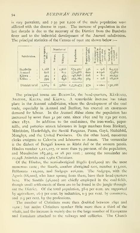
94 BURDWAN DISTRICT
is very prevalent, and 2-39 per 1,000 of the male population were
afflicted with the disease in 1901. The increase of population in the
last decade is due to the recovery of the District from the Burdwan
fever and to the industrial development of the Asansol subdivision.
The principal statistics of the Census of 1901 are shown below :
—
Subdivision.
BurdwanAsansolKatwa .
Kalna .
District total
Area
in
.square
miles.

ACRICri/rURE 95
Missionary Society is at work in lUirdwan town, anti the Wcslcyan
Methodist Mission supports a leper asylum and other charitable institu-
tions at Ranlganj. A Roman Catholic mission has a church and a
boarding-school in Asansol, where the Methodist Episcopal Mission
also maintains a leper asylum, orphanage, and school ; while at Kalna
a dispensary is kei)t up by the Scottish Free ('hurch Mission. Native
Christians numbered 1,027 'i^ 1901.
The alluvium which covers the greater part of the District is extremely
fertile ; but the uplands in the west and north are sterile, and in the
undulating rt^ky country in the extreme north-west.,
1 .1 * *u • Ti If Agriculture,maize is the only crop that thrives. 1 he chief
agricultural statistics for 1903-4 are shown below in square miles :—
Subdivision.

96 BURDU^AN DISTRICT
The cattle are poor, and there are no large pasture-grounds except
along the banks of the BhagTrathi ; but straw and grass are plentiful.
Annual fairs are held at Agradwip, Uddhanpur, Dadia, Bagnapara, and
Kanchannagar ; these are primarily religious gatherings, but are used
also for trade purposes.
About 33 square miles in the Burdwan and Jamalpur thdnas and in
the Memari outpost are irrigated from the Eden Canal and its dis-
tributaries ; and elsewhere small streams and tanks are often utilized
for irrigation, the water being lifted on to the fields by hollowed tree-
trunks known as dongas. In the Kaksa thdna near the Damodar a
few shallow irrigation wells have been sunk.
The character of the coal-field has been described under Geology.
The average of 31 assays of samples from different mines gives, as a
result : moisture, 4-80 per cent. ; volatile matter,
25-83 per cent. ; fixed carbon, 53-20 per cent. ; and
ash, 1 6- 1 7 per cent. The field extends from Andal to Barakar in the
Asansol subdivision. In spite of the difficulties caused by the scarcity
of labour and shortage of wagons, the mining industry has made very
rapid strides of late years. In 1903 there were no mines, with an
output of 2,759,000 tons, the number of work-people employed being
30,566. Most of these collieries are managed by European companies
with head-quarters in Calcutta, but some of them, notably the Siarsol
collieries, are owned and worked by natives. Most of the pits are
shallow and are worked by a system of inclines ; cages are, however,
used in all the principal European collieries, the deepest pit being one
in the Disergarh colliery near Barakar. The coal is used by steamers,
factories, and railways throughout India. Most of it is taken by rail
to Calcutta, whence large quantities are exported to Bombay and
Colombo. The miners are chiefly local Bauris or immigrant Santals.
They are usually paid 5 annas for loading a half-ton tub, and at this
rate a man can cam 1 2 annas a day.
An iron-field is situated near Barul, about 1 1 miles north of RanT-
ganj, and pig-iron is smelted at the Barakar Iron and Steel Works. In
1904 the out-turn was 40,000 tons of pig-iron valued at i7'30 lakhs,
and 15,000 tons of castings valued at 12 lakhs. 'I'he ore is obtained
chiefly from the ironstone shales of the Damcxlar series. Below the
ground the ore is in the fijrni of carbonate, but at the surface it
consists of hematite and limcniite.
'I'he out-turn of the pottery works at Raniganj was valued at 7 lakhs
in 1904. The clays used are chiefly obtained in the neighbourhood
of the coal-measures, and consist of more or less decomposed shales.
A quantity of laterite road-metal is exported by rail from the Kaksa
thdna in the Asansol subdivision.
Silk and cotton-weaving were formerly important industries ; but
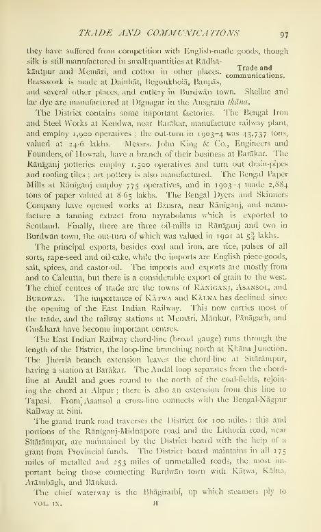
TRADE AND COMMUNICATIONS 97
they have suffered from competition with English-made goods, though
silk is still manufactured in small (|uantities at Radha-
kantpur and Memari, and cotton in other places. . ..' '
.I _ communications.
Brasswork is made at Dainhat, Begunkhola, Banpas,
and several other places, and cutlery in Burdwan town. Shellac and
lac dye are manufactured at Dlgnagar in the Ausgram thdna.
The District contains some important factories. The Bengal Iron
and Steel Works at Kendwa, near Barakar, manufacture railway plant,
and employ 1,900 operatives ; the out-turn in 1903-4 was 43>737 tons,
valued at 246 lakhs. Messrs. John King & Co., Engineers and
Founders, of Howrah, have a branch of their business at Barakar. TheRanTganj potteries employ 1,500 o[)eratives and turn out drain-pipes
and roofing tiles ; art pottery is also manufactured. The Bengal Paper
Mills at RanTganj employ 775 operatives, and in 1903-4 made 2,884
tons of paper valued at 8-65 lakhs. The Bengal Dyers and Skinners
Company have opened works at Bansra, near Ranlganj, and manu-
facture a tanning extract from myrabolams which is exported to
Scotland. Finally, there are three oil-mills ui RanTganj and two in
Burdwan town, the out-turn of which was valued in 1901 at 5I lakhs.
The principal exi)orts, besides coal and iron, are rice, pulses of all
sorts, rape-seed and oil-cake, while the imports are English piece-goods,
salt, spices, and castor-oil. The imports and exports are mostly from
and to Calcutta, but there is a considerable export of grain to the west.
The chief centres of trade are the towns of Raniganj, Asansol, and
Burdwan, The importance of Katwa and Kalna has declined since
the opening of the East Indian Railway. This now carries most of
the trade, and the railway stations at Memari, Mankur, Panagarh, and
Cruskhara have become important centres.
The East Indian Railway chord-line (broad gauge) runs through the
length of the District, the loop-line branching north at Khana Junction.
The Jherria branch extension leaves the chord-line at Sltarampur,
having a station at Barakar, The Andal loop separates from the chord-
line at Andal and goes round to the north of the coal-fields, rejoin-
ing the chord at AlTpur ; there is also an extension from this line to
Tapasi. From] Asansol a cross-line connects with the Bengal-Nagpur
Railway at Sini.
The grand trunk road traverses the District for 100 miles ; this and
portions of the RanTganj-Midnapore road and the Lithoria road, near
Sltarampur, are maintained by the District board with the help of a
grant from Provincial funds. The District board maintains in all 175
miles of metalled and 253 miles of unmetalled roads, the most im-
portant being those connecting Burdwan town with Katwa, Kalna,
Arambagh, and Bankura.
The chief waterway is the Bhanirathi, up which steamers ply to
VOL. IX. H

08 nURDWAN DISTRICT
Kalna all the year round ; country boats also bring down a large quan-
tity of grain from Nadanghat, the principal rice mart in the interior.
There are important ferries over the Bhaglrathi and the Damodar.
Burdwan suffered severely in the great famine of 1770. In 1866,
the year of the Orissa famine, numbers of destitute persons flocked in
from the surrounding Districts, and relief was given
to 348,000 persons. Part of the District suffered
during the famine of 1873-4, and there was some distress in 1884-5,
when relief measures had to be undertaken in some isolated tracts and
Rs. 7,000 was spent on gratuitous relief. Again in 1904 the failure of
the rice crop caused considerable distress in the Katwa and head-
quarters subdivisions. The area affected was about 376 miles, and
relief works were opened by the District board ; but at no time did
the number on relief rise above 2,981. Besides this expenditure,
Rs. 35,000 was advanced in the shape of loans and Rs. 3,000 was
spent in gratuitous relief.
For administrative purposes the District is divided into four sub-
divisions, with head-quarters at Burdwan, Asansol, Kalna, and
Katwa. The staff subordinate to the Magistrate-
Collector at head-quarters consists of five Deputy-
Collectors and occasionally a Joint-Magistrate. A Covenanted Civil
Servant assisted by a Sub-Deputy-Collector is in charge of the Asansol
subdivision ; a Deputy-Collector assisted by a Sub-Deputy-Collector
is in charge of the Kalna subdivision ; and a Deputy-Collector with a
kd?iimgo is stationed at Katwa.
The civil courts at Burdwan are those of the District Judge, an
Additional Judge, a Sub-Judge, and five Munsifs ; there are also
Munsifs at Ranlganj and Kalna, and two at Katwa. The criminal
courts are those of the Sessions Judge, the District and subdivisional
magistrates, and their subordinates. Dacoities frequently occur, and
petty thefts and burglaries are very common in the Asansol subdivision,
especially in the neighbourhood of Asansol.
At the settlement of Todar Mai the present District of Burdwan fell
within various sarkdrs, portions of which were subsequently amalga-
mated into one great zaminddri, including the whole of Bankura and
Panchet (Manbhum) together with parts of Hooghly and Birbhum. It
had a revenue of 20-47 lakhs, and was granted to the East India
Company in 1760. At the time of the Permanent Settlement in 1793
the Maharaja of Burdwan, with whom it was settled, entered into
an agreement to pay a revenue of 40-15 lakhs of sicca rupees and
r-94 \'Akh9, f>iil/>a>id/ii (for up-keep of embankments). He experienced
great difficulty in meeting the Government demand on this huge
estate, but solved it by the creation of j)ermanent leases known as
fuit/il tenures, whose rent was fixed in perpetuity, but which could be
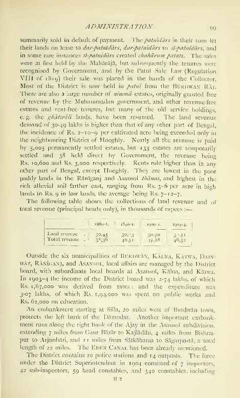
ADMIXTSTRA TTOX 99
summarily sold in default of payment. '\\\(^ patmdars in their turn let
their lands on lease to dar-pafnlddrs, dar-patnlddrs to si-patniddrs, andin some rare instances sl-patniddrs created c/iahdrum paints. The sales
were at first held by the Maharaja, but subsetjuently the tenures were
recognized by Government, and by the Patnl Sale Law (Regulation
VIII of 1819) their sale was placed in the hands of the Collector.
Most of the District is now held in patin from the Bukdwan Raj.
There are also a large number of aimmd estates, originally granted free
of revenue by the Muhammadan government, and other revenue-free
estates and rent-free tenures, but many of the old service holdings,
e, g. the (^hd/wd/i lands, have been resumed. The land revenue
demand of 30-49 lakhs is higher than that of any other part of Bengal,
the incidence of Rs. 2-10-9 P^'' cultivated acre being exceeded only in
the neighbouring District of Hooghly. Nearly all the revenue is paid
by 5,005 permanently settled estates, but 133 estates are temporarily
settled and 38 held direct by Government, the revenue being
Rs. 10,600 and Rs. 3,000 respectively. Rents rule higher than in any
other part of Bengal, except Hooghly. They are lowest in the poor
paddy lands in the Raniganj and Asansol thdnas, and highest in the
rich alluvial soil farther east, ranging from Rs. 3-6 per acre in high
lands to Rs. 9 in low lands, the average being Rs. 7-12-7.
The following table shows the collections of land revenue and of
total revenue (principal heads only), in thousands of rupees :
—

loo BURDlVAiV DISTRICT
154 town chaukldars stationed in the six municipalities ; there was also
a rural police force of 4,918 village watchmen and 393 daffadars or
head watchmen. There are still many watchmen, called phdridars,
paiks, and ghdiwd/s, who hold land in return for police services ; but
the majority of them have been replaced by paid watchmen under the
Village Chaukldari Act, and the ghdticd/i lands are now under re-
sumption. The District jail at Burdwan town has accommodation
for 256 prisoners, and subsidiary jails at the three subdivisional
out-stations for 88.
In 1 90 1 the proportion of literates was 8-5 per cent. (i6-2 males and
0-8 females). The total number of pupils under instruction increased
from 45,442 in 1881-2 to 47,139 in 1892-3 and 48,084 in 1900-1.
In 1903-4, 47,434 boys and 3,396 girls were at school, being respec-
tively 4 1 '3 and 2-9 per cent, of the children of school-going age. Thenumber of educational institutions, public and private, in that year was
1,412, including one Arts college, T38 secondary, 1,225 primary, and
48 special schools. The expenditure on education was 3-28 lakhs, of
which Rs. 23,000 was met from Provincial funds, Rs. 57,000 from
District funds, Rs. 4,000 from municipal funds, and 1-55 lakhs from
fees. The most important institutions are the Burdwan Raj College
and a technical schof)l in Burdwan town. A free high English school,
established in 1863 by the trustees of the will of the late Babu
Sarada Prasad Singh Rai, at Chakdighi also deserves mention. Ofthe primary schools nine are for the education of aboriginal tribes.
In 1903 the District contained 10 dispensaries, with accommodation
for 108 in-patients ; the cases of 56,000 out-patients and 2,086 in-
patients were treated, and 3,918 operations were performed. Theexpenditure was Rs. 27,000, of which Rs. 1,700 was met by Govern-
ment contributions, Rs. 7,000 from Local and Rs. 13,000 from muni-
cipal funds, and Rs. 4,000 from subscriptions.
Vaccination is compulsory only within municipal areas. Elsewhere
it is backward, and in 1903-4 only 45,000 persons, representing 31 per
1,000 of the population, were vaccinated, or rather less than the general
average for liengal.
[Sir \\. W. Hunter, Annals of Rural /n^nga/ (1868), and Statistical
Account of /bengal, vol. iv (1876); 'Burdwan Raj,' Calcutta Review
(1872) ; A. C. Sen, Agricultural Experiments and Imjuiries in the
Burdwan Division (Calcutta, 1886, reprinted 1897); W. B. Oldham,
Some Historical and Ethnical Aspects of the Burdtvdn District (Calcutta,
1894); W. T. Blanford, 'The Raniganj Coal-field,' Memoirs, Geological
Survey of India, vol. iii, part i.]
Burdwan Subdivision.— Head (juarters subdivision of Burdwan
District, Bengal, lying between 22° 56' and 23° 37' N. and 87° 26' and88° 14' Iv, with an area of 1,268 s<iuarc miles. The subdivision con-

BURDWAN RAJ loi
sists of a flat alluvial plain, covered with rice crops. The population in
1901 was 679,412, compared with 619,868 in 1891. It contains one
town, BuRDWAN (population, 35,022), its head-quarters; and 1,688 vil-
lages. It is less densely populated than the rest of the District,
supporting only 536 persons to the square mile. Brass and bell-metal
ware and cutlery are manufactured at Banpas, and silk dhotis and sdr'is
at Memari ; a large annual fair is held at Kanchannagar, a suburb of
Burdwan town. A considerable tasar silk industry is carried on at
Mankur, wliich is also an important trade centre.
Burdwan Raj.— Estate in Bengal, comprising an area of 4,194 square
miles, in nineteen Districts, but chiefly in Burdwan, Manbhiim, Hooghly,
and Birbhum. The liurdwan Rajas trace their origin back to 1657,
when Abu Rai, a Kapur Khattri of Kotli in lahore, who had migrated
to Burdwan, was appointed chaudhri and kotwdl of Rikabi Bazar in the
town of Burdwan, under the faujddr of chakhi liurdwan. The uii/iin-
ddr who held the estate in 1696 was defeated and slain by the rebel-
lious Subha Singh, but the latter was in his turn killed by the Raj
Kumari, whom he was attempting to outrage. The title of Raja was
first conferred on Chitra Sen Rai in 1741 ; but the best-known repre-
sentatives of the family have been Kirti (.'handra (1702 40), who con-
([uercd and annexed the petty kingdoms of Chandrakona and liarda
near Ghatal in Midnapore ; Tilak Chand (1744-71), who was vested
with the title of Maharaj Adhiraj Bahadur ; and Mahtab Chand
(1832-79), who assisted the Government in suppressing the Santal
rebellion of 1855, and later at the time of the Mutiny, and who was
appointed a Member of the Viceroy's Legislative Council. Maharaja
Aftab Chand (i 881-5) ^Ji^^ without heir.s, and his widow adopted the
present Maharaj .'\dhiraj, Bijoy ( "liand Mahtab Bahadur, son of Raja
]>an Bihari Kapur. During his minority the estate was administered
by the Court of Wards, and was managed with conspicuous success by
Raja Ban Bihari Kapur, first as joint and later as sole manager. The
Maharaja on coming of age was installed in February, 1903, by the
Lieutenant-Governor of Bengal, and visited England in 1906.
The territorial extent of the Burdwan zamhiddri at the close of the
seventeenth century was limited to 6 or 7 parganas, but Maharaja Kirti
Chandra increased it to 57 parganas, extending over 5,000 sijuarc
miles. At the time of the cession of Burdwan to the Comj)any in
1760, the revenue payable was asses.sed at 31-75 lakhs for three years,
after which it was reassessed at 41-72 lakhs, the increase being due
to the resumption of lands hitherto held as bdze-zdmln without pay-
ment of revenue. At the Permanent Settlement the Maharaja entered
into an agreement with the Government to pay a revenue of sicca
Rs. 40, 15,109, and .v/,((/ Ks. 1,93,721 ft)r pulbandlii or repair iA
embankments. The difficulty which he experienced in meeting the

1 02 BURD WAN RAJ
Government demand was eventually sohed by the creation of leases
under the patiil tenure. The main conditions of this tenure, which
is of a permanent character, are the hypothecation of the land as
security for the punctual payment of rent, and liability to summary sale
for default. In 1799 the Maharaja gave away a large portion of the
estate in these leases ; and the system, which was legalized by Regula-
tion VIII of 1819, was gradually extended, so that by 1825 nearly the
whole estate had been leased out in this manner. When defaulting
tenures were bought in by the proprietor for want of adequate bids, it
was formerly the custom to relet the lands covered by them in patni,
but under the administration of the Court of Wards they were kept
under direct management; between 1891 and 1896 these lands, which
are known as khds maka/s, were regularly surveyed and settled. Theoperations extended to Burdwan, Hooghly, and Bandura Districts,
embracing an area of 107 square miles, which was settled at a rental
of Rs. 95,000.
The Maharaja of Burdwan is the largest revenue-payer in India,
the present demand from the estate on account of land revenue
and cesses being 31-7 lakhs and 3-3 lakhs respectively. Owing to the
close assessment made at the time of the Permanent Settlement, the
incidence of land revenue in the Burdwan estate is remarkably high
for Bengal.
Burdwan Town {Bardhamdna^ the ' increasing ' or ' prosperous ').
^Head-quarters of Burdwan District, Bengal, situated in 23° 14' N.
and 87° 51 E., on the Banka river. Population (1901), 35,022 (exclud-
ing 3,669 persons within railway limits), of whom 25,453 were Hindus
and 9,441 Musalmans, while 128 belonged to other religions. Thetown really consists of numerous small villages scattered over an area
of 9 square miles, and the greater part of it is rural in character. In
1 81 4 the population was estimated at 53,927. For a long time the
town was looked upon as a sanitarium ; but it suffered very severely
from the Burdwan fever from 1863 onwards, and though now free from
this virulent type of fever, it is still very unhealthy. It was the head-
quarters of the Commissioner of the Burdwan Division from 1854 to
187 1, and again from 1884 to 1896.
The town is first mentioned in history as having been captured by
prince Khurram in 1624, and again in 1696 by the Hindu rebel Subha
Singh. There are several ancient tombs, the most interesting being
those of Pir Ikihram Shah, Khoja Anwar Shah, Sher Afghan, and Kutb-
ud-din ; and a group (;f 108 Siva //V/^w/// temples constructed in 1788 is
situated at Nawab Hat, about 2 miles from the town. Within the town
itself the principal places of interest are the palaces and gardens of the
Maharaja. Cutlery is manufactured, and there are two oil-mills ; a
large annual fair is held at Kancluinnagar, one of the suburbs. Burd-
BURHANPUR TAIISIf. 103
wan was constituted a municipality in 1865. The income durinj; the
decade ending 1901-2 averaged Rs. 1,13,300, and the expenditure
Rs. 1,00,300. In 1903-4, (Hit of a total income of Rs. 1,43,000,
Rs. 39,000 was derived from u tax on houses and lands, Rs. 24,000
from a water rate, Rs. 1 7,000 from a conservancy rate, Rs. 6,000 from
a tax on vehicles, Rs. 4,000 each from tolls and from rents, Rs. 3,000
from markets, and Rs. 5,000 from educational institutions. The inci-
dence of taxation was Rs. 2-8-7 per head of the po[)ulation. In the
same year the expenditure of Rs. 1,10,000 included Rs. 4,000 s[jent on
lighting, Rs. 2,000 on drainage, Rs, 32,000 on conservancy, Rs. 11,000
on medical relief, Rs. 1 2,000 on roads, and Rs. 7,000 on education.
^Vater-works constructed at a cost of 2 lakhs were opened in 1884, the
Maharaja of liurdwan contributing half a lakh, and the remainder being
borrowed from Government ; the health of the town has since greatly
improved. The town possesses the usual public offices. The District
jail has accommodation for 256 prisoners, the chief industries being
surki pounding and the manufacture of oil and uewar ; carpets are also
made, and indigo dyeing is carried on on a small scale. The most
important educational institutions are the Burdwan Raj College, a free
institution maintained by the Raj, and a technical school affiliated to
tlie Sibpur Engineering College and maintained by the District board
with a contribution from the municipality.
Burha.—Former name of B.alaghJvt Town, in Balaghat District,
Central Provinces.
Burhampur. - Town in Nimar District, Central Provinces. See
BUKH.\M'UK.
Burhana.— TahsU and town in Muzaffarnagar District, United
I'rovinces. See Budhana.
Burhanpur Tahsil.—Southern tahs'il of Nimar District, Central
Provinces, lying between 21° 5' and 21° 37' N. and 75" 57' and
76° 48' E., with an area of 1,138 square miles. The jiopulation in
1901 was 92,933, compared with 81,366 in 1S91. The tahs'il has one
town, Burh.\ni'UK (population, 33,341)' the head-quarters; and 194
villages. It also contains the ancient fort of AsIrcarh. The average
density is 82 persons per square mile, but the town of Burhanpur con-
tains more than a third of the whole population of the tahsil. Exclud-
ing 737 square miles of Cjovernmcnt forest, 72 per cent, of the availal)le
area is occupied for cultivation. The cultivated area in 1903-4 was
241 square miles. The demand for land revenue in tlie same year was
Rs. 1,24,000, and for cesses Rs. 17,000. The tahs'il lies in the valley of
the Tapti, a narrow strip of very fertile land, with hills on the north and
south. The upper or eastern part of the valley, though containing
excellent soil, is mainly covered by forest. This land is now in process
t)f allotnicnl on the ryotivCiri system.
104 BURHANPUR TOWN
Burhanpur Town.—Head-quarters of the tahsll of the same name,
Nimar District, Central Provinces, situated in 21° 18' N. and 76° 14' E.,
on the Great Indian Peninsula Railway, 310 miles from Bombay, the
station being at Lalbagh, a suburb 2 miles distant from the town and
not included in the municipality. The town is surrounded by a masonry
wall with massive gates on the main roads, and the Tapti river flows
along the southern side. The space contained within the walls is two
miles in length from north to south, and half a mile in breadth ; but
numerous remains outside show that the suburbs must once have
been very extensive. The population at the last four enumerations
was : (1872) 29,303, (1881) 30,017, (1891) 32,252, and (1901) 33,341,
including 21,762 Hindus and 11,253 Muhammadans. Among the
Musalmans are a number of Behnas or cotton-cleaners, and there is
also a large community of Bohras, a sect of Gujarat! merchants.
Burhanpur was founded about 1400 by Nasir Khan, the first indepen-
dent prince of the Faruki dynasty of Khandesh, and called by him after
the famous Shaikh, Burhan-ud-dln of Daulatabad. Zainabad on the
opposite side of the Tapti was founded at the same time, and called
after another Shaikh, Zain-ud-dln. Burhanpur was the usual residence
of all the later Faruki kings, and it was during their rule of two
centuries that the two great mosques called the Jama Masjid and the
Bibi Masjid were built. In 1600 Burhanpur, with the kingdom of the
Farukis, was annexed by the emperor Akbar. Under Akbar and his
successor, Burhanpur was greatly embellished. In the Ain-i-Akbarl
it is described as a * large city with many gardens, in some of which is
found sandal-wood, inhabited by people of all nations and abounding
with handicraftsmen. In the summer the town is covered with dust,
and during the rains the streets are full of mud and stone.' Burhan])ur
formed the seat of government of the Deccan princes of the empire till
1635, when Aurangabad took its place. After this event, Burhanpur
became the capital of the large Subah of Khandesh, usually governed
by a prince of the royal blood. The transfer had not occurred at the
time when Sir Thomas Roe, Ambassador in 1614 from James I to the
Great Mughal, paid his visit to prince Parvez, son of Jahangir. Forty-
four years after Sir Thomas Roe's visit Tavernier described Burhanpur
(or as he wrote it, Brampour), through which he then passed for the second
time, as 'a great city very nmcli ruined, the houses being for the most
j)art thatched with straw.' He adds :' There is also a great castle in
the midst of the city, where the governor lives. The government of
tin's prfjvince is a very considerable command, only conferred upon the
son or uncle of the king. 'I'here is a great trade in this city ; and as
well in Hrampour as over all the Provinces, there is made a i)ro(ligious
(juantity of calicuts, \ery clear and white, which are transported into
Persia, 'i'urkey, and Muscovia, Poland, Arabia, to Grand Cairo, and

nURHANPUR TOWN 105
other places.' The remains of mosques and other buildings show that,
at the height of its j)rosperity under the Mughals, Burhanpur extended
over an area of about five square miles. The city continued to play an
important part in the wars of the empire, particularly in the reign of
Aurangzeb. It was plundered in 1685 by the Marathas just after the
emperor had left it with an enormous army to subjugate the Deccan.
Repeated l)attles were afterwards fought in its neighbourhood, until in
1 7 19 the demands of the Marathas for the chauth or one-fourth of the
revenue was formally conceded. Between 1720 and 1748 Ikirhanpur
was the head-quarters of the Nizam Asaf J ah, who then possessed the
government of the Deccan. It afterwards belonged to the Peshwa and
vSindhia, and was taken by General Wellesley's army in 1803, but did
not fuially become British territory until i860. In 1S49 Burhanpur
was the scene of a desperate and sanguinary affray between the Muham-madans and Hindus. In 1897 a large part of the town was destroyed
by fire, and in 1903 there was a severe outbreak of plague with 1,872
deaths. The Bibl Afasjid is now in a bad state of repair ; but the JamaMasjid, which was built by All Khan in 1588 and visited by Akbar
twelve years later, is a Hne building, decorated with stone carvings
executed in perfect taste. AUjng the river bank the ruins of the fort
rise to a great height, and the remains of lofty halls bear testimony to
the magnificence of its palace. The tombs in the suburbs include
those of Mubarak Shah and Adil Shah, which are under repair.
Burhanpur was created a municipality in 1869. The municipal
receipts and expenditure during the decade ending 1901 averaged
Rs. 65,000. In 1903-4 the income was Rs. 62,000, including octroi
(Rs. 44,000) and con.servancy (Rs. 7,000) ; and the principal items of
expenditure, out of a total of Rs. 54,000, were sanitation (Rs. 13,000),
education (Rs. 6,000), general administration and collection of taxes
(Rs. 6,000), and refunds of duty on goods in transit (Rs. 5,000). A system
of water-works was completed by the Mughal emperor Jahanglr in the
seventeenth century. Several lines of subterranean wells were con-
structed to catch the water percolating from the hills to the centre of
the valley, and connected by conduits leading into masonry reservoirs.
Eight lines of wells can be traced, but all except two are (luite out of
repair. From the reservoirs water was distributed to the town by
a system of earthenware or stone jjipes, furnished at short intervals with
tall hollow columns of masonry, which served the purpose of stand-
l)ipes from which the water could be drawn off. The present scheme,
which was completed in 1894. involved the construction of masonry
channels for the conduits, and the substitution of cast-iron pipes with
sluice-valves and stand-posts for the old earthenware and stone channels.
The work cost 1-43 lakhs and the annual maintenance (barges are
Rs. 3,200. No water rate is yet levietl excejU ow private connexion*.
io6 BURHANPUK TOWN
Burhanpur has a considerable export trade in raw cotton, and the
town contains three ginning factories. Two more ginning factories and
two presses have been established at Lalbagh. The principal hand
industry of the town is the production of silk cloths embroidered with
gold and silver lace, which continues now in the same manner as
described by Tavernier. The manufecture of the gold wire is distinct
from the weaving industry, and is carried on by a special set of crafts-
men. About 2,000 persons were supported in 1901 by the wire-
drawing industry, and the same number by silk-weaving. Another
small industry is the manufacture of rough globes of coloured and
frosted glass for decorative purposes. The construction of the railway
has deprived Burhanpur of the favourable position it formerly enjoyed
as the main trade centre between Hindustan and the Deccan, while
changes in fashion have decreased the demand for its costly embroidered
fabrics. The population, however, continues to increase at a slow rate.
Burhanpur contains an English middle and girls' school, several branch
schools, and a dispensary.
Burhwal.—Railway junction in the Fatehpur tahsil of Bara Banki
District, situated in 27° 5' N. and 81° 24' E. The main line of the
Bengal and North-Western Railway meets the Oudh and Rohilkhand
Railway metre-gauge here, while a branch of the broad-gauge line runs
to Bahramghat. A branch of the Bengal and North-Western Railway
to Sitapur has been projected.
Buri Dihing.—River in Lakhimpur District, Eastern Bengal and
Assam. See Diking, Buri.
Buriya.—Town in the Jagadhri tahsil of Ambala District, Punjab,
situated in 30° 10' N. and 77° 22' E., 3 miles north of the North-
AV'estern Railway. Population (1901), 5,865. Founded in the time
of the emperor Humayun, it was captured by the Sikhs in 1760, and
became the head-quarters of a considerable principality, one of the
nine that were exempted from the reforms of 1849, ^'"''^ allowed to
retain a certain amount of independence for some time after the re-
duction of the other ("is-Sutlej chiefs to the position oi Jagirdiirs. Part
of the estate has now lapsed, and part is held in jdgir by the Buriya
family. The town is of ncj commercial importance. The municipality
was created in 1867. The income during the ten years ending 1902-3
averaged Rs. 4,300, and the expenditure Rs. 5,100. The income in
1903-4 amounted to Rs. 4,500, chiefly from octroi; and the expendi-
ture was Rs. 4,400. There is a vernacular middle .school.
Burma.—The name given to the country stretching along the
western edge of that portion of the continent of Asia which lies be-
tween the Bay of Bengal and the China Sea and is known generally
as Indo-China. It is situated between 9° 58' and 27° 20' N. and
92° 11' and loi'' i/ E., covering a suiJerficial area of approximately
BURMA 107
237,000 scjuarc miles, of which 169,000 arc under direct British admin-
istration, \vhile 08,000 belong to dependent Native States. Due north
the boundary between Burma, Tibet, and China has n(;t been precisely
determined. Assam, Manipur, the Lushai Hills, and the ("hittagong
Hill Tracts hem it in on the north-west, and its western border is the
Bay of Bengal. Its north-eastern and eastern frontiers march with the
Chinese Province of Viinnan, the Chinese-Shan and the Lao States,
the French possessions in Indo-China, and the kingdom of Siam ; and
on the south it is bounded by that portion of Siam which forms part of
the Malay Peninsula. It thus constitutes the easternmost rampart of
the Indian Empire. Its extreme width is approximately 500 miles and
its extreme length about 1,200 miles : in other words, its northernmost
and southernmost points, the first near the head-waters of the
Irrawaddy in the neighbourhood of Tibet, the second on the Isthmus of
Kra on the Siamese Malay border, are about as far removed from each
other as is Allahabad from Cape Comorin or Lahore from Chittagong.
With the exception of the three southern Districts of Tenasserim—Am-herst, Tavoy, and Mergui—Burma (with the Shan States) forms a fairly
compact lozenge-shaped quadrilateral area, with its southern and northern
angles at Cape Negrais and Hkamti Long, and its western and eastern
corners at Maungdaw on the Naaf river in Arakan and in the bend
of the Mekong river which takes in the eastern corner of the Shan
State of Kengtung. The Districts of Amherst, Tavoy, and Mergui
form a straggling southern adjunct to the rest of the Province, con-
necting it with the Malay Peninsula. In the second edition of the
Imperial Gazetteer the shape of British Burma, as it figured on the
map in 1885, was likened to a 'sea-gull travelling towards the east
with wide, extended wings,' the northern pinion being Arakan, the
southern Tenasserim, and the body including the valley of the Irra-
waddy and Sittang. Matters have so progressed since then that the
ccjuntry would now more properly be compared by the imaginative
to a kite, with its head pointed due north and a string or tail depend-
ing from its south-eastward end.
The origin of the word ' Burma ' is by no means certain. It is
argued, on the one hand, that the name came from India in the
shape of ' Brahma'
; on the other, that it is a corruption of the Chinese
name for the Burmese race. The former was the view held by Sir
Arlhur I'hayre ; and, when it is borne in mind that in the works of
European writers of the seventeenth and eighteenth centuries the
country is occasionally referred to as ' Brama,' there would certainly
appear to be prima facie grounds for the theory. At no time, however,
has Brahmanism found a footing in more than an insignificant portion
of what is now Burma ; and, on the whole, the weight of opinion
appears to lean towards the second liypothesis, which was originated

io8 BURMA
by the late Bishop Bigandet, the scholarly Vicar Apostolic of Southern
Burma. 'Mien' is the Chinese for Burma*, and the Burmese name
for Burma was and still is written Myanma, though ordinarily pro-
nounced Bama. The Shans called Burma the country of the Mans,
the term 'Man' having been originally applied by the Chinese to a
group of tribes, including the Lolo and the Mantzu, who are found
in considerable numbers in the Province of Ssuch'uan. The Mani-
purls on the north-west frontier of the Province call the Burmans' Maran.' Burmans in Kachin and Maru are styled ' Myeng ' ; and
among the Palaungs, a Mon-Anam pre-Burman hill tribe inliabiting
the north of the Shan States, who are absolutely free from the suspicion
of exposure to Hindu influences, Burma is known as ' Bran.' In short,
internal evidence all points to a Mongolian derivation.
Burma is split up into natural divisions by its rivers and mountain
ranges. The valleys of the Irrawaddy, Chindwin, and Sittang form
a narrow strip of plain land, running down the centre
^V of the main mass and widening out into the deltaaspects.
. , rcountry on either side of Rangoon. The sea forms
the southern limit of this strip. On all other sides the central level
is enclosed by hill ridges— in the north by the Kachin, in the west
by the Chin, in the east by the Shan and Karen Hills ; and, as
the general direction of streams and ranges alike is north and south,
a geographical dissection results in the presentation to the observer
of a series of more or less vertical stretches of territory following
the line of the coast. Prior to 1852 British dominion was represented
by the provinces of Arakan and Tenasserim, two narrow fringes of the
seaboard of Indo-China. The Burmese War of 1852 filled up the gap
between the extreme ends of these two strips, and added to British
territory the southern portions of the main central section of Burmalying along the valley of the Irrawaddy, and of the long stretch of
liighland rising between the Irrawaddy and the Sahveen. Thirty-four
years later, with the annexation of Upper Burma, these accretions
were again extended to the north. Ihe whole of the valley of the
Irrawaddy, with its tributary the Chindwin, now forms an integral
part of the Indian Empire, and the table-land between the Irrawaddy
and the Salween acknowledges British suzerainty as iw north as the
confines of ^'unnan. At the same time control was acquired over
the Chin Hills, an oblong strip of hill country in tlic north-west, forming
part c>f the general mass of ujjland of which the Yoma (' main ridge')
separating Arakan from the Inawadd}' valley is the most southerly
spur. 'J'o the east of the Salween there is a further stretch of country
bounded on its east by the Mekong. A large portion of this area
belongs to the Shan States and forms part of the Indian Empire. Its
' Cf. Marco I'olo's ' Kiiii^doni of Micii ' and ' I'loviiicc of Ainicn.'

nrVSlCAL ASPF.CTS 109
precise limits are as yet undcteriiiined ; and the hold over its northern
end, peopled by the most backward of all the wild communities that
inhabit the Province, the Was, is at present of the lightest.
With reference to rainfall and population, Burma falls into four main
natural divisions : the U[)[)er burma wet, the Upper Burma dry, the
Lower Burma littoral and deltaic, and the Lower Burma sub-deltaic.
The Upper Burma wet division, with a rainfall of over 50 inches,
comprises the Shan States, the Chin Hills, and the Districts of Katha,
Bhamo, Myitkyina, the Ui)pcr ('hindwin, and the Ruby Mines : i.e. por-
tions of the Mandalay and Sagaing C'ommissionerships. This mass of
hill country is the home of the Shans of the Shan States, the Shans
of Burma proper, the Kachins, the Chins, and a host of other hill tribes,
and may be said, roughly speaking, to comprise the whole of the non-
Burman areas of Upper Burma.
The Upper Burma dry division is an arid zone which extends across
the valley of the Irrawaddy from tlie 20th to the 23rd parallel of
latitude, and consists of plain land with a few sporadic hill masses
dotted over its surface. It embraces the Districts of iVIinbu, Magwe,
Pakokku, Mandalay, Shwebo, Sagaing, Lower Chindwin, Kyaukse,
Meiktila, Yamethin, and Myingyan— i.e. portions of the Mandalay,
Sagaing, and Minbu Commissionershi[)s, and the whole of Meiktila
—
being more or less conterminous with the limits of the old kingdom
of Ava. Most of the old Burmese capitals—Pagan, Sagaing, Ava,
Shwebo, Amarapura, and Mandalay— are situated within its limits, and
the preponderating element of its population is still Burman. Tlie
rainfall is slight, save at its fringes.
The wet division of Lower Burma stretches down the entire length
of the coast, including the whole of the Arakan and parts of the
Tenasserim, Pegu, and Irrawaddy Conmiissionerships. North and
south of the delta country hill ranges approach the sea-face, islands
abound, and such lowlanders as there are have found a footing only
in the valleys and exiguous stretches of plain land that occur here and
there along the seaboard. Pure Burmans are comparatively scarce
in this area. Arakancse, Bengalis, and Chins form a large proportion
in the Arakan portion, while to the south the Karens, Taungthus,
Talaings, Siamese, Salons, and Tavoyans make up a considerable sec-
tion of the conmiunity. The rainfall is ordinarily tar in excess of 100
inches per annum. The Districts of Akyab, Sandoway, Kyaukpyu,
.\mherst, Thaton, Tavoy, and Mergui belong to this division, as also
the Hill Tracts of Northern Arakan and Salween.
In the delta proper— i.e. in the Districts of Bassein, Pyapon,
Myaungmya, Maubin, Hanthawaddy, and Pegu—the country is prac-
tically all a dead level. Such rising ground as is found at its limits
is of inconsiderable height. The populaticjn is relatively dense, anil
I TO BURMA
the rainfall not so heavy as along the coast hills, seldom rising above
I GO inches per annum. With the delta Districts are intimately con-
nected five comparatively dry Districts, belonging to the Commissioner-
ships of Minbu, Pegu, Irrawaddy, and Tenasserim, which, for want of
a better classification, have been designated the sub-deltaic Districts
of Lower Burma. They mark the border-land between the wet and
the dry areas, and partake to a certain extent of the characteristics
of both. Thayetmyo is almost a dry zone District ; Henzada is practi-
cally deltaic ; Tharrawaddy, Prome, and Toungoo have features of
their own. All, however, have a rainfall of below 90 inches ; all are
in Lower Burma ; none actually touches the coast ; and on the whole
all possess enough similarity with each other, and differ sufificiently
from their neighbours, to justify their being placed together in one
category. In the delta and in the sub-deltaic Districts the Burman
element again asserts itself, though there is a far greater admixture
of Karens, Talaings, and other non-Burman Indo-Chinese races than
in the Districts of the arid zone.
Within its borders Burma can show scenery of surprising variety.
In the remote uplands of the extreme north the piled hill masses raise
their heads almost into the region of eternal snow, their blue crests
encompassing the head-waters of the great streams that they dismiss
southwards to the ocean ; and from end to end of the Province there
are but few spots from which one or other of the long forest-clad spurs
that stretch downwards towards the southern seas cannot be seen
closing in the prospect on the one hand or the other. They are visible
alike from the silk bazar in Mandalay and from the roadstead of
Moulmein ; the traveller skirts them for half a day in his train journey
from Rangoon to the north ; they follow the seafarer down the coast
from Akyab to Maliwun. Their flanks are clothed with dense bamboo
or tree jungle. Here and there, amid the more sombre green, a vivid
patch points to the handiwork of the tau)ic!;ya-Q.w\XQ.x. Down all the
countless valleys that furrow the uplands, streams wend their way plain-
wards, marking their passage through the forest by a sinuous streak of
richer verdure ; and where the line is broken by waving plantain tufts,
there, one may be sure, thatched roofs will proclaim a village, with possibly
its monastery embowered amid the trees, and a whitewashed pagoda
or two. Low-lying stretches of swainpy land covered with grey-green
kaing grass abound in the valleys and hollows of the hills, and point
to the countless acres of waste still capable of being brought under
cultivation. These stretches open out towards the plains, and are
swallowed up in the wide paddy-fields that follow the line of all the
principal watercourses of the Province. This is the typical scenery
of the north of Upper P>urma. Farther south in the dry zone the
aspect of things is in marked roiUrast. Luxuriant vegetation no longer
P/rVSlCAL ASPECTS iir
meets the eye. On every hand the country rolls away in stretches
of a dull yellow ochre. Sparse, stunted vegetation clothes the arid
ridges. Through the hollows toddy palms are scattered, and almost
every eminence is crowned with a pagoda spire. In place of narrow
forest paths, encroached on by undergrowth and blocked by fallen
trees, we have here stony cart-tracks radiating unimpeded across the
face of the country, rising and falling with its undulations, leading
through hedges of cactus, past bleak collections of huts that lie
huddled away within ring fences of thorn bushes and are barely
distinguishable during the dry season from their drab surroundings.
From Thayetmyo southwards conditions outwardly more pleasing
prevail. The scenery of the north is reproduced, though on a .some-
what less imposing scale. (Jreen jungle-clad heights look down upon
the stream, and smiling tracts of rice land tell of a generous rainfall.
South of Prome the hills fall back from the river ; elephant-grass and
paddy-fields spread like a sea on either hand ; the horizon is bounded
by the nearest clump of trees that rises appreciably above the level of
the fields, and the breaking up of the waters into a network of muddytidal creeks proclaims that the delta has been reached and that the sea
is near. A southward course takes the traveller out to sea ; but long
after the low coast has dropped behind the horizon, the brown flood
through which the vessel ploughs tells of the vast volume of silt that
the Irrawaddy has carried down with it through the Lower Burmaplains. In time, however, clear water and fresh prospects are reached.
The coast-line that soon lifts into view in the east is fringed with hills
clad with tropical vegetation down to the beach's edge. Amid their
hollows nestle sandy coves ; and, as the course towards the equator
is maintained, wooded islands rise up into view out of the blue sea
in ever and ever greater numbers, till at length the southern limit of
the Province is reached amid the beautiful pearling grounds of the
Mergui Archipelago.
Outside the Districts of the dry zone and the areas around the Irra-
waddy delta there is but little level land in ]?urma. To the extreme
north the country is a labyrinth of hills, the habitat of the Kachins and
other cognate tribes; and it is from this remote region, or even from
the Tibetan plateau still farther north, that all the main hill systems
of the Province start. Towards the south the chains diverge and take
lines of their own ; but so dense is the massing in the angle caused
by the converging of the Assam and China frontiers, that the only
general classification possible is that which distinguishes the high-
lands lying to the west from those lying to the east of the Irrawaddy.
The former may be considered first. To the north-west of the point
in Myitkyina District where the Malikha {kha = 'stream') and the
N'maikha unite their waters and become the Irrawaddy, lies the

112 BURMA
Hukawng valley, the cradle of the Chindwin river. To the east of
this basin the Kumon range runs down from Hkamti Long towards
the neighbourhood of Mogaung ; and the main trend of upland is con-
tinued southwards, where this system ceases, by a succession of ridges
which form the watershed between the Irrawaddy and the Chindwin.
The Taungthonlon, an eminence 5,652 feet in height, marks the
northernmost point of the most distinctive of these ranges. South of
the Hukawng valley is a mass of broken hill country known as the
Jade Mines tract, which lies more or less at right angles to the ranges
described above, and abuts in the west on the upper reaches of the
Chindwin. On the western side of the last-named river, at and below
this point, are the Naga and Manipur Hills, with peaks running up to
a level of over 12,000 feet. This lofty rampart follows the course
of the Chindwin southwards, and constitutes the western frontier of
Upper Burma. Between the 22nd and 24th parallels of latitude the
western highland border is known as the Chin Hills ; farther south
it is the home of the inhabitants of the Arakan and Pakokku Hill
Tracts, while its ever-dwindling southern spur that skirts the Bay of
Bengal and ends at Cape Negrais goes by the name of the ArakanYoMA. Two of the highest points in this system are Sarameti
(12,557 feet), known to the Burmans as Nwemauktaung, a mountain
due east of KohTma in Assam, a portion of which lies in Burmese
territory; and Mount Victoria (10,400 feet), a peak in the Pakokku
Chin Hills between Paletwa and Pakokku, which is looked upon as
possessing great possibilities as a sanitarium. Turning now to the hill
systems to the east of the Irrawaddy, we find a succession of mountain
chains and plateaux separating the valley of that river from the rocky
trough down which its sister stream, the Salween, rushes to the sea.
Starting from the extreme north, the eastern Kachin Hills detach them-
selves from the lofty ridge that rises between the head-waters of the two
great rivers and, running in a southerly and south-westerly course, are
absorbed into the high ground that is massed to the north of the
Northern Shan States and the Ruby Mines District. Thence again
southwards, as far as the boundary between Upper and Lower Burma,
the Shan plateau stretches its undulations across the country that lies
between the two main streams of the Province. In the Northern Shan
States the grouping of the hills is broken and irregular, but in the
Southern the trend of the ridges north and south is i)ronounccd. Near
Toungoo, soon after the Shan Hills have given [)lace to the Karen
Hills, the high land to the west of the Salween narrows and, under the
name of the Paunglaung range, drops away eventually to the level of
the 'I'haton plain, a little to the cast of where the big-mouthed Sittang
river em[)ties itself into the Gulf of Martaban. On the farther side
f)f the Salween li(.- the rugged heights peopled by tlie A\'as in the north,

J'HYSICAL ASPECTS ii_5
and farther soutli tlic hills ih.il form the Salwecn-Mckong watershed in
the trans Salween State of Kengtung. As the confines of the La(j
States are reached, a mass of hills curves round the southern edge
of Kengtung along the Slam border down the east of Karenni, sending
out southern spurs which stretch along the marches of Amherst, Tavoy,
and Mcrgui, in the I'enasscrim Division, to the extreme southerly limit
of Hurma. In addition to the hills on the western and eastern skirts
of the Province, a few isolated ranges call for notice. One of these
is the Pegu Yoma, which, rising in Yamelhin District and running
southwards, separates the valleys of the Irrawaddy and the Sittang, and
branches out near the head of the Irrawaddy delta into several low
terminal hills, the extremity of one being crowned by the Holy of
Holies of Burmese Buddhism, the Shwedagon pagoda of Rangoon.
The main central plain of Burma, formed by the Districts of the dry
^one, is for the most part destitute of rising ground. Here and there,
however, isolated hill clusters rise from the surrounding level ; and
in the centre of the plain, like a boss on a shield, stands the volcanic
peak of PoPA, its summit nearly 5,000 feet above the sea.
The general course of the rivers of Burma, like that of its hill ranges,
is from north to south. The Irrawaddy traverses the greater part
of the Province from end to end, dividing Burma proper into two strips
of about equal area. Formed by the junction of the Malikha and the
N'maikha, about 30 miles above the town of Myitkyina, it emerges
from a labyrinth of hills in the extreme north, and flows for 900 miles
through rocky defiles, broad level plains, and narrow tidal creeks, to
empty itself through a multiplicity of mouths into the Bay of Bengal
between Rangoon and Cape Negrais. Its principal tributaries are the
Mogaung stream, the Taping, the Shvveli, the Mvitnge, the Mu,
the Chindwin, the Yaw, the Mon, and the Man.
The next most important river of Burma is the Salween or NamKong, which, lying to the east of the Irrawaddy, flows, like its sister
stream, generally from north to south. So fiir as is at present known,
its springs are situated at about the 32nd or 33rd parallel of latitude
in the unexplored country east of Tibet. When it is level with Hkamii
Long, i.e. at about the 27th parallel of latitude, only a comparatively
narrow watershed separates its channel from that of the N'maikha. It
is not, however, till it has penetrated about three degrees farther south,
and has reached a point between 600 and 700 miles from its mouth,
that it enters liritish territory. Thence southwards, ploughing between
steep hills, it bisects the Shan States and Karenni, skirts the eastern
edge of the Province, and disgorges itself into the Gulf of Martaban
near Moulmein.
About midway between the valleys of the Irrawaddy and the Salween
and flowing, like these streams, from the north to the south, is the
VOL. IX 1
ii4 BURMA
SiTTANG. The valley lying between the Pegu Yonia and the Shan
Hills in Vamethin District is the area within which the head-waters
of the Sittang or Paunglaung join and begin their journey south-
wards to the sea. Fed by affluents from the Yoma on the one hand
and from the Karen Hills on the other, it winds past the towns of
Toungoo and Shwegyin and spreads out, almost imperceptibly, after
a course of about 350 miles, into the northern apex of the Gulf of
Martaban at a point about equidistant from the ports of Rangoon and
Moulmein.
Rangoon itself lies at the junction of three minor streams—the
Hlaing or Rangoon River, which flows down, followed by the line
of the Prome railway, from the north-west, the Pazundaung creek from
the north, and the Pegu River from the north-east. Various streams
rise in the hills along the coast of Burma, run south, and empty them-
selves, after a course of greater or less length, into the sea. Of these,
the most important are the Kaladan in Arakan, which, rising in the
remote fastnesses of the Chin Hills, flows southwards into the Bay
of Bengal at Akyab ; the Tavoy river, on which the town of Tavoy
stands ; and the Tenasserim, farther down the coast, in the extreme
south of the Division of that name. The Mekong can hardly be said
to constitute any part of the river system of Burma. For a distance
of between 50 and 100 miles it does, however, form the boundary
between the Shan States and French Indo-China, and therefore deserves
mention. Of its affluents the principal one in this region is the NamLwi, which traverses the greater part of the Shan State of Kengtung
and joins the Mekong from the west.
J/ilh, or shallow meres, caused by the accumulation of river or rain-
water in low-lying levels, and drying up either wholly or partially before
the close of the hot season, are common in every District of Burma.
The greater part of the fishing industry of the interior and the bulk
of the hot-season tillage is carried on in the beds of these natural
reservoirs, but their transitory nature is such as to deprive them of
a title to geographical recognition. There are but few considerable
stretches of water which attain any depth that have not been largely
converted by May into paddy-fields. The Indawgvi Lake, in the west
of Myitkyina District, is the largest of the few real lakes in Burma. It
measures 16 by 6 miles, and is bounded on the south, east, and west
by two low ranges <jf hills. The Meiktila Lake, near the town of
Meiktila, is artificial. "^I'he Inle Lake, near Yawnghwe in the Southern
Shan States, is nearly as large as the Indawgyi, but has greatly
diminished in size within recent times. A similar shrinkage is ap})arent
in the case of some lakes at Mongnai in the Shan States. The Inmain I'rome JJistrict, the 'J'u in Henzada, and the Inyegyi in Bas.sein are
the tliree most conspicuous of tiic inland waters of Lower Burma.
rHYSICAL ASPECTS 115
Islands arc plentiful all down the shores of Burma. The larj^cst
is Ra.mkke, off the coast of Arakan. It is about 50 miles in length
and at its broadest point about 20 miles in breadth ; and the town of
Kyaukpyu, the head-quarters of the District of the sau)e name, lies at
its northern end. Separated from it to the south by a narrow strait
lies Cheduda, another considerable island, with an area of 220 square
miles. A straight line drawn from the Alguada lighthou.se to the
northern end of the Andaman Islands passes through the Coco.s, two
small islands lying to the north-east of the Andamans and forming,
administratively, part of the Hanlhawadd)' District of Lower Burma.
They are not inhabited by any permanent residents, and are only
visited occasionally by coco-nut gatherers. The island of Bilugvunis situated south-west of the town of Moulmein at the mouth of the
Salween. It is 190 square miles in extent, and is thickly inhabited.
South of Tavoy the Mergui Archipelago stretches along the western
face of the Tenasserim Di\ ision. The islands of this group are rocky
and sparsely populated. Tavoy, King, Sullivan's, Elphinstone, Ross,
Kisseraing, and Domel Islands are all of considerable extent, and
are all more or less frequented by the Salons or sea-gipsies.
The Province boasts of few good natural harbours. With three
exceptions (Akyab, Kyaukpyu, and Mergui), the principal ports are
situated on tidal rivers at some little distance from the sea, and none
of the harbours on the sea-face is exceptionally commodious or easy
of approach.
A line drawn along the western bank of the Irrawaddy as far south
as Mandalay, and thence southwards again, along the foot of the Shan
plateau, down the Sittang valley to the head of the Gulf of Martaban,
may be said to divide Burma into its two main geological divisions.
West of this line the formations are of Tertiary age ; cast of it they are
far older, for the most part Archaean and Secondary, any Tertiary
patches being purely local. From a geological point of view the most
important mountain ranges to the west are the Chin Hills and
Arakan Yoma, which are composed partly of .sandstones, shales, and
limestones, probably of Cretaceous age, but for the most part of rocks
containing Tertiary fossils extending from the Nummulitic to the
Miocene period ; and the Pegu Yoma, consisting of shales and .sand-
stones of more recent formation than those of the Arakan \'oma, which
overlie, apparently conformably, the Nummulitics on the eastern slopes
of the latter range. The oldest-known formations in the western
division are the Chin shales found in the central parts of the Arakan
Yoma. According to Mr. Theobald (who has given them the name
of Axial-s), they arc of Triassic (Secondary) age, but doubt has been
thrown upon the correctness of this classification. A more widely
spread formation in this western area is the Nummulitic division, con-
I 1
ii6 BURMA
si.sting of shales and sandstones capped by a bed of limestone, which
is shallow in Lower Burma but increases in thickness towards the north,
and is of very considerable depth in the neighbourhood of the Chin
Hills in Upper Burma. The petroleum of the Province is found in the
still younger sandstones of what is known as the Pegu (geological)
division. Coal and amber are present in the beds of this division,
which contain a large proportion of the mineral wealth of the Province.
These beds are of marine origin, but are overlaid by fiuviatile layers
of soft yellow sandstone (Miocene), containing concretions of exceed-
ingly hard siliceous sandstone and subordinate bands of ferruginous
conglomerate, which cover a very large portion of the valleys of the
Irrawaddy and the Chindwin, Volcanic activity during the deposition
of the Tertiary formations in Upper Burma is responsible for the
presence of jade and gold in the northern portions of the Province.
In the main eastern division, the hilly country to the east of the
Irrawaddy-Sittang valley (comprising the Ruby Mines District, the
Shan States, and the Karen Hills) is almost entirely composed of rocks
older than Tertiary, ranging from the Primary gneisses of pre-Cambrian
age to mesozoic (Jurassic or Cretaceous). The gneisses of the RubyMines District contain bands of crystalline limestone, in which rubies,
sapphires, and spinels occur. In the Northern Shan States, which have
been more thoroughly studied than most of Upper Burma, the gneisses
are followed southwards by a considerable thickness of mica schists,
and dikes of tourmaline granite occur near their junction. In this
area the formations have been found to belong to the Devonian, tlie
Silurian, and Cambrian systems of geological sequence. The lowest
beds consist of quartzites,' greywackes, and slaty shales, above which
are Silurian strata composed of limestones, calcareous sandstones, and
shales exceedingly rich in fossils. In certain localities beds of sand-
stone and conglomerates are found. The surface of the Shan plateau
is a great thickness of limestone (Maymyo limestone), which extends
from near Maymyo to the Salween. This limestone is generally greatly
crushed and brecciatcd, and the fossils it contained have for the most
part been destroyed ; but there is reason to believe that it includes beds
of carboniferous as well as of Devonian age. In several different
localities on the surface of the plateau beds of shale are found contain-
ing numerous fossils, the relation of which to the Maymyo limestone
has not yet been clearly made out. To the east of Hsipaw a series of
red sandstones with subordinate bands of limestone is largely developed,
folded or faulted in among the Maymyo limestone. North and south
of Lashio are beds containing thick seams of lignitic coal. In the
Southern Shan States a great series of limestones, probably representing
the Maymyo limestone, has been found. Farther south again in the
Paunglaung range, east of the Sittang, the hills are composed chiefly

P/fYS/CAL ASPECTS T17
of crystalline gneissic rocks. The hills separating Amherst, Tavoy,
and Mergiii from the Siamese border api)ear to be a prolongation of
the Paunglaung and neighbouring ranges. They consist of palaeozoic
beds belonging to what have been termed the Moulmein and Mergui
groups, and of gneissic rocks. It is in these that the tin-bearing areas
of the Province occur'.
The coast of Burma shows the usual mangrove forest vegetation
prevalent along most tropical shores. Farther inland the mangrove pass
into tidal forests, where scrubby vegetation is prominent and climbers
abound. The herbage here consists of a few coarse sedges and grasses.
In the moist climate of Tenasserim, on the lower levels, typical evergreen
tropical forests are found, with shrubby vegetation largely developed,
and abounding in climbers. Ai higher elevations oaks, chestnuts, and
rhododendrons occur, the soil is covered with grass and herbs, and
gentians, lobelias, umbellifers, and violets are met with, while epiphytic
orchids and mosses and lichens clothe the trees. Along the eastern base
of the Pegu Yoma the vegetation is of the nature of open tropical forest,
but the Yoma itself is clad with deciduous forest, bare of leaves in the
hot season. Bamboos here, as elsewhere, are abundant ; climbers are
not uncommon ; but orchids and other epiphytes are somewhat scarce.
'I'he Irrawaddy valley in Lower Burma shows a mixed forest and vegeta-
tion towards the Pegu and Arakan Yoma ; climbers and bamboos are
common, and orchids not infrequent. Near the river the forest merges
into a savannah land of coarse grasses, with here and there swampforests. In the dry climate of Upper Burma a characteristic scrubby
desert flora prevails. Bordering the western flanks of the .Shan Hills is
the usual typical tnrai jungle, while at a higher elevation the uplands
are covered with evergreen forest, which, at an elevation of about 4,000
feet, merges into an open rolling plateau with a temperate vegetatitjn
of such forms as Ranunculus, Vio/a, and Po/Yi:^a/a -.
Most of the larger animals that have their habitat in India are found
also in Burma. In the jungles of the north, and in portions of Lower
Burma, elephants are fairly plentiful. Tigers abound, save in the Dis-
tricts of the dry zone, where there is barely sufficient cover for them.
Leopards are common everywhere, and make their presence felt far more
than do their larger congeners. The rhinoceros is at times found in the
swampy levels of both the Upper and the Lower province, and in the
extreme south tapirs have been occasionally seen and shot. It is
doubtful whether the wild buffaloes that are at times met with are really
indigenous, or whether they are merely beasts, or the progeny of beasts,
' The m.nteri.'il from wliich the i^jeoloLjicil paragr.iphs have been comiiiled was
furnished by Mes?r,-i. La Touche and Dattaofthe Geological Survey.'" Tile botanical paragraph has been pre]xared from materials for wliich the Editor is
indebted to Major Prnin, I. M.S., director of the liot.anical Survey.

ii8 BURMA
that have strayed from their herds and become wild within recent years.
The hsaifig, tsiue, or banteng {Bos sondaia/s), is not found in India
proper. Bison can be obtained in the remoter parts of the forests. Thedeer family is represented by the sdw/>ar, the hog deer, the thamiti or
brow-antlered deer {Cen'us eldi), and the barking-deer. Several varieties
of monkey are indigenous to the country, and gibbons {Hylobates hoolock)
make the forests re-echo with their yelping, which is very like the music
of a pack of fox-hounds giving tongue. The orang-outang is said to
have been seen in the portions of Tenasserim adjoining the Malay
Peninsula. Among birds, the peafowl (which differs from the Indian
bird), the pelican, the vulture, and the hornbill may be mentioned.
Partridge and pheasants of different kinds are distributed over the
Province, and every considerable stretch of jungle swarms with jungle-
fowl. The saras crane is frequently seen among the paddy-fields, and
in the cold season the country is visited by myriads of ducks, geese, snipe,
and teal. The cobra, the Russell's viper, and the Bu?igarus (or karaif)
all infest Burma, and in some localities the hamadryad has been met
with. Pythons are common and at times attain enormous dimensions.
The best-known fish are the hilsa [C/i/pea ilisha), the mango-fish {Poly-
nenius paradiseus)^ and the mahseer. Crocodiles and turtle are found
in the greatest numbers in the delta of the Irrawaddy, but are not
uncommon elsewhere. Porpoises are occasionally seen in the upper
reaches of the Irrawaddy and the Chindwin.
Burma has long enjoyed an unenviable notoriety in the matter of
climate, but is slowly outgrowing its reputation as an irredeemably pesti-
lential region. Malarial fevers are very prevalent in certain localities,
and the Province still possesses towns, such as Kyaukpyuand Kengtung,
which are deplorably unhealthy ; but jungle-clearing and conservancy
have worked wonders in the past few years in reducing the tale of these
penal settlements, and now, whatever may be said of the jungle areas,
the majority of places inhabited by Europeans are as salubrious as
average stations in the East. For the greater part of the year Lower
Burma is a most relaxing place of sojourn, but it is by no means as
deadly as it is often supposed to be ; and the dry zone of Upper Burmais, except for a few weeks in the spring and autumn, neither overpower-
ingly hot nor remarkably unhealthy. Life in Ikirma is often, it is true,
a burden to the enervated foreign resident, but his bodily discomfort
has but little connexion with his state of health, as gauged by the bills
of mortality ; for the close, steamy days of the early monsoon are not so
dangerous as the cooler, but more treacherous, period that ushers in the
cold season, and March and April, two of the most burdensome months
of the twelve in the dry Districts, are nevertheless among the healthiest.
Generally speaking, the rainy season may be said to commence with
the third \swY in May and end with the third week in October. In the

n/YSlCAL ASPECTS ttq
wet Districts the rainfall of Afay and September, though high, is rather
lower than that of June, July, and August ; and July is ordinarily, it
may almost be said invariably, the wettest month in the year. In the
dry zone, on the contrary, the beginning and end of the wet season give,
as a rule, the heaviest rainfall. July and August in this area are marked
l)y strong, steady winds almost devoid of moisture, and it is only when
these drop that showers occur to any extent. In Upper Burma the
beginning of October is sometimes very wet, but by the end of the
month the dry season has set in. The period between November and
April forms the dry moiety of the year, when rain is the exception not
the rule. The first half of this period is known as the cold season ; the
second as the hot season. December and January are, even in Lower
pHirma, moderately cool. In Upper Burma the three months from the
middle of November to the middle of February are uniformly pleasant.
From the latter date there is a marked rise of the thermometer till,
shortly after the end of April, the temperature is sent down by the first
showers of the monsoon period.
The average temperature and rainfall of the I'rovince are shown in
Tables I and II at the end of this article (p. 234). The mean and the
diurnal range of four representative months are there given for six typical
plains stations and for Maymyo, a hill station on the edge of the dry
zone of Upper Burma. Perhaps the most noticeable feature of the
figures is the relative variation in these monthly means. In Mergui the
highest monthly average shown in the table is less than 4° higher than
the lowest, and in Rangoon less than 8°, whereas in Bhamo the January
and May means are separated by over 20°, and in Thayetmyo and Man-
dalay by over 18°. Where the rainfall is heavy (i.e. exceeds 60 inches
per annum) the average maximum summer temperature in Burma
seldom rises much above 94° ; where it is light, the c(^rresponding
figure may be put roughly ten degrees higher, namely, at 104°. The
minima are less affected by rainfall than the maxima ; hence, in the cold
season, latitude rather than moisture is the determining factor. Speak-
ing generally, we may take 60° as the level below which the temperature
of Lower Burma seldom falls, while for Upper Burma the figure must be
placed about ten degrees lower. The extremes of temperature are thus
found in Upper Burma, where the range is about 20*" greater than in
Lower Burma.
Table II (p. 234) indicates the striking disparity of the rainfall in
different portions of Burma, and shows the distribution of the rain over
the months of the year. In the natural divisions of Burma referred to
above the average annual rainfall is roughly as follows : in the Upper
Burma wet division, 70 inches ; in the Upper Burma dry division,
37 inches; in the Lower Burma littoral, 180 inches; and in the Lower
Burma sui)-deltaic-, 62 inches. The Upper liurma (li\isions present little

T20 BURMA
variation in the rainfall of their component Districts. In the Lower
Burma littoral division, however, the average ranges from 200 inches in
Tavoy and Sandoway to 97 in Rangoon, the figure for the latter area
being little more than half of the divisional average, while in the
sub-deltaio division the mean lies between Henzada, with nearly 90
inches, and Thayetmyo, with very little over 30.
Storms at the head of the Bay of Bengal are rarely felt south of
20° N., and then only in the immediate neighbourhood of the Arakan
coast. Storms and cyclones in the Bay near Burma generally occur
during the rainy season. They are of most frequent occurrence during
May, though records show that April and November are not free from
severe climatic disturbances. Of the May storms those of 1884, 1890,
1897, 1899, and 1902 may be mentioned. The last did much damage
in Rangoon and its immediate neighbourhood. Frequent squalls occur
during the south-west monsoon. Those near the Arakan coast are
apparently due to the obstructive action of the Arakan Yoma, which
is from 1,000 to 4,000 feet in height and diverts the direction of the
monsoon currents.
Earthquakes of note have occurred only twice in recent years. OnOctober 10, 1888, a fairly severe shock was felt in Rangoon, which
wrecked the vane on the top of the great Shwedagon Pagoda. On the
13th and 14th of December, 1894, a series of severe shocks again
occurred in Rangoon and its neighbourhood. Considerable damagewas done to buildings in the city, but there was no loss of life.
Destructive floods on a large scale are unknown in Burma. Where,
as for instance in the Irrawaddy delta, inundation might result in serious
damage, most of the low-lying tracts exposed to this danger are fully
protected by an elaborate system of embankments. Outside these
specially guarded areas the rise of the waters at flood-time is so well-
known, and can be so accurately gauged, that it is quite the exception
for loss of life or pro[)erty (other than growing rice) to occur even in
the highest floods.
Burmese history, as recorded by indigenous chroniclers, goes back to
an exceedingly remote period, and its earlier chapters deal with events
. that are for the most part obviously legendary, but of
interest in so far as they afford a clue to the distri-
bution over the country of the various races that claim Burma as their
home. It is impossible to place a finger on the precise point at which
fact begins to emerge from fable. Our present knowledge of the people
of the country enaliles us to dismiss as wholly fabulous the story that
the first princes of Burma came from Benares. It is clear, however,
that the Burmans, in their progress down from their northern prehistoric
home in Central Asia, first estal)lished themselves as a political entity
in the country r<)un(.l the nortliern reaches of the Irrawaddy. 'I'heir

/rrSTORY T2t
earliest-known capital was Tagaung, a town on the left bank of the
river, in what is now the Ruby Mines District c)f Upper lUirma. It
may be necessary to accept with some reserve the statement, put
forward by the early Burmese historians, that a dynasty was founded
here at the beginning of the tentli century n. c. ; but that this settlement
took place at a very early era is clearly indicated by the story of a branch
which, after the foundation of Tagaung, s])read westward, first into the
Chindwin valley and next into the vicinity of the Kaladan river in
Northern Arakan. This migration can have been nothing more or
less than the diversion to the western coast lands of the pec^ples whosubsequently became the Arakanese, and who in all probability separated
from the Burmans during the early centuries of the Christian era. Sub-
sequent movements of parties into the Shan States and down the
Irrawaddy, alluded to in these early annals, point to a possible solution
of the problems connected with the origin of the Taungyos and Inthas,
and conceivably of other Tibeto-Burman hill tribes now resident on
the confines of the Province. It was during this early legendary period
that a section of the primitive l^urmese community, forsaking the main
body, pressed southward and founded, in the borderland between the
dry and wet zones of the country, the dynasty of the Pyus at Promf,
which for many years was the centre of Burmese tradition.
From very early days the southern portion of what is now Burma was
in the hands of the Tai.aixgs or Peguans. The Talaings are represen-
tatives of an even earlier immigration wave than the Burmans, namely,
the Mon-Anam ; and it seems possible that their political beginnings,
which had Thaton as their earliest centre, were almost as early as
those of the Burmans, though their chronicles do not profess to go
back so far. War between the different races of the country was
a common feature of their history. In 104 b. E. (a.d. 742) Prome was
destroyed by the Talaings, and a new Burmese kingdom was established
at Pagan, which for five hundred years was the head-quarters of
Burmese rule. From the eleventh to the thirteenth century the old
Burmese empire was at the height of its power, and to this period
belongs the greater part of the architecture which still survives in the
shape of picturesque ruins on the site of the ancient capital. Pagan.
The most famf)us of its rulers was Anawrata, who invaded and con-
quered the Talaing kingdom in the south, brought from Thaton a copy
of the Buddhist Scriptures, and revived (if he did iK)t first establish)
Buddhism in what is now Upper Burma. One of his successors,
Narathu or Kalakyamin ('the king overthrown by the kaids' or
foreigners), is said to have been slain by assassins. The Pagan dynasty
came to an end at the close of the thirteenth century, after the country
had been dex^stated by a Chinese-Shan invasion, Narathihapade, the
monarch reigning at the time, being still known as Tayokpyemin. 'the

122 BURMA
king who fled from the Chinese ^' The Burmese hold over Pegu and
Arakan (which appears to have acknowledged the suzerainty of Pagan)
was lost, a succession of Shans and quasi-Shans obtained the upper
hand, a number of independent principalities with capitals at Pinya,
Sagaing, and elsewhere came into existence, and no conspicuous Bur-
mese house held sway till the early part of the sixteenth century, when
the rulers of the dynasty of Toungoo in the south began to assert
themselves. The Toungoo kings, ofwhom Tabinshweti and Bayinnaung
are the most famous, made themselves masters of the Talaing kingdom,
took Pegu as their capital, obtained temporary possession of Arakan,
and subjugated the Burmese country of Ava. It was in the days f>f
the Toungoo dynasty that European countries first entered into com-
mercial relations with Burma, In 1619 the Portuguese signed a treaty
with the Burmese king of Pegu, and established factories at Syriam
and Martaban (practically the present-day Rangoon and Moulmein).
The close of the sixteenth century found the Dutch in possession of
the island of Negrais, off the coast of the present Bassein District
;
and early in the seventeenth century the English East India Companyestablished agencies and factories at Syriam and Prome as well as at
Ava, which had been founded in 1364 by Thadominpaya, and had by
that time become the political centre of the Burmese (Toungoo)
kingdom. During the rest of the seventeenth century the British were
strengthening their commercial position in the country. Towards the
middle of the eighteenth century the Talaings of the south revolted,
shook off the Burmese yoke, and turned the tables on their late
conquerors by laying siege to and burning Ava. The supremacy thus
passed into the hands of the Peguans, and it was from the dominion of
this Mon dynasty that the Burmans were rescued by their great king
Alaungpaya.
The opening years of the second half of the eighteenth century saw
two reigning houses established in what is now Burma proper, the
Arakanese to the west of the Arakan Yoma and the Peguan to the east.
The various states that had gone to make up the Burmese empire had
been amalgamated into one and had been recently brought under the
Talaing yoke. Born in Shwebo, and originally the headman of a small
town in that District, .\]aungi)aya, or, as he was originally called, AungZeya, commenced, in 1752, his career of revolt against the foreign
conquerors ; and between this d.ile and i 760, when he died on his
return from an inroad into Siam, lie had succeeded in driving the
Talaings out of Ava, and, carrying the war into the enemy's country,
had re-established the Burmese power in the whole of the southern
as well as the northern portion of the Province, and had invaded both
Manipur and Siam. The town of Kanc.oon may be said to have had
' .S>(' MviNcvAN District.

HISTORY 123
its real beginning in Alaungpaya's reign. It was founded in 1755 to
commemorate the conquest of tlie I'alaings, and, as a token f)f tlie
termination of hostilities, received its existing name, which means, ' the
finish of the war.' Trade was not immediately attracted to the new city
of peace. Commercial interests centred round Syriam, a town close to
Rangoon but separated from it by the Pegu river ; and during the
struggle between the Burmans and the Takings the British and French
merchants at this station found considerable difficulty in adjusting their
policy to the varying fortunes of war. When victory had finally declared
for the Rurmans, Alaungpaya emphasized his position by putting to the
sword the French traders, who had on the whole been better disposed
towards the Peguans than towards their oi)ponents. The British, on
the other hand, obtained increased (acilities for commerce, but their
evil day was deferred for a while only, for, in 1759, they in their turn
were massacred at Negrais ; the factories they had established were*
demolished ; and it was not till the reign of Alaungpaya's successor that
trading rights were restored to the foreigners by the Burmese king.
This monarch was Naungdawgyi, Alaungpaya's eldest son, whoreigned from 1760 to 1764, and was succeeded by his brother Sin-
byushin (1764-76). The latter invaded Siam and Maniijur, added a
portion of the Shan States to the Burmese kingdom, and successfully
repelled two Chine.se invasions. On his death the throne was occupied
by his son, Singu Min, during whose reign Siam passed finally out of
the hands of the Burmans. Singu Min died a vif)lent death and was
succeeded in 1781 by his cousin, Maung Maung, a son of Naungdawgyi
;
but this prince reigned for a few days only and was then put to death
by his uncle, Bodawpaya, fifth son of the great Alaungpaya. Under
the new ruler Burma was extended to what are practically its existing
limits by the final subjugation of the Arakanese kingdom (1784), the
cession of the Kubo valley, as the result of an invasion of Manipur, and
a peace concluded with Siam in 1793, which left the Burmans in
possession of the coast of Tenasserim and the ports of Tavoy and
Mergui. In 1783 the capital was moved from Ava to Am.\rapura.
By the conquest of .Arakan the Ikirmans were brought into direct
political contact with the British (Government. Disputes, arose with
Calcutta regarding the extradition of Arakanese fugitives. They were,
however, temporarily settled in 1794. In 1795 the Government of
India dispatched an envoy (Captain Symes) to Burma, to strengthen
commercial and political relations with the court of Amarapura. Little
came, however, of this and of subse(]ucnt missions, and a representative
who was sent to .\marapura in 1796 was forced by a succession of
indignities to withdraw two years later. In 18 19 Bodawpaya died and
his grandson, Bagyidaw, succeeded. In 1822 Assam was overrun and
declared a Burmese province, but this annexation added the last of its
124 BURMA
jewels to the Burmese crown. Aggressions from the newly acquired
provinces of Arakanand Assam into British territory provoked hostilities
with the Indian authorities, and in 1S24 the British Government
formally declared war against Burma. Operations were conducted on
a limited scale on the Assam border ; but the main advance on Ava (to
which the seat of the government had been retransferred in 1822) was
up the Irrawaddy, the invading body being under the command of
General Sir Archibald Campbell. The river was entered May 10, 1824.
No serious resistance was offered at Rangoon. The town was invested
and the troops were landed there, but no further progress was madetowards Ava for several months. The rains, which were then at their
height, rendered active operations exceedingly difficult, the troops
suffered heavily from sickness, and during the monsoon Sir .Archibald
Campbell had to satisfy himself with obtaining control of Pegu, Marta-
ban, Tavoy, Mergui, and the Tenasserim coast, and maintaining his
position in Rangoon. At the beginning of the cold season active
operations recommenced. The redoubtable Burmese Maha Bandula,
or ' commander-in-chief,' a general who had covered himself with glory
in the operations against Assam, was recalled from Arakan and sent to
the front ; and by the end of November an army of 60,000 men under
this leader was surrounding the British position at Rangoon and
Kemniendine, for the defence of which only 5,000 efficient troops were
available. Despite the heavy odds against them the invaders were able
to hold their own. A succession of attacks was directed against
Kemniendine by a strong body of Burmans ; but they were ineffectual,
and on December 7 the Burmese general's numerically superior force
was completely routed.
Early in 1825 operations in Assam had resulted in the capture of all
the enemy's posts there and the granting to them of terms which
involved their evacuation of the country. Simultaneously with these
()[)erations, an expedition was dispatched from Chittagong into Arakan
under General Morrison. Myohaung, the capital, was occupied on
April I, and the subjugation of the rest of the province was easy. Bythe beginning of 1825, practically all the outlying portions of what
is now Lower Burma, including Bassein, were in the hands of the
JJritish, and the ground had been prepared for the advance uj) the
Irrawaddy to the liurmese capital. Two columns proceeded from
Rangoon northwards in February, 1825, one by land and one by river.
The opposing force was entrenched at Danubyu, a town on the western
bank of the Irrawaddy, which was attacked on April i by the land and
river forces and taken after two days' assault, the Maha Bandula having
been previously killed. Prome was occupied by the Ikitish three days
later, and after an al)ortivc attempt to settle terms had been made at
Nyaungbinzcik, offensive operations were resumed. Several skirmishes

HISTORY 125
followed in the neighbourhood of Pronie and a 15urmc.se force of 60,000
men invested the town ; but on December i they were completely
routed and retired to Myede, a town close to what subsequently becamethe frontier between Upper and Lower Ikirma. Driven out of Myede,
they made another stand at Malun, and here tlicy were allowed to stop
while a further attcmjjt was made 1(j come to terms. Meanwhile a
IJritish force had moved fr(jm Pegu inlcj the valley of the Sittang, and
by the middle of January, 1826, had reduced the most important posts
in that region. The Malun negotiations proved ineffectual ; the Burnians
were pressed back on Pagan, whence they were driven on February 9 ;
and the British advanced to Yandabo, four marches south-west of
Ava. Here at length the Burmans accepted the terms already offered
to them, which involved the cession of the provinces of Arakan and
Tenasserim, the abandonment of claims upon Assam and the small
States in its vicinity, and the payment of a war indemnit)', and also
provided for the appointment of Political Agents and other matters.
This concluded what is known as the first Burmese War.
The removal of the British troops from Pegu on the cessation of
hostilities encouraged the Peguans to make a final effort to shake off
the Burmese yoke. At the beginning of 1827 they revolted under the
Talaing governor of Syriam, but were defeated and have never since
attempted to regain their independence. There was considerable delay
before the Burmans could be prevailed upon to comply with all the con-
ditions of the Treaty of Yandabo, notably in connexion with the pay-
ment of the war indemnity, and the patience of the Residents sent to
the court of Ava in the years immediately following the war was tried
to the utmost. The first Resident was accredited in 1830, but it was not
till two years later that the final instalment of the indemnity was paid.
In 1837 the king of Ava (Bagyidaw), who had for several years been
insane, was deposed by his brother Tharrawaddy, who took iVmarapura
for his capital. This monarch's attitude towards the British was even
less conciliatory than that of his predecessor ; the relations between the
two Governments became more and more strained; and in 1839 the
British Resident was withdrawn and no further attempt was made to
maintain friendly political intercourse with the Burmese court. 'Jharra-
waddy's reign lasted till 1846. Towards the end of his life he, like his
brother, became gradually insane and his last years were spent in
confinement. On his death his son, Pagan Min, was proclaimed king,
but the new ruler did nothing to bridge over the differences between
the British Government and Independent Burma : in fact he widened
the breach, and in 1851 matters were brought to a head by the illegal
arrest and punishment in Rangoon of the masters of two British
merchant vessels. The steps taken to redress the grievances complained
of by the British Government were an empty show, and the warlike

126 BURMA
preparations made by the court of Amarapura left no course open to
the Ciovernor-General but to take severe measures.
HostiHties commenced with the bombardment of the Rangoon stock-
ades by a British man-of-war ; and as this operation had no effect on the
Burmans, a land force was dispatched under General Godwin. Thecapture of Martaban on April 5, 1852, was the first incident of note in
this second Burmese ^\'ar, and was followed a week later by the occupa-
tion of Rangoon and the seizure of Bassein. Pegu was taken in June
after some sharp fighting. In July operations were conducted on the
Irrawaddy by a small squadron of steamers, and the enemy suffered
a series of reverses off Prome and elsewhere on the river. On September
2 7 an advance was made on Prome in force, and the town was captured
on October 12, after a feeble resistance. Shortly after this it was found
necessary to retake Pegu, which, after its capture earlier in the year, had
been left in charge of the Talaings and had been lost by them to the
Burmans. The town was regained ; but the little garrison left behind
when the main body of troops returned to Rangoon was before long
beleaguered by the enemy, and its relief was not effected till a consider-
able force had been sent. Towards the end of 1852 the hold of the
British over the province of Pegu was so complete that a proclamation
annexing it was issued and a treaty providing for its cession was pre-
pared. This latter document was, however, never ratified. King Pagan
Min was dethroned at the beginning of 1853 by his half-brother,
JNIindon Min ; and as the new ruler would have nothing to do with the
treaty, measures were taken for the occupation of the whole Pegu
province, which passed to the British without formal cession.
The pacification of the new province and its reduction to order was
a long and troublesome undertaking; but eventually, in 1862, the
British possessions in Burma, Arakan, Pegu, Martaban, and Tenasserim
were amalgamated and formed into the Province of British Burmaunder a Chief Commissioner, the first ruler of the combined Province
being Lieutenant-Colonel (afterwards Sir Arthur) Phayre.
In 1857 the Burmese capital was moved from Amarapura to
Mandalay. The history of the succeeding few years is mainly a
record of diplomatic moves and countermoves made in connexion with
the attempt to establish fair commercial relations between British and
Independent IJurma. In 1862 a treaty was signed which opened the
Irrawaddy to trade ; and, to encourage commercial relations, the British
agreed to forgo lucrative customs duties levied in the past on the
frontier. The Burmans, however, failed to fulfil adequately their share
of the stipulations, and in 1867 a second treaty was found necessary.
This reaffirmed the previous agreement, and, among other matters, put
a limit on the creation by the Burmese king of some objectionable
monopolies, which severely handicapped trade in his dominions. But
JJISTORY 127
Mindon Min found means for eluding the provisions (jf this treaty also;
and, what with the evasion of their obligations and their treatment of
British subjects, the Burnians had succeeded by 1878 in making the
relations between Mandalay and Rangoon very strained. This was
the last year of Mindon Min's reign, a period which, but for a revolt in
1866 involving the murder of the heir-apparent by two princes of the
blood royal, was one of comparative internal tranquillity. In 1868 and
1874 expeditions were sent by the British into south-west China with
a view to improving the trade between China and Burma. One of the
members of the second expedition, Mr. Margary, was murdered by
the Chinese, and the party was ft)rced to return without having effected
its object.
^\'hen Mindon Min died and his son Thibaw succeeded him, it was
hoped that the new ruler's reign would inaugurate happier relations with
the British Government, but a very short time sufficed to show that this
hope was vain. A few months after his accession Thibaw displayed his
character by a general massacre of the numerous direct descendants of
his predecessor, and made it clear that there was to be no change for
the better. The Resident at Mandalay protested strongly against the
murder of the princes and princesses, and tried to obtain the release
of the few survivors who were in custody ; but his good offices were
rejected, and in October, 1879, political relations with the Burmese
court were broken off. The second edition of the Imperial Gazetteer
sums up the situation, as it existed when the volume dealing with
Burma went to the press, in the following words :
—
' In spite of various disquieting rumours, no breach of peaceful rela-
tions between the British and Burmese Governments has yet occurred;
and although no British Resident is stationed at Mandalay, direct com-munication has been maintained with the Ava court.'
The storm did not burst till 1885. That the blow did not fall earlier
was due in a great measure to the foreign complications which were
engaging the attention of the British Government during the first half of
the six years of Thibaw's reign, and which rendered expedient an atti-
tude of extreme forbearance towards that ill-advised monarch. In 1880
and 1882 pretences to enter into negotiations with the British were
made by the Burmese court; and in 1883 Thibaw sent a mission to
Europe which visited a number of the important countries and cities of
the Continent, ostensibly with a view to studying Western industrial
methods, but in reality to establish with France precisely those friendly
relations which his action had rendered impossible with Great Britain.
From 1882 to 1884 there was considerable friction in connexion with
the demarcation of the Manipur-Burma frontier, and later on other
causes for complaint arose. These culminated in the imposition by
the Hlutdaw, or High Court of Mandalay, of a fine of 2^ lakhs, on an

128 BURMA
alleged charge of fraud, upon the Bombay Burma Trading Corporation,
a British company which had obtained the right of extracting timber
from the forests of Upper Burma. A request made by the Chief Com-missioner of British Burma that the questions at issue between the
corporation and the Burmese officials should be fairly and exhaustively
investigated by an impartial tribunal was flatly rejected, and there was
nothing left for the British Government but to send Thibaw an ulti-
matum which aimed at a settlement, once and for all, of all the main
matters in dispute between the two Governments. The reply to this
ultimatum, which was eminently evasive and unsatisfactory, was followed
by a proclamation issued by Thibaw to his subjects, intimating that
armed force was to be opposed to any attempt made by the British
to enforce their demands. On November ii, 1885, instructions to
advance on Mandalay were telegraphed from England, and hostilities
commenced without further delay.
An advance was made up the river by a fleet of river steamers under
General Prendergast ; and the brick fort at Minhla, the first station of
importance north of the frontier, was attacked and taken after a sharp
action, the fort on the opposite bank of the river being evacuated with-
out resistance. Nyaungu (Pagan) and Myingyan farther up the river
were occupied without serious opposition, and some little way above
the latter town envoys met the expeditionary force with offers of terms.
They were informed that a complete surrender of the capital and troops
was a condition precedent to further negotiations ; and, pending the
receipt of an intimation that this stipulation was accepted, the fleet
pushed on towards Mandalay. A reply to the British demands was not
obtained till a point on the river between Ava and Sagaing had been
reached and the troops were on the eve of attacking the former post
;
but when received it was found that it amounted to an unconditional
surrender, and after the Burmese troops at Ava and Sagaing had laid
down their arms, a move was made on Mandala}', which was reached
on November 28, 1885. No opposition was offered to the landing of
the troops, the palace was reached and surrounded, and on the follow-
ing morning king Thibaw surrendered to General Prendergast. Hewas immediately conveyed to Rangoon, and from thence to India
;
and he now resides as a state prisoner at Ratnagiri on the Bombaycoast, receiving an allowance from the British Government.
After the occupation of Mandalay a provisional administration was
constituted ; and before the close of the year Mr. (the late Sir Charles)
Bernard, Chief Commissioner of Lower Burma, arrived from Rangoon
and assumed charge of the civil administration in Upper Burma also.
On January r, 1886, a proclamation was issued declaring Upi)er Burma
t(^ be part of Her Majesty's dominions. From that date the energies of
its responsible rulers were concentrated on the task of pacifying the new

HISTORY 129
territory, which was administratively attached to Lower Burma. Forthe first five years this work was excessively laborious. The resistance
offered was nowhere organized and formidable ; the majority of the
people acquiesced without a murmur in the new order of things ; but
everywhere, in Lower as well as in Upper Burma, rebels swarmed in
small bands over the face of the country, rarely venturing into the open,
and trusting for success to the unhealthiness of their jungle refuges not
less than to their mobility and intimate local knowledge of the ground.
Against guerrillas of this type regular troops were of little avail, andspecial measures had to be taken for coping with the special conditions
of resistance. A stringent disarmament policy, and the supersession of
regulars by military police, stationed thickly in small posts over the dis-
affected areas, gradually wore down the undisciplined o[)position ; the
political ends that for a time made heroes of the outlaws dropped out
of sight by degrees ; and long before the last of the original gangs hadbeen hunted down or broken up, it had been recognized by all that
each fresh success of the police meant so many men of bad character
accounted for and so many pests to society removed. The most'
serious rising in Burma proper between the beginning of 1886 and the
end of 1 89 1 was a rebellion in Wuntho, a Shan State lying to the west
of the Irrawaddy between the Upper Chindwin and Katha Districts.
It broke out early in 1891, but was promptly suppressed with consider-
able loss to the insurgents ; the Sawbwa (chief) took to flight and his
territory became part of Katha District. The crushing of this rising
may be looked upon as having dealt the deathblow to organized rebel-
lion in Upper Burma. From time to time since annexation the hill
tribes on the frontiers of the Province, notably the Chins on the north-
west and the Kachins and Was on the north and north-cast, have given
trouble, sometimes serious enough to justify the dispatch of expeditions
against them ; and it would be unsafe to affirm that cause for anxiety
no longer exists in the north-eastern regions, and that armed force will
never again be necessary. So far, however, as Burma proper is con-
cerned, the establishment of order may be said to have been fully
achieved, and the acceptance by the people of the British as their
undisputed rulers is now full and unhesitating. The annexation of
Upper Burma made the Chief Commissioner at Rangoon Chief Com-missioner for Burma as a whole, and in 1897 the growing importance
of the enlarged Province led to its development into a Lieutenant-
Governorship.
The relations of the Province with Siam and China since the annexa-
tion of Upper Burma have been friendly. In 1883 a treaty concerning
Chiengmai and the adjacent provinces was concluded with Siam, and in
1892-3 a joint Commission of English and Siamese officers demar-
cated the frontier between Siam and the trans-Salween Shan States.
VOL. IX. K

130 BURMA
Mr. Margary's murder, referred to in an earlier paragraph, was made
the subject of negotiations with the Chinese, which ended in an agree-
ment signed at Chefu in 1876. A convention signed at Peking in 1886
provided for the recognition by China of British rule in Burma, and for
the delimitation of the frontier between Burma and China. The boun-
dary as far north as latitude 25° 35' N. was subsequently defined, first
by a convention in 1894, and later by a supplementary agreement in
1897 ; and the demarcation of the greater part of the frontier was
effected by a joint Boundary Commission between 1897 and 1900.
The demarcation of a portion of the boundary has not yet been finally
completed, and in the extreme north the frontier to the east of the
N'maikha has not been settled. In 1894-5 negotiations were opened
with France for the creation of a buffer state between the British and
the French territory; but these fell through, and in 1896 the Mekongwas fixed as the boundary line between British and French territory to
the east of Kengtung.
Before his death in April, 1890, Dr. Forchhammer, late Government
Archaeologist, completed a detailed archaeological survey of Akyab,
Myohaung, Launggyet, Minbya, Urittaung, and Sandoway in Arakan,
and of the Kyaukku temple at Pagan. Since 1890 archaeological work
in Burma has been carried on somewhat spasmodically. No detailed
survey of any locality in Burma proper has been executed ; but a close
study of the inscriptions and native histories has revealed the fact that,
as the religion, letters, and civilization of Upper Burma were influenced
by Magadha, Nepal, Tibet, and China, so those of the Takings of
Lower Burma were affected by Ceylon, Southern India, and Cambodia,
and that these two streams of influences finally coalesced at Pagan in
the eleventh century, when the Burmese king, Anawrata, subverted the
Talaing kingdom of Thaton, and led its monarch, Manuha, captive to
Pagan together with the learned monks and literary treasures of the
conquered race.
Archaeological exploration of the following sites may be expected
to yield interesting results : Yazagyo and Myeyin in the Chindwin
valley, Tagaung, Prome, Pagan, Ava, Pegu, Toungoo, Thaton, and
Taikkala.
Shwebo, Sagaing, Amarapura, and Mandalay are modern sites dating
from the middle of the eighteenth century. At these places the woodenarchitecture, especially that of the Mandalay palace and the royal
monasteries, deserves minute study.
The total population of the Province at the Census of 1901 was
10,490,624. This total includes, besides the residents of those areas
^ . . where a regular synchronous or non-synchronousPopulation. . ^ -^
. , , • , , •
enumeration was earned out, the mhabitants of a
few (jf the most backward of the Hill Tracts where the population

POPULATION 131
could only be estimated. The estimated areas contained a popula-
tion of 127,011, so that the aggregate of persons regularly treated
was 10,363,613. For Burma proper, exclusive of the Shan States
and the Chin Hills, the density in 1901 was 55 persons per square
mile (49 in rural areas). In 1891 the corresponding figure was 46,
and at the Census of 1881 it was 43 for what was then liritisli (or
Lower) Burma. Of the four natural divisions of the Province described
above, the Lower Burma sub-deltaic is the most thickly populated.
Its average is 90 persons per square mile, and one of its Districts
(Henzada) shows the highest density of any of the rural Districts in
the Province. The Upper Burma dry division comes second in order
with 79 persons per square mile, and the Lower Burma littoral division
follows with 55. Some of the Lower Burma littoral Districts can
boast of a fairly dense population, but the divisional average is reduced
by the hill areas of Arakan and Tenasserim, whose dwellers are exceed-
ingly scattered. The Upper Burma wet division is far the least populous
of the Province, its average being only 15 persons per square mile.
The density for the whole of Burma, including the poorly populated
areas which were enumerated for the first time in 1901 as well as Burmaproper, is 44 persons per square mile (40 in rural areas).
In all, 989,938 of the persons dealt with at the last Census lived
in towns and 9,500,686 in rural areas. Burma contained, in 1901,
two cities (Rangoon and Mandalay) with more than 100,000 inhabi-
tants, 19 towns with a population of over 10,000, and 25 with 5,000
and more. The following are the population totals for the principal
towns: Rangoon, 234,881; Mandalay, 183,816; Moulmein, 58,446;
Akyab, 35,680; Bassein, 31,864; Prome, 27,375; Henzada, 24,756;
and Tavoy, 22,371. Villages with more than 500 inhabitants num-
bered 2,447, and smaller villages 57,948. The Burmese village or
hamlet is as a rule a very compact unit. Each house stands in its
own separate compound or enclosure, and the whole collection of
dwellings is often surrounded b)' a bamboo fence or a thorn hedge.
For administrative purposes the village headman's charge consists
ordinarily of several of these hamlets.
In Burma proper (that is, excluding the Shan States and the Chin
Hills) the population rose during the ten years i8gi and 1901 from
7,722,053 to 9,252,875, or by 19-8 per cent. As Upper Burma was
not dealt with in 1 881, it is not possible to make any further com-
parison of the figures for the whole Province ; but in Lower Burma,
which has now been British for over fifty years, the figures show
that from 1872 to 1881 the rate of increase was 36 per cent., from
1 88 1 to 1 89 1 24-7 per cent., and from 1891 to 1901 21-2 per cent.
This large growth is due almost wholly to immigration from outside,
which has no real emigration to counterbalance it : there is nothing
K 2

132 BURMA
to show that the excess of births over deaths within the Province is
at all above the normal. The part that immigration plays in the
movement of the population is strikingly brought out by the District
figures, for without exception the rise is most marked in the rice-
producing areas of the delta, which annually attract large numbers
of agriculturists from Southern India. Prome, Mandalay, and Thayet-
myo alone of the Districts of the Province showed a falling off in
population at the Census of 1901, caused by the exodus of the indi-
genous population to the more fertile areas of the Province, notably to
the delta Districts. The rate of increase during the ten years ending
1 90 1 in the Lower Burma sub-deltaic division (of which Thayetmyo and
Prome are typical Districts) is only 1 1 per cent. ; that of the Upper
Burma dry (in which Mandalay figures) is only 1 per cent, higher
;
and it is clear that the tendency is not only for the immigrant Indian
population to collect in the wetter portions of the Province, but for
residents of the less-favoured areas of the dry zone to move to the
more prosperous rice-producing tracts. This relinquishment by the
indigenous folk of the less fruitful localities of Lower Burma is a
phenomenon of comparatively recent growth. There was no hint
of any such movement during the years 1S81-91, and in the case
of Prome and Thayetmyo it cannot be said that the annexation of
Upper Burma has helped to bring it about. No tendency exists on
the part of the indigenous population to crowd from the rural areas
into the towns. The Burman, fond as he is of gaiety and the amenities
of cities, is quite incapable of responding to the calls that town life
makes upon his energies. In industrial matters he finds it hopeless
to compete with the native of India or the Chinaman ; and, though
precluded by no caste prejudices from taking up fresh occupations,
he soon learns that it is in the non-industrial pursuits of the country
that he can best hold his own. There is, in fact, among the people
of the country an inclination to forsake urban for rural areas. In
the six largest towns of the Province, though the number of foreigners,
i.e. Hindus and Musalmans, was in almost every instance considerably
higher in 1901 than in 1891, the total number of Buddhists was either
lower than, or only slightly above, the earlier figure. In Upper Burma,
where the urban population is recruited less from India than in Lower
Burma, a surj)risingly large number of towns declined in population
within the decade preceding the Census of 1901. Mandalay, whose
inhabitants have diminished by close upon 5,000 during the period
in (luestion, is a case in point, but there are other towns where the
falling off is even more marked. During the preceding decade a
decrease in the urban po[)ulation was quite the excci)tion. To a
certain extent the diminution of recent years is due to the growing
practice of building houses just outside municipal limits in order to

porri.ATiox 133
avoid municipal taxation ; hut this tendency can be held responsible
for a portion only of the general decrease, and everything seems to
point to the gradual displacement of the Burman in the larger industrial
centres and to the concentration of the indigenous folk into the large
villages.
There is very little emigration from Burma. Practically all the
people who leave are foreign immigrants returning to their homeseither temporarily or permanently, 'i'he Burman himself rarely moves
from the country of his birth. Tt is probable that at least one-half
of the persons indigenous to Burma who were enumerated in India at
the Census of 1901 were convicts undergoing terms of transportation
in Indian jails.
At the Census of 1891 the mean age of the population was returned
as 24-57 years for males and 24-51 for female.s. In 1901 it was found
to be 25-04 for the former, and 24-75 ^or the latter. Though, judged
by European standards, this mean is low, it is not below that of the
other Provinces of India. A rise in the mean age, such as is apparent
from the above data, is not always a satisfactory feature, but there
appear to be good grounds for assuming that in the case of Burma
it is not a decline in the birth-rate that has caused the figure to mount.
The following figures give the distribution over five main age [)eriods C)f
every 20,000 of the population of the Province in 1891 and 1901 :
—
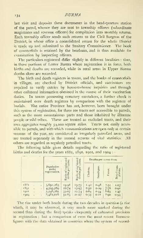
134 BURMA
last visit and deposits these documents in the head-quarters station
of the patrol, whence they are sent to township ofificers (subordinate
magistrates and revenue officers) for compilation into monthly returns.
Each township officer sends such returns to the Civil Surgeon of the
District, in whose office a consolidated return for the whole District
is made up and submitted to the Sanitary Commissioner. The book
of counterfoils is retained by the headman, and is thus available for
examination by inspecting officers.
The particulars registered differ slightly in different localities : thus,
in those portions of Lower Burma where registration is in force, both
births and deaths are recorded, while in rural areas in Upper Burmadeaths alone are recorded.
The birth and death registers in towns, and the books of counterfoils
in villages, are checked by District officials, and vaccinators are
required to verify entries by house-to-house inquiries and through
other collateral information obtained in the course of their vaccination
duties. In towns possessing cemetery caretakers, a further check is
maintained over death registers by comparison with the registers of
burials. The entire Province has not, however, been brought under
this system of registration, for there are tracts not accessible to patrols,
such as the more mountainous parts and those inhabited by illiterate
people or wild tribes. These are treated as excluded tracts, and their
area aggregates roughly 54,000 square miles. Tracts not easily acces-
sible to patrols, and with which communications are open only at certain
seasons of the year, are considered as irregularly patrolled areas, and
are treated separately in the annual returns of vital statistics. All
others are regarded as regularly patrolled tracts.
The following table gives details regarding the ratio of registered
births and deaths for the years 1881, 1891, 1901, and 1904 :
—
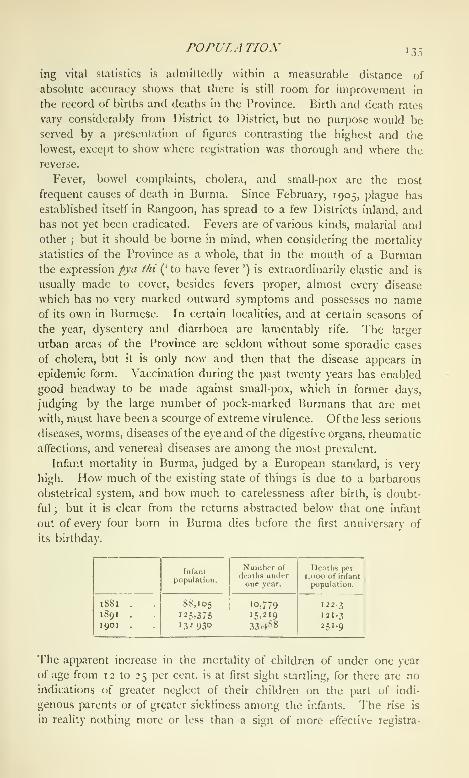
POPULATION '3:
ing vital statistics is admittedly within a measurable distance of
absolute accuracy shows that there is still room for improvement in
the record of births and deaths in the Province. Birth and death rates
vary considerably from District to District, but no purpose would be
served by a presentation of figures contrasting the highest and the
lowest, except to show where registration was thorough and where the
reverse.
Fever, bowel complaints, cholera, and small-pox are the most
frequent causes of death in Burma. Since February, 1905, plague has
established itself in Rangoon, has spread to a few Districts inland, andhas not yet been eradicated. Fevers are of various kinds, malarial andother ; but it should be borne in mind, when considering the mortality
statistics of the Province as a whole, that in the mouth of a Burmanthe expression pya thi (' to have fever ') is extraordinarily elastic and is
usually made to cover, besides fevers proper, almost every disease
which has no very marked outward symptoms and possesses no nameof its own in Burmese. In certain localities, and at certain seasons of
the year, dysentery and diarrhoea are lamentably rife. The larger
urban areas of the Province are seldom without some sporadic cases
of cholera, but it is only now and then that the disease appears in
epidemic form. Vaccination during the past twenty years has enabled
good headway to be made against small-pox, which in former days,
judging by the large number of pock-marked Burmans that are met
with, must have been a scourge of extreme virulence. Of the less serious
diseases, worms, diseases of the eye and of the digestive organs, rheumatic
affections, and venereal diseases are among the most prevalent.
Infant mortality in Burma, judged by a European standard, is very
high. How much of the existing state of things is due to a barbarous
obstetrical system, and how much to carelessness after birth, is doubt-
ful ; but it is clear from the returns abstracted below that one infant
out of every four born in Burma dies before the first anniversary of
its birthday.

136 BURMA
tion, and of the gradual disappearance of the belief, so common in
backward races, that the concerns of so unimportant a section of the
community as babies of less than one year are not a matter that can
possibly come in any way within the cognizance of Government.
Of the 10,490,624 persons shown in the census returns for 1901,
5,342,033 were males and 5,148,591 females. In other words, 50-9 per
cent, of the population of Burma were of the male sex and 49-1 per
cent, of the female, or for every 1,000 males there were 962 females.
The Census of 1891 showed a similar proportion. It has been held by
competent observers that the ratio of females to males in a given race
is generally higher or lower according as woman occupies a better or
a worse position in the social scale. The absolute freedom of the
Burmese women, and the prominent part they play in the industrial no
less than in the social life of the country, are phenomena that are very
striking to those accustomed to the zanatia life of India ; and one would
expect the emancipated women of Burma to bear a higher proportion
to the males than is the case in other parts of the Indian Empire. As
a matter of fact, the ratio in Burma is lower than in several other
Provinces. This is, however, due to immigration, the male immigrants
exceeding the female to a very large extent. In the Districts that are
but little resorted to by settlers from India the females are morenumerous than the males, and they also predominate in the case of all
the principal indigenous races except the Karens and the Talaings.
The figures for Burmans are males 3,191,469 and females 3,317,213;
for Shans, males 386,370 and females 400,717 ; and for Chins, males
89,008 and females 90,284. The question of female infanticide does
not, fortunately, arise in Burma.
The following table gives stati.stics of civil condition in Burmaproper, as recorded in 1891 and 1901 :
—
Civil
condition.

POPULATION 137
conception underlying it. Matches are arranged by tlie parents of the
young couple, or through the medium of a go-between, or merely with
the mutual consent of the parties. The wedding is ordinarily made the
occasion of a feast to which friends are invited, and during the course
of which the bride and bridegroom join hands {let tat) and eat out of
the same dish ; but this ceremony may be dispensed with. The mere
fact of living and eating together as husband and wife is sufficient to
constitute a legal union. Remarriage both of widows and widowers is
common, and the widowed form only a small proportion of the popula-
lation. Divorce is very freely resorted to, but is generally followed by
a second marriage. The figures would appear to show that the readi-
ness to embrace matrimony a second time has, if anything, increased
during the last decade.
The statistics of civil condition by age periods show a rather higher
total of married girls and boys of immature age in 1901 than in 1891,
an increase for which the growth of Indian immigration during the
decade is responsible, for infant marriage is not practised by the people
of the country. They indicate further a slightly increased tendency on
the part of the indigenous male to defer his marriage until after the
twenty-fifth year of life. The matrimonial customs of the Kachins and
Karens, which restrict their choice of wives to certain families or clans,
appear to exercise an appreciable effect upon their readiness to marry.
In their case the proportion of married to the total population is very
much below that of the Burmans and the Shans. Polyandry is
unknown, but polygamy exists, though not to such an extent as to
produce any abnormal figures in the sex and civil condition return.
The indigenous languages of Burma belong, with two exceptions, to
the Mon-Khmer and the Indo-Chinese families of language. The latter
can be subdivided into two sub-families, the Tibeto-Burman and the
Siamese-Chinese. Burmese, the most important of the languages of
the Tibeto-Burman sub-family, was spoken by 7,006,495 persons in
1901. Arakanese, a dialect of Burmese, claimed 383,400 speakers in
the same year. Kadu, the vernacular of a tribe in the north-west of
the Province which is fast dropping out of use, has been placed pro-
visionally in the Tibeto-Burman sub-family. The Census showed that
in 1901 it was spoken by 16,300 persons, and that the Mro of the
Arakan Hill Tracts, which has been similarly classified, was the speech
of 13,414 inhabitants of Arakan. Kachin and Chin are also Tibeto-
Burman languages, not quite so closely allied to Burmese as the others.
Their vocabulary differs, but their structure bears a strong family
resemblance to Burmese. Kachin was the language ordinarily used by
65,570 persons within the area treated regularly in 1901. A large pro-
portion of the Kachin-speaking folk are inhabitants of the estimated
areas, where language data were not collected, and it is probable that

138 BURMA
the aggregate of Kachin speakers in the Province is nearly double the
figure given above. The Chin speakers numbered 176,323. There
are various forms of Chin, but the only largely spoken variety that was
not classified under the general head of Chin was the speech of the
Kamis of Northern Arakan (24,389). The vernaculars of the Lisaws,
the Muhsos, the Akhas, the Marus, and of a few other hill tribes in the
north and east, are also comprised in the Tibeto-Burman sub-family.
Shan and Karen are the two main local representatives of the
Siamese-Chinese sub-family. Shan proper was the vernacular of
750,473 persons in 1901, Karen of 704,835 persons. These totals
do not include the speakers of the trans-Salween dialects of Shan known
as Hkiin and Lii, or the quasi-Karen vernaculars of Karenni and its
neighbourhood. Taungthu, which is practically a dialect of Karen, was
spoken by 160,436 persons in 1901. Siamese and Chinese, the two
most important non-indigenous tongues of the sub-family, are both
spoken in Kurma, Siamese (19,531) for the most part in the extreme
south, on the Siamese border, and Chinese (47,444) more or less through
the whole of the Province by Chinese immigrants.
Talaing, the speech of the Mons or Peguans, who for many years
strove with the Burmans for the mastery in Burma, belongs to the Mon-
Khmer or Mon-Anam family, and was returned by 154,483 persons
in 1901. Talaing as a spoken language is gradually dying out, its place
being taken by Burmese. The remaining languages of the Mon-Khmer
family spoken in the Province are the vernaculars of various hill tribes
scattered through the Shan States, such as the Was, the Palaungs, the
Riangs, and the Danaws. Palaung was the speech of 51,121 persons
in 1 90 1. Wa is spoken largely to the east of the Salween, but the
majority of its speakers were entirely excluded from the census opera-
tions and their number is not even approximately known.
The only two vernaculars of Burma that do not belong to either of the
two families are Daingnet, a corrupt form of Bengali spoken in Akyab
District near the borders of Chittagong ; and Salon (Selung), the speech
of the sea-gipsies of the Mergui Archipelago, which has been placed in
the Malay language family. The Malayo- Polynesian languages, though
related to the Mon-Khmer family, have been separated from that group,
because the relationship has not yet been definitely settled.
The proportion borne by the speakers of the chief vernaculars of the
Province (namely, Burmese, Shan, Karen, Talaing, Chin, and Kachin)
to the population of Burma projier in 1891 and 1901 is indicated in the
statement below :
—

POPULATIOX 139
The following are the totals of persons returned in 1901 as speakers
of the principal non-indigenous languages belonging to language
families other than the Indo-Chinese:
—
Knglish iS,500
Hindustani . . . . 95,122
Bengali 204,973
Hindi 28,689
Punjabi 15,803
Tamil 99.576Telugu 96,601
(!aste is absolutely unknown as an indigenous institution in Burma.
It is foreign to the democratic temperament of the people, and an
ethnical analysis of the inhabitants of the country must of necessity
be based on considerations other than that of caste. In existing con-
ditions, the most satisfactory classification of the indigenous races of
Burma is that which proceeds on a linguistic basis. Of the total popu-
lation in 1901, 6,508,682, or 62 per cent., were Burmans. Of the other
Tibeto-Burman peoples, the Arakanese of the western coast numbered
405,143, the Kadus of Katha 34,629, and the Mros of Akyab and
Northern Arakan 12,622. The Inthas, a community found scattered
through the Southern Shan States, numbered 50,478, though only 5,851
of them spoke the Intha dialect. The Kachins occupy the hills to the
extreme north of Upper Burma, and are steadily making their way
southwards down the eastern fringe of the Province ; 64,405 of them
came within the scope of the regular census operations in 1901, and
about 50,000 were residents of the estimated tracts, where no regular
collection of race statistics was made. The Chins {see Chin Hills)
are the predominant folk along the western border of Burma from the
level of Manipur down to Akyab District, and thence southwards along
the range of hills that separates the old province of Arakan from the
Irrawaddy valley. The Chins proper numbered 179,292 in 1901, and
the Kamis of Akyab and Northern Arakan, a closely allied tribe,
24,937. The Danus (63,549) are a half-bred Shan-Burmese community
inhabiting the borderland between Burma and the Shan States ; and the
Taungyos (16,749) are also borderers, frequenting the same region and
talking a language which resemliles an archaic form of Burmese. TheAkhas or Kaws, a hill tribe of the trans-Salween Shan States, come
probably from the same prehistoric stock as the Burmans, the Kachins,
and the Chins ; so also, there is reason to believe, do the Lisaws, the
Muhsos, the Maingthas, the Szis, the I^ashis, and the Marus of the
north-eastern hills. The Akhas numbered 26,020 in 1901 ; the Muhsos,
15,774 ; the Kwis, a branch of the Muhsos, 2,882 ; the Lisaws, 1,427.
The remaining tribes are for the most part inhabitants of the areas
estimated at the Census of 1901, and their strength is but imperfectly
known.

I40 BURMA
In the Siamese-Chinese group the Shans and Karens are most
strongly represented. The total number of Shans in 1901 was 787,087
(exclusive of the Lem, the Hkiin, and the Lii of trans-Sahveen territory,
but including the Shan Tayoks of the Chinese border). The Shans
{see Shan States) are the prevailing nationality in practically the
whole of the uplands that lie between the Irrawaddy and the Mekongfrom the 20th to the 24th parallels of latitude, and form a large pro-
portion of the population in the country that separates the western bank
of the Irrawaddy from the Manipur and Assam frontiers. West of the
Irrawaddy they have become absorbed to some extent into the Burmancommunities that surround them, and nearly the whole of their territory
forms part of the regularly administered areas of the Province ; but east
of the river they have preserved their race characteristics unimpaired,
and are administered through the native rulers of the States into which
their country is politically divided. The Karens are the hill tribes of
the south-eastern areas of the Province from Toungoo to Mergui, and
are also found scattered over the delta of the Irrawaddy. The greater
number of the Karens of Lower Burma are members of one or other
of two main tribes, the Sgaw and the Pwo. Towards the north and
beyond the limits of Lower Burma, in Karenni and the Southern Shan
States, a third tribe, the Bghai, preponderates. In 1901 a total of
86,434 persons returned themselves as Sgaw, and 174,070 as PwoKarens, the tribe in the case of 457,355 others being not returned.
The Bghai were for the most part residents of the estimated areas of
Karenni when the Census took place. Within territory treated regu-
larly, 4,936 Red Karens (Bghai) were enumerated. The Bres, the
Padaungs, and the Zayeins of Karenni and its neighbourhood have been
classed linguistically with the Bghai, though it is possible that further
research may show that ethnically they should be placed in some other
category. In all, 7,825 Padaungs and 4,440 Zayeins were found in
areas within the scope of the regular Census. They were practically all
residents of the south-western corner of the Southern Shan States. The
Taungthu.s, like the Padaungs and the Zayeins, are of doubtful origin.
They are found in the hills along the eastern border of Burma from
Amherst to Yamethin, and numbered 168,301 in 1901. Their language
is to all intents and purposes a form of Karen, and it is probable that
there is more Karen than any other element in their composition.
The Talaings arc the main representatives of the Mon-Anam group
in Burma proper. They arc found in their greatest strength in the
country round the mouths of the Irrawaddy, the Sittang, and the
Salween, which formed the nucleus of the ancient kingdom of Pegu.
In 1901 their aggregate was 321,898. Their numbers are diminishing,
and they arc being gradually absorbed into the Burmese population of
tlic I'rovince. Of the Mon-Anam hill tribes of the Shan States the most
rOPULATIOX 141
numerous according to the census figures of 1901 are the Palaungs
(56,866), who arc found for the most part in the Ruby Mines District
and the hills that form the northern border of the Northern Shan States.
It is probable that the >Vas, whose country lies to the east of the Palaung
tract on the farther side c^f the Salween, are as numerous as the
Palaungs ; but, as their northern areas were untouched at the time of
the Census, nothing is known of their real strength. In the regularly
enumerated areas in the trans-Salween Shan States 5,964 persons were
returned as ^\'as, 15,660 as Tai Loi, 1,351 as Hsen Hsum, and i,oy6
as Pyin. The last three tribes are, it is believed, varieties of the Wastock. The Riangs or Yins are almost certainly, and the Danawsprobably, of Mon-Anam extraction. The latter, who numbered only
635 in 1901, are almost extinct as a separate tribe. They inhabit the
Myelat States to the east of Upper Burma. The Yins numbered 3,094
at the last Census. Their habitat lies in the north-east of the Southern
Shan States.
There are no very marked differences in the physical characteristics
of the indigenous races of the Province. Like all southern Mongolians,
their stature is below the average. They are thick-set and for the most
part sturdy. Their complexion ranges through various shades of olive-
brown, and is darker on the whole than that of the Chinese ; their hair
is black and straight and on the face ordinarily very sparse. It is
usually left long on the head and in most cases is tied into a top-knoL
They are round-headed or brachyccphalic, have high cheek-bones and
broad noses. Their eyes are small and black but not as markedly
oblique as those of the Chinese \ and, taken as a whole, they show
a greater tendency to approximate to the Caucasian type than do the
latter.
Of the Hindu castes the following show the largest totals : Paraiyan,
25,601; Mala, 18,522 ; Kapu, 11,214; Palli, 13,250; Brahman, 15,922 ;
Chhatri or Rajput, 13,454. A total of 41,663 males and 7,758 females
were returned in the census schedules under the general designation of
Sudra. Among the Musalman tribes the Shaikhs are numerically the
most important in Burma, and their total of 269,042 represents 80 per
cent, of the Muhammadan population of the Province. Saiyids and
Pathans numbered respectively 8,970 and 9,224; and Zairbadis, the
offspring of unions between Burmese women and Musalman natives
of India, 20,423.
The British in Burma in 1901 numbered 7,450 (5,948 of whom were
males and 1,502 females), and the Eurasians 8,884. A total of 1,090
persons were returned as Europeans, no nationality being given. It is
probable that the majority of these were, strictly speaking, Eurasians.
The Chinese of the Province aggregated 62,486, as against 41,457 in
1891.
142 BURMA
Of the religions of Burma, Buddhism has by far the largest number
of professed adherents. In 1901 a total of 9,184,121 persons, or
88-6 per cent, of the population, were returned as Buddhists. The
Buddhism of Burma is an amalgam that has resulted from a fusion of
the elements of the Northern and the Southern schools of Buddhist
thought, introduced from India on the one hand and from Ceylon on
the other. This amalgamation was, as already stated, completed at
Pagan in the eleventh century. Before that, a corrupt form of Buddh-
ism prevailed, which appears to have been an admixture of Lamaism
and Tantric Buddhism, its professors being called the Ari or Ariya,
the 'noble.' Their robes were dyed with indigo, like those of the
Lamas of Tibet and China, and they wore their hair at least two inches
long. They were not strict observers of the vow of celibacy, and the
basis of their doctrines was that sin could be expiated by the recitation
of certain hymns.
In theory Buddhism is the general religion of the country. In point
of fact, though it has done much to soften and humanize the people, it
is far too often nothing more than an outward veneer covering the
spirit-worship that is everywhere practised openly, one might almost say
shamelessly. The Burmese Buddhist Church is split up into two main
parties, which are known as the Su/agandi and the Mahagandi. The
members of the former set store by ritual and outward observances
;
those of the latter are to all intents and purposes fatalists, but the
differences between the two parties are largely academic. Sectarian
bitterness is practically unknown. There are various minor sects, but
none has achieved any marked distinction. The head of the Church
in Upper Burma is the thathanabamg or archbishop ; and in both sec-
tions of the Province there is a recognized hierarchy, which comprises
dignitaries known as gaingoks (bishops) and gaingdauks, as well as
the ordinary pongyis or monks. The religion of the people finds an
outward and visible sign in the pagodas and monasteries that are
prominent features of nearly every village. The Burmese pagoda is
bell-shaped, built of brick and usually whitewashed, though many
shrines are partially, and a few wholly, gilded. Timber is the material
ordinarily used for the kyaungs or monasteries that the pious have
erected in thousands through the length and breadth of the Province,
and enormous sums are frccjuently lavished on these and other works of
merit. The monasteries are the indigenous schools of Burma, at which
the village boys all learn to read and write. It is not only as scholars,
moreover, that the people have had experience of their kyaungs. Prac-
tically every male Burman assumes the yellow robe of a monk for
a shorter or longer period as the case may be, and monasticism thus
jjlays a part in the life of the inhabitants of the country that is absolutely
unicjue.

POPUJ.ATION 143
Next to the Buddhists in point of numbers come the sjjirit-worshippers
or Animists, the majority of whom inhabit the Hill Tracts. 'J'heir aggre-
gate in 1 90 1 was 399,390. This figure does not, however, adequately
represent the strength of Animism in Burma, for it does not include
the residents of the estimated areas where no religion data were col-
lected at the enumenition. 'i'he population of these areas amounted to
127,011 ; and, as there is good reason to believe that it was made up
very largely of spirit-worshippers, the actual strength of the Animists
may be fixed at something approaching half a million.
Islam was represented at the latest Census by 339,446 persons, and
Hinduism by 285,484. After these, but separated from them by a con-
siderable numerical gap, come Christians with a total of 147,525, of
whom 129,191 were natives, while the adherents of the other religions,
most of whom were Sikhs, totalled only 7,647. The largest proportional
increase during the decade ending 1901 is among the Animists, who at
the close of this period were shown as more than twice as numerous as
at its beginning ; but this is due solely to the fact that the Census of
1 90 1 dealt with several large backward hill areas inhabited by spirit-
worshipping tribes who were untouched in 189 1. A comparison of the
totals in each year for Burma proper gives a better idea of the relative
growth of the main religions. On this basis we find that during the
period in question Hindus have increased at the rate of 63 per cent.,
Animists at 41, Musalmans at 33, Christians at 21, and Buddhists at
19 per cent. The last figure may be looked upon as indicating roughly
the natural rate of increase in the Province, the conversions from
Buddhism to Christianity and Islam being counterbalanced by acces-
sions from the ranks of the spirit-worshippers. In the case of the
Hindus and the Musalmans, immigration from outside the Province
accounts for the high rate of increase.
In Lower Burma, where data extending over more than twenty years
are available, we find that between 1881 and 1891 the Buddhists
increased by 24 per cent., but in the following ten years by only 19 per
cent. This apparent diminution in the rate of growth is probably due
to the return to their homes in Upper Burma of villagers whom the
disturbances that succeeded the seizure of Mandalay had driven tem-
porarily into Lower Burma. Among Musalmans and Hindus, on the
other hand, the rate of growth during the first half of the twenty years
in question was by no means as conspicuous as during the second.
The Christian population of Lower Burma rose between 1881 and
1 89 1 by 33 per cent., and between 1891 and 1901 by 19 per cent.
The strength of this population is, however, largely afiected by the move-
ments of British troops, and it is probable that the falling off in the
rate of increase during the second decade is not really as marked as it
would appear to be. The principal Christian denominations returned

144 BURMA
in 1 90 1 were Baptists (66,860), Roman Catholics (37,io5\ and Angli-
cans (22,307). In Burma proper the Anglicans increased by 76 per
cent, between 1891 and 1901 and the Roman Catholics by 48 per cent.
The Baptists show a falling off of 18 per cent, for the same period, but
this diminution is in all probability due to the fact that a large number
of Baptist native Christians did not return their sect at the Census.
Burma forms an Anglican diocese under the administration of the
Bishop of Rangoon, The diocese was created in 1877, and then
included Lower Burma only. In 1888 new letters patent were granted
extending it to Upper Burma. The Bishop is assisted by an arch-
deacon and nine other chaplains of the Bengal (Rangoon) Ecclesiastical
establishment.
The Anglican missions in Burma arc worked through the agency of
the Society for the Propagation of the Gospel. The missionary staff
consisted in 1903 of eight British clergy and ninety-five catechists and
sub-deacons. The Society labours among the Burmese, the Tamils,
and the Karens, its principal stations being Rangoon, Kemmendine,
Moulmein, Mandalay, Shwebo, and Toungoo.
From 1 72 1 to 1866 the Roman Catholic Church in Burma was
represented by a single mission, known as the Vicariate Apostolic of
Ava and Pegu. Subsequently the Province was divided into three
distinct missions, one for southern, one for northern, and one for
eastern Burma, each in charge of a bishop; and in 1879 the Arakan
administrative division was transferred to what is now the diocese of
Dacca.
The establishment of the American Baptist Mission dates from the
year 1813, when Messrs. Judson and Rice started mission work in
Rangoon; but difficulties encountered after 1824 forced the mission-
aries to transfer their main sphere of action to the British territories of
Arakan and Tenasserim. The Tavoy mission was opened in 1825, and
a commencement was there made of that widespread evangelization of
the Karens which has for so long been associated with the name of the
mission in Burma. The^Kyaukpyu mission was founded in 1831, the
Moulmein mission in 1827 ; and after the second Jiurmese War work was
renewed in Rangoon, and started in Toungoo, Henzada, and Bassein.
The teaching of the Kachins had been commenced in Bhamo in 1877,
several years before the annexation of Upper Burma, and after Thibaw's
deportation mission stations were established in other Districts of the
newly acquired j)rovince. Within the last few years the mission has
extended its operations into the Shan States, the Chin Hills, and
Karenni. Its work lies mainly among the Karens, with whom the
greatest measure of success has so far been obtained ; but the mission-
aries labour among the Burmese also, and the Shans, the Chins, and
the Kachins have received attention. According to the latest official

POPULA TION 145
returns of the mission, there are twenty-nine stations in the Province.
The mission has been eminently useful from an administrative point of
view, for it has been one of the main instruments in bringing a know-
ledge of the languages of the country within the reach of foreign residents.
Judson's Burmese Dictionary has long been a household word in Burma;
and what was done for Burmese by that early pioneer has been, and is
being, accomplished by his successors for other Provincial vernaculars.
The following are the totals for the principal religions returned in
Burma proper in 1891 and 1901 :
—
146 BURMA
census returns as engaged in the preparation and supply of material
substances. Strictly speaking, this comprises certain occupations that
involve no real technical knowledge, but for the purposes of general
presentation the classification is probably exact enough. In the artisan
classes the following occupation totals may be cited : fishermen and
fish-curers, 126,651; turners and lacquerers, 14,274; silk-weavers,
34,029; cotton-weavers, 189,718; tailors, 57,915; goldsmiths, 42,112 ;
iron-workers, 26,221;potters, 19,667 ; carpenters, 69,886 ; and mat-
makers, 53,585. The commercial classes numbered 449,955, or 4-34
per cent., and the professional 264,047, or 2-54 per cent., of the
Provincial aggregate. More than one-third of those engaged in com-
merce come under the unspecified head of shopkeepers ; while the
most important of the professional occupations, from a numerical point
of view, is that of the religious mendicant (138,329), a term which
includes, besides pongyis or Buddhist priests, probationers for the
priesthood and other occupants of monasteries. Medicine was the
means of support of 43,252 rural practitioners and their families,
teaching maintained 12,178 actual workers and dependents, and the
number of persons of all kinds dependent upon the legal profession
totalled 7,507. Altogether 392,654 inhabitants of the Province came
into the category of general labourers or coolies. This occupation
constituted the greater part of those classed under the head of unskilled
non-agricultural labourers, who formed 4-2 per cent, of the total
population. Government service provided occupation for 191,796
persons, or for 1-85 per cent, of the Provincial total, the largest
individual figure being shown by village headmen, who, with their
dependents, reached a total of 62,335. The number of those engaged
in personal or domestic service was 104,252 ; and those whose means
of subsistence were independent of occupation, such as pensioners,
convicts, and the like, numbered 41,522.
Rice forms the basis of all the Burman's meals, and is eked out with
condiments according to his means. There are no caste restrictions as
to food ; and, when it is available, the Burman has no hesitation in
eating any form of animal and vegetable nutriment that a European
would consume. He affects, besides, certain dainties that arc repugnant
to Western culinary notions, but is on the whole by no means a dirty
feeder. This cannot be said of the Karens, who are partial to vermin,
and to whom scarcely any kind of animal food comes amiss. Dogs arc
considered a delicacy by the Akhas, the Was, the black Marus, and
other hill tribes in the east of the Province ; but liurmans will not
touch them. Onions and chillies figure largely in indigenous recipes;
but the most distinctive condiment is ngapi or salt-fish paste, a com-
pound which, though exceedingly offensive to the untutored nostril, has
achieved a widespread jiopularity throughout the Province and a|)pears

POPULATION 147
at nearly every repast. On tlie whole, however, the Burmese villager's
daily meal, though possibly not as frugal as that of many Indian
peasants, is exceedingly simple.
The male lUirnian's dress consists of a jacket, ordinarily white,
a cotton or silk waistcloth {paso or longyi), and a silk headkerchief
{gaunglmioig). Women wear a jacket resembling the men's, and
a petticoat or skirt of silk or cotton. The original Burmese i)etticoat
{iamein) was open down the front and showed a considerable portion of
one of the legs when the wearer walked. It is still largely worn, though
the closed /ongvi, a trille longer in the women's than in the men's dress,
is rapidly displacing it in the urban areas of the Province. Nothing is
worn on the head by Burmese women, but among the Shans the fair
sex cover the head with a cotton head-clolh. In place of the head-
kerchief that forms a portion of the male attire, the Burmese woman,
when dressed in her best, drapes her silk cloth over her shoulders as
a scarf. The scarf is, however, not a portion of her everyday attire.
On ordinary occasions it is dispensed with, and the jacket is also
frequently discarded by both sexes while the household or other work
is being done. When it forms her only garment, the woman's skirt
is wrapped round her body from close under her armpits to her knees.
While engaged in manual labour^ the man ordinarily tucks up his waist-
cloth in such a way as to allow absolute freedom for the lower limbs.
It is on these occasions that a full sight can be had of the tattooing with
which the male Burman decorates the middle portion of his body from
the waist to the knee. AVhere the wearers can afford it, jewellery is
much affected by the fair sex. It is mostly gold, and takes the form of
bangles, necklaces, rings, ear ornaments, and, in the case of children,
anklets. The main dress characteristics of the chief non-Burman hill
tribes are detailed in the tribal articles.
The ordinary village residence is a hut raised on piles some little
distance off the ground, built of jungle-wood, timber, and bamboo-
matting, and roofed with thatch or split bamboo {wagat). The better-
class houses have plank walling and flooring, and corrugated iron is
gradually obtaining a prominent place in the domestic architecture of
the Country ; but no real use has yet been made by the Burmans
themselves of brick as a material for house-building. 'l"he empty space
below the house is frequently used as a cattle-pen. The style of
building varies little throughout the country. The Kachins and other
hill tribes are in the habit of building barrack-like houses, in which
several families live together ; but the general rule is for one or at most
two families to occupy the same building. \\'hether they are erected
in the hills or the plains, the materials of which the houses are put
together are uniform. Bamboo supplies the greater part of the frame-
work, except in the dry zone, where bamboos are scarce and hovels are
L 2
148 BURMA
constructed almost wholly of palm leaves. The Burmans dispose of
their lay dead by burial. The bodies of monks are burned with
more or less ceremony. Burial-grounds are ordinarily situated to the
west of the village.
Pwe is the term applied in Burma to nearly every form of entertain-
ment, whether dramatic or otherwise. The zat pwe is performed by
living actors ; it represents episodes in the life of one or other of the
incarnations of Buddha, and the dialogue is helped out with muchsinging, dancing, and buffoonery. Similar plays are enacted by means
of marionettes {yokthe), whose manipulation is exceedingly effective
and involves considerable skill. Performances of this nature are given
by professionals ; but pnu's of other kinds are frequently organized by
amateurs, the best-known form being probably the jei'/i J>zve or ' posture
dance,' in which as a rule a number of girls take part. Pony, boat, and
bullock-cart racing are popular pastimes, and cock-fighting is indulged
in freely. One of the most striking of the indigenous games is that
known as chitilon, which consists in keeping a light ball of plaited cane
in the air for as long a time as possible by successive blows from the
feet, knees, or almost any other portion of the body but the hand. Theplayers stand in a circle and kick the ball from one to the other,
and adepts are able to keep it in motion for a surprisingly long time
without letting it touch the ground. Among other amusements maybe mentioned kite-flying, and games resembling chess, backgammon,
and marbles, the last, known as gonnyifito, being played with the large
flat brown seeds of the Entada Pursaeiha. Gambling is a national
weakness which it has been found necessary to keep within bounds
by special legislation. Boat, pony, and other races are invariably the
occasion for heavy betting. There are numerous games of chance, of
which one of the best known is the ' thirty-six animal ' game. TheBurmans are inveterate smokers. Both sexes indulge freely in tobacco
and commence smoking at a comparatively early age, but the cigars that
they ordinarily affect have the merit of extreme mildness and contain
as a rule a great deal that is not pure tobacco. The outer covering is
ordinarily of maize husks or thaiiat leaves. The strong black Burmacheroot of the European market is but little favoured by the natives.
The two principal festivals of the Burmans are the New Year, which
occurs in April, and the end of the Buddhist Lent, which takes place
in October. The former celebrates the annual descent to earth of the
Thagya Min, the king of the Nat or spirit kingdom, and is often known
as the 'water festival,' as the most prominent feature of the merry-
making consists of what may be entitled a battle of squirts which leaves
the revellers drenched to the skin. The autumn season of rejoicing
might appropriately be termed the ' fire festival,' for the most striking
of its ceremonies is the general illumination that takes place, the
AGRICULTURE f49
sending up of fire balloons, and the floating of diminutive lamps downthe streams and rivers.
The full moon of the month of Tabaung {roughly speaking, March)is made the occasion for pagoda festivals and other gatherings, Thecommencement of the JBuddhist Lent in July has its less exuberant
ceremonies ; and the Tazaungmon festival, between the end of Lent
and the close of the calendar year, is marked by rejoicings in certain
parts of the country. All these are treated as public holidays, and all
are observed more or less by the non-Burman Buddhist peoples of the
country, such as the Shans, the Taungthus, and the Palaungs, as well
as by the Burmans.
The ordinary Burmese title is Maung (' Mr. ') for males and J/a(* Mrs.' or ' Miss ') for females. To these are added one or more namesusually indicative of some object, animate or inanimate, or of somequality. Children are named at birth, and convention usually requires
that the initial letter of each child's name should be that appropriate
to the day of the week on which he or she was born. Thus, for
example, the gutturals (^, g^ tig, &c.) belong to Monday, the palatals
(j, 0, &c.) to Tuesday, the labials to Thursday, and the dentals to
Saturday. Hence a boy born on a Monday might suitably be called
Maung Gale {gale = ' small '). JVga and Mi are less respectful sub-
stitutes for Maung and Ma. They are used for children, inferiors, and
the like. With advancing years the honorific U is often applied to a
man in place of Maung, especially if he is a senior of substance and
position ; and Kyaungiagd, with its feminine Kyaungamd, is a title
earned by a person who has gained merit by the construction of
a kyaung or monastery. A Pali title takes the place of the ordinary
lay name on the assumption of the yellow robe and admission into
a monastery. Family names are unknown except among the Kachins,
and there is no change in the woman's name at marriage. Shtvc
(* gold ' or 'golden') occurs frequently in Burmese names, and figures
largely in the nomenclature of towns, villages, rivers, hills, Xrc. Occa-
sionally it indicates the presence of old gold-workings {Shwedwiu, 'gold-
mine'; Shwegyin, 'gold-sifting'); but more ordinarily it is purely
honorific {S/nveJaung, 'golden hill'; Shivc/aung, 'golden boat'). Myo('town'), y-wa ('village'), (aung ('hill'), myit ('river'), chaung
(' stream ') form the component part of a large proportion of Burmese
place-names, their counterparts in Shan being words like mong (' state '),
nam (' water ' or ' river '), hi (' hill '), nawng (' lake '), and the like.
Agriculture, as already stated, affords the means of support to over
66 per cent, of the population of Burma, and is the subsidiary occupation
of a further portion of the community. Cultivation
is regulated more by rainfall than by the conformation
of the surface of the soil. Rice is thrown wherever there is sufticient

I50 BURMA
moisture and land in any way adapted to its cultivation. In the dry zone
of Upper Burma, sesamum, maize, jowar, cotton, beans, wheat, and gram
largely take the place of rice ; but these alternative products have been
practically forced upon the Upper Burma cultivator by climatic con-
ditions, for it is an almost universal rule that where rice of any kind
can be cultivated, it is raised to the exclusion of other and apparently
more appropriate 'dry crops.' Throughout Lower Burma the rainfall
is ample for rice cultivation, and little else but rice is produced there,
and the same may be said of a substantial portion of the wet division
of Upper Burma. Rice cultivation in Burma is of two main classes :
namely, k ('lowland') and taungya ('hill-slope'). The j'a- crops, such
as sesamum, cotton, and Jotvar, cover the rolling uplands of the dry
Districts of Upper Burma and so much of the plain as cannot be
brought under rice cultivation. Wheat and gram are grown in the
better kinds of lowland soil ; and beans and maize, with a host of other
minor crops of the class ordinarily known as kamggyun, are harvested
in the rich alluvial soil left behind as the waters of the rivers recede
from their flood limits during the dry season.
Rice is the staple food-grain of the Province. To eat a meal of any
kind is, in Burmese, to 'eat rice' {tamiii so). There are numerous
varieties of rice, distinguishable from each other by colour, texture,
consistency when cooked, and the like ; but their names are largely
local and, from an agricultural point of view, their differences are not
of special importance. A more suitable classification, after that which
separates the plain from the upland rice, is by harvests or seasons.
There are three main harvest classes : kaukkyi, the big or late rains rice,
which is sown in nurseries (/>yog//i) at the beginning of the monsoon,
transplanted during the rains, and reaped during the cold season
;
kaiiky{)i, the quick-growing or early rains rice, which is sown in May-
June and gathered during the height of the rains ; and tnayin, or dry-
season rice, which is sown during the cold season on the edges of meres
or other inundated depressions from which the water is receding, and
is garnered about the commencement of the rains. Other harvest
classes are known as kauklat and kaukti. Of these, the kaukkyi pro-
vides the bulk of the rice of Burma. Very little else is cultivated in
the Lower province, and it is practically this crop alone that is ex[)orted.
It is longer in the stalk than the other kinds and takes longer to
mature. In Upper Burma the climate docs not always lend itself to
kaukkyi cultivation, and recourse has to be had there to the inferior
varieties, laun^va, or ' hill rice,' is sown, as soon as the rains set in,
on hill slopes which have been cleared and fired during the hot season.
The seed is not transplanted from nurseries, as is usual in the case
of /( rice, but is .scattered broadcast or dibbled in the ash-im.i)regnated
soil, and the crop is reaped towards the close of the rains. The system

AGRICUr.TUKE 151
of cultivation adopted is to the last degree wasteful, iax the soil is soon
exhausted and constant moves have to be made by the /^«//^'«-cutter
to new and uncleared hill-sides.
There is nothing particularly attractive in the paddy-fields of Burma.
A stretch of typical delta rice country in the early rains is a dingy
expanse of mud and water, studded with squat hamlets, and cut up by
low earth ridges into a multitude of irregular polygons through which
mire-bespattered plough bullocks wade. Later on, with the transplant-
ing, the plain grows green ; and, as the young plants accustom them-
selves to their surroundings, this hue becomes more pronounced, till
the cold season draws near and the expanse takes on a tinge of yellow
that recalls the approach of the wheat harvest of England ; but here
there are no undulations to break the dull uniformity of the outlook,
no trim hedges, no variety of crops. All is one dead level away to the
horizon. It is very little more picturesque in the uplands. Amongthe hills the iaungya patches are conspicuous : but unsightly blackened
tree-stumps stand up out of the grain, and there is an air of desolation
and unkemptness about the clearings that nothing in the way of
colouring or surroundings can redeem.
Jowdr or millet {Sorghum viilgare) is the main subsidiary food-crop
in the dry zone of Upper Burma. In some of the arid upland tracts
this grain takes the place of rice as the ordinary food of the household
;
but ordinarily it is not regularly eaten, and is often grown simply as
fodder for cattle. There are two main varieties of millet : the kun-
pyaiiiig which has a husk, and the sanpyaung which has none. Theplant, which is not unlike maize, grows to S or 10 feet in height. It is
sown on all descriptions of ya land in July and August, and is cut
towards the end of the cold season. There was a large export oij'mcar
to India during the recent famine )ears.
Sesamum {/man) is for the most part, like millet, essentially a dry
area crop. There are two distinct sesamum harvests, that of the early
sesamum or hnauyin and that of the late sesamum or hnatig)i\ the
former being more generally grown. The latter is sown towards the
close of the rainy season and reaped during the cold season, while the
hnanyin is gathered during the rains. The plants, when mature, range
in height from 2 to 5 feet and liear white flowers. Sesamum is culti-
vated for the sake of the seed, which yields an oil much affected by
the Burman in cooking. Oil-presses on the pestle-and-mortar prin-
ciple, usually worked by bullocks, are common in the majority of the
villages where sesamum is grown.
Of the kaing or riverain crops none is more conspicuous than maize
ipyauiigbii), which carries glossy green foliage and rises to a considerable
height, either alone or in conjunction with a form of climbing pulse,
the growth of which its stalks materially assist. The maize cob is
152 BURMA
largely eaten green, as a delicacy, and the husk or sheath when dried
is used for the outer covering of Burmese cheroots. Its stalks, like
those of jowdr, are excellent fodder for cattle. It is sown as the
water falls and is cut during the dry season.
Of peas and beans, which are also the product of river land inun-
dated during the rains, there are numerous varieties, of which some of
the best known are peg}'i, pegya, matpe, and sadaivpe. The sowing
of this form of kaing crop takes place in October, and the harvest
is gathered just before the hot season begins. There is a considerable
export o{pegya {Phaseolus lunatus) to Europe for cattle fodder.
Cotton is grown systematically only in certain special tracts of the
dry zone. It is sown on high land, as a rule, early in May, and
picking commences about October and is continued at intervals till
the end of the year. In Thayetmyo District picking appears to be
continued up to a later date than in Upper Burma. The cotton is
short-stapled as a rule. It is cleaned locally, either by hand or in
cotton-ginning mills, and sent to both China and India.
Tobacco is ordinarily sown in nurseries on inundated alluvial land in
September and October, and planted out in December. The crop is
one that needs careful attention ; and weeding, pruning, and hoeing are
constantly necessary. In March and April the leaf is ready for picking.
It is then plucked, roughly pressed, and dried in the sun, but no
regular curing operations are undertaken. The stalks are used for
smoking as well as the leaves. It is grown solely for local con-
sumption.
A level black soil known as sane is the best soil for gram and wheat.
Both crops are grown on alluvial land, and are sown at the close of the
rainy season and harvested at the beginning of the hot season. Wheat,
which in Burma is of the bearded kind, is grown only in a few limited
tracts in the dry zone ; the cultivation of gram is more widespread.
Throughout the dry zone the toddy-palm {Borassus flabellifer) is a
feature of the landscape, and the tapping of this useful tree affords
employment to a large proportion of the residents of the Districts in
which it grows. Tapping commences in February and continues till
July. The juice when extracted is either fermented and made into
tdri^ or is boiled down into molasses or jaggery {tanyet). The leaves
are used in the dry zone for thatching purposes.
Among the other products of the country may be mentioned chillies,
pumpkins and gourds, betel-vines and the areca-nut, sugar-cane, and
onions. Plantains are successfully cultivated on a small scale in nearly
every village, and on a larger scale in specially suitable tracts ; mango-
trees abound, though, except in the neighbourhood of Mandalay, the
fruit is not as a rule of any exceptional quality. Prome has long been
famous for its custard-apples, and the southern pcjrtion of the Tenas-

AGRICULTURE 153
serim Division lias achieved a local notoriety for its niangosteens and
durians. Pineapples are common, and arc cultivated in enormous
quantities in the immediate neighbourhood of Rangoon. Oranges
of good quality are grown in Amherst, in the Shan States, and
in Toungoo. Tea-growing is systematically practised in the Shan
States by the Palaungs ; but the industry has never been able to attract
European capital, and is still conducted on purely native lines. Coffee
has, on the other hand, been worked on the Ceylon and Indian systems,
and was very successful in Toungoo District until attacked by leaf
disease. Opium is grown freely in portions of the Shan States, but the
drug is extracted almost solely for home consumption. There is no
regular cultivation of fibres on a large scale, though the forests of the
Province abound in shaiv and other fibrous products. ^'a//-hemp is,
however, grown to a considerable extent in Tavoy.
The average yield in cwt. per acre of the principal crops of Burma is
as follows :
—
Crop.

154 BURMA
wood at the end of a heavy bar working on a lever, which is raised and
lowered by the weight of the operator's body as he steps on and off the
farther end of the bar. The Burman's conservative tendencies are
nowhere more apparent than in his dealings with the soil, and the
introduction into the country of novel agricultural appliances is slow.
The greater proportion of the cultivator's implements are still eminently
primitive, and are not likely to alter materially in character for some
tirne to come.
Cow-dung is used to a certain extent for manure in some Districts,
but the labour involved in carrying the manure from the cattle-pens to
the fields appears to be an insuperable obstacle in the way of manuring
on a methodical and uniform system. As a rule the nurseries receive
most attention when any manuring is done. The only other measure
taken to fertilize the paddy-fields is to burn the stubble during the
dry season and to leave the ash to enrich the soil.
In Lower Burma, where there is only one main crop of importance
and the soil is extraordinarily fertile, the question of rotation of crops is
not one which concerns the agriculturist to any appreciable extent. In
Upper Burma, on the other hand, and especially in the dry zone,
experience has taught the husbandman that there is a limit to the recu-
perative power of much of the non-inundated land ; that some crops
exhaust the soil more than others ; and that regard must be paid to this
fact in cropping the poorer classes of fields. Sesamum, for instance,
absorbs an exceptional quantity of nourishment from the soil, and is
not generally grown two successive years on the same land. In some
cases two fallow years are allowed after a sesamum year, in some more.
Occasionally jowdr or cotton or both take their turn before the fallow
period commences. In better kinds of soil sesamum and jowar are
cropped in alternate years. In the sane (black soil) tracts wheat and
gram alternate to a certain extent, and millet often succeeds cotton
before a fallow. As a rule, however, even where conditions demand
an economical system of rotation, the order of tillage observed is more
or less haphazard and the most is not made of the properties that
the soil possesses.
The average area of a holding differs very greatly from District to
District and tract to tract. The mean for Meiktila District is 7-7, that
for Sagaing rather over 12 acres. In Pegu, in 1900, the average area
of rice-land holdings was 26 acres, or more than double the Sagaing
average. In certain localities, as, for instance, in Prome and Kyauk-
pyu, it is even lower than in Meiktila ; and looking at the Province as
a whole, and having regard to the numerical strength of the agricul-
tural community and the area under cultivation, it would probably be
safe to say that the general average falls between 10 and 15 acres.
The total area under crop in 1903 4 amounted to 19,680 scjuare
A(n<n'i'LTrRK 155
miles, being 50 per cent, larger than that cropped ten years earlier.
A portion of tliis increase must be attributed to more accurate surveys,
but even so the growth is still substantial. In Lower Burma extension
of cultivation was large in 1892-3; in 1893-4 it was less marked;
while cattle-disease, and low prices induced by a paddy ring, sent the
area cropped in 1894-5 down to more than 235 scjuarc miles below the
previous year's figures. Since these years of depression, however,
prices have ruled high, and the growth of cultivation in the Lower
province has been calculated at the rate of 375 square miles per
annum. In Upper Burma there has been a steady rise in the area under
cultivation since the early post-annexation days, with only temporary
decreases, owing to deficient rainfall, in 1895-6 and 1 901-2.
The area under rice in 1903-4 was 14,540 square miles. Rice nowcovers over two-thirds of the cropped area in the whole of Burma, and
in Lower Burma it forms more than eleven-twelfths of the total. Thus
the history of the increase or decrease of cultivation generally is in
Burma to all intents and purposes a history of the growth or shrinkage
of the cultivation of rice. Joivdr, gram, sesamum, sugar-cane, cotton,
and tobacco all show increases. Maize, on the other hand, would seem
to be declining in popularity. Joivdr showed a total of 1,633 square
miles in 1903-4, representing an increase of 78 per cent, since 1894.
In the case of sesamum the ten years in question have seen a growth
of no less than 128 per cent, in the cropped area. On the whole,
recent years have been favourable to the crops in both sections of
the Province, and have enabled the cultivators to extend their holdings
and clear available waste ground ; while scarcity in India has afforded
a ready market for agricultural produce, notably food-grains.
The advantages of improvements in quality by a careful selection of
seed have not been wholly lost sight of in the Province ; but where
high prices are obtainable in the market for produce of almost any
class, quantity rather than cjuality is the improvident husbandman's
first and often his only thought. The Settlement officer of Prome
wrote in his Revision Scttlemoit Kcpoft (season 1 900-1) :
—
'As a rule the seed paddy is merely taken from the store o{wiinsa,
but in one kwi/i near Shwedaung a holding in an unpromising situation
was found to be giving an unusually heavy crop, which the cultivators
explained was due to the use of specially selected hand-i)icked seed
grain. It is possible that this is not a solitary case, but no other
happened to come to light.'
It is to be feared, however, that forethought such as this is likely to
be the exception with the Bunuan for many years to come.
The Agricultural department is doing its best to turn the indigenous
cultivator from his attitude of passive distrust towards untried agricul-
tural methods and new products. Ground-nuts, tobacco (Havana and

156 BURMA
Virginia seed), wheat, Egyptian cotton, and potatoes are crops the
introduction of which it is sedulously fostering ; but so far, except
p'erhaps in the case of potatoes in the Shan States and ground-nuts in
Magwe, the result of the experimental cultivation has not been altogether
encouraging, for the operations are too often conducted half-heartedly
by the villagers concerned. In time, some of the new products will
no doubt gain a footing in the country. Agricultural shows are held
annually throughout the Province at suitable centres. They are popular,
but their usefulness, like that of experimental cultivation, has yet to be
appraised at its full worth by the people. There are no model farms,
but experimental gardens are maintained by Government at Taunggyi,
Falam, Myitkyina, Katha, Sima, and Sinlumkaba in the Upper pro-
vince. The position of private tenants is, generally speaking, good;
but measures are needed to improve their condition and to relieve them
from indebtedness, and a Tenancy Bill, framed to secure these objects,
is at present under consideration. Steps have been taken in Upper
Burma to prevent the leasing of state land to persons other than bona
fide agriculturists.
Small use is made of the Land Improvement Loans Act, 1883, in
Burma, but loans under the Agriculturists' Loans Act, 1884, are common.During the years 1 890-1 900 the total of advances made under the latter
enactment averaged about Rs. 41,000 per annum in Lower, and 2,13,000
in Upper Burma. Advances are made by Government, through the
local otficers, to deserving villagers on the security of the village head-
man or of fellow villagers. The rate of interest demanded is 5 per cent,
per annum, having been reduced to this figure from 6^ per cent, in
1897-8, but a proposal to raise it again is under consideration. Thepresent rate is far below the lowest interest that cultivators would have
to pay on money borrowed from private individuals. The period for
repayment is ordinarily two or three years. Money-lenders in Burma
are sometimes recruited from the agricultural community itself. They
are ordinarily cither Chettis from Madras, whose rate is from i| to 5 per
cent, a month, or Burmans, whose demand is at limes even more
exorbitant. Thus in some Districts the Government loans are eagerly
sought after, though in others the formalities that have to be gone
through before the cash reaches the cultivator's hands and the rigid
rules under which recoveries are effected often deter applicants from
availing themselves of the loan rules. The popularity or otherwise
of the advances depends to a large extent on tlie efforts made by the
local officers to commend them to the agricultural community. Re-
coveries are made without great difficulty ; and though occasionally it
is found that applications have been made for other than bona fide
agricultural purposes, this is the exception and not the rule. The total
of irrecoverable sums is small. Steps have recently been taken to

AGRTCrT.TrRK 157
introduce the system of co-operative credit among the agriculturists of
the Province. Under the pro\ isions of the (Jo-operative Oedit Societies
Act (X of 1904) the people have been encouraged to start small
societies, the members of which (usually frf)m 30 to 50 in number) join
together and subscribe a cajjital. Sums ranging from Rs. 1,000 to
Rs. 4,000 are thus obtained, and to this Government adds a loan of
a similar amount free of interest for the first three years and afterwards
at 4 per cent. The combined amount is lent out among the membersof the society at r per cent a month, and the profits go first to the for-
mation of a reserve fund. When this has been built up. they will be
devoted to bonuses to members. During the first four months of 1905
eight rural societies (four in Upper and four in Lower liurma) were
established ; and at the end of May of that year they numbered 404members, who had subscribed a capital of Rs. 12,160, to which (Govern-
ment had added Rs. 11,560 in the shape of a loan. The movement is
at present in its infancy, but the progress so far has been encouraging.
Burmese cattle are of a type peculiar to Burma and other portions of
Indo-China. Small, but sturdy and well set up, they are exceedingly
docile and for their size possess considerable powers of endurance.
Their hump and dewlap are less developed than in Indian beasts, and
their horns are comparatively small. They are bred by the Burmans
almost solely for draught purposes, and by the Shans for caravan traffic,
not professedly for food nor ordinarily for dairy purposes, for the tenets
of Buddhism proscribe the taking of life, and the use of milk and butter
is only beginning to be recognized by the people of the country, in
whose eyes to rob the calf of its natural food used to be almost aS
reprehensible an act as to eat its mother's flesh. Religious scruples in
this regard are being gradually broken down ; but the Burman's faith
has left an indelible impression on the treatment of his cattle, which,
except perhaps in Arakan, are infinitely better cared for than the sacred
drudge of the average Hindu ryot. In some Districts a light-built breed
of bullocks is used for cart-racing. Cattle are ordinarily driven out to
graze early in the day and return to the villages at nightfall. Some of
the animals are housed under the dwellings of the villagers amid the
piles on which they are erected, others are tethered in a shed close by
the house. The diseases to which the cattle of the Province are most
liable are rinderpest {kyaukpauk)^ foot-and-mouth disease {shana kivana),
anthrax (daungthan or ^^id'/'/^/m), dysentery {thwethun tviin kya), and tuber-
culosis (gveik). Of these, the first claims the largest number of victims.
Cattle-disease is kepi under as far as possible by a staff of veterinary
assistants whose duty it is to visit affected areas. Segregation is enforced.
Outbreaks of infectious disease have to be reported to the civil authori-
ties, and in Lower Burma all deaths of cattle are recorded and the death
returns are collected by the police. In Rangoon full use is made of the

158 BURMA
provisions of the Glanders and Farcy Act of 1879. The price of cattle
varies considerably. An ordinary pair of working bullocks may be
purchased for sums varying from Rs. 120 to Rs. 150, but well-matched
and powerful beasts will often fetch as much as Rs. 150 each. Theprice of cows ranges from Rs. 30 to Rs. 60. Buffaloes are used for
ploughing and other draught-work, more so in the wet than in the dry
Districts of the Province. For heavy and laborious work they are
excellent and cost little to keep, for they subsist for the most part on
what they find on the grazing-grounds. An ordinary pair of buffaloes
may be purchased for from Rs. 150 to Rs. 200, though more is
demanded for an exceptionally good pair.
The Burmese pony is small, its height ranging from 11 to 13 hands.
It is very hardy and active, but hard-mouthed and often of uncertain
temper. The so-called Pegu pony is well-known in India, but Major
Evans, A.V.D., Superintendent of the Civil Veterinary department of
Burma, throws doubt upon the theory that there was a separate Pegu
breed. He wrote as follows in the Annual Report of the Provincial
Civil Veterinary department for the year 1 899-1 900 :—
' Burma never, as far as I can ascertain, was a horse-breeding country.
Certainly ponies, and some good ones, were bred in Lower Chindwin,
Pakokku, Myingyan, and Shwebo, but even in Burmese times the supply
was from the Shan States. We hear much of the so-called Pegu pony,
as if a special breed of ponies existed in Pegu. There is not now, nor,
so far as I can find out, ever was such an animal. The justly celebrated
Pegu ponies were Shans, imported from the States, possibly via Shwegyin
and Toungoo.'
The Shan States are still the main centre for pony-breeding in the
Province, though good beasts are to this day bred in the Upper Burma
Districts referred to by Major Evans. There is a small stud of Govern-
ment stallions, but breeding operations have so far been attended by
no great measure of success. The price of Burmese ponies varies, and
has risen considerably during the past twenty years. The cost of a fair
pony for ordinary purposes may be anything between Rs. 150 and
Rs. 300. Racing ponies naturally command fancy prices.
Sheep and goats are bred to a small extent (mostly by natives of
India'', the former especially in the dry zone. A small breed of sheep is
imported into Bhamo District from China. The average price of this
Chinese variety is about Rs. 5. Indian sheep run to a somewhat larger
figure, the maximum being sometimes as high as Rs. 12. The price
of goats is about the same as that of sheep. Pigs are eaten freely by
the Chins, Karens, and other hill tribes, and pig-breeding is carried on
by Burmans as well as by Chinamen in certain localities. The price
of pigs in Sagaing District, which may be looked upon as a tyjjical
pig-breeding area, ranges from Rs. 10 to Rs. 40 a head.
AGRICULTURE 159
The area of uncultivated land in the Province is still so extensive that
the provision of grazing-grounds has never been a matter of urgent
importance ; and in the dry zone of Upper Burma, where there are
enormous stretches of land too poor for cultivation but suitable for
grazing, the question is never likely to be pressing. Care has, how-
ever, been taken to provide for a future when cultivation may have
spread to such an extent as to render the grazing problem a real one,
and fodder reserves have been selected and demarcated. The matter
is one to which special attention is directed when a District is being
brought under settlement. Except in the dry zone, no special difficulties
are encountered in providing food for cattle. In the dry Districts
chopped millet stalks are largely used for fodder during the hot season,
when vegetation is at its lowest ebb. In specially unfavoured tracts
the water difficulty assumes serious proportions. In his Summary
Settlement Report (season 1 899-1901) the Deputy-Commissioner of
Myingyan wrote as follows :
—
' In parts of Kyaukpadaung and Pagan during the hot months, when
the tanks are dry and people fetch their water daily, often from a distance
of 6 miles, the cattle fore very l)adly, and it is quite common to find
them being herded 15 miles from water. At this time they are watered
only every other day, and sometimes even only once in three days.
The condition of the cattle at this time is terrible, and many die on
the long road between fodder and water.'
This state of things is, however, fortunately the exception.
There are in Burma no regular fairs at which live-stock are collected
for sale as in India. Opportunity is, however, occasionally taken of the
gatherings at pagoda festivals and the like to do business in cattle or
other animals. The annual festival at Bawgyo in the Hsipaw State, for
instance, is usually made the occasion for a pony mart.
In Lower Burma, Prome and Thayetmyo Districts excepted, the
heavy rainflill renders systematized irrigation operations unnecessary
even for the culture of so exacting a crop as rice. The depth of water
in the paddy-fields has to be carefully regulated, but an excess is with-
out difficulty drained off through a temporary breach in one of the en-
closing embankments, known as kazins ; and if at any time the empty-
ing has been injudicious, and a field is momentarily in need of an extra
supply of water, that supply will nearly always be available near at hand,
and is admitted either by gravitation from an adjacent higher level or
by lifting in a flat bamboo water-scoop. Thirsty crops, such as betel-
vines, onions, durians, and oranges, are watered by hand.
In Upper Burma the case is widely different. In Myitkyina, Bhamo,
and the other northern Districts, it is true, the climatic conditions differ
but little from those obtaining in the north of Lower Burma ; but farther
south it may be laid down as a general rule that, except in a few

i6o BURMA
favoured tracts, rice cultivation can be carried on successfully only with
the aid of a supply of water rendered available by artificial means and
capable of being drawn upon at any time between seed-time and harvest.
Other crops also need artificial watering, but it is only on behalf of rice
cultivation that regular irrigation works are undertaken. The provision
of a water-supply of the kind required has been recognized as a matter
of vital interest in Upper Burma from time immemorial ; and among
the legacies bequeathed to the British by the Burmese government in
1 886 not the least important were a number of irrigation works, for the
most part damaged or useless, but valuable, if for nothing else, for the
lasting testimony they bore alike to the needs of the people and to
the responsibilities of their rulers. Of these, the most ambitious were
the Kyaukse and Minbu irrigation systems, the Meiktila Lake and the
Nyaungyan-Minhla tanks, and the Mu and Shwetachaung canals. In
1892 a Public ^^'orks Irrigation circle was formed in Upper Burma, not
only to improve sucli of these larger systems as it was thought fit to
preserve, but to put in order the host of minor village irrigation works
that are scattered, in the shape of tanks and irrigation channels, through
the greater part of the dry zone. The work undertaken has included
projects for, and the construction of, new canals from loan funds, in
addition to the remodelling, extension, and maintenance of old irriga-
tion systems with funds provided from Provincial revenues. The only
completed work of the class known as 'major' is the Mandalav Canal,
opened in 1902, which is 39 miles in length, cost about 51 lakhs, and is
capable of irrigating 89,000 acres. It waters much the same country
as a canal dug by the Burmans before annexation, which proved a failure
owing to faulty alignment and the inability of the Burmans to deal with
the severe cross-drainage from the Shan plateau. The Shwebo Canal,
another ' major ' work which will benefit an even more extended area,
is in course of construction \ and will probably cost about 52 lakhs.
There was a Shwebo canal before annexation, but the new work does
not follow the line of its predecessor, which, however, still performs useful
functions. 'I'he construction of two canals, in connexion with the Monriver in Minbu District, has been started, and two more canals, the Ye-u
and the Yenatha, are in contemplation ; when completed they too will
be 'major' works. The great majority of the Government irrigation
works in Upper Burma are, however, what are known as ' minor ' works.
They are practically all adaptations of pre-existing native schemes,
and for this reason only revenue accounts are maintained for them.
They consist partly of canals, partly of tanks. The canals are mostly in
Kyaukse, Mandalay, and Minbu Districts; some of these are under the
maintenance of the ordinary local officials, but the majority are kept up
by the Irrigation department. The most important of the tanks main-
' Thii cnnal was opened in 1906.

AGRICULTURE t6i
tained by the department are the Kanna tank in Myingyan District, the
Meiktila Lake and the Nyaungyan-Minhla tank in Meiktila District, andthe Kyaukse tank in Yamethin District. Scattered over the dry zone
are a considerable number of small village tanks, constructed locally,
for the management of v/hich the department does not hold itself respon-
sible. No revenue is paid for water supplied from these small indigenous
works. At the end of the year 1903-4 the total area irrigated by' minor ' Government irrigation works amounted to 430 square miles.
Revenue, on account of water supplied from Government irrigation
works, is levied in the shape of water rate, which varies in different
localities, and which, on land cultivated with rice, ranges between R. i
and Rs. 5-8 per acre. In settled 1 )istricts the water rate is included
in the land revenue; in unsettled Districts it is assessed separately
and is levied only on non-state land irrigated from Government works.
The total collections of separate water rate in 1903-4 amounted to
Rs. 24,423. Government canals and tanks are ordinarily in charge of
the Executive Engineer. The carrying out of urgent repairs to Govern-
ment irrigation works constitutes a public duty which villagers in the
vicinity of the works are liable to be called out to perform. A similar
duty devolves upon the residents in the neighbourhood of the embank-
ments which, in the delta Districts, have been built to protect low-lying
areas from excessive inundation by the rivers.
Until quite recently no revenue had been obtained from the ' major
'
irrigation works of Upper Burma, but the Mandalay Canal has nowbegun to pay. Up to the end of 1903-4 the total expenditure on works
of this nature had amounted to 81 lakhs, of which 50 lakhs were in
respect of the Mandalay and 30 lakhs in respect of the Shwebo Canal.
No reliable irrigation finance figures are available for the first few years
succeeding the annexation of the Upper province. During the ten
years ending 1901 the average annual expenditure on ' minor' Govern-
ment irrigation works of all kinds in Upper Burma was g lakhs, and the
corresponding receipts amounted to ro-8 lakhs ; the average net [)rofits
for each year of the period in question may accordingly be taken at
nearly i| lakhs. In 1903-4 the expenditure on these ' minor ' irrigation
works was 9-98 lakhs, and the gross receipts from the same 9-35 lakhs.
The only Government irrigation channel that is used for navigation
is the Shwetachaung Canal in Mandalay District. On this tolls are
levied on boats and timber.
In Lower Burma the only works having the same main agricultural
objects as the irrigation works of the Upper province are the embank-
ments in the delta of the Irrawaddy and Sittang, designed to guard the
crops from the ill-effects of an overplus of water. In 1 900-1 the total
area protected or benefited by these works was 925 square miles. Theworking expenses incurred in connexion with these works during
VOL. IX. M
1 62 BURMA
the same year amounted to 3-4 lakhs, and the share of the land and
other revenue credited to them was 13-56 lakhs, the net revenue thus
amounting to 10-2 lakhs, which represents 75 per cent, of the gross
receipts. In 1903-4 the corresponding figures of expenditure and
revenue were 4-8 and i6-i lakhs respectively.
Tanks, wells, and canals are the ordinary indigenous means of irriga-
tion in the Province. Water-wheels (j'/V) are used here and there on the
banks of rivers ; and there are other forms of water-lifts, of the trough,
basket, or scoop type, known by different names, such as ku, kafiwe, or
fnaunglet. These latter are all worked by hand. A certain measure of
engineering skill appears to have been devoted in Burmese times to the
construction of canals. The village tanks already referred to are rough,
very often consisting merely of a mass of earthwork thrown across the
lower end of a well-defined catchment area ; but as a rule they are
judiciously selected, and can often be converted with the help of a little
trained engineering skill into suitable irrigation works. There are wells
in nearly every village, but as a rule they supply water solely for drink-
ing and washing. Such wells as are dug for agricultural purposes" are
ordinarily found in the vicinity of betel-vine yards or fruit gardens. Arough well of ordinary depth can be dug for about Rs. 25. The cost of
dipakkd or brick-lined well is a good deal higher, and ranges, according
to the depth, between Rs. 150 and Rs. 500.
So far as can be ascertained, the aggregate area irrigable by exist-
ing Government irrigation works of all kinds amounts to about 1,280
square miles.
The fisheries of Burma are important financially and otherwise.
From time immemorial the exclusive right of fishing in certain classes
. of inland waters has belonged to the Government,
and this right has been perpetuated in various fishery
enactments, the latest of which is the Burma Fisheries Act of 1905.
Fishing is also carried on along the coast, but the sea fisheries absorb
but a small portion of the industry. Most of the fishermen labour in
the streams and pools, which abound particularly in the delta Districts.
The right to work these fisheries mentioned in the enactments alluded
to above is usually sold at auction, and productive inland waters of
this kind often fetch very considerable sums. River fishing is largely
carried on by means of nets, and generally yields revenue in the shape
of licence fees for each net or other fishing implement used. Here and
there along the coast are turtle banks which yield a profit to Govern-
ment. In the extreme south the waters of the Mergui Archipelago
afford a rich harvest of fish and prawns, mother-of-pearl shells and their
substitutes, green snails and trochas, shark-fins, fish-maws, and beche-de-
mer. Pearling with diving apparatus was introduced by Australians with
Filipino and Japanese divers in 1893. They worked mainly for the
RENTS, IVAGES, AND PRICES 163
shell, it being impossible for them to keep an effective check on the divers
as regards the pearls. After about five years, when the yield of shell had
decreased, they all left. The industry is now carried on by natives.
In Burma the prevailing form of land tenure is thai kn(j\vn as nv/-
7vdri. As a general rule the agriculturist is a peasant proprietor, whomakes all payments in respect of the land he works
directly to the state. Under native rule, with a few R«°ts, wages,• , • • , r ,, , , • X and prices,
exceptions, the original occupier of all land in LowerBurma obtained an almost absolute title to his holding subject to the
payment of revenue ; but, though their early codes go to show that the
people of the country originally possessed what at first sight would seemto be an allodial right of property in land, there is evidence to indicate
that their interests were of a subordinate nature, and the fact that in
certain circumstances abandonment of cultivation entitled the crown to
claim a holding, proves that the ryot's tenure, while carrying with it
the outward powers of a proprietor, was strictly limited in the interests
of the state.
In Lower Burma the main [irinciples of land tenure were continued
unchanged after the country had become a British possession, and
were not defined by special legislation until many years later. In
Upper Burma, on the other hand, a different land policy was introduced
when land revenue legislation was first undertaken, less than three years
after the annexation of the province. The proprietary ownership of
waste land, i.e. of land which had been hitherto unoccupied for the
purposes of cultivation, or which had been so occupied and had subse-
quently been abandoned, was held to be vested in the state ; and the
Government asserted rights of ownership, inherited from the Burmese
State, in islands and alluvial formations, in land previously termed
royal land, and in land held under service tenures. Land coming
within these categories formed a comparatively small proportion of the
cultivated land of the province. Existing tenures remained, and still
remain, undefined in respect of the greater part of cultivated land
commonly called private land. Under both the U[)per and the Lower
Burma systems, however, the small peasant proprietor dealing direct
with the state was the prominent figure in the revenue system, and it
has thus come about that in Burma the relations between landlords and
tenants have never assumed the prominence that they hold in zam'in-
dCiri Provinces. In 1881 tenants in Lower Burma were few in number;
but in 1892 the Memorandum on the moral and material progress of
the country during the preceding decade referred to the existence of a
considerable and growing class of tenants in the Lower province, and
gave an outline of this new trend of affairs :—
' This class is recruited mainly from persons who have formerly been
landholders, have run into debt, and have in consequence had to part
M 2

1 64 BURMA
with the ownership of their holdings and occupy them as tenants. Manytenants, particularly in the delta of the Irrawaddy, are immigrants from
Upper Burma and young men setting up house. Although a precise
estimate cannot be made of the extent to which land is being, year after
year, transferred from its original owners, it is certain that such transfers
are now frequent in the neighbourhood of large trading centres, andthat the area of land cultivated by persons in the condition of tenants,
who have no statutory rights and pay rent to middlemen, is extensive
and on the increase.'
In 1903-4 the total area let at full rents was 3,445 square miles. The.same condition of things prevails, though to a less degree, in Upper
Burma in connexion with bohabaing or non-state land. Full data regard-
ing the area rented are not, however, available for the Upper province.
Rent is ordinarily paid in produce, taking the form of a proportion of
the gross out-turn of the land leased. Cash rents exist, but at present
they are the exception. In Lower Burma, in 1 899-1 900, only 3 per cent,
of the total area rented was let at cash rents. It is somewhat diffi-
cult to say what conditions precisely determine the rent paid by the
actual cultivator to his immediate landlord. In Upper Burma disin-
clination to move to a strange neighbourhood will frequently lead a
stay-at-home cultivator to work land at a rent that leaves him the
barest pittance to exist on ; while a husbandman, with more land than
he can work himself, will often be content to make over the use of his
more distant fields for an abnormally minute share of their produce,
indeed sometimes for practically nothing, if he has any fear that a
temporary abandonment of non-state land may lead to its classification
as state land. Within these extremes practice is ordinarily regulated by
a bhnd adherence to local custom, which has decreed what proportion
of the produce is to be regarded as a fair and proper rent for each kind
of crop on each class of soil. In Lower Ikirma rent is based more on
practical considerations, but it is doubtful whether it bears as yet any
close relation to what experience has shown to be the actual selling value
of land of similar quality in the neighbourhood.
Custom in Upper Burma has decided that the amount of produce
paid as rent shall be more or less regulated by the proportion of the cost
of cultivation borne by the tenant. 'J'enancies have here been defined as
of two kinds : simple, where the tenant bears the whole cost of cultivation;
and partnership, where the landlord contributes towards the expenses.
Simple tenancies may be of different kinds. The rent may be fixed {asu-
the or asK-pon-the tenancy), or it may be a share of the actual out-turn
{asu-cha), or it may consist merely in the payment of Government dues.
Of these the second is by far the commonest form. Partnership tenancy
is known as asu-kojipet. Partner landlords supply the seed-grain as a
general rule, their further contributions to the cost of cultivation vary-
ing in different localities. The rent ranges between one-half and one-

RENTS, WAGES, AND PRICES 165
tenth of the gross produce. Leases are ordinarily for a year only in
Upper Burma ; in Lower Burma they are often for a longer period.
The partnership tenancy system is not common in the Lower province.
Rents have had an upward tendency for many years in LowerBurma. The average rent per acre in 1890 was e(}uivalent \.o Rs. 5.
By 1895 this average had risen to Rs. 6-7, and by 1900 to Rs. 8. Thefollowing figures show the average rents per acre, in rupees, in each of
the Divisions of Lower Burma in 1890 and 1900:
—
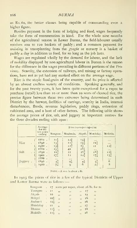
1 66 BURMA
as Rs. 60, the better classes being capable of commanding even a
higher figure.
Besides payment in the form of lodging and food, wages frequently
take the form of remuneration in kind. For the whole nine months
of the agricultural season in Lower Burma, the field-labourer usually
receives 100 to 120 baskets of paddy; and a common payment for
assisting in transplanting from the pyogin or nursery is a basket of
paddy a day in addition to food, for so long as the job lasts.
Wages are regulated wholly by the demand for labour, and the lack
of mobility displayed by non-agricultural labour in Burma is the reason
for the difference in the wages prevailing in different portions of the Pro-
vince. Scarcity, the extension of railways, and mining or factory opera-
tions, have not as yet had any marked effect on the average wage.
Rice is the staple food-grain of the country, and its price is affected
by an almost endless variety of conditions. Speaking generally, and
for the past twenty years, it has been quite exceptional for a rupee to
purchase (retail) less than 10 or more than 20 seers of cleaned rice, the
precise figure between these two extremes being determined in each
District by the harvest, facilities of carriage, scarcity in India, internal
disturbances, floods, revenue legislation, paddy rings, extension of
cultivated area, and a host of other factors. The following table shows
the average prices of rice, salt, and jaggery at important centres for
the three decades ending with 1900 :
—
Note.—A seer is about 2 lb.
In 1903 the prices of rice in a few of the tyiiical Districts of Upper
and Lower Burma were as follows :
—
Kanjjoon
Toungoo
AkyabMergni
Amherst
M.nnflalay
BhamoMciktil.i
17 seers per ru])ec, about 26 Ih. for is.
1
1
10
1
1
'^Hi
17
16
16
17
18
18

FORESTS 167
Apart from yearly fluctuations, due mainly to variations in the (juality
of harvests, there has been a slight hut steady downward tendency
during the last twenty years in the purchasing power of the rupee in
regard to rice, which, in view of the enormous increase in the demandfor the staple for export purposes, is not surprising. The only other
food-grain of any im[)ortance in Burma is millet. It is eaten regularly
in the poorer portions of the dry zone, but in other localities only whenthe supply of rice is insufficient for the requirements of the people.
Its price in 1903 in two typical dry zone Districts of Upper Burma was :
—
Mnndnlny . 29 seers per rupee, about 45 lb. for \s.
Meik-til.i . 20^ ,, „ „ 31
The material condition of the people is better in Lower Burma than
in the Upper province, where deficient rainfiill or the lack of culti-
vable land in the vicinity of villages makes for a lower agricultural
output and cuts down the profits of the husbandman. The financial
advantages of the prosperous Lower Burma cultivator meet the eye less
in his residence, household furniture, and ordinary dress than in his
expenditure on food, ornaments, social ceremonies, and works of merit.
There will be more silk waistcloths, anklets, and ear-plugs, more
savoury accessories to the rice-bowl, and more festive gatherings in the
rich farmer's house than in that of his poor neighbour; but the dwelling,
and its fittings or lack qf such, will be much the same in both cases,
nor will any ap[)reciable difference be noticeable between the outward
circumstances of a villager cultivating his own land and of a landless
day-labourer. The middle-class clerk, whose lines are for the most
part cast in urban areas, will usually occupy a more pretentious building
than the well-to-do agriculturist ; his furniture and his everyday attire
will be more elaborate ; his jewellery will be more showy ; his food will
be richer ; and his charities will be less. During the past twenty years
the advance in the standard of comfort has been considerable among
the town population.
An ordinary everyday costume of cotton jacket, cotton wuistcloth,
and silk gataii:;l)auni:^ or heatlkerchief costs from Rs. 3 to Rs. 5. A good
jacket can be purchased for Rs. 1-8 and a cotton Aws^v/ or loin-cloth
for Rs. 1-4. A single square of Japanese silk is enough for a head-
cloth, and its price is R. r or even less, but for a full gaung/>au;ig
two squares are ordinarily required. Burmese shoes can be bought at
between R. i and Rs. 1-8 a pair. Silk waistcloths are worn on special
occasions. They cost from Rs. 10-8 upwards.
The forests of Burma may be conveniently classified as : I. Evergreen^
comprising (i) littoral, {2) swamp, (3) tropical, (4) hill or temperate;
and, II. Deciduous, comprising (i) open, (2) mixed,
and (3) dry. The littoral forests arc confined to
Lower liurma, as arc also, practically, the true swani[) forests, while the
1 68 BURMA
dry deciduous forests mostly occur in the Upper province. The other
classes are common to the whole of Burma. The mixed deciduous
forests yield most of the out-turn of teak. Large areas covered entirely
with teak are however not known, and it is rare even to find forests
where teak is numerically the chief species. As a rule it is scattered
throughout forests composed of the trees common to the locality. Thein forests, so well-known on laterite formation, belong to the open
deciduous sub-class, while evergreen hill or temperate forests clothe
a large proportion of the uplands of the Shan States. A considerable
forest area in Burma is covered with a luxuriant growth of bamboo.
The littoral and swamp forests contain little timber that is of any
present value. In the tropical forests the kauyin {Dipterocarpus turbi-
fiatus) and thiikado {Cedre/a Toona) abound, while the thbigan {Hopea
odoratd) and the India-rubber tree {Ficits e/astka), with oaks and pines,
are typical of the evergreen hill forests. The mixed forests contain,
besides teak and pyingado {Xy/i'a dolabriformis), the pyinma [Lager-
stroemia Flos Reginae) and the padauk [Fferocarpus indicus). In the
dry deciduous forests the tree most utilized is perhaps the sha {Acacia
Catechu), which furnishes the cutch of commerce.
The forest area of the Province may be classified under two heads :
' reserved ' forests, which are specially demarcated and protected, and
whose produce remains entirely at the disposal of Government after
satisfaction of the demands (if any) of right-holders ; and public forest
lands, which are freely drawn on for trade and agricultural requirements.
For the Reserves, which are responsible for the timber supply of the
Province, working-plans are compiled so that a sustained maximumyield may be forthcoming in the future.
The area of the * reserved ' forests is increasing yearly as exploration
of the forests proceeds, and time and staff are available for settlement
duties. In 1881 the Reserves were 3,274 square miles in extent; in
1901, 17,837 scjuare miles. In the latter year the area of public forest
land aggregated 81,562 scjuare miles. Ncj new Reserve is created until
full incjuiry has been made on the s[K)t with regard to existing rights,
domestic or agricultural ; and this formal recognition of prescriptive
rights has done nmch towards rendering the i)e()ple less antagonistic
to the restrictions which it is sometimes necessary to imptxse for the
welfare and maintenance of the forest. Areas once ' reserved ' may,
should necessity arise, be disforested in the public interest ; and in
times of scarcity of food or fodder the Reserves are placed at the free
disposal of the people and their cattle.
For administrative purposes the timber trees of llurma ma)' similarly
be divided into two classes, 'reserved' and 'unreserved.' The first
includes teak, which is the projjcrty of Government wherever found,
together with some eighteen otlier species to which this monopoly does
FORESTS 169
not extend. The second class includes all other trees. ' Reserved
'
trees can be cut only under a G(wernment licence ;' unreserved ' trees,
on the other hand, may, outside Reserves, be utilized free of cost for
the domestic and agricultural recjuirenients of the people, but their
produce is taxed when extracted for trade purposes.
Although the forests of Burma contain many valuable species of
timber, some of which are largely used locally, teak is the only species
in which an export trade of importance has yet been developed. Theextraction of teak for trade purposes is carried out under the supervision
of the Forest department, sometimes by means of Government agency,
but chiefly by private firms under the system of purchase contracts.
The annual yield in mature stems of a teak-bearing area is fixed for
a term of years, and the given number of trees are annually girdled
under the immediate control of a Forest officer. In the third year after
girdling, when the timber has seasoned on the root, it is felled and
logged. The logs are then dragged by buffaloes or elephants to the
nearest floating stream, whence they ultimately reach deep water on one
of the main rivers and proceed on their long journey to the seaports,
where they are converted into beams and scantlings and shipped to the
consumer. Years may thus elapse before a girdled tree comes on to
the market, for its progress depends on the amount and frequency of
the monsoon precipitations which cause the necessary flushes or freshes
in the floating streams. In 188 1-2 the out-turn of teak from (Govern-
ment forests in Lower Burma was 31,246 tons, while the exports from
the Province, including teak received from outside the limits of what
was then British Burma, amounted to 133,751 tons. In 1892-3 the
exports reached a total of 216,186 tons, valued at 164 lakhs of rupees,
and ten years later a total of 229,571 tons, with a value of 203 lakhs,
was recorded.
The value of minor forest produce, including bamboos, utilized for
trade purposes in Burma, has as yet reached no considerable amount.
It stood at 4I laktis of rupees in 1903-4. It must, however, be remem-
bered that the inhabitants of the country receive all their requirements
in forest produce free of royalty, and that transport difficulties are as
a rule so formidable in the Province that at present it is not found to
be remunerative to extract for export any but the most valuable forest
products.
The protection and imjirovement of the state forests in Burma is
entrusted to the Forest department. Systematic operations for the
settlement of forest areas, for their demarcation, survey, and protection
from fire, involve the annual expenditure of very large sums. At the
same time the extension of the forest area under the more valuable
indigenous trees is not lost sight of. Tau/fsu'it cultivation of teak is
a speciality of Burma forest management, and consists in permitting

i7o BURMA
shifting cultivation of cereal and other crops within Reserves, on the
condition that teak seed is sown at the time of cultivation. The system
is suitable to the requirements of the forest population, and has resulted
in benefiting both the people and the forests. Plantations on an ex-
perimental scale of exotic species such as rubber and eucalyptus, cSrc,
are also receiving attention, the object being to prove, if possible, that
such projects are remunerative and so to open out a field for the
enrichment of the country by private enterprise.
The following figures give the average annual financial results of
forest management in Burma for the last two decennial periods ending
with 1900, and also the figures for the year 1903-4 :
—

MINES AND MINERALS 171
22,983 tons, but it fell after this, and in 1903 was only 9,306 tons.
The average number of hands employed in 1900 was 246. 'J"he coal
was carried on a tramway from the mines to the river bank, and the
average selling price was about Rs. 10 per ton. The mine has now,
however, been shut down.
Iron is found in the Shan States, in Mergui, and elsewhere. It has
nowhere, however, been systematically extracted and dealt with onEuropean methods. Iron-smelting is a purely local village industry.
Gold is found in the beds of many of the streams of both Upper and
Lower Burma, and the gold-washing of past generations has left its
impress on the country in town and village names like Shwegyin,
Shwedwin, and Shwedaung. It has been found in a non-alluvial form
in Tavoy District ; in the Paunglaung Hills to the east of the Sittang;
in the Shan Mills, and in Katha District. The Kyaukpazat gold-mine in
the last-mentioned District was worked for several years, but the lease
has now been surrendered. In 1900 a prospecting licence was granted
for gold-washing within the bed of the Irrawaddy, from the confluence
above Myitkyina to the mouth of the Taping river in lihamo District.
That gold exists in paying (juantities in Burma is indubitable. A good
deal more money, however, is required for the successful exploitation of
the metal than capitalists have as yet shown a disposition to invest.
The gold-leaf used so largely for gilding pagodas in l^>urma comes for
the most part from China.
Mogok is the head-quarters of the ruby-mining area of Upper Burma.
The ruby mines are situated in the hills 60 miles east of the Irra-
waddy, and about 90 miles north-north-east of the city of Mandalay.
The stones are extracted partly by native miners and partly b)- the
Burma Ruby Mines Company. The first lease to the company,
granted by the Government in 1889, was for the extraction of stones by
European methods, and for the levy of a royalty from persons working
by native methods, and provided for the payment of a share of the
company's profits to the Cjovernment. It expired in 1896, and was then
renewed for a further term of fourteen years at a rent of Rs. 3,15,000
a year plus a .share of the profits, the royalty system being continued.
In 1899 a debt due by tiie company to the Government was written
off and the annual rent reduced to 2 lakhs, while the Government
share of profits was increased. By a lease running for twenty eight
years from April 30, 1904, the rent has been fixed at 2 lakhs, with
30 per cent, of the net profits. The system of extraction adopted is
to raise the l>yon or ruby earth (found ordinarily some 20 feet below
the surface) from open quarries, and to wash it by machinery similar to
that employed in the South African diamond mines. The stones thus
obtained are then sorted and the spinels are separated from the rubies.
The capital of the Ruby Mines Company stands at i)resent at

172 BURMA
£180,000. The company's establishment was in 1904 approximately
1,600 strong. Of this staff 44 members were Europeans and Eurasians,
the rest natives of India, Shans, Chinese, Maingthas, and Burmans.
Rubies are found in the Nanyaseik tract, in the Mogaung township of
Myitkyina District, and in the Sagyin tract of Mandalay District, but
neither of these areas approaches the Mogok ruby tract in point of
productiveness. The Nanyaseik tract is now practically deserted.
The richest oil-bearing tract of Burma lies in the valley of the
Irrawaddy, in the southern portion of the dry zone of the Upper
province, at about the 21st parallel of latitude. It has been worked by
the natives certainly since the middle of the eighteenth century, but
modern boring appliances were not introduced till 1889. The three
principal centres of the petroleum-extracting industry are Yenangyaung
in Magwe District and Singu in Myingyan District on the eastern bank
of the Irrawaddy, and Yenangyat in Pakokku Di.strict on its western
bank. The oil is obtained partly from wells dug by native labour, but
mainly by a system of regular boring carried on by the Burma Oil
Company, which purchases the bulk of the oil obtained by the native
workers {hvinzas), and pays a royalty to Government of 8 annas per 100
viss (365 lb.) in the case of the older leases and per 40 gallons in the
case of the later ones. From the wells the crude oil is conveyed by
pipes to tanks on the river bank, where it is pumped into specially
constructed flats or floating tanks which are towed by the Irrawaddy
Flotilla Company's steamers to Rangoon. Here it is refined in the Oil
Company's works at Syriani and Danidaw. In 1903 the value of the
Yenangyaung oil extracted was 36-4 lakhs, and of the Yenangyat oil
15 lakhs. The royalty on the output of petroleum was 4^ lakhs in
1 90 1 and 8 lakhs in 1903. The Burma Oil Company has a staff of
over 7,000 employes, of whom about 150 are Europeans and Americans.
The Rangoon Oil Company works also at Yenangyat and Singu, and
oil is won by the Burma Oil Company from the Minbu Oil Company's
concessions. Petroleum is also worked in the Akyab and Kyaukpyu
Districts of the Arakan Division, but the Arakan fields are not to be
compared with those of the dry zone for richness. The total production
of kerosene oil in ]5urma has risen from about 10 million gallons in
I.S93 to 83 millic^n gallons in 1903.
Hitherto jade has been found in paying cjuantities only in the Myit-
kyina District of Upper Burma. It is quarried in the hills during the
dry months of the year by Kachins, and is purchased on the si)Ot by
Cliinese traders, and by them transported in bulk by water and rail, f(jr
the most part to Mandalay, where the blocks are cut u[). The purchase
of the jade in bulk is a highly speculative tran.saction, as, till it has been
sawn u[), it is almost impossible to say how much marketable green jade
a particular bicjck may contain. Practically all the jade extracted finds
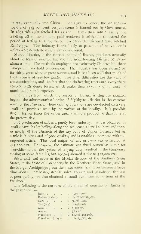
MINES AND MINERALS 173
its way eventually into China. The right to collect the ad va/oj-em
royalty of t^t,^ per cent, on jade-stone is farmed out by Government.
In 1891 this right fetched Rs. 55,500. It was then sold annually, but
a falling off in the amount paid rendered it advisable to extend the
period of letting to three years. In 1899 the triennial lease fetched
Rs. 60,350. The industry is not likely to pass out of native hands
unless a fresh jade-bearing area is discovered.
Mergui District, in the extreme south of Burma, produces annually
about 60 tons of smelted tin, and the neighbouring District of Tavoyabout a ton. 'I'he methods employed are exclusively Chinese, but three
European firms hold concessions. The industry has been carried on
for thirty years without great success, and it has been said that much of
the tin ore is of very low grade. The chief difficulties are the want of
communications, and the fact that the tin-bearing tracts are everywhere
covered with dense forest, which make their examination a work of
much labour and expense.
The mines from which the amber of Burma is dug are situated
beyond the administrative border of Myitkyina District in the extreme
north of the Province, where mining operations are conducted on a very
small and primitive scale by the natives of the locality. It is possible
that in former times the amber area was more productive than it is at
the present day.
The production of salt is a purely local industry. Salt is obtained in
small quantities by boiling along the sea-coast, as well as here and there
in nearly all the Districts of the dry zone of Upper Burma ; but as
a rule it is bitter and of poor quality, and is unable to compete with the
imported article. The local output of salt in 1900 was estimated at
415,000 cwt. For 1902-3 the estimate was fixed somewhat lower, for
a modification in the system of levying duty resulted in the temporary
closing of some factories, but 1903-4 showed a rise to 517,000 cwt.
Silver and lead occur in the Myelat division of the Southern Shan
States, in the State of Tawngpeng in the Northern Shan States, and in
the Mergui Archipelago ; but their extraction has never assumed large
dimensions. Alabaster, steatite, mica, copper, and plumbago, the last
of poor quality, are also obtained in small quantities in portions of the
Province.
The following is the out-turn of ttie principal minerals of Burma in
the year 1903 :—
Jade . . . .1,402 cwt.
Rubies (value) . . 14,78,628 rupees.
Coal . . . .9,306 tons.
Tin (ore) . . .2,198 cwt.
Gold .... J, 397 oz.
Amber . . -37 cwt.
Petroleum . . . 85,328,491 gah.
Petroleum (1S90) . 4,641,308 gals.

174 BURMA
Of domestic industries cotton-weaving is the most important and
widespread. In 1901 the number of persons supported by cotton-
weaving by hand was returned as 189,718, of
man fact"whom the actual workers numbered 9,392 males and
136,628 females. This latter figure represents a
fraction only of the total of women and girls actually engaged in
cotton-weaving, for the great majority of those who wove solely for
home consumption must have returned weaving, if at all, as a subsidiary
occupation. The loom is a feature of nearly every house in certain
localities ; and in the past, before imported cloth began to compete
with home-spun, its use must have been far more widespread than now.
As it is, the foreign is slowly ousting the home-made article, and where
home-weaving is still fairly universal more and more use is made of
imported ready-dyed yarn. In fact, it is only in the cotton-growing
areas of the dry zone that local thread is used in any quantities.
There are no cotton-mills in Burma. Everything is woven on hand-
looms.
Silk-weaving is a purely professional industry, though, like cotton-
weaving, it is wholly the product of hand labour. The silk cloth wovenis for sale, not, except in rare cases, for home consumption. Theprospects of the silk-weaving industry have been damaged by the advent
of cheap Manchester and Japanese silk goods, and the number of
weavers in Sagaing and Mandalay, the head-quarters of the industry,
has declined enormously of late years ; but Burmese silk, where not
woven of silk thread prepared and dyed in Europe, is still, by virtue of
its texture and durability, able largely to hold its own. The Burmese
silk is woven from Chinese silk thread, purchased raw and treated and
dyed locally ; but its comparatively sober hues fail to appeal to the
average Burman as do the brilliant acheik and other cloths made of the
gaudy silk thread of commerce. Silk is the attire of the well-to-do ; and
all but the very indigent, even when they ordinarily wear a cotton waist-
cloth, have a silk paso (waistcloth) or tatnein (petticoat) stored up for
gala days. The head-gear of the people is almost invariably of silk.
The locally made silk is too stiff for the gaungbaungs or headkerchiefs
of the men, and for this purpose custom has pronounced in favour of
the flimsy Manchester or Japanese squares that are obtainable in all the
bazars of the country. The total number of persons supported by silk-
weaving in 1 90 1 was 34,029, of whom the actual workers numbered
5,973 males and 18,316 females. The Districts of Prome, Mandalay,
Kyaukse, and Tavoy showed the highest totals.
Neitlier embroidery nor carpet-weaving exists as a widespread local
industry. Cloth saddles are frecjuently decorated with patterns, and
a near approach to embroidery is a form of appli</ue work which con-
sists in sewing figures of coloured cloth and spangles on to a dark cloth

ARTS AND MANUFACTURES 175
background. Curtains of this work arc known as kalagai. As a rule
they are barbaric but effective.
Gold- and silversmiths and jewellers form a not unimportant section
of the indigenous community. Workers and dealers in gold, silver,
and precious metals, and their dependents, numbered 53,912 in lyoi,
the total of actual workers being 25,021. Silver jewellery is but little
worn, but the better classes are profuse in their display of golden
ornaments. Ear-rings {nadauugs and tiagats), either of plain gold
filigree work or enriched with jewels, are common ; rings and bracelets
of the same metal are popular gauds ; children of well-to-do parents
often wear gold anklets, and necklaces are affected by those of the fair
sex who can afford them. Silver is mainly used for bowls and betel and
lime boxes, the latter being occasionally of gold also. The making
and designing of silver bowls has grown into what is probably the most
attractive of the fine arts of Burma. The figures and patterns are
executed, as a rule, in high relief, and the work, when well done, is
singularly effective.
Of indigenous ironwork there is little that is not exceedingly primi-
tive. Iron implements of a rough kind, such as das and axes, are manu-
factured in considerable quantities, but all the better kinds of cutlery
and other hardware used in the Province are imported. The few iron
foundries are almost all in Rangoon. Of the 26,221 workers and
dependents shown in the census returns under the head of workers in
iron and hardware, few can have been capable of executing anything
more than the coarsest blacksmith's work. An exception must, how-
ever, be made in favour of the forgers of the inlaid knife-blades pro-
duced in Yamethin District, some of whose work is really meritorious.
Copper-working can hardly be said to exist in the Province. Brass-
workers are fairly numerous (3,287 workers and dependents in 1901),
though, as the Burman neither cooks in nor eats off brass, their total
is a good deal smaller in Burma than it would be in an Indian com-
munity of corresponding numerical strength. Images of Buddha, bells,
gongs, water-filters, spittoons, and bowls are the main products of the
brass-worker's craft.
Practically all the indigenous cooking is done in earthen vessels, and
the trade of the potter is widespread. The actual workers and
dependents connected with the production of pottery in 1901 totalled
19,800, a small number considering the extensive use made of earthen-
ware. Pot-making is, however, often a subsidiary occupation, combined
with agriculture, and thus a large proportion of the potters were returned
at the Census under their main calling. The ordinary pottery is rough
and homely ; but here and there, as at Pyinmana, Myinmu, and
Kyuukmyaung, glazed pottery is made which is not without a certain
measure of artistic merit. Bricks are baked extensively, and brick-
T76 BURMA
making must have been a recognized industry in connexion with the
building of pagodas for centuries past. The industry supported rather
over 7,000 actual workers and dependents in 1901.
Lacquer-work is common, the Myingyan District of Upper Burma
being the head-quarters of the industry. The lacquer, the basis of
which is the gum of the Melanorrhoea usitata, is laid over a foundation
either of wood or bamboo wicker-work. Flat trays, or byats, and betel
boxes, cylindrical, with deep covers and ornamented with quaint pat-
terns, are the two articles that the lacquerer produces in greatest
numbers. The Burmese lacquer-work is durable, light, and economical,
and is outwardly attractive to the eye. The gold lacquer industry has
almost disappeared from the Province. It will be a matter for regret if
this art is allowed to die out finally, for it is distinctive and picturesque.
The lacquer industry was the means of support of 14,274 persons of
both sexes in 1901. Of these 4,277 males and 2,702 females were
actual workers, more than one-third of them in Myingyan District.
Indigenous sculpture may be said to be confined to the making
of alabaster figures of Buddha. The design adopted is always con-
ventional and uniform. It is ordinarily helped out with a little outline
colouring, and is absolutely devoid of artistic beauty. Of the 349persons returned as working sculptors in 1901, all are probably to be
included in the category of sacred image modellers. Wood-carving is
a source of income to a small but not unimportant section of the
community. Carving has always been a feature of the finer timber
monasteries of the Province, and the art has been steadily fostered,
though it has far fewer exponents than has the silverwork industry.
The majority of the wood-carvers are found in the main centres of trade,
and their work, did they choose to produce systematically, would
probably find a ready market among the European community. As
a rule, however, they work to order and accumulate no stock of carved
material. Burmese carving is free, and on the whole graceful, and is
often executed in high relief. Floral and figure designs are frequently
combined, and, considering the primitive nature of the tools employed,
the result is, as a rule, singularly effective. It never fails from over-
minuteness, for not only arc the implements rough but the wood em-
ployed is ordinarily coarse-grained. The more delicate ivory-carving
is also one of the arts of Burma, but its votaries are few in number
and it is confined to a few special localities, such as Moulmein town.
Mat-weaving is a popular industry, supporting 53,585 persons in 1901.
Mats are of various kinds. The commonest sort are of bamboo, the
better kinds are woven of cane and reeds. Those used for sleeping on
are of the latter class, and are known as thinbyu. A rough paper used
for wrappers, umbrellas, and the like is made in Mongnai and elsewhere
in the Shan States from the white inner bark of a species of mulberry-

AJiTS AND MANUFACTURES 177
tree known to the Shans as maisaik. Of llie 749 persons aclually
engaged in tlie production of paper by hand in 1901, nearly half were
enumerated in the Southern Shan States. The Burmese umbrella
resembles the Chinese in outward appearance. It is light and graceful,
but flimsy, and has unfortunately now had to yield largely to the black
gingham of the European market. A total of 915 persons were engaged
in 1 90 1 in the production of the indigenous article. Cart- and boat-
building are two of the important industries of the Province. Boats are
of various kinds, ranging from the simple dug-out or hiung to craft like
the laungzat or pei)tga7C', elaborately carved and of a capacity of up to
40 tons. Cart-builders in 1901 numbered 5,946 actual workers and
dependents, and boat-builders and their families 5,840. The use of
European boots and shoes is becoming conmion in towns, but the
ordinary Burman does not usually look outside the Province for his
foot-gear. His sandals {panat) are made of wood, leather, or felt, and
are kept in position by two thongs which run from the two sides of the
sole and unite in the front, passing between the great and second toes.
The manufacture of Burmese sandals was the means of support of
12,864 persons in 1901.
The year 1892 was the first in which statistics of factory manu-
factures were published in Burma. In that year 106 factories were
registered under the Factories Act. in the Lower province. One of
them was a cotton-press, 5 were iron-works, 2 printing presses, 52 rice-
mills, 41 timber-mills, 3 ice-works, and 2 oil-works. The number of
workmen employed in these factories was 21,136, of whom 20,335
were male and 588 female adults, while 213 were children. All these
factories used steam-driven machinery, and each employed not less
than twenty persons. In 1902 the number of factories under in-
spection in Burma had risen to 173, of which 96 were rice and 54timber-mills. The great majority of the factories of the Province
fall, and are likely for many years to fall, under one or the other of
the two last-named classes. There were five iron foundries in Ran-
goon in 1902 and one in Moulmein ; two oil refineries, both in Rangoon
or in its neighbourhood ; and a brewery in Mandalay. This last
has not yet been brought under the provisions of the Factories Act.
The total number of factory hands employed in 1902 was 28,517, (f
whom 27,890 were adult males, 527 adult females, and 100 children
of both se.xes. The figures for 1903 were: males, 31,327; female?,
861 ; children, 157. The majority of the operatives come from India;
and the growth of factory industries, though not affecting internal
migration to any appreciable extent, has left its mark on immigration
from outside the Province. Akyab draws its coolies mainly from
Bengal \ Rangoon and Bassein from the East Coast Districts of Madras.
NN'ages in factories vary with the locality, as well as with the amount
VOL. IX. N

178 BURMA
of technical skill required of the operatives. Highly trained mechanics
receive as much as Rs. 60 a month, and even unskilled labour is very
well paid. Male coolies ordinarily receive from Rs. 10 to Rs. 15 a
month, and female coolies, when employed, are frequently paid at
the same rates as the men. The material condition of the operatives
is indubitably good. The mill hand can live comfortably on half
his monthly wage, and almost invariably returns to his own country with
a considerable hoard of .savings. So remunerative is factory labour
that the supply of operatives is always on a level with the demand.
For centuries the seaboard of Burma has been visited by ships from
many countries. Bassein was a flourishing port in the twelfth century,
and at a later period we find Arabs and other AsiaticCommerce and
^.^^ -^^ constant communication with Arakan, Pegu,trade.
, ^ . ,„ ,,,..' °
and Tenassermi. lowards the begmnmg 01 the
second half of the fourteenth century, Muhammadan merchants car-
ried on a brisk trade between Pegu and the countries east and west.
The Arabs brought to Burma goods of European manufacture as
well as the produce of their own country ; and large sea-going boats
from Arakan visited the ports of Bengal. The principal exports from
Bassein and Pegu were gold, silver, rubies, sapphires, long-pepper, lead^
tin, lac, and some sugar. The imports from Arabia and the Persian
Gulf to Syriam, an ancient emporium of Burma, close to the mouth
of the Pegu river, were woollen cloths, scarlet velvet, and opium ; and
from Madras and Bengal piece-goods of various kinds. The trade of
Malacca and places to the eastward was with Mergui and Martaban,
then flourishing ports of Tenasserim, the imports being porcelain from
China, camphor from Borneo, and pepper from Achin. From Arakan,
rice was the principal export, the imports being muslins, woollens,
cutlery, piece-goods, and glass and crockery ware. Tenasserim e.\-
])orted tin largely. After the cession of Arakan to the British, Akyab
rajjidly rose in importance. The trade of I'enasserim, when the British
came into i)ossession, was at a very low ebb. The country, however,
had large teak forests, which led to the foundation of the town
of Moulmein, where ship-building could be extensively carried on.
Later on, after the second Ikirmcse War, Rangoon came into pro-
minence and has now far out-distanced the older ports.
The chief items of the export trade of Burma are rice, timber, cutch,
hides, petroleum, india-rubber, cotton, and precious stones. It is the
rice produce and the rice exports that have made, and maintain, the
prosperity of the Province. Paddy and rice now form more than three-
quarters of the total exports. The only other item of export which
can ap[)roach rice in importance is teak timber. The chief imports
are piece-goods, silk, salted fish, wool, cotton twist, gunny-bags, betel-
nuts, licjuors, tobacco, iron, mill machinery, and sugar.
COALVERCE AND TRADE 17O
Thu chief centres of trade in the Province are the seaports of Ran-
goon, MouLMEiN, Akyau, Bassein, Tavoy, Mergui, Kyaukpyu,
Sandowav, and Victoria Point ; and, in the interior, Mandalay,
Bhamo, Pakokku, Prome, Henzada, and Myingyan. The bulk
of the trade at the ports is sea-borne. Mandalay and Bhamo are
the two main emporia for the trade with South-Western China and
the northern portion of the Shan States, which is wholly by land.
The trade of Pakokku, Prome, Henzada, and Myingyan is partly river-
and partly land-borne. Rangoon exports rice, timber, cutch, hides,
india-rubber, tobacco, and cotton. Akyab and Bassein export little
else than rice, but Moulmein sends timber, also rice and a little tobacco.
The chief exports of Mergui are fish and shrimi) paste {ngapi), dried
prawns, salted fish, mother-of-pearl and its substitutes, and tin. The
produce that leaves Tavoy by sea is miscellaneous in nature, but rice
preponderates ; and it may be laid down in general terms that the
amount of merchandise other than rice and timber which passes out
through the smaller ports of the Province is practically a negligible
quantity. Rangoon's chief imports are hardware, piece-goods, kero-
sene, salted fish, liquors, and sugar ; and the smaller ports follow suit
on a less extended scale, the only noticeable feature being Moulmein's
large importation of betel-nuts and sugar. Mandalay is the head-
quarters of the tea and jade trade of Upper Burma, and Myingyan is
largely concerned with the cotton grown in the dry areas of the Upper
Province. Rangoon possesses a Chamber of Commerce, formed in
1877 with a view to the furtherance of commercial interests in the
Province, and a Trades Association. The port of Rangoon is adminis-
tered by a Port Trust constituted under the Rangoon Port Act of 1905.
There are thirteen commissioners, of whom four are elected by the
Rangoon Chamber of Commerce and one by the Rangoon Trades
Association, the others being appointed by the Local Government.
The chief executive authority is vested in a full-time chairman, who
is also the Chief Engineer of the port. The receipts of the Port
Fund in 1881 amounted to nearly 5^ lakhs, and its expenditure to over
6^ lakhs. In 1902-3 the corresponding figures were 15^ and 14^
lakhs respectively, and in 1903-4 the income had risen to 17-^ lakhs.
The simplest method of classifying the trade of the Province is
that which distinguishes between the internal and the external trade.
External trade may be with countries beyond the limits of British
India (trans-frontier) or with other Provinces of the Indian Empire.
The trans-frontier sea-borne trade is registered by the Customs depart-
ment, the trans-frontier land trade with China, Siam, and other Asiatic
countries by a Trade Registration department under the Director of
Land Records and Agriculture. External trade with the rest of British
India may similarly be maritime or land trade. In the former case
N 2

i8o BURMA
it is generally known as coasting trade and is registered by the Customs
department, in the latter it is not registered. Table V (p. 238) gives
statistics of the sea trade of the Province with other Provinces and
with foreign countries, and of its foreign land trade, for the years
1890-1, 1900-1, and 1903-4.
The internal trade of Burma is still mainly in the hands of the
Burmans ; but they hold their own with difficulty when pitted against
the natives of India and of China, whose shrewdness and business
capacity have enabled them to take a large proportion of the petty
business away from the people of the country. The rail- and water-
ways are the main commercial highways of the country in Burma
proper. Up to 1892 practically the only statistics of internal trade
were those furnished by the Irrawaddy Flotilla Company and the
railway administration. In 1892 steps were taken to register the
trade carried on by the country boats plying on the rivers of Burma,
but it was found that the value of the information furnished was not
commensurate with the cost incurred in collecting the required data,
and in 1897 the arrangements were discontinued. The boat trade
is still largely carried on by the indigenous population, and the float-
ing pedlars it supports are able to reach a portion of the community
untouched by bazars and the ordinary traffic of the market-place.
Though its precise extent has not been gauged of recent years, the
internal trade of Burma is comprehensive and far-reaching. Here
statistical details, which must of necessity be defective, are of no great
value. Advantage may, however, be taken of what has been collected
in the past to place on record that in 1896-7, the last year of registra-
tion, the value of the internal trade of Burma was given as about 937lakhs. Between Burma proper and the Shan States, and within the
limits of the latter, there is a fairly extensive caravan traffic ; bullocks
and mules are the main means of transport, but a considerable portion
of the merchandise is conveyed in baskets slung on bamboos upon
the shoulders of carriers. This section of inland trade has been in
the past, and is still, registered by the Trade Registration department.
The value of the inland trade between liurma and the Shan States
amounted in 1903-4 to over 78 lakhs under exports and 104 lakhs
under imports. In return for the cotton twist, cotton goods, salted
fish, and betel-nuts, which form the bulk of what they take from Burma,
the Shan States send into the Burmese markets tea (pickled and dry),
timber, fruit, vegetables, and cattle. The Northern Shan States supply
the greater part of the pickled tea (Jetpei) consumed in the Province.
The value of this commodity imported from the Northern Shan States
in 1903-4 was about 22 lakhs. Barter is occasionally resorted to by
the inland traders, especially in the case of dealings with the hill tribes,
but the practice is not widespread.

COMMERCE AND TRADE i8i
There is a little land trade between Ikirma and the rest of India.
Goods pass between Akyab and Chittagong and Assam and the Upper
Chindwin District ; but the business done over these inland trade
routes is insignificant, is not registered, and for general statistical
purposes may be left out of consideration. Burma's commercial inter-
course with the rest of the Indian Empire may be said to be almost
wholly maritime. It is carried on to a small extent by native craft
;
but the great bulk of what is known as the coasting trade of the Pro-
vince is in the hands of the British India Steam Navigation Com-pany, which unites the Province with all the chief commercial ports of
the seaboard of the Indian Empire, besides furnishing steamer services
which ply the whole length of the coast from Akyab to Mergui. TheAsiatic Steam Navigation Company is also concerned in the coasting
trade of the Province. It connects Rangoon with the Andamans and
several ports of India. Of the imports from other Provinces the most
notable ^are coal, tobacco, gunny-bags, cotton yarn, vegetable oil, and
betel-nuts, while rice, mineral oil, and teak timber form the bulk of the
exports. The coasting trade of the Province passes through the larger
ports, namely, Rangoon, Akyab, Moulmein, Tavoy, and Mergui, and
to some extent through Kyaukpyu, Sandoway, and Victoria Point. In
the smaller ports the imports by coasting trade ordinarily exceed the
exports. In Rangoon the case is reversed, and, taking the Province as
a whole, the export business exceeds the import. Bassein is not
visited by any of the regular coasting lines of steamers, and thus,
though its foreign trade is far from inconsiderable, it does very little
coasting business.
Table V appended to this article (p. 238) shows that, excluding
Government treasure, the total value of the maritime trade of Burma
with other Provinces in the year 1903-4 was nearly 7 crqres under
imports and more than 4| crores under exports, the corresponding
figures for 1 900-1 being, in round figures, 6 and 10 crores. In the
latter year the exports were raised by the abnormal demand for rice
from the Provinces suffering from famine, especially from Bombay
;
and it may be said in general terms that the existence or non-existence
of calls of this nature decides whether the coasting trade of the
Province in any one year shall exceed or H^ll below its foreign trade.
A noticeable feature of the coasting trade returns is the fact that famine
in India, while afiecting the destination of shipments from the rice-
exporting ports of Rangoon and Akyab, has in the past failed to divert
the rice supply of Bassein from its ordinary foreign channel.
The foreign sea-borne trade of Burma is carried by the boats of the
Bibby, the Patrick Henderson, and other lines, and passes for the most
part only through the larger ports of the Province : namely, Rangoon,
Akyab, Moulmein, Bassein, Tavoy, and Mergui. Except at Rangoon,

1 82 BURMA
there is no comparison between the imports and the exports under
foreign trade, the proportion the latter bear to the former in the lesser
ports being roughly 20 to i. An instance of this disparity may be
cited. At Bassein the value of foreign exports in the year 1900-1 was
over 103 lakhs, that of foreign imports w^as Rs. 354. Rice and timber
are the main articles of export, and the imports are generally those
indicated on p. 178. Details will be found in Table VI on p. 239,
which shows that in 1903-4 the total foreign import trade was valued
at 8^ crores, and the export trade at nearly 16 crores.
The increase in exports and imports under foreign trade during the
past twenty years has on the whole been steady. The trade of the first
half of the decade 1 891 -1900 was disastrously affected by a com-
bination entered into by the rice-millers in 1893 to keep down the
price of rice. Since then, however, there have been no very marked
fluctuations, though the effect of the scarcity of 1896-7 in Upper
Burma is visible in the yearly trade returns.
In the matter of foreign imports the United Kingdom heads the list
of supplying countries. In 1900-1 it supplied 4 crores' worth of goo'ds,
or 58 per cent, of the total, and in 1903-4 4| crores, about the same
proportion. The Straits Settlements, important as a distributing rather
than as a producing centre, are the second largest supplier. Japan
follows next in the list of importing countries, and the rapid growth of
its business with Burma is not the least significant feature of the trade
statistics of the past decade. The Straits Settlements were Burma's
largest customer in 1903-4, the exports exceeding in value those to the
United Kingdom (349 lakhs against 254 lakhs); but it should be
mentioned that information as to the ultimate destination of a good
deal of the produce exported from the country by sea is defective, in
consequence of the practice of shipping in vessels whose ultimate
destination is unknown. A considerable portion of the exports to
the Straits is intended for Java, Sumatra, liorneo, and Eastern Asia
generally.
The trans-frontier land trade of l^urma is carried on with China,
Siam, Karenni \ and French Indo-China, and is registered at a number
of fnjntier stations. The trade with Western China passes for the mo.st
part over a route terminating at Bhamo on the Irrawaddy, though there
is some traffic through Myitkyinil District and the Northern Shan
States. A small ])ortion of the ^^estern China trade also passes
through the registration stations established south of Maymyo along
the Shan States border. Karenni sends its merchandise for the most
part down the Salween to Kawludo and Kyaukhnyat. Dagwin, Tadan-
ku, and Kwanbi, stations along the eastern frontier of the Tenasserim
' Karenni, ll)Ou;;li controlled Ijy the T.ritisli Cloverninent, is not jiart of liiitish
India. nn<l, for liade imipuses, lias been treated as a foreign country.

COMMUNICA TIONS 183
Division, secure the bulk of the trade between Burma and Chiengmai
that does not pass through the Shan States, while commerce with the
rest of Siam, besides traversing the Tadanku route, crosses the fron-
tier hills near Kyeikdon in Amherst and Myitta in Tavoy District.
The merchandise that enters and leaves the country by land is carried
mostly by pack-bullocks and mules, though cooly-carriage is not
uncommon. The traders seldom travel singly ; and caravans mark,
with jangling bells and clouds of dust, their progress up and down the
main frontier highways during the whole of the dry season. TheBurman himself takes very little active part in the trans-frontier land
trade of his country. The carriers are Shans, Maingthas, Panthays,
Chinese, and Siamese. The registration stations are placed on the
roadside at suitable points where traffic converges, and the record of
statistics maybe said on the whole to be fairly accurate. In 1891 the
total number of registration stations was 13, in 1904 it was ^t,.
The figures in the foreign land trade table appended to this article
(p. 241) show that trade of this class increased very largely during the
ten years ending 1901. In the case of imports the total for 1901 is
almost exactly double what it was in 1891, and the exports have more
than doubled; the figures for 1903-4 show a further increase. Thepresent trans-frontier land trade is in value and extent still far below the
trade that passed before 1885 between British and Independent Burma,
but its development during the past few years augurs well for the
future. The distribution of the total of 1903-4 between the different
foreign countries concerned is as follows, the figures being given in
thousands of rupees :—
1^4 BURMA
and curving eventually eastwards until it reaches the river again at
Myitkyina, the head-quarters of the most northerly District of Upper
Burma. This line, which is 724 miles in length, traverses the greater
part of Burma from end to end. A steam-ferry service across the
Irrawaddy connects the southern with the northern section at Sagaing,
a few miles below Mandalay. The southern (Rangoon-Mandalay)
section sends out two branch lines. The first, 71 miles in length,
leaves the main line at Thazi, about 80 miles due south of Mandalay,
and passes north-west, through Meiktila, to Myingyan on the Irra-
waddy. The second starts from Myohaung, a junction just beyond the
southern limits of Mandalay city, and runs north-east 180 miles into
the Northern Shan States as far as Lashio. A noticeable feature of
this line is the steel viaduct, 1,620 feet in length and at its highest
point 325 feet above ground, which spans the Gokteik gorge. The
northern section of the main line has also two branches : one runs west-
ward from Sagaing till it taps the (.liindwin at Monywa and Alon
(73 miles) ; the other is a minor feeder to the east, 15 miles in length,
which terminates at Katha on the right bank of the Irrawaddy and
serves to connect that station, as well as Bhamo, a little farther up-
stream, with the main system.
The southernmost portion of this main line, which extends 166 miles
from Rangoon to Toungoo, a frontier station in the days preceding the
annexation of Upper Burma, was commenced in 1881 and completed in
1885. The Toungoo-Mandalay section was taken in hand shortly after
the annexation of the Upper province, and was completed in 1889.
During the same year a start was made on the extension northwards
(known first as the Mu Valley State Railway), and the final section,
which brought Myitkyina into direct railway communication with the
south, was opened to traffic in 1899. The branch lines have been
mostly completed since that year.
The oldest railway in the Province is, however, not a portion of the
main line, but lies to the west of it, connecting Rangoon with Prome on
the Irrawaddy. This railway, which was completed in 1877, is 161
miles in length. It runs in a north-westerly direction through the Pegu
Division of Lower Burma. A branch line, completed in April, 1903,
leaves it at Letpadan, about half-way between Rangoon and Prome, and
runs to the left bank of the Irrawaddy opposite the town of Henzada.
Here the river is crossed by a steam ferry, and the line proceeds on
from Henzada in a south-westerly direction to Bassein (115 miles).
From Henzada a line northwards to Kyangin (66 miles) is under con-
struction. Moulmein will shortly be connected with Rangoon by a line
which will take off from the Rangoon-Toungoo section at Pegu, and,
crossing the "Sittang, will pass down the eastern coast of the Gulf of
Martaban to the nearest suitable point of the Salween opposite

COMMUNICATIONS 185
Moulmein. It will be about 120 mik-s in length, and its construction
has been taken in hand. The construction of a railway from the
Toungoo-Mandalay section of the main line eastwards into the Southern
Shan States is in contemplation. The extension of the Northern Shan
States Railway from Lashio across the Salween to the ('hina border has
for the present been abandoned. Sanction has, however, been given for
the survey of a line from Bhamo towards '1 engyiieh in the YunnanProvince of China, and arrangements have been made to obtain the
consent of the Chinese Government to the survey being carried beyond
the frontier between the two countries.
Till 1896 the railways of Burma were state lines. They were then
taken over by the Burma Railways ('ompany ; and in 1897 a contract
was entered into between the Secretary of Stale and tlie c(jmpany which
guaranteed interest at the rate of 2\ per cent, on the company's share
capital of £2,000,000, and provided for the division between Govern-
ment and the company of the annual surplus in the proportion of four-
fifths to the former and one-fifth to the latter.
The total length of line open in 1891 was 609 miles; in 1901 it was
1,178 miles, and by 1905 it had risen to 1,340 miles. There was then
one mile of railway to every 176 scjuare miles of country, and the
average cost of construction per mile had been Rs. 94,392. 'I'he gauge
is metre.
Railway communication has done much towards reducing the prices
of imported articles in the remoter portions of the country. Scarcity
is as a rule so partial in Burma that it is doubtful whether the railway
will ever be called upon to play as important a i)art in combating
famine as in less-favoured Provinces. There can be no doubt, how-
ever, that it will prove very useful whenever there is a failure of crops
on a large .scale in the Districts liable to scarcity, which are, as regards
rail communications, exceptionally well served. The railway is proving
a formidable competitor of the Irrawaddy Flotilla Company, which has
practically a monopoly of the private carrying business on the inland
waters of Burma ; but river carriage is, for various reasons, still preferred
to rail by a large section of the trading community.
There are two steam tramways in the province. The first is 8 miles
in length and runs from Duyinzeik, on the Donthami river in Thaton
District, to Thaton, the District head-quarters. The capital cost of con-
struction up to the end of 1895, the last year for which capital and
revenue accounts were submitted, was nearly 4^ lakhs. By an agreement
entered into between Government and the original owner in January,
1884, a subsidy of Rs. 1,000 per mile was paid for three years after the
date of opening on condition that a proper service should be maintained,
and for ten years Government kept up all the bridges on the line.
From December i, 1900, the tramway passed into the liands of
1 86 BURMA
the Irrawaddy Flotilla Company. The receipts amounted in 1903 to
Rs. 32,000. In all 34,362 persons travelled by the tramway during
that year.
The other tramway is in Rangoon, and its construction and mainte-
nance are regulated by the Rangoon Tramways Act (XXII of 1883).
The cost of construction has exceeded 10 lakhs. Its working expenses
and net earnings in 1903 were about i^ lakhs and three-fourths of a
lakh respectively, and the return on capital is about 8 per cent. Thenumber of passengers carried daily during 1903 was about 9,000.
The line will shortly be electrified. An electric tramway on the over-
head trolley system was opened in July, 1904, in Mandalay city. It is
worked by the Burma Electric Tramways and Lighting Company, with
a capital of £200,000 ; and its present length is 6 miles of double track.
An application for permission to construct a light tramway from
Mandalay to Madaya is under consideration.
Nothing is more illustrative of the march of events during the past
fifty years than the difference in the principles on which the road
systems of the two portions of Burma have been designed. In LowerBurma the two principal roads, from Rangoon to Prome and from
Rangoon to Toungoo, cover practically the same ground as two main
stretches of railway line which later conditions showed to be necessary
on strategical as well as commercial grounds. Upper Burma, on the
other hand, came into the occupation of the British at a time whenrailway- and road-building went naturally hand in hand. The railway
there took the place of the trunk roads constructed in the early days
of British authority in the Lower province, and the guiding policy of
road-construction was to provide feeders for the railway and the rivers.
Railway expansion has enabled branch lines to be subsequently carried
over ground covered by several of these feeders ; but from the southern
limit of Yamethin District to Myitkyina in the north no considerable
outlay has been incurred in the construction of communications that
run in any way parallel with the main line of railway, and this policy
has saved unnecessary expenditure which the conditions obtaining up
to the last quarter of the nineteenth century rendered unavoidable in
the Lower province. In Lower Burma, especially the deltaic portion,
natural waterways have been largely used for communications ; but, with
the extension of the railway system, feeder-roads are being provided
to give access to new railway stations. In pursuance of this policy of
affording approach to the main lines of river and railway communication,
the ('hin Hills have been connected with the Chindwin and the
Irrawaddy by a system of cart-roads and bridle-paths from Kalewa and
Pakokku as far as the Lushai Hills frontier, and similar action has been
taken in the direction of the frtnitiers from Bhamo and Myitkyina. TheIrrawaddy and the railway are now in tc)uch with all important towns and
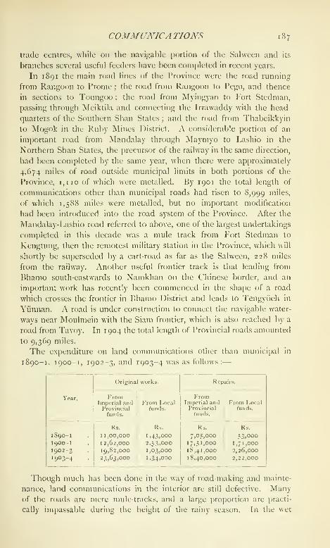
COMMUNICA TIONS 187
trade centres, while on the navigable portion of the Salwcen and its
branches several useful feeders have been completed in recent years.
In 1891 the main road lines of the Province were the road running
from Rangoon to Prome ; the road from Rangoon to I'egu, and thence
in sections to Toungoo : the road from Myingyan to Fort Stedman,
passing through Meiktila and connecting the Irrawaddy with the head-
quarters of the Southern Shan States ; and the road from Thabeikkyin
to Mogok in the Ruby Mines District. A considerable portion of an
important road from Mandalay through Maymyo to Lashio in the
Northern Shan States, the precursor of the railway in the same direction,
had been completed by the same year, when there were approximately
4,674 miles of road outside municipal limits in both portions of the
Province, 1,110 of which were metalled. By 1901 the total length of
communications other than municipal roads had risen to 8,999 "li'es,
of which 1,588 miles were metalled, but no important modification
had been introduced into the road system of the Province. After the
Mandalay-Lashio road referred to above, one of the largest undertakings
completed in this decade was a mule track from Fort Stedman to
Kengtung, then the remotest military station in the Province, which will
shortly be superseded by a cart-road as far as the Salween, 228 miles
from the railway. Another useful frontier track is that leading from
Bhamo south-eastwards to Namkhan on the Chinese border, and an
important work has recently been commenced in the shape of a road
which crosses the frontier in Bhamo District and leads to Tengyiieh in
Yunnan. A road is under construction to connect the navigable water-
ways near Moulmein with the Siam frontier, which is also reached by a
road from Tavoy. In 1904 the total length of Provincial roads amounted
to 9,369 miles.
The expenditure on land communications other than municii)al in
1890-1, 1900-1, 1902-3, and 1903-4 was as follows:
—
Year.
1 88 BURMA
Districts cart-roads are few and far between, but in the dry areas of
Upper Burma country carts are able to move about freely at all
seasons of the year. The Burmese cart is light but durable. Till
recently the prevailing type of wheel in the rural area was of the solid
kind, rough, often very far from circular, and highly destructive to the
roads. This form of wheel has, however, of recent years been largely
superseded by the spoked variety. On these wheels considerable labour
and occasionally some little artistic skill are expended, in marked con-
trast to the body and shafts, which are almost invariably of the roughest
description. Tilts or covers of matting or thatch are common.Burma abounds in rivers, streams, and tidal creeks, and the southern
portion of the Lower province is a veritable network of natural water-
ways. Thus in Lower Burma there has never been any pressing need
for canals, and such artificial additions as have been made to the exist-
ing water system consist generally of transverse (east and west) con-
nexions of the streams that run southwards into the sea. The principal
navigable canals are the Pegu-Sittang Canal, uniting the Pegu river
and the Sittang ; the Twantp: Canal, forming a junction between the
Irrawaddy and the Rangoon river ; the Sittang-Kvaikto Canal, a
waterway running south-east from the Sittang into the western portion
of Thaton District ; and the Shwetachaung (^anal in Mandalay District.
Work on the Pegu-Sittang Canal commenced in 1873-4, and the
channel was opened in the beginning of 1878. The Twante Canal was
begun in 188 1-2 and opened in May, 1883, The year 1882-3 saw the
commencement of the work on the Sittang-Kyaikto Canal. This last
was intended to form a portion of a larger undertaking, the union of the
Sittang and Sahveen rivers ; but the second section of this project, that
between Kyaikto and Bilin, has been abandoned. The Shwetachaung
Canal is an old Burmese irrigation work near Mandalay remodelled
and used for navigation purposes. Tolls are levied on it and on the
Pegu-Sittang Canal, but on no other of the navigation channels in
Burma. The capital expenditure on the Pegu-Sittang Canal up to the end
of 1903-4 was 44 lakhs, that on the Twante Canal 3 lakhs, and that on
the Sittang-Kyaikto Canal 10 lakhs. No capital accounts are, however,
kept for any of the navigation channels above referred to. Up to the
end of 1903-4 the receii)ls from tolls on the Pegu-Sittang ('anal aggre-
gated 19-3 lakhs, against a total outlay of 58-6 lakhs. So far the
realizations from tolls on the Shwetachaung Canal have been insignifi-
cant and f(jrm a small i)ortion only of the revenue from the work.
The British India and the Asiatic Steam Navigation Companies are
the two regular lines which carry passengers coastwise within the limits
of the Province. The British India steamers ply the whole length of
the coast from Akyab to Mergui. 'I'he Asiatic Steam Navigation (Com-
pany's principal passenger work lies between Rangoon and Port Blair,
COMMUNICA TIONS 1 89
but their boats visit other coast ports. Both these hues also connect
Burma with Indian ports, and the British India boats run from Ran-
goon to Penang and Singapore. Direct communication between Burmaand Europe is kept up by the steamers of the Bibby hne and the
British and Burmese Steam Navigation Company (Patrick Henderson).
The great bulk of the river steamer traffic is in the hands of the Irra-
waddy Flotilla Company, whose boats and fiats are familiar objects on
nearly all the inland waters of Burma. This company owned (at the
end of 1903) 45 river steamers and 75 other steamers of various
descriptions, working over a length of more than 5,000 miles, and
carrying nearly 2^ millions of passengers. The company employs over
7,000 persons, and its recei{)ts in 1903 exceeded 81 lakhs. 'J'here are
a few small private lines, but the Government, with its fleet of Indian
Marine and local river-boats, is the only other river carrier of impor-
tance. Native craft of all kinds ply on all the larger rivers. ?'erries
abound in all the river Districts. They are managed by Government
lessees, who are required under the terms of their leases to conform
to Government rules prescribing rates of tolls and other matters con-
nected with the working of the ferries.
In the early days of British dominion in the Province postal arrange-
ments were on a small scale. (Government steamers and country boats
were used largely for the carriage of mails in the interior. Postal com-
munication between Rangoon and Calcutta, and Rangoon and Moul-
niein, was fortnightly, and there was a mail once a month to Tavoy and
Mergui. There are now three direct mail steamers weekly between
Rangoon and Calcutta, and one between Rangoon and Madras.
Steamers ply between Rangoon and Moulmein every other week-day,
while all the other principal stations on the sea-coast are served once
in seven days. The steamers of the Irrawaddy Flotilla Company carry
letters at least weekly to the few river stations where the railway has
not secured a daily service. From all the main centres District post
lines radiate out into the rural areas, and there is no place of any com-
mercial or administrative importance in Burma i)roper that the post has
not placed in ready touch with the outside world. The first year for
which postal statistics are available is 1862-3, when the total number of
letters received and dispatched was 673,939, '^"^ of other articles, such
as parcels, books, and newspapers, 177,287. These totals had risen
by 1878-9 to 1,286,990 and 393,835 respectively. In 1881-2 there
were 55 post offices open in Burma. In 189 1-2 there were exactly
200 more; in 1 900-1 the total was 299, and in 1903-4 it was 399.
The table on the next page gives the main postal statistics for the
years 1 880-1, 1890-1, 1900-1, and 1903-4.
In 1 88 1-2 the total of postal employes of all classes was 171. By
1903 the aggregate of the postal establishment had risen to 1,592,

19© BURMA
a figure which includes Imperial establishments only and does not
comprise a host of rural postmen and peons employed on the Dis-
trict post system whose services are paid for out of local revenues.
FAMINE 191
able to place some of the arid areas in a position to compete witii the
wetter portions of Burma or to free them from periods of anxiety.
Before annexation, famines in Upper Burma were of not infretjuent
occurrence. No reliable details regarding tlieir area and intensity are
forthcoming, but there can be no question that they were at times very
severe. Between the annexation and 1891 there was no extensive
scarcity. In 1887 there was a partial failure of crops in a portion of
what is now Shwebo District, but relief works were not considered
necessary. In 1891 deficient rain caused a shortage of crops in the
greater part of the dry zone. From I^ecembcr, 1891, to March, 1892,
distress was acute over an area of more than 80,000 scjuare miles,
emigration on a large scale to Lower liurma commenced, and it was
necessary to open relief works and grant gratuitous relief, though
recourse to the latter step was not frequent. The number of persons
on relief works during the period of greatest depression was over
20,000, and the cost of the measures taken to combat the scarcity
amounted to more than 15 lakhs. The period between 189 1-2 and
1896-7 was one of indifferent harvests in Upper Burma. In 1895-6
there was a partial failure of crops, and in 1896-7 the early rains failed
in the Districts of Meiktila, Myingyan, and Yamethin. The area
affected by the drought covered 5,300 square miles, with a population
of 528,000 persons. The first relief works opened were unimportant;
but later it was found that more extensive operations would be needed,
and work was started, first on the earthwork of the Meiktila-Myingyan
Railway, and then on a large tank in Myingyan District. From
December, 1896, to February, 1897, the average of persons in receii)t
of relief was 28,000. There was a diminution during the next few
months, but by August the aggregate had risen to 30,000. The
grant of gratuitous relief was found necessary, and the expenditure
on aid of all kinds to the sufferers was a little over 5^ lakhs. Since
then there have been threatenings of scarcity, but no real distress, in
Upper Burma. Even the most serious scarcity experienced so far in
the Province nmst, when judged by Indian standards, be looked upon
as slight. None of the droughts has added appreciably to the death-
rate of the Province, no deaths from privation have been recorded as
a result of their occurrence, and no visible reduction of the birth-rate
has followed in their wake.
The construction of irrigation works is the principal measure adopted
to minimize the results of deficient rainfall in the famine-affected areas.
These works are on a large scale, for experience has shown that tanks
and the like with an insignificant catchment area cannot be relied upon
in the lean years. The necessity for adequate professional knowledge
in the matter was one of the causes which led to the establishment in
1S92 of a separate Public Works Irrigation Circle, on the officers of

192 BURMA
which devolves the duty of designing and carrying into execution
schemes for supplementing the existing water-supply of the more arid
tracts. The weekly crop reports compiled by Deputy-Commissioners
from data furnished by township officers regarding the price of grain,
the nature of the weather, the existence of conditions likely to affect
the harvest, and cognate matters, enable a constant watch to be kept
on the economic condition of the agricultural community and give the
earliest intimation of any possible scarcity of crops.
The provinces of Arakan and Tenasserim were acquired in 1826,
after the first Burmese War. The former became a portion of Bengal,
the latter was administered by the Governor-GeneralAdministration. . 1 ,- mt. ti jthrough a Commissioner. \Vhen Pegu was annexed
in 1852, Martaban was placed under the Commissioner of Tenasserim,
and the rest of the Province under a second Commissioner, also directly
subordinate to the Governor-General, with his head quarters in Rangoon.
The whole of British Btirma was constituted a Chief Commissionership
in 1862, and Sir Arthur Phayre was appointed Chief Commissioner.
His successors were General A. Fytche (appointed 1867), Sir Ashley
Eden (1871), Sir Rivers Thompson (1875), Sir Charles Aitchison
(1878), Sir Charles Bernard (1880), Sir Charles Crosthwaite (1887),
Sir Alexander Mackenzie (1890), and Sir Frederic Fryer (1895). In
1897 the Province was constituted a Lieutenant-Governorship, and
Sir Frederic Fryer became the first Lieutenant-Governor. He was
succeeded by Sir Hugh Barnes in 1903, who was followed by Sir
Herbert White in 1905.
The direct administrative functions of Government are performed
by the Lieutenant-Governor through the medium of the Secretariat,
which consists of five secretaries, four under .secretaries, and two
assistant secretaries. One of the secretaries deals with railway and
another with ordinary Public ^Vorks business. The following are the
principal heads of departments : the Financial Commissioner, who has
a .secretary and an assistant secretary ; the Settlement Commissioner
and Director of Land Records and Agriculture (with deputy and
assistant directors); the Inspector-General of Police; the Director
of Public Instruction ; the Inspector-General of Prisons ; the Inspector-
General of Civil Hospitals; the Accountant-(icneral ; and the Post-
master-General. The last two represent Imperial departments under
the (Jovcrnment of India. A Chief ('onservator of Forests has recently
been appointed. The Financial Commissioner, besides dealing with
Land Revenue, Stamps, Income Tax, and Excise, is also chief Customs
authority, Inspector-C}encral of Registration, and Registrar-General of
Births, Deaths, and Marriages.
The territories under the control of the Lieutenant-Governor consist
of {a) Burma proper, {h) the Shan States, and {c) the Chin Hills.

JDMA\7STRA TION r 93
The Division, in charge of a (Commissioner, is the largest adminis-
trative area within Burma proper. Each Division is made up of
a number of Districts, under Deputy-Commissioners; Districts are
divided into subdivisions under subdivisional ofificers ; and one, two,
or more townships, under a township ofificer, go to each subdivision.
Commissioners are ahvays, and Deputy-Commissioners are ordinarily,
otificers of the Burma Commission. In the Northern Arakan and
Sahveen Districts the Deputy-Commissioner is a Police officer. .Sub-
divisional officers are members either of the Commission or of the
Provincial or Subordinate civil services (Extra-Assistant Commissioners
or myo-oks). Township officers (inyo-oks) are practically always members
of the Subordinate civil service. There are 8 Commissioners' Divisions
(4 in Upper and 4 in Lower Burma), with an average population of
1,157,000 and an average area of 21,000 square miles; 37 Districts,
with an average population of 250,000 and an average area of 4,556
square miles; 82 subdivisions, with an average population of 112,840
and an average area of 2,056 square miles; and 194 townships, with
an average population of 47,695 and an average area of 869 square
miles. Particulars regarding each District and Division as constituted
in 1901 will be found in Table IV on pp. 236 and 237. The village
system is in operation in both portions of the Province. In Lower
Burma \\\q. ywathugyi or village headman, in charge of a single village
or of a group of villages small enough to be efficiently administered
by one village official, has, so far as the collection of revenue is con-
cerned, taken the place of the taikthugvi, or circle headman, whose
jurisdiction embraced a much larger area. In Upper Burma he is
absorbing the myothugyi of pre-annexation days, an official whose
jurisdiction corresponded in a measure with that of the taikthugyi of
Lower Burma. 'Y\\t ytvathugyi is in the first place responsible for the
maintenance of order in his charge. He is also the rural revenue
collector, and receives a commission on his collections ; he exercises
petty criminal and, in certain cases, petty civil judicial powers, and
is the indispensable intermediary between the people and their rulers.
The office has been made as far as possible hereditary, and often
attracts a really good class of man. There were about 18,500 village
headmen in the Province in 1903.
For the purposes of police and medical administration the divisions
of the Province are to all intents and purposes the same as for general
civil administration. Each District has a Superintendent of police and
a Civil Surgeon, whose jurisdictions coincide with that of the Deputy-
Commissioner. The Public Works and Forest administrative areas,
on the other hand, differ to some extent from the civil. In their case
the unit is the division in charge of an Executive Engineer or a Deputy-
Conservator of Forests, as the case may be, and the division often
VOL. IX. o
194 BURMA
comprises portions of different civil Districts, Divisions are grouped
into circles, which are, in the case of the Public Works department,
in charge of Superintending Engineers and, as regards Forests, of
Conservators. There are six Public Works and four Forest circles
in Burma. Public Works divisions are divided into subdivisions, and
Forest divisions into subdivisions and ranges. For educational purposes
Burma is divided into circles under Inspectors of Schools and sub-
circles under Deputy-Inspectors. There are four education circles,
each of which comprises several civil Districts. The head-quarters
of three of them are at Rangoon, those of the fourth at Mandalay.
The education sub-circle ordinarily corresponds to a civil District.
There are nine postal divisions, each under an Inspector of post ofifices,
and three Telegraph divisions with twelve subdivisions \ The medical
officer in charge of a station in which a jail is situated is ex-qfficio
Superintendent of the jail.
The Shan States, though a portion of British India, do not form
part of Burma proper and are not comprised in the regularly adminis-
tered area of the Province. They lie for the most part to the east
of Upper Burma. They owed allegiance to the Burmese government
but were administered by their own rulers (Sawbwas), and the British
Government has continued to a certain extent the semi-independence
which it found existing in 1885. As at present defined, the Shan
States are divided into
—
(1) States under the supervision of the Superintendent, Northern
Shan States, whose head-quarters are at Lashio
;
(2) Slates under the supervision of the Superintendent and Political
officer. Southern Shan States, whose head-quarters arc at
Taunggyi
;
(3) The Myelat Slates, under the supervision of the same officer
;
The Superintendents of the Northern and Southern Shan
States have Assistant Superintendents under them.
(4) A State under the supervision of the Commissioner, Mandalay
1 )ivision.
(5) Slates under the supervision of the Commissioner, Sagaing
Division,
The civil, criminal, and revenue administration of every State in the
Northern and Southern Shan States is vested in the chief of the State,
subject to the restrictions specified in the saiiadox deed of appointment
granted to him. The law administered is the customary law of the
State, so far as it fulfils the general conceptions of justice and does not
tun counter to the spirit of the law of India. Chiefs can inflict the
punishment of death on their own subjects for certain heinous offences,
' Tlic Aiakaii Telegraph division includes the Chittagong Division of Bengal,
a portion of which is comjuiscd in tlic Akynb Telegraph subdivision.
ADMINISTRA TION 1 95
but the Superintendents have a general control over the aduiinistraiion
(jf criminal justice and exercise broad revisionary pcjwers. In criminal
cases in which persons other than natives of the Shan States are con-
cerned, the jurisdiction is vested in the Superintendents and their
Assistants. A simple procedure has been prescribed for the local
criminal and civil courts. In revenue matters the chiefs administer
their charges according to local rules and customs, which have been
but slightly modified by the British Government.
The Myelat consists of a number of small Shan States which form
a strip of territory running, north and south, to the west of the Southern
Shan States, and lying between them and the Districts of Kyaukse,
Meiktila, and Y'amethin in Upper Burma. So far as civil law and
revenue matters are concerned, the administration is the same in the
Myelat as in the Southern Shan States. The criminal law, however,
is practically that of Upper Burma. The total area supervised by
the Superintendents of the Northern and Southern Shan States is
57,915 square miles, with a population of 1,137,444 persons in igoi.
The one State under the supervision of the Commissioner, Mandalay
Division, is Mongmit, to the east of the Ruby Mines District, which,
with its dependency Monglang, is administered by the Deputy-Com-
missioner as if it were a subdivision of that District. Its administration
is about to be handed over to the Sawbwa, who has attained his
majority.
The States under the supervision of the Commissioner, Sagaing
Division, are two in number : Hsawnghsup (called by the Burmans
Thaungdut) and Zingkaling Hkamti. Both are on the banks of the
Chindwin river. These are the last survivals of the collection of Shan
States to the west of the Irrawaddy, many of which in ancient days
acknowledged the suzerainty of the Sawbwa of Mogaung. To this
category belonged also the State of NVuntho, in which a rebellion broke
out in 1 89 1, and which was in consequence absorbed into Upper
Burma ; and the State of Kale, which was abolished in the same year.
The law administered in Hsawnghsup and Zingkaling Hkamti is
practically the same as in the Northern and Southern Shan States.
The Chin Hills lie to the west of the river Chindwin and form
a block of territory about 8,000 square miles in extent, which in 1901
contained a total population of 87,189. They are supervised by a
Superintendent, with head-quarters at Falam, and four Assistant
Superintendents. The law in force is regulated by the Chin Hills
Regulation (V of 1 896). So far as the indigenous races are concerned,
the criminal law is, with a few modifications, the same as the law of
Upper Burma, and the petty Chin Hills chiefs have not the same
administrative powers as the Shan Sawbwas. A small portion of the
Chin Hills, known as the Pakokku Chin Hills, is outside the jurisdiction
2
196 BURMA
of the Superintendent, and is controlled by the Commissioner of the
Minbu Division. A portion of the Chin area lying between the Chin
Hills proper and the Northern Arakan District is not administered.
The Kachin tracts in the north, within the limits of the Province, are
administered under the Kachin Hill Tribes Regulation (I of 1895).
Beyond those limits the hill tribes are not directly controlled ; and
similarly no attempt has yet been made to administer Hkamti Long,
a collection of petty Shan States in the extreme north of the Province,
beyond the administrative border of Upper Burma—a geographical
line, drawn at about the 26th parallel of latitude, along the northern
border of Myitkyina District. In the case of Karenni, on the other
hand, a certain measure of control is exercised. The Karenni States
lie on both sides of the Salween river, to the east of Toungoo District,
and are bounded on the north by the south-western corner of the
Southern Shan States. They are not part of British India and are not
subject to any of the laws in force in the Shan States or Burma ; but
the Superintendent, Southern Shan States, and an Assistant Superinten-
dent stationed at Loikaw exercise certain judicial powers in the
States.
A Legislative Council was created for Burma in 1897, which consists
of the Lieutenant-Governor and nine members, five
Legislation and ^j- ^^.j^^^^^ ^^.^ ^^^j^, ^^^^ ^^^^ non-official. Thejustice.
, ,.....
members do not as yet possess the rights of mter-
pellation and of discussing the Provincial budget, which have been
granted to the Councils of the older Provinces.
The following are the chief legislative measures specially affecting
Burma which have been passed since 1880 and are still in force :
—
Acts of the Gover7ior- General in {Legislative") Council
15uima Steam Boilers and IVime Movers Act, Will of 1SS2.
Lower Burma Pilots Act, XII of 18S3.
l')Urma Steam Boilers and Prime Movers Act, I of 1SS5.
Burma Military Police Act, XV of 1S87.
Financial Commissioner, Burma Act, XVIII of 1888.
Lower Burma Village Act, III of 1S89.
Lower Burma 'I'owns Act, IX of iSy^.
Northern India Excise Act, XII of 1896.
Burma Laws Act, XIII of 1898.
Lower Burma Courts Act, VI of 1900.
Regulations of the Covernor-Gcna'al in {^E.\ecntive) Council
Upper Burma Municipal Regulation, V of 1887.
Upper Burma Village Regulation, XIV of 1887.
Upper Burma Land and Revenue Regulation, III of 1889.
Upper Burma Towns Uegulation, VI of 1891.
Upper Burma Criminal Justice Regulation, V of 1892.
Kachin Hill Tribes Regulation, I of 1895.

LEGISLATION AND JUSTICE 197
Upper Burma Civil Courts Regulation, I of 1S96.
Chin Hills Ret^ulation, V of 1S96.
UpiJcr Burma Registration Regulation, II of 1897.
Acts of the Burma Legislative Council
Burma General Clauses Act, I of 1898.
Burma Ferries Act, II of 1S98.
Burma Municipal Act, III of 1S98.
Lower Burma Town and Village Lands Act, IV of 1898.
Burma Gambling Act, I of 1S99.
Rangoon Police Act, I\' of 1899.
Burma Forest Act, IV of 1902.
Burma Canal Act, II of 1905.
Burma Fisheries Act, III of 1905.
Rangoon Port Act, IV of 1905.
Till recently there was in Burma no such regular separation of
judicial and executive functions as has been developed in the older
Provinces of India. A scheme for the more satisfactory disposal of
civil appeals and criminal trials and appeals by whole-time District and
Divisional Judges in Lower Burma has, however, now been introduced.
It involves the appointment of five Divisional Judges and seven
District Judges (with jurisdiction extending over the areas shown in the
tables below), and has been adopted to relieve the pressure caused
by the growth of judicial work in the Irrawaddy Division and in the
Lower province generally.
Divisional Judges
Number ofDivisionalJudges.

1 98 BURMA
A regular township judicial service has recently been created for
Lower Burma. It consists of thirty-six judges.
The criminal procedure followed in Upper Burma differs in some
particulars from that in the Lower province. For Upper Burma certain
modifications in regard to powers of magistrates, appeals, and the like
have been introduced into the Indian Criminal Procedure Code(which regulates the practice of the Courts in Lower Burma) by the
Upper Burma Criminal Justice Regulation (V of 1892). The Codeof Civil Procedure has been adapted to the special conditions of
Upper Burma by the Upper Burma Civil Courts Regulation (I of 1896).
The Chief Court for Upper Burma in both criminal and civil matters
is that of the Judicial Commissioner at Mandalay. Commissioners of
Divisions are Sessions Judges, and try cases without the aid either of
jurors or assessors. The Mandalay Division has an Additional Sessions
Judge. Deputy-Commissioners are District Magistrates, and exercise
the special powers conferred by section 30 of the Criminal Procedure
Code. Subdivisional officers are usually first-class, and township
officers second- or third-class magistrates. The Civil Courts Regulation
created the following grades of civil courts in Upper Burma : the town-
ship court, presided over by the township officer, with jurisdiction up to
Rs. 500 ; the subdivisional court, presided over by the subdivisional
officer, with jurisdiction up to Rs. 3,000 ; the District court, presided
over by the District Judge (Deputy-Commissioner), without limit of
pecuniary jurisdiction ; the Divisional court, presided over by the
Commissioner of the Division ; and the Judicial Commissioner's court.
The last two courts are purely appellate. The District court hears
appeals from courts subordinate to it, appeals from the District court
being heard by the Divisional court or by the Judicial Commissioner,
according to the value of the suit or the nature of the decree.
In Lower Burma the Chief Court occupies the position of a High
Court for the purposes of both civil and criminal justice. It was
constituted in 1900 and is presided over by four judges, two of
whom are members of the Indian Civil Service and two barristers. TheChief Judge is at present a barrister. The Chief Court discharges the
functions previously performed by the Recorder of Rangoon, the Judicial
Commissioner of Lower Burma, and a Special ("ourt in which both
these officers sat together, sometimes along with a third judge. In
Arakan the Commissioner is Divisional and Sessions Judge. Elsewhere
there are the special whole-time judicial officers referred to above.
Sessions cases are tried with the aid of assessors, except in the Rangoon
town sessions (where a judge of the Chief Court sits as Sessions Judge
and cases are tried by a jury) and in Moulmein town. The Deputy-
Commissioner is District Magistrate. In Lower Burma the Criminal
Procedure Code is in force unmodified. For the purposes of civil
LEGISLATION AND JUSTICE 199
procedure the Code of Civil Procedure and tlie Lower Burma Courts
Act (VI of 1900) are followed. The courts created by the latter
enactment are, besides the Chief (^ourt, those of the township, the
subdivision, the District, and the Division. In both Lower and UpperBurma the Government appoints judges, and, while appointing ex-ojjuio
judges to some courts, appoints persons by name to others. In UpperBurma the executive officers are ex-ojjlcio civil judges except in a few
townships. In Lower Burma there are special civil judges in about
half the courts. There are twenty-four benches of honorary magistrates
in the Province, and at the end of 1904-5 the number of these magis-
trates was 174. They generally sit in municipal towns for the disposal
of petty cases.
There has been a steady growth in the amount f)f criminal judicial
work in the Province during the last two decades. In 1881 the total
of cases brought to trial in Lower Burma was 23,181. In 1891 the
Lower Burma cases reached an aggregate of 38,755, while those of
Upper Burma numbered 13,433, making a total of 52,188 for both
jjortions of the Province. In 1901 the cc^rresponding total was 70,161,
and in 1903, 76,750 '.
In a community increasing as rapidly as that of Burma a steady rise
in the figures of crime is to be looked for. It may be safely said,
however, that improved detection has had as much to do with raising
the figures as has increase of population. It is probable that in a few
urban areas crime is actually and proportionately more rife at present
than it was in 1881 ; but, looking at the Province as a whole, there can
be no doubt that the gravity of the crime committed is far less now
than ten or fifteen years ago. The annexation of Upper Burma and
the disturbances that succeeded it transformed the whole nature of the
crime of Burma. Sentences of transportation rose from 153 in 1885 to
1,504 in 1886; sentences of imprisonment for more than seven years
from 32 to 78. The total of robberies and dacoities brought to trial in
Lower Burma in 1881 was lor. In 1886 it was 1,180, and in 188S no
less than 1,419 ; and it was not till well into the second decade under
review that real headway was made against offences of this violent
nature, which, curiously enough, have been far more prevalent of late in
Lower than in Upper Burma. The number of dacoities and robberies
brought to trial in both portions of the Province in 1890 was 1,039 ;
in 1891 it was 734 ; by 1S96 it had fallen to 527, and by 1900 to 208.
While crimes of violence have been diminishing, offences of a petty
nature, especially against special and local laws, have been on the
increase. It is the rise in these minor forms of crime that is responsible
for a good deal of the growth apparent since 1881.
* For statistics as to the number of persons t:)rought to trial in these years .^ee
TaMe VI on p. 241.

200 BURMA
If the effect of the annexation on the crime returns of the country
was marked, the impress that it left on civil judicial business was hardly
less significant. For the ten years prior to 1881 litigation had been
nearly stationary in Lower Burma. Between 1882 and 1884 the total
number of suits instituted rose from 32,267 to 35,478- Ii"* 1885 the
aggregate declined, and in 1886 there was a further general decrease,
which was continued into the next year, so that the figure for 1887 fell
to 32,367 or only 100 in excess of the total for 1882. The follow-
ing year (1888) saw a real commencement in the restoration of order,
and the litigation figures again rose. There was a further substantial
increase in 1889, which may be said to reflect the almost complete
renewal of the feeling of security that the disturbances following on the
annexation had temporarily dispelled. The total of cases instituted in
that year was 37,904 in Lower Burma. There was a falling off in
litigation there in 1890, but the value of cases was higher than in the
previous year, and the total of cases instituted in Upper Burma rose
largely. This increase in the Upper province, despite the scarcity of
1896, has been maintained uninterruptedly ever since. In Lower
Burma, on the other hand, there have been considerable fluctuations.
The total for both portions of the Province was 58,143 in 1901, and
68,656 in 1903. Further statistics will be found in Table VII on
p. 241.
The Indian Registration Act {III of 1877) is in force in Lower
Burma. In Upper Burma the Registration law is that embodied in the
Upper Burma Registration Regulation (II of 1897). The Financial
Commissioner is Inspector-General of Registration in Lower Burma,
Commissioners are Inspectors of Registration, and Deputy-Com-
missioners are registrars. There are also sub-registrars (treasury,
subdivisional, and township officers) in each District. In Upper Burma
the registering officers are ordinarily subdivisional or township officers,
but the Financial Commissioner, the Commissioners, and the Deputy-
Commissioners control and supervise registration work. There is an
intimate connexion between registration and litigation. Thus during
1886 and 1887 there were marked decreases in the total of documents
presented for registration in Lower Burma, while 1888 showed an
increase which continued till 1893, when registrations fell in number.
There was then a rise in 1894 and a second fall in 1895 and 1896,
since which date registration work in Lower Burma has been growing
steadily. As in the case of litigation, the increase in registration in
Upper Burma has been regular and sustained. The total of documents
registered in Britisli Burma in 1880-1 was 6,107. I" 1890-1 the figure
had risen in Lower Burma to 11,013, while the aggregate in 1900-1
for b<uh Upper and Lower Burma was 29,594. In 1903 the total was
40,731, and the lumiber (jf rt-gistration offices was 146.

F/NA.YCE 20 r
The main sources of revenue in Lower Burma under Burmese rule
were a tax based more or less on the land cultivated, taxes on ploughs,
transit dues, judicial fees and fines, and a few otherT TT Ti .t .u .- Finance,
miposts. In Upper Burma prior to the annexation
the kings looked for their revenue in the first j)]ace to the thathameda or
income tax, but also to the rent of state land, to receipts from forests
and minerals (rubies, jade, and earth-oil), and to other items of receipt,
such as water rate, fisheries, transit dues, monopolies, ferries, and
bazars. In Lower and Ui)[)er Burma the revenues were farmed out to
unsalaried native administrators {myozas^ literally ' eaters of districts'),
who paid a fixed sum on account of their myos into the royal exchequer,
and retained the larger amount they had succeeded in extracting from
the long-suffering taxpayers. With the abolition of this system in
Lower Burma, after annexation, the finances of the country began to
show an upward tendency. The revenue of Arakan expanded between
1826 and 1855 from 2-3 to 12-8 lakhs, while that of Tenasserim rose
from Rs. 27,000 in 1829 (three years after its annexation) to 8-3 lakhs in
1855. Between 1855 and 1882 the revenue of Lower Burma increased
from about i to 3 crores of rupees. This total includes all receipts,
whether eventually credited to Provincial revenues or not, as well as the
incomes of municipalities and ' Excluded ' Local funds.
All items of the revenue of Burma, other than those derived from
municipal and purely local sources, fall into one or other of two classes.
They may be treated as Provincial, in which case they are at the dis-
posal of the Local Government, or as Imperial, in which case a portion
returns into the country in the form of payments, the balance being
absorbed into the Imperial exchequer (see chapter on Finance,
\olume IV, chapter vi). The financial relations of the Local and
Supreme Governments have for the last (juarter of a century been
regulated by periodical settlements. The first of these was madein 1878, and further settlements took j>lace in 1882, 1892, 1897,
antl 1902. Till 1897 the finances of Uj)per Burma were excluded
from this arrangement, but in that year the Upper Burma accounts
were also provincialized and included in the terms of the 1897-1902
settlement.
Under the first settlement with the Government of India, that of
1878-9, the Imperial excheciuer received five-sixths, and the Provincial
one-sixth, of the revenue of the Province. Under the scheme which
came into operation in 1882, fixed percentages of land revenue, export
duties, and salt revenue, and the whole of the receipts and charges
of certain departments, were assigned to the Province. At the same
time, half of the receipts and expenditure under the heads Forest,
Excise, Stamps, and Registration became Provincial. The 1882 settle-
ment was nt)t favourable to Burma ; only in the first and last years

202 BURMA
of its currency was there a Provincial surplus. In each of the other
three years there was a deficit, which had to be met from Imperial
revenues. The average annual receipts and expenditure during the
currency of this settlement were— Imperial and Provincial combined,
receipts 2-73 crores, charges i'6o crores ; Provincial alone, receipts
1-29 crores, charges 1-35 crores. In 1887-8, in lieu of a fresh quin-
quennial settlement, a provisional arrangement was entered into by
which the terms of the previous settlement were continued with cer-
tain modifications, the chief of which fixed the shares of land revenue
at two-thirds Imperial and one-third Provincial, and a special assignment
of 4| lakhs was granted to Provincial to cover the probable excess
of expenditure over revenue. This arrangement was continued up
to 1889-90, when the Imperial share of excise receipts and charges
was increased to three-fourths, and the receipts and charges in con-
nexion with income-tax were equally divided, the loss thus caused
to Provincial being adjusted by a contribution from Imperial. During
the five-year period covered by these arrangements, the combined
Imperial and Provincial receipts and charges averaged 3-33 crores
and 1-70 crores yearly, and the Provincial alone 1-51 crores and
I '45 crores. The quinquennium was one of economic progress and
closed in conditions of material prosperity. Under the settlement
of 1892 the Provincial shares of land and fishery revenue were re-
duced to one-fourth, while that of stamp revenue was raised from
one-half to three-fourths. These and other changes caused a loss to
the Provincial government, which was met in part by an increase in
the lump grant from Imperial to Provincial, fixed at 41^ lakhs per
annum. The average annual receipts and charges during the currency
of the 1892 settlement were : under Imperial and Provincial combined,
4-26 and 2-19 crores respectively, and for Provincial alone, 2-01 and
2-03 crores. The settlement was, on the whole, a favourable one
from the Provincial point of view, though the credit balance at its
close was lower than at its commencement.
Upper Burma finance may be said practically to date from the year
1887-8. At the outset the revenue was small ; but it increased steadily
and at the end of the decade ending 1897 was doulilc what it had
been at the commencement, and this des[)ite the fact that the last year
of the decade (1896 -7) was a season of scarcity marked by a substantial
diminution in land revenue. With the settling down of the country
after annexation cultivation was largely extended, and the progress
of settlements raised the revenue total. Forests and Railways also
showed very large increases. The average annual receipts and ex-
]jenditure during the ten years in question were i crore and \\ crores
respectively.
The year 1897-8 saw the commencement f)f a fresh (]uin(juennial

LAND REVENUE 203
settlement. It was the first wliich comprised the finances of the Pro-
vince as a whole. Under its terms tlic Provincial share of land revenue
and excise was raised to two-thirds and a half respectively, and the lump
sum grant from Imperial to Provincial was reduced from 41^ lakhs U)
39 lakhs. During the currency of this settlement the total receipts and
expenditure of the Province averaged 6-93 and 4-20 crores annuall),
and the Provincial share averaged 3*47 and 3-26 crores respectively.
On the whole the period covered by the settlement was one of material
pr()si)erity. The harvests were good ; there were large extensions of
cultivation, and land revenue settlement operations resulted in a rise
in the rate of assessments over a large area. In each year of the
quinquennium both revenue and expenditure exceeded the standard
figure very considerably, and the period closed with a Provincial credit
balance of 120 lakhs, a sum nearly four times as great as the balance
in hand at its commencement.
By the settlement of 1902 the Provincial share of land revenue
receipts was reduced from two-thirds to one-half, and that of excise
revenue and expenditure from one-half to one-third.
Table VHI at the end of this article (p. 242) shows the average receipts
under the main heads of revenue during the decades 1881-90 and
1 891-1900, side by side with the actual receipts for 1900-1 and 1903-4.
The figures are illustrative of the steady growth of revenue during the
pa.st twenty years. Table IX (p. 243) indicates the fluctuations in
Provincial expenditure during the same period.
The principles that underlie the land tenures of the Province have
been indicated in an earlier paragraph. In Lower Burma a permanent
right of use and occupancy in land may be acquired,° .. ,.. .;: c Land revenue.by prescription or by virtue of a specific grant trom
the state. In early days a theory seems to have sprung up that
the people of the country Ivul, of their own motion, surrendered
a portion of their produce to the monarch, as a return, so to speak,
for his assumption of the arduous and responsible duties of ruler.
The tlieory is based, no doubt, on a democratic fiction ; and, whatever
its merits may be, the principle that the permanent right of use and
occupancy aforesaid does not free land in Lower Burma trom its
liability to pay revenue has never been seriously disputrd. In Upper
Burma the crown's ownership in the soil was unmistakably atifirmed for
all future time by the Upper Burma Land and Revenue Regulation
(III of 1889), which declares the proprietary ownership of the state in
all waste land and in all islands and alluvial formations, as well as in
land known under the Burmese regime as royal or service land. At the
same time it was recognized that there was land in L^pper Burma in
which the full proprietary title of the crown had been extinguished,
much as in Lower Burma, by the prescri])tive rights of private indi-

2-04 BURMA
viduals in the past. In the case of this land the ownership appeared,
moreover, at first sight, to have passed more fully away from the state
than in Lower Burma, since for some time prior to the annexation the
sovereigns of Upper Burma had abstained from levying land revenue on
it, although rent was paid on state land. It is more than probable,
however, that this abstention was due, not to the idea that the Burmese
government had relinciuished all rights in private land, but to the fact
that the primary source of revenue in pre-annexation days was the tha-
thameda. This tax—which appears in the first instance to have been a
proportion of the produce of the fields, and at one time to have been
actually taken from the grain-heap and paid in kind by all classes of
landholders—gradually assumed a form which caused its intimate
connexion with the land and its fruits to be lost sight of, and, by the
time the British came into occupation, had developed into something
that may be described as approximating more closely to an income-tax
than to any other form of impost. However that may be, the Upper
Burma Land and Revenue Regulation established the right of Govern-
ment to demand land revenue from the holders of non-state, no less
than from the holders of state land ; and this right, even when not
actually enforced since then, has been held to be only temporarily in
abeyance. Where both classes of land are assessed to land revenue,
the private landholder has the advantage in a lower assessment and
in full rights of transfer. In the case of all but non-state land there
are certain restrictions on the right of alienation. Thus in Lower
Burma transfers of land granted or leased by Government are forbidden
within five years of the execution of the grant or lease (or within a
longer period if exemption from land revenue has been allowed), with-
out the previous sanction of the Deputy-Commissioner ; while in Upper
Burma no transfer of state land held on lease can be made to a non-
agriculturist, or to a person who is not a native of Burma, without the
previcjus sanction of the township officer.
As has been already stated, Burma is a ryohvari Province : that is to
say, the cultivator, as a general rule, pays his land revenue to the state
direct and not through the medium of a landlord. In the early days of
the British occupation of the Lower province, an attempt was made in
Arakan by the revenue officials, fresh from a zannndCiri Province, to erect
the village headman, on whom the collection of the revenue devolved,
into a species of za/nhiddr ; but this policy does not aj)pear to have
been a success and was not persisted in. The assessments of revenue
are fixed, subject to revision, at periodical settlements for which no
uniform period of duration has yet been prescribed. The term seldom
exceeds fifteen years in Lower Burma ; and in Upper Burma, where
a regular settlement policy is still in process of development, fifteen
years has been the maximum uj) to now. The whole of the Province

LAND REVENUE 205
has not yet been l)r<night under regular settlement, but only a comparatively small portion of the cultivated area of Lower Burma remains
unsettled. In Upper Burma the settlement of the greater i)art of the
dry zone Districts is either complete or approaching completion, and a
commencement has been made on the remoter wet areas ; but the land
revenue system in the Upper province is still in a state of transition.
Settlement operations are more elaborate in Upper than in Lower
Burma : the crops are more varied than in the Lower province ; the
held season is longer, and additional laljour is thrown on the settle-
ment officer by the investigations entailed in prci)aring a record of
rights and occupation, and in adjusting the thathameda on the classes
who do not depend solely on agriculture for their livelihood. In
Upper Burma the District is settled as a whole, in Lower Burma in
tracts of varying size. In the unsettled Districts of Upper Burma non-
state land is ordinarily not assessed to land revenue, and state land
))ays at rates based on local custom and varying from locality to locality.
In the second edition of the Imperial Gazetteer it was stated that the
basis of the land revenue settlement in Burma had been ' 20 per cent,
of the gross produce after many deductions, payable to Government in
money at the rates of the price of grain in the circle within which the
land is situated.' It is now a generally accepted principle throughout
India that land revenue rates should be calculated on the net and not
on the gross produce ; and, speaking generally, it may be said that
50 per cent, of the net produce is what is looked upon in Burma as the
theoretical maximum. The actual rates are, however, as a rule far
below this. In Lower Burma the provisional maximum is one-fourth of
the net produce, and rates varying from one-tenth to one-sixth are the
most common. To arrive at the rates the land is first classified accord-
ing to its fertility, the approximate productiveness of each class is
ascertained by crop measurements, and the money value of the gross
produce is arrived at after a consideration of average prices extending
over a considerable period of years. From this is deducted the cost of
cultivation, computed on a liberal scale, and on the net remainder the
rates are based. In the settled Upper Burma Districts non-state land is
ordinarily assessed at rates 25 per cent, lower than those at which state
land is assessed, while in a few Districts all ya land (see page 150),
whether state or non-state, is assessed at a single rate. A fallow rate of
two annals per acre is levied in Lower Burma on land which has been
left uncultivated in order to allow it to recover from exhaustion, or as a
result of causes over which its occupier had no control ; otherwise
a rate ranging between two annas an acre and the normal cultivation
rate is ordinarily levied. In Upper Burma the assessment is levied on
matured crops only, and rates are not assessed on either failures or
fallows.
2o6 BURMA
It is practically impossible novr to form anything but the roughest
estimate of the amount of land revenue assessed and collected by the
Burmese kings in the days that preceded the annexation of the Lower
Province. In addition to a form of income-tax, the amount of which
was gauged by the area of land cultivated by each assessee, a tax was
paid in Arakan and Tenasserim, prior to 1826, on every plough used;
and it was not till 1831 that any attempt was made by the British to
assess the cultivated land by area instead of by the plough. Before the
second Burmese \\'ar added Pegu to the Indian Empire, the tax upon
the land cultivated in that province was according to the yokes of cattle
emplo\ed, the only exception to the general rule being Prome, where
half the produce (apparently the gross produce) was taken from some
lands and no other demand was made on the occupiers. The revenue
of Pegu prior to annexation was nominally nearly 15 lakhs, and to this
total private exactions on the part of the minor officials are computed to
have added 10 lakhs more ; but this figure represents only the revenue
that was not paid in service or in kind, and there are no means now of
separating the purely land revenue from the other items, such as transit
dues, timber revenue, and the like, which went to make up the aggre-
gate. In Upper Burma in 1884, i.e. immediately before annexation,
the amount collected from the rent-paying royal rice-fields, cultivated
grounds, and gardens was rather more than t^\ lakhs in money pay-
ments, and a little over a million and a half baskets of paddy. These
rents, however, formed only a small portion of the total revenue of the
kingdom ; the greater part was furnished by the thathatneda, which in
1884-5 brought a total of 36 lakhs into the royal coffers. In the first
two years of the reign of Mindon, the immediate predecessor of Thibaw,
a land tax of 12 to 15 annas per acre was levied on rice land, and from
10 to 12 annas per acre on land producing island crops in Sagaing Dis-
trict, but on the introduction of thathameda this tax was abolished. In
Minbu District under Mindon's predecessor, Pagan Min, the land tax
appears to have been heavier in incidence, nearly Rs. 3 per acre in
certain cases. King Mindon himself would seem in this District to
have introduced a land tax on one-tenth of the produce on all classes of
land. In Meiktila the government share of the produce of state land
was taken at one-fourtli, and the assessment was fixed at Rs. 15 per pe
(i-75 acres); but there are no signs of any permanency in the revenue
system of the Burmese monarchs.
Turning now to the actual outcome of the British settlements, we find
that the rate now levied on rice land very seldom exceeds Rs. 7, or falls
below Rs. 1-4 per acre. On ya land the rates are lower and do not as a
rule rise much above Rs. 1-8, at times being as low as 3 annas per acre.
ATa/w^ land rates (page 150) vary from Rs. 7 to Rs. 1-4 per acre. Garden
land is, as a rule, assessed at lower rales than rice land. Remissions
LAXD REVENUE 207
of revunut: are granlcd when crops have been wholly or partially
destroyed by flood or drought. These remissions may be either entire
or partial, according to the extent of the loss sustained, but are not
ordinarily granted unless the loss exceeds one-third of the estimated
ordinary full crop (jf the holding concerned. Temporary exemptions
from land revenue are allowed under certain conditions in the case of
uncleared land granted or leased by Government for purposes of culti-
vation. The maximum period of exemption is fifteen years.
In 1 88 1 the average incidence of land revenue in its narrowest sense
was Rs. i'7 per head of the population of the Lower province. By the
end of the succeeding decade, Upper Burma had been added to the
Indian Empire ; and the peculiar revenue conditions obtaining there had
reduced the average incidence of land revenue proper for 1891 to Rs.
1-2 per head for the whole Province. Since then successive settlements
in Upper Burma, coupled with an extension of cultivation that has out-
stripi)ed the growth of population, have added to the land revenue to an
extent that in 1901 raised the incidence to Rs. 1-9 per head, or above
the average for r88r. As thathameda is gradually replaced by land
revenue in Upper Burma, this figure will tend to rise still farther.
The net demand of land revenue proper was 66 lakhs in 1880-1, 94lakhs in 1890-1, 180 lakhs in 1900-1, and 218 lakhs in 1903-4. The
yivathugyi, or village headman, is the revenue collector in Burma. Heis renmnerated by commission varying from 3 to 10 per cent, on his
collections.
Capitation tax has been a source of revenue in Lower Burma from the
earliest days of British dominion. It does not appear to have been
levied by the native rulers, but was introduced soon after the cession of
Arakan and Tenasserim in 1S26. In 1831 it was iixed at Rs. 5 on
married men, Rs. 3 on widowers, and Rs. 2 on bachelors. In 1876 this
was altered to a rate not exceeding Rs. 5 for married men, and Rs. 2-8
for widowers of between eighteen and sixty years of age ; and it has
remained at this figure ever since. In several of the larger towns of
Lower Burma a land rate not exceeding one pie and a half per square
foot on land covered with buildings and Rs. 3 per acre on land not so
utilized is levied in lieu of capitation tax. The capitation tax produced
29 lakhs in 1880-1, 36 lakhs in 1890-1, and 45 lakhs in 1900-1.
In 1903-4 the demand was 49 lakhs. Exemptions from the tax are
granted to certain classes, such as Government servants and pensioners,
village headmen, priests, persons who pay income-tax, and the like.
The original connexion between thathameda and land revenue has
been referred to in an earlier paragraph. Thathameda was introduced
into Upper Burma during the reign of Mindon Min. The origin of the
word is doubtful. Various derivations, Sanskrit and other, have been
suggested, but none has obtained popular acceptance. In the earliest

2o8 BURMA
years of its imposition the incidence of the tax was hght : but about 1866,
when its origin as a fixed proportion of the cultivator's grain-heap had
dropped out of sight and it had become a kind of income-tax, it was
raised to the level at which it was found when the British took over the
administration of the country, namely, at about Rs. 8 to Rs. 12 per
household. It was continued by the British Government, and the
principle on which it has since been assessed is that a tract enjoying
ordinary prosperity should pay a sum not exceeding Rs. 10 per annumfor each household that it contains. Rates are not, however, now fixed
annually. In settled Districts the rates sanctioned in the Local Govern-
ment's orders on the Settlement Report are levied. In unsettled tracts
the normal rate, generally Rs. 10 per household, is assessed. The unit
for which rates are fixed is generally the village ; and the exact share to
be paid by each individual household is determined by village assessors
or thamadis, who fix the demand above or below the average according
to the assessee's means. The average incidence of the tax in 1901 was
Rs. 8-8 per household. No maximum or minimum limit has been fixed
for individual payments, but in practice these range ordinarily between
Rs. 30 and 8 annas. Exemption from thathameda is granted to Govern-
ment servants, the old and infirm, religious mendicants, and a few other
classes. Immediately before the annexation of Upper Burma the
thathameda produced 36 lakhs. The collections of 1 890-1 amounted to
44 lakhs, those of 1 900-1 to 58 lakhs, and those of 1903-4 to 46 lakhs.
It is generally acknowledged that thathameda presses somewhat heavily
on the agricultural classes of Upper Burma; and one of the most
important features of the existing revenue policy is a scheme the object
of which is to retain the total present amount of taxation on non-agri-
cultural incomes unchanged, but so far as possible to ensure that a
greater share than heretofore of that taxation should be borne by the
richer non-agriculturists, and to substitute assessment in the form of
acre rates on land for that part of the thathameda which represents tax-
ation on income derived from land. This principle is applied at each
fresh settlement, and as it is introduced thathameda will tend to diminish.
It is still, however, and will continue for some time to be, the main
source of revenue in the Upper province.
Fisheries both in Upper and Lower Burma contributed towards the
revenue of the country before the days of British occupation, and are
still one of the most profitable of the assets of theFis enes.
province. There are two main classes of fishery
revenue, the proceeds of leases of fisheries and net licence fees, the
greater part of the realizations being of the former class. The fishery
area of the Province is not susceptible of any appreciable extension. In
spite of this, however, the fishery revenue has increased sensibly during
the past two decades. In 1880-1 the total collections amounted to 14

M/SCELLA.yEOUS REVENUE 209
lakhs. Ry 1890-r the annexation of the Upper province had raised the
figure to 19 lakhs. In 1900-r the receipts amounted to 23 lakhs, andin 1903-4 to 29 lakhs. The more important of the leased fisheries are
in the delta Districts ; and the subdivision of large fisheries, with other
improvements in methods of control (largely the outcome of investiga-
tions recently conducted by Major Maxwell in the delta areas), havebeen weighty factors in the increase of late years.
Other considerable items classed under Land Revenue in the larger
sense of the term are receipts from water rates, from the duty on oil
extracted from the oil-fields, and the rent paid by the Burma RubyMines Company. Under this head come also the receipts from bird's-
nest and jade-stone revenue. The incidence of Land Revenue in its
broader meaning, which includes thathameda, capitation tax, and the
other forms of revenue indicated above, was in 1901 Rs. 2-12 per headfor Lower and Rs. 2-8-6 for Upper Burma. Comparing this with
similar figures for other Provinces, it will be found that the Lower Burmafigure is exceeded only by Sind and the Upper Burma figure only bySind and Berar.
The existing opium policy of Burma was introduced in 1894. It is
the same in the two portions of the Province, but is at two different
stages of application. It has as its basis the view
that the drug is exceptionally deleterious in the caseMiscellaneous
revenue,of Burmans. In Lower Burma the possession of
opium in small quantities up to a certain limit (3 tolas or rather less than
i\ oz.) is allowed in the case of non-Burmans and such Burmans as are
registered as having been opium consumers prior to 1894. In the case
of non-registered Burmans possession is allowed only in a few special
cases, e. g. to tattooers. In Upper Burma, where the object has been to
preserve as far as possible the law in force at the time of annexation,
registration of Burmans as consumers is not permitted, and, with a few
minor exceptions, no Burman is allowed to possess opium. Non-
Burmans may possess the drug, as in Lower Burma, up to an indivitlual
limit of 3 tolas.
For all practical purposes it may be said that opium is imported and
held in bulk solely by Government. Licensed vendors obtain their
supplies from Government treasuries and retail it to the actual consumers.
The number of licences for the retail vend of opium is strictly limited,
and till recently they were sold by auction ; but this system has now
been discarded in favour of selection by Government on payment of
fixed fees, as it was found that the auction system tended to encourage
smuggling by the vendors. The taxation of opium, which is derived
from a fixed duty per seer (2 lb.) plus vend fees, is very high. The
price at which the drug was supplied to the licensees in Lower Burma
was Rs. 33 per seer in 1901-2 and Rs. 60 per seer in 1902-3. As
vol.. IX. p
2IO BURMA
already mentioned, only those Burmans are registered in Lower Burma
who can show that they became habituated to the drug prior to the intro-
duction of the policy of 1894. The experience of a few years showed,
however, that the first list of registered consumers did not contain the
names of all persons who might have claimed the privilege of registration
;
and in 1900 the registers of consumers were reopened, to be finally
closed on March 31, 1903. As no person who has acquired the opium
habit since 1894 can be registered, the number of registered Burman
consumers will in process of time diminish and must eventually
altogether disappear. Owing to these restrictions, and to the high tax-
ation of the drug, opium smuggling is rife, and special excise establish-
ments have recently been sanctioned to cope with it. The receipts from
opium revenue, which are credited to excise, amounted in 1 890-1 to 21
lakhs, in 1900- 1 to 27 lakhs, and in 1903-4 to 45-| lakhs.
Opium is not grown in Burma proper, though in portions of the
Shan States it is cultivated for local consumption. The Province is
mainly supplied from India with Bengal opium. Malwa opium has
been tried, but did not find favour among the opium consumers.
The possession oi gdnja, except in special cases, has been prohibited;
the large seizures of the drug that have been made recently show,
however, that it continues to be smuggled into the country.
Locally made salt, produced along the sea-coast, used, in the years
succeeding the second Burmese ^Var, to form a substantial portion of
the salt supply of the Province, but has since then yielded to a large
extent to the imported article. Indian or foreign salt has long paid
duty at the rate of R. i per maund (82^ lb.), to which it was reduced
in India proper in 1907. Salt made in the country was formerly taxed
by levy of fees on the pans, cauldrons, or other vessels used in boiling
it. In 1902, however, a tax of 8 annas per maund on the output was
introduced as an experimental measure in two Lower Burma Districts,
and this system of taxation has since been extended. In inland Dis-
tricts the production of local salt is insignificant, and is carried on,
under licence, in sterile tracts and in the face of considerable difficulties
by the most indigent section of the community. In parts of UpperBurma the industry luis approached the border-line of extinction.
There are no reliable statistics of the total amount of salt consumed in
the Province. In 1900 it was calculated that 794,000 cwt. of foreign
salt pas.sed out of bond, and for the same year the estimated local
output was returned at 415,000 cwt. ; but a comparison of these totals
with the figures of the previous year shows that a i)ortion of the require-
ments of the year must have been met from stocks held over from the
preceding twelve months. The gross salt revenue was 15^ lakhs in
1890-1, 13-I lakhs in 1900-1, and 15^ lakhs in 1903-4.
'J'he im[)()rte(l salt comes for the most part from Germany and
MISCELLANEOUS REVENUE 211
England, the former country being the largest supplier, but Aden and
Madras salt are beginning to find a market. Salt is exported by land
to China and Siam, the amount in 1903-4 aggregating 24,500 cwt.
The consumi^tion of salt per head of population in Burma seems t(j be
about 12 lb. per annum, but the matter is obscured by the system
of assessment on local salt, and the estimate can at best be only
approximate.
The main principles underlying the liquor excise policy of UpperBurma are practically the same as those which have been shown to
form the basis of the Provincial opium policy. One of the chief
objects aimed at is to keep intoxicating liquor as much as possible out
of the reach of the pure Burman, whose inability to refrain from
alcoholic excess is notorious. In Lower Burma special restrictive
measures for the indigenous population were not introduced when the
Province first came under British dominion, and the Lower Burman has
thus acquired a certain title to be absolved from exceptional treatment.
In Upper Burma, on the other hand, the British have perpetuated the
excise policy in force at the time of annexation ; and although the
Upper Burman cannot be punished for the possession of liquor if it is
in quantities below the maximum fixed by the Excise Act, the sale to
him of any intoxicant except iari is prohibited, under penalty, by
special conditions attached to the licences issued to liquor vendors.
The manufacture and sale of spirits and fermented liquor may be
carried on only under licences granted by Government, and the
prohibition of the sale to Upper Burmans is thus susceptible of enforce-
ment. Persons other than Upper Burmans may possess liquor in
small quantities. Tari^ the fermented juice of the toddy-palm, stands
on a different footing from other intoxicating liquors in Burma. It is
generally looked upon as less harmful than other forms of drink, its
consumption was more or less countenanced under native rule in
Upper Burma, and over a considerable portion of the rural areas of the
Upper province there is practically no restriction on its production and
consumption. Spirit is manufactured at four private distilleries organ-
ized on the English pattern, where it pays duty at Rs. 6 per gallon, and
in parts of the Province in native out-stills. Tari and hhnvzaye are the
principal country fermented liquors produced in Burma ; but there are
other kinds, and in respect of their manufacture the members of some
of the backward hill communities have been exempted from the
provisions of the Excise law. The Excise Act (XII of 1896) has been
extended to a few stations in the Shan States and the Chin Hills. The
revenue from liquor in Burma falls under the following heads : (</)
Customs duty on imported foreign liquor and spirits ; (ti) excise duty
on local distillery liquor and spirits ; (c) licence fees for the siUe of local
di.stillery and foreign liquor and spirits;
{d) licence fees for the manu-
p 2

BURMA
facture and sale of country spirits ; and {e) licence fees for the sale of
country fermented liquor. Licences to sell are disposed of annually by
auction. The net revenue under all heads during the decade 1891-
1900 averaged 21 lakhs. In the year 1 900-1 the collections were
26^ lakhs, and in 1903-4 2>z\ lakhs. The average incidence of the
liquor excise revenue per head of the population was in 1881, 9-3 annas;
in 189T, 8-6 annas; and in 1901, 92 annas. There is nothing to show
that the indigenous liquor-drinker is at all fastidious in his tastes. He is
usually content with the form of alcohol that is most readily procurable;
but if figures speak aright, he appears of late to be showing a preference
for country fermented liquor over country spirits—a tendency which
there is no need to deplore. On the whole, local liquor is fairly well
able to hold its own against the imported article. The trade returns
show that the quantity and value of foreign spirits imported from
foreign countries into Burma in 1 890-1, 1900-1, and 1903-4 were as
follows :
—
LOCAL AND MUNICLL'AL 213
Burma it applies only to Government and railway servants, and to the
city of Mandalay, where it was brought into force in 1897-8. Thetax produced 8 lakhs on an average during the decade ending 1900,
and 1 1 laklis in 1 900-1. Notwithstanding the raising of the maximumincome excluded from Rs. 500 to Rs. 1,000 in 1903, the income-tax
receipts of 1903-4 amounted to 1I4 lakhs.
Customs duties are levied, under the Indian Tariff Act (VIII of
1 894), on goods brought by sea from foreign countries into the ports of
the Province ; and there is also a duty on exports of paddy, rice, and
rice flour (see Volume IV, chapter viii). This export duty, which
brings in a larger revenue than all the varied items of import, is 3 annas
per maund of 82^ lb. Nearly the whole of the customs revenue is
credited to Imperial, Provincial receiving only a few minor items, such
as warehouse and wharf rents and miscellaneous receipts. Customs
expenditure is a wholly Provincial charge. For the ten years ending
1890 the annual receipts from custcmis averaged 56^ lakhs, and during
the following decade nearly 77 lakhs. The actual collections in 1900-1
amounted to 92 lakhs (of which 56 lakhs represented export duty on
paddy and rice), and in 1903-4 to nearly i^ crores.
Municipal administration in Burma dates from 1874, when the
British Burma Municipal Act became law, and Rangoon, Moulmein,
Prome, Bassein, Akyab, Toungoo, and Henzada were
constituted municipalities, to be administered by _f* :^-„»i.
'^ '
. .•' municipal.
committees appointed by the Chief Commissioner.
In 1882 and 1883 the elective system was introduced into all these
places except Prome. A certain proportion of the members of each
conmiittee was still, however, appointed by Government, and, except in
Rangoon, the elections evoked no great interest. In 1883-4 the Act
was extended to Pegu. On December 1, 1884, the Burma Municipal
Act (XVII of 1884) came into force ; and in January, 1885, the eight
towns already mentioned, as well as Paungde and Vandoon, were
constituted municipalities under it. Between 1885 and 1888 twelve
more municipalities were constituted in Lower Burma, but already the
discovery had been made that the elective system was not an unquali-
fied success. The new committees were accordingly formed ordinarily
of members nominated by the Local Government ; and when in 18S7
the municipal system was extended to Upper Burma, the Regulation
(\' of 1887) whereby the necessary legislation was effected provided for
the appointment, and not for the election, of members of nmnicipal
committees. The elective system now obtains only in nine of the
municipalities of Lower Ikirma and in Mandalay. The Mandalay
municipality was constituted in 1887 ; and by the end of 1887-8 fifteen
other municipalities had been established in Upper Burma under the
Regulation. Events proved, however, that some of the smaller munici-

2 14.
BURMA
palities then created were not really ripe for municipal administration,
and three of them were subsequently abolished. Two new Lower Burmamunicipalities, those of Letpadan and (iyobingauk, were created in
1894-5, a third (Thonze) in 1897, and a fourth (Allanmyo) in 1900.
One of the earliest measures to engage the attention of the BurmaLegislative Council in the first year of its existence (1897) was a Muni-
cipal Bill. The Lower Burma Municipal Act of 1884 had been
adapted, with only a few modifications, from an Act passed for the
Punjab ; and thirteen years of experience of its provisions had shown
that, to suit the requirements of the Province, it needed thorough
revision. Steps were accordingly taken to produce an entirely new
legislative measure, the Burma Municipal Act (III of 1898). This Act
was applicable to Mandalay as well as to Lower Burma, and power was
taken to extend it to other Upper Burma municipalities. This extension
has been made in eight cases, and proposals for the extension of the
Act to the remaining five Upper Burma municipalities have recently
been sanctioned.
In April, 1905, there were forty-two municipalities in Burma. Twoof these (Rangoon and Mandalay) contained over 100,000 inhabitants,
17 more than 10,000 but less than 100,000, and 23 less than 10,000
inhabitants. The average incidence of municipal taxation in 1903-4
was in Rangoon Rs. 6-8-4 P^i" head of population ; and in the remain-
ing municipalities of the Province, Rs. 1-10-3 per head. The total
number of members of nmnicipal committees in 1904-5 was 543, of
whom 161 were ^.v officio, 268 nominated, and 114 elected. In all 160
were Europeans. The president of the Rangoon municipality is an
officer of the Burma Commi-ssion who devotes his whole time to muni-
cipal and town lands matters. In the other municipalities the i)resident
is the Deputy-Commissioner of the District or the chief ci\il officer of
the station concerned.
At the close of 1904-5 there were fourteen ' notified areas' adminis-
tered by town committees who exercise certain municipal functions.
These are practically embryo municipalities.
Taxes on buildings and lands, lighting and scavenging rates, and
taxes and tolls on carts and other vehicles are the most common sources
of muniripal income ; but the real mainstay of municipal revenues in
the interior is the sum of the fees derived from markets and slaughter-
houses. A water tax is levied in Rangoon, Moulmein, and Prome.
Considerable sums are spent annually on conservancy, hospitals, educa-
tion, and works of a public nature. A special Sanitary Engineer has
been appointed to assist munici|)al committees in preparing schemes
for conservancy and water-supply, and it is probable that in the near
future the expenditure on water-supply schemes will increase appreciably.
The scheme by which Rang(wn has till recently been supplied with

PUBLIC WORKS 215
water from the Victoria Lake north of Kokaing has been found insuffi-
cient for the requirements of the rapidly growing population of the city,
and a project for a new supply from the more remote Hlawga reservoir
has been recently carried out by Government for the municipality. Ascheme for supplying Moulmein with water has also been completed
by Public ^Vorks agency, and a project for water-works for Akyab has
been prepared. Prome has water-works which were completed in
1885. Municipal accounts are audited at regular intervals by a staff of
auditors under the Inspector of Local Funds Accounts.
The total ordinary municipal income and expenditure of Rangoon
and other municipalities in Upper and Lower Burma in 1903-4 is given
below, in lakhs of rupees :
—
2i6 BURMA
One of the charges was an Irrigation circle, which included all the
Government. irrigation works in the Province, while the other four dealt
with buildings and roads and other works, excluding irrigation, within
their respective boundaries. Each circle consists of a number of divi-
sions in charge of Executive Engineers ; the number has not been
constant, but there were recently twenty-four buildings and roads divi-
sions and five irrigation divisions. In 1905, in order to cope with the
rapidly developing needs of the Province, a second Chief Engineer,
a sixth Superintending Engineer for the charge of an additional build-
ings and roads circle, and a Sanitary Engineer with the status of a Super-
intending Engineer were sanctioned, and the charges are now being
distributed. All public works paid for out of Imperial and Provincial
revenues are carried out by the department, which also, when so
required, executes works the cost of which is defrayed by municipal.
Port, District, or District cess funds.
The statement of Provincial expenditure appended to this article
(p. 243) shows that the average outlay on public works, ordinary and
irrigation, which during the ten years ending March 31, 1890, was less
than 25 lakhs, rose during the following decade to 46 lakhs, and that
the actual figure for the year 1900-1 was 104 lakhs. Taking all heads
(Imperial, Provincial, and Local), the expenditure for the last-named
year exceeded 128 lakhs. From Provincial funds nearly 17 lakhs was
spent on irrigation, 42 lakhs on public buildings, and 30 lakhs on com-
munications. In 1902-3 the Provincial expenditure aggregated 102^
lakhs, and in 1903-4 the total expenditure in the Public Works depart-
ment. Imperial, Provincial, and Local, was 1395 lakhs. The mainland
and water communications and the principal irrigation works have
already been noticed. During the past twenty years Upper Burma has
been supplied with courthouses, police stations, military police barracks,
jails, and an enormous number of other public buildings ; but, with the
exception of one or two of the larger jails, no single work of any great
importance has been undertaken. Lower Burma at the commencementof this period was well furnished with public buildings of every descrip-
tion, but their number has been very considerably added to since. Therecent additions include the present (lovernmenl House, the Secretariat
offices, and the Central jails at Moulmein and Insein. Work has been
commenced on the new General Hos[)ital at Rangoon, a project esti-
mated to cost 27 lakhs, and will shortly be begun on the new Chief
(Jourt, Currency buildings, l^ress buildings, and Museum. Designs for
extended General Post and Telegraph Offices are under preparation.
The work done in the way of lighthouse construction in the past is
dealt with in a later paragraph.
Few notable i)ublic works have been undertaken by local bodies
during the past twenty years save in Rangoon. 'I'hc princi[)al municipa'
ARMY 217
water supply scheineb thai have been executed are referred to in an
earlier i)aragraph under the head of Local and Municipal. Consider-
able sums have been spent in the past by the Port Commissioners of Ran-
goon on the improvement of the port, and the accommodation for
shipping has of recent years been largely increased. Among other works
not falling into any of the previous categories may be mentioned the
Anglican Cathedral in Rangoon, to which a tower is now being added,
and the Roman Catholic Cathedral in the same city at present in course
of construction.
For military purposes Burma forms a separate division, directly under
the Commander-in-Chief, which was constituted in 1903. The total
number of troops stationed within the Province on
June I, 1903, was: British, 3,812; Native, 5,674;
total, 9,486. The military stations at present are Rangoon, Mandalay,
Maymyo, Shwebo, Bhamo, Thayetmyo, and Meiktila. Britisli infantry
are ordinarily quartered at all the stations. British artillery are
stationed at Rangoon only, where there is an arsenal. There are
volunteer corps at Rangoon, Mandalay, and Moulmein, with detach-
ments at all the principal stations. Their ti)tal strength in June, 1903,
was 2,419, and about two-thirds were volunteer infantry, the balance
consisting of Naval, Artillery, Engineer, and Mounted Rifle Corps.
One of the corps (the Burma Railway Volunteer Corps) is composed
almost wholly of the staff and employes of the Burma Railways
Company.
There are four Port Officers in Burma, stationed at the ports of
Rangoon, Bassein, Moulmein, and Akyab. They are all officers of the
Royal Indian Marine. Rangoon possesses in addition an Assistant
Port Officer. The Port Officer, Rangoon, is also Marine Transport
Officer. At Mandalay there is a second Marine Transport Officer, also
belonging to the Indian Islarine, who is responsible for the working of
the (Government flcjtilla in the inland waters of Upper Burma. The
13eputy-Commissioners of Kyaukp)u, Tavoy, and Mergui have been
appointed Conservators of their i)orts. A sea-going steamer of the
Royal Indian Marine is stationed at Rangoon for lighthouse and other
duty. Three Indian Marine river steamers ply on the inland waters
of the Province, and a fleet of 66 launches is employed for Government
transport work. These latter are practically all in charge of native
serangs. Pilots, whose licensing and control is provided for by the
Lower Burma Pilots Act (XII of 1883), are employed for the navigation
of vessels in the ports of Rangoon, Moulmein, Akyab, and Bassein.
The strength of the service at the end of 1905 was as follows : Rangoon)
17 ordinary and 4 special pilots; Moulmein, 6 ordinary and 2 special
pilots ; Akyab 2, and Bassein 4 pilots. The pilots are of four grades in
Rangoon and of three grades in Akyab and Bassein, and are paid by

2i8 BURMA
fees proportioned in each case to the draught of the vessel piloted.
There is a special river surveyor in Moulmein. The Port Officer,
Rangoon, is Superintendent of lighthouses for Burma. The following
lighthouses are maintained :
—
Off the coast of Akyab District : Oyster Island, first lighted with
a permanent light in 1892 ' ; and Savage Island, at the mouth of Akyab
harbour, constructed in 1842.
Off the coast of Bassein District : Alguada, on the Alguada Reef,
due south of Cape Negrais, constructed in 1865.
Off the coast of Hanthawaddy District : China Bakir, lighted in 1869
and re-erected in 1901 ; Eastern Grove, at the mouth of the Rangoon
river, constructed in 1869 ; and Table Island, two miles from the Cocos
Islands, erected in 1867.
Off the coast of Amherst District : Double Island, south of the
entrance to the Salween, constructed in 1865 ; and Green Island near
Amherst Point, also at the mouth of the Salween, constructed in 1903.
Off the coast of Tavoy District : Reef Island, at the entrance to the
Tavoy river, constructed in 1883.
The construction of a lighthouse on Beacon Island, 4 miles north of
Cheduba Island, is under consideration.
Light-vessels are stationed off the Baragua Flats and the Krishna
Shoal, south of the mouths of the Irrawaddy ; and at the spit in the
mouth of the Rangoon river.
The Police department in liurma is administered by an Inspector-
General and three Deputy-Inspectors-General, two for civil and one for
military police. There is also a special officer ino ice an
charge of police supply. The civil police force maybe said to have been first regularly organized in 1861,
when the Indian Police Act (V of 1861) came into force. A Super-
intendent of police was appointed for each District of the Province as
it then existed, and was made immediately subordinate to the Inspector-
General in Rangoon. The whole force then numbered 6,100 and cost
12 lakhs a year, in 1881 it consisted of 6,853 officers and men, and
its cost had risen by over 2 lakhs. The disturbed state of the country
about the time of the annexation of Upper Burma, and the necessity
for the protection of the newly acquired territory, occasioned a large
increase to the force; and by 1891 the strength of the civil police in
both sections of the Province had risen to nearly 16,000. For a short
time, while the police force of Upper Burma was being organized,
a special Inspector-General was appointed for the Upper province.
Since 1891 the total of civil police has been reduced. The policy
of curtailment began in 1892, and by 1895 the strength of the force
' The Oyster Island Lij^ht tof)k the jilacc of a lif^hthousc on Oyster l\cef, which
wa-; Iniilt in 1876 and swept away hy a evclonc in 1884.
POLICE AND JAILS 219
had been lessened by more than 2,000 and brought down to its existing
proportions. In 1901 the force was 12,879 strong, or in cnher words
there was in Burma proper one civil policeman to every 13 square miles
and to every 718 of the population. 'I'he strength and cost of the force
in 1 88 1, 1 89 1, 1 90 1, and 1903 are given in Table XI at the end of
this article (p. 245).
Except in the superior grades and in urban areas the members of the
force are recruited from Burmans, Takings, Shans, and other indigenous
races. The service is not popular, for the discipline that enlistment in
the force entails is disliked by the men. As detectives the Burmese
police are on the whole successful, but in matters of drill and the like
they are not to be compared with the police of India proper. In 1888
a Committee was appointed to investigate the state of the police and to
devise means for placing it on a more satisfactory footing. The main
outcome of its recommendations was the division of the Lower Burma
force into civil and military police, and the establishment at the head-
quarters of Districts of police schools at which recruits and other
members of the force receive systematic training. In 1891 the beat
patrol system was inaugurated in the rural areas of the Province, and
has been found to work satisfactorily. In 1899 the Rangoon Police
Act came into force, and from the date of its enactment the Rangocm
town police has been administered by a special Police Commissioner
on a somewhat different footing from the rest of the force. It has
occasionally been found necessary to invoke the aid of section 1 5 of the
Police Act, and to station punitive police in specially criminal or ill-
affected areas, making the cost of their maintenance a burden on the
local residents. For several years after the annexation the annual total
of punitive police did not fall below 1,000, but till quite recently none
has been required since 1896. There is a special finger-print or
criminal identification department in Rangoon which, since 1898, has
carried on the system of Identifying criminals by means of finger
impressions. References are made to it from the Districts, and it has
been the means of tracing a considerable number of previously convicted
prisoners. At present the majority of the civil police are armed with
das (sword-knives) and smooth-bore muskets, but arrangements are
being made to substitute Martini-Henry smooth-bore carbines.
The Burma District Cesses and Rural Police Act (II of 1880) created
a rural police for Lower Burma, the officers appointed under the Act
being known as kyedangy-is and yazawut gaufigs. The Lower Burma
Village Act (III of 1889) superseded this enactment so far as the con-
stitution of the rural police force was concerned. Lender the latter
Act, petty officials known as ' ten-house ' gaungs have been appointed
to be rural policemen in Lower Burma, and have been invested with
the powers and privileges of i)olice officers The office of gaitng

220 BURMA
in charge of ten houses was a well-recognized feature of village
administration in Burmese times, ' Ten-house ' gaiings are not paid,
but their duties are exceedingly light and their office gives them a
certain standing. There are no rural police in Upper Burma, but in
both Upper and Lower Burma the village headman has been empowered
to search for and arrest any person who is liable to be arrested by
a police officer in any of the circumstances mentioned in section 54 of
the Criminal Procedure Code. The relations between the regular and
rural police are in the main very satisfactory. The village headmen
have petty magisterial functions and some of them receive enhanced
powers. They also collect the revenue.
The military police in Burma may be said to have had their origin
in the disorder that followed on the annexation of Upper Burma. In
1886, with a view to supplementing the work done by the troops,
proposals were submitted to the C.overnment of India for the enlistment
of about 3,500 military police. Out of this nucleus grew the military
police force of the Province, which in 1888 consisted of 19 battalions,
numbering 17,880 men in Upper Burma, with a further force of r,ooo
men in Lower Burma. The force was formally established under the
Upper Burma Military Police Regulation in 1887. This enactment
was superseded during the same year by the Burma Military Police
Act, which created a military police for Lower Burma and incorpo-
rated it with the Upper Burma force. The rank and file of the
military police consists almost entirely of natives of India, each battalion
being commanded by officers of the Indian Army. The officers
of the Upper Burma battalions are termed commandant and assistant
commandant ; those of the two Lower Burma battalions, adjutant
and assistant adjutant. Since r888 the force has been gradually re-
duced in strength (the battalions on disbandment being frequently
formed into local regiments), and at the close of 1901 consisted
of 15,053 men, distributed over ten battalions in Upper, and two
battalions in Lower Burma. At the end of 1903 the total was 15,062.
'l"he force is armed with Martini-Henry rifles. The military police
tijok the principal part in the pacification of the country, and their
work now consists, for the most part, in garrisoning posts and perform-
ing guard and escort duty. They still form, in fact, a supplemen-
tary military force and take no share in the detection or prosecution
of offences. The force includes some Kachins and Karens. At one
time the latter formed a separate battalion, but a riot that occurred in
its ranks in 1899 led to the distribution of the companies forming it
am(;ng other battalions. Half a compajiy of the recently formed
S(^uthern Shan States battalion is com])osed of Shans.
The railway police force was organized in 1890 and is in charge of
a specially selected Sui)erintendent. In 1899 it was reorganized and
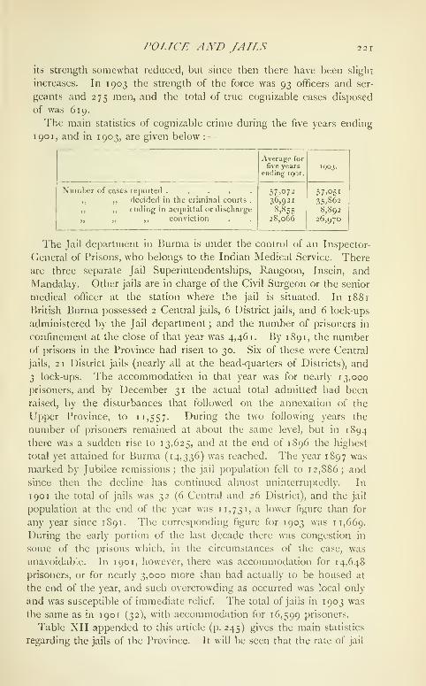
POLICE AND JAILS 221
its strength somewhat reduced, but since then there have been slight
increases. In 1903 the strength of the force was 93 officers and ser-
geants and 275 men, and the total of true cognizable cases disposed
of was 619.
The main statistics of cognizable crime during the five years ending
1 90 1, and in 1903, are given below :—

222 BURMA
mortality has fallen during the past twenty years from 44 to 15 per
thousand. Admissions to hospital have declined from over 900
j)er 1,000 of average jail population in i88r, and nearly 900 in 1891,
to 547 in 1901 and 474 in 1903. These data speak for themselves
of the progress made during the past two decades in the sanitary
administration of the jails. The manufacture of furniture and the
cultivation of vegetables are two of the most important jail industries of
the Province, and, so far as green food is concerned, the prisons are
practically self-supporting. Wheat-grinding for the military police is
carried on extensively, and as much use as possible is made of convict
labour in the manufacture of articles required by Government depart-
ments. A branch of the Government Press is located in the Rangoon
jail. With the exception of carved wooden furniture, practically no
products of jail labour in Burma leave the Province. The profit on
jail manufactures is, as will be seen from the table already referred to,
considerable. It was lower in 1901 and 1903 than in 1891, owing to
a more rigid enforcement of the rule which prohibits the sale to the
public of jail manufactures at prices below the ordinary market rate.
A juvenile reformatory at Insein, a few miles out of Rangoon, was
opened in December, 1896, taking the place of the reformatory which
had till then existed at Paungde, a station in Prome District on the
railway line. In April, 1899, it was transferred from the control of the
Inspector-General of Prisons to that of the Director of Public Instruc-
tion. It had 96 inmates at the end of 190 1, and 82 on December 31, 1903.
On the annexation of Lower Burma the British found an almost
unique system of vernacular education ready to their hand throughout
their newly acquired possession. The kvaungs orEducation. , , , , ^ \
monasteries were the schools, and the pongyis or
monks the teachers, while the taught embraced the whole of the male
population of the country, for custom then, as now, demanded that
every Burmese Buddhist male, from the highest to the lowest, should
pass some portion of his youth in a religious seminary. The tuition
given in these indigenous schools was not of the profoundest ; but
including, as it did, reading, writing, and the rudiments of arithmetic,
it was not to be despised, and, apart from its intrinsic worth, it was of
value as forming a parent stem on which Western educational methods
could be grafted. This process of grafting was first systematically
carried out by Sir Arthur Phayre in 1866. An Educational department,
with a system of grants-in-aid, had been in existence in Burma ftjr many
years previously, but it was then placed on a sound footing. The
attention of the newly appointed Director of Public Instruction was
directed to supervising and fostering the scheme for spreading vernacu-
lar education through the kyaungs or Buddhist monasteries in Rangoon
and Moulmein ; and the principle of adapting the existing indigenous

EDUCATION 223
agency for the diffusion of primary education has since then occupied
the foremost place in the educational policy of the Province, UpperBurma having been included in the Educational department's sphere of
action in 1 889-90. Missionary schools are now plentiful, and lay schools
both public and private abound ; but the bed-rock of vernacular educa-
tion in Burma is still monastery teaching, and with it is intimately
bound up the educational welfare of the people.
Regarded from a purely departmental point of view, education in
Burma falls under two main heads, vernacular and Anglo-vernacular,
the latter being carried on wholly under the supervision of the (lovern-
nient Educational authorities. The former is only partially supervised,
for a large number of the monastery schools have not yet conformed to
the rules of the department and sought registration. Non-registered
schools obtain no assistance from (Government, but schools which have
been registered and have submitted to Government inspection are
helped with grants of various kinds.
As at present constituted, the inspecting staff of the Educational
department in Burma consists of a Director of Public Instruction,
4 Inspectors of schools, 4 Assistant Inspectors, 44 Deputy-Inspectors,
and one Sub-Inspector. The Director and the Inspectors are members
of the Indian Educational Service, with a British university training,
and are appointed in England by the Secretary of State. The Assistant,
Deputy, and Sub-Inspectors are recruited in the country, and are
ordinarily Burmans, Karens, or Talaings. The Deputy- Inspectors have,
as a rule, the educational charge of a civil District and confine their
attention to vernacular education, but neither they nor any of the other
members of the inspecting staff undertake any direct instruction. Theteaching staff of the Educational department consists of the masters of
the Government schools (high, middle, normal, &c.) in the Province;
but it is comparatively small, for one of the cardinal principles kept in
view has been that Government should 'ordinarily not establish and
directly manage schools and colleges of its own, but should inspect,
regulate, and assist schools estiiblished and managed by private persons
or associations.' The greater part of the tuition is thus given by non-
Govemment teachers. To spread elementary education, however, and
to assist such persons as are anxious to have their schools registered by
the department, or to raise their grade, a staff of itinerant teachers
is maintained by Government. Measures have also been taken to
facilitate the ap[)ointment of pupil-teachers for small and struggling
institutions needing special assistance of this kind. These teachers are
examined yearly and undergo a practical training at a normal school.
In Lower Burma municipalities and committees of ' notified areas
'
have the general control of educational affairs within their jurisdiction,
subject to the rules laid down in the local Education Code : in Upper

224 BURMA
Burma the control of municipal and town schools rests directly with
the Educational department. In Lower Burma education is one of the
objects on which District cess fund money may be spent, but the
District funds of Upper Burma cannot be thus applied.
All education, whether vernacular or Anglo-vernacular, falls under
one or other of the three heads, collegiate, secondary, or primary.
Burma as yet possesses no separate University, and up to 1894 the
Rangoon College was the only college. That institution was developed
from the Rangoon High School in 1881 ; and in the following year the
Educational Syndicate, a body constituted for the purpose of conducting
examinations, and for advising the Local Government regarding certain
standards of instruction in Lower Burma, came into being. It had at
first no corporate existence; but in 1886 it was formally incorporated
under the Registration of Societies Act, and it managed the Rangoon
College till 1904 and the High School till 1902. Both these institutions
are now under the control of the Educational department. The college
is of the first grade. The Baptist College, which was registered as
such in 1894, is a second-grade aided college, also at Rangoon. The ex-
penditure on the Rangoon College in 1904 was Rs. 48,150 ; that on the
Baptist College, Rs. 16,200. Both colleges are affiliated to the Calcutta
University. Below are given certain particulars regarding the Uni-
versity work of these colleges for the years 1891^ 1901, and 1904 :
—
Passes in

EDUCATION
with an aggregate of 2,890 male pupils, and 58 middle schools with
5,135 male pupils. The increase is noteworthy, but it was less than
the rise which took place in the succeeding ten years. In 1901 the
15 high schools for hoys in Burma had a total of 5,335 male pupils;
3 were managed by Ciovernment, 3 by municipal committees, and 9
by i)rivate liodies (aided). In the same year there were 281 middle
schools for boys with 18,858 male pupils. Twelve of these schools
were managed by municipal committees, the rest (269) by private
bodies (aided). There were two vernacular high schools in 1901 ; of
the 281 middle schools 225 were vernacular and 56 Anglo-vernacular.
In 1904, 21 high schools for boys had 7,432 male pupils; and 325middle schools tor boys (of which 265 were vernacular) had 23,182
male pupils. Of the high schools, 5 were managed by Government,
3 by municipalities, and 13 by private bodies. There are no unaided
secondary schools in Burma. Aid is given in the shape of results
grants for pupils who have passed examinations, and grants for build-
ing, efjuipment, and maintenance, and for salaries to certificated
teachers, (S:c. Of the male |)opulation of the Province of school-going
age (taken at 15 per cent, of the total), 3 per cent, were under secondary
instruction in 1901.
Primary schools teach the lowest standards, from the first to the
fourth inclusive. They may be vernacular or Anglo-vernacular, but
there are very few of the latter. Vernacular primary schools are in
some cases under missionary control ; but the great majority are carried
on by non-Christian private individuals, monastic and lay, who draw
grants from (lovernment or municipal funds, if they come up to the
standard prescribed for registration and conform to the grant-in-aid
rules. These are known as public schools. All which do not conform
to the rules and have no desire to be in.spected by the department
are private institutions.
The condition of public male i)rimary education in the Province
in the years 1881, 1891, 1901, and 1904 is indicated in the following
statement :
—
1I88I. I89I.

2 26 BURMA
twenty years shows fluctuations so marked as to demand a word of
explanation. The high-water mark may be said to have been reached
in 1885-6, when Lower Burma alone had 5,102 public boys' schools
with 133,408 pupils. Various causes, of which the annexation of
Upper Burma was at the time regarded as the most vital, combined
to reduce the figures of subsequent years. In 1888-9 the number
of schools had fallen to 2,750 and that of pupils to 69,105, and even
the inclusion of the Upper Burma data in the following year failed to
bring the figures for the whole Province into line with the Lower Burma
total for 1885-6. Matters improved after 1888-9 ; but from 1891-2
onwards there has been a falling off, which has brought the average
of the five years ending with 1 900-1 down to a level no higher than
that of the Lower Burma average of twenty years ago. The fact
appears to be that formerly Deputy-Inspectors were apt to place on the
departmental registers schools that were really unqualified for regis-
tration, so that we may regard the latest figures, the result of successive
years of elimination of the unfit, as a truer picture of the state of public
primary education than that afforded by the opening years of the two
decades under review. It may be laid down as a general proposition
that in Burma the extension of primary vernacular education is limited
only by the amount of money available for its development : in other
words, that, wherever additional funds are judiciou.sly applied and
new schools are opened and equipped, there will, in existing circum-
stances, be an unfailing supply of new scholars to fill the schools and
benefit by the money spent.
Whatever may have been the factors that have brought about the
reduction in the total of public primary schools, there has been no
falling off in the aggregate of unregistered monastic institutions.
Growth of population, the transfer of schools from the registered to the
unregistered list, and a more thorough system of recording non-depart-
mental data have, in fact, sent up the totals to a very marked extent.
'I'lie ff)]lowing are the figures for 1891, 1901, and 1904 in respect of
pri\ate primary schools, the majority ot which -axq /^o/igyi kyaiaiii^s :—

EDUCATION 227
but rani^es ordinarily bftwoen Rs. 20 and Rs. 100 a month. Rs. 20 is
the salary fixed for fifth-grade and Rs. 60 for first-grade certificated
assistant-teachers appointed by the department. The pay and jjosition
of teachers has improved of late years ; but the service is still far from
popular, and is often used merely as a stepping-stone to more lucrative
employment under Government.
The whole Provincial vernacular system is framed to suit the c<jn-
venience of children belonging to the agricultural classes. 'I'he atten-
dance recjuired during the year is reduced in their case, and their
presence is not enforced while work in the fields is necessary.
Female education in Hurma has been advancing steadily. Thefollowing table shows the totals of public secondary and primary girls'
schools, and of the pupils attending them, in the years 1881, 1S91,
and 1904:
—

2 28 BURMA
proper, are experienced in consequence of the seclusion of the sex.
The missionary bodies have done much good work in furthering female
education.
There were 3 normal schools in 1881, 4 in 1891, and 10 (5 for
training masters and 5 for mistresses) in 1901. This last total has
since been increased by four. The total of normal-school pupils in
1904 was 395 males and 191 females. The Province possesses no
special law school, but a law class is attached to the Rangoon College,
which in 1904 had an attendance of 36 students. It was first opened
in 1892. An Engineering school at Insein near Rangoon trains youths
for the subordinate branches of the Public Works department, and
had 32 pupils on its rolls in 1904.
No industrial schools, properly so called, have as yet been opened
in Burma. Instruction in certain industries, however, such as weaving,
l)rinting, and carpentry, is included in the curricula of a few schools.
Medical training is given to female students at the Dufferin Maternity
Hospital in Rangoon. A vernacular Forest school has been established
at Tharrawaddy, which receives private pupils as well as Forest subor-
dinates for training, and a Veterinary school at Rangoon. There is
as yet only one recognized class, also at Rangoon, for imparting com-
mercial instruction. The study of Pali, the sacred language of Burmese
Buddhism, is fostered by a yearly examination known as the patama-
byan, at which monks and laymen appear and for which certificates of
various classes are granted. Mention may be made here of the school
at Taunggyi, in the Southern Shan States, for the sons of Shan chieftains.
The education of backward indigenous communities is a matter that
has occupied the attention of the religious bodies ever since missionary
work was started in Burma. Anglicans, Baptists, and Roman Catholics
have been engaged for many years past in educating the Karens,
while of late schools have been started for the Kachins and Chins,
who, like most of the hill tribes of the Province, have no indigenous
educational system of their own.
In 1904 there were 33 educational institutions for I'^uropeans and
Eurasians, with an aggregate of 3,298 ])upils. The passes gained at
the principal examinations by European and luuasian |)U])ils from
all classes of .schools during the same year were as follows : B.A. 3,
1""..\. 2, matriculation 25, middle 432, and primary 1,149. ^'^ large
]jroi)orli(jn of the European scholars enter Government service after
leaving school. Others seek occupation on railways or in mercantile
offices, while a certain number adopt the legal profession.
In 189 1 the i'rovince contained 24 registered Musalman schools,
with 595 pupils, in Lower Burma, and one school, with 36 pupils, in
Upj)er Burma. Of the Lower Burma institutions all but one were
in .\ky;ib District, in which aloiu' tlie Musalmans form a substantial

RDUCATJOX 229
proportion of the population. Tn 1901 there ultc 45 Musahiinn
|)iibhc schools in the Province as a whole, and in 1904 the number
was 86. The attendance at these institutions in the last-mentioned
year was 2,605. Education in these schools is chiefly confined to
the lower primary stage, 'i'he number of Mulmmmadan pupils in
all the public educational institutions of Burma, Musalman and non-
Musalman, in 1891, 1901, and 1904 was as below:
—
1891.

2 30 BURMA
Successive enumerations have established the fact that the average
of education in Burma is high. By this is meant not that the Burman
is as a rule well educated, for this is very far from being the case,
but that the Province can show a higher proportion of persons (both
males and females) able to read and write than any other part of India.
In 1 90 1 it was calculated that of every five persons then living in
Burma one individual would be able to read and write some language,
and would thus be literate for the purposes of the census enumeration.
In four Districts of Upper Burma—Upper Chindwin, Minbu, Shwebo,
and Magwe— there were in 190.1 actual!}' more literate than illiterate
males, and for the Province as a whole the average of males able
to read and write was 378 per r,ooo. The corresponding figure for
literate females was only 45 per 1,000, which is still, however, far
higher than in any other Pro\ince, while in Rangoon more than
26 per cent., and in Hanthawaddy more than 10 per cent., of the
female population were able to read and write. In the same year 6
males in every 1,000 and one female in every 1,000 were literate in
English. Use has been made of the census figures to calculate the
])roportion borne by the total of children under tuition to the total
of children of school-going age. For the purposes of this calculation
the population of school-going age is taken as 15 per cent, of the
total. On this basis the population under tuition in Burma was in 1881
16 per cent., in 1891 21 })er cent., and in 1901 23 per cent, of the
total population (A school-going age. Comprising as this does the figures
for females as well as for males, the percentage is high for the East.
The total number of newspapers published in Ikirma in 1903 was
26 ; f)f these, t6 were published in English, 8 in Burmese, and one
each in (lujarati and Tamil. There are two important English dailies,
the Rafigoon Gazette and tlie Ran^:;oo)i Tiiin's. The Friend of Burmaand the Burma Herald are liurmese dailies with a somewhat smaller
circulation. None of the Burmese journals can be said to be actively
political, and none printed in l^nglish or Burmese is addressed to
any special class of the reading public. The (lujaratT and Tamil
newspapers are more or less the mouthpieces of the Bombay and
Madras residents of Burma. The .American baptist Mission Press
issues a number of weekly and monthly periodicals, which are, how-
ever, wholly religious.
The total number of publications registered in I'urnia in 1902 under
the Printing Presses and liooks Act was 123. In 1903 the total
had risen to 146. 'J'he majority of these are, as a rule, in Burmese
or Pali-Burmese, and are for the most j)art religious treatises. The
number of dramatic works is generally large, lulucational publica-
tions, on tlie otiier hand, are relatively few, and, except in the matter
of pliilology, original rcseurcli is larking.

The Mcdicul dcpurlmciit in Hurniii is c<jiUrollcd by an Inspector-
Cleneral of Civil Hospitals. Each civil District, except Northern
Arakan and Salween, is under the medical charge
of a Civil Surgeon, who is stationed at the District
head-quarters (Rangoon has three officers of this class) : and there
are also Civil Surgeons at 'launggyi, Lashio, l^'alani, and Maymyo.Assistant-Surgeons are stationed at the head-quarters of the Northern
Arakan and Salween Districts and elsewhere, and a large staff of
Hospital Assistants does duty in the District head cjuarters hospitals
or in charge of the minor subdivisional and township dispensaries. Themain figures regarding the hospitals are given in Table XIV appendedto this article (p. 246). The number of hospitals and dispensaries
rose from 27 in i88r to 119 in 1901 and 134 in 1903. Of these,
the most important are the hospitals at Rangoon, Akyab, Moulmein,and Mandalay. 'i'he Rangoon hospital was opened in 1854, in a
wooden building on its existing site. In 1872 the present building
was erected at a cost of nearly a lakh, and it has been added to
very considerably since then. A new General Hospital is now under
construction. In 1868, the first year for which figures are available,
the total of patients treated was 9,555. In 1891 the corresponding
figure was 52,605, and in 1903 it was 64,596. The number of beds
now available is 483, of which 425 are for males. Prior to 1902
the cost of the hospital was met for the most part by the Rangoonmunicipality ; since then it has been maintained from Provincial
revenues. The establishment of the Akyab hospital dates from the
annexation of .\rakan after the first Burmese \\'ar. A new hospital
was built in 1879, and has been added to from time to time as occa-
sion required. The patients treated in 1891 and 1903 numbered
15,712 and 16,877 respectively. The hospital is supported for the
most part from Local funds and accommodates 114 in-patients. Thefirst civil hospital in Moulmein was started soon after 1840. The ex-
isting hospital was built, practically upon the site of the old one, in
1877, and since 1881 it has been a municipal institution. Its present
accommodation is for 84 male and t6 female in-patients. The total
number of patients treated was 13,091 in 1891 and 15,864 in 1903.
The date of construction of the existing Mandalay hospital was 1891,
though acconuiiodation for patients had been ])rovi(ied in a temporary
building from 18SS. In 1S87-8 the atlendant-e at the hospital was
3,948 patients. This figure had risen in 1903 to 19,753. ''^''^ hospital
is a municipal institution. The table above referred to shows that
Local funds contribute the greater part of the money for hospital
maintenance in Burma. The expenditure under this head more than
iloubled during the period 1888-1901. The Province has 4 leper
asylums, 2 in Mandalay and one each in Rangoon and Moulmein.

232 BURMA
There is a lunatic asylum in Rangoon. Il was built in 1872 and
opened with a population of 151, which has since risen to over 400.
The asylum buildings were largely extended between 1894 and 1898.
Inoculation is carried on extensively in Burma, being preferred to
vaccination by the Burmese, especially by the illiterate, under the
mistaken belief that, while vaccination requires to be repeated every
few years, inoculation protects for a lifetime. Inoculators have been
employed as vaccinators, but have invariably been found to give way to
])opular prejudice and to resort to their old system of inoculation,
which they find more paying.
Vaccination is being pushed on throughout Burma, and in recent
years has been extended to the Shan States and the Chin Hills. It is
compulsory in nearly all the municipalities and cantonments of the
Province. The main statistics are given in Table XIV appended to
this article (p. 246). There seems reason, however, to question the
accuracy (^f the figures of successful operations, and the extent to
which the population is protected against small-pox cannot be accu-
rately estimated.
A scheme for facilitating the .sale of quinine in pice packets in rural
areas Avas brought into operation towards the close of 1895. '^^^^
results were at first not encouraging, but in 1903 the .sales reached
a total of 3,250 packets, equal to 1,758,000 grains. The quinine is
sold at post offices, and by vaccinators, village postmen, and village
headmen.
Rules providing for village .sanitation are issued under the authority
of the Village Act and Regulation by Commissioners of Divisions, and
volumes known as the Permanent Sanitary Record and the Village
Sanitary Inspection Book are maintained for the more important
villages of the Province. 'J'he total amount expended from District
cess and District lunds on rural sanitation in 1903 was Rs. 1,60,000.
Parties of the Survey of India are employed in Burma in connexion
with the cadastral, the topographical, and the Forest survey. Of these,
the most valuable from an administrative point ofSurveys. ...
, ,•
, ,
view IS the cadastral survey, wnicli j)lays an mipor-
tant part in the assessment of land revenue. The system adopted is
that of a connected theodolite exterior survey and a field-to-field
interior survey. The country to be surveyed is divided up into
polygons, each of which consists of so many kici/is, areas ordinarily
from I to i^ sfjuare miles in extent, enclosed as much as ])ossible
within natural boundaries, and corresponding in many wavs to the
mauzas of Northern India. 'I'he unit of survey is the field, an area of
cultivated land ranging ordinarily between an acre and a (|uartcr of an
acre, included within well-defined boundaries. The greater part of the
cultivated area of Lower I'urma and also of Upper 15urma has been
SURVEYS 233
cadastnilly surveyed. The cadastral record i)re])arcd by tlie Survey of
India is kept ui) to date by the Trovincial Land Records department,
the alterations and extensions in cultivation, ownership, topography, &c,,
being annually shown on fresh copies of the maps. The area in which
this system of supplementary survey was carried on in 1903 4 was in
all nearly 42,000 square miles ; and the Land Records staff at that
date consisted of a Director of Land Records, an Assistant Director,
27 superintendents of land records, with 7 probationers, 105 inspectors,
and 1,058 surveyors. So far the supplementary survey system has been
introduced into most of the Upper Burma Districts. Records-of-rights
and occupations are prepared by the settlement officer and are kept up
to date by the officers of the supplementary survey, changes of owner-
ship being registered in Lower Burma by surveyors and in Uj)per
Burma by village headmen. In unsettled Districts no record-of-rights
is maintained. 'I'he subordinate Land Records staff is recruited from
the Government survey schools. At the close of 1903-4 there were
18 such schools in the Province with 452 pupils. Village headmen, onwhom the collection of the revenue devolves, are encouraged to send
their sons or other relatives likely to succeed them in office to the
survey schools, and in the Upper Burma schools the majority of the
scholars are youths of this class. Forest surveys are made with a view
to the preparation of tlie maps that are used as a basis for forest work-
ing-plans. 'Hiey are carried oul by the Topographical Survev branch
of the Survey of India.
[British Burma (lazeiteer, 2 vols. (Rangoon, 1879 and 1880).
—
V. Mason: Burma, its People and Productions (1883).— Shway Yoe :
The Burman, his Life and Amotions (1882).—J. Nisbet : Burma under
British Rule—and before {\()0\).—Burma Census Reports, 1872, 1881,
1S91, and 1901.— Sir J. G. Scott : Gazetteer of Upper Burma and the
Shan States (Rangoon, 1900-1); and Burma : a JIandlwok of Practical
Information (1906).—V. C. Scott O'Connor : The Silken East, 2 vols.
(1904).-— S. Kurz : Preliminary Forest Report of Pegu (Calcutta,
1875).
—
Records, Geological Survey of India, vols, xxv, xxvi, \\vii, and
wviii.— San Germano : The Burmese Empire (1885).— Sir A. Phayre :
History of Jiurma (1884).— J. Gray: The Alaungpra Dynasty (Ran-
goon, 1S85).]
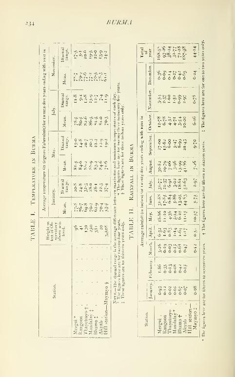
234 BURMA

TABLES 235
TABLl-: III
Statistics of Agriculturk, Burma
(In square miles)

236 BURMA
55
oH<
a,
o
bOIS
oHBQ
5H
1
•/=
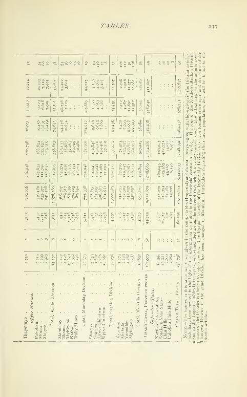
TABLES 237
10

238 BURMA
TABLE V
Trade of Burma by Sea with other Provinces of India
FOR the Years 1890-1, 1900-r, and 1903-4
(In thousands of rupees)
1
Articles.

TABf.ES 239
TABLI': V {continued)
Foreign Makmimk Trade ok Burma for the Years1890-1, 1900-1, AND 1903-4
(In thousands of rupees)
Articles.
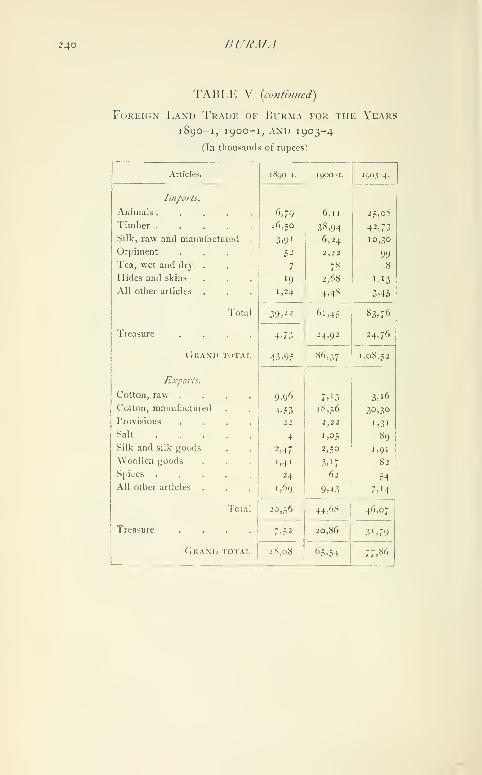
240 BURMA
TABLE V {continued)
Foreign Land Trade of Burma for the Years
1890-1, 1 900- 1, AND 1903-4
(In thousands of rupees)
Articles.

TABLES 241
TABM-: VI
Statistics of Criminal Justice, Burma

242 JiURMA
<s
pq
>
•—I o «
< Ph o
O ^(/I
u:ou.
t)o
<
u

TABLES 243
TABLE IX
Provincial Expp:nditurI': undl.r 1'rincipal II
IN Burma
(In lliousands of ruijees)
EADS
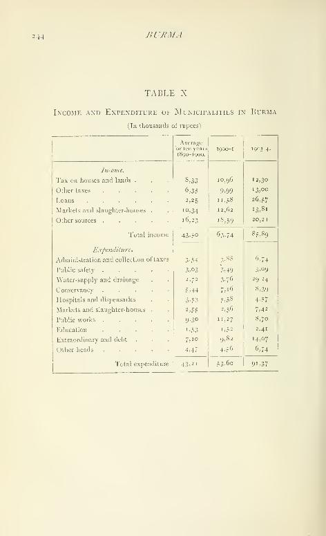
2-14 BURMA
TABLE X
Income and Expenditure of MuNicirALixiES in Burma
(In thousands of rupees)

TAIU.RS 245
TABLE XI
Strength and Cost of Civil Police, Burma

24^) BURMA
TABLE XIII
Colleges, Schools, and Scholars, Burma
Class of

/ir.y.iA' Toirx 247
Butana.- -Town in the Cjohfina fa/tsil oi Rohtak District, I*unjal),
situiited in ^y"^ 12' N. and 76° 42' Iv, 19 miles north of Rf)htak on
a branch of the Western jiunna ("anal, to which it gives its name.
Population (kjoi), 7,509. It is administered as a 'notified area."
Buthidaung Subdivision.- Sul)division of Akyab District, Lower
Burma, consisting of the BuTHrDAUNO and Maungd.wv townships.
The head-quarters are at Buthidaung (pf)pu]ation, 983), on the Mayuri\er.
Buthidaung Township.— i'ownship in Akyab District, Lower
Ikuina, constituted in 1906 from a portion of the Rathf.daunc
township, with an area of 763 square miles and a jiopulation (1901)
of 59,766.
Buxa.— Cantonment in the AlTpur subdivision of Jalpaigurl District,
Eastern Bengal and Assam, situated in 26° 46' N. and 89° 35" E., on
a small gravel plateau 2,000 feet above sea-level, in a valley in the lower
range of the Bhutan hills. Population (1901), 581. Buxa commands
one of the principal passes leading into Bhutan and lies on the trade
route from that State, whence ivory, wax, wool, musk, rhinoceros' horns,
cotton cloth, endi silk cloth, blankets, honey, and brick-tea are imported
and purchased by local merchants, who either pay in cash or give in
exchange rice, tobacco, English cloth, betel-nuts, &:c. Large quantities
of indigenous wool, both from Bhutan and through Bhutan from Tibet
and Central Asia, enter India through this channel for export to Europe.
The cantonment, which was established during the Bhutan War in 1865,
consists of a rough fort to which three pickets are attached on spurs at
a higher elevation. .\ detachment of native infantry is stationed here.
Water is obtained from two perennial streams, one of which issues from
the base of the plateau. The average annual rainfall of 209 inches is
the highest recorded in Bengal.
Buxar Subdivision.—North-western subdivision of Shahabad
Di.strict, Bengal, lying between 25° 16' and 25° 43' N. and 83° 46' and
84*^ 22' E., with an area of 669 square miles. The subdivision consists
of a level plain, entirely under cultivation and extensively irrigated by
canals ; a strip of land to the north along the (ianges is liable to in-
undation from the overflow of that river. The population was 416,704
in 1901, com])ared with 438,739 in 1891, the density being 623 persons
per square mile. It contains two towns, Buxar (population, 13,945),
its head-quarters, and Dumraon (17,236); and 937 vilhiges. Buxar
is famous as the scene of the defeat by Sir Hector Munro of Shuja-ud-
Daula and Mir Kasim in 1764, while at Chaus.^, near by, Humayunwas defeated by Sher Shah in 1539.
Buxar Town {Baksar).—Head-quarters of the subdivision of the
same name in Shahabad District, Bengal, situated in 25" 34.' X. and
S3' 58' I*'., on the south bank of the Ganges. Population (ii)Oi).
248 BUXAR TO]VN
13,945. Buxar is a station on the East Indian Railway, 411 miles from
Calcutta, and is a considerable centre of trade. It is famous as the
scene of the defeat in 1764 by Sir Hector Munro of Mir Kasim, in the
battle which finally won the Lower Provinces of Bengal for the British.
It is a place of great sanctity, and is said to have been originally called
Vedagarbha, ' the womb of the ^"edas,' as many of the inspired writers
of the Vedic hymns lived here. Buxar was constituted a municipality
in 1869. The income during the decade ending 190 1-2 averaged
Rs. 8,400, and the expenditure Rs. 7,700. In 1903-4 the income was
Rs. 9,500, mainly derived from a tax on persons (or property tax); and
the expenditure was Rs. 1 2,000. Buxar contains the usual public
buildings, and also a Central jail with accommodation for 1,391
prisoners. The chief jail industry is the manufacture of tents, of which
2,705 were supplied to Government departments in 1903 ; cloth-weaving
and the manufacture of prison clothing and uniforms for the police
and chaukiddrs, as well as for the Opium and Jail departments, are
also extensively carried on. A subsidiary jail has accommodation for
61 prisoners.
Byadgi.—Town in the Ranihennur taliika of Dharwar District,
Bombay, situated in 14° 41' N. and 75^ 30' E., about 10 miles north-
west of Ranlbennur town, on the Southern Mahratta Railway. Popu-
lation (1901), 6,659. The municipality, established in 1879, had an
average income during the decade ending 1901 of Rs. 10,000. In
1903-4 the income was Rs. 11,600. A weekly market, one of the
largest in the District, is held on .Saturdays, when rice, molasses,
groceries, and chillies are sold. The Rameshwar temple has two
inscriptions, one dated 1092 and the other 1620. The town contains
three schools, of which one is for girls.
Byans.—A portion of Almora District, United Provinces, near the
Tibetan border. See Bi.\NS.
Cachar {Kachdr).— District in I'^astern liengal and Assam, which
derives its name from the Kachari tribe, whose Raja married a 'l'ij)pera
princess and received as her dowry the upper portion of the Surma \'al-
ley. It lies between 24° 12' and 25° 50' N. and 92° 26' and 93° 29' E.,
and covers an area of 3,769 square miles. On the north it is bounded
t)y the Kapili and Doiang rivers, which separate it from Nowgong Dis-
trict ; on the east by the Naga Hills and the State of Manipur ; on the
south by the Lushai Hills ; and on the west by the District of S)lhet
and tlie jaintia Hills. The District falls into two natural divisions, the
plains and the hills. 'i"he latter (area 1,706 square^^'^^ miles) is a section of the ran^e which divides the
aspects. '
r . 1Surma Walley from that of the P.rahmaputra. 'I'he
former is the upjxjr jjortion of the \alley of the Barak or Surma, and
consists of a le\cl plain doltid with isolated liilhx ks and hroktii nj)

CACBAR 249
l)y ranges of low hills, which project from the mountains surrounding it
on three sides. The area of the plains portion is 2,06^^ square miles.
The Baraii, range, which connects the north Manipur iiills and the
Khasi range, forms a continuous wall along the north of the Barak
valley, varying from 2,500 to 6,000 feet in height. South of the
Barak the District is bounded on the east by the Bhubans, which vary
from 700 to 3,000 feet in height, and on the west by the Siddhkswar
Hills. The plain is further broken up by two long ranges running
north and south, called the Rengtipahar and the Tilain. All of these
hills are formed in ridges and peaks, with precipitous sides covered
with tree forest. The general appearance of the District is extremely
picturesque. On three sides it is shut in by range upon range of blue
hills, whose forest-clad sides are seamed with white landslips and gleam-
ing waterfalls. The villages are buried in groves of feathery bamboos and
the graceful areca palm, and the country on every side looks fresh and
green. Here and there, swamps and marshes lend variety to the scene,
and the low hills with which the plain is dotted are covered, as a rule,
with neat rows of tea bushes and crowned at the top with the planters
bungalow. The Barak winds through the centre of the plain, its surface
dotted with the sails of native craft, and in places hills come down
almost to the water's edge.
The chief ri\er of Cachar is the Jiarak or Surma, which enters the
District from Manipur at the extreme south-east corner, and, flowing
north, forms the boundary between that State and British territory till
it turns westward a little to the south-east of Lakhipur. Its bed is
from 100 to 200 yards in width, and in places is as much as 70 feet
deei). Its principal tributaries in Cachar District from east to west are:
on the south bank, the Sonai, the (ihagra, and the Dhaleswaki, with
its new channel, the Kiltakhal ; (jn the north bank, the JiRi, which also
divides Cachar and Manipur, the Chiri, the Madhura, and the Jating.\.
The Doiang, which falls into the Kapili, a tributary of the Brahmaputra,
is the largest river north of the Baraii. The most imjjortant sheet of
water in the District is the Chatla haor, or fen, a low-lying tract
between the Rengtipahar and 'I'ilain hill ranges, which during the greater
l)art of the year is drained by the Ghagra river. \\ hen the nion.soon
breaks, the rainfall on the surrounding hills, assisted by the floods of
the Barak, turns this marsh into a navigable lake 12 miles in length by
2 in breadth. The floods, however, deposit large quantities of silt, and
year by year the level is being raised and the area liable to inundation
diminished. Other marshes, though of less importance, are the Bakri,
the Bowalia, the Kholang, the Thapani, and the Puma.
The Cachar plains form an alluvial tract which is gradually being
raised by the action of the rivers, which overflow their banks and
deposit a laver of silt. The constituents of the soil are clay, sand, and
2 50 CACHAR
vegetable matter. The hills surrounding the valley are for the most
part composed of Upper Tertiary sandstones.
The vegetation of the District presents the usual characteristics of a
sub-tropical region. The hills are covered with dense evergreen forest
and bamboo jungle, and in the plains there are the remains of a savan-
nah forest, of which the principal constituents are simul {Bonibax mala-
haricum) and jarul {Lagersfroefiiia F/os Reginae). High grass grows
on the lower land and floating weeds cover the numerous swamps.
^^'ild animals are no longer common in the valley ; but elephants,
bison, buffalo, tigers, leopards, bear, and various kinds of deer are still
found in the wilder parts and in the hills.
The climate of the valley is characterized by excessive humidity, and,
being shut in by ranges of hills on almost every side, at certain seasons
of the year it becomes decidedly oppressive. The hottest months are
June to September, with an average mean temperature of about
83 degrees ; the coldest month is January, with a mean of 65 degrees.
During the rainy season the air is charged with moisture, the annual
rainfall in the {)lains ranging frrmi 100 to 165 inches, but north of the
Barail towards the Nowgong border it sinks to 55. Cachnr suffers little
either from cyclones or floods. In i86g there was a severe earthquake,
which seriously damaged many buildings in Silchar, and cut up the
roads and wrecked the bridges throughout the District. Another severe
shock was felt in 1882. The great earthquake of 1897 did somedamage to masonry buildings, but the effects of the shock were incon-
siderable in comparison with the widcsj^read havoc caused in other
])arts of the Province.
The seat of the Kachari rulers was originalh' fixed in the Assam\'alley, and at the beginning of the thirteenth century they occupied
the western portion of Sibsagar and a large part of
Nowgong District. 'I'heir capital was situated on the
banks of the Dhansiri at Dimai'ur ; and the ruins still to be seen show
that the town must once have been the seat of a king, far in advance,
both in power and civilization, of the simple tribesmen of the present
(Ui)'. In 1536 Dimapur was sacked by the Ahom king, its ruler
i)etsung killed, and the people compelled to remove their capital to
Maibang in the North f 'achar hills. l<Aen here they were not safe, and
in 1706 Rudra Singh, the most powerful of the Ahom princes, dis-
patched an army into the hills, which sacked Maibang and compelled
the Raja to lake refuge in the; plains of Cachar. He was treacherously
seized by the Jaintiii king, but was rescued by the Ahoms and reinstated
on the throne. From this time forward the Kachari princes seem to
have settled in tht; plains of Cachar, their court being usually located at
Khaspur, but the Kapili valley in Nowgong i )istricl also remained
Kachari territory till it finally passed into the possession of the P)ritish.

nrSTORY 251
The first occasion on which the British entered the District was in
1762, when a Mr. Verelst marched from Chittagong to Khaspur to the
assistance of the Manipur Raja, but was prevented from going farther
by the difficulties of the country. The reigning family were converted
to Hinchiism in 1790, and a few years later the last prince, (lobind
('hand, was driven from his throne by Marjit Singh of Manipur. This
man had established himself on the throne of Manipur by the aid of the
Uurmans. but when he endeavoured to assert his independence they
drove him from the State into the Surma \'alley. The Burmans then
threatened to annex Cachar, but this the British Oovernment, which
was in possession of Sylhet, was unable to permit. They espoused the
cause of the Kachari Raja, expelled the Burmans, and handed back
the District to C.obind Chand. On his death without heirs in 1830, it
lapsed to the British (lovernment under the terms of a treaty concluded
in 1826.
A large portion of the North ("achar hills had, however, been seized
seventeen years before by a man called Kacha 1 )in, who had originally
been one of the Raja's table servants. He was enticed down into the
plains and killed ; but his son Tula Ram succeeded in holding his own
against the various attacks made upon him, and in 1829 ("lobind Chand
was induced by Mr. Scott, the Agent to the Oovernor-General on the
north-east frontier of Bengal, to recognize his independence and assign
him a separate fief. This territory was subsequently resumed by the
British Government in 1854, in consequence of the misconduct and
incapacity of Tula Ram and his descendants.
In 1857 a party of Sepoy mutineers made their way from ("hittagong
through Tippera and Sylhet into Cachar. They were routed and dis-
persed near Lakhipur, and the fugitives who escaped into the jungle
were hunted down and killed by Kukis. The southern frontier of the
District was for long exposed to the attacks of the Lushais, who raided
the valley in 1849, 1869, 1871, and 1892. In 1871 they attacked the
garden of Alexandrapur, killed a planter and many of the coolies, and
carried off. the planter's little daughter: in 1892 they raided Barun-
chara and killed forty-two coolies. Trouble was also experienced in the
north, and in 1880 a raid was made by the Khonoma Nagas on the
Baladhan garden, where the manager and some of his coolies were
killed. Shortly afterwards a Kachari fanatic, named Sambhudan, estab-
lished himself at Maibang and gave out that he possessed miraculous
powers, and that he had been sent to restf)re the Kachari kingdom.
He evaded the Deputy-Commissioner, Major Boyd, who had proceeded
to arrest him, and attacked and burnt the subdivisional head-quarters at
Gunjong, killing three persons. He then returned to Maibang, where
his followers were dispersed by the police, but in the meh'e Major Boyd
received a wound, which for want of proper treatment brought on

252 CACHAR
mortification and eventually caused his death. Sambhudan was subse-
quently surrounded and shot while endeavouring to escape. In 1893
some excitement was aroused by the murder of the European manager
of the Baladhan garden, and in 1898 by the death of Mr. Wilde, an
engineer engaged on the construction of the railway, who was cut down
by two Pathan contractors.
The District contains no archaeological remains of any importance,
but there are a few rock-carvings at Maibang.
Cachar contains one town, Silchar (population, 9,256), the District
head-quarters, and 1,332 villages. The population at the last four
enumerations was: (1872) 235,027, (1881) 313,858,
(1891) 386,483, and (1901) 455>593- The steady
increase is largely due to the importation of garden coolies and to immi-
gration from the neighbouring District of Sylhet, and in 1901 more than
a quarter of the total population were natives of other Provinces. The
District is divided into three subdivisions : Silchar and Hailakandi,
with head-quarters at the towns of those names, and North Cachar,
with head-quarters at Haflang. The following table gives particulars
of area, towns and villages, and population according to the Census
of 1 90 1 :—
Population.
Subdivision.
Silchar .
HailakandiNorth Cachar
4)
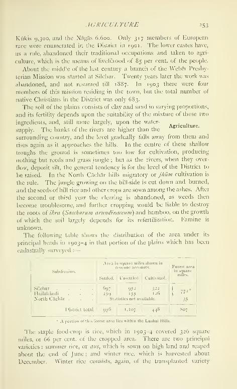
AGRICULTURE J53
Agriculture.
Kukis 9,300, and the Nagas 6,600. Only 317 members of European
race were enumerated in the District in 1901. The lower castes ha\e,
as a rule, abandoned their traditional occupations and taken to agri-
culture, which is the means of livelihood of 85 per cent, of the people.
About the middle of the last century a branch (;f the Welsh Presby-
terian Mission was started at Silchar. Twenty years later the work was
abandoned, and not resumed till 1887. In 1903 there were four
members of this mission residing in the town, but the total number of
native Christians in the District was only 683.
The soil of the plains consists of clay and sand in varying proportions,
and its fertility depends upon the suitability of the mixture of these two
ingredients, and, still more largely, upon the water-
supply. The banks of the rivers are higher than the
surrounding country, and the level gradually falls away from them and
rises again as it approaches the hills. In the centre of these shallow
troughs the ground is sometimes too low^ for cultivation, producing
nothing but reeds and grass jungle ; but as the rivers, when they over-
flow, deposit silt, the general tendency is for the level of the District to
be raised. In the North Cachar hills migratory or jhum cultivation is
the rule. The jungle growing on the hill-side is cut down and burned,
and the seeds of hill rice and other crops are sown among the ashes. After
the second or third year the clearing is abandoned, as weeds then
become troublesome, and further cropping would be liable to destroy
the roots of ikra {Saccharum arutidinaceuni) and bamboo, on the growth
of which the soil largely depends for its refertilization. I'amine is
unknown.
The following table shows the distributicjn of the area under its
principal heads in 1903-4 in that portion of the plains which has been
cadastrally surveyed :
—
Sub(Ji\ ision.
Silchar
Ilailakandi
Norlli Cachilr
Area in square miles shown in
revenue accounts.
Settled. Unsettled. Cultivated.
952697
5ta
District total I 956 } 1,107
322
59 '5.^ '-6
Statistics not aA ailable.
448
Forest areaill squaremiles.
r72'
807
A portion of this forest area lies within the Lushai Hills.
The staple food-crop is rice, which in 1903-4 covered 326 scjuare
miles, or 66 per cent, of the cropped area. There are two principal
varieties : summer rice, or aus^ which is sown on high land and reaped
about the end of June ; and winter rice, which is harvested about
December. Winter rice consists, again, of the transplanted variety

2 54 CACBAR
known as sai/, and aman or long-stemmed rice sown broadcast on the
lower levels. The greater part of the total rice area is under sail.
Pulse, sugar-cane, mustard, and linseed are also grown, but in compari-
son with rice and tea other crops are of comparatively small importance.
Tea comes next in importance to rice as regards the area under cul-
tivation (93 square miles), but the value of the manufactured product
exceeds that of the whole of the rice crop of the District. The plant
was discovered growing wild in Cachar in 1855, and the first grant of
land for a tea garden was made in the following year. Reckless specu-
lation in the promotion of tea companies led to severe depression,
which reached its crisis about 1868, when the industry was placed upon
a firmer basis. The plateaux at the foot of the Barail range were found
to be well adapted for the cultivation of the plant. They rise from
20 to 200 feet above the level of the plain : and though the sides are
often steep, the top is generally flat, and has a layer of excellent soil
from 5 \.o 8 feet deep. South of the Barak, gardens were opened out
on the numerous round-topped hills known as tl/as ; but though at first
the soil was little inferior to that of the plateaux, it suffered severely from
erosion during the rains. In 1875 the experiment was tried of planting
bushes on well-drained marsh land, and it was found that under these
conditions the plant gave a large yield, though the tea was of inferior
quality. There were, in 1904, 164 tea gardens with an out-turn of
over 31,000,000 lb. of manufactured tea, which gave employment to
140 Europeans and 63,500 natives, the latter of whom had been for the
most part recruited from other parts of India. The principal tea com-
panies are the Tarapur, with its centre at Dewan, 18 miles east of
Silchar ; the Scottpur, centre at Pollarbund, 1 1 miles east of Silchar ; and
the Bengal Tea Company in Hailakandi, with its centre at Ainakhal.
Since the District came under liritish rule, it has witnessed an
enormous extension of cultivation, and the area under ordinary crops at
the last settlement is believed to have been more than ten times that in
1830. Little or no attempt has, however, been made to improve the
condition of agriculture or to introduce new staples. The cultivators
are prosperous and contented with the existing order of things, and the
heavy rainfall renders artificial irrigation unnecessary.
The breed of cattle is i)oor, and buffaloes, which are of a sturdier
stock, are largely used as plough animals. Sheep are imported from
other parts of India, as they do not thrive in the damp climate of Cachar.
The ' reserved ' forests of Cachar covered in 1903-4 an area of 807
scjuare miles. With the exception of the Langting Mupa Reserve (area
„ 80 square miles), they are all situated near theForests.
n j
southern and eastern borders of the District. These
forests have never been thoroughly examined ; it is doubtful whether the
whole of the area reserved includes valuable timber, and as the popu-

TRADE A\D COMMrXJCATJOXS 255
laliun begins lo ijrcs^ upuii ihc .soil, il i.i probable lliat the process of
disforestatioii, which has already been begun, will be extended. Themost valuable trees are janil ox ajhar {Lagers/rocinin Flos Ri\i:;i/iae), nahor
{Mcsua ferrca), i/iain {Artocarpiis Chap/as/ia), niia {Dysoxy/on bincctari-
Jerioii), siindi^ goinari {Gmelina arlwrea\ and gundroi {Cinnamoiiiuin
glandulifcrum) ; but the bulk of the trade is in tula {Stercidia alalii)
and other soft woods which arc used for tea boxes. In addition to the
Reserves, there is a large area in the North Cachar hills from which
timber can be removed free of charge by Government tenants for their
own use, or extracted for sale on payment of royalty, 'i'he out-turn of
these ' unclassed " state forests has of late exceeded that from the
Reserves. Rubber is obtained from Ficns c/astica, but in recent years
only a small amount has been collected. The timber merchants are
usually Muhammadans, who employ Kukis and Nagas to fell the trees.
'I'he logs are dragged by elei)hants to the Barak or its tributaries, and
pay duty at Sonai, Silchar, Siyaltek, or Matijuri.
No mines or minerals of any value are known to exist in Cachar.
Discoveries of coal have frequently been reported, but on examination
the deposits have invariably turned out to be anthracite or lignite, not
worth working. Petroleum has also been discovered near Badarjjur
and Masimpur, but not utilized. The local demand for salt was
formerly met from salt-wcUs, but a cheaper and better supply is now
obtained through Calcutta.
Apart from tea, there are few manufactures in Cachar, but two saw-
mills give employment to 153 hands. The Manipuris weave cotton
cloths and mosquito curtains, and manufacture brass
vessels. Daos and axes are forged bv blacksmiths ^^ ^. ^".° ' communications.
from Sylhet, and a certain amount of rough pottery
is made, but not enough to satisfy the local demand. The women of the
cultivating classes seldom weave even the cloths required for home
consumption, and European piece-goods are, in consequence, in great
demand.
Cachar exports very little except tea, which in 1904 was valued at
about 94 lakhs, and forest produce, such as timber and bamboos, for
which there is a considerable demand in Sylhet. The principal articles
of import are rice, which is requiretl for the large cooly j)opulation, flour,
betel-nuts, .salt, sugar, g/il, cotton piece-goods, kerosene oil, coal, and
iron and steel. In 1903-4 nearly half the trade of the District was
carried by rail. The bulk of the trade is with Calcutta. Manipur
exports to Cachar timber, rubber, other forest produce, and Indian
piece-goods, and till recently supplied tea-seed. It receives in return
European ])iece-goods and cotton twist, dried fish, and betel-nuts. Sil-
char, the head-quarters of the District, is the chief business centre.
Other markets of some importance are those at Lakhipur, Sonaimukh

256 CACBAR
Siyaltek, and Barkhala ; but the numerous tea gardens tend to increase
trade centres, as on each large estate there is a local market, to which
the villagers from the neighbourhood bring their surplus products. The
natives of Cachar have little aptitude for commerce, and the principal
merchants and shopkeepers are natives of Rajputana, Sylhet, and Bengal.
Prior to the construction of the Assam-Bengal Railway, communica-
tion with the outside world was difficult, as in the dry season the Barak
is navigable only by vessels drawing less than 3 feet of water, and the
journey to Calcutta from Silchar took nearly five days. The completion
of the railway from Badarpur to Silchar in 1898 reduced the time to
thirty-three hours. Badarpur, which is on the Sylhet boundary, is the
junction, from which the line turns north, and after crossing the Barak
by a large bridge winds through the North Cachar hills into the Assam
Valley.
In 1903-4 there were outside the town of Silchar one mile of metalled
and 100 miles of unmetalled road, maintained by the Public \\'orks
department, and 6 miles of metalled and 346 miles of unmetalled road
kept up by the local boards, besides 224 miles of bridle-path. The
principal lines of communication are the Sylhet-Manipur road, which
passes through the District from Badarpur to Jirighat ; the Dhayarband
road from Silchar to Aijal in the Lushai Hills ; the Natwanpur road,
which runs along the north of the District to the Sylhet boundary ; and
the road from Salchapra, 10 miles west of Silchar, up the valley of the
Dhaleswari through Hailakandi to Kukichara. During the rains these
roads are incapable of carrying heavy traffic, and tea is usually conveyed
down the various rivers with which the District is intersected, and
shipped by steamer to Calcutta. The extreme rapidity with which the
rivers rise after rain renders the construction of permanent bridges over
the larger streams a matter of some difficulty and of great expense.
Ferries are in consequence largely used, and there are more than 100
within the District. In the cold season, when the rivers fall, they are
often spanned by temporary bamboo bridges.
The steamer service of the Di.strict is provided by the India General
Steam Navigation Company and the Rivers Steam Navigation Company.
Shallow-draught steamers ply on the Barak in the cold season. During
the rainy season there is a regular service of large steamers between
Silchar and Calcutta ; and feeder-steamers go up the Barak to Pakhipur,
up the Madhurato Chandighat tea estate, up the Cihagra to the Hattia
rocks, and up the Katakhal to Kukichara.
For administrative purposes the District is di\idcd into three sul)-
divisions : Silchar, Hah.akandi, and North C.ach.\k. Silchar is in
the charge of the Deputy-Commissioner, who usuallyAdministration, , ., ... ,.
'
at •^ ^ j c 1
lias three Suborchnate Magistrates and a Sul)-
Deputy-Collector as his immediate assistants. A member of the Assam

ADMINISTRA TION 257
Commission is usually posted in the Hailakandi subdivision, and is
assisted by a Sub-Deputy-Collector, who exercises magisterial powers.
The North Cachar hills are in charge of a European police officer. Thesuperior staff of the District includes a Forest officer.
The Deputy-Commissioner is invested with the special powers con-
tained in sections 30 and 34 of the Criminal Procedure Code, and is
authorized to impose sentences (jf seven years' rigorous imprisonment.
The Judge of Sylhet discharges the functions of a District and Sessions
Judge in the plains of Cachar, the Deputy-Commissioner acts as Sub-
Judge, and one or more of the assistant magistrates exercise the powers
of Munsifs. The High Court at Calcutta is the chief appellate authority •
but in the North Cachar hills its jurisdiction extends only to Europeans
charged with criminal offences, and the I )eputy-Commissioner exercises
the powers of a District and Sessions Judge, appeals lying to the Chief
Commissioner. The system of administration in this subdivision is
specially adapted to the needs of a i)rimitive people, and the village
headmen are allowed to dispose of most civil disputes and all petty
criminal cases.
In the time of the Kachari Rajas settlement was made, not with the
individual, but with a corporate body. The smallest unit recognized by
ihe State was the khel, a collection of men often bound together by n(j
ties of race, caste, or religion, who held a piece of land in common.
These kheh were grouped in larger bodies, which were styled the raj.
Each individual was jointly and severally responsible for the revenue
assessed on the khel, and similarly each khel was responsible for the
payments of the nxj. Tlie earliest rates mentioned are a he-goat, a pair
of fowls, a duck, and two coco-nuts from each holding, irrespective of
its size. Subsequently, the rate was fixed at about 2\ annas an acre,
and in the time of Kartik Chand raised to 10 annas. Gobind Chand,
the last Raja, is said to have sometimes obtained twice this sum. In
addition to these money payments, the villagers were obliged to supply
labour for the Raja s works, and trade was hampered by high customs
duties, market fees, and monopolies.
The first regular settlement of Cachar, after it came under British
administration, was made in 1838-9, for a term of five years, the initial
revenue being Rs. 25,000, In 1843-4 a resettlement was made for
fifteen years, which was followed by the settlement of 1859, which
expired in 1879. '^''"^^ initial revenue at these two settlements was
Rs. 43,000 and Rs. 9 1,000. The rates in 1859 varied from 12 annas to
5 annas per acre. On the expiry of this settlement, a fresh settlement
was made for fifteen years. The rates varied from Rs. i-i i to 12 annas
per acre of homestead or cultivated land, excluding land held for tea.
Waste was assessed at 3 annas per acre, and the initial revenue was
Rs. 2,22,000. The current settlement was made in 1900 for a peri(jdof
VOL. IX. s

258 CACHAR
fifteen years. The method of classification adopted is more discrimi-
nating than that employed on previous occasions, and distinctions are
drawn between good and bad land in the same village. The rates on
cultivation vary from Rs. 2-7 to 1 2 annas per acre. Waste land is
assessed at from 6 to 3 annas and tea at a uniform rate of Rs. 2-1 per
acre. It was believed on general grounds that the land could pay
double the previous rates of revenue without difficulty, but it was deter-
mined to limit the enhancement to 50 per cent., and the actual enhance-
ment amounted to only 47 percent, above the previous revenue demand.
The fields were divided into different classes and the revenue adjusted
in proportion to their value. In all villages in which the total increase
amounted to 33 per cent, or upwards, it will be reached by progressive
instalments spread over from twelve to eight years. The initial revenue
was Rs. 4,01,000. The system of joint leases, which was well suited to
the time when the greater part of the District was covered with jungle,
was found to be only a source of inconvenience when the land was
cleared and cultivated. At the last settlement these joint estates were
broken up, and separate leases issued to each individual for the land to
which he was entitled. The average assessment per acre of homestead
or garden land is Rs. 2-1, of rice land Rs. i-i i, and of ' dry-crop ' land
Rs. 1-3. The total revenue and land revenue of the District, in thou-
sands of rupees, is shown in the table below :
—

XORTH CACIIAK 259
was laid out on public works and education. The chief sources of
income are local rates, tolls on ferries, and a substantial grant from
Provincial revenues. Sifxhar is the only municipal town.
For the prevention and detection of crime, Cachar is divided into
seven investigating centres. The police force in 1904 consisted of
33 officers and 145 men, with 663 chaukidars or village watchmen. Adetachment of the Lakhimpur military police battalion is stationed at
Silchar. The District jail at Silchar has accommodation for 84 prisoners.
Education has made more progress in the Cachar plains than in other
parts of the Province. The number of pupils under instruction in
1880 I, 1890-1, 1900 I, and 1903-4 was 3,025, 5,157, 7,900, and
8,090 respectively. That the development of education has been satis-
factory is also evident from the fact that the number of pupils at school
in 1903-4 was more than three times that of the number twenty-nine
years before. At the Census of 1901, 5 per cent, of the population in
the plains (91 males and 0-4 females) were returned as literate. Only
a small proportion of the natives of the North Cachar hills know how-
to read and write, and the percentage of literacy in the plains is reduced
by the large number of ignorant coolies brought up to the tea gardens.
There were 245 primary, 6 secondary, and 2 special schools in the
District in 1903-4. The number of female scholars was 298. Theenormous majority of the boys under instruction and all the girls are in
the primary stage. Of the male population of school-going age 19 per
cent, and of the female population of the same age less than one per cent.
were under primary instruction. The total expenditure on education
was Rs. 63,000, of which Rs. 13,000 was derived from fees. About 43per cent, of the direct expenditure was devoted to primary schools.
Cachar contains 3 hos{)itals and 4 dispensaries, with accommodation
for 45 in-patients. In 1904 the number of cases treated was 58,000, of
whom 500 were in-patients, and 1,300 operations were performed. Theexpenditure was Rs. 14.000, the greater part of which was met from
Local funds.
Vaccination is compulsory only in Silchar municipality. A staff of
vaccinators is employed for work in the District ; but in this respect
Cachar is very backward, only 19 per 1,000 having been protected in
1903-4, as compared with 44 per 1,000 for the Province as a whole.
[Sir W. W. Hunter, A Statistical Auount of Assam, vol. ii (1879);
S. C. Banarji, Settlement Report (1901) ; B. C. Allen, District Gazetteer
of CUchar ( 1906).
]
Cachar, North.—A subdivision of Cachar District, Assam, lying
between 24° 58' and 25° 50' N. and 92° 32' and 93° 29' E., with an area
of 1,706 square miles. The subdivision is a section of the range which
divides the Surma Valley from that of the Brahmaputra. It was through
these hills that the Knchiiri kings moved from Dimapur, their capital in

26o NORTH CACHAR
the Dhansiri valley, to the plains of Cachar, and for many years their
capital was at Maibang, in North Cachar, on the northern side of the
Barail range. Early in the nineteenth century Tula Ram Senapati, a
chaprasi in the employ of the Kachari Raja, succeeded in establishing
himself here; and till 1854 he and his sons were recognized by the
British Government as feudatory chiefs of the desolate tract of jungle
lying between the Mahur river on the south and the Jamuna river in
Nowgong District on the north. The whole of the subdivision consists
of mountainous country, the hills taking the form of serrated ridges,
whose sides in their natural condition are clothed with dense evergreen
forest. Shifting cultivation is practised, according to which the land,
after being twice cropped, is allowed to lie fallow for seven or eight years,
when it becomes covered with a dense growth of reeds and bamboojungle. The population is extremely sparse, and excluding the persons
enumerated by the railway authorities, there were in 1901 only 12
persons per square mile. In 1891 the population was 18,941, and in
1901 it had risen to 40,812 ; but almost the whole of this increase was
due to the presence of a large number of persons engaged on the con-
struction of the railway, who have since left the District. The Assam-
Bengal Railway runs through the subdivision, connecting the Brahma-
putra Valley with the sea at Chittagong. Its construction was a work of
great difficulty and expense, owing to the fact that the hills are largely
composed of shale, while the country is covered with jungle, destitute of
supplies, and very unhealthy for people working under such conditions
as the railway employes. The subdivision is administered by a police
officer exercising magisterial powers with head-quarters at Haflang, and
contains 254 villages. House tax is assessed in lieu of land revenue.
The assessment under this head in 1903-4 amounted to Rs. 6,600. Therainfall is much lighter than in the Cachar plains, the high wall of the
Barail acting as a barrier to the monsoon clouds. At Haflang the
average fall is only 77 inches, and at Maibang farther north 55 inches.
Calcutta ( A a//X'aAz).—Capital of the Indian Empire and the official
residence of the Viceroy and Governor-General, situated in 22° 34' N.
.^ . . and 88° 22' E., on the east or left bank of theDescription. ., 1 1 • •
i• 1 n- r t^ t-w-Hooghly river, withm the 1 wenty-four rarganas Dis-
trict, Bengal. The city lies about 86 miles from the sea, and is only 18 to
21 feet above mean sea-level. Stretching northward for 6 miles along
the river-bank, and bounded on the east by the Circular Canal and the
Salt Lakes, it ccjvers at the present day an area of 20,547 acres, of which
only 1,792 are rural, and 1,113 acres form the Maidan. Calcutta is so
called after a village which formerly occupied the site of the modern
Bow Bazar : the name is supposed by some to be connected with the
worship of the goddess Kali.
'i'he city is bounded on all sides by suburban municipalities, which
CALCUTTA 261
have been excluded from Calcutta for purposes of municipal administra-
tion. Cossipore-Chitpur on the north, Manifctala on the east, and
Garden Reach on the south-west, as well as Howrah on the west
bank of the Hooghly river, are industrial suburbs, which form an integral
part of the life of the metropolis. If these be included, Calcutta has a
population of 1,106,738, which is greater than that of any European city
except London, Constantinople, Paris, and Berlin, and of any city in
America except New York, Chicago, and Philadelphia. Excluding
China, the population of whose cities is uncertain, the only city in Asia
with more inhabitants than Calcutta is Tokio ; and next to London, it
is the most p()[)ulous city in the British Empire. The present article is,
however, confined to the municipal town of Calcutta as defined in
Bengal Act III of 1899, Fort William, and the water area, the population
of which (1901) is 808,969, 4,612, and 34,215 respectively.
The importance of ("alcutta lies in its position as the capital of the
empire and as a seaport situated on a navigable river and connected by
converging lines of railway, rivers, navigable canals, and roads with the
rich valleys of the Ganges and Brahmaputra, whose produce it exports
oversea, while it supplies their dense population with the products and
manufactures of other countries.
In the centre of the town stands Fort William, surrounded by the
noble expanse of park known as the Maidan. North of this are the
shops and business houses of the Europeans, whose residential quarter
bounds it on the east. To the south and south-east lie the European
suburbs of Ballvgunge and Ai.ipore, which latter contains the
residence of the Lieutenant-Governor of Bengal. Surrounding the
European quarter on all sides is the native town. Immediately north
of the European commercial quarter is Burra Bazar, the chief centre of
native business ; the buildings are mainly one-storeyed masonry shops,
and it is only here and in the adjoining quarters of Jorabagan and BowBazar that brick buildings are more numerous than tiled huts. Three-
fifths of the whole population live in the latter, which have mud or
wattle walls and are known as kachcha houses. The native town is
traversed by three main roads from north to south, and by five or
six roads from east to west, but with these exceptions it is extremely ill-
arranged. The lanes are narrow, tortuous, and badly lit ; the dwellings
are overcrowded and insanitary ; and the overwhelnn'ng proportion of
one-storeyed houses gives this portion of the town a peculiarly squalid
appearance which belies the proud title of a 'city of palaces' which
Calcutta claims.
The city of Calcutta includes the area under the control of the muni-
cipal corporation, or Calcutta proper, together with Fort William and the
Maidan (1,283 acres), which are under the military authorities, and the
water area, or port and canals, with an area of 7.310 acres. Calcutta

262 CALCUTTA
proper again is divided into the ' Old Town ' and the ' Added Area.'
The former, which covers 3,766 acres, is divided into eighteen wards,
and is situated between the Lower Circular Road and the Hooghly river.
This is the tract within the old Maratha Ditch, corresponding with the
original civil jurisdiction of the Sadar Diwani Adalat. The ' AddedArea ' lies south and east of the Old Town, and is separated from it by
the Circular Road; it contains 8,188 acres, distributed over eleven
wards. It was excluded from the Suburban municipality and added to
Calcutta by Bengal Act II of 1888.
The soil on which Calcutta is built has been formed at a compara-
tively recent date by the alluvial deposits of the Gangetic delta, and
excavations made for tanks and foundations disclose alternate layers of
sand and clay. A bore-hole sunk in Fort William in 1840 revealed an
ancient land surface at a depth of 382 feet.
The climate is hot and moist. The mean temperature averages 79°,
the mean maximum being 102'^ in May and the mean minimum 48° in
January. The average temperature in the hot season is 85°, in the rains
83°, and in the cold season 72°. Humidity averages 78 per cent, of
saturation, ranging from 69 per cent, in March to 89 per cent, in August.
The annual rainfall averages 60 inches, and the average number of
rainy days in the year is 118.
At the beginning and close of the rainy season Calcutta is frequently
visited by cyclones, the most disastrous having occurred in 1737, 1842,
1864, and 1867. In 1737 the steeple of .St. Anne's Church fell to the
groutid, many houses were blown down, and all but one of the ships in
the river were driven ashore. In the cyclone of 1864 as many as 49persons were killed and 16 injured; several brick houses were destroyed
or damaged, and only 23 of the 195 vessels in the ])ort escaped without
injury.
'i'he earthquake of June 12, 1897, was severely felt in Calcutta; the
steeple of the Cathedral was destroyed and 1,300 houses were injured.
Calcutta is mentioned in a poem of 1495 '^'^ ^ village on the bank of
the Hooghly. ^\'hen the Portuguese began to frequent the river about
\^xo. SaT(;aon, not far from Hooghly on the oldHistory. ^^'^ '
^ . ' .^
^ /^ ^ ,
.Saraswati river, was the great emporium 01 trade.
Owing to the shallowness of the upper reaches of the river, however,
ships used to anchor at Garden Reach, and their goods were sent up to
Satgacm in small boats ; and a market thus sprang up at Betor, near
Sibpur, on the west bank of the Hooghly, which the Portuguese madetheir head-cjuarters. In the sixteenth century the Saraswati began to silt
up, and Satgaon was abandoned. Most of its inhabitants went to the
town of Hooghly, but about the middle of the century four families of
Bysakhs and one of Seths founded tlu; village of (iobindpur on the site
of the modern l'"ort William. ShorlK' after this the Portut/uese moved
\

HISTOR Y 263
to Hooghly, deserting Betor, and the trade of the latter place was
gradually transferred to Sutanuti (' cotton mart ') in the north of modern
Calcutta. Joh Charnock of the English East India Company came to
this place in 1686, after liis skirmish with the Mughals at Hooghly, and
formulated certain demands on the Nawab. These were rejected by the
latter, who ordered his subordinates to drive the English out of the
country. Charnock retaliated by destroying the salt-houses and forts at
Tana or (iarden Reach and seizing Hijili. He was shortly afterwards
superseded by Captain Heath, who came out from England with
instructions to occupy Chittagong. The attempt on this place failed ; but
on August 24, 1690, the English returned to Siitanuti under Charnock,
at the invitation of the Nawab, and laid the foundation of modern
('alcutta.
Several reasons led to the selection of this place as the head-quarters
of British trade in Bengal. The Hooghly river tapped the rich trade of
the Ganges valley, and Calcutta was situated at the highest point at
which the river was navigable for sea-going vessels ; it was moreover
protected against attack by the ri\er on the west and by morasses on the
cast, and it could be defended by the guns of the shipping.
In 1696 the rebellion of Subha Singh, a Burdwan zamltidar, assumed
formidable dimensions, and the English applied to the Nawab for per-
mission to fortify their settlement. This was granted ; and a fort was con-
structed on a site extending from the modern Eairlie Place on the north
to Koila Ghat Street on the south, the river forming the western and
what is now Dalhousie Square the eastern boundary. It was completed
in 1702. Four years previously the three villages of Calcutta, Suta-
nuti, and Gobindpur had been purchased from the governor of Hooghly.
The town grew rapidly ; within a short time a wharf, a good hospital,
a church, and barracks were erected; and in 1707 the East India
Company declared it a separate Presidency accountable only to the
Directors in London. The new settlement was perpetually harassed
by the Muhammadan governors of Bengal; and in 171 7 the Council
sent an embassy to Delhi to procure the recognition of their rights
in the country and permission to purchase property on the banks of
the Hooghly. 'Ihe emperor granted the permission sought for, but it
was to a great extent rendered nugatory by the determined opposition
of the Nawab.
In 1742 the inhabitants commenced to dig an enlrenclimcnt round
their settlement as a defence against the Maralhils, who were then
raiding Bengal. This entrenchment, known as the Maratha Ditch,
followed the course of the modern Circular Road, but it was never com.
pleted along the southern boundary. The scare caused by the Maratha
invasion and the growing trade of the Company brought a large influx
of new settlers, and in 1752 Holwell calculated the population at

264 CALCUTTA
409,000, ihough this was probably an over-estimate, as the number of
houses was still less than 15,000. The original settlement round the
Fort was protected by palisades ; but the Company's servants lived in
the quarter now bounded by Canning Street on the north, Hastings
Street on the south, Mission Row on the east, and the river on the west.
^^'ithin this area there were in 1753, exclusive of the Fort and its w-are-
houses, no less than 230 masonry structures, and the native portion of
the town contained about the same number.
The chief event in the early history of Calcutta is its capture in 1756
by Siraj-ud-daula, Nawab of Bengal. The native troops deserted and
the Europeans were driven into the fort, which was practically indefen-
sible, as its guns were masked by the surrounding buildings. The
Governor and many of the officials made their escape to the ships,
which thereupon dropped down the river, and the garrison, under the
command of Holwell, were driven to surrender. They were forced, to
the number of 146, into a small room, measuring only 18 by 14 feet,
which is known in history as the Black Hole. Here they were left for
the night. It w-as June 20 ; the heat was intense, and the two small
grated windows were quite insufficient to give air to the closely packed
crowd, who endured terrible sufferings. When the morning came and
the door was opened, only twenty-three were found alive.
The town was recaptured by Clive and Admiral Watson early in
1757 ; and after the battle of Plassey, Mir Jafar gave the English the
zaminddri of the Twenty-four Parganas, as well as a free gift of the
town and some of the adjacent villages. Heavy compensation was
paid to the merchants and the Company's servants and adherents for
their losses, and permission was granted to establish a mint. From
this date the town has enjoyed uninterrupted prosperity. With part of
the compensation money received from the Nawab, Gobindpur was
cleared of its inhabitants and the foundations of the present fort were
laid. It was not finished till 1773, and is said to have cost two millions
sterling, half a million of which was spent on works to protect the west
face from the erosion of the river. Tlie clearing of the jungle round
the fort led to the formation of the Maidan. In 1766 the General
Hospital was removed to its present site, and at this period the
ICurojjean (luarter began to extend southwards along Chowringhee.
In I 773, by an Act of Parliament, the Ciovernor and Council of Bengal
were invested with control over the other Indian possessions of the
Company, and soon afterwards ^Varren Hastings removed the treasury
from Murshidabad to Calcutta.
The history of muniripal administration in Calcutta dales from 1727,
when the first corporation came intcj existence. It consisted of a mayor
and nine aldermen, and its duties were to collect ground rents and
town dues, and to make the necessary repairs to roads and drains.
HISTORY 265
The amount thus spent was, however, insignificant. An effort was
made, about 1757, to organize a municipal fund by levying a house tax,
but the scheme came to nothing. The duty of keeping the town in
order rested with the Police Commissioner ; but its insanitary condition
was notorious, and in 1780 the native town was thus described by
William Mackintcish {Trai'eh in Kiii-ope, Asia^ and Africa, 2 vols.,
1782):—
'It is a truth that, from the western extremity of California to the
eastern coast of Japan, there is not a spot where judgement, taste,
decency, and convenience are so grossly insulted as in that scattered
and confused chaos of houses, huts, sheds, streets, lanes, alleys,
windings, gullies, sinks, and tanks, which, jumbled into an undistin-
guished mass of filth and corruption, equally offensive to human sense
and health, compose the capital of the English Company's Governmentin India. The very small portion of cleanliness which it enjoys is
owing to the familiar intercourse of hungry jackals by night, andravenous vultures, kites, and crows by day. In like manner it is
indebted to the smoke raised on public streets, in temporary huts andsheds, for any respite it enjoys from mosquitoes, the natural productions
of stagnated and putrid waters.'
By a statute of George III Justices of the Peace were appointed for
the town in 1794, and regular assessments were authorized. TheCircular Road was metalled, and the conservancy establishment was
increased. But many defects remained ; and in 1803 Lord Wellesley
pointed out the extremely defective construction of the public drains
and watercourses, the absence of any regulations in respect of the
situation of public markets and slaughter-houses, the irregularity of the
buildings and the dangerous condition of the streets, and appointed
a Town Improvement Committee of 30 members to carry out the
necessary reforms.
.Since 1793 it had been the practice to raise money for public
improvements by means of lotteries, 10 per cent, of their value being
set aside for public works or charitable purposes. As long as the TownImprovement Committee existed, these funds were made over to it ;
but in 1S17 a Lottery Committee was formed, which was employed for
twenty years in schemes for the improvement of the town. During this
period a great advance was undoubtedly made. The Town Hall was
built and the Beliaghata canal dug, and a large number of streets
were opened out, including the .Strand Road, Amherst Street, Colootolla
and Mirzapur Streets, Free School Street, Kyd Street, Canal Road,
Mango I^ne, and Bentinck Street, and the long roadway formed by
Cornwallis Street, College Street, ^^'ellington Street, and \\'ellesley
Street, with the four adjoining squares. Arrangements for watering the
streets were also introduced. In 1820 a systematic plan for road-
metalling was adopted at an annual cost of Rs. 25,000. Public opinion

266 CALCUTTA
in England having condemned this method of providing funds for
municipal purposes, the Lottery Committee came to an end in 1836.
Meanwhile, under the Act of 1794, the Justices had met the expenses
of the conservancy and police of the town from a tax on houses and
licences for the sale of liquor. In 18 19 the house tax reaHzed a little
over 2\ lakhs, and in 1836 this had risen to 3 lakhs, while i^ lakhs
was derived from excise. The expenditure on conservancy and
police was at this period 5^ lakhs, the difference being made up by
Government.
In 1810 the principle of municipal taxation was extended to the
suburbs. In 1840 an Act was passed dividing Calcutta into four
divisions, and authorizing the ratepayers, on an application made by
two-thirds of them, to undertake their own assessment, collection, and
management of the rates up to a limit of 5 per cent, on the assessable
property in Calcutta. Nothing came of this Act, and in 1847 the
Justices were replaced by a Board of seven paid members, four of
whom were to be elected by the ratepayers. They were empowered to
purchase and hold property for the improvement of Calcutta and to
make surveys, and were entrusted with the maintenance of the streets
and drainage. In 1852 their number was reduced to four, two being
appointed by Government and two elected ; and they were allowed
a maximum salary of Rs. 250 a month. The house tax was raised first
to (i\ per cent, and later to i\ per cent., and a 2 per cent, lighting rate
and a tax on carts were authorized ; horses and vehicles had already
been made taxable by the Act of 1847. The Commissioners were
recjuired to set aside \\ lakhs for the sewage and drainage of the
town. In 1856 their number was reduced to three, all of whom were
appointed by the Lieutenant-Governor.
In 1863 the municipal government was vested in a body composed
of all the Justices of the Peace for the town of Calcutta, together with
all the justices for the Province who happened to be resident in
the town. 'I'his body elected its own vice-chairman and had a regular
health officer, engineer, surveyor, tax-collector, and assessor. Awater rate was imposed, and the house tax raised to a maximum
of 10 per cent. The Justices' powers of borrowing were extended by
several Acts, and during their period of office the drainage and
water system of the town were largely developed. The municipal
slaughter-houses were opened in 1866, and the New Market in 1874.
Footpaths were made along the main thoroughfares, Beadon Scjuare
was opened, and in all about 2 crores were spent on the improvement
of the town.
In 1876 a new corj. oration was created, consisting of 72 commis-
sioners with a chairman and vice-chairman; 48 of the commissioners
were elected by the ratepayers and 24 appointed by the Local Govern-

POPULA TTON 267
nient. This body completed the original drainage scheme, largely
increased the supply of filtered and unfiltered water, and effected
many other improvements, including the construction of the Harrison
Road.
In 1888 the municipal boundaries were extended by the inclusion
of a large portion of the suburbs lying south and east of the Circular
Road. Seven wards were added, and additions were made to three
other wards in the north of the city. The number of municipal
commissioners was raised to 75, of whom 50 were elected, 15 appointed
by Government, and the remaining 10 nominated by the Chamberof Commerce, the Trades Association, and the Port (Commissioners.
During the following ten years the filtered water supply was further
extended, at a cost of 18 lakhs, and an underground drainage scheme
for the ' Added Area ' was started. A dhobikhdnd, or laundry, and an
incinerator were constructed, and a number of insanitary tanks were
filled up and replaced by roads and squares. This constitution
remained unaltered until 1900, when it was replaced by the system of
municipal government now in force, which will be described farther on.
The population of Calcutta in 1901 was 847,796, the mean density
being 41 |)ersons per acre for the whole city, and 68 in Calcutta
proper. By far the most crowded ward is ColootoUa•10 1 r 11 J 1 I - - 1Population.
wuh 261 persons to the acre, followed by Jorasanko
(202), Jorabagan (201), and Moocheepara (199); these wards are in
the centre of the native commercial quarter. The lowest density occurs
in the suburbs of Alipore and Ballygunge, where much land is still not
built over. 'I'he greatest increase in population during the last decade
has occurred in the wards which were already most populous in 1891.
Judged by luiropean standards, the city is seriously overcrowded ; more
than half the population have less than half a room per head, and 90per cent, have three-quarters of a room or less. In Buna Bazar no less
than 9,531 i)erst)ns out of 31,574 are crowded four or more into each
room. Calcutta in normal years is fairly healthy, but of late the
mortality has been greatly swollen by the plague, which in 1903
accounted for 8,222 deaths our of a total of 29,765 ; the other chief
diseases are fever, dysentery, cholera, and respiratory complaints.
Early estimates of the population were made from time to time, but
they were partial and untrustworthy, and it was not until 1876 that the
first complete Census was taken. The population then enumerated for
the whole area of modern Calcutta was 611,784, which grew to 612,307
in 1881, to 682,305 in 1891, and to 847,796 in 1901. On the last two
occasions the increases have amounted to 1 1 and 24 per cent,
respectivelv.
Only a third of the population of CaU-utta in 1901 had been born
there : half had been born in other parts of Bengal and one-seventh in
268 CALCUTTA
other parts of India. The number of persons born in other countries
in Asia is 2,973, in Europe 6,701, in Africa 96, in America 175, in
Austrah'a 80, and at sea 9. Of the number born in other parts of
Bengal, the Twenty-four Parganas supplies nearly one-fifth, and large
numbers come from Hooghly, Gaya, Patna, Midnapore, and Cuttack.
Of those from other parts of British India, the majority are recruited
from the United Provinces, chiefly from Benares, Azamgarh, Ghazlpur,
and Jaunpur. Of other Asiatics, the Chinese, who congregate in China
Bazar and the Bow Bazar and Waterloo Street sections, account for
1,709, of whom only 141 are females. Of those born in Europe, 5,750
are British and 951 come from other countries, France (176), Germany
(168), and Austria (108) alone having more than 100 representatives.
In the whole population there are only half as many women as men.
This is due to the large number of immigrants, among whom there are
only 279 females to 1,000 males ; the majority of these are temporary
settlers who leave their families at home. Another result of the large
volume of immigration is that 44 per cent, of the entire population are
male adults, which is double the proportion for the whole of Bengal.
No less than 57 different languages are spoken by people living in
Calcutta, of which 41 are Asiatic and 16 non-Asiatic. The Bengali-
speaking population numbers 435,000 and the Hindi-speaking 319,000.
About 3 [,000 persons speak Oriya, 29,000 English, and 24,000 Urdii.
By religion 65 per cent, are Hindus, 29-4 per cent, Muhammadans,and 4 per cent. Christians, leaving only about i per cent, for all other
religions combined ; the latter include 2,903 Buddhists, 1,889 Jews, and
1,799 Brahmos. Hindus preponderate in the north of the city, while
the chief Musalman centres are Colootolla and Moocheepara, and
the outlying wards near the docks and canals.
During the decade ending 1901 the growth of the Christian popu-
lation was 31 per cent. The number of native (Christians during the
same period increased from 6,671 to 9,872, or by 49 per cent., the
Roman ('atholic missions with a gain of 88 per cent, being the most
successful. 'J'he chief Protestant bodies are the Church Missionary
Society, the Oxford Mission, the Baptist Mission, the London Mission,
the Episco[)al Methodist Mission, and the missions of the Established
and Free Churches of Scotland. IJcsides direct evangelization, most
of the missions maintain schools and colleges, and thus promote the
cause of higher education.
Brahmans (83,000) are the most numerous caste, and with Kayasths
(67,000), Kaibarltas (37,000), Subarnabaniks and Chamars (25,000
each), Goalas (23,000), and Tantis (21,000) account for more than half
the Hindu population. Among the Muhammadans 91 per cent, are
Shaikhs and 5 per cent. Pathans, while Saiyids number 8,000.
Europeans number 13,571, and JMirasians 14,482.
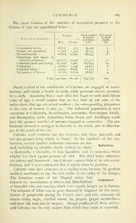
COMMERCE 269
Tht main features of the statistics of occupation pre})ared at Uu
Census of 1901 are reproduced below :
—
M.iiii lieai] of occupalion.
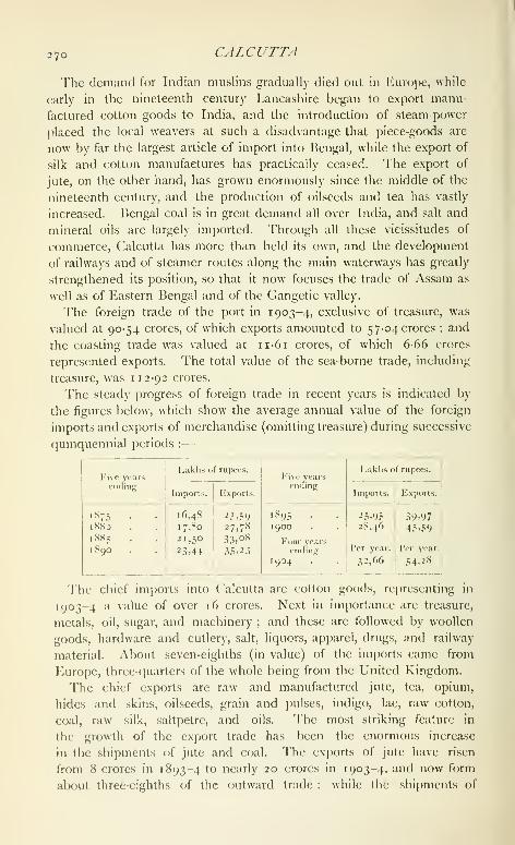
270 CALCUTTA
'I'he demand for Indian muslins gradually died out in Europe, while
early in the nineteenth century Lancashire began to export manu-
factured cotton goods to India, and the introduction of steam-power
placed the local weavers at such a disadvantage that piece-goods are
now by far the largest article of import into Bengal, while the export of
silk and cotton manufactures has practically ceased. The export of
jute, on the other hand, has grown enormously since the middle of the
nineteenth century, and the production of oilseeds and tea has vastly
increased. Bengal coal is in great demand all over India, and salt and
mineral oils are largely imported. Through all these vicissitudes of
commerce, Calcutta has more than held its own, and the development
of railways and of steamer routes along the main waterways has greatly
strengthened its position, so that it now focuses the trade of Assam as
well as of Eastern Bengal and of the Gangetic valley.
The foreign trade of the port in 1903-4, exclusive of treasure, was
valued at 90-54 crores, of which exports amounted to 57-04 crores ; and
the coasting trade was valued at ii-6r crores, of which 6-66 crores
represented exports. The total value of the sea-borne trade, including
treasure, was 112-92 crores.
The steady progress of foreign trade in recent years is indicated by
the figures below, which show the average annual value of the foreign
imports and exports of merchandise (omitting treasure) during successive
(]uinquennial periods :
—
Fi\e yearseiKling
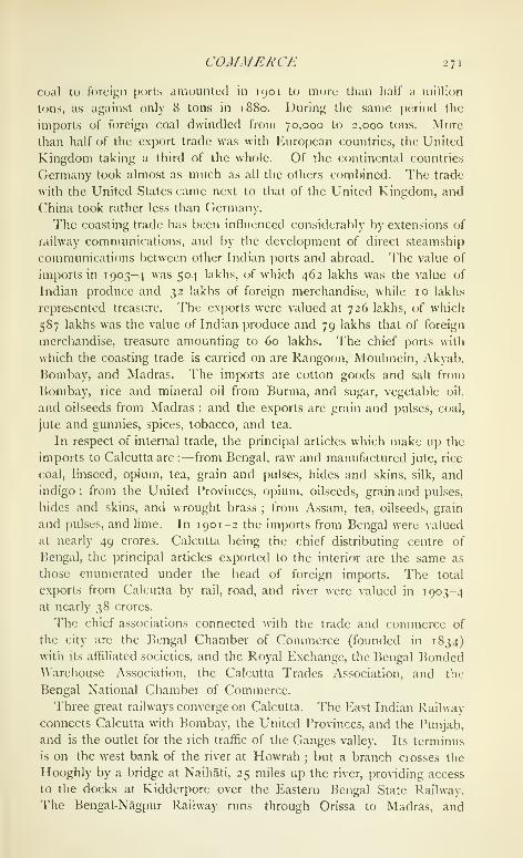
COMMERCE 271
C(jal to foreign [)oils amounted in 1901 to more than lialf a million
tons, as against only 8 tons in 1880. During the same period the
imports of foreign coal dwindled from 70,000 to 2,000 tons. More
than half of the export trade was with European countries, the United
Kingdom taking a third of the whole. Of the continental countries
Germany took almost as much as all the others combined. The trade
with the United States came next to that of the United Kingdom, and
('hina took rather less than Germany.
The coasting trade has been influenced considerably by extensions of
railway communications, and by the development of direct steamship
communications between other Indian ports and abroad. The value of
imports in 1903-4 was 504 lakhs, of which 462 lakhs was the value of
Indian produce and 32 lakhs of foreign merchandise, while 10 lakhs
represented treasure. The exports were valued at 726 lakhs, of which
587 lakhs was the value of Indian produce and 79 lakhs that of foreign
merchandise, treasure amounting to 60 lakhs. The chief ports with
which the coasting trade is carried on are Rangoon, Moulmein, Akyab,
Bombay, and Madras. The imports are cotton goods and salt from
Bombay, rice and mineral oil from Burma, and sugar, vegetable oil,
and oilseeds from Madras ; and the exports are grain and pulses, coal,
jute and gunnies, spices, tobacco, and tea.
In respect of internal trade, the principal articles which make up the
imports to Calcutta are :—from Bengal, raw and manufactured jute, rice
coal, linseed, opium, tea, grain and pulses, hides and skins, silk, and
indigo ; from the United Provinces, opium, oilseeds, grain and pulses,
hides and skins, and wrought brass ; from Assam, tea, oilseeds, grain
and pulses, and lime. In 190 1-2 the imports from Bengal were valued
at nearly 49 crores. Calcutta being the chief distributing centre of
Bengal, the principal articles exported to the interior are the same as
those enumerated under the head of foreign imports. The total
exjiorts from Calcutta by rail, road, and river were valued in 1903-4
at nearly 38 crores.
The chief associations connected with the trade and commerce of
the city are the Bengal Chamber of Commerce (founded in 1834)
with its affiliated societies, and the Royal Exchange, the Bengal BondedWarehouse Association, the Calcutta Trades Association, and the
Bengal National Chamber of Commerce.
Three great railways converge on Calcutta. The East Indian Railway
connects Calcutta with Bombay, the United Provinces, and the Punjab,
and is the outlet for the rich traffic of the Ganges valley. Its terminus
is on the west bank of the river at Howrah ; but a branch crosses the
Hooghly by a bridge at Naihati, 25 miles up the river, providing access
to the docks at Kidderpore over the Eastern Bengal State Railway.
l"he Bengal-Nagpur Railway runs through Orissa to Madras, and

2 72 CALCUTTA
westwards through the Central Provinces to Bombay ; its terminus is
also at Howrah, but a wagon ferry plies between Shalimar and the
docks. The Eastern Bengal State Railway, the terminus of which is at
Sealdah, connects Calcutta with North and East Bengal and Assam,
and with Diamond Harbour.
The railways, however, by no means monopolize the traffic.
Numerous native craft ply up and down the rivers, along the channels
through the Sundarbans which connect Calcutta with Eastern Bengal
and the valley of the Brahmaputra, and on the Midnapore and Orissa
Coast Canals. There are also several large steamer companies, whose
vessels navigate these inland waters and carry an extensive coasting
trade to the Orissa ports ; the most important of these are the India
General, the Calcutta Steam, and the Rivers Steam Navigation Com-panies.
The port was formerly under direct Government management, but in
1870 a Port Trust was formed, consisting at first of 12, and afterwards
of 15 commissioners. The Strand Bank lands were subsequently madeover to them at an annual quit-rent of Rs. 37,392. The value of the
property taken over by the Trust was estimated at 27-65 lakhs, and
with further advances the debt was consolidated into a loan of 60 lakhs.
During the last thirty years the commissioners have been adding con-
siderably to the facilities of the port. In 1870 there were only 6 screw-
pile jetties, 6 cranes, and 4 sheds for the accommodation of the sea-
going trade ; whereas now there are 6 unloading berths for sea-going
vessels at the jetties, with a frontage of 2,982 feet, and all the loading
is done separately at the Kidderpore docks. These docks, which were
constructed in 1884-5 ^'^ ^ ^^^^ ^^ 285 lakhs, consist of a basin, con-
nected by a double passage with the wet docks, which accommodate
twelve vessels, and of two graving docks. The Petroleum Wharf at
Budge-Budge was established in 1886, and the Tea Warehouse in 1887.
In 1889 the Pcjrt Commissioners were made the Conservators of the
port. They have their own dockyard and workshop, and they main-
tain a staff of assistant harbour masters, who take over the pilotage
of all vessels from Garden Reach ; they license all cargo boats and
pay three-fourths of the cost of the river police ; they survey and
prepare charts of the river from ( "ale utla to the sea, and are responsible
for the lighting of the Hooghly.
The revenue of the Port Trust amounted in 1903-4 to 80 lakhs, and
the expenditure to 77 lakhs. The greater part of the income is derived
from a toll of 4 annas a ton on all goods shipped or discharged. The
capital debt amounts t(j 501 lakhs, and the book value of the Trust
property is returned at 656 lakhs, exclusive of the Strand Bank and
Howrah fcjreshore lands, and an accumulated sinking fund of 42 lakhs.
Even before the foundation of (Calcutta, the East India Company
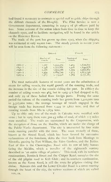
COMMERCE 273
had found it necessary to maintain a special staff to guide ships through
the difficult channels of the Hooghly. The Pilot Service is now a
Government department, consisting in 1903-4 of 58 officers paid by
fees. Some account of the action taken from time to time to keep the
channels open, and to fiicilitate navigation, will be found in the article
on the HooGHLV River.
The trade of the port has grown up since 1727, when the shipping
was estimated at only 10,000 tons. The steady growth in recent years
will be seen from the following statement :
—

2 74 CALCUTTA
Wellesley Street, College Street, and Cornwallis Street ; and to the east
of it the Lower Circular Road sweeps round the city, one section of it
following the course of the old Maratha Ditch. These four main roads
are linked by a number of cross streets, the most important of which
are Park Street, passing through the European quarter and so called
because it originally bordered the spacious garden of Sir Elijah Impey
;
DhurrumtoUa Street, passing through a quarter largely inhabited by
Eurasians ; Lai Bazar and its continuation Bow Bazar, in the centre
of the native town, presenting a mass of densely packed houses and
shops ; Canning Street and Harrison Road, named after Lord Canning
and a former chairman of the Corporation ; and, to the north of the
town, Sobha Bazar and Grey Street. From Government House to
Kidderpore, 2 miles to the south, stretches the oldest road in the
Maidan, known as the 'Old Course' and described in 1768 as being
' out of town in a sort of angle made to take the air in'
; to the north
this road runs into Old Court-house Street, so called from the old
court-house pulled down in 1792. Starting from Kidderpore, Garden
Reach and Circular Garden Reach Roads connect the docks and the
mills fringing the Hooghly with the city, while to the south DiamondHarbour Road links Calcutta with the harbour after which it is named.
Calcutta is connected with the important town of Howrah, on the
west of the river, by several ferries and also by a floating bridge opened
in 1874. This structure, supported on pontoons, is 1,530 feet in length
between the abutments, and has a roadway for carriages 48 feet in width
with footpaths of 7 feet on either side. The bridge is opened three
times a week to allow ships to pass to the dockyards above, and while
it is open a ferry steamer plies across the river. Bridges over Tolly's
Nullah at Kidderpore, Alipore, and Kali Ghat connect the south-east
portion of the present city with the '.Old Town.' On the north the
main roads converge at the Chitpur Bridge, by which the old grand
trunk road cros.ses the Circular canals.
Lines of tramway run from the High Court to Tollygunge, Nimtolla
Ghat, and Sealdah, and from the Esplanade to Chitpur, Sham Bazar,
Kidderpore, and Belgachia. 'I'hese tramways hove been recently
electrified. There is a large suburban traffic along all the main lines of
railway, and also on two small light railways from Howrah to Anita
and Sheakhala.
In the 'Old '{"own ' civil justice is administered by a judge of the
High Court, who sits singly and tries cases above Rs. 2,000 in value
.... . and suits concerning land ; and by the Small CauseAdministration. „ •
1 ,- , , ,• ,,
Court with five Judges, who try suits up to Rs. 2,000
in value. In the 'Added Area' a Small Cause Court and two Munsifs'
courts sit at Sealdah, and three Munsifs' courts at Alipore ; these arc
subrmlinate to the District Judge of the 'I'wenty-four I'arganas. Both
ADMINISTRA TION 2 7 5
the District Judge and the Additional Judge of the Twenty-four Par-
ganas have jurisdiction in Calcutta under the Land Acquisition Act.
Criminal justice is administered in the ' Old Town ' by three stipen-
diary and a number of honorary Presidency Magistrates. The High
Court holds Criminal Sessions, and hears appeals from the Presidency
Magistrates. In the ' Added Area ' the Sessions Judge and the Dis-
trict Magistrate of the Twenty-four Parganas have criminal jurisdiction.
Two stipendiary magistrates sit, one at Alipore and the other at
Sealdah, and there are also several honorary magistrates. Throughout
Calcutta cases under the Municipal Act are tried by a stipendiary
municipal magistrate. The Chief Presidency Magistrate is the pre-
siding officer in the court for the trial of pilots, and also Judge of the
Court of Survey for the Port of Calcutta.
The Government revenue receipts under the main heads amounted
in 1903-4 to 88-5 lakhs, of which Rs. 18,000 was derived from land
revenue, 29-7 lakhs from stamps, ZZ'Z 'akhs from excise and opium,
and 25-4 lakhs from income-tax. The total revenue receipts in 1 880-1,
1890-1, and 1900-1 were 33-5 lakhs, 614 lakhs, and 8o-i lakhs
respectively. In 1881 the income-tax had not been imposed.
The Collector of Calcutta, who is assisted by a Deputy-Collector,
is Collector of stamp revenue in the ' Old Town,' and is Superintendent
of excise revenue throughout Calcutta, and in the municipalities of
Cossipore-Chitpur, Maniktala, Garden Reach, Howrah, and Bally; Heis also Deputy-Collector of land revenue in the ' Old Town '
; and in this
respect is subordinate to the ('ollector of the Twenty-four Parganas,
whose ordinary jurisdiction extends over the 'Added Area' in all
revenue matters except excise. There is a separate Collector of
income-tax in the ' Old Town.'
The stamp revenue of Calcutta has risen from 23 lakhs in 1892-3 to
29-7 lakhs in 1903-4, when 14-2 lakhs was realized from judicial and
15-5 lakhs from non-judicial stamps. During the same period the
income-tax receipts rose from 1722 to 25-4 lakhs, in spite of the exclu-
sion from assessment in 1903 of incomes below Rs'. 1,000; and the
excise receipts rose from 25 to -^^'Z kikhs. The main items under
the latter head are imported liquor (1-5 lakhs), country spirit (i9'4
lakhs), opium (4-9 lakhs), hemp drugs (4-3 lakhs), rum (2-3 lakhs), and
tari (Rs. 79,000).
In the ' Old Town ' there is, strictly speaking, no land revenue, as in
1758 the East India Company obtained from the Nawab a free grant
of the area on which Calcutta now stands. The so-called revenue
is really ground-rent, which -has been permanently fixed and amounts
to Rs. 18,163. The 'Added Area' belongs for revenue purposes to
the District of the Twenty-four Parganas. The tract east of Tolly's
Nullah and the Lower Circular Road, which comprises BhawanTpur,
T 2

2 76 CALCUTTA
liallygunge, and Intally, is included in the Panchannacram Govern-
ment estate. West of Tolly's Nullah are ordinary permanently settled
estates belonging to private owners ; a considerable area is, however,
included in the Sahiban BagTcha Government estate {see Twenty-fourParganas).
The grand total realized by the Customs department in 1903-4 was
388 lakhs, to which salt contributed 197 lakhs; cotton piece-goods,
49^ lakhs; mineral oil, 17^ lakhs; liquor, 22^ lakhs; articles of food
and drink, 12^ lakhs ; countervailing duties on sugar, \ lakh ; and arms
and ammunition, \\ lakhs. The export duty on rice amounted to
15^ lakhs. Besides this, 26| lakhs was paid into District treasuries
on account of salt imported into Calcutta.
The municipal administration of the city, as regulated by Bengal
Act III of 1899, is in the hands of three co-ordinate authorities, the Cor-
. . poration, the General Committee, and the Chairman.
The Corporation consists of the Chairman appointed
by Government, and 50 commissioners, of whom 25 are elected at
ward elections, and the remainder are appointed as follows : namely,
4 by the Bengal Chamber of Commerce, 4 by the Calcutta Trades
Association, 2 by the Port commissioners, and 15 by the Local Govern-
ment. The General Committee consists of 12 commissioners and the
Chairman, who is president. Of the commissioners 4 are elected by
the ward commissioners, 4 by the appointed commissioners, and the
remaining 4 are appointed by the Local Government. The entire
executive power is vested in the Chairman, to be exercised subject to
the approval or sanction of the Corporation or General Committee,
whenever this is expressly directed in the Act. To the Corporation
are reserved the right of fixing the rates of taxation and all those
general functions which can be etificiently performed by a large body.
The General Committee stands between the deliberative and executive
authorities, and deals with those matters which are ill adapted for
discussion by the whole Corporation, but yet are too important to be
left to the disposal of the Chairman alone.
The Corporation thus constituted commenced work in April, 1900;
and its efforts so far have been mainly directed to the introduction
of a continuous water-supply for the whole city, the completion of the
drainage scheme, the decentralization of control, and the punctual
collection of the rates. The city has been divided into four districts,
each with its own staff for conservancy, roads, and buildings. A large
scheme for opening out the congested areas, with the assistance of
Imperial funds, is under consideration.
'J1ie drinking-water supply is obtained from the Hooghly river at
I'alta, 17 miles north of Calcutta, where it is pumi)ed up into settling
tanks and filtered. 'I'he pure water is conveyed by gnuitation thnnigh

MUNICIPALITY 277
two iron mains to a masonry reservoir at the nortli end of the city.
'I'hence it is pumped into the distributing mains and three other
reservoirs in different quarters of the city, and from these it is again
pumped into the distributing pipes. The scheme was inaugurated in
i860, and it was then intended to supply 6,000,000 gallons per diem,
or 15 gallons per head. In recent years the works have been greatly
extended, and the Corporation has now three pumping stations at
Palta and four in the city : there are 1,997 standposts and 5,904ground hydrants, and the number of filtered water connexions exceeds
26,000. These give to Calcutta and the adjacent towns of Barrack-
pore, Duni-Dum, Cossipore-Chitpur, Maniktala, and (iarden Reacha daily supply of over 7,624,000,000 gallons of filtered water, or 2\\gallons per head. The streets are watered and the drains flushed with
unfiltered water pumped up in Calcutta, and for these purpcses there
are more than 3,500 connexions. The initial cost of the works was
7 lakhs. Subsequent extensions have increased the capital cost to
210 lakhs ; the annual cost of maintenance is i6| lakhs.
'l"he scheme of underground drainage, by which the city is freed
of surplus water and of the filth which water will carry, was inaugurated
half a century ago. The drainage is carried eastwards by a .series of
five parallel conduits which discharge into an intercepting sewer, and
thence into a large well at Tengra in the eastern suburbs. There it is
raised by steam pumps into a high-level sewer, which carries it to the
Salt Water Lakes, east of the city, there to undergo oxidation. Theoriginal project was commenced in 1859, and took sixteen years to
complete ; but meanwhile fresh additions had been found nece.s.sary,
and these are still incomplete .so far as the ' Added Area ' is concerned.
The execution of the original scheme proved a very expensive under-
taking and cost the munic-ipality 95 lakhs, including a storm-water cut
completed in 1883-4. The annual cost of maintenance amounts to
Rs. 26,000.
Good progress has been made in lighting the city, especially in the
southern area ; oil lamps are being gradually replaced by gas ; and the
incandescent .system has been extended throughout Calcutta. The Cor-
poration have now 11,000 street lamps, of which 8,500 are gas lamps.
A municipal railway conveys street refuse to the Salt \\'ater Lakes.
The income of the Corporation has increased largely in recent years,
but its expenditure has grown even more rapidly, and its indebtedness
on March 31, 1904, was nearly 327 lakhs, of which 179I lakhs has been
borrowed during the last decade. The chief item of receipt is the
consolidated rate, which during the last ten years has varied from t^z
to 42 lakhs per annum. Next in importance are the licence tax on
trades and professions, and the tax on animals and vehicles. Themunicipal market has also proved a source of profit to the Corporation.

278 CALCUTTA
The average receipts and expenditure during the ten years ending
1903-4 are shown below, in thousands of rupees :
—
Receipts.

rrni.ic jwildiags, etc. 279
and eiiibellislicd b) Sir Ashley Eden. At the spot which is now the
west entrance of Jielvedere, on the Alipore Road, was fought the
famous duel between Warren Hastings and Philip ?>ancis, in which
the latter was wounded. Not far from this spot is Hastings House,
the favourite residence of the great Governor-deneral, which is nowused as a guesthouse for Native chiefs.
To the west of Government House, and nearer to the river, stands
the High C^ourt. This imposing structure in somewhat florid Gothic
was completed in 1872, on the site of the old Supreme Court. Thedesign is said to have been suggested by the Town Hall at Vpres.
The Town Hall stands west of Government House, between it and the
High Court. It is a large building in the Doric style, approached by
a noble flight of steps leading up to the grand portico. It was built
in 1804 at a cost of about 7 lakhs, and contains many interesting
statues and portraits. The Indian Museum, situated in Chowringhee,
contains a fine collection of fossils and minerals, a geological gallery,
and a gallery of antiquitie.s. Adjoining it are the Economic Museumand the School of Art. The Mint in the north of the town covers
i8| acres, and was built in 1824-30. The style is Doric, the central
portico being a copy in half size of the Parthenon at Athens. TheVictoria Memorial Hall, which it is proposed to erect in memory of
the late Queen-Empress, is now in course of construction at the south
end of the Maidan near the Cathedral.
The General Post Office, opened in 1870, occupies a position in
Dalhousie Square on the site of the old Fort. In the same square are
Writers' Buildings, now used for the offices of the Bengal Secretariat,
the Central Telegraph Office, the Currency Office, and the offices of the
Commissioner of the Presidency Division and the Collector of (,'alcutta.
The offices of the Secretariat of the Government of India and the
Treasury lie between Government House and the Town Hall, and the
I'oreign and Military Departments have recently transferred their offices
to a handsome new building on the Esplanade. The Survey Office
occupies substantial quarters in ^\'ood Street. The Bank of Bengal,
incorporated as a Presidency Bank by Act XI of 1876, has a fine
building in the Strand erected in 1809. Hard by it is the Metcalfe
Hall, occupied by the new Imperial Library. The Muhammadanmosques and Hindu temples of Calcutta have no great architectural
merit, the only mosque of any pretensions being the one at the corner
of Dhurrumtolla Street, which was built and endowed in 1842 by Prince
Ghulani Muhammad, son of Tipu Sultan. Kali Ghat, in the south
of the town, is a place of great sanctity for Hindus, and numbers go
there every day to bathe in Tolly's Nullah. The temple, which is said
to be about 300 years old, has 194 acres of land assigned for its
maintenance.

28o CALCUTTA
The Cathedral Church of the see of Calcutta. St. Paul's, stands at
the south-east corner of the Maidan. It was commenced in 1839 and
consecrated in 1847, and it is practically the work of Bishop Wilson.
Of the 7^ lakhs raised to build and endow the Cathedral, the Bishop
gave 2 lakhs, the East India Company \\ lakhs, and 2-8 lakhs was
subscribed in England ; only Rs. 1,20,000 was collected in India. It
is built in a style which is known in Calcutta as Indo-Gothic : that is
to say, Gothic adapted by a military engineer to the exigencies of the
Indian climate. The building is 247 feet in length with a transept of
114 feet, and the tower and spire are 207 feet high. Among the
many monuments to famous Englishmen who have served in this
country, the most conspicuous is a life-sized kneeling figure in episcopal
robes by Chantrey bearing the single word ' Heber.' The spire was
rebuilt in 1897, the original one having been destroyed in the earth-
quake of that year.
St. John's, the old Cathedral, was commenced in 1784. It was
erected to replace the still older Church of .St. Anne's, which occupied
the site of the modern Bengal Council Chamber and was demolished
by Siraj-ud-daula in 1756. St. John's was built chiefly by voluntary
.subscriptions, the site being the gift of a Raja. In the graveyard is
the mausoleum which covers the remains of Job Charnock ; and slabs
commemorating Surgeon William Hamilton, who died in 1717, and
Admiral Watson, are built into the walls of the church. The Old
Mission Church has a peculiar interest as having been erected between
1767 and 1770 by Kiernander, the first Protestant missionary to Bengal,
at his own expense. In 1786 the good Swede found himself unable to
defray the charges involved by his benevolent schemes, and the church
was seized by the sheriff. It was rescued and restored to religious
purposes by Charles Grant, afterwards the well-known East Indian
Director, who paid Rs. 10,000, the sum at which it was appraised.
Other churches of the Anglican communion are the Fort church of
St. Peter, St. Thomas's, St. Stephen's, Kidderpore, and St. James's,
besides several others belonging to missionary bodies.
The Roman Catholic Cathedral, situated in the heart of the commercial
(juarter, was built in 1797, taking the place of a chapel built by the
Portuguese in 1700. The Greek church in the same (juarter was built
by subscriptions in 1780, and the Armeiu'an church was completed in
1790. At the corner of Dalhousie Square, on the site of the old
Mayor's Court-house, stands the Scottish church of St. Andrew.
The Maidan, the chief open space in Calcutta, stretches from
Government House and the Eden Gardens on the north to Tolly's
Nullah on the south, Chowringhee lying on the east, and the river andFort on the west. Scattered over it are several monuments, the most
conspicuous f)f them being the Ochterlony column, erected in honour

.IRMY 28 r
of Sir David Oclilerlony, who, 'for fifty years a soldier, served in every
Indian war from the time of Hyder downwards.' It rises 165 feet, with
a Saracenic capital, and its summit commands a noble view of the city.
Facing the river is a pillared archway erected by the citizens of Calcutta
to perpetuate the memory of James Prinsep, founder of the science of
Indian numismatics. Near Park Street is the fine bronze statue of Sir
Tames Outram, in which he is represented with drawn sword lo(Aing
round to his troops and cheering them forward. Among other monu-
ments may be mentioned those of Lord William Pentinck, Lord Hardinge,
Lord Mayo, Lord Lawrence, Lord Dufferin, and Lord Lansdowne ; and
the equestrian statue to Lord Roberts is a noteworthy addition to this
group. A statue of Her late Majesty Queen Victoria by Frampton has
recently been placed on the Maidan, waiting till it may find a more
honoured position in the Hall now being erected to her memory. Onthe south-west side of the Maidan is the racecourse, while the rest of
it is devoted to recreation grounds.
Other open spaces are the Eden Oardens, named after the Misses
Eden, sisters of Lord Auckland, on the north-west of the Maidan;
Dalhousie Square, in the heart of the official quarter ; Beadon Square in
llie north of the town, named after a Lieutenant-Governor of Bengal
;
and a series of squares by the side of Cornwallis, College, Wellington,
and AN'ellesley Streets. The Zoological Gardens at Alipore were
opened by the (then) Prince of Wales in 1876. They are managed by
an honorary committee, and are maintained chiefly by donations and
subscriptions, entrance receipts, and a Government grant-in-aid. The
expenditure in 1903-4 amounted to Rs. 87,000, of which Rs. 42,000
was spent on new buildings. The Government of India has made
a grant of a lakh of rupees, which it has been decided to devote mainly
to permanent improvements. The gardens contained, in 1904, 464
mammals, 842 birds, and 238 reptiles.
At Sibpur, on the opposite bank of the Hooghly, are situated the
Botanical Gardens, which are beautifully laid out along the river and are
stt)cked with rare tropical plants. They were founded in 1786, at
the instance of Colonel Alexander Kyd, for the collection of plants
indigenous to the country and for the introduction and acclimatization
of plants from foreign parts. This object has been fully realized, and
among the greatest triumphs of the gardens may be mentioned the
introduction of the tea plant from China. They cover 272 acres, and
contain a fine herbarium, a botanical library, and monuments to the
first two Superintendents, Kyd and Roxburgh.
Fort William is included in the Lucknow division of the Eastern
Command. The garrison consists of a battalion of
British infantry, a battery of garrison artillery, a com-
pany of the Indian submarine mining corps, and a regiment of Native
282 CALCUTTA
infantry in the Fort, and half a squadron of Native cavalry and a regi-
ment of Native infantry at Alipore. The volunteer forces are : (i) the
Calcutta Port Defence Volunteers, in five companies, two being naval
divisions, one of garrison artillery, one of submarine miners, and one of
electrical engineers, with a strength in 1903-4 of TiZZ '• (2) the Calcutta
Light Horse, in five troops, strength 187 ; (3) the Cossipore Artillery,
with four six-gun batteries, strength 428; (4) the Calcutta ^'olunteer
Rifles, with three battalions (of which the third is a cadet company),
and a strength of 2,075, including cadets and reservists: and (5) the
Eastern Bengal State Railway Volunteers, strength 728. The military
authorities have control over the erection of buildings on the Maidan
and in the Hastings ward, which lies to the south of Fort William.
The Calcutta police force is under a Commissioner, a Deputy-Com-
missioner, and an Additional Deputy-Commissioner, and consists of
8 Superintendents, 55 inspectors, 74 sub-inspectors
and European constables, 291 head constables and
sergeants, including mounted men, 2,484 foot constables, and 130 river
constables. It has under its control, besides the municipal area, the
suburban municipalities of Cossipore-Chitpur, Maniktala, part of Garden
Reach, and the river. There are 18 police stations in the 'Old Town"and 14 in the 'Added Area' and in the suburbs. The total cost of
the force in 1901 was 8-66 lakhs, of which 8-15 lakhs was paid from
Imperial and Provincial revenues, and the rest by local bodies and
private individuals for services rendered. The proportion of police to
population was i to 405 persons, and to area 76 per square mile.
Besides ordinary police duties, the Commissioner is responsible for the
working of the Arms Act and the fire brigade. The latter consists of
one chief engineer. 4 engineers, one European and 4 native drivers,
3 firemen, 16 tindals, 84 khalasis, and one inspector of warehouses.
The force is equipped with six steam engines and six manual engines,
and is paid for partly by fees levied on jute and other warehouses and
partly by certain municipalities. The number of fires reported in 1903
in the city and suburbs, including Howrah, was 120, of which only
seven were serious. The Port Commissioners maintain their ownboats and staff for fires on the river.
Until 1845, there does not ap{)ear to have been any disciplined force,
the only police being a number of thdnaddrs and peons for night duty;
but in that year the town was divided into three police divisions, each
containing a police station with six sub-stations. In 1852 the number
of divisions was reduced to two, and in 1877 the present divisions and
tliduas were created. ]5y Act XIII of 1856 a (Commissioner of Police
was appointed, and in 1868 the detective branch was constituted. In
1867 the suburban police was made over to the Commissioner's control,
Bengal Act \\ f)f 1866 having been passed for the purpose. Until 1889

EJ)UCATIOX 283
the ("hairnian ot the Calcutta ( "oriKJiation was also ("ommissioncr of
Police, but in that year the appointments were separated.
The Presidency jail on the south of the Maidan contains accommoda-
tion for 70 European and 1,214 native prisoners, the average number of
prisoners during the year 1903 being 1,209. The chief industry is the
printing of Clovernment forms, and the printing work done during 1903
was valued at 1-77 lakhs; minor industries are the manufacture of
mustard-oil, wheat-grinding, and carpentry. It is intended to transfer
this jail to Alipore, where new buildings are being erected for the
purpose. There are also a District and Central jail and a Reformatory
School at Alipore, and a Criminal Lunatic Asylum at Dullunda.
At the Census of 1901, 24-8 per cent, of the total population (20-9
males and 3-8 females) were returned as literate. The percentage for
Christians was 75-9, for Hindus 26-5, and for Mu, , Education.hammadans 12-2.
The University of Calcutta exercises, by means of the examinations
for its degrees, paramount influence over English education throughout
Pengal. The University building, situated in College Street, contains
a library adorned with portraits of some of the more famous persons
who have been at various times connected with the University.
The higher colleges in Calcutta are the Presidency, the Doveton, LaMartiniere, the Free Church Institution and Duff College, the LondonMissionary Society's Institution, the Sanskrit (College, Bishop's ('ollege,
St. Xavier's, the General Assembly's Institution, the Metropolitan
Institution, the City, Ripon, Central, and BangabasT Colleges for men,
and the Bethune ("ollcge for women. Of these, the Presidency, the
Sanskrit, and the Bethune Colleges are Government institutions;
the first was established in 1855 and the second as early as 1824 :
the third was founded in 1849 ^'y ^Ii"- Bethune, and maintained
by him till his death in 1851. It was then maintained by Lord
Dalhousie until 1856, and from that date by the Government. TheDoveton College was first opened in 1823 for the education of
Christian boys under the name of the Parental Academic Institution :
but it was subsequently called after Captain J. Doveton, who gave it an
endowment of 2-3 lakhs. La Martiniere was founded by General Claud
Martin, and was opened in 1836. Bishop's College was founded by
Bishop Middleton in 1820, and was at first located at Sibpur on the site
now occupied by the Civil Engineering College. The College of the
Scottish Church was founded in 1830 and St. Xavier's in i860. Thesecond-grade colleges are the Madrasa, the Albert College, the ArmenianCollege, and the Church Missionary College. The Madrasa (for Mu-hammadans) was founded and endowed by A\'arren Hastings in 1781 :
in 1873 it received additional funds from the Hooghly MuhammadanEducational Endowment, and it is also assisted b\- Government. The

284 CALCUTTA
Armenian College was opened in 1821, and is managed by trustees.
The Sibpur College for Engineering {see Howrah Town), situated on
the opposite bank of the Hooghly, was opened by Government in
1880.
Calcutta contains 75 schools teaching up to the standard for the
entrance examination of the University, and a large number of primary
schools. The oldest Christian school is the Calcutta Free School,
which was founded in 1789 from the united funds of the Old Calcutta
Charity and the Free School Society, which then amounted to 3 lakhs.
The Calcutta Medical College is a Government institution, which
was opened in 1835 and had 519 pupils in 1903-4 ; there are also four
private medical schools with 454 pupils. Of the latter the oldest is
the Calcutta Medical School, to which the Albert Victor Hospital has
lately been attached.
The two most important hostels under Government management are
the Eden Hindu hostel and the Elliott Madrasa hostel. The former is
intended chiefly for the accommodation of such Hindu pupils of the
Presidency College and of the Hindu and Hare schools as do not live
with their parents or guardians ; the latter is for Muhammadans studying
at the Calcutta Madrasa. In 1903-4 the number of inmates in the
Eden hostel was 247 and in the Elliott hostel 222. The total expendi-
ture of the former amounted to Rs. 30,000, and that of the latter,
exclusive of messing charges, to Rs. 4,500. Of this Government paid
Rs. 700 and Rs. 1,400 respectively, chiefly for medical attendance and
superintendence. The average cost of a student was Rs. 10 per month
per head in the former, and a little over Rs. 3 in the latter.
The Government School of Art attached to the Government Art
Gallery was attended by 241 pu|)ils in 1903-4. An aided industrial
school was attended by 47 pupils, and 3 unaided schools of Art taught
182 pupils. Besides, there are two schools for the blind and a deaf
and dumb school. There were four training schools for mistresses in
1900-1, and one Normal school for the training of schoolmasters. In
addition to the Bethune College, there were six other higher-class
female institutions in Calcutta.
The total number of pupils under instruction increased from 25,124
in 1883 to 40,724 in 1892-3 and to 43,979 in 1900-1, while 39,524boys and 8,277 gi'"'^ were at school in 1903 4, being resjiectively 46-8
and 19-3 per cent, of the total of school-going age. The numberof educational institutions, public and private, in that year was 531,
including 20 Arts colleges, 69 secondary, 311 primary, and 131 special
schools. The expenditure on education was i8-o6 lakhs, of which
6-22 lakhs was met from Provincial funds, Rs. 11,000 from municipal
funds, and 8-i6 lakhs from fees.
Calcutta has four daily newspapers owned and edited by ICnglishnicn :

MEDICAL 285
namely, the F.ni^/ii/nnan, ihc Indian Daily News^ the Slatesman, antl
the Etnpire^ the latter being an evening newspaper which has recently
(1906) been started. The other journals and magazines under Euro-
pean management include a fortnightly illustrated paper, a weekly paper
dealing with finance and commerce, an illustrated engineering journal,
and three weekly papers devoted to sport. Other periodicals deal with
religious subjects, the interests of planters and volunteers, medicine,
railways, horticulture, and literary and general matters ; one of the latter,
the Calcutta Revie^v, is an old-established publication of some repute.
There are also five daily newspapers published in English but owned
and edited by natives : namely, the Bengalee, Amrita Bazar Fatrikd,
Indian Mirror, Hindoo Patriot, and Bande Mataram. No less than
twenty-three vernacular papers are published in Calcutta, but few of
these are daily journals or of any great importance ; the most influential
are the Ilitahddi, the Basinnatl, and the Bangabdsl, all weekly papers.
The chief hospitals are the Medical College, Eden, Ezra, Syama
Charan Law Eye, Presidency General, Campbell, Police, Sambhu
Nath Pandit, and Dufferin Victoria Hospitals, the „ j. ,
VT • XT • , • 1 1 J- • J Medical.Mayo Native Hospital with three dispensaries and
the Chandney Hospital attached to it, and the Kidderpore Municipal
and Dockyard Dispensaries. Of these, the Dufferin Victoria Hospital
and the Eden Hospital are for women only. The Medical College
Hospital was originally started in 1838 with thirty beds. It was very
largely attended and, the accommodation having soon been found quite
insufficient, an enlarged building was opened on the present site in
1852. The Eden or lying-in Hospital, the Ezra Hospital for Jews, and
the Eye Infirmary were subsequently added to it. The Presidency
General Hospital for Europeans dates from about the middle of the
eighteenth century. The central block was purchased by Government
in 1768, and two wings were added in 1795. '^ ^e foundation stone of
a new block was laid in 1898. This is one of the best hospitals in
India ; it contains accommodation for 233 patients, and has been
provided with all modern requirements and conveniences. The Camp-
bell Hospital, started in 1867, is the largest hospital in India and has
accommodation for 752 patients. The Police Hospital, with 211 beds,
was opened in 1865 for the treatment of the members of the Calcutta
police. The Mayo Native Hospital, the successor of the old Chandney
Hospital, contains 105 beds and was opened in 1874. The total num-
ber of patients treated in these institutions during 1903 was 274,000,
of whom 25,000 were in- and 248,000 out-patients. Of these 163,000
were men, 51,000 women, and 59,000 children. These charities are
mainly dependent on Government for their support. In 1903, out of
a total income of 9-15 lakhs, Government gave 6-39 lakhs ; i lakh was
supplied from Local funds : the Corporation contributed Rs. 46,000 :

286 CALCUTTA
interest on investments amounted to Rs. 25,000; while only Rs. 7,000
was subscribed, the balance being made up from fees from paying
patients. There are also two Lunatic Asylums entirely under Govern-
ment control, while a Leper Asylum has lately been erected.
Vaccination is compulsory, and is controlled by the Health depart-
ment of the Corporation. In 1903-4 the number of persons success-
fully vaccinated was 22,492.
S^Census Reports; H. E. VtwsX&^di, Echoes from Old Calcutta (third
edition, 1897); R. B. Hyde, Parochial Annals 0/ Bengal (Calcutta,
1901) ; A. K. Ray, History of Calcutta {Calcutta, 1902); S. C. Hill,
Bengal in 1756-7 (1905); C. R. AVilson, Old Fort William in Bengal
(1906); H. E. A. Cotton, Calcutta Old and New (Calcutta, 1907).]
Calcutta, Suburbs of.—A name given to the three suburban
municipalities of Cossipore-Chitpur (population, 40,750), Maniktala
(32,387), and Garden Reach (28,211), which are thus grouped as a
subdivision of the District of the Twenty-four Parganas, Bengal. Thearea of the subdivision is 10 square miles, and the population in 1901
was 101,348, as compared with 87,508 in 1891, the density being
10,135 persons per square mile. Cossipore-Chitpur is north and
Maniktala north-east of Calcutta, while Garden Reach bounds the city
on the south-west
Calcutta, South Suburbs.—'1 own in the head-quarters subdivision
of the District of the Twenty-four Parganas, Bengal, comprising a por-
tion of the southern suburbs of Calcutta. Population (1901), 26,374,
of whom 20,165 were Hindus, 5,849 Musalmans, and 350 Christians.
The application of the term 'suburbs of Calcutta ' has varied widely at
different periods. By Act XXI of 1857 the 'suburbs' were defined as
including all lands within the general limits of the Panchannagramestate; and under the Bengal Municipal Act, 1876, they were further
defined as comprising the present municipalities of Cossipore-Chitpur,
Maniktala, Garden Reach, South Suburbs, and Tollygunge, as well as
so much of Calcutta as lay outside the limits of the ' Old Town,' which
was bounded by Lower Circular Road and Tolly's Nullah. This
unwieldy municipality, known as the Suburban municipality, was in
1 888 split up into four parts, the ' Added Area ' and ' Fringe Area
Wards' (defined in article on Calcutta) being added to Calcutta, and
the municipalities of Cossipore-Chitpur and Maniktala being created.
These deductions still left the South Suburban municipality of un-
manageable size, and, accordingly, in 1897 the Garden Reach munici-
pality and in 1901 the Tollygunge municipality were separated from it.
The constitution of the present ' South Suburbs ' municipality therefore
dates from 1901. The income during the three years following its
constitution has averaged Rs. 52,000, and the expenditure Rs. 32,000.
In i9o."> 4 the income was Rs. 79,000, including Rs. ir,ooo derived
CALCUTTA AND EASTERN CANALS 287
from a tax on houses and lands and Rs. 29,000 obtained from the sale-
proceeds of Government securities and the withdrawal of savings bank
deposits. The expenditure in the same year was Rs. 53,000, of which
Rs. 29,000 represented the outlay on the introduction of a supply of
filtered water. The principal villages now within the municipality are
Barisa and Behala.
Calcutta and Eastern Canals.—A system of navigable channels
in the Twenty-four I'arganas, Khulna, Backergunge, and Faridpur
Districts of Bengal and Eastern Bengal and Assam, extending over
a length of 1,127 miles, of which 47 miles, including Tolly's Nullah,
are artificial canals, and the remainder are natural channels, mainly tidal
creeks in the Sundarbans. These stretch eastwards from the Ilooghly
across the Ganges delta and afford means of intercommunication
between the mouths of the latter river. The channels are under the
supervision and control of Government, and tolls are charged on vessels
using the artificial canals.
This is one of the most important systems of river canals in the world,
judged by the volume of the tratific, which averages 1,000,000 tons
per annum, valued at nearly four millions sterling. The situation of
Calcutta makes it the natural outlet for the Ganges valley ; and this
position has been enormously strengthened by the construction of
railways, but other measures were necessary to enable it to tap the trade
of the Brahmaputra valley and to focus the rich tratific of the eastern
Districts. The intermediate country is a maze of tidal creeks, for the
most part running north and south but connected here and there by
cross-channels, wide near the sea-face but narrow and tortuous farther
inland. These inland channels are constantly shifting as the deposit of
silt raises their beds, while on the other hand the great estuaries near
the sea-face are not navigable by country boats from June \o October,
owing to the strong sea-breezes which prevail during the south-west
monsoon. This system of canals was devised, therefore, in order to
allow country boats to pass from the eastern Districts to Calcutta by
a direct inland route, and the problem has been to keep the natural
cross-channels clear of silt, and to connect them with each other and
with Calcutta by a system of artificial canals. The channels have been
in use for many years ; and it is along them that the rice, jute, and
oilseeds of East and North Bengal, the tea of Assam and Cachar, and
the jungle produce of the Sundarbans pour into Calcutta, while they
also carry the exports of salt, piece-goods, and kerosene oil from
Calcutta to those Districts.
Before the opening of Tollv'.s Nullah, boats could approach Cal-
cutta only by a route close to the sea-face which brought them into the
Hooghly by the Baratala creek, 70 miles below CTalcutta ; and this route
was not only circuitous but was impracticable for country boats during

288 CALCUTTA AND EASTERN CANALS
the rainy season. Jhe pioneer of the system was Major Tolly, who in
1777 canalized an old bed of the Ganges, from its confluence with the
Hooghly at Hastings, a Httle south of Fort William, in Calcutta, south-
eastwards to Gariya (8 miles). From this point the canal (known as
Tolly's Nullah) was carried east to meet the BidyadharT river at Saniuk-
pota, and thus gave access to an inner route which leads eastwards from
Port Canning. In 1810 a further step was taken to facilitate access to
Calcutta. An old channel through the Salt Water Lakes, east of the
city, was improved and led westwards by what is now known as the
Beliaghata canal in the neighbourhood of Sealdah. Between 1826 and
1 83 1 a new route was opened between Calcutta and the Jamuna river,
following the same direct easterly course as the present Bhangar canal,
the object being to relieve the pressure on Tolly's Nullah ; a number of
tidal channels were utilized and connected by six cuts to form a con-
tinuous eastward route. The next step was to cut the Circular canal
from Chitpur, parallel with the Circular Road, to meet the old Eastern
canal at Beliaghata, and this was completed in 1831. These canals
were still choked by the increasing stream of trafific ; and, in order to
relieve them, the New Cut was opened in 1859, leading from Ulta-
danga, a point on the Circular canal 3 miles east of Chitpur, south-east
to Dhapa on the Beliaghata canal. Finally the Bhangar channel was
canalized in 1899 for a length of 15 miles, thus completing the inner
channel which had been commenced in 183 1.
The objective of this system is Barisal, the head-quarters of the
great rice-growing District of Backergunge, situated 187 miles east of
Calcutta. There are three alternative routes to Barisal. The one
generally followed is along the Bhangar canal and Sibsa river to Khulna,
and thence by the Bhairab river to Pirojpur and Barisal. An alterna-
tive route between Calcutta and KalTganj on the IchamatI river follows
Tolly's Nullah and the Bidyadhari river to Port Canning, :ind then
strikes north-eastward. This is called the Outer route, and two similar
alternative routes branch off southwards in Khulna District. The
main steamer route follows the Hooghly river as far as the Baratala
creek, and then turns east and north-east, meeting the two routes [pre-
viously described at Pirojpur.
Included in this system is an imj)ortant channel, known as the
Madaripur Bil route, which connects the Kumar and Madhumati rivers,
and is used by jute-laden steamers during the rains ; it shortens the
journey between Khulna and Madaripur by 89 miles. The construction
of this route was conuiicnced in 1900, and has since been completed.
The channel is being deepened and widened for the purpose of allowing
steamers and flats drawing 6 feet of water to use the route during the
jute season ; and the question of still further improving it, so as to
make it navigable ihiougliout tlie year, is under consideration, ihe net

CALICUT CITY 289
revenue of these canals in 1902-3 was i'4 lakhs, being 2 per cent, on
the capital outlay, and the estimated value of cargo carried during the
year was 497 lakhs. In 1903-4 the receipts amounted to 4 lakhs andthe net revenue was 1-3 lakhs; while the total capital outlay up to
March 31, 1904, was 77-1 lakhs.
Calicut Taluk.—-Coast subdivision and taluk in the centre of Mala-
bar District, Madras, lying between 11° 10' and i r° n' N. and 75° 45'
and 76° 9' E., with an area of 379 scjuare miles. It contains 74 amsa/ns,
or parishes. 'I'he population increased from 237,682 in 1891 to 255,612
in 1901. The land revenue demand amounted in 1903-4 to Rs. 2,20,000.
The fdli/k contains the municipality of Calicut (population, 76,981), the
head-quarters of the District, and the seaport of Beypore. The Conolly
Canal, abcnit 3 miles long, connects the Korapula and Kallayi rivers.
On the east the ta/uk is bounded by the plateau of the AVynaad, the
chief road to which runs through it. The whole is covered with pictur-
esque undulations, well wooded and interspersed with rice-fields.
Calicut City.—^Head-quarters of the tdliik of the same name, and
also of Malabar District, Madras, situated in 11° 15' N. and 75° 47' E.,
on the Madras Railway, 414 miles from Madras city. It is a picturesque
place, the streets winding through continuous groves of palms and other
tropical vegetation. In addition to the various {public buildings and
institutions usual in a District head-quarters, it contains a branch of the
Bank of Madras, and a Lunatic Asylum with accommodation for 135persons. The chief suburbs are at West Hill, 3 miles north of the old
town, where are the barracks of the British infantry detachment andthe ('ollector's house, both on small hills ; and at Kallayi, the centre of
the timber traffic at the mouth of the Kallayi river.
Calicut is the fourth largest city in the Presidency, and in 1901 had
a population of 76,981 (42,744 Hindus, 30,158 Muhammadans, and
4,007 Christians). In 187 1 its inhabitants numbered 47,962 ; in 1881,
57,085 ; and in 1891, 66,078, so that it is a growing place. The rate of
increase during the last decade was as high as 16 per cent. The climate
is on the whole healthy, though relaxing ; but the want of a drainage
and water-supply system renders the crowded quarters of the city
insanitary. Calicut was constituted a municipality in 1869. Theincome and expenditure during the decade ending 1900 averaged
Rs. 66,000 and Rs. 63,000 respectively. In 1903-4 the income was
Rs. 83,000 (mainly derived from the taxes on houses, land, and pro-
fessions), and the expenditure was Rs. 81,000.
The vernacular form of Calicut is Kolikod, which means 'cock-fort'
;
and the tradition regarding its foundation is that when CheramanPerumal, the last of the kings of Malabar, retired to Mecca in the ninth
century and divided his kingdom among his chiefs, he gave to the
Zamorin of Calicut as much land as a cock crowing from Talli temple
VOL. IX. u

2 90 CALICUT CITY
could be heard over. The Zamorins, with the help of Arab traders
settled at Beypore, soon extended their powers and made the town the
centre of a dominion extending from Tikkodi to Chetwai. The Arab
writers of the thirteenth century describe Calicut as one of the great
ports of the west coast, full of magnificent buildings, and noted for the
security to trade afforded by the power of the Zamorin and the justice
with which he treated foreign settlers. In the fifteenth century the
place seems to have been the most important town in Malabar. It was
the first port of India visited by Europeans, and gave its name to calico,
one of the chief articles of the early trade ; but, owing to the opposition
of the Arab traders, the European settlements here were not so impor-
tant as those at Cochin and Cannanore. The Portuguese adventurer
Covilham was the first European to visit Calicut (in i486) ; but trade
only began with the arrival of Vasco da Gania in 1498. A factory was
established, but Da Gama was badly treated by the Zamorin. Twoyears later Cabral established a factory of seventy Portuguese, which
was immediately destroyed by the Mappillas, and most of the inmates
murdered. In revenge the town was bombarded, and the port was then
left alone by the Portuguese for some years. In 15 10 Albuquerque
attacked Calicut at the instigation of the Raja of Cochin, but was
repulsed. A year later the Zamorin allowed the Portuguese to build
a fort on the north bank of the Kallayi river ; but he continued secretly
hostile to their trade, the fort was abandoned in 1525, and the Portu-
guese did not again attempt a settlement at Calicut itself.
The English connexion with the town dates from 161 5, when Captain
Keeling arrived with three ships and concluded a treaty with the Zamorin
;
but no settlement was established till 1664, when a trading agreement
was made with the Zamorin by the East India Company. I'he Zamorin,-
however, gave little encouragement to the Company, and it was not until
1 759 that they were allowed to tile their factory. The French settlement
dates from 1698. During the wars with France it thrice came into the
possession of the English, but was finally restored to France in 1819.
It at present consists of about 6 acres of ground, called the Loge, near
the sea-shore south of the pier. The Danish Government established
a factory at Calicut in 1752. Il was partially destroyed in 1784, and
soon afterwards incorporated in the IJriiish sctllemenl. The Dutch
never had any station at the place.
During the Mysore Wars the town suffered severely, and was twice
pillaged by the Muhammuclan armies, in 1773 and 1788. On the
latter (occasion TiiJii Sultan made a determined effort to establish a rival
capital at Ferokh on the south bank of the Beypore river, but the
attempt failed. In 1790 ("alicut was occupied by the British in their
operations against Ti[)u, and by the Treaty of Seringapatam in 1792 it
fuiilly passed under the df^ninion of the Coni[)any.

CAUNGAPATAM 291
Calicut now ranks second among the ports of Malabar and fourth
among those in the Presidency. During the live years ending 1902-3
the value of its imports averaged 72^ lakhs, and of its exports 132 lakhs.
The corresi)onding figures for 1903-4 were 57^ lakhs and 136 lakhs.
Grain and salt form the bulk of the imports, while one-fourth of the
exports consists of coffee. The city contains a steam spinning mill,
established in 1883, with an annual out-turn of 550 tons of cotton yarn;
a steam manure factory, which produces every year about 1,950 tons;
and a steam saw-mill in the suburb of Kallayi, at which timber to the
value of 2 lakhs is sawn annuall)'. There are also steam tile-works and
coffee-curing works and a steam oil-mill. The chief temple of Calicut
is held in much repute.
Calimere, Point (the Calligicmn c^f Ptolemy).—A low [)romontory
in the Tirutturaippundi tdlitk of Tanjore District, Madras, situated in
10° 18' N. and 79° 51' E., 40 miles from Point Pedn; in Ceylon. Alighthouse was erected on it in 1902. Inland stretches a ' reserved ' forest
extending over 6-| sijuare miles, where antelope, spotted deer, and wild
hog are to be met with. Ponies are bred in the neighbourhood in
small numbers, and tobacco is largely grown. To bathe in the sea at
Point Calimere is considered sacred by the Hindus, and the place has
a temple which is an object of pilgrimage. The promontory was
once used as a sanitarium, but it is now said to be malarious from
April to June.
Calinga.—Name of an ancient kingdom in the north of the Madras
Presidency. See Kalinga.
Calingapatam. - Port in the Chicacole taluk of Canjam District,
Madras, situated in 18° 20' N. and 84° 8' E., at the mouth of the
Vamsadhara river, 17 miles from Chicacole. Population (1901),
5,019. It was one of the early seats of Muhanmiadan government in
the Telugu country. Signs of its ancient importance are still visible in
the ruins of many mosques and other buildings. After rain, small gold
coins of great age are found on the site of the old city. Having a safe
anchorage, it is a regular place of call for steamers. The port is an
open roadstead, protected on the south by a sandy point and some
rocks which extend seaward about half a mile from the shore. These
rise above water near the land, but are submerged farther out. On this
sandy point, about a mile south of the port, stands a lighthouse 73 I'eet
in height, exhibiting a white occultating light, visible 14 miles at sea
in clear weather. It is protected from the sandhills which are drifting
towards it, and threaten to bury it, by a casuarina plantation. Theexports from Calingapatam, consisting chiefly of grain and pulse, myra-
bolams, and turmeric, were valued in 1903-4 at 6 lakhs. The imports,
mainly haberdashery, glass-ware, and gunny-bags from Indian ports,
were valued at only Rs. 12,000. The coasting trade has decreased con-
u 2

292 CALINGAPA TAM
siderably since the construction of the East Coast Railway. CaHnga-
patam possesses one of the four salt factories of the District. Thepans cover an area of 517 acres, and yielded a revenue in 1903-4 of
Rs. 3,27,000.
Calpee.—Town and tahs'il in Jalaun District, United Provinces.
See KalpI.
Cambay {Khambdyat ox Khambh'it).—-Feudatory State in the Political
Agency of Kaira, Bombay, lying at the head of the gulf of the same
name, in the western part of the province of Gujarat, between 22° 9'
and 22° 41' N. and 72*^ 20' and 73° 5' E., with an area of 350 square
miles. It is bounded on the north by the District of Kaira ; on the
east by Kaira and Baroda ; on the south by the Gulf of Cambay
;
and on the west by the Sabarmati river, separating it from Ahmadabad.
The boundaries of the State are very irregular ; some villages belonging
to the Gaikwar of Baroda and to the British Government are entirely
surrounded by Cambay territory, while Cambay villages are found in
Kaira District. The country is fiat and open, interspersed here and
there, generally in the vicinity of the villages, withysica
groves of fine trees, such as the mango, tamarind,
banyan or bar, mm, and p'tpal. From the position of
the State between the Sabarmati and Mahi, both of which are tidal
rivers, the soil is so soaked with salt that the water becomes brackish
at a little distance below the surface.
Cambay is a gentle, undulating, alluvial plain, without any rock
exposure. The fauna does not differ from that of the neighbouring
British District of Kaira, though the former presence of tigers in large
numbers is said to be indicated by the site of a village named VaghTalao or ' tiger tank.' The climate is equable, the temperature rising
to 108° in May, when the minimum is 75°, and falling as low as 46""
in January, at which season 84° is the maximum. The annual rainfall
averages 31 inches.
The name is said to be derived from k/iaiiibha or stambha-tirth, the
pool of Mahadeo under the form of the pillar god. Cambay is men-
tioned by Masaudi (913); but the prosperity of
the town is traditionally referred to the grant of its
present site to a body of Brfihmans in 997. During the eleventh
and twelfth centuries Cambay appears as one of the chief ports of
the Anhilvada kingdom ; and at the conquest of that kingdom by the
Musalmans in 1298 it is said to have been one of the richest towns
in India.
According to Lieutenant Robertson's Historical Narrative of Cambay^
the Parsis of Gujarat sailed from Persia about the end of the .seventh
or beginning of the eighth century. A great number of their ships
foundered in a storm, and only a few arrived at Sanjan, about 70

CA}rBA y 293
miles south of Surat. They obtained permission to land after somedifficulty, and on certain conditions, the chief of which were that they
should speak the Ciujaratl language and abstain from beef. The ParsTs
remained for many years in the vicinity of Sanjan, pursuing a coasting
trade ; but eventually they spread over the neighbouring districts, and
became so numerous at Cambay that they outnumbered the original
inhabitants and took pf)ssession of the town. After a short period,
however, they were driven out with great slaughter by the Hindus, whoheld the territory until conquered by the Muhammadans in 1298.
In the fifteenth century, with the growing wealth and power of the
Gujarat kingdom, Cambay regained its former prosperity, and at the
beginning of the sixteenth century formed one of the chief centres of
commerce in Western India. Large vessels unloaded their cargoes at
Gogha, whence they were conveyed in small craft to Cambay. In 1538the Portuguese plundered the town, and the country remained in a state
of disorder until 1573, when it was reduced by the emperor Akbar.
Though free from disturbance during the next century, the gradual silt-
ing up of the harbour drove a large part of the Cambay trade to Surat.
Its manufactures, however, still retained their former importance
;
and in 1616 the English, followed by the Dutch in 16 17, established
factories there. On the death of Aurangzeb, when the Mughal power
commenced to decline, the country was exposed to the ravages of the
Marathas, who exacted large contributions. Cambay appears to have
been established as a distinct State about 1730. The founder of the
present family of chiefs was Momin Khan, the last but one of the
Muhammadan governors of Gujarat. While he held the office of
governor, his son-in-law Nizam Khan had charge of Cambay. OnMomin Khan's death in 1742 his son Muftakhir (Momin Khan II)
basely compassed the death of Nizam Khan and assumed the govern-
ment of Cambay. The Maratha leaders had already partitioned Gujarat
;
but Momin Khan II successfully resisted the claims of the Peshwa to
tribute, until, by the Treaty of Bassein, the Peshwa's rights over Cambaywere transferred to the British. The principal item of this disputed
tribute consisted of a nominal half-share in the sea and land customs,
deducting cost of collection. 'I'he British Government found muchdifficulty in inducing the Nawab to revise the complicated and onerous
tariff of sea customs, which was highly injurious to trade: but in 1856an arrangement was made by which the methods of collection were
assimilated to those obtaining in civilized countries.
The ruler is a Muhammadan of the Shiah sect. He has received a
sa?iad, guaranteeing any succession to his State that may be legitimate
according to Muhammadan law. He is entitled to a salute of ir
guns. A tribute of Rs. 21,924 is paid to the British Government.Cambay contains 2 towns and 88 villages. The population was

294 CjiAfB.^V
89,722 in 1 89 1, but fell to 75,225 in 1901, owing to the famine of
1899-1900. The density is 215 persons to the
square mile. Hindus form 81 per cent, of the total,
Musalmans 13 per cent., and Jains 5 per cent. The only important
town is Cambay. The most numerous Hindu castes are KolTs (14,000),.
Kunbls (12,000), and Rajputs (5,000). They are mainly cultivators,
though Kunbls now work as carnelian polishers, an art formerly prac-
tised by the Musalmans. ParsTs have ceased to be of importance, and
the decline of trade has taken many of the trading castes to Bombay.
Nearly half the population (30,000) is supported by agriculture. TheIrish Presbyterian Mission has a branch at Cambay.
Towards the north and west the soil is generally black, and well
suited for the cultivation of wheat and cotton. To the east it is fit
for only inferior sorts of grain, abundant crops of
which are grown in favourable years. Of the total
area, 84 square miles are unfit for cultivation and 224 are cultivable.
Of the latter, 154 square miles were under cultivation in 1903-4, the
residue being composed of fallow (11 square miles) and cultivable
waste (59 square miles). Only 903 acres of land were irrigated. Thechief crops are the ordinary varieties of millets and pulse, rice, wheat,
cotton, indigo, and tobacco. The cultivation of indigo has of late years
greatly fallen off. Besides the Nareshwar tank and the Alang canal,
there are 1,292 wells and 36 tanks for irrigation purposes. The supply
of drinking-water is chiefly drawn from wells, in which water is found
throughout the greater part of the year. Near the town of Cambay,
skirting the shore of the gulf, and along the banks of the Mahl and
SabarmatT rivers, stretch vast tracts of salt marsh land submerged at
high spring-tides. About three-quarters of a square mile of salt-waste
is in process of reclamation by means of an embankment built along
the seashore, which holds u\) rain-water.
The chief articles of manufacture are salt, cloth, carpets, embroidery,
and carved carnelians, which are imported from Ratanpur and other
places in the Rajplpla State. The chocolate-colouredra e an
stone is brought from Kathiawar ; a";ates come from
Kapadvanj and Suklatirlha on the Narbada river, and
from Rajkot in Kathiawar. 'i'here are two cotton-ginning factories and
1,400 hand-looms, supporting over 3,000 persons. An experimental
school for weaving was opened in 1904.
During tlie thirteenth, fourteenth, and fifteenth centuries Cambayhad a trade history of much interest. At the close of the thirteenth
century it was one of the two chief ports of Western India, whencewere exported indigo in abundance, cotton, fine cloth, and large
fjuantities of hides. Its chief imports were gold, silver, copper, //'//in
(copper sulphate), madder from the Red Sea, and horses from the

ADMINISTRA TION 295
Persian Gulf. l>y the opening of the sixteenth century Cambay had
added many other articles to its export list, and had dealings with
fifteen marts in India, Persia, Arabia, and East Africa. The transfer
of trade to Surat at the close of the sixteenth century dealt a severe
blow to Canibay's importance, and by 1802 its trade had dwindled to
a very low ebb. Trade revived during the nineteenth century and was
valued at one lakh in 1874-5. The total imports in 1897-8, previous
to the severe famine of 1899-1900, consisted chiefly of molasses, timber,
clarified butter, grain, carnelians, metal, piece-goods, silk, coco-nuts,
and sugar, and were valued at more than 5 lakhs ; while the exports,
including tobacco, wrought carnelians, and sundries, were worth 4 lakhs.
The total value of the sea-borne trade in 1903-4 was 6-5 lakhs. Before
the advent of railways, goods and passengers were carried by boat to
Bombay and other ports. Now the passenger traffic is almost entirely
by rail. The mode of transit into the interior by native carts, camels,
or pack bullocks has been discontinued since the opening of a line
from Cambay to Petlad. For communication by water, except during
the monsoon months, boats of under 6 tons at ordinary tides, and
under 50 tons at spring-tides, ply between Cambay and Bombay, Surat,
Broach, Gogha, and other ports. The head of the gulf forms neither
a safe nor commodious harbour, in consequence of the constant shifting
of its bed from the force of the tides and the currents of the rivers Mahland SabarmatT. Ships of more than 50 tons never visit Cambay. Thelightship at the port exhibits a steady white light over an area of 8 miles.
There are 45 miles of unmetalled roads in the State, the two longest
being from Cambay to Golana (16 miles) and from Cambay to Kanavada
(i6|). The Cambay-Petlad Railway, a broad-gauge line 22-42 miles
in length, connecting with the Bombay, Baroda, and Central India
Railway at Anand, was opened in 1901 at a cost of 15 lakhs, of which
the State contributed 9. There is only one post and telegraph office
in the State.
In 1899-1900 (Cambay State suffered severely from famine. Relief
measures commenced in October, 1899, and were closed in July, 1900,
thouirh gratuitous relief was continued till the endr T
'
'iM 11. I f Famine.of January, 1901. 1 lie highest number of persons
on the relief works was 3,174 in February, and of persons gratuitously
relieved, 1,948 in June. More than Rs. 80,000 was spent on relief,
of which Rs. 48,371 was devoted to works and Rs. 32,432 to gratuitous
relief. The loss of cattle is estimated at more than 30,000.
The Xawal> exercises full jurisdiction within the State, but cannot
trv llritish subjects for capital offences without the , .
,/,.- , . ., HM /^ n . r 1- • Administration.Political Agent s permission. 1 he Collector of kaira
exercises the usual political control, but does not ordinarily entertain
appeals.

296 • CAMBA y
The State has a revenue of 5^ lakhs and an expenditure of 4 lakhs,
of which Rs. 65,000 go into the chief's purse. The chief sources of
revenue are land revenue, excise, and customs. The land revenue is
regulated by a survey settlement introduced in 1894, which replaced
the old bhagbatai system of payment in kind. The settlement increased
the revenue by nearly half a lakh. The survey rates are: for 'dry'
land, from Rs. t^-'x^ to Rs. 6-0 per acre ; for rice land, from Rs. 6-6 to
Rs. 10; while garden rates are merged in the 'dry-crop' rates in the
shape of a subsoil water assessment. The total land revenue demand
amounts to 3 lakhs, while the local fund cess of half an anna per rupee
of assessment brings in Rs. 14,000. In 1901-2 British currency was
substituted for the State coins. In 1880 the Cambay salt-works were
closed, the output since then being restricted to the requirements of
the Darbar, namely, 500 maunds. No opium may be produced in the
State. Excise arrangements have been controlled by the State since
1904, the previously existing lease to the British Government having
expired in that year. During the last ten years the State has spent
more than 6 lakhs on public works, including many schools, roads,
and a dispensary.
The military force consists of 236 men, for the most part undis-
ciplined. The police number 170, exclusive of village watchmen
numbering 366. The State contains one jail, with a daily average
in 1903-4 of 25 prisoners. Public instruction is imparted in 26 schools^
including a high school and 2 girls' schools, the total number of pupils
in 1903-4 being 1,880. Besides these, 15 private schools have 551pupils. There are 2 hospitals and 2 dispensaries, treating about
33,000 patients a year at a cost of Rs. 7,000. A veterinary dispensary
is also maintained at a cost of Rs. 1,000. More than 1,400 persons
are vaccinated annually.
Cambay, Gulf of.—The name for the strip of sea which separates
the peninsula of Kathiawar from the Northern Bombay coast. Thegulf was in ancient times much frequented by Arab mariners.
Surat lies at the eastern j)oint of its mouth, the Portuguese settlement
of I )iu at the western mouth, and Cambay town at its northern
extremity. The gulf receives two great rivers, the Tapti and Narbada,
on its eastern side, the Mah! and Sabarmati on the north, and several
small rivers from Kathiawar on the west. Owing to the causes
mentioned under Camp.ay Town the gulf is silting uj), and is nowresorted to only by small craft. The once famous harbours of Surat
and Broach on its coast have ceased to be used by foreign commerce.
Cambay Town {h'/iai/ibayat or /v7/</;///'/'r?/).— Capital of the
State of Ctimhay, ]}omi)ay, situated in 22*^ 18' N. and 72° 40' E., at
the head of the Culf of Cambay, on the north of the estuary of the
river Mahi, 52 miles south of Ahmadahnd. Population (1901), 31,780:

CAMB.n' TOWN 297
namely, 21,975 Hindus, 6,584 Muhammadans, 3,063 Jains, 23 Christians,
and 134 ParsTs. The city was originally surrounded by a brick wall
perforated for musketry, flanked with irregular towers without fosse or
esplanade ; but the works are now out of repair, and few of the guns
mounted are serviceable. Only portions of the wall remain, enclosing
a circumference of not more than 3 miles. The palace of the Nawabis in good repair, but built in an inferior style of architecture. TheJama Masjid was erected in 1325, in the time of Muhammad Shah
;
the pillars in the interior were taken from desecrated Jain temples, and,
though arranged without much attention to architectural effect, give
a picturesque appearance. Many ruins still attest the former wealth
of Cambay. It is mentioned, under the name of Cambaet, as a place
of great trade by Marco Polo {circ. 1293), and by his countryman and
contemporary Marino Sanudo, as one of the two great trading ports
of India (Cambeth).
The commercial decline of this once flourishing mart is due in great
measure to the silting-up of the gulf, and to the 'bore' or rushing tide
in the north of the gulf and at the entrances of the Mahi and Sabarmati
rivers. High spring-tides rise and fall as much as 33 feet, and the tide
runs at a velocity of from 6 to 7 knots an hour. In ordinary springs
the rise and fall is 25 feet, and the current \\ to 6 knots. Great
damage is thus frequently caused to shipping, the more so as the
average depth of the channel is only from 4 to 6 fathoms ; and the
hazard is greatly increased by the constantly shifting shoals, caused
by the frequent inundation of the rivers.
('ambay is celebrated for the manufacture of agate, carnelian, and
onyx ornaments. The carnelians come chiefly from mines in the
vicinity of Ratanpur, in the State of Rajplpla, Rewa Kantha Agency.
The preparation of the stones was thus described in 1821 by
Mr. J. Willoughby, Assistant to the Resident at Raroda :
—
' The Bhils, who are the miners, commence their operations aboutSeptember and leave off in April, when they commence burning the
carnelians. The operation of burning is performed by digging a hole,
one yard square, in which are placed earthen pots filled with the
carnelians, which, to facilitate the process, have for some time previous
been exposed to the sun. The bottoms of the pots are taken out, anda layer of about 6 or 7 inches of cow or goat-dung, strewed above andbelow them, is set on fire, which, when consumed, has rendered the
stones ready for the (Aimbay merchants.'
The three principal colours of the carnelians are red, white, and yellow,
the first of which is considered the most valuable.
The town is administered as a municipality, with an average income
of about Rs. 7,000 (chiefly derived from octroi), which is augmentedby a contribution from the State revenues. The public institutions

298 CAMBAY TOUW
include an experimental weaving-school, two hospitals, a high school,
and the Lord Reay public library.
Campbellpore {Kdmilpir).— Cantonment in the Attock tahsll, and
head-quarters of Attock District, Punjab, situated in 2,'^ 46' N. and
72° 22' E., on the North-Western Railway, and connected by a rough,
unmetalled road, 1 1 miles long, with the grand trunk road. Popula-
tion (1901), 3,036. It takes its name from Kamilpur, a small adjacent
village. The garrison consists of a battery of field artillery, a company
of garrison artillery, and an ammunition column. Campbellpore is
also the head-quarters of a silladar camel corps. The income and
expenditure of cantonment funds during the ten years ending 1902-3
averaged Rs. 5,300 and Rs. 5,200 respectively.
Canara, North.— District in the Southern Division, Bombay. See
Kaxara, North.
Canara, South.— District in Madras. See Kaxara, South.
Candahar.—Province and city in Afghanistan. See Kandahar.
Cannanore.— Head-quarters of the Chirakkal taluk of Malabar
District, Madras, situated in 11° 52' N. and 75° 22' E., in a shallow
bay of the Arabian Sea, 470 miles by rail from Madras city. Besides
the usual public offices the town contains a branch of the Basel German
Mission, with a mercantile establishment where various cotton fabrics
are manufactured, and a Central jail with accommodation for 865
males and 31 females.
Cannanore was once the capital of the Kolattiri Raja, the chief rival
of the Zamorin, and became an important emporium of trade with
Persia and Arabia during the twelfth and thirteenth centuries, from
which time dates the rise of the family of the All Rajas, or Sea Kings,
f)f Cannanore. Their origin is uncertain ; but tradition assigns the
foundation of the family to a Nayar minister of the Kolattiri Raja, who
was converted to Islam about the beginning of the twelfth century.
Towards the end of the century the family appears to have obtained
the port and town of Old Cannanore as a grant from the Kolattiri
Raja. The All Raja became his chief admiral and the head of the
Cannanore Mappillas ; and his power gradually increased till by the
eighteenth century he was practically independent of his suzerain
and was able to put 25,000 men in the field.
Cannanore was one of the earliest Portuguese settlements. In 149S
Vasco da Oama touched there, by invitation of the Kolattiri Raja,
on his way home from Calicut. Three years later Cabral founded
a factory; and in 1502 Da (lama, on his second voyage to India,
concluded a treaty with th(' Raja and left 200 Portuguese in Cannanore.
The factory continued to flourish, and in r505 Almeyda was allowed to
build a fort. In the next year he won a great naval victory in the
C'annanorc bav over the Zamorin and his Mappillas, which finally

PORT CANX!KG 209
established the Portuguese naval supremacy. The fort and factory
continued in possession of the Portuguese till they were conquered by
the Dutch in the middle of the seventeenth century. The Dutch held
the fort till 1771, when they sold it to the All Raja, whose power had
considerably increased during Haidar All's first invasion. In 1783 the
fort was taken by the British, as the Bibi of Cannanore had detained
250 British soldiers on their way to join the forces against Tipu ; but in
the next year the Bibl entered into a treaty with the British and the
fort was restored to her. Finally, in 1790, owing to the unsatisfactory
behaviour of the Blbi, who had throughout secretly favoured the
Mysore Sultan, Cannanore was again besieged and the Bibi made an
unconditional surrender. Cannanore then became the military head-
quarters of the British on the west coast, and continued to be so till
1887, when the head-quarters was transferred to the Nllgiris. A settle-
ment was made in 1796 with the Pjlbl, who agreed to pay Rs. 15,000
per annum as the assessment on her houses, parambas, &:c., in and
near Cannanore, and on her trade and Janniafn property in the Lac-
CADIVE Isi.Axns. The settlement appears to have been similar to
the temporary settlements for the collection of revenue made with
the other Malabar Rajas, which were subsequently superseded by the
ryotivdri system ; but the settlement with the Bibi has continued in
force till the present time.
(Cannanore has lost a good deal of its importance as a trade centre.
It now ranks fourth among the j)orts of Malabar, the value of its
imports in 1903-4 being 25 lakhs and of its exports 15 lakhs. Pepper,
salted fish, and cotton fiibrics are the chief exj)orts, and rice and cotton
yarn the chief imports. It has also suffered from the decline of its
importance as a military station, and the many untenanted bungalows
are a melancholy reminder of departed prosperity. The south-west
line of the Madras Railway is now being extended into South Kanara,
via Cannanore. The population in 1901 was 27,811, including ii,7rr
Hindus, 12,893 Muhammadans, and 3,180 Christians. The town was
made a mmiicipality in 1870. The income during the decade ending
1900 averaged Rs. 29,000, and the expenditure Rs. 28,000. In 1903-4
they were Rs. 38,000 and Rs. 37,000 respectively, the chief income
being from the taxes on houses and land.
Canning, Port {Mil/Zn).— \"illage in the head-quarters subdivision of
the District of the Twenty-four Parganas, Bengal, situated in 22° 19' N.
and 88° 39' E., at the junction of the Bidyndharl and Matla ri%'ers.
Population (1901), 1,041). Between 1853 and 1870 an attempt was
made to create a port at Canning as an auxiliary to Calcutta, in con-
sequence of the deterioration of the river Hooghly, which was then
believed to be rapidly closing. Land was acquired by (lovernment in
1853, and in 1862 a municipality wns created, to which the land was

300 PORT CANXIXG
transferred. In 1865 the Port Canning Company was formed to
develop the port. In that year it was visited by twenty-six ships, and
for a time the company's shares rose at an unprecedented rate ; but the
number of ships visiting the port dropped to one vessel in 1868-9, and
the failure of the scheme was then recognized. Litigation ensued, and
in 1870 the company went into liquidation and was reconstructed as
the ' Port Canning Land Company, Limited.' This company is under
ParsI management, the shares being held in Bombay, and is engaged
in leasing reclamations in the Sundarbans. The lands held by it have
been sub-leased ; and the middlemen, who have again sublet them to
others, reap most of the profits. Canning is now a Government estate,
and the only relics of the wild speculation of the sixties are a railway
which does a little traffic in timber and other produce from the
Sundarbans, some ruined jetties, and the remains of a tramway line.
Caragola.—Village in Purnea District, Bengal. See Karagola.
Cardamom Hills.— Range of hills in Travancore State, Madras,
lying between 9° 26' and 10° 8' N. and 76° 40' and 77° 7' E., south
of the Anaimudi group. They form an elevated plateau at a height of
3,000 to 3,500 feet, with peaks and hills running up to 5,000 feet, and
comprise the High Range in the north, the Cardamom Hills proper in
the centre, and those of Pirmed in the south. Area, about 1,000
square miles; population (1901), 21,589. Though not a distinct
revenue division, they form a separate division for magisterial and
certain other purposes, under the charge of a Superintendent and
District magistrate assisted by a first-class magistrate located at Pirmed.
Cardamoms formed a State monopoly till 1896, when a system of
land tax was introduced. The ryots now receive permanent occupancy
rights, with the power to relinquish their holdings at will. They are
mostly natives of neighbouring British Districts, and own no property
in Travancore except these cardamom lands. In 1903-4 the area
under cultivation was 13,698 acres, of which 12,579 acres paid the
prescribed assessment of Rs. 6-4 per acre. Since the abolition of
the monopoly, European capital has thrown itself largely into this
enterprise. Viewed from the economic and industrial aspect, however,
the chief value of the hills lies less in their eminent suitability for
cardamom cultivation than in the fact that they are now the chief seat
of the tea-planting industry. A large amount of British money has
been invested in this industry, the capital of one company alone
amounting to a million sterling. The High Range is the centre of the
greatest activity, and is the largest and most compact tea district in
Southern India. The hills are tapped by roads and bridle-paths, which
connect them with the Cochin State and the sea on the west and with
the British Districts on the east. The expenditure by the Travancore
State on public works in this area in 1903 4 was Rs. 1,47,000. 'I'he

CAGNATIC 30 >
Cardamom Hills are provided with civil and criminal courts, police
stations, post offices, h(xspitals, telegraphic and telej^honic lines,
schools, <.Vc.
Carnatic {Kajiiunia, Kaniaia, Kar/iaiaka-desa).— Properly, as the
iianic implies, 'the Kanarese country.' The name has, however, been
erroneously apj)lied by mcjdern luiropcan writers to the Tamil country
of Madras, including the Telugu District of Nellore. The boundaries
of the true Carnatic, or Karnalaka-tlesa, are given by ^\'ilks as
' Conmiencing near the town of Bidar, iS"" 45' N., about 60 miles
north-west from Hyderabad (Deccan). Following the course of the
Kanarese language to the south-east, it is found to be limited by a
waving line which nearly touches Adoni, winds to the west of Ciooty,
skirts the town of Anantapur, and passing through Nandidroog,
touches the range of the Eastern Ghats ; thence pursuing their southern
course to the mountainous pass of Gazzalhati, it continues to follow
the abrupt turn caused by the great chasm of the western hills between
the towns of Coimbatore, Pollachi, and Palghat ; and, sweeping to the
north-west, skirts the edges of the precipitous Western Ghats, nearly
as far north as the sources of the Kistna ; whence following first an
eastern and afterwards a ncjrth-eastern course, it terminates in rather
an acute angle near Bidar, already described as its northern limit.'
This country has been ruled wholly or in part by many dynasties,
of whom the Andhras or Satavahanas, the Kadambas, the Pallavas,
the Gangas, the Chalukyas, the Rashtrakiitas, the Cholas, the later
Chalukyas, the Hoysalas, and the house of Vijayanagar are the most
prominent. The Vijayanagar kings, who came into power about the
year 1336, conquered the whole of the peninsula south of the Tunga-
bhadra ri\er. They were completely overthrown by the Muhanmiadans
in 1565, and retired first to Penukonda, and then to Chandragiri, one
branch of the family remaining at Anagundi opposite to their old
capital. It was these conquests that probably led to the extension
of the term ' Carnatic ' to the southern plain country ; and this latter
region came to be called Karnata Payanghat, or ' lowlands,' to dis
tinguish it from Karnata Balaghat, or the ' hill country.' When the
Muhammadan kings of the Ueccan ousted the Vijayanagar dynasty,
they divided the north of the Vijayanagar country between them into
Carnatic Hyderabad (or Golconda) and Carnatic Bijapur, each being
further subdivided into Payanghat and Balaghat. At this time, accord-
ing to Wilks, the northern boundary of Karnata (Carnatic) was the
Tungabhadra.
Speaking of this period and the modern misapplication of the
name, Bishop Caldwell says [Grammar of the Dravidian Languages,
PP- 34-5) •—
'The term Karnata or Karndtaka is said to have been a generic
term, including both the Telugu and Kanarese peoples and their

302 CARNA TIC
languages, though it is admitted that it usually denoted the latter alone,
and though it is to the latter that the abbreviated form Kannadamhas been appropriated. Karnataka (that which belongs to Karnata)
is regarded as a Sanskrit word by native Pandits ; but I agree with
Dr. Gundert in preferring to derive it from the Dravidian words kar,
" black," nddu (the adjective form of which in Telugu is ndti), " country,"
that is, " the black country," a term very suitable to designate the" black cotton soil," as it is called, of the plateau of the Southern
Deccan. The use of the term is of considerable antiquity, as we find
it in the Vardha-Mihira at the beginning of the fifth ^ century a. d.
Taranatha also mentions Karnata. The word Karnata or Karnataka,
though at first a generic term, became in process of time the appellation
of the Kanarese people and of their language alone, to the entire
exclusion of the Telugu. Karnataka has now got into the hands of
foreigners, who have given it a new and entirely erroneous application.
A\'hen the Muhammadans arrived in Southern India, they found that
part of it with which they first became acquainted—the country above
the Ghats, including Mysore and part of Telingana— called the Karna-
taka country. In course of time, by a misapplication of terms, they
applied the same name Karnatak, or Carnatic, to designate the country
below the Ghats, as well as that which was above. The English have
carried the misapplication a step farther, and restricted the name to the
country below the Ghats, which never had any right to it whatever.
Hence the Mysore country, which is probably the true Carnatic, is nolonger called by that name ; and what is now geographically termed
"the Carnatic" is exclusively the country below the Ghats on the
Coromandel coast.'
It is this latter country which formed the dominions of the Nawabs
of the Carnatic, who i)layed such an important part in the struggle for
supremacy between the English and the French in the eighteenth
century, and which now forms the greater portion of the present
Madras Presidency. This connotation still survives in the designation
of Madras regiments as Carnatic infantry. Administratively, however,
the term Carnatic (or Karnatak as it is there used) is now restricted
to the Bombay portion of the original Karnata : namely, the Districts of
Kelgaum, Dharwar, and Pijapur, and part of North Kanani, with the
Native States of the Southern Maratha Agency and Kolhapur. See
SouiHKRN Maratha Country.
Car Nicobar.—The northernmost of the Nicguar Islands.
Cashmere.- Native State in Northern India. See KashmIr and
Jammu.Cassergode.— Taluk of South Kanara District, Madras. See
Kasara(;oo.
Castle Rock. Village in the Supa/fV/w of the Haliyfil td/uka of
Xfirth Kanara District, F.oinbay, situated in 15" 24' N. and 74° 20' E.,
on the Southern Mahralta Railway, 290 miles from Poona, and an
' Rcdc ' si.xlli.'
CAUVERY 303
im[)ortant frontier po.-ii. I'opulation (1901), 117. The (ioa frontier is
3 miles west of the railway station. There is a considerable trade with
Portuguese possessions, the chief import being salt (value 10 lakhs
yearly), and the chief exports grain and cotton for shij)nient at Mar-
niagao (30 lakhs). Castle Rock has an elevation of 3,000 feet and
commands many beautiful views. The chief object of interest in the
vicinity is the Dudh-sagar waterfall cm the :^hdt incline, a few miles
beyond the Portuguese frontier. The village contains a dispensary
belonging to the railway company.
Cauvery {Kdvcri; the Xaftyfx)'; of the Greek geograi)her Ptolemy).—
•
A great river of Southern India, famous alike for its traditional sanctity,
its picturesque scenery, and its utility for irrigation. Rising on the
Brahmagiri, a hill in Coorg, high up amid the Western Ghats (12'' 25' N.
and 75° 34' E.), it flows in a generally south-east direction across the
plateau of Mysore, and finally pours itself into the Bay of Bengal in
the Madras District of Tanjore. Total length, about 475 miles ; esti-
mated area of drainage basin, 28,000 square miles. It is known to
devout Hindus as Dakshina Ga/tgd, or the ' Ganges of the South,' and
the whole of its course is holy ground. According to the legend pre-
served in the Agneya and Skanda Puranas, there was once born
upon earth a girl named Vishnumaya or Lopamudra, the daughter of
Brahma ; but her divine father permitted her to be regarded as the
child of a mortal called Kavera-muni. In order to obtain beatitude
for her adoptive father, she resolved to become a river whose water
should [)urify from all sin. Hence it is that even the holy Ganga
resorts underground, once in the year, to the source of the Cauvery,
to purge herself from the pcjllution contracted from the crowd of
sinners who have bathed in her waters. At Tala Kaveri, where the
river rises, and at Bhagamandala, where it receives its first tributary,
stand ancient lcm[)les frecjuented annually by crowds of pilgrims in
the month of Tulamasa (October-November).
The course of the Cauvery in Coorg is tortuous ; its bed is rocky ;
its banks are high and covered with luxuriant vegetation. In the dry
season it is fordable almost anywhere, but during the rains it swells into
a torrent 20 or 30 feet deep. In this portion of its course it is joined
by many tributaries— the Kakkabe, Kadanur, Kumma-hole, Muttara-
nmdi, Chikka-hole, and Survarnavati, or Haringi. Near the frontier, at
the station of Fraserpet, it is spanned by a magnificent stone bridge,
516 feet in length. Soon after entering Mysore State, the Cauvery
passes tlirough a narrow gorge, with a fall of 60 to 80 feet in the rapids
of Chunchan-Katte. After this it widens to an average breadth of from
300 to 400 yards till it receives the Kabbani, from which point it swells
to a much broader stream. Its bed continues rocky, so as to forbid all
navigation, but its banks are bordered with a rich belt of 'wet' cultiva

304 CA UVER V
tion. In its course through Mysore the river is interrupted by no less
than twehe anicuts (dams) for the purpose of irrigation. Including
irrigation from the tributaries, the total length of channels on the
Cauvery system in Mysore in 1904-5 was 968 miles, the area irrigated
112,000 acres, and the revenue obtained nearly 7 lakhs. The finest
channel is 72 miles long, and two others each run to 41 miles. The
construction of three of the principal dams is attributed to the Mysore
king, Chikka Deva Raja (1672-1704).
In Mysore the river forms the two islands of Seringapatam and
SiVASAMUDKAM, about 50 milcs apart, which vie in sanctity with the
island of Srirangam lower down in Trichinopoly District. Both islands
are approached from the north by interesting bridges of native construc-
tion, composed of hewn-stone pillars founded on the rocky bed of the
stream, and connected by stone girders. The one at Seringapatam,
about 1,400 feet long, named the Wellesley Bridge, after the Governor-
General, was erected between 1803 and 1804 by the famous Diwan
Purnaiya. That at Sivasaniudrani, 1,580 feet long, and called, after
a Governor of Madras, the J.usliington Bridge, was erected between
1830 and 1832 by a private individual, who also bridged the other arm
in the same way and was honoured with suitable rewards. The river
is moreover bridged at Seringapatam for the Mysore State Railway,
and at Yedatore. The first fresh in the river generally occurs about
the middle of June. In August the flow of water begins to decrease,
but the river is not generally fordable till the end of October.
Enclosing the island of Sivasamudram are the celebrated Falls of
the Cauvery, unrivalled for romantic beauty. The river, here running
north-east, branches into two channels, each of which makes a descent
of 320 feet in a succession of rapids and broken cascades. The western
fall is known as the Gagana Chukki (' sky si)ray '), and the eastern as
the Bhar Chukki (' heavy spray '). The former, which is itself split by
a small island, dashes with deafening roar over vast boulders of rock in a
cloud of foam, the column of vapour rising from it being visible at times
for miles. The eastern fall is quieter, and in the rainy season pours over
the hill-side in an unbroken sheet a quarter of a mile broad. At other
times the principal stream falls down a deep recess in the form of
a horseshoe, and then rushes through a narrow channel, again falling
ab(}Ut 30 feet into a large basin at the fo(jt of the precipice. This
waterfall is said to resemble the Horseshoe Fall of Niagara. Theparted streams unite again on the north-east of the island and hurry on
through wild and narrow gorges, one point being called the Mekedatu
or ' goat's leap.'
'i'he Cauvery has now been harnessed at Sivasamudram, the western
fall being utilized for generating electricity to drive the machinery at the
KoL.\R (jOLI) Fields, 92 miles distant, and to supply electric lighting for

CAUVERY 305
the city and power for a mill at Bangalore, 59 miles away. The instal-
lation, delivering 4,000 h.p. at the mines, has been in successful
operation since the middle of 1902, and was increased by 2,500 h.p.
in 1905. It was the first of its kind in India, and at the time of
its inception one of the longest lines of electric transmission in
the world.
The principal towns on the river in Mysore are Yedatore, Seringa-
patam, and Talakad, the last named being an old capital, now almost
buried under sand-dunes. Crocodiles are numerous ; but they have
seldom l)een known to attack fishermen, and the natives in general
stand in no dread of them. Shoals of large fish, which are held sacred,
are fed daily by the Brahmans at Ramnathpur and Yedatore. TheMysore tributaries of the Cauvery are, on the north, the Hemavati,
Lokapavani, Shimsha, and Akkavati ; on the south, the Lakshman-
tTrtha, Kabbani, and Suvarnavati or Honnu-hole.
The Cauvery enters the Presidency of Madras at the Falls of Sivasa-
mudram, and forms the boundary between the Districts of Coimbatore
and Salem for a considerable distance, until it strikes into Trichinopoly.
In this part of its course, near Alambadi in Coimbatore, there is a
remarkable rock in the middle of the stream which throws up a column
of perpetual spray, though the water round it is to all appearances quite
unbroken. It is called the ' smoking rock,' and the natives declare that
the spray is due to the river pouring into an enormous chasm in its bed.
Close under the historic Rock of Trichinopoly the Cauvery breaks at
the island of Srlrangam into two channels (crossed by masonry road
bridges), which irrigate the delta of Tanjore, the garden of Southern
India. The more northerly, of these channels is called the Coi.eroon
(Kollidam) ; that which continues the course of the river towards the
east preserves the name of the Cauvery. On the seaward face of the
delta are the open roadsteads of Tranquebar, Negapatam, and French
Karikal. In Madras the chief tributaries of the Cauvery are the
Bhavani, Noyil, and Amaravati. At Erode the river is crossed by the
south-west line of the Madras Railway, by means of an iron girder-
bridge, 1,536 feet long with 22 spans, on piers sunk into the solid
rock.
The only navigation which exists on the Cauvery is carried on in
coracles of basket-work, but the Coleroon is navigable for a few miles
above its mouth by vessels of 4 tons burden.
Although the water of the Cauvery is utilized to a considerable extent
for agriculture in Mysore, and also in Coimbatore and Trichinopoly
Districts, it is in its delta that its value for irrigation becomes most
conspicuous. At Srlrangam, just above the point where it bifurcates to
form the Coleroon, the flood discharge is estimated at 313,000 cubic
feet per second. The problem of utilizing this storehouse of agri-
VOL. IX. X

3o6 CAUVERY
cultural wealth was first grappled with about the eleventh century by
one of the Chola kings, who constructed a massive dam of unhewn
stone, 1,080 feet long and from 40 to 60 feet broad, below the island of
Srirangam, to keep the Cauvery separate from the Coleroon and drive it
towards Tanjore District. This is still in existence and is known as
the ' Grand Anicut.' It has been improved by British engineers and
a road bridge has been built upon it. Below it the kings of the same
dynasty cut several of the chief canals of the delta, some of which still
bear their names, and the Cauvery irrigation is thus less entirely due to
the British Government than that in the Godavari and Kistna deltas.
When the British first came into possession of Tanjore District, in
1801, it was found that the great volume of the water-supply was then
passing down the Coleroon, which runs in a straighter course and at
a lower level than the Cauvery, while the Cauvery proper was gradually
silting up, and the irrigating channels that took off from it were
becoming dry. The object of the engineering works that have been
since constructed is to redress this unequal tendency, and to compel
either channel to carry the maximum of water that can be put to good
use. The first of these was the ' Upper i\nicut ' across the head of
the Coleroon at the upper end of Srirangam Island, constructed by Sir
Arthur Cotton between 1836 and 1838. This is 2,250 feet long, broken
by islands into three sections, and was designed to increase the supply
in the Cauvery. It was followed in 1845 by a regulating dam, 1,950
feet long, across the Cauvery near the Grand Anicut, to prevent too
much water flowing down this latter stream. Close to it a similar
regulator was constructed in 1848 across the Vennar, one of the main
branches of the Cauvery. From this point the Cauvery runs north-
east and the Vennar south-cast, both of them throwing off branch after
branch, which in their turn si)lit up into innumerable channels and form
a vast network which irrigates the delta. At the off-take of all the more
considerable of these, head-works have been constructed to control and
regulate the flow. The Cauvery itself eventually enters the sea by an
extremely insignificant cliannel. From the Lower Anicut across that
stream the C'oleroon irrigates land in South Arcot as well as in Tanjore.
In the three Districts of Tanjore, Trichinopoly, and South Arcot the
two rivers water 1,107,000 acres, yielding a revenue of 41 lakhs. Thecapital cost of the works of improvement and extension in the delta has
been 28 lakhs, and the net revenue from them is 85 lakhs, representing
a return of nearly 31 jier cent, on the outlay.
Cawnpore District {Kd/ipur).— Northern District of the Allah-
abad Division, United Provinces, lying between 25° 56'' and 26" 58' N.
and 79° 31' and 80° 34' E., with an area of 2,384 square miles. It is
bounded on the north-east by the (Ganges, which divides it from the
Oudh Districts of HardoT and Unao ; on the north-west by Farrukhabad

CAU'XPORE DISTRICT 307
and Rtawah ; on the south-west by the Jumna, which separates it from
Jalaun and Hamlrpur; and on the southeast by
Fatehpur. Cawnpore forms part of the Doab, orPhysical... aspects,
great alluvial plam between the Ganges and the
Jumna ; and it does not materially differ in its general features from
other portions of that vast tract. It consists for the most part of a level
plain, varied only by the courses of the minor streams whose waters
eventually swell the great boundary rivers. There is a general slope
towards the south-west, and all the river channels trend in that direction.
The Isan cuts off a small angle to the north, joining the Ganges shortly
after its entry within the limits of Cawnpore ; next come the Pandu and
Rind or Arind, which traverse the central portion of the District from
end to end ; while the Sengar, after a south-westerly course through
part of the District, turns south abruptly and falls into the Jumna.
The banks of both the Sengar and the Jumna are deeply furrowed
by extensive ravines, which ramify in every direction from the central
gorge. Their desolate appearance contrasts strongly with the rich and
peaceful aspect of the cultivated country above. The (Ganges and
Jumna are navigable throughout their course, but water-borne traffic has
decreased. Although no lakes of any size exist, there are several jhih
or swamps, especially in the northern and central portions ; and in the
south-west a long drainage line, called the Sonas, gradually deepens
into a regular watercourse.
The District consists entirely of Gangetic alluvium ; but kaiikar is
found in all parts, and large stretches of country, especially in the
Ganges-Pandu doab^ are covered with saline efflorescences.
The flora of the District presents no peculiarities. The only extensive
jungles are of dhak {Bitfea froiidosa). Groves of mangoes cover a
larger area ; and maJuid {Bass/a latifolia), jdmini {Eugenia Jajubolana),
nim {Melia Azadirachfa), and l>a/>Fi/ {Acacia aralnca) are the com-
monest trees.
Leopards are found near the confluence of the Sengar and Jumna, the
ravine deer along the Jumna, and antelope and nilgai in small and
decreasing numbers throughout the District. \\'ild hog are commonnear both the great rivers, and wolves along the bank of the Ganges
are sometimes dangerous to human life. Partridges, quail, and hares
are common ; and geese, duck, teal, and other aquatic birds haunt
the marshes in the cold season. Fish are plentiful, and are freely
used for food.
The climate is hot and dry. From April to July westerly winds
prevail ; the rainy season lasts till the end of September or beginning of
October, and the cold season begins in November. The District is,
on the whole, well drained, and is therefore fairly healthy.
The rainfall over a long series of years averages ^iZ inches, evenly
X 2

3oS CAU'XPORE DTSTRICT
distributed throughout the District. From time to time there are
considerable variations in the fall, which greatly aftect agricultural
conditions. In 1894 the amount was as much as 59 inches, and in
1897 only 19 inches.
The early history of the District is unusually meagre, owing to the
fact that it contained no town of importance, and was divided between
kingdoms or provinces whose capitals were situated
beyond its limits. Thus in the reign of Akbar it was
divided between the sarkars of Kanauj, Kalpi, and Kora. On the
fall of the Mughal empire the District fell into the possession of the
Bangash Nawab of Farrukhahad and remained in his power from
1738 to 1754, when the Marathas occupied the Lower Doab. After the
great battle of Panipat the Farrukhabad Nawab again acquired part of
the District, and gave some help to Shuja-ud-daula in his second attempt
against the English, which ended in the victory of the latter near Jajmau
in 1765. The result of that event was the restoration to the emperor
Shah Alam II of a tract south of the Ganges, including part of this
District. A few years later the Marathas again advanced, and the
emperor joined them. The Oudh forces were successful in driving
the Marathas out of the Doab, and in 1773 the territory granted to the
emperor was assigned to the Nawab of Oudh. About 1778 a British
cantonment was founded at Cawnpore, and in 1801 the whole District
was ceded with other territory. The later history is uneventful till the
date of the Mutiny of 1857. The events of that terrible summer are
described in detail in the article on Cawnpore Citv.
The revolt commenced on Jime 6, when the sepoys seized the
treasury, broke open the jail, and burnt the public offices. For three
weeks the small European garrison held out in entrenchments, hastily
prepared in the middle of an open plain. On June 26 they capitulated
on a sworn promise of protection, which was broken almost as soon as
made. As the survivors of the siege were embarking in boats for
Allahabad, fire was suddenly opened by men in ambush. With hardly
an exception, the men were shot down on the spot and the women were
carried off to prison, where they were afterwards all cut to pieces under
the orders of the Nana, at the first sound of Havelock's guns outside
Cawnpore. General Havclock had fought the battles of Aung and the
Piandu Nadf on the 15th of July, and next day took Cawnpore by storm.
The 17th and r8th were devoted to the recovery of the city, and the 19th
to the destruction of Bithur and the Nana's palaces. Two or three un-
successful attempts to cross into Oudh were hazarded ; but no actual
advance was made until the arrival of reinforcements under General Out-
ram towards the end of August. Sir Colin Campbell's column passed
through to the relief of Lucknow on October 19, and Colonel Greathed
followed a week later. In November tin- Gwalior mutineers crossed the

roi'Li.A'noN 309
Jumna, and, being joined by a large force of Oudh rebels, attacked
Cawnpore on the 27th, and obtained possession of the city, which they
held till Sir Colin Campbell marched in the next evening. On Decem-
ber 6 he routed them with great loss, and took all their guns.
General Walpole then led a column through the country, restoring
order in Akbarpur, Rasillabad, and Derapur. The District was not
completely pacilied till after the fall of Kalpi in May, 1858. But that
event rendered its reorganization easy ; and when Firoz Shah fled
through it in December, 1858, his passage caused no disturbance.
Some interesting copper arrow-heads and hatchets have been found
near Bithur. Along the course of the Rind stands a series of Hindu
temples, mostly of small size, dating from the sixth to the ninth
century.
There are 6 towns and 1,962 villages in the District. In spite of ad-
verse seasons population is increasing steadily. The numbers at the last
four enumerations were as follows : (1872) 1,156,055,
(1881) 1,181,396, (1891) 1,209,695, and (1901)
1,258,868. Cawnpore contains eight tahsils—Akbarpur, Bilhaur,
BhognIpur (or Pukhrayan), Cawnpore, Der.\pur, Narwal (or Sarh
Salempur), Shivar.xjpur, and Ghatampur—the head-quarters of each
being at a place of the same name. The only large town is CawnporeCity, the administrative head-cjuarters of the District. The following
table gives the chief statistics of population in 1901 :
—
Population.
1

3IO CAWNPORE DISTRICT
tors), 122,000; Rajputs, 95,000; Lodhas (cultivators), 47,000; Kurmis
(agriculturists), 45,000; and Korls (weavers), 51,000. The Boriyas or
Baurias, who number 15,000, are akin to the Basis, and are not found
elsewhere. Among Musalmans the chief groups are : Shaikhs, 53,000;
Pathans, 18,000; and Saiyids, 7,000. Agriculture supports 62 percent.
of the population, general labour more than 8 per cent., and personal
services nearly the same proportion. Rajputs, Brahmans, and Kurmis
are the principal holders of land ; Brahmans, Ahirs, Rajputs, Chamars,
Kachhis, and Kurmis are the chief cultivators.
In 1901 there were 1,456 native Christians, of whom 547 belonged to
the Anglican communion, 330 were Methodists, 50 Presbyterians, and
104 Roman Catholics. The Society for the Propagation of the Gospel
has laboured here since 1833, and the American Methodist Mission
was opened in 187 1.
Broadly speaking, there are two main agricultural divisions in the
District. In the southern portion the Jumna and Sengar have an
extensive system of ravines with small areas of low-
land; the upland away from the ravines is mainly
loam, but is not very fertile, and bears some resemblance to the neigh-
bouring tract of Bundelkhand south of the Jumna. A striking feature
of this tract is the great depth of the spring-level, making the cost of
irrigation from wells almost prohibitive. The northern half of the
District consists mainly of good fertile loam, with some heavy rice soil
and large nsar plains, particularly in the north and north-west. Along
the Pandu and Rind are found stretches of lighter loam with a distinc-
tive red colour. In the extreme north a strip of very light soil or bhur
is found near the Isan. The Ganges has very little alluvial land, as in
most parts of its course it flows close under the high bank.
The tenures found are those connnon to the United Provinces. In
the whole District, 4,336 mahdls are held zamlnddri, ^^^ patfiddri, and
20 bhaiydchdrd. The main agricultural statistics for 1903-4 are given
below, in square miles :
—
Agriculture.
Ta/isll.
TRADE AND COMMUNICATIONS 311
were: gram {2(i-^Jowixr (2 2^0)^ baric) (^54), and wlicat (230J. Maize, rice,
and bdjra are also important. Of the non food crops, cotton covered
an area of 82 square miles, sugar-cane 12, indigo 20, and poppy 10.
The area under cultivation has not increased during tlie last thirty
years, nor is there much room for expansion. Important changes have,
however, taken place in the crops sown. These changes have been in
the direction of increasing the area under the food-crops of the poorer
classes, such ivijowar, rice, maize, and minor products, all of which are
grown in the autumn. The spring crops, especially mi.xed wheat andl)arley, and mixed gram and peas, have decreased in area, as have the
valuable autumn crops, t:otton and sugar-cane. A substantial increase
has, however, been effected in the area double cropped ; and l)op[jy and
potatoes, which are valuable crops, though covering a small area, are
being more largely grown. Canal-irrigation has also been extended to
two important tracts in the south-west and north-east of the District.
A steady demand exists for advances under both the Land Improve-
ment and the Agriculturists' Loans Acts. During the ten years ending
1901 the total advances were 1-7 lakhs, of which Rs. 75,000 was
advanced in the famine year 1896-7. In normal years the loans
amount to Rs. 3,000 or Rs. 4,000.
The District has no particular breed of cattle, goats, or sheep, and
the best animals are all imported, the M.\kanpur fair being the great
source of supply. Horse-breeding is not carried on in any part, and
the ponies ordinarily bred are very inferior.
Cawnpore is largely dependent on canals. In 1903-4, out of
534 square miles irrigated, canals supplied 362, wells 140, and tanks
29. Three main branches of the Lower Ganges Canal supply the
District : namely, the Cawnpore branch, the Etawah branch, and the
Bhognlpur branch. The first of these is now continued through
the east of Cawnpore, under the name of the Fatehpur branch. Un-
bricked wells can be made in all parts of the District, except in the
tract near the Jumna, and often last for many years, with annual repairs
and cleaning, ^^'ater is raised in a leatliern bucket by a rope drawn by
bullocks.
The only mineral products of the District are kankar or nodular and
block limestone, and the saline efflorescence called reh.
Cawnpore Citv is the most important manufacturing centre in the
United Provinces. Cotton-spinning and weaving and tanning and the
manufacture of leathern goods are the chief industries
carried on ; but ironwork, woollen goods, sugar, and ^^^^".
° ° ' communications,several other classes of articles are also manufactured.
The twenty-five largest factories gave employment in 1903 to nearly
17,000 hands. Outside the city there are few manufactures, and these
are confined to the preparation of the articles required for local use.
312 CAWiYPORE DISTRICT
The trade of the District largely centres in Cawnpore city, which not
only takes the lead in industrial enterprise, but is also the greatest com-
mercial mart in Upper India. Articles manufactured here are exported
to all parts of the country, and several classes of goods are sent abroad.
Grain and pulses, oilseeds, and sugar are exported ; while raw cotton,
salt and saltpetre, metals, and piece-goods are imported for distribution
to the surrounding Districts. The traffic is largely carried on the
railway ;', but grain and cotton are also brought into Cawnpore by road
and by the Lower Ganges Canal.
Cawnpore city is an important railway junction. The oldest line is
the East Indian Railway, passing across the District from east to west.
Through communication with Bombay is supplied by the Indian Mid-
land branch of the Great Indian Peninsula Railway, while a branch of
the Oudh and Rohilkhand Railway runs to Lucknow. The Cawnpore-
Achhnera metre-gauge line traverses a rich tract in the Agra Division,
and is connected with the Bengal and North-Western Railway. TheDistrict is well suppHed with means of communication, being the centre
of a system of metalled roads, radiating in all directions with a total
length of 205 miles, maintained by the Public Works department,
148 miles being repaired at the cost of Provincial revenues. There are
also 798 miles of unmetalled roads in charge of the District board.
Avenues of trees are kept up on 567 miles. The main routes are the
grand trunk road, and the roads from Cawnpore city to Jhansi and
Saugor, and to Hamlrpur.
Cawnpore is not liable to such severe famine as are the Districts situ-
ated to the west and south, but contains several tracts in which distress
„ . is caused by drouirht. The terrible famine of 1770
extended to this District, and in 1783-4 people and
cattle died by thousands. ])istress was felt in 1803-4, and the famine
of 1837 visited Cawnpore witli frightful severity. Cattle died by herds,
and whole villages were depopulated. In 1 860-1 some distress was
felt ; but the extension of canal-irrigation has been very effective to pre-
vent famine ; and in 1868-9 ^"^^ 1877-8 there was little damage. In
1896-7 distress was severely felt in the parts not protected by canals,
and was, as usual, aggravated by the inrush of starving peo[)le from
Bundelkhand. In February, 1897, 139,600 persons were in receipt
of relief, and more than 4 lakhs was spent on relief works. Large
advances were made for seed, bullocks, and wells, and the District
recfjvered rapidly.
The District officer is usually assisted by two members of the Indian
. , . . . Civil Service, and by four Deputy-Collectors recruitedAdministration. . ^ ,. ,,,,,- •, , , ,m India. A iaiisilaar resides at the head-fjuarters
of each tahsll, and two Executive Engineers in charge of divisions of
the Lower Ganges Canal are stationed at Cawnpore city.

ADMJXISTRA TION 3»3
There are two District Munsifs. The Subordinate Judge and Dis-
trict Judge have civil jurisdiction throughout Cawnpore and Fatehpur
Districts, and the latter is also Sessions Judge for both Districts, but
only hears appellate criminal cases from Fatehpur. The District is not
specially notable for crime. In 1900 a serious riot attended by loss of
life took place in the city, and extra police were quartered on it for
time. Female infanticide was formerly suspected ; but the last names
were removed from the register of persons under surveillance in 1903.
Cawnpore was accjuired in 1801, and when first formed included
parts of the present Districts of Farrukhabad and Fateh[)ur. The
administrator under the Nawab of Oudh before cession had been the
celebrated eunuch, Almas All Khan, whose method was that of assess-
ing revenue at the highest figure which could be collected. Under
British rule short-term settlements were made at first, based on the
nominal demand under native rule. This demand was excessive over
a series of years, and great scandals arose. The native officials were
corrupt and the English officers ignorant or supine ; and estates were
brought to sale, and purchased for a song, without their owners know-
ing that they were in arrears. In 1821 a special commission was
ap[)ointed, with power to inquire into and set aside such sales. The
commission annulled 185 auction sales, and a few private sales and
mortgages. In 1840 the first regular settlement under Regulation IX
of 1833 was carried out. The revenue demand was reduced from 23-2
to 2 1-8 lakhs, and this was further reduced by Rs. 30,000, as the assess-
ment was found to be too high. There were at that time two large
talukas in the District, which, in accordance with the usual policy, were
broken up and settled with the village proprietors. The next regular
settlement was made between i858 and 1877, in the usual method.
Each village was divided into l)l()cks of similar cjualitics of soil, and
rates were selected fcM" the valuation of these. The result was an
assessment of 21-6 lakhs. In 1903 a new settlement was connnenced;
but procedure has been simplified, as the /a/7£'im' records were proved
to be reliable, and where the existing demand is found to lie between
45 and 55 per cent, of the recorded ' assets," no change is ordinarily
being made.
Collections on account of land revenue and tt)tal revenue have been,
in thousands of rupees :
—

314 CAWNPORE DISTRICT
charge of local affairs beyond the limits of these towns, had an income
of 1-5 lakhs in 1903-4, chiefly derived from rates. The expenditure
included Rs. 60,000 spent on roads and buildings.
There are 28 police stations ; and the District Superintendent of
police usually has 2 Assistants, and a force of 6 inspectors, 133 sub-
ordinate officers, and 621 constables, in addition to 195 municipal and
tuwn police, and 2,882 rural and road police. The District jail con-
tained a daily average of 397 prisoners in 1903.
Cawnpore takes a fairly high place as regards the literacy of its popu-
lation, and 4 per cent. (7 males and 0-4 females) could read and write
in 1 90 1. This is largely owing to the presence of a great city. Thenumber of public institutions rose from 234 with 7,028 pupils in
18S0-1 to 271 with 11,177 pupils in 1900-1. In 1903-4 there were
263 public institutions with 12,580 pupils, of whom 529 were girls;
besides 265 private schools with 3,406 pupils, including 131 girls.
More than 14,000 of the total number of pupils were in primary
classes. Three of the public schools were managed by Government
and 162 by the District and Municipal boards. The total expenditure
on education was i-i lakhs, of which Rs. 34,000 was met from subscrip-
tions and other sources, Rs. 44,000 from Local funds, Rs. 21,000
from fees, and Rs. 15,000 from Provincial revenues. The only ccjllege
in the District is at Cawnpore city.
There are 18 hospitals and dispensaries, providing accommodation
for 153 in-patients. In 1903 the number of cases treated was 107,000,
including 1,600 in-patients, and 5,400 operations were performed. Thetotal expenditure was Rs. 28,000, chiefly met from Local funds.
About 33,000 persons were successfully vaccinated in 1903-4, repre-
senting a proportion of 26 per 1,000 of the population, which is
rather a low figure. Vaccination is compulsory only in the municipality
and cantonment.
[F. N. ^\Tight, Settlement Report, 1878; District Gazetteer, 1881
(under revision),j
Cawnpore TahsiL—Head-quarters taJisll of Cawnpore District,
United Provinces, conterminous with the pargana of the same name,
formerly known as Jajmuu. It lies along the Ganges, between 26° 15'
and 26° 41' N. and 80° 2' and 80° 26' E., with an area of 283 square
miles. Population increased from 324,628 in 1891 to 338,507 in 1901.
There are 221 villages and two towns : Cawnpore City (population,
197,170), the District and tahsU head-quarters, and BiTHiJK (7,173).
The demand for land revenue in 1903-4 was Rs. 2,56,000, and for
cesses Rs. 41,000. The density of po()ulation, 1,196 persons per square
mile, is more than double the District average, owing to the inclusion
of the city. The Pandu and Rind are the chief rivers, besides the
Ganges. There is a high cliff of barren soil along the Ganges, pierced

CAWNPORE CITY 315
by ravines ; but south of this tlie soil improves and is a fertile loam,
which gradually assumes a reddish colour south of the Pandu. In
1903-4 the area under cultivation was 141 square miles, of which
60 were irrigated. The Cawnpore and Fatehpur branches of the
Lower Ganges Canal supply about two-fifths of the irrigated area, and
wells most of the remainder.
Cawnpore City.—Head-ciuartcrs of the iJistrict of the same name,
United Provinces, situated in 26^ 28' N. and 80° 21' E., on the right
bank of the Ganges, 120 miles above its junction with. .
the Jumna at Allahabad ; distance by rail to Ilowrah
(Calcutta) 684 miles, and lo Bombay 839 miles. The city is the third
largest in the United Provinces and is increasing rapidly. The numbers
at the four enumerations were as follows: (1872) 122,770, (i88r)
151,444,(1891) 188,714, and (1901) 197,170, including cantonments
(24,496). In the eiirhteenth century it was a mere•11 1 I' t • - 1.'- 1 f u- 1
History.village known as Kanhaiyapur or Kanhi)ur, or which
the present name is a corrupted spelling. Following the British
victories in 1764-5 at Buxar and Jajmau, a treaty was made at Fyzabad
in 1773 with the Nawab Wazir of Oudh, Shuja-ud-daula, who allowed the
British to occupy two stations in his territories with troops. Theplaces first selected were Fatehgarh and a site in Hardoi District ; but
in 1778 the troops were moved from the latter place to Cawnpore, and in
1 801 the District with others was ceded by the Nawab. Like Calcutta,
the city, which is now the most important trade centre in Upper India,
owes everything to British influence. The population in 1901 included
144,123 Hindus, 46,949 Musalmans, and about 4,000 Christians, of
whom nearly 3,000 were Europeans or Eurasians. The civil lines and
cantonments stretch for several miles along the river bank, separating it
from the native quarter. The latter is of mean appearance, and con-
sists of a maze of narrow winding streets.
In 1857 Cawnpore was the scene of several of the most terrible
episodes of the Mutiny. The native garrison included a company of
artillery, a regiment of cavalry, and three regiments of infantry, while
there were only 200 British troops. Inflammatory rumours had already
spread before the outbreak at Meerut on May 9, and the news of that
disturbance increased them. On May 20 General Wheeler telegraphed
to Lucknow for reinforcements ; but Sir Henry Lawrence could spare
only fifty men. The General then appealed to Dundu Pant, adoi)ted
son of the last Peshwa, who was living at Bithur, twelve miles away,
and who had a grievance against the British Government, owing to
their refusal to recognize his succession to the late Peshwa's pension
and title. Dundu Pant, more familiarly known as the Nana Sahib,
brought in 300 horse and foot with two guns. Before the end of May
an entrenchment was prepared, consisting of a shallow trench and

3i6 CAWNPORE CITY
miserable parapet 4 or 5 feet high, surrounding two long single-storeyed
barracks, the whole enclosure ' being but 200 yards square. On June 2
the fifty men who had come from Lucknow were sent back with fifty
more of the Cawnpore garrison. During the night of June 4 the out-
break began with the departure of the cavalry regiment, followed by the
I St Infantry, and the next day by the other two regiments. In no
case were the European officers injured, and a few men from all the
regiments, mostly native officers, joined the English in their entrench-
ments. The sepoys, after plundering the treasury and houses in the
civil station and opening the jail, had started for Delhi ; but on June 6
the Nana, who had thrown off his too successful pretence of friendship,
persuaded them to return. The European entrenchment contained be-
tween 750 and 1,000 persons, of whom 400 were men able to bear arms.
On June 7 the besiegers, who were subsequently reinforced and had as
many as twelve guns, opened their attack in earnest ; but in spite of
three general assaults on June 12, 18, and 23, failing stores, and
difficulty in obtaining water, the defenders still held out. The Nana
then decided to have recourse to stratagem. He promised that our
forces should be allowed to march out with arms, that carriages should
be provided for those who could not march and for the women and
children, and that boats properly victualled should be ready at the
Sati Chaura ghat to convey everybody to Allahabad. On the other
hand, the entrenchments, treasure, and artillery were to be given up.
Early on June 26 the evacuation began. Though every detail of the
coming massacre had been carefully prepared and the fatal ghat was
surrounded by armed men and guns, the mutineers could not restrain
themselves, and victims began to fall before they had entered the
ambuscade. The majority were, however, allowed to embark, when
a bugle sounded just as the boats were ready to start. For twenty
minutes grape and bullets hailed on the boats, and only then did the
enemy venture to come to close quarters. Every man caught was
killed, and the women and children were taken to the Savada Kothi,
where their number were shortly increased by the inmates of a boat
which had got away, but was subsequently caj)turcd. In the meantime,
Havelock had been advancing up the grand trunk road, and he defeated
the Nana's br(jther and entered Cawnpore District on July 15. Thesame night five men armed with swords entered the IJibighar, to which
the women and children had been removed, and hacked and slashed
till all were left for dead. Next morning the bodies of the dead and
a few children who had survived were thrown into a well in the com-
I)ound. The well is now surrounded by a stone screen, and over it is
a pedestal on which stands a marble figure of an angel by Marochetti.
A large area round it was enclosed at the expense of tliu town, and
' A Memorial Church now stands near the site of the entrenchment.
./DMTXTSTRA 770X 3 1
7
is called the Memorial Garden. Cawnpore was occupied by Havelock
on July 17, and was held till the end of November, when the
mutineers of the Gwalior Contingent got possession of it for ten days.
It was recovered on I )eceniber 6 by Sir Colin Campbell on his return
from Lucknow.
Since the Mutiny the most serious event has been the riot of April,
1900. Two or three cases of plague had occurred, and several patients
had been segregated. A mob of the lowest classes, led by ringleaders
in better circumstances, attacked the plague huts and murdered six
policemen and a tahsil chaprdsi. There is reason to believe that some
of these were thrown alive into the burning thatch. The rioters then
proceeded to the parade-ground, and were dispersed by troops whofired on them. Seven of the ringleaders were hanged, and a punitive
force of police was quartered in the city for a year.
Cawnpore has been a municipality since 1861. During the ten
years ending 1901 the income averaged 5-6 lakhs, and the expenditure
<-^ lakhs ; but the income includes loans fromt^'' 11,1-11, Administration.Government, amounting to x\\ lakhs in the decade.
Owing to its position as a trading centre, octroi was not levied here for
many years, the chief receipts being derived from a licence tax on trades
and professions, and from the rents of escheated lands within the muni-
cipality, which are under the management of the municipal board. In
1892 octroi was introduced, but two years later it was replaced by
a terminal tax on both imports and exports, which now produces about
half the tc)tal receipts. In 1903-4, out of a total income of 5-3 lakhs
(excluding a loan of 10 lakhs), the principal receipts were : terminal tax
(1-9 lakhs), tax on professions and trades (Rs. 60,000), house tax
(Rs. 59,000), and rents (Rs. 35,000). The ex[)enditurc of 11-3 lakhs
included general administration (Rs. 19,000), collection of taxes
(Rs. 22,000), public works (Rs. 91,000), conservancy (1-4 lakhs), re-
payment of loans with interest (3-9 lakhs), besides capital expenditure
(2-3 lakhs), and plague charges (Rs. 17,000).
A system of water-works was comi^leted in 1S94 at a cost of 14^- lakhs,
and the annual charges for maintenance amount to about Rs. 68,000,
while the income from sale of water is Rs. 27,000. The works supply
the whole city with drinking-water drawn from the Ganges and filtered
before distribution ; standposts are situated in all parts for public use,
and the daily supply amounts to about 10 gallons per head, about one-
seventh being taken by a few of the large mills. A drainage scheme,
which was much needed, is now being carried out, and the house tax
was specially imposed to meet the extra charges that will be necessary.
The main sewers are complete, and the branches are nearly finished.
The initial cost of the scheme was met from a loan raised in the
open market, for the first time in the United Provinces. Refuse is
3t8 CAWNPORE city
removed from the city by a steam tramway, the only one of its kind
in the Provinces, and incinerators have been erected to consume it.
An electric tramway has been sanctioned to run for about four miles
through the city. The receipts of the cantonment fund during the
ten years ending 1901 averaged Rs. 50,000, and the expenditure
Rs. 48,000. In 1903-4 the income and expenditure were Rs. 60,000
and Rs. 68,000 respectively. The ordinary garrison in the cantonment
consists of British infantry and artillery, and Native infantry and cavalry.
While Cawnpore first became of importance as a military cantonment,
its subsequent growth has been the result of alterations in trade routes
dating from its connexion by rail with Calcutta in
1863. When the demand for cotton arose during
the American Civil War, it was easiest to send it from Bundelkhand
to the railway at Cawnpore. The strain on Cawnpore was ditificult to
meet. Lands covered with the mud huts of camp-followers were hastily
taken up by the authorities. Commissariat elephants were brought out
to push down the frail erections in order to clear space for the storage
of the bales of cotton, which, piled up level with the roofs, had been
blocking every lane in the city. At the same time the ordinary country
produce of the Doab and of Oudh began to pour in here instead of
passing by along the river. The trade which thus had its origin in
the alignment of a railway has been immensely increased by the later
development of the railway system of Upper India. In addition to
the East Indian Railway, the Oudh and Rohilkhand and the Indian
Midland broad-gauge systems pass through Cawnpore, providing through
communication with the northern part of the Provinces and with
Bombay, whih; tlie nairow-gauge lines traversing Rajputana and Central
India on the west, and the Districts north of the Gogra and Bihar and
Bengal on the east, meet here. A network of sidings also connects
these lines with the chief factories in the place. In the last ten years
imports have increased by about 2,000,000 maunds, and exports by
3,000,000 maunds, or by 30 to 40 per cent, in each case.
Cawnpore, however, is not only a collecting and distributing centre
for raw products, such as cotton, food-grains, oilseeds, .salt, saltpetre,
sugar, and foreign manufactured goods ; it has alsoIndustries. , , r , • . t oc ^\become a great manuhicturmg town. In 1869 the
Elgin Cotton-spinning and Weaving Mills were founded by a company
and subsequently purchased by a private individual. Since then three
other mills have been opened by companies : the Muir Mills in 1875,
the (>)tton Mills, Limited, in 1882, and the Victoria Mills in 1887.
The total nominal capital in 1903-4 was 67 lakhs, excluding the Elgin
Mills, and there were 3,215 looms and 242,616 spindlesat work, employ-
ing 6,395 persons daily. The next industry to be organized in factories
was tanning, which has now become of even greater importance than

RDUCATIOX 319
cotton. In Upper India tanning is the traditional occupation of the
C'luimars, who are also day-labourers, and formed a large proportion
of the early population of the town. A (Government Harness and
Saddlery Factory—opened on a small scale soon g.fter the Elgin Mills
commenced operations—now employs 2,000 to 2,500 hands, and turns
out goods valued at 30 lakhs annually. A still larger concern is the
Army Boot and Equipment Factory, owned by a private firm, and
employing over 3,000 persons. In 1903 the three large tanneries
inspected under the Factory Act employed 4,915 persons ; and, including
small native works, it was estimated that the capital exceeded 45 lakhs
and that about 10,000 hands were employed. Military requirements
have been supplied not only throughout India, but to troops .sent from
England to Egypt, China, and South Africa, while the boots and shoes
manufactured here are also sold in the Straits Settlements and in South
-Vfrica. The chief tanning material is the bark of the l)al>Fi/-\.xcG, which
is found all over the Doab. A woollen mill was opened in 1S76, which
has developed from a small blanket manufactory into a large concern
with a capital of 20 lakhs, employing 1,500 hands and using 300 looms
and 13,100 spindles, while the out-turn consists of every class of woollen
goods, valued at 17 lakhs. The other factories in Cawnpore include
a sugar-mill where rum is also manufactured, a jute-mill, seven cotton
gins and presses, a tent factory, two flour-mills, a brush and cabinet-
making factory, two iron foundries, a tape factory, and chemical works.
There is a small but increasing native industry in cheap cutlery. Thetotal capital sunk in manufacturing enterprise is estimated at one
million sterling, and more than half the inhabitants of the city are
directly dependent on it. It must be pointed out that the manufactures
of cotton, wool, leather, flour, and sugar, referred to above, were all
assisted materially in the first place by Government contracts for army
purposes ; but although their establishment without such aid might
have been diflicult, they could now, almost without exception, be
maintained independently of the official market.
The Upper India Chamber of Commerce was founded at Cawnpore
in 1889, and now represents practically every European commercial
firm and manufacturing concern of consequence in the United Provinces
and the Punjab. The association takes for its object the general
welfare and interests of trade and commerce, and has supplied a want
which would otherwise have been greatly felt. It has recently been
decided to move the Allahabad Currency Ofifice to Cawnpore.
The principal educational institution is Christ Church College,
maintained by the Society for the Propagation of the Gospel Mission.
It was founded as a high school in 1S60 and
aftiliated to the Calcutta University in 1866. It is
now aftiliated to Allahabad, and was raised to the first grade in 1896.
320 CAU'NPORE CITY
In 1904 the number of students on the rolls was 106. The samemission also manages an industrial school, which includes a carpenter's
shop and brass foundry. The municipality maintains ten schools and
aids twelve others, with a total attendance of 1,046. An agricultural
school at which kdmingos are trained, with a large experimental
farm, situated in the old civil lines, north of the city, is now being
converted into a college. There are twenty-four printing presses andthree weekly and four monthly newspapers, none of which is of muchimportance.
[Valuable information on the trade of Cawnpore has been obtained
from a note by the late ^V. B. Wishart, secretary to the Chamberof Commerce.]
Ceded Districts.—In 1800 the Nizam of Hyderabad ceded to the
British, in return for a subsidiary force to be maintained in his
dominions, the territories he had acquired from Mysore by the treaties
of 1792 and 1799 which closed the second and third Mysore Wars.
These included the recent Madras Districts of Bellary and Cuddapah
and four tdhiks of what is now Kurnool District, and were known
as the Ceded Districts. The rest of Kurnool was at that time in the
possession of a Nawab who was tributary to the Nizam, and the latter's
suzerainty passed to the Company. In 1839 the Nawab rebelled and
his territory was annexed by the British. In 1882 the District of
Bellary was divided into the two existing Districts of Bellary and
Anantapur. The four Collectorates thus established, Cuddapah,
Kurnool, Bellary, and Anantapur, are still known as the CededDistricts.
Ceded and Conquered Provinces.—A tract of country in North-
ern India acquired by the British in 1801 and 1803, and now forming
part of the United Provinces. See also Agra Province.
Central Division (Bombay).—This Division lies between 16° 48"
and 22° 2' N. and 73° 15' and 76° 2(1' E., and comprises the Districts
of Ahmadnagar, Khandesh, N.asik, Poona, Satara, and Shoi.apur.
It extends from the Satpuras in the north to the Bhima in the south-
east, and has an area of 37,192 square miles and a population (1901) of
5,944,447. The total population increased by 18 per cent, in the
twenty years previous to 1891, but in the next decade there was
a decrease of 4 per cent., due to plague and famine. 'I'he density is
159 persons per square mile, being slightly higher than the average of
the British Districts in the Presidency. Classified according to religion,
Hindus form 92 per cent, of the total, and Muhammadans 6 per cent.,
while other religions include 73,830 Jains, 43,130 Christians, 4,263
I'arsis, and 11,697 Animists.
'I'he following table shows the area, population, and land revenue
and cesses of each District comprised in the Division :
—

CENTRAL D/VISION 32r
District.

32 2 CENTRAL DIVISION
division is in charge of an Assistant Superintendent stationed at
Taunggyi.
Central India.—An Agency or collection of Native States, under
the political supervision of the Agent to the Governor-General in
Central India, lying between 21° 22" and 26° 52' N. and 74° o' and
83° o' E. The head-quarters of the Agent to the Governor-General are
at Indore. The Agency may be roughly said to
^^^^^ consist of two large detached tracts of country, sepa-
rated by the wide and winding valley of the Betwa
river, which, starting from Jhansi, spread out east and west into the
Peninsula ; northwards its territories stretch to within 30 miles of Agra,
and southwards to the Satpura Hills and the Narbada valley. Thecountry has a general declination to the north, the land falling from
an elevation of 2,000 feet above the sea along the Vindhyan range
to about 500 feet along its northern boundary.
Central India is bounded on the north-east by the United Provinces
of Agra and Gudh. On the east, and along the whole length of its
southern border, lie the Central Provinces ; the south-western boundary
is formed by Khandesh, the Rewa Kantha Agency, and the Panch
Mahals of Bombay ; while various States of the Rajputana Agency
enclose it on the west and north. The total area of this tract is
78,772 square miles, and the population (1901) 8,628,781 ; but,
excluding areas situated in it which belong to States in Rajputana,
and including outl)ing portions of Central India States, the area is
77,395 square miles and the population (1901) 8,510,317.
The name Central India, now restricted ofificially to the territories
under the immediate political control of the Agent to the Governor-
General in Central India, is a translation of the old Hindu geographical
term Madhya Desa or the Middle Region, which was, however, used to
designate a far larger and very different tract of country. The term
Central India was ofificially applied at first to Malwa alone ; but in
1854, when the Bundelkhand and Baghelkhand districts were
added to Malwa to form the present Central India Agency, it was
extended to the whole tract.
There is a marked diversity in the physical aspects, climate, scenery,
people, and dialects in different parts of the Agency, which falls into
three natural divisions. These may be conveniently designated the
plateau, the low-lying, and the hilly tracts. The plateau takes in most
of Malwa, the wide table-land with a mean elevation of about 1,600
feet above the sea, an area of 34,637 scjuare miles, and a population
of 102 persons per square mile, which forms the major portion of the
western section of the Agency. Malwa, taking the term in its widest
application, includes all the country lying between the great Vindhyan
barrier, which forms the northern bank of the Narbada valley, and

CENTRAL INDIA 323
a point just south of Gwalior ; its eastern limit is marked by the ridge
which runs from south to north starting near Bhilsa, while its western
hmit marches with the Raj|)utana border. The inhabitants of this
tract are hard-working agriculturists, speaking for the most part dialects
of Rajasthani. The low-lying division embraces the country round
(iwalior, and to the north and north-east of it, extending thence
across into Bundelkhand, of which it includes the greater part, till it
meets the Kaimur Hills in Baghelkhand. The area of this tract is
about 18,370 square miles, and the population 172 persons per square
mile, its mean elevation being about 700 feet above the sea. Theinhabitants are agriculturists, but of a more sturdy physical type, thick-
set and of lower average stature than the Malvva peasantry. Theyspeak chiefly dialects of Western Hindi. The hilly tracts lie principally
.along the Vindhya and Satpura ranges and their numerous branches.
This division has an area of about 25,765 square miles, and a popula-
tion of only 74 persons per square mile. The inhabitants are chiefly
Bhils, (ionds, Korkus, and other tribes of non-Aryan or mixed descent,
who practise but little agriculture and speak for the most part a bastard
dialect compounded of GujaratI, MarathI, Malwi, and Hindi.
Strictly speaking, there is but one range of mountains in Central
India. In the south-western portion of the Agency this range is
divided by the Narbada river into two parallel lines, the northern line
being known as the Vindhyas and the southern as the Satpuras.
The branch of the Vindhyas which strikes across Bundelkhand is
termed the Panna range, while the arm which runs in a boldly defined
.scarp north of the Son river is called the Kaimur range. The small
chain which links up the Vindhya and Satpura systems near Amar-
kantak is called the Maikala. Other branches of less importance
have local names.
This hill .system, of which isolated peaks rise to over 3,000 feet
above sea-level, has a marked effect on the climate of Central India,
both from the high table-land which it forms on the west, and from the
direction it gives to the prevailing wind at different seasons. At the
same time it forms the watershed of the Agency. In the tract of
country which lies north of the Vindhyas all streams of importance rise
in this range and, except the Son, flow northwards, the Betwa, Cham-i!AL, K.\Li SiNi), MahI, P.\ri!ati, Sind, and Sipra on the west, and
the Dhasan, Ken, and Tons on the east, all following a general
northerly course till they ultimately join the water-system of the
Gangetic Doab.
There are no large rivers south of the Vindhyas except the Nariiada,
which, rising in the Maikala range, flows in a south-westerly direction
till it falls into the sea below Broach. None of the Central Indian
rivers is, properly speaking, navigable, though sections of the Narbada
\ 2
324 CENTRAL INDIA
can be traversed for a i^'^ months of the year. No lakes deserve
special mention except those at Bhopal, though large tanks are
numerous, especially in the eastern section.
h^\ infinite variety of scene is presented. The highlands of the great
Malwa plateau are formed of vast rolling plains, bearing, scattered over
their surface, the curious flat-topped hills which are so marked a charac-
teristic of the Deccan trap country— hills which appear to have been all
planed off to the same level by some giant hand. Big trees are scarce
in this region, except in hollows and surrounding villages of old founda-
tion ; but the fertile black cotton soil with which the plateau is covered
bears magnificent crops, and the tract is highly cultivated. Where no
grain has been planted, the land is covered with heavy fields of grass,
affording excellent grazing to the large herds of cattle which roam over
them. During the rains, the country presents an appearance of un-
wonted luxuriance. Each hill, clothed in a bright green mantle, rises
from plains covered with waving fields of grain and grass, and traversed
by numerous streams with channels filled from bank to bank. This
luxuriance, however, is but short-lived, and, within little more than
a month after the conclusion of the rains, gives place to the mono-
tonous straw colour which is so characteristic of this region during the
greater part of the year. Before the spring crops are gathered in, how-
ever, this yellow ground forms an admirable frame to set off broad
stretches of gram and wheat, and the brilliant fields of poppy which
form a carpet of many colours round the villages nestling in the deep
shade of great mango and tamarind trees.
In the eastern districts the aspect is entirely different. The undu-
lating {)lateau gives place to a level and often stone-strewn plain, dotted
here and there with masses of irregularly heajied boulders and low
serrated ridges of gneiss banded with quartz, the soil, except in the
hollows at the foot of the ridges, being of very moderate fertility, and
generally of a red colour. Big trees are perhaps more common, and
tanks numerous. Many of these tanks are of considerable antiquity,
and are held up by fine massive dams. Though some are now used
for irrigation, examination shows that they were not originally made for
that purpose, but merely as adjuncts to temples and palaces or the
favourite country seat of some chief, the low cjuartz hills lending them-
selves to the construction of such works.
In the hilly tracts the scene again changes. On all sides lie a mass
of tangled jungles, a medley of mountain and ravine, of tall forest trees
and thick undergrowth, traversed by steep rock-strewn watercourses
which are filled in the rains by roaring torrents. Here and there small
collections of poor grass-thatched huts, surrounded by little patches of
cultivation, mark the habitation of the Bhil, Gond, or Korku. Along
the Son valley and the bold scarp of the Vindhyas, over which the

PHYSICAL ASPECTS 325
Tons falls inlo the i)luins below in a series of magnificent cataracts, the
scenery at the close of the rains is of extraordinary beauty.
Each tract has its history recorded in ruin-covered sites of once popu-
lous cities, in crumbling palaces and tombs, decaying shrines, and
mutilated statues of the gods.
' Geologically, (."entral India belongs entirely to the Peninsular area
of India. It is still to a large extent unsurveyed, yet such parts as
have been more or less completely studied enable a general idea of
its geological conformation to be given.
The most remarkable physical feature of this vast area, and one inti-
mately connected with its geological peculiarities, is the almost recti-
linear escarpment known as theVindhyan range. From Rohtasgarh on
the east, where the Son bends round the termination of the range, up
to Ginnurgarh hill, in Bhopal territory, on the west, a distance of about
430 miles, the escarpment consists of massive sandstones belonging to
the geological series w^hich, owing to its preponderance in this range,
has been called the Vindhyan series. At Ginnurgarh hill, however, the
sandstone scarps take a sudden bend to the north-west, and trend
entirely away from the Vindhyan range proper, though as a geo-
graphical feature the range continues for almost 200 miles beyond
Ginnurgarh. It no longer consists, however, of Vindhyan strata in
the geological sense, being formed mostly of compact black basalts, the
accumulated lava-flows of the ancient volcanic formation known as
Deccan trap. It has been well established, by a geological study of
this region, that the Vindhyan series is immensely older than the
Deccan trap, and that the surface of the Vindhyan rocks, afterwards
overwhelmed by these great sheets of molten lava, had already been
shaped by denudation into hills and dales practically identical with
those which we see at the present day.
In the roughly triangular space included between the Viiidhjan and
Aravalli ranges and the Jumna river, which comprises the greater portion
of the Central India Agency, rocks of the AMndhyan series prevail. Thegreater part of this area is in the shape of a table-land, formed mostly of
Vindhyan strata, covered in places by remnants of the Deccan basalts,
especially in the western part of Malwa, where there are great continuous
spreads of trap. The Vindhyans do not, however, subsist over the
whole of the triangular area thus circumscribed, owing to their partial
removal by denudation. The floor of an older stratum, upon which they
were originally deposited, has been laid bare over a great gulf-like ex-
panse occupied by gneissose rocks, known as the Bundelkhand gneiss.
South of the Vindhyas, besides a strip of land, mainly alluvial, between
the Vindhyan scarp and the Narbada, the Agency includes at its eastern
and western extremities two large areas that extend a considerable
' By Mr. E. Vredeiiburg of ihc Geological Survey of India.

326 CENTRAL INDIA
distance southwards. The western area, bordering on Khandesh,
includes a portion of the Satpura range mainly formed of Deccan trap.
The eastern area comprises all the southern portion of Rewah, and
includes an extremely varied rock series, the most extensive outcrop in
it belonging to the Gondwana coal-bearing series.
The geology of Central India is thus more complex than that of any
other area of similar extent in the Peninsula : scarcely one of the Penin-
sula groups is unrepresented, and it contains the type areas of several
among them. The rock series met with may thus be tabulated :
—
Central India formations.

PHYSICAL ASPECTS 327
newest rock of the wliolc group, called the Bandair (Bhander) sand-
stone from the small range which it caps, to the south of Nagod.
Along the Vindhyan range proper, these three great scarps are not so
clearly marked as elsewhere, but in the northern branch they stand out
perfectly distinct. The northernmost range constituting the first or
outer scarp is capped by Kaimur sandstone and exhibits very bold
scarps, often almost vertical and quite inaccessible, deeply cut into by
the river valleys. Numerous detached masses or outliers stand in front
of the main line of escarpment, often crowned by those formerly impreg-
nable fortresses which have played so important a part in the history of
India, such as Kalinjar, Bandhogarh, and Ajau;arh. Along a
portion of this scarp and in all the deej) valleys that penetrate it, the
Kaimur sandstone rests upon the flaggy limestones, underlaid by shales
and thin bands of sandstone, which constitute the lower Vindhyans;
in most of the outliers, the Kaimur sandstone rests directly upon the
Bundelkhand gneiss.
In the Son valley the sandstones contain a remarkable group of
highly siliceous rocks known as porcellanites, a name which accurately
describes their appearance. They are indurated volcanic ashes of a
strongly acid type, containing a high percentage of silica. When the
fragments of volcanic dust become sufficiently large to be distinguished
without a magnifying power, the appearance of the rock changes to that
of the variety designated as trappoid. These beds indicate an ancient
period of intense volcanic activity. The beds below the porcellanites,
the basal beds of the Vindhyans, consist of a variable thickness of shale,
limestone, and conglomerate, the last being the oldest rock of the
entire Vindhyan series. A very constant, though not universally present,
division occurs in the Kaimur at the base of the massive sandstone,
and is called the Kaimur conglomerate.
At the eastern extremity of the Rewah scarp, the entire thickness of
the lower Rewah formation consists of a continuous series of shales, but
in some parts of Bundelkhand this is divided into two portions by an
intermediate sandstone. The shales below this sandstone are called
the Panna shales, after the town of that name, and those above it Jhiri
shales, after a town in (Iwalior territory. A bed of great economic
importance, the diamond-bearing conglomerate, is intercalated in the
midst of the Panna shales. It is found only in some small detached
outcrops near Panna and east of that place, and the richest of the cele-
brated mines arc those worked in this diamond-bearing bed. The
diamonds occur as scattered pel^bles among the other constituents of
the conglomerate.
The lower Bandairs of l>undelkhand and Baghelkhand closely resem-
ble the lower Vindhyans ; like them, they are principally a shaly series
with an important limestone group and some subsidiary sandstone.

328 CENTRAL INDIA
The limestone band is of considerable economic importance, yielding
excellent lime. It is to a great extent concealed by alluvium, but comes
into view in a series of low mounds, one of the best known being
situated near Nagod, whence it has been called Nagod limestone.
On entering Central India at Bhopal, the Vindhyans are shifted so as
to run to the north of the great faults, and the whole series again comes
into view, presenting all the main divisions met with in Bundelkhand
and Baghelkhand. Little alteration has taken place in the series, in
spite of the distance from the eastern outcrops, except that the Panna
shales are replaced by fiaggy sandstones. The lower Bandairs and
lower Vindhyans have changed in constitution, the calcareous and
shaly element being replaced by an arenaceous development, giving
the entire Vindhyan series a greater uniformity than it presents farther
east. The scarps which form the northern part of the syncline in
Bundelkhand curve round the great bay of Bundelkhand gneiss and
continue up to the town of Gwalior, after which they sink into the
Gangetic alluvium. The main divisions are represented here even more
uniformly than in Bhopal. An additional limestone band is, however,
intercalated among the Sirbu shales, known as the Chambal limestone.
The lower Vindhyans are absent, the Kaimur conglomerate resting
immediately on the Bundelkhand gneiss. In the neighbourhood of
Nimach the Kaimur, Rewah, and Bandair groups are all represented.
No fossils have ever been found in the Vindhyans, so that their age
still remains doubtful. It seems probable that the range, or at least
the greater part of it, is older than the Cambrian series in England,
which would account for its unfossiliferous nature.
Next in importance to the Vindhyan series, by reason of the vast
area which it occupies, is the Bundelkhand gneiss, forming, as already
mentioned, a great semicircular bay surrounded by cliffs of the over-
lying Vindhyans. The Bundelkhand gneiss is regarded as the oldest
rock in India. It consistsprincipally of coarse-grained gneissose granite,
and is very uniform in composition. The gneiss is cut through by great
reefs of quartz striking nearly always in a north-easterly direction, which
form long ranges of steep hills of no great heiglU with serrated summits,
and cause a marked difference in the scenery of the counti). This
formation gives special facility for the construction of tanks. Innumer-
able narrow dikes of a much later basic volcanic rock cut through the
Bundelkhand gneiss. Towards the Jumna the gneiss vanishes below
the (iangetic alluvium.
As a rule, the sandstone cliffs which surround the gneiss rest directly
on that rock. In places, however, an older series intervenes, namedafter the liijAWAR .Siate in which its ty[)e area is found. The same
series is met with near Gwalior town, forming a range of hills that
strikes approximately east and west. The identity of these rocks with

PHYSICAL ASPECTS 329
the i}ija\vars is now dclcrniiiicd ; llicy were, however, long regarded as
of a different type and were known as the Gwalior series. Other
outcrops of these series are met with in the Narbadii valley and south
of the Son. These rocks have been subjected to far more pressure
and folding than the Vindhyans, and their shales have been converted
into slates and their sandstones int(; quartzites, while the bottom bed
is invariably a conglomerate full of pebbles of white quartz.
'i'he most characteristic rocks of the Bijawars are the layers of
regularly banded jaspers which are frequently intercalated among the
limestones. They usually contain a large proportion of hematite, giving
them a fine red colour, which makes them highly ornamental and in
great demand for inlaid decoration, such as that worked at .Agra. The
proportion of hematite is often high enough to make it a valuable iron
ore, and the sites of old iron workings may be met with everywhere on
the Bijawar outcrops. In Bijawar itself the ore has become concentrated
in a liighly ferruginous lateritic formation, which must have accumulated
in tlie long period that intervened between the deposition of the Bija-
wars and Vindhyans. (See ' Geology of Gwalior and Vicinity,' Records,
Geological Survey of India, vol. iii, pp. 33-42 ; vol. xxx, pp. 16-41.)
The series underlying the Vindhyans to the south of the Son river
are very complex. (See ' Cieology of the Son Valley,' Memoirs,
Geological Survey of India, vol. xxxi, part i.)
The Archaean rocks met with in the Narbada valley in Nemawar, at
Bagh and All Rajpur, conform in character to the Bundelkhand gneiss.
The forces that so violently disturbed the Vindhyans in the Son and
Narbada valleys were the last manifestations of true orogenic pheno-
mena that have affected the Peninsular portion of India. All the
disturbance that has taken place since then has been of an entirely
different nature. Great land masses have sunk bodily between parallel
fractures, and in the areas thus depressed a series of land or fresh-water
deposits have been preserved. These are called the Gondwana series,
from their being found principally in the tract so named. This series
has received a large amount of attention on account of the rich stores
of coal which it contains. The (iondwanas have been subdivided into
several grou[)s, those known as the Damuda and Talcher groups, and
the lowest subdi\ision of the Damudas, the Barakar, being the richest
in coal seams. (See ' 'I'he Southern Coal Fields of the Kewah
Gondwana Basin,' Memoirs, Geological Survey of India, vol. xxi, p. 3.)
The liarakar beds consist of sandstones and shales with numerous coal
seams, and cover a large area of Rewah. The Umaria mines are
excavated in this horizon.
In the Cretaceous period the sea advanced and covered a considerable
area which had remained dry land since the end of the \'indhyan period,
leaving limestone deposits full of marine organisms. The beds ot this
330 CENTRAL INDIA
deposit are known as the -Lametas from a ghat of this name near
Jubbulpore, whence they extend westwards to Barwaha in the Indore
State. An examination lately made by Mr. Vredenburg has shown that
the Cretaceous beds at Bagh and the Lametas are identical and not, as
has been hitherto supposed, two different rocks {^Quarterly Journal,
Geological Society of London, vol. xxx (1865), pp. 349-63, and Records,
Geological Survey of India, vol. xx, pp. 81-92). The sandstones and
limestones of the Lametas yield excellent building materials. TheBuddhist caves at Bagh are cut in Nimar sandstone which underlies
the Bagh beds. A handsome variety of marine limestone, called
coralline limestone, has been largely used in the ancient buildings of
Mandu. Ores of manganese are found in the conglomerate which
forms the basement of the Lametas.
The Lameta period was a short one ; and before its deposits were
overwhelmed by the gigantic basalt flows of the Deccan trap, they had
already been largely denuded. The whole of what is now Central
India was overwhelmed by these stupendous outpourings of lava.
Denudation acting upon them during the whole of the Tertiary period
has removed a great part of this accumulation. The subsisting portions,
consisting of successive horizontal layers, have been denuded into
terraced hills. The name trappean or ' step-like ' originated from
similar formations in Europe. In spite of denudation, this rock still
covers a large area.
A peculiar form of alteration that seems to have been very active in
former geological times produced the red-coloured highly ferruginous
rock known as laterite (from later, * a brick '), which still subsists as
a horizontal layer of great thickness, capping some of the highest
basaltic table-lands, while it also occurs at long distances from the
present limits of the Deccan trap, showing the immensely greater area
formerly covered. This rock contains a large percentage of alumina,
probably suitable for the extraction of that metal.
In some regions from which the basaltic Hows have been completely
removed by denudation, the fissures through which the molten rock
reached the surface are indicated by numerous dikes. They are
especially plentiful in the Clondwanas in Rewah. Near Bagh one of the
dikes is remarkable for its gigantic dimensions and colun\nar structure.
To the exact age of the Deccan trap there is no clue.
Along the Narbada valley there are some fresh-water beds which
have long attracted attention, but have not yet been fully investigated.
Their peculiar interest lies in the fact that they were certainly deposited
by streams totally unrelated to the Narbada, which there is every reason
to suppose is the most recent river system in India.
The recent deposits are of no very great thickness, and consist of
ordinary alluvmm, gravel, and soils. An immense area in Central

PHYSICAL ASPECTS 33'
India is covered with the fiinious black cotton soil, a dark-coloured
earth formed by the decomposition of the Deccan trap, which is of
great richness and fertility, esj^ecially the variety found in Mahva.
'The vegetation of Central India consists chiefly of deciduous forest,
characterized by the presence of a considerable number of plants that
flower profusely in the hot months. Of these the most conspicuous
are two species of Ihttca, one a tree {B . frojidosa), the other a climber
(/)'. superba). Less common but still widespread and very noticeable is
the yellow-flowered .^,'^^//^;?•^/ {Codilospennum gossypiian).
The more valuable trees include teak {Tectona grandis), aiijaii
{Hardnnckia binata), harm {Tenninalia Chehiila), bahera {T. be/erica),
kahna {T. Arju7ia\ siij {T. tomentosa), bljasdl {Pterocarpus Marsupium),
tendu {Diospyros iomentosa), tinis {Oiigeinia da/bergioides), siisal {DaL
bergia latifolia), and shhham {D. Sissoo). The natural families of
Meliaceae, Sfenu/iaceae, Jiignouiaceae, and Urticaceae are all well
represented in the forests. The more shrubby forms include species
of Capparis, Zizyphus, Gnmna, Antidesvia, Phyllanthus, F/ueggea,
Cordia, Wrightia, Nycianthes, Celtis, Indigo/era, Flemingia, and
Desmodium.
The avali {Cassia atiriculata) is very characteristic of outcrops of
laterite amid black cotton soil, while Balanites Roxburghii, Cadaba
indica^ ak or maddr (Calotropis procera), babul {Acacia arabica), and
other species are found in the cotton soil itself. The climbing plants
most characteristic of this region include some species of Convolvii-
laceae, many Leguminosae, a few species of Vitis, Jasminutii, and
some Cucurbitaceae. The herbaceous undergrowth includes species
of Acanthaceae, Compositae, Amarantaceae, Legiiminosae, and many
grasses which, though plentiful during the monsoon period, die down
completely in the hot season. Palms and bamboos are scarce.
In gardens it is possible to grow most European vegetables, and
almost all the plants which thrive in the plains of Northern India, as
well as many belonging to the Deccan.
All the animals common to Peninsular India are to be met with in
the Agency. Up to the seventeenth century elephants were numerous
in many parts of Central India, the Ain-i-Akbari mentioning Narwar,
Chanderl, Satwas, Bijagarh, and Raisen as the haunts of large herds.
The Mughal emperors used often to hunt them, using both the khcdda
and pits {gar) or an enclosure {bd7-\ The elephants from Panna were
considered the best. Another animal formerly common in Malwa was
the Indian lion. The last of the species was shot near Guna in 1872.
Most chiefs preserve tiger and sd»ibar, while special preserves of
antelope and chlfal are also maintained in some places. In Hindu
States peafowl, blue-rock pigeons, the Indian roller, the sdras, and
' By Lieut.-Col. D. Train, I.M.S., of the Botanical Survey of India.

332 CENTRAL INDIA
a few other birds are considered sacred, while in many places the fish
are similarly protected.
The commonest animals are mentioned in the following list.
Primates : latigur {Sevinopithecus enieilus), bandar {Macaats r/iesus).
Carnivora : tiger {Fe/is tigris), leopard {Felis pardus), hunting leopard
{Cynaelurus Jitdaius), mungoose {Herpesfes inungo), hyena {Hyaena
striata), wild dog (Cjon dukhioicnsis), Indian fox {Vulpes hengalensis),
wolf {Canis pallipes), jackal {Canis aureus), otter {Lutra vulgaris), black
bear (Me/ursus ursinus). Ungulata : nilgai {Bose/aphus tragocamelus),
four-horned antelope {Tetracerus quadricornis), black buck {Antilope
cervicapra), spotted deer {Cervus axis), sdnibar {Cervus unicolor), wild
boar {Sus cristatus). The bison {Bos gaurus) and buffalo {B. bubalus)
were formerly common in the Satpura region, but are now' only
occasionally met with. Most of the birds which frequent the Peninsula
are found, both game-birds and others. Reptilia : crocodile(Crocodilus
i>orosus and Gavialis gangeticus), tortoise {Testudo elegans), turtle
{Nicoria triji/ga), various iguanas and lizards. Snakes are most
numerous in the eastern section of the Agency. Three poisonous
species are conmion : the cobra {Naia tripudians), Russell's viper
(Vipera russellii), and the karait {Bungarus caeruleus). I'he Echis
carinata, a venomous if not always deadly snake, of viperine order, is
also frequently seen. Of harmless snakes the commonest are the
ordinary rat snake or dhdman {Zamenis miicosus), Lycodon aulicus,
Gongydophis conictis, Tropidonotos plumbicolor, Dendrophis pictus
;
various Oligodones and Simotes and pythons {Eryx johnii) are commonon the hills and in thick jungle.
Rivers and tanks abound with fish, the mahseer {Barbus tor) being met
with in the Narbada, Chambal, Betwa, and other large rivers, and the
rohu {Labeo rohitd) and marrat or sdmval {Ophiocephalus punctatus) in
many tanks. It should be noted that the Morar river in Gwalior has given
its name to the Barilius morarensis, which was first found in its waters.
Of the insect family, the locust, called tiddi ox poptia, is an occasional
visitor. The most common species is the red locust {PJiymatea
punctata). Cicadas, butterflies, moths, m()S([uitoes, sand-flies, and manyother classes, noxious and innocuous, are met with.
The climate of Central India is, on the whole, extremely healthy, the
elevated plateau being noted for its cool nights in the hot season, pro-
verbial all over India. The Indo-Gangetic plain divides the highlands
of Central India from the great hill system of the north, while the lofty
barriers of the Vindhya and Satpura ranges isolate it from the Deccan
area. These two parallel ranges, which form its southern boundary,
have, moreover, a marked effect on the climate of the plateau, the most
noticeable being the pronounced westerly direction which they give to
the winds.
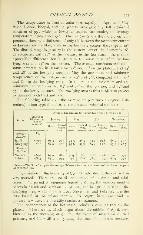
PTl \'SICA I. ASPKC rS
The temperature in Central India rises rapidly in April and May,
when Indore, Bhopal, and the plateau area generally fall within the
isotherm of 95°, while the low-lying sections are cooler, the average
temperature being about 90°. The plateau enjoys the more even tem-
perature, showing a difference of only 26° between the mean temperature
in January and in May, while in the low lying section the range is 32°.
The diurnal range in January in the eastern part of the Agency is 26°,
as compared with 29° in the plateau ; in the hot season there is no
appreciable difference, but in the rains the variation is 11° in the low-
lying area and 13° on the plateau. The average maximum and mini-
mum temperatures in January are 77° and 48° on the plateau, and 74"
and 48° in the low-lying area; in May the maximum and minimumtemperatures of the plateau rise to 103° and 76°, compared with 107°
and 81° in the low-lying tract. In the rains the maximum and the
minimum temperatures are 83° and 71° on the plateau, and 87" and
77° in the low-lying tract. The low-lying area is thus subject to greater
extremes of both heat and cold.
The following table gives the average temperature (in degrees Fah-
renheit) in four typical months at certain meteorological stations :
—

334 CENTRAL INDIA
A great fall in temperature occurs at sunset on the Malwa plateau, the
nights being usually calm and cool, even in the middle of the hot
season, while a gentle west wind occasionally blows. On the plateau,
moreover, the current continues to retain its pronounced westerly
direction ; the wind, at first dry, suddenly becoming moist, the climate,
at the same time, undergoing a rapid and marked change, and the
temperature falling 14 to 16 degrees. The Malwa portion of Central
India is supplied principally by the Bombay monsoon current, while
the eastern section of Rundelkhand and Baghelkhand shares in the
currents which enter by the Bay of Bengal.
The annual rainfall on the plateau averages about 30 inches, and in
the low-lying tract 45 inches. The low-lying tract gets much more
rain in June than the plateau, the rain there starting earlier and falling
more copiously throughout the season. The winter rains usually fall in
January or the beginning of February, and are very useful to the rabi
crop sowings. There is little doubt that the rainfall of the plateau area
has undergone a marked decrease. Sir John Malcolm's observations
(at Mhow) give an average of 50 inches, and general report points to
a diminution of at least 20 inches during the last sixty or seventy
years.
The following table gives the annual rainfall, month by month, at
certain meteorological stations :
—
Station.

HISTORY 335
they tell of a struggle between the dark-skinned aboriginal and the
light-eoloured Aryan, already assign the hilly \'indhyan region and
the Narbada valley to the non-Aryan Pulindas and Sabaras, showing
that these tribes had long since been driven out of the heart of the
country.
From the early Buddhist books it appears that in Buddha's lifetime
there were sixteen principal States in India, of which Avanti, with
Ujeni (Ujjain) as its capital, was one, while the eastern section of
Central India was comprised in the kingdoms of the Vatsas, of which
Kausambhi was the chief town, and of the Panchalas. Villages appear
in those days to have enjoyed a large share of autonomy under their
headmen, while class distinctions were not very strongly marked.
Buildings were mostly of wood, only forts and palaces being of stone.
There is no mention of roads, but certain great routes with their stages
are given. One of these ran from north to south, from SravastT in
Ko.sala to Paithan in the Deccan, passing through Ujjain and MahissatI
(now Mahkshwar), which are mentioned as halting stations.
With the establishment of the Maurya dynasty by Chandragupta
some light breaks in upon the history of Central India. Chandragupta
rapidly extended his empire over all Northern India, from the Hima-layas to the Narbada, and his grandson Asoka was sent to Ujjain as
viceroy of the western provinces. Chandragupta was succeeded by his
son Bindusara (297-272 B.C.), who was followed by Asoka. Someyears after his accession, Asoka, on becoming an ardent Buddhist,
caused the erection of the famous group of stnpas round Bhilsa of
which that at Sanchi is the best known, and also in all probability the
great siupa which formerly stood at Bharhut in Nagod. A fragment
of one of his edicts has been discovered on a pillar at SanchT.
On the death of Asoka (231 n. c), his em^jire rapidly broke up ; and,
according to the Puranas, Central India, except perhaps the most
western part of Malwa, fell to the Sungas, who ruled at Pataliputra
(now Patna). Agnimitra, the hero of the play Mdlavikagnimiira, was
viceroy of the western provinces, with his head-quarters at Vidisha
(now Bhilsa). On one of the gates from the stUpa at Bharhut is
an inscription stating that it was erected in the time of the Sungas.
Under the Sunga rule a revival of Brahmanism took place, and
Buddhism began to lose the paramount position it had acquired under
Asoka.
In the second century before the Christian era, the Sakas, a powerful
Central Asian tribe, appeared in the Punjab and gradually extended
their conquests southwards. One section of this horde entered Malwa,
and founded a line of Saka princes who are known as the Western
Kshatrapas or Satraps {^see Malwa). They soon became possessed of
considerable independence, and except for a tem[)orary check (a.d. 126)

336 CENTRAL INDIA
at the hands of the Andhra king of the Deccan, Vilivayakura TI
(Gautamiputra), ruled till about 390, when their empire was destroyed
by Chandra Gupta II.
The Guptas of Magadha rose to power in the beginning of the fourth
century. An inscription at Allahabad, of Samudra Gupta, second of
this line (326-75), enumerates his foes, feudatories, and allies. Amongthe feudatories were the nine kings of Aryavarta, one of whom, Ganapati
Naga, belonged to the Naga dynasty of Padmavati, now Narwar, where
his coins have been found. Among the unsubdued tribes on his frontiers
certain races of Central India are named : the Malavas, who were at
this time under Satrap rule ; the Abhiras, who lived in the region
between Gwalior and Jhansi, still called after them AhTrwara ; and the
Murundas, who seem to have lived in the Kaimur Hills in Baghel-
khand. He also took into his service the kings of the forest country,
apparently petty chiefs of Baghelkhand.
Chandra Gupta II (375-413), who succeeded Samudra, was the most
powerful king of the dynasty. Extending his conquests in all directions
he entered Malwa, as we learn from two inscriptions at Udayagiri near
Bhilsa, and destroyed the Kshatrapa power between 388 and 401,
probably about 390. About 480 the regular Gupta succession ends,
and the kingdom broke up, the Malwa territory being held by indepen-
dent Gupta princes. Of two of these, Budha Gupta and Bhanu Gupta,
we have records dated 484 and 510.
The most interesting episode of this period is the invasion of the
Gupta dominions in eastern Malwa by Toramana and his son Mihirakula.
These chiefs were AVhite Huns, a section of whom had overrun Eastern
Europe in a. d. 375, ancjther horde entering India a century later.
During the reign of Skanda Gupta (455-80) they were held more or less
in check ; but on his death their leader 'J\)ramana pressed south, and,
after seizing Gwalior and the districts round it, advanced into Malwa
and soon acquired possession of the eastern portion of that tract. Frominscriptions found at Gwamor, Eran, and Mandasor, it appears that
Toramana and his son Mihirakula held eastern M;ilwa for about forty
years, the local princes becoming their feudatories. Mihirakula, who
succeeded his father about 510, was defeated finally in 528 by a
combined attack of Nara Sinha Gupta IJaladitya of Magadha and
Vasodharman wlio ruled at Mandasor.
At the end of the sixth century I'rabhakara Vardhana, king of
Thanesar in the Punjab, had extended his conquests southwards ; and
his younger son Harshavardhana, who succeeded an elder brother in
606, rapidly acquired possession of all Northern India and fixed his
capital at Kanauj. After a reign of forty-two years he died, and his
empire at once went to pieces. An interesting account of JijhotT
(liuiulelkhand), Mahcswapura (now Maiiksiiwar) on the Narbada, and

HISTORY 337
Ujjain at this period has been given by Hiuen T-siang. The pilgrim,
who visited Kanauj in 642-3, notices the decline of Buddhism, which
had been steadily losing its position since the time of the Guptas.
During the fifth and sixth centuries a number of nomad tribes, the
Gurjaras, Malavas, Abhiras, and others, who were possibly descended
from the Central Asian invaders at the beginning of the Christian era,
began to form regularly constituted communities. During the first half
of the seventh century they were held in check by the strong hand of
Harshavardhana ; but on his death they became independent, and com-
menced those intertribal contests which made India such an easy prey
to the Muhammadan invaders of the tenth and eleventh centuries.
The Malavas and Abhiras were early settlers in Central India. Both
appear to have come from the north-west, and by about tlie fifth
century to have occupied the districts still called after them Malwaand Ahirwara, the country to the east of Malwa and west of the Betwa
river, including Jhansi, Sironj, and the tract stretching southwards to
the Narbada.
In the sixth century the powerful Kalachuri (Haihaya, or Chedi)
tribe seized the line of the Narbada valley, acquiring later most of
BuNDELKHAND and Baghei.khand.
From the eighth to the tenth century, by a gradual process of
evolution very imperfectly understood as yet, these tribes became Brah-
manized and adopted pedigrees which connected them with the Hindupantheon, probably developing finally into the Rajput clans as we knowthem to-day ; the Paramaras of Dhar, Tonwars of Gwalior, Kachwahas
of Narwar, Rathors of Kanauj, and Chandels of Kalinjar and Mahobaall becoming important historical factors about this time.
Recent researches appear to show that all Central India was in the
eighth century under the suzerainty of the Gurjaras, a tribe who had
settled in Rajputana and on the west coast in the tract called after them
Gujarat. They gradually extended their power till their chief Vatsa
ruled from Gujarat to Bengal. About 800 he was defeated and driven
into Marwar by the rising power of the Rashtrakuta clan. The Gurjaras,
however, as we learn from inscriptions at Gwalior and elsewhere, again
advanced and recovered their lost dominion as far east as Gwalior,
under Ramabhadra. His success(jr Bhoja I (not to be confounded with
the famous Paramara chief who lived two centuries later) recovered all
the lost territory and acquired fresh lands in the Punjab.
Two branches of the Gurjaras, who became known later as the
Parihar and Paramara Rajput clans, obtained at this time the possession
of Bundelkhand and Malwa respectively, holding them in fief under
their Gurjara overlord. After the death of Bhoja I (885), the Gurjara
power declined, owing to the rising power of the Chandels in Bundel-
khand, the Kalachuris along the Narbada, and the Rashtrakutas. Taking
VOL. IX. z

338 CENTRAL INDIA
advantage of their ditThcultics, the Paramara section in Malwa threw off
their allegiance (915) ; and Central India was then divided between the
Paramaras in Malwa, with Ujjain and Dhar as their capitals, the
Parihars in Gwalior, the Chandels in Bundelkhand, with capitals at
]\Iahoba and Kalinjar, and the Chedis or Kalachuris who lield much of
the present Rewah State. The history of this period is that of the
alliances and dissensions of these clans, which in Central India lasted
through the early days of the Muhammadan invasion, until they eventu-
ally came under the Moslem yoke in the thirteenth century.
When Mahmud of Ghazni commenced his raids, the Rajputs were the
rulers everywhere. Dhanga (950-99), the Chandel of Bundelkhand,
had already fought with Jaipal of Lahore against Sabuktagin at Lamghan
(988). In his fourth expedition Mahmud was opposed at Peshawar by
Anand Pal of Lahore and a confederate Hindu army ; and amongthose who fought round Anand Pal's standard were the Tonwar chief
of Gwalior, the Chandel prince, Ganda (999-1025), and the Paramara of
Malwa (either Bhoja or his father Sindhuraja). By the capture of
Kanauj in 1019, Mahmud opened the way into Hindustan, and in 1021
Gwalior fell to him. After Mahmud's death (1030), Central India was
not again visited by the Muhammadans till the end of the twelfth
century ; but from the time of his death until the appearance of Kutb-
ud-din the history of Central India is that of the incessant petty wars
which went on between the various Hindu clans. Paramara, Chandel,
Kalachuri, and Chalukya (of Gujarat) waged war against one another,
gaining temporary advantage each in turn, but exhausting their own re-
sources and smoothing the way for the advance of the Muhammadans.In 1193 Kutb-ud-din entered Central India and took Kalinjar for
Muhammad Cihori, and later (1196) Gwalior, of which place Shams-ud-
din Altamsh was appointed governor. In 1206 Kutb-ud-din became
king of Delhi, and for the first time a Muhammadan king ruled India
from within, and held in more or less subjection all the country up to
the Vindhyas. A period of confusion followed his death (12 10), during
which the Rajputs of Central India regained the greater part of their
possessions.
Altamsh finally succeeded to the Delhi throne (12JO-36), and in the
twenty-first year of his reign retook Gwalior from the Hindus after a
siege of eleven months (1232). He then proceeded to Bhilsa and
Ujjain, sacked the latter place and destroyed the famous temple of
Mahakal, sending its idol to Delhi (1235). He was followed by a
succession of weak kings, during whose reigns (1236-46) the Hinduchiefs were left much to themselvOs. In 1246 Nasir-ud din succeeded.
Like the others, he was a weak ruler ; but his reign is of im{jortance on
account of the energetic action of his minister lialban, wlio took Nar-
WAK in I 25 I, and, succeeding his master in 1266, kept the Hindu chiefs

nrSTORY 339
in subjection, and ruled with a lirm hand, so that it was said 'An
elephant avoided treading on an ant.'
On Balban's death the rule passed to the Khiljis under Jalal-ud-din,
who (1292) entered Malwa and took Ujjain, and after visiting and
admiring the temples and other buildings, burnt them to the ground,
and, in the words of the historian, thus 'made a hell of paradise.' About
this time Ala-ud-din, then governor of Bundelkhand, look Bhh.sa and
Mandu (1293).
In Muhammad bin Tughlak's reign (1325-51) a severe famine broke
out (1344) ; and the king resting at I )har on his way from the 1 )eccan
found that ' the posts were all gone off the roads, and distress and
anarchy reigned in all the country and towns along the route,' while the
anarchy was augmented by the dispatch of Aziz Hamir as governor of
Malwa, who by his tyrannous actions soon drove all the people into
rebellion. In the time of Firoz Shah (1351-88) the process of dis-
integration commenced, which was completed in the time of Tughlak
Shah II. The land was divided into provinces governed by petty rulers,
Malwa, Mandu, and Gwalior being held by separate chiefs.
The history of Central India now becomes largely that of Malwa.
The weak Saiyid dynasty, who held the Delhi throne from 1414 to
145 1, were powerless to reduce the numerous chiefs to order, and
Mahmud of Malwa even made an attempt to seize the Delhi throne
(1440), which was, however, frustrated by Bahlol Lodl. It is worth
while noting, in regard to this weakening of Musalman rule, how Hindu
and Muhammadan had by this time coalesced. A\'e fmd the Hindu
chiefs employing Muhammadan troops, and Mahmud of Malwa enlist-
ing Rajputs. Some sort of order was introduced under the Lodis
(1451-1526) ; but they had no great influence, except in the country
immediately round Delhi, though Narwar was taken by Jalal Khan,
Sikandar's general (1507), and Ibrahim Lodi captured the Badalgarh
outwork of Gwalior (1518).
The emperor Babar (1526-30) notes in his nicnioirs that Malwa was
then the fourth most important kingdom of Hindustan (being a part
of Gujarat under Bahadur Shah), though Rana Sanga of Udaipur had
seized many of the provinces that had formerly belonged to it. Babar's
forces took Gwalior (1526) and ChanderT (1527), and later he visited
Gwalior (1529), of which he has left an appreciative and accurate
account. Humayun defeated Bahadur Shah at Mandasor (1535), but
in 1540 was himself driven from India by Sher Shah.
Sher Shah, the founder of the Suri dynasty (1539-45) was a man of
unusual ability, and soon reduced the country to order. He obtained
possession of Gwalior, Mandu, Sarangpur, Bhilsa, and Raisen,
(1543-4), making Shujaat Khan, his principal noble, viceroy in Malwa.
Islam Shah, Sher Shah's successor, made Gwalior the capital instead
z 2

340 CENTRAL INDIA
of Delhi, and it continued to be the chief town during the brief reigns
of the remaining kings of this dynasty.
Humayun regained his throne in 1555, but died within the year, and
was succeeded by Akbar, who in 1558 entered Central India, and
taking Gwalior, proceeded against Baz Bahadur, son of Shujaat Khan,
then holding most of Mahva, and finally drove him out in 1562.
Ujjain, Sarangpur, and Sipri were soon in Akbar's hands, thus com-
pleting his hold on Malwa, while in 1570 Kalinjar was surrendered by
the Rewah chief, and all Central India thus came under his sway. In
1602 Bir Singh Deo of Orchha, in Bundelkhand, murdered Abul
Fazl at the instigation of prince Salim (Jahangir), and in revenge
Orchha was taken.
In Shah Jahan's reign, Jhujhar Singh, the Raja of Orchha, rebelled
and was driven from his State (1635), which formed part of the empire
till 1641.
In 1658, during the struggle for the throne, Aurangzeb and Murad
defeated Jaswant Singh at Dharmatpur, now Fatehabad, near Ujjain,
and thus opened the road to Agra. During this period the Marathas,
who had already begun to desert the plough for the sword in the time
of Jahangir, first crossed the Narbada (1690), and plundered the
Dharampurl district (now in Dhar), while in 1702-3 Tara Bai sent
expeditions to plunder as far as Sironj, Mandasor, and the Subah of
Malwa and the environs of Ujjain.
Though the Marathas had entered Malwa as early as 1690, it was
not till the reign of Muhammad Shah (1719-48) that they obtained
a regular footing in this part of India. So rapidly did their power
increase under the tacit, if not active, support of the Hindu chiefs, that
in 1 71 7 Maratha officers were collecting chauih under the very eyes
of the imperial suhahddrs. In 1723 the Nizam, at this time governor of
Malwa, retired to the Deccan ; and the Peshwa Baji Rao, who had
determined to destroy the Mughal power, at once strengthened his
position across the Narbada by sending his generals (1724), notably
Holkar, Sindhia, and the Ponwilr, to levy dues in Malwa. In 1729
the oi)pressivc action (jf Muhammad Khan Bangash in Bundelkhand
induced Chhatarsal of Panna to call in the aid of the Peshwa, who thus
obtained a footing in eastern Central India. The l^eshwii's power was
finally ctjiifirmed in Malwa in 1743, when he obtained, through the
influence of Jai Singh of Jaipur, the formal grant of the deputy-governor
shij) of Malwa. In 1745, at the time of RanojT Sindhia's death, the
whole of Malwa, estimated to produce 150 lakhs of revenue, was, with
small exceptions, divided between Holkar and Sindhia. Lands yield-
ing ro lakhs were held by various minor chiefs, of whom Anand RaoI'onwar (Dhar) was the most considerable. From this time Central
India remained a |)rovince of the Peshwa until the fatal battle of
inSTONY 341
Panlpat in 1761 broke the jjower of ihe Maratha confederacy, and
Central India was divided between the great Maratha generals. Three
years later the battle of Buxar made the Mughal emperor a pensioner
of the East India ('om[)any ; and though they had a severe struggle
with the great Central India chiefs, Holkar and Sindhia, the liritish
henceforth became the paramount power in India.
Comparatively speaking, Central India was at peace from 1770 to
1800. The territories of Holkar were, during most of this period,
under Ahalya Bai (1767-95), whose just and able rule is proverbial
throughout India, while till 1794 the possessions of Sindhia were con-
trolled by the strong hand of Mahadji. The great influence of Tukoji
Holkar (1795-7), who succeeded Ahalya Bai, restrained young Daulat
Rao Sindhia and kept things quiet, till on TukojI's death (1797) the
keystone was removed and the structure collapsed. Central India was
soon plunged into strife, and all the advantages which the land had
derived from forty years of comparative peace were lost in a few
months.
Troubles in Bombay had necessitated proceedings against Mahadji
Sindhia, who was intimately concerned with them ; and Gwalior was
taken by Major Popham (1780), and Ujjain threatened by Major Camac,
which caused Sindhia to agree to terms (October, 1781). The next
year, Sindhia's independence of the Peshwa was recognized in tlie
Treaty of Salbai (1782), and he at once commenced operations in
Hindustan. Mahadji Sindhia died in 1794, and his successor, Daulat
Rao, had by 1798 become all-powerful in Central India, when the
appearance at this moment of Jaswant Rao Holkar, with the avowed
intention of reviving the fallen fortunes of his house, soon plunged the
country into turmoil. Now commenced that ])eriod of unrest, still
known to the inhabitants of Central India as the 'Gardi-ka-wakt,' which
reduced the country to the last state of misery and distress. A clear
proof of the anarchy which prevailed in Central India at this time is
given by the ease with which Jaswant Ra(j Holkar was able in the
short space of two years to collect a body of 70,000 men— Pindaris,
Pathans, Marathas, and Bhils—who were tempted to join his standard
solely by the hope of plunder, and with whose assistance he proceeded
to devastate the country. The capture of Indore (1801) and wholesale
massacre of its inhabitants by Sarje Rao Ghatke, the father-in-law of
Sindhia, was no check on Holkar, whose victory at Poona (1802) sent
him back with renewed energy to ravage Malwa.
The non-interference system pursued by Cornwallis, followed by
Barlow's policy of ' disgrace without compensation, treaties without
security, and peace without tranquillity,' allowed matters to pass from
bad to worse. To the hordes which plundered under Amir Khan and
Jaswant Rao Holkar were added the bodies of irregular horse from

342 CENTRAL INDIA
British service which had been indiscriminately disbanded at the end of
Lord Lake's campaign. In 1807 Bundelkhand was in a state of fer-
ment. Parties of marauders scoured the country, and numerous chiefs,
secure in their lofty hill forts, defied the British authority. As soon,
however, as they saw that the policy had changed and that the British
intended to interfere effectively, most of them surrendered, hut the
chiefs of Kalinjar and Ajaigarh only submitted after their forts had
been taken by assault. In 1812 the Pindaris began to increase to an
alarming extent ; and supported by Sindhia and Holkar and aided by
Amir Khan, their bands swept Central India from end to end, passing
to and fro between Malwa and Bundelkhand, and even crossing the
border into British India.
At this juncture. Lord Hastings was appointed Governor-General.
Ten years of practically unchecked licence had enormously increased
the numbers of the marauders. About 50,000 banditti were now loose
in Central India, and the confusion they produced was augmented
by the destructive expedients adopted by Holkar, who sent out
subahdars tf) collect revenue, accompanied by large military detach-
ments, which were obliged to live on the country, while at the same
time extorting funds for the Darbar. By 181 7 the disorganization had
reached a climax. At last Lord Hastings received permission to act.
Rapidly forming alliances with all the native chiefs who would accept
his advances, he ordered out the three Presidency armies, which
gradually closed in on Central India. Sindhia, who had originally
promised his aid, now showed signs of wavering, but a rapid march on
Gwalior caused him to come to terms, while Amir Khan at once sub-
mitted, and dismissed his Afghan followers. The army of Holkar,
after murdering the Rani, marched out to oppose the British, but was
defeated at Mehidpur (181 7). The Pindari leaders, Karim, Wasil
Muhammad, and Chltii, were either forced to surrender or hunted
down, and the reign of terror was over.
These military and political operations were remarkal)le alike for
the rapidity with which they were executed and for the completeness
of their result. In the middle of October, 181 7, the Marathas, Pin-
daris, and I'athans presented an array of more than 150,000 horse and
foot and 500 cannon. In the course of four months this formidable
armament was utterly broken up. The effect on the native mind was
tremendous, and a feeling of substantial security was diffused through
Central India. So sound, moreover, was the settlement effected, under
the superintendence of Sir John Malcolm, that it has required but few
inodificati<ms since that time.
'I'lie next few years were spent in settling the country and repopu-
lating villages. One of the principal means of achieving this was by
granting a guarantee to small landliolders thai their holdings would be

/rISTOin' 343
assured to them, on the underslunding that tliey assisted in pacifying
the districts in which they lived. This guarantee, which secured the
small Thakurs from absorption by the great Darbars, acted like magic
in assisting to [)roduce order. In 1830 operations were commencedagainst the 'I'hags, whose murderous trade had been greatly assisted
by the late disorder, but who, under Colonel Sleeman's energetic action,
were soon suppressed.
Affliirs in the State of Clwalior now became critical. 1 )aulat RaoSindhia had died cliildless in 1827, and two successive adoptions of
young children followed. Disputes arose between the regent and the
Rani. The army sided with the Rani, and the state of affairs became
so serious that the British Government was obliged to send an armed
force. Fights took place on the same day at Mahar.^jpur and
Panniar (December 29, 1843), in which the Gwalior army was destroyed.
The administration of the State was reorganized and placed under
a Political officer, whose authority was supported by a contingent force
of 10,000 men.
The various sections which now compose the Central India Agency
were at first in charge of separate Political officers. Residents at Indore
and Gwalior dealt direct with the Government of India, and Bundel-
khand and Baghelkhand were independent charges. In 1854 it was
decided to combine these different charges under the central control
of an Agent to the Governor-General. The Bundelkhand and Baghel-
khand districts were added to Malwa, and the whole Agency so formed
was placed under Sir R. Hamilton, at that time Resident at Indore,
as Agent to the (jovernor-General for Central India.
The first serious outburst during the Mutiny in Central India took
place on June 14, 1857, among the troops of the Gwalior Contingent
at MoRAR, whose loyalty had been doubted when the first signs of
trouble appeared. Sindhia was still only a youth, but luckily there
were present at his side two trusty councillors, Major Charters
Macpherson, the Resident, and Dinkar Rao, the minister. Major
Macpherson, before he was forced to leave Gwalior, managed to impress
on Sindhia the fact that, however bad things might appear, the British
would win in the end, and that it was above all necessary for him to do
his best to prevent the mutinous troops of the (^ontingent leaving
Gwalior territ(jry, and joining the disaffected in British India.
On June 30 the Indore State troops sent to guard the Residency
mutinied, and Colonel Durand, Officiating Agent to the Governor-
General, was obliged to retire to Sehore and finally to Hoshangabad.
Outbreaks also took place at NTmach (June 3), Nowgong (June 10),
Mhow (July 8), and Nagod (September).
In October, 1857, the Central India campaign commenced with the
capture of Dhar (October 22). In December Sir Hugh Rose took
344 CENTRAL INDIA
command, and ousting the pretender Firoz Shah, who had set up his
standard at Mandasor, took the forts of Chanderi, Jhansi (March,
1858), and GwALioR (June). The two moving spirits of the rebellion
in Central India were the ex-Rani of Jhansi, Lachmi Bai, and Tantia
Topi, the Nana Sahib's agent. The Ram was killed fighting at the
head of her own troops in the attack on Gwalior, and Tantia Topi
after a year of wandering was betrayed by the Raja of Paron and
executed (April, 1859). The rising thus came to an end, though small
columns were required to operate for a time in certain districts.
After the excitement of 1857-9 had died away, the country soon
returned to its normal condition, and the history of Central India from
this time onwards is a record of steady general improvement. Com-
munications have been improved by the construction of telegraphs,
high roads, and railways, and by the development of a postal system,
while trade has been facilitated by the abolition of transit dues. Closer
supervision has led to great reforms in the systems of administration
in the various States, which were everywhere crude and unsatisfactory.
A regular procedure has been laid down for the settlement of boundary
disputes, and education has been fostered. Still, the course of progress
has not been uninterrupted. Severe famines, and more lately plague,
have ravaged the country from time to time, and cases have occurred
where mismanagement and even actual crime have led to the removal
of chiefs.
The archaeological remains in the Agency are considerable, including
old sites, buildings of historical and architectural importance, ancient
coins, and epigraphic records. Little is really known as yet about
most of the places, which require more systematic investigation,
especially ancient sites, such as those of Old Ujjain and Beshnagar.
Many of the old Hindu towns have since been occupied by Muham-madans, as for instance Dhar, Mandasor, Narwar, and Sarangpur,
and are consequently no longer available for thorough research, though,
as at Dhar and Ujjain, chance sometimes brings to light an old Hindu
record which has been used in constructing a Muhammadan building.
The principal places at which remains and buildings of interest exist
are Ajakjakh, Amarkantak, Bagh, Baro, Barwani, Bhojpur,
C'handkrI, Datia, Dfiamnar, Gwalior, Gvaraspur, Khajraho,
Mandu, Nagod, Naroi), Narwar, Orchha, Pathari, Rkwah,SanchI, Sonagir, Udavagiri, Udavapur, and Ujjain.
Ancient coins have been found in many of the old sites, ranging
from the early punch-marked series to those of the local chiefs and
the Mughals. The ejiigraphic records found are also numerous. Theearliest with dates are those inscribed on the railings and gates of
the stupas at Sanchl and Bharhut, belonging to the first years of the
Christian era. Next in chronological (jrder follow the Gupta inscrip-

HTSTORV 345
tions, of which the earliest is dated in the year 82 of the Gupta era
(a.d. 401), the latest on some copperplates from Ratlam of the year
320 (a.d. 640). A record from Mandasor, dated in the year 493 of
the Malwa rulers (corresponding to a.d. 436), is important, as in con-
junction with other similar records it has been instrumental in proving
the identity of the era of the lords of Malwa with the \'ikran)a Sannat
of the present day.
The various records, both inscriptions on stone and copper-plate
land grants, have afforded much information regarding the history of
the dynasties which from time to time ruled in ('entral India, notably
the Guptas of Magadha of the fourth to the sixth century, the Rajput
chiefs—the Paramaras of Malwa, the Chandels of Bundelkhand, the
Kalachuris of Baghelkhand—the rulers of Kanauj of the ninth to the
fifteenth century, and the subsequent Muhammadan rulers.
Central India is unusually rich in architectural monuments, especially
of Hindu work, which afford probably as complete a series of examples
of styles from the third century h. c. to the present day as can be seen
in any one province in India. In Muhammadan buildings the Agencyis less rich.
The earliest constructions in Central India date from the third
century h.c. and are Buddhist. They include stupas or monumentaltumuli, often containing relics of famous teachers of that faith, chaitya
halls or churches, and vihdras or monasteries. A considerable numberof stupas are still standing in Central India, many being grouped round
Bhii.sa, and the finest of the series being the Sanchi Tope. This and
another, which formerly stood at Bharhut in Nagou, were erected in
the third century B.C. Of the chaitya hall numerous rock-cut examples
exist, but none is of great age. The oldest chaitya hall in Central India
is represented by the remains standing to the south of the Sanchi Tope,
which are of special interest as constituting the only structural building
of its kind known in all India. The rock-cut examples which date
from about the sixth to the twelfth century exemplify the transitions
through which this class of building passed, those at B.\gh and
Dhamnar being about two centuries older than those at Kholvi, a place
situated close to Dhamnar, but just outside the Central India Agencyin the State of Jhalawar. Tlie vihani or monastery is also met with
at these places, being in some cases attached to a chaitya hall, forming
a combined monastery and church. I'robably monolithic pillars
formerly stood beside most of these three classes of building ; the
remains of one bearing an edict of Asoka were found at Sanchi.
The buildings which follow these chronologically have been not very
happily named Gupta, as the name has obscured their connexion with
those just dealt with. They are represented by botli rock cut and
structural examples, the former existing at Udavagiri, and at Mara

346 CENTRAL INDIA
in Rewah. In two of the caves at the first place inscriptions of
A.D. 401 and 425 have been found, but many of the caves may well be
older. The structural temples of this class are numerous, those at
Sanchi, Nachna in Ajaigarh, Paroli in Gwalior, and Pataini Devi in
Nagod being good examples, while many remains of similar buildings
lie scattered throughout the Agency.
Though many buildings of the so-called Jain style have disappeared,
the Gyaraspur temples, the earliest buildings at Khajraho, the
later temples at the same place, and the Udavapur temple give a
sufficiently consecutive chain leading up to the modern building of
the present day with its perpendicular spire and square body.
Numerous examples of this mediaeval style (of the eighth to the
fifteenth century) lie scattered throughout Central India in various
stages of preservation, those at Ajaigarh, Baro, Bhojpur, and
Gwalior being important. The later developments of the sixteenth
century are to be seen at Orchha, Sonagir, and Datia, and of the
seventeenth century to the present day in almost any large town. The
modern temple as a rule has little to recommend it. The exterior
is plain and lacks the light and shade produced by the broken surface
of the older temples, and the general effect is marred by the almost
perpendicular spire, the ugly square body often pierced by foliated
Saracenic arches and surmounted by a bulbous ribbed Muhammadandome ; while all the builder's ingenuity appears to be lavished on
marble floors, tinted glass windows, and highly coloured frescoes.
'I'emples of this class abound, those at Maksi in Gwalior and several
in Indore city affording good examples of the modern building. The
chhatri of the late Maharaja .Sindhia at Gwalior is perhaps as good
an example of modern work as any.
Muhammadan religious architecture is not so well represented in
Central India. 'I'he earliest building of which the date is certain is the
mosque near Sehore, built by a relative of Muhammad bin Tughlak in
1332. The most important buildings are those at Dhar and Mandu,
where numerous mosques, tombs, and palaces were erected by the
Malwa kings between 1401 and 1531. These are in the Fathan style,
distinguished by the ogee pointed arch, built with horizontal layers of
stone and not in radiating courses, which shows tiiat they are Muham-madan designs executed by Hindu workmen. These buildings are
ordinarily plain ; and the pillars, when not taken directly from a Hindu
or Jain edifice, are simple and massive, the Jama Masjid at Mandubeing a magnificent example of this style. Scattered throughout Central
India are numerous small tombs in the Pathan style, to be seen in
almost any jilace which Muhammadans have occupied.
Of Mughal work the best example is the tomb of Muhammad Ghaus
in Gwalior, which is a very fine building in llie early Mughal style of

rnSTORY 347
Akbar and Jahanglr, with the low donn' on an octagonal base, and a
vaulted roof ornamented with glazed tiles.
Of modern Muhammadan work the only example of any size is the
new Taj-ul-Masajid at Bhopal, not yet completed. The plan is that
of the great mosque at Delhi, tliough, owing to the weakness of the
foundations, the flanking domes have been omitted. The general
effect is fine ; l)ut the carving is poor, being too slight for the general
design, and the pillars, which are massive, would have been better
without it. All the modern buildings have the heavily capped and
ribbed dome common to the later Mughal style. Muhammadan build-
ings also exist at SAR.\Nf;puK, U.ijain, ("iWamor, C'iOfiad, Narwar,and ChandkrI. Muhammadan domestic architecture is not repre-
sented by any important edifices, except the palaces at Mandu and
the water palace at Kaliadeh near Ujjain.
Of the domestic architecture of the Hindus there are few examples
of note. The finest building of this class is the fifteenth-century palace
of Raja Man Singh at Gwalior, its grand fac^^ade being one of the most
striking features of the old fort, while at Orchha and Datia there are
two majestic piles, erected by Raja Bir Singh Deo of Orchha in the
seventeenth century.
There is little modern work that merits much attention. In most
cases, such as the palaces erected by chiefs of late years, either small
attention has been paid to the design, or else the Hindu, Muham-madan, and European styles have been mingled, so as to produce a
sense of incongruity and unfitness, as in the moscjue-like palace at
Ujjain. The most noteworthy building of this class is the Jai Hilas
palace at Gwalior, which is designed on the model of an Italian palazzo,
but is marred by the unfortunate use of Oriental ornamental designs;
the college and hospital at the same place are more successful. Theordinary dwelling-houses of the well-to-do have few pretensions to style,
though a marked improvement is noticeable in the increased number
of windows introduced. Of European buildings, the Residency House
at Indore and the Daly (College are the only structures of any size,
but architecturally they have nothing to recommend them. The most
picturesque buildings are the churches at Sehore and A(;au.
Throughout Central India there are a large number oi ghats (bathing-
stairs) and dams, some of considerable age and great size. Thecolossal dams at Bhojpur are the finest, but many others exist, as
at Ujjain, Maheshwar, and Charkh.\ri. Bundelkhand is especi-
ally rich in them. ICxamination shows that they were built to form
tanks, not for irrigation, but as adjuncts to temples, palaces, or
favourite resorts. Their employment for irrigation is invariably a later
development.
'I"he population of Central India at the three regular enumerations
348 CENTRAL INDIA
was: (1881) 9,261,907, (1891) 10,318,812, (1901) 8,628,781 \ The
average density (log persons per square mile) varies markedly in the
. different natural divisions. In the low-lying tract,
forming the eastern part of the Agency, the density
is 172 per square mile, in the plateau 102, and in the hilly tracts
only 74.
The Agency contains 63 towns with 5,000 or more inhabitants,
besides 1 7 of which the population through famine and other causes
had fallen below that figure since 1891. Of the towns, 49 are situated
on the western side of the Agency, and only 14 in Bundelkhand and
Baghelkhand. The largest city is Lashkar, the modern capital of
Gwalior, with a population of 89,154; Indore (86,686) and Bhopal
(77,023) come next in importance. Of the 33,282 villages, 30,058
have a population of less than 500, the average village containing
only 230 persons. The size of the village is greater in the low-lying
tract, where the average rises to 313. The village in Central India,
when of fair size, consists as a rule of a cluster of small habitations
surrounding a large building, the home of the Thakur who holds
the land.
The population fell by 16 per cent, during the last decade, owing
mainly to the two severe famines of 1896-7 and 1899-1900. Thedecrease took place, however, only in the rural population, the urban
population rising by 18 per cent., due chiefly to the opening of new
railways and consequent increase of commerce.
(Central India gains little from immigration. Of the total population
enumerated in 1 901, 92 per cent, were born within the Agency. This
fact is supported by the language figures, which show 93 per cent,
speaking local dialects. Such immigration as takes place comes chiefly
from the United Provinces, and flows into Bundelkhand and Baghel-
khand, amounting to 47 per cent, of the total immigration, Rajputana
supplying 26 per cent. On the whole. Central India gained about
90,000 persons as the net result of immigration and emigration.
Internally there is very little movement.
The age statistics show that the Jains, who are the richest and best-
nourished conniiunity, live the longest, while the Animists and Hindus
show the greatest fecundity. The age at marriage varies with locality,
the same sections of the community in different parts marrying their
children at somewhat varying periods. Most males under five years of
age are married in the low-lying tract, while the statistics show that
child-marriage is becoming popular among the Bhils and allied tribes.
No vital statistics are recorded in Central India, but from the
census figures it is apparent that infant mortality increased in the period
' This figure incUidcs the population of parts of Kajputaiia, hut cxchulcs that of
portions of Central India States in other Aj^encies, &c., see p. 3^2.

POPULA TION 349
1895-9, which involved two famines and several bad agricultural years.
Plague has also very materially affected the population.
Except for an occasional local outbreak of cholera and small-pox,
Central India was free from serious epidemics till 1902, when plague
appeared. The first case (except for an isolated instance in 1897) was
reported in 1903 from the village of Kasrawad in the Nimar district of
Indore State, and the e[)idemic spread thence to Ratlam, and finally to
Indore city, the Residency area, and Mhow cantonment. The registra-
tion of deaths from this cause was very incomplete, but an idea of its
virulence may be gained from the figures for these places. In Indore
city the deaths recorded in three months during 1904 were 10 per cent,
of the population ; in the Residency area the total number of deaths in
1903 was 966, or 9 per cent. ; in Mhow, 5,136, or 14 per cent. Other
places of importance which have suffered from plague are Lashkar,
Jaora, Bhopal, Sehore, Dewas, Nimach, Mandasor, Shajapur, and
Agar. In the districts the attacks were less violent, as a rule, though
here and there individual villages were very severely visited. Theactual loss of life, added to the emigration consequent on fear ot
infection, has seriously affected agricultural conditions in Malwa by
reducing the population. Inoculation was at first looked on with
the greatest suspicion, but ultimately a large number of persons were
treated.
Female infanticide in Central India was first reported on by Mr.
Wilkinson in 1835. He found that not less than 20,000 female infants
were yearly made away with in Mahva alone. No attempt at concealing
the practice was made, and a careful examination showed that 34 per
cent, of girls born were killed. In 1881 attention was called to the
prevalence of this custom in Rewah, and special measures were taken
to cope with it. The census figures of 1901, however, give no proof
that the custom is now a general one.
The total number of persons affected by infirmities in Central India
in 1901 was 3,180 males and 2,272 females. This included 5 males and
2 females insane, 19 male and 13 female deaf-mutes, 41 males and
35 females blind, 6 male and 4 female lejjers, in every 100,000 of the
population. Insanity is more prevalent in the plateau and low-lying
tracts than in the hills, a fact possibly due to the inhabitants of the
jungle tracts being but little addicted to the use of opium.
Central India in 1901 contained 4,428,790 males and 4,199,991
females. The ratio of women to 1,000 men was 896 in 18S1, 912 in
1891, and 948 in 1901, being 950 in towns and 920 in villages. Of the
natural divisions, the hilly tracts have the most females, about 9,900 to
every 10,000 males, while the plateau and low-lying divisions have
about 9,400 and 9,300 respectively. The hilly tracts thus contain
between 5 and 6 per cent, more women than the other two tracts. The
35° CENTRAL INDIA
figures fur the different political charges vary : Baghelkhand alone
shows an excess of females.
Marriage and cohabitation are not simultaneous, except among the
animistic tribes of the hilly tracts. Out of the total population in 1901,
2,080,562 males and 2,066,717 females were married, giving a proportion
of 9,933 wives to 10,000 husbands. In a country where marriage is
considered obligatory it is interesting to note that 44 per cent, of the
males of all ages and 31 per cent, of the females are unmarried. In the
widowed state a large difference is noticeable between males and females,
the prohibition to remarry raising the figure for females to 20 per
cent., that for males being 9 per cent. Most men between 20 and 30
are married. No great rise takes place in the number of married till
after fifteen years of age, the difference between the 15-20 and 20-40
periods being about 2,700 persons per 10,000. Girls marry earlier.
The female figures are about double those of the male in each age-period
until the ages 20 to 40 are reached, when the figures become more
equal. The relative ages of girl-marriage in the several natural divisions
are : on the plateau, Hindus 1 2 years and 4 months, Musalmans
13 years and 6 months, and Jains 12 years and 6 months; in the low-
lying tract, Hindus and Musalmans 12 years, and Jains 11 years; in the
hilly tracts, Hindus 12 years and 6 months, and Animists 14 years.
Pcjlygamy is comparatively rare and polyandry is unknown in the
Agency. Divorce is current among both Hindus and Muhannnadans,
according to their respective customs, while widow remarriage prevails
among Muhannnadans generally, and also among the inferior classes of
Hindus, such as Gwalas, Ahirs, (lujars, and Koris, and among the
jungle tribes. Widow remarriage is more common in the low-lying
tract than on the plateau. The statistics of civil condition in 1901 are
shown below :
—

POPULATION 351
to the fastnesses of the Vindliya range. As is usual in such cases, the
mother tongue has l)een lost, and only a small number of Gonds in the
hills south of Hhopal still show traces of 1 )ravidian forms in their speech.
Most of the tribes speak a jjatois founded on the vernacular prevailing
in their district, such as Malwi or Baghcli. 'Hie JJluls also, who are
probably of Munda stock, have so effectually lost their ancient speech
that only a small residuum of words remains, amounting to about 6 per
cent., which cannot be identified as Aryan. Their present dialect is
a bastard tongue compounded of GujaratI and MahvT.
Most of the dialects spoken in Central India belong to Western
Hindi, which includes (besides Bundell) the everyday language of the
educated resident Hindus, and also the more Persianized Urdu chiefly
used by the employes in Government offices and the ruling class in
Muhammadan States. Bundell is spoken, as its name implies, by the
peasantry of Bundelkhand. About 29 per cent, of the population speak
unspecified dialects of Western Hindi, of whom 50 per cent, reside in
Malwa.
Two of the Rajasthani dialects, Malwi (with its derivatives Rangri
and NimarT) and Marwari, are spoken in Central India by large
numbers of the people. The Malwi dialect is spoken in the country of
which Indore is the centre. It extends eastwards to the borders of
Bhopal, where it meets Bundeli, while westwards it crosses into Udaipur
in Rajpulana, touching on the south the Bhil and Gond dialects, and on
the north the Braj Bhasha of Muttra, which is spoken round Gwalior.
The Rangri dialect is a form of Malwi largely mixed with Marwari
words. The Nimari dialect, which is met with in Nimar, is a mixture
of Bhili, KhandeshI, and other tongues, with Malwi as a basis. Marwari,
the most important of the Rajasthani tongues, is brought into Central
India principally by the merchant community, most of whom come from
\\'estern Rajputana. It is the only dialect of this language with a litera-
ture, being largely employed in the Rajput bardic chronicles. TheRajasthani dialects are spoken by 20 per cent, of the total population,
and by 66 per cent, of the people of Malwa.
Special interest attaches to Eastern Hindi, as an early t'orm of it was
employed by Mahavira (500 B.C.), the Jain teacher, in expounding the
tenets of his religion, whence it became later the language of the canoni-
cal books of the Digambara Jains. Of its three dialects, Awadhi and
Bagheli are met with in Central India, the latter being locally of more
importance as the chief dialect of Baghelkhand. There is a considerable
literature in Bagheli, which has always been fostered by the chiefs of
Rewah, though the numerous works produced are not creative in
character, but rather the writings of scholars and critics about poets,
than of actual poets. The dialects of this language are met with only in
Baghelkhand, where 99 per cent, of the population employ them.

352 CENTRAL INDIA
The chief forms of speech used by the majority of the people are
shown below :
—
Western Hindi
POPULATION 353
niunity are the Marsvaris of Rajputana, who maintain connexion with
their original home too closely to be reckoned as local groups, even
after long residence. Under the head of Bania 240,807 persons were
returned, among whom were 41,637 Agarwals, chiefly in Gwalior,
Bundelkhand, and Malwa, and 19,935 Mahesris in Malwa.
Tlic type of the agricultural population differs in the eastern and
western sections. The peasants of Bundelkhand are of shorter stature
and sturdier build and darker colour than those of Malwa. The chief
classes in Bundelkhand and Baghelkhand (including in this term the
country round and to the east of Gwalior city) are Ahirs (326,157),
Gadarias (149,230), Kachhis (353,095), and Lodhis (219,637) ; while
in Malwa the Gujars (167,179), Malis (73,918), and Kunbis (56,458)
predominate.
Classified by religion, the inhabitants of Central India are chiefly
Hindus, Animists, Muhammadans, or Jains, of whom the first two are
the most numerous. According to the Census of 1901, 81 per cent, were
Hindus, 1 1 per cent. Animists, 6 per cent. Muhammadans, and 1 per
cent. Jains. Other religions numbered 11,144, of whom 8,114 were
Christians, including 3,715 natives, chiefly the famine waifs supported
by Christian missions ; Sikhs numbered 2,004, almost all soldiers in
British regiments; Parsis 1,002, and Jews 24, both mainly residents of
British cantonments and stations.
The term Hindu includes every shade of this religion from the
orthodox Brahman to the lowest castes, whose religion is three parts
animistic. Hindus as a rule profess special devotion to Vishnu or Siva,
the two chief persons of the Hindu triad, or to a Sakti or female
counterpart (usually of Siva). The numbers professing these forms of
worship were Vaishnavas (worshipping Vishnu), 1,883,618 ; Smartas
(worshipping the triad), 1,069,137 ; Saktas (worshipping Devi, the female
counterpart of Siva), 759,297; and Saivas (worshipping Siva), 737,229.
The Animists (992,458), all members of jungle tribes such as the
Bhils, worship certain sjjirits supposed to inhabit some inanimate
object, as a tree, spring, or stone. Many Animists gave the name of
the local deity as that of the sect, such as Babadeo (187,413), or
Barabij (96,518).
Among Muhanuiiadans the Siumis (449,885) predominate con-
siderably over the Shiahs (50,357).
In the eleventh and twelfth centuries the Jain religion was the chief
form of worship of tlie highest classes in Central India, and the
remains of temples and images belonging to this sect are met with all
over the Agency. There are still old temples at Khajraho and Sonagir,
in Bundelkhand, and several places of pilgrimage, such as Bawangaza
in Barwani. The Digambaras (54,605) and Swetambaras (35,475) are
the most prominent sects among them.
VOL. IX. A a

354 CENTRAL INDIA
Of the local forms of belief, the Dhami, Hardol Lala, and Baba
Kapur sects are peculiar. The first two belong to Bundelkhand, and
the last to Gwalior. The founder of the DhamI sect was one Prannath,
a native of Sind, who migrated to Panna in the eighteenth century,
and, settling there, commenced to preach his doctrines, which, like
those of Kabir, sought to reconcile the Hindu and Muhammadan reli-
gions. His followers are very numerous in Panna, but often returned
themselves at the Census of 1901 as Vaishnava, and the number
actually recorded (576) is thus far below the truth. Hardol was a
brother of Raja Jhujhar Singh (1626-35) of Orchha, who suspected him,
without cause, of criminal intimacy with his wife, and made him drink
a cup of poison. His unhappy end roused public indignation, and
he was in time deified. This form of worship is universal throughout
Bundelkhand and has even spread to the Punjab. It was professed
by about 11,000 persons in 1901. The followers of Baba Kapur (125)
are confined to Gwalior district. Kapur was a Muhammadan fakir
who lived at the foot of the Gwalior Fort, and acquired a wide
reputation for sanctity. He died in 157 1.
The Census of 1901 shows a large increase in the number of
Christians, 2,000 more being recorded than in 1891, when they were
1,000 in advance of the figures for 1881. Indore and Malwa, where
the principal mission work is carried on, show the largest number
of Christians. The total number of native Christians is, however, still
very small, only amounting to 3,715 in 1901. Success has chiefly been
met with among the aboriginal tribes and lower castes. The following
missions have branches in Central India : the Canadian Presbyterian
Mission; the St. John's Mission at Mhow ; the Friends Mission at
Sehore ; the Society of Friends of Ohio at Nowgong ; the Hansley
Bird Mission at Nhnach ; Pandita Rama Bai's Mission at Nimach ;
and Roman Catholic missions in several places. The most im|)ortant
of all is the Canadian Presbyterian Mission, with its head-quarters at
Indore and a number of out-stations. There is no doubt that the
famine greatly assisted their work, a fact recognized in the reports. Agreat deal of work is done by the medical officers of this mission.
Statistics of the population belonging tt) the chief religions in 1891
and 1901 are given below :—
POPULATION 355
depending on agriculture. As a rule, however, they consider it
derogatory to their caste, especially in the eastern section of the
Agency, to put their own hands to the i)lough, employing servants to
carry out this part of the work.
According to the Census of 1901, actual w(jrkcrs nunibercd
3,027,026 males and 1,637,291 females, while dependents of both
sexes numbered 3,964,464. Of these, 1,514,399 males and 836,190
females supported themselves by agricultural or pastoral occupations,
having 2,175,175 dependent on them. They form 52 per cent, of the
total population. Of those supported by agriculture, the great majority
were actual cultivators, while 925,851 were agricultural labourers, of
whom 35 per cent, were regular farm servants. Personal and domestic
service supported 482,273 persons, and 1,475,561 were engaged in the
l)reparation and supply of material substances. Of these, 269,039
supplied vegetable food and 72,459 were engaged in providing drink,
condiments, and stimulants, of whom 22,049 were wine and spirit-
sellers. The number of persons occupied in sup[)lying firewood and
forage was 98,913, of whom 52,685 sold grass, and 40,955 sold fire-
wood and charcoal. Of 304,299 persons engaged in occupations con-
nected with textile fabrics and dress, 207,307 followed cotton-cleaning,
pressing, ginning, weaving (hand industry), spinning, and other pro-
cesses, and 78,018 persons were engaged in the preparation of dress, of
whom 48,849 were tailors. \Vorkers in metals and precious stones
numbered 105,671, of whom 40,497 worked in gold and precious
stones and 51,358 in iron and hardware. Workers in earthen- and
stoneware numbered 81,769. The number of persons engaged in con-
nexion with wood, cane, and leaves was 133,622, of whom 55,462 were
carpenters and 29,979 dealers in timber and bamboos, and 34,218
dealers in baskets, mats, and brooms. Of the 217,189 returned as
engaged in occupations connected with leather, 152,960 were shoe,
boot, and sandal-makers. The population engaged in commerce was
183,625, composed chiefly of bankers (24,471), money-changers and
testers (16,668), general merchants (11,022), and shopkeepers (88,702).
The professional classes numbered 121,846, including 37,148 priests
and ministers, 14,611 temple and other servants, 2,059 native medical
practitioners, and 1,896 midwives. The professions of music and
dancing were followed by 18,847, who included 11,383 actors, singers,
and dancers, the majority being in Bundelkhand and the Bhil tracts.
Manual labour supported 1,109,608, while 268,860 lived by mendi-
cancy. The majority of the last two classes were returned in urban areas.
Meals are generally taken twice a day, at noon and in the evening.
\\^ell-to-do men often take some light refreshment in the early morning
and again in the afternoon. The ordinary food of the rich and middle
classes consists of chapatis (thin cakes) of wheat flour, pulse, rice, ghl^
A a 2
/

356 CENTRAL INDIA
sugar, milk, vegetables, and sweets. No local Brahmans or Banias eat
flesh. Among the poorer classes, those living in the western section
generally eat bread (not thin cakes) made of wheat and jowdr ground
together, or of jo7vdr and other millets, with pulses, vegetables, onions
or garlic. Those inhabiting the eastern section of the Agency makebread of barley and gram ground together, or of kodoii, sdmdti, jowdr
or kutki, which is eaten with pulies and vegetables, or with curds and
buttermilk. The flowers of the mahud {Bassia latifolid) are eaten
as a luxury in Bundelkhand, the fresh flowers in the hot season, and the
dried flowers at other times. The latter are parched and ground,
and then made into a form of bread. The Bhils live on maize, Jowdr,
and a large number of jungle roots and plants. The mahud flower is
looked on by them as a great delicacy.
In rural areas, and among the poorer classes in towns, the males wear
the loin-cloth known as a dkotl. It is about lo feet long and 4 broad,
and is worn from the waist downward. A jacket, called mirzal in the
east of the Agency and bandi in the west, made of coarse white country
cloth, covers the upper part of the body. The head-dress is called sdfa
(a piece of cloth wound round the head) in the east, and pagri (or a
made-up head-dress) in the west. Both sections use country shoes,
those of Bundelkhand being peculiar for high flaps in front and behind.
The well-to-do classes also wear the dhoti, but of superior cloth, or else
trousers, coats of various styles, a sdfa or coloured /a^rJ, and English
shoes. Elderly persons usually carry a sheet hanging over their shoul-
ders. The younger generation, however, now prefer to wear caps instead
of the sdfa or pagri, while the use of English shirts, coats, waistcoats,
trousers, socks, and boots is becoming very common in towns. The
hair is also dressed as a rule in the English fashion.
In Malwa the women wear a coloured lehnga (petticoat), and a choli
(bodice) on the upper part of the body, a piece of cloth called the onii
being used to cover the head and shoulders. In the east of the Agency,
however, they wear a sdri, a single piece of cloth so folded as to act as a
dhoti, and also as a covering for the body and head.
The huts of the agricultural classes in the western section are small
mud dwellings with bamboo doors, the roof being sometimes tiled, but
far more often thatched with grass or covered with mud. In the eastern
section the huts are similar, but tiles are generally used for the roof.
Adjoining the house there is usually a courtyard for the cattle. In
])laces where sandstone is plentiful, houses are mainly constructed of
this material, as at Gwalior and Bhopal, and in all villages along the
.sandstone outcrops. In towns, houses of several storeys are common.
In Malwa these are often ornamented with picturesque carved wooden
balconies and projecting windows. The influence of European example
is noticeable in towns, especially in Bhopal.
AGRrcrr.rrRE 357
The dead bodies nf Hindus are burnt, except those of SanyasTs
and infants, which arc buried. Cremation takes place by the side
of a stream, the ashes being, if possible, conveyed to a sacred river;
otherwise they are committed to some local stream. The people of
Malwa usually throw the ashes after cremation into the nearest stream.
Muhammadans bury their dead in regular cemeteries.
diildren's games consist oi gili danda (tip-cat), kite-flying, anklniiicht
(blind-man's buff), and the like. In towns where there are I'^uro})eans,
cricket, hockey, and football have become regular institutions. Indoor
games include chess, cards, and chaupar. Polo is a favourite game with
native chiefs and their Sardars, who are also fond of all forms of sport,
including pigsticking and l)ig game shooting. Partridge and cock-fight-
ing, the latter especially in Gwalior, are popular forms of amusement.
Theatrical performances are common in large towns, several amateur
companies even existing. Recitations by Bhats of family exploits and
tales from the Ramayana are eagerly listened to.
The great yearly festivals are the only holidays enjoyed by the popu-
lation. The most important are the Dasahra at the close of the rains,
which is specially observed by Marathas as having in former days
marked the recommencement of their forays ; the DewalT, the great
feast of the trading classes, when the new financial year opens ; the
Holl, the festival of spring ; the Ganesh ChaturthT, a special festival
among the people of Malwa ; the Gangor, also a Malwa festival ;
and the Raksha Bandhan.
Among Muhammadans the Muharram is the only important feast ;
and, although the population is mainly Sunni, tazias are always borne in
procession, being sent by all important personages, Hindu as well as
Muhammadan, including the chief of the State.
Surnames are unknown, except among the Marathas. Hindus are
called after gods or famous personages of the Mahabharata and Ramayana, and also receive fancy names, such as Pyare Lai. Muhammadansname their children after saints and persons of note. Low-caste Hindus
often name their children after days of the week, such as Manglia. Thejungle tribes now use names similar to those of low-class Hindus.
Central India possesses soils of every class, from the rich black cotton
soil which covers the greater part of Malwa to the dry stony red earth
met with in the gneissic area of Bundelkhand. (iene-11 1 • 1 -1 r 1 » ,- 11 • .1 Agriculture,
rally speakmg, the sou of the Agency tails mto three
main groups, corresponding with the three natural divisions : the Malwaplateau ; the low-lying land of northern Gwalior, Bundelkhand, and
Baghelkhand ; and the hilly tracts. The most favourable conditions
exist in Malwa, where tlie prevalence of black cotton soil makes
cultivation possible even with a light rainfall. In northern Gwalior,
Bundelkhand, and Baghelkhand poorer soils predominate, requiring a

358 CENTRAL INDIA
heavier rainfall and some irrigation. In all regions, however, the crops
are almost entirely dependent on the rainfall, there being no general
or extensive system of artificial irrigation.
The soil is classed by the cultivator in three ways : by composition,
position (i.e. whether near or remote from villages, which affects facility
for manuring and irrigation), and by capability for bearing certain crops.
In Malwa the chief classes are kali matti, the ' black cotton soil ' of
Europeans, lliuri or bhuinar, dhdm, and b/iator'i (stony). The black soil
is formed by the disintegration of the Deccan trap, which prevails over
the greater part of this region, bhfiri and dhavii being lighter soils with
a greater proportion of sand. All three, however, are sufficiently reten-
tive of moisture to bear all the ordinary crops, excepting poppy and
sugar-cane, both in the autumn {khar'if) and spring {rabi) season, with-
out irrigation. The other soils are suitable only for the autumn crops,
unless irrigated. In the Nimar tract, which lies south of Malwa proper
below the Vindhyan range, there is, except actually in the river bed, a
preponderance of the lighter soils, as compared with Malwa, which
makes irrigation necessary, while the stiffer nature of the soil necessi-
tates the use of heavier implements.
In Bundelkhand and Baghelkhand the soils include mota, a variety of
black soil of inferior quality to that of Malwa and less general in dis-
tribution, being met with only in intrusive dikes of trap rock ; and other
lighter soils known as kdbar pania., pathron^ and raka?; the last being
the stony soil so common in the gneissic area and in the hills. Gene-
rally speaking the soil is less fertile, and bears but little poppy, a plant
requiring a rich soil.
Agricultural operations are invariably carried out with regard to
rainfall and the ascendancy of special fiakshatras (solar asterisms).
Of these asterisms ten fall in the agricultural season, and numerous
sayings are current relating to the efiicacy or otherwise of rain falling
under their influence. Ploughing in Central India is begun for the
autumn crops {k/iarif) on Akhatij, tlie third {t'tj) of the bright half of
the Hindu month of Vaishakh (April-May), when the plough is wor-
shipped and other ceremonies are i)erformed. First the bnkhar or
harrow is passed over the ground, which is then ploughed and sown.
The fourth process is weeding, the fifth thinning out,' and the sixth
reaping. Ploughing penetrates to a di;|)th of only six inches, as the
nutritive principle is not supposed to reside at a greater depth. In
Nimar, plougliing for the next autumn is carried out immediately
after tli(; reaping of the last season's crops, and is continued at intervals
until the next sowing. This system, which is not followed in Malwa,
is necessitated by the poorer nature of the soil. In the hilly tracts
no operations are commenced till after the first rain has fallen, as the
stony soil is incapable of bearing till well moistened. In a few places
AGRICULTURE 359
the destructive form of cultivation known as dahiya is carried on, trees
being cut down and burnt, and the crop grown in the ashes. This
process is, however, now discouraged, and is gradually dying out.
Except in the hilly tracts, there are two field seasons in Central India :
the kharif ox shialu, when the autumn crops are grown during the rains,
and the rabi or unhdlii, when the spring crops are cultivated. The less
expensive millets, cotton, and til form the chief products of the autumn
sowing ; wheat, gram, linseed, and popi)y of the spring.
The kharif crops are sown in June, during the ascendancy of the
7nrig nakshatra, after the moist breeze known in Malwa as kiildwaii has
set in, with rain. In Bundelkhand the sowing takes place in Asarh,
about a month later. The seed is usually sown through a drill. The
process in the case of the rabi crops is similar, ploughing commencing
in Sawan (August) and sowing in Kartik (October-November). The
seed is sown broadcast or with a drill. The autumn crops, when once
well started, recjuire but little care, whereas the spring crops depend
on a sufficiency of rain to moisten the soil thoroughly, and to supply
water for irrigation.
Methods of reaping vary. Only the heads or pods oijowdr and fF/ar
are cut, while other crops are reaped close to the ground, except gram,
which is pulled up by the roots. The crops when gathered are taken to
the threshing-floor, where the grain is trodden out by bullocks, except in
the case of kodon, rameli, and fFiar, which are threshed with a flail.
The crops are never winnowed in an east wind, which is supposed
to bring blight with it.
In 1 90 1, 4,525,764 persons, or 52 per cent, of the population, were
recorded as suppc^rted by agricultural and pastoral occupations. The
actual workers falling in these groups were 34 per cent, of males and
1 9 per cent, of females.
The principal crops in Central India are—food-grains : jowar or
iiindl {Sori^/ii/ni 7'ii/gare), maize {Zea Mays), bajra {Pennise/ian typJwi-
deiim), /liar or arhar (Cajani/s i/idiiits), sdmdn (^Pa)iicum frumeniaceiini),
kodon {Faspa/um scrobiculaUim\ kakitn {Setaria ifalica), kiiikl {Fanicum
/niliare), urad {Fhaseolus radiatus), wheat {Triticum sativum), gram
{Ciii'r arietinum), batla {Fisum sativum), masfir {Ervum Lens), and
barley {Hordeiim vuli^are) ; oilseeds : /// {Stsamitm indiiiim), ramcli
{Guizotia abyssinica), alsi (Linum usitatissimum), and rai {Sina/is race-
tnosa) ; fibres : hemp, both san {Crotolaria Jinicca) and ambdri or
Deccan hemp (LLibisn/s avinabini/s), and cotton {Gossy/>ium indicum);
stimulants: pan {I^ipcr Ih'tle), gdnja {Cannabis saliva), tobacco {Xico-
liana Tabaaim), and poppy {I\xpaver somniferum). All the usual
spices and vegetables met with in Northern India are also grown.
Though accurate statistics are not available, the total cultivated area
in 1902-3 was approximately 19,400 scjuare miles, or 25 per cent, of

360 CENTRAL INDIA
the total area of the Agency {see table on p. 390), The staple food-
grains are : jo7vdr, occupying 3,500 square miles, or 17 per cent, of the
cropped area; gram (2,300) and wheat (2,270), each 11 per cent. ; rice
(950), 5 per cent. ; maize (680), 3 per cent. ; and in the eastern section
of the Agency, kodon (200), i per cent.
Joii'ilr, the principal food-crop of the western section, is sown during
the rains, carefully weeded, and reaped in November and December.
It is grown as a food-crop, and is almost invariably sown together with
tfmr or arhar, nrad or mung {Phaseohis Mimgo), and sometimes cotton.
When grown for fodder, however, it is sown alone, is not weeded, and
is cut as soon as it commences flowering. The grain is eaten in the
v\'inter, either parched or green, the latter form being considered a
great relish. It serves as food to the cultivator for a couple of months.
One acre requires about 4 seers of seed and yields 4^ cwt.
Gram is a spring crop, sown after the termination of the rains, and
gathered in March or April. This crop has great powers of reviving
exhausted soils, and is always grown for this purpose, and as a first crop
on newly broken land. IJkeJowdr, it is eaten parched. In the eastern
section and in northern Gwalior it is mixed with barley and made into
cakes. The average yield per acre is 3 cwt., from about 34 seers of seed.
Wheat, the favourite food of all but the poorest classes, is grown in
winter, after the rains have ceased. It is irrigated only in the eastern
section of the Agency, where, moreover, the yield is always inferior to
that obtained without irrigation from the rich soils of Malwa. It is
sown at the same time as gram, and the grain is parched and eaten like
jowdr. An acre requires about 42 seers of seed, giving a yield of
\\ cwt. of grain.
Maize, one of the earliest autumn crops, is sown as soon as the rains
have set in, and reaches maturity in three months. The grain, which is
eaten green, is highly prized. Like yV;7£'(7r, the crop is also grown for
fodder. Maize is sometimes sown in late autumn and early spring as
an irrigated crop, being often followed by poppy. An acre requires
8 seers of seed, yielding 4^ cwt.
Kodon is the most important food-grain of ilie poorest classes in the
east of the Agency. It is sown on inferior soils during the rains, and
gathered in July or August. An acre requires 14^ seers of seed, and
yields 5-^^ cwt. of grain.
The chief subsidiary food-crops are /F/ar or arhar and mung, which
are almost always grown \m\c(\ \\\i\\ Joivdr, 7noih {Phaseolus aio?iitifo/ia),
and matar {Fisutn saiivum). Several sjjccies of the smaller millets are
also grown in the rains, of which sdmdn {Panicum frumenfareii/n), kutki
{P. nii/iare), and kilkioi form an important source of food for the
poorer classes.
The most valuable oilseeds are ///, alst, and mmigphali {Arachis

AGRTCrr.TURE 361
hypogea). The last, wliich is grown in Malwa to a considerable extent,
though exported in large quantities for its oil, is also used locally as
food.
By far the most important source of fibre is cotton, which in 1902-3
covered 953 square miles. It is very often grown mixed with ///. Hemp,both san and am/>dri, is cultivated only to a small extent.
Complete statistics are not available to show the exact extent to which
poppy is grown, but a brief account may be given of the cultivation,
which is of great economic importance. The mild climate, rich soil, and
facilities for irrigation in IVIalwa are well suited for this crop. It is
always sown in the 7ndr or black soil, which is heavily manured and
watered seven or nine times. It is not uncommon to sow poppy and
sugar-cane in the same field, the latter crop not maturing till manymonths after the opium has been collected. When the poppy is about
3 inches high, the plants are thinned out and the beds are weeded.
As soon as the capsules show a brown pubescence, they are carefully
lanced, and the gummy juice {chlk) which exudes is scraped off and
collected. The preparation of refined opium will be described under
Arts and Manufactures. In 1894-5, before the recent series of un-
favourable years, poppy covered 315 square miles and the total yield
was 1,332 tons. Five years later the area was only 37 square miles and
the yield 96 tons, but in 1902-3 the crop was grow-n on 237 square
miles, producing 959 tons. The cultivation of poppy in Malwa is men-
tioned by Garcia d'Orta in the sixteenth century. It was once confined
to the tract between the Chambal and Sipra, but has since extended
north into Rajputana, and south wherever the soil is suitable. Theflowers are of all shades from pink to dark red, in contrast to the mono-
tonous white prevailing in the Doal), Oudh, and Bihar. As a rule the
c/ilk is delivered to the banker who has advanced money for seed, only
a few well-to-do cultivators being in a position to sell their produce in
the open market, where they get from Rs. 6 to Rs. 7 a seer for it.
The following fruits are generally cultivated : mango (Afangifera
i/idica), mahud {Btjssiu latifolia)^ peach {IViou/s persica), loquat
{Eriohotrys japonicii), custard-apple {Ano/ia S(]i/anwsa), guava {/\vdii/m
Guyava), plantain {Afusa sapienfum), shaddock {Citrus decumana), and
various kinds of fig, melon, lime, and citron. \'^egetables are produced
in garden lands in the vicinity of towns and villages, those mentioned
below being the commonest : gourds, cucumbers, potato, sJuxkarkhand
{Ipoffwea Batatas), cabbage, cauliflower, onion, carrot, yam, kac/ia,
ghuiydn {Colocasia antujiiorum), garlic, the egg-plant or briiijCil {So/aniim
7neloNge/ia), mhri {Foeniiiilum vitlgare), methi {Trigonclla Focnumgraeatm), pdlak {Rhinacanthtis cof/timoiis), adrak {Zingiber ojjicinale)
and red pepper.
Manure is but little used, except for special crops such as poppy and
362 CENTRAL INDIA
sugar-cane or vegetables, and then only in fields close to villages.
There are three sources of supply : village sweepings which have been
allowed to rot in pits for twelve months, goat and sheep dung obtained
by penning these animals on the land, and green manure. This last is
used for poppy. Sail or urad is grown on the field and ploughed into
the soil when in flower ; the process is known as safi chur or rtrd chur.
Night-soil {sonkhdi) is never used, except in fields near large towns.
Rotation cannot be said to be practised with any great regularity. In
Malwa virgin soil is first sown with gram, in Bundelkhand with ///, this
being followed by wheat, yf7£v7;-, and cotton. In Malwa the rotation is
then repeated, omitting gram. In Bundelkhand kodon and kutki are
sown, followed hy Jo7vdr, rd/i, and kodon again ; after the third year the
field is left fallow for three years and the process is repeated.
Mixed sowings, \vhich take the place of rotation to some extent, are
common in Malwa, but less so in Nimar. JowCir and tuar, maize and
tt7-ad or ambdr'i^ wheat and gram or alsl^ and poppy and sugar-cane are
sown together in the same field.
A field of one acre requires in seed, for maize about 8 ?,eex?,, Joivdr
4 seers, and wheat 42 seers, yielding in each case 10 maunds of grain.
From 2 to 3 seers of seed are required for poppy, and the yield is
6 maunds of seed. In the case of///, i^ seers are sown and the ordinary
crop is about 6 maunds.
All large States now make advances to their cultivators, while native
bankers also advance their clients seed and cash. In the case of petty
estates, it is often necessary to grant help from Imperial funds.
No new varieties of seed have so far been successfully introduced.
Attempts have been made, but as yet have been insufficient to overcome
the strong local prejudice which exists against change. Similarly, except
for a few improved sugar-cane mills, little has been done to introduce
new or improved implements.
The implements used are similar to those met with elsewhere in
Northern India, and differ but little in construction throughout the
Agency, except that in Nimar and the eastern section the ploughs are
of heavier make. The /idl (plough), bakhar (harrow), dora (small
harrow) for passing through rising crops, and nai (seed-drill) arc the
principal implements.
Deficient rainfall is always followed hy an increase in field rats,
which cause great damage to standing crops. Locusts occasionally appear.
Scarcity of labour due to diminution in population from famine and
plague has seriously affected agriculture, especially the cultivation of
the spring crops, which require much attention.
There are two well-known breeds of Central India cattle, the Malwi
and the Nimari. The Malwi breed are medium-sized, generally of
a grey, silver-grey, or white cr)lour. They are very strong and active

AGRTCUTTrRR 363
for their size, having deep wide frames, Hat shapely bones, and very
hard feet. Their hind quarters droop slightly, while the dewlap and
loose skin about the neck is well developed and the hump prominent.
The muzzle, which is broad, should always be black and also the hair
round the eye sockets and the eye membranes ; these are the recognized
marks of the breed. The head should be short, the horns springing
forward and up with a graceful outward curve. The Umatwari species
of this breed is a heavier, less active type than the true MalwT.
The Nimarl breed is much larger than the Malwi, and well adapted
to heavy work. These cattle are usually of a broken red and white
colour, more rarely all red with white spots. They have large horns,
very thick at the base, and usually curled over the head. The eye mem-
brane and nose are commonly flesh-coloured. The head is coarse and
large, and the ears are pendulous, while the loose skin on sheath and
navel is very noticeable. Their frames are large and square, the leg-
bones round, and the feet coarse, unshapely, and soft. They are
sluggish by nature, but very strong. These cattle are bought by Govern-
ment for military purposes.
Buffaloes, horses, sheep, and goats are reared in most villages, but
there are no breeds of any special importance, though the goats from
the Bhind and Tonwarghar districts of Gwalior have a local reputation.
An unsuccessful attempt was at one time made by the British Govern-
ment to encourage horse and mule breeding by maintaining stallions
at Agar and Guna, under the officer commanding the Central India
Horse.
No difficulties are experienced in ordinary years in feeding cattle, as
Central India abounds in pasture lands and jungles affording grazing
more than sufficient for local needs.
There are very few important cattle fairs in the Agency, though most
places of any size have weekly markets, where the sale of cattle takes
place, A large cattle and horse fair has lately been started at Gwalior.
Irrigation is not carried on in the Agency as systematically as it
might be. The attention of all States has now, however, been directed
to the question. In Malwa irrigation is practically confined to poppy,
sugar-cane, and vegetables, being effected from wells, almost entirely
by means of the charas (leathern bucket) lift. In ]5undelkliand and
northern Gwalior water is supplied to sugar-cane, betel-vine, wheat,
and barley from wells by means of the Persian wheel (rahat) and the
cha?-as. In Baghelkhand temporary dams for the retention of rain-
water in suitalile places are the chief means of irrigation. The cost
of a masonry well averages Rs. 500, and of an unbricked well Rs. 50
to Rs. 200. The total area under irrigation in Central India in 1902-3
was estimated at about 1,140 square miles, or 6 per cent, of the culti-
vated area.

364 CENTRAL IXDIA
According to the usual official phraseology, the payments made by
the actual cultivators in Central India are revenueRents, wages, ^^^ ^^^ x^x\\.. The States are everywhere regardedand prices. ,,•,• ,
as sole proprietors of the sou, and their relations with
the cultivators will be described below, under Land Revenue.
The prices of staple food-grains have undoubtedly risen, though in
the absence of regular statistics it is impossible to give any reliable
figures. The variations are considerably affected by local conditions,
especially the want of good roads, which cause large accumulations of
grain at certain centres. So far as can be ascertained, an average rise
of 40 to 50 per cent, has taken place in the last thirty years, the change
being most marked in the western section of the Agency. In the
country round Gwalior yV^ze/a?' and barley sold in 1874 at 60 seers to
the rupee, while now the rate is only 30 seers ; in Rewah the same
grains sold in 1880 at 47 and 40 seers to the rupee, but now sell at only
30, while in the famine year of 1900 the rates fell to 19 and 16 seers
per rupee.
Wages have similarly risen, especially in certain rural districts where
the population has been so seriously diminished by famine and plague
that it is difficult to procure labour when wanted. In the western
section carpenters and blacksmiths now receive 1 2 annas a day instead
of 8 annas, and labourers 5 annas instead of 2 and 3 annas. In large
towns the rates are often higher even than these, but they vary consider-
ably in each case, the rates in Indore city being 30 per cent, higher
than in Bhopal city.
For ordinary labour cash wages are now becoming general ; but
wages in kind are still the rule for agricultural operations, such as reap-
ing and weeding, while the village servants
—
pdtel^ priest, artisan,
watchman, and balai— still receive doles of grain in return for their
services. Thus, agricultural labourers commonly receive one paseri
(2^ seers) oi Jowar or maize a day. During the harvest season they
obtain 24 seers per blgha, or about 5 seers a day in the eastern and
a little less in the western section, for cutting maize, jowar, kodott, or
sdmdn; and 15 seers per b'lgha in the eastern section, and about
l\ seers a day in the western section, for gathering wheat or gram. Avillage artisan receives about 30 seers of each kind of grain yearly from
every cultivator.
The table on the next page gives the rates of wages during the thirty
years ending 1904.
The material condition of the ])eoi)le in urban areas has undoubtedly
improved considerably. 'I'he miiklle-class clerk, however, is not as
a rule well off, as he is obliged to keep up a respectable appearance
generally beyond his means. Pensionable appointments are compara-
tively rare in the States, and promotion has little connexion with length

FORESTS 365
of service or merit, while the scale of j^ay is small. The cultivator's
position is not very satisfactory, though in spite of bad seasons there is
no doubt that he now dresses better than he used to do thirty years ago,
and in places on high roads or near towns or railways he has learned
to desire a higher standard of comfort and more show. A great source
of impoverishment is the lavish expenditure incurred at marriages,
which often cripples a man for years, perhaps for the rest of his life.
1

366 CENTRAL INDIA
sandal-wood {Sanialum album), tendii {Diospyros tomentosa), mahud
{Bassia hitifo/ia), khair {^Acacia Catechu), dl {Morinda tinctoria),
and those of other genera such as Terminalia, Anogeissus, Sterculia,
Eugenia, and Hardwickia. On the Malwa plateau there is little or no
forest, the prevailing trees being the dhak {Butea frondosa), and various
species of Mimosa, Albizzia, Melia, and Dalbergia.
Distinct changes are noticeable in passing from the trap to the
Vindhyan sandstone formation, the latter favouring the growth of large
trees. The forest area of Central India has decreased considerably
since the period of Mughal rule, both in the extent covered and in the
quality of the forest. The plains of Malwa were in those days covered
with a thick jungle of dhak, while the region between Gwalior and Bhilsa
was sufficiently wooded to afford shelter to large herds of elephants,
which the emperors used to hunt in their journeys from the Deccan to
Delhi. The south of Indore State round Satwas and Bijagarh, and the
Bhat-Ghora district which lay partly in Panna and partly in Rewah,
were frequented by large herds of these animals, those from Panna
being esteemed the best. The jungle round the town of Orchha was
thick enough to occupy the Mughal army several days in cutting a way
through it.
Till within the last few years systematic forestry was never practised,
and there are still large areas which require proper management. Save
the protection given to a few selected trees, such as the mahud {Bassia
laiifolia), khair {^Acacia Catechu), shisham {Dalbergia Sissoo), teak, biya
{Pterocarpus Marsupium), anjan [Ilardivickia binaia),seja {Lagerstroemia
parviflora), achdr {Buchanania laiifolia), tendic {Diospyros iomentosa),
and a few others, the forests have been left to the mercy of the jungle
tribes, who yearly destroyed considerable tracts by their dahiya culti-
vation, while the villager cut down ruthlessly for firewood and building
purposes, no attempt at afforestation being ever made. Many useful
grasses are gathered, such as rftsa {Andropogon sp.), from wliich a fragrant
oil is extracted, and punia and dub {Cynodon dactylon), used for fodder.
Most of the f(jrest work is carried on by the jungle tribes, including the
Gonds, Korkus, and K(j1s, wlio live chiefly along the line of the Vindhyas
south of the Bhopal and Rewah States ; the Saharias, who live in the
central hilly tracts of Bundelkhand, and in the region round Narwar,
Guna, and Gwalior; and the Bhils, who inhabit the Vindhyan and
Satpura ranges on either side of the Narbada and various parts of
Malwa.
The known mineral wcallli of the Agency is considerable, and
there is every likelihood that further examinationMines and n i r u j . r i
mineralsreveal fresh deposits of value.
Of the carbon compounds, other than diamond,coal is the only valuable deposit. This is found in the Gondwana rocks

MIXES J\J) MLXERALS 367
in the south of the Rewuh State. The mines are situated at Umakia,
and are worked by shafts, the workers ineluding a large proportion of
the jungle tribes.
Copper has been found at Bardi (24° 32' N., 82*^ 25' E.)and at Tagwa
village (24° 16' N., 82*^ o' E.) in the Rewah State, while it was at one
time extensively worked in the Shahnagar parij;ana of the Panna State.
Lead in the form of galena has been found at Bargoa village near
Bardi, and exists in rich veins in the hills near Seondha in 1 )atia, in the
Bar sandstones, and in the quartzites of the Bijawars. Iron is met with
throughout the Vindhyan rocks, to which it gives its characteristic red
and brown colours. The richest and most easily worked ores occur at
Hirapur village (24'^ 42' N., 79*^ 39' E.) in the Bijawar State, once a
famous centre of the iron-smelting industry. Other rich deposits occur
near Barwaha in Indore, where an attempt to revive the industry was
made in i860 by Colonel Keatinge ; and in Gwalior, where there are
the remains of many old workings, especially at the Par hill (26'' 2' N.,
78^ 5' E.). This industry has now almost entirely vanished, owing to
com[)etition with European iron.
Manganese has been found in the Gwalior State and in Jhabua. In
the latter place it is worked, 6,800 tons having been extracted in
1903-4.
In materials for construction Central India is unusually rich, nmchof the local building stone being unrivalled in beauty of colour, ease of
working, and resistance to the elements. The sandstones of the \'in-
dhyan series stand first, and, besides having supplied material for the
ancient buildings at many places, are still largely used for local purposes,
and are to a certain extent exported. The Nimach and Satna limestones
are exported in considerable cjuantities. Among the Vindhyan sandstones
the Kaimur sandstone of lihopal, of a fine deep purplish red colour,
has been used in many recent buildings, and in the old temjjle at
Nem.\wak. It is fully etjual to the similar stone met with in Mir/apur
and Chunar. The lower Bandairs have been used in the Taj-ul-
Masajid at Bhopal and in the Sanchi i-Z/z/a, while stone of the upper
Bandair, besides being used in many modern edifices, was employed
in the old temple at Bhojpuk. In Gwalior, Bhopal, and parts o{
Baghelkhand these sandstones occur in large dei)osits well suited for
building purposes.
Corundum is still pr^^fitably extracted in Rewah ; 600 maunds were
obtained in 1902. Asbestos is found in parts of the Bhopawar Political
Charge, but attempts to work it have hitherto proved a failure. Theonly valuable gems met with are diamonds, which are found chiefly in
the neighbourhood of Panna. Agates and jasper are found in several
localities.
Central India was once lamous for the fine cloths and muslins made
368 CENTRAL INDIA
at several places in Malwa. This industry is still carried on at Chan-
deri, where delicate muslins, often shot with gold and
f^°
silver thread, are made and exported all over India,manufactures. ' ^
The demand for such cloth has, however, dmimished
with the disappearance of many native courts. At Sarangpur and Sehore
town the industry still lingers, but is dying out, while at Sironj, once a
famous centre of this manufacture, all recollection even of its former
existence has vanished. The saris and dhotljodas of Maheshwar have a
considerable sale. The usual coarse country cloths are produced in
most places. There is a weaving mill at Indore city which turns out cloth
of moderate fineness. Cloth is dyed and printed in many places, the
ill {Morinda tinctorid) dye of Mandasor and Gautampura being famous.
A considerable industry formerly existed in the working of local iron
obtained from the rich hematites found at Bijawar, Barwaha, and other
places, but it is now carried on only here and there to a very small ex-
tent. Inlaid metal-work is manufactured at Rampura in the Indore State.
There is still a considerable stone-cutting industry, especially in the
country round Gwalior, where the fine local sandstones are carved with
great skill, the lattice-work in particular being often exceedingly beautiful.
The industry is one of long standing in Central India, as the buildings
at Sanchl, Khajraho, Gwalior, Chanderi, and other places show.
One of the principal and certainly the most lucrative of the industries
of Central India is the manufacture of Malwa opium, chiefly for the
China market. The chik or crude opium, collected from the poppy
plants, is soaked by the cultivator in linseed-oil to prevent its dry-
ing. This composition is kept for about six weeks in bags of double
sheeting in a dark room, until the oil drains off. In the beginning of
the rains the bags are emptied into large copper vessels in which \\\Qchik
is pressed and kneaded, after which it is again kneaded in a succession
of flat copper pans, called /a/'i/, till of sufficient consistency to be madeinto balls. Each ball weighs about 40 tolas (16 oz.). The ball is next
dipped into some waste opium licjuor called rabba or Jet/idpdni, and
covered with pieces of dried, broken i)oi)i)y leaf. It is then placed on a
shelf, or rack, also covered with poppy leaf, to dry, and lose all super-
fluous oil. After about a month the cakes are cut open and remade, so
as to allow the interior portions to dry and the whole to become of uni-
form consistency. An inferior opium called rabba is extracted from the
old bags by boiling them, and is disposed of chiefly in the Punjab.
In the Peripliis, Ozene (Ujjain) is referred to as a centre from which
commodities were exported through the port of Barygaza (Broach),
special mention being made of onyx, porcelain, fineommerce ana
^^^slins, mallow-tinted cottons—possibly coloured
with the d)'e (jf the ai tree— and ordinary cottons. At
Mandasor there is a record of the fifth century creeled by the guild
COMMUNICA TWNS 369
of silk-weavers, showing that this industry must once have flourished
there. In the records on the Sanchi" s/F/pa mention is made of various
trade-guilds, including that of workers in ivory. In the time of Akbar,
the fine cloths, grain, fruit (especially grapes), mangoes, betel-leaves,
and opium of Central India were famous.
No statistics are available to show the total trade of Central India.
The chief imports are salt, sugar, g/ii, kerosene oil, hardware, machinery,
European piece-goods, arms, oilman's stores, and wines. The exj^orts
consist of grain, cotton, oil-seeds, opium, poppy-seed, and hides, with a
certain amount of timber from States in the eastern part of the Agency,
and building stone, especially the Nimach limestone.
The chief centres of trade are Lashkar, the capital of Gwalior State,
Indore, Mandasor, Ujjain, Ratlam, Mhow, Satna, Nimach, Bhopal,
Sehore, Morena in Gwalior, and Barwaha. These main centres are fed
from district marts which are in their turn supplied from the weekly
fairs. Railways and roads have effected a noticeable change during the
last forty years. The large stores of surplus grain which often existed
within a hundred miles of a great town, but which on account of defec-
tive communication could not be transported thence for sale, have ceased
to exist. Prices have risen but are much steadier, while a supply of
grain can easily be poured into any place requiring it. Commerce is
carried chiefly by the railways, and by carts and pack-bullocks along
the great high roads.
The traders in grain and clotli are mainly Marwarl Banias, in hard-
ware and iron goods Muhammadan Bohras, and in European oilman's
stores ParsTs. A European firm has agencies at Indore and several
other places. Speculation on the rise and fall of prices of grain and
opium is very common in Indore and Ratlam, though it has been
prohibited in many States. The registration of such transactions, where
allowed, is compulsory, and the fees bring in a considerable income.
Central India is crossed by three of the main routes from Northern
India to Bombay, all of which ultimately join the. ^ ... ^ . ^ . ^
, . Communications.!north-east mam hne of the Great Indian renmsula
Railway.
On the east the Allahabad-Jubbulpore branch of the East Indian
State Railway runs for 89 miles through Rewah, Maihar, Panna, and
several other small States in the eastern section of the Agency, serving
Satna, the head-quarters of the Political Agent in Baghelkhand, and
carrying off a considerable traffic in lime from the quarries in the
Nagod State.
Through the centre of the Agency passes the Midland section of the
Great Indian Peninsula Railway, from Agra to Itarsi, traversing
Gwalior and Bhopal, and having a number of branches. For a distance
of 57 miles north of Itarsi, of which 13 miles lie in British territory, the
VOL. IX. B b

370 CENTRAL INDIA
line was constructed in 1885 by the Bhopal State and the Government
of India jointly, the State making a contribution of 50 lakhs. The net
earnings are divided between the Darbar and the Government of India
in proportion to the capital expenditure. Another section from Bhopal
to Ujjain was constructed jointly by the Bhopal and Gwalior Darbars.
The line is 114 miles in length, net earnings going to the Darbars
concerned. The Bina-Guna-Baran branch strikes off from the Bina
station of the main line. The funds for the portion between Bina and
Guna were provided by the Gwalior Darbar, engineers being lent by
the Government of India for its construction. The line was sub-
sequently extended to Baran, the Darbars of Tonk and Kotah in
Rajputana also contributing to this section. The total length is 146
miles, and the net earnings are divided proportionately among the
Darbars concerned. (The Tonk portion has recently been sold to
Gwalior.) A branch from Jhansi passes eastward for 73 miles through
several of the States of Bundelkhand, meeting the East Indian Railway
at Manikpur.
The lines already described are all on the broad gauge. Light
railways on the 2-feet gauge run from Gwalior station south-west to
Sipri (74 miles), north-east to Bhind (53 miles), and west to Sabalgarh
(58 miles). These belong to the Darbar, and lie wholly within the
territory of Gwalior State, but are worked by the Great Indian
Peninsula Railway.
West of these systems lies the Ajmer-Khandwa (metre gauge) section
of the Rajputana-Malwa State Railway, 393 miles in length, of which
241 miles pass through the Agency. The construction of this line was
much facilitated by loans of a crore and 75 lakhs from the Indore and
Gwalior Darbars respectively. Starting from Ajmer, the railway serves
Nimach cantonment, Sailana by Namli station, Sitamau by Mandasor
station, Jaora, Ratlam, where it connects with the Ratlam-Godhra line,
Fatehabad, where a branch strikes off to Ujjain (14 miles), Indore,
and Mhow.
The Godhra-Ratlani-Nngda (broad gauge) section of the Bombay,
Baroda, and Central India Railway, with a branch to Ujjain, runs for
175 miles through Central India. The portion from Nagda to Ratlam
and Godhra was built by Government, while that from Nagda to Ujjain
belongs to the Gwalior Darbar, and lies wholly within that State. At
Ujjain this line meets the Rajputana-Malwa Railway and the Ujjain-
Bhopal lines, and at Ratlam the Rajputana-Malwa Railway. It thus
connects Central India with Bombay down the west coast through
Gujarat, and with Kathiawar. An important extension from Nagdato Muttra via Mcliidi)ur and Jhalrapatan (Rajputana) is under con-
struction. A line from ]>arwnha through the Narbada valley is being
surveyed.

COMMUNTCA TIONS 3 7 t
The KatnT-Hilaspur branch of the Bcngal-Niigpur Raihvay, on the
broad gauge, runs for loi miles through Rewah, serving the coal-mines
at Umaria, and giving through communication with Calcutta.
Central India is thus provided with a total of r,o8o miles c)f railway,
or one mile for every 73 square miles of country. Land for the railways
in Native States was given free by the Darbars, while the abolition of
transit dues has fostered trade. The most remunerative line con-
structed at the cost of the Darbars is the Bhopal-Itarsi branch, which
yielded a profit of 6^ per cent, in 1904. The Nagda-Ujjain andBhopal-Ujjain lines earned 3 per cent, in the same year, and the Bina-
Baran and the Gwalior light railways between i and 2 per cent.
The influence of railways is very marked, especially in Malwa, where
there are more lines than in the east of the Agency. Grain can nowbe carried from one part to another freely, which has largely tended to
equalize prices. Railways have also necessitated a relaxation of caste
ob.servances while travelling, but on the other hand they have certainly
tended to bring members of the same caste living at a distance into
closer communion.
According to the early Buddhist books, three great main routes
passed through Central India. The most important was the road from
Paithana (modern Paithan) in the Deccan to Sravasti, stages on which
were Mahissati (Afaheshwar), UjenI (Ujjain), and Vidisha (Bhilsa) in
Malwa. The road then turned eastwards and entered the present
Bundelkhand and Baghelkhand Agencies. Merchants and travellers
passed from Pataliputra (Patna) to Sovira on the west coast ; while in
the well-known story of king Pradyota of Ujjain and Jivaka the physician
of Rajagriha, a route lying through Ashta, Sehore, Bhilsa, and Bharhut
is indicated. The principal routes became more defined in Mughaldays, and are still distinguishable in the names of numerous villages
with the suffix sarai. The road from Bijapur to Ujjain crossed into
Central India at Bhikangaon, and passed through Gogaon to the
historical ford of Akbarpur (now Khalghat) over the Narbada, and so
via Depalpur and Fatehabad to Ujjain. Another great route led to
Agra, passing in Central India through Ichhawar, Sehore, Sironj,
Mughal Sarai, Shahdara, Sipri, Narwar, and Gwalior. In the east
travelling was attended with great hardships, and Muhammadan armies
did not often venture much south of Kalinjar. The old pilgrim routes
seem to have fallen into disuse to a great extent, while the rugged
nature of the country was rendered more difficult of passage by the
Gonds and other savage tribes who inhabited it.
There were few metalled roads in the Agency till after the Mutiny,
when the first impetus was given to their construction by the desire to
improve the connexion between different points of military importance.
By degrees the extension of railways and improved administratit)n have
p. b 2

372 CENTRAL INDIA
induced the States to co-operate in extending such communications,
but much still remains to be done in improving the internal con-
nexions. The introduction of motor cars, which many chiefs are
adopting, may possibly assist in this result.
The most important through line is at present the Agra-Bombay
road, originally commenced by the Bombay Government about 1834.
In Central India it follows a more westerly path than the old Mughal
route, though it crosses the Narbada by the same ford, now known as
Khalghat. Before the advent of the railway this was the only impor-
tant trade route in Mahva. Though its importance has diminished,
and will decrease still further on the completion of the Nagda-Muttra
Railway, it still carries a considerable traffic from the Narbada valley
districts to the railway line at Mhow, and southward into Khandesh.
The portions in Gwalior State are kept up by the Darbar.
Other roads, such as those from Mhow to Nimach, Mhow to Kheri-
ghat, Dhar to Sardarpur, and Ujjain to Agar, were made originally for
military purposes, but have now become of more importance as feeders
to the railways. Among the roads which still carry a considerable
amount of traffic may be mentioned those from Dewas to Bhopal
through Ashta, from Biaora to Sehore and Rajgarh, and from Indore
to Simrol. Altogether, Central India contains about 1,562 miles of
metalled roads, of which 921 are kept up by Government and 641 by
the States. No statistics are available to show the mileage of
unmetalled roads.
The carts in common use are of two types—one having solid and
the other spoked wheels—the frame consisting in each case of woodand bamboo. In towns, bullock carts and horse and pony carriages
with springs have become common. In Gwalior town ekkas replace
the tongas and shigrams met with in Indore, Mhow, and Nimach.
Motor cars are becoming common, being used by most chiefs and by
district officers in the Gwalior and Indore States.
The opening of the railways has killed the traffic on rivers. There is,
however, still some traffic on the Narbada ferries at Khalghat, Mandl-
eshwar, and Maheshwar, and on the Chambal at Rajghilt and Dholpur.
There are now 198 J5ritish post offices in Central India. In the
case of Gwalior the local system is worked in connexion with the
British system under a special postal convention ; a return for this
State is given separately, as no distinction is made between the letters
carried by the British and State systems. Besides this State, Indore,
Bhopal, Charkhari, Chhatarpur, Datia, and Orchha have their ownpostal arrangements, controlled by the Darbfirs. '^I'he States of Central
India, excluding Gwalior, are distributed for postal purposes between
the three circles of the United Provinces, the ('entral Provinces, and
Rfijputana.

FAMINE 373
The following tables show the progress in Ikitish postal business:
—
Postal Statistics for all States except Gwalior

374 CENTRAL INDIA
famine of 1 899-1 900 fell upon it, the inhabitants were entirely unpre-
pared for such a calamity, of which they had had no previous experience.
They were unaccustomed to migrate and refused to leave their villages
until it was too late, while the stream of immigrants from Rajputana,
who had hitherto always found a place of refuge in the fertile plains
of Malwa, added to the distress.
The records of famine in Central India are few, little or no notice
having been taken of such visitations till comparatively recently. In
1344, in the reign of Muhammad bin Tughlak, that monarch, whentravelling from Dhar to Delhi, found Malwa plunged in famine. In
1595 and again in 1630 it also appears that there was famine in this
region. Northern Ciwalior was attacked by famine in 1785, and
Bundelkhand in 1803-4, 1829-30, and again very severely in 1833,
a year still spoken of by the people. ^Mthin more recent times two
famines have attacked Central India—that of 1896-7, which affected
mainly the eastern section, and that of 1 899-1 900, which attacked
Malwa principally.
In the famine of 1896-7 an area of 36,000 square miles was affected.
For the first time regular measures were inaugurated, relief works and
poorhouses being opened. The total numbers who came on relief
works were 2,900,000, or a daily average of 320,000 persons, amounting
to 7 per cent, of the total population, while 89,000, or 4 per cent.,
received gratuitous relief, the cost to the States amounting to about
86 lakhs. The mortality was severe, especially among the poorer
classes.
The famine of 1899-1900 affected the western side of the Agency;
and Malwa, which had not suffered from such a visitation within the
memory of man, was very badly afflicted. The area in which flimine
prevailed on this occasion was 47,700 square miles, or 60 per cent, of
the total area of the Agency. Over about 17,275 square miles suffering
was severe. Altogether, -x,-^ million units were relieved on regular
works or by charity, the cost to the States being 148 lakhs.
The results of the most recent famine are only too apparent still in
Malwa. Throughout this region in every village large numbers of
ruined houses are to be seen, which are referred to as relics of Chhapan
kd sal, i.e. 'of the year 56,' 1956 being the corresponding Samvat year
to 1899. The effects on agriculture are also marked, as the shortage
of labour due to a reduced population has resulted in the abandonment
of much land, especially that at a distance from villages, and in a sub-
stitution of the less delicate and cheaper /(.'//a/'//' crops for ral>i sowings.
In particular, the cultivation of poppy, which requires careful and
constant attention and a large number of labourers, has diminished
considerably.
During the latest period of distress prices of food-grain often rose
ADAflNISTRA TION 375
over 100 per cent.; \\\w^ jowdr sold at 10 seers instead of 24 to 30seers per rupee, wheat at 8 seers instead of 15 seers, gram at 10 seers
instead of 20 seers, maize at 1 2 seers instead of 30 to 40 seers, andkodon at 12 seers instead of 30 to 40 seers. The financial position of
the States was seriously affected, all but the largest having to borrow
considerable sums, amounting in all to 26 lakhs. Of the mortality no
reliable statistics exist ; but that it was very large in both famines is
undeniable, and the deaths from sickness after the actual stress of want
had passed were very numerous.
The extension of railways has done much to enable food to be
brought within reach of the people when famine breaks out, but in
preventive measures the States are generally backward. After the
famine of 1897 a survey for protective works was made in Bundelkhand,
and further schemes are being prepared, while the works projected in
connexion with the general irrigation survey, now in progress in the
Agency, will also provide employment in future famines.
Central India includes altogether 148 Native States -and estates
(as well as a large portion of the Tonk State in. .
T^_. ^_ ^ , .,
. , ^, ,- • , Administration.Rajputana), which range in size from Gwalior, with
25,000 square miles, to small holdings of only a single village.
Eleven States hold under direct treaty engagements with the British
(iovernment, and are known as Treaty States: namely, Gwalior,
Indore, Bhopal, Dhar, Dewas (both branches), Jaora, Orchha, Datia,
Samthar, and Rewah.
The sa/iad States, 31 in number, have direct relations with the
British Government, but not by treaty. States of this class (except
Khaniadhana in Gwalior) are met with only in the eastern Political
Charges. In the early years of the nineteenth century the British
Government, during the settlement of Bundelkhand and Pjaghelkhand,
entered into engagements with certain of the chiefs by which, on their
presenting a written bond of allegiance {ikrdr/iauia), they received
in return deeds {sanads) confirming them in the possession of their
States, under certain conditions as to powers of administration.
The remaining minor States and estates are known as Mediatized
or Guaranteed. Agreements between certain small States and more
important Darbars claiming authority over them were arranged through
British mediation. Such States are hence termed ' Mediatized.
A 'Guaranteed' holding is one the possession of which is guaranteed
under conditions which vary in almost every case. This form of tenure,
which is peculiar to Malwa, arose from the measures taken at the close
of the Pindari War. Malwa was then in a state of anarchy. The petty
Rajput chiefs had been reduced by the various Maratha powers, but
many of them had fled to the hills and jungles, whence they sallied
forth on marauding expeditions. To put a stop to this, the larger

376 CENTRAL INDIA
States assigned them shares of revenue as tdnka or blackmail. As
a measure of rough justice, the rights existing at the time of the British
occupancy were recognized on condition of the maintenance of order,
while the relations of such chiefs as owed mere subordination or tribute
were adjusted and guaranteed.
In 1862 most chiefs received sanads informing them that, on the
failure of direct heirs, the Government of India would recognize and
confirm the adoption of a successor, in accordance with Hindu or
Muhammadan law and custom.
Fuller details of the methods of administration followed in individual
States will be found in the separate articles. Most chiefs exercise their
authority through a dlwdn or minister. In Gwalior, however, where
there is no minister, a committee called the Sadr Board, composed of
the heads of departments and presided over by the Maharaja, discusses
all general measures, and orders are promulgated by a chief secretary.
The chiefs of Bhopal and Rewah are each assisted by two ministers,
who respectively control the revenue and judicial branches of the
administration. In cases of gross maladministration, or of a minority,
the control of the State is vested in the Political officer in charge of the
Agency, the direct management in larger States being entrusted to
a minister and council working under the guidance of the Political
officer. In small States a native Superintendent is placed in immediate
charge, acting under the orders of the Political Agent.
The chief representative of the Supreme Government is now styled
the Agent to the Governor-Cjeneral. The following is a list of those
who have held the charge substantively : Lieutenant-General Sir JohnMalcolm, in general political and military charge (1818-21) ; Residents
at the court of Holkar : Mr. Gerald Wellesley (1818-31); Mr. W. B.
Martin (1832-3) ; Mr. John Bax (1834-40) ; Lieutenant-Colonel Sir
Claude Wade (1840-4); Sir Robert Hamilton (1844-54). In 1854
Sir Robert Hamilton was appointed to the newly created i)ost of Agent
to the Governor-General in Central India, which he continued to hold
for five years (1854-9). He was succeeded by Colonel Sir R. Shakespear
(1859-61); Colonel (afterwards Sir) R. Meade (1861-9); Lieutenant-
General Sir H. Daly (1869-81); Sir Lepel Griffin (1S81-8); Mr. F.
Henvey (1888-90); Mr. (afterwards Sir) R. Crosthwaite (1891-4);
Colonel (afterwards Sir) David Barr (1894-1900); Mr. C. S. Bayley
(1900-5); and Major H. Daly (1905).
The chiefships and estates of the Agency are grouped for adminis-
trative purposes into eiglit ' I'olitical Charges: the Residencies of
Gwalior and Indore, and the JJaghclkhand, ]5undelkhand, J5hopal,
Bhopawar, Indoic, and Malwa Political Agencies. Each of these is
' Now reduced to seven. In Marcl), 1907, the Indore A^'ciicy was abolislied, (he
comi>oncnl States being included in the Malwa Agency.

LEGISLATION AND JUSTICE 377
under the immediate control of a Political officer, who acts under the
orders of the Agent to the Governor-General for Central India, the
ultimate control lying with the Government of India in the Foreign
Department. The Agent to the Governor-General, who resides at
Indore, is the head of the local administration, and exercises through
his Political officers a general control over the whole Agency, while he
is at the same time the medium of communication between the States
and the Government of India. He is also Opium Agent for Malwa,
controlling the large traffic in this commodity in Central India.
The head-quarters staff consists of the First Assistant, who, besides
being Chief Secretariat Officer and a District Magistrate and Sessions
Judge, also carried on the duties of Political Agent for the Indore
Agency, which was directly under the control of the Agent to the
Governor-General ; an Assistant, who is the Magistrate in charge of
the Residency area at Indore, District Magistrate for the Fatehabad-
Narbada section of the Rajputana-Malwa Railway, and Deputy Opium
Agent, directly responsible for the control of opium passing the Govern-
ment scales in Malwa ; a native Extra Assistant in charge of the
treasury, who is also a District Judge. A Native Assistant is in charge
of the vernacular section of the office, and superintends ceremonials.
Jurisdiction over specified areas, such as Residency bazars, canton-
ments, and railways, has been ceded by the States, and cases in which
British subjects of any race or European foreigners
are concerned are tried by British courts. The courtsjustice
authorized to deal with such matters are constituted
by the Governor-General-in-Council, who also frames the law to be
followed.
All Political offici-rs in charge of Residencies and Agencies are,
ex officio, vested witli the powers of a District Magistrate and Sessions
Court under the Criminal Procedure Code, and may take cognizance of
cases as an original court without committal by a magistrate. They are
also Justices of the Peace. Appeals from Political officers lie to the
Agent to the Governor-General, who is, in respect of all offences triable
by Political officers, vested with the powers of a High Court and Court
of Sessions for the territories under his control, with the proviso that
original and appellate criminal jurisdiction in the case of European
British subjects resident in Native States, and of persons charged
jointly with ihcm, is rL'servcd for the High Courts at Bombay or
Allahal)ad, as ordered.
The Magistrates of the two British cantonments of Nimach and
Nowgong are Magistrates of the first class and District Magistrates
under the Code of Criminal Procedure, ai)peals from their decisic^is
lying to the Political Agents in Malwa and Bundelkhand respectively.
The Cantonment Magistrate of Mhow has similar powers, but appeals
378 CENTRAL INDIA
from his ducisions lie to thu First Assistant to the Agent to the
Governor-General at Indore. The officers commanding at Guna and
Agar are vested with second-class powers, appeals lying respectively to
the Resident at Gwalior and the First Assistant.
The railway magistrates exercise subordinate jurisdiction, appeals
lying, as a rule, to the Political Agent through whose charge the section
of the line on which the offence took place passes.
Political Agents deal with civil cases only in petty holdings or in
such of the larger States as are, owing to the minority of the chief or
for other reasons, directly supervised by them. Appeals from the
Political officer lie to the Agent to the Governor-General. Appeals
from the Cantonment Magistrates sitting as District Judges lie in the
case of Mhow to the First Assistant to the Agent to the Governor-
General, and in the other two cases to the Political officer of the
charge. The railway magistrates are, as a rule, also Judges of Small
Cause Courts, and the Political Agents are District Judges.
The powers of the different States in criminal cases vary ; but gener-
ally speaking full powers of life and death are held by the chiefs of
Gwalior, Indore, Bhopal, Rewah, Orchha, Datia, and Samthar ; the
smaller chiefs, except where special authority is granted, being required
to submit all heinous cases to the Political officer. The States usually
follow the Indian Penal Code and the Code of Criminal Procedure.
In civil matters either local rules or the old panchdyat (arbitration)
system prevail. Mutual arrangements have been made for extradition
and the service of civil processes between the States and British India,
and in the case of all the larger States among the States themselves.
Rules have been framed for the decision of boundary disputes
between the States ; such cases are decided, if necessary, by a British
officer specially appointed for the purpose.
The total revenue collected by the States amounts roughly to
428-3 lakhs. Of this, 231-1 lakhs, or 54 per cent., is derived from land
revenue and cesses, 26-3 lakhs from excise and cus-
toms, and 6-1 lakhs from dues on opium. The
normal revenues of individual States vary from that of (jwalior with
150 lakhs, Indore 54 lakhs, Bhoixal 25 lakhs, Rewah 29 lakhs, Dhar
8-7 lakhs, Jaora 8-5 lakhs, Orchha 4-5 lakhs, Datia 4 lakhs, and Ratlam
5 lakhs, to sums of only a few hundred rupees. The States make
certain payments to the British Goveriuiumt, for the u[)keep of troo[)S
and other treaty obligations, amounting to about 6 lakhs a year.
Under the Mughals the right of coining was a privilege granted by
the emperors as a si)ecial mark of favour, but the privilege was often
extorted or assumed during the reigns of the weak successors of
Aurangzeb. At the accession of the British to ])aramount power in
the nineteenth century several States in Central India issued their own
LAND REVENUE 379
coinage. Mints existed at Chhatarpur, Panna, Sironj, Bhopal, Sohag-
pur (Rewah), Tehri (Orchha), Ujjain, Isagarh (Gwalior), Srinaj^'ar
(Panna), Indore, and Maheshwar (Indore). 'Hie closing of the Pritish
mints to the free coinage of silver in 1893 was followed by a rapid
decline in the exchange value of Native State rupees. As the result of
this, all the Darbars except Orchha have ceased to coin gold and silver.
Many States, however, still issue cop[)er money. Although the British
rupee is now legal tender in most places, the old local silver currencies
are still met with in bazars, the commonest in Malwa being the Sdlim
shahi of Raja Salim Singh of Partabgarh (Rajputana), and in Bundel-
khand the BCibd shahi or Rdjd shdhi.
Though each State has its own system of land revenue, certain
features are common to all. In all cases the State claims sole pro-
prietorshii) of the soil ; and in many States no.
, 11 1 1 1 ,Land revenue.
occupancy rights are allowed to the actual cultivators,
at least in theory, though in practice long occupation confers a pre-
scriptive claim to such rights, and even sale, mortgage, and subletting
are allowed.
All State land is divisible into three classes. Land held directly by
the Darbar is called khdlsa or kothd?: This may be managed through
a contractor, called a thekaddr, ijdraddr, or mahate, who receives a
lease for two to five years, and is solely resj)onsible for the revenue
due on the holding; or it may be classed as khdiii, i.e. managed
directly b)- the State through its own officials. Jdgir land is usually
held on a personal service tenure, called saranjam in Maratha States,
and dates from the lime when (i\c\y Jdgirddr was bound to support his
chief, if called upon to do so, with a quota of horse and foot, called
zdl'la. This service obligation has been, as a rule, commuted into
a money payment. Land is now granted on this tenure to high officials
of the State, members of the chiefs family, and persons of position,
who pay a percentage of the revenue of the holding as tribute, called
barbast or tdnka. The rules for the resumption o^ Jdg'ir holdings and
succession on the decease of a holder vary in each State. Such grants
were made much more freely by Rajput than by Maratha chiefs. In
some 'iiSiiQ^ Jdglrddrs have only a life interest, and debts cannot be
recovered from their estates after death. The third class is known as
miidji, or lands given, as the name implies, as a free grant. These are
ordinarily of two kinds : dharmdda, granted for religious or charitable
purposes ; or chdkrdnd, small allotments to palace servants and personal
attendants of the chief, pensioned sepoys, and other subordinates.
From these grants no revenue is levied, though, in the case o'i dhanndda^
certain sums have often to be devoted to the repair and upkeep of
temples.
Leases to cultivators, except in States which have been regularly
38o CENTRAL INDIA
settled, are almost invariably made for one year only, a patta being
issued by the Darbar in the case of khdlsa land, and in the case of
other tenures by the jdglrddr, contractor, or other holder. Theyeaxly palia appears to be by no means unpopular ; and State officials
allege that the actual cultivator does not benefit by a long lease,
as he will not save, and it simply results in his spending larger
sums at marriages, which pass into the hands of the shopkeeper and
banker classes.
Systems of assessment of revenue based on those in vogue in British
India have been adopted in all the larger States, and in some of the
smaller chiefships which have been administered by British officials
during a minority. Elsewhere the revenue is assessed in kind by
various methods, of which the chief are : kankut or kut, in which the
standing crop is appraised just before harvest, and either a produce
share taken, or its equivalent in cash ; bhdg or kist-bhdg, in which a
share of the crop is taken after it has been gathered in ; ha/i or harankd,
in which a fixed share of the produce per plough of land is taken,
a system in force in hilly tracts ; thdnsd, where a rate is fixed between
the individual cultivator and the State for a term always exceeding one
year, such rate not being subject to remission or enhancement under
any circumstances ; and darbandi, which is not unlike a regular assess-
ment based on the crop-bearing power of the soil.
Revenue is collected in various ways, the commonest methods being
either by theka or farming as mentioned above, or by the tlpddri or
manotiddri system. The latter system is very conniion, and is applied
to khdm land as well as to other classes. The bankers of the State
become surety for the revenue of certain tracts, which they finance,
making advances of grain and money to the cultivators, and recouping
themselves from the revenue. The late succession of bad years has
made it difficult to get the bankers to undertake this responsibility.
Collections are made, as a rule, four times- a year : in the months of
Bhadon (August-September) and Aghan (November-December) for
the kharif, and in Magh (January-February) and Chait (March-April) for the raN. When only two collections are made, they take
place in Aghan and ('hait. States are fully alive to the value of
the cultivator, and remissions and suspensions are freely made in
bad years.
The actual share of the produce taken varies considerably, ranging
to from two-thirds to one-eighth, after deducting the amount required
su]jply seed for the following harvest. The cultivator's share also
includes the jiercjuisitcs of the headman, and of village artisans and
servants. The share taken by the State is worth from Rs. 6 to Rs. 40per acre in the best irrigated land on tin; plateau, while in 'dry' land
the share varies from a few annas to Rs. 5. The hills and lowlands
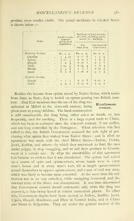
MfSCE/.LAXEOrS RF.VEh'UE 381
produce even smaller yields. The actual incidence in selected States
is shown below :
—

382 CENTRAL INDIA
Agent to the Governor-General in Central India, who is the OpiumAgent in Malwa, and of an Assistant to the Agent to the Governor-
General, who is the Deputy-Agent, the weighments at Indore being
supervised by the Deputy-Agent, and at other stations by Assistant
Opium Agents, Two classes of duty are levied: an Imperial duty
on opium exported to China of Rs. 600 on every chest of 140 lb.
weight ; and a Provincial duty of Rs. 700 on every chest exported for
consumption to places in India, principally Hyderabad State, and someNative States in the Bombay Presidency.
The number of chests passing through all the depots under the
Opium Agent in Mahva during the last twenty years averaged 27,500
per annum, yielding a duty of 159 lakhs. In 1904-5, 19,287 chests
were passed, yielding a duty of 115-1 lakhs. The export trade to
China is apparently declining. The number of chests has decreased
from 42,351 in 1860-1 to 36,964 in 1880-1, 25,822 in 1900-r, and
19,287 in 1904-5. The price of opium has risen considerably. In
1814 the average price was Rs. 29 per dhari (10 lb.), in 1817 Rs. -i^Zi i^^
1850 Rs. 44, in 1857 Rs. 56, in 1864 Rs. 62, and in 1904-5 Rs. 72.
No salt, except the small quantity turned out in Gwalior and Datia,
is now manufactured in Central India, and the States receive from the
British Government various sums in compensation for the surrender
of the dues formerly levied on that article, as detailed in the accounts
of individual States. The total receipts amount to about 3*4 lakhs
per annum.
The only other important excisable commodity is country liquor,
distilled from the flower of mahud {Bassia latifolia).
Excise administration varies considerably in different States, but is in
all cases defective. The right to the manufacture and vend of country
liquor is usually sold by auction to one or more contractors, who are
then left entirely to their own devices, or are subjected only to very lax
supervision. The number of liquor shops (excluding the States of
Gwalior, Indore, and Bhopal, for which figures are not available) works
out to one for every 8-8 square miles and 951 persons, rising in a
few individual cases to a maximum of one for every 6| square miles
and 400 persons. The right to sell foreign liquor is usually included
in the contract for country licjuor, wliile the right to retail the hempdrugs
—
ganja, /'hang, and charas— is, in almost all cases, sold along
with the contract for li(|uor or opium.
The opium traffic, being a considerable source of income, is morecarefully controlled. In most States this drug is subjected to heavy
taxation by means of customs, transit, and export dues, and numerous
miscellaneous duties. These amount on an average to Rs. 30 on
every chest (740 lb.), rising to a maximum of Rs. 50 in the case of
Indore.
A/^AfV 383
Municipal self-government is not yet common, but the States of
Gwalior and Indoreare introducing the system into all
towns of any size ; Bhopal, Ratlam, and a few other °^*. ?°
.
large towns have either regular municipalities or
town committees.
Public works in Central India, excluding railwiiys, belonging to the
British Government are in charge of a Superintending Engineer, who is
also Secretary to the Agent to the Governor-General _ . ..
Puulic worksin the Public Works department. He is assisted by
an Examiner of Accounts and two Executive Engineers, in charge
of the Indore and Nagod divisions, with head-quarters at Indore
and Nowgong. Imperial roads and buildings in the Gwalior and
Bhopal States, however, are maintained by the Darbars, while others
make contributions towards their upkeep. Each of the larger States
employs a European engineer, and great activity is being displayed in
the Indore State, especially in the construction of metalled roads.
The most important works carried out during the last twenty years
are : the Victoria College and Jayaj! Rao Hospital at Ciwalior and
the palaces at Ujjain and SlprT, the King Edward Hall and Holkar
College at Indore, and the Water-works, Lady Lansdowne Hospital
for women, and Central jail at Bhopal.
The Agent to the Governor-General formerly controlled three local
corps : the Central India Horse, the Bhopal Battalion, and the Malwii
Bhil Corps; but in 1897 these were placed under
the Commander-in-Chief, and in 1903, except the
Malwa BhIl Corps (see Sardarpur), were de-localized and brought
on to the regular roster of the Indian army.
Central India is included in the Mhow division of the AVestern Com-mand ; and in 1903 was garrisoned by 2,388 British and 4,256 Native
troops, in the cantonments of Mhow, NhfACH, and Nowgong, and
the stations of Agar, Guna, Skhore, and Sardarpur, detachments
from these places furnishing guards at the civil stations of Indore,
Sehore, and Gwalior Residency.
Besides these regular forces, there are several regiments of Imperial
Service troops. Gwalior maintains 3 regiments of cavalry, 2 of infantry,
and a transport corps ; Indore, a transport corps, with an escort of 200
cavalry ; Bhopal, one regiment of cavalry. These corps are commandedby State officers and supervised by British inspecting officers.
The other troops maintained by the States are numerous, but as
a rule little disciplined and armed with obsolete weapons. Somedetails of their strength and constitution will be found in the articles
on the various States.
The volunteers in the Agency chiefly belong to the Bombay, Baroda,
and Central India Railway A'olunteer Rifles, and to the Great

384 CEXTRAL INDIA
Indian Peninsula Railway Volunteer Corps; in 1903 they numbered
169 men.
Till recently the police in areas administered by the British Govern-
ment chiefly consisted of bodies of men enlisted locally and paid from
local funds. Along the Agra-Bombay road south of
^°^'ails^^^Mhow, the petty Bhilala chiefs and their followers
were responsible for watch and ward in return for
certain allowances. In April, 1899, the present Central India Agency
police force was raised. It consists of 482 men of all grades, whopolice the cantonments and stations of the Agency, and is in charge of
an Inspector-General, who is also Assistant to the Agent to the Governor-
General in the criminal branch. Railway police form a separate body,
as usual.
The States of Gwalior, Indore, and Bhopal have now regularly consti-
tuted police, and most States are reforming this branch of the adminis-
tration. The systems, however, vary considerably. The village
watchman is ordinarily a village servant, and often regular police are
not employed, the irregular State troops performing police duties.
The common criminal tribes met with in Central India are Badhaks
or Bagris, who come mainly from Malwa. Closely connected, if not
identical with these, are the Moghias. To lessen the depredations of
this clan, settlements have been made in many States, at which land
and plough oxen have been allotted for their use. The Moghias are
registered, and a careful watch is kept over their movements, regular
rules having been drawn up for their control. The principal Moghia
settlements are at Mirkabad in Gwalior ; Bani and Bodhan{)ur in
R.ajgarh ; Mughalkheri, Kurarwar, and HalkherT in Narsinghgarh;
Dhamana in Kachhi-Baroda ; Kularas in Maksudangarh ; Chamari,
Bhawangaon, and Bichpuri in Khilchipur. About 7,800 members of
criminal tribes have thus been settled in the States of Gwalior, Indore,
Bhopal, Rajgarh, Narsinghgarh, Khilchipur, Jaora, Ratlam, and others.
Sanaurias are also found, mainly in Bhopal. The Bhampta or pro-
fessional railway thief has appeared since the extension of railway lines
in the Agency. A Kanjar settlement has lately been started at Now-
gong. Vir Gopals and Ramoshis arc only occasionally met with.
The systematic registration of finger-prints has been introduced in
most States. A central bureau has been established at the Agency
head-quarters, and the Darbars co-operate in the collection of
impressions.
Early in the nineteenth century attention was called by Colonel
Sleeman to the widespread prevalence f)f gang-robbery with violence,
especially in Native States. In 1830 Lord ^Villian1 13entinck instituted
a systematic campaign against such crime, Colonel Sleeman being in
1835 appointed General Superintendent of the ThagI and Dakaiti

F.nUCATfOX 3S5
department. Owing to his energetic measures, thagl (murder I)y stran-
gulation) was practically stamped out by 1840. In 1864 the department
was reconstituted for dealing with organized and interstatal crimes in
Native States, the Political Agents being made Superintendents for their
charges, and an Assistant Superintendent being stationed at Indore.
In 1878 control was vested in a General Superintendent at Simla, but
since 1904 supervision has been exercised directly by the local adminis-
tration. An inspector and a certain number of subordinates are
stationed at Sehore, Nowgong, Gwalior, Nlmach, and Sardarpur, whoact under the orders of the Political officers.
Dacoity varies with the nature of the season. The highest figures are
those for the famine year of 1900, when 1,051 cases were reported, and
for 1899, when 643 were reported ; in 1897, also a year of great distress,
479 took place. The total number reported between 1881 and 1903
was 6,312, concerning property valued at 38 lakhs, while 581 persons
were killed and 3,789 wounded. Of dacoits committing robbery, 9,794
were arrested and 2,689 convicted.
There are a Government Central jail at Indore, a District jail at Xow-
gong in charge of the local Medical officer, and a small jail at Sehore.
Rugs, carpets, and dans are made at the Central jail. The jail arrange-
ments in Central India have been revolutionized within the last twenty
years, and all States of any size now possess properly constructed jails,
which are administered more or less on the lines obtaining in British
India, though discipline is much less stringent. Extra-mural labour is
the rule, large numbers of prisoners being employed in gardens and on
other duties. In the jails at Gwalior and Bhopal industries are carried
on, the manufacture of tiles being a speciality in the latter jail.
Although here and there, as at Sehore as early as 1839, individual
effort had succeeded in inducing the Native chiefs to assist in the estab-
lishment and support of a school, Central India con-
tained only two schools worthy of the name in 1868;
and it was reported, as late as 1889, that in matters of general education
the darkness was Cimmerian. Education in a Native State may gener-
ally be said to vary with the excellence of the administration, and with
the acceptance or otherwise of modern ideas by its ruler. Thus in
Gwalior (1902-3), besides two colleges, there are more than 300 schools
supported by the State, while in Rewah, the largest State in the east,
there are only about 40 schools of all classes. About 1,000 institutions
exist in Central India, of which 4 are colleges teaching up to the uni-
versity B.A. standard, and 19 are high schools teaching up to the
matriculation standard. Missions are active supporters of both male
and female education. The Canadian Presbyterian Mission maintains
numerous schools for boys and girls, besides a large college at Indore.
In 1872 a college for the education of the sons of chiefs in the
VOL, IX. c c

386 CENTRAL IXDIA
eastern part of the Agency was opened at Nowgong. In 1898, how-
ever, it was abolished, owing to the small attendance. In 1876 a
special class was opened in the Indore Residency school for the sons
of Native chiefs on the western side of Central India. Ten years later
the Daly College was opened, at which several of the present ruling
chiefs have been educated. In 1903 the status of the college was
reduced, the idea being that important chiefs and Sardars should go to
the Mayo College at Ajmer, while only the petty chiefs and Thakurs
would be educated at Indore. Steps are now being taken to re-estab-
lish the Daly College on the same footing as the Mayo College.
Of female education there is little to be said. The principal efforts
in this direction have been made by the Maharaja of Gwalior, while
several smaller States have also started schools with some success.
The people in the west of the Agency are better educated than those
in the east, which is due not only to the generally more advanced state
of the former, but also to the greater number of towns there. Omitting
Christians and ' others ' (chiefly ParsTs), the Jains are the best educated
community, 19 per cent, being literate, while Muhammadans come
next with 8 per cent., followed by Hindus with 3 per cent. In know-
ledge of English Muhammadans come first, with 4 in every 1,000.
Only 3 females in every 1,000 are literate in Central India. The
States of Gwalior and Indore have a regular educational department
under a European, but elsewhere there is no such organization.
There are also special schools in these two States and in Bhopal.
Gwalior supports schools for the sons and daughters of Sardars, as well
as military and technical schools ; in Indore engineering and medical
classes are held ; and a Sardars' college under a European principal
has been opened at Bhopal. At Mhow, Indore, and Nimach there are
convent and railway schools for Europeans and Eurasians.
About 300 newspapers, none of which, however, has more than
a small local circulation, were published in Central India in 1901. Of
these 156 were in Hindi. There were also 73 books published.
Medical institutions in the Central India Agency practically com-
menced with the foundation of the Indore Residency Charitable Hos-
pital in 1848. This institution was opened at the
suggestion of Dr. Impey, then Residency Surgeon, and
was built from funds given by Maharaja Tukoji Rao Ilolkar II. Amedical school in connexion with this hospital was started in 1878. In
1850 branch dispensaries were started at Ujjain, Ratlam, Dhar, Dewas,
Sailana, Shajai)ur, and Indore city. All States of any size now have
properly constituted hospitals with branch dispensaries, while many
smaller States have dispensaries. "J'he total number of hospitals and
dispensaries has risen from 61 in 1881 to 74 in 1891, 107 in 1901, and
16^) in 1904.
SURVEYS 387
The chief hospitals are the Charitable Hospital in the Residency area
at Indore, the Jayaji Rao Memorial Hospital at (iwalior, the Tukoji
Rao Hospital at Indore, the Prince of Wales's Hospital and the LadyI^nsdowne Hospital for Women in Bhopal city, the Leper Asylumnear Sehore, and the hospital at Rewaii.
Vaccination is now carried on regularly in Central India. The extent
to which it is practised varies in different States, but though here
and there prejudices against it exist, on the whole its beneficial effects
are recognized. The total number of successful cases was 131,844 in
1891, 141,937 in 1901, and 169,055 in 1904, representing a propor-
tion of 19 per 1,000 of population.
Quinine was made available for sale at all post offices in the Raj-
putana Circle in 1898. In 1891, 3,855 grains were sold; in 1900-1,
23,403 ; and in 1903, 21,319.
* The Gwalior and Central India Survey, commencing work in i86r,
had completed 19,729 square miles of survey on the i-inch scale by
1874. The sphere of operations lay north of the
24th parallel, bounded on the west by the Rajputana^^^^'
Agency, and on the east by the Districts of Jalaun, Jhansi, and Saugor,
and comprised Datia, and parts of Gwalior, Indore, Jaora, Khilchlpur,
Rajgarh, and Tonk States. In 1862 a party was organized for the
survey of Rewah and Bundelkhand. After the completion of 18,456
square miles on the i-inch scale, it was transferred in 1871 to Bhopal
and Malwa, and took up the survey of the country lying south of 24° N.
and north of 22° 30' E. and the Narbada river. By 1882 an area of
23,562 square miles had been surveyed on the r-inch scale, comprising
the States of Bhopal, Narsinghgarh, Dewas, Jaora, Ratlam, with portions
of Gwalior, Indore, Jhabua, Khilchlpur, and Rajgarh. Between the
years 187 1 and 1872 the Khandesh and Bombay Native States party
completed 7,680 square miles of survey on the same scale of that portion
of the Agency lying south of 22° 30', bounded on the east by NimarDistrict and on the south and west by Khandesh and the Rewa KanthaAgency, embracing Barwani and Jobat, with portions of Dhar, Indore,
Gwalior, Dewas, and Ali Rajpur. During 1870-1 the Rajputana survey
party surveyed an area of 102 square miles of the small portion of
Gwalior and Indore lying north of the parallel of 25° and east of the
Beluch river, a tributary of the Banas. In 1884-5 the Ciujarat party
surveyed on the 2-inch scale 337 square miles in Jhabua, All Rajpur,
and Jobat, lying to the west of 74° 30' E. and between the parallels of
latitude 22° 30' and 23° 15'. During the years 1855-7 and in 1860-2,
4,850 square miles of survey on the i-inch scale was executed bya revenue survey party in the western portion of Bundelkhand, corn-
prising the States of Orchha, CharkharT, and Samthar, and a number of
' By Lieut. -Col. Fleming, I. A., Survey of India.

388 CENTRAL INDIA
smaller States falling within Hamirpur District. A further area of
1,668 square miles, consisting of the Indurkhi and Daboh parganas
of Jalaun District, and Karehra and Pachor in Jhansi, ceded to Sindhia
after the Mutiny in recognition of his services to Government, were
surveyed on the 4-inch scale by a revenue survey party during 1852-5,
1856-7, and 1859-60. Besides these portions, many of the larger
States have had internal surveys made for revenue purposes. Most
small States, however, have no accurate idea of the extent of their
territories, a survey of the land actually under cultivation being all
that is attempted, no measurements being made even of forest land.
[J. Grant Duff : History ofthe Mahrattas, 3 vols. (1826).—W. Thorn :
Memoir of the War in India from 1803 to 1806 (1818).—H. T, Prinsep :
History of the Transactions in India during the Administration of the
Marquis of Hastings, 2 vols. (1825).—J. Malcolm : Memoir of Central
India, 2 vols, (1823).
—
Official Narrative of the Events of the Mutiny of
1857-9.
—
Administration Reports {{xom 1866).—T. H. Thornton: Sir
Richard Meade and the Feudatory States of Central India (1898).—H.
Daly : Life of Sir Henry Daly (1905).—^V. Lee-Warner : The Protected
Princes of India (1894).—State Gazetteers (under issue).—A. Cunning-
ham : Archaeological Survey Reports, vols, ii, vii, ix, x, x\, and xxi.
—
Census Reportsiox Central India, r88i, 1891, and 1901.]

TABLES .^89
« t! i
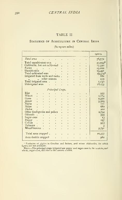
390 CENTRAL INDIA
TABLE II
Statistics of Agriculture in Central India
(In square miles)
1902-3.
Total area
Total uncultivated area
Cultivable, but not cultivated
Forest ....Uncultivable
Total cultivated area
Irrigated from wells and tanks
,, ,, other sources
Total irrigated area .
Unirrigated area
Principal Crops.
RiceWheatGram .....Jowdr .....Bajra .....Maize ....Kodon . . . .
Other food-grains and pulses
Oilseeds
Sugar-cane ....Poppy .....Cotton .....Tobacco .....Miscellaneous ....Total area cropped .
Area double cropped
78.773
52,033*i7>32o
15,222
19,49119.415*
881
2591,140
18,275
9532,2742,302
3,503III
682202
2,794
5.'>9
13
237
9533
5.79
1
20,377
962
" Exclusive of jagirs in Gwalior and Indore, and minor f/iakurats, for whichfigures are not available.
Note.—The principal crops irrigated are poppy and sugarcane in tlic western, andwheat, sugar-cane, and rice in the eastern section.

TAIlf.RS 391
TABLE III
Principal Sources of Ordinary Revenue in Central India
(In thousands of rupees)
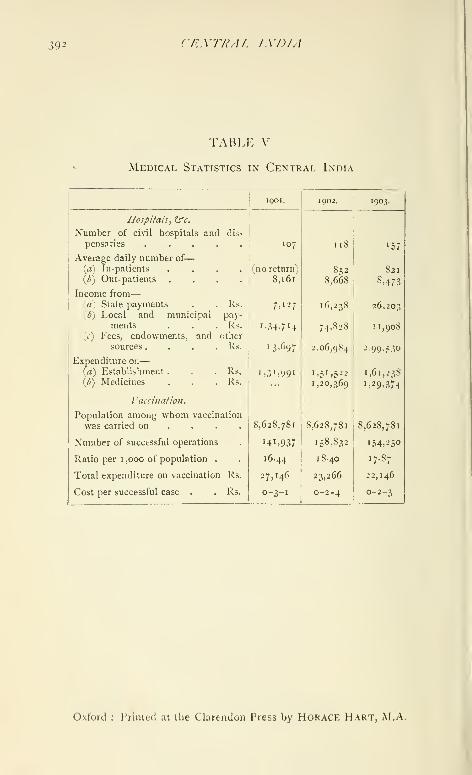
392 CEXTRAL IXDTA
TABLE V
Medical Statistics in Central India


UNIVERSITY OF CALIFORNIA LIBRARY
Los Angeles
This book is DUE on the last date stamped below.
iu: LD-UKU
f-..; a-^ 6 19W
,7.:,>'n vriJm
Form L9-Series 4939
u:.
Y
:FOR>aA

3 1 58 00856 3289
UC SOUTHERN RFGIONAlI IBRARY FACI[ ITY
lliliniiii|[iliii||j|ni||jj||||i|j|n|j|lljj llll j| lull
AA 001 138 992 i
![Smith's Canadian gazetteer [microform] : comprising statistical and ...](https://static.fdokumen.com/doc/165x107/631d3ef36c6907d36801aca9/smiths-canadian-gazetteer-microform-comprising-statistical-and-.jpg)