The imperial gazetteer of India
514
MM
-
Upload
khangminh22 -
Category
Documents
-
view
0 -
download
0
Transcript of The imperial gazetteer of India

MM


THE IMPERIAL GAZETTEER OF INDIA.

MORRISON AND GIBB, EDINBURGH,
PRINTERS TO HER MAJESTY'S STATIONERY OFFICE.

The Imperial Gazetteer of India.
W. W. HUNTER, C.S.I., CLE, LL.D.
DIRECTOR-GENERAL OF STATISTICS TO THE GOVERNMENT OF INDIA.
VOLUME I.
ABAR TO BALASINOR.
UNITED STATES AIR FORCE
CAMBRIDGE RESEARCH CENTERGEOPHYSICS
RESEARCH LIBBAR/
second edition:
TRUBNER & CO., LONDON, 1885.

DS
/.I
UNIV. OF MASSACHUSETTS
AT BOSTON - LIBaAHT

TO HER MOST GRACIOUS MAJESTY
VICTORIA
QUEEN OF ENGLAND AND EMPRESS OF INDIA
THIS WORK IS BY HER ROYAL PERMISSION
DEDICATED,


PREFACE TO THE FIRST EDITION
OF iSSi.
' We are of opinion/ wrote the Court of Directors in Early
1807 to their servants in Bengal, 'that a Statistical unjr
er
s
the
Survey of the country would be attended with much ^°6
mp*ny'
utility ; we therefore recommend proper steps to be 1855.
taken for the execution of the same.' The despatch
from which these words are quoted forms one of a long
series of instructions in which the East India Company
urged a systematic inquiry into its territories. The
first formulated effort in Bengal dates from 1769, four
years after that Province came into its hands ; the latest
orders of the Court of Directors on the subject were
issued in 1855, three years before the administration of
India passed from the Company to the Crown. During
the interval many able and earnest men had laboured at
the work, manuscript materials of great value had been
amassed, and several important volumes had been pub-
lished. But such attempts were isolated, directed by
no central organization, and unsustained by any con-
tinuous plan of execution.
The ten years which followed the transfer of the Efforts
government of India to the Crown in 1858, produced a J"^new set of efforts towards the elucidation of the country. 1858-69.
Conspicuous among them was the work begun in
1866 under the direction of Sir Richard Temple, when
Chief Commissioner of the Central Provinces. 1 The
controlling power in England had now passed from a
body of experts, the Court of Directors, to Parliament
1 Executed by Mr. Charles Grant (now Sir Charles Grant, K.C.S.I.),
of the Bengal Civil Service, sometime Member of the Viceroy's Legislative
Council and Foreign Secretary to the Government of India.

VI 11
Theirfailure,
1869.
Remon-strances
by public
bodies.
PREFACE 10 THE FIRST EDITION.
and the nation at large. Accurate and accessible infor-
mation regarding India was become, under the new-
system, an essential condition for the safe exercise of
that control. Accordingly, in 1867, the Viceroy, acting
on instructions from Her Majesty's Secretary of State,
ordered an account to be drawn up for each of the twelve
great Provinces of India.1
^The Provincial Governments struck out widely diver-
gent schemes for conducting the work. It was as if a
command had issued from some central power for a
Statistical Survey of all Europe, and each nation set
about its execution on a separate plan. It became
apparent that vast sums of money would be expended,
while considerable uncertainty existed as to the results.
One local Government started on a scale which, if gene-
rally adopted, would have involved an outlay of£100,000
for the District materials alone. The head of another
Province himself 2 carried out the work, expeditiously and
at scarcely any cost to the State ;but on a system which,
although admirably suited to the territories under his
care, could not be applied to the rest of India. Mean-
while, the commercial community and various public
bodies were pressing upon the Government the necessity
of systematic organization, with a view to ensure uni-
formity in the execution of the work. Without such
uniformity, the Council of the Asiatic .Society pointed
out that, when the local compilations came to be finally
digested into the General Account of India, there would
be no basis for comparative statistics, and much ' of the
original work would have to be gone over again de novo!
1 These Provinces, or rather political divisions under separate admini-
stration, were—(1) Bengal; (2) Bombay; (3) Madras; (4) The North-
western Provinces and Oudh ; (5) The Punjab; (6) Assam, in 1867
included in Bengal ; (7) Central Provinces ; (8) British Burma; (9) The
Berars, under the Resident at Haidarabad ; (10) Mysore and Coorg
;
(11) Rajputana; (12) Central India.—Orders of the Government of India,
No. 1758, dated 19th October 1867.
2 Mr. Alfred Lyall, C.B., of the Bengal Civil Service, then Commis-
sioner of West Berar; now Sir Alfred Lyall, K.C.B., and Lieutenant-
Governor of the North-Western Provinces and Oudh.

PREFACE TO THE FIRST EDIT/OX. k
The Viceroy arrived at the same conclusion ; and in Renewed
1869, His Excellency directed me to visit the various jggo'
Provincial Governments, with a view to ' submit a com-
prehensive scheme for utilizing the information already .
collected; for prescribing the principles ' to be thenceforth
adopted ;' and for the consolidation into one work of
the whole of the materials that may be available.'
In carrying out these instructions, I found that the Causes of
series of previous efforts had failed from two distinct failures,
causes. In one class of cases, a central officer of rank
and ability had been appointed ; but he had not been
supported by adequate machinery for collecting the
local materials. In another class, the District Officers
had been left to work each on his own plan, without the
guidance of any single mind. The first class had failed
from want of local organization ; the second, from want
of central control.1 The task set before me consisted, in Two stages
fact, of two separate stages—First, a ' local inquiry,' con- WOT\im
1 The Governor-General in Council thus summed up the previous efforts,
in a Resolution dated the 8th September 1S71 : 'Three distinct series of
operations have in time past been undertaken or encouraged by the
Government, with a view to obtaining trustworthy accounts of the country,
such as might form a Gazetteer of India ; the whole representing a very
large outlay, commencing as far back as 1769, and one of the efforts
costing ^"30,000 for merely collecting the materials for part of a single
Province. From a variety of causes, all more or less proceeding from
defective organization, this large expenditure, while accumulating isolated
materials of great value, failed to yield any systematic and comprehensive
result.' The Resolution then reviewed the fresh operations ordered by the
Secretary of State in 1867: 'Various schemes were set on foot to give
effect to these orders, some of them so costly as to be altogether dispro-
portionate to the results to be obtained. But His Excellency in Council
observes that excessive costliness is not the only unfortunate effect of the
want of organization, which left each local Government to invent a scheme
of its own, irrespective of what was being done in other Provinces. There
was, in fact, no unity of plan or central supervision, and the results did
not contain the materials required for the comparative statistics of the
Empire. . . . Widely different schemes have been propounded by the local
administrations, some of them involving a very extravagant outlay, others
of too meagre a character. Each local Government has given its owninterpretation to the work ; and the experience of the last few year?
shows that, in the absence of a central organization, the cost of the enter-
prise will swell to an enormous total, while the same heterogeneous incom-
pleteness, which rendered all previous efforts infructuous, will again result.'
VOL. I. b

x PREFACE TO THE FIRST EDITION.
ducted on a uniform scheme, throughout each of the [then]
240 Districts, or administrative units, of British India :
Second, the consolidation of the materials thus obtained
into one book. The first stage could be effected only
by a Statistical Survey of India ; the second is repre-
sented by The Imperial Gazetteer. No basis existed at
that time for either of these works. A Census had
never been taken for British India ; and in some
Provinces the different departments of the same Govern-
ment grounded their financial and administrative de-
mands on widely diverse estimates of the population.
Plan for a Accordingly, in 1869,1 submitted to the Governor-
Sm-vJy^1
General in Council a Plan for a Statistical Survey and
and an an Imperial Gazetteer of India.1
It endeavoured, First.Imperial r
Gazetteer, to eliminate the causes of previous failures, by providing
a uniform scheme, a local mechanism, and a central con-
Its objects, trol. Second, to clearly define the objects of the present
undertaking. These objects were partly of an admini-
strative and partly of a general character ; namely, ' for
the use of the Controlling Body in England, of admini-
strators in India, and of the public.' Third, to secure the
co-operation of the Provincial Governments,—lukewarm
heretofore in such matters,—by respecting their indi-
viduality, and by modifying the uniform scheme to suit
the circumstances of their several Provinces. Fourth,
to collect the materials at once systematically and
cheaply, by enlisting the unpaid agency of the District
Officers throughout India under a central control. The
Government was pleased to approve of this Plan, and
to 'secure for the execution of the design the super-
vision of the designer.'2
Extent ' The operations,' wrote the Governor- General in
operations. Council, ' will extend over ten separate Governments
which, with their Feudatory States, administer a terri-
tory of 1 \ million square miles and govern a popula-
1 Printed at the Home Secretariat Press, 144 pp. folio. Calcutta, 1870.
2 Proceedings of the Government of India, dated 8th September 1S71.
PREFACE TO THE FIRST EDITION. xi
tion estimated at 200 million souls [since found to be 255
millions]. The work represents, therefore, a series of
local inquiries and comparative statistics, spread over
an area but little less than that of all Europe, ex-
cepting Russia/ and a population then exceeding that
of all Europe, less Russia. With a view to securing Median •
. , T . . . ism of the
uniformity in the materials, I drew up six series statistical
of leading questions,1 illustrating the topographical, Survey,
ethnical, agricultural, industrial, administrative, and
medical aspects of an Indian District. These have
served as a basis for the Statistical Survey throughout
all India. With a view to securing punctuality of
execution, Provincial Compilers were appointed, each
responsible for getting in the returns from the District
Officers within the territories assigned to him;for sup-
plementing those returns by information from heads of
Departments and other local sources ; and for working
up the results into the Statistical Account or Gazetteer
of the Province. In this way, the unpaid co-operation
of the administrative staff throughout the 240 Districts
of India was enlisted, the best local knowledge was
brought to bear, while in each Province a paid editor Its
was answerable for the completion of the Provincial working.
Account on a uniform plan and within a reasonable
time. The supervision of the whole rested with me,
as Director-General of Statistics to the Government
of India. During one-half of each year, I visited the
various Provinces, especially Bengal, which I retained
in my own hands as Provincial Editor in addition to
my duties as Director-General. The other half of each
year, I devoted to testing and working up the results.
During the past twelve years, the Statistical Survey The
has been conducted throughout the whole of British survey of
India. The District forms the administrative unit in India -
India, and the Statistical Survey furnishes an elabo-
1 Circulated to the Provincial Governments, under the title of ' Heads of
Information required for the Imperial Gazetteer.'

XU PREFACE TO THE FIRST EDITION.
The ioovolumesof the
Survey;
nowpractically
completed.
rate account of each of the 240 Districts. The Pro-
vince is the administrative whole in India, and the
Statistical Survey groups all the District materials
into fifteen Provincial Accounts or Gazetteers. Such
a work, if it is to furnish a basis for administrative
action in India, and supply data to the Controlling
Body in England, must be at once comprehensive
and minute. The District and Provincial Accounts
will form about 120 printed volumes, aggregating 50,000
pages, of which 90 volumes, making over 32,000 pages,
were issued by 1880. The operations have (1881)
been completed throughout 12 Provinces and 210 Dis-
tricts, representing a population of about 190 millions
of souls.
The Statistical Survey of British India (18S1).

PREFACE TO THE FIRST EDITION. xiii
[Since the foregoing table was prepared in 1 88 1, the
Statistical Survey of British India has been completed
in 119 volumes, aggregating 54,504 pages (1885).]
The Feudatory States and Chiefdoms, exceeding 300 Statistical
in number, with 50 millions of people, were from the first ^Native*
placed outside the scope of the Statistical Survey. In Statcs -
these territories it was unsuitable to attempt minute
investigations, which the native princes would have been
likely to misunderstand, and able to frustrate. Accord-
ingly, my Plan of 1869 restricted the Statistical Survey
to the British territories, but pointed out that the
Native States must be included in the ultimate compila-
tion for all India, that is, the Imperial Gazetteer. Steps
were therefore taken to bring together the information
already existing regarding the Native States, and to
supplement it. In States temporarily under British man- Excep-
agement, this was quite practicable ; and Major Powlett'sl°™
r _
account of Alwar supplies an admirable specimen of tumties-
what may be done under these circumstances.
Apart from such exceptional cases, I found that the Five great
300 Native States of India had to be dealt with in stated!
five great groups. The first and most numerous class
comprised the States and Chiefdoms which are in
political dependence on the Provincial Governments.
These States have accepted a large measure of British
supervision, and the Provincial Compilers were able to
draw up fairly adequate accounts of them. The second
group consisted of the Rajputana States; and two
valuable volumes have been collected regarding them by How dealt
Mr. Lyall (now Sir Alfred Lyall, K.C.B.) when Governor- separately.
General's Agent. 1 For the third group, including the
Central India States, I did not find myself in a position
to bring forward specific proposals ; and in the case
of several of them, this book will add but little to
the sum of human knowledge. In the fourth group,
or the territories of the Nizam, efforts were made at an
1 The Rajputana Gazetteer, 1879-80.

PREFACE TO THE FIRST EDITION.
early stage to obtain the necessary materials from His
kingdoms.i
F-
rol\tier Highness' Government. The fifth group consisted of
Frontier and Independent States, such as Afghanistan,
Burma, and Nepal. Some account of such States would
be expected in the Imperial Gazetteer of India. But
any account of them, drawn up from official sources and
issued under the authority of the British Government,
might give rise to uneasiness among the Princes who
rule those territories, our neighbours and allies. After
full consideration, it was decided that no special inquiry
should be made with regard to trans-frontier Indepen-
dent Kingdoms, and that no official documents should
be used. The articles upon them in the Imperial
Gazetteer are, accordingly, a mere reproduction of
accounts already before the public ; and for them no
responsibility attaches to the Government.
Median- Of the five groups of Native States, therefore, the
ployed "for^rst was satisfactorily dealt with by means of the Pro-
the Native vinc iai Compilers ; the fifth can scarcely be said to have
been dealt with at all. In the three intermediate groups,
many isolated efforts were made, and a special Assistant
was deputed to me in the Foreign Office, Calcutta, with
a view to putting together the materials already exist-
ing. His labours were afterwards supplemented in the
Political Department of the India Office. But the con-
Its imper- fidential relationship between the Government of India
and its Feudatory States, the dislike of the native Princes
to inquiries of a social or economic character, and the
scrupulous delicacy of the Foreign Office to avoid
grounds of offence, have rendered a complete treatment
of such territories impossible. I beg that those who use
this book will believe that the occasional meagreness
of the results, and the inadequate treatment of certain
Native States, are due not to want of anxious effort on
my part, but to the conditions under which I worked.
In some cases I have had to fall back on the old
materials compiled, at the expense of the Court of
feet results.

PREFACE TO THE FIRST EDITION. xv
Directors, by Mr. Edward Thornton in the India House,
and published by their authority, in four volumes, in
1854.1 As a whole, therefore, the articles on the Native
States represent a much less exact method of inquiry
than those on the British Provinces. They will be found,
however, to mark a material advance in our information
regarding Feudatory India. The basis for more system- NoStatist'.
atic operations, a Census of the Feudatory Territories,^Survey
r * * of .Native
docs not exist ; and a Statistical Survey of the Native States.
States still remains unattempted.
[Including the less exact work thus done for the
Native States, the results of the Statistical Survey of
British and Feudatory India, now (1886) make 128
printed volumes, aggregating 60,000 pages.]
The two primary objects of the operations were The three
' for the use of Indian administrators,' and ' for the the^ork
:
use of the Controlling Body in England.' The 128
volumes of the Statistical Survey were expressly com-
piled for these purposes ; and of the twelve years
which have elapsed since its commencement, the first (1) For
eight were devoted to that part of the work. But^hSthese 128 volumes, although by no means too elaborate strat01> :
for administrative requirements, are practically within (2) For
the reach of but a small official class. The third trolling
*
object of the undertaking had been defined in my ^J "J
.
original Plan, to be 'for the use of the public ;' (3) For the
and the remaining four years of the twelve have beenpu
chiefly occupied in reducing the voluminous records
of the Statistical Survey to a practicable size for
general reference. The result is now presented in
the nine volumes of The Imperial Gazetteer.1 Under the title of A Gazetteer of the Territories under the East India
Company and of the Native States on the Continent of India. (4 volumes.)
This work, excellent at its date, was compiled between the years 1844 and
1854; Mr. Thornton being paid a sum of money by the Court of
Directors in addition to his salary, • it being distinctly understood that the
copyright is to vest in the East India Company' {Resolution of the Court
of Directors, \%th February 1846).

XVI PREFACE TO THE FIRST EDITION.
Initial
steps in
compilingthe
Imperial
Gazetteer.
Previous
chancetopo-
graphy.'
List of
places.
The first
of the kind
for India.
System ofuniform
reatment.
Previous Gazetteers had described, with industry and
sometimes with eloquence, the famous cities of India,
its historical sites, and great Provinces. But in the
absence of systematic materials, they had to depend
on the chance topography of tourists, or on a place
happening to find its way into the records of the
India House. A petty hamlet in which some traveller
had halted for a night, or any locality which had formed
the subject of a correspondence with the Court of
Directors, stood out in bold relief; while great tracts
and rivers, or the most important features of large
Provinces, were passed over without a word. Myfirst business, therefore, was to take care that every
place which deserved mention should be enumerated;
my second, to see that it received neither less nor
more space than its relative importance demanded.
With a view to the first object, I sent circulars to
the Provincial Editors and District Officers, calling for
a return, upon clearly-stated principles, of every town,
river, mountain, historic site, religious resort, commer-
cial fair, harbour, or other place of importance in each
District of British India. This list I checked from
the Statistical Survey, and supplemented with manyplaces which, although of no local significance, had
obtained prominence in the literature of India.
Eleven thousand names were thus arranged in alpha-
betical order. No such list had ever before been com-
piled for Her Majesty's Indian Empire. After being
thinned out, it was printed in a folio volume, and for-
warded to all the Local Governments in India, with a
request that they would ascertain that the enumera-
tion was correct as regards the territories under their
care. I finally revised the list by the light of their sug-
gestions, and selected about 8000 places for treatment
in the Imperial Gazetteer.
During the interval which elapsed before their
replies could be received, I drew up model articles

PREFACE TO THE FIRST EDITION. xvii
showing paragraph by paragraph the method of treat-
ment; and I got together the missing materials for
Provinces where the Statistical Survey had not suffi-
ciently advanced to yield them. In this way, I placed in Model
the hand of each contributor to The Imperial Gazetteer
the names of the places of which he was to treat,
together with the complete materials for dealing with
them, and also an exact mould into which those
materials were to be squeezed.
The value of the work, as a guide to administration, Defects of
is impaired by the fact that its figures cannot be as anr
'
brought up to date. The basis of Indian statisticsAdmini -
° r strative
is still the Census of 1872, taken a few months after Guide-
t-v- r* 1 11/-- book.my appointment as Director-General ; and the Govern-
ment has decided that the publication of the Gazetteer
must not be delayed, with a view to obtaining the
results of the new Census of 188 1. Even the Census of
1872 does not supply a uniform basis for the whole
of India ; and in certain Provinces I have had to
work on enumerations taken in 1867, 1868, 1869,
and 1 87 1. Much labour has been expended in bringing
up the economic statistics to a more recent date, with
the help of Administration Reports, and by special
inquiries. But the length of time necessarily occupied
by a Statistical Survey of a Continent, nearly equal
to all Europe less Russia, rendered it inevitable that
the results should refer to different years during its pro-
gress. My figures represent substantially the population Period to
statistics of India in 1872, with the administrative and^atTsdcs
6
trade statistics from 1875 to 1879. ^ n some cases, even refer -
this degree of uniformity has not been found practi-
cable ; in others, I have brought the facts down to 18S0.
But the reduction of the statistics of India to a uniform
basis must be deferred for a second edition, after the
results of the new Census are obtained.
In its other aspect, as a book for general reference, the

XVlll PREFACE TO THE FIRST EDITION.
Its defects
as a general
Gazetteer.
Deficient
in history.
The true
history of
India.
Where it
is to befound.
Imperial Gazetteer is also less perfect than I could have
wished in several points. The Governor-General in
Council found that the task of collecting the admini-
strative materials and statistics would prove a burden
quite as heavy as he deemed expedient to lay upon
the Local Governments. The historical aspects were
expressly left to the voluntary research of the Provincial
compilers. From the first, one of the Local Govern-
ments objected even to this moderate scope being
allowed for matters not directly of an official character.
The emphasis which the Governor-General in Council
laid in 1875 on the responsibilities of the Provincial
Governments for the tone and contents of the work,
seemed to several of them to render general disquisitions
unsuitable. Even in the Provinces of Bengal and
Assam, which I retained in my own hands as Provincial
Editor, every sheet had to receive the sanction of the
Local Government before it was printed off. Many
topics of social or political interest were excluded ;and a
general introductory volume, after being in part printed,
was not issued.
But if the history of India is ever to be anything
more than a record of conquest and crime, it must be
sought for among the people themselves. Valuable
historical materials had been collected for the Statistical
Survey; and in 1877, the Secretary of State for India
decided that a wider scope should be allowed me for their
use in the Imperial Gazetteer. I have done my best to
give effect to that view ; and it will be seen, for the first
time in these volumes, that every Indian District has its
own history. The true territorial unit of Indian history
is, indeed, much smaller than the British District. For
example, he who would study the history of Oudh must
search for it in the pargand or parish; in other parts of
India, the zaminddri or estate is the historical unit ; in
others, the chiefship ; while in a few, the rural districts
were mere appendages to the great cities. Had it been

PREFACE TO THE FIRST EDITION. xix
permitted me to subject the rural annals of India to
systematic inquiry, as I wished, a rich harvest would have
been gathered in. The historical accumulations made
by the wayside, in conducting the Statistical Survey,
have proved of much value. But in attempting to
incorporate them into the Imperial Gazetteer, I have Some
had frequently to choose between using materials which, jjUJd^
owing to the earlier instructions, I had been unable to
test ; or rejecting statements, in themselves new and
interesting, but which, in the later stages of the work, I
could not personally verify.
The latitudes and longitudes have, with a few excep- Geo-
tions, been revised by the Surveyor-General's Depart- dSails^
ment. 1I have to thank General Sir H. Thuillier for
many years of friendly help, and Colonel J. T. Walker
for more recent assistance, in the geographical details.
Areas, distances, and similar details have been taken
from the latest scientific measurements ; but the
frequent changes in the jurisdiction of Indian Dis-
tricts introduce an element of variation difficult to
eliminate. In some cases, averages will not work out Element-
correctly, as in the rates of local taxation per head,of error-
where the municipal area often differs from the town
area taken for the census. In other instances, the
items will not add up; as in certain Districts where the
religious classification of the people does not yield the
exact total arrived at by the general enumeration. There
are not very many discrepancies of this sort, and no
labour has been spared to get rid of them. But in several
cases I cannot go beyond the figures supplied to me by
1 The longitudes require a constant correction of minus 2h minutes
(—o° 2' 30') to reduce them from the adopted value of 8o° 17' 21' for the
longitude of the Madras Observatory, on which they have been based, to
the value of 8o° 14' 51', which was determined electro-telegraphically in
1876-77. It is not improbable that some further minute correction maybe hereafter made ; and the Surveyor-General has deemed it undesirable
that the values of all the individual longitudes should be altered, until the
final determination has been arrived at.

XX PREFACE TO THE FIRST EDITION.
the local authorities; and although I may see that there
is something wrong, I am unable to set it right. I beg
that those who may come after me will, in improving
on my work, remember the conditions under which it
has been done. When it was begun, no one knew
exactly the population of a single Province of India, or of
a single District of Bengal. In the latter Province alone,
the Census of 1872 suddenly disclosed the presence of 22
millions of British subjects whose existence had never
previously been suspected. The population of Bengal
and Assam, up to that time reckoned at 40 millions,
was ascertained in 1872 to number 6j\ millions of souls.
Spelling o
IndianProperNames.
Inherent
difficulty
of trans-
literation
f The spelling of names of Indian places has long
formed a subject of controversy. Without a uniform
system of rendering them, an alphabetical Gazetteer
could not start ; and one of my first duties was to lay
down a system for transliterating Indian Proper Names.
In existing Gazetteers of India, the same word appears
under many forms. The best work of this class gives
eleven different spellings of the same town, not one of
which is exactly correct ; and in order to be sure of
finding a place, the inquirer has to look it up under every
possible disguise. The truth is, it requires a careful
study of the vernacular languages of India, and some
knowledge of Sanskrit, which forms the key to them,
before one is able to spell local names correctly in the
native alphabets. It next requires a well-considered
system of transliteration in order to render such names
into the English character. For it must be remembered
that the Sanskrit alphabet has fifty letters or signs, while
the English alphabet has only twenty-six. Thus, the
Roman alphabet has but one letter for the consonant
11; the Sanskrit has four letters for it, in its various
modifications, as a dental, lingual, palatal, and guttural.
On the other hand, the Indian alphabets attach a
uniform sound to each vowel ; while in English, the same

PREFACE TO THE FIRST EDITIOX. xxi
vowel may have several sounds, such as u in but, put,
curc\ rural. Indian names can therefore be represented
only in a loose and popular manner in our alphabet;
unless, indeed, we manufacture a new Roman alphabet
with additional letters, by means of accents over the
vowels, dots under the consonants, italics, or similar
devices of typography.
A recognition of this fundamental difficulty should System
.adopted
make an Indian spelling-reformer moderate in his aims in this
and patient of opposition. I first collected about 15,000w
names of places, written out by competent natives in the
vernacular character; and transliterated them accurately
on the method adopted by the Royal Asiatic Society.
But the multitude of accented vowels and dotted con-
sonants convinced me that such precision was im-
practicable for popular use. I therefore re-transliterated
them on a more simple system, discarding dotted
consonants altogether, using as few accents as possible
over the vowels, and abstaining from liberties with the
alphabet which would give it an un-English look, and
perplex the ordinary reader. My object was, not to
write a paper for the Asiatic Society's Journal, but to lay
down a uniform system which might afford a practical
settlement of the long dispute about Indian orthography,
by being adopted by all fairly educated men.
The task was complicated by the circumstance that Difficulties1
of the
three systems had co-existed during nearly a century, task.
For two of the rivals a good case might be made
out. Popular usage had drawn at random from all
three, and a number of important places had thus
obtained an historical or literary fixity of spelling. Well-
known names of this last class, when transliterated in
an unwonted fashion, or by a rival method, had a strange
look, which afforded scope for pleasantries. Yet one
system had to be accepted and resolutely adhered to.
The method which I have adopted does not attempt
to represent the fine distinctions of the Sanskrit con-

xxu PREFACE TO THE FIRST EDITTON.
sonants, such as the dental and lingual d. But it
TOwJSrm attaches a uniform value to each vowel, namely, a and
sounds. u as in rural ; e as in grey, mediant ; and i and o as in
police. The accented dt
i, and *£ represent the long
forms of the same vowels in Sanskrit, or the sounds in
the English words far, pier, and lure.
with"Some Indian names, however, have grown so familiar
historical as to render a rectification of their spelling impracticable.
spelling. Such names have been considerately dealt with. I
found that they arranged themselves under two classes.
In the first class, the popular or historical fixity of
spelling had so hardened and set as to preclude anyalteration whatever; thus, Calcutta, Madras, andBombay. In the second class, it was possible to bring
the spelling somewhat nearer to the uniform system,
without destroying the historical or popular identity of
the word. For example, the multiform terminal pur,
pore, poor, poore, a city, might be uniformly given in its
correct Hindi form as pur, even if the body of the wordcould not be rectified; while the similar termination
nagar, nagore, Hugger, nuggur, naggore, etc., a town,
might be uniformly rendered nagar. Such a system,
like all compromises, was open to the strictures of both
the extreme parties—of the scrupulous purists on the
one hand, and of the obstinate upholders of the old
confused spelling on the other. It commended itself
to the intermediate body of reasonable men. TheGovernment of India, in 1870, accordingly promulgatedmy system of transliteration in the Official Gazette, andformally authorized its adoption.
Introduc- It remained to organize machinery for enforcing- itstionofthe , « , „ ,
b
system. general use. Several of the leading Indian journals
expressed their willingness to adopt a uniform systemof spelling which presented no typographical difficulties.
Up to that time, the same place used to appear underdiverse forms in the different newspapers, and was

PREFACE TO THE FIRST EDITION. xxiii
often variously rendered in different columns of the
same journal. A printed volume containing the correct
spelling of all Indian places was circulated to the Press,
to literary institutions, libraries, publishing houses, and
to the official Departments. But the chief sources from
which Indian news is derived, and from which Indian
orthography emanates, are the Government Gazettes and
Administration Reports. The official Gazettes in India The new
give much of the information which in England would adopted for
be communicated by Her Majesty's Ministers to p"b°?!£
al
Parliament. Each Provincial Government has its own lions -
set of Reports and its own Gazette—the latter some-
times swelling into a weekly folio of over a hundred
pages, filled with State papers. The Governor-General
requested each of the Provincial Governments to
draw up a list of places within its own territories,
spelt on my system. These lists, after receiving his
sanction, were to be published in the Gazettes, and to
be thenceforth adopted in them and all other official
publications.
The Provincial Governments carried out the principles Provincial
. , . . r . r lists re-
of transliteration with varying degrees of uniformity, v ised by
and took widely different views as to the number ofg^*e™f
names which had obtained a popular fixity of spelling, men* of
India.
This was inevitable ; and the Governor - General in
Council, in revising the lists, endeavoured to remove
divergences and to attain the maximum degree of
uniformity. Owing to the number of languages and
alphabets used in India, the work extended over nearly
ten years. The Provincial Governments have been
induced to reconsider their first efforts ;and in each
new edition, they have approached more closely to the
lines originally laid down. In one Presidency, indeed,
the latest revision has advanced beyond the limits of
accuracy which I had thought practicable. Throughout
India, every year sees the uniform system of spelling
more generally introduced ; it has been accepted in the

xxiv PREFACE TO THE FIRST EDITION.
Parliamentary blue-books at home, and is irresistibly
forcing its way into the English press.
Spelling Meanwhile, the Imperial Gazetteer had to march on.
Imperial The Government decided that the publication of theGazetteer. wj10 ie WOrk should not, in any circumstances, be delayed
beyond the year 18S1. The proof sheets had to pass
under the revision of the Secretary of State in Council;
and most of them were, accordingly, printed in 1879
and 18S0. I therefore did my best to arrive at the true
spelling of each name, starting from my own lists in
the vernacular character, and usually accepting the Pro-
vincial lists as drawn up by the Local Governments,
when they arrived in time ; although not delaying the
work by waiting for their final revision.
Provincial It sometimes happened that adjoining Governments
adopted different renderings for the same word, such as
a river or a border district ; while each Government
introduced variations in revised editions of its own
list. If an attempt were made to introduce a uniform
system of spelling proper names for all Europe, similar
delays and difficulties would arise. It must be remem-
No bered, too, that India has no common alphabet, like the
alphabet Roman alphabet in Europe, but a variety of local
in India. cnaracters, which render the same word by different
letters.
Thus, apart from the difficulty of dental and lingual
forms ; the commonest of all terminals, pur, a town,
is spelt with a short 2t in Hindi and by most of the
Sanskrit family of alphabets, and with a long 11 in the
Urdu alphabet, derived from Arabic sources. Dialectal
Dialectal variations also play a confusing part ; a universal
place-name like Sivapur or Shivapur, being hardened
into Sibpur in Bengal, and softened into Hiwapur in
the adjoining Province of Assam. It will therefore be
possible to discover instances in which the rendering of
a name in the Imperial Gazetteer differs from that
ultimately sanctioned by the Government of India.
variations.

PREFACE TO THE FIRST EDITION. \\\
But candid inquirers will, I hope, find the degree i f
uniformity which has been arrived at by the Provincial
Governments and myself, more surprising than the
occasional variations.
I must not let this work pass from my hands without Acknow-
cxprcssing my sincere thanks for the help which I
have so liberally received in its preparation. It has
been officially described as the only example of a
national undertaking of the sort, being carried out
under the uninterrupted direction of one mind, from
the initial District Survey to the final alphabetical
compilation in a Gazetteer. But such merits as it maybe found to possess, are due in large measure to the
zealous and friendly help of my fellow-workers. I feel Thanks
especially grateful to the District Officers throughout District
India who have supplied the local materials. On their0fficers ;
unselfish labours the fabric of this work, as, indeed,
of the whole Indian administration, rests. The Pro- to the
o • • c-Provincial
vincial Compilers of the Statistical Survey, enumerated on Compilers.
page xii., have also my sincere thanks. In particular, the
volumes of Mr. Atkinson on the North-Western Provinces;
of Mr. Campbell on the Bombay Presidency; and of Mr.
Rice on Mysore, form models of administrative research.
Mr. Hughes' work on Sind also deserves high praise.
The condensation of the Statistical Survey of the Pro-
vinces into The Imperial Gazetteer has been conducted
chiefly in England, where the cost of literary work is much
less than in India. In that task I have had, at intervals,
the aid of Mr. H. P. Piatt, Fellow of Lincoln College ;Thanks
Major - General J. Clarke, formerly Commissioner in coadjutors
Oudh ; Mr. J. S. Cotton, late Fellow and Lecturer at £nng"
Queen's College, Oxford ; Mr. Grant Allen, late of
Merton College, Oxford ; Miss Alice Betham (now
Mrs. Mackenzie), sometime Acting Tutor of Girton Col-
lege, Cambridge ; Miss Margaret Robertson ; Mr. G.
Barclay, M.A. ; the Rev. E. Cunningham, M.A. ; Mr.
VOL. I. C

XXVI PREFACE TO THE FIRST EDITION.
Acknow-ledgmentsto formerAdmini-strators.
TheArchaeo-logical
Sections.
Philip Robinson, late Professor of History in the Govern-
ment College, Allahabad. I shall ever look back with
pleasure to my connection with this able and friendly
body of fellow-workers. To Mr. Cotton, and to Mr.
Charles Dollman who has been my assistant throughout,
I owe in a special manner my thanks.
Apart from the literary compilation, I have endea-
voured to bring the best practical knowledge to bear
upon the revision of the work. My obligations in
this respect to distinguished Indian Administrators are
too numerous to be specifically detailed. But I desire
particularly to thank Sir William Muir, formerly Lieu-
tenant - Governor of the North-Western Provinces, for
his kind revision of the article on those territories ; Sir
William Robinson, sometime Acting Governor of Madras,
for his contributions to articles on that Presidency,
and for his untiring friendly help ; Sir Robert Mont-
gomery and Sir Henry Davies, sometime Lieutenant-
Governors of the Punjab ; Mr. Lewin Bowring, C.B.,
sometime Chief Commissioner of Mysore ; and General
Fytche, C.S.I., sometime Chief Commissioner of British
Burma, for their personal contributions to, or revisions
of, the articles on the Provinces which they formerly
ruled. Mr. J. H. Batten, sometime Commissioner of
Kumaun and Garhwal, supplied in chief part the articles
on these Districts. Many other retired administrators
have, in like manner, enriched my materials with mono-
graphs on the territories in which their life's work was
done. In each of the principal articles, I have tried to
get the sheets revised by the person with the largest
administrative experience of the Presidency or Province.
To Colonel Yule, C.B., the editor of Marco Polo, I amindebted for scholarly and most generous aid in all
articles which deal with the mediaeval history of India.
A separate Archaeological Survey is now at work in
India ; but only a very small portion of its results
reached me in time to be incorporated into the Imperial

PREFACE TO THE FIRST EDIT/OX.
Gazetteer. The existence of that Survey precluded me Why
from independent researches within its jurisdiction. I
hope, therefore, that the next edition of this work will
deal more fully and accurately with Indian antiquities
than it has been in my power to do. But the reader will
find how deeply my pages are indebted to the Reports
already issued by General Cunningham, the head of the
Archaeological Survey ; and to Dr. Burgess, the Archaeo-
logical Surveyor for Western India. Mr. W. Recs
Philipps has assisted me in the revision of the Madras
articles, and supplied interesting materials regarding
the Christian population. Mr. Buchan, the secretary
to the Royal Scottish Meteorological Society, kindly
revised the section of article INDIA which deals with his
branch of science. My obligations to other friends, too
numerous to enumerate here, are mentioned in the body
of the work. Finally, I beg to tender my thanks to
their Excellencies the Viceroy of Portuguese India, and
the Governor-General of French India, for their courtesy
to me while visiting their territories ; and for materials
placed at my disposal by the chiefs of their respective
administrations.
I cannot close these acknowledgments without re- Revision
cording my sense of the fairness with which I have Loca i
invariably been treated by the Governments that have j^^'n ~
had to supervise the work. Twelve years ago, I laid
down the conditions which I regarded as essential for
the right conduct of the enterprise, and on which I was
willing to undertake it. Very deliberately, indeed not
till two years afterwards, were those conditions accepted
by the Supreme Government of India of that day. But
it attached to them a proviso that each of the Local
Governments should be responsible for the general
scope and contents of the Provincial Accounts of its own
territories ; and the Secretary of State accepted a similar
responsibility in regard to the final compilation of The
Imperial Gazetteer.
XXV1I1 PREFACE TO THE FIRST EDITION.
Theshifting
personnelof the
revising
bodies.
The diffi-
culties of
the situa-
tion.
The result was that, as already stated, every page of
the twenty volumes of the Account of Bengal had to
be passed by the Government of that Province, and
every sheet of The Imperial Gazetteer has been sub-
mitted to the Secretary of State. But during the
progress of the work, the personnel of the Local Govern-
ments has changed over and over again. More than
thirty Governors or heads of administrations have ruled
the Indian Provinces, while four successive Viceroys
and four Secretaries of State have directed the Indian
Empire. Some of these great functionaries have held
decided opinions of their own on many important
questions which arose in the conduct of the opera-
tions. The work, therefore, is the result of several
not perfectly parallel forces. On the one hand, there
was myself with a staff of fellow - workers, anxious
to adhere to the Plan as originally laid down : on
the other hand, there were a number of shifting
Governments, local and central, some of them divergent
in their views, and any one of them able to render myposition difficult, and even, for a time, to impede the
work.
The delicacy of the situation was enhanced by the
circumstance, that many points had to be decided in
my absence from the head-quarters of the Government
of India. From the first, during half of each year I was
visiting the Local Governments, or on circuit through the
Provinces ; latterly, I have been in England for con-
siderable periods, while compiling the Imperial Gazetteer.
I have to thank the Indian Governments, not only for
the patience with which they have always listened to
my views, but for the courteous reconsideration of
decisions which they had arrived at in my absence. I
undertook to see the work to an end, and I was placed
in the best position for doing so. I have been enabled
to examine the various Provinces of India with my own
eyes, to study their local circumstances, and to travel

PREFACE TO THE FIRST EDITION. xxix
over fifty thousand miles by every means of civilised
and uncivilised transport.
If I have brought to a successful issue an enterprise in
which abler men had failed, it is due to the support
which I have thus received. The Governor-General in
Council, or the Secretary of State, might at any time
have simply ordered me to adopt the methods or
measures which seemed to him best. Yet not only has
there never been a single occasion during the twelve
years in which commands have thus been substituted Those
for argument ; but orders, passed after full deliberation, success-
have been modified or rescinded to suit what I believedted
to be the requirements of the work. No revision by
the Indian Government could take the primary responsi-
bility off myself. This has been generously recognised
throughout ; and the double supervision has never been
permitted to give rise to a strain in the conduct of the
undertaking. Whatever blemishes or deficiencies may
be found in these volumes are due, therefore, not to the
difficult double system of responsibility imposed by the
Government, but to my own self, or to the fundamental
conditions under which statistical inquiries have to be
conducted in India.
Now that the twelve years' work is over, and nothing The
can be added or taken away, I feel those blemishes and survey of
deficiencies acutely enough. When I started, I hadJ
n^ p>
two national enterprises in my mind : the Ain-i-Akbari,
or statistical survey of India, conducted three hundred
years ago by the Finance Minister of Akbar, the greatest
of Mughal Emperors ; and the military survey of
E^ypt, executed by France in the first quarter of the Theb/F '
,J l
-Frenchpresent century. 1 The former is a masterpiece ot survey of
Egypt,1 Description de L'Egypte, ou recueil des observations et des recherches i^>->-
qui ont ete faites en Egypte pendant l'expedition de l'armee Francaise.
(36 volumes, 1821.) Twenty-one years were given to this magnificent
work, four of them being devoted to local inquiries at the time of the
military occupation, and seventeen being spent in working up the results.
*xx PREFACE TO THE FIRST EDITION.
administrative detail ; the latter a brilliant effort of
organized research. It was my hope, and the wish of
the Viceroy—now, alas ! gone from this world—who most
deeply impressed his personality on the undertaking, to
make a memorial of England's work in India, more
lasting, because truer and more complete, than these
monuments of Mughal Empire and of French ambition.
Separate The scientific aspects of the country, its fauna, flora, and
Surveys of geology, already form the subject of elaborate volumes.India.
For the mQst jmp0rtant f them, such as the fishes,
botany, geology, meteorology, and medical aspects of
India, special Surveys or Departments exist. It would
have been improper for me to intrude upon the ground
so ably occupied. I have therefore confined myself on
these heads to brief but careful sketches, such as might
be useful to practical administrators, and referred the
scientific inquirer to the separate standard works, or to
the publications of the professional Indian Surveys.
The work I have ever borne in mind that the work has been
by India; paid for by the Indian people, and that it was primarily
designed as an aid to the better government of their
and for its country. Since the authority passed from the Company
to the Crown, fundamental changes have taken place
alike in the central control and in the local ad-
ministration. As already mentioned, the transfer of
the controlling power from the Court of Directors, a
small body with special knowledge of the country, to
Parliament, an assembly whose members have had for
the most part no opportunity of studying Indian affairs,
caused the necessity for a standard account of India
' La France,' says the preface, after setting forth the brilliant and nume-
rous staff of savants who took part in the survey, ' avait reuni tous ses
efforts pour la conquete de cette contree ; tous les efforts des arts ont ete
employes pour sa description.' The area dealt with was only a fraction of
that now covered by the Statistical Survey of India ; the cost of the operations
was many times as great. The results were sumptuously published under
an Ordonnance du Roi, dated 1820, and dedicated to His Majesty Louis
xviii., in 25 volumes of letterpress and 11 double folios of maps and
illustrations.

PREFACE TO THE FIRST EDITION. xxxi
to be more keenly felt. No book exists, sufficiently
accurate and sufficiently comprehensive, to be generally
accepted as a work of reference. Contradictory asser-
tions can therefore be safely hazarded on almost every
point of Indian statistics ; and Indian discussions com-
monly lose themselves in a wilderness of irrelevant
issues.
But if a standard account of India is required for Altered
the Controlling Body in England, the altered con-f indian
ditions of Indian service have rendered such a work Govern-ment ;
still more necessary for the local administrators. The
Company's servants accepted India as their home, and
generally remained a long time in one District. But
under the beneficent policy of the Queen's Proclama-
tion, the natives of India every year engross a larger
share of the actual government. The English ad-
ministrators are accepting their ultimate position as
a small and highly -mobilised superintending staff.
They are shifted more rapidly from District to District;provided
and the new system of furlough, with a view to JqY^keeping them at the utmost efficiency, encourages
them to take their holidays at short intervals of four
years, instead of granting long periods of idleness
once or twice in a quarter of a century's service.
They have not the same opportunities for slowly
accumulating personal knowledge of one locality ; on
the other hand, their energies are not allowed to be
eaten away by rust. An officer, who had spent a dozen
years in one District, might have little to learn from a
printed account of it ; but to the present generation
of quickly changed 'officiating' functionaries, such a
work is indispensable.
The thanks, gazetted and private, of the Provincial Conclu-
r Slon *
Governments prove that the Statistical Survey has ful-
filled this its primary design in India. I hope that The
Imperial Gazetteer will be found to answer the same
purpose for the Controlling Body in Parliament, and the
xxxii PREFACE TO THE FIRST EDITION.
English public. It furnishes, for the first time, an account
of India based upon a personal survey of the country, and
upon an actual enumeration of the people. I trust that
it may transfer many Indian questions from the region
of haphazard statement to the jurisdiction of calm
The cost knowledge. ' Nothing,' I wrote in my original Plan,
ance.
n° r
submitted to the Viceroy in 1869, 'nothing is more
costly to a Government than ignorance.' I believe that,
in spite of all its defects, this work will prove a memor-
able episode in the long battle against ignorance ;a
breakwater against the tide of prejudice and false
opinions flowing down upon us from the past ; and a
foundation for a truer and wider knowledge of India
in time to come. Its aim has been, not literary graces,
nor scientific discovery, nor antiquarian research ;but
an earnest endeavour to render India better governed,
because better understood.
For the first time in the history of our rule, an opportunity
has fallen to me of finding out the truth about the Indian
people, and of honestly telling it. Whether I have used
that opportunity in a worthy spirit, and whether I have
succeeded in the task in which so many previous attempts
have failed, it is for others to judge. Sound knowledge is
of slow growth, and no intensity of effort can do in twelve
years for India what centuries of local research have
accomplished for Europe. But when I compare the basis
for future effort created by these volumes, with the absence
of any systematic materials when I commenced the work,
I feel that the first and most difficult stage has been
passed. If the statistical survey of the Mughal India,
conducted by Akbar's Finance Minister, had afforded
such a basis, it would have proved invaluable to English
administrators. What would European scholars not
give for a similar account of the Roman Empire ! The
territories dealt with in these volumes far exceed the
Provinces which paid tribute to the Great Akbar, and
contain a population exactly double Gibbon's estimate of

PREFACE TO THE FIRST EDITION. xxxiii
all the nations and races that obeyed Imperial Rome. I
leave the work to the charitable judgment of those who
can contrast it with the efforts of Indian statists who
have gone before me ; I also leave it with a sure con-
fidence that it will be improved by brethren of my
Service who come after inc.
W. W. Hunter.
Atril 12. 1881.


PREFACE TO THE SECOND EDITION.
The circumstances under which the Statistical Survey and the
Imperial Gazetteer of India were undertaken, and the methods
by which the operations have been carried out, are explained in
the preface to the first edition of this work. That edition was
compiled from materials collected between 1868, the year of the
Punjab Census, and 1877. Its central foundation was the first
attempt at a general census of India, conducted throughout the
greater part of the country in 1871 and 1872. The present
edition takes as its starting-point the last Census of 1881, which
was also the first complete and fairly synchronous Census of
India. Its administrative statistics chiefly refer to the years
1 882-1 884, but in certain of the larger questions dealt with, the
facts are brought down to 1885.
Every article in the original edition has been submitted to the
Provincial Governments of India, and through them to the
District Officers, for criticism and suggestions. Valuable local
information, received from these sources, has been incorporated
;
in some cases, however, without the possibility of personally
testing its precision. The vast economic and social changes
which are taking place in India have involved still larger
additions. The rapid expansion of India's foreign trade, of her
internal railway system, and of steam factories, has profoundly
affected the industrial equilibrium. Old centres of commerce,
old staples of produce, the old domestic hand-manufactures,
have in parts of the country declined. New cities, new marts,
new ports, new staples, and new manufactures by machinery.

xxx vi PREFACE TO THE SECOND EDITION.
have sprung up. The progress of municipal institutions and ofLocal Government Boards has, during the same period, tendedto remodel the fabric of rural administration. In the ten yearsending 1884, the latest date for which the final returns arepublished, the foreign trade of India increased from 102 to 157millions sterling
; Indian shipping (outward and inward) from
4i to j\ million tons; the number of telegrams from f of a
million to ij millions; and the number of letters or articles
sent through the Indian Post Office from 116 to 203 millions.
During the last seven years of that period, the ascertainedattendance at Indian schools rose from if to 3 millions ofpupils.
So far from representing ' the stationary stage ' of civilisation,
according to a former school of English economists, India is
now one of the most rapidly progressive countries of the earth.
An effort has been made, in these volumes, to bring out thesalient features of this great awakening of an Asiatic people to
Western modes of thought and to the modern industrial life.
In some cases, indeed, the detailed comparisons between presentand past statistics may prove wearisome to the reader. 1 Butwithout such comparisons, it was not found possible to conveya clear understanding of the existing problems of Indianadministration and of Indian progress.
Articles which, in the first edition, were found inadequate to
the needs of commercial enquirers have been amplified; or, as
in the case of the HuGLI RlVER, have been rewritten from fresh
investigations, conducted personally on the spot. In others, anattempt has been made to incorporate the results of researches
published since the first edition appeared. Thus, in article
INDIA, the chapter on Buddhism endeavours to exhibit the newlights derived from the Chinese and Tibetan records; whileadditional chapters on the history of Christianity in India(A.D. 190 to 1881), and on the growth of the Indian vernaculars
The considerations which have guided the selection of the years for the purposesof comparative statistics are fully explained at page 457 of volume vi.

PREFACE TO THE SECOND EDITION x\.\\ 11
and their literatures, have been written from original materials,
supplied, in part, by the now completed Statistical Survey. Asmany of the subjects dealt with in that article arc still questions
of historical or scholarly discussion, rather than ascertained
facts, the author's views are offered on his own responsibility,
and a personal tone has been adopted which is absent from the
rest of the work.
But while the present edition has thus been enriched by flush
local enquiry, it has had to encounter a peril from which the
original edition was exempt. The Government deemed it
expedient that, in bringing out the first edition, the author
should be placed in immediate contact with the printers in
England. In regard to the present edition, it was not found
possible to afford the same facility for the accurate execution of
the work. The time necessarily occupied in transmission of
printed materials from India to England and back has precluded
the possibility, save in exceptional cases, of more than a single
revision of the proof-sheets. It can scarcely be hoped that
twelve volumes of figures and statistics, published under these
conditions, will be free from blemishes and oversights. But the
author begs the reader to believe that anxious effort has not
been spared to secure the utmost accuracy attainable in the
circumstances.
If the result should prove not unsatisfactory, it is due in no
small measure to the admirable arrangements made by the
printers, and to the circumstance that the corrections inserted in
the proof-sheets in India have been checked in the final revise
by Mr. J. S. Cotton in England. The author has also received
the valuable assistance of Mr. Charles Dollman throughout the
whole process of revision ; and of Mr. F. Bancss (now deceased),
Mr. Stanley Shaw, and Mr. D. Atkinson during stages in the
progress of the work.
Special acknowledgments are due to Babu Jaikisscn Mukhaiji
for the use of his large and excellent library at Uttarpara in

xxxviii PREFACE TO THE SECOND EDITION.
Hugh' District. The facilities afforded by this unique storehouse
of local literature, alike in the English and the Vernacular
tongues, have materially aided in the verification of statements,
the avoidance of errors, and the addition of new facts. They
have tended to lessen the inevitable disadvantages under which
literary work has to be done in India, separated by half the
globe from those great libraries of reference, which more
fortunate writers in England have at their disposal.
W. W. Hunter.
Uttarpara in Bengal,February 1886.

VOWEL SOUNDS.
a


IMPERIAL GAZETTEEROF
INDIA.
Abar or Abor Hills.—Tract of country on the north-east frontier
of India, occupied by an independent tribe called the Abars. It lies
north of Lakhimpur District, in the Province of Assam, and is boundedon the east by the Mishmi Hills ; on the west by the Miri Hills
;
but it is not known how far the villages of this tribe extend north
towards Tibet. The term Abar, an Assamese word, signifying
barbarous or independent, is applied by the Assamese to manyfrontier tribes ; and especially to those with whom they are least
acquaint. Thus, the Nagas to the south of Lakhimpur and Sibsagar
Districts, are divided into Abar and non-Abar Nagas. The latter are
those whose settlements adjoin the plains, and are called by the nameof the Dwar or pass through which their road runs; the former are the
interior tribes, who have little or no commerce with the plains. TheAbars, par excellence, however, who call themselves Padam, occupy the
tract of country defined above. They constitute two main groups,
called respectively, the Bar (Bor) Abars (or 'Great Abars'), and the
Pasi-meyong Abars. The former dwell in the hilly country between the
Dihang (Dihong) and Dibang (Dibong) rivers, having their chief settle-
ment, Damloh (or Damroh) Padam, in the high ranges to the north of
the former river ; the latter occupy the country between the Dihang
river and the Miri Hills. The manners and customs of this people
have been fully described by Colonel Dalton, in his Ethnology of Bengal.
He holds that the Abars, together with the cognate tribes of Miris,
Daphlas, and Akas, are descended from a Tibetan stock. The Abars
are a quarrelsome and sulky race, violently divided in their political
relations. In former times, they committed frequent raids upon the
plains of Assam, and have been the subject of more than one retaliatory
expedition. Since 1862 they have fairly observed the agreements
then made with the British Government, by which they formerly
received annually certain small presents of cloth, hoes, and other articles
vol. 1. A

2 ABAZAI—ABBOTTABAD.
(commuted into a money payment since 1880), and engaged to keep
the peace along their own border. In 1880-81, however, there was a
threatened migration of some Abar villages from the west to the east of
the Dibang, where they would command the route taken by the Mishmis
to and from Sadiya. In order to prevent this movement, which it was
anticipated would lead to disturbances, the Government in 1881-82
advanced a military and police guard to Nizamghat, on the Dibang,
about 34 miles north of Sadiya. This move led to some acts of hostility
on the part of the Abar village of Pado, and an attempt was made to
surprise one of our patrols. The establishment of a line of outpost
stations, however, checked any further aggressive movements, and since
1882 the Abars have lived peaceably in their own villages.
Abazai.—Fort and village on the north-western frontier of India, in
Peshawar District, Punjab, 24 miles north of Peshawar city, on the
left bank of the Swat river, and 1 mile from its exit from the hills.
The river, here 150 yards wide, is crossed by a ferry, and is the highest
point in British territory where a ferry is stationed. The fort, which lies
between Abazai village and the hills, was constructed in 1852, and has
been very effective in preventing raids by the Utaman-khels and other
hill tribes upon British territory. It consists of a star with six bastions,
and a square keep in the centre, all constructed of mud. It is sur-
rounded by a ditch 30 feet wide and 8 feet deep. The wall is 16 feet
in height, with a thickness .of 10 feet at the bottom and 4 feet at top.
The garrison ordinarily consists of 100 infantry and 50 cavalry, and the
armament of one iS and one 12 pounder bronze gun. The total
population of the fort in 1881, including camp servants, was 220, of
whom only 7 were females. Abazai village is a picturesque place of
about 130 houses, well wooded, and lying on the banks of the river.
Abbottabad.—Tahsil of Hazara District, Punjab, comprising parts
of the mountain valleys drained by the Dorh and Haroh rivers, together
with the hill country eastward. The hillsides to the north and north-east
are covered with forest timber. Inhabited chiefly by Kharals and Dhiinds
in the east, by Jadiins in the centre, Tanaolis in the west, with a large
and scattered population of Awans and Giijars, the latter in the hills
and the former in the plains. Lat. 34 n., long. 73 16' e. ; area, 714square miles; population (1881), 135,486; land revenue, ^6248.Local administrative staff : 1 Deputy - Commissioner, 2 Assistant or
Extra-Assistant Commissioners, 1 Tahsildar. These officers preside
over 4 civil and 4 criminal courts; with 6 police stations; 92 regular
policemen, and 137 village watchmen.
Abbottabad.—Town and cantonment in Abbottabad tahsil, and
head-quarters of Hazara District, Punjab. Called after Major JamesAbbott, first Deputy-Commissioner of Hazara, 1 847-1 853. Picturesquely
situated at the southern corner of Rash (Orash) plain, 4120 feet above
ABDU—ABLAGUNDL 3
the sea, 63 miles from Rawal Pindi, 40 miles from Murree (Marri), 1 17
miles from Peshawar. Lat 34° 9' 15" n., long. 73° 15' 30" k. Popula-
tion in 1 88 1, Hindus, 2 151 ; Muhammadans, 1649 ; Sikhs, 306 ; 'others,'
8^: total, 4189, residing in 918 houses. Nearly two-thirds of the
population live in the cantonment, and about a third in the civil
station. Municipal revenue in 1881-82, ,£383 ; expenditure, ^365.Garrison lines exist for the Gurkha Battalion, a native infantry
regiment of the Punjab Frontier Force, and a Native battery of
Mountain Artillery. Head-quarters of Frontier Force Staff. Water
supply abundant from wells, except for three months in the year, whenit is very scarce ; the water is impregnated with lime. Bazar, District
court-house and treasury, lock-up, dispensary, staging bungalow, post-
office, telegraph station, small church. Snow falls occasionally from
December to March, but rarely lies long ; hot weather from May to
September ; rain falls in almost every month of the year. Principal
disease, intermittent fever, chiefly in September and October, attributed
to irrigation of rice fields.
Abdu.—Town in Sakkar (Sukkur) taluk, Shikarpur District, Sind,
Bombay Presidency. Lat. 27 50' 30" n., long. 68° 50' 30" e. Head-
quarter station of a tappaddr. Population under 2000, the Muham-madans consisting chiefly of the Koreshi, Mahar, Machhi, and Sumra
tribes; the Hindus are chiefly Brahmans, Lohanos, and Sonaros. Notrade or manufactures of any importance.
Abhana.—Village in Damoh tahsil, Damoh District, Central Pro-
vinces, situated 11 miles from Damoh town on the road to Jabalpur.
There is a large tank here, abounding in fish and waterfowl. Goodencamping ground in the neighbourhood. Population under 2000.
Abiraman.—Town in Ramnad estate, Madura District, Madras
Presidency. Lat. 9 26' 30" n., long. 78 28' 45" e. Population 6278,
principally cultivators ; Lubbays (Labhais) are numerous; houses, 1207.
Chief industry, cotton-weaving by a numerous weaving caste ; consider-
able trade in grain, cotton and cloths. Situated close to the large lake
of the same name ; 13 miles s.w. of Paramakiidi, in the jurisdiction
of the sub-magistrate of Mulukolatiir. Possesses a good supply of
drinking water and a fine irrigation tank, used by the Maravar and
"Vallalar cultivating castes for extensive paddy crops. Old name,
Nail dr. A local superstition declares that within an area of two miles
of the town, snake-bite is innocuous.
Abji.—Town in Naushahro taluk, Haidarabad (Hyderabad) District,
Sind, Bombay Presidency, 9 miles from Naushahro. Founded about
1750 a.d. Lat. 26 52' 30" n., long. 68° 1' 15" e. The population,
which is under 2000, is mainly agricultural. A small trade in grain
and sugar. No manufactures of any consequence.
Ablaglindi.—The western pass from the Ramandrug plateau in the

4 ABOR HILLS—ABU.
Sandiir State, Madras Presidency. The stream, which afterwards forms
the main feeder of the Daroji lake, enters the valley through this pass
from the westward.
Abor Hills and Abor Tribe, Assam Frontier.
—
See Abar.
Abu.—A celebrated mountain, Sirohi State, Rajputana. Lat. 24° 35'
37" n., long. 7
2
45' 16" e.j 45 miles n.e. from Disa (Deesa), and
50 miles n.n.e. from Siddhapur. Lieutenant-Colonel James Tod,
formerly Political Agent in Western Rajputana, and well known as the
author of The Annals of Rajasthan, was the first European who visited
Abu, and, for practical purposes, he may be said to have discovered
the place in the early part of the present century; for, as he
expresses it in his Travels in Western India, 'the discovery was myown. To Abu I first assigned a local habitation and a name,
when all these regions were a terra incognita to my countrymen.'
Although regarded as part of the Aravalli range, Abu is completely
detached from that chain by a narrow valley about 15 miles across,
in which flows the western Banas ; and it rises from the surrounding
plains of Marwar like a precipitous granite island from the sea,
with a base about 20 miles in length, enclosed in a broad belt of
dense jungle. The top spreads out into a picturesque plateau, about
14 miles in length and 2 to 4 in breadth, broken by fantastic peaks
and surrounded by a natural wall of granite. The natural features of
Mount Abu are very bold, and the slopes, especially on the western and
northern sides, extremely precipitous ; on the east and south, the out-
line is more broken up into spurs with deep valleys between. Advantage
has been taken of one of these valleys on the east side to make a cart
road from Rukki Kishan to the top of the hill, about 1 1 miles in length,
which will shortly be the main line of communication with the plains.
Highest point, Guru Sikar, or the Saint's Pinnacle, in the northern part of
the plateau, 5653 feet above sea level. There are two marble mines on
the hill, but the stone is of too crystalline and hard a texture to be
worked. Abii is the summer residence of the Governor-General's Agent
for Rajputana, and a hot-weather resort for Europeans. The ascent is
made by a good road from the Abu Road Station of the Rajputana State
Railway, on the east side of the hill, the distance from the station to the
Abii post-office being 16 miles. The station, with an English church,
club, barracks, hospital, and Lawrence School, is charmingly situated
near the s.w. end of the high undulating plateau, being nearly 4000 feet
above sea level, and some 3000 feet above the plains below. There are
two rocks near the station called the Nun and the Toad, from their
curious resemblance, in outline, to a veiled woman, and to an immensetoad. Loftier heights surround the station, and a beautiful little lake,
about half a mile long, called Nakhi Talao,—popularly translated the
'Nail Lake,' but more appropriately the 'Gem Lake,'—lies 3770 feet

ABU.5
above the sea. In 1822 Tod described this water as 'about four
hundred yards in length,' and the counterpart of the lake three miles
above Andernach on the Rhine. 'It is,' he writes, 'surrounded by
rocks, wooded to the margin, while the waterfowls skim its surface
unheeding and unheeded by man ; for on this sacred hill neither the
fowler's gun nor the fisher's net is known, " Thou shalt not kill " being
the supreme command, and the penalty of disobedience, death.' '
Great changes have taken place on Abu since then ; the Nakhi Takio
is still a beautiful sheet of water, and from different points in the walk
surrounding it, delightful views are obtained. It contains a few small
tree-clad islands, and a bandh or dam has recently been built across the
gorge at the west end (where the overflow runs off), in order to increase
the depth of the water, fears having been entertained that it might run
dry, or nearly so, should an exceptionally light monsoon occur.
The eastern end of the lake towards the station is shallow and weedy,
but the other portions are deep, the average depth being from 20 to 30
feet, and near the centre towards the dam, about 100 feet. But though
there is now a finer sheet of water, the beauty of the lake scenery has
somewhat suffered, as the wooded islands have been much submerged,
and their trees nearly all killed. The fishing in the lake is inferior
;
there were formerly only two kinds of small fish, the singhi and gardi,
but some murrel were put in a few years ago, and other sorts might be
added with advantage. Numerous otters inhabit the lake, and it is
doubtful whether they would allow the fish to grow to any size. The
origin of the name of the lake is doubtful. According to local legends
it is said to have derived its name from its having been excavated with
the nails of the gods, who dug a cave in the earth to protect themselves
from the giant Mahik Asiir, who had obtained the favour of Brahma,
by his intense worship of the deity, and had become all-powerful.
It is during and just after the rainy season that Abu wears its most
charming aspect ; the streams then flow fresh and full everywhere, and
ferns abound. There are also several waterfalls, that at the head of
the Rukki Kishan valley below Hetamji being especially fine after a
heavy fall of rain.
The great mass of Abu is composed of rocks of primary formation,
the mountains having been formed by an upheaval of igneous granitic
rocks of crystalline structure and concrete texture, consisting mainly
of syenite, ill adapted for building purposes and expensive to work.
The absence of limestone on Abu is a serious inconvenience, as all
lime required has to be brought from below, rendering building on the
hill very expensive.
The slopes and base of Abu are clothed with dense forests of the
various trees common to the plains and to the neighbouring Ardvalli
1 Tod's Travels in Western India, pp. 115, 1 16.

6 ABU.
range, interspersed with great stretches of bamboo jungle. The plateau
is well wooded in parts, but in the neighbourhood of the station many
of the hills have become denuded of timber. Since 1868, however,
attention has been given to forest conservancy, and the cutting and
burning of trees and shrubs on the summits and upper slopes have been
prohibited with beneficial results.
No complete account of the fauna of Abu has yet been written. Of
the larger carnivora, tigers occasionally stray up the mountain, and
panthers and black bear are more commonly met with. The smaller
beasts of prey are not numerous ; hyaenas have occasionally been seen,
but the jackal and fox never. The sdmbhar is the only deer which
ascends the hill, but the spotted deer or chital is common at the base.
Porcupines and hares are tolerably plentiful. Snakes are not common
on the summit, the cobra and a species of viper being the only deadly
snakes. The insect life during the rains is also less abundant than
on the plains. Grey quail and snipe are to be seen in the cold
season, but jungle fowl are scarce, and the partridge is rarely found.
The climate ofAbu throughout the greater portion of the year is agree-
able and healthy. During the hot season, which commences about the
middle of April, the temperature has been known to rise to 98 in the
shade, but this is very unusual, as the thermometer seldom exceeds 90 ;
and, owing to the dryness and lightness of the atmosphere and the
absence of hot winds, the heat at this period of the year is not generally
trying to the constitution of Europeans. The following figures give the
mean temperature in the shade for each quarter of the three years ending
1880: first quarter, 62 F. ; second quarter, 79 ; third quarter, 73 ;
fourth quarter, 66°: annual mean, 70 . It is supposed that the tem-
perature on Abu has increased since the hill was first occupied as a
sanitarium, owing to the reckless way in which many of the summits
have been cleared of timber, and to the consequent drying up of
several springs and streams at an early period of the year. The
rains usually commence with thunderstorms about the middle of June.
During this season fog and drizzle prevail, but the temperature is cool
and pleasant, and there is none of the stifling damp heat of the plains
;
the climate also is healthy at this time. The rainfall is generally
heavy, but not excessive, and varies greatly from year to year. Theaverage for seventeen years ending 1880 was 68 inches. The rains
usually cease as they begin, with thunderstorms, about the middle of
September. There is a good deal of fever and ague, generally of a
mild type, during the short interval of warmer weather following the
autumn monsoon. Throughout the cold season from November to
March, the climate is very healthy and bracing, and fires are required in
the houses ; the temperature at this time seldom falls below 40 , and the
average is 6o°. On the whole, Abu may be considered as possessing a

ABU. 7
good climate, combined with the charms of beautiful scenery. Earth-
quakes are frequent.
Perennial springs of water on the summit of Abu are singularly few
and small, but good water can be got in almost every valley within
twenty or thirty feet of the surface by sinking wells through the clay.
The civil portion of the sanitarium consists of the Residency of the
Agent to the Governor-General, and forty or fifty scattered bungalows
occupied by members of his staff, the Government offices, visitors, etc.
The military portion affords accommodation for about 200 men,
including quarters for 26 families. Like most hill stations, Abu is
nearly empty of European residents during the cold season. The most
noteworthy public institution is the Lawrence School, one of several
institutions in different parts of India, founded in 1854 by the late Sir
Henry Lawrence, for the education of the children and orphans of
British soldiers.
The permanent residents are not numerous, and consist mainly of
Lok cultivators. The shopkeepers and artisans are Musalmans. TheChamars work as coolies, and do all the thatching, tiling and building.
The Bhils also work as coolies, and bring grass, wood, etc., into the
station. The whole population of Abu during the summer season maybe reckoned in round numbers at 4500, at other times 3500.
The crops grown on Abu include wheat, barley, Indian-corn, pulse,
rice, and a few inferior grains. Potatoes are also largely grown and
exported.
The native revenue officials consist of one kdmddr for the whole of
Abu, with a ndib under him and two thdndddrs, all paid by the ruler of
Sirohi.
In and around the station the roads are good, and most of them
adapted for light carriages ; the principal one runs to the Dumani Ghat,
known to the residents as ' Sunset Point,' overlooking Anadra and the
plains on the west side of Abu. There are also several bridle-paths by
means of which many of the most beautiful views on Abu can now be
enjoyed with ease and comfort. The heights of various positions on
the plateau and in the station and its immediate vicinity are as follow
:
Ramkund peak, south of the lake, 4354 feet ; Amada Devi peak, north
of the lake, 4721 feet; church, 3849 feet; Residency, 3930 feet;
Kue-ka-Pahar, at the extreme s.w. corner of the plateau, 4598 feet;
Deoli hill, 4335 feet ; Bemali peak, 4542 feet ; Parok, on the south-east,
4572 feet; Achalgarh, 4688 feet; Naira, 46S6 feet; Jhaka, 5196 feet;
Nagara talao, 4933 feet; on the north-west the plateau is precipitous to
the plains of Sirohi.
It is as the site of the most exquisite Jain buildings in the world,
and as a place of pilgrimage, that Mount Abu is celebrated. Tod styles
Mount Abu the Olympus of India. The following details are con-

8 ABU.
densed, principally from an account furnished by Mr. Burgess, Archaeo-
logical Surveyor to the Government of Bombay. In the thirteenth
century, Mount Abu, the ancient Ar-Buddha, 1 was held by the Parmars
of Chandravati, vassals of the old Hindu kings of Guzerat. The site of
Chandravati, a little to the south-east of Abu,—once a splendid capital,
—is now indicated only by mounds of ruined temples and palaces. The
Muhammadan Sultans of Ahmaddbald first, the Thakurs of Girnar more
recently, and up to the present day the head-men to whom the chief of
Sirohi grants charge of the village, have carried away and burnt into
lime the marble slabs, columns, and statues, so that few fragments are
left except such as are covered by debris.
Although Abu is not one of the greater Jain tirthas, or holy places, it
can boast of at least two of the most beautiful of Jain temples. These
are at Deul\va>a\ or Devalwdrd, the place of temples, about a mile north
of the station. 2 There are five temples in all, one of the largest being
three-storied, dedicated to Rishabhanath, the first of the twenty-four
Tirthankars, or deified men, whom the Jains worship. The shrine,
which is the only enclosed part of the Rishabhanath temple, has four
doors, facing the cardinal points. The image inside is quadruple, and
is called a Chaumukh, a not unfrequent form of this Tirthankar. Onthe west side, the temple has a double mandap or portico, and on the
other three sides single ones, each supported on 8 columns. The
corners between the domes are occupied by 6 more columns, which,
with the 4 columns added to each octagon to form the square, give
1 6 on each quarter between the lines of entrance. Over the square
formed by the pillars on the lines of the inner sides of the octagons,
rise the pillars of the second story, whilst the walls of the shrine are
carried up to the roof. This form of temple, with its four approaches,
ample domes, and shady colonnades, is a fine type of the Jain style of
temple architecture, and from it, by very simple modifications, the
other prevalent forms may easily be deduced. North of Rishabhanath's
Chaumukh, and on a raised platform, is another large temple, without a
spire, but with a roofed mandap, which is locally known by the name of
Benchasah's. South-east by south from the Chaumukh is a third temple,
enclosed by a high wall, and known as Dailak, or the temple of Adisvara
(or Rishabhanath) and Gorakhalanchan.
To the west of the Chaumukh stand the two finest temples of Abu
:
the one known as Vimalasah's, dedicated to Adisvara, or Adinatha,
another name for Rishabhanath, the first Tirthankar ; and opposite it,
on the north side, the temple of Vastupala and Tejahpala, dedicated to
1 Derived from the Sanskrit Ar, mountain, and Bziddh, wisdom.2 These temples are now under the management of the Committee of the Jain
mahdjans of Sirohi, who collect the revenues, which they devote to the current
expenses and repairs of the temples.

ABU. 9
Neminath, the twenty-second of the Tirthankdrs. The date of the
former seems to be given in an inscription in which the following
sentence has been read : 'Samvat 1088 (a.d. 1031), by the blessing of
Amba, Vimalasah built the temple of Adinatha : this plate records its
repair in Samvat 1379 (a.d. 1322), on Monday the ninth day of the light
fortnight of Jaistha.' Several inscriptions over the shrines around the
court are dated in Samvat 1245 (a.d. 1188), and record their dedication
to Sdntinath, the 16th, and Aranath, the iSth Tirthankar, by ' Yasod-
havala, of the race of Pragvata,' or his family. 1 Both the temples of
Vimalasah and of Vastupala are built of white marble, and carved
with all the delicacy and richness of ornament which the resources of
Indian art at the time of their erection could devise. Inscriptions fix
the date of the Vimalasah temple at 1031 a.d., and the construction of
the Vastupala edifice from 1197 to 1247.
' Were twenty persons,' says Mr. Fergusson, 2' asked which of these
two temples were the most beautiful, a large majority would, I think,
give their vote in favour of the more modern one, which is rich and
exuberant in ornament, to an extent not easily conceived by one not
familiar with the usual forms of Hindu architecture. The difference
between the two is much the same that exists between the choir of
Westminster Abbey, and Henry the Seventh's chapel that stands behind
it. I prefer the former, but I believe that nine-tenths of those that
go over the building prefer the latter.'
The temple of Vimalasah is constructed on the usual model of Jain
temples, which, though of very great variety as to size, are generally
similar in plan. It consists of a shrine lighted only from the door, con-
taining a cross-legged seated figure, in brass, of the first Jaina-Adisvara,
to whom this temple is dedicated. In front of this is a platform, uhich,
with the shrine, is raised three steps above the surrounding court. The
platform and greater part of the court are covered by a mandap, or outer
portico, cruciform in plan, and supported by forty-eight columns. The
eight central pillars of this porch are so arranged as to form an octagon,
supporting a dome, which, together with its circular rims and richly-
carved pendant, forms the most striking and beautiful feature of the
entire composition. The whole is enclosed in an oblong courtyard
about 140 feet by 90 feet, surrounded by fifty-five cells, each of which
contains a cross-legged statue of one or other of the Tirthankars. The
door-posts and lintels of these cells or subordinate shrines round the
court, are carved in most elaborate devices, with human figures inter-
spersed with foliage and architectural ornaments of the most varied
1 Asiatic Researches, vol. xvi. p. 312.
2 Picturesque Illustrations of Ancient Architecture in Hin iustdn, p. 39. See also
Mr. Fergusson's admirable account at pp. 234-239 of his new edition of the History
of Indian and Eastern Architecture (1876).

io ABU.
complexity. In front of these cells, and forming porticoes to them, is
a double colonnade of smaller pillars, their bases standing on a platform
raised three steps above the court. In a small cell in the south-west
corner is the image of Ambaji, a dev'i or familiar goddess, always associ-
ated with Neminath. 1 Vastupala's temple is dedicated to Neminath,
and as the adjoining cell also contains a colossal black marble image
of the same Tirthankar, it may possibly be an indication that this shrine
was likewise at first dedicated to Neminath. On each of the three
outer faces of the central dome of the mandap, the roof is carried on
tall pillars to that of the corridors in front of the cells, thus leaving two
small square courts near the front corners of the enclosure, besides the
open space round the central shrine, to admit light to the whole area.
'Externally,' says Mr. Fergusson, 2* the temple is perfectly plain, and
there is nothing to indicate the magnificence within except the spire '
—
or rather pyramidal roof—' of the cell peeping over the plain wall
;
though even this is the most insignificant part of the erection.' 'And,'
as he remarks elsewhere, ' the external porch, too, is insignificant, so
that one is totally unprepared for the splendour of the interior ; but I
do not know anything in architecture so startling as the effect when the
door is opened, and the interior bursts on the astonished traveller.'
1 Facing the entrance is a square building supported by pillars, and
containing nine statues of elephants, each a single block of white
marble, about four feet in height. On each of them is (or rather was,
for the Mogra, or Mughal iconoclast, has been at work here) a male
figure seated on a rich howdah beside the Mahaut.' They represented
the Seth, or merchant, Vimalasah, and his family, going in procession
to the temple. He, however, having been carried off, an equestrian
statue of him has been placed in the doorway,— ' a most painful speci-
men of modern art, made of stucco, and painted in a style that a sign-
painter in England would be ashamed of.'
In Vastupala's temple a procession similar to this, with an elaborately-
carved spire resembling the later forms of the Buddhist dahgoba in the
centre, occupies the place of the cells behind the shrine in that of
Vimilasah. ' It is separated from the court by a pierced screen ofopen
tracery, the only one,' so far as Mr. Fergusson knows, ' of that age,
—
a little rude and heavy, it must be confessed, but still a fine work of its
kind. Behind it are ten elephants of very exquisite workmanship,
and with rich trappings sculptured with the most exquisite precision.
The " Mogra Rajd" has, however, carried off the riders. In this case,
however, the loss is not so great, as behind each elephant is a niche
containing statues in alto-relievo of those who were, or were to be,
mounted on them. There are Vastupala, with his one wife ;Tejahpala,
1 Tod says this cell is dedicated to Bhawani {Travels, p. ic6).
2 History of Indian and Eastern Architecture, vol. ii. p. 237.

ABU. it
with two ; and their uncle, who seems to have been blessed with three
—in short, the whole family party. The men are fine-looking fellows,
all with long, flowing beards ; the ladies are generally sharp-vi-
sour-looking dames ' (Fergusson's Pictorial Illustrations of Architecture
in Hindustan, p. 40).
The Temple of Vastupdla and Tejahpdla stands on the north of Yima-
lasah's, and is entered from the court between them by a stair near
the west end of the enclosure. It contains several inscriptions in
Sanskrit {Asiatic Researches, vol. xvi. pp. 284-330 ; Ind. Antiquary,
vol. ii. pp. 255 ff.). Over the doors of the cells, or kulikds, which
surround the central fane, are 46 inscriptions recording their construc-
tion, and grants for the worship of the different images they enshrine,
chiefly by Tejahpdla and his kindred, and dated from Samvat 1287 to
1293 (a.d. 1230 to 1236). The brothers Vastupdla and Tejahpala were
Porwala banids of Anahilapattan, who served as chief ministers to Vira
Dhavala, the first of the Waghela" dynasty of Guzerat.
The mandap, or portico, forms one of the distinguishing characteristics
of the Jain style of architecture, as well as its most beautiful feature.
In most existing instances it is surmounted by a dome, resting on
eight columns out of twelve, which form a square with four columns on
each side, including the corners. These pillars terminate in the usual
bracket capital of the East. ' Upon this,' as Mr. Fergusson describes
it, ' an upper dwarf column or attic, if it may be so called, is placed to
give them additional height ; and on these upper columns rest the great
beams or architraves which support the dome. As, however, the long
bearing is weak, at least in appearance, the weight is relieved by the
curious angular strut or truss of white marble, which, springing from the
lower capital, seems to support the middle of the beam.' The arch
formed by the two struts between each pair of columns is known as a
torana. ' That this last feature is derived from some wooden or carpentry
original,' continues Mr. Fergusson, 'can, I think, scarcely be doubted.'
On the octagon, formed by the massive marble architraves across the
heads of the pillars, rests the dome, also of white marble, finished with
a delicacy of detail, a richness, and an appropriateness of ornament
unrivalled by any similar example either in India or Europe. A single
block over the angles of the octagon suffices to introduce the circle.
Above the second ornamented course, sixteen brackets are inserted, the
lower sides of each being wrought into a sitting figure with four or six
arms. The brackets support statues, male and female ; and the spaces
between are wrought with elaborate ornamentation. Above their heads
is a circle of twenty-four pendants, and inside this a sort of scolloped
pattern, whilst in the centre is a pendant of the most exquisite beauty.
Of the ornaments, Mr. Fergusson remarks that 'those introduced by the
Gothic architects in Henry the Seventh's chapel at Westminster, or at

12 ACHALA BASANTA—ACHRA.
Oxford, are coarse and clumsy in comparison.' (For a further account
of the Abu temples, with drawings and photographs, see Mr. Fergus-
son's valuable works, the History of Indian Architecture and Pictorial
Illustrations of Architecture in Hindustan ; also a paper on Mount
Abu in the Indian Antiquary, vol. ii. pp. 249 ff., Sept. 1873; and the
Rdjputdna Gazetteer, vol. iii. pp. 145 to T50.)
Achala Basanta {Eternal Spring). — Peak of the Assia range,
Cuttack District, Bengal. Lat. 20 38' n., long. 86° 16' e. At the foot
of the hill lie the ruins of Majhipur, the residence of the ancient Hindu
chief of the hills, and his brethren and relatives. Dilapidated remains
of old gates, stone platforms, and broken walls now alone mark the site.
Achandaviltan.—Town in Srivilliputtur taluk, Tinnevelli District,
Madras Presidency. Lat. 9 29' n., long. 77 42' e.;population (1881),
2765 ; houses, 544. Situated on the left bank of the Kayakudi river.
Achanta (Atsanta, Ausanta).—Town in Narsapur taluk, Godavari
District, Madras Presidency. Lat. 16 36' n., long. 8i° 50' 30" e.;
population (1881) 6568, mainly agricultural; houses, 1248. Formerly
belonged to the Pithapuram estate.
Achenkoil (or Kallakadeva). — River in the Travancore State,
Madras Presidency. Lat. 9 5' to 9 31' 30" n., long. 76 25' 15" to
77 14' 30" e. It rises at the foot of the Achenkoil Pass, and, after a
north-westerly course for 70 miles, joins the Pambaiyar. For most of
the year navigable by small boats to within 30 miles of its source.
Chief places on the river, Pandalam and Mauvalikarai.
Achenkoil.—Village, pass, and well-known temple in Chenganur
taluk, Travancore State, Madras Presidency. Lat. 9 5' 45" n., long.
77 16' e. The pass, called on the British side Shenkotai, connects Tin-
nevelli District with Travancore, but, being more difficult for traffic than
the Ariankavu road, is less used. The shrine is sacred to Shasta, one of
the manifestations of Siva. It lies in an exceedingly wild part of the hills.
Achipur (Atcheepore).—Village in the District of the 24 Parganas,
Bengal. Lat. 22 27' 5" N., long,. 88° 10' 16" e. A telegraph station
on the Hugh river a few miles below Baj-baj (Budge-Budge), and 17^
nautical miles from Fort- William by the navigable channel. Move-
ments of ships passing Achipur (up or down) are telegraphed to
Calcutta, and published several times each day in the Telegraph Gazette.
Achnera.—Town in Agra District, North -Western Provinces.
Lat. 2
7
12' n. ; long. 77 44' e. The junction station of the Mathura
(Muttra) branch of the Rajputana State Railway (Agra line), 16 miles
from Agra city.
Achra.— Port in the Malwan Sub-division, Ratnagiri District,
Bombay Presidency. Lat. 16 13' 35" n., long. 73 29' 50" e. Average
annual value of trade for five years ending 18S1-82—exports, ^2511
;
imports, ^2757.
ADALPUR—ADDAXKF. 1
3
Adalpur.— Town in Ghotki talick, Rohri Sub-division, Shikarpur
District, Sind, Bombay Presidency. Lat 27 56' n., long. 69 21' 15" 1
.
Founded about 1456 a.d. Population (1881) under 200c. The
Muhammadans are chiefly Kalwars ; the Hindus belong nearly all to
the Baniya or trading caste. No manufactures. A vernacular school,
and police station.
Adam-jO-Tando (or Tando Adam).—Town in Hala Sub-division,
Haidarabad District, Sind, Bombay Presidency. Founded about
1800 a.d., by one Adam Khan Man, whence its name. Lat. 25 36' x.,
long. 68° 41' 15" E. Population (1881) 4021 ; the Hindus are
principally Lohanos and Punjabis ; the Muhammadans chiefly Khas-
kelis, Surnras, and Memons. Trade in silk, cotton, grain, oil, sugar
and ghi. Yearly value about ^4000, besides transit trade of ^6500.
Municipal revenue for 1881-82, ^700, or 3s. 6d. per head. Sub-
ordinate Judge's Court, police station, vernacular school, dispensary,
and post-office.
Adampur.—Large village in Kartarpur tahsil, Jalandhar (Jullundur)
tahsil, Jalandhar District, Punjab. Lat. 31 26' N., long. 75 45' 15" e.
Forms, together with the village of Sagran, a third-class municipal union.
Population in 1881—Muhammadans, 2324; Hindus, 1235 ; and Sikhs,
13 : total, 2972, residing in 473 houses. Municipal revenue in 1881-82,
^128; expenditure, ^112.
Adam's Bridge.—A ridge of sand and rocks, about 1 7 miles in length,
stretching n.w. to s.e., from the island of Rameswaram off the Indian
coast, to the island of Manaar off Ceylon, and so nearly closing the
northern end of the Gulf of Manaar. Lat. 9 5' to 9 12' 30" x., long.
7922' 30" to 8o° e. At high tide, three or four feet of water cover the
ridge in places. In the Ramayana, Rama is said to have used this
natural causeway for the passage of his army when invading Lanka
(Ceylon).
Adavad.—Town in the Chopda Sub-division of Khandesh District,
Bombay Presidency, once the head-quarters of a Sub-division, 12 miles
east of Chopda. Population (1881) 4455- The site of the old offices
is now occupied by a school-house. Contains a fine old step well 30
feet by 12 in a ruined enclosure known as the Ldl Bdgh. To the north
of the town is a mosque built in 1678 (1089 h.). Three miles to the
north-west are the celebrated Unabdev hot springs.
Addanki (Ardinghy).— Town in Ongole taluk, Nellore District,
Madras Presidency. Lat. 15° 48' 42" N., long. 8o° o' 52" e. Popu-
lation (1881) 6481 ; namely, Hindus, 5968; Muhammadans, 176; and
Christians, 337. Situated on the Gundlakamma river, and on the
main road from Nellore to Haidarabad, 26 miles north of Ongole.
Being the centre of an extensive pulse-growing and cattle-breeding tract,
it has a large trade in gram. The temple of Singarikonda and the ruined
i 4 ADEGAON—ADEN.
fort of Hari Palakudu in the neighbourhood, possess some archaeological
interest. The deputy iahsilddr holds his court here. Post-office,
travellers' bungalow.
Adegaon.— Tract of country or estate in Seoni District, Central
Provinces, formerly a portion of the Harai chiefship. Lat. 2 2° 37' N.,
long. 79 16' e. The estate consists of 90 villages, and was held
formerly by a family of Bharti Gosains, descendants of a governor of
Seoni under the Nagpur Bhonslas. It is now the property of Govern-
ment, having lapsed to the State in 1874, upon the death of the last
owner without heirs. The estate mainly consists of hilly jungle, peopled
by aboriginal Gonds, but with good wheat cultivation in the neighbour-
hood of the villages.
Adegaon.—Chief village of Adegaon estate, with a population in 1881
of 1209 inhabitants. The remains of a fort of some pretensions, built
by the former owners of the estate, still exist on a hill to the west of,
and commanding the village. School for boys attended by 7 1 pupils ;
also girls' school, with 40 pupils. Police outpost station.
Aden.—Peninsula, isthmus, and fortified town, under the Govern-
ment of Bombay, on the south coast of Yemen Province, Arabia Felix.
The British territory was formerly limited to the peninsula of Aden
proper, and extended to the Khor Maksar creek, two miles north of
the defensive works across the isthmus. In 1868, the island of Sirah
(now connected with the mainland by a masonry causeway) and the
peninsula of Jebel Ihsan, or Little Aden, were acquired by purchase
from the Sultan of Lahej. In 1882, owing to the increasing population
of Aden town, a further small tract of territory was acquired by pur-
chase beyond the Khor Maksar creek, extending to just beyond the
village of Imad on the north, and to Shaikh Othman on the north-west.
Lat. 12 45' N.;
long. 45 4 e. The area of Aden peninsula is 21
square miles, and of Little Aden peninsula, 15 square miles, and of
the newly acquired tract, 34 square miles: total, 70 square miles;
population (1SS1), 34,860; or including the garrison and shipping, as
also the island of Perim, 35,932, of whom nearly 23,000 are males.
The inhabited peninsula is an irregular oval, 15 miles in circumference,
with a diameter of 3 to 5 miles, connected with the continent by a
neck of land 1350 yards broad, but at one place nearly covered at
high spring tides. The causeway and aqueduct, however, are always
above, although at certain seasons just above, water. Aden consists of
a huge crater, walled round by precipices, the highest peak being 1775
feet above the sea. Rugged spurs, with valleys between, radiate from
the centre. A great gap in the circumference of the crater has been
rent on its sea face, opposite the fortified island of Sirah, by some later
volcanic disturbance. The town and part of the military cantonment
are within the crater, and consequently are surrounded on all sides by

ADEX. 1 5
hills. The Census return shows the area to be n'6 square miles.
Lavas, brown, grey, and dark green, compact, schistose, and spong
breccias ; and tufas, form the materials of this volcanic fortress ; with
occasional crystals of augite, sanidin, small seams of obsidian, chal-
cedony in the rock cavities, gypsum, and large quantities of pumice
stone, of which several thousand tons are exported yearly to Bombay.The scanty vegetation resembles that of Arabia Petrea, and consists
only of 94 species ; the more arid forms of the Dipterygium glaucum,
Caparidiceae, Risida amblyocarpa, Cassia pubescens, Acacia eburnea,
and Euphorbiacere, predominating. The harbour, Bandar Tawayih, or
Aden West Bay, more generally known as Aden Back Bay, lies between
the two peninsulas of Jebel Shum Shum and Jebel Ihsan, and extends
8 miles from east to west by 4 from north to south, and is divided into
two bays by a spit of land, running off half a mile to the southward of
the small island of Aliyah. Depth of water in the western bay from 3
to 4 fathoms; across the entrance, \\ t0 5 fathoms, with 10 to 12
fathoms 2 miles outside. Bottom, sand and mud. There are several
islands in the inner bay ; the principal, Jazirah Sawayih or Slave Island,
is 300 feet high, and almost joined to the mainland at low water.
Lightship visible 10 miles. Large vessels lie off Steamer Point. At
present (1881) the town of Aden consists of 5254 inhabited houses; it
is nearly 1400 yards broad.
History.—Aden formed part of Yemen under the ancient Himyarite
kings. It has been identified with the Eden of Ezekiel xxvii. 23, whose
merchants traded ' in all sorts, in blue clothes, and broidered work, in
chests of rich apparel, bound with cords, and made of cedar.' Aden,
the 'Apa/3ia evSalfxojv of the Periplus, is mentioned as 'ASar*/, one of the
places where churches were erected by the Christian embassy sent forth
by the Emperor Constantius, 342 a.d. Its position rendered it an
e?itrepot of ancient commerce between the provinces of the Romanempire and the East. About 525 a.d., Yemen, with Aden, fell to
the Abyssinians, who, at the request of the Emperor Justin, sent an
army to revenge the persecution of the Christians by the reigning Him-
yarite dynasty. In 575 the Abyssinians were ousted by the Persians.
Anarchy and bloodshed followed. The rising Muhammadan power
reached Aden ten years after the Hijirah. It became subject successively
to the Umayyah Caliphs, the Abbassides (749 a.d.), and the Kanlmite
Caliphs (905), until the period of Yemen independence under its own
Imams (932 a.d.). Aden continued in the early centuries of Islam to
be a place of flourishing commerce. It carried on a direct trade with
India and China on the east, and with Egypt (and so indirectly with
Europe) on the west. In 1038, Aden was captured by the Chief of Lahej,
and remained under his successors till 1 137. During the next three
centuries it was frequently taken and retaken by the conflicting powers

1
6
ADEN.
in the south of Arabia. About the year 1500, the Yemen Imam then
in possession, constructed the aqueduct of 9 miles from Bir Mahait
into Aden, the ruins of which exist at this day. In 1503, Aden was
visited by Ludovico de Varthema ; ten years later it was attacked by
the Portuguese under Albuquerque, who had been charged by King
Emmanuel to effect its capture. His expedition left India on the 18th
February 15 13, with 20 ships and 2500 sailors, and reached Aden on
Easter eve. The assault was delivered on Easter Sunday. An out-
work with 39 guns fell to the Portuguese j but, after a four days' bloody
siege, Albuquerque was repulsed with great slaughter, and had to con-
tent himself with burning the vessels in the harbour and cannonading
the town. In 15 16, the Mameluke Sultan of Egypt failed in a similar
attack. Later in that year, the fortress was offered to the Portuguese
under Lopo Soares d'Albergaria; but the defences having been meanwhile
repaired by the native governor, it was not delivered up. About 15 17
Selim 1., Sultan of Turkey, having overthrown the Mameluke power in
Egypt, resolved to seize Aden as a harbour, whence all the Turkish
expeditions against the Portuguese in the East, and towards India, might
emanate. This project was carried out in August 1538 by an expedition
sent forth by his son, Solyman the Magnificent, under the admiral Rais
Sulaiman. The Turkish sailors were conveyed on shore, lying on beds
as if sick ; and the governor was invited on board the Turkish fleet,
where he was treacherously seized and hanged. The Turks strengthened
the place by 1 00 pieces of artillery and a garrison of 500 men. For a time
Aden, with the whole coast of Arabia, remained under the power of
Solyman the Magnificent. Before 155 1, the townsmen had rebelled
and handed the place over to the Portuguese, from whom, however, it
was retaken in that year by Peri Pasha, the Capidan of Egypt, and still
more strongly fortified. In 1 609, Aden was visited by the East India Com-
pany's ship Ascension, the captain being well received, and then thrown
into prison until the governor had got as much as he could out of the
ship. Next year, Admiral Sir Henry Middleton also visited Aden, and
one of his ships being left behind, a similar act of treachery was repeated.
About 1 6 14, Van den Broeck arrived on behalf of the Dutch East India
Company, was, as usual, well received, but obtained a hint that he had
better leave, and returned unsuccessful to India. In 16 18, by the desire
of Sir Thomas Roe, British Ambassador to the Emperor of India, we
received permission to establish a factory at Mokha. In 1630, the
Turks were compelled to evacuate Yemen, and Aden passed again to
the native Imams of that province. In 1708, the French visited the
port, and in 1735 it was seized by the Abdali Sultan of Lahej. During
the next seventy years, it formed the subject of constant struggles among
various Arabian claimants. In 1802, Sir Home Popham concluded a
treaty of friendship and commerce with the chief; and in 1829 the

ADEN. 17
Court of Directors thought of making it a coaling station, hut abandonedthe idea owing to the difficulty of procuring labour. Aden was attacked
by the Turkchi Bilmas in 1833, and sacked by the Fadhlis in 1836.
The Chief soon afterwards committed an outrage on the passengers and
crew ofa British buggalow, wrecked in the neighbourhood; and in January
1838, Captain Haines, on behalf of the Government of Bombay,
demanded restitution. It was arranged that the peninsula should be
ceded for a consideration to the British. But various acts of treachery
supervened, and it was captured in January 1839 by H.M. steamers
Volage, 28 guns, and Cruiser, 10 guns, with 300 European and 400
native troops under Major Baillie—the first accession of territory in the
reign of Queen Victoria. Captain Haines thus described its condition
when it passed into British hands :' The little village (formerly the
great city) of Aden is now reduced to the most exigent condition of
poverty and neglect. In the reign of Constantine, this town possessed
unrivalled celebrity for its impenetrable fortifications, its flourishing
commerce, and the glorious haven it offered to vessels from all quarters
of the globe. But how lamentable is the present contrast ! With scarce
a vestige of its former proud superiority, the traveller values it only for
its capabilities, and regrets the barbarous cupidity of that government
under whose injudicious management it has fallen so low ' (MS. Journal,
PP- 44, 49)-
Aden under British Rule.—A stipend of 541 German crowns was
assigned to the Sultan during his good behaviour. But the Abdali
proved fickle, and in three attacks, the last in 1841, he was repelled
with heavy loss. In 1844 he implored forgiveness, and his stipend was
restored. In 1846, a fanatic, named Sayyid Ismail, preached a jihdd
among the neighbouring tribes, but was routed. Occasional outrages in
the neighbourhood, such as atrocities on boats' crews and plunderings,
have from time to time disturbed the peace ; but each has been very
promptly checked. The adjacent peninsula of,Jebel Ihsan, Little Aden,
was obtained by purchase in 1868; an advance of the Turkish troops
on the Lahej territory took place in 1872, but was withdrawn in con-
sequence of representations made by Her Majesty's Government to the
Porte. Perim, a volcanic island in the Straits of Babel-Mandeb, \\
miles from the Arabian, and 1 1 miles from the African coast, had been
visited by Albuquerque in 15 13, taken possession of by the East India
Company in 1799, and finally re-occupied as an outpost of Aden in
1857. In 1839, the inhabitants numbered 6000, exclusive of the
military; 15,000 in 1842 ; 17,000 in 1856 ; 19,2891111872; and 34,860
in 1881. The European residents and Christians now number 2595 ;
Muhammadans, 27,022 ; other Asiatics, 2184. The Parsis (236), Jains
(157), and Hindus (2666) have most of the trade in their hands. The
Somdlis, from the African coast, and the Arabs do the hard labour
vol. 1. B

jS ADEN.
of the port. There are also a few Arab merchants of substance.
Many of the Somalis and Arabs have no homes, but find their meals at
the cook-shops, and sleep in the coffee-houses or in the open air. The
increasing pressure of the civil population upon the military town and
garrison, led to arrangements being made to acquire a suitable site to
locate the large number of natives among the classes who lead a hand
to mouth existence, and by the purchase of the Shaikh Othman tract,
in February 1882, the difficulty of want of room has been removed.
The food of the whole population, civil and military, is imported,
Aden and the adjacent country producing not a blade of grain. Rice
comes from Calcutta, Bombay, and Malabar; jodr (Sorghum vulgare),
bdjrd (Panicum miliaceum), and Indian corn (Zea mayz) are carried on
camels from the interior. Coarse grass and the straw ofjodr and bdjrd,
are brought for the horses and camels from the Lahej and Fadhli
Districts in the neighbourhood. The people have an untidy and make-
shift air, which contrasts with the personal cleanliness of an Indian
population. This arises partly from the scarcity of water, partly from
the temporary nature of their residence and out-of-door life. They
earn high wages in the various employments incident to a busy e?itrepot
and port of transhipment. Domestic servants receive jQi, 10s. to £$per mensem; grooms, £1 ; boatmen, messengers, etc., £1 to £1, 10s.
These classes also get 3 gallons of water per day, besides their wages.
Porters and day-labourers earn from 15s. upwards, according to their
industry. The cost of living is high.
The Trade of Aden has immensely developed under British rule.
From 1839 to 1850, customs dues were levied as in India. In 1850,
the Government of India declared Aden a free port, and thus attracted
to it much of the valuable trade between Arabia and Africa, formerly
monopolized by Mokha and Hodaida. Customs duties are levied on
spirits, wines, etc., salt, and arms. A transhipment fee of ^"io (Rs. 100)
per chest is levied on all opium, other than of Indian growth, imported
for transhipment or re-export. The average value of imports and exports
during the seven years preceding the opening of the port in 1850 was
.£187,079; during the next seven years it was £602,820, besides
inland traffic. During the next seven years ending 1864-65, the ex-
ports and imports averaged £1,131,589; in 1870 they had reached
;£i, 747,543. For the year 1881-82, the total value of the sea import
trade was £"2,107,623. The total value of the sea export trade was
£"1,602,423. The inland trade was also considerable; the total value
of camel loads that entered Aden with different articles, including fresh
provisions, water, firewood, and fodder, was £21,285. The total
estimated value of the land import trade was £189,900, and of the
land export trade was £85,686. The opening of the Suez Canal has
more than doubled the trade of Aden, and in 1881-82 it amounted to
ADEN. 1 9
^3, 710,1 08, sea and land combined, exclusive of the value of goods
transhipped. The growing importance of the port may be inferred
from the steamer traffic, which in five years has risen from 894 to 12 14
steamers. Of the merchant steamers in 1882, 843 were British, 88
French, 51 Austrian, 42 Spanish, 35 Italian, and 23 Dutch. During
the forty-three years of British rule in Aden, therefore, the popu-
lation has multiplied itself nearly six-fold, and the trade has risen from
under ^100,000 per annum to nearly 4 millions, or by forty-fold.
Aden now forms not only the great seat of the Arabian trade with
Africa, but an entrepot and place of transhipment for an ever increas-
ing European and Asiatic commerce. Since the opening of the Suez
Canal, the visits of ships of foreign navies are becoming more frequent
yearly, 61 having visited the port in 1882, necessitating a vessel of war
of some size being always stationed at Aden.
The Administration is conducted by a Political Resident, two As-
sistant Residents, and a Cantonment Magistrate, who is also, ex
officio, an Assistant to the Resident. The Resident is also Military
Commandant, and is usually an officer selected from the Bombay army,
as are also his Assistants. The police number 141, including two
European inspectors, the cost being ^3550 in 1881-82, and the pro-
portion being one policeman to 247 of the population. The cost of the
water police was ^"464. Daily average number of prisoners (1 881) in
jail, 69 ; 50 per cent, of the offences being committed by the half-savage
African Somalis. The number of civil suits disposed of in 1881-82
was 2047, affecting ^8577 worth of property. Aden is politically
subject to the Government of Bombay, and for legal purposes is held
to be a part of India, civil and criminal justice being regulated by a
special Act of the Indian Legislature. The Port of Aden, in charge of
a Conservator, is regulated by the Indian Ports Act. Average annual
number of letters despatched (1881-82), 190,303 (as against an average
of 98,651 from 1871 to 1876); other articles, 33,848; parcels, 590;
money orders paid, ^1444- Average annual number received—letters, 150,324 (as against an average of 97,506 from 1871 to 1876)
;
other articles, 72,440; parcels, 919; money orders issued, ^19,281.
The realizations from sale of stamps, etc., amounted to £zU 2 - The
actual revenue of Aden in 1881-82 was ^10,760; but, adding remit-
tances, deposits, and the proceeds of bills, etc., the total amount
was ^108,160. The chief sources of revenue are excise, stamps,
and salt. The municipal administration is usually conducted by the
Second Assistant Resident, and defrayed from a 'Municipal Fund'
raised by local taxes and rates, amounting in 1881-S2 to ^7426.
Expenditure in the same year, ^,7283. 'The Good Shepherd Con-
vent,' under a Mother Superior and Roman Catholic clergyman, gives
shelter to emancipated slave-girls. The garrison of Aden in 1SS1-S2

20 ADEN.
comprised two batteries of artillery, a battalion of the Seaforth High-
landers, a company of sappers and miners, and a Native regiment, the
22nd.
Climate and Water Supply.—The average temperature of Aden is
S3 F. in the shade, the mean monthly range being from 76 in
January to 91 in June, with variations up to (and sometimes exceed-
ing) 102 . The lulls between the monsoons in May and in September
are specially oppressive. The mortality among the Europeans, although
greatly increased by sick or dying men from the passengers and crews
of ships, only amounts to 23 per thousand, and Aden ranks as a rather
healthy station for troops ; but it is a well-ascertained fact, that long
residence impairs the faculties and undermines the constitution of
Europeans, and even natives of India suffer from the effects of too
prolonged an abode in the settlement. The climate during the north-
east monsoon, or from October to April, is cool and pleasant, particu-
larly in November, December, and January. During the remainder of
the year, hot sandy winds, known as shamdl, or north, indicating the
direction from which they come, prevail within the crater, but on the
western or Steamer Point side, the breezes coming directly off the sea
are fairly cool. During the eleven years preceding 187 1, the mean
annual rainfall was 2 -45 inches, the largest rainfall in any of those years
being 8-03 inches. In 1871 only \ of an inch fell, and during the
four years 1871-74 the average fall was 3 J inches. During the years
1876-81, the average fall of rain was 2*5 inches. The Aden rainfall may
be said to vary from \ of an inch to 8J inches, with an irregular average
of about 3 inches. Since the restoration of the tanks, commenced in
1856, they have only been filled three times, in May 1866, May 1870,
and September 1877. The water supply forms, perhaps, the most
important problem at Aden ; but it has been found that the most
reliable means of supply is by condensing, and but little is now drawn
from the wells and aqueducts. It is obtained from four sources
—
wells, aqueducts, tanks or reservoirs, and condensers. The following
description is abridged from a Report by Captain F. M. Hunter, First
Assistant Resident, dated 1877 :
—
(1.) Wells.—These may be divided into two classes, within and
without British limits.
Water of good quality is found at the head of the valleys within the
crater, and to the west of the town, where wells are very numerous;
they are sunk in the solid rock to the depth of from 120 to 190 feet
;
in the best the water stands at a depth of 70 feet below sea level. The
sweetest is the Banian Well, situated near the Khussaf valley ; it yields
a daily average of 2500 gallons; the temperature of the water is 102
Fahrenheit, the specific gravity -999, and it contains 1*16 of saline
matter in 2000 gallons.

ADEX. 21
Close to the village of Shaikh Othman, and on the northern side of
the harbour, there is a piece of neutral ground, nominally British
property, and called the Hiswah, where the bed of a mountain torrent
meets the sea. After very heavy rains on the neighbouring hills, the
flood occasionally empties itself into the harbour by this outlet. From
wells dug in the watercourse, a limited supply of water may always be
obtained. It is brought over to the southern side of the bay in boats,
and it is also conveyed in leather skins on camels round by land across
the isthmus into the settlement. Water of a fair quality is also obtained
from wells in the village of Shaikh Othman, and is carried into Aden
by land on camels. During the hot season, these Hiswah and Shaikh
Othman wells yield no inconsiderable portion of the quantity of water
used by the civil population, as may be gathered from the fact that in
the year 1881-82, 63,080 camel-loads of water, or upwards of 3,154,500
gallons, passed the barrier gate.
(2.) Aqueduct.—In the year 1867, the British Government entered
into a convention with the Sultan of Lahej, by which they obtained
permission to construct an aqueduct from two of the best wells in the
village of Shaikh Othman, seven miles distant. The water is received
inside the fortifications into large reserve tanks, and it is thence distri-
buted to the troops and establishments, and also to the public in
limited quantities, at one rupee per 100 gallons. This water is of an
indifferent quality, and is only fit for the purposes of ablution. The
Sultan of Lahej has recently sold the territory through which the aque-
duct passes, and has commuted his share of the profits for a monthly
payment of Rs. 1200 or ^120. The aqueduct cost ,£29,693 to con-
struct, and the original intention was to extend the work up to Dardb,
eight miles farther inland. This latter place is situated on the bank of
the torrent, the outlet of which, on the northern side of the harbour,
has been already referred to, and the object was to take advantage of
the rainfall in the months of May, June, July, August, and September,
on the hills some twenty miles farther inland, before the thirsty sands
had time to drink it up.
(3.) Tanks or Reservoirs (see Playfair's History of Yemen).—The
expediency of constructing reservoirs in which to store rain-water, was
recognised in Arabia at a very early date. They are generally found
in localities devoid of springs, and dependent on the winter rains for a
supply of water during the summer months. The most remarkable
instance on record is the great dam at Mareb, assigned to 1700 B.C. (?).
Travellers who have penetrated into Yemen describe many similar
works in the mountainous districts, while others exist in the islands of
Said-ud-din, near Zaila ; in Kotto in the Bay of Amphilla;and in
Dhalak Island, near Massowah.
Those in Aden are about fifty in number, and, if entirely cleared

22 ADEN.
out, would have an aggregate capacity of nearly thirty million imperial
gallons.
There is no trustworthy record of the construction of these reservoirs,
but they are supposed to have been commenced at the time of the
second Persian invasion of Yemen, circ. 600 a.d. They cannot be
attributed to the Turks. The Venetian officer who described the ex-
pedition of the Rais Sulaimdn in 1538, when Aden was first conquered
by the Turkish nation, says :
; They (the inhabitants of Aden) have none
but rain-water, which is preserved in cisterns and pits 100 fathoms deep.'
Ibn Batuta also mentions the tanks as the source of the Aden water
supply in his day (circ. 1330). Mr. Salt, who visited Aden in 1809,
describes the tanks as they then existed :—
' Amongst the ruins some fine
remains of ancient splendour are to be met with, but they only serve
to cast a deeper shade over the devastation of the scene. The most
remarkable of these reservoirs consists of a line of cisterns situated on
the north-west side of the town, three of which are fully eighty feet
wide and proportionately deep, all excavated out of the solid rock, and
lined with a thick coat of fine stucco, which externally bears a strong
resemblance to marble. A broad aqueduct may still be traced which
formerly conducted the water to these cisterns from a deep ravine in
the mountain above ; higher up is another, still entire, which at the time
we visited it was partly filled with water.'
When Captain Haines, then engaged in the survey of the Arabian
coast, visited Aden in 1835, some of the reservoirs appear to have
been still in a tolerably perfect state. Besides the tanks built high up
on the hills, several large ones were traceable round the town. But
the necessary steps not having been taken to preserve them from
further destruction, they became filled with debris washed down from
the hills by the rain. The people of the town carried away the stones
for building purposes, and, with the exception of a very few which
could not be easily destroyed or concealed, all trace of them was lost,
save where a fragment of plaster, appearing above the ground, indicated
the supposed position of a reservoir, believed to be ruined beyond the
possibility of repair.
In 1856, the restoration of these magnificent public works was
commenced, and thirteen have been completed, capable of holding
7,718,630 gallons of water. It is almost impossible to give such a
description of these extraordinary walled excavations as would enable
one who has not seen to thoroughly understand them. Trees have
now been planted in their vicinity, and gardens laid out, making
the only green spot in the Settlement. The Shum-Shum (Sham-
shdii) hills, which form the wall of the crater, are nearly circular ; on
the western side the rainfall rushes precipitously to the sea, down a
number of long narrow valleys unconnected with each other ; on the
ADEN. o3
interior or eastern side, the hills are quite as abrupt, but the descent is
broken by a large table-land occurring midway between the summit andthe sea level, which occupies about one-fourth of the entire superficies
of Aden. The plateau is intersected by numerous ravines, nearly all of
them converging into one valley, which thus receives a large proportion
of the drainage of the peninsula. The steepness of the hills, the hard-
ness of the rocks, and the scantiness of the soil upon them, combineto prevent absorption ; and thus, a very moderate fall of rain suffices
to send down the valley a stupendous torrent of water, which, before
reaching the sea, not unfrequently attains the proportions of a river.
To collect and store this water, the reservoirs have been constructed.
They are fantastic in shape. Some are formed by a dyke built across
the gorge of a valley ; in others, the soil in front of a re-entering angle
on the hill has been removed, and a salient angle or curve of masonry
built in front of it ; while every feature of the adjacent rocks has been
taken advantage of and connected by small aqueducts, to ensure that
no water is lost. The overflow' of one tank has been conducted into
the succeeding one, and thus a complete chain has been formed. In
1857, when only a very small proportion of the whole had been repaired,
more water was collected from a single fall of rain on the 23d October
than the whole of the wells yield during an entire year. It is manifest,
however, that a large city could never have entirely depended on this
precarious source of supply ; and the Sovereign of Yemen, Abdul-
Wahab, towards the close of the 15th century, constructed an aqueduct
to convey the water of the Bir Mahait (Playfair says 'Bir Hameed")into Aden. The ruins of this magnificent public work exist to the
present day.
The restoration of the tanks, including repairs, had cost about
^3 7,000 up to the 31st March 1874. When there is water in the
tanks, the condenser in the crater, where the larger portion of the
troops are stationed, is not worked. The water collected, besides being
issued to the troops, is also sold to the public at one rupee per 100
gallons. But when the rain fails and the tanks are exhausted, a skin
containing 5 gallons of brackish water has at times sold for S annas,
or nearly one shilling.
(4.) Condensers.—Shortly before the opening of the Suez Canal,
Government foresaw the necessity of obtaining a plentiful and unfailing
supply of good water, and in 1867, several condensers, on the most
approved principle, were ordered from England. A brisk trade in
distilled water sprang up, and six condensers are now worked, by the
Government and private companies, capable of yielding 52,000 gallons
per diem, or a sufficient supply for 10,400 Europeans at 5 gallons per
head. In 1881-82, condensed water was sold at the following rates,
excluding carriage :
—

24 ADE VI A VULAPALLI—ADJAI.
Isthmus, . . . . Rs. 2. o. 4 (say 4s. o|d.) per 100 gallons.
Steamer Point, . . I. 12. 3 ( ,,3s. 6id.) ditto.
Camp, . . . . 1. 11. 6 (,, 3s. 5d.) ditto.
The cost of working the condensers in 1881-82 was ^6090.
The Fortifications of Aden are now of a character commensurate
with the importance of the place. But details regarding them would
be unsuitable in this work.
The Arab tribes with whom we have to deal at i\den are the fol-
lowing, viz. :
—
The Abddli, inhabiting a district lying in a north-north-westerly
direction from Aden, called Lahej, about 33 miles long and 8 broad.
Al Hautah, the capital, where the Sultan resides, is situated about 2
1
miles from the Barrier Gate. The population of this district is about
15,000. The Abddlis are the most civilized but least warlike of all the
tribes in south-western Arabia.
The Fadhli, inhabiting two large districts, with a seaboard of 100
miles extending eastward from the boundary of the Abddli. Shograh,
their chief seaport, is situated 60 or 70 miles from Aden. The
Fadhlis are proud, warlike, and independent. Their number of fighting
men is about 6700.
The Akrdbi, inhabiting a district, the coast line of which stretches
from Bir Ahmad to Ras Amran. This tribe have a high reputation
for courage.
There are other tribes, but as they do not reside in the immediate
vicinity of Aden, it is unnecessary to refer to them. The Arab
chiefs in the neighbourhood are nearly all stipendiaries of the British
Government.
The language of the Settlement and country is Arabic, but other
Asiatic tongues, as Urdu, Persian, Guzerathi, Sindhi, etc., as well as
several European languages, are spoken and understood.
[An admirable monograph has been written on Aden by Captain F.
M. Hunter, under the title of the Aden Gazetteer, 232 pages, Triibner
& Co., London, 1877. The present article has been condensed chiefly
from Captain Hunter's volume.]
Adevi Avulapalli.—Mountain, Cuddapah District, Madras Presi-
dency. Lat. 13° 28' 27" n., long. 78 26' 35" e.
Adina Masjid.—Celebrated ruined mosque in Panduah (Paruah)
town, Maldah District, Bengal. One of the most remarkable surviving
specimens of Pathan architecture.
—
See Panduah.
Adjai {Ajaya, 'The Invincible').—A river of Bengal, rises on the
boundary between the Districts of Hazaribagh, Monghyr, and the Santal
Parganas, and, after draining the south-western portion of the latter
District, follows a winding south-easterly course, forming the boundary
line between Bardwan and Birbhum as far as the village of Bhedia,

ADJUNTA—ADOM. 2$
where it assumes a due easterly direction until it joins the Bhigirathi
just north of Katwa. During the rains, the river is sometimes navi-
gable by cargo boats as far as the point where it enters BardwdnDistrict from the Santal Parganas ; at other seasons it is fordable
throughout its course. There is a ferry at Sankhai on the road from
Bardwdn to Birbhiim. The Bhagirathi and the Adjai frequently over-
flow their banks, causing considerable damage to the crops on the
neighbouring lands. To protect the country to some extent from these
floods, embankments of an aggregate length of 22 miles have been
raised at three different points on the right bank of the Adjai, and an
embankment 3 miles long has also been constructed on the left bank.
Principal tributaries :—In the Santal Parganas are the Darua, the Patro
and the Jainti ; in Birbhiim, the Hingla nadi ; and in Bardwdn, the
Turn and Kuniir nadis. The produce of the rich valley of the Adjai
in Birbhiim District now finds its way to Calcutta and the other
markets of Bengal via the Bolpur Station of the East India Railway.
This station has rapidly grown into the most important railway centre
in Birbhiim.
Adjunta.—Village and cave temples, Nizam's Dominions. .SkAjANTA.
Adoni.— Taluk, Bellary District, Madras Presidency. Area, 503,680
acres (787 square miles), chiefly under 'dry' cultivation; population
(1881), 122,085, or 155 to the square mile, dwelling in 2 towns,
and 192 villages, and occupying 23,272 houses, 14 per cent, of the
whole being Muhammadans. Land revenue demand (1882), ^18,224
;
1 civil and 3 criminal courts; strength of police 100 men, distributed
at 10 stations. The language spoken is a mixture of Teliigu and
Canarese; Hindustani is used by the Musalmdns. The assessment
on irrigated land (nunja) varies from 2s. to £i94s. od. per acre, and
on dry land (punjd) from 3d. to 6s. per acre. An additional rate of
1 os. per acre is charged on the lands watered by the Tungabhadra
channel. This channel irrigates an area of 965 acres, assessed at ^937,and from which a second crop is always obtained. The only important
tanks in the taluk are those at Chikka-Tumbalum, and Halhervi, which
together irrigate 1342 acres, assessed at ^815. Among the non-
agricultural population, weaving forms the chief occupation, the Adoni
fabrics being highly thought of throughout the Presidency. There is
a large export of silk and cotton cloths. The chief towns are Adoni,
Kosgi, Kavutal, Nagaldinna, and Emmiganiir; six others, Hatchalli,
Halhervi, Kotakal, Giidikal, Hissarmurvani, and Nandavaram, have
each over 2000 inhabitants. No other taluk in the District has so
many large places. The Madras railway passes through the taluk, and
there is one metalled road, the highway from Bellary to Sikandarabad
(Secunderabad).
Adoni (Adwdnt).—Town in the Adoni taluk, Bellary District, Madras
26 ADONI.
Presidency. Lat 15° 37' 30" n., long. 77 19' 10" e. The second
largest town in the District, having a population (1881) of 22,441 ;
namely, Muhammadans, 8235 ; Hindus, chiefly of the Vallalar and
Kaikalar castes, 14,129; and Christians, 67; houses, 3750. Cloth
of cotton and silk (the latter made from the Collegal cocoons), and
carpets constitute its chief manufactures, and occupy more than a third
of the total adult male population. The municipal revenue amounted
in 1881-82 to ;£i6o8 ; the incidence of taxation, including tolls, being
is. 3d. per head. Adoni is distant from Madras 307 miles, and from
Bellary 66 miles, and has been connected by rail with both towns since
1 870, in which year a station was opened here. Good roads run to Guti
(Gooty), Bellary, Kurniil, and Siragupa, while numerous country roads
converging on Adoni, act as feeders to the railway. Cholera used at
one time to be frequently epidemic here, but, owing to recent municipal
reforms in street-widening, cleansing, and sanitation, the health of the
town has of late improved greatly. The allotment for sanitary purposes
in 1880-81 was £si°- Death-rate, 21 per 1000, and birth-rate 24*4
per 1000 of population included within municipal limits. The fort of
Adoni, now in ruins, stands upon five rocky granite hills to the north-
west of the town, two of the peaks known as Barakila and Talibiinda,
rising to a height of 800 feet above the plain. Half way up is a fine
tank of drinking water. On the summit of the Talibiinda, is a fig-
tree standing alone, which is visible for 20 or 30 miles from every
direction, and is an excellent landmark. The tahsilddr of the taluk
holds his court here, and the town has also a dispensary, telegraph
and post offices, and a Deputy Collector's court.
Adoni, as the capital of an important frontier tract in the fertile
Doab of the Kistna and Tungabhadra, played a conspicuous part in
the intestine wars of the Deccan. Traditions allege that it was founded
in 1200 B.C. by Chandra Sen, in the reign of Bhim Singh, ruler of
Bfdar (Beder). Subsequently it was absorbed by the Vijayanagar
Rajas ; and when, in 1564, that dynasty fell by the defeat at Talikot,
Adoni became a stronghold of the Muhammadan kings of the Adil
Shahi dynasty of Bijapur and Golkonda. They added to its strength
by building the lower forts and the outer walls. The revenue of the
District, of which this fortress was the centre, amounted then to ' 675,900
pagodas] and the military establishment consisted of 4000 horse and
8c00 foot. Ferishta refers to it as ' situate on the summit of a high
hill, and containing many lakes and fountains of sweet water, with
princely structures.' In 1690 it was taken after a determined resist-
ance by the generals of Aurangzeb, and included in the Governorship
of Bijapur. As the central authority of Delhi declined, Bijapur was
merged in the territories of the Nizam, and the fortress and province
of Adoni became a family fief of a younger branch of the house.

ADRAMPET—AFGHANISTAN 2 7
Thus, in 1748 it was held by Muzaffar Jang, and on his death (1752)
it descended, through the influence of M. Bussy, to his son. In 1757,
it passed to Basdlat Jang, the brother of the Subahddr of the Deccan,
who, making it his capital, attempted to establish an independent prin-
cipality. Haidar All twice attacked the fortress without success, and
though in 1778 he defeated the Marathas under its walls, and in the
following year laid waste the country round, it did not surrender. In
1782 Basalat Jang died, and Haidar Ali soon afterwards. In 17S6,
Tipu, by a siege of a month, took the fort and razed its battlements.
After the peace, Adoni was restored to the Nizam, and in 1799 was
ceded to the English.
Adrampet (Adrampatnam, Adivira Rdmapatnam in Tamil :* The
city of the great hero Rama').—Seaport in the Pattukotta taluk, Tan-
jore District, Madras Presidency. Lat. io° 20' 10" n., long. 79 25' 40" e.
The population is largely engaged in sea fisheries and salt manufacture.
The sea trade is chiefly with Ceylon, whither rice is exported in exchange
for betel and timber. Imports, 1880-81, £$1,2%$ ; exports, ,£44,190.
Of the inland trade, fish forms an important item, being sent from the
coast as far as to Trichinopoli. A large (Government) salt manufac-
ture also exists here, the salt marsh lying between the town and Point
Calimere, being one of the most extensive in the Presidency, and
producing salt of superior quality. The average annual revenue from
this salt marsh amounts to about ,£15,000. The sharp angle of the
coast immediately above it, protects the port from the north-east
monsoon, while Ceylon on the south-east, protects it from the violence
of the gales from that quarter. The Grand Trunk Road, on which it
is situated, connects it with the principal coast towns, while the District
road affords communication with the chief places inland. Post-office,
customs and salt stations.
Adur or Audur.—Sometimes applied to an estate, but properly the
name of a family, who are Kavalgars of certain villages in Nellore
District, Madras Presidency. The Adur chiefs enjoyed, under the
police system of native rule, the privileges of ' Men Kavalgars,' i.e.
anciently leaders of professional robber gangs, with rights of black-mail
over certain clusters of villages. Under the title of ' Men Kavalgars,'
they were recognized by successive rulers as a police, and were sub-
sidized to abstain from or prevent depredations. They were subordinate
to the Poligars, who were held answerable for the ' Men Kavalgars
'
within their limits.
Adyal.—Town in Sakoli ta/isil, Bhandara District, Central Pro-
vinces. Population (1881) 3092; namely, Hindus, 2793; Muhamma-
dans, 108; Jains, 11 ; and aboriginal tribes, 107.
Aeng.—River and town in British Burma.
—
See Ax.
Afghanistan is the name applied, originally in Persian, to the

2 8 AFGHANISTAN.
mountainous region between North-Western India and Eastern Persia,
of which the Afghans are the most numerous and the predominant
inhabitants. This extensive application of the term Afghanistan, is
scarcely older than the short-lived empire founded by Ahmad Khan in
the middle of the last century. The Afghans themselves are not in the
habit of using it. Their territories lie beyond British India, but some
account of them will be useful to many who have to consult this book.
It is, however, necessary to explain that no official authority attaches
to the account contained in this article, the materials for the pre-
paration of which are obtained from information already available to
the public. With the kind permission of Colonel Henry Yule, C.B.
(the author), and of Messrs. A. & C. Black (the publishers), this article
is partly condensed from that on Afghanistan in the ninth edition of
the Encyclopedia Britannica, by far the ablest and most systematic
account of the country yet published. I have also added information
derived from more recent travellers and surveys. The following notice
includes the Hazara mountains, but not that part of the Oxus basin
which is now under Afghan rule, and which will be treated of separately
as Afghan-Turkistan.
Afghanistan Proper forms a great quadrilateral tract of country, extend-
ing from about 6i° to 71 e. long., and from 30° to 35° N. lat. This
territory corresponds fairly to the aggregate of the ancient provinces of
Aria (Herat), Drangiana (Seistan), the region of the Paropamisade
(Kabul), and Arachosia (Kandahar), with Gandaritis (Peshawar and
Yuzufzai). Though the last territory belongs ethnically to Afghanistan,
an important part of it now forms the British District of Peshawar,
whilst the remainder acknowledges no master.
Boundaries.—The boundaries of Afghanistan can be stated here only
in rough geographical outline, and from the area thus broadly defined,
many portions will have to be deducted, being occupied, as they are,
by independent or semi-independent States and tribes, who owe no
allegiance to the Amir. Subject to this understanding, the boundaries
may be thus given :
—
On the north : beginning from the east, the great range of the Hindu
Kush, a western offshoot of the Himalayas, parting the Oxus basin
from the Afghan basins of the Kabul river and the Helmand. From
long. 68° this boundary continues westward, in the prolongation of the
Hindu Kush, called Koh-i-Baba. This breaks into several almost
parallel branches, enclosing the valleys of the Han'-rud or river of
Herat, and the Murgh-ab or river of Merv. The half-independent
Hazara tribes stretch across these branches and down into the Oxus
basin, so that it is difficult here to assign a boundary. It is assumed
to continue along the range called Safed Koh or 'White Mountain,'
which parts the Herat river valley from the Murgh-ab.

AFGHANISTAN. 2Q
On the east : the eastern base of the spurs of the Sulaimdn and other
mountains which limit the plains on the right bank of Indus, and the
lower valleys opening into them; the said plains (the * DerajdV) and
lower valleys belonging to British India. North of Peshawar District
the boundary is, for a space, the Indus; thereafter the limit lies in
unknown country, between the Afghan and Dard tribes.
On the south : the eastern part of the boundary, occupied by prac-
tically independent tribes, Afghan and Baluch, is hard to define, having
no marked natural landmarks. But from the Shal territory (long. 67 ),
belonging to the Baluch State of Khelat, westward, the southern limits
of the Helmand, as far as the lake of Seistan to a peak called KuJi
Malik-i-Siyah, in lat. 30 and long. 6o° 40', complete the southern
boundary. Thus, the whole breadth of the Baluch country, the ancient
Gedrosia, a dry region occupying 5 degrees of latitude, intervenes
between Afghanistan and the sea.
The western boundary runs from Kuh Malik-i-Siyah north-eastward
to a point near Nadali on the Helmand, so as to exclude a part of
the plain of Seistan on the further bank of the lake, and then bending
westwards, crosses the lake to near the meridian of 61 \ Thence it
runs nearly due north, along this meridian to a point on the Hari-riid,
or river of Herat, about 70 miles from that city, where it encounters
the spurs of the Safed Koh, which have been given as the northern
boundary.
But if the limits of the entire Afghan dominions are taken as they are
at present supposed to exist, the western boundary will continue north
along the Hari-riid to Sarrakhs, in lat. 36 30', and the northern boundary
will run from this point along the borders of the Turkoman desert, so as
to include Andkhoi, up to Khoja Saleh ferry on the Oxus. The Oxus, to
its source in the Great Pamir, forms the rest of the northern boundary.
These enlarged limits would embrace the remainder of the Hazdra
mountain tracts, and the whole of what is now called Afghan Tiirkistan,
as well as Badakhshan with its dependencies. Bhagis is included
within, while Bajour and Swat are excluded from Afghanistan.
The extreme dimensions of Afghanistan, as at first defined, are
about 750 miles from east to west, and about 450 miles from north to
south ; and if we take the external limits of the whole Afghan dominion,
the extent from north to south will be increased to about 600 miles.
The whole country, excepting parts of the Kabul valley, and a
triangle roughly defined by the positions of Kandahar, Herat, and the
Seistan Lake, and a small part bordering the desert on the north-west,
has an elevation of more than 4000 feet above the sea, and vast regions
lie upwards of 7000 feet.
Natural Divisions.— (1.) The Kabul basin; (2.) the lofty central
part of the table-land on which stand Ghazni and Kilat-i-Ghilzdi

3 oAFGHANISTAN.
(embracing the upper valleys of ancient Arac/iosia); (3.) the upper
Helmand basin; (4.) the lower Helmand basin, embracing Girishk,
Kandahar, and the Afghan portion of Seistan; (5.) the basin of the
Herat river; and (6.) the eastern part of the table-land, drained by
streams, chiefly occasional torrents, flowing towards the Indus.
The Kabul basin has as its northern limit the range of the Hindu Kush
;
a name which properly applies to the lofty snow-clad crest due north of
Kabul, and perhaps especially to one pass and peak. But it has been
conveniently extended to the whole line of alpine watershed, stretching
westward from the southern end of Pamir, and represents the Caucasus
of Alexander's historians. Its peaks throughout probably rise to the
region of perpetual snow, and even on most of the passes beds of snow
occur at all seasons, and on some, glaciers. No precise height has
been stated for any of its peaks, but the highest probably attain to at
least from 20,000 to 25,000 feet. The height of the Kushan Pass is
estimated by Lord at 15,000 feet; all the passes, some 20 in number,
are near, or over, 12,000 feet.
Rivers. The Kabul river (the ancient Kophes) is the most important
river of Afghanistan. It may be considered as fully formed about
30 miles east of Kabul, by the junction thereabouts of the following
streams:
—
(a.) The Kabul stream, rising in the Unai Pass towards the
Helmand, which, after passing through the city, has been joined by
the Logar river, flowing north from the skirts of the Ghilzai plateau.
lb.) A river bringing down from the valleys of Ghorband and Panjshir a
large part of the drainage of the Hindu Kush, and watering the fruitful
plain of Daman-i-Koh (the ' Hill-skirt '), intersected by innumerable
brooks and studded with vineyards, gardens, and fortalices. This river
was formerly called Baran, a name apparently obsolete, but desirable
to maintain, (c.) The river of Tagao, coming down from the spurs of
the Hindu Kush on the Kafir borders.
About 30 miles farther east, the Alishang enters the Kabul on the
left bank, from Laghman, above which the Alishang drains western
Kafiristan. Twenty miles farther, and not much beyond Jalalabad, the
Kabul receives from the same side a confluent entitled, as regards
length, to count as the main stream. In some older maps this bears
the name of Kama, from a place near the confluence, and in more
recent ones Kunar, from a district on its lower course. Higher up it
is called the river of Kds/iMr, also the Beildm. It seems to be the
Choaspes, and perhaps the Malamantus of the ancients. It rises in a
small lake near the borders of Pamir, and flows in a south-west direc-
tion through the length of Kashkar or Chitral, a State whose soil lies
at a height of 6000 to 1 1,000 feet. The whole length of the river to its
confluence with the Kabul river cannot be less than 300 miles, or con-
siderably longer than that regarded as the main stream, measured to its

AFGHANISTAN. 31
most remote source. The Landai, an important tributary, joins near
Peshawar, bringing in the Swat (Soastus), and waters of Bajaur.
The basin of the Kabul river is divided by the Paghman range, an
offshoot of the Hindu Kush, from the Helmand. The road to Tiirkistan
leads up to the head waters of the stream that passes Kabul, crossing
for a brief space into the Helmand basin by the easy Pass of Unai
(11,320 feet), and then over the Koh-i-Baba, or western extension of
the Hindu Kush, by the Hajjikhak Passes (12,190 and 12,900 feet),
to Bamian.
The most conspicuous southern limit of the Kabul basin is the Safed
Koh, Spin-gar of the Afghans ('White Mountain,' not to be confounded
with the western Safed Koh already named), an alpine chain, reaching
in its highest summit, Sikarram, to a height of 15,620 feet, and the
eastern ramifications of which extend to the Indus at and below Attock.
Among the northern spurs of this range are those formidable passes
between Kabul and Jalalabad, in which the disasters of 1841-42 cul-
minated, and the famous Khaibar (Khyber) Passes between Jalalabad
and Peshawar. This southern watershed formed by the Safed Koh, is
so much nearer the Kabul river than that on the north, that the
tributaries from its northern side, though numerous, are individually
insignificant. The Kabul finally enters the Indus above the gorge at
Attock.
The lowest ford on the Kabul river, near Jalalabad, is a bad one, and
only passable in the dry season. Below the Kiinar confluence, the river
is deep and copious, crossed by ferries only, except at Naushera (Now-
shera), below Peshawar, where there is usually a bridge of boats. The
rapid current is unfavourable to navigation, but from Jalalabad down-
wards, the river can float boats of 50 tons, and is often descended by
rafts on inflated skins.
A marked natural division of the Kabul basin occurs near Gandamak,
above Jalalabad, where a sudden descent takes effect from a minimum
elevation of 5000 feet to one of only 2000. The Emperor Babar says
of this :—
' The moment you descend, you see quite another world.
The timber is different; its grains are of another sort; its animals are
of a different species; and the manners and customs of its inhabitants
are of a different kind.' Burnes, on his first journey, left the wheat
harvest in progress at Jalalabad, and found the crop at Gandamak, only
25 miles distant, but 3 inches above ground. Here, in truth, nature
has planted one of the gates of India. The valleys of the upper basin,
though still in the height of summer affected by a sun of fierce power,
recall the climate and products of the finest parts of temperate Europe ;
the region below is a chain of narrow, low, and hot plains, with climate
and vegetation of an Indian character.
The remainder of the country, regarded by the Afghans as included

32 AFGHANISTAN.
in Khorasan, exhibits neither the savage sublimity of the denies of the
Kabul region, the alpine forests of its higher ranges, nor its occasional
nests of rich vegetation in the valleys, save in the north-east part
adjoining Safed Koh, where these characters still adhere, and in some
exceptional localities, such as the valley of Herat, which is matchless in
richness of cultivation. The characteristics of this Khorasan country
are, elevated plateaux of sandy or gravelly surface, broken by ranges of
rocky hills, and often expanding into wide spaces of arid waste, which
terminate to the south-west in a regular desert of shifting sand. Even
in cultivated parts there is a singular absence of trees, and when the
crops are not visible, the Khorasan landscape has an aspect of great
desolation and emptiness. Natural wood, however, is found in some
parts of West Afghanistan, as in the almost tropical delta of the Hel-
mand, in the Ghor territory, and on the Herat river below Herat. The
trees appear to be for the most part willows, tamarisks, and the like,
with little body of foliage.
Next to the Kabul river in importance, and probably much exceeding
it in volume, as it certainly does in length, is the Helmand {Etymatider),
the only considerable river in its latitude from the Tigris to the Indus.
The Helmand has its highest sources in the Koh-i-Baba and Paghman
hills, between Kabul and Bamian. Its succeeding course is through
the least - known tract of Afghanistan, chiefly occupied by Hazaras;
indeed, for a length of nearly 300 miles down to Girishk, where the
Helmand is crossed by the principal route from Herat to Kandahar,
we know of no published account of the river. The character of the
Helmand is said to be that of a mountain river, flowing between scarped
rocks, and obstructed by enormous boulders till within 40 miles of
Girishk. At that point it enters on a flat country, and, extending over
a gravelly bed, begins to be used for purposes of irrigation. Forty-five
miles below Girishk, and just below Kala-i-Bist, the Helmand receives
its greatest tributary, the Arghand-ab, flowing west of Kandahar from
the high Ghilzai country. The Helmand here becomes a very con-
siderable river, said to have a width of 300 or 400 yards, and a depth
of 9 to 12 feet. But this cannot be the case at all seasons, as fords
occur at intervals as far down as Pulalik, 100 miles from the mouth.
The desert draws near the left bank in its lower course, and throughout
its last 150 miles, the moving sands approach to within i\ miles.
The vegetation on the banks is here of a luxuriant, tropical character.
The whole of the lower valley seems to have been once the seat of a
prosperous population, and there is still a good deal of cultivation
for 100 miles below Girishk. Even this, however, has much fallen
off, and lower down still more so, owing to disorders and excessive
insecurity.
The course of the Helmand is more or less south-west from its

AFGHANISTAN. nsource, till in Seistan it approaches meridian 62°, when it runs nearly
north, and so flows on for 70 or So miles, till it falls into the lake of
Seistan by various mouths. The whole length of the river is about 650
miles. Ferrier considers that it has water enough for navigation at all
seasons, from Girishk downwards. At present, boats are rarely seen,
and those in use are very clumsy ; inflated skin-rafts are employed for
crossing.
Next to the Helmand is the Hari-nid, rising at an elevation of 9500
or 10,000 feet in lat. 34 50', long. 66° 20', at a point where the Koh-i-
Baba range branches off into the Koh-Siah and Safed-Koh ranges which
form its north and south watersheds. Receiving the waters of several
streams, its volume is great at the village of Obeh ; here its waters are
drawn off by canals for purposes of irrigation. After leaving Herat its
volume is again increased by other large tributaries ; and as it enters
Persian territory it divides into two branches, the largest of which
flows, without being turned to any account, to within a short distance
of Sarrakhs, where it is lost in the steppes. The rise of this river in the
spring or season of floods is very considerable ; it is then deep and
exceedingly difficult to cross. Above Obeh the course is very rapid,
and there are several cataracts many feet in height. The whole length
of its course may be put down at 500 miles. Minor streams of
Afghanistan : The Arghand-ab, Tarnak, Arghestan, Dori, Khash-riid,
Farrah-nid, Hari-nid, Kiiram, and Giimal.
Lakes.—As nothing is known of the lake in which the Lora is said to
end, and the greater part of the lake or swamp of Seistan is excluded
from Afghanistan, there remains only the Ab-i-estdda, on the Ghilzai
plateau. This is about 65 miles south of Ghazni, and stands at a height
of about 7000 feet, in a site of most barren and dreary aspect, with no
tree or blade of grass, and hardly a habitation in sight. It is about 44
miles in circuit, and very shallow; not more than 12 feet deep in the
middle. The chief feeder is the Ghazni river. The Afghans speak of
a stream draining the lake; but this report seems ill-founded, although
an outflow occurs at intervals from the south end of the lake (as in
1878), and the saltness and bitterness of the lake argue against it.
Fish entering the salt water from the Ghazni river, sicken and die.
Provinces and Towns.—The chief political divisions of Afghan-
istan Proper, in recent times, are stated to be, Kabul, Jalalabad,
Ghazni, Kandahar, and Herat, to which are sometimes added the
command of the Ghilzais and of the Hazaras.
After the capitals of these divisions, there are but few other places in
Afghanistan which can be called towns. The following may be noted
here :
—
Istdlif is a town in the Koh-i-Daman, 20 miles n.n.w. of Kabul,
which was stormed and destroyed, 29th September 1S42, by a force
VOL. I.C

34 AFGHANISTAN.
under General M'Caskill, to punish the townspeople for the massacre
of the garrison at Charikar, and for harbouring the murderers of Burnes.
The place is singularly picturesque and beautiful. The rude houses
rise terrace over terrace on the mountain-side, forming a pyramid,
crowned by a shrine embosomed in a fine clump of planes. The dell
below, traversed by a clear, rapid stream, both sides of which are
clothed with vineyards and orchards, opens out to the great plain of the
Daman-i-Koh, rich with trees and cultivation, and dotted with turreted
castles ; beyond these are rocky ridges, and above all the eternal snows
of the Hindu Kush. Nearly every householder has his garden with a
tower, to which the families repair in the fruit season, closing their
houses in the town. The town is estimated, with seven villages
depending on it, to contain about 18,000 souls. The inhabitants are
Tajiks, and, contrary to the usual habits of these people, are among the
most turbulent class in the country. They have the reputation also of
being the best foot-soldiers in Afghanistan, and are a healthy handsome
race, fond alike of sport and of war. Coarse cloths, lungis and susi
are manufactured, and a trade in them is maintained with Tiirkistan.
There are about 50 families of Sikh shopkeepers. Lat. 34 50' n.,
long. 69 7' e.
Charikar lies $6 miles north of Kabul, and about 20 miles north of
Istalif, at the north end of Koh-i-Daman, on the high road to Tiirkistan.
Lat. 35 3' N. ; long. 69 10' e. It is watered by a canal, which leaves
the Ghorband river at Kala-i-Shafi. In 1882, it contained about 3000
houses, and a covered market-place, the traders and shopkeepers being
mostly Sikhs, of whom there are about 150 families. Iron ore is
brought here in great quantities from the Ghorband mines, and worked
up principally for the Kabul market. There are several mud forts within
the town, the largest being the Kala-i-Kazi. In this neighbourhood was
the Triodon, or meeting of the three roads from Bactria, spoken of by
Strabo and Pliny. Charikar is still the seat of the customs levied on the
trade with Tiirkistan. It is also the residence of the governor of the
Kohistan or hill country of Kabul, and a place of considerable com-
merce. During the British occupation, a Political Agent (Major Eldred
Pottinger, famous in the defence of Herat) was posted here with a
Giirkha corps under Captain Codrington and Lieutenant Houghton.
In the revolt of 1841, after severe fighting, they attempted to make
their way to Kabul, and a great part was cut off. Pottinger, Houghton
(with the loss of an arm), and only one sepoy then reached the city,
though many were afterwards saved.
Kildt-i-Ghilzdi has no town, but is a fortress of some importance
on the right bank of the Tarnak, on the road between Ghazni and
Kandahar, 89 miles from the latter, and at a height of 5543 feet The
repulse of the Afghans in 1842, by a sepoy garrison under Captain
AFGHANISTAN. 35
Craigie, was one of the most brilliant feats of that war. Lat. 32 7' x.;
long. 66° 55' e.
GirisJik is also a fort rather than a town, the latter being insignificant.
It is important for its position on the high road between Kandahar and
Herat, commanding the ordinary passage and summer ford of the
Helmand. It was held by the British from 1839 ^M August 1842 ; and
for the last nine months of that period amid great difficulties, by a
native garrison only, under a gallant Indian soldier, Balwant Singh.
Lat. 31 45' n. ; long. 64 37' e.
Farrah belongs to the Seistan basin, and stands on the river that
bears its name, and on one of the main routes from Herat to Kandahar,
164 miles from the former, 236 miles from the latter. The place is
enclosed by a huge earthen rampart, crowned with towers, and sur-
rounded by a wide and deep ditch, which can be flooded, and with a
covered way. It has the form of a parallelogram, running north and
south, and only two gates. As a military position, it is of great im-
portance, but it is excessively unhealthy. Though the place would
easily contain 4500 houses, there were but 60 habitable when Ferrier
was there in 1845, nor was there much change for the better when
Colonel Pelly passed in 1858. Farrah is a place of great antiquity;
it would seem to be the Phra of Isidore of Charax (1st century), and
possibly also the Prophthasia, though this is perhaps to be sought in
the great ruins of Peshawaran, farther south, near Lash. According to
Ferrier, who alludes to ' ancient chronicles and traditions,' the city on
the present site within the great rampart, was sacked by the armies of
Ghinghiz (Chengis Khan), and the survivors transported to another
position farther north, where there are now many ruins and bricks of
immense size (a yard square), with cuneiform letters, showing that site to
be greatly older than the time of Ghinghiz. The population came back
to the southern position after the destruction of the mediaeval city by
Shah Abbas, and the town prospered again till its bloody siege by
Nadir Shah. Since then, under constant attacks, it has declined, and
in 1837 the remaining population, amounting to 6000, was carried off
to Kandahar. Such are the vicissitudes of a city on this unhappy
frontier. Lat. 32 26' N. ; long. 62 8' e.
Sabzavdr, the name of which is a corruption of old Persian, Tsphizdr,
' horse-pastures,' forms another important strategic point, 93 miles from
Herat, and 71 miles north of Farrah, in similar decay to the latter.
The present fort, which in 1845 contained a small bazar and 100
houses, must once have been the citadel of a large city, now represented
by extensive suburbs, partly in ruins. Water is conducted from the
Hari-nid by numerous canals, which also protect the approaches.
Lat. 33 17' n. ; long. 62 17' e.
Zarni is a town in the famous but little explored country of Ghor, to

36 AFGHANISTAN.
the east of Herat, the cradle of a monarchy (the Ghor dynasty) which
supplanted the Ghaznevides, and ruled over an extensive dominion,
including all Afghanistan, for several generations. Ruins abound
;
the town itself is small, and enclosed by a wall in decay. It lies in a
pleasant valley, through which fine streams wind, said to abound with
trout. The hills around are covered with trees, luxuriantly festooned
with vines. The population in 1845 was about 1200, among whomFerrier noticed some Gheber families (remarkable, if correct). The
bulk of the people are Sun's and Taimunis, both apparently very old
Persian tribes. The statements in this paragraph rest entirely on
Ferrier's authority.
Lash is also a fort rather than a town, and is situated 60 miles south-
west of Farrah, on the summit of a scarped sugar-loaf eminence,
immediately under which flows the Farrah-rud. Its position with
reference to Herat, Persia, and Kandahar is of very great strategical
importance, and for this reason the chief is always possessed of much
political influence. There are not more than 70 or 80 houses within
its e?iceinte, but there are always several thousand tents of nomads
encamped in its vicinity. Lat. 31° 43' n. ; long. 6i° 35' E. ; height
1400 feet.
G/wridn, situated 35 miles due west of Herat, on an extensive and
well-cultivated level plain, is a town containing some 500 households,
and a fort, built by the Persians in the war with the Afghans in 1856,
on the site of the old citadel, whose battlements are in part still standing
without the ditch. On the advance of Persian arms to Herat in 1837,
this place was given up by treachery, and in 1844 the citadel was
demolished by Yar Muhammad, to court the favour of the Persian
monarch. Lat. 34° 20' N. ; long. 6i° 27' e.
Natural Productions.—Minerals.—Afghanistan is believed to be rich
in minerals, but few are wrought. Small quantities of gold are taken
from the streams in Laghman and the adjoining districts. Famous
silver mines were formerly wrought near the head of the Panjshir
valley, in the Hindu Kush. Iron of excellent quality is produced
in the (independent) territory of Bajaur, north-west of Peshawar, from
magnetic iron sand, and is exported. Iron is also found or reported to
exist in the Mahsiid Wazfri country. Kabul is chiefly supplied from
the Permiili (or Farmuli) District, between the Upper Kuram and
Gumal, where it is said to be abundant. Iron ore is most plentiful
near the passes leading to Bamian, and in other parts of the Hindu
Kush. Copper ore from various parts of Afghanistan has been seen, but
it is nowhere worked. Lead is found, e.g., in Upper Bangash (Kuram
District), and in the Shinwari country (among the branches of the Safed
Koh), and in the Kakar country. There are reported to be rich lead
mines near Herat scarcely worked. Lead, with antimony, is found

AFGHANISTAN. 37
near the Argband-ab, 32 miles north-west of Kilat-i-Ghilzdi ; in the
Wardak hills, 24 miles north of Ghazni ; in the Ghorband valley, north
of Kabul ; and in the Afridi country, near our frontier. Most of the
lead used, however, comes from the Hazara country, where the ore is
described as being gathered on the surface. An ancient mine of great
extent and elaborate character exists at Feringal, in the Ghorband
valley. Antimony is obtained in considerable quantities at Shah-
Maksiid, about 30 miles north of Kandahar. Silicate of zinc in
nodular fragments comes from the Zhob District of the Kakar country.
It is chiefly used by cutlers for polishing. Sulphur is said to be found
at Herat, dug from the soil in small fragments, but the chief supply
comes from the Hazdra country, and from Pirkisri, on the confines of
Seistan, where there would seem to be a crater or fumarole. Sal-
ammoniac is brought from the same place. Gypsum is found in
large quantities in the plain of Kandahar, being dug out in fragile
coralline masses from near the surface. Coal (perhaps lignite) is said
to be found in Zurmat (between the Upper Kuram and the Gumal)
and near Ghazni. Nitre abounds in the soil over all the south-wrest of
Afghanistan, and often affects the water of the kdrez or subterranean
canals.
Climate.—The climate of a country like Afghanistan is necessarily
as diversified as its physical configuration, due almost entirely to
difference of elevation rather than of latitude. Taking elevation then
as our guide, we find the winter at Ghazni, 7280 feet in elevation, most
severe, the thermometer sinking to io° and 15 Fahr. below zero.
Before the 15th December, the passes over the Hindu Kush are closed
to all but footmen, and the full force of winter sets in about the middle
of January, the thermometer frequently falling io° and 12 below zero;
and no change occurs before March. In the Hazarajat also, as well as
in Kabul, the winter is excessively severe. Rigorous as is the winter
in the Ghazni district, it diminishes in severity as the country falls, and
is mildest at Kandahar where snow falls only in severe seasons. In
Herat the winter is tolerably mild, and at Jalalabdd it is as mild as in
India. As regards the winter season generally in Afghanistan, it may
be safely surmised that it is intense above an elevation of 5000 feet
;
below this elevation it decreases in proportion to the height. The heat
of summer is almost everywhere great, except in the very elevated
parts of the Hindu Kush and other lofty mountains. In the Jalalabad
District the heat during summer is so intense as to produce simooms and
destroy animal life. Even at Kabul, though at an elevation of 5780
feet, the thermometer ranges from 90 to 100 in summer. At Kandahar
and Seistan it is frequently above no° in the shade, and hot winds
blow, accompanied by frequent dust storms. At Herat the temperature
at this season is generally moderate, and the climate one of the most

38 AFGHANISTAN.
agreeable in Asia. Ferrier says, that for nine months the sun shines
with the greatest splendour in Afghanistan, and that the nights are even
more beautiful than the days. The monsoon which deluges India has
scarcely any effect in this country farther west than the Sulaiman range,
the rainfall in winter being slight and in summer of rare occurrence.
The hot season lasts from June to September ; the autumn, winter,
and spring months from October to May. In winter, acute pulmonary
affections prevail, and from September to November fevers and bowel
complaints are very rife.
Agriculture.—The great variety of climate and elevation, enriches
Afghanistan with the products alike of the temperate and the tropical
zones. In most parts of the country there are two harvests, as in India.
One of these, called by the Afghans bahdrak, or the spring crop, is sown
in the end of autumn and reaped in summer. It consists of wheat,
barley, and a variety of lentils. The other, called pdizah or tirmdi, the
autumn crop, is sown in the end of spring and reaped in autumn. It
consists of rice, varieties of millet and sorghum, of maize, Phaseolus
mungo, tobacco, beet, turnips, etc. The loftier regions have but one
harvest. Wheat is the staple food over the greater part of the country.
Rice is largely distributed, but is most abundant in Swat (independent),
and best in Peshawar (British). It is also the chief crop in Kiiram. In
the eastern mountainous country, bdjra (ffolcus spicatus) is the principal
grain. Many English and Indian garden stuffs are cultivated ; turnips
in some places very largely, as cattle food. Sugar-cane and madder are
important products, together with a great variety of melons, grapes, and
apples ; dried fruits, indeed, form a staple export from Afghanistan to
India. Canal irrigation is employed in the Kabul valley, while in the
western provinces the karez, a peculiar underground aqueduct, is muchresorted to.
Domestic Animals.—The camel of Afghanistan is of a more robust
and compact breed than the tall beast used in India, and is more care-
fully tended. The two-humped Bactrian camel is sometimes seen, but
is not a native. Horses form a staple export to India. The best of
these, however, are brought from Maimana, and other places on the
Khorasan and Turkoman frontier. The indigenous horse is the ydfrii,
a stout, heavy-shouldered animal, of about 14 hands high, used chiefly
for burden, but also for riding. It gets over incredible distances at an
ambling shuffle, but is unfit for fast work, and cannot stand excessive
heat. The breed of horses improved rapidly under the late Amir Dost
Muhammad, who took much interest in it. As a rule, colts are sold
and worked too young. The cows of Kandahar and Seistan give very
large quantities of milk. They seem to be of the humped variety, but
with the hump evanescent. Dairy produce is important in Afghan
diet, especially the pressed and dried curd called krut (an article and
AFGHANISTAN. 39
name perhaps introduced by the Mongols). There are two varieties of
sheep, both having the fat tail. One bears a white fleece, the other a
russet or black one. Much of the white wool is exported to Persia,
and now largely to Europe and Bombay. Flocks of sheep are the main
wealth of the nomad population, and mutton is the chief animal food
of the people. In autumn large numbers are slaughtered, their car-
cases cut up, rubbed with salt, and dried in the sun. The same is
done with beef and camel's flesh. The goats, generally black or parti-
coloured, seem to be a degenerate variety of the shawl-goat. The
climate is found to be favourable to dog-breeding. Pointers are reared
in the Kohistan of Kabul and above Jalalabad— large, heavy, slow-
hunting, but fine-nosed and staunch, very like the old double-nosed
Spanish pointer. There are greyhounds also, but inferior in speed to
second-rate English dogs. The kkandi is another sporting dog, most
useful, but of complex breed. He is often used for turning up quail
and partridge to the hawk.
Industrial Products.—These are not important. Silk is produced
in Kabul, Jalalabad, Kandahar, and Herat, and chiefly consumed in
domestic manufactures, though the best qualities are carried to the
Punjab and Bombay. Excellent carpets—soft, brilliant, and durable in
colour—were made at Herat, and usually sold in India as Persian. But
the manufacture received a check, and for a time ceased altogether, in
1863. The weavers migrated to Birjand, although a well-known pattern
of Persian carpet is still called the Herati. Excellent felts, and a variety of
woven goods, are made from the wool of the sheep, goat, and Bactrian
camel. A manufacture, of which there is now a considerable export to
the Punjab, for the winter clothing of our irregular troops, besides a
large domestic use, is that of the postin, or sheepskin pelisse. The
long wool remains on, and the skin is tanned yellow, with admirable
softness and suppleness. Pomegranate rind is a chief material in the
preparation. Rosaries are extensively made at Kandahar from a soft
crystallized silicate of magnesia (chrysolite). The best are of a semi-
transparent straw colour, like amber. They are largely exported,
especially to Mecca.
Trade.—Practically, there are no navigable rivers in Afghanistan,
nor any roads for wheeled carriages. Hence goods are carried on
beasts of burden, chiefly camels, along roads which often lie through
close and craggy defiles, and narrow stony valleys, among bare moun-
tains, or over waste plains. Though from time immemorial the larger
part of the products of India, destined for Western Asia and Europe, has
been exported by sea, yet at one time valuable caravans of these products,
with the same destination, used to traverse the rugged Afghan roads.
The great trade routes are the following :—(1) From Persia by Meshed
(Mashad) to Herat. (2) From Bokhara, by Maimana to Herat. (3) From

40 AFGHANISTAN.
the same quarter, by Karshi, Balkh, and Khulm, to Kabul. (4) Fromthe Punjab, by Peshawar and the Tatara or Abkhana passes to Kabul.
(5) From the Punjab, by Peshawar and Jamriid, through the Khaibar
pass to Kabul. (6) From the Punjab, by the Giimal or Ghwalari pass
to Ghazni. (7) From Sind, by the Bolan pass to Kandahar. There is
also a route from Eastern Turkistan by Chitral or Jalalabad, or to
Peshawar by Dfr; but it is doubtful how far there is any traffic at
present.
Towards Sind the chief exports from or through Afghanistan are wool,
horses, silk, fruit, madder, and assafoetida. The staple of local produc-
tion exported from Kandahar is dried fruit. The horse trade in this
direction is chiefly carried on by the Sayyids of Pishin, Kakars, Bakh-
tiyaris and Baluchis. The Sayyids also do, or did, dabble largely in
slave-dealing. The Hazaras furnished the largest part of the victims.
Burnes' early anticipation of a large traffic in wool from the regions west
of the Indus, has been amply verified, for the trade has for many years
been of growing importance; and in 1876-77 the shipment of wool
from Sind had reached nearly 20,000,000 lbs. The importation to Sind
is chiefly in the hands of Shikarpur merchants. Indeed, nearly all the
trade from southern Afghanistan is managed by Hindus. That between
Meshed (Mashad), Herat, and Kandahar is carried on by Persians,
who bring down silk, arms, turquoises, horses, carpets, etc., and take
back wool, skins, and woollen fabrics. The chief imports by Peshawar
into Afghanistan through India, are, cotton, woollen, and silk goods
from England ; and coarse country cloths, sugar, tea, indigo, Benares
brocades, gold thread and lace, scarves, leather groceries, and drugs
from India. The exports are raw silk and silk fabrics of Bokhara, gold
and silver wire (Russian), horses, almonds, raisins, and fruits generally,
furs (including dressed fox-skins and sheep-skins), and bullion.
The trade with India is thus estimated. I give the latest figures
which I have been able to obtain (1884) :
—
Exports to India.Img^fr°m
Total.
With Sind (1880-81), . £32,732 £172,182 £204,914With Punjab (1880-81), . 324,061 986,006 1,310,067
£356,793 £1,158,188 £1,514,981
The Sind figures include part of the trade with Khelat, which cannot
be separated, but the return omits some passes, and the Bolan exports
do not include the large item of wool which enters Sind farther south.
A relic of the old times of Asiatic trade has come down to our day
in the habits of the Afghan traders, commonly called Povindas, who are
at once agriculturists, traders, and warriors, and who spend their lives
in carrying on traffic between India, Khorasin, and Bokhara, with
strings of camels and ponies, banded in large armed caravans, to pro-

AFGHANISTAN. 4 1
tect themselves, as far as possible, from the ever-recurring exactions onthe road. Bullying, fighting, evading, or bribing, they battle their waytwice a year between Bokhara and the Indus. Their summer pastures
are in the highlands of Ghazni and Kildt-i-Ghilzai. In the autumn
they descend the Sulaimdn passes. At the Indus they have to deposit
all weapons with our officers : for, once within the British frontier, they
are safe. They leave their families and their camels in the Punjab, and
take their goods by rail to Calcutta and the Gangetic cities, or by boat
and steamer to Karachi and Bombay. Even in Assam or in distant
Rangoon, the Povinda is to be seen, pre-eminent by stature and by
lofty air, not less than by his rough locks and filthy clothes. In March,
they rejoin their families, and move up again to the Ghilzai highlands,
sending on caravans anew to Kabul, Bokhara, Kandahar, and Herat,
the whole returning in time to accompany the tribe down the passes
in the autumn. The name Povinda is supposed to be derived from
the Persian Pdrwinda, a bale of goods, and seems to be indifferently
applied to the Lohanis (the most important section), Wazirfs, Kakars,
Ghilzais, or any other tribe, temporarily or permanently forming part
of this singular ' trades' union.'
Races of Afghanistan. — These may first be divided into Afghan
and non-Afghan, of whom the Afghan people are predominant in
numbers, power, and character. A full and very interesting account of
them will be found in Dr. Bellew's admirable work. Of the Afghans
proper there are about a dozen great clans, with numerous sub-divisions.
Of the great clans the following four are the most important :
—
The Durdnis, originally called Abdalis, a name which has been
traced to the Ephthalites and Abdela of the Byzantine writers of the 6th
century. It was changed to Durani from the title of Duri-Duran,
' Pearl of the Age,' assumed by Ahmad Shah of the Saddozai branch of
the Popalzais, when he usurped the supreme power at Kandahdr on the
death of Nadir Shah in 1747, since which time the Duranis have been
the ruling tribe. Their country may be regarded as comprising the
whole of the south and south-west of the Afghan plateau, but mainly in
the tract between Herat and Kandahar.
The Ghilzais are the strongest of the Afghan clans, and perhaps the
bravest. They were supreme in Afghanistan in the beginning of the last
century, and for a time possessed the throne of Ispahan. They occupy
the high plateau north of Kandahar, and extend, roughly speaking,
eastward to the Sulaiman mountains, and north to the Kabul river
(though in places passing these limits), and they extend down the
Kabul river to Jalalabad. On the British invasion in 1839, the Ghilzais
showed a rooted hostility to the foreigner, and great fidelity to Dost
Muhammad, though of a rival clan. It is remarkable that the old Arab
geographers of the 10th and nth centuries place in the Ghilzai country

42 AFGHANISTAN.
a people called Khilijis, whom they call a tribe of Turks, to which
belonged a famous family of Delhi kings. The Ghilzais are said to
look like Turks, whilst the possibility of the identity of the names Khiliji
and Ghilzai is obvious, and the question touches others regarding the
origin of the Afghans.
The Yusufzdis occupy an extensive tract of hills and valleys north of
Peshawar, including part of the Peshawar plain. Except those within
the British District of Peshawar, they are independent j they are noted,
even among Afghans, for their turbulence.
The Kakars, still retaining in great measure their independence,
occupy a wide extent of elevated country in the south-east of Afghan-
istan, among the spurs of the Toba and Sulaiman mountains, bordering
on the Baluch tribes. But the region is still very imperfectly known.
The other Afghan clans are the Khugidnis, chiefly in the Jalalabad
district ; the Mohmandzdis, in the hills north-west of Peshawar, chief
town Lalpura ; the Khataks, chiefly in the districts of Peshawar and
Kohat ; the Utmdn Khel, in the hills north of Peshawar ; the Bangash,
in the Kohat, Kiiram, and Miranzai valleys ; the Afiidis, in the west
and south of the Peshawar district ; the Orakzdis, in the Tira highlands,
north and west of Kohat ; and the Shiiiwdris, in the Khaibar hills and
eastern valleys of the Safed-Koh.
Of the non-Afghan population associated with the Afghans, the Tajiks
come first in importance and numbers. They are intermingled with the
Afghans over the country, though their chief localities are in the west.
They are regarded as descendants of the original occupants of that part
of the country, of the old Iranian race ; they call themselves Parsiwan
and speak a dialect of Persian. They are a fine athletic people, gene-
rally fair in complexion, and resemble the Afghans in aspect, in dress,
and much in manners. But they are never nomadic. They are
chiefly agriculturists, while those in towns follow mechanical trades
and the like, which the Afghan seldom does. They are generally
devoid of the turbulence of the Afghans, whom they are content to
regard as masters and superiors, and lead a frugal, industrious life,
without aspiring to a share in the government of the country. Many,
however, become soldiers in the Amir's army, and many enlist in our
local Punjab regiments. They are zealous Sunnis. The Tajiks of the
Daman-i-Koh of Kabul are said to be of an exceptionally turbulent
and vindictive character.
The Kizilbdshis or ' Red Heads ' may be regarded as modern
Persians, but more strictly they are Persianized Turks, like the present
royal race and predominant class in Persia. Their immigration dates
only from the last century, in the time of Nadir Shah (1737). They
are chiefly to be found in Kabul as merchants, physicians, scribes,
petty traders, etc., and are justly looked on as the more educated

AFGHANISTAN. 43
and superior class of the population. They are a fine race, and very
fair in complexion, and fill important posts in the civil administration
of the country. Many serve in our Indian regiments of irregular
cavalry, and bear a character for smartness and intelligence, as well as
for good riding. They are Shias, and heretics in Afghan eyes. It is
to the industry of the Parsiwans and Kizilbashis that the country is
indebted for whatever wealth it possesses, but few of them ever attain
a position which is not in some degree subservient to the Afghan.
The Hazdras have their stronghold and proper home in the wild
mountainous country on the north-west of Afghanistan Proper, includ-
ing those western extensions of the Hindu Kush, to which modern
geographers have often applied the ancient name of Paropamis-iis. In
these, their habitations range generally from a height of 5000 feet to
10,000 feet above the sea. This portion, known as the Hazarajat, has
always been almost entirely independent of the ruler of Kabul, and it
is said no Afghan can pass through it.
The Hazaras generally have features of a Mongol type, often to a
degree that might be called exaggerated, and there can be little doubt that
they are mainly descended from fragments of Mongol tribes, who came
from the east with the armies of Ghinghiz Khan and his family, though
other races may be represented among the tribes called Hazaras. The
Hazaras generally are said by Major Leech to be called Mughals by
the Ghilzais ; and one tribe, still bearing the specific name of Mongol,
and speaking a Mongol dialect, is found near the head waters of the
Murgh-ab, and also farther south on the skirts of the Ghor mountains.
But it is remarkable that the Hazaras generally speak a purely Persian
dialect. The Mongols of the host of Ghinghiz were divided into
tumdns (ten thousands) and hazdras (thousands), and it is probably
in this use of the word that the origin of its present application is
to be sought. The oldest occurrence of this application that M. de
Khanikoff has met with, is in a rescript of Ghazan Khan of Persia, re-
garding the security of roads in Khorasan, dated a.h. 694 (a.d. 1294-95).
Though the Hazaras, in the more accessible of their districts, pay
tribute to the Afghan chiefs, they never do so unless payment is
enforced by arms. The country which they occupy is very extensive,
embracing the upper valleys of the Arghand-ab and the Helmand, both
sides of the main range of the Hindu Kush, nearly as far east as the
longitude of the Andar-ab, the hill country of Bamian, and that at the
head waters of the Balkh river, the Murgh-ab, and the Harf-rud, alto-
gether an area of something like 30,000 square miles. The Hazaras
are popularly accused of loose domestic morals, like the ancient Massa-
getce. They manufacture gunpowder, are excellent shots, and, in spite
of the nature of their country, are good horsemen, riding at speed
down very steep declivities. They are said to have a jodcl like the

44 AFGHANISTAN.
Swiss. They are often sold as slaves, and as such are prized. During
the winter many spread over Afghanistan, and even into the Punjab, in
search of work. Excepting near Ghaznf, where they hold some lands
and villages, the position of the Hazaras found in the proper Afghan
country, is a menial one. They are Shias in religion. The majority
speak Persian.
Aimdk is a term for a sept or section of a tribe. It has come to be
applied, like the Ziazdra, to certain nomadic or semi-nomadic tribes
west of the Hazaras, of whom we have been speaking, and immediately
north and east of Herit. These tribes are known as ' the four Aimaks.'
It is difficult in the present state of information regarding them, some-
times contradictory, to discern what is the broad distinction between
the Aimaks and the Hazaras, unless it be that the Aimaks are princi-
pally of Iranian or quasi-Iranian blood, the Hazaras of Turanian. The
Aimaks are also Sunnis. Part of them are subject to Persia.
Hindkis.—This name is sometimes given to people of Hindu descent
scattered over Afghanistan. They are said to be of the Kshattriya or
military caste. Occupied in commerce, they are found in most of the large
villages, and in the towns form an important part of the population,
doing all the banking business of the country, and holding its chief trade
in their hands. They pay a high poll-tax, and are denied many privi-.
leges, but thrive notwithstanding. The Jats of Afghanistan doubtless
belong to the same vast race as the Jats and Jats, who form so large a
part of the population of the territories now governed from Lahore
and Karachi (Kurrachee), and whose origin is so obscure. They are a
fine, athletic, dark, handsome race, considerable in numbers, but poor,
and usually gaining a livelihood as farm-servants, barbers, sweepers,
musicians, etc.
Baluchis.—Of Iranian stock, are represented in Afghanistan by a
number of hill tribes in the south-east corner. Some also squat among
the abandoned tracts on the lower Helmand ; the more important are
known as Kasrdnis, Hozddrs, Khosdbs, Laghdris, Gurchdnis, Marris,
and Bugtis ; they are a fierce and savage people, professing Islam, but
not observing its precepts, and holding the grossest superstitions ; ven-
detta is their most stringent law ; they are insensible to privation, and
singularly tolerant of heat ; camel-like in capacity to do without drink;
and superior to the Afghans in daring and address.
There remain a variety of tribes in the hill country north of the Kabul
river, speaking various languages, seemingly of Prdkritic character, and
known as Kohistanis, Laghmanis, Saffs, etc. ; apparently converted
remnants of the aboriginal tribes of the Kabul basin, and more or less
kindred to the still unconverted tribes of Kafiristan, to the Chitral
people, and perhaps to the Dard tribes, who lie to the north of the
Afghan country on the Indus.

AFGHANISTAN. 45
The tract called Kafiristan, due north of the Jalalabad district, and
extending to the snows of the Hindu Kush, is supposed to be inhabited
by a fair, interesting, and somewhat mysterious people, who are called
Siah Posh Kafirs (black-clothed unbelievers), who may be one of the
earliest offshoots of the Aryan race, or perhaps part of the original
stock itself, and who are said to have remained for ages in or near their
original home. Few Europeans have seen any of this curious race, and
even the Muhammadans bordering on their frontiers are unable to give
any information respecting them. It is reported that they have some
distinctly European customs, as sitting on chairs and using tables, and
are affirmed to build their houses of wood, of several stories in height,
and that they are much embellished with carving. Major Tanner states
that the carving of the houses in Aret, the nearest village to Kafiristan
reached by him in his attempt to explore this country, was most
remarkable. It is possible that some of the Greco-Bactrians, when
driven from the cities in the valley of the Kabul river, may have sought
refuge in this almost inaccessible region, and have been absorbed by
the old population. Up to the present time they have resisted all the
attempts of the Afghans to subdue and convert them to Muhammadan-
ism, though those who live on the borders have had to submit, and are
called Nimchas. See article Kafiristan.
An able officer of the staff in India (General Sir Charles Macgregor)
has lately made a careful attempt to estimate the population of
Afghanistan, which he sets down at 4,901,000 souls, of whom about
2§ millions are supposed to be Afghans. This includes the estimated
population of Afghan Tiirkistan (about 642,000), the people of Chitral,
the Kafirs, and the independent Yusufzais.
The pastoral and agricultural stages of human development may
still be seen side by side in Afghanistan. The nomad tribes roam
through the wide plains of Khorasan ; the agricultural sections are
settled in village communities. As a race, the Afghans are very
handsome and athletic, often with fair complexion, a flowing beard,
generally black or brown, though sometimes red ; the features highly
aquiline. The hair is shaved off from the forehead to the top of the
head, the remainder at the sides being allowed to fall in large curls
over the shoulders. Their step is full of resolution, their bearing proud,
and apt to be rough. They are passionately fond of hawking and
hunting. The women have handsome features of Jewish cast (the last
trait often true also of the men) ; fair complexions, sometimes rosy,
though usually a pale sallow ; hair braided and plaited behind in
two long tresses, terminating in silken tassels. They are rigidly
secluded, but intrigue is frequent. In some parts of the country the
engaged lover is admitted to visits of courtship analogous to old Welsh
customs.

46 AFGHANISTAN.
The Afghans, inured to bloodshed from childhood, are familiar
with death, audacious in attack, but easily discouraged by failure;
excessively turbulent and unsubmissive to law or discipline ; apparently
frank and affable in manner, especially when they hope to gain someobject, but capable of the grossest brutality when that hope ceases.
They are unscrupulous in perjury, treacherous, vain, and insatiable
;
passionate in revenge, which they will satisfy in the most cruel manner
even at the cost of their own lives. Nowhere is crime committed on
such trifling grounds, or with such general impunity, though whenit is punished, the punishment is atrocious. ' Nothing,' says Sir
Herbert Edwardes, ' is finer than their physique, or worse than their
morale.' Elphinstone has touched his sketch with a more friendly
hand.
Political Institutions.—The men of the section (ka?idi) of a village,
having come to a decision, send their representative to a council of the
whole village, and these again to that of the sept {khel), and the
appointed chiefs of the septs finally assemble as the council (jirgah) ofthe
ulu or tribe. These meetings, in all their stages, are apt to be stormy.
But when once a council has decided, implicit compliance is incumbent
on the tribe, under heavy penalties, which the maliks, or chiefs of
tribes, have the power of enforcing. Justice is administered in the
towns, more or less effectively, according to Muhammadan law, by a
kdzi and muftis. But the unwritten code by which Afghan communities
in their typical state are guided, and the maxims of which penetrate the
whole nation, is the Pukhli'mwdli, or usage of the Pathans, a rude
system of customary law, founded on principles such as one might
suppose to have prevailed before the institution of civil government.
A prominent law in this code is that called Nanawati* or * entering
in.' By this law, the Pathan is bound to grant any boon claimed by the
person who passes his threshold and invokes its sanctions, even at the
sacrifice of his own life and property. So also, the Pathan is bound to
feed and shelter any traveller claiming hospitality. Retaliation must be
exacted by the Pathan for every injury or insult, and for the life of a
kinsman. If immediate opportunity fail, a man will watch his foe for
years, with the cruel purpose ever uppermost, using every treacherous
artifice to entrap him. To omit such obligations, above all the vendetta,
exposes the Pathan to scorn. The injuries of one generation may be
avenged in the next, or even by remoter posterity. The relatives of a
murdered man may, however, before the tribunal council, accept
a blood-price. The crimes punished by the Pathan code, are such as
murder without cause, refusal to go to battle, contravention of the
decision of a tribal council, adultery.
The Afghans are Muhammadans of the Sunni or orthodox body, with
the exception of a few tribes, perhaps not truly Pathan, who are Shias.

AFGHANISTAN. 47
They arc much under the influence of their muUas, especially for evil,
and have a stronger feeling against the Shia heretic, than against the
unbeliever, their aversion to the Persians being aggravated thereby. But
to those of another faith they are more tolerant than most Muham-madans, unless when creed becomes a war-cry.
Government.—Afghanistan has from time to time been, and is now,
under one prince, but it is hardly a monarchy as we are wont to under-
stand the term. It is rather the government of a dictator for life over
a military aristocracy, and within this, a congeries of small democracies.
The sarddrs govern in their respective districts, each after his own
fashion;jealous, ambitious, turbulent, the sovereign can restrain them
only by their divisions. There is no unity nor permanence. In war,
as in peace, chiefs and soldiers are ready to pass from one service to
another without scruple. The spirit of Afghan character and institu-
tions was tersely expressed by an old man to Elphinstone, who had
urged the advantages of quiet and security under a strong king :' We
are content with discord, we are content with alarms, we are content
with blood, but we will never be content with a master.'
Revenues.—The revenues of Dost Muhammad Khan were estimated
in 1857 at 4,000,000 rupees, or about ^400,000. This included Afghan
Tiirkistan, but not Herat, which he did not then hold. The Herat
revenue was estimated some years before (probably too low) at ^80,000.
In the latter years of Dost Muhammad (1863), the revenue is stated to
have amounted to ^710,000, of which the army cost ^430,000. In
1879 the revenue of Afghanistan, including Afghan Tiirkistan, was
estimated at ,£733,000. Information on this subject is very imperfect,
and not always consistent. Yakiib Khan told a British officer (Major
Biddulph) in 1880 that the whole revenue of Afghanistan, including
Maimana and Badakhshan, amounts to about ;£i, 500,000, of which a
large portion is paid in kind. The chief sources of revenue are said
to be, land, town duties, customs, the produce of the royal demesne,
fines, forfeiture, mint, etc. There seems to be a tax on the produce of
the soil, both in kind and in money, and a special tax on garden
ground. A house tax of about 5 rupees is paid by all who are not
Pathans. The latter pay a much lighter tax under another name, and
the Hindus pay the separate poll-tax (jaziya). Taxes are paid on
horses, etc., kept, and on the sale of animals in the public market. In
many parts of the country, collections are only made spasmodically by
military force. The people are let alone for years, till need and oppor-
tunity arise, when an army is marched in and arrears extorted. Customs
dues at Kabul and Kandahar, are only 2\ per cent, nominally, but tin's
is increased a good deal by exactions. There is a considerable tax on
horses exported for sale, and a toll on beasts of burden exporting mer-
chandise, from 6 rupees on a loaded camel, to 1 rupee on a donkey.

43 AFGHANISTAN.
Military Force. — According to the old system, the Afghan forces
were entirely composed of the ulus, or tribesmen of the chiefs, who
were supposed to hold their lands on a condition of service, but who,
as frequently as not, went over to the enemy in the day of need. As a
counterpoise, the late Amir Dost Muhammad began to form a regular
army. In 1858, this force contained 16 infantry regiments of (nomi-
nally) 800 men, 3 of cavalry of 300 men, and about 80 field-pieces,
besides a few heavy guns, largely increased of late years. There were
also Jezailchi (riflemen) irregulars—some in the Amir's pay, others
levies of the local chiefs ; and a considerable number of irregular cavalry.
The pay is bad and extremely irregular, and punishments are severe.
Language and Literature.— Persian is the vernacular of a large
part of the non-Afghan population, and is familiar to all educated
Afghans. But the proper language of the Afghans is Pushtu, or Pukhtii,
classed by the most competent as Aryan or Indo-Persian dialects. The
oldest work in Pushtu, is a history of the conquest of Swat by Shaikh
Mali, a chief of the Yusufzais, and leader in the conquest (a.d. 1413-24).
The literature is rich in poetry; Abdur Rahman (17th century) being
the best known poet. Pushtu seems to be but little spoken west of the
Helmand.
History.— The Afghan chroniclers call their people Beni-Lsrdil
(Arabic for children of Israel), and claim descent from King Saul (whom
they call by the Muhammadan corruption Td/ut), through a son whomthey ascribe to him, called Jeremiah, who again had a son called
Afghana. This story is repeated with great variety of detail in the
Afghan poems and chronicles. But the oldest of these appears to be
of the 16th century; nor do we know that any trace of the legend is
found of a previous date.
In the time of Darius Hystaspes (b.c. 500), we find Afghanistan
embraced under various names, in the Achaemenian satrapies.
Alexander's march led him to Artacoa?ia (Kain), a city of Aria, and
thence to the country of the Zarangce (Seistan), to that of the Euergetce,
upon the Etyma?ider (Helmand river), to Arachosia, thence to the
Indians dwelling among snows in a barren country, probably the high-
lands between Ghazni and Kabul. Thence he marched to the foot of
the Caucasus, and spent the winter among the Paropamisadce, found-
ing a city, Alexandria, supposed to be Hupian, near Charikar. Onhis return from Bactria, he prosecuted his march to India by the north
side of the Kabul river. The Ariana of Strabo corresponds generally
with the existing dominions of Kabul, but overpasses their limits on
the west and south.
About 310 b.c, Seleukos is said by Strabo to have given to the Indian
Sandrokottos (Chandragupta), in consequence of a marriage contract,
some part of the country west of the Indus, occupied by an Indian
AFGHANISTAN. 49
population, and no doubt embracing a part of the Kabul basin. Somesixty years later, occurred the establishment of an independent Greek
kingdom in Bactria, which eventually extended into Afghanistan. TheKabul basin formed the starting-point of Gr?eco-Bactrian expeditions
into India, and is rich in coins of that dynasty. In the 7th century,
Hwen Thsang, the Chinese pilgrim, 630-45 a.d., found both Tiirki and
Indian princes reigning in the Kabul valley. The last Hindu prince of
Kabul succumbed to the Muhammadans in the 10th century. The
great dynasty of Mahmiid of Ghazni had its seat in Afghanistan, as had
also the later one of Ghor, both of which conquered India. More or
less connected with Afghanistan were the so-called Pathan dynasties
that reigned at Delhi from the 12th to the 16th century.
The whole of Afghanistan was conquered by Timiir, and Kabul
remained in the hands of a descendant till 1501 ; soon after which,
another more illustrious descendant, Sultari Bdbar, captured it, adding
Kandahar in 1522. For the next two centuries, Kabul was held by
the Mughal Emperors of Delhi, Herat by Persia, while Kandahar
repeatedly changed hands between the two. In 1708, Kandahar
expelled the Persians, and set up a chief of the Ghilzai tribe; in 17 15,
Herat also became an independent Afghan State. In 1720-22, the
Ghilzais took Ispahan, and held the throne of Persia for a short space.
Nadir Shah of Persia reoccupied the Afghan Provinces (1737-38), and
held them till his assassination in 1747. During the anarchy which
followed his death, the different provinces of Afghanistan were gradually
formed into a single empire under Ahmad Shah Durani, and the Persians
were again expelled. On Ahmad Shah's death in 1773, the Afghan
sovereignty included the Punjab and Kashmir on the south-east, and
extended to Turkistan and the Oxus on the north.
In 1809, in consequence of the intrigues of Napoleon in Persia, the
Hon. Mountstuart Elphinstone had been sent as envoy to Shah Shuja,
then in power, and had been well received by him at Peslmwar. This
was the first time the Afghans made any acquaintance with Englishmen.
Lieutenant Alexander Burnes visited Kabul (then ruled by Amir Dost
Muhammad Khan, of the Barakzai family) on his way to Bokhara in
1832. In 1837, the Persian siege of Herat, and the proceedings of
Russia, created uneasiness, and Burnes was sent by the Governor-
General as Resident to the Amir's court at Kabul. But the terms
which the Amir sought, were not conceded by the Government, and
the rash resolution was taken, of re-establishing Shah Shuja, long a
refugee in British terrirory. Ranjit Singh, Maharaja of the Punjab,
bound himself to co-operate, but eventually declined to let our expe-
dition cross his territories, though a Sikh force, with Sir Claud Wade
and a small British detachment, advanced through the Khaibar. The
'Army of the Indus,' amounting to 21,000 men, therefore assembled in
vol. 1.D
50 AFGHANISTAN.
Upper Sind (March 1S38), and advanced through the Bolan Pass,
under the command of Sir John Keane. Kohandil Khan of Kandahar
fled to Persia. That city was occupied in April 1839, and Shah Shuja
was crowned in his grandfather's mosque. Ghaznf was reached on the
21st July; a gate of the city was blown open by the engineers (the
match was fired by Lieut, afterwards Major-General Sir Henry Durand),
and the place was taken by storm. Dost Muhammad, finding his troops
deserting, passed the Hindu Kush, and Shah Shuja entered the capital
(7th August). The war was thought at an end, and Sir John Keane
(made a peer) returned to India, leaving behind 8000 men, besides
the Shah's force, with Sir William Macnaghten as Envoy, and Sir
Alexander Burnes as Resident.
During the two following years, Shah Shuja and his allies remained in
possession of Kabul and Kandahar. The British outposts extended to
Saighan, in the Oxus basin, and to Mulla Khan, on the lower Helmand.
Dost Muhammad surrendered (Nov. 3, 1840), and was sent to India,
where he was honourably treated. From the beginning, insurrection
against the new government had been rife. The political authorities
were over confident, and neglected warnings. On the 2nd November
184.T, revolt broke out violently at Kabul, with the massacre of Burnes
and other officers. The position of the British camp, its communica-
tions with the citadel, and the location of the stores were the worst
possible ; and the general (Elphinstone) was shattered in constitution.
Disaster after disaster occurred, not without misconduct. At a conference
(23rd December) with the Amir Dost Muhammad's son, Akbar Khan,
who had taken the lead of the Afghans, Sir William Macnaghten was
murdered by that chiefs own hand. On the 6th January 1842, after a
convention to evacuate the country had been signed, the British garrison,
still numbering 4500 soldiers (of whom 690 were Europeans), with some
12,000 followers, marched out of the camp. The winter was severe,
the troops demoralized, the march a mass of confusion and massacre
;
for there was hardly a pretence of keeping the terms. On the 13th,
the last survivors mustered at Gandamak only twenty muskets. Ofthose wrho left Kabul, Dr. Brydon only reached Jalalabad, woundedand half dead. Ninety-five prisoners were afterwards recovered. Thegarrison of Ghazni had already been forced to surrender (10th Decem-
ber). But General Nott held Kandahar with a stern hand, and General
Sale, who had reached Jalalabad from Kabul at the beginning of the
outbreak, maintained that important point gallantly.
To avenge these disasters and recover the prisoners, preparations
were made in India on a fitting scale ; but it was the 16th April 1S42
before General Pollock could relieve Jalalabad, after forcing the
Khaibar Pass. After a long halt there, he advanced (20th August), and
gaining rapid successes, occupied Kabul (15th September), where Nott,

AFGHANISTAN.5 i
after retaking and dismantling Ghazni, joined him two days later.
The prisoners were recovered from Bamian. The citadel and central
fdsdr of Kabul were destroyed, and the army finally evacuated
Afghanistan in December 1842.
Shah Shuja had been assassinated soon after the departure of the
ill-fated garrison. Dost Muhammad, released, was able to resume his
position at Kabul, which he retained till his death in 1863. AkbarKhan was made Wazir, but died in 1848.
The most notable facts in later history must be briefly stated. In
1S4S, during the second Sikh war, Dost Muhammad, stimulated bypopular outcry, and by the Sikh offer to restore Peshawar, crossed the
frontier and took Attock. A cavalry force of Afghans was sent to join
Sher Singh against the British, and was present at the battle of Gujrat
(21st Feb. 1849). The Afghans were hotly pursued to the passes.
In 1850, the Afghans re-conquered Balkh, and in January 1855,
friendly intercourse, which had been renewed between the Amir and
the British Government, led to the conclusion of a treaty at Peshawar.
In November 1855, the Amir made himself master of Kandahar. In
1856 came the new Persian advance to Herat, ending in its capture,
and the English expedition to the Persian Gulf. In January 1857, the
Amir had an interview at Peshawar with Sir John Lawrence, at which
the former was promised arms and a subsidy for protection against
Persia. In consequence of this treaty, a British mission under Major
Lumsden proceeded to Kandahar. The Indian Mutiny followed, and
the Afghan excitement strongly tried the Amir's fidelity, but he main-
tained it. Lumsden's party held their ground, and returned in May1858.
In 1863, Dost Muhammad, after a ten months' siege, captured Herat;
but he died there thirteen days later (9th June), and was succeeded by
his son Sher Ali Khan. The latter passed through many vicissitudes,
in rivalry with his brothers and nephews, and at one time (1867) his
fortunes were so low that he held only Balkh and Herat. By the
autumn of 1868, however, he was again established on the throne of
Kabul, and his competitors were beaten and dispersed. In April
1869, Sher Ali Khan was splendidly received at Ambala (Umballa)
by the Earl of Mayo, who had shortly before succeeded Sir John
Lawrence as Viceroy. Friendly relations were confirmed, and the Amir
received the balance of a donation of ^120,000 which had been partly
paid by Sir John Lawrence. A present of artillery and arms was also
made to him, followed by occasional aid.
In the early part of 1873, a correspondence which had gone on
between the Governments of Russia and England resulted in a declara-
tion by the former that Afghanistan was beyond the field of Russian
influence ; while the Oxus, from its source in Lake Sir-i-Kiil to the

5 2 AFGHANISTAN.
western limit of Balkh, was recognised as the frontier of Afghanistan. The
principal events between 1873 and l8 7 8 were the Amir's efforts in 1873
to secure a British guarantee for his sovereignty and family succession
;
Lord Lytton's endeavours in 1876, to obtain the Amir's consent to the
establishment of British Agencies in Afghanistan; and the Peshawar
Conference, with a similar view, in 1877, which was brought to an end
by the death of the Amir's envoy.
In July 1878, a Russian mission, under General Stolietoff, was
received with honour at Kabul; while the Amir Sher Ali shortly
afterwards refused permission for a British mission, under Sir Neville
Chamberlain, to cross his frontier. After some remonstrance and
warning, an ultimatum was despatched, and, no reply being received
up to the last date allowed, the Amir's attitude was accepted as one of
hostility to the British Government. On the 21st November, an
nvasion of Afghanistan was decided upon, and within a few days the
British forces were in full occupation of the Khaibar Pass and the
Kuram Valley, after inflicting severe defeats on the Afghan troops.
The Am. f.ed from Kabul on the 13th December, accompanied by the
members of trie Russian mission, and, on the 21st February 1879, died,
a fugitive, at Mazar-i-Shariff, in Afghan Tiirkistan. His second son,
Yakiib Khan, who had been kept a close prisoner by his father at Kabul,
but was released before the Amir's flight, was recognised by the people
as Amir. In May 1879, Yakiib adjusted all differences by voluntarily
coming into the British camp at Gandamak, and signing the treaty
which bears the name of that place. Its chief features were the recti-
fication of the frontier in the sense proposed by the British, the accept-
ance of a British Resident at Kabul, and the complete subordination
of the foreign relations of Afghanistan to British influences. Under
that treaty, Major Sir Louis Cavagnari was appointed to this post, and
was welcomed to the city with great apparent cordiality by the Amir
Yakiib Khan. Owing, however, to intrigues, which will probably never
be unravelled, the fanatical party was allowed to gain head. On 3rd
September 1879, tne Residency was attacked by a rabble of towns-
people and troops, and the British Resident and his escort were
murdered, after a valiant defence. In October 1879, an avenging
force marched under General (now Sir Frederick) Roberts up the
Kiiram, and occupied Kabul. The Bala Hissar, including the fort and
palace, was partially destroyed. The Amir, Yakiib Khan, whose com-
plicity was suspected, abdicated, and was removed to India ; and the
guilty city remained under British occupation for a year. A new Amir,
Abdur Rahman Khan, wras recognised on the 22nd July 1880; and
the punitive purposes of the expedition having been accomplished, the
British troops wrere withdrawm from Kabul in August 1880.
Antiquities. — The basin of the Kabul river abounds in remains

AFGHAN-TURKISTAN. 5 3
of the period when Buddhism flourished, beginning with the Inscribed
Rock of Shahbazgarhi, or Kapur-di-giri, in the Peshawar plain, which
bears one of the replicas of the famous edicts of Asoka (not later
than B.G 250). In the Koh-i-Ddman, north of Kabul, are the sites
of several ancient cities, the greatest of which, called Baghrdm, has
furnished coins in scores of thousands, and has been supposed to re-
present Alexander's Niccea. Nearer Kabul, and especially on the hills
some miles south of the city, are numerous topes. In the valley of
Jalalabad are many remains of the same character. In the neighbour-
hood of Peshawar are numerous ancient cities and walled villages, in
many cases presenting ruins of much interest, besides the remains of
topes, monasteries, cave temples, etc. ; and frequently sculptures have
been found on those sites, exhibiting evident traces of the influence of
Greek art. The Mahaban mountain, near the Indus, which has been
plausibly identified with the Aornos of the Greeks, and the hills more
immediately compassing the Peshawar valley, abound in the ruins of
ancient fortresses. At Talash, on the Panjkora river, are ruins of
massive fortifications; and in Swat, there are said to be remains of
several ancient cities.
In the valley of the Tarnak are the ruins of a great city (Ulan
Robat), supposed to be the ancient Arachosia. Near Girishk, also, on
the Helmand, are extensive mounds and other traces of buildings ;and
the remains of several great cities exist in the plain of Seistan, as at
Pulki, Peshawaran, and Lash, relics of ancient Drangiana, not yet
sufficiently examined. An ancient stone vessel, preserved at a village
near Kandahar, is almost certainly the same that was treasured at
Peshawar in the 5th century as the begging-pot of Sakya-Mum. Of
the city of Ghazni,"the vast capital of Mahmiid and his race, no sub-
stantial relics survive, except the tomb of Mahmiid and two remarkable
brick minarets. To the vast and fruitful harvest of coins which has
been gathered in Afghanistan and the adjoining regions only a passing
allusion can here be made.
Afghan-Tiirkistan is a convenient name applied of late years to
those provinces in the basin of the Oxus which are subject to the Amir
of Kabul. Badakhshan and its dependencies, now understood to be
tributary to the Amir, are sometimes comprised under the name, but
will not be so included here. The whole of the Afghan dominions
consist of Afghanistan as above described, Afghdn-Tiirkistan, and
Badakhshan with its dependencies. This article is abridged from the
same published source as the preceding one.
The territories here included are, beginning from the east, the
khdndts or principalities of Kundiiz, Khulm or Tashkurghan, Balkh
with Akcha ; and the western khdndts of Sir-i-piil, Shibarkhan, Andkhoi,
and Maimana, sometimes classed together as the Char ITi/drat, or
54 AFGHAN-TURKISTAN.
' Four Domains ;
' and besides these, such part of the Hazara tribes as
lie north of the Hindu Kush and its prolongation, defined in the article
Afghanistan. The tract thus described includes the southern half of
the Oxus basin, from the frontier of Badakhshan on the east, to the
upper Murgh-ab river on the west. The Oxus itself forms the northern
boundary, from the confluence of the Kokcha, or river of Badakhshan,
in 69V e. long., to Khoja Saleh ferry, in 65 ° 30' e. long, nearly. Here
the boundary quits the river and skirts the Turkoman desert to the
point where the Murgh-ab issues upon it in about lat. 36°4o'n. Along
the whole southern boundary there is a tract of lofty mountain country.
Thus, in the east, south of Kundiiz, we have the Hindu Kush rising
far into the region of perpetual snow, with passes ranging from 12,000
to 13,000 feet and upwards. South of Khulm and Balkh is the pro-
longation of the Hindu Kush, called Koh-i-Baba, in which the elevation
of the cols or passes seems to be nearly as high, though the general
height of the crest is lower. The mountains then fork in three branches
westward,—viz. Koh-i-Sidh, ' The Black Mountain,' to the south of the
Hari-rud or Herat river ; Koh-i-Safed, ' The White Mountain,' between
the headwaters of the Hari-rud and the Murgh-ab ; and a third ridge
north of the latter river, called the Tirband-i-Tiirkistan Mountains. The
second branch (Safed-Koh) has been assumed in the article Afghanistan
as the boundary of that region. Almost nothing is known of these
mountains, except from the journey of Ferrier, who crossed all three
watersheds in four days of July 1845. He describes the middle range as
very lofty, with a good deal of snow on the pass ; the southern range as
not so high, the northern one as not nearly so high. The chief rivers,
excluding the Oxus, are, beginning from the east : (1) the Aksarai, with
its tributary the river of Kundiiz; (2) the river of Khulm
; (3) the Delias
or Balkh river; (4) the rivers watering the Char Wilayat, viz. the Sir-i-
piil-ab and the Sangalak, which lose themselves in the desert below
Andkhoi; (5) the Murgh-ab, which, after flowing north-westward in the
Paropamisus, turns northwards, reaching Merv, where formerly it formed
a fertile oasis, the nucleus of ancient Margiana. Beyond this, it is lost
in the desert.
The province of Balkh deserves special note. Balkh Proper is the
populous and well-watered territory upon the eighteen canals which
draw off the waters of the Balkh-ab, and on which there are said to be
360 villages. No trace has been discovered of the ancient splendours
of Bactra, nor do the best judges appear to accept Ferrier's belief, that
he saw cuneiform inscriptions upon bricks dug up there. Remains are
scattered over some 20 miles of circuit, but they consist mainly of
mosques and tombs of sun-dried brick, and show nothing even of early
Muhammadan date. The inner city, surrounded by a ruined wall of 4
or 5 miles in compass, is nowT entirely deserted ; a scanty population
AFGHAN-TURKISTAN, 5 5
still occupies a part of the outer city. In 1858, Muhammad Afzal
Khan, ruling Turkistan on behalf of his father, Dost Muhammad,transferred the seat of the Afghan Government, and the bulk of the
population, to Takhtapul, a position which he fortified, some 8 miles
east of the old city ; and this remains the capital of the Afghan territories
on the Oxus.
The Population of Afghan Turkistan is estimated at 642.000, in-
cluding 55.000 for Badakhshan, probably too low an estimate for the
latter. The Tajiks, or people of Iranian blood, are probably the
representatives of the oldest surviving race of this region. They are
found in some districts of Balkh and valleys of Kundiiz. Khost, in
Afghanistan Proper, is also said to be chiefly occupied by them.
Uzbegs seem to be the most numerous and ruling race ; and there are
some other Turk tribes not classed as Uzbegs. There seem to be a
good many families claiming Arab descent ; Afghans, especially about
Balkh and Khulm ; and in the towns some Hindus and Jews.
Products and Industry. — Rock salt is worked at Chal, near the
Badakhshan frontier, as well as beyond that frontier. Pistachio nuts
are grown largely in the hill country of Kundiiz, together with the
adjoining districts of Badakhshan, and the whole supply of India,
Central Asia, and Russia is said to be derived from this region. Fruit
is abundant and excellent, especially in Khulm and Balkh. Andkhoi,
before its decay, was famous for the black sheepskins and lambskins
which we call astrakhan, and also for a breed of camels in great demand.
Kundiiz produces a breed of horses, highly valued in the Kabul market
under the name of Kataghdn. Maimana also is famous for horses,
which are often exported to India, and is a mart for carpets, and
textures of wool and camel's hair, the work of Turkoman and Jamshidi
women. Slave-dealing and man-stealing have long been the curse of
this region, but late changes have tended to restrict them.
History.—Ancient Balkh, or Pactra, was probably one of the oldest
capitals in Central Asia. There Persian tradition places the teaching
of Zoroaster. Bactriana was a province of the Achaemenian empire,
and probably was occupied in great measure by a race of Iranian blood.
About B.C. 250, Theodotus, governor of Bactria, under the Seleucidas,
declared his independence, and commenced the history, so dark to us,
of the Gr?eco-Bactrian dynasties, whose dominions at one time or
another—though probably never simultaneously—touched the Jaxartes
and the Gulf of Kachh (Cutch). Parthian rivalry first, and then a
series of nomad movements from Inner Asia, overwhelmed the isolated
dominion of the Greeks (circa B.C. 126). Powers rose on the Oxus,
known to the Chinese as Yuechi, Kweishwang, Yetha, Tukharas, dimly
identified in Western Asia and Europe, as Kushans, Haiathala,
Ephthalitcc or White Huns, and Tochari. Buddhism, with its monas-

5 6 AFGHAN-TURKISTAN.
teries, colossi, and gilded pagodas, spread over the valley of the Oxus.
We do not know what further traces of that time may yet be revealed;
but we see some in the gigantic sculptures of Bimian. The old Arab
historians of the Muhammadan conquest, celebrate a heathen temple
at Balkh, called by them Naobihdr, which Sir Henry Rawlinson points
out to have been certainly a Buddhist monastery (Nawa-Vihdra).
The name Naobihdr still attaches to a village on one of the Balkh
canals, thus preserving, through so many centuries, the memory of the
ancient Indian religion. The memoirs of the Chinese pilgrim Hwen
Thsang, in the first part of the 7th century, give many particulars of
the prevalence of his religion in the numerous principalities into which
the empire of the Tukharas had broken up ; and it is remarkable how
many of these states and their names are identical with those which
still exist. This is not confined to what were great cities like Balkh
and Bamiin; it applies to Khulm, Khost, Baghlan, Andarab, and
many more.
As Haidthala, or Tokhdristdn, the country long continued to be
known to Muhammadans ; its political destiny generally followed that
of Khorasan. It bore the brunt of the fury of Ghinghiz, and the
region seems never to have effectually recovered from the devastations
and massacres which he began, and which were repeated in degree by
succeeding generations. For about a century these Oxus provinces
were attached to the empire of the Delhi Mughals, and then fell into
Uzbeg hands. In the last century they formed a part of the dominion
of Ahmad Shah Duratni (see Afghanistan), and so remained under
his son Timiir. But during the fratricidal wars of Timur's sons, they
fell back under the independent rule of various Uzbeg chiefs. Amongthese, the Kataghdns of Kunduz were long predominant ; and their
chief Murdd Beg (1815 to about 1842) for some time ruled Kiilab
beyond the Oxus, and all south of it from near Balkh to near
Pamir.
In 1850 the Afghans recovered Balkh and Khulm ; by 1855 they had
also gained Akcha and the four western khdndts ; Kunduz in 1859.
They were proceeding to extend their conquests to Badakhshan, when
the Amir of that country agreed to pay homage and tribute.
Antiquities.—The best known, and probably the most remarkable,
are the famous colossi at Bamian, with the adjoining innumerable caves.
In the same locality are the ruins of the mediaeval city destroyed by
Ghinghiz, the great fort called Sayyidabad, and the ruins of Zohak. At
Haibak are numerous caves like those of Bamian. Balkh seems to have
little or nothing to show, though excavation would probably be rewarded.
The little known or unknown valleys of Badakhshan contain remains
of interest, but our only notices of them are so highly spiced with
imagination as to be worthless.

AFZALGARH—AGARTALA. 57
Afzalgarh.—Town in Bijnaur (Bijnor) District, North- Western
Provinces, on the left bank of the Ramganga. Lat. 29 23' 51" n., long.
78 43' 3" e. Distant from Calcutta 938 miles ; from Nagina, 15 miles.
Named after a Pathan chief, Nawab Afzal Khan, who founded it during
the brief domination of that race in Upper India (1 748-1 774). His
brick fort was dismantled after the Mutiny of 1857, and is now quite
in ruins. The town has decayed of late, and cultivation is encroaching
upon its site. It has a small trade in forest timber and bamboos. Asmall colony of weavers manufacture excellent cotton cloths, described
by Mr. Markham as 'almost equal to English,' some specimens of
which obtained a prize and silver medal at the Agra Exhibition of 1867.
Population (1881) 7797, comprising 5459 Muhammadans and 2341
Hindus. For conservancy and police purposes a small municipal tax
is levied under the provisions of the Chaukidari Act (xx. of 1856).
First-class police station;
post-office.
Agai—Town, Partabgarh District, Oudh ; 27 miles from Partabgarh
town, and 28 from Rai Bareli. Population (1881) 4006, namely, 3833
Hindus and 123 Muhammadans. Formerly the border town between
the idlukds (estates) of Rajapur and Rampur. Government school.
Agar.—Petty State of the Sankhera Mehvas, in Rewa Kantha,
Bombay Presidency. Consists of 28 villages. Area, 17 square miles;
estimated revenue in 1879, ;£ IOO °- The chief pays a yearly tribute of
^18 to the Gaekwar of Baroda.
Agar.—Town and parga?id of the Gwalior State, under the Western
Malwa agency of Central India. The town is situated on an open plain,
1675 feet above the sea, on the bank of a lake 3 miles in circum-
ference. Distant 41 miles north-east of Ujjain, with which place it is
connected by a metalled road. Lat. 23 43' 30" n., long. 76 4' 45" e.
Population (1881) 6193. Fort with stone rampart. Agar is the head-
quarters of one of Sindhia's revenue districts ; he maintains no troops
here, but the Central India Horse, consisting of 2 cavalry regiments
(one of which is stationed at Giina) under the command of English
officers, has its head-quarters here. A horse and cattle fair is held here
in the month of April.
Agarpara.—Town in the District of the 24 Parganas, Bengal, now
known as the South Barrackpur municipality. Lat. 22 41' n., and
long. 88° 24' 57" e. Population (1881) 30,317, namely Hindus 21,952,
Muhammadans 7490, and 'others' 875. Municipal revenue in 1SS1,
^1282 ; rate of municipal taxation, 1 id. per head. Contains, besides
other institutions, a female orphanage and school under the Church
Missionary Society. Ten miles by the Hugh river from Calcutta.
Agartala (also called Natan Haveli or ' New Town').— Capital of
Hill Tipperah State, Bengal, and the occasional residence of the Raja;
38 miles north of Kumilla (Comillah), with which it is connected by a

53 AGARTALA, OLD—AGOADA HEADLAND.
road. Lat. 23 50' 30" x., long. 91 23' 5" e. A mere village, but
increasing in size and importance. Population in 1881, 2144. Con-
tains a palace of the Raja, jail, police station, school, and hospital.
Agartala, Old.—Village in Hill Tipperah State, Bengal, situated
about 4 miles east of the present capital. Population (1881) 1186.
Residence of the Rajas until 1844, when the capital was removed to the
new town. The ruins of the old palace still stand, together with some
monuments to the Rajas and Ranis. On some of these ruins new
buildings have been erected, in which the Raja has generally resided
since 1875. Adjacent to the palace is a small temple much venerated
by the hillmen, and containing 14 heads of gold, silver, and other
metals, which represent the tutelary gods of the Tipperahs. Every
one who passes the temple is expected to bow his head.
Agashi.—Town and port in the Bassein Sub-division of Thana
(Tanna) District, Bombay Presidency, 10 miles north of Bassein, and 3 J
miles west of Virar Station on the Bombay, Baroda, and Central India
Railway, with which it is joined by a metalled road. Lat. 19° 27' 45" n.,
long. 72 49' 30" e.;population (1881) 6823 ; Hindus numbering 5168,
Christians 1500, and Muhammadans 155. Average annual value of
trade at the port of Agashi, for five years ending 1879-80—exports,
,£31,847 ; imports, ,£8565. Post-office. In the early part of the 16th
century Agashi was a place of some importance, with a considerable
timber and shipbuilding trade. It was twice sacked by the Portuguese
—in 1530, and again in 1531. In 1530, as many as 300 Guzerat
vessels are said to have been taken; and in 1540, the Portuguese
captured a ship on the stocks at Agashi, and afterwards made several
voyages to Europe. Agashi drives a great trade with Bombay in plan-
tains and betel leaves, its dried plantains being the best in the District.
There is a Portuguese school here, and a large temple of Bhavani-
shankar, built in a.d. 169T, which enjoys a yearly grant from Govern-
ment of £5. The bathing place close to the temple has the reputation
of effecting the cure of skin diseases.
Agastya-malai.—Mountain peak, 6200 feet above the sea, in the
Agiisthisvaram tdluk, Travancore State, Madras Presidency. Lat.
8° 5' 30" n., long. 77 33' 50" e. The Tambraparni river has its
sources on this hill. Formerly an important astronomical station.
The boundary between Travancore State and Tinnevelli District runs
over the hill.
Aghwanpur-Mughalpur.—Town in Moradabad District, Rohil-
khand, North-Western Provinces. Population in 1881, 5277, namely
Muhammadans 3003, and Hindus 3274.
Agoada Headland and Bay.—An inlet, and bold, bluff headland
on the coast of Goa, Western India, in lat. 15 29' 26 "3" x., long.
73° 45' 55'1" e. The Agoada Head appears nearly flat-topped from

AGRA. 59
seaward, and is about 260 feet high at its highest part, with a revolving
light on its summit, 5 miles distant from Mormagao hill flagstaff. The
construction of the Goa railway and the prospects of an important
trade springing up at Mormagao, render it expedient to describe the
Agoada headland in some detail. I condense the two following para-
graphs from the Report of the Marine Survey, by Navigating Lieutenant
Petley, R.N., in 188 1.
The Agoada headland forms part of the north side of Agoada Bay,
and is ij miles long east and west, but only half a mile wide at its
greatest breadth north and south. The north side of the hill is joined
to the mainland, which is here low and sandy and covered with cocoa-
nut groves. The beach, which runs from the headland nearly due
north, is also low and sandy, and has at all times a heavy surf breaking
on it. The whole of the north side of the hill is fortified, as also a
portion of the south and west sides. Where no fortifications have been
built, the sides of the hill are inaccessible. The fortress, which is on
the south side of the headland, is composed of a citadel on the crest of
the hill, and a fort with barracks, etc., on the shore at the foot, the
two being connected by an unfortified wall, with covered ways running
up the sides of the hill. Within the citadel stands the lighthouse, and
in the north-east bastion is a pillar marking a great trigonometrical
station, while in the north-west bastion is a signal station with a flag-
staff. This part of the fortress is surrounded by a deep moat cut out
of the laterite rock. The lower fort, now used as a jail, is garrisoned
by 60 officers and men, who form a guard over the military prisoners
confined there. The saluting battery is outside the fort, as are also the
houses of the commandant, customs officers, and pilots for the river.
Immediately to the eastward of the fort is a small landing jetty where
good water can be procured at any time of the tide.
Agoada Bay, on the south side of Agoada head, is about ij miles
long. At the head of the bay, and two miles east of Agoada lighthouse,
is the entrance to the Mandovi river, which is narrowed by sandbanks
on either side to only about one cable. The entrance to this river is
protected on the north side by the fort of Reis Magos, which is built
on the south-east extremity of Reis hill, and on the south side by the
fort of Gaspar-dias, which bears from the former nearly due south,
distant 8 cables. The shore between Agoada headland and Reis Magos
fort is fringed with rocks for the greater part of the distance, extending
farther off shore as the Reis Magos fort is approached, where they are
dry at low water for a distance of three-quarters of a cable. Reis hill, 9
cables w.n.w. of Reis fort, is 150 feet high ; its summit is bare, while the
base and slopes of the hill are covered with cocoa-nut trees and jungle.
Agra.—Division or Commissionership in the North-Western Pro-
vinces, including the six Districts of Agra, Muttra, Farrukhabais

6o AGRA.
Etah, Etawah, and Mainpuri, all of which see separately. Lat.
26 21' 30" to 28° i' 30" n., long. 77 19' 15" to 8o° 3' 15" e. TheDivision is bounded on the north by Aligarh District ; on the east by
the Ganges which separates it from Budaun and Shahjahanpur Districts
and from Oudh ; on the south by Jalaun and Cawnpur Districts ; and
on the west by the native States of Bhartpur, Dholpur, and
Gwalior. Area in 1 881, 10, 151 square miles. The Census of 1881
disclosed a population of 4,834,064, namely males 2,629,283, and
females 2,204,781, residing in 8125 villages and inhabiting 681,482
houses; average density of population, 476*2 per square mile; houses
per square mile, 67*1;persons per occupied house, 7 "2. Classified
according to religion, the population consisted of—Hindus, 4,377,055 ;
Muhammadans, 422,460; Jains, 27,423 ; Christians, 6582 ; Sikhs, 534;
Jew, 1 ; Parsis, 9.
Agra.—District in the Lieutenant-Governorship of the North-Western
Provinces and Oudh, lying between lat. 26 44' 30" and 27 24' N.,
and between long. 77 28' and 78° 53' 45" e. Area (1881) 1850
square miles; population (1881) 974,656 souls. Agra is a District of
the Division of the same name, and is bounded on the north by Muttra
(Mathura) and Etah, on the east by Mainpuri and Etawah, on the
south by Dholpur and Gwalior States, and on the west by Bhartpur
State. The administrative head-quarters are at the city of Agra.
Physical Aspects.—The District of Agra is an artificial administrative
division, including territory on either bank of the Jumna (Jamuna), which
runs obliquely through its midst and divides it into two unequal portions.
The northern and smaller section forms a part of the Dodb, or great
alluvial plain between the Ganges and the Jumna. Its interior consists
of the level and unbroken plateau which characterises the whole of
that monotonous tract. The soil is a rich and productive loam, irrigated
with water from the Ganges canals, and varied only by narrow ridges
of sandy hillocks or barren stretches of saline usar plain. But as wedescend towards the Jumna river, we encounter a broad belt of branch-
ing ravines, deeply scored by the torrents which carry off the surface
drainage in the rainy season, and either totally bare of vegetation or
covered with babul trees and scrub jungle. At the foot of this unculti-
vated slope lies a narrow strip of khddir or modern alluvial deposit,
which produces rich crops of wheat and sugar-cane without the neces-
sity for artificial irrigation. The southern and larger portion of the
District, lying on the west bank of the Jumna, presents the same general
characteristics as the Doab region, except that it is even more minutely
intersected by ramifying ravines. The Utanghan traverses the heart of
this portion, while its southern boundary is formed by the large andturbulent stream of the Chambal, whose volume often surpasses that of
the Jumna itself. From either river a network of gorges spreads

AGRA. 6
1
upwards towards the alluvial plateau above. This plateau maintains the
general level of the Gangetic plain till it meets, on the south-western
border of the District, a low range of sandstone hills, the farthest out-
liers of the great Vindhyan ridge. The narrow strip of land enclosed
between the three main channels of the Jumna, the Chambal, and the
Utanghan, consists almost entirely of ravines and the small patches
of level ground which divide them. The north-western pa?-gands,
however, present a wider expanse of unbroken ground, through which
the Agra Canal distributes its fertilizing waters. The city of Agra itself
is situated on the west bank of the Jumna, about the centre of the
District. It contains the famous mausoleum of the Taj Mahal, and
many other works of architectural interest, details of which will be
found in the account of Agra City.
History. — The District of Agra has scarcely any history, apart
from that of the city. The Lodhi kings of Delhi had a residence
on the east bank of the Jumna, which was occupied by Babar
after his victory over Ibrahim Khan in 1526. Its foundations are
still to be seen opposite the modern Agra. Babar fought a great
and decisive battle with the Rajputs near Fatehpur Sikri in 1527.
His son Humayun also resided at old Agra, until his expulsion
in 1540. Akbar lived in the District for the greater part of his
reign, and founded the present city of Agra on the west bank. The
town of Fatehpur Sikri also owes its origin to the same Emperor,
and dates back to the year 1570. A tank of twenty miles in
circumference, which he constructed in its neighbourhood, can
now be traced only in the fragmentary ruins of the embankment.
The mausoleum at Sikandra, five miles from Agra, marks the burial-
place of the great Mughal organizer. It was built by his son
Jahangir, and has a fine entrance archway of red sandstone.
Jahangir, however, deserted Agra towards the close of his reign, and
spent the greater part of his time in the Punjab and Kabul. Shah
Jahan removed the seat of the imperial court to Delhi, but continued
the construction of the Taj and the other architectural monuments to
which the city owes much of its fame. After the successful rebellion
of Aurangzeb against his father Shah Jahan, the deposed Emperor
was assigned a residence at Agra. From the year 1666, the District
dwindled into the seat of a provincial governor, and was often attacked
by the Jats. During the long decline of the Mughal power, the annals
of the District are uneventful; but in 1764 Agra was taken by the
Jats of Bhartpur under Suraj Mall and Walter Reinhardt, better known
by his native name of Samru. In 1770 the Marathds overran the
whole Doab ; but were expelled by the imperial forces under Xajaf
Khan in 1773. The Jats then recovered Agra for a while, and were
driven out in turn by Najaf Khan in the succeeding year. After passing

62 AGRA.
through the usual convulsions which marked the end of the last century
in Upper India, the District came into the hands of the British by the
victories of Lord Lake in 1803. Under our strong and peaceful govern-
ment, the annals of Agra call for no special notice up to the date of the
Mutiny. The city was long the seat ofgovernment for the North-Western
Provinces, and remained so until the events of 1857. The outbreak
of the Mutiny at Agra in May of that year will be related under Agra
City. As regards the District, the tahsils and thdnds fell into the
hands of the rebels, after the defection of the Gwalior contingent, on
the 15th of June. By the 2nd of July the Nimach (Neemuch) and
Nasirabad (Nusseerabad) mutineers had reached Fatehpur Sikri, and
the whole District became utterly disorganized. On the 29th, however,
an expedition from Agra recovered that post, and another sally restored
order in the Ihtimadpur and Firozabad pargands. The Raja of Awah
maintained tranquillity in the north, while the Raja of Bhadawar
secured peace on the eastern border. But after the fall of Delhi in
September, the rebels from that city, joined by the bands from Central
India, advanced towards Agra on the 6th of October. Four days
later, Colonel Greathed's column from Delhi entered Agra without the
knowledge of the mutineers, who incautiously attacked the city, and
hopelessly shattered themselves against his well-tried force. They were
put to flight easily and all their guns taken. The rebels still occupied
Fatehpur Sikri, but a column despatched against that post successfully
dislodged them. On the 20th of November, the last villages remaining
in open rebellion were stormed and carried ; and on the 4th of
February 1858, the last man still under arms was driven out of the
District.
Population.—The Census of 1853 returned the total inhabitants of
Agra District at 1,001,961. The population in 1872, according to the
Census of that year, but allowing for recent transfers, which have
decreased the area from 1907 to 1849 square miles, was 1,076,005.
The latest Census in 1881 (area 1849 square miles) returned a total
population of 974,656, showing a decrease of 101,349, or 9-42 per
cent, in the nine years. The male population in 1881 numbered
526,801, and the female, 447,855 ;proportion of males 55-5 per cent.
Average density of population, 526-8 ; number of towns and villages,
1201; number of occupied houses, 165,439; number of villages per
square mile, 0-64; houses per square mile, 89*4; inmates per occupied
house, 5 "8. As regards the religious distinctions of the people,
857,957, or 88'o per cent, were returned as Hindus, and 99,809, or
10-2 per cent., as Musalmans. There were also 11,476 Jains, 409
Sikhs, 4997 Christians, and 8 Parsi's. The three higher castes of
Hindus numbered 123,847 Brahmans, 94,144 Rajputs, and 50,323
Banias. Among the lower castes, Ahirs amounted to 37,839, Chamars

AGRA. 63
to 152,656, Kayasths to 11,093, Jats to 57,461, Kachhi's to 45,640,
Lohs to 24,007, Koris to 29,719, Kumbhars to 15,448, Mallas to
2i,orS, and Nais to 19,559. The Musalmans were divided into
97,818 Sunnis and 1991 Shias. The rural classes live almost entirely
in mud huts ; but in the south-west of the District, near the quarries,
stone houses are common, and even the poorer people live in cottages
of unhewn stone roughly piled together. Dwellings with a large court-
yard, accommodating many families, and surrounded by a ditch
enclosing a mud wall, are known as gar/is or forts. They were
dotted all over the country in Hindu and Muhammadan times.
The District contained, in 1881, six towns with a population exceeding
5000 souls—namely, Agra, 141,188; Firozabad, 16,023; Tajganj
(suburb of Agra City), 12,570; Shahganj (also a suburb of Agra),
6445 '> Fatehpur Sikri, 6243 ; and Pinahat, 5697. These figures
show a total urban population of 188,166 souls, as against 769,490
forming the rural population. Of the total of 1201 villages and towns,
219 contain less than two hundred inhabitants; 445 from two to five
hundred; 320 from five hundred to one thousand; 152 from one to
two thousand; 44 from two to three thousand; 15 from three to five
thousand; 3 from five to ten thousand ; 1 from ten to fifteen thousand
;
1 from fifteen to twenty thousand ; and 1 with upwards of a hundred
thousand inhabitants. As regards occupation, the Census Report of
1 88 1 classifies the male population into the following six great divisions :
—Class 1. Professional class, including the military, Government, and
other officials, and the learned professions, 13,168 ; (2) domestic class,
including household servants and lodging-house keepers, 7909 ; (3)
commercial class, including merchants, traders, and carriers, 15,786;
(4) agricultural class, including cultivators, gardeners, and sheep and
cattle tenders, 208,183 ; (5) industrial class, including artisans, 90,191 ;
(6) indefinite and non-productive class (including 20,986 general
labourers, 13 persons of rank and property without office or occupation,
and 170,565 male children), 191,564.
Agriculture.—In the Doab, the soil is generally rich and fertile, but
elsewhere its productiveness is much impaired by the prevalence of
ravines. Their detrimental influence extends far beyond the atea
actually occupied by their sloping sides; for wherever any declivity
begins, the surface soil is washed away, leaving scarcely enough mould
for seed to germinate in ; while nearer to the actual declivity a belt
of sandy loam occurs, where the produce is always poor and uncertain.
The khddir or low-lying silt, however, which stretches between the
ravines and the river-sides, is usually rich and fruitful. The course of
agriculture does not differ from that which is common throughout the
whole upper Gangetic plain. The crops are divided into the kharij
or autumn harvest and the rabi or spring harvest. The kharif crops

64 AGRA.
are sown after the first rain in June, and reaped in October or
November. They consist of bdjra, jodr, moth, and other food-grains
;
and cotton, which is not ready for picking till November. The rabi
crops are sown in October or November, and reaped in March and
April. They consist of wheat, barley, oats, peas and other pulses.
Manure is used, where it can be obtained, for both harvests; land is
allowed to lie fallow whenever the cultivator can afford it ; and some-
times from paucity of labourers. As a rule, the same soil is not planted
for both spring and autumn harvests in a single year, but occasionally
a crop of early rice is taken off a plot in August, and some other seed
sown in its place for the spring reaping. Rotation of crops is practised
in its simplest form ; autumn staples alternate with spring, wheat and
barley being substituted for cotton and bdjra, while gram takes the
place of jodr. Sugar-cane, tobacco, indigo, poppy, and vegetables are
also grown. The total area under cultivation in 1 880-81 was 731,708
acres; of which 23,045 acres were irrigated by Government works,
159,408 acres were irrigated by private individuals, and 549,255 acres
were unirrigated. The uncultivated area consisted of 191,410 acres of
grazing and cultivable land, and of 202,485 acres of uncultivable waste.
Total assessed area, 1,125,603 acres or 1759 square miles. Gross
amount of Government assessment, ^178,884 ;average per acre of
cultivation, 4s. iojd., or per acre of cultivated and cultivable land,
3s. iojd. The total amount of rent, including cesses, paid by the
cultivators in 1881 was ^319,528, oranaverage of 8s. 2d. per cultivated
acre. Agriculturists form 56-61 per cent, of the total population, the
area of cultivable and cultivated land being 174 acre per head of
the agricultural population. From the statistics of out-turn during
the last quarter of a century, it appears that the amount of cotton and
superior cereals has been greatly on the increase; but as additional
land has been brought under tillage at the same time, there has been
no corresponding diminution in the growth of cheaper food-grains.
Most of the cultivators are badly off and in debt. Even the land-
owners are far from rich, owing to the minute subdivision of property.
In the greater number of cases the tenants possess rights of occupancy.
Wages rule generally as follows : Coolies and unskilled labourers, 2^d.
to 3|d. per diem ; agricultural labourers, 2 Jd. to 3d. per diem ; brick-
layers and carpenters, 6d. to 2s. per diem. Women are paid about
one-fifth less than men, while children receive from one-third to one-
half the wages of adults. The average prices current of food-stuffs
are about as follow: Wheat, 25 sers per rupee, or 4s. 6d. per cwt.
;
rice, 7 sers per rupee, or 16s. per cwt.;jodr, 30 sers per rupee, or 3s. 9d.
per cwt. ; bdjra, 30 sers per rupee, or 3s. 9d. per cwt. Both wages
and prices have risen 15 or 20 per cent, in the last thirty-five years.
Natural Calamities. — The District suffers much in periods of

AGRA. 65
drought, as it depends largely on natural rainfall for its water supply.
Famines from this cause occurred in 1783, in 18 13, in 18 19, and in
1838. In the last-named year as many as 113,000 paupers were being
relieved at one time in Agra city alone, while 300,000 starving people
immigrated into the District in search of work or charity. Prosperity
returned very slowly, and for many years traces of the famine might be
observed on every side. In 1860-61 the District was again visited by a
severe scarcity, though it did not suffer so greatly as the country im-
mediately to the north. In April 1861, 18,000 persons were employed
on relief works, and 2000 on irrigation works ; in July, the daily average
so occupied had risen to 66,000. Wheat rose to 10 sers per rupee or
tis. 2d. per cwt. in September i860, but fell again to 15 sers, or 7s. 6d.,
by July 1 86 1 ; and the effects of this famine were not so severe or so
lasting as those of the drought of 1837-38. The last great scarcity was
that of 1868-69. The failure of rain in the autumn of the former year
destroyed the kliarif crops, and confined the spring sowings to irrigated
lands. The rabi was saved by rain in January and February ; but
distress began to be felt from September 1868. The famine was never
really dangerous in the District itself, as rain fell in the west; but
crowds of fugitives trooped in from the Native States of Rajputana,
brinsinsc want and disease in their train. Work was found for the able-
bodied on the Agra Canal, while gratuitous support was afforded by
Government to women and invalids. Distress (which was again severely
felt in 1877-78) becomes serious in this District when the scarcity of
the cheap autumn food-stuffs forces labouring people to consume the
better and more expensive grains of the spring crops. When prices
rise to a rate of 12 or 13 sers per rupee (8s. 7d. to 9s. 4d. per cwt.),
they are beyond the purchasing power of the labourer, and famine
is reached.
Commerce and Trade, etc.—The trade of the District centres mainly
in the city of Agra. There are, however, several indigo factories
and two cotton screws in the rural parts, besides the usual village
manufactures of pottery and coarse cloth. Large cattle markets are
held at Sultanpur, Kandharpur, Jarra, and Shamsabad. The chief
commercial fair is that of Batesar, on the right bank of the Jumna,
at which about 150,000 persons attend the Bathing Festival, and
a great trade is transacted in horses, camels, and cattle. Large
quantities of stone are quarried in the south-west of the District, and
exported by the Jumna, after being dressed and carved at Agra. The
system of communications is excellent. The East Indian main line of
railway runs through the whole Doab section, with stations at Firozabad,
Tiindla, and Barhan j and sends out a branch from Tiindla to Agra,
which crosses the Jumna by a bridge belonging to the Rajputana State
Railway. The latter line runs from Agra to Bombay, vid Bhartpur,
VOL. I. E

66 AGRA.
Jaipur and Ajmer, and has a length of 20 miles within the District.
The Sindhia State Railway leaves the Rajputana line at Agra, and,
after crossing the Utanghan and Chambal, proceeds to Gwalior, via
Dholpur. Muttra is connected with Agra by a line of railway on the
narrow gauge leaving the Rajputana railway at Achnera in Agra
District. By means of this branch, the Hathras and Muttra railway
is brought into communication with the Rajputana system. The city
of Agra is thus the railway centre to which the various lines converge,
as well as the commercial entrepot of the District. Good metalled
roads connect Agra with Muttra, Aligarh, Cawnpur, Etawah, Gwalior,
Karauli, Fatehpur Sikri, and Bhartpur. The Agra Canal has one
navigable channel, and the Jumna still carries a large amount of
heavy traffic eastward. A daily English newspaper, the Delhi Gazette,
is published at Agra city. There were also in 1880-81 three vernacular
papers, the Agra Akhbar, the Haiyat-i-Jawidani'and the Ndsim-i-Agra,
besides five vernacular periodicals, and twelve private printing presses.
Administration—The District staff varies according to administrative
exigencies, but consists normally of a Collector-Magistrate, one or
two Joint Magistrates, an Assistant, and two uncovenanted Deputies,
besides the usual fiscal, medical, and constabulary establishment.
Agra is the head-quarters of a civil and sessions judge, who has also
jurisdiction in Muttra. In 1880-81 there were 20 civil and revenue
judges, and 25 officers with magisterial jurisdiction. The whole
amount of imperial revenue raised in the District in 1880-81 amounted
to ,£227,788, being at the rate of 4s. 8d. per head of the population.
Total cost of officials and police of all kinds, £30,777. In 1880-81
the regular District police force consisted of 744 officers and men,
besides 431 employed in towns or municipalities, and a cantonment
police of 68 men; total strength of police force, 1243. These figures
give an average of 1 policeman to every 1*52 square mile of area and
to every 800 persons of the population. There was also a rural police
consisting of 2160 village and 98 road patrol chaukiddrs. The District
contains the Central Jail for the Division, the average number of
prisoners in which, during the year 1880-81, amounted to 2082*41, of
whom 1937*27 were males and 145*14 females. The average cost per
head was £3, 3s. 3d. ; average earnings of each hard labour prisoner,
£4, 12s. od. There is also a District jail, which contained in the
same year a daily average of 501*03 prisoners, all of whom were males.
The average cost per prisoner was £3, 4s. 8|d., and the average
earnings of each prisoner £i9
10s. Two lock-ups in the civil station
and cantonments contained in 1880-81 a daily average of 45*50
prisoners, of whom 2*25 were females. Seven main lines of telegraph
leave the Agra station—to Aligarh, Bhartpur, Cawnpur, Dholpur, Muttra,
and the two railways. There are also telegraph offices at all the stations
AGRA. 67
on the East Indian and Rajputdna lines. The District contains 17
imperial and 1 2 local post-offices, with a tendency to increase. Suchfigures, without a date attached to them, should be taken throughout these
volumes as usually below the present facts. The total number of Govern-
ment and aided schools in Agra District in 1880-81 was 245, attended
by 7683 pupils, being at the rate of 1 school to every 7*53 square miles.
There are, however, a number of private schools, unaided and un-
inspected ; and the Census Report of 1881 returned 9391 males
and 976 females as being under instruction, and 31,776 males and
1248 females as not under instruction, but able to read and write.
Four institutions for higher education exist at Agra—namely, the
Government College, St. John's College, St. Peter's College, and
Victoria College. The Sikandra Orphanage School is an excellent
institution, which, in addition to affording education, has a well-
managed industrial department. Those who wish to continue their
English studies are drafted to St. John's College, and many such
are now employed as teachers and clerks in different parts of the
country. Most of the boys, however, take to handicrafts ; and smiths
and carpenters trained here, find ready employment on the different
railways. The institution also supplies trained proof readers, com-
positors, pressmen, bookbinders, tailors, gardeners, and domestic
servants. In the girls' branch, needlework and useful domestic arts
are taught. Anglo-vernacular schools are established at Agra and
Fatehpur Sikri. For fiscal purposes the District is divided into seven
tahsils and seven pargands. The land revenue in 1880-81 amounted
to ;£i 78,395. Agra contains three municipalities—namely, Agra,
Fatehpur Sikri, and Firozabad. In 1881-82 their joint income amounted
to ,£20,875, and their united expenditure to ^"20,408. The incidence
of municipal taxation was at the rate of 2s. 3 Jd. per head of the popula-
tion within the municipal boundaries.
Medical Aspects.—Agra District, from its proximity to the sandy
deserts on the west, is very dry, and suffers from greater extremes of
temperature than the country farther east. Though cold in winter and
exceedingly hot in summer, the climate is not considered unhealthy.
Mean annual temperature is about 75 F. ; lowest monthly average
about 59 in January, and the highest, 95 in June. The follow-
ing are the official figures for 1880-81 : Highest maximum, 1167 in
June; lowest minimum, 39'6° in January; mean maximum, 91*6°;
mean minimum, 687 ;general mean, 80*2°. Average annual rain-
fall, 26*46 inches; rainfall in 1880-81, 1572 inches, or 1074 inches
below the average. There are six charitable dispensaries in the District,
—four in Agra, and one at Fatehpur Sfkri and at Firozabad. There
are also a leper asylum and poorhouse at Agra city. [For further
information regarding Agra District, see the Agra Settlement Report,

63 AGRA.
by Mr. H. F. Evans, C.S., printed by the Government of the North-
western Provinces (1880); and 'Agra District,' in the Gazetteer of the
North- Western Provinces, by Mr. E. F. Atkinson, C.S., vol. iv. part L,
1876.]
Agra— Tahsil of Agra District, North-Western Provinces, lying along
the river Jumna, and containing the great city from which it derives
its name. Area, 206 square miles, of which 143 are cultivated. Popu-
lation (1881) 266,206 ; land revenue, ^22,846 ;total revenue, ^39>°°9 J
rent paid by cultivators, ^43 J6 57- The tahsil contains five civil and
twelve revenue courts, with a regular police force of 533 officers and
men, distributed at eleven police stations {thdnds) ; number of chau-
kiddrs or village watchmen, 313.
Agra. Chief city of Agra District, North-Western Provinces. Lat.
27 10' 6" n., long. 78 5' 4" e.;population in 1881, including canton-
ments and the suburbs of Tajganj and Shahganj, 160,203. Agra is
the second city in size and importance in the North-Western Provinces
(excluding Lucknow, in Oudh), and is situated on the right bank of the
river Jumna, about 300 miles above its confluence with the Ganges.
Distance by rail from Calcutta, 841 miles; from Allahabad, 277 miles;
and from Delhi, 139 miles.
Site and Area.—The city of Agra occupies a bend of the Jumna,
where the stream turns sharply to the east. The fort is perched
in the angle thus formed, on the edge of the bank. In the rainy
season, one side of it overhangs the swollen river. The old walls
enclosed an area of about n square miles, half of which is now
inhabited, while the remainder consists of ruins, ravines", and bare
patches of open ground. The cantonments lie to the south of the
fort, and between them on the river bank a little eastward rises the
famous mausoleum of the Taj Mahal. North-west of the fort stretch
the buildings connected with the civil station : while between the station
and the Jumna lies the native city, better built than any other town in
the North-Western Provinces, and containing a much larger propor-
tion of stone houses. The site is generally level, but a few ravines
intersect the European quarter and the native city, while the space
between the Taj and the fort is a mass of tangled gorges, running south-
ward in the direction of the cantonments. Agra is a well-built and
handsome town, and its numerous architectural works, as well as the
prominent part which it bore in Mughal history, give it a lasting interest
to the tourist and the student.
History.—Before the time of Akbar, Agra had been a residence of
the Lodhi kings, whose city, however, lay on the left or eastern bank
of the Jumna. Traces of its foundations may still be noticed opposite
the modern town. Bahar occupied its old palace after his victory
over Ibrahim Khan in 1526; and when, a year later, he defeated

AGRA. 69
the Rajput forces near Fatehpur Sikri and securely established the
Mughal supremacy, he took up his permanent residence at this place.
Here he died in 1530; but his remains were removed to Kdbul, so
that no mausoleum preserves his memory amongst the tombs of the
dynasty whose fortunes he founded for a second time. His son
Humayun was for a time driven out of the Ganges valley by Sher
Shah, the rebel Afghan Governor of Bengal, and after his re-estab-
lishment on the throne he fixed his court at Delhi. Humayun was
succeeded by his son Akbar, the great organizer of the imperial system.
Akbar removed the seat of government to the present Agra, which he
founded on the right bank of the river, and built the fort in 1566.
Four years later, he laid the foundations of Fatehpur Sikri, and contem-
plated making that town the capital of his empire, but was dissuaded,
apparently, by the superior advantages of Agra, situated as it was on
the great waterway of the Jumna. From 1570 to 1600, Akbar was
occupied with his conquests to the south and east; but in 1601 he
rested from his wars, and returned to Agra, where he died four years
later. During his reign, the palaces in the fort were commenced, and
the gates of Chittor were set up at Agra. The Emperor Jahangir
succeeded his father, whose mausoleum he built at Sikandra. Healso erected the tomb of his father-in-law, Itmad-ud-daula, on the left
bank of the river, as well as the portion of the palace in the fort knownas the Jahangir Mahal. In 1618, he left Agra and never returned.
Shah Jahan was proclaimed Emperor at Agra in 1628, and resided here
from 1632 to 1637. It is to his reign that most of the great architec-
tural works in the fort must be referred, though doubtless many of them
had been commenced at an earlier date. The Motf Masjid, or Pearl
Mosque, the Jama Masjid, or Great Mosque, and the Khas Mahal,
were all completed under this magnificent Emperor. The Taj Mahal,
generally allowed to be the most exquisite piece of Muhammadanarchitecture in the world, commemorates his wife, Mumtaz-i-Mahal.
In 1658 Shah Jahan's fourth son, Aurangzeb, rebelled and deposed
him ; but the ex-emperor was permitted to live in imperial state,
but in confinement, at Agra for seven years longer. After his death,
Agra sank for a while to the position of a provincial city, as Aur-
angzeb removed the seat of government permanently to Delhi. It
had often to resist the attacks of the turbulent Jats during the
decline of the Mughals; and in 1764 it was actually taken by the
Bhartpur forces under Siiraj Mall and the Swiss renegade Walter
Reinhardt, better known by his native name of Samru. In 1770,
the Marathas ousted the Jats, and were themselves driven out by
the imperial troops under Najaf Khan four years later. Najaf Khanthen resided in the city for many years with great state as imperial
minister. After his death in 1779, Muhammad Beg was governor

70 AGRA.
of Agra; and in 17S4 he was besieged by the forces of the Emperor
Shah Alam and Madhuji Sindhia, the Maratha prince. Sindhia took
Agra, and held it till 1787, when he was in turn attacked by the impe-
rial troops under Jhulam Kadir and Ismail Beg. The partisan General
de Boigne raised the siege by defeating them near Fatehpur Sikri in June
1788. Thenceforward the Marathas held the fort till it was taken by
Lord Lake in October 1803. From this time it remained a British
frontier fortress; and in 1835 tne seat °f government for the North-
Western Provinces was removed here from Allahabad. The English
rule continued undisturbed until the Mutiny of 1857. News of the out-
break at Meerut reached Agra on the nth of May, and the fidelity of
the native soldiers at once became suspected. On the 30th of Maytwo companies of Native Infantry, belonging to the 44th and 67th Regi-
ments, who had been despatched to Muttra to escort the treasure into
Agra, proved mutinous, and marched off to Delhi. Next morning
their comrades were ordered to pile arms, and sullenly obeyed. Most
of them then quietly retired to their own homes. The Mutiny at
Gwalior took place on the 15th of June, and it became apparent imme-
diately that the Gwalior contingent at Agra would follow the example of
their countrymen. On the 3rd of July the Government found it necessary
to retire into the fort. Two days later the Nimach (Neemuch) and
Nasirabad (Nusseerabad) rebels advanced towards Agra, and were met
by the small British force at Sucheta. Our men were compelled to retire
after a brisk engagement; and the mob of Agra, seeing the English
troops unsuccessful, rose at once, plundered the city, and murdered
every Christian, European or native, upon whom they could lay their
hands. The blaze of the bungalows was seen by our retreating troops
even before they reached the shelter of the fort. The mutineers,
however, moved on to Delhi without entering the town ; and on the
8th, partial order was restored in Agra. During the months of June,
July, and August, the officials remained shut up in the fort, though
occasional raids were made against the rebels in different directions.
The Lieutenant-Governor of the North-Western Provinces (John Col-
vin), the seat of whose government lay at Agra, was one of the
officers thus shut up. He died during those months of trouble,
and his tomb now forms a graceful specimen of Christian sculpture
within the fort of the Mughals. After the fall of Delhi in September,
the fugitives from that city, together with the rebels from Central
India, advanced against Agra on October the 6th. Meanwhile, Col.
Greathed's column from Delhi entered the city without the know-
ledge of the mutineers, who unsuspectingly attacked his splendid
force, and were repulsed, after a short contest, which completely
broke up their array. Agra was immediately relieved from all danger,
and the work of reconstituting the District went on unmolested. The

AGRA. 71
Government continued to occupy the former capital until February
1858, when it removed to Allahabad, which was considered a superior
military position. Since that time Agra has become, for administrative
purposes, merely the head-quarters of a Division and District; but the
ancient capital still maintains its natural supremacy as the finest city of
Upper India, while the development of the railway system, of which it
forms a great centre, is gradually rendering it once more the commercial
metropolis of the North-West.
Architectural Works.—Most of the magnificent Mughal buildings,
which render Agra so interesting in the eye of the traveller, are
situated within the limits of Akbar's fort. They illustrate and justify
the criticism, that the Mughals designed like Titans and finished
like jewellers. Their bare outlines can alone be indicated in this
article. But a description of rare literary charm and architectural
value will be found in Mr. Fergusson's History of Indian Architecture
(ed. 1876). Mr. H. G. Keene's Handbook to Agra will be found
a useful guide. The fortress is built of sandstone, and its vast red
walls and flanking defences give it an imposing appearance as viewed
either from the land or the water. The oldest structures within its
lines are composed of the same red stone, and date from the reign
of Akbar. In front of the main entrance there used to be a walled
square or place d'armes, known as the Tripolia, which has now been
dismantled, and the ground is occupied by a railway station. Facing
the gateway, and outside the enclosure of the fort, stands the Jama
Masjid, or Great Mosque, elevated upon a raised platform, and reached
by a broad flight of steps.
The Janui Masjid of Agra.—The main building of the mosque is
divided into three compartments, each of which opens on the court-
yard by a fine archway, and is surrounded by a low dome, built of white
and red stone in oblique courses, and producing a somewhat singular
though pleasing effect. The work has all the originality and vigour of
the early Mughal style, mixed with many reminiscences of the Pathan
school. The inscription over the main archway sets forth that the mosque
was constructed by the Emperor Shah Jahan in 1644, after five years'
labour. It was built in the name of his daughter, Jahanara, who after-
wards devotedly shared her father's captivity when he was deposed by
Aurangzeb. This is the noble-hearted and pious princess, whose tomb
lies near the poet Khusrus, outside Delhi. It is a cenotaph of pure
white marble, with only a little grass, religiously planted and watered
by successive generations, growing at one end of the slab. The adjacent
Persian inscription records the last wish of this devoted lady :' Let no
rich canopy surmount my grave. This grass is the best covering for
the tomb of the poor in spirit; the humble and transitory Jahanara,
the disciple of the holy men of Chist, the daughter of the Emperor

72 AGRA.
Shah Jahan.' The splendid Jama Masjid at Agra is the public memorial
of this princess, whose modest grave lies near Delhi. The dimensions
of the Agra mosque are 130 feet in length by 100 in breadth.
The Fort.—From the Jama Masjid we cross the square to the fortress,
whose walls are 70 feet high, and a mile and a half in circuit ; but as they
are only faced with stone, and consist within of sand and rubble, they have
no real strength, and would crumble at once before the fire of modern
artillery. A drawbridge leads across the deep moat which surrounds
the crenelated ramparts, and gives access, through a massive gateway
and up a paved ascent, to the inner portal. The actual entrance is
flanked by two octagonal towers of red sandstone, inlaid with ornamental
designs in white marble ; the passage between them being covered by
two domes, and known as the Delhi gate. Within it, beyond a bare space
once occupied by a courtyard, lie the palace buildings, the first of which
is known as the Diwan-i-am, or Hall of Public Audience, formerly used
as an armoury. It was built by Aurangzeb in 1685, and did duty as an
imperial hall and court-house for the palace. The roof is supported by
colonnades, which somewhat impair the effect of the interior. This hall
opens on a large court or tilt-yard : and while the Emperor with his
grandees sat in the open hall, the general public occupied three of the
cloisters. A raised throne accommodated the sovereign, behind which
a door communicated with the private apartments of the palace. The
Diwan-i-am has been of recent years vulgarized by hasty decorations
:
its pillars and arches covered with white stucco, feebly picked out with
gilt lines. The main range of buildings does not belong to Akbar's
time, but was built by his son and grandson. The centre consists of a
great court, 500 feet by 370, surrounded by arcades, and approached at
opposite ends through a succession of corridors opening into one another.
The Diwan-i-am is on one side, and behind it are two smaller enclosures,
the one containing the Diwan-i-khas, and the other the harem. Three
sides were occupied by the residences of the ladies, and the fourth by
three white pavilions. The Diwan-i-khas, or Hall of Private Audience,
consists of two corridors, 64 feet long, 34 feet broad, and 22 feet
high, both built in 1637. It is being repaired in a spirit of fidelity
to the original, although it is still unfortunately in the hands of the
workmen, and littered with their materials and tools (1884). TheMachi Bhawan, or court between these and the Diwan-i-am, was pro-
bably built by Shah Jahan. On the river side of this court are two
thrones, one of white marble and the other of black slate. The sub-
structures of the palace are of red sandstone, but the corridors, rooms,
and pavilions are of white marble elaborately carved. Next to the
Diwan-i-khas comes the Shish Mahal, or Palace of Glass, which was an
oriental bath adorned with thousands of small mirrors. To the south,
again, lies a large red building called the Jahangfr Mahal, with a fine

AGRA. 73
two-storied facade and relieving lines of white marble ; one of the inner
courts is 70 feet square, and both are of red stone. Between them is
a handsome entrance on pillars. The Jahringfr Mahal presents some
admirable examples of Hindu carving, with projecting brackets as
supports to the broad eaves and to the architraves between the pillars,
which take the place of arches. This Hindu form is adopted in the
Jahangir Mahal and in the neighbouring Samam Bhiirj instead of the arch
;
and the ornamentation of the former is purely Hindu. The exquisite
Motf-Masjid, or Pearl Mosque, stands to the north of the Diwan-i-am.
It is raised upon a lofty sandstone platform, and has three domes of
white marble with gilded spires. The domes crown a corridor open
towards the court and divided into three aisles by a triple row of
Saracenic arches. The Pearl Mosque is 142 feet long by 56 feet high,
and was built by Shah Jahan in 1654. It is much larger than the
Pearl Mosque at Delhi ; and its pure white marble, sparingly inlaid
with black lines, has an effect at once noble and refined. Only in the
praying oblongs on the floor is colour employed— a delicate yellow
inlaid into the white marble. There is, however, in the Agra Fort a
second and much smaller Pearl Mosque, which wTas reserved for the
private devotions of the Emperors. This exquisite miniature house of
prayer is entirely of the finest and whitest marble, without gilding or
inlaying of any sort.
The Taj Mahal with its beautiful domes, ' a dream in marble,' rises
on the river bank. It is reached from the fort by the Strand Road,
made in the famine of 1838, and adorned writh stone ghats by native
gentlemen. The Taj was erected as a mausoleum for the remains of
Arjamand Benu Begam, wife of the Emperor Shah Jahan, and known as
Mumtaz-i-Mahal, or Exalted of the Palace. She died in 1629, and this
building was set on foot soon after her death, though not completed
till 1648. The materials are white marble from Jaipur, and red sand-
stone from Fatehpur Sfkri. The complexity of its design and the delicate
intricacy of the workmanship baffle description. The mausoleum stands
on a raised marble platform, at each of w^hose corners rises a tall and
slender minaret of graceful proportions and exquisite beauty. Beyond
the platform stretch the two wings, one of which is itself a mosque
of great architectural merit. In the centre of the whole design, the
mausoleum occupies a square of 186 feet, with the angles deeply trun-
cated, so as to form an unequal octagon. The main feature of this
central pile is the great dome, which swells upward to nearly two-thirds
of a sphere, and tapers at its extremity into a pointed spire, crowned
by a crescent. Beneath it, an enclosure of marble trellis-work surrounds
the tombs of the princess, and of her husband, the Emperor. Each
corner of the mausoleum is covered by a similar though much smaller
dome, erected on a pediment pierced with graceful Saracenic arches.

74 AGRA.
Light is admitted into the interior through a double screen of pierced
marble, which tempers the glare of an Indian sky, while its white-
ness prevents the mellow effect from degenerating into gloom. The
internal decorations consist of inlaid work in precious stones, such as
agate and jasper, with which every spandril or other salient point in
the architecture is richly fretted. Brown and violet marble is also freely
employed in wreaths, scrolls, and lintels, to relieve the monotony of the
white walls. In regard to colour and design, the interior of the Taj
may rank first in the world for purely decorative workmanship ; while
the perfect symmetry of its exterior, once seen, can never be forgotten,
nor the aerial grace of its domes, rising like marble bubbles into the
clear sky.
The Taj represents the most highly elaborated stage of ornamenta-
tion reached by the Indo-Muhammadan builders—the stage at which
the architect ends and the jeweller begins. In its magnificent gateway,
the diagonal ornamentation at the corners which satisfied the designers
of the gateways of the Ihtimad-ud-Daula and Sikandra Mausoleums is
superseded by fine marble cables, in bold twists, strong and handsome.
The triangular insertions of white marble and large flowers have in like
manner given place to fine inlaid work. Firm perpendicular lines in
black marble, with well-proportioned panels of the same material, are
effectively used in the interior of the gateway. On its top, the Hindu
brackets and monolithic architraves of Sikandra are replaced by Moorish
cusped arches, usually single blocks of red sandstone, in the kiosks and
pavilions which adorn the roof. From the pillared pavilions a magni-
ficent view is obtained of the Taj gardens below, with the noble Jumna
river at their farther end, and the city and fort of Agra in the distance.
From this beautiful and splendid gateway one passes up a straight
alley, shaded by evergreen trees, and cooled by a broad shallow piece
of water running along the middle of the path, to the Taj itself. The
Taj is entirely of marble and gems. The red sandstone of the other
Muhammadan buildings has disappeared : or rather the red sandstone,
where used to form the thickness of the walls, is in the Taj overlaid
completely with white marble ; and the white marble is itself inlaid
with precious stones arranged in lovely patterns of flowers. A feeling
of purity impresses itself on the eye and the mind, from the absence of
the coarser material which forms so invariable a material in Agra archi-
tecture. The lower walls and panels are covered with tulips, oleanders,
and full-blown lilies, in flat carving on the white marble ; and although
the inlaid work of flowers, done in gems, is very brilliant when looked
at closely, there is on the whole but little colour, and the all-prevailing
sentiment is one of whiteness, silence, and calm. The whiteness is
broken only by the fine colour of the inlaid gems, by lines in black
marble, and by delicately written inscriptions, also in black, from the

AGRA. 75
Kuran. Under the dome of the vast mausoleum, a high and beautiful
screen of open tracery in white marble rises round the two tombs, or
rather cenotaphs, of the emperor and his princess ; and in this marvel
of marble, the carving has advanced from the old geometric patterns to
a trellis-work of flowers and foliage, handled with great freedom and
spirit. The two cenotaphs in the centre of the exquisite enclosure have-
no carving, except the plain Kalamddn, or oblong pen-box, on the
tomb of the Emperor Shah Jahan. But both the cenotaphs are inlaid
with flowers made of costly gems, and with the ever graceful oleander
scroll.
The Tomb of Ihtimdd-ud-Dauld rises on the left bank of the river.
Ihtimad-ud-Daula was the 7tazir, or prime minister, of the Emperor
Jahangir, and his mausoleum forms one of the treasures of Indian
architecture. The great gateway is constructed of red sandstone, inlaid
with white marble, and freely employing an ornamentation of diagonal
lines, which produce a somewhat unrestful Byzantine effect. The
mausoleum itself in the garden looks from the gateway like a structure
of marble filagree. It consists of two stones : the lower one of marble,
inlaid on the outside with coloured stones chiefly in geometrical
patterns, diagonals, cubes, and stars. The numerous niches in the
walls are decorated with enamelled paintings of vases and flowers.
The principal entrance to the mausoleum is a marble arch, groined,
and very finely carved with flowers in low relief. In the interior,
painting or enamel is freely used for the roof and the dado of the walls;
the latter are about 3J feet high, of fine white marble inlaid with
coloured stones in geometrical patterns. The upper storey consists of
pillars of white marble (also inlaid with coloured stones), and of a
series of perforated marble screens stretching from pillar to pillar.
The whole forms a lovely example of marble open filagree work.
Akbar's Tomb lies five miles from Agra, on the Muttra road, at
Sikandra (q.v.).
Amongst the modern buildings may be mentioned the Government
College on the Drummond Road, the Central Prison, and the Judges'
Courts. The Catholic Mission and Orphanage is also of interest for its
relative antiquity, having been founded as early as the reign of Akbar,
through the influence of the Jesuit fathers, when the Portuguese were
the only Europeans who had much communication with India. In the
cemetery are many tombs of early date with Armenian inscriptions.
Population.—-By the Census of 1872, the total population of the city
and station of Agra was returned at 149,008 souls, of whom 79,344
were males, and 69,664 females. In 1881, the total population was
returned at 160,203, including the troops in cantonments, and the
suburbs of Tajganj and Shahganj. Excluding the suburbs, the popula-
tion consisted of 141,188 souls, of whom 77,368 were males and

7
6
AGRA CANAL.
63,820 females. Hindus, 97,372; Muhammadans, 38,328; Jains, 1009;
Christians, 4073 ;' others,' 406. The city itself is remarkable for the
comfort and solidity of its domestic architecture. The houses of the
better classes are three or four storeys high ; the upper floors being
often decorated with carved balconies, and the lower floors are open,
and surrounded by pillared verandahs.
Manufactures, Trade, etc.—Agra is a great grain mart, whence traders
to the south and west draw their supplies ; and it is a centre where the
sugar or other produce of Rohilkhand and the north converges, before
being finally dispersed to the places of consumption. It has also a
large manufacture of shoes, pipe stems, and gold lace. But to Europeans
the main specialite of Agra is its inlaid mosaic work, like that of the Taj,
which is still as beautifully and deftly fabricated as in the days of the
Mughal Emperors. From the minuteness and delicacy of the work, it
is necessarily very expensive. The chief imports of Agra are sugar,
tobacco, grain, salt, and cotton, while the exports consist of darris or
cotton carpets, gold lace, and wrought stone from the quarries of Fateh-
pur Sikri, and the Bandroli hills. The city has hardly maintained its
commercial position of late years, as it lies away from the main line of
the East Indian Railway. It is connected by a branch line from
Tiindla (distant 13 miles), which crosses the Jumna by a bridge; while
the Rajputana State Railway from Bhartpur now affords access on the
west, and the New Sindhia State Railway connects it with Dholpur
and Gwalior on the south. When these lines are united with the
Bombay system, their convergence at this point will doubtless render
Agra once more the commercial metropolis of Northern India. In
addition to these modern means of communication, the old imperial
road through Muttra enters the town from the north-west, while the
Fatehpur Sikri and Bhartpur roads communicate with the western
country. The Jumna is also used for heavy traffic, though superseded
by the railways for passengers and light goods.
Municipality.—Agra has a municipality of 25 members, of whom 8
are official, and 17 elected by the taxpayers. In 1881-82 its gross
income amounted to ^19,609, of which sum ;£i 6,085 was raised by
octroi; wrhile its total expenditure was returned at ,£19,114; incidence
of taxation, 2s. 5^d. per head of the population (160,203) within
municipal limits. [For further information regarding Agra City, see
the authorities which I have quoted at the end of the last article
(Agra District); also a useful little handbook to Agra, by H. G.
Keene, C.S., Calcutta, 1878 ; and Fergusson's History of Indian
Architecture (ed. 1876), a truly admirable work.]
Agra Canal.—An important irrigation work, available also for naviga-
tion, in Delhi, Gurgaon, Muttra, and Agra Districts, and Bhartpur
State. The canal receives its supply from the Jumna river at Okla,

AGRA—AGROIIA. 77
about 10 miles below Delhi. The weir across the Jumna was the first
attempted in Upper India, on a river having a bed of the finest sand.
The weir is about 800 yards long, and rises 7 feet above the summer
level of the river. From Okla, the canal follows the high land between
the Khari-nadi and the Jumna. Its course is fairly parallel with the
Jumna throughout at a distance of from 3 to 12 miles from the river
bank. The canal finally joins the Utanghan river about 20 miles below
Agra. Navigable branches connect the canal with Muttra and Agra, the
latter of which has a lock into the Jumna, so that, as the main line is
itself navigable, boats can pass by it from Delhi into the Jumna again
at Agra city. The canal was finally opened in March 1874, and irriga-
tion commenced from it in the following cold weather. It commands a
total area of 375,800 acres as follows:—Delhi District, 8600 acres;
Gurgaon District, 92,300 acres; Muttra District, 114,200 acres; Agra
District, 113,100 acres ; and Bhartpur State, 47,600 acres. The length
of the main and branch canals is 140 miles, with 313 miles of distribu-
taries, making a total of 453 miles. The capital account of the canal
up to the 31st March 1881, excluding interest, was ^840,312. The
Agra Canal is now a reproductive public work, and in 1880-81 yielded
a profit over expenses of ^"27,401, or 3*40 per cent. The area actually
irrigated in that year was 141,405 acres.
Agra.—Village in Khulna District, Bengal, about 1 mile n.e. of
Kapilmuni, containing remains of old buildings, supposed to be the
residences of early settlers in the Sundarbans.
Agra Barkhera.—Petty State or guaranteed Thakurate under the
Bhopal Political Agency (Central India). Lat. 23 57' n., long. 77 32' e.
The chief of the State holds the rank of Thakur, with a grant of 1
2
villages from Sindhia, to whom he pays annually ^"588 as istamrdr dues
or quit-rent. In 1857 the then chief Thakur, Chattar Sal, joined the
rebels, and his estate was confiscated ; the villages held from Sindhia
were, however, afterwards restored to the present chief, Thakur Balwant
Singh, who also receives from Karwai ^30, and from Sindhia ^237,yearly. Estimated revenue, £100 ;
population (1881) about 4500.
Agradwip.—Island in the Bhagirathi river, Nadiya District, Ben-
gal ; scene of one of the principal annual fairs and festivals of the
District, held in April or May for a week, and attended by about 25,000
pilgrims. Lat. 25 33' 45" to 23 37' n., long. 88° i7'i5"to8S° 19' 15" e.
Agrahara Vallalur.—Town in the Coimbatore taluk, Coimbatore
District, Madras Presidency. Lat. io° 58' 30'' n., long. 7; 3' ^" e.
The population is mainly agricultural. Situated on the Noyil river,
five miles south-east of Coimbatore, and near the Pathaniir Railway
junction. The wet lands of the village are of high value.
Agroha.—Ancient town in Fatehabad taJisil, Hissar District, Punjab.
Situated 13 miles north-west of Hissar. Original seat of the Aganvala

7 8 AGROR—AGWON.
Baniyas, and once a place of great importance. Remains of a fort still
visible about half a mile from the existing village ; ruins and debris half
buried in the soil on every side, attest its former greatness. It has now
lost all its former importance, and in 1881 contained a population of
only 1156 souls. Captured by Shahab-ud-din Ghori in n 94, since
which time the Agarwala Baniyas have been scattered over the whole
peninsula. The clan comprises many of the wealthiest men in India.
Agror or Agrore (Ughi).—Frontier valley in the Mansahra tahsil of
Hazara District, Punjab, comprising the upper basin of the river Kunhar.
It consists of three branches of mountain glens, 10 miles in length and
6 in breadth. The lower portions form a mass of luxuriant cultivation,
thickly dotted with villages, hamlets, and groves, and surrounded by
dark pine-clad heights, whose depressions occasionally disclose the
snowy peaks of the main range in the distance. These valleys are alike
in their nature ; they have no strictly level spaces, but consist rather of
terraced flats which descend from the hills. Water is abundant and
perennial, so that failure of crops seldom occurs. Lat. 34 29' to 34 35'
15'' n., long. 7 2 58' to 73 9' 30" e. The population chiefly consists of
Swatis and Grijars, and was returned at 10,666 in 1881. Muham-
madanism is the almost universal creed. Sole manufacture, common
country cloth ; trade purely local, except a small export of grain. The
valley is under the direct management of the Khan of Agror; but the
British Government maintains a thdnd or police station under an
inspector. Disturbances occurred in 1868, which resulted in the
temporary removal of the Khan under surveillance to Lahore ; but he
has since been restored to his authority in the valley. Agror is exposed
to raids from beyond the frontier, and a military force is maintained for
the preservation of order. Area, 41,285 acres, of which 20,820 are
cultivated.
Aglimbe. — A pass in the Udipi taluk, South Kanara District,
Madras Presidency, connecting Mysore with Kanara. Lat. 13 29' to
1
3
29' 30" n., long. 75 6' 20" to 75 ° 8' e. The trunk road from
Mangalore to the Nagar division of Mysore meets this pass, and much
coffee and sandal-wood are conveyed through it to the coast, the pass
being practicable for wheeled vehicles. The distance from the bottom
to the top is about 5 miles, and the parallels are so arranged that the
ascent is nowhere more than 1 in 18 feet.
AgUStisvaram.— Taluk in Travancore State, Madras Presidency.
Area, 97 square miles; population (1881) 78,979.
Agwanpur-Mughalpur.—Town in Moradabad District, North-
Western Provinces. Population (i88t) 5277, namely, Hindus, 2274;
and Muhammadans, 3003 ; area of town site, 90 acres.
Agwon.—Revenue circle, Rangoon District, British Burma, n.e. of
mouth of Rangoon river. Sandy, and fringed with belts of jungle and

AHAMS. 79
high grass, near the sea ; open plains, slightly undulating towards the
north, farther inland, with marshes well known for their fisheries.
The population is chiefly engaged in agriculture, fisheries, and salt-
making. Agwon has lately been divided into two revenue circles,
North and South Agwon.
Ahams.—A tribe of Shan descent inhabiting the Assam valley;
and, prior to the invasion of the Burmese at the commencement of the
present century, the dominant race in that country. The great Shan
nation originally occupied a tract of country extending from Tipperah
in the west to Yunan and Siam in the east, known as the kingdom
of Pong, with its capital at the city now called Mogoung by the
Burmese on the upper wTaters of the Irrawadi. The date of their first
arrival in the Brahmaputra valley is variously given by different
authorities. Colonel Dalton in his Ethnology of Bengal, following
Robinson's History of Assam, states :' In the reign of Sukampha, the
thirteenth sovereign of the Empire of Pong (who succeeded his father
a.d. 777), his brother Samlonpha, who was the general of his forces,
having subjugated Cachar, Tipperah, and Manipur, pushed across the
hills to the valley of the Brahmaputra, and commenced there a series
of conquests by which the Shans gradually reduced the whole country
from Sadiya to Kamrup to subjection.' Robinson adds that Samlonpha,
having effected a foothold in x\ssam, informed his brother of his suc-
cesses, and announced his intended return. The Pong king, however,
suspected his designs, and formed a conspiracy for poisoning Sam-
lonpha, which, coming to the latter's knowledge, led to his remaining
in Assam. From Samlonpha, the subsequent princes of the Ahamdynasty are said to be descended. The Assam Census Report gives
a different version, placing the advent of the Shans nearly five centuries
later. That Report states the proximate cause of their invasion of
Assam to have been a dispute as to the accession to the throne of the
Pong kingdom in 1228 a.d. Chukapha, one of the claimants, being
set aside, left his native country with a scanty following, and marching
north-westwards across the Patkoi range, entered Assam. He reached
it by the valley of the Namrup river, a tributary of the Buri Dining.
This legend probably records the last of a series of inroads from the
Shan country. Chukapha, however, was the first ruler to assume the
name of Aham, ' the peerless,' for himself and his people. He also
gave the name, now altered to Asam or Assam, to the country. Onthe conversion of the Aham king Chatumla to Hinduism in 1654 a.d.,
a divine origin was discovered for his family by the Brahman priests;
and a long list of forty-eight names leads down from Indra, the king
of the gods, to Chukapha, the first of the real Aham kings. Chatumla
took the Hindu name of Jagadaya Singh ; and since then, Hindu titles
and names have been assumed by the Aham princes and their people.

So AHAMS.
For a century and a half from 122S, the successors of Chukapha
appear to have ruled undisturbed over a small territory extending
along the Dihing river. In 1376, they first came into contact with
the Chutias, who then occupied the inhabited portions of Lakhim-
pur and Sibsagar. After a struggle lasting 124 years, the Ahams finally
overthrew the Chutia monarch in 1500, and made Garhgaon {q.v.) in
Sibsagar District their capital. From that time the Aham kings ruled
over the country between Sadiya in Lakhimpur and Kaliabar in the
north of Nowgong District. The extension of their power westward
down the valley of the Brahmaputra was very gradual, and by no means
uniformly successful. In 1563, their newly acquired territory in Sibsagar
was overrun, and their capital taken, by the Koch king, who, however,
made no attempt to retain his conquests. In restoring their power,
the Ahams entered into a struggle with the Cacharis in Nowgong and
Eastern Darrang, which ended in an alliance between them to defeat
a threatened Muhammadan invasion in 16 15. The Ahams soon
afterwards extended their power to Gauhati. Half a century later, a
second Muhammadan invasion under Mir Jumla, Aurangzeb's general,
took place. But Mir Jumla, after seizing the Aham capital, and im-
posing a tribute upon its ruler, was forced to retreat to Goalpara on
the south bank of the Brahmaputra. The Aham kings now held sway
over the entire Brahmaputra valley from Sadiya to near Goalpara, and
from the skirts of the southern hills to the Bhutia frontier on the
north. Their main strength, however, was on the borders of Sibsagar
and in Southern Lakhimpur, where the foundation of their power had
originally been laid. The dynasty attained the height of its power
under Rudra Singh, who is said to have ascended the throne in 1695.
In the following century, the Ahams began to decay, alike from
internal dissensions and from the pressure of outside invaders. Aninsurrection of a religious sect known as Moamariyas compelled the
removal of the Aham capital from Garhgaon to Rangpur, also in Sib-
sagar. Continuous internecine dissensions again forced the removal
of the capital farther to the west, till it was finally fixed at Gauhati
in Kamriip. The Burmese were called in to the assistance of one of
the contending factions in 1810. Having once obtained a foothold
in the country, they established their power over the entire valley, and
ruled with merciless barbarity until they were expelled by the British
in 1824-25.
The Ahams retained the form of Government in Assam peculiar to
the Shan tribes, and which may be briefly described as an organized
system of personal service in lieu of taxation. (See article Assam.)
In all other respects their national customs succumbed to Hinduism,
and they are now completely Hinduized in religion, although dis-
tinguishable by their features from other Hindus. The Census Report

AHANKARIPUR—AHAR. 8l
states that a special class of Ahams called Chasdang are found onlyin Sibsagar District. 'The name is a term of office denoting theguards or executioners who lived within the precincts of the Court,sleeping underneath the platform upon which stood the bamboo palaceof the king. These people still retain some of their old liberties
;
they drink strong liquor, eat swine's flesh and fowls, and bury their
dead. But the national Shan deity, Chang or Song, whom Chutaphais said to have stolen and carried away with him from Mogoung, andto whose influence the success that attended his emigration is ascribed,
has long been forgotten by all except a few of the Bailungs orastrologers, and the Deodhas or priestly class, who still retain at least
a tradition of their old faith, and some written records of their ownlanguage.' The total number of Ahams in Assam in 1881 is returnedin the Census Report at 179,283, of whom 117,872 were living in
Sibsagar, and 51,588 in Lakhimpur. [For further particulars regarding
the Ahams, their system of administration, etc., see post, article Assam;
Colonel Dalton's Descriptive Ethnology of Bengal, 1872; Robinson's
Assam ; Report o?i the Tribes of the North-Eastern Frontier of Bengal
;
the Bengal Census Report of'1872; and the Assam Census Report of1881.]
Ahankaripur (Gosainganj).—Town in Faizabad District, Oudh, 22
miles from Faizabad town. Population (1881) 4280, of whom 2796were Hindus and 1455 Muhammadans. Named after its founder, a
Barwar chief called Ahankari Rai. Considerable export trade in hides
to Calcutta. Government school. An important railway station on the
Oudh and Rohilkhand Railway. A considerable market is springing upin the neighbourhood of the station.
Ahar.—Ancient ruined city in Udaipur Native State, Rajputana,
lying 3 miles east of Udaipur town. It is said to have been founded byAsaditya upon the site of the still more ancient capital, Tamba Nagari,
where dwelt the Tuar ancestors of Vikramaditya before he obtained
Awinti or Ujjain ; from Tamba Nagari its name was changed to
Anandpur, and at length to Ahar, which gave the patronymic of Aharia
to the Gehlot race. Vestiges of immense mounds still remain to the
eastward called the Dhulkot (or fort destroyed by the ashes of a volcanic
eruption), in which sculpture, pottery, and coins are found. Somevery ancient Jain temples are still to be traced, erected apparently from
the ruins of shrines still older; and the ground is strewed with the
wrecks of monuments and old temples whose stones have been used in
erecting the cenotaphs of the Ranas.
Ahar.— Ancient town in Bulandshahr District, North - Western
Provinces; lying on the right bank of the Ganges, 21 miles n.e. of
Bulandshahr. Population (1881) 2736. Police station, post-office,
school. Large fair in June, at which crowds assemble to bathe in the
Ganges. The town abounds in temples, which are, however, of no great
vol. 1. F

8z AHIRI—AHMADABAD.
antiquity nor of any architectural interest. There is a small red sand-
stone mosque, apparently of the time of Akbar. The town possesses
no local trade, and it is now in a very decayed condition. A bridge of
boats crosses the Ganges at this place in the dry months. Large
tumuli in the neighbourhood testify to its former importance;probably
the capital of a Hindu principality before the advent of the Musalmans.
The Nagar Brahmans of Ahar became Muhammadans under Aurangzeb,
and retained their proprietary rights till 1857, when they forfeited their
lands by complicity in the Mutiny. Their property was then conferred
on Raja Gursahai Mall of Moradabad.
Ahiri.—Zaminddri, constituting the southern portion of Chanda Dis-
trict, Central Provinces. Lat. 18 57' 30" to 20 52' 30" n., long. 79 57'
to 8i° 1' e. ; area, 2672 square miles; villages, 309; occupied houses,
4702; population (1881) 25,896, namely 13,379 males and 12,517
females. Hilly on the east and south, and famed for its magnificent
forests. Much of the teak has been felled, but many thousand fine
trees still remain. Inhabitants almost entirely Gonds ; languages,
Gondf and Teliigu. The proprietor is first in rank of the Chanda
zaminddrs, and is connected with the family of the Gond kings.
Ahiri.—Forest in the chiefship of the same name, yielding teak of
great value; two blocks named Bemaram and Mirkallii have been
reserved by Government and marked out by boundary lines. Lat. 19
18' 30" to 1
9
27' 45" n., long. 8o° 7' to 8o° 13' 15" e.
Ahirwas.—A ruined fort in Holkar's dominions, in Central India.
Lat. 22 31' n., long. 76° 31' e. Situated in the pargand of Satwas,
and distant from Bagli 14 miles. Celebrated as the last refuge of the
Pindari leader, Chitu, who was eventually killed by a tiger in the
surrounding jungle.
Ahiyari.—Village in Darbhangah District, Bengal. Lat. 2 6° 18' n.,
long. 85 50' 45" e. Population (1881) 2162. Scene of religious
gathering, called Ahalyasthan, attended by 10,000 people ; contains a
fine temple with images of Rama and Sfta.
Ahmadabad {A/wiedabad).—A District in the Province of Gujarat
(Guzerat), Northern Division, Bombay Presidency, lying between 21
57' 30" and 23° 24' 30" n. latitude, and 71 20' and 72 57' 30" e.
longitude. Total area, 3821 square miles, with 9 towns and 853 villages.
Population (1881) 856,324. The chief town and administrative head-
quarters of the District are at Ahmadabad city.
Ahmadabad District is bounded on the west and south by the pen-
insula of Kathiawar, on the north by the northern division of the
Baroda territory, on the north-east by the Mahi Kantha territory, on
the east by the State of Balasinor and the British District of Kaira, and
on the south-east by the State and Gulf of Cambay. The boundary
line is irregular, and two of the Sub-divisions—Parantij in the north-

AHMADABAD. 83
east, and Ghoga (Gogo) in the south—are cut off from the main bodyof the District by the territories of native chiefs. The compactness ofthe District is also broken by several villages belonging to Baroda andKathiawar lying within it, while several of its own are scattered in small
groups beyond its own borders.
Physical Aspects.—The general appearance of the District shows that
at no very remote period it has been covered by the sea. The tract
between the head of the Gulf of Cambay and the Rann of Kachh(Cutch) is still subject to overflow in high tides. In the extreme south,
and also just beyond the northern boundary, are a few rocky hills.
But between these points the whole of the District forms a level plain,
gradually rising towards the north and east, its surface unbroken by anyinequality greater than a sand-hill.
The chief feature of the District is the river Sabarmati, which rises in
the north-east, near the extremity of the Aravalli range, and flows towardsthe south-west, falling finally into the Gulf of Cambay. Its total course
is about 200 miles, estimated velocity in September 2 to 4 feet, witha discharge of from 1500 to 90,000 cubic feet per second, and the
drainage area about 9500 square miles. The river has several tribu-
taries both above and below Ahmadabad city, of which some are of
considerable size. The Sabarmati is not navigable. In all parts of the
District, except in the west, where the water is so salt as to be unfit
even for the purposes of cultivation, wells exist in abundance, and in
most places good water is found at a depth of about 25 feet. TheDistrict is also well supplied with reservoirs and tanks for storing water,
not only near towns and villages, but in outlying parts ; these cover anarea of some 14,000 acres. Though in favourable years a sufficient
supply of water is thus maintained, after a season of deficient rainfall,
many of the tanks dry up, causing much hardship and loss of cattle.
The only large lake in the District is situated in the south of the
Yiramgam Sub-division, about 37 miles south-west of Ahmadabad. This
sheet of water, called the Nal, is estimated to cover an area of 49square miles. Its water, at all times brackish, grows more saline as
the dry season advances, till at the close of the hot weather it has
become nearly salt. The borders of the lake are fringed with reeds
and other rank vegetation, affording cover to innumerable wild-fowl of
every description. In the bed of the lake are many small islands,
much used as grazing grounds for cattle during the hot season. In the
north of the District, near the town of Parantij, in a hollow called the
Bokh (lit. a fissure or chasm), are two smaller lakes. Of these, the
larger covers an area of about 160 acres, with a depth of 30 feet of
sweet water; and the smaller, with an area of 31 acres, is S feet deepin the rains and cold season, but occasionally dries up before the close
of the hot weather.

84 AHMADABAD.
Geologically, Ahmadabad District is an alluvial plain, bounded on
the south by a range of hills, about 700 feet in height; and in the
north-east, by sandstone rocks close to the surface.
With the exception of a quarry in the Viramgam Sub-division, from
which small slabs of stone are obtained for building purposes, Ahmad-
abad is without minerals. There are no forests in the District, but the
common trees of Gujarat (Guzerat) are found near villages and in the
fields. The domestic animals are cows, buffaloes, oxen, camels, horses,
asses, sheep, and goats. The breed of cattle is held in esteem. Govern-
ment stud stallions are stationed in the District, and the efforts to
improve the local breed, by the introduction of Arab sires, have been
fairly successful. Tigers are found in the jungles in the north-east.
The smaller kinds of game are obtained during the cold season in great
numbers, especially quail, duck, and snipe. Fish abound.
History.—Although Ahmadabad District contains settlements of very
high antiquity, its lands are said to have been first brought under tillage
by the Anhilwara kings (746-1297 a.d.). Notwithstanding their wealth
and power, large portions remained in the hands of half independent
Bhil chiefs, who eventually tendered their allegiance to the Emperor
Akbar (1572). Except Gogo, all of its present lands were included
in the district sarkdr of Ahmadabad, some outlying portions being
held in the position of tributary chiefdoms. In the middle of the
18th century (1753), after the capture of Ahmadabad, the Peshwa and
the Gaikwar found it convenient to continue this distinction between
the central and outlying parts. A regular system of management was
introduced into the central portion, while the outlying chiefs were only
called on to pay a yearly tribute, and so long as they remained friendly,
were left undisturbed. Until their transfer to the British, in 1803, the
position of the border chieftains remained unchanged, except that
their tribute was gradually raised. The first English acquisition in the
District was due to the aggression of the Bhaunagar chief, who, intriguing
to obtain a footing in Dholera, drove the people to seek British pro-
tection. The Bombay Government was implored for years to take
possession of Dholera and to protect its inhabitants from their neigh-
hour's aggressions. In 1802, the offer was accepted, the cession being
sanctioned by the Gaikwar, then the Peshwa's Deputy. Sir Miguel de
Souza was sent to examine and report upon this new possession, and
he was of opinion that the cession would be of little value without the
addition of other adjoining estates. These were also ceded, and in the
following year, 1803, Dholka was handed over to the British for the
support of a subsidiary force. In 181 7, in order to provide for the
regular payment of additional troops, the Gaikwar granted to the
English, in perpetual gift, his own as well as the Peshwa's share in the
city of Ahmadabad, and in other portions of the District. The territory

AHMADABAD. 85
acquired in 1S02-3 remained under the Resident at Baroda till 1805,when it was included in the charge of the newly appointed Collector ofKaira. On the 1st of January 1818, in consequence of fresh cessions
of territory, Ahmadabad was made a separate District. In 1886-87,this District will become open to resettlement, the first settlement
having taken place in 1856-57.
Population.—In 1857, the population numbered 650,223, and 829,637in 1872. The Census of 1881 returned a total population of 856,324,or 224 persons to the square mile. Of these, 729,493, or 85*18 per cent.,
are Hindus; 83,942, or 9*80 per cent., Musalmans ; 652, or 0*08 percent., Parsi's; 1528, or 0*18 percent., Christians; 38,470, or 4-49 percent., Jains; 233 Jews; and 1996 aborigines. Males 439,394, females
416,930; dwelling in 199,996 houses; number of houses per squaremile, 87*4; persons per occupied house, 4-28. Proportion of males to
the total population, 51*31. Among the Hindus the males number375> 8 79> the females 353>6l 4; and Musalman males 42,086, females
41,856.
Among the Hindus, the merchant or baniyd class is the most influ-
ential; but, contrary to the rule in other parts of Guzerat, the Sarawak
baniyds, or Jain merchants, are superior to the Meshri baniyds orBrahmanical traders, in wealth. The wealthiest members of bothclasses employ their capital locally, supplying the funds by which the
village usurers and dealers carry on their business. Those who do notpossess sufficient capital to subsist solely by money-lending, borrow at
moderate rates of interest from their caste-fellows of greater wealth,
and deal in cloth, grain, timber, or sugar. The poorest of all keepsmall retail shops, or move from place to place hawking articles required
by the rural population for their daily consumption. Besides engagingin trade, both the Sarawaks and Meshri ba?iiyds are employed as clerks,
either in Government or private offices.
Although Ahmadabad is one of the first manufacturing Districts of
the Bombay Presidency, the large majority of the people support them-selves by agriculture. Among the Hindus, the chief cultivating classes
are the Kunbis, Rajputs, and Kolis. There is also in most parts of
the District a sprinkling of Musalman cultivators or Boras, as well as
Musalmans of the common type. The Kunbis, who number 109,690,or 12*8 per cent, of the total population, are an important class. Manyof them are skilled weavers and artisans, and some have risen to high
positions in Government service, or have acquired wealth in trade ; butthe majority are engaged in agriculture and form the bulk of the peasant
proprietors in Guzerat. There is no real difference of caste betweenKunbis and Pattidars, though Pattidars will not now intermarry with
ordinary Kunbis. Both classes are excellent cultivators. Immorality is
uncommon among them, and crime rare. They are also more intelligent
S6 AHMADABAD.
and better educated than the rest of the agricultural population. TheKunbis are divided into three classes—Lewas, Kadavas, and Anjanas.
Female infanticide, owing to the ruinous expenses attached to marriage,
having been found prevalent among the Kunbis, the provisions of Act
viii. of 1870 were applied to the Kadava and Lewa Kunbis. Two of
the marriage customs of the Kadava Kunbis are deserving of notice :—(1) When a suitable match cannot be found, a girl is sometimes for-
mally married to a bunch of flowers, which is afterwards thrown into a
well. The girl is then considered a widow, and can now be married by
the ndtrd (second marriage) form—a cheap process. (2) At other times
they marry a daughter to a man already married, previously obtaining
his promise to divorce her as soon as the ceremony is completed. The
girl is afterwards given in ndtrd to any one who may wish to marry her.
Next in position to the Kunbis are the Rajputs, who still retain to
some extent the look and feelings of soldiers. They are divided into
two classes:— (1) Garasias, or landowners; and (2) Cultivators. Theformer live a life of idleness on the rent of their lands, and are greatly
given to the use of opium. There is nothing in the dress or habits of a
cultivating Rajput to distinguish him from a Kunbi, though, as farmers,
they are far inferior in skill and less industrious. Their women, unlike
those of the Garasias, are not confined to the house, but help their
husbands in the labour of the field. The character of the Kolis, as
agriculturists, varies much in different parts of the District. In the
more central villages, their fields can hardly be distinguished from those
cultivated by Kunbis, while towards the frontier they are little superior
to other aboriginal tribes. Crimes of violence are occasionally com-
mitted among them ; but, as a class, they have settled down in the
position of peaceful husbandmen,—a marked contrast to their lawless
practices fifty years ago.
Classified according to caste, the chief among the Hindus were
43,000 Brahmans, 48,658 Rajputs, 15,377 Chamars, 7188 Shimpis
(tailors), 11,621 barbers, 109,690 Kunbis, 176,268 Kolis, 20,555
Kumbhars (potters), 11,659 Lohars, 40,626 Mahars, and 10,758 Sutars
(carpenters). Of the 83,942 Musalmans, 77,326 are Sunnis and 6616
Shias. Of the 1528 Christians, 559 are Europeans, 53 Eurasians, and
916 are native converts.
The language chiefly spoken is Guzerathi, but in the towns Hindustani
is generally understood.
There were in 1881, 862 inhabited State and alienated villages,
giving an average of 0*22 to each square mile, and 993*4 inhabitants
to each village. The total number of houses in 1881 was 199,996occupied and 134,089 unoccupied, or an average of 87-4 to each
square mile, and about 4 persons per house.
The chief towns of the District are—(1) Ahmadabad, population,

AHMADABAD. 87
city 124,767, cantonment 2854; (2) Dholka, population 17,716; (3)
Yiramgam, population 18,990; (4) Dholera, population 10,301; (5)
Dhandhiika, population 10,044; (6) Gogo (Goghd), population 7063;
(7) Parantij, population 8353; (8) Morasa, population 7031; and (9)
Sanand, population 6984.
Manufactures.—Ahmadabad holds an important place as a manu-
facturing District. Except the preparation ot salt, carried on near the
Rann, most of its manufactures are, however, centred in the city of
Ahmadabad. At Kharagora, about 56 miles north-west of Ahmadabad,
are situated the salt works, from which salt is distributed through
Guzerat. A railway has been carried into the heart of the works, and
a large store has been built at Kharagora. Minor depots have been
constructed at Ahmadabad, Broach, and Surat. Other stations on the
railway are supplied by a contractor. Salt is sold at all depots and
railway stations at one uniform price of Rs. 3. 7. (6s. iod.) per 80 lbs.
The salt is made not from sea water, but from brine, found at a depth
of from 18 to 30 feet below the surface. This brine is much more
concentrated than sea water, and contains in proportion about six
times as much salt. Saltpetre is largely manufactured in the neigh-
bourhood of the salt-works. The other manufactures are silk, gold and
silver work, hardware, copper and brassware, pottery, woodwork, cotton
cloth, shoes, blankets, soap, and paper. In 1881, there were four
steam cotton mills, working 57,928 spindles and 684 looms.
In consequence of the importance of its manufactures of silk and
cotton cloth, the system of caste or trade unions is more fully de-
veloped in Ahmadabad than in any other part of Guzerat. Each of
the different castes of traders, manufacturers, and artisans, forms its own
trade guild. All heads of households belong to the guild. Every
member has a right to vote, and decisions are passed by a majority
of votes. In cases where one industry has many distinct branches,
there are several guilds. Thus among potters, the makers of bricks,
of tiles, and of earthen jars, are for trade purposes distinct ; and in
the great weaving trade, those who prepare the different articles of
silk and cotton form distinct associations. The objects of the trade
guild are, to regulate competition among the members, and to uphold
the interest of the body in any dispute arising with other craftsmen.
For example, in 1872, the cloth dealers agreed among themselves,
that they would reduce the rates formerly paid by them to the sizers
or tdgids ; the sizers on their side refused to prepare cloth at the
reduced rates. The dispute lasted for about six weeks, and during that
time the sizers remained out of work. The matter in dispute was at
last settled, and a formal agreement by both parties was drawn up on
stamped paper. Again, to modify the competition of the members of
a craft, the guild appoints certain days as trade holidays, when any

88 AHMADABAD.
member who works is punished by fine. This arrangement is found
in almost all guilds. A special case occurred in 1873 among the
Ahmadabad bricklayers. Men of this class in some cases added 3d.
to their daily wages by working extra time in the morning. But several
families were thrown out of employment ; accordingly the guild met,
and decided that as there was not employment for all, no man
should be allowed to work extra time. The decisions of the guilds
are enforced by fines. If the defender refuses to pay, and the members
of the guild all belong to one caste, the offender is put out of caste.
If the guild contains men of different castes, the guild uses its
influence with other guilds, to prevent the recusant member from
getting work. Besides the amount received from fines, the different
guilds draw an income by levying fees on any person beginning to
practise his craft. This custom prevails in the cloth and other
industries. But no fee is paid by potters, carpenters, and other inferior
artisans. An exception is also made in the case of a son succeeding
his father, when nothing has to be paid. In other cases the amount
varies, in proportion to the importance of the trade, from £$ to £$0.
The revenue derived from these fees, and from fines, is expended in
feasts to the members of the guild, and in charity. Charitable institu-
tions or saddvarat, where beggars are daily fed, are maintained in
Ahmadabad at the expense of the trade guilds.
Agriculture.—Exclusive of lands belonging to other territory situated
within its limits, Ahmadabad District contains a total area of 2,445,440
acres, of which 607,822 acres are arable assessed Government land,
and 731,458 acres tdlukddri, or a total of 1,339,280 acres, of which
1,248,216 acres were returned as cultivated in 1881-82. Of the culti-
vated area, 9637 acres or o*8 per cent, were garden lands; 1,164,536
acres or 94-3 per cent, were dry crop lands ; and 60,578 or 5 per cent.
were rice lands. Of the total area, 248,635 acres or 10*2 1 per cent, have
been alienated by the State; and 1,400,416 acres or 57J per cent, are
either tdlukddri, i.e. held by large landowners, or mehivdsi, i.e. held
by chiefs of the classes who pay a tribute instead of a regular
assessment.
The two principal varieties of soil are the black and the white. In
many parts of the District, both kinds occur within the limits of the
same village ; but on the whole, the black soil is found chiefly towards
the west, and the light-coloured soil in the east. With the help of
water and manure, the light-coloured soil is very fertile ; and though
during the dry weather, especially where subject to traffic, it wears into
a loose fine sand, yet after rain has fallen, it again becomes tolerably
compact and hard. Two other varieties of soil are less generally dis-
tributed ; an alluvial deposit of the Sabarmati river, the most fertile
soil in the District, easily irrigated, and holding water at the depth of

AHMADABAD. 89
a few feet below the surface ; and in the north-east of the District, a
red stony soil, like that of Belgaum in the south of the Presidency.
As compared with the other British Districts of Guzerat, an important
peculiarity of Ahmadabad is the great extent of land held by the class
of large landholders called tdlukddrs, who own the lands of 387villages, or 46*47 per cent, of the whole number in the District. Their
possessions comprise the border land between Guzerat Proper and the
peninsula of Kathiawar. Historically, this tract forms 'the coast,
where the debris of the old Rajput Principalities of that peninsula was
worn and beaten by the successive waves of Musalman and Maratha
invasion.' But these estates are part of Kathiawar rather than of
Guzerat. Their proprietors are Kathiawar chiefs, and their communi-
ties have the same character as the smaller States of the western
peninsula. The tdlukddri villages are held by both Hindus and
Musalmans. Among the Hindus are the representatives of several
distinct classes. The Chudasamas are descended from the Hindudynasty of Junagarh in Kathiawar, subverted by the Musalman kings
of Ahmadabad, at the end of the 15th century; the YVaghelas are
a remnant of the Solanki race, who fled from Anhilwara when that
kingdom was destroyed by Ala-iid-dm in 1297 a.d.; the Gohels
emigrated from Marwar many centuries ago; the Jhalas, akin to the
Waghelas, were first known as Makwaras; the Thakaras are the off-
spring of Solanki and Makwana families, who lost position by inter-
marriage with the Kolis of Mahi Kantha. The Musalman families are
for the most part relics of the old Muhammadan nobles of Ahmad-abad. Besides these, there are a few estates still held by descendants
of favourites of the Mughal or Maratha rulers; by Molesalams, con-
verted Rajputs of the Parmar tribe, who came from Sind about
a.d. 1450; and by Musalman officers from Delhi, in the service of the
Marathas. All Parmars and Musalmans are called Kasbatis, or men of
the Kasba or chief town, as opposed to the rural chiefs. There are
also other Kasbatis, who say that they came from Khorasan to Patan,
and received a gift of villages from the Waghela kings.
Landowners of this class are subject to the payment of a fixed quit-
rent to Government. In other respects they are considered absolute
proprietors. In the course of time, the estates have become so sub-
divided, that in most villages there are several shareholders, mutually
responsible for the payment to Government of the whole quit-rent.
One of their number is generally appointed manager, and entrusted
with the duties of collecting their shares from the different members.
The first settlement of the District took place in 1856-57, and the next
will take place thirty years after, in 1886-87. Under the shareholders
are tenants, by whom the work of actual cultivation is carried on, and
who receive from the landlord a share in the crops, varying from 40 to

9o AHMADABAD.
50 per cent. In the year 1862 it was found necessary to adopt special
measures for the relief of many of the tdlukddrs, who were sunk in
debt; 469 estates were taken under the management of Government,
and a survey was undertaken and completed in 1865-66, with the view
of ascertaining precisely the area and resources of the different villages.
The claims brought against the landlords were then enquired into, and
the total amount awarded to the creditors fixed at ^"136,040. Ofthis sum ^128,963, or 9479 per cent, of the whole, had, up to the
end of 1876, been repaid, and of the .£55,000 advanced by Govern-
ment, only £"13,647 were outstanding.
As in other parts of Guzerat, there are in Ahmadabad two sets of
agricultural operations—one ending in the early or kharif, lasting from
July to November; and the other in the late or rabi harvest, from
November to March. The cultivating season is generally considered
to begin immediately after the first fall of rain in June or July. Amonth or two before this, however, manure is carted to the field, and
left there exposed to the action of the sun ; and after a fall of rain, the
manure is spread over the ground and ploughed in. The plough used
is of the most simple construction, costing from 6s. to 8s. After two
ploughings, each to the depth of 4 or 5 inches, the ground is considered
ready for the seed, which is sown by a drill plough. Several English
ploughs have been distributed in the District, and they are appreciated
by the cultivators, as the land is found to derive lasting benefit from
deeper ploughing. The advantages of a free use of manure are admit-
ted by the husbandmen ; but, at the same time, as a great part of the
cowdung is burnt as fuel, the ground is but scantily manured. TheDistrict is not favourable for direct river irrigation, as most of the rivers
flow in deep, narrow channels with sandy beds. At the same time,
there are many spots along the course of the Sabarmati, Khari, and
Bhadhar rivers, where, by means of a frame on the banks, water is
raised in leather bags. Well water is also used to a considerable
extent. The irrigation from tanks and reservoirs is almost confined
to the early part of the cold season, when water is required to bring
the rice crops to maturity. The Government irrigation works in the
north-eastern Sub-division of the District, constructed at a cost of
£"28,000, are designed to irrigate once in three years' rotation 30,000
acres.
The agricultural stock in the possession of the cultivators during 1 88 1-82
was returned at 64,303 ploughs; 21,247 carts; 151,539 bullocks;
123,280 buffaloes; 85,926 cows; 7203 horses; and 72,077 sheep and
goats. Of the total of 1,248,216 acres under actual cultivation in the
same year, cereals occupied 602,761 acres, or 48*3 per cent.; pulses,
72,305 acres, or 5*8 per cent; oil-seeds, 23,000 acres, or i*8 per
cent.; fibres, 162,812 acres, or 13*0 per cent.; tobacco, 1293 acres;

AHMADABAD. 91
sugar-cane, 2769 acres; incligo, 200 acres; other dyes, 495 acres;
and miscellaneous crops, 4166 acres. In addition, 391,245 acres were
fallow or under grass.
Natural Calamities.—During the past two centuries and a half, four-
teen years have been memorable for natural calamities. Of these, three
were in the 17th, six in the 18th, and seven in the 19th centuries. In
the 17th century, the year 1629 is said to have been a season of great
famine; and 1650 and 1686 were years of drought and scarcity. In the
1 8th century, 17 18 and 1747 wrere years of scarcity, and 1771 was one
of pestilence. The years 17 14 and 1739 were marked by disastrous
floods in the Sabarmati. In 1755, extraordinarily heavy rains did con-
siderable damage to the city of Ahmadabad. The famine, which reached
its height in 1790-91, and from having occurred in Samvat 1847, is
known by the name sattdlo, lasted through several seasons. In the
19th century, the years 181 2-13 were marked by the ravages of locusts;
1819-20 and 1824-25 were years of insufficient rainfall. In 1834, the
rainfall was again short, and the distress was increased by vast swarms
of locusts. In 1838, there was a failure of the usual supply of rain. In
1868, another disastrous flood of the Sabarmati occurred. In September
1875, tne cu7 of Ahmadabad and three eastern Sub-divisions were
visited by extraordinary floods of the Sabarmati river. Two iron bridges
and a large portion of the town were washed away ; and throughout the
District roi villages suffered very severely. In years of famine and
scarcity, immigration from Mahra and other places is said to have
added to the local distress.
Roads, Trade, etc.—Before the introduction of railways, the main
route of the trade of Central India and Malwa passed through Ahmad-
abad District. The general means of transit included carts drawn by
two or more pairs of bullocks, camels, and pack bullocks. Thirty
years ago there were no made roads in the District ; and during heavy
rain the country became impassable to carts, and traffic was suspended.
At present the means of communication are three—by road, by rail,
and by sea. Within the last few years, many good roads have been
constructed ; and for internal communication, the common Guzerat cart,
drawn by two, and sometimes four bullocks, is still in use. In 1880-81,
there were 85 miles of metalled road, and 309 miles of road suitable for
fair weather traffic only. The Bombay Baroda and Central India
Railway runs through the District for a distance of 93 miles, the Rajput-
ana State Railway for a distance of 15! miles, and the Dhola-Wadhwan
branch of the Bhdunagar-Gondal Railway for a distance of about 20
miles. The seaports of the District are Dholera and Gogo; towns at
one time of importance, but whose trade has of late years been falling
off. The imports comprise sugar, piece goods, timber, metal, grain,
cocoa-nuts, and molasses; the exports are cotton, seeds, and grain.

92 AHMADABAD.
The trade of Ahmadabad is almost entirely carried on by local capital.
The great distance from Bombay is said to have given a distinctive
character to its merchants, as compared with those of Southern Guzerat.
They are more conservative, and less extravagant. Bankers make
advances to each other on personal security for short periods at from
2 to 6 per cent, per annum. In all transactions, when an article worth
more than the amount advanced is given in pledge, the rate of interest
in the city is reported to be so low as from 3 to 4 per cent, per annum,
without any reference to the circumstances of the borrower.
The wages in 1881-82 of skilled labourers, such as masons, carpenters,
and bricklayers, were is. 3fd. a day; those of able-bodied agricultural
labourers, 5d. a day ; the hire for carts and camels, 3s. a day. The
current prices of the chief articles of food during 1881-82 were— for
wheat, 5s. 3|d. per maimdoi 80 lbs. ; for barley, 2s. iod. ; for rice, from
8s. 6d. to 1 os. 9d. ; for millet or bajra, 4s. id.; for Indian millet or joar,
3s. 6d. ; for split peas or da/, 5s. 1 Jd. ; for gram, 3s. iod. ; for flour,
6s. 8Jd. ; for clarified butter or ghee, ^3, 5s. od. ; and for salt, 5s. 9jd.
Administration.—For administrative purposes, Ahmadabad is divided
into seven tdhiks or Sub-divisions, viz. Daskroi, Samand, Viramgam,
Dholka, Dhandhuka, Parantij-Morasa, and Gogo. Of these, six
are generally entrusted to covenanted assistants, and one is under the
Collector's personal control. The supervision of the District treasury is
in the hands of an uncovenanted assistant, styled a Deputy Collector.
These officers have, under the supervision of the Collector, the chief
management of the different administrative bodies, local funds, and
municipal committees within the limits of their revenue charges. The
revenue charge of each fiscal Sub-division is placed in the hands of a
native officer, styled mdmlatddr, who is entrusted with magisterial powers.
For the settlement of civil disputes, there are seven courts. Thirty-two
officers, including eight Europeans, share the administration of criminal
justice. In the year 1881 the total strength of the District or regular
police force was 1200 officers and men ; the cost of maintenance was
^21,191. These figures show an average of one man to every three
square miles as compared with the area, and one man to every 691
souls as compared with the population. The cost of maintenance is
equal to ^5, 10s. od. per square mile, or 6d. per head of population.
In 1881, the Ahmadabad jail contained a daily average of 479 convicted
prisoners, including 45 females, showing one prisoner to every 1788 of
the population. The total expenditure was ^2312, i8s.,or^4, 16s. 7d.
per head. The District contains 19 post-offices and 12 telegraph
offices.
In 1881-82 the whole amount of revenue raised, including imperial,
municipal, and local funds, was ^358,285, showing an incidence
of 8s. 4d. per head of population. The land tax alone produced
AHMADABAD CITY. 93
^143,974. The District local funds created since 1S63 for works
of public utility and rural education, realized in 18S0-S1 a total
revenue of ^11,647, against an expenditure of ^9282. There arc
seven municipalities in the District ; of these 1 is a city corporation
and 6 are town corporations, namely :—Ahmadabad city, population,
124,767; Dholka, 17,716; Viramgam, 18,990; Dhandhiika, 10,044;
Gogo, 7063; Parantfj, 8353; and Morasa, 7031. The total municipal
receipts in 1881-82 amounted to ,£32,553, and the total expenditure to
^48,852. The incidence of municipal taxation, per head of population,
was 3s. 6d., and of income 2s. 9d. There are eleven dispensaries and
two hospitals. During 1881-82, 98,647 patients were treated, of whom95,418 were out-door, and 3229 in-door patients. There is a lunatic
asylum at Ahmadabad city, where, in 1881, 141 persons were treated.
In the same year 25,311 persons were vaccinated. The total number of
deaths reported in the fourteen years ending 1879 was 261,122, or an
average yearly mortality of 18,652, or 22*48 per 1000. In 1881 the
registered deaths were, males, 13,757; females, 12,040: total, 25,777,
showing a ratio of 30*99 per 1000.
In the year 1880-81 there were 193 Government schools, or an
average of about one school for every five villages. Of the whole
number, 13 were girls' schools. The average daily attendance at these
schools was 6792 pupils, or 2*55 per cent, of 265,970, the population
between six and twenty years of age. The receipts for educational
purposes wrere ^8980, and the expenditure ^6650. Of the total
expenditure on education, ^"1419 was defrayed by imperial, and
^4284 by local and other funds. In 1881-82, the Government
schools numbered 200. There are 1 1 printing presses in the District,
publishing 3 newspapers and 6 periodicals.
Except in the southern tracts lying along the sea-coast, the District,
especially towards the north and east, is subject to considerable varia-
tions of temperature. Between the months of November and February,
periods of severe cold occur, lasting generally from two days to a week.
During the hot months, from February to June, the heat is severe;
and as the rainfall is light, the climate in the rainy season is hot
and close. October is the most sickly month. The average annual
rainfall between 1852 and 1861 was 37*35 inches; between 1862 and
1871, 22*89 inches; and in 1875, 2 TS 1 inches were registered. Themean temperature, on an average of the last ten years ending 1880, is
82*3° F., the maximum within doors being no°, and the minimum 52 .
[For further information regarding Ahmadabad District, see the Bombay
Gazetteer, vol. iv. 1879: an admirable volume edited by Mr. James
Campbell, C.S., from information chiefly supplied by Mr. F. S.
Lely, C.S., and Mr. Beyts, and published by the Bombay Government]
Ahmadabad (Ahmeddbdd) City.—The chief city in the District
94 AHMADABAD CITY.
of the same name, Bombay Presidency, 310 miles north from
Bombay, and about 50 miles north of the head of the Gulf of Cambay.
Lat. 23 1' 45" n., long. 72 38' 30" e. Population (1881) 127,621,
including 2854 in cantonments.
Ahmadabad ranks first among the cities of Guzerat, and is one of the
most picturesque and artistic in the whole Bombay Presidency. It
stands on the raised left bank of the Sabarmati river, about 173 feet
above mean sea level. The walls of the city stretch east and west for
rather more than a mile, and enclose an area of about 2 square miles.
They are from 15 to 20 feet in height, with 14 gates, and at almost
every 50 yards, a bastion and tower. The bed of the river is from 500
to 600 yards broad ; but except during occasional freshes, the width
of the stream is not more than 100 yards. To the north of the
city, the channel keeps close to the right bank; and then, crossing
through the broad expanse of loose sand, the stream flows close
under the walls, immediately above their south-western extremity. Thecity is built on a plain of light alluvial soil or gordt, the surface within
the circuit of the walls in no place rising more than 30 feet above the
fair-weather level of the river. From its position, therefore, the city is
liable to inundation. In 1875, the floods rose above the level of a large
portion of the town, causing damage to 3887 houses, valued at about
^5 8, 2 08. Beyond the city walls the country is well wooded, the fields
fertile and enclosed by hedges. The surface of the ground is broken
at intervals by the remains of the old Hindu suburbs, the ruins of
mosques, and Musalman tombs. The walls of the city were first traced
by Ahmad Shah (141 3-1443), the second of the dynasty of the Musal-
man kings of Guzerat, on the site of the more ancient city of Ashawal.
In a.d. i486, they were put into thorough repair by the greatest of his
successors, Mahmiid Shah Begara; and at a cost of ^25,000 were, in
the year 1832, again restored under the British Government. In 1573,
Ahmadabad was, with the rest of Guzerat, subjugated by Akbar.
During the 16th and 17th centuries, Ahmadabad was one of
the most splendid cities of Western India. There were, according
to Ferishta, 360 different wards, each surrounded by a wall. The decay
of the Mughal Empire, and the rise of the Maratha power, led to
disastrous changes. Early in the 18th century, the authority of the
Court of Delhi in Guzerat had become merely nominal ; and various
leaders, Musalman and Maratha, contended for the possession of Ahmad-abad. In the year 1738, the city fell into the hands of two of these
.combatants, Damaji Gaikwar and Momin Khan, who, though of
different creeds, had united their armies for the promotion of their
personal interests, and now exercised an equal share of authority, and
divided the revenues between them. The Maratha chief, Damaji
Gaikwar, having subsequently been imprisoned by the Peshwa, the

AHMADABAD CITY.95
agent of his Mughal partner took advantage of his absence, to usurp
the whole power of the city, but permitted Damaji's collector to realize
his master's pecuniary claims. Damaji, on obtaining his liberty, united
his forces with those of Raghunath Rao, who was engaged in an expe-
dition for establishing the Peshwa's claims in Guzerat. In the troubles
that followed, combined Maratha armies gained possession of Ahmad-abad in 1753. The city was subsequently recaptured by Momin Khanin 1755-56, and finally acquired by the Marathas in 1757. In 1780, it
was stormed and captured by a British force under General Goddard.
The British, however, did not then retain it. The place was restored
to the Marathas, with whom it remained till 181 8, when, on the
overthrow of the Peshwa's power, it reverted to the British Govern-
ment.
In the days of its prosperity, the city is said to have contained a
population of about 900,000 souls ; and so great was its wealth, that
some of the traders and merchants were believed to have fortunes of
not less than one million sterling. During the disorders of the latter
part of the 18th century, Ahmadabad suffered severely, and in 18 18,
when it came under British rule, was greatly depopulated and a
melancholy wreck. In 1851, it contained a population of 97,048, in
1872 of 116,873, and in 1881 of 124,767 souls in the city, and 2854 in
the cantonments. The Hindus, numbering 86,544, or 67-81 per cent,
of the entire population, form the wealthiest and most influential class.
The Sarawaks or Jains come next in the order of importance, being
the wealthy traders, merchants, and money-lenders of the town. TheKunbi caste supplies a large proportion of the weavers and other
artisans. Though the majority of Musalmans, who number 27,124, or
21*25 Per cent - of tne entire population, seek employment as weavers,
labourers, and peons, there are a few wealthy families who trade in
silk and piece goods.
Ahmadabad is the head-quarters of the Guzerat Jain or Sarawaksect, who have upwards of 120 temples here. Though in and around
the city there is no place deemed holy enough to draw worshippers from
any great distance, no less than twenty-four fairs are held, and every
third year the Hindu ceremony of walking round the city barefooted is
observed.
The peculiarity of the houses of Ahmadabad is, that they are generally
built in blocks or pol, varying in size from small courts of from five to
ten houses, to large quarters of the city containing as many as 10,000
inhabitants. The larger blocks are generally crossed by one main street
with a gate at each end, and are subdivided into smaller courts andblocks, each with its separate gate branching off from either side of the
chief thoroughfare.
Ahmadabad was formerly celebrated for its commerce and manufac-

96AHMADABAD CITY.
tures in cloth of gold and silver, fine silk and cotton fabrics, articles of
gold, silver, steel, enamel, mother-of-pearl, lacquered ware, and fine
woodwork. The prosperity of Ahmadabad, says a native proverb,
hangs on three threads—silk, gold, and cotton ; and though its manu-
factures are now on a smaller scale than formerly, these industries still
support a large section of the population. All the processes connected
with the manufacture of silk and brocaded goods are carried on in the
city. The raw silk comes through Bombay from China, Bengal, Bussorah,
and Bokhara, the yearly supply of about 200,000 lbs. of silk being
valued at ,£150,000. Bokhara silk has but recently been introduced
in small quantities. It arrives ready made for weaving, and is used
only for the woof. Of both the white and yellow varieties of China
silk, the consumption is large. Bussorah silk arrives in a raw state.
The best is valued at 36s. to 38s. a pound. The Bengal silk holds
almost the same position in the market as silk imported from Bussorah.
Ahmadabad silk goods find a market in Bombay, Kathiawar, Rajputana,
Central India, Nagpur, and the Nizam's Dominions.
The manufacture of gold and silver thread, which is worked into the
richer varieties of silk cloth and brocade, supports a considerable
number of people. Tin and electro-plating is also carried on to some
extent. Many families are also engaged as hand-loom weavers, working
up cotton cloth. In addition, four steam factories, established within
the last twenty years, give employment to about 2000 hands in spinning
and weaving. Black-wood carving is another important industry, and
the finest specimens of this class of work may here be seen.
The common pottery of Ahmadabad is greatly superior to most of
the earthenware manufactures of Western India. The clay is collected
under the walls of the town, and is fashioned into domestic utensils,
tiles, bricks, and toys. To give the clay a bright colour, the potters use
red ochre, or ramchi, white earth, or k/idri, and mica or abrak, either
singly or mixed together. No glaze is employed, but the surface of the
vessels is polished by the friction either of a piece of bamboo or of a
string of agate pebbles. A few of the potters are Musalmans, but the
majority are Hindus. A considerable manufacture of shoes and leather
work generally gives employment to a large number of the people.
Ahmadabad has long been famous for its manufacture of paper, which
is exported to various parts of the Bombay Presidency, including the
Native States of Guzerat, Kathiawar, and Cutch. A small quantity finds
its way into the territories subject to Sindhia and Holkar. In con-
sequence of foreign competition, the manufacture has of late years
declined. At present, its use is confined to the Native States, and the
native mercantile classes, whose system of book-keeping and mode of
binding require tough and close-grained paper. For the same reason,
though stamped paper is now imported from England, the vernacular

AHMADABAD CITY. 97
registers in Government offices are still kept on Ahmadahad paper,
Six kinds are manufactured, chiefly from jute rags, in sheets 17 J to 29\inches long, and in breadth from 16 inches to 27 J inches. The price
of a sheet varies, according to size and quality, from Id. to 2^d. Rawjute or other fibre is seldom worked up, the material commonly used
being old gunny bags and other kinds of jute sackcloth, mixed with
pieces of damaged European paper. The craft, like many other
industries in Ahmaddbad, is a guild monopoly. The workers are all
Muhammadans, and the trade is regulated by an association called the
paper guild, kdgdinijamdt.
There are within municipal limits about 27J miles of road fit for the
passage of wheeled vehicles. The principal streets run across the town
from north to south. The Oliphant road, 40 feet broad, with side foot-
paths, runs from west to east. It does not pass through the thickly
peopled parts of the city, but rows of houses are gradually rising on
either side of it. The streets are kept well watered, and are lighted at
night by kerosene oil lamps. There are in all 64 Hindu caste lodges,
and 14 markets. Besides the chief market places near the centre of
the city, grain markets are held in open spaces. There are two libraries
in the city, the principal one being located in the Hemabhai Institute,
the upstairs hall of which is used for public lectures and meetings.
The military cantonment is situated to the north of the city, at a
distance of 3J miles. The road leading to the cantonment, lined with
avenues of fine trees, forms a favourite resort of the inhabitants, both
in the morning and evening. The camp is the head-quarters station
of the Northern Division of the Bombay Army, commanded by a
Major-General.
The total yearly income of the city municipality amounted in 1881-82
to ^28,449, and the expenditure to ^"44,498 ; incidence of municipal
taxation, 4s. 7d. per head. There are, besides the usual public offices,
two churches, an arsenal, a hospital, a lunatic asylum, an asylum for
lepers, two dispensaries, and 18 Government and missionary schools, of
which 4 are girls' schools; in addition, about 100 private schools are
taught by Brahmans. A home for animals, called the Panjrdpol^ is
another interesting institution of the city.
The well-water is brackish and unfit for drinking. The richer
classes use for drinking purposes rain-water stored in cisterns in their
own houses ; the lower orders obtain their supplies either direct from
the river, or from the water pumped into the city at the expense of the
municipality.
The Architecture of Ahmaddbad illustrates in a very interesting and
characteristic manner, the result of the contact of Saracenic with Hindu
forms. The vigorous aggressiveness of Islam, here found itself con-
fronted by strongly vital Jain types, and submitted to a compromise
vol. 1. g

98 AHMADGARH—AHMADNA GAR.
in which the latter predominate. Even the mosques are Hindu or
Jain in their details, with a Saracenic arch thrown in occasionally, not
from any constructive want, but as a symbol of Islam. The exquisite
open tracery of some of the windows and screens, form memorials
—
which no one who has seen them can forget—of the wonderful plasticity
of stone in Indian hands. ' The Muhammadans,' says Mr. James
Fergusson, ' had here forced themselves upon the most civilised and the
most essentially building race at that time in India ; and the Chalukyas
conquered their conquerors, and forced them to adopt forms and orna-
ments which were superior to any the invaders knew or could have
introduced. The result is a style which combines all the elegance and
finish of Jain or Chalukyan art, with a certain largeness of conception,
which the Hindu never quite attained, but which is characteristic of the
people, who at this time were subjecting all India to their sway.' The
exigencies of space preclude any attempt at detailed description.
The following list of the remains of most interest in the city and
its neighbourhood, has been supplied by the Archaeological Surveyor:
—
I. Mosques—(i) Ahmad Shah; (2) Haibat Khan
; (3) Sayyid Alam;
(4) Malik Alam; (5) Rani Isni (not Sipri); (6) Sidi Sayyid; (7)
Kutab Shah; (8) Sayyid Usmani; (9) Mia Khan Chishti; (10) Sidi
Basfr; (n) Muhafiz Khan; (12) Achat Bfbi; (13) Dastur Khan; (14)
Muhammad Ghaus, and the Queen's and Jama Mosque.
II. Tombs—(1) Ahmad Shah 1. ; (2) Ahmad Shah's Queen; (3)
Dariya Khan; (4) Asam Khan; (5) Mir Abu; and (6) Shah Wazir-
ud-din.
III. Miscellaneous—Ancient well of Mata-Bhawani at Asarwa ; the
Tin Darwdzd, or Triple Gateway ; the Kankaria Tank, about a mile to
the south-east of the city ; Dada Harir's Well ; the Shahi Bagh ; AzimKhan's Palace, now used as the jail ; Tombs of the Dutch, and the
temples of Swami Narayan and Santidas.
IV. Mausoleums in the neighbourhood—(1) Sirkej (Sharkej), about
5 miles from Ahmadabad; (2) Batwa, about 6 miles from Ahmadabad
;
and (3) Shah Alam's buildings, situated half way between Ahmedabadand Batwa. [For details see Architecture of Ahmadabad, by Messrs.
Hope and Fergusson. London: John Murray. 1866. Also the
section on Ahmadabad city in the Bombay Gazetteer, vol. iv. 1879,
which I have referred to at the end of the last article, a.v.]
Ahmadgarh.—Village in Bulandshahr District, North-Western Pro-
vinces ; distant 28 miles south-east from Bulandshahr, and 6 miles north
from Pahasu. Post-office and school. Weekly market. North of the
village is a small lake, on the borders of which are ruins of fine build-
ings founded by Ani Rai, the Badgiijar Raja of Amipshahr, and namedafter his title of Ahmad Khani.
Ahmadnagar (Ahmednagar).—A District in the Deccan, or Central

AHMADNAGAR. 99
Division, Bombay Presidency, lying between iS' 20' o" and 20 o' o" x.
lat., and 73 42' 40" and 75 45' 50" e. long. Area, 6666 square miles.
Population (1881) 751,228 souls.
To the north-west and north lies Nasik District ; on the north-east
the line of the Godavari river separates Ahmadnagar from the Domi-nions of the Nizam. On the extreme east, from the point where the
boundary leaves the Godavari to the extreme northern point of the
Sholapur District, it touches the Nizam's Dominions, a part of the
frontier being marked by the river Sfna. On the south-east and south-
west lie the districts of Sholapur and Poona, the limit towards Sholapurbeing marked by no natural boundary. But to the south-west, the line
of the Bhima, and its tributary the Kera, separates Ahmadnagar fromPoona ; and farther north the District stretches westwards, till its lands
and those of Thana (Tanna) District meet on the slopes of the Sahyadri
hills. Except in the east, where the Dominions of the Nizam run in-
wards to within ten miles of the city of Ahmadnagar, the District is
compact and unbroken by the territories of Native States, or outlying
portions of other British Districts.
Physical Aspects.—The principal geographical feature of the District
is the chain of the Sahyadri hills, which extend along a considerable
portion of the western boundary, throwing out many spurs and ridges
towards the east. Three of these spurs continue to run eastwardsinto the heart of the District, the valleys between them forming the
beds of the Prawara and Miila rivers. From the right bank of the
Miila, the land stretches in hills and elevated plateaux to the Ghor river,
the southern boundary of the District. Except near the centre of the
eastern boundary, where the hills rise to a considerable height, the
surface of the District eastwards, beyond the neighbourhood of the
Sahyadri hills, becomes gradually less broken. The highest peaks in
the District are in the north-west ; the hill of Kalsubai, believed to attain
a height of more than 5000 feet above the level of the sea ; and the
Maratha forts of Kila Patta and Harischandragarh. Farther south, about18 miles west of the city of Ahmadnagar, the hill of Parner rises about
500 feet above the surrounding table-land, and 3240 feet above sea
level.
The chief river of the District is the Godavari, which for about 40miles forms the boundary on the north and north-east. Farther south, the
streams of the Prawara and Miila, flowing eastwards from the Sahyadrihills along two parallel valleys, unite, and after a joint course of about 1
2
miles fall into the Godavari in the extreme north-east of the District.
About 25 miles below the junction of the Prawara, the Godavarireceives on its right bank the river Ghor, which rises in the highland in the east, and has a northerly course of about 35 miles. Thesouthern parts of the District are drained by two main rivers, the Sina

ioo AHMADNAGAR.
and the Kera, both tributaries of the Bhima. Of these, the Sina, rising
in the high lands to the right of the Miila, flows in a straight course
towards the south-east. The river Kera, rising in the Sahyadri range and
flowing to the south-east, separates the Districts of Ahmadnagar and
Poona. The Bhima itself, with a winding course of about 35 miles,
forms the southern limit of the District. Besides the main rivers, there
are several tributary streams and watercourses, many of which in ordi-
nary seasons continue to flow throughout the year. Except in some of
the villages situated in the high lands, where water is scarce, the District
is fairly supplied with streams and wells.
There are no minerals or quarries deserving notice. Though
there are no large forests, a considerable area of hill land, covered
with small trees, has been set apart to form State reserves. Of domestic
animals, the bullocks, varying in value from £2 to £6, are small
and weak, two pairs of them being required to draw a plough. Thehorses, especially those bred near the river Bhima, though small,
are strong, and formerly mounted the famous Maratha cavalry. Pains
are taken by Government to improve the local breed, nine stallions
being stationed in the District for this purpose. There is also a breed
of ponies, strong and enduring, and well suited to the wants of the
people. In the forests and mountains there are tigers, bears, panthers,
and bison, and in the plain country wolves abound. The rivers
contain considerable quantities of fish, for the most part of an inferior
description.
History.—A summary of the chief events in the history of the
District, wThich from 1508 to 1636 formed one of the Musalman
kingdoms of the Deccan, will be found in the article on the City of
Ahmadnagar. On the fall of the Peshwd's power in 181 7, the country
was formed into a British District.
Population.—The Census of 1872 returned a total population of
773,938 persons, or 116*43 t0 tne square mile. The next regular
general Census, of 1881, showed a total population of 751,228 in an
area of 6666 square miles, the average density being 112-69 persons
per square mile ; the males numbered 381,602 ; the females 369,626,
and the percentage of males was 5079. Of the total population in
1881, 684,184, or 91*07 per cent., were Hindus; 39,592, or 5*27 per
cent, Musalmans; 179 Parsis; 15,497, or 2*06 per cent, Jains;4821, or
0*64 per cent, Christians ; 65 Jews; 8 Sikhs ; and 6876, or 0*91 per cent,
aboriginals. Classified according to castes, the Brahmans numbered
32,581 ; Rajputs, 2794 ; Lingayat, 3229 ; Kunbi, 304,818 ; Koli, 26,753 ;
Mali, 32,639; Banjari, 30,072; Shimpi, 3451; Dhobi, 4041; Nhavi,
7928; Koshti, 7933; Kumbhar, 6068; Lohar, 3802; Sonar, 8139;
Sutar, 7858; Teli, 7206; Chamir, 13,523; Dhangar, 39,527; Mang,
19,165; Mahar, 62,091; and 'other' Hindus (low castes), 59,881.

AHMADNAGAR. 1 1
The bulk of the population belongs to the Maratha race, who are
generally cultivators and artificers, and, as a rule, darker in complexion
than the Brahmans. Besides the low or depressed castes,—Mahar,
Mang, Dhangar, Chamar, and Ramosi, — there are many wandering
tribes, of which the chief are called Wadari, Kaikadi, and Kolati. Ofhill tribes, beside Bhils, the Thakurs, Waralis, and Kathodis may bementioned ; they form a distinct race, generally met with in the wilder
tracts of the western District. The members of these tribes are still
fond of an unsettled life, and have to be carefully watched to prevent
their resuming their predatory habits. With the exception of a few
Boras who engage in trade and are well-to-do, the Musalmans are in
poor circumstances, being for the most part sunk in debt. Since the
District has come under British management, there has been a large
immigration of Marwaris. These men come by the route of Indore and
Khandesh, and are almost entirely engaged in money-lending, and
trading in cloth and grain.
Of the Musalmans, 39,545 are Sunnis, and 47 Shias. The Parsis are
all Shahanshahi, and the Jews are all Beni-Israel. Of the Christian
population, the greater number have been converted from the Mahdr
and Mang low-castes since 1831, by missionaries belonging to an
American Society. Maratha is the general language of the country,
though some of the hill tribes in the west speak a dialect of their own.
There were, in 1881, 1334 inhabited State and alienated villages,
including 7 towns, giving an average of one village to five square miles,
and 563 "13 inhabitants to each village. The villages are, as a rule,
surrounded by high mud walls ; but of late years these fortifications
have been allowed to fall into disrepair. The total number of occupied
houses in 1881 was 105,386, and of unoccupied, 29,408, or an average
of 2o -2o to each square mile ; number of persons per occupied house,
7 'i2. The cost of building a large stone house of the better class is
reported to vary from ^400 to ^800. The houses contain, for the
most part, very scanty furniture. Even the dwelling of a well-to-do
trader has but little except a small stock of brass vessels, some beds of
the cheapest description, and a few razdis or cotton-stuffed quilts.
Unlike the artisans of Guzerat, the mechanics of Ahmadnagar do not
associate together in trade guilds.
The chief towns of the District are—(1) Ahmadnagar city, with a
population of 32,903 souls in city and 4589 in cantonments; (2) San-
gamner, population 8796 ; (3) Pathardi, population 6734 ; (4) Kharda,
population 5562; (5) Shrigonda, population 5278; (6) Bhingar,
population 5106 ; and (7) Sonai, population 5483.
The staff of village servants includes, as a rule, the head man (pate!);
the accountant (kulkarni) ; the family priest (Jos/ii or bhdt) ;the potter
(kumbhdr) ; the barber (n/idvi) ; the carpenter {sutdr) ; the blacksmith

102 AHMADNAGAR.
(lohdr) ; the shoemaker {chamdr) ; the tailor (shimpi) ; the washerman
(parit) ; the sweeper (bha?igi)\ the watchman (rakhwdlddr) ; the Musal-
man priest (mulld) j the temple keeper {guru). Villagers join together
to build temples or dig wells. The rich give a contribution in money,
while the poor supply their labour. Depressed castes, such as Mahars,
Mangs, Chamars, and Dhangars, are not allowed to draw water from
the village tank. In most villages, the head man still possesses much
influence. He is on all occasions put forward as the official represen-
tative of his village. He is also the social head, and on the occasion
of a wedding in his family, or of the birth of a son, gives a dinner to the
whole community. The village council (panchdyat) decides questions
of caste and sometimes of money disputes. The Muhammadan priest or
mulld, besides attending the mosque, kills the sheep and goats offered
by the Hindus as sacrifices to their gods. So thoroughly has this
strange custom been incorporated with the village community, that
Marathas generally decline to eat the flesh of a sheep or goat unless its
throat has been cut by a mulld or other competent Musalman.
Agriculture.—Exclusive of lands belonging to other territory situated
within its limits, Ahmadnagar District contains a total area of 4,266,240
acres, of which 2,519,379 acres are arable assessed land, and the re-
mainder uncultivable waste. Of the arable assessed land, 2,278,125
acres were in 1881-82 under cultivation. The soil varies much in
different parts of the District. Towards the north and east, it is as a
rule a rich black loam ; while in the hilly parts towards the west, it is
frequently light and sandy. By reason of this variation in soil, it is
said that a cultivator with ten acres of land in the north of the District
is better off than one with a holding twice as large in the south.
Though a single pair of bullocks cannot till enough land to support a
family, many cultivators have only one pair, and manage to get their
fields ploughed by borrowing and lending bullocks among each other.
Garden lands are manured; but, as a rule, for ordinary dry crops
nothing is done to enrich the soil. Cultivators are employed in
ploughing in March, April, and May ; in sowing the early kharif crops
in July ; and in harvesting the early crops from November to February.
There are no tanks for irrigation, but there is a good deal of irrigation
from wells, especially in the northern parts. The District, though
possessing in many parts a fertile soil and a fair supply of water, not
unfrequently suffers from drought. To meet this evil, three large
irrigation works have been constructed by the Government. These
works together can supply 41,510 acres, but in 1876 water was used
for less than 500 acres. The ordinary Bombay land revenue system
prevails throughout the District. Lands are held under the survey
tenure, bearing rents fixed as far as possible according to the intrinsic
value of the soil, and liable to revision at the expiry of a lease generally

AHMADNAGAR. 103
of thirty years' duration. The first settlement took place in 1843-44,
and re-settlement operations are now in progress ; they were com-
menced in 1876-77, the total cost up to 1881-82 being ,£33,824.
In 1881-82 the gross land revenue receipts were ^3 1,661 ; after the
re-settlement, the receipts in that year amounted to ,£43,140 ; the total
increase of land revenue resulting from there-settlement being ,£35,232
since 1876-77.
The stock in the possession of the cultivators of State villages during
the year 1881-82 was returned at 59,332 ploughs; 22,294 carts;
246,228 bullocks; 42,231 buffaloes; 163,540 cows; 17,451 horses;
417,197 sheep and goats ; and 8066 asses. The staple crops are wheat
(Triticum vulgare) and gram (Cicer arietinum), in the vicinity of the
rivers Godavari and Bhfma ; Indian millet or jodr (Sorghum vulgare)
throughout the rest of the District, except in the inferior soils near the
hills, where the chief crop is millet or bdjra (Holcus spicatus). These
grains are grown both on dry and irrigated lands. Among other
products, sugar-cane, pan (Piper betel), and vegetables of many kinds
are raised in irrigated land. In some of the superior soils near the
Godavari, hemp (Crotalaria juncea) is sown. In the north-east, cotton
(Gossypium herbaceum) and inferior rice (Oryza sativa) are cultivated
to a small extent. Of the area under cultivation in 1881-82, inclusive
of the acreage twice cropped (11,485), grain crops occupied 1,662,250
acres, or 72-96 per cent.;pulses, 162,165 acres, or 7*12 per cent. ; oil
seeds, 88,226, or 3*87 per cent. ; cotton and other fibres, 38,682 acres,
or 1-69 per cent.; tobacco, 6428 acres; and miscellaneous crops,
11,937 acres, or 0-52 per cent.
Ahmadnagar District is not subject to blights or floods. Occasion-
ally wheat is affected by a disease called tdmbird. Under this disease,
as the name implies, the grain turns a copper colour and withers away.
Though the country is liable to drought, scarcity, deserving the name
of a famine, has seldom occurred since the District came into the hands
of the British. In 1791, 1792, and 1794, there was much misery
owing to the increase in the price of grain, occasioned by the disturbed
state of the country. A few years later (1803-04) the depredations of
the Pindaris, who accompanied the army of Holkar, caused much
suffering, and so severe was the distress that children are said to have
been sold for food. The price of wheat rose to 4s. a pound. The last
severe famine occurred in 1877. The prevailing prices of produce in
the District in 1881-82 were, for wheat, 5s. id. per maund of 82 lbs.
for rice, best, 8s. 10-Jd. ; common, 7s. 3|d. ; bdjri, 2s. lojd. \jodri,
2s. 3d.;gram, 3s. 3d. ; split peas (ddt), 4s. 3Jd. ; salt, 6s. 9d. ;
and
flour (wheat), 5s. iojd.
Trade, etc.—In former days a considerable trade between Upper
India and the seaboard passed through this District. The carriers

io4 AHMADNAGAR.
were a class of Banjaris called Lumans, owners of herds of bullocks.
-But since the opening of the two lines of the Great Indian Peninsula
Railway, the course of traffic has changed. Trade is carried on almost
entirely by means of permanent markets. From all parts of the
District, millet and gram are exported to Poona and Bombay. The
imports consist chiefly of English piece-goods, tin sheets, metals,
groceries, salt, and silk. The chief manufacturing industries are the
weaving of saris or women's robes and inferior turbans, and the manu-
facture of copper and brass pots. Weaving is said to have been
introduced into the District soon after the founding of the city of
Ahmadnagar (a.d. 1494) by a member of the Bhangria family, a man
of considerable means, and a weaver by caste. Of late years the
industry has risen in importance. This change seems due to the fall
in the price of yarn, now spun by steam-power at Bombay. The
number of hand-looms in Ahmadnagar city alone has increased from
213 in 1820 to 2000 in 1882. The yarn consumed in these looms is
said to come chiefly from Bombay, either imported from Europe or
spun in the Bombay steam factories. Ahmadnagar saris have a high
reputation ; and dealers flock from neighbouring Districts and from the
Nizam's Dominions to purchase them. Many of the weavers are
entirely in the hands of money-lenders, who advance the raw material
and take possession of the article when made up. The workmen are
generally paid at the rate of from 2 s. to 4s. for a piece of cloth from
14 to 16 cubits long, and from 2 to 2^ cubits wide. A piece of cloth
of this size would take a man and his wife from 2 to 4 days to weave.
An ordinary worker will earn at his loom about 10s. a month. The
weavers, as a class, are said to be addicted to the use of intoxicat-
ing liquors. In 1820 this craft was almost entirely confined to
members of the weaver caste, Sali or Kosti. But many classes, such as
Brahmans, Kunbis, Kongadis, and Malis, now engage in the work.
Among former industries that have died out, are the manufactures of
paper and carpets. The place of the country paper has been supplied
by cheaper articles brought from China and Europe, and Ahmadnagar
carpets have ceased to be in demand.
Except three or four mercantile houses in the city of Ahmadnagar,
there are no large banking establishments in the District. The busi-
ness of money-lending is chiefly in the hands of Marwari Baniyas, most
of them Jains by religion, who are said to have followed the camps of
the Mughal armies at the end of the 15th century. They did not,
however, commence to settle in the District in large numbers until
the accession of the English in the first quarter of the present century.
Since then they have almost supplanted the indigenous money-lenders,
the Deccani Brahmans. A Baniya from Marwar, anxious to start as a
money-lender, generally brings what capital he may have in bills of
AHMADNAGAR. 105
exchange, or in gold and silver ornaments. On arrival be finds manyof his caste fellows and acquaintances ready to give him a helping hand.
For a month or two he may travel about, making inquiries and learning
the course of local trade. He then decides on some village where he
thinks he can see his way to a good business. He rents a small house
and opens a shop, offering for sale either piece-goods, grain, or groceries.
He is never overreached in a bargain, never sells save at a profit, and
is most frugal in his personal expenditure. He very soon commences
to lend small sums on the security of household articles or personal
ornaments. As his connection gradually enlarges, he advances moneyon crops and land. His stock of grain increases from year to year.
Some of it he sends away to Poona or Bombay, storing the rest under-
ground against a failure of crops or a rise of prices. When he has
been eight or ten years in the Deccan, he returns to Marwar to bring
some of his family to his new home. As years go on, his profit in-
creases, and he grows wealthy. He builds himself a large house,
marries his children into the families of other Marwari settlers, and
probably never again leaves the Deccan.
The rate of interest charged for an advance of grain is from one-fourth
to one-half the value of the grain advanced. The same rates are
charged whether the grain is advanced for seed or for the support of the
borrower and his family. Among the cultivating classes, few are free
from debt, and many of the poorer peasants are said to be in hope-
lessly involved circumstances. The depressed condition of the cul-
tivators of this District was brought to the notice of Government between
1848 and 1858. In the following years, the high prices of agricultural
produce which accompanied the American war helped to free them
from their difficulties ; but the recent fall in prices, combined with the
increased pressure of creditors for payment, was accompanied by muchgeneral discontent in the District, and by several serious offences
against the persons and property of money-lenders.
The depressed condition of the peasantry in this part of India has since
formed a subject of inquiry by a special Commission appointed by the
Government of India. As a rule, they are sober, indulging in the use
neither of liquor nor of opium. An agricultural labourer is usually paid
at the rate of about £2 a year and his food. Wages for day-labourers
employed in harvesting are, as a rule, 5 sheaves per 100 of the number
cut and uprooted and tied by the individual, whether man or woman.
For work on the threshing-floor, one pound of grain, or about i|d., or
1 airna per 100 sheaves, trodden out or winnowed is allowed. For other
work, the wages are—for a woman, from 2^d. to 3d.; children, iid.,
paid in cash, weekly or monthly. Masons and carpenters earn from is.
to is. 3d. a day; domestic servants in native houses, 6s. a month,
besides food.

io6 AHMADNAGAR.
The Dhond and Manmad State Railway, connecting the south-eastern
and north-eastern branches of the Great Indian Peninsula Railway, at
the stations named, runs for a distance of 122J miles (very nearly its
entire length, 145 miles) through this District, via the town of Ahmad-
nagar ; and the District is besides well supplied with roads. Of a total
length of 370 miles of road within its limits, 31 miles are bridged and
metalled, 274 are spread with gravel or sand, and 31 made fit for traffic
during the monsoon, while 65 miles are unmetalled. All the main lines
of communication have been constructed by the State, and are kept in
repair at a yearly charge of not less than ^5400. The metal used is
basaltic trap, of which there is a plentiful supply in almost every part of
the District.
Administrator^ etc.—For administrative purposes, the Ahmadnagar
District is divided into eleven taluks or Sub-divisions, viz. Ahmadnagar,
Parner, Sangamner, Kopargaon, Shrigonda, Akola, Jamkhed,
Kaljat, Newasa, Sheogaon, Rahuri. The administration in revenue
matters is ordinarily entrusted to a Collector and 3 assistants, of whom2 are covenanted civil servants. For the settlement of civil disputes
there are 9 courts, besides the District Court. Thirty officers conduct
the administration of criminal justice, of whom 5 are Europeans.
In the year 1881-82, the total strength of the District or regular
police force, was 626. The total cost of maintaining the force was
^£12,085, 14s., of which ^254 was raised from local sources. These
figures show one man to every 10-65 square miles as compared with
the area, and one man to every 1200 souls as compared with the popu-
lation. The cost of maintenance is equal to £it16s. 3d. per square
mile, or 3|d. per head of the population. In 1881 the Ahmadnagar
jail contained a daily average of 204 convicted prisoners, including 21
females, showing one prisoner to every 3794 of the population; the
total cost was ^13 16, 4s. od., or £6, 6s. od. per head.
The District contains 54 post-offices and a Government telegraph
office. There is a military cantonment with a population of 4589persons.
The District local funds, created since 1863 for works of public
utility and rural education, in 1881-82 yielded a revenue of ,£13,388,
against an expenditure of ^13,729. There are 4 municipalities in the
District, namely: Ahmadnagar town, population 32,905; Sangamner,
8796; Bhingar, 5106; and Puntamba, 4094. In 1881-82 the total
municipal receipts amounted to ^6628, and the total expenditure to
^5555- The incidence of taxation varied from 2jd. to 3s. 4jd. per
head. Land revenue in 1881-82, ^121,985 ;gross revenue, £176,612,
including ;£i 2,923 on account of excise (spirits and drugs).
Besides the civil hospital in Ahmadnagar city, there are three dis-
pensaries—at Sangamner, Nivasa, and Sheogaon. In 1881-82 a total

AHMADNAGAR. 107
of 30,063 patients were treated, of whom 405 were in-door patients.
The number of vaccinations was 22,144 in 1881-82. The people are
said to consent willingly to the operation.
The number of deaths reported in the year ending 1881-82 was
21,270, showing an average mortality for the year of 28*31 per thousand
of the population. During the same year the number of births is
returned at 24,313, or 12,554 males and 11,759 females, being an
average birth-rate of 31 per thousand of the population.
In the year 1881-82 there were 257 Government schools, including
19 girls' schools, or an average of 1 school for every 5 villages, or to
31 square miles, with an attendance of 13,675 pupils. In Ahmadnagar
there are 2 libraries and 3 newspapers.
Climate.—The rainy season generally begins in the early part of June,
and ends in November. The average annual rainfall during the ten years
ending with 1881 was returned at 26*03 inches; in 1875 the total
registered was 20*59 inches. The principal diseases are fever and small-
pox. Guinea-worm and ophthalmia are also very common complaints.
[For further information concerning Ahmadnagar District, see Selec-
tions from the Records of the Bombay Government, No. cxxiii., NewSeries, containing papers relating to the revision of assessment in six
tdlukas of the Ahmadnagar Collectorate, printed 1871. Also the
forthcoming volume on Ahmadnagar District in the Bombay Gazetteer,
and the Report of the Deccan Riots Commission.]
Ahmadnagar.— Sub-division of Ahmadnagar District, BombayPresidency. Area 619 square miles. Contains 2 towns and 107
villages. Population (1881) 108,950 souls, of whom 55,333 are males
and 53,617 females ; Hindus are returned at 94,728, Muhammadans at
9416, and others at 4806.
Ahmadnagar (Ahmednagar) City.—Chief town of the District of
the same name, Bombay Presidency. Lat. 19 5' n., long. 74 55' E.
;
area, 3 square miles; population in 1881, 37,492 souls, including 4589inhabiting the cantonments. The Hindus number 29,239; Muham-madans, 5934; Jains, 915; Christians, 1128; Parsis, 176; 'others,'
100. Ahmadnagar is the third among the cities of the Deccan and
the seventeenth in the Bombay Presidency. It is situated on the
plain of the river Sina, about 12 miles from its source, and on its
left bank. The city has a commonplace appearance, most of the
houses being of the ordinary Deccan type, built of mud-coloured sun-
burnt bricks, with flat roofs. It is surrounded by an earthen wall
about 12 feet in height, with decayed bastions and gates. This wall
is said to have been built about the year a.d. 1562 by King Husain
Nizam Shall. The adjacent country is closed in on two sides by
hills. Ahmadnagar was founded in a.d. 1494 by Ahmad Nizam Shah,
originally an officer of the Bahmani State, who, on the breaking
io8 AHMADNAGAR.
up of that Government, assumed the title and authority of an in-
dependent ruler, and fixed his capital at this place, named after its
founder. It was built on the site of a more ancient town called Bingar.
Ahmad Nizam Shah was succeeded in 1598 by his son Burhan Nizam
Shah. In his reign the State attained high prosperity, until his defeat
by Ibrahim Add Shah, king of Bijapur, in a.d. 1546. Burhan Nizam
Shah died in a.d. 1553, and was succeeded by his son Husain Nizam
Shah. This prince also suffered a very severe defeat from the King
of Bijapur, in a.d. 1562, losing several hundred elephants and 660
pieces of cannon ; amongst them the great gun now at Bijapur,
considered to be one of the largest pieces of brass ordnance in the
world. Husain Shah of Ahmadnagar was subsequently confederated
with the Kings of Bijapur, Golkonda, and Bidar, against Raja Ramof Vijayanagar, whom in a.d. 1564 they defeated, made prisoner, and
put to death at Talikot, in the present British District of Belgaum.
Husain Nizam Shah, nicknamed Divana, or the insane, from the
extravagance of his conduct, was in a.d. 1588 cruelly murdered by
his son Miran Husain Nizam Shah, who, having reigned ten months,
was deposed and put to death. Miran was succeeded by his nephew
Ismail Nizam Shah, who, after a reign of two years, was deposed by
his own father, who succeeded by the title of Burhan Nizam Shah 11.,
and died in a.d. 1594. His son and successor, Ibrahim Nizam
Shah, after a reign of four months, was killed in battle against the
King of Bijapur. Ahmad, a reputed relative, was raised to the throne;
but, as it was soon afterwards ascertained that he was not a lineal
descendant, he was expelled the city ; and Bahadur Shah, the infant son
of Ibrahim Nizam Shah, was placed on the throne under the influence
of his great-aunt, Chand Bibi (widow of Ali Adil Shah, king of
Bijapur, and sister of Murtaza Nizam Shah of Ahmadnagar), a
woman of heroic spirit, who, when the city was besieged by Murad,
the son of Akbar, defended in person the breach which had been
made in the rampart, and compelled the assailants to raise the siege.
These events took place in 1595. In 1599, Prince Danyal Mirza, son
of Akbar, at the head of a Mughal army, captured the city of Ahmad-
nagar. Nominal kings, however, continued to exercise a feeble sway
until 1636, when Shah Jahan finally overthrew the monarchy. In 1759,
the city was betrayed to the Peshwa by the commandant holding it for
the Government of Delhi. In 1797 it was ceded by the Peshwa to the
Maratha chief Daulat Rao Sindhia. In 1803, it was invested by a
British force under General Wellesley, and surrendered after a resist-
ance of two days. It was, however, shortly after given up to the
Peshwa; but the fort was again occupied by the British in 181 7, by
virtue of the treaty of Poona. On the fall of the Peshwa, Ahmadnagar
became the head-quarters of the Collectorate of the same name.

AHMADNAGAR. I09
The population of the city was 17,000 in 1817, and 26,012 in 1S50.
By 188 1, the total population of the city had risen to 32,903, and that
of the cantonment 104589; total, 37,492, namely, males 19,220, andfemales 18,272. The Hindus numbered 29,239; Muhammadans,
5934; Jains, 915; Christians, 11 28; Parsi's, 176; 'others,' 100. Someof the Brahmans are tradespeople; most, however, are employed
in work requiring education and intellect. The bulk of the popula-
tion consists of Siidras, engaged in various occupations. The Musal-
mans are, as a rule, uneducated and indolent. They are employed in
weaving, cleaning cotton, and in domestic service in the houses of
well-to-do Hindus. The Marwarfs are the most prosperous class. Thechief manufacturing industries of the city are the weaving of saris, and
the manufacture of copper and brass pots. Ahmadnagar is celebrated
for the strength and durability of its carpets. Of the articles manu-
factured in the city, estimated in 1875-76 at about ^1 1 1,657, cotton
and silk cloths contributed ,£55,687, and copper and brass pots
£43,920. One street is devoted to the houses and shops of grain
dealers. The shops of the cloth-sellers form another street. The trade
of cloth-selling is chiefly in the hands of Marwaris, who combine it with
money-lending.
Half a mile to the east of the city stands the fort, built of stone,
circular in shape, about i^- mile in circumference, and surrounded by
a wide and deep moat. This building, which stands on the site of a
former fortress of earth, said to have been raised in E488, was erected
in its present form by Husain Nizam Shah, grandson of Malik Ahmad,in the year a.d. 1559. In the year 1803 the fort was surrendered to
the British army after a severe bombardment of two days. The breach
then made in the fort is still visible. The city has numerous specimens
of Muhammadan architecture, several of the mosques being now con-
verted into Government offices or used as dwelling-houses by European
residents. The Collector's office is held in a mosque built in the 16th
century. The Judge's Court was originally the palace of a Musalmdn
noble, built about the year 1600; the buildings at present used as a
jail and a civil hospital were formerly mosques. Six miles east of the
city, on a hill between 700 and 800 feet above the level of the fort
and city, stands a large unfinished tomb, now fitted up as a sanitarium
for British troops. Close to the city is a marble tablet, let into the
wall, which contains the names of the English officers and men who
fell in storming it. Ahmadnagar contains an American church, a Parsi
agidri (fire temple), and two or three Hindu temples, a High School,
with a branch and seven vernacular schools. The municipality was
established on the 1st March 1855, and has an income (1SS1-S2) of
£5610. Since the establishment of the municipality, the roads have
been widened and drained, and several new streets opened out. The

1 1 o AHMADNAGAR—AH
P
IV UK.
city is now well supplied with water by various aqueducts from sources
ranging from two to six miles from the city. The wells inside the city
are brackish. [For further information, see the authorities mentioned
at end of last article, Ahmaunagar District. Also the Bombay
Census Report of 1881, and the Bombay Administration Reports for
1880-81 and 1881-82.]
Ahmadnagar.—Village in Kheri District, Oudh. Area, 1350J acres;
population (1SS1) 1509, comprising 1353 Hindus and 156 Muham-
madans. Land revenue, ^111. River Sarayan takes its rise in the
village. Good water supply. Ruins of a mud fort.
Ahmadpur.— Town in Shorkot tahsiL Jhang District, Punjab.
Population (1881) 2338; namely, Hindus, 1433; Sikhs, 89; Muham-
madans, 876; number of houses, 432.
Ahmadpur.—Trading village in Birbhum (Beerbhoom) District,
Bengal, and station on the loop-line of the East Indian Railway, inmiles from Calcutta. Since the opening of the railway, Ahmadpur has
become an entrepot for rice, although not on so large a scale as the
next station Bolpur, 12 miles nearer to Calcutta.
Ahmadpur.—Town in Ahmadpur ta/isit, Bahawalpur State, Punjab.
Lat. 29 8' 30" N., long. 71 18' e. Population (1881)—Muhamma-
dans, 6257 ; Hindus, 3569; Sikhs, 19 ; others, 4: total, 9853, residing
in 2134 houses. Chief trade in arms, cotton, and silk. The town is
meanly built, but has a handsome mosque with four lofty minarets.
Ahmadpur.—Town in Sadikabad ta/isit, Bahawalpur State, Punjab.
Population (1881) 4235; namely, Hindus, 2500; and Muhammadans,
1705 ; number of houses, 401.
Ahmagird.—Town in Burhanpur tahsil, Nimar District, Central
Provinces. Population (1881) 2223; namely, Hindus, 2084; Kabir-
panthis, 5 ; and Muhammadans, 134.
Ahmedabad.—District and town, Bombay Presidency.
—
See Ahmad*
abad.
Ahmednagar.—District and town, Bombay Presidency.
—
See Ah-
madnagar.
Ahobalam. — Village and shrine in Karnul (Kurnool) District,
Madras Presidency. Lat. 15° 9' 3" n., long. 78 46' 59" e.; population
(1881) 108 ; houses, 41. Three pagodas, of great local sanctity, stand
on a hill near the village,—one at the foot, one half way up, one at the
top. The first is the most interesting, as it contains beautiful relievos of
scenes from the Ramayana on its walls, and on two great stone porches
(mantapams) which stand in front of it, supported by pillars 8 feet in
circumference, hewn out of the rock.
Ahpyouk. — Revenue circle, Henzada District, British Burma
;
situated in a great rice-producing country, along the bank of the river
Irrawaddy, and containing many lakes and fisheries, the chief being

AURAURA—AJABPUR. 1 1
1
Gnyee-re-gyee, 3 miles long, \ mile broad, and 15 to 20 feet deepduring dry season ; and Biendaw, 2^ miles long, and 10 feet deep.
Ahraura.—Town in Mi'rzapur District, North-Western Provinces.
Lat 25 1' 15" n., long. S3 4 20" e.;
population (1881) 11,332,
comprising 9780 Hindus, 1274 Muhammadans, and 278 ' others ;' area,
123 acres : 12 miles south-east of Chunar, 18 miles south of Benares.
Trade in grain, oilseeds, stick-lack, and jungle produce. Manufacture
of sugar, glass bangles and lacquered toys, and to a small extent of silk
made from imported cocoons. Railway station on East Indian Railway
at Ahraura road, 10 miles north of the town.
Ahtaran.—River in Amherst District, British Burma.
—
See Attarax.
Aiavej.—Petty State of Und Sarviya in Kathiawar, Bombay Presi-
dency. Consists of 2 villages with 2 independent tribute - payers.
Revenue in 1875, £S 2 °- Pavs tribute of .£28 to the Gaekwar of
Baroda, and 16s. to the Nawab of Junagarh. Lat. of Aiavej town,
21 24' n., long. 71 47' E.
Aidaha (Id/ia).—Village in Partabgarh (Pratapgarh) District, Oudh;
situated 10 miles north of the Ganges on the road from Behar to
Partabgarh, 5 miles from the former and 26 from the latter town.
Population (1881) 2512, namely 2414 Hindus and 98 Muhammadans.
Aigur.—Old capital of the Province of Balam, now in Hassan Dis-
trict, Mysore State, situated on river of same name. Lat. 12 48' n.,
long. 75 o' 53" e. An early scene of coffee cultivation.
Aihar.—Town in Dalmau tahsil, Rai Bareli District, Oudh, 12 miles
from Dalmau town. Population (1881) 2653, the greater part of whomare Brahmans. It contains a temple dedicated to Baleswar Mahadeo.
The village is locally called Nuniagaon, it being considered unlucky to
pronounce the true name of the place.
Aikota.— Town in Malabar District, Madras Presidency. — See
Ayakotta.
Aing-gyi.—Large village in Henzada District, British Burma, north
of Lake Dura, on the margin of a great rice-producing area. Inhabit-
ants entirely agricultural. Population (1881) 1399; houses, 272.
Ainur Marigiidi.—State forest in Mysore District, Mysore State.
Area, 30 square miles.
Aili.—Teak forest in Mandla District, Central Provinces, under
the Forest Department. Lat. 22 38' to 22 40' n., long. So° 43' 45" to
8o° 46' 45" e. ; area, 3 square miles. Conveniently situated at the
junction of the Burhner and Halon rivers.
Aiyar.—River in Salem District, Madras Presidency. Lat. 12 7'
to 12 39' 45" n., long. 77 49' o" to 77 49' 15" e.
Ajabpur.—Native State within the Political Agency of Mahikantha, in
Guzerat, Bombay Presidency. Population (1SS1) 446. Pays a tribute
°f £% J 2S. to Baroda.

ii2 AJAIGARH.
Ajaigarh.—Native State and fort in Bundelkhand, under the Central
India Agency ; lying between 24 45' 30" and 24 58' n. lat., and
between 8o° 4' 45" and 8o° 22' e. long.; bounded on the north by the
Charkhari State and Banda District ; on the south and east by Panna
State ; and on the west by Chhatarpur State ; distant from Kalinjar
16 miles, from Banda 47 miles, and from Allahabad 130 miles.
Estimated area, 802 square miles; villages, 321; occupied houses,
14,076; population (1881) 81,454, namely, males 42,409, and females
39,045 ; average density of population, 101*5 per square mile. Hindus
numbered 78,427; Muhammadans, 2768; Jains, 214; 'others,' 45.
The principality consists of the famous hill-fortress of Ajaigarh, with
the surrounding territory, besides an outlying tract between Jaso and
Panna. The Rdja lives at Naushahr, a neat, regularly built town at
the northern base of the hill on which is perched the ancient fort.
The mean elevation of the plateau on the summit of the hill is 1340
feet above sea level, and 860 feet above that of the surrounding country.
The fort itself stands 1744 feet above sea level. The eminence is com-
posed of granite, overlaid by a bed of sandstone, and presenting all
round a perpendicular face of rock some 50 feet in height. North-east
of the main hill, and separated from it by a deep ravine, rises the
opposite height of Bihonta. The fort stands on the southern crag, and
is enclosed by a rampart running round the bold face of the rock. It
is composed in part of exquisitely-carved shafts, pedestals, and cornices,
the relics of ancient Jain temples. Over the whole surface of the
plateau lies scattered a profusion of ruins, statues, and stone fragments.
In their perfect state the temples must have been of great magnificence.
At present they are tenanted only by large monkeys, and by serpents of
great size, which glide and harbour among the fragments strewing the
ground. The fort belongs to the same period as the other famous
Bundela stronghold of Kalinjar, about the 9th century a.d. Ajaigarh
formed a portion of the territories ruled over by the famous Bundela
chieftain Chhatar Sal. On the partition of Bundelkhand after Chhatar
SaTs death, about 1734, the country around Ajaigarh was included in
the share allotted to his son Jagat Rai; but in 1800 it was captured by
the Marathas after a six weeks' siege. On the cession of portions of
Bunkelkhand to the British in 1803, a British force was sent to take
possession of Ajaigarh ; but the governor of the fort, in consideration
of a bribe, handed it over to one Lakshman Dawa, a famous marauding
chieftain. With a view to the pacification of the country, Lakshman
Dawa was confirmed by the British in the possession of the State ; but
in 1809, owing to his persistent turbulence, it was necessary to send a
force against him, which captured the fort after a severe engagement.
Lakshman Dawa then withdrew, and the British granted the principality
to Bakht Singh, the former Bundela ruler. His representative still holds
AJANTA. i, 3
the position of chief, with the title of Sawai Maharaja, and pays a
tribute of £701. The total revenue from all sources amounts to
about ^22,500. The State suffered severely from famine during the
great scarcity in Upper India in 1868-69. The chief maintains a
military force of 150 cavalry, 100 infantry, 16 guns and 50 artillerymen.
He receives a salute of n guns.
Ajanta (Adjuntd)ox Indhyadri, also known as Sdtmdla and Chdndor.
—Hill ranges at the south-west extremity of Berar, running into the
Nizam's Dominions, and skirting the Bombay District of Khandesh.
They support the northern side of the great table-land of the Deccan,
and form the watershed of the feeders of the Godavari and Tapti rivers.
With their spurs and continuation, known as the Satmala range, they
cover the whole of the Basim and Wiin Districts, and the southern half
of Buldana District, in Berar, rising into peaks of over 2000 feet in
height. They consist, excepting in their alluvial river valleys, almost
entirely of trap ; well-wooded, picturesque, and abounding in game, they
form the retreats of the aboriginal tribes. (See Bhils.) One of their
passes in the Nizam's Dominions contains the famous rock temples of
Ajanta described in the following article.
Ajanta (Adjunta).—A village and ravine celebrated for its cave
temples, situated at the head of one of the passes or ghats that lead
down from the Ajanta or Indhyadri Hills on their south-west face, and
near to the Berar and Khandesh frontiers, but within the Nizam's
Dominions. Lat. 20 32' 30" n., long. 75 48' e.; 220 miles north-east
of Bombay, 55 miles north-north-east of Aurangabad, in the Nizam's
Dominions, and 24 miles north of the field of Assaye. Four miles
north-north-west of the town are the caves to which it gives name.
The caves have been identified as those mentioned by Hwen Thsang,
on the eastern frontier of the kingdom of Pulakesi. The best route for
visiting these striking memorials of Buddhism, is by the Great Indian
Peninsula Railway, from Bombay to Pachora Station (231 miles), and
thence by bullock cart to Fardapur, where there is a travellers' rest-
house. A bridle path leads from Fardapur to the ravine of Lenapur
(3^ miles), in which the caves lie; and it is by this route, not from the
village of Ajanta above the pass, that they are best visited. The defile
is wooded, lonely, and rugged, the caves being excavated out of a wall
of almost perpendicular rock, about 250 feet high, sweeping round in a
hollow semicircle, with the Waghara stream below, and a wooded rocky
promontory jutting out from its opposite bank. The caves extend
about a third of a mile from east to west, in the concave scarp com-
posed of amygdaloid trap, at an elevation of 35 to no feet above the
bed of the torrent. The ravine, a little higher up, ends abruptly in a
waterfall of seven leaps (sat kund), from 70 to over 100 feet in height
From the difficulty of access to them, the Ajanta caves were but little
vol. 1. h

ii4 AJANTA.
visited until within the last forty years ;in 1843 Mr. Fergusson's paper
on the rock-cut temples of India created a general interest in these
remarkable works of art.
Twenty-four monasteries (vihdras) and five temples {chattyas) have
been hewn out of the solid rock, many of them supported by lofty
pillars, richly ornamented with sculpture, and covered with highly-
finished paintings. Mr. Fergusson's admirable woodcuts and descrip-
tions (History of Indian Architecture, pp. 122-159, ed. 1876) have
brought these beautiful excavations within reach of the English public.
The&following brief description has been condensed chiefly from
materials furnished by Mr. Burgess, Archaeological Surveyor to the
Government of Bombay. The five chattyas, or cave temples for public
worship, are usually about twice as long as they are wide, the largest
being 94* feet by 41J. The back or inner end of the chaitya is almost
always circular ; the roofs are lofty and vaulted, some ribbed with wood,
others with stone cut in imitation of wooden ribs. A colonnade cut
out of the solid rock runs round each, dividing the nave from the aisles.
The columns in the most ancient caves are plain octagonal shafts
without bases or capitals ; in the more modern ones they have both
bases and capitals, with richly ornamented shafts. Within the circular
end of the cave stands the daghoba (relic-holder), a solid mass of rock,
either plain or richly sculptured, consisting of a cylindrical case sup-
porting a cupola {garbha), which in turn is surmounted by a square
capital or tee (toran). The twenty-four vihdras, or Buddhist monas-
teries, containing cells, are usually square in form, supported by rows
of pillars, either running round them and separating the great central
hall from the aisles, or disposed in four equidistant lines. In the larger
caves, a verandah cut out of the rock, and with cells at either end,
shades the entrance ; the great hall occupies the middle space;with
a small chamber behind, and a shrine containing a figure of Buddha
enthroned. The walls on all the three sides are excavated into cells,
the dwelling-places (grihas) of the Buddhist monks. The simplest
form of the vihdra or monastery, is a verandah hewn out of the face of
the precipice, with cells opening from the back into the rock. Very
few of the caves seem to have been completely finished ; but nearly all
of them appear to have been painted on the walls, ceilings, and pillars,
inside and out. Even the sculptures have all been richly coloured.
Twenty-five inscriptions—seventeen painted ones in the interior, eight
rock inscriptions engraved outside—commemorate the names of pious
founders in the Sanskrit and Magadhi tongues.
One monastery has its whole facade richly carved, but as a rule, such
ornamentation is confined in the monasteries {vihdras) to the doorways
and windows. More lavish decoration was bestowed upon the temples
{chaityas) ;—the most ancient of them have their facades sculptured,
AJANTA. Ir5
while in the more modern ones, the walls, columns, entablatures, anddaghoba are covered with carving. The sculpture shows little know-ledge of art, and consists chiefly of Buddhas, or Buddhist teachers, inevery variety of posture, instructing their disciples.
'The paintings,' writes the Archaeological Surveyor, 'have muchhigher pretensions, and have even been considered superior to thestyle of Europe, in the age when they were probably executed. Thehuman figure is represented in every possible variety of position,displaying some slight knowledge of anatomy; and attempts at fore-shortening have been made with surprising success. The hands aregenerally well and gracefully drawn, and rude efforts at perspective areto be met with. Besides paintings of Buddha and his disciples anddevotees, there are representations of streets, processions, battles, in-
teriors of houses with the inmates pursuing their daily occupations,domestic scenes of love and marriage and death, groups of womenperforming religious austerities ; there are hunts ; men on horsebackspearing the wild buffalo; animals, from the huge elephant to thediminutive quail ; exhibitions of Cobra di capello, ships, fish, etc. Thesmall number of domestic utensils depicted is somewhat remarkable,the common earthen waterpot and lota, a drinking-cup, and one or twoother dishes, a tray, an elegantly-shaped sort of jug having an ovalbody and long thin neck with lip and handle, together with a stoneand roller for grinding condiments, being all that are observable. Thesame lack of weapons of war, either offensive or defensive, is also to benoticed. Swords, straight and crooked, long and short, spears ofvarious kinds, clubs, bows and arrows, a weapon resembling a bayonetreversed, a missile like a quoit with cross-bars in the centre, and shieldsof different forms, exhaust the list. There is also a thing which bearsa strong resemblance to a Greek helmet, and three horses are to beseen yoked abreast, but whether they were originally attached to a warchariot cannot now be determined. The paintings have been in themost brilliant colours—the light and shade are very good ; they musthave been executed upon a thick layer of stucco. In many places, thecolour has penetrated to a considerable depth.' Of the date of thesepaintings it is difficult to form a very definite estimate, nor are they all
of the same age. The scenes represented are generally from thelegendary history of Buddha and the Jatakas, the visit of Asita to theinfant Buddha, the temptation of Buddha by Mara and his forces,Buddhist miracles, the Jataka of King Sfbi, legends of the Nagas[hunting scenes, battle-pieces, the carrying off of the relics of Ceylon,etc.
The cave temples and monasteries of Ajanta furnish a continuousnarrative of Buddhist art during 800 years, from shortly after the reignof Asoka, to shortly before the expulsion of the faith from India. The

1 1
6
AJANUR—AJIMPUR.
oldest of them are assigned to about 200 b.c. ; the most modern cannot
be placed before the year 600 a.d. For many centuries they enable us
to study the progress of Buddhist art, and of Buddhistic conceptions,
uninfluenced by Hinduisms. The chief interest of the latest chaitya,
about 600 a.d., is to show how nearly Buddhism had approximated to
Brahmanism, before the convulsions amid which it disappeared. Theliberality of the Indian Government had enabled Major Gill to take
up his residence in Ajanta, and to prepare a magnificent series of
facsimiles from the frescoes. These unfortunately perished in the fire
at the Crystal Palace in i860, but reductions of two of the more
important of them, and of eight detached fragments, exist in Mr.
Spier's Life in Ancient India, and renewed efforts are being made by
Government, to render the matchless art-series of Ajanta available to
the western world. [For further information, see the reports of Mr.
Burgess the archaeological surveyor, and of Mr. Griffiths, Indian Anti-
quary, vol. ii. p. 150, and vol. iii. p. 25 ; History of Indian Architec-
ture, Fergusson, ed. 1876; Bauddha Rock Temples of Ajanta, Burgess,
1879; and Cave Temples of Western India, Burgess, 1881.]
Ajantir.—Town in Cassergode taluk, South Kanara District, Madras
Presidency. Lat 12 20' n., long. 75 7' 15" e.;population (188 1)
6309; houses, 1280. Situated on the coast road about halfwaybetween Mangalore and Cannanore.
Ajgain.—Town in Undo District, Oudh, 10 miles from Unao town,
and a station on the Oudh and Rohilkhand Railway, 24 miles from
Lucknow. Population (1881) 2348, namely 2243 Hindus and 105
Muhammadans. Formerly called Bhanpara, after its founder BhanSingh ; but its name was altered to the present one, as being moreauspicious (literally the town of Aja, one of the names of Brahma).
Village school, post-office, police station, and engineers' road bungalow.
The town is rising in importance on account of its position midwaybetween Lucknow and Cawnpur.
Ajgaoil.—Town in Unao District, Oudh, on the banks of the Sai
river. Population (1881) 2369, namely 2274 Hindus and 95 Muham-madans. Belongs to a Rajput family of the Janwar tribe, who are said
to have founded it about 250 years ago. Noted for its excellent
tobacco cultivation.
Ajimpur.—Town in Tarikere taluk, Kadiir District, Mysore State.
Situated on the Tarikere-Hosdurga road, 12 miles east of the kasba
or head-quarters station of the taluk. Number of houses 431. Popu-
lation (1876) 2249. [The Mysore Census for 1881 does not particu-
larize towns of under 5000 inhabitants.] Contains a fort, built by
Azim Khan, an officer of the Sira Government in the middle of the
1 8th century, after whom the town has been named. Weekly market,
held on Tuesdays.

AJMERE-MER WARA., , y
Ajmere-Merwara.-An isolated British Province under a Commissioner in Rajputana, lying between 25 30' and 26 45
' n lat andbetween 73 53' and 75 22' e. long., with an area of 271 1 square miles—Ajmere 2070; Merwara 641,—and a population in 1881 of 460 722souls. The Province comprises the two tracts known as Ajmere 'andMerwara (the latter of which see separately), and is entirely surroundedby Native States. It is bounded on the north by Kishangarh and Jodhpur(Marwar)
;on the west by Jodhpur (Marwar) ; on the south by Udaipur
(Meywar);and on the east by Kishangarh and Jaipur (Jeypore). The
two tracts originally formed distinct Districts, but they were unitedunder one officer in 1842; they have again been divided, and nowform distinct Districts of the Division of Ajmere-Merwara, under thecharge of a Commissioner of Ajmere-Merwara, who has his head-quarters at the town of Ajmere. The whole forms also a Chief Com-missionership
;the Agent of the Governor-General for Rajputana, with
his head-quarters at Abu, being ex officio Chief Commissioner of Ajmere-Merwara. Of the total area of 27 11 square miles for the united tracts,Md/sd, rent-free, and jdgir villages occupy 798 square miles in Ajmere;towns, 40 square miles ; istimrdri estates in Ajmere, 1272 square miles •
Meywar-Merwara, 266 square miles; and Marwar-Merwara, 72 squaremiles. The number of villages on the Government rent-roll are 698,—Ajmere 368, Merwara 330. The land revenue in 1880-81 amounted to,£33>°5°, namely, Ajmere .£24,093, Merwara ^8957. Gross revenuefor the united tracts, ,£95,843.
Physical Aspects.—The District of Ajmere-Merwara occupies thecrest of the great Rajputana watershed ; the rain which falls upon thesummit finding its way either by the Chambal into the Bay of Bengal,or by the Liini into the Gulf of Cutch. The plateau on whose centrestands the town of Ajmere may be considered as the highest point inthe plains of Hindustan ; and from the circle of hills which hem it in,
the surrounding country slopes away on every side—towards rivervalleys on the east, south, and west, and towards the desert region onthe north. The Aravalli range, which divides the plains of Marwar fromthe high table-land of Meywar, forms the distinguishing feature of theDistrict. Rising first from the alluvial basin of the Jumna into the ridgeat Delhi, this broken chain runs south-westward across the RajputanaStates, and crops out to a considerable height near the town of Ajmere,where it assumes the form of several parallel hill ranges. The greatest
elevation, on which is perched the fort of Taragarh, rises immediatelyover the city to a height of 2855 feet above sea level, and between1300 and 1400 feet above the valley at its base. The Nag-pahar or
Serpent hill, 3 miles west of Ajmere, attains a scarcely inferior elevation.
About 10 miles from the city, the hills subside for a short distance
;
but in the neighbourhood of Beawar, the head-quarters of Merwara, they

1 1
8
AJMERE-MER WARA.
reappear once more as a compact double ridge, enclosing the valley
pargand from which that station derives its name. The two ranges
approach each other at Jowaja, 14 miles south of Beawar, and finally
meet at Kiikra, in the north of the Todgarh tahsil. From this village
there is a succession of hills and valleys, to the farthest extremities of
the District. On the Marwar side, the Aravalli chain gradually becomes
bolder and more precipitous, till it finally merges into the Vindhyan
system near the isolated height of Abu. The portion of the District
east of the range, is an open country, with a slope to the east, and
broken only by gentle undulations. West of the Nag-pahar, on the other
hand, the plains become an unbroken sea of barren sand. The average
level of the valleys is about 1800 feet. Owing to its elevated position
at the centre of the watershed, Ajmere-Merwara possesses no rivers of
any importance. The Banas, its principal stream, rises in the Aravalli
hills, 40 miles n.w. of Udaipur (Oodeypore), and enters the District at
the extreme s.e. corner, near the cantonment of Deoli. During the
rains it becomes unfordable, and, as no ferries exist, travellers from
Deoli can only cross into the District by means of extemporized rafts.
Four other insignificant rivulets—the Khari Nadi, the Dai Nadi, the
Sagarmati, and the Saraswati—swell into violent torrents after heavy
rains. But the great tank embankments form the most interesting
feature in the hydrography of the District. They are constructed by
damming up the gorges of hill streamlets ; and several of them, as for
instance the Bisalya tank, the Anasagar, and the Ramsar in Ajmere
;
the Dilwara, Kalinjar, Jowaja, and Balad in Merwara, date back to
periods long anterior to the British occupation. As many as 435 of
these valuable works now irrigate and fertilize the District, due in most
part to the untiring energy and benevolent exertions of Colonel Dixon,
who administered various portions of this tract from 1836 to 1857.
The tanks become dry by the month of March, and their moist beds
are then cultivated for the spring crops. Four small natural reservoirs,
scarcely deserving the name of lakes, are also found in the depressions
of the sand-hills, the most important of which is the sacred lake of
Pushkar. The Aravalli range abounds in mineral wealth, but no
mining operations are at present carried on. The Taragarh hill is rich
in lead, copper, and iron, and mines have been worked. The lead
mines of this hill were farmed by the Marathas for ^500 yearly. Onthe British acquisition of the country, Mr. Wilder, the first Superin-
tendent of Ajmere. took the mines under direct management, and they
produced annually from 400 to 500 tons of lead. The Ajmere military
magazine was the chief customer, and on its ceasing to take the metal
in 1846, the mines were closed. The lead is universally allowed to be
purer and of a better quality than European pig-lead, and it was chiefly
owing to the want of fuel, and of proper means of transport, that this

AJMERE-MER WARA. x 1
9
industry has become extinct ; now that the Rajputana State Railway is
completed, there are hopes of its revival. The general character of the
District is of plutonic hypogene formation, and no organic remains haveyet been discovered. The hills are schistose for the most part, and avery hard dark grey granite appears to underlie the schistose strata
throughout. The cultivated soil is a mixture of one-third stiff yellow
loam and two-thirds sand, consisting of disintegrated mica schist andfelspar. Pure silicious sand is rare. Except in the beds of the tanks,
no alluvial soil is found in the District, and there is much carbonate of
lime in tracts where the Euphorbias are most common.Good building materials abound throughout the District, and stone
is largely used for purposes for which wood is employed elsewhere in
India. The best stone quarries are at Srfnagar and at Sillora, not far
from Ajmere. There are quarries also at Atitmand and at Kheta Khera,in the vicinity of Bedwar, and at Deogarh 10 miles s.e. from Todgarh.The District was entirely denuded of trees long before the British
period, but great pains have lately been taken for re-afToresting the arid
hill-sides. There is not much cover for large game in the District, but
leopards are found in the western hills from the Nag-pahar down to
Dawer ; tigers, hyaenas, and wolves are rare. Wild pigs are preserved
by most of the Thakurs who have large estates, as pig-shooting is a
favourite amusement of Rajputs. A few antelope and ravine deer are
also to be seen. Of small game the bustard and florikin are ocasionally
met with, and geese, duck, and snipe are found in the cold weather.
History.—Tradition refers the foundation of the fort and city of
Ajmere to Raja Aja, a Chauhan Rajput, about the year 145 a.d. Ajaat first attempted to build his stronghold on the Nag-pahar, where the
proposed site is pointed out to the present day ; but as his evil genius
destroyed each night the walls erected during the day-time, the Rajatransferred his fortress to the neighbourhing hill of Taragarh. Here heconstructed a fort which he called Garh Bitli, and in the valley below,
known as Indrakot, he founded a city which he called after his ownname, Ajmere. Finally, toward the close of his life, he retired as a
hermit to a mountain gorge, 10 miles from his newly-built capital, wherethe temple of Ajapal still commemorates his death-place. Authentic
history begins, at Ajmere, with the advent of the Muhammadan con-
querors. In a.d. 685, Dola Rai, Chauhan ruler of Ajmere, joined the
Hindu alliance in resisting the first isolated efforts of Musalmanaggression under Muhammad Kasim, the Arab conqueror of Sind,
but was defeated and slain by the invaders. His successor, ManikRai, founded Sambhar, from which the Chauhan princes thenceforth
derived their title. We hear no more of the little Rajput State till the
year 1024, when Sultan Mahmud took the route via Ajmere, in his famousexpedition against the temple of Somnath. On his way he sacked

1 2 o AJMERE-MER WARA.
Ajmere, and destroyed the gods and temples ; but the fort of Taragarh
gave shelter to the towns-people, and Mahmrid, who had no leisure
for sieges, proceeded on his desolating course to Guzerat. On his
way back he had intended marching by the Ajmere route, but his
guides misled him into the desert. The Ajmere Rajputs hung upon
his army, inflicting severe losses, while thousands of the Muhammadansdied of thirst. The guides confessed they had revenged Somnath,
and were put to death. Visaladeva, or Bisaldeo, who shortly after-
wards ruled at Ajmere, made himself famous by the construction of
an important tank, the Bisalsagar. He also conquered Delhi from
the wild Tuars, and subdued the hill tribes of Merwara, whom he
enslaved as drawers of water in the streets of Ajmere. Ana, grandson
of Bisaldeo, constructed the embankment which forms the Ana Sagar
lake, on which Shah Jahan long afterwards erected a noble range of
marble pavilions. Someswar, the third in descent from Ana, married
the daughter of Anang Pal Tuar, king of Delhi ; and from this marriage
sprang Prithwi Raja, the last of the Chauhan dynasty, who was adopted
by Anang Pal, and thus became ruler of Delhi and Ajmere. This
marks the culminating-point in the independent history of the District.
Ajmere had ranked with Delhi, Kanauj, and Ujjain, as one of the
Rajput breakwaters against Muhammadan invasion. The united king-
dom of Delhi and Ajmere was now submerged beneath the advancing
tide, and the downfall of the inner Rajput States, Kanauj and Ujjain,
followed. In 1193 a.d., Prithwi Raja, the king of Delhi and Ajmere,
was defeated and put to death in cold blood by Shahab-ud-din Ghori,
and the Muhammadan power was thenceforth established over Upper
India. Shortly afterwards, the Musalman leader took Ajmere,
massacred such of the inhabitants as opposed him, and reserved the
rest for slavery. He then granted the country to a relative of Prithwi
Raja, under a heavy tribute. In the following year, Shahab-ud-din
overthrew the Rahtor kingdom of Kanauj, after which event the Rahtor
clan emigrated to Marwar. The Hindu Raja of Ajmere did not long
remain faithful to his Muhammadan suzerain. He plotted with the Rahtors
and Mers to throw off his dependence on Kutab-ud-din, the founder of
the Slave dynasty at Delhi ; but Kutab-ud-din marched unexpectedly
against him in the hot season, and the Ajmere Raja shut himself up in
his fortress, and in despair threw himself and his wives on the funeral
pile. The Musalman leader then attacked the Mers and Rajputs, and
after some reverses, in the course of which he found himself in turn
besieged in Ajmere, succeeded in annexing the Aravalli country to his
own dominions. Sayyid Husain received charge of the Taragarh fort
;
but after the death of Kutab-ud-din in 12 10, the Rahtors and Chauhans
joined in a night attack on Taragarh, and massacred the garrison to a
man. The shrine of Sayyid Husain still forms the most conspicuous
AJMERE-MER WARA. i 2 1
object at Taragarh; his tomb, with those of his comrades and his cele-
brated charger, standing within an enclosure which bears the name of
Gunj Shahidan, or Treasury of Martyrs. More than three centuries
later, the greatest of the Mughal sovereigns, Akbar, vowed that if a
son were born to him, he would walk on foot to this shrine. His eldest
son, Salfm, was born 1570, and the Emperor walked in procession to
Ajmere, and offered thanks at the Martyrs' tomb. Shams-ud-di'n
Altamsh, the successor of Kutab-ud-din, restored the authority of the
Delhi princes, which was not again disturbed until the invasion of
Timur. After the sack of Delhi by the Mughals, and the extinction of
the house of Tughlak, Rana Kumbho of Mewar took advantage of the
prevailing anarchy to seize Ajmere ; but the adventurous Hindu was
soon after assassinated, and the city fell into the hands of the Muham-madan kings of Malwa in 1469. The Malwa princes retained their
hold upon the tract until 1531, when their kingdom was merged in
that of Guzerat. Thereupon, Maldeo Rahtor, prince of Marwar, took
possession of Ajmere. He strengthened the fortress of Taragarh, and
built in part a lift to raise water from a spring at its foot ; but the work,
which still stands, as solid as at its first construction, was never com-
pleted. For twenty-four years the Rahtors held the District, after
which period it passed under the rising power of Akbar in 1556. The
great Mughal administrator included the territory in a subahat, which
took its name from the town of Ajmere, and comprised the whole of
Rajputana. It formed an integral portion of the Mughal empire for
194 years, from the reign of Akbar himself to that of Muhammad Shah.
The District was an appanage of the royal residence at Ajmere, where
the family of Babar had a country-seat, to maintain their authority
among the warlike Rajput chieftains of the surrounding tracts. Akbar
built himself a fortified palace just outside the city. Jahangir and Shah
Jahan often honoured it with their presence ; and Sir Thomas Roe,
the ambassador of James 1., presented his credentials to the former
Emperor at the Ajmere court, on the 23rd December 16 15. Our
envoy also visited a ' house of pleasure of the king's,' behind the Tara-
garh hill, 'a place of much melancholy delight and security.' Ajmere
formed the capital of the Mughal empire during several years of
Jahangir's reign. Thomas Coryat, the pedestrian traveller of the 17th
century, or 'world's foot post,' as he called himself, walked from
Jerusalem to Ajmere, and spent only ^2, 10s. od. on the road. Hedated his book at Ajmere :
—'Thomas Coryat, traveller for the English
Wits, greeting. From the court of the Great Mogul at Asmere
'
(London, 16 16). A vivid account of the court at Ajmere, of the city,
and of its neighbourhood, is preserved in Sir Thomas Roe's Journal,
161 5, 1616. It was at Ajmere, too, in 1659, that Aurangzeb defeated
the forces of his unfortunate brother Dara, whose flight and privations
1 2 2 AJMERE-MERWARA.
are graphically narrated by the traveller Bernier, an eye-witness of his
miserable retreat. After the fall of the Sayyids in 1720, during the
first stages of decline in the Mughal empire, Ajit Singh, of Marwar,
seized on Ajmere, and murdered the imperial governor. MuhammadShah recovered the post for a while, but ten years later he yielded it
once more to Abhay Singh, who succeeded his father as ruler of Marwar.
Ram Singh, son of Abhay Singh, during the course of a territorial quarrel
with his uncle, called in the treacherous aid of the Marathas, under
Jai Apa Sindhia. After a series of intrigues and counter-plots, whose
details defy simplification, Jai Apa was murdered, and an arrangement
was effected in 1756, by which Bijai Singh, a cousin and rival of RamSingh, surrendered the suzerainty of Ajmere to the Marathas, being
himself confirmed in his possession as a vassal on payment of a triennial
tribute. For the next thirty-one years, the Marathas held the District
;
but in 1787, when Madhuji Sindhia invaded Jaipur (Jeypore), the
Rahtors rose in defence of their brethren, recaptured Ajmere, and
annulled their tributary engagement. Three years later, the Marathas,
led by De Boigne, defeated the Rahtors at Patan, and once moreoccupied Ajmere, which they did not again lose till its cession to the
British. After the Pindari war, Daulat Rao Sindhia made over the
District of Ajmere to our Government, by treaty dated June 25, 1818.
From that epoch, the history of Ajmere becomes merely administrative
and social. In 1820, the tract known as Merwara was conquered
and annexed ; but its annals will be found under a separate heading.
The long incumbency of Colonel Dixon, who took a deep interest in
the welfare of the District and its people, was productive of muchgood to Ajmere. Tanks and other public works were vigorously
pushed forward, while the fiscal arrangements were adjusted in such a
manner as to encourage agriculture and develop commerce. Sosuccessful were these measures in winning the confidence of the people,
that the Mutiny of 1857 left this outlying region almost unaffected.
On the 28th of May, two regiments of Bengal infantry, and a battery
of Bengal artillery, revolted at the military station of Nasirabad
(Nusseerabad) ; but the European residents were protected by a
regiment of Bombay infantry, while a detachment of the Merwarabattalion adequately guarded the Ajmere treasury and magazine.
Civil government received no interruption; the mutinous regiments
marched direct to Delhi, and the agricultural classes held entirely
aloof from the revolt. The great famine of 1868-69 is tne onlv event
which has since troubled the quiet annals of Ajmere-Merwara.Population.—The Census of 1872 returned the total population of
Ajmere-Merwara at 316,590 souls, or 316,032 exclusive of Europeans,
inhabiting an area of 271 1 square miles, and distributed among 91,199houses. The Census of 1881, the fourth of a series commencing in

AJMERE-MER \VARA. 1 3 3
1865, returned a total population of 460,722 souls for the District,
including Europeans and railway passengers ; these figures show an
increase of 144,132 over those of 1872; the totals for each tract,
separately, being 359,288 for Ajmere and 101,434 for Merwara. These
figures yield the following averages for the u?iited District ; for Merwara
alone, see Merwara: Persons per square mile, 170. Classified
according to sex, there were—males, 248,854; females, 211,878; pro-
portion of males in total population, 54 per cent. Classified according
to age, there were—adults: males, 166,136; females, 140,922: total,
307,058, or 67 per cent, of the whole population—children : boys,
82,708; girls, 70,956: total, 153,664, or ^ per cent, of the whole
population. The total number of houses has been returned at 86,353,
of which 64,118 are given as occupied, and 22,235 as unoccupied, or
31 houses per square mile, and for the occupied houses 7 persons per
house. In unoccupied houses are included shops, temples, mosques,
etc. As regards the religious distinctions of the people, Ajmere-
Merwara is still an essentially Hindu District, in spite of its long sub-
jection to the Muhammadan power and the continued presence
of the Mughal court. As many as 400,519 persons, or 87 per
cent, of the population, profess some sort of Hinduism ; while
on ty 57>8o9, or 13 per cent., belong to the faith of Islam.
Amongst the Hindus, 24,308 are Buddhists or Jains; 182 are
Sikhs, and 376,029 are Hindus proper. The District also contains
94 Jews; 75 Parsis ; 1230 Europeans and Americans; 196 Eurasians
and 799 native Christians. The agricultural population amounted to
132,702 persons. As regards the distinctions of caste or tribe, the
Brahmans numbered 22,388, ofwhom only 1869 live in Merwara, includ-
ing 1082 living in Beawar town; these have no dealings with the other
Brahmans, who consider them an inferior class. The Rajputs are re-
turned at 14,965 souls ; they hold no land as cultivators, though they have
large possessions under the peculiar forms of tenure known as tdlukddri
and bhum, some account of which will be found in a later section. They
are still warlike and indolent, much addicted to the use of opium, and
proud of their distinguished descent from the warriors who carried the
Aryan standards from their mountain home to the Eastern Sea. Every
man among them carries arms, and none will touch a plough except
under the extreme pressure of necessity. Amongst the various clans or
sub-divisions of Rajputs, the Rahtors greatly preponderate in numbers,
wealth, and power, forming the social aristocracy of Ajmere, and possess-
ing feudal rights over a large portion of the soil. The Kachwahas comenext in point of numbers. The Chauhans, once the dominant Rajput
clan, now number only 1145. The mercantile tribes, of whom the
principal are the Mahesris Agarwalas, Oswals and Saraogi's, number
39,641. Of these the Oswals are the most notorious for good business

1 2 4 AJMERE-MER WARA.
habits, general intelligence, and good humour ; their females are gene-
rally taught to read and write Hindi, and many are singularly clever in
keeping accounts. The Jats and Giijars comprise the original cultiva-
tors of the soil, returned at 32,690 and 31,788 souls respectively. In
Ajmere, as elsewhere, the Jats possess a fine physique and excellent
agricultural qualities. They have monopolized the best villages, and
display great energy in digging wells and improving their land. TheGiijars, on the other hand, keep up their usual character as lazy culti-
vators, with a greater aptitude for grazing than for tillage. The minor
castes are very numerous, about one-third of the total population, but
present no special interesting features. The population is generally
industrious, but in a state of indebtedness, the result of extravagance in
marriages, funeral feasts, and periodical famines. Though ordinarily
classed as Hindus, the aboriginal tribes found in Merwara, known as Mers
(Mhairs), are little fettered by the observances of caste, which have never
been rigidly introduced among their wild gorges and jungle-clad hill-
sides. There is a class of Brahmans in Merwara who receive gifts andofferings from the hill-tribes, and who freely partake of meat and spirits
;
they have forsaken their religion, and bear no relation to the other
Brahmans. The present tendency of the Merats seems to take the
direction of an approach towards Islam. For long the Merats and
Mers formed a difficult problem to the English Government. Previous
to our accession, they had been accustomed to live, almost destitute of
clothing, by the produce of their herds, by the chase, and by plunder.
But soon after the cession to us of Ajmere in 181 8, the Mer country
also came under British influence, and the predatory instincts of the
people have at the same time been controlled and utilized by forming
them into a Merwara battalion. As the peaceful results of British rule
developed, and the old feuds between the Mers and their Rajput neigh-
bours died out, the Mer battalion was transformed into a police force.
The men strongly objected to this change, and pleaded a long period
of loyal usefulness to the State. They have accordingly been again
erected into a military battalion, and brought upon the roll of the
British army. The Division contains in all 735 villages and 4 towns
with a population exceeding 5000 souls,—namely, Ajmere (48,735),
Bedwar or Nayanagar (15,829), Nasirabad (Nusseerabad) (21,320),
and Kekri (6119). Other important towns are Pisangan (4922),
Bhinae (4251), Masuda (3849), Pohkar (3392), Sawar (3943), Deoli
(3559)- Ajmere is the head-quarters of the united Division, and Beawar
of the Merwara tract ; Nasirabad (Nusseerabad) forms the principal
cantonment ; Kekri has a declining trade, now transferred to Ajmere.
The Districts include no other town of more than local importance,
with the exception of Pushkar, a famous place of Hindu pilgrimage.
Marwari and Hindustani are the prevailing languages.

AJMERE-MER WARA., 2 5
Agriculture.—-In Ajmere-Merward, as in the other parts of Rajputanacultivation is carried on with great difficulty, owing to the insufficientand precarious nature of the water supply. Artificial irrigation is thusrendered imperatively necessary, while famines and scarcity recur withalmost regular severity. The area under cultivation in the united tractsin 1 880-8 1, was 993 square miles—Ajmere 896, Merwara" 97—ofwhich 51,949 acres were irrigated, and 119,467 unirrigated. 'Thecultivable waste was 139,898 acres, uncultivable 481,099. The assessedrate per acre of cultivated land varied from 5s. 6fd. to 2s. 9 d. ; and ofwaste, from 3 s. 7Jd to is. 4^d. The chief crops are maize,' barley,jo&r, and bdjra. Cotton pulses, oil-seeds, wheat, and gram rank nextin extent, while sugar-cane is only grown in the Pushkar valley, whereit can be raised without irrigation. Poppy for opium covers a smallarea in Beawar and Todgarh, principally for exportation. The areaoccupied by each of the above is as follows : wheat, 8683 acres ; otherfood grains, 148,350 pulses, 32,825 ; drugs and spices, 1333 \ oil'-seeds,
9188; cotton, 11,694; sugar-cane, 406 ; miscellaneous, 2414. Water-nuts are not grown. Fish are caught in some of the lakes, but thepeople don't eat fish, and it is only in the Anasagar at Ajmere, and thesacred lake of Pushkar, that fish permanently exist, while religious pre-judice prevents their being killed in the latter lake. Manure is largelyused in Merwara, but less frequently in Ajmere Proper. Merwanlliasalso 40 per cent, of its cultivated area under irrigation, while in Ajmerethe proportion so treated is only 25 per cent. The condition of thepeople is still far from satisfactory. They depend for their lives in timesof scarcity upon the money-lending classes, who derive their capitalultimately from the Seths of Ajmere. The mortgagees of land draw morethan the landlord's share from the produce of the soil, as interest uponadvances. The dangerous facility of borrowing, produced by the influxof capital into the District since the introduction of British rule hasplunged all classes into debt. In the case of the larger proprietorsGovernment has given some relief, by liquidating the principal andcollecting a moderate interest from the indebted Thakurs; but withthe peasantry, weighed down under the accumulation of hereditaryindebtedness, such a system of relief would be practically impossible\\ages and prices have increased considerably of late years. In 1850coolies received 2 |d. per diem; in 1881, they obtained 6d. ; in 1850the wages for skilled labour were 6d. per diem ; in 1SS1, they had risento is. The period of daily labour has also decreased meanwhile from10 to 8 hours. The domestic animals of the District are small andweak. The agricultural stock in 1880-81 comprised 145,131 cows andbullocks; 1 1 24 horses; 967 ponies; 5096 donkeys; 195,257 sheepand goats; 301 camels : 3553 carts and 21,508 ploughs. The followingwere the prices current of food grains in 1873 : Best rice, 4 sers per rupee;

126 AJMERE-MERWARA.
or 28s. per cwt ; common rice, 8 sers per rupee, or 14s. per cwt.
;
barley, 20 sers per rupee, or 5s. 70!. per cwt. j wheat, 15 sers per rupee,
or 7s. 6d. per cwt. In 1881, the average prices ruling in sers of 2 lbs. in
the District were for best rice, 7 J sers per rupee (2s.) ; wheat, 17 sers ;
alia, \$\ sers ; barley, 28 sers ; gram, 24 sers; Indian corn, 29 sers ; jodr,
23 sers ; bdjra, 19 sers ; urd, 14 sers ; cotton, 2 J sers ; sugar, 2J sers ;
ghi, if sers; firewood, 3J sers ; tobacco, i\ sers ; salt, n \ sers.
Zand Tenures. — The soil of Ajmere- Merwara is held on tenures
analogous to those which prevail in the adjacent Native States. The
territory throughout Rajputana maybe broadly divided into two classes,
—khdlsd, or Crown domain ; and zaminddri, or land originally held
in barony by feudal chiefs, under obligation of military service, but now
owned on a tenure known as isllmrdri. Khdlsd land, however, might be
alienated by the Crown as endowment for a religious institution, or in
jdgir as a reward of service to an individual and his heirs. Throughout
all Rajputana, the State in its khdlsd territory retains the actual pro-
prietary rights, standing in the same relation to the cultivators as the
feudal chiefs stand to the tenants on their estates. In jdgir lands, these
rights are transferred to the jdgirddr. But immemorial custom in the
khdlsd of Ajmere, allowed a cultivator who effects permanent improve-
ments, such as sinking wells or constructing embankments, thereby to
acquire certain privileges in the soil so improved. Such a cultivator
was protected from ejectment by prescriptive law, so long as he paid the
customary share of the produce. He might sell, mortgage, or give away
the well or embankment, together with the hereditary privileges it
entailed, which thus practically amounted to proprietary rights.
Unirrigated land being of little value in Ajmere, the State gradually
became restricted in its proprietorship to the waste or grazing lands;
and since 1850 it has abandoned its claim to the ownership, and
transformed the khdlsd villages into bhdydchdra communities, owning
the surrounding soil in common. This change, however, is little
understood by the people, who still regard the British Government in
the light of a landlord. The zaminddri estates are usually held on the
tenure known as Islimrdri, originally a feudal holding, under obligation
of military service. The Marathas, however, who would obviously have
found it impolitic to encourage the warlike tendencies of their Rajput
vassals, commuted for a fixed tribute the duty of furnishing a contingent
to aid the suzerain power. The chieftains accordingly acquired the
habit of regarding themselves as holders at a fixed and permanent quit-
rent ; and although, during the earlier portion of our rule, extra cesses
were levied from time to time, in 1841 the British Government remitted
all such collections for the future, and granted sanads to the various
istimrdrddrs, declaring their existing assessments to be fixed in
perpetuity, without liability to re-settlement. A relief, however, is

AJMERE-MER WARA. 1 2 7
levied on successions, its amount being separately stipulated in each
sanad. Another mode of tenure, known as bhiim, and confined to
Rajputs, consists essentially in the possession of a hereditary inalienable
title to the soil, free of revenue to the State. In return, the bhumids
bind themselves to perform certain police duties, such as guarding
against dacoity or theft ; and also to indemnify losses due to crimes
which they ought to have prevented. This rude device for the
protection of property, handed down from an earlier and a weaker
Government, is already becoming obsolete ; and the bhumids have been
permitted in certain cases to commute their responsibility, though still
remaining liable to be called out as an armed militia, for the suppression
of riots or rebellion. In Merwara, where no settled government
existed before the British occupation, and where the people found
plunder more congenial than agriculture, no revenue was ordinarily
paid, and accordingly no tenures sprang up. At its first land Settlement,
therefore, the British Government acted as landlord, gave leases, built
tanks, and collected one-third of the produce as revenue. At the
Settlement of 185 1, however, all cultivators were recorded as proprie-
tors. Speaking generally, throughout Merwara a non-proprietary
cultivating class can hardly be found, except on the estates of the
feudal chieftains. No rent law exists ; rentals are collected exclusively
in kind ; suits for arrears rarely occur, and suits for enhancement
are unknown. Custom regulates the rates ; and, as cultivators are still
deficient in number, a competition for labour exists between the
landlords rather than for land among the labourers.
Natural Calamities.—Aj mere-Merwara, like the neighbouring por-
tions of Rajputana, lies peculiarly exposed to the disasters of drought
and famine. In ordinary years of scarcity, the people in the afflicted
tracts emigrate to more favoured regions, returning home in time for
the sowings of the succeeding year. But when both the south-western
and north-eastern monsoons fail, Rajputana is exposed, in local phrase-
ology, to the miseries of a ' treble famine,' due to the lack of grain, grass,
and water. Serious scarcity occurred in Ajmere-Merwara in 1819, in
1824, in 1833, and in 1848. The dearth of 1861, which produced such
disastrous results in the North-Westem Provinces, affected only the
eastern border of Rajputana ; while Marwar, Ajmere, and the whole tract
dependent on the south-western monsoon, secured an abundant harvest.
But in 1868-69, a treble famine of the most disastrous sort, desolated
the whole of Rajputana. In Ajmere, the harvests for the four preceding
years had been insufficient, and the District accordingly entered on the
famine with its stock of grain exhausted. On every side, the surrounding
Native States themselves suffered severely; and Ajmere stood isolated
from other British Districts, in the midst of an extensive famine tract.
Transport was almost impracticable, as the failure of grass rendered tie

1 2 8 AJMERE-MER WARA.
pack-cattle unable to work. Owing to the scarcity of fodder, cows were
offered for sale at 2S. a head in August 1868. At the same time,
wheat sold for 10 sers per rupee, or ris. 2d. per cwt.; and barley, jodr,
and grass at T2 sers per rupee, or 9s. 4d. per cwt. Relief works were
set on foot ; emigration went on uninterruptedly ; while, on the other
hand, crowds of starving poor poured into the District from Marwar,
accompanied by their herds, which consumed the little grass still re-
maining. Early in 1869, although poor-houses were established, the
people were reduced to support themselves upon the bark of trees and
roots. The kharif harvest of 1869 proved a partial failure, and the dis-
tress became terrible. Food could not be procured at any price. Before
the close of the famine, it was calculated that 105,000 persons, or 25
per cent, had perished, besides 33 percent, of the cattle. Government
had expended altogether ^152,007, of which sum ^23,000 were
gratuitously distributed. The famine left the District thoroughly im-
poverished, and deeply indebted, nor can its prosperity be expected to
revive before the lapse of many years. It is hoped, however, that the
opening of the Rajputana State Railway, which has relieved Ajmere-
Merwara from its previous isolation, will prevent the recurrence of so
severe a visitation, by affording a means of access to the rich grain
stores of the Doab. A tendency to the equalisation of prices has
already disclosed itself.
Forests.—Forest conservancy, so long neglected in this District, is
now making steady progress. The total area of reserved forests in
1880-81, was returned at 77,875 acres, or 121*6 square miles. There
were also 35 acres appropriated for nurseries and plantation operations.
The following is the list of tracts reserved : in Ajmere, Madar Hill,
2812 acres; Nag-pahar, 2660 acres; Ta>agarh valleys, 1016 acres;
Srinagar and Bir, 3575 acres; Rajaosi, 1260 acres; and Danta, 1244
acres. In Merwara : Chang, 2341 acres; Hattun and Sheopura, 1920
acres; Biliawas and Taragarh, 3172 acres; Todgarh and Barakhan,
40,048 acres; Dilwara and Chang Birs, 235 acres; Borwar and Kotra,
3923 acres; Auspahar, 1466 acres; and Dewair, 12,203 acres. The
total expenditure on plantations down to 1880-81 was .£3463. For
the year the expenditure was ^1242, and the income ^112.
Commerce and Trade, etc.—The city of Ajmere was in ancient times an
entrepot for the trade between Bombay and Upper India, and a factory
was early established by the East India Company at this important
centre. The District forms the natural mart for the interchange of
Rajputana produce with European goods or Upper Indian and Bombay
wares. The trade of Ajmere city was for some years on the decline,
but the railway has largely revived its importance, while Beawar (or
Nayanagar) and Nasirabad (Nusseerabad) have lately made rapid
progress. The chief imports consist of sugar and European cloth ; the

AJMERE-MER WARA. 1 2 9
principal exports comprise cotton, for which Beawar forms the great
local mart, grain and poppy seeds, which are despatched to Pali in
Marwar. The District has no manufactures except a few salt-pans.
Till quite lately, the transit trade was entirely carried on by camels and
bullocks, but these have now been largely superseded by the railway.
Communications have rapidly improved of late years. The famine of
1869 gave a great stimulus to the construction of metalled roads, of
which the District now possesses several, the principal among them
connecting Ajmere city with Agra, Nimach (Neemuch) and Mhau(Mhow), and Nasinibad (Nusseerabad) with Deoli. Merwdra* had
hardly any roads before the famine, but a good track now runs to
Todgarh, and two others lead over the passes into Masiida and Meywar.
The length of metalled roads is 226 miles, unmetalled 365 miles. TheRajputana State Railway connects the town of Ajmere with Agra,
Nasirabad (Nusseerabad), and Ahmadabad, in Bombay ; while the
Rajputana-Malwa line connects Ajmere and Nasfrdbad (Nusseerabad)
with the Khandwa station of the Great Indian Peninsula Railway.
The local traffic over these lines far exceeds any expectations that
had been formed, and the effect in cheapening many commodities at
Ajmere has been considerable. Ajmere is now connected with three
great main lines : with the East India Railway at Agra ; the BombayBaroda Railway at Ahmadabad; and the Great Indian Peninsula
Railway at Khandwa\
Administration.—Ajmere-Merwara forms a Division under a Com-
missioner, whose head-quarters are at Ajmere city. The Commissioner
has the powers of a Civil and Sessions Judge, and has direct manage-
ment of the Police, Registration, Jail, and Education affairs. TheAjmere District is administered by an Assistant Commissioner, whohas his head-quarters also at Ajmere; and Merwara is administered by
an Assistant-Commissioner, whose head-quarters are at Beawar, 33 miles
distant from Ajmere. The united Division forms also a Chief Commis-
sionership under the Foreign Department; the Governor-General's Agent
for Rajputana being ex officio Chief Commissioner of Ajmere-Merwdra,
having the powers of a chief revenue authority and of the highest
court of appeal in civil and criminal cases. The Chief Commissioner
is assisted in the administration of the Division by 43 officers invested
with various magisterial powers. The total revenue, imperial, local,
and municipal, raised in the Division during the year 1S80-81
amounted to ^121,062, and the total expenditure to ^70,398. Theimperial receipts were returned at ^94,602, of which ,£38,235 were
due to the land tax. The other principal items of receipt were stamps,
excise, and fees in law courts. The total strength of the police force
during the same year was 582 men of all grades, being in the pro-
portion of one policeman to every 4^65 square miles, and every 792 of
vol. 1. 1

1 30 AJMERE-MER WARA.
the population. The cost of maintenance amounted to ^£9044, or
£$, 6s. 9a1
. per square mile, and 6Jd. per head of the population.
The whole number of crimes reported to have been committed in the
united Division, during the same year, was 2184, being at the rate of
one crime to every 1*24 square mile of area, and every 211 of the
population. The Division contains but one place of confinement for
criminals, which is also the central jail for the whole of Rajputana,
receiving prisoners from all the Political and Criminal Courts through-
out the Province. During the year 1880, it contained 1109 convicts,
of whom 1035 were males and 74 females. The daily average number
of inmates was 463. The average annual cost per head amounted to
^£3, 18s. 3d., and the average earnings of each prisoner to ^3, 7s. 6|d.
The receipts by sale of jail manufactures in 1880 amounted to ^1005,
the expenditure for materials amounted to ^628, showing a net amount
to credit of ^"377. The total expenditure on the prison for the year
amounted to ^2272. Education still remains in a backward state,
when compared with other portions of Northern India. In 1880-81
the Division possessed a total number of 139 schools, with a joint roll
of 5417 pupils. The United Presbyterian Mission has 6 stations in
Ajmere, and maintains 60 schools, with a total of 1 989 pupils. The
Ajmere College, opened in 185 1, was affiliated to the Calcutta Uni-
versity ten years later, and contained 211 students in 1881. The
Mayo College, set on foot by the late Earl of Mayo, on the occasion of
his visit to Rajputana in 1870, is supported partly by the interest on a
sum of nearly 7 lakhs of rupees (^70,000), contributed by the native
chiefs, and partly by an annual allowance from Government. It is
intended as a purely aristocratic College for the whole of Rajputana,
where the sons of Rajput noblemen may be brought into direct con-
tact with European ideas, under healthy influences of physical and
moral training. The College has been carried on since 1875, and
its first Principal was Major St. John of the Royal Engineers. Thecouncil or governing body of the College consists of all the principal
chiefs of Rajputana, and the Political Agents accredited to their States,
with the Viceroy as President, and the Agent to the Governor-General
in Rajputana as Vice-President. The Division contains three munici-
palities, Ajmere, Beawar, and Kekri. In 1880-81 their joint revenue
amounted to ^11,230, the greater part of which was derived from an
octroi duty. The incidence of municipal taxation was at the rate of
2s. 6Jd. per head of their united population.
Medical Aspects.—Ajmere-Merwara lies on the watershed of the
continent, and on the border of the arid zone of Rajputana, outside
the full influence of the two monsoons, from whose spent and wasted
force it derives a partial and precarious rainfall, varying much in
quantity from year to year. The average annual amount for the

AJMERE. I3I
nineteen years ending 1881, was 22-56 inches at Ajmere, and (for 26years to 1881) 20*64 inches at Beawar. The maximum at the twostations during this period was 43-40 inches in 1862, and the minimumwas 5-50 in 1868, the year of the great famine. The rainfall in 1881was returned at 21*21 inches for Ajmere, and 20-60 for Beawar. Theclimate is healthy
jwith cold, bracing weather in December, January,
and February, when hoar-frost not infrequently covers the ground in theearly morning. The mean monthly temperature in the shade showed90-5° F. in May, 87-1° in July, and 73-0° in December 1875. Themaximum reading was 112 in May, and the minimum 62-0° in Decem-ber. The District suffers from no special endemic disease, except feverin Ajmere city; but epidemics of cholera frequently occur, whiledysentery, skin diseases, and pleurisy cause many deaths. Ophthalmiais common, and guinea-worm sometimes attacks hundreds of people ina single year. The annual death-rate per 1000 of the total populationwas returned in 1880-81 at 34-4. The District contained seven chari-table dispensaries in 1875, which afforded relief to 24,575 persons, ofwhom 454 were in-door patients. The lunatic asylum had 19 inmatesduring the same year, 1 1 of whom were discharged as cured.—[Forfurther information, see Rdjputdna Gazetteer, 1879; Gazetteer of Ajmere-Merwdrd, by Mr. J. D. Latouche, C.S., 1875; Provincial Administra-tion Reports, 1880-81 and 1881-82; Census Report, 1881 ; Depart-mental Reports, 1880-81 and 1881-82.]
Ajmere.—City and administrative head-quarters of Ajmere-Mer-wara Division, Rajputana. Lat. 26 27' 10" n., long. 74 43' 58" e.
Population in 1881, 48,735- namely, males, 27,347, and females,
21,388. Hindus numbered 26,685; Muhammadans, 18,702; Jains,
2575; Christians, 720; Parsis, 22; Jews, 21 ; and Sikhs, 10. Distantfrom Bombay 677 miles north; from Agra, 228 miles west. Occupiesthe lower slope of the Taragarh hill, crowned by the lofty fortress
of Tapagarh;on the north side lies the Ana Sagar lake. A stone
wall, with five gateways, surrounds the city, which has well-built, openstreets, containing many fine houses. Founded, according to tradi-
tion, by the eponymous Raja Aja, in the year 145 a.d. Underwentmany dynastic changes during the Middle Ages. A full account ofits history will be found under Ajmere-Merwara. Akbar built afortified palace just outside the walls, where Jahangir and Shah Jahanoften resided. Sir Thomas Roe, the ambassador of James 1. of England,visited the city in December 161 5, and presented his credentials toJahangir. His journals present a vivid picture of Court life at Ajmerein 16
1 5 and 16 16. In 1791, the fort underwent a siege by theMarathas under De Boigne, who captured the city on the 22nd August.The original town, known as Indrakot, stood in the valley throughwhich the road leads to Taragarh ; here a number of Musalman families
1 32 AJMERE.
still reside. Among the objects of interest in or near the city, the most
noticeable is the Dargah, an object of veneration alike to Muhammadans
and Hindus. It marks the burial-place of the saint, Khwaja Muezzin-ud-
din-Chishti, more briefly known as Khwaja Sahib, who came to Ajmere
in the year 1235, shortly before the invasion of Shahab-ud-din. Hesucceeded in converting many of the inhabitants, and worked several
miracles, whose memory is handed down in numerous legends. His
eldest lineal descendant still ranks as spiritual head of the shrine. The
Dargah lies on the southern side of the city, and comprises, amongst
other buildings, a partially ruined mosque, erected by Akbar j another
mosque of white marble, the gift of Shah Jatdn, still in perfect repair
;
and the tomb of the Khwaja himself, a square-domed edifice with two
entrances, one of which is spanned by a silver arch. A festival called
Urs Mela, of six days' duration, is held annually at the Dargah. One
peculiar custom of this festival may be mentioned. There are two
large cauldrons inside the Dargah enclosure, one twice the size of the
other; these are known as the great and little deg. Pilgrims to the
shrine propose to offer a deg feast. The smallest sum with which
to buy the rice, butter, sugar, almonds, raisins, and spices to fill the
large deg'is ;£ioo; the donor, besides the actual cost of its contents,
has to pay about ^20 more as presents to the officials of the shrine,
and as offerings at the tomb. The materials for the small deg cost
exactly half the sum required for the large one. After this gigantic
rice pudding has been cooked, it is scrambled for, boiling hot. Eight
earthen pots of the mixture are first set apart for the foreign pilgrims,
and it is the hereditary privilege of the people of Indrakot, and of the
menials of the Dargah, to empty the cauldron of the remainder of its
contents. All the men who take part in this hereditary privilege are
swaddled up to the eyes in cloths, to avoid the effect of the scalding
fluid. When the cauldron is nearly empty, all the Indrakotis tumble
in together and scrape it clean. There is no doubt that this custom is
very ancient, though no account of its origin can be given. It is
generally counted among the miracles of the saint, that no lives have
ever been lost on these occasions, though burns are frequent. Thecooked rice is bought by all classes, and most castes will eat it. Thenumber of pilgrims at this festival is estimated at 20,000. The Arhai-
din-ka-jhonpra {shed of two a?id a half days), a mosque situated on the
lower slope of the Taragarh hill, originally formed a Jain temple, but
was converted into a place of Muhammadan worship (a.d. 1236) by
Altamsh or Kutab-ud-din, in two and a half days, according to tradition.
It ranks as the finest specimen of early Muhammadan architecture nowextant ; but its gorgeous prodigality of ornament, and delicately-finished
detail, are referred by General Cunningham to the earlier Hindu
workmen, whose handicraft has been incorporated in the Musalman

AJMIRGARH—AJNALA. 133
building. Government has lately undertaken to repair this magnificent
relic, which had long exhibited signs of decay and insecurity. TheDaulat Bagh, or Garden of Splendour, built in the 16th century over
the And Sagar lake by Jahangir, now serves as the abode of the Chief
Commissioner. Elegant marble pavilions, commanding a full view of
the town, stand on the very edge of the lake, in which, as in a crystal
mirror, the surrounding hills are reflected. The garden itself is of great
extent, and full of venerable trees. Akbar's massive, square, fortified
palace, on the north side of the city, served for some years as an
arsenal for the British military authorities, but now does duty as a
tahsili and treasury. Ajmere derives its water-supply from the AnaSagar tank, by two masonry channels passing underground, with
openings at intervals. One channel passes through the city, the other
just outside it ; the latter fills a handsome reservoir called the Madar
Kund. Two natural springs, known as the Jhdlra and the Diggi, are
also largely resorted to for water. There are very few good wells about
the town, and there are none within the walls. The transport trade of
Rajputana centres in the city, and has largely increased since the
opening of the Rajputana State Railway. Several important firms of
Seths have their head offices in Ajmere, with branches throughout
Rajputana and other parts of India. They act chiefly as bankers and
money-lenders, transacting a large business with the Native States.
The city contains two institutions for higher education, the Ajmere and
the Mayo Colleges, details of which are given under the heading of
Ajmere-Merw'ara District. It also includes a jail, dispensary, post-
office, and telegraph station. The head-quarters of the Merwara Battalion
were transferred to Ajmere in 1871. Municipal income in 1880-81,
^"6576, or 2s. id. per head of population within municipal limits.
There is one printing-press in the city, from which the Rajputana Official
Gazette issues in English, Hindi, and Urdu. [For further information,
see authorities cited at end of the last article, Ajmere-Merwara.]
Ajmirgarh.—Hill in Bilaspur District, Central Provinces, 3500 feet
high, a little north of Amarkantak hill. Summit difficult of access; at
one time fortified.
Ajnala.— Tahsil of Amritsar District, Punjab; lying between 31
37' and 32 3' 15" n. lat, and between 74 32' 30" and 75 1' e. long.
Area, 428 square miles. Population (1881) 201,172 souls. The tahsil
occupies the north-west corner of the District, and is bounded on the
west by the river Ravi.
Ajnala.—Village in Amritsar District, Punjab, and head-quarters of
Ajnala tahsil Situated on the road from Amritsar to Sialkot, 16
miles north-west of the former town. Population (1881) 1936. Old
bridge, built under the Sikh rule, spans the Sakki stream. Founded,
according to tradition, by one Baga, a Najar Jat, and hence called

134 AJODHYA.
Najrala, of which the modern name is a corruption. Tahsili, police
station, sardi, distillery, dispensary, post-office, Anglo - vernacular
school, Munsif's Court. The revenue of Ajnala tahsil is ^"20,600.
The local administrative staff consists of one tahsildar and one munsif.
These officers preside over two civil courts and one revenue court
;
with two police stations, 30 regular police, and 366 village watchmen.
Ajodhya.—Ancient town in Faizabad (Fyzabad) District, Oudh,
adjacent to Faizabad, on the right or south bank of the Gogra (Ghagra)
river. Lat. 2 6° 48' 20" n., long. 82 ° 14' 40" e. The interest of
Ajodhya centres in its ancient history. In the present day, the old
city has almost entirely disappeared, and its site is only known by
heaps of ruins. But in remote antiquity, Ajodhya was one of the
largest and most magnificent of Indian cities. It is said to have
covered an area of 1 2 yojan, equal to 96 miles, and was the capital of
the kingdom of Kosala (corresponding to the modern Oudh), and the
court of the great King Dasaratha, the fifty-sixth monarch of the Solar
line in descent from Raja Manu. The opening chapters of the Rdmd-yana recount the magnificence of the city, the glories of the monarch,
and the virtues, wealth, and loyalty of his people. Dasaratha was the
father of Rama Chandra, the hero of the epic. With the fall of the
last of the Solar line, Raja Sumintra, the one hundred and thirteenth
monarch, Ajodhya became a wilderness, and the royal families dispersed.
From different members of this scattered people, the Rajas of Jaipur,
Udaipur, Jamber, etc., claim descent. A period of Buddhist supremacy
followed the death of the last king of the Solar dynasty. On the
revival of Brahmanism Ajodhya was restored by King Vikramaditya
(arc. 57 a.d.). He is said to have traced out the ancient city, and
identified the different shrines and spots rendered sacred by associa-
tion with events in the life of Rama, the deified son of Dasaratha.
The most important of these are the Ramkot, or fort and palace of the
king, the Nageswar Nath shrine, sacred to Mahadeo, the Maniparbat
or sacred mound, and a few temples still visited by thousands of
pilgrims. After Vikramaditya, the kingdom of Kosala, with Ajodhyaas its capital, was ruled successively by the Samiidra Pal, Sribastam,
and Kanauj dynasties, until the period of the Muhammadan conquest.
Kosala is also famous as the early home of Buddhism and of its modernrepresentative, Jainism, and claims to be the birthplace of the founder
of both these faiths. The Chinese traveller, Hwen Thsang, in the 7th
century, found twenty Buddhist temples, with 3000 monks, at Ajodhya,
among a large Brahmanical population. Many Jain temples exist, but
are of modern restoration. Other more recent temples (dating from
about 150 years back) mark the supposed birthplaces of five of the
principal hierarchs of the faith. The Muhammadan conquest has left
behind it the ruins of three mosques, erected by the Emperors Babar

AJODHYA—AKA HILLS. 135
and Aurangzeb, on or near the site, and out of the materials, of three
celebrated Hindu shrines known as (1) the Janmasthdn, marking
the place where Rdma was born; (2) the Swarga-dwara mcuidir, on
the spot where his body is said to have been burned ; and (3) the
Tareta-ka-Thakur, famous as the scene of one of his great sacrifices.
The modern town of Ajodhya (1881) contains 2545 houses, 864 being
of masonry. Population 11,643, of whom 9499 are Hindus, 2 141
Muhammadans, and 3 ' others.' There are 96 Hindu temples, of which
63 are Vishnuvite and 33 Sivaite; 36 Musalman mosques. Principal
buildings—Darshan Singh's or Man Singh's temple, erected about 30
years ago, and the Hanuman Garhi. Little local trade is carried on;
but the great fair of Ramnami held here every year is attended by
about 500,000 people. [For further information, see The Oudh Gazetteer
(1877). The article Ajodhya was contributed by Mr. P. Carnegy,
Commissioner of Faizabad.]
Ajodhya.—A considerable trading village in Bardwan District,
Bengal. Lat. 23 35' 10" n., long. 87 32' 20" e. Chief imports,
mustard, iron, ghi, silk, sealing wax, and mustard oil ; exports, husked
rice.
Ajra.—Town in Kolhapur State, Bombay Presidency. Lat. 16 8' n.,
long. 74 17' e. The chief is a feudatory of Kolhapur.
Aka Hills.—Tract of country on the north-east frontier of India,
occupied by an independent tribe called Aka. It lies north of Darrang
District, Assam, bounded east by the Daphla Hills, and west by indepen-
dent Bhutia tribes. The following brief account of this tribe is mainly
condensed from Colonel E. T. Dalton's Descriptive Ethnology of Bengal
(Calcutta, 1872). The Akas call themselves Hrusso, and are divided into
two clans—the Hazari-khoas, or ' eaters of a thousand hearths ;' and the
Kapas-chors, or ' thieves that lurk in the cotton fields.' These are both
Assamese nicknames, indicating the terror inspired in former days by
their raids into the Brahmaputra valley. The Aka country is very
difficult of access, the direct road from the plains leading along the pre-
cipitous channel of the Bhoroli river, which divides the Aka from the
Daphla country. Farther north lies the country of the Migis, a kindred
clan, with whom the Akas intermarry, but who rarely visit the plains
except to support the Akas in mischief. Under the native Government
of Assam, the Hazari-khoas had acquired a right to levy black mail on
the people of the plains, which they regularly enforced ; and hence pro-
bably their name. The Kapas-chors exercised the right without having
obtained a licence ; and one of their chiefs, the Tagi Rdja, mercilessly
plundered the people till he was captured in 1829, and confined a
close prisoner in the Gauhati jail. After an imprisonment of four years
he was released, but his first action on reaching his native hills after
obtaining his freedom was to put to death all who had been concerned

136 AKALGARH.
in his capture. He afterwards attacked and cut up a British outpost
stationed at the head of the pass leading into his country. During the
next seven years, although vigorously pursued, he not only evaded
capture, but made fresh raids on the plains. At length he and his
subordinate chiefs surrendered ; and upon their taking a solemn oath
to respect the peace of the frontier, they were amnestied, and small
pensions were allotted to them. In 1873, a small piece of land
in the plains, 49 acres in extent, was granted to the Hazari-khoa
clan. The Kapds-chor Akas subsequently received a similar grant of
land of the same extent as the Hazari-khoas, under the orders of
the Chief Commissioner. In 1875-76, the boundary between the
Kapas-chors and Darrang District was demarcated by the Deputy-
Commissioner. This clan, a few years ago, adopted a degraded form
of Hinduism, together with the worship of the god Hari. But the tribal
gods are Fiixo, the god of the mountains and streams ; Firan and Siman,
the gods of war ; and Satu, the god of house and field ; to all of whompropitiatory offerings are made at stated seasons, with thanksgiving
sacrifices on the birth of children. The Aka houses are similar to
those of the Mirfs, but are more carefully and substantially built, with
a well smoothed and closely fitting plank floor, raised on piles. All the
household utensils are of metal. Large copper vases for water are
obtained from Tibet and Bhutan, and cooking pots and plates of brass
from Assam, whence they also purchase iron and steel for making arms.
A few possess muskets, but their chief weapons are the crossbow and
poisoned arrows, a light spear, and a sword about four feet long. They
are a brave people, and the men strong and well made. They are dis-
liked and feared by their eastern neighbours, the Daphlas, with whomthey have very little communication. Since the foregoing article was
written, the Akas have again given trouble. Towards the end of 1883
they showed their old turbulent spirit. The reservation of a tract of
country in the north of Darrang District as Government forest was
resented by the tribe, who claimed it as their own land. They made a
sudden descent upon the plains at Balipara in Darrang, within a few
miles of Tezpur, the head-quarters of the District, and left behind them
some imperious demands upon the Deputy Commissioner. They then
carried off several native forest officers as hostages. Their refusal to
return their captives led to an expedition being sent against them.
The expeditionary force, under the command of General Sale Hill, C.B.,
started in December 1883, and returned to Tezpur on the 1st February
1884. All its objects were satisfactorily accomplished, namely, the
recovery of the captives, the surrender of all fire-arms, the payment of
the fine inflicted by the British Government, the complete submission
of the tribe, and the survey of the country.
Akalgarh (or Aligarh, as called by Muhammadans).—Town in

ARALGARH—AKALRO T. 137
Wazirabad /a/isi/, of Gujranwala District, Punjab. Lat. 32 16' n.,
long. 73 S 2 ' °" E - ^°P- (l8Sl
) 43 I2>comprising 2329 Muhamma-
dans, 1846 Hindus, 136 Sikhs, and 1 'other.' Third-class munici-
pality; income in 1880-81,^160, derived from octroi; expenditure,
^148; incidence of municipal taxation, 8^d. per head. First-class
police station and post-office. The town is of no commercial import-
ance, and its best claim to note lies in its being the residence of a
family of Kshattriyas of the Chopra caste, to which belonged the
celebrated Diwan Sawan Mall and his son Mulraj, Governors of
Miilfan in the latter days of Sikh rule.
Akalgarh. — Town in Karmgarh fa/isi/, Patiala State, Punjab.
Population (1881) 2907; namely, Hindus, 1465; Sikhs, 265; Jains,
33 ; and Muhammadans, 1144; number of houses, 485.
Akalkot.—Feudatory State, one of the old Satira Jagirs, or of the
Deccan Jagirs, according to modern nomenclature, Bombay Presi-
dency ; lying between lat. 17 17' 45" and 17 44' n., and long. 75 56'
and 76 28' 30" e. Bounded on the north, east, and south, by the
Nizam's Dominions, and on the west by the British District of Sholapur.
Area, 498 square miles; 104 villages. Population in 1881, 58,040, or
116 persons to the square mile. Gross revenue in 1880-8 r, .£34,343-
Expenditure, ^34,577. Akalkot forms part of the table-land of the
Deccan. The country is open, undulating, and remarkably free from
tracts of waste or forest land, and is intersected by the Great Indian
Peninsula Railway. A few streams cross the State, but they are all
small; the Bori, the largest, being nearly dry during the greater part of
the year. The climate is comparatively cool and agreeable, with an
average rainfall of 30 inches during the six years ending with 1872.
The registered rainfall in 1881 was 30*41 inches. Fever, rheumatism,
diarrhoea, and dysentery, are the most prevalent complaints. Within
the limits of the State there are neither mines nor forests. The chief
agricultural products are Indian millet (Holcus sorghum), rice, sugar-
cane, gram, wheat, and linseed. Of the total population, 49,971 are
Hindus, 7590 Muhammadans, and 479 belong to other religions. Asurvey of this State, completed in 187 1, shows that (exclusive of
alienated villages) 271,259 acres are cultivable, and 24,313 uncultivable.
The cultivable State lands have been assessed at an average rate
of is. 8d. per acre, yielding a total yearly income of .£23,760. Thechief occupation of the inhabitants is agriculture, supporting 35*14 Per
cent, of the population. The only other industry of any importance is
the weaving of cotton cloth, turbans, and women's robes, a calling that
gives employment to about six hundred families.
In the beginning of the 18th century, the Akalkot territory, which
had formerly been part of the Musalman kingdom of Ahmadnagar, was
subject to the supply of a contingent of horse granted by Sahu, the

133 AKALKOT—AKBARPUR.
ruler of Satara, to a Maratha officer, the ancestor of the present chief.
On the British annexation of SataVa in 1849, the Akalkot chief became
a feudatory of the British Government. In 1868, the contingent of
horse was disbanded, and a yearly money payment of ^1459 was
substituted. The family follows the rule of primogeniture, and holds a
charter (sanad) authorizing adoption.' The State does not maintain
any military force ; the regular police number 59. In 1866, on account
of his misrule, the Chief was deposed, and the State placed under
the management of the British Government until his death in 1870.
During the minority of the heir, a Maratha by caste (who, at the time
of his accession, was a child of two years of age), the territory is
managed by the Collector of Sholapur, who is also styled 'Political
Superintendent, Akalkot,' and whose office is known as the Sholapur
Agency. The Chief is a first-class Sardar of the Deccan ; he was
educated at the Rajaram College at Kolhapur. A portion of the funds
of the State are yearly set apart for the construction of public works
;
a dispensary has been established at the town of Akalkot. There are
19 schools in the State, attended by 619 pupils.
Akalkot.—Chief town of the State of Akalkot, in political con-
nection with the Bombay Presidency. Lat. 17 31' 30" n., long. 7615' e. ; 250 miles south-east of Bombay. Population (1881) 5836,
comprising 4096 Hindus, 1668 Muhammadans, and 72 Jains.
Akar-ali.—Old raised road or dli in Sibsagar District, Assam,
running from Golaghat to Nigiriting; length, 20 miles ; annual cost of
maintenance, ^235.Akbarbandar.—Trading village and produce depot in Rangpur
District, Bengal. Chief trade, jute and tobacco.
Akbarnagar.—Old name of Rajmahal, Bengal.
Akbarpur.— Tahsil of Cawnpur District, North-Western Provinces.
Area, 247 square miles, of which 137 are cultivated. Number of
estates, 290; land revenue, ,£22,750; total revenue, ^24,742; rental
paid by cultivators, ^38,274; incidence of Government revenue on
cultivated area, 5s. i-Jd. ; on total area, 2s. iod. per acre. In 1883,
the tahsil contained 1 civil and 1 criminal court, with 2 thdnds or
police stations; strength of regular police 32, with 293 chaukiddrs or
village watchmen. Cost of tahsili administration, ^2345. The tahsil
is fertile and well cultivated, being watered by the rivers Rind and
Sengar, and by the Etawah branch of the Ganges Canal, which runs
throughout the tahsil from north-west to south-east, giving out distribu-
taries on either side. The principal lines of communication are the East
Indian Railway, with a station at Riira, and the metalled road to Kalpi.
Akbarpur.—Head-quarters town of Akbarpur tahsil in CawnpurDistrict, North-Western Provinces, situated on the road to Kalpi, 26
miles from Cawnpur, and 8 miles from the Riira Station of the East

AKBAKPUR—AKBARPUR-SINJHA ULL 139
Indian Railway. The town was originally known as Guraikhera, but
its name was altered to its present form in honour of the Emperor
Akbar. Population (1881) 5131, namely Hindus, 3673 ; and
Muhammadans, 1458; area of town site, 340 acres. Good bi-weekly
market, and small annual fair. Tahsili, munsiji, police station, post-
office, and school. For conservancy and police purposes, a house-tax
is assessed under the provisions of the Chaukidari Act (xx. of 1856),
which in 1876-77 yielded ,£iii.
Akbarpur.— Tahsil or Sub-division of Faizdbad District, Oudh.
Bounded on the north by Faizabad and Tanda tahsils ; on the east by
Tanda ; on the south by Sultanpur District ; and on the west by
Bi'kapur tahsil ; lying between 26 14' 45" and 26 35' N. lat, and
between 82 15' 45" and 82 46' 15" e. long. Area, 392 square miles,
of which 205 are cultivated. Population according to the Census
of 1881, Hindus, 187,701; Muhammadans, 21,993: total, 209,694,
of whom 107,065 are males, and 102,629 females. Average density
of population, 535 per square mile.
Akbarpur (with Shahzadpur).— Chief town in Akbarpur tahsil,
Faizabad District, Oudh, situated on the Tons river, in lat. 2 6° 25'
35" n., and long. 82 34' 25" e. Population (1 881) 6610. A Muham-
madan town, formerly of considerable importance, with old fort, and
mosque; a fine masonry bridge spanning the Tons, erected by the
Emperor Akbar, is still in a state of preservation. Railway station,
tahsil, police station, school, dispensary, rest house. A small muni-
cipal income for police and conservancy purposes is raised under the
provisions of Act xx. of 1856.
Akbarpur (or Katrd).—Village and thdnd in MuzafTarpur District,
Bengal. Lat. 26° 12' 45" n., long. 85 41' 6" e. Population (1881)
2417, namely, 2036 Hindus, and 381 Muhammadans. Contains a
small bazar and remains of an interesting old fort, said to have been
built by Raja" Chand.
Akbarpur-Sinjhauli.— Pargand in Akbarpur tahsil, Faizabad
District, Oudh. Bounded on the north by Tanda; on the east by
Birhar; on the south by Surharpur ; and on the west by Majhaura
pargands. Originally in the hands of the Bhars, by whom it was called
Sojhawal after a Rawat chief of the same name ; subsequently corrupted
into Sinjhauli. The fort and town of Akbarpur, built by an officer of
the Delhi Emperor of that name, afterwards gave its name to the
pargand, which has been thenceforward entered in the official records
as Akbarpur-Sinjhauli. The river Tons intersects the pargand, and,
as mentioned above, is spanned by Akbar's old bridge at Akbarpur.
Area, 263 square miles, of which 130 are cultivated. Population (1881),
Hindus, 119,619; Musalmans, 17,539; and 'others,' n : total, 137,169.
Average density of population, 521 per square mile.

140 AKDIA—AKOLA.
Akdia.—Petty State in Northern Kathiawar, Bombay Presidency.
Consists of one village, with four independent tribute-payers. Lat.
2i° 42' n., long. 71 8' e. Estimated revenue, £100. British tribute,
£13; Junagarh tribute, £2, 10s.
Akheri.—Ancient town in Mysore.
—
See Ikkeri.
Akhnur.—Town and fort in Kashmir State, Punjab.
—
See Aknur.
Akkayavalasa.—Estate in Ganjam District, Madras Presidency.
Area, 1 square mile.
Aklaj.—Town in the Malsiras Sub-division of Sholapur District,
Bombay Presidency. Lat. 17 53' 30" n., long. 75 4' e. Population
(1881) 1838.
Akniir.—Town and fort just within Kashmir State, Punjab, situated
at the foot of the southern Himalayan range, 114 feet above sea level,
and on the banks of the Chenab, which here becomes navigable. Lat.
3
2
5' n., long. 74 47' e. The town, which is a great timber mart,
chiefly consists of ruins, but presents a picturesque appearance from
without. It has a fine old palace and modern fort, built by Mian Tej
Singh in the great famine of 1839-40.
Akohri.—Town in Unao District, Oudh ; 1 1 miles south-east from
Purwa, and 31 from Unao. An ancient town, containing a large
Kshattriya population. Population (1881) 3718, namely Hindus
3656, and Musalmans 62.
Akola.—District of Berar, Haidarabad Assigned Districts, under the
Resident of Haidarabad, extending from lat. 20 17' to 21 15' n., and
from long. 76 23' to 77 25' e. Bounded on the north by the Satpura
Hills ; on the south by the Satmala, or Ajanta range, which separates
it from Basim and Buldana Districts ; on the east by Ellichpur and
Amraoti Districts, and on the west by Buldana and Khandesh Districts.
Area, 2660 square miles. Greatest length north and south, 72 miles;
greatest breadth east and west, 63 miles. Number of villages on the
Government rent-roll, n 94; and of revenue sub-divisions 5. Landrevenue, ,£178,810; total revenue (gross), ,£238,785 (1881). Popula-
tion, according to the census of 1881, 592,792, or 223 per square
mile of area. The town of Akola, on the river Morna, is the admini-
strative head-quarters of the District, and of the Judicial Commis-sionership of Berar. The District is sub-divided for fiscal purposes
into 5 taluks, viz. Akola, Akot, Balapur, Jalgaon, and Khamgaon.Physical Aspects.—The District is almost a dead level. The Purna,
a non-navigable river, forms the main line of drainage, and receives
seven tributaries in its westward course through the District, which it
divides into two almost equal parts. Two conical-shaped hills, one in
the south of the Balapur taluk, the other in the Akola taluk, rise
abruptly from the plain. The soil is for the most part a rich black
alluvial mould. Forest reserves, 88 square miles, chiefly plantations of

AKOLA. 141
Babul (Mimosa arabica) for supply of fuel and small timber. In the
coverts bordering the hills, panthers, hyaenas, wolves, black bears,
and wild hog are found. The increase of cultivation under British
administration has driven away the tiger, which is now rarely seen.
Antelope, sdmbhar, bustard, florican, pea-fowl, duck, teal, partridge,
and quail are met with in plenty, while the rivers abound in fish.
The District antiquities are few. At Patiir there is a temple cut out
of the solid rock. Several temples built of dressed stone without
cement are also found ; the finest of these are at Pinjar and Barsi
Takli. The Chhatri or pavilion of black stone, supposed to have been
built by Raja Jai Singh, the Rajput prince, who was one of Aurangzeb's
best generals, may still be seen at Balapur. There are 19 Dargahs
(saints' tombs) ; of these the most noteworthy is that of Pir NamadAulia Ambia at Dhariir, who is said to have led the forlorn hope at
the storming of Narnala, when besieged by the Delhi Emperor. AtShahpur, near Balapur, are ruins of the palace built by Prince MuradShah, son of Akbar, who commanded in this Province, and died here
in 1599 a.d. Of modern Hindu temples there are 169 in all, and
56 masjids or mosques of varying antiquity. The salt wells are the
most curious mineral speciality of this District. They are sunk into
what is supposed to be 'a kind of subterranean lake or reservoir
of water,' extending more than fifty miles in length, and about ten
in breadth, on both sides of the Purna river, from the village of
Paturda on the west, into Amraoti District on the east, the principal
wells being close to Dahihanda ; the water in this underground lake is
supposed to be very deep, but it has never been properly fathomed.
The diameter of the shafts is 3 or 4 feet, and their inner surface is
lined with basket-work; at 90 to 120 feet, a thick and strong band of
gritstone is met with, through which, when pierced, water rushes vio-
lently up 15 or 20 feet. The salt is produced by natural evaporation
of the water, which is drawn up and exposed in salt-pans ; it contains
deliquescent salts, which give it a bitter taste, and spoil it for exporta-
tion. The supply of salt from these wells is inexhaustible, but the
wells are no longer allowed to be worked.
History.—Local tradition preserves the memory of independent
Rajas who governed from Ellichpur, and asserts that the princes pre-
ceding the Muhammadans were Jains. The tract now forming Akola
District, was presumably included in the territory acquired by Ala-ud-
din in 1294, in his first expedition to the Deccan. At his death, the
Hindus reasserted their independence, but were crushed, and their last
Raja of Deogarh was flayed alive in 131 9, from which date Berar
became permanently subject to Muhammadan rule. The Bahmanidynasty, with the Imad Shahi rulers, and the Ahmadnagar princes,
held sway in succession until 1594-96, when the Emperor Akbar

142 AKOLA.
annexed Berar, and formed it into an imperial Province. His son,
Prince Murad Mirza, built a palace for himself in Akola District in
1596 ; and the District was included in Sarkar Narnala. On the death
of Akbar, Malik Ambar, an Abyssinian, recovered part of Berar, and in
1612 fixed a standard rent-roll, the memory of which still survives.
But his influence was short-lived; and from 1596, Akola practically
remained a province of the Mughal empire. Its revenue system, as
organized by Todar Mall, was introduced about 1637-38, from which
year the Fasli era runs in this District. In 167 1, the Maratha, Pratap
Rao, Sivaji's general, plundered as far east as Karanja (in Amraoti
District), and exacted a pledge from the village officers to pay chauth.
In 1717, the Marathas obtained formal grants from the Ministers of
the Emperor Farrukhsiyyar. But in 1724, Chinkhilich Khan, Viceroy
of the Deccan, under the title of Nizam-ul-Mulk, obtained a decisive
victory over Farrukhsiyyar's party. Since this date, Berar has been
reckoned a dependency of the Nizamat at Haidarabad (Hyderabad).
But throughout the 18th century, a long struggle went on between the
Nizam and the Marathas, for the revenues of the Province. By the
battle of Argaum, a village 36 miles north of Akola, General Wellesley
broke the Maratha power under Raghuji Bhonsla; and the District, as a
section of Berar, was in part formally made over to the Nizam in 1804,
the remainder being transferred at the conclusion of the Pindari war.
The exactions of the Nizam's revenue officers led to frequent out-
breaks. In 1 84 1, Mogat Rao planted the flag of the Maratha Bhonslas
on the walls of Jamod, in the north of Akola District. More^serious
disturbances took place in 1849 under Apa Sahib, and were only put
down by British troops. Akola was one of the Districts assigned by
the Nizam to the British, for the maintenance of the Haidarabad
(Hyderabad) contingent, under the treaties of 1853 and 1861.
Population.—The District population, as ascertained by the Census
of 1867, was 460,615. A later return (1876-77), based, however, only
on estimates, shows a population of 523,913 on an area of 2660 square
miles, being 196 per square mile. No Census of the District was taken
in 1872. The Census of 1881 gave the total population at 592,792,
or 222*8 persons per square mile. Adult males numbered 204,524;
adult females, 183,392 ; male children under twelve, 103,522 ; female
children under twelve, 101,354. Total males, 308,046; total females,
284,746; grand total, 592,792. Classified according to religion, the
Hindus numbered 539,068; Muhammadans, 49,337; aborigines, 59;
Jains, 3736; Sikhs, 93; Europeans, 74; Eurasians, 165; native Chris-
tians, 149; Parsis, 108; and Jews, 3. The Census Report returned
the aboriginal tribes at only 59, according to religious classification ;
according to race, they number 7160. The great majority have now
abandoned their primitive faiths and adopted some form of Hinduism,

AKOLA. I43
while some have been converted to Christianity. The distributionof the Hindus by caste showed 18,632 Brahmans ; 10,922 Rajputs;207,253 Kunbis; 53,421 Malis ; 66,781 Mahars; and 178,694 otherHindu castes. Most of the Hindus are of low class, and some, asthe Pasis, lead a wandering life. The Kunbis (Hindu cultivators)
worship and pay vows at Muhammadan shrines, whose custodians(Mujdwari) officiate at ceremonies forbidden by the Koran. Amongthe Muhammadans there were 141 1 Sayads
; 560 Mughals; 9749Pathans; 32,413 Sheikhs; and 5204 others. The Musalmans con-sult the Hindu Joshi, a priest astrologer, for auspicious days. TheManbhavs, a Hindu sect bound to, but not rigidly observing celibacy,
number 812 in Akola District. A new sect, acknowledging no tie butthat of absolute dependence on and service to the sacred tulsi plant(Ocymum sanctum), sprang up in 1860-70. No castes are excluded,and a Brahman belonging to it must offer obeisance to the Mdl ornecklace of Tiilsi root beads, worn by an outcast Dher. The paiwdri-sliip of Mauza Agar, in the Akola taluk, is held by a Muhammadanconvert family, a most exceptional case in Berar. The distribution
of the population of the District by occupation showed that therewere 9448 males, and 368 females, total 9816, belonging to the'professional class'; 3454 males, and 240 females, total 3694, to the'domestic'; 7687 males, and 77 females, total 7764, to the 'com-mercial'; 153,799 males, and 88,882 females, total 242,681, to the
'agricultural'; 31,811 males, and 25,211 females, total 57,022, to the'industrial'; and 101,847 males, and 169,968 females, total 271,815,to the 'indefinite and non-productive' classes. The principal townsare Akola, population 16,614; Akot, 16,137; Khamgaon, 12,390;Balapur, 11,244; Jalgaon, 10,392; Shegaon, 11,079; Patur, 7219;Hiwarkhed, 7300; Wadegaon, 6096 ; Barsi Takli, 5377; Jamod,5258; Sonala, 5130; Argaum (Argaon), 4625; and Pinjar, 331 i.
The Holi, Dasahara, and Pola are the principal festivals, the latter in
honour of the plough cattle of the village. The languages generallyspoken by the people of the District are Marathi and Urdu.
Agriculture.—The principal kharif or autumn crops of the District
are cotton, great millet {jodr), bdjra, pulses, and til ; and the mostvaluable rabi or spring crops are wheat, gram, linseed, peas, mustard, andtobacco. Market garden crops, generally irrigated, include sugar-cane,
onions, pan, sweet potatoes, plantains, grapes (at Jumbod only), etc.
The principal natural products are dyes and gums. Some jute is grownnear Balapur. Such rotation of crops as experience has shown to benecessary is practised. The average produce of land per acre is for
cotton, 58 lbs.; wheat, 282 lbs.; oilseeds, 196 lbs. ; jodr, 186 lbs.;
tobacco, 304 lbs. ; rice, 64 lbs. ; and gram, 260 lbs. Grass is cut andstacked at the end of the rains. The strong-rooted grass called kuini,

144 AKOLA.
offers, in deep soils especially, great obstruction to ploughing ; but the
best black soil, if it has been properly cleared of this grass, does not
require ploughing more than once in fifteen or twenty years, and is
merely scarified with a steel-edged implement called wakhar. Thefarmers consider frequent ploughing exhausting. Banni cotton (the
best and earliest variety) is gathered in November, and jari in
December ; if well cared for, each kind should yield three pickings.
The current prices in sers of 2 lbs. ruling in the District in 1880-81,
per rupee (2s.), were for clean cotton, 2J sers ; wheat, 22 sers ; gram,
32 sers ; rice, 10J sers ; jodr, 36 J sers ; oil-seed, 12J sers ; and tobacco,
3\ sers. Horses, inferior, and few in number;ponies, more numerous,
and better of their kind. Oxen, which are ridden as well as driven,
are noted for their beauty, strength, activity, and endurance. Theagricultural stock of the District in 1880-81 was, 245,376 cows and
bullocks, 62,328 buffaloes, 5725 horses and ponies, 5258 donkeys,
72,946 sheep and goats, 150 camels, 22,674 carts, and 15,577 ploughs.
The total area professionally surveyed (1881) showed 1,464,960
acres under cultivation, 30,720 acress cultivable, and 206,720 acres
uncultivable waste, including 52,029 acres of grazing land. The most
important crops in 1880-81 were—cotton (two kinds), 342,498 acres;
jodr (the staple food of the people), 535,453; linseed, 83,596; wheat,
134,415; b&jra, 51,689; gram, 79,690; ^,5864; lac, 53,864 ; tobacco,
1814; urd, 1756; hemp or flax, 917; rice, 758; tur, 16,775; kurdi,
1729; sugar-cane, 538; other products, 22,717 acres. The average
rate per acre, in 1880-81 of land suited for cotton was 2s. 8d. ; wheat,
3s. 1 Jd. ; oil-seed, 3s.;jodr, 2s. 8d. ; tobacco, 5s. ijd. ; rice, 3s. 7|d.
;
gram, 3s. 4^d.
Land Tenures.—When Akola was assigned to the British, the only
recognised title to land was actual possession by the cultivator, with
payment of revenue. Certain rights and prescriptive privileges were
allowed to long-settled occupants ; but, as a rule, all ancient proprietary
rights had been extinguished by the tdlukddrs and revenue farmers.
The British Government has now given stability to the tenure of land
by instituting leases for thirty years, under which the occupant is,
subject to specified restriction, acknowledged as a heritable proprietor.
The wage of a harvest labourer, when he is not paid in kind, is 4J& to
6d. a day.
Natural Calamities.—Owing to the scarcity of water, the District
suffers greatly in years of extreme drought. In 1862, a year of famine,
the loss of cattle was very great. Severe visitations of cholera are
common.
Manufactures and Trade.—Coarse cotton cloth is woven in nearly
every village; and at Akot and Balapur, good cotton carpets and
turbans are manufactured. Weekly markets are held in every con-

AKOLA. I45
siderable village and town, and petty traders visit the most frequented
of these with foreign groceries and cheap manufactures. Threeprincipal fairs—at Patur Shaikh Babu, in February, lasting twenty
days ; at Sondla, in November, five days ; and at Akot, in November,
twelve days—attract large numbers of traders from long distances.
Chief imports, sugar, salt, hardware, piece goods, wheat, oil, opium,
cocoa-nuts, and ricej
principal exports, cotton, wheat, linseed, gMt
indigo (a little), saffron, and cattle. The trade products of the District,
before the construction of the railway, were conveyed by a class of
carriers, called aanjdras, or owners of pack-bullocks ; but the railway
and new roads have impoverished these people to such an extent that
they are now labourers, not carriers as of old. Khamgaon, now the
largest cotton mart in Berar, is connected with the Great Indian
Peninsula main line of railway, by a branch nearly 8 miles long
;
its trade is over ^4,000,000 sterling a year. Other cotton marts have
risen in importance, specially Shegaon, distant 1 1 miles east, on the
main line, which is more conveniently situated for cotton from the
north of the District, and is a formidable rival to Khamgaon, having a
trade of about ^2,543,000; Akot, of about ^377,000; and Akola,
of about £it000,000.
Roads and Railways.—There are 261 miles of made road in the Dis-
trict, and 65 miles of the Great Indian Peninsula Railway, having seven
stations, pass through it. One of the stations, Jalum, forms the junction
for Khamgaon, to which place there is a State line, 7J miles in length.
Admi?iistration.—The District is administered by a Deputy-Com-
missioner, with whom are associated 5 Assistant or extra-Assistant-
Commissioners, 5 Tahsildars, and 4 Honorary Magistrates ; a Civil Sur-
geon, a Superintendent of Police, and an Executive District Engineer.
In 1880-81 the total revenue of the District was ^238,785, of which
,£178,810 was derived from land. The total cost of officials and
police of all kinds for the same year was put down at ^9483. Sanc-
tioned strength of police, 92 officers and 470 men. One central jail at
Akola; daily average of prisoners in 1880, 595; cost per head, £6, 6s.;
death-rate, 3*96 per cent. Crimes attended with violence have muchdecreased under British rule. Muhammadan convicts form more than
one-fifth of the jail population, while their proportion to the Hindu
District population is about one to eleven. Number of Government
and aided schools, in 1881, was 254, with 9629 scholars. At Akola
there is a college for training teachers. Branches of the Berar Govern-
ment Central Book Depot supply the District with English, Manithi,
Sanskrit, Persian, and Urdu works ; two newspapers, the Berar Samd-
chdr and the Urdu Akhbdr, are also published. Akola (population
16,608), Khamgaon (population 12,390), and Shegaon (population
11,079), are municipalities.
vol. 1. K

146 AKOLA.
Meteorological Aspects, etc.—The hot season begins in March, and lasts
for about three and a half months, during which sunstrokes followed by-
cholera often occur. The rains commence about the middle of June,
and last until the end of August. September and October are usually
hot and moist. The coldest season is from November to February;
frost is very rare. It is said that the great extension of cultivation
since British rule, has decreased the water in the wells. Average
temperature at Akola town in the shade in May, 114 F. ; in December,
45 . Average annual rainfall at Akola, about twenty-four inches.
Principal diseases: Cholera, which is endemic; fevers; and bowel com-
plaints. In 1880, seven Government dispensaries afforded relief to
46,515 patients, of whom 548 were in-door. The number of births
registered in 1880 was 23,792; deaths, 12,567. Death-rate, 26*2 per
1000. Average death-rate 48*2, and births 49*5 per 1000 of the popu-
lation ; deaths by snakes or wild beasts in 1880-81, 34. Number of
vaccine operations in the same year, 17,541; the Muhammadans are
less ready than Hindus to have their children vaccinated. [For further
information, see The Berdr Gazetteer, by Sir Alfred C. Lyall, 1870;
Provincial Administration Reports, 1880-81 and 1881-82; Census
Report, 1 881; Departmental Reports, 1880-81 and 1881-82. Thearticle on Akola District in the Berdr Gazetteer was written by
Mr. J. H. Burns.]
Akola.—Taluk of Akola District, Berar. Area 739 square miles
;
285 towns and villages; number of occupied houses, 23,632. Popu-
lation (1881) 139,421, comprising 72,560 males and 66,861 females, or
1 88 '66 persons per square mile. Area occupied by cultivators, 398,135
acres. Total agricultural population, 88,394. The total revenue of
Akola Taluk is ,£55,095 ; land revenue, £44,829. The number of
civil courts, 5 ; of criminal courts, 7 ; of police stations, 6 ; of regular
policemen, 215 ; and of village watchmen, 2 to.
Akola.—Town and head-quarters of the District of the same name,
in the West Berar Division. Lat. 20 42' 15" n., long. 77 2 e. Onthe Nagpur extension of the Great Indian Peninsula Railway; 383miles from Bombay, and 157 from Nagpur. Height above sea level,
930 feet. Population (1881), males, 8828; females, 7780 ; total, 16,608,
namely, 11,219 Hindus, 5028 Muhammadans, 199 Christians, 104
Jains, 43 Parsis, and 15 Sikhs. Akola was long the head-quarters of a
sub-district under the Nizam's Government, its old brick fort and stone-
faced walls with bastions still testifying to its importance. It formed
the scene of a battle (date uncertain) between the Nizam's troops and
the Marathas. Pindari Ghazi Khan was defeated in 1790 below its
walls, by the Bhonsla general ; and General Wellesley encamped in^ it
for a day in 1803. During the later years of the Nizam's rule, it declined,
owing to the malpractices of the native officer in charge, who robbed

AKOLA—AKOT. i 47
and did not keep off other robbers ; and many of the inhabitants
emigrated to Amraoti. Under the British Government, it has increased
in trade and population, and is now the head-quarters of the Judicial
Commissioner of Berar. The town is bisected by the Morna" river,
Akola Proper being on the west bank, and Tajnapet, with the European
houses and Government buildings, on the east. There are two market
days, the principal one being held at Tajndpet on Sundays, and the
other at Akola on Wednesdays. A cotton market was established
about 1868 in Tajnapet, with presses, and the trade developed rapidly.
Public buildings : Commissioner's and Deputy-Commissioner's offices;
courts;
jail ; barracks ; a town hall ; a church;
post-office ; hospital
;
charitable dispensary ; rest - houses for both European and native
travellers ; schools. Population within municipal limits (1881), 16,614
;
municipal income, ^979, or is. 2d. per head. Akola is the seat of a
Christian mission.
Akola.—Sub-division of Ahmadnagar District, Bombay Presidency.
Area 588 square miles, containing 156 villages. Population (1881)
60,800, ofwhom 30,933 were returned as males, and 29,867 as females.
Hindus numbered 58,892, Muhammadans 1221, others 687.
Akona.—Village in Bahraich District, Oudh. See Ikauna.
Akora.—Small town in Peshawar District, Punjab, situated half a
mile from the right bank of the Kabul river, 1 1 miles from Attock and
34 miles from Peshawar. It is built of white stone, with mud cement,
and contains a stone square or stockade, the walls of which are closely
pierced with loopholes. Good bazar and camping-ground, with abund-
ance of grass and forage for cattle. The chief village of the northern
Khattak tribe.
Akot.—Taluk of Akola District, Berar. Area 518 square miles.
221 towns and villages; number of occupied houses, 23,432. Popula-
tion (1881) 144,253, comprising 74,755 males and 69,498 females, or
278-5 persons per square mile. Area occupied by cultivators, 312,119
acres. The following are the principal towns of the taluk, which do a
large trade in cotton and grain : Argaon (population 4625), Tilwah
(population 3826), and Hiwarkhed (population 7300). The total
revenue of Akot taluk is ,£59,399 ; land revenue, £50,646. The
number of civil courts is 1 ; of criminal courts, 4 ; of police stations, 5 ;
of regular policemen, 68; and of village watchmen, 281.
Akot.—Town and head-quarters of taluk of same name, Akola
District, Berar ; about 30 miles north of Akola town. Lat. 21 5' 45" N.,
long. 77 6' e. Population (1881) 16,137, comprising 8278 males
and 7859 females. Of the total population Hindus numbered 12,404 ;
Muhammadans, 3602; Jains, 105; Christians, 17; Parsis, 7; and
Sikhs, 2. Interspersed with garden land and mango groves, every
house having its own well. Several good examples of building in

1 48 AKO UK-TAUNG—AKYAB.
carved stone. Akot is one of the chief cotton marts of Berar, attended
by both European and native merchants, and has a trade of about
,£377,000. The cotton is despatched to Shegaon, on the Great
Indian Peninsula (Nagpur Extension) Railway. Good carpet manu-
factures, the best sorts, however, being only made to order. Twoweekly bazars are held here, one on Wednesday and the other on
Saturday. Public buildings
—
Tahsil and civil court offices; schools;
travellers' bungalow ; and charitable dispensary.
Akouk-taung.—Hill forming the eastern extremity of a spur of
the Arakan Yoma Mountains, Henzada District, British Burma. Lat.
18° 29' 45" n., long. 95 io' 45" e. Overhangs the river Irawadi,
which a little lower enters the delta, and spreads out into creeks and
bifurcations. The scarped cliff (300 feet high) is honeycombed with
excavated caves, containing images of Buddha. The scene of two or
three minor engagements during the second Burmese war.
Akrani.— Pargand in Taloda Sub -division, Khandesh District,
Bombay Presidency. An irregular table-land on the Satpuras, about
60 miles long and from 15 to 30 broad. Bounded on the north by
the Narbada river, on the east by the Barwani State and Turan Mall
hill, on the south by the old petty division of Sultanpur and the
Mehvas States of Bhudaval and Nal, and on the west by the Mehvas
State of Kathi. Land revenue £6 10. Of its 172 villages, 155 are
inhabited, and 17 are deserted. The whole surface is mountainous,
the height varying from 1600 to 2500 feet above the plain, and covered
with thick brushwood, furnishing many valuable drugs and dyes.
Between the hills are rich valleys watered by unfailing streams. Turan
Mall hill overlooks the pargand from the east. The hills are believed
to contain veins of silver, copper, and iron. The heat of the plateau
is at all times moderate ; during the winter months the cold is severe,
ice forming in wells and streams. During the monsoon the fall of rain
is excessive. The inhabitants are Bhils, belonging to the two tribes
of Verb's and Pavras. Five passes lead from Khandesh into Akrani
;
the one most used is the Nanagaon Pass ; the others, the Dodhdbuva,
the Chandseli, the Surpan, and the Kuraipani, are much more
difficult. The export of grain from Akrani is considerable, the exports
being estimated at about ^1400. The chief owns two villages, and
draws a yearly pension of ^286, 16s., and has the title of Rand.
The family ranks high, and has intermarried with the Gaikwars of
Baroda and the Rana of Chhota Udaipur. The total revenue in good
seasons is about ^1500.
Akyab.—District in Arakan Division, British Burma, lying between
20 and 21 24' n. lat., and between 92 14' and 94 e. long.; area
5535 square miles; population (1881) 359,706 souls. Of the total
area 662 square miles are returned (1 881) as cultivated, 968 as culti-

AKYAB. 149
vable waste, and 3905 as uncultivable. Bounded on the north by
the Chittagong Hill Tracts ; on the south by numerous straits and inlets
of the sea ; on the east by the Arakan Yoma mountains, separating it
from Independent Burma; and on the west by the Bay of Bengal. Theadministrative head-quarters are at Akyab town, on the Kuladan river.
Physical Aspects.—Akyab consists of the level tract lying between
the sea and the Arakan Yoma mountains, and of the broken country
formed by a portion of their western spurs and valleys. Through these
hills flow the three principal rivers of the District,—viz. the Mayu,
Kuladan (Koladyne), and Lemru,—at first mountain torrents, but
spreading out on the plains into a network of channels, and forming a
delta as they merge into the sea by interlacing tidal creeks. The Mayurises in the mountains forming the north-western boundary of the
District, and, after following a south-south-east course, reaches the sea a
few miles north-west of Akyab. The Kuladan, the most important
river of Akyab, enters the District at the village from which it takes its
name, and marks the boundary for a distance of about 16 miles; it
rises in the main range in the neighbourhood of the Blue Mountain
(5676 feet), and falls into the sea at Akyab town. Its mouth forms a
spacious harbour, but the entrance is rendered difficult by a bar. In
the rainy reason, it is navigable by vessels of 400 tons burden for 70
miles above Akyab, and by boats of 40 tons for 50 miles higher. The
Lemru enters the District in its eastern portion, about 1 2 miles east of
the village of Mahamuni, and also rises in the main range far in the
north, and falls into the sea in Hunter's Bay. The Arakan Yomarange, in long. 94 , forms the eastern boundary of Akyab, and its spurs
cover the whole portion of the District east of the Lemru. A pass
leading across this range, connects the District with Upper Burma. In
the west, between the Naaf and the Mayu rivers, and terminating near
the mouth of the latter, is the steep Mayu range, the southern part of
which runs parallel with, and not far from, the coast. This range is
traversed by several passes, which are only practicable for foot passengers.
Through one of these, the Aleh-khaung, the Burmese force retreated
before General Morrison, during the first Burmese war (1824-25).
Between the Mayu and Kuladan rivers, in the north-western portion of
the District, the country is hilly, and broken by numerous intervening
spurs and valleys, running parallel to the Mayu range. The forests
form a most important feature of Akyab District, and contain a
valuable supply of timber of many kinds. The low ground near the
sea is covered with forests of mangrove ; farther inland the principal
trees are the sit (Albizzia procera), the pyin-ma (Lagerstrremia reginse),
the kabaung (Strychnos nux vomica), the ka-nyin (Dipterocarpus alata)
and the lekpan (Bombax malabaricum). But the most valuable timber
is found on the lower ranges. On these, the tree most frequently met

150 AKYAB,
with is the pyin-kado (Xylia dolabriformis), of which some has, at
various times, been exported for railway sleepers. The wood is used
for bridges, boats, house-posts, etc, and is much esteemed. Teak
plantations have of late years been made in the upper parts of the tract
drained by the Kuladan and Lemru rivers. Numerous other valuable
timber trees are found, among which may be mentioned the thit-pauk
(Dalbergia sp.) and thtngan (Hopea odorata), used for boat-building.
Bamboo abounds everywhere.
History.—Akyab was the metropolitan Province of the native
kingdom of Arakan, and the history of that country centres in it. The
following sketch will therefore recapitulate the leading facts, which
have been collected from the Burmese annals, for the whole of Arakan.
The earliest traditions, obscure and for the most part incredible,
endeavour to magnify the connection between Arakan and India, the
cradle of the Buddhist faith. Long before the birth of Gautama
Buddha, the Burmese chroniclers state that an Arakanese kingdom,
with its capital at Ramawadi, near the modern Sandoway, paid tribute
to the king of Baranasi (Benares). Ages later, Sekkyawadi, who was
in a future life to be born as Gautama Buddha, reigned in Benares, and
allotted to his fourth son, Kanmyin, ' all the countries inhabited by the
Burman, Shan, and Malay races, from Manipur to the borders of China.'
Kanmyin peopled his dominions with a multitude of non-Aryan tribes
from the north-east, and settled the progenitors of the present Arakanese
upon a strip of land between the Yoma Mountains and the sea, which
they still inhabit. The only value of these traditions is, that they point
to a connection with India, and to Aryan influences, prior to the intro-
duction of Buddhism. But it should be remembered that they were
compiled in a Buddhistic age ; and their historical accuracy may be
judged of from the circumstance, that the number of years during
which Kanmyin's dynasty reigned, is represented in the Palm-Leaf
Records by a unit followed by 140 cyphers.
The Muhammadans make their appearance in Arakan about 800
a.d. ; several of their ships having been wrecked on Ramri island, not
far south of Akyab ; and their crews settled in the adjoining villages.
The Arakanese capital still continued at Ramawadi, near the modernSandoway. In the 9th century, the King of Arakan made an expedition
into Bengal, and set up a pillar at Chittagong, which, according to the
Burmese tradition, takes its name (Sit-ta-gaung) from a remark of the
conqueror, that 'to make war was improper.' Towards the end of the
10th century, the King of Prome, in the Irawadi valley, pressed hard
upon southern Arakan ; and the capital was removed northwards to
Mrohaung (' Old Arakan '), in Akyab District, where it continued
(with intervals), until the head-quarters of the Province were finally
changed to Akyab town, by the British, in 1826. The next five

AKYAB. I5 ,
centuries are filled with annals of invasions from the south and east, bythe Burmese, Shans, Takings, Pyiis, and other tribes from beyond the
Yoma ranges, which separate Arakan from the Irawadi valley, andwith internal revolutions or dynastic struggles among the Arakanese
themselves. A Burmese inscription at Buddh-Gayd, in BehaV, describes
a king of Arakan in the 12th century, as 'Lord of a hundred thousand
Pyus,' or inhabitants of the Pagan kingdom in the Irawadi valley, to
which kingdom Arakan seems then to have been subject. Between1 133 and 1 153 a.d., reigned Gaw-laya, 'to whom the kings of Bengal,
Pegu, Pagan, and Siam did homage,' and who built the temple of
Mahati, in Akyab District, a few miles south of the capital, 'OldArakan.' This temple, second only to that of Mahdmuni, was occupied
as a fort by the Burmese troops in 1825, and unfortunately destroyed
by our troops in driving them out. The oldest Arakanese coins, bear-
ing the emblems of royalty, belong to the 12th century. In the 13th
century the Arakanese began to push northwards into south-eastern
Bengal, and twice received tribute or presents (arc. 1237 and 1294a.d.) from the Bengali kings at Sonargaon, in Dacca District. Adynastic struggle in Arakan led to the King of Ava being called in as
an ally in 1404, and the kingdom remained subject to him till 1430,
when its independence was established, and Mrohaung ('Old Arakan')
was again fixed on as the capital. During the remainder of the 15th
century, Arakan enjoyed comparative rest; but the 16th century brought
fresh attacks by the Burmese from the interior, and by the Portuguese
from the seaboard. In 1531, the capital, 'Old Arakan,' was fortified
against the latter adventurers, by a stone wall 18 feet high; and in
157 1, it was further strengthened by lakes excavated around it, traversed
only by narrow causeways. Between 1560 and 1570, the Arakanese
conquered Chittagong, and the King's son was appointed governor.
This connection with the northward, led the Arakanese King to realize
the power of the encroaching Mughal Empire. He accordingly
encouraged the Portuguese corsairs and outlaws from Goa to makeshore settlements on the coast of Arakan, provided them with wives
and lands, and gave over Chittagong to them as a pirate harbour.
These river bandits formed a good defence against the Mughal galleys
;
but they also proved troublesome to their Arakanese patrons. About
1605, the nest of sea-robbers at Chittagong threw off their nominal
allegiance to the Arakan King; and in 1609, the latter resumed their
grants of land, and drove them out of that harbour. They took refuge
in the island of Sandwip, at the mouth of the Ganges, where they first
put every Muhammadan to death, and whence they next despatched
an unsuccessful expedition against Arakan. Their leader, Sebastian
Gonzales, a low Portuguese, had been successively a common soldier,
a dealer in salt, and a pirate. One of the rival kings of Arakan, being

152 AKYAB.
driven by a dynastic revolution to seek refuge at Sandwip, was first
received with ostentatious hospitality, then forced to give his sister in
marriage to the Portuguese ruffian, and died suddenly, not without
suspicion of poison. Gonzales joined with the new Arakan King
against the Mughals, then destroyed the Arakan fleet, and entered
into treaty, as an independent prince, with the Portuguese Viceroy at
Goa, to invade Arakan. The admiral and the pirate chief were sepa-
rately defeated ; the former fell in action, the latter was deserted by
his followers, and perished miserably. The King of Arakan took
possession of Sandwip, whence he annually plundered the Bengal
Delta, carrying off the people as slaves to Arakan. In 1661, Shah
Shujd, the Mughal Viceroy of Bengal, and son of the Emperor Shah
Jahan, being defeated by his brother, Aurangzeb, sought refuge in
Arakan, and was received with great pomp. But the Arakan King
soon afterwards demanded his guest's daughter in marriage ; and, on
being haughtily refused, he seized and drowned the Muhammadanprince, and killed all his sons. The princess whom he had sought in
marriage, stabbed herself rather than submit to the embraces of an
infidel barbarian ; two of her sisters took poison, and the third, forced
to wed the Arakan King, either died of grief, or was brutally murdered
when about to become a mother. Not one of Shah Shuja's family
survived ; and his father, the aged Emperor Shah Jahan, bitterly
exclaimed, ' Could not the cursed infidel have left one son alive to
avenge the wrongs of his grandfather !
'
This marks the climax of Arakanese power and insolence. Aurangzeb,
although glad to be rid of a rival brother, determined to show that
no member of the imperial family might be thus treated with im-
punity. Shaista Khan, his Viceroy in Bengal (1 664-1 675), first joined
with the Portuguese to inflict a crushing punishment on the Arakan
King ; then seized Chittagong, and treated his Portuguese allies as pirates
and traitors. During the next century dynastic struggles wasted Arakan,
and exposed it to every sort of foreign and domestic calamity. In 1784,
the Burmese gave the final blow to the ancient kingdom of Arakan.
The Burmese armies broke into the country in three separate bodies,
each under command of a royal prince, and annexed the whole Pro-
vince. The Arakanese fled in great numbers, from the barbarities of
the conquerors, into British territory, and settled in Chittagong, andon the estuary and islands of the Ganges. Others revolted, but their
risings were cruelly suppressed ; and the survivors again found shelter
within the British frontier. The Burmese monarch, having in vain
demanded the surrender of the refugees, attacked the East India
Company's elephant -hunters, sent retaliatory expeditions into our
Districts, insolently seized the British island of Shahpuri, between
Akyab and Bengal, and drove out our detachment in charge of it.

AKYAB. 153
After much forbearance and remonstrance, Lord Amherst declared
war against the Burmese on the 24th Feb. 1824. The following
account of our operations in Akyab District is condensed from Cap-
tain Spearman's narrative in the British Burma Gazetteer:— 'A force
under General Morrison moved on Arakan, and another, under Sir
Archibald Campbell, operated by way of the valley of the Irawadi.
On the 2nd February 1825, the first detachment of British troops
crossed the Naaf from Chittagong ; and, after a tedious but un-
opposed march, arrived in front of Arakan town on the 28th of
the same month, supported by a flotilla under Commodore Hayes,
which, not without resistance on the part of the Burmese, had pro-
ceeded up the Kuladan and through the creeks. " Old Arakan "
was found to be strongly fortified, the Burmese commander having
added to the ancient entrenchments, and erected a line of stockades
along the hills. The single pass through the hills to the town, was at
the northern extremity of the line of defence, and this was protected
by several guns and four thousand muskets; the total garrison was 9000
men. The ground in front was clear and open, and the only cover was
a belt of jungle which ran along the base of the hills, while beyond this
again the ground was fully exposed to the enemy's fire. On the morning
of the 29th March, the storming party, under Brigadier-General M'Bean,
advanced to attack the pass. It consisted of the light company of the
54th Regiment, four companies of the 2nd Regiment L.I., the light
companies of the 10th and 16th M.N. I., and the rifle company of the
Magh Levy, and was supported by six companies of the 16th Regiment
M.N.I. Under the well-directed and steady fire of the Burmese, and
the avalanche of stones which they poured down upon the heads of the
troops, the British were repulsed ; and at last, when Captain French,
of the 1 6th Regiment M.N. I., had been killed, and all the remaining
officers wounded, the storming party retreated. The plan of attack was
then changed, and it was determined to attempt to turn the right flank
of the Burmese, whilst their attention was occupied by an attack on their
front. On the 30th March, a battery was erected to play upon the
works commanding the pass, and on the 31st it opened fire. At about
eight in the evening, a force under Brigadier Richards left the camp
;
it consisted of six companies of the 44th Regiment, three of the 26th,
and three of the 49th Native Infantry, thirty seamen under Lieutenant
Armstrong of the Research, and thirty dismounted troopers of Gardener's
Horse. The hill was nearly five hundred feet high, and the ascent
steep and winding. All remained quiet till shortly after eleven, when
a shot from the hill showed that the enemy had discovered the approach
of Brigadier Richards' party. This single shot was followed by a short
but sharp fire, when the Burmese turned, and the hill was in the posses-
sion of the British. The next day a six-pounder was dragged up the

154 AKYAB.
hill, and fire was opened on the heights commanding the pass ; while
at the same time, Brigadier Richards moved against it from the position
which he had taken the night before, and Brigadier M'Bean along his
original line of advance. The Burmese, after a feeble defence, abandoned
the works and the town. The capture of Arakan town ended the war
as far as the Arakan Province was concerned. The Burmese troops at
once abandoned Ramri and Sandoway, and retreated across the moun-
tains into Pegu; and the steady advance of Sir Archibald Campbell
up the valley of the Irawadi, driving the Burmese forces before
him, prevented any attempt on their part to disturb our possession.
This advance ended at Yandabii, where a treaty was signed on the
24th February 1826, by which Arakan and Tenasserim became British
territory.'
On the withdrawal of the main body of the British army from
Burma, one regiment was left in Akyab, and a local Arakan battalion
was raised. Next year (1827), and again in 1836, unsuccessful efforts
were made to tamper with the local irregulars, or to stir up the people.
With these momentary exceptions, the peace of the Province has
remained absolutely undisturbed since its annexation in 1826, and all
classes have heartily accepted the rest and security guaranteed by
British rule.
Population.—On its annexation in 1826, Arakan was found to be
almost depopulated. In the first years of British rule, the descendants
of those who had escaped to Chittagong on the Burmese conquest
returned in large numbers, and inhabitants flocked in from the adjoin-
ing territories of the King of Burma. In 1831, the population of AkyabDistrict, then inclusive of the adjoining Hill Tracts on the north (now
forming a separate District), had risen to 95,098; in 1852, to 201,677.
Since 1862, when the Provinces of Arakan, Pegu, and Tenasserim were
erected into a separate administration, as British Burma, large accessions
of inhabitants have taken place, both from native territory and our ownBengal seaboard. In 1872, the population of Akyab District, inclusive
of the Hill Tracts, was close on 300,000. Exclusive of the Hill Tracts,
Akyab District had a population of 276,671. In 188 1, the total popula-
tion of the District, as at present existing, was returned at 359,706, the
following being the classes represented and their numbers :—Hindus,
8812; Muhammadans, 99,548; Christians, 1114; Buddhists and Jains,
230,046; Nat worshippers and others, 20,186; the adult males numbered
148,028; females, 105,152; total, 253,180. Children under twelve
years, males, 55,096; females, 51,430; total, 106,526. Number of
occupied houses, 68,057; number of persons per square mile, 65;
per house, 5*28. The agricultural population numbered 263,104, or
73*15 percent, of the total population. There is a small community
of Chinese included among the Buddhists. Nat worshipper is a term

AKYAB. I55
used in British Burma to denote the non-Buddhist indigenous races,
whose sole religion consists in a kind of worship of spirits or demons,supposed to reside in the hills, forests and streams, and to preside over
the destinies of mankind. The Arakanese are of Burmese origin, butseparated from the parent stock by the Arakan Yoma mountains, andthey have a dialect and customs of their own. Their kingdom wasconquered by the Burmese during the last century, but they haveremained distinct from their conquerors. Their type of face is as
much Aryan as Mongolian, and in character and habits they partially
resemble the Indian races. Females are secluded, and early marriages
of girls are now frequent. Many of the Muhammadans included in the
Census, are men who had come from Chittagong to the District for
the working season. The resident Muhammadans are, chiefly, the
descendants of slaves of the Burmese and Arakanese monarchs. Theydiffer from the Arakanese only in their religious observances ; they usethe Burmese alphabet and speech, but among themselves preserve, col-
loquially, the language of their ancestors in Bengal. The Hindus havebeen in the country for many generations. Among them, the ManipuriBrahmans were invited by the Burmese as astrologers ; a few Doms,a very low and despised caste, were brought from Bengal to serve as
pagoda slaves. In Burma, the strange custom prevails of employingoutcastes as sweepers of the pagodas. The Doms, now released fromtheir hereditary slavery, have become cultivators, but have risen nohigher in social rank. The Muhammadan immigrants intermarry freely
with the women of the country ; while the Hindus, from caste prejudices,
rarely do so. The Hill Tribes (14,499) are fully described in the articles
on the Arakan and Chittagong Hill Tracts. The Chaungtha are
of the same race as the lowland Arakanese, but inhabit the banks of
mountain streams. The number of persons employed in agriculture
was (1881) 116,060; and in mechanical arts, manufactures, etc., 22,055.The agriculturists numbered 263,104, or 73*15 percent, of the wholepopulation. The only towns are Akyab on the Kuladan (Koladyne)river, population 33,989; and 'Old Arakan' or Mrohaung ('old
town '), the ancient fortress and capital of the kingdom of Arakan,
population 3000. Besides these two towns, the District contains only
1 village with 1000 to 2000 inhabitants; 44 villages with 500 to 1000;
542 with 200 to 500; and 1340 with fewer than 200—making in all
1929 towns and villages.
Agriculture.—Rice forms the staple crop, and is grown in the exten-
sive fertile plains, stretching from the foot of the northern hills to the
sea-coast. It is exported from the port of Akyab, which is very easy of
access by the numerous creeks around it, and has a spacious harbour.
Acreage under cultivation (1881)—rice, 341,523 acres; oil-seeds, 219acres; sugar, 88 acres; tea, 170 acres; cocoa-nuts, 433 acres; betel-

156 AKYAB.
nuts, 795 acres; dhani, 8208 acres; plantains, 1844 acres; pan
(betel-leaf), 714 acres; vegetables, 1874 acres; hemp, 90 acres;
mixed fruit trees, 9101 acres; chillies, 3000 acres; indigo, 2 acres;
and tobacco, 8 acres. Cattle disease and the cyclone of 1867 threw
30,000 acres out of cultivation in 1868. The high prices during the
Bengal scarcity of 1874, gave a new impetus to rice cultivation. Theholding of each cultivator averages 8\ acres. The current prices of
the chief articles of food during 1880-81 per maund of 80 lbs. were
—
for rice, 4s. to 5s. ; sugar, jQi to jQi, 10s. ; salt, 3s. : and the average
produce of land per acre in lbs., for indigo, was 200; for oil-seeds,
910; for sugar-cane, 672; for tobacco, 370; for vegetables, 1000;
and for tea, 106. The taungya, or nomadic system of husbandry, still
lingers in Akyab District. It resembles the jutn tillage of the Hill
Tribes in Chittagong. The taungya cultivator burns down the jungle,
raises a rapid series of exhausting crops from the open spot, and then
deserts it for a fresh clearing. Some tribes cultivate the same patch
for two or three years, after which the hamlet migrates en masse.
Another process is thus described by the Chief Commissioner of British
Burma:— ' A hill-slope is selected in the cold weather; its jungle cut down
in April, and burnt in May, the ashes being spread over the ground ; and
several crops are sown together at the beginning of the rains (June).'
The harvest continues from August to October. The Indian corn ripens
at the end of July ; a crop of melons and vegetables follows in August
;
the rice harvest is reaped in September ; and a cotton crop concludes
the exhausting series in October. 'The same spot,' adds the Chief
Commissioner, ' can only be cultivated on this system once in ten years.'
It is profitable as long as a superabundance of fresh land is available,
and is now being abandoned as wasteful, before the increasing pressure
of the population. The taungya cultivator pays no rent, but a poll-tax
of two shillings a year per family in Arakan ; and per male in Ten-
naserim and other parts of British Burma. The more economical
tillage by the plough, is gradually extirpating this primitive form of
husbandry in Akyab District. In 1855 there were 5355 taungya culti-
vators or ' cutters ;' in 1879 tne number had fallen to 4895 ; in 1881,
to 4310. In 1882 the number was much greater, but I have been
unable to ascertain whether the increase was nominal or real, up to
the time when this sheet had to be printed off. Agricultural stock has
increased rapidly, notwithstanding the plague of 1867. In 1881, the
agricultural stock of the District comprised 109,969 buffaloes; 160,996
cows and bullocks; 373 horses and ponies; 6802 sheep and goats;
7512 pigs; 4544 carts; 56,030 ploughs ; and 14,434 boats. The chief
means of communication in the country are the tidal creeks, which
account for the large number of boats returned. The Chittagong men
are the chief carriers of grain, from the interior of the District to the

AKYAB. J57
town of Akyab. Wages are high; unskilled labourers are reported
(1881) to earn from Rs. 15 to Rs. 30 (30s. to 60s.) a month in theshipping season, and skilled labourers Rs. 60 (£6).
Manufactures^ etc.—A little salt is manufactured near the Naaf river
by a mixed process of solar evaporation and boiling j but the quantity
diminishes each year, owing to the cheapness of imported salt. Thereare no mines and quarries in the District. About 700 persons are
employed in making earthen pots, in Akyab, Minbra, and Rathaidaun^.Before its conquest by the British, large boats from Mrohaung (' OldArakan '), up the river, visited the ports of Bengal for British manu-factures of muslins, woollens, cutlery, piece-goods, glass, and crockery.
A small trade was also carried on with the other Burmese ports on the
east. When the British Government removed the restrictions on trade
imposed by the Burmese, Akyab quickly rose into an important seat ofmaritime commerce.
Communications, Trade.—The trade of the District centres in the
town ofAkyab {q.v.). There are no railways in Akyab ; communicationis carried on chiefly by water. Total length of roads within the
District, 83 miles ; of water communication, 2460 miles.
Revenue, etc. — The revenue has more than kept pace with theincrease of population. In 1828, the whole revenue of the three
Districts, that were then included in the Province of Arakan, wasestimated at £"22,000 per annum. In 183 1, Akyab District aloneyielded £"24,019; in 1840, ,£37.97°- In 1837, the old native taxes
on forest produce, huts, boats, houses, sugar-presses, handicraftsmen,
etc., had been abolished, making a remission of £9735. By 1875,the gross revenue of the District from land, capitation tax, excise, etc.,
but exclusive of municipal and local funds, had risen to £"208,369.In 1875, tne land-tax amounted to £"59,465. The taungyas, or nomadiccultivators, paid £"331. The capitation tax, paid by all males between18 and 60 years of age, was, in 1875, assessed on 70,040 persons; andyielded £"28,359, at tne rate of about Rs. 4 (8s.) per head of the
assessed population. The excise revenue amounted to £"15,773.Customs have increased from £"18,159 m 1855—56 to £"37,785 in
1865-66, and £"70,062 in 1875-76. In 1881, the land revenue alone
amounted to £"70,171, and the gross or total revenue to £"231,727,including £"127,315 for customs dues, excise, timber, etc.; £"31,423,capitation tax on 77,489 persons; £"948 for fisheries; and £"1827,
house-tax on 8749 houses. The local taxes not included in the
Imperial revenue amounted to £"8643.
Ad?ninistraiion.—The District is administered by a Deputy Commis-sioner, an Assistant Commissioner, a Magistrate for the island and town of
Akyab, eight extra-Assistant Commissioners, an Akhun-wun, or a revenue
officer, a Superintendent of Police, a Civil Surgeon, an Executive

158 AKYAB TOWN.
Engineer, a Collector of Customs, a Master Attendant, a Deputy-
Inspector of Schools, a Telegraph Superintendent, and a Postmaster.
Akyab has 9 judicial and revenue sub-divisions, and is divided into
126 circles, of which 114 are denominated kywon, or islands, being
situated in the lowlands, and 12 are called khyaung, or streams, being
in the hill districts; these circles contain altogether 1928 villages.
Each circle is placed under an indigenous officer, thugyi, whose duties
are to collect the revenue, to preserve order, and to assist the police^in
the apprehension of criminals, to compile statistics, and to settle dis-
putes concerning land. Each circle comprises from 3 or 4 to 15 or 20
villages. The thugyi is assisted by the gating, or village head. The
police force of the District consisted, in 1880, of 457 men, and 5
officers, costing ^9490. Number of prisoners in Akyab Jail, 745 in
1 88 1—employed in stone-breaking, coir-pounding, jute-spinning, road-
making, carpentry, smiths' work, and timber-sawing. The total
expenditure on jails in 1881 was ^2205, of which a little more than
one-third was defrayed by the profits arising from convict-labour. In
1880, the total number of patients treated in the Hospital and Dis-
pensary was 4157. There are (1881) 3 Government and 114 private
inspected schools in the District, attended by 2465 pupils. The total
expenditure on these schools in 1881 amounted to ^1632. There
are also a number of private uninspected schools; and the Census
Report of 1 88 1 returns 13,031 boys and 2498 girls as under instruction,
and those who are able to read and write as 56,333, including 1797
females. The Government School, established in 1846, was made a
High School in 1875. One newspaper is published in the District, the
Arakan News, at Akyab.
Climate, etc.—The climate of Arakan is malarious. Average rainfall
for the five years ending 1882, 1827 inches. [For further information,
see The Gazetteer of British Burma, vol. i. (1879-80); Provincial
Administration Reports, 1880-81 and 1881-82; Ce?isus Report, 1881;
and Departme?ital Reports to 1881-82.]
Akyab.—Town, seaport, and head-quarters of Arakan Division and
of Akyab District, British Burma ; at the mouth of the Kuladan river.
Lat. 20 6' 45" n., long. 92 56' 30" e. Formed into a municipality in
1874. Originally a Magh fishing village, Akyab dates its prosperity
from the time when it was chosen as the chief station of the Arakan
Province, at the close of the first Burmese war (1826). The troops
and civil establishments were removed here from Mrohaung, or
Myohoung (' Old Arakan '), the last capital of the Arakanese kingdom,
owing to the unhealthiness of that town ; but the military were after-
wards withdrawn, and the cantonment abandoned, except by the
European civil officers. Under British rule Akyab rapidly grew into
the seat of an extensive rice trade, being accessible by boats from the
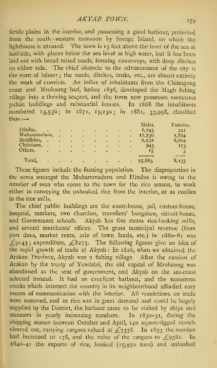
AKYAB TOWN. i 59
fertile plains in the interior, and possessing a good harbour, protected
from the south-western monsoon by Savage Island, on which the
lighthouse is situated. The town is 15 feet above the level of the sea at
half-tide, with places below the sea level at high water, but it has been
laid out with broad raised roads, forming causeways, with deep ditches
on either side. The chief obstacle to the advancement of the city is
the want of labour ; the roads, ditches, tanks, etc., are almost entirely
the work of convicts. An influx of inhabitants from the Chittagong
coast and Mrohaung had, before 1836, developed the Magh fishing
village into a thriving seaport, and the town now possesses numerouspublic buildings and substantial houses. In 1868 the inhabitants
numbered 15,536; in 1872, 19,230; in 1881, 33,998, classified
thus :
—
Males. Females.Hindus, 6,243 !2iMuhammadans, n,73o 1,834Buddhists, ........ 6,932 6,004Christians, ........ 943 173Others, 15 3
Total, 25,863 8,135
These figures include the floating population. The disproportion in
the sexes amongst the Muhammadans and Hindus is owing to the
number of men who come to the town for the rice season, to work
either in conveying the unhusked rice from the interior, or as coolies
in the rice mills.
The chief public buildings are the court-house, jail, custom-house,
hospital, markets, two churches, travellers' bungalow, circuit-house,
and Government schools. Akyab has five steam rice-husking mills,
and several merchants' offices. The gross municipal revenue (from
port dues, market rents, sale of town lands, etc) in 1880-81 was
^9143; expenditure, ,£8275. The following figures give an idea of
the rapid growth of trade at Akyab : In 1826, when we obtained the
Arakan Province, Akyab was a fishing village. After the cession of
Arakan by the treaty of Yandabii, the old capital of Mrohaung was
abandoned as the seat of government, and Akyab on the sea-coast
selected instead. It had an excellent harbour, and the numerouscreeks which intersect the country in its neighbourhood afforded easy
means of communication with the interior. All restrictions on trade
were removed, and as rice was in great demand and could be largely
supplied by the District, the harbour came to be visited by ships andsteamers in yearly increasing numbers. In 1830-31, during the
shipping season between October and April, 140 square-rigged vessels
cleared out, carrying cargoes valued at ^7378. In 1833 the numberhad increased to 178, and the value of the cargoes to .£9381. In
1840-41 the exports of rice, husked (15,970 tons) and unhusked

160 AKYAIV.
(75,255 tons), amounted to the total value of £114,220, and the
number of vessels cleared out in that year was 709. Ten years later,
in 1851-52, though the number of ships cleared out had fallen to
394, the total value of the exports amounted to £168,382. The
principal export trade was then with Madras, whence the grain was
re-shipped as Madras rice. The annexation of Pegu at the conclusion
of the second Burmese war, 1852-53, made but little difference in the
trade of Akyab. The export of rice, husked and unhusked, continued
to increase as did the trade generally. In 1861-62, the value of imports
was .£562,749, and of exports £460,153 ; ten years later, in 1871-72,
the value of the imports was £763,764, and of the exports £"546,016;
aggregating £"1,309,780. In 1881-82, the values were— imports,
£lZS>W> exports, £^920,057; total, ,£1, 655,189. Rice and petroleum
are the two principal exports from Akyab, valuable sources of supply of
the latter having been lately discovered on the Borongo Islands and in
Ramri. There is but little import trade from Europe direct, almost
all requirements being brought from India and from Rangoon. Theimports from the United Kingdom consist of coal and machinery ; of
Indian produce from Indian ports, apparel, rope, cocoa-nuts, gunny
bags, metals, mineral and vegetable oils, ghi, salted fish, silk piece
goods, spices, sugar, and raw tobacco ; and of foreign merchandise
from the same ports, cotton twist, yarn and piece goods, hardware and
cutlery, liquors, machinery, metals, and silk and woollen piece goods.
The exports consist almost entirely of rice, husked and unhusked,
hides and horns, cutch, mineral oil, salted fish, and betel-nuts. Thecourse of trade, and the large revenues raised in Akyab District,
render the import and export of treasure large. The average annual
import of treasure during the five years ending 1881-82 was £"422,841
;
the exports amounting to £"99,962. 'Akyab' is supposed to be a
corruption of 'Akyat-daw,' the name of a pagoda in the neigh-
bourhood, probably once a landmark for ships. In the Burmese
language the place is called Tsit-twe, because the British Armyencamped here in 1825.
From the statistics given in the foregoing article, it will be seen that
Akyab had grown from a fishing village to a town of 15,536 inhabitants
during the first forty years of British rule, and that during the past
thirteen years it has more than doubled its population—from 15,536 to
34,000. In the fifty years from 1831 to 1881, its trade has multiplied
more than 220 times, or from £7378 to over 1^ millions sterling. Ascommunications are developed with Bengal, it is hoped that the labour
difficulty will be still further diminished—the difficulty which stands in
the way of an immense expansion of the trade of Akyab town.
Akyaw.—Revenue circle of Thoon-khwa District, British Burma.
Northern portion more cultivated than the south, which is a forest.

ALABAKHSHPUR—ALAKNANDA. \ 6 i
Inhabitants principally traders, fishermen, and rice cultivators. Landrevenue (1874-75) ^2og. Capitation tax (1875-76) ,£180.
Al&bakhshpur.— One of the business quarters of Patna City,
Bengal, with large trade in oil-seeds. Lat. 25 36' n., long. 85 15' e.
Alagar.—Range of low hills, Madura District, Madras Presidency;
about 12 miles in length, average height 1000 feet above the sea.
Sandstone predominates in their composition, but a great variety of
geological formations are found at their base. On the south-east face,
at the foot of the hill, stands the Kallar-Alagar Kovil, the ancient
temple of the Kalians or Kallars, situated 12 miles north-east of
Madura. Lat. of Alagar Hill, io° 6' n., long. 78 17' 15" e.
Alahyar-jO-Tando (Tando AIdhydr).—Tdluk in the Hala Sub-
division, Haidarabad District, Sind, Bombay Presidency, lying between
25 8' and 25 50' n. lat., and between 68° 37' and 69 2' e. long. Popula-
tion (1881) 66,126; namely, Muhammadans, 49,319; Hindus, 10,467;
Sikhs, 2242; aboriginal tribes, 4091; others, 5. Area, 696 square
miles, with 61 towns and villages; number of occupied houses, 12,941.
Revenue (1880-81), ^"10,058 ; being ^9536 imperial, and ^522 local.
Alahyar-jO-Tando {Tando Aldhydr).—Chief town of taluk of same
name in Sind, Bombay Presidency. Lat 25 27' n., long. 68° 45' e.
Founded about 1790 by a son of the first sovereign of the Talpur
dynasty. Population (1881) 3898. Trade in sugar, ivory, silk, cloth,
cotton, oil, and grains; yearly amount about ^11,600 ; besides transit
trade of ^16, too. Municipal revenue in 1880-81, ^694; disburse-
ments, ^"514; taxation per head, 3s. 2^d. Under the Talpur dynasty,
the town attained considerable commercial importance, but has
declined in modern times, especially since the opening of the railway
line in 1861, between Kotri and Karachi which diverted the trade
of northern Sind. Extensive cultivation of cotton ; raw silk, metal
pots, and ivory, are largely imported ; silk weaving and ivory work
form the chief local industries. The chief buildings are the fort,
subordinate judge's court, post-office, dispensary, school, and market.
Alaipur.—Trading village in Khulna District, Bengal, at the junction
of the Bhairab and Atharabanka rivers. Lat. 22 49' n., long. 89°4i' e.
Noted for the manufacture, on a large scale, of excellent pottery.
Alaknanda.—River in Garhwal District, North-Western Provinces;
one of the main upper waters of the Ganges. It rises in the snowy
ranges of the Himalayas, and runs through the central valley which
forms the upper part of the Garhwal District. The river is numbered
among the sacred streams of India ; and each of the points where it
meets a considerable confluent is regarded as holy, and forms a station
in the pilgrimage which devout Hindus make to Himachal. TheAlaknanda is itself formed by the junction of the Dhauli and Saraswati
(Sarsuti) and receives in its course the Nandakini, the Pindar, and the
VOL. I. L

1 6 2 ALAMBADAI—ALAMNA GAR.
Mandakini. At Deoprayag it is joined by the Bhagirathi, and the
united streams are henceforward known as the Ganges. Thoughthe Alaknanda is the more important in volume and position, the
Bhagirathi is popularly considered the chief source of the holy river.
The character of the Alaknanda is that of a mountain stream, and the
only town upon its banks is Srinagar in Garhwal. Floods not unfre-
quently occur, one of which, before the British occupation, swept away
the greater part of the town. Gold was formerly found in the sands
of this river, but the search is so little remunerative that it has been
discontinued.
Alambadai.— Town in Coimbatore District, Madras Presidency.
Lat. 12° 9' n., long. 77 49' e. On right bank of the Kaveri (Cauvery),
65 miles east of Seringapatam. An important place in the 17th century.
Garrisoned for a short time in 1768 by British troops, but relinquished
on the advance of Haidar All's army.
Alamdanga.— Trading village on the Pangasi river, Nadiya Dis-
trict, Bengal, and a station on the Eastern Bengal Railway; 93 miles
from Calcutta. Since the opening of the railway, the rice trade has
largely increased. Lat. 23 45' 30" n., long. 88° 59' 30" e.
Alamgir Hill.—One of the peaks of the Assia range, in Orissa.
Lat. 20 37' n., long. 86° 16' e. On the summit of a precipice of this
hill, 2500 feet above the neighbouring country, stands a mosque, built
(1719 a.d.) by Shuja-ud-din, the Orissa Deputy of the Nawab Murshid
Kuli Khan, and endowed by him with a grant of 60 acres of land.
Every morning and evening, the people of the neighbourhood, Hindus
as well as Muhammadans, offer homage at the shrine.
Alamgirnagar.—An ancient fort, which once commanded the mouth
of the Meghna river ; it long formed a pirate stronghold, but was stormed
and taken from the Arakanese by the Mughals under Husain Beg, the
general of Nawab Shaista Khan, in 1664-65 a.d.
Alamnagar. — Village in Bhagalpur District, Bengal, situated in
lat 25 33' 45" n., long. 86° 56' 21" e., about 7 miles south-west of
Kishenganj. This was once the principal village of a powerful Chandel
family, which at one time possessed fifty two adjacent townships, and
enjoyed a considerable revenue. The estate, however, was squandered
away, and at present only two villages remain to the family. Ruins of
fine tanks, earthenware ramparts of forts, and of a large family resi-
dence, alone remain to show the former wealth of the owners. Theprevailing castes are Rajputs and Brahmans.
Alamnagar.—Pargand in tahsil Shahabad, Hardoi District, Oudh ;
bounded on the north by Kheri District, on the east by Pihani, on
the south by North Sara, and on the west by Shahabad pargand.
This part of the country appears to have been held originally by the
Thatheras, until, at some uncertain period in the later days of Hindu

ALAMNAGAR-TBOMSONGANJ-ALANDI., 6 3
dominion, a band of Gaur Kshattriyas crossed rt» rKanauj and drove them out. Shortl/^foT^ffljof^8
•*TNikumbhs obtained a footing in tL !.
Kanauj, tI,e
country side by sMe^T^t^ttt^T^ *"Akbar, grew rebellious, and were expend by Li abS.'d V^^illustrious founder of the line of Pihin SayTidT Th^f I
J"^^
Nikumbhs fell before the rising power SS^S X a^r
domain of the Pihani and Muhamdi S«S and besUve/r fdepressed Nikumbhs and Gaurs who had thUnn „
t°Wed.
lt uP°n the
engaging for a portion of their otpoesions APPO
fT °f^59 square miles, of which only ninefeent the middle S^Z"*ucmana, ^2451, at the rate of is. ?#d Der arr^ nf n™ -d i
•
/ T oo T \ T 5oQ, a ,^ 8
^cre ot area
- Population
The mat o7 Alar8"^ °fP^ "' ^ P<*W mi e£ rfS4?TX
C°nSIStS°f a dUStCT °f
?6 h°- with a
acres>'
7I> others
> 73- Area of town site, 3S
vSS^Tt^^ * Ch«**»? (Chi^0 District, Madras
Muzaffar Jang, the ffiKrTtt.wTS*^ ^^sh" ^rr dUrm§th
!--^'tweenTe' Kr^hVnd
of £e nations5™, TT "^ enSaSement between the squadrons
n (
eSe
;a
f
"0ns,
was fought opposite the village. It was a French
E Coltt
I
drng
phe"re
05 MadraS>
a"d ™ oaptur^d b "sit) re Coote m 1 760. Formerly famous for its oyster-beds
Jiaroda,and ^16, 4s. to the Nawab of Junagarh
Ag7ncTT™^W
°f I
nd°re Stat6
' '" Bundelkhand, Central India
r"' ES 2? V1"ages> with a reven^ (1878) of r-,,7Esnmated population (1878) r 7,ooo j chief town, Alampur. * '°" 7 '
AlandL-lown, and a place of Hindu pilgrimage, in Puna (Poona)

1 64 ALAPUR—ALA Y-KYWON.
District, Bombay Presidency. Lat. 18 27' n., long. 74 6' 30" e.;
population (188 1) 1754; municipal revenue (1881-82), ^459 ; expen-
diture, ,£282 ; rate of taxation, 4s. 9 Jd. per head.
Alapur. — Town in Budaun District, North-Western Provinces,
situated in lat. 27 54' 45" N., long. 79 17' e. ; 11 miles south-east of
Budaun town. Population (1881) 5630, comprising 3878 Hindus and
1752 Muhammadans. A small house tax is levied under the provisions
of Act xx. of 1856 for police and conservancy purposes. Police outpost
station ; village school ; market twice a week. The town is named
after Ala-ud-din, the last Emperor of the Sayyid dynasty, who is said
to have founded it after his abdication of the throne of Delhi and
retirement to Budaun, 1450 a.d. The estate within which the town
lies has been held for ages by Saraswati Brahmans, who claim to have
obtained it from Ala-ud-din.
Alattlir (Elattur).—Town in Malabar District, Madras Presidency.
Lat. ii° 52' n., long. 76 6' 30" e. Population (1881)3328; houses,
507. Sub-magistrate's and subordinate civil courts; post-office;
travellers' bungalow ; weekly market.
Alaut. — Pargana of the Dewas State, under the Western MahvaAgency, Central India.
Alawakhawa {Alawa—dried rice distinguished from rice prepared
by boiling, and khdwd—to eat).—A celebrated fair held in Balia village,
Dinajpur District, Bengal. It is held in honour of Krishna every
year on the occasion of a Hindu religious festival (Raspurnima),
celebrated in October or November. The god is worshipped by the
devotees with offerings of dried rice, and hence the name. The fair
lasts from eight to fifteen days, and is attended by about 75,000 or
80,000 persons. A considerable trade is carried on here at this time.
Alawalpur. — Town in Kartarpur iahsil, Jalandhar (Jullundur)
District, Punjab. Lat. 31° 26' n., long. 75 42' e. Population (1881)
3802, comprising 2206 Muhammadans, 578 Hindus, and 18 Sikhs.
Third-class municipality. Revenue, chiefly from octroi dues, in 1880-81,
^137 .;expenditure, ^131.
Alay Khyoung. — Revenue circle, Kyouk-hypu District, British
Burma. Area, 25 square miles. Salt manufacture.
Alay-Kywon.— Revenue circle, Bassein District, British Burma.
Area, 65 square miles. The centre of the mass of islands lying in
the river Bassein, between the Bassein and Thek-kay-thoung mouths.
Flat and jungly, with low sand-hillocks, and covered with a network of
streams, its chief means of inter-communication. Revenue (1876),
^"815. Inhabitants chiefly engaged in salt-making and fishing.
Alay-Kywon.—Revenue circle, Kyouk-hypu District, British Burma;
on north coast of Hunter's Bay. Area, 27 square miles. Land revenue
(1875), ^466 ; capitation tax, ^138.

ALDEMA U—ALIABAD. 165
Aldem&TL—Pargattd in Sultanpur District, Oudh. This par-amiappears to have been originally in the hands of the Bhars ; and local
tradition asserts that a prominent Bhar chieftain, named Aide, built afort and city on the high left bank of the Gumti, the ruins of whichstill exist, and which gave its name to the pargand. The only traces ofBhar occupation now visible consist of numerous old forts and ruinedtowns. Several settlements of Hindus were made during the Bharperiod. As the Muhammadan power in Oudh became gradually con-solidated, the Bhar supremacy languished, and ultimately the aboriginal
race entirely lost their footing. The principal Hindu tribes who havesettled here are the Sakarwdrs, Raghubansfs, Ujainias, Bais, Pandes,Kiirmis, and Rajkumars. The Rajkumars are the latest arrivals, butthey soon became the most powerful, and the rights of other clans
rapidly declined until this pargand (among others) may now be con-sidered as the Rajkumdrs' zaminddri. The great Rajkumdr estates in
Aldemau are Dera, Meopur, Nanamau, and Paras-patti. Their chiefs
were at deadly feud with each other down to the time of the annexationof Oudh, and much blood has been shed from their jealousies. Thepargand contains an area of 349 square miles, or 223,373 acres, ofwhich 112,480 are cultivated. Government land revenue, ^20,218,being at the rate of 3s. per acre of arable land. Population (1881),Hindus, 158,446 ; Muhammadans, 10,046 : total, 168,492. Averagedensity of the population, 485 per square mile. Several classes of
professional thieves have their home in this pargand.
Alengad.
—
Taluk in Travancore State, Madras Presidency. Area,
208 square miles. Population (1881) 66,753.
Alguada.—Dangerous reef in the Bay of Bengal, off the coast of
Pegu, British Burma. Bearing from Diamond Island, 3J leagues south-
south-west. Lat. 1
5
40' 15" n., long. 94 16' 45" e. The rocks
extend \\ mile north and south, level with the surface of the sea, andhave outlying reefs at some distance. This dangerous spot is known to
the Burmese as Nagarit Kyauk, but to the rest of the world by the
name given to it by the Portuguese mariners, Alguada. The mainreef has a granite lighthouse 144 feet high, with first-class catadioptric
light, revolving once in a minute, visible twenty miles. A work of
great labour, commenced in 186 r, and completed in 1865 under the
superintendence of Captain (now Major-General) A. Fraser, C.B. TheAlguada reef lies on the submarine volcanic band which stretches fromSumatra to the delta of Bengal.
Aliabad.—Village in Bara Banki District, Oudh; about 30 miles east of
Bara Banki town, on the road from Daryabad to Rudauli. Lat. 2 6° 51' n.,
long. 8i° 41' e.;population (1881) 1883. Formerly celebrated for its
looms, and a considerable seat of the cloth trade ; now declined owingto competition of English goods. Inhabitants principally weavers.

1 66 ALIBAGH—ALIGANJ.
Alibagh.— Sub-division of Kolaba (Colaba) District, BombayPresidency. Area, 194 square miles ; contains 3 towns and 169 villages.
Population (1881) 76,138, of whom 38,355 were returned as males, and
37,783 as females. Hindus numbered 72,476; Muhammadans, 2119;
and 'others,' 1543.
Alibagh.—Chief town of Kolaba District, and head-quarters of the
Sub-division of Alibagh, Bombay Presidency; 19 miles south of
Bombay. Lat. 18 ^' 55' N -> l°ng- 7 2° 54 5°" E - Alibagh was
named after a rich Muhammadan, who lived about two centuries ago,
and who constructed several wells and gardens in and near the town,
many of which still exist. On entering the harbour, the buildings of the
town are hid from view by a belt of cocoa-nut trees. The only object
of mark is the Kolaba fort,—on a small rocky island, about one-eighth
of a mile from the shore,—once a stronghold of the Maratha pirate-
captain Angria. (See Kolaba District.) About 2 miles out at sea, to
the south-west of the Kolaba Fort, a round tower, about 60 feet high,
marks a dangerous reef, covered at high water, on which several vessels
have been wrecked. Population (1881) 6376; namely, Hindus, 5674;Muhammadans, 407 ;
Jains, 66 ; Christians, 55 ; Pdrsis, 2 ; 'others,' 172.
Municipal revenue (1881), ^1076; rate of taxation, 2s. 6d. per head;
municipal expenditure, £652. The town is supplied with drinking
water from a lake, recently made, distant about a mile and a half to
the north-east, on the road to Dharamtar, and contains a sub-judge's
court, a customs house, hospital, jail, schools, and a post-office. Thegardens of Alibagh, which yield cocoa-nuts and some fine varieties of
graft mangoes, are among the best in the District. Average annual value
of trade at the port of Alibagh, for five years ending 1881-82 :
—
Exports, £"14,224 ; imports, £"20,263.
All Bandar.—Small town on the Gonni river, in Tando MuhammadKhan Sub-division, Haidarabad District, Sind, Bombay Presidency.
Lat. 24 22' n., long. 69 11' e. Remarkable as the site of a dam,' the only work of public utility ever made by the Talpur dynasty,'
which, however, by causing the deposit of silt above the town, cut off
its water communication with Haidarabad. The channel below the
town, once a main estuary of the Indus, dried up from the samereason, and the District of Saira (formerly remarkable for fertility)
became a part of the Rann, or Great Salt Waste of Cutch (Kachchh).
Aliganj.— Tahsil or Sub-division of Etah District, North-Western
Provinces. Lies between the Ganges and the Kali Nadi, intersected
by the Burh Ganga and Fatehgarh branch of the Lower Ganges Canal.
It comprises the four minor fiscal divisions (pargands) of Azamnagar,
Barna, Patiali, and Nidhpur. Area, 525 square miles, of which 352are cultivated. Population (1881) 186,364; land revenue, £"24,279
;
total revenue, ,£27,421 ; rental paid by cultivators, £"59,380. In

ALIGANJ—ALIGARH. , 6 7
1SS3, the talisil contained one magisterial court, with four thdnds or
police circles. The regular police force numbered 65 men; townpolice, 58; and village watch or rural police, 411 men.
Aliganj.—Town in Etah District, North-Western Provinces; 32miles north-west of Fatehgarh. Lat. 27 29' 20" n., long. 79 12' 40" e.
Population (1881) 7436, comprising 4787 Hindus, 241 1 Muham-madans, 237 Jains, and 1 Christian; area, 96 acres. Rather a large
agricultural village than a town. A wide metalled road, containing the
principal bazar, runs through the town from north to south, crossed byanother metalled road at right angles. The shops are, for the mostpart, built of mud, but there are a few large brick-built houses, the
residences of the wealthier traders. Police station, post-office, large
clean sarai or native inn. Chief trade—grain, indigo-seed, and cotton.
Tri-weekly market. The town contains two unpretending mosques anda large mud fort, constructed in 1747 by Yakut Khan, a Muhammadanconvert, whose family are still the principal landowners. Municipal
income in 1880-81, ^"340, chiefly from octroi dues; expenditure,
^283; incidence of municipal taxation, nd. per head of population
within municipal limits.
Aliganj.—Village in Kheri District, Oudh. Lat. 2 8° 9' n., long. 8o°
40' e. Population (1881) 117c; namely, Hindus 932, and Muham-madans 238. Bi-weekly market. Ruins of old mud fort.
Aliganj Sewan.—Town in Saran District, Bengal, and head-
quarters of the Sewan Subdivision. Lat. 26 13' 23 n., long. 84 23'
43" e. Population (1881) 13,307; namely, Hindus, 8115; Muham-madans, 5184 ; Christians, 8. The place is noted for the manufacture
of superior pottery (red and black glazed, as well as unglazed and
porous), brass vessels, and chintzes. Boats can come up the river Daha,
on which the town is situated, at all seasons. Distance from Chhapra,
40 miles; from Dinapur, 54. Municipal income in 1881-82, ^523.Aligarh.—District in the Lieutenant-Governorship of the North-
Western Provinces and Oudh, lying between 27 28' 30" and 28 10' n. lat.,
and between 77 31' 15" and 78°4i' 15" e. long. Area, 1955 square miles.
Population (1881) 1,021,187. Aligarh is the southernmost District of
the Meerut (Mirath) Division, and is bounded on the north by
Bulandshahr District ; on the east by Etah ; on the south by Muttra
District ; and on the west by Muttra District and by the river Jumna(Jamuna). The administrative head-quarters are at the civil station of
Aligarh, adjoining the town of Koil (Koel).
Physical Aspects.—Aligarh forms a portion of the great alluvial plain
lying between the Ganges and the Jumna, and known accordingly as
the Doab. Its surface is one broad unbroken level, having a general
elevation of about 600 feet above the sea, with a slight slope toward
the south-east. On either side, it dips down abruptly into the hollow

1 68 ALIGARH.
valleys of the two great rivers, which flow at a depth of about 60 feet
below the central plateau. The watershed between them is composed
of a low sandy ridge, along whose summit the course of the Ganges
Canal has been carried. That magnificent work passes almost through
the centre of the District from north to south, and distributes its waters
by minor channels to the thirsty plain on either hand. Near the town
of Akrabad it divides into two terminal branches, which severally run
to Cawnpur and to Etawah. Under the influence of this great fertilizing
agent, the plain of Aligarh presents, in the cool season, an almost
uninterrupted sea of green and smiling cultivation, interspersed with
numerous flourishing villages. The jungle, which covered a large
portion of the District at the commencement of the British occupation,
is rapidly disappearing ; and, with the spread of tillage, the country is
now being denuded of trees. The total area under groves, such as
mango and other fruit trees, etc., is only 5676 acres. There are few
Districts which present such a bare appearance, and none where more
efforts should be made to induce the people to plant trees. This has
been partially attained by the Government allowing a remission of
revenue for land under groves, and a considerable extension of tree
plantations is anticipated. The principal plantation trees are mmt
mango, jdmzm, pipal, babul, mahud, fards, and ber. Sal, and the better
sorts of timber for building purposes, are imported. The soil through-
out the District may be said to consist of a rich fertile loam, which
becomes much indurated wherever it comes into constant contact with
water ; whilst here and there are large tracts of sandy soil. To the
north-east, the land bordering the Ganges possesses a more or less
sandy soil. To the west, along the high bank of the Jumna, the soil is
sandy for a few miles, but then comes pure loam, with occasional
hillocks or high ridges of sand. In the north of the District, the
eastern tracts are inferior to the western, and neither are so fertile as
the tracts to the south. The substratum is entirely kankar, or nodular
limestone, which is found everywhere a few feet below the surface, and
in several places crops out. It is used for building purposes, and in
the form of coarse gravel for metalling roads. On the higher grounds,
which sever the small streams from one another, extensive patches of
barren land occur, known by the name of usar. They are caused by
the efflorescence of a noxious salt, called by the natives reh, and no
plant or weed will grow upon the soil which it covers. It forms a white
crust on the ground, and the spots on which it has gathered stand out
upon the landscape glistening white in the sun, like snow on a bright
winter's day in more northern climates. Unfortunately the spread of
irrigation seems to have contributed to its increase, as the water, which
percolates the earth, brings this deleterious saline substance to the
surface. The Ganges marks the boundary line in the north-east

ALIGARH. 169
corner of the District, and the Jumna runs along the western frontier
for about 16 miles. The two main rivers are bordered by strips of low-
land, largely used for grazing; and the Ganges shifts its channel from
time to time, thereby exposing fresh alluvial tracts, whose deep deposits
of decaying vegetable matter render them singularly fertile. The minor
rivers and streams are the following:—The Kali Nadi, which flows
through the District from north-west to south-east, into Etah District.
Largely used for irrigation, and also affords an escape for the excess
water of the canals. The river is bridged at the eleventh mile on the
road from Aligarh to Moraddbad, where in high flood the river has a
breadth of 187 feet, and a depth of 14 feet ; and in the hot season a
breadth of 30 feet, and a depth of 8 feet. It is also bridged at the
twenty-second mile on the Aligarh and Kdsganj road, where the stream
has a width of 250 feet and a depth of 14^ feet in seasons of flood, and
a width of 60 feet and a depth of 5 \ feet in the hot season. The Nim
Nadi also flows through the north-east of the District, and eventually falls
into the Kali Nadi. It is bridged at Malsai and Bhikampur, and its
waters are largely used for irrigation. The river has a breadth of 200 feet,
and a depth of 8 feet in the rains. The Karon Nadi, Isan, Sengar,
and Rind are minor streams, which, though of considerable breadth and
depth, are, as a rule, dry in the hot and cold weather. The Ganges
Canal enters Aligarh from Bulandshahr District on the north, and
flows in a generally straight south-easterly direction into Etah District,
and ultimately joins the Ganges at Cawnpur. From Akrabad, a branch
canal is thrown off to the south, but afterwards turns eastwards, and
runs parallel to the main canal at a distance of about 5 miles, also into
Etah District, after which it again turns southward and joins the Jumna
in Etawah District. To a general view, the plain of Aligarh displays
one of the most fruitful and prosperous tracts of the Upper Doab.
History.—The few facts in the early annals of the District which
can now be recovered centre around the ancient city of Koil, of which
the fort and station of Aligarh form a suburb. A popular legend
informs us that Koil owes its origin to one Kosharab, a Kshattriya of
the Lunar race, who called the city after his own name ; and that its
present designation was conferred upon it by Balaram, who slew here
the great demon Kol, and subdued the neighbouring regions of the
Dodb. Another tradition assigns a totally different origin to the name.
The District was held by the Dor Rajputs before the first Muham-
madan invasion, and continued in the hands of the Raja of Baran
until the close of the 12th century. In n 94 a.d. Kutab-ud-din
marched from Delhi to Koil, on which occasion, as the Muham-
madan historian informs us, 'those who were wise and acute were
converted to Islam, but those who stood by their ancient faith were
slain with the sword.' The city was thenceforward administered

i;o ALIGARH.
by Musalman governors, but the native Rdjas retained much of
their original power. The District suffered during the invasion of
Timur in the 14th century, and participated in the general misfor-
tunes which marked the transitional period of the 15 th. After
the capture of Delhi by the Mughals, Babar appointed his follower,
Kachak Ali, governor of Koil (1526); and in the reign of Akbar,
the town and District were organized on the general scheme by
which that great Emperor endeavoured to consolidate and unify his
wide dominions. Many mosques and other monuments still remain,
attesting the power and piety of Musalman rulers during the palmy
days of the Mughal dynasty. The period was marked, here as else-
where, by strenuous and successful proselytizing efforts on the part of
the dominant religion. But after the death of Aurangzeb, the District
fell a prey to the contending hordes who ravaged the fertile stretches
of the Doab. The Marathas were the first in the field, and they were
closely followed by the Jats. About the year 1757, Suraj Mall, a Jat
leader, took possession of Koil, the central position of which, on the
roads from Muttra and Agra to Delhi and Rohilkhand, made it a post
of great military importance. The Jats in turn were shortly afterwards
ousted by the Afghans (1759), and for the next twenty years the Dis-
trict became a battle-field for the two contending races. The various
conquests and reconquests which it underwent had no permanent effects,
until the occupation by Sindhia took place in 1784. The District
remained in the hands of the Marathas until 1803, with the exception
of a few months, during which a Rohilla garrison was placed in the
fort of Aligarh by Ghulam Kadir Khan. Aligarh became a fortress of
great importance under its Maratha master ; and was the depot where
Sindhia drilled and organized his battalions in the European fashion,
with the aid of De Boigne. When, in 1802, the triple alliance between
Holkar, Sindhia, and the Raja of Nagpur was directed against the
British, the Nizam, and the Peshwa, Aligarh was under the command of
Sindhia's famous partisan leader, Perron, while the British frontier had
already advanced to within 15 miles of Koil. Perron undertook the
management of the campaign ; but he was feebly seconded by the
Maratha chieftains, who waited, in the ordinary Indian fashion, until
circumstances should decide which of the two parties it would prove
most to their interest to espouse. In August 1803, a British force
under Lord Lake advanced upon Aligarh, and was met by Perron at
the frontier. The enemy did not wait after the first round of grape
from the British artillery, and Perron fled precipitately from the field.
Shortly after, he surrendered himself to Lord Lake, leaving the fort of
Aligarh still in the possession of the Maratha troops, under the com-
mand of another European leader. On the 4th September, the British
moved forward to the assault ; but they found the fortifications

ALIGARH., 7I
planned with the experience and skill of French engineers, anddesperately defended with true Maratha obstinacy. It was only aftera most intrepid attack, and an equally vigorous resistance, that thefortress, considered impregnable by the natives, was carried by theBritish assault
; and with it fell the whole of the Upper Dodb to thevery foot of the Siwaliks. The organization of the conquered territoryinto British Districts was undertaken at once. After a short period,during which the fargands now composing the District of Aligarh weredistributed between Fatehgarh and Etawah, the nucleus of the presentDistrict was separated, in 1804. Scarcely had it been formed whenthe war with Holkar broke out ; and his emissaries stirred up thediscontented revenue-farmers, who had made fortunes by unscrupulousoppression under the late Maratha rule, to rise in rebellion against thenew Government. This insurrection was promptly suppressed (1805).A second revolt, however, occurred in the succeeding year; andits ringleaders were only driven out after a severe assault upon theirfortress of Kamona. Other disturbances with the revenue-farmersarose in 181 6, and it became necessary to dismantle their forts. Thepeace of the District was not again interrupted until the outbreak of theMutiny. News of the Meerut revolt reached Koil on the 12th May1857, and was here followed by the mutiny of the native troops quarteredat Aligarh, and the rising of the rabble. The Europeans escaped withtheir lives, but the usual plunderings and burnings took place. Untilthe 2nd July, the factory of Mandrak was gallantly held by a smallbody of volunteers in the face of an overwhelming rabble, but it wasthen abandoned, and the District fell into the hands of the rebels. Anative committee of safety was formed to preserve the city of Koil fromplunder, but the Musalman mob ousted them, and one Nasim-ullatook upon himself the task of government. His excesses alienatedthe Hindu population, and made them more ready to side with theBritish on their return. The old Jat and Rajput feuds broke outmeanwhile with their accustomed fury ; and, indeed, the people indulgedin far worse excesses towards one another than towards the Europeans.On the 24th August a small British force moved upon Koil, when therebels were easily defeated, and abandoned the town. Various otherbodies of insurgents afterwards passed through on several occasions, butthe District remained substantially in our possession ; and by the end of
1857, the rebels had been completely expelled from the Doab. Withthat episode the history of Aligarh fortunately closes.
Population.—An enumeration in 1853 returned the total inhabitantsat i
>i 34jS65. The population in 1872, according to the Census of that
year, but allowing for some trifling changes of area, amounted to
I »°73 )2 5 6 - The latest Census in 1881 returned a total population of
1,021,157 (on an area of 1955 square miles), showing a decrease of

172 ALIGARH.
52,069 or 4'8 per cent, in the nine years. The male population in
1881 numbered 551,279, and the female 469,908; proportion of males
in total population, 54 per cent. Average density of population,
522 per square mile j number of towns and villages, 1743 ; number of
occupied houses, 124,573; number of villages per square mile, '89;
houses per square mile, 637 ; inmates per house, 8*i. As regards the
religious distinctions of the people, 901,144, or 88*2 per cent., were
returned as Hindus, and 117,339, or 11-5 per cent., as Muhammadans.
There were also 2377 Jains, 26 Sikhs, 289 Christians, and 10 Parsis.
Of the four great classes into which the Hindus are divided, the
Brahmans numbered as many as 136,664 souls. They are chiefly
landowners. The Rajputs amounted to 75,841, amongst whom the
Jaduns and Chauhans are the most numerous. They are also land-
holders. The Baniyas, or trading classes, are returned as 50,817
souls. They are a wealthy body, chiefly absentees, who follow their
trades as money-lenders and brokers in the larger towns. The
Chamars are the most numerous amongst the low castes, amounting to
172,451 persons, or 16*9 percent, of the whole population; but they
are generally poor, almost serfs of the proprietor, and tied by debt to
the soil, with which they were transferred by custom. The Jats comenext in number, with 83,605 souls, and rank far the first in social and
political importance, from the industry with which they cultivate their
villages. They have a hereditary feud with the Rajputs, and the two
tribes will not inhabit the same villages. Gadarias, or shepherds,
number 31,906; Lodhis, 37,331; Kolfs, 29,521; Kachhis, 23,618;
Kahars, 26,445; an<^ Ahirs, 12,099. There were 42 native Christians
in the District in 188 1. Seven towns had populations exceeding 4000
souls—namely, Tappal, 4712; Jalali, 4939; Harduaganj, 4520;Sikandra Rao, 10,193: Atrauli, 14,374; Hathras, 25,656; andKoil (with Alfgarh), 61,730. These figures show an urban population
amounting to 126,124 souls, leaving a rural body of 895,033. Of the
total of 1743 towns and villages, 456 contained less than two hundred
inhabitants in 1881; 708 from two to five hundred; 379 from five
hundred to a thousand; 153 from one to two thousand; 22 from two
to three thousand; 21 from three to five thousand; 2 from ten to
fifteen thousand; 1 from twenty to fifty thousand; and r with over fifty
thousand inhabitants. The northern half of the District abounds with
the ruins of old forts. The language of the peasantry is Hindi,
tinged in the south with the Braj dialect, but the better classes speak
the Urdu of Delhi. As regards occupation, the Census Report returns
the male population under six main heads, as follows :—Class (1) Pro-
fessional, including civil and military and the learned professions,
11,131; (2) domestic servants, lodging-house keepers, etc., 2183; (3)
commercial class, including merchants, traders, carriers, etc., 13,497 ;
ALIGARH.1 /3
(4) agricultural class, including cultivators, gardeners, tenders of sheenand cattle, etc., 198,620; (5) industrial, including manufacturers artisansetc., 91,642; (6) indefinite and non-productive (being 52,29! generallabourers and 182,115 male children or persons of unspecified occumtion), 234,406.
a
Agriculture.—Almost all the cultivable land in Alfgarh is undertillage, only 12 per cent of the available area, or 121,168 acres beinareturned as cultivable waste, while 88 per cent, or 897 172 acres isreported as being under cultivation. The area of uncultivable waste isreturned at about 208,000 acres. The greater portion of the cultivableland still available consists of wide tracts of poor sand and alluvialkhadir near the banks of the great rivers in the northern divisionsof Atrauh and Khair. The area under grass for pasturage is veryrestricted. The few wide uncultivated pasture lands in Atrauli andKhair must sooner or later come under the plough, and in a short timecultivation will have reached its limit in this District, where even nowthe pressure of the population on the soil is severely felt Aligarhhas in many places two, and in some three, harvests a year Theprincipal products are wheat (182,045 acres), barley (93,463 acres)joar (159,106 acres), and bdjra (70,405 acres). The cultivation ofcotton has largely increased of late years, and the returns show 11071cacres employed for that purpose, while indigo, another rising staple isgrown on 29,013 acres. Of the total cultivated area, 433,516 acres 'or48*3 per cent., are under kharif, or rain crops, of an estimated totalvalue of ^826,564, and 450,946 acres, or 50-3 per cent, are underrain, or cold-weather crops of a total estimated value of £1 241; enEstimated grand total value of both kharifand rabi crops ^2'o 7 2
07:'The average out-turn of cotton is 2 maunds, or 1 cwt 1 qr 24 lbsper acre
;value on the field, £2, 4 s. : while wheat produces about 17mounds 20 sers, or 12 cwts. 3 qrs. 6 lbs, per acre; value on the field
£2, 1 6s. Irrigation is widely practised, as many as 648,017 acres'or 72-3 per cent, of the cultivated area, being artificially supplied withwater in 1875, while only 248,357 acres, or 277 per cent, were de-pendent upon the precarious rainfall. Canals afforded water to 1 14 406acres, and 524,406 acres were irrigated from wells, the residue of10,005 acres being supplied from tanks. The main line of the GangesCanal has a length of 48-62 miles within the District; and from it 2*60mi es of greater distributaries, 49 miles of lesser distributaries, and 4S7mi es of small channels draw their supplies. The people are fairlywell off. Besides the ordinary tenures by zaminddri, pattiddri andbhayachdra, there is another known as tdlukddri, by which the minorproprietors are responsible for their share of the revenue to a superiorholder, called a tdlukddr, the latter being in his turn responsible toGovernment for the whole revenue of his subordinates, on which he

i 74 ALIGARH.
receives a fixed percentage. This tenure has grown up through some
confusion at the early settlements between the actual possession of
land and the responsibility of the Maratha revenue-farmers for the
taxes of the country farmed by them. Most of the District is cultivated
by tenants-at-will j only 29 per cent, of the area is held by tenants with
rights of occupancy. Rents are chiefly paid in cash, and vary much
with the means of communication and irrigation. Good irrigated lands
in the best situations let at jQi, 2s. 7d. an acre, but the same class of
soil without artificial water-supply, rents at only 10s. 6d. an acre.
Outlying dry lands are rated at from 3s. 3d. to 6s. an acre. Wages
ruled as follows in 1875 :—Blacksmiths, carpenters, masons, 7jd. per
diem; labourers, 3|d. to 4jd. ; coolies, 3d. ; women, 2 \&. ; boys, ifd.
Agricultural labourers obtained 3d. a day and 1 lb. of bread. Food-
stuffs have risen steadily in price of late years. In 1870, wheat was
18J sers the rupee, or 6s. ofd. per cwt. ; barley, 2 8Jd. sers the rupee,
or 3s. njd. per cwt. ; and jodr, 26f sers the rupee, or 4s. 2^d. per
cwt. Prices in Aligarh District for 1882 are returned as follow : wheat,
20J sers or 41 lbs. the rupee ; barley, 27 sers or 54 lbs. the rupee;jodr
(large millet), 24 sers or 48 lbs. the rupee; rice, 14 sers or 28 lbs. the
rupee; bdjra (common millet), 22J sers or 45 lbs. the rupee; gram
(pease), 21 \ sers or 43 lbs. the rupee.
Natural Calamities.—The District of Alfgarh is comparatively free
from the danger of famine, owing to the prevalence of irrigation,
more especially through the instrumentality of the great Ganges
Canal. Famines often occurred before the opening of that impor-
tant work ; the most severe one in the present century was due
to the drought of 1837. The District shared the unfortunate season
of 1868-69 w itn neighbouring tracts, and the result was dearth and
scarcity ; but actual famine was averted by the influence of the Ganges
Canal, and large quantities of grain were exported to less favoured
regions. The inestimable value of the canal was thoroughly tested on
that occasion, as Aligarh, which formerly used itself to suffer from
want of food, was enabled not only to supply its own needs, but also
to relieve the pressing necessities of the Punjab and the Native States
to the south. Prices rose very high during the scarcity, but the
market was ruled by the demand for increased exports rather than
by any danger of local distress. Prices were at their highest in
December 1868, when wheat was selling at 8\ sers per rupee, or
13s. 6d. per cwt, and jodr, the ordinary food of the poorer classes, at
n sers per rupee, or 10s. 2d. per cwt.
Commerce and trade, etc.—The principal articles of export from
Aligarh are grain, cotton, and indigo. The principal grain marts are
Hathras, Koil, Atrauli, Sikandra Rao, and Harduaganj. Allowing
for food and seed requirements, it is estimated that an average of

ALIGARH., 5
^354,45 x maundsox 991,651 cwts. is available as fcod for cattle, forreserve store, and for exportation. Nearly all the kharlf grain crops,except pulses, are consumed locally, and the exports are confined towheat, barley, bdjra, and gram, which are cold weather (rabi) crops,and to pulses. Cotton cultivation has increased to such an extentof late years, as to make it one of the characteristic products of theDistrict. About 212,603 maunds, or 156,198 cwts., of cotton areestimated as the average annual amount which is left for exportation,after all the needs of home consumption have been supplied. Theindigo trade is also flourishing and important, the District beingstudded with factories, which numbered 171 in 1873, and produced362s maunds, or 2663 cwts., of the marketable dye. There has beenan extraordinary increase in the cultivation of indigo by natives duringthe past fifteen years. Oil-seeds and saltpetre form other importantitems in the export trade. The imports consist of sugar, rice, Man-chester goods, spices, metals, tobacco, timber, and manufactured articlesgenerally. Hathras is the chief centre of trade, but Koil has alsoan extensive commerce. Excluding the five municipal towns ofKoil, Hathras, Atrauli, Sikandra Rao, and Harduaganj, there are 180markets in the District, or one to about every 10 villages. Cattlegrain, country cloth, vegetables, sweetmeats, toys, brass utensils, andpetty articles of domestic consumption are the chief commodities.Religious-trading fairs are held on the occasions of Hindu festivals, andby Muhammadans during the period of the Muharram. The meansof communication in Aligarh District are excellent, and new routes arein progress or under consideration. The East Indian Railway crossesthe District from north to south, with stations at Somna, Aligarh(Koil), Pali, and Hathras road. The Oudh and Rohilkhand linediverges from the East Indian at Aligarh, and runs north-east, withstations at Rampur (for Harduaganj) and Raipur (for Atrauli). Anew State line of railway on the narrow gauge was opened in 18S0,starting from the Hathras road station of the East Indian Railway toMuttra, a distance of 29 miles, of which 15 lie within Aligarh District, withstations at Hathras city and Mursan. The Ganges Canal is alsolargely employed for through traffic. The Grand Trunk Road entersthe District at its south-east corner, and proceeds by Sikandra Rao,Koil, and Somna, into Bulandshahr District, where one branch leadsto Delhi, and another to Meerut. Its total length in Aligarh Districtis 49\ miles. There are 229 miles of first-class roads in theDistrict, most of which are metalled and bridged ; and in additionto these, the chief villages, marts, and police stations are connectedby a network of cross-country roads, 90 miles being second class,and 182 third. The District contains a remarkable native association,the Aligarh Institute and Scientific Society, founded in 1S64 by Nawab

176 ALIGARH.
Sayyid Ahmad Khan, C.S.I. Its main object is the translation into
the vernacular language of modern scientific and historical works. It
possesses a library of 2000 volumes, and a reading-room for English
and native papers. A journal is published twice a week in connection
with the society, known as the Aligarh Institute Gazette ; printed in
English and Urdu. Two other newspapers were printed at Aligarh
in 1 88 1, the Bkarat Bandu, a weekly; and the Dharma Samdj Patr,
a monthly journal. A periodical called the Tasdnil-i-Ahmadi, is also
published in connection with the Aligarh Institute, and there are two
private presses.
Administration.—In i860, the revenue from all sources amounted to
£197,837, of which £178,299, or 90-12 per cent, of the total, was
contributed by the land tax. At the same date, the expenditure
amounted to £52,146, or little more than one-fourth of the revenue.
In 1870, the total receipts had risen to .£223,709, of which £196,655,
or 87*90 per cent, of the whole sum, was contributed by the land tax.
At the same time the expenditure had decreased to £43,472, or less
than one-fifth of the revenue. In 1880-81, the gross revenue of the
District had risen to £250,606, of which £213,403, or 85*14 per cent.,
were derived from the land. The total cost of officials and police of
all kinds in the same year, was £37,781. The principal items of
receipt, exclusive of land tax, are judicial charges, and stamps. Thelast land settlement was made in 1871-73, and will remain in force
until 1 90 1. The District is administered by a Magistrate-Collector
and his Assistant, with about five or six Deputy Collectors, about
as many ta/isi/ddrs, and six Honorary Magistrates. There were four
munsifs, besides the Judge of Aligarh. Twenty magisterial and 22
civil and revenue courts were held in the District in 1880-81. Theregular District police numbered 489 men in 1881, besides 532 em-
ployed in towns and municipalities; total, 102 1 officers and men,
maintained at a total cost of £10,035, of which £6814 was paid from
provincial, and £3221 from local sources. There was also a rural or
village police numbering 1999. The total machinery for the protection
of persons and property consisted, therefore, of 3020 men of all ranks,
giving an average of one man to every o*6i square mile and to every
3274 inhabitants. Aligarh is infested by a clan of gipsy-like vagrants,
known as Haburas, whose sole profession is thieving, and who give
much trouble to the police authorities. A single jail suffices for the
criminal population of the District ; the average number of prisoners
was 562 in 1850, 481 in i860, 470 in 1870, and 496 in 1881. In
i860, the number of convicts admitted was 1660; in 1870, 1260;
and in 1881, 1482. Education is rapidly spreading, both in the higher
and lower departments. The number of schools, aided and unaided,
in i860 was 427, and the children under instruction were returned as

AL1GARH. 177
4964; while the cost of maintenance amounted to ^2314. In 1871
the number of aided schools had decreased to 370, but their pupils
had risen to 7941 ; while the expenditure on education had increased
to ^5426. The total number of Government-inspected schools in
1880 was 221, attended by 6722 pupils. This is exclusive of unaided
and uninspected private schools, for which I have been unable to obtain
any returns for 1880, but which probably make up the total of schools
and pupils to double the figures given above. The Census Report
of 1 88 1, however, returned 8834 boys and 144 girls under instruction
in that year; besides 25,706 males and 388 females able to read and
write but not under instruction. The District is subdivided into six
tahs'ds and fourteen pargands, with an aggregate in 1874 of 2045 estates,
owned by 27,175 registered proprietors or coparceners; the average
land revenue from each estate amounted to ^100, 2s. 2|d., and from
each proprietor, to £7, 10s. 9d. There are five municipal towns,
Koil (including Aligarh), Harduaganj, Sikandra Rao, Atrauli, and
Hathras {qq.v.). In 1880-81, their united revenue amounted to
,£9803, of which ^8064 was derived from octroi dues ; their joint
expenditure was ^8579. The incidence of municipal taxation was
at the rate of is. 8|d. per head of their population.
Medical Aspects.—The climate of Aligarh is that of the Doab plain
generally. The year is divided into—the rainy season, from June till
October ; the cool season, from October till April ; and the hot season,
from April till June. The mean temperature of three daily ob-
servations in 1880 was as follows :—January 53*5° F., February 65 '2°,
March 76-6°, April 80-3°, May 90*3°, June 93*3°, July 82 , August 87 ,
September 87-5°, October 76 , November 66*5°, December 58-8°. Theaverage rainfall for the thirty-five years ending 1881 was 26*24 inches
;
the maximum being 31 inches in 1863-64; and the minimum, 14-3
inches in 1866-67. The rainfall in 1881 was 2770 inches, or 1*46
above the average. The only endemic disease prevailing in the District
is a malarious fever ; but cholera and typhoid fever occur in an
epidemic form, especially during years of scarcity. In 1880, the
number of deaths reported was 27,706, or 27*1 per thousand inhabitants;
and of these 22,514 were assigned to fever. There are dispensaries at
Koil, Hathras, Sikandra Rao, and Khair. Cattle-disease is common,
and assumes a virulent form when the rains first set in ; the animals
gorge themselves with rank grass after the long scarcity of the dry
months. Foot-and-mouth disease is also prevalent. [For further
information, see The Gazetteer of the North- Western Provinces, vol. ii.,
by Mr. E. T. Atkinson, C.S. (Allahabad, 1875); Administration
Reports of the Government of the North-Western Provinces and Oudh,
particularly that for 1880-81 ; and the admirable Settlement Report of
Aligarh District, by Mr. W. H. Smith, CS., 1874.]
VOL. I. M

178 ALIGARH TOWN AND TAHS1L.
Aligarh.— Town and administrative head-quarters of Aligarh
District, North-Western Provinces, situated in lat. 27 55' 41" n.,
long. 78° 6' 45" e. ; distant 803 miles north-west from Calcutta, and
84 miles south-east from Delhi ; area, 452 acres. Population in 1881
(with the town of Koil), 61,730, comprising 38,253 Hindus, 22,504
Muhammadans, 676 Jains, 264 Christians, and 33 'others.' The fort
and civil station of Aligarh adjoin the large native city of Koil, which
may be conveniently treated under the same heading. Koil is a
handsome and well-situated town, the centre of which is occupied by
the high site of an old Dor fortress, now crowned by Sabit Khan's
mosque, a conspicuous object from the surrounding plain. The
history of this place has been given under Aligarh District. The
fort, 740 feet above the sea level, founded at a much later date than
the city, was captured by Lord Lake in 1803. It was held by Perron,
the partisan general of Sindhia, but on the first approach of Lord
Lake's forces he fled to Hathras and thence to Muttra. The fort
was stormed by the British on the 4th September, and carried after a
desperate resistance ; with its fall, the whole Upper Doab passed into
our hands. The place was naturally strong, owing to its position in
the midst of large swamps and deep morasses, and it had been fortified
with the greatest skill by its French engineers. The native troops at
Aligarh joined the Mutiny of 1857, and the town was successively
plundered by the Mewatis of the neighbouring villages, by the passing
rebel soldiery, by Nasim-ulla during his eleven days' rule, and by the
British troops. The East Indian Railway has a station here, which
is also the junction station with the Oudh and Rohilkhand Railway.
The post-office workshops for the manufacture of carts, bags, and
other postal apparatus, give employment to over 700 workmen. TheAligarh Institute has a library of 2000 volumes and a public reading-
room, furnished with the leading English and vernacular journals.
Details regarding this institution, and respecting the Aligarh press,
have been given under Aligarh District. Public buildings— the
courts, Anglo-Oriental college, the Anglo-vernacular schools, jail, and
church, also a dispensary and a railway telegraph office. The principal
trade is in cotton, for pressing which there are screws, under both
European and native management, near the railway station. Manufac-
tures unimportant, except a little pottery. Total municipal revenue
in 1880-81, ^5278, of which ^4452 was derived from octroi dues;
expenditure, ^4704.Aligarh.— Tahsil or sub-division of Farukhabad District, North-
western Provinces, comprising the parganas of iVmritpur, Paramnagar,
and Khakhat-mau; area, 187 square miles, of which 59,611 acres or
93 3 square miles are cultivated. Population (1881) 76,085; land
revenue, ,£12,187; total revenue, ,£13,649 ; rental paid by cultivators,

ALIGARH—ALIPUR. 1 79
,£23,556. The taJisil contains one criminal court, and comprises the
two police circles {thdnds) of Aligarh and Allahganj. Strength of the
regular police, 29 men, besides 178 chaukiddrs or village police.
Aligarh.— Village in Farukhabad District, and head-quarters of
Aligarh tahsil^ situated about a mile west of the Rohilkhand trunk
road, 8 miles north-north-east of Fatehgarh town. A small and
insignificant village, only noticeable as the site of the tahsili, and con-
taining a first-class police station and an imperial post-office. Market
twice a week. The village is stated to be exceptionally unhealthy,
owing to the unwholesomeness of its drinking water.
Aligarh.—The site of a small fort on the west bank of the Hiigli
river, near Garden Reach, 5 miles below Calcutta, which was taken by
Lord Clive at the re-capture of Calcutta, on the 30th December 1756.
Only the site now remains.
Aligaum.—Town in Poona District, Bombay Presidency, on the
river Bhima. Lat. 18 35' n., long. 74 23' e.; 32 miles east from
Puna (Poona). A Government stud was established here in 1827, but
not proving successful, it was abolished in 1842.
Alipur.—The principal Sub-division of the District of the Twenty-
four Parganas, Bengal; area, 420 square miles. Population (1881)
384,972, including 259,018 Hindus, 121,458 Muhammadans, 168
Buddhists, 4193 Christians, and 135 'others.' Number of villages,
1017; of houses, 78,106, of which 76,098 are occupied; average
number of persons per square mile, 916*60; of villages per square
mile, 2*56; and of houses per square mile, 185*97 ; average number
of persons per village, 378; and per house, 5*0. Alipur has been the
head-quarters Sub-division of the District since 1759; it includes
the Suburbs of Calcutta, and is divided into the six thdnds, or police
circles, of Tollyganj, Bhangor, Sonirpur, Bishnupur, Atchipur, and
Baranagar. In 1882-83, it contained 12 Magisterial Courts, and a
total police force of 1231 men. Since March 1883, the Sub-division
has been increased by the addition of the thdnds of Baruipur, Matla,
and Jainagar, comprising the former Sub-division of Baruipur, which
was abolished on that date on account of the opening of the Diamond
Harbour railway having rendered the Courts at Alipur more accessible
than those at Baruipur. Including these additions, the Sub-division
now (1883) contains a total area of 862 square miles, with 1825 towns
and villages, and 103,600 occupied houses. Total population, 584,460 ;
namely, Hindus, 395,118; Muhammadans, 183,768; Buddhists, 183;
Christians, 5135; and 'others,' 259. Average density of population,
678 per square mile;persons per village, 320.
Alipur.—The civil head-quarters of the District of the Twenty-four
Parganas, Bengal. Lat. 22 31' 50" n., long. 88° 24' e. It forms a
southern suburb of Calcutta, and contains Belvedere House, the
i So ALIPUR.
residence of the Lieutenant-Governor of Bengal, and a number of
handsome mansions. It lies within the limits of the South Suburban
Municipality, and is a cantonment of native troops. The strength of
the military force ordinarily stationed at Alfpur is as follows :—Small
detachment of Bengal Cavalry, one Native Infantry Regiment and wing
of another. There is a well-supplied market at Kidderpur, less than
a mile off. A handsome and well-stocked Zoological Garden has
been opened in this suburb. There is a large Central and District
jail at Alipur, mainly filled with long-term male convicts from various
Districts of Bengal; the total number of prisoners on the 31st
December 1881 was 2015 ; the daily average number of prisoners
during that year was 1974. There is also a Central and District jail
for females at Russa in the neighbourhood, which, at the end of 1881,
contained 181 prisoners. On the Calcutta maiddn opposite Alipur
Bridge, stood two trees under which duels were fought. It was here
that the famous meeting, in 1780, between Hastings and Francis took
place.
Alipur.—Civil station and head-quarters of the Baxa Sub-division
of Jalpaigun District, Bengal. It is situated on the road from
Kuch Behar to Baxa, on the north bank of the Kaljani river, which
separates Jalpaiguri District from Kuch Behar State ; distance from
Kuch Behar town, 10 miles, and from Baxa, 22 miles. The nearest
railway station at the present time (1883) is Mughal-hat, on a
branch of the Northern Bengal State railway, 30 miles distant, but an
extension is now in course of construction to Kuch Behar town, only
1 2 miles distant. There are also good roads to Kuch Behar and Jal-
paiguri town. Alipur is also the head-quarters of the officer in charge
of the Baxa forests, and contains a large and well-stocked timber depot.
Alipur.—The southernmost tahsil of Muzaffargarh District, Punjab.
Lat. (centre) 29 16' n., long. 70 55' e. Forms the end of the wedge
of the Sind-Saugor (Sagar) Doab, between the Chenab and the Indus.
Area, 887 square miles; population in 1881, 110,869.
Alipur.—Village in Muzaffargarh District, Punjab, and head-quarters
of the tahsil ; situated 50 miles south of Muzaffargarh town. Lat. 29
23' N., long. 70 57' e. Population (1881) 2555, consisting of 1503
Hindus, 1048 Muhammadans, and 4 Sikhs. Police office, dispensary,
and sardi. Small export trade in molasses and indigo to Sind and
Khorasan. Snuff is also manufactured largely for exportation. Muni-
cipal revenue, chiefly from octroi, in 1880-81, ^398; expenditure,
^420 ; incidence of municipal taxation, 3s. 1 Jd. per head of popula-
tion. The town is stated to be the healthiest in the southern part of
the District ; but fever is prevalent during the rainy season.
Alipur.—Prosperous agricultural village in Wardha District, Central
Provinces. Lat. 20 32' 45" n., long. 78 44 e. Population (1881)

ALIPUR—ALI-RAJPUR. 1 8
1
3938; namely, Hindus, 3579; Muhammadans, 274; Jains, 7; abori-
ginal tribes, 78. Founded by Nawab Salabat Khan of Ellichpur ; but
passed to the family of the Secretary to the late Mardthd Government.Famous for its well-irrigation, gardens, mango groves, and brisk weekly
fair. Has also a colony of weavers and a well-attended village school.
Alipur.—Town in Gujranwala District, Punjab.
—
See Akalgarh.Alipura.—Native State in Bundelkhand, North-Western Provinces,
lying between 25 7' 15" and 25 17' 30" n. lat, and between 79 21'
and 79° 30' 15" e. long. Bounded north and east by HamirpurDistrict, south by Garauli, and west by Jhansi. Area, 69*44 square
miles; 26 villages; 2312 occupied houses; population in 1881, 14,891,
namely, Hindus, 13,950; Muhammadans, 855; and Jains. 86. Theannual revenue of the chief is returned at about ^"3000. The lands
comprising this State were granted by Hindupat, Raja of Panna, to
Achal Singh, and the grant was confirmed to his son, Partab Singh, byAli Bahadur. On the British occupation, Partab Singh obtained a
sanad confirming him in his possession, and granting him the right of
adoption; and his great-grandson, Hindupat, succeeded in 1840. Onthe death of Hindupat in 187 1, he was succeeded by his son Chhartar-
patti, on whom the title of Rai Bahadur was conferred at the Delhi
Darbar in 1877. The chief belongs to the Purihar caste of Rajputs;
he maintains a force of 180 infantry with 2 guns.
Alipura.—Chief town of Alipura State, Bundelkhand, North-Western
Provinces. Situated in lat. 25 ° 10' 30" n., long. 79 24' e., on the
main road between Gwalior and the Satna Station on the Jabalpur
section of the East Indian Railway, 100 miles south-east of Gwalior,
and 24 miles north-west of Chhatarpur. Population (1881) 3232.
The town is picturesquely situated on rising ground, and contains a
small fort which forms the residence of the ruler of the State.
Ali-Rajpur.—Native State under the Bhil or Bhopawar Agency,
in the south-west corner of Central India, bordering upon the
Rewa Kantha States of Guzerat, Bombay Presidency. Area, 836square miles; population (1881) 56,827, dwelling in 312 villages, andoccupying 10,136 houses. Hindus numbered 35,834; Muhammadans,1871; Jains, 167; aboriginal Bhils, 18,955. Males, 29,227; females,
27,600. The country is mountainous, and covered with jungle. Thechief products are bdjra (Holcus spicatus) and makka or Indian corn.
There is no record of the date when this State was established, or of its
first rulers. It appears, however, owing to its wild and hilly position,
to have been little disturbed during the turmoils caused by the Maratha
invasion of Malwa. Immediately before the establishment of British
supremacy in Malwa, Rand Pratab Singh was chief of Ali Rajpur. Hehad in his service a Mekrani adventurer, named Musafir, who put
down pretenders to the succession and managed the State after the

1 8 2 ALI-RAJPUR—ALLAHABAD.
Rana's death, in trust for his posthumous son Jaswant Singh, who died
in 1862, leaving a will by which he divided the State between his two
sons. The British Government, in consultation with the neighbouring
chiefs, set this will aside, and allowed the elder son, Gangdeo, to succeed
to the whole State ; but during the later years of Gangdeo's life, his
incapacity for rule, and the consequent anarchy, compelled the British
authorities to take the territory temporarily under management.
Gangdeo died in 187 1, and was succeeded by his brother, Rana RupDeoji, who died on the 29th October 188 1. He was succeeded by a
cousin named Waje Singh, who is now (1883) a minor. During his
minority, the State is managed by a minister appointed by the British
Government. The chief, who is a Rahtor Rajput, bears the title of
Maharana, and is entitled to a salute of 9 guns. Revenue in 1881-82,
^9500. Ali Rajpur was formerly tributary to Dhar, but the latter State
ceded its rights to the English in 1821 ; and the Chief now pays a tribute
of jQi 100 direct to the English Government, of which ^"iooo is paid
to Dhar, as former feudal lord, and the remainder received as a con-
tribution to a police fund. The sum of .£150 per annum is also
contributed for the Malwa Bhil Corps. There are 5 schools and 1
dispensary in the State. The military force of the Chief consists of 2
field guns, 9 horse, and 150 policemen.
Ali-Rajpur.—Chief town of the Ali-Rajpur State, under the Bhil
Agency of Central India. Lat. 22 n' n., long. 74 24' e. Contains
about 1000 houses, and a population (1881) of 4100. The streets are
broad, straight, and airy, and lined with shops. The old palace is a
handsome building, and is used as a residence by the State officials,
and contains the treasury ; near it are the school, dispensary, and jail.
Opening on to the bazar is the ' Bara,' containing the Chiefs residence.
Two creeks and about a dozen wells—3 of them being good—form the
water supply. Post-office.
Aliwal.—Village in Ludhiana District, Punjab. Situated on the
left bank of the Sutlej (Satlaj), 9 miles west of Ludhiana town, in lat.
3°° 57' N -> l°ng- 75° 37' e. Famous as the scene of the great battle of
the first Sikh war. At the end of June 1846 it was held by Ranjiir
Singh, who had crossed the river in force and threatened Ludhiana.
On the 28th, Sir Harry Smith, with a view to clearing the left or
British bank, attacked him, and after a desperate struggle thrice pierced
the Sikh troops with his cavalry, and pushed them into the river, where
large numbers perished, leaving 67 guns to the victors. The immediate
consequence of the victory of Aliwal was the evacuation of the Sikh
forts on the British side of the Sutlej, and the submission of the whole
territory east of that river to the British Government.
Aliyar.—River in Coimbatore District, Madras Presidency.
Allahabad.—Division, under a Commissioner, in the North-Western

ALLAHABAD. 183
Provinces, lying between 24 47' and 26 57' 45" n. lat, and between
79 19' 30" and 83 7' 45" e. long., and including the six Districts of
Cawnpur, Fatehpur, Banda, Allahabad, Hamirpur, and Jaunpur,
all of which see separately. Area of Allahabad Division, 13,745 square
miles; population (1881) 5,754,855, including 5,194,243 Hindus,
549,900 Muhammadans, 99 Sikhs, 778 Jains, 23 Jews, 30 Pdrsfs, and
9782 Christians or 'others.' Number of towns and villages, 11,934;
number of occupied houses, 1,032,732 ; average density of population,
418*6 per square mile; towns and villages per square mile, o*86;
inmates per occupied house, 6*5. The total adult male agricultural
population of the Division is returned at 1,350,820, cultivating 5,004,928
acres, or an average of 371 acres each. The total population of the
Division, however, including women and children, dependent on the
soil, numbers 3,916,758, or 68*o6 per cent, of the total population. Of
the total area of 13,745 square miles, 13,430 are assessed for Govern-
ment revenue, of which 7702 are returned as under cultivation, 3004 as
cultivable, and the remainder as uncultivable. Total Government
assessment of Allahabad Division, including cesses on the land,
^82 1,958, or an average of 4s. 5d. per cultivated acre. Rental paid
by cultivators, including cesses, ;£i, 592,836, or an average of 6s. 4^d.
per cultivated acre.
Allahabad.—District in the Lieutenant-Governorship of the North-
Western Provinces, lying between 24 47' and 25 47' 15" n. lat., and
between 8i° 11' 30" and 82 21' e. long. Area, 2833*1 square miles;
population (1881) 1,474,106. Allahabad is a District in the Division
of the same name, and is bounded on the north by Partabgarh District
in Oudh ; on the east by Jaunpur and Mirzapur ; on the south by the
Native State of Rewa ; and on the south-west and west by Banda and
Fatehpur. Greatest length of the District from east to west, 74 miles;
maximum breadth from north to south, 64 miles. The administrative
head-quarters are at Allahabad, the capital of the North-Westem
Provinces.
Physical Aspects.—The District of Allahabad is situated at the con-
fluence of the Jumna (Jamuna) and Ganges, and its limits embrace
the territory lying between the two great streams, together with
portions beyond their outer banks. These rivers apportion the District
into three well-marked Sub-divisions :—(1) The Doab, or triangular
wedge of land enclosed by the converging channels of the Ganges
and Jumna. The northern side of this alluvial region shares the
general characteristics of the Gangetic Doab, of which it forms the
easternmost extremity. It stretches along the south bank of the Ganges
in a level and highly cultivated plain, the monotony of which is only
broken by patches of usar, whitened with the saline efflorescence known
as reh. But the southward slope, through which the surface drainage

i84 ALLAHABAD.
flows into the Jumna, is furrowed by ravines. The Sasiir Khaderi,
Kinhai, and other small streams which take their rise in the watershed
between the main rivers, and drain into the Jumna, have scooped
out for themselves in the light and sandy soil a series of mimic
gorges, closely simulating the beds of mountain torrents. (2) The
trans-Ganges tract, stretching from the north of that river, to the
borders of Oudh, Jaunpur, and Mirzapur ; and (3) the trans-Jumna
tract, extending from the south bank of the Jumna down to the frontiers
of Banda, Rewa, and Mirzapur. At the apex of the Doab tract, close
to the confluence of the two great rivers, is the city of Allahabad. The
natural sub-divisions of this Doab tract, with an area of 821 square
miles, are
—
(a) The level tract in the centre, consisting at the edges, of
light, high-lying loam, sinking gradually westward, and stiffening into
clay soil. In the higher lying lands, the crops are mainly jodr, bdjra,
cotton, gram, masuri, etc. Proceeding westward, jodr and bdjra are
replaced by rice j and gram, etc., by wheat, barley, and flax. It is only
in the western portion of this centre tract that irrigation is practicable
to any appreciable extent, (b) The ravine lands along the banks of the
Ganges, Jumna, and Sasiir Khaderi, consisting of a very light sandy
soil, with a substratum of kankar. The crops here consist mainly of
the poorer staples, and irrigation is impracticable, owing to the preva-
lence of kankar, and the great depth before water is reached, (c) Amagnificent strip of alluvial land (kachhar or char) under the banks of
the Ganges, flooded in the rains, and subject to changes from fluvial
action, but growing splendid spring crops without need of irrigation.
(d) The Jumna tari, a fine moist soil, flooded in the rains, but growing
good wheat and other spring crops without irrigation. It resembles
the Ganges kachhar, but is below that tract in general fertility. The
trans-Ganges, or north-eastern sub-division, has three descriptions of soil
answering to those of the Doab tract
—
(a) the Ganges kachhar, (b) the
raviny bank, (c) the level upland. But this part of the District has a
much more extensive water-supply, and far surpasses the Doab in
general fertility. It contains a denser population, with a better class
of tenantry. Thriving villages lie close together all over its surface,
and scarcely any patches of waste land can be found. Facilities for
irrigation abound, and the finer qualities of grain and pulses are very
extensively cultivated, together with sugar, which forms one of the
most valuable crops of the District. The trans-Jumna tract to the
south-east is the largest of the three sub- divisions, and the most varied
in physical features. The drainage is entirely into the Ganges and
Jumna, the main feeder being the river Tons. Latitudinally, the tract
is divided into two parts by a range of low stone hills, which enter the
District about 4 miles south of the Ganges. North of these hills, in
the Ganges valley there are the usual alluvial lands, though not so
ALLAHABAD. 185
extensive as on the opposite bank of the river. Along the Jumna
and Tons run strips of sloping tari. Above these, on all three rivers,
occur raviny ridges; while farther inland are level tracts sinking
gradually into a trough at the foot of the hilly country. South of the
stone range, the aspect of the country changes entirely. The land rises
by a series of sandstone terraces toward the Kaimur range (an outlier
of the great Vindhyan plateau), whose summits slope up beyond the
British frontier, in the neighbouring State of Rewa. Each long roll of
the terrace declivity is topped by a cultivated table-land ; but the inter-
mediate ridges are stony and untilled, covered with scrubby jungle
—
the haunt of leopards, wolves, antelopes, and wild boars. These barren
spurs have a sparse and scattered population, whose villages often he
at great distances from one another.
The main rivers of the District are the Ganges, Jumna, Tons, and
Belan. The Ganges,^ after entering Allahabad at its north-western
corner, flows a south-easterly course for 78 miles. The breadth between
the high banks of the river, corresponding with the breadth of the
stream at high flood, varies from one to six miles, and averages about
two and a half or three miles. The average breadth of the stream
when at its lowest in May and June is about three-quarters of a mile.
During the rainy season, the river is navigable for any kind of craft, the
average depth being 60 or 70 feet. In the dry season the depth goes
down to 15 or 20 feet, but navigation is difficult for large boats at this
time, on account of the number of shifting sand-banks. The river has
no permanent bridges, but bridges of boats are maintained from
October to June at Rajghat, where the Grand Trunk Road crosses the
river towards Delhi; and also at Phaphamau, the starting- place of the
main road to south-eastern Oudh. In the rains, these bridges are replaced
by ferries. Boat ferries also ply between the principal villages.
Frequent changes take place in the course of the stream, and alluvion
and diluvion take place yearly on a large scale, and become a fruitful
source of affrays and litigation in the land courts. The Jumna enters
the District at its south-west corner, holding a course of 63 miles east
by north-east, till it effects a junction with the Ganges opposite Allah-
abad city. The Jumna differs from the Ganges in its narrower valley,
its more constant bed, the greater clearness of its waters, and the greater
number and depth of the ravines on its banks. The breadth of the
stream in time of flood averages a mile and a half, and in the dry season
half a mile. It is navigable at all seasons of the year, but in the
hot months navigation by large cargo boats is impeded by numerous
shallows. Average depth in the rains, 80 feet; and in the hot season,
16 feet. A permanent railway bridge spans the river about a mile
above its junction with the Ganges, and ferries are maintained at the
more important crossings. The Tons river rises in the Kaimur Hills

1 86 ALLAHABAD.
south of the District, and flows a north-easterly course till it falls into
the Ganges some 19 miles below the confluence of that stream with
the Jumna. The river has a rocky bed, and stony rapids are met with
every few miles up to within a short distance of the Ganges. Navigable
by small boats, but at certain places only. Crossed by the East
Indian Railway bridge two or three miles above its mouth, and by
several boat ferries. The Belan, also rising in the Kaimiir Hills, enters
the District from the south-east, and flowing a westerly course, falls into
the Tons on the Rewa border. The bed of the river is stony, and
numerous rapids render navigation impossible. Ferries are maintained
at road crossings during the rains ; at other seasons the river is almost
everywhere fordable. The other streams and watercourses of the
District are quite unimportant, and only contain water in the rainy
season. The only lake of any importance is the Alwara jhil, in the
extreme west of the District, a shallow but permanent sheet of water,
2 J miles long by 2 miles broad, whose marshy flats are covered with
wild-duck, teal, coot, and other waterfowl. Excellent sport may also
be obtained among the hills of the trans-Jumna region. Minerals are
few, but good building stone is found at Partabpur, Deoria, and Raja-
pur. The stone used for building Akbar's fort came from the Deoria
and Partabpur quarries, which are conveniently situated for water
carriage on the south bank of the Jumna.
History.—In the Mahabharata, the country round Allahabad bears
the name of Varanavata, and was the scene of the exile undergone by
the famous Pandava brethren. At the period of the Ramayana, the
trans-Ganges region was ruled by the Raja of Kosala ; and we learn
that Rama was welcomed, on his banishment, at Singror in this District,
by Guha, King of the Bhils. The mythical hero of the Solar race
crossed the Ganges in a boat, entered Allahabad, and proceeded over
the Jumna into Bundelkhand. But the earliest authentic information
which we possess with reference to the District is obtained from a
sculptured monument in the fort at Allahabad, erected by the Buddhist
King Asoka about the year B.C. 240. This pillar, a tall and slender
monolith with a tapering shaft, bears in addition to the edict of its
original founder, Asoka, a later inscription detailing the conquests of
Samudra Gupta, about the second century after Christ; and it was
re-erected in 1605 by the Mughal Emperor Jahangir, who has com-
memorated thereon his accession in a Persian legend. Fa Hian, the
Chinese Buddhist pilgrim, found the District still a part of the Kosala
kingdom about a.d. 414; and two centuries later, his countryman,
Hwen Thsang, visited Prayag (the Hindu name of Allahabad), where he
records the existence of two Buddhist monasteries and many Hindu
temples. From this time, we know nothing of the history of Allahabad
until the invasion of Shahab-ud-din Ghori in 1194. The District was

ALLAHABAD. 187
then conquered by the Musalmans, in whose hands it remained until
the introduction of British rule. During the 13th and 14th centuries
the country round Allahabad was included in the fief of Karra, at which
town the Governor had his head-quarters. Karra was the scene of the
famous meeting between Muiz-ud-din and his father in 1286. The son
had just succeeded Balban on the throne of Delhi, and the father was
making his way up from Bengal to oppose him. They met at Karra,
and, inspired with an aversion to bloodshed, conferred with each other
from boats in the middle of the Ganges, and resolved to march together
to the capital. Allahabad was in the possession of Ala-ud-din at the
end of the 13th century, and it was in the town of Karra that he basely
murdered his uncle, the aged Sultan Firoz Shah. Under succeeding
princes, the history of the District is a tedious narrative of ambitious
revolts and their barbarous suppression. About 1529, Allahabad was
wrested from the Pathans by Babar, and its modern name was bestowed
upon it by the Emperor Akbar. Prince Salim had his residence here
as Governor during the lifetime of his father ; and the mausoleum in the
Khushru-bagh commemorates Salim's rebellious son. Early in the 1 8th
century, when the Bundelas under Chhatar Sal (see Banda) were begin-
ning their successful national movement against the Mughal power,
Allahabad was overrun by the Bundela and Maratha chieftains.
During the subsequent anarchy, the Oudh Government at one time
held the supremacy; at another, the ubiquitous Marathas were in
possession; and still later, in 1765, the English restored the town to
Shah Alam, the phantom Emperor of Delhi. For some years, Allahabad
was the seat of the imperial court; but in 1771 Shah Alam removed to
Delhi, and threw himself into the arms of the Marathas. The British
held that his eastern dominions were vacated, and sold the abandoned
Provinces to the Nawab of Oudh for 50 lakhs of rupees. Shah Alam
remained a State prisoner in the hands of the Mardthas until 1803,
when the victories of Lord Lake set him free. Meanwhile difficulties
arose from time to time with regard to the payment of the Oudh
tribute, which was permanently in arrears; and in 1801 the Nawab
agreed to a compromise, by which he made over his territory between
the Ganges and the Jumna to the British Government in lieu of
tribute. The District of Allahabad formed part of the tract thus ceded.
During the Mutiny of 1857, the Sepoys at Allahabad revolted (June
6th), and massacred most of their officers. At the same time the
populace rose throughout the city, set free the prisoners in jail, and
murdered every European and Eurasian upon whom they could lay
hands. Happily, however, the British forces held the fort with the aid
of a Sikh detachment; and on the nth of June, Colonel Neill arrived
to take the command. The insurgents were promptly attacked and
repulsed ; and only a fortnight after the outbreak, the city and station

1 88 ALLAHABAD.
were once more in the hands of the authorities. Soon afterwards,
Havelock arrived at Allahabad; and, the position having been secured,
the main army passed on for CaWi\pur. No further disturbance
arose, and the peaceful course of administration in the District has
never since been interrupted.
Population.—An enumeration in 1853 returned the total number of
inhabitants at 1,379,788. The population in 1872, according to the
Census of that year, but allowing for subsequent changes of area,
amounted to 1,396,241. The latest Census, in 1881, returned a total
population of 1,474,106, showing an increase of 77,865, or 57 per
cent, in the nine years. The male population in 1881 numbered
741,730, and the female 732,376; proportion of males in total
population, 50*3 per cent. Average density of population, 520*3 per
square mile ; number of towns and villages, 3509 ; number of occupied
houses, 288,647; number of villages per square mile, 1*23; houses
per square mile, ioi*8; inmates per house, 5*1. As regards the
religious distinctions of the people, 1,272,408, or 86-3 per cent., were
returned as Hindus, and 195,201, or 13*2 per cent, as Muhammadans.There were also 6079 Christians, 337 Jains, 68 Sikhs, and 13 Parsis.
Amongst the Hindus, the Brahmans formed the largest body, amounting
in all to 182,294 persons. The other chief tribes were the Rajputs
(5°-7°3)> Baniyas (41,300), Ahirs (144,619), Chamars (149,449),
Gadarias (40,819), Kachhis (59,723), Kayasths (19,336), Kiirmis
(134,550), Mallahs (38,492), Pasis (98,119), and Telis (26,641). TheMusalmans are divided by religion into 185,402 Sunnis and 9799Shias. The District contains only one town with a population
exceeding 5000—namely, Allahabad, including the civil station and
cantonments, and the suburbs of Katra and Daraganj, with a total
population of 148,547. See Allahabad City. Of the total of
3509 towns and villages, 1427 contained less than two hundred
inhabitants in 1881 ; 1282 from two to five hundred; 580 from five
hundred to a thousand; 177 from one to two thousand; 28 from two to
three thousand ; 10 from three to five thousand ; and 1, Allahabad city
and suburbs, with upwards of a hundred thousand inhabitants. The Dis-
trict contains no walled or fortified places ; but the fort of Allahabad,
commanding the junction of the Ganges and the Jumna, is strongly
guarded, and garrisoned by a European force. The ruins of a few small
fortresses also line the bank of the Jumna. Most of the houses are mud-roofed, but the better sort are tiled. In the towns there are two-storied
buildings, and in Allahabad itself the wealthy bankers have erected
several showy mansions at Kydganj. The various trades possess their
panchdyatS) or caste guilds, which practically operate like European
trades-unions. Under their influence a Baniya would not be allowed to
undersell his fellow-tradesmen, nor a labourer to work for less than the

ALLAHABAD. jS 9
current rate of wages. But the panchdyats also take note of religious
questions, and punish social or moral delinquencies by expulsion fromcaste. The village community generally embraces a governing bodyof Thdkurs, Ahfrs, or Brahmans, who own the land, and let out thegreater portion to inferior cultivators j a well-to-do peasantry of Kdchhis,Kiirmis, and Lodhis (some of them also landholders), tilling the soil
under the Thakur landlords, whom they regard as a superior race ; asmall number of Baniyds, who act as bankers or shopkeepers; andfinally, a labouring class, consisting of Chamars, Pasis, and otherdark-skinned races, of slighter build and inferior physique to the
higher castes. Each community also includes the usual village officers
—the headman, the patiudri or accountant, the family priest, the barber,
and all the minor functionaries of the native system. As regards occu-
pation, the Census Report of 1881 returned the male population underthe following six classes :—(1) Professional, including civil and military,
and the learned professions, 17,405; (2) domestic servants, inn andlodging-house keepers, 6920 ; (3) commercial, including merchants,
traders, carriers, etc., 13,868; (4) agricultural, including cultivators,
gardeners, tenders of animals, etc., 337,267 ; (5) industrial, including
manufacturers, artisans, etc., 81,900; (6) indefinite and non-productive
(being 24,690 general labourers, and 259,680 male children or persons
of unspecified occupation), 284,370.
Agriculture.—Allahabad is one of the Districts where cultivation hasnearly reached its utmost limit, very little waste land fit for tillage being
now left uncultivated. The kharif or autumn crops, are sown in June,on the first appearance of the rains, and reaped in October and Novem-ber. Food-stuffs are the staples of this harvest, the principal crops beingrice, pulses, jodr and bdjra (millets). Cotton is sown at the same time,
the coarser varieties being picked in November or December, and the
finer in April or May. The rabi, or spring crops, are sown in Octoberand reaped in March or April. They consist of wheat, barley, andother grains. Manure is used for both harvests, wherever it can beobtained. The acreage under the different crops was ascertained at
the time of the last land settlement (1876-77) to be as follows :
—
Kharifcrops—jodr, 49>546; bdjra, 75,982; cotton, 41,153; indigo, 8942;pulses, 110,399; Indian corn, 89; millets, 25,164; rice, 155,003;hemp, 960; oil-seeds, 1895: total kharif 469,133 acres. Rabi crops
—
wheat, 79,921 acres; barley, 182,536; birra, 94,001; gram, 109,703;peas, 40,001 ; masuri, 91 18 ; oil-seeds, 18,626: total rabi, 533,906.Miscellaneous crops — sugar-cane, 18,853; poppy, 3573; tobacco,
1229 \ gourds, 2073 )garden crops, 2787 ;
pan, 106;grass for grazing,
1 69 1 : total miscellaneous crops, 30,312 acres. Grand total of area undercultivation, 1,033,351 acres. As a rule, the same land is not allowed
to bear two crops a year, but sometimes advantage is taken of a simple

1 9o ALLAHABAD.
system of rotation to secure a second harvest after rice has been grown
for the kharif. The area of land growing two crops at the time of the
settlement was returned at 58,720 acres. Irrigation is carried on by
means of wells, tanks, and jhils, there being no canals in the District.
The area under irrigation at the time of the settlement was 376,330
acres, or 36*4 per cent, of the total cultivation, of which 207,416 acres
were in the rich trans-Ganges tract, or 66*2 per cent, of the cultivated
area. In the sterile southern or trans-Jumna tract, irrigation was only
carried out in 63,564 acres, or i6'i per cent of the cultivated area.
The area under trees according to the settlement measurements is
72,304 acres, the trans-Ganges pargands in the north-west being the
best wooded, and the trans-Jumna in the south-east, the worst. Near
Allahabad city, groves of guavas, oranges, custard apples, pomegranates,
lemons, plantains, karonda, Jdmun, etc., cover a considerable area, and
yield large profits. In the villages, the mango predominates; and
ma/iud, tamarind, and aonla trees are grown to some extent. The
indigenous or jungle trees are the pipal, nim, gi'dar, shisham, babiil, ber,
dhdk, etc. Where there are many small proprietors, the owner often
cultivates the whole of his little estate in person. More frequently,
however, the greater part of an estate is leased to cultivating tenants,
and only about 1 5 per cent, of the area is held by the proprietor as sir,
or homestead. The total adult male agricultural population of the
District was returned in 1881 at 332,116, cultivating 1,080,448 acres, or
an average of 3*25 acres each. The total agricultural population, how-
ever, including women and children, numbered 986,947, or 66*95 Per
cent, of the District population. Of the total area of 2833 square
miles, 2783 are assessed for Government revenue, and of these 1662
are returned as cultivated, 45 1 as cultivable, and the remainder as un-
cultivable. Total Government assessment, including local rates and
cesses on land, ^278,211, or an average of 5s. 2-Jd. per cultivated acre.
Total rental paid by cultivators, ^397,438, or an average of 7s. 4^d.
per cultivated acre. The tenures of land belong to the three standard
classes of the North-Western Provinces
—
zaminddri, where the land is
owned in common and the profits divided by the shareholders, none of
whom possesses a separate plot;pattiddri, where each shareholder owns
a plot on his own account, while the whole estate remains answerable to
Government for the revenue in common ; and bhdydchdra, where the
rights and interests of each shareholder are regulated, not by ancestral
custom, but by actual possession. Wages ruled as follows in 1877 :
—
Coolies and unskilled hands, 2 Jd. to 3!d. per diem ; agricultural
labourers, 25-d. to 3d. per diem ; bricklayers and carpenters, 6d. to 2s.
per diem. Women get about one-fifth less than men, while children
under 1 2 are paid at from one-half to one-third. Prices of food grains
have risen greatly of late years. Dividing the years of the present

ALLAHABAD. 1QI
century into three periods, viz. (i) from the earliest period of British ruleup to first settlement in 1833, (2) from 1833 to the Mutiny, and (3)from the Mutiny down to 1876, the average prices of the staple foodgrains were as follow :—Wheat, 1st period, 2 6£ sers per rupee, or 4 s. 3d.a cwt.
;2nd period, 2of sers per rupee, or 5s. iod. a cwt
;3rd period,
iS sers per rupee, or 6s. 3d. a cwt. Barley, 1st period, 35! sers per rupee!or 3 s. id. a cwt.
; 2nd period, 32J sers per rupee, or 3 s. 5 id. a cwt.;
3rd period, 24 sers per rupee, or 4 s. 8d. a cwt. Gram, 1st period, 32$sers per rupee, or 3s. 5 Jd. a cwt. ; 2nd period, 38 sers per rupee, or 3 s.
a cwt.; 3rd period, 22 sers per rupee, or 5s. id. per cwt. Rice, 1st
period, 2 if sers per rupee, or 5s. 2d. a cwt. ; 2nd period, 16^ sers perrupee, or 6s. iojd. a cwt; 3rd period, 15 sers per rupee, or 7s. 6d.a cwt. Jodr, 1st period, 44 sers per rupee, or 2s. S^d. a cwt.
;
2nd period, 33f sers per rupee, or 3 s. 4^d. a cwt.;3rd period, 24 sers
per rupee, or 4 s. 8d. a cwt. Bdjra, 1st period, 39 sers per rupee, or2s. 1 id. a cwt. : 2nd period, ^3 sers per rupee, or 3s. 5d. a cwt.
;3rd
period, 27,h sers per rupee, or 4 s. c^d. a cwt. Prices in AllahabadDistrict were returned for 1882 as follow :—Wheat, i8£ sers, or 37 lbs.
per rupee; barley, 28 sers, or 56 lbs. per rupee; gram (pease), 26J sers,
or 53 lbs. per rupee ; rice, 20 sers, or 40 lbs. per rupee;jo&r (great
millet), n sers, or 66 lbs. per rupee ; bdjra (common millet), 30 sers,
or 60 lbs. per rupee.
Natural Calamities.—
Y
amines from drought occurred in Allahabadin 1770, 1783, 1803, 1819, and 1837, and severe scarcities in 1813,1860-61, 1868-69, and in 1873-74. In the two famines antecedent toBritish rule, beyond a little gratuitous relief at the capital, no measuresappear to have been taken for the relief of the starving multitudes. In1803, considerable remissions of revenue were made, and large advancesfor the purchase of seed and plough cattle were granted, but there was noregular famine organization. The exportation of grain was prohibited in18 13. Public relief works in times of famine were first started in 1837,and besides remissions and advances by Government, a great deal wasdone by private subscriptions. The distress in Allahabad in this year wasvery great, though not quite so disastrous as in the country to the west ofCawnpur. The scheme of relief then sketched out was fully developedin subsequent scarcities, and improvements in the means of communica-tion have also done much to diminish the intensity of such calamities.But for these, there is no doubt these later scarcities would have beenas disastrous as their predecessors. In 1873-74, severe scarcity existedin the wild and barren hill-country and the trans-Jumna pargands. Extrapoor-houses were temporarily established, and, by the prompt andvigorous action of Government, the people were enabled to tide overthe season. The rains of 1874 put an end to the danger, and nofurther assistance was needed.

192 ALLAHABAD.
Commerce and Trade, etc.—The bankers and large traders ofAllahabad
are chiefly Kshattriyas and Baniyas, though a few Brahmans and Bengalis
conduct large businesses. The leading houses have agencies at Cal-
cutta, Benares, Mirzapur, Cawnpur, Agra, and Hathras. Large quanti-
ties of cotton, grain, and miscellaneous agricultural produce used to be
sent down the two great rivers in native sailing craft; but the main
channel of transport is now the East Indian Railway. Besides the prin-
cipal towns, there are nineteen considerable markets which carry on an
outside as well as a local trade, to an estimated value of about ^50,000annually. The principal local bazars or petty markets are returned as
numbering 45. No minerals are found in the District, except nodular
limestone or kankar and the saline earth of the iisar plains, which is
utilized for the manufacture of salt and saltpetre. The principal fair is
that known as the Magh Mela, held on the plain near the fort of
Allahabad in December and January. It lasts for a whole month, and
is attended by as many as 250,000 persons in ordinary years, either for
religious or commercial purposes. Every twelfth year is a special
occasion, and the last kumbh meld in 1882 is estimated to have been
attended by at least a million of devotees at one time. The great
bathing-day is at the time of the new moon. The means of communi-
cation are excellent and varied. The East Indian Railway main line
runs through the whole length of the District from south-east to north-
west. It enters from the side of Mirzapur, and runs for 36 miles south
of the Ganges ; at Naini it crosses the Jumna by a magnificent iron
girder bridge (11 10 yards long and 106 feet above the river), and passes
close to the city of Allahabad ; thence it runs north-westerly through
the Doab pargands, and emerges from the District 43 miles from
x\llahabad. The stations on this line within the District boundaries
are Nahwai, Sirsa road, Karchhana, Naini, Allahabad, Manauri,
Bharwari, and Sirathu. The Jabalpur (Jubbulpore) branch of the East
Indian Railway, the through route to Bombay in connection with the
Great Indian Peninsula line, runs through the trans-Jumna pargands,
with stations at Jasra and Siurajpur. It diverges from the main line
at Naini Junction, and passes into Rewa 23 miles south-west of
Allahabad. Passenger steamers formerly plied between Calcutta and
Allahabad until superseded by the railway. The Grand Trunk Road,
running nearly parallel with the East Indian Railway, passes through
the District for 76 miles and conveys the main local traffic. Other
good roads connect Allahabad with all the surrounding centres of popu-
lation. Total length of communications—railways, 102 miles ; metalled
roads, 207 miles; unmetalled roads, 626 miles; navigable rivers, 141
miles. There is a free public library, which contained about 8700
volumes in 1877; besides an Allahabad Institute, for the social, moral,
and intellectual improvement of the people. The District possesses
ALLAHABAD. Ig3
five English newspapers—the Pioneer, a daily paper, with its weeklyissue the Pio?ieer Mail, the Commercial Gazette, Allahabad Advertiser,
Railway Service Gazette, and Exchange Gazette, besides a weeklyvernacular newspaper, the Dabir-i-Hind, and the Presbyterian Missionpress. There are also several private printing presses, both English
and vernacular.
Administration.—The District staff generally consists of a Collector-
Magistrate, two joint-Magistrates, and one assistant-Magistrate, and twodeputies, besides the usual civil, fiscal, and constabulary officers. Thetotal revenue of Allahabad District in 1 880-81 was ,£289,839, of which
^237,224, or 81-84 per cent., was derived from the land tax. The total
cost of officials and police of all kinds in the same year, was ,£42,858.Twenty-one civil and revenue, and the same number of magisterial
courts were open. The regular District police force numbered 884officers and men, besides 386 employed in towns. Total, 1270 officers
and men, maintained at a cost of ,£14,852, of which ,£12,003 wascontributed from provincial, and ^2848 from local sources. In
addition, there is also a rural police or village watch numbering in
1S80-81, 3425. The total machinery for the protection of person andproperty, consisted, therefore, of 4695 men of all ranks, giving anaverage of one man to every 0*51 square mile, or one to every 314 in-
habitants. The total number of Government inspected schools in 1880was 170, attended by 5593 pupils. This is exclusive of uninspected andunaided schools, which are numerous, but regarding which returns are
not obtainable. The Census Report of 1881 returned 12,747 boysand 851 girls as under instruction; besides 40,013 males and 1908females as able to read and write, but not under instruction. Theprincipal educational institution is the Muir College at Allahabad, with
Principal and Professors. In 1880 it contained 79 students, not
including the Law Class. The College, which is affiliated to the Calcutta
University, has a special Law Class attached to it, attended in 1880by 21 students. There are three places of confinement for prisoners
in Allahabad. The Central Jail, at Naini, contains all the prisoners
from the whole Division who are sentenced for a term of years. It
had a daily average number of 2 119 in 1880, of whom 126 werefemales. The District Jail, in the Allahabad Station, takes the short-
term prisoners only; daily average in 1880, 720*94, including 50 females.
In the Magistrate's lock-up, prisoners under trial are confined during
inquiry; daily average in 1880, 4175, of whom 2-25 were females.
The worst criminals are sent to the Andamans. The Postmaster-
General for the North-Westem Provinces has his office in Allahabad,
and there are n post-offices in the District. The telegraph runs side
by side with the railway, and has offices at all the railway stations.
The Government has a head telegraph office at the Allahabad station,
vol. 1. N

, 94ALLAHABAD.
with branches at Katra, and in Allahabad city. The District is sub-
divided into 9 tahsils and 14 pargands, as follows :—(1) Allahabad
tahsil, comprising the pargand of Chail; (2) Sirathu, comprising the
pargand of Karra; (3) Manjhanpur, comprising the parganas of
Karari and Atharban ; (4) Soraon, comprising the pargands of Soraon
Nawab-ganj, and Mirzapur; (5) Phiilpur, including the parganas of
Sikandraand Jhiise ; (6) Handia, including the pargands of Mah and
Kiwai; (7) Karchhana, comprising the pargand of Aran1
; (8) Bara,
corresponding to the pargand of Bara; and (9) Meja, comprising the
pargand of Khairagarh. Allahabad is the only municipality in the
District. In 1880-81 its total receipts were returned at ,£22,248, of
which ,£15,104 was derived from octroi; expenditure, ^21,330.
Sanitary Aspects.—Amongst the bare sandstone hills of the trans-
Jumna pargands, the seasons are marked by the excessive heat and
dryness which characterise the adjoining principality of Rewa. Else-
where, however, the District has the same climate as the remainder of
the Gangetic Doab. Though the hot weather lasts from April to
November, yet the dry west winds are not so trying here as in the upper
country; and during the rains a cool breeze generally blows from the
Ganges or the Jumna. The average rainfall of the ten years from 1872
to 1881 was 31-18 inches; the greatest fall was 42'4 inches in 1872,
and the least was 1 7 inches in 1880. The general health of the District
is good. Number of deaths registered in 1881, 4i,9 I 7, ™ 28 '43 per
1000 of the population. There are nine charitable dispensaries and one
hospital in the District, at which 62,892 patients received medical relief
in 1 88 1. Besides these Government institutions, Allahabad contains
a large hospital under private management, and an Eye hospital, neither
of which receives any Government grant. The number of hakims, baids,
and English educated Bengali medical practitioners is remarkably large,
owing to the large number of sick who flock to the city. There is also
a municipal hospital for contagious diseases. [For further details, see
the Settlement Report of Allahabad District, by F. W. Porter, Esq., C.S.
(1878); the Provincial Administration Reports for 1880-81-82;^ and
Census' Report of 1881 ; more general information will be found in Kaye's
History of the Sepoy War, Elphinstone's History ofLndia, and Sir Henry
Elliot's Persian Historians, especially the index in the eighth volume.]
Allahabad. — Head-quarters tahsil or sub-division of Allahabad
District, North-Western Provinces, forming the extreme end of the
wedge enclosed between the Ganges and the Jumna. Area, 312 square
miles, of which 2037 are cultivated. Population (1881) 3i 8>°59-
Land revenue (excluding cesses), ^3i,795; total revenue, .£36,728.
In 1883, the tahsil contained 5 civil and 14 criminal courts, with 9
thdnds or police circles; strength of regular police, 146, and of rural
police {chaukiddrs), 495.

ALLAHABAD CLTY. Ig5
Allahabad—City in the AllahdMd District, and the seat of Govern-ment for the North-Western Provinces. Lat. 25 26' n., long. 8i° 55'15" e. Allahabad is the third city of the North-Western Provinces(excluding Oudh) in size, and the first in administrative importance. It
lies on the left bank of the Jumna, on the wedge of land formed by its
confluence with the Ganges, and is distant 564 miles from Calcutta byroad, and 89 from Benares. The population in 1872, including canton-ments and suburbs, amounted to 143,693- In 1881, the total population(inclusive of cantonments) was returned at 148,547, made up as follows :
Allahabad City, with Kydganj, 87,644; Katra-Colonelganj, 12,254; CivilStation, 25,710; Cantonments, 9780; and Daraganj, 13,159. The total
population was divided into 99,518 Hindus, 43,558 Muhammadans,140 Jains, 5257 Christians, and 74 'others.' The military forcestationed at Allahabad on the 1st January 1882, consisted of twobatteries of artillery, one regiment of European and one of NativeInfantry, and a regiment of Native Cavalry. The cantonment populationin 1881 numbered 9780. Total area of town and cantonments, 22,202acres. On the angle formed by the junction of the Ganges and theJumna stands the fort, its walls and glacis towering above the river
banks. The civil station, cantonments, and city occupy the plainbetween the rivers ; stretching back for a distance of over 6 miles fromtheir point of junction. The town somewhat recedes from the Ganges,but reaches down to the Jumna bank, from which a few ravines runupwards into the level expanse. A large tract of low-lying land stretchesalong the Ganges bank, with the thriving suburb of Daraganj inlandon the higher ground towards the fort. The English quarter is hand-somely laid out with broad, well-watered roads, planted on both sideswith trees. Many of the European residences stand in large com-pounds, or parks, and the Station is adorned with public buildings andgardens. The native town consists of a network of narrow streets,
intersected by a few main roads. The houses are of every description,from the mud hovel of the suburbs to the garden palace of the AlopiBagh, and the modern mansions of the wealthy native merchants in
Daraganj and Kydganj. The East Indian Railway enters the city fromthe east by a magnificent bridge across the Jumna. Two bridges of boatslead over the Ganges ; while the great rivers afford a water-way to all
the principal cities of Bengal and the North-West. The Grand TrunkRoad also passes through Allahabad.
The fort and city as they now stand were founded by Akbar in 1575 ;
but a stronghold has existed at the junction of the two rivers since theearliest times {ante, p. 186). It was from this post, probably, that theAryan Kshattriyas secured their conquests on the upper valleys of theGanges and the Jumna, or overawed the yet unsubdued aborigines ofLower Bengal. The town was visited by Megasthenes, the ambassador

I9 6 ALLAHABAD CITY.
of Seleukos, in the 3rd century b.c. The Chinese Buddhist pilgrim,
Hwen Thsang, in the 7th century a.d., gives a circumstantial account
of the city, under the name of Prayag, which it still bears amongst the
Hindu population. He describes it as ' situated at the confluence of
the two rivers, to the west of a large sandy plain. In the midst of the
city stood a Brahmanical temple, to which the presentation of a single
piece of money procured as much merit as that of one thousand pieces
elsewhere. Before the principal room of the temple there was a large
tree with wide-spreading branches, which was said to be the abode of a
man-eating demon. The tree was surrounded with human bones, the
remains of pilgrims who had sacrificed their lives before the temple, a
practice which had been observed from time immemorial.' General
Cunningham, from whom this passage is extracted, adds (1871) :—'I
think there can be little doubt that the famous tree here described by the
pilgrim is the well-known "undecaying Banian tree," which is still an
object of worship at Allahabad. This tree is now situated underground,
at one side of a pillared court, which would appear to have been open
formerly, and which is, I believe, the remains of the temple described
by Hwen Thsang.' The sacred Banian is next mentioned in the pages
of Rashid-ud-dm, who states that ' the tree of Prag ' is situated at the
confluence of the Jumna and Ganges ; and this notice may be referred
to the date of Mahmiid of Ghazni. The sacred relic still exists, and
represents to the devout mind a large trunk with spreading branches.
So far as one can be certain without digging it up, it seems to be merely
a forked post or log, stuck into the ground with its bark on, and renewed
secretly by the attendant priests when it threatens to decay.
During the early middle ages, Allahdbad was probably in the hands
of the Bhils. The Musalmans first conquered it in n 94, under the
guidance of Shahab-ud-din Ghori ; and for two centuries the surround-
ing country formed part of the Karra Province, until that Division was
merged in the eastern principality of Jaunpur. Babar wrested the
District from the Pathans in 1529, and in 1575 Akbar re-named the
city as Allahabad and erected the fort. Towards the end of Akbar's
reign, Prince Salim, afterwards the Emperor Jahangir, held the gover-
norship of Allahabad, and lived in the fort. On Salim's accession, his
son Khusru rebelled against him, but was defeated and made over to
the custody of his brother Khurram, the future Emperor Shah Jahan.
Khusru died in 16 15, and the mausoleum in the Khusru Bagh at
Allahabad was erected in his honour. Throughout the 18th century,
Allahabad experienced the usual reverses of Upper India during the
disastrous period of Mughal decline. In 1736 it fell into the hands
of the Marathas, who held it till 1750, when the city was sacked by
the Pathans of Farukhabad. In 1 753, Safdar Jang, the Nawab of Oudh,
seized upon the city, and retained possession till 1765. The English,

ALLAHABAD CITY. 197
after their victory at Buxar (October 1764), restored it to the Emperor
Shah Alam (1765). But in 1771, when he threw himself into the
hands of the Marathas, they held that it had escheated, and sold it to
the Nawab of Oudh for 50 lakhs of rupees. As the Nawab's tribute-
was in a state of perpetual and progressive arrears, an arrangement was
effected in November 1801, by which the city and District, together
with the Doab generally, were ceded to the British. Allahabad was
the seat of the Provincial Government from 1833, when the North-
western Provinces were constituted a separate administration, till 1835,
when the capital was removed to Agra. Agra remained the seat of
the Government of the North-Western Provinces until 1858. After
the suppression of the Mutiny in that year, Allahabad again became
the provincial capital, and has continued to be so up to the present
date.
During the Mutiny of 1857, Allahabad became the scene of one of
the most serious outbreaks and massacres which occurred in the North-
Western Provinces. The news of the outbreak at Meerut reached
Allahabad on the 12th May. The native troops in the cantonment
consisted of the 6th Bengal Native Infantry, a wing of a Sikh regiment,
and two troops of Oudh Irregular Horse. A small body of European
artillerymen were brought in from Chanar fort as news of the spread
of the rebellion arrived. Disquieting rumours soon prevailed in
Allahabad, but precautionary measures were taken in the fort and
approaches to the city, and affairs remained quiet for some time.
The Sepoys of the 6th volunteered to march against the rebels at Delhi,
and at the sunset parade on the 6th June the thanks of the Governor-
General were read to the regiment for their devoted loyalty. At nine
o'clock that very evening the Sepoys rose in open rebellion, fired upon
and murdered most of their officers, and plundered the treasury. Many
military and civil officers were in the fort at the time of the rising. The
city rabble joined in the plunder and bloodshed ; the jail was broken
open, the dwellings of the Christian residents sacked and burnt, and
every European or Eurasian captured, was murdered in cold blood.
The work of destruction only ceased from want of anything further to
destroy, and a sort of provisional insurgent government was established
in the city, under a man called ' The Maulvi,' who proclaimed the
restored rule of the Delhi Emperor. The little garrison of Europeans
and loyal Sikhs held together in the fort until the arrival of General
Neill with a party of the Madras Fusiliers on the nth June. On the
morning after his arrival, General Neill assumed the offensive against
an insurgent rabble in the suburb of Daraganj, which was carried and
destroyed. On the 15th June, after having despatched the women and
children to Calcutta by steamer, Neill opened the guns of the fort upon
the suburbs of Kydganj and Miilganj, which were occupied after some

198 ALLAHABAD CITY.
opposition. On the 17 th June the Magistrate proceeded to the city
Kotwdli and re-established his authority, without opposition. The rebel
leader 'the Maulvi ' escaped; and on the morning of the 18th, Neill
with his whole force marched into the city, which he found deserted.
Havelock arrived at Allahabad shortly after, and the united force
moved on to Cawnpur. Although the surrounding country remained
for a time in rebellion, there was no further disturbance in Allahabad
itself. In 1858, after the suppression of the Mutiny, Allahabad was
definitively selected as the seat of Government for the North-Western
Provinces.
The fort still forms a striking object from the river. It crowns the
point where the Ganges and the Jumna unite. But the ancient castle
of the Musalman governors no longer remains ; the high towers having
been cut down, and the stone ramparts topped with turfed parapets and
fronted with a sloping glacis. The changes, rendered necessary by
modern military exigencies, have greatly detracted from the picturesque-
ness of the fort as a relic of antiquity. Within the enclosure lie the
officers' quarters, powder magazine, and barracks, while the old palace
is now utilized as an arsenal. An enclosure and garden just inside the
gateway contains the celebrated pillar of Asoka, which bears an edict
of this great Buddhist Emperor, circ. 240 B.C. The pillar was further
inscribed in the 2nd century a.d. with a record of Samudra Gupta's
victories and sovereignty over the various nations of India. It was re-
erected by the Mughal Emperor Jahangfr, who added a Persian legend,
to commemorate his accession in 1605 a.d. Finally, it was set up in
its present position by a British officer in 1838. Near the pillar stands
the subterranean temple which covers the undying Banian tree. This
building, dedicated to Siva, passes as the traditional place where the
Saraswati, or Sarsuti, unites with the Ganges and the Jumna. The
moisture on the walls of the underground chamber affords sufficient
proof of its existence for the satisfaction of devotees. The Khusru
Bagh, or garden and mausoleum of Prince Khusru, stands close to the
railway station. The tomb consists of a handsome domed building, in
the style of the Taj, the interior being painted with birds and flowers.
Two minor mausoleums occupy sites in its neighbourhood. Amongnoteworthy modern buildings are the Government offices and courts,
the European Barracks, the Roman Catholic Cathedral, Trinity Church,
and the Thornhill and Mayne Memorial, containing the library and
museum. The Muir Central College at Allahabad is the chief
educational establishment of the North-Western Provinces. Sir W.
Muir instituted the scheme, and Lord Northbrook laid the foundation-
stone in 1874. The Mayo Memorial and Town Hall completes the
list of handsome public buildings. Government House stands in a
park-like enclosure on slightly rising ground, and has a central suite of
ALLAH BANDH—ALLAN-MYO.1 99
public rooms, with a long curved wing on either side containing the
private apartments. The Allahabad Central Jail at Naini is one of the
largest prisons in India, and admirably managed.
Allahabad is not famous for any particular trade or manufacture, but
it has long been a mart of considerable general importance ; and since
the formation of the railway system of Upper India enormous quantities
of goods pass through the town. There is a local trade in gold andsilver ornaments j but Allahabad is rather an exchange mart for the
purchase and sale of goods produced at other places, than a depot
for articles manufactured within the city itself. A great religious
fair, known as the Magh Mela, is held in December and January on
the plain near the fort, just above the junction of the Ganges and the
Jumna. It is one of the largest in the Province, being ordinarily
visited by about 250,000 persons; but at the great fair held every
twelfth year, the Kumbh Mela, as many as a million pilgrims are
present at one time. The great bathing-day is at the new moon, but
pilgrims and traders attend the sacred spot throughout the whole
month. The religious ablutions are presided over by a peculiar
class of Brahmans, who bear a bad character for turbulence andlicentiousness.
The local administration of Allahabad is conducted by a municipal
board, under the Municipal Act of 1883 for the North-Western Pro-
vinces. In 1880-81 the total municipal revenue amounted to ,£22,248(of which ^"15,104 was derived from octroi), while the gross expendi-
ture was .£21,330. [For further information, see authorities quoted at
the end of last article, Allahabad District.]
Allah Band. — On the southern frontier of Sind, Bombay Presi-
dency. Lat. 24 21' n., long. 69 n' e. A long bank of earth, partly
saline, mixed with sand and shells ; about 50 miles in length, and in
places 16 miles broad. It was upheaved by the earthquake of 181 9,
across the Purana branch of the Indus. In 1826, an overflow of the
Indus breached the Band, the waters expanding, just below the cutting,
into a vast lake (called by Burnes the ' Lake of Sidree'), now merged in
the Rann of Cutch (Kachchh).
Allahganj.—Town in Aligarh tahsil, Farukhabad District, North-
western Provinces, situated on the Rohilkhand Trunk road, 13 miles
north-north-east of Fatehgarh town. The town, or rather village, con-
tains a police station, post-office, village school, and a sardi or inn for
native travellers. A market is held twice a week, but the sales are
confined to the ordinary trade in grain and cloth. An encamping
ground outside the village marks the first stage for troops marching to
Shahjahanpur or Bareli.
Allan-myo.—Frontier town, Thayet District, British Burma. Onleft bank of the Irawadi (Irrawaddy) and close to the old Burmese town

200 ALLEPPI—ALLUR.
of Myedeh. Lat. 19 21' 25" n., long. 95" 17' 30" e. Built during the
Burmese War, it has rapidly risen in importance, and is now a
flourishing seat of export trade for a large tract on the east of the
Irawadi. Called after Major Allan, of the Madras Army, who
demarcated the adjoining boundary line between British and Inde-
pendent Burma. The residence of an Assistant Commissioner.
Population (1881) 5825; namely, Buddhists, 5403; Muhammadans,
144 ; Hindus, 89 ; and Christians, [89.
Alleppi {Aulapolay, Allapalli).—Chief port and second largest town
in Travancore State, Madras Presidency. Lat. 9 29' 45" n., long.
76 22' 31" e.;population about 30,000. Situated on the coast 33
miles south of Cochin, and 464 from Madras ; it lies between the
sea and an extensive tract of paddy-fields bordering the backwater,
which here forms an extensive lake. Safe roadstead all the year
round. The export trade has an average annual value of^2 20,446, and
consists chiefly of vegetable produce, coffee, cardamoms, ginger, pepper,
cocoa-nuts, coir, and fish. Alleppi is a depot for the products of the
Travancore forests, and is the seat of two coir matting manufactories.
The average annual import trade amounts in value to ^157,476.
The harbour returns for 1880-81 show a total of 323 ships of all kinds
as having called, aggregating a tonnage of 172,709. Excellent
anchorage always available ; for although there is no protecting head-
land, a very remarkable mud bank, or floating mud island, of about 1\
mile in length, breaks the force of the roughest seas, and ensures
shelter to vessels in the roadstead. The lighthouse, 85 feet high, bears
a revolving white light, visible 18 miles out at sea.
The canal connecting the port with the great backwater to the
north-east, passes through the centre of the town, at right angles to
all the main streets, which cross it by seven bridges. A tramway,
worked by coolies, conveys heavy goods from the end of the iron
pier, newly constructed, to the warehouses. The soil on which the
town is built is sandy ; the general health is good ; average mean
temperature, 82 . Among the public buildings are the Maharaja's
palace, the zild and munsif's courts, hospital, school, travellers' bungalow,
postal, telegraph, and customs offices ; also a school and a church,
built by Protestant missionaries. To the last is attached a small
Christian community.
Bartolomeo records that Alleppi was opened to foreign trade in 1762,
and mentions the canal, from the port to the backwater, as being then
in existence. In 1809 a detachment of European soldiers and
Company's Sepoys, who had halted here on their way up the coast,
were treacherously massacred by the Nairs.
Alllir (or Pantalalluni). — Town in Nellore District, Madras
Presidency. Lat. 14 41' 30" n., long. 8o° 5' 21" e. ; houses, 1061
;
ALLUR—ALUR. 201
population (1SS1) 5190,—mainly rice cultivators; three fine tanks
provide ample irrigation. Sub-magistrate's court, post-office.
Allur cum Kottapatnam (Akula Allur).—Village and port on the
sea-coast, in Nellore District, Madras Presidency. Lat. 15° 27' (Allur)
and 15 26' 40" (Kottapatnam) n., long. 8o° 9' 45" (Allur) and 8o°
12' 15" (Kottapatnam) e. Population (1881) 6267, nearly 30 per cent,
being of the trading caste of Kamattis ; houses, 1378. The export
trade consists chiefly in the dry grains and oil-seeds of Cumbum(Kambam), Dupad, and the Addanki country. The coast canal from
Madras passes through the town. It is the station of a superintendent
of sea customs and of a sub-magistrate.
Almodh.—Chiefship in Chhindwara District, Central Provinces,
consisting of 52 villages, situated among the Mahddeo Hills, between
22 17' and 22 25' n. lat. and between 78 18' and 78 30' e.
long. Area, 52 square miles; occupied houses, 565; total population
(1881) 3133, namely 1647 males and i486 females. The jdgirddr is
one of the Bhopas or hereditary guardians of the Mahadeo temples. Hereceives from the Government an annual allowance of ^17 in lieu of
pilgrim tax, and pays an annual tribute of £3, 10s. od. Almodh village
is a mere hamlet of 59 houses, picturesquely situated at a high elevation.
It is, however, very inaccessible from all sides, and the jdgirddr has re-
moved his residence to a more populous village at the foot of the hills.
Almora.—Chief town and administrative head-quarters of KumaunDistrict, North-Western Provinces
; 5494 feet above sea level. Lat.
2 9° 35' 1 6" N -> long, 79° 41' 16" e.;
population (1881) 7390 (including
the cantonments), comprising 6323 Hindus, 866 Muhammadans, and
201 Christians. The population within municipal limits in 1881 was
only 4813. It stands on the crest of a ridge, and for centuries formed
one of the strongholds of its native rulers, in whose history it played
an important part. In 1 744, the aggressions of the Rohillas sent a
Muhammadan force for the first time into Kumaun. They captured
and plundered Almora, but after a few months retired, disgusted with
the poverty of the country and the rigours of the climate. The country
round Almora again formed an important strategical centre in the
Gurkha War of 181 5, which was concluded by the evacuation of the
post on the 26th of April, after a heavy cannonade by Colonel Nicholls,
and the surrender of the town and Kumaun to the British power.
Almora is a substantially-built and prosperous little town, and the
local demand for labour is so great that a hillman can pay his whole
land tax for a year by a week's work at the station. Municipal
revenue, chiefly from house tax, in 188 r, £517; expenditure, ^443-Alur—Village in Hassan District, Mysore State, 7 miles west
of Hassan. Lat. 12 59' n., long. 76 3' e.;population (1SS1) 853.
Chief rice mart of Hassan District.

202 ALUR—ALWAR.
Aliir.— Tdluk of Bellary District, Madras Presidency. Area, 646
square miles, containing 107 villages, and 12,039 occupied houses;
population (1881) 65,586 (namely, 33,212 males and 32,374 females),
of whom 8 per cent, were Muhammadans. Land revenue (1882-83),
^22,201 ; cost of administration, ^745 ; number of criminal courts, 2;
police stations, 6;police strength, 49 men. The tdluk is within the civil
jurisdiction of the Adoni mu?isif. Of the total acreage (405,530) about 90
per cent, is under cultivation, 341,396 acres being 'dry,' and only 6521wet.' The large proportion under crops is due to the fact of the soil
being of the best black cotton description, rendering this small tdluk
one of the richest in the District ; while the remarkably small area of4 wet' cultivation is due to the absence of irrigation channels and
tanks, the only river, the Hagri, being almost useless for agricultural
purposes, from its wide sandy margins and shifting bed. The dead
level of the country, too, makes artificial storage extremely difficult;
hence there is not a single tank of any size. The principal crops are
cotton and cholum, the centre of the trade for the former being at
Molagavelli. About 60 miles of road intersect the tdluk and connect
the chief towns, Aliir, Harivanam, Molagavelli, Chikka Hottiir,
Hollalgiindi, and Chippagiri.
Aliir.—Town on the Trunk Road in the Aliir tdluk, Bellary District,
Madras Presidency. Population (1881) 2021. Except as the head-
quarters of the tdluk, of no importance. Travellers' bungalow, several
minor official establishments, police station, grant-in-aid school.
Alvarkurichchi {Alw&rUr&nagdn),—Town in Tinnevelli District,
Madras Presidency. Lat. 8° 47' 45" n., long 77 25' 45" e.;population
(1881) 5956 ; namely, 5799 Hindus, 16 Muhammadans, and 141
Christians. Situated on the right bank of the Tambraparni river, 19
miles south-east of Tinnevelli.
Aiwa (Alava).— Petty State of the Sankhera-Mewas, in RewaKantha, Bombay Presidency. Area, 6 square miles ; estimated
revenue, ^600. The Chief is a Chauhan Rajput, with the title
of Thakur, and pays tribute of £6, 14s. to the Gaekwar of Baroda.
Alwar.—State in Rijputana, under the political superintendence of
the Rajputana Agency and the Government of India. It was, in the
early days of the East India Company, known as Machery (Machari),
from a town of that name formerly the residence of the Rao Rajas.
Bounded on the north by the British District of Gurgaon, the Bawal
pargand of Nabha State, and the Kot Kasim pargand of Jaipur (Jey-
pore) ; on the east by the State of Bhartpur, and Gurgaon District
;
on the south and west by the State of Jaipur ; situated between lat.
27 5' and 28 15' n., long. 76 10' and 77 15' e. Number of villages,
1806. Area, 3024 square miles. Population (1881) 682,926, of whom
526,115 were Hindus, 151,727 Musalmans, 90 Christians, and 4994

ALWAR. 203
Jains, giving an average of 2258 souls to the square mile; the Dumberof inhabited houses returned at the same time was 101,348. TheMeos are the most important race in the State, and the agricultural
portion of them is considerably more than double any other class of
cultivators, except Chamars. They occupy about half the territory,
mainly in the north and east, and own some 448 villages. They are
divided into 52 clans, of which the 12 largest are called Pdls, and the
smaller Gots. Claiming to be of Rajput origin, the Meos are now all
Musalmans in name; but their village deities are the same as those of
Hindus, and they observe several Hindu festivals, in addition to
Muhammadan. As agriculturists they are inferior to their Hinduneighbours. The Rajputs (26,889), though the ruling class, do not
form a twentieth of the population of the State. The Brahmans were
returned at 75,965, of whom about half were agriculturists. The other
classes of Hindus returned were—Jats, 29,725 ; Ahirs, 50,942 ; Gujars,
39,826; Baniyas, or trading castes, 42,212; Chamars, 69,201 : Balais,
6616; others, 149,579; and Minas, 38,164. There are no very
wealthy people in the State, and only a few rich ; these last are found
not in the city of Alwar, but in the villages of Rajgarh and Bas of the
Kishangarh pargand.
Ridges of rocky and precipitous hills, generally parallel and lying
north and south, are a feature observable throughout the whole State,
which, however, to the north and east is generally open. The hills
attain a height of nearly 2400 feet above the level of the sea, and about
1600 feet above the level of the surrounding country. The Sabi is the
chief stream in the State, and forms for 16 miles the western boundary.
Owing to its high banks it is useless for irrigation ; it dries up after the
rains. A fine railway iron bridge, resting on masonry piers, crosses it
just beyond the Alwar border. The other streams are the Riiparel,
Chuhar Sidh, and Lindwa ; the two former are valuable irrigation
channels. Slate, marble (black, white, and pink), slate-coloured
sandstone, talc, red ochre, iron, copper, lead, and potash, are produced
in abundance in the hills, and in the vicinity of the capital. Large
and small game of every kind abound in the State.
Originally, Alwar State consisted of petty chiefships, which till the
middle of the last century owed allegiance to Jaipur and Bhartpur.
The founder of the present family was Pratap Singh, a Nariika Rajput,
who at first possessed but two villages and a half, Machari being oneof them. During the minority of the Maharaja of Jaipur, and while
Jats, Mughals, and Marathas were contending with each other, he
succeeded, between 1771 and 1776, in establishing independent powerin the greater part of the territory which now forms the southern half
of the State. In the war carried on by Mfrza Najif Khdn against the
Jats, he united his forces at an opportune moment with those of the

2o4 ALWAR.
former, and aided him in defeating the enemy at Barsana and at Dig
(Deeg). As a reward for his services, he obtained the title of Rao Raja,
and a sanad authorizing him to hold Machari direct. In 1776 he took
advantage of the weakness of Bhartpur, to wrest from the Jats the town
and fort of Alwar. His brethren of the Nariika clan of Rajputs then
acknowledged him as their chief. He was succeeded by his adopted
son Bakhtawar Singh, during whose time the country was overrun by
the Marathas. At the commencement of the Maratha war of 1803-6,
Bakhtawar Singh allied himself with the British Government ; and the
famous battle of Laswari, in which Sindhia's forces were completely de-
feated by Lord Lake, was fought about 1 7 miles east of the town of Alwar.
After this campaign, the British Government conferred on Bakhtawar
Singh the northern Districts of the present State, and thereby raised
his revenue from 7 to 10 lakhs. The new Districts lay in the tract well
known in Mughal history as Mewat, or the country of the Meos.
In 1803, the Chief of Alwar accepted the protection of the British
Government ; and a treaty of alliance, offensive and defensive, was
concluded, on the basis that Alwar should pay no tribute, but that its
troops should co-operate with the British Government when required.
In 181 1, it was found that intrigues, threatening the independence of
Jaipur, were being carried on in Alwar, with the connivance of the
Chief; and that the existing treaty approached too nearly to an equal
alliance to allow of Government interference. A fresh engagement
was therefore made, by which the Rao Raja was expressly prohibited
from political intercourse with other States. In 181 2, Bakhtawar Singh
took possession of the forts of Dhobi and Sikrawa, with adjoining
territory belonging to Jaipur, and refused to restore them on the
remonstrance of the Resident at Delhi. A British force was moved
against him but on its arrival within one march of his capital, Bakhta-
war Singh yielded, and restored the usurped territory. Bakhtawar Singh
was succeeded by his nephew and adopted son, Bani Singh ; but as he
had also left an illegitimate son, Balwant Singh, a dispute arose about
the succession, and the British Government advised a suitable provision
being made for Balwant Singh. The advice was disregarded, and an
attempt was made to murder Balwant Singh's chief supporter, when
staying with the British Resident. Accordingly, after the capture of
Bhartpur in January 1827, a force advanced towards Alwar, and Bani
Singh was compelled to make over to Balwant Singh the northern tracts,
which in Lord Lake's time had been conferred upon his father.
Balwant Singh died childless in 1845, and his possessions then reverted
to Alwar. Bani Singh died in 1857, after the outbreak of the Mutiny.
An Alwar contingent was sent towards Agra to co-operate with the
British forces, but it was headed by a traitor, who betrayed it to the
rebels, and it was dispersed.

AL WAR. 205
Bani Singh was succeeded by his son Sheodan Singh, at that timethirteen years of age. The Muhammadan ministers obtained anascendency over the young chief, which caused a rising of the Rajputnobles to expel them. On this, it was considered advisable to appoint
a Political Agent at Alwar, to advise and assist the council of regency
during the young chiefs minority. Soon after Sheodan Singh's accession
to power, the affairs of the State fell into confusion, and discontent wasshown by insurrection. In 1870, a council of management, presided
over by a British officer, was appointed, by whom the State wasgoverned. Sheodan Singh died in 1874, without any legitimate
descendant, either lineal or adopted, and it was considered advisable
that a ruler should be selected from the collateral branches of the
ruling family. The choice between those having the strongest claims
was left to the twelve Kotris, as the Naruka families are called, and the
selection fell upon Thakur Mangal Singh of the Thanna family. TheChief of Alwar, who has the title of Mahdrao Raja, enjoys the right of
adoption, and is entitled to a salute of 15 guns. In 1866, an extradi-
tion treaty was concluded with Alwar. British coin has been introduced
into the State. In 1865, the Raja agreed to give the land required for
railway purposes free of cost, and to compensate the owners. He also
consented to cede full jurisdiction in such land, short of sovereign
rights, to the British Government, and to surrender all transit andother duties on goods passing through. The Delhi branch of the
Rajputana State Railway now runs through the State, nearly bisecting
it from north to south, and joins the line from Agra to Jaipur at
Bandikui Junction, which is just beyond the southern boundary of the
State. Several roads are in course of construction as feeders to the
railway. Of the fairs held in the State the most important are those at
Bilali, at Chuhar Sidh, and at the capital.
For fiscal purposes Alwar State is divided into 14 ta/isils, viz.
Tijara, Kishangarh, Mandawar, Bahror, Govindgarh, Ramgarh, Alwar,
Bansur, Katumbar, Lachhmangarh, Rajgarh, Thana Ghazi, Baldeogarh,
and Tartabgarh. Fifty-five per cent, of the whole area of the State is
under cultivation, half being irrigated ; the crops produced are the
millets bdjra and jodr, barley, gram, cotton, Indian corn, wheat,
pulses, oil-seeds, tobacco, sugar-cane, and opium. During the last
century and a quarter no less than ten famines have occurred in Alwar,
of which five were specially severe. The State also suffers occasionally
from floods and locusts. The manufacture of iron was in former times
a great industry in the State, but it has fallen off of late years,
the out-turn at the present time being about 660 to 700 tons a year;
and since the introduction of British coin for the cumbrous takka,
the production of copper has also declined. The manufactures are notof much account ; a good deal of paper is made at Tijara, and inferior

206 ALWAR.
glass from a peculiar earth, a few miles east of the capital. The
imports are sugar, rice, salt, and piece goods.
The revenue of the State in 1875 was .£232,431 5expenditure,
^201 129- the government was carried on by a council of admini-
stration under the Presidency of the Chief, with three Courts,
appellate, revenue, and criminal. There are several schools in the
State and three dispensaries at Alwar city, Tijara, and Rajgarh, for
each of which a cess of one per cent, is levied. Alwar pays no tribute
or contribution to local contingents. The Chief maintains an army of
1800 cavalry, 475° Gantry, 10 field and 290 other guns, and 369
artillerymen. [For further information, see Major Powlett's Gazetteer of
Alwar (edition 1878), and the Rdjputdna Gazetteer, vol. in., Alwar
Section, by Major Powlett (1880).]
Alwar—Capital of the Native State of the same name, Rajputana;
situated nearly in the centre of the State. Two modes of deriving its
name are current: one, that it was anciently called Alpur, or 'strong
city;' the other, that by an interchange of letters, it is a form of the
word Arbal, the name of the main chain with which the hills near
the city are connected. The first historical mention of the town
is in Ferishta, who speaks of a Rajput of Alwar contending with
the Ajmere Rajputs a.d. 1195. The city is protected by a ram-
part and a moat on all sides, except where the rocky hill range,
crowned by the fort, secures it from attack. There are five gates, and
the streets are well paved. The chief buildings within the city are—
(1) the Raja's palace; (2) the cenotaph of Maharaja Bakhtawar Singh;
(3) the temple of Jagannath ; (4) the court-house and revenue office
;
(5) an ancient tomb, said to be that of one Tarang Sultan, brother of
the Emperor Firoz Shah, called the Tripolia. The Muhammadan
shrine of most account in the city is that of one Bhikan, after whom a
street has been named. Just 1000 feet above the Tripolia is the fort
(lat. 27 34' 4" N., long. 76 38' 28" e.), containing a palace and other
buildings, erected chiefly by the first two Naruka rulers of Alwar. Its
rampart's extend along the hill-top and across the valley for about 2 miles.
It is said to have been built by Nikumbh or Nikumpa Rajputs, and has
undoubtedly been in the hands successively of Khanzadas, Mughals,
Pathans, Jats, and Narukas. Below the fort are two important
outworks, called respectively the Chitanki and the Kabul Khurd.
There are also five considerable temples belonging to the Jain and
Saraogi sects, of whom there are about 400 families. The Lake of
Siliserh, more than a mile in length, and about 400 yards in average
width, is 9 miles south-west of the city ; and to an aqueduct which
brings its waters to Alwar is due the beauty of the environs. The lake
abounds with fish, and much game is to be found in the neighbourhood ;
it is a favourite resort of pleasure parties. The Banni Bilas palace and

AL WA YE—AMALAPURAM. 2o;
garden, situated about a mile from the town, are famous for theirpicturesque situation. The Residency,—about a mile and a half fromthe city,-a fine tank for the use of the town, and an excellent jail onthe Tijara road, are the principal works in the suburbs, and good metalroads, in and around the town, keep up communications in everydirection. Major Powlett (Gazetteer of Ahuar, London, 1S78) mentionsmany other interesting places of public resort in the neighbourhood ofthe city. The same authority states that in 1872 the population ofthe city and suburbs was 52,357, and that the most numerous classesare Brahmans, Baniyds, and Chamars. In 1S81 the Census returneda total population of 49,867 ; namely, 37,100 Hindus, 12,680 Muham-madans, and 87 others.
Alwaye.—Town in Kannutanad District, Travancore State MadrasPresidency Lat. io° 6' 50" n., long. 7
6° 23' 31" E. ; population
(1881) under 3000. The Portuguese and Dutch selected it as thesanitarium of Cochin, and such it is still considered. Situated on theriver Alwaye (Peryar), 20 miles from Cochin.Alwaye.—River in Cochin State, Madras Presidency; named by
the early Portuguese the « Fiera d'Alva.' It forms a branch of thePeryar, which it joins at Alwaye town, and enters the Cochin estuarya few miles from that city. Cochin derives its drinking water from theAlwaye river.
Amala. — Dd?ig State, Khandesh District, Bombay Presidency.Area 200 square miles; population about 4700. Estimated grossrevenue, ^300. The Chief, a Bhfl, lives at Modal, and has no patentallowing adoption, the family following the rule of primogeniture. Owin-to the wild and unhealthy nature of the country, the internal resourcesof the State are practically unknown. The inhabitants are ignorantand superstitious, and make little or no progress.
Amalapuram. — Town in Bellary District, Madras PresidencyPopulation (1881) 3165.
Amalapuram.— Taluk of Godavari District, Madras Presidency.Area, 506 square miles; contains 170 villages; population (1SS1)227 157, chiefly Hindus. Land revenue (1882-83) ,£57,270; costof administration, ^949 ; number of civil and criminal courts, 3. Thistaluk is the stronghold of Brahmanism in the District. It is irrigatedby three navigable main canals from the anicut, namely the Lolla, theGaunawaram, and the Amalapuram, which supply water to all thevarious branch channels. The country is flat, very rich and pro-ductive, and the central part is noted for its cocoa-nut, areca-nut,and plantain plantations. Several branches of the Godavari flowthrough it or along its border, in their course to the sea. In the bedof one, the Vasishta Godavari, there are valuable islands formed byaccumulated deposits of silt. No special industry; the principal trade

203AMALAPURAM—AMALYARA.
is in cocoa-nuts and oil, areca-nuts, paddy, grain, oil-seeds cloth, and
cotton twist, exported by the canals to Cocanada,^-ahendn
(Rajahmundry), and Ellore. No imports except salt. The chief
towns are Amalapuram, Palivela, Rdli, and Ambdjipetta
Amalaptom (' The Sinless OY,').-Town in the tdlukoi the same
name in Godavari District, Madras Presidency. Lat 16 34 20 N,
IcT S 2° 2' 40" e.; houses, .363 5 P°P^°" (188.) 86a 3 ,
namely
8i 7°6 Hindus, 440 Muhammadans, and 7 Christians. Sub-magistrates
court and headquarters of tdluk. Situated in the delta of the Godavar.
river on a canal 38 miles south-east from Rdjmahendn (Rajahmundry).
Amalner.-Sub-division of Khdndesh District, Bombay Presidency.
ArtaS square miles, with 2 towns and 223 villages. PopulaUon
(188 ) 88,986, or 169 to the square mile, mainly agriculturists. Hindus
numbered 75,°44; Muhammadans, 68 I2 ;'others,' 713°; °cc«prcd
houses 14 196. Of the total area, 82 per cent, is arable land 13 per
cent is waste, and the remainder is taken up by village sites, roads, and
rivers Flat for the most part, and widely tilled in the north;
the
southern portion, broken by a low chain of hills, being less cultivated
The Tdpti forms the northern boundary for about 20 miles, and with
its tributaries, the Bori and Pdnjhrd, affords an unfailing supply of water
for irrigation. Contains 223 villages with 3*37 working wells, and,
in addition to the chief town, the following market towns where
weekly marts are held: Betawad, Bahddurpur, Varsi, and Shirsala.
Imports, salt, dates, sugar, betel-nuts, cocoa-nuts, spices, foreign cloths
and yarn. Exports, cotton, linseed, M, a little indigo, and coriander
seed Of the total population, 93 per cent, are Hindus, chiefly of the
Kdnbi caste. There are three important lines of road passing through
the sub-division connecting the chief town with Dhulia, Betawad
Erandol, and Dharangaon, two of these roads being continuations of
the Berdr highway.
Amalner—Chief town of the Sub-division of the same name in
Khdndesh District, Bombay Presidency. On the left bank of the river
Bori 21 miles north-east of Dhdlia. Lat. 21° 1' 45" N-, long. 75 7 ^5 E->
population (1881) 7627 ; namely, Hindus, 6089 ;Muhammadans, 1 201
;
Tains 101 ; and 'others,' 236; municipal revenue (1881-S2), ^254,
rate of taxation, 4d. per head. The town has a sub-judge's court, and a
post-office. A large fair is held annually in the month of May.
Amalyara —Tributary State of the Political Agency of Mahi-kantna,
in Guzerat, Bombay Presidency; lying between 22' 59' and 23 2. N
lat., and between 72° 44 and 73° u! F- l°n& 'PoP^t.on (1S81
124-7- estimated area under cultivation, 35,916 btghas. Principal
crops, cereals, especially millets. No mines and no manufactures._
For
administrative purposes the State is included in the Watrak Sub-d.v.sion
of Mdhi Kdntha territory. Estimated gross yearly revenue, £2380.

AMAL YARA—AMARAPURA. 8og
Two schools, with 64 pupils. The family of the Chief arc HindusKhant Kolis by caste. In matters of succession they follow the rule ofprimogeniture, but do not hold a gonad authorizing adoption. TheChief has the title of Thakur, and pays to the Gaekwar of Baroda anannual tribute of ^31, 13s. 4d. Transit dues are levied in this State.Prevailing diseases, fever and dysentery.
Amalyara.—Chief town of the State of Amalyara, in Mahi Kanthn,Bombay Presidency; 34 miles north-east of Ahmadabad. Lat 2wV\'1 o / ti
' O O f
long- 73 5 20' e.
Amanat.—The chief feeder of the North Koel river, Bengal ; risesin the hillypargand of Kunda in Hazaribagh District, and, flowing west,joins the North Koel a little north of Daltonganj in Lohdrdaga. Itsbed is sandy throughout.
Amaniganj.—Market village in Faizabad (Fyzabad) District, Oudh.Annual bazar sales about ^2770, chiefly agricultural produce andcotton cloth. Population (1881) 2809, namely, Hindus 2359, andMuhammadans 450. Government school.
^
Amaniganj-hat.—The chief silk mart in Maldah District, Bengal.Traders come to this village from the neighbouring Districts^ ofMurshidabad and Rajshahf to buy mulberry silk cocoons, and alsonative-wound and raw silk, called khajiyrii. On the weekly market-day,cocoons and raw silk to the value of ^2000 to ^5000 are often sold.'
The rates for cocoons at each bandh or breeding season are fixed herefor the whole District.
Amapur (Amdnpur).—Small trading town in Kasganj ta/isil, EtahDistrict, North - Western Provinces, situated on the Delhi andFarukhabad road, 13h miles from Etah town. The town is the seat ofa considerable trade in cotton, grain, and indigo seed, and containsseveral wealthy bankers and merchants; although it has declined inimportance since the opening of the Grand Trunk road. A smallmunicipal income, in the shape of a house-tax, is levied for police andconservancy purposes, under the provisions of Act xx. of 1856.Amarapura ('The City of the Gods').—A town of Independent
Burma, situated on the right bank of the Irawadi (Irrawaddy) river.
Lat. 21 57' N ., long. 73 4' e. It was founded in 1783, as a newcapital for the Burmese kingdom. It increased rapidly in size, and in1 8 10 its population was estimated at 170,000 ; but in that year the townwas destroyed by fire, and this disaster, together with the removal ofthe Native Court in 1819, caused a decline in the prosperity of theplace. It remained the capital till 1822. In 1827 its population wascalculated at only 30,000. An estimate made by Major Grant Allanfrom an enumeration of the houses (in 1835) gave the population withinthe walls at 26,670, or, including the immediate suburbs, 90,000. Sincethen it has suffered another severe calamity from an earthquake, which
vol. 1.

2 1 o AMARAPURAM—AMARNA TH.
in 1839 destroyed the greater part of the city. It again became the
capital about 1838, soon after the accession of Tharawaddi in 1837 ;
and it had been re-occupied before the earthquake of 1839. Thelate king (who recently died in 1878) removed the seat of his govern-
ment to Mandalay, about i860. Amarapura is regularly laid out; but,
with the exception of a few temples, the town is built only of bamboos,
although several of the buildings, being richly gilt, have a showy
appearance. The most remarkable edifice is a celebrated temple,
adorned with 250 lofty pillars of gilt wood, and containing a colossal
bronze statue of Buddha. The remains of the palace of the Burmese
monarchs still exist in the centre of the town. During the time of its
prosperity, Amarapura was defended by a rampart and a large square
citadel, with a broad moat, the walls being 7000 feet long and 20 feet
high, with a bastion at each corner. Whilst it was the capital, a very
few of the principal houses were built of timber, the others being of
bamboo. The Chinese quarter was of brick.
Amarapiiram.—Town in Anantapur District, Madras Presidency.
—See Amrapur.
Amarkantak. — Hill in Rewa State, Baghelkhand; 3493 feet
above sea level. Lat. 22 40' 15" n., long. 8i° 48' 15" e. The hill
forms a portion of the Satpura range, and its summit consists of an
extensive plateau. Interesting for its temples around the sources of
the sacred river Narbada (Nerbudda), and for its waterfalls.
Amarnath (or Ambarndth, literally ' Immortal Lord,' a name of
Siva).—Small village of about 300 inhabitants, in Thana District,
Bombay Presidency. The old Hindu temple, situated in a pretty valley
less than a mile east of the village, is interesting as a specimen of
genuine Hindu architecture, possibly dating as far back as the nthcentury a.d. An inscription found on it is dated Sak 982 (a.d. 1060).
It was probably erected by Mamvaniraja, the son of Chittarajadeva, a
Mahamandaleswara, or feudatory king of the Konkan, under the
Chalukya of Kalyan, in the Deccan. The temple itself faces the west,
but the mandap or antard/a, the entrance hall, has also doors to the
north and south. Each of the three doors has a porch, approached by
four or five steps, and supported by four nearly square pillars—two of
them attached to the wall. The mandap is 22 feet 9 inches square.
The roof of the hall is supported by four very elaborately carved
columns. In their details no two of them are exactly alike ; but, like
the pillars in the cave temples of Ajanta, they have been wrought in
pairs, the pair next the shrine being if possible the richer. The gabhdrd
or shrine, which is also square, measures 13 feet 8 inches each way. It
appears to have been stripped of its ornamentation, and now only con-
tains the remains of a small linga, sunk in the floor. The outside of
the building is beautifully carved. The principal sculptures are, a

AMARNATJI—AMB. 2 1
1
three-headed figure with a female on his knee, probably intended to
represent Mahddeva and Parvati ; and on the south-east side of the
Vimana, Kali. The sculpture, both on the pillars of the hall andround the outside, shows a skill not surpassed by any temple in the
Presidency. [For a more detailed account, illustrated with fifteen plates,
see Indian Antiquary, vol. iii. pp. 316 ff. (Nov. 1874), and vol. xiv. of
the Bombay Gazetteer, pp. 2 to 8.]
Amamath.—Cave in Kashmir State, Punjab ; situated among the
mountains which bound that territory on the north-east. Lat. 34 15' n.,
long. 75 49' e. It consists of a natural opening in a gypsum rock,
about 30 yards in height and 20 in depth, and is held to be the
dwelling-place of the god Siva. Dr. Vigne in his Travels in Kashmir
(1842) mentions this as a resort of pilgrims, whose prayers are
supposed to be favourably answered if the pigeons which inhabit its
recesses fly out at the sound of their tumultuous supplications. Agreat fair is annually held here at the Saluna festival. The water
falling from the roof forms a stalagmitic column, said to form the
image of the god, and believed by the worshippers to wax and wanealong with the moon.
Amarwara.—Village in Chhindwara District, Central Provinces,
situated on the road to Narsinghpur. Government school, police
station.
Amatti (or Colepett). — Town in Coorg, situated in the Coffee
District, and known as the c Bamboo,' 6 miles from Virajendrapett, on
the high road to Mysore. Large weekly market on Sundays, frequented
by the coolies from the adjoining estates. Head-quarters of the
Pdrpattigar of the Nad. Post-office and school with 31 pupils.
Population (1881) 667. Distant from Merkara 20 miles.
Amb.— Estate {jdgir) in the extreme north-western corner of
Hazara District, Punjab, and separated from independent Pathan
country by the Indus. It consists of 204 square miles of mountain
country, which was granted in perpetuity to the family of the
Nawab, at the time of the annexation of the Punjab. The present
Nawab is described as one of the most trustworthy of the border
chieftains. He rendered good service to the British during the
operations in the Agror valley in 1868, in reward for which he was
created a C.S.I. Besides the jdgir writhin Hazara District, which
is under ordinary British administration, the Nawab holds as feudal
territory the cis-Indus tract of Tanawal in the north-west corner of
the District, and also the entirely independent State of Amb beyondthe Indus. The village of Amb, on the right bank of the river,
contains about 300 houses, built of stone and sand. It is situated
on the south of a ravine, at the north of which is a small fort containing
the Nawab's residence.

2 1
2
AMBAD—AMBAGARH CHA UKI.
Ambad.— Taluk in Haidarabad territory, Nizam's Dominions. Situ-
ated in the north-west. Area, 860 square miles. Population (1881)
116,168, of whom 58,768 are males and 57,400 females; 56 per cent,
of the total population are agriculturists. Of the area, 685 square miles
are cultivated, 138 cultivable, and 37 uncultivable waste. Land
revenue, ,£32,723. This amount is subject to revision, as a new settle-
ment is being introduced (1883). Chief towns of the taluk are, Ambad
(4000), Jamkhei (34 iS), Rohilgarh (946), Vihamandav (2234), Gun-
saungi (1318), Ektuni (1030). The taluk contains 241 villages, 22 of
which are alienated. After the final subjugation of the Marathas by the
British, the District of Ambad, with others, passed under British rule
for a short period, until its cession to the Nizam, under whom it was
made a circdr and included the following Districts : Verul, Fulamberi,
Harsiil, Waliij, Chikhli, Jalna, Rakshasbhawan, and Badnapur. In
1862 Ambad was formed into a zild having under its jurisdiction six
taluks, viz. Pathri, Purbhani, Jalnapur, Narsi, Paitan, and Ambad.
Four years later this new arrangement was abandoned, the head-quarters
of the District being removed to Aurangabad, of which District Ambad
became a taluk.
Ambad.—Chief town and head-quarters of Ambad taluk, Aurang-
abad District, Haidarabad territory, Nizam's Dominions. Situated near
the centre of the taluk, in an undulating plain, and surrounded on
three sides by low hills. Tradition ascribes its foundation to a Hindu
prince, named Amba, who, wearied of the cares of Government in his
own State in Northern India, is said to have taken up his abode in a
small cave to the east of the town, which he founded and named after
himself. The site of the cave is now occupied by a handsome temple.
The town once enjoyed great prosperity, of which it retains but a
remnant now. Principal trade, cotton and grain. Population about
4000. Contains no buildings of any interest. There is a small fort in
the eastern quarter, in which the tahsilddr resides and holds his court.
Weekly market, held on Thursdays. An annual fair, lasting ten days,
is held in connection with the temple at the cave, which is visited by
several thousand people.
Ambagarh Chauki.—Chiefship or zaminddri in Chanda District,
Central Provinces, lying between 20 35' and 20 51' 20" N. lat., and
between 8o° 31' 15" and 8o° 52' e. long. Area, 208 square miles; 179
villages; 6462 occupied houses; population (1881) 29,854, namely
15,032 males and 14,822 females. Hilly, with large tracts of jungle :
but towards the Raipur side fairly cultivated. Excellent iron ore is
found. Inhabitants, Gonds and a few Gaulis. The estate has largely
increased in population of late years. The town of Ambagarh Chauki
contained 1419 inhabitants in 1881. The zaminddr ranks third of
the Chanda chiefs.

AMBAHTA—AMBALA. 2 , 3
Ambahta.—Town in Saharanpur District, North-Western Provinces,16 miles south-west of Saharanpur. Lat. 29 51' 15" N ., long. 77 22'
35" E- Population in 1881, 6392, comprising 3553 Muhammadans,2326 Hindus, and 513 Jains; area, 55 acres. Residence of thePirzadah family of Sayyids, one of whose ancestors, Shah Abul Masli,a celebrated personage in the 17th century, has a handsome tomb!with dome and minarets, in the middle of the town. The familystill hold several revenue-free grants, and one representative lives inthe fort. The town contains a good many brick-built houses, and thebdzdr consists of a double roadway, with a centre line of poor-lookingshops. The roads are well made and drained, and in places paved withbrick. Ambahta was originally a cantonment for Mughal troops. Itis a comparatively modern town, and contains two mosques dating fromHumayun's reign. Police outpost, branch post-office, well-kept school.Village police of 13 men; income under Act xx. of 1856, ^189 in18S2
; incidence of local taxation, 7^d. per head.
Ambaji-durga—Hill in Kolar District, Mysore State; 4399 feetabove sea level ; formerly fortified by Tipu Sultan. Lat. n° 2 1! 40" ni 00/// ** «-» • *
'
long. 78 3' 25" e.
Ambajipetta—Hamlet attached to Machavaram town, GodavariDistrict, Madras Presidency.—See Machavaram.Ambala (Umballa).—Division or Commissionership in the Punjab,
comprising the Districts of Ambala and Ludhiana, with the outlyinglittle District of Simla (each of which see separately). Area in 1880,3963 square miles. Population in 1881, 1,729,043, namely, males955.463, and females 773>58o i average density of population, 436per square mile. Classified according to religion, the populationconsisted of—Hindus, 997,280; Muhammadans, 525,012; Sikhs,
!95>787; Jains, 3495; Christians, 7448; Buddhists, 4; Parsis, 6:and 'others,' 11. Of the total area of 3963 square miles, 2763 areassessed for Government revenue, of which 1775 are returned as culti-
vated, 405 cultivable, and the remainder uncultivable. Total Govern-ment assessment, including rates and cesses on the land, ^181,235;rental (estimated) paid by the cultivators, including cesses, ^478,026.Ambala ( c7>///W/tf).—District in the Lieut-Governorship of the
Punjab^ lying between 29 49' and 31 12' n. lat., and between 76 22'
and 77 39' E. long. Area, 2570 square miles; population in 1SS1,1,067,263 souls. Ambala is the central District in the Division of thesame name. It is bounded on the north-east by the Himalayas ; on thenorth by the Sutlej
; on the west by the Native State of Patiala and theDistrict of Ludhiana ; and on the south by the District of Karnal andthe river Jumna. The administrative head-quarters are at AmbalaCity.
Physical Aspects.—The District of Ambala forms a portion of the

2i4 AMBALA.
level plain intermediate between the Sutlej and the Indus, stretching
along the foot of the Lower Himalayas. A strip of Patiala territory,
jutting into the District from the south-west, separates it into two un-
equal portions, connected only by a narrow isthmus immediately below
the hills. Towards the Himalayas, the frontier is comparatively simple,
as the first upward undulation of the great range generally marks the
limits of the British domain, beyond which lies the Native State of
Nahan or Sirmur (Sarmor). But at two points in its course our boundary
projects into the hill country; once at its eastern extremity, on the bank
of the Jumna, where a valuable upland timber forest lies within the
British line; and again midway between the two rivers, nearly opposite
the narrowest point, where our territory expands so as to include a large
hill tract, known as the Kotaha. flargand, and composed of two parallel
ranges, the sources of the river Ghaggar. This mountainous region
differs widely in its physical features and in the character of its inhabit-
ants, from the level plain at its foot. It is covered by the forest of
Morni, in whose midst, enclosed by projecting spurs, lie two remarkable
lakes. A hill divides them from one another, but some hidden com-
munication evidently exists between their basins, as the level of either
is immediately affected by any withdrawal of water from its neighbour.
The people regard them as sacred ; and a ruined temple in honour of
Krishna, which stands upon the bank of the larger lake, is the scene
of a great annual festival. The village and fort of Morni lie consider-
ably higher up the mountain-side. Below the hills, the face of the
country assumes at once the appearance of a level plain. It has,
however, a uniform slope towards the south-west ; and near the hills its
surface is broken at intervals by the beds of mountain torrents, which
form the characteristic feature in the plysical aspect of the District.
Besides the great boundary streams of the Sutlej and the Jumna, each
of whose beds passes through the various stages of boulders, shingle,
and sand, the District is traversed in every part by innumerable minor
channels. The Ghaggar rises in Nahan State, passes through the
Kotaha pargand, crosses the District at its narrowest point, and enters
Patiala almost immediately; but near the town of Ambala it again
touches on British territory, and skirts the border for a short distance.
It is largely used for irrigation, the water being drawn off by means of
artificial cuts. When in flood, the current is too dangerous for boats,
and on all other occasions the stream is fordable. The Ambala andSimla road crosses the river by a ford about half-way between Ambalaand Kalka. During the rains the mails are carried over on elephants.
A tributary of the Ghaggar, the Saraswati or Sarsuti, once
according to tradition an important river, but now largely de-
siccated by irrigation channels and the silting up of dams, runs
through the heart of the southern tract. It rises in the low hills

AMBALA. 215
just beyond the border of the District in Nahan State, and emerges
into the plains at Zadh Budri, a place esteemed sacred by all Hindus.
A few miles after entering the plains, the river disappears for a time
in the sand, but percolating underground, re-emerges about three
miles farther south, at the village of Bhawantpur. At Balchhapar
it again sinks below the surface, but afterwards re-appears, and
flows onward in a south-westerly direction, and after crossing Karnal
ultimately joins the Ghaggar in Patiala territory. Amongst other
streams may be mentioned the Chutang, Tangri, Baliali, Markanda,
Begana, Kushala, Sukhia, and Sombh. The Western Jumna Canal
takes its rise at Hathi Kiind in this District (where the Jumna finally
debouches from the hills on its western bank), and runs parallel with
the lessened stream till it reaches the Karnal boundary. A section of
the Sirhind Canal also passes through a portion of Ambala District.
The aspect of the country is generally pleasing ; the submontane tract
being diversified by undulating slopes, while the plains are well
wooded and abundantly interspersed with green mango groves. Theneighbourhood of the hills, and the moisture imparted by the numerous
torrents, give an air of freshness and beauty to the otherwise monoto-
nous scenery. In clear weather, the Himalayas may be seen from any
part of the District. The mango is common in the southern part of
the District, where fine groves of these trees prove a source of consider-
able income to the landholders. The commonest timber tree is the
kikar (Acacia arabica), which grows almost everywhere. The other
indigenous trees are the pipal (Ficus religiosa), sin's (Acacia sirissa), tut
(mulberry), sal (Shorea robusta), bargat or banyan tree (Ficus indica),
semhal (Bombax heptaphyllum), farus (Tamarix orientalis), and dhdk
(Butea frondosa). There are several extensive forest areas. The most
important, though not the largest, is the Kalesar forest, covering
13,917 acres, and composed of valuable sal trees. Gold is said to be
found in minute quantities among the sand washed down by some of
the minor hill streams. The only mineral product, however, of any
importance is limestone ; large quantities of which are brought down
by the streams from the hill, and form deposits, which are collected
and burned. Game abounds in all the wilder tracts, and beasts of
prey are also common. The reward for killing a tiger or leopard is
30s. ; for cubs, 6s. ; and for a wolf, 10s.
History.—Ambala and its neighbourhood are intimately associated
with the earliest dawn of Indian history. The strip of country included
between the Saraswati (Sarsuti) and the Ghaggar is the Holy Land of the
Hindu faith, the first permanent home of the Aryans in India, and
the spot where their religion took shape. Hence the sanctity of the
Saraswati even in modern times attracts the faithful, not only frcm
neighbouring Districts, but even from Orissa and the remotest corners of

216 AMBALA.
Bengal. Its banks are everywhere lined with shrines, but the towns of
Thanesar and Pihewa form the chief centres of attraction ; and a tank
filled by the Saraswati at the former place is annually bathed in by some
300,000 persons. The country teems with traditions of the great
conflict between the Pandavas and the Kauravas, whose exploits are
detailed in the Mahdbhdrata. The earliest authentic information
which we possess with reference to this District is, however, derived
from the Itinerary of Hwen Thsang, the Chinese Buddhist pilgrim of
the 7th century. He found it the seat of a flourishing and civilised
kingdom, having its capital at Srugna, a town identified by General
Cunningham with the modern village of Sugh, near Jagadhri. The
evidence of coins found on the spot in great abundance shows that
Srugna continued to be occupied down to the time of the Muhamnia-
dan conquest.
The country around Ambala, like the rest of Upper India, fell to
the successive Muhammadan dynasties of Ghazni and Ghor, but has no
special mention in the records of their conquests. About the middle
of the 14th century, the Emperor Firoz Shah constructed a canal to
supply the town of Hissar, which probably coincided in the main
with the present Western Jumna Canal. Under Akbar, Ambala District
formed part of the Sttbahat or Governorship of Sirhind. But the
practical interest of the local annals begins with the rise of the Sikh
principalities south of the Sutlej during the latter half of the iSth
century. As the central power of the Empire relaxed under the blows
of the Marathas on the one side, and the Afghans on the other,
numerous Sikh marauders from the Punjab proper began to extend
their encroachments beyond the Sutlej, and ere long acquired for them-
selves the heart of the country between that river and the Jumna.
When the Maratha supremacy fell before the British in 1803, the
whole tract was parcelled out among chiefs of various grades, from the
powerful Rajas of Patiala, Jhmd, and Nabha down to the petty sarddr
who had succeeded in securing by violence or fraud the possession of
a few villages. But after Ranjit Singh began to consolidate the Sikh
territories within the Punjab, he crossed the Sutlej in 1808, and
demanded tribute from the cis-Sutlej chieftains.
Thus pressed, and fearing for themselves the fate which had overtaken
their brethren, the Sikh princes combined to apply for aid to the
British Government. The responsibility of protecting the minor States
from their powerful neighbour was accepted by the British, and the
treaty of 1809, between our Government and Ranjit Singh, secured them
in future from encroachment on the north. Internal wars were strictly
prohibited by a proclamation issued in 181 1; but with this exception
the powers and privileges of the chiefs remained untouched. Each
native ruler, great or small, had civil, criminal, and fiscal jurisdiction

AMBALA. 217
within his own territory, subject only to the controlling authority of the
Governor-General's Agent at Ambala. No tribute was taken, nor
was any special contingent demanded, although the Rdjas were bound
in case of war to give active aid to the Government. The right to
escheats was the sole return which we asked for our protection. The
first Sikh war and the Sutlej campaign of 1845 gave Government an
opportunity of testing the gratitude of the chieftains. Few of them,
however, displayed their loyalty more conspicuously than by abstaining
from open rebellion. Their previous conduct had not been such as to
encourage Government in its policy towards them, while their mis-
management was amply testified by the universal satisfaction with
which the peasantry of lapsed principalities accepted the British rule.
A sweeping measure of reform was accordingly introduced, for
the reduction of the privileges enjoyed by the Sikh chieftains.
The Political Agency of Ambala was transformed into a Commis-
sionership, and the police jurisdiction was handed over to European
officers. In June 1849, after the second Sikh war had brought the
Punjab under our rule, the chiefs were finally deprived of all sovereign
power. The revenues were still to be theirs, but the assessments were
to be made by British officials and under British regulations. Even
previous to this arrangement, portions of the modern District had
lapsed to Government by death or forfeiture ; and the reforms of
1849 brought Ambala nearly to its present proportions. During the
Mutiny of 1857, although incendiary fires and other disturbances gave
much ground for alarm, especially at the first beginning of disaffection,
no actual outbreak occurred, and the District was held throughout with
little difficulty. In 1862, the dismemberment of Thanesar District
brought three new pargands to Ambala; and four years later, another
exchange of territory finally gave it the existing area and boundaries.
Population.—In 1854, the population of Ambala, including those
portions of Thanesar which have since been incorporated with this
District, amounted to 957,078 souls. In 1868, after the addition of
Thanesar, it had risen to 1,028,418, on an area corresponding to the
present District (2570 square miles). In 1881, the Census disclosed
a total of 1,067,263, or an increase of 38,845 or 3*6 per cent, during
the thirteen years. The population in 1881 was distributed over 2570
square miles, with 2226 villages and towns, and 146,517 occupied and
54,873 unoccupied houses. Number of resident families, 251,649.
From the above figures, the following averages may be deduced :
—
Persons per square mile, 361; villages per square mile, 0*87; houses
per square mile, 78; persons per village, 479; persons per occupied
house, 7-28. Classified according to sex, there were—males, 588,272;
females, 478,991; proportion of males, 55'n per cent. The pre-
ponderance of the male sex was at one time greater, amounting in
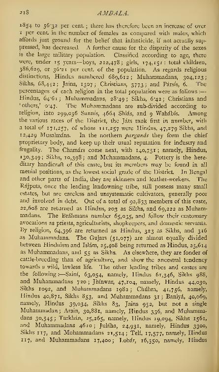
2t8 AMBALA.J ^54 to 56-32 per cent. ; there has therefore been an increase of over
1 per cent, in the number of females as compared with males, whichaffords just ground for the belief that infanticide, if not actually sup-
pressed, has decreased. A further cause for the disparity of the sexes
is the large military population. Classified according to age, there
were, under 15 years— boys, 212,478; girls, 174,151: total children,
386,629, or 36*21 per cent, of the population. As regards religious
distinctions, Hindus numbered 689,612; Muhammadans, 304,123;Sikhs, 68,442; Jains, 1307; Christians, 3773; and Parsis, 6. Thepercentages of each religion in the total population were as follows :
—
Hindus, 64-61; Muhammadans, 28*49; Sikhs, 6*42; Christians and'others/ 0-47. The Muhammadans are sub-divided according to
religion, into 299,056 Sunnis, 4664 Shias, and 9 Wahabis. Amongthe various races of the District, the Jats rank first in number, with
a total of 171,257, of whom 111,257 were Hindus, 47,279 Sikhs, and
12,429 Musalmans. In the northern pargands they form the chief
proprietary body, and keep up their usual reputation for industry andfrugality. The Chamars come next, with 140,751; namely, Hindus,
130,349; Sikhs, 10,398; and Muhammadans, 4. Pottery is the here-
ditary handicraft of this caste, but its members may be found in all
menial positions, as the lowest social grade of the District. In Bengal
and other parts of India, they are skinners and leather-workers. TheRajputs, once the leading landowning tribe, still possess many small
estates, but are careless and unsystematic cultivators, generally poor
and involved in debt. Out of a total of 92,833 members of this caste,
22,608 are returned as Hindus, 203 as Sikhs, and 69,222 as Muham-madans. The Brahmans number 65,035, and follow their customary
avocations as priests, agriculturists, shopkeepers, and domestic servants.
By religion, 64,396 are returned as Hindus, 323 as Sikhs, and 316as Muhammadans. The Gujars (51,077) are almost equally divided
between Hinduism and Islam, 25,408 being returned as Hindus, 25,614
as Muhammadans, and 55 as Sikhs. As elsewhere, they are fonder of
cattle-breeding than of agriculture, and show the ancestral tendency
towards a wild, lawless life. The other leading tribes and castes are
the following:—Saini, 63,054, namely, Hindus 61,346, Sikhs 988,
and Muhammadans 720;Jhinwar, 47,104, namely, Hindus 44,030,
Sikhs 1092, and Muhammadans 1982 ; Chiihra, 41,756, namely,
Hindus 40,871, Sikhs 853, and Muhammadans 31; Baniya, 40,069,
namely, Hindus 39,034, Sikhs 8^, Jains 952, but not a single
Muhammadan; Arain, 30,881, namely, Hindus 336, and Muhamma-dans 30,545 ; Tarkhan, 25,265, namely, Hindus 19,094, Sikhs 1561,
and Muhammadans 4610; Julaha, 24,931, namely, Hindus 3300,
Sikhs 117, and Muhammadans 21,514; Teli, 17,577, namely, Hindus
117, and Muhammadans 17,400; Lohar, 16,550, namely, Hindus

AMBALA. 219
9066, Sikhs 341, and Muhammadans 7143; Kumbhar, 15,598, namely,
Hindus 12,80S, Sikhs 161, and Muhammadans 2629; Nai, 14,932,
namely, Hindus 10,609, Sikhs 352, and Muhammadans 3971 ; Kam-
boh, 12,988, namely, Hindus 10,106, Sikhs 1717, and Muhammadans
1165; Khattri, 8154, namely, Hindus 7668, Sikhs 481, and Muham-
madans 5 ; Sonar, 7332, namely, Hindus 6648, Sikhs 102, and
Muhammadans 573; Gadaria, 6671, all Hindus. The exclusively
Muhammadan tribes consist of—Sheikhs, 28,920; Pathans, 9845;
Sayyids, 8543; Penja, 6684; and Biluchis, 1070. The religious
mendicant class is largely represented in Ambala. Of 10,434 Fakirs,
9939 are returned as Muhammadans, 473 as Hindus, and 22 as Sikhs;
while of 11,897 Jugis, 7758 are returned as Hindus, 4091 as Muham-
madans, and 48 as Sikhs. Of the 3773 Christians, 3473 were Euro-
peans or Americans, 74 Eurasians, and 224 natives. The Church of
England numbered 2253 adherents, the Roman Catholics 896, Presby-
terians 177, Wesleyans 5. The inhabitants of the Kotaha pargand,
in the hill country, are a simple quiet race, clinging almost without
exception to the Hindu faith of their forefathers, deeply devoted to
their homes, and seldom visiting the plains. Proprietary right is kept
up amongst them with more than Indian tenacity ; a family may be
absent for a hundred years, yet their names will be held in remem-
brance, and their descendants may return at any time to reclaim their
possessions without a remonstrance. The places of pilgrimage in the
District are very numerous. Along the sacred Saraswati (Sarsuti), the
whole year round, there is a constant succession of festivals at one
shrine or another; and religious fairs are held at many other towns
scattered about the country. The attendance at these fairs has fallen
off of late years, owing to the dislike of the people to the sanitary
regulations rendered necessary by outbreaks of cholera. The total
agricultural population amounted in 1881 to 530,266 persons. The
Census of 1881 returned the n largest towns with their population as
follows:—Umballa City and Cantonment, 67,463; Jagadhri, 12,300;
Sadhawra, 10,794; Rupar, 10,326; Shahabad, 10,218; Buriya,
741 1 ; Thanesar, 6005; Kharar, 4265; Radaur, 4081; Ladwa,
4061; Pihewa, 3408. These figures show an urban population of
140,332 persons, or 13*2 per cent, of the total population. Of the
2226 villages and towns in the District, 794 contain less than 200
inhabitants, 874 from 200 to 500, 379 from 500 to 1000, 130 from
1000 to 2000, 28 from 2000 to 3000, 14 from 3000 to 5000, 2 from
5000 to 10,000, 4 from 10,000 to 15,000, and 1 upwards of 50,000.
As regards occupation, the Census classifies the adult male population
over fifteen years of age into seven main groups as under : (1) Profes-
sional, including civil and military, and the learjned professions, 30,502;
(2) domestic and menial servants, 34,426 ; (3) commercial, including

220 AMBALA.
merchants, traders, carriers, etc., 10,642; (4) agricultural and pastoral,
295,302; (5) industrial, including manufacturers, artisans, etc., 125,950;
(6) indefinite and non-productive, including labourers, 23,291; (7)
unspecified, 47,411.
Agriculture. — The cultivated area of Ambala District in 1881
amounted to 951,890 acres, leaving 692,959 acres uncultivated, of
which 187,539 are returned as cultivable, 127,151 as grazing land,
and 378,269 as uncultivable waste. The staple crops are wheat,
barley, and gram for the spring harvest ; with rice, jodr, bdjra, Indian
corn, moth, cotton, and sugar-cane for the autumn harvest. Poppy,
tobacco, and hemp are also grown, but only for home consumption.
The area under each crop in 1881 was returned as follows :—Wheat,
354,045 acres ; rice, 88,598 ;jodr (great millet, Sorghum vulgare),
98,443; bdjra (spiked millet, Pencillaria spicata), 7341: kangni (Italian
millet, Panicum italicum), 10 13 ; makdi (Indian corn, Zea mayz),
131,005; jau (barley), 59,793; china (Panicum miliaceum), 12,440;
gram (Cicer arietinum), 107,723; moth (Phaseolus aconitifolius),
18,423; matar (peas, Pisum sativum), 1456; mash (Phaseolus radi-
atus), 16,859; mung (Phaseolus mungo), 1528; masuri (Ervum lens),
23,110; poppy, 3680; tobacco, 6750; coriander seed, 162; chillies,
584 ; linseed, 3509 ; sarson (mustard, Sinapis dichotoma), 14,564
;
til (Sesamum orientale), 1001 ; tdrdmira (Sinapis eruca), 3422; cotton,
65,650; hemp, 1830; safflower, 12,012; indigo, 944; vegetables, 5543;
sugar-cane, 37,097 ; other crops, 390 acres. Total, including twice-
cropped land, 1,078,916. The quality of the crops is steadily improving,
the higher cereals, tobacco, cotton, and sugar-cane being largely substi-
tuted for inferior food-grains, such as millets and pulses. This im-
provement is the result of an increase in material prosperity, enabling
the peasantry to incur a larger outlay upon their farms. Manure is
used to a slight extent in the neighbourhood of villages, and rotation
of crops is so far understood that the same staple is seldom sown on
a single plot for two years in succession; but the land is incessantly
cultivated year after year, never lying fallow for more than six months
at a time. The average out-turn of produce per acre is returned as
follows: — Rice, 400 lbs.; indigo (manufactured), 16 lbs.; cotton
(raw), 218 lbs.; sugar (refined), 184 lbs.; opium, 16 lbs.; tobacco,
610 lbs. ; wheat, 706 lbs. ; inferior grains, 424 lbs. ; oil-seeds, 265 lbs.
;
fibres, 117 lbs. Irrigation is practised on 173,499 acres, 22,463 acres
being watered by Government works, and 151,036 acres by private
individuals. The Western Jumna Canal supplies part of the District
with water, while the remainder is irrigated from wells worked with a
Persian wheel or a hand-lever. Near the hills water lies so close
to the surface that it may be obtained in the river beds by scratching
away a little of the earth ; in the upland plain, however, at a distance

AMBALA. 221
from the mountains, many villages do not possess a well, even for
drinking purposes, but depend entirely for water supply on the surface-
drainage collected in tanks. Where irrigation is not available, no
spring crop can be grown.
The condition of the people is generally comfortable, and they
are seldom in debt to any great extent; but near the larger towns
the peasantry have become ambitious of a better style of living,
which often induces them to exceed their means, especially in
the matter of dress and personal ornament. The total capital
necessary for a small holding of, say 10 acres of land, is about ^n,namely ^10 for the price of a pair of average plough bullocks, and jQi
for the necessary implements. For a similar-sized holding of irrigated
land, about double the above capital is necessary for two pairs of
bullocks and the well-fittings. The latter, in this part of the country,
are extremely inexpensive, consisting merely of a rope running over
a wheel, and an earthenware or leather bucket. The agricultural stock
of the District in 1878-79 was returned as follows :—Cows and bullocks,
340,270; horses, 8600; ponies, 3035; donkeys, 11,767; sheep and
goats, 131,492; pigs, 8896; camels, 112; carts, 10,205; ploughs,
90,816 ; boats, 62. Of the total area of 2570 square miles, 1068 square
miles are assessed for Government revenue. Of these, 624 square miles
are returned as cultivated, and 202 as cultivable. Total Government
assessment, including rates and cesses on land, ,£90,85 7. Estimated
actual rent paid by cultivators, £274,892. All the villages, except
quite an insignificant number, are in the hands of cultivating com-
munities. The jdgirddrs, or persons holding assignments of revenue
for particular estates, are naturally very numerous, owing to the his-
torical origin of their tenure. They include the families of all the chiefs
whose powers were reduced in 1849, and in most cases they are Sikhs
by religion. Another peculiar tenure of the District is that known as
chahdram, which took its rise from a common custom of the cis-Sutlej
Sikhs, when struggling with the native proprietors for the possession of
a particular village, to compromise the matter by assigning half the
revenue to each of the contending parties. Most of the tenants have
rights of occupancy. Rents ruled as follows in 1880-81, according to
the quality of the soil, its irrigable capabilities, and the nature of the
crop grown :—Rice, from 6s. ijd to ns. iojd. per acre; wheat, from
5s. ijd. to 19s. 7jd. per acre; inferior food-grains, from 4s. to 12s. per
acre; oil-seeds, from 4s. 4^d. to 10s. iojd. per acre; cotton, from 9s.
to 15s. 3d. per acre; other fibres, from 3s. 4jd. to 12s. per acre;
indigo, from 4s. ijd. to 8s. 6d. per acre; sugar, from 14s. 7J& to
£1, 9s. od. per acre; opium, from 15s. 7^d. to £1, 7s. per acre;
tobacco, from 12s. to £1, 2s. 6d. an acre. Wages in kind remain
stationary, but money wages and prices have doubled within the last

222 AMBALA.
few years. In iS8i, agricultural and unskilled labourers received from
3d. to 4-Jd. per diem; while artisans obtained from 7 Jd. to io^d. per
diem. Bullock carts hire at the rate of is. 9d., and camels at is. 3d.
per day. The following were the prices of food-grains and the prin-
cipal crops in January 1881, per cwt :—Wheat (best), 6s. 7d. ; flour
(best), 7s. 6d. ; barley, 4s. 4d. : gram, 5s. 3d.; Indian corn, 4s. iod.;
jodr, 4s. 6d. ; ddj'ra, 5s. 4d. ; rice (best), 16s. ; ddly
5s. nd.;potatoes,
7s. ; cotton (cleaned), £2 \ sugar (best), £2, 9s. iod. ; tobacco, 14s.
;
and salt, 10s. 2d. per cwt.
Natural Calamities.—Ambala suffers, like the neighbouring Districts,
from the effects of drought. In 1860-61 it shared the famine which
desolated the surrounding country. The autumn rains of i860 failed
utterly, and the rain crop withered in the ground. So great was the
heat that even the jungle tracts produced no grass, and the cattle died
off by thousands. A sprinkling of rain fell in December, but did not
prove sufficient for the spring sowings ; and the rabi crops also failed
completely, except where means existed for artificial irrigation. Wheat
rose to 8 sers per rupee (14s. per cwt.), and the mortality from disease
and hunger began to be serious. Refugees from Bikaner and Hariana
flocked into the District, as usual on such occasions, and augmented
the local distress. The dearth continued to be felt throughout the
summer, until the ripening of the autumn harvest, which fortunately
turned out to be exceptionally good. The year 1869-70 was elsewhere
one of famine, but the distress did not reach Ambala, where a moderate
harvest was gathered in. Relief was necessarily provided for the
starving poor from Bikaner, Hissar, and Sirsa, but charity was not
required by the inhabitants of the District themselves. Local subscrip-
tions sufficed for all demands.
Comtnerce and Trade, etc.—Ambala being mainly an agricultural
District, has little trade or manufactures deserving special notice. Small
articles of iron-work are made at Riipar, carpets at Ambala, and coarse
country cloth in every village. The principal centres of trade are
Ambala, Riipar, Jagadhri, Khizrabad, Biiria, and Kharar. The Sind,
Punjab, and Delhi Railway traverses the District for a length of 42
miles, entering it by a bridge across the Jumna, a few miles south of
Jagadhri, and leaving it by another across the Ghaggar, 6 miles west
of Ambala city. There are stations at the city and cantonments, at
Barara, and at Jagadhri. The Grand Trunk Road enters Ambala
District from Karnal, a few miles east of Thanesar, whence it runs
nearly north as far as Ambala, where it turns north-west, and passes
into Patiala territory, after a course of 38 miles in the District. The
Ambala and Kalka road (for Simla) leaves the Grand Trunk Road a few
miles above the Ambala cantonment, and runs nearly north for t>^
miles to Kalka, at the foot of the hills. This road is metalled through-

AMBALA.
out, and crosses the Ghagg.tr by a ford about midway. A detention of afew hours sometimes occurs at the crossing after heavy rain m the hillsThe Saharanpur road runs from Ambala south-east via Mulana andJagadhn for 39 m,les. There are also several minor lines of unmetaUed
ziznZTs *e to
:
vns and pri"c?
ai «"*» ^ iength ofmetalled roads, i 9 i miles; unmetalled roads, 468 miles. Lines <telegraph run by the side of the Grand Trunk Road and the railwayA project for a railway line from Ambala to Kalka at the foot of the1 « . .* ^ ^^"-iiva at Lue ioot or the
hdls in order to further facilitate communication with Simla has beenfor some time under consideration. The line has been surveyedestimates have been drawn up, and the undertaking only awaitsofficial sanction to be carried out.
Administration—The administrative staffordinarily includes a DeputvCommissioner 3 Assistant and 2 Extra-Assistant Commissioners, be^desthe usual medical, fiscal, and constabulary officials. In 1872-7, therevenue of the District from all sources amounted to ^rojal ofwhich sum ,£74,827, or nearly three-fourths, was derived f om theland-tax. In ,33o-8r the revenue amounted to ^1,070, of which^78,262 was derived from the land. The other principal items arestamps and local rates. The imperial police in 1880 numbered 9,!officers and men, who were supplemented by the following specialbodies ^Municipal police, 102 ; cantonment police, 123; and ferrypolice, r r. The total machinery, therefore, for the protection of personand property amounted to 1149 officers and men, being at the rate of
tl XT"!?eV6ry "23 SqUare mi ' eS and t0 every ^9 of the popula-
tion. The District contains 2 prisons, one at Ambala, the other at
nfT'n T " the l0Cal jai1'and itS inmates™ '»e criminals
vete oft* " l
8S°k h3d
%t0tal°f *3« ™-' "* * dailvaverage of 615, of whom 13 were females. The Rupar jail is a depotor central prison, .0 which convicts are brought from other DistrictsTobe employed upon the canal works. It contained in 1880 a total of
3552 prisoners, and a daily average of 2066, all males. The numberot schools maintained or assisted by the State numbered 98 in 1880and were attended by 5262 pupils. The number of private and unaidedschools is large; there are at least 293 indigenous schools attended by340. pupils. The Census of ,88. returned a total of 6 2or boysunder instruction; 26,790 males as able to read and write, but notunder instruction, and 555,281 as unable to read and write. Ofhe female population, only i64 girls are returned as under instruc-tion and 604 others as able to read and write. Ambala also containsan Institution for Government Wards, who in this District are neces-sarily numerous, owing to the large number oijdgirJdr families. It ishoped that great good has already been effected by thus bringing thesons of influential Sikh gentlemen into constant contact with European

224 AMBALA TABSIL AND CITY.
opinion. For fiscal and administrative purposes, Ambala is divided
into 6 tahsils and 15 parganas, with a total of 2226 villages, owned by
100,809 proprietors or coparceners; average land revenue, including
local rates and cesses, from each proprietor, a little less than £l.
The District includes one second-class municipality, Ambala, besides
10 of the third-class, namely, Jagadhri, Sadhaura, Rupar, Buriya,
Thanesar, Shahabad, Kharar, Pihewa, Radaur, and Ladwa. In
18S0-81 their aggregate municipal revenue amounted to /"7537> and
their expenditure to ^6464 ;population within municipal limits, 99,646.
Sanitary Aspects. -The average yearly rainfall is about 36 inches.
In 1880 the rainfall amounted to 40-3 inches, of which 5-3 inches fell
from January to May; 34*4 inches from June to September; and o"6
inch from October to December. Fever is the most prevalent disease
of the District; but bowel complaints carry off a large number of
persons annually, and small-pox occasionally appears in a violent epi-
demic form. Goitre and cretinism are extremely common on the banks
of the Ghaggar, where diseases of the spleen also affect a very great
proportion of the inhabitants. The villages along its course are ex-
ceedingly unhealthy and much under-populated. Blindness prevails
in Ambala to a greater extent than in any other part of the Punjab.
The average of blind persons in the District is 1 in every 126 in-
habitants, as compared with 1 in 1037 in England. The total number
of registered deaths from all causes in 1880 was 30,423, or an average
of 30 per thousand of the population. No less than 22,069 deaths, or
21-87 per thousand of the population, were due to fevers. The District
contains a civil hospital at Ambala city, and second-class dispensaries
at Riipar, Jagadhri, Thanesar, and Sadhaura, which afforded relief in
1880 to 79,948 patients. There is also a leper asylum at Ambala town.
In addition to the medical aid afforded by the established dispensaries,
3 hakims or itinerant native doctors are maintained by Government,
and travel over the District. [For further information, see the Punjab
Gazetteer, by Mr. Ibbetson, C.S. ; the Punjab Census Report for 1881
;
the Punjab Administration Reports for 1880 to 1883; the Report on
the Revised Settlement of the Northern Parganas of Ambala, by P. S.
Melvill, Esq., C.S., 1855 ; and the Report on the Revised Settlement
of the Southern Parganas of Ambala District, by W. Wynyard, Esq.,
C.S., 1853. The District is at present passing through a revision of
the Settlement, 1883.]
Ambala.— Tahsil or Sub-division of Ambala District, Punjab. Area,
366 square miles; population in 1881, 220,477; namely, 132,124
Hindus, 12,167 Jains, 72,007 Muhammadans, and 4194 Christians and
1 others'
; average density of population, 602 per square mile.
Ambala.—City and cantonment ofAmbala District, Punjab, and civil
head-quarters of the District, situated on an open plain 1040 feet above

AMBALA CITY. 225
sea level, and 3 miles east of the river Ghaggar. Lat. 30' 21' 25" n. •
long. 76 52' 14" e. The town was founded probably in the 14thcentury by an Amba Rajput, from whom it derives its name, but was aplace of little importance prior to the British occupation of the Province.In 1809, when the cis-Sutlej States came under British protection, theestate of Ambala was held by Daya Kaur, widow of Sardar GiirbakshSingh, its Sikh possessor. Daya Kaur was temporarily ejected by RanjitSingh, but was restored by General Ochterlony. On Daya Kaur's death,which occurred in 1823, the little principality lapsed to the BritishGovernment, and Ambala town was fixed on as the residence of thePolitical Agent for the cis-Sutlej States. In 1843, a cantonment wasestablished a few miles south of the town. In 1849, the Punjab cameunder British rule, and Ambala was made the head-quarters of aDistrict. The town is unwalled, and consists of two portions, a newand an old quarter. In the old part of the town the thoroughfares arenarrow, dark, and tortuous, so as to scarcely permit of the passage ofa single elephant; but the newer portion, which has sprung up in thedirection of the cantonment, consists of fine open roads, well laid out.Indeed, the long straight military roads of the cantonment give acertain monotony to the European quarter which strikes a strangeras wearisome and unpleasant. In March 1869, a grand Darbar washeld at Ambala, on the occasion of the visit of the late Amir of Afghan-istan, Sher Ali.
The water supply of the town was up till lately very insufficient
;
but recent public works and municipal improvements have to a greatextent remedied this evil. The cantonment lies four miles south-east of the city, and covers an area of 7220 acres. The ordinarygarrison comprises 3 batteries of artillery, 1 regiment of Europeanand 1 of native cavalry, besides 1 regiment each of European andnative infantry. The central portion of the cantonment is laid out withgood broad metalled roads, shaded in many instances by lines of fineo\&pipal trees. The church is considered the handsomest in the Punjab.There are also a club-house, several hotels, and a staging bungalow.The Civil Station lies between the city and cantonment, and containsthe usual District offices—a court-house and treasury, jail, hospital,American mission school, and Government Wards Institution. Ambalais well situated for commercial purposes, midway between the Jumnaand the Sutlej rivers, at the point where the Punjab and Delhi Railwayintersects the Grand Trunk Road. Its importance is enhanced bythe fact that it is at present the nearest station on the railway to thesummer seat of the Government of India at Simla; and a branch lineto Kalka at the foot of the hills, 39 miles in length, is about to beundertaken. Owing to this circumstance, Ambala contains a largenumber of English shops
; and a brisk trade in European commodities

2 2 6 AMBALAPULAI—AMBELA.
is carried on. The city is a great grain mart for the produce of the
District and of the Independent States to the West It also carries on a
considerable trade in hill products, ginger, and turmeric. Chief exports
—cotton goods, grain, and carpets ; imports—English cloth and iron,
salt, wool, and silk.
The population of the town and cantonment, which in 1868 num-
bered 50,696, had increased in February 1881 to 67,463, made up as
follows: — Hindus, 34,5 22 >Muhammadans, 27,115; Sikhs, 1867;
Jains, 410; Christians and 'others,' 3549- Ambala city and civil
station with a separate population of 26,777, has been constituted a
second-class municipality; revenue in 1880-81, ^2253; expenditure,
-£lQQ2.
AmMWLpulai—Tdluk in Travancore State, Madras Presidency.
Area 121 square miles; population (1881) 93j io4-
Ambapeta.— Estate in Goddvari District, Madras Presidency.
Quit-rent or peshkash, ;£ 1 6 1 4.
Ambarnath.— Village and temple in Thana District, Bombay
Presidency.
—
See Amarnath.
Ambasamudram.—Tdluk in Tinnevelli District, Madras Presidency;
contains 92 towns and villages. Area, 569 square miles, or 364,160 acres,
of which 9026 acres are zaminddri, 7943 «"&*> and the rest Government
land. Of the area of Government land, 63,685 acres are under culti-
vation, and 62,912 fallow. Land revenue, £z^41- The Tambraparni
river flows through the tdluk, joined, about four or five miles before its
debouchure from the mountain range, by the Serviar in five falls, at a
famous spot, known as Papanassam, where many thousand pilgrims
annually congregate. The tdluk contains 50 Siva temples, whose
annual income in cash amounts to ^1647, and endowments in land
and jewels to ^5744- There are two zaminddris, Singampatti and
Urkad,in the tdluk. Population (1881) 165,152, namely 78,882 males
and 86,270 females; density, 290 persons per square mile; number
of occupied houses, 36,881. (See Tinnevelli.)
Ambasamudram.—Town and head-quarters of the Ambasamudram
tdluk, Tinnevelli District, Madras Presidency. Lat. 8° 42' 45" N., long.
7729' 15" e. Population (1881) 8770, namely 8383 Hindus, 313
Muhammadans, and 54 Christians. Head-quarters of Sub-divisional
officer.r
Ambatmuri.—Pass in the Uppinangadi tdluk, South Kanara Dis-
trict, Madras Presidency; between 13° o' 45" and I 3° 4 N. lat., and
between 75 29' 15" and 75° 33' 45" * long. It leads into Mysore,
but is little used.
Ambela (Umbeyla).—Mountain pass situated just beyond British
territory, north-east of Peshawar District, Punjab. The pass has ac-
quired importance, asbeing the route selected on various occasions when

AMBELA.?2y
punitive military expeditions have been rendered necessary against thepredatory mountain clans along the border. The last and mostimportant of these was in 1863. A colony of Wahabi Muham-madans, established at Sitana in the Swat country, and made up ofreligious fanatics, escaped criminals, mutinous soldiers, and politicalrefugees from British India, had been a source of trouble and anxiety tothe Punjab Government since the annexation of the Province. Thisfanatical colony, throughout the whole period between 1850 and 1863,had kept the border tribes in a state of chronic hostility to Britishrule. They themselves, however, wisely avoided direct collisionwith the British authorities, till in 1857 they boldly made a plunderinginroad into our territory, and attacked the camp of a British officer.Accordingly, in 1858, a force 5000 strong was marched into the hillcountry through the Ambela Pass. After some difficulties, the columndestroyed the villages of the tribes who had rendered assistance to theWahabi fanatics, razed or blew up two forts, and destroyed the traitorsettlement at Sitana. Engagements were entered into with the bordertribes that they would prevent the fanatics from re-entering theirterritory, and the Sitana lands were made over to one of these tribes.Scarcely two years elapsed, however, before the rebel colony hadregained their influence over the wild highland clans, and recommencedtheir inroads on to British territory, the tribes either rendering themactive assistance, or allowing them free passage through their territory.These frontier inroads culminated in an attack in September 1863upon the camp of our Guide Corps, and in a declaration of a Holy War{jihad) by the fanatics against the English infidels. A strong militaryforce was organised in the Punjab, to put a stop once and for all tothese maraudings; and on the 18th October 1863 a British army of7000 men under General Sir Neville Chamberlain marched out ofcantonments, and the following evening entered the Ambela defile. Thehill tribes all threw in their fortunes with the rebel fanatics, and on the20th the British force was brought to a halt before it cleared the pass,and reinforcements were summoned. The coalition of tribes, at onetime numbering 60,000 men, kept up a constant series of harassingattacks on the British position, capturing some pickets and inflictingheavy loss. The force was kept acting entirely on the defensive till
December, when the further reinforcements raised the strength of thecolumn to 9000 regular troops. Meanwhile diplomatic efforts werebeing made to break up the coalition, and some of the chiefs withdrew,while others were wavering. On the night of the 15th December, asuccessful night attack was made on the enemy's position, and on the1 6th the village of Ambela was captured and burned. The coalitionthereupon dissolved, and the Bunair tribes, on whom the rebelsettlement mainly depended, entered into an engagement with us to

228 AMBER.
burn the fanatics in their stronghold. In less than a week, a strong
British brigade, reinforced by the Bunairs, advanced through the
mountains to the fanatical settlement, and reduced it to ashes. Theforce returned to the Ambela Pass on the 23rd December, and on the
25th re-entered British territory, not a shot being fired on its home-
ward march. The British loss during the campaign amounted to no
less than 227 killed (British and native) and 620 wounded. Thetotal loss of the enemy was reported at 3000 killed and wounded.
Amber (Amer).—The ancient but now decayed capital of Jaipur
(Jeypore) State, Rajputana, about 5 miles north-east of the present
capital, Jaipur Town. Lat. 26 58' 45" n., long. 75 52' 50" e.;
population (1881) 5036, namely 4346 Hindus, 665 Muhammadans, and
25 'others.' Its picturesque situation, almost entirely surrounded by
hills, and at the mouth of a rocky mountain gorge, in which nestles a
little lake, has attracted the admiration of travellers. The margin of
the lake is dotted over with beautiful buildings, and the hill slopes
which surround it are clothed in the rains with green foliage. Jacque-
mont and Heber have both recorded the deep impression made by
the beauty of the scene. Amber is reached from Jaipur by a good
road, suitable for horse-carriages ; but the ascent to the palace, and
the exploration of the site of the ancient city, must still be done on
elephant or pony-back (1883). A day thus spent at Amber is usually
one of the most enjoyable which falls to the lot of the traveller in
India. The name of Amber occurs in Ptolemy, but nothing is knowrn
in regard to its early history. In a.d. 1037, the Kachhwaha Rajputs,
shortly after obtaining a footing in this part of the country, conquered
Amber from the King of the SusaVat Minds after a protracted struggle.
The seat of Rajput power was thereupon transferred to Amber,
which became the capital of the country, and gave the name to the
state. There are many objects of interest at Amber. The old palace
ranks second only to Gwalior as a specimen of Rajput architecture.
Commenced about 1600 a.d., a century later than the Gwalior palace,
by Raja Man Singh, who erected the Observatory at Benares, it
was completed early in the 18th century by Siwai Jai Singh, whoadded the beautiful gateway which bears his name, before transferring
his capital to Jaipur city in 1728. It lacks the fresh and vigorous
stamp of Hindu originality, which characterises the earlier buildings
at Gwalior, and instead of standing on a lofty pedestal of rock, it lies
low. But nothing could be more picturesque than the way in which
it grows, as it were, out of its rocky base, and reflects its architectural
beauties on the water. The interior arrangements are excellent, and
the suites of rooms form vistas opening upon striking views of the lake.
The ornamentation and technical details are free from the feebleness
which had already begun to paralyze Hindu architecture ; and they

AMBGAON—AMBIKA. 2 2 9
bear the impress of the influence which Akbar managed to stamp on
everything done during his reign. Amber contains many large and
handsome temples, and was at one time much frequented by ascetics
and religious devotees from all parts of India. A small temple, where
a goat is every morning offered up to Kali, preserves the tradition of
a daily human sacrifice on the same spot, in the pre-historic times
anterior to Rajput ascendency. Few of the temples, however, are now
maintained, and the glory of Amber has departed. The palace,
although still kept in good order, and occasionally visited by the Chief,
is generally silent and deserted. The fort which crowns the summit of
a hill, 400 or 500 feet above, is connected with and defended the
palace. It has been from time immemorial the State treasury and
prison, and remains so to the present day ; the Kachhwaha Rajputs having
engaged, on wresting the fort from the Minds, to maintain the treasury
here for ever. Mr. Fergusson, from whose work some of the foregoing
sentences have been condensed, has given an excellent description of
Amber in his History of Eastern Architecture, p. 480, ed. 1867.
Ambgaoil.—Pargand in Chanda District, Central Provinces. Lat.
20 38' 30" n., long. 79 59' 45" e. ; area, with its dependent zamindaris
(excluding Ahiri), 12 12 square miles. It contains 67 villages and 4
zamindaris. Hilly, and, except near the Wainganga river, covered
with jungle ; much intersected by tributaries of the Wainganga. Chief
productions, rice, tasar silk, and jungle products, with large import
trade in salt from the east coast. Telugu is spoken in the south,
Marathi in the north. The local traders of the pargand are Telingas.
Principal place of interest, Markandi ; largest villages, Garhchiroli
and Chamursf. The village of Ambgaon contains a population of only
483 souls.
Ambika.—River in Surat District, Bombay Presidency. Rises in
the Bansda hills, and after flowing through Baroda territory, westward,
in two separate channels, enters Surat District, through which it flows
in a winding course over a deep bed of sand between the Chikhli
and Jalalpur Sub-divisions, falling into the sea 15 miles south of the
Puma. The town of Gandevi, about 12 miles from the mouth, is the
limit of the rise of the tide. At a point about 6 miles from the sea,
the railway crosses the Ambika by a bridge 875 feet long and raised
2S feet above the level of the river. The Ambika is joined by two con-
siderable streams, the Kaveri and Kharera, and, below the junction,
widens out into a broad estuary. About a mile and a half from the
entrance is a bar, covered at low water to a depth of three or four feet,
with a tidal rise of 22 feet. Vessels of considerable size can pass up
for about 6 miles as far as to Bilimora ; beyond this, for five miles, only
boats of 50 tons and under can proceed. The Kaveri and Kharera are
both crossed by railway bridges, 688 feet and 625 feet in length.
230 AMBULUPALI—AMETHL
Ambulupali. — Town in the Ambulupali taluk of Travancore
State, Madras Presidency. Lat. 9 23' n., long. 76° 24' 30" e.j
population about 3000. A canal connects it with Alleppi, and a great
annual festival, held here in April, attracts some local trade. Head-
quarters of the taluk; magistrate's and munsifs courts. Famous in
history as the scene of Fra Paolo Bartolomeo's protest against the
compulsory attendance of Christians at Hindu festivals. Until 1754
it was the capital of the Chembagachari Rajas.
Amblir (Amourdrug, Petambur).—Town in the Vellore taluk, North
Arcot District, Madras Presidency. Lat. 12 50' 25" n., long. 78 44'
30" e.;population (1881) 10,390, namely, 5991 Hindus, 4388 Muham-
madans, and 1 1 Christians. A well-built and compact town, about 30
miles from Vellore, 79 miles from Bangalore, and 112 miles (by rail)
from Madras, situated at the foot of the Kadapanatham Pass, which
leads from the Eastern Hills of the Baramahal ; it lies on the south bank
of the Palar river. The railway station is within half a mile of the town,
and an excellent road connects it with Vellore and Salem. The Ambiir
Drug peak towers above the town. It possesses a considerable trade
in oils, ghi, and indigo, which the Labbay merchants (Nagar Muham-madans) collect here for export to Madras both above and below the
ghat, but since the opening of the railway in i860 Ambiir has lost its
monopoly of the ghat carrying trade. The fort, situated on the almost
inaccessible Ambiir Driig, and commanding an important pass into
the Carnatic, was in past times keenly contested. In 1750, the first
pitched battle in the great wars of the Carnatic was fought under its
walls, in which Anwar-ud-din, the Nawab of Arcot, was defeated by
Muzaffar Jang. This battle is remarkable as being the first occasion in
which European troops played a conspicuous part in Indian warfare.
In 1768, the fort was gallantly defended by the 10th regiment of
Madras Infantry. Twenty years later it was besieged by Haidar Ah',
and taken ; only, however, to be restored by the Treaty of Mangalore.
In the expeditions against Mysore, in 1792 and 1799, tnis fortress was
occupied as a point of great importance on the line of communications.
Amburpet.—Town in Salem District, Madras Presidency. Lat.
I2 ° 47' I 5" N -> long- 7 8° 45' 15" e. ; houses, 1411; population (1881)
6700. A suburb of Vaniyambadi.
Amer.—Town in Jaipur State.
—
See Amber.Amet.—Town in the Native State of Udaipur (Oodeypore), Rajput-
ana. Situated in a fine valley, nearly surrounded by hills, on the
banks of the Chandrabhaga, a tributary of the Bands. One of the first-
class nobles of the State, owning 51 villages, resides here. The town
is walled.
Amethi.—Village in Farukhabad District, North-Western Provinces,
situated on the right bank of the Ganges, about a mile east of Farukh-

AMETHI—AMGA ON. 231
abad town, of which it forms a suburb. A small income is derived froma house tax under the provisions of Act xx. of 1856, for police andconservancy purposes. Beneath the village, the Ghatiaghat boat-bridge
conveys the Rohilkhand Trunk Road across the Ganges.
Amethi.—Pargand of Sultanpur District, Oudh. Bounded on the
north by Isauli and Sultanpur pargaiids, on the east by Tappa Asl,
on the south by Partabgarh District, and on the west by Rokha Jais
pargand. Amethi is an important pargand, occupied by a clan of
Kshattriyas, known as the Bandhalgotis. Of the 365 villages compris-
ing the pargand, all but one are owned by this clan. Raja MadhuSingh's estate consists of 318 villages, covering an area of 265 square
miles, and paying a Government land revenue of ^20,103. TheBandhalgoti clan is confined to Amethi, and does not possess a single
village outside the pargand. The members are alleged to be descended
from a female bamboo-splitter who married a servant of the Raja of
Hasanpur. It is alleged that they still, on certain ceremonial occasions,
make religious offerings to a specimen of the ancestral implement—the
bdnka or knife used in splitting the bamboo. The Bandhalgotis them-
selves, however, repudiate this humble origin. According to their ownaccount they are Surjabansi Kshattriyas, belonging to the branch of
the clan now represented by the Raja of Jaipur, and descended from a
scion of that house, who 900 years ago, when on a pilgrimage to
Ajodhya, was led to settle here through a vision, by which it was dis-
closed to him that he and his successors were to become the hereditary
lords of this part of the country. Area of the pargand, 299 square
miles, of which 131 are cultivated;population (1881), Hindus, 151,104;
Muhammadans, 8514: total, 159,618. Average density of population,
523 per square mile.
Amethi Dungar.—Town in Lucknow District, Oudh ; 1 7 miles from
Lucknow, on the road to Sultanpur. Lat. 2 6° 45' 20" N.j long. 8i° 12' e.
An ancient town, supposed to be of Bhar origin. It has repeatedly
changed hands between the Hindus and Musalmans, and the in-
habitants belong to these religions in about equal proportions.
Population (1881) 5654, namely, Hindus 2739, and Muhammadans2922 ; number of houses, 1151 ; area of town site, no acres. Seat cf
flourishing weaving trade ; thriving export trade in hides and horns
;
Government school. A small revenue for police and conservancy
purposes is raised under the provisions of Act xx. of 1856.
Amgaon.—Estate or zaminddri in the eastern portion of Bhandara
District, Central Provinces; area, 144 square miles, of which 47 are
returned as under cultivation; villages, 61; occupied houses, 5577;population (1881) 27,524; namely, 13,625 males and 13,899 females.
Amgaon village has a large weekly market. Near it extends somemiles of low rocky jungle, infested with leopards, and the estate

232 AMGAON—AMHERST.
generally is noted for the number of man-eating tigers which have been
killed from time to time.
Amg&on.— Village in Narsinghpur tahsil, Narsinghpur District,
Central Provinces. Population (i 88 1) 2492—namely, Hindus, 2108;
Kabirpanthis, 18 ; Muhammadans, 177 jJains, 6; aboriginal tribes, 183.
Amherst.—District in Tenasserim Division, British Burma, lying
between 14 59' and 17 71' n. lat., and between 97 30' and 98 53' e.
long.; area, 15,189 square miles; population in 1881, 301,086. Bounded
on the north by the Salwin (Salween) and Kyun-eik rivers ; on the east
by the Thaung-yin river, and by the mountains which form the boundary
between British and Burmese territories ; on the south by the Malwe,
a spur of the same range ; and on the west by the Bilin (Bhileng) river
and the Gulf of Martaban. The administrative head-quarters of the
District and Division are at Maulmain.
Physical Aspects.—Amherst District occupies the Thatiin plain, lying
between the Bilin (Bhileng) and the Salwin (Salween) rivers, and the
country lying north, south, and east of the mouths of the Salwin, Gyaing,
and Attaran. Round Maulmain are alluvial plains watered by these
rivers ; shut in by the Dawna Hills, and south of Maulmain by the Taung-
nyo chain, running parallel to the coast. In the extreme east is a narrow
and densely-wooded region, broken by the Dawna range and its spurs
;
to the south is the valley of the Ye, situated between the Taung-nyo
Hills and the sea, drained by numerous streams, with a general direc-
tion to the west. Tha-tiin, or the country between the rivers Salwin
(Salween) and Bilin (Bhileng), has one main chain running northwards;
Bilugyun, an island one mile west of Maulmain, and a township of
Amherst District, is also traversed by a ridge of hills from north to
south. The chief mountains in the District are the Dawna, starting
from the Mulai-yit Hill, an immense mass of rock, 5500 feet high, in
1 6° 5' 45" n. lat, and 98 42' 3" e. long. They throw out numerous
spurs, and run north-west for 200 miles, dividing the waters of the
Haung-tharaw and Hlaing-bhwai from those of the Thaung-yin.
This range presents in most parts the appearance of a wooded plateau
of laterite cut up by drainage into hills. At places, the underlying
rocks project into the bed of the Thaung-yin, and indicate volcanic
agency. The main range and its offshoots form the watershed between
the Bay of Bengal and the Gulf of Siam. The hills to the west of the
main range undulate for some distance gently to the southward, but
end in barren limestone ridges. From the Tsadaik Hill, in 15 17' 25" n.
lat., and 95 15' e. long., the Taung-nyo chain extends north-west to
Maulmain, forming the Attaran watershed, and finally disappears in a
small island at the mouth of the Gyaing. North of Maulmain and east
of this river is a short range of limestone rocks (16 miles long), called
Zwet-ka-beng. The main chain terminates at Kama-thaing, a little to
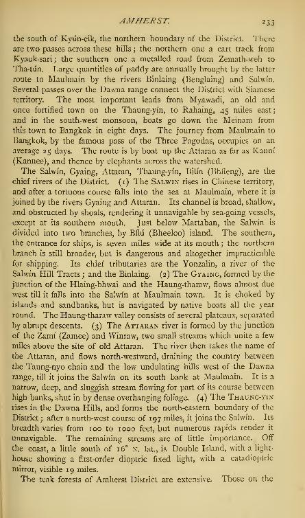
AMHERST. 233
the south of Kyiin-eik, the northern boundary of the District. There
are two passes across these hills ; the northern one a cart track from
Kyauk-sari j the southern one a metalled road from Zemath-weh to
Tha-tiin. Large quantities of paddy are annually brought by the latter
route to Maulmain by the rivers Binlaing (Benglaing) and Salwi'n.
Several passes over the Dawna range connect the District with Siamese
territory. The most important leads from Myawadi, an old and
once fortified town on the Thaung-yin, to Rahaing, 45 miles east;
and in the south-west monsoon, boats go down the Meinam from
this town to Bangkok in eight days. The journey from Maulmain to
Bangkok, by the famous pass of the Three Pagodas, occupies on an
average 25 days. The route is by boat up the Attaran as far as Kanni
(Kannee), and thence by elephants across the watershed.
The Salwin, Gyaing, Attaran, Thaung-yin, Bilin (Bhileng), are the
chief rivers of the District. (1) The Salwin rises in Chinese territory,
and after a tortuous course falls into the sea at Maulmain, where it is
joined by the rivers Gyaing and Attaran. Its channel is broad, shallow,
and obstructed by shoals, rendering it unnavigable by sea-going vessels,
except at its southern mouth. Just below Martaban, the Salwin is
divided into two branches, by Bilii (Bheeloo) island. The southern,
the entrance for ships, is seven miles wide at its mouth ; the northern
branch is still broader, but is dangerous and altogether impracticable
for shipping. Its chief tributaries are the Yonzalin, a river of the
Salwin Hill Tracts ; and the Binlaing. (2) The Gyaing, formed by the
junction of the Hlaing-bhwai and the Haung-tharaw, flows almost due
west till it falls into the Salwin at Maulmain town. It is choked by
islands and sandbanks, but is navigated by native boats all the year
round. The Haung-tharaw valley consists of several plateaux, separated
by abrupt descents. (3) The Attaran river is formed by the junction
of the Zami (Zamee) and Winraw, two small streams which unite a few
miles above the site of old Attaran. The river then takes the name of
the Attaran, and flows north-westward, draining the country between
the Taung-nyo chain and the low undulating hills west of the Dawnarange, till it joins the Salwin on its south bank at Maulmain. It is a
narrow, deep, and sluggish stream flowing for part of its course between
high banks, shut in by dense overhanging foliage. (4) The Thaung-yin
rises in the Dawna Hills, and forms the north-eastern boundary of the
District ; after a north-west course of 197 miles, it joins the Salwin. Its
breadth varies from 100 to 1000 feet, but numerous rapids render it
unnavigable. The remaining streams are of little importance. Off
the coast, a little south of 16 n. lat., is Double Island, with a light
house showing a first-order dioptric fixed light, with a catadioptric
mirror, visible 19 miles.
The teak forests of Amherst District are extensive. Those on the

234 AMHERST.
Dawna Hills rank among the most important in British Burma. For
conservancy purposes they are divided into five tracts— viz., the
Diinthami (Doonthamee), Hlaing-bhwai, Thaung-yin, Haung-tharavv,
and Attaran. (i) The Diinthami forests, between the rivers Diinthami
and Sahvin, cover 60 square miles, and in 1859 contained i4>34° first-
class trees growing on dry ground. Excellent ' crooks ' for ship-building
are obtained, and the rivers afford the means of transit. (2) The Hlaing-
bhwai and lower Salwin forests lie east of the Salwin, and on the
Hlaing-bhwai and its feeders ; they are chiefly valuable for their supply
of crooked timber. Teak is found here only on level ground ; but its
growth is irregular, owing principally to the remains of old taungya
cultivation. The teak forests are open and much exposed to jungle
fires. (3) The Thaung-yin forests, on the hills forming the west
watershed of the Thaung-yin river, contain regularly-grown trees of
gigantic size. Bamboo and pyi?igado also abound in this tract. The
teak localities in parts are hedged in by dense evergreen forest, stretch-
ing down to the banks of the Thaung-yin and its tributaries. Some of
the most valuable teak in British Burma is found on the sandstone of
the hills between the Thaung-yin and its tributary the Meh-pa-leh. In
one locality, 550 first-class trees occupied an area of \ of a square mile.
These are tall and regular. Of five trees taken at random from among
the larger ones of the Meh-pa-leh forest, the average girth was 1 1 feet,
and the length of stem to first branch 74 feet. Higher up the hills,
teak localities give place to impenetrable forests, where the height of
the trees nearly equals that of the Wellingtonia of California. Aspecimen of dipterocarpus had a girth of 20 feet, and a height to the
first branch of 160 feet. (4) The Haung-tharaw forests have been
stripped of their best trees ; teak is now found only in isolated patches.
At one locality above the fall of the 99 islands,' the trees were magni-
ficent ; but the teak had been converted into short logs and afterwards
abandoned, owing to the impossibility of conveyance down the channel
between the islands. These logs, after ten years' exposure, were still
sound. During the last few years, attempts have been made to clear
the channel of the Haung-tharaw by blasting. In 1873-74, 545 tons
of stone were thus removed near the '99 islands.' (5) The Attaran
forests are situated on both banks of the Zami (Zamee) and Winraw,
and cover an area of 100 square miles. For some years after the
cession of Martaban and Tenasserim, the timber was so recklessly
felled—the grantees working for speedy returns—that in 1850 only
two small teak forests had been left. In i860 the greater number of
trees were found to be hollow or attacked with epiphytic ficus. At
this time it was proposed that these tracts should continue in the
hands of private parties ; subsequently, however, they were declared
'reserved Government forests.' Such tracts were worked under one-

AMHERST. 235
year permits for the removal of seasoned timber only. Where the
private tenure was recognised, thirty-year permits were given, and the
removal of timber under 7 feet 6 inches in girth was strictly prohibited.
Padauk, furnishing a hard, heavy wood ; anan (Fagrcea fragrans), a
timber hardening under water; pyi?una, thingan (Hopea odorata), and
numerous other valuable timbers abound.
The Geological Formation of Amherst District has never been com-
pletely examined by a professional survey. A conspicuous and
picturesque feature in the country round Maulmain and in the
Salwin valley, is the massive limestone occurring in steeply-scarped
hills with overhanging cliffs, which exhibit the appearance of what
they undoubtedly were at no remote period in geologic time, i.e. sea-
girt rocks. These, even now, during the rains can only be approached
by boats. In the hills there are 23 groups of caves, of which those
above the sea level promise a rich harvest to future explorers. Lead
ore occurs in the Taung-nyo Hills, and near Martaban, schorl rock
and crystals, schist, and hornblendic rock are found. Hot springs
exist in eleven places in Amherst District, and are always found near
the limestone outcrops. The largest and most important are at Attaran
Yebii (Yeboo), on the Attaran, about two miles inland from the old
town of Attaran. Here there are ten hot-water ponds, in some of
which the temperature is 130 F.; carbonic acid is evolved in large
quantities, and the ground around the springs is highly impregnated
with iron. The Attaran springs are said to approach in their composi-
tion nearest to the celebrated spring of Toplitz, and their medical
properties render them excellent remedies in a number of diseases,
especially liver complaints. The Burmese use the waters in cases of
fever and skin-disease. Dr. Morton found on analysis that the springs
contain much calcareous matter ; they deposit carbonate of lime.
History.—The history of Amherst District is for many centuries a
monotonous chronicle of wars and incursions. Claimed by the Siamese
on the east, and by the Peguans on the west, the country had no rest
until the former were expelled and the latter conquered by the Burmese.
The ancient capital, Martaban, was founded in 1269 a.d. by Narapadi-
sithu, a Burmese King of Pagan, who erected a Buddhist Pagoda there,
and planted a colony of thirty families to take charge of it. Aleinma
was appointed governor. At this time the country east of the Salwin
belonged to Siam. On Aleinma's refusal to appear at the Court of
Narapadisithu's son and successor, Talapya was appointed in his place.
But, aided by the Shans, the ex-governor soon returned, drove out and
killed Talapya, and resumed office, probably as tributary to Siam. For
many years the Burmese kingdom was harassed by the Chinese from
the north, and its sovereigns were unable to exert any authority in the
south. Magadu, a native trader of Martaban, who had risen in favour

236 AMHERST.
at the Siamese Court, was appointed governor of the capital during one
of the king's absences. He eloped with the king's daughter, and,
returning to Martaban, treacherously murdered Aleinma. In 1281 he
was recognised by the King of Siam, and from this time is known in
history as King Wariyii. Wariyu's ambition was not yet satisfied.
North of Martaban lay a country called Kanpalani (Kanpalanee),
which he eventually conquered. Whilst the King of Kanpalani was
away on a hunting excursion, his capital was pillaged, and his daughter
made captive. About this time the King of Martaban aided the
King of Pegu, who had also effected his independence, in expelling
the Chinese, who had defeated the King of Pagan and were attacking
Pegu. Quarrels soon arose between the two monarchs, which ended
in Wariyu's annexing Pegu. This king was succeeded by his brother,
who perished in a rebellion. In the reign of the next sovereign, Zaw-
aw-bin-maing, Labon, Tavoy, and Tenasserim were added to the
kingdom, which already extended nearly to Prome on the north and
to Bassein on the west. From this time the history of Martaban
merges in that of Pegu. Between 1563 and 1581 Caesar Frederic,
the Venetian, visited Martaban; he found there 'ninety Portugal
merchants and other base men which had fallen at difference with
the governor of the city.' The King of Pegu 'had gone with a
million and four hundred thousand men to conquer the kingdom of
Siam,' and in his absence the Portuguese caused a disturbance in the
capital. From this time the country was the theatre of continual wars
and rebellions. The kings of Siam succeeded in re-annexing the site
of the modern Maulmain and the territory to the south, and in con-
quering the portion of the Province lying east of the Salwin. In the
latter half of the 18th century, Alaungpaya and his successors obtained
possession of the country, and retained it till after the first Anglo-
Burmese war, when the Burmese were forced to cede to the British the
tract east of the Salwin (1826); the remaining portion was annexed
after the second Burmese war by Lord Dalhousie, in 1853.
Antiquities.—Bhilii (Bheeloo) island, in the estuary of the Salwin,
alone contains 60 pagodas. Tradition fondly alleges that the Kalaw
pagoda was erected in order to receive a relic of Gautama during the
reign of the Indian Buddhist King Asoka. The most famous pagodas
at Martaban are the Myathiendhan (1282 a.d.), attributed to King
Wariyii; the Shwe Dagon, ascribed to 1288 a.d.; the Kyaik-kha-pan
pagoda, built in 1199 a.d. by Aleinma. The Tha-tun (Tha-htoon)
pagoda is the oldest and most celebrated of all. The Burmese
chroniclers absurdly assign it to the year 594 B.C. It is said to have been
built in honour of a visit of Gautama Buddha, and as a receptacle for
a hair of the holy man. The chief pagoda at Maulmain is the Kyaik-
than-lan, built on the northern spur of the hill near Martaban. There

AMHERST. 237
are several small but ancient pagodas near Maulmain containing relics
of Buddha. Tha-tiin (Tha-htoon) and Martaban, once the capitals of
independent kingdoms, are now in ruins, but still exhibit traces of their
former importance.
Population.—Before 1826, Amherst was the scene of perpetual warfare
between the kings of Siam and Pegu, and was ravaged in turn by their
troops, and by the Burmese armies of Alaungpaya and his successors.
When the country east of the Salwin was annexed in 1826, it was
found to be almost uninhabited. In February 1827, Maung Sat, a
rebel Taking chief, known to the English of that day as the Syrian)
Raja, settled, with 10,000 followers, in Maulmain and its neighbour-
hood. After a few years, a further influx of 20,000 immigrants from
Burmese territory took place. In 1829, the population of the country
stretching from the Thaung-yin to the Pakchan (which includes the
present Districts of Tavoy and Mergui) was about 70,000 souls. In
1835 ^ na^ risen to 85,000, and in 1845 to 127,455. This rapid
increase was due to immigration from Pegu native territory, and on a
small scale from India to Maulmain, which rose from a fishing village
into a flourishing town. In 1855, Amherst District comprised only the
country east of the Salwin (Salween) between the Thaung-yin river and
Tavoy District, and had a population of 83,146. In i860 this numberhad increased to 130,953, and in 1870 to 235,747. During this
decade Tha-tiin sub-division was transferred from Shwe-gyin District.
In 1872, at the first regular Census, the District population was, exclu-
sive of Maulmain town, which is now constituted a separate District,
193,468. By February 1881 the inhabitants had increased to 301,086,
or by 64 per cent, in nine years. The Census was taken over an area
of 15,189 square miles, and in 1021 villages; number of houses,
53,906, of which 50,483 were occupied, and 3423 unoccupied; average
persons per square mile, 19*82; towns or villages per square mile,
0-07; number of houses per square mile, 3*54; persons per occupied
house, 5*96. Classified according to sex, there were 160,221 males
and 140,865 females. Divided according to religion, there were
Buddhists, 283,072; Muhammadans, 7599; Hindus, 6690; Christians,
3040; ndt or demon-worshippers, 685. The disproportion between
the sexes (males, 53*22 per cent.; females, 4678) is chiefly owing
to the large immigration of male labourers. During the Burmese
occupation of the country, the coast tracts of Tenasserim were peopled
chiefly by Talaings, called by themselves ' Mun ;
' and they now form
over n per cent, of the population. It is not known whether this tribe
came directly down the Irawadi (Irrawaddy) from Pegu, or whether
they migrated via the Brahmaputra, and so through Arakan to their
present settlements. At a later date, Dravidians from Telingana
established trading colonies in Ramdyana '
—
i.e., the country between

23 3 AMHERST.
the mouths of the Salwin and Bassein rivers. These colonists soon
merged in the wild race of the Mdn, and their name, ' Talaing,' by
which this mixed people is known to all but themselves, alone shows
their connection with 'Telingana.' Their language is harsh and
guttural, and essentially different from Burmese; and after the first
Anglo-Burmese war, it was cruelly proscribed by the Burmese sovereign.
In Pegu it has almost died out, but still prevails in Amherst District.
The Karens generally occupy the hilly country in the District, and
both Sgaw and Pwo or Pgho are fully represented. The pure Burmese
are few in number. The Taungthus are an isolated race; they are
swarthy and sturdily built, and have a language, dress, and customs
of their own. They have no written character, but their traditions
are preserved to them by professional story-tellers. The Arakanese
and the Shans may be considered as permanent settlers, as are also
some of the Hindus and Muhammadans, amongst whom are included
Burmese women converted before marriage with Musalmans. Such
marriages are frequent. Many Hindus and Muhammadans, however,
only come to the District to make a little money, and look forward to
returning to India. On the banks of the Attaran there is a Muhammadan
colony. The Hindus are clustered in the towns and villages near
Maulmain. The number of towns and villages in Amherst in 1881 was
1021—of which 495 contained less than 200 inhabitants, 400 from 200 to
500,95 from 500 to 1000, 25 between 1000 and 2000, 4 from 2000 to 3000,
and 2 from 3000 to 5000. The chief towns are Maulmain, Amherst,
and Martaban, although the former is now separately administered.
Maulmain is situated at the points of junction of the Salwin, Gyaing,
and Attaran rivers, in lat. 16 38' N. and in long. 97° 38' E. Although
now created an independent District, it is within the limits of Amherst,
and is the head-quarters of the District. It was made a cantonment
in 1826 for the main body of the troops in Tenasserim by General
Sir Archibald Campbell. He selected it as the best position to overawe
the Burmese, who still retained Pegu, and had a force at Martaban on
the opposite bank of the Salwin. Its natural fertility and the discovery
of the valuable teak forests, together with the cruelties of the Burmese
in Pegu, induced immigration, and Maulmain sprang into importance.
In 1 88 1 the population amounted to 53,107. Amherst (Kyaik Khami)
is a small station on the sea-coast, in lat. 16 15' n. and in long. 97°
34' E. On the cession of Tenasserim it was chosen to be the seat of
the local Government, and called after Lord Amherst, the Governor-
General; but in 1827 Maulmain became the head-quarters station.
Martaban came under British rule in 1854, and was transferred from
Shwe-gyin District to Amherst in 1864-65. It once formed the capital
of an independent State, but afterwards belonged at different periods to
Burma, Pegu, and Siam, until its capture by the English.
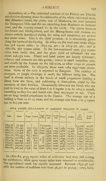
AMHERST.239
Agriculture, etc.—The cultivated portions of the District are Tha-tunsub-division (forming about five-sixteenths of the whole cultivated area),Bilu (Bheeloo) island, the plains east of Maulmain, the tract betweenthe Taung-nyo Hills and the sea stretching from Maulmain to Amhersttown, and the country around Ye in the south. The plains betweenthe Salwi'n and Hlaing-bhwai, and the Haung-tharaw and Attaran arealmost entirely inundated during the rains, and sometimes are severalfeet under water. Rice is the chief produce j it is extensively grownalong the banks of the Gyaing. In 1869-70, the total area under tillagewas 318 square miles; in 1873-74, 401; in 1875-76, 461; and in1SS1-82, 587 square miles. In the last-mentioned year, 513 squaremiles were under rice, and the gross yield of unhusked rice wasabout 246,259 tons. Dhani and betel palms are largely cultivated-tobacco and sesamum are also grown ; cotton in small quantities only,'and chiefly by the Karens on the hill-sides, as other crops at presentare more profitable. In 1875-76, there were 1189 sugar-cane planta-tions. Some of the cane is exported to Rangoon. The number oftaungyas, or jungle clearings, is small, the hillmen being few. Theland is almost entirely in the hands of small proprietors holding it
direct from the State, and cultivating it themselves, aided by "themembers of their families. Occasionally labourers are hired, who arepaid in kind to the value of from 6 to 8 rupees (12s. to 16s.) a month,according as they live and board with their employers or not. Thereare no large landed proprietors in the District. The average size of aholding is from 10 to 15 acres, and the average rent from 2 to 3 rupees(4s. to 6s.) per acre.
AREA UNDER CULTIVATION IN AMHERST DISTRICT IN ACRES.
Year.

240 AMHERST.
and bullocks, from 5297 to 79,247 ; carts, from 2356 to 9068; ploughs,
from 1029 to 32,448; and boats, from 4320 to 6094. The most
important natural product is teak, which, since the country came into
our possession, has formed the staple article of local commerce.
Indeed, the District owes its early prosperity to the timber trade, and
the impetus which it gave to immigration. Most of the timber is of
foreign growth, and is brought down the rivers from Siam and Cheng-
mai for shipment at Maulmain. The mode of bringing it to market is
as follows :—The selected trees are first girdled ; three years later they
are felled, marked, and dragged by elephants to the bed of the stream
which taps the forests, and left there until the rains, when the waters
rise. They then float down—in some cases untouched and unseen,
and in others, as in the Thaung-yin, followed and guided by men and
elephants— till they reach the kyodan, or rope station, where their further
progress is arrested. Here parties of foresters are stationed, who
recognise their own timber, draw the logs to the bank, and form them
into rafts. These are taken by raftsmen to the Government timber-
station, where they must be entered in the forest revenue books, and
the duty, if any, paid before they can be taken farther down the river
to the ships awaiting them, or to the saw-pits at Maulmain. At the
kyodan on the Salwin, where the river, narrowed to a third of its
ordinary breadth, runs between two perpendicular cliffs, an immense
cable, stretched across, intercepts the floating logs as they collect
during the night. At dawn, numbers of foresters are seen, each trying
to get his own logs ashore and clear of the rest. Sometimes the weight
of the timber snaps the cable, and the whole mass is carried swiftly
down the river, either to be stranded by the current or lost by being
drifted out to sea, or to be landed by practised men, who make this
their profession and receive salvage at a fixed scale. The other natural
products are gamboge and stick-lac ; the ka-nyin, yielding a varnishing
oil; and a drug having all the properties of camphor, extracted by
distillation from a plant belonging to the sub-division of Verbenacece
eupatorice. Communication is carried on chiefly by boat. Total
length of water communication within the District, 500 miles. Ametalled road runs southwards as far as Kwan-hla, a distance of 38
miles. It will eventually be prolonged to Tavoy and Mergui. At
Kwan-hla, a branch road leads westward to Amherst, 16 miles distant;
a road leads from Maulmain to the Gyaing ; and a short metalled way,
4J miles, connects Zemathway with Tha-tun (Tha-htoon). Another
road has been made from Martaban northwards to Tha-tun, and thence
to Shwe-gyin. Total length of roads in the District, 62 miles. Atelegraph line extends from Maulmain past Tha-tun to Shwe-gyin (with
a branch thence to Rangoon) and on to Taung-ngii (Toung-gnoo), and
another line runs from Maulmain to Amherst.

AMHERST. 241
Manufactures, etc.—Sugar is manufactured for home consumptionand for export, chiefly in Tha-tiin. The demand for rice and teak in
the English and Indian markets, the discovery of valuable forests, the
rapid increase of population, and the convenient position of Maulmain,gave a great stimulus to trade. The principal exports are timber andrice. The first shipment of teak to England was in 1839. It is nowsent in large quantities to the United Kingdom and to India, to con-
tinental Europe, and in small quantities to the Straits. In 1873-74, the
value of timber exported was £582,483, and in 1881-82, £823,009.Rice was formerly sent chiefly to the Straits, but now large shipments
are made to Europe and India. In 1876-77, its total export was
56,383 tons, and in 1881-82, 56,726 tons. In 1881-82, 7 steam
rice cleaning mills were at work in the District, besides several steam
saw-mills. There is a small trade in hides and cotton. The principal
imports are cotton and woollen piece-goods, twist, tea, sugar and sugar-
candy, spirits, vegetable oils, silk goods, and tobacco. In 1855-56,
the value of imports was £358,302, of exports £439,092— total,
£797>394; in 1864-65, the value of imports was £693,021, of exports
£874,834—total, ,£1,567,855 ; in 1875-76, the imports were
£598>738 >exports £1,184,436— total, £1,783,174; in 1880-81,
the imports (including treasure) were £979,011, and the exports
£1,482,580—total, £2,461,591. In 1881-82, the imports amountedto £1,004,066, and the exports to £1,400,837—total, £2,404,903.This represents the foreign and coasting trade ; but there is also a
considerable inland trade between Amherst and Siam, the imports
mainly comprising cattle and sheep, and the exports of English piece-
goods. In 1880-81, the value of this trade was—imports £14,554,exports £5137 ; but this is greatly below the average, owing to the
fact that the passes were for a time in the hands of a gang of Siamese
dakdits.
Administration.—On the cession of the Tenasserim Provinces, they
were considered so unproductive that at one time their surrender was
seriously contemplated. The discovery of the teak forests, however,
soon proved a source of wealth and prosperity. In 1855-56, the total
revenue of Amherst District, exclusive of Tha-tiin (Tha-htoon), derived
from land, capitation, fisheries, customs, excise, etc, amounted to
£44,936; in 1862-63, to £93,486; in 1872-73, to £i37,737;
in 1875, t0 £ l68>74 1 ') and in 1881-82, to £121,400, or including
Maulmain town, to £181,964. The land revenue alone rose from
£40,319 in 1872 to £45,3 I 3 in 1873, and to £63,221 in 1881-82.
This increase was owing to the enlarged area of taxable land, caused
partly by the improvement in the rice trade, and partly by cultivable
land having been reclaimed in the Tha-tiin and Zaya townships. Forsome years after the cession of Tenasserim, the land revenue was
vol. 1. Q

242 AMHERST.
represented by a levy of 25 per cent, upon the crop, calculated at an
average ad valorem rate dependent on the market price of grain. In
1834 this system was abolished, and payment by acreage substituted.
Two rupees 8 annas (5s.) per acre were fixed as the maximum rent of
the best lands. In addition to the imperial revenue, a local revenue
is raised from town and District funds, and the cess levied on the land
revenue and fisheries. In 1872, the local rates amounted to ^2837 ;
in 1875-76, to ^5445- For administrative purposes the District is
divided into 1 1 townships—viz., Tha-tun (Tha-htoon), Hpagat, Martaban,
Biliigyun (Bheeloogywon), Than-lwin-Hlaing-bhwai, Gyaing-Than-lwin,
Gyaing-Attaran, Zaya, Wakarii (Wakharoo), Ye-Lamaing, Haung-tharaw.
These are subdivided into revenue circles. Judicial staff—a Judge
at Maulmain, with civil and criminal jurisdiction; and 18 presiding
officers in the District, of whom 14 have civil, criminal, and revenue
powers. In 1882 the regular police force, excluding Maulmain town,
was 719 men, maintained at a cost of ^16,948. Crimes of violence
are chiefly committed by the Karens, Taung-thiis, and Shans ; and in
1880-81, an organized robber gang held undisturbed sway over the
passes near the Siamese border, and completely closed the roads, and
put a stop to trade for several months. The jail at Maulmain is one
of the central prisons of British Burma. In 1880, the total number of
prisoners was 2292, the daily average prison population being 333.
They are employed in gardening, wicker and coir work, tailoring,
cotton-spinning, stone-breaking, etc. Including Maulmain town, the
District contained 361 schools in 1880-81, with 8295 pupils, of
which 129 received some form of aid from Government, and 232 were un-
aided indigenous monastic schools. These last have been lately brought
under Government supervision, as a means of spreading sound primary
instruction among the people. In 1873, 89 of these schools were
visited with the consent of the Buddhist Pungyis, or teachers, and the
pupils examined. In 1880-81, 350 such schools were inspected by the
Government examiners, and 118 of them received grants-in-aid. The
Census Report of 1S81 returned 8438 boys and 1092 girls as under
instruction; and 34,738 males and 967 females as able to read and
write, but not under instruction. Two newspapers are published in the
District. The Government High School, established in Maulmain in
1835, had no pupils on its roll in 1880-81. St. Patrick's School was
started in 1842 by the Roman Catholic Mission; the Maung-gan
Anglo-Vernacular School is now incorporated with it. In Maulmain,
the Morton Lane and St. Joseph's Schools, and the Church of
England Orphanage, are for girls only. In 1843 the American
Baptist Mission set up a Normal school in Maulmain for Karens,
in which Burmese is taught Speaking generally, the education of
Burmese women has hitherto been neglected, but they are inde-

AMHERST—AMI. ...
pendent, active, and shrewd. The petty trade is almost exclusively intheir hands.
Climate, *&—Fevers and rheumatism are the most prevalent diseases.The average annual rainfall at Maulmain for the 32 years ending in1SS1, was 189-67 inches. In 1881, 205-88 inches of rain fell inMaulmain town. The temperature in the same year was thus returned—May, max. 99-9° R, min. 73-5° • July, max. 85-8°, min. 71-5°;December, max. 91
-
4 °, min. 6r 7°. Amherst District has suffered
terribly from cattle-disease, which is imported almost annually fromthe Shan States. In 1876, between January 1st and August 30th,12,562 cattle died. [A considerable literature has of late years sprungup with regard to British Burma, and several excellent works are nowavailable to the public. It would be invidious for me to makeselections among these books for special mention. But for additionalofficial information the following authoritative works may be consulted :—The British Burma Gazetteer, 2 vols., 1879 and 1880; the BurmaCensus Report of 1881 ; the Provincial Administration Reports for1880-81 to 1882-83; and the Meteorological Report for 1881.]Amherst.—Town in Amherst District, British Burma, on the
Wakarii (Wakharoo) river ; lat. 16 4' 40" n., long. 97 35' 30" e. It is
situated on the sea-coast about 30 miles south of Maulmain by riverand 54 by road, on an elevation, airy and open to the sea-breeze. Onaccount of its accessible position, on a river which is navigable for somedistance and possessing a good harbour at its mouth, Amherst was, in1826, made the capital of the Province. It was called after LordAmherst, the Governor-General ; its native name is Kyaik Khami. In1827 the head-quarters were transferred to Maulmain. As a sani-tarium, Amherst is strongly recommended; on the inland side, thetown is sheltered by a bold range of wooded hills, and it is a favouritesummer retreat of the people of Maulmain. For some years it wasgarrisoned by a small detachment, afterwards replaced by a policeguard. Amherst is now important only as a pilot station with atelegraph office. Population in 1881, 2953.Ami.—River of the North-Western Provinces ; rising from a small
lake in Basti District, and flowing in an easterly and south-easterlydirection, it falls into the Rapti on its left bank. Except during therains, the river, though deep in some places, is a narrow sluggishstream. Its waters are extensively used for irrigation, and thefisheries are valuable. The river is bridged at three places. Duringthe rains it is navigable by boats of about four tons burthen ; butthe course of the stream being difficult to follow owing to floods, andto sunken trees, navigation is attended with some risk. Very little
deposit is left behind by the subsiding of the floods, but what there is,
is a fertilizing loam, and the crops grown thereon are exceptionally good.

244 AM1NDIVI ISLANDS—AMNER.
Amindivi Islands.—See Laccadives.
Amingadh.—Town in Kaladgi District, Bombay Presidency; 9
miles west of Hungund, and 34 miles south-east of Kaladgi. Lat. 16
3' 30" n., long. 76 e.;population, 7314 in 1872; not returned sepa-
rately in 1 88 1. The town has a post-office and a large cattle market
—the sale of cattle is said to reach the yearly value of ^2 500. It
is also a great mart for cocoa-nuts and rice, which reach Amingadh
westwards from the sea-coast.
Amjhera.—Revenue division of Gwalior State, in Malwa, Central
India, comprising 250 villages, and lying between lat. 22 16' and 22
47' n., and between long. 74 40' and 75° 15' E. It was formerly a
petty State. In the Mutiny of 1857, the chief was tried and hanged for
rebellion ; and eventually the State lapsed to Sindhia, with the outlying
pargands of Bagh, Bankaner, Manawar, Dikthan, and Sagor. Area, 584
square miles ; extent from north-east to south-west, 42 miles, and from
south-east to north-west, 33 miles.—Revenue, ^27,366. Opium is
cultivated to a considerable extent; other special crops are cotton,
maize, sugar-cane, etc. Chief town, Amjhera, 12J miles west from
Dhar. The town was once populous, but is now in ruins ; it has a
fine tank, with a good camping ground to the eastward.
Amliyara.—See Amalyara.
Ammapet.—Town in Salem District, Madras Presidency. Lat. 12
9' 15" n., long. 78 41' e.;
population (1881) 7003; namely, 6704
Hindus, 278 Muhammadans, and 21 Christians; houses, 1181. Asuburb of Salem town.
Ammayanayakannr.—Large estate in Dindigal taluk, Madura
District, Madras Presidency. The battle fought here in 1741 decided
the fate of Dindigal, which thus fell into the hands of Chanda Sahib
;
and the estate also figured somewhat conspicuously in the incursion of
Haidar Ali (1757). It was one of the five palaiyams which the invader
failed to resume, but it was afterwards sequestrated by Tipu Sahib.
On the British occupation, it was restored to its original status as a
tributary palaiyam, and assessed at .£1397 per annum. In 1862 an
increase to ^1508 was recommended. Government, however, decided
that the original assessment, reduced by ^3, should be considered
permanent The South Indian Railway passes through this estate,
with a station at the head-quarters town of Ammayanayakaniir.
Ammayanayakanur.—Village in Dindigal idluk, Madura District,
Madras Presidency. The station for the Palni Hills, on the line of
railway from Negapatam to Tuticorin. Distant 40 miles from
Kodaikanal.
Amner.—Town in Morsi taluk, Amraoti District, BeraV, at the junc-
tion of the Jam and Wardha rivers; population (1881) 1416, chiefly
Muhammadan. Celebrated as the site of a battle between the Jagirdar

AMNER—AMRAOTL 2 45
and the Nizam, 7000 Muhammadan tombs being still pointed out; alsofor an old temple to Mahadeo on the river bank, with miracle-poolbelow. Government school.
Amner (or Jilpi-Amner).—Small fort in the Melghat, in the north ofEllichpur District, Berir. Lat 21 31' 45" n., long. 7
6° 49' 30" e.
Stands in a commanding position at the apex of the triangle formed bythe junction of the Garga and Tdpti rivers, the only approach beingfrom the north-west, on a level with the left bank of the Tapti, which,though here entirely of earth, is very steep and lofty. The fort coversabout an acre, is quadrangular in shape, built of brick, and has fourflanking bastions. A mosque with minarets in its west angle is aconspicuous and picturesque object. Dismantled, and its guns removedin 1858.
Amod. — Sub-division of Broach District, Bombay Presidency.Area, 176 square miles, containing 1 town and 47 villages; occupiedhouses, 8483; population (1881) 39,641, or 225 to the square mile.
Hindus numbered 27,653 ; Muhammadans, 7837 ;' others,' 4151. Of
the total area, 81 per cent, is cultivated, 3J per cent, cultivable waste,
8 per cent, uncultivable waste, and 7J per cent, occupied by village
sites, roads, tanks, and rivers. In the neighbourhood of the Dhadharriver, which forms its north boundary, the country is wooded. Chiefly
black cotton soil ; water supply deficient. Of the cultivated area, grain
crops occupy a third, and cotton a half.
Amod.—Chief town of the Sub-division of the same name in BroachDistrict, Bombay Presidency ; about a mile south of the Dhadharriver, 21 miles north of Broach, and 30 miles south-west of Baroda.Lat. 21 59' 30" n., long. 72 56' 15" e.
;population (1881) 5822;
namely, 4189 Hindus, 771 Muhammadans, 559 Jains, 10 Parsis, and293 ' others.' The residence of a thakur, or large landholder, whoowns about 21,214 acres of land, with a yearly income of ^"8000.
Workers in iron make good edged tools, such as knives and razors.
Small trade, chiefly in cotton. Post-office.
Amosi.—Town in Lucknow District, Oudh ; about 8 miles from Luck-now city, and 4 from Bijnaur. The head-quarters of a clan of ChauhanRajputs, who captured it and a surrounding tract of country from the
Bhars about the middle of the 15th century. Population (1881)
1937, nearly all of whom are Hindus, many of them proprietary
cultivators of the soil. Surrounded on all sides by wide usar (barren)
plains. Government school.
Ampta. — Village and police station on the Damodar river, in
Howrah District, Bengal, 22 miles west of Calcutta. Lat. 22 34' 30" n.,
long. 88° 3' 12" e. The population is composed chiefly of boatmen.Good mats are made.
Amraoti ( Umrdwati). — District of Berar, in the East Berar

246 AMRA OTI.
Division, under the Resident at Haidarabad, who is also Chief Com-missioner of Berar; lying between lat. 20 25' and 21 36' 45" N., and
between long. 77 15' 30" and 78 29' 30" e. Bounded on the north
by Betiil District, on the east by the river Wardha, which marks the
whole boundary in this direction, on the south by Basim and WunDistricts, and on the west by Akola and Ellichpur Districts. Area, 2759
square miles, of which 2327 square miles were returned in 1880-81
as cultivated, 108 square miles as cultivable, and 324 as uncultivable
waste; population according to the Census of 1881, 575,328, or 208^
per square mile. Number of towns and villages, 1015 ; and of
revenue sub-divisions, 4. Land revenue (1881), ^"157, 598 ; total revenue
(gross), ^£202,099. The District is sub-divided for fiscal purposes into
the following taluks, viz :
—
Amraoti, Chandur, Morsi, and Murtaza-
pur. The town of Amraoti is the administrative head-quarters of the
District, and of the Commissionership of East Berar.
Physical Aspects.—Amrioti District is a plain about 800 feet above
sea level, with a gentle slope from north to south;parts of it are con-
siderably higher, and the general flatness is broken by a chain of barren
rocky hills between Amraoti and Chandur. Soil extremely fertile,
principally a black loam, except in the higher parts of the District,
where it is shallow and poor. The river Piirna flows westward through
a part of the District, and for about 16 miles marks the boundary
betweeen it and Ellichpur; the remaining streams, forming deep
channels in the rainy season, run eastward, and drain into the Wardha,
which is not navigable in Amraoti District. Game of the larger sorts
still abounds in the wooded parts of the District, in which the area of
reserved forests is 26,268 acres, and of unreserved 62,672 acres.
Forest area of Amraoti Hills, 78 square miles. The District forests
yielded in 1880-81 a total revenue to Government of ^5891 ; expen-
diture, ^905.History.— Tradition relates that a great Company of Warhans, who
had come to Amraoti to witness the votive ceremonies of Rukmini
before her marriage, settled there, and gave their name to the country
now called Berar, which was held by Rajput princes for some centuries.
Amraoti, with the rest of Berar, fell to Ala-ud-din, nephew and son-in-
law to the Delhi Emperor Feroz Ghilzai, in 1294. The rise and fall of
the Bahmani dynasty (1347-1525), the ninety years of Berar indepen-
dence under the Imad Shahi princes, its eventual cession to Akbar
(1596), belong to the history of the Province rather than to the account
of Amraoti District. After the death of Aurangzeb, Chin Khilich
Khan, viceroy of the Deccan, under the title of Nizam ul Mulk,
obtained in 1724, as the fruit of three victories, a divided dominion
with the Marathas. From this date, Berar has been always nominally
subject to the Haidarabad dynasty. By the partition treaty of 1804,

AMRAOTL 247
the whole of Berar was made over to the Nizam ; and Amraoti, as a partof it, is included in the Districts assigned to the British Government bythe Nizam, under the treaties of 1853 and 186 1.
Population.—The Census of 1867 showed a population of 407,276,on an area of 2566 square miles. The returns of 1877 showed a popula-tion of 546,44s, on an area of 2767 square miles. The Census of 188
1
returned the population at 575,328 souls, on an area of 2759 square miles,
as follows: Adult males, 201,792; adult females, 182,485; children below12—males 96,259, females 94,79 2 • total males, 298,051 ; total females,
277,277. The excess of births over deaths is stated to be 16 per cent.
Classified according to religion, there were—Christians, 366; Sikhs, 119;Parsi's, 103; Hindus, 527,467; Muhammadans, 41,118; Jains, 6127;1 Buddhist, and 27 professing aboriginal religions. According to castes,
Brahmans in 1881 numbered 15,936; Rajputs, 11,706; Kiinbis,
159,768; Mali's, 57,127; Mahars, 79,492 ; other Hindu castes, 192,108;
non-Hindus or aborigines, 17,484. The aborigines that have beenreturned are stamped by their physical appearance and customs as
belonging to an earlier type than the general population. The agri-
cultural population numbered 312,417; the non-agricultural, 262,911;
occupying 102,190 houses, or an average of 5-6 souls to each house.
Each Maratha village, according to custom, has a patel and a patwdriat its head ; the patels are usually Kiinbis, but a few are Brahmans.The pola, a great festival, is annually celebrated in the villages in
honour of the plough cattle. There are seven principal fairs, at whichmany curious local customs are observed. The principal towns are
—
Amraoti, pop. 23,550; Karanja, 10,923; Badnera, 6460; Khola-pur, 6452; Talegaon, 5506; Mangrul, 6122; Morsi, 5592; NerPlNGLAI, 6644; SHENDURJANA, 8501 ; WARUD, 6607 ; MURTAZAPUR,4837 ; Anjangaon-Bari, 2888. Of the 10 15 villages comprising the
District in 1881, 375 contained less than two hundred inhabitants, 330had from two to five hundred, 188 from five hundred to a thousand, 77from one to two thousand, 21 from two to three thousand, 14 fromthree to five thousand, 8 from five to ten thousand, and 2 upwards of
ten thousand. As regards occupation, the Census Report classifies the
male population into the following six divisions—(1) professional, 8343 ;
(2) domestic, 2452 ; (3) commercial, 6431 ; (4) agricultural, 150,941;
(5) industrial, 30,937 ; and (6) indefinite and non-productive, including
male children, 98,947. The vernacular language of the people is
Marathi and Urdu.
Agriculture.—The staple crop is cotton, of which two varieties are
said to be indigenous to Berar—(1) Banni, sown towards the end of
June, and ripens in November; (2) /art, sown in the deep black soil
of the Piirna valley, a fortnight later than banni, and seldom readybefore the 15th December. Several varieties of pulse are grown.

24 S AMRAOTI.
Among vegetables, the potato is indifferent, but the yam is excellent
;
many cucurbitaceous and wild plants are raised or gathered. Irrigation
is little resorted to, although storage tanks would be of great service in
the hot season. The average rate per acre of land, in 1880-81, suited
for cotton was is. iojd. ; wheat, 2s. iod. ; oil-seed, 2s. i^d.;jodr, 2s.
;
tobacco, 3s. 1 id.; rice, 2s. 4|d.;gram, 2s. 2J& The cultivated area
in 1880-81 was 1,489,117 acres, of which 7608 acres only were
irrigated. Grazing land, 85,948 acres. The most important crops were
—jodr (great millet), 575,390 acres ; cotton, 434,903 ; wheat, 129,388 ;
linseed, 80,067; tobacco, 7308; bdjra, 2179; rice, 1045; gram,
27,225; tur, 78,391; til, 20,517; pulses, 700; hemp, 2717; kurdi,
mi ; lac, 17,397 ; sugar-cane, 881 ; other products, 20,737. Jodr is
the staple food of the people, and its stalk {karbi) is the staple fodder
for cattle. The agricultural stock of the District comprised in 1880-81,
294,555 cows and bullocks; 61,608 buffaloes; 2191 horses; 4908
ponies; 3477 donkeys; 96,657 sheep and goats; 694 pigs; 100
camels; 29,143 carts; 21,384 ploughs. The average produce of
land per acre is—cotton, 87 lbs. ; wheat, 474 lbs. ; oil-seeds, 274 lbs.
;
jodr, 400 lbs.; tobacco, 312 lbs.; rice, 406 lbs.; and gram, 204 lbs.
The current prices ruling in the District in 1880-81, per rupee (2s.),
were, for clean cotton, 2^ sers or 5 lbs.; wheat, 23 sers ; gram, 28 sers
;
rice, 10J sers ; jodr, 31 sers; oil-seed, 15 sers; tobacco, 2 h sers. The
rate of wages for skilled labour is is. 9d. ; for unskilled, 4^d. per day.
Zand Tenures.—The native collectors and revenue-farmers admitted
no rights, except the prescriptive claims of resident cultivators, to hold
at such rates as might be fixed, together with a few quasi-proprietary
privileges in wells and orchard lands. Under British rule, the Bombaysystem of survey and settlement has been adopted, by which, subject to
certain restrictions, the occupant is absolute proprietor of his holdings.
The assessment is fixed for 30 years, and can then be enhanced only on
good reason being shown. Under this system the proprietors often
work co-operatively. The few large landowners cultivate most of their
lands by hired labour, themselves supplying seed and plough cattle.
Revenue free tenures are granted for village offices, personal services,
religious and charitable endowments.
Natural Calamities.—In the great famine of 1839, many villages
moved en masse towards Agra, streaming through Sagar cantonments
like files of ants, scrambling for every scrap of food and leaving a long
line of corpses behind them. Hailstorms often cause great destruction
to the crops.
Manufactures.—None, except coarse cotton cloth, and a few wooden
articles for domestic use. Kholapur is the seat of an ancient silk
industry.
Trade. — Cotton, for which Amraoti has long been famous, was

AMRA OTI. 249
anciently carried on pack-bullocks to Mirzapur on the Ganges, 500 miles
distant. The Parsi merchants claim to have been the first to send the
Amraoti fibre to Bombay in 1825-26. The Great Indian Peninsula
Railway has immensely developed the trade, and there are now several
cotton presses at Amraoti town. This city also carries on a large import
trade in spices, salt, English piece-goods, and fine cotton stuffs from
Nagpur; sugar, molasses, and turbans from Delhi, and gold embroidery
from Benares. The internal traffic of the District is chiefly conducted
by weekly markets, and at seven principal marts,—viz. Kondanpur (a
fair), Bhiltek, Amraoti town, Morsi, Chandur, Murtazapur, Badnera.
Roads and Railways. — There were in 1880-81—made roads, 522
miles ; railways, 69 miles Great India Peninsula, with stations at short
intervals, and 5J miles of State Railway from Badnera Junction (Great
India Peninsula) to Amraoti. The receipts for the latter line amounted
in 1880-81 to ^3942.Administration. — The District is administered by a Deputy Com-
missioner, with whom are associated 20 assistants, and tahsilddrs or
sub-divisional collectors. In 1877, the total revenue of the District
amounted to ^198,195, of which ,£153,978 was contributed by the
land revenue. In 1880-81, the total revenue was returned at
,£202,099, °f which ^157,597 was derived from the land. The total
ccst of officials and police in 1881 was ^10,435. Justice is adminis-
tered by 17 magistrates and 8 civil judges. Heinous crimes have
greatly decreased under British rule, but convictions for petty offences
have increased. There is one central jail at Amraoti ; daily average
number of prisoners (1880), 546; yearly cost per head, £6; death-
rate, 3 -95 per cent. The Muhammadans, less than one-twelfth of
the District population, supply more than a fifth of the prisoners, the
remainder being chiefly low-caste Hindus or aborigines. Sanctioned
strength of police, 96 officers and 487 men, being 1 to every 987 of the
population. The proportion to area is 1 policeman to 5 square miles.
Schools, aided and inspected by Government, numbered 99 in 1881,
with 6003 scholars, and 70 indigenous schools with 1199 pupils. TheCensus Report of 188 1 returned 6137 boys and 75 girls as under instruc-
tion ; besides 14,691 males and 187 females as able to read and write, but
not under instruction. The only municipality is Amraoti town, con-
stituted under Act iv. of 1873, but local committees for administration
of town funds have recently been started in 41 villages in this District.
Meteorological Aspects, etc. — Hot weather begins in March, but
without the scorching westerly winds of Upper India ; and lasts till the
rains set in about the middle of June. These continue for about three
months, and the air is moist and cool. September and October are
hot and steamy, and the most unhealthy months. The cold season
lasts from November to end of February, but the sun is even then

2 5 o AMRA TI DISTRICT AND TO WN.
powerful in the middle of the day. Frost very rarely occurs. Thetemperature in May registers in the shade 114 Fahr. ; in Decemberthe minimum reading is about 5
1° Fahr. The rainfall in 1880-81 at
Amraoti town was 16-40 inches, of which 13*30 fell between June
and September. This, however, is much below the average, which
is returned for the previous 22 years at 30-89 inches. The principal
diseases are cholera, malarious fevers, bowel complaints, and skin
affections. The number of deaths registered in 1880, from all causes,
was 10,193 ) ratio of deaths per thousand, 20-9. Snake-bites and
wild beasts killed 71 persons. The number of births registered in
1880 was 18,238, or 36*4 per 1000 of population. Seven charitable
dispensaries afforded medical relief to 36,980 patients, at an expendi-
ture of ^"1443, contributed by Government, local funds, and sub-
scriptions. In 1 88 1, 20,061 persons were vaccinated by the staff of
the Vaccination Department. [For further details, see the Berd?'
Gazetteer, by A. C. Lyall, Esq., C.S., 1870 ; Provincial Administration
Report, 1880-81; Census Report, 1881; Departmental Reports, 1880-81.
Amraoti.—Head-quarters taluk of Amraoti District, Berar. Aren,
672 square miles, containing 3 towns and 245 villages. Population
(1881) 163,456, comprising 85,333 males and 78,123 females, or
243-23 persons per square mile. Hindus numbered 144,454; Sikhs,
41; Muhammadans, 16,824; Christians, 356; Jains, 1677; Parsis,
77; 'others,' 27. Area occupied by cultivators, 369,077 acres. Thetotal revenue of Amraoti taluk in 1883 was ^59,12 1 ; the land revenue
amounted to ^46,497. The number of civil courts was 3 ; of criminal
courts, 4 ; of police stations, 5 ; of regular policemen, 302 ; of village
watchmen (chaukiddrs), 364.
Amraoti.—Municipal town and head-quarters of the District of same
name, Berar. Lat. 20 55' 45" n., long. 77 47' 30" e.;population,
according to Census of 1881, 23,550, comprising 12,859 males and
10,691 females. Of the total population, 17,675 were Hindus,
4725 Muhammadans, 851 Jains, 266 Christians, 20 Sikhs, and 13
Parsis. A branch (State) railway of 6 miles joins the town with
the Great Indian Peninsula line at Badnera, which is 411 miles
from Bombay, 140 miles from Nagpur, and 1332 miles from Calcutta,
by rail. Height above sea level, 1222 feet. A strong stone wall
of from 20 to 26 feet high, circuit 2 J miles, surrounds the town,
having five gates and four wickets (khirki). The wall was begun in
1807 by the Nizam's Government, to protect the wealthy traders from
the Pindaris. The Khundri (bloody) wicket is said to be so called
from 700 persons having fallen in a fight close to it in 18 18. Thetown is divided into two parts—the Kasba and the Pet. In the middle
of the last century a large number of people, who had been driven
from Akola by the tyranny of the talukddrs, emigrated to Amraoti;

AMRAPUR STATE AND TOWN. 251
and a new accession was derived from the same cause forty years ago. Thewater supply of the town is bad, most of the wells being brackish. Themost remarkable native buildings are the Temple of Bhawani, also called
the Amba Temple, said to have been built a thousand years ago (and which
has supplied a doubtful derivation for the name of Amraoti) ; together
with seven other temples, built about a hundred years ago. Amraoti is
celebrated for its cotton trade, and gives its name to the class of fibre
of which it is the entrepot. Until the Great Indian Peninsula Railway
diverted the business to Bombay, the Amraoti cotton was chiefly sent to
Mirzapur, on the Ganges, upon pack-bullocks. In 1842, a single merchant
is said to have despatched 100,000 bullock-loads by this route to Calcutta.
Amraoti now ranks next to Khamgaon as a cotton mart, and is the richest
town in Berar, with the most numerous and substantial commercial popula-
tion. In 18S0-81 the trade by rail of this town was—imports, £538,247
;
exports, ,£727,951. In 1804, General Wellesley encamped here after
the capture of Gawilgarh. It had then no commercial importance.
In 1848, during the Nizam's rule, the price of jodr (great millet), the
staple food of the people, rose 400 per cent.,—from 10s. to £2 per
candy, — owing to the want of rain ; and the populace murdered
Dhanraj Sahii, a wealthy trader, who had bought up large quantities
of rice. Principal public buildings—Court-houses, Commissioner's and
Deputy Commissioner's offices, jail, lines for police and one company
of native infantry, hospital, dispensaries, library and reading-room,
church with cemetery, post and telegraph offices, rest-houses for Native
and European travellers. Population within municipal limits in 1881,
22,945 ; municipal taxation, £2988, or 2s. 7^d. per head; expenditure,
£3819. Amraoti has one newspaper, the Pramod Sindhu, and a High
School, attended by 99 scholars. In 1877 there were 13 cotton 'mills
or large manufactories' in Amraoti and the neighbourhood; 16401private looms or small works,' employing in all 5788 cotton-workers,
of whom n were European superintendents; also, 700 wool looms, 36
silk, and 798 looms for 'other fibres,' employing 12,000 workmen.
Amrapur.—Native State in Kathiawar, Bombay Presidency.
—
See
Umrapur.
Amrapur.—Town in Madaksira taluk, Anantapur District, Madras
Presidency. Lat. 14 8' n. ; long. 77 1' 15" e. ; houses, 936; popula-
tion (1881) 3165. Formerly called Nadimepalli, the old site being
about half a mile to the west. In the neighbourhood are some fine
druapair (cocoa-nut) gardens. Situated on the road from Chitaldriig
to Chittiir. Large weekly market.
Amrapur.—Petty State of the Pandu Mehwas, in Rewa Kantha,
Bombay Presidency. Area, if square miles; estimated revenue
(1882), £50. Pays a tribute oi £20 to the Gaekwar of Baroda, Thechief village lies in lat. 21 36' x., long. 71 6' e.

252 AMRAVATI—AMRAVATI, OR CHATIA, HILL.
Amravati.—River in Coimbatore and Trichinopoli Districts, Madras
Presidency. It has its source in the confluence of several streams
that run from the north - eastern spurs of the Anamalai range into
the Anjenad valley, whence it debouches into Coimbatore District,
at the village of Kallapuram, and, after flowing through the taluks
of Udumalpetai, Dharapuram and Kariir, falls into the Kaveri
(Cauvery) river at the village of Tirumakudal, on the Trichinopoli
boundary. In its course of 122 miles, the Amravati is crossed by 16
a?iicuts and 6 temporary dams, which drain off for the fields so muchwater, that in ordinary seasons the river is nearly exhausted before it
joins the Kaveri (Cauvery). Lat. io° 58' n., and long. 78° 13' 45" e.
The Government revenue in 1881, from the 21,620 acres of wet or rice
lands irrigated by this river, amounted to ,£13,052, or an average rate
of about 12s. per acre. Kariir and Dharapuram are the most impor-
tant towns on its banks. Navigation is possible only for the smallest
class of boats.
Amravati (Amara Ishwara, JDharamikotta, sometimes called Dipal
Dinna).—Town in the Satnapalli taluk, Kistna District, Madras
Presidency. Lat. 16 34' 45" n., long. 8o° 24' 21" e.;population
(1881) 2155. Situated on the south bank of the Kistna river, 62
miles from its mouth, 20 miles north-west of Gantur (Guntoor), and
close to the site of the ancient Dharamkotta. Of great interest for the
antiquary, as one of the chief centres of the Buddhist kingdom of
Vengi, and for its tope. The tope was first examined in 1797, when
drawings were made ; and subsequently portions of the sculptures from
the processional circle and daghoba were sent by Sir Walter Elliott to
England. Amravati has been identified with Hwen Thsang's To-na-
kie-tse-kia, and with the Rahmi of Arab geographers. Subsequent to
the disappearance of Buddhism from this region, the town became a
centre of the Sivaite faith. When Hwen Thsang visited Amravati in
639 a.d., it had already been deserted for a century, but he speaks in
glowing terms of its magnificence and beauty. No vestige of the central
daghoba now remains in situ, but Mr. Fergusson has ascertained its
dimensions and general appearance by piecing together the fragments
in the India Museum, London. Very careful and artistic representa-
tions of the tope, with its daghoba and interesting rail, pillars, and
sculptures, will be found in Mr. Fergusson's Tree and Serpent Worship,
and in his History of India Architecture (ed. 1876). Its elaborate
carvings illustrate the life of Buddha, and supply valuable materials for
the study of tree and serpent worship in India. See also ' Report on
the Amravati Tope, and Excavations on its Site in 1877,' by Mr. Robert
Sewell.
Amravati, or Chatia, Hill.— Close to the village of Chatia, in
Cuttack District, Bengal. Lat. 26 37' n., long. 86° 5' e. At the

AMRELI—AMRITSAR. 253
eastern base of the hill are the remains of an old fort, with an extensive
rampart made of laterite, 4 feet deep, and said to have been 2 miles
square. On a platform within the ramparts are the remains of the fort
;
and another platform contains two images of the goddess Indrani, cut
out of slate-stone, and remarkable for their elegance and beauty. Aspacious tank, called the nil-pukur, covering about 20 acres, is situated
within half a mile of the hill, in the centre of which are the ruins of
an old building of considerable dimensions.
Amreli. — Division of Baroda State, Guzerat, Bombay Presidency,
comprising the Districts of Amreli and Okhamandal in the peninsula of
Kathiawar. Area, 1560 square miles. Population (1881) 147,468,
namely, 77,048 males and 70,420 females. Hindus numbered 127,127 \
Muhammadans, 17,817; Christians, 24; others, 2500. Averagedensity of population, 94*3 per square mile. The Division contains
3 schools.
Amreli.— Chief town in the Amreli Division of Baroda State,
Guzerat, Bombay Presidency, situated 139 miles south-west of Baroda,
and 132 miles south-west of Ahmadabad. Lat. 21 36' n., long. 7115' 15" e.
;population (1881) 13,642, namely, 6996 males and 6646
females. Post-office. Civil hospital, attended by 6555 patients in
1881.
Amri.—Village in Sehwan taluk, Karachi (Kurrachee) District, Sind,
Bombay Presidency, 23 miles south of Sehwan. Lat. 26 10' 30" n.,
long. 68° 3' 30" e. ; the population, under one thousand, is mainly
agricultural. Staging bungalow. Head-quarters of a tappaddr.
Amrita Bazar or Magura.—Village in Jessor District, Bengal,
founded by a family of landholders in the District, and named after
their mother Amrita ; lat. 23 9' n., long. 89 6' e. A Bengali weekly
newspaper, the Amrita Bazar Patrika, was formerly published here,
but is now printed in Calcutta. A samdj or theistic congregation
was formed here in 1859, and consisted in 1870 of 15 members, but
has since ceased to exist, most of the members having joined the
Vaishnav sect.
Amritsar.—Division or Commissionership in the Punjab, lying
between 31 10' and 33 50' 30" n. lat., and between 74 14' 45" and
75 44' 30" e. long., and including the three Districts of Amritsar.
Gurdaspur, and Sialkot, each of which see separately. Area of
Amritsar Division, 5354 square miles; population (1881) 2,729,109,
comprising 1,474,319 Muhammadans, 921,171 Hindus, 328,927 Sikhs,
2867 Christians, and 1825 others. Number of resident families,
6 X 6,453. The Division contains 5623 towns and villages. Number of
houses, 449,612, of which 346,659 are occupied, and 102,953 un_
occupied. Average density of population, 510 per square mile ; towns
or villages per square mile, 1*05;persons per town or village, 487 ;
254 AMRITSAR.
houses per square mile, 84 ;persons per occupied house, 7*8. Of the
total area of 5354 square miles, 4562 are assessed for Government
revenue; and of these, 3295 are returned as under cultivation, 507 as
cultivable, and the remainder as uncultivable waste. Estimated total
agricultural population, 1,257,652, of whom 392,651 are males above 15
years of age. Average area of cultivated and cultivable land, 2-2 acres
per head of agricultural population. Total amount of Government
land revenue, including local rates and cesses upon the land, ;£ 348,793-
Estimated rental actually paid by cultivators, including cesses, ^769,5 6 7 •
Amritsar.—District in the Lieutenant-Governorship of the Punjab,
lying between 31° 10' and 32 13' N. lat, and between 74° 24' and
7527' e. long. ; area, 1574 square miles
;population in 1881, 893,266.
Amritsar is bounded on the north-west by the river Ravi, which separates
it from Siaikot District ; on the north-east by the District of Gurdaspur
;
on the south-east by the river Beas (Bids), which divides it from
Kapurthala State ; and on the south-west by the District of Lahore.
The administrative head-quarters are at the town of Amritsar.
Physical Aspects.—-The District of Amritsar is an oblong strip of
country extending from side to side of the Bari Doab, or alluvial tract
between the Beas and the Ravi. Though apparently a level plain, it
has in reality a gentle slope from east to west, as indicated by the
course of its boundary rivers, and by the variations in the water
levels. The right bank of the Beas is high and abrupt, crowned
with a series of bluffs and sand-hills, which occasionally attain an
elevation of 60 feet above the stream at their base. From this
point the level gradually falls away towards the channel of the Ravi,
whose eastern bank does not exceed a few feet in height. In the
neighbourhood of the Ravi, water may be found at less than 20 feet
below the surface, whereas in the higher ground to the eastward it
can rarely be reached at a depth of 50 feet. On either river, a belt of
khddar, or low-lying silt, fringes the margin of the modern bed,
changing year by year, according to the action of the floods. A
hundred years ago, the Beas is said to have run seven miles from its
present course, and traces of its ancient bed are still discernible. At
Wazir Bhola, where the river is crossed by the Punjab and Delhi
Railway, and by the Grand Trunk Road, the low water or winter channel
varies from 300 to 400 feet in width, but swells in flood time to three-
quarters of a mile. The stream, a seething torrent during the rains,
and 35 feet deep, dwindles in the winter to a mean depth of perhaps 6
feet, and is even fordable in places. A fine railway bridge spans the
river at Wazir Bhola, and ferries are maintained at 1 1 other places. The
Ravi is fordable everywhere during the winter and spring months, but
in the rainy seasons the depth is from 18 to 20 feet, and ferries are kept
up at the principal crossing places. At Kakkar, on the Amritsar and
AMRITSAR. 255
Gujrdnwdla road, a bridge of boats is maintained across the river,
except during the four months of flood. Between the great boundary
streams, several lines of drainage enter Amritsar from Gurdaspur, and
after heavy rains bring down a considerable volume of water, collected
from the high grounds of that District. Of these, the most important is
the Kirran or Sakki. The soil of Amritsar consists mainly of alluvial
clay and loam, usually good and cultivable, though interspersed with
patches of barren sand, or tracts of the deleterious saline efflorescence
known as kalar. The District includes several strips of waste land,
known as rak/is, more or less covered with inferior timber-trees andcoarse grass, some of which are under the charge of the Forest Depart-
ment, while others are preserved for the sake of fodder alone. Theserakhs were more numerous, and of far greater extent, twenty years
ago than at present. Cultivation has rapidly increased, and large
grants of waste land have been made to native officers of the army,
the country around Amritsar and Lahore, known as the mdnj/ia,
having ever been the great recruiting ground, where retired soldiers
endeavour, if possible, to obtain a grant of land in the neigh-
bourhood of their homes. Apart from the rak/is, the scarcity of
trees, particularly in the south, is a marked feature of the District.
What trees there are, have been planted in the neighbourhood of
villages or on the borders of fields. The only characteristic trees
indigenous to Amritsar are the phuldhi (Acacia modesta), fardsh
(Tamarix orien talis), dhdk (Butea frondosa), and jhdnd (Prosopis
spicigera). The last-named species is a gnarled and knotted bush,
highly valued for fuel. Many other fruit-bearing or forest trees have
been successfully introduced of late years. The District has no mineral
produce except kankar, or nodulated limestone, deposited in layers a
few feet below the surface, and largely used for road-metalling and the
manufacture of lime. Salt was formerly obtained from the saline earth
of the kalar plains by evaporation, but this industry is now practically
extinct, owing to the superior supply obtained from the mines of
Jhelum District. Amritsar is not, on the whole, a good District for
sport, although the southern half is well stocked with the commonantelope and chikdra (ravine deer); and black-buck stalking is obtain-
able. Wild pigs are found occasionally in the rakhs or fuel plantations.
Wolves are the only beasts of prey. The feathered game comprise
the black and grey partridge, sand-grouse, pea-fowl, quail, ortolan, wild
duck and geese, snipe, crane, ibis, and curlew. In the Beas river the
mahsir affords excellent fishing; but in the Rdvi this fish, although
numerous, is said to refuse the bait. Such statements must, however,
be received with hesitation ; as in similar cases which have been in-
vestigated by experts, the fish are always found to be ready to take
some particular form of bait, if sufficiently fine tackle be employed. In

256 AMRITSAR.
both rivers, the large rahu (the ruki of Bengal) is caught for sale by
native fishermen.
History.—Amritsar contains no noteworthy relics of an early date,
and the interest of its local annals begins with the rise of the Sikh
power. The guru or high priest, Angad, successor to Nanak, founder
of their sect, inhabited the village of Khadur, near the Beas, in the
south of this District, where he died in 1552. Amar Das, third guru,
lived at Govindwal in the same neighbourhood, and was succeeded on
his death in 1574 by his son-in-law Ram Das, who became the fourth
spiritual leader of the rising sect, and died in 1581. Ram Das laid
the foundations of the future city of Amritsar upon a site granted
by the Emperor Akbar. He also excavated the holy tank from which
the town derives its name of Amrita Saras, or Pool of Immortality;
and in its midst, on a small island, he began to erect a temple,
the future centre of Sikh devotion. Arjan, the fifth guru, son and
successor of Ram Das, completed the sacred building, and lived to
see the growth of a flourishing town around the holy site. In spite
of persecution, the sect rapidly increased in numbers and import-
ance; but Arjan, having become involved in a quarrel with the
imperial governor of Lahore, died a prisoner at that city in 1606.
Under his son, Har Govind, the Sikhs first offered resistance to the
imperial power. The guru defeated a force sent against him ; but
was ultimately obliged to leave the Punjab, and died an exile in 1644-45.
Guru Govind, the tenth spiritual chief in succession to Nanak, organized
the Sikhs into a religious-military commonwealth ; in which all menwere equal, and all were soldiers. In 1 708, Banda, the chosen friend
and disciple of Govind, the last of the gurus, returned to Amritsar, and
preached a religious war against the Muhammadans. Henceforth the
character of the Sikh resistance entirely changed. Amritsar was the
centre of a constant struggle, waged with varying fortune by the Sikhs,
at first against the imperial governors of Lahore, and afterwards against
Ahmad Shah Durani. Time after time, the Musalmans succeeded in
capturing their capital ; but after each defeat the enthusiasm of the
young faith rose again with unabated vigour. The last great disaster
of the Sikhs was in 1761, when Ahmad Shah routed their forces com-
pletely at the second great historical battle of Panipat, near Delhi,
and pursued them across the Sutlej (Satlej). On his homeward
march he destroyed the town of Amritsar, blew up the temple with
gunpowder, filled in the sacred tank with mud, and defiled the holy
place by the slaughter of cows. But, true to their faith, the Sikhs rose
once more as their conqueror withdrew, and this time initiated a final
struggle, which resulted in the secure establishment of their indepen-
dence. The desecrated shrine was restored, and Amritsar became for
a while the capital of the Province. Each of the Sikh Confederacies

AMRITSAR. 257
had its own quarters in the city. In the division of their territory, thegreater part of Amritsar District fell to the chiefs of the Bhang{ Con-federacy. Gradually, however, Ranjit Singh, who obtained possessionof Lahore in 1799, brought the whole surrounding country under his
own sway. The Bhangi chieftains succumbed in 1802, and before longthe whole District was included in the dominions of the Lahore prince.
With the remainder of the Punjab, it came under British rule after thesecond Sikh war, in 1849. As originally formed, the Amritsar District
included the Sub-division of Narowdl, transferred to Sialkot in 1867 ;
and other redistributions of territory have also taken place from time totime. On the outbreak of the Mutiny in May 1857, great anxiety wasfelt for the safety of the Govindgarh fortress, just outside the walls ofAmritsar. It was garrisoned mainly by native troops of suspectedregiments, and a few artillerymen were the only Europeans on the spot.
The city, on the other hand, remained quiet, and the peasantryevinced a loyal readiness to aid the local authorities in case of need.The danger was at length averted by the timely despatch in carriages ofa company of British infantry from Meean Meer (Mian Mir).
Population.—An enumeration of the population in 1855 returned thetotal number of the inhabitants in the tract now composing AmritsarDistrict at 720,374. The Census of 1868 returned the number at
832,838, and that of 1881 at 893,266 persons. The latter enumerationwas effected over an area of 1574 square miles, and gave the followingresults :—Total population, 893,266; number of villages and towns,
1039; number of houses, 156,492, of which 121,155 were occupied,and 35>337 unoccupied. From these data the following averages maybe deduced :—Persons per square mile, 567 ; villages per square mile,•66
jpersons per town or village, 860 ; houses per square mile, 99 ;
persons per occupied house, 7-37. Classified according to sex, there were—males, 490,694; females, 402,572; proportion of males, 54-9 percent. Classified according to age, there were—under 15 years, males,
181,119; females, 144,521 = total, 325,640, or 36-45 per cent. ;—above15 years, males, 3°9>575; females, 258,051 : total, 567,626, or 63-55per cent. As regards the religious distinctions of the people, Mu-hammadans numbered 413.207; Hindus, 262,531; Sikhs, 216,337;Christians, 869; Jains, 312; and others, 10. The principal tribes ofthe District include 205,434 Jats (of whom 16,843 are returned asHindus, 151,107 as Sikhs, and 37,483 as Muhammadans)
; 32,495Kashmiris, exclusively Muhammadans; 34,753 Brahmans, namely,Hindus 34,120, and Sikhs 6 3 3 \ Rajputs, 27,665, namely, Hindus 1S18,Sikhs 450, and Muhammadans 25,391; Khattris, 31,411, namely,Hindus 29,036, and Sikhs 2375 ; and Aroras, 20,613, namely, HindusM,77i, and Sikhs 5842. The Jdts constitute 55-7 per cent, of theagricultural population. The Sikh Jats in this and the neighbouringVOUI.

258 AMRITSAR.
Districts formed the flower of the armies which contested the fields of
Moodkee (Mudki), Ferozshah, and Sobraonwith the British troops, and
ventured again to face them in a second campaign. They are a peasantry
of which any country in the world might be proud, admirable as
soldiers in time of war, and equally admirable in peace for their skill
and perseverance as agriculturists. The Kashmiris are exclusively
Muhammadans, and reside in the city of Amritsar, where they carry on
their manufacture of the famous Amritsar shawls. Slight in person
and uncleanly in their habits, they bear a bad reputation for trickery
and litigiousness. Large numbers of the Brahmans are engaged in
agriculture, while others find employment as domestic servants. The
Khattris and Aroras form the trading classes of the towns and villages.
Rajputs are found as agriculturists only in the low-lying lands bordering
upon the Ravi and the Beas ; most of them follow miscellaneous occu-
pations in the city of Amritsar. The other classes of the District are
made up as follow:—Chiihra, 107,011 (Hindus 102,242, Sikhs 2351,
and Muhammadans 2415); Jhinwar, 45,360 (Hindus 16,236, Sikhs
5554, Muhammadans 23,570); Tarkhan, 34,984 (Hindus 4101, Sikhs
21,095, Muhammadans 9788); Kumbhar, 29,175 (Hindus 6156, Sikhs
2429, Muhammadans 20,590); Lohar, 18,778 (Hindus 1039, Sikhs
4769, Muhammadans 12,970); Nai, 14,694 (Hindus 4834, Sikhs 3447,
Musalmans 6404); Kamboh, 13,654 (Hindus 2844, Sikhs 6814, Muham-
madans 3996) ; Chhimba, 13,379 (Hindus 3273, Sikhs 3956, Muham-
madans 6150); Mirasis, 11,046 (all but 90 being Muhammadans);
Sonar, 8605 (Hindus 5085, Sikhs 2860, Muhammadans 660). The
exclusively Muhammadan tribes are— Shaikh 8280, Sayyid 5003,
Pathan 4349, Arain 44.708, Julaha 41,593, Barwala 13,180, Bharai
6157, Changar 4712, and Gujar 4168. Classified according to sect,
the Muhammadans were returned as follows :—Sunnfs, 409,092 ; Shias,
1543 ; Wahabis, 541 ; Faraizi's, 28 ; and unspecified, 2003. Of the
total Christian population, 562 were returned as Europeans, 66 as
Eurasians, and 241 as natives. By sect, the Christian population con-
sisted of—Church of England, 533 ; Roman Catholics, 175; Presby-
terians, 46 ; Baptists, 39 ; others and unspecified, 76.
The eight most important towns are — Amritsar (151,896),
Jandiala (6535), Majitha (6053), Ramdas (4498), Tarn Taran
(3210), Vairowal (5409), Sarhali Kalan (5197), and Bundala
(5 1 01), of which the first-named six are municipalities. Amritsar, the
administrative head-quarters of the District, is second in size to Delhi
alone amongst the cities of the Province, and inferior to none in
political importance. It is the sacred city of the Sikhs, and the centre
of their religious aspirations. No other town in the District can lay
claim to more than local importance. Of the 1039 villages and towns,
172 are returned as containing in 1881 less than 200 inhabitants; 337
AMRITSAR. 259
from 200 to 500; 304 from 500 to 1000; 175 from 1000 to 2000; 27from 2000 to 3000; 18 from 3000 to 5000; 5 from 5000 to 10,000;and 1 of over 50,000. The principal fairs are the Diwali held at
Amritsar in November, and the Baisakhi in April. They are primarily
of a religious character ; but of late years horse and cattle fairs havebeen held at the same time, at which large transactions take place,
and prizes are given by Government. The chief other religious gather-
ings are two large fairs held at Tarn Taran in March and August ; onein November at Rdmtirth, a place of Hindu pilgrimage 8 miles north-
west of Amritsar city; at Govindwal, Dera Nanak, Khadiir, and otherSikh shrines. As regards occupation, the Census Report of 188 1 divides
the adult male population into the following seven classes:—(1) Pro-fessional, including civil, military, and the learned professions, 16,568
;
(2) domestic service, 29,069; (3) commercial, including merchants,traders, and carriers, 5807; (4) agricultural and pastoral, 114,728; (5)industrial, including manufacturers, artisans, etc., 93,008 ; (6) indefinite
and non-productive, 22,476; (7) occupations not specified, 27,919.Agriculture.— Only a small proportion of the soil is unfit for
tillage, and a considerable area receives irrigation from the Bari DoabCanal, which draws its supplies from the Ravi in Gurdaspur District.
Amritsar is traversed both by the main canal and by a branch whichpasses westwards towards Lahore. In a great part of the District, wells
are also in use for irrigation, either independently or as supplementaryto the canals. Cultivation has been largely extended of late yearsunder the security of British rule. In 1851 there were 149,483 acresof irrigated land, and a total of 596,748 acres under cultivation; in
1864 the irrigated area had risen to 179,914 acres, and the total extentof cultivation to 633,080 acres; in 1880-81 the irrigated area had further
increased to 242,903 acres, and the total extent of cultivation to 766,773acres. Area irrigated from Government canals, 97,256 acres ; byprivate irrigation, 145,647 acres. A large proportion of the tillage
is thus protected against drought by artificial means. The staple
products of the rabi, or spring harvest, are wheat, barley, and gram.Mustard, flax, lentils, safflower, and lucerne grass for fodder are also
cultivated, together with small quantities of poppy and tobacco. Forthe kharif, or autumn harvest, rice, Indian corn, joar, pulses, cotton,and sugar-cane are the all-important crops. The grain is principally
grown for home consumption, while sugar and cotton form the staples
of the export trade. In 1880-S1 the acreage of the principal cropswas returned as follows:—Wheat, 297,032 acres; rice, 24,747; makaior Indian corn, 51,499; joar or great millet, 52,501 ; barley, 41,578 ;
other cereals, 13,045; gram, 100,061; other pulses, such as moth,matar, mash, mung, masur, 30,390; poppy, 560; tobacco, 1966;chillies, 891 ; coriander seed, 37; oil-seeds, 9595; cotton, 16,347;

2 6o AMRITSAR.
hemp, 1407 ; vegetables, 14,369 ; sugar-cane, 33,085 acres. Wheat
and barley for the spring harvest are ordinarily sown in September or
October, and reaped in March or April. For gram, the seasons both
of sowing and reaping are a little earlier. The preparation for the
autumn harvest is begun with the commencement of the rainy season,
and sowing ought to be completed before the middle of August. Theaverage out-turn of the principal crops per acre was returned as follows
in 1880-81 :—Wheat, 738 lbs. ; rice, 960 lbs. ; inferior grains, 480 lbs.
;
gram, 530 lbs.; oil-seeds, 320 lbs. ; fibres, 380 lbs. The estimated available
agricultural stock in the District is shown as under :—Cows and bullocks,
174,056; horses, 1443; ponies, 1475 ; donkeys, 6098 ; sheep and goats,
47,214; pigs, 50; camels, 311 ; carts, 1875; ploughs, 56,129. The soil is
the property of village communities, held subject to the payment of a
land tax to the State. Out of 1077 villages, in 1873-74, only 59 retained
the whole of their land in common ; amongst the remainder, the division
of land in accordance with the shares of the co-parceners has been
carried out with greater or less completeness. Villages in which no
undivided common land remains are exceptional. The whole village
is in any case responsible to the Government for the land tax assessed
upon it. The number of sharers in 1873-74 was returned at 87,804,
and the gross area at 1,214,716 acres; allowing for each proprietor,
including land let to tenants, an average holding of 13*8 acres. Thetenants of the District in the same year were thus classified : Occupancy
tenants, 15,411 ; average holding, 5 acres : tenants holding condition-
ally, 1 186; average holding, 3 acres: tenants-at-will, 32,447; average
holding, 4 acres. Most of the occupancy tenants pay rent in the form
of a percentage upon the land tax falling to their holdings. With this
exception, rent is taken almost universally in kind. The estimated
agricultural population is returned at 368,502, or 41'3 per cent, of the
District population, of whom 114,728 are males above 15 years of age.
Average area of cultivated and cultivable land, 2*4 acres per head of the
agricultural population. These figures, however, include only agricul-
turists pure and simple, and are exclusive of the considerable number
who combine agriculture with other occupations, and also of those who
depend indirectly in great measure for their livelihood on agriculture.
Of the total area of 1574 square miles, 1225 are assessed for Govern-
ment revenue, of which 983 square miles are cultivated, 128 cultivable,
the remainder being uncultivable waste. Amount of Government
land revenue, including local rates and cesses on the land, ,£100,034,
or 3s. per acre of cultivated land ; estimated amount of rent actually paid
by the cultivators, ,£236,830, or an average of 6s. 6d. per cultivated acre.
Cash wages in 1880 ruled as follows :—Unskilled labourers, from 3!d. to
4^d. per diem ; skilled labourers, from 9d. to is. per diem. Agricultural
labourers are paid in kind at the rate of 2 J lbs. of grain per diem ; but

AMRITSAR. 2 6
1
when reaping they receive a measure (bluiri) containing 32 lbs. ofgrain
; and when husking, 5 per cent, of the produce. These landlessday-labourers form about five per cent, of the District population, andwhen not engaged in field labour, earn their livelihood by handicrafts,chiefly basket-making. The following were the prices current percwt. of food-grains and principal products in 1880-81 :—Wheat (best),
6s. pjd. per cwt. ; flour (best), 7s. 4d. ; barley, 4s. 8d. ; best gram^5s. 8d. ; Indian corn, 5s. id; jo&r, 5s. id. ; bajra, 6s. 3d. ; best rice,
8s. 1 id.; cotton, £2, 4s. od. ; sugar (refined), £2, 4s. od. ; tobacco,12s. 9d. per cwt.
Natural Calamities.—The north and west of the District are com-paratively secure from drought, through the abundant facilities for
irrigation which exist in that tract ; but in the south-eastern parga?ids,
which are higher and more sandy, there must always be risk from the
abnormally dry seasons. In 1861, and again in 1869, the failure of therains rendered necessary the opening of relief works. On both occa-
sions the high price of food caused great distress in the city of Armitsar,
to which the indigent peasantry from the neighbouring Districts wereattracted in thousands by its reputed wealth. The District as a wholedid not suffer materially from the scarcity, and the peasants of the
irrigated portions secured large profits from their crops. On Januarythe 1st, 1870, wheat was sold at gh sers per rupee, or us. ghd. percwt.
;gram, at 13J sers per rupee, or 8s. 2d. per cwt. j and Indian corn,
at 17 J sers per rupee, or 6s. 4d. per cwt.
Conmierce and Trade, etc.—As a commercial centre, Amritsar takes
precedence of every town in the Punjab, with the exception of Delhi.
Its imports are estimated at an average value of ^2,500,000, and its
exports at ,£1,500,000. Bokhara, Kabul, and Kashmir to the west andnorth, and Rajputana on the south, supply its markets with their produce,and largely depend upon it for the purchase of their Indian andEuropean wares. It is also the great emporium for the home traffic of
the Punjab proper, gathering local products of every kind for exportation,
and supplying half the merchants of the Province with English piece-
goods or other imports from Calcutta and Bombay. The principal
items of the Indian trade are grain, sugar, oil-seeds, salt, tobacco, tea,
cotton, silk, wool, metals, and leather. The specialite of the city is the
manufacture of shawls from the fine woollen undergrowth of the goatsfound on the high plateau of Tibet. (See Amritsar City.) Importanthorse and cattle fairs are held on the chief festivals. The local trade
centres so entirely within the city, that the smaller towns are throwncompletely into the shade. Jandiala, Ramdas, Majftha, Tarn Taran,and Vairowal are, however, local marts of some importance. The Sind,Punjab, and Delhi Railway traverses the heart of the District, withstations at Wazir Bhola, Jandiala, Amritsar, Khasa, and Atari. There

262 AMRITSAR.
are two good metalled roads ; the Grand Trunk line, which enters the
District from Jullundur by a ferry across the Sutlej (Satlej), and passes
on to Lahore, through Amritsar; and the road from Amritsar to
Pathankot, in Gurdaspur, at the foot of the Himalayas. The total
mileage of communications in 1881 was thus returned: Railways, 61
miles; metalled roads, 76 miles; unmetalled roads, 288 miles; navi-
gable rivers, 41 miles. There is a Government line of telegraph by the
side of the Grand Trunk road, with a station at Amritsar. The railway
line of telegraph is also open to the public. There are five vernacular
printing-presses in Amritsar, and one missionary newspaper.
Administration.—The revenue derived from the District in 1875-76
was £107,196, of which the land tax contributed £83,921, or
nearly four-fifths. The land tax was summarily assessed in 1849-50 at
£86,197, but reductions were afterwards found necessary, and granted
accordingly. In 1880-81, while the total revenue derived from the District
had increased to £127,862, the amount contributed by the land tax
had fallen to ,£79,359. The administration is carried on by 13 civil
and revenue officers, who exercise both judicial and magisterial powers.
The staff usually includes 3 covenanted civilians. In 1880-81, there
were 15 civil and revenue judges, and 14 magisterial officers at work in
the District. In the same year, the regular District police numbered
412 men, besides a municipal police of 496, and 5 cantonment police.
There is also a body of village watchmen {chankiddrs), whose number,
however, is not on record. The District jail at Amritsar contained in
1880 a total number of 2950 prisoners of all classes ; daily average
prison population, 431, of whom 19 were females. Education has made
great progress in this District. In 1880-81 the returns show 134
schools supported or aided by the State, having a total roll of 7147
pupils. A normal school for teachers was established here in 1865
by the Christian Vernacular Education Society, and nearly 300 menhave been trained in the institution. There is also a model school
capable of receiving 100 boys. There is no complete official record
of the number of private and unaided schools ; but the indigenous
schools (unaided) number at least 256 with 3719 pupils. The Census
report of 1881 returned a total of 8656 boys as under instruction,
and 24,869 other males as able to read and write. The principal
educational establishments are a female normal school, the higher
and middle departments of the District school, and the various
mission schools in receipt of grants-in-aid. Female instruction has
received considerable attention in Amritsar, 1320 of the scholars in
1880 being girls. The Census, however, only returned 450 girls as
under instruction. For administrative purposes the District is divided
into 3 tahsils, namely, Amritsar, Ajnala, and Tarn Taran, and 23
pargands. The aggregate revenue of the six municipal towns amounted,

AMRITSAR TAHSIL AND CITY. 263
in 1880-81. to ,£32,607; while their united expenditure reached atotal of £"32,020.
Sanitary Aspects.—The climate of Amritsar is considered more tem-perate in the summer months than that of many other places in thePunjab
; and this fact is doubtless due to the comparative proximityof the hills, joined with the general extension of tillage and irrigation.
During the winter months the atmosphere is pleasant and healthy,and frosts are frequent. The annual average rainfall for the 2 1 yearsending 1880 amounted to 26-31 inches. In 1880, the rainfall wasconsiderably below the average, and only 191 inches fell, distributed
as follows :—January to May, 1-9 inch; June to September, 16*4 inches;
October to December, o-8 inch. The mean temperature in the shadein May 1880 was 91-1° Fahr. ; in July, 85-2°; in December, 55-6°.
The highest reading in 1881 was 113 in May; and the minimum36-5° in December. The total number of deaths officially recordedin the District during 1880 was 23,914, being at the rate of 2678 per
thousand of the population. No less than 14,621, or more than one-
half of the registered deaths, are due to fevers. Amritsar District
contains a civil hospital, with two branch dispensaries, and a midwifery
school in Amritsar city; and dispensaries at Tarn Taran, Ajnala,
Majitha, and Atari, which afforded medical assistance in 1880 to 71,147patients. At Tarn Taran there is a leper asylum, the largest in the
Punjab, with a total of 352 inmates in 1880. [For further details, see
the Amritsar District Gazetteer, by D. J. H. Ibbetson, Esq., C.S. ; the
Punjab Census Report for 1881 ; the Punjab Provincial Administration
Reports, 1881 to 1883; the Report on the Revised Settlement of
Sialkot District in the Amritsar Division, by E. A. Prinsep, Esq., C.S.,
1863.]i
Amritsar.— Tahsil of Amritsar District, Punjab ; situated in the
middle of the Bari Doab plain, between 31 28' 15" and 31 51' N. lat.,
and between 74 44' 30" and 75 26' 15" e. long., and deriving its
name from the city of Amritsar, which lies within its boundaries. Area,
550 square miles;population (1881) 430,418 ; namely, Muhammadans,
191,830; Hindus, 149,279 ; Sikhs, 88,125 ; and Christians and others,
1 184. Amritsar tahsil comprises the following nine fiscal divisions
(tdlukas orpargands)—Jandiala, Sathiala, Bundala, Mahtabkot, Mattiwal,
Chawinda, Majitha, Amritsar, and Gilwali. The administrative staff
consists of the Commissioner of the Division, the Deputy-Commissionerof the District, Judicial Assistant, four Assistant Commissioners, onetahsilddr, three munsifs, and one honorary Magistrate. These officers
preside over twelve civil and nine criminal courts, with five police
stations, 572 regular police, and 414 village watchmen. The land
revenue of the tahsil is £39,377.Amritsar.—City in Amritsar District, Punjab, and the head-quarters

264 AMRITSAR CITY.
of the Division ; situated 32 miles east of Lahore city, in a depression
of the Bari Doab, midway between the Beds and Ravi rivers. Lat.
31° 37' 15" n., long. 74°55'e. Population (188 1) 151,896. Next to Delhi,
Amritsar is the wealthiest and most populous city of the Punjab, and the
religious capital of the Sikhs. The city was founded in 1574 by GuruRam Dds, the apostle of the Sikhs, upon a site granted by the EmperorAkbar, around a sacred tank, from which the city takes its name. Atemple was erected in the centre of the taluk, and Amritsar (literally
' The Pool of Immortality ') became the capital of the rising sect.
Another account mentions that an ancient city, Chak, formed the
nucleus of the Sikh saints' capital. Ahmad Shah destroyed the town
in 1 761, blew up the temple, and denied the shrines with bullocks'
blood. After his retirement in the succeeding year, the Sikh com-
munity assumed political independence, and Amritsar was divided
between the various chiefs, each of whom possessed a separate ward as
his private estate. The city gradually passed, however, into the power
of the Bhangi Confederacy, who retained the supremacy until 1802.
In that year Ranjit Singh seized Amritsar, and incorporated it with his
dominions. The Maharaja spent large sums of money upon the great
shrine, and roofed it with sheets of copper gilt, whence the building
derives its popular name of the Golden Temple. He also erected the
fortress of Govindgarh, to the north-west of the city, nominally for the
protection of the pilgrims, but in reality to overawe their tumultuous
assemblages. Part of the massive wall with which he surrounded
Amritsar still remains, but the greater portion has been demolished
since the British occupation. The present city is handsome and well-
built, its oldest portions dating back only to the year 1762, while the
greater part is of very recent erection. Near the centre lies the sacred
tank, from whose midst rises the Darbar Sahib, or great temple of the
Sikh faith, the focus of the believer's aspirations. It stands upon a
rectangular platform, connected with the land by a marble causeway,
and consists of a square block surmounted by a gilded dome. Manyof the inlaid decorations had been carried off by the Sikh marauders
from the tomb of Jahangir and other Muhammadan monuments. Theservice at the Golden Temple consists of the reading of the Granth, or
sacred book of the Sikhs, with hymns and a musical accompaniment.
It is of an impressive character, and daily attracts throngs of the faithful.
The city contains several minor tanks and temples, besides a lofty column,
known as the Baba Atal, built over the tomb of a son of Guru Har
Govind. A short distance north-west of the modern wall stands the
fort of Govindgarh, built by Ranjit Singh in 1809, and now garrisoned
by a company of British infantry with a battery of artillery. North of
the city are the civil lines, and beyond them the military cantonment,
occupied by two companies of native infantry. The Sind, Punjab, and

AMR1TSAR CITY. 265
Delhi Railway has a handsome station half a mile north of the city.
The chief public buildings are the court-houses and treasury, the
Protestant and Roman Catholic churches, post-office, telegraph office,
police station, jail, hospital, and Government school-house, and the
Municipal Town Hall. Two great religious fairs are held in Amritsar
during the months of November and April. Besides its political
importance as the sacred city of the Sikh faith, Amritsar forms the
head-quarters of several heterodox or fanatical sects.
Amritsar is the most flourishing commercial city of the Punjab, and
it has become the great entrepot and starting-place for the trans-Hima-
layan traffic. The value of the imports into Amritsar in 1879-80
amounted to ^2,422, 337, and in 1880-81 to ,£3,153,428; exports in
1879-80, ^933,765, and in 1880-81, ^1,303,098. Total trade in
1S79-80, ,£3,356,102 ; in 1880-81, ,£4,456,526. The great increase of
imports was in wheat, gram, rice, salt, and refined sugar; and of exports,
in wheat, hides, and skins. Trade is carried on with Bokhara,
Kabul, and Kashmir on the north, and with Calcutta, Bombay, and
the other Indian seats of commerce southward. There is, however,
some probability that, since the opening of the railway to Peshawar
in 1883, the Central Asian traders may begin to deal directly with
Bombay and Calcutta. The principal imports are grain, pulses, sugar,
oil, salt, tobacco, cotton, English piece-goods, Kashmir shawls, silk,
glass, earthenware, hardware, tea, and dye-stuffs. The exports are
chiefly the same articles, passed through in transit ; together with the
manufactures of the town, which consist mainly of woollen fabrics and
silks. The specialite of the city is the manufacture of shawls from the fine
undergrowth of the goats (pashm) on the plateau of Tibet. The pattern
of the best shawls is produced on the loom ; the common kinds are
woven of a single ground shade, and afterwards embroidered in colours.
The looms employed number about 4000. The workers are Kashmiri's,
whose first settlement took place about the year 1803. Besides the
shawls of home manufacture, Amritsar forms the chief mart for the
genuine fabrics of Kashmir. Several European firms have agents in
the city to make their purchases ; and the total annual value of shawls
exported to Europe is stated at ^"200,000, of which the local manufac-
ture contributes ,£80,000. I take these statements from official sources,
but I have been informed that, owing to the decreased demand in
Europe for Kashmir shawls, this branch of trade in Amritsar is
declining. A full-sized shawl of the best quality will fetch from ,£4°
to ,£50 on the spot; smaller sizes range in price from ,£12 to ,£30.
The manufacture, which requires the utmost skill in manipulation, is
learned by the workmen from their earliest childhood. The Amritsar
fabric, however, is inferior to that of Kashmir, owing among other
causes to the adulteration of the wool, which practice is never allowed

266 AMROHA—AMSIN.
in Kashmir. The other principal items of manufacture are woollen
cloth, silk goods, and gold thread embroidery. Important horse and
cattle fairs are held on the two great religious festivals.
The city is steadily increasing in population. In 1868 the inhabit-
ants were returned at 135,813 ; while at the time of the Census of
1881 they had risen to 151,896, made up of 75,891 Muhammadans,
61,274 Hindus, 13,876 Sikhs, 9 Jains, and 846 'others,' mainly
Christians. Males, 86,714 ; females, 65,182. The city contains 26,346
occupied houses; average persons per inhabited house, 577.
The site of Amritsar is very flat, and its drainage difficult to effect.
The water supply is obtained from wells, in which impurities commonly
occur. Hence Amritsar suffers much from any epidemic which visits
the Punjab ; and cholera, fever, diarrhoea, and dysentery are very preva-
lent. An extensive scheme of drainage is now (1883), however, in course
of construction, and other sanitary and conservancy measures are being
carried out with a view to raising the standard of health of the city.
The civic administration of Amritsar is conducted by a municipality of
the first class. Municipal income in 1880-81, £30,544; expenditure,
Amroha.— Tahsil of Moradabad District, North-Western Provinces ;
consisting of a level plain traversed by the Ban, Kurala, and Ganguru
streams, and bounded on the east by the Ramganga river. The Sot (or
Yar-i-Wafadar) flows southward for a few miles from its source in a
swamp near Amroha town. Area, 383 square miles, of which 264 are
under cultivation; number of villages, 498; land revenue, ,£13,300;
total revenue, £14,202 ; rental paid by cultivators, £58,228. The
tahsil contains one civil and one criminal court, with two police
stations (thdnds). The regular and municipal police number 64 ; and
the village police (chaukiddrs), 472 men.
Amroha.—Ancient town and municipality in Moradabad District,
North-Western Provinces ; 23 miles north-west of Moradabad, by road;
frequently mentioned by the Musalman historians. Lat. 2 8° 54' 40" n.,
long. 78 31' 5" e.;
population (1881) 36,145, comprising 10,644
Hindus, 25,377 Muhammadans, 97 Jains, 20 Christians, and 7 'others.'
Area of town site, 397 acres. Contains a tank, and tomb of Shaikh
Saddu. The affairs of the town are managed by a committee of 9
members, 3 of whom are officials, and 6 elected ; municipal income in
1880-81, £1462, of which £1416 was derived from octroi; expendi-
ture, £1460 ; average incidence of taxation, 9^d. per head of popu-
lation.
Amsill.—Pargana in Faizabad (Fyzabad) District, Oudh ; bounded
on the north by the river Sarju or Gogra, on the east by Tanda pargatia,
on the south by the Madha river, and on the west by Haweli Oudh,
and Pachhimrath pargands. The aboriginal Bhars have left many ruins

AMSIX—AN, OR AENG. 267
in this pargana ; they themselves have disappeared. The ancient
Hindu clans still represented in the pargana are the Barwar andRaikwar Kshattriyas, who came to the country about 300 years ago.
The former were at one time powerful, but their villages have within
the last thirty years passed into the hands of others. Of the 180villages comprising the pargana, 79 are included in the estate held bythe late Maharaja Man Singh, a Brahman ; the Gargbansis hold 44
;
Musalmans, 21, etc. These estates were all formed in the present
century. To the old landed families of Barwars and Raikwars only
6 villages remain of their ancient estates. The tillage is very good.
Irrigation is largely resorted to. Area, 99 square miles, of which 63square miles are cultivated and 14 square miles cultivable but not
under tillage. Population in 1881 : Hindus, 53,878; Muhammadans,5471 ; others, 29 : total, 59,378. The Brahmans are the most numeroussection of the population; and, next to them, the Kshattriyas or
Rajputs. Markets are held in 10 villages. The Oudh and Rohil-
khand Railway runs through the pargana.
Amsill.—Town in Faizabad District, Oudh, and head-quarters of
Amsin pargana. Population (1881) 1308, consisting of 901 Hindusand 407 Muhammadans ; houses, 496.
Amura Bhauriari (Amwa Byrria).—A village in ChamparanDistrict, Bengal. Lat. 26 47' x., long. 84 19' e.
Amurnath.—Cave in Kashmir State, Punjab.
—
See Amarxath.Amwa.—Collection of villages in Gorakhpur District, North-Western
Provinces, 6S miles from Gorakhpur town. Lat. 26 51' x., long.
84° 16' 15" e. The population consists chiefly of agriculturists be-
longing to low Hindu castes. The Bun Gandak, on whose bank Amwaformerly stood, has now changed its course and flows some miles to the
east; but the alluvial tract between the village and the river is still
subject to occasional fertilising floods.
An, or Aeng. — River in Kyauk-pyii (Kyouk-hpyoo) District,
Arakan Division, British Burma; rises in the Arakan Yoma Mountains,and flows by a south-westerly course into Combermere Bay. Navigableby large boats 45 miles from its mouth during spring tides.
An, or Aeng.—Township in Kyauk-pyii (Kyouk-hpyoo) District,
British Burma. Area, 2883 square miles; population (1881)20,658.It consists of a hilly and densely-wooded country, entirely occupyingthe eastern portion of Kyauk-pyii north of the Mai (Maee) river, andbounded by the Arakan Yoma mountains. The chief rivers are the
An and the Mai (Maee). Large quantities of rice, tobacco, andsesamum are raised for exportation in the river valleys near the sea-
coast. From Upper Burma, via the An Pass, are imported ponies, tea,
coarse sugar, lacquered ware, and other articles. Gross revenue (18S1)
^2950. Area under cultivation (1881-82), rice, 10,627 acres; and
268 AN, OR AENG—ANAKAPALLE.
miscellaneous, 296 acres;—agricultural stock: horned cattle, 4369; pigs,
2630; ploughs, 1094; and boats, 781. Before 1826, An formed a
Burmese Governorship ; after our conquest it was united with Sando-
way, and in 1833 was erected into a separate District, with portions of
the present Kyauk-pyii and Akyab Districts joined to it. In 1838, the
head-quarters were removed from An to Kyauk-pyii, and 11 circles
were added to it from Ramri (Ramree) District. In 1852, Ramri andAn were united into Kyauk-pyii District.
An, or Aeng".—Town and head-quarters of An township, Kyauk-pyu(Kyouk-hpyoo) District, British Burma; situated in lat. 19 49' 30" n.,
and long. 94 4' 45" e., on the river An, 45 miles from its mouth. Animportant seat of transit trade between the Arakan coast and Indepen-
dent Burma ; it forms, indeed, the starting-place for the great trade
route over the Yoma mountains to Ava. The pass rises from 147 feet
to 4517 feet above the sea level. The descent is steepest on its eastern
side, the gradients averaging 472 feet per mile. The stockade at the
summit of the pass was captured from the Burmese by a British
detachment in 1853. Population of An town (1881) 1492, chiefly
engaged in commerce; houses, 401.
Anagundi.—The capital of the Narapathi dynasty of Southern India
in the 14th century.
—
See Vijayanagar.
Anahadgarh.—Town in Anahadgarh ta/isil, Patiala State, Punjab.
Population (1881) 5449, namely, Hindus, 2136; Sikhs, 1949; Jains,
27; Muhammadans, 1337. Number of houses, 1060 ; average inmates
per house, 5*14.
Anaimiidi (Anamiidi). — A plateau in the upper ranges of the
Anamalai Hills, in Travancore State and Coimbatore District, Madras
Presidency, averaging 7000 feet above the level of the sea, and
enjoying a climate similar to that of Utakamand (Ootacamund). Theplateau is uninhabited, except for occasional visits from ibex-hunters or
the wild hill tribe of Puliyars. This jungle tribe sell to the people of
the plains great quantities of honey, which they obtain at a fearful
risk, by swinging themselves at night (when alone can the formidable
rock bees be approached) by long chains of rattan rings over the
precipices, to the face of which the honeycombs are attached. BetweenAnaimiidi and the next plateau lies an extensive grassy plain watered
by several streams.
Anakapalle (Anakapilli).—Estate in Vizagapatam District, Madras
Presidency. Originally only tributary to the Vizianagram Rajas, it
passed entirely into the hands of the family by purchase at auction in
1802, subject to a tribute (peshkash) to Government of ^2997 per
annum, and was resold by the Raja to Gode Jaggappa. It consists of
16 villages and 17 hamlets, and comprises some of the richest land in the
District. Annual rent value, with five other attached estates, ,£17,609.

ANAKAPALLE—ANAMALAL 269
Anakapalle.— Tdiuk in Vizagapatam District, Madras Presidency.
Area, 313 square miles. Contains 145 towns and villages, and 154
hamlets, all zaminddri (belonging to private estate-holders), with 27,929
occupied houses and 131,637 inhabitants. Classified according to
religion, there were in 1881—Hindus, 130,267; Muhammadans, 1367 ;
and Christians, 3. Government land revenue, as apart from zam'mdari,
^127. One criminal court. In civil matters, it is within the juris-
diction of the munsifs court at Rayavaram. Chief town, Anakapalle.
Anakapalle (Anakapilli).-—Town in Anakapalle taluk in Vizaga-
patam District, Madras Presidency. Lat. 17 41' 20" n., long. 83 3' e.
Situated on the Saradanadi river and the great trunk road, 20
miles south-west of Vizagapatam ; also connected by road with Pudi-
madaka, which serves as its port. A rising town of recent growth, and
an agricultural centre, with an export trade in molasses and a little
cotton. Population (1881) 13,341; namely, 13,197 Hindus and 144
Muhammadans; number of houses, 3810. The municipal revenue in
1880-81 amounted to ^9 15. Birth-rate 29*6 per 1000, and death-rate
18-9 per 1000 of population included within municipal limits. Most
of the surrounding country belongs to the Raja of Vizianagram. There
was a political disturbance here, speedily quelled, in 1832. Being the
head-quarters {kasbd) of the taluk, it possesses the usual subordinate
courts, jail, dispensary, and school. In population, Anakapalle ranks
fourth among the towns of the District.
Anamalai {Annamally, literally 'Elephant Mountains').—A range
of hills and table-lands in Coimbatore District and Travancore State,
Madras Presidency. Lat. io° 13' 45" to io° 31' 30" n. ; long. 76
52' 30" to 77 23' e. They form a portion of the great Western Ghats,
and eventually merge into the Travancore Hills. A sub-montane strip
(tardi), overgrown (except on the side of Coimbatore District) with
dense jungle, and dangerous from its malarious exhalations, belts their
base ; but the higher lands have been described in terms of admiration
for their perennial streams, splendid timber, and excellent building
stone. The soil supports a flora of extraordinary variety and beauty;
while the climate equals in salubrity that of any sanitarium, and in
suitability for coffee cultivation, etc., any plantation of Southern India.
The scenery is said to be at once grand and lovely. These plateaux
therefore seem, if their natural advantages have not been exaggerated,
to fulfil in a singular degree all the requirements of a site for European
colonization. Difficulty of access, want of labour, the fever-tract that
encircles them, and the unhealthiness of the lower range, have,
however, to be contended with. The hills are divided into two ranges
—the higher and the lower. The higher varies in height from 6000 to
8000 feet, and consists for the most part of open grassy hills and
valleys, filled with a forest growth similar to that of the Nilgiris. It

270 ANAMALAL
contains Michael's valley, named after Captain Michael, who may be
said to have discovered the range in 1851 j and the Tanakka table-land.
The lower range averages a height of 2000 feet, and is densely wooded
with valuable timber. The Government forest, which for many years
supplied the Bombay dockyards with teak, lies at the extreme west of this
range. It includes not only the reserved forest within the Coimbatore
limits, which is the sole property of Government, but also an extent
of forest within Malabar District, leased for 99 years from the
proprietor, the Nambiiri of Kolingad, on a stump fee for all timber
felled. The estimated extent of this forest is 80 square miles. The
teak trees are felled on the plateau about 3000 feet above sea level, and
the logs are dragged by trained elephants to timber slides, by which
they are slipped down to the plain. Some logs are floated by river to
Ponani, others are carted to Potanur junction or Coimbatore, on the
Madras Railway, and others are brought and sold at the depot in
Anamalai town. The saw is very little used in this forest ; the work is
done by skilled Malayalam axe men from Palghat. Since the
abolition of the Bombay dockyard, the receipts from this forest have
seriously fallen off, and the Burma teak competes with the Anamalai
timber in the market. The teak in the forest had been overworked,
and some years must elapse before it can recover. The chief streams
of these hills are the Khiindali, Torakadavu, and Konalar. The two
latter meet at the foot of Pal Malai, where the joint stream pours over
a precipice 300 feet high, and (under the name of the Torakadavu)
rushes down densely-wooded gorges to the lowlands, where it joins
the Ponai. The chief peaks are Anamiidi, 8850 feet, the highest
in Southern India; Tangachi, 8147 ; Kathu Malai, 8400; Kumarikal,
8200; and Karrinkola, 8480. Five others average a height of 7200
feet. The range of the thermometer throughout the year is not known;
but in December it has been as low as 30 R, and from February to
May 1874 the minimum recorded was 45 , the maximum 86°. Geo-
logically, the Anamalai range resembles the Nilgiris, being gneiss of the
metamorphic formation, freely veined with felspar and quartz, and
interspersed with reddish porphyrite. The abundance of teak, vengi
(Pterocarpus marsupium), biackwood (Dalbergia latifolia), and bamboos,
make the flora of great commercial value. Several new species of
plants have been found. Elephants, bison, sdmb/iar, and ibex are still
numerous.
The hills are virtually uninhabited. On the northern and western
sides are found small scattered colonies of Kaders (' lords of the hills ')
and Malassers. Over a wider range, members of the Puliyar and
Maravar tribes are met with. The Kaders will perform no menial
labour, but make excellent guides and assistants to sportsmen. They
are described as a truthful and obliging people, exercising some

ANAMALAI—ANAMASAMUDRAMPET. 2 7
1
influence over the other forest folk. They are of small stature, and in
feature slightly resemble the African ; but their type is that of other
aboriginal hill tribes, and is more nearly allied to the Australian than to
that of the negro. They file the front teeth of the upper jaw as a
marriage ceremony. The Malassers are more amenable to civilisation,
and occasionally take to cultivation and adopt settled habits. ThePuliyars are a wild-looking race, who number in all about 200, living in
five villages among the lower plateaux. Their religion is a demon-worship, their marriage system monogamous, and their food anything.
They are the only natives available for carrying loads. The Maravars
form a very small clan, distinguished for their timidity and nomadic
habits. They have no fixed habitations, but wander over the mountains
with their cattle, erecting temporary huts, and seldom remaining morethan a year at one place. They worship the idols of the Puliyars. All
these hill tribes are keen hunters, and eke out a subsistence by gathering
wild forest produce, gums, stick-lac, turmeric, cardamoms, honey, andwax, which they sell or barter to the lowlanders, to whom they are
generally in debt. Coffee-planting has already been commenced, andon the western side of the Torakadavu valley, three estates have beenopened out. They have as yet been free from both leaf disease and the1 borer.' Land on the Anamalais is sold under the ordinary waste-land
rules, at an upset price of 10s. per acre, plus the cost of demarcation,
the purchaser guaranteeing to bring the lands under cultivation within
a certain period. Although at present uninhabited, the upper plateaux
disclose traces of a population in pre-historic times, in numerous dolmens,
or Cyclopean monuments, similar to those found on the Nilgiris andShevaroys, and in the plains of Coimbatore, Salem, and Malabar.
Anamalai.—Town in Coimbatore District, Madras Presidency. Lat.
io° 35' n., long. 76 59' 30" e. Situated on the Aliyar river, 23 miles
south-east of Palghat, and 10 miles from the lower spurs of the Anamalairange. Population (1881) 5578; namely, Hindus, 4853; Muham-madans, 723; Christians, 2; number of occupied houses, 1239. Riceis largely cultivated, but the principal crop is a dry one
—
cholum
(Sorghum). A large tract of forest land has been gradually cleared awaytowards the south, to make room for the augmented cultivation required.
An important Government depot for the timber felled in the neigh-
bouring plateau has long been established here, a good cart-road
connecting it with Pollachi. A market, chiefly for forest produce, is
held weekly. Anamalai is described by Ward and Connor as having
been an important town about the middle of the 18th century; almost
all the temples in the place were destroyed by Tipu Sultan.
Anamasamudrampet.—Village in Nellore District, Madras Presi-
dency. Lat. 1
4
41' 40" n., long. 79 43' e. Contains a fine mosque,
one of the most ancient in this part of the country, and the scene of a
272 ANAND—ANANDPUR.
great annual gathering in July of nine days, to celebrate the Urusu, a
festival held in honour of the founder, Khwaja Rahmat-ulla. The
mosque has an endowment of eight villages, its trustee holding the title
of Plrzdda.
Anand.—Sub-division of Kaira District, Bombay Presidency. Area,
243 square miles, with 2 towns and 72 villages, and 35,901 occupied
houses. Population (1S81) 154,118 ; namely, Hindus, 140,506 ; Muham-
madans, 12,118; 'others,' 1494. Males, 83,229, and females, 70,889.
Average density of population, 634 per square mile. Formed in 1867
from the Nadiad, Mahudha, Thasra, and Borsad sub-divisions. Of the
total area, 17 square miles are occupied by the lands of alienated
mehwdsi villages; 86-63 Per cent - are cultivated, and 2 per cent, are
cultivable waste, the remainder being taken up by roads, rivers, ponds,
and village sites. Except towards the east, where the land is bare of
trees, uneven and seamed with deep ravines, the whole is a flat, rich
plain of light soil, well tilled and richly wooded. The water supply is
scanty. The average rate per acre of assessed arable land is 4s. The
rates of assessment, introduced between 1863 and 1867, remain in
force till 1891-92. Of the total population, 91 percent, are Hindus,
chiefly of the Koli and Kiinbi castes.
Anand.—Chief town of the Anand Sub-division, Kaira District,
Bombay Presidency. Lat. 22 32' 30" n., long. 73 o' 45" E. ;popula-
tion (1881) 9271; Hindus 8120, Muhammadans 534, Jains 530,
Christians 75, Parsis 8, ' others ' 4. A station on the Bombay, Baroda,
and Central India Railway, 40 miles south of Ahmadabad. The town
contains the ordinary sub-divisional courts and buildings, and a post-office.
Anandapur.—Christian village in Coorg. Population (1881) 150.
Church and school. A Christian settlement was established here in
1857 by the Basel Mission, composed chiefly of liberated Holeyas,
who were formerly the slaves of the Coorgs.
Anandpur.—Petty State in North Kathiawar, Bombay Presidency.
Consists of 33 villages, having 7 independent tribute-payers. Estimated
revenue in 1876, ^£2911 ; tribute paid to the British Government,
^71, 10s. ; to the Nawab of Junagarh, ,£20, 10s.
Anandpur.—Town in Una tahsil, Hoshiarpur District, Punjab
;
situated at the base of Naina Devi peak, on the left bank of the river
Sutlej (Satlaj). Lat. 31 15' n., long. 76 34' e. Founded in 1678 by
Guru Govind, the tenth and last spiritual successor of Nanak, the
founder of the Sikh faith. Residence of the principal branch of the
sacred family of Sodhis, or descendants of Guru Ram Das (see Amritsar
District), and head-quarters of the Nihang sect of Sikhs. The town is
known as Anandpur Makhowal, to distinguish it from other towns of the
name of Anandpur. The name means ' city of rest ' or { enjoyment,' and
seems to have been conferred by, or in the time of, the Sikh Guru Govind.
ANANDPUR—ANANTAPUR. 2 7 3
Great annual religious fair, attended by an enormous concourse of
Sikhs. Centre of trade for Jandbari or trans-Sutlej tract. Head-quarters
of police sub-division, post-office, dispensary. Population (1881) 5878,comprising 3589 Hindus, 1361 Sikhs, and 928 Muhammadans ; numberof inhabited houses, 1378. The town has been constituted a muni-
cipality of the third class. Municipal income in 1880-81, ^"236;
expenditure, ^193.Anandpur.—Village in Midnapur District, Bengal, with consider-
able silk manufacture. Lat. 21 41' 50" n., long. 87 35' 30" e.
Population (1881) 3351.
Anantagiri.—Village in Vizagapatam District, Madras Presidency.
Situated 31 n feet above the sea, on the crest of the Galikonda Hills,
which here form the boundary between the Vizianagram and Panchi-
penta domains. Population about 250. Coffee estate.
Anantapur.—Ancient town in the Sagar taluk, Shimoga District,
Mysore State. Lat. 14 4 50" n., long. 75 15' 10" e.;population
(1881)503. This town was several times the point of attack during
the wars of Haidar and Tipu, and in the insurrection of 1830.
Anantapur (Anantapuram).—District in the Madras Presidency,
created on the 5th January 1882, comprising the seven taluks of Gutti
(Gooty), Tadpatri, Anantapur, Dharmavaram, Penukonda, Madaksira,
and Hindupur, which previously formed part of Bellary District. Theseparation of these seven taluks from the large and unwieldy District
of Bellary is one of several administrative improvements in the MadrasPresidency since the famine of 1877. Anantapur District lies between
13 41' and 15 13' n. lat, and 76 50' and 78 12' e. long. ; area, 5103square miles; population (1881) 599,889. In point of size Anantapurranks fifteenth, and in population twentieth, among the Districts of the
Madras Presidency. It contains 900 inhabited villages, including 10
towns. Bounded on the north by Karnul (Kurnool) District, on the
south and west by Mysore territory and Bellary District, and on the
east by Cuddapah District.
Physical Aspects.—The District in its northern and central portions is
a high plateau, generally undulating, with large granite rocks or lowhill ranges rising here and there above its surface. Trees are scarce
except in the immediate neighbourhood of villages. In the north,
regada or black cotton soil prevails, but farther south this gives place
to red soil. In the southern taluks the surface is more hilly. Theplateau there rises to 2600 feet above the sea level. In the northern
taluks water is scarce, but in the southern, which are the garden of the
District, it is abundant. The sacred Pennar, which flows through five ofthe seven taluks, is dry for the greater part of the year. On its banksstand Hindupur, the chief town of the taluk of that name, Penna-hoblem(which possesses a very sacred Hindu temple frequently visited by
vol. 1. s

274 ANANTAPUR.
pilgrims), Pamidi (famous for its dyed cloths), and Tadpatri, the
temples in which attract about 20,000 votaries annually. Theriver Chitravati rises in the south of the District, and fills the large
tanks at Bukkapatnam and Dharmavaram. The low Muchukota hill
ranges, and those farther south near Pamadurti, are worth mention
simply as producers of the HarKnckiabinata, a valuable timber. There
is a remarkable fortress rock at Gutti (Gooty) 2 171 feet above sea level,
and a similar but larger rock at Penukonda, with an elevation equal to
that of Bangalore, i.e. about 3100 feet. Masses of granitic rock are
numerous. Good iron is to be had in abundance. Copper, lead, anti-
mony, and alum are all found. Salt and saltpetre are extracted from
the soil. The diamond mines in the Tadpatri and Gooty taluks have
not yielded any revenue since 1813, but are now again attracting
attention. The fauna of the District includes among mammals the
tiger (very rare), leopard, cheeta or hunting leopard, wolf, black bear,
hyaena, wild boar, antelope, and deer. Birds of prey of many sorts are
common. There are also the bustard, florican, peafowl, partridge,
snipe, goose, various kinds of waterfowl, parrots, and numerous small
birds. Venomous snakes are occasionally seen. The flora is scanty.
The babul (acacia-arabica), the ber, and the wild date are the chief
indigenous trees. The mango, the cocoa-nut, the palm, the tamarind,
the banian, and many other trees have been introduced.
History.—This District formed part of the kingdom of Vijayanagar.
In 1564, at the battle of Talikot, the Vijayanagar sovereign RamaRaja was overthrown by the allied armies of the Sultans of Bijapur,
Golkonda, Daulatabad, and Berar, and his capital was then plundered
and destroyed. Rama Raja's brother, Tirumala Raja, retired to Penu-
konda, which place bears signs of having formerly been a populous and
extensive town. Anantapur, the present head-quarters, was founded in
1364 by Chikkappa Udayar, Dewan to the Raja of Vijayanagar. It was
for some time the stronghold of a race of Naidiis. Gooty fortress stands
as a monument of Maratha power and heroism. The District around
Gooty remained subject to Golkonda, and had in its own turn the
pdlegdrs of Raidnig, Anantapur, and Harpanhalli under subjection.
After the death of Sivaji, the great Maratha chief, in 1680, the whole
District, which had made him a show of allegiance, was overrun by
Aurangzeb, whose power was not, however, formally established, and the
revenues of the District were never regularly remitted to the Imperial
treasury. After Aurangzeb died, and the Nizam rose into power, all the
palegars, and notably of Gooty, asserted their independence. Mean-
while Haidar Ali, the usurper of the Mysore throne, was bent upon
extending his supremacy over the neighbouring country. While
Kodikonda, Madaksfra, Hindupur, and others yielded, Gooty held
its own, and successfully resisted his attacks and demands for a

ANANTAPUR, 275
time. Gooty, however, eventually succumbed to his power, and
Haidar Ali made it his head-quarters for two years, and held his pos-
sessions against both the Marathas and the Nizam. The surrounding
palay&ms became the acknowledged tributaries of Mysore. On Haidar's
death, all of these threw off their allegiance to Mysore. Tipu, the son
of Haidar, succeeding to the throne, brought back the rebellious chiefs
to his authority. Tipu, however, was soon involved in war with the
British. On the conclusion of the campaign in 1789, he had to part
with his last conquests in favour of the Nizam. In 1800 the Nizamceded certain tracts of land, the present District of Anantapur included,
to the East India Company in lieu of a Subsidiary British force.
When the Company attempted to collect the revenue, a rebellion of the
palegdrs broke out, which was, however, effectually quelled by General
Campbell. The more turbulent were expelled from their estates, and
the rest were terrified into submission. The revenue administration
was entirely taken out of their hands, and the maintenance of armed
forces prohibited. In 1800, Colonel Munro was appointed Principal
Collector of the ceded Districts, which have ever since been under
British rule. The taluks which now form Anantapur District were,
as already stated, comprised within Bellary District of these ceded
territories until 1882; and they have no separate administrative history
from the rest of Bellary (q.v.).
Population. — The Census of 1881 gave a total population for
Anantapur District of 599,889 persons, as compared with 741,255 in
187 1, showing a decrease of 141,366, or 19*07 per cent., due to the
Famine of 1876-78; the taluks of Gooty and Madaksira were the
tracts worst affected. The population in 1881 was returned as inhabit-
ing 10 towns and 890 villages, in an area of 5103 square miles, and as
occupying 119,128 houses. Number of persons per square mile, 117,
varying from 172 in the taluk of Hindupur to 81 in Dharmavaram;
number of persons per occupied house, 5*0. In point of density,
Anantapur stands nineteeth among the Districts of the Presidency.
The males numbered 305,452, the females 294,437, the proportion
being 509 males to 491 females in every 1000 of the total population.
Of children under ten years, there were 61,697 boys and 64,241 girls,
total 125,938 ; between the ages of 10 and 20, there were 72,748 males
and 64,130 females, total 136,878. Classified by religion, 558,585, or
9312 per cent, of the total population, are Hindus; 40,239, or 671 per
cent., are Muhammadans; the remainder being 857 Christians, I2g
Jains, and 'others' 79. Among the Christians, the number of
Europeans, Eurasians, and natives is included in the figures given for
Bellary District. Classified according to. worship, the Hindus are
nearly equally divided between Sivaites and Vishnuvites, the small
remainder being returned as Lingayats and 'others.' According to

2;6 ANANTAPUR.
caste the Hindus were distributed as follows :—Brahmans (priests),
'
or 2.?I per cent; Kshattriyas (warriors), 1153, or 0-21 per
cent; Shettfe (traders), 15,232, or 272 per cent; Vallalars (agri-
culturists), 175,723, or 31H6 per cent ; Idaiyars (shepherds), 78,037,
or 13-98 per cent; Kammalars (artisans), 7403, or 1-33 per cent;
Kanakkan (writers), 268 ; Kaikalar (weavers), 24,682, or 4-42 per cent;
Vanniyan (labourers), 297 ;Kushavan (potters), 4972, or 0-89 per
cent.; Satani (mixed castes), 6523, or ri 7 per cent;Shembadavan
(fishermen), 82,257, or 1472 per cent; Shanan (toddy-drawers), 5 944,
or 1-07 per cent; Ambattan (barbers), 9286, or r6 7 per cent;
Vannan (washermen), 12.387, or 2-21 per cent; Pariahs, 78,240, or
14-01 per cent; and 'others,' 41,028, or 7 "33 per cent In this
District, the proportion of agriculturists, shepherds, and fishermen is
higher than the general average. Classified according to occupations,
7 ,°oo were returned as belonging to the professional class:of these, 463
were females ; 1498 to the domestic class, of whom half were females;
7692 to the commercial class, of whom 1518 were females; 264,884
to the agricultural class, 106,951 being females; 7 °,435 t0 the lndus"
trial class, of whom 28,764 were females; the remainder, 247,990, to
the indefinite and non-productive class, 155,986 being females. About
59-63 per cent, are returned as workers, on whom the remaining 40*37
per cent, of the population depend ;70-85 per cent, of males, and 47*98
per cent of females were workers. The percentage of educated to the
total population of each religion was, Hindus, males 8-95, females
0-28; Muhammadans, males 10-03, females o'66 ;Christians, males
43-52 females 16-17. The Koravars deserve special notice as a class
of habitual criminals. They speak a dialect of their own. Their dwell-
ings are constructed of water-grass matting, and are carried from place
to place, as the habits of the tribe are nomadic. They feed upon mice,
rats etc They revere neither Brahmans nor temples. A Koravar can
marry only one lawful wife. Early marriages are not known among
them About 10 towns have a population of over 5000, and 20 others
over 2000 inhabitants each. Of the town population, 19 '68 per cent
are Muhammadans ; 80 per cent, of the total population may be con-
sidered as rural. Canarese, Telugu, and Hindustani are the languages
spoken. Telugu is most commonly in use.
A-riculturc—Of the total area (3,288,308 acres), 576,864 acres
consist of barren ground, including sites occupied for non-agricultural
purposes Of the remainder, about one-third is under cultivation
and assessed, and 613,504 acres are held as indm or revenue-free.
The area actually under tillage (1,067,749 acres) may therefore be
taken at about one-third of the total area, and at 65-0 per cent of
the cultivable area. Of the cultivated area, 84,360 acres for the first
crop and 13,498 for the second, total 97,858 acres, were cultivated

ANANTAPUR.277
under irrigation. Of the cultivable area (1,641,219 acres) not underfield cultivation, 20,620 acres are pasture and forest lands. The cul-tivated area is divided officially, as in other Madras Districts, into wet,
1
' dry,' and ' garden ' lands. Dry land is that on which crops are raisedwithout the help of artificial irrigation. The chief crops are kambu,cholam, ragi, and korra, and these form the staple food of the masses.'Wet lands are artificially irrigated, and are exclusively devoted to riceand sugar-cane. 'Garden' lands produce cocoa-nut, betel-leaf, plan-tains, wheat, tobacco, chillies, turmeric, vegetables and fruits. Manurein some form or other is always applied. Crops are not cultivated inany recognised order. The statistics of 1 88 1-82 show that there werein that year in the District 26,847 buffaloes, 89,013 bullocks, 66,648cows, 10,807 donkeys, no horses, 855 ponies, 241.250 sheep, 98,897goats, 12,752 pigs, 6953 carts, and 51,433 ploughs. The prices ofproduce at the end of the same year, per mound of 80 lbs., were forrice, 5s. 3d. : for wheat, 5s. ijd.
Jfor other grains, from 2s. to 2s. 8jd. :
for salt, 7 s. ijd.; for sugar, 32s.; for cotton, 8s.; and for hemp,'
8s. 4d. The price of field bullocks ranges from £ 5 to ^20 a pair.Buffaloes, though much cheaper, are seldom used for ploughing. Theagricultural implements in use are all of the most primitive kind.There has been, however, a marked improvement of late in manypoints. The old cart, with solid wheels of stone or wood, the axlerevolving with the wheel, has given place to open wheels, with tire,spokes, and axle. There appears to be a desire in the people tosink artesian wells and adopt English ploughs. People have begun torecognise and appreciate the principle of segregation during outbreaksof cattle distemper. Prices have been steadily rising. Where moneypayments obtain, agricultural labourers and ordinary artisans nowreceive double, and even treble, the wages given prior to 1850. Thefield labourers, however, are, as a rule, paid in kind, and the rise ofprices of grain, therefore, has not affected them. In other cases, thecultivator has been benefited. Rice during 1840-50 averaged 24 lbs.for the shilling, between 1S50-60 the price rose to 20 lbs., and sincei860 has averaged 10 lbs. for the shilling. Cholam, during the sameperiod, rose in price from 58 to 38 and 23 lbs. for the shilling.Natural Calamities. — The earliest famine on record is that of
1792-93. In that year, rice, which is largely produced in Anantapurand other taluks in the District, sold at 4 lbs. for the shilling, andcholam, the staple food of the masses, at 12 lbs. for the shilling.Prices rose 300 percent, in 1803, and wholesale emigration was theresult. Cholera treading on the heels of the Gantiir (Guntoor) faminem 1833, carried away thousands of persons at Gooty. There was alsoconsiderable mortality from starvation. In 185 1, a storm swept over theDistrict and damaged the tanks and irrigation works, and before the
278 ANANTAPUR.
completion of the repairs, the ruin of the crops was consummated by
heavy and unseasonable rainfall (1852). The failure of rain in 1853,
six inches only having fallen, produced famine. A large portion of the
cattle in the District succumbed to it, but prompt recourse to relief
works arrested the spread of mortality among the people. In 1866,
famine reappeared. Relief works helped to remove the popular distress
in a great measure. Cholera broke out, and its ravages were so dread-
ful that people ceased to attend to their dead. Anantapur was one of
the Districts most severely affected by the great famine of 1876-77.
A system of organised relief, in the shape of public works, and of
gratuitous distribution of food, checked its ravages to a considerable
extent.
Commerce and Trade.—Among the agricultural products of the District,
rice ranks first in the southern, and cotton in the northern parts. Theformer is largely exported to the surrounding British Districts of Cudda-
pah, Karniil (Kurnool), and Bellary, and also to the adjoining Districts
of the Mysore State. Cotton goods, cloth, rope, and tape are the
chief manufactures. Paper is also manufactured in the Dharmavaramtaluk. Oil-seeds, sugar-cane, hemp, and indigo represent important
mercantile interests. Jaggery is largely exported to other places.
Gooty taluk still maintains its important industry of chintz-stamping.
The manufacture of glass bangles is carried on in many places. Earth
salt used formerly to be largely manufactured, but since the introduction
of the Government monopoly this industry is now only clandestinely
carried on. An Inspector of Salt Revenue with an establishment has
recently been introduced into the District for the detection and
prevention of illicit manufacture. The North-Western Line of the
Madras Railway passes for 57 miles through the extreme north of the
District, with stations at the towns of Tadpatri, Rayalcheruvu, Gooty,
and Guntakal. The existing road and railway communication require
development ; there are only 857 miles of made road (imperial and
local) in the District. The main road from Bangalore to Secunderabad
enters the District near Kodikonda, and leaves it near Gooty, after
passing through Anantapur town. Under the Local Fund Act a district
road cess is levied at the rate of 6J per cent, on the land assessment,
to provide for the maintenance of the roads. One-third of this road
cess, aided by various other receipts, is employed to supply the needs
of the District in education, vaccination, sanitation, etc. There are
neither newspapers nor printing-presses at Anantapur.
Administration. —Until the 5th of January 1882, Anantapur Dis-
trict formed part of Bellary District, which was included in the tracts
known as the Ceded Provinces. A full account of the revenue history
of these provinces generally, will be found under the article on
Bellary District, to which reference should be made. For admini-

ANANTAPUR TALUK. 279
Strative purposes the District is divided into 7 taluks, namely, Anan-TAPUR, DHARMAVARAM, GOOTY, HlNDUPUR, MaDAKSIRA, PkNUKONDA,
and Tadpatri.
Civil justice is administered by four grades of courts—the village
munsif's, the District munsifs, subordinate judge's, and the court of
the Civil Judge. The last is also the Sessions Court for Criminal cases;
subordinate to it are the magistrates of all grades. This District has not
a separate Civil and Sessions Court, being included within the jurisdic-
tion of the Bellary Judge. There is a sub-jail in each taluk, for the
confinement of prisoners. The District Jail is in Bellary town. Police
duties are conducted by a specially employed regular force, which
numbered in 1881-82, 597 officers and men of all ranks, being in the
proportion of 1 to every 1005 of the population. Anantapur is the
only municipal town, with an annual income of .£800 expended on
local improvements.
The state of education in this District is backward, but steps are
being taken to promote it. I have not received separate statistics of
the schools included in Anantapur District, as distinguished from
the general education returns for the District of Bellary, within which
Anantapur was, until 1882, comprised.
Medical Aspects.—The climate is peculiarly dry. The average annual
rainfall is only 17 inches. The daily temperature ranges from 67 F. to
Sf in November and December, and rises sometimes to as high as
1 oo° in May even at midnight. Since 1820, eighteen years have been
officially recorded as seasons of epidemic cholera. Fever exists in an
epidemic form. Small-pox is very common. Cattle diseases have
several times made havoc, especially between 1840-50, and in 1857
and 1868. Gratuitous medical advice and attendance is provided
from local and municipal funds for the poorer classes at the civil dis-
pensaries at Gooty, Tadpatri, Kaliandriig, Penukonda, and Anantapur.
The number of such dispensaries is being increased. There is no
District surgeon. [The foregoing article is based on a special Report
;
but see also the Manual of Bellary District, by John Kelsall, Esq.,
Madras Civil Service; the Madras Census of 1881 ; and the Admini-
stration Reports, 1882, 1883.]
Anant&pur.— Taluk in Anantapur District, Madras Presidency.
Area, 868 square miles, with 123 villages and 16,466 occupied houses.
Population (1881) 91,816, namely, males 47,546, and females 44.27°;
total revenue, ^19,486; land revenue (1881-82), ^10,775. Of the
total acreage, about 70 per cent, is under cultivation, the 'wet' lands
yielding the larger half of the whole assessment. The general
appearance of the taluk is a level plain bounded on the north and
north-east by hills. About 80 miles of made road keep communi-
cations open between the chief towns, Anantapur, Bukkara-yasamiidraru,

2 80 ANANTAPUR—ANA UK.
Tadmari, and Singanamalla. The largest tanks of the taluk are those
of Anantapur and Singanamalla, each irrigating over 2000 acres.
Chief town, Anantapur. The highest point in the taluk is ChiyeduDrug, 1200 feet above the level of the plain. The taluk is within the
civil jurisdiction of the munsifzX Gooty j number of criminal courts, 3 j
police stations, 9; strength of police, 144.
Anantapur.—Town in Anantapur District, Madras Presidency,
32 miles south of Gooty (Guti), and 62 miles south-east of Bellary.
Lat. 14 40' 58" n. long. 77 39' e. ; houses, 1133 ;population (1881)
49°7> namely, Hindus 3488, Muhammadans 1407, and 12 Chris-
tians; municipal revenue (1880-81), ^757 ; incidence per head of
rateable population, 8d. The head-quarters of the District, with chief
police and magisterial courts, sub-jail, dispensary, school, post-office,
travellers' bungalow. Anantapur, said to be the western limit of the
true Karnataka-desa or Canarese country, was founded in the 14th
century by the Diwan of the Vijayanagar court, to whom the site wasgranted in consideration of military service, and in whose family it
remained till Haidar Ali absorbed it in 1775. A large tank in the
vicinity, constructed in 1364 a.d. by damming up the Pandu river,
irrigates land assessed at ^1200.
—
See Anantasagaram.Anantapur.—Shrine in the Rayachot taluk, Cuddapah District,
Madras Presidency. The Ganga Jatra festival is held here, and nearly
all the Siidra community of the surrounding villages assemble on the
occasion. The importance of this festival has much lessened of late
years.
Anantasagaram.—The ancient name of Hande Anantapur (' TheEternal City of Hande'), a town in Anantapur District, MadrasPresidency. Lat. 14 40' n. ; long. 77 40' e. It was built in 1364a.d. by the Diwan of the Vijayanagar family, who dammed the Panduriver at this place, and built a village on either side of the stream, the
western one being named Anantasagaram after his wife Ananta. Theembankment was breached soon afterwards; and, to prevent similar
disasters in the future, a daughter of the chief of the village wassacrificed to the river deity, being built up alive in the repairs of the
breach.
Anantasagaram.—Town in the Atmakiir taluk, Nellore District,
Madras Presidency. Lat. 14 34' 30" n., long. 79 26' 30" e.; popu-
lation (1881) 2548, namely, Hindus 2212, and Muhammadans 336;number of occupied houses, 533. Contains a fine mosque, and a
remarkable tank, 40 feet deep, paved and riveted throughout;constructed 1522 a.d.
Anauk.—Township in Tavoy District, Tenasserim Division,
British Burma. A narrow strip occupying the western portion of the
District, and traversed throughout its length by a low range of hills

ANCHITTAI-DURGAM—AXDAMAX ISLAXDS. 2S1
(highest point 500 feet), forming the western watershed of the river
Tavoy. In the north is the large sweet-water lake Hein-seh (15 miles
long and 6 to 8 miles broad), fed by numerous streams, and emptying
itself into the sea by a narrow mouth obstructed by a sand-bar. Chief
products, rice, the nipa palm, and salt. Population (1881) 24,630,
74 villages, 13 revenue circles. Gross revenue, ^65 12, namely, land
revenue, ^3813; capitation tax, ^1905 ; tax on nets, ;£i8o; salt tax,
,£233; local cess, ^381.
Anchittai-durgam.— Hill fort in Salem District, Madras Presi-
dency. Lat. 12 21/ n., long. 77 45' 45" e. Notable for its gallant
defence in 1760 by Makdiim Ali, against the superior forces of
Khanda Rao. The village of Anchittai, in the vicinity, is 8 miles from
the nearest Mysore boundary.
Andaman Islands.—Situated on the east side of the Bay of
Bengal, and forming a continuation of the archipelago which extends
from Cape Negrais in British Burma, to Achin Head on the north
coast of Sumatra. They lie at a distance of 590 geographical miles
from the Hugh mouth of the Ganges, and 160 miles from Cape
Negrais, stretching from io° 30' to 13 45' n. lat., and from 92 15' to
t0 93° 1 S E - l°n g- They were surveyed in 1789-90 by Lieutenant
Archibald Blair, who made a circuit of the entire archipelago,
and who embodied the result of his researches in general charts,
plans, and a Report containing much useful information for mariners.
They consist of the Great and Little Andaman groups, surrounded
by a number of small islands. The most considerable of these latter
are Interview Island, immediately west of Stewart's Sound; Outram,
Henry Lawrence, and Havelock Islands, east of Andaman Strait ; and
Rutland Island on the south. Between the Andamans and Cape
Negrais thereare two small groups, Preparis and the Cocos. The Great
Andaman group, including Rutland Island (which might be looked
upon as a continuation), is 156 miles in length and 20 miles in
breadth, and it may therefore be said to have an area of about 1760
square miles. It comprises three large islands—the Northern, Middle,
and Southern Andaman, separated from each other by two narrow
straits, of which one, Andaman Strait, is navigable ; the other, sepa-
rating Middle and North Islands, is not passable by boat at low water.
Macpherson's Strait, separating Rutland from South Andaman, is
navigable. The length of the different islands is as follows :—North
Andaman, 51 miles; Middle Andaman, 59 miles; South Andaman, 49
miles. The Little Andaman, which lies about 30 miles south of the
larger group, is 30 miles long and 1 7 miles broad ; it is separated
from the main group by a strait called ' Duncan Passage.' Port Blair,
the principal harbour, is situated on the south-east shore of the
southern island of the Great Andaman group, in lat. n° 41' 13" n., and

282 ANDAMAN ISLANDS.
long. 9
2
42' 44" e. It is one of the most perfect harbours in the
world, and half the British Navy might ride in it ; while its central
position in the Bay of Bengal gives it immense advantage as a place
of rendezvous for a fleet. Stretching across the mouth of the harbour
is Ross Island, running nearly north and south, with a passage into
the port on either side. It was declared a port under the Indian Ports
Act on the 18th April 1877. The other ports are—Port Campbell, on
the west coast of South Andaman ; and Port Cornwallis, on the east
coast of North Andaman.Physical Aspects.—The most conspicuous geographical feature of the
islands is a central range of mountains in the Great Andaman group,
the highest point of which, Saddle Peak, reaches an elevation of about
2400 feet, with an escarped side towards the east, and a sloping de-
clivity to the west. There are many other little hills, most of them
covered with jungle, ' scarcely to be equalled for its density and un-
healthiness in any part of the Eastern world,' and the islands are
indented by bays and inlets. On the east coast, as far south as LongIsland, there is a great deficiency of water. The scenery is beautiful.
Graceful forest trees shoot up to a height of more than 100 feet, with
large clumps of bamboos, from 30 to 35 feet high;palms abound. The
banian and the almond, the ebony, the sundri and the poplar, the red-
wood, and the iron-tree which turns the edge of the axe, are all found
in the Andaman forests, mixed in beautiful confusion with cotton-trees,
screw pines, and arborescent euphorbias. The mangrove is very
abundant, inhabiting the low-lying pestilential swamps between the
hills, and giving shelter to the loveliest orchids. Everywhere a dense
undergrowth renders the jungle impenetrable by man or beast, and
innumerable creepers, stretching from tree to tree, prevent the escape
of malarious exhalations. The general character of the vegetation is
Burmese, but there are also Malayan types not found on the adjacent
continent. A remarkable fact in connection with these islands, is that
cocoanut-trees are rarely seen on them, though they are abundant on
the Nicobars, the nearest of which is 72 miles to the south, and on
the Cocos, which are 30 or 40 miles to the north. There is a remark-
able absence of animal life in the islands. Almost the only mammalsare hogs (which are used for food), rats, and ichneumons. The iguana
is found, also scorpions and snakes of various kinds. Birds are rare;
amongst those observed are pigeons, paroquets, Indian crows, wood-
peckers, kingfishers, and a few sea-fowl. Edible birds' nests are found
in the recesses of the rocks. Fish in great variety is very abundantall round the coast ; among other kinds may be mentioned grey mullet,
rock cod, skate, soles;prawns, shrimps, cray-fish, oysters, etc. There
are also large sharks. Turtles are plentiful, and are frequently sent to
Calcutta. Near Port Blair, in the South Andaman, the principal rocks

ANDAMAN ISLANDS. 283
are grey tertiary sandstoneJ
in other parts, serpentine and indurated
chloritic rock are seen. Traces of coal have been discovered in the
rock, but no seam. Coral reefs surround the islands on all sides ; on
the west they are continuous and extensive, and reefs occur 20 or 25
miles from the shore.
History,—The islands cannot be identified with certainty in Ptolemy,
but Colonel H. Yule, from whose admirable account in the Encyclopedia
Britan?iica much of the information in this article is taken, thinks it
1 probable that this name itself is traceable in the Alexandrian geo-
grapher.' The name Andaman first appears distinctly in a remarkable
collection of Arab notes on India and China (9th century), translated
by Renandot and again by Reinaud. 'But it seems possible,' says
Colonel Yule, ' that the tradition of marine nomenclature had never
perished ; that the 'AyaOov Scu/wos vrjaos was really a misunder-
standing of some form like Agdaman, while N^o-ot BapcaVo-ai
survived as Lanka Bdliis, the name applied by the Arabs to the
Nicobars. The islands are briefly noticed by Marco Polo, who
probably saw, without visiting them, under the name Angamanain,
seemingly an Arabic dual, "the two Angamans.'" Our connection
with the islands began in 1789, when the Bengal Government established
on them a convict settlement, and a harbour of refuge for ships blown
out of their course. During seven years the settlers struggled against
the deadly malaria of the jungles, the arrows of the natives, and the
failure of supplies from the mainland; till, in 1796, the Indian
Government found itself compelled to bring away the remnant and to
abandon the Colony. Throughout the next half-century, the Anda-
mans appear in the records only as a cluster of cannibal islands,
peopled with fierce fish-eating tribes, who promptly killed the savant
we had sent to study their natural history, cut off stragglers from two
troop-vessels that had gone ashore, and murdered shipwrecked crews.
These atrocities at length forced on the Indian authorities the re-
occupation of the islands. A new settlement was projected in 1855,
and the number of life prisoners left by the Mutiny, led to the
establishment of the present convict colony in 1858, when the whole
group was formally annexed, and placed in 1872 under an officer who is
now styled 'Chief Commissioner and Superintendent, Andaman and
Nicobar Islands,' in direct correspondence with the Supreme Govern-
ment. The first officer who was then appointed in charge of the settle-
ment was Captain H. Mann. The settlement had again a hard struggle
for life. The Arab geographers describe the Andamanese as ' savages
who eat men alive ; black, with woolly hair ; in their eyes and counten-
ances something frightful ; who go naked, and have no boats—if they
had, they would devour all who pass near.' These stories, and Marco
Polo's legend of them as dog-faced anthropophagi, gave place to stern
284 ANDAMAN ISLANDS.
realities. The convict settlement found itself surrounded by savages
of a low and ferocious type, who decorated themselves with red earth,
mourned in a suite of olive-coloured mud, used crying to express the
emotions of friendship or joy, bore only names of common gender
which they received before birth, and whose sole approach to the con-
ception of a God, was that of an evil spirit who spread disease. For
five years they continued bitter enemies of the colony, ' repulsing all
approaches with treachery, or by showers of arrows,' murdering every
one who strayed into the woods, and plotting robberies and arsons of a
merciless sort. By degrees, however, the British officers persuaded
them to a better mind, by stern reprisals on the guilty, and by
building homes near the settlement for the less hostile—sheds where
they might be protected from the tropical rains, and receive food and
medicines. Latterly an orphanage has been established for their
children. The most memorable event in the history of the AndamanIslands is the assassination at the foot of Mount Harriet, of the
lamented Earl of Mayo, Viceroy and Governor-General of India, while
on a tour of inspection, on the 8th February 1872. In 1876 a regula-
tion for the government of these islands was passed, and is still in
force. In 1877 the island of South Andaman was declared a settle-
ment under its provisions.
Population.—The population of the Andamans, in addition to the
convicts and the establishment required for their safe keeping, etc.,
consists of the aborigines, to whom reference has been made in the
preceding paragraphs. The mutineer element, which was of course
largely represented in the convict population, on the re-establishment
of the settlement in 1858, has now nearly died out, and the colony is
replenished from the jails of Bengal, Madras, Bombay, and British
Burma. In 1867, the population of Ross Island, exclusive of the
aborigines, was returned as follows :—Prisoners of all classes, 2330 ;
officials and free residents, 371 ; European troops, in ; sappers, 128 ;
marines, 20;police, 60—total, 3020. The total convict population of
the whole settlement on the 1st January 1867 was 6678, of whom 6643
were Natives, and 35 Europeans and Eurasians. In 1870, the total
convict population was 7460, and in 187 1, 7603. Since then, only
life prisoners have been sent to the colony. In 1881, there were at the
end of the year 11,452 convicts, of whom 8790, or 76J per cent., were
life, and 2662, or 23J per cent., term convicts. The gross cost per
convict was ^13, 5s. 7jd. The number of self-supporting convicts
in the same year were, 1982 men and 651 women. Owing to the
withdrawal of the greater part of the Native Infantry garrison, the
police force was raised in 1881 to 736 men of all ranks. The
aborigines of the Andamans are of a very low type—apparently
negroid, whose origin is involved in obscurity. Indications are not

ANDAMAN ISLANDS. 2 s
wanting that the race to which they belong was widely diffused,
tribes of somewhat similar character being found in the moun-tains of the Malay Peninsula, in the interior of Great Nicobar, in
the Philippines, and even in Tasmania (the last now extinct). Theirorigin has been the subject of much discussion, and remains acurious and very interesting ethnographical problem. A resume ofvarious hypotheses is given in the Calcutta Review for January 1878,No. cxxxi. Their skin is very black, and they are of small stature,
very few of them exceeding 5 feet in height, while many are muchshorter. They have a robust frame, and their unhealthiness must beattributed to the exposed nature of the lives they lead in a very dampclimate. Few of them pass the age of forty, and the race seems to begradually dying out. A gentleman who visited the islands in 1869,only saw one woman who had as many as three children ; and he wasinformed that no other family possessed more than two. From April1868 to 1869, 38 deaths were reported, and only 14 births, among theaborigines who resided near our settlements. In 1881-82, 27 deathswere reported amongst the aborigines residing near Port Blair. Theirpresent number is unknown, conjecture varying from 2000 to 10,000;those who live in the neighbourhood of our settlements are dividedinto tribes, rarely above 30 strong. They go naked and live in leaf
dwellings, or rather enclosures, which cannot be called huts ; their food,which consists chiefly of turtle, wild roots and fruits, honey, fish, andwhen they can get it, hog, is always cooked. They are good archers,
making their own bows and arrows, and they shoot and spear fish withgreat dexterity. They are quite at home in the water, being perfect
divers and swimmers, and they manage their rough but neatly fashionedcanoes very expertly. They are monogamists, and those under British
influence seem to be of a kindly disposition among themselves, quite
fearless, and though irritable, not vindictive. Their language is verydeficient, they have no numerals, and the inhabitants of Little Andamanare said not to understand those of South Andaman. All the islands
in the group are visited several times during the year, and friendly
relations have been maintained and extended with the inhabitants ofall, except those of Little Andaman, who still refuse to accept ouradvances towards them, and evince the utmost hostility on our ap-proach. It is hoped that by frequent visits, and by showing ourfriendly intentions towards them, they may come to look upon us as
friends and not as enemies. Even during the years which haveelapsed since I commenced this Gazetteer, a considerable improve-ment in our relations with the natives has taken place.
Agriculture is absolutely unknown to the aboriginal population ; andwith the exception of patches here and there, which have been clearedby the convicts, the islands are almost totally uncultivated. A small

2 86 ANDAMAN ISLANDS.
tea garden of about 3 J acres of china and hybrid shrubs, was started a
few years ago, and the manufacture of tea has at last been commenced,
the out-turn in 1881 being 142 lbs. ; a sample of this tea was sent to
Calcutta, and was valued at 2s. 4d. per pound, and very favourably
reported on ; the whole was taken over by the Commissariat Depart-
ment at 2s. a pound. Sugar-cane, arrowroot, paddy, Indian corn,
cocoa-nuts, and garden produce are all cultivated in ample quantities
for local consumption. The area of land under cultivation and
pasture in 1882 was nearly 10,000 acres, and the amount of actual
revenue paid into the treasury, in 1881, was ^7401. Swampreclamations and forest clearings are being carried on with great
energy ; cocoa-nuts are being largely planted, and it is expected
that these plantations will in a few years yield a large revenue. Twonew villages have been founded, one in the northern District, named
Namuna Ghar, and the other in the southern, named Brookesabad.
Sheep and cattle breeding is increasing yearly, and it is expected
that the settlement will become self-supporting in a few years, in the
matter of slaughter cattle. In 1881-82, there were 4225 horned cattle
in the settlement.
Medical Aspects, etc.—The old ill-fame of the Andamans, as regards
unhealthiness, is disappearing under a more careful medical supervision.
The islands have been steadily improving in this respect for several
years past. In 1881-82, out of an average convict population of 1 1,128,
the average daily sick amounted to 1087 ; the percentage of deaths
being only 4*56 per cent., as against 2 per cent, in 1869, 3-9 per cent,
in 1868, and 10*16 per cent, in 1867. The percentage in 187 1 was
about the same as in 1870. In 1880-81, the daily average sick for the
year wras 11*09 per cent, as compared with 10 per cent, in 1879-80.
The average annual death-rate from all causes for the five years ending
1880-81, is 5*i per cent. The number of deaths in 1880-81 was
returned at 522; and the largest number of admissions into hospital
takes place in May. The climate is very moist; the islands being
exposed to the full force of the south-west monsoon, only four months
of fair weather (February to May) can be counted on. The rainy
season lasts from June to September, and what is called the 'moderate'
season, from October to January. The average annual rainfall at Port
Blair for the fourteen years ending 1882 was 118*25 inches, varying
from 100*09 to 155*7 inches. The annual mean temperature is about
82 F. The aborigines suffer, as might be expected, from fevers,
colds, lung complications, bowel complaints, headache, toothache, and
rheumatism. They have recently begun to appreciate the value of
quinine. The sea-tract around the Andaman Islands is, according to
Piddington (Law of Storms), subject to cyclones ' of terrific violence,
though they seem to be of rare occurrence.' Communication is kept

ANDAR—ANDIPA TTI. 2 8 7
up with Calcutta and Rangoon by a monthly mail service undercontract with the British India Steam Navigation Company. [TheAndaman Islands have formed the subject of a number of official
Reports. See Selections from the Records of the Home Department.
and for recent information, the Administration Report of the Andamansand Nicobars for 1882-83.]
Andar—Ghat in South Kanara District, Madras Presidency. Lat.
13 20' 15" n., long. 75 4' 30" e. Leads into Mysore ; impracticablefor wheeled vehicles.
Andaw (' Sacred Double Tooth ').—Pagoda in Sandoway District,
British Burma, situated on the right bank of the river Sandoway'opposite Sandoway town. Lat. 18 27' 15" n., long. 94 28' e. It is
said to have been built in 761 a.d., as the receptacle for a tooth ofGautama Buddha.
Andhargaon.—Town in Tarora lahsil, Bhandara District, CentralProvinces. Population (1881) 2917: namely, Hindus, 2729; Kabir-panthis, 65 ; Muhammadans, 73 j aboriginal tribes, 50. Manufactureof cotton fabrics. Government school.
Andhra.—Ancient name of one of the principal kingdoms in EasternIndia, and at one time applied to the whole country of Telingana,although this extended application ignored or included the coastkingdom of Kalinga. The Peutingerian Tables, presumed to be earlierthan Ptolemy, omit all mention of Kalinga, but speak of Andrae Indi.Ptolemy (a.d. 150) mentions Kalinga, but not Andhra. The Puranasmention both—as do Pliny and Hwen Thsang (a.d. 630). At thelatter date, Andhra was recognised as one of the six great DravidianDivisions. An Andhra dynasty, according to Wilson, reigned in
Magadha about 18 b.c. Sanskrit writers call the Telugu languageAndhra, and the Dravidian tongue generally Andhra-Dravida-Bhasha.The ancient capital is believed to have been Orangal (Warangal),afterwards the capital of the Ganapatis.
Andhra.—Estate in Vizagapatam District, Madras Presidency. Lat.18 20' 45" n., long. S3
° 15' e.;population (1881) 7846, inhabiting
1 791 houses, grouped into 50 villages and 11 hamlets; area, 30S0acres. This estate is all that to-day represents the great DravidianDivision of Andhra. The ancestor of the present proprietor obtainedthe estate from the Jaipur (Jeypore) chief, and on his descendants ally-
ing themselves with the Vizianagram family, Andhra passed under thepatronage of that house. It was assessed at the time of the PermanentSettlement at ^138.Andipatti.—Range of hills in Madura District, Madras Presidency,
running from the Travancore chain, and known during the last 15 milesof its length (altogether 55 miles) as the Naga Malai. They nowhereexceed 3000 feet in height, and being covered with thorny scrub or

?88 ANDIPATTI—ANGADIPURAM.
quite bare rocks, are uninhabited. Abounding in game, bison, deer of
several kinds, pigs, leopards, and, at certain seasons, elephants. Lat. of
chief peak, 9° 56' n., long. 77 44' 30" e.
Andipatti.—Town in Madura District, Madras Presidency. Lat.
io° n., long. 77° 40' e. Situated almost 40 miles north-west of Madura,
at the north-eastern spur of the Andipatti Hills. Population (1881)
6041 ; namely, Hindus 5856, Muhammadans 13, and Christians, 172;
number of houses, 819. The pagoda of Andipatti has received from
Government, since 1806, an annual grant of ^24, which was formerly
paid in cash, but is now deducted from the assessments on the village
lands. The Paliaput of Andipatti comprises 8 villages, paying a
revenue to the pdlegdr of ^1500, of which about ^600 are paid as
peshkash and road-cess to Government. The family is an ancient one,
and is connected with some of the Madura pdlegdrs.
Andiyur.—Town in Coimbatore District, Madras Presidency. Lat.
ii° 34' 45" n., long. 77 37' 45" e. Situated on a tributary of the
Bhawani river, 12 miles from Bhawani, and, by the District road, 30
miles from the Erode station of the Madras Railway. Population
(1881) 5671; namely, Hindus 5479, Muhammadans 99, Christians
93 ; number of houses, 1092. Formerly the chief town (kasbd) of the
taluk, and still a busy place, with a well-attended weekly market. Theruins of a fort stand in the middle of the town.
Andra.—Estate in Vizagapatam District, Madras Presidency.
—
See
Andhra.
Anechaukur.—Toll station in Coorg, Southern India, on the road
through the Western Ghats, by which a large portion of the produce of
the Mysore State passes down to the Malabar coast. The traffic returns
for 1881-82 give a total of 13,553 carts and 14,809 pack-bullocks.
Anekal.— Taluk in Bangalore District, Mysore State. Lat. (centre)
12 42' 40" n., long. 77 44' e. Area, 178 square miles; population
(1881) 44,411. Land revenue, exclusive of water rates (1874-75),
^5725, or 2S. iod. per cultivated acre. Number of villages, 201.
Manufactures—iron, cotton, silk, muslin, turbans, and carpets.
Anekal (' Hailstone ').—Town and head-quarters of Anekal taluk, in
Bangalore District, Mysore State. Lat. 12 42' 40" n., long. 77 44' E.
;
population (188 1) 5995, of whom 5425 are Hindus, 486 Muhammadans,
and 84 Christians. Anciently the fortified capital of a line of pdlegdrs,
where Haidar Ali found shelter when driven from Seringapatam by an
insurrection.
Angadipuram (' The Market Town').—Town in Malabar District,
Madras Presidency. Lat. io° 58' 55" n., long. 76° 16' 51" e. Head-
quarters of the taluk of Wallavan^d, and an important market town,
situated 45 miles south-east of Calicut, with which it is connected by a
good road;possessing District and subordinate magisterial courts, jail,

ANGARBARI—AXGUL. 289
police establishment, post-office, etc. Population (1S81) 7055 ; namely,Hindus 3605, Muhammadans 3450; number of houses, 1330. The'fort, maintained till 1800, is now a ruin. The town is notable for its
temple, a building of great sanctity, and as having been the scene ofone of the most desperate of the Mapilla (Mopla) outrages in 1849.Angarbari—A detached peak of the Saranda Hills in Singbmim
District, Bengal; height, 2137 feet. Lat. 20 30' n., long. S5 37' 30" E.
Anghad—Petty State of the Dodka-Mehwas in Rewa Kantha,Bombay Presidency. Lat. 23 55' 40" n., long. 72 13' 30" e. ; area,
3| square miles; estimated revenue in 1882, ^600. There are sixchiefs, who pay a tribute of ^"174 to the Gaekwar of Baroda.Angrezabad.—Town and civil station of Maldah District—See
English Bazar.
Angul.—Government estate in Orissa, formerly a feudatory chief-ship, but now under the direct management of the Bengal Government,lying between 20 32' 5" and 21 10' 55" n. lat, and between 84 18'
10" and Z^ 42' 45" e. long. ; area, 881 square miles;population (1881)
101,903. It is bounded on the north by the States of Radhakoland Bamra in the Central Provinces; on the east by Talcher, Dhenkanal,and Hindol States ; on the south by Narsinghpur and Daspalla Statesand the Mahanadi river ; and on the west by the State of Athmallik.With the exception of the southern portion, which is hilly, the countryis level. The greater part remains buried under primeval jungle, butsmall patches are cultivated with rice, sugar-cane, oil-seeds, cotton, andmillets. Valuable timber abounds in the forests, and Governmentreserves have recently been formed. Droughts frequently destroy thecrops
;scarcely any part is in danger of flood. The State was confis-
cated in 1847, in punishment for the ex-Raja's continued disobedience,and his attempts to wage war against the English ; his family receivepensions from Government. The estate is managed by a tahsilddr, orreceiver, on behalf of the Bengal Government, under the jurisdiction ofthe Commissioner of Cuttack. The estate is now in a prosperous con-dition, with a steadily increasing population. In 1872, it contained78,374 inhabitants, which by February 1881 had increased to 101,903,namely, males 51,819, females 50,084. Divided according to religion'there are— Hindus, 100,366; Muhammadans, 275; Christians, 6; and'others' 1256, consisting of aboriginal tribes, who still retain theirprimitive forms of faith. The number of villages in the estate is 379,and of occupied houses, 17,719- Average density of the population,115*67 per square mile; villages per square mile, 0-43; persons pervillage, 266; houses per square mile, 20*13; persons per house, 575.The chief villages are Angul and Chhindipada. The latter village is
situated in 21 5' n. lat. and S4 55' e. long., and contained in 1862,
149 houses. Before 1847, no trade was carried on in Angul, butvol. 1. £
2 9o ANGUL—ANJAR.
since then fairs attended by traders from Cuttack and the neighbouring
Districts have been established at several places. The Brahmani river
flows within a mile of the north-east boundary, and might form a
valuable trade route for the products of the estate. The high road from
Cuttack to Sambalpur passes through Angul, supplying a good means
of communication and transport. Coal and iron are found. (For an
account of the Talcher coal-field, which includes a considerable portion
of Angul, see Statistical Account of Bengal, vol. xix. pp. 325-328.)
Angul.—Chief village of estate of the same name, in Orissa, and
residence of the ex-Raja's family. Lat. 20 47' 50" n., long. 85 1' 26" e.
Anjangaon.— Village in the Bhusawal Sub -division, Khandesh
District, Bombay Presidency. Situated about 6 miles east of Edlabad.
Has a well-preserved brick and mortar temple of Amarsinghbhava, 130
feet by 13.
Anjangaon.—Town in Ellichpur District, Berar, on the Shanur
river; 16 miles west of Ellichpur town. Lat. 21 10' 30" n., long. 7720' 30" e.
;population (1881) 9842, namely, 5060 males and 4782
females. Of the total population, 7714 were returned as Hindus,
1955 Musalmans, 6 Sikhs, and 167 Jains. A mart for cotton cloth,
excellent basket-work, and pan grown in the adjacent garden lands.
Large weekly market. In December 1803, Sir Arthur Wellesley, with
plenary powers from the Governor-General (Marquess Wellesley), here
concluded with Wittal Panth, Sindhia's Prime Minister, the Treaty of
Surji Anjangaon, which crushed the Maratha supremacy in Central
India.
Anjangaon Bari.—Town in Amraoti District, Berar; 10 miles from
Amraoti town. Population (1881) 2888.
Anjanwel.—Seaport in Ratnagiri District, Bombay Presidency. Lat.
T 7° 33' N -» l°ng- 73° J 3 E - The town is situated on the south bank of
the Anjanwel river in a little bay within the entrance. Inside the bar,
there is deep water up to 5, 6, and even 9 fathoms. Average annual
value of trade for five years ending 1880-81—Exports, ^421,296;imports, ^£304,720; total, ^726,016.
Anjar.—Town in the State of Cutch (Kachchh), in political connection
with the Bombay Presidency. Lat. 23 5' 45" n., long. 70 9' 45" e.;
population (1881) 12,584, namely, 8380 Hindus, 3258 Muham-madans, 943 Jains, and 3 'others.' Municipal income (1881), ^263;expenditure, .£233. Anjar possesses a dispensary
;patients treated
in 1880-81, 12,228, of whom 33 were in-door. As a friendly return
for the assistance rendered to the Chief of Cutch in recovering certain
possessions, the town and District of Anjar were ceded by him in 18 16
to the East India Company. In 1822, the arrangement was modified
by a new treaty, under which the territory ceded was restored, on con-
dition of an annual money payment of ^8800. The only sum which

ANJENGO. 29 r
had hitherto been required from the State of Cutch was a contributionof 2 lakhs of rupees (^20,000) towards the expenses of the British
subsidiary force. This, however, was not paid with regularity, and alarge debt was allowed to accumulate. In 1832, therefore, a newtreaty was executed, remitting to Cutch all arrears, and limiting thedemand to 2 Idkhs, to be reduced in proportion to reductions made in
the subsidiary force, provided that the sum to be paid should never beless than ^8800. [See Aitchison's Treaties and Engagements, 2nd ed.]Outside the town is a temple containing the image on horseback ofAjepal, brother of the Chauhan Chief of Ajmere, who in the beginningof the 9th century was driven out of Ajmere, and established himselfas an anchorite in the town of Anjar, to which he gave his name.Some land has been assigned for the maintenance of this temple, anda large number of ascetics have settled there. The spiritual head ofthese ascetics is called a Mr, or saint.
AnjengO (Attinga, A?iju-tenga ; < Five Cocoa-nut Trees').—Townenclosed within the territory of Travancore State, but under the juris-
diction of Malabar District, Madras Presidency. Lat. 8° 40' n., long.
76 47' 50" e.;population (1881) 2534, being 1315 Christians, 1054
Hindus, and 165 Muhammadans. Situated 72 miles north-west-by-
west of Cape Comorin, on a strip of sandy soil on the coast of the
Arabian Sea. An extensive back-water stretches behind the town.Station of a sub-magistrate. Formerly an important place, Anjengohas now declined to a mere fishing town. Owing to its isolation in
native territory, its land trade suffers, while from the want of shelter
for shipping it attracts little sea commerce. A strong surf beats on the
shore; and as ships can find no safe anchorage nearer than \\ miles,
communication with the land is always difficult. The water supply,
moreover, is scanty and indifferent in quality. In 1684, the East India
Company obtained permission from the Rani of Attingal to occupy the
site; and in 1695 a factory, with fortifications, was erected. Thoughthe defects of the situation were from the first apparent, it was hopedthat the facilities afforded for the collection of pepper, coir, and calicoes
would compensate ; and for a while Anjengo ranked as an importantport. The ' Factor' was second in Council in Bombay ; and under himwere placed the ports of Koleche, Eddawa, and Villinjum. During the
wars of the Karnatic, Anjengo was also found of use as a depot for
military stores, and as the point from which the first news of outward-bound ships reached Madras. These factitious advantages, however,did not compensate for natural defects; and in 1792, the town wasreported to be in hopeless decline. In 1809, during the disturbances
in Travancore, its roadstead was completely blockaded ; and in the
following year the post of Commercial Resident was abolished, and the
station made subordinate to the Political Resident at Trevandrum. The

2 9 2 ANJI—ANKLES WAR.
old fort, now a ruin, was once of considerable strength. Robert Orme,
the historian, was born here ; and here, too, lived Eliza Draper, the
lady of Sterne's affections.
Allji.—Town in Wardha District, Central Provinces ; situated on the
left bank of the Dham river, about 9 miles northwest of Wardha town.
An important town under the Marathas, by whom the present mud
fort was built. Population (1881) 2530; namely, Hindus, 2199;
Muhammadans, 281; Jains, 21; persons following aboriginal rites,
29. With the exception of a few weavers, the inhabitants are all
cultivators. Weekly market, with considerable trade in woven cloth.
Vernacular school.
Anjinad.—A tract now dependent on Travancore State, Madras
Presidency, comprising a valley and hill range; area, 231 square miles.
The hills form a part of the Palani (Pulney) mountains, and are divided
into two ranges, the higher having an average elevation of 7500 feet
above the sea level. Coffee, tea, and cinchona plantations have recently
been opened on these hills.
Ankewallia. — Petty State in Kathiawar, Bombay Presidency
;
consists of three villages, with two independent tribute-payers. Esti-
mated revenue (1876), ^1486 ; tribute paid to the British Government,
^130; to the Nawab of Junagarh, ^22, 12s.
Ankleswar.—Sub-division of Broach District, Bombay Presidency.
Area, 294 square miles, with 1 town and 99 villages; number of
occupied houses, 14,272. Population (1881) 65,054; namely, Hindus,
40,862; Muhammadans, 10,942; 'others,' 13,250; average density,
221 per square mile. Of the total area, 74-3 per cent, is cultivated,
4'6 per cent, cultivable, and i6 -
6 per cent, uncultivable waste; while
4*5 per cent, is occupied by village sites, roads, tanks, and rivers.
Seven square miles are occupied by the lands of alienated villages.
Average rainfall, 32 inches. The total assessment on Government and
alienated lands, at rates assessed in 1871-72 and to remain in force
until 1 900-1 90 1, amounts to ^60,364. Of the cultivated land 49
per cent, is occupied by cotton, 47-3 per cent, by grain crops, the
remainder by pulses, oil-seeds, etc. Water supply good.
Ankleswar.— Chief town of the Sub-division of Ankleswar in Broach
District, Bombay Presidency. Lat. 21 37' 58" n., long. 73 2 50" e.
It is also a station on the Bombay, Baroda, and Central India Railway,
6 miles south of Broach, and 3 miles from the left bank of the Nar-
bada. Connected by a road with Hansot (in the Ankleswar Sub-
division), 12 miles to the west, and with another running for
9 miles eastward towards Nandod, in the State of Rajpipla (Rewa
Kantha Agency). Population (1881) 9535; namely, Hindus, 5586;
Muhammadans, 2381; Jains, 234; Parsfs, 294; Christians, 2;
'others,' 1038. Ankleswar has of late become the chief mart of a

ANKOLA—ANTORA. 2 9 3
considerable area of country. Cotton is the staple article ofcommerce, and within the last twenty years the town has beensupplied with cotton ginning factories. There is also a tradein rafters and bamboos, brought from the Rdjpipla forests, and asmall manufacture of country soap, paper, and stone hand-mills.Municipal revenue (1881-82), £1272, of which £"1215 was derivedfrom taxation ; incidence of taxation per head of populationwithin municipal limits, 2s. 6d. ; municipal expenditure, £1066.Subordinate judge's court, revenue and police offices, dispensary andpost-office.
Ankola.—Sub-division of North Kanara District, Bombay Presidency.Area, 367 square miles, containing 8S villages. Population (1881)
34,189 souls, of whom 17,593 were returned as males, and 16,596 as
females. Of Hindus there were 32,778, of Muhammadans T013, andof 'others' 398. Formerly a portion of the Coompta (Kumpta)Sub-division, from which it was separated in 1880.
Ankola.—Seaport and chief town of the Ankola Sub-division of
North Kanara District, Bombay Presidency. Lat. 14 39' 30" n., andlong. 74 20' 55" e. Population (1881) 2467. Average annual value
of trade for five years ending 1880-81—exports, ^17,564; imports,
,£11,501; total, ^29,065. Post-office and school. Contains an oldfort in ruins, and numerous temples, of which the one dedicated to
Bhiimi Devati is the most famous.
Annamarazpet.—Village in Vizagapatam District, Madras Presi-
dency; once the residence of a branch of the Vizianagram family.
Large pagoda. Endowment, £363, derived from land.
Annigeri.—Town in Dharwar District, Bombay Presidency ; 29miles east of Dharwar, on the main road from Dharwar to Bellary, rid
Gadag. Lat. 15 24' 52" N., and long. 75 28' 31" e.;
population,
7098 in 1872; no separate return received for 1881. A considerable
trade in grain and cotton, and a large weekly market.
Anta Dhlira (Untk Dhurd).—A pass on the Tibetan frontier of
Kumaun District, North-Western Provinces; situated 156 miles north-
east of Almora, in lat. 30 35' n., long. 8o° 17' e. It traverses
a ridge to the north of the main Himalayan range, and forms the
watershed between the upper feeders of the Gogra from its southern
slopes and the tributaries of the Sutlej (Satlej) to the north. Theelevation is estimated at 17,500 feet. Snow lies on the pass for eleven
months of the year.
Antivili.—Village in the Bhusawal Sub-division, Khandesh District,
Bombay Presidency. Situated about 1 2 miles north of Edlabdd ; has
a fine well, in good preservation, about 150 years old.
Antora.—Seaport in Kolaba District, Bombay Presidency. Lat.
19 14' n., and long. 73" 18' 30" e. Average annual value of trade for

2 94 ANTRA VEDI—ANUPSHAHR.
five years ending 1SS1-82— exports, ,£64,402; imports, .£35,795;total, ,£100,197. Population (1881) 420.
Antravedi.—Shrine on the coast in Godavari District, Madras Presi-
dency ; situated near Narsapur, and visited during the five days' festival
of the Kalydnam by 20,000 pilgrims. Besides being an object of
direct pilgrimage, Antravedi forms the last of the seven sacred stations
on the Godavari, at each of which devotees performing the ceremony
of Saptasaganayatra have to bathe. The Vasishtha branch of the
river falls into the sea at this place.
Antri.—A pargand of Indore State, under the Western Malwa
Agency of Central India.
Amimakonda.— The ancient capital of the Warangal kingdom,
established in the Deccan, south of the Godavari river, by the
Kakatiya or Ganapati dynasty, who claimed to be descendants of
the old Hasti'napur line. Situated 88 miles e.n.e. of Haidarabad,
Deccan. At first probably merely a pastoral chieftain, the founder of
the kingdom gradually acquired influence and estates, and organized a
sort of government at Amimakonda. The seventh in descent, Kakatiya
Pralaya (Prola or Prole) seems to have assumed the regal style and
dignity, and from him the Warangal line received its original name.
The Ganapati dynasty was overthrown by Muhammadan invaders
in a.d. 1323, after a rule of about a century and a half. Themost famous sovereigns were the two Pratapa Rudras, both of whommade extensive conquests, and Rudramma the queen, mother of
Pratapa Rudra II., who ruled for about 40 years, as mentioned by
Marco Polo.
—
See Telixgaxa.
Amipgarh.—Chief town of the district of the same name in Bikaner
State, Rajputana. Situated on the Sotra river, and contains a strong fort.
Amipshahr.— TahsU of Bulandshahr District, North-Western Pro-
vinces, lying along the right bank of the Ganges, and comprising the
pargands of Amipshahr, Ahar, and Dibal. Area, 448 square miles, of
which 330 are cultivated; population (1881) 213,294; land revenue,
,£29,352; total revenue, .£33,308; rental paid by cultivators,
,£82,467. The administrative staff consists of one tahsilddr and four
honorary magistrates. Five police stations (thdnds) ; strength of regular
police force, 69 men ; with 79 municipal and town police, and 491 village
watchmen [chaukiddrs).
Amipshahr.—Town in Bulandshahr District, North-Western Pro-
vinces, and head-quarters of Amipshahr tahsil. Lat. 28 21/ x., long.
78° 18' 55" e. Situated on the military route from Aligarh to Budaun,
75 miles south-east of Delhi on the high western bank of the Ganges,
which is liable to erosion when the river is in flood. Founded in the
reign of Jahangir by the Badgujar Raja, Anup Rai, from whom it
derives its name. In 1757, Ahmad Shah Abdali placed his canton-

ANWA—AONLA. 295
ments here, where two years later he organized his coalition againstthe Jats and Marathas, which led to their overthrow at the battle ofPanipat in 1761. In 1773, the combined forces of the Oudh Wa/irand the British made Anupshahr their rendezvous, when opposingthe Maratha invasion of Rohilkhand ; and from that date till 1806,Anupshahr was garrisoned with British troops, afterwards removed to
Meerut. Population (1SS1) S234; namely, Hindus, 6479; Muhamma-dans, 1 73 1 ; Jains, 24 ; area of town site, 55 1 acres. Municipal revenuein 18S0-S1, £579; expenditure, ^588. With the revenue derivedfrom octroi and a house tax, a proper conservancy establishment is
kept up, and much attention is directed to local improvements. TheGanges is here crossed by a bridge of boats in the dry weather, andby a ferry in the rainy season. The town is resorted to by Hindupilgrims, who bathe in the Ganges at certain seasons. The largest
assemblage is on the full moon of Kartik (November-December),when about 50,000 persons collect together from all quarters ; but as abathing place, Rajghat, owing to its position on the railway, has becomemore popular. Owing to its central position on a great navigable river,
Anupshahr has great commercial advantages ; but since the opening ofthe railway station at Rajghat on the Oudh and Rohilkhand railway,
9 miles to the south-east, much of the traffic of the town has beendiverted to Dibhai. The population is yearly decreasing, and the trade
is now confined to timber and bamboos, for which it is still a large
depot. There is some local manufacture of coarse and fine cloths,
blankets, boots, bullock carts, soap, shoes, etc. ; but the traffic is mainlyconfined to the neighbouring villages in exchange for grain. Tahsili,
post-office, dispensary, vernacular school, mosque, and several small
temples, but none of any interest;good sardi or inn for native
travellers.
Anwa.— Town in Silod taluk, Haidarabad territory, Nizam'sDominions; situated on the river Jiia, 5 miles south of Sheoni.
Population, 2000. Large depot for cotton, which is exported to
Khamgaon and Jalgam. The chief object of interest is a small templewith a stone roof, supported on a number of pillars, covered with small
sculptured figures, beautifully carved. The annual fair, held in con-
nection with this temple, is largely attended. AVeekly market onFridays. In the year 1859, the town was sacked by a band of Rohillas
from Jafarabad.
Aonla.— Tahsil in Bareilly (Bareli) District, Northwestern Pro-
vinces, comprising the four pargcunis of Aonla, Balia, Saneha, andSarauli. Lat. 28 16' 25" n., long. 79° 12' 25" e. ; area, 30S square
miles, of which 225 are cultivated; population (18S1) 197,636.Contains large patches of scrub jungle, and is traversed by the Oudhand Rohilkhand Railway. Land revenue, ,£24,778. The tahsil

2 96 AONLA—ARAGONDA.
contains one criminal court and four police stations (thdnds) ; strength
of regular police, 62 men, with 371 chaukiddrs or village watchmen.
Aoilla.—Ancient town in Bareilly (Bareli) District, North-Western
Provinces, and head-quarters of Aonla tahsil. Situated on a branch of
the river Aril, 16 miles south-west of Bareilly. Lat. 2 8° 16' 25" n.,
long. 79 12' 25" e. Population (1881) 13,018; namely, Muhamma-dans, 6613 ; Hindus, 6391 ; Christians, 14. Area, 142 acres. Thetown contains a splendid tomb of the Rohilla leader, Ali Muhammad,whose capital it was, and who died here in 1 75 1. For more than
a quarter of a century (1748-74), Aonla remained the seat of the
Rohilla court. It was then a place of considerable importance, but
on the overthrow of the Rohillas it sank into insignificance, and has
since remained merely the chief of the tahsil. The town stands on a
well-wooded site, surrounded by orchards. It is divided into four
distinct quarters or wards, which are in fact separate villages, the
intervals between them being filled with shady graveyards or decaying
mosques. Aonla is a city of tombs, the relics of the time when
it was the capital of Rohilkhand, and the court of a powerful ruler.
The two principal streets of the town contain some respectable
buildings ; several new masonry structures show signs of returning
prosperity. It is a station on the Oudh and Rohilkhand Railway,
with a large bazar, the usual sub-divisional buildings and a post-office,
police station and dispensary. The Chaukidari Act xx. of 1856 is in
force, and a small revenue from a house tax is raised for police
and conservancy purposes.
Appecherla (Appicherla).—Town in Anantapur District, Madras
Presidency; population (1881) 2287. Large tank.
Appekondu (Appikojida, Sameswarddu).—Village on the sea-coast
in Vizagapatam District, Madras Presidency. Lat. 17 40' n., long.
83° 25' e.;population (1881) 570. Remarkable for its sacred shrine
of Siva as Sameswarddu, where ceremonies for the removal of
calamitous stellar conjunctions are supposed to have peculiar efficacy.
Numerous pagodas, which once existed in the neighbourhood, have
long been buried under sand-drifts. Formerly part of the Chipurapilli
estate. The village now forms a separate property, held at an annual
rent to Government of ;£6o.
Ar.—Ancient city in Udaipur Native State, Rajputana.
—
See Ahar.
Arachaltir. — Village in the Erode taluk, Coimbatore District,
Madras Presidency; houses, 1172; population (1881) 5035; namely,
Hindus, 4909; Muhammadans, 10; Christians, 116.
Aragonda.— Village in the Chittiir taluk, North Arcot District,
Madras Presidency ; 14 miles north-west of Chittiir. Population (1881)
1736; namely, Hindus 1678, and Muhammadans 58. Moderate trade
in grain and molasses. The name of the town is derived from the

ARAIL—ARAKAN. 297
appearance of the hill close by it, which looks as if split in half; ara,
half; and konda, mountain.
Arail.— Tahsil of Allahabad District, North-Western Provinces
(sometimes called the Kurchana tahsil, after the head - quarters
village), lying to the south of the river Jumna (Jamuna). Area, 263
square miles, of which 170 are cultivated;population (1881) 53,430;
land revenue, ^26,528; total revenue (including cesses), ,£30,556 ;
rental paid by cultivators, ^38,490 ; incidence of land revenue,
3s. i|d. per acre of total area. Kurchdna, the head-quarters, is a
mere village with a population in 1881 of 805, but is a station on
the East Indian Railway. Tahsili, second class police station, school,
and post-office. The tahsil contains one criminal court, with two police
stations {thdnds) ; strength of regular police, 33 men, with 261 chaukiddrs
or village watchmen.
Arail.—Village in Allahabad District, North-Western Provinces,
situated on the high southern bank of the Jumna, at the point of its
confluence with the Ganges. Population (1881) 755. The village
is the site of a very old Hindu city, the date of its foundation being
lost in antiquity. It was partially rebuilt by Akbar, who called it
Jalalabad, but this name has now been lost.
Arakan.—The most northern of the four Divisions or Provinces of
British Burma, comprising the Districts of Akyab, Arakan Hill Tracts or
Northern Arakan, Kyauk-pyu, and Sandoway {qq.i\). Area (exclusive
of Hill Tracts not under immediate British administration), 14,526
square miles, with 2 towns and 3528 villages; number of houses,
116,046, of which 111,750 are occupied and 4296 unoccupied. Total
population (1881) 587,518 ; namely, 317, 773 males and 269,745 females.
Average density of population, 40-45 per square mile; villages per
square mile, 0*24; persons per village, 167; houses per square mile,
7-98; persons per house, 5*26. Classified according to religion, there
were—Buddhists, 422,396; Muhammadans, 106,308; Hindus, 9393;
Christians, 12 14; and Nat worshippers, or aboriginal non-Buddhists,
48,207. The agricultural population is returned at 447,922, or 76*24
per cent, of the whole. Of the total area of 14,526 square miles, only
841 square miles have been assessed for Government revenue, and of
these 823 are returned as under cultivation. Total Government land
revenue, including rates and cesses on the land, £98,123, or an average
of 3s. 6 fd. per acre of cultivated land. Arakan is a narrow seaboard
strip, shut in on the east by the Arakan Yoma mountains, and
extending from the Naaf estuary in the north to the Khwa river
in the south. At its annexation in 1826, Rakaing-pyi-gyi, or the
Arakan kingdom, was formed into a Province under the Bengal
Government. It then extended as far south as Cape Negrais, and
was divided into the four Districts of Akyab, An, Ramri (Ramree),
2 93 ARAKAN—ARAKAN HILL TRACTS.
and Sandoway. When Pegu was annexed, in 1852, the lower
portion of Arakan between the Kyeintali and Cape Negrais was joined
to Bassein District. Subsequently, the northern part of this tract,
between the Kyeintali and the Gwa, was restored to Arakan. Arakan
is administered by a Commissioner and subordinates, whose head-
quarters are at Akyab town. Gross revenue (1881-82) ^300, 2 23.
A full account of the history of Arakan under native rule, and of its
annexation by the British, will be found under Akyab District,
which contains the capital of the ancient kingdom and the principal
town of the modern Province, and which has formed the theatre of
the most important events in its annals.
Arakan.—The ancient capital of Arakan.
—
See Mro-haung.
Arakan Hill Tracts (or Northern Arakan).—District in the
Arakan Division, British Burma ; not strictly demarcated, but lying
between 20 44' and 22 29' n. lat., and between 92 44' and 93 52'
E. long. It contains an area of from 4000 to 5000 square miles ; but it
is a wild and backward tract, and regular jurisdiction has only been
introduced into an area of 10 15 square miles, containing in 1881 a
population of 14,499 souls. Roughly speaking, the Hill Tracts are
bounded on the south by Akyab District, and on the west by Chittagong;
to the north and east there are no denned boundaries, only unexplored
jungle stretching away to Manipur and Independent Burma.
Physical Aspects, etc.—The Arakan Hill Tracts consist of parallel
ridges of sandstone, covered with dense forest, and drained by
numerous streams. The general run of these ranges is north and south;
and wherever the rivers have been forced into an easterly or westerly
course, the gaps in the barriers, which formerly dammed up the waters,
may still be traced. The scenery at places is very wild and beautiful,
but montonous. The Kiiladan (Koladyne), or Yam-pang, is the chief
river. Its source is unknown, but its general course (which the wild
tribes believe to run for some miles underground) is from north to
south. During the dry weather it is navigable 120 miles above Akyab
;
the tide is felt as far as Kiindaw (Koondaw), 15 miles higher up.
Beyond this point the river is a series of rapids and shallows, and its
bed is rocky. The principal tributaries of the Kiiladan (Koladyne) are
the Sala (which joins it 25 miles above Dalekme), the Rala, Kola,
Palak, Kan, and Mi (Mee), with the Thami and Pe or Pi. The
valleys of the Palak and Kan are fertile and open, but now uninhabited.
The Mi is a very shallow stream ; the Pi is navigable from its mouth as
far. as the latitude of the Kiiladan police post, and above that is a
shallow mountain torrent through the country of the Mros and Khamis.
The Le-mro rises some distance north of Dalekme, in the Eastern
Yoma Hills, the watershed between Arakan, Pegu, and Upper Burma.
After a southerly course of 60 miles it is joined by the Pi from the
ARAKAN HILL TRACTS. 299
east, and, turning westward, receives the waters of the from the
north. Its course thence, until it reaches the Bay of Bengal, is very
tortuous. The Le-mro is unnavigable ; being silted up at its mouth,the tide is felt for only a few miles. In the rains, the current is very
rapid. Its chief tributaries are the Pin or Wakrein, the kii ( Roo),
Wet, and Sin. The wild animals found in this District include the
elephant, rhinoceros, bison, deer, goat, tiger, bear, monkey, etc. Thedomestic animals are the gayal, buffalo, ox, goat, pig, and dog. Thetimber-trees are ironwood, teak, kamaimg, thit-ka-do
yye-ma-nay
(Gmelina), theng-ga-net (Hopea), viee-gyaung-ye (Pentaptera glabra),
ka-gyneng (Dipterocarpus levis). Bamboos are very plentiful throughout
the Hill Tracts.
History.—Arakanese traditions yield little information concerning
the Hill Tracts. The Burmese believe that the hill tribes are related
to themselves, and frequent reference is made to immigrations into
Burma via the Kiiladan (Koladyne) route. It has been inferred that
in remote ages a great Mongoloid horde passed southward from Tibet,
and branched out into two streams in or near the Manipur valley.
The one proceeded down the Chin-din and peopled Upper Burma;while the other followed the valley of the Kiiladan, driving before it
an aboriginal cannibal race, perhaps corresponding to the Sak-ko
(Rakshasas, or demons) of Ceylon, and to the present AndamanIslanders. The more fortunate, or more hardy, of the immigrants
advanced to the coast, and developed a higher stage of civilisation on
the fertile maritime plains. The small communities in the hills be-
came isolated, clung to their old habits of life, and preserved the various
dialects of the present hill tribes, which disclose an affinity with the
Burmese language. Their peculiar customs will be treated of in the
next paragraph.
Population.—Until 1881 no actual enumeration of the population
was made in the Arakan Hill Tracts, owing to the fact that the people
object to stating the number of their children. In 1881, however, an
enumeration was carried out over an area of 1 01 5 square miles, compris-
ing 195 villages inhabited by 14,499 persons, namely, 7467 males
and 7032 females. Hindus numbered 228 ; Buddhists, 2160; Christians,
15; and Muhammadans, 5. With these exceptions, the population
consists entirely of wild hill tribes of ' demon ' - worshippers. Thegreat tribes inhabiting the hills are—(1) The Rakaing or Chaungtha
;
(2) the Shandii (almost entirely beyond British territory); (3) the
Kami or Kwe-myi; (4) Ami or Kaungso; (5) Chin; (6) Chaw or
Kuki; (7) the Mro. The number of these (exclusive of police) make
up 12,701 in the returns. (1) The Rakaings or Chaung-tha (Sons of
the River), 670 in number, are of Burmese stock, and speak a dialect
akin to Arakanese. They are divided into seven clans, all of whom

300 ARAKAN HILL TRACTS.
live on the Kiiladan, their most northern village being 8 miles above
Dalekme. Some of these clans are said to be descended from the
Talaings or Miins of Pegu ; one is still called the Mun clan. In
manners and customs, the Chaung-tha resemble the Arakanese and
Burmese, but, unlike the Burmese, they prefer dingy colours in their
dress. They practise tattooing to a small extent. They profess
Buddhism, but spirit-worship sways their minds. The books of the
Chaung-tha are written on palm-leaf-shaped pieces of rough, home-
made paper ; the character was originally Burmese, but now differs
considerably from it. (2) The Shandu cannot, strictly speaking, be
called one of the District tribes, although some of their clans live
within the limit of the survey map. Very little is known about them.
Their language is monosyllabic ; they inhabit the tract east and north-
east of the Blue Mountain, and are always at variance with one
another. They are polygamous, and bury their dead ; in this latter
custom they differ from the other tribes. (3) The Kami's number 8143,
and are the most numerous tribe of the District. Three or four
generations ago they lived in the mountains to the north-east, but
having quarrelled with the Shandus, their neighbours, they were driven
towards the Kiiladan. They are divided into clans, each of which
keeps apart in villages of its own, under a hereditary taung-ineng,
or hill chief. The word ' Kami ' means ' man'
; their Burmese
name, ' Kwe-myi ' (from kwe, a dog, and myi, tail), was given on account
of the peculiarity of their dress, which hangs down behind like a tail.
In features, language, and manners, the Kamis resemble the Burmese
;
in character they are wary and deceitful, but will always trust those
of whose fidelity they are once convinced. They, of all the tribes,
are most open to improvement, and fully understand the benefits of
peace and trade. (4) The Mros, 1844 in number, live on the Mi and on
some streams to the south, and are looked upon as an inferior race.
Formerly they used to construct a nest, as nearly musket-proof as
they could, in some high tree connected with the ground by a bambooladder, to which they fled when attacked, cutting down the ladder after
their refuge was gained. The establishment of British authority freed
the tribe from danger, and the custom has died out. (5) The Amis
live in inaccessible villages east of Dalekme, and on the Sala river.
Little is known of them except that they dress like the Kamis, but
speak a distinct dialect. (6) The Chins, 980 in number, are the most
widely spread tribe, and inhabit the Arakan Yoma Hills east of the
Le-mro river. All acknowledge that they are of the same family, but
there is a great difference between the dialects of those brought captive
from the east and of those inhabiting the mountain range. The
practice of tattooing the women is peculiar to this tribe. Generally
speaking, the Chins are shy and averse to improvement. Each clan

ARAKAN HILL TRACTS. 30
r
inhabits a tract of forest sufficiently large to supply it with cultivation.
Their language, though not understood by the Mro or Kami tribes,
possesses many words in use among the two latter races. (7) TheChaws (587) inhabit a small village on the Sala river, and are un-
doubtedly of the Kuki family, although it is not known how they
separated from the main body.
The hill races have many religious beliefs, domestic customs, and
laws in common. Their tribal religion is spirit-worship. Its rites
chiefly consist of bloody sacrifices to the spirits of the hills and rivers,
in order to avert evil. There are two great annual ceremonies for the
propitiation of the Ka-niox spirits, viz. at seed-time and before harvest.
Another annual feast is held in honour of departed spirits or hpalaw.
This last custom is followed by the Kami's and Chaung-thas, but not
by the Mros. The ceremony consists in opening the dead-house andplacing food and a-mii (liquor made from rice) near the ashes of the
departed. The prevailing languages are Arakanese and Kami. Thehill tribes have a very ancient system of law, criminal and civil. Their
code punishes murder by a fine of two slaves, several spears, swords, andgongs, worth altogether about £60 ; all other offences or injuries
are in like manner punishable by fine only. The one offence not
expiable by fine is murder upon a raid. Such murderers, when caught
red-handed, are beheaded, and their heads are stuck up in the village.
Trial by ordeal is resorted to. The tribes under our authority have,
of course, been liberated from the worse features of their ancient code.
The houses of all the tribes are constructed of bamboos, and are
generally raised 5 or 6 feet from the ground. Villages are built in
a rough circle, wherever the ground permits, with the slaughter-posts
and a shed for travellers, also used as a forge, in the centre. The chief
men have detached buildings for the accommodation of strangers.
Sexual intercourse is free before matrimony; divorce is easy. Marriage
is a simple contract ; the bridegroom makes valuable presents to the
girl's parents as dowry, but receives them back in case of divorce
arising from the wife's misconduct. The succession to property rests
exclusively in the males ; a woman cannot inherit, and is not responsible
for debt. Fines for offences cannot be paid to a woman, but go to her
nearest male relative.
Agriculture, etc. — Cultivation is conducted on the simple nomadic
system known as tanngya in Burma, and///;;/ in Chittagong (see AkyabDistrict). The only agricultural implements used are an iron chopper,
about 12 inches long and 3 inches broad at the end, and a small iron
axe or ' celt,' both fixed into bamboo handles. Seed is sown broadcast.
During the rains, rice and sesamum are planted on the same plot of
ground. Cotton and tobacco are the other staple products. Thecotton is much sought after by the Arakanese ; it is inferior to Egyptian,

302 ARAKAN HILL TRACTS.
but yields a larger crop, reported to be better than the ordinary Bengal
cotton. Tobacco is cultivated by all the villagers on the Kiiladan, and
the leaf is of remarkably good quality. It is sown broadcast on alluvial
deposits along the banks after the fall of the river. The regularly
cultivated area is very small as compared with the population. In 1881
it was estimated at only 18 square miles for a population of 14,499;
about 2500 acres of this area were under cotton, and 4000 under
tobacco. Except in the tanngya plots, there is very little rice cultiva-
tion—principally on the plain near Myaung-taung, at the foot of the
hills. In 1880-81, only 18 square miles were returned as cultivated
by the plough, of which about 10 were under rice. The rate of assess-
ment per acre is 12 annas (is. 6d.). The nomadic system of tillage by
jungle-burning still feeds the majority of the people. Rice is grown in
thej&m or tanngya clearings, but no measurements are made or rate
fixed per acre, each family being charged 1 rupee (2s.) a year.
The number of tanngya patches was returned in 1881-82 at 6636,
but they are gradually decreasing in number, and giving way to plough
cultivation. The women do most of the taungya cultivation, except
the work of cutting down the jungle.
Manufactures, etc.—The only manufactures are the weaving of cotton
cloth and basketmaking. The blankets woven by the Kami's are
generally white, and have thick ribs of cotton run in to make them
warm ; some are like large Turkish towels. The Mros usually weave
blankets with a black and white pattern, showing only on one side.
The Chins weave them in broad stripes of bright colours, like those
worn by the Taung-thiis. Long earthenware pots are made by the
Chins on the Le-mro river ; they are covered with cane network, and
have a wide ring for the base. The trade on the Le-mro amounts to
^1200, and the principal exports are bamboos and sesamum. The
imports are miscellaneous goods. On the Pi river there is a trade to
the value of about ;£8co, in tobacco, cotton, sesamum, and miscel-
laneous goods. In 1868, it was estimated that ^"8000 worth of pro-
duce annually found its way to Akyab, nearly the whole of it from the
Kami tribe on the Kiiladan river. In 1875-76, the exports from the
Kiiladan, exclusive of coin, amounted to ^8707, consisting chiefly of
tobacco, ^£2846; cotton, ^"332; oil-seeds, ^300 ; bamboos, ^322;and plantains, ^"112. The export season for cotton is from December to
March. This is sold by the basket of 30 local sers, being little more
than 40 lbs. The usual price is 2 rupees (4s.) a basket, which would
make the price of a maund of 80 lbs. about 4 rupees (8s.). The whole
of the salt used in the District is brought from Ramrf (Ramree). The
price is 1 rupee for from 4 to 5 baskets (12 sers). The Shandus
obtain their salt by water from the villagers near the frontier, who
make very large profits from the trade. All the other trans-frontier

ARAKAN HILL TRACTS.3 o 3
tribes arc dependent on the British Government for their supplies ofsalt.
Administration, etc.—A capitation tax was formerly charged on theMros and Chins living near the borders of Akyab District, and onthe Chaung-thas generally. The rates were 2 rupees (4s.) for marriedmen, and 1 rupee (2s.) for widowers ; bachelors were exempted. Thistax has since been abolished, and tribute has been levied at the rate of1 rupee per family. The other sources of revenue are the land, timberduty, and fines. A tax of 1 rupee is levied, as in other parts of Arakan,on all ironwood trees felled. The revenue derived from this jungletract is merely nominal. In 1869-70, the total revenue was only
^370; in 1875-76, ^680; and in 1881-82, ^"683, while the merecost of District officials and police in the latter year was ^5272.In 1865, in order to bring the mountainous region in the north ofArakan under better control, and to civilise the wild inhabitants,
it was removed from the jurisdiction of Akyab, and erected into aseparate District, under the name of the Arakan Hill Tracts, nowcalled Northern Arakan. In 1S68, a market was established at Myauk-taung, with a view of encouraging trade with the hill tribes, and ofwinning them over to more peaceable intercourse with the people ofthe plains. This market, which was far enough in the hills to attract
the hill people, and not too remote for traders from Akyab, has proveda great success. The hill produce is disposed of here instead of being,
as formerly, exchanged for other goods with itinerant hucksters, whocould not be prevented from carrying about arms, gunpowder, etc., for
sale or barter. There are two judicial officers in the District, bothexercising civil and criminal powers, viz. the Superintendent and the
Assistant-Superintendent. On the Kiiladan, the limit of the real powerof control of the Superintendent is 20 miles north of Dalekme ; beyondthis, there are only one or two villages, and then comes an uninhabitedcountry stretching away northwards. On the Mi, his control is only felt
a mile or two beyond the police post at the junction of the rivers
Thami and Mi. Until a regular boundary is laid down, the actual
limits of the District and of the jurisdiction of the Superintendentcannot be fixed. This official, as ex officio superintendent of police,
directs a force of 256 strong, of whom 81 are Gurkhas or Tipperahs,
50 Kamis, 32 Manipuris, 25 Rajbansis, and the remainder chiefly
Arakanese and local tribesmen; 100 of them are armed with muzzle-loading cavalry carbines, the remainder have the old Brown Bess.
The police are posted at ten stations, of which eight are stockadedwith upright posts, 6 feet apart, and a cheveux-de-frise of sharpenedbamboos. The inspectors of police are Europeans, and 76 of the menbelong to the Hill Tracts. They constitute a quasi- military force,
whose duty is to repel raids from outside, and keep order among

3o4 ARAKAN YOJ/A, OR ROMA.
the tribes within our administrative boundary. The whole length of
the north-east frontier from Dalekme to Prinwa is regularly patrolled
once a week during the raiding months. It requires strong and hardy
men to stand the climate and the work incidental to the police of these
hills, and the annual admissions to hospital average 84 per cent, a year
of the total strength. In 1875 the stockade at Dalekme was removed
from the bank of the river to the top of a small neighbouring hill.
Guard-houses have recently been built at Sami, and on the Kan and
Pi rivers.
Climate.—Fevers are very prevalent ; but a late Superintendent writes
that the deadliness of the climate has been overstated. He attributes
the hill fever to the severe changes of temperature rather than to
malaria. The dangerous months are April, May, and June ;April is
sultry, and May and June are the beginning of the rains. The people
are as a rule healthy, but subject to skin diseases. What most affects
Europeans is want of proper food. Beef and mutton cannot be
procured. The Arakanese lowlanders do not stand the climate well,
and it is fatal to most Burmese. From December to March the pre-
vailing wind is north, and during the monsoon south and south-west.
Annual rainfall, 118 inches. [For further details, see the British Burma
Gazetteer, 2 vols., 1879 and 1880; the Burma Census Report of 1881 ;
Administration Reports for 1880 to 1883. The article on the Arakan
Hill Tracts in the British Burma Gazetteer-is based on a Report by R. F.
St. John, Esq., 1872; and since then an admirable account has been
written of them by Major Gynne Hughes, lately Superintendent of the
District, under the title of The Hill Tracts of Arakan, printed 1881.]
Arakan Yoma, or Roma.—A range of hills forming the eastern
boundary of Bengal and of Arakan, stretching from the great mass of
mountains in the Naga country and Manipur, and thence spreading out
westward to Tipperah, Chittagong, and Northern Arakan, in a broad
succession of unexplored and forest-covered spurs. Contracting to a
more defined and better known chain, this range passes southwards
under the name of the Arakan Yoma-daung, till, 700 miles from
its origin in the Naga wilds, it sinks into the sea at Cape Negrais,
its last bluff crowned by a golden-topped pagoda gleaming far to
seaward.
The loftiest points of the range are at its northern extremity, on the
confines of Manipur; farther south the height diminishes; but where
it enters Arakan in the extreme north, the elevation again becomes
considerable, culminating in the Blue Mountain, 7100 feet above sea
level. There it throws off a mass of spurs and cross-spurs in all direc-
tions, densely wooded and completely filling the country. The most
important extends westward to the coast at A-ngu Maw, and forms the
watershed between the Naaf and the Ma-yii. Though of no great

ARAKERE—ARAL RIVER. 305
elevation for some distance from the coast, the steepness of the slopes
renders these hills impracticable, except by the regular passes. Themost northern is the Dalet pass, which, however, is but little used, as
water is scarce, and the ascents and descents are almost precipitous.
The next pass going southwards is from the village of An or Aeng, onthe river of the same name, in Kyouk-hpyii District, leading to Min-buand Sin-byii-gyun, both on the Irawadi river in Upper Burma. Thedistance between An and Min-bd is 100 miles, or 10 marches; andbetween An and Sin-byu-gyun, 125 miles, or 12 marches. For somedistance the road goes over a level country and crosses the An at four
fords. Leaving this level ground, the road passes up the sloping face
of a massive spur which stretches nearly in a westerly direction at right
angles from the central ridge. The summit of the pass, 4663 feet abovesea level, is 31 miles from An village, the last 18 miles being a steep
ascent. The descent on the eastern side to the Kin stream in Inde-
pendent Burma is much more precipitous. For 20 miles beyond the
Kin, the road passes over the bed of the Man river, a mountain torrent
which flows through a defile varying from one to five hundred yards in
breadth at the place where the road emerges, and forks off to Sin-byu-giin
and Min-bu, over a level and thinly-wooded country. From Taung-giip,
in Sandoway, a made road crosses the hills to Padaung in PromeDistrict. South of these are other passes, of little or no importance,
and used only by local traders. They are generally mere footpaths
along the bed of a torrent, with occasional short cuts across intervening
spurs, practicable only for a pack animal or a pedestrian.
In 1868, an endeavour was made to establish a sanatarium in these
hills at Myaung-gyii, on the road across the Taung-giip pass, 15 miles
beyond Naung-kyi-dauk, and about 2000 feet above sea level.
Although the thermometer rarely rose above 83 F. in April, the
result proved unfavourable. The invalids sent there received little or
no benefit. Water is scarce within any convenient distance ; and the
site, besides being below the fever line, proved too damp and chilly for
comfort in the cold season, and too wet in the rains. For an account
of the various tribes inhabiting these mountains, see Arakan HillTracts.
Arakere.—Hobli in Ashtagram taluk, Mysore District, Mysore State.
Contains twenty primary and twenty-two secondary villages. Chief town,
Arakere, population 2660.
Aral River.—One of the channels by which Lake Manchhar (in
Karachi District) discharges its water into the Indus ; 1 2 miles long,
and navigable throughout. Lat. 26 22' to 26° 27' n., long. 67 47' to
67 ° 53' e. With the Nara and Lake Manchhar, the Aral forms a
continuous waterway, running for above 100 miles nearly parallel to
the Indus ; and as the current is at all times very moderate, this channel
vol. 1. u

3c6 ARAMEKI—ARARIYA.
used to be more frequented during the flood season than the main
stream, but in consequence of sluices and bridges on the Nara, the
passage of large boats is no longer possible. There is a small railway
station of the Indus valley line called ' Bandar Station,' on the banks
of the Aral at Sehwan. Goods arrive in large quantities here for export
to Upper and Lower Sind.
Arameri.—Village in the Yedenalknad taluk, Coorg. Population
(1881) 1 1 08. Three miles from Virarajendrapet, on the Merkara
road. The mission station formed here has been abandoned.
Aran River.—Rises in the hills north of Basim District, Berar;
Course about 100 miles. Lat. 19° 54' to 20 12' n., long. 77 13' to 78
15' e. Drains more than half the west portion of Wiin District ; receives
the Arna river (64 miles in length) ; and forms the most important
tributary of the Penganga river, which it joins at Chinta. The Aran
valley is from 6 to 14 miles wide ; the Arna valley from 8 to 12.
Arang.—Town in the Raipur ta/isil, Raipur District, Central Pro-
vinces ; situated on the Mahanadi river. Population (1881) 4608;
namely, Hindus, 4109; Kabirpanthis, 47; Satnamis, 290; Muham-madans, 144; Jains, 5 ; aboriginal religions, 13. Formerly the seat of
a tahsilddr's court, which was removed to Rdipur town in 1863. It
still contains a large number of commercial residents, and a consider-
able trade in metal vessels is carried on. Anciently one of the seats of
the Haihai Bansi Rajput Dynasty, with ruins of temples and old tanks,
and extensive remains of ancient brick buildings north ofthe present town,
which is surrounded by immense groves of mango trees. Dispensary.
Araraj.—Village in Champaran District, Bengal. Lat. 26 33' 30" n.,
long. 84 42' 15" e. About a mile south-west is a monolith of
polished granite, on which are cut, in well-preserved letters, portions of
Asoka's edicts ; the pillar is 36\ feet high ; diameter at the base, 42
inches, at the top 38 inches.
Arariya.—Sub-division of Purniah District, Bengal, lying between
2 5° 5 6' 15" and 2 6° 27' n. lat., and between 87 1' 30" and 8
7
44' 45" e.
long.; area, 1044 square miles; villages, 874; houses, 66,338, of
which 64,906 are occupied. Population (1881), 401,679; namely
—
males, 201,415, and females, 200,264; average density of population,
38475 per square mile;persons per village, 459 ;
persons per occupied
house, 6 "19. Classified according to religion, the population consisted
of—Hindus, 279,211; Muhammadans, 122,447 ; and Christians, 2I -
The Sub-division is divided into the three thands, or police circles, of
Arariya, Matiari, and Raniganj, with four outpost stations ; strength of
regular police, 80 men; rural police or chaukiddrs, 1044. One magis-
terial and one revenue court.
Arariya.— Small village on the Panar river, in Purniah District,
Bengal, and head-quarters of Arariya sub-division. Lat. 2 6° 9' 15" N.,

ARASALAR—ARA VALLI HILLS. 307
long. 87 32' 56" E. It contains a middle-class vernacular and a
primary school. Distance from Purniah town, 30 miles north, and
from Basantpur, 4 miles east.
Arasalar (Ardsalaidr, ' The Pipal-leaf River ').—An estuary of the
Kaveri (Cauvery) in Tanjore District, Madras Presidency. It branches,
in lat. io° 56' n., long. 79 22' E., from the right bank of the main
stream, and, after flowing nearly due east for 40 miles through a rich
plain, falls into the sea at Karikal (lat. io° 55' n., long. 79 56' e.). It
irrigates upwards of 60,000 acres, yielding an annual revenue of
Araun.—Pargand of Gwalior State, held in jdgir, under the Giina
(Goona) sub-Agency in Gwalior territory, Central India.
Arava-Kurichi.—Village in Coimbatore District, Madras Presi-
dency. Lat. io° 46' 30" n., long. 77 57' e.; houses, 788; population
(1S81) 3585—namely, Hindus, 2586; Muhammadans, 900, chiefly of
the Labhay sect; and Christians, 99. Situated 18 miles south-west of
Kariir, on the road from that station to Dindigal. Pallapatti, the large
Labhay village (formerly included with Arava - Kurichi), has recently
been detached from it, and made a separate village. It is the head-
quarters of a considerable trade in hides, leather, cloth, etc., carried
on by the Labhay traders, who are often well-to-do. Population (1881)
6351—namely, Hindus, 1643; Muhammadans, 4708. A fort, built
here by the Mysore Raja, and known to the Muhammadans as Bfja-
mangal, was on three occasions— 1768, 1783, and 1790—forcibly occu-
pied by British troops. On the last occasion the fortifications were
destroyed, and the site made over to the pdlegdr of Andipatti. Station
of a deputy ta/isi/ddr, and a sub-registrar.
Aravalli Hills.—A range of mountains running for 300 miles in a
north-easterly direction through the Rajputana States and the British
District of Ajmere-Merwara, situated between lat. 25 and 26 30' n.,
and between long. 73 20' and 75 e. They consist of a series of
ridges and peaks, with a breadth varying from 6 to 60 miles, and an
average elevation of 1000 to 3000 feet. Their highest point is Mount
Abu, 5653 feet, an isolated outlier at the south-western extremity of the
range. The geology belongs to the primitive formation— granite,
compact dark-blue slate, gneiss, and syenite. Colonel Tod remarks
upon the dazzling white effect of the peaks—an effect produced, not by
snow, as among the Himalaya, but by enormous masses of vitreous
rose-coloured quartz. On the north, their drainage forms the Liini
and Sakhi rivers, which fall into the Rann of Cutch (Kachchh). Tothe south, the drainage supplies two distinct river systems, one of which
debouches in comparatively small streams on the Gulf of Cambay,
while the other unites to form the Chambal river, a great southern
tributary of the Jumna (Jamuna), flowing thence by the Ganges into

30S ARAZI—ARCOT.
the Bay of Bengal on the other side of India. The Aravalli Hills are
for the most part bare of cultivation, and even of jungle. Many of them
are mere heaps of sand and stone ; others consist of huge masses of
quartz piled upon each other. The valleys between the ridges are
generally sandy deserts, with an occasional oasis of cultivation. At
long intervals, however, a fertile tract marks some great natural line of
drainage, and in such a valley, Ajmere City, with its lake, stands
conspicuous. The hills are inhabited by a very sparse population of
Mers (Mhairs), an aboriginal race. (See Ajmere-Merwara.) The
main range sends off rocky ridges in a north-easterly direction, which
from time to time reappear in the form of isolated hills and broken
rocky elevations nearly as far as Delhi. [See the Rdjputdna Gazetteer,
edited by Sir Alfred Lyall]
Arazi.—Village in the Sehwan taluk, Karachi (Kurrachee) District,
Sind, Bombay Presidency. Lat. 26 28' n., long. 67° 49' e.;population
under 2000, mainly agricultural. The Muhammadans are chiefly Say-
yids and Chandias ; and the Hindus, mainly Brahmans and Lohanos).
Head-quarters station of a tapddd?'.
Arcot.—Tdluk in North Arcot District, Madras Presidency. Area
432 square miles, containing 1 town and 301 villages, of which 7 are
held as indm, or revenue-free. Length of tdluk east to west, 35 miles;
breadth, 12 miles. Houses, 19,579; population (1SS1) 147,388, being
72,607 males and 74,781 females. The soil is poor, and besides lime-
stone there are no minerals, even building stone being scarce. Fish are
caught in large quantities in the Mamandiir and Kalavai tanks. Agri-
culture, weaving, and tanning are the only important industries. Land
revenue (1882-83), ,£34,496. Number of criminal courts, 2. In civil
matters, the tdluk is within the jurisdiction of the munsif of Ami.
Number of police stations, 6 ; strength of regular police, 60 men.
Arcot (Aru-kadu, 'six forests'— Tamil, Arkat, Arucati— the
'ApKarov Bao-tAeiov 2^pa of Ptolemy).—Town in North Arcot District,
Madras Presidency. Lat. 12 55' 23" n., long. 79 24' 14" e. Situated
65 miles from Madras, and 5 from the Arcot Railway Station of the
Madras Railway, on the right bank of the Palar. Head-quarters of Arcot
tdluk, containing sub-magistrate's court, post-office, sub-jail, and Govern-
ment school. Formerly the capital of the Nawabs of the Karnatic, but
now of small importance. Beyond some exportation of rice to the west
coast, there is no trade ; and, the manufacture of bangles excepted, the
town possesses no special industry. Its trade, however, continued large
for some years, and much gold lace and chintz were here manufactured
and sold, until its young rival, Walajapet, only three miles distant, began
slowly to draw away its commerce. Historically, Arcot is of great
interest, but few traces of its former power remain. In 1712, in order to
facilitate operations against Mysore, Saadat-ulla-Khan, commanding

ARCOT.3o 9
the Delhi forces, transferred his head-quarters to Arcot. For thetwenty years of his power, and during the reign of his successor J Just
Ali, it remained the seat of government. But in 1740, the Marathdarmy of Hoji Bhonsla" overran the District ; Dost Ali was killed in
battle, and Arcot became the centre of the strife. Sabdar Ali, whosucceeded Dost Ali, was murdered in 1742 ; and his successor, SayyidMuhammad, shared the same fate in 1744. During the next sevenyears Arcot changed hands as many times; and in 1 751, an Englishgarrison occupied the fort. The capture and brilliant defence of Arcotby Clive are among the most remarkable feats of the British arms in
India. On the 25th August 1751, Clive with his small force of 200Europeans (including 8 officers) and 300 native troops, with 8 field-
pieces, left Madras, and five days later encamped within 10 miles ofArcot, during a severe tempest of lightning, thunder, and rain. Of the
eight officers with the force, four, including Clive, had recently been4writers ' in the Company's service, and only two out of the eight had
ever been in action. The undaunted demeanour of this small armyduring the storm gave the enemy's spies such an idea of the valour of the
British, that they hurried panic-stricken to Arcot, and so demoralised
its garrison that they abandoned the fort. The next morning Clive
arrived at the town, and meeting with no opposition took possession of
the citadel. On the news of the capture of his capital reaching Ch^ndaSahib, Nawab of the Karnatic, he detached 4000 of his own troops, with
150 of the French, under the command of his son Rdja Sahib, to
recapture the fortress. Rdja Sahib invested the fort on the 23rd Sep-tember with 120 Europeans, 2000 regular native troops, 300 cavalry,
and 5000 irregular foot soldiers. There were but 60 days' provisions in
the fort, but fortunately plenty of water. Breaches made by day in the
ruined old battlements (a mile in circumference) were untiringly repaired
during the night, during a siege of 50 days. Within the fort had beenfound an enormous piece of ordnance, discharging a 72-lb. ball. It
was said to have been drawn by a thousand yoke of oxen all the wayfrom Delhi. Clive succeeded in erecting this monster on the highest
of the fort towers;and from this position it was fired once each day at
the palace of the Nawab, while Raja Sahib and his officers were assembledin a council of war. On the fourth day the cannon burst, but fortunately
without doing any damage, as the precaution had been taken of always
firing it by means of a train. This accident emboldened the besiegers,
who raised a mound at a short distance from the walls, commandingthe whole of the interior of the fort. On this mound they placed a
small but powerful battery. The work was allowed to proceed to com-pletion, when Clive opened fire with such success that within an hourthe mound was a heap of ruins, and the 50 men who had been on it
were all either killed or disabled. Attempts meanwhile made from

310 ARCOT.
Madras to relieve the garrison proved unsuccessful. Assistance, how-
ever, appeared from an unexpected quarter. Some Maratha cavalry,
under a leader named Morari Rao, who had hitherto remained neutral,
waiting the turn of events, on hearing the news of Clive's gallant defence,
announced their readiness to come to his aid. Raja Sahib, in view of
this threatened danger, summoned Clive to surrender, but his message
met with a contemptuous refusal. An offer of a present of money was
then made, and indignantly refused. Seeing no prospect of a surrender,
Raja Sahib resolved to adventure an assault, which took place on
November the 14th. The result is thus described by Macaulay :
—
'The day was well fitted for a bold military enterprise; it was the great
Muhammadan festival, the Moharram, which is sacred to the memoryof Hussain, the son of Ali. Clive had received secret intelligence of
the design ; had made his plans, and, exhausted by fatigue, had thrown
himself on his bed. He was awakened by the alarm, and was instantly
at his post. The enemy advanced, driving before them elephants whose
foreheads were armed with iron plates. It was expected that the gates
would yield to the shock of these living battering rams. But the huge
beasts no sooner felt the English musket balls, than they turned round
and rushed furiously away, trampling on the multitude which had urged
them forward. A raft was launched on the water which filled one part
of the ditch. Clive perceiving that the gunners at that post did not
understand their business, took the management of a piece of artillery
himself, and cleared the raft in a few minutes. Where the moat was
dry the assailants mounted with great boldness, but they were received
with a fire so heavy and so well directed, that it soon quelled the
courage even of fanaticism and of intoxication. The rear ranks of the
English kept the front ranks supplied with a constant succession of
loaded muskets, and every shot told upon the living mass below. After
three desperate assaults the besiegers retired behind the ditch.
1 The struggle lasted about an hour. Four hundred of the assailants
fell. The garrison lost only 5 or 6 men. The besieged passed an
anxious night looking for a renewal of the attack. But when day broke
the enemy were no more to be seen. They had retired, leaving to the
English several guns and a large quantity of ammunition.' Thus ended
the famous siege of Arcot.
In 1758, Arcot was surrendered to the French, under Lally ; and two
efforts made in the following year to regain possession, failed. In 1760,
however, Colonel Coote laid siege to the fort, and after a bombardment
of seven days took it. For the next twenty years it remained in the hands
of the Nawab Muhammad Ali, the ally of the British; but when in 1780
the Mysore war extended to the District, Arcot was surrendered to
Haidar Ali, who held it till 1783. Tipu Sultan succeeded to Haidar's
conquests, and after destroying the fortifications abandoned the town. In
ARCOT, NORTH. 311
the cession of the Karnatic to the English in 1801, Arcot was included;
but the descendants of the Nawab (styled the Prince of the Karnatic ')
Still hold property in the neighbourhood of the town. The palace is nowa ruin, and of the fort hardly a trace remains. Between the palace andthe fort stands the tomb of the Nawab Saadat-ulla Khan, for the
decoration of which and the performance of religious ceremonies a
monthly allowance is made by Government. Close to the tomb is the
principal mosque, the Jama Masjid, and within the town are twenty-
two other places of Muhammadan worship, all largely attended. Thereare also many other notable tombs,—Tipu Auliah's among them,
—
each of which receives an allowance from Government. With the
exception of two, the temples built by the Chola king in the six forests
still exist. The European station, Ranipet, is on the left bank of the
Palar, 3 miles from the railway station.
Arcot, North.— District in the Madras Presidency, lying between
12 20' and 13 55' n. lat., and between 78 15' and 8o° 4' e. long.;
area, 7256 square miles; population in 1881, 1,817,814. Mysorebounds it on the west, and on the other three sides lie British Districts
—Cuddapah and Nellore on the north, Salem and South Arcot on the
south, and Chengalpat (Chingleput) on the east. North Arcot, in point
of size, ranks eleventh, and in population fifth, among the Districts of
the Madras Presidency. It is sub-divided into nine taluks and five
large zatninddri divisions, of which one is a jdgir ; and contains 3967inhabited villages, including sixteen towns. Land revenue (1881),
,£281,802; total revenue, ,£337,343. The town of Chittiir is the
administrative head-quarters of the District.
Physical Aspects.—The northern and western portions of the District
are hilly and picturesque ; the southern and eastern, as a rule, flat and
uninteresting. The range of the Eastern Ghats traverses it from south-
west to north-east, throwing out spurs on their southern side, and the
Nagari Hills run across the north-eastern corner. The former range
separates what used to be called the two Karnatics, viz. the Bald Ghat,
or elevated Mysore plateau, and the Payan Ghat, or low-lying plain
country. The general elevation of this part of the range is about 2500
feet above sea level. In the south-wesuthe Jawadi range impinges on
the District, its peaks attaining sometimes a height of 3000 feet, covered
in part with dense and valuable forest. The broad valley of the Yani-
ambadi, or Palar, separates this range from the Eastern Ghats, narrowing
in the neighbourhood of Ambiir, where the Jawddi hills and the Ghits
almost unite. The Eastern Ghats and the Jawadis are of gneissic or
metamorphic formation, made up to a great extent of bare, rounded rock
masses, with smooth, loose boulders scattered about. In the north-eastern
formation, conglomerates, quartzites, and sandstones prevail ; and the
precipitous cliffs, rising sheer from the plains, present every appearance

3 i2 AJ?COT, NORTH.
of volcanic upheaval. Iron and copper are found in some abundance,
and as gold has been obtained in Mysore, within a few miles of the
District frontier, it is probable that it exists in North Arcot also. Coal
occurs nowhere, but lime and excellent building stone abound. Thechief river is the Palar. It enters the District in the south-west, and,
after a preliminary deflection northwards, on meeting the rise of the
Jawadi hills, assumes an easterly direction to the sea. It receives on
its way two important affluents, the Cheyair and the Poiny. Smaller
affluents of the Pilar are the Ambiir and the Gudiyatam. Theeastern centre of the District is drained by the Narayanavanam and
Cortelliar (Kortalaydr). For almost the whole year the river courses
are dry, the water sinking into the deep sand of their beds. Channels,
however, are cut into the sand, and the underflow of water thus
tapped is carried off for irrigation. This supply never fails. Forests
cover an area of about 1800 square miles, of which nearly one-third
belong to private owners. Of the remainder, about one-half are ' local
forests;
' and the actual imperial revenue from this source is only ^400a year. One reason for this comparatively small income is that the
imperial forests are as yet very carefully conserved, nothing being taken
from them beyond the absolute requirements of the neighbourhood.
The most valuable tree found in the forests of the District is the RedSanders, used by the natives for cart frames, door-posts, and other
purposes, as white ants will not touch it ; it is largely exported in
billets as ships' dunnage to Europe, where a red dye is extracted from it.
The fisheries, although fish forms an item in the food supply, are
financially unimportant. The fauna of the District includes the ele-
phant, bison, wild buffalo, tiger, leopard, bear, hyaena, several species of
deer, porcupine, and boar.
History.—The District of North Arcot forms part of the ancient
country called Dravida, corresponding in part to the modern Karnatic.
When and by whom it was originally peopled is unknown, but the
earliest important settlers appear to have been the Karambas, who are
said at first to have had no king. Dissensions, however, led them to
choose a chief named Komandu Karamba Prabhu, the supposed first
king of the Pallava dynasty. Little is recorded of these Pallava kings.
Their principal stronghold was at Piiraliir, and Conjeveram became
their most important town. In the 7th century, the power of the
Pallava kings seems to have reached its height, but shortly afterwards
the Konga and Chola kings succeeded in gaining the supremacy. Thefinal downfall of the Pallava dynasty, and the partial extermination of
the Karamba race, was effected by the Cholas about the eight or ninth
century. Conjeveram now became the capital of the Chola kingdom,
the limits of which appear at one time to have extended to the Godavari.
The Chola power, however, in its turn declined after several contests
ARCOT, NORTH. 313
for supremacy with the kings of Telingana and Vijayanagar. About
the middle of the 17th century the last-named dynasty also came to a
close, its place being taken by the Marathas, who under Sivaji began
to exercise a powerful influence over the destinies of Southern India.
Venkaji, a half brother of Sivaji, and the founder of the present family
of Tanjore, held, as a vassal of the Bijapur State, certain Southern
jd^'irs in the Karnatic, which had passed into his possession by the
death of his father Shahji in 1664. In 1676, Sivaji, desirous of wresting
these from his half brother, set out against him, and entered the
Karnatic by the Kallur pass in the District of North Arcot. After
reducing the forts at Vellore, Ami, and other strongholds in this and
the neighbouring Districts, Sivaji became complete master of all his
brother's territories. News from the north suddenly recalled Sivaji to
the aid of his ally the Sultan of Golconda, who had held his Northern
Provinces for him while he marched into the Karnatic. Sivaji left his
newly acquired territories under the charge of another half brother,
Santaji, who, however, was gradually overpowered by Venkaji. In the
end, Sivaji was compelled to acquiesce in the retention of his conquests
by Venkaji on a promise of one-half the revenues. Meanwhile the
Emperor Aurangzeb resolved to put a stop to the anarchy prevailing in
Southern India. In 1698, his general Zulfakar Khan took Gingi, and
made Daiid Khan Governor of Arcot, under which district Gingi was
included. Until 171 2, the Muhammadan governors resided at Gingi,
and settled the country by Muhammadan fiefholders. Saadat-ulla-
Khan, who first assumed the title of Nawdb of the Karnatic, madeArcot his capital in 1712. For an account of the capture and subse-
quent defence by Clive of Arcot during the Karnatic war, see article
on Arcot town.
In 1792, after the termination of the second Mysore war, the
portion of the present District lying above the Ghats was ceded to
the British. It was appended to the Bara-mahal tract, and admini-
stered conjointly with the western estates of Venkatagiri, Saidapur,
Kalahasti (Calastri), and Karvaitnagar. In 1801, the Karnatic was
ceded to the British by the Nawab ; and the portion of this territory
lying north of the Palar river was, together with the above estates,
formed into the District then called the Northern Division of Arcot,
and placed under the Kistnagiri Collector. In 1808, the taluks south
of the Palar were added to the District, Kistnagiri removed from
it, and the estates of Venkatagiri and Saidapur transferred to Nellore.
Since that year, the only alteration in the area of the District has been
the addition of the Pangamir estate. When the Karnatic was first
acquired, there were in all twelve pdlaydms or tributary estates—Nara-
ganti, Kallur, Karkambadi, Krishnapuram, Tumba, Bungari, Pulicherla,
Poliir, Mogaral, Pakala, Gedragunta, and Giidipati. In 1803, all of

314 ARCOT, NORTH.
these, with the exception of the last, rebelled, and a military force had
to be employed to reduce them to submission. Four pdlaydms— Poliir,
Mogaral, Pakala, and Gedragiinta—were resumed by Government, and
the rest, Giidipati excepted, were for many years held under attach-
ment. Several towns in the District, notably Arcot, Vellore, and
Chendragiri, have interesting historical associations, dating from the
negotiations of 1640 with the Bijapur king, for permission to erect a
factory at ' Madraspatam ' within his territories.
Populatio?i.—A Census of the District has been taken quinquennially
since 1850; but the first trustworthy results were obtained in 1871.
This enumeration disclosed a total of 329,844 houses (15,744 being
returned as uninhabited), and a total population of 2,015,278 (or
6'4 inmates per house), 1,020,678 being males and 994,600 females.
The general Census of 1881 returned a population of 1,817,814, in-
habiting 16 towns and 3951 villages in an area of 7256 square miles,
and occupying 279,328 houses; number of persons per square mile,
251 ;per occupied house, 6*5. In the Government taluks, the density
is 281 per square mile; in the zaminddri divisions, only 204. In point
of density, North Arcot holds the eleventh place among the Madras
Districts. As compared with the population in 1871, the figures for
1 88 1 show a decrease of 197,464, or 9*8 per cent, due to the famine
of 1876-78. The proportion of the sexes is nearly equal; there were
907,354 males and 910,460 females returned; and of children under
ten years, 467,740, or 227,911 males and 239,829 females. Classified
according to religion, 1,717,595, or 94*9 per cent, were Hindus ; 82,438,
or 4*3 per cent., Muhammadans ; 10,018 Christians, of whom 115 were
Europeans and 446 Eurasians; 7761 Jains and Buddhists: and 2
'others.' The Hindu population was distributed as follows:—Brah-
mans, 49,299 ; Kshattriyas (warriors), 23,563 ; Chettis (traders), 29,398 ;
Vallalars (agriculturists), 507,928; Idaiyars (shepherds), 124,487;
Kammalars (artisans), 47,030 ; Kanakkan (writers), 19,895; Kaikalars
(weavers), 56,711 ; Vanniyans (labourers), 267,710; Vannans (washer-
men), 27,609; Kushawans (potters), 15,577; Satanis (mixed castes),
26,045 ; Shembadavans (fishermen), 25,976 ; Shanans (toddy-drawers),
24,208; Ambattans (barbers), 20,197; Pariahs, 316,025; 'others,'
1 35,93 7- The languages of the District are Tamil and Telugu. The
Muhammadans, mainly of the Sunni sect, are most numerous about
Arcot town, Vellore, and Gudiyatam, and engage indifferently in trade
and agriculture, a large number being also employed in subordinate
Government posts. The Labhays, a class of ^/^-Muhammadans,are cultivators and traders. The Jains are most numerous in the
southern taluks ; as a rule, they hold land and are well off. The
Malas or pariahs amount to about 1 7 per cent, of the total population,
and are all agricultural labourers of the poorest class. Wandering

ARCOT, NORTH. 31 5
tribes are numerous, the chief being the Banjaras, Lumbadis, Sugah's,
Bhattiis, and Dommeras. They travel from place to place, professing
to subsist on the produce of the herds which they drive about, but ekingout a livelihood by theft. The forests and hills are inhabited by aboriginal
tribes—Irulas, Yerikah's, Yanddis, and Malayalfs. These collect the
jungle produce,—honey, beeswax, barks, roots, soap-nuts, etc.,—for
barter with the people of the plains ; the last-named tribe being morecivilised, cultivate the soil, and trade in forest produce. They are
identical in origin with the Tamil cultivating castes of the plains, but
the unhealthy nature of the hills they inhabit has greatly deteriorated
the race. The Christians are chiefly Roman Catholics, although the
American, Danish Lutheran, and Scotch Church missions have stations
in the District. Some agricultural villages established by the Americanmission appear to be thriving.
The population is mainly rural. The urban population is divided
among the following 16 towns :
—
Vellore, population (1881) 37,491 ;
TlRUPATI, 13,232; ARCOT, 10,718; GUDIVATAM, 10,641; AMBUR,
10,390; WALLAJAPET, 10,387; KALAHASTI, 9935; PUNGANUR, 7672;Chittur, 5809; Polur, 5649; Arni, 4812; Ranipet, 3697; Arkonam,3220; Chandragiri, 4193 ; Wandewash, 4130; and Palmaner, 1931.
Total town population, 143,907. Of the 3967 towns and villages
comprising the District, 1458 contained less than two hundred inhabit-
ants; 1390 from two to five hundred; 762 from five hundred to a
thousand; 275 from one to two thousand; 53 from two to three thou-
sand ; 16 from three to five thousand; 7 from five to ten thousand ; and
6 upwards of ten thousand inhabitants. Classified according to occu-
pation, 24,647 persons were returned as belonging to the professional
class, of whom 2162 were females; 12,128 to the domestic class, of
whom 3738 were females; 24,337 to the commercial class, of whom4691 were females; 659,666 to the agricultural class, of whom 214,653were females; 154,081 to the industrial class, of whom 63,535 were
females; the remainder, 942,955, to the indefinite and non-productive
class, 621,681 being females. The agriculturist is strongly attached
to his native village, and rarely leaves it except to attend somereligious festival. The railway has worked very considerable changes,
and, by raising the value of agricultural produce, has materially im-
proved the condition of the cultivating class along the line. In the
towns, stone houses are not uncommon ; but all the villagers, and the
vast majority of the urban population, live in mud buildings. Thehousehold furniture of the ordinary cultivator, herdsman, artisan, and
small trader classes, consists merely of a bed of wooden planks (zrisa-
palaka), a bench, and a box or two.
Agriculture.—The Government land under cultivation in 1S80-S1
was returned at 776,270 acres, or only one-sixth of the District area;

1
6
ARCOT, NORTH.
of this area, cereals occupied 530,452 acres; pulses, 53,590; tobacco,
1444; garden produce, 17,629; drugs, condiments, and spices, 543°;
sugar, 9717 ; oil-seeds, 64,456 ; indigo, 11,809 ; cotton, 129 ;other fibres,
207 ; and starches, 555. The remaining Government land is made up
as follows :—Cultivable, 580,373 acres;pasture and forest land, 429,084
acres ; irreclaimable waste, 878,002. The private or zaminddri estates,
for which no details are available, aggregate 2865 square miles.
Most of the individual holdings are very small, paying less than
jQi per annum. A cultivator paying more than that may be called
a moderately large holder, while those paying more than ^10 per
annum are few in number, and wealthy. The average rates of
assessment are 3s. per acre for ' dry,' and 6s. per acre for ' wet ' land
;
the average out-turn per season being 900 lbs. for 'dry,' and 1200
lbs. for 'wet' land, valued in ordinary years at £2, 5s. and ^3.Leaving out of calculation the initial outlay in cattle, the profits
derivable from a holding of 5 acres average from 16s. to £1 per
month. The peasant's implements—plough, leveller, water-bucket,
and smaller articles—cost in all about £1, 5s. ; and manure, which is
generally applied at the rate of 14 loads per acre of ' wet,' and 20 loads
per acre of 'dry' land, varies in price from 2d. to 6d. per load. One
pair of bullocks suffices for the cultivation of 3 acres, and an ordinary
yoke of cattle costs about £$ ; buffaloes are somewhat cheaper. The
chief grain crops of the District are rice, ragi, cholam, — the three
staples of food with the bulk of the population,
—
kambu, varagu,
karamdni, millet, srtma, sajja, jonna, gram, gingelli, utandu, mochakotti,
and ddl, mostly sown in June, July, and August, and reaped about
four months later. Cholam is sown in April, jonna in January, and gram
in September. Hemp, cotton, sugar-cane, betel, indigo, onions,
tobacco, chillies, plantains, mangoes,—for which the District is cele-
brated,—and turmeric, are all largely cultivated. No regular rotation of
crops appears to be observed. From ragi the people make a porridge
(sankati), which constitutes the ordinary food of the masses. Rice,
though sometimes mixed as a luxury with the cheaper grains, is eaten
as a regular meal only by the wealthy. The wholesale prices returned
in 1 88 1 were as follows:— Rice, 4s. 6d. per maund of 80 lbs.; ragi,
2S. 9d. ; cholam, 2s. 7 Jd. ; kamfat, 2s. 7jd. ; wheat, 8s. 7 Jd. ; salt,
6s. 4jd. ; sugar, 18s. 7jd. ; cotton, 29s. 3d.; indigo, .£13, 4s.
The agricultural stock in 1881 comprised 75,563 buffaloes, 200,995
bullocks, 190,366 cows, 4433 donkeys, 384,670 goats, 1453 horses
and ponies, 23,937 pigs, 124,078 sheep, 16,720 carts, 94,677
ploughs. Live-stock varies in value in different parts of the District,
but on the average a pony costs from £1 to £1, 10s. ; a donkey,
from 1 6s. to £1 ; a sheep, from 4s. to 8s. ; a goat, from 3s. to 6s. ;
a pig, from 6s. to 10s. ; fowls, 6d. to iod. each; and ducks, 7d. to
ARCOT, NORTH.3 i 7
9d. Male labourers earn from 3d. to 4jd. per diem, and females abouthalf as much. The wages of a working goldsmith or blacksmith, ofa carpenter or bricklayer, are od. to is. per day. The rate of interest
for money lent on personal security varies from 12 to 36 per cent, perannum; on the security of goods it averages 12 per cent., and with
a lien upon crops, 18 per cent. From 6 to 8 per cent, is considered
a fair return for money invested in land.
Natural Calamities.—Disastrous floods are almost unknown. OnMay 2, 1872, a cyclone visited the District, and caused, after a fall of
13*80 inches of rain, an overflow of the tanks above the town of Vellore.
Several hundred lives were lost in the inundation which resulted, andone suburb was entirely swept away. Among recent famines, the mostnotable, until the disastrous year of 1876-77, was that of 1866. Owingto continuous drought the crops failed, and relief works were kept openby Government till the close of 1868. During the famine of 1877relief measures on a still larger scale were resorted to ; and the utmost
efforts of Government were required to avert the depopulation of the
country. The railway which traverses the District protects it to someextent ; but North Arcot does not enjoy facilities for the construction of
canals or other irrigation works, and those already in existence dependupon the local rainfall.
Commerce and Trade.—The trade of the District consists of the
export of food-grains (chiefly rice) and molasses ; the import of salt,
iron, cloth, and a transit trade in cotton. The exports are in excess of
the imports. Weaving forms the chief industry, but the carpets of
Wallajapet, the reed mats (kore) of Wand ewash, the brass-work andwood-carving of Tripatty (Tirupati), the hardware of Punganiir, the
pottery of Gudiyattam, and the glass beads of Kalahasti (Calastri), are
noteworthy specialities of the District. The manufacturers generally
work in their own premises on their own account, and their condition
is somewhat better on the average than that of the agriculturists.
There are no important fairs, but nearly every town has its weekly
market for the exchange of local products. Accumulations of moneyare for the most part invested in ornaments of gold or silver,
and very rarely in the improvement of land. The District is
liberally supplied with means of communication. There are at the
present time (1881) 170 miles of railway. There are altogether
1 152 miles of road, maintained at an annual cost of ^9480. Three
good passes—the Kalliir, Moghili, and Sainigiinta—lead up from
the plains to the Mysore plateau ; the trunk road from Madras
to Cuddapah passes along the first, and there is a considerable
traffic over it ; the second commences at a distance of some 20
miles from Chittur, the head-quarters town of the District, the main
road to Bangalore and Cuddapah passing through it; the third leads

31 8 ARCOT, NORTH.
from the taluk of Gudiyattam to Palmaner. The old military
road to Bangalore was formerly carried through Ambiir and over
the Naikaneri Pass, but owing to its difficulties during the rains this
route has now been abandoned. The Anna Danam (rice-giving)
chaultri at Sholingarh, where large numbers of pilgrims are regularly
fed, is the only religious institution individually remarkable. Similar
charities on a smaller scale are numerous. The chief religious
gatherings are those held annually at Tripatty, largely attended by
visitors from Northern India and the Maratha country.^
An important
annual assemblage also takes place at Kalahasti (Calastri).
Administration.—-The District comprises 9 Government taluks—
Chandragiri, Chittur, Palmaner, Gudiyattam, Wallaja, Arcot,
Vellore, Polur, and Wandewash; 4 large zaminddris, Kalahasti
(Calastri), Kangundi, Karvaitnagar, and Punganur ;and one jdgir,
Arni. The total District revenue amounted in 1880-81 to ^337,343»
the principal items being—Land revenue, ^281,802, including rent
of permanently settled estates; excise, £31,943', stamps, ;£i9,935;
assessed taxes, ^2737. The zaminddri estates upon the rent-roll
of the District aggregated a revenue of ^50,503, Kalahasti (Calastri)
and Karvaitnagar together returning ^37,°48. A survey and classi-
fication of the District was made in 1805 for revenue purposes,
and the accounts then prepared— known as the pazmdisn—hzve
been the basis of all subsequent assessments. In 1808, a three
years' lease system was introduced, but the experiment proving
unsuccessful, the old plan of settling with the cultivators direct was
reverted to in 182 1. But the land had been over-assessed, and in
1857 reduced rates were promulgated. The new assessment, known as
the Ml tirva, diminished the rates by 30 to 40 per cent, on ' wet,' and
from 20 to 30 on 'dry' lands. In 1864, further concessions with
regard to waste lands were allowed. In Government taluks, the
cultivator possesses a permanent right of occupation so long as he
discharges the revenue ; on other estates he is a tenant-at-will. Many
of the larger landholders, and all the Brahman proprietors, sublet their
holdings upon temporary leases, sometimes at money rents, more often
for a share (usually about two-fifths) of the produce. There are at
present 37 magisterial courts, besides n civil and revenue courts.
Exclusive of village watchmen, the police number 1338 officers and
men, in the proportion of 1 constable to every 5 square miles and
every 1360 of the inhabitants. Their cost of maintenance in 1881 was
,£19,502, or about 2d. per head of the population. The daily average
of prisoners in jail during the year 1880 was 1207, the annual cost per
head being £7, 8s. ; the earnings of the prisoners by jail labour were
considerable. For the purposes of public education the District was
divided, in 1881, into two circles, the Chittur and Vellore. These con-

ARCOT, SOUTH. 3ig
ars.tain together 722 schools under official supervision, with 20,587 schokThere are also a number of private schools not under inspection. TheCensus Report returned 34,994 boys and 145 1 girls under instruction,
besides 92,221 males and 3861 females able to read and write, but notunder instruction. Total educated males, 14-02 percent, of the malepopulation; females, 0-58 per cent, of the female population of theDistrict. The first Government schools were opened in 1826, but it
was not until 1856 that the zild schools, giving education of a higherstandard, were established. In 1868 the result-grant system was extendedto all the lower-class schools, and in 1872 the administration ofelementary public instruction was made over to the Local FundBoards, established in that year.
Medical Aspects.—Malarious fever may be considered endemic in
many parts of the District. It increases in severity immediately after
the rainy season. Leprosy is common, and small-pox so prevalentannually from February to May, that a very large percentage of thepopulation bear the marks of attack. In every year from 1869 to
1873 inclusive, cholera prevailed in an epidemic form; in 1876 there
was another outbreak. Dengue fever was almost universal from Sep-tember 1872 to January 1873. Cattle disease, in the form known as1 foot-and-mouth disease,' has been frequently epidemic. The returns
for the District during the year 1880 give a mortality of 28,819, ° r r 5per thousand of the population. These figures only represent the
registered deaths. The real mortality, however, is much higher. Theregistered number of births during the same year was 49,740; beingmales 25,541, and females 24,199. The mean monthly temperature,calculated on the returns for 1868-69, ranges from 8i° to 95 ° F. ; the
maximum recorded being 104 for May, the minimum 74 for January.The annual rainfall for the eighteen years prior to 1881 averaged 33-9
inches, ranging from 3572 in Palmaner to 46*8 in Wandewash ; there
are heavy rains during October and November. In 1881, the rainfall
amounted to 55-4 inches, or 21*5 inches above the average. [Forfurther details regarding North Arcot District, see Selections fromthe Madras Government Records, No. xiv. ; Papers relating to the
Survey and Settlement of the Chellumbrum and Manargudi Taluks,1 858-1 86 1 ; and the Manual of the North Arcot District, by A. F.
Cox, Esq., M.C.S., printed at the Government Press, Madras, 1SS1.]
Arcot, South. — District in the Presidency of Madras, lying
between n" 10' and 12 25' 30" n. lat., and between 7S 41' 30"
and 8o° 3' 15" e. long.; area, 4873 square miles; population in 1S81,
1,814,738 souls. Bounded on the north by the Districts of Chengalpat(Chingleput) and North Arcot, on the east by the Bay of Bengal, on the
south by the Districts of Trichinopoli and Tanjore, and on the west bySalem District. In point of size, South Arcot ranks sixteenth, and in
3 2o ARCOT, SOUTH.
population sixth, among the Districts of the Madras Presidency. It is
sub-divided into 8 taluks, and includes within its limits the French
settlement of Pondicherri. It contains 2850 villages, including 9 towns.
Land revenue, 1881-82, £$tf,i 1 7 ', total net revenue, p£5 l8>5 6 5-
The town of Cuddalore is the administrative head-quarters of the
District.
Physical Aspects.—Although traversed along its western frontier by
the Kalrayan hills, a group connected with the Shevaroys, averaging
3500 feet in height, and having on its north-western boundary the
Jawadi group, the District of South Arcot itself contains no important
mountain chain. From the ranges above mentioned, small rocky spurs,
covered with stunted jungle, straggle down into the north and western
portions, but for the rest, the District presents a flat surface. On the
sea-coast a few sand ridges break this flatness, and near Pondicherri and
Cuddalore high lands of laterite formation interrupt the general level
;
but the only elevation sufficiently important to form a feature of the
District landscape is the Trinomalai Hill, an isolated mass, with a fine
peak and long sloping sides covered with jungle, rising to a height of
2669 feet, and accessible only on foot. The only rivers of South Arcot,
navigable throughout the year, are the Coleroon, Vellar, and Paravanar,
but only for short distances of their length. The Coleroon, after a
course of 36 miles along the south-eastern frontier, debouches into the
bay about 3 miles south of Porto Novo. The Vellar flows through
the District for 82 miles, marking the southern boundary for about 45
miles, receiving on its way the waters of the Manimukta-nadi, and entering
the sea at Porto Novo. Both rivers are affected by the tide for a distance
of about 6 miles. Other streams of importance are the Gaddilam (or
Garuda-nadi), rising in the Yegal tank, and, after a course of 59 miles,
emptying itself into the sea about a mile north of Cuddalore ; the Ponniar
(Ponnaiyar), rising in the Mysore plateau, and, after a course of 75
miles, running into the bay 3 miles north of Cuddalore ;and the Gingi,
which rises in the Naranamangalam tank, and after receiving the waters
of the Tondaiyar and Pambaiyar, flows into the sea by two mouths near
Ariankupam and Chinna Virampatnam. The forest reserves of the
District aggregate 199,478 acres, of which 103,798 are fuel reserves, and
there are besides considerable tracts of unreserved jungle lands, to
which vast herds of cattle are annually driven to graze, chiefly from
Tanjore. From July 1882, however, a grazing fee of 2 annas (3d.)
per diem for every 100 sheep, and of 4 annas (6d.) per diem for
every 50 horned cattle, was introduced. The fauna of the District
includes among the mammals—the elephant, tiger, bear, leopard,
sdmbhar and other deer, hycena, wild dog, boar, and porcupine. The
three first are, however, rare. Among the birds, may be mentioned the
peacock, floriken, several species of game birds, and a great variety of

ARCOT, SOUTH 321
waterfowl. The principal salt-water fish are thepomfrct, sole, seer, whiting,
rubdl, and vdlai (a silurus); in the back-waters are found the mullet and
eel. The rivers and tanks yield the marral, vdlai, shelkandai (a kind
of carp), and eels. Oysters are obtained from the back-water.
History.—The English connection with the District dates from 1674,
when the ruler of Gingi invited the President of Fort St. George to
make a settlement in his country. Negotiations were opened, but no
definite action was taken until 1682, when a trading station was formed
at Cuddalore. This proved a failure, but a few months later a second
settlement was made at Conimeer (Kunimedu), about 10 miles north of
Pondicherri. In 1683, the Cuddalore station was re-occupied, and a
branch settlement opened at Porto Novo, the deed of grant for all three
being received in the following year from Harji Raja, Governor of Gingi.
Four years later, the Company purchased from the Marathds the site of
Fort St. David (on the coast close to Cuddalore), with the neighbouring
villages, and abandoned the settlement of Conimeer. The little terri-
tory was augmented in 1750, by a grant from Nawab Muhammad All
of two villages forming the Jdgir of Chinnamanaik. In the wars of the
Karnatic, South Arcot, more especially Cuddalore, played a conspicuous
part. In 1758, Fort St. David and Cuddalore were captured by the
French, and the fort was levelled to the ground ; but two years later, Sir
Eyre Coote, advancing on Pondicherri after the battle of Wandewash,
re-occupied Cuddalore, the French evacuating Fort St. David on his
approach. In 1782, the French and Tipu Sultan regained possession
of the town, and held it for three years, when it was finally restored,
Pondicherri (then in British hands) being at the same time surrendered
to the French. On the capture of Pondicherri in 1793, the French
territory was placed under the Resident of Cuddalore, but three years
later was incorporated with that tract into a revenue collectorate. In
i8ot, the subdhat of Arcot passed into the Company's possession, with
the rest of the Karnatic, and all that portion lying between the Pilar and
Vellar rivers was erected into a District and named the southern division
of Arcot. Since that date, numerous changes of area have occurred, the
most important being the restoration of Pondicherri to France in 181 6;
the addition, in 1805, of the Mannargudi and Chilambaram tracts j the
transfer of three of the northern taluks to Chittiir and Chengalpat
(Chingleput) Districts in 1808 ; and of Chetpat to North Arcot in 1859.
The first court of justice established in the District was that of the
Choultry Justices in 1691, sitting alternately at Cuddalore and Fort St.
David (Devanapatnam). More than a century elapsed before a more
elaborate system was required. In 1802, a zild or District court, with
its head-quarters at Virudachalam, was established, and courts of native
commissioners were instituted for the trial of small causes. Sub-
judges' courts were opened in 181 6 at Cuddalore, Villupuram, Gingi,
vol. 1. x

322 ARCOT, SOUTH.
and Srimiishnam, but four years later the judicial administration of the
District was transferred to the courts of Chengalpat. In 1843, local
courts of the first class were again established ; the Civil and Sessions
Court at Cuddalore, then erected, being the present District and
Sessions Court. Between the years 1843 and 1881, numerous courts
were opened, the total number now standing at 36, with 11 for the trial
of rent and revenue cases only.
Population.—The first Census was taken in 1822, and there have been
several subsequent attempts at enumeration. In 187 1, the total popu-
lation was returned at 1,755,817. The returns for 1881 form, however,
the only trustworthy basis of calculation. According to these, the total
population was 1,814,738 persons, or an increase, as compared with 1871,
of 3J per cent. The population inhabited 9 towns and 2841 villages on
an area of 4873 square miles; number of occupied houses, 243,773;
number of persons per square mile, 372 ;per occupied house, 7-4. In
point of density, South Arcot ranks fifth in the Madras Presidency.
There were 905,771 males and 908,967 females, or 499 males to 501
females in every thousand of the population. Of children under 10
years there were 238,348 boys and 251,230 girls. Classified according
to religion, 1,721,614, or 94-87 per cent., are Hindus; 48,289, or 2-66 per
cent., Muhammadans; 39,571, or 2-18 per cent., Christians, among
whom are included 84 Europeans and 375 Eurasians; 5261 Jains and
Buddhists, and 3 'others.' According to caste, the Hindu population was
distributed as follows : Brahmans, 34,555 \Kshattriyas (warriors), 3542 ;
Chettis (traders), 32,714; Vellalars (agriculturists), 245,044; Idaiyars
(shepherds), 99,809 ; Kammalars (artisans), 41,669 ; Kanakkans
(writers), 10,434; Kaikalars (weavers), 44,4*9 5Vanniyans (labourers),
592,380; Kushavans (potters), 11,342; Satanis (mixed castes), 13, 118;
Shembadavans (fishermen), 19,179; Shanans (toddy-drawers), 15,059;
Ambattans (barbers), 19,217; Vannan (washermen), 20,005; Pariahs,
427,745; 'others,' 91,383. The Hindus sub-divided according to worship
show 53 per cent. Sivaites, and 45 Per cent - Vishnuvites. Classified
according to occupation, 38-21 of the total population, or 693,453, are
agricultural; 112,394, or 6-19 per cent, industrial; 15,324, or 0*85 per
cent, commercial; 17,493. or °'9 6>professional; 6799, or 0-38, domestic;
969,275, or 53-41 per cent, non-productive. The language of the District
is Tamil. The Chettis (traders) are the wealthiest caste ;the Brahmans
are landholders, and occupy the majority of official posts. The Kora-
vars are a thieving tribe, wandering about with herds of swine, on which,
and by basket-weaving, they profess to subsist. In the hilly tracts are
found the Malayah's, Irulars, and Villiyars ; the first supporting them-
selves by cultivating forest patches, the second by the sale of jungle
produce (honey, wax, gall-nuts, and bark), and the third by the chase.
The Christians, nearly all Pariahs, are chiefly Roman Catholics. Three

ARCOT, SOUTH. 323
Christian villages established by the American mission appear tobe thriving. The first Roman Catholic mission was established in 1 640
;
in 1 7 16, the Danish mission followed, but a century elapsed before anyof the others made settlements. Among the Muhammadans ofTrivananallur is a small colony returning themselves as Wahabfs. Thepopulation is mainly rural, but a tendency to gather into towns andseats of industry is said to be becoming apparent. During the last
twenty years the material condition of the people has improved. Butthe hut of the ordinary peasant is still of mud, without windows ; its
furniture some pieces of matting to sleep on, two or three brass dishes,and a few earthen pots for cooking. His clothing is of two pieces—onefor the head, the other for the waist. Though the expenses of a familyof five persons do not exceed 9s. a month, he cannot, as a rule, supporthis household without borrowing. Waste land being abundant in theTrinomalai taluk, a considerable emigration goes on, the immigrants bein^chiefly Reddis and other parla/is. The same classes emigrate, to theaverage number of 150 annually, to the West Indies, under a system ofsupervision and protection carried out by the Indian Government.The chief towns of the District are Chilambaram, population 19,837 ;
Cuddalore, 43>545 5 Panruti, 20,172; Porto Novo, 7823; Tix-DIVANAM, 3526; TlRUVANNAMALAI, 9592; VALAVANUR, 7231; VlLLU-puram, 8241 ; and Vriddhachalam, 7347. Of the 2850 towns andvillages comprising the District, 589 contain less than two hundredinhabitants, 1024 from two to five hundred, 775 from five hundred to athousand, 366 from one to two thousand, 59 from two to three
thousand, 28 from three to five thousand, 6 from five to ten thousand,and 3 upwards of ten thousand. About 49 per cent, of the total
population are returned as 'workers,' on whom the remaining 51 percent, depend. Of males 65*64 per cent., and of females 32-34 percent., were 'workers.'
Agriculture.—Of the total area of 3,125,641 acres, 1,248,561 wereunder cultivation in 1881-82, of which 56,071 acres bore a secondcrop ; the cultivable but not cultivated area was returned at
1,172,908 acres, pasture and forest lands at 134,055 acres, anduncultivable or barren waste at 626,188 acres. Of the acreageunder cultivation rice occupied 354,489 acres, kambu (spiked millet)
200,027, varagu (Panicum miliaceum) 245,264, ragi (Eleusine coracana)
144,209, indigo 63.779, oil-seeds 92,491, cotton 7491, ckolam (Sorghumvulgare) 45> 82 3> pulses 22,871, samai (millet) 1683, tobacco 2657, sugar-
cane 3690, cocoa-nut trees 4195, palmyra trees 2520, and fruit orchards
20,074. Forty varieties of rice, samba and kdr being the chief, arecultivated. The ground is always highly irrigated for this crop. Eightvarieties of kambu, the chief 'dry' crop of the District, and as manymore of ckolam, are grown. Indigo is sown in November and cut in

324 ARCOT, SOUTH.
March ; sugar-cane is sown from March to May, and cut in February
;
tobacco is sown in December and gathered in April, and cotton is
sown in August and gathered in April. The prevailing rates of assess-
ment range from 17s. to 2s. 3d. per acre of 'wet,' and from 10s. 6d. to
is. 6d. per acre of 'dry' land; the average rate being 10s. 6d. for the
former, and 3s. 5 c]. for the latter. The cultivator resorts to irrigation
wherever possible, for which he pays, if his land is entered on the
revenue register as 'dry' land, an extra charge varying from 7s. to 3s.
per acre, a deduction being always allowed where the process of
irrigation entails exceptional expense on the cultivator. On an acre of
land assessed at 6s., the yield of rice averages in value £1, 4s., and
the out-turn increases or decreases, as a rule, in the proportion of 4s.
to every is. added to or taken from the rent. The maximum yield on
an acre of 'wet' land may be taken to be 18 cwts., the minimum120 lbs.; on 'dry' land the produce per acre varies from 6 cwts. to
96 lbs. For every 3 acres a yoke of oxen is required, costing on the
average jQi per pair. The agricultural implements of an ordinary
cultivator cost about £i, 5s. ; that outlay representing the purchase of
a plough, hoe, 2 sickles, spade, bill-hook, rake, harrow, and water-
buckets. Manuring varies in cost from 6s. to 18s. per acre. With a
holding of 5 acres, therefore, a peasant would not be so well off as a
retail shopkeeper making a net income of 16s. a month. The mass of
cultivators, however, hold less ; and—although the expenses of an
ordinary cultivator, with a wife and three children, may be calculated
at only 7s. to 9s. per month for the family—they are, as a rule, in debt.
Twenty acres would be considered a large holding ; less than two acres
reduces the cultivator to a hand-to-mouth subsistence. Under the
favourable regulations in force, cultivable waste land is being annually
taken up—a considerable area for the plantation of the cashew nut.
Agricultural and day-labourers, males, earn from 4d. to 5d. a day,
females about half as much. Smiths, bricklayers, and carpenters
obtain from 9d. to is. a day. Since 1850, wages have risen 50, and
in some cases 75, per cent. A comparison of the prices of food-
grains in the years 1850-51, 1860-61, 1870-71—all average years
—
shows a general rise in the second decade, with a fall in the third
decade. Thus, rice selling (according to quality) at 25 and 28 lbs. per
shilling in 1850-51, had risen to 16 and 18 lbs. per shilling in 1860-61,
and fallen again to 18 and 19 lbs. per shilling in 1870-71 ; and c/w/am,
which was at 46 lbs. for the shilling, rose to 27 lbs., and fell to 40 lbs.
Paddy, in the same way, selling in 1850-51 at 52 and 6^ lbs. per
shilling, rose in 1860-61 to 34 and 39 lbs., and fell in 1870-71 to 45
and 50 lbs. The prices ruling in 1880-81 were, for rice, 4s. 5^d. per maund
of 80 lbs. ; ragi, 2s. 7 Jd. ; c/iolam, 2s. 6d. ; kambu, 2s. 9§d. ; samai,
3s. 3d. ; varagUy is. iojd. ; wheat, 9s. 9^d.;gram, 4s. 4d. ; salt, 6s. 7 ^d.
;

ARCOT, SOUTH. 325
sugar, us. 7|d.; oil-seeds, 6s. 4fd. \ tobacco, 21s. 3 Jd. On the
31st March 1882, paddy was selling at 18 South Arcot measures per
rupee (2s.), or at 25 lbs. per shilling. Country liquor shows a reduction
in price from nd. to 3d. a gallon since 1850. The agricultural stock
in 1881 comprised 85,038 buffaloes, 280,031 bullocks, 263,226 cows,
2936 donkeys, 249,868 goats, 306 horses, 2060 ponies, 14,992 pigs,
35 6>233 sheep, 22,462 carts, and 149,038 ploughs. Live stock have
not changed notably in value,—a pig costs from 6s. to 10s. ; a bullock,
30s. to 40s. ; a sheep, 4s. to 6s. ; ducks, 8s. a dozen ; and fowls, about
3d. a piece. The District contains a large number of field labourers
called padaydls, of the Pariah caste, who receive payment in kind, andare, as a rule, farm hands engaged by the season, but sometimes
permanently attached to the estate. The mass of cultivators are,
however, tenants of Government with rights of occupancy, the holdings
being terminable at their own option. On private estates, the culti-
vators, where not padaydls, are tenants-at-will, paying rent to the inter-
mediate landlord, sometimes in cash but often in kind, and liable to
ejectment at the end of any season. The rates of interest vary from
12 to 24 per cent, on the security of personal goods; from 6 to 9 per
cent, on large transactions; and from 12 to 18 per cent, on personal
security, with a lien on a crop. Five to six per cent, would be
considered a fair return on money invested in land.
Natural Cala??iities.—Floods and droughts have been frequent. Theformer occur chiefly in the valleys of the Ponniar (Ponnaiyar), Vellar, and
Gaddilam, the most notable years of inundation being 1853, 1858, 1871,
i874,and 1880. The floods ofthe Coleroon were unusually heavy in 1882,
and submerged the lands of upwards of 100 villages in the Chilambaram
tdluk. Famine prices have prevailed ten times within the century. In
1806-07 Government relieved distress by large importations of grain,
by the remission of revenue to the extent of ^62,000, and by the
disbursement of ^£23,000 on relief works. In 1833-34, the prices of
grain doubled, and 18,000 persons were thrown on the relief works
opened by Government. Remissions of revenue to the extent of
;£i 6,400 were granted. In 1866, relief works were again necessary.
Other 'famine' years were 1823-24-25, 1867-68, 1873-74, 1875-76,
and 1877. The severest famine occurred in 1877, from the effects of
which the District has not yet recovered. Relief was afforded by the
distribution of food and doles of money to the weak and emaciated,
while for the able-bodied, employment was found in works of utility
;
the total charge on this account amounted to nearly ^£103,210.
Violent storms frequently visit the coast, and the recorded loss of lives
and shipping on the seaboard of this District is very great. In April
1749, two merchant vessels and two men-of-war went down with all
their crews—one, the Namur, a flagship, and the finest vessel of her

326 ARCOT, SOUTH.
size in the British Navy, having 750 men on board. The hurricane of
October 1752 is recorded to have been the most violent remembered
on the coast ; and eight years later, a cyclone scattered the blockading
fleet in the Pondicherri roads. Three vessels of war were wrecked,
and three others, with 1150 Europeans on board, went to the bottom.
In 1784, 1795, 1808, 1820, 1S31, 1840, 1842, 1853, 1870, and 1871,
violent storms, causing a serious loss of shipping, and doing great
injury on shore, swept the coast of the District.
Commerce and Trade.—The list of District manufactures includes
indigo, sugar, jaggery, salt, mats, pottery, oils, coir, and cloths both of
cotton and silk. The salt is made entirely under official supervision.
The silk used comes from Mysore ; it is dyed at Combaconum, and
woven at Chilambaram. In the early part of the iSth century, the
East India Company established cloth factories on a large scale at
several points in the District, but the industry has now much decayed.
Grain, pottery, spirits, and oils, in addition to the articles above noted,
represent the internal trade. This is carried on by means of permanent
markets in the principal towns, and periodical fairs at various places
—
the chief being the Kdrtik festival at Trinomalai, the Ariidra Darsanamat Chilambaram, and the annual gatherings at Virudachalam, Cuddalore,
Kaillai, Srimushnam, Kuvagam, Mylam, and Malayaniir. The export
trade of the District in 1 88 1-82 was returned as follows: By sea,
,£67,700; by land and rail from and into Pondicherri territory, ^"414,151.
Piece-goods contributed ,£52,550; oil and oil-seeds, ,£170,900; grain,
,£145,810; indigo, ,£21,370; hides, ,£6850; sugar, ,£31,730 ; and
spices, p£ 1 1,890. The imports for the same year amounted in value
to ,£105,561, of which ,£36,650 entered by land. The leading items
were—piece-goods, ,£580 ; cocoa-nuts, ,£3083 ; twist and yarn, ,£3540;grain and pulses, ^2467 ; hides, ,£7000 ; oil, ,£3394 \ coal, ,£14,658 ;
timber, ,£10,660; jaggery, ,£44,720; bones, ,£1080; and liquor,
,£1390. The chief centres of traffic are Cuddalore, Porto Novo,
Panniti, Tiagar Drug, Tindivanam, Trinomalai, Villapuram, and Pondi-
cherri (French). The only industries conducted by European agency
are the manufacture of sugar and the spirit called arrack, the estimated
annual value of the out-turn being ^20,000 worth of sugar and- ,£5000worth of spirits. Strong spirit, intended to compete with spirits from
Europe, is manufactured and sent to Madras and other places for sale.
Of manufactures conducted by native capital, the annual values are
estimated at—Indigo, ,£120,000; oils, ,£70,000. During the year
1881-82, a sugar factory, worked by steam, was established at Iruvelipat,
in the Tirukoiliir taluk, which gave an out-turn of about 25,000 lbs. of
sugar, valued at ,£300. Along the coast, sea fishing occupies the
population of some 25 villages. The produce is for the most part
consumed locally, but a considerable quantity is cured for sale at a

ARCOT, SOUTH. 327
distance. The fresh-water fisheries of the District are not important,
the total revenue for 18S1-S2 being ^470. The forest products are
honey, beeswax, gall nuts, and barks for dyeing, gathered by a class of
people called Irulars, who subsist in a great measure by collecting and
trading in these articles. Iron ore is found in large quantities in the
Kallakiirichi, Trinomalai, and Tirukoiliir taluks; but a company,
established in 1824 on an extensive scale for working the mines, has
since suspended its operations. Quarries of sandstone, blue limestone,
and laterite are advantageously worked. The made roads of the
District aggregate a length of 1209 miles, maintained by Government
at an annual cost of ^14,694. The only noteworthy canal is the KhanSahib, connecting the Coleroon and Vadavar rivers with the Vellar; it
is 43 miles in length, but, being navigable only for small craft, does not
carry much traffic. A length of in miles of the 'Southern India
Railway ' from Madras to Porto Novo, en route for Tanjore, runs through
the four coast taluks of the District ; and a branch striking off from
Villupuram station to Pondicherri was opened in 1882. The only
institutions worthy of note are the chaultrts, 210 in number, and the
religious edifices, 76 pagodas and 243 mosques, under the control of the
Mosque and Pagoda Committee. Two out of the five ancient sites of
Siva-worship
—
Chilambaram and Trinomalai—are in this District, as
also is Srimushnam, one of the eight chief places of Vaishnav-worship.
Administration.—For administrative purposes, the District is sub-
divided into the following 8 taluks, viz. :
—
Chilambaram, Cuddalore,
Kallakurichi, Tindivanum, Tirukoilur, Turuvannamalia, Villu-
puram, and Vriddhachalam. The total net revenue of the District
amounted in 1870-71 to ^443, 108. In 1881-82, it amounted to
,£518,565, as follows:—Land revenue, £347,117; forests, £1305;abkdri (spirits and drugs), £33,402; customs, £5854; stamps,
£18,486; registration, £2725; salt, £108,998; education, £678.The total expenditure on civil administration in 1SS1-S2 was £65,047.The police force numbers 1306 officers and men, in the proportion of 1
to every 37 square miles and every 1386 of the inhabitants; their cost
of maintenance in 1881-82 was £16,980. Gang robbery was once
prevalent, but it has now greatly diminished, owing to the appointment
of a special officer for its suppression. On the assumption of the
Government of the Karnatic by the Company, the police of the District
consisted of the village watch onty, presided over by local inspectors.
This system was at once abolished, the police being placed under the
District Judge, and authority centralized. In 181 6, the control of the
force was vested in the District Magistrate ; and this system continued
till 1859, when the new Madras Constabulary (organized on the plan
of the English County and Irish Constabulary) was introduced. Thehistory of the District Courts has already been given. The District

328 ARCOT, SOUTH.
is administered by a Collector-Magistrate, with four Sub-divisional
Magistrates, three of whom are covenanted officers. There is also an
officer in charge of the District treasury, who has control over all the
sub-treasuries of the District. Over each taluk is a tahsild&r, assisted
by a deputy-tahsilddr. The jails of the District contained during
1881-82 a daily average of 334 prisoners, at a cost per head of
£6, 9s. 8d. per annum. The average earnings of each working
prisoner was ^4, 10s. Education is represented by 3 higher schools,
9 middle-class, and 781 elementary schools, inspected by the officers of
the Education Department, and attended by 18,027 pupils. There
are also a number of private schools, for which I have not received
details. The Census Report in 1881 returned 32,859 boys and 11 ngirls as under instruction, besides 106,004 males and 4370 females able
to read and write, but not under instruction. Total of males able to
read and write, or under instruction, 15*33 per cent, of the male
population • total of females, o*6o per cent, of the female population.
There are two municipalities, Cuddalore and Chilambaram. During
the years 1877 to 1881, rewards to the amount of ^77 were distributed
for the destruction of animals dangerous to human life ; the average
mortality from snake-bite and wild beasts was 911, and 98 wild beasts
were killed during that period.
Medical Aspects.—Epidemic cholera appeared in the District in
eighteen of the years between 1851 and 1881. In 1875 the deaths
from cholera were 8339; in 1876, 9544; in 1877, 25,774; and in 1878,
2066. Fevers appear to be endemic in some of the western taluks;
and in the eastern tracts, leprosy and elephantiasis are prevalent. The
chief drugs in the native pharmacopoeia are mercury, sulphur, arsenic,
lead, bismuth, sulphate of copper, calomel, magnesia, biliary calculi of
cattle, musk, safflower, orpiment, ginger, and castor-oil. The mode of
treatment is in all cases the same—strict diet with purges. The native
doctors (hakims) never bleed nor use leeches. Medicated oil-baths
take the place of blisters. In cases of delirium, stimulants are applied
to the eye-balls. Cattle epidemics, which are frequent, may be classed
under the three heads of rinderpest, foot-and-mouth disease (kumdri),
and tympanitis. The average annual rainfall of the District is 35*10
inches. There are 10 dispensaries in the District, of which 7 are
supported from local and 3 from municipal funds, the expenditure for
1881-82 being ^2154. [For further details regarding South Arcot
District, see the Selections from the Madras Government Records, viz.
Papers relating to the Revision of the Land Settlement in South Arcot, by
E. Maltby, of the Madras Civil Service (then Collector), 1853-55 ; also
the Manual of the South Arcot District, compiled by J. H. Garstin,
Esq., of the Madras Civil Service, from the local records and other
original sources—an excellent volume—Madras, 1878.]

ARDABAK—ARIAPAD. 3 2 9
Ardabak.—Milage in the District of the 24 Pnrgands, Bengal.Noted for its iron and brass manufactures.
Argaum (Argdon, literally ' City of Wells ').—1 own in Akola Dis-
trict, Berar, mentioned in the Ain-i-Akbari, 32 miles north of Akola.
Lat. 21 7' 30" n., long. 76° 59' 30" e. Population (1881) 4625.Contains 787 houses and 800 wells. Police station, school, and post-
office. On the broad plain, intersected by watercourses, before Argaum,the British, under Sir Arthur Wellesley, gained a great victory (28th
November 1803) over the Nagpur army under Venkaji (RaghujiBhonsla's brother). This battle, with the capture of Gawilgarh (15th
December) by General Stevenson, led to the Treaty of Deogaon (19th
December), whereby the Bhonsla, in addition to other important
cessions, resigned all claim to territory west of the Wardha. A medalcommemorative of Argaum was struck in 185 1, and presented to the
surviving officers and soldiers.
Arhar Nawargaon—Town in Brahmapuri tahsil, Chanda District,
Central Provinces. Population (1881) 2035; namely, Hindus, 2001;Muhammadans, 15; aboriginal tribes, 19.
Ariadaha.—Thriving village in the District of the 24 Pargana\s,
Bengal; half-way between Calcutta and Barrackpur. Lat. 22 40' n.,
long. 88° 25' e.
Ariaktipam.—Fort and estuary in French territory, within SouthArcot District, Madras Presidency; situated i\ mile south-west of
Pondicherri. Lat. n° 55' n., long. 79 42' e. The fort and stream
(known also as the Gingi river) formed an important part of the outer
defences of Pondicherri in the operations of 1 746-60, between whichdates they changed hands more than once.
Arial Khan.—A river of Lower Bengal ; between lat. 22 37' 30" and23 26' n., and between long. 90 7' 30" and 90 33' 45" e. It diverges
from the Padma, or Ganges, close to Faridpur town ; flows south-east
through the Districts of Faridpur and Bakarganj, forming a navigable
chord line to the Ganges, which describes an arc farther to the east.
Breadth, 1700 yards in the dry season, to 3000 yards in the rains.
After throwing out a network of branches, it re-enters the Gangeticestuary (Meghna) at Mirzaganj. Navigable everywhere by large boats.
Ariankavu (Areankoil).—Village, pass, and shrine, in Shenkotta
District, Travancore State, Madras Presidency; situated in a circular
valley about a mile from the head of the pass. Lat. 8° 58' 45" n.,
long. 77 11' 15" e. Since European capital has been directed to
coffee cultivation in Assembu, the importance of this pass, which is oneof the principal lines of road from Tinnevelli to Trevandrum andQuilon, has much increased.
Ariapad (Arripaad).—Shrine of great sanctity in Travancore State,
Madras Presidency. Lat. 9 17' n., long. 76 29' 51" e. The building

33oARIKKOD—ARKONAM.
itself is notable, while the spacious rest-houses, etc., attached, make it
much frequented. The great annual gathering is in April. The State
contributes largely to the support of the temple.
Arikkod (Ariacode).—Town in Malabar District, Madras Presidency.
Lat. n° 14' 10" n., long. 76° 3' 21" e. ; houses, 1050 ;population (1881)
50S9, chiefly Moplas (Mapillas). Situated on the south bank of the
Beypur (Bepur) river, 20 miles east of Beypur town. Chiefly notable
for its timber trade (depot established in 1797), and as the point of
embarkation for the South-East Wainad coffee en route for Calicut.
Arisillar.—River of Madras.—See Arasalar.
Arjlini.—Estate in Bhandara District, Central Provinces; 12 miles
east of Sakoli town. Consists of 10 villages. Area, 13,894 acres, of
which 3200 were under cultivation in 1880. The population in 1881
numbered 2926, comprising males 1410 and females 1516, the pre-
ponderating class being Gonds, to which tribe the chief belongs.
Arjunpur.—Village on the boundary between Hardoi District,
Oudh, and Farukhabad District, North-Western Provinces; 7 miles
north-east of Farukhabad town.
Arkalgad.— Taluk of Hassan District, Mysore State. Area about
212 square miles, containing 412 villages. On the west, up to the
borders of Coorg, the taluk is hilly and wooded ; the southern portion
is level, with valuable cocoa and areca gardens, and an extensive
cultivation of paddy and tobacco. The Kaveri (Cauvery) runs
through the south, forming a part of the boundary in that direction
;
the north is crossed by the Hemavati. Two channels are taken off
from the Kaveri in this taluk ; one, the Kattepura, runs along the right
bank for 40 miles; the other, for 12 miles along the left bank. Chief
town, Arkalgad.
Arkalgad (' Abode of the sun').—-Town in Hassan District, Mysore
State, 17 miles south of Hassan. Lat. 12 46' N., long. 76 5' 40" e.;
population (1881) 3683. The place is said to have been originally
called Arkapuri {City ofthe sun), owing to Gautama having there performed
penance to that luminary. The present town was founded about 1568
a.d. by one of the Aigiir chiefs, who changed the name to Arkalgad.
Site of historic interest, and head-quarters of Arkalgad taluk.
Arkavati.—An important tributary of the Kaveri (Cauvery) river;
rises to the west of Nandidnig (Nundydroog), and after flowing from
west to south for about 120 miles, through Bangalore District, Mysore
State, falls into the Kaveri on the south boundary of that District.
Maximum flood discharge, 50,000 cubic feet per second; ordinary
monsoon discharge, 3500 feet. The bed is sandy, and yields water
on diviner at all seasons of the year. It is not much used for irrigation,
as its course lies chiefly through rocky hills and jungle.
Arkonam (Arconum).—Town in North Arcot District, Madras

ARMAGON—ARNI.33 x
Presidency. Lat 13 5' 15" n., long 79 42' 56" e.;population (1881)
3220; namely, Hindus, 2575; Muhammadans, 419; Christians, 226.Situated 42^ miles west of Madras. The junction station of the south-west and north-west lines of the Madras and South Indian Railways,and therefore a rapidly growing settlement.
Armagon (Ariim&gam). — Shoal and lighthouse on the coast ofMadras, Nellore District, Madras Presidency. Lat. 13 53' x., long.
So° 17' e. The shoal lies east by north of the lighthouse, which is
situated near the village of Monapalliem, raised 75 feet above high-
water mark, and visible for 10 or 12 miles. Said to be named after
Ariimugam Miidaliar, by whose assistance the first English settlement
on the Coromandel Coast was established at this place in 1628.
—
See
DURGARAZAPATAM.
Armori.—Town in Chanda District, Central Provinces ; situated onthe left bank of the Wainganga* river, about 80 miles north-east of
Chanda town. The third place in commercial importance in theDistrict, with manufactures of fine and coarse cloth, tasar thread, andcountry carts ; and large mart for the exchange of forest produce,cattle, and iron from the wild eastern tracts, for commodities fromthe western Districts. Population (1881) 5584, namely, Hindus,
5300; Muhammadans, 16S; and aboriginal tribes, 116. Large market-place, police outpost station, Government school, and a dispensary.
Arna.—A tributary of the Aran river (q.v.\ Berar ; length, 64 miles.
The Arna valley is 8 to 10 miles wide.
Arnala.—Island in Thana District, Bombay Presidency ; situated
8 miles north of Bassein, off the mouth of the Waitarna river. Con-tains a strong fort, which was besieged in 1781 by General Goddard,in the course of the Maratha campaign which closed in that year.
Ami.—Aj'dgir (estate) in North Arcot District, Madras Presidency.
Area, 183 square miles, or 117,120 acres; land revenue, ,£14,524;population (1881) 73,417, being 36,019 males and 37,398 females.
Chief town, Arni. This j&gir was first granted to the Rija of
Vijayanagar in the 16th century, and the grant was confirmed by the
Company in 1789 at an annual tribute (peshkash) of £ 1000. Thepresent tribute amounts to a little more than £500, reductions onvarious accounts having been made. The estate is for the most part
flat and open, with a few small hills, on one of which, Devipuram, is a
celebrated temple. Contains 182 villages, of which 51 have been given
away in indm or rent free. The principal manufacture is weaving ; the
best fabrics being woven in the chief town, where they are made of a
mixture of silk and cotton ; these are much worn by the higher classes,
and also exported to Mysore at prices varying from 14s. to £$.Besides weaving, mat-making is carried on, and a superior sort of
pottery, glazed and unglazed, is also produced in the estate.
332 ARNI—ARRAH.
Ami.—Town in the Ami jdgir (estate), North Arcot District,
Madras Presidency. Lat. 12° 40' 23" n., long. 79 19' 31" e.;popula-
tion (1881)4812; namely, Hindus, 4177; Muhammadans, 536 ; Chris-
tians, 26; 'others,' 73. Situated 400 feet above the sea, on the right
bank of the Cheyair (Cheyar) river, 16 miles south of Arcot. Formerly
a large military station, but at present merely the head-quarters of the
jdgir. The fort, now in ruins, played a conspicuous part in the wars
of the Karnatic. In 1751 it was stormed by Clive, when pursuing
Raja Sahib, after the successful defence of Arcot ; and under its walls,
in 1782, Sir Eyre Coote defeated the troops of Lally and Haidar Ali,
capturing the fort with all the military stores lodged in it by the
enemy. Here also the British army concentrated for the campaign of
1790. The site of the fort does not belong to the Jagirdar. Animposing monument in the shape of a high column stands on one
side of the old parade ground, built, as the inscription shows, by an
officer of the garrison in memory of a brother officer whom he shot in a
duel. At the north-west angle of the enclosure is a fine old temple,
though it has no good sculpture.
Aror (A/or).—Ruined town in Rohri Sub-division, Shikarpur District,
Sind, Bombay Presidency. Lat. 27 39' n., long. 68° 59' e.; 5 miles to the
east of Rohri. Formerly the capital of the Hindu Rajas of Sind, and
said by native historians to have been taken from them by the Muham-
madans about 711 a.d. It was built on the bank of the old course of
the Indus,—then known as the Mihran,—and was destroyed by the
earthquake which, about 962 a.d., diverted the river into its present
channel. Among the ruins is the mosque of Alamgir. There is also
a cave, considered by Hindus sacred to the goddess Kalka Devi, where
an annual fair is held. Travellers' bungalow.
Arpalli.—Pargand in Chanda District, Central Provinces; lying
between 19 28' 15" and 19° 49' 45" n. lat, and between 79 48' 15"
and 8o° iV 30" e. long. ; area, 440 square miles. Contains 81 villages,
the principal being Ghot, but most of them merely small clearings
tenanted by Marias. The country is hilly, everywhere covered with
forests, but with numerous sites for reservoirs, and abounding in
perennial streams.
Arrah.—Head-quarters Sub-division of Shahabad District, Bengal
;
lying between 25 10' 15" and 25 47' n. lat, and between 84 19' and
84 54' e. long.; area, 915 square miles; population (1881) 700,273,
comprising 650,948 Hindus, 49,264 Muhammadans, and 61 Christians
and others. Number of villages, 1379 ; houses, 101,657, of which 88,567
are occupied. Average number of persons per square mile, 765*33;
villages per square mile, 1*51; houses per square mile, 1 1 1 ; number
of persons per village, 507, and per occupied house, 7 "91. The Sub-
division contains the three thdnds of Arrah, Belauti, and Piru.

ARRAIT. 3,3
Airah.—The administrative head-quarters and most populous townof Shahabad District, Bengal; and a municipality. Lat 25
J
33' 46" n.,
long. 84 42' 22" e. Population (1881) 42,998; namely, Hindus,30,611 ; Muhammadans, 12,346; Christians and 'others,' 41. Area oftown site, 12 16 acres ; municipal income, 1881-82, ^"2037. The townis well built, and has a dispensary, jail, and the usual public offices
There is a station of the East India Railway here; distance fromCalcutta, 196 miles. Arrah figures prominently in the history of theMutiny of 1857. A dozen Englishmen, with 50 Sikhs who had beensent to their aid by the Commissioner of Patna, gallantly held twobuildings, now known as the Judge's houses, against the mutineersunder Kuar (Kooer) Singh for eight days (27th July to 3rd August),until relieved by Major Vincent Eyre.
The following graphic account of the siege and defence of Arrahis reproduced in a somewhat condensed form from Sir J. W. Kaye'sHistory of the Sepoy War. The mutinous Sepoys at Dinapur havingcrossed the river, marched to Arrah. There they plundered thetreasury, released the prisoners in jail, and laid siege to the little bandof Europeans and Sikhs, defeating in an ambush a British force
despatched to relieve Arrah. Sir J. W. Kaye thus proceeds :' But
the little party of English at Arrah were holding out against tremendousodds. Anything more hopeless than an attempt to defend a houseagainst two thousand Sepoys, and a multitude of armed insurgents,
perhaps four times that number, could not well be conceived. Thealmost absolute certainty of destruction was such, that a retreat undercover of the night would not have been discreditable ; but the residents
at Arrah had other thoughts of their duty to the State. There were a
dozen Englishmen, and three or four other Christians, and 50 Sikhssent by Mr. Tayler(the Commissioner of Patna), so that it was resolved
that there should be no flight, but hard fighting.
\ The centre of defence had been wisely chosen. Mr. Vicars Boyle,who was superintending the works of the East Indian Railway, was a
civil engineer who had some acquaintance with military science. Hewas the owner of two houses, and chose the smaller, a two-storied onewith a flat roof, for the defence, and razed the parapet of the other.
He had collected stores and ammunition. On the 27th July, the
mutinous Dinapur Sepoys marched boldly up to the attack, but weremet with such a heavy fire that they broke into groups, and sheltered
themselves behind trees. Herwald Wake, the Magistrate, had taken
command of the Sikhs, and the little garrison resisted all attempts to
overpower them, either by the fire of rifles or by heaping up combus-tibles, and adding to the smoke by throwing chillies on the flames.
Another attempt to drive out the garrison by piling up the carcases of
horses and men, so as to create a fearful effluvium, also failed, as did a

334 ARRAH CANAL,
mine which the rebels carried to the foundations of the house. A week
thus passed ; but when the second Sunday came round, Major Vincent
Eyre arrived with four guns, 60 English gunners, and 100 men of the
78th Highlanders, accompanied by 150 of the 5th Fusiliers under
Captain L'Estrange. After six weeks of heavy rain, the roads were very
difficult, and before reaching Arrah, Eyre had been attacked by
thousands of the enemy ; but he fought his way through all obstacles
until he reached the railway works. The line of railway gained, Eyre
drew up his force, and the flight speedily commenced. Awed by the
foretaste they had had in the morning of our Enfield rifles and our field
guns, the enemy again sought shelter in a wood, from which they
poured a galling fire on our people. Our want of numbers was now
severely felt. There was a general want of fighting-men to contend
with the multitude of the enemy ; and there was a special want almost
as great, which rendered the service of a single man in that conjuncture
well-nigh as important as a company of Fusiliers. Eyre had left his
only artillery subaltern at Ghazipur, and was compelled therefore him-
self to direct the fire of his guns, when he would fain have been direct-
in^ the general operations of his force. More than once the forward
movements of the infantry had left the guns without support ; and the
Sepoys seeing their opportunity, had made a rush upon the battery, but
had been driven back by showers of grape. The infantry were fighting
stoutly and steadily, but they could not make an impression on those
vastly superior numbers, aided by the advantage of their position.
Eyre accordingly ordered a bayonet charge, which was made with a
rush upon the panic-stricken multitude of Sepoys. It was nothing that
they had our numbers twenty times told. They turned and fled in
confusion before the British bayonets, whilst Eyre poured in his grape
round after round upon the flying masses. The rout was complete,
and the road to Arrah was left as clear as though there had been no
mutiny at Dinapur—no revolt in Behar.'
Arrah Canal.—A branch of the Son Canal system in Shahabad
District, Bengal. Lat. 24 58' to 25 41' 15" N., long. 84° 13' 30" to
84° 46' e. It commences at the fifth mile (from the head works at
Dehri) of the Main Western Canal, and follows a northerly course,
passing Arrah town ; finally falling into the Gangi nadi which com-
municates with the Ganges. Its length from the point where it leaves
the Main Western Canal to the Gangi nadi is 65 miles. There are
thirteen locks necessary to overcome the fall of 180 feet between
the Dehri and the Ganges. The canal is designed both for
irrigation and navigation ; and a line of steamers is maintained on
it by Government for goods and passengers throughout its navigable
length of 74 miles. It has four principal distributaries, exclusive of
the Bihiya branch (30J miles), and the Dumraon branch (40J miles),

ARSIKERE—AR IV. 335
459J miles in length. With these, the Arrah canal commands anarea of 441,500 acres.
Arsikere.—Village in Hassan District, Mysore State ; containing
temples built in the Chalukyan style of architecture, with in-
scriptions. There are also memorials of the Hoysala Ballala line
of kings. Lat. 13 18' 38" n., long. 76 17' 41" e. Population
(188 1) 928. Head-quarters of the Haruhalli taluk, and rising in
importance.
Arnndangi.— Tract and fortress in Tanjore District, MadrasPresidency, which in the early history of the Province played aconspicuous part. It was taken in the 15th century from the Cholakings, by the Sethupati general of the Pandia monarch, and annexedto the dominions of the latter. In the 17th century it belonged to
Tanjore, and about 1646 was wrested from that State by RaghunathTevan. Restored by treaty, it was again captured on war breaking out
afresh in T698. Early in the iSth century, ' the important Province of
Ariindangi ' is spoken of as the governorship of a son of ' the Kilawan '
of Ramnad. The fortress subsequently changed hands many times,
the Tanjore Raja finally occupying it in 1749.
Arunuthmangalam. — Village in the Ramnad estate, MaduraDistrict, Madras Presidency. Remarkable for the peculiar tribe
inhabiting it, called the ' Arambukiitan ' Vallalas, who differ in their
manners and customs from all other Vallalas. They will not accept
service of any kind, nor perform any act of respect. Marriage out of
their community is forbidden.
Aruppakotai.— Town in Madura District, Madras Presidency.
Population (1881) 10,831, being 10,365 Hindus, 309 Muhammadans,and 157 Christians.
Arvi.—Tahsil or Sub-division in Ward ha" District, Central Provinces,
lying between 20 45' and 21 3' 15" n. lat., and between 78 10' 30"
and 78 40' e. long. ; area, 877 square miles; with 297 villages, and apopulation (1881) of 121,136, namely, 62,105 males and 59,031 females.
Of the total area (877 square miles), 698 square miles are assessed
for Government revenue, of which 378 square miles are cultivated
and 105 cultivable, the remainder being uncultivable waste. Pro-
portion of agriculturists, 44*19 per cent, of the population; averagearea of cultivated and cultivable land, 6 acres per head of agricultural
population. Average incidence of Government land revenue, including
cesses, is. \\&. per cultivated acre; average rental paid by cultivators,
2s. o^d. per cultivated acre. Total revenue of the tahsil (1S82-83),
;£28>357> of which ^15,571 was derived from the land assessment,
^"1036 from provincial rates and cesses on land, ^1960 from forests,
;£6o66 from excise, ^2654 from stamps and registration, j£200 fromlaw and justice, etc. The tahsil contains 2 civil and 4 criminal courts

336 ARVI—ASAFPUR.
including those of 3 honorary magistrates; number of police stations, 3,
besides 8 outpost stations.
Arvi.— Town in Wardha District, Central Provinces, situated
about 34 miles north-west of Wardha town. Lat. 20 59' 45" n.,
long. 78 16' 16" e. Population (1881) 8072 ; namely, Hindus, 6884;
Muhammadans, 913; Jains, 188; and others, 87. The affairs of
the town are conducted by a municipality committee of 10 members.
Municipal income in 1880-S1, ^"801; expenditure, ^803 ; incidence
of taxation, 2s. per head. Under the Maratha Government the Kama-visdar in charge of the Anji pargand used to hold his court here. It is
now the head-quarters of the Arvi tahsil and police circle. Said to
have been founded 300 years ago by Telang Rao Wall, and hence
sometimes called Arvi Telang Rao. The Hindus claim Telang
Rao as a Brahman, and the Muhammadans as a Muhammadan.Both worship at his tomb, now a handsome shrine. Arvi is a
considerable trading town, with a good market-place ; a dispensary
;
a sardi, with rooms for Europeans ; an excellent municipal garden
;
and an Anglo-vernacular school, well attended.
Arwal.—Produce depot on the river Son (Soane), in Gaya District,
Bengal, 41 miles from Patna. Lat. 25 14' 43" n., long. 84 42' 30" e.
The village of Arwal itself has long since been swept away by the Son
river, but a group of villages in the neighbourhood now goes by the name,
and forms the seat of a considerable grain, tobacco, and salt trade.
Contains two considerable sugar manufactories. In the beginning of
this century Arwal was famous throughout Behar for its paper manu-
factories, but the Kdghazi Mahal, or ' Paper Quarter,' is now a
collection of ruined houses, and the industry is extinct. Police station,
and large sardi or native inn. A railway feeder road to Bihta station
passes the village, which has also road communication with Dinapur
and Patna. The Patna branch canal affords water communication by
means of a considerable boat traffic, and a weekly Government steamer.
Arwal.—Village in Bilgram tahsil, Hardoi District, Oudh, between
the Ganges and Ramganga rivers ; 1 1 miles south-wrest from Sandi.
It is inhabited by Bais Kshattriyas, whose ancestor purchased it with
two neighbouring villages about 800 years ago. Population (1881)
2534; houses, 346.
Aryallir.— Town in Trichinopoli District, Madras Presidency.
Lat. n° 8' 20" n., long. 79° 6' 40" e.;
population (1881) 5871;
namely, Hindus, 5635 ; Muhammadans, 146 ; Christians, 90. Head-
quarters of a Deputy - Collector and Magistrate, whose charge
comprises the taluks of Perambaliir and Udiyarpalliem. Post-office,
dispensary, and weekly grain market. Connected by metalled roads
with Perambaliir and Kelappalur.
Asafpur.—Village in Bisauli tahsil, Budaun District, North-Western

ASAISH—ASIITA. 337
Provinces, and a station on the Barcilly (Bareli) branch of the Oudh andRohilkhand railway. An unmetalled road from Bisauli passes through
the village, and acts as a feeder to the line.
Asaish (Asdyash, called also KahisH).—Village in Unao District,
Oudh; 14 miles north-west from Safipur, and ^ miles north-wc^t
from Undo town. Founded by one Asa of the Gadi caste, in the
reign of the Emperor Humayiin, about 300 years ago. Population
(1SS1) 201 1 ; namely, Hindus 1807, and Muhammadans 204.
Asansol.—Village and police station in Bardwan District, Bengal,
and railway station on the East Indian Railway. Lat. 23 42' n., long.
S7 1' e. Situated in the centre of the Raniganj coal-field, and distant
from Calcutta 132 miles. A large number of railway employes reside
here. Catholic convent and school.
Asanir, or Khangar Asanir, but more commonly called in
the District, Mian Ali.—Village in Gujranwala District, Punjab,
containing an extensive mound, with ruins of great antiquity, which
reach back at least to the 1st century before the Christian era.
Asanir is identified by General Cunningham with the Tse-kia of
Hwen Thsang, the Chinese Buddhist pilgrim of the 7th century a.d.
Tse-kia or Taki formed the capital of a kingdom embracing the whole
Punjab plain from the Indus to the Beas, and from the mountains to
the junction of the five rivers below Multan (Mooltan). The existing
ruins comprise the foundations of the ancient palace, citadel, and
city, built of large primitive bricks, some of which are moulded into
ornamental patterns, and evidently belong to buildings of some preten-
sions. Numbers of Indo-Scythian coins are annually washed out of the
soil after heavy rains. During Akbar's reign, Ugar Shah, a Dogra, erected
a mosque on the top of the mound out of bricks derived from the ruins.
Two miles north-east of the ancient city, Hwen Thsang describes a stupa
of Asoka, commemorating the spot where Buddha had halted, and con-
taining many of his sacred relics. The site of this stupa has been identified
with another mound just 2 miles north of the modern village of Asarur.
Asasuni.—Village and police station in Khulna District, Bengal
;
at the junction of the Sobnali and Asasuni rivers. Lat. 22 33' n., long.
89 13' e. Anchorage for boats going eastwards through the Sundar-
bans, while waiting for tide. Large market, with considerable local
trade. Annual fair during the Dol-jdtrd festival.
Ashta.—Town in Bhopal Native State, Central India. Population
(1881) 5793; namely, Hindus, 3761 ; Muhammadans, 1610; 'others,'
422. Situated between Bhopdl and Dewas, 46 miles west of the former,
and 44 east of the latter.
Ashta.—Town in Satdra District, Bombay Presidency, on the right
bank of the river Krishna, and on the main road from Mfraj to Satara;
20 miles north-west of the former, and 61 miles south-east of the latter.
vol. 1. v

338 ASHTAGRAM—ASIRGARH.
Lat. i6° 57' N., and long. 74° 27' 5" e.;population (1881) 9548;
namely, Hindus, 7243; Muhammadans, 674; Jains, 1631. Muni-
cipal revenue (1880-81), ^90; expenditure, ^82; rate of taxation,
2^d. per head. Ashta is an agricultural town, with a weekly market,
and an annual fair held in June, when about 5000 persons assemble.
There is a sub-judge's court and a post-office.
Ashtagram.—A Civil Division in the State of Mysore, comprising
the two Districts of Mysore and Hassan (which see separately). Lies
between u° 40' and 13 2,3 N. lat., and between 75 31' and 77 27'
E. long.; area, 4859 square miles; population (1881) 1,438,372, thus
classified
—
1,378,222 Hindus, 52,071 Muhammadans, 4996 Christians,
2993 Jains, 36 Parsis, 35 Sikhs, and 19 ' others.' Of the total population
704,595 were males and 733,777 females, inhabiting 239,280 houses.
Agriculturists numbered 498,947, non-agriculturists 939,425. Land
revenue, .£195,698; total revenue (gross), ^262.517. Number of
villages, 9706. Police, 1094. The name is derived from ' eight villages
'
once granted for the charitable support of Brahmans.
Ashtagram.— Taluk in Mysore District, Mysore State. Area, 353square miles, containing 400 villages. The Kaveri (Cauvery) runs
through the taluk from west to east, forming several small islands near
Belagola, and lower down the large one of Seringapatam. Several
fine canals, drawn from the river, irrigate the taluk, one of these
channels, the Virjanadi, working the sugar and iron factories at Palhalli.
Ashti.—Ancient town in Wardha District, Central Provinces, 52
miles north-west of Wardha town. Lat. 21 12' n., long. 78° 13' 30" e.
Population (1S81) 5245; namely, Hindus, 4273; Muhammadans, 884;
Jains, 35 ; aboriginal tribes, 53. Ashti, which is said to have been
a flourishing town under the prehistoric Gauli kings, was granted by
the Emperor Jahangir, with other parganas, to Muhammad KhanNiazi, an Afghan noble (died 1629), who restored the town and
brought the surrounding country under cultivation. He and his
successor, Ahmad Khan Niazi, are buried here under handsome
mausoleums in the Mughal style, lately restored. Ashti has a reservoir,
a well-attended Anglo-vernacular school, and a police station-house.
Asin.—Town in the Native State of Udaipur, Rajputana, situated
80 miles north of Udaipur. The residence of one of the first-class
nobles of the state, who owns 39 villages.
Asirgarh. —A strong fortress in Nimar District, Central Provinces;
29J miles south-west of Khandwa, and 7 from the station of Chandnf,
on the Great Indian Peninsula Railway. Lat. 21 28' 19" n., long. 76
20' 9" e. It is situated on a detached spur of the Satpura range ; height,
850 feet from the base and 2283 above sea level. The fort is still used
as a military cantonment, and contained a population in 1881 of 2437 ;
namely, Hindus, 12 18; Kabirpanthfs, 3; Satnamf, 1; Muhammadans,

ASIWAN. 339
803; Christians, 166; Jains, 232; aboriginal tribes, 9 ;' others,' 5.
Greatest length of the fortress from west to east, about 1100 yards;
greatest breadth from north to south, about 600 ; but owing to its
irregular shape, the area does not exceed 60 acres. The fortress is
terminated on every side by a bluff precipice, from 80 to 120 feet deep,
so well scarped as to leave means of ascent at two places only. The
approach from the north leads up a ravine, ending where the hill is
highest, and is defended by an outer rampart, containing four casements
with embrasures, 18 feet high, as many thick, and 190 feet long, which
crosses it from one part of the interior wall to another, where a re-
entering angle is formed by the works. The easier and principal
approach, on the south-west side, proceeds by a steep ascent of stone
steps through five gateways, constructed in fine masonry, and protected
by a double line of works. A third line of works, called the Lower
Fort, embraces an inferior branch of the hill immediately above the
village. ' A sallyport of extraordinary construction,' writes Colonel
Blacker, in his account of the Maratha wars (18 17-19), to which I
owe several of the details here given, ' descends through the rock at
the south-eastern extremity, and is easily blocked on necessity by
dropping down materials at certain stages, which are open to the top.'
The fort possesses an ample supply of water sheltered from shot range,
but the numerous ravines around the base afford cover in every direc-
tion to an enemy's approach. According to Ferishta, Asirgarh was
fortified about 1370 by the eponymous herdsman Asa Ahir, to whose
ancestors the place had belonged for seven centuries. The Farukhi
princes of Khandesh held it for 200 years, till it was surrendered by
the last of that dynasty to the great Akbar. From that time the fort
appears to have remained in the possession of the Delhi Emperors,
up to the invasion of their kingdom by the Marathas. In 1803, it
was taken with little resistance from Daulat Rao Sindhia by a detach-
ment of General Wellesley's army, shortly after the battle of Assaye ;
but on peace being concluded with the Marathas in the same year, it
was restored to Sindhia. In 18 19, it was again besieged by a British
force, to which it surrendered after an investment of twenty days. Since
then the fort has remained in British possession. It is generally gar-
risoned by a company of European troops. Several ancient guns of
large size, dating from the reign of Aurangzeb, and elaborately orna-
mented, form splendid specimens of native gun-casting.
Asiwan.—Pargand in Undo District, Oudh. A small tract, iS miles
long by 9 broad; area, 100 square miles; Government land revenue,
^8446, at the rate of 2s. 8d. per acre. The land is mainly owned
by village communities, only 10 square miles belonging to tdlukddrs.
The principal proprietors are a clan called the Gamhelas, said to
be descended from the Mahrois, but illegitimately, through an Ahir

34oASIIVAN—ASOHA.
mother. Population (1881) 60,119, namely 31,399 males and 28,720
females. Number of villages, 119 ; average density of population, 600
per square mile. Principal buildings are a fine masonry thdkur-dwdra
at Katra, and a mosque at Rasulabad, dating from 1664 a.d.
Asiwan—Town in Undo District, Oudh ; 20 miles north of Unao
town, on the road from Lucknow to Bangarmau. Lat. 26 48' 35" N ->
long. 8o° 29' 40" e. Said to have been founded by a dhobi or washer-
man, named Asun, about 800 years ago. Population (1881) 2677;
namely, Hindus 1352, and Muhammadans 1325. Nine mosques; 10
temples to Mahadeo (Siva) and 2 to Debi. Good masonry sardi ; post-
office letter box. Bi-weekly markets, at which the annual sales of grain
amount to about ;£i45°-
kska,.—ZaminddH (estate) in Ganjam District, Madras Presidency.
Area, 160 square miles, containing 341 villages. Population (1881)
116,222, being 57,447 ™ales and 58,775 females. Revenue, ^740.
Formerly a portion of the Gumsur (Goomsur) estate. Chief town, Aska.
Aska (AsiM).— Town in Ganjam District, Madras Presidency.
Lat. 19° 36' 35" n., long. 84 42' 6" e.;population (1881) 3909, being
3797 Hindus, 60 Muhammadans, and 52 Christians. Situated 10 miles
south of Gumsur (Goomsur), on the road from Berhampur to Russell-
konda, immediately above the confluence of the Rushikulya and
Mahanadi rivers. The former of these is crossed near the town by
a fine masonry bridge of 19 spans. Being the head-quarters of the
zaminddri of Aska, it is the residence of the proprietors. The town
possesses a subordinate court, jail, police station, post-office, etc. During
the Gumsiir disturbances in 1835-36, Aska was temporarily occupied by
troops. The town lies in a richly fertile tract of country, chiefly planted
with sugar-cane; and near k are sugar works, employing about 1000
hands under English supervision, with an annual out-turn of rum and
rice spirit to the value of £3°,°°°, and su§ar t0 the value of £l 20°-
Aslana.—Village in Damoh District, Central Provinces ; situated on
the right bank of the Sonar river, about 13 miles north-west of Damoh
town.° The river here forms a picturesque natural doh or pool, which
is always filled with water, and is overshadowed by trees. The in-
habitants are chiefly Brahmans, and Chhipias or cloth printers, who
command a wide sale for their work. Government school ;ferry.
Asoha Parsandan.—Pargand in Unao District, Oudh. A small and
unimportant pargand, with an area of 44 square milles or 28,358 acres ;
cultivated area, 24 square miles ;Government land revenue, ^3423,
at the rate of 2s. 4|d. per acre. The land is thus distributed— Tdlukddri,
9 1 1 1 acres ; zaminddri, 11,519 acres;pattiddri, 7728 cares. The principal
landed proprietors are Sengar Kshattriyas. Population (1881) 20,242,
namelv, 10,338 males and 9904 females; number of villages, 53.
Asoha.—Village in Unao District, Oudh; 10 miles north of Purwar

ASPARI—ASSAM. 341
and 32 miles east of Undo town. Lat 26 38' n., long. 8o° 56' e.
Said to have been founded by the sage Aswasthama, mentioned in the
Mahabharata. Population (1881) 141 1, namely, Hindus 1359, and
Muhammadans 52. Five temples. Pleasantly situated in groves of
mango and mahud trees.
Aspari.—Town in Bellary District, Madras Presidency. Population
(1881) 1493. Railway station on n.-\v. line of the Madras Railway.
Assam.—The Province of Assam lies on the north-eastern border
of Bengal, and forms the frontier Province of the Indian Empire.
It comprises the valleys of the Brahmaputra and the Barak or
Surma, together with the mountainous watershed which intervenes
between these two rivers. It is situated between 24 o' and 28
17' n. lat., and between 89 45' and 97 5' e. long. The total area
is returned at 46,341 square miles, excluding certain unsettled and
unsurveyed tracts in the hill territory of Lakhimpur, and also the
surface of the larger rivers ; the total population, also excluding the
hill tracts, amounts to 4,881,426, according to the Census of 1881.
The administrative head-quarters and the residence of the Chief Com-
missioner are at the station of Shillong, in the Khasi Hills.
The name of Assam is said to be derived from that of the once
dominant race, the Ahams. It should be borne in mind, however,
that Aham is not locally pronounced Asam. The local dialectical
change softens the Bengali s into //, but never converts h into s. It is
possible that the name Asam was given to the country or to the people
ab extra, by Muhammadan invaders or Hindu immigrants, who by an
opposite process might harden the aspirate into the sibilant in the word
Aham. But against this theory it may be urged that the Bengali name
of the Province is Asam, with each a long, while that of the race as
Aham, with the second a short. On the whole, however, the derivation
of the word Assam from the Aham tribe seems most probable.
Assam is bounded on the north by the eastern section of the great
Himalayan range, the frontier tribes from west to east being successively
Bhutias, Akas, Daphlas, Miris, Abars, and Mishmis ; on the north-east
by the Mishmi Hills, which sweep round the head of the Brahmaputra
valley ; on the east by the unexplored mountains that mark the frontier
of Burma, by the hills occupied by semi-independent Naga tribes, and
by the State of Manipur ; on the south by the hills occupied by the
Lushai tribe of Kukis, by the State of Hill Tipperah, and by the
Bengal District of Tipperah ; on the west by the Bengal Districts of
Maimansingh and Rangpur, the State of Kuch Behar, and Jalpaiguri
District. I regret that the delay of the Assam Census of 1S81, which
had not been received when this article went to press, has debarred me
from treating so fully as I should have wished of the economic aspects
of this most interesting province. The figures relating to 18S1 have
342 ASSAM.
been inserted while the article was passing through the printer's hands.
But for generalizations I must refer to the admirable Report of the
Census of 1881, as revised by the Chief Commissioner, Mr. Charles
Elliot, C.S.L, of the Bengal Civil Service; and to his Administration
Reports of the Province from 1882 to 1884.
History.—The Province of Assam was constituted in its present form
in the year 1874, when the eleven Districts comprising it were separated
from the Lieutenant-Governorship of Bengal, and erected into an in-
dependent administration under a Chief Commissioner. The tract
thus united under one Government is naturally divided into three
portions,—the Brahmaputra valley, the Surma valley, and the interven-
ing hill tracts,—each of which in former times possessed a separate
history. To the Brahmaputra valley alone, covering an area of
21,414 square miles, or just one-half the whole, is the name of Assam
properly applicable. This fertile valley, penetrated throughout its
entire length by a great navigable river, has always been closely con-
nected with the main course of Indian history, though it has never
formed an integral part of the vast empires which dominated at various
times over the rest of the peninsula. In ethnological features and in
language, as well as in history, the population of Assam is distinct
from the great body of Hindus, though in recent times they have
adopted the Brahmanical religion. The earliest authentic traditions
attest the existence of a Hindu kingdom of Kamrup, with its capital at
Gauhati, still the most important town of the Province. The area of this
kingdom is said to have extended over a great part of Eastern Bengal,
including the present District of Rangpur. One of the early Rajas is
popularly identified with the Bhagadatta of the Mahdbhdrata, who was
slain by Arjuna. Many local legends are current concerning his suc-
cessors, which are preserved in the Yogini Tantra. The best evidence
of their power is to be found in the remains of Gauhati, and in the ruins
of palaces and temples of hewn stone which lie scattered through the
valley of the Brahmaputra as far up as Tezpur. The overthrow of this
dynasty is ascribed to the Muhammadans, who occupied Rangpur for
the first time in the 15th century, and sent several expeditions into
Assam. A state of general anarchy ensued, out of which the aboriginal
tribe of Kochs rose to power, and founded a kingdom which was at
one time co-extensive with the earlier Hindu Empire of Kamrup. The
present Raja of Kuch Behar, in Bengal, still represents the main line
of this dynasty, and the petty Rajas of Darrang, Bijni, and Sidli, in the
Brahmaputra valley, belong to the same stock.
The modern history of Assam records the advance of two opposite
races of invaders—the Ahams, from the east ; and the Musalmans,
who, from the west, were ever trying to annex the Province to Bengal.
The Ahams succeeded in establishing their authority throughout

ASSAM. 343
the whole valley, but their permanent influence upon the civilisation
of the people whom they subdued was comparatively small. They
were a tribe of Shan origin, of the same stock as the Siamese, and
are supposed to have first entered the head of the valley in the
13th century. The extension of their power westwards was very
gradual ; and the fact that all their great towns are situated as high
up as Sibsagar District, explains the late continuance of the Koch
dynasty in Lower Assam. The Ahams appear to have been a bold
race of warriors, who were not afraid to meet the Mughals face to face
in battle ; and they also possessed a highly organized system of govern-
ment, differing in several important particulars from that which prevailed
throughout India. It was not the soil, so much as the cultivators of
the soil, that were regarded as the property of the Aham State. The
entire scheme of administration was based upon the obligation of
personal service, due from every individual. Each male inhabitant
above the age of sixteen years was denominated a pdik, and enlisted as
a member of a vast army of public servants. Three pdiks made up
a got, and one pdik from each got was, in theory, always on duty. Alarger division, called a kJiel, consisted of twenty gots, at the head of
which was a bdra. Over each hundred gots was a saikyd, and over
each thousand gots a hazdri. The whole population, thus classified in
regiments and brigades, was ready to take the field on the shortest
notice. But this organization was not only used for military purposes;
it supplied also the machinery by which public works were conducted,
and the revenue was raised. Every pdik was liable to render personal
service to the Raja, or to pay a poll-tax if his attendance was not
required. As a remuneration, each pdik was allowed two purds
(2§ acres) of rupit or rice land (known as godmati or body-land), rent
free ; but his house and garden land {pari) were liable to an assessment
varying in different parts of the country, from a house tax to a poll-tax
or a hearth tax, generally at the rate of one rupee per house, head, or
hearth. The godmati or body-land was considered as the property of the
State, and (theoretically) was neither hereditary nor transferable. The
bdri lands were both hereditary and transferable. The Aham princes
were efficient administrators, but hard taskmasters. It was by the pdik
organization that they were able to repel the Muhammadan invaders,
and to construct those great public works still scattered throughout the
Province in the form of embankments and tanks. But the memory of
their system of forced labour has sunk so deep into the minds of the
native population, that at the present day it is reckoned a badge of
servitude to accept employment in public works. Our civil officers
find it very difficult to attract labour, even by high wages.
The first recorded invasion of Assam by the Ahams is said to have
occurred in 1228 a.d. They appear to have come from Momiet in

344 ASSAM
Upper Burma. The first prince of this line who adopted Hinduism is
stated to be a King Chuhum-pha, whose accession is placed at 1497 a.d.
The third ruler in succession to this prince, Chu-cheng-pha, whoreigned from 161 1 to 1649, built temples to Siva at Sibsagar;
and to him is attributed the establishment of Hinduism as the State
religion. His successor (1650 a.d.), Raja Chutumla, received from the
Brahmans the name of Jayadhajiya Singh. In his reign occurred the
Mughal invasion of Assam under Mir Jumla, one of the most skilful
generals of Aurangzeb. Despite the boasts of the Muhammadanchroniclers, it is certain that this invasion proved ultimately unsuc-
cessful, and that the Ahams pushed forward the western limit of
their kingdom as far as Goalpara. The greatest of the Aham kings
was Rudra Singh, who is said to have ascended the throne in 1695.
In the next century the dynasty began to decay, torn by internal
dissension, and hard pressed by invaders from without. The acquaint-
ance of the British with Assam dates from the year 1792, when Captain
Welsh was sent with a detachment of Sepoys to restore Raja Gaurinath
Singh, who had been dispossessed by a combination between the KochRaja of Darrang and an insurgent sect of religious fanatics called
Moamarias. Captain Welsh having achieved his purpose in restoring
the Raja, was recalled in 1794, in accordance with the policy of non-
intervention then dominant at Calcutta. The head of the Moamarias or
Matak tribe inhabiting the Dihing-Brahmaputra dodb maintained an
independent political existence, under the title of the Bar Senapati,
down to the time of the British annexation. Captain Welsh left
anarchy behind him in Assam. The Aham Rajas had become mere
puppets in the hands of rival ministers, and no party in the State was
strong enough to stand without foreign help. The Burmese were called
in as arbitrators, and, having once established themselves in Assam,
ruled the natives with a rod of iron. Whole districts are known to have
been depopulated by internecine struggles, and by the barbarities and
exactions of the Burmese. At length, in 1824, war was declared
between the British and the Burmese ; and, as an incident in the war,
Assam was occupied by a British army, and finally ceded to us by the
treaty of Yandabu (Yendaboo) on the 24th February 1826. On their
departure from the Province, the Burmese and their allies carried with
them a large number of Assamese as slaves, the recovery of whomfrom the hands of the Sinphos was one of the first efforts of British
policy. Lower Assam was forthwith placed under direct British
administration, but the upper part of the valley, except the Matak or
Bar Senapati country, was constituted a separate principality in 1832
under Purandar Singh, one of the pretenders to the Aham throne. In
1838, however, owing to the flagrant misgovernment of Purandar Singh,
it was found necessary to annex this tract also.
ASSAM. 345
The Districts of Sylhet and Goalpdra had been previously acquired
by the East India Company in 1 765 by the diwdni grant, with the
rest of Bengal. The plains portion of Cachar lapsed to us in
1830, on the death of the last native Raja, Govind Chandra, with-
out heirs. British authority has gradually extended itself over the
hill tracts at various times, the last annexation, that of Tularam
pati's country, being effected in 1854. The Garo Hills were, from the
first, nominally included within the Bengal District of Goal] ara, and
were placed under a separate officer in 1866; but as late as 1873, a
military expedition was necessary to exact submission from the inde-
pendent tribes. The Khasi Hill States were acquired, partly byconquest, and partly by treaty, after a petty war of a harassing nature,
in 1833; and the chiefs are treated to the present day as semi-inde-
pendent, no direct taxation being levied from them. The Jaintia Hills
were acquired in 1835, when the native Raja, having forfeited his
territory in the plains, for complicity in the human sacrifice of a British
subject, voluntarily surrendered his hill territory, over which he had but
little control, and from which he derived hardly any revenue, in return
for a pension of ^50 a month. The inhabitants, who call themselves
Syntengs, or Santengs, rose in insurrection in 1862 as a protest against
the introduction of novel taxes ; and the rebellion was not suppressed
without difficulty.
An officer was first stationed at Samaguting in the Naga Hills in
1868, but the savage tribe of Angami Nagas still cherish their primitive
independence, and have frequently been guilty of bloodthirsty raids.
The history of the Naga Hills District is complicated by frontier
struggles. This territory was acknowledged to be British (in super-
session to the rule of the Rajas of Assam) as far back as 1842,
when the northern frontier of Manipur was demarcated. Numerous
raids by savage tribes of Angami Nagas in North Cachar have been
the principal feature in the history of that tract from 1835 onwards;
and in 1854, the North Cachar Sub-division was formed with a view
to the repression of these inroads. In 1866, a British station was
formed at Samaguting as the head-quarters of the Naga Hills, the North
Cachar Sub-division being distributed between the Districts of Cachar,
Nowgong, and the Naga Hills. The subjection of the Angami country
was gradually effected by the acceptance of the allegiance of those
villages which were willing to pay a nominal revenue ; and also by a
succession of punitive expeditions into the hills. Eventually it became
manifest that the purpose of the establishment of the station at Sama-
guting, namely the repression of raids upon North Cachar and Nowgong,
could not be effectively served except by placing the seat of control in
the centre of the Angami country; and this was effected after another
military expedition, and the occupation of Kohima, in 1S79-S0. Public

346 ASSAM
buildings and a fort have been constructed, and a road has been made.
The decision of Government to permanently occupy the hills as a British
District was arrived at in February 1881, and the District boundaries
•finally notified in July 1882. The Chief Commissioner of Assam, in
1881-82, stated his belief that the feeling of the Nagas is now one of
acquiescence in British rule. In travelling through the District in March
1882, he noticed that they wore a look of greater friendliness and con-
tentment than during his previous visit, and that they had begun to
offer voluntary labour in making and clearing the road in considerable
numbers. The Eastern Dwars portion of Goalpara District was
annexed from Bhutan on the outbreak of the war of 1864. For a
recent tribal disturbance in Assam, see article Akas.
Physical Aspects.—The three divisions of Assam which have been
already indicated are distinguished by well-marked physical features.
Assam Proper, or the valley of the Brahmaputra, is an alluvial plain,
about 450 miles long, with an average breadth of 50 miles. On all
sides but the west it is shut in by jungle-covered ranges or lofty
mountains. From east to west it is traversed by the main stream of
the Brahmaputra ; and the strips of land along each bank of the great
river are intersected by numerous minor streams. The main stream of
the Brahmaputra, although confined here and there by isolated hills,
or by spurs from the great ranges, for the most part wanders freely
over the broad bottom of its basin, and has changed its course many
times within the memory of man. A strip of land, varying from six to
twenty miles in breadth, liable to annual inundations, or irruptions
of new channels, is thus abandoned to a wild overgrowth of reeds
or grass-jungle, and is incapable of permanent habitation or cultivation.
It is not till the ground begins to rise gradually towards the hills
that regular agriculture becomes possible. The almost uniform level is
broken at intervals by low conical hills, which are scattered in isolated
mounds or in clusters throughout the plains. In some parts the hills
throw forward spurs, almost to the river-bank.
The Surma valley differs from that of the Brahmaputra, in that it
consists of a shallow basin, which is being filled up by the silt that the
enormous rainfall washes off the southern slopes of the Khasi Hills.
This detritus is deposited along the river banks, which are thus
gradually raised above the surrounding level, and form the high-
ways of the country. From each river the level recedes, sinking
20 or 30 feet below the crest of the bank, when it again rises
to the bank of the next stream. These great hollows or riyer
troughs, locally known as Mors, are a peculiar feature in Sylhet. The
District of Cachar is crossed by hill ranges running transversely to the
main river, and in Sylhet the valley gradually expands until it merges
into the wide expanse of Eastern Bengal.

ASSAM. 347
The central hill tract between the Brahmaputra and the Surmavalleys, comprising the Districts of the Naga Hills, EChasf and Jaintia
Hills, and Garo Hills, forms a long, projecting outwork of the mountain
system which intervenes between the watersheds of the Brahmaputra
and the Irawadi. This outwork consists, not of one hill range, but
of a number of ridges and plateaux, separated by deep valleys. Thecharacter of a plateau, deeply furrowed by torrents, but still having
a general equality of level, is maintained throughout the Khasi and
Jaintia Hills, and in the eastern portion of the Garo Hills, but is lost
in the country west of the Sameswari river. The highest elevation is
maintained by a plateau starting on the west from the Tura range in the
Garo Hills, running through the Khasi Hills by Shillong, then turning
southwards and passing by the head of the Kapili river into the Barel
range, the two branches of which, divided by the Jatinga valley, run up
into the Naga Hills, meeting again on the frontier of North Cachar.
Thence they proceed in one range north-eastwards, reaching their
highest point in British territory in the peak of Japso, near Kohima,
with a height of 9890 feet. Farther east, beyond British territory, this
elevation is considerably exceeded, the maps showing several peaks over
10,000, and one of over 12,000 feet. In the Khasi Hills the range
above Shillong rises to 6449 feet, while the Garo Hills have no point
above 4700 feet. The ascent from the plain is very abrupt, especially
on the southern side of the Khasi ranges ; and each separate ridge or
plateau is marked by precipitous outlines.
The soil of the Brahmaputra valley is for the most part a rich black
loam, reposing on grey sandy clay \ but in some tracts, a light yellow
clay appears on the surface. The mountains on the north and east are
of igneous formation, being composed of primitive limestone, granite,
serpentine, porphyry, and talcose slate. The Mishmi Hills, closing the
north-eastern frontier, are of limestone. The Naga Hills begin on the
east with sandstone ; but in the neighbourhood of Samaguting granite
appears, which runs westwards continuously to the end of the Garo
ranges. In the Khasi and Jaintia Hills, stratified rocks of sandstone,
limestone, and shale occur ; and talc in the Garo Hills. Over the greater
part of the hill tracts, the surface soil is a red ferruginous loam.
Minerals.—The hills of Assam abound in mineral resources, including
coal, iron, and limestone. The existence of coal was discovered in 1825,
and several attempts at working the seams have been conducted by
European capital. The beds at the foot of the Naga Hills in Lakhim-
pur and Sibsagar Districts were examined and reported upon by Mr.
Mallet of the Geological Survey in the years 1S74-75 and 1875-76.
These coal-fields are six in number, extending over a tract of country
no miles long, and are computed to contain an aggregate of 40 million
tons. There are several small beds in the Khasi and Jaintia Hills.

348 ASSAM.
The quality of the coal in both cases is described as excellent ; but the
difficulty of transport has as yet prevented it from competing with the
coal imported from the Bengal mines or from England. A company
called the Assam Railway and Trading Company has been formed for
the purpose chiefly of exploiting the Makum coal-beds in Lakhimpur, and
a railway on the metre gauge has been constructed from Dibrugarh to
the Makum field. The first rail was laid in 1881, and the line opened
in 1884. The enterprise promises extremely well, and the opening out
of these coal-measures is likely to add greatly to the prosperity of the
Province. Petroleum is found in abundance near the out-crop of the
several coal-measures at Makum, but attempts to introduce the oil as
an article of commerce have hitherto proved unsuccessful. Concessions
for the working of petroleum have now been concluded with the AssamRailway and Trading Company. Iron, also, occurs along the whole
line of the hill tracts. In former times the Khasis supplied the plains
of Eastern Bengal with smelted ore and iron implements, but now the
industry has almost died out under the competition of the cheaper
English article, and is only confined to a few villages in the Khasi
hills. The process of smelting is very rudely carried on in charcoal
fires, blown by enormous double action bellows worked by two persons,
who stand on the machine raising the flaps with their hands, and
expanding them with their feet. Neither furnace nor flux is used in
the process. The fire is kindled on one side of an upright stone, with
a small arched hole close to the ground for the nozzle of the bellows.
The ore is run into lumps which are afterwards cleft nearly in two, to
show the quality of the metal. Inexhaustible beds of limestone are
found on the southern face of the Khasi and Jaintia Hills. From time
immemorial a large part of the supply of Bengal has been derived from
this source under the name of 'Sylhet lime.' In 1876-77, the total
export was 37,709 tons, valued at ,£74,000, and the revenue to Govern-
ment from royalties was £6726. In 1880-81, the export of lime by
boat to Bengal was returned at 12 lakhs of mannds, or about 43,900
tons, valued at ^"119,599. In the following year, the export of lime
by river was returned at 16 lakhs of mau?ids. It is said that gold
exists in most of the hill streams, but the business of gold-washing
barely supports a few miserable families.
Forests form a second great source of natural wealth in Assam, but
they have only recently been placed under a system of conservancy
protection and of economic working. Wood-cutters from Bengal have
as yet hardly penetrated half way into Kamrup, and there is a vast
quantity of timber to be worked in the Eastern Dwars, as well as in
South Kamrup. East of Kamrup, the forests are practically untouched.
The manufacture of canoes or 'dug-outs' is the only use to which
large trees are put, while charcoal is the main object of demand.
ASSAM, 349
The local requirements in the way of wood are so small, that theconservancy of the forests scarcely pays its way; and the large area offorests in private hands (disposed of as waste land grants) still further
reduces the calls upon Government forests. In the year 1871-72measures of protection were first adopted, and by the close of 1 880-8 r
an area of 2015 square miles had been declared 'forest reserves,' underthe control of the Forest Department, and 689 square miles declared as
'protected' forest. In addition, there is an area of 5371 square miltsof unreserved forest under the ordinary authority of the civil officers.
In 1880-81 the total revenue of the Forest Department was ,£16,809,against an expenditure of ^14,272, showing a credit balance of £262-].A net revenue 0^4732 was also realized from forests by the District
officers. In 1881-82, the revenue of the Forest Department was-£16,605, against an expenditure of ,£16,536. These figures, how-ever, only show the financial results of an elaborate system of forest
administration still in its infancy. The most valuable timber-trees are
sal (Shorea robusta), stsu (Dalbergia sissoo), nahor (Mesua ferrea), ajhar(Lagerstrcemia reginae). In the Khasi Hills are found the Pinus kasya,
and many other trees characteristic of a temperate clime. Prior to
1 88 1 it was found impracticable to levy any revenue from the collec-
tion of caoutchouc (Ficus elastica), owing to the difficulty of bringing
foreign rubber under regulations; but this difficulty has been over-
come, and in 1881-82 the rubber plantations were leased out by auction
for ,£2684. In the year 1880-81, timber to the value of ,£72,715,and caoutchouc to the value of ^£24,656, were exported to Bengal.
Among the wild animals of Assam may be mentioned elephants,
rhinoceros, tigers, leopards, bears, deer of many kinds, buffaloes, andthe 7nithan or gaydl (Gavaeus frontalis), a wild cow domesticated by the
hill tribes. The domestic animals are principally confined to commoncattle and buffaloes. The former are very numerous, but the breed is
indifferent. The buffaloes, on the other hand, are of peculiar excel-
lence, which is attributed to the circumstance that they interbreed with
the wild stock. Ponies are imported from Manipur and Bhutan. Theright of capturing wild elephants is regarded as a Government preroga-
tive, and is leased out annually upon stringent conditions. Theelephant hunting-grounds, which lie chiefly among the lower slopes of
the hill tracts, are divided into several ma/zals, which are leased out,
and yielded in 1 880-8 r a total revenue of ,£6318. Government
retained, up till recently, the option of purchasing every elephant caught
between 6 and 7J feet in height at the price of ;£6o, and a royalty of
;£io was payable by the leaseholder on every elephant not so purchased.
This right of pre-emption has now been abandoned. Elephants are
largely used by the Forest Department. In 1S81, the total number of
deaths reported as caused by wild beasts and snake-bite was 250.

35° ASSAM.
Population.—Prior to 1871-72, no trustworthy estimates exist of the
population of Assam. At that time, the Districts now forming the
Chief Commissionership were under the Bengal Government. The
Census Report of 1872 returned the population of Assam, as at present
constituted, at 4,124,972. In 1881, a second Census was taken at
the same time as throughout the rest of India. The result showed
that during the nine years since 1872 the population of the Province
had increased by 756,454 persons, or 18*34 per cent. This increase,
although to some extent owing to more careful enumeration in 1881,
is mainly due to the natural increase of the population, which is
approximately entered in the Census Report at 530,000, showing an
increase of 13*4 per cent, in the nine years, or an average annual
increase of 1*407 per cent. The remaining increase, just under 5 per
cent, is attributed to immigration of coolies to the tea gardens.
The Census of 1881 was taken over a total area (in some cases
estimated) of 46,341 square miles, containing 7 towns and 22,401
villages; number of houses, 860,084, of which 859,388 were occupied,
and 696 unoccupied. Total population 4,881,426, namely, males
2,503,703, and females 2,377,723; proportion of males in total popu-
lation, 51*29 per cent. Average density of population, 105 per square
mile ; towns and villages per square mile, 0*478;persons per town or
village, 213; houses per square mile, 18*48; persons per occupied
house, 5*57. The density of the population varies greatly. Of the
three tracts comprising the Province, the Surma valley has an area of
6725 square miles, and a population of 2,258,434 persons; average
density, 336 per square mile. The Brahmaputra valley, with its 21,414
square miles of area, and population of 2,249,185, has a density of
105 per square mile. The hill tracts contain an area of 18,202
square miles, with a population of 373,807, or only 20*5 persons per
square mile. Thus the valley of the Brahmaputra covers an area
over three times as great as that of the Surma, and yet has a less
population. Its soil is almost everywhere fertile and suitable for
cultivation, and could easily support a population of 300 to the square
mile ; so that four million immigrants could be received and settled in
this division of the Province, without crowding each other, and with
immense benefit to the over-populated parts of India from whence they
might come. Sylhet is at once the most populous District in the
Province, both as to numbers and density (362 per square mile), and is
the largest in area except two of the thinly peopled hill tracts. Its
population is very nearly two millions, and nearly equal to that of all
the other plain Districts put together. Cachar ranks second in point of
density, having 225 per square mile ; the other plain Districts in order
of density being—Kamriip, 178; Sibsagar, 130; Goalpara, 114; Now-
gong, 91; Darrang, 80; and Lakhimpur, 48. In the hill tracts, the

ASSAM. 3$l
density varies from 27 per square mile in the Khasi and Giro hills,
to 9 "9 in the North Cachar hills.
The table on the following page exhibits the area, population, etc., of
each District in the three territorial divisions of Assam, as returned in
the Census Report of 1881.
Regarded ethnically, the population of Assam presents a great variety
of races. As compared with Bengal, tribes of aboriginal or semi-
aboriginal descent are especially numerous ; and the distinction which
the Census Report draws between these two classes is not quite
uniformly maintained. There is no single Assamese nationality ; the
Assamese language is merely a modern dialect of Bengali. Thosetribes which still remain in their native hills preserve their primitive
religion and customs, and in many cases also their own language ; but
wherever the aboriginal tribes have permanently settled in the plains,
whether as conquerors or in agricultural colonies, they have generally
fallen under the overshadowing influence of Hinduism, and now rank
as low-castes in the Brahmanical system. Purity of blood, indeed, is
very lightly regarded throughout Assam. Intermarriage between the
different castes is common, and the offspring of mixed marriages are
readily received into one or other of the low-castes. Among those
aboriginal tribes who keep their nationality unimpaired, the most
numerous are the Nagas, 104,650 in number, the Khasi's (104,830), the
Garos (112,104), and the Mikirs (77,765). The Kacharis also, whobelong to the great Bodo race, of which there are several tribes, remain
still for the most part in the condition of primitive barbarism. Theyhave given their name to the District of Cachar ; but, as a matter of
fact, their Raja fixed his capital there within a very recent period, and
the great majority of the tribe are to be found in the lower Districts of
the Brahmaputra valley. In 1881 they numbered 281,611. TheLalungs, a tribe proved by their language to be closely connected with
the Kacharis, inhabit the northern skirts of the Jaintia hills, with the
plains at their feet, and thence extend eastwards up the valley of the
Kopili river, to the northern face of the Mikir highlands; number,
47,650. The Rabhas (56,499) and Hajungs (4354), who are found at
the foot of the Garo Hills, and the Mechs (57,890) in Goalpara
District, are also closely connected with the Kachari or Bodo tribe.
The two tribes of Ahams and Chutiyas are the descendants of former
masters of Assam, who have now sunk to the condition of ordinary
Hindu cultivators. The Aham dynasty survived to the beginning of
the present century; but according to the Census of 188 1, there are nowonly 179,314 of this race to be found in the Province—principally in the
District of Sibsagar, which contains the ruins of several of their capitals,
and in Lakhimpur. The Chutiyas number 60,232, chiefly in the same
[Sentence continued on p. ^^^

35 2 ASSAM.
•3[IUI

ASSAM 353
Sentence continuedfrom p. 351.]
District. The Kochs (230,382) and the Rajbansis (106,376) form the
great aboriginal castes of North-eastern Bengal in the Brahmaputra valley.
The other principal aboriginal tribes are the following —Mikirs,
originally inhabiting the lower hills and adjacent lowlands of thecentral portion of the range stretching from the Garo to the PatkoiHills, but forced by pressure from hostile tribes to migrate to their
present seat in the Mikir Hills. This consists of a low mountaintract in Nowgong, cut off by the valleys of the Kopili and Dhaneswanfrom the main range of the Naga Hills \ number in 1881, 77,765. TheKhamtis are a tribe of Shan descent, principally found in the country
around Sadiya; number within British territory in 1881, 2883. Miri
(25,636), Daphla (549), and Abar (821), are the names given by the
Assamese to three sections of one and the same race inhabiting the
mountains between the Assam valley and Tibet, and settled also to
some extent (especially the Miris) in the valley itself, where they follow
a system of migratory cultivation. Manipuris number 40,443 ; Syntengsor Santengs, 47,815; Madahis, 13,159 ; and. Kukis, 10,812. A descrip-
tion of the principal aboriginal tribes will be found under their respective
alphabetical headings. The total undoubtedly aboriginal population is
returned, according to race, at 1,596,817, although the number still
professing primitive faiths is only 488,251.
Religion—Hindus.—In the religious classification, the Hindus are
returned at 3,062,148, or 62*8 per cent, of the total population. This
number, however, includes the majority of the aboriginal tribes given
above. The total number of recognised Hindu castes is returned at
1,911,906. The Brahmans (119,075 in number) are among the oldest
of the Hindu settlers in the Brahmaputra valley. They penetrated
to its farthest north - eastern corner under the Hindu dynasties
which preceded the Aham invasion, and they are repeatedly men-tioned in the accounts of the rising Aham kingdom. Successive
immigrations of Brahmans are recorded as having taken place in LowerAssam. The Rajas of Kamatapur (see Rangpur District), whosedominions extended into Kamrup, imported a number of Brahmansfrom Behar in the 13th or 14th century. Early in the 1 6th century,
the great Koch ruler, Viswa Singh, introduced a settlement of Brah-
mans, whose descendants are known as Kamriipi Brahmans to this day.
The Brahmans of Upper Assam appear to have been Vishnu-worshippers
from the earliest historical times, and the deity worshipped by the Ahamkings on their first introduction into Hinduism in the 17th century is
described as Govind Thdkur. The majority of the Brahmans of UpperAssam claim a doubtful connection with Kanauj. The principal Tantrik
families, who are Siva-worshippers, are found in the lower Districts and
trace their origin to a colony of Nadiya Brahmans imported by the
vol. 1. z

354 ASSAM
Aham king, Rudra Singh, about the close of the 17th century. One of
these became rdj-guru or Court Confessor, while others had temples or
lands assigned to them in Kamrup. The Tantrik Brahmans eat the
flesh of animals offered in sacrifice to Devi, and drink spirits ; but these
practices are an abomination to the mass of the Assamese cultivators,
who are zealous Vaishnavas, under a strong religious organization of
sect-leaders and spiritual guides. Ganaks (23,914 in number) are a
lower class of Brahmans, said to be of inferior origin on the mother's
side, and to have become otherwise degraded by their acceptance of
alms from the lower castes. In Assam, however, they enjoy greater
honour than in Bengal, and the head of one of their religious houses
maintains their claim to be regarded as equal to the other Brahmans.
Their profession is astrology and the casting of horoscopes.
The Bhuiyas or Bara Bhuiyas of Assam (5218 in number) are
supposed to be of the same stock as the Bhuinhar or landowning
Brahman and Rajput caste of Behar and the eastern Districts of the
North-Western Provinces. According to the native histories of Assam,
the Bhuiyas were the heads of twelve families given as hostages by a
western chieftain to a king of the line which succeeded the Pal dynasty
on the throne of Kamatapur. Six of these families were Brahmans and
six Kayasths, their leader being a Kayasth named Chandibar, who is
claimed as the great-great-grandfather of the religious reformer Sankara
Acharya. The Raja of Kamatapur settled these Bhuiyds on the eastern
border of his kingdom, corresponding to parts of the present Districts
of Nowgong and Darrang. Here they were known as the Bara (or
twelve) Bhuiyas, and formed a kind of ruling aristocracy among the
surrounding Koch population. In the early part of the 16th century,
they were either overthrown by, or made submission to, the Aham king,
who appointed many of their young men to honourable orifices about
his Court. The Bhuiyas of the present day claim to rank as superior
to the Kalitas—a claim, however, which the latter refuse to admit.
The Kalitas are a caste almost peculiar to Assam. They rank as the
highest of the Siidra castes native to the Brahmaputra valley, and claim an
equality with the Kayasth caste of Bengal. One tradition derives them
from Kshattriya refugees, who, flying eastwards across the Tista from
the wrath of Parasu-rama, dissembled their caste, and became known
as Kul-lupta, or of obliterated caste. Another story is that the Kalitas
are Kayasths who have lost caste by putting their hands to the plough.
They are said to have entered Assam from Rangpur when the Koch
dynasty was flourishing, although it is not improbable that their advent
was of much earlier date. It has been supposed that the Kalitas were
the religious instructors of the Koch rulers of Rangpur, and subse-
quently of the Ahams, and that they were gradually displaced from this
position by Brahmans. This theory of the Kalitas' position is not,
ASSAM 355
however, borne out by native histories, as Brdhmans were among the
oldest Hindu inhabitants of the Assam valley; and it is certain that the
conversion of the Aham kings to Hinduism was effected not by Kalitas,
but by Brahmans, while in later years the r&j-guru or Court Confessor
seems invariably to have been a Brahman. Nor can the Kalita Gosains
of the present day be regarded as survivals of an ancient Kalita hierarchy
antecedent to Brahmanism, seeing that they owe their origin to a
religious movement instituted by Sankara in the 15th century, which
may be described as a revolt against the spiritual ascendancy of the
Brahmans. Although chiefly employed in agriculture, Kalitas are fre-
quently met with also as traders and clerks. Those who occupy positions
of respectability claim to be regarded as Kayasths, and call themselves
by that name, asserting that they have regained their caste by abandoning
agriculture. The last step in their social progress is investiture writh
the sacred thread worn by Kayasths ; after which the Kalita considers
himself entitled to intermarry with the Kayasths of Assam, but it is
very doubtful whether this claim would be admitted by the Bengal
Kayasths. The Kalita has always been regarded as a genuine Hindu
of unmixed Aryan descent ; and in the days when slaves were exported
from Assam to Bengal, a Kalita lad fetched double the price of a Koch.
Members of some artisan castes attach the name Kalita to their caste
designation by way of asserting their Aryan origin ; but these artisan
Kalitas are looked upon as inferior to, and may not intermarry nor eat
with, the agricultural Kalitas. Of the 253,860 Kalitds returned in Assamin 1881, 241,589 were inhabitants of the Brahmaputra valley; while of
the 185,561 Kayasths, all but 20,000 were found in the Surma valley.
Kaibarttas (37,161) and Keuts or Kewats (104,275) are different names
for practically one and the same caste (the former occupying the Surma
valley, and the latter the Brahmaputra Districts), and are fishermen by
hereditary occupation. The Keuts of Assam are counted as one of the
respectable Siidra castes, and form a large proportion of the agricultural
population. In Lower Assam, a distinction is made between the hdlwa
(agricultural) andj'dlwa (fishing) Keuts, the former being held superior
to the latter. Originally of the same caste with the Keuts are the Das, whoare not found in the Brahmaputra valley at all, but who number 102,065
in Sylhet District, where they have all adopted the more honourable
occupation of agriculture, and have abandoned their ancestral trade as
fishermen. The Assamese Dom (127,641 in number in 1SS1, more
than two-thirds being found in the Brahmaputra Districts) is usually a
fisherman. Though of an inferior caste, he is not regarded, as in Bengal
and Upper India, with contempt and aversion, nor does he perform any
menial and disagreeable offices. On the contrary, the Dom of Assam
pretends to an exceptional degree of ceremonial purity. A Dom coolie,
for instance, will refuse to carry fowls, or any receptacle containing

35 6ASSAM.
them ; while the large section of Doms who are Mahdpunishiyas, or
disciples of some religious institution which traces its origin to the
reformer Sankara, carry their punctiliousness so far as to refuse to eat
except in clothes specially reserved for that purpose, or still wet from
the bath. The very name of Dom is usually euphemized into Nadiyal.
Katanis (59,847 in number) and Jugis (1 12,753). The Census Report
states that it seems doubtful how far Jugis should be classed among
Hindus, and that it is not unlikely they are the remnants of some
degraded non-Aryan race. The genuine Jugi is said to eat all manner
of meat, to have no priests or spiritual guide (gosdm), and to bury the
dead. A large number have enrolled themselves among Hindu castes
by the name of Katani, which means spinners and reelers of thread.
The breeding of the mulberry silk-worm was assigned to this caste by
the Aham kings, and the occupation remains peculiar to them to this
day, though, with the decline of the silk industry, a number of them
have taken to agriculture, and look down upon their fellows who still
cling to their ancient occupation.
Chandals number 173,532; namely, 141,
3
IQ in sylhet and Cachar,
and 32,222 in the Brahmaputra Districts. The Chandals of the Assam
valley were returned in the Census Report together with the Hiras.
Hira is a caste of potters peculiar to the Assam valley, and distinguished
from Kumbhars by the fact that their workers are women, who shape
the vessels by hand without the assistance of the potter's wheel. The
moist clay is added strip by strip, being beaten out between two flat
pieces of stone. Upon the men devolves the labour of fetching reeds
for fuel from the jungle, and of baking the moulded pots.^
They do
not, like the Kumbhars, use a furnace for the purpose, but simply pile
the'vessels on an open space with the reeds in layers between. Hiras
and Chandals are regarded as on the same level generally throughout
the Assam valley, but they will not eat together nor intermarry.
The Borias (20,438 in number) are an agricultural caste, peculiar to
the Assam valley, deriving their name from the Assamese word banri,
a widow. A Boria is the offspring of a Brahman widow by a man of
any other caste. They call themselves by the euphemistic title of Hud
or Slit {i.e. Sudra) ; or possibly the word may indicate some claim to
relationship with the renowned expounder of the Puranas of the same
name, who was born of a Brahman widow. The Salais or Shalois
(12,093 in number) are also an agricultural caste peculiar to the Assam
valley, ranking beneath the Keuts, although the members themselves
assert' their right to the rank of Kayasths. The Haris (n,534 in
number, confined to the Brahmaputra valley) were scavengers and
sweepers under the Aham kings, although it would now be impossible
to induce a Hari to perform any such menial office. Where they are
not agriculturists, the Haris have taken to the trade of goldsmiths, and

ASSAM. 357
call themselves by the more respectable title of brithiydt or artisan.
The lowest members of the caste still keep pigs and eat fowls, but themajority have entirely conformed to Hindu notions as regards food anddrink, and rank next below the Dom in social estimation. The twosections of the caste do not eat together or intermarry.
The Napit or barber caste. (31,249 in number) style themselvesKalita in the Assam valley, where they number 7398, and assert their
claim to rank with the highest Siidra castes. The Nat (1 1,204) is a danceror singer by profession, although all professional dancers and singers are
not Nats. A Koch, or even a Kalita, may take to this way of earning his
living without losing caste, and some of the singing and dancing Nats addKalita to their name, in order to mark themselves as genuine Siidras.
The Bhumij (25,459 in number, mainly in the Brahmaputra valley)
are wrongly classed as Hindus in the Census tables. They are
aborigines from the highlands of Southern Bengal, imported in large
numbers into Assam as tea-garden coolies, and are most numerous in
the great tea-growing District of Sibsagar.
The Muhammadan population of Assam in 1881 numbered 1,317,022,or 26-9 per cent, of the total population. The great bulk of the
Musalmans is found in the Surma valley, where they number 1,107,924,being almost equally numerous with the Hindus. In Sylhet District,
the Muhammadans outnumber the Hindus. In the Brahmaputravalley, the Muhammadans number only 208,431, or less than one-tenth
of the total population j while in the hill tracts, with a total population
of 373,807, the faith of Islam has only 667 adherents. The commonappellation of Muhammadans in the Assam valley is Goria, a namewhich probably connotes the introduction of the faith by invaders fromGaur in Bengal. Sylhet was occupied by the Muhammadans as early
as the 14th century; but it was not till 1663 tnat the kingdom of KuchBehar, including Goalpara, Kamnip, and the western border of Darrang,was overrun by the Musalmans. About 1662, Aurangzeb's general,
Mir Jumla, with a large army advanced up the Assam valley as far as
Garhgaon, the capital of the Aham king, and imposed a tribute uponhim. Though the Assamese were unable to face the superior arms of the
invaders, yet the insidious climate, and the difficulty of communications,soon compelled the Musalmans to abandon their conquests in UpperAssam. A second invading force was defeated about 1669, and the
Muhammadans were driven behind the Manas river. Ten years later,
taking advantage of internal dissensions in the Aham kingdom, the
Muhammadans regained possession of Gauhati, but were finally expelled
about 1688. Thenceforward, the outposts of Islam were, on the southbank of the Brahmaputra, at Goalpard; and on the north bank, at
Ringamati, about 36 miles farther to the west.
The Musalman peasants of Assam, like those of Lower Bengal, are

358 ASSAM.
extremely ignorant of the elements of their own faith. Some of them
have never heard of Muhammad ; some regard him as a person corre-
sponding in their system of religion to the Rama* or Lakshman of the
Hindus ; others, again, believe that the word is an appellation expressive
of the unity of God ; while some of the better educated explain that
Muhammad is their dangdrpir or chief saint. The Kuran is hardly
read, even in Bengali, and in the original Arabic not at all ; many of
those who have heard of it cannot tell who wrote it. Yet any Muham-
madan peasant is able to repeat a few scraps of prayer in Arabic with
a pronunciation of surprising accuracy, though his explanations of their
supposed meaning are often ingeniously wide of the mark. The Musal-
mans of Assam have borrowed much of the spiritual machinery of the
Hindus. They have their gosdins or spiritual preceptors, to one of
whom every Musalmdn is bound to attach himself. These gosdins have
their own establishments of resident disciples, who, however, are not
bound by vows of celibacy. They collect tribute or subscriptions from
non-resident disciples, by means of their own village officers.
An interesting sub-division of lapsed Muhammadans in the Assam
valley are the people called Marias. They are not returned as a
separate class in the Census Report, owing probably to the progress
they have made towards orthodox Muhammadanism. Although few in
number, these Marias have a history of their own. There seems little
reason to doubt that they are the relics of one of the earlier Musalman
invasions ; and the native histories relate how in 1510 a Muhammadan
force was sent into Assam by the ruler of Gaur, which fought its way
up the south bank of the Brahmaputra as far as Kaliabar, where, how-
ever, it was surrounded and broken by reinforcements of Assamese
from Upper Assam. Those of the invading force who escaped slaughter
were carried away into captivity ; and, being in turns unsuccessfully
employed first as cultivators, then as wood-cutters, and again as grass-
cutters to the royal elephants, they ultimately elected to be braziers,
and braziers they are still, though they frequently eke out the profits of
their trade with a little agriculture. During the period of their isolation
in Assam, the Marias departed considerably from the doctrines of their
religion. Circumcision fell into disuse, and they borrowed from the
Assamese the custom of drinking strong liquor and eating swine's flesh.
But the gradual development of the country has been favourable to the
introduction of a purer form of Muhammadanism, and late years have
witnessed a great reform. Most of the larger communities of Marias
are now found to profess all the orthodox doctrines of Islam ; they
practise circumcision, abstain religiously from forbidden meat and
drink, follow recognised Musalman gosdins, and proudly assert that the
mullds of the bazar will partake of food with them.
Christians.—The total number of Christians in Assam in 1881 was

ASSA.U. 359
7093, of whom 1 63 1 were Europeans and Eurasians, and 5642 were
natives. A large increase in native Christians since 1872 is mainly due
to the immigration of Christian Santals and Kols to the tea Districts,
and to the establishment of a new Santal colony at Goalpara. TheSociety for the Propagation of the Gospel and the American Baptist
Mission have stations in Darrang, Nowgong, and Sibsagar Districts.
In Cachar and Sylhet there were no missionaries in 1881, but a branch
of the Welsh Mission formerly flourished in Sylhet town, and had an
excellent school there, at which the sons of many gentlemen of the
neighbourhood obtained their education ; some high-placed Govern-
ment officials are now the leaders of this little community. Cachar has
been visited from time to time by the American Mission. There are
a number of Kol and Santal native Christians in Cachar, and some
in Sylhet ; a small community of this class in South Cachar have built
themselves a church. But missionary effort has been principally active
in the Khdsi Hills, where the Welsh Calvinistic Methodists have seven
missions ; and in the Garo Hills, where there is a body of American
Baptists, who work chiefly among the Garos in that District and in
Goalpara. The Khasi followers of the Welsh Mission were returned
in 1881 at 1796, but the books of the Mission itself show 2060 pro-
fessing Christians and 1226 probationers. The Americans have, ac-
cording to the Census, 730 converts in the Garo Hills and Goalpara;
but their own returns in the same year show 821 communicants, and 396
children of Christian parents. Classified by sect, the Christian popu-
lation numbers, according to the Census,—Church of England, 1676;
Roman Catholics, 351 ; Presbyterians, 290; Baptists, 1475 > Wesleyans,
10; Welsh Calvinistic Methodists, 1827; Lutherans, 220; Unitarians,
3 ; Armenians, 5 ; and 'others ' and unspecified, 1035.
The Buddhists number 6563, found only in five Districts of the
Brahmaputra valley. This religion is professed by Bhutias, who
inhabit the north edge of the valley, or who come down in the cold
season to trade ; by scattered remnants of the Burmese invasion called
Muns, who live in a few villages in Goalpara and Kamriip ;and by
Khamtis, Phakials, and Aitoniyas, who inhabit the eastern portion of
Lakhimpur, and have some settlements in North Lakhimpur, Sibsagar,
and the Nambar forest at the foot of the Naga Hills. The number
of Buddhists returned, however, very inadequately represents the
Buddhist subjects of the Queen in Assam; for the majority of the
Khamtis and Phakials live beyond the Tengapam river, which was the
limit of the Census, although not the limit of British dominion.
Jains.—The Census returns the number of Jains at only 158, of whom
145 are males and 13 females. These are active and enterprising
parwan merchants from Rajputana, who carry on most of the import
and export trade of the Brahmaputra valley. No Jains are returned in

360 ASSAM.
the Surma valley (where the bulk of the trade is in the hands of Muham-
madans), though it is known that a few exist, who were probably entered
as Hindus. In the Brahmaputra valley also, their numbers are much
understated; and indeed, the line of separation between the modern Jain
and the Hindu is a very thin one. Few of the Jains are permanent
residents of the Province, and they seldom bring their families with them.
Brdhmos.—This sect of theistic Hindus is returned as numbering
177, namely, 124 males and 53 females. They are found in all the
plains Districts except Lakhimpur, and also in the Khasi and Garo Hills,
and are in all cases Bengali clerks in Government offices.
Distribution of the Population into Town and Country.—-The Province
of Assam is essentially a rural and agricultural country, with little trade,
few manufactures, and hardly any towns. Indeed, only seven towns
were returned in 1881 as containing upwards of 5000 inhabitants
—
namely, Sylhet, population 14,407; Barpeta, 13,758; Gauhati,
11,695; DlBRUGARH, 7153; GOALPARA, 6697; SlLCHAR, 6567; and
Sibsagar, 5868. Shillong, the administrative head-quarters of the
Province, in the Khasi Hills, had, in 1881, a population of only 3737.
These towns, again, are mostly conglomerations of villages. Silchar and
Sylhet are the only places in which there is the least approach to a close
packing of the inhabitants ; Dibrugarh and Sibsagar towns are not much
more thickly peopled than many great agricultural areas, such as the
Districts of Saran in Bengal and Ghazipur in the North-Western Pro-
vinces. Of the 21,419 towns and villages (excepting 758 villages in
the Garo Hills, for which no details are available), no less than 14,469
contained less than two hundred inhabitants; 5285 had from two to
five hundred; 1290 from five hundred to a thousand; 326 from one to
two thousand ; 35 from two to three thousand; 7 from three to five
thousand ; and 7 upwards of five thousand inhabitants.
Occupations of the People.—The occupations of persons in Assam are
divided into the following six great classes :—Professional, domestic,
commercial, agricultural, industrial and indefinite. Under the last
or sixth class are grouped not only persons who return themselves by
such vague descriptions as 'labourers,' 'gentlemen,' 'beggars,' or
* vagrants,' but also persons against whom no return at all is entered,
and who cannot be said to have any occupation, such as children and
non-working women. Hence some uncertainty. The occupations of the
males (omitting the Garo and Naga Hills) are—Class I. Professional,
28,641 ; namely, (a) officers of national government, 3643 ;{b) officers
of municipal and local government, 5562 ;(c) engaged in learned pro-
fessions, namely, clergymen, priests and temple officers, lawyers, authors,
artists, musicians, actors, teachers, and scientific persons, 1 7,4*4- Class
II. Domestic; including house - servants, innkeepers, etc., i4>35 6 -
Class III. Commercial, 50,504; namely, (a) merchants, 3726; (b)

ASSAM,,6
general dealers, 38,562 ;and (c) carters, carriers, boatmen, etc.,
Class IV. Agricultural, 1,333,437 Jincluding (among others) (a) 51,747
landed proprietors; (b) 657 tea planters; (c) 1062 tea-garden employes
;
(d) 107,564 tea coolies; (e) 1,100,176 tenant cultivators; (/) 26,217agricultural labourers, etc. Class V. Industrial, 44,998; including (a)
447T engaged in mechanic productions, chiefly carpenters (3744);(b) 17,280 workers and dealers in textile fabrics; (c) 9306 workersand dealers in food and drinks; (d) 761 dealers and workers in
animal substances; (e) 2532 workers and dealers in vegetable sub-stances; (/) 10,753 workers and dealers in minerals; and (g) 51,939fishermen and persons engaged about animals. Class VI. Indefinite,
931,012; including (a) 40,948 general labourers; (b) 15,539, mainlybeggars and religious devotees; (c) 161 gentlemen of rank and propertywithout special occupation; and (d) 874,844 male children or otherwiseunspecified. The details do not quite agree with the totals in this
statement, as the latter is exclusive of the Naga" and Garo Hills,
while the former include the occupations of the residents of Kohima,and of the plains portion of the Garo Hills.
The Material Condition of the People is prosperous, and the Com-missioner of the Assam Valley reports that ' there is no doubt that themass of the people are happy and contented.' This may be said witheven greater emphasis of the Surma" Valley Districts, where food is
abundant, taxation extremely light, and the demand for labour great.
The Deputy Commissioner of Lakhimpur makes the following remarkson this subject :
—' The middle class of people who live on a fixed pay,
a pay which was estimated as barely sufficient in other and cheaperDistricts, are very hard pressed. It is believed that the clerks (amid)
of the Government offices here are nearly all in debt. On the other
hand, the cultivators can get such high prices for their crops, bamboos,etc., that they are extremely well off; and the demand for manuallabour for railway works is so great, that the commonest coolie gets
from Rs. 12 (£1, 4s.) to Rs. 16 {£i, 12s.) a month. Skilled labourers,
such as carpenters and blacksmiths, earn from one rupee (2s.) a dayup to a much higher rate for a really good man. Domestic servants
are hardly procurable, even with very high pay. In fact, with the
exception of salaried officials, who do not share in the increasing
prosperity of the country, but, on the contrary, suffer in proportion as
trade increases, this District (Lakhimpur) may be considered in a very
flourishing condition.'
Agriculticre.—The one staple crop of Assam is rice. In the valley
of the Brahmaputra, three crops of rice are grown in the year: (1)
The sail, or winter crop, corresponding in some respects to the dman of
Bengal. Both names are used in Sylhet ; that called dman is sown
broadcast in the deep water of the great hollows or haors lying between

362 ASSAM.
the river channels ; the salt, or sail, as it is locally known in Sylhet,
is transplanted from a seed bed, and does not require more than two
or three feet of water. (2) The dhu or dus, sowTn on comparatively
high lands. (3) The bdo, or bow, a variety of rice sown broadcast,
and corresponding closely to dman. A good deal of boro rice is
sown in Sylhet, in the bottom of the /mors on the subsidence of
the annual floods, and along the banks of the rivers. Of these, the
sdli furnishes by far the larger portion of the food supply. In the
Surma valley, the same three crops of rice are grown, and called by
their Bengali names.
The other crops include mustard-seed in abundance, chiefly sown
on dry sandy soil liable to inundation;pulses to a smaller extent
;
sugar-cane, Indian corn, betel-nut, betel-leaf, and tobacco. Thecultivation of jute is confined to Sylhet and Goalpara Districts, and
that of cotton to the hill tracts. The aboriginal races in the hills
usually follow the nomadic mode of agriculture knowrn asjiim, which is
extremely destructive to the forests. They roughly clear a piece of
primeval jungle by burning down the vegetation ; among the ashes they
dibble holes with their ddos or hill-knives, and drop into them indiscrimi-
nately seeds of rice, mustard, and cotton, reaping each crop in succession
as it comes to maturity. After the natural fertility of the soil has been
exhausted by the crops of two or three years, the spot is abandoned
for a fresh clearing. This method of cultivation is now no longer
followed by the Kacharis, the most numerous aboriginal tribe in the
lower Districts of Goalpara, Kamrup, and Darrang ; nor is it universally
followed throughout the whole of the Khasi Hills, or in the central
portion of the Naga Hills. With the exception of North Cachar, each
of the hill Districts contains a certain portion of settled cultivation,
in irrigated and terraced rice-fields filling the valley bottoms. Potatoes,
oranges, pine-apples, and tezpdt or bay leaves are grown at the foot of
the Khasi and Jaintia Hills and in Sylhet, for the Calcutta market.
The soil of Assam is extremely fertile. Neither manure nor
irrigation is required, as the rivers rarely fail to overflow their banks
and deposit a fresh top-dressing of silt every year. There is abundance
of waste land on all sides waiting for tillage. The pressure of the
population is at present very light. The revenue demand is com-
paratively low, and is levied in a manner most convenient to the
cultivators. No landlords intervene between the Government and the
actual tillers of the soil ; and, as a rule, this latter class is not deeply
in debt. Labour is in great demand on the tea plantations, at
high rates of wages. With all these natural advantages, the culti-
vators of Assam cannot be otherwise than prosperous. They raise
nearly every article of domestic consumption from their own fields, and
live in ease and independence. But they are not an industrious race.

ASSAM. 363
They produce no great staples for export, and do not even care to growmore rice than is sufficient for their own families. With the single
exception of Sylhet, which geographically belongs to Bengal, every other
District of Assam annually requires to import rice and other grain,
although not to any considerable extent, in order to feed the labouring
population employed on the tea-gardens. The quantity of rice thus
imported into Assam in 1881 was 150,000 tons. According to the
returns for 1880-81, out of a total area of 30,151 square miles in
the Brahmaputra and Surma valleys, only 6843, or 22-6 per cent., are
cultivated; while 16,813, or 527 per cent, are waste but cultivable.
As in the rest of India, the State is the superior landlord
of the soil. In Sylhet and in the greater part of Goalpara, which
originally was included within Bengal, the Permanent Settlement is
in force. The land settlement in Sylhet is distinguished from all other
Permanent Settlements in India, except that of Chittagong, by the fact
that it was mainly rdyatwdri^ or made direct with the cultivators,
instead of with zaminddrs. The settlement extended, however, only
to parts which up to that time were cultivated. There was then a
large extent of waste and forest land especially along the southern
border, into which cultivation has since extended; and this is nowtemporarily settled. A tract of about 450 square miles in the north-
east corner of Sylhet is also under a temporary settlement. Thepeculiarity of the Cachar tenure is that the estates are settled with
companies of husbandmen, united by no tie of blood, caste, or religion,
but who combine together for the purpose of taking up new lands, and
bringing them under the plough. These cultivators are known as
mirdsddrs ; the settlement is made for a term of years; and the mutual
relations of these partners to each other, and the shares which they
respectively hold in the estates, are frequently of a most complicated
character. Throughout the Brahmaputra valley, the land system is
effected on the system known as mauzdddri, according to which the
mauzdddr becomes virtually a contractor for the Government revenue for
his mauzd, or collection of villages, often comprising a large tract. The
revenue is levied primarily from the mauzdddr, and he recoups himself
from the individual cultivator. This system is thus a survival of the
method of collection through chaudharis, which was once very general
in Bengal, and was the form of collection which the Permanent
Settlement converted into a landlord system, turning the chaudharis
into zaminddrs. The mauzdddr measures annually the new and
relinquished cultivation of each holding, and adjusts the revenue
demand according to the area actually under tillage. The pattas, or
leases, held by the cultivators are granted by the District officers,
and are chiefly though not exclusively annual. The mauzdddr system
prevails throughout Assam proper, and in the Eastern Dwars. In

364 ASSAM.
the hill Districts, and in several portions of the plains of Lakhimpur,
the land revenue is taken in the form of a house, hoe, or poll-tax.
The rates of rent in force in the five Districts of Assam proper
are as follow :— For basti9or homestead and garden land, 6s. an
acre ; for rupit, or low-lying land on which the sail rice is grown,
3s. 9d. an acre ; for p/iaring/iati, or high land on which the dus rice
and most other crops are grown, 3s. an acre. In the Eastern Dwars,
however, the prevailing rates for basti and rupit lands are 3s. an acre
;
and for pharingati land, is. 6d. an acre. Of a total population of
2,158,027 of specified occupations in the Surma and Brahmaputra
valleys {i.e. excluding children and persons of unspecified occupations,
as also the entire population of the hill tracts), 1,938,464, or 89*81
per cent, were returned as agriculturists. Of the total area of 27,666
square miles, occupied by the above population, only 6715 square
miles are cultivated and assessed for Government revenue.
The rate of assessment varies greatly in different tracts. In Sylhet,
the land revenue (exclusive of local rates) averages 5jd. per acre
on the permanently settled estates, and about 2s. 4§d. on those
temporarily settled : in Goalpara about jd. per acre on the permanent,
and 2S. 5|d. on the temporarily-settled lands. The permanently-settled
estates of Goalpara pay probably less land revenue than any other part
of India ; indeed, in one case, the proprietor actually receives payment
from Government instead of making it, the compensation granted him
when his market and transit dues were abolished exceeding the total
land revenue payable. The average incidence of land revenue in the
temporarily settled tracts in the Surma and Brahmaputra valleys is
3s. ifd. per acre, and of local rates 2|d. ; total, 3s. 4§d. per acre. Therevenue, however, is not in all cases borne by the cultivated land ; a
certain portion is paid by the waste land grants, which are extensive in
Cachar, Lakhimpur, and Sibsa'gar.
Natural Calamities on a scale sufficiently large to affect the general
harvest are almost unknown in Assam. The only famines recorded in
local tradition are those caused by the depredations of the Burmese
in the early years of the present century, when anarchy prevailed to
such an extent that whole Districts were depopulated. Blights,
locusts, droughts, and floods occasionally occur ; and of these, floods
do the most mischief. But no preventive measures in the form of
irrigation works or embankments are required. In the event of a
widespread local failure of the crops, the means of importation from
Bengal are sufficient to prevent scarcity from reaching the famine point.
Tea Cultivation.—The cultivation and manufacture of tea, conducted
with European capital and under European supervision, forms the one
great commercial industry of Assam. The tea-gardens occupy a com-
paratively small area, but they are the principal source of wealth to the

ASSAM. 3*
Province, and supply the chief stimulants to its development The first
discovery of the tea-plant growing wild in Upper Assam, in 1823, is
generally assigned to Mr. Robert Bruce, who had proceeded thither ona mercantile exploration. The country then formed part of the
Burmese dominions. But the first Burmese war shortly after-
wards broke out, and a brother of the first discoverer having beenappointed in 1826 to the command of a flotilla of gunboats, followed
up the subject, and obtained several hundred plants and a quantity of
seed. Some specimens were ultimately forwarded to the superintendent
of the Botanic Garden at Calcutta. In 1832, Captain Jenkins was
deputed by the Governor-General of India, Lord William Bentinck, to
report upon the resources of Assam, and the tea-plant was specially
brought to his notice by Mr. Bruce. In 1834, Lord William Bentinck
recorded a minute, stating that his attention had been called to the
subject previous to his having left England to take up the Governor-
Generalship, and he appointed a committee to prosecute inquiries, and
to promote the cultivation of the plant. Communications were opened
with China with a view to obtain fresh plants and seeds, and a
deputation, composed of gentlemen versed in botanical studies, was
despatched to Assam. Seed was obtained from China; but it was
ascertained that the tea-plant was indigenous in Assam, and might be
multiplied to any extent. Another result of the Chinese mission, the
procuring of persons skilled in the cultivation and manufacture of black
tea, was of more material benefit. Subsequently, under Lord Auckland,
a further supply of Chinese cultivators and manufacturers was obtained
—men well acquainted with the processes necessary for the production
of green tea, as the former set were with those requisite for black.
A great deal of plant is still grown from pure China seed, especially
in Cachar and the older gardens. But China seed is now disliked
and avoided. The hybrid produced from it and the Assam plant
is the most flavoured, and is generally preferred by the planters as
combining the best qualities of both. Government undertook the
experimental introduction of tea-planting into Assam. In 1S35, l^e
first tea-garden was opened at Lakhimpur. In 1838, the first twelve
chests of tea from Assam were received in England. They had been
injured in some degree on the passage j but on samples being submitted
to brokers, the reports were highly favourable. It was never, however,
the intention of Government to carry on the trade, but to resign it to
private enterprise as soon as the experimental cultivation proved
successful. Mercantile associations for the planting and manufacture
of tea in Assam began to be formed in 1839 ; and in 1840, Government
made over its experimental establishment to the Assam Tea Company.
In 185 1, the crop of this Company was estimated at 2So,ooo lbs. In
1854, gardens were opened in Darrang and Kamrup ; and In 1855, the

3 66 ASSAM.
plant was discovered growing wild in Cachar. During the next ten
years, capital flowed into the business from all quarters. Land was
recklessly taken up, to be sold to speculators in England for extravagant
sums ; and tea-growing for a time fell into the hands of stockjobbers
and bubble companies. The crash came in 1866 ; and for the next few
years this promising industry lay in a condition of extreme depression.
About 1869, matters began to mend; and tea cultivation, now estab-
lished on a sound basis, is making legitimate progress year by year.
The returns for 1871 showed 11,475,398 lbs. of tea manufactured in
Assam, against 9,511,517 in 1870. In 1878, the total area in Assam
taken up for tea was 587,409 acres, of which 109,577 acres were under
mature, and 40,975 acres under immature plants ; out-turn, 28,509,548
lbs. In 1879, 112,685 acres of mature plant yielded 31,386,636 lbs.
of tea; in 1880, an area of 120,512 acres yielded 34,013,583 lbs. ; and
in 1881, an area of 133,293 acres yielded 37,571,311 lbs., the average
out-turn per acre of mature plant being 282 lbs. The total value
of the tea exported from Assam into Bengal in 1880-81 was returned
at ^£2,828,670 ; and in 1881-82, at ^2,835,840. The number of tea
plantations in the latter year in the Assam Province was 1058.
Importation of Coolies. — The deficiency of labour in the Assam
valley has developed an important system of coolie emigration from
Bengal. With the exception of the Kacharis, the natives of Assam are
too indolent or too well-to-do to accept regular employment, even at
high rates of wages ; and a tradition has been handed down from the
days of their Aham taskmasters that it is degrading to work for others.
The average monthly number of labourers employed on the tea-gardens
of Assam during 1871 was 54,326, of whom upwards of 38,000 were
imported under the Labour Transport Acts, chiefly from the western
Districts of Lower Bengal. On those gardens which furnished returns
in 1874 there were 289 Europeans employed, and an average monthly
number of 84,394 labourers. By the end of the year 1880 the number
of labourers had increased to 187,300, and by the end of 1881 to
195,782. It is estimated that a sum of at least one and a half millions
sterling is annually expended in the Province in connection with the tea
industry. The total population of the Assam tea-gardens was returned by
the Census of 1881 at 258,146, of whom 67,775 were returned as born
within the Province ; 189,683 from other parts of India ; and 688 outside
of India. The transport of labourers to Assam, and the protection of
those who enter into long contracts, are regulated by law. But it is hoped
that, with the opening of railway communication with Assam, the neces-
sity for such legislative interference will gradually disappear. For an
account of tea cultivation and manufacture, see Darjiling District.
The land best suited for the plant is the virgin soil of the dense
forests at the foot of the hills, where the climate is hot and moist.

ASSAM.:/»7
This soil is to be found in every District of Assam; but by far the
largest number of gardens are in the four Districts of Cachar, Lakhim-pur, Sibsagar, and Darrang. The land is held either on long leases
under Government, or in fee-simple.
Manufactures, etc.— The principal native industry in the Assamvalley is the weaving of coarse silk cloth, but this is now in a languishingcondition. This cloth is of two kinds
—
erid and m&gd ; the formerbeing the produce of a worm fed on the castor-oil plant (Ricinuscommunis)
jthe latter of a worm fed on the sum tree (Machilus
odoratissima), which grows wild in the jungle. The ordinary mulberrysilk-worm is also cultivated by the Jugi caste, and the cocoons woveninto silk cloth. Cotton cloth, brass-ware, pottery, ivory ornaments,and the ordinary utensils are also manufactured ; but the indigenousmanufactures of Assam have suffered greatly from the competition of the
cheaper articles imported from Bengal. In Sylhet and the Surma valley
there are specialties of sitalpdti or grass mats, shell bracelets, ivory
mats and fans, and inlaid iron-ware. The other important industries
of Sylhet are lime-burning, boat-building, and sugar-boiling. In the
Khasi and Jaintia hills, the manufactures consist principally of various
articles of bamboo and cane work, cotton and silk fabrics, articles ofiron, gold and silver ornaments, and a few musical instruments.
The external commerce of Assam is almost entirely conducted by water.
Both of the two main rivers, the Brahmaputra and Surma, are navigable
by steamers. According to the registration returns of river trade in
1 880-8 1, the total exports from Assam into Bengal in that year were
valued at ,£3,585,297, of which the following are the most important :
—
Tea, ,£2,828,670; mustard seed, ^282,476; linseed, ,£2660; timber,
.£72,715; raw cotton, ,£18,501; lime and limestone (from Sylhet),
;£i 19,611 ; rice and paddy (also from Sylhet), ^£"16,985 ; lac, ,£38,563 ;
caoutchouc, ,£24,656 ;jute (raw), ,£30,084. The imports were
valued at ,£1,686,537, including European piece goods, ,£430,760 ;
cotton twist, ,£35,267; salt, ,£197,898; rice, ,£124,977; gram and
pulse, ;£60,762; sugar (refined), ,£4 1, 69 2; sugar (unrefined), ^£56,6 18;
iron, ^£27,196 ; brass and copper, ,£43,590 ; liquors, .£58,789 ; spices,
^53,497; betel-nuts, ^£12,451; tobacco, ,£59,874. Total exports
and imports (1880-81), ^5,271,834. In 18S1-S2, the exports by
water from Assam into Bengal amounted to ^3,626,069; imports into
Assam from Bengal, ,£1,887,524; grand total, ,£5,5 I 3>593> ° r an
increase of nearly a quarter of a million over the previous year. Theexports of tea and caoutchouc, and the imports of piece-goods,
cotton twist, rice, sugar, and liquor, are chiefly carried by steamer
;
the rest by country boats. Local trade is almost monopolized by
Marwari or Jain merchants in the Brahmaputra valley. In the Khasi
Hills, the natives keep to themselves the profits made from their

368 ASSAM.
valuable exports. In the Surma valley, the principal traders are
Muhammadan merchants from Dacca and Eastern Bengal. Annual or
weekly fairs are held during the winter months along all the frontiers
of the Province, and have now created a mutually profitable intercourse
with the hill tribes. In Lakhimpur, a large fair lasting for a month is
held at Sadiya, and throughout the cold weather the traders settled in
Lakhimpur town are visited by hill-men from the Daphla and Abar
country. The trans-frontier trade is carried on with Bhutan, Towang,
the Daphla, Abar, Mishmf, and Naga hills ; with Hill Tipperah, the
Lushai hills, and Manipur. Imports into Assam from the frontier in
1 880-8 1, ,£55,233; exports, £28,404: total, ,£83,637. In 1881-82,
the imports into Assam amounted to £70,989, and the exports to
£24,313: total, £95,302. Thus, the imports from the frontier increased
in value in 1881-82 by £15,756 over those for the previous year, while
the exports to the frontier decreased by £4091. Net increase of trade
in 1881-82, £1 1,665, or J 4 Per cent-, the principal increase being in the
trade with Bhutan and Towang. The imports consist chiefly of timber,
bamboos, horses and ponies, gold and ivory ; and the exports of rice,
cotton and silk cloth, brass and copper manufactures, opium and salt.
Communications.—In the year 1881-82, the total length of navigable
rivers was returned at 37n miles; there were also 746 miles of first-
class roads, 2148 second-class, and 1523 third-class. The two most
important lines of road are : (1) the one recently completed for wheeled
traffic from Gauhati to Shillong,— a triumph of engineering skill;
(2) the road running along the south bank of the Brahmaputra, which
crosses the river at Dhubrf, in Goalpara District, and there connects
with the main system of roads in Northern Bengal. A new cart road
from Shillong in Cherra Punji was opened in 1882; an experimental
tramway in the tea districts between Jorhat and Kukilamukh is nearly
completed (1883). A second proposed tramway between Dibrugarh
and the landing stage at Dibrumukh, 7,4 miles in length, was not
carried out, owing to the failure of the contractor to complete his con-
tract. Another tramway between Dibrumukh and Dibrugarh is in
course of construction. The Assam Railway and Trading Companycommenced in 1880-81 the construction of a railway from Dibrugarh in
Lakhimpur to Dum-duma, with a branch line to the Makum coal-fields.
This railway was opened for traffic in 1884. But the main channel of
communication in Assam is the Brahmaputra River. Two river steam
companies, the India General Steam Navigation Company and the River
Steam Navigation Company, have for several years past kept up a weekly
line of steamers running from Calcutta to Dibrugarh and back. The
advertised time-tables give 25 days for the up, and 20 days for the down
journey, but these dates are not very accurately kept. Nine days on
both the up and down journeys are occupied between Calcutta and

ASSAM
Goalanda. But the latter place being connected with Calcutta by theEastern Bengal Railway, is virtually the starting pent for the up, andthe terminus for the down journey, for passengers and for a considerableportion of the cargo. A special daily steamer service for A sam, fromthe end of the Kaunia branch of the Northern Bengal Railway systemat Dhubi, to Dibrugarh, has been organized under contract with thelocal government by a large Calcutta firm, and steamers coramrunning about the middle of 1883. The upward voyage occupies 4,and the downward 3 days.
Administration.—The administration of the Province is entrusted toa Chief Commissioner, acting immediately under the orders of theGovernment of India. Under him, are a Commissioner for the AssamValley, appointed in 1881 ; and the Political Agent for Manipur State.
Next are eleven Deputy-Commissioners—one for each District—whoconduct the various departments of the fiscal, executive, and in somecases judicial administrations. These posts are filled in accordancewith what is known as the non-regulation system, being open to
military officers and uncovenanted civilians, as well as to members ofthe covenanted civil service ; with the exception of Sylhet, which is
reserved for a covenanted officer. There are two judges—one for
Assam Proper, and the other for the two Districts of the Surma Valley.
The heads of Departments are—Inspector General of Police, of Jails, of
Registration, and Superintendent of Stamps, all united in one official
;
Commissioner of Excise, Assam Valley, who is also Commissioner of
the Division; Commissioner of Excise, Surma Valley and Hill Districts,
who is also Inspector-General of Police, etc. ; Conservator of Forests
;
Comptroller of Accounts; Deputy Postmaster-General; Deputy Surgeon-
General, who is also Sanitary Commissioner ; Inspector of Schools
;
and Superintending Engineer, who is also Secretary to the Chief Com-missioner in the Public Works Department.
The table on the following page exhibits the revenue and expenditure
of the Province under the different headings of ' Imperial,' Provincial,'
and ' Local,' for the year 1880-81.
The police force in 1880-81, employed on civil duties, numbered 1529officers and men of all ranks, besides a well drilled and armed semi-
military force of 2200 officers and men maintained as frontier guards
and patrols in the hill tracts and North Cachar. The total cost of this
force to the imperial revenues in 1880-81 was ^78,962, the average
cost being ^"i, 14s. io|-d. per square mile of area, and4]d. per head of the
population. Very heavy duties fell upon the frontier police during the
year, and they shared with the military in the risks of the expedition
against the Naga tribes, which terminated in April 1880, The village
watch, or c/iau/dddrs, are only found in the Districts of Sylhet, Goalpdri,
[Sentence continued on p. 371.
VOL. I. 2 A

370 ASSAM.
coI
oCO00
oft
w
>o
Ph
3Owco
<fa
OW
13Hs
WCh
Xwp
S3
>Wp4
<oo
Q
J"
o
>OPi
Ph
i-f
<
wPh
S3
moo MOOtf) coco >OC0 m lo looo O O O t^ CM m -top mo o^o o YXio m on 4 &co oo mo o co o o mo co - £ m m -+ £. coo o £»;+£>mm ON LO O COO tHO \£) h fl t^CO I" IN 1- 00 CO CM__ m 0_ 0_ 00_ 0__ C0_
S-t of Cm" M CM M 0> 6" H M O- 'fo" tN. ^ CM" « M~ LO l<. lt> CI o" CO
CO H CM LOCO CMM CM
S3
t^ LO i^NM O 00 ONCM On . O CO
^ CM O O CO OnOO COCO CM COO O mON ^- O^CO COOOOCMOOOOCMOnloOCO m O O lo CM On **
C) O On On <0m m t^ O
vo m . ^ mCOO LO CM
O CMCO loH O
M CM OO CO ONVO • C^-CO
^ : H lO
M O C^o >-" t^CO CM Tt-
CO OnOOr^ co loCM O H
S3
pi'g'g
,-<flj£t| .
"C 13 13o o •-ao 2
• • • £ J | «
o 2 2 2; • • • • .2 * ' * ' £ ? ^ o
2 PI • • •'>-* • • ••g'>'rt^
O _- e y _0_yS_> _ Ql_ t—* •—in
m O ON LOO CM O LOCOCMO LOONM ONCC COO O O O"^vo cm on co o t loco m m lo mo tx on h m to o £. -too
C^ CO O CM ON CM LO O <d" CO H CO H NOT 0_ CO_ 0_ ON
o" io onco" cm" co o"o" cm" m o" t£ }o cm" o" hM On CM tJ-vO H H M CM
S3

ASSAM.yj }
Sentence continuedfrom p. 369.]
and Cachar; they numbered 4376 in 1SS0-S1, and are supported bycontributions from the villagers, estimated at ,£10,502. A municipalpolice is maintained in the towns of GauMtf, Goalpuia, Sibsagar,Dibrugarh, Sylhet, and Silchar, numbering 1 10 men, at a cost of £1838.
In i8So-Sr, the total number of cognisable cases inquired into
7209. The number of persons put on their trial was 8107, of whom5438, or 67-06 percent, were convicted, being one person in every 890of the population. In addition, 13,169 non-cognisable cases wereinstituted, in which 9162 persons were arrested or summoned, and
5573> or 60*82 per cent., convicted. There are 10 District jails
and ir lock-ups in the Province. In 1880, the average daily prison
population was 1381-94, or one person always in jail to every 3532 of
the population. The daily average number of sick was 55*33, or 3-99
per cent.; the total number of deaths 76, or 55-5 per 1000. Theaggregate expenditure, excluding cost of building new jails, alterations or
repairs, was £10,411, or £"7, ns. id. per prisoner.
The military force employed in the Province in 1880 consisted of
the 34th Regiment Native Infantry, stationed at Cachar ; the 42ndRegiment Assam Light Infantry, stationed at Kohima in the NagaHills ; the 43rd Regiment Native Infantry, stationed at Dibrugarh ; andthe 44th Regiment Sylhet Light Infantry, stationed at Cachar. Total
strength, 3325 officers and men. The Government Marine Service con-
sists of four river steamers of from 200 to 350 tons burthen, a yacht
for the Chief Commissioner, a flat, and a steam launch ; manned by
a total of 163 officers and men.
Education has only begun to make any progress in Assam within the
past few years. In 1875-76, there were altogether 1293 schools in the
Province, attended by a total of 31,462 pupils. The total expenditure
was £"26,012, of which £7584 was subscribed by the public, and the
remainder granted from provincial and local funds.
In 1880-81, the number of Government and aided schools under
inspection had slightly fallen to 1287, but the number of pupils had
increased to 40,671, and the expenditure to £"28,741, of which the State
contributed £"19,084, or just two-thirds. There is a Government High
School in each of the eight valley Districts, and at Shillong. Also one
aided and one unaided school of the same class. These eleven schools
contained 1930 pupils in 1880-81, as against 1351 in the previous year.
Out of 46 candidates, 34 successfully passed the entrance examination
of the Calcutta University in December 1880. Middle-class English and
vernacular schools numbered 83 in 1880-S1, against 85 in 1S79-S0;
but the pupils increased from 5420 in the latter year to 5662 in 1881.
Primary schools for boys increased from 102S with 27,635 pupils in
1879-80, to 1 1 15 with 31,555 pupils in 1SS0-S1 ;and the girls' schools,

372 ASSAM.
from 63 with 1072 pupils in 1879-80 to 66 with 1136 pupils in 1880-81.
Normal and special schools, such as an artisan school at Jorhat, and
a survey class at Sibsagar, numbered 12 in 1880-81, with 388 pupils.
The indigenous, or unaided and uninspected schools of the Province
are schools in which the instruction is principally religious, and
usually imparted orally. No complete statistics of these schools exist,
although 287 such schools have been enumerated in Sylhet and 11 in
Sibsagar. Up to 1880 it had not been found practicable to induce the
teachers of these schools to use the Government text-books, or to
conform to the Government course of instruction ; but an attempt was
commenced in that year to encourage a more practical kind of secular
education by a grant-in-aid system of payment by results. In Bengal,
such efforts to incorporate indigenous schools into our system of public
instruction have yielded most encouraging results. The Census Report
returned (omitting the Garo and Naga Hills) a total of 54,758 boys
and 1676 girls as under instruction in the Province in 1881 ; besides
78,968 males and 1786 females as able to read and write, but not under
instruction. Of the total male population 95-3 per cent., and of the
female population 99*87 per cent, are returned as illiterate. There
were in 1881 seven printing-presses in the Province, besides the
Provincial Government Gazette. A weekly vernacular newspaper is
published in Sylhet, and a monthly vernacular periodical in Sibsagar.
Medical Aspects.—The climate of Assam, both in the Brahmaputra
and Surma* valleys, is noted for its excessive humidity. The rainy
season begins about March, and after an interval of dry weather, the
regular monsoon rains set in about the latter half of May, and last till the
middle of October. In both the Brahmaputra and Surma valleys the
morning fog is a special characteristic of the cold weather, especially in
December and January. It rises from the river at daybreak, and often
does not clear away till nearly mid-day. The prevalent direction of
the wind in both valleys is from the north-east. Earthquakes are of
common occurrence. In January 1869, and again in September 1875,
there were shocks of great severity, which did much damage at Silchar
and Gauhiti. The average rainfall registered for a period varying in
the different Districts from 7 to 20 years, ranges from 153 inches in
Sylhet to 52 J inches at Samaguting, and 76 inches at Tezpur in Darrang.
The rainfall in the hill tracts is much heavier. Cherrapoonjee (Ch£r£-
punji), in the Khasf Hills, enjoys the distinction of having the heaviest
rainfall in all the world ; the recorded average during about twenty
years ending 1881 is 489 inches ; but a total of 805 inches is said to
have fallen in the year 1861—no fewer than 366 inches having poured
down within the single month of July. The average mean temperature
at Silchar is about 77 F., the range of variation being 32 . The climate
of the higher ranges and plateaux in the hill tracts is very salubrious,

ASSAM. 373
the extremes of heat and cold being both unknown. A Shillong the
average maximum temperature recorded during three years was 74*21'
R, in August; the average minimum, 38*99° in January. Frost and hoar-
frost are common at Shillong in the winter months ; but the strong south-
west winds, which are extremely cold, form the peculiar winter feature.
These commonly begin in December or January, and continue till the
end of March. In the neighbourhood of Kohima, snow frequently falls
in winter, and the peak of Japso is often snow-capped till March.
The sanitary condition of Assam is far from satisfactory, although
some improvement has recently been effected by the clearing of jungle
and the enforcement of conservancy arrangements in the towns. Thetract at the foot of the hills, and the valleys running up into them, are
excessively malarious, especially in the Brahmaputra valley. The open
country, however, is by no means unhealthy, and the tea-planting
population, especially Europeans, are said to enjoy better general
health than in most other parts of the plains of India. The gradual
extension of cultivation appears to be the most hopeful method of
driving away malaria. The most prevalent diseases are intermittent
fevers, bowel complaints, cholera, small-pox, various skin disorders, and
in some localities goitre. The general vital statistics of the Province
are untrustworthy, although the registration of births and deaths is
gradually increasing in accuracy. In 1881-82, an exceptionally
healthy year, the registered death-rate showed a mortality of 16*04 per
thousand, as against a registered death-rate of io'oo per thousand in
the previous five years. Vaccination has made some progress in Assam.
In the year 1881-82, 83 vaccinators were employed under the supervision
of the medical authorities. They performed 11,689 operations, chiefly
in the Districts of Kamriip, Goalpara, and the Garo Hills. In the same
year there were 25 charitable dispensaries in the Province, at which a
total of 58,001 in-door and out-door patients were treated. The total ex-
penditure in 1 88 1 amounted to ^30 2 2, of which Government contributed
^1238, inclusive of the cost of European medicines, which amounted to
.£270. The greater number of the cases were of malarious origin
(including organic affections of the spleen and kidneys), dysentery,
diarrhoea, and cutaneous disorders. The lunatic asylum for Assam at
Tezpur had an average daily population of 56 in 1882.
A considerable literature has of late years sprung up regarding Assam
and its industries. It would be unsuitable for me to select individual
publications of this class for comment, but the following are the official
works which have been most useful to me in the compilation of this
article:—The Provincial Administration Reports, 1S80 to 1883; The
Assam Census Report of 1881, from which the whole population section
is derived; my Statistical Account of Assam, 2 vols., Triibner, 1S79;
Robinson's Descriptive History of Assam, 1841 ; and Mill's Report on the

374 ASSA YE.
Province of Assam, 1854. Several excellent recent accounts of the tea
industry in Assam also deserve notice.
Assaye (Asdi).—Village and battle-field in the extreme north-east
of the Nizam's Dominions, just beyond the Berar frontier. Lat. 20° 15'
15" n., long. 75 56' 15" e.; 43 miles north-east of Aurangabad. On
the 23rd September 1803, Sir Arthur Wellesley found the Marathas,
under Sindhia and Raghuji Bhonsla, strongly posted on the tongue of
land formed by the junction of the Juah and Kailna rivers, with their
left resting on Assaye village. Their forces consisted of 16,000
disciplined infantry, of whom 10,500 had been drilled and were led by
European officers ; 20,000 cavalry; a noble park of artillery, 100 of the
guns being served chiefly by French artillerymen; besides irregular troops,
—making an army of 50,000 men. General Wellesley had with him a
force of only 4500 of all arms; Colonel Stevenson's force, which was to
have joined him on the morrow, not yet having come up. But finding
himself compelled to risk an engagement, he crossed the Kailna river
near its junction with the Juah, and, after desperate fighting, pushed
the enemy backwards down the tongue of land, and northwards across
the Juah, with terrible slaughter. The battle consisted of a bayonet
charge, a cavalry pursuit, a rally by the enemy, which for a time im-
perilled the very existence of our army, another splendid charge by our
troops, and their complete victory. The fight occupied the three
hottest hours of the day, after a long march of 14 miles. The Maratha
artillery was so well served by the French gunners, that General
Wellesley had to leave his own behind, owing to loss of men and
bullocks during the first minutes of the advance. He put himself at
the head of the line, pushed the enemy across the river at the point of
the bayonet, and rushed after them. But a number of Marathas, who
had thrown themselves on the ground around or under their guns, and
been passed by as dead, suddenly arose and turned their artillery upon
our pursuing troops. At the same time masses of the Maratha cavalry
began to close in upon our scattered regiments. General Wellesley led
a magnificent cavalry charge back across the river, re-captured the guns,
snatched our army from destruction, and secured the victory. A second
and more bloody pursuit followed. Sindhia and Raghuji Bhonsla had
fled early in the fight, but their artillery, trained by De Boigne, stood
by their guns to the last. Of the enemy, 12,000 were killed and
wounded, and General Wellesley lost 1657—one-third of his little force
—killed and wounded. Assaye proved the first overwhelming blow to
the Maratha confederacy. Sindhia's Prime Minister died of a wound
received in the fight, and it was quickly followed by the battle of Argaon,
and the treaty of Devagaon. A commemorative medal was struck in 1 85 1,
and presented to the few surviving officers and men. The inhabitants
of the village of Assaye, close to the scene of the conflict, possess

ASS/A—ATCIIA VERAM. 375
numbers of muskets, jinjals, and small cannon balls, which havepicked up from time to time on the battle-field. Other tra
conflict in the shape of human remains are not unfrequently discoveredon the banks of the Juah, especially after freshets caused by the rains.
The battle-field is best visited from Sillod, on the Aurangabid-Ajantaroad, where there is a travellers' bungalow, and from whence the village
of Assaye is distant about 1 1 miles.
Assia.— Range of hills in Cuttack District, Bengal; containing
very interesting Buddhist, Muhammadan, and Hindu remains of
ancient temples, forts, caves, sculptures, etc. The principal hills are,
Alamgfr, with a Muhammadan mosque, built 1719 a.d. ; Udavagiri,
with two large figures of Buddha, and extensive Buddhist ruins ; Achala
Basanta, also with numerous ruins ; Bara Dehi, the highest peak in the
range ; Naltigiri, with its sandal-wood trees and famous antiquities,
chief among which is the Elephant Cave ; and Amravati Hill, with two
beautiful images of Indrani.
Asurgarh Fort (Ruins of).—In Purniah District, Bengal ; said to
be named after Asura, one of five brothers, each of whom built himself
a garh or fort here. The brothers are represented as having been
Domkata Brahmans, and to have lived about 57 B.C. The real history
of the fort is involved in obscurity. Asurgarh is 4 miles from Dulalganj
village, a little east of the Mahananda, and covers an irregular space
about 1200 yards in circumference.
Atak.— Tahsil and town. Rawal Pindi District, Punjab.
—
See Attock.
Atari.—Village and ruins in Sarai Sidhu tahsil of Multdn (Mooltan)
District, Punjab ; 20 miles south-west of Talamba. At present an
insignificant hamlet, but contains a ruined fortress, once evidently of
great strength. General Cunningham identifies the site with the City
of the Brahmans, the third city taken by Alexander in his invasion of
India. The citadel is 750 feet square and 35 feet high, surrounded by
a ditch now almost undistinguishable, and having a central tower of 50
feet in height. On two sides stretch the remains of an ancient town,
forming a massive mound covered with huge bricks, whose large size
attests their great antiquity. No tradition exists as to the origin or
history of these remains, and the name of the old city is quite unknown.
The adjacent village of Atari is quite modern.
Atasarai (or Isldmpur).—Trading village and police station in Patna
District, Bengal. Lat. 25 9' n., long. 85 13' e. Centre of tobacco
trade in the Behar Sub-division; thousands of mounds are brought annu-
ally from Tirhiit District, and collected in large store-rooms, whence they
are distributed throughout the Districts of Patna, (Java, and I [azaribagh,
Atchaveram (Achapiiram).—Village in Tanjore District, Madras
Presidency. Lat. io° 38' n., long. 79° 34' 15" K - Tne pagoda is
notable for its defence, in 1749* against the Tanjore army.

376 ATCHEEPORE—ATHGARIL
Atcheepore.—Village, 24 Parganas, Bengal.
—
See Achipur.
Ateha.—Pargand in Partabgarh District, Oudh. The most northerly
pargand in the District, comprising an area of 79 square miles, of which
4r are cultivated. The landholding class are Kanhpurias, who possess
60 out of the 6S villages which make up the pargand ; 3 are held by
Brahmans, 2 by Kayasths, and 3 by Muhammadans. Population
(1881) 45,152, namely, Hindus 42,318, Muhammadans 2834. The
northern or trans-Sal portion of the pargand formerly contained strong
forts, now in ruins, at Ateha, Sujakhar, and other places. The first of
these was bravely defended by the rebels in 1858.
Atharabanka.—River in the Twenty-four Parganas, Bengal ; forms
a portion of the boat route between Calcutta and the Eastern Districts,
known as the Outer Sundarbans Passage. It enters the Bidyadhari
river at Port Canning, and the united stream, together with that of the
Karatoya, which also joins the Bidyadhari at this place, flows southward
through the Sundarbans as the Matla River, and falls into the Bay of
Bengal under that name.
Atharabanka.—River in Khulna District, Bengal. A cross stream
connecting the Madhumati and the Bhairab rivers. It flows from north-
east to south-west, leaving the Madhumati at Chapali, and falling into the
Bhairab at Alaipur; 20 miles long; 220 yards wide in the rains; navigable
throughout the year by large-sized cargo boats and river steamers.
Athara-mura.—Range of hills in Hill Tipperah State, Bengal
;
running north and south, and covered with bamboo and other low
jungle. Lat. 23 25' to 24 n., long. 91 ° 43' e. Principal peaks
—
Athara-murd, 1431 feet high; Churamain, 291 feet; Jari-mura, about
1500 feet; Tula-mura and Chapu, each about 800 feet.
Athgarh.—One of the Tributary States of Orissa, Bengal, lying
between 20 25' 35" and 20 41' 35" n. lat., and between 84 34' 25"
and 85 54' e. long. ; area, 168 square miles; population (1881) 31,079.
Bounded on the north by Dhenkanal State; on the east by Cuttack
District ; on the south by the Mahanadi river, separating it from Cuttack
on this side also ; and on the west by the tributary States of Tigaria and
Dhenkanal. A low-lying level country, very subject to inundation.
The cultivation consists of rice, with an occasional crop of sugar-cane.
In ancient times, Athgarh belonged to the kings of Orissa, one of whommarried the sister of his prime minister, and bestowed the State with
the title of Raja on his brother-in-law. The present ruler (1883), Raja
Sri Karan Bhagirathi Bawdrta Patnaik, is the twenty-seventh in descent,
and belongs to the Kayasth or writer caste. He maintains a military force
of 344 men, and a rural police of 1 15. The State yields him an income
estimated at ^£1620 a year; the tribute annually paid to the British
Government is ^280. The Raja supports a school, and there is another
village school, oxpdthsdld, in the State. The population of 3 1,079 persons

ATHGARH—ATJIMA I.I.IK. 377
dwells in 210 villages, and 5546 houses. The males number 15,761, andthe females 15,318. Average density of the population, 185 per squaremile; villages per square mile, 1-25
;persons per village, [48 ; houses
per square mile, 33; persons per house, 5-6. Classified according
to religion, there were—Hindus, 30,543; Muhammadans, 198; andChristians, ^^8. The residence of the Raja is at Athgarh village;
but the principal village, and the only one in the State containing
more than 100 houses, is Gobra (lat. 20 35' 2" n., long. 85 22' 28
Between Gobra and Athgarh is the village of Chhagan, with a
native Christian agricultural colony. The high road from Cuttack to
Sambalpur passes through Athgarh State; and the Mahanadi river,
which forms the southern boundary, also affords a means of commmuni-cation and a trade route. At present, however, no trade is carried on.
Athgarh.-—Village in Athgarh Tributary State, Orissa, Bengal, and
residence of the Raja* ; situated on the Cuttack and Sambalpur road.
Lat. 20 31' 30" n., long. 85 40' 31" e. The Raja's dwelling is buried
in bamboo thickets, originally planted as a defence against the Maratha
horse. Post-office.
Athirala. — Shrine on the Cheyair river, in Cuddapah District,
Madras Presidency. The sanctity of this spot centres in the pond
attached to the temple. According to local belief, its waters cleanse
from the most heinous crimes, as illustrated by the purification of
Parasu Rama (one of the incarnations of Vishnu) from the sin of
matricide. The festival of Sivaratri, celebrated here during three days
in the middle of February, attracts many thousands of pilgrims. The
temple has an endowment of ^83 per annum.
Athmallik.—One of the Tributary States of Orissa, Bengal, lying
between 20 36' 55" and 21 5' 30" n. lat, and between 84 18' 20" and
84 50' 30" e. long. ; area, 730 square miles;population (1881) 21,774.
It is bounded on the north by the State of Radhakol in the Central
Provinces ; on the east by Angul ; on the south by the Mahanadi
river, which separates it from Bod ; and on the west by the States of
Sonpur and Radhakol in the Central Provinces. The country is for
the most part covered with dense jungle ; a long range of hills, clothed
with forest, runs along its southern side, parallel with the course of the
Mahanadi. What little cultivation there is consists of coarse rice and
other inferior grains, with a few oil-seeds. The State yields its
Jagendra Saont, an estimated income of ^710; the annual tribute paid
to the British Government is ^48. The chief maintains a military
force of 360 men ; he also supports a school. The population ol
21,774 persons inhabits 277 villages, and 4024 houses. The males
number 11,356, or 51 per cent, of the population. Average density of
the population, 30 per square mile (Athmallik being the most sparsely
populated of all the Orissa Tributary States); villages per square mile, -38;
378 ATHNI—ATMAKUR.
persons per village, 78 ; houses per square mile, 6;persons per house,
5-41. The religious division of the people is returned as follows :
—
Hindus, 16,385; Muhammadans, 78; aboriginal tribes, chiefly Gonds
and Kandhs, 531 1. The chief village, and the only one in the State con-
taining more than 100 houses, is Kdinta, the residence of the Chief, on
the north bank of the Mahanadi. No trade is carried on in the State.
Athni. — Sub - division of Belgaum District, Bombay Presidency.
Area, 787 square miles, containing one town and 80 villages; popula-
tion (18S1) 105,961, of whom 51,998 were returned as males, and
53,963 as females. Of Hindus there are 83,428 ; Muhammadans,
10,909; and others, 11,624.
Athlli.—Chief town of the Athni Sub-division, Belgium District,
Bombay Presidency. Lat. 6o° 43' 45" N., long. 75° 6' 30" e.;popula-
tion (1881) 11,186; namely, Hindus, 9266; Muhammadans, 1462;
Jains, 458. Municipal revenue (1880-81), ^"1167; expenditure, ,£919;
rate of taxation, 2s. id. per head of the population. Athni is a place of
increasing importance as a local centre of trade. Its wheel-wrights are
known as excellent workmen, and it has manufactures of coarse cotton
cloth, native blankets, and saltpetre. It is the chief rural market in
Belgaum District, sending cotton and grain westwards to Miraj (24 miles),
and receiving from the sea-coast through Miraj, rice, cocoa-nut and
dried fish. There is a sub-judge's court, a dispensary, and a post-office.
Athpadi.—Town in the State of Aundh, Satara District, Bombay
Presidency. Population (1881) 5841, comprising 5634 Hindus, 194
Muhammadans, and 13 Jains.
A-thllt {A-thoot).—Tidal river in Bassein District, British Burma;
rises in the Kyiinlaha lake or swamp, and after a south-westerly mean-
dering course through plains sparsely covered with forests, falls into the
Kyiin-kabo above Paya-thun-zu. Navigable for 15 miles from its mouth
during the rains ; in the dry season the A-thiit is divided off into fisheries.
Atia.—Sub-division of Maimansingh District, Bengal, lying between
2 3° 57' 3°" and 2 4° 49' N - lat -> and between 89 43' and 90 16' 15" e.
long.; area, 1061 square miles;population (188 1) 754,241, comprising
509,085 Muhammadans, 243,988 Hindus, 2 Christians, and 1166
others; number of villages, 2486 ; of houses, 104,203, of which 103,132
are occupied; average density of population, 710-88 per square mile;
villages per square mile, 2*34 ; houses per square mile, 98*21;persons
per village, 303 ;persons per occupied house, 7*31. The Sub-division
contains the three thdnds, or police circles, of Pingna, Gopalpur, and
Atia. Strength of regular police force, 76 men, besides 1388 chankiddrs
or village watchmen. Civil courts at Pingna and Tangail. The head-
quarters of the Sub-division are at Tangail town, which is connected
with the civil station of the District by a good road.
Atmaklir.— Taluk in Nellore District, Madras Presidency. Con-

ATMAKUR—ATRAXJI KHER* I.
tains no villages. Area, 638 square miles; houses, [6,823; ption (iSSr) 87,752, being 44,495 males and 43,257 femal . I
revenue (1882-83), .£20,909. The tdluk contains 2 criminal courts,
and in civil matters is under the jurisdiction of the munsifoi KNumber of police stations, 9 ; strength of police, 65 men. Chief towns
—Atmakiir, Kalavaya, Chijerla, Mahimalur, and Anantasagaram. Thetdluk is divided by the Pennair (Ponnaiyar) river, which, with thi
geru, irrigates 10 per cent, of the arable land. Indigo is largely grown
on the river banks. There are several fine tanks, those of Ana*.
GARAM and Kalavaya being specially noteworthy. The chief antiquities
of the tdluk are the temples at Somisilla, Kotitirtham, Kalavaya,
Mahimalur, and Chijerla, the forts and pagodas of Prabhagiripatnam, and
the mosque of Anamasamudrampet.
Atmakur.—Town in Nellore District, Madras Presidency. Popula-
tion (1881) 3760; namely, 3094 Hindus and 666 Muhammadans.
The head-quarters of the tdluk of the same name. Post-office.
Atner.—Town in Betiil ta/isi/, Betul District, Central Provinces.
Population (1881) 2429; namely, Hindus, 1869; Muhammadans, 388;
Jains, 101 ; aboriginal tribes, 71. Large weekly market, at which a
considerable trade is carried on with inhabitants of the Berar Districts.
Police station, dispensary, and good school. Remains of an old
Maratha fort, from which fine squared stone blocks are still dug up.
Atpadi (Athpddi).—Town in the State of Aundh, included within
the boundaries of Satara District, Bombay Presidency. Lat. 17° 25'
25" N., long. 74 59' e.;
population (1SS1) 5841; namely, Hindus,
5634; Muhammadans, 194; and Jains, 13.
Atrai.—A river of Northern Bengal, by which the waters of the
Tista found their way to the Ganges before the great change in the
course of the Tista in 1787-S8. Assuming its name at a point close to
the northern boundary of Dinajpur, it flows in a southerly direction
through that District, and then south-east through Rajshahi and a
small portion of Pabna, finally joining the Ganges in the latter District,
having previously taken the name of the Baral. Since the diversion
of the waters of the old Tista into the Brahmaputra, the Atrai has
suffered considerably as a navigable channel ; but in its upper reaches it
still allows of the passage of boats of about 2 tons burthen during the
dry season, and in the rains it is navigable by vessels of about 35 tons.
The country through which it flows is level, and the stream very slug-
gish. Chief tributary, the Jamuna ; smaller feeders, the Kastuakhari,
Satkharia, Khan, Darna, Irabati, Nagar, and Phuljhur. Total length,
more than 250 miles.
Atranji Khera.—Prehistoric mound in Etah District, North-Westem
Provinces ; 10 miles north of Etah town, and 15 miles south of Soron.
Lat. 27 40' n., long. 7S 45' 15" e. Its surface is covered with

380 ATRA ULI—ATTARAN.
fragments of statues and broken bricks of large size. Ancient coins are
frequently found among the ruins. A temple of Mahadeo and five
lingams stand upon the mound, and all the sculpture is of Brahman
origin. General Cunningham identifies Atranji Khera with the site of
Pi-lo-chan-na, visited by the Chinese Buddhist pilgrim Hwen Thsang in
the 7th century a.d. Local tradition connects the ruins with the capital
of Raja Ben, who was defeated by Shahab-ud-din Ghori in 1193, while
his fort and city were blown into the air by the Muhammadan conqueror;
but many inconsistencies in the story, and especially the mention of
gunpowder in the 12th century, render this tradition untrustworthy.
Atrauli.— Tahsil or Sub-division of Aligarh District, North-Western
Provinces, lying along the right bank of the Ganges, and traversed by
the Oudh and Rohilkhand Railway. Area, 226,371 acres, of which
150,305 are cultivated, and 73,406 irrigated; population (1881)
146,536; number of villages, 306. Land revenue, ^29,096; total
revenue, ^32,140. The tahsil contains 1 civil court, and 4 police
stations at Atrauli, Dadon, Barla, and Gangiri; strength of regular police,
51 men, with 320 village watchmen or chaukiddrs.
Atrauli.—Town in Aligarh District, North-Western Provinces, and
head-quarters of Atrauli tahsil, situated 16 miles from Aligarh town, on
the road thence to Ramghat; lat. 28° i' 50" N., long. 78° 19' 40" e.
Area, 166 acres. Population in 1881, 14,374, composed of 8684 Hindus,
5593 Muhammadans, and 97 Jains. A well-built, clean, and healthy
town, with tahsili, police station, post-office, and school. Trade in cotton,
iron, brass utensils, and local produce. Founded about the 1 2th century,
but little is known of its local history. Centre of local disaffection during
the Mutiny of 1857. The Muhammadan inhabitants, who are converted
Hindus, have always had a bad reputation for turbulence ; and during
the rebellion, the town was in the hands of the insurgents from June till
September 1857, when order was restored. Municipal income in
1880-81, ^840, of which ^763 was derived from octroi; expenditure,
^820; average incidence of taxation, is. ofd. per head of the population.
Atrauli.—Town in Hardoi District, Oudh ; 1 1 miles north-east from
Sandila. Population (1881) 2031, principally Bais Kshattriyas, living
in 297 houses, whose ancestors are said to have wrested it, with 80
other villages, from the Gaurs, about eleven generations ago. Weekly
market and Government school.
Atri.—Village and police station in Gaya District, Bengal. Lat. 24
55' 5" n., long. 75° 17' 40" e. Police force, 1 sub-inspector and 9
constables. Distance from Behar, 28 miles south-west.
Atsanta.—Town in Godavari District, Madras Presidency.
—
See
Achanta.
Attaran {Ahtaran).—River in Amherst District, British Burma,
formed by the junction of the Zami and Winraw rivers. It falls into
ATTARI—ATTOCK. -,
the Salwfn (Salween) river at Maulmain. Narrow, deep, and sin
course north-west; navigable for nearly its whole Length. Theforests on the banks of the Zami and Winraw arc now nearlyexhausted. There are several hot springs on the Attaran, the
important being those at Attaran Rebu, in Amherst I >isi 11 i.
Attari.—Village in Tarn-tdran tahsil, Amritsar I district, Punjab, on the
Grand Trunk Road, and a railway station on the Sind, Punjab, and 1 >elhi
line. Population (18S1) 2853. Founded by Gaur Singh, a Jat of the
Sindu tribe. His descendants, the Sirdars of Attari, still reside in the
village. The family was of great importance under the early Sikh com-monwealth, and afterwards under Ranjit Singh. Their present represen-
tative, an honorary magistrate, enjoys large estates in the neighbourhood.
Attigada.—Estate in Ganjam District, Madras Presidency. Area,
149 square miles. Land revenue, ^6000.
—
See Kallikot.
Attikuppa.— Taluk in Hassan District, Mysore State. Area, 371square miles; population (1872) 46,182; land revenue (1881-82),
exclusive of water rates, ^13,735, or an average of 4s. iod. per cultivated
acre. Fertile black and red soil, on which are cultivated rice, plantains,
and garden produce; manufacture of cotton cloth and silk articles.
Attikuppa {'Heap of Wild Fig').—Village in Hassan District,
Mysore State, and head-quarters of the taluk of the same name. Lat12 41' n., long. 76° ^ e.
;population (1881) 1347.
Attili (Atri).—Town in Godavari District, Madras Presidency. Lat.
i6°4i' 10" n., long. 8i°38'36"e.; population (1 88 t) 7080; namely, 6784Flindus, 289 Muhammadans, and 7 Christians. Houses, 1353. Situated
on one of the navigable Godavari canals. A centre of wet-crop cultivation.
AttOCk (Atak).—Tahsil in RaVal Pindi District, Punjab, lying along
the left bank of the Indus, and containing the rocky range known as
the Attock Hills. Area, 568 square miles; population (1881) 138,752 ;
namely, males, 79,629; and females, 59,123. Revenue of the tahsil
(1883), ^12,088. The administrative staff consists of one Assistant
Commissioner ; one tahsilddr and 1 munsif. These officers preside
over 3 civil and 2 criminal courts; with three police stations, 145
regular police, and 149 village watchmen.
AttOCk {Atak).—Town and fortress in Rawal Pindi District. Punjab,
and head-quarters of Attock tahsil. Lat. -$$ 53' 15" n., long. 72 16'
45" e. The fort is situated on a commanding height (lat. $3° 53' 29" x.,
long. 72 17' 53" e.) overhanging the Indus, almost opposite the point
where it receives the Kabul river. Below their junction, a dangerous
whirlpool eddies between two jutting precipices of black slate, known
as Kamalia and Jalalia, from the names of two famous Roshnai heretics,
who were flung from their summits during the reign of Akbar. The
buildings of the town stood formerly within the fort, but have been
removed to a lower site beneath it. The Emperor Akbar here

382 ATUR.
established a ferry, and built the fortress in 1583. Akbar granted the
revenues of a village in Chach to be enjoyed by the Attock boatmen
;
this was confirmed to them by the British Government, and is still in
their possession. The fort is an irregular polygon, built on the crest of
the end of a spur running down to the Indus. The Muhammadanhistorians call it Atak Benares, in contradistinction to Katak Benares in
Orissa, at the opposite extremity of the empire. Ranjft Singh occupied
the post in 1813 ; and it remained thenceforth in the hands of the
Sikhs till the British conquest in 1849. It is now neld by a consider-
able European detachment, including a battery of artillery. Attock
forms an important post on the military road to the frontier. Formerly,
during eight months of the year abridge of boats was maintained across
the Indus, and for the remaining four months the passage was effected
by a ferry. The bridge on the Northern State Railway from Lahore to
Peshawar was completed in 1883, and the railway line to the frontier
opened throughout. The bridge has a subway for goods and passenger
traffic. The town, which is intersected by four main streets meeting in
an open space in the centre, contains a court-house, police station, staging
bungalow, two sardis, church, school-house, and dispensary. The popula-
tion, which at the time of the Census of 1868 numbered 1454, had risen
in 1 88 1 to 42 10, composed of 2912 Muhammadans, 1283 Hindus, 2 Sikhs,
and 13 ' others.' The town has been constituted a municipality of the
third class; municipal revenue in 1880-81, .£669; expenditure, ,£361.
Atlir (Attur).—Taluk in Salem District, Madras Presidency. Lat.
n° 19' to n° 52' n., long. 77 44' to 78 55' e. ; area, 767 square miles
(570,758 acres), containing 1 town and 178 villages. The acreage liable
to revenue is distributed as follows :—Government villages, 402,477 ;
hill ranges, 157,933 ; Mitta and Shrotriem villages, 10,348 acres. The
extent actually under cultivation is 107,524 acres, paying a Government
revenue of ^20,332 in 1882-83. Population (1881) 158,554, being
76,238 males and 82,316 females. Classified according to religions,
there are 152,620 Hindus, including Sivaites, Vishnuvites, and
Lingayats; 3046 Muhammadans, 2888 Christians, chiefly Roman
Catholics. Four-fifths of the whole are engaged in agriculture, and
very poor. Houses number 28,298 occupied and 3391 unoccupied;
average number of inmates per house, 6*4. The taluk is situated in
the south-east of the District. Hill ranges surround it on three sides,
and the Paithiir Malai range runs across the taluk, dividing it into the
two watersheds of the Vellar (or Vasishthanathi) and Swathanathi rivers,
which water the rich grain tracts on either side. Magnetic iron beds
of great extent exist in the higher hill groups. These are the Periya
and Chinna Kalrayan, under petty chiefs ; the forests in the former are
held by Government on lease. The pagoda of Kari Raman on the
Periya Hill is a shrine of great sanctity. The soil alternates in stretches
ATUR. 3*1
of red loam and black alluvium, its fertility being in many parts greatly
reduced by the excessive quantity of lime contained. Ragi on 'dry,'
and paddy on 'wet' lands, form the staple of cultivation; but Othergrain crops
—
varagu, kambu, diohnn, wheat, etc.—are grown largely.
Areca palms and palmyras are cultivated along the river drainage lines,
and cotton occupies a large proportion of the black soil. The N ••
Orleans plant has been tried with success. A grove of sandal-wood,
flourishing near Valapadi, disproves the opinion that that tree requires a
high elevation. Irrigation is carried on from all the rivers, 75 tanks,
64 minor reservoirs, and 8561 wells; irrigated area, 14,837 acres,
assessed at ^10,168. The rates of assessment vary on 'dry' lands
from 6d. to 10s. per acre ; on ' wet ' lands from 3s. to 19s. The trunk
road from Salem to Cuddalore intersects the taluk, and there are
besides 89 miles of road. The chief towns are Atur, Thamampatti,Thadaviir, and Viraganur ; four other towns have a population of over
2000. The Local Fund Board has established 7 boys' and 1 girls'
schools in the taluk, which have an attendance of 250 scholars ; the
London Mission has 2 schools ; and there are besides about 100 native
schools or pidls. Travellers' bungalows have been erected at Atur,
Valapadi, Thalaivasal. Twelve weekly and four annual fairs are held in
the taluk. The taluk contains two criminal courts, and in civil matters
is under the jurisdiction of the munsif at Salem. Strength of regular
police force, 65 men.
Atur (Attin-ur, 'the Village by the River:' Attur, Athih).—Chief town
of the taluk of the same name in Salem District, Madras Presidency. Lat.
1 1° 35' 50" n., long. 78 39' e. Situated on the trunk road from Salem to
Cuddalore, and on the Vasishthanathi river. Population (1SS1) 8334,
namely, 7219 Hindus, 880 Muhammadans, and 235 Christians; houses,
161 7. Head-quarters of the tahsilddr, and of the forest, public works,
and police departments ; has a charitable dispensary, post - office,
travellers' bungalow, two schools, and weekly market. Cart-making,
iron-smelting, and the manufacture of indigo (four factories being at
work) form the chief industries. Except in grain, the town has no
trade, although there is much through traffic along the trunk road.
The water of the river has a bad reputation. On the north bank stands
a large fort, the ramparts of cut stone, with four bomb-proof chambers.
Commanding, as it did, the pass from Salem to Sankaridrug, this fort
was of importance in the wars with Haidar Ali. It was captured by
the British in 1768, after the surrender of Salem ; and during the war
with Tipu was again occupied by British troops.
Atlir (Aht&r).—Town in Tinnevelli District, Madras Presidency. Lat.
8° 37' 30" n., long. 78°6'3o"e.;pop. (1881) 5744, namely, 2701 males,
and 3043 females. Situated near the mouth of the Tambraparni river.
Atlir.—Town in Madura District, Madras Presidency. Lat. io° 16'

384 ATWA PIPARIA—AUNDH.
n., long. 77 53' e.;population (1881) 7232, namely, 5170 Hindus,
1665 Muhammadans, and 397 Christians; houses, 1224. Situated 10
miles south-west of Dindigal, in the centre of a highly cultivated tract.
Atwa Piparia.—Pargand in Kheri District, Oudh; situated between
the Kathna and Gumti rivers. A scantily populated jungle tract.
On the breaking up of the great Muhamdi estate, of which it formed
part, many of the sub-holders obtained direct engagements for their
villages ; among them the father of Bhagwant Singh, who held Atwa
Piparia. The whole pargand was subsequently engrossed by Bhagwant
;
but in 1836 he lost part of it. In resentment, he went into rebellion,
and for several years led a life of successful robbery. He had a fort
at Atwa, on the Kathna river, situated amid dense jungle, from which
he used to emerge at night, and commit raids and robberies of cattle
on the neighbouring Districts. Colonel Sleeman relates how on one
occasion, in 1841, this man, with 200 followers, completely defeated
three companies of the King of Oudh's troops under a European
officer, who had been despatched to effect his capture. He was sub-
sequently assassinated, and his head sent in triumph to the king.
The estate was then put under the management of Captain Faida
Husain Khan, an officer of the King of Oudh. On our annexation of
Oudh the settlement was made with him, and a tdlukddri sanad granted,
whereby he obtained a permanent and hereditary proprietary title to the
pargand. The estate, however, has now passed out of his hands. Area,
64 square miles, of which 23 are cultivated; population (1881) 10,575,
namely, Hindus 9244, Muhammadans 133 1. Land revenue, £775.
Auckland Bay.—Bay on the coast of Mergui District, British
Burma. Lat. 12 10' n., long. 98 30' e. Forms part of the Mergui
Archipelago, the rocky islands of which guard its entrance.
Augasi.— Tahsil or Sub-division of Banda District, North-Western
Provinces. Also called Baberu, q.v.
Aundh.—A petty State (jdgir) within the Satara Political Agency,
under the supervision of the Collector, in the Bombay Presidency, lying
between 17 6' 15" and 17 34' 15" n. lat, and between 74 16' 15" and
74 52' 30" e. long.; area, 447 square miles;population (1881) 58,916,
namely, Hindus 56,237, Muhammadans 2393, 'others' 286. Number
of occupied houses, 8496; number of villages, 71; estimated gross
revenue, inclusive of export and import duties, ,£19,377- Pro-
ducts—wheat, the ordinary varieties of millet and pulse, and cotton
;
molasses, clarified butter, and oil are also prepared. There are (1881)
19 schools (one for girls), with 723 pupils. The present chief is a Hindu
of the Brahman caste, with the title of Panth Pratinidhi. This title,
meaning ' Representative of the RajaV or ' Viceroy,' was held, with the
office, by several Maratha chiefs, under the descendants of Sivajf, and
eventually became hereditary in the family of the present holder. The

A UNDH—A URANCA.
fdgir is under the direct control of the Bombay Government, and its
Chief ranks in the first class among the Deccan Sardars. 1 [e maintains
a retinue of 280 armed police and 20 horsemen. He holds a sanadauthorizing adoption. The family follows the rule of primogeniture ;
but during the last six successions either an adopted son or a sole sonand heir has succeeded.
Aundh.—Chief town of the State of Aundh, in the District of Satara,
Bombay Presidency; 26 miles south-east of Satara. Lat. 17° 32'45"n..long. 74 22' 30" e. Population (18S1) 2600.
Aundhi.—Estate or za?ninddri, in Brahmapurf tahsil, Chanda District,
Central Provinces; area, 21 square miles ; villages, 25 : occupied houses,
185 ;population (1881) 1066, namely 553 males and 513 females.
Auraiya (C/riya).— Tahsil of Etawah District, North-Western Pro-
vinces ; extending on either side of the Jumna (Jamuna), the Chambal,
and the Kuari Nadi, and much intersected by the ravines which run up
from their beds. Area, 308 square miles, of which 175 are cultivated
;
population (1881) 117,980; land revenue, ^23,041; total revenue,
^25,813; rental paid by cultivators, ^42,237. In 1883, the tahsil
contained 1 civil and 1 revenue court, with 2 police stations ; strength
of regular police, 52 men, with 247 village watchmen (chaukiddrs).
Auraiya.—Town in Etawah District, North-Western Provinces, and
head-quarters of the tahsil ; situated on the Etawah and Kalpi road, 42
miles distant from the former town. Lat. 26 28' N., long. 79 33' 15" e.
Area, 428 acres. A steadily improving and prosperous town, carrying
on a considerable trade with Gwalior and Jhansi. Population (1881)
7299, composed of 6267 Hindus, 1017 Muhammadans, and 15 Chris-
tians. A small revenue for police and conservancy purposes is raised
under the provisions of the Chaukidari Act (xx. of 1856). The metalled
road from Jhansi passes a little outside the town, and on it is built the
tahsili, a handsome structure. Opposite the tahsili, a wide metalled
road, lined with fine shops, runs down to the new market-place known
as Humeganj, and which consists of a large well-kept square, with a
central metalled roadway, and good masonry shops at the sides. The
town proper comprises about 200 masonry houses, around which mud
huts are closely packed. Three good sardis or travellers' rest-houses,
two large tanks, two fine mosques, and several Hindu temples. During
the Mutiny, the town was more than once at the mercy of the in-
surgents ; it does not, however, appear to have been plundered, and it
is stated that some of the more wealthy traders saved themselves from
that fate by bribing the rebel leaders.
Auranga.—River in Surat District, Bombay Presidency, rising in
the Dharampur hills, and falling into the sea about 8 miles south of the
Ambika. For the last 15 miles of its course the Auranga is a tidal
stream, navigable by boats of 50 tons and under for about 6 miles from
vol. 1.2 B

3 S6 A URANGABAD SUB-DIVISION AND TOWN
the sea. A mile above the town of Balsar the railway crosses the river
by a bridge iooo feet long, and raised 32 feet above the stream. At
Balsar the channel is 600 feet wide, with a depth of from 7 to 9 feet
at low tide. There is a bar at the mouth, the tidal rise over which
is 18 feet.
Aurangabad—Sub-division of Gaya District, Bengal, lying between
24° 29' and 25° 7' 30" n. lat., and between 84 2' 30" and 84 46' 30" e.
long.; area, 1246 square miles; population (1881) 445> 64i> comprising
398,070 Hindus, 47,564 Muhammadans, 3 Christians, and 4 Santals
density of population, 357 per square mile ;number of villages, 2667
of occupied houses, 70,481. The Sub-division comprises the three
police circles of Aurangabad, Daiidnagar, and Nabinagar. In 1883
it contained 1 civil and 2 criminal courts ; strength of regular police
103 men; village watchmen (chaukiddrs), 843.
Aurangabad.—Village on the Grand Trunk Road, in Gaya District
Bengal, and head-quarters of Aurangabad Sub-division. Lat. 24 45' 3'
n., long. 84° 25' 2" e. Population (1881) 4626, namely, males 2290,
and females 2336. Municipal income (1881), ^79. The village con-
tains, besides the usual official buildings, a school, dispensary, jail, and
a distillery, at which native liquor is manufactured. The local trade
consists chiefly of food-grains, oil-seeds, leather, lacquered ware, glass
ware, candles, piece-goods, spices, kerosene oil, and salt.
Aurangabad.—Pargand in Kheri District, Oudh ; bounded on the
north by MagdaLpmpargand, on the east by the Kathna river, on the
south by Sultanpur District, and on the west by the Gumti river. The
town from which the pargand takes its name was one of the seats of
the great Sayyid raj which once governed the country from Pihani to
the Gogra ; and it was here that the Sayyids were defeated and over-
thrown by the Gaur Kshattriyas. The pargand comprises two well-
defined tracts of about equal size. The western half consists of high,
arid, sandy plains, dotted with the poorest class of villages ; the eastern
tract contains villages of the first and second classes, with a domat soil
of tolerable fertility. The principal landed proprietors are Musalmans.
Area, 116 square miles, of which 58 are cultivated. Population (1881)
—Hindus, 29,845; Muhammadans, 3008: total, 32,853,- ofwhom 17,603
are males and 15,250 females. The metalled road from Sitapur to
Shahjahanpur runs through the pargand. Land revenue, ^37°5-
Aurangabad.—Town in Kheri District, Oudh; 28 miles north-east
of Sitapur. Lat. 27 47' n., long. 83 27' E. Called after the Emperor
Aurangzeb, in whose reign it was founded by Nawab Sayyid Kharram.
Tieffenthaler describes it as ' having a brick-built palace enclosed with
a wall, and adjoining a wall of quadrangular ground plan, having hexa-
gonal towers.' The palace, in a decayed condition, is still the residence
of the descendants of the founder ; but the fort is in complete ruins.
AURANGABAD PARGANA A XI) TO WW.
The walls of one of the bastions are the only part standing. Population(1881), 2016 Hindus, and 1255 Muhammadans— total, 3271.Aurangabad—Pargand in Sitapur District, Oudh
; bounded on thenorth by Misrikh pargand^ on the east by Kurarnii pargand, and on thesouth and west by the Gumti river, which separates it from HardoiDistrict. A new pargand, dating from the British annexation. InAkbar's reign the lands were included in Nimkhar, which comprised
6 large mahals. Area, 60 square miles, or 38,292 acres, thus classified :
—Cultivated, 23,154; cultivable, 10,877 ; madfti 89; and barren, 4172acres. Rate of Government land revenue on cultivated area, 2s. 5Jd.per acre; on assessed area, is. 8|d. per acre; on total area, is. 5^d.
Population (1881) 21,057, namely 11,018 males and 10,039 females;
number of villages, 34. The chief family is Muhammadan, owning 27
out of the 34 villages. It is noticeable that there are now no Rajput
za?ninddrs in the pargand, although prior to the reign of Aurangzeb it
was owned by Ponwar Rajputs.
Aurangabad.—Town in Sitapur District, Oudh; 4 miles east of
Nimsar. The residence of tdlnkddr Mirza Muhammad Ali Beg, whoseancestor, Bahadur Beg, acquired the surrounding country as a jdgir
from the Emperor Aurangzeb, in whose honour he named the town.
Population (1881) 3631. Large bi-weekly market, with considerable
trade in cotton and salt ; annual value of sales, about ^6600. Climate
healthy ; soil good. Government school.
Aurangabad.—Town in the Dominions of the Nizam of Haidarabad,
near the north-west boundary; situated on the Kaum river, a small
perennial stream which takes its rise in the neighbouring hills, and a
tributary of the Godavari. Lat. 19 54' n., long. 75 22' e. Distance
from Ahmadnagar, 68 miles ; from the nearest railway station, Nand-
gaon, on the Great Indian Peninsula line, 56 miles; from Bombay, 1 75
miles; and from Haidarabad (Hyderabad), 270 miles. The population
was estimated in 1825 at 60,000, but is now returned at 20,500. Founded
in a.d. 1 6 10 by the celebrated Malik Ambar, or Sidi Ambar, as he is
frequently styled, a native of Abyssinia, who rose from the condition of
a slave to that of Regent of the Nizam Shahi kingdom of Ahmadnagar.
The town, which was first named Kirki by Malik Ambar, is surrounded
by masonry walls of moderate height, with semicircular bastions sur-
mounted by towers at the different angles. It contains the ruins of
many buildings, among which is a palace built by Aurangzeb, at present
in a state of complete decay. The most interesting building is a
mausoleum, also built by Aurangzeb, to contain the remains of a
favourite wife; it is said to resemble in a feeble way the Taj Mahal at
Agra. Aurangabad was the capital of the extensive Province of that
name, comprehending a considerable portion of the old Deccan (Dak-
shin) kingdom of Ahmadnagar. The ruins within occupy almost a

388 AURANGABAD SAYYID—AVA.
fourth of the area of the city. A couple of miles west of the town are
the ruins of a large suburb named Harsiil, on the road to which is a
vast stone building erected by Aurangzeb for the accommodation of
travellers. A short distance to the east of the city is a group of
Armenian tombs, about 50 in number, containing inscriptions in
Hebrew. At Roza, about 14 miles from the city, is buried Malik
Ambar, its founder, under a dome which was erected during his life-
time. A mile to the west of the town are situated the cantonments,
for a force of cavalry, artillery, and infantry; population, 9721. The
Aurangabad caves, situated in the Sichel range of hills, about 2 miles to
the north of the city, have been thoroughly explored and described by
Mr. Burgess, of the Archaeological Survey, in vol. iii. page 59 of the
Records. Mr. Burgess divides the caves into 3 groups ; the first and
second groups are of Buddhistic origin, and contain 9 caves ; the third
group contains 3 caves, and lies about a mile to the east of the other two.
Aurangabad was at one time a considerable trading centre, but its com-
mercial importance decreased when Haidarabad became the capital of
the Nizam. The trade of the place has, however, revived considerably
of late years, and a large traffic in wheat, cotton, and in manufactured
goods and hardware, is now carried on. A Sadr Tahikdar (Revenue
Commissioner), who is also Siibah, has his head-quarters here.
Aurangabad Sayyid.— Town in Bulandshahr District, North-
western Provinces; 10 miles north-west of Bulandshahr town. Area,
168 acres. Population (1881) 5210, comprising 2693 Hindus, 2512
Muhammadans, and 5 Jains. A small municipal revenue, for police and
conservancy purposes, is raised under the provisions of the Chaukidad
Act (xx. of 1856). Post-office, school, market. Founded a.d. 1704
by Sayyid Abdul Aziz, who ousted the turbulent Jaroliyas of the neigh-
bourhood, with the permission of Aurangzeb, and called the new town
after his patron's name. Founder's family still hold this and 15 other
villages. Religious fair at Sayyid Abdul's tomb. The town is sur-
rounded by tanks, which are prejudicial to health after the rainy season.
The streets are well paved and drained, and a new market-place was
constructed in 1882.
Auras.—Village in Unao District, Oudh ; 26 miles north of Unao
town, on the road to Sandila. Lat. 26 54' n., long. 8o° 33' e. Popula-
tion (1881) 969, namely, Hindus 928, and Muhammadans 41. Bi-
weekly market; trade in grain, tobacco, vegetables, and English and
country-made cloth. Manufactures of earthenware, and of gold and
silver trinkets. Registration office.
Ausgram.—Considerable village, with police station, in Bardwin
District, Bengal. Lat. 23 31' 15" N., long. 87 42' 35" e.
Ava.—The former capital of the Burmese Empire; in 21 52' N.
lat., and 96 1' e. long. It is situated on the Irawadi (Irrawaddy),

A VA.3 3 9
which is here 3282 feet broad, and sweeps past the city on the
north. The Myt-nge, a rapid stream, 450 feet wide, defends it on the
east, and joins the Irawadi close under its walls. From this river a
canal has been dug, through which its waters flow on the south-cast
angle of the city, and are again brought into the same river. Thedeep and rapid torrent of the Myt-tha, an offshoot of the Myt-nge, andlike it falling into the Irawadi, protects the south and west sides of the
town. The city is divided into the outer and the inner town, both of
which are fortified. A brick wall, 15 \ feet high by 10 feet thick, with
a shallow moat in front, and a bank of earth thrown up at an angle of
45 behind, surrounds the whole. A second and stronger wall, 20 feet
high, with a deeper and broader ditch, crossed by three causeways, and
not fordable when full, and a teak-wood stockade, protect the inner town,
a square containing the royal palace, council chamber, hall of justice,
and arsenal. The city and suburbs have a circumference of about 5^miles, but the huts of the inhabitants are scattered, and interspersed
with waste spaces. Mr. Crawford stated that there were not more than
half a dozen brick houses. Ava, like other Burmese towns, is adorned
with numerous temples, of which the gilded spires present on a distant
view a splendid and imposing appearance, which is far from being-
realized on a nearer inspection. The largest of these temples con-
tains two distinct edifices, one in the ancient, the other in a modern
form ; the former contains an image of Gautama, not of marble, as
Syme supposes, but of sandstone. It is in a sitting posture, and is 24
feet in height. The head is 8 feet in diameter. The temple called
Maong-Ratna is celebrated as the one in which the public officers take,
with solemn forms, the oath of allegiance. The temple called Maham-
rat-muni was famous for its gilded pillars and splendid ceiling. Ava
contains 1 1 markets or bazars, composed of thatched huts and sheds,
well supplied with country produce, and exhibiting for sale the wares
of China and Lao, side by side with Manchester piece-goods and
British woollens, earthenware, glass, etc. The town is in a declining
state, and has no local industries of any importance. Ava comprehends,
according to the political divisions of the Burmese Empire, the town
Sagaing, on the opposite shore of the Irawadi, and the town ol
Amarapura, 4 miles to the east. Sagaing extends along the bank of
the Irawadi for more than a mile and a half, but is of inconsider-
able breadth. It consists of mean houses thinly scattered among
gardens and orchards, the principal trees in the latter consisting of line
old tamarinds. On the site of the town and its environs are innu-
merable temples, some of them old and ruinous, others modern. On
the river face there is a brick wall about 10 feet in height, with
parapet and embrasures, like that of Ava, and extending more than
half a mile along the river. Ava was founded in 1364, and was, with

390 A VANI—A VINASH1.
interruptions, the usual capital until the foundation cf Amarapura, in
1783. It was again made the capital from 1822 to 1837-38. Since
that date its importance has steadily declined. To each of the
towns of Ava, Sagaing, and Amarapura are attached Districts, the
two former of which extend 1 2 miles along the river, and are of equal
breadth. The District of Amarapura is of similar size, so that Avamust be considered as not only the name of the former capital, but
also of a large District, which covers an area of 288 miles, with a
population estimated at 354,200 inhabitants. The city of Ava itself,
when the capital, was supposed to contain not more than 50,000 inha-
bitants ; and, according to Mr. Crawford, half that number would be
nearer the truth. In 1755, it had but 8000 or 9000 inhabitants, and has
now probably fewer. [Ava, as a city beyond British India, lies outside
the scope of this work. The foregoing brief description has therefore
been condensed from the Encyclopedia Britannica. Colonel Yule, C.B.,
has also favoured me with some later information, which I have incor-
porated ; but for fuller information his own work should be consulted
;
also pp. 257 to 309 of vol. i. of the British Burma Gazetteer.']
Avani.—Village of great sanctity in Kolar District, Mysore State.
Lat. 13 6' 20" n., long. 78 23' 20" e.;population (1881) 685. It is
the residence of a guru of the Smartha sect, and is associated with the
mythical travels of the god Rama ; the festival held in his honour is
annually attended by 40,000 people, and forms the occasion of a great
cattle fair. The hill overhanging the village is reputed to have been
the residence of the poet Valmiki, author of the Ramayana.
Avati, or Ahliti.—Village in Kolar District, Mysore State. Lat.
13 18' n., long. 77 48' e.;population (1881) 904. First settlement
of the Morasu Wokkalu, or seven immigrant farmers, who founded
dynasties in Mysore during the 15th century.
Avchar. — Dang State, Khandesh District, Bombay Presidency.
Area, 8 square miles; population, about 280 souls. Estimated gross
revenue, ^17. The chief, a Bhil, lives at the chief town of the same
name, and follows the rule of primogeniture, but has no patent
authorizing adoption.
Avinashi. — Town in Coimbatore District, Madras Presidency.
Lat. n° n' 30" n., long. 77 18' 45" e. ; houses, 215; population
(1881) 1002, namely 981 Hindus, 20 Muhammadans, and 1 Christian.
Situated on an affluent of the Novel river, and on the Trunk Road,
28 miles north-east of Coimbatore, and 8 from the Tirupur station of
the Madras Railway, S.W. line; known also as the 'Avinashi RoadStation.' Formerly the head-quarters of the td/uk, but now only a Sub-
divisional station, with a deputy tahsilddr ; jail, police station, and post-
office, Previous to the opening of the railway, it was a posting-stage
on the road to the Nilgiris.

A VULAPALI—AZAMGARH,
Aviilapali.—Range of hills in Cuddapah District, Madras !
dency; situated on the plateau above the Ghats. 1 1 ighest peak, A\i
Driig (3850 feet), at the point of junction of the Distri< ts of Cuddapah
and North Arcot with Mysore territory.
Awah.—Town in Etah District, North-Western Provim es ; 12 miles
east of Jaiesar, on the road from Agra to Etah. Lat. 27' 27' 2" \.,
long. 78 31' 47" e. ; area, 76 acres; population (1881) 5679, -
prising 4357 Hindus, 918 Muhammadans, 400 Jains, and 4 Christians.
The town has been constituted a municipality under the provisions of
Act xx. of 1856.
Awar.—Pargand of Jhaiawar State, under the Western Malwa
Agency of Central India.
Ayakotta (Tiacotay, Jacotta, Aikota, Ayikod, Ayakkad).—Town in
Malabar District, Madras Presidency. Lat. io° 37' 15" n., long. 76'
31' 15" e.;population (1881) 9211 ; namely, Hindus, 7284; Muham-
madans, 1922; Christians, 5; number of houses, 1696. Situated at
the northern extremity of the island of Vaipin (' Vypeen'), 15 miles
north from Cochin. A town of considerable antiquity, tradition relating
that St. Thomas landed here. Until the cession of the Dutch Indies,
it belonged to Holland. During the war with Tipii Sultan it was
considered a point of strategical importance.
Ayaktidi.—An estate (zaminddri) in Madura District, Madras Pre-
sidency; area, 27,277 acres. The Government land tax yields ^1678.
Ayaklidi.—Town in Madura District, Madras Presidency. Lat.
io° 26' 45" n., long. 77° 35' 30" e. Situated about 34 miles north-west
by west from Dindigal on the road to Palghat. Population (1881)
10,617, being 9291 Hindus, 1140 Muhammadans, and 186 Christians ;
houses, 2349. Ayakiidi is the head-quarters of the estate (zaminddn)
of the same name.
Ayyankere, or Dodda Madaga-kere—An artificial lake at the
eastern base of the Baba Biidan Hills, in Kadur District, Mysore State,
formed by embanking the Veda river. Circumference, 7 miles ;length
of embankment, 1700 feet; greatest depth of water, 35 feet. The
contents have been estimated at 207,900 cubic feet of water. The
construction of this work is assigned to Rukmangada Raya, a legendary
king of Sakaraypatna, and many traditions are connected with it. A
shrine on the embankment contains an inscription dating back to the
13th century. The lake is studded with islands, and forms a scene ol
great beauty; but the outlets have fallen into disrepair, and now
irrigate only 300 acres.
Azamgarh—District of the Benares Division, in the Lieutenant-
Governorship of the North-Western Provinces, lying between 25 3S'
and 26 25' N. lat., and 82 42' and 83 49' & long. ;area, 2147 square
miles; population in 18S1, 1,604,654. Bounded on the north by

392 AZAMGARH.
Faizabad and Gorakhpur Districts ; east, by the new District of Ballia;
south, by Ghazipur District ; and west, by Jaunpur and Sultanpur.
The administrative head-quarters of the District are at Azamgarh,
which is also the chief town.
Physical Aspects.—The District forms part of the Gangetic plain,
and in general shape is an irregular quadrangle. It has an almost
uniform height of 255 feet above the sea, the flatness of its surface being
relieved only by the occasional difference of elevation between the old
and the recent alluvial deposits of which its soil is composed, and by
the ravines cut deeply into those soft strata by its numerous streams.
As it has a gentle slope towards the south-east, the main drainage
channels run in that direction. A natural line running east and west,
and formed by the Kunw;ir nadi and the Tons river, cuts off the
southernmost third of the District from the rest, and demarcates with
some distinctness a natural divison in the soil. The southern portion
consists entirely of the old alluvium typical of the Gangetic plain.
The northern has in great part been formed by the more recent silting
of the rivers in their later course. The southern portion is cut into
strips lying east and west, by a series of swamps and watercourses,
and abounds in lakes. These in the rainy season combine—especially
in the south-west—to form extensive marsh lands, from which stand
out the more elevated portions studded with villages, groves, and
crops. Nowhere does any long continuous expanse of cultivation
occur, marshes and saline plains {usar) interrupting the crop lands.
In the northern portion of ihe District, the old and new alluvial soils
divide the area between them nearly equally ; but the watercourses
here keep more closely to their channels, the swamps are less frequent,
the expanses of cultivation more continuous, and hamlets with their
attendant groves more thickly scattered. Usar or reh patches, lands
efflorescing with salts, are very prevalent throughout the District ; and
though reclaimable, the process is costly and laborious. These, with
the swamps, the occasional sand-beds, and the ravines, which, being
overgrown with dhdk and babul jungle, defy cultivation, bring up the
total barren area of the District to 371,563 acres, or more than a
quarter of the whole. The principal river is the Gogra (Ghagra) or
Great Sarju, known also as the Deoha or Dehwa. Its valley varies
in width from half a mile to ten miles, and within this the river is
constantly shifting its channel. When in flood, it rolls along in
an enormous volume of water, cutting its way deeply through the soft
soil, and depositing along its course a sediment of sterile sand. The
Tons river enters the District near Mahul, and after a very tortuous
course of some 30 miles, during which it receives several affluents,
makes its way south-east till it reaches Azamgarh ; here it turns north-
ward again, making a loop, in which the town stands, and then returns

AZAMGARH. 393
to its south-easterly course, which it maintains till it leaves the 1 district
near Mau (Mhow). The other rivers of the District are the Chhota Sarju,
Pharai, Basnai, Nangai, Gangi, Besu ; and the Kunwar, Ungri, Majhui,
Silani, Kayar, and Suksui, the affluents of the Tons. There are
about 20 large lakes (tdls) or swamps (jhils) in the District, the prin-
cipal being the Gamhirban, Kotail, Jambawan, Gumadih, Koila,
Salona, Pakri-Pewa, Narja, and Ratoi. They abound in fish—the rohu,
bachua, and others. Among the mammalia are the nilgdt\ wolf, boar,
wild-cat, jackal, fox, and the common rodents. The complete absence
of the antelope tribe is, however, noteworthy. Innumerable wildfowl
of several species frequent or breed in the marsh lands, among thembeing the bean goose and the whistling teal. The trees are the mango,
fdm, pipal, tamarind, sirsa, gular, shisham, etc. The only mineral of
importance is kankar, a nodular limestone largely used for road-
making.
History.—Tradition points to the Rajbhars, Suin's, Sengarias, and
Cherus as the aboriginal inhabitants of the District. The Rajbhars,
or Bhars, in particular, are said to have at one time had possession
of the greater part of the District. Three waves of invasion swept
over the District. First came the Rajputs, who wrested the
soil from the Bhars. The Bhuinhars, a people of doubtful origin,
followed. They claim to be pure Brahmans, but their neigh-
bours assign to them either a Kshattriya or a mixed Brahman
and Kshattriya descent. One thing is certain, the Bhuinhars
supplanted the Rajputs over the greater part of the District, as the
numerous colonies still flourishing on their original sites attest. When
the tide of Muhammadan conquest flowed eastwards, Azamgarh passed
with the neighbouring country under the Delhi rule. At the end of
the 14th century, Jaunpur established its independence, and the Sharki
kings of that city usurped authority over Azamgarh. On the fall of
their dynasty, the District was re-annexed to the Delhi dominions, and
the fort of Sikandarpur was built by, and named after, Sikandar Lodhi.
For many years the District remained peaceably under the Emperors
of Delhi; but early in the 17th century, the Gautam family of Rajputs
rose to influence, and before the close of the century they had by force
of arms possessed themselves of the entire District, Mahul excepted.
The fortunes of this house were founded about 1600 by Abhi'man
Chandra Sen, who became a Muhammadan, and in the service
of Akbar grew rich enough to purchase the estate of Daulatabad in
Azamgarh District. His descendants, and those of his brother,
systematically plundered their neighbours, wresting their estates from
them one by one, until, at the beginning of the iSth century, all the
country lying between the Gumti river and the present Ghazfpur Dis-
trict was held by the family. The Khan-Khanan of Jaunpur, a great

3 94AZAMGARH.
feudatory of the Lucknow viceroyalty, still, however, claimed authority
over the District, and received from it a yearly revenue of ^"6ooo.
But early in the 18th century, Mahabat Khan, the Azamgarh chief,
refused payment, fortified his capital, and, marching out to meet the
Jaunpur forces sent to enforce his submission, completely defeated
them at Tilasra. Jaunpur, now invaded in its turn, appealed to
Lucknow for assistance, and Saadat Khan, the Viceroy of Oudh, led
a large army against Mahabat Khan. He fled to Gorakhpur, but was
captured, and with him fell the political power of his house. Three
members of the family nominally succeeded to his position, but under
them all the estates in Jaunpur and Ghdzipur were gradually lost, until
at last they became freebooters in the District they had once ruled.
In 1758, Azamgarh was formally constituted a chakld of Oudh, and
assimilated in internal administration with the rest of that territory
;
and except for the disturbances created by the outlaw Nadir Khan, an
adopted member of the family of Chandra Sen, it remained peaceably
under the Wazirs of Lucknow until 1801. In that year, the District,
yielding a revenue of ^£86,400, was ceded to the Company, together
with other territory, in commutation of the military subsidy and other
charges till then borne by the Lucknow treasury. Nadir Khan
unsuccessfully sued the Company for the lands formerly held by his
family ; but the family title of Raja, with a pension, was conferred on
his sons, and both are still enjoyed by the representative of the house.
From 1 80 1 to 1857, the District has no history apart from the North-
western Provinces. In the latter year it was a centre of mutiny.^
On
the 3rd of June 1857, the 17th Regiment of Native Infantry mutinied
at Azamgarh, murdered some of their officers, and carried off the
Government treasure to Faizabad. The Europeans fled to Ghazipur,
but on June 16th, Messrs. Venables and Dunne returned to Azamgarh,
and, troops being sent from Ghazipur, the town was reoccupied. On
the 1 8th July, the civil officers returned to the station; and Mr.
Venables attacked the rebels, but was forced back on the city, and
on the 28th, after the mutiny at Dinapur, all the Europeans returned
to Ghazipur. The Palwars held Azamgarh city from the 9th to the
25th August; but they were expelled by the loyal Gurkhas on the
26th, and on the 3rd September the civil officers returned again. On
the 20th, Beni Madhu and the Palwars were defeated, and our
authority to a great extent re-established. The rebels were driven out
of Atraulia in November, and in January 1858 the Gurkhas under Jang
Bahadur marched from Gorakhpur towards Faizabad, driving the rebels
back into Azamgarh. Kuar Singh entered the District in his flight
from Lucknow in the middle of February, and was attacked by our
troops at Atraulia; but the latter were defeated and fell back on
Azamgarh, which was besieged by Kuar Singh till the middle of April,

AZAMGARH. 395
when he was defeated by a force under Sir E. Lugard, and the
raised. Kuar Singh fled the District, and lost his life in t rossing the
Ganges ; but bands of rebels roamed about, attacking the tahsilis and
thdnds till October, when a force under Colonel Kelly was sent to
clear the District.
Archaology.—Ruins of numerous forts are found both in this and
Ballia District, which are attributed to the Bhars, the ancient rulers
and inhabitants of this part of the country. Some of them are of vast
size, but the builders' names as well as the dates of their erection are
unknown. The largest is that at Ghosi, said to have been built by
Raja Ghos with the help of demons. To the same agency are attri-
buted a large excavation from the Kunwdr to the Nangai rivers, and a
tunnel from the Bindraban fort running for a mile into the Narja Tal.
In Maharajganj, in pargand Gopalpur, there is an old shrine of
Bhairo, which is said to have formed the eastern gate of Ajodhya, in
the traditional period when that city had lour gates, each 42 kos
distant from it.
Population.—The Census of 1872 returned the total population of
Azamgarh at 1,531,482, distributed over 2565 square miles, or 1,317,626
on the present reduced area (2147 square miles) of the District. The
latest Census in 1881 returned a total population of 1,604,654, show-
ing an increase of 287,028, or 17-8 per cent., in the nine years. The
male population in 1881 numbered 816,429, and the female 788,225 ;
proportion of males in total population, 50*9 per cent. Total area of
District, 2147-4 square miles; average density of population, 747' 2
per square mile ; number of towns and villages, 4641 ;number of
occupied houses, 245,336; number of villages per square mile, 2"i;
houses per square mile, ii4"2; inmates per house, 6-5. Ot the in-
habitants, classified according to religion, 1,393,387 were Hindus,
211,190 Muhammadans, and 77 Christians. The two highest castes
were Brahmans, 108,769, and Rajputs or Thakurs, 124,867, forming
together nearly 18 per cent, of the total population. The baniyd
caste numbered 5674, and the Kayasth or writer caste, 15,817. The
governing body of landowners is generally derived from the highest
castes and the Ahirs (253,229). The Bhuinhars (52,947) form a
noteworthy element in the District population ; they abound in
pargands Deogaon, Nizamabad, Mahul, Sagri, Ghosi, and Muham-
madabad. The well-to-do peasants are generally Kiirmis (35,54*)
and Koeris (64,204) ; and on a par with them may be placed the
artisans, namely Barhais or carpenters (9960), Kumbhars or potters
(29,377), Lohars or blacksmiths (27,174), and Sonars or
smiths (7790). The Bhars, the earliest aboriginal inhabitants ot" the
Districts, numbered 77,942. Other Hindu castes—Lonias, salt-makers
by caste, but new principally labourers (56.566); Kahars, domestic

396 AZAMGARH.
servants, palanquin bearers, and labourers (46,147); Mallas, boatmen
(30,926); Telis, oilmen (26,924); Dhobis, washermen (14,244); Kal-
wa>s, distillers (18,592); Nais, barbers (13,025) ; Tambulis, betel-sellers
(10,371); Gadarias, shepherds (8353). Lowest in the scale are the
Chamars (259,816), the most numerous caste in the District; Pasis
(20,627), Doms (1349), etc. Trades-unions are represented in the
District by the caste panc/idyats, or consultative assemblies. Whenan enhancement of rent is threatened, the cultivators sometimes
league together in a general defence fund, subscribing so much per
plough towards the expenses of litigation. Man/yds, goldsmiths, cloth
merchants, and other guilds have in the same way panchdyats which
regulate their trade customs. The eight towns in the District con-
taining over 5000 inhabitants are — (1) Azamgarh, population
18,528, area 1374 acres; (2) Mau, population 14,945, area 261
acres; (3) Mubarakpur, population 13,157, area 276 acres; (4)
Muhammadabad, population 9154, area 199 acres; (5) Dubari,population 7502, area 127 acres; (6) Kopaganj, population 6301,
area 147 acres; (7) Walidpur, population 5343, area 145 acres
;
and (8) Sarai Mir, population 5238, area 98 acres. These eight
chief towns contain, therefore, a total of 80,168 inhabitants, or only
5 per cent, of the District population. Of the 4641 villages and towns,
2250 had a population of less than 200; 1472 between 200 and 500 ; 645between 500 and 1000; 226 between 1000 and 2000; 40 between
2000 and 5000; 5 between 5000 and 10,000 ; and 3 between 10,000
and 20,000. Owing to the immense majority being agricultural, and to
the minute sub-division of land, the population is uniformly distributed.
The mass of it consists of the very poorest cultivating class, living from
hand to mouth on the day's earnings. From the comparative healthi-
ness of the District, and its immunity from severe famines, it has becomeover-populated, and the standard of subsistence is very low. In the
whole District there are only 496 houses built by skilled artisans ; the
remainder are constructed of layers of mud, added one on the other
as each dries. The labourers receive 3|d. per diem for this work, andthe total cost of such a house is about jQi. The cultivator's effects,
which as a rule consist of a brass drinking vessel, a bedstead, a blanket,
a quilt, and a few earthen pots, may be roughly valued at 10s. or 12s.
Among the Hindus of the District, the cost of living for a family of
four persons (man, woman, and two children) would be approximately
— (1) for those in the first class, having incomes of over ^iooa year,
£96 t0 £ l &°> (
2 ) f°r those in the second class, having incomes
between ^25 and ^"100 a year, about ^24 to £60; and (3) for those
in the third class, or with incomes under ^25 a year, from £6 to
£12. For the Musalmans it would be rather higher, as their habits are
more expensive. Out of the total population of nearly one and two-

AZAMGARH. 397
third million, 36.891 males and 503 females were officially returned as
able to read and write in 1881. Classified according to occupation,
the Census Report returned the male population under the following
six main groups:—Class (1) professional, 4430; (2) domestic, 1930;
(3) commercial, 10,350; (4) agricultural, 416,198; (5) industrial andmanufacturing, 57,933 ; (6) indefinite and non-productive, including
male children, general labourers, and unspecified, 325,588.
Agriculture.—The soil is alluvial throughout, being partly b&ngar
(the old) and partly kachh&r (the new deposit), with the transition from
the one to the other generally marked by some change of elevation in
the surface. The bangar land, although both reh and kankar occur
more frequently in it than in the hachhdr, is the more fertile of the
two. The sub-soil strata are sands and clays, the former sometimes
coming to the surface in the patches called bdlui. Water is met with
at a few feet beneath these sandy strata, but owing to the looseness of
the soil the wells have to be lined with masonry, to prevent them from
falling in. The clays are of three kinds,—the clear grey or bluish
grey, called matidri, containing but little organic matter; the black
clay, called kardil, heavy, sticky, very tenacious of moisture, and
the most fertile of all the soils of the District ; the light clay, called
kabsa, contains a saline matter, and forms in fact the transition soil
between the raised sandy wastes, on which it always borders, and the
heavier clays of the more depressed portions. The waste tracts of the
District generally lie on the higher levels, and owe their sterility to the
presence of reh, a saline efflorescence which crystallizes on the surface
of the soil during the hot months. This usar or reh land can, how-
ever, with labour, be reclaimed ; for if it be well trenched during the
rains, and mixed with uninfected soil, the reh dies out in time, and even
after the first year the reclaimed surface will yield a crop of rice. If,
however, the surface drainage from the adjoining reinfected parts be
admitted to it, the improving patch rapidly lapses into its original
sterility. Much of the present rice land was once, no doubt, usar land;
and if the wholesome water were to be drained off them, would at once
revert. In some places, extensive beds of kankar (limestone in course
of formation) underlie the surface in solid sheets of coherent rock.
The thin layers of soil that cover such reefs alternate, according to the
season, between parched, dusty plains, and swamps. Agriculture in this
District is specially dependent upon a seasonable distribution of the
rainfall. The total agricultural population in 1881 was 1,293,089, or
8o-6 per cent, of the inhabitants of the District. The two great harvests
of the year are the kharif or autumn, and the rabi or spring crop.
Including two-crop land, the total area cultivated in 1881-82 was
889,942 acres, the principal crops being as follow :— Kharif—-rice,
274,706 acres; arhar, 52,379; Indian corn, 10,550; other food

398 AZAMGARH.
crops, 40,589; sugar-cane, 75,310; indigo, 10,790: total kha?if area,
467,389 acres. Rabi—wheat, 17,934 acres; barley, 235,078; wheat
and barley mixed, 39,401 ; barley and gram, 18,641 ;peas, 87,277;
other food crops, 22,055 ; miscellaneous non-food crops, 12,167 : total
rabi area, 422,553 acres. Of the total area under cultivation, about five-
eighths, or 576,355 acres, are irrigated, 264,047 acres from wells, and
312,308 acres from other sources. There are no Government canals or
irrigation works in the District. Of the total area of 2147 square miles,
2139 square miles were assessed for Government revenue. Of this,
1269 square miles were under cultivation, and 353 cultivable, the re-
mainder being uncultivable waste. Average area of cultivated and cul-
tivable land per head of agricultural population, 079 acre. Amount of
Government land revenue, including local rates and cesses upon land,
^204,114, or an average of 5s. per cultivated acre. Amount of rent
actually paid by cultivators, including cesses, ^362,204. The land
tenures are those of the North-Western Provinces generally : (1) Zamin-
ddri, villages held in joint possession with no actual division of the
estate; (2) pattiddri, where the land has been divided, and is held by
several owners separately, but under a joint responsibility for the land
revenue; (3)
' imperfect pattiddri, where the two sets of circumstances
meet in the same estate; (4) bhdydchdra, where, though the tenure is
pattidariy the rights and interests of each co-sharer are not determined
by his ancestral share, but by custom or possession. In all these
classes of estates, the settlement of the revenue to be paid to Government
is a joint settlement, i.e., all the co-sharers are jointly and severally
responsible for payment of the assessment, and the entire estate is liable
for the whole of the revenue.
The cultivated land may be divided into three classes,—(1) The
sir land, or home farm, kept by the owner for his own cultivation
;
(2) the land held by tenants-at-will on terminable leases; (3) the
land held by tenants with rights of occupancy. The last are
generally old proprietors or relatives or dependants of old proprietors,
and their privileges can be acquired by inheritance only. The last
settlement of the land revenue for a period of 30 years was
commenced in 1868, and concluded in 1877. It resulted in an
increase of revenue of ^36,505 a year. The bankers and large traders
are chiefly baniyds and Kshattriya mahdjans, who send produce
to Patna, Mirzapur, Calcutta, etc., and have agents at each mart. The
rates of interest charged are as follow :—In small transactions, on the
security of personal effects, from 12 to 15 per cent.; and on personal
security only, from 18 to 37 J per cent. In large transactions, on the
security of valuables, 6 to 12 per cent., and on land, 9 to 18 per cent.
The rates of wages are as follow :—Coolies and unskilled labourers,
2d. to 3|d. a day; agricultural labourers, 2d. to 3d.; bricklayers and

AZAMGARH, 399
carpenters, from 6d. to 2s. a day. The average current prices of t
during 1882 were—wheat, 19 lbs. for a shilling; rice (best), 10 lbs. and(common) 19 lbs. ; barley, 38 lbs.
; Jodr, 38 lbs. ; and dal, 22 lbs.
Natural Calamities.—During the present century, no drought so
severe as to cause deaths by starvation, or to force the people to leave
their homes, has been known in the District. In 1782-83, there was
so serious a scarcity that deaths from starvation occurred in the townof Mau, and a mosque and some wells built as relief works in the
town of Kopaganj form memorials of the year. Wheat, nevertheless, sold
throughout this 'famine' at 14 lbs. for the shilling. In 1818, an extra-
ordinary hailstorm ruined the crops; and in 181 9, the frost destroyed
the spring crops. In 1837-38, there was a scarcity in parts; and in
1869, wheat was selling at 11 lbs. for the shilling. In 1873, tne winter
rice crop was lost from want of rain. Partial droughts also occurred in
1859-60, 1864-65-66, 1877-78; and floods in 1871-72.
Commerce and Trade.—Trade in Azamgarh has many lines of ingress
and egress, both by road and river. The chief is the Gogra river, a
cheap highway for both import and export, bringing in grain from the
north and west, and carrying out sugar to Bengal and the east. Theprincipal roads in the District radiate from the town of Azamgarh to
Ghazipur, Jaunpur, Gorakhpur, Benares, and Faizabad, the two first
being main feeders of the Oudh and the East Indian Railways
respectively. They are bridged and metalled throughout, with the
exception of the Faizabad road. A network of unmetalled roads
connects these main communications at numerous points, and
brings to them the produce of the remoter hamlets, carried in
packloads on the backs of bullocks, buffaloes, and ponies. Total
length of roads, 670J miles. Sugar, molasses, indigo, opium,
coarse cloths, and firewood, constitute the bulk of the exports
;
the District importing in exchange, grain, English-made cloth and
threads, raw cotton, silk, tobacco, salt, hardware, drugs, leather goods,
and millstones and stone sugar - presses from Chanar. Formerly,
Azamgarh enjoyed a large trade in refined sugar with Europe lid
Calcutta, but this has died out. The trade with other parts of India
now amounts to about 45,000 tons a year. About 400 indigo factories
(4 being European) exist in name, but the industry is not prosperous,
and many of the concerns have altogether ceased work. All the native
indigo factories have been started since 1857. Forty fairs are annually
held in the District, the chief being those of Darbasa, Bhairoka-asthan-
Deolas, and Dohrighat. The last is a bathing festival as well as a
trading fair. There are no local manufactures of importance. In
par^and Mahiil, particularly tappd Didarganj, considerable deposits of
chloride of sodium occur, but the manufacture of salt and saltpetre is
prohibited.

400 AZAMGARH.
Administration.—The District forms part of the Benares Division,
and is controlled in revenue and police matters by the Commissioner of
Benares ; in judicial matters it forms a civil and sessions judgeship by
itself. The District staff generally consists of a magistrate-collector, a
joint-magistrate, an assistant-magistrate, an uncovenanted deputy-magis-
trate and collector ; together with a District superintendent of police, 5
tahsilddrs or sub-magistrates and sub-collectors of revenue sub-divisions,
a sub-deputy opium agent, and 3 honorary special magistrates with local
powers. The civil courts are under the control of a civil and sessions
judge, who also supervises the criminal courts. Subordinate to him are
one sub-judge and two munsifs, stationed at Azamgarh and Muham-madabad. For the purpose of collecting the land revenue, the District
is divided into the five tahsils of Azamgarh, Deogaon, Mahiil, Sagri,
and Muhammaddbad.
The total revenue of the District, as at present constituted, allowing
for the separation of the tract forming part of the new District of
Ballia, including imperial, municipal, and local funds, amounted in
l8 75 t0 ^£"228,991, of which the land revenue yielded ^166,497. Thegross imperial revenue in 1880-81 amounted to ^189,236, of which
^165,926, or 80 per cent., was derived from the land. The total cost
of officials and police of all kinds in the same year was ^"22,243.
The regular police force of the District in 1880 numbered 456officers and men, besides a municipal or town police of 142 of all
ranks, maintained at a cost of ^6780, of which ^6048 was contributed
from provincial and £732 from local funds. These figures give one
constable to every 3J square miles of the District area, and one to every
2688 of the population. Besides these, there were 2229 village police
maintained by the landholders at an estimated cost of ^8047. TheDistrict jail at Azamgarh contained during 1880 a daily average of
262-60 prisoners (240*35 being males). The postal administration
centres at Azamgarh, the number of local post-offices in the District
being 18. There are no telegraph offices. Education was carried onby 169 Government aided or inspected schools, with a total attendance
on March 31st, 1882, of 6834 pupils. These figures are exclusive of
unaided and uninspected schools, regarding which no returns are avail-
able ; but the Census report of 1881 returns 8915 boys and 168 girls as
under instruction, with a total of 36,891 males as being able to read
and write out of a total male population of 816,429, and 508 females
out of a total female population of 788,225.
Medical Aspects.—The District is on the whole a healthy one ; but
fever is prevalent during the rains and immediately after them. These
begin in normal years in the third week of June and end in September,
the first burst coming sometimes from the north-east, sometimes from
the north-west. During the rains, the temperature varies from 75

AZAMGARH—AZ1MABAD.4o i
to 95 F. in the shade. The cool season begins about the middlOctober and continues till March, the wind during these months hem-generally from the west, but sometimes from the east, and tl
accompanied with rain. There are occasionally fronts, which, as in
1S19, cause most serious damage to the crops; and also, as in 1
hailstorms. The hot season lasts through April, May, and most ofJune ; the thermometer ranges to 1 io° F. in the shade. Westerly windsblow steadily till the middle of May, when easterly winds set in, andthe climate becomes very relaxing. The average rainfall for about 30years ending 1SS0 is returned at 3973 inches, the maximum being57*1 in 1871, and the minimum 208 in 1859. The total number ofdeaths 'reported' in 1880 was 28,562, or 17-81 per 1000. There are
2 dispensaries, at Azamgarh and Mau. During 1881 the aggregatenumber of out-door patients was 16,493, of in-door 668. The numberof persons vaccinated in 1 880-81 was 16,438. [For further information,
see Reports on the Settlement Operations in the District of Azamgarh,as also in Parganas Sikandarpur and Bhadaon. Printed at Allahabadin 1 88 1. The assessment was made almost entirely by Mr. J. R. Reid,between 1868 and 1874. Also the Land Revenue Reports andProvincial Administration Reports (N.-W. P.) for 1880 to 1883; the
Census Report of- 1 881 ; and the North-Western Provinces' Gazetteer.]
Azamgarh (called also Nizdmdbdd).— Tahsil of Azamgarh District,
North-Western Provinces. Area, 442 square miles, of which 24S are
cultivated; population (188 1) 278,611; land revenue, ^40,684 ; total
revenue, ^44,252; rental paid by cultivators, ^78,744. The tahsil
contained, in 1883, 3 ciy^ and 6 criminal courts, with 4 police stations
and 1 outpost ; strength of regular police, 58 men ; 389 village watchmenor chankiddrs.
Azamgarh. — Town and municipality, and head - quarters of
Azamgarh District, North-Western Provinces. Situated on the river
Tons, 81 miles north of Benares, 109 miles north-east of Allahabad,
and 171 miles south-east of Lucknow. Lat. 26 3' n., long. 83 13'
20" e. ; area, 1374 acres; population (1881) 18,528, comprising
12,045 Hindus, 6410 Muhammadans, and 73 Christians. Founded
about the year 1665 by Azam Khan, a powerful landholder of the
neighbourhood. During the Mutiny of 1857, the 17th Native Infantry
murdered their officers and carried off the treasure to Faizibid The
Europeans at Azamgarh were twice compelled to take refuge at
Ghazipur, and Kuar Singh, on his retreat from Lucknow in February
1858, laid siege to Azamgarh, but fled on the arrival of Sir ¥.. Lugard
in April. Local centre for trade, en route for the Oudh and Rohil-
khand Railway at Jaunpur. Government offices, jail, post-office, dis-
pensary. Municipal revenue in 1881, ^3346; expenditure, ^2225.
Azimabad.—Quarter of Patna City.
—
See Patna.
vol. 1. - C

4 o2 AZ1MGANJ—BABA BUDAN, OR CHANDRA DRONA.
Azimganj. — Village on the Bhagirathi river in Murshidabad
District, Bengal, once regarded as a suburb of Murshidabad city.
Lat. 24 14' 20" N., long. 88° 18' 1" E. Distance from Nalhati,
27 miles. Terminus of the Nalhati State Railway, and a great
centre of passenger traffic. Some of the merchants of Jiaganj and
Bhagwangola reside here; and the village also contains a thriving
colony of Oswal and Marwari (up-country) traders, who are all Jains.
Their handsome temples are conspicuous from the river.
Azimganj.— Village of minor importance, also in Murshidabad
District, Bengal, situated in Jalangi thdnd (police circle), in the head-
quarters Sub-division. Lat. 24 7' 20" n., long. 88° 35' 46" e. Seat of
a munsifi, or subordinate civil court.
Azmeriganj (Ajmeriganj).—Village in the Habiganj Sub-division
of Sylhet District, Assam, on the Surma river, with considerable river-
borne exports of rice, dried fish, bamboos, and mats ; and imports of
salt, tobacco, sugar, and piece-goods. Lat. 24 33' 20" x., long. 91
16' 31" e. In i88r, the exports by country boats were valued at
^18,000, and the imports at ^45,000.
B.
Baba Blidan, or Chandra Drona.—Range of mountains in Kadiir
District, Mysore State; between 13 23' and 13 35' n. lat, and 75 37'
and 75 52' e. long. They form a horse-shoe, opening towards the
north-west, about 6000 feet above sea level, the highest peak,
Mulaina-giri, being 6317 feet ; other companion heights, Baba Budan-
giri (6214 feet) and Kalhatti-giri (6155 feet). The range runs out
as an isolated spur of the Western Ghats ; the northern arm, com-
mencing with the Hebbe hill, stretches eastwards without interruption
for about 15 miles, whence bending southwards, it presents an unbroken
wall of more than 20 miles. The conspicuous conical peak on the
outer verge of the eastern face is Devirammangudda, on which a
beacon is lighted, at the Dipavalli festival, which is visible for miles to
all the surrounding country. A road passes along the eastern face
from Chikmagaliir to Tarikere ; midway is the settlement of Santaveri.
The summits consist of grassy slopes, broken into ravines; and the
sides are densely clothed with forests, including teak and sandal-wood.
Here was the scene of the first cultivation of coffee in India, and
plantations are now scattered over their valleys. The coffee berry is
said to have been introduced from Mecca about two centuries ago by
a Muhammadan saint, who has given his name to the mountains. His
body lies buried in a cave on the southern slopes, which is now under
the custody of a Musalman kalanddr, who resides at Attigundi, the

BABAI—BABIIAR.4o3
principal village on the hills, and about a mile from the cave; but the
spot is equally venerated by Hindus, who regard it as the throne ofDattatreya. A hot weather retreat for the European offi< ials of theneighbouring Districts has been established at Kalhatti, in the north-east of the range, where there is also an experimental cinchona planta-tion. The rainfall is about 70 inches in the year. At the eastern baseof the hills are two artificial lakes, which have been formed in early
days by throwing embankments across narrow gorges. Their presentutility for irrigation is small. Iron ore is largely obtained and smeltedamong the hills bordering the eastern slope of the range.
Babai.—Town in Hoshangabad District, Central Provinces, situated
16 miles east of Hoshangabad town, on the high road to Jabalpur;Population (1881) 3818; namely, Hindus, 3169; Muhammadans, 510;Jains, 72; aboriginal tribes, 67. Connected by road with the Bagrarailway station on the Jabalpur branch of the East Indian Railway,
6 miles distant. Good weekly market, school, police station.
Babbala.—Village in Gunnaur tahsil, Budaun District, and a station
on the Oudh and Rohilkhand line of railway. Besides the railway, a
road from Ujhani to Anupshahr (in Bulandshahr District) passes
through the village.
Baberu.— Tahsil or Sub-division of Banda District, North-WesternProvinces (also known as Augdsi), stretching upward from the Jumna(Jamuna), and consisting of a flat level plain, which is broken up into
ravines in the neighbourhood of the Garara Nala and the Jumna.Area, 362-4 square miles, of which 209 are cultivated; population
(1881) 82,229. Land revenue, ^15,653 ; total revenue (including
cesses), ^17,548; rental paid by cultivators, ,£22,240; incidence of
land revenue, is. 4^d. per acre of total area. The tahsil contained, in
1883, one criminal court, with three police stations; strength of regular
police, 31 men; village watchmen (chaukiddrs), 172.
Baberu.—Town in Banda District, North-Western Provinces, and
head-quarters of Baberu tahsil, situated 24 miles east of Banda town,
with which it is connected by an unmetalled road, almost impassable
in the rains. Tahsili, police station, school, and sub-post-office. Atown of but little importance; population (1SS1) 35S0, principally
Bais Rajputs.
Babhar (Bhdbhar). — Petty State under the Palanpur Agency,
Guzerat, Bombay Presidency; bounded north by Deodar, east and
south by Terwara, and west by Suigam and Tharad. Area, about
80 square miles; population (1881) 7222, principally Koli's : contains
23 villages; revenue, £1500. The State is held by K.oli Thakurs,
of mixed Rajput origin. In 1826, in consideration of the poverty of
the petty chiefs in Palanpur, the tribute was remitted altogether. The
country is flat, with a great deal of jungle. The soil is sandy, pro-

4o4 BABHAR—BABLA, OR D WARKA.
ducing only one crop of the common grains yearly. British relations
with the State date from 1820. Transit duties are levied.
Babhar.—Chief town of the State of the same name, under the
Palanpur agency, in Guzerat, Bombay Presidency; 55 miles west of
Palanpur. Lat. 24° 7' N., long. 71° 43' E -
Babhnipair—Pargand in Utraula tahsil, Gonda District, Oudh;
bounded on the north by Mankapur and Burhsupira. pargands ; on the
east and south by Basti District, in the North-West Provinces ;and on
the west by Nawabganj pargand. The Raja of Babhnipair, descended
from the old Kalhans Rajas of Khurasa, is the head of the family,
whose sway at one time extended from Gonda far into Gorakhpur
District. On the downfall of the Khurasa dynasty, in accordance with
a curse of extinction from a Brahman whose daughter had been carried
away by the Raja, an exception was made in favour of the offspring of
the youngest Rani. A few months after her husband's death she bore
a posthumous son, who possessed himself of a small chieftainship
embracing Babhnipair, Biirhapara, Rasiilpur, Ghaus, etc. The Pathan
chief of Utraula succeeded in wresting away a great portion of the
estate, and Babhnipair pargand is all that now remains to his descend-
ants. With the exception of a narrow belt of jungle along the bank of
the Bisiihi river in the north-east, the pargand is well populated, and
under minute and careful tillage. The whole is a perfectly level,
slightly raised plain, with no distinctive natural features beyond a
number of small lakes, which collect the water during the rains.^
The
soil is a good domat, or mixture of clay and sand. Irrigation is
general. Area, 67 square miles, or 42,985 acres, of which 28,641, or
66-5 per cent., are under cultivation. Autumn rice occupies about
one-half of the cultivated area, the other crops being winter rice,
wheat, gram, a/si, etc. The Government land revenue is ^4282, to
be ultimately increased to ^4439 during the current thirty years'
settlement. Population (1881), Hindus, 33,538; Muhammadans,
2867: total, 36,405, viz. 18,687 males and 17,
7
l8 females; number
of villages, 141. The most numerous castes are Brahmans, 5622;
Chamars, 4612; Ahirs, 4233; and Kurmi's, 2994. No manufactures
or commerce. A road has been made through the west corner of the
pargand to Nawabganj, and it is also intei sected by the new line of railway
from Bahraich to Patna. The other roads are merely rough cart-tracks
which connect the villages with each other. The only place of religious
importance is the shrine at Chhipia.
Babla, or Dwarka—River of Lower Bengal ; rises in the Santal
Parganas, and after watering the northern portion of Birbhum District,
passes through the south-west corner of Murshidabad, flowing first in
an easterly and then in a south-easterly direction. Again entering
Birbhum, it finally falls into the Bhagirathi. During the latter part of

BABRA—BACHHRA WAN. 405
its course it is navigable, and, being connected by numerous break-
waters and cross-channels with the Bhdgfrathi, it affords a convenient
means of communication in the part of Murshidabdd District which it
waters. With its confluents, it forms the chief drainage basin of the
southern portion of that District.
Babra.—Petty State in North Kdthiawar, Bombay Presidency, con-
sisting of 6 villages, with 6 independent tribute-payers. Estimated
revenue in 1876, ^"4000. The tribute due by this taluk is paid byAmreli, in the Gaekwar's territory. Chief village, Babra; lat. 21
51' n., long. 71 21' E.
Babriawar.—Tract of country in Kathiawar, Bombay Presidency,
lying between lat. 20 47' and 21 10' x., and long. 71 3' and 71 33' e.;
so called from a tribe of Babrias who formerly possessed the adjacent
Districts of Kathiawar and Gohelwar, but are now confined principally
to this tract. Chief town, Jafarabad.
Babuabera.— Trading village on the Damodar river, BardwanDistrict, Bengal. Chief articles of traffic—coal, rice, and timber.
Bablilgaon.—Village in Wiin District, Berar. Lat. 20 33' 30" x.,
long. 78 12' 30" e. Population (1881) 1 77 1 ; 259 houses. Large
weekly cattle market, a rest-house for travellers, and school. Watersupply by wells plentiful and good.
Bachhraon.—Rural town in Moradabid District, North-YVestern
Provinces; 38 miles west of Moradabad by road, and 7 miles east of
the Ganges. Lat. 28 55' 45" n., long. 78 16' 55" e. Area, 69 acres.
Population in 1881, 7046, comprising 4841 Muhammadans and 2205
Hindus. Area of town site, 116 acres. A small local tax for police
and conservancy purposes is raised under the provisions of the
Chaukidari Act (xx. of 1856). Income in 1881, £136.Bachhrawan.—Pargand in Digbijaiganj tahsil, Rai Bareli District,
Oudh ; bounded on the north by Kumhrawan, on the east by Hardoi,
on the south by Bareli, and on the west by Nigohan and Mauranwanpargands. The pargand was held by the Bhars up till early in the
15th century, notwithstanding that they were subdued successively
by a general of Sayyid Salar Masaud and by the Bais Rajds. In that
year, however, their power was completely broken by Sultan Ibrahim
of Jaunpur. The zaminddri of the pargand was granted to one of
Ibrahim's officers, Kazi Sultan, but his descendants have been gradually
deprived of the greater portion of their estates by the Kiirmis and
Bais ; only 6 villages now remain to them, and these are mortgaged.
The pargand is very fertile, owing to irrigation from numerous tanks,
and it abounds in groves of mango and niaJiua trees. Soil chiefly
loam and clay. The principal markets are at Girdharaganj, Kundun-
ganj, and Hasanganj. Two rivers, the Sai and Naiya, intersect the
pargand. Area, 94^ square miles, or 60,395 acres; cultivated area,

4o6 BACHHRA WAN—BADAGARA.
49 square miles. Government land revenue, £6734, at the rate of
2s. 2 Jd. per acre. The 58 villages of which the pargand is composed are
held under the following tenures :
—
Tdlukddri, 45 ; zaminddri, 2 ; and
pattiddri, 11. Population (1881) 44,697—namely, 21,908 males and
22,789 females: number of villages, 58; average density of population,
476 per square mile. Salt was formerly manufactured, but this industry
is not now carried on, although saltpetre, to the extent of about 38 tons
per annum, is still made in 11 villages. Six villages have bi-weekly
markets. Large cattle market at Girdharaganj, attended by dealers
from trans-Gogra Districts and from Tirhiit.
Bachhrawan.—Town in Digbijaiganj tahsil, Rai Bareli District,
Oudh, and head-quarters of Bachhrawan pargana, on the road from
Rai Bareli to Lucknow. Population (1881) 3999. Five temples
to Mahadeo. Police station, Government school, and tri - weekly
market.
Bachireddipalem.—Village in Nellore District, Madras Presidency;
situated 10 miles west of Nellore. Population under 5000. In the
neighbourhood are gneiss quarries, producing a fine building stone,
and giving the town its chief industry—pillar and ornament cutting for
pagodas, etc. At the annual festival, held here in April, in honour of
Kodanda Ramaswami, when some 8000 persons assemble, considerable
trade is carried on by merchants from Nellore. The 'Bachireddipalem
Family' dates from 1700, and owes its fortunes and present position to
the intelligent public spirit of its members, recognised from time to
time by grants of land. The important irrigation channel from the
Penner (Ponnaiyar) to the Southern Delta, now abandoned, and the
temple at Bachireddipalem, are among the public works constructed at
their own expense by members of the family.
Backergunge.—District of Bengal.
—
See Bakarganj.
Badagara {Vadaka-Rara, 'The North Bank;' Vatakara Wudda-
kurray of the Indian Atlas, usually known as Baddgara).—Town in
Malabar District, Madras Presidency. Lat. n° 36' n., long. 75 37'
15" e. Population (1881) 8336; namely, 4435 Hindus, 3849 Muham-
madans, and 52 Christians; number of houses, 1244. The Muham-
madan population consists almost exclusively of Moplas (Mappilas).
Situated on the sea-coast at the northern extremity of the Calicut back-
water, and on the Trunk Road from Calicut to Cannanore; 30 miles
from the former town, and 12 from Tellicherry. Imports in 1880-81,
,£56,701 ; exports, £84,405. The fort belonged originally to the
Kolattiri (Chirakkal) Rajas, from whom it was obtained (probably in
gift) by the Kadattanad family in 1564. It. then passed into the
possession of Tipu Sultan, who made it the chief export customs
station in his dominions. In 1790 the fort was taken from Tipu, and,
having been restored to the Kadattanad Raja, has now been converted
BADAKSHAN—BADARGAXJ. 407
into a rest-house for pilgrims. Badagara is a busy town, the head-
quarters of the taluk, with sub-magistrate's and judge's courts, cu>t<Mii-
house, jail, post-office, and travellers' bungalow.
Badakshan.—Mountainous tract of country in Afghan Tiirki>t;in,
containing the valley of the Kokcha with its feeders, and tributary to
the Amir of Afghanistan ; lying beyond the Hindu Kush range, and
therefore outside the scope of this work; bounded on the north by
Kulab and Darw£z, on the east by the Pamir table-land, on the south
by the Hindu Kush, and on the west by Kunduz and Kataghdn. Lat
(including Wakhan) 35° 50' to ^S° 30' n., long. 69 30' to 74 20' k.
Extent from east to west about 260 miles, and from north to south
about 150 miles. Contains 16 Districts, of which the chief is Faizabdd.
Its mines, which yield rubies, lapis-lazuli, lead, sulphur, and copper,
were mentioned by the Arabian geographers of the 10th century.
Chief agricultural products—wheat, rice, cotton, poppy, oil-seeds, mul-
berries (the chief article of food in these parts), and many other fruits.
From their features the Badakshis would appear to be akin to the
inhabitants of Kafaristan, Chitral, Wakhan, Shagnan, and Roshan.
They are believed to be a pure Aryan race, intermediate between the
Iranians and Hindus, and of the same stock as the highland Tajiks,
whom Chevalier de Ujfalvy groups under the collective name of
Galchas. A Galcha skull, which found its way to Paris, was examined
by P. Topinard, who pronounced it to be identical with those of the
early Keltic Aryans.
Badami.—Sub-division of Kaladgi District, Bombay Presidency.
Area, 676 square miles; contains 2 towns and 193 villages. Popula-
tion (1881) 89,047 persons, or 44,529 males and 44,5 l8 females. The
Hindus were returned at 82,567, Muhammadans at 5850, others
at 630.
Badami.—Town in Badami Sub-division, Kaladgi District, Bombay
Presidency. Population (1881) 3060. Interesting for a Jain excavation
and cave temple ascribed to 650 a.d., together with three caves of
Brahmanical construction, one of which has an inscription bearing the
date 5 79 a.d. The Jain cave is only 3 1 feet across by about 1 9 feet deep.
These caves mark the period when Hinduism was re-asserting itself
previous to its final triumph over Buddhism in the next century or
two. The Narasingha avatar, Vishnu seated on the five-headed serpent
Ananka, and a variety of sculptures, still survive. In one cave temple
the front pillars have three brackets of a wooden-like design, ornamented
by male or female figures and dwarfs, of considerable beauty of execution.
Some of the pillars are more architectural in their forms, and in the
best style of Hindu art.
Badarganj.—Trading village and produce depot, in Rangpur Dis-
trict, Bengal. Lat. 25 40' n., long. 89° 6' e. Chief trade— rice, paddy,

4o3 BADARI—BADIN, OR BADINO.
and mustard-seed. Station on the Rangpur branch of the Northern
Bengal State Railway.
Badari.—River in Mysore State, the chief tributary of the Hema-
vati. It rises in the Bdba-Budan hills, and flowing south receives the
Berinji-halla from the west, passes the town of Beliir, and joins the
Hemavati near Gorur in the Arkalgud taluk.—See also Yagachi.
Badariya.—Village in Etah District, North-Western Provinces
;
situated on the Burhganga river, 27 miles from Etah town. The
village consists principally of mud-built houses, the bazar being formed
by two wide metalled roadways, running at right angles to each other.
The inhabitants are a few well-to-do landholders, and the cultivators of
the rich tract lying between the Burhganga and the Ganges. The
village, which is very clean and well kept, although liable to flooding
from the Burhganga, is, for municipal purposes, considered as one town
with Soron, on the opposite bank of the Burhganga, with which it is
connected by an iron bridge.
Badarpur.—Village in Sylhet District, Assam.
—
See Badrpur.
Badausa.— Tahsil of Banda District, North-Western Provinces;
composed of irregular uplands, the last outliers of the Vindhyan range,
interspersed with detached granite rocks, and extending into the black-
soil plains on the north. Towards the south a range of craggy hills
pushes into the tahsil, and the river Bagain intersects it from end to
end. Area, 331-7 square miles, of which 173 are cultivated; popula-
tion (1881) 79,939- Land revenue, ,£10,151 ; total revenue (including
cesses), ;£i 1,403; rental paid by cultivators, ^18,433; incidence of
land revenue, n|d. per acre of total area. The tahsil contained in
1883, one criminal court, with four police stations; strength of regular
police, 39 men; village watchmen (chaukiddrs), 214.
Badausa.—Town in Banda District, North-Western Provinces, and
head-quarters of Badausa Sub-division, situated on the left bank of the
Bagain river. It consists of three separate villages, with a total popula-
tion in 1 88 1 of 3415. Tahsili, police station, school, and sub-post-office.
Badesar. — Village in the Native State of Udaipur, Rajputana.
Situated in the western part of a range of hills south-west of Chitor.
Surrounded by a stone wall and defended by a fort on the hill above.
The residence of a second-class noble of the State, who owns 32
villages.
BadhalgaOIl.—Town in Gorakhpur District, North-Western Pro-
vinces. Population in 1882, 5779, namely, Hindus 4241, and Muham-
madans 1538. A small municipality constituted under the provisions
of Act xx. of 1856.
Badin, or Badino— Taluk in Haidarabad District, Sind, Bombay
Presidency, lying between 24 13' and 24 58' 15" n. lat, and between
68° 43' and 69 16' e. long. ; area, 795 square miles; population (1881)

BAD1N, OR BADINO—BADXIR. 409
65,708; namely, Hindus, 5305 ; Muhammadans, 55,315 ; Sikhs, 473 ;
Christians, 23; and aboriginal tribes, 4594; number of villages, 109
Government and 6 alienated; number of occupied houses, 11,426;
revenue (1880-81), ,£12,453, being ^11,690 imperial and ,£763 local.
Badin, or Bcldino. — Town and head-quarters of Badin taluk,
Haidarabad District, Sind, Bombay Presidency. Lat. 24 40' n\, l«-n,ur .
68° 53' e.;population under 1000, the Hindus being principally shop-
keepers, and the Muhammadans agriculturists and weavers. Founded
about 1750 by a Hindu named Sawalo. Distant 62 miles from
Haidarabad, and 41 from Tando Muhammad Khan. The old town
(on the opposite bank of the canal) was totally destroyed by Madat
Khan, the famous Pathan, in his raid into Sind. Large local trade
in grain, g/ii, sugar, molasses, cloths, metals, tobacco, skins, cotton,
and drugs, with an annual fair in June, lasting a fortnight. The
manufactures comprise the making of agricultural implements, earthen-
ware, and wooden wheels (ndrs), for irrigation purposes. Head-quarters
of a mukhtidrkdr ; post-office, school.
Badipiidi.—A former taluk of Nellore District, Madras Presidency,
now included in the Kandukiir taluk. Formerly also a ' range' of the
District Public Works Department, with an annual revenue of ^"42,068,
but now included in the 4th or ' Northern Range.'
Badnera {Wudnera).—Town in Amraoti District, Berar, and the
station for Amraoti and Ellichpur towns on the Great Indian Peninsula
Railway. Lat. 20 51' 45" n., long. 77° 46' 15" e. Population (1881)
6460, comprising 3291 males and 3169 females. Of the total popula-
tion, 4828 were Hindus, 1401 Musalmans, 83 Christians, 84 Jains, and
64 Parsis. A State railway connects the town with Amraoti, 6 miles
off. It is also called Badnera Bibi, from having formed part of the
dowry of an Ahmadnagar princess. The old town and earthen fort on
the north of the railway were the residence of the Mughal officials.
The exactions of successive rulers depopulated Badnera, and it was
plundered in 1822 by Raja Ram Siibah, who partly demolished the fort
and town walls. A cotton mill has been recently erected here, and
there is a large steam cotton ginning and press factory. Rich fan
gardens and plantain grounds lie round the old town. Badnera is fast
rising in importance from being the place whence all the full and nearly
all the half pressed cotton of Amraoti District is despatched to Bombay.
Badniir.—Town and civil station in Betiil District, Central Pro-
vinces, of which it is the head-quarters. Lat. 21 54' 28" n., Ion.-. 77
56' 40" e. Population (18S1) 2881; namely, Hindus, 1972; Kabir-
panthi, 1; Muhammadans, 771; Jains, 3S ;Christians, 24; aboriginal
tribes, 75. Municipal income (1881-82), ^'105. There are two bazars,
well kept, with good roads through them, the larger of which, in 1881,
had 530 houses with a population of 19 19. The public buildin-

4 io BODO SARAI—BADRINATH.
the Commissioner's court-house, the District court-house, the jail, the
tahsil and police station-house, two Government schools for boys, the
post-office, dispensary, and Government central distillery, also two good
sardis for native travellers, and a ddk bungalow. Near Badniir is
Kherla, the former residence of the Gond Rajas, with a ruined fort.
Bado Sarai.—Pargand in Fatehpur tashil, Bara Banki District,
Oudh ; lying west of the Gogra river, and east of Bhitauli and Daryabad
parga?ids. It consists partly of the high lands west of the old bank of
the Gogra river, and partly of the low tardi extending to the present
channel. Area, 48 square miles, of which 24 are cultivated;popula-
tion (1881) 27,648, namely, 14,276 males and 13,372 females; number
of villages, 56.
Bado Sarai.—Town in Bara Banki District, Oudh, 25 miles north-
east of Bara Banki town, on the road from Ramnagar to Daryabad.
Said to have been founded about 500 years ago by afakir named Badu
Shah. A shrine ever the tomb of a famous Muhammadan saint, Mala-
mat Shah, who died about 150 years ago, is reputed a place of great
sanctity, and daily offerings are made. The population in 1881, 2576,
largely consists of petty Musalman proprietors.
Badrachalam.—Tdluk and town in Godavari District, Madras
Presidency.
—
See Bhadrachalam.
Badrihat, or Ghiasabad—At present an unimportant police outpost
on the right bank of the Bhagirathi, a few miles above Azimganj, in
Murshidabad District, Bengal. Lat. 24 17' 30" n., long. 88° 17' e.
Ruins extending several miles from the river show that an ancient city
with a palace or fort once stood here. Stones and pillars engraved
with Pali characters, gold coins, and much broken pottery, have been
found ; but there is no evidence to throw light upon the history of the
place. The Pali inscriptions seem to point to the Buddhist period.
The old Hindu name of Badrihat was changed by the conquering
Muhammadans to Ghiasabad, in honour of Ghias-ud-din, one of the
Pathan kings of Gaur, who is said to be buried here.
Badrinath.—Peak of the main Himalayan range in Garhwal Dis-
trict, North-Western Provinces, reaching to a height of 23,210 feet
above the sea. From the glaciers on its sides, the Alaknanda river and
many of its tributaries take their rise. On one of its shoulders, at an
elevation of 10,400 feet, and 56 miles north-east of Srinagar, stands a
shrine of Vishnu, which also bears the name of Badrinath (lat. 30 44'
15" n., long. 79° 30' 40" e.). The existing temple, more noteworthy for
its religious importance than for any architectural pretensions, is said to
have been erected some 800 years ago by Sankara Swami, who brought
up the figure of the deity from the bottom of the river after diving ten
times. It consists of a conical building, surmounted by a small copper-
covered cupola, terminating in a golden ball and spire. Several previous

BADRFUR, OR BADARPUR—BA D I 'A'/. I. 411
temples, according to tradition, were swept away by avalanches, and the
present erection has been severely shattered by an earthquake. Belowthe shrine a sacred tank stands on the hill-side, supplied from a thermal
spring by means of a spout in the shape of a dragon's head. Pilgr
both sexes bathe in the holy pool. The god is daily provided with a
dinner, and his comfort is carefully ensured in many other ways. Thevessels on which he is served are of gold and silver, and a large staff
of servants attend to his various wants. The chief priest, known as
the Rdwa/, is always a Brahman of the Nambiiri caste, from Kirat
Malwar in the Deccan (Dakshin). The priests officiate at Badrinath from
May to October, and then bury the treasure and retire to Josh i.math
for the winter. Four other temples are dependent upon Badrinath.
Besides the offerings of pilgrims, the revenue of a large number of
villages in Kumaun and Garhwal is appropriated to the use of the
temple ; annual value, £z94> Immense numbers of pilgrims annually
pay a visit to Badrinath, and in some years as many as 50,000 persons
have been known to attend the great festival.
Badrpur, or Badarpur.—Village in Sylhet District, Assam ; situated
six miles above the bifurcation of the Barak into the Surma and Ku sivara
rivers, close to the boundary of Cachar District. Lat. 24 52' 45" n.,
long. 92° 37' 30" e. In the neighbourhood, a bathing festival is held in
March, annually attended by 3000 persons, among whom are many
itinerant traders. When the Burmese invaded Cachar in 1826, the
British troops met and defeated them at this spot. There is a picturesque
old fort on a rock overlooking the river. It is rectangular, built of stone
and lime, with high walls and bastions, loopholed for musketry, and not
intended for artillery. There is now no building inside the walls.
Badshahpur.—Town in Jaunpur District, North-Western Provinces.
Population (1881) 6423, namely, Hindus 4952, and Muhammadans
147 1. A small municipality, constituted under the provisions of Act
xx. of 1856.
Badshahpur.—A hill torrent in Delhi and Gurgaon Districts, Pun-
jab. It rises in the Ballabhgarh hills in Delhi District, and although
the bed is nearly dry during the greater part of the year, it becomes an
impassable torrent for a few hours after heavy rains in the hills. The
stream brings down the drainage of a part of Ballabhgarh tahs'il through
a gorge in the hills near the village of Badshahpur, from which it takes
its name. It formerly flowed to the south through the Bhiinsi valley
into the Chandeni jhil, but upwards of a century and a half ago it was
diverted into its present western course by the construction of a dam by
a local landholder, Bahadur Singh of Ghasera, and its waters now go to
swell the Najafgarh jhil, though after heavy floods, as in 1S75, part vi
the stream still finds its way south by the old channel.
Baduria.—Town in the District of the 24 Parganas, situated on the

4 1
2
BADVEL—BAGALKO T.
right bank of the Jamuna river. A considerable market town, with alarge trade in jute, molasses, and sugar. Population (1881) 12,981,namely, Hindus 7715, and Muhammadans 5266. The town has beenconstituted a second class municipality under Act v. (b.c.) of 1876.Municipal income (1880-81), ^501 ; expenditure, ^510.Badvel {Baddeloo-vailoo, 'The Town of Cloths %—Tdluk in Cudda-
pah District, Madras Presidency. Area, 755 square miles; population
(1881) 82,445, or io9 t0 the square mile. Of the total popula-
tion 41,801 are males, and 40,644 females, distributed in 118 villages,
and occupying 17,697 houses. Chief towns, Badvel, Kodiiru Poruma-milla, Kodiiru, Palaguralapalli, Senkavaram, Kavulakiintla, Munnelli,
Charlopalli, and Kateragandla. The taluk suffers with the rest of the
District from a deficient water supply ; but it possesses two of the finest
tanks in Cuddapah, and 93 smaller reservoirs, besides 14 irrigation-
channels and 1042 wells, irrigating altogether lands assessed at ^£7706.The chief product is indigo, of which about 1600 cwts. are annually
exported. The imports consist of grain. The hills are rich in
minerals, silver, copper, iron, and lead being worked on a small scale.
The land revenue of the taluk in 1882-83 amounted to ^13,445.Number of civil courts, 1; criminal courts, 2; police stations, 10;strength of police, 80 men.
Badvel.—Town in Badvel taluk, Cuddapah District, Madras Presi-
dency. Lat. 1
4
45' n., long. 79 6' e. Situated in the Kambamvalley, 198 miles from Madras, and 32 from Cuddapah; a place
of considerable antiquity. Population (1881) 8638, namely, 7469Hindus, 1166 Muhammadans, and 3 Christians; number of occupiedhouses, 1948. As the chief town of the taluk, it possesses subordinate
magisterial courts, jail, etc. The tank immediately above the town is
one of the largest in the District.
Baffa.—Town in Mansahra ta/isil, Hazara District, Punjab, situated
on the right bank of the Sirhan river, in the northern corner of the
Pakhli plain. Lat. 34 26' 30" n., long. 73 15' 15" e. Principal martof northern Hazara and of the neighbouring independent Swat tracts.
Imports, indigo, cloth, copper vessels ; exports, grain, chiefly of rice.
Population in 1868, 4193; in 1881, 5410, namely, 4893 Muhamma-dans and 5 1 7 Hindus. A third-class municipality, with an income in
1881-82 of £276; expenditure, ^205.Bagalkot.—Sub-division of Kaladgi District, Bombay Presidency.
Area, 683 square miles; contains 2 towns and 161 villages. Population
(1881) 96,156 persons, or 47,680 males and 48,476 females. TheHindus numbered 85,586; Muhammadans, 10,295 \ and 'others,' 275.
Bagalkot.—Chief town of Bagalkot Sub-division, Kaladgi District,
Bombay Presidency ; situated on the river Ghatprabha, 15 miles east
of Kaladgi. Lat. 16 n' 50" n., long. 75 44' 50" e.;population

BAGASPUR—BA GET. 1 1. 1. 1. ..,
3
(1881) 12,850; namely, Hindus, 9989; Muhammadans, 2805 ; andJains, 56; municipal revenue (1SS0-81), ^767 ; expenditure, ^812;rate of taxation, is. 2d. per head. Bagalkot is a place of con-
siderable trade, with manufactures of silk and cotton goods. At
Muchkandi, about five miles to the south-west of Bagalkot, is a large
tank, recently constructed for irrigation. Sub-judge's court, post-on i< e,
and dispensary.
Bagaspur. — Town in Narsinghpur tahsil, Narsinghpur District,
Central Provinces. Population (1881) 2026; namely, Hindus, 1689;Muhammadans, 85 ;
Jains, 37 ; aboriginal tribes, 215.
Bagasra.—Petty State in South Kathiawar, Bombay Presidency,
consisting of 15 villages, with 6 independent tribute-payers. Estimated
revenue, ^1000. A tribute of ,£255 is paid to the Gaekwar, and
^154 to the Nawab of Junagarh.
Bagasra.—Town in the peninsula of Kathiawar, Bombay Presidency
;
152 miles south-west of Ahmadabad, and 160 west of Surat. Lat. 21
29' n., long. 71 e.jpopulation (1881) 7876, namely, 5898 Hindus,
1278 Muhammadans, 695 Jains, and 5 Parsfs. Bagasra is situated in
the vicinity of the Gir, or wild highlands which occupy the centre of
the Kathiawar peninsula.
Bagaud.—Pargand of Dewas State, under the Deputy Bhil Agency
of Central India. Situated along the foot of the Vindhya range,
between lat. 22 24' 26" and 22 14' 35" n., and long. 75 ° 58' 45"
and 75 45' 50" e. ; length about 14 miles, and breadth about 10 miles.
Area about 70 square miles. Population estimated at 3500. The rich
black soil of the southern portion of this tract is capable of producing
rich crops of wheat and other grains, also opium ; but the northern
portion is covered with jungle. The Vindhya range forms the
northern boundary, and the only hill lying within the pargand is
Tumbai Mata, having an elevation of about 2500 feet above the level
of the sea. A table-land of 2 miles in length and 1 mile in breadth
stretches along its top, with a small temple on its western side. The
inhabitants are mostly immigrants from the adjacent districts in Holkar's
territory. No towns of importance as regards commerce and fairs, or
of any special interest exist. A fair-weather cart road runs through the
pargand for a distance of 16 miles, and the Holkar State Railway
passes to the eastward of it. Revenue (1878), ^541. Thepargand
contains 44 villages, of which the principal are Bagaud, Methawa, and
Naziri, the head-quarters of the native administrative officer (mahalkdri)
being at Padlia.
Bagdogra.—Town in Rangpur District, Bengal. Population ( 1 SS1
)
5747; namely, Hindus, 5200; Muhammadans, 543; and 4 'others.'
Area, 3943 acres.
Bagepalli (Bagcnhalli).—Village and head-quarters of the Gumna-

4 i4 BAGESAR—BAGH.
yakanpalya taluk in Kolar District, Mysore. Lat. 13 47' 15" N., long.
77° 5°' 3 1 " E - >population (1881) 1242.
Bagesar.—Town in Kumaun District, North-Western Provinces, at
the confluence of the Sarju and Gomati rivers, about 3000 feet above
the sea; distant from Almora 27 miles north-east, from Calcutta 911
miles north-west Lat. 29° 49' 20" n., long. 79 47' 35" e. Carries on
a brisk trade with Central Asia, and forms one of the main outlets for
the Tibetan traffic. A great Bhutia fair is held in January, at which
the produce of the lower hills is exchanged for that of the alpine valleys.
Said to have been originally occupied by a Mughal colony planted by
Timiir in the Bagesar valley, but the colony has now disappeared. The
present population consists chiefly of hill Baniyas or traders, and is very
fluctuating.
Bagewadi.—Sub-division of Kaladgi District, Bombay Presidency.
Area, 764 square miles; contains 2 towns and 118 villages. Population
(1881) 86,743, namely, 42,644 males and 44,099 females. Hindus
number 76,067 ; Muhammadans, 10,568; others, 108.
Bagh.—River in Bhandara District, Central Provinces. Rising in
the hills near Chichgarh, it flows in a northerly direction, forming the
south-western border of Balaghat District. After receiving the Son
(Soane) and Deo, it falls into the Wainganga at Satona. Partly navigable
during the rains since the removal of the rocky barrier near Rajagaon.
Bagh.—Pargand of Gwalior State, under the Bhil or Bhopawar
Agency of Central India. Bounded on the north by Amjhera, south
and east by Dhar, and west by Ali-Rajpur States. Length about 14
miles, and breadth about 12 miles. Revenue about ^2500. The
whole tract is wild and hilly, and is inhabited almost entirely by the
wilder class of Bhi'ls. Iron ore abounds, and in former days furnaces
for smelting the ore were worked, but this industry is no longer carried
on. Water supply scanty.
Bagh.—Small town in Rath parga?id, Gwalior, Central India, cele-
brated for Buddhist cave-temples in its immediate neighbourhood.
Situated at the confluence of the two small rivers Giona and Wagni,
and distant from Ujjain 80 miles s.w. and from Jhabua 30 miles s.e.
Lat. 22 24' n., long. 74 52' 30" e. The cave-temples, known as
Panchpandhu by the natives, lie about 850 feet above the level of the
sea, on a hilly tract below the Vindhyan range. These vihdras, only a
little less interesting than those of Ajanta, date from 500 to 700 a.d.
They are remarkable for their rock-hewn pillars, and were at one time
adorned with frescoes, in brilliant colours and of great beauty. First
described, about 1820, by Lieutenant Dangerfield in Transactions of the
Bombay Literary Society, vol. ii. ; and subsequently, in 1854, by Dr. E.
Impey (see Journal Bombay Branch of Royal Asiatic Society, vol. v.
July 1856).

BAGIIAL—BA GilA T. 4 ,-
Baghal.—Protected Hill State, Punjab, in the vicinity of Simla, andunder the political superintendence of the Commissioner of the Ambala(Umballa) Division. Lat. (centre) 31 13' n., long. 77 1'
1 . Area.
124 square miles; number of villages, 346; number of houses,
1476, of which 1446 are occupied; population (1881) 20,633, namely11,036 males and 9597 females; average density, 166 persons persquare mile. Classified according to religion, the population consists
of Hindus, 20,351, and Muhammadans, 282. The Raja is a PuarRajput. The title of the ruling family was previously Rana ; but the
predecessor of the present chief acquired for himself and successors
the title of Raja for good services to Government. He holds the terri-
tory under a sanad dated 18 15, and pays a tribute of ^"360 in
commutation for begdrs or forced labour. He has a military force of 50infantry and 1 field gun. He is also bound to keep the roads in his
territories in order. Sentences of death passed by the Raja require
the confirmation of the Superintendent of the Hill States and of the
Commissioner of the Division ; all other punishments are awarded bythe Raja on his own authority. The revenue of the State is returned
at about ^6000. The capital of the State is Arki, a village about 20
miles distant from Simla. The well-built residence of the Raja is
situated above the town, and has an imposing appearance. The Raja
has built and furnished an excellent rest-house for the accommodationof his European guests and for travellers. Baghal is, for the hills, a
populous and flourishing little State. Agriculture is carried on byKanets and Brahmans (principally Gaurs and Sarauts). The Gurkhasduring their short and oppressive rule in the hills between the Jumnaand the Sutlej made Arki their capital.
Baghar (Baghidr).—A western offshoot of the Indus, diverging from
it about lat. 24 40' n., long. 68° e., to the south of Tatta, in Karachi
(Kurrachee) District, Sind, Bombay Presidency. At the beginning of
the 1 8th century it was a considerable stream, navigable to Lahori-
bandar, within 20 miles of the sea, into which it fell by four branches
—the Piti, Pitiani, Juna, and Rechhal—all navigable. Owing to a
sandbank having been thrown up where it diverges from the Indus, the
Baghar in 1840 became almost dry. It is at the present day the chief
watercourse connecting the Indus with the sea, through the Jhirak
(Jerruck) Deputy-Collectorate.
Baghat.—Protected Hill State, Punjab, in the vicinity of Simla,
and under the political superintendence of the Commissioner of the
Ambala (Umballa) Division. Lat. (centre) 30 55' N., long. 77' 7' e.
Area, ^6 square miles; villages, 178; number of houses, 2432, of
which 1954 are occupied; population (1881) 8339, namely, males
4957, and females 3382; average density, 222 persons per square
mile. Classified according to religion, the population consists of
—

4 t 6 BAGHBANPUR—BAGHELKHAND.
Hindus, 7916; Sikhs, 64; Jains, 4; Muhammadans, 343; andChristians, 12. The Rana, Dhulip Singh, is a Rajput, and was born
about 1859. His military and police force amount to 35 men.
The tribute payable is ^200 per annum, but ^139 is remitted onaccount of the land occupied by the Kasauli and Solon cantonments
(between Kalka" and Simla), and by the rifle-range at the latter station.
The State is held on the same conditions as Baghal. The annual
revenue of the Chief is estimated at ^"800.
Baghbanpur.—Village in Lahore tahsil, Lahore District, Punjab;
5 miles east of Lahore. Population (1881) 4269. Contains the
celebrated Shalimar Gardens, laid out by Ali Mardan Khan, the
engineer of the Emperor Shah Jahan, in imitation of those which
Jahangir had constructed near the sources of the Jhelum (Jehlam), in
Kashmir. During the later period of the Mughal empire they fell into
ruin, but were restored by Ranjit Singh, stucco being substituted for
the marble of which the central pavilion was originally constructed.
Baghdanga.—Village in Jessor District, Bengal, a little to the west
of Jessor town ; noted for its excellent pottery. Lat. 23 13' n., long.
89 12' E.
Baghelkhand.—Tract of country in Central India, occupied by a
collection of Native States (known as the Baghelkhand Agency), under
the political superintendence of the Governor-General's Agent for
Central India, and of a Political Agent who is also Superintendent of
the Rewa State, residing ordinarily at Satna or Rewa. The Agency
for this tract was established in March 187 1. Lies between 22 40' and
25 10' n. lat., and between 8o° 25' and 82 45' e. long. ; bounded on
the north by Allahabad and Mirzapur Districts of the North-Western
Provinces, on the east by the tributary States of Chutia Nagpur, on
the south by Bilaspur and Mandla Districts of the Central Provinces,
and on the west by Jabalpur (Jubbulpore) District and the States of
Bundelkhand. Until 1871, Baghelkhand was under the Bundelkhand
Agency, and it is geographically as well as historically connected with
that province, under which head a general description of the country
will be found. Area, according to the Census of 1881, 11,323
square miles; population (1881) 1,512,595, distributed in 4 towns and
5832 villages; number of occupied houses, 295,924; density, 133*5
persons per square mile. The States comprising the Baghelkhand
Agency are Rewa, Nagode, Maihar, Sohawal, Kothi, and Sidpura
Jagir (all of which see separately). Rewa is the only State with a
treaty, the others are held under sanads or rescripts of the British
Government. Transit duties have been abolished by all the chiefs of
Baghelkhand. According to Wilson, in his Glossary of Indian Terms,
the Baghelas, who give their name to this tract of country, are a
branch of the Sisodhiya Rajputs who migrated eastwards, and who

BAGHERHAT—BA GIIJALA. 4 ,
7
once ruled in Gujarat (Guzerat). Akbar gave the tribe much influ-
ence.
Bagherhat {Bagirhdt).—Sub-division of Khulna District, Bengal,lying between 21 44 and 22 59' 15" n. lat, and between 89 34' and90 o' 15" e. long. Area, 679 square miles; number of villages, 849 ;
number of houses, 50,171, of which 49,179 are occupied; population
(18S1) 300,793, namely 158,459 males and 142,334 females;
average density, 443 persons per square mile ; villages per square
mile, 1*25; houses per square mile, 73*89 ;persons per village, 443;
persons per occupied house, 6*12. Classified according to religion, the
population consisted of—Hindus, 154,106; Muhammadans, 146,109;and Christians, 578. The Sub-division consists of the four police circles
(f/idnas) of Bagherhat, Matlahat, Rampal, and Morellganj. It con-
tained in 1883, two civil and two criminal courts; strength of regular
police, 94 men; village watchmen (chaukiddrs), 576.
Bagherhat.—Village and head-quarters of Bagherhat Sub-division,
situated on the Bhairab river, in Khulna District, Bengal ; distant from
Khulna 20 miles south-east. Lat. 22 40' 5" n., long. 89 49' 50" e.
A little to the west of this village are several interesting ruins of the
famous buildings of Khan Jahan. The chief of these is the Shat-
gumbuz, a sixty-domed mosque, 3 miles west of Bagherhat,—a splendid
building, which was reported in 187 1 to be in fair repair, although the
roof was covered with jungle. From the Bhairab river at Bagherhat to
the Shat-gumbuz there is a brick road, also the work of Khan Jahan,
and still in good order, although it is said not to have been repaired
since it was made 400 years ago. About a mile and a half from
Bagherhat along this road a track strikes off to a mound, on which is
situated, within a double enclosure, Khan Jahan's tomb, covered by a
dome 47 feet in height. Here an annual fair is held in March-April at
full moon. The tomb is also visited by pilgrims throughout the year.
Khan Jahan, who was one of the earliest reclaimers of the Sundar-
baxs, died in 1459. The village has considerably increased in size and
importance of late years, and contains, besides the usual Sub-divisional
buildings, a police station and dispensary. The inhabitants, who are
mostly Muhammadans, are described as turbulent and lawless, and
excessively fond of litigation.
Baghjala {South Dum-Dum).—Town in the District of the Twenty-
four Pargands, Bengal. Lat. 22 47' 38" N., long. SS° 47' 16" e.;
population (18S1), including the cantonment of Dum-Dum, 14,10s;
namely, Hindus, 7641 ; Muhammadans, 5469 ; and Christians and
others, 998. Number of houses, 2262. Area of town site, 3520 acres.
Municipal revenue in 1881, ^549; rate of municipal taxation, is. of&per head of population within municipal limits, exclusive of Dum-Dumcantonment.
VOL. I. 2D

4 i 8 BAGHMATI—BAGLL
Baghmati.—River of Northern Behar. Lat 25 51' 45" to 27 .13'
30" N., long. 85 22' to 86° o' 45" e. Rises in Nepal, near Kathmandu,
and on entering British territory forms the boundary between the
Districts of Muzaffarpur and Champaran, until near Narwa it takes a
south-westerly direction through Darbhanga District, and ultimately
joins the Buri Gandak above Rusera. Being, for a considerable
portion of its course, a hill stream, and flowing on a ridge, it rises very
quickly after heavy rain, and sometimes causes much damage by over-
flowing its banks ; the current is very swift, running 7 miles an hour in
the upper reaches during heavy freshes. Near Darbhanga, the Bagh-
mati and its larger tributaries flow through very flat country, and fail
to keep distinct courses. At Haiaghat the Baghmati bifurcates, one
branch, called the Karai, turning to the east, and ultimately falling
into the Tfljuga at Tilkeswar, while the parent stream turns more to the
south, and finally joins the Gandak. A portion of the river has been
embanked since 18 10 by the managers of the Kantai indigo factory. For
some distance north of the Nepal frontier, the river is navigable for
boats of about 9 tons burthen • between the frontier and Gaighati,
where the stream is crossed by the Muzaffarpur-Darbhanga road, for
boats of 18 tons; and below Gaighati for boats of 75 tons burthen.
Chief tributaries—the Lai Bakya, Bhurengi, Lakhandai, Little Bagh-
mati, Dhaus, and Jhim. A former bed of the river, known as the Old
Baghmati, extends from Malai, on the frontier, to Belanpur ghat,
3^ miles north-west of Kalya ghat, where it joins the present stream.
It carries a good deal of water in the rains, but is only two feet deep
in the cold weather. Several factories are situated on its east bank,
and draw their water from it.
Baghmati, Little.—River in Muzaffarpur District, Bengal ; a tribu-
tary of the Baghmati, which it joins at Haiaghat, about 8 miles south of
Darbhanga. Navigable in the rains from Haiaghat as far as Darbhanga
by boats of about 75 tons, and by boats of about 18 tons up to Pali, 20
miles farther north. The Little Baghmati, before falling into the Bagh-
mati, is itself fed by numerous streams, the chief being the Kamla, the
Dhaus, and the Jhim.
Baghmiindi.—Plateau and hill range in Manbhiim District, Bengal
;
highest peak, Gangabari or Gajboru (lat. 23 12' n., long. 86° 5' 30" e.),
a bold, cliff-like hill, with rocky and forest-clad sides, accessible only on
foot, except from the plateau. Distance from Purulia, 20 miles south-
west.
Bagirhat.—Sub-division and town in Khulna District, Bengal.
—
See
Bagherhat.
Bagirji.— Village in the Sakkar taluk, Shikarpur District, Sind,
Bombay Presidency, 16 miles south of Shikarpur. Government school.
Bagli.—Petty State of the Indore Agency, Central India. Area,

BAGOR—BAGPAT. 4 i 9
about 300 square miles. Population (1881) 14,645, namely, Hindus,
13,608; Muhammadans, 735; Jains, 206; aboriginal tribes, 96. Theestate consists of 61 villages, of which 14 are guaranteed holdings. TheThakurs, or Chiefs, are Rajputs of the Champawat clan. The
1
Thakur succeeded by adoption in 1866. He is a dependant of Sindhia,
to whom he pays an annual tribute of ^1647. Revenue from all
sources, about ^'8oco. Force maintained by the Thdkur, 120 foot and
30 horse. Chief town, Bagli : lat. 22 38' n., long. 76 25' e.;popu-
lation (1881) 2283. Situated on the banks of the Kali Sind river.
Bagor.—Town in the Native State of Udaipur, Rajputana. Situated
67 miles to the north-east of Udaipur town. It formerly belonged to
the Mahdrana Sohan Singh, an uncle of the present Chief, but was
confiscated in 1875.
Bagpat (Bhdgpaf).— Tahsil or Sub-division of Meerut (Merath) Dis-
trict, North-Western Provinces, lying between the Hindan and the Jumna
(Jamuna), and watered from end to end by the Western Jumna Canal.
Area, 401 square miles, of which 322 are cultivated; population (1881)
258,000; land revenue, ^51,466 ; total revenue, ,£56,631 ; rental paid
by cultivators, ^42,490. The tahsil contains one criminal court, with
7 police stations ; strength of regular police, 94 men ; number of village
watchmen {chaukiddrs), 597.
Bagpat.—Town in Meerut District, North-Western Provinces, and
head-quarters of Bagpat tahsil, situated on the left bank of the Jumna,
30 miles from Meerut City. Lat. 28 55' 50" n., long. 77 16' 5" e.
Bagpat is mentioned in the Mahdbhdrata as one of the pats or settle-
ments of King Yudhisthira in the Pandava forest. The town is divided
into two portions, the kasbd or agricultural portion, and the mandi or
trading quarter. The former lies close to the Jumna, and the latter
about half a mile to the north, on a well-raised site. The town is well
built, the majority of the houses being of brick, often with ornamental
fronts. Intersected by two wide streets running at right angles to each
other, with an open chank or market-place at their point of intersection.
The principal bazar is lined with good shops ; and all the streets are
well kept, metalled, and drained. The Meerut road outside the town
leads to a bridge of boats across the Jumna. Besides the usual ofrieial
buildings, such as the tahsili, police station, post-office, etc., there are
two sardis or travellers' rest-houses, two handsome temples, three
mosques, and a dispensary. The population in 1881 numbered 7205,
namely, 4346 Hindus, 2345 Muhammadans, 510 Jains, and 4
' others;
' area of town site, 104 acres. The majority of the inhabitants
are Chauhan Rajputs, who cultivate the town lands and graze large
herds of cattle along both banks of the river. The Mahdjans or traders
(mostly Jains), however, are the wealthiest and most important section
of the community. Municipal revenue in 1881, £987 ; expenditure,

4 2 o BAGRASI—BAHADURGARH.
^769. Bagpat is the great sugar-mart of the District, whence sugar is
exported to the Panjab, Rajputana, and Bundelkhand, by boats down
the Jumna, to Delhi, Agra, and Kalpi, and by carts across country
to Panipat, Karnal, Ambala, and Lahore. The estimated annual
exports amount to 13,000 tons, and the trade is steadily increasing.
Other exports comprise cotton, wheat, red pepper, sajji or fuller's
earth, and dye-stuffs. There is a good encamping ground outside the
town, with abundant water and supplies. The inhabitants of the town
rendered assistance to the British troops before Delhi in 1857.
Bagrasi.—Town in Bulandshahr District, North-Western Provinces,
so called from its founder, Bagu Rao, a Taga Brahman ; 22 miles north-
east of Bulandshahr town. Population (1881) 4643. Chiefly remark-
able for its Pathan inhabitants, who settled in the town after ousting
the original Brahman owners under the Lodhi dynasty, and still retain
their original fair complexion, and refuse to intermarry with their dark-
skinned compatriots. They remained loyal during the Mutiny, and fill
many important posts under British Government and Native States.
The town is famous for its mango topes.
Bagru.—Town in the Jaipur (Jeypore) State of Rajputana, on the
Agra and Ajmere road, about 18 miles south-west from Jaipur, and the
residence of one of the principal thakars of the State. Large trade in
dyeing and printing cotton stuffs. About a mile to the east is a com-
modious staging bungalow, maintained by the chief of Jaipur.
Bagula (Bogoola).—Village in Nadiya District, Bengal, and a station
on the Eastern Bengal Railway ; distant from Calcutta 57 J miles. Ametalled road, 1 1 miles in length, connects the village with Krishnagar.
Bahadran.—District and town in Bikaner State, Rajputana. The
District contains 89 villages.
Bahadurgailj.—Town in Ghazfpur District, North-Western Pro-
vinces. Population (1881) 5007, namely, Hindus 3220, and Muham-
madans 1787. Area of town site, 76 acres.
Bahadurgarh.—Town in Sampla tahsil, Rohtak District, Punjab,
and former capital of a small Native State; situated 18 miles west of
Delhi, on the road to Rohtak and Hissar. Lat. 2 8° 40' 30" n., long.
7 6° 57' e. The town was formerly known as Sharafabdd, and was
granted in 1754 with 25 other villages by Alamgir 11. to Bahadur
Khan, a Baluch chief, who built a fort, which he called after his own
name ; resumed by Sindhia in 1793 ; bestowed by Lord Lake in 1803
upon Ismail Khan, brother of the Navvib of Jhajjar, whose family
retained the principality until 1857; confiscated after the Mutiny,
owing to the disloyalty of Bahadur Jhang Khan, the reigning chief.
Population in 1868, 7259; in 1881, 6674, composed of 3888 Hindus,
2672 Muhammadans, and 114 Jains. A third-class municipality, with
an income in 1881 of ^374, and an expenditure of ^367. Police

BAHAD UR KHEL—BAI1A J J 'ALPC7R. 4 2
1
station, school-house, and dispensary. The old palace is at present
used as a staging bungalow. Small trade in country produce ; several
merchants and money-lenders live in the town. Dispensary, school,
police station, and dak bungalow.
Bahadur Khel.—Salt mine in Kohdt District, Punjab, lying in the
range of hills south of the village of Bahddur Khel, and near the Bannu
border. Lat. 33 10' 30" N., long. 70 59' 15" e. For a space of 4
miles in length by a quarter of a mile in breadth, an exposed mass of
rock-salt crops out between two hills, with several large hillocks, also
of salt, on either side. The quarries in work number about 60, and
extend over an area one mile long by half a mile broad ; the salt is
simply hewn out in large blocks with picks and wedges. Government
maintains a large preventive establishment, for the preservation of the
revenue. The salt is exported to Kabul, Baluchistan, the Derajat, Sind,
and the Indian towns generally. Average annual out-turn, 1523 tons;
average revenue for the eight years ending 1881-82, ^1280. The
neighbouring villages of Bahadur Khel and Drishkhel are allowed
twenty-five per cent, of the revenue realized.
Bahadurpur.—Village in Sylhet District, Assam, on the Lower
Barak river, near the mouth of the Mann river. Lat. 24 45' N., long.
92 13' 45" e. Formerly a place of some trade. In 1876-77, the
registered exports into Bengal included 10,000 maunds of unhusked
rice.
Baharagarha.—Market village in Singbhiim District, Bengal ; one
of the chief trading places of the District. Lat. 22 16' 19" n., long.
86° 45' 3°" E -
Bahawa.—Village in the Santal Pargan^s, Bengal, and railway
station on the loop line of the East Indian Railway ; distance from
Calcutta (Howrah), 185 miles.
Bahawalpur.—Native State in political relation with the Govern-
ment of the Punjab, but situated between that Province and Rdjputina.
Lat. 2
7
41' to 30 22' 15" n., long. 69 47' to 74 1' £. Bounded on
the north-east by the British District of Sirsa (Bhattiana), on the east
and south by the Rajputana States of Bikaner (Bickaneer) and Jaisal-
mer (Jeysulmere), on the south-west by Sind, on the north-west by
the Indus and the Sutlej (Satlaj) rivers. Area, 15,000 square miles,
of which 9880 miles are desert. Along the river lies a strip of alluvial
soil from 8 to 14 miles in width, which alone is cultivated. This tract
is scored throughout with deep depressions left by changes in the
course of the rivers ; and these have been as far as possible utilized as
canal beds. In the centre of the State is a belt of higher land, about
20 miles wide ; and on the east commences the great sandy desert
which stretches into Rdjputana. The surface consists of a succession
of undulating sand ridges, from 100 to 500 feet high. The Census of

422 BAHAWALPUR.
1881 returned the population of the State at 573,494, classified as
follows:—Muhammadans, 480,274; Hindus, 91,272; Sikhs, 1678;Jains, 254 ; Parsis, 3 ; and Christians, 13. The number of villages
and towns was returned at 922 ; occupied houses, 88,650 ; unoccupied
houses, 44,210; number of resident families, 122,623. Males 314,395,and females 259,099. Average density, 38 persons per square mile.
The principal towns in the State, with their populations in 1881, are as
follow :—Bahawalpur, the capital, population 13,635 ; Ahmadpur, 9853 ;
Khanpur, 7189 ; Uchh, 5767 ; Garhi Mukhtiyar Khan, 5001 ; Khairpur,
4543; Ahmadpur (2), 4235 ; and Minchinabad, 1858. The language
varies from Sindi in the south to Punjabi in the north, the ordinary
dialect being a mixture of the two, called MuMni.At Bahawalpur town there is a silk manufactory, which is said to have
been introduced many years ago from Benares. The principal articles
of production in the State are hingis, sufi, silk goods, indigo, cotton, andcereals. Considerable extensions have been lately made in the area
irrigated by State canals. New lines of canal have been opened out,
and a steam dredger imported from England is used for removing silt
and keeping open the channel of communication between the canal
heads and the river Indus. As the State of Bahawalpur depends uponinundation canals for the greater portion of its cultivation, these
improvements have been of great value, especially the introduction of
irrigation into the north-eastern Districts of the State, where it had not
existed since the failure of a great natural channel which winds through
that region. This channel has been filled with water for a distance of
77 miles, and a new canal, 113 miles in length, with two large branches,
has been excavated parallel to the Sutlej about 15 miles inland. In
consequence of these and other works, the State revenues have of late
nearly doubled. Courts of justice have been established under the
general control of a chief court, presided over by three native judges
;
a system of public instruction, comprising primary, middle, and superior
education, has been set on foot. A central jail has been built, wherefor the first time in India a trial has been given to the separate system
of imprisonment, side by side with the partially separate and associated
system, with a result exceedingly favourable to the first. Three newtowns have been lately founded. A stud farm for improving the breed
of horses and cattle has been started with every prospect of success
;
and recently the extensive jungles have been placed under the super-
vision of a trained forest conservator with a view to providing a
supply of fuel. The Indus Valley State Railway, from Multin to Kotri
on the Indus in Sind, runs through a large portion of the territory,
crossing the Sutlej river by a magnificent bridge at Baha\valpur town.
The gross revenue of the State in 1881-82 was estimated at about
^160,000.

BAHAWALPUR. 423
History and Administration.—The ancestors of the ruling family of
Bahawalpur originally came from Sind, and assumed independence
during the dismemberment of the Durani Empire, which followed the
expulsion of Shah Shuja from Kabul. On the rise of Ranjit Singh,
the Nawab, Bahawal Khan, made several applications to the British
Government for an engagement of protection. These however were
declined, although the treaties of Lahore in 1809, whereby Kanji't Singh
was confined to the right bank of the Sutlej, in reality effected this
object. The first treaty with Bahawalpur was in 1833, which was
negotiated at the same time as the treaty with Ranjit Singh for regulat-
ing traffic on the Indus. It secured the independence of the Nawab
within his own territories, and opened up the traffic on the Indus and
Sutlej. The political relations of Bahawalpur with the paramount
power, as at present existing, are regulated by the treaty of October
1838, when arrangements were being made for the restoration of Shall
Shuja to the Kabul throne. The main provisions are as follow. The
British Government is bound to protect the principality and territory of
Bahawalpur ; the Nawab is bound to act in subordinate co-operation
with the British Government, and to acknowledge its supremacy. Hemay not enter into negotiations with any chief or State without the know-
ledge and sanction of the British Government ; he is debarred from
aggression ; and disputes are to be submitted to British arbitration and
award. The Nawal) and his heirs and successors are to be absolute
rulers of the country, and British jurisdiction is not to be introduced.
During the first Afghan war, the Nawab rendered assistance both in
facilitating the passage of troops and in furnishing supplies ;and in
1847-48 he co-operated actively with Sir Herbert Edwardes in the
expedition against Multan. For these services he was rewarded by
the grant of the districts of Sabzalkot and Bhoung, together with a life
pension of a lakh of rupees (say ^10,000 per annum). On his death a
succession dispute arose. He was succeeded by his third son, whom
he had nominated for the throne in supersession of his eldest son.
He was, however, deposed by his elder brother, and obtained asylum
in British territory, with a pension from the Bahdwalpur revenues. But
on his breaking his promise to abandon his claims, he was confined in
the Lahore fort, where he died in 1862. In 1863 and 1866 insurrec-
tions broke out against the Nawab, caused by his cruelty and mis-
government. The Nawdb successfully crushed the rebellions ;but in
March 1866 he died suddenly, not without suspicion of having been
poisoned, and was succeeded by his son, the present Nawab, Sadik
Muhammad Khan, then a minor of four years of age. After several
endeavours to arrange for the administration of the country without
active interference on the part of Government, it was found necessary,
on account of disorganization and disaffection, to place the principality

4 2 4 BAHA WALPUR—BAHERL
in British hands during the minority of the young chief. The Nawabattained his majority in 1879, an^ was invested with full powers of
governorship, which he has conducted with the advice and assistance
of a council of six members, whose appointment or dismissal is subject
to the sanction of the British Government. During the Afghan cam-
paigns (1878-80) the Nawab placed the entire resources of his State at
the disposal of the British Government, and a contingent of his troops
was employed in keeping open communications, and in guarding the
Dera Ghazi Khan frontier.
In precedence, the Nawib of Bahawalpur ranks third on the list of
Punjab chiefs, coming next to the Maharaja of Patiala. He is entitled
to a salute of 17 guns. He pays no tribute, and enjoys a gross
revenue estimated at 16 lakhs of rupees, or say ;£ 160,000. Themilitary force of the State consists of 12 guns, 99 artillerymen, 300
cavalry, and 2493 infantry and police.
Bahawalpur.—Capital of Bahawalpur State, Punjab ; situated about
two miles from the Sutlej river, on the Indus Valley State Railway, 63
miles from Multan, and 219 from Sakkar (Sukkur). Lat. 29 24' n.,
long. 71 47' e. ; height 375 feet above sea level. Population (1881)
13,635; namely, Muhammadans, 7459; Hindus, 6082; Sikhs, 43;
Jains, 48 ; * others/ 3 ; number of occupied houses. 2906. The city is
surrounded by a mud wall four miles in circuit. The palace of the
Nawab is a vast square pile, with towers at each corner. The reception
hall in the centre is 60 feet long and 56 feet high, the vestibule to it
being 120 feet high. The palace contains underground apartments
where the thermometer remains at about 70 F., while it rises to ioo°
and even 110° in the upper rooms. From the roof of the palace an
extensive view is gained over the vast desert of Bfkaner, which stretches
away waterless for 100 miles. Five miles from Bahawalpur, the Indus
Valley Railway crosses the Sutlej by a magnificent iron girder bridge,
4258 feet in length, consisting of sixteen spans, each 250 feet long. It
is called the 'Empress' bridge, and was opened in June 1878. [For
further information, see the Selectionsfrom the Records of the Govern-
ment of the Punjab and its Dependencies, New Series, Nos. iv. and viii.
(printed at Lahore in 1869 and 1870). Also Punjab Census Report of
1 88 1, and the forthcoming Gazetteer of the Punjab^
Bahera.—Market village and police station in Darbhanga District,
Bengal. Lat. 2 6° 4' n., long. 86° 10' 8" e. It was originally the head-
quarters of a Sub-division ; but, owing to its unhealthy and inconvenient
situation, it was abandoned in 1865 in favour of Darbhanga town, from
which it is distant 20 miles south-east.
Baheri—Tahsil of Bareilly (Bareli) District, North-Western Pro-
vinces. Area, 349 square miles, of which 271 are cultivated; popula-
tion (18S1) 218,487; land revenue (1882-83), ^"33,502. The tahsil
BAHIL WARA—BAIIRAICH. 425
contains one criminal court, and has four police stations; strength of
regular police, 52 men; village watchmen (c/taukiddrs), 513.
Bahilwara.—Town in Muzaffarpur District, Bengal Population
(1881) 5796, namely, 5568 Hindus and 228 Muhammadans.of town site, 938 acres.
Bahli.—Mountain range in the Native State of Bashahr, Punjab,
running in a north-west direction from the Himalayan outliers to the
banks of the Sutlej (Satlaj) ; crowned by a rectangular fort. The river
Naugarrikhola flows at its foot. Lat. (of chief peak) 31 22' n., long.
77 42' e. The village of Bahli, with a travellers' bungalow, is situated
on the upper or new line of the Hindustan and Tibet road, distant from
Rampur, and from Serahan (the summer quarters of the Rajas of
Rampur and Bashahr) each one stage.
Bahlolpur.—Town in Ludhiana District. Punjab.
—
See Bhilolpur.
Bahraich.—District of Oudh, in the Faizabad (Fyzabad) Division,
under the jurisdiction of the Lieutenant-Governor of the North-Western
Provinces, lying between lat. 27 2 and 28 12' n., and between long.
8i° 2' and S2 15' e. Area, 2740 square miles; population (1881)
878,048. The shape of the District is that of an isosceles triangle, with
its base running south-west and its apex to the north-east. Bahraich
forms the most northerly District of the Faizabad Division or Commis-
sionership, and is bounded on the north by the independent State of
Nepal; on the east by the District of Gonda ; on the south by Gonda
and Bara Banki ; and on the west by Sitapur and Kheri, the Kauriala
or Gogra river forming the boundary. The administrative head-quarters
of the District are at Bahraich, which is also the chief town of the
District.
Physical Aspects.—-The physical features of the District of Bahraich
are well marked by the course of the Gogra and Rapti rivers. A belt
of comparatively high land, raised about 40 feet above the level of the
surrounding country, of a uniform breadth of 12 or 13 miles, and a
total area of about 670 square miles, runs through the District in
a south-easterly direction, forming the watershed between the two
rivers. The great plain of the Gogra stretches away from the
southern edge of this strip of upland down to the river itself, which
flows along the western boundary of the District, at a distance from
the plateau varying from 10 miles in the north to 35 miles in the
south. Tradition asserts, and the whole appearance of the country
supports the theory, that in past ages the Gogra flowed immediately
under this high bank, and gradually receded westwards until it
reached its present course. The numerous channels with which this
alluvial plain is scored in all parts, testify to the fact that it has been
subjected at times to fluvial action. These channels, of which some
now form mere drainage streams, and others are dry during the greater

426 BAHRAICH.
part of the year, have a general direction parallel to the main river.
The Gogra, or Kauriala, as it is called in its upper reaches, enters
Bahraich District from the Nepal tardion its extreme north-east corner,
at the point where the Mohan joins it from the west. After a course
of a few miles it is joined by the Girwa, a little below Bharthdpur. Its
only other tributary of importance on the Bahraich side is the Sarju,
which also enters from Nepal 22 miles east of the Kauriala, and
separated from it by a high tract of forest land. It flows south by an
exceedingly tortuous course of 70 miles, and falls into the Kauriala at
Katai ghat. In the early part of the century, the Sarju, instead of
joining the Kauriala at Bahraich, flowed on into Gonda District. The
stream was turned into its present channel by a European timber
merchant, with a view to securing a more expeditious route for floating
down his logs. Below the confluence of the Kauriala and Sarju the
united stream is called the Gogra. Its volume is further increased by
tributaries from Kheri District, but it receives no more affluents on the
Bahraich bank, and it leaves the District in its extreme south-west
corner. The Rapti, whose valley lies on the northern side of the
plateau described above, enters British territory from Nepal about
midway on the frontier line, at Sidania ghat ; it thence follows a winding
course of 81 miles in a south-easterly direction, till it passes into
Gonda District. The principal tributary of the Rapti is the Bhakla,
a stream rising in the Nepal tardt, which flows immediately under the
north bank of the plateau, and joins the Rapti under the name of the
Singhia just above Sahet Mahet. All these rivers are navigable
throughout the year— the Gogra and Rapti for boats of 20 tons
burthen, the others for smaller craft. The river traffic, mainly confined
to the export of grain, is very extensive. Valuable * reserved ' timber
forests exist in the north of the District, comprising an area in 1 880-8
1
of 257 square miles.
History.—According to Hindu tradition, the District derives its
name from Brahma, the Creator, who chose this country as his especial
kingdom, and called together a company of holy Rishis to establish his
worship in its forests. Hence Bahraich, or Brahm-aich, ' the assembly
of Brahma.' In legendary times it formed a division of the kingdom
of Adjodhya, known as Uttar-Kosala, and was governed by Lava, the
son of Rama, whose capital was at Sravasti, now known as Sahet
Mahet (a.v.), the ruins of which are situated in the east of this District,
on the south bank of the Rapti. Uttar-Kosala also claims to be the
cradle of Buddhism. Sakya Buddha, the founder of the faith, was
born within its borders at Kapilanagara (now Nagar, near Basti) about
623 b.c, and passed nineteen years of his life at Sravasti. The king
and his minister became converts to the new faith, and Brahmanism
was temporarily overthrown. The Chinese traveller, Fa Hian, who

BAHRAICH. 427
visited the country about 410 a.d., at a time when Buddhism had lost
its supremacy, describes the city as in a decayed state, containing only
200 families, but abounding in remains of monastic buildings, memorial
pillars, shrines, etc., which have been identified and described by
General Cunningham in his Aticient Geography (vol. i. pp. 408,
409). Other Buddhist remains have been identified at Tandwa, a
village about 9 miles west of Sahet Mahet, where the Hindus still
worship a statue of Maha Mai, Buddha's mother, under the name of
Sita Mai. Buddhist coins have also been found on the banks of the
Gogra. In common with the rest of Eastern Oudh, the District is
said to have been at one time under the Bhars, and the name of
Bahraich itself is derived by some etymologists from this race. No
distinctive memorials of this people are now found in the District.
The descendants of the Bhars who escaped the sword of the Rajputs
on their conquest of the country, must either have emigrated or been
absorbed in the rest of the population. The Muhammadans first
made their appearance in Bahraich in 1033 a.d., under Sayyid Salar
Masaud, who overran the country, but after a series of victories was
defeated at Bahraich town by the confederate Rajput princes, and
slain with almost his entire army. A famous shrine, frequented by
Muhammadans from all parts of India, covers his remains. Various
expeditions followed, but it was not till the middle of the 13th century
that a regular Muhammadan government was established in the trans-
Gogra region. One of the earliest governors was Nasir-ud-din
Mahmud, son of Sultan Shams-ud-din Altamsh, who vigorously ruled
the District until he succeeded to the throne of Delhi in 1246. For the
best part of a century after Nasir-ud-din's rule, the records of Bahraich
contain nothing noteworthy. The Ansdris, the descendants of the
earlier Musalman settlers and invaders, were gradually extending their
hold over the south of the country in Hisampur ; but the older races
were not yet crushed, for so late as the end of the 14th century,
Bhar chieftains held sway both in this pargcum and in Fakhrpur.
In 1340, the first of the series of land grants was made, from which
sprang most of the late tdlukddri families in the District. In that
year, a large tract of country in Jarauli pargand was awarded by
the Emperor Ghias-ud-din to a Persian Sayyid family, who entered
into possession after expelling by force the Bhar Raja, who had
previously held the villages. In the next reign — that of Firoz
Shah Tughlak—a large tract in the east of the District, which was
overrun by banditti, was made over to a young Janwar officer of the
Emperor, named Bariah Sah, as a reward for ridding the country of
the gang and restoring order. Bariah Sah took up his residence at
Ikauna, and became the founder of the great family which in the
course of 17 generations has provided landlords for many estates
428 BAHRAICH.
in Bahraich and Gonda Districts. The Raikwars are the descendants
of two brothers, Surajbans Rajputs, who migrated from Raika in
Kashmir. The son of one of the brothers obtained service with the
Bhar chief of Bamnauti. He served his master so well, and increased
the value of his estate to such an extent, that the Raja refused to
acknowledge the authority of the Delhi Government, and rebelled. The
young Raikwar took advantage of the opportunity, slew his master,
and possessed himself of the estate. This was about 1450 a.d., and
from that day the Raikwars have remained masters of the western
portion of the District. At the end of the 15th century the District
was occupied much as follows :—The An saris in the south, the
Janwars in the east, and the Raikwars in the west, held the southern
portion of the District ; while the northern tracts were practically
independent under the sway of hill chieftains. During the governor-
ship of Kala Pahar, the nephew of the Emperor Bahlol Lodhi, these
turbulent chiefs were brought into some sort of subjection, being made,
nominally at least, to acknowledge the imperial sway, and pay revenue.
In the reign of Akbar (1556 -1605), Bahraich District, together
with a portion of the Nepal tardi, was formed into an administrative
division, called Sarkdr Bahraich. It comprised 1 1 pargands or Fiscal
Divisions, with a cultivated area of 1,664,714 bighds or 867 square
miles, and paid a total revenue of 24,079,624 dams, which, at the rate
of 40 per rupee, is equal to Rs. 601,990 (say ^60,199). The Raikwars
and Janwars continued to extend their possessions to the west and east,
principally by further grants, but partly by conquest. A grant of a few
small villages in the northern pargands to a Muhammadan officer of
Shah Jahan, became the nucleus of the great estate of Nanpara, now
one of the finest in Oudh. The separation of Oudh from the Delhi
Empire, and the independent rule of the Nawab Wazirs, dates from
1724 a. d. Saadat Khan, the sixth Nawab, first introduced the farming
of the revenue, under which system the local governors bound them-
selves to pay a certain stated sum into the Government treasury, and
were allowed to appropriate to themselves any surplus collections.
This system is said to have worked well while its author ruled Oudh,
and Bahraich was for a time peculiarly fortunate in its Nazims. The
ten years' administration of Balki-das, and of his son Rai Amar Singh,
from 1807 to 1 816, was the most prosperous period that Bahraich
experienced under native government ; and it was not for some time
that the evil effects of the farming system showed themselves. The
second successor of Rai Amar Singh, Hadi Ali Khan, commenced
the practice of extortion by demanding an increase of one - eighth
above the rates formerly paid. He found it difficult to realize this
demand, and as a means to that end he favoured the system of the
incorporation of the khdlsd lands (independent villages held under
BAHRAICIL 4a9
direct engagement with the State) in the great talukJars' estates. Thispolicy was continued under his successors, until, between 1816 and1856, 788 such villages were absorbed in the nine great estates. It
was, however, during the farming of one Raghubar Dayal, who held
the contract of the revenues for Bahraich and Gonda in 1846-47, that
oppression rose to its height. His administration is described as1 a reign of terror, such as has seldom been experienced by anyProvince in the worst days of native rule.' A British officer who wasdeputed to report on the country that had suffered from this man, wrote
as follows in 1849:—'The once flourishing Districts of Gonda andBahraich, so noted for fertility and beauty, are now for the greater
part uncultivated. Villages completely deserted, in the midst of lands
devoid of all tillage, everywhere meet the eye. From Faizabad to
Bahraich, a distance of 80 miles, I passed over plains which had been
well cultivated, but now lay entirely waste—a scene for two years of
great misery, ending in desolation.' The annexation of Oudh, in
February 1856, put an end to this misrule and misery. British
officers were appointed, police and revenue establishments reorganized,
courts of justice established, and, most important of all, an equitable
settlement of the land revenue effected. In doing this, as few
changes as possible were made regarding title to property. Of 3682
villages which the tdlukdars held in the year preceding annexation, the
possession of 2998 was confirmed to them. Of the remainder, one
estate, comprising 305 villages, was escheated for non-payment of
revenue; for 230 deserted villages no settlement was made; while in
78 villages only were the tdlukdars ousted in favour of rival claimants.
The great landholders had been liberally dealt with, but on the out-
break of the Mutiny many of them preferred to return to the old state
of lawlessness which had preceded the enforced peace and order of
British rule. A section of them declared against us in 1857, and their
estates, comprising 14 18 villages, were transferred to other landholders
who had remained loyal during the struggle.
Population.—The population of Bahraich District in 1S69 was
returned at 774,477, on an area estimated at 2645 square miles, showing
a density of 293 per square mile. At the time of the Census of 18S1,
the area of the District, owing to transfers, had increased to 2740 square
miles. The population in that year amounted to 878,048, namely,
459,187 males and 418,861 females, dwelling in 1896 villages, and
occupying 177,314 houses. Average density of population, 320 per
square mile, as against 293 in 1869 ; number of villages per square mile,
0-69; persons per village, 462 ; houses per square mile, 64-6 : persons
per house, 4-9. In 18S1, the Hindus numbered 734,241, or 83-61 per
cent, of the population; Muhamraadans, 143.252, or i6'oS per cent.;
Sikhs, 459; Jains, 37; and Christians, 59. The higherclass Hindus
43o BAHRAICH.
are thus represented—Brahmans, 79,034, and Rajputs, 20,958. Thedisproportion of sex among the Rajputs, 12,059 males against only
8899 females, seems to indicate that the practice of female infanticide,
formerly so common among Rajputs, has not yet been entirely sup-
pressed. The Baniyds or traders, 13,551 in number, and Kayasths or
writer caste (9799), form the middle class. Of the lower class Hindus,
the principal cultivating castes are—Ahir, 103,319, the most numerous
caste in the District; Kurmi, 85,560; Lodhi, 37,995; Kachhi, 23,484.
The Garariya or shepherd caste numbered 17,393. The more important
artisan castes are—Barhai, carpenters, 10,676 ; Kumbhar, potters, 8807 ;
Lohar, blacksmiths, 7826 ; and Telis, oil-pressers, 10,960. Castes
engaged in domestic occupations—Kahar, palanquin-bearers, domestic
servants, and labourers, 41,958; Dhobi, washermen, 13,083; Nai,
barbers, 10,832 ; and Kalwar, distillers, 8048. The very lowest castes
—Loni, salt-makers by hereditary occupation, but now principally
labourers, 17,082 ; Kori, cultivators and labourers, 47,454; Chamar,
leather-sellers, skinners, and labourers, 62,583 ; and Pasi, wine-sellers,
41,443. The Bhars, an ancient aboriginal ruling tribe, are now
represented by only 173 persons. The Muhammadan community,
including 930 Rajputs and Giijars, are thus divided according to
religion—Sunms, 140,804; and Shias, 2448. The population of the
District is almost entirely rural, and only two towns contain a popu-
lation of upwards of 5000 inhabitants, namely, Bahraich, 19,439; and
Nanpara, 7351. The other towns of importance are
—
Jarwal, Bhinga,
and Bahrampur. Of the 1896 villages or townships, 544 contained
less than 200 inhabitants in 1881, 735 from 200 to 500, 464 from
500 to 1000, 126 from 1000 to 2000, 19 from 2000 to 5000, 6 from
3000 to 5000, 1 from 5000 to 10,000, and 1 upwards of 15,000.
Classified according to occupation, the Census Report of 188 1 returned
the male population under the following six main groups :—Class (1)
Professional, 5471; (2) domestic, 2082; (3) commercial, 5552; (4)
agricultural and pastoral, 253,170; (5) industrial and manufacturing,
25,471; and (6) indefinite and non-productive (including male children,
general labourers, and unspecified), 167,441.
Agriculture.—The principal agricultural staples of the District are
rice, Indian corn, barley, and wheat, which together cover 47*9 per
cent, of the total cultivated area. Two great harvests are raised during
the year, the kharif or winter, and the rabi or spring crops. According
to the Revenue Administration Report for 1880-81, the total assessed
area of the District is 2337 square miles, or 1,495>337 acres, of which
801,431 acres are under cultivation, 558,710 acres cultivable or -grazing
land, and 135,196 uncultivable waste. The total area under cultivation
(including land bearing two crops), in 1880-81, is returned as follows :
—
Rice, 240,639 acres; wheat, 137,746; other food-grains, 597,751;

BAHRAICH.43,
oil-seeds, 87,649; sugar, 1643; cotton, 4317; opium, 29835 indigo,
92; fibres, 1549; tobacco, 1372; vegetables, 3705; total, 1,07.
The average holding of each cultivator is 5-25 acres. Irrigation in
1880-81 was carried out on 39,103 acres by private individuals. Themethod adopted is described in the article on Bara Bank] District
The condition of the peasantry is said to be better in Bahraich than in
any other part of Oudh, and to be fast improving. Rents, although
high, are lower than in some Districts, and are reported to be 10 per
cent, below the rates prevailing in Bara Banki. The official returns for
1880-81 give the average rates of rent per acre for land growing the
different crops as follows:—For rice land, 7s. 8d. per acre ; wheat, 8s. 4d.;
inferior grains, 7s. 4d. ; indigo, 10s. 2d. ; cotton, 6s. 9d. ; opium, 16s. 2d.;
oil-seeds, 7s. 8d. ; fibres, 5s. iod. ; sugar-cane, us. ; and tobacco,
1 6s. 2d. an acre. Rents are, however, commonly paid in grain at the
rate of one-half the crop raised. A system of modified serfage is
common here, as in other Districts east of the Gogra, by which a manreceives an advance from a farmer of a sum varying from ^3 to ;£io,
and practically becomes his bond serf for life, receiving, however, one-
sixth of the crop which he raises. Average produce of land per acre in
1880-81 :—Rice, 448 lbs. ; wheat, 512 lbs. ; inferior grains, 529 lbs.;
indigo, 30 lbs. ; cotton, 23 lbs. ; opium, 6 lbs. ; oil-seeds, 437 lbs.
;
fibres, 213 lbs.; sugar, 776 lbs.; tobacco, 544 lbs. per acre. Thecommon rate of wages for agricultural labour is from 2d. to 3d. a day
in money, writh an allowance of parched grain, generally maize, worth
about is. per month. A skilled labourer earns about 7-^d. a day.
Prices of food-grains are about 10 per cent, lower than those prevalent
in Lucknow, but are rapidly rising. The rates at the end of the year
ending 30th September 1881 were returned as follows :—Wheat, 1st
quality, 5s. 6d. per cwt. ; wheat, 2nd quality, 4s. nd. per cwt. ; rice,
1st quality, 10s. 3d. per cwt. ; rice, 2nd quality, 6s. 5d. per cwt.;gram,
1 st quality, 4s. id. per cwt.;gram, 2nd quality, 3s. 9d. per cwt. The
grains, however, which form the ordinary food of the people are muchlower in price. The rates for other agricultural products were returned
as follows :—Sugar, white, £2, 6s. od. per cwt. ; sugar, raw, us. 3d.
per cwt. ; salt (Sambhar), 13s. 5d. per' cwt.;ghi, ^3, 6s. od. per cwt.
;
cotton, ^£2, 7s. od. per cwt. ; linseed, 6s. 9d. per cwt.;jute, 7s. 2d.
per cwt. The agricultural stock in the District in 1880-S1 was
returned as under :—Cows and bullocks, 601,261 ; horses, 665 ;ponies,
11,216; donkeys, 5895; sheep and goats, 115,153; pigs> I9»0I5 1
carts, 7929; ploughs, 119,969; boats, 757. As indicated in the
historical sketch, the land is held for the most part in tdlukddri tenure,
the superior proprietary right resting in a single person, the lord of
the domain ; and perhaps in no District of Oudh was the feudaliza-
tion of the country so complete on the annexation of the Province

432 BAHRAICH.
as in Bahraich. These tdlnkddri estates are 36 in number, comprising
1760 villages, the Government assessment on them (1881) being^96,755.
Of these 11 are ancestral, 7 were acquired during the 40 years preceding
annexation, while 18 were confiscated for rebellion during the Mutiny,
and conferred upon fresh owners as a reward for loyal service. Thetotal agriculturists in the District in 1881 numbered 709,474, or 8o*8o
per cent, of the total population. Average area of cultivated and
cultivable land, 2-23 acres per head of agricultural population. Total
Government revenue, including cesses and rates levied on the land,
^102,726, or an average of 2s. 7d. per cultivated acre. Total rental
paid by cultivators, including cesses, ^272,431, or an average of 6s. 9§d.
per cultivated acre. Scarcity, caused by drought, is the most commonnatural calamity to which Bahraich District is liable, the northern tracts
being the first to feel the pinch of famine. The two least dearths
occurred in 1869 and 1874. Inland communication is afforded by
597 miles of made road, while the navigable rivers and canals supply
water communication for 253 miles. There is no line of railway at
present open (1883) within the District, but the Patna-Bahraich line
in course of construction will intersect it from south to north. Abridge of boats is maintained across the Gogra at Bahrampur on
the road to Lucknow during the dry season, replaced by a well-served
ferry during the rains. Three other main and ten minor ferries are
also kept up on the Gogra, and seven on the Rapti.
Commerce and Trade.—The trade of the District consists principally
of the export down the rivers of grain, clarified butter (gM), and
timber. Piece-goods, salt, and pulses form the chief imports. Nostatistics exist as to the value of the trade, which is registered in
Faizabad District. The timber chiefly comes from the Nepal forests,
whence it is floated down the Kauriala and Rapti. The Government
forests within the District have only been recently reserved, and have
not as yet yielded much timber. In 1881, the Government reserved
forests aggregated 257 square miles in area. The main timber mart
in the District is Bahramghat on the Gogra, whence the logs are con-
veyed southward by road to Lucknow and Cawnpur. The manu-
factures of Bahraich are confined to coarse cotton weaving, commonthroughout the District, a good quality of felt manufactured at Bahraich
and Jarwal towns, and excellent blankets woven at Charda in the
north of the District.
Administration.—The total revenue of the District in 1880-81
amounted to ;£i 18,065, °f which ,£97,717 was derived directly from
the land. The total expense of civil administration, as represented by
the cost of officials and police of all kinds, amounted in the same year
to ^10,357. Fifteen civil and revenue and 13 magisterial courts are
maintained in the District. The police force consists of three bodies

BAIIRAICIL 433
—the regular police, at the end of 1SS0, numbered 365 officers andmen, maintained at a cost to the State of ^"4996 ; a village watch,
numbering 2 161, and maintained by the villagers or landholders at anestimated cost (in money or land, or grain allowances) of .£7779;and a municipal force, for the towns of Bahraich and Nan para, of 73officers and men, costing £"374 from local funds. During the year
1SS0, the number of 'cognizable' cases taken in hand by the police
was 7336, of which conviction was obtained in 916. The chief cases
of grave crime during the year were—murder, 7 ; dakditi or gang-
robbery, 3; robberies with violence, 11 j housebreaking, 1562; ordinary
theft, 1742. The Bahraich jail and lock-up received a total of 2331prisoners during the year ; average daily prison population, 33872.The Government or aided educational institutions consist of the District
school in Bahraich town, with three suburban branches, and 93 other
schools, attended by a total of 4425 pupils in 1881, equal to an average
of one school to every 29*15 square miles of area, or 1 pupil to every
0*5 per cent, of the population. This is exclusive of uninspected
village schools, for which no returns are available. The Census Report
returned only 3376 boys and 44 girls as under instruction, and 16,667
males and 28 females as able to read and write but not under instruc-
tion. Several of the landholders maintain schools at their own expense,
and take a real interest in the spread of education.
Medical Aspects.—The climate resembles in some points that of
Bengal, being cooler than in Districts south of the Gogra, but more
moist and enfeebling. Average annual rainfall, 45 inches. The pre-
valent diseases are fever, diarrhoea, goitre, and skin disorders. Five
Government charitable dispensaries are maintained at Bahraich, Nan-
para, Kaisarganj, Ikauna, and Bhinga towns, with an annual average of
450 in-door and 44,915 out-door patients. [For further information
regarding Bahraich, see the ' Report on the Revision of Settlement of
the Bahraich District, effected by Major Edgar Gibson Clark, and
Henry Scott Boys, of the Bengal Civil Service, 1865-1872.' The final
report is by Mr. Boys, dated 1872. Also the Provincial Administration
Reports and Revenue Administration Reports for Oudh, 1881 to 1883 ;
the Oudh Census Report of 1881 ; and article Bahraich in the Oudh
Gazetteer', 3 vols. 1877.]
Bahraich.— Tahsil or Sub-division of Bahraich District, Oudh, lying
between lat. 27 15' 45" and 27 56' n., and between long. 8i° 29' 45"
and 82 15' e. Bounded on the north by Nanpara tahsil and the
independent territory of Nepal, on the east by Balrampur, on the
south by Gonda District, and on the west by Kaisarganj tahsil. Area,
992 square miles, of which 436 are cultivated; pop. (1869) Hindus,
2 37> 8 75 ; Muhammadans, 28,688: total, 266,563, viz. 138,803 males
and 127,760 females; number of villages or towns, 721 ; average
vol. 1. 2 E

434 BAHRAICH PARGANA—BAHRA1CH TOWN.
density of population, 266 per square mile. The tahsil consists of the
four pargands of Bahraich, Ikauna, Bhinga, and Tulsipur.
Bahraich.—Pargand in Bahraich tahsil, Bahraich District, Oudh.
Bounded on the north by Bhinga, Charda, and Nanpara ;on the east by
Ikauna ; and on the south and west by Hisampur and Fakhrpurpargan&s.
The history of the pargand is included in the account of Bahraich
District. Its present area is 329 square miles, with a maximum
length from south-east to north-west of 32 miles, and an average
breadth of 13 miles. Under native rule its area was three times as
large, including the whole of Bhinga and Ikauna, besides portions of
Nanpara and Charda. It forms a portion of the belt of high land which
runs through the District in a south-easterly direction, having Bahraich
and Nanpara towns on its south-western edge. This plateau, about 30
feet high, forms the watershed between the Gogra and Rapti rivers.
The pargand is well wooded, some of the mango groves being of
unusual size; but its most marked feature is the wide expanse of
waste land. Out of a total area of 329 square miles, at the time of
the settlement measurements, only in were under the plough. The
soil is generally a good loam, consisting, as a rule, of two-thirds
clay and one-third sand ; and, with fair farming and irrigation, it will
produce excellent crops. Government land revenue, ^10,256;
average incidence, 2s. 7fd. per acre of cultivated area, is. 2d. per
acre of assessable area ; and is. ofd. per acre of total area. Four
roads lead from Bahraich town to Gonda, Ikauna, Bhinga, and Nanpara,
while cart tracks branch in every direction. The traffic is mainly
grain, which is exported to the marts of Colonelganj and Nawabganj,
and via Bahramghat to Lucknow. Besides the town schools at
Bahraich, Government schools are situated in four villages in the
pargand.
Bahraich.—Chief town and administrative head-quarters of Bahraich
District, Oudh ; situated in the centre of the District, on the road from
Bahramghdt to Nepalganj. Lat. 27 34' 52" N., long. 8i° 38' 2" e.
Population (1881) 19,439, namely, Muhammadans, 10,239; Hindus,
9088 ;Jains, 33 ; Christians, 50; and 'others,' 29. Males, 10,459, and
females, 8980. Area of town site, 1745 acres - Municipal income in
1 880-8 1 ,£1 446, or an average of 1 s. 7 fd. per head of population (21,981)
within municipal limits. The town is in a nourishing condition, and its
municipal income is quite sufficient for conservancy and police purposes,
as well as to pay for extensive improvements. Its main thoroughfares
are lighted at night, and the masonry drains well flushed daily with
water from the public pumps. The residences of the European officers,
and the Government buildings, lie on a high bank above the old bed of
the Gogra (Ghagra). An annual cattle fair was established here in 1881,
and promises, now that the town has been fixed upon as the terminus

BAHRAMGHA T—BAIIR. 1 .VPUR.4 3 5
of the Patna-Bahraich Railway, to become an important one. Thetrade of the town is principally in articles of local consumption, thetotal value of goods paying octroi in 1870-71 being ,£37,227, chiefly
consisting of grain, sugar, ghi, dried fruits, spices, etc. There is a fairly
brisk local trade in piece-goods and copper utensils. The throughtraffic in 1S70-71 was valued at ,£21,959, comprising grain, sugar, ghl
%
oil, timber, tobacco, hides, etc. Government District school ; 12 lower-
class schools. The American Methodist Mission has a station in the
town, and maintains a school. Town police force, 60 of all ranks;
Government dispensary. The principal building of interest is the
shrine of Masaiid, a famous warrior and saint, who invaded Bahraichabout 1033 a.d., and who, after several victories, was defeated and slain
by the confederate Hindu princes. The shrine is maintained by the
reputed descendants of some servants of the hero, and 150,000 pilgrims,
both Muhammadans and Hindus, visit the place during an annual fair
held in the month of Jaishtha. Tombs of his principal followers are
also objects of veneration. A famous Muhammadan monastery still
exists in the town, founded by a holy man from Multin about 1620.
The Daulat-khani, once a handsome range of buildings, now in ruins,
was built by the Nawab Asaf-ud-daula, who frequently visited the
District on hunting expeditions.
Bahramghat.—Town in Bara Banki District, Oudh ; on the right
bank of the Gogra (Ghagra) river. Lat. 27 7' n., long. 8i° 30' e.
An important trading mart. A branch of the Oudh and Rohilkhand
Railway runs to Bahramghat from the main line at Nawabganj, and
connects it with the capital, Lucknow, 39 miles distant ; and a bridge of
boats here spans the Gogra (Ghagra), and opens up the country on the
other side of the river. It is also connected by a metalled road with
Nawdbganj, Lucknow, and Faizabad. The bridge and ferry tolls yield
about £2100 per annum. Considerable traffic is carried both by the
railway and the bridge. The principal exports by train are ghi,joar,
timber, cotton seed, etc. ; and the imports, piece-goods, salt, and
linseed. The traffic over the bridge consists mainly of timber, rice
and other food grains, oil-seeds, cattle, hemp, etc., from Bahraich on
the north ; and cotton cloth, salt, pulses, metal utensils, etc., from
Southern Oudh and Cawnpur.
Bahrampur.—Towns in Murshidabdd District, Bengal, and in Gan-
jam District, Madras.
—
See Berhampur.
Bahrampur.—Town in Gurddspur District, Punjab; situated on
the Kiran stream, 6 miles from Gurdaspur town, and named after its
founder Bahrdm Khan, one of Akbar's generals. Population (1SS1)
2682, comprising 13 14 Muhammadans, 1211 Hindus, 121 Sikhs, and
3 Jains j number of occupied houses, 623. A third-class municipality,
with a revenue in 1881 of ^147, derived chiefly from octroi ; expendi-
436 BAHSUMA—BAIKANTHPUR.
ture, ^187 ; average incidence of taxation, is. i^d. per head of the
population. The town contains two bazars, grain-market, school, and
municipal committee house. It is also the seat of a local industry
in chintz printing.
Bahsuma.—Small town in Meerut (Merath) District, North-Western
Provinces.
—
See Bisambhar.
Balm.—A river in Cuddapah District, Madras Presidency ; rises in
the Madanapalli taluk, and, passing through Voilpad and Raichoti
taluks, joins with other streams to form the Cheyair.
Bahuleshwar.—Village in Khandesh District, Bombay Presidency
;
about 3 miles west of the Mahaji Station, Great Indian Peninsula
Railway. Has a fine Mahadeo temple.
Bai.—Guaranteed Thdkurdt, under the Indore Agency in Central
India.
Baiadgi.—Town in Dharwar District, Bombay Presidency. Popu-
lation (1881) 4116, namely, Hindus, 3711; Muhammadans, 405.
Municipal income in 1881, ^639; incidence of taxation per head of
population, 3s. i^d. ; municipal expenditure in the same year, ^795.Baideswar.—Village on the Mahanadi river, in Banki Government
estate, Orissa. Lat. 20 21' 15" n., long. 85 25' 30" e. Has traffic in
salt, spices, cocoa-nuts, and brass utensils, which are taken to Sambalpur
in the Central Provinces ; cotton, wheat, rice, oil-seeds, iron, tasar
cloth, etc., are brought back in exchange. Police outpost.
Baidur.—Town in South Kanara District, Madras Presidency.
Lat. 13° 52' 15" n., long. 74 39' 30" e. ; houses, 191 ;population
(1881) 1162. The extreme north-western town of the Presidency, 18
miles north of Kundapur.
Baidyabati.—Important market town on the Hiigli river, Hugli
District, Bengal, and a station on the East Indian Railway; 15 miles
from Calcutta. Lat. 22 47' 25" n., long. 88° 22' 20" e. Population
(1881) 14,477, namely, Hindus, 13,239; Muhammadans, 1237;
'others,' 1. Males, 7553; females, 6924. Area of town site, 3360
acres. Total municipal income in 1880-81, ^1269, chiefly derived
from a tax upon wheeled vehicles, and a house tax. A market, said
to be one of the largest in Bengal, is held here twice a week, at which
large transactions take place in various kinds of produce, and specially
in jute, which is brought from all parts of the adjacent country. Ropemade of jute and hemp is manufactured in the town.
Baidyanath.—Village in Shahabad District, Bengal ; contains a
ruin, with many obelisks and images, attributed to Madan Pal, a Sivira
Raja. Lat. 25 17' n., long. 83 36' 15" e.
Baikal.—Town and fort, South Kanara District, Madras Presidency.
—See Bekal.
Baikal!thpur.—Town in Patna District, Bengal. Lat. 25 ° 29' 30" n.,

BA1LA BHELA—BAITARAXI RIVER. 437
long. 85 25' 15" e. Situated on the Ganges 5 miles below the point
where the Piinpiin joins that river. Baikanthpur is a place of
sanctity, thronged by pilgrims at the festival of Sivardtri, A station
on the East Indian Railway between Barh and Fatwa. Population
(1881) 6424, namely, Hindus, 6146 ; and Muhammadans, 278. Males,
3067; females, 3357. Area of town site, 1716 acres. Municipal
income in 1880-81, ^130. A small town police force is maintained.
The town was much larger in the beginning of the century than it now
is, and then had a considerable weaving population.
Baila Bhela.—Town in Rai Bareli ta/isi/, Rdi Bareli District, Oudh.
Rather a collection of hamlets than a town. Population (1881) 4747,
principally Sivaite Hindus. Bi-weekly market. Government school.
Temple to Mahadeo.
Bailgaon.—Village in Undo District, Oudh; 5 miles north-west
of Purwa, and 16 miles south-east of Undo town. Population (1881)
1 2 18, namely, Hindus, n 34; and Muhammadans, 84. Ruined
fortress ; bi-weekly market, attended by from 4000 to 5000 people;
trade in jewellery, wood, iron, agricultural implements, cloth ; school.
Pleasantly situated among groves of mango and mahud trees.
Bailhongal.—Town in Belgaum District, Bombay Presidency.—See
Hongal.
Bainchi.—Village on the Grand Trunk Road, in Hiigli District,
Bengal, and a station on the East Indian Railway; distant from
Calcutta 44 miles. Lat. 23 7' n., long. 88° 15' 35" e. Once notorious
for its bands of dakdits, or gang-robbers.
Bairagnia.—Village in Muzaffarpur District, Bengal—See Bhair-
AGNIA.
Bairam Ghat.—A place of great sanctity situated within the
boundary of Karinja, a village in Ellichpur District, Berar, 14 miles
east of Ellichpur town ; the site of an annual fair held in October,
at which 50,000 people assemble. Lat. 21 22' 30" n., long. 77 38'
30" e. Sacrifices of thousands of animals are offered before a rock,
approached by a long flight of steps, the Hindus on one side and the
Musalmans on the other; a most curious and authentic fact in
connection with this annual slaughter is, that not a fly is to be seen,
although thousands of animals are sacrificed in front of the rock, and
the place is several inches deep in blood.
Bairath.—Town inTonrwaU District of the Jaipur State, Rajputana.
Population (1881) 5649, namely, Hindus, 4286 ;Muhammadans, S14 :
'others,' 549.
Bairia.—Town in Ballia District, North-Western Provinces.—See
BlRIA.
Baitarani River—The Styx of Hindu mythology, rises among the
hills in the north-western portion of Keunjhar State, Orissa \flows first

438 BAJANA—BAJ1TPUR.
in a south-westerly and then in an easterly direction, forming successively
the boundary between Keunjhar and Morbhanj States, between
Keunjhar and the District of Cuttack, and between Cuttack and
Balasor. Lat. 20 44' 45" to 21 27' 45" n., long. 85 35' to 86° 51' 15" E.
In the latter District its waters join those of the Brahmanf, and the
united stream flows, under the name of the Dhamra, into the Bay of
Bengal. The river is navigable as far as Olokh, 15 miles from its
mouth ; beyond this point it is not affected by the tide, and above it the
river is fordable during the hot season. There is a legend that Rama,
when marching to Ceylon to rescue his wife Sita from the ten-headed
demon Ravana, halted at the river-side on the borders of Keunjhar;
and, in commemoration of this event, large numbers of people visit the
river every January. Chief tributaries, Salnadi and Malai in Balasor
District. Principal places on the banks, Anandapur, in Keunjhar
State, and Olokh, and Chandbalf, in Balasor District.
Bajana.—Tributary State within the Political Agency of Kathidwar
in the Province of Guzerat, Bombay Presidency, lying between 22 57'
45" and 23 to' 30" n. lat., and between 71 39' 45" and 71° 59' 30" e.
long. ; situated inland between the Ra?in of Kachchh (Cutch) and
Ahmadabad District. Population (1881) 15,881, distributed among 26
villages; estimated gross revenue, ^5200. The country is flat; the
soil is light and in many places impregnated with salt, producing only
cotton and the commoner varieties of grain ; there are no rivers, and the
supply of water is obtained entirely from wells. The climate is hot and
dry. The prevailing disease is fever. Most of the inhabitants belong
to a predatory class of Muhammadans called Jats. There are no made
roads. Communication is kept up by bullock carts and pack-bullocks.
The nearest port is Dholera. There are four schools, with 99 pupils.
Bajana ranks as a fourth-class State among the many petty States of
Kathiawar. The ruler first entered into engagements with the British
in 1807. The chief is a Muhammadan. He pays to the British
Government a tribute of ^798, exclusive of ^"5, 14s. sukri on account
of Ahmadabid, and maintains a military force of 232 men. He holds
no sa?iad authorizing adoption ; succession follows the rule of
primogeniture. No transit duties levied.
Bajana.—Chief town of the State of the same name in Kathiawar,
Bombay Presidency. Lat. 23 7' n., long. 71 49' 15" e.
Baj-baj {Budge-Budge).—Small village on the bank of the Hugli,
in the District of the Twenty-four Parganas, Bengal. Lat. 22 29' n.,
long. 88° 44' e. It is about 15 miles by river below Calcutta, and is
noted as being the site of a fort captured from the forces of Siraj-ud-
daula by Clive in 1756. The inhabitants belong almost entirely to the
fishing castes.
Bajitpur (Bdzitpir).—Town and thdnd (police station) in Maiman-

BAJRANGARH—BAKA RGAXJ. 439
singh District, Bengal. Lat. 24 12' 40" n., long. 90° 59' 43' 1.;
number of houses, 942. Population (1881) 4641, namely, males,
2232, and females, 2409. Municipal income in 18S0-81, ^90,mainly to defray cost of small town police force, and of conservarn v
and sanitation. Formerly noted for its muslin manufacture. The East
India Company had a factory here. Munsif's court, and charitable
dispensary.
Bajrangarh.—Subdhat of Gwalior, under the Giina (Goona) sub-
Agency in Gwalior Territory, Central India. The subdhat comprises
four pargands, namely, Ranod, Pachar, Chachaura, and Bajrangarh;
these are known as the Jaubdt, and are managed by a subah for the
chief, who is a tributary of Gwalior. Capital, Bajrangarh, in lat. 24
34' n., long. 77 18' e., where a fair is held in October, lasting 15 days.
Bajwara.—Village in Hoshiarpur tahsil, Hoshiarpur District, Pun-
jab ; 1J mile east of Hoshiarpur. Population (1881) 2548. Said to
have been formerly the principal place in this neighbourhood, and1 celebrated for cloth-weavers and pious Brahmans.' A very ancient
town, originally the head-quarters of the Narii Rajputs. The buildings
extend for 2285 acres, but the greater part now consists of ruins, and
furnishes broken bricks for metalling roads. Contains a picturesque
brick fort, one of the few in the District not dismantled since the advent
of British rule. A considerable garrison was maintained here during
the reign of Ranjit Singh and his successors. Until the cantonment was
removed, the fort was used as a military prison for European soldiers.
The fort was built by the Kangra chief Sausar, the limit of whose
advance towards the plains it may be said to mark.
Bakaner.—Pargand of the Gwalior State, under the Bhil Agency of
Central India.
Bakargaiij (Backergwige).—District in the Lieutenant-Governorship
of Bengal, lying between 21 48' and 23 4 45" n. lat, and between 89
55' and 91 ° 4' 50" e. long. ; area (1881) 3649 square miles;population,
1,900,889 souls. It forms the southernmost District of the Dacca
Division, and is bounded on the north by the Districts of Dacca and
Faridpur ; on the east by the Meghnd and Shdhbazpur rivers, separating
it from Noakhali and Tipperah ; on the south by the Bay of Bengal;
and on the west by Jessor and Faridpur Districts. The Administrative
head-quarters are at Barisal, the chief town of the District, situated on
the river of the same name.
Physical Aspects.—Bakarganj is a typical part of the alluvial delta
formed by the three great river systems of Bengal. It is watered by the
united streams of the Ganges, the Brahmaputra, and the Meghna, and
traversed by innumerable rivers and watercourses, forming a most
intricate network of channels, which are ever changing their courses.
The whole District presents the appearance of an unbroken level,

44° BAKARGANJ.
although there is a very slight and gradual decline from the east towardsthe west and north-west. There is not a hill or hillock in the wholeDistrict, but its scenery derives a beauty from the wide expanse ofcultivation, and the greenness and freshness of the vegetation. Thevillages, which are always walled round by groves of bamboos andbetel-nut palms, have a very picturesque appearance. The level ofeven the highest part of the District is only just sufficient to protect it
from ordinary floods, while the western and north-western parts lie solow that the water of the numerous channels and streams collects inextensive marshes and swamps. These are often of great size anddepth, abound in fish, and frequently during the rainy season over-spread the adjacent country. Among the principal swamps (jhils)are—(i) Baghia marsh, 30-39 square miles; (2) Salti marsh, 2471square miles; and (3) Ramsil marsh, 2 r6i square miles. The SurveyOfficer reports the following peculiarities with regard to some of thesemarshes :—
<In some of the swamps, the surface growth of aquatic plants,
mixed with drift weeds, grasses and rice stalks, increase annually, andin
^
process of time a crust is formed capable of supporting humanbeings, and on which rice is cultivated. Small floating patches arethus formed, and the natives assert that in very strong winds these aresometimes carried from one side of the swamp to the other, and arethe cause of great dispute. ... It is not uncommon for the holdersof these floating fields to make holes through them, and catch the fishwhich may be in the neighbourhood, and which are immediatelyattracted by the light.' On the southern face of the District, borderingthe Bay of Bengal, lies the Bakarganj portion of the Sundarbans orseaboard jungles. But in many parts the land has now been clearedalmost to the sea. The river system of Bakarganj consists of theoffshoots from the great estuary of the Meghna, and the tributaries anddistributaries of the Arial Khan and the Baleswar, the two other prin-cipal rivers of the District. The numerous names given to these riversin different parts of their courses cause great confusion. The Meghn<lestuary itself is called at different parts of its course the Satbaria, theIlsa, the Tetulia, and the Shihbazpur ; and the same perplexing multi-plicity of names extends even to the smallest khdl or watercourse,which the villagers on one side often call by a name quite differentfrom that by which it is known on the other. These khdls intersectthe District in every direction, and are so numerous that it is difficult
to get about except by boat at any season of the year. Indeed, thereare hardly any roads in the District, and every peasant has his ownboat in which he moves from place to place.
The rivers and water channels are all navigable throughout the year,and subject to tidal action. The Collector thinks that there is not asingle watercourse which is not navigable by boats of two tons burthen

BAKARGAXJ. 441
at high water in the rainy season. During the rains nearly the whole
country is underwater. There is a very strong ' bore ' at spring tides
in the estuary of the Meghna, and at that season the boatmen seldom
venture on the river. Several large islands are formed by the Mi
near its mouth, the most important of which within the jurisdi< tion of
Bakarganj are Dakshin Shahbazpur, Manpura, tthadura, and Rabnabad.
Alluvion and diluvion are constantly taking place, especially towards
the east, where the District is washed by the Meghna. On the north
and east of the island of Dakshin Shahbazpur, the land is being rapidly
cut away ; and every year many homesteads, with their groves of betel-
nut and cocoa-nut palms, fall into the river. On the other hand, large
alluvial accretions are being formed in the estuary, the names of many
of which, such as Victoria char, Alexander char, Falcon char, Brown
char, Drummond char, Lord Harding's char, etc., indicate their recent
origin.
Little has been done towards embanking rivers and marshes with a
view to their reclamation and the extension of cultivation. The banks
of the rivers and marshes produce large quantities of reeds, which are
used for mat-making. Long-stemmed rice is extensively cultivated in
the swamps. The seed is sown when the marshes are dry, or nearly
so, and when the rains set in the plant shoots up with the rise of the
water, and can be grown in water to a depth of from 18 to 20 feet.
The few trading villages to be found in the District are invariably
situated on the banks of a stream, but the inhabitants do not love to
congregate into villages. Each man builds his homestead on his own
land, generally on the highest spot in his holding, without any reference
to his neighbours ; and as a rule, therefore, the homesteads are apart
from each other. They are surrounded with dense plantations of cocoa-
nut and betel-nut palms and bamboos, presenting a very picturesque
appearance. The principal places inhabited by a large community
living by river traffic, are the following :—(1) Nalchiti, on the Nalchiti
river;principal imports, salt, tobacco, oil and sugar ; exports, rice and
betel-nuts. (2) Maharajganj or Jhalakati, on the Jhalakati Midi
;
imports and exports same as Nalchiti ; also large market for sale of
timber, especially sundri wood. (3) Madaripur, on the Kumar
;
imports, tobacco and oil; exports, jute. (4) Sahibganj, on the river of
the same name ; imports, salt, oil, tobacco and pulses ;exports, rice,
molasses, and sundri wood. (5) Daulat Khan, in the island of Dakshin
Shahbazpur;principal exports, betel-nuts. The staples of the District,
which are the chief support of the river traffic, are rice, cocoa-nuts and
betel-nuts, among the exports ; the chief import is salt. The rivers
are only used for navigation purposes. Irrigation is scarcely known,
although a small watercourse is occasionally dammed up for this
purpose.

442 BAKARGANJ.
There are no mineral products, with the exception of salt. This
can be extracted very easily from the soil, and is a frequent cause of
breaches of the Salt Laws. In some of the islands in the Meghna the
ground is quite white in the dry season from salt efflorescence. The
only forests in the District are in the southern Sundarbans tract ; they
yield an abundant supply of timber and firewood, and some honey and
wax, and give shelter to tigers, leopards, and other wild animals.
Game-birds are very numerous in the District, and fish abound in all
the streams, many of which also contain formidable crocodiles. There
are no regular fishing towns or villages in the District, but most villages
contain one or two fishermen's houses, and nearly every man fishes on
his own account, either with net or rod, whenever he has leisure, and
this contributes a good deal to his maintenance. Marabouts, king-
fishers, flamingoes, cranes, pelicans, and wild geese are killed for the
sake of their plumage, which is sent to Calcutta.
Administrative History.—Bakarganj probably formed part of Todar
Mall's (1582) sarkdr of Sonargaon. In the readjustment of Bengal by
Sultan Shuja in 1658, the Bakarganj portion of the Sundarbans is for the
first time mentioned, under the name of Muradkhana. The next land
settlement of Bengal was made by Nawab Jafar Khan in 1721, during
the reign of Muhammad Shah. By this settlement, all Bengal was
divided into thirteen chaklds, one of which, chakld Jahangirnagar,
included Bakarganj and the Sundarbans. From the cession of Bengal
to the East India Company in 1765 down to 181 7, the District formed
part of the Dacca Collectorate, but was administered by a judge and
magistrate of its own, whose head-quarters were originally at the town
of Bakarganj, near the junction of the Krishnakati and Khairabad
rivers. This station is now in ruins. In 1801, the administrative
head-quarters were transferred to Barisal. There have been numerous
changes of jurisdiction in the District, the most important being the
transfer (in 1859) to Bakarganj of the large island of Dakshin Shah-
bazpur, together with the adjacent sandbanks and islands (of which
Manpura is the chief) from Noakhali District. Up to quite recently,
there were several discrepancies between the limits of the magisterial,
revenue, and civil jurisdictions. In the northern part of the District,
some villages within the Madaripur sub-division were within the
criminal jurisdiction of Faridpur, and the civil and revenue jurisdiction
of Bakarganj. To remedy this discrepancy, the whole of Madaripur
sub-division, with the exception of the Gaurnadi police circle, has
been separated from Bakarganj since 1872, and attached to Faridpur
District.
Population.—The first systematic attempt at an enumeration of the
people was in 1872, when the Census disclosed a population of
2>377>433 persons, inhabiting 4269 villages, and spread over an area of
BAKARGANJ. .; ; j
4935 square miles; average density of the population, 482 per square
mile. Reductions in area have since taken place by transfers to
other Districts. On an area corresponding to that of the present
District, the population in 1872 was 1,887,586. The Census of
1881 returned the population at 1,900,889, on an area of 3649square miles, or an increase of 13,303 over the same area in
The District population in 1881 resided in 4336 towns and villages,
and inhabited 222,912 houses; average density of population, 520*93
per square mile; number of houses, 63*83 per square mile; inhabitants
per occupied house, 8*53. Divided according to sex, males numbered
973,479, and females 927,410. Classified according to religion, there
were—Muhammadans, 1,267,694; Hindus, 624,597 ; Christians, 3717;Buddhists (chiefly Magh immigrants from Arakan), 4797 ; Brahmos,
S3J Jew, 1. The principal Hindu and semi-Hindu castes were as
follow:—Brahman, 44,736; Chandal, the most numerous caste in the
District, constituting the great mass of Hindu cultivators, 260,771;
Dhobi, 21,628; Jalfya, 13,298; Jugi, 21,518; Kaibartta, 18,080;
Kayasth, 87,834; Napit, 33,499; Surf, 16,845. Hindus, not recog-
nising caste, were returned as numbering 5286. The Muhammadans
are, almost without exception, descendants of converts from Hinduism,
and do not differ either ethnically or linguistically from their Hindu
neighbours. Of the 3717 Christians, 2892 were natives or descendants
of native converts. The male population was divided according to
occupation into the following six classes :— (1) Professional class, includ-
ing Government, military, and civil officials, and the learned professions,
20,497 ; (2) Domestic servants, hotel and lodging-house keepers, etc.,
9864; (3) Commercial class, including merchants, general dealers,
carriers, etc., 43,863 ; (4) agricultural and pastoral castes, including
gardeners, 437,441 ; (5) manufacturing, artisan, and other industrial
classes, 69,610; (6) indefinite and non-productive (comprising 11,836
general labourers, 1663 men of rank and property without occupation,
and 378,705 unspecified, including children), 378,705- During the 1 7th
and 1 8th centuries the Maghs or Arakanese made regular raids in fleets
of armed vessels up the rivers of Eastern Bengal, causing so much devas-
tation that, in one of the early maps, a considerable tract is marked
' depopulated by the Maghs.' The Magh settlers in Bakarganj have
subsided under British rule into quiet, peaceable, and industrious
communities. They are nominally Buddhists, but, from long residence
in a District where Buddhism is unknown, nearly all traces of their
religion have been obliterated, and many of them have embraced
Hinduism. They are fond of their old homes, to which they occasion-
ally make short visits. They adhere to their own mode of living,
intermarry only among themselves, and build their dwellings on the
model of Burmese houses. They first settled in the Sundarbans more
444 BAKARGANJ.
than a hundred years ago, when they fled from their country, during
the war between the Burmese and Arakan Rajas, which ended in the
conquest of Arakan. Amongst the Muhammadans, the Faraizis, a
puritan, but here a not actively fanatical, sect, deserve special mention.
They are very numerous in Bakarganj, especially in the southern parts
of the District, but the original home of the sect was in Faridpur,
and a brief account of its origin and rise will be found in the article
on that District.
The material condition of the people is good. With scarcely an
exception, every man is a small landholder, and cultivates sufficient
rice and other necessaries for the support of his family. Owing to this
cause, hired labour is very scarce, and during the harvest season, when
the few available labourers are eagerly bid for by the landholders, the
price of labour rises to a shilling per diem. The diet of the people
consists principally of rice, fish, and vegetables ; but the Muhammadans,
whenever rich enough to do so, indulge in animal food, particularly
fowls and goats. Except in the larger villages, the dwellings of the
people are very isolated, especially in the south of the District, where
the homesteads are far apart from each other, with dense plantations of
cocoa-nut and betel-nut trees surrounding each. Accordingly, families
have little communication with each other, and neighbourly visits are
seldom exchanged. The population of Bakarganj is purely rural, and
there is no tendency to gather into towns. Only three towns contain
more than 5000 inhabitants, viz. the civil station of Barisal, popula-
tion 13,186; Bakarganj, 7060; and Bauphal, 5055. In addition,
there are three other towns, or rather large villages, viz. Nalchiti,
Jhalakati or Mahardjganj, and Pirozpur—all considerable trading
places. Jhalakiti is one of the largest timber markets in Eastern
Bengal, especially for the sale of sundri wood, which is exported to
Calcutta and elsewhere for fuel. Daulat Khan is the principal village
in the island of Dakshin Shahbazpur, but the head-quarters of that
Sub-division are at Bhola. Amongst the other trading villages of the
District may be mentioned—Sahibganj, Angaria, Sayyidpur, and Jabar
Amla. The towns and villages are thus classified in the Census returns
of 1881 :—Villages with less than 200 inhabitants, 1656; from 200 to
500, 1484: from 500 to 1000, 759; from 1000 to 2000, 341; from
2000 to 3000, 70; from 3000 to 5000, 23; from 5000 to 10,000, 2;
from 10,000 to 15,000, 1 : total, 4336 villages and towns. Fairs are
held in November at Lakhutid, Banaripara, and Kulsokati ; in October
at Jhalakatf, and in March at Pirozpur. These are not religious
gatherings, but meetings for general amusement and trade ; the largest
of them is attended by five or six thousand persons.
Agriculture.—Rice forms the staple crop of the District, and indeed is
the only cereal grown to any extent. It consists of three sorts
—
dman, or

BAKARGAXJ. 445
winter rice ; dus, the autumn crop ; and boroyor spring ri< e. These are
sub-divided into more than a hundred well-recognised varieties. Thedman, which is the most important crop, is sown on the setting in <»f
the rains in April or May, transplanted between the beginning of June
and the middle of August, and reaped in November and December.
It requires much care, as it will not grow unless the ears can be kept
well above the flood-water. Aus rice is sown in spring and the early
part of the hot weather, and reaped in August. In many parts of the
District it is transplanted like the dman crop, but in the northern portion
it is simply sown broadcast. The boro crop is generally sown broad-
cast in December, and reaped in April or May ; it is also sometimes
transplanted. Among the other crops of the District are mustard,
pulses {khesdri and musuri), linseed, betel-nuts, cocoa-nuts, sugar-cane,
safflower, and pan. Jute is grown in the northern part of the District.
Of the total area, nearly three-fourths are under cultivation. Rice
lands yield from 12 cwts. of unhusked rice per acre in the case of
inferior land, to as much as 43 cwts. in the case of very fine land ; a
good average out-turn is from 17 h to 22 cwts. per acre. The price of
paddy varies, but it is seldom worth to the cultivator more than 2s. 8d.
a cwt. ; and, speaking generally, a husbandman would be glad if he
could sell it on the ground at 2s., the price in many places being as
low as is. 6d. or is. 8d. a cwt. From the above figures it will be seen
that it is not easy to estimate the value of the rice crop per acre ; an
average calculation which has been made, however, shows the ordinary
net profit to the cultivator to be, all things considered, about £i, 10s.
The condition of the peasantry is on the whole satisfactory ; almost
every man has his own little plot of ground, on which he grows
sufficient for the wants of his family. The average size of these little
farms is about four acres ; a fair-sized comfortable holding would be
from five to seven acres in extent. Very few peasants cultivate as much
as seventeen acres. A single pair of oxen is able to cultivate from five
to five and a half acres of land.
Act x. of 1859, although extensively worked, has not caused a
general enhancement of rent, but it has tended to render rents uniform,
and to enhance rates on lands which were held on terms unduly favour-
able to the cultivator. Rates of rent vary considerably, according to
the situation and quality of the soil ; rice land rents at from 3s. to iSs.
per acre; sugar-cane and pan plantations at £1, 4s. ;homestead land
surrounding dwellings at from 9s. to 30s. Wages generally have
doubled during the last few years, the present average rates being as
follows :—Coolies, 6d. a day ; agricultural day-labourers, 6d., Sd., or is.
a day, according to the season and demand; bricklayers, carpenters,
etc., when not paid by the job, 30s. to 40s. a month. Although the
prices of food have also risen, the increase has not been so marked as

446 BAKARGANJ.
in the case of wages. The best cleaned rice in 1881-82 sold at from
5s. 6d. to 6s. 2d. a cwt., and common husked rice at from 4s. 9d.
to 5s. 3d.
Land Tenures.—There is not much spare land in the District, except
in the forests of the Sundarban tracts. Land tenures, of a favourable
nature to the cultivators, and indicating the existence of surplus lands,
are not common. In former days, however, a tenure prevailed called
jangal-buri, for the cultivation of jungle and waste lands. Many
persons undertook to cultivate such tracts, and these newly reclaimed
lands were constituted taluks, and included in the rent-roll of the
nearest zaminddr. If the tdlukddr died leaving heirs, the latter obtained
possession of the lands ; but if without heirs, the zaminddr managed
the land on behoof of Government. The various intermediate tenures
between the superior landlord and the actual cultivators are as follow :
—
Taluk, ausat taluk, nim ausat taluk, hawald, nim hawald, ausat nim
hawald, mirdsh karshd, and kaimi karshd. The word nim when used
in naming a tenure, generally indicates that it is a sub-division of the
parent tenure, i.e. that the rights of the sub-tenant do not extend to the
whole, but only to a portion of the land included within the parent
tenure ; the word ausat simply means subordinate, and signifies a
dependent tenure ; mirdsh karshd and kaimi karshd are hereditary
cultivators' tenures held at a fixed rent. To this must be added the
ijdra, or ordinary farming lease, and its sub-tenure dar ijdra, and which
may be attached to any of the foregoing tenures. Most of the land in
the District has passed from the hands of the superior holders into
those of intermediate holders, and there is no District in Bengal in
which the sub-division of tenures has been carried to a greater extent
Except in the case of newly-formed alluvial lands, it is rare to find an
instance in which there are not two or three middlemen between the
proprietor of the soil and the actual cultivator. Most of the husband-
men are thought to possess rights of occupancy.
Natural Calamities.—Bakarganj is subject to blight, which cannot,
however, be said to materially affect the prosperity of the District, and
to flood, which often causes much injury. These floods are generally
occasioned either by the rising of the rivers before they enter the
District, or by the high tides which accompany cyclones. One of
the most serious floods of the present century took place in 1822, in
which it was estimated that nearly 40,000 people lost their lives;
the loss of cattle was estimated at 98,830 head, and the value of
miscellaneous property destroyed, at ,£132,669; the records of the
Collectorate were also swept away and totally destroyed. Other
destructive floods have occurred since then, in 1825, 1832, 1855,
1867, 1869, and 1870. In November 1876 the islands at the mouth
of the Meghna were swept by a terrible cyclone and storm wave, which

BAKARGANJ.
caused a great loss of life, and was followed by a severe outbreak of
cholera. The erection of protective works against these inundations
would involve enormous expenditure; no such works exist at present
Bakarganj is not liable to famines, and did not suffer duringi
although prices rose considerably in that year, owing to the greatly
increased export of rice to other parts of the country. The maximumprice of paddy during the famine of 1866 was 8s. 10-^d. a cwt, and of
husked rice 17s. id. a cwt. If these rates were reached in January or
February, and if the rise of prices was known to be caused by the failure
of the crops writhin the District, famine might reasonably be expected
later in the year. A deficient rainfall, which in other Districts would
seriously diminish the crop, might in Bakarganj prove rather beneficial
than otherwise.
Commerce a?id Trade, etc.—The trade of the District is for the most
part carried on at river-side markets, the principal of which have
already been mentioned ; but a good deal of business is also done at
the fairs, which are attended by large numbers of people. The chief
exports are rice, betel-nuts, cocoa-nuts, sundri wood, and jute ; the
principal imports—piece-goods, salt, tobacco, oil, oil-seeds, pulses, etc.
The exports greatly exceed the imports in value. The only manufac-
tures of the District are pottery, coarse cloth, oil, guror molasses, and
fine mats ; of these only the pottery, which is of excellent quality, is
exported. The condition of the manufacturing classes is fairly prosper-
ous. Manufactures are carried on by the people in their own houses
and on their own account ; the employment of hired labour for such
purposes is rare. Several indigo factories formerly existed, but the
manufacture has long since ceased. Native banking establishments are
carried on in the towns of Barisal, Jhalakati, Sahibganj and Xalchiti,
but loans are conducted by all classes, whether agricultural or commer-
cial, who have spare money at their disposal. The few roads in the
District are very short, and are not maintained by the Public Works
Department ; regular communication being, as already mentioned, con-
ducted entirely by water.
Administration.—In 1818, the first year after its separation from
Dacca, the net revenue of Bakarganj was ^96,438, and the net civil
expenditure, ,£13,647. By 1860-61, the net revenue had increased to
^150,305, and the net civil expenditure to ^£3 2,584—that is to say,
between 1818 and i860, the revenue of the District increased by
55 per cent., while the expenditure more than doubled, the increase
being 139 per cent. In 1870-71, the net revenue of the District had
further risen to ^203,445 (showing an increase since 1S60 of $5 per
cent), and the civil expenditure to,£44<902 >or an i"cr^se since lS6°
of 38 per cent. In 1880-81 the revenue had increased to ^216,049,
of which the principal items were the following :—Land revenue,

448 BAKARGANJ.
£"146,285; excise, £"8254; stamps, .£43,470; registration, ^5754
;
and road cess, £"10,274. In 1818, there were 1 magisterial court and
3 revenue and civil courts in the District; in 1850, there were 3,
and in 1869, 8 magisterial courts, the number of revenue and civil
courts in these years being 10 and 15 respectively. In 1880-81, there
were 14 revenue and civil judges, and 15 magistrates, exclusive of
honorary magistrates. For police purposes, Bakarganj is divided into
16 police circles (thdnds), namely, Barisal, Bakarganj, Medhiganj,
Gaurnadi, Jhalakati, and Nalchiti in the head-quarters Sub-division;
Patuakhali, Bauphal, Gulsakhalf, and Gulachipa in Patuakhali Sub-
division ; Pirozpur, Bhandaria, Swarupkati, and Matbari in Pirozpur
Sub-division ; and Bhola and Barhan-ud-din Halar in Dakshin Shah-
bazpur Sub-division. In 1880, the regular police force numbered
507 men of all ranks, maintained at a total cost of £"11,471. There
was also a municipal force of 113 officers and men, costing £"696, and
a rural police or village watch of 4378, maintained by the zaminddrs at
an estimated cost of £"12,828. The total machinery, therefore, for the
protection of person and property consisted of 4998 officers and men,
giving one man to every 73 square mile, or to every 460 of the popula-
tion. The total cost was ,£24,935, equal to an average of £"4, 19s. 9d.
per square mile of area, and 3^d. per head of the population. Murders
and riots are common in Bakarganj. The frequency of this and other
crimes, such as ddkditi or gang-robbery, has been attributed to the isola-
tion of the dwellings, together with the consequent freedom of the
people from those restraining influences which a community exercises
on the members constituting it. Bakarganj contains one District jail,
and three subsidiary prisons. Daily average jail population in 1880,
455*56. Education till lately was in a very backward state in the Dis-
trict, a fact which is explained by the circumstance that, except at the
civil station, almost the entire community is composed of peasants and
fishermen, all intent upon earning their daily food, and caring nothing
for an education which will not assist them to do so. A small triangular
tract between the Barisal, Arial Khan, and Swarupkati rivers, in the
centre of the District, contained nearly all the State schools. Thenumber of Government and aided schools in 1860-61 was 3, attended
by 389 pupils ; in 1870-71, the number of such schools was 67, and of
the pupils attending them, 31 16. Since Sir George Campbell's Educa-
tional reforms in 1873, by which the grant-in-aid system was extended
to primary schools, education has received a considerable impetus, and
in 1880, 703 schools, attended by 21,357 pupils, were returned as
receiving State assistance. The number of unaided inspected primary
schools in the same year was returned at 192. The Census Report
in 1 88 1 returned 34,787 boys and 1127 girls as under instruction,
besides 79,733 males and 1482 females as able to read and write, but
BAKARGANJ—BA A'//A'. 1.., A C)
not under instruction. The District is divided into 4 administrativeSub-divisions, namely, Barisal, Dakshfn Sh4hbazpur, Pfrozpur,Patuakhali.
Medical Aspects.—-The climate of Bdkarganj is said to be one of thehealthiest in Eastern Bengal, owing to the strong south-west monsoon,which blows up fresh from the sea, and keeps the atmosphere cool.But the heavy rainfall and consequent humidity of the atmosphere, com-bined with the use of bad water, act as sources of disease. The averagemonthly temperature varies from 78 F. minimum to 85° maximumthe thermometer ranging from 62 to 98 . The rainfall in 1881 was99*26 inches at Barisal, the average for the previous 15 years being
77-28 inches. The principal endemic diseases are fevers of all kinds
and cholera; the latter disease and small-pox occasionally occur as
epidemics. Cattle disease has been prevalent of late years. [For
further particulars regarding Bakarganj District, see my Statistical
Account of Bengal (Trubner, 1875), vol- y. pp. 157-251 ; and Geogra-
phical Notes appended to vol. i. pp. 349-389 ; also the Bengal Census
Report of 1881 ; the Revenue Survey Report of the District; and the
History a?id Statistics of the Dacca Division : Government Press,
Calcutta.]
Bakarganj.—Former head-quarters of the District of the same
name, Bengal; situated near the junction of the Krishnakatf and Khair-
dbad rivers. Lat. 22 32' 45" n., long. 90 23' 10" e. In 1801 the
head-quarters wrere transferred to Barisal. Population in 1872, 4465;in 1881, 7060, viz. Muhammadans, 4653; Hindus, 2406; Christian, 1.
Area of town site, 3084 acres. Bakarganj and some surrounding villages,
with a total population of 9380, has for police and conservancy purposes
been constituted a Municipal Union. Income in 1880-81, ,£170.
Bakeswar, or Kana.—A small river of Bengal; rises in Bfrbhiim
District, and, with its tributary the Kopai or Kopa or Sal Nadi, drains
the country between the Ajai and the Mor or Maureksha, joining the
latter river in Murshidabad District. Course, easterly. Springs impreg-
nated with sulphuretted hydrogen are found in the bed of the stream,
with hot and cold jets within a few feet of each other, about 8 miles
west of Suri. One mile south of Tantifsara village a group of hot
sulphur springs (named Bhiim Bakeswar) attracts an annual concourse
of pilgrims, whose piety has erected a little temple city of more than
300 brick shrines to Mahadeo on the river bank.
Bakhar.—Fortified island in the Indus, Shikarpur District, Sind,
Bombay Presidency.
—
See Bukkur.
Bakhra. — Village in Muzaffarpur District, Bengal. Population
(1881) 3316, comprising 2717 Hindus, 598 Muhammadans, and 1
Christian. Residence of a family of influential landholders, said to be
descendants of the sadr kanungos of Behar. Bakhra is a police outpost,
vol. 1. - L

450 BAKHSHI KHAL—BAKSAR.
and has a saltpetre store, two schools, and some temples. Distance from
MuzafTarpur, 22 miles.
Bakhshi Khal.—Water channel in Hugh' District, Bengal, and the
principal tributary of the Riipnarayan river in that District. It drains
the central marsh lying between the Damodar and the Riipnarayan.
Bakhtgarh. — Petty State or guaranteed Thdkur&t in the Bhil
Agency, under the Central India Agency.r
l he present chief, Pratap
Singh, was adopted in 1869 by the widow of his predecessor, with the
consent of the Dhar Darbd?^ and was invested with full powers on
attaining his majority in 1882. A payment of Hali rupees 16,502 is
annually made to the Dhar State, under a settlement dating back to
1 8 18. The State comprises 35 villages, 3 of which are indm or revenue
free; revenue in 1880, ^"4248.
Bakhtiarpur.—Village and station on the East Indian Railway, in
Patna District, Bengal ; nearest station for Behar or Nawada. Lat.
25 27' 30" n., long. 85 34' e. Distance from Calcutta, 310 miles.
Bakkarayasamudram.—Village in Anantapur District, Madras
Presidency. Population (1 881) 2213. Though small, it pays a revenue
of ;£8oi ; situated 2 miles from Anantapur, where the principal rdyats
of the village live. It is built immediately under the tank dam, and the
streets are therefore usually under water ; fever and cholera are almost
endemic. The village was founded in 1364, on one end of the dam,
of which Anantasagaram (Anantapur) forms the other.
—
See Anan-TASAGARAM.
Bakloh.—Town and small hill cantonment in the extreme north-
east of Gurdaspur District, Punjab, on the borders of Chamba State.
Lat. 32 30' n., long. 75 57' k ; height above sea level, 4584. Popu-
lation in 1881, 1479, comprising 1300 Hindus, 13 Sikhs, 154 Muham-madans, and 12 others.
Bakra River.—A small and rapid stream of North Behar. Rises
in the Morang, or lower Himalayan range, and flowing in a southerly
direction, joins the Panar at Rampur, 5 miles north of Arariya, in
Purniah District, Bengal. A good deal of timber is brought down the
stream from Nepal.
Baksar.—Village in Undo District, Oudh, on the left bank of the
Ganges, 34 miles south-east of Undo town. The first seat of the Bais
clan, conquered by Raja Abhai Chand. Population (1881) 131 4,
namely, Hindus, 1184; and Muhammadans, 130. Annual fair in the
month of Kartik, when 100,000 people assemble to bathe in the Ganges,
which is held to be particularly sacred at this place, where there
is a famous temple dedicated to the goddess Chandika. Village school
and Sanskrit pdthsdla. This little village has acquired a modern interest
from its connection with the Cawnpur massacre of July 1857. A single
boat-load of fugitives had managed to escape from the scene of butchery

BAKUD CREEK.45 ,
on the river at Cawnpur; but after two days' pursuit by the mutineers,
who lined both banks, and the slaughter of the majority of its occupants,it ran upon a sandbank near Baksar. The fire of the enemy preventedthe boat being got afloat again, and 14 of its occupants landed to
attempt to drive them off. Major De la Fosse, one of the survivors,
thus tells the story :—
' Directly we got on shore the insurgents retired;
but having followed them up too far, we were cut off from the river,
and had ourselves to retire as we were being surrounded. We couldnot make for the river, but had to go down parallel, and came at the
river again a mile lower down, where we saw a large force of men right
in front waiting for us, and another lot on the other bank, should weattempt to cross the river. On the bank of the river, just by the force
in front, was a temple. We fired a volley and made for the temple, in
which we took shelter, one man being killed and one wounded. Fromthe door of the temple we fired on every insurgent who showed himself.
Finding they could do nothing against us while we remained inside,
they heaped wood all round and set it on fire. When we could nolonger remain inside, on account of the smoke and heat, we threw
off the clothes we had, and, each taking a musket, charged through the
fire. Seven of us out of twelve got into the water j but before we had
gone far two poor fellows were shot. There were only five left now,
and we had to swim, while the insurgents followed us along both banks,
wading, and firing as fast as they could. After we had gone about 3
miles down the stream, one of our party, an artilleryman, to rest himself,
began swimming on his back, and not knowing in what direction he
was swimming, got on shore, and was killed. When we had gone down
about 6 miles, firing on both sides ceased ; and soon after we were
hailed by some natives on the Oudh side, who asked us to come on
shore, and said that they would take us to their Rajd, who was friendly
to the English. We gave ourselves up, and were taken 6 miles inland
to the Raja [the late Maharaja Sir Digbijai Singh, K.C.S.I., to whomthis village and considerable other estates in Oudh were awarded as a
recognition of his loyalty], who treated us very kindly, giving us clothes
and food.' Besides Major De la Fosse, the others who escaped were
Captain Mowbray Thomson and two privates— the sole survivors
of the Cawnpur massacre. The boat from which the party had
landed was overtaken by the mutineers, and the remaining occupants
conveyed back to Cawnpur, where they were slaughtered by order of
the Nana.
Bdkud Creek.—A short, deep branch of the Mahanadi river, in
Cuttack District, Bengal. It is the more southerly of the two channels
leading inland from the anchorage at False Point, and it is also the
more direct of the two for navigation. A bar, about 1000 yards long,
lies across the mouth, and is dry during the last quarter of the ebb.

452 BALAGAN/—BALAGHA T.
At full tide, however, cargo-boats and steamers enter easily. Beyond
the bar a channel of 2 feet is obtained, gradually deepening to 8, then
shoaling again to 2, and eventually deepening into an excellent channel
of 14 to 20 feet up to its junction with the Mahdnadi, a distance of
about 16 miles. In this creek Government established its rice depot
for throwing supplies into Orissa from the sea during the great famine
of 1866.
B&laganj.—Village in Sylhet District, Assam, on the Lower Barak
or Kusiyara river, with a large river-borne trade in rice, jute, oil-seeds,
and sitalpdti mats. Lat 24 39' 15" n., long. 91 52' 15" e. In 1876-77
the registered exports into Bengal included 137,800 mounds of rice,
7000 of paddy, and 3400 of jute; the imports included ^18,300 of
piece-goods, and 17,340 maunds of salt.
Balagarh.—Town in Hiigli District, Bengal, situated on the right
bank of the Hiigli river. Population (1881) 11,233, namely, Hindus,
9941, and Muhammadans, 1292. The town and surrounding villages,
covering an area of 8000 acres, has been constituted a Municipal
Union. Population within municipal limits, 16,662; municipal income
(1880-81), ^393; expenditure, ^454-Balaghat (' Above the Ghats'1
).—Name given to certain Districts of
the old Vijayanagar kingdom of the Karnatic, to distinguish them from
the Karnaticpayanghdt, the Districts ' below the ghats,' now called ' TheKarnatic' Lat. 8° 10' to 16 n., long. 77 20' to 8o° 10' e. The Districts
of Bellary, Karniil (Kurnool), and Cuddapah are still locally known as
the Balaghat.
Balaghat.—The upland country of BeraV (in contradistinction to the
payanghdt or lowland tract), above the Ajanta ridge, sloping southwards
beyond the ghats or passes which lead up to it. Here is the extreme
northern limit of the table-land of the Dakshin (Deccan). Lakenwadi
ghat, the gateway to the Bdldghdt, is in lat. 20 29' n., and long. 76
37' E._
Balaghat.—District in the N^gpur Division of the Chief-Commis-
sionership of the Central Provinces, lying between 21 18' and 22 25'
N. lat., and 79 42' and 8i° 4' e. long. It forms an irregular quadri-
lateral, with its northern base resting on Mandla District, bounded on
the west by Seoni ; on the south by Bhanddra' ; and on the east by
Raipur. Population in 1881, 340,554 souls; area, 3146 square miles.
The administrative head-quarters are at Burha.Physical Aspects.—Geographically, the District is composed of three
distinct tracts—(1) The southern low-lands comprising the pargands of
Hatta, Dhansua, and Lanji, together with a tract recently added to
Balaghat, from the District of Seoni, on the west. (2) A long narrow
valley, known as the Man tdluka. (3) A lofty plateau, known as the
Raigarh Bochhia tract. The first portion consists of a slightly undulat-

BALAGIIAT.453
ing tract, comparatively well cultivated, and drained by the Waingangtf,Bagh, Deo, Ghisri, and Son rivers. On its northern and northsedge it is fringed with a belt of forest, which extends from one to five
miles from the base of the hills, and at places along the banks of theriver. Elsewhere the country is quite open, the quality of the landvarying from the water-scoured soil on the banks of the Wainganga, to
rich alluvial black deposits. The second portion is a long, narrow,
irregular-shaped lowland tract, composed of a series of small valleys,
intersected by light micaceous granite hill ranges covered with dense-
jungle. From the main range to the Vv'ainganga, this tract varies in
breadth from five to twenty miles. The soil, as a rule, is of a somewhatinferior quality, and requires a full supply of water to produce goodcrops: but ample facilities for irrigation exist. The third tract, whichcomprises the greater part of the District, is a vast undulating plateau,
broken into numerous valleys by irregular ranges of hills running gene-
rally from east to west. The general level of these valleys is about 800
or 900 feet above the surrounding plains, and nearly 2000 feet above
sea level. Some of the peaks, however, reach from 2300 to 3000 feet
above sea level. By far the greater portion of these highlands is covered
with dense jungle, the villages consisting, almost without exception, of
collections of ten or twelve Gond or Baiga temporary huts, which
remain for about two years, and are then burnt by their inhabitants, whomigrate to other places in search of virgin soil. The quality of the soil
of this tract ranges from the richest black alluvium, to a stony uncul-
tivable soil in the proximity of the higher peaks.
The greater part of the District is drained by the Wainganga and
its tributaries above named, but most of the streams which rise
in the upper country find their way into the Narbada (Nerbudda).
There are no lakes in Balaghat. The forests are very extensive, and
cover the greater part of the north of the District. The finest of these
is the large sal reserve of Topla in the north-east corner, where the trees
are magnificent. But little teak of value is now to be found, owing to
reckless destruction by the aboriginal tribes in making clearings for
their nomadic cultivation. The forests are now being protected, and in
1880-81, 950 square miles were 'reserved' and in charge of the Forest
Department. The working of the Department in that year showed a
total revenue, from the sale of timber and forest produce, of ^3 l8o»
against an expenditure of ^767, leaving a net profit of ^24 13. Stunted
timber, and patches of scrub and jungle, are scattered about the plains.
On the banks of the Deo and the Son is found the large katang bamboo,
specimens of which have been exhibited 90 feet in length. The jungle
is tenanted by game of every kind, from the bison and buffalo, which
range the hill summits, to the fox and hare in the plains below.
There is every reason to suppose that the mineral wealth of the high-

454 BALAGHAT.
land tract is considerable, although the country has been only partially
explored. Gold is washed in many of the hill streams, although the
quantity obtained scarcely suffices to repay the labour. Iron in large
quantities is found in many places, and is extensively worked by the
Gonds, who smelt it into rough semicircular shapes called chulds, averaging
about 10 lbs. in weight, and which are sold in the bazar at the rate of
from two to four for the rupee. Red ochre is found, and is used by the
people for dyeing purposes, and sulphide of antimony (surma) occurs in
large quantities. Mica is abundant, but it has not yet been met with
in sheets of sufficient size to make it commercially valuable.
History.—The early history of the lowlands before the Maratha inva-
sion is uncertain, but more than a century ago they were absorbed by the
Bhonsla rulers of Nagpur. The upper country was held by the Garha
Mandla kings until their subjugation by the Marathas. The Buddhist
temples of cut stone would seem to indicate a comparatively high
civilization at some remote period ; but whatever prosperity now exists
in the highlands has been created within the memory of man. Less
than a century ago a primeval wilderness reigned throughout these
regions ; and it is owing to the enterprise of one Lachhman Naik, and
of the immigrants whom he introduced about 1810, that Paraswara and
its 30 neighbouring villages are now flourishing settlements, surrounded
by excellent rice fields, which never lack water even in the driest season.
It is the aim of the English administration to foster such endeavours to
people the waste ; and the records of this process are likely for some
time to form the history of Balaghat.
Population.—The Census of 1872 disclosed a population of 195,008
persons, and an area of 2608 square miles. The subsequent transfer
of a considerable tract from Seoni, increased Balaghat District to
its present area of 3146 square miles, with a population in 1872 of
301,780. The Census of 1881 returned a population of 340,554,
or an increase of 38,774 on the corresponding area in 1872. TheDistrict population in 1881 resided in 1211 towns and villages, and
inhabited 69,034 houses; average density of population, 108*2 per
square mile ; number of houses, 2 1 '94 per square mile ; inhabitants per
occupied house, 4*93. Divided according to sex, there were—males,
168,830, and females, 171,704. Classified according to religion, Hindus
numbered 241,216; Sikhs, 6; Kabirpanthis, 8574; Jains, 125; Muham-madans, 6541; Christians, 36; and aboriginal tribes still retaining their
primitive forms of faith, 84,056. The principal Hindu castes with
their numbers are as follow:—Rajputs, 2452 ; Ahirs, graziers, 6938;Banjaras, carriers, 1544 ; Chamars, skinners and leather sellers,
2105; Dhimars, fishermen, 61 12; Gawalas, cowherds and graziers,
23,588; Kalars, spirit sellers, 6689; Koshtis, weavers, 2348; Kurmfs,
gardeners and cultivators, 9386 ; Lodhis, cultivators, 15,867; Lohars,

BALAGHAT. 455
blacksmiths, 4921 ; Manas, cultivators, 3741 ; Mardrs, cultivators,
45,335 IMehra, labourers and cultivators, 34,1 20 ; N'ais, barbers, 337 1 ;
Ponwars, cultivators, 34,901; Sondrs, goldsmiths, 40O0 ; Telis, oil-
pressers, 5916. Aboriginal tribes professing Hinduism, chiefly Gonds,
12,031. Of the non-Hindu aboriginal tribes, 96,488 in number, (ionds
were returned at 88,688; Baigas, 7737; Kols, 27; and Kawars, 36.
Divided according to sect, the Muhammadans comprise— Sunnis,
5868; Shias, 91; unspecified, 582. The 36 Christians consist of 10
Europeans or Eurasians, and 26 natives; 17 are returned as belonging
to the Church of England, 5 as Roman Catholics, and the remainder
unspecified. As regards the occupations of the people, the Census
report classifies the male population in the following six main divi-
sions:—(1) Professional, including Government officials and the learned
professions, 3327; (2) domestic servants, etc., 772; (3) commercial,
including merchants, traders, carriers, etc., 1359; (4) agricultural and
pastoral, including gardeners, etc., 88,853 ; (5) manufacturing, artisan,
and other industrial classes, 19,998; (6) indefinite and non-productive,
including labourers and children, 54,521.
Division into Town and Country.—The population is entirely rural.
Of the 121 1 villages in the District in 1881, 551 contained less
than two hundred inhabitants, 509 had from two to five hundred,
132 from five hundred to a thousand, 14 from one to two thousand,
3 from two to three thousand, and 2 from three to five thousand.
The head-quarters town, which is the most populous place in the
District, contains only 4136 inhabitants.
Agriculture.—Of the total area of 3146 square miles, only 577 were
cultivated in 1881-82, and of the portion lying waste, 731 were returned
as cultivable; 4627 acres, or about 7 square miles, were irrigated
entirely by private enterprise. The Government assessment is at the
rate of 1 id. per acre on the cultivated land, or 5d. on the cultivable
land. The most important crop is rice, the area under the different
crops being returned as under :—Rice, 273,941 acres; wheat, 17,643;
other food grains, 115,183; oil-seeds, 33,114; sugar cane, 2455;
tobacco, 1 105 ; and vegetables, 1204 acres. Average out-turn of crops
per acre :—Rice, 572 lbs. ; wheat, 470 lbs -Jinferior Srains >
4§o lbs.;
oil-seeds, 242 lbs. ; fibres, 325; crude sugar, 356 lbs.; tobacco, 214
lbs. Average rates of rent for land growing cereal crops, from lod. to
is. an acre. The price of rice averages about 4s. 6& a cwt The
tenants number over 20,000, of whom about 4400 have either absolute
or occupancy rights, the remainder being tenants-at-will. A.
wages per diem—skilled labour, is. ;unskilled, 3d. Of the purely
agricultural classes the most numerous are the Lodhi's and Ponwars.
Both are esteemed to be good cultivators, though the latter have merely
a local reputation, while the former are well known throughout northern

456 BALAGHAT.
and central India. From the immigration of sturdy peasants of these
classes the reclamation of the forest wastes may be hoped for ; and it
was with the main object of facilitating their settlement in Balaghdt that
the District was at first experimentally formed. For the last ten years,
every effort has been made to induce industrious husbandmen to reclaim
lands in the upland tracts. Where the plot applied for has been entirely
waste, grants have been made under the waste-land clearance lease rules.
Where a few squatters have already settled, active men are encouraged
to undertake the management of the village, by the prospect of obtain-
ing the proprietary right on their getting the village inhabited and the
lands around brought under cultivation. In the year 1882, the total
area of grants made amounted to 95,653 acres.
Commerce and T?-ade.—The trading classes chiefly consist of oil-
sellers and spirit-distillers, who, however, combine other trades, and
even agriculture, with their hereditary vocations. The artisan class as
yet scarcely exists. Gold is washed in a few of the streams, especially
the Deo and the Son (Soane), but the quantity obtained hardly repays
the labour. At Malanjhand in the Bhimlat taluk, malachite is found
in thin flakes. Abandoned workings have been discovered so old, that
there is no tradition of their ever having been worked. In many places
on the hills iron abounds. The Gonds smelt the ore into rough semi-
circular shapes of about 10 lbs. weight, called chulds, which are sold in
the bazars for from 6d. to is. a piece. The mica is too fragmentary to
be of much value. What little internal trade there is in Balaghat is
carried on with the villages of the Waingangd plain. There the inhabit-
ants of the uplands find a market for their produce, and thence they
obtain their salt, their copper vessels, their cotton goods, and their
hardware. The greatest obstacle to the prosperity of the District arises
from the difficulty of communication. Only within the last few years
has much progress been made in this respect. During that period the
the Panche'ra, the Warai, the Banpur, and the Bhondwd hill tracts
have been rendered available for carts ; but in 1881 the length of made
roads was returned at only 116 miles of the 2nd class. There is no
railway in the District. Communication by water is carried on by means
of the Bagh, the Deo, the Son, and the Wainganga rivers, on which,
during the flood season, a good deal of grain goes down, and some salt
comes up in flat-bottomed boats. But the navigation of these streams
is much impeded by the rocky barriers which occur in different parts of
their course, in the removal of which, however, some progress has been
made.
Administration.—In 1867, Balaghat was, as a temporary measure in
the first instance, formed into a separate District under the Government
of the Central Provinces, and attached to the Nagpur Division. It is
administered by a Deputy-Commissioner, with an Assistant Commis-

BALAHERA—BALAHL 457
sioner and tahs'ilddrs. In 18S1-82, the total revenue amounted I
^32,094, of which the land revenue yielded .£16,179 ; total cost
District officials and police of all kinds, ^7 138 ;number of civil and
revenue judges of all sorts within the District, 5; magistrates, 4;
maximum distance from any village to the nearest court, 65 miles
;
average distance, 30. The police force of the District in 1881-82
consisted of a regular force of 222 men, and a town police of 1 1 men,
costing ^3418, of which ^3304 was payable by the State. The daily
average number of prisoners in jail in 1881 was 79*21, of whom
9-54 were females. The number of Government or aided schools
under Government inspection in 1881-82 was 36, attended by 1882
pupils. This is exclusive of private unaided schools. The Census
Report of 1 88 1 returned 2306 boys and 16 girls as under instruction,
besides 2698 males and 35 females as able to read and write, but not
under instruction. The District contained four municipalities in 1881-82,
viz. Burha, Wdra Seoni, Lalbara, and Katangf, with an aggregate popula-
tion of 12,422. Municipal income, ^893 ;expenditure, ^562.
Medical Aspects.—-The rainy season lasts from June to September.
In 1 88 1, the rainfall at the civil station amounted to 62*51 inches ;in
1876 it was 56-20 inches. The average rainfall during the ten years end-
ing 1 88 1 was 65*65 inches. Temperature in the shade in 1881—May,
highest reading 113 F., lowest 8o°; July, highest reading 90 ,lowest
73 ; December, highest reading 83 , lowest 79°. By far the most fatal
complaint is fever, to which cause is attributed about 83 per cent, of
the deaths throughout the District. Cholera and small-pox have been
comparatively harmless, but dysentery and similar bowel complaints are
responsible for a considerable number of deaths. In 1881, the registered
death-rate per 1000 of the population was returned at 22-4. The
District has three dispensaries, namely the Balaghat main dispensary,
with branches at Waraseoni, Hatta Behir, and Katangi. [For further
particulars regarding Balaghat District, see the Gazetteer of the Central
Provinces, by Charles Grant, Esq., C.S.I., pp. 15-23 '• Nagpur 1870;
Census Report for the Central Provinces, 1881 ;and Administration
Report for Central Provinces, 1881-82.]
Balahera.—Village with fort in Jaipur (Jeypore) State, Rajputana ;
on the route from Agra to Ajmere, 78 miles west of the former, 150 east
of the latter. Lat. 26 57' n., long. 76 47' E. Situated close to a pass
through a chain of rocky hills running north and south. The fort was
bombarded and partly destroyed by De Boigne, Sindhia's general, in
the end of last century.
Balahi.—Hill range in Bhanddra District, Central Provinces; 6
miles west of Bhandara, rising 400 feet above the plain. Lat. 21 10'
30" to 21 13' n., long. 79° 35' 3°" to 79° 33' 15" e.;area about 24
miles in circumference.

458 BALAKOT—BALAPUR.
Balakot.—Town in Hazara District, Punjab ; situated on left bank
of the river Kunhar or Nainsiikh, 20 miles in a straight line from the
junction with the Jhelum (Jehlam). The population in 1881 was 2310
in the main village, besides 7018 in scattered hamlets included in the
village (mauzd). A few Khattris of this place, in conjunction with
those of Naushahra (Nawashahra), have a considerable trade. Imports,
salt, cloth, indigo, and cotton ; chief export, clarified butter (ghi). Ofthe agricultural population, belonging to the Swati and Giijar tribes, a
majority inhabit the central village; the remainder, included in the
above figures, are scattered in isolated hamlets over the extensive lands
of the township.
Balakot.—Fortified village in the hilly region of Damoh District,
Central Provinces ; 12 miles south-west of Damoh. Lat. 23 41' 45" n.,
long. 79 22' 45" e. The inhabitants are Lodhis, and rebelled in 1857,
when the fort was dismantled by the British troops. Police post.
Balamau. — Parga?ia in Sandila taJisil, Hardoi District, Oudh
;
bounded on the north by Gopamau, on the east and south by Sandila,
and on the west by Bangar and Mallanwan pargands, the Sai river
marking the boundary line. The pargana is said to have been formed
towards the end of Akbar's reign by one Balai Kurmf, who, flying from
the oppression of the Chandels some 300 years ago, found an asylum
with the Kachhwaha Kshattriyas of Marhi. Being settled by them in
the neighbouring forest, he cleared and peopled it, and founded the
village of Balai Khera, now Balamau. Another tradition states that
Balai Kurmi received the jungle tract from the Kachhwahas as a reward
for his assistance in beating off a Musalman raid. A small and fertile
pargana, with an area of 25 square miles, of which 18 are cultivated.
Principal crops, wheat, barley, and gram. Land revenue, ^2048, at
the rate of 3s. 6|d. per cultivated acre, or 2s. 7§d. per acre of total
area. Population (1881) 11,720. Of the fourteen villages comprising
the pargana, 8 are held by Kachhwaha Kshattriyas, 2 by Nikhumbhs,
2 by Sukiil Brahmans, and 1 each by Kayasths and Kashmiri
Brahmans.
Balamau.—Town in Hardoi District, Oudh ; 14 miles north-west of
Sandila. Population (1881) 2461, principally agricultural Kiirmis
;
313 houses. A thriving place, with daily market and Government
school.
Balapur.—Taluk in Akola District, Berar. Area, 570 square miles;
contains 3 towns and 165 villages. Population (1881) 107,200,
comprising 55,739 males and 51,461 females, or 188*07 persons per
square mile. Area occupied by cultivators, 282,930 acres.
Balapur.—Town in Akola District, Berar. Lat. 20 40' n., long. 76
°
49' 15" e. ; 16 miles west of Akola town, and 6 miles south of Paras
station on the Great Indian Peninsula Railway; population (1881)

BALARAMPUR—BALASIXOR.
11,244, of whom 5994 were returned as Hindus, including manyGuzerati Brahmans, and 4642 as Musalmans. The Mini river divides
Balapur proper from the petta (suburbs). Contains a library, a
charitable dispensary, two schools—one a girls'—police station, and
post-office. Balapur was the chief military station of the Mughal rulers
of Berar after Ellichpur. One of the largest fairs in Berar was formerly
held here in honour of the goddess Bala, whose temple still remains,
and who gives her name to the town. Balapur is mentioned
in the Ain-i-Akbari as one of the richest par^a?ids of Berar. A/.i'm
Shah, son of Aurangzeb, is said to have resided here, and to have
built a fort of earthwork. Nizam-ul-Mulk defeated (July 1721) the
imperial forces close to the town, after a severe engagement, in which
his famous Deccan artillery decided the day. The present fort of
Balapur is the largest and probably the strongest in Berar, the hill forts
of Melghat excepted. An inscription on the front gate states that it
was completed in 1757 by Ismail Khdn, first Nawab of Ellichpur.
The Jama Masjid, once a fine building, 90 feet long, but now a ruin,
bears date 1032 a.h. A chhatri (umbrella-shaped pavilion) of black
stone, 25 feet square and 38 feet high, on the bank of the river, south
of the town, is much admired. It is supposed to have been built by
Raja Savai Jai Singh, who accompanied Alamgir to the Deccan
(Dakshin). A good market on Saturdays; the woven manufactures,
formerly in high repute, are now but little sought after. A large
proportion of the inhabitants are Musalmans, and the town is generally
becoming a ruin.
Balarampur.—Town or collection of villages in Kuch Behar State,
Bengal. Population (1881) 10,696, namely, males 5526, and females
5 J 7o.
Balasan.—A river of Darjiling District, Bengal ; rises at Jagat
Lepcha, a few miles south-west of Darjiling, and flows south until it
enters the tardi, where it divides into two streams. One, called the New
Balasan, branches off and joins the Mahanadi on its right bank just
below Siliguri; the other, the Old Balasan, continues its southward
course till it passes out of the tardi into Purniah District. The
Balasan is fordable at several places during the cold and dry weather,
and even in the rainy season after flood water has subsided. In the hills
the banks of the river are covered with jungle, but in the tardi they
are cultivated.'
Balasinor (Vdddsinor or Wdrdsinor), — Native State within the
Political Agency of Rewa Kantha, in the Province of Gu/.erat, Bombay
Presidency, lying between 22 53' and 23 17' N. lat., and between
73 17' and 73° 40' e. long. ;bounded on the north by the States of
the Mahi Kantha, on the east by the State of Lunawara, and part of the
Godhra Sub-division of the Panch Mahals, and on the west and south
46o BALAS1N0R.
by the Kaira District. The territory is about 30 miles in length and10 to 12 in breadth, and is divided into two distinct and nearly equal
parts, the Baldsinor and Virpur Sub-divisions, the former containing
41 villages, the latter 57, much mixed with those of the adjoining State
of Lrinawara; estimated area, 189 square miles; population (1881)
46,328, or an average of 245 per square mile ; of the total population
23,969 are males, and 22,359 females ; estimated gross revenue,
;£i 1,000. Except some hilly tracts in the west, the surface is flat.
The soil is fertile, and though fever prevails, the climate is tolerably
healthy. There are no rivers of any note except the Mahi ; irrigation
is conducted from wells. Products—cereals, oil-seeds, pulses, sugar-
cane, and cotton. Routes from Guzerat to Malwa pass through the
State, and transit duties are levied. There are 2 schools, with 496pupils. The chief is a Musalman. The distinguishing title of the
family is Babi, meaning ' doorkeeper,' that having been the office
assigned to the first ancestor, who attained distinction at the Mughal
court. The chief has power to try his own subjects for capital offences,
without requiring the sanction of the Political Agent. He pays a
tribute of ^360 to the Gaekwar of Baroda, and ^1108 to the British
Government. He maintains a military force of 203 men, and is
entitled to a salute of nine guns. Succession follows the rule of
primogeniture ; there is no sanad authorizing adoption. The family
traces its origin to Sher Khan Babi, a distinguished officer in the
imperial service (a.d. 1664) ; the fifth in descent, Salabat Khdn, was
granted the revenues and jurisdiction of Balasinor and Virpur.
Bahadur Khan, the fourth in descent from Salabat Khan, obtained
possession of the principality of Junagarh in Kathiawar ; on his death
his territory was divided, the younger son receiving Junagarh, and the
elder son continuing to hold Balasinor. During the ascendancy of the
Marathas in Guzerat, the State became tributary to both the Peshwa
(1768) and the Gaekwar; and in 1818, when the British Government
succeeded to the rights of the Peshwa, it assumed the political
superintendence of Balasinor. Placed at first under the supervision of
the Collector of Kaira, Balasinor has, since the year 1853, formed part
of the territory controlled by the Political Agent of Rewa Kantha.
Balasinor. — Chief town of Balasinor State, Guzerat, Bombay
Presidency; near the Sheri river, on the route from Nimach (Neemuch)
to Baroda. Lat. 23 N., long. 73 24' e.;
population (1881) 9718.
Contains a dispensary maintained at an annual cost of ^286, and a
post-office.
END OF VOLUME I.
11MORRISON AND GIBB, EDINBURGH,
PRINTERS TO HER MAJESTY'S STATIONERY OFFICE.


1002083853™

![Smith's Canadian gazetteer [microform] : comprising statistical and ...](https://static.fdokumen.com/doc/165x107/631d3ef36c6907d36801aca9/smiths-canadian-gazetteer-microform-comprising-statistical-and-.jpg)