Hydrogeochemical characteristics of groundwater in a mid-western coastal aquifer system, Korea
HYDRODYNAMIC BEHAVIOR OF CAVES FORMED IN THE FRESH·WATER LENSOF CARBONATE ISLANDS
E. Raeisi' and J. E. Mylroie'
'Departmem of Geology, College ofScience, Shiraz University, Shiraz, Iran'Department ofGeosciences, Mississippi State University, Mississippi State, MS 39762
ABSTRACT: Flank margin caves are developed in carbonate islands at the edge of the fresh-water lens during sea-level highstands. Thedevelopment of these caves in the Bahamas was constrained by the short period of glacioeustatic sea-level highstand available during thelast interglacial (10,000-15,000 years), and by the small size of the fresh-water lens at the lime of the sea-level highstand. The mixing offresh and saline water, and bacterial oxidation and reduction of organic matter are the chemical processes that drive the origin of the flankmargin caves. In the fresh-water lens, the average specific discharge (discharge per unit volume of aquifer) drastically increases at distancesless than 100 m from the shoreline, as the lens thins. This area is named the active edge of the fresh-water lens. The higher specificdischarge results in enhanced dissolution, which, coupled with the chemistry of the distal margin of the lens, increases porosily andhydraulic conductivity. As a consequence the thickness of the fresh-water lens decreases with time and the average specific dischargecontinues to increase at the active edge of the lens. Mapped flank: margin caves in the Bahamas show short penetration distances into the
eolian ridges containing them (averaging 29 m), perpendicular to the paleoshoreline, indicating development within the active edge.
INTRODUCTION
Flankmargincavesareoneoftheunusual cavetypesin late Pleistocene carbonate rocks which havebeen studiedextensively in theBahamas(Mylroie andCarew1990; Vogelet al. 1990; Mylroie et al. 1991). A review of flank margincave form and development is presented in this volume(Mylroie and Carew 1995a). Flank margin caves areramiform-type caves (palmer 1991). Thecaves are found inthehillsides ofeolian calcareniteridges in theBahamas. Theyare phreaticcaves oflimited vertical extent, butcommonly ofappreciable horizontal development. Theygenerally haveamain chamber adjacent to the edge of the eoliancalcareniteridgein whichtheyare contained, withsmaller chambers andpassages radiating inward towards the ridge axis. Mylroieand Carew(1990) suggested that the margin ofa past freshwaterlens,elevated bya past highersealevel, was theareaofintensive dissolution in which the flankmargin cavesdeveloped. As the caves are believed to have developed in themargin of a fresh-water lens, just under the flank of an enclosingridge,theywerenamedflankmargin caves byMylroieand Carew(1990).
Flank margincave development is the resultof theconvergence of twoprimaryareasofdissolution in the freshwaterlens:the topof the lenswherevadose and phreatic watersmix,andthebottom of thelens(halocline ormixingzone)wherefreshand salinemarinewatermix. In vadose/phreaticmixing,evenif theunmixedwaters areindividually saturatedwithcalcium carbooate, theirmixing produces renewed chemical aggressivity for dissolution if their initial saturation occurredat different carbon dioxide concentrations (BOgli 1980).Mixingof fresh and salinewater at the halocline produces achemicallycomplex brackish waterthatiscapable ofrenewedcalcium carbonate dissolution (plummer 1975).
Flankmargincavesof theBahamas havebeendocumentedtohaveformed in the 10,000 to 15,000 yearlongtime
Carbonates and Evaporites, v. 10, no. 2, 1995, p. 207-214
spanof the last interglacial sea-level highstand (oxygen isotope substage5e,circa125,000yearsago)(CarewandMylroie1995a). However, on thebasisof inorganic mixing, SanfordandKonikow (1989) predicted thatthe amountofdissolutionshown byflankmargincaves cannotoccurduringsucha limitedtimeor withinsmall,lowdischarge lenses(suchas thosefound in Bermuda).
Bottrell et al. (1991; 1993), and Mylroie andBalcerzak (1992) havedemonstrated thatbacteriaarecapableof penetrating carbonate aquifers and enhancing dissolutionin Bahamian limestones. Oxidation of organic materials inthewater increases theamountofcarbondioxide, which produces carbonic acid thatdrives limestone dissolution. Whenthe oxygen in the wateris depleted, anaerobic processes begin. Anaerobic bacteria reduce sulfate in the sea water toproduce hydrogen sulfide, which uponsubsequent oxidationtosulfuric acidcauses additional dissolution ofthe limestone.The dissolution mechanisms of flank margin cavedevelopment,suchas thefresh-saline watermixingandbacterial oxidation-reduction, are almostuniformly distributed throughout thefresh-water lensboundaries; however, the largestdissolution cavities, the flank margincaves, develop at the marginofthefresh-water lens. Therefore, someadditional mechanismsmaybe involved to produce suchbig cavesat the edgeofthefresh-water lens. Theobject of thisstudyis to introduceadditional mechanisms which mayenhancecavedevelopmentat theedgeof thefresh-water lens.
HYDROGEOLOGICAL SETI'ING
TheBahamas are a series oflow-lying carbonate islands thatextend from neartheFloridaPeninsula south-southeast toHispaniola (Fig.1). The islands are the subaerial expression ofportions of shallow-water carbonate platforms upto 10km thickthathavebeen collecting carbonate sedimentssince the Mesozoic. Subaerially exposed rocks in the Bahamas are composed of a variety of marine and eolian lime-

= § ~ ~ R ~ tz &? ~ s ~ tr:I ;
Ban
k -"-<
;
ISL
AN
DS
oIS
LA
ND
-:
20
00
mco
nto
ur
~,~
KEY
r/"\
20
mete
rco
nto
ur
...
Mark
sth
eb
ou
nd
ary
betw
een
,,'
the
No
rth
Am
eri
can
Pla
te.;'
an
dth
eC
ari
bb
ean
Pla
te
HIS
PA
NIO
LA
AT
LA
NT
ICO
CE
AN
BAH
AM
A
CA
Y
TH
E
,"
SAL
VA
DO
R
-"' I I ,
~-
-I I
N
o1
00
20
0km
s,
f•
i•
,
ISL
AN
D r, I\
....,.
.-.-
;;;-
,,----
..~.-~
I I ,, , \ ,
...,
...~ --
-'---
Bla
ke
Pla
teau
Lit
tle_
Bah
am
aB
ank
, ,~-
.:>
BIM
INI
.ill
Clo
--.
....
.-.-
-..-
0"11
<'
«.,0
0"""~
"11-'
",,< '" -
,_
,C
AY
MA
NS
-e>
t?r
-~
~-------
\~ -.
-,.
,-/
---
FLO
RID
A
---
--....--
-
~
~
Fig
ure
1.M
apof
the
Bah
amia
nA
rchi
pela
goan
dsu
rrou
ndin
gar
ea(A
fter
Car
ewan
dM
ylro
ie19
95b)
.

RAEISIANDMYLROIE
SALINE GROUNDWATER
OPEN OCEAN
whereh is the fresh-water head abovesea level,z is the distanceof interfacebelow sea level, Pf and P.are, respectively,the fresh water and salt waterdensities, and a =p/{P.- pf ) .
Flow in coastal aquifers can be described by means of theDupuit equation in combination with the Ghyben-Herzbergprinciple. For one-dimensional steady-state flow, a homogeneous andisotropic aquifer receiving rechargeat constantrate,R, with a width equal to W, the head of the water table isobtained by Henry(1964) and laterauthors(Child 1968; Fetter 1972; Bear 1972;Vacher 1978)as follows:
GHYBEN· HERZBERG FRESHWATER lEt'S IN A POROUSC'ARBONATE ISLAND (2)
hI = h: + 1 R I [2M (x - a) - (x 2- a)] (4)
l K2 (1 + a) l
whereh is the head ofwater tableabovesea levelat any distance, x, from the shoreline, K is hydraulic conductivity andM is halfof the island width.
Thefresh-water lensmaybeconsidered as two aquifersinsidea strip islandofinfinitelength and finitewidth,aspresented byVacher (1988), wherethe aquifersare composedof two adjacent vertical-strip sectors of different hydraulicconductivities, with a boundary at x equal to a, both parallelto the islandmargin. Vacher (1988)obtainedthe solution forstripsof different K, as follows:
whereh, and ~ are the headof watertableabovesea levelofthestripsnearand far from theshoreline, respectively, K, andK" are the hydraulic conductivity of the strips near and farfromthe shorelinerespectively, and ha is the head above sealevelat the boundary of strips of different K (x equal to a).The discharge per unit width of aquifer (Q) is calculated bythe equation:
(3)
(5)
I R I (2Mx _ x2)1 K1 (1 + a) l
Q = R(M - x)
FRESH·WATER LENS EQUATION
stonesof Pleistocene and Holocene age. The islandsare tectonicallystableand appear to be isostatically sinkingat a rateof no more than a few meters per hundred thousand years(Carew and Mylroie 1995a). Therefore, anycavesthat occurabove sealevelin theBahamasmusthavebeenproduced whensealevelwas higherthan today. The deposition ofQuaternarylimestones on the Bahamasbanks is tied to glacioeustatic sealevelfluctuations (Carew and Mylroie 1995b).
The flank margin caves are found 0 to 7 m abovepresent sea level. They occur mostly in the flanks of Pleistocenedunes (eolian calcarenites) and are alignedparallel tothe duneaxis. The upperlimit of thisvertical rangeofcaverndevelopment coincides with the +6m maximum sea levelhighstand of the last interglacial that occurred 120,000132,000 years ago, based upon uranium/thorium dating offossil coralreefs(Chenet, al. 1991; CarewandMylroie 1995a),correlating to oxygen isotope substage 5e (Shackleton andOpdyke 1973). At a sea-level riseof 6 m above the presentlevel,onlythe topsof the eolianridgeswereexposed. In thissetting,the Bahamasislandswerereducedtoa seriesofsmallseparateislands, and the flank margin caveswouldhavedeveloped at the fresh-water lens margin of their shorelines(Mylroie and Carew 1990).Each cave generally consists ofan irregularchamberor chambersnear the marginofa dune,with a network of passages that extend inward toward thedune axis. These inward-extending passages, in somecasesquite large, terminateabruptly, indicatingthe position of thesiteofactivecavedissolution whensealevelfelland thecavesweredrained (Mylroie and Carew, 1990).
Figure 2. Diagrammatic representation ofanidealizedfreshwater lensin a porous carbonate island.
The averagespecific discharge (q) or discharge perunit volumeof aquiferis calculated as follows:
The main physicalcontrolson the salt-water/freshwater interfaceare givenby the Ghyben-Herzberg model, asshownin figure2. It shows that understaticconditions, thefresh-water head above sea level depresses the interface belowsea levelaccording to the relationship:
q = Qt
(6)
z = r PI 1h = ak1 Ps - PI l
(1) where t is the thickness of aquiferwhich is equal to z + h.
209

~L= 10 km
50 100 150 200 250 300 350 400 450 500
7,.-------------------,
0.7,--------------------,
~0.6'C
E-; 0.5 -Oll;j
f 04 -'" .iso!5 0.3QJ
g W = 1 krn
~ 0.2 1Qi _ W ;;; 2 km
~0.1 ~ l
oo 50 100 150 200 250 300 350 400 450 500
Distance Inland Perpendicular to the Shoreline (m)
Figure 3.Average specific discharge versus distance. Hydraulic conductivity is 8.2 mJday. W is the island width.
Distance Inland Perpendicular to the Shoreline (m)
Figure 4. Average specific discharge versus distance. Hydraulic conductivity is 821 mJday. W is the island width.
HYDRODYNAMICBEHAVIOROF CAVES IN CARBONATE ISLANDS
HYDRODYNAMIC BEHAVIOR conductivity inside the active. edge of the fresh-water lens.The relationship between K and porosity is not linear. Hydraulicconductivity increases with the squareof the pore diameterin Darcian flow. Bradyand Brown (1985) observedthat if the widthof a fissure in a laminar flow increases by afactor of 10from0.05 mmto 0.5 mm, then its transmissivity(K. x fissure width) increases bya factorof 1000. Theprocessof faster K development inside the edge of the fresh-waterlensdivides theaquiferintoparallel stripsofdifferent K parallel to the shoreline (in the caseof the Bahamas during thelast interglacial, alsoparallel to the eolianite ridgeaxis), suchthat the K in the strip of the activeedge (K) is greater thanthat of the interior (landward) strip ~). Equations 3 and 4can be used to calculate the profile of the fresh-water lens.The crosssection of a fresh-water lenswith K,and~ equalto 82 m/dayand 8.2 m/dayrespectively is shown in figure5.The thickness ofaquiferdecreases insidetheactiveedge,and
The average specific discharge is calculated usingEquations 2, 1,5 and 6, in sequence. The ratio (a) is 40, ifthedensities offreshwaterand salinewaterare takenas 1.000and 1.025grams per cubiccentimeter, respectively. According to Vacher (1988), dimensionless R/K ratios of Holocenesandsand upperPleistocene calcarenites appear to be in therangeoflQ-6 to 104,whereRisO.3toOAm/yearand Krangesfrom 10 to 1000 rn/day. Budd and Vacher (1991) justifiedthis generalization. The currentwidthsof islandsin theBahamasat presentsea levelare measured in kilometers to tensofkilometers; however, during the sea-level highstandof thelastinterglacial onlythe narroweolianite ridgeswereexposedas islands hundredsof metersto at mosta few kilometers inwidth. Therefore, the hydrodynamic behavior of the freshwaterlens is evaluatedfor islandswidthsof 1,2 and 10km,the upperlimitof island width for the last interglacial. Average annual recharge is considered 0.3 rn/year (Vacher andAyers 1980). The averagespecific discharge versus distanceinlandfromshorelineforR/Kequalto 104(K.=8.2rn/day) to10-6 (K. =821 rn/day) are presented in figures 3 and 4. Thecurves showthataverage specific discharge increasesdramaticallyat the lens margin in bothcases.
Attheinitialstageofkarstdevelopment, thehydraulicconductivity is expected tohavetheminimum value,thereforeR/Kequalto 104probablyrepresents thefresh-water lensduring the initial stage of cave development The averagespecific discharge increases greatly within the lensas thelensthinsat distanceless than 50 m fromtheshorelinein islandswith 1 km and 2 km widths. This area is named here theactive edgeof the fresh-water lens. The active edge of thefresh-water lens increases up to 100m in islandswith 10kmwidth. Thewidthof the activeedgedepends on the width ofthe island, recharge rate, and hydraulic conductivity. Highvalues of islandwidth,recharge, and K produce a morelandwardposition of theactiveedgeofthe fresh-water lens. Averagespecific discharge at a distance of 1meterfromtheshoreline is almost10timesmorethan at a distance of 100meters.The 1 meterdistancefromthe shoreline mayappearto beanextreme case, as a dynamic and a static flow model for thelenswill approximately coincide except for smallvalues of x(distance fromthe shoreline). However, exploration of flankmargincaves consistently shows that theydevelop withintheeolianite ridgesat a location thatwasonlya few metersfromthe paleoshoreline (Mylroie and Carew1990; 1995b).
Sanfordand Konikow (1989) showed that the ratioofporosity development is linearly dependent on specific discharge in coastal carbonate aquifers; as a consequence theporosity development is muchfaster insidethe activeedgeofthe fresh-water lens,especially near the shoreline. Vacher etal. (1990) concluded that velocities are greatestat the watertable, whichmayenhanceporosity at andjust below the watertablewithin theactiveedgeof fresh-water lens.Theseporosity enhancements create an aquifer with a higher hydraulic
210

RAEISIANDMYLROIE
10
-60 '----'-_-I-_L---'-_-I-_L---L._...L.._L---!
o 50 100 150 200 250 300 350 400 450 500
Distance Inland Perpendicular to the Shoreline (m)
Figure 5. Cross-section of thefresh-water lens fora homogeneous aquifer (K =8.2 m/day) andfor different strips of K(K} =82 m/day, ~ =82 miday).
MINOR PROCESSES CONTROLLING FLANKMARGIN CAVEORIGIN
The model of Sanfordand Konikow (1989) showsthat smallislandswithlowspecific dischargeare unfavorablelocations forporosity development. Bottrellet al. (1993)suggestedthat theexistence of flankmargincavesin thesesmallislandswas a resultoforganicprocesses and oxidation-reduction reactions that enhancedlimestone dissolution. In addition, the continuous process of porosity and hydraulic development, and hydrodynamic behavior of flow throughdissolutional passages presented in this paper, were not consideredin the Sanfordand Konikow (1989)model. Mylroieand Carew (1995b) have stated that flank margin cavesarenot trueconduits, in that theyshowno evidence of turbulentflow, and that theyreceive and discharge water througha parousmedium. This is essentially correct; however, the development of dissolutional voids by mixing and by oxidationreduction reactions resultsin a change in hydrodynamic behaviorofthelens,thatenhances further dissolution. Thevoidsbecome chambers that, as a result of their lowresistance toflow, capturewaterfromadjacentareasof the lens, accelerating chamberenlargement. As a resultof lens discharge perpendicular to the shoreline, these chambers develop in theactive edge parallel to the shoreline, but do not necessarilyconnect witheach other. Furtherenlargement ofthesechambers thins the fresh-water lens sufficiently to allow marinewatertodominatethegeochemistryofthe chambers, at whichtimetheactiveedgeofthe lens"shifts" to thebackwallofthechambers. Continued dissolution produces passagesradiating from the back wall of the chambers; they often developinto a second, and then a third, row of chambersparallel tothe shoreline, as observed in both the Bahamas and Isla deMona, PuertoRico (Mylroie and Carew 1995b).
The other processes that may cause differences inporosity development along the fresh water lens are theaggressivity variation ofinfiltratingwaterthroughthevadosezoneand the migrationoforganicmatter. The topography ofthe Bahama islands is dominated by a series of Pleistoceneeolianridges(Carewand Mylroie 1995b). Theseduneridgescurrently reacha maximum altitudeof40 meterson San Salvador Island; however the majority were between 10 to 14metershigh during the time of the last interglacial sea-levelhighstand(Mylroie and Carew, 1995a). The thickness of thevadose zone abovethe activeedge of the fresh-water lens isless than the areas more to the center of the lens. Palmer(1991) statedthat waterinfiltrating directlyinto limestone ofhighintergranular porosityquicklyloses itsaggressivitywithina fewmeters of the surface. The development of a shallowsurface karst or epikarstin carbonate islandsconsumes mostavailable dissolutional potentialin the vadosewater. Therefore the water which infiltrates above the activeedge of thefresh-water lens, where the surfacealtitude is lower, passesthrough a shortvadose distance, and is moreaggressive uponreachingthe topof thefresh-water lenscomparedto thewaterpassing througha greatervadosethickness towards the lens
E K]= 82 m/d.y
:: 10 4~- ),.s A,
81-20 ~(/J '4E '.'...e ·30 "~ ...........2~ -40
m-50
As the various mixing processes dissolve the limestone, especially in the downflow parts of the active edge,achamberforms. Initiallythechamberactsasa mixingvessel,butas the chamberenlarges,the lens thins sufficiently in thislocaleto allowpenetrationby marinewater. The fresh-waterlens then migratestowardthe backwallof the chamber, andpassages continuetodevelop at thisnewlocation of theactiveedgeof the fresh-water lens. This modelexplainsthepervasive existence of passages diverging inland towards the island interiorin mostflankmargincaves (Mylroie and Carew1990; 1995a; 1995b).
as a consequence the average specific discharge again increases. This cycleof increasingaveragespecific dischargeand consequent porosity development by dissolution continuesuntil irregularpassageswith laminarflow are formedinside the active edge of the fresh-water lens. Once formed,thesepassages capturewaterradially, transferring a considerable amount of water, especially during the periods of highrainfall intensity. Flank margincavesdevelop in this zoneofenhancedflow.
Flank margin caves develop parallel to the axis ofthe eolianite ridge enclosing them, adjacent to thepaleoshoreline of the last interglacial, just under the flank oftheridge (Mylroie and Carew1990; Mylroie etal. 1991). Themaximum penetrationlengthoftheseflankmargincavesintothe eolianite ridges, perpendicular to the paleoshoreline, ispresentedin table 1. This penetration distance is a measureof the position and subsequent migration inland of the activeedge as the flank margincaves developed. Penetration perpendicularto the shorelinein all Bahamiancavesis less than100m, withan averageof 29 m, which corresponds with thewidthof the activeedgeof the fresh-waterlens, parallelto thepaleoshoreline, when the caves wereforming. Ifclimateremainsconstant,the thinning of thefresh-water lens is an outcomeof porosity and hydraulic conductivity enhancement.
211

HYDRODYNAMIC BEHAVIOR OF CAVES IN CARBONATE ISLANDS
Table1. Maximum penetration length of flankmargin cavesperpendicular to the shorelineof the enclosing eolianite ridges.
Islands Cave Name MPL* Source**
San Salvador Dance Hall 22 1George Storrs 25 1Beach 68 1Bug City 17 1Lighthouse 65 1Reckley Hill Pond 12 1Closet 7 2Garden 19 3Alter 48 4
New Providence Caves Point East 16 5Caves Point West 27 5Bat 16 5Harry Oakes 24 5Harry Oakes Annex 11 5Bahamas West 28 5Clifton East 10 5Hunts Cave 45 5
Long Island Stella Morris 25 5Salt Pond 79 5Benzie Hill North 12 5Benzie Hill South 9 5Hamilton 73 5
Great Inagua Maroon Hill 30 1Salt Pond Hill 19 6
Andros South Deep Creek 29 6Cluster 16 6Little Little Creek 10 6Deep Creek 9 6Archways 8 6Micholstown 55 6
Eleuthera Hachet Bay 59 6
Isla De Mona Cueva De Dona Gena 52 7Cueva De Dona Gena Arriba 32 7Cueva De Agua 92 7Cueva Neuvo 52 7Cueva Del Alemon Upper Level 62 7Cueva Del Alemon Lower Level 100 7Cueva al Gado Del Faro 240 8
* Maximum penetration length perpendicular to the shoreline** 1) Mylroie and Carew, 1990 2) Vogel et al., 1990 3) Kunze andMylroie, 1991 4) Mylroie, 1988 5) Mylroie et al., 1991 6)Mylroie and Carew, 1986 (unpublished data) 7) Mylroie et al., 19958) U.S. Geological Survey Map, 1972
212
RAEISIAND MYLROIE
ACKNOWLEDGMENTS
.700 '-.--i_--l_--L_-L_--L._-L_--L-_...L----.I
o 1 2 3 456 7 S 9
Distance Inland Perpendicular to the Shoreline (1000 m)
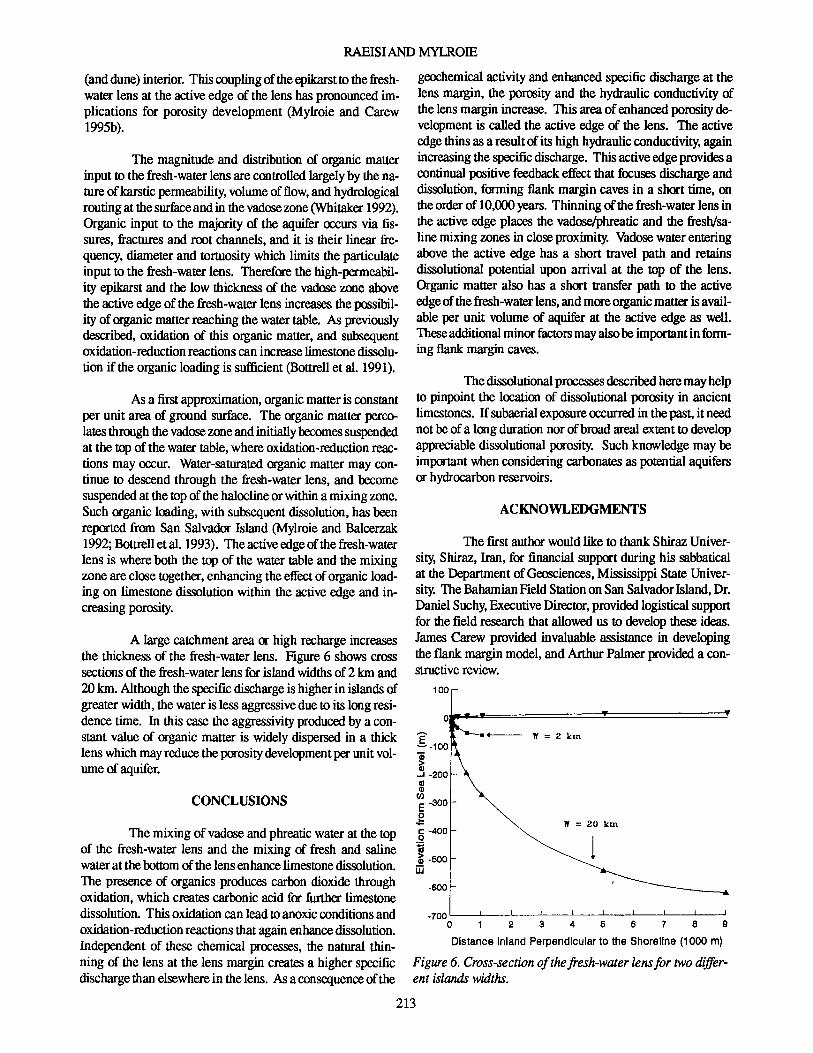
Figure 6. Cross-section ofthefresh-water lensfor two different islands widths.
W = 20 km
-600
geochemical activityand enhanced specific discharge at thelens margin, the porosity and the hydraulic conductivity ofthe lens margin increase. This area of enhancedporosity development is called the active edge of the lens. The activeedgethinsas a resultof its high hydraulic conductivity, againincreasing the specific discharge. Thisactiveedgeprovides acontinual positive feedback effectthat focuses discharge anddissolution, forming flank margin caves in a short time, ontheorderof 10,000years. Thinningof thefresh-water lensinthe active edge places the vadose/phreatic and the fresh/saline mixingzones in closeproximity. Vadose waterenteringabove the active edge has a short travel path and retainsdissolutional potential upon arrival at the top of the lens.Organic matter also has a short transfer path to the activeedgeof thefresh-water lens,and moreorganicmatterisavailable per unit volume of aquifer at the active edge as well.Theseadditional minorfactors mayalsobe importantin forming flank margincaves.
Thedissolutional processes described heremayhelpto pinpoint the location of dissolutional porosity in ancientlimestones. Ifsubaerial exposure occurred in the past, it neednot be of a longdurationnorof broad areal extent to developappreciable dissolutional porosity. Such knowledge may beimportantwhenconsidering carbonates as potentialaquifersor hydrocarbon reservoirs.
The first author wouldlike to thank ShirazUniversity, Shiraz, Iran, for financial supportduring his sabbaticalat the Department ofGeosciences, Mississippi State University. TheBahamianFieldStationon San SalvadorIsland,Dr.DanielSuchy, Executive Director, providedlogistical supportfor the field research that allowed us to develop these ideas.James Carew provided invaluable assistance in developingthe flank marginmodel, and ArthurPalmer provided a constructive review.
100
E~-100
1..J -200Cl1Gl
C/)
E -300
,g&:: -400o~~ -500iii
As a firstapproximation, organicmatteris constantper unit area of ground surface. The organic matter percolatesthroughthe vadose zoneand initially becomes suspendedat the top of the watertable,where oxidation-reduction reactions may occur. Water-saturated organicmatter may continue to descend through the fresh-water lens, and becomesuspended at the topof thehalocline or withina mixingzone.Such organicloading,with subsequent dissolution, has beenreported from San Salvador Island (Mylroie and Balcerzak1992; Bottrellet al. 1993). The activeedgeofthefresh-waterlens is whereboth the top of the watertableand the mixingzone are closetogether, enhancingthe effect oforganicloading on limestone dissolution within the active edge and increasingporosity.
The magnitude and distribution of organic matterinput to the fresh-water lens are controlled largelyby the natureofkarstic permeability, volume of flow, and hydrologicalroutingat thesurfaceand in the vadose zone(Whitaker 1992).Organic input to the majority of the aquifer occurs via fissures, fractures and root channels,and it is their linear frequency, diameterand tortuosity which limits the particulateinput to the fresh-water lens. Therefore the high-permeability epikarst and the low thicknessof the vadose zone abovethe activeedgeof the fresh-water lens increases the possibility of organicmatterreaching the watertable. As previouslydescribed, oxidation of this organic matter, and subsequentoxidation-reduction reactionscan increaselimestone dissolution if the organicloading is sufficient (Bottrell et al. 1991).
(anddune)interior. This couplingoftheepikarstto thefreshwater lens at the activeedge of the lens has pronounced implications for porosity development (Mylroie and Carew1995b).
CONCLUSIONS
A large catchmentarea or high rechargeincreasesthe thickness of the fresh-water lens. Figure 6 shows crosssections of the fresh-water lens for islandwidthsof 2 km and20km. Although the specific discharge is higherin islandsofgreaterwidth,the wateris lessaggressive due to its longresidence time. In this case the aggressivity produced by a constant value of organic matter is widely dispersed in a thicklens whichmayreducethe porositydevelopment per unit volumeof aquifer.
The mixingof vadoseand phreaticwater at the topof the fresh-water lens and the mixing of fresh and salinewaterat thebottom of the lensenhancelimestone dissolution.The presence of organics produces carbon dioxide throughoxidation, which createscarbonicacid for further limestonedissolution. Thisoxidation can leadtoanoxicconditions andoxidation-reduction reactionsthat againenhancedissolution.Independent of these chemical processes, the natural thinning of the lens at the lens margin creates a higher specificdischarge than elsewhere in the lens. Asa consequence ofthe
213
HYDRODYNAMIC BEHAVIOROF CAVES IN CARBONATE ISLANDS
REFERENCES
BEAR. J., 1972, Dynamics offluids in porous media. Elsevier,New York,764 p.
BOOU, A., 1980, Karst hydrology and physical speleology.Spring-Verlag, New York, 284 p.
BOTTRELL, S. H., CAREW,J. L., and MYLROIE,J. E., 1993,Bacterialsulphate reductionin flank marginenvironments:Evidence from sulphur isotopes, in White, B., (00.), Proceedingof the Sixth Symposiumon Geologyof the Bahamas. Bahamian Field Station,San Salvador Island, Bahamas, p. 17-21.
BOTIRELL, S. H., SMART, P. L., WffiTAKER, E, andRAISWELL,R., 1991, Geochemistry and isotopesystematicsofsulphur in themixingzoneofBahamian blueholes:AppliedGeochemistry, v. 6, p. 97-103.
BRADY, B. M. G., and BROWN, E. T., 1985,Rock mechanicsforundergroundmining. London,Allenand Unwin, 527 p.
BUDD, D. A., and VACHER, H. L., 1991,Predicting the thickness offresh-waterlensesin carbonatepaleo-islands: Journal of Sedimentary Petrology, v. 61, p. 43-53.
CAREW,J. L., and MYLROIE,J. E., 199511. Quaternary tectonics stability of the Bahamian Archipelago: Evidencefromfossil coral reefsand flank margincaves: Quaternary ScienceReviews, v. 14, p. 145-153.
CAREW,J. L., and MYLROIE,J. E., 1995b,Depositionalmodeland stratigraphyfor the Quaternary geologyof the BahamaIslands, in Curran. H. A. and White, B., (eds.), TerrestrialandShallowMarineGeology oftheBahamasand Bermuda.GeologicalSociety ofAmerica Special Paper 300,in press.
CHEN, J. H., CURRAN, H. A., warrs, B., andWASSERBURG,G.J.,1991,Precisecbronologyofthelastinterglacialperiod 234Uf3&Th datafromcoral reefsin theBahamas: Geological Society ofAmerica Bulletin, v. 103,p.82-97.
CHIlDS, E. C., 1969, An introduction to the physical basis ofsoil-waterphenomena. John Wileyand Sons, New York,493p.
FETIER,C. W. Jr., 1972, Position of the saline water interfacebeneath oceanic islands: Water Resources Research, v. 8,p.1307-1314.
HENRY, H. R.,l964, Interfaces betweensaltwater andfreshwaterin coastalaquifers,inCooper, H.HJr., Kohout,F.A.,Henry,H. R., and Glover, R.E., Sea waterin coastalaquifers.U. S.Geological SurveyWaterSupplyPaper, 1613 p.
UTILE, B. G., BUCKlEY, D. K., CANT,R. V.,HENRY, P.W.T., JEFFERISS, A., MATHER, J. D., STARK, J., andYOUNG, R. N., 1977. Land resources of the Bahamas:Summary land resources study 27. Land ResourcesDivision,MinistryforOverseasDevelopment, SurbitonEngland,133p.
UTILE, B. G., BUCKlEY, D. K., CANT, R. V., JEFFERISS,A, STARK,J. and YOUNG R. N., 1975,Land resourcesof the Commonwealth of the Bahamas, volume 5a GrandBahama. Unpublished Report for the Ministry for Overseas Development,Surbiton,England, 198 p.
MYLROIEJ. E., and BALCERZAK,W.J., 1992,Interaction ofmicrobiology and karst processesin Quaternary carbonateisland aquifers, in Stanford,J. A., and Simons,J. J., (eds.),
Proceedingof the FIst InternationalConferenceon GroundWater Ecology: American Water Resources Association,Bethesda.Maryland,p. 37-46.
MYLROIE, J. E., and CAREW,J. L., 1990, The flank marginmodel fordissolutioncave developmentin carbonateplatforms: Earth Surface Processes andLandforms, v. 15, p.413-424.
MYLROIE,J. E., and CAREW, J. L., 199511. Geologyand KatstGeomorphology ofSanSalvadorIsland,Bahamas:CarbonatesandEvaporites. v. 10, no. 2, p. 193-206.
MYLROIE,J. E., and CAREW.J. L., 1995b,Karst developmenton carbonate islands, in Budd, D. A, Harris, P. M., andSaller,A., (eds.), Unconformities in carbonatestrata:Theirrecognitionand significanceof associatedporosity. AmericanAssociationofPetroleum GeologistMemoir 63, Chapter 3, P 55-76.
MYLROIE, J. E., and CAREW, J. L., SEALEY, N. E., andMYLROIE,J. R., 1991,Cave development on New Providence Island and Long Island, Bahamas: Cave Science, v.18,p. 139-151.
PALMER, AN., 1991,Originandmorphologyoflimestonecaves:Geological Society ofAmerica Bulletin, v. 103,p. 1-25.
PLUMMER,L. N., 1975,Mixingof sea water with calcium carbonate ground water, inWhitten, E. H. T., (ed.), Quantitative studies in geological sciences, Geological Society ofAmerica Memoir 142, p. 219-236.
SANFORD,W.E., and KONIKOW, L. E, 1989,Porositydevelopmentincoastalcarbonate aquifers: Geology, v. 17,p. 249252.
SEAIEY, N.E., 1985,Bahamianlandscapes.CollinsCaribbean,London,England,96 p.
SHACKlETON, N. J.,and OPDYKE, N. D., 1973,Oxygenisotope and paleomagnetic stratigraphy cK equatorial pacificcore V28-238: Oxygen isotope temperatures and ice volumesona lOS yearand 1()6 yearscale:QuaternaryResearch,v. 3, p. 39-55.
VACHER,H. L., 1978,Hydrogeology of Bermuda:Significanceof an across the inland variations in permeability: Journalof Hydrology, v, 39, p. 207-226.
VACHER,H.L.,1988,Dupuit-Ghyben-Herzberganalysisofstripisland lenses: Geological Society ofAmerica Bulletin, v.100,p. 508-591.
VACHER, H. L., and AYERS,J. E, 1980, Hydrologyof smailoceanic islands:Utility of an estimate of rechargeinferredfrom the chlorideconcentration of the fresh-water lenses:JournalofHydrology, v.45, p. 21-37.
VACHER, H. L., BENGTSSON, T. 0., and PLUMMER,L. N.•1990, Hydrology cK meteoricdiagenesis:Residencetimeofmeteoric ground water in island fresh-water lenses withapplication toaragonite-ealcitestabilizationrate inBermuda:GeologicalSociety ofAmericaBulletin, v. 102,p. 223-232.
VOGEL,P.N., MYLROIE, J. E.,and CAREW,J. L.,l990, Limestone petrologyand cave morphology-on San SalvadorIsland, Bahamas: Cave Science, v. 17,p. 19-30.
WHITAKER, E E, 1992,Hydrology, geochemistry and diagenesis of modem carbonateplatforms in the Bahamas. UnpublishedPhD dissertation, UniversitycK Bristol, 374 p.
Received: May 6, 1995Accepted: September19, 1995
214
Copyright © 2022 FDOKUMEN