Groundwater pesticides residue in the southwest of Iran-Shushtar plain
9
ORIGINAL ARTICLE Groundwater pesticides residue in the southwest of Iran-Shushtar plain Ali Akbar Shahsavari • Kamal Khodaei • Farhad Asadian • Farhad Ahmadi • Seyed Mohammad Zamanzadeh Received: 14 March 2010 / Accepted: 26 April 2011 / Published online: 18 May 2011 Ó The Author(s) 2011. This article is published with open access at Springerlink.com Abstract Study area with an area of about 415 km 2 is located from 31°40 0 to 32°05 0 northern latitudes and 48°45 0 to 49°00 0 eastern longitudes 85 km to the north-east of Ahwaz city, in the north of Khuzestan province, and south west of Iran. The purpose of this study is: (1) the deter- mination of the pesticides concentration in the groundwater of the Shushtar plain (Mian-Ab) and (2) the assessment of geology, hydrogeology and anthropogenic activities impacts the groundwater quality. Thirty-seven groundwater samples were taken from product wells based on the standard methods. A simple and efficient automated method for extraction and preconcentration was used. In this method, a pyrrole-based polymer was synthesized and applied as an efficient sorbent for micro-solid-phase extraction. After extraction, analytes were desorbed in ethyl acetate and analyzed using gas chromatography– flame. The study area is surrounded by Aghajari Formation dominated by silt and clay sediments and the Bakhtiari Formation dominated by sand andgravel. Existence of these formations affects the aquifer sediments and the hydrogeological properties. In the study area, the sediments grade from gravel and sand in the north and east into silt and clay to the south and west, respectively. The topsoil in the south of the study area contains more clay sediments. In this study, the concentration of two common herbicides, i.e., 2,4-D and clodinafop propargyl and two pesticides, i.e., permethrin and diazinon, in the groundwater of Mian- Ab aquifer was assessed. Chemical analysis results showed that the 2,4-D residue in the groundwater has the highest concentration (15 ppm). About 50% of the samples have concentration values more than the maximum contamina- tion level based on EPA drinking standard. The pesticides concentrations decrease from the north to the south of the study area. Pesticides influx to the groundwater in the south of the area is prevented or diminished due to the specific geological situation and soil type. Distribution pattern of population centers, which increase to the north of the study area, and the role of groundwater as the main source of drinking water are two important issues that must be con- sidered in management of pesticides use in the area. Keywords Groundwater quality Pesticide residue Khuzestan province Introduction Khuzestan province in the south-west of Iran with appro- priate surface-water resources, topographical situation, and fertile soil is an important area for agricultural activities. The lack of a proper management has caused surface and sub-surface water resources contamination due to the uti- lization of excessive chemical fertilizers and poisons (including pesticides, herbicides, and insecticides). Pesticides are chemical and biological materials that are used for pest removing or controlling, and are categorized into three main groups of insecticides, fungicides, and herbicides (Waxman 1998). In this study, concentration of A. A. Shahsavari (&) K. Khodaei F. Asadian Department of Geology, ACECR, Research Institute of Applied Science, Shahid Beheshti University, Tehran, Iran e-mail: [email protected] F. Ahmadi Pharmaceutical Chemistry Department, Faculty of Pharmacy, Kermanshah University of Medical Sciences, Kermanshah, Iran S. M. Zamanzadeh Faculty of Geography, University of Tehran, Tehran, Iran 123 Environ Earth Sci (2012) 65:231–239 DOI 10.1007/s12665-011-1086-9
-
Upload
independent -
Category
Documents
-
view
1 -
download
0
Transcript of Groundwater pesticides residue in the southwest of Iran-Shushtar plain
ORIGINAL ARTICLE
Groundwater pesticides residue in the southwest of Iran-Shushtarplain
Ali Akbar Shahsavari • Kamal Khodaei •
Farhad Asadian • Farhad Ahmadi •
Seyed Mohammad Zamanzadeh
Received: 14 March 2010 / Accepted: 26 April 2011 / Published online: 18 May 2011
� The Author(s) 2011. This article is published with open access at Springerlink.com
Abstract Study area with an area of about 415 km2 is
located from 31�400 to 32�050 northern latitudes and 48�450
to 49�000 eastern longitudes 85 km to the north-east of
Ahwaz city, in the north of Khuzestan province, and south
west of Iran. The purpose of this study is: (1) the deter-
mination of the pesticides concentration in the groundwater
of the Shushtar plain (Mian-Ab) and (2) the assessment of
geology, hydrogeology and anthropogenic activities
impacts the groundwater quality. Thirty-seven groundwater
samples were taken from product wells based on the
standard methods. A simple and efficient automated
method for extraction and preconcentration was used. In
this method, a pyrrole-based polymer was synthesized and
applied as an efficient sorbent for micro-solid-phase
extraction. After extraction, analytes were desorbed in
ethyl acetate and analyzed using gas chromatography–
flame. The study area is surrounded by Aghajari Formation
dominated by silt and clay sediments and the Bakhtiari
Formation dominated by sand andgravel. Existence of
these formations affects the aquifer sediments and the
hydrogeological properties. In the study area, the sediments
grade from gravel and sand in the north and east into silt
and clay to the south and west, respectively. The topsoil in
the south of the study area contains more clay sediments. In
this study, the concentration of two common herbicides,
i.e., 2,4-D and clodinafop propargyl and two pesticides,
i.e., permethrin and diazinon, in the groundwater of Mian-
Ab aquifer was assessed. Chemical analysis results showed
that the 2,4-D residue in the groundwater has the highest
concentration (15 ppm). About 50% of the samples have
concentration values more than the maximum contamina-
tion level based on EPA drinking standard. The pesticides
concentrations decrease from the north to the south of the
study area. Pesticides influx to the groundwater in the south
of the area is prevented or diminished due to the specific
geological situation and soil type. Distribution pattern of
population centers, which increase to the north of the study
area, and the role of groundwater as the main source of
drinking water are two important issues that must be con-
sidered in management of pesticides use in the area.
Keywords Groundwater quality � Pesticide residue �Khuzestan province
Introduction
Khuzestan province in the south-west of Iran with appro-
priate surface-water resources, topographical situation, and
fertile soil is an important area for agricultural activities.
The lack of a proper management has caused surface and
sub-surface water resources contamination due to the uti-
lization of excessive chemical fertilizers and poisons
(including pesticides, herbicides, and insecticides).
Pesticides are chemical and biological materials that are
used for pest removing or controlling, and are categorized
into three main groups of insecticides, fungicides, and
herbicides (Waxman 1998). In this study, concentration of
A. A. Shahsavari (&) � K. Khodaei � F. Asadian
Department of Geology, ACECR, Research Institute of Applied
Science, Shahid Beheshti University, Tehran, Iran
e-mail: [email protected]
F. Ahmadi
Pharmaceutical Chemistry Department, Faculty of Pharmacy,
Kermanshah University of Medical Sciences, Kermanshah, Iran
S. M. Zamanzadeh
Faculty of Geography, University of Tehran, Tehran, Iran
123
Environ Earth Sci (2012) 65:231–239
DOI 10.1007/s12665-011-1086-9
two herbicides: 2,4-D and clodinafop propargyl and two
pesticides: permethrin and diazinon, was investigated in the
Mian-Ab, Shushtar groundwater. In this paper, the general
term of ‘‘pesticide’’ is adopted instead of repeating the
above-mentioned name.
Relation between human health, environment, and pesti-
cides usage was heard after 20 years of using pesticides
(Carson 1962) and their usage was related to cancer danger as
well (UNEP 1993). It has been estimated that 2.5 million tons
of pesticides are being applied worldwide each year and the
usage continues with an increasing trend (Pimentel 1995).
Some farmers who work with 2,4-D suffer from neurotic
illness, moreover digestive disease and prostate cancer
related to 2,4-D have been registered based on the previous
studies (Sierra Club of Canada 2005). 2,4-D causes slight
decreases in testosterone release and significant increases
in estrogen release from testicular cells (Liu et al. 1996).
Workers applying chlorinated phenoxy herbicides fre-
quently show nervous system disorders.
Human activities and natural factors that affect ground-
water quality were studied around the world by many
researchers (Jiang et al. 2009; Lorite-Herrera et al. 2007;
Jalali et al. 2008; Kim et al. 2003; Shomar et al. 2005).
Based on the Chemical Security Profile information of
Iran in 1996, about 27,000 tons of pesticides, including 101
types of insecticides, herbicides, fungicides…, were used
in this country. Comprehensive and accurate information
about pesticides utilization does not exist in the study area
and this subject is a major source of worry about using
pesticides.
Determination of residual pesticides in groundwater can
help us to decide about groundwater management in an
area (including cities and villages where the groundwater is
utilized as drinking water supply). Some limited studies in
Iran about pesticides residue in agricultural (Ebadi et al.
2005) and meat products (Hashemy-Tonkabony et al.
1981) have been carried out regardless of geological
parameters.
Some studies on the surface-water and agricultural wells
around Tehran city have been done to determine 13
organophosphorous pesticides; in these samples diazinon,
malathion, and etion have been extracted from water and
the results show that their concentration was lower than
EPA maximum contaminant level (Ahmadi et al. 2006).
2,4-D is one of the pesticides that is mostly used in the
study area. Some other pesticides such as permethrin,
clodinafop, diazinon, atrazine, glyphosate, eradicane, are
also used there. In the present study, permethrin, clodina-
fop, 2,4-D, and diazinon concentrations were determined in
the groundwater in the study area.
The purpose of this study is: (1) the determination of the
pesticides concentration in the groundwater of the Shushtar
plain (Mian-Ab) and (2) the assessment of geology,
hydrogeology and anthropogenic activities impacts the
groundwater quality.
Agricultural activities are similar all over the plain, but
geological and hydrogeological properties and soil types
are different in the south compared to the north of the study
area, so it is expected that the pesticides concentration in
the groundwater in the northern part of the study area will
be greater than in the southern part.
Materials and methods
Study area
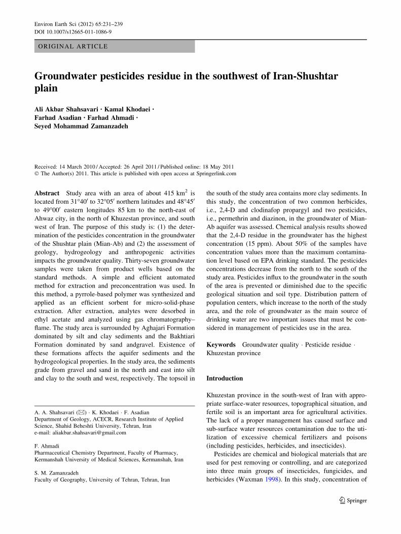
Study area is the Shushtar (Mian-Ab) plain with an area of
about 453 km2 and is located between 31�400 and 32�050
northern latitudes and 48�450 and 49�000 eastern longitudes
some 85 km to the north-east of Ahwaz city, north of
Khuzestan province, and south west of Iran. The Karun
river at the entrance of the study area, near the Shushtar
city, is divided into two branches: (1) Gargar river (eastern
boundary) and (2) Shotait river (western boundary). These
rivers again come together near to the Ghir dam after
recharging the agricultural terrains. Mian-Ab Plain is
bounded between the above-mentioned rivers (Fig. 1).
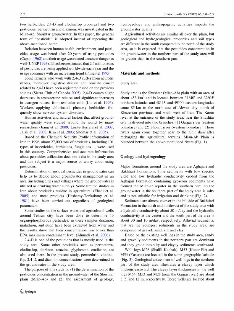
Geology and hydrogeology
Major formations around the study area are Aghajari and
Bakhtiari Formations. Fine sediments with low specific
yield and low hydraulic conductivity eroded from the
Aghajari Formation containing gypseous sediments have
formed the Mian-ab aquifer in the southern part. So the
groundwater in the southern part of the study area is salty
and is not suitable for irrigation and drinking (Fig. 2).
Sediments are almost coarser in the hillside of Bakhtiari
Formation in the north and northwest of the study area with
a hydraulic conductivity about 50 m/day and the hydraulic
conductivity at the center and the south part of the area is
about 30 and 10 m/day, respectively. Alluvial sediments,
that are the youngest sediments in the study area, are
composed of gravel, sand, silt and clay.
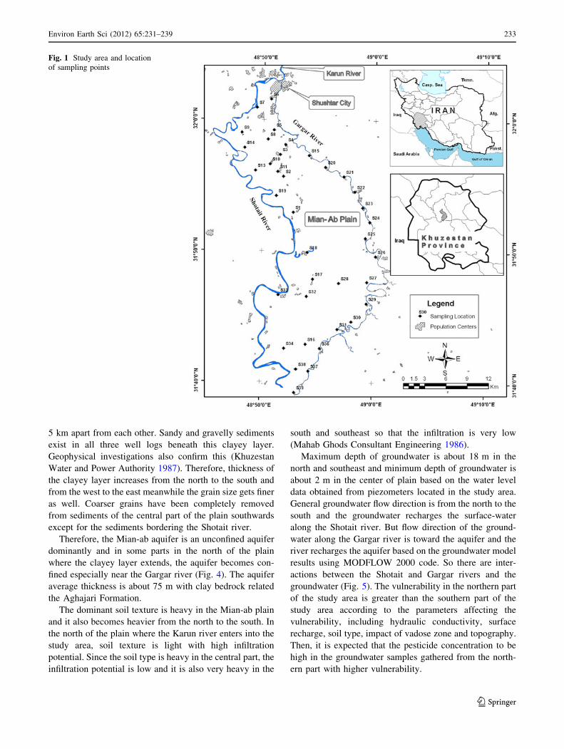
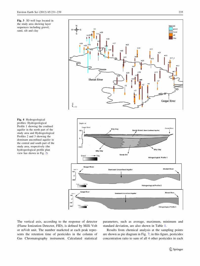
Based on the existing well logs in the study area, sandy
and gravelly sediments in the northern part are dominant
and they grade into silty and clayey sediments southward.
Well logs M28 (Shalili Kuchak), M53 (Konar Pir) and
M54 (Yasarat) are located in the same geographic latitude
(Fig. 3). Geological assessment of well logs in the northern
part of the study area illustrates a clayey layer which
thickens eastward. The clayey layer thicknesses in the well
logs M54, M53 and M28 (near the Gargar river) are about
3, 5, and 12 m, respectively. These wells are located about
232 Environ Earth Sci (2012) 65:231–239
123
5 km apart from each other. Sandy and gravelly sediments
exist in all three well logs beneath this clayey layer.
Geophysical investigations also confirm this (Khuzestan
Water and Power Authority 1987). Therefore, thickness of
the clayey layer increases from the north to the south and
from the west to the east meanwhile the grain size gets finer
as well. Coarser grains have been completely removed
from sediments of the central part of the plain southwards
except for the sediments bordering the Shotait river.
Therefore, the Mian-ab aquifer is an unconfined aquifer
dominantly and in some parts in the north of the plain
where the clayey layer extends, the aquifer becomes con-
fined especially near the Gargar river (Fig. 4). The aquifer
average thickness is about 75 m with clay bedrock related
the Aghajari Formation.
The dominant soil texture is heavy in the Mian-ab plain
and it also becomes heavier from the north to the south. In
the north of the plain where the Karun river enters into the
study area, soil texture is light with high infiltration
potential. Since the soil type is heavy in the central part, the
infiltration potential is low and it is also very heavy in the
south and southeast so that the infiltration is very low
(Mahab Ghods Consultant Engineering 1986).
Maximum depth of groundwater is about 18 m in the
north and southeast and minimum depth of groundwater is
about 2 m in the center of plain based on the water level
data obtained from piezometers located in the study area.
General groundwater flow direction is from the north to the
south and the groundwater recharges the surface-water
along the Shotait river. But flow direction of the ground-
water along the Gargar river is toward the aquifer and the
river recharges the aquifer based on the groundwater model
results using MODFLOW 2000 code. So there are inter-
actions between the Shotait and Gargar rivers and the
groundwater (Fig. 5). The vulnerability in the northern part
of the study area is greater than the southern part of the
study area according to the parameters affecting the
vulnerability, including hydraulic conductivity, surface
recharge, soil type, impact of vadose zone and topography.
Then, it is expected that the pesticide concentration to be
high in the groundwater samples gathered from the north-
ern part with higher vulnerability.
Fig. 1 Study area and location
of sampling points
Environ Earth Sci (2012) 65:231–239 233
123
Sampling and chemical analysis
It is necessary to take into account the impact of the field
stages on the chemical analysis of natural water, in terms of
both sampling representativeness and spatial and temporal
variability (Roy and Fouillac 2004). Sampling in the Mian-
ab was done in 4 days in August 2006 because of huge
consumption of pesticides in June and August so it is an
appropriate time to detect the pesticides in the groundwater
samples. Sampling locations were determined based on the
expert judgment type (EPA 1995). Then, the sampling
operators with a specific plan went to the sampling loca-
tions and carried out sampling. The samples were taken
based on the standard sampling method from 37 wells
(EPA 2003) and placed in dark glass bottles with 1 l
capacity and kept at 4�C before handing to the laboratory
in the pharmacy faculty of medicine, University of
Kermanshah.
Sample preparation was done to extract the pesticides
from water afterwards. Then, a simple and efficient auto-
mated method for extraction and pre-concentration was
applied. In this method, a pyrrole-based polymer was
synthesized and applied as an efficient sorbent for micro-
solid-phase extraction. After extraction, analytes were
desorbed in ethyl acetate and analyzed using gas chroma-
tography–flame (Ahmadi et al. 2008).
Discussion and results
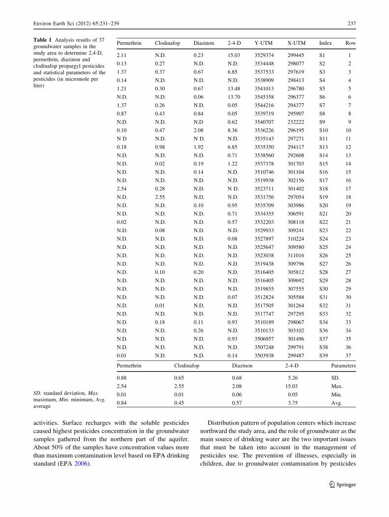
Chemical analysis results from 37 groundwater samples for
2,4-D, permethrin, diazinon and clodinafop propargyl
pesticides are shown in Table 1. The pesticides were not
recognized in most of the samples which were gathered
from the central and southern part of the study area. These
results are marked by N.D. sign in Table 1; but in samples
that were gathered from the north of study area, there is a
high amount of pesticides. For example in the Longor
village in the north of the study area, different peaks were
appeared in retention time similar to 2,4-D, diazinon,
permethrin and clodinafop propargyl (Fig. 6). Figure 6 is a
chromatogram of a sample water which analysed by GC.
Fig. 2 Geological map of the
study area including Aghajari
(AJ), Bakhtiari (BK), and
Mishan (MN) Formations
Lahbari member (LBM) and
Quaternary (Q) Sediments and
the Hydrogeological profile
location
234 Environ Earth Sci (2012) 65:231–239
123
The vertical axis, according to the response of detector
(Flame Ionization Detector, FID), is defined by Milli Volt
or mVolt unit. The number marketed at each peak repre-
sents the retention time of pesticides in the column of
Gas Chromatography instrument. Calculated statistical
parameters, such as average, maximum, minimum and
standard deviation, are also shown in Table 1.
Results from chemical analysis at the sampling points
are shown as pie diagram in Fig. 7; in this figure, pesticides
concentration ratio to sum of all 4 other pesticides in each
Fig. 3 3D well logs located in
the study area showing layer
sequences including gravel,
sand, silt and clay
Fig. 4 Hydrogeological
profiles: Hydrogeological
Profile 1 showing the confined
aquifer in the north part of the
study area and Hydrogeological
Profiles 2 and 3 showing the
dominant unconfined aquifer in
the central and south part of the
study area, respectively (the
hydrogeological profile plan
view has shown in Fig. 2)
Environ Earth Sci (2012) 65:231–239 235
123
sample is shown. Points with no pie diagram means that in
these points no pesticide was recognized (Fig. 7).
Among 4 pesticides assessed, 2,4-D has highest con-
centration value in the groundwater (15 ppm), and then
permethrin, diazinon, and clodinafop propargyl have more
concentration value, respectively. Maximum standard
deviation is related to 2,4-D and minimum standard devi-
ation is related to the clodinafop propargyl. 2,4-D has a
relatively long half-life (200 days) and its high amount
consumption are two reasons that 2,4-D concentration in
groundwater is higher than the others; however, due to the
lack of accurate information about amount of pesticides
utilization (because of diversity in management), there is
no detailed information about pesticides usage.
Wide-spread agricultural activities throughout the study
area caused the pesticides existence in most samples with
various pesticides concentration value.
Geology and soil type in the same agricultural condi-
tions have an important effect on the groundwater
contamination. Existence of Aghajari and Bakhtiari For-
mations and their erosion products resulted in formation of
an aquifer which is composed of clay and gravel sediments,
respectively. These sediments affect hydraulic conductivity
which is one of the important parameters influencing the
groundwater movement and contamination. For example
because of high hydraulic conductivity and surface
recharge in the northern part of the study area in compar-
ison with the southern part, the transport of pesticides in
the northern part is faster and the concentration of the
pesticides in the groundwater samples is more.
As mentioned above, groundwater quality and quantity in
the south of the study area is not in a good condition, so that it
is not suitable for drinking and inevitably, it is just used for
agricultural purposes. Lowest concentration values of pes-
ticides are recorded in the south with similar agricultural
activities conditions (same land-use) to the northern part of
the plain. This shows that soil properties and upper sediments
that form the aquifer have a preservative role against aquifer
contamination caused by anthropogenic activities.
Coarse sediments such as sand and gravel that form the
aquifer and the light soil texture in the north of the plain
caused great surface recharge due to the agricultural
Fig. 5 Iso-piezometric map and
groundwater direction in the
study area
236 Environ Earth Sci (2012) 65:231–239
123
activities. Surface recharges with the soluble pesticides
caused highest pesticides concentration in the groundwater
samples gathered from the northern part of the aquifer.
About 50% of the samples have concentration values more
than maximum contamination level based on EPA drinking
standard (EPA 2006).
Distribution pattern of population centers which increase
northward the study area, and the role of groundwater as the
main source of drinking water are the two important issues
that must be taken into account in the management of
pesticides use. The prevention of illnesses, especially in
children, due to groundwater contamination by pesticides
Table 1 Analysis results of 37
groundwater samples in the
study area to determine 2,4-D,
permethrin, diazinon and
clodinafop propargyl pesticides
and statistical parameters of the
pesticides (in micromole per
liter)
SD. standard deviation, Max.maximum, Min. minimum, Avg.average
Permethrin Clodinafop Diazinon 2-4-D Y-UTM X-UTM Index Row
2.11 N.D. 0.23 15.03 3529374 299445 S1 1
0.13 0.27 N.D. N.D. 3534448 298077 S2 2
1.37 0.37 0.67 6.85 3537533 297619 S3 3
0.14 N.D. N.D. N.D. 3538909 298413 S4 4
1.21 0.30 0.67 13.48 3541013 296780 S5 5
N.D. N.D. 0.06 13.70 3545358 296377 S6 6
1.37 0.26 N.D. 0.05 3544216 294377 S7 7
0.87 0.43 0.84 0.05 3539719 295907 S8 8
N.D. N.D. N.D 0.62 3540707 232222 S9 9
0.10 0.47 2.08 8.36 3536226 296195 S10 10
N D N.D. N D. N.D. 3535143 297271 S11 11
0.18 0.98 1.92 6.85 3535350 294117 S13 12
N.D. N.D. N.D. 0.71 3538560 292608 S14 13
N.D. 0.02 0.19 1.22 3537378 301703 S15 14
N.D. N.D. 0.14 N.D. 3510746 301104 S16 15
N.D. N.D. N.D. N.D. 3519938 302156 S17 16
2.54 0.28 N.D. N D. 3523711 301402 S18 17
N.D. 2.55 N.D. N.D. 3531756 297054 S19 18
N.D. N.D. 0.10 0.95 3535709 303986 S20 19
N.D. N.D. N.D. 0.71 3534355 306591 S21 20
0.02 N.D. N.D. 0.57 3532203 308118 S22 21
N.D. 0.08 N.D. N.D. 3529933 309241 S23 22
N.D. N.D. N.D. 0.08 3527897 310224 S24 23
N.D. N.D. N.D. N.D. 3525647 309580 S25 24
N.D. N.D. N.D. N.D. 3523038 311016 S26 25
N.D. N.D. N.D. N.D. 3519438 309796 S27 26
N.D. 0.10 0.20 N.D. 3516405 305812 S28 27
N.D. N.D. N.D. N.D. 3516405 309692 S29 28
N.D. N.D. N.D. N.D. 3519855 307555 S30 29
N.D. N.D. N.D. 0.07 3512824 305588 S31 30
N.D. 0.01 N.D. N.D. 3517505 301264 S32 31
N.D. N.D. N.D. N.D. 3517747 297295 S33 32
N.D. 0.18 0.11 0.93 3510189 298067 S34 33
N.D. N.D. 0.26 N.D. 3510133 303102 S36 34
N.D. N.D. N.D. 0.93 3506957 301496 S37 35
N.D. N.D. N.D. N.D. 3507248 299791 S38 36
0.01 N.D. N.D. 0.14 3503938 299487 S39 37
Permethrin Clodinafop Diazinon 2-4-D Parameters
0.88 0.65 0.68 5.26 SD.
2.54 2.55 2.08 15.03 Max.
0.01 0.01 0.06 0.05 Min.
0.84 0.45 0.57 3.75 Avg.
Environ Earth Sci (2012) 65:231–239 237
123

must be taken into account. Irregular consumption of pes-
ticides also caused contamination and the pesticides are
transmitted to agricultural products (Ebadi et al. 2005).
Pesticides concentration values were not dangerous for
human health based on the results from studies performed
on the wells and rivers around Tehran City (Ahmadi et al.
2006). However, in the present study the pesticides con-
centration in half of samples was higher than the EPA
maximum contaminant level and besides influence of geo-
logical and hydrogeological properties is considered too.
Fig. 6 Chromatogram of
groundwater sample
S11- Longor village
Fig. 7 Results from chemical
analysis of the groundwater
samples as pie diagram for
pesticides
238 Environ Earth Sci (2012) 65:231–239
123

Interaction between surface and groundwater brings
some variations in the chemical composition in the both
sources (Delleur 2007).
Contaminated groundwater transmission to the Shotait
river (a branch of Karun river) caused contamination of
surface-water that it is used as agricultural water; however,
pesticides in a losing river may cause its influx to the
groundwater. We suggest to use some contaminant trans-
port models such as MT3DMS to estimate transmitted
pesticides values in rivers.
Agriculture development in this area is possible by
performing the Irrigation-Drainage Project all around the
plain. If this project is carried out, the agricultural industry
will develop irregularly. So the groundwater level will rise,
as a result land becomes muddy and so more pesticides will
be transmitted to the aquifer and the risk of contamination
increases.
Conclusion
Groundwater is an important resource for drinking and
agricultural consumptions in the study area. Therefore,
groundwater quality assessment is very important. Based
on the exploration studies, in some parts of the plain the
aquifer becomes semi-confined due to the existence of the
impermeable clayey layers. The existence of heavy soil,
which is mostly composed of clay and dominates in the
south, caused changes in the concentration of groundwater
pesticides in the south and north of the study area.
Based on results from the analysis of 37 samples that
was carried out on 4 pesticides (2,4-D, diazinon, per-
methrin and clodinafop propargyl), it was determined that
pesticides concentration values in the groundwater in the
north of the plain are higher where highly permeable sed-
iments with light soil texture dominates compared to the
southern part.
Existence of impermeable clayey layer in the southern
part of the plain caused an intensive decrease in the pes-
ticides concentration. About 50% of the groundwater
samples have concentration values more than maximum
contamination level based on EPA drinking standards.
High concentration of pesticides in groundwater in the
north of plain is an important issue from environmental
point of view. It gets more critical when it is clarified that
the wells located in the north of the plain are the major
supply of drinking water and most of the population centers
are located there, as well.
Open Access This article is distributed under the terms of the
Creative Commons Attribution Noncommercial License which per-
mits any noncommercial use, distribution, and reproduction in any
medium, provided the original author(s) and source are credited.
References
Ahmadi F, Assadi Y, Milani Hosseini SMR, Rezaee M (2006)
Determination of organophosphorus pesticides in water samples
by single drop microextraction and gas chromatography-flame
photometric detector. J Chromatogr A 1101(1–2):307–312
Ahmadi F, Shahsavari AA, Rahimi-Nasrabadi M (2008) Automated
extraction and preconcentration of multiresidue of pesticides on
a micro-solid-phase extraction system based on polypyrrole as
sorbent and off-line monitoring by gas chromatography–flame
ionization detection. J Chromatogr A 1193(1–2):26–31
Carson RL (1962) Silent spring, Riversde Press, Cambridge
Delleur JW (2007) The handbook of groundwater engineering, 2nd
edn. CRC Press, Boca Raton
Ebadi AG, Shokrzadeh M, Zare S (2005) A survey and measurement
of residues of lindane (organochlorine pesticides) in cultivated
cucumber of Mazandaran Province (Iran). Pak J Nutr 4(5):
291–293
EPA (1995) Superfund program representative sampling guidance
EPA (2003) Guidance on choosing a sampling design for environ-
mental data collection, QA/G-5S
EPA (2006) 2006 Edition of the Drinking Water Standards and Health
Advisories, 822-R-06-013, Office of Water
Hashemy-Tonkabony SE, Afshar A, Ghazisaidi K, Assadi-Langaro-
odi F, Messchi M, Ahmadi Z (1981) Chlorinated pesticide
residues in meat and fat from animals raised in Iran, JAOCS
Jalali M, Kolahchi Z (2008) Groundwater quality in an irrigated,
agricultural area of northern Malayer, western Iran. Nutr Cycl
Agroecosyst 80:95–105. doi:10.1007/s10705-007-9123-5
Jiang Y, Wu Y, Groves C, Yuan D, Kambesis P (2009) Natural and
anthropogenic factors affecting the groundwater quality in the
Nandong karst underground river system in Yunan, China.
J Contam Hydrol 109(1–4):49–61
Khuzestan Water and Power Authority (1987) Geophysics Assess-
ments of Gargar, Mian-Ab and Shoaibie Plains
Kim JH, Kim RH, Lee J, Chang HW (2003) Hydrogeochemical
characterization of major factors affecting the quality of shallow
groundwater in the coastal area at Kimje in South Korea.
Environ Geol 44:478–489. doi:10.1007/s00254-003-0782-5
Liu RC, Hahn C, Hurtt ME (1996) The direct effect of hepatic
peroxisome proliferators on rat leydig cell function in vitro.
Fundam Appl Toxicol 30:102–108
Lorite-Herrera M, Jimenez-Espinosa R (2007) Impact of agricultural
activity and geologic controls on groundwater quality of the
alluvial aquifer of the Guadalquivir River (province of Jaen,
Spain): a case study. Environ Geol 54:1391–1402. doi:
10.1007/s00254-007-0920-6
Mahab Ghods Consultant Engineering (1986) Karun Irrigation
Projects
Pimentel D (1995) Amounts of pesticides reaching target pests: envi-
ronmental impacts and ethics. J Agric Environ Ethic 8:17–29
Roy S, Fouillac A-M (2004) Uncertainties related to sampling and
their impact on the chemical analysis of groundwater. Trends
Anal Chem 23(3):185–193
Shomar BH, Muller G, Yahya A (2005) Occurence of Pesticides in
Groundwater and Topsoil of the Gaza Strip. Water Air Soil
Pollut. doi:10.1007/s11270-005-9038-1
Sierra Club of Canada (2005) Overview of the toxic effects of 2,4-D,
412-1 Nicholas St., Ottawa, ON K1 N 7B7,613-241-4611
UNEP (1993) The Aral Sea: diagnostic study for the development of
an action plan for the conservation of the Aral Sea, United
Nations Environment Programme (UNEP), Nairobi, Kenya
(1993)
Waxman MF (1998) Agrochemical and pesticide safety handbook.
Lewis Publishers, Boca Raton
Environ Earth Sci (2012) 65:231–239 239
123