![Colin Dexter - The Dead of Jericho [EnglishOnlineClub.com].pdf](https://static.fdokumen.com/doc/165x107/633b367e7b8e0525470c6f24/colin-dexter-the-dead-of-jericho-englishonlineclubcompdf.jpg)
Colin Dexter - The Dead of Jericho [EnglishOnlineClub.com].pdf
ORIGINAL ARTICLE
Hydrochemical variation in the springs water betweenJerusalem–Ramallah Mountains and Jericho Fault, Palestine
Saed Khayat Æ Peter Moller Æ Stefan Geyer ÆAmer Marei Æ Christian Siebert Æ Fayez Abu Hilo
Received: 26 January 2008 / Accepted: 24 June 2008 / Published online: 19 July 2008
� Springer-Verlag 2008
Abstract The spatial and temporal changes of the com-
position of the groundwater from the springs along the Wadi
Qilt stream running from the Jerusalem–Ramallah Moun-
tains towards the Jericho Plain is studied during the
hydrological year 2006/2007. The residence time and the
intensity of recharge play an important role in controlling
the chemical composition of spring water which mainly
depends on distance from the main recharge area. A very
important factor is the oxidation of organics derived from
sewage and garbage resulting in variable dissolved CO2 and
associated HCO3- concentration. High CO2 yields lower pH
values and thus under-saturation with respect to calcite and
dolomite. Low CO2 concentrations result in over-saturation.
Only at the beginning and at the end of the rainy season
calcite saturation is achieved. The degradation of dissolved
organic matter is a major source for increasing water hard-
ness. Besides dissolution of carbonates dissolved species
such as nitrate, chloride, and sulfate are leached from soil and
aquifer rocks together with only small amounts of Mg. Mg
not only originates from carbonates but also from Mg–Cl
waters are leached from aquifer rocks. Leaching of Mg–Cl
brines is particularly high at the beginning of the winter
season and lowest at its end. Two zones of recharge are
distinguishable. Zone 1 represented by Ein Fara and Ein Qilt
is fed directly through the infiltration of meteoric water and
surface runoff from the mountains along the eastern moun-
tain slopes with little groundwater residence time and high
flow rate. The second zone is near the western border of
Jericho at the foothills, which is mainly fed by the under-
groundwater flow from the eastern slopes with low surface
infiltration rate. This zone shows higher groundwater resi-
dence time and slower flow rate than zone 1. Groundwater
residence time and the flow rate within the aquifer systems
are controlled by the geological structure of the aquifer, the
amount of active recharge to the aquifer, and the recharge
mechanism. The results of this study may be useful in
increasing the efficiency of freshwater exploitation in the
region. Some precautions, however, should be taken in future
plans of artificial recharge of the aquifers or surface-water
harvesting in the Wadi. Because of evaporation and associ-
ated groundwater deterioration, the runoff water should be
artificially infiltrated in zones of Wadis with high storage
capacity of aquifers. Natural infiltration along the Wadis lead
to evaporation losses and less quality of groundwater.
Keywords Recharge � Infiltration � Wadi Qilt �Jericho Plain � Major elements � Temporal change
of composition � Spatial change of composition �Upper mountain sub-aquifer � Pollution � Karst aquifer
S. Khayat (&) � S. Geyer � C. Siebert
UFZ, Helmholtz Centre for Environmental
Research-Leipzig Halle, Leipzig, Germany
e-mail: [email protected]
S. Geyer
e-mail: [email protected]
C. Siebert
e-mail: [email protected]
P. Moller
Geo-Research Center Potsdam, Potsdam, Germany
e-mail: [email protected]
A. Marei
Department of Earth and Environmental Sciences,
Al-Quds University, Jerusalem, Palestine
e-mail: [email protected]
F. A. Hilo
Institute of Water and Environmental Studies (IEWS),
Bierzeit University, Ramallah, Palestine
e-mail: [email protected]
123
Environ Geol (2009) 57:1739–1751
DOI 10.1007/s00254-008-1459-x
Introduction
Groundwater from catchments characterized by uniform
mineralogy might have a unique, characteristic chemical
composition reflecting the soluble minerals in the saturated
zone. Numerous lithology-controlled factors such as dis-
solution rates, cation exchange capacity, fluid mobility, and
reaction kinetics at mineral surfaces determine the net
solute inventory added to an evolving water parcel along a
flow path (Bullen et al. 1996). If the lithology along the
flow path varies or if the infiltrating water mixes with
saline formation water enclosed in sedimentary rocks, the
solute inventory is altered. Thus, the composition of
groundwater is expected to be different from that of the
infiltrating water. Variation of both meteoric precipitation
and the rate of water/rock interaction yield time-dependent
variable hydrochemical composition of groundwater.
All these effects are important in semi-arid to arid areas
with their seasonal rainfalls, where the amount and
mechanism of recharge of aquifers control the quality of
groundwater. These influences have been studied in the
uppermost aquifer of the Jerusalem–Ramallah sub-basin,
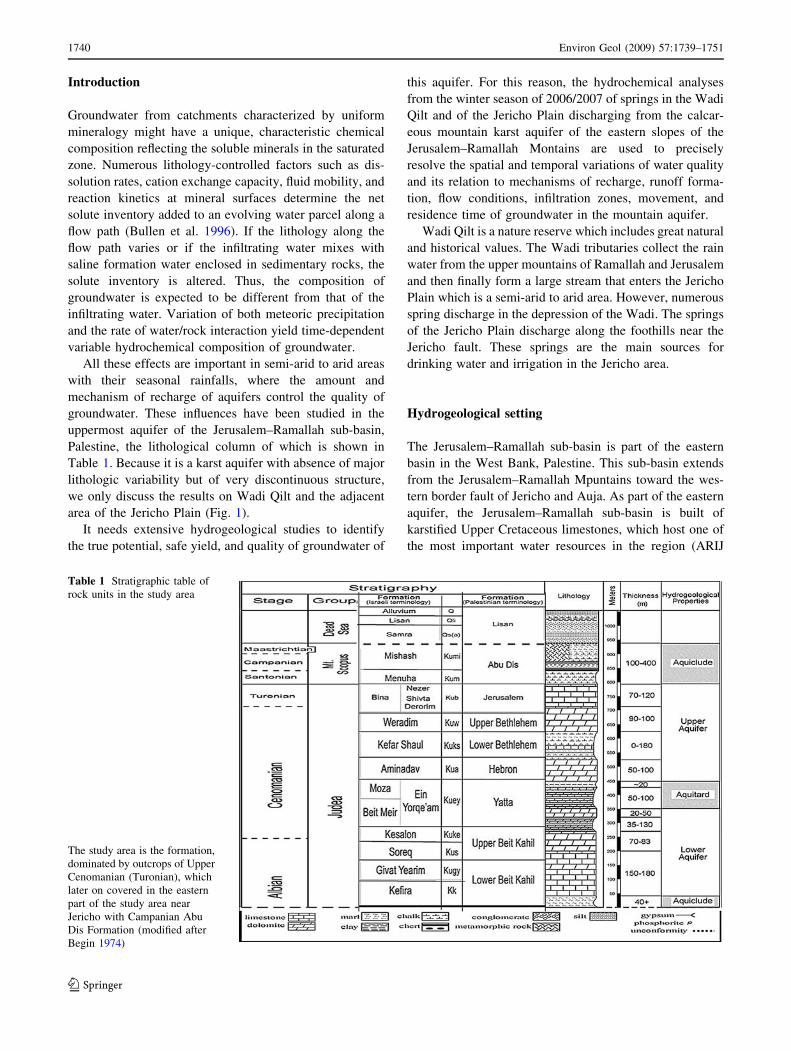
Palestine, the lithological column of which is shown in
Table 1. Because it is a karst aquifer with absence of major
lithologic variability but of very discontinuous structure,
we only discuss the results on Wadi Qilt and the adjacent
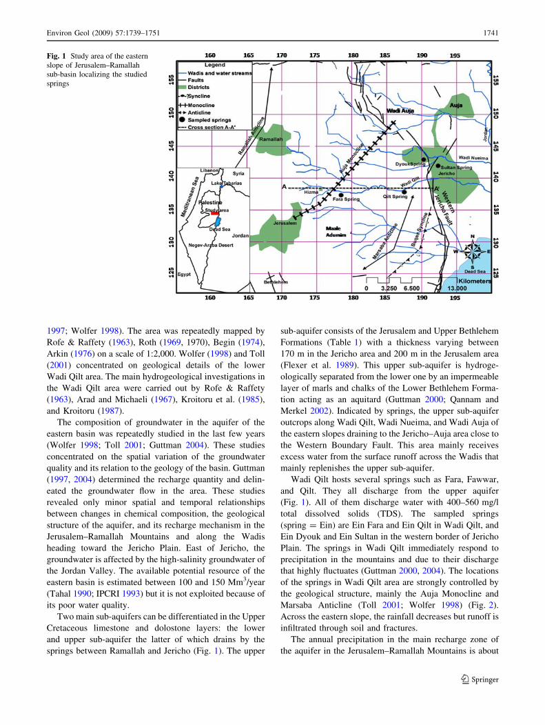
area of the Jericho Plain (Fig. 1).
It needs extensive hydrogeological studies to identify
the true potential, safe yield, and quality of groundwater of
this aquifer. For this reason, the hydrochemical analyses
from the winter season of 2006/2007 of springs in the Wadi
Qilt and of the Jericho Plain discharging from the calcar-
eous mountain karst aquifer of the eastern slopes of the
Jerusalem–Ramallah Montains are used to precisely
resolve the spatial and temporal variations of water quality
and its relation to mechanisms of recharge, runoff forma-
tion, flow conditions, infiltration zones, movement, and
residence time of groundwater in the mountain aquifer.
Wadi Qilt is a nature reserve which includes great natural
and historical values. The Wadi tributaries collect the rain
water from the upper mountains of Ramallah and Jerusalem
and then finally form a large stream that enters the Jericho
Plain which is a semi-arid to arid area. However, numerous
spring discharge in the depression of the Wadi. The springs
of the Jericho Plain discharge along the foothills near the
Jericho fault. These springs are the main sources for
drinking water and irrigation in the Jericho area.
Hydrogeological setting
The Jerusalem–Ramallah sub-basin is part of the eastern
basin in the West Bank, Palestine. This sub-basin extends
from the Jerusalem–Ramallah Mpuntains toward the wes-
tern border fault of Jericho and Auja. As part of the eastern
aquifer, the Jerusalem–Ramallah sub-basin is built of
karstified Upper Cretaceous limestones, which host one of
the most important water resources in the region (ARIJ
Table 1 Stratigraphic table of
rock units in the study area
The study area is the formation,
dominated by outcrops of Upper
Cenomanian (Turonian), which
later on covered in the eastern
part of the study area near
Jericho with Campanian Abu
Dis Formation (modified after
Begin 1974)
1740 Environ Geol (2009) 57:1739–1751
123
1997; Wolfer 1998). The area was repeatedly mapped by
Rofe & Raffety (1963), Roth (1969, 1970), Begin (1974),
Arkin (1976) on a scale of 1:2,000. Wolfer (1998) and Toll
(2001) concentrated on geological details of the lower
Wadi Qilt area. The main hydrogeological investigations in
the Wadi Qilt area were carried out by Rofe & Raffety
(1963), Arad and Michaeli (1967), Kroitoru et al. (1985),
and Kroitoru (1987).
The composition of groundwater in the aquifer of the
eastern basin was repeatedly studied in the last few years
(Wolfer 1998; Toll 2001; Guttman 2004). These studies
concentrated on the spatial variation of the groundwater
quality and its relation to the geology of the basin. Guttman
(1997, 2004) determined the recharge quantity and delin-
eated the groundwater flow in the area. These studies
revealed only minor spatial and temporal relationships
between changes in chemical composition, the geological
structure of the aquifer, and its recharge mechanism in the
Jerusalem–Ramallah Mountains and along the Wadis
heading toward the Jericho Plain. East of Jericho, the
groundwater is affected by the high-salinity groundwater of
the Jordan Valley. The available potential resource of the
eastern basin is estimated between 100 and 150 Mm3/year
(Tahal 1990; IPCRI 1993) but it is not exploited because of
its poor water quality.
Two main sub-aquifers can be differentiated in the Upper
Cretaceous limestone and dolostone layers: the lower
and upper sub-aquifer the latter of which drains by the
springs between Ramallah and Jericho (Fig. 1). The upper
sub-aquifer consists of the Jerusalem and Upper Bethlehem
Formations (Table 1) with a thickness varying between
170 m in the Jericho area and 200 m in the Jerusalem area
(Flexer et al. 1989). This upper sub-aquifer is hydroge-
ologically separated from the lower one by an impermeable
layer of marls and chalks of the Lower Bethlehem Forma-
tion acting as an aquitard (Guttman 2000; Qannam and
Merkel 2002). Indicated by springs, the upper sub-aquifer
outcrops along Wadi Qilt, Wadi Nueima, and Wadi Auja of
the eastern slopes draining to the Jericho–Auja area close to
the Western Boundary Fault. This area mainly receives
excess water from the surface runoff across the Wadis that
mainly replenishes the upper sub-aquifer.
Wadi Qilt hosts several springs such as Fara, Fawwar,
and Qilt. They all discharge from the upper aquifer
(Fig. 1). All of them discharge water with 400–560 mg/l
total dissolved solids (TDS). The sampled springs
(spring = Ein) are Ein Fara and Ein Qilt in Wadi Qilt, and
Ein Dyouk and Ein Sultan in the western border of Jericho
Plain. The springs in Wadi Qilt immediately respond to
precipitation in the mountains and due to their discharge
that highly fluctuates (Guttman 2000, 2004). The locations
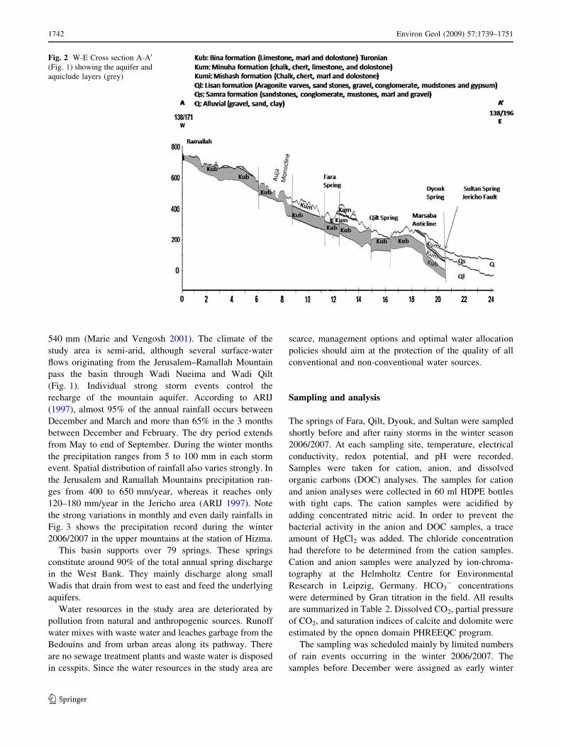
of the springs in Wadi Qilt area are strongly controlled by
the geological structure, mainly the Auja Monocline and
Marsaba Anticline (Toll 2001; Wolfer 1998) (Fig. 2).
Across the eastern slope, the rainfall decreases but runoff is
infiltrated through soil and fractures.
The annual precipitation in the main recharge zone of
the aquifer in the Jerusalem–Ramallah Mountains is about
Fig. 1 Study area of the eastern
slope of Jerusalem–Ramallah
sub-basin localizing the studied
springs
Environ Geol (2009) 57:1739–1751 1741
123
540 mm (Marie and Vengosh 2001). The climate of the
study area is semi-arid, although several surface-water
flows originating from the Jerusalem–Ramallah Mountain
pass the basin through Wadi Nueima and Wadi Qilt
(Fig. 1). Individual strong storm events control the
recharge of the mountain aquifer. According to ARIJ
(1997), almost 95% of the annual rainfall occurs between
December and March and more than 65% in the 3 months
between December and February. The dry period extends
from May to end of September. During the winter months
the precipitation ranges from 5 to 100 mm in each storm
event. Spatial distribution of rainfall also varies strongly. In
the Jerusalem and Ramallah Mountains precipitation ran-
ges from 400 to 650 mm/year, whereas it reaches only
120–180 mm/year in the Jericho area (ARIJ 1997). Note
the strong variations in monthly and even daily rainfalls in
Fig. 3 shows the precipitation record during the winter
2006/2007 in the upper mountains at the station of Hizma.
This basin supports over 79 springs. These springs
constitute around 90% of the total annual spring discharge
in the West Bank. They mainly discharge along small
Wadis that drain from west to east and feed the underlying
aquifers.
Water resources in the study area are deteriorated by
pollution from natural and anthropogenic sources. Runoff
water mixes with waste water and leaches garbage from the
Bedouins and from urban areas along its pathway. There
are no sewage treatment plants and waste water is disposed
in cesspits. Since the water resources in the study area are
scarce, management options and optimal water allocation
policies should aim at the protection of the quality of all
conventional and non-conventional water sources.
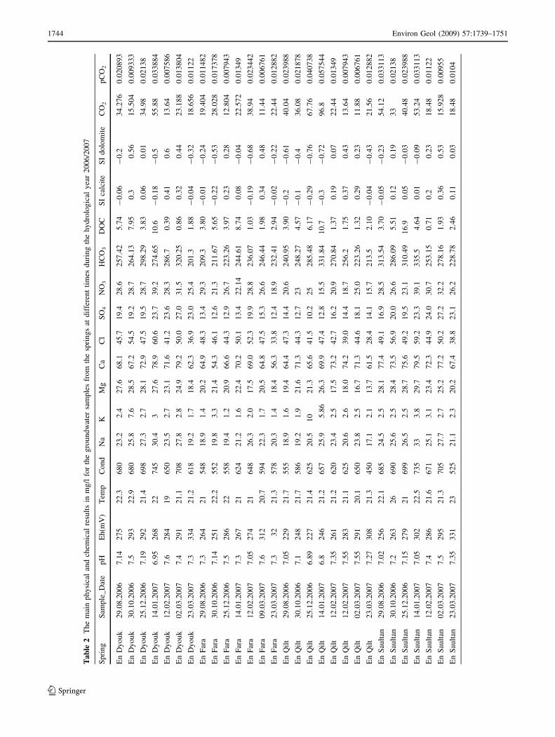
Sampling and analysis
The springs of Fara, Qilt, Dyouk, and Sultan were sampled
shortly before and after rainy storms in the winter season
2006/2007. At each sampling site, temperature, electrical
conductivity, redox potential, and pH were recorded.
Samples were taken for cation, anion, and dissolved
organic carbons (DOC) analyses. The samples for cation
and anion analyses were collected in 60 ml HDPE bottles
with tight caps. The cation samples were acidified by
adding concentrated nitric acid. In order to prevent the
bacterial activity in the anion and DOC samples, a trace
amount of HgCl2 was added. The chloride concentration
had therefore to be determined from the cation samples.
Cation and anion samples were analyzed by ion-chroma-
tography at the Helmholtz Centre for Environmental
Research in Leipzig, Germany. HCO3- concentrations
were determined by Gran titration in the field. All results
are summarized in Table 2. Dissolved CO2, partial pressure
of CO2, and saturation indices of calcite and dolomite were
estimated by the opnen domain PHREEQC program.
The sampling was scheduled mainly by limited numbers
of rain events occurring in the winter 2006/2007. The
samples before December were assigned as early winter
Fig. 2 W-E Cross section A-A0
(Fig. 1) showing the aquifer and
aquiclude layers (grey)
1742 Environ Geol (2009) 57:1739–1751
123
samples, while those coming after were assigned to be the
late one.
Results
Total dissolved solids
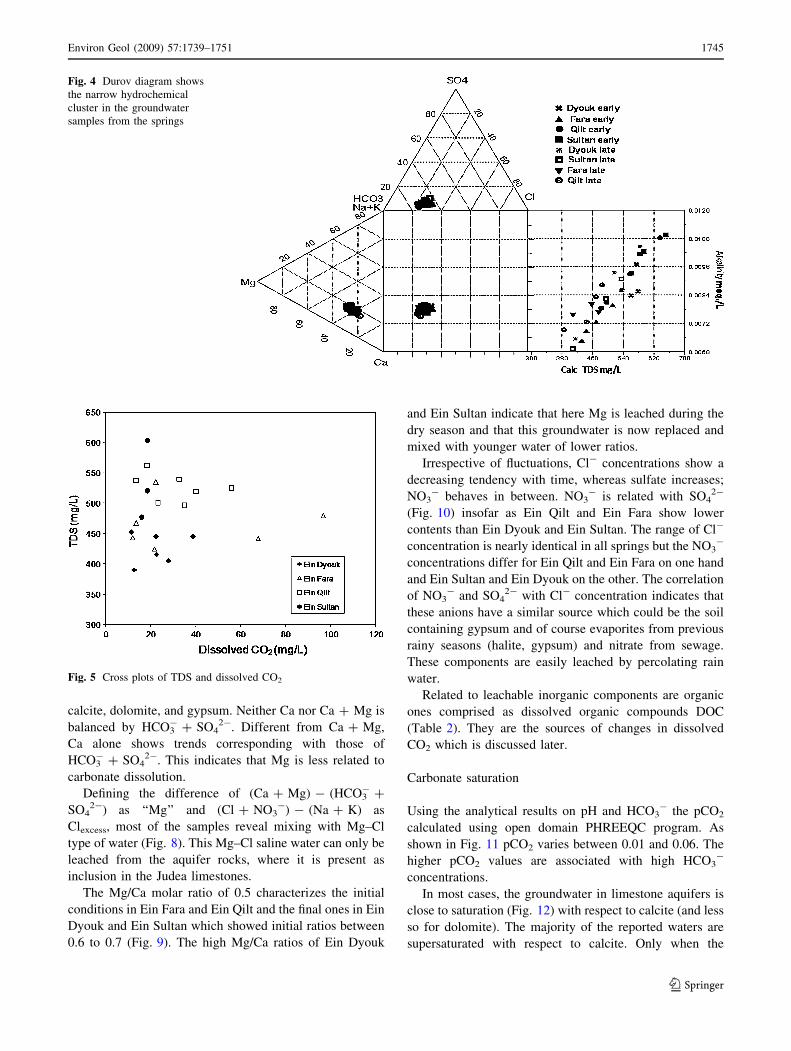
All groundwater samples in the study area are of Ca-HCO3
type (Table 2) because they originate from Judea Group
limestone aquifer. In the Durov diagram the water analyzes
clusters narrowly (Fig. 4). The scatter of total dissolved
solids (TDS) is strongly related to alkalinity. There is no
general tendency of TDS to increase with dissolved CO2 or
pCO2, although the behavior of each spring is different
(Fig. 5). During the winter season, some of the springs
show variations in TDS at nearly constant dissolved CO2,
others show nearly constant TDS but variable CO2.
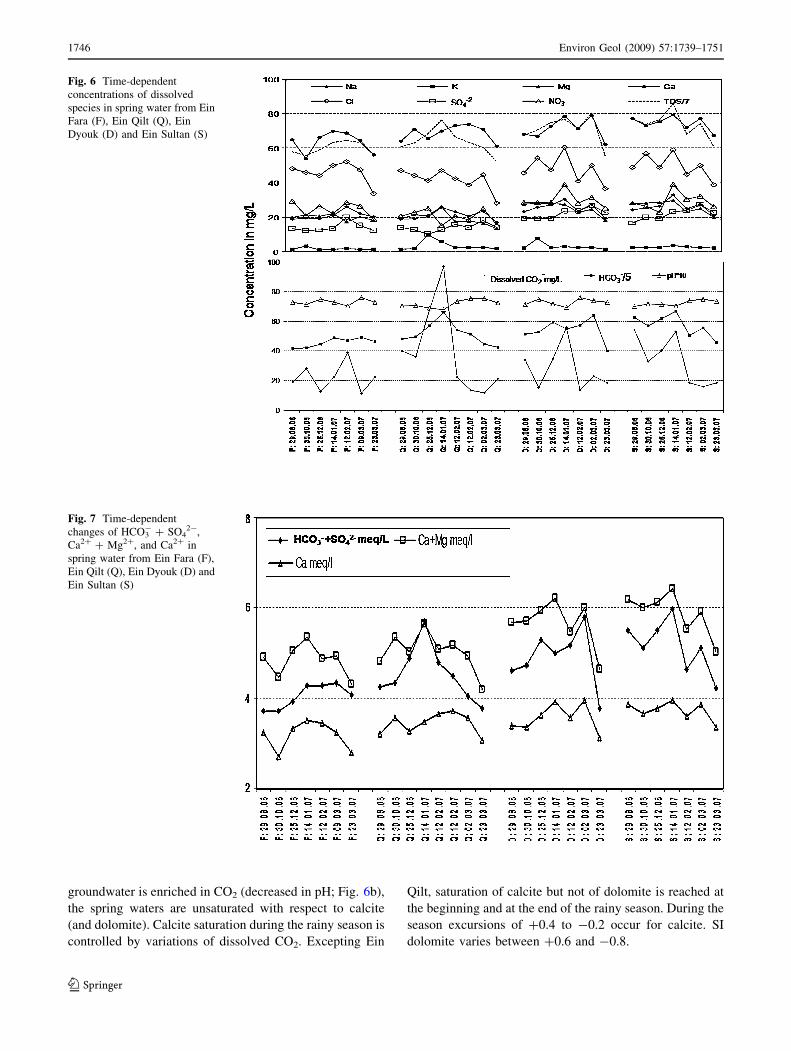
During the wet winter season, however, the concentra-
tions of solutes vary locally and temporally (Fig. 6a). At
comparable times, the samples from Ein Fara (F) and Ein
Qilt (Q) show slightly lower TDS than those from Ein
Dyouk (D) and Ein Sultan (S). This indicates an increase in
TDS with distance from the recharge area in the upper
mountains along the flow path: Ein Fara–Ein Qilt–Ein
Dyouk/Ein Sultan. Temporally, TDS increases in the first
half of winter but decreases significantly in the second half
due to increasing recharge in the mountain aquifer which
enhances the water flow in the aquifer.
The increase in the TDS in the first half might refer to
the flushing of soluble components stored during the earlier
dry periods which are washed out by the first recharge
events.
In general, the time-dependent trend of TDS is parallel
to that of Ca and HCO3- concentrations (with exception of
Ein Qilt) but none of the other dissolved species.
Hydrochemical variations
Different from Ca, Mg shows higher and rather constant
concentrations in the early period and lower ones in the
later. A similar behavior shows Na in Dyouk and Sultan
water. In early winter, Ca increases in Ein Fara and Ein Qilt
but remains nearly constant in Ein Sultan and Dyouk. In
late winter, Ca always decreases. K mostly shows a peak
after the first significant rain storm and returns to initial
values in the late season.
Along the water flow path in Wadi Qilt, HCO3- con-
centration of groundwater increases toward the springs of
Sultan and Dyouk at the Jericho western boundary fault
(Fig. 6b). Dissolved CO2 shows a strong maximum in Ein
Qilt, Ein Dyouk, and Ein Sultan in mid-January. These
peaks may refer to the same rain event, whereas the sig-
nificantly lower peak in the Ein Fara water from mid-
January may reflect a later strong rainfall.
Temporal changes of equivalent concentrations of
Ca + Mg and HCO3- + SO4
2- show little correlation
Fig. 7, although their main sources are dissolution of
Fig. 3 Record of precipitation
at Hizma Station (Ramallah)
Environ Geol (2009) 57:1739–1751 1743
123
Ta
ble
2T
he
mai
np
hy
sica
lan
dch
emic
alre
sult
sin
mg
/lfo
rth
eg
rou
nd
wat
ersa
mp
les
fro
mth
esp
rin
gs
atd
iffe
ren
tti
mes
du
rin
gth
eh
yd
rolo
gic
aly
ear
20
06
/20
07
Sp
rin
gS
amp
le_
Dat
ep
HE
h(m
V)
Tem
pC
on
dN
aK
Mg
Ca
Cl
SO
4N
O3
HC
O3
DO
CS
Ica
lcit
eS
Id
olo
mit
eC
O2
pC
O2
En
Dy
ou
k2
9.0
8.2
00
67
.14
27
52
2.3
68
02
3.2
2.4
27
.66
8.1
45
.71
9.4
28
.62
57
.42
5.7
4-
0.0
6-
0.2
34
.27
60
.02
08
93
En
Dy
ou
k3
0.1
0.2
00
67
.52
93
22
.96
80
25
.87
.62
8.5
67
.25
4.5
19
.22
8.7
26
4.1
37
.95
0.3
0.5
61
5.5
04
0.0
09
33
3
En
Dy
ou
k2
5.1
2.2
00
67
.19
29
22
1.4
69
82
7.3
2.7
28
.17
2.9
47
.51
9.5
28
.72
98
.29
3.8
30
.06
0.0
13
4.9
80
.02
13
8
En
Dy
ou
k1
4.0
1.2
00
76
.95
26
82
27
45
30
.43
27
.67
8.9
60
.62
3.7
39
.22
74
.65
10
.6-
0.1
8-
0.5
55
.88
0.0
33
88
4
En
Dy
ou
k1
2.0
2.2
00
77
.62
84
19
65
02
3.5
2.7
23
.17
1.6
41
.22
3.6
28
.32
86
.70
.39
0.4
10
.61
3.6
40
.00
75
86
En
Dy
ou
k0
2.0
3.2
00
77
.42
91
21
.17
08
27
.82
.82
4.9
79
.25
0.0
27
.03
1.5
32
0.2
50
.86
0.3
20
.44
23
.18
80
.01
38
04
En
Dy
ou
k2
3.0
3.2
00
77
.33
34
21
.26
18
19
.21
.71
8.4
62
.33
6.9
23
.02
5.4
20
1.3
1.8
8-
0.0
4-
0.3
21
8.6
56
0.0
11
22
En
Far
a2
9.0
8.2
00
67
.32
64
21
54
81
8.9
1.4
20
.26
4.9
48
.31
3.4
29
.32
09
.33
.80
-0
.01
-0
.24
19
.40
40
.01
14
82
En
Far
a3
0.1
0.2
00
67
.14
25
12
2.2
55
21
9.8
3.3
21
.45
4.3
46
.11
2.6
21
.32
11
.67
5.6
5-
0.2
2-
0.5
32
8.0
28
0.0
17
37
8
En
Far
a2
5.1
2.2
00
67
.52
86
22
55
81
9.4
1.2
20
.96
6.6
44
.31
2.9
26
.72
23
.26
3.9
70
.23
0.2
81
2.8
04
0.0
07
94
3
En
Far
a1
4.0
1.2
00
77
.32
67
21
62
42
1.2
1.6
22
.47
0.2
50
.11
3.4
22
.14
24
4.6
18
.74
0.0
8-
0.0
42
2.5
72
0.0
13
49
En
Far
a1
2.0
2.2
00
77
.05
27
42
16
48
26
.32
.01
7.5
69
.05
2.3
19
.92
8.8
23
6.0
71
.03
-0
.19
-0
.68
38
.94
0.0
23
44
2
En
Far
a0
9.0
3.2
00
77
.63
12
20
.75
94
22
.31
.72
0.5
64
.84
7.5
15
.32
6.6
24
6.4
41
.98
0.3
40
.48
11
.44
0.0
06
76
1
En
Far
a2
3.0
3.2
00
77
.33
22
1.3
57
82
0.3
1.4
18
.45
6.3
33
.81
2.4
18
.92
32
.41
2.9
4-
0.0
2-
0.2
22
2.4
40
.01
28
82
En
Qil
t2
9.0
8.2
00
67
.05
22
92
1.7
55
51
8.9
1.6
19
.46
4.4
47
.31
4.4
20
.62
40
.95
3.9
0-
0.2
-0
.61
40
.04
0.0
23
98
8
En
Qil
t3
0.1
0.2
00
67
.12
48
21
.75
86
19
.21
.92
1.6
71
.34
4.3
12
.72
32
48
.27
4.5
7-
0.1
-0
.43
6.0
80
.02
18
78
En
Qil
t2
5.1
2.2
00
66
.89
22
72
1.4
62
52
0.5
10
21
.36
5.6
41
.51
0.2
25
28
5.4
86
.17
-0
.29
-0
.76
67
.76
0.0
40
73
8
En
Qil
t1
4.0
1.2
00
76
.82
46
21
.26
57
25
.95
.86
26
.36
9.9
47
.41
2.8
15
.53
31
.84
10
.7-
0.3
-0
.72
96
.80
.05
75
44
En
Qil
t1
2.0
2.2
00
77
.35
26
12
1.2
62
02
3.4
2.5
17
.57
3.2
42
.71
6.2
20
.92
70
.84
1.3
70
.19
0.0
72
2.4
40
.01
34
9
En
Qil
t1
2.0
2.2
00
77
.55
28
32
1.1
62
52
0.6
2.6
18
.07
4.2
39
.01
4.4
18
.72
56
.21
.75
0.3
70
.43
13
.64
0.0
07
94
3
En
Qil
t0
2.0
3.2
00
77
.55
29
12
0.1
65
02
3.8
2.5
16
.77
1.3
44
.61
8.1
25
.02
23
.26
1.3
20
.29
0.2
31
1.8
80
.00
67
61
En
Qil
t2
3.0
3.2
00
77
.27
30
82
1.3
45
01
7.1
2.1
13
.76
1.5
28
.41
4.1
15
.72
13
.52
.10
-0
.04
-0
.43
21
.56
0.0
12
88
2
En
Sau
ltan
29
.08
.20
06
7.0
22
56
22
.16
85
24
.52
.52
8.1
77
.44
9.1
16
.92
8.5
31
3.5
43
.70
-0
.05
-0
.23
54
.12
0.0
33
11
3
En
Sau
ltan
30
.10
.20
06
7.2
26
32
66
90
25
.62
.52
8.4
73
.55
6.9
20
.02
6.6
28
6.0
95
.51
0.1
20
.19
33
0.0
21
38
En
Sau
ltan
25
.12
.20
06
7.1
52
79
21
69
92
6.5
2.5
28
.77
5.6
49
.21
9.5
23
.13
10
.49
16
.90
.05
-0
.03
40
.48
0.0
23
98
8
En
Sau
ltan
14
.01
.20
07
7.0
53
02
22
.57
35
33
3.8
29
.77
9.5
59
.22
3.3
39
.13
35
.54
.64
0.0
1-
0.0
95
3.2
40
.03
31
13
En
Sau
ltan
12
.02
.20
07
7.4
28
62
1.6
67
12
5.1
3.1
23
.47
2.3
44
.92
4.0
30
.72
53
.15
0.7
10
.20
.23
18
.48
0.0
11
22
En
Sau
ltan
02
.03
.20
07
7.5
29
52
1.3
70
52
7.7
2.7
25
.27
7.2
50
.22
7.2
32
.22
78
.16
1.9
30
.36
0.5
31
5.9
28
0.0
09
55
En
Sau
ltan
23
.03
.20
07
7.3
53
31
23
52
52
1.1
2.3
20
.26
7.4
38
.82
3.1
26
.22
28
.78
2.4
60
.11
0.0
31
8.4
80
.01
04
1744 Environ Geol (2009) 57:1739–1751
123
calcite, dolomite, and gypsum. Neither Ca nor Ca + Mg is
balanced by HCO3- + SO4
2-. Different from Ca + Mg,
Ca alone shows trends corresponding with those of
HCO3- + SO4
2-. This indicates that Mg is less related to
carbonate dissolution.
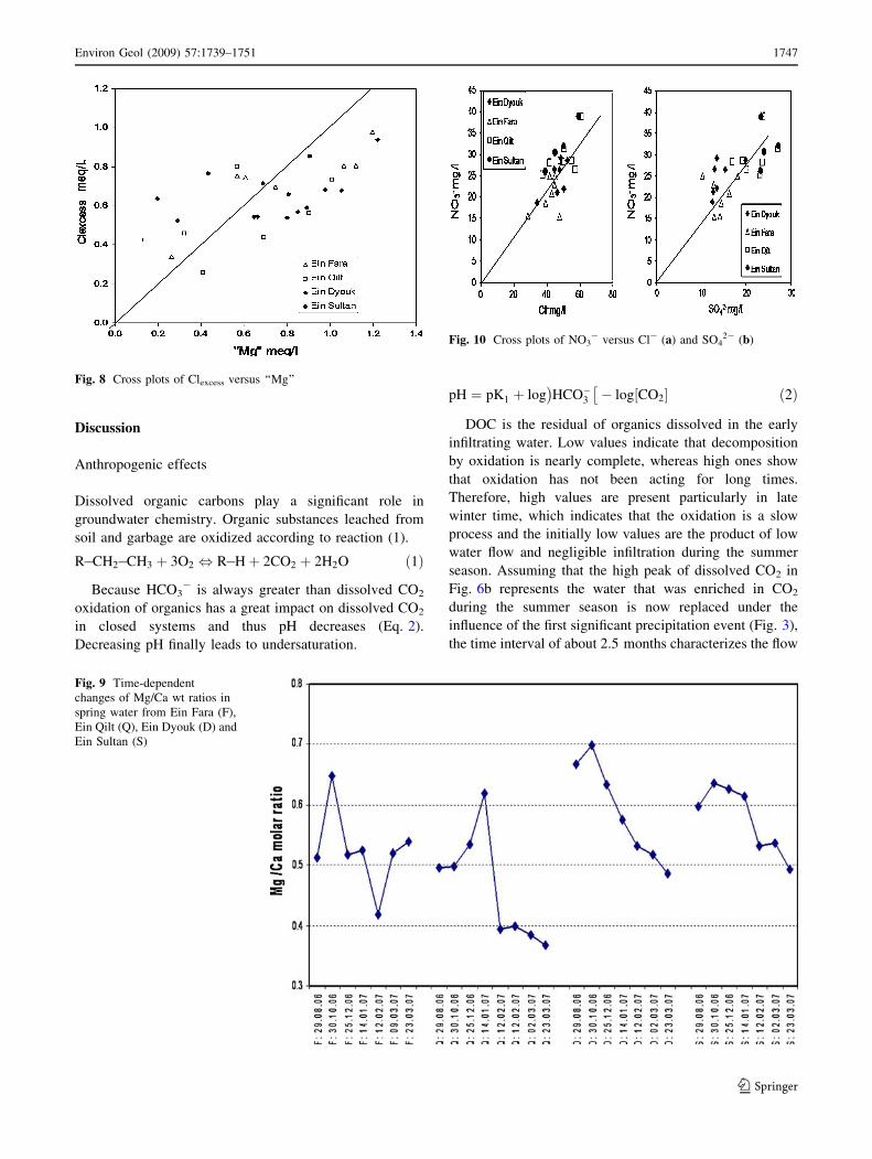
Defining the difference of (Ca + Mg) - (HCO3- +
SO42-) as ‘‘Mg’’ and (Cl + NO3
-) - (Na + K) as
Clexcess, most of the samples reveal mixing with Mg–Cl
type of water (Fig. 8). This Mg–Cl saline water can only be
leached from the aquifer rocks, where it is present as
inclusion in the Judea limestones.
The Mg/Ca molar ratio of 0.5 characterizes the initial
conditions in Ein Fara and Ein Qilt and the final ones in Ein
Dyouk and Ein Sultan which showed initial ratios between
0.6 to 0.7 (Fig. 9). The high Mg/Ca ratios of Ein Dyouk
and Ein Sultan indicate that here Mg is leached during the
dry season and that this groundwater is now replaced and
mixed with younger water of lower ratios.
Irrespective of fluctuations, Cl- concentrations show a
decreasing tendency with time, whereas sulfate increases;
NO3- behaves in between. NO3
- is related with SO42-
(Fig. 10) insofar as Ein Qilt and Ein Fara show lower
contents than Ein Dyouk and Ein Sultan. The range of Cl-
concentration is nearly identical in all springs but the NO3-
concentrations differ for Ein Qilt and Ein Fara on one hand
and Ein Sultan and Ein Dyouk on the other. The correlation
of NO3- and SO4
2- with Cl- concentration indicates that
these anions have a similar source which could be the soil
containing gypsum and of course evaporites from previous
rainy seasons (halite, gypsum) and nitrate from sewage.
These components are easily leached by percolating rain
water.
Related to leachable inorganic components are organic
ones comprised as dissolved organic compounds DOC
(Table 2). They are the sources of changes in dissolved
CO2 which is discussed later.
Carbonate saturation
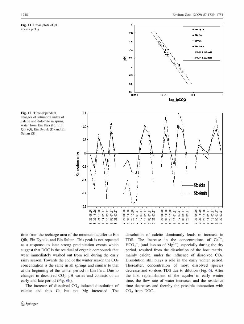
Using the analytical results on pH and HCO3- the pCO2
calculated using open domain PHREEQC program. As
shown in Fig. 11 pCO2 varies between 0.01 and 0.06. The
higher pCO2 values are associated with high HCO3-
concentrations.
In most cases, the groundwater in limestone aquifers is
close to saturation (Fig. 12) with respect to calcite (and less
so for dolomite). The majority of the reported waters are
supersaturated with respect to calcite. Only when the
Fig. 4 Durov diagram shows
the narrow hydrochemical
cluster in the groundwater
samples from the springs
Fig. 5 Cross plots of TDS and dissolved CO2
Environ Geol (2009) 57:1739–1751 1745
123
groundwater is enriched in CO2 (decreased in pH; Fig. 6b),
the spring waters are unsaturated with respect to calcite
(and dolomite). Calcite saturation during the rainy season is
controlled by variations of dissolved CO2. Excepting Ein
Qilt, saturation of calcite but not of dolomite is reached at
the beginning and at the end of the rainy season. During the
season excursions of +0.4 to -0.2 occur for calcite. SI
dolomite varies between +0.6 and -0.8.
Fig. 6 Time-dependent
concentrations of dissolved
species in spring water from Ein
Fara (F), Ein Qilt (Q), Ein
Dyouk (D) and Ein Sultan (S)
Fig. 7 Time-dependent
changes of HCO3- + SO4
2-,
Ca2+ + Mg2+, and Ca2+ in
spring water from Ein Fara (F),
Ein Qilt (Q), Ein Dyouk (D) and
Ein Sultan (S)
1746 Environ Geol (2009) 57:1739–1751
123
Discussion
Anthropogenic effects
Dissolved organic carbons play a significant role in
groundwater chemistry. Organic substances leached from
soil and garbage are oxidized according to reaction (1).
R�CH2�CH3 þ 3O2 , R�Hþ 2CO2 þ 2H2O ð1Þ
Because HCO3- is always greater than dissolved CO2
oxidation of organics has a great impact on dissolved CO2
in closed systems and thus pH decreases (Eq. 2).
Decreasing pH finally leads to undersaturation.
pH ¼ pK1 þ log HCO�3� �
� log CO2½ � ð2Þ
DOC is the residual of organics dissolved in the early
infiltrating water. Low values indicate that decomposition
by oxidation is nearly complete, whereas high ones show
that oxidation has not been acting for long times.
Therefore, high values are present particularly in late
winter time, which indicates that the oxidation is a slow
process and the initially low values are the product of low
water flow and negligible infiltration during the summer
season. Assuming that the high peak of dissolved CO2 in
Fig. 6b represents the water that was enriched in CO2
during the summer season is now replaced under the
influence of the first significant precipitation event (Fig. 3),
the time interval of about 2.5 months characterizes the flow
Fig. 8 Cross plots of Clexcess versus ‘‘Mg’’
Fig. 9 Time-dependent
changes of Mg/Ca wt ratios in
spring water from Ein Fara (F),
Ein Qilt (Q), Ein Dyouk (D) and
Ein Sultan (S)
Fig. 10 Cross plots of NO3- versus Cl- (a) and SO4
2- (b)
Environ Geol (2009) 57:1739–1751 1747
123
time from the recharge area of the mountain aquifer to Ein
Qilt, Ein Dyouk, and Ein Sultan. This peak is not repeated
as a response to later strong precipitation events which
suggest that DOC is the residual of organic compounds that
were immediately washed out from soil during the early
rainy season. Towards the end of the winter season the CO2
concentration is the same in all springs and similar to that
at the beginning of the winter period in Ein Fara. Due to
changes in dissolved CO2, pH varies and consists of an
early and late period (Fig. 6b).
The increase of dissolved CO2 induced dissolution of
calcite and thus Ca but not Mg increased. The
dissolution of calcite dominantly leads to increase in
TDS. The increase in the concentrations of Ca2+,
HCO3-, (and less so of Mg2+), especially during the dry
period, resulted from the dissolution of the host matrix,
mainly calcite, under the influence of dissolved CO2.
Dissolution still plays a role in the early winter period.
Thereafter, concentration of most dissolved species
decrease and so does TDS due to dilution (Fig. 6). After
the first replenishment of the aquifer in early winter
time, the flow rate of water increases and the residence
time decreases and thereby the possible interaction with
CO2 from DOC.
Fig. 11 Cross plots of pH
versus pCO2
Fig. 12 Time-dependent
changes of saturation index of
calcite and dolomite in spring
water from Ein Fara (F), Ein
Qilt (Q), Ein Dyouk (D) and Ein
Sultan (S)
1748 Environ Geol (2009) 57:1739–1751
123
The behavior of Mg and Na in Ein Dyouk and Ein
Sultan reflects dilution. Simultaneously, SO42- increases
continuously, probably due to leaching gypsum from Lisan
sediments in the Jericho Plain. Leaching of gypsum affects
the low concentrations of SO42- much more than the high
ones of Ca.
At high water level in the aquifer, gypsum is leached
from the overlying Lisan Formation, which is predominant
in the Jericho Plain. Because the Lisan Formation is absent
in the recharge area in the upper mountains, this effect is
not seen in Qilt and Fara. Without gypsum dissolution, the
Ca decrease would be more than observed. This means that
gypsum is an additional source for Ca and sulfate in Dyouk
and Sultan springs, while in Qilt and Fara springs gypsum
dissolution does not play a major role.
Anthropogenic pollutants such as nitrate are strongly
related to sulfate and less so to Cl- which indicates leaching
from soil and rocks by irrigation return flow. In general,
there is some correlation between NO3- and Cl- concen-
trations which is not explicable by dilution (Fig. 10a). The
rather constant NO3-/Cl- ratio may be due to leaching of
both components from soil or infiltration of sewage.
The correlation of sulfate, chloride, and nitrate in some
springs (Fig. 10), reflects that these species are washed out
from fertilized soils. In the intensive farming area, Ein
Dyouk and Ein Sultan yield significant higher nitrate
concentrations than Ein Qilt and Ein Fara in the nature
reserve. The slope of the indicated trend line in yield
NO3-/Cl- wt ratios of 0.54, which is quite high indicating
additional contamination by human activity such as farm-
ing, etc.
Mg/Ca ratio
The continuous decrease of Mg/Ca wt ratios in Ein Dyouk
and Ein Sultan indicate mixing of water in the aquifer by
the new recharge water. The mixing demands for a dual
porosity flow in which the recharge water with low Mg/Ca
ratio uses the larger karst conduits and mixes with the old
water with high Mg/Ca ratio which is present in parts of the
aquifer with less transmissivity. The less transmissivity
pool decreases with time and thus the Mg/Ca ratio of the
spring water decreases.
The rather constant but different Mg concentrations in
spring waters during early and late seasons requires a rather
large pool of Mg. In Ein Dyouk and Ein Sultan this
behavior is paralleled by Na, which is much less pro-
nounced for Ein Qilt and Ein Fara. Such a pool could be the
marly layers of the overlying Lisan Formation acting as
aquitard. The clay minerals may react here as ion
exchanger. Leaching of Mg–Cl water from sediments or
rocks is also a possibility. In any case the equilibrium is
quickly established.
Carbonate dissolution dominantly controls Ca concen-
trations. Dissolution of calcite is slow because the waters
are largely saturated with respect to calcite. High-magne-
sium calcite releases Mg by forming low Mg-calcite.
Equilibration with dolomite at this low temperature is
negligible. This explains why these waters are mostly
oversaturated with respect to dolomite.
After an initial increase of Mg/Ca in Ein Dyouk and Ein
Sultan the springs show a gradual decrease in Mg/Ca molar
ratio resulting from higher decreases in Mg than in Ca
(Fig. 9), i.e., from about 0.65 to about 0.5 in the late winter
season. A similar trend is observed in water from Ein Qilt
but here the ratio varies between 0.6 and 0.4. Values of 0.5
are typical ratios in calcareous aquifers of the study area
(Schoeller 1977; Rosenthal, 1987).
Ein Fara shows a trend of its own. The general decrease
of Mg/Ca ratios is associated with increasing precipitation
and runoff (Fig. 9). These results show that with the
increase of rainwater recharge the stored water in the
aquifer is flushed out by the middle and the end of the winter
season. In the early period the water shows the solute
contents gained due to long contact with minerals of the
aquifer during the dry period. This water is replaced by
infiltrated runoff in the Wadi Qilt zone (zone 1) and then is
going to replace the water of Sultan and Dyouk springs in
the Jericho Plain zone (zone 2) by underground flow.
In general, the compositional changes in Ca and Mg
concentrations mainly depend on the residence of water in
the aquifer which is controlled by the volume and mech-
anism of recharge and the distance from the recharge area.
The absolute ratios, however, do not yield a measure of the
residence time. For instance, the ratio of 0.5 indicates long
residence times in Fara and Qilt, but short ones in Ein
Dyouk and Ein Sultan, although all these springs discharge
water from the same aquifer. The mineralogical composi-
tion of the aquifer of the springs in Wadi Qilt contains less
soluble Mg-bearing minerals than that the one from which
the Jericho springs originate. The result in the study area
indicate that the Mg/Ca ratio is not a reliable, generally
applicable indicator for residence times of the water in
aquifers as suggested by Edmunds and Smedley (2000),
Kloppmann et al. (1998), and Langmuir (1971), being only
controlled by incongruent dissolution of calcite, magnesian
calcite and dolomite (Bakalowicz 1979; Musgrove and
Banner 2004).
Groundwater recharge
The groundwater recharge and flow is mainly controlled by
two factors: the geologic structure and geometry of the
aquifer along the flow path of groundwater. These factors
play an important role in controlling the aquifer flow across
the eastern slope, which is reflected by the behavior of
Environ Geol (2009) 57:1739–1751 1749
123
solutes within the aquifer the different zones of Wadi Qilt
and Jericho Plain.
This infiltration zone is located to the west of the
Marsaba anticline (Figs. 1, 2). The section west of the
anticline is uplifted. Thus, the base of the aquifer is raised
and the flow gradient increases which resulted in an
increase of the flow velocity and reduced residence time.
Zone 1, represented by Ein Fara and Ein Qilt, is fed directly
through the infiltration of meteoric water and surface run-
off from the mountains.
Contrastingly zone 2, represented by Ein Sultan and Ein
Dyouk, is located east to the Buqea syncline and Marsaba
anticline parallel to the western fault boundary. Here, the
aquifer thickness decreases from the syncline to the anti-
cline (Fig. 2) which may act as a retardation factor to flow.
The Marsaba anticline prevents the groundwater of the
Upper Cretaceous aquifer from flowing further eastwards
and thus the replenishment of the springs east to the anti-
cline takes a longer period of time (Wolfer 1998; Guttman
2004) and these springs are fed by groundwater with high
solute contents leached from aquifer rocks. The mentioned
springs of zone 2 are located along the western boundary
fault in the western part of Jericho–Auja area, where the
fault acts as a flow barrier. The water normally flows lat-
erally along the fault; the latter confines the groundwater
for additional period of time resulting in increasing contact
time of rocks and groundwater. The recharge mechanism
for the zone 2 is different from that in zone 1 due to dif-
ferent geological structures. The zone of Sultan and Dyouk
springs is covered by a chalky Eocene layer (Kumi; Fig. 2),
which is considered an aquiclude preventing further sur-
face runoff infiltration into the aquifer zone. Therefore, the
aquifer is replenished nearly exclusively by underground
flow.
Conclusion
The strongly inclined aquifers of the Wadi Quilt and the
less inclined ones of the Jericho Plain result in changes
with residence time of groundwater in the aquifer and with
distance from the recharge area which in turn causes
changes in chemical composition of spring water. Due to
the monocline two zones with different recharge charac-
teristics are distinguishable. In zone 1 on the slopes of the
eastern mountains recharge of the aquifer is mainly by
direct infiltration of precipitation and runoff combined with
less groundwater residence time and high flow rate. The
second zone is near the western border of Jericho at the
foothills, which is mainly fed by the groundwater flow
from the eastern slopes. This zone is characterized by
higher groundwater residence time and slower flow rate
than in zone 1. The main factors controlling the residence
time and flow rate of groundwater are the geological
structure, the amount of active recharge of the aquifer and
the recharge mechanism.
A detailed analysis of dissolved species reveals that
besides dissolution of carbonates, chloride, and sulfate are
leached from the aquifer rocks. Mg not only originates
from carbonates but also from Mg–Cl saline waters
included in the rocks. Leaching of Mg is particularly high
at the beginning of the winter season and lowest at its end.
A very important factor in the composition of ground-
water is the oxidation of organics derived from sewage and
garbage resulting in variable dissolved quantities of CO2.
High CO2 yields lower pH values and thus undersaturation
with respect to calcite and dolomite. Low CO2 concentra-
tions result in carbonate oversaturation. At the beginning
and at the end of the rainy season calcite saturation is
always achieved. Associated with dissolution of carbonates
is the major source of increasing water hardness.
Acknowledgments The authors would like to thank the DAAD-
German Academic Exchange Service and the DFG-German Research
Foundation for the financial support of the project KH215/1-1.
Finally, we gratefully thank the co-workers of the Hydrogeology
Section in the UFZ-Helmholtz Centre for Environmental Research,
(Dr. Marion Martienssen, Silke Koehler and Stefen Juergen) for their
cooperation in data processing and sample measurements.
References
Arad A, Michaeli A (1967) Hydrogeological investigations in the
western catchment area of the Dead Sea. Isr J Earth Sci 16:181–
196
ARIJ (1997) Water Resources. In: The Status of the environment in
the West Bank. ARIJ, Jerusalem, pp 95–107
Arkin Y (1976) Explanations to the geological map of the Jerusalem-
Bet Shemesh area. Isr J Earth Sci 16:46–47
Bakalowicz M (1979) The Role and contribution of Geochemistry to
investigate the Karstic Aquifer and Karstification. Ph.D. Thesis,
University of Paris VI
Begin ZB (1974) Geological Map of Israel, Jericho, Sheet 9-III,
1:50,000, with explanatory notes—Geology Survey of Israel,
Jerusalem
Bullen TD, Krabbenhoft DP, Kendall C (1996) Kinetic and miner-
alogic controls on the evolution of groundwater chemistry and87[Sr]/86[Sr] in a sandy silicate aquifer, northern Wisconsin.
Geochim Cosmochim Acta 60:1807–1821
Edmunds WM, Smedley PL (2000) Residence time indicators in
groundwater: the East Midlands Triassic sandstone aquifer. Appl
Geochem 15:737–752
Flexer A, Gilat A, Hirsch F, Honigstein A, Rosenfeld A, Rueffer T
(1989) Late Cretaceous evolution of the Judean Mountains as
indicated by ostracods. Terra Nova 1:349–358
Guttman J (1997) The hydrogeological conditions in the Cenomanian
Aquifer along the margins of the Jordan Valley (the Fazael–
Auja–Jericho area). Tel Aviv, Tahal (01/79/26), pp 1–43
Guttman J (2000) GIJP Multi-lateral Project B: hydrogeology of the
Eastern Aquifer in the Judea Hills and Jordan Valley. Mekorot
Water Company, Report 468, pp 1–36
Guttman J (2004) The karstic flow system in Auja area—West Bank:
an example of two separated flow system in the same area. The
1750 Environ Geol (2009) 57:1739–1751
123
IPCRI 2nd Israeli–Palestinian Internal Conference Water for
Life in the Midle East, Antalya, Turkey (October 2004)
IPCRI (1993) A proposal for the development of a regional water
master plan, Israel/Palestine Center for Research Information,
Jerusalem. Water in Palestine, Tunis (1990), pp 106–306
Kloppmann W, Dever L, Edmunds WM (1998) Residence time of
chalk groundwaters in the Paris Basin and the North German
Basin: a geochemical approach. Appl Geochem 13:593–606
Kroitoru L (1987) The characterization of flow systems in carbonatic
rocks defined by the groundwater parameters: Central Israel;
Ph.D. Thesis for the Weizman Institute of Science. Rehovot,
Israel, pp 1–120
Kroitoru L Mazor E, Dror G (1985) Hydrological characteristic of the
Wadi Kelt and Elisha springs. In: Scientific basis for water
resources managment vol 153. IAHS Publication, Wallingford,
pp 207–218
Langmuir D (1971) The Geochemistry of some carbonate ground-
waters in Central Pennsylvania. Geochim Cosmochim Acta
35:1023–1045
Marie A, Vengosh A (2001) Sources of salinity in groundwater from
Jericho area, Jordan Valley. Groundwater 39:240–248
Musgrove M, Banner J (2004) Controls on the spatial and temporal
variability of vadose dripwater geochemistry: Edwards aquifer,
central Texas. Geochem Cosmochim Acta 68:1007–1020
Qannam Z, Merkel B (2002) Hydrogeology, hydrochemistry and
contamination sources in Wadi Al Arroub drainage basin,
Palestine. Freiberger Forschungshefte—selected contribution to
applied geology in the Jordan Rift Valley, C 494, Technische
Universitat Bergakademie Freiberg, Germany. ISBN: 3-86012-
162-6, pp 111–123
Rofe & Raffety Consulting Engineers (1963) Geological and
hydrological report, Jerusalem and district water supply—
Hashemite Kingdom of Jordan, Central Water Authority, pp 1–
79
Rosenthal E (1987) Chemical composition of rainfall and groundwa-
ter in recharge areas of the Bet Shean-Harod multiple aquifer
system, Israel. J Hydrol 89:329–352
Roth I (1969) The geology of the Wadi el Qilt region, M. Sc. Thesis,
Hebrew University Jerusalem, Israel, pp 1–52
Schoeller H (1977) Geochemistry of groundwater. In: Groundwater
studies—an International guide for research and practice,
UNESCO, Paris, Chap 15, pp 1–18
Tahal (1990) Water master plan. Report on the water sector Israel,
Tahal Consulting Engineers Ltd (in Hebrew)
Toll M (2001) Hydrogeological characterization of the Uppermost
Aquifer in the Wadi el Qilt Area, Diploma Thesis. Depart.
Applied Geology, Tubingen University, Tubingen, Germany,
pp 1–137
Wolfer J (1998) Hydrogeological investigation along the Jerusalem—
Jericho Transect (Wadi el Qilt), West Bank/Israel, Diploma
Thesis, Depart Applied Geology, Karlsruhe University,
Karlsruhe, Germany, pp 1–106
Environ Geol (2009) 57:1739–1751 1751
123
Copyright © 2022 FDOKUMEN