CFTR regulates phagosome acidification in macrophages and alters bactericidal activity
Upload
independentCategory
view
4download
0
ARTICLE
Received 9 Jul 2012 | Accepted 14 Dec 2012 | Published 22 Jan 2013
High heat flow and ocean acidification at a nascentrift in the northern Gulf of CaliforniaRosa Ma Prol-Ledesma1, Marco-Antonio Torres-Vera2, Riccardo Rodolfo-Metalpa3, Catalina Angeles4,
Carlos H. Lechuga Deveze5, Ruth Esther Villanueva-Estrada1, Evgueni Shumilin6 & Carlos Robinson4
The prevailing tectonic setting in the Gulf California suggests the presence of an unde-
termined number of short spreading centres with associated hydrothermal systems. However,
to date, active seafloor spreading phenomena have been documented in only three of the
eight tectonically active basins. Here we report heat flow values as high as 15,436 mW m� 2
in two of the northernmost basins of the Gulf of California, providing evidence of intense
hydrothermal activity associated with the transition from continental rifting to seafloor
spreading. The mean heat flow for the Wagner and Consag basins area is 1,875 mW m� 2,
more than 15 times higher than the mean value for oceanic crust (105.4 mW m� 2). Addi-
tional evidence for vigorous hydrothermal circulation and a shallow heat source includes
intense gas discharge (CO2 and CH4), widespread low pH (average 7.7), locally high 222Rn
concentrations in the bottom water and a high extent of organic matter maturation in the
sediments.
DOI: 10.1038/ncomms2390 OPEN
1 Instituto de Geofısica, Universidad Nacional Autonoma de Mexico, Mexico, Cd. Universitaria, Mexico D.F. 04510, Mexico. 2 Asociacion para Evitar laCeguera en Mexico, Vicente Garcıa Torres 46, San Lucas Coyoacan C.P. 04030 A.P.E.C., Mexico D.F. 04310, Mexico. 3 Marine Institute, Marine Biology andEcology Research Centre, University of Plymouth, Drake Circus, Plymouth, Devon PL4 8AA, UK. 4 Instituto de Ciencias del Mar y Limnologıa, UniversidadNacional Autonoma de Mexico, Mexico, Cd. Universitaria, Mexico D.F. 04510, Mexico. 5 Centro de Investigaciones Biologicas del Noroeste, S.C. Mar Bermejo195, Colonia Playa Palo de Santa Rita, 23090 La Paz, B.C.S., Mexico. 6 Centro Interdisciplinario de Ciencias Marinas, Instituto Politecnico Nacional, Av. IPN s/nCol. Playa Palo de Santa Rita, 23090 La Paz, B.C.S., Mexico. Correspondence and requests for materials should be addressed to R.M.P.-L.(email: [email protected]).
NATURE COMMUNICATIONS | 4:1388 | DOI: 10.1038/ncomms2390 | www.nature.com/naturecommunications 1
& 2013 Macmillan Publishers Limited. All rights reserved.

The Gulf of California (GC) formed as a result of obliquerifts linked by long transform faults and short spreadingcentres at B6 Ma ago1. Active seafloor spreading
phenomena have been documented in only three of the eighttectonically active basins located in the GC2. However, theprevailing tectonic setting in the region indicates that the Gulflikely includes an undetermined number of short spreadingcentres3 with hydrothermal systems in different stages ofdevelopment. The majority of data on active seafloor spreadingin the GC corresponds to the Guaymas and the Alarcon basins4,5.A crustal thickness of B15 km has been calculated for thenorthern Gulf6, and this area is suited to study the transition fromcontinental to oceanic rifting.
The Wagner and Consag basins are located towards thenorthernmost extent of the GC (Fig. 1) between the Upper Gulfto the north and the Upper and Lower Delfın basins to the south.The two basins are semi-graben structures that link the UpperDelfın basin to the south and the subaerial Cerro Prieto basin tothe north in the Mexicali-Imperial Valley along the Pacific–NorthAmerica plate boundary in the northern GC. These basins are theshallowest basins in the GC, with depths of less than B225 m,and are tectonically active with a relatively high number of faults7.
Geophysical or geochemical evidence of active seafloorspreading in the northern GC has not been previously reported.Moreover, the Wagner and Consag basins have been consideredas unlikely to contain active seafloor spreading processes, despitehaving the highest density of faults7 in the northern Gulf as wellas possible mantle upwelling under the Wagner basin indicatedby seismic modelling8.
In the Wagner basin, the sediment thickness is greater than7 km, which impedes the rise of magma generated by seafloorspreading; this hindrance, in turn, masks any visible evidence ofrifting9. Consequently, heat flow anomalies are the onlyindication of nascent spreading centres in the sediment-coveredbasins10. The connexion of the two basins to the active spreadingcentres at Delfin basin and Cerro Prieto has long beenhypothesized but not demonstrated11,12 because the thicksediment cover eliminates the possibility of identification ofmagnetic banding or gravity anomalies related to active oceanspreading. Recently, the occurrence of gas venting has beenreported13 in both of the basins. Beneath the plumes, acousticblanking is widely observed, indicating subsurface gasaccumulation (Fig. 2a). Although there are areas on the westernside of the basins where surface gas flares are not detected,
114°20′0″W
0 5 10 20Km
30°40′0″N
30°50′0″N
31°0′0″N1,216
75
62
42
27
92
892 2,907
Wagner fault
15,4361,450
NCalifornia
Of
Gulf
7,115
621
859
1,121 1,2062,053
1,369
533
67
310
163
2,559
16
416
709
229
31°10′0″N
Consag fault
Consag S
ur fault Wagner S
ur fault
Percebo fault
114°10′0″W 114°0′0″W 113°50′0″W
–150
–150
Consa
g ba
sin
Wag
ner b
asin
–150
–200
–150
–200
–100
–150
Figure 1 | Locations of the Wagner and Consag basins and the heat flow stations. Detailed bathymetric map of the Wagner and Consag basins; stars
indicate the flare locations. Thick lines denote the main and secondary faults identified by the seismic reflection (Wagner basin faults20; Consag basin
faults9). Numbers indicate the heat flow data (values in mW m� 2) from this study (filled circles) and previously published results (open circles)3.
A majority of values are greater than the mean ocean heat flow18 (105.4 mW m� 2).
ARTICLE NATURE COMMUNICATIONS | DOI: 10.1038/ncomms2390
2 NATURE COMMUNICATIONS | 4:1388 | DOI: 10.1038/ncomms2390 | www.nature.com/naturecommunications
& 2013 Macmillan Publishers Limited. All rights reserved.

sub-bottom profiles indicate the disruption of the sedimentarystructure by newly ascending gas plumes (Fig. 2b), indicating thatthe activity is increasing.
Detailed bathymetric mapping of the Wagner and Consagbasins (Fig. 1) indicates the eastern edge of the basins bordered bythe Wagner Fault. The bathymetry and acoustic sub-bottomprofiler data reveal large vertical displacements due to the recentfaulting that disrupts the sedimentary column. During twooceanographic cruises, more than 300 flares were mapped on theecho-sounder profiles (Fig. 1) at depths from 65 to 150 m,covering an area of 2,240 km2. The gas plumes originate fromsites of large disruptions of the upper sediment structure (forexample, synsedimentary faults, pockmarks, mud domes anddiapirs, as well as raised irregular hard reflectors; Fig. 2a). Theplumes had mainly diffuse and intermittent gas flows in extensiveareas of the basins, as observed using a remotely operated vehicle(ROV) camera.
The extensive tidal and convective mixing, as well as the strongcurrents in the Gulf, combine the different water masses, thusmaintaining a nearly constant temperature in the bottom of theWagner and Consag basins14,15. This effect allows themeasurement of the temperature gradient minimizing seasonalvariations in the temperature. In contrast, the strong verticalmixing in the water column produces less pronounced physico-chemical profiles related with ocean bottom discharge features16.
Historical heat flow studies were concentrated in the centraland southern part of the GC, and only four heat flowmeasurements3 have been performed in the Wagner andConsag basins, producing values in the range from 63 to92 mW m� 2. Additionally, heat flow values of 108 and126 mW m� 2 near the Wagner and Consag basins werecalculated using the Curie point isotherm depths17. Previousdata did not indicate the presence of a major heat flow anomalyin the northern GC, as the mean heat flow for the oceanic crust18
is 105.4 mW m� 2.Seismicity is high in this region9,19, and focal mechanisms are
mainly strike-slip and dip-slip, which are consistent with theextension character of the basins and the transform faults of theCerro Prieto system. The earthquakes recorded between 1973 and2009 show that significant seismic activity occurs along the mainfaults on the borders of the basins9.
The deep structure of the Wagner basin was described based onseismic images that present poor resolution at depth in theWagner and Consag basins area; however, these data allow for theinference of the basement depth below the 7-km-thick sedimentcover20. The observed gas accumulation may explain the lowquality of the images obtained in the seismic studies. The mappedstructures in the upper 4� 5 km reveal the presence of abundantfaults within both of the basins (1 fault km� 1 in Wagner basinand 1.3 faults km� 1 in Consag basin20). These faults do not reach
the sea bottom (Fig. 3b), but they do increase the permeability atdepth within the thick sediment pack and allow for convectiveheat transfer in the deep sedimentary layers.
The magnetic and gravity anomalies coincide with the centre ofthe Wagner basin, and their low amplitude is related to the thicksediment cover17. A thick sediment cover usually masks lineatedanomalies produced by seafloor spreading. Additionally, it hasbeen suggested that the low permeability of the sediments willfavour a more intense alteration of any layered intrusions atdepth, thereby suppressing the magnetic anomalies21. Magneticsurveys indicate that the upper basement in this area likelycontains basalt layers interbedded with sediments17,22.
Here, we present new heat flow data and pH measurements,detailed bathymetric observations, gas compositions, profilersections and organic matter maturation data; this informationprovides the supporting evidence required to infer the occurrenceof active seafloor spreading at the Wagner and Consag basins.The average thermal gradient of B1 1C m� 1 (greater than 30times the average gradient on Earth) and the occurrence of 222Rn-positive anomalies in the bottom water samples reveal theoccurrence of high heat flow-driven convection through the thicksediment cover, which generates diffuse gas discharge (mainlyCO2 with minor CH4). CO2 is a common gas discharging fromhydrothermal vents, and as CO2 dissolves in sea water, the pHdecreases, thereby generating acidification over an extensive area.The identification of CO2 as the most abundant gas in thedischarged fluids explains the low pH measured in the area andidentifies this zone as a natural laboratory to explore theevolution of ecosystems under long-term exposure to low pHconditions.
Degassing mound
Fault500 m10 m Gas accumulation
acoustic blanking 100 m
10 m
Gas accumulationacoustic blanking
No venting on ocean bottom
Figure 2 | Sub-bottom profiles. Sub-bottom profiles showing the blanking effects of gas saturation: (a) zones with active venting in the northeastern
region of the study area; (b) new areas of gas upwelling without sea bottom disruption in the western portion of the study area, where a large 222Rn
anomaly indicates the upflow location (W� 27 in Supplementary Fig. S1).
Wagnerbasin
Wagnerfault
Consag Surfault
10,000
1,000
100
10
1
Hea
t flo
w (
mW
m–2
)
Figure 3 | Heat flow pattern and faults throughout the Wagner basin.
The scheme shows (a) the heat flow variation across the Wagner basin on
a SW-NE profile and (b) the main fault location as identified by the seismic
reflection data9,20. High values correlate with the presence of the Wagner
and Consag Sur faults.
NATURE COMMUNICATIONS | DOI: 10.1038/ncomms2390 ARTICLE
NATURE COMMUNICATIONS | 4:1388 | DOI: 10.1038/ncomms2390 | www.nature.com/naturecommunications 3
& 2013 Macmillan Publishers Limited. All rights reserved.
ResultsHeat flow measurements. In contrast to spreading centres thatdo not have a sediment cover, the thick sediment layer in theWagner and Consag basins made it possible to conduct coringand heat flow surveys in the study area, especially over the activehydrothermal manifestations. As this is the first detailed heat flowmapping of the basins, we located the heat flow stations in pro-files that crossed the basins to identify heat transport anomalies.We focused the heat flow and coring studies on the trace of theWagner and Wagner Sur faults, where the majority of thehydrothermal features occur, as this structure likely dominatesthe deep fluid circulation.
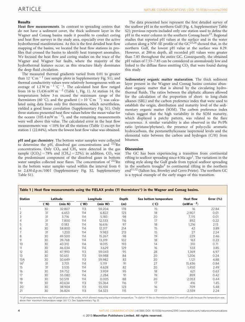
The measured thermal gradients varied from 0.01 to greaterthan 12 1C m� 1 (see sample plots in Supplementary Fig. S1), andthermal conductivity values were relatively homogeneous with anaverage of 1.2 W m� 1
1C� 1. The calculated heat flow rangedfrom 16 to 15,436 mW m� 2 (Table 1, Fig. 1). At station 14, thetemperatures below 3 m exceed the maximum range of thethermistors (60 1C), and the gradient (410 1C m� 1) was calcu-lated using data from only five thermistors, which nevertheless,yielded a good linear correlation (Supplementary Fig. S1). Onlythree stations presented heat flow values below the mean value forthe oceans (105.4 mW m� 2), and the remaining measurementswere well above this value. The calculated error in the heat flowmeasurements was o10% for all the stations (Table 1) except forstation 1 (22.84%), where the lowest heat flow value was obtained.
pH and gas chemistry. The bottom water samples were collectedto determine the pH, dissolved gas concentrations and 222Rnconcentrations. Only CO2 and CH4 were detected in the gassample ([CO2]¼ 78% and [CH4]¼ 22%); in addition, CO2 wasthe predominant component of the dissolved gases in bottomwater samples collected near flares. The concentration of 222Rnin the bottom water samples varied within the interval from 0to 2,430 d.p.m./100 l (Supplementary Fig. S2, SupplementaryTable S1).
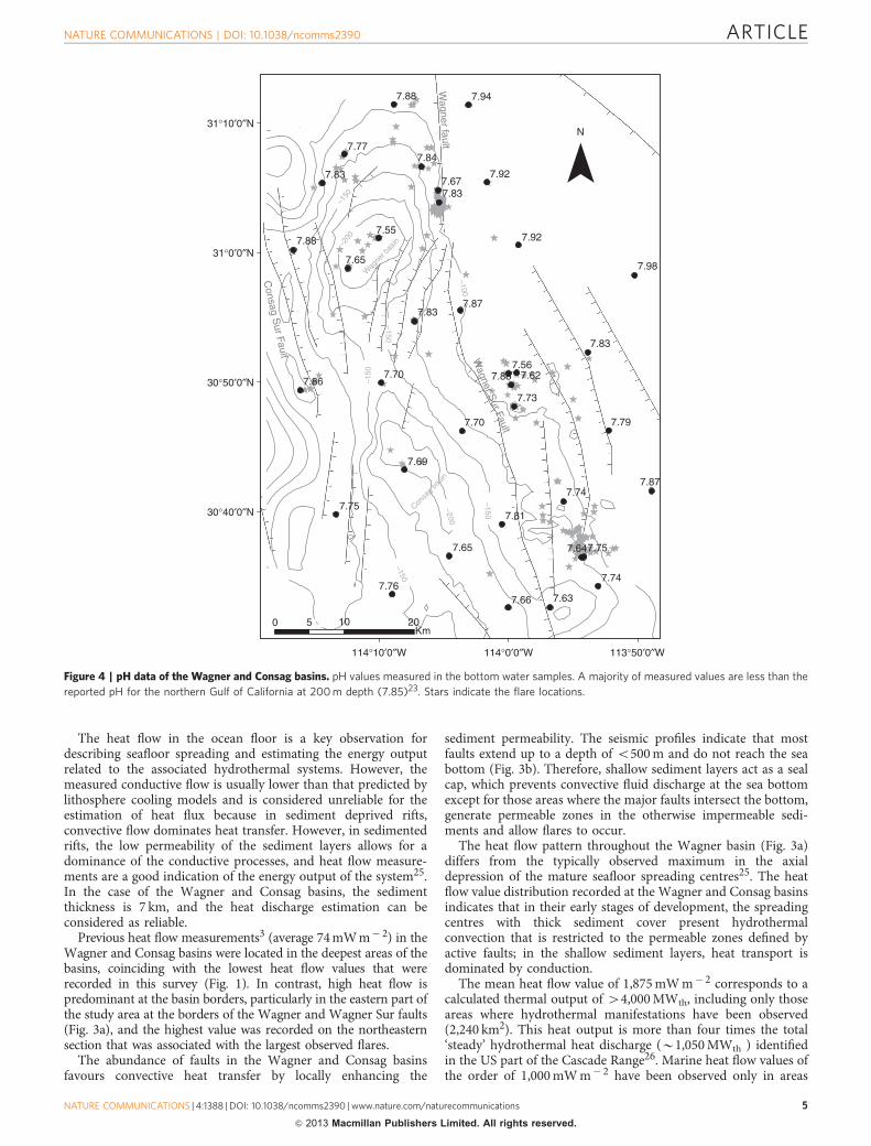
The data presented here represent the first detailed survey ofthe seafloor pH in the northern Gulf (Fig. 4, Supplementary TableS2); previous reports included only one station used to define thepH in the water column in the southern Consag basin23. Regionalstudies that reported pH values at the surface and in the watercolumn along a NW-SE profile of the GC23,24 showed that, in thenorthern Gulf, the lowest pH value at the surface was 8.29.However, at 200 m depth, all recorded pH values were greaterthan 7.85 throughout the entire GC. Consequently, the obtainedpH values of 7.55–7.85 can be considered as anomalously low andlinked to the diffuse flares emitting CO2 that were found duringthis study.
Sedimentary organic matter maturation. The thick sedimentlayer present in the Wagner and Consag basins contains abun-dant organic matter that is altered by the circulating hydro-thermal fluids. The ratios between the aliphatic alkanes allowedfor the calculation of the proportion of short- to long-chainalkanes (SRL) and the carbon preference index that were used toestablish the origin, distribution and maturity level of the sedi-mentary organic matter (SOM). The carbon preference indexvalues suggest that the high variability in the SOM maturity,which displayed a patchy pattern, was related to the flareoccurrence. A similar variability is also observed in the Pr/Phratio (pristane/phytane), the presence of polycyclic aromatichydrocarbons, the pentamethylicosane isoprenoid levels and theelemental ratio between the carbon and hydrogen (C/H) frombitumen.
DiscussionThe GC has been experiencing a transition from continentalrifting to seafloor spreading since 6 Ma ago1. The variations in therifting style along the Gulf grade from typical seafloor spreadingin the southern troughs2 to continental rifting in the northernend11,12 (Salton Sea, Browley and Cerro Prieto). The northern GCis a typical example of the early stages of this transition.
Table 1 | Heat flow measurements using the FIELAX probe (11 thermistors*) in the Wagner and Consag basins.
Station Latitude Longitude Depth Sea bottom temperature Heat flow Error (%)
(1N) (min N) (1W) (min W) (m) (1C) (mW m� 2)
1 30 32.807 113 59.204 178 15 16 22.842 31 6.653 114 6.822 123 18 2,907 0.013 31 3.716 114 5.183 98 20 7,115 0.014 31 7.800 114 12.533 116 17 892 0.225 31 0.183 114 16.616 97 18 1,216 2.136 30 58.800 114 12.317 214 15 42 3.897 31 1.200 114 9.983 213 15 27 2.248 30 49.500 114 15.267 98 19 229 2.469 30 39.768 114 13.319 102 18 163 0.2310 30 43.310 114 8.015 193 14 310 0.7111 30 46.034 114 3.629 129 16 533 3.8512 30 47.993 113 59.043 95 28 1,369 6.9713 30 50.651 113 59.988 84 20 1,206 0.2413A 30 50.649 113 59.982 83 20 1,121 4.8814w 31 3.701 114 5.119 91 27 15,436 0.8415 31 3.535 114 4.628 82 20 1,450 2.4916 30 59.752 114 3.959 95 18 621 0.6317 30 55.080 114 2.284 91 19 859 0.4218 30 50.519 114 0.005 88 20 2,053 0.4419 30 40.634 113 55.364 116 17 416 1.4520 30 38.904 113 55.104 123 16 709 5.4821 30 36.824 113 54.323 115 17 2,559 2.24
*In all measurements there was full penetration of the probe, which allowed measuring sea bottom temperature. wIn station 14 the six thermistors below 3 m went off scale because the temperature wasabove their maximum temperature range (60 1C). See Supplementary Fig. S1.
ARTICLE NATURE COMMUNICATIONS | DOI: 10.1038/ncomms2390
4 NATURE COMMUNICATIONS | 4:1388 | DOI: 10.1038/ncomms2390 | www.nature.com/naturecommunications
& 2013 Macmillan Publishers Limited. All rights reserved.
The heat flow in the ocean floor is a key observation fordescribing seafloor spreading and estimating the energy outputrelated to the associated hydrothermal systems. However, themeasured conductive flow is usually lower than that predicted bylithosphere cooling models and is considered unreliable for theestimation of heat flux because in sediment deprived rifts,convective flow dominates heat transfer. However, in sedimentedrifts, the low permeability of the sediment layers allows for adominance of the conductive processes, and heat flow measure-ments are a good indication of the energy output of the system25.In the case of the Wagner and Consag basins, the sedimentthickness is 7 km, and the heat discharge estimation can beconsidered as reliable.
Previous heat flow measurements3 (average 74 mW m� 2) in theWagner and Consag basins were located in the deepest areas of thebasins, coinciding with the lowest heat flow values that wererecorded in this survey (Fig. 1). In contrast, high heat flow ispredominant at the basin borders, particularly in the eastern part ofthe study area at the borders of the Wagner and Wagner Sur faults(Fig. 3a), and the highest value was recorded on the northeasternsection that was associated with the largest observed flares.
The abundance of faults in the Wagner and Consag basinsfavours convective heat transfer by locally enhancing the
sediment permeability. The seismic profiles indicate that mostfaults extend up to a depth of o500 m and do not reach the seabottom (Fig. 3b). Therefore, shallow sediment layers act as a sealcap, which prevents convective fluid discharge at the sea bottomexcept for those areas where the major faults intersect the bottom,generate permeable zones in the otherwise impermeable sedi-ments and allow flares to occur.
The heat flow pattern throughout the Wagner basin (Fig. 3a)differs from the typically observed maximum in the axialdepression of the mature seafloor spreading centres25. The heatflow value distribution recorded at the Wagner and Consag basinsindicates that in their early stages of development, the spreadingcentres with thick sediment cover present hydrothermalconvection that is restricted to the permeable zones defined byactive faults; in the shallow sediment layers, heat transport isdominated by conduction.
The mean heat flow value of 1,875 mW m� 2 corresponds to acalculated thermal output of 44,000 MWth, including only thoseareas where hydrothermal manifestations have been observed(2,240 km2). This heat output is more than four times the total‘steady’ hydrothermal heat discharge (B1,050 MWth ) identifiedin the US part of the Cascade Range26. Marine heat flow values ofthe order of 1,000 mW m� 2 have been observed only in areas
31°10′0″N
7.88
7.84
7.677.83
7.92
7.92
7.94
N7.77
Wagner fault
7.83
7.88
7.65
7.55
7.83
7.70
7.69
7.65
7.81
7.66 7.63
7.74
7.757.64
7.74
7.70
7.73
7.83
7.98
7.567.627.88
7.87
7.79
7.86
7.87
–150
–200
Wag
ner b
asin
Wagner S
ur Fault
Consag S
ur Fault
–150
–150
–150
–200Con
sag
basin
–150
–100
31°0′0″N
30°50′0″N
30°40′0″N
0 5 10
114°10′0″W 114°0′0″W 113°50′0″W
7.76
7.75
20Km
Figure 4 | pH data of the Wagner and Consag basins. pH values measured in the bottom water samples. A majority of measured values are less than the
reported pH for the northern Gulf of California at 200 m depth (7.85)23. Stars indicate the flare locations.
NATURE COMMUNICATIONS | DOI: 10.1038/ncomms2390 ARTICLE
NATURE COMMUNICATIONS | 4:1388 | DOI: 10.1038/ncomms2390 | www.nature.com/naturecommunications 5
& 2013 Macmillan Publishers Limited. All rights reserved.
where active seafloor spreading occurs, such as the Guaymasbasin27, and values as high as 490,000 mW m� 2 have beenreported for a sedimented flank at the Juan de Fuca Ridge28.
High heat flow values and intense seismicity in the Wagner andConsag basins imply the presence of a vigorous hydrothermalsystem in these basins. The low permeability of the sedimentcover, especially in the upper layers, as shown by the sub-bottomprofiler images (Fig. 2a,b), produces high conductive heat flowvalues measured in the ocean bottom as a result of convection inthe deeper layers.
The measured CO2/CH4 gas ratio of B4 is consistent with anequilibrium temperature in the order of 200 1C and is typical ofsedimentary basins with active hydrothermal systems29. High-temperature areas in the Guaymas basin30, where thermal stress isevident in the extent of organic matter maturation, arecharacterized by large amounts of CO2 and a limited range ofhydrocarbons (i.e., predominantly CH4). Therefore, it is likelythat the high temperature and thick sediment cover in theWagner and Consag basins result in the simple composition ofthe discharged gas (CO2 and CH4).
The predominance of CO2 in the discharged gas and theextensive occurrence of flares in both of the basins has acidified20–50 m of sea water near the bottom of the entire area(42,000 km2) to values within 7.55–7.98 pHT units (Fig. 4;Supplementary Table S2). Similar phenomena of extensive seawater acidification generated by CO2 discharged by hydrothermalventing have not been reported. However, local acidification wasobserved in three sites31–33, namely, the Okinawa Trough, Japan(lowest pH¼ 6.97 at 1,428 m depth), in Ischia, Italy (lowestpH¼ 6.40 at 3 m depth), and in Papua New Guinea (lowestpH¼ 7.21 at 3 m depth). CO2 venting in those areas is related tothe presence of marine deep- and shallow-water hydrothermalsystems. The average value of 7.77 units, as found in the presentstudy, is similar to the extrapolated pH level of the shallow oceanwater at the end of this century due to the increase in atmosphericCO2 concentrations34. The extensive acidification of the bottomwater predominates over the mixing effect of strong currents andmakes this area a natural laboratory for the study of the effects oflong-term acidification on deep-water ecosystems.
The water column radon anomalies in the basins indicate theinput of excess radon due to injection from a 222Rn-rich fluid.The maximum observed 222Rn value of 2,430 d.p.m./100 l is wellabove the 60 d.p.m./100 l level that was measured in bottom watersamples from the Juan de Fuca ridge flank28, which is an areawith intense hydrothermal circulation and a thermal output of1.5 MW. The positive anomalies of 222Rn along the Wagner Faultcoincide with the presence of the strongest flares, suggestinghydrothermal circulation in the thick sediment cover andrevealing the location of upflow areas. High values were alsoobserved in the areas with incipient upflow, as shown in Fig. 2band Supplementary Fig. S1.
Further evidence of the presence of hydrothermal activity inthe Wagner and Consag basins is provided by the SOM alteration.Maturation of SOM due to intense hydrothermal activity inheavily sedimented rifts generates plumes of low molecularweight hydrocarbons35. The highest maturity values correlate wellwith the observed presence of the flares. Furthermore, theidentification of the pentamethylicosane isoprenoid, related toCrenarchaeota36 that live at temperatures between 75 and 105 1C,is important evidence of the occurrence of hydrothermal activity;this compound has been associated with methanogenic bacteria37,and its presence coincides with the location of the largest flares inthe northeastern Wagner basin.
The data reveal that hydrothermal circulation occurs along themain structures, especially the Wagner and Wagner Sur faults,and that the anomalously high heat flow values support the
association with active seafloor spreading and mantle upwellingin the Wagner and Consag basins. Both basins display all of thetypical characteristics of sediment-covered active oceanic ridgeswith a large heat flux. However, in this case, the large heat flowvalues are restricted to the higher-permeability areas related tothe trace of the largest faults, indicating that the transition from‘continental rift to seafloor spreading’ remains in the early stageswith the presence of asymmetrical semi-grabens and nogeophysical evidence of oceanic lithosphere formation. However,the average heat flow agrees well with the calculated values for theconductive cooling of very young lithosphere. This characteriza-tion demonstrates that the continental rifting to the seafloorspreading transition is highly advanced in the GC and extends tothe northernmost area.
MethodsBathymetry and acoustic sediment profiler. The data presented here were col-lected during two oceanographic cruises, WAG-01 (2007) and WAG-02 (2010),aboard the R/V El Puma. The survey tracks were B4,500 km in length and coveredan area of B3,500 km2 (B90 km� 40 km), which included the Wagner andConsag basins. The survey paths for the second cruise were planned based on thelocation of the active flares to cover those areas with additional detailed bathymetryand sampling stations. Three types of Kongsberg echosounders were used: an18 kHz Simrad ES-60 and a 120 kHz Simrad EY-60 and Multi Beam EM300. Thebathymetry data were processed using the Fledermouse software. A KongsbergTOPAS parametric acoustic sub-bottom profiler (used in Chirp mode from 1 to6 kHz) with a sub-seafloor penetration of several tens of metres was used to studysediment features and structures, including blanking due to gas saturation. Thedata were displayed using the Kongsberg TOPAS software.
Autonomous underwater vehicle missions. In four sites, we used the ROVSeaEye LINX to observe the gas vents and take bottom water samples.
Water and gas chemistry. The bottom water samples were collected usingstandard Niskin bottles attached to the ROV. Samples from B10 m from the oceanbottom were collected using a Rosette Water Sampling System, and samples fromB1 m above the seafloor were obtained using hydrocasts. The gas analyses wereperformed on board the ship using two packed-column gas chromatography (GC)systems with thermal conductivity and flame ionization detection. The interstitialgas in vials was analysed in the laboratory using gas chromatography mass spec-trometry (GC–MS; Polaris Q).
The sea water samples for 222Rn measurements were collected near the seafloorand taken directly from the Niskin bottles while avoiding contact with air usingspecial glass containers of 250 ml. The containers were connected to an ElectronicRadon Detector ‘RAD 7’ coupled with an additional ‘RAD-H2O’ radon-in-wateraccessory (Durridge Co.) to measure the 222Rn concentrations in the sea watersamples.
On board the ship, the water subsamples were collected in glass bottles, and thepHT (in total scale) was immediately measured using a pH meter with an accuracyof 0.01 pH units. The total alkalinity (AT) was measured by Gran titration. Theparameters of the carbonate system (pCO2, CO3
2� , HCO3� , CT and saturation state
of calcite (Oc) and aragonite (Oa)) were calculated based on the pHT, mean AT,temperature and salinity at the sampling depth pressure using the free-accessCO2SYS package38. AT was nearly constant at all sites; therefore, its mean was usedto calculate the carbonate chemistry parameters (AT¼ 2,359.01 mmol kg� 1). Themean values of pHT were calculated from hydrogen ion concentrations and thenconverted back to pH values39 (available at http://cdiac.ornl.gov/oceans/co2rprt.html).
Organic matter maturation in sediments. The sediment sampling was performedusing a Smith–McIntyre grab sampler, a USNEL box corer and a gravity corer. Thesediment samples used in the organic matter analysis were maintained frozen untilthey were brought to the laboratory. Subsequently, the soluble organic matter wasextracted and analysed by gas chromatography (Gas Chromatograph 5973Network, injector 7683 B, coupled to MS Hewlett-Packard Agilent 6890N).
Heat flow measurements. Heat flow measurements were performed using a 6-m-long FIELAX probe with 11 thermistors. The full length of the probe penetrated thesediment during all of the measurements, and the ocean bottom temperature wasrecorded. The data were processed using custom software based on the codespublished by Villinger and Davis40. The high sedimentation rate(3.77 cm year� 1)41 decreases the measured heat flow values. The data were notcorrected for sedimentation, and thus, the presented heat flow data should be takenas the minimum possible values because the actual values would be much higher.
ARTICLE NATURE COMMUNICATIONS | DOI: 10.1038/ncomms2390
6 NATURE COMMUNICATIONS | 4:1388 | DOI: 10.1038/ncomms2390 | www.nature.com/naturecommunications
& 2013 Macmillan Publishers Limited. All rights reserved.

Seasonal changes in the bottom temperature were not significant due to strongmixing phenomena14.
References1. Oskin, M., Stock, J. M. & Martın-Barajas, A. Rapid localization of Pacific-North
America plate motion in the Gulf of California. Geology 29, 459–462 (2001).2. Lizarralde, D. et al. Variation in styles of rifting in the Gulf of California.
Nature 448, 466–469 (2007).3. Henyey, T. L. & Bischoff, J. L. Tectonic elements in the northern part of the
Gulf of California. Geol. Soc. Am. Bull. 84, 315–330 (1973).4. Gieskes, J. M. et al. Hydrothermal activity in the Guaymas basin, Gulf of
California: a synthesis. in Initial Reports of the Deep Sea Drilling Project (edsCurray, J. R. et al.) (US Government Printing Office, 1982).
5. Fisher, A. T. et al. Heat flow, sediment and pore fluid chemistry, andhydrothermal circulation on the east flank of Alarcon Ridge, Gulf of California.Earth Planet Sci. Lett. 188, 521–534 (2001).
6. Lewis, J. L. et al. Crustal thickness of the peninsular ranges and gulf extensionalprovince in the Californias. J. Geophys. Res. 106, 13599–13611 (2001).
7. Persaud, P. et al. Active deformation and shallow structure of the Wagner,Consag, and Delfın basins, northern Gulf of California, Mexico. J. Geophys. Res.105, 2355 (2003).
8. Wang, Y., Forsyth, D. W. & Savage, B. Convective upwelling in the mantlebeneath the Gulf of California. Nature 462, 499–501 (2009).
9. Gonzalez-Escobar, M., Suarez-Vidal, F., Hernandez-Perez, J. A. & Martın-Barajas, A. Seismic reflection-based evidence of a transfer zone between theWagner and Consag basins: implications for defining the structural geometry ofthe northern Gulf of California. Geo. Mar. Lett. 30, 575–584 (2010).
10. Einsele, G. Basaltic sill-sediment complexes in young spreading centers: genesisand significance. Geology 13, 249–252 (1985).
11. Elders, W. A. et al. Crustal spreading in Southern California. Science 178, 15–24(1972).
12. Dorsey, R. Sedimentation and crustal recycling along an active oblique-riftmargin: Salton Trough and northern Gulf of California. Geology 38, 443–446(2010).
13. Canet, C. et al. Discovery of massive seafloor gas seepage along the Wagnerfault, Northern Gulf of California. Sed. Geol. 228, 292–303 (2010).
14. Lavın, M. F., Gaxiola-Castro, G., Robles, J. M. & Richter, K. Winter watermasses and nutrients in the northern Gulf of California. J. Geophys. Res. 100,8587–8605 (1995).
15. Vazquez-Figueroa, V. et al. Batimetrıa y caracterısticas hidrograficas (Mayo,2007) en las Cuencas de Consag y Wagner, Norte del Golfo de California,Mexico. Bol. Soc. Geol. Mex. 61, 119–127 (2009).
16. Delgadillo-Hinojosa, F., Macıas-Zamora, J. V., Segovia-Zavala, J. A. &Torres-Valdes, S. Cadmium enrichment in the Gulf of California. Mar. Chem.75, 109–122 (2001).
17. Sanchez-Zamora, O., Doguin, P., Couch, R. W. & Ness, G. E. Magneticanomalies of the Northern Gulf of California: structural and thermalinterpretations. in The Gulf and Peninsular Provinces of the Californias(eds Dauphin, J. P. & Simoneit, B. R.) 47, 377–401 (AAPG Mem, 1991).
18. Davies, J. H. & Davies, D. R. Earth’s surface heat flux. Solid Earth 1, 5–24 (2010).19. Frez, J. & Gonzalez, J. J. Crustal structure and seismotectonics of Northern
Baja California. In The Gulf and Peninsular Provinces of the Californias (edsDauphin, J. P. & Simoneit, B. R.) 47, 261–283 (AAPG Mem, 1991).
20. Gonzalez-Escobar, M., Aguilar-Campos, C., Suarez-Vidal, F. & Martın-Barajas,A. Geometry of the Wagner basin, upper Gulf of California based on seismicreflections. Int. Geol. Rev. 51, 133–144 (2009).
21. Levi, S. & Riddihough, R. Why are marine magnetic anomalies suppressed oversedimented spreading centers? Geology 14, 651–654 (1986).
22. Klitgord, K. D., Mudie, J. D., Bischoff, J. L. & Henyey, T. L. Magnetic anomaliesin the Northern and Central Gulf of California. Geol. Soc. Am. Bull 85, 815–820(1974).
23. Alvarez-Borrego, S. & Lara-Lara, J. R. The physical environment and primaryproductivity of the Gulf of California. in The Gulf and Peninsular Provinces ofthe Californias (eds Dauphin, J. P. & Simoneit, B. R.) 47, 555–567 (AAPGMem, 1991).
24. Zirino, A. & Lieberman, S. H. pH-temperature relationship in the Gulf ofCalifornia. in Mapping strategies in chemical oceanography: American Chem.Soc. Adv. Chem. Ser. (ed. Zirino, A.) 209, 393–408 (American ChemicalSociety, Washington, DC, 1985).
25. Sclater, J. G. Variability of heat flux through the seafloor: discovery ofhydrothermal circulation in the ocean crust. In Hydrogeology of the OceanicLithosphere (eds Davis, E. E. & Elderfield, H.) 3–27 (Cambridge UniversityPress, 2004).
26. Ingebritsen, S. E. & Mariner, R. H. Hydrothermal heat discharge in the CascadeRange, northwestern United States. J. Volc. Geoth. Res. 196, 208–218 (2010).
27. Fisher, A. T. & Becker, K. Heat flow, hydrothermal circulation and basaltintrusions in the Guaymas basin, Gulf of California. Earth Planet. Sci. Lett. 103,84–99 (1991).
28. Wheat, C. G. et al. Heat flow through a basaltic outcrop on a sedimented youngridge flank. Geochem. Geophys. Geosyst. 5, Q12006 (2004).
29. Giggenbach, W. Relative importance of thermodynamic and kinetic processesin governing the chemical and isotopic composition of carbon gases in high-heat flow sedimentary basins. Geochim. Cosmochim. Acta 61, 3763–3785(1997).
30. Simoneit, B. R. T., Kawka, O. T. & Brault, M. Origin of gases and condensatesin the Guaymas basin hydrothermal system (Gulf of California). Chem. Geol.71, 169–182 (1988).
31. Shitashima, K., Maeda, Y., Koike, Y. & Ohsumi, T. Natural analogue of the riseand dissolution of liquid CO2 in the ocean. Int. J. Greenhouse Gas Control 2,95–104 (2008).
32. Hall-Spencer, J. M. et al. Volcanic carbon dioxide vents show ecosystem effectsof ocean acidification. Nature 454, 96–99 (2008).
33. Fabricius, K. E. et al. Losers and winners in coral reefs acclimatized to elevatedcarbon dioxide concentrations. Nat. Clim. Change 1, 165–169 (2011).
34. Intergovernmental Panel on Climate Change. Summary for policymakers. inClimate Change 2007: the Physical Sciences Basis. Working Group IContribution to the Fourth Assessment Report of the IPCC (eds Solomon, S.et al.) (Cambridge Univ. Press, 2007).
35. Merewether, R. M., Olson, M. S. & Lonsdale, P. Acoustically detectedhydrocarbon plumes rising from 2 Km depths in Guaymas basin, Gulf ofCalifornia. J. Geophys. Res. 90, 3075–3085 (1985).
36. Madigan, M. T., Martinko, J. M. & Parker, J. Brock Biology of Microorganisms10th edn. pp. 1012 (Prentice Hall-Pearson Education Inc., 2003).
37. Thiel, V. et al. Highly isotopically depleted isoprenoids: molecularmarkers for ancient methane venting. Geochim. Cosmochim. Acta 63,3959–3966 (1999).
38. Pierrot, D. E. & Wallace, D. W. MS Excel program developed for CO2 systemcalculation. ORNL/CDIAC-105aCarbon Dioxide Information Analysis Center(2006).
39. Dickson, A. G., Sabine, C. L. & Christian, J. R. (eds) Guide to Best Practices forOcean CO2 Measurements (PICES Special Publication 3, 2007).
40. Villinger, H. & Davis, E. E. HFRED: a program for the reduction of marineheat-flow data on a microcomputer. Geol. Sur. Can Open File Rep. 1627, 90(1987).
41. Baba, J., Peterson, C. D. & Schrader, H. J. Fine-grained terrigenous sedimentsupply and dispersal in the Gulf of California during the last century. inThe Gulf and Peninsular Provinces of the Californias (eds Dauphin, J. P. &Simoneit, B. R.) 47, 589–602 (AAPG Mem, 1991).
AcknowledgementsThis work was funded by the FONCICYT 94482 project ‘Recursos geotermicos sub-marinos del Norte del Golfo de California’, which was jointly supported by Mexico andthe European Union. This study was also partially funded by the IMPULSA IV UNAMproject. We are very grateful to the crew of the R/V El Puma. The Comision Academicade Buques Oceanograficos (CABO, UNAM) is thanked for partially supporting theresearch. We thank A. Estradas, D. Rodrıguez, K. Choumiline, M.A. Aguilar-Juarez,J. Renterıa, J.G. Gomez, F. Sandoval, M. Lopez, J. Hall-Spencer, S.I. Ramırez-Jimenezand E. Tobon for their help during the cruise, data processing and laboratory analyses.The figures were prepared by A. Membrillo.
Author contributionsAll authors were involved in the oceanographic cruise preparation and data processing.R.M.P.L. designed the project and wrote the paper. R.M.P.L. and M.A.T.V. worked on theheat flow data; R.R.M. was in charge of the water sampling, analyses and calculations forthe pH data; C.A. performed all of the S.O.M. analyses and data processing; C.H.L.D. andE.S. produced the Rn data; R.E.V.E. supervised the chemical analyses and processed thedata; E.S. analysed the sediment chemistry; and C.R. produced the bathymetry andprofiler maps. The manuscript was reviewed and discussed by all of the authors.
Additional informationSupplementary Information accompanies this paper at http://www.nature.com/naturecommunications
Competing financial interests: The authors declare no competing financial interests.
Reprints and permission information is available online at http://npg.nature.com/reprintsandpermissions/
How to cite this article: Prol-Ledesma, R.M. et al. High heat flow and ocean acidificationat a nascent rift in the northern Gulf of California. Nat. Commun. 4:1388 doi: 10.1038/ncomms2390 (2012).
This work is licensed under a Creative Commons Attribution-NonCommercial-ShareAlike 3.0 Unported License. To view a copy of
this license, visit http://creativecommons.org/licenses/by-nc-sa/3.0/
NATURE COMMUNICATIONS | DOI: 10.1038/ncomms2390 ARTICLE
NATURE COMMUNICATIONS | 4:1388 | DOI: 10.1038/ncomms2390 | www.nature.com/naturecommunications 7
& 2013 Macmillan Publishers Limited. All rights reserved.
Copyright © 2022 FDOKUMEN