Greenlink Marine EnvironmentaCT Impact Assessment Report
558
GREENLINK MARINE ENVIRONMENTAL STATEMENT- WALES P1975_R4484_RevF1 June 2019 Greenlink Interconnector - connecting the power markets in Ireland and Great Britain
-
Upload
khangminh22 -
Category
Documents
-
view
0 -
download
0
Transcript of Greenlink Marine EnvironmentaCT Impact Assessment Report

GREENLINK MARINE ENVIRONMENTAL STATEMENT- WALES
P1975_R4484_RevF1 June 2019
Greenlink Interconnector
- connecting the power markets in Ireland and Great Britain

For more information: W: www.greenlink.ie
“The sole responsibility of this publication lies with the author. The European Union is not responsible for any use that may be made of the information contained therein.”

Greenlink Interconnector Limited
Greenlink Marine Environmental Statement - Wales
For more information: W: www.greenlink.ie
II
Glossary XVII
1. Introduction 1-11.1 The Proposed Development 1-1
1.2 The Aim of the Document 1-4
1.3 Statutory Consents and Permissions 1-5
1.4 The Developer 1-5
1.5 The Project Team 1-5
1.6 Structure of the Environmental Statement 1-6
1.7 Sources of Data and Information 1-8
1.8 Consultation 1-8
1.9 Availability of the ES 1-9
References 1-10
2. Policy and Legislative Framework 2-12.1 Energy Policy 2-1
2.2 Marine Planning 2-4
2.3 Marine Licensing and Permits 2-6
References 2-15
3. Development of the Project and Alternatives 3-13.1 ‘Do-Nothing Option 3-1
3.2 Selection of Technology 3-1
3.3 Connection Options 3-2
3.4 Landfall Options 3-4
3.5 Offshore Route Selection 3-7
3.6 Proposed Development 3-28
References 3-30
4. Project Description 4-14.1 Introduction 4-1
4.2 Project overview 4-1
4.3 Submarine cable route description 4-3
4.1 Submarine cable description 4-5
4.2 Indicative programme 4-5
4.3 Pre-installation works 4-6
4.4 Cable installation 4-17
CONTENTS
Greenlink Interconnector Limited
Greenlink Marine Environmental Statement - Wales
For more information: W: www.greenlink.ie
III
4.5 Landfall installation 4-33
4.6 Cable operation 4-39
4.7 Emissions 4-42
4.8 Decommissioning 4-46
4.9 Embedded Mitigation 4-47
4.10 Zone of Influence 4-51
References 4-53
5. Impact Assessment Methodology 5-15.1 Introduction 5-1
5.2 Environmental Impact Assessment Guidance 5-1
5.3 Screening for Environmental Impact Assessment 5-2
5.4 Scoping and Consultation 5-2
5.5 Method of Environmental Assessment 5-14
5.6 Characterisation of the Baseline Environment 5-14
5.7 Establish Potential Pressures and Zone of Influence 5-15
5.8 Identification of Effects 5-16
5.9 Characterisation of the Receptor 5-17
5.10 Characterisation of Effect 5-20
5.11 Evaluation of Significance of Effect 5-20
5.12 Establish Mitigation 5-21
5.13 Determine Significance of Residual Effects 5-23
5.14 Cumulative Effects Assessment (CEA) 5-23
5.15 Transboundary Assessment 5-24
5.16 Uncertainty, Assumptions and Limitations 5-24
References 5-26
6. Physical Conditions and Marine Processes 6-16.1 Data Sources 6-1
6.2 Consultation 6-9
6.3 Existing Baseline 6-10
6.4 Potential Pressure Identification and Zone of Influence 6-29
6.5 Embedded Mitigation 6-30
6.6 Significance Assessment 6-31
6.7 Project Specific Mitigation 6-39
6.8 Residual Effect 6-40
References 6-42

Greenlink Interconnector Limited
Greenlink Marine Environmental Statement - Wales
For more information: W: www.greenlink.ie
IV
7. Benthic and Intertidal Ecology 7-17.1 Data Sources 7-1
7.2 Consultation 7-6
7.3 Existing Baseline 7-8
7.4 Potential Pressure Identification and Zone of Influence 7-40
7.5 Embedded Mitigation 7-42
7.6 Significance Assessment 7-43
7.7 Project Specific Mitigation 7-63
7.8 Residual Effect 7-66
References 7-68
8. Fish and Shellfish 8-18.1 Data Sources 8-1
8.2 Consultation 8-2
8.3 Existing Baseline 8-4
8.4 Potential Pressure Identification and Zones of Influence 8-17
8.5 Embedded Mitigation 8-18
8.6 Significance Assessment 8-19
8.7 Project Specific Mitigation 8-33
8.8 Residual Effect 8-33
References 8-35
9. Birds 9-19.1 Data Sources 9-1
9.2 Consultation 9-5
9.3 Existing Baseline 9-5
9.4 Potential Pressure Identification and Zone of Influence 9-15
9.5 Embedded Mitigation 9-15
9.6 Significance Assessment 9-16
9.7 Project Specific Mitigation 9-24
9.8 Residual Effect 9-24
References 9-25
10. Marine Mammals and Reptiles 10-110.1 Data Sources 10-1
10.2 Consultation 10-2
10.3 Existing Baseline 10-3
10.4 Potential Pressure Identification and Zone of Influence 10-20
10.5 Embedded Mitigation 10-21

Greenlink Interconnector Limited
Greenlink Marine Environmental Statement - Wales
For more information: W: www.greenlink.ie
V
10.6 Significance Assessment 10-22
10.7 Project Specific Mitigation 10-35
10.8 Residual Effect 10-35
References 10-38
11. Protected Sites 11-111.1 Requirement for HRA 11-1
11.2 Consultation 11-3
11.3 Stage 1 Screening 11-4
11.4 Stage 2 Appropriate Assessment 11-8
12. Commercial Fisheries 12-112.1 Data Sources 12-1
12.2 Study Area 12-2
12.3 Consultation 12-4
12.4 Existing Baseline 12-5
12.5 Potential Pressure Identification and Zone of Influence 12-13
12.6 Embedded Mitigation 12-15
12.7 Significance Assessment 12-17
12.8 Project Specific Mitigation 12-28
12.9 Residual Effect 12-28
References 12-30
13. Shipping and Navigation 13-113.1 Data Sources 13-1
13.2 Consultation 13-4
13.3 Existing Baseline Description 13-6
13.4 Potential Pressure Identification and Zone of Influence 13-12
13.5 Embedded Mitigation 13-13
13.6 Significance Assessment 13-15
13.7 Project Specific Mitigation 13-23
13.8 Residual Effect 13-23
References
14. Offshore Infrastructure and Other Marine Users
13-25
14.1 Data Sources 14-1
14.2 Consultation 14-214.3 Existing Baseline 14-3
14.4 Potential Pressure Identification and Zone of Influence 14-8
14-1

Greenlink Interconnector Limited
Greenlink Marine Environmental Statement - Wales
For more information: W: www.greenlink.ie
VI
14.5 Embedded Mitigation 14-914.6 Significance Assessment 14-11
14.7 Project Specific Mitigation 14-18
14.8 Residual Effect 14-18References 14-20
15. Marine Archaeology 15-115.1 Data Sources 15-1
15.2 Consultation 15-5
15.3 Existing baseline 15-6
15.4 Potential Pressure Identification and Zone of Influence 15-17
15.5 Embedded Mitigation 15-18
15.6 Significance Assessment 15-19
15.7 Project Specific Mitigation 15-26
15.8 Residual Effect 15-26
References 15-27
16. Cumulative Effects Assessment (CEA) 16-116.1 Introduction 16-1
16.2 Part 1 – Intra-project effects 16-2
16.3 Part 2 – CEA with other projects/plans & activities 16-3
16.4 Part 3 – Transboundary Effects 16-55
References 16-57
17. Schedule of Mitigation 17-1
18 Conclusions 18-1
Appendix A Compliance with Draft Welsh National Marine Plan
Appendix B Meetings held with Welsh stakeholders to inform Proposed Development and EIA
Appendix C Greenlink Habitats Regulations Assessment (HRA)
Appendix D Noise Assessment
Appendix E Herring Spawning and Sandeel Assessment
Appendix F Commercial Fisheries Assessment
Appendix G Marine Archaeology Technical Report

Greenlink Interconnector Limited
Greenlink Marine Environmental Statement - Wales
For more information: W: www.greenlink.ie
VII
Appendix H Water Framework Directive Assessment Scoping
Appendix I Cable Route Survey Report
Appendix J Benthic Survey Report
Appendix K Intertidal Habitat Survey Report
Appendix L Marine Detailed UXO Risk Assessment
Appendix M Draft Written Scheme of Investigation (WSI)
Appendix N Welsh and Irish Landfall Final Selection Report
Appendix O Competent Experts

Greenlink Interconnector Limited
Greenlink Marine Environmental Statement - Wales
For more information: W: www.greenlink.ie
VIII
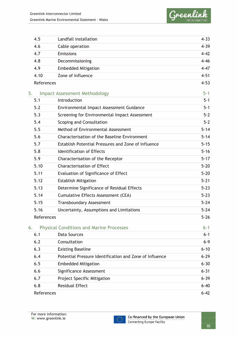
Tables Table 1-1 Structure of the ES 1-6
Table 1-2 Specialist studies 1-8
Table 2-1 List of permits and licences needed for Proposed Development 2-6
Table 2-2 UK protection measures for marine species 2-13
Table 3-1 Summary of project distances 3-4
Table 4-1 Indicative programme for marine works 4-6
Table 4-2 Indicative route lengths potentially requiring boulder clearance 4-11
Table 4-3 Indicative pre-sweeping requirements 4-13
Table 4-4 Crossing locations 4-22
Table 4-5 Key worst-case assumptions for crossings 4-25
Table 4-6 Potential installation method 4-26
Table 4-7 Indicative rock protection locations (due to ground conditions) 4-31
Table 4-8 Embedded mitigation 4-48
Table 4-9 Zone of influence summary 4-52
Table 5-1 Stakeholders consulted during Scoping 5-4
Table 5-2 Effects scoped out from the ES and the rationale for their exclusion 5-8
Table 5-3 Factors to be assessed by an ES – signposting to topic chapters 5-13
Table 5-4 Definitions of interaction, impact and effect 5-15
Table 5-5 Definitions of effects 5-16
Table 5-6 Criteria for characterising the sensitivity or value of the receptor (Receptor Value) 5-18
Table 5-7 Factors which determine the Magnitude Value of an Effect 5-20
Table 5-8 Significance matrix (SNH 2013) 5-21
Table 5-9 Definitions of significance levels 5-21
Table 6-1 Survey data quality 6-5
Table 6-2 Consultation responses – physical conditions and marine processes 6-9
Table 6-3 Mean monthly wave statistics for a 20-year period (1994-2004) 6-12
Table 6-4 Summary of metal concentrations (μg/g dry weight) in sediment across grab sample sites together with threshold values. 6-28
LIST OF TABLES AND FIGURES

Greenlink Interconnector Limited
Greenlink Marine Environmental Statement - Wales
For more information: W: www.greenlink.ie
IX
Table 6-5 Pressure identification and zone of influence – physical conditions and marine processes 6-30
Table 6-6 Embedded mitigation 6-31
Table 6-7 Impact assessment summary – physical conditions and marine processes 6-32
Table 6-8 Sediment analysis along the Proposed Development 6-36
Table 6-9 Project-specific mitigation physical conditions and marine processes 6-39
Table 7-1 Consultation responses – benthic and intertidal ecology 7-6
Table 7-2 Key biotopes identified at Freshwater West 7-10
Table 7-3 Habitats present within the Proposed Development 7-13
Table 7-4 Areas of biogenic reef 7-36
Table 7-5 Pressure identification and zone of influence – benthic and intertidal ecology 7-40
Table 7-6 Embedded mitigation 7-42
Table 7-7 Impact assessment summary – benthic and intertidal ecology 7-44
Table 7-8 Sensitivity of habitats within the Proposed Development to the pressures penetration and abrasion 7-48
Table 7-9 Sensitivity of habitats within the Proposed Development to the pressure smothering and siltation rate changes (heavy) 7-56
Table 7-10 Habitats within which external cable protection could be installed 7-58
Table 7-11 Project specific mitigation – benthic and intertidal ecology 7-63
Table 8-1 Consultation responses – fish and shellfish 8-2
Table 8-2 Summary of spawning and nursery areas for the main commercial species8-5
Table 8-3 Diadromous ray-finned fish with potential to be present along the Proposed Development 8-12
Table 8-4 Environment (Wales) Act 2016 - Section 7 Priority species present within the Proposed Development 8-15
Table 8-5 Pressure identification and zone of influence – fish and shellfish 8-17
Table 8-6 Embedded mitigation 8-18
Table 8-7 Impact assessment summary – fish and shellfish 8-20
Table 9-1 Consultation responses - birds 9-5
Table 9-2 SPAs assessed in the HRA Stage 1 Screening (Technical Appendix C) 9-7

Greenlink Interconnector Limited
Greenlink Marine Environmental Statement - Wales
For more information: W: www.greenlink.ie
X
Table 9-3 Environment (Wales) Act Section 7 priority species within Proposed Development 9-12
Table 9-4 Pressure identification and zone of influence – birds 9-15
Table 9-5 Embedded mitigation 9-15
Table 9-6 Impact assessment summary – birds 9-17
Table 10-1 Consultation responses – marine mammals 10-2
Table 10-2 Cetacean species recorded near to the Proposed Development 10-4
Table 10-3 Seasonal summary of marine mammal and reptile presence within and near the Proposed Development 10-17
Table 10-4 Legislation protecting marine mammals and reptiles 10-18
Table 10-5 Environment (Wales) Act 2016 - Section 7 Priority species present within the Proposed Development 10-19
Table 10-6 Pressure identification and zone of influence – marine mammals and reptiles 10-20
Table 10-7 Embedded mitigation 10-21
Table 10-8 Impact Assessment Summary – Marine mammals and reptiles 10-23
Table 10-9 Marine mammal groups based on auditory bandwidth 10-26
Table 10-10 Zones of influence for each sound category, activity and marine mammal group 10-27
Table 10-11 Project Specific Mitigation – marine mammals and reptiles 10-35
Table 11-1 Consultation responses 11-3
Table 11-2 European Sites screened in – Summary of potential for likely significant effects 11-7
Table 11-3 Project specific mitigation – Pembrokeshire Marine / Sir Benfro Forol SAC – reef 11-8
Table 11-4 Project specific mitigation – Pembrokeshire Marine / Sir Benfro Forol SAC – grey seals and West Wales Marine / Gorllwein Cymru Forol SAC –harbour porpoise 11-9
Table 12-1 Data sources and associated limitations 12-1
Table 12-2 Consultation responses – commercial fisheries 12-4
Table 12-3 Key fishing periods from MMO data and consultation 12-12
Table 12-4 Pressure identification and zone of influence – Commercial Fisheries 12-14
Table 12-5 Embedded mitigation 12-15
Table 12-6 Impact Assessment Summary – Commercial Fisheries 12-18

Greenlink Interconnector Limited
Greenlink Marine Environmental Statement - Wales
For more information: W: www.greenlink.ie
XI
Table 12-7 Worst-case displacement 12-21
Table 12-8 Project specific mitigation – commercial fisheries 12-28
Table 13-1 Consultation responses – shipping and navigation 13-4
Table 13-2 Pressure identification and zone of influence – shipping and navigation 13-13
Table 13-3 Embedded mitigation 13-13
Table 13-4 Impact assessment summary – shipping and navigation 13-16
Table 13-5 Summary of change of water depth significance assessment 13-21
Table 13-6 Project specific mitigation – shipping and navigation 13-23
Table 14-1 Consultation responses 14-2
Table 14-2 Pressure identification and zone of influence – offshore infrastructure and other marine users 14-8
Table 14-3 Embedded mitigation 14-10
Table 14-4 Impact assessment summary – offshore infrastructure and other marine users 14-12
Table 14-5 Project specific mitigation – offshore infrastructure and other marine users 14-18
Table 15-1 Consultation responses – marine archaeology 15-5
Table 15-2 Wrecks/obstructions recorded within the 500m radius CSC 15-10
Table 15-3 Pressure identification and zone of influence – Marine archaeology 15-17
Table 15-4 Embedded mitigation – marine archaeology 15-18
Table 15-5 Impact assessment summary – Marine archaeology 15-20
Table 15-6 Project specific mitigation – marine archaeology 15-26
Table 16-1 Potential intra-project effects 16-3
Table 16-2 Activity / pressure / receptor matrix for the Proposed Development 16-7
Table 16-3 Projects within 10km of the Proposed Development for consideration within the CEA 16-11
Table 16-4 Activity / pressure / receptor matrix for Projects within 10km 16-15
Table 16-5 Spatial overlap assessment 16-28
Table 16-6 Project timeline 16-33
Table 16-7 Summary of pathway screened in 16-37
Table 16-8 Assessment of PCE 16-40
Table 16-9 Screening Summary – Underwater Noise Change 16-44
Greenlink Interconnector Limited
Greenlink Marine Environmental Statement - Wales
For more information: W: www.greenlink.ie
XII
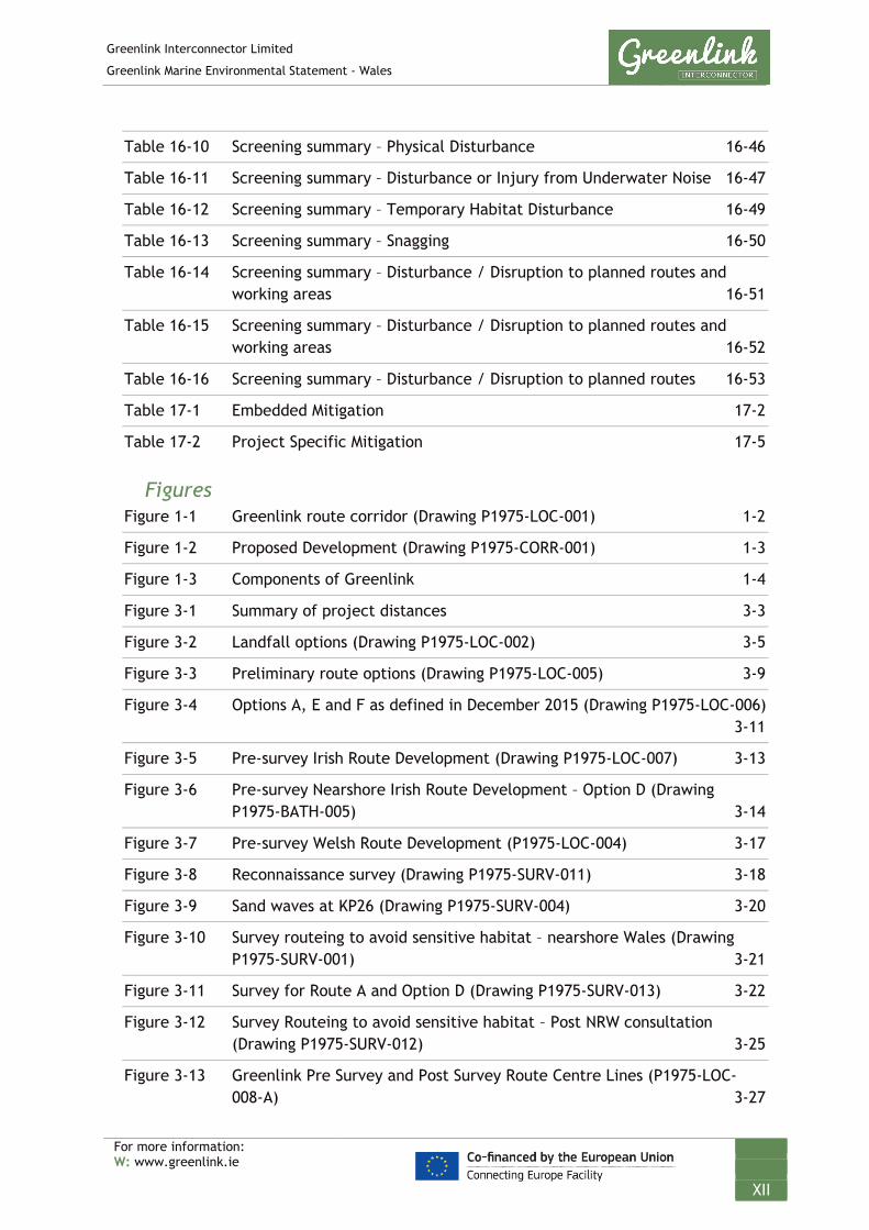
Table 16-10 Screening summary – Physical Disturbance 16-46
Table 16-11 Screening summary – Disturbance or Injury from Underwater Noise 16-47
Table 16-12 Screening summary – Temporary Habitat Disturbance 16-49
Table 16-13 Screening summary – Snagging 16-50
Table 16-14 Screening summary – Disturbance / Disruption to planned routes and working areas 16-51
Table 16-15 Screening summary – Disturbance / Disruption to planned routes and working areas 16-52
Table 16-16 Screening summary – Disturbance / Disruption to planned routes 16-53
Table 17-1 Embedded Mitigation 17-2
Table 17-2 Project Specific Mitigation 17-5
Figures Figure 1-1 Greenlink route corridor (Drawing P1975-LOC-001) 1-2
Figure 1-2 Proposed Development (Drawing P1975-CORR-001) 1-3
Figure 1-3 Components of Greenlink 1-4
Figure 3-1 Summary of project distances 3-3
Figure 3-2 Landfall options (Drawing P1975-LOC-002) 3-5
Figure 3-3 Preliminary route options (Drawing P1975-LOC-005) 3-9
Figure 3-4 Options A, E and F as defined in December 2015 (Drawing P1975-LOC-006)3-11
Figure 3-5 Pre-survey Irish Route Development (Drawing P1975-LOC-007) 3-13
Figure 3-6 Pre-survey Nearshore Irish Route Development – Option D (Drawing P1975-BATH-005) 3-14
Figure 3-7 Pre-survey Welsh Route Development (P1975-LOC-004) 3-17
Figure 3-8 Reconnaissance survey (Drawing P1975-SURV-011) 3-18
Figure 3-9 Sand waves at KP26 (Drawing P1975-SURV-004) 3-20
Figure 3-10 Survey routeing to avoid sensitive habitat – nearshore Wales (Drawing P1975-SURV-001) 3-21
Figure 3-11 Survey for Route A and Option D (Drawing P1975-SURV-013) 3-22
Figure 3-12 Survey Routeing to avoid sensitive habitat – Post NRW consultation (Drawing P1975-SURV-012) 3-25
Figure 3-13 Greenlink Pre Survey and Post Survey Route Centre Lines (P1975-LOC-008-A) 3-27

Greenlink Interconnector Limited
Greenlink Marine Environmental Statement - Wales
For more information: W: www.greenlink.ie
XIII
Figure 3-14 Proposed Development (P1975-CORR-001) 3-29
Figure 4-1 Pictorial representation of Greenlink 4-2
Figure 4-2 Proposed Development (Drawing P1975-CORR-001) 4-4
Figure 4-3 Typical cable bundle arrangement 4-5
Figure 4-4 Example of XLPE submarine cable 4-5
Figure 4-5 Example multi-beam image 4-8
Figure 4-6 Example SSS image 4-9
Figure 4-7 Typical plough and grab used to clear boulders 4-11
Figure 4-8 Non-mobile reference level below mobile seabed features 4-12
Figure 4-9 Non-mobile reference level for cable burial below sandwave and dredge profiles 4-13
Figure 4-10 Indicative sandwave pre-sweeping locations UK waters (Drawing P1975-INST-007) 4-14
Figure 4-11 Trailing suction hopper dredger 4-15
Figure 4-12 Mass flow excavator 4-16
Figure 4-13 Cable lay vessels 4-17
Figure 4-14 Typical factory and cable laying vessel turntables 4-18
Figure 4-15 Typical fall-pipe vessel 4-19
Figure 4-16 Examples of subsea cable joints 4-22
Figure 4-17 Representative crossing design 4-24
Figure 4-18 Indicative rock protection requirements (Drawing P1975-INST-005) 4-27
Figure 4-19 Typical water-jetting machines 4-28
Figure 4-20 Typical plough 4-29
Figure 4-21 Rock placement 4-31
Figure 4-22 Concrete mattress deployment (courtesy of FoundOcean) 4-33
Figure 4-23 Typical HDD 4-35
Figure 4-24 Indicative location of HDD compound – Freshwater West, Pembrokeshire4-36
Figure 4-25 Typical layout of HDD compound 4-36
Figure 4-26 Indicative HDD exit point (Drawing P1975-INST-001) 4-38
Figure 4-27 Example of a cable being floated-in 4-39
Figure 5-1 Steps of an EIA 5-14

Greenlink Interconnector Limited
Greenlink Marine Environmental Statement - Wales
For more information: W: www.greenlink.ie
XIV
Figure 6-1 Scope of Marine Survey (Drawing P1975-SURV-015) 6-4
Figure 6-2 The location of beach morphology profiles within the Proposed Development, FSC profile data collection January 2016. 6-7
Figure 6-3 The location of Freshwater West seismic profiles (Plate 1). Plate 2 - survey profile locations overlaid on high resolution gridded LIDAR data acquired by AUV. 6-8
Figure 6-4 Yearly mean (red) and monthly mean (black) significant wave height and wave period. 6-12
Figure 6-5 Beach profiles plots created from FSC data January 2016 6-15
Figure 6-6 Bathymetry (Drawing P1975-BATH-001) 6-17
Figure 6-7 Bathymetry Freshwater West (Drawing P1975-SURV-001) 6-18
Figure 6-8 Seabed sediments – survey data (Drawing P1975-SED-005-A_1) 6-21
Figure 6-9 Seabed sediments – survey data (Drawing P1975-SED-005-A_2) 6-22
Figure 6-10 Seabed sediments – survey data (Drawing P1975-SED-005-A_3) 6-23
Figure 6-11 Seabed sediments – survey data (Drawing P1975-SED-005-A_4) 6-24
Figure 6-12 Seabed sediments – survey data (Drawing P1975-SED-005-A_5) 6-25
Figure 7-1 Grab sample and drop down video transect positions 7-5
Figure 7-2 Aerial image of Freshwater West September 2018 7-9
Figure 7-3 EUNIS biotope mapping and sampling locations at Freshwater West 7-11
Figure 7-4 Benthic habitats (Drawing P1975-HAB-003 Sheet 1) 7-19
Figure 7-5 Benthic habitats (Drawing P1975-HAB-003 Sheet 2 7-20
Figure 7-6 Benthic habitats (Drawing P1975-HAB-003 Sheet 3) 7-21
Figure 7-7 Benthic habitats (Drawing P1975-HAB-003 Sheet 4) 7-22
Figure 7-8 Benthic habitats (Drawing P1975-HAB-003 Sheet 5) 7-23
Figure 7-9 Benthic habitats (Drawing P1975-HAB-003 Sheet 6) 7-24
Figure 7-10 Annex I Habitats (Drawing P1975-HAB-005) 7-27
Figure 7-11 Annex I Habitats (Drawing P1975-HAB-004 Sheet 2) 7-28
Figure 7-12 Annex I Habitats (Drawing P1975-HAB-006) 7-29
Figure 7-13 Annex I Habitats (Drawing P1975-HAB-004 Sheet 5) 7-30
Figure 7-14 Image T06_014 of Annex (1170) - Bedrock reefs 7-31
Figure 7-15 Bedrock reef communities for from Transects DDV_T06 to DDV_T09 7-32
Figure 7-16 Environmental transect 06 7-34

Greenlink Interconnector Limited
Greenlink Marine Environmental Statement - Wales
For more information: W: www.greenlink.ie
XV
Figure 7-17 Image T03_001 of Annex I (1170) – Medium Grade Stony Reef with the habitat A5.141 – Pomatoceros triqueter with barnacles and bryozoan crusts on unstable circalittoral cobbles and pebbles. 7-35
Figure 7-18 Annex I (1170) – Low Grade Biogenic reef with the habitat A5.611 – Sabellaria spinulosa on stable circalittoral mixed sediment (Image S25_003). 7-37
Figure 7-19 Annex I (1170) – Low Grade Biogenic reef with the habitat A5.611 – Sabellaria spinulosa on stable circalittoral mixed sediment (Image S20_005). 7-38
Figure 7-20 Annex I (1170) – Medium Graded Biogenic Reef on the habitat A4.2212 – Sabellaria spinulosa didemnid and small ascidians on tide-swept moderately wave-exposed circalittoral rock (image T05_013) 7-39
Figure 7-21 Exclusion Zones within the Proposed Development (Drawing P1975_INST-009) 7-65
Figure 8-1 Spawning and nursing grounds sheet 1 of 2 (Drawing P1975-FISH-001) 8-7
Figure 8-2 Spawning and nursing grounds sheet 2 of 2 (Drawing P1975-FISH-002) 8-8
Figure 9-1 Wintering Bird Surveys 9-4
Figure 9-2 Location of rafting Manx shearwater (after McSorley et al 2008) in relation to the Proposed Development and existing shipping activity (Drawing P1975-BIRD-001) 9-13
Figure 10-1 Long term sighting rates (vessel counts per 10km) of harbour porpoise 10-6
Figure 10-2 Long term sighting rates (vessel counts per 10km) of common dolphin 10-8
Figure 10-3 Long term sighting rates (vessel counts per 10km) of common bottlenose dolphin 10-10
Figure 10-4 Grey seal at-sea usage: mean 10-12
Figure 10-5 Grey seal breeding locations in Pembrokeshire Marine SAC 10-13
Figure 10-6 Harbour seal at-sea usage: mean 10-14
Figure 10-7 Habitat suitability for otter 10-16
Figure 11-1 Stages of HRA 11-2
Figure 11-2 Protected sites (Drawing P1975-PROT-001) 11-5
Figure 12-1 Proposed Development in relation to ICES rectangles (P1975-LOC-009) 12-3
Figure 12-2 Static gear fishing grounds in the vicinity of the Proposed Development12-9

Greenlink Interconnector Limited
Greenlink Marine Environmental Statement - Wales
For more information: W: www.greenlink.ie
XVI
Figure 12-3 Mobile gear fishing grounds in the vicinity of the Proposed Development12-10
Figure 12-4 Seasonal trends in landed weight (tonnes) and value (£) from ICES rectangle 32E4 between 2012-2016 12-12
Figure 13-1 Study Area - UK Waters (Drawing P1975-AIS-001) 13-3
Figure 13-2 Proportion of vessel types operating within the UK Study Area 13-6
Figure 13-3 Number of unique vessels counts per month (August 2017 to June 2018) in the UK Study Area 13-7
Figure 13-4 Proportion of vessel types intersecting the Proposed Development 13-8
Figure 13-5 Overview of marine users - UK Waters (Drawing P1975-INFR-001) 13-9
Figure 13-6 Vessel tracklines and density – UK waters (Drawing P1975-AIS-003) 13-10
Figure 13-7 Royal Yachting Association Sites – UK waters (Drawing P1975-RYA-001) 13-11
Figure 13-8 RYA heat map of recreation boating around the coast based on AIS data13-12
Figure 13-9 Under keel clearance 13-21
Figure 14-1 Recreational boating (Drawing P1975-RYA-001) 14-7
Figure 14-2 Marine users zones of influence (Drawing P1975-INFR-003) 14-17
Figure 15-1 Remains of the submerged forest preserved in the exposed peats on the foreshore (courtesy of Intertek) 15-8
Figure 15-2 Wrecks & Obstructions – Sheet 1 15-14
Figure 15-3 Wrecks & Obstructions – Sheet 2 15-15
Figure 15-4 Wrecks & Obstructions – Sheet 3 15-16
Figure 16-1 Projects, plans and licensed activities within 10km of the Proposed Development (Drawing P1975-CUMU-001) 16-13.

Greenlink Interconnector Limited
Greenlink Marine Environmental Statement - Wales
For more information: W: www.greenlink.ie
XVII
AA Appropriate Assessment
AADT Annual Average Daily Traffic
ADD Acoustic deterrent device
AEP Auditory Evoked Potential
AER Annual Environmental Report
AEZ Archaeological Exclusion Zone
AIS Automatic Identification Data
ALARP As Low As Reasonably Practicable
AQS Air Quality Standards
BEIS Department for Business, Energy and Industrial Strategy
b field Magnetic field
BGS British Geological Survey
BIM Board Iascaigh Mhara (Irish Sea Fisheries Board)
Birds Directive European Council Directive 2009/147/EC of the European Parliament and of the Council on the conservation of wild birds
BRE British Research Establishment
Brief Effects Effects lasting less than a day
BSA Biologically Sensitive Area
BT British telecom
BTO British Trust for Ornithology
BWD Directive 2006/7/EC concerning the management of bathing water quality (Bathing Waters Directive)
Campile Estuary Component of Greenlink where onshore cables cross under the River Campile
CBRA Cable burial risk assessment
CCME Canadian Council of Ministers of the Environment
CCW Countryside Council for Wales
C&D Construction and Demolition
CD Chart Datum
CEA Cumulative Effects Assessment
CEF Connecting Europe Facility
GLOSSARY

Greenlink Interconnector Limited
Greenlink Marine Environmental Statement - Wales
For more information: W: www.greenlink.ie
XVIII
Cefas Centre for Environment, Fisheries and Aquaculture Science
CEMP Construction Environmental Plan
CEP Common Fisheries Policy
CIEEM Chartered Institute of Ecology and Environmental Management
CIRIA Construction Industry Research and Information Association
CLB Cable Lay Barge
CLV Cable Lay Vessel
CMS Law firm used by Greenlink
COLREGs International Regulations for Preventing Collisions at Sea
COMAH Control of Major Accident Hazards involving Dangerous Substances
CPP Concept for Public Participation
CPT Cone Penetration Testing
CRU The Commission for Regulation of Utilities
CSO Central Statistics Office
Cumulative Effects The combined effect of pressures present to which a specific receptor is sensitive. Cumulative effects result from incremental changes caused by other past, present or reasonably foreseeable actions together with the project
DAFM Department of Agriculture, Food and Marine
DAHG Department of Arts, Heritage and the Gaeltacht
DC Direct Current
DCCAE Department of Communications, Climate Action and Environment
DCHG Department of Culture, Heritage and the Gaeltacht
DDV Drop-Down Video
DECC formerly the Department for Energy and Climate Change
DHPLG Department of Housing, Planning and Local Government
DIO Defence Infrastructure Organisation
DMRB Design Manual for Roads and Bridges
DOC Depth of closure
DP Dynamic Positioning
Greenlink Interconnector Limited
Greenlink Marine Environmental Statement - Wales
For more information: W: www.greenlink.ie
XIX
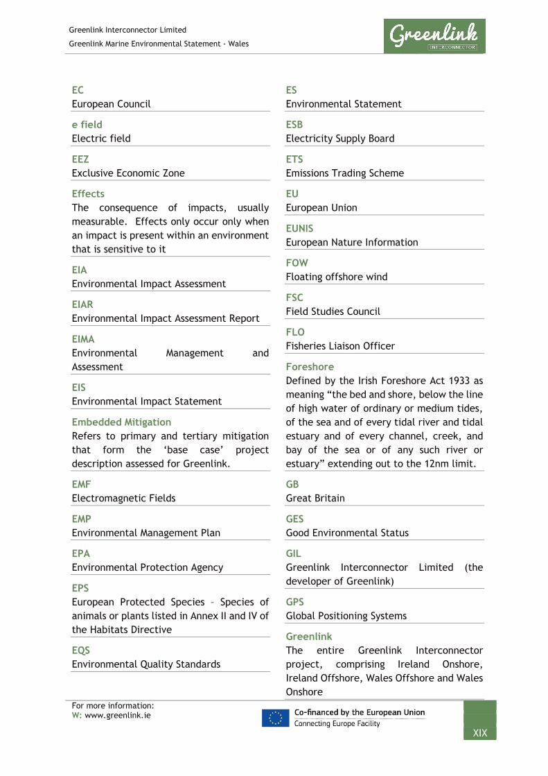
EC European Council
e field Electric field
EEZ Exclusive Economic Zone
Effects The consequence of impacts, usually measurable. Effects only occur only when an impact is present within an environment that is sensitive to it
EIA Environmental Impact Assessment
EIAR Environmental Impact Assessment Report
EIMA Environmental Management and Assessment
EIS Environmental Impact Statement
Embedded Mitigation Refers to primary and tertiary mitigation that form the ‘base case’ project description assessed for Greenlink.
EMF Electromagnetic Fields
EMP Environmental Management Plan
EPA Environmental Protection Agency
EPS European Protected Species – Species of animals or plants listed in Annex II and IV of the Habitats Directive
EQS Environmental Quality Standards
ES Environmental Statement
ESB Electricity Supply Board
ETS Emissions Trading Scheme
EU European Union
EUNIS European Nature Information
FOW Floating offshore wind
FSC Field Studies Council
FLO Fisheries Liaison Officer
Foreshore Defined by the Irish Foreshore Act 1933 as meaning “the bed and shore, below the line of high water of ordinary or medium tides, of the sea and of every tidal river and tidal estuary and of every channel, creek, and bay of the sea or of any such river or estuary” extending out to the 12nm limit.
GB Great Britain
GES Good Environmental Status
GIL Greenlink Interconnector Limited (the developer of Greenlink)
GPS Global Positioning Systems
Greenlink The entire Greenlink Interconnector project, comprising Ireland Onshore, Ireland Offshore, Wales Offshore and Wales Onshore

Greenlink Interconnector Limited
Greenlink Marine Environmental Statement - Wales
For more information: W: www.greenlink.ie
XX
GSI Geological Society of Ireland
Habitats Directive European Council Directive 92/43/EEC on the conservation of natural habitats and of wild fauna and flora
HDD Horizontal Directional Drilling
HRA Habitats Regulation Assessment
HVAC High Voltage Alternating Current
HVDC High Voltage Direct Current
IAQM Institute of Air Quality Management
ICPC International Cable Protection Committee
ICES International Council for the Exploration of the Sea
iE Induced Electric Fields
IEC International Electro-technical Commission
IEMA Institute of Environmental and Assessment
IFCA Inshore Fisheries and Conservation Authority
IMO International Marine Organisation
Impact The consequence of the pressure; a predicted change in the baseline environment.
In-combination Effects Similar to Cumulative Effects but it describes the effect of a pressures present from the plan or project acting with pressures from other plans or projects
Indirect Effects Effects, which are not a direct result of the project, often produced away from or as a result of a complex pathway
INFOMAR Integrated Mapping for the Sustainable Development of Ireland's Marine Resource
INNS Invasive non-native species
INSN Irish National Seismic Network
Interaction The link between a pressure and the receptor. There must be an interaction for an impact to occur.
Intertidal The area between mean high-water springs and mean low water springs
IPA Initial Project Assessment
INS International Navigation System
IS cables In Service
ISQG Interim marine sediment quality guidelines
IUCN International Union for Conservation of Nature
JNCC Joint Nature Conservation Committee
JUB Jack-up barge

Greenlink Interconnector Limited
Greenlink Marine Environmental Statement - Wales
For more information: W: www.greenlink.ie
XXI
KPs Kilometre Points
LAT Lowest Astronomical Tide
Long-term Effects Effects lasting fifteen to sixty years
LSA Land service ammunition
LWM Low Water Mark
Marine Ireland Component of Greenlink from mean high-water springs at Baginbun Beach to 12nm limit.
Marine Wales Component of Greenlink from mean high water springs at Freshwater West to UK/ Republic of Ireland median line
MarLIN Marine Life Information Network
MARPOL International Convention for the Prevention of Pollution from Ships
MBES multi-beam echo sounder
MCA Maritime and Coastguard Agency
MCAA Marine and Coastal Access Act
MCZ Marine Conservation Zone
Median line The boundary between two adjacent countries’ Exclusive Economic Zones (offshore waters).
Medium-term Effects Effects lasting seven to fifteen years
MEW Marine Energy Wales
META Marine Energy Testing Area
MFE Mass Flow Excavation
MGN Marine Guidance Notice
MHPA Milford Haven Port Authority
MHWS Mean High Water Springs
MI Marine Institute
Mitigation means primary (inherent design), secondary (foreseeable) and tertiary (inexorable) measures as defined by IEMA (2016)
MLWS mean low water springs
MMO Marine Management Organisation
MMObs Marine Mammal Observer
MNCR Marine Nature Conservation Recorder
MoD Ministry of Defence
Momentary Effects Effects lasting from seconds to minutes
MPS Marine Policy Statement

Greenlink Interconnector Limited
Greenlink Marine Environmental Statement - Wales
For more information: W: www.greenlink.ie
XXII
MSFD Marine Strategy Framework Directive 2008/56/EC establishing a framework for community action in the field of marine environmental policy
MSL Mean Sea Level
MSP Marine Spatial Plan
MU Management unit
MW Megawatt
MWR Marine Works (Environmental Impact Assessment) Regulations 2007 (as amended)
NATO North Atlantic Treaty Organisation
Natura 2000 the European network of nature conservation areas, including special areas of conservation, and special protection areas under the Birds Directive, provided for by Article 3(1) of the Habitats Directive
Nautical miles International measurement equivalent to 1,852 metres
NAVAREA The geographic areas in which various governments are responsible for navigation and weather warnings.
NAVTEX Navigational Telex is an international automated medium frequency direct-printing service for delivery of navigational and meteorological warnings and forecasts, as well as urgent maritime safety information (MSI) to ships
NBDC National Biodiversity Data Centre
NCA National Competent Authority
Nearshore The area between mean low water springs and the 10m depth contour
NFFO National Federation of Fishermen’s Organisations
NGET National Grid Electricity Transmission plc
NHA Natural Heritage Area
NIS Natura Impact Statement
NMFS American National Marine Fisheries Service
NMS National Monuments Service
NNS Northern North Sea
NPWS National Parks and Wildlife Service
NRA Navigation Risk Assessment
NRW Natural Resources Wales
NtM Notice to Mariners
NTS Non-Technical Summary
OD Ordnance Datum

Greenlink Interconnector Limited
Greenlink Marine Environmental Statement - Wales
For more information: W: www.greenlink.ie
XXIII
OESEA Offshore Energy Strategic Environmental Assessment
Offshore Ireland Component of Greenlink from 12nm limit to UK/Republic of Ireland median line
Offshore waters The exclusive economic zone i.e. from the seaward limit of the territorial waters to the median line.
Ofgem Office of Gas and Electricity Markets
OGA Oil and Gas Authority
OMHSR The Conservation of Offshore Marine Habitats and Species Regulations 2017
Onshore Ireland Component of Greenlink from point of connection at Great Island substation to mean high water springs at Baginbun Beach.
Onshore Wales Component of Greenlink from point of connection at Pembroke substation to mean high water springs at Freshwater West.
OOS Out Of Service
OPW Office of Public Works
OSPAR Oslo - Paris
Convention for the Protection of the Marine Environment of the North-East Atlantic
OWEZ Offshore Windpark Egmond aan Zee
PAD Protocol for Archaeological Discoveries
PAH Polycyclic aromatic hydrocarbons
PAM Passive Acoustic Monitoring
PCB Polychlorinated Biphenyl
PCE Potential cumulative effects
PCI Project of Common Interest
PLB Post lay burial
PLGR pre-lay grapnel run
PoWC Port of Waterford Company
p-pPeak-to-peak sound pressure
PPW10 Planning Policy Wales
Pressure the mechanism through which an activity has an effect on any part of an ecosystem. Pressures can be physical, chemical or biological, and can be created by different activities or drivers. The OSPAR Intercessional Correspondence Group on Cumulative Effects (ICG-C) prepared a list of marine pressures and their descriptions (OSPAR Commission 2011) which have been used in the preparation of the EIAR.
Primary Mitigation Modifications to the location or design of the development made during the pre-application phase that are an inherent part of the project, and do not require additional action to be taken. Referred to as ‘Embedded Mitigation’ in the EIAR.
Greenlink Interconnector Limited
Greenlink Marine Environmental Statement - Wales
For more information: W: www.greenlink.ie
XXIV
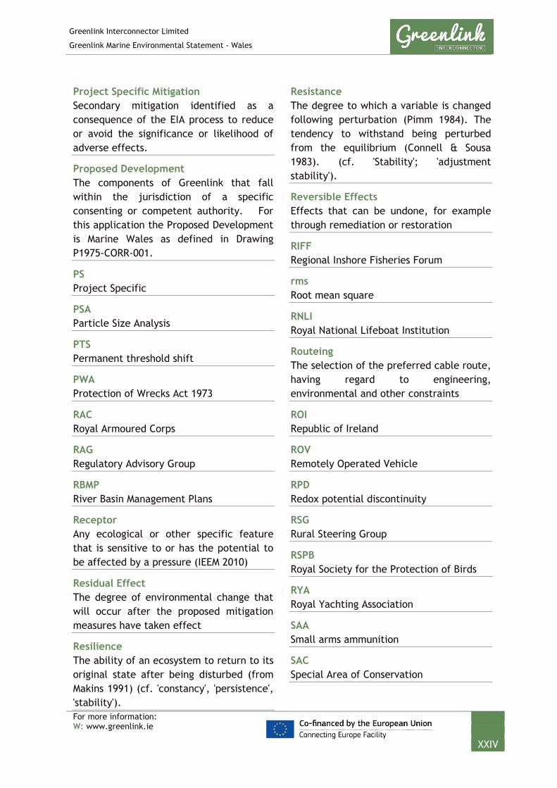
Project Specific Mitigation Secondary mitigation identified as a consequence of the EIA process to reduce or avoid the significance or likelihood of adverse effects.
Proposed Development The components of Greenlink that fall within the jurisdiction of a specific consenting or competent authority. For this application the Proposed Development is Marine Wales as defined in Drawing P1975-CORR-001.
PS Project Specific
PSA Particle Size Analysis
PTS Permanent threshold shift
PWA Protection of Wrecks Act 1973
RAC Royal Armoured Corps
RAG Regulatory Advisory Group
RBMP River Basin Management Plans
Receptor Any ecological or other specific feature that is sensitive to or has the potential to be affected by a pressure (IEEM 2010)
Residual Effect The degree of environmental change that will occur after the proposed mitigation measures have taken effect
Resilience The ability of an ecosystem to return to its original state after being disturbed (from Makins 1991) (cf. 'constancy', 'persistence', 'stability').
Resistance The degree to which a variable is changed following perturbation (Pimm 1984). The tendency to withstand being perturbed from the equilibrium (Connell & Sousa 1983). (cf. 'Stability'; 'adjustment stability').
Reversible Effects Effects that can be undone, for example through remediation or restoration
RIFF Regional Inshore Fisheries Forum
rms Root mean square
RNLI Royal National Lifeboat Institution
Routeing The selection of the preferred cable route, having regard to engineering, environmental and other constraints
ROI Republic of Ireland
ROV Remotely Operated Vehicle
RPD Redox potential discontinuity
RSG Rural Steering Group
RSPB Royal Society for the Protection of Birds
RYA Royal Yachting Association
SAA Small arms ammunition
SAC Special Area of Conservation

Greenlink Interconnector Limited
Greenlink Marine Environmental Statement - Wales
For more information: W: www.greenlink.ie
XXV
SBP Sub-bottom profiler
SCI Site of Community Importance
SDA Sea Danger Area
SEA Strategic environmental assessment
SEACAMS A collaborative project between Bangor, Swansea and Aberystwyth Universities
Secondary mitigation Actions that will require further activity in order to achieve the anticipated outcome. These may be imposed as part of the planning consent, or through inclusion in the environmental reporting. They tend to operate in the middle of the mitigation hierarchy, focusing on reducing the significance or likelihood of adverse effects. They are referred to as Project Specific Mitigation in the EIAR.
SEL Sound Exposure Levels
Sensitivity An assessment of the intolerance of a species or habitat to damage from an external factor and the time taken for its subsequent recovery. For example, a very sensitive species or habitat is one that is very adversely affected by an external factor arising from human activities or natural events (killed/destroyed, 'high' intolerance) and is expected to recover over a very long period of time, i.e. >10 or up to 25 years ('low'; recoverability). Intolerance and hence sensitivity must be assessed relative to change in a specific factor.
SERIFF South East Regional Inshore Fisheries Forum
SFWD Directive 2006/113/EC on the quality required of shellfish waters (Shellfish Waters Directive)
Short-term Effects Effects lasting one to seven years
SID Strategic Infrastructure Development
SL Source level
SLR Sea Level Rise
SNH Scotland Natural Heritage
SNS Southern North Sea
SOLAS V International Convention for the Safety of Life at Sea
SOPEP Shipboard oil pollution emergency plan
SPA Special Protection Area
SPL Sound Pressure Levels
SPM Suspended particulate matter
SSB Spawning stock biomass
SSS Side Scan Sonar
SSSI Site of Special Scientific Interest

Greenlink Interconnector Limited
Greenlink Marine Environmental Statement - Wales
For more information: W: www.greenlink.ie
XXVI
STECF Scientific, Technical & Economic Committee for Fisheries
S&WWFC South & West Wales Fishing Communities
TAC Total Allowable Catches
TBT Tributyltin
Temporary Effects Effects lasting less than a year
TEN-E Regulation (EU) No 347/2013 guidelines for trans-European energy infrastructure
Territorial waters Waters within 12 nautical miles of the coastline
Tertiary mitigation (inexorable) Actions that would occur with or without input from the EIA feeding into the design process. These include actions that will be undertaken to meet other existing legislative requirements, or actions that are considered to be standard practices used to manage commonly occurring environmental effect. This can be identified at any point during the design and EIA process. They are referred to as ‘Embedded Mitigation’ in the ES.
TII Transport Infrastructure Ireland
TJP Transition joint pit
Transboundary Effects Effects from a project that cross an international boundary.
TSHD Trailing suction hopper dredger
TSS Traffic Separation Scheme
TTS Temporary threshold shift
UKBAP UK Biodiversity Action Plan
UKHO UK Hydrographic Office
UAIA Underwater Archaeological impact assessment
UAU Underwater Archaeology Unit
UAV Unmanned autonomous vehicle
UXO Unexploded Ordnance
UXBs Unexploded Bombs
VC Vibrocore
VMS Vessel Monitoring Systems
VSC Voltage Source Conversion
WCC Wexford County Council
WFA Welsh Fisherman’s Association
WFD Water Framework Directive 2000/60/EC establishing a framework for Community action in the field of water policy
WMFAG Welsh Marine Fisheries advisory Group

Greenlink Interconnector Limited
Greenlink Marine Environmental Statement - Wales
For more information: W: www.greenlink.ie
XXVII
WNMP Welsh National Marine Plan
Wrapper document A document which summarises all components of the planning application (Welsh Onshore, Welsh Marine, Irish Offshore, Irish Marine, Irish Onshore), will be prepared and will be available online at www.greenlink.ie once all planning applications have been submitted.
WSI Written Scheme of Investigation
WWSFA West Wales Shell Fisherman’s Association
XLPE Cross-linked polyethylene
ZOI Zone Of Influence
The spatial extent over which an activity is predicted to have an impact on the receiving environment.

Greenlink Interconnector Limited
Greenlink Marine Environmental Statement - Wales
For more information: W: www.greenlink.ie
1-1
1. IntroductionThis Environmental Statement (ES) documents the Environmental ImpactAssessment (EIA) process and conclusions as carried out in support of an applicationfor consent to install, operate, maintain and eventually decommission an electricityinterconnector linking the existing electricity grids in Great Britain (GB) and Ireland.
1.1 The Proposed Development
Greenlink Interconnector Limited (GIL) is proposing to develop an electricity interconnector (Greenlink) linking the existing electricity grids in GB and Ireland (Figure 1-1). The Greenlink project will consist of two converter stations, one close to the existing substation at Great Island in County Wexford (Ireland) and one close to the existing substation at Pembroke in Pembrokeshire (Wales). The converter stations will be connected by underground cables (onshore) and subsea cables (offshore).
The project is designated as a European Union Project of Common Interest (PCI), project number 1.9.1, under the provisions of European Union Regulation No. 347/2013 on guidelines for Trans-European Network for Energy (TEN-E Regulations) and has successfully applied for funding under the Connecting Europe Facility (CEF). It was granted an Interconnector Licence in Great Britain, by Ofgem (the UKs Government regulator for gas and electricity markets), on 10th February 2015 and was awarded Initial Project Assessment (IPA) Status under Ofgem’s Cap and Floor Regime on 30th September 2015.
In Wales, a connection agreement has been signed with National Grid Electricity Transmission plc for a grid connection at the existing Pembroke substation.
In Ireland, GIL’s connection application is being progressed by EirGrid (the transmission network operator). GIL anticipates that EirGrid will issue a formal connection offer in summer 2019.
This ES covers the Welsh Marine components of Greenlink from mean high-water springs (MHWS) at the Welsh landfall at Freshwater West, Pembrokeshire out to the UK/Ireland median line, a distance of 73.9km with an average width of 500m. This is defined as the Proposed Development and comprises:
• Two high voltage direct current (HVDC) electricity power cables;
• A smaller fibre-optic cable for control and communication purposes;
• All associated works required to install test, commission and complete theaforementioned cables; and
• All associated works required to operate, maintain, repair and decommissionthe aforementioned cables, including five repair events over the 40 year lifetimeof Greenlink.
The location of Greenlink is illustrated in Figure 1-1 (Drawing P1975-LOC-001). The Proposed Development is illustrated in Figure 1-2 (Drawing P1975-CORR-001).

BaginbunBeach
GREENLINK INTERCONNECTORROUTE OVERVIEW
Chris GoodeEmma Langley
Monday, April 8, 2019 08:45:37WGS_1984_UTM_Zone_30N
D_WGS_1984DCCAE; UKHO; CDA; GEBCO; MarineFind; Greenlink
WGS_1984
NOTE: Not to be used for Navigation
© Copyright Department of Communications, Climate Action and Environment (DCCAE); Contains public sector information, licensed under the Open Government Licence v2.0, from the UKHO, 2018.; Contains data from UKOGD.; © The GEBCO Digital Atlas published by the British Oceanographic Data Centre on behalf of IOC and IHO, 2003; Charts from MarineFIND.co.uk © Crown Copyright, 2015. All rights reserved. Licence No: EK001-1001-WEB105. Not to be used for Navigation.
Anna Farley
250000
250000
300000
300000
350000
350000
57000
00
57000
00
57500
00
57500
00
58000
00
58000
00
58500
00
58500
00
LegendLandfall
Baginbun BeachFreshwater WestGreenlink Route Centreline (Indicative)
Administrative BoundariesROI 12nm Territorial Sea LimitUK 12nm Territorial Sea LimitMedian Line
0 10 20 30 40km © Metoc Ltd, 2019.
All rights reserved.
J:\P1975\Mxd\01_LOC\P1975-LOC-001.mxd
Created ByReviewed By
DateProjection
DatumData Source
File Reference
Spheroid
Approved By
Drawing No: P1975-LOC-001 A
FreshwaterWest
0 1 2 3 4km
0 1 2 3 4km

Chris GoodeEmma Langley
Wednesday, June 5, 2019 12:44:02WGS_1984_UTM_Zone_30N
D_WGS_1984CDA; GEBCO; UKHO; ;OSOD; MarineFind
WGS_1984
NOTE: Not to be used for Navigation
Contains data from UKOGD.; © The GEBCO Digital Atlas published by the British Oceanographic Data Centre on behalf of IOC and IHO, 2003; -; Contains public sector information, licensed under the Open Government Licence v2.0, from the UKHO, 2018.; Contains Ordnance Survey data © Crown copyright and database right 2019; Charts from MarineFIND.co.uk © Crown Copyright, 2015. All rights reserved. Licence No: EK001-1001-WEB105. Not to be used for Navigation.
Anna Farley
12
3 45 6 7 8
9 1011
252627
28293031
3233
300000
300000
325000
325000
350000
350000
56750
00
56750
00
57000
00
57000
00
57250
00
57250
00
57500
00
57500
00
LegendProposed Development PointsGreenlink Route Centreline (Indicative)Proposed DevelopmentIrish OffshoreUK Mean High Water12nm LimitMedian Line
0 3 6 9 12km © Metoc Ltd, 2019.
All rights reserved.
J:\P1975\Mxd\03_CORR\P1975-CORR-001.mxd
Created ByReviewed By
DateProjection
DatumData Source
File Reference
Spheroid
Approved By
11 12 13 1415
1617
1819
2021
2223
2425
0 1 2 3 4km
Drawing No: P1975-CORR-001 A
GREENLINK INTERCONNECTORPROPOSED DEVELOPMENT
UK Waters
Id WGS 1984 Longitude (°) WGS 1984 Latitude (°) BNG Easting (m) BNG Northing (m)1 -6.1001 51.6813 116618 2060742 -6.0239 51.6732 121828 2048813 -5.7903 51.6583 137885 2023594 -5.6623 51.6605 146746 2021525 -5.4630 51.6503 160474 2003486 -5.4267 51.6505 162980 2002467 -5.4233 51.6524 163231 2004508 -5.3888 51.6527 165665 2003299 -5.3097 51.6648 171213 201414
10 -5.2264 51.6646 176974 20113611 -5.1707 51.6448 180729 19876512 -5.1490 51.6437 182223 19857113 -5.1211 51.6440 184155 19852814 -5.1054 51.6442 185245 19850315 -5.1050 51.6498 185300 19911716 -5.0977 51.6553 185828 19971117 -5.0907 51.6583 186327 20002318 -5.0703 51.6638 187765 20058219 -5.0629 51.6609 188265 20022820 -5.0810 51.6563 186989 19978021 -5.0915 51.6527 186249 19940822 -5.0979 51.6479 185778 19889023 -5.0986 51.6424 185706 19828424 -5.1147 51.6379 184571 19782625 -5.1736 51.6407 180508 19831326 -5.2292 51.6604 176763 20067727 -5.3084 51.6604 171281 20091728 -5.4011 51.6461 164732 19968029 -5.4634 51.6459 160420 19985030 -5.6627 51.6560 146695 20165431 -5.7904 51.6538 137857 20185932 -6.0248 51.6688 121742 20438933 -6.1001 51.6768 116589 205567

Greenlink Interconnector Limited
Greenlink Marine Environmental Statement - Wales
For more information: W: www.greenlink.ie
1-4
Separate ESs will be prepared which cover individually the Welsh Onshore; the Irish Onshore; the Irish Marine (the submarine route from MHWS at the Irish landfall at Baginbun Bay, County Wexford to the 12nm limit) and Irish Offshore (the submarine route from the 12nm limit to the Ireland/UK median line; and the Welsh Marine (the submarine route from the UK/Ireland median line to the MHWS at the Welsh landfall at Freshwater West, Pembrokeshire. Once submitted these will be available online at www.greenlink.ie. The boundaries of the individual components described above are shown in Figure 1-3.
A wrapper document which summarises all components of the planning application (Welsh Onshore, Welsh Marine, Irish Offshore, Irish Marine, Irish Onshore), will be prepared and will be available online at www.greenlink.ie once all planning applications have been submitted.
Figure 1-3 Components of Greenlink
1.2 The Aim of the Document
The aim of the ES is to present, in a logical and comprehensive fashion, the findings and outcomes of the EIA.
The EIA process follows a systematic approach to assess the potential impacts and subsequent effects of a project on the environment in a robust and transparent manner. There are three stages to the process: screening, scoping and assessment (described fully in Chapter 5).
The focus of the EIA and subsequent ES was developed during the Scoping phase of the process, in consultation with statutory and non-statutory stakeholders. The ES

Greenlink Interconnector Limited
Greenlink Marine Environmental Statement - Wales
For more information: W: www.greenlink.ie
1-5
encompasses all aspects of the environment where it is considered there could be a potential effect, but focuses in more detail on topics which were highlighted by stakeholders.
The Scoping Report (Intertek EWCS 2018) is available online at www.greenlink.ie. All scoping comments received from stakeholders throughout the EIA process up to submission of the ES are summarised at the start of each relevant topic chapter.
1.3 Statutory Consents and Permissions
The ES will be submitted to Natural Resources Wales (NRW) in line with The Marine Works (Environmental Impact Assessment) Regulations 2007 (as amended) in support of an application for a Marine Licence under the Marine and Coastal Access Act 2009 (MCAA).
In addition, it will also be submitted to Milford Haven Port Authority in line with The Marine Works (Environmental Impact Assessment) Regulations 2007 (as amended) in support of an application for a Marine Works Licence for works within the port authority’s jurisdiction under the Milford Haven Conservancy Act 1983.
Further details of the other consents that will be required, consenting process and legislation that GIL will comply with is provided in Chapter 2.
1.4 The Developer
The Greenlink project is being developed by Greenlink Interconnector Limited, which is owned jointly by Element Power Holdings, part of Hudson Sustainable Investment, and Partners Group on behalf of its clients. Hudson Sustainable Investment is an independent investment management firm with a strong track record and expertise in investing in and developing sustainable energy infrastructure projects in Ireland, the UK and internationally. Partners Group is a global private markets investment management firm with €73 billion in investment programs under management in private equity, private real estate, private infrastructure and private debt.
1.5 The Project Team
The GIL team is highly experienced in the project development and construction of electricity interconnectors. The team has been supported during the EIA process by a number of specialist contractors.
Intertek Energy & Water Consultancy Services (Intertek EWCS) is the lead EIA manager for the project assisting GIL with data collection, analysis and interpretation in support of route development, consenting and mitigation.
Intertek EWCS is part of the part of Intertek Group plc, a FTSE 100 listed company quoted on the London Stock Exchange. Previously Metoc, Intertek EWCS has been operating since 1983, providing specialist technical services in the marine, coastal and river environments. The company has considerable experience in undertaking interconnector route development and EIAs and managing supporting surveys, and

Greenlink Interconnector Limited
Greenlink Marine Environmental Statement - Wales
For more information: W: www.greenlink.ie
1-6
has led the environmental assessment process on ten of the interconnectors that connect into the UK. In addition, the company has worked on the other two interconnectors that are constructed or proposed connecting into Ireland.
Specialist technical input has been provided by the following consultants:
• MMT – marine cable route survey
• Cotswold Archaeology – marine archaeology
• 1st Line Defence – unexploded ordnance
• MarineSpace Ltd – commercial fisheries
• Arup – onshore environmental consultants
A full list of technical experts who were involved in compiling the ES are provided in Technical Appendix O.
1.6 Structure of the Environmental Statement
The ES comprises 18 chapters, a stand-alone Non-Technical Summary (NTS) document and 15 Technical Appendices.
The ES is structured as outlined in Table 1-1. Topics are discussed in full within each chapter in a consistent and sequential manner i.e. each environmental receptor chapter describes the baseline, impact assessment, mitigation measures and conclusions for the receptor. For each topic receptor the baseline is described in sequence following the Proposed Development from the landfall to the median line.
Table 1-1 Structure of the ES
Chapter Title Content
0 Non-Technical Summary The aim of the NTS is to enable communication with those unfamiliar with the EIA process and terminology by summarising the key findings of the ES in simple terms.
1 Introduction An introduction describing the developer, the content of the ES and summarising the Proposed Development.
2 Policy and Legislative Framework
A description of the legislative frameworks which govern the Proposed Development and the EIA process.
3 Development of the Project and Alternatives
This chapter outlines the need for the interconnector, and why the Proposed Development is preferable to alternative options.
4 Project Description A description of the Proposed Development in terms of the activities that will be undertaken and emissions to the environment during construction and operation of Greenlink. This chapter also presents embedded mitigation; measures which are an inherent part of the design of the Proposed Development (primary mitigation); and actions that will be undertaken to meet existing legislative requirements and are considered to be standard practice (tertiary mitigation).
5 Impact Assessment Methodology
A description of the process followed when conducting the EIA.
This chapter also presents an overview of the results of the scoping consultation and summarises the technical studies and specific surveys that have been undertaken to inform the EIA.

Greenlink Interconnector Limited
Greenlink Marine Environmental Statement - Wales
For more information: W: www.greenlink.ie
1-7
Chapter Title Content
6 Physical Conditions and Marine Processes
These chapters describe the physical, biological and human baseline environment in the Proposed Development including identification of key receptors and their sensitivity to possible effects. The findings of the EIA process are reported, which takes into consideration the nature, magnitude, duration of the potential effects in order to determine their significance. If necessary, secondary mitigation (Project Specific Mitigation) measures to avoid, reduce or remedy the effects identified are described.
The chapters are informed by the relevant studies and surveys undertaken for the Proposed Development.
7 Benthic and Intertidal Ecology
8 Fish and Shellfish
9 Birds
10 Marine Mammals and Reptiles
11 Protected Sites
12 Commercial Fisheries
13 Shipping and Navigation
14 Infrastructure and Other Users
15 Marine Archaeology
16 Cumulative Effects Assessment
Possible effects from Greenlink and the Proposed Development in combination with other power cable developments as well as other types of development in the vicinity have been assessed and are presented.
17 Schedule of Mitigation This chapter outlines the embedded (primary and tertiary mitigation) and Project Specific Mitigation (secondary mitigation) measures proposed in the assessment.
18 Conclusions This chapter provides overall conclusions on the significance of any effects, proposed mitigation and how measures will be implemented.
Appendix A Compliance with Draft Welsh National Marine Plan
Appendix B Meetings held with Welsh stakeholders to inform Proposed Development and EIA
Appendix C Greenlink Habitats Regulations Assessment (HRA)
Appendix D Noise Assessment
Appendix E Herring Spawning and Sandeel Assessment
Appendix F Commercial Fisheries Assessment
Appendix G Marine Archaeology Technical Report
Appendix H Water Framework Directive Assessment Scoping
Appendix I Cable Route Survey Report
Appendix J Benthic Survey Report
Appendix K Intertidal Habitat Survey Report
Appendix L Marine Detailed UXO Risk Assessment
Appendix M Written Scheme of Investigation (WSI) and Protocol for Archaeological Discoveries (PAD)
Appendix N Welsh and Irish Landfall Final Selection Report
Appendix O Competent Experts

Greenlink Interconnector Limited
Greenlink Marine Environmental Statement - Wales
For more information: W: www.greenlink.ie
1-8
1.7 Sources of Data and Information
The information contained within this ES has been drawn from existing literature, project-specific data, personal communications with local experts and statutory bodies and site-specific studies and surveys commissioned for the Proposed Development. Every effort has been made to obtain data concerning the existing environment and to accurately predict the likely environmental effect of the proposed development. Assumptions adopted in the evaluation of the effects are reported in the relevant sections.
Key literature sources used in the EIA process are listed at the beginning of each section; and referenced throughout the topic chapters. Specialist studies and surveys have also been carried out to inform the EIA process. These are listed in Table 1-2.
The data collected throughout these assessments and surveys have been used to define the baseline conditions – against which impacts have been measured and predicted, in turn helping to define the secondary mitigation measures required. More information on these studies is provided in the relevant chapters of the ES.
Table 1-2 Specialist studies
Document Author
Greenlink Cable Route Survey: Geophysical & Geotechnical Report - Offshore
MMT
Greenlink Cable Route Survey: Geophysical & Geotechnical Report – Nearshore
MMT
Greenlink Cable Route Survey: Environmental Survey Report MMT
Phase 1 Intertidal surveys: Freshwater West and Baginbun Beach MarineSpace
Greenlink – Marine Archaeology Technical Report Cotswold Archaeology
Greenlink Interconnector Commercial Fisheries Assessment MarineSpace
Greenlink - Detailed Unexploded Ordnance (UXO) Risk Assessment
1st Line defence
Greenlink Freshwater West - Detailed Unexploded Ordnance (UXO) Risk Assessment
1st Line defence
Greenlink Cable Burial Risk Assessment Intertek EWCS
Greenlink Welsh and Irish Landfall Final Selection Report Intertek EWCS
Greenlink Route Development Report Intertek EWCS
Greenlink Trenching Analysis Intertek EWCS
Greenlink Landfall HDD Report Arup
Greenlink Winter Bird Counts Arup
1.8 Consultation
GIL has taken a pro-active approach to consultation, recognising that it is a critical activity in the development or a comprehensive and balanced EIA.
Discussions started in 2016 with NRW, local planning authorities, statutory bodies and other non-statutory stakeholder groups, and have continued throughout the EIA

Greenlink Interconnector Limited
Greenlink Marine Environmental Statement - Wales
For more information: W: www.greenlink.ie
1-9
process. Stakeholders have had the opportunity to inform route development, environmental surveys, and EIA scope and content.
Over 30 statutory and non-statutory organisations were asked for opinions on the proposed approach to, and scope of, the EIA as outlined in a Scoping Report. Scoping comments were requested twice; firstly in 2016 (Intertek 2016) and then again formally in 2018 (Intertek EWCS 2018). All comments and data received during both Scoping exercises has been used in the EIA process and has helped provide direction on the topics the EIA focuses on. Further details of the Scoping stage are provided in Chapter 5.
As a European PCI project GIL is also required to conduct public consultation through a variety of means set out in the TEN-E Regulation and the UK and Welsh Manual of Procedures and as set out in detail in GIL’s concept of public participation. Wider public participation was achieved through:
• Development and regular updates to Project Website (https://www.greenlink.ie/project)
• Public consultation meetings
• Provision of public information brochure (TEN-E Regulation Information Brochure) – published before the start of formal public consultation and updated throughout the development process.
Comments received through the public meetings have also been considered in the preparation of this ES. Further details on the public consultation is provided in Chapter 5.
1.9 Availability of the ES
The full ES, the NTS and Technical Appendices are available in electronic copy on request or are available for download from the Greenlink website.
To request a digital copy please contact GIL at:
Intertek EWCS, Exchange House, Station Road, Liphook, Hampshire, GU30 7DW, UK
Email: [email protected]
Website: www.greenlink.ie
Greenlink Interconnector Limited
Greenlink Marine Environmental Statement - Wales
For more information: W: www.greenlink.ie
1-10
1 Intertek EWCS (2016). Greenlink Interconnector Environmental Scoping Report – UK Marine Route. P1975F_R3994_Rev1 Final_20161219
2 Intertek EWCS (2018). Greenlink Interconnector Environmental Scoping Report – UK Marine Route. P1975F_R3994_Rev2 Final_20181029
3 NRW (2019). SC1816 Scoping Opinion dated 29 January 2019.
REFERENCES
Greenlink Interconnector Limited
Greenlink Marine Environmental Statement - Wales
For more information: W: www.greenlink.ie
1-1
2. Policy and Legislative Framework This Chapter provides a brief overview of the key European, National and Local Energy and Planning Policies which support the ‘Need’ for Greenlink (further described in Chapter 3) and the Proposed Development; and the marine planning policy in Wales. It also sets out the legislative framework and marine licensing and permitting requirements that apply to the installation, repair and maintenance, operation and decommissioning of Greenlink.
There is no requirement for an EIA to address energy or planning policy, and there is no requirement to set out energy or planning policy within an ES. However, a brief overview is useful in identifying the support for the Proposed Development.
2.1 Energy Policy
This section summarises the energy and planning policies that support the delivery of the Proposed Development. Greenlink has been awarded Project of Common Interest (PCI) status by the European Commission, making it one of Europe’s most important energy infrastructure projects and granting it the “highest national significance” possible.
2.1.1 European policy
The ‘Energy Union’ launched by the European Commission in February 2015, and endorsed by Member States in October 2015, is driving a fundamental transition towards more innovative ways to produce, transport and consume energy, and to address different approaches to design, implement and, where needed, enforce energy policy. A range of actions will be required to make this happen, including improvements to the physical interconnectedness of energy grids (both gas and electricity) to meet a 10% interconnection target by 2020 and to possibly reach 15% by 2030. As of November 2017, 17 EU Member States have reached the 10% target, with a further 7 on the path to reach the target by 2020. The UK’s expected level of interconnection in 2020 is 8% (European Commission 2017).
An interconnected European energy grid is vital for Europe's energy security, for more competition in the internal market resulting in more competitive prices, and for better achieving the decarbonisation and climate policy targets, to which the European Union (EU) has committed. An interconnected grid will help to deliver the ultimate goal of the Energy Union i.e. to ensure affordable, secure and sustainable energy, as well as growth and jobs across Europe.
There is broad consensus that, in a post-Brexit world, the efficient cross-border trade in electricity between the UK and the EU should continue. The UK government has stated its commitment to mechanisms to achieve this (BEIS 2019).
Whether there is a ‘hard’ or ‘soft’ Brexit Greenlink will not only remain economically viable, but will continue to offer benefits to both Ireland and the UK
Greenlink Interconnector Limited
Greenlink Marine Environmental Statement - Wales
For more information: W: www.greenlink.ie
1-2
in the shape of increased energy security, decarbonisation and downward pressure on consumer bills (CRU 2018).
This was confirmed by the Irish utility regulator (the Commission for Regulation of Utilities Water and Energy, CRU) when in October 2018 it determined, after a detailed consultation, that Greenlink is in the public interest, with “the potential to provide a net benefit to Irish consumers and Ireland as a whole.”
The CRU’s analysis included modelling of Brexit sensitivities and concluded that under Brexit “introducing a new interconnector may unlock more benefits to Irish consumers compared to a no Brexit scenario where no trading frictions are present.” The CRU explained: “this is because the addition of Greenlink in a market with trading frictions provides an additional link to import/export route and hence consumers are better off than without the addition of a new interconnector.” (CRU 2018)
Whatever the future holds, Greenlink will be an example of how the UK and Ireland can continue to work positively and profitably together to meet their energy and economic objectives.
2.1.1.1 TEN-E Regulation: Regulation (EU) No 347/2013
In 2013, the EU adopted Regulation (EU) No 347/2013 on Guidelines for Trans-European Networks for Energy (TEN-E Regulation). The TEN-E Regulation sets out guidelines for streamlining the permitting processes for major energy infrastructure projects that contribute to European energy networks. These are referred to as Projects of Common Interest (PCIs).
The EU identified 248 energy infrastructure projects in the first PCI list. These PCI projects encompassed a range of network development, smart grids, energy storage and interconnector projects involving two or more EU Member states. To ensure effective and efficient implementation of the projects, the European Commission is focusing on improving regional cooperation between Member States as part of the implementation of the TEN-E Regulations.
Greenlink achieved PCI status under the TEN-E Regulation in November 2017.
The TEN-E Regulation requires that each Member State assign a single co-ordinating authority, also known as the National Competent Authority (NCA), as being responsible for facilitating and coordinating the permit granting process for projects within that Member State, and to co-ordinate with other NCA’s on PCI projects. In Wales, the NCA is the Welsh Government. The TEN-E Regulation requires that PCI projects are given ‘priority status’ at a national level to ensure rapid administrative treatment. To address this GIL have discussed the ‘Schedule of Permit Granting Process’ which outlines the ‘in principle’ timeline for the permit granting process with the Welsh Government, Natural Resources Wales, Pembrokeshire County Council and Pembrokeshire Coast National Park Authority.
Article 10(4)(a) of the TEN-E Regulation requires the NCA to identify the scope of material and level of detail of information to be submitted by the project

Greenlink Interconnector Limited
Greenlink Marine Environmental Statement - Wales
For more information: W: www.greenlink.ie
1-3
proponent, as part of the application for the comprehensive decision (i.e. the “decision or set of decisions taken by a Member State authority or authorities that determines whether or not a project promoter is to be granted authorisation to build the energy infrastructure to realise a project”). For the marine elements of the project this includes for the Marine Licence (see Section 2.3.3.1 below).
Article 10(4)(c) of the TEN-E Regulation requires the project proponent to submit a “draft application file” to the NCA. The project proponent is also required to make the “draft application file” available to consultees and the public for comment. Following receipt of the file, the NCA are required to identify whether information is missing and inform the project proponent of omissions.
The Schedule of Permit Granting Process provides that the NCA (in this case, The Welsh Government) will confirm that the “final application file” can be submitted within 3 months of receipt of the “draft application file” or the submission of missing information.
This Environment Statement (ES) has been prepared to accompany a Marine License application (see Section 2.3.3.1 below) which will form part of the ‘Draft Application File’ and ‘Final Application file’.
Specific requirements of the TEN-E Regulation include guidelines for public participation. Annex IV(5) specifies that at the least the following should be undertaken:
• Publish an information leaflet, giving, in a clear and concise manner, an overview of the purpose and preliminary timetable of the project, the national grid development plan, alternative routes considered, expected impacts, including of cross-border nature, and possible mitigation measures, which shall be published prior to the start of the consultation.
• Establish a project website;
• Inform all stakeholders affected about the project through the project website;
• Invite in written form relevant affected stakeholders to dedicated meetings, during which concerns shall be addressed; and
• Undertake at least one public consultation before submission of the “draft application file”.
GIL has complied with these requirements, details of which can be found on the project website: www.greenlink.ie.
2.1.2 Welsh policy
Planning Policy Wales (PPW Edition 10) sets out the land use planning policies of the Welsh Government, supporting the UK’s commitment to the EU Renewable Energy Directive and the UK target of 15% of energy from renewables by 2020 (Welsh Government 2018a).

Greenlink Interconnector Limited
Greenlink Marine Environmental Statement - Wales
For more information: W: www.greenlink.ie
1-4
PPW Edition 10 states that the new PPW embeds the spirit of the Wellbeing of Future Generations Act, through moving us towards a low carbon, resilient society, of providing secure and well-paid jobs, and of building well-connected environments for everyone in Wales that improves our lives and health and enhances our well-being. It seeks to promote adequate and efficient infrastructure, highlighting services such as electricity and telecommunications, as crucial for the economic, social and environmental sustainability of all parts of Wales.
Greenlink aligns with the strategies and objectives described in PPW Edition 10 in developing Wales’ access to a more diverse energy mix including energy from renewable and low carbon energy sources, promoting energy efficiency and enhancing security of supply.
2.1.3 Irish policy
On 6 July 2018 the Irish Department of Communications, Climate Action and Environment (DCCAE) published its National Policy on Electricity Interconnection in Ireland which sets out the strategic importance of interconnection to Ireland and the three pillars of its energy policy – sustainability, security of supply and competitiveness and recognises the benefits to the consumer ‘including lower long-term costs of electricity’ (DCCAE 2018).
Following public consultation in relation to the initial project assessment of Greenlink, the Irish utilities regulator, the Commission for Regulation of Utilities (CRU), determined that Greenlink passes the public interest test in Ireland (CRU 2018).
2.2 Marine Planning
2.2.1 European framework
In 2014 the EU adopted Directive 2014/89/EU establishing a framework for Maritime Spatial Planning (MSP Directive).
Marine Spatial Planning (MSP) is a new approach to the management of our seas. The aim is to ensure a sustainable future for our coastal and offshore waters through managing and balancing the many activities, resources and assets in our marine environment. MSP seeks to adapt spatial planning concepts used on land and, taking into consideration the challenges in the marine environment, apply them to territorial and offshore waters. MSP has emerged as a means of resolving inter-sectoral and cross-border conflicts over marine space.
The directive sets out the framework under which Member States must establish a Marine Spatial Plan (MSP); and details the main goals (Article 5) and minimum requirements (Article 6). The plan must be in place by March 2021.

Greenlink Interconnector Limited
Greenlink Marine Environmental Statement - Wales
For more information: W: www.greenlink.ie
1-5
2.2.2 UK Marine Plan
The UK adopts a Marine Spatial Planning approach to the management of its seas. The aim is to ensure a sustainable future for coastal and offshore waters through managing and balancing the many activities, resources and assets in the marine environment. The UK Marine Policy Statement 2011 (MPS, HM Government 2011), prepared in accordance with Section 44 of the Marine and Coastal Access Act 2009 (MCAA), is the system which directs marine planning activities.
The UK Act requires all public authorities taking authorisation or enforcement decisions that affect, or might affect, the UK marine area do so in accordance with the MPS and relevant marine plans unless relevant considerations indicate otherwise (HM Government 2011). Authorities taking decisions that affect, or might affect, the UK marine area which are not authorisation or enforcement decisions must have regard to the MPS and relevant marine plans.
The MSP sets out the policies intended to help achieve sustainable development in the UK marine areas and provides the framework for preparing marine plans and for taking decisions that affect the marine environment. Marine plans provide more detailed policy and spatial guidance at a country or regional level.
2.2.3 Welsh Marine Plans
The Welsh Government are currently working on the first Welsh National Marine Plan (WNMP), which will guide decisions on the sustainable use of Welsh seas (both inshore and offshore). The plan has been prepared and adopted for the purposes of section 51 of the MCAA in accordance with Schedule 6 of the Act and in conformity with the MPS. Consultation on this plan ended on the 29th March 2018 and responses to the consultation are currently being reviewed. The Welsh Plan will:
• Integrate its policy with the rest of the UK, guided by the MPS.
• Support a vision for clean, healthy, safe and biologically diverse seas.
• Guide future sustainable development.
• Support “blue growth” by directing key decisions taken on the future use of marine space and natural resources (Welsh Government 2018b).
The WNMP covers both the Welsh inshore region (from mean high water spring tides out to 12 nautical miles from shore) and the offshore region (beyond 12 nautical miles).
The management of activities in Welsh waters is split between devolved functions which are the responsibility of Welsh Ministers, and functions which are retained by UK Government. The balance of devolved and retained functions may change with time. At the time of writing, further responsibilities are being devolved to the Welsh Ministers e.g. ports policy, harbour orders and byelaws (with the exception of major trust ports, the only one in Wales being Milford Haven), marine licensing in the offshore area, consenting energy projects up to 350MW.
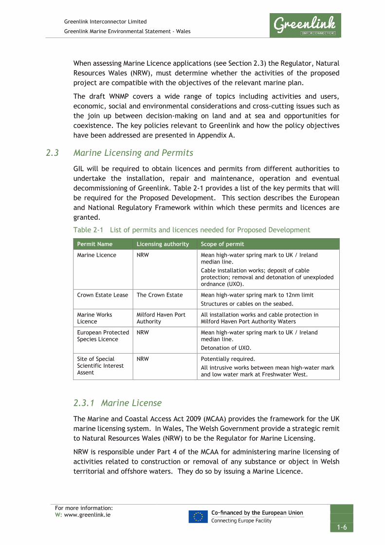
Greenlink Interconnector Limited
Greenlink Marine Environmental Statement - Wales
For more information: W: www.greenlink.ie
1-6
When assessing Marine Licence applications (see Section 2.3) the Regulator, Natural Resources Wales (NRW), must determine whether the activities of the proposed project are compatible with the objectives of the relevant marine plan.
The draft WNMP covers a wide range of topics including activities and users, economic, social and environmental considerations and cross-cutting issues such as the join up between decision-making on land and at sea and opportunities for coexistence. The key policies relevant to Greenlink and how the policy objectives have been addressed are presented in Appendix A.
2.3 Marine Licensing and Permits
GIL will be required to obtain licences and permits from different authorities to undertake the installation, repair and maintenance, operation and eventual decommissioning of Greenlink. Table 2-1 provides a list of the key permits that will be required for the Proposed Development. This section describes the European and National Regulatory Framework within which these permits and licences are granted.
Table 2-1 List of permits and licences needed for Proposed Development
Permit Name Licensing authority Scope of permit
Marine Licence NRW Mean high-water spring mark to UK / Ireland median line. Cable installation works; deposit of cable protection; removal and detonation of unexploded ordnance (UXO).
Crown Estate Lease The Crown Estate Mean high-water spring mark to 12nm limit Structures or cables on the seabed.
Marine Works Licence
Milford Haven Port Authority
All installation works and cable protection in Milford Haven Port Authority Waters
European Protected Species Licence
NRW Mean high-water spring mark to UK / Ireland median line. Detonation of UXO.
Site of Special Scientific Interest Assent
NRW Potentially required. All intrusive works between mean high-water mark and low water mark at Freshwater West.
2.3.1 Marine License
The Marine and Coastal Access Act 2009 (MCAA) provides the framework for the UK marine licensing system. In Wales, The Welsh Government provide a strategic remit to Natural Resources Wales (NRW) to be the Regulator for Marine Licensing.
NRW is responsible under Part 4 of the MCAA for administering marine licensing of activities related to construction or removal of any substance or object in Welsh territorial and offshore waters. They do so by issuing a Marine Licence.

Greenlink Interconnector Limited
Greenlink Marine Environmental Statement - Wales
For more information: W: www.greenlink.ie
1-7
In Wales, it is a licensable activity to install and maintain marine cables and to deposit material on the seabed for the purposes of cable protection within territorial and offshore waters (i.e. from MHWS to the UK/Ireland median line).
When assessing a Marine Licence application, NRW require that the applicant has met all legal requirements under relevant European Union Directives; and in particular:
• Directive 2014/52/EU (amending Directives 2011/92/EU and 85/337/EEC) on the assessment of the impacts of certain private and public projects on the environment (Environmental Impact Assessment [EIA] Directive) (Section 2.3.1.1);
• Directive 92/43/EC on the conservation of natural habitats and of wild fauna and flora (Habitats Directive) (Section 2.3.1.2);
• Directive 2009/147/EC on the conservation of wild birds (Birds Directive (Section 2.3.1.2); and
• Directive 2000/60/EC establishing a framework for Community action in the field of water policy (Water Framework Directive [WFD]) (Section 2.3.1.3).
The purpose, requirement, and how GIL will comply with these Directives are described in Section 2.3.1.1 to 2.3.1.3 below.
As part of the assessment of the marine licence application the regulator will seek advice from their primary advisors and consultees before making a decision on whether to issue the licence. The regulator may consult any person or body it deems fit, in cases involving any matter in which that person or body has particular interest or expertise.
2.3.1.1 EIA Directive
On receipt of a Marine Licence application it is the responsibility of NRW to assess and understand the likely impacts of the proposed activities on the marine environment. The applicant must supply in support of the Marine Licence application sufficiently high-quality information to allow NRW to make a decision about the environmental impact of the Project.
European Directive 2014/52/EU (amending Directives 2011/92/EU and 85/337/EEC) on the assessment of the impacts of certain private and public projects on the environment (the EIA Directive) requires that certain types of project with the potential to significantly affect the environment have an EIA before a licence decision is made.
The EIA Directive is transposed into UK law through the Marine Works (Environmental Impact Assessment) Regulations 2007 (as amended) (MWR). Changes to the EIA Directive were translated into an updated MWR as of 16 May 2017. Schedules A1 and A2 list projects for which the licensing authority must determine that a EIA is to be submitted with the license application or should be screened to determine if an EIA is required, respectively.

Greenlink Interconnector Limited
Greenlink Marine Environmental Statement - Wales
For more information: W: www.greenlink.ie
1-8
In Wales, Greenlink is not EIA development for the purposes of the EIA Directive, and the component parts are not EIA development for the purposes of the:
1. Town and Country Planning (Environmental Impact Assessment) (Wales) Regulations 2017 in respect of the onshore components of the Welsh Proposal; or
2. Marine Works (Environmental Impact Assessment) Regulations 2007 (as amended in 2017) in respect of the offshore elements of the Welsh Proposal.
Screening opinions from the Welsh Government (in respect of the onshore elements of Greenlink) and NRW (in respect of the offshore elements of Greenlink) have confirmed that Greenlink does not constitute EIA development for the purposes of the relevant EIA regulations.
GIL has been advised of a risk of legal challenge in Ireland, where a sometimes broad approach has been taken to the project categories. GIL is keen to ensure that Greenlink is not exposed to any such challenge risk and that actions taken in Wales cannot be suggested to undermine the Irish consenting process. Therefore, an ES/EIAR will be submitted with all relevant applications for consent.
GIL has therefore requested that the Project is screened in by Agreement under regulation 5 of the MWR to undertake a voluntary EIA and produce and Environmental Statement (ES). A Screening Opinion to confirm this was received from NRW on 22 October 2018.
2.3.1.2 Habitats Directive and Wild Birds Directive
European Commission (EC) Directive 92/43/EC on the conservation of natural habitats and of wild fauna and flora (Habitats Directive) and EC Council Directive 2009/147/EC on the conservation of wild birds (Birds Directive) enable European Union member states to work together within the same legislative framework to protect Europe’s most valuable species and habitats, irrespective of political or administrative boundaries. At the heart of these Directives is the creation of a network of sites, known as the Natura 2000 network.
The aim of the Natura 2000 network is to ensure the long-term survival of European threatened species and habitats. The network comprises Special Areas of Conservation (SACs) designated under the Habitats Directive, and Special Protection Areas (SPAs) designated under the Birds Directive. SPAs and SACs are designated by the individual member states.
UK Government policy (ODPM Circular 06/2005) states that sites designated under the Convention on Wetlands (Ramsar, Iran 1971) known as the "Ramsar Convention"1 are also included under the definition Natura 2000. The vast majority of Ramsar sites are also classified as SPAs.
Collectively, SPAs, SACs and Ramsar sites are referred to as European sites under UK Regulations.

Greenlink Interconnector Limited
Greenlink Marine Environmental Statement - Wales
For more information: W: www.greenlink.ie
1-9
Each EU Member State must implement the EU legislation in national law. In the UK, obligations under the Habitats and Birds Directives are transposed in the UK offshore area (broadly from the 12 nautical mile limit outwards) through The Conservation of Offshore Marine Habitats and Species Regulations 2017 (OMHSR), and in territorial waters (MHWS up to 12 nautical miles) by The Conservation of Habitats and Species Regulations 2017. Collectively they are referred to as the ‘Habitats Regulations’.
The ‘Habitats Regulations’ transpose into UK law Article 6(3) of the EC Habitats Directive. This requires project-related activities within European sites to be assessed with regard to their implications for the sites conservation objectives.
Under regulation 28(3) of the OMHSR and regulation 63(2) of the Conservation of Habitats and Species Regulations, a person applying for consent, permission or other authorisation must provide such information as the competent authority may reasonably require for the purposes of assessment or to enable them to determine whether an Appropriate Assessment (AA) is required.
The three tests set out to determine if a proposal will affect a European site are:
• Is the proposal directly connected with or necessary for site management for nature conservation?
• Is the proposal likely to have a significant effect on the site? (this is the Screening Stage)
• Can it be ascertained that the proposal will not adversely affect the integrity of the site? (this is the Appropriate Assessment stage)
The tests are known as the Habitats Regulations Assessment (HRA) process.
A HRA Screening Assessment should be provided with a Marine Licence application if the proposed project is near or within an European site.
The Greenlink Marine HRA is provided in Technical Appendix C and has been used to inform the assessment provided in Chapter 11.
2.3.1.3 Other relevant EU Directives
Water and sediment quality are monitored and regulated in Wales under EC Directives. The most relevant to the project are:
• Directive 2008/56/EC establishing a framework for community action in the field of marine environmental policy (Marine Strategy Framework Directive, MSFD);
• Directive 2000/60/EC establishing a framework for Community action in the field of water policy (Water Framework Directive, WFD);
• Directive 2006/7/EC concerning the management of bathing water quality (Bathing Waters Directive, BWD); and
• Directive 2006/113/EC on the quality required of shellfish waters (Shellfish Waters Directive, SFWD).

Greenlink Interconnector Limited
Greenlink Marine Environmental Statement - Wales
For more information: W: www.greenlink.ie
1-10
The WFD sets out Environmental Quality Standards that are used to assess the risk of chemical pollutant impacts on water quality to the health of aquatic plants and animals. Environmental Quality Standards are set for freshwater, estuarine and coastal waters. The MSFD considers marine water beyond 1nm. Both the WFD and MSFD seek to ensure Good Environmental Status (GES) within designated water bodies. The WFD requires member states to ensure surface water and groundwater achieve "good chemical and ecological status" by 2015 by progressive reductions in pollution and restoration. Under the MSFD each marine region or sub-region needs to achieve GES by 2020 (Articles 1 and 3). Broadly GES for the marine environment means that marine waters are:
• Ecologically diverse;
• Clean, healthy and productive; and
• Used sustainably, so that the needs of current and future generations are safeguarded.
Annex I of the MSFD lists eleven criteria (qualitative descriptors) of GES.
The BWD and the SFWD are only applicable at designated bathing waters and shellfisheries, respectively. Sediment quality within the marine environment is measured using the Centre for Environment, Fisheries and Aquaculture Science (Cefas) action levels (Cefas 1994), which were developed to consider dredged material contamination, however this still provides a guide to the levels contained within sediments for assessment purposes.
A Water Framework Directive Scoping Assessment is provided as Technical Appendix H.
2.3.1.4 Marine Conservation Zones (MCZs)
A key component of the MCAA is the provision of powers to the appropriate authority to designate MCZs; in Wales, the Welsh Government, through NRW. MCZs protect a range of nationally important marine wildlife, habitats, geology and geomorphology, and can be designated anywhere within Welsh territorial and offshore waters.
A main objective when selecting MCZs is to ensure that an ecologically coherent network is achieved. MCZs therefore aim to complement the existing Natura 2000 sites (i.e. SACs, SPAs and Ramsar sites).
Under Section 126 of the MCAA, NRW has a duty to consider MCZs during marine licence decision making. To meet the requirements of Section 126, a MCZ assessment process has been integrated into the marine licence decision making procedures. The process comprises three main stages, i) screening, ii) Stage 1 Assessment, and iii) Stage 2 Assessment.
Screening determines whether Section 126 should apply to the application and therefore require MCZ assessment. It will apply if the licensable activity will take place within or near a MCZ and has the potential to affect the features of an MCZ

Greenlink Interconnector Limited
Greenlink Marine Environmental Statement - Wales
For more information: W: www.greenlink.ie
1-11
or processes on which the conservation of any protected feature of the MCZ is reliant.
Stage 1 Assessment considers whether the conditions of Section 126 can be met. It will be deemed met if information supplied by the applicant demonstrates that there is no significant risk of the activity hindering the achievement of the MCZ conservation objectives. If it cannot be met there are measures which can reduce the risk.
Stage 2 Assessment considers if the benefit of the licensable activity to the public outweighs the risk of damage to the environment and whether the applicant can undertake measures of equivalent environmental benefit to compensate the environmental damage.
A Stage 1 MCZ Assessment has been undertaken for the Skomer MCZ. This is presented within the Greenlink HRA – Technical Appendix C, the conclusions of which are summarised in Chapter 11.
2.3.1.5 Marine Archeology
As part of the UK marine licencing consultation, the statutory stakeholder Cadw (Welsh Government’s historic environment service) requires that the following legislation is considered during the assessment of impact:
• Protection of Wrecks Act 1973
• Ancient Monuments and Archaeological Areas Act 1979
• Protection of Military Remains Act 1986
On consideration of this legislation and prior to work being conducted, a project specific Written Scheme of Investigation (WSI) for Archaeological Remains and a Protocol for Archaeological Discovery (PAD) are required to minimise disturbance and destruction of archaeological features and set out a methodology for investigation.
A draft WSI has been provided as Technical Appendix M.
Protection of Wrecks Act 1973 Under the Protection of Wrecks Act 1973 (PWA), wrecks and wreckage of historical, archaeological or artistic importance can be protected by way of designation. It is an offence to carry out certain activities in a defined area surrounding a wreck that has been designated, unless a licence for those activities has been obtained. Offences include:
• Tampering with, damaging or removing any part of a vessel;
• Carrying out diving or salvage without permits;
• Removing objects from the wreck site; and
• Depositing, so as to fall and lie abandoned on the seabed, anything that would obliterate the site, obstruct access to it, or damage any part of the wreck.

Greenlink Interconnector Limited
Greenlink Marine Environmental Statement - Wales
For more information: W: www.greenlink.ie
1-12
Under the PWA, protection is provided for wrecks that are designated as dangerous due to their contents and is administered on a UK-wide basis by the Maritime and Coastguard Agency (MCA) through the Receiver of Wreck.
Ancient Monuments and Archaeological Areas Act 1979 Although primarily land based, in recent years the Ancient Monuments and Archaeological Areas Act 1979 has also been used to provide some level of protection for underwater sites. The Act provides for the scheduling of monuments, which encompasses buildings, structures or work, cave or excavation, vehicle, vessel, aircraft or other moveable structure. To be eligible for scheduling, a monument must be of national importance. Sites range from standing stones to deserted medieval villages and include recent structures such as collieries and wartime pillboxes.
Protection of Military Remains Act 1986 The Protection of Military Remains Act is used to provide protection for military wrecks of both aircraft and ships. All military aircraft are automatically protected under this legislation. The Act is administered by the Ministry of Defence (MoD) notably the RAF for aircraft and the Royal Navy for vessels. Under this Act, vessels may be designated either as a protected place or as a controlled site.
Wrecks are designated by name and can be designated as protected places even if the location of the site is not known. Thus, the wreckage of a UK military aircraft is automatically a protected place even if the physical remains have not been previously discovered or identified. Shipwrecks need to be specifically designated, and designation as a protected place applies only to vessels that sank after 4 August 1914 (English Heritage 2012). The Act makes it an offence to interfere with a protected place, to disturb the site or to remove anything from it, unless licensed to do so by the MoD. Further details on applicable legislation is provided in Technical Appendix G – Marine Archaeological Technical Report (Cotswold Archaeology 2019).
2.3.2 European Protected Species Licence
Certain species are protected by international, European and national wildlife legislation throughout the UK. This includes protection from intentional or reckless disturbance, taking, harming and killing, and in some cases possession or sale of the species.
There is no intention to take, trade or sell protected species during the proposed project; therefore, this section focuses on the legislation for which it is an offence to recklessly disturb, harm or kill a protected species.
The legislation that applies is:
• The Conservation of Offshore Marine Habitats and Species Regulations 2017 (OMHSR);
• The Conservation of Habitats and Species Regulations 2017; and

Greenlink Interconnector Limited
Greenlink Marine Environmental Statement - Wales
For more information: W: www.greenlink.ie
1-13
• The Wildlife and Countryside Act 1981 (as amended).
Table 2-2 below provides details of the marine species which are currently protected in Wales under this legislation. The schedules to the legislation are regularly reviewed and updated considering scientific evidence.
Table 2-2 UK protection measures for marine species
OMHSR 2017 Conservation of Habitats and Species Regulations 2017
Wildlife & Countryside Act
Schedule 1 (European Protected Species)
Schedule 2 (European Protected Species)
Schedule 5
Whales, Dolphins and Porpoises (all species)
Loggerhead turtle Green turtle
Kemp’s Ridley turtle Hawksbill turtle
Leatherback turtle Common Sturgeon
Whales, Dolphins and Porpoises (all species)
Marine Turtles Common Sturgeon
Otter
Whales, Dolphins and Porpoises (all species)
Basking and Angel Shark Allis shad and Twaite shad
Flatback turtle Green Sea turtle
Loggerhead turtle Olive Ridley turtle
Kemp’s Ridley turtle Hawksbill turtle
Leatherback turtle Common Sturgeon
Short Snouted Seahorse and Spiny Seahorse
Fan Mussel and Freshwater Pearl Mussel
Starlet sea anemone Otter
In Wales, a licence under regulation 49 of the OMHSR, referred to as a ‘European Protected Species Licence’, can be issued to authorise what would otherwise be an offence under the nature conservation legislation. A licence may only be issued where the activity meets certain purposes and where there is no satisfactory alternative. Licences are granted subject to conditions and licence holders are responsible for ensuring compliance with conditions. Failure to comply with conditions is an offence.
Consultation with NRW has identified that if it is necessary to detonate UXO for the purposes of route clearance, a European Protected Species License will be required.
2.3.3 Crown Estate Lease
The Crown Estate own and manage the majority of the seabed out to the 12nm territorial limit. Permission is needed for rights to lay, maintain and operate cables on areas of seabed for which they are the landlord. This is given in the form of a seabed lease (a legal agreement). Occupation of any site and performance of works cannot commence until the lease has been completed.
Greenlink Interconnector Limited
Greenlink Marine Environmental Statement - Wales
For more information: W: www.greenlink.ie
1-14
Applicants are required to obtain all necessary consents from government and crossing and proximity agreements from existing tenants in close proximity to the works and works restriction zone prior to the lease being in place.
2.3.3.1 Crossing and Proximity Agreements
The Proposed Development will cross a third-party telecommunications cable within Welsh offshore waters. The crossing of third party infrastructure is made with prior agreement of the owners following a negotiated formal Crossing Agreement. The Crossing Agreement describes the rights and responsibilities of the parties and also the detailed physical design of the crossing. The design addresses the need to protect both the project cables and the third-party infrastructure and other aspects such as crossing angle and vertical separation.
The exact physical design of the crossing will depend on both the negotiated Crossing Agreement and the resources of the installation contractor and may vary from location to location.
GIL is in the process of negotiating formal Crossing Agreements with the telecommunication owner.
2.3.4 Milford Haven Port Authority - Marine Works Licence
All works within the Port Limits of Milford Haven Port Authority (MHPA) will require a Marine Works Licence under the Milford Haven Conservancy Act 1983. MHPA will request opinion from NRW in relation to potential impacts on protected sites and will need sufficient information with the application to undertake an Appropriate Assessment. This ES will be submitted in support of the Marine Works License.
2.3.5 SSSI Assent
The Proposed Development between MHWS and the low-water mark at the Freshwater West landfall is within the Broomhill Burrows SSSI. To carry out any works within the SSSI, GIL would be required to give notice to NRW under Section 28 E (1) of the Wildlife and Countryside Act 1981 that they wish to carry out works in the SSSI. The application form requires the applicant to provide a method statement for the works and outline measures to be taken to minimise effects on the site.
Although the Proposed Development will pass under the Broomhill Burrows SSSI all installation works will be outside the site. A SSSI Assent will therefore not be required. In future, should any maintenance or repair works be required on the Proposed Development within the site then a SSSI Assent would be sought.

Greenlink Interconnector Limited
Greenlink Marine Environmental Statement - Wales
For more information: W: www.greenlink.ie
1-15
1 Cefas(1994). Cefas Guideline Action Levels for the Disposal of Dredged Material. https://www.pla.co.uk/Environment/Cefas-Guideline-Action-Levels-for-the-Disposal-of-Dredged-Material [Accessed November 2019]
2 Cotswold Archaeology (2019). Marine Archaeological Technical Report
3 CRU (2018) Greenlink Electricity Interconnector Determination. [online] Available at: https://www.cru.ie/wp-content/uploads/2018/10/CRU18216-Greenlink-determination-paper-1.pdf (Accessed May 2019)
4 Department for Business, Energy & Industrial Strategy (BEIS) (2019). Trading electricity if there’s no Brexit deal. Updated 25 March 2019. [online] Available at: https://www.gov.uk/government/publications/trading-electricity-if-theres-no-brexit-deal/trading-electricity-if-theres-no-brexit-deal (Accessed May 2019)
5 Department of Communications, Climate Action & Environment (DCCAE) (2018). National Policy Statement. Electricity Interconnection. [online] Available at: https://www.dccae.gov.ie/en-ie/energy/publications/Documents/19/National%20Policy%20Statement%20on%20Electricity%20Interconnection.pdf (Accessed May 2019)
6 English Heritage (2012) Designation Selection Guide - Ships and Boats: Prehistory to Present.
7 European Commission (2017). Communication from the Commission to the European Parliament, The Council, The European Economic and Social Committee
and the Committee of the Regions. Communication on strengthening Europe’s energy networks. Brussels 23.11.2017. COM (2017) 718 final.
8 HM Government (2011). UK Marine Policy Statement. [Online] Available at: https://assets.publishing.service.gov.uk/government/uploads/system/uploads/attachment_data/file/69322/pb3654-marine-policy-statement-110316.pdf [Accessed September 2018]
9 Welsh Government (2018). Planning Policy Wales: Edition 10. [Online] Available at: https://gov.wales/sites/default/files/publications/2019-02/planning-policy-wales-edition-10.pdf [Accessed April 2019].
10 Welsh Government (2018b). Draft Welsh National Marine Plan. [Online] Available at: https://beta.gov.wales/draft-welsh-national-marine-plan [Accessed September 2019].
REFERENCES
https://www.pla.co.uk/Environment/Cefas-Guideline-Action-Levels-for-the-Disposal-of-Dredged-Material
https://www.pla.co.uk/Environment/Cefas-Guideline-Action-Levels-for-the-Disposal-of-Dredged-Material

Greenlink Interconnector Limited
Greenlink Marine Environmental Statement - Wales
For more information: W: www.greenlink.ie
3-1
3. Development of the Project and Alternatives This Chapter summarises the development of Greenlink, including the alternatives which have been considered and the rationale for selection of the Proposed Development. It considers technology selection of; summarises the processes that were undertaken to identify a Welsh connection point; and sets out the alternative landfalls and marine route options which have been considered in developing Greenlink.
The evolution of the Onshore Wales, Onshore Ireland, Marine Ireland and Offshore Ireland aspects of Greenlink are presented separately in the respective Environmental Statements and Environmental Impact Assessment Reports.
3.1 ‘Do-Nothing Option
The ‘do nothing’ option dictates that generation of electricity needs to be based in the country where it is used and constrains export of electricity when generation exceeds demand. One of the key actions identified in the European Commission Priority Interconnection Plan and the TEN-E regulations is to increase the transmission capacity between countries and improve security of supply.
Greenlink has been awarded Project of Common Interest (PCI) status by the European Commission, making it one of Europe’s most important energy infrastructure projects and granting it the “highest national significance” possible.
The ‘do nothing’ option would therefore not be supported by UK government and EU policy.
3.2 Selection of Technology
Greenlink will consist of a pair of HVDC submarine and underground onshore cables connected to an AC/DC converter station in each country. The converter station in Wales will be connected to the Pembroke substation via high voltage alterna5ting current (HVAC) underground cables. Electricity will be able to flow in either direction between Great Britain (GB) and Ireland.
GB and Irish electricity transportation grids operate as HVAC systems, in which the direction of the current changes (and then changes back) on average fifty times a second. However, an HVAC interconnector between the GB and Irish grids is not technically and economically feasible as:
• The British and Irish grids are not “synchronized”, i.e. the current reversals are not happening at the same times – without this synchronization, power cannot be successfully transmitted between the grids with an HVAC interconnector; and
• The capacity of HVAC underground or subsea cables to transmit power reduces significantly with distance travelled such that an HVAC interconnector would not be an economic means to transmit power between GB and Ireland.
Therefore, a HVDC interconnector, combined with a converter station at each end to change the current to HVAC is the best current technology.

Greenlink Interconnector Limited
Greenlink Marine Environmental Statement - Wales
For more information: W: www.greenlink.ie
3-2
Transmission electricity losses emanate in the form of heat and are increased with the current flowing through the equipment. Losses can therefore be reduced by using HVDC.
3.3 Connection Options
3.3.1 Irish and GB Transmission Networks
The importance of Greenlink, linking the Irish and GB Transmission Networks, is recognised through its PCI status which makes it one of Europe’s most important energy infrastructure projects and granting it the “highest national significance” possible. The requirement and need for Greenlink has been reinforced by Ofgem (GB) and CRU (Ireland) via the completion of a Cost Benefit Analysis which demonstrates that Greenlink offers economic benefit to consumers in both jurisdictions.
3.3.2 Transmission Network Substation Connection Options
The configuration of any interconnector project is influenced by the location of the existing network infrastructure, its ability to accommodate the required connection capacity, any requirement for network reinforcements, and other factors such as environmental constraints. A review of these factors was undertaken for both the Irish and GB Transmission Networks by EirGrid and National Grid Electricity System Operator, respectively.
3.3.3 Irish Transmission Network
A review of suitable points of connection was undertaken in Ireland. Connection locations on the east of Ireland were assessed. Following a network review the most suitable location on the east of the Irish Transmission Network was found to be the Great Island Substation in County Wexford.
3.3.4 GB Transmission Network
The National Grid completed a Connections and Infrastructure Options Note process to assess potential grid connection locations within the GB Transmission Network. Connection locations to the west of the GB Transmission Network were assessed.
The Connections and Infrastructure Options Note process is a defined procedure which is used for all large electricity users and generators seeking connection to the GB electricity network. This process considers both the cost benefit of different connection options and the engineering limitations of the existing network.
Eight substations were initially considered as potential connection points. National Grid Electricity System Operator then completed a Cost Benefit Analysis for the four remaining options (Alverdiscott 400kV, Swansea North 400kV, Pembroke 400kV and Pentir 400kV). Figure 3-1 and Table 3-1 presents a figure and table included in the Connections and Infrastructure Options Note that summarises route distances between Ireland and the four options.
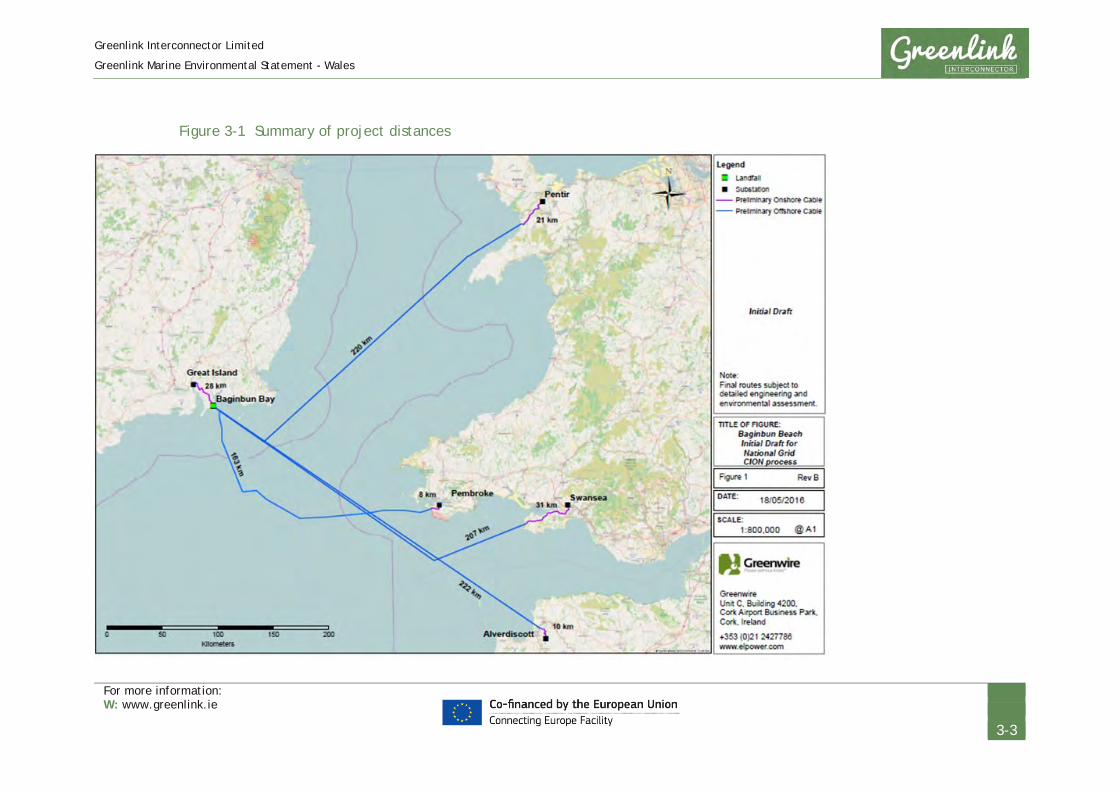
Greenlink Interconnector Limited
Greenlink Marine Environmental Statement - Wales
For more information: W: www.greenlink.ie
3-3
Figure 3-1 Summary of project distances

Greenlink Interconnector Limited
Greenlink Marine Environmental Statement - Wales
For more information: W: www.greenlink.ie
3-4
Table 3-1 Summary of project distances
Distance (km)
Site Onshore Offshore Total Distance
Alverdiscott 400kV 38 222 (direct) 260
Pembroke 400kV 36 159 (known constraints included)
195
Swansea North 400kV 59 207 (direct) 266
Pentir 400kV 49 220 (direct) 269
Note: It was acknowledged that length of direct offshore routes is likely to increase by 10 to 20% as constraints become known and therefore costs would increase accordingly.
After completing the Connections and Infrastructure Options Note and Cost Benefit Analysis, National Grid Electricity System Operator determined the most economical connection point to be Pembroke 400kV substation, requiring only a busbar extension to provide a connection point for Greenlink. National Grid Electricity System Operator also concluded that the site facilitates the connection from other points of view (environmental, consenting etc) and as such is the preferred connection point
3.4 Landfall Options
Following identification of Pembroke substation as the connection point for Greenlink, an options appraisal study of the Pembrokeshire coastline was undertaken using a search area from Strumble Head in the north to Tenby in the south.
The options appraisal (desktop study), undertaken by JP Kenny (2012), considered a range of environmental, technical and economic constraints to identify suitable landfall locations within the search area. It was undertaken in parallel with consideration of onshore locations for converter stations and underground and marine cable routes.
Criteria assessed included vessel access, beach composition, amenity impact, environmental constraints (e.g. presence of protected sites), exposure, coastal erosion, access to beach, cable engineering and protection requirements, obstructions and existing infrastructure.
Eleven potentially suitable landfall locations in Pembrokeshire were identified. Shown on Figure 3-2 (Drawing P1975-LOC-002), these were Broad Haven; Broad Haven South; Freshwater West; Freshwater East; Tenby South Beach; Dale; Whitesands; Abereiddy LF; Aber Mawr 1 & 2; and Strumble Head.
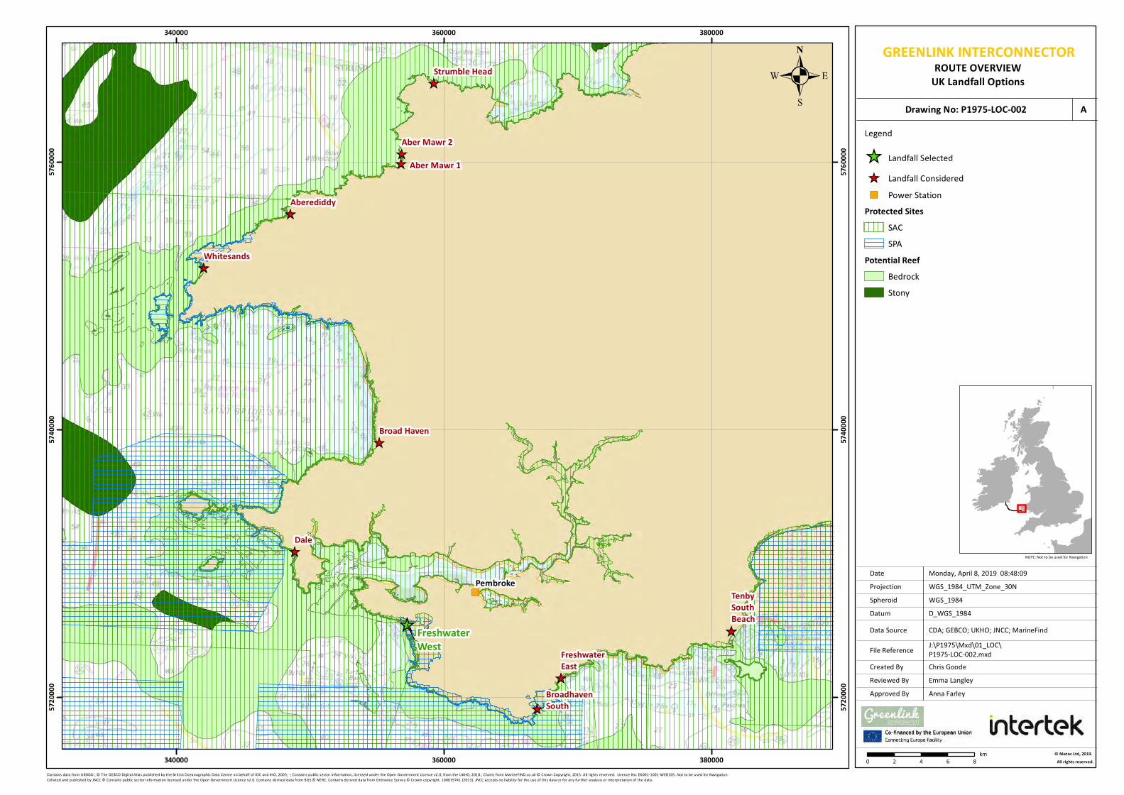
Chris GoodeEmma Langley
Monday, April 8, 2019 08:48:09WGS_1984_UTM_Zone_30N
D_WGS_1984CDA; GEBCO; UKHO; JNCC; MarineFind
WGS_1984
NOTE: Not to be used for Navigation
Contains data from UKOGD.; © The GEBCO Digital Atlas published by the British Oceanographic Data Centre on behalf of IOC and IHO, 2003; -; Contains public sector information, licensed under the Open Government Licence v2.0, from the UKHO, 2018.; Charts from MarineFIND.co.uk © Crown Copyright, 2015. All rights reserved. Licence No: EK001-1001-WEB105. Not to be used for Navigation. Collated and published by JNCC © Contains public sector information licensed under the Open Government Licence v2.0. Contains derived data from BGS © NERC. Contains derived data from Ordnance Survey © Crown copyright. 100019741 (2013). JNCC accepts no liability for the use of this data or for any further analysis or interpretation of the data.
Anna Farley
FreshwaterWest
PembrokeTenbySouthBeach
FreshwaterEast
BroadhavenSouth
Dale
Broad Haven
Whitesands
Aberediddy
Strumble Head
Aber Mawr 1Aber Mawr 2
340000
340000
360000
360000
380000
380000
57200
00
57200
00
57400
00
57400
00
57600
00
57600
00
Legend
Landfall SelectedLandfall ConsideredPower Station
Protected SitesSACSPA
Potential ReefBedrockStony
0 2 4 6 8km © Metoc Ltd, 2019.
All rights reserved.
J:\P1975\Mxd\01_LOC\P1975-LOC-002.mxd
Created ByReviewed By
DateProjection
DatumData Source
File Reference
Spheroid
Approved By
Drawing No: P1975-LOC-002 A
GREENLINK INTERCONNECTORROUTE OVERVIEW
UK Landfall Options
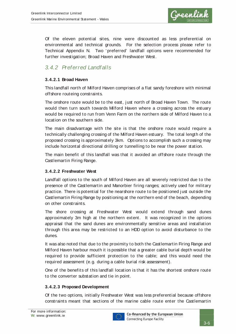
Greenlink Interconnector Limited
Greenlink Marine Environmental Statement - Wales
For more information: W: www.greenlink.ie
3-6
Of the eleven potential sites, nine were discounted as less preferential on environmental and technical grounds. For the selection process please refer to Technical Appendix N. Two ‘preferred’ landfall options were recommended for further investigation; Broad Haven and Freshwater West.
3.4.2 Preferred Landfalls
3.4.2.1 Broad Haven
This landfall north of Milford Haven comprises of a flat sandy foreshore with minimal offshore routeing constraints.
The onshore route would be to the east, just north of Broad Haven Town. The route would then turn south towards Milford Haven where a crossing across the estuary would be required to run from Venn Farm on the northern side of Milford Haven to a location on the southern side.
The main disadvantage with the site is that the onshore route would require a technically challenging crossing of the Milford Haven estuary. The total length of the proposed crossing is approximately 3km. Options to accomplish such a crossing may include horizontal directional drilling or tunnelling to be near the power station.
The main benefit of this landfall was that it avoided an offshore route through the Castlemartin Firing Range.
3.4.2.2 Freshwater West
Landfall options to the south of Milford Haven are all severely restricted due to the presence of the Castlemartin and Manorbier firing ranges; actively used for military practice. There is potential for the nearshore route to be positioned just outside the Castlemartin Firing Range by positioning at the northern end of the beach, depending on other constraints.
The shore crossing at Freshwater West would extend through sand dunes approximately 3m high at the northern extent. It was recognized in the options appraisal that the sand dunes are environmentally sensitive areas and installation through this area may be restricted to an HDD option to avoid disturbance to the dunes.
It was also noted that due to the proximity to both the Castlemartin Firing Range and Milford Haven harbour mouth it is possible that a greater cable burial depth would be required to provide sufficient protection to the cable; and this would need the required assessment (e.g. during a cable burial risk assessment).
One of the benefits of this landfall location is that it has the shortest onshore route to the converter substation and tie in point.
3.4.2.3 Proposed Development
Of the two options, initially Freshwater West was less preferential because offshore constraints meant that sections of the marine cable route enter the Castlemartin

Greenlink Interconnector Limited
Greenlink Marine Environmental Statement - Wales
For more information: W: www.greenlink.ie
3-7
Firing Range. Routeing within the vicinity of the range was thought to be not feasible or at the very least problematic. However, consultation with the Ministry of Defence (MoD) in late 2013 and early 2014 with respect to Freshwater West being a potentially landfall, indicated that routeing within the Castlemartin Firing Range would be permitted. Further discussions with the MoD throughout 2016 and 2017 determined that the co-location of a submarine cable and the military firing range was possible, from the MoD perspective.
3.5 Offshore Route Selection
The development of the submarine cable route balances the need for a technically feasible and economically viable route corridor whilst limiting disturbance to people and the environment, and minimising cable length. In identifying preferred options, and determining if a route is feasible, the physical, environmental and human aspects were considered.
Route development has been an iterative process involving cycles of consultation, refinement and survey. The submarine cable route has been designed to avoid or reduce environmental effects to ALARP levels (i.e. As Low As Reasonably Practicable) while also accommodating other factors.
Three main objectives have driven route development:
• To avoid where possible, or otherwise minimise the distance through which the route crosses reef habitat within the Pembrokeshire Marine Special Area of Conservation (SAC) (Proposed Development) and Hook Head SAC (Marine Ireland);
• To avoid where possible, or otherwise minimise the distance through which the route crosses the Castlemartin Firing Range (Proposed Development); and
• To minimise disruption to shipping associated with Milford Haven (Proposed Development), Waterford Port (Marine Ireland) and offshore traffic separation schemes (Proposed Development).
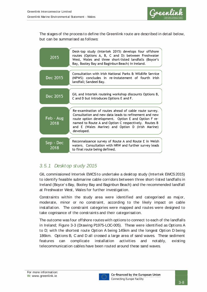
Greenlink Interconnector Limited
Greenlink Marine Environmental Statement - Wales
For more information: W: www.greenlink.ie
3-8
The stages of the process to define the Greenlink route are described in detail below, but can be summarised as follows:
3.5.1 Desktop study 2015
GIL commissioned Intertek EWCS to undertake a desktop study (Intertek EWCS 2015) to identify feasible submarine cable corridors between three short-listed landfalls in Ireland (Boyce’s Bay, Booley Bay and Baginbun Beach) and the recommended landfall at Freshwater West, Wales for further investigation.
Constraints within the study area were identified and categorised as major, moderate, minor or no constraint, according to the likely impact on cable installation. The constraint categories were mapped and routes were designed to take cognisance of the constraints and their categorisation.
The outcome was four offshore routes with options to connect to each of the landfalls in Ireland; Figure 3-3 (Drawing P1975-LOC-005). These were identified as Options A to D; with the shortest route Option A being 145km and the longest Option D being 186km. Options B, C and D all crossed a large area of sand waves. These sediment features can complicate installation activities and notably, existing telecommunication cables have been routed around these sand waves.

Chris GoodeEmma Langley
Friday, April 12, 2019 15:39:30WGS_1984_UTM_Zone_30N
D_WGS_1984DCCAE; CDA; JNCC; NPWS; GEBCO; UKHO; Oceanwise; Greenlink;
WGS_1984
NOTE: Not to be used for Navigation
© Copyright Department of Communications, Climate Action and Environment (DCCAE); Contains data from UKOGD.; Collated and published by JNCC © Contains public sector information licensed under the Open Government Licence v2.0. Contains derived data from BGS © NERC. Contains derived data from Ordnance Survey © Crown copyright. 100019741 (2013). JNCC accepts no liability for the use of this data or for any further analysis or interpretation of the data.; Copyright Government of Ireland. This dataset was created by National Parks and Wildlife Service, Department of Arts, Heritage, Regional, Rural and Gaeltacht Affairs. This copyright material is licensed for re-use under the Creative Commons Attribution 4.0 International licence. http://creativecommons.org/licenses/by/4.0/; Contains Joint Nature Conservation Committee data © copyright and database right [2018]. Contains Natural England data © copyright and database right [2018]. Contains Natural Resource Wales data © copyright and database right [2018]. Contains UK Hydrographic Office data © copyright and database right [2018]. Contains Ordnance Survey data © copyright and database right [2018]. Contains public sector information licensed under the Open Government Licence v3.0.; Contains public sector information licensed under the Open Government Licence v3.0. Link: http://www.nationalarchives.gov.uk/doc/open-government-licence/version/3/; © The GEBCO Digital Atlas published by the British Oceanographic Data Centre on behalf of IOC and IHO, 2003; Contains public sector information, licensed under the Open Government Licence v2.0, from the UKHO, 2018.; © British Crown and OceanWise, 2018. All rights reserved. License No. EK001-ET18001 Not to be used for Navigation
Anna Farley
Offshore Option B
Offshore Option C
Offshore Option D
Offshore Option A
250000
250000
300000
300000
350000
350000
57000
00
57000
00
57500
00
57500
00
58000
00
58000
00
LegendSubstation
Pembroke Power StationGreat Island
LandfallFreshwater WestBaginbun Beach
Preliminary RouteNearshore Route Options (Dependant on Final Landfall)Offshore Option AOffshore Option BOffshore Option COffshore Option DROI 12nm Territorial Sea LimitUK 12nm Territorial Sea LimitMedian LineStudy Area
Challenging ConstraintsMinorSAC ROIMajor
0 5 10 15 20km © Metoc Ltd, 2019.
All rights reserved.
J:\P1975\Mxd\01_LOC\P1975-LOC-005.mxd
Created ByReviewed By
DateProjection
DatumData Source
File Reference
Spheroid
Approved By
Drawing No: P1975-LOC-005 A
GREENLINK INTERCONNECTORROUTE OVERVIEW
Preliminary Route Options

Greenlink Interconnector Limited
Greenlink Marine Environmental Statement - Wales
For more information: W: www.greenlink.ie
3-10
3.5.2 NPWS consultation December 2015
On 09 December 2015 the Irish National Parks & Wildlife Service was consulted regarding the Irish landfalls, resulting in the re-instatement of a fourth landfall site; Sandeel Bay.
3.5.3 Route workshop December 2015
GIL and Intertek EWCS conducted a routeing workshop on 10 December 2015. At this workshop preliminary research into the area of sand waves was presented, concluding that the heights of waves are between 10 – 15 m with slope angles in excess of 10°. The sand waves by their nature are likely to be mobile, however there is little confirmation of the rate of this mobility and it would require several bathymetric campaigns at different times to determine the mobility. A decision was made to discount Options B, C and D from further investigation.
An alternative Option E was introduced, during the workshop, to alter the approach to the cable-crossings. Option E sought to conduct the cable-crossings in a ‘stepped’ approach and thus shorten the route. The result was a 2km reduction in cable length when approaching the Irish Baginbun Beach landfall.
Refinements were also made to Option A & E in the Irish nearshore region owing to additional bathymetric and geological data being available. In addition, an Option F was developed as an alternative shorter option to Option A to the landfalls on the west coast of the Hook Head Peninsula.
Options A, E and F as defined after the workshop are shown in Figure 3-4 (Drawing P1975-LOC-006).
Intertek EWCS (2016) subsequently concluded that the ‘preferred route’ for survey depended on the Irish landfall chosen, but based on the shortest, least constrained route, Option E was currently the preferred route.

Chris GoodeEmma Langley
Thursday, April 25, 2019 08:21:34WGS_1984_UTM_Zone_30N
D_WGS_1984DCCAE; CDA; NPWS; JNCC; NRW; GEBCO; UKHOOceanwise; Greenlink
WGS_1984
NOTE: Not to be used for Navigation
© Copyright Department of Communications, Climate Action and Environment (DCCAE); Contains data from UKOGD.; Copyright Government of Ireland. This dataset was created by National Parks and Wildlife Service, Department of Arts, Heritage, Regional, Rural and Gaeltacht Affairs. This copyright material is licensed for re-use under the Creative Commons Attribution 4.0 International licence. http://creativecommons.org/licenses/by/4.0/; Contains Joint Nature Conservation Committee data © copyright and database right [2018]. Contains Natural Resource Wales data © copyright and database right [2018]. . Contains UK Hydrographic Office data © copyright and database right [2018]. Contains Ordnance Survey data © copyright and database right [2018]. Contains public sector information licensed under the Open Government Licence v3.0. Link:ttp://www.nationalarchives.gov.uk/doc/open-government-licence/version/3/; © CNC/NRW All rights Reserved. Contains Ordnance Survey Data. Ordnance Survey Licence number 100019741. Crown Copyright and Database Right.; Collated and published by JNCC © Contains public sector information licensed under the Open Government Licence v2.0. Contains derived data from BGS © NERC. Contains derived data from Ordnance Survey © Crown copyright. 100019741 (2013). JNCC accepts no liability for the use of this data or for any further analysis or interpretation of the data.; © The GEBCO Digital Atlas published by the British Oceanographic Data Centre on behalf of IOC and IHO, 2003; Contains public sector information, licensed under the Open Government Licence v2.0, from the UKHO, 2018.© British Crown and OceanWise, 2018. All rights reserved. License No. EK001-ET18001 Not to be used for Navigation
Anna Farley
Offshore Option A
Offshore Option F Offshore Option E
250000
250000
300000
300000
350000
350000
57000
00
57000
00
57500
00
57500
00
58000
00
58000
00
0 5 10 15 20km © Metoc Ltd, 2019.
All rights reserved.
J:\P1975\Mxd\01_LOC\P1975-LOC-006.mxd
Created ByReviewed By
DateProjection
DatumData Source
File Reference
Spheroid
Approved By
Drawing No: P1975-LOC-006 A
GREENLINK INTERCONNECTORROUTE OVERVIEW
Options A, E, and F as defined in December 2015
LegendSubstation
Pembroke Power StationGreat Island
LandfallFreshwater WestBaginbun BeachOption A to BaginbunOption A to Booley BayOption A to Boyces BayOption A to Sandeel BayOption E to BaginbunOption E to Sandeel BayOption F to Booley BayOption F to Boyces BayROI 12nm Territorial Sea LimitUK 12nm Territorial Sea LimitMedian Line
ConstraintsWellObstructionWreckOffshore InstallationNavigation Line
Dumping GroundFoul GroundRock
Environmental Sites
NHApNHASSSIRocky or Biogenic Reef
ConfidenceHighPotential
Traffic Separation SchemeMilitary Practice Area
SACSPA
Sandwaves

Greenlink Interconnector Limited
Greenlink Marine Environmental Statement - Wales
For more information: W: www.greenlink.ie
3-12
3.5.4 February to August 2018
Ahead of the cable route survey Option E (to Baginbun Beach) and Option F (To Boyce’s Bay) were re-examined in light of new data and consultation undertaken with Natural Resources Wales, Castlemartin Firing Range, Milford Haven Port Authority and in Ireland, with Port of Waterford Company.
These two routes were renamed to become Route A (to Baginbun Beach) and Option C (to Boyce’s Bay) respectively in the subsequent route development work as reported in Intertek EWCS (2018).
3.5.4.1 Ireland
Consultation with the Port of Waterford Company (PoWC) identified serious reservations with the Irish landfalls on the western side of the Hook Head Peninsula (Boyce’s Bay and Booley Bay). PoWC requested that any route within the estuary should avoid the main navigation channel and follow or be as close to as possible the outcropping rock on the eastern coastline. This constraint combined with the environmental sensitivities of the River Barrow estuary (i.e. reef habitat and important twaite shad spawning habitat), led to the recommendation that Baginbun Beach should be considered the preferred landfall for cable route survey. This therefore identified that Route A would be the ‘preferred route’ for survey, but with Option C to Boyce’s Bay retained in case survey of Route A proved unfeasible ground conditions were present (Figure 3-5, Drawing P1975-LOC-007).
On the approach to Baginbun Beach, Option D was developed as an option to Route A to avoid an area of outcropping rock identified on bathymetric survey data obtained from INFOMAR; shown on Figure 3-6 (Drawing P1975-BATH-005).

GREENLINK INTERCONNECTORROUTE OVERVIEW
Pre-Survey Irish Route Development
Chris GoodeEmma Langley
Tuesday, April 9, 2019 11:28:15WGS_1984_UTM_Zone_30N
D_WGS_1984UKHO; DCCAE; CDA; KISORCA; GEBCOMarineFind; Oceanwise; Greenlink
WGS_1984
NOTE: Not to be used for Navigation
Contains public sector information, licensed under the Open Government Licence v2.0, from the UKHO, 2018.; © Copyright Department of Communications, Climate Action and Environment (DCCAE); Contains data from UKOGD.; Copyright © KIS-ORCA; © The GEBCO Digital Atlas published by the British Oceanographic Data Centre on behalf of IOC and IHO, 2003; Charts from MarineFIND.co.uk © Crown Copyright, 2015. All rights reserved; Copyright © KIS-ORCALicence No: EK001-1001-WEB105. Not to be used for Navigation.; © British Crown and OceanWise, 2019. All rights reserved. License No. EK001-ET18184 Not to be used for Navigation
Anna Farley
225000
225000
250000
250000
275000
275000
300000
300000
57250
00
57250
00
57500
00
57500
00
57750
00
57750
00
58000
00
58000
00
0 2.5 5 7.5 10km © Metoc Ltd, 2019.
All rights reserved.
J:\P1975\Mxd\01_LOC\P1975-LOC-007.mxd
Created ByReviewed By
DateProjection
DatumData Source
File Reference
Spheroid
Approved By
Drawing No: P1975-LOC-007 ALegendGreenlink Interconnector Proposed Routes
Route A Rev1Route E Rev1Option C Rev0Option D Rev1ROI 12nm Territorial Sea LimitUK 12nm Territorial Sea LimitMedian Line
Marine Structure or ObstructionObstructionWreckCableShoreline Construction
Marine Use AreasNavigatuion Line
Dumping GroundCaution AreaRestricted Area
Harbour Area(Administrative)Traffic SeparationZone

GREENLINK INTERCONNECTORBATHYMETRY
Nearshore ROI Waters
Chris GoodeEmma Langley
Monday, April 8, 2019 09:32:29WGS_1984_UTM_Zone_30N
D_WGS_1984UKHO; OSI; INFOMAR; Greenlink
WGS_1984
NOTE: Not to be used for Navigation
Contains public sector information, licensed under the Open Government Licence v2.0, from the UKHO, 2018.; Contains data published by Ordnance Survey Ireland licensed under Creative Commons Attribution 4.0; © 2017 INFOMAR.
Anna Farley
230000
230000
235000
235000
240000
240000
57800
00
57800
00
57850
00
57850
00
LegendGreenlink Interconnector Proposed Routes
Route A Rev1Route B Rev0Option C Rev0Option D Rev1Proposed Development
INFOMAR BathymetryBathymetry (below LAT)-4m
44m
0 0.5 1 1.5 2km © Metoc Ltd, 2019.
All rights reserved.
J:\P1975\Mxd\04_BATH\P1975-BATH-005.mxd
Created ByReviewed By
DateProjection
DatumData Source
File Reference
Spheroid
Approved By
Drawing No: P1975-BATH-005 A
0 0.5 1 1.5 2km

Greenlink Interconnector Limited
Greenlink Marine Environmental Statement - Wales
For more information: W: www.greenlink.ie
3-15
3.5.4.2 Wales
Further route development occurred to reduce the distance of the route either in protected sites or reduce distance through sensitive habitat features as follows:
Route A • Minor route amendments were made to move the route further south, reducing
the distance the route crossed the Skomer, Skokholm and the Seas off Pembrokeshire Special Protection Area (SPA). Routeing is constrained by the location of a disused explosive dumping ground in this area.
• Where appropriate, alterations were made to minimise the length of the route across potential reef features, a designating feature of the Pembrokeshire Marine SAC.
• The route was optimised to consider new information obtained on wrecks and obstructions.
• Nearshore route adjustments were made using SECAMS bathymetric data provided by Bangor University. A channel infilled with sediment was identified within the outcropping rock. The routes were revised to follow this channel.
• The amendment resulted in the route going further into the Castlemartin Firing Range. Consultation with the MoD confirmed that this was feasible.
Route B • An alternative to Route A in Welsh waters, this route sought to reduce the
distance within the Pembrokeshire Marine SAC and crossing of potential areas of bedrock reef habitat.
• This option encroaches further into the Castlemartin Firing Range; although this was confirmed as acceptable through consultation with the MoD.
• Route B was later discounted from further investigation, as although it reduced the distance through the Pembrokeshire Marine SAC it did not minimise the length of potential reef habitat crossed. Consultation with NRW confirmed that reef habitat outside the SAC should be regarded in the same manner as reef habitat within the SAC.
Route E • Following consultation with NRW, it was concluded that further efforts should be
made to avoid the potential areas of reef; a designating feature of the Pembrokeshire Marine SAC.
• Route E sought to avoid potential areas of reef by routeing around it to the north.
• Routeing closer to the Milford Haven harbour entrance was confirmed as possible through consultation with Milford Haven Port Authority.
Routes A, B and E are shown in Figure 3-7 (Drawing P1975-LOC-004).
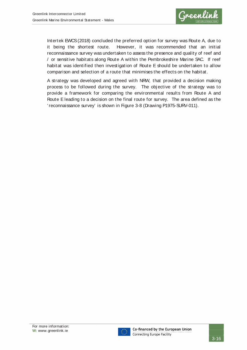
Greenlink Interconnector Limited
Greenlink Marine Environmental Statement - Wales
For more information: W: www.greenlink.ie
3-16
Intertek EWCS (2018) concluded the preferred option for survey was Route A, due to it being the shortest route. However, it was recommended that an initial reconnaissance survey was undertaken to assess the presence and quality of reef and / or sensitive habitats along Route A within the Pembrokeshire Marine SAC. If reef habitat was identified then investigation of Route E should be undertaken to allow comparison and selection of a route that minimises the effects on the habitat.
A strategy was developed and agreed with NRW, that provided a decision making process to be followed during the survey. The objective of the strategy was to provide a framework for comparing the environmental results from Route A and Route E leading to a decision on the final route for survey. The area defined as the ‘reconnaissance survey’ is shown in Figure 3-8 (Drawing P1975-SURV-011).

Chris GoodeEmma Langley
Friday, April 12, 2019 15:33:23WGS_1984_UTM_Zone_30N
D_WGS_1984JNCC; NRW; GEBCO; UKHO; CDA; MarineFind; Greenlink
WGS_1984
NOTE: Not to be used for Navigation
Contains Joint Nature Conservation Committee data © copyright and database right [2018]. Contains Natural Resource Wales data © copyright and database right [2018]. Contains UK Hydrographic Office data © copyright and database right [2018]. Contains Ordnance Survey data © copyright and database right [2018]. Contains public sector information licensed under the Open Government Licence v3.0.; Contains public sector information licensed under the Open Government Licence v3.0. Link: http://www.nationalarchives.gov.uk/doc/open-government-licence/version/3/; © CNC/NRW All rights Reserved. Contains Ordnance Survey Data. Ordnance Survey Licence number 100019741. Crown Copyright and Database Right.;JNCC accepts no liability for the use of this data or for any further analysis or interpretation of the data.; Collated and published by JNCC © Contains public sector information licensed under the Open Government Licence v2.0. Contains derived data from BGS © NERC. Contains derived data from Ordnance Survey © Crown copyright. 100019741 (2013). JNCC accepts no liability for the use of this data or for any further analysis or interpretation of the data.; © The GEBCO Digital Atlas published by the British Oceanographic Data Centre on behalf of IOC and IHO, 2003; Contains public sector information, licensed under the Open Government Licence v2.0, from the UKHO, 2018.; Contains data from UKOGD; Charts from MarineFIND.co.uk © Crown Copyright, 2015. All rights reserved. Licence No: EK001-1001-WEB105. Not to be used for Navigation.
Anna Farley
PembrokeshireMarine/ Sir
Benfro Forol - SAC
West Wales Marine /Gorllewin Cymru Forol - SAC
Bristol ChannelApproaches /Dynesfeydd Môr Hafren - SAC
Skomer, Skokholmand the Seas off
Pembrokeshire - SPA
CastlemartinCoast - SPA
Grassholm - SPA
Ramsey andSt David`s Peninsula
Coast - SPA
280000
280000
300000
300000
320000
320000
340000
340000
360000
360000
57000
00
57000
00
57200
00
57200
00
57400
00
57400
00
57600
00
57600
00
LegendOriginal Proposed RouteRoute A Rev1Route B Rev0Route E Rev1
Environmental DesignationsSACSPASSSINational Park
Protected Sandbank Slightly Covered by SeawaterSandbank Area (High Confidence)Potential Sandbank
Potential ReefBedrock (High Confidence)Bedrock (Potential)Stony (Potential)
0 3 6 9 12km © Metoc Ltd, 2019.
All rights reserved.
J:\P1975\Mxd\01_LOC\P1975-LOC-004.mxd
Created ByReviewed By
DateProjection
DatumData Source
File Reference
Spheroid
Approved By
Drawing No: P1975-LOC-004 A
GREENLINK INTERCONNECTORROUTE OVERVIEW
UK Route Development

Chris GoodeEmma Langley
Friday, April 12, 2019 15:47:21WGS_1984_UTM_Zone_30N
D_WGS_1984
UKHO; CDA; NRW; JNCC; GEBCO; Greenlink
WGS_1984
NOTE: Not to be used for Navigation
Contains public sector information, licensed under the Open Government Licence v2.0, from the UKHO, 2018.; Contains data from UKOGD.; © CNC/NRW All rights Reserved. Contains Ordnance Survey Data. Ordnance Survey Licence number 100019741. Crown Copyright and Database Right.; Contains public sector information licensed under the Open Government Licence v3.0. Link: http://www.nationalarchives.gov.uk/doc/open-government-licence/version/3/; Contains Joint Nature Conservation Committee data © copyright and database right [2018]. Contains Natural Resource Wales data © copyright and database right [2018]. Contains UK Hydrographic Office data © copyright and database right [2018]. Contains Ordnance Survey data © copyright and database right [2018]. Contains public sector information licensed under the Open Government Licence v3.0.; JNCC accepts no liability for the use of this data or for any further analysis or interpretation of the data.; Collated and published by JNCC © Contains public sector information licensed under the Open Government Licence v2.0. Contains derived data from BGS © NERC. Contains derived data from Ordnance Survey © Crown copyright. 100019741 (2013). JNCC accepts no liability for the use of this data or for any further analysis or interpretation of the data.; © The GEBCO Digital Atlas published by the British Oceanographic Data Centre on behalf of IOC and IHO, 2003
Anna Farley
PembrokeshireMarine/ Sir
Benfro Forol - SAC
West Wales Marine /Gorllewin Cymru Forol - SAC
Skomer, Skokholmand the Seas off
Pembrokeshire - SPA
CastlemartinCoast - SPA
Grassholm - SPA
Ramsey andSt David`s Peninsula
Coast - SPA
ANGLE PENINSULA COAST SSSIBROOMHILL
BURROWS SSSI
CASTLEMARTINRANGE SSSI
DALE AND SOUTHMARLOES
COAST SSSI
320000
320000
340000
340000
360000
360000
57200
00
57200
00
57400
00
57400
00
LegendUK 12nm Territorial Sea Limit
Greenlink Interconnector Proposed RoutesRoute A Rev1Route E Rev1
Reconnaisance SectionRoute A (24.84km)Route E (27.62km)
Environmental DesignationsSACSPASSSINational Park
Protected Sandbank Slightly Covered by SeawaterSandbank Area (High Confidence)Potential Sandbank
Potential ReefBedrock (High Confidence)Bedrock (Potential)Stony (Potential)
0 2 4 6 8km © Metoc Ltd, 2019.
All rights reserved.
J:\P1975\Mxd\02_SURV\P1975-SURV-011.mxd
Created ByReviewed By
DateProjection
DatumData Source
File Reference
Spheroid
Approved By
Drawing No: P1975-SURV-011 A
GREENLINK INTERCONNECTORROUTE OVERVIEW
UK Route Development

Greenlink Interconnector Limited
Greenlink Marine Environmental Statement - Wales
For more information: W: www.greenlink.ie
3-19
3.5.5 Route refinements during survey
Extensive route development was carried out during the cable route survey. This fell into two categories;
• minor refinements as a result of identification of potentially challenging areas for cable installation e.g. large sand waves and areas of hard ground; and
• major route development to avoid reef habitat.
3.5.5.1 Minor route refinements
Proposed Development At KP26 large sand waves are present (Figure 3-9, Drawing P1975-SURV-004). Additional survey lines were carried out to determine the extent of the sandwaves and investigate the feasibility of routeing around them. The sandwaves proved to be a sequence of sand waves that were too extensive, and a route around was not viable. No change to the indicative centreline could be made.
Pre-survey analysis of available SEACAMS bathymetric data provided by Bangor University identified a possible sandy channel system through the extensive rock outcrop (potential Annex I reef habitat) in nearshore Wales. The survey was engineered to acquire data over a 500m corridor with the intent to highlight more of the channel system within the bedrock.
Once the survey was outside the area covered by the SEACAMS data it was identified that the channel system deviated outside the initial survey corridor. Therefore, additional geophysical survey data was acquired showing that it was possible to follow the channel system northwest of the original route. A route was then developed to follow the channel avoiding the outcropping rock where possible, and survey data collected along this alignment; shown in Figure 3-10 (Drawing P1975-SURV-001). Survey data confirmed that there is likely to be sufficient sediment depth within the channel to achieve the likely required burial depths and protection for the cables.
Marine Ireland On the approach to Baginbun Beach both Route A and Option D was surveyed (Figure 3-11, Drawing P1975-SURV-013). The small sand channel on Route A between outcropping rock features was approximately 35m wide at the narrowest point. This outcropping rock falls under the definition of Annex I Reef (stony reef); a Qualifying Interest Feature of the Hook Head SAC. Mapping of the bedrock reflector shows that installation of the cable along Route A would likely require external cable protection measures e.g. rock berm, in order to protect the cable.
However, mapping of the bedrock reflectors on Option D shows that there is sufficient sediment depth around the loop to achieve the likely required burial depths and protection for the cables. Therefore, although Option D increases the length of the cables, it has been selected as the preferred route as it avoids the sensitive reef habitat.

GREENLINK INTERCONNECTORSURVEY DATA
Bathymetry over Large Sandwave Area
Chris CarrollChris Goode
Monday, April 8, 2019 13:07:54WGS_1984_UTM_Zone_30N
D_WGS_1984ESRI; OSOD; MMT; Greenlink
WGS_1984
NOTE: Not to be used for Navigation
© Crown Copyright, 2015. All rights reserved. Licence No: EK001-1001-WEB105. © Esri. Contains Ordnance Survey data © Crown copyright and database right 2013. Greenlink Ltd. Not to be used for Navigation.
Anna Farley
Height ~7m, Wavelength ~230m
333000
333000
333500
333500
57245
00
57245
00
57250
00
57250
00
LegendPost Survey Centreline
Survey Bathymetry Below LAT (m)High : 60
Low : 45
0 50 100 150 200m © Metoc Ltd, 2019.
All rights reserved.
J:\P1975\Mxd\02_SURV\P1975-SURV-004.mxd
Created ByReviewed By
DateProjection
DatumData Source
File Reference
Spheroid
Approved By
Drawing No: P1975-SURV-004 A

GREENLINK INTERCONNECTORSURVEY DATA
Bathymetry Nearshore Freshwater West
Chris CarrollChris Goode
Monday, April 8, 2019 12:52:17WGS_1984_UTM_Zone_30N
D_WGS_1984ESRI; OSOD; Bangor University; MMT; Greenlink
WGS_1984
NOTE: Not to be used for Navigation
© Crown Copyright, 2015. All rights reserved. Licence No: EK001-1001-WEB105. © Esri. Contains Ordnance Survey data © Crown copyright and database right 2013. ©Bangor University. ©Greenlink Ltd. Not to be used for Navigation.
Anna Farley
Channel Seen in SEACAMS Bathymetry
Channel Highlightedin Survey Data
350000
350000
352800
352800
355600
355600
358400
358400
57232
00
57232
00
57260
00
57260
00
57288
00
57288
00
LegendPost Survey CentrelinePre-Survey CentrelineProposed DevelopmentDesktop Bathymetry Extent
Survey Bathymetry Below LAT (m)High : 80
Low : -80
0 0.25 0.5 0.75 1km © Metoc Ltd, 2019.
All rights reserved.
J:\P1975\Mxd\02_SURV\P1975-SURV-001.mxd
Created ByReviewed By
DateProjection
DatumData Source
File Reference
Spheroid
Approved By
Drawing No: P1975-SURV-001 A
0 0.25 0.5 0.75 1km

GREENLINK INTERCONNECTORSURVEY DATA
Survey Bathymetry for Route A and Option D
Chris GoodeEmma Langley
Thursday, April 25, 2019 08:27:56WGS_1984_UTM_Zone_30N
D_WGS_1984OSI; MMT; Greenlink
WGS_1984
NOTE: Not to be used for Navigation
Contains data published by Ordnance Survey Ireland licensed under Creative Commons Attribution 4.0;
Anna Farley
238000
238000
239000
239000
240000
240000
57870
00
57870
00
57880
00
57880
00
LegendGreenlink Interconnector Proposed Routes
Route A Rev1Option D Rev1Proposed Development
Surveyed BathymetryDepth Below LAT (m)High : 20
Low : -10
0 100 200 300 400, © Metoc Ltd, 2019.
All rights reserved.
J:\P1975\Mxd\02_SURV\P1975-SURV-013.mxd
Created ByReviewed By
DateProjection
DatumData Source
File Reference
Spheroid
Approved By
Drawing No: P1975-SURV-013 A

Greenlink Interconnector Limited
Greenlink Marine Environmental Statement - Wales
For more information: W: www.greenlink.ie
3-23
3.5.5.2 Major route development
Proposed Development On completion of the reconnaissance survey of Route A and Route E biotope maps, seabed photographs and an interpretive report were submitted to NRW for review. These identified extensive areas of Annex I Reef habitat on both routes. The Conservation Objectives for the Pembrokeshire Marine SAC for Annex I Reef habitat is that “The overall distribution and extent of the habitat features within the site, and each of their main component parts is stable or increasing”.
Having reviewed the extent of the Annex I Reef biotopes described for the eastern arm of Route A, NRW concluded:
“due to the extent of the reef and the type of reef habitats contained within, the presence of a cable and associated construction work and protective covering would compromise the conservation objectives of the feature, should this section of Route A be used. (NRW 2018a)”
The same rationale applied for the eastern sections of Route E where Annex I reef feature has been identified throughout the width of the corridor, the loss of reef in that area would also be too great to be considered insignificant.
NRW (2018a) recommended that additional geophysical survey be completed to the eastern end of the reconnaissance survey area between Route A and Route E.
Two north-south geophysical survey lines were run between Route E and Route A (Figure 3-12, Drawing P1975-SURV-012) to identify if possible, the northern extent of the bedrock outcrop which formed the reef feature on Route A. The additional geophysical lines showed the top of the bedrock slightly north of the extent of the Route A survey corridor. This led to a route being designed between Route E and Route A that avoided the sensitive reef habitat on both routes (Figure 3-12, Drawing P1975-SURV-012).
Seabed photographs, a biotope map and interpretative report were subsequently submitted to NRW for the new route section for review. NRW (2018b) considered the biotope to be present should be classified as A5.141 or SS.SCS.CCS.SpiB “Spirobranchus triqueter with barnacles and bryozoan crusts on unstable circalittoral cobbles and pebbles”. NRW considers this biotope forms part of the Annex I Reef (stony reef) habitat. However, NRW (2018b) advice concluded:
“NRW considers that this alternative route is likely to be preferable to routes A and E because:
- The cobble/sediment biotope identified, potentially A5.141, will have a low sensitivity to the cable lay. If the cable is buried within this biotope, and covered with the existing sediments, recovery will occur as the sediments are routinely scoured and moved by wave and tidal action. As stated in the JNCC biotope description for A5.141 “This biotope is characterized by a few ubiquitous robust and/or fast growing ephemeral species which are able to colonise pebbles and

Greenlink Interconnector Limited
Greenlink Marine Environmental Statement - Wales
For more information: W: www.greenlink.ie
3-24
unstable cobbles and slates which are regularly moved by wave and tidal action” and long-lived or delicate species are not regularly present.
- There are boulders and other potential Annex I habitats including Sabellaria reef present. The side scan and drop-down video however appear to indicate that these habitats can be avoiding through micro-siting of the cable.
At this stage, and without prejudice to later comments made during the application phase, NRW would not consider that there would be significant issues with laying a cable within A5.141, should burial of the cable be possible within this habitat with covering of local sediments from A5.141 biotope. (NRW 2018b)”
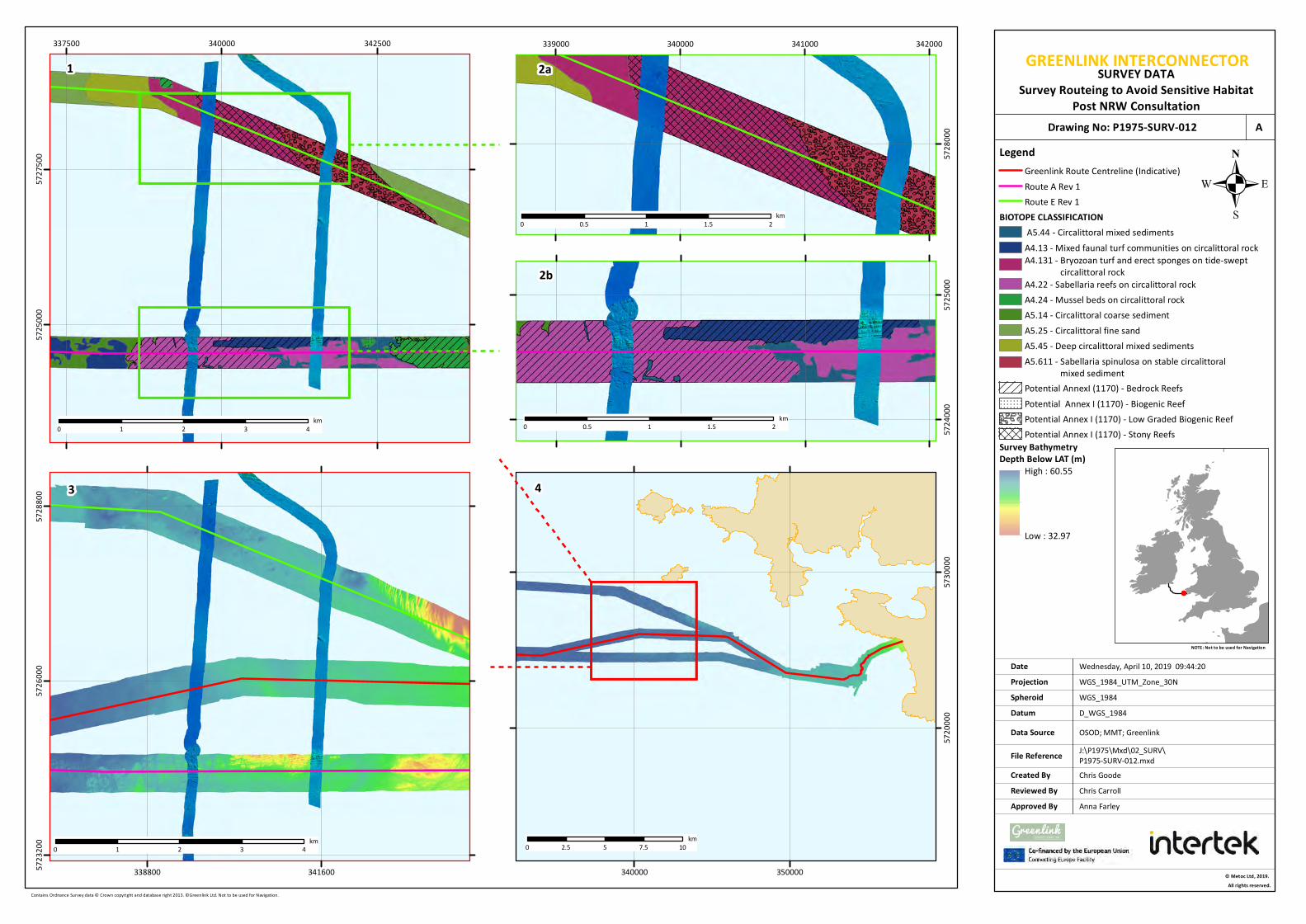
GREENLINK INTERCONNECTORSURVEY DATASurvey Routeing to Avoid Sensitive Habitat
Post NRW Consultation
Chris GoodeChris Carroll
Wednesday, April 10, 2019 09:44:20WGS_1984_UTM_Zone_30N
D_WGS_1984OSOD; MMT; Greenlink
WGS_1984
NOTE: Not to be used for Navigation
Contains Ordnance Survey data © Crown copyright and database right 2013. ©Greenlink Ltd. Not to be used for Navigation.
Anna Farley
337500 340000 342500572
5000
57275
00
© Metoc Ltd, 2019.All rights reserved.
J:\P1975\Mxd\02_SURV\P1975-SURV-012.mxd
Created ByReviewed By
DateProjection
DatumData Source
File Reference
Spheroid
Approved By
Drawing No: P1975-SURV-012 A
338800 34160057232
00572
6000
57288
00
57240
00572
5000
0 1 2 3 4km
0 1 2 3 4km 0 2.5 5 7.5 10
km
0 0.5 1 1.5 2km
340000 350000
57200
00573
0000
339000 340000 341000 342000
57280
00
1 2a
2b
3 4
0 0.5 1 1.5 2km
0 2.5 5 7.5 10km
Legend
BIOTOPE CLASSIFICATION
A4.131 - Bryozoan turf and erect sponges on tide-swept circalittoral rock
A5.611 - Sabellaria spinulosa on stable circalittoral mixed sediment
Greenlink Route Centreline (Indicative)Route A Rev 1Route E Rev 1
A5.44 - Circalittoral mixed sedimentsA4.13 - Mixed faunal turf communities on circalittoral rock
A4.22 - Sabellaria reefs on circalittoral rockA4.24 - Mussel beds on circalittoral rockA5.14 - Circalittoral coarse sedimentA5.25 - Circalittoral fine sandA5.45 - Deep circalittoral mixed sediments
Potential AnnexI (1170) - Bedrock ReefsPotential Annex I (1170) - Biogenic ReefPotential Annex I (1170) - Low Graded Biogenic ReefPotential Annex I (1170) - Stony Reefs
Survey Bathymetry Depth Below LAT (m)
High : 60.55
Low : 32.97

Greenlink Interconnector Limited
Greenlink Marine Environmental Statement - Wales
For more information: W: www.greenlink.ie
3-26
3.5.6 Summary of Route Development
The following flow diagram summarises the route evolution of the Greenlink indicative centreline and how the routes were developed during the offshore survey campaign. The reference numbers on the left hand side are to be read in conjunction with Figure 3-13 below (P1975-LOC-008-A).
• Route A – Preferred route from Freshwater West, Wales to Baginbun, Ireland
• Route B – Route deviated to the south of a disposal area and into Castlemartin Firing Range
• Route C - Route to different landfall (Boyce’s Bay) in Ireland in case the preferred landfall, Baginbun, was not feasible
• Route D – Small additional route at the Irish nearshore to avoid outcrop
REF#1Pre-Survey proposed routes
• Route E – CMS (Greenlink lawyers, 18 April 2018) raised the concern that as reef is a designating feature of the Pembrokeshire Marine SAC, the project will need to demonstrate that all possible alternatives have been considered.
REF#2New route to reduce impacts of
crossing a designated reef feature
• Route A & Route E Rev1 – Amended at the Welsh nearshore area and havs been engineered into a natural channel within outcropping rock (Identified in the SEACAMS data). These are now displayed as Rev1. With the introduction of Route E, Route B was dropped.
REF#3Amendment to nearshore Wales
routes
• Route A & Route E Rev1 – Surveys carried out in October 2018 showed both routes contained area identified as an Annex 1 habitat and were not feasible.
REF#4Reconnaissance surveys along Route
A and Route E
• Route A & Route E Rev1 – The full extent of the channel area was not highlighted in the SEACAMS data therefore additional reconnaissance bathymetry lines were acquired to visualise a wider area to highlight where the channel ended and if it was feasible to practically install a cable.
REF#5Reconnaissance survey to highlight
channel extents
• Re-Routed area – North-South Reconnaissance lines were carried out between Route A and E to find the extent of outcrop associated with the Annex 1 habitat. Once the outcrop was highlighted, Geophysical Survey data was acquired within a new East-West oriented survey corridor which joined Route E to A.
REF#6Re-routed area avoiding Annex 1 habitats identified on Route A &
Route E
• Route C – Once survey was complete on the preferred Route A in Ireland and that the preferred landfall at Baginbun was confirmed as feasible, Route C was removed.
REF#7Excluding Route C from Geophysical
investigation work
• Greenlink_WGS84_UTM30N_09112018_Rev0 – The post Survey Greenlink route has used a combination of Route A, Route E, Route D, the re-routed area to avoid Annex 1 habitats and reconnaissance at the end of the old river channel area to arrive at a single route centreline.
REF#8Post Survey Centre Line
• Greenlink_WGS84_UTM30N_09112018_Rev1 – Further refinement of the Greenlink route using processed survey data to avoid identified constraints and areas interpreted as Annex 1 habitat.
REF#9Post Survey Centre Line Rev1

Chris GoodeChris Carroll
Monday, April 29, 2019 13:57:11WGS_1984_UTM_Zone_30N
D_WGS_1984CDA; UKHO; DCCAE; GEBCO; EMODNET; ESRI;
WGS_1984
NOTE: Not to be used for Navigation
Contains data from UKOGD.; Contains public sector information, licensed under the Open Government Licence v2.0, from the UKHO, 2018.; © Copyright Department of Communications, Climate Action and Environment (DCCAE); © The GEBCO Digital Atlas published by the British Oceanographic Data Centre on behalf of IOC and IHO, 2003; The bathymetric metadata and Digital Terrain Model data products have been derived from the EMODnet Bathymetry portal - http://www.emodnet-bathymetry.eu;© Esri.
Anna Farley
REF#1 Route A, B, C & D
REF#2 Introduction of Route E
REF#3 Nearshore Wales Route Amendment
REF#4 Route A & E not Feasible
REF#5 Reconnaissance to Highlight Channel Extents
REF#6 Reconnaissance Lines
REF#7Removal of Route C REF#8 & #9
Post Survey Route(Dashed Line)
250000
250000
300000
300000
350000
350000
57000
00
57000
00
57500
00
57500
00
58000
00
58000
00 LegendPost Survey Route Centre Line
Greenlink Route Cenreline (Indicative)*Median Line12nm Territorial Sea Limit
Pre Survey Route Centre LineRoute A Rev1Route B Rev0Option C Rev0Option D Rev1Route E Rev1
Survey Reconnaissance LinesNorth South Reconnaissance Lines
Bathymetry (m)-150 - -125-125 - -100-100 - -75-75 - -50-50 - -20-20 - -10-10 - 0
0 5 10 15 20km © Metoc Ltd, 2019.
All rights reserved.
J:\P1975\Mxd\01_LOC\P1975-LOC-008.mxd
Created ByReviewed By
DateProjection
DatumData Source
File Reference
Spheroid
Approved By
Drawing No: P1975-LOC-008 A
GREENLINK INTERCONNECTORROUTE OVERVIEW
Pre Survey & Post Survey Route Centre Lines
*Greenlink_WGS84_UTM30N_05042019_Rev1.shp

Greenlink Interconnector Limited
Greenlink Marine Environmental Statement - Wales
For more information: W: www.greenlink.ie
3-28
3.6 Proposed Development
The final Greenlink route being taken forward for consent in Wales and Ireland is shown in Figure 1-1 (Drawing P1975-LOC-001). Figure 3-14 (Drawing P1975-CORR-001) presents the Proposed Development in Wales. An indicative centreline is shownon the Figure, noting that this will be subject to change as micro-routeing isundertaken within the consented corridor by the Installation Contractor.
The advantages of the final route, in comparison to alternative routes considered are:
Proposed Development
• The route minimises the area of Annex I reef habitat crossed and avoids the mostsensitive habitats were cable installation may have significantly affected theconservation objectives of the Pembrokeshire Marine SAC.
• The route is the minimal length within the Castlemartin Firing Range necessaryto avoid other constraints such as presence of Annex I reef and historical dumpingsites.
• The installation solution at the landfall has been selected as horizontal directionaldrilling, which will ensure that disruption to the recreational use of the beach isminimised.
Offshore Ireland
• The route avoids the extensive area of sand waves by routeing to the south.
Marine Ireland
• The installation solution at the landfall has been selected as horizontal directional drilling, which will ensure that intertidal Annex I reef habitat is not affected by cable installation, and disruption to the recreational use of the beach is minimised.
• The route uses an existing sand channel between extensive Annex I reef habitat within the Hook Head SAC. Survey has confirmed that the sand channel contains adequate sediment cover to allow full burial of the Greenlink cables.
• The route avoids shipping channels in to and out of Port of Waterford.

Chris GoodeEmma Langley
Wednesday, June 5, 2019 12:44:02WGS_1984_UTM_Zone_30N
D_WGS_1984CDA; GEBCO; UKHO; ;OSOD; MarineFind
WGS_1984
NOTE: Not to be used for Navigation
Contains data from UKOGD.; © The GEBCO Digital Atlas published by the British Oceanographic Data Centre on behalf of IOC and IHO, 2003; -; Contains public sector information, licensed under the Open Government Licence v2.0, from the UKHO, 2018.; Contains Ordnance Survey data © Crown copyright and database right 2019; Charts from MarineFIND.co.uk © Crown Copyright, 2015. All rights reserved. Licence No: EK001-1001-WEB105. Not to be used for Navigation.
Anna Farley
12
3 45 6 7 8
9 1011
252627
28293031
3233
300000
300000
325000
325000
350000
350000
56750
00
56750
00
57000
00
57000
00
57250
00
57250
00
57500
00
57500
00
LegendProposed Development PointsGreenlink Route Centreline (Indicative)Proposed DevelopmentIrish OffshoreUK Mean High Water12nm LimitMedian Line
0 3 6 9 12km © Metoc Ltd, 2019.
All rights reserved.
J:\P1975\Mxd\03_CORR\P1975-CORR-001.mxd
Created ByReviewed By
DateProjection
DatumData Source
File Reference
Spheroid
Approved By
11 12 13 1415
1617
1819
2021
2223
2425
0 1 2 3 4km
Drawing No: P1975-CORR-001 A
GREENLINK INTERCONNECTORPROPOSED DEVELOPMENT
UK Waters
Id WGS 1984 Longitude (°) WGS 1984 Latitude (°) BNG Easting (m) BNG Northing (m)1 -6.1001 51.6813 116618 2060742 -6.0239 51.6732 121828 2048813 -5.7903 51.6583 137885 2023594 -5.6623 51.6605 146746 2021525 -5.4630 51.6503 160474 2003486 -5.4267 51.6505 162980 2002467 -5.4233 51.6524 163231 2004508 -5.3888 51.6527 165665 2003299 -5.3097 51.6648 171213 201414
10 -5.2264 51.6646 176974 20113611 -5.1707 51.6448 180729 19876512 -5.1490 51.6437 182223 19857113 -5.1211 51.6440 184155 19852814 -5.1054 51.6442 185245 19850315 -5.1050 51.6498 185300 19911716 -5.0977 51.6553 185828 19971117 -5.0907 51.6583 186327 20002318 -5.0703 51.6638 187765 20058219 -5.0629 51.6609 188265 20022820 -5.0810 51.6563 186989 19978021 -5.0915 51.6527 186249 19940822 -5.0979 51.6479 185778 19889023 -5.0986 51.6424 185706 19828424 -5.1147 51.6379 184571 19782625 -5.1736 51.6407 180508 19831326 -5.2292 51.6604 176763 20067727 -5.3084 51.6604 171281 20091728 -5.4011 51.6461 164732 19968029 -5.4634 51.6459 160420 19985030 -5.6627 51.6560 146695 20165431 -5.7904 51.6538 137857 20185932 -6.0248 51.6688 121742 20438933 -6.1001 51.6768 116589 205567

Greenlink Interconnector Limited
Greenlink Marine Environmental Statement - Wales
For more information: W: www.greenlink.ie
3-30
1 Intertek EWCS (2015) Greenlink Interconnector Route Selection Report, P1975_RN3929_Rev1, December 2015.
2 Intertek EWCS (2016) Greenlink Interconnector Route Selection, P1975_BN3952_Rev1, February 2016
3 Intertek EWCS (2018) Greenlink Cable Route Report, P1975_BN4437_Rev2, August 2018
4 Intertek EWCS (2019), Greenlink Cable Route Report, P1975_BN4437_Rev3, April 2019.
5 NRW (2018a). Pre-application advice to Greenlink/Intertek. 07 December 2018.
6 NRW (2018b). NRW advice on Routes A and E. Pre-application advice to Greenlink/Intertek. 12 October 2018.
REFERENCES

Greenlink Interconnector Limited
Greenlink Marine Environmental Statement - Wales
For more information: W: www.greenlink.ie
4-1
4. Project Description
4.1 Introduction
This Chapter presents information on the Proposed Development – the Welsh Marine components of Greenlink within UK waters from mean high water springs (MHWS) at the landfall on the Pembrokeshire coast, Wales to the UK/Republic of Ireland median line. The installation, operation (including repair & maintenance) and decommissioning phases of Greenlink are described in terms of the likely component options and their installation as follows:
• Installation: Options for the submarine cable installation process including the pre-installation surveys, the range of vessels to be used and different installation techniques which could be employed in submarine cable laying, jointing and burial.
• Operation: The physical characteristics of the submarine cables including information about their design, operation, repair and maintenance. Emissions produced during operation, in the form of heat, and electric and magnetic fields are discussed.
• Decommissioning: The recovery and dismantling activities involved in decommissioning a typical submarine power cable at the end of its operational life.
A summary of the elements of Greenlink is provided in Section 4.2.
4.2 Project overview
Greenlink is a proposed subsea and underground electricity interconnector cable between the existing electricity grids in the Republic of Ireland and Great Britain with a nominal capacity of 500 megawatts. Greenlink will provide a new interconnector between EirGrid’s Great Island substation in County Wexford (Ireland) and the National Grid’s Pembroke substation in Pembrokeshire (Wales). The power will be able to flow in either direction, depending on supply and demand in each country.
The high voltage grid systems in the UK and Ireland operate using high voltage alternating current (HVAC). To transport the electricity from one country to the other, the HVAC power is converted to high voltage direct current (HVDC) at a converter station located onshore and transmitted by means of HVDC cables to the other converter station, whereupon it is converted back from HVDC to HVAC for integration into the high voltage network in the other country.
Greenlink will consist of two converter stations, one close to the existing substation at Great Island in County Wexford (Ireland) and one close to the existing substation at Pembroke in Pembrokeshire (Wales). The converter stations will be connected by two HVDC cables under the Irish Sea. HVDC provides the most efficient and effective means to transport electricity over the distance involved.

Greenlink Interconnector Limited
Greenlink Marine Environmental Statement - Wales
For more information: W: www.greenlink.ie
4-2
The subsea cable system will be joined to the corresponding land cable system in a transition joint pit (TJP) located above MHWS, and therefore does not form part of the Proposed Development (this application). An application for consent for the Wales Onshore components of Greenlink will be submitted to Pembrokeshire County Council under the Town and Country Planning Act 19901. Further to this, an application will be submitted to An Bord Pleanála for the Irish Onshore components in Ireland.
A Foreshore License application for the installation and operation of submarine cables has been submitted to Department of Housing, Planning and Local Government (Foreshore Unit) that covers the Campile Estuary, Irish Marine and Irish Offshore.
The proposed landfall sites are Freshwater West, Pembrokeshire, Wales and Baginbun Beach, County Wexford, Ireland. Figure 4-1 presents a schematic of Greenlink, and Figure 4-2 (Drawing P1975-CORR-001) presents the Proposed Development. The total length of the Greenlink marine cables is 159.27km of which 73.9km forms the Proposed Development in Welsh territorial and offshore waters.
Figure 4-1 Pictorial representation of Greenlink
1 There is an overlap in the intertidal area between the Proposed Development and Wales Onshore for planning purposes. The Wales Onshore ES and planning application will include information on the Proposed Development down to the Low Water Mark.

Greenlink Interconnector Limited
Greenlink Marine Environmental Statement - Wales
For more information: W: www.greenlink.ie
4-3
4.3 Submarine cable route description
The submarine cable corridor derived from preliminary cable route engineering, consultation with stakeholders and survey is shown in Figure 4-2 (Drawing P1975-CORR-001). Kilometre points (KPs) have been assigned to the route running from KP0 at MHWS, Freshwater West to KP159.27 at MHWS, Baginbun Beach. The proposed submarine cable corridor crosses the UK/Republic of Ireland median line at KP73.8.
The proposed submarine cable corridor (for which consent for installation of the marine cables will be applied for) is generally 500m wide. A small part of this width will be required for installation (of the order of 10-20m) once the final cable route within this corridor is agreed. It is proposed to finalise the precise position of the submarine cables within the corridor after permits are granted but before installation has commenced. This will allow for optimisation of the final laid submarine cables to minimise engineering and environmental challenges, such as avoidance of:
• Unexploded ordnance (UXO);
• Boulders;
• Undulations as troughs and ridges;
• Mobile sand features as sand waves;
• Areas of hard soils and gravels;
• Sensitive habitat features such as bedrock, stony or biogenic reef;
• Steep slopes;
• Any debris not removed prior to installation; and
• Other magnetic anomalies.

Chris GoodeEmma Langley
Wednesday, June 5, 2019 12:44:02WGS_1984_UTM_Zone_30N
D_WGS_1984CDA; GEBCO; UKHO; ;OSOD; MarineFind
WGS_1984
NOTE: Not to be used for Navigation
Contains data from UKOGD.; © The GEBCO Digital Atlas published by the British Oceanographic Data Centre on behalf of IOC and IHO, 2003; -; Contains public sector information, licensed under the Open Government Licence v2.0, from the UKHO, 2018.; Contains Ordnance Survey data © Crown copyright and database right 2019; Charts from MarineFIND.co.uk © Crown Copyright, 2015. All rights reserved. Licence No: EK001-1001-WEB105. Not to be used for Navigation.
Anna Farley
12
3 45 6 7 8
9 1011
252627
28293031
3233
300000
300000
325000
325000
350000
350000
56750
00
56750
00
57000
00
57000
00
57250
00
57250
00
57500
00
57500
00
LegendProposed Development PointsGreenlink Route Centreline (Indicative)Proposed DevelopmentIrish OffshoreUK Mean High Water12nm LimitMedian Line
0 3 6 9 12km © Metoc Ltd, 2019.
All rights reserved.
J:\P1975\Mxd\03_CORR\P1975-CORR-001.mxd
Created ByReviewed By
DateProjection
DatumData Source
File Reference
Spheroid
Approved By
11 12 13 1415
1617
1819
2021
2223
2425
0 1 2 3 4km
Drawing No: P1975-CORR-001 A
GREENLINK INTERCONNECTORPROPOSED DEVELOPMENT
UK Waters
Id WGS 1984 Longitude (°) WGS 1984 Latitude (°) BNG Easting (m) BNG Northing (m)1 -6.1001 51.6813 116618 2060742 -6.0239 51.6732 121828 2048813 -5.7903 51.6583 137885 2023594 -5.6623 51.6605 146746 2021525 -5.4630 51.6503 160474 2003486 -5.4267 51.6505 162980 2002467 -5.4233 51.6524 163231 2004508 -5.3888 51.6527 165665 2003299 -5.3097 51.6648 171213 201414
10 -5.2264 51.6646 176974 20113611 -5.1707 51.6448 180729 19876512 -5.1490 51.6437 182223 19857113 -5.1211 51.6440 184155 19852814 -5.1054 51.6442 185245 19850315 -5.1050 51.6498 185300 19911716 -5.0977 51.6553 185828 19971117 -5.0907 51.6583 186327 20002318 -5.0703 51.6638 187765 20058219 -5.0629 51.6609 188265 20022820 -5.0810 51.6563 186989 19978021 -5.0915 51.6527 186249 19940822 -5.0979 51.6479 185778 19889023 -5.0986 51.6424 185706 19828424 -5.1147 51.6379 184571 19782625 -5.1736 51.6407 180508 19831326 -5.2292 51.6604 176763 20067727 -5.3084 51.6604 171281 20091728 -5.4011 51.6461 164732 19968029 -5.4634 51.6459 160420 19985030 -5.6627 51.6560 146695 20165431 -5.7904 51.6538 137857 20185932 -6.0248 51.6688 121742 20438933 -6.1001 51.6768 116589 205567

Greenlink Interconnector Limited
Greenlink Marine Environmental Statement - Wales
For more information: W: www.greenlink.ie
4-5
4.4 Submarine cable description
Greenlink will be a submarine cable system including two HVDC cables, laid alongside each other. A fibre optic cable will also be laid for control and communication purposes. It is likely that the cables will be bundled together and installed with no separation between the cables (Figure 4-3).
The HVDC cables will be a cross linked polyethylene (XLPE) type (Figure 4-4). XLPE is an extruded polyethylene material that is thermoset after extrusion through a controlled heating process. XLPE cables have been in use for alternating current (AC) applications since the 1980s and for HVDC applications since around 2000 and have proven to be reliable.
Figure 4-3 Typical cable bundle arrangement
Figure 4-4 Example of XLPE submarine cable
The cable will have a lead sheath, to ensure no moisture can penetrate the insulation, and steel wire armour to protect the cable from external damage during installation and burial/protection. The armouring is made from round or flat steel wire wound in a helical form. Over the armour wires a polyethylene sheath is applied to make the cable easier to handle and ensure the armour wires remain in place during bending. The cable conductor will be either Aluminium or Copper.
Each cable will be approximately 120-130mm in diameter (260mm per bundle) and will weigh approximately 35-40kg/m. They will operate at a voltage of 320kV.
4.5 Indicative programme
The programme for the commencement of installation has not yet been agreed but for a scheme of this size to be constructed it is expected to take approximately 36 months from start to finish. The project is envisaged to commence on-site construction in late 2020 and be fully operational in 2023. Table 4-1 presents an indicative programme of works.
In general installation in European waters are undertaken in the summer season, broadly between April and October. This period is determined primarily by the high probability of adverse weather occurring outside of this period. The schedule will also be affected by factors such as, the availability of cable, the delivery of cable, other commitments of the installation contractor, and any Project Specific Mitigation proposed by the EIA process.
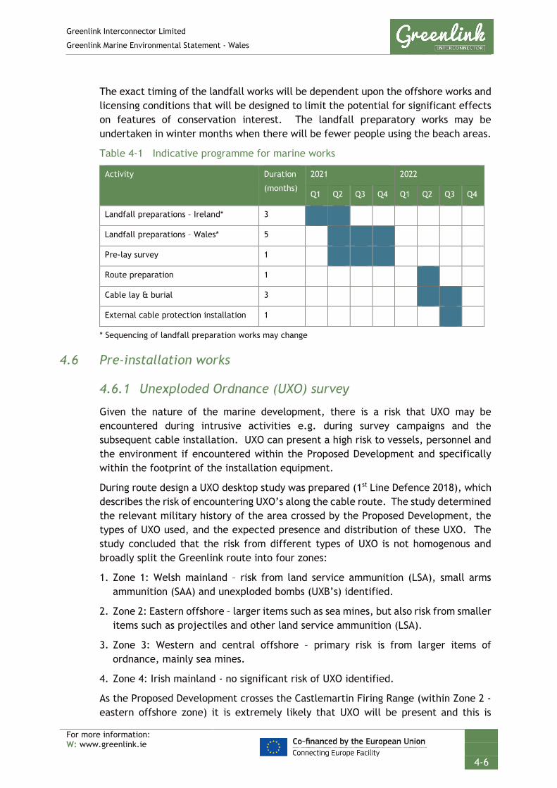
Greenlink Interconnector Limited
Greenlink Marine Environmental Statement - Wales
For more information: W: www.greenlink.ie
4-6
The exact timing of the landfall works will be dependent upon the offshore works and licensing conditions that will be designed to limit the potential for significant effects on features of conservation interest. The landfall preparatory works may be undertaken in winter months when there will be fewer people using the beach areas.
Table 4-1 Indicative programme for marine works
Activity Duration
(months)
2021 2022
Q1 Q2 Q3 Q4 Q1 Q2 Q3 Q4
Landfall preparations – Ireland* 3
Landfall preparations – Wales* 5
Pre-lay survey 1
Route preparation 1
Cable lay & burial 3
External cable protection installation 1
* Sequencing of landfall preparation works may change
4.6 Pre-installation works
4.6.1 Unexploded Ordnance (UXO) survey
Given the nature of the marine development, there is a risk that UXO may be encountered during intrusive activities e.g. during survey campaigns and the subsequent cable installation. UXO can present a high risk to vessels, personnel and the environment if encountered within the Proposed Development and specifically within the footprint of the installation equipment.
During route design a UXO desktop study was prepared (1st Line Defence 2018), which describes the risk of encountering UXO’s along the cable route. The study determined the relevant military history of the area crossed by the Proposed Development, the types of UXO used, and the expected presence and distribution of these UXO. The study concluded that the risk from different types of UXO is not homogenous and broadly split the Greenlink route into four zones:
1. Zone 1: Welsh mainland – risk from land service ammunition (LSA), small arms ammunition (SAA) and unexploded bombs (UXB’s) identified.
2. Zone 2: Eastern offshore – larger items such as sea mines, but also risk from smaller items such as projectiles and other land service ammunition (LSA).
3. Zone 3: Western and central offshore – primary risk is from larger items of ordnance, mainly sea mines.
4. Zone 4: Irish mainland - no significant risk of UXO identified.
As the Proposed Development crosses the Castlemartin Firing Range (within Zone 2 - eastern offshore zone) it is extremely likely that UXO will be present and this is

Greenlink Interconnector Limited
Greenlink Marine Environmental Statement - Wales
For more information: W: www.greenlink.ie
4-7
considered a high-risk area by the study. The assessment concluded that for Zones 1 and 3 the risk is medium to high; and low for Zone 4 (see Technical Appendix L, Appendix i and ii).
Consequently, a UXO survey was undertaken of the Proposed Development within the Castlemartin Firing Range in 2018/2019 to inform route design. The results of the survey have been used to refine the indicative centreline of the cables within the Proposed Development.
Additional UXO survey, using a magnetometer array, will be needed prior to installation. This is typically undertaken by the cable installation contractor within six months of cable installation starting, using one vessel. It is unlikely that the entire cable route would be surveyed; instead potential hotspots such as the Proposed Development within the Castlemartin Firing Range, would be targeted.
Magnetometers are passive devices which detect magnetic anomalies compared to the earth’s magnetic field such as those caused by geological faults and buried metallic objects (e.g. pipelines, cables, ordnance) that may not be detected by standard geophysical survey equipment i.e. side scan sonar survey.
4.6.2 Geophysical survey
Although detailed engineering surveys have been completed for Greenlink (September to December 2018, and March 2019), there is the potential that the Installation Contractor will conduct further surveys prior to the commencement of cable installation.
The objectives of these surveys are to confirm that no new obstructions have appeared on the seabed since the original marine surveys were undertaken, and to confirm the viability of the proposed centreline of the marine cables within the submarine cable corridor with regard to seabed conditions, bathymetry and any other seabed features.
The survey will involve standard geophysical survey techniques as follows:
• Bathymetry: Swathe and multi-beam acoustic echo sounder systems are used to record water depth, prepare a 3D digital terrain model of the route and to describe the seabed topography along the submarine cable corridor. The 3D terrain model built from the bathymetrical data will be used to identify mobile seabed features and, where applicable, to assess the mobility of these mobile seabed features by comparing its location relative to the previous route survey. An example of the type of data obtained is presented as Figure 4-5.

Greenlink Interconnector Limited
Greenlink Marine Environmental Statement - Wales
For more information: W: www.greenlink.ie
4-8
Figure 4-5 Example multi-beam image
Source: MMT (2019) – Shaded bathymetric relief showing ripples and sandwaves between KP25.685 and
KP26.390 Wales Marine
• Side Scan Sonar (SSS): The sonar signal is emitted from a towfish towed behind the survey vessel along the submarine cable corridor. Reflections from sediments and other hard objects are received back at the towfish and processed on board the survey vessel to produce an image of the seabed. This technique enables mapping of the seabed surface and identification of sediment types, but cannot determine the thickness of sediments. Obstacles lying on the seabed, such as wrecks, trawler debris and telecommunication cables that might impede cable installation can be identified from the SSS image. An example of the type of data obtained is presented as Figure 4-6.

Greenlink Interconnector Limited
Greenlink Marine Environmental Statement - Wales
For more information: W: www.greenlink.ie
4-9
Figure 4-6 Example SSS image
Source: MMT (2019) – SSS plan view from KP25.369 to KP26.129.
• Sub-Bottom Profiler (SBP): It is unlikely that this survey is required. In the event that the installation contractor chooses to obtain additional data, this technique involves injecting a pulse of acoustic energy into the seabed and detecting the reflections from the sub-surface geological units. From the reflections the thickness of the sediment can be assessed, but the type of sediment can only be inferred until “ground-truthing” geotechnical data is obtained.
In addition, geotechnical investigations may be taken to verify ground conditions in the light of cable burial as well as to assess the bearing capacity of the soil with regards to crossing structures and trenching equipment intended to be used.
Greenlink crosses six existing telecommunication cables; five in service and one out of service. Although the 2018 marine route survey included visual inspection of the crossing locations and depth of burial measurements with a remotely operated vehicle (ROV), it is possible that the third-party asset crossing agreements (see Section 2.3.8) or installation contractor preference may stipulate that additional ROV inspection is required.

Greenlink Interconnector Limited
Greenlink Marine Environmental Statement - Wales
For more information: W: www.greenlink.ie
4-10
4.6.3 Route preparation
A pre-lay grapnel (see Section 4.6.3.1 below) will be towed along the entire route to prepare the cable centreline for installation. Other types of seabed preparation may be required in certain areas. Examples include:
• UXO clearance;
• Cable route clearance;
• Route preparation in sand waves (pre-sweeping); and
• Route preparation at subsea cable crossing locations.
4.6.3.1 Pre-lay grapnel
Seabed debris such as scrap trawler warps or ships’ crane wires that may have been jettisoned by vessels onto the seabed and other debris can be detrimental to the installation process. To clear the route of detected and any undetected debris, a small vessel will be mobilised to remove them during an operation known as a ‘pre-lay grapnel run’ (PLGR). The PLGR vessel tows a wire with a string of specially designed hooks, or grapnels, along the centreline of the cable route until it encounters debris. The tow winch is fitted with a strain gauge which will detect the rise in tension as an object is hooked. The PLGR grapnel will be designed to snatch debris on the surface and just below the surface.
Debris caught with the grapnel will be recovered to the deck of the vessel for appropriate licensed disposal ashore. Cable installation will be carried out in several campaigns, the length of which is related to the cable carrying capacity of the main lay vessel. The PLGR operation may therefore be phased to ensure that the route is clear of any recent debris before each campaign.
4.6.3.2 UXO clearance
The primary objective will be to avoid encountered potential UXO by micro-routeing within the permitted corridor (Proposed Development). Typically, a standoff distance of 15-25m relative to potential UXO, and depending on the nature of the UXO and installation method, is considered safe for cable installation purposes.
If re-routeing around a particular potential UXO appears not to be possible, this potential UXO will be investigated. If visual inspection confirms a UXO, then if it is safe to do so the UXO will be removed, or as a last resort demolition measures will be undertaken in accordance with UK Best Practice.
Review of the UXO data acquired within Castlemartin Firing Range suggests that identified magnetic anomalies can be micro-routed around.
As a precautionary measure, GIL will apply for permission to detonate one UXO up to 794 kg in size. This is the maximum size of charge identified as potentially present within the Proposed Development by the 1st Line Defence UXO desk-based study (Technical Appendix L) and correlates to a sea mine from World War II.

Greenlink Interconnector Limited
Greenlink Marine Environmental Statement - Wales
For more information: W: www.greenlink.ie
4-11
4.6.3.3 Cable route clearance
Prior to the start of marine cable installation, it is essential to ensure the proposed centreline is clear of obstructions that may hinder the installation works. These obstructions include boulders and debris such as fishnets, wires etc.
For areas with large stones and/or boulders along the route, there may be a requirement to move these objects out of the way (if they cannot be avoided) so that the marine equipment can operate. To prepare a clear path for the cable to be laid and buried, a plough, like that shown in Figure 4-7 may be towed across the seabed, pushing the boulders to both sides. A swathe of between 5 and 10m width will be cleared of surface boulders.
An alternative solution is to use a grab to move single boulders. Boulders would be moved clear of the centreline.
Figure 4-7 Typical plough and grab used to clear boulders
Areas identified as potentially requiring boulder clearance are presented in Table 4-2.
Table 4-2 Indicative route lengths potentially requiring boulder clearance
Indicative KP Approximate
length (km)
EUNIS Biotope present Annex I habitat
present
KP11.3 to KP12 0.7 A5.451 - Polychaete-rich deep Venus
community in offshore mixed sediments
No
KP15 to KP22 7.0 A5.141 - Pomatoceros triqueter with
barnacles and bryozoan crusts on unstable
circalittoral cobbles and pebbles
Annex I - Medium
grade stony reef
KP20.55 0.1 A5.141 - Pomatoceros triqueter with
barnacles and bryozoan crusts on unstable
circalittoral cobbles and pebbles
Between two areas
of Annex I -
Medium grade
stony reef

Greenlink Interconnector Limited
Greenlink Marine Environmental Statement - Wales
For more information: W: www.greenlink.ie
4-12
Indicative KP Approximate
length (km)
EUNIS Biotope present Annex I habitat
present
KP24.9 to
KP25.5
0.6 A5.142 - Mediomastus fragilis, Lumbrineris
spp. and venerid bivalves in circalittoral
coarse sand or gravel
No
KP34 to KP34.4 0.4 A5.611 - Sabellaria spinulosa on stable
circalittoral mixed sediment
No
KP53 to KP53.5 0.5 A5.611 - Sabellaria spinulosa on stable
circalittoral mixed sediment
No
4.6.3.4 Route preparation in sand waves (pre-sweeping)
Sandwaves are known to be present on the sea bed within the Proposed Development in both Welsh and Irish waters. These sandwaves may be mobile; changing shape and position over time. The mobility of sandwaves creates the risk that that buried cables will become exposed if the hydrodynamics change and a covering sandwave crest moves away.
Sandwaves can also present a major challenge for both towed and self-propelled installation equipment. Installation equipment can generally work on long inclines of up to 10-15°. However, for commonly available machines the practical limit for burial depth is 3m. By removing a proportion of the sandwave prior to installation, a burial machine can reach further down and place the cables below the level at which they may be affected by the mobility of the bedform feature; a technique referred to as pre-sweeping.
Once an area has been pre-swept (using a dredger or mass flow excavator) cables can be buried relative to a non-mobile reference level below the lowest point of the undulations. This ensures that the burial depth of the cables is unlikely to be compromised by seabed mobility (see Figures 4-8 and 4-9). The area to be pre-swept has to be wide enough for the passage of the trenching equipment and is typically 10-20m wide.
Figure 4-8 Non-mobile reference level below mobile seabed features
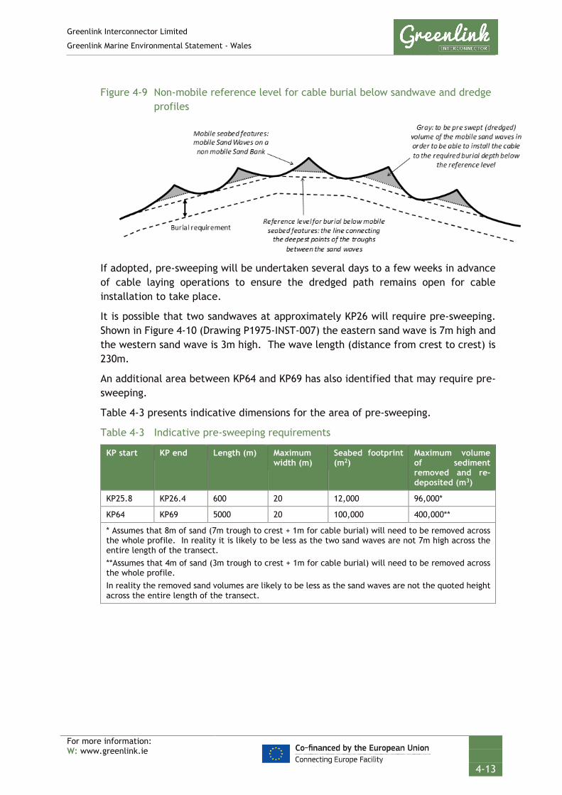
Greenlink Interconnector Limited
Greenlink Marine Environmental Statement - Wales
For more information: W: www.greenlink.ie
4-13
Figure 4-9 Non-mobile reference level for cable burial below sandwave and dredge profiles
If adopted, pre-sweeping will be undertaken several days to a few weeks in advance of cable laying operations to ensure the dredged path remains open for cable installation to take place.
It is possible that two sandwaves at approximately KP26 will require pre-sweeping. Shown in Figure 4-10 (Drawing P1975-INST-007) the eastern sand wave is 7m high and the western sand wave is 3m high. The wave length (distance from crest to crest) is 230m.
An additional area between KP64 and KP69 has also identified that may require pre-sweeping.
Table 4-3 presents indicative dimensions for the area of pre-sweeping.
Table 4-3 Indicative pre-sweeping requirements
KP start KP end Length (m) Maximum width (m)
Seabed footprint (m2)
Maximum volume of sediment removed and re-deposited (m3)
KP25.8 KP26.4 600 20 12,000 96,000*
KP64 KP69 5000 20 100,000 400,000**
* Assumes that 8m of sand (7m trough to crest + 1m for cable burial) will need to be removed across the whole profile. In reality it is likely to be less as the two sand waves are not 7m high across the entire length of the transect. **Assumes that 4m of sand (3m trough to crest + 1m for cable burial) will need to be removed across the whole profile. In reality the removed sand volumes are likely to be less as the sand waves are not the quoted height across the entire length of the transect.

GREENLINK INTERCONNECTORINSTALLATION
Indicative Sand Pre-Sweeping LocationsUK Waters
Chris CarrollChris Goode
Tuesday, April 16, 2019 09:17:34WGS_1984_UTM_Zone_30N
D_WGS_1984UKHO; CDA; OSOD; MMT; EMODNET;
WGS_1984
NOTE: Not to be used for Navigation
Contains public sector information, licensed under the Open Government Licence v2.0, from the UKHO, 2018.; Contains data from UKOGD.; Contains Ordnance Survey data © Crown copyright and database right 2013; The bathymetric metadata and Digital Terrain Model data products have been derived from the EMODnet Bathymetry portal - http://www.emodnet-bathymetry.eu.
Anna Farley
KP 0KP 10
KP 20KP 30
KP 40KP 50KP 60
KP 70KP 80
300000
300000
325000
325000
350000
350000
57000
00
57000
00
57250
00
57250
00
57500
00
57500
00
LegendKPGreenlink Route Centreline (Indicative)12nm Territorial Sea LimitMedian LineIndicative Sand Pre-Sweeping General LocationIndicative Sand-Pre-Sweeping 20m Corridor
BathymetryDepth below LAT (m)
-10 - 0-20 - -10-30 - -20-50 - -30-80 - -50-100 - -80-120 - -100-145 - -120
0 5 10 15km © Metoc Ltd, 2019.
All rights reserved.
J:\P1975\Mxd\15_INST\P1975-INST-007.mxd
Created ByReviewed By
DateProjection
DatumData Source
File Reference
Spheroid
Approved By
Drawing No: P1975-INST-007 A
KP 26
0 100 200 300 400m
KP 25.8 - KP 26.4
KP 63KP 64
KP 65KP 66
KP 67KP 68
KP 69
KP 64 - KP 69
0 0.5 1 1.5 2km
NOTE:Flase colour representationfo the Surveyed bathymetryhave been used to show thesandwaves at the two pre-sweeping locations.

Greenlink Interconnector Limited
Greenlink Marine Environmental Statement - Wales
For more information: W: www.greenlink.ie
4-15
There are two techniques used for pre-sweeping; dredging and mass flow excavation. As it is not currently known which technique will be used, both are described and have been assessed by the EIA.
Dredging This technique uses a trailing suction hopper dredger (TSHD) to remove the crest lines of sandwaves and create a flatter path for a burial machine to move along. The TSHD would operate as a discrete vessel (i.e. detached from the cable laying spread) and is generally agile and not restricted in its ability to manoeuvre.
The spoil volumes resulting from pre-sweeping are typical of dredging operations for channel or port maintenance and therefore are relatively small. The spoil would be deposited back on the seabed in the immediate vicinity of the pre-sweeping activity, thus keeping the dredged soil in the mobile seabed system and within the Proposed Development. The dredged soil will be dispersed equally by sailing slowly whilst opening the bottom doors at a slow pace.
Figure 4-11 Trailing suction hopper dredger
Source: http://www.theartofdredging.com/tshd3comp.htm
Mass flow excavation The MFE produces a downwards flow from a nozzle suspended 1m above the seabed. This fluidises the sediment, allowing the cables to sink into the seabed to the desired burial depth. Sediment is either pushed to either side of the cable trench (as illustrated in Figure 4-12) by the downward thrust or settles out of suspension. It has been assumed that disturbed sediments will be cast up to 50m either side of the trench, but will settle out of suspension within 3 minutes2.
2 Chapter 6 provides the basis for this assumption.
Anna Farley Intertek
Check this

Greenlink Interconnector Limited
Greenlink Marine Environmental Statement - Wales
For more information: W: www.greenlink.ie
4-16
Figure 4-12 Mass flow excavator
Source: Quad-prop Mass Flow Excavating Tool by N-Sea (2014).
4.6.3.5 Route preparation at subsea cable crossing locations
The submarine cable corridor crosses two types of cables: out of service (OOS) and in-service (IS) telecommunications cables.
OOS cables Greenlink crosses one OOS telecommunications cable; the Celtic telecommunications cable, within Irish territorial waters (Irish Marine). GIL is in discussion with the cable owners (BT) to cut the cable. To do this a de-trenching grapnel is used to retrieve the OOS cable from the seabed. The de-trenching grapnel typically penetrates 1.5 – 2.0m into the seabed. Once retrieved the OOS cable is cut and the ends secured to the seabed in accordance with International Cable Protection Committee (ICPC) recommendation No 1 (ICPC 2014), i.e. with clump weights which reduces the risk of hooking behind the cable ends by for instance fishing gear.
The clearance of OOS cables will be undertaken by a dedicated vessel equipped with a ROV for subsea intervention.
IS cables Greenlink crosses five IS telecommunication cables. Of these one is in the Proposed Development and four are in Irish offshore waters (Irish Offshore). The assets and crossing locations are provided in Section 4.7.4, Table 4-4 below.
As explained in Section 2.3.8, the crossing of third-party infrastructure is made with prior agreement of the owners following a negotiated formal Crossing Agreement. This will lay out the design of the crossing, describing aspects such as crossing angle and the vertical separation to be achieved between the Greenlink interconnector and the third-party asset.
The crossing physical design will vary according to, among other things, the size, type, location and burial state of the crossed asset. Generally, the Greenlink interconnector will cross over the IS cables on a ‘bridge’ comprised of either aggregate (rock) or concrete mattresses. It is this first layer of protective material

Greenlink Interconnector Limited
Greenlink Marine Environmental Statement - Wales
For more information: W: www.greenlink.ie
4-17
that will be positioned during route preparation. Construction of the remainder of the crossing is described in Section 4.7.4.
4.7 Cable installation
4.7.1 Installation vessels
The cable lay operation will be performed on a 24-hour basis to ensure minimal navigational impact on other users and to maximise efficient use of suitable weather conditions and vessel and equipment time. Notifications will be issued in accordance with statutory procedures to ensure navigational and operational safety. In addition to the installation vessel(s), additional vessels (i.e. guard vessels) will be involved with the operation. Although exact details may change, it is likely that the vessels to be used will consist of:
• Cable lay vessel (CLV) – undertakes cable lay and burial;
• Jack-up barge (JUB) – may be used at the horizontal directional drill exit point to support the pull-in of the cables.
• Cable lay barge (CLB) – may be used in water depths of less than 10m;
• Small work boats – support the CLV, CLB and JUB e.g. during cable pull-in operations;
• Guard vessel(s) – used to protect areas of exposed cable prior to external protection being applied;
• Rock placement vessel – used to deposit the external protection material e.g. rock berms;
4.7.1.1 Cable lay vessel (CLV)
The cable lay vessel (CLV) is a specialist ship designed specifically to carry and handle long lengths of heavy power cables. CLV’s are equipped with dynamic positioning (DP) systems, which enable the ship to be held very accurately in position despite the effects of currents and wind.
Figure 4-13 Cable lay vessels
The cable is loaded onto the ship at the cable factory. The CLV’s have powered turntables so that the cables can be wound on without coiling. The factory is also

Greenlink Interconnector Limited
Greenlink Marine Environmental Statement - Wales
For more information: W: www.greenlink.ie
4-18
equipped with a turntable as well as a purpose built dock with rollers and guides so the transfer of cable is smooth and safe for the integrity of the cable. Once loaded the vessel transits to a port, close to the worksite for final mobilisation of cable handling crew, client’s staff and equipment prior to heading to the work site. The vessels can carry long lengths of cable, up to and perhaps in excess of 100km, depending on the vessel used and the final design of the cable.
Figure 4-14 Typical factory and cable laying vessel turntables
4.7.1.2 Jack-up barge (JUB)
The shore crossing i.e. where the submarine cables come ashore and connect to the land cables, will be made by a horizontal direction drill (HDD). This is described in detail in Section 4.8. The base case is that the HDD ducts will exit below the low water mark. It is likely that the HDD will be completed ahead of the cable lay campaign.
A jack-up barge (JUB) may be used at the HDD exit to either excavate the end of the HDD duct and/or support the cable pull-in through the HDD.
A JUB is a small platform that typically has four to eight legs. The number of legs used for the operation is dependent on seabed conditions, current strength, wave action and the selected contractor. The JUB would be towed into position by a tug, which is likely to remain close by, in a support capacity, through-out the operation.
4.7.1.3 Cable lay barge (CLB)
The main CLV cannot typically operate in water depths of less than 10m so cannot reach the beach to directly land the cables. Therefore, a separate shallow water spread, such as a CLB, may also be needed.
Shallow water spreads are normally based upon flat-top pontoon barges that are mobilised on an ad-hoc basis for cable work. They will be fitted with all the necessary cable storage and working gear and a four to six-point mooring system (anchors), which is used to manoeuvre the barge during cable work. Occasionally two barges are combined into a single spread, with one providing storage and deck working space and another providing motive power by use of anchors or thrusters.

Greenlink Interconnector Limited
Greenlink Marine Environmental Statement - Wales
For more information: W: www.greenlink.ie
4-19
The CLB may be assisted by a team of small boats and divers, depending on the installation technique selected by the contractor.
The base case is that the horizontal direction drill for the shore crossing will exit approximately 1km from the HDD compound. If this length of HDD is achieved, it is unlikely that a CLB would be required.
4.7.1.4 Guard vessel
Where deemed necessary, the CLV, CLB or other vessel operations with restricted vessel manoeuvrability will be accompanied by a guard vessel(s). The guard vessel(s) will maintain surveillance around the main vessel to advise other vessels keep clear of the installation to avoid the threat of collision and to protect the cable prior to burial.
A guard vessel may also be used to warn fishing vessels of temporarily unprotected sections of cable e.g. between cable lay and installation of rock protection.
4.7.1.5 Rock placement vessel
Rock placement will be used to protect sections of the marine cables (described in Section 4.7.5 below). Rock-placement vessels feature a large hopper to transport the rock, and a mechanism for deployment of the rock on site. The usual mechanisms are:
• Side dumping, whereby the rock is pushed or tipped over the side of the vessel;
• Split hopper, the halves of which separate to allow the rock to fall through the vessel; and
• Flexible fall pipe, where a retractable chute is used to control the flow of rock to the seabed.
Where there are strong currents such as off the Pembrokeshire coast, fall-pipe vessels have a big advantage in that the rock can be more accurately placed.
Figure 4-15 Typical fall-pipe vessel

Greenlink Interconnector Limited
Greenlink Marine Environmental Statement - Wales
For more information: W: www.greenlink.ie
4-20
4.7.2 Cable laying
When the CLV arrives on site the cable is transported via cable engines to the over-boarding point of the ship (usually the aft end). Under a hold back tension, it is guided over into the water. It is either laid onto the seabed for later burial or emerges from the plough at a point below the seabed consistent with the specified burial depth.
Two cable installation techniques are being considered for the Proposed Development:
• Simultaneous lay and burial – in this operation the CLV may tow the burial equipment or it is deployed by another vessel navigating close behind, creating effectively a single large spread. The cables are fed into the burial equipment directly from above and the cables are buried as the spread progresses along the route.
• Post-lay burial – in this operation the CLV lays the cables on the seabed first. A post-lay burial vessel follows to bury the cables. The post-lay burial vessel may be some physical distance, or indeed some days, behind the lay vessel, so there are two discrete operations separated physically and in time.
The sea surface footprint of a cable installation spread will depend on the technique to be used. It will incorporate that of the vessel, or vessels if working in concert, and the surrounding area, commensurate with being a “vessel restricted in its ability to manoeuvre”. Typically, a large CLV will be up to 150m in length and other vessels will be requested to remain a “safe” distance from the operation, typically 500m radius or potentially up to 2km if the CLV has anchors.
The temporal effect of the spread will be dependent on the slowest moving element, usually the burial spread, which will most likely be moving at a speed of between 100 – 300m per hour, depending on the soils encountered and the type of trencher used. This, in terms of other shipping, will appear to be effectively stationary. The only interruptions to the marine installation may be for cable joints that need to be made along the route (see Section 4.7.3 below).
Cable laying without simultaneous cable burial can progress at speeds of up to around 500m an hour. This operation can continue in fairly heavy weather, up to Force 7 winds and a significant wave height of 3m. The vessel can stay on station typically in Force 8 or 9 winds. While operating in poor weather the CLV will slowly lay cable against the wind. After riding out the storm the length of cable laid during the storm will be retrieved from the seabed and cable lay will start again where operations were previously suspended.

Greenlink Interconnector Limited
Greenlink Marine Environmental Statement - Wales
For more information: W: www.greenlink.ie
4-21
In the most severe weather, the vessel may have to cut and cap the cable and leave the work site. In this case the vessel will return when the weather has improved, recover the end of the cable, make a joint and continue the laying operation.
In shallow waters the sea surface footprint of the spread will also be dependent on whether anchors are used. The anchors may be placed up to 500 to 1000m from the vessel depending on the amount of wire present on the vessel winches and on the space available for placing the anchors. The same precautions are necessary with respect to the vessel and the anchor pattern although there is inherently less risk of interaction with large volumes of shipping traffic in shallow water. The anchor handling vessels will in this case normally also act as guard vessels for the spread.
4.7.3 Cable jointing
CLV’s typically have a carrying capacity of 5,000 to 10,000 tonnes. For Greenlink, this equates to cable lengths in bundled configuration up to or even over 100km. However, this means that it may be necessary to install the cable in at least two sections.
The end of the installed section will be temporarily left on the seabed whilst the CLV picks up the new cable. Depending on the local situation (i.e. threat levels) the end of the cable may be temporarily buried into the seabed. A ground wire will be attached to the end of the cable to enable retrieval of the end of the cable to allow cable laying to continue.
Cable joints will be made on board the CLV and will take up to a week to complete per joint location. In this time the vessel is likely to anchor to maintain position. Once the cable joint has been made on board the vessel cable laying will continue as normal.
There are two types of cable joints; in line joints and omega (or hairpin) joints. An ‘in line’ joint is when cable laying is continued after picking up a cable end (as illustrated in Figure 4-16). An omega joint is made between a cable which has been laid towards another cable, or when a repair is required in an existing cable.
The jointing process for an omega joint requires extra cable approximately equal to twice the depth of water to be introduced into each of the two cables to allow for the jointing operation to take place. When joints are deployed onto the seabed they are laid down in a loop formation, referred to as an “omega” (or “hairpin”) owing to its shape. The loop size and shape are controlled as the cables are deployed onto the seabed to ensure the cable minimum bend radius requirements are met (see Figure 4-16).
The joints and the short section of adjacent cables left on the seabed at the ‘final’ joint location will be buried using a jetting machine, a mass flow excavation unit or protected by concrete mattresses or rock protection.
GIL will ensure, as far as possible, that joints are not located in higher risk areas, e.g. shipping channels and anchoring grounds, where the prolonged location of the installation spread is not desirable.
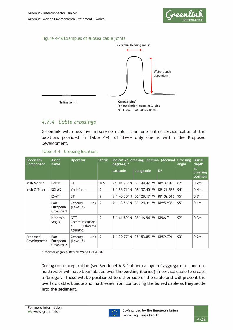
Greenlink Interconnector Limited
Greenlink Marine Environmental Statement - Wales
For more information: W: www.greenlink.ie
4-22
Figure 4-16 Examples of subsea cable joints
4.7.4 Cable crossings
Greenlink will cross five in-service cables, and one out-of-service cable at the locations provided in Table 4-4; of these only one is within the Proposed Development.
Table 4-4 Crossing locations
Greenlink Component
Asset name
Operator Status Indicative crossing location (decimal degrees) *
Crossing angle
Burial depth at crossing position
Latitude Longitude KP
Irish Marine Celtic BT OOS 52° 01.73" N 06° 44.47" W KP139.098 87° 0.2m
Irish Offshore SOLAS Vodafone IS 51° 53.71" N 06° 37.40" W KP121.535 94° 0.4m
ESAT 1 BT IS 51° 45.30" N 06° 29.17" W KP102.513 95° 0.7m
Pan European Crossing 1
Century Link (Level 3)
IS 51° 43.56" N 06° 24.31" W KP95.935 95° 0.1m
Hibernia Seg D
GTT Communications (Hibernia Atlantic)
IS 51° 41.89" N 06° 16.94" W KP86.7 92° 0.3m
Proposed Development
Pan European Crossing 2
Century Link (Level 3)
IS 51° 39.77" N 05° 53.85" W KP59.791 93° 0.2m
* Decimal degrees. Datum: WGS84 UTM 30N
During route preparation (see Section 4.6.3.5 above) a layer of aggregate or concrete mattresses will have been placed over the existing (buried) in-service cable to create a ‘bridge’. These will be positioned to either side of the cable and will prevent the overlaid cable/bundle and mattresses from contacting the buried cable as they settle into the sediment.
‘In line joint’ ‘Omega joint’For installation: contains 1 jointFor a repair: contains 2 joints
Water depth dependent
> 2 x min. bending radius

Greenlink Interconnector Limited
Greenlink Marine Environmental Statement - Wales
For more information: W: www.greenlink.ie
4-23
The Greenlink cable bundle will then be surface-laid across the mattresses. To do so the cables will have to transition from a buried state in the sediments close by to surface lay. An exclusion zone either side of the existing cable (distance as agreed with the third-party cable owner) will be observed for burial equipment. If a plough is used, it must transition out of the soil before reaching the exclusion boundary. Burial will continue after cable lay progresses outside the burial exclusion zone on the other side of the crossing.
Additional mattresses or rock protection will be laid along the Greenlink interconnector where it is surface laid in the burial exclusion zone.
Figure 4-17 (overleaf) illustrates a typical crossing design for a buried cable.

Pre lay rock
Slope: ~1:5
C
l
o
s
e
t
o
9
0
°
Y
X
Y
XY of Asset Crossing
Slope: ~1:5
Slope: ~1:3
Project Cable
Ø
A
s
s
e
t
D
i
a
m
e
t
e
r
Y
Y
Trencher limit informed by trencher type and risk assessment
X
XY of Asset Crossing
~Slope: 1:5
Slope: ~1:3
Rock Cover
Ø
A
s
s
e
t
D
i
a
m
e
t
e
r
Trench Limit Trench Limit
As-Laid Asset DoB
Distance defined by
protection requirements
Rock berm limit defined by trench depth
and asset protection measures
Distances determined by rock
berm heights defined by
protection requirements
Project Cable
Trencher limit informed by trencher type and risk assessment
Rock berm limit defined by trench depth
and asset protection measures
Pre lay Rock
Distance defined by
protection requirements
Distance defined by
protection requirements
POST LAY ROCK BERM
PRE LAY ROCK BERM

Greenlink Interconnector Limited
Greenlink Marine Environmental Statement - Wales
For more information: W: www.greenlink.ie
4-25
A minimum vertical separation between the existing cable and Greenlink, typically 300mm, will be agreed with the cable owners; and the crossing engineered to achieve the agreed vertical separation distance.
The crossing design for each asset crossed will indicate the footprint of the impact to the seabed. For the purposes of assessment, it has been assumed that cable protection will be required up to 60m either side of the third-party asset3; 200m in total. The rock berm will be up to 1.2m high and 8.2m wide.
Table 4-5 provides the worst-case dimensions and assumptions that have been used in the assessment.
Table 4-5 Key worst-case assumptions for crossings
Asset name
Total length of external protection (m)
Seabed footprint of crossing (m2)
Total external protection volume (m3)
Sediment EUNIS Habitat
Proposed Development
Pan European Crossing 2
120 1009 583.5 Sand A5.251- Echinocyamus pusillus, Ophelia borealis and Abra prismatica in circalittoral fine sand
Irish Offshore
ESAT 1 120 1009 583.5 Sand A5.272 - Owenia fusiformis and Amphiura filiformis in deep circalittoral sand or muddy sand
SOLAS 120 1009 583.5 Sand A5.242 - Fabulina fabula and Magelona mirabilis with venerid bivalves and amphipods in infralittoral compacted fine muddy sand
Pan European Crossing 1
120 1009 583.5 Sand A5.252 - Abra prismatica, Bathyporeia elegans and polychaetes in circalittoral fine sand
Hibernia Seg D
120 1009 583.5 Sand A5.252 - Abra prismatica, Bathyporeia elegans and polychaetes in circalittoral fine sand
Assumptions
Height of rock berm 1.2m Rock berm crest 1m wide Berm side slope 1:3 profile
4.7.5 Cable burial and protection
Once laid on the seabed the cables need to either be buried or otherwise protected from the threat of external damage such as anchors or fishing activity.
The choice of burial technique or protection method will vary along the route depending upon the seabed conditions in each section. Where possible the cables
3 50m berm at either side of crossing plus 10m grade out to provide over-trawlable profiles.

Greenlink Interconnector Limited
Greenlink Marine Environmental Statement - Wales
For more information: W: www.greenlink.ie
4-26
will be buried in the seabed as this provides the best protection for the cable and minimises potential for interference with fishing activity. Where the seabed composition is not suitable for burial, external mechanical protection will be provided through either rock-placement or application of concrete mattresses.
4.7.5.1 Burial depths
The recommended target burial depths along the cable length were determined in a detailed Cable Burial study completed in April 2019 (Intertek EWCS 2019) using the Carbon Trust cable burial risk assessment (CBRA) methodology. This considered cable design, regulatory requirements, route, seabed composition and dynamics, and risk of hazards (shipping, existing infrastructure, UXO) and potential for damage from external sources (fishing gear and ship’s anchors).
The cables will be buried into the seabed along the maximum length possible. The target burial depth is:
• 1.0m for all areas of loose sediment (sands / gravels); and
• 0.6m for areas of glacial till.
4.7.5.2 Installation techniques
The nature of the seabed influences which installation tool is selected. The seabed varies along the cable route from sands and gravelly sand/ sandy gravel with local areas of gravel and silt. Bedrock is found outcropping and subcropping mainly in the Proposed Development and nearshore Irish Marine (MMT 2019).
A preliminary assessment of the cable installation methods is presented in Table 4-6, and indicative locations where external cable protection may be required in shown in Figure 4-18 (Drawing P1975-INST-005) and Table 4-6. It is estimated that at least 89% of Greenlink will be buried within sediment. Given the sediment conditions, it is likely that the main techniques used will be jet-trenching and ploughing. Approximately 16km of the cable route within the Proposed Development may require either cutting below the base of the sand unit to achieve the required burial depth or external cable protection such as rock. External cable protection will also be required at the third-party asset crossing locations.
Table 4-6 Potential installation method
Cable Protection Option Length (km)
Proposed Development
Irish Offshore Irish Marine
Burial in sediment (jetting or ploughing) 57.44 49.24 35.63
Rock placement only 0.12 0.48 0.00
Potential burial in rock or rock placement 16.34 0.00 0.02
Total 73.9 49.72 35.65
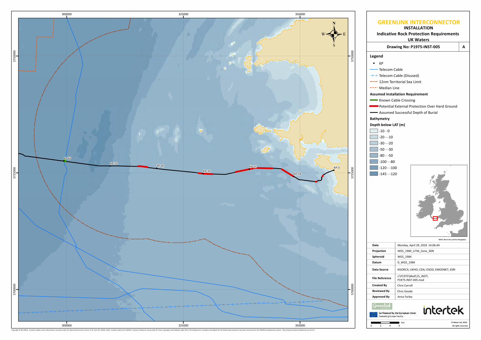
GREENLINK INTERCONNECTORINSTALLATION
Indicative Rock Protection Requirements UK Waters
Chris GoodeChris Carroll
Monday, April 29, 2019 14:06:44WGS_1984_UTM_Zone_30N
D_WGS_1984KISORCA; UKHO; CDA; OSOD; EMODNET; ESRI
WGS_1984
NOTE: Not to be used for Navigation
Copyright © KIS-ORCA; Contains public sector information, licensed under the Open Government Licence v2.0, from the UKHO, 2018.; Contains data from UKOGD.; Contains Ordnance Survey data © Crown copyright and database right 2013; The bathymetric metadata and Digital Terrain Model data products have been derived from the EMODnet Bathymetry portal - http://www.emodnet-bathymetry.eu.© Esri
Anna Farley
KP 0KP 10
KP 20KP 30
KP 40KP 50KP 60
300000
300000
325000
325000
350000
350000
57000
00
57000
00
57250
00
57250
00
57500
00
57500
00 LegendKPTelecom CableTelecom Cable (Disused)12nm Territorial Sea LimitMedian Line
Assumed Installation RequirementKnown Cable CrossingPotential External Protection Over Hard GroundAssumed Successful Depth of Burial
BathymetryDepth below LAT (m)
-10 - 0-20 - -10-30 - -20-50 - -30-80 - -50-100 - -80-120 - -100-145 - -120
0 2 4 6km © Metoc Ltd, 2019.
All rights reserved.
J:\P1975\Mxd\15_INST\P1975-INST-005.mxd
Created ByReviewed By
DateProjection
DatumData Source
File Reference
Spheroid
Approved By
Drawing No: P1975-INST-005 A
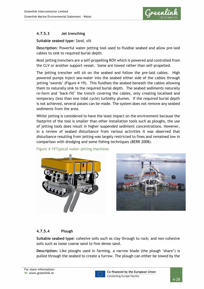
Greenlink Interconnector Limited
Greenlink Marine Environmental Statement - Wales
For more information: W: www.greenlink.ie
4-28
4.7.5.3 Jet trenching
Suitable seabed type: Sand, silt
Description: Powerful water-jetting tool used to fluidise seabed and allow pre-laid cables to sink to required burial depth.
Most jetting trenchers are a self-propelling ROV which is powered and controlled from the CLV or another support vessel. Some are towed rather than self-propelled.
The jetting trencher will sit on the seabed and follow the pre-laid cables. High powered pumps inject sea-water into the seabed either side of the cables through jetting ‘swords’ (Figure 4-19). This fluidises the seabed beneath the cables allowing them to naturally sink to the required burial depth. The seabed sediments naturally re-form and ‘back-fill’ the trench covering the cables, only creating localised and temporary (less than one tidal cycle) turbidity plumes. If the required burial depth is not achieved, several passes can be made. The system does not remove any seabed sediments from the area.
Whilst jetting is considered to have the least impact on the environment because the footprint of the tool is smaller than other installation tools such as ploughs, the use of jetting tools does result in higher suspended sediment concentrations. However, in a review of seabed disturbance from various activities it was observed that disturbance resulting from jetting was largely restricted to fines and remained low in comparison with dredging and some fishing techniques (BERR 2008).
Figure 4-19 Typical water-jetting machines
4.7.5.4 Plough
Suitable seabed type: cohesive soils such as clay through to rock; and non-cohesive soils such as loose coarse sand to fine dense sand.
Description: Like ploughs used in farming, a narrow blade (the plough ‘share’) is pulled through the seabed to create a furrow. The plough can either be towed by the

Greenlink Interconnector Limited
Greenlink Marine Environmental Statement - Wales
For more information: W: www.greenlink.ie
4-29
CLV to simultaneous lay and bury the cables or more usually is towed by a separate vessel to bury the cables post-lay.
The cable is fed into a bellmouth at the front of the plough and is guided down through the share to emerge in the trench the machine leaves as it passes through the seabed. The displaced by the plough share is pushed to either side of the trench as berms. These berms may be simultaneously pushed by the plough back into the trench to cover the cables; pushed into the trench by a separate back-fill plough pulled along in the wake of the first plough; or left in place to ‘naturally back-fill’ the trench via the natural movement of sediment on the seafloor.
The overall body of the plough is approximately 10m wide and rides on hydraulically adjustable skids which are used to control the depth of protrusion of the share, and therefore the burial depth of the cable. The trench created by the plough can be up to 5m wide; although for power cable installation a trench of 1m wide is more typical.
The action of the plough causes a relatively large amount of ground disturbance (in comparison to jetting), because seabed material is displaced and piled up at either side of the trench (National Grid and SP Transmission 2011). In addition, cable ploughing temporarily suspends finer bottom sediments into the water column creating a localised and temporary plume (less than one tidal cycle).
Figure 4-20 Typical plough
4.7.5.5 Cutting
Suitable sediment type: Hard clay, cemented sand, sand stone, rock
Description: Cutting of trench using a wheel or a driven chain cutter to break and move rock and hard sediments. Can be used either pre-lay (so the cable can be laid into the trench) or post-lay.
Mechanical trenchers can work in all sediments including those with high shear strength and even weak bedrock. These machines are usually mounted on tracked vehicles and use chain saws or wheels armed with tungsten carbon steel teeth to cut a defined trench. Most spoil is ejected from the trench by the cutting action and the cable is guided into the trench base by a depressor.

Greenlink Interconnector Limited
Greenlink Marine Environmental Statement - Wales
For more information: W: www.greenlink.ie
4-30
The mechanical action may be augmented in some cases by eductors that suck disrupted material out of the trench and deposit it to the side. The open trench can be back-filled or left to refill naturally. A typical mechanical trencher can make a trench of 0.3-0.7m in width and the overall footprint of the mechanical trencher is approximately 5-15m.
For all burial techniques, machine function is controlled from the surface vessel via an umbilical cable. However, in shallow water less than 5m deep, some trenchers require the assistance of divers, to load the cable to the cable depressor.
This operation is relatively slow and typically requires frequent maintenance.
4.7.5.6 Rock placement
Rock placement is used to protect subsea cables by covering them in a continuous profiled berm of graded rock. The berm provides a strong protective cover to prevent potential impact and snagging, and also ensures stability by shielding the cable from the current flow. The size of the berm and grade of rock required will depend on the current and wave loading conditions. The rock grading needed for a dynamically stable rock berm decreases with increasing water depths. In shallower waters the wave induced water action at the seabed is larger than in deeper waters. Therefore, at shallower water depths a larger rock grading is needed.
Typically, rock placements are designed to be dynamically stable. This implies that under design wave and current conditions some displacement of rock is allowed for, provided the protection by the rock is not compromised. As a result of some displacement of rock under these conditions the slopes of the rock berms will decrease in steepness, which in its turn results in an increasing stability of the rock berm. By allowing a dynamically stable rock berm design, the effect on the environment by the rock placement and its footprint can be reduced to some extent.
Where required, rock berms will be designed to ensure long-term stability however, it is likely that some level of maintenance (periodic inspections and replacement of disturbed rock) will be required particularly in shallower water sections where the impact of waves under storm conditions is greater compared to deeper water sections.
Although the size of the berm will depend on the location and conditions, as a worst-case it has been assumed the maximum height will be 1.5m, with a crest width of 1.0m. The side slopes of such a rock berm would be 1 vertical in 2.5 horizontal, which is the natural angle of repose of placed rock. Where additional stability is required due to higher wave loads under design conditions, the side slopes can be reduced to 1 in 5 or even 1 in 8 under a dynamically stable design; although then the maximum height would also be reduced. To further increase the stability of the rock berm, a heavier rock type can be used. The assessment assumes rock berms for external cable protection will have a maximum width of 10m.
The particle size of the rock used will be driven by an assessment of the local seabed geology, metocean conditions, water depth and the nature of the external threat

Greenlink Interconnector Limited
Greenlink Marine Environmental Statement - Wales
For more information: W: www.greenlink.ie
4-31
which is being protected against. Engineering design has not yet been completed for the berms but rock sizes are likely to be in the range of 2cm to 22cm. A filter layer is sometimes required either to provide a stable base in soft sediment for the armour layer to be installed on and/or provide protection to the cable bundle from the impact of the installation of the armour layer. If used, the filter layer would be laid first comprising of smaller particle sizes, followed by larger layer designed to prevent segregation of sediments during placement. The final layer (i.e. the armour layer) covers the other two layers and is designed to provide protection against identified external threats (e.g. anchors and fishing gear) whilst also withstanding severe metocean events.
Figure 4-21 Rock placement
The cable burial risk assessment (Intertek EWCS 2019), informed by the geophysical and geotechnical survey data, has identified indicative locations where external cable protection may be required. Table 4-7 provides indicative locations where rock placement could be required due to ground conditions. These locations are shown on Figure 4-18 above.
Table 4-7 Indicative rock protection locations (due to ground conditions)
KP start
KP end
Distance (km)
Comment Biotope Presence of Annex I habitat
2.38 2.41 0.03 Outcrop within sandy channel. Likely to be too tight to route around.
Outcrop is A4.138 - Molgula manhattensis with a hydroid and bryozoan turf on tide-swept moderately wave-exposed circalittoral rock. Surrounding area is A5.143 - Protodorvillea kefersteini and other polychaetes in impoverished circalittoral mixed gravelly sand.
Bedrock reef
2.7 2.9 0.2 0.3-0.5m cover of sand. May be able to cut down into rock below sand. Protection likely to be 2-3m wide.
A5.143 - Protodorvillea kefersteini and other polychaetes in impoverished circalittoral mixed gravelly sand. A5.25 - Circalittoral fine sand
4.86 5 0.14 Small sand channel identified through bedrock reef confirmed by analysis of video transect data.
A4.138 - Molgula manhattensis with a hydroid and bryozoan turf on tide-swept moderately wave-exposed circalittoral rock
Bedrock reef
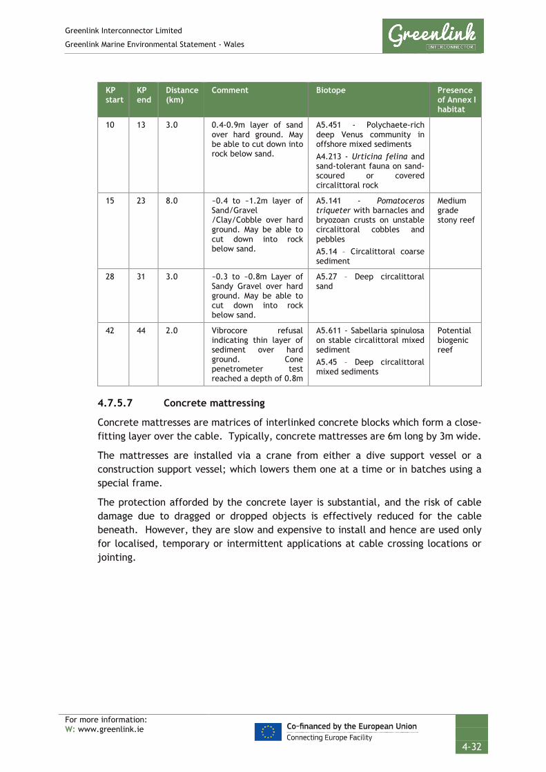
Greenlink Interconnector Limited
Greenlink Marine Environmental Statement - Wales
For more information: W: www.greenlink.ie
4-32
KP start
KP end
Distance (km)
Comment Biotope Presence of Annex I habitat
10 13 3.0 0.4-0.9m layer of sand over hard ground. May be able to cut down into rock below sand.
A5.451 - Polychaete-rich deep Venus community in offshore mixed sediments A4.213 - Urticina felina and sand-tolerant fauna on sand-scoured or covered circalittoral rock
15 23 8.0 ~0.4 to ~1.2m layer of Sand/Gravel /Clay/Cobble over hard ground. May be able to cut down into rock below sand.
A5.141 - Pomatoceros triqueter with barnacles and bryozoan crusts on unstable circalittoral cobbles and pebbles A5.14 – Circalittoral coarse sediment
Medium grade stony reef
28 31 3.0 ~0.3 to ~0.8m Layer of Sandy Gravel over hard ground. May be able to cut down into rock below sand.
A5.27 – Deep circalittoral sand
42 44 2.0 Vibrocore refusal indicating thin layer of sediment over hard ground. Cone penetrometer test reached a depth of 0.8m
A5.611 - Sabellaria spinulosa on stable circalittoral mixed sediment A5.45 – Deep circalittoral mixed sediments
Potential biogenic reef
4.7.5.7 Concrete mattressing
Concrete mattresses are matrices of interlinked concrete blocks which form a close-fitting layer over the cable. Typically, concrete mattresses are 6m long by 3m wide.
The mattresses are installed via a crane from either a dive support vessel or a construction support vessel; which lowers them one at a time or in batches using a special frame.
The protection afforded by the concrete layer is substantial, and the risk of cable damage due to dragged or dropped objects is effectively reduced for the cable beneath. However, they are slow and expensive to install and hence are used only for localised, temporary or intermittent applications at cable crossing locations or jointing.

Greenlink Interconnector Limited
Greenlink Marine Environmental Statement - Wales
For more information: W: www.greenlink.ie
4-33
Figure 4-22 Concrete mattress deployment (courtesy of FoundOcean)
4.8 Landfall installation
4.8.1 Cable landfalls
The landfalls are where the marine cables come ashore. In Wales, the landfall is Freshwater West, Pembrokeshire (illustrated in Figure 1-1, Drawing P1975-LOC-001).
The ‘base case’ is that shore-crossings will be accomplished by horizontal directional drilling (HDD) which will exit seaward of the low water mark, avoiding any activity on the beach.
The landfall will be prepared in advance of the arrival of the CLV, so that that vessel is not delayed in its operations. This will involve the digging of transition joint pits (TJPs) above MHWS and the installation of cable ducts from the TJP to below mean low water, avoiding any activity on the beach.
4.8.1.1 Transition joint pit (TJP)
The land cables will connect with the marine cables in a TJP, buried in the ground above the high-water mark. At both landfalls up to two TJPs will be dug. Each bay will be 10-15m long, 2-3m wide and 2-3m deep below ground level; covering a maximum area of 45m2 per TJP. The TJPs are outside of the scope of the Proposed Development and this ES as they are above MHWS, but further information is provided in the Welsh Onshore ES. The TJPs are located away from the beach.
4.8.1.2 Installation of ducts - horizontal directional drilling (HDD)
HDD is a surface-launched process for boring a hole, under any sensitive features, to a point a suitable distance in the nearshore. A pipe is inserted into the drilled hole which is used as a duct into which the cables are installed. Figure 4-23 illustrates a typical shore to sea bore.

Greenlink Interconnector Limited
Greenlink Marine Environmental Statement - Wales
For more information: W: www.greenlink.ie
4-34
The HDD is accomplished in three stages:
• Pilot Hole Drilling;
• Hole Opening Operations (Reaming); and
• Pre-lay messenger (draw) wire.
The first stage involves drilling a small diameter pilot bore which is stabilised by filling it with drilling mud, typically consisting of bentonite clay and water. Any materials used will be inert.
Maintaining an open bore is of critical importance. Drill pipes (approximately 9.0m in length) are added to the end of the drill string on the drilling rig one at a time and drilled down into the ground in succession. Pilot hole drilling continues until the drill bit exits the ground at the required exit point.
The second stage involves enlarging the drilled hole to the required diameter for installation of the cable, a process known as pilot hole reaming. At the exit point a back reamer replaces a drill bit and is pulled back towards the pilot hole entry.
The final stage involves inserting a messenger wire within the duct to enable future cable pull in operations. Ducts will be capped prior to cable installation to avoid excessive build up of debris.
The HDD compound, from which drilling will take place, will be sited above MHWS. Sites have been selected that take the following into consideration:
• Distance from neighbouring properties;
• Adequate space for the construction of a HDD compound; and
• Adequate set-back distance from sensitive features e.g. sand dunes at Freshwater West, and cliff face at Baginbun Beach.
Indicative locations for the compound is shown in Figure 4-24 and a typical HDD compound layout is presented in Figure 4-25. Further details are provided in the Welsh Onshore ES.
Three ducts will be drilled at each landfall; two for use, and one as a spare. The fibre optic cable will be installed in a duct with one of the power cables. The ducts will fan out of the TJP to achieve exit points for the marine cables in the nearshore, with a separation distance of approximately 10m. The cable ducts will pass approximately 10m below the beach.

Greenlink Interconnector Limited
Greenlink Marine Environmental Statement - Wales
For more information: W: www.greenlink.ie
4-35
Figure 4-23 Typical HDD

Greenlink Interconnector Limited
Greenlink Marine Environmental Statement - Wales
For more information: W: www.greenlink.ie
4-36
Figure 4-24 Indicative location of HDD compound – Freshwater West, Pembrokeshire
Figure 4-25 Typical layout of HDD compound

Greenlink Interconnector Limited
Greenlink Marine Environmental Statement - Wales
For more information: W: www.greenlink.ie
4-37
4.8.1.3 HDD exit point
Preliminary design of the HDD has been undertaken, but the final design will be completed by the Installation Contractor. Based on the geological conditions at Freshwater West, the HDD is likely to exit within the orange hatched box presented in Figure 4-26 (Drawing P1975-INST-001).
The base case is that the HDD will exit below the low water mark, and no intrusive works will be undertaken on Freshwater West between MHWS and LWM.
The EIA process, Chapter 6, established that the top of the beach is likely to be sensitive to intrusive works e.g. cutting a trench for cable installation. In addition, beach levels at Freshwater West can change dramatically during winter storm conditions. To ensure cables remain buried they would need to be buried 2m below the winter beach level. The geophysical survey (MMT 2019) identified that the mobile sand unit in the lower intertidal area could be as deep as 6m. Undertaking a trench of this nature i.e. up to 8m deep, would be technically challenging. For these reasons it is not currently proposed that any cable trenching will be undertaken above the LWM at Freshwater West.
An exclusion zone has been established within the Proposed Development (red hatched area shown in Figure 4-26, Drawing P1975-INST-001) in which no intrusive works will be carried out unless further assessment work is undertaken to determine the significance of effects and a Marine Licence variation is obtained from Natural Resources Wales (see Chapter 6 for further details).
The length of HDD proposed (between 1-2km) is feasible and has been proven on other engineering projects.
The HDD exits points for each duct are likely to be within 10m of each other. From the exit point the cables will then merge back together, to form the bundle. Cables in this transition area will be buried post-lay.
The base case is that the HDD will be engineered to exit into a deep sediment unit where post-lay burial of the cables and the ducts can be achieved.
Review of the geophysical data suggests that burial in sediment is achievable and the base case assumes that external cable protection will not be required at the HDD exit point.

GREENLINK INTERCONNECTORINSTALLATION
Indicative HDD Exit Point - UK Landfall
Chris GoodeChris Carroll
Thursday, June 6, 2019 13:48:42WGS_1984_UTM_Zone_30N
D_WGS_1984OSOD; MMT; ESRI; Greenlink
WGS_1984
NOTE: Not to be used for Navigation
Contains Ordnance Survey data © Crown copyright and database right 2013; Service Layer Credits: Source: Esri, DigitalGlobe, GeoEye, Earthstar Geographics, CNES/Airbus DS, USDA, USGS, AeroGRID, IGN, and the GIS User Community
Anna Farley
356000
356000
357000
357000
358000
358000
57250
00
57250
00
57260
00
57260
00
LegendGreenlink Route Centreline (Indicative)Proposed DevelopmentHigh Water MarkLow Water MarkDecommissioned MOD Cable Avoidance ZoneHDD CompoundIndicative HDD Exit PointTrenching Exclusion ZoneAnnex I Habitat Exclusion Zone
EUNIS Habitat ClassificationA4.138A5.13A5.24A5.261
0 100 200 300 400m © Metoc Ltd, 2019.
All rights reserved.
J:\P1975\Mxd\15_INST\P1975-INST-001.mxd
Created ByReviewed By
DateProjection
DatumData Source
File Reference
Spheroid
Approved By
Drawing No: P1975-INST-001 A
NOTE:No trenching to be carried out in exclusion zones.

Greenlink Interconnector Limited
Greenlink Marine Environmental Statement - Wales
For more information: W: www.greenlink.ie
4-39
4.8.1.4 Marine cable installation at landfall
The installation sequence for each of the submarine cables and the fibre optic cable is likely to be similar, and will be defined by the Installation Contractor. An indicative methodology is provided below:
• The end of the duct accepting the cable will be dug out using an excavator positioned on a jack-up barge or anchored barge.
• Material excavated will be left adjacent to the HDD exit point and refilled after the cable pull-in. The submarine cable would be floated to the exit point of the duct. Small work boats and divers would support this activity (Figure 4-27).
• The submarine cable would then be connected to the messenger wire pre-installed in the duct and winched from a position close to the TJP through the duct; whereupon it can be jointed to the onshore cables.
• The cable is then installed away from the beach either using a plough or trencher (as per the offshore installation section above).
No works would be required on the beach.
As marine operations are dependent on weather conditions, offshore and nearshore installation work will be conducted on a 24-hour basis.
Figure 4-27 Example of a cable being floated-in
4.9 Cable operation
Following installation, routine maintenance work to the submarine cables is not anticipated. However, some work (described below) may be required to maintain the burial of the cable to protect it from adverse interactions with other sea users
Greenlink Interconnector Limited
Greenlink Marine Environmental Statement - Wales
For more information: W: www.greenlink.ie
4-40
and marine processes which might damage it. The cable and its installation will be designed to minimise any maintenance requirements.
Repair and maintenance activities will have a similar impact to the installation activities assessed in this EIA, however, they will be on a smaller and localised scale, and as such are not expected to have any significant impacts. Any impacts will be lower than those identified for installation operations.
4.9.1 In-service survey operations
It is likely that routine surveys using standard geophysical survey equipment and/or ROVs to monitor buried depth and integrity of rock-berms will be undertaken, particularly in the initial years of operation, and should the local environmental conditions change or be suspected as having changed.
Survey techniques used will be similar to those employed for pre-installation surveys described in Section 4.6.2 e.g. multi-beam echosounder, side scan sonar and magnetometer. In addition, shallow sub-bottom profiling and cable tracking may be used.
Shallow sub-bottom profiling involves injecting a pulse of acoustic energy into the seabed and detecting the reflections from the sub-surface geological units. From the reflections the thickness of the sediment can be assessed, and the depth of cable burial can be ascertained.
Regular survey of cable crossings may also be a requirement of a particular cable crossing agreement. Periodic inspections may be undertaken to identify cable exposures or spanning.
4.9.2 Marine cable repairs
Cable repairs to correctly installed and protected marine cables are infrequent but require operations which temporarily intrude on the environment and the activities of other users of the sea. The most common reason for repair of a marine cable in water depths <200m is damage caused by external interaction, typically by trawlers and commercial ships’ anchors. Globally around 70% of cable faults can be attributed to man-made activities and about 12% are caused by natural hazards e.g. induced abrasion or earthquakes (KIS-ORCA – Seafish 2019).
Faults caused by man-made activities are usually localised depending on the energy of the interaction and whether the cable is merely impacted, mauled (where something is dragged with force along the cable for a distance) or dragged from the seabed.
Where a cable fault is detected, the relevant section of the cable will be located and retrieved to surface for inspection and replacement. It may be necessary to unbury the cable prior to cable recovery or remove external protection such as rock-berms. Once unburied, measurement and testing will be conducted to establish the section of cable that needs to be replaced. If de-burial is not considered necessary the cable will be first retrieved from the seabed and pulled up by a suitable vessel.

Greenlink Interconnector Limited
Greenlink Marine Environmental Statement - Wales
For more information: W: www.greenlink.ie
4-41
A repair will typically be carried out by a single vessel. A shallow water repair, in less than 10m of water, will typically be made using an anchored barge. In deeper water a dynamically positioned (DP) cable vessel will be used. Vessels carrying out cable repair operations are restricted in their ability to manoeuvre and will display the required navigational lights and signals. Divers and/or ROV are expected to be used with associated vessels.
The actual operational details and the exact configuration of a repair spread will depend on the type of repair and the contractor’s facilities and would typically follow:
• Loading of spare cable to the repair vessel;
• Location of the damage;
• Cable de-burial;
• Cable cutting and recovery to the surface;
• Splicing in the replacement section of cable; and
• Re-deployment of cable onto the sea bed and re-burial.
A cable repair invariably requires the insertion of additional cables and two additional cable joints, the initial and the final. The additional cable length in the case of point damage may be equal to approximately three times the depth of water at the site and longer if the cables have been damaged over a distance or if the fault is difficult to locate. The greatest water depth is 134m indicating that for a repair at this depth a minimum of 400m of cable would be required. As the fault location may be uncertain up to 1km has been allowed for as a replacement length.
For the repair of a single cable in a bundled pair, the pair of cables would need to be cut and both brought to the surface. However, it is possible that both cables might be repaired as a precaution against undetected damage; this would double the length of cable required for repairs.
The extra length of a repaired short cable section means it cannot be returned to its exact previous alignment on the seabed. The excess cable will be laid on the seabed in a loop off to one side of the original route; but still within the Proposed Development. The excess cable and first joint of a longer repair section can be laid ‘in-line’ along the original route whilst the final joint will form an ‘omega’ loop on the seabed.
The additional joints and the extra cable length will be buried, typically using jetting machines, concrete mattresses or rock placement deployed from either the repair vessel itself or a separate specialised vessel.
A cable repair operation might be expected to take between two and six weeks depending on the type and extent of damage, burial requirements and operational constraints such as weather.
Spare marine cable will normally be stored at the premises of the nominated repair contractor or a nearby port facility.
Greenlink Interconnector Limited
Greenlink Marine Environmental Statement - Wales
For more information: W: www.greenlink.ie
4-42
GIL requires a permit to cover discrete incidents of repairs or replacement over the operational lifetime of the cable (40 years) limited to a maximum single cable length of 1km x 3 (i.e. for bundled cable including the fibre optic).
The area of seabed affected by repair operations will depend on the location of the fault, and the burial / protection method used for the original installation. All repair activities will be undertaken within the coordinates that make up the red line boundary of the Marine Licence application area (the Proposed Development). When considering the effects of a cable repair the EIA assumed the following:
• the bundled marine cables require a maximum 1km long x 3 repair (i.e. two power cables and a fibre optic cable);
• marine cables can be re-trenched; and
• the removal and re-burial footprints will not overlap (a worst case, as in reality they might).
Should re-trenching not be feasible, the Marine Licence also applies for consent to use an alternative protection method e.g. rock or concrete mattresses. Similar the rock berms used for external cable protection the EIA assumes that external cable protection for cable repair will be up to 10m wide.
GIL is requesting licences that cover up to five incidents in each jurisdiction over the operational life time of the cable (40 years). This is in line with the industry used ‘rule of thumb’ which is one fault every ten years per 100km; based on historic experience.
4.10 Emissions
4.10.1 Introduction
There are a number of emissions which may occur to varying degrees during installation or operation of Greenlink. These emissions include:
• Electric and magnetic fields
• Heat
• Sound
4.10.2 Electromagentic fields (EMF)
4.10.2.1 General
Electromagnetic fields (EMF) are generated by submarine power cables due to the electric current flowing along the cables. The movement of electricity induces both an electric field (E field) and a magnetic field (B field), which are collectively referred to as EMF (National Grid & Energinet 2017; Tethys 2019). The distance over which the EMF persists is dependent on the strength of the electric current and the density of the surrounding material (Tethys 2019).

Greenlink Interconnector Limited
Greenlink Marine Environmental Statement - Wales
For more information: W: www.greenlink.ie
4-43
The electric (E) field exists between the high voltage conductor of a cable and the grounded screen and armour and since the armour is at the same electric potential as the ambient outside, there is no electric (E) field outside the cable. However, these materials are permeable to magnetic (B) fields, which therefore emanate into the surrounding environment. These magnetic (B) fields attenuate with distance (both horizontally and vertically) from the cable conductor. Movement through the generated magnetic field creates induced electric fields (iE field). This can occur as a result of water current movement or from an organism swimming through the field (Normandeau et al 2011). Owing to the dependence of iE field magnitude upon B field magnitude, iE fields will attenuate with both horizontal and vertical distance from the cables.
4.10.2.2 Background EMF
The background geomagnetic field for the Celtic Sea is approximately 48.7 µT (Natural Resources Canada 2019). The naturally occurring iE field varies continuously because of the varying speeds and directions of the water flow that are consequences of the tides and weather conditions, but it is essentially a static field.
The background iE field has been calculated as 53.57 µV/m. This calculation is based on the equation below:
Induced electric field (µV/m) = Velocity (m/s) x Magnetic field (µT) (National Grid & Energinet 2017).
Peak tidal current velocities for the ebb and flood tide were taken from Hydrographic Department (1974) for the Proposed Development 1.1 m/s (ebb and flood).
4.10.2.3 Greenlink EMF
The HVDC cables will be installed in direct contact with each other (bundled configuration), with currents flowing in opposite directions. Therefore their magnetic fields are also anti-directional and cancel each other out to a large extent. As a result, the magnetic field decreases very rapidly as a function of distance from the pair of HVDC cables.
The Greenlink circuit has a nominal capacity of 500 MW, with a 320 kV voltage cable current. It is the current that produces the magnetic field. With the cables bundled and buried at 1m below the seabed, the magnetic (B) field has been calculated (using Cyme-Cap software) as:
• 21µT on the seabed (directly over the cables) reducing to 3µT at 2m from the cable; and
• 6µT at 1m above the seabed (directly above the cables), reducing to 3µT at 2m from the cable.
How the Greenlink magnetic field reacts with the naturally occurring background geomagnetic field will depend on the direction of the two fields. The worst case will be an additive effect; although in reality it is likely to be less.

Greenlink Interconnector Limited
Greenlink Marine Environmental Statement - Wales
For more information: W: www.greenlink.ie
4-44
Assuming a straight additive effect the magnetic field on the seabed directly above the cables will be approximately 69.7µT, reducing to close to natural background levels at 2m from the cables.
4.10.3 Magnetic Compass Deviations
The influence of the Greenlink HVDC system on the total geomagnetic field along the design route is expected to be insignificant to compass deviation (less than 3 degrees compass deviation) due to the bundled configuration in shallow waters, and water depth for the remainder of the Proposed Development.
4.10.4 Heat
During the operation of an HVDC cable heat losses occur because of the resistance in the cable/conductor. GIL is likely to install XLPE cable. These cables have maximum design operating conductor temperatures of between 70°C and 90°C, which leads to maximum temperatures of 60°C at the cable surface; although temperatures are more likely to be 40°C to 50°C. When the interconnector is in operation there will be localised heating of the environment surrounding the cables (i.e. sediment for buried cable or water in the interstitial spaces of rock protection). The rate of heat dissipation, and magnitude of environmental heating, will be determined by a number of factors; most notably the amount of power passing through the cables; the design of the cables; and the thermal properties of the surrounding media.
4.10.5 Sound
The predominant sound generating activities during the different phases of Greenlink are:
• Geophysical survey equipment (e.g. side scan sonar, multi-beam echosounder, sub-bottom profiler and magnetometer);
• UXO detonation (if required);
• Cable trenching, dredging and mass flow excavation;
• Rock or mattress placement; and
• The movement of project vessels.
These activities are required during installation, cable repair and maintenance and decommissioning. No sound will be produced during operation of the cables.
Based on frequency and intensity characteristics, anthropogenic sound is categorised into two groups:
1. high-intensity impulsive sound - characterised by large fluctuations of pressure in time, and typically exhibit rapid rise times. Examples of impulsive sound includes pulses generated during pile driving, seismic surveys and explosives.
2. continuous sound - characterised by low levels of sound spread over a longer period of time, typically many seconds, minutes or even hours. The amplitude of the

Greenlink Interconnector Limited
Greenlink Marine Environmental Statement - Wales
For more information: W: www.greenlink.ie
4-45
sound may vary throughout the duration, but the amplitude does not fall to zero for any significant time. Examples of continuous sound includes vessel noise and noise from small geophysical surveying equipment such as sub-bottom profilers.
Each group is associated with particular effects on marine fauna. The significance of the effect depends on:
• the predicted source level – the apparent strength of a sound source at a reference distance, typically 1m; and
• how the sound propagates (spreads) through the water – as sound spreads through water the acoustic power decreases with distance travelled. The rate of decrease is influenced by factors such as the frequency of the sound, temperature, salinity, water depth, and seabed conditions. High frequency sounds attenuate rapidly with distance, whilst low frequency sounds can travel great distances (Genesis 2010).
There are different ‘metrics’ used to describe the levels of sound received at their measurement position. The common ones, which have been used in the EIA are sound pressure levels (SPL) and sound exposure levels (SEL). There are several ways SPLs can be reported which depends on how the amplitude of the sound wave has been measured. They are: peak sound pressure (0-peak); peak-to-peak sound pressure (p-p); and root mean square (rms). The SEL is a measure of the energy of the sound; therefore it depends on both the amplitude of the sound wave and duration. When assessing the effects of sound on marine fauna it is important to ensure that the same metrics are compared.
Underwater sound is a complex topic and for further information OSPAR Commission (2009) ‘Module 2: Background on Underwater Sound’ provides a useful description of the nature of sound and the basic concepts associated with sound measurements.
The SPLs generated by the Proposed Development are provided in Technical Appendix D – Noise Assessment.
4.10.5.1 Background noise context
Sound produced by Greenlink in the marine environment is set against a background of sound produced by natural sources (e.g. wind, rain and animal vocalisations) and other anthropogenic activity in the area (e.g. shipping, dredging). Shipping includes vessels transiting through the Celtic Sea using the main shipping lanes; merchant vessels, ferries and crude oil tankers of up to 300,000 dead weight tonnes arriving at Milford Haven; and cruise ships and merchant vessels arriving at the Port of Waterford.

Greenlink Interconnector Limited
Greenlink Marine Environmental Statement - Wales
For more information: W: www.greenlink.ie
4-46
4.11 Decommissioning
4.11.1 Introduction
GIL recognise the importance of considering the decommissioning process at an early stage and should decommissioning be undertaken the operation will be conducted according to the standard industry protocol at the agreed time.
At the end of the cable's life the options for decommissioning will be evaluated. In some circumstances, the least environmentally damaging option may be to leave the cable in-situ. This option raises the issue of liability for any claims from fishermen or other third parties that come in contact with the cables. This issue will be addressed in the planning stage of cable decommissioning.
4.11.2 Extent of decommissioning
The objectives during the decommissioning process will be to minimise both the short and long term effects on the environment whilst making the sea safe for others to navigate. Based on current regulations and available technology, the following level of decommissioning is proposed:
• Cables - to be either removed or to be left safely in-situ, buried to below the natural seabed level
• Mattresses - to be left in-situ
• Rock protection - to be left in-situ
4.11.3 Retrieval of buried cables
Should cables be required to be removed from the seabed, the following operation is typical.
The first stage of the operation would be to expose a section of buried cable to either attach a gripper directly onto the cable or to install a cable "under roller" to de-bury the full length of the cable. This local cable de-burial operation would be undertaken using either a jetting device to expose a short section of cable or to use a grapnel tool to raise the cable to the surface.
Once a section of the cable is exposed, there are then two alternative methods to de-bury the full length of cable. Providing cable "peel out" forces are not too excessive, a gripper could be attached to the cable to then lift a cable end back to the cable recovery vessel. Cable recovery could then proceed directly. Alternatively, a cable under roller could be used to run the full length of the buried cable. This device would be connected back to a vessel by a steel wire and raises the cable back to seabed level. Both schemes would ensure that a cable end is recovered back onto the cable recovery vessel. Cable recovery would then commence for the full cable length, or lengths would be cut and stored separately. The cable recovery process would essentially be the reverse of a cable laying operation, with the cable handling equipment working in reverse gear and the cable either being coiled into tanks on
Greenlink Interconnector Limited
Greenlink Marine Environmental Statement - Wales
For more information: W: www.greenlink.ie
4-47
the vessel or guillotined into sections approximately 1.5m long immediately as it is recovered. These short sections of cable would be then stored in skips or open containers on board the vessel for later disposal through appropriate routes for material reuse, recycle or disposal. When back in port, the cable recovery vessel would unload the cable onto the quayside.
The submarine cable route would be surveyed to ensure that all cable had been removed. This survey would be provided as proof of removal.
4.11.4 Disposal / re-use of components
During decommissioning the wastes must be handled, stored and disposed of according to the following:
• Waste management legislation
• Environmental Best Practice
At the time of decommissioning a waste management protocol will be drafted addressing the treatment of waste and its minimisation, re-use and recycling where possible, to reduce environmental damage, risks to health and safety, and address economic concerns.
4.11.5 Decommissioning programme
The decommissioning programme is expected to be similar to that during installation; and involve similar vessels and timescales to the installation phase.
4.12 Embedded Mitigation
Greenlink has been developed through an iterative process that sought to avoid or reduce potential environmental effects. Steps taken to reduce environmental disturbance include:
• Sensitive environmental features were identified through a desk-based assessment that used publicly available datasets and survey data acquired from other developers in the region.
• Nearshore sections of the route in Wales were refined to follow identified sand channels through the bedrock reef habitat prior to survey.
In Wales:
• Three possible routes through the Pembrokeshire Marine Special Area of Conservation (SAC) were designed for further investigation (see Chapter 3). Natural Resources Wales (NRW) was consulted on the routes and survey strategy.
• A reconnaissance survey was undertaken on two route options (Route A & Route E) through the SAC to identify areas of bedrock reef. NRW reviewed preliminary survey results.
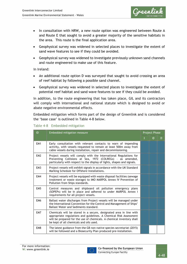
Greenlink Interconnector Limited
Greenlink Marine Environmental Statement - Wales
For more information: W: www.greenlink.ie
4-48
• In consultation with NRW, a new route option was engineered between Route A and Route E that sought to avoid a greater majority of the sensitive habitats in the area. This route is the final application area.
• Geophysical survey was widened in selected places to investigate the extent of sand wave features to see if they could be avoided.
• Geophysical survey was widened to investigate previously unknown sand channels and route engineered to make use of this feature.
In Ireland:
• An additional route option D was surveyed that sought to avoid crossing an area of reef habitat by following a possible sand channel.
• Geophysical survey was widened in selected places to investigate the extent of potential reef habitat and sand wave features to see if they could be avoided.
In addition, to the route engineering that has taken place, GIL and its contractors will comply with international and national statute which is designed to avoid or abate negative environmental effects.
Embedded mitigation which forms part of the design of Greenlink and is considered the ‘base case’ is outlined in Table 4-8 below.
Table 4-8 Embedded mitigation
ID Embedded mitigation measure Project Phase
I O D
EM1 Early consultation with relevant contacts to warn of impending activity, with vessels requested to remain at least 500m away from cable vessels during installation, repair and decommissioning.
EM2 Project vessels will comply with the International Regulations for Preventing Collisions at Sea, 1972 (COLREGs) – as amended, particularly with respect to the display of lights, shapes and signals.
EM3 Project vessels will exhibit signals in accordance with the UK Standard Marking Schedule for Offshore Installations.
EM4 Project vessels will be equipped with waste disposal facilities (sewage treatment or waste storage) to IMO MARPOL Annex IV Prevention of Pollution from Ships standards.
EM5 Control measures and shipboard oil pollution emergency plans (SOPEPs) will be in place and adhered to under MARPOL Annex I requirements for all project vessels.
EM6 Ballast water discharges from Project vessels will be managed under the International Convention for the Control and Management of Ships’ Ballast Water and Sediments standard.
EM7 Chemicals will be stored in a secure, designated area in line with appropriate regulations and guidelines. A Chemical Risk Assessment will be prepared for the use of chemicals. A chemical inventory shall be kept of all chemicals and oils used.
EM8 The latest guidance from the GB non-native species secretariat (2015) will be followed and a Biosecurity Plan produced pre-installation.

Greenlink Interconnector Limited
Greenlink Marine Environmental Statement - Wales
For more information: W: www.greenlink.ie
4-49
ID Embedded mitigation measure Project Phase
I O D
EM9 An Environmental Management Plan (EMP) and an Emergency Spill Response Plan will be developed and implemented for the installation phase.
EM10 Notice will be given to sea users in the area via Notices to Mariners, Kingfisher Bulletins, NAVTEX, and NAVAREA warnings. Particular attention will be paid to ensuring the following organisations receive the notifications: Castlemartin Firing Range, Milford Haven Port Authority, South Pembrokeshire RNLI, RYA, Maritime and Coastguard Agency (MCA), Welsh Fishermen’s Association, South and West Wales Fishing Communities, Welsh Marine Fisheries Advisory Group, West Wales Shell Fisherman’s Association, individual local fishermen (as identified during marine survey campaign), Pembrokeshire Coast National Park Authority, META, Bombora Wave Power, Irish Ferries.
EM11 ‘As-laid’ co-ordinates of the cable route will be recorded and circulated to the UK Hydrographic Office (UKHO) and KIS-ORCA Service. Cables will be marked on admiralty charts and fisherman’s awareness charts (paper and electronic format).
EM12 Crossing Agreements will be produced with cable owners. The Crossing Agreement describes the rights and responsibilities of the parties and also the design of the crossing. Crossing design will be in line with industry standards, using procedures and techniques agreed with the cable owners.
EM13 The preference is to use HDD for the cable landfalls to avoid disturbance of sensitive habitats (e.g. dune system) and disruption on beaches.
EM14 Route engineering was undertaken during the marine survey to avoid sensitive habitats where possible or to reduce the distance the submarine cable corridor crosses a sensitive feature.
EM15 Submarine cables will be bundled together, which reduces the seabed footprint of installation activities and the electromagnetic field generated during operation, thus minimising any potential compass deviation effects.
EM16 Procedures to minimise disruption near high density shipping areas will include, for example, avoidance of anchoring near busy areas when Project vessels are waiting on weather; and the presence of a guard vessel in areas of significant vessel traffic. Installation vessels will have passage planning procedures, holding positions (e.g. if waiting on weather), traffic monitoring (e.g. radar, AIS, and visual), means of communication with third-party vessels, and emergency response plans in the event a third-party vessel approaches on a collision course.
EM17 Agreed Castlemartin Firing Range access and communication protocol. GIL will notify Castlemartin Firing Range a minimum of two weeks
prior to commencement, of any works (survey, installation / construction, repair or maintenance) to be carried out in the Range. This notice will be provided in writing.
Prior to works commencing within the Range, GIL and their appointed contractor will arrange a meeting with Castlemartin Firing Range to provide a briefing of the works to be undertaken in the Range; confirm timescales; confirm lines of communication; and understand what live firing activity will be undertaken during the period.
During activity within the Range, or within close proximity, GIL’s appointed contractor will provide daily briefings to Castlemartin

Greenlink Interconnector Limited
Greenlink Marine Environmental Statement - Wales
For more information: W: www.greenlink.ie
4-50
ID Embedded mitigation measure Project Phase
I O D
Control that will cover: name of vessel(s) involved and exact location of works for the day.
The Installation Contractor will be requested to design the programme for installation works to minimise disruption to Castlemartin Firing Range. All activities related to a particular phase within the Range should be completed before work progresses to a new section of the application area.
EM18 Deployment of anchors/anchor chains on the seabed will be kept to a minimum in order to reduce disturbance to seabed.
EM19 Where possible, project vessels will not exceed 14 knots.
EM20 GIL will require that the appointed contractor(s) follows the ‘JNCC guidelines for minimising the risk of injury and disturbance to marine mammals from seismic surveys’ (JNCC 2017) (or subsequent amendments), appropriate to sub-bottom profiling and multi-beam and echo-sounder surveys respectively. In particular: Establishing a 500m mitigation zone for marine mammal observation. Provide non-dedicated marine mammal observers to implement the
JNCC guidelines within the Pembrokeshire Marine / Sir Benfro Forol SAC and West Wales Marine / Gorllewin Cymru Forol SAC.
Undertake pre-survey search - On-board marine mammal observer (MMObs) will scan the waters surrounding the vessel for 30 minutes before operations start to determine whether any marine mammals are within 500m of the survey equipment.
Where possible, according to the operational parameters of the equipment concerned, its acoustic energy output shall commence from a lower energy start-up and thereafter be allowed to gradually build up to the necessary maximum output over a period of at least 15 minutes, with the duration from the start of the soft start until the start of the survey line being a maximum of 25 minutes.
If the device cannot be ramped up then it shall be switched on and off in a consistent sequential manner over a period of 20 minutes prior to commencement of the full necessary output.
EM21 A UXO survey will be undertaken less than 6 months prior to installation works commencing. If any significant UXO are identified the following decision making process will be followed: 1. Avoid by micro-routeing the marine cables. 2. If it cannot be avoided, consider whether it is safe to move. 3. If it cannot be moved, detonate on site.
EM22 Guard vessels will be used (subject to risk assessment) during installation activities to communicate with third party vessels within the vicinity of cable sections that remain unburied between cable lay and burial.
EM23 GIL will require that the appointed UXO contractor follows the JNCC guidelines for minimising the risk of injury to marine mammals from using explosives (JNCC 2010, or as updated) including: Establishing a default 1km mitigation zone for marine mammal
observation, measured from the explosive source and with a circular coverage of 360 degrees.
Providing a trained marine mammal observer (MMObs) to implement the guidelines outlined in Section 2.1 to 2.4 e.g. pre-detonation search of mitigation zone.

Greenlink Interconnector Limited
Greenlink Marine Environmental Statement - Wales
For more information: W: www.greenlink.ie
4-51
ID Embedded mitigation measure Project Phase
I O D
Only commence explosive detonations during daylight hours and good visibility.
Accurately determine the amount of explosive required for the operation, so that the amount is proportionate to the activity and not excessive.
If necessary, plan the sequence of multiple explosive discharges so that, wherever possible, the smaller charges are detonated first to maximise the ‘soft-start’ effect.
EM24 A cable burial plan will be produced which outlines proposed method statements and cable protection measures for approval by the Regulator and discussion with fisheries stakeholders
EM25 Effective channels of communication will be established and maintained between the Project and commercial fishing interests. This will include the appointment of a Fisheries Liaison Officer (FLO).
EM26 Post-installation inspection surveys will be conducted along the length of the cables on a regular basis.
EM27 Post-installation compass deviation surveys will be undertaken to confirm compass deviation levels and the results forwarded to the UKHO and MCA.
EM28 Cable protection material (rock berms and mattresses) will be designed to be over-trawlable.
EM29 Rock and mattresses will only be deployed where adequate burial cannot be achieved. The footprint of the deposits will be the minimum required to ensure cable safety and rock berm stability.
EM30 Prior to any installation works, a project-specific Written Scheme of Investigation (WSI) and a Protocol for Archaeological Discoveries (PAD) will be prepared in accordance with current guidelines. The WSI will set out the project scope of works and will detail any mitigation measures (if any) that are required. The PAD will include contact details for all relevant personnel, including key members of the project team, the archaeological consultant, and the relevant authorities. The PAD will outline the key roles and responsibilities of all personnel, should anything of archaeological potential be unexpectedly encountered in the course of the works, to ensure appropriate actions are undertaken. This may include the implementation of a temporary exclusion zone until further assessment has been undertaken.
I = Installation; O = Operation (including repair & maintenance); D = Decommissioning
4.13 Zone of Influence
The zone of influence i.e. spatial extent, over which Greenlink is predicted to have an impact on the receiving environment has been established for the activities discussed above. The zones of influence are based on worst case assumptions as presented in Table 4-9.

Greenlink Interconnector Limited
Greenlink Marine Environmental Statement - Wales
For more information: W: www.greenlink.ie
4-52
Table 4-9 Zone of influence summary
Project Activity Description Zone of Influence
Base case Shallow water cable installation (LWM out to 10m water depth)
Vessel positioning
Anchors may be used to maintain the position of the CLB or CLV. Up to 4 anchors may be used, secured up to 500 m from vessel. JUB may be used at HDD exit point. 4-8 legs may be used to keep position. Vessels will be requested to remain a safe distance from the spread.
1km x 2km
Cable burial Two power cables & fibre optic cable will be bundled together and laid within the Proposed Development
500m wide
Cable trench will be up to 1m wide 1m
A typical cable excavation tool has a seabed footprint of 15m.
15m
Deep water cable installation (water depths greater than 10 m)
Vessel positioning
Vessels will be requested to remain at a safe distance from the cable lay spread.
1km wide x 12km along centreline (in any 24-hour period)
Cable burial Two power cables & fibre optic cable will be bundled together and laid within the Proposed Development application area
Generally 500m wide.
Cable trench will be up to 1m wide 1m
A typical cable excavation tool has a seabed footprint of 15m.
15m
Trailing suction hopper dredging or MFE has a seabed footprint of up to 50m either side of cable trench (based on suspended sediments).
100m
Cable protection
Maximum berm size 10m wide and 1.5m high
10m wide x 1.5m high
Crossings Footprint of deposits at asset crossing 120m long by 8.2m wide (1009m2)
Operation Buried cables
There will be a 250m development exclusion zone in place either side of the interconnector
500m
Heat – based on industry standards for similar installations
1m
EMF – B & iE fields elevated above background levels
2m
Repair (5 discrete occasions)
Vessels will be requested to remain at a safe distance from the cable lay spread.
1km x 1km
Removal of buried cable 10m wide x 1km
Re-trenching or rock placement 10m wide x 1km

Greenlink Interconnector Limited
Greenlink Marine Environmental Statement - Wales
For more information: W: www.greenlink.ie
4-53
1 1st Line Defence (2018). Detailed Unexploded Ordnance Risk Assessment Greenlink. Report Reference DA2985. Dated 14 February 2018.
2 BERR (2008). Department for Business Enterprise & Regulatory Reform. Review of cabling techniques and environmental effects applicable to the offshore wind farm industry. Technical Report. January 2008. In association with Defra.
3 FAB Link Limited (2016). FAB France Alderney Britain Interconnector. Offshore Environmental Report. Final December 2016.
4 Genesis (2011). Review and Assessment of Underwater Sound Produced from Oil and Gas Sound Activities and Potential Reporting Requirements under the Marine Strategy Framework Directive. Document J71656- Final Report-G2. [Online] Available at: https://www.gov.uk/government/uploads/system/uploads/attachment_data/file/50017/finreport-sound.pdf
5 Gill, A.B., Gloyne-Philips, I., Neal, K.J. and Kimber, J.A. (2005). The potential effects of electromagnetic fields generated by sub-sea power cables associated with offshore wind farm developments on electrically and magnetically sensitive marine organisms – a review. COWRIE-EM FIELD 2-06-2004.
6 Hydrographic Department (1974). Admiralty Tidal Stream Atlas. Irish Sea and Bristol Channel. NP256. Edition 3.
7 International Cable Protection Committee (ICPC) (2014). ICPC Recommendation No. 1 Management of Redundant and Out-of-Service Cables. Issue 13. Dated 12 January 2016.
8 Intertek EWCS (2019). Greenlink Cable Burial Risk Assessment. P1975J1_R4574_Rev4.
9 KIS-ORCA – Seafish (2019). Subsea Cables. Maintenance / Repair Operations. [online] Available at: http://kis-orca.eu/subsea-cables/maintenance-repair-operations#.XE7MZVX7TGg (Accessed January 2019)
10 MMT (2019). Greenlink Marine Survey. Geophysical Survey Report. Revision 02. January 2019.
11 Moyle Interconnector Limited (2014). Replacement Metallic Return Conductors – Marine Environmental Report. Volume 2: Marine Report December 2014.
12 National Grid & Energinet (2017) Volume 2: UK Offshore Environmental Statement. Viking Link Document No VKL-07-30-J800-007. August 2017
13 National Grid & SP Transmission (2011). Western HVDC Link. Environmental Report Marine Cable Route. Prepared by Aecom and Intertek Metoc. September 2011
14 National Grid NSN Link Limited (2014). Norway-UK Interconnector UK Marine Environmental Statement March 2014.
15 Natural Resources Canada (2018). Magnetic field calculator. Date modified 13/07/2018 [online] Available at: http://geomag.nrcan.gc.ca/calc/mfcal-en.php. (Accessed January 2019)
16 NEMO Link (2013). UK Environmental Statement Volume 1. February 2013.
REFERENCES

Greenlink Interconnector Limited
Greenlink Marine Environmental Statement - Wales
For more information: W: www.greenlink.ie
4-54
17 Normandeau, Exponent, T. Tricas, and A. Gill. (2011). Effects of EMFs from Undersea Power Cables on Elasmobranchs and Other Marine Species. U.S. Dept. of the Interior, Bureau of Ocean Energy Management, Regulation, and Enforcement, Pacific OCS Region, Camarillo, CA. OCS Study BOEMRE 2011-09.
18 OSPAR Commission (2009). Overview of the impacts of anthropogenic underwater sound in the marine environment. London: OSPAR Commission Biodiversity Series. [online] Available at: https://tethys.pnnl.gov/publications/overview-impacts-anthropogenic-underwater-sound-marine-environment (Accessed January 2019)
19 Tethys (2009 – 2019 copyright). EMF. [online] Available at: https://tethys.pnnl.gov/stressor/emf [accessed January 2019]

Greenlink Interconnector Limited
Greenlink Marine Environmental Statement - Wales
For more information: W: www.greenlink.ie
5-1
5. Impact Assessment Methodology
5.1 Introduction
Under the Environmental Impact Assessment (EIA) Directive 2014/52/EU (amending Directives 2011/92/EU and 85/337/EEC) on the assessment of the impacts of certain private and public projects on the environment (EIA Directive), there are three stages to the EIA process: screening, scoping and assessment.
This chapter outlines the key stages of the EIA process, summarises the conclusions of the screening and scoping stages, and outlines the approach taken to identify and evaluate potential impacts and cumulative effects associated with the Proposed Development.
The Proposed Development comprises the Welsh Marine components of Greenlink from mean high-water springs (MHWS) at the Welsh landfall at Freshwater West, Pembrokeshire to the UK/Republic of Ireland median line. It comprises:
• Two high voltage direct current (HVDC) electricity power cables;
• A smaller fibre-optic cable for control and communication purposes;
• All associated works required to install, test, commission and complete the aforementioned cables; and
• All associated works required to operate, maintain, repair and decommission the aforementioned cables, including five repair events over the 40 year lifetime of Greenlink.
The Proposed Development includes the following phases: installation; operation (including repair and maintenance activities); and decommissioning.
The EIA methodology follows a systematic approach to assess the potential effects of the Proposed Development on physical, biological and human receptors in a robust and transparent manner.
5.2 Environmental Impact Assessment Guidance
The environmental impact assessment takes into account the guidance provided in the following documents:
• The Institute of Environmental Management and Assessment (IEMA) Guidelines for Environmental Impact Assessment, 2004;
• The Chartered Institute of Ecology and Environmental Management (CIEEM) Guidelines for Ecological Impact Assessment in Britain and Ireland: Marine and Coastal, 2010;
• Scottish Natural Heritage (SNH) A handbook on environmental impact assessment: Guidance for Competent Authorities, Consultees and others involved in the Environmental Impact Assessment (EIA) Process in Scotland, 2013;

Greenlink Interconnector Limited
Greenlink Marine Environmental Statement - Wales
For more information: W: www.greenlink.ie
5-2
• IEMA Environmental Impact Assessment Guide to: Delivering Quality Development, 2016; and
• National Assembly for Wales The Planning Series 10 – Environmental Impact Assessment, 2017.
There are a number of different environmental impact assessment guidance documents available for terrestrial and marine applications which set out what an assessment should include and suggested ways it can be undertaken. However, there are few prescriptive examples on how to measure the significance of an effect. The SNH Handbook provides an example of a matrix showing significance related to sensitivity and magnitude of change. This method can be applied to any marine project irrespective of its location in the UK and has been used as a guide for the matrix in the Greenlink assessment method, as agreed with Natural Resources Wales (through the Scoping process).
5.3 Screening for Environmental Impact Assessment
The current requirements for EIA for Welsh offshore projects are set out in The Marine Works (Environmental Impact Assessment) Regulations 2007 (as amended in 2018) (‘EIA Regulations’).
The Welsh Minister’s EIA Superseded Screening Opinion (reference SC1805, dated 14 June 2018) on the Wales offshore elements of Greenlink was previously that the development proposed is not EIA development. In reaching this Screening Opinion, they considered the proposed works against Schedule A1 and A2 of the EIA Regulations. The Superseded Screening Opinion concluded that the Proposed Development would not require a statutory EIA.
Notwithstanding the above Superseded Screening Opinion, GIL is cognisant of the broad interpretation of the EIA Directive and the sectoral categories of projects referred to in Annex I and Annex II of the EIA Directive.
GIL has been advised of a risk of legal challenge in Ireland, where a sometimes broad approach has been taken to the project categories. GIL is keen to ensure that Greenlink is not exposed to any such challenge risk and that actions taken in Wales cannot be suggested to undermine the Irish consenting process. Therefore, an ES/EIAR will be submitted with all relevant applications for consent.
In October 2018, GIL requested that NRW screen in the Project under Regulation 5 of the ‘EIA Regulations’. On 22 October 2018, NRW agreed and issued the Screening Opinion (reference SC1808 Screening Opinion updated) to this effect. This is the most recent and relevant Screening Opinion.
5.4 Scoping and Consultation
GIL has taken a pro-active approach to consultation recognising that it is a critical activity in the development of a comprehensive and balanced EIA. This section provides a summary of the consultation undertaken during the design of the project and consultation relevant to the environmental scoping and EIA.

Greenlink Interconnector Limited
Greenlink Marine Environmental Statement - Wales
For more information: W: www.greenlink.ie
5-3
5.4.1 Approach to Scoping and Consultation
Consultation has been undertaken with statutory consultees, stakeholders and the public during key stages of the project. Consultation, including scoping, has had the following aims:
• To provide statutory and non-statutory consultees as well as local communities and other stakeholders with the opportunity to inform the development of the project and the final offshore route design.
• To provide statutory consultees with the opportunity to comment on the proposed specialist studies commissioned to inform the EIA, and the approach to, and scope of the EIA.
5.4.2 Scoping
The aim of the scoping process was to assist GIL in identifying the key environmental pressures surrounding their proposal. It also provided statutory and non-statutory consultees with an opportunity to comment on the proposed development, the scope of the EIA and raise any issues which they consider may be important to the EIA process. Their responses have helped to provide direction on the topics the EIA should focus on.
Initially, the Superseded Scoping Report (Intertek EWCS 2016) was submitted to stakeholders in December 2016 in support of a non-statutory Environmental Report. Stakeholders were identified through three methods; the project teams’ experience of interconnector projects; consultation; and web-based research of potential interest groups. Stakeholders were asked to provide responses on the Superseded Scoping Report by the end of February 2016. If a response was not received, the stakeholder was approached after the deadline (via email & telephone) to ensure that they had the opportunity to provide comment.
The Scoping Report (Intertek EWCS 2018) was issued in October 2018, following the decision to submit a formal ES with the Marine Licence application. The EIA is based on the most recent Scoping Opinion received from NRW (reference SC1816, dated 29 January 2019). NRW advised in Scoping Opinion SC1816 that any comments received on the Superseded Scoping Report, were not part of a formal scoping opinion and should be used as informal advice only.
Table 5-1 identifies the stakeholders approached during the two exercises and those that provided a Scoping Opinion either directly to GIL or to NRW.
At the start of each topic chapter a table is provided listing the scoping responses received relevant to that topic and how they have been addressed in the EIA. Responses were also received that have informed the general content, structure and approach.
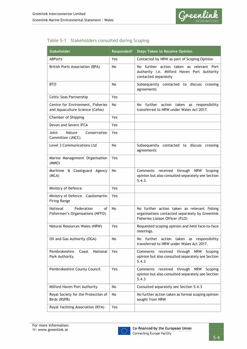
Greenlink Interconnector Limited
Greenlink Marine Environmental Statement - Wales
For more information: W: www.greenlink.ie
5-4
Table 5-1 Stakeholders consulted during Scoping
Stakeholder Responded? Steps Taken to Receive Opinion
ABPorts Yes Contacted by NRW as part of Scoping Opinion
British Ports Association (BPA) No No further action taken as relevant Port Authority i.e. Milford Haven Port Authority contacted separately
BTO No Subsequently contacted to discuss crossing agreements
Celtic Seas Partnership Yes
Centre for Environment, Fisheries and Aquaculture Science (Cefas)
No No further action taken as responsibility transferred to NRW under Wales Act 2017.
Chamber of Shipping Yes
Devon and Severn IFCA Yes
Joint Nature Conservation Committee (JNCC)
Yes
Level 3 Communications Ltd No Subsequently contacted to discuss crossing agreements
Marine Management Organisation (MMO)
Yes
Maritime & Coastguard Agency (MCA)
No Comments received through NRW Scoping opinion but also consulted separately see Section 5.4.3.
Ministry of Defence Yes
Ministry of Defence – Castlemartin Firing Range
Yes
National Federation of Fishermen’s Organisations (NFFO)
No No further action taken as relevant fishing organisations contacted separately by Greenlink Fisheries Liaison Officer (FLO)
Natural Resources Wales (NRW) Yes Requested scoping opinion and held face-to-face meetings.
Oil and Gas Authority (OGA) No No further action taken as responsibility transferred to NRW under Wales Act 2017.
Pembrokeshire Coast National Park Authority
Yes Comments received through NRW Scoping opinion but also consulted separately see Section 5.4.3
Pembrokeshire County Council Yes Comments received through NRW Scoping opinion but also consulted separately see Section 5.4.3
Milford Haven Port Authority No Consulted separately see Section 5.4.3
Royal Society for the Protection of Birds (RSPB)
No No further action taken as formal scoping opinion sought from NRW
Royal Yachting Association (RYA) Yes

Greenlink Interconnector Limited
Greenlink Marine Environmental Statement - Wales
For more information: W: www.greenlink.ie
5-5
Stakeholder Responded? Steps Taken to Receive Opinion
Tenby and District Angling Club No No further action taken as relevant fishing organisations contacted separately by Greenlink Fisheries Liaison Officer (FLO)
The Crown Estate No Comments received through NRW Scoping opinion but also consulted separately see Section 5.4.3
The Royal Commission on the Ancient and Historical Monuments of Wales
Yes Comments received through NRW scoping opinion.
The Welsh Fishermen's Association No Contacted by Greenlink FLO
The Wildlife Trust of South and West Wales
No No further action taken as formal scoping opinion sought from NRW
Trinity House Lighthouse Service Yes
UK Association of Fish Producers Organisation
No Contacted by Greenlink FLO
Wave Hub Ltd No Consulted separately see Section 5.4.3
Welsh Government Yes Comments received through NRW scoping opinion.
5.4.3 Meetings
GIL have held meetings with stakeholders since February 2016. Details of these meetings are provided in Technical Appendix B; with a list of stakeholders consulted below. Meetings have helped to inform route development, discuss potential areas of conflict and inform environmental impact assessment.
• Castlemartin Rural Steering Group - The Castlemartin Rural Steering Group meets quarterly. Attendees include representatives from the MoD Castlemartin & Sennybridge Firing Ranges, Pembrokeshire Coast National Park, Pembrokeshire County Council and Natural Resources Wales.
• Milford Haven Port Authority
• Natural Resources Wales (NRW)
• Ministry of Defence – Castlemartin Firing Range
• The Crown Estate
• BT
• Marine Energy Wales
• National Federation of Fisherman’s Organisations (NFFO)
• Welsh Fisherman’s Association (WFA)
• South and West Wales Fishing Communities (SWWFC)

Greenlink Interconnector Limited
Greenlink Marine Environmental Statement - Wales
For more information: W: www.greenlink.ie
5-6
• Welsh Marine Fisheries advisory Group (WMFAG)
• West Wales Shell Fisherman’s Association (WWSFA)
• Bombora Wave Power
5.4.4 Public Consultation
As a European PCI project, GIL is required to conduct public and stakeholder consultation meetings through a variety of means set out in Section 4.23 of the TEN-E UK Manual of Procedures (DECC 2014). Wider public consultation was achieved through:
• Development and regular updates to the Project website (www.greenlink.ie)
• Public consultation meetings
• Newspaper notices published in both local and national newspapers
• Provision of public information brochure (TEN-E Regulation Information Brochure) – published before the start of formal public consultation and updated throughout the development process
Public exhibitions were held on the following dates:
• 29 May 2018 - Pater Hall, Pembroke Dock, Wales
• 30 May 2018 - Hundleton Sports Pavilion, Hundleton, Wales
• 31 May 2018 – Angle Village Hall, Angle, Wales
• 27 June 2018 - Fethard on Sea, County Wexford, Ireland
• 15 August 2018 - Duncannon, County Wexford, Ireland
• 03 December 2018 – Pater Hall, Pembroke Dock, Wales
• 04 December 2018 – Angle Village Hall, Angle, Wales
• 05 December 2018 – Hundleton Sports Pavilion, Hundleton, Wales
• 16 January 2019 – Fethard on Sea, County Wexford, Ireland
• 17 January 2019 - Duncannon, County Wexford, Ireland
• 28 March 2019 - Ramsgrange, County Wexford, Ireland
The exhibitions were well attended by the community. Feed-back forms were provided so that the public could comment on the proposals. Issues raised during the consultation process have been considered in the preparation of the ES and are outlined at the start of each topic chapter.
Details of public consultation can be found at www.greenlink.ie.
Following submission and acceptance of the Marine Licence application by NRW a 42-day public consultation period will commence. This period provides consultees and the public further opportunity to comment on the application and ES. At the

Greenlink Interconnector Limited
Greenlink Marine Environmental Statement - Wales
For more information: W: www.greenlink.ie
5-7
start of this period copies of the ES will be made available to the public at Pembroke Library and on the Greenlink project website (www.greenlink.ie).
5.4.5 Scoping Conclusions
The Scoping Report included an assessment of significance of each potential pressure resulting from the Proposed Development to decide which of the pressures could have a significant effect and therefore should be taken forward for further assessment in the EIA. Those which were deemed to be non-significant were scoped out of the EIA and no further assessment has been undertaken. This scoping process was refined through the consultation discussed above with some pressures being scoped back-in at the request of stakeholders, or agreement reached that an effect could be scoped out.
Table 5-2 identifies the effects that have been scoped out of the EIA and the reason for the exclusion. These effects will not be discussed or assessed further in the ES.

Greenlink Interconnector Limited
Greenlink Marine Environmental Statement - Wales
For more information: W: www.greenlink.ie
5-8
Table 5-2 Effects scoped out from the ES and the rationale for their exclusion
Pressure Scoped Out of EIA
Receptor Reason for Scoping Effect out of the ES
ALL Air and climate The proposed marine cable corridor crosses the Celtic Sea which is characterised by low levels of human activity (and therefore away from sources of emissions that may influence air quality). Air quality and particulate matter (as indicated by concentrations of gases which are potentially harmful to human health) is not generally considered to be an issue for offshore developments (Fuzzi et al. 2015). Concerns over air quality are primarily related to emissions from road transport and land-based industry as these are the main sources of combustion products onshore (Defra 2011). Potential air quality effects from the Proposed Development will primarily occur from engine exhaust emissions from marine vessels used during cable installation and maintenance. Given that these emissions will be emitted in the coastal or offshore environment away from any major emission sources, emissions from the Proposed Development are not expected to cause a deterioration in local air quality. It is therefore concluded that emissions from the Proposed Development will not be a significant contributor to global emissions and as discussed in Chapter 3, the Proposed Development will help to reduce CO2 emissions and meet climate policy targets in the long-term. Therefore, this effect has been scoped out of the ES.
ALL Population and human health
The only aspects of the Proposed Development which could affect population and human health are the Proposed Development’s ability to effect local air quality and potential effects in relation to electric and magnetic fields (EMF) in the intertidal zone. However, the proposed marine cable corridor is located away from human populations and is unlikely to cause a deterioration in air quality. The topic of EMF is proposed to be scoped out for the intertidal zone based on the depth of burial of the cables, negligible risk and maintenance of adequate separation from sensitive receptors (hospital, schools or dwellings). Therefore, this effect has been scoped out of the ES.
Hydrocarbon and PAH contamination
All receptors Unplanned events (accidental oil or chemical spills) have been scoped out of the ES for the following reasons:
• The likelihood of a large oil spill occurring from a Project vessel is extremely low and the risk is no greater than that for any other vessel in the Proposed Development’s area.
• All Project vessels will have control measures and shipboard oil pollution emergency plans (SOPEP) in place and will adhere to MARPOL Annex I requirements.
• A Construction Environmental Management Plan (CEMP) and an Emergency Spill Response Plan will be developed and implemented for the installation phase. Execution of these plans will ensure that the risks associated with an unplanned event will be effectively managed in line with relevant international and national statute.

Greenlink Interconnector Limited
Greenlink Marine Environmental Statement - Wales
For more information: W: www.greenlink.ie
5-9
Pressure Scoped Out of EIA
Receptor Reason for Scoping Effect out of the ES
Temperature changes - local
Physical conditions
Fish and Shellfish
When cables are in operation, localised heating of the environment may occur surrounding the cables (i.e. sediments including interstitial water, where cables are buried, rock berms/concrete mattresses when cable protection employed). Seawater temperatures within the Celtic Sea vary seasonally and therefore are likely to accommodate minor localised variations in temperature associated with thermal losses. Impacts on seabed temperature will not have a significant effect. The indirect effects on fish and shellfish have therefore also been scoped out of the ES.
Changes in suspended solids (water clarity)
Physical conditions
The screening out of this effect from the ES only relates to the activity discharges from project vessels; other activities will be assessed. Project vessels will comply with the International Marine Organisation (IMO) International Convention for the Prevention of Pollution from Ships (MARPOL) standards. No discharges of waste or sewage are permitted within 12nm of the coast, therefore no impacts to bathing waters are anticipated. Impacts of discharges offshore will be temporary and localised and are unlikely to have a significant effect on water quality.
Visual disturbance Fish and Shellfish
The effect could occur during cable installation, as a result of the presence of the installation vessels and equipment (and associated noise) within the vicinity of operations. This could result in the displacement of fish within the water column. The disturbance from installation operations will be short term, localised and not considered likely to be significant given existing background levels of noise and shipping in the St Georges Channel and around Milford Haven. Therefore, this effect has been scoped out of the ES.
Siltation rate changes including smothering (depth of vertical sediment overburden)
Fish and Shellfish
There are three pathways for species to be smothered as a result of project activities: by displaced sediments during trenching; by the re-deposition of suspended sediment; and by cable protection material being placed on the seabed. The effect from displaced sediment will be very localised, only effecting species in the immediate vicinity of cable trenches. Suspended sediment settlement levels are expected to be minimal with any material deposited likely to be quickly re-suspended and distributed by natural hydrodynamic processes. Therefore, this aspect of the effect on fish and shellfish has been scoped out of the ES.
The suspension of sediments within the water column from cable installation may cause small, localised and temporary turbidity before being re-deposited on the seabed. A temporary reduction in the feeding capability of species relying on sight to locate their prey may occur. Most species are likely to be tolerant to any changes in turbidity levels (likely to be equivalent to those experienced during storm events) and the significance of the effect is likely to be negligible. Therefore, this aspect of the effect on fish and shellfish has also been scoped out of the ES.
The effects of depositing cable protection material will be assessed.
Penetration of and/or disturbance
Birds The EIA process (see Chapter 6) has identified the potential for a significant effect if trenching is undertaken within the intertidal zone. The base case is therefore for no intrusive works to be undertaken between mean high water springs and low water at

Greenlink Interconnector Limited
Greenlink Marine Environmental Statement - Wales
For more information: W: www.greenlink.ie
5-10
Pressure Scoped Out of EIA
Receptor Reason for Scoping Effect out of the ES
of the substrate below the surface of the seabed
Freshwater West. As intertidal habitats will not be effected by the works there is no pressure-receptor pathway for bird species to be indirectly effected e.g. by loss of prey species.
Sandeel are important for the breeding success of some seabirds which can be reduced dramatically when sandeel abundance decreases. Cable trenching in the offshore and nearshore area has the potential to disturb sandeel habitat. This could result in an indirect effect on seabirds feeding on sandeel. A sandeel assessment has been completed to identify any potential key areas of sandeel habitat (Technical Appendix E). The assessment on sandeel (Chapter 8) concluded that given the majority of cable protection is proposed for areas outside of potential sandeel habitat the effects of cable installation on sandeel habitat are minor and not significant. As there will be no significant effects on the prey species, the indirect effects on birds has been scoped out of the ES.
Death or injury by collision
Basking shark Marine mammals.
Although shipping collision is a recognised cause of basking shark and marine mammal mortality worldwide, the key factor influencing the injury or mortality caused by collisions is ship size and speed. Ships travelling at 14 knots or faster are most likely to cause lethal or serious injuries. Although the presence of the cable lay vessels and support vessels will marginally increase the level of vessel activity within the area for the duration of the marine works, none of the Proposed Development’s vessels will be travelling at speeds exceeding 14 knots. Cable lay vessels move along the cable route at the rate of cable installation, approximately 100-300m per hour depending on sediment conditions, resulting in a low likelihood of collision. Given that vessels will be operating at less than 14 knots, the effect is scoped out of the ES as it is not likely to be significant.
Light Marine birds NRW Scoping Opinion SC1816 noted “Consideration should be given to the impacts of lighting at any stage of the project on Manx shearwater, a feature of the Skomer, Skokholm and the Seas off Pembrokeshire Special Protection Area (SPA).” The necessity of scoping in the pressure was queried on the grounds that:
• The Proposed Development lies 3.13km south of Skokholm. Where the Proposed Development is close to the islands it is within an area of moderate to high shipping density. This is the main route for the Pembroke to Rosslare ferry amongst other vessels transiting to and from Milford Haven.
• The Proposed Development is to the south of the known rafting areas of manx shearwater.
• Both manx shearwater and puffin score low for susceptibility to disturbance on the Joint SNCB Interim Displacement Advice Notice (2017).
• The cable lay vessel will be progressing very slow along the route; effectively stationary in terms of bird displacement. it is a 24-hour continuous operation and would progress through the SPA.

Greenlink Interconnector Limited
Greenlink Marine Environmental Statement - Wales
For more information: W: www.greenlink.ie
5-11
Pressure Scoped Out of EIA
Receptor Reason for Scoping Effect out of the ES
• The introduction of the cable lay vessel will be within the day-to-day variation of ship numbers in the area. Birds in the region are habituated to the shipping levels and the cable lay vessel will not significantly increase this.
NRW agreed that the pressure could be scoped out on the grounds that “The Conservation Objectives for the SPA call for “The breeding population of Manx shearwater should be stable or increasing with no measured decrease in numbers (based on a population count of 150,968), based on annual study plots.
The current population for Manx shearwater is estimated at just under 300,000 individuals. This is the lowest conservative estimate (there are differences in counting methods). Therefore the population is doing well and we [NRW] don’t consider that the presence of one ship, carrying out the activities proposed …, has the potential to have a significant effect on population numbers.” (Pauls, L. 04/04/2019 [email])
Accidental anchoring or emergency anchoring on unburied / buried cable
Shipping, recreational boating
During installation (and repair & maintenance) there is the potential for a ship to accidentally anchor over unburied cable prior to its burial, snagging the anchor and resulting in potential damage to the ship. This risk will be managed by GIL and their appointed installation contractor through standard industry best practice methods such as informing sea users of the impending works (through Notices to Mariners, Kingfisher Bulletins, radio broadcasts), traffic monitoring, and if necessary the use of guard vessels. In addition, the likelihood of a commercial vessel accidentally releasing its anchor in close proximity to the unburied marine cables is very low.
The possibility of an anchor hooking the cable after installation is considered during detailed design, and the risk mitigated through the recommendation of minimal burial depths for the cable. The Cable Burial Risk Assessment Report recommends a target burial depth of 0.6m - 1.0m. It is Best Practice to ensure that the ‘as-laid’ co-ordinates of the cable route are recorded and marked on Admiralty Charts and fisherman’s awareness charts (paper and electronic format). This increases the awareness of the presence of the submarine cables and reduces the likelihood that a vessel will intentionally drop anchor nearby. As the likelihood of an effect is very low and taking into consideration the sensitivity of shipping in the region (medium) the significance of any effects is negligible.
Risk of ship collisions
Shipping It is recognised that ship to ship collisions could potentially occur. All Project vessels will comply with the International Regulations for Preventing Collisions at Sea 1972 and will be appropriately marked. This risk will be managed by GIL and their appointed installation contractor through compliance with international and national statute and standard industry best practice methods. For example, informing sea users of the impending works (through Notices to Mariners, Kingfisher Bulletins, radio broadcasts), traffic monitoring, and if necessary the use of guard vessels. Taking into consideration the sensitivity of shipping (medium), embedded mitigation, the likelihood of the effect occurring (very low) the significance of effects are negligible.

Greenlink Interconnector Limited
Greenlink Marine Environmental Statement - Wales
For more information: W: www.greenlink.ie
5-12
Pressure Scoped Out of EIA
Receptor Reason for Scoping Effect out of the ES
Damage to or interference with an external cable asset
Existing cables The marine cables cross one existing cable in UK waters. Although, there is the potential for installation and repair & maintenance activities to damage the existing active cable, particularly at the crossing point, this risk is managed through standard operating procedures. The cable asset will be crossed at 90°. Routes have been designed to ensure sufficient separation between the marine cables and existing cables, particularly where they run parallel, to ensure there is no interference. Cable crossing agreements between GIL and the third-party cable operator will include design and installation methods for crossing arrangements. Therefore, the potential for the installation of the Greenlink Interconnector to damage the existing asset is greatly reduced and will not lead to a likely significant effect.

Greenlink Interconnector Limited
Greenlink Marine Environmental Statement - Wales
For more information: W: www.greenlink.ie
5-13
5.4.6 Structure of the ES
Schedule 3 of the Marine Works (Environmental Impact Assessment) Regulations 2007 (as amended in 2018) (‘EIA Regulations’) outlines the information to be included in an environmental statement. It transposes into UK legislation the requirements of the EU EIA Directive. Schedule 3 Section 4 states that [information to be included in an environmental statement should include]“
“A description of the factors … likely to be significantly affected by the project and the regulated activity: population, human health, biodiversity (for example, fauna and flora), land (for example, land take), soil (for example, organic matter, erosion, compaction, sealing), water (for example, hydromorphological changes, quantity and quality), air, climate (for example, greenhouse gas emissions, impacts relevant to adaptation), material assets, cultural heritage, including architectural and archaeological aspects, and landscape.”
Table 5-3 provides a signpost to the chapters which cover these factors. A number of these factors were scoped out of the ES via the scoping process and Scoping Report. The proposed structure of the ES was outlined in the Scoping Report and agreed with NRW.
Table 5-3 Factors to be assessed by an ES – signposting to topic chapters
Factor ES Topic Chapter
Ch 6
– P
hysi
cal
Envi
ronm
ent
and
Mar
ine
Proc
esse
s
Ch 7
– B
enth
ic a
nd
Inte
rtid
al E
colo
gy
Ch 8
- F
ish
and
Shel
lfis
h
Ch 9
- B
irds
Ch10
- M
arin
e M
amm
als
and
Rept
iles
Ch11
– P
rote
cted
Si
tes
Ch12
– C
omm
erci
al
Fish
erie
s
Ch 1
3 –
Ship
ping
and
N
avig
atio
n
Ch 1
4 –
Off
shor
e In
stru
ctur
e an
d O
ther
Mar
ie U
sers
Ch15
– M
arin
e A
rche
olog
y
Ch 1
6 –
Cum
ulat
ive
Effe
cts
Ass
essm
ent
Population and human health
Scoped out of assessment, justification provided in Table 5-2, Section 5.4.5
Biodiversity ✓ ✓ ✓ ✓ ✓
Land Covered by the onshore ES
Soil (i.e. seabed sediments)
✓
Water ✓
Air and climate Scoped out of assessment, justification provided in Table 5-2, Section 5.4.5
Material assets ✓ ✓ ✓
Cultural heritage and landscape
✓
Interaction between these factors
✓ ✓ ✓ ✓ ✓ ✓ ✓ ✓ ✓ ✓ ✓
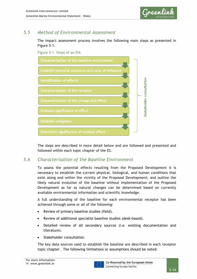
Greenlink Interconnector Limited
Greenlink Marine Environmental Statement - Wales
For more information: W: www.greenlink.ie
5-14
5.5 Method of Environmental Assessment
The impact assessment process involves the following main steps as presented in Figure 5-1.
Figure 5-1 Steps of an EIA
The steps are described in more detail below and are followed and presented and followed within each topic chapter of the ES.
5.6 Characterisation of the Baseline Environment
To assess the potential effects resulting from the Proposed Development it is necessary to establish the current physical, biological, and human conditions that exist along and within the vicinity of the Proposed Development; and outline the likely natural evolution of the baseline without implementation of the Proposed Development as far as natural changes can be determined based on currently available environmental information and scientific knowledge.
A full understanding of the baseline for each environmental receptor has been achieved through some or all of the following:
• Review of primary baseline studies (field).
• Review of additional specialist baseline studies (desk-based).
• Detailed review of all secondary sources (i.e. existing documentation and literature).
• Stakeholder consultation.
The key data sources used to establish the baseline are described in each receptor topic chapter. The following limitations or assumptions should be noted:

Greenlink Interconnector Limited
Greenlink Marine Environmental Statement - Wales
For more information: W: www.greenlink.ie
5-15
• Third party and publicly available information is correct at the time of publication.
• Baseline conditions are accurate at the time of physical surveys but due to the dynamic nature of the environment, conditions may change before or during the installation and operation phases of the Proposed Development (although the effects of the natural variation are included in the assessment).
• The Proposed Development area will not be subject to force majeure resulting in a complete shift from the existing baseline.
For each receptor topic the baseline has been described from mean high-water springs (MHWS) at Freshwater West, Wales to the UK/Republic of Ireland median line.
5.7 Establish Potential Pressures and Zone of Influence
The IEMA (2004) guidelines state:
“The assessment stage of the EIA should follow a clear progression; from the characterisation of ‘impact’ to the assessment of the significance of the effects taking into account the evaluation of the sensitivity and value of the receptors.” (p11/2)
For consistency, the terms pressure, interaction and effect, as defined in Table 5-4 below, have been used throughout the ES.
Table 5-4 Definitions of interaction, impact and effect
Term Definition
Pressure A pressure can be defined as “the mechanism through which an activity has an effect on any part of the ecosystem”. The nature of the pressure is determined by activity type, intensity and distribution. A list of marine pressures and their definitions has been formally agreed by the OSPAR Intercessional Correspondence Group on Cumulative Effects (ICG-C).
Interaction The link between a pressure and the receptor. There must be an interaction for an effect to occur.
Effect The consequence of the pressure; a predicted change in the baseline environment, usually measurable. Effects only occur when an activity or pressure is present within an environment that is sensitive to it.
For each potential topic, the zone of influence – the spatial extent over which the activities are predicted to have an effect on the receiving environment – is established. This will vary for different activities and for the different stages of the Proposed Development (installation, operation and decommissioning).
Establishing the zone of influence for different pressures and receptors will be undertaken quantitatively where possible, but if not, it will be undertaken qualitatively where necessary based on the Proposed Development description, project experience and literature reviews.
Greenlink Interconnector Limited
Greenlink Marine Environmental Statement - Wales
For more information: W: www.greenlink.ie
5-16
Potential effects on receptors which occur outside the zone of influence and which cannot or are unlikely to travel into the zone (e.g. benthic communities) have been scoped out. Conversely, mobile species and other mobile receptors such as other sea users can travel into the zone of influence and may therefore be effected by the Proposed Development.
The zone of influence used in the assessment are given in the topic Chapters. The zone of influence will in many cases relate to the seabed and or sea surface footprint of the Proposed Development’s activities. These are established in Chapter 4. However, in some cases the zone of influence may extend much further e.g. disturbance from noise may affect birds or cetaceans >1km away.
The zone of influence have been considered for each potential pressure on the receptor. Where a number of project activities result in the same pressure (e.g. pre-sweeping, pre-lay grapnel run, trenching, resulting in seabed disturbance) or the installation technique has not been determined, the worst-case spatial extent has been applied.
5.8 Identification of Effects
The prediction of potential effects has been undertaken to determine what could happen to each environmental receptor as a consequence of the Proposed Development. The diverse range of potential effects considered in the EIA process results in a range of prediction methods being used including quantitative, semi-qualitative and qualitative. Potential pressures to be assessed are provided in each receptor topic chapter. The definitions used to describe effects are presented in Table 5-5 below.
Table 5-5 Definitions of effects
Term Definition
Direct effect Effects that result from a direct interaction between the Proposed Development/Proposed Development’s activities and the receiving environment.
Indirect effect Effects on the environment, which are not a direct result of the Proposed Development/Proposed Development’s activities, often produced away from the activity or as a result of a complex pathway (European Commission 1999). For example, loss of habitat from trenching, leading to reduction in prey species availability, having an indirect impact on predators.
Cumulative effect Effects that result from incremental changes caused by other present or reasonably foreseeable actions together with the Proposed Development (European Commission 1999). Generally considered to be the same effect but from different projects e.g. underwater noise from two separate projects combining to affect marine mammals.
Positive / Beneficial effect
An effect that is considered to represent an improvement on the baseline condition or introduces a new desirable factor (IEEM 2010).
Negative / Adverse effect
An effect that is considered to represent an adverse change from the baseline condition or introduces a new undesirable factor (IEEM 2010).

Greenlink Interconnector Limited
Greenlink Marine Environmental Statement - Wales
For more information: W: www.greenlink.ie
5-17
5.9 Characterisation of the Receptor
The significance of an effect on a receptor or feature is characterised by the sensitivity, recoverability and importance of the receptor or feature. Characterisation of the receptor is achieved by balancing out these three considerations to determine the Receptors Value. Criteria used for the assessment are presented in Table 5-6.
• The sensitivity of the receptor relates to itssensitivity/vulnerability to change (including its capacity toaccommodate change i.e the tolerance/intolerance of thereceptor to change).
Sensitivity
• The ability of the receptor to return to the baseline statebefore the Proposed Development caused the change.Recoverability
• The importance of the receptor or feature is a measure ofthe value assigned to that receptor based on biodiversityand ecosystem services, social value and economic value.Importance of the receptor is also defined within ageographical context, whether it is importantinternationally, nationally or locally important.
Importance
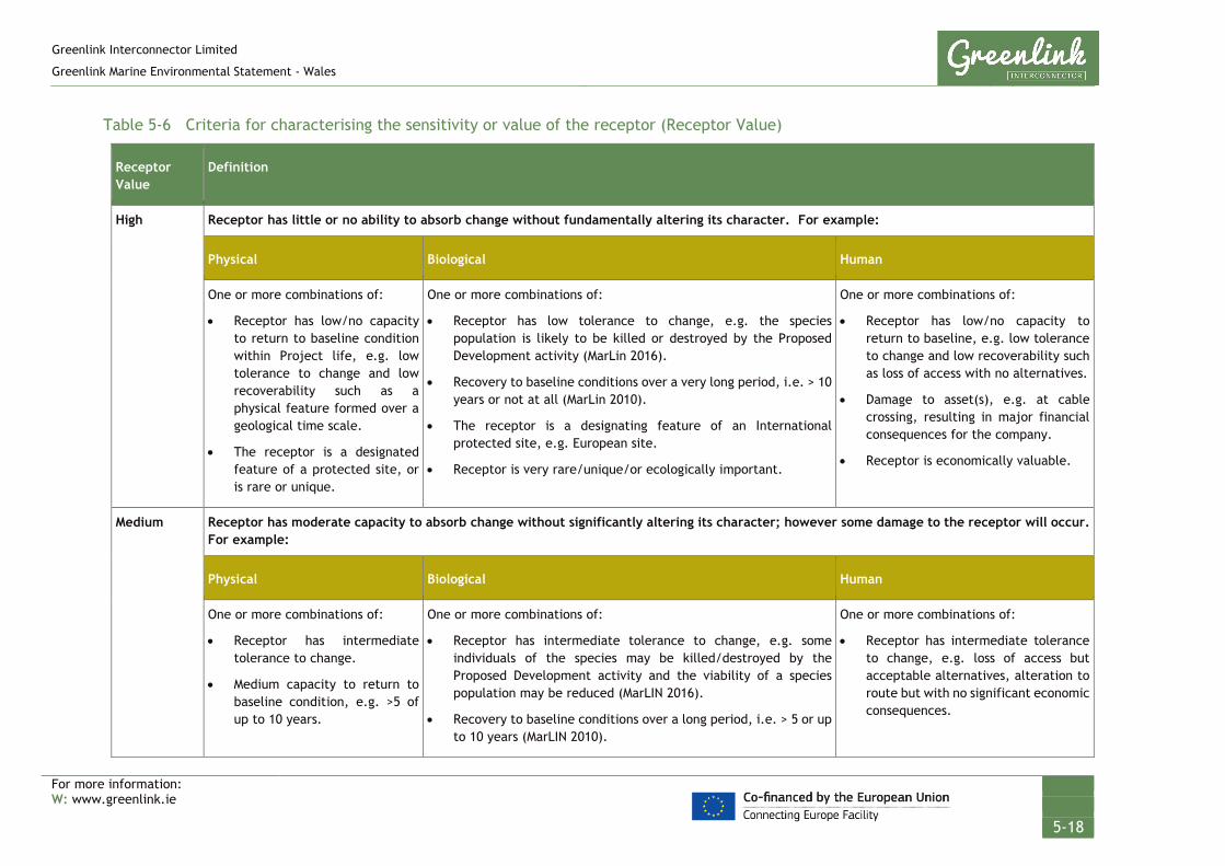
Greenlink Interconnector Limited
Greenlink Marine Environmental Statement - Wales
For more information: W: www.greenlink.ie
5-18
Table 5-6 Criteria for characterising the sensitivity or value of the receptor (Receptor Value)
Receptor Value
Definition
High Receptor has little or no ability to absorb change without fundamentally altering its character. For example:
Physical Biological Human
One or more combinations of:
• Receptor has low/no capacity to return to baseline condition within Project life, e.g. low tolerance to change and low recoverability such as a physical feature formed over a geological time scale.
• The receptor is a designated feature of a protected site, or is rare or unique.
One or more combinations of:
• Receptor has low tolerance to change, e.g. the species population is likely to be killed or destroyed by the Proposed Development activity (MarLin 2016).
• Recovery to baseline conditions over a very long period, i.e. > 10 years or not at all (MarLin 2010).
• The receptor is a designating feature of an International protected site, e.g. European site.
• Receptor is very rare/unique/or ecologically important.
One or more combinations of:
• Receptor has low/no capacity to return to baseline, e.g. low tolerance to change and low recoverability such as loss of access with no alternatives.
• Damage to asset(s), e.g. at cable crossing, resulting in major financial consequences for the company.
• Receptor is economically valuable.
Medium Receptor has moderate capacity to absorb change without significantly altering its character; however some damage to the receptor will occur. For example:
Physical Biological Human
One or more combinations of:
• Receptor has intermediate tolerance to change.
• Medium capacity to return to baseline condition, e.g. >5 of up to 10 years.
One or more combinations of:
• Receptor has intermediate tolerance to change, e.g. some individuals of the species may be killed/destroyed by the Proposed Development activity and the viability of a species population may be reduced (MarLIN 2016).
• Recovery to baseline conditions over a long period, i.e. > 5 or up to 10 years (MarLIN 2010).
One or more combinations of:
• Receptor has intermediate tolerance to change, e.g. loss of access but acceptable alternatives, alteration to route but with no significant economic consequences.
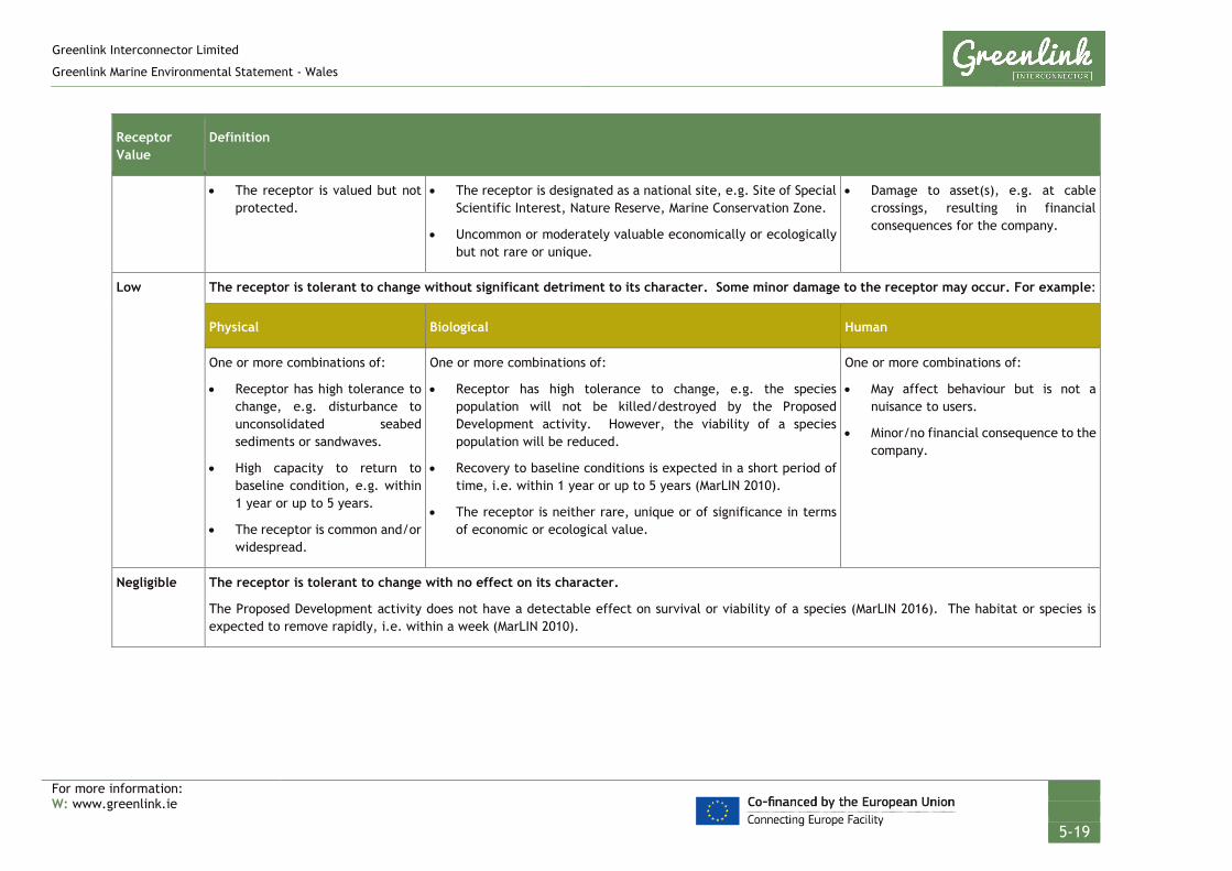
Greenlink Interconnector Limited
Greenlink Marine Environmental Statement - Wales
For more information: W: www.greenlink.ie
5-19
Receptor Value
Definition
• The receptor is valued but not protected.
• The receptor is designated as a national site, e.g. Site of Special Scientific Interest, Nature Reserve, Marine Conservation Zone.
• Uncommon or moderately valuable economically or ecologically but not rare or unique.
• Damage to asset(s), e.g. at cable crossings, resulting in financial consequences for the company.
Low The receptor is tolerant to change without significant detriment to its character. Some minor damage to the receptor may occur. For example:
Physical Biological Human
One or more combinations of:
• Receptor has high tolerance to change, e.g. disturbance to unconsolidated seabed sediments or sandwaves.
• High capacity to return to baseline condition, e.g. within 1 year or up to 5 years.
• The receptor is common and/or widespread.
One or more combinations of:
• Receptor has high tolerance to change, e.g. the species population will not be killed/destroyed by the Proposed Development activity. However, the viability of a species population will be reduced.
• Recovery to baseline conditions is expected in a short period of time, i.e. within 1 year or up to 5 years (MarLIN 2010).
• The receptor is neither rare, unique or of significance in terms of economic or ecological value.
One or more combinations of:
• May affect behaviour but is not a nuisance to users.
• Minor/no financial consequence to the company.
Negligible The receptor is tolerant to change with no effect on its character.
The Proposed Development activity does not have a detectable effect on survival or viability of a species (MarLIN 2016). The habitat or species is expected to remove rapidly, i.e. within a week (MarLIN 2010).

Greenlink Interconnector Limited
Greenlink Marine Environmental Statement - Wales
For more information: W: www.greenlink.ie
5-20
5.10 Characterisation of Effect
To fully characterise an effect or level of change from baseline conditions the following parameters are considered. These parameters are used to define the magnitude of effect or the Magnitude Value of the effect based on the definitions provided in Table 5-7.
Table 5-7 Factors which determine the Magnitude Value of an Effect
Magnitude Value Definition
High Long term (> 5 years) and/or regional level loss or major alteration to key elements /features of the baseline condition such that post development character/composition of the baseline will be fundamentally changed.
Medium Medium term (1- 5 years) loss and/or local level change (greater than the Proposed Development footprint) or alteration to one or more key elements/features of the baseline conditions such that post development character/composition of the baseline condition will be materially changed.
Low Short term (<1 year), site specific and/or a minor shift away from baseline conditions. Changes arising from the alteration will be detectable but not material; the underlying character/composition of the baseline condition will be similar to the pre-development situation.
Negligible Very little change from baseline conditions. Change is barely distinguishable, approximating to a “no change” situation.
5.11 Evaluation of Significance of Effect
Having established the magnitude of change (Magnitude Value) and the sensitivity of the receptor (Receptor Value), the significance of the effect can be assessed using the significance matrix adapted from the SNH (2013) Handbook on EIA; presented in Table 5-8.
• The scale of change refers to the degree of change to or fromthe baseline environment caused by the pressure beingdescribed.
Scale of Change
• The extent of an impact is the full area over which theimpact occurs.
Spatial extent
• The duration is the period within which the impact isexpected to last prior to recovery or replacement of thefeature. Frequency refers to how often the impact willoccur.
Duration & Frequency

Greenlink Interconnector Limited
Greenlink Marine Environmental Statement - Wales
For more information: W: www.greenlink.ie
5-21
Table 5-8 Significance matrix (SNH 2013)
Magnitude Value
Negligible Low Medium High
Sens
itiv
ity
of r
ecep
tor
(Rec
epto
r V
alue
)
High Negligible Moderate Major Major
Medium Negligible Minor Moderate Major
Low Negligible Negligible Minor Moderate
Negligible Negligible Negligible Negligible Minor
The result of using this matrix approach is the assignment of the level of significance of the effect for all potential pressures of the Proposed Development. This is undertaken prior to any mitigation. Project Specific Mitigation will generally only be proposed if effects are significant.
Definitions of the significance levels are provided in Table 5-9 below.
Table 5-9 Definitions of significance levels
Significance Definition
Negligible Generally considered as Not Significant.
Minor Generally considered as Not Significant and adequately controlled by Best Practice and international statute. Opportunities to reduce effects further through mitigation may be limited and are unlikely to be cost effective.
Moderate Generally considered as Significant but effects are those, considered to be tolerable. However, it is expected that the residual effect has been subject to feasible and cost effective mitigation, has been reduced to as low as reasonably practicable (ALARP) and that no further measures be feasible.
Major Generally considered as Significant and regarded as unacceptable prior to any mitigation measures being considered.
5.12 Establish Mitigation
Mitigation measures are the actions or systems proposed to manage or reduce the potential negative impacts identified. Mitigation measures are sometimes confused with measures taken to ensure legal compliance, which can be similar. Legislation is often designed to ensure impacts to the environment are minimised.
Greenlink Interconnector Limited
Greenlink Marine Environmental Statement - Wales
For more information: W: www.greenlink.ie
5-22
A standard hierarchical approach to identifying mitigation requirements has been used to inform the EIA:
• Avoid or Prevent: In the first instance, mitigation should seek to avoid or prevent the adverse effect at source for example, by routing the marine cables away from a sensitive receptor.
• Reduce: If the effect is unavoidable, mitigation measures should be implemented which seek to reduce the significance of the effect.
• Offset: If the effect can neither be avoided nor reduced, mitigation should seek to offset the effect through the implementation of compensatory mitigation.
Mitigation measures fall into two categories: mitigation which forms part of the Proposed Development design which is referred to as embedded mitigation in Chapter 4; and mitigation which is part of the construction and operation of the Proposed Development, which is referred to as Project Specific Mitigation.
5.12.1 Embedded Mitigation
As described in Chapter 3, the Proposed Development has been developed through an iterative process which involved seeking to avoid or reduce potential environmental effects through routeing of the marine cables. This was the first project specific step in mitigating potential effects by seeking to avoid or reduce environmental disturbance.
Embedded mitigation measures which form part of the design are an inherent part of the GIL and are considered the ‘base case’ as primary mitigation measures. As well as steps the Proposed Development has taken to reduce environmental effects, the base case also includes measures taken to ensure compliance with international and national statute, which also seeks to avoid or abate negative effects.
All embedded mitigation which has been assessed as part of the ‘base case’ is listed in the Chapter 4 and the appropriate receptor topic Chapter.
5.12.2 Project Specific Mitigation
Mitigation measures which are to be adopted and implemented during the construction and operation of the Proposed Development to mitigate adverse effects, over and above legal compliance are called Project Specific Mitigation. Appropriate, feasible and cost-effective mitigation measures have been proposed as necessary in each topic Chapter. All project specific mitigation commitments made in the EIA are additionally listed in a Schedule of Mitigation provided as Chapter 17.
5.12.3 Mitigation Schedule
The package of Embedded Mitigation and Project Specific Mitigation measures to be incorporated into the design, installation, operation and decommissioning of the submarine cables are set out in Chapter 17 of this ES. The mitigation schedule will form the basis of an Environmental Management Plan (EMP) to be implemented in the

Greenlink Interconnector Limited
Greenlink Marine Environmental Statement - Wales
For more information: W: www.greenlink.ie
5-23
installation and operation of the marine cables. In stating the mitigation measures within the ES, GIL, as well as their appointed contractors, are committed to the effective implementation of all those measures described. This is to ensure that the Proposed Development will not generate significant adverse environmental effects that have not been assessed.
5.13 Determine Significance of Residual Effects
The significance assessment is repeated taking into consideration the application of Project Specific Mitigation, i.e. secondary mitigation. This determines whether there is likely to be a residual effect. When applied after mitigation, the resulting significance level is referred to as the residual significant effect. Tables within the topic chapters present the results of both assessments.
Residual effects assessed as moderate or major after consideration of proposed mitigation measures will normally require additional analysis and consultation in order to discuss and possibly further mitigate impacts where possible. Where further mitigation is not possible a residual effect may remain.
5.14 Cumulative Effects Assessment (CEA)
The term cumulative effects refers to effects upon receptors arising from the Proposed Development when considered alongside other present or reasonably foreseeable projects, plans or licensed activities, that result in an additive effect with any element of the Greenlink. Cumulative effects can be described as the net effect of cumulative pressures, which includes both direct and indirect effects resulting from cumulative pressures caused by different activities. An individual effect alone may be considered insignificant, but the additive effects of more than one effect, from any number of sources, could result in a significant effect, either positive or negative.
Intra-project effects (effects between different components of Greenlink) are discussed in the relevant topic chapters, and are summarised in Chapter 16.
Potential cumulative effects between the Proposed Development and other present or reasonably foreseeable projects, plans or licensed activities have been assessed using the methodology from the “MMO Strategic Framework for Scoping Effects” (MMO 2014), which consists of six steps:
1. Complete an activity/pressure/receptor matrix for each phase of the Proposed Development and identify the spatial and temporal extents of pressures;
2. Define a study area around the Proposed Development and identify projects, plans and licensed activities within that area;
3. Complete an activity/pressure/receptor matrix for each type of project, plan and licensed activity within the study area to identify common pressures on each receptor;

Greenlink Interconnector Limited
Greenlink Marine Environmental Statement - Wales
For more information: W: www.greenlink.ie
5-24
4. Identify if the Proposed Development’s zone of influence overlaps spatially with those from other projects or plans. If there is no spatial overlap, that specific pressure-receptor pathway will be screened out. If there is a spatial overlap, the pathway continues to the next step in the process;
5. Identify if the Proposed Development phases overlap temporally with the scoped-in projects. If there is no temporal overlap or if a review of publicly available information and consultation with the appropriate developer did not identify specific timelines, the specific pressure-receptor pathway will be screened out. If there is a temporal overlap the pathway continues to the next stop; and
6. Undertake the assessment on Screened Projects/Plans, where both a spatial and temporal overlap has been identified.
The CEA is presented in Chapter 16.
5.15 Transboundary Assessment
The Convention on Environmental Impact Assessment in a Transboundary Context 1991 sets out the obligations of parties to assess the transboundary environmental effect of certain activities at an early stage of planning. It also lays down the general obligations of states to notify and consult each other on all major projects under consideration that are likely to have a significant adverse environmental effect across boundaries.
Greenlink crosses two maritime jurisdictions (UK and Republic of Ireland). An EIA has been conducted for each jurisdiction, as well as the UK and Irish onshore components, and as such transboundary assessment has been an integral component of the environmental assessment. It is anticipated that transboundary effects will be limited. This is discussed in Chapter 16.
Wider intra-project effects including interactions between each Greenlink element (Marine Wales, Onshore Wales, Marine Ireland, Offshore Ireland and Onshore Ireland) have been considered within a standalone Wrapper Assessment which will be made available at www.greenlink.ie.
5.16 Uncertainty, Assumptions and Limitations
5.16.1 General
The EIA process aims to assist good decision-making based on information about the potential effects of the Proposed Development. However, there will be some uncertainty as to the exact scale and nature of the environmental effects. This uncertainty arises as the level of detail and information about the Proposed Development available at the time the assessment was undertaken and/or due to limitations to the prediction process itself. Key issues relating to assumptions about the Proposed Development design are outlined below. Where assumptions have been made in undertaking the EIA these are set out in each topic Chapter.
Greenlink Interconnector Limited
Greenlink Marine Environmental Statement - Wales
For more information: W: www.greenlink.ie
5-25
5.16.2 Level of design detail for the EIA
It is acknowledged that the development which is eventually designed and constructed may differ slightly from the design details that have been used in the EIA and reported in the ES. At the time of writing, the contract to undertake the cable installation work has not been awarded, and therefore the proposed installation methodology and exact timing has not been finalised. However, in order to ensure the EIA is as robust as possible, the EIA assesses the range of likely installation methods to ensure that the envelope of effects assessed will encompass the worst case and actual installation method, once confirmed.
The potential effects assessed within this EIA has taken into account the range of parameters within which the detailed design will be developed. Generally potential environmental effects will be similar for each discrete environmental topic. For certain topic areas there may be slight differences in the assessment where maximum and minimum dimensions are considered.
5.16.3 Baseline data used in the EIA
Within the EIA, the assessment of potential effects on environmental receptors has been undertaken against present, known, baseline conditions. It is recognised that baseline conditions could change over time. However, it is assumed that the data referenced in this EIA, including survey data, is sufficient to characterise the baseline environment relative to the Proposed Development’s effects, and any changes to this baseline characterisation throughout the Proposed Development lifetime are not anticipated.
Whilst decommissioning has been considered within the EIA, it is recognised that a full decommissioning plan including impact assessment will be undertaken in accordance with current legislation at the time of decommissioning. It is however planned to leave the cable in-situ.

Greenlink Interconnector Limited
Greenlink Marine Environmental Statement - Wales
For more information: W: www.greenlink.ie
26
1 DECC (2014). The TEN-E Regulation EU347/2013. Available online: https://assets.publishing.service.gov.uk/government/uploads/system/uploads/attachment_data/file/311184/uk_manual_procedures_ten_e_regulation.pdf [Accessed August 2018)
2 Chartered Institute of Ecology and Environmental Management (CIEEM) Guidelines for Ecological Impact Assessment in Britain and Ireland: Marine and Coastal, 2010
3 Environmental Impact Assessment (EIA) Directive 2014/52/EU (amending Directives 2011/92/EU and 85/337/EEC) on the assessment of the impacts of certain private and public projects on the environment (EIA Directive)
4 Institute of Environmental Management and Assessment (IEMA) (2004). Guidelines for Environmental Impact Assessment. Lincoln, p154.
5 Institute of Ecology and Environmental Management (IEEM) (2010). Guidelines for Ecological Impact Assessment in Britain and Ireland: Marine and Coastal, [Online] Available at: http://www.cieem.net/data/files/Resource_Library/Technical_Guidance_Series/EcIA_Guidelines/Final_EcIA_Marine_01_Dec_2010.pdf (Accessed April 2016).
6 National Assembly for Wales. The Planning Series; 10 – Environmental Impact Assessment. July 2017.
7 Scottish Natural Heritage (SNH) (2013). A handbook on environmental impact assessment: Guidance for Competent
Authorities, Consultees and others involved in the Environmental Impact Assessment (EIA) Process in Scotland. [Online] Available at: http://www.snh.gov.uk/docs/A1198363.pdf (Accessed April 2016).
8 Institute of Environmental Management and Assessment (IEMA) (2004). Guidelines for Environmental Impact Assessment. Lincoln, p154.
9 Intertek EWCS (2016). Greenlink Interconnector. Environmental Scoping Report - UK Marine Route. Report number: P1975_R3994_Rev1. Issued: 19/12/2016
10 Intertek EWCS (2018). Greenlink Interconnector. Environmental Scoping Report - UK Marine Route. Report number: P1975_R3994_Rev2. Issued: 30/10/2018
11 MarLin (1999-2010). Sensitivity assessment methodology. [Online] Available at: http://www.marlin.ac.uk/species/MarLIN-sensitivity-methods (Accessed April 2016).
12 MarLin (2016). Species intolerance. [Online] Available at: http://www.marlin.ac.uk/glossary/intoleranceranking (Accessed April 2016).
13 Scottish Natural Heritage (SNH) (2013). A handbook on environmental impact assessment: Guidance for Competent Authorities, Consultees and others involved in the Environmental Impact Assessment (EIA) Process in Scotland. [Online] Available at: http://www.snh.gov.uk/docs/A1198363.pdf (Accessed April 2016).
REFERENCES

Greenlink Interconnector Limited
Greenlink Marine Environmental Statement - Wales
For more information: W: www.greenlink.ie
6-1
6. Physical Conditions and Marine Processes This Chapter describes the existing baseline environment in terms of the physical conditions and marine processes, identifies the pressures associated with the Proposed Development on the receptors, presents the findings of the environmental impact assessment, and describes how significant effects (if any) will be mitigated.
The Proposed Development comprises the Welsh Marine components of Greenlink from mean high-water springs (MHWS) at the Welsh landfall at Freshwater West, Pembrokeshire to the UK / Republic of Ireland median line. It comprises:
• Two high voltage direct current (HVDC) electricity power cables;
• A smaller fibre-optic cable for control and communication purposes; and
• All associated works required to install, test, commission and complete the aforementioned cables; and
• All associated works required to operate, maintain, repair and decommission the aforementioned cables, including five repair events over the 40 year lifetime of Greenlink.
The Proposed Development includes the following phases, all of which are assessed within this chapter:
• Installation;
• Operation (including repair and maintenance activities); and
• Decommissioning.
Kilometre points (KPs) have been assigned to the route to aid with the description; running from KP0 at MHWS, Freshwater West to KP159.27 at MWHS, Baginbun Beach. The Proposed Development lies between KP0 and KP73.8.
Where relevant, any limitations related to the baseline conditions, data sources or scientific understanding/interpretation within the process of assessing the effects have been highlighted.
6.1 Data Sources
Greenlink Interconnector Limited (GIL) commissioned geophysical and geotechnical surveys to inform the baseline description and assessment. These have been supplemented where necessary by a review of published information and consultation with relevant bodies. The data sources used to inform the baseline description and assessment include, but are not limited to the following:
• Greenlink Geophysical Survey Report (MMT 2019a) – provided as Technical Appendix I;
• Greenlink Geotechnical Survey Report (MMT 2019b);
• Freshwater West Beach Profiles 2016 (Field Studies Council 2016);
• SEACAMS Bathymetric data (University of Bangor 2018);
Greenlink Interconnector Limited
Greenlink Marine Environmental Statement - Wales
For more information: W: www.greenlink.ie
6-2
• Seabed Features (Bombora Wave Power 2018); and
• Other data sources as listed at the end of the Chapter.
6.1.1 Greenlink cable route survey
A survey of Greenlink was carried out between September 2018 and January 2019 by MMT to inform cable route design and the environmental impact assessment. Weather and strong tidal currents delayed a small section of the geophysical scope and an infill survey was carried between March and April 2019.
Geophysical, geotechnical and benthic survey techniques were used to:
• Characterise the seabed to a depth of approximately 15-20m in terms of its topology, shallow geological and seabed features, sediment type, sediment particle size and sediment contamination;
• Identify obstructions and debris on the seabed;
• Characterise burial conditions;
• Characterise the benthic community; and
• Determine the presence of any features that may have conservation significance.
The survey was divided into six blocks. The Proposed Development is location within Blocks 4, 5 and 6; Block 6 being the closest inshore. Blocks and sampling stations are shown in Figure 6-1 (Drawing P1975-SURV-015).
The scope of work comprised of:
• Onshore/intertidal topographic survey; using an unmanned autonomous vehicle (UAV);
• Geophysical/hydrographic nearshore and offshore data acquisition;
• Geotechnical investigations;
• Environmental sampling and imagery;
• Infrastructure crossing survey with remotely operated vehicle (ROV);
• Unexploded ordnance (UXO) survey within Castlemartin Firing Range only;
• Geotechnical boreholes to inform the feasibility of horizontal directional drilling (HDD);
• Onshore reflection and refraction survey.
These operations in the nearshore and offshore provide high-resolution and accurate measurements of the bathymetry, seabed features and shallow geological conditions within the Proposed Development.
The geophysical survey comprised multi-beam echosounder (MBES), side-scan sonar (SSS), sub-bottom profiler (SBP), transverse gradiometer and remotely operated vehicle (ROV) inspection. Data were acquired along survey lines (generally seven

Greenlink Interconnector Limited
Greenlink Marine Environmental Statement - Wales
For more information: W: www.greenlink.ie
6-3
to eight) to create a 500m wide survey corridor centred on the indicative centreline for the cable route. Data quality is described in Table 6-1. The survey corridor was extended in places to visualise the extent of key seabed features e.g. sandwaves or sediment channels within bedrock.

GREENLINK INTERCONNECTORSURVEY DATA
Scope of Marine Survey - UK Waters
Chris GoodeEmma Langley
Friday, April 12, 2019 16:05:15WGS_1984_UTM_Zone_30N
D_WGS_1984GEBCO; UKHO; CDA; MMT; Greenlink
WGS_1984
NOTE: Not to be used for Navigation
© The GEBCO Digital Atlas published by the British Oceanographic Data Centre on behalf of IOC and IHO, 2003; Contains public sector information, licensed under the Open Government Licence v2.0, from the UKHO, 2018.; Contains data from UKOGD.
Anna Farley
Block 05
Block 06
Block 04
Block 03
300000
300000
325000
325000
350000
350000
57000
00
57000
00
57250
00
57250
00
57500
00
57500
00
LegendUK 12nm Territorial Sea LimitMedian Line
Survey LocationGrab SampleVibrocore SampleCPT SampleROV Track LineSurvey BlockReconnaisance Survey
0 2.5 5 7.5 10km © Metoc Ltd, 2019.
All rights reserved.
J:\P1975\Mxd\02_SURV\P1975-SURV-015.mxd
Created ByReviewed By
DateProjection
DatumData Source
File Reference
Spheroid
Approved By
Drawing No: P1975-SURV-015 A

Greenlink Interconnector Limited
Greenlink Marine Environmental Statement - Wales
For more information: W: www.greenlink.ie
6-5
Table 6-1 Survey data quality
Block Technique Quality Comment
Onshore topography
UAV Good Met project requirements
Nearshore (Block 6)
MBES Good Some gaps in the UAV data, either caused by flat featureless seabed, which means an image is unable to be resolved; or could be due to movement in the water column such as seaweed, or bad light or visibility during survey.
SSS Good Noise increasing slightly towards the shore
SBP Fit for purpose
Penetration up to 13.4m.
Magnetometer Good Noise increasing slightly towards the shore
Offshore (Blocks 5 & 4)
MBES Very Good In Block 4, there are occasional areas where data quality was affected by the weather. Offshore where the seabed is very flat the overlap between survey lines is sometimes visible. This is to be expected in flat areas and the difference between overlapping lines is between 10cm to 20cm so within specification at the depth.
SSS Fit for purpose
The low frequency (300 kHz) SSS data were mainly interpreted. The high-frequency data were used to aid the interpretation.
SBP Good Penetration on the Sparker was an average of 50m. The penetration of the Chirp was usually between 1m and 15m. Greater signal attenuation was observed when thick layers of surficial sand were present.
Magnetometer Good
Source: MMT (2019a)
The geotechnical survey included testing and sampling along the entire route using vibrocores (VC) and cone penetration testing (CPT). A total of 47 vibrocores (plus 36 re-attempts) and 47 CPT (plus 18 re-attempts) were undertaken in the Proposed Development.
Seabed samples were also collected using either a Hamon grab or a Day grab; selection depended on sediment type. A total of 21 sites were sampled. Three samples were obtained at each station; two for faunal identification and one for particle size analysis and chemical analysis. Geophysical data were used to focus the environmental survey strategy and subsequent data interpretation. A description of the benthic survey is provided in Chapter 7.

Greenlink Interconnector Limited
Greenlink Marine Environmental Statement - Wales
For more information: W: www.greenlink.ie
6-6
6.1.2 Topographic survey
GIL commissioned the Field Studies Council (FSC), Orielton, Pembrokeshire, to conduct beach profiles at the northern extent of Freshwater West in January 2016 following a large winter storm in December 2015. Local consultation identified that after severe storms the beach levels drop exposing the remains of a wreck, a fossilised forest, and a decommissioned Ministry of Defence cable protected by clam-shells1. To understand the beach dynamics, it is important to determine the lowest level to which sediments could erode.
FSC carried out three morphological beach profiles in January 2016. The location of these three transects at Freshwater West Beach is shown in Figure 6-2. Transect 1 represents the northern extent of the Proposed Development, Transect 2 the centre and Transect 3 the southern extent of the Proposed Development. The beach profiles are referenced to a local datum, 1.63m above ground (on a dynamic beach this is not accurate). This survey has not been referenced to a national datum or fixed base station, therefore, this information cannot be used to understand the level of a winter profile. However, it provides useful information on the morphology of the beach during winter conditions. The transects of the beach face are plotted for comparison and presented in Figure 6-5.
Additionally, TerraDAT was commissioned by MMT Ltd on behalf of GIL to provide a geophysical survey of the intertidal area as part of the cable route surveys. As well as topographic data, four seismic refraction profiles were conducted between 01 and 10 October 2018, as shown on Figure 6-2.
The seismic work was designed to provide information on the composition and depth of superficial deposits, depth to unweathered/weathered bedrock and associated seismic velocities, as well as identify any structural features which may cross the site. This data will be used to inform the design of the HDD.
1 Rigid jointed sections attached to the outside of the cable

Greenlink Interconnector Limited
Greenlink Marine Environmental Statement - Wales
For more information: W: www.greenlink.ie
6-7
Figure 6-2 The location of beach morphology profiles within the Proposed Development, FSC profile data collection January 2016.

Greenlink Interconnector Limited
Greenlink Marine Environmental Statement - Wales
For more information: W: www.greenlink.ie
6-8
Figure 6-3 The location of Freshwater West seismic profiles (Plate 1). Plate 2 - survey profile locations overlaid on high resolution gridded LIDAR data acquired by AUV.

Greenlink Interconnector Limited
Greenlink Marine Environmental Statement - Wales
For more information: W: www.greenlink.ie
6-9
6.2 Consultation
Table 6-2 summarises the relevant consultation responses on physical conditions and marine processes. The steps taken to contact stakeholders for comments on the EIA scope is documented in Chapter 5.
Table 6-2 Consultation responses – physical conditions and marine processes
Stakeholder Summary of Consultation Response How response has been addressed
Comments received on NRW Scoping Opinion (SC1816)
Natural Resources Wales (NRW)
Where seabed preparation is required, Section 2.6.2 refers to the technique of mass flow excavation. It should be noted that the cable route goes directly through Turbot Bank which is an Annex 1 habitat and is part of the ‘Sandbanks which are slightly covered by seawater all the time’ features of Pembrokeshire Marine SAC. If mass flow excavation on Turbot Bank is considered as part of the project design envelope, the impacts must be considered in detail in the ES. They must also be considered in the HRA as this may compromise the structure and function of this SAC feature and at this stage could not rule out a likely significant effect.
The effects of seabed preparation works on Turbot Bank are assessed in Section 6.6.2 and the Greenlink Marine HRA – Technical Appendix C.
Comment received in discretionary advice from NRW (December 2018)
NRW Sandbanks. Note on Sandbanks: NRW is aware that there have been issues with repeated re-burial of cables in some dynamic areas and advises consideration of methods to avoid this with regards to Greenlink. This would be to avoid potential repeated disturbance and damage to the Sandbank feature. NRW also advises that there have also been issues with sandbank seabed “flattening” from various project impacts, not just cabling, and that consideration should also be given to ensure that sandbanks and sand waves are reinstated where necessary. The provision of suitable coastal process modelling which enables an understanding of sediment processes will help to address the points above at the application stage.
The effects of seabed preparation works on Turbot Bank are assessed in Section 6.6.2.
Informal scoping opinions received from NRW in 2017
NRW NRW disagreed with a statement made in the scoping report that suggested the use of cable protection material in areas of hard substrate, stony reef or bedrock would not result in a significant change to the existing baseline. NRW requested that this aspect was not scoped out of the EIA.
The project aspect has been scoped into the EIA and is assessed in Section 6.6.5.
NRW Requested that changes to the sediment regime and coastal processes should not be scoped out of the EIA. Given the uncertainties at the time regarding the method of installation at Freshwater West.
Changes to the sediment regime and coastal processes have been assessed Sections 6.6.4 and 6.6.5.

Greenlink Interconnector Limited
Greenlink Marine Environmental Statement - Wales
For more information: W: www.greenlink.ie
6-10
6.3 Existing Baseline
For the purposes of this ES the physical environment has been divided into the following topics:
• Metocean conditions;
• Coastal processes;
• Bathymetry, geology, seabed sediments and features; and
• Water and sediment quality.
The baseline description is provided to characterise the environment of the Proposed Development and to enable the identification of areas that may be geologically and/or bathymetrically sensitive to pressures from cable installation, maintenance, repair, operation and decommissioning.
6.3.1 Overview
The Proposed Development extends from Freshwater West, Pembrokeshire out to St Georges Channel in the Celtic Sea. Close to the coastline, between KP2 and KP5, it follows a sediment channel between outcropping bedrock before crossing the Turbot Bank, a large sandbank between KP5 and KP10. The Proposed Development then avoids further outcropping bedrock by routeing to the north and west through an area of mixed cobbles and boulders. It crosses two large sandwaves at KP26 before routeing through mainly sand and gravelly sand to sandy gravel sediments to the UK/Ireland median line.
6.3.2 Metocean conditions
6.3.2.1 Water levels & Currents All points along the Proposed Development are subjected to water level change from the semi-diurnal tide and derived current forcing. There are other meteorological forces which act to change water levels and are likely to act on the Proposed Development, such as wind acting on low-pressure systems creating a surge. Additionally, seasonal cycles change water levels as well as year to year variations and long-term changes due to climate change. According to the UK Government's UK Climate Change Risk Assessment (2017), sea levels in the UK are rising by approximately 3mm a year, or 300mm over the next 100 years. However, this could be as much as 2m over the next 50 years depending on global emissions. In Pembrokeshire, this water level increase at the coast will alter the position of the shoreline. This will have a likely impact on beaches, dune systems, and estuaries over the next 50 years since these areas are low-lying and cannot roll-back landward, where human activity prevents natural morphological migration.
Water levels and currents in the Irish Sea are driven by astronomical tides and occasional storm surges. Bathymetry also plays a significant role in modifying coastal tidal and residual currents (DECC 2016). The tide propagates into the Irish Sea from the Atlantic Ocean through both the St George’s Channel and the north.

Greenlink Interconnector Limited
Greenlink Marine Environmental Statement - Wales
For more information: W: www.greenlink.ie
6-11
The tidal waves from both directions converge to the south-west of the Isle of Man, reducing the tidal currents (<0.35m/s). Strong tidal currents (depth-averaged values up to 2m/s at spring tides) and areas of vigorous tidal mixing and peak bed stresses are generally observed throughout St George’s Channel (DECC 2016).
The tides are semi-diurnal (two high and two low waters each day) and their range varies through the lunar cycle and seasonally reaching a maximum (spring tide) every two weeks. The mean spring range is around 3m to 3.5m near the UK/Irish median line, increasing to 7m at the Freshwater West landfall. The beach at Freshwater West is known for its exposed character, strong waves and currents. Spring tidal currents reach peak speeds of 1.0m/s to 1.5m/s generally in a northwest-southeast direction past the Pembrokeshire coast. These currents are nearly rectilinear, i.e. they have very little deviation from their main direction of flow. Currents during neap tides peak at around 0.75m/s (Barne et al 2005).
Storm surges occur when deep depressions cause a temporary and localised increase in water levels, by up to 1.3m in extreme cases. The associated currents are weaker than tides in this area, having an estimated speed of around 0.4m/s in an extreme (50-year return period) event.
There is thought to be a slow residual surface current drift northward, with speeds in the order of 0.02m/s.
6.3.2.2 Waves Waves are principally caused by wind. The average wave height for the Proposed Development ranges from 1.75m to 2m at the UK/Irish median line increasing to between 2.5m to 4m at the Freshwater West landfall (Barne et al 2005).
Wave motions follow a roughly circular trajectory, forward on a wave crest and backward on the following trough. These motions can extend to a great depth below the surface (several tens of metres) and can mobilise seabed sediment.
The studies for the South Wales Wave Resource Area are useful resources for wave information for the nearshore at Pembrokeshire. The analysis of a 20-year time series from 1/09/1994 to 30/04/2014 of wave buoy data recorded at the Turbot Bank buoy, located at 51.603N 5.100W, is provided by Fairley (2014) for use in marine energy studies. The data were recorded approximately 20km to the southwest of the Proposed Development in a water depth of 40m. This buoy returns significant wave height and mean wave period – as an older generation of wave buoy it provides non-spectral and non-directional information. The data can be used to assess long-term variability and predict extreme values for wave height and period.
While not located in the Proposed Development, these data provide a good indication of the likely wave climate at the site at similar depths at the sandbanks. Table 6-3 shows the mean monthly wave data over a 20-year period. Monthly wave heights show seasonal patterns with the lowest heights recorded between June and August (1.16m); steadily increasing through September and October to highs of 2.07m to 2.27m between November and February. Throughout the spring wave heights decrease again (Fairley 2017).

Greenlink Interconnector Limited
Greenlink Marine Environmental Statement - Wales
For more information: W: www.greenlink.ie
6-12
Figure 6-4 Yearly mean (red) and monthly mean (black) significant wave height and wave period.
Note: The standard deviation in parameters is shown in grey (horizontal lines). Source: Fairley (2017)
Table 6-3 Mean monthly wave statistics for a 20-year period (1994-2004)
Significant Wave Height (Hs) statistics
Height (m) Wave Period (T) statistics Period (s)
Mean significant wave height (Hs)
1.63m (SD 0.2m)
Mean wave period (Tm) 6s (SD 1.86 s)
Maximum mean annual wave height
1.99m Maximum annual mean wave period
7.3s
Minimum annual mean wave height
1.11m Minimum annual mean wave period
5.6s
The 100 year return extreme wave height (Hs)
12.5m 100 year return mean wave period (Tm)
19s
Source: Fairley (2017)
Under high energy conditions, a rip current forms at the northern extent of Freshwater West where the sediment forms as quicksand in places (general information from surfing amenity description; 2019). Rips are formed as wave energy forced into the bay escapes as return flow, forming an offshore or alongshore current, that typically corresponds to a deeper area or channel due to the fast-moving water. The predominantly south-westerly wave direction pushes water

Greenlink Interconnector Limited
Greenlink Marine Environmental Statement - Wales
For more information: W: www.greenlink.ie
6-13
towards the northern extent of the beach. This dangerous feature is also responsible for carrying sediments away from the nearshore area and likely depositing sand to the northwest of the bay.
6.3.2.3 Wind The region has a temperate maritime climate with a wind regime that is driven by high- and low-pressure systems. Frontal depressions generally approach from the Atlantic moving east or northeast, while areas of high pressure (anticyclones) tend to reduce wind speeds and, if they become stationary over the region, can fend off the arrival of depressions.
The prevailing wind direction varies between south to south-west and north-west, with north-easterly winds increasing in late winter and spring. In autumn and winter, Force 5 (8m/s) or greater wind conditions occur around 65% of the time in the west, and 50% in the east, falling to 25% and 15% respectively in the summer (DECC 2016).
6.3.2.4 Temperature and Salinity The surface temperature of seawater varies with the seasons, being coldest in February/March at between 6°C to 8.5°C and warmest in August/September when it varies between 14°C and 16°C. The magnitude of this variation is greater in coastal waters. The surface water may be up to 5°C warmer than the bottom layer. Water salinity can fluctuate locally due to temperature and other influences, however, at all depths along the Proposed Development, it remains relatively constant throughout the year. A salinity of 35 is typical (DTI 2007).
Published data from NRW (2018) suggests that offshore salinity remains at a constant 34.5 - 35 although water column data collected in the Skomer Marine Nature Reserve from 1992 indicates that inshore salinity is more variable, falling to 33.5 during winter months and rising to 36 in summer months.
6.3.3 Coastal processes
The hydrodynamic conditions present in the Irish Sea are heavily influenced by tidal stream strength. Tidal streams increase in strength from north to south, from approximately 0.2m/s to 1.2m/s respectively. The differing hydrodynamic conditions in this area are reflected in the spatial variation in sediment particle size and bedform distribution. A sand parting zone is present across the Irish Sea from Dublin Bay to the Llŷn Peninsula from which sand migrates north and south parallel to the UK/Irish Coast. Soft glacial coastal sediments have little resistance to the hydrodynamic conditions and therefore coastal erosion is significant - this is lessened slightly by the supply of sediments from the offshore sandbanks (DTI 2005). Detailed sediment processes in St George’s Channel are poorly understood but are dominated by tidal currents. Around the Pembrokeshire coast, strong tidal currents are present which suspend high levels of seabed particles in the water column.
Freshwater West is a long exposed sandy beach. Tidal and cross-shore sediment movement covers or exposes a fossil forest, wreck and historic cable on the beach

Greenlink Interconnector Limited
Greenlink Marine Environmental Statement - Wales
For more information: W: www.greenlink.ie
6-14
indicating large natural fluctuations in the profile, periodically under winter-summer processes. The beach is exposed to high wave energy during the winter months (November to April) where sediment is generally suspended and moved offshore. During the summer months, lower energy waves act upon the sediment to build up the beach to a fuller summer profile. The mobile sediment envelop is the difference between the winter and summer profiles, i.e. the natural fluctuation of the beach. While georeferenced winter profile data is not available, the seismic survey information (MMT 2019) highlights this layer to be approximately 6m deep at the seaward extent of the west-east profile.
Post-storm winter profile data were taken at this site in January 2019, although this information is not correctly georeferenced and cannot be used in the comparison of height/depth changes at the beach face, it can be used to inform the morphology or shape of the features as they are referenced to the same onsite level. The upper beach is steep dropping 5m from the sand dunes, through a thin strip of shingle (cobbles) at the back of the beach moving to coarse to medium sand in the first 50m of the profile. The mid-beach is a gentler gradient (1:50) medium sand, and the centre profile has distinct berm feature as seen in the 2016 survey and highlighted by the seismic profile of the cable route. The lower tide terrace comprises of medium to fine sand with a shallower gradient (1:200).
Beach material is mobilised naturally by wind and wave energy and migrates on-offshore depending on the prevailing conditions. The sediment at Freshwater West is relatively fixed by the rock reef structures in the nearshore. Under calm conditions, the sand will move onshore to supply sand to the beach, although it is unlikely to escape the system by travelling alongshore or offshore. The beach morphological profile and seismic profile surveys highlight the beach is steeper at the southern section of the Proposed Development, and slopes more gently in the northern and central profiles (shown in Figure 6-5). Regardless of steepness, the seismic profiles identified that the deeper sediment is located towards the centre of the beach.
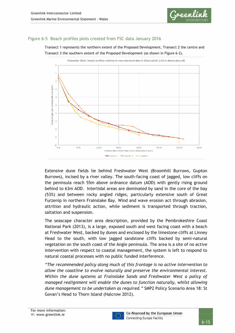
Greenlink Interconnector Limited
Greenlink Marine Environmental Statement - Wales
For more information: W: www.greenlink.ie
6-15
Figure 6-5 Beach profiles plots created from FSC data January 2016
Transect 1 represents the northern extent of the Proposed Development, Transect 2 the centre and
Transect 3 the southern extent of the Proposed Development (as shown in Figure 6-2).
Extensive dune fields lie behind Freshwater West (Broomhill Burrows, Gupton Burrows), incised by a river valley. The south-facing coast of jagged, low cliffs on the peninsula reach 55m above ordnance datum (AOD) with gently rising ground behind to 63m AOD. Intertidal areas are dominated by sand in the core of the bay (53%) and between rocky angled ridges, particularly extensive south of Great Furzenip in northern Frainslake Bay. Wind and wave erosion act through abrasion, attrition and hydraulic action, while sediment is transported through traction, saltation and suspension.
The seascape character area description, provided by the Pembrokeshire Coast National Park (2013), is a large, exposed south and west facing coast with a beach at Freshwater West, backed by dunes and enclosed by the limestone cliffs at Linney Head to the south, with low jagged sandstone cliffs backed by semi-natural vegetation on the south coast of the Angle peninsula. The area is a site of no active intervention with respect to coastal management, the system is left to respond to natural coastal processes with no public funded interference.
“The recommended policy along much of this frontage is no active intervention to allow the coastline to evolve naturally and preserve the environmental interest. Within the dune systems at Frainslake Sands and Freshwater West a policy of managed realignment will enable the dunes to function naturally, whilst allowing dune management to be undertaken as required.” SMP2 Policy Scenario Area 18: St Govan’s Head to Thorn Island (Halcrow 2012).

Greenlink Interconnector Limited
Greenlink Marine Environmental Statement - Wales
For more information: W: www.greenlink.ie
6-16
The dune system is shifting and changing over time naturally, with periodic blow-outs which can be considered to support landward retreat; the blowouts allow sediment to pass through the foredune and to the rear of the system. New foredunes are created as the dunes morph. Broomhill Burrows is in a constant flux as sediment supply fluctuates seasonally with wave climate, beach steepness and the wet-drying cycle of the intertidal zone.
In summary, the sand dunes of Broomhill Burrows backing Freshwater West indicate an area of onshore sediment migration. The beach and intertidal area are gently sloped for around 500m. The rocky headlands to the north and south of the beach and dune systems fix the sediment to the area by providing a sheltered area and act as a funnel for aeolian2 transport onshore. The beach is in equilibrium, with storm or winter conditions moving sediment offshore in the pocket bay, and calm or summer conditions moving the sediment onshore to the beach. When deposited and dried, the onshore (southwesterly) winds carry sand into the dunes.
6.3.4 Bathymetry, geology, seabed sediments and features
6.3.4.1 Bathymetry The dominant bathymetric feature off the west coast of Wales is a wide trough, having a maximum depth in excess of 100m, which runs the length of St Georges Channel between Wales and Ireland (Figure 6-6 Drawing P1975-BATH-001). Along the Proposed Development, the water depths range from 91-120m at the UK/Ireland median line to 0-30m close to the Pembrokeshire coast.
The Proposed Development is generally characterised by flat or gradually changing seabed with very gentle to gentle slopes. The water depth slowly increases from the landfall to the St Georges bathymetric trough at the westerly end of the Proposed Development. The maximum depth within the Proposed Development is 127.8m at KP53.66. Moderate gradients are generally associated with areas of mobile bedforms comprising megaripples and sand waves or over rocky outcrops. Mobile bedforms are frequently present throughout the Proposed Development. From KP2 to KP4.85, the indicative cable centreline passes through a sediment channel (valley) between rocky outcrops (Figure 6-7 Drawing P1975-SURV-001).
2 This is the process that wind moves the sand from the intertidal zone and beach face to the land and dune system.

BaginbunBeach
GREENLINK INTERCONNECTORBATHYMETRY
Chris GoodeEmma Langley
Monday, April 8, 2019 09:08:07WGS_1984_UTM_Zone_30N
D_WGS_1984DCCAE; UKHO; CDA; GEBCO; EMODNET; MarineFind; Greenlink
WGS_1984
NOTE: Not to be used for Navigation
© Copyright Department of Communications, Climate Action and Environment (DCCAE); Contains public sector information, licensed under the Open Government Licence v2.0, from the UKHO, 2018.; Contains data from UKOGD.; © The GEBCO Digital Atlas published by the British Oceanographic Data Centre on behalf of IOC and IHO, 2003; Charts from MarineFIND.co.uk © Crown Copyright, 2015. All rights reserved. Licence No: EK001-1001-WEB105. Not to be used for Navigation.; The bathymetric metadata and Digital Terrain Model data products have been derived from the EMODnet Bathymetry portal - http://www.emodnet-bathymetry.eu.
Anna Farley
250000
250000
300000
300000
350000
350000
57000
00
57000
00
57500
00
57500
00
58000
00
58000
00
58500
00
58500
00
LegendBaginbun BeachFreshwater WestGreenlink Route Centreline (Indicative)Proposed DevelopmentROI 12nm Territorial Sea LimitUK 12nm Territorial Sea LimitMedian Line
EMODNET BathymetryValueHigh : 0
Low : -130
0 10 20 30 40km © Metoc Ltd, 2019.
All rights reserved.
J:\P1975\Mxd\04_BATH\P1975-BATH-001.mxd
Created ByReviewed By
DateProjection
DatumData Source
File Reference
Spheroid
Approved By
Drawing No: P1975-BATH-001 A
FreshwaterWest
0 1 2 3 4km
0 1 2 3 4km
A
B
A
B

GREENLINK INTERCONNECTORSURVEY DATA
Bathymetry Nearshore Freshwater West
Chris CarrollChris Goode
Monday, April 8, 2019 12:52:17WGS_1984_UTM_Zone_30N
D_WGS_1984ESRI; OSOD; Bangor University; MMT; Greenlink
WGS_1984
NOTE: Not to be used for Navigation
© Crown Copyright, 2015. All rights reserved. Licence No: EK001-1001-WEB105. © Esri. Contains Ordnance Survey data © Crown copyright and database right 2013. ©Bangor University. ©Greenlink Ltd. Not to be used for Navigation.
Anna Farley
Channel Seen in SEACAMS Bathymetry
Channel Highlightedin Survey Data
350000
350000
352800
352800
355600
355600
358400
358400
57232
00
57232
00
57260
00
57260
00
57288
00
57288
00
LegendPost Survey CentrelinePre-Survey CentrelineProposed DevelopmentDesktop Bathymetry Extent
Survey Bathymetry Below LAT (m)High : 80
Low : -80
0 0.25 0.5 0.75 1km © Metoc Ltd, 2019.
All rights reserved.
J:\P1975\Mxd\02_SURV\P1975-SURV-001.mxd
Created ByReviewed By
DateProjection
DatumData Source
File Reference
Spheroid
Approved By
Drawing No: P1975-SURV-001 A
0 0.25 0.5 0.75 1km

Greenlink Interconnector Limited
Greenlink Marine Environmental Statement - Wales
For more information: W: www.greenlink.ie
6-19
6.3.4.2 Underlying geology The underlying geology is reported to consist of Palaeozoic rock (541 – 252.17 million years ago) overlain by Permian (252.17 – 298.9 million years ago), Mesozoic (252.17 – 66 million years ago) and Tertiary strata (66 – 2.58 million years ago), of which overlying Quaternary sediments locally exceed 300m in depth (Tappin et al. 1994).
Coastal The Proposed Development lies within the Pembrokeshire Marine/Sir Benfro Forol Special Area of Conservation (SAC); an area with a rich and complex geology. The southern part, which the Proposed Development crosses, is dominated by old red sandstone and carboniferous rocks, notably the limestone block of the Castlemartin coast, and the silurian volcanics of the Marloes Peninsula, Skomer and offshore rocks and islands. There has been a spectacular degree of rock faulting and folding. The coastal cliffs of highly faulted Cambrian (northern St Brides Bay shoreline) and old red sandstone (southern St Brides Bay, West Dale, Freshwater West) shorelines have an extensive sublittoral extension (CCW 2005).
The headland from Sheep Island (36m AOD) around west-facing Freshwater West Bay towards Linney Head (40-50m AOD) is predominantly composed of red sandstones that form irregular, steep cliffs with fallen rocks at the back of beaches. Freshwater West exposes older, Lower Palaeozoic mudstones and siltstones in its core, overlain to the north and south in Frainslake Bay by Old Red Sandstone, in east-west striking, long rocky intertidal foreshore outcrops. A submerged fossil forest is partially exposed on the beach.
The shallow (<30m), gently to moderately westwards shelving (<1o-10o) sandy seafloor overlies an east-west striking Lower Palaeozoic – Old Red Sandstone succession of sandstones and shales.
Offshore The central Celtic Sea comprises Upper Cretaceous (100.5 – 66 million years ago) and Paleogene sedimentary rock (66 – 23.03 million years ago), with Devonian to Carboniferous rock extending along the coast of southern Ireland (Tappin et al. 1994).
The geophysical survey suggests that the shallow geology along the Proposed Development is characterised by a gravelly to silty surface sand unit overlying Bedrock and/or till. The layer of sand and till thickens to the west at the southern extent of the St Georges Channel bathymetric trough.
The surface sand unit is almost continuous and varies in thickness between 1m and 4m. It reaches a thickness of >10m between KP5 and KP9.5, which is associated with the Turbot Bank.
Bedrock is close to the seabed, often within 3m. It outcrops between KP1.89 and KP3.77 where the indicative cable centreline follows a channel through the outcropping bedrock. The bedrock is also close to the seabed surface between KP9.5 and KP24.9.

Greenlink Interconnector Limited
Greenlink Marine Environmental Statement - Wales
For more information: W: www.greenlink.ie
6-20
The till comprises mainly high strength, stiff clay with varying fractions of sand, gravel and silt.
6.3.4.3 Seabed sediments and features The surficial seabed sediments within the Proposed Development generally comprise sand or gravelly sand/sandy gravel, interrupted by areas of outcropping bedrock. The bedrock outcrops and subcrops mainly in the nearshore, and in the first 43km of the Proposed Development.
The results of the particle size analysis show that the sediment at the grab sample sites principally consist of coarse sediment. The main component in the sediment was sand, amounting to an average of 69±22% of the total sediment, together with gravel (25±22%). As the standard deviation indicates, the proportions of the sand and gravel varied greatly. The mud content (clay and silt) was consistently low throughout the samples (6±4%).
Mobile sediments are common throughout the Proposed Development. Most common are megaripples, ranging in wavelength between 5 m and 25 m, however ripples <5 m wavelength were also seen. An area with sandwaves is present between KP25.685 and KP26.408.
Boulder fields are present in several locations. The density of boulders in the fields vary, from occasional to numerous. The largest boulder field area is present between KP20.2 and KP22.5. The boulders range in height from very small up to 2.3 m. Boulders are usually associated with the presence of out- and subcropping bedrock.
Some trawl marks were found present in the offshore section.
Survey data showing the seabed sediments and features is presented in Figures 6-8 to 6-12 (Drawing P1975-SED-005-A_1 to P1975-SED-005-A_5).
Turbot Bank The Proposed Development crosses the Turbot Bank for approximately 5km between KP5 to KP10. This subtidal sandbank is a designating feature of the Pembrokeshire Marine SAC.
Turbot Bank is a sink for glacial till and land-derived sediments from the Cleddau Ddu and Milford Haven Estuary, which is being reworked by the strong tidal currents into megaripples and sand waves across the seabed. Much like terrestrial dunes, these features migrate and can move either with or against the net tidal current and wave-derived stresses. The back of the dune is typically aligned to the predominant tidal flow with the steeper face aligned towards the direction of travel. Migration is slow (in the order of tens of metres per year), although some migrate faster and are likely to reform and recover in areas that have been cleared. These dunes, therefore, appear to be more active as they form towards an equilibrium size with the surrounding energy and available material. The cable route survey suggests that the direction of travel of these sand waves is east to west.

GREENLINK INTERCONNECTORSEABED SEDIMENTS
Survey Data - Sheet 1
Chris GoodeEmma Langley
Monday, April 8, 2019 12:40:40WGS_1984_UTM_Zone_30N
D_WGS_1984DCCAE; UKHO; CDA; OSOD; OSI; MMT; Greenlink
WGS_1984
NOTE: Not to be used for Navigation
© Copyright Department of Communications, Climate Action and Environment (DCCAE); Contains public sector information, licensed under the Open Government Licence v2.0, from the UKHO, 2018.; Contains data from UKOGD.; Contains Ordnance Survey data © Crown copyright and database right 2013; Contains Ordnance Survey Ireland data © OSi 2014
Anna Farley
KP 0
KP 5
KP 10
KP 15
Sheet - 1Sheet - 2
345000
345000
350000
350000
355000
355000
57200
00
57200
00
57250
00
57250
00
57300
00
57300
00
LegendFreshwater WestKPGreenlink Route Centreline (Indicative)Proposed Development
Seabed ClassificationBEDROCKGRAVELGravelly SAND to Sandy GRAVELSANDLarge RipplesMega RipplesOccasional BouldersRipplesSand Waves
0 0.5 1 1.5 2km © Metoc Ltd, 2019.
All rights reserved.
J:\P1975\Mxd\05_SED\P1975-SED-005.mxd
Created ByReviewed By
DateProjection
DatumData Source
File Reference
Spheroid
Approved By
Drawing No: P1975-SED-005 A

GREENLINK INTERCONNECTORSEABED SEDIMENTS
Survey Data - Sheet 2
Chris GoodeEmma Langley
Monday, April 8, 2019 12:40:40WGS_1984_UTM_Zone_30N
D_WGS_1984DCCAE; UKHO; CDA; OSOD; OSI; MMT; Greenlink
WGS_1984
NOTE: Not to be used for Navigation
© Copyright Department of Communications, Climate Action and Environment (DCCAE); Contains public sector information, licensed under the Open Government Licence v2.0, from the UKHO, 2018.; Contains data from UKOGD.; Contains Ordnance Survey data © Crown copyright and database right 2013; Contains Ordnance Survey Ireland data © OSi 2014
Anna Farley
KP 15KP 20
KP 25
Sheet - 1
Sheet - 2
Sheet - 3
330000
330000
335000
335000
340000
340000
57200
00
57200
00
57250
00
57250
00
57300
00
57300
00
LegendKPGreenlink Route Centreline (Indicative)Proposed Development
Seabed ClassificationBEDROCKGRAVELGravelly SAND to Sandy GRAVELSANDCurrent LineationLarge RipplesMega RipplesNumerous BouldersOccasional BouldersRipplesSand Waves
0 0.5 1 1.5 2km © Metoc Ltd, 2019.
All rights reserved.
J:\P1975\Mxd\05_SED\P1975-SED-005.mxd
Created ByReviewed By
DateProjection
DatumData Source
File Reference
Spheroid
Approved By
Drawing No: P1975-SED-005 A

GREENLINK INTERCONNECTORSEABED SEDIMENTS
Survey Data - Sheet 3
Chris GoodeEmma Langley
Monday, April 8, 2019 12:40:40WGS_1984_UTM_Zone_30N
D_WGS_1984DCCAE; UKHO; CDA; OSOD; OSI; MMT; Greenlink
WGS_1984
NOTE: Not to be used for Navigation
© Copyright Department of Communications, Climate Action and Environment (DCCAE); Contains public sector information, licensed under the Open Government Licence v2.0, from the UKHO, 2018.; Contains data from UKOGD.; Contains Ordnance Survey data © Crown copyright and database right 2013; Contains Ordnance Survey Ireland data © OSi 2014
Anna Farley
KP 30
KP 35
KP 40
Sheet - 2
Sheet - 3Sheet - 4
320000
320000
325000
325000
330000
330000
57200
00
57200
00
57250
00
57250
00
57300
00
57300
00
LegendKPGreenlink Route Centreline (Indicative)Proposed Development
Seabed ClassificationBEDROCKGRAVELGravelly SAND to Sandy GRAVELSANDCurrent LineationLarge RipplesMega RipplesNumerous BouldersOccasional BouldersRipplesSand Waves
0 0.5 1 1.5 2km © Metoc Ltd, 2019.
All rights reserved.
J:\P1975\Mxd\05_SED\P1975-SED-005.mxd
Created ByReviewed By
DateProjection
DatumData Source
File Reference
Spheroid
Approved By
Drawing No: P1975-SED-005 A
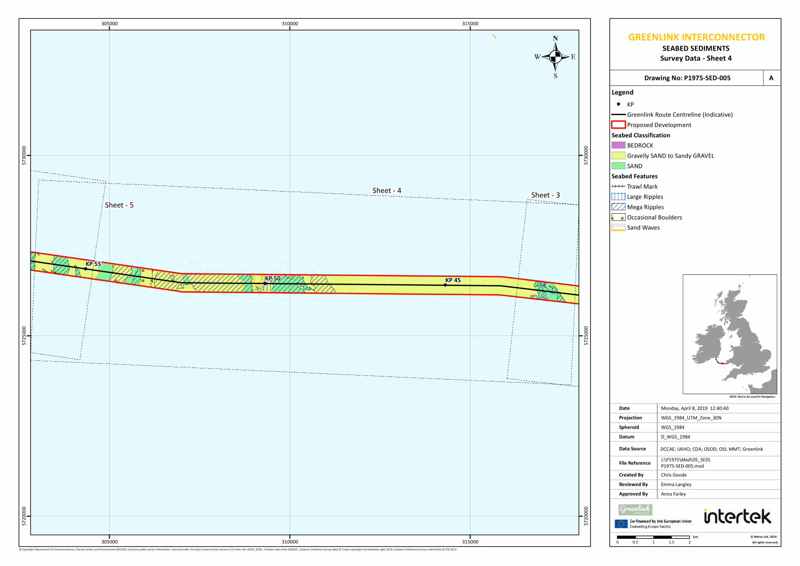
GREENLINK INTERCONNECTORSEABED SEDIMENTS
Survey Data - Sheet 4
Chris GoodeEmma Langley
Monday, April 8, 2019 12:40:40WGS_1984_UTM_Zone_30N
D_WGS_1984DCCAE; UKHO; CDA; OSOD; OSI; MMT; Greenlink
WGS_1984
NOTE: Not to be used for Navigation
© Copyright Department of Communications, Climate Action and Environment (DCCAE); Contains public sector information, licensed under the Open Government Licence v2.0, from the UKHO, 2018.; Contains data from UKOGD.; Contains Ordnance Survey data © Crown copyright and database right 2013; Contains Ordnance Survey Ireland data © OSi 2014
Anna Farley
KP 45KP 50KP 55
Sheet - 3Sheet - 4Sheet - 5
305000
305000
310000
310000
315000
315000
57200
00
57200
00
57250
00
57250
00
57300
00
57300
00
LegendKPGreenlink Route Centreline (Indicative)Proposed Development
Seabed ClassificationBEDROCKGravelly SAND to Sandy GRAVELSAND
Seabed FeaturesTrawl MarkLarge RipplesMega RipplesOccasional BouldersSand Waves
0 0.5 1 1.5 2km © Metoc Ltd, 2019.
All rights reserved.
J:\P1975\Mxd\05_SED\P1975-SED-005.mxd
Created ByReviewed By
DateProjection
DatumData Source
File Reference
Spheroid
Approved By
Drawing No: P1975-SED-005 A

GREENLINK INTERCONNECTORSEABED SEDIMENTS
Survey Data - Sheet 5
Chris GoodeEmma Langley
Monday, April 8, 2019 12:40:40WGS_1984_UTM_Zone_30N
D_WGS_1984DCCAE; UKHO; CDA; OSOD; OSI; MMT; Greenlink
WGS_1984
NOTE: Not to be used for Navigation
© Copyright Department of Communications, Climate Action and Environment (DCCAE); Contains public sector information, licensed under the Open Government Licence v2.0, from the UKHO, 2018.; Contains data from UKOGD.; Contains Ordnance Survey data © Crown copyright and database right 2013; Contains Ordnance Survey Ireland data © OSi 2014
Anna Farley
KP 55
KP 60
KP 65
KP 70Sheet - 4
Sheet - 5
Sheet - 6
290000
290000
295000
295000
300000
300000
57250
00
57250
00
57300
00
57300
00
57350
00
57350
00
LegendKPGreenlink Route Centreline (Indicative)Proposed DevelopmentUK 12nm Territorial Sea Limit
Seabed ClassificationGravelly SAND to Sandy GRAVELSAND
Seabed FeaturesTrawl MarkMega RipplesSand Waves
0 0.5 1 1.5 2km © Metoc Ltd, 2019.
All rights reserved.
J:\P1975\Mxd\05_SED\P1975-SED-005.mxd
Created ByReviewed By
DateProjection
DatumData Source
File Reference
Spheroid
Approved By
Drawing No: P1975-SED-005 A

Greenlink Interconnector Limited
Greenlink Marine Environmental Statement - Wales
For more information: W: www.greenlink.ie
6-26
6.3.5 Water and sediment quality
Water and sediment quality at any particular location on the UK continental shelf is the result of a combination of source, transport and removal mechanisms for the individual chemical species under consideration. There are many routes by which substances with the potential to affect water quality enter the Celtic Sea, both through natural processes and as a result of anthropogenic activity, with a general downward trend in anthropogenic inputs over the past few decades (UKMMAS 2010).
6.3.5.1 Water quality The EU Marine Strategy Framework Directive adopted in 2008 requires that the UK takes “the necessary measures to achieve or maintain Good Environmental Status in the marine environment by the year 2020 at the latest” (UKMMAS 2010). The report on the current state of the UK seas (UKMMAS 2010) concludes that good progress has been made towards this with significant contamination restricted to industrial estuaries and coastal areas.
The requirement for monitoring UK rivers and near-shore waters has increased as a result of the implementation of the EU Water Framework Directive (WFD), with more stringent criteria for water quality in rivers applied. River Basin Management Plans (RBMP) are being developed as a requirement of the WFD and report on the ‘ecological status’ of surface and ground water in coastal waters (out to 1nm from the baseline) and ‘chemical status’ of surface and ground waters in territorial waters (out to 12nm from the baseline). The Proposed Development is located within the Pembrokeshire South waterbody (water body id: GB611008590003). The overall water body status is listed as Good, with a Good ecological status and Good chemical status (see WFD Scoping Assessment – Technical Appendix H).
Water quality, defined in terms of bacterial concentration, is monitored within Bathing Waters designated under the revised Bathing Water Directive (2007/7/EC). These are classified as Excellent, Good, Sufficient and Poor. Bathing waters at Freshwater West have been classified as Excellent for the last four years (2015 – 2018) (NRW 2019). The bathing water sample point lies at the centre of the beach; approximately 280m southeast of the Proposed Development.
Water quality is also monitored for shellfish waters designated under the Shellfish Waters Directive 79/923/EEC and requires specification of protected areas for the protection of economically significant species. Currently, the nearest shellfish water to Freshwater West is the Milford Haven Cleddau, approximately 13km to the north-east.
6.3.5.2 Suspended sediments Suspended sediment in the water column arises as a result of biological activity, inputs from land and re-suspension of sediments. The suspended particulate matter (SPM) is made up of organic and inorganic fractions.
The organic fraction is predominantly the result of biological activity in the water column, and is primarily composed of planktonic material, including bacteria. This

Greenlink Interconnector Limited
Greenlink Marine Environmental Statement - Wales
For more information: W: www.greenlink.ie
6-27
will not be influenced by any activities associated with cable laying and will not be discussed further in this Chapter.
Inorganic SPM results from inputs from rivers (derived both from erosion in the river catchments and from chemical reactions in the estuarine zone), fallout from the atmosphere and coastal erosion combined with resuspension of existing sediments and chemical reactions in the water column. As a result inorganic SPM loads vary widely, generally increasing with proximity to the coastline (UKMAAS 2010). They are also highly dependent on energy inputs (e.g. storms).
NRW (2018) states that for the Pembrokeshire Marine / Sir Benfro Forol SAC “Suspended particulate concentrations are highly variable with season, wave action, tidal conditions and freshwater discharge. As a consequence water clarity and seabed and water column light intensity are also highly spatially and seasonally variable.”
Available measurements of SPM, whether from vessels or by satellite imagery, are largely restricted to near-surface data obtained under non-storm / cloud free conditions, and are limited for the Pembrokeshire coast. Average SPM for the period 1998-2015 off the Pembrokeshire coast is approximately 5-10mg/l (CEFAS 2016). Higher concentrations are typically seen during autumn and winter when concentrations typically exceed 5mg/l. Values in excess of 10mg/l occur after storm events.
As an indication of naturally occurring suspended particulate matter loads resulting from sediment resuspension, values of the order of 1000mg/l have been measured within the surf zone of sandy beaches (Voulgaris and Collins 2000), while surface inorganic SPM loads in water depths of over 70m in the central English Channel exceed 6mg/l during the winter (Rivier et al 2012).
6.3.5.3 Seabed quality Sediment contamination may result from natural and anthropogenic inputs that are harmful to biota. Dissolved contaminants in the Celtic Sea and off the Pembrokeshire coast are low or below the level of detection for current analytical tools.
Sediment samples taken during the cable route survey were tested for metal and polycyclic aromatic hydrocarbons (PAH) concentrations.
Metal concentrations were low across all grab sample sites and rarely exceeded any threshold values with the exception of Arsenic (As). Threshold values for Arsenic were exceed in all, but two samples tested in the Proposed Development – see Table 6-6. Arsenic is a natural component of seawater and rocks and given the lack of variability between samples it is expected that the values are of a natural origin rather than anthropogenic contamination.
Concentrations of organics and moisture content showed moderate variation between grab sample sites. Concentrations of PAHs varied greatly between grab samples sites. Grab sample sites S22, S23 and S37 had markedly higher

Greenlink Interconnector Limited
Greenlink Marine Environmental Statement - Wales
For more information: W: www.greenlink.ie
6-28
concentrations of PAHs, whereas grab sample site S28 had markedly low concentrations. Threshold values set by Canadian Council of Ministers of the Environment (CCME) interim marine sediment quality guidelines (ISQG) of 36.1μg/Kg were exceeded at grab sample site S33; test result was 34.6μg/Kg. This was the only site where values were exceeded. The full test results are providing in the Greenlink Benthic Survey Report – Technical Appendix J.
Table 6-4 Summary of metal concentrations (μg/g dry weight) in sediment across grab sample sites together with threshold values.
Highlighted cells indicate where threshold values have been exceeded. Samples S19 to S37 are taken
in the Proposed Development.
Source: MMT (2019c)
6.3.6 Natural evolution of the baseline
The natural evolution of the baseline has been compiled using information from the Offshore Energy Strategic Environmental Assessment 3 (OESEA 3) (DECC 2016). The

Greenlink Interconnector Limited
Greenlink Marine Environmental Statement - Wales
For more information: W: www.greenlink.ie
6-29
OESEA 3 notes significant anomalies and changes in sea surface temperature, thermal stratification, circulation patterns, wave climate, pH and sea level change, and change in strength of the Atlantic heat conveyor belt and the Gulf stream – many appear to be correlated to atmospheric climate variability as described by the North Atlantic Oscillation. The OESEA reports varying degrees of confidence in the interpretation of observed data and prediction of future trends.
According to the UK Government's UK Climate Change Risk Assessment (2017), sea levels in the UK are rising by approximately 3mm a year, or 300mm over the next 100 years. However, this could be as much as 2m over the next 50 years depending on global emissions. The response of the coastal area to sea-level rise will depend on local conditions (prevailing solid and drift geology, wave and tidal conditions and sediment processes) and coastal protection (i.e. sea defences). However, it is expected that sea level rise will result in beach steepening and a loss of intertidal habitat where adjoining landward areas are constrained to adjustment (i.e. coastal squeeze), and potentially enhanced flooding and erosion of soft-rocked coasts are possible. Therefore, it is expected that sea level rise will gradually effect the morphology of the coast at Freshwater West and could result in beach erosion and retraction.
The shoreline management plan outlines the coastal management approach at Freshwater West is no active intervention i.e. the system is left to respond to natural coastal processes with no public funded interference.
“The recommended policy along much of this frontage is no active intervention to allow the coastline to evolve naturally and preserve the environmental interest. Within the dune systems at Frainslake Sands and Freshwater West a policy of managed realignment will enable the dunes to function naturally, whilst allowing dune management to be undertaken as required.” SMP2 Policy Scenario Area 18: St Govan’s Head to Thorn Island (Halcrow 2012).
6.4 Potential Pressure Identification and Zone of Influence
A scoping exercise undertaken to inform the content of the ES has excluded the following pressures from further consideration in this topic Chapter. The explanation for the exclusion is provided in Chapter 5, Table 5-2.
• Changes in suspended solids (water clarity): specifically, in relation to discharges from project vessels.
• Temperature changes (local).
The pressures listed in Table 6-5 will be assessed further. For each pressure, the assessment considered the different aspects of the project during installation, operation (including repair & maintenance) and decommissioning. In order to evaluate the most significant effects, the largest zone of influence from these aspects was selected. The zones of influence are presented in Table 6-5.

Greenlink Interconnector Limited
Greenlink Marine Environmental Statement - Wales
For more information: W: www.greenlink.ie
6-30
Table 6-5 Pressure identification and zone of influence – physical conditions and marine processes
Project phase Project Activity
Aspect Pressure Receptor Zone of influence
Installation Cable burial
Pre-sweeping+
Penetration and/or disturbance of the substrate below the surface of the seabed, including abrasion
Sediments 100m
Installation Cable burial Cable protection
Seabed preparation Cable trenching (ploughing and jet trenching) External cable protection
15m
Operation Cable repair and maintenance
Decommissioning Cable removal
Installation Cable burial
Pre-sweeping Cable trenching (ploughing and jet trenching)
Changes in suspended solids (water clarity)
Water quality
100m*
Operation Cable repair and maintenance
Decommissioning Cable removal
Installation Cable protection
Cable protection
Water flow (tidal current) changes local
Coastal processes
Freshwater West
Cable protection at HDD exit
Installation Cable protection
Cable protection
Physical change (to another seabed type)
Sediments 10m x 16.34km
Operation Cable repair and maintenance
10m x 1km (5 discrete occasions for cable repair)
+ No pre-sweeping is likely on Turbot Bank (KP5 to KP10); pre-sweeping of sand waves required at KP25.8 to 26.4 and at the median line (KP63 to KP69). * Defined in Section 6.6.4.
6.5 Embedded Mitigation
The project description in Chapter 4 provides the current ‘base case’. This includes mitigation measures which form part of the design and are therefore an inherent part of the Proposed Development and comprise embedded or primary mitigation. The embedded mitigation relevant to physical conditions and marine processes is provided in Table 6-6 below. When undertaking the EIA it has been assumed that these measures will be implemented; either as a matter of best practice or to ensure compliance with statute and consents.
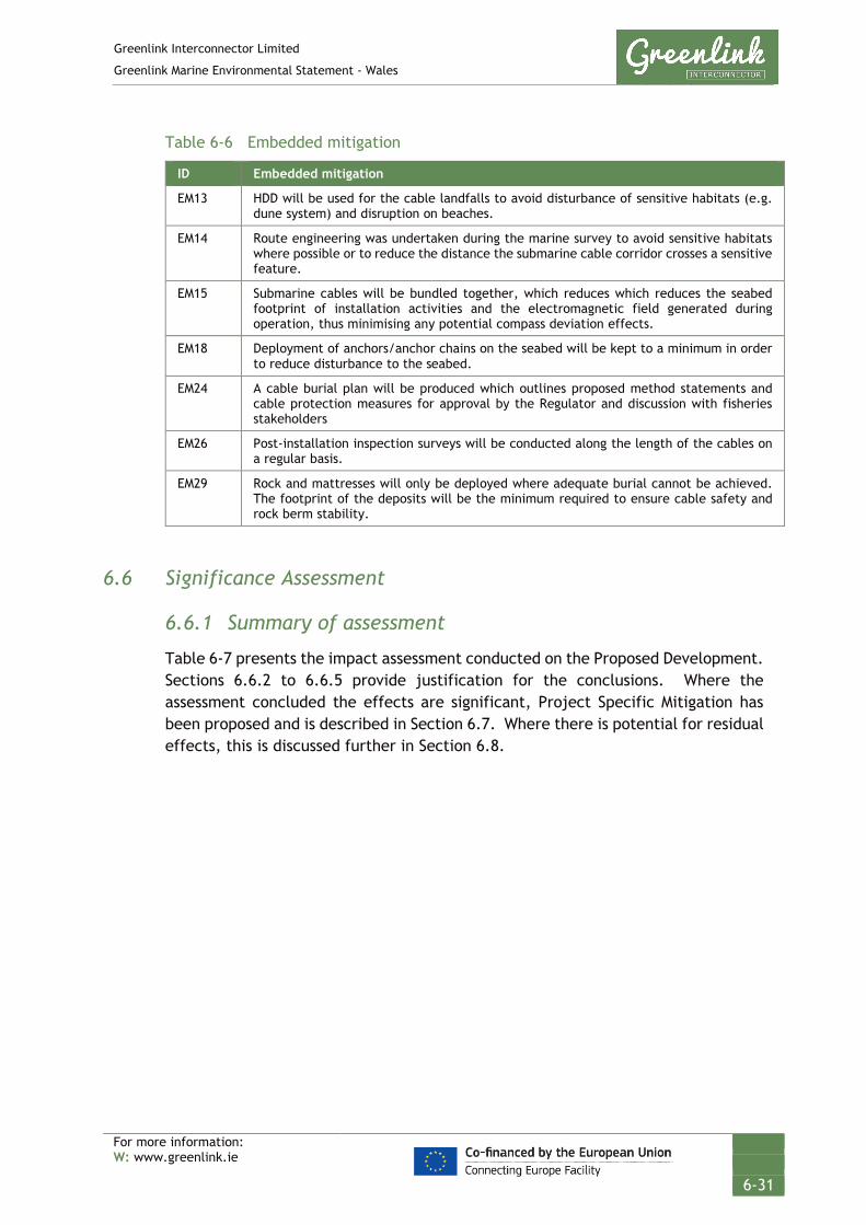
Greenlink Interconnector Limited
Greenlink Marine Environmental Statement - Wales
For more information: W: www.greenlink.ie
6-31
Table 6-6 Embedded mitigation
ID Embedded mitigation
EM13 HDD will be used for the cable landfalls to avoid disturbance of sensitive habitats (e.g. dune system) and disruption on beaches.
EM14 Route engineering was undertaken during the marine survey to avoid sensitive habitats where possible or to reduce the distance the submarine cable corridor crosses a sensitive feature.
EM15 Submarine cables will be bundled together, which reduces which reduces the seabed footprint of installation activities and the electromagnetic field generated during operation, thus minimising any potential compass deviation effects.
EM18 Deployment of anchors/anchor chains on the seabed will be kept to a minimum in order to reduce disturbance to the seabed.
EM24 A cable burial plan will be produced which outlines proposed method statements and cable protection measures for approval by the Regulator and discussion with fisheries stakeholders
EM26 Post-installation inspection surveys will be conducted along the length of the cables on a regular basis.
EM29 Rock and mattresses will only be deployed where adequate burial cannot be achieved. The footprint of the deposits will be the minimum required to ensure cable safety and rock berm stability.
6.6 Significance Assessment
6.6.1 Summary of assessment
Table 6-7 presents the impact assessment conducted on the Proposed Development. Sections 6.6.2 to 6.6.5 provide justification for the conclusions. Where the assessment concluded the effects are significant, Project Specific Mitigation has been proposed and is described in Section 6.7. Where there is potential for residual effects, this is discussed further in Section 6.8.

Greenlink Interconnector Limited
Greenlink Marine Environmental Statement - Wales
For more information: W: www.greenlink.ie
6-32
Table 6-7 Impact assessment summary – physical conditions and marine processes
Section Determination of Potential Effect Impact Assessment Consideration of Mitigation
Residual Effect Assessment
Project Phase Aspect Potential pressure
Embedded Mitigation (Table 6-6)
Receptor Magnitude Sensitivity Significance Project Specific Mitigation (Table 6-9)
Magnitude Sensitivity Significance of Residual Effect
6.6.2 Installation Operation (Repair & Maintenance) Decommissioning
Cable burial
Penetration and/or disturbance including abrasion
EM13, EM15 Intertidal sands / Coastal processes
High High Major PS1, PS3 - - No Effect
EM13, EM14, EM15
Bedrock Low High Moderate PS2 - - No Effect
Pre-sweeping
EM14, EM15 Subtidal sands
Medium
Medium
Moderate PS5
Low
Medium
Minor
Cable burial Cable protection Cable removal
EM13, EM14, EM15, EM18
All other subtidal sediments
Low Low Negligible - - - -
6.6.3 Installation, Operation (Repair & Maintenance) Decommissioning
Pre-sweeping Cable burial Cable removal
Changes in suspended solids (water clarity)
EM15 Water quality
Negligible Negligible Negligible - - - -
6.6.4 Operation Cable protection
Water flow (tidal changes) local
EM13, EM15, EM24, EM29
Coastal processes
Low Low Negligible - - - -
Cable protection at HDD exit
Sediments Coastal processes
High Medium Major PS4 - - No Effect
6.6.5 Operation Cable protection
Physical change (to another seabed type)
EM15, EM24, EM26, EM29
Sediments
Low Medium Minor PS6 Low Medium Minor
Greenlink Interconnector Limited
Greenlink Marine Environmental Statement - Wales
For more information: W: www.greenlink.ie
6-33
6.6.2 Penetration and/or disturbance of the substrate below the surface of the seabed, including abrasion
6.6.2.1 Installation Sediments will be disturbed during seabed preparation (e.g. pre-lay grapnel run, boulder clearance, pre-sweeping), cable burial (jetting, and / ploughing) and to a lesser extent anchor placement if required. The cable trench will either be naturally or manually backfilled (with trenching tools) returning the seabed to its former state and the bathymetry to the baseline condition.
A shallow depression may be observed directly over the cable if jetting is used, as finer fractions of sediment suspended during the burial process are dispersed by currents. However, the depression will be a temporary feature with local sediment transport filling it in. The cables will be bundled together into one trench (embedded mitigation EM15), which will reduce the footprint of effects.
Sediments within the Proposed Development are generally sand or gravelly sand/sandy gravel, interrupted by areas of outcropping bedrock. Certain sediments have been identified as potentially more sensitive to penetration and these are discussed below:
Intertidal sands / Coastal processes During the EIA process consideration was given to whether it would be feasible for the horizontal direction drill (HDD) to exit above the low water mark within the intertidal area at Freshwater West.
This was discounted from the project description and trenching on the beach is not being considered as a contingency for the following reasons:
• The mobile sand unit at Freshwater West is estimated to be in the order of 6m deep (based on seismic profile data). To ensure that the cables do not become exposed i.e. after a winter storm, a potential trench depth of 8m would be required. Although technically feasible, this would be challenging and involve significant engineering works on the beach.
• Sediment removed from the cable trench would be returned to back-fill the trench, covering the cables. However, the compacted and saturated sediment, once excavated will take time to return to the same immobile state as pre-trenching. With larger spaces and water separating sediment particles, the bed in the disturbed area will be more prone to scour and erosion until sediment recompacts.
• An area of consolidate coarser sediment is covered by a sand veneer in the upper beach terrace. Trenching through this feature could create a weakness as described above, potentially allowing a scour channel to form, which in turn could effect the way sediment is transported on and off the beach.
The EIA concluded that the significance of effects were uncertain without coastal processes modelling but there was the potential that effects could be Major and Significant. It was therefore recommended that trenching on the upper beach

Greenlink Interconnector Limited
Greenlink Marine Environmental Statement - Wales
For more information: W: www.greenlink.ie
6-34
terrace should be excluded from the project description. Project Specific Mitigation has been proposed to ensure that it is clear that this ES commits to no intrusive works between mean high water springs and the low water mark (Project Specific Mitigation PS1); and that if the final selected Installation Contractor proposes works within this area, any plans would need to be subject to full coastal processes assessment and a variation to the Marine Licence application applied for (Project Specific Mitigation PS3).
Bedrock Outcropping bedrock is prevalent within the Proposed Development between KP2 and KP4.85 and at discrete locations at KP11 and between KP23 and KP24. Cable installation in bedrock would likely require cutting and the use of external cable protection. Although the spatial extent of the effect would be localised, approximately 1m wide trench, the change to the feature would be permanent. This results in an assessment of low magnitude and high sensitivity. The overall significance of the effect has been assessed as Moderate and is Significant.
Project Specific Mitigation (PS2) has been proposed to reduce the significance of the residual effect and is presented in Section 6.7.
Subtidal sands: pre-sweeping Analysis of sandwave and megaripple heights within the Proposed Development on the Turbot Bank suggests that pre-sweeping will not be required on this feature.
Two sandwaves at KP26 and an additional area between KP64 and KP69 may require pre-sweeping. The process of clearing an installation track through the sandwaves will create a short-term change to the morphology of the sandwaves. If mass flow excavation is used the material is retained within the system, just pushed to either side; with dredging the material is effectively moved to a different place within the Proposed Development, where it is re-deposited.
The features of the system are likely to reform and recover in areas of active sandwaves, the sediment will likely be reworked by wave action and migrate across filling the area cleared and trenched. Timescales for recovery are expected to be in the order of 1-2 years, for the trenching scar to be covered by the sand waves.
The magnitude of the effect has been assessed as medium as it is recognised that recovery, and therefore the scale of the effect is dependent on the installation technique used and how sediment is retained within the system. If dredging moves the sediment out of the sandwave system, recovery of the trenching scar could take longer than predicted. However, disturbance will be a one-off event causing very localised change.
The sensitivity of the receptor has been assessed as medium as the sandwaves are all in water depths of greater than 30m meaning changes to the feature will not have an effect on coastal processes, they are not protected features; and recovery to baseline conditions is possible in the short-term. The overall significance of the effect has been assessed as Moderate and is Significant if dredging is used.

Greenlink Interconnector Limited
Greenlink Marine Environmental Statement - Wales
For more information: W: www.greenlink.ie
6-35
Project Specific Mitigation has been proposed (PS5), to ensure that if dredging is used material is retained within the sandwave system.
All other subtidal sediments Activities which cause seabed disturbance within the remainder of the Proposed Development will have a temporary effect on seabed sediments. The magnitude of the effect has been assessed as low for the following reasons:
• BGS data shows the sediments within the Proposed Development cover larger areas of the Celtic Sea and in this context the narrow zone of disturbance (15m) is very small and localised;
• The cable burial activities will not alter sediment characteristics, bathymetry or seabed features; and
• The activity will be a one-off event that will not be repeated.
The sensitivity of the receptor has been assessed as low as sediments have a high capacity to return to baseline conditions following disturbance. The overall significance of the effect has been assessed as Negligible and is Not Significant.
6.6.2.2 Operation (including maintenance and repair) No seabed disturbance will occur from the operating cables. Effects during any unforeseen repair and maintenance works will be of a smaller magnitude when compared to cable installation. The assessment considered five discrete cable repairs during operation and concluded the significance of the effect remains:
• Moderate and is Significant for bedrock, intertidal sediments and areas of sandwaves requiring pre-sweeping with dredgers; and
• Negligible and is Not Significant for all other subtidal sediments.
6.6.2.3 Decommissioning Two options will be considered at decommissioning; leaving the cables in-situ and removing them. If the cables are left in-situ there will be no effect on sediments during decommissioning. However, if the option to remove the cables (and any associated protection) is selected, this process would essentially be the same as installation activities but in reverse. Therefore, any effects that could arise due to the decommissioning phase of the Proposed Development will be of a comparable magnitude to those assessed above for cable installation and so the effect has been assessed as:
• Moderate and is Significant for bedrock, intertidal sediments and areas of sandwaves requiring pre-sweeping with dredgers; and
• Negligible and is Not Significant for all other subtidal sediments.
6.6.3 Change in suspended solids (water clarity)
Seabed preparation and cable burial (ploughing and/or jetting) will briefly change SPM levels (increasing turbidity). An increase in SPM has the potential to indirectly
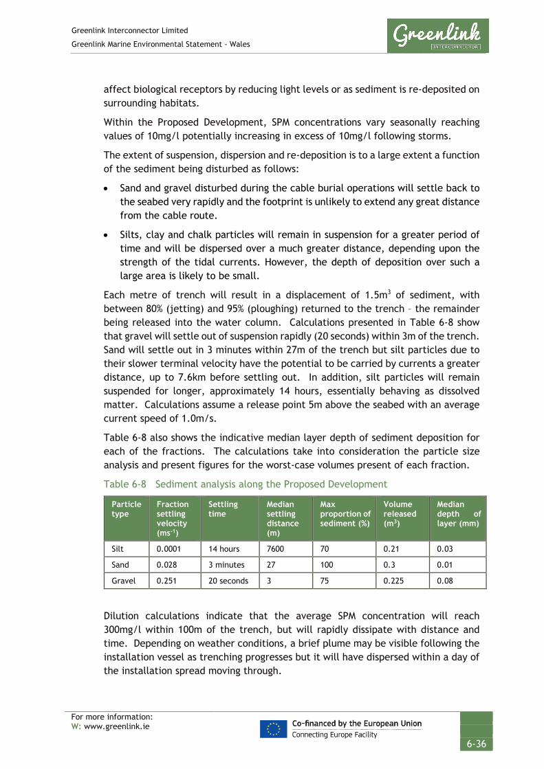
Greenlink Interconnector Limited
Greenlink Marine Environmental Statement - Wales
For more information: W: www.greenlink.ie
6-36
affect biological receptors by reducing light levels or as sediment is re-deposited on surrounding habitats.
Within the Proposed Development, SPM concentrations vary seasonally reaching values of 10mg/l potentially increasing in excess of 10mg/l following storms.
The extent of suspension, dispersion and re-deposition is to a large extent a function of the sediment being disturbed as follows:
• Sand and gravel disturbed during the cable burial operations will settle back to the seabed very rapidly and the footprint is unlikely to extend any great distance from the cable route.
• Silts, clay and chalk particles will remain in suspension for a greater period of time and will be dispersed over a much greater distance, depending upon the strength of the tidal currents. However, the depth of deposition over such a large area is likely to be small.
Each metre of trench will result in a displacement of 1.5m3 of sediment, with between 80% (jetting) and 95% (ploughing) returned to the trench – the remainder being released into the water column. Calculations presented in Table 6-8 show that gravel will settle out of suspension rapidly (20 seconds) within 3m of the trench. Sand will settle out in 3 minutes within 27m of the trench but silt particles due to their slower terminal velocity have the potential to be carried by currents a greater distance, up to 7.6km before settling out. In addition, silt particles will remain suspended for longer, approximately 14 hours, essentially behaving as dissolved matter. Calculations assume a release point 5m above the seabed with an average current speed of 1.0m/s.
Table 6-8 also shows the indicative median layer depth of sediment deposition for each of the fractions. The calculations take into consideration the particle size analysis and present figures for the worst-case volumes present of each fraction.
Table 6-8 Sediment analysis along the Proposed Development
Particle type
Fraction settling velocity (ms-1)
Settling time
Median settling distance (m)
Max proportion of sediment (%)
Volume released (m3)
Median depth of layer (mm)
Silt 0.0001 14 hours 7600 70 0.21 0.03
Sand 0.028 3 minutes 27 100 0.3 0.01
Gravel 0.251 20 seconds 3 75 0.225 0.08
Dilution calculations indicate that the average SPM concentration will reach 300mg/l within 100m of the trench, but will rapidly dissipate with distance and time. Depending on weather conditions, a brief plume may be visible following the installation vessel as trenching progresses but it will have dispersed within a day of the installation spread moving through.

Greenlink Interconnector Limited
Greenlink Marine Environmental Statement - Wales
For more information: W: www.greenlink.ie
6-37
Whilst jetting is considered to have the least impact on the environment because the footprint of the tool is smaller than other installation tools such as ploughs, the use of jetting tools does result in higher suspended sediment concentrations. However, in a review of seabed disturbance from various activities it was observed that disturbance resulting from jetting was largely restricted to fines and remained low in comparison with dredging and some fishing techniques (BERR 2008).
In conclusion, the installation activities will increase the levels of SPM in the water column. The magnitude of the increase will be dependent on the seabed conditions. However, calculations indicate the concentrations will be within the range of natural variability expected for the region, will be limited in extent and brief in nature. The magnitude of the effect has been assessed as negligible. The sensitivity of the receptor has been assessed as negligible as the level of change is reversible and there will be no effect on the baseline character. The overall significance of the effect is Negligible and is Not Significant.
6.6.4 Water flow (tidal current) changes – local
External cable protection External cable protection will be required offshore in locations totalling up to 16.34km of the cable route. The rock berms would have a footprint up to 10m wide with a maximum height of 1.5m. Engineering design has not yet been completed for the berms but rock sizes are likely to be in the range of 2cm to 22cm.
The presence of external cable protection in the offshore region may cause very localised changes in water flows. This in turn could cause localised scour. Scour will only occur in areas of sediment where bottom current either already exceed the critical bedload parting velocity, or where external cable protection results in an increase in current velocity to above the critical bedload parting velocity. Given that current speeds within the Proposed Development are relatively low, particularly near the seabed due to frictional effect, high scour is unlikely to be a significant issue.
The description of this pressure also includes sediment transport considerations e.g. whether the installation of the rock berms could affect transport of sediment to and from the beach at Freshwater West.
Depth of closure is an important concept used in coastal engineering. The depth of closure is a theoretical depth along a beach profile where sediment transport is very small or non-existent (USACE 2019), or basically the furthest distance offshore at which there is no significant sediment transport between the nearshore and offshore. Depth of closure has been conservatively estimated, using a mean significance wave height of 1.63m, as 14.5m below lowest astronomical tide for Freshwater West. Beyond this depth, there will be theoretically little effect on beach processes.

Greenlink Interconnector Limited
Greenlink Marine Environmental Statement - Wales
For more information: W: www.greenlink.ie
6-38
All the indicative locations for external cable protection proposed are in water depths greater than 14.5m. Therefore, it is concluded that there will be no effects on sediment transport pathways at Freshwater West.
In conclusion, the magnitude of the effect on water flow has been assessed as low as although the structures will be permanent features, the spatial extents of effects will be very localised, with effects unlikely on Freshwater West. The sensitivity of the receptor has been assessed as low. The overall significance of the effect has been assessed Negligible and is Not Significant.
External cable protection at HDD exit During the EIA process consideration was given to whether it would be necessary to install external cable protection at the HDD exit point. External cable protection can be used to protect the cables as they leave the individual cable ducts and before they are bundled together and trenching starts. Consideration was given to including a contingency for a rock berm 20m long by 5.2m wide by 0.7m high. This has been discounted from the project description for the following reasons:
• An artificial feature in water depths that are less than the depth of closure has the potential to modify wave patterns which in turn could effect sediment transport to and from the beach and indirectly effect the protected dune system and intertidal sediments (Qualifying Features of the Pembrokeshire Marine / Sir Benfro Forol Special Area of Conservation).
• There would be a local scour concern with respect to the feature (current and wave driven).
The EIA concluded that the significance of effects were uncertain without coastal processes modelling but there was the potential that effects could be Major and Significant.
Analysis of the cable route survey data suggests there is sufficient depth of sediment within the area defined for the HDD exit that burial of the HDD duct and cables can be achieved without external cable protection. External cable protection at the HDD exit has therefore not been included in the Project Description. Project Specific Mitigation has been proposed (PS4) to ensure that this is ES commitment is clear.
6.6.5 Physical change (to another seabed type)
Where external cable protection is required, e.g. at the crossing locations, and in areas where burial in sediment cannot be achieved because of ground conditions, there will be a localised change in seabed sediment type. The preference is to lay the cables bundled in one trench (embedded mitigation EM15), which will reduce the potential spatial footprint of the change. Sediments where external cable protection is potentially necessary range from sand through to gravelly sand and sandy gravel with cobbles.
External cable protection will consist of rock in the size range of 2-22cm. This will represent a coarsening of the sediment. Approximately 0.165km2 of seabed will be

Greenlink Interconnector Limited
Greenlink Marine Environmental Statement - Wales
For more information: W: www.greenlink.ie
6-39
affected. The sediments identified cover large areas of the Celtic Sea and the Proposed Development.
A Qualifying Feature of the Pembrokeshire Marine / Sir Benfro Forol SAC is the habitat Reef. The sandy gravel and gravelly sand between KP15 and KP23 support this habitat. In addition sand sediments between KP42 and KP44 support potential biogenic reef habitat. External cable protection in these areas therefore has the potential to alter the sedimentology of the habitat an important element of the structure and function of the Qualifying Feature. The Natura 2000 form for the site (NATURA 2000 2015) records that the Qualifying Feature Reef covers an area of 409.97km2 (40997.43hectares). The footprint of the external cable protection within this habitat will cover 0.1017km2; equivalent to 0.025% of the Qualifying Feature. This is a negligible reduction in the habitat which will not adversely affect the conservation targets for the Qualifying Feature.
The magnitude of the effect has been assessed as low as although the structure will be a permanent feature, the spatial extent of the change in seabed type will be very localised. The sensitivity of the receptor has been assessed as medium as there will be a localised change in sediment type which changes the character of the baseline, albeit on a very small scale. The overall significance of the effect has been assessed as Minor and is Not Significant.
This potential effect has also been assessed within the Greenlink Habitats Regulation Assessment (HRA) – Technical Appendix C. Stage 1 Screening concluded likely significant effects and that Appropriate Assessment was required.
6.7 Project Specific Mitigation
In addition to the embedded mitigation discussed in Section 6.5, Table 6-9 presents Project Specific Mitigation that GIL is committed to adopting.
Table 6-9 Project-specific mitigation physical conditions and marine processes
ID Project Specific Mitigation
PS1 No intrusive works will be undertaken at Freshwater West between mean high water springs and mean low water springs.
PS2 Exclusion zones have been established around Annex I bedrock reef features; shown on Figure 7-21, Drawing P1975-INST-009. No intrusive works (e.g. cable installation, deposit of external cable protection material) will be undertaken within these exclusion zones.
PS3 An exclusion zone has been established on the upper beach terrace at Freshwater West, shown on Drawing P1975-INST-001. No intrusive works should be carried out in this area unless further assessment is undertaken to determine the significance of effects on coastal processes. Any intrusive works between MHWS and MLWS would require a variation to the Marine Licence.
PS4 The preference is to bury the HDD duct exit and all cables in sediment to the required depth of lowering. No external cable protection should be deposited at the HDD exit point.
PS5 Should dredging be employed rather than mass flow excavator for pre-sweeping, sand should be deposited up-current and as close to the disturbed sandwaves as possible so that sand can naturally migrate back onto the sandwaves.
PS6 A burial assessment study will be carried out by the Installation Contractor that defines the feasibility of achieving the required depth of burial. When determining the installation

Greenlink Interconnector Limited
Greenlink Marine Environmental Statement - Wales
For more information: W: www.greenlink.ie
6-40
ID Project Specific Mitigation technique for the cable route between KP15 and KP23 the preference shall be to bury the cable in sediment. If ground conditions do not allow this then cutting should be investigate as the next alternative. External cable protection shall only be consider as the final option, and if necessary, the Installation Contractor shall seek to minimise the footprint (length and width) of external cable protection required between KP15 and KP23 (Annex I stony reef).
6.8 Residual Effect
The assessment presented in Table 6-7 indicated that three pressures could potentially have significant effects on the receptor physical conditions and marine processes. The significance of these pressures was re-assessed taking into consideration the Project Specific Mitigation outlined in Section 6.7 to determine if a significant residual effect remains.
6.8.1 Penetration and/or disturbance of the substrate below the surface of the seabed, including abrasion
Intertidal sediments / coastal processes The assessment concluded that the significance of effects of trenching within the intertidal zone at Freshwater West were uncertain without coastal processes modelling but there was the potential that effects could be Major and Significant. The preferred installation technique is to directionally drill under the beach and therefore the base case does not include any works in the intertidal zone. To ensure that this is clear the ES commits to no intrusive works between mean high water springs and the low water mark (PS1).
As the base case does not include works within the intertidal zone there is no pressure pathway to the receptor and the residual effect has been assessed as No Effect.
If the final selected Installation Contractor proposes works within this area, any plans would need to be subject to full coastal processes assessment and a variation to the Marine Licence application applied for (PS3).
Bedrock The assessment identified that Bedrock is highly sensitive to the pressure penetration and/or disturbance of the substrate below the surface of the seabed, including abrasion. Activities that involve intrusive seabed works have been assessed as having a Significant effect on the receptor. The Proposed Development has been optimised to avoid the majority of the bedrock, by following a sand channel. Project Specific Mitigation in the form of exclusion zones (PS2) have been established around the habitat within the Proposed Development. Implementation of the exclusion zones will result in the pressure pathway to the receptor being removed and the subsequent residual effect has been assessed as No Effect.

Greenlink Interconnector Limited
Greenlink Marine Environmental Statement - Wales
For more information: W: www.greenlink.ie
6-41
Subtidal sands: Pre-sweeping The EIA concluded that there is the potential for a Moderate effect on subtidal sand sediments if dredging is used for pre-sweeping. This relates principally to the fact that sediment could be deposited at some distance from the disturbed sandwave effectively removing it from the system, impeding recovery of the sandwave.
Project specific Mitigation PS5 requires that should dredging be employed, sand should be deposited up-current and as close to the disturbed sandwaves as possible so that sand can naturally migrate back onto the sandwaves. Implementation of this mitigation will reduce the magnitude of the effect to Low and the residual effect has been assessed as Minor and is Not Significant.
6.8.2 Water flow (tidal current) changes – local
The EIA concluded if external cable protection was used at the HDD exit point, the significance of effects were uncertain without coastal processes modelling but there was the potential that effects could be Significant.
Analysis of the cable route survey data suggests there is sufficient depth of sediment within the area defined for the HDD exit that burial of the HDD duct and cables can be achieved without external cable protection. External cable protection at the HDD exit has therefore not been included in the Project Description. Project Specific Mitigation has been proposed (PS4) to ensure that this ES commitment is clear. Therefore there will be No Effect.
6.8.3 Physical change (to another seabed type)
The EIA concluded that the use of external cable protection has the potential to have a minor effect which is Not Significant. However, as external cable protection is likely required on areas of seabed which support the structure and function of a Qualifying Feature of the Pembrokeshire Marine / Sir Benfro Forol SAC, Project Specific Mitigation has been proposed. PS6 seeks to reduce the footprint of the effect by requiring the Installation Contractor to seek alternative means of achieving the required depth of burial before the use of external cable protection. However, as it is not known whether alternatives will be available, the residual effect remains Minor and is Not Significant.

Greenlink Interconnector Limited
Greenlink Marine Environmental Statement - Wales
For more information: W: www.greenlink.ie
6-42
1 Barne, J.H., Robson, C.F., Kaznowska, S.S., and Doody, J.P., eds. (1995). Coasts and seas of the United Kingdom. Region 12 Wales: Margam to Little Orme. Peterborough, Joint Nature Conservation Committee.
2 CEFAS Report (2016). Suspended Sediment Climatologies round the UK. Cefas. Report for the UK Department for Business, Energy & Industrial Strategy offshore energy Strategic Environmental Assessment programme. [online] Available at: https://assets.publishing.service.gov.uk/government/uploads/system/uploads/attachment_data/file/584621/CEFAS_2016_Suspended_Sediment_Climatologies_around_the_UK.pdf (Accessed May 2019)
3 Countryside Council for Wales (CCW) (2005). Pembrokeshire Marine European Site. Advice provided by the Countryside Council for Wales in fulfilment of Regulation 33 of the Conservation (Natural Habitats, &c.) Regulations 1994.
4 Cyngor Cefn Gwlad Cymru, (undated) SSSI citation https://www.field-studies-council.org/media/2414829/sssi_1136_citation_broomhill_burrows.pdf [accessed March 2019]
5 Department of Energy and Climate Change (DECC) (2016). Offshore Energy Strategic Environmental Assessment. Department of Energy and Climate Change. March 2016.
6 DTI (2005). SEA 6 Offshore Oil and Gas Licencing. Physical and Chemical Environment.
7 DTI (2007). SEA 8 technical report- Hydrography.
8 Fairley, I. (2014) Wave Climate Analysis in South Pembrokeshire from 20-year Time Series of the Turbot Bank Buoy. Marine Energy Research Group. https://www.marineenergywales.co.uk/wp-content/uploads/2016/01/Turbot-Bank-Wave-Report_1014-Rev0.pdf [accessed March 2019]
9 Fairley, I. (2017) An analysis of the wave climate in South Wales, UK. Proceedings of the 12th European Wave and Tidal Energy Conference, Cork, Ireland. https://www.researchgate.net/publication/319311500_An_analysis_of_the_wave_climate_in_South_Wales_UK [accessed March 2019]
10 Freshwater West Surf Location www.magicseaweed.com (Accessed March 2019)
11 Halcrow (2012) Lavernock Point to St Ann’s Head SMP2. https://www.npt.gov.uk/ldpexamination/SWW03%20Shoreline%20Management%20Plan%202%20Main%20Document%20(2012).pdf (Accessed March 2019)
12 MMT (2019a) Geophysical Survey Report. Greenlink Interconnector. Ireland - United Kingdom. Revision 03. April 2019
13 MMT (2019b) Geotechnical Survey Report. Greenlink Interconnector. Ireland - United Kingdom. Revision 02. April 2019
14 Natura 2000 (2015). Pembrokeshire Marine SAC Natura 2000 Data Form [online] Available at: http://jncc.defra.gov.uk/ProtectedSites/SA
REFERENCES

Greenlink Interconnector Limited
Greenlink Marine Environmental Statement - Wales
For more information: W: www.greenlink.ie
6-43
Cselection/n2kforms/UK0013116.pdf (Accessed May 2019)
15 NRW (2018). Pembrokeshire Marine / Sir Benfro Forol Special Area of Conservation. Advice provided by Natural Resources Wales in fulfilment of Regulation 37 of the Conservation of Habitats and Species Regulations 2017. March 2018. [online] Available at: https://naturalresources.wales/media/688101/sac_uk0013116_enreg_37.pdf (Accessed March 2019).
16 NRW (2019) 2019 Bathing Water Profile for Freshwater West. [online] Available at: http://environment.data.gov.uk/wales/bathing-waters/profiles/profile.html?_search=freshwater%20west&site=ukl1403-38248 (Accessed May 2019)
17 Pembrokeshire Coast https://www.pembrokeshirecoast.wales/default.asp?PID=654 (Accessed March 2019)
18 Pembrokeshire Coast National Park (2013) Supplementary Planning Guidance: Seascape Character Area Assessment SCA No. 34 Freshwater West. https://www.pembrokeshirecoast.wales/files/files/Dev%20Plans/AdoptedSPG/SCA34%20Freshwater%20West.pdf (Accessed March 2019)
19 Rivier, A., Gohin, F., Bryère, P., Petus, C., Guillou, N. and Chapalain, G. (2012) Observed vs. predicted variability in non-algal suspended particulate matter concentration in the English Channel in relation to tides and waves Geo Marine Letters 32 pp 139-151
20 Tappin, D.R., Chadwick, R.A., Jackson, A.A., Wingfield, R.T.R. and Smith, N.J.P. (1994). United Kingdom offshore regional report, the geology of Cardigan Bay and the
Bristol Channel. London: HMSO for the British Geological Society.
21 UKMMAS (2010). Charting Progress 2. An assessment of the state of UK seas. Available at: http://www.gov.scot/Topics/marine/science/atlas/CP2
22 USACE (2019) Depth of Closure http://cirp.usace.army.mil/products/depth-of-closure.php [accessed March 2019]
23 Visit Pembrokeshire http://www.visitpembrokeshire.com/explore-pembrokeshire/beaches/freshwater-west/ (Accessed March 2019)
24 Voullgaris, G. and Collins, M.B. (2000) Sediment resuspension on beaches: response to breaking waves, Marine Geology 167 pp 167-187

Greenlink Interconnector Limited
Greenlink Marine Environmental Statement - Wales
For more information: W: www.greenlink.ie
7-1
7. Benthic and Intertidal Ecology This Chapter describes the existing baseline environment in terms of benthic and intertidal ecology, identifies the pressures associated with the Proposed Development on the receptor, presents the findings of the environmental impact assessment, and describes how significant effects (if any) will be mitigated.
The Proposed Development comprises the Welsh Marine components of Greenlink from mean high-water springs (MHWS) at the Welsh landfall at Freshwater West, Pembrokeshire to the UK / Republic of Ireland median line. It comprises:
• Two high voltage direct current (HVDC) electricity power cables;
• A smaller fibre-optic cable for control and communication purposes;
• All associated works required to install, test, commission and complete the aforementioned cables; and
• All associated works required to operate, maintain, repair and decommission the aforementioned cables, including five repair events over the 40 year lifetime of Greenlink.
The Proposed Development includes the following phases, all of which are assessed within this chapter:
• Installation;
• Operation (including repair and maintenance activities); and
• Decommissioning.
Where relevant, any limitations related to the baseline conditions, data sources or scientific understanding / interpretation within the process of assessing the effects have been highlighted.
7.1 Data Sources
Greenlink Interconnector Limited (GIL) has commissioned environmental and intertidal surveys to inform the baseline description and assessment. These have been supplemented where necessary by a review of published information and consultation with relevant bodies. The data sources used in this Chapter include, but are not limited to the following:
• Greenlink Interconnector Environmental Survey Report (MMT 2019) – provided as Technical Appendix J;
• Greenlink Interconnector Cable Landfall Locations (Wales and Ireland) – Intertidal Walkover Survey Report 2018 (MarineSpace 2018) – provided as Technical Appendix K;
• Greenlink Marine Habitat Regulation Assessment (HRA) (Intertek EWCS 2019) – provided as Technical Appendix C
• The Marine Life Information Network (MarLIN) website; and

Greenlink Interconnector Limited
Greenlink Marine Environmental Statement - Wales
For more information: W: www.greenlink.ie
7-2
• Other data sources as listed at the end of the Chapter.
7.1.1 Intertidal survey
Data regarding the intertidal area of Freshwater West is not readily available. Therefore, GIL commissioned MarineSpace to undertake a phase 1 intertidal walkover survey of the Freshwater West landfall to inform the baseline description and assessment.
Conducted on the 11 September 2018, it involved surveying all intertidal habitats between MHWS and mean low water springs (MLWS) across a 500m wide area centred on the indicative cable centreline. The Proposed Development lies within the surveyed area.
The intertidal survey was undertaken during spring tides in line with guidance in the Marine Monitoring Handbook (Davies et al. 2001) and Countryside Council for Wales (CCW) Handbook for Marine Intertidal Phase I Survey and Mapping (Wyn et al. 2006). During the walkover survey, biotopes were identified according to the European Nature Information System (EUNIS) classification in line with relevant guidance (Parry 2015) (and correlated to the Marine Nature Conservation Recorder (MNCR) biotopes). Where possible, boundaries of biotopes were tracked using handheld Garmin E-Trex 10 GPS devices and the Phase One Habitat Survey Tool Kit application (v1.4.0).
Soft and hard substrate quadrat sampling was undertaken to gather detailed information on the benthic communities present for biotope mapping purposes. Areas representative of each key soft sediment habitat at different tidal heights were assessed by sampling the upper 10 cm of a 0.04m2 (0.2 m x 0.2 m) quadrat using a spade and screened on a 0.5 mm sieve. Any macrobenthos retained on the sieve was identified to species level where possible in the field. The quadrats were then dug to approximately 30 cm depth to check for the presence of larger, burrowing species. Any soft sediment samples were subject to a visual inspection and observations of colour, smell, redox potential discontinuity (RPD) depth layer, texture and presence of surface features (accretions, algae, fauna, etc.) recorded.
The survey report is provided as Technical Appendix K.
7.1.2 Offshore survey
As part of the comprehensive survey of the Greenlink cable route, MMT was commissioned by GIL to characterise the benthic ecological conditions and map the distribution and extent of the marine benthic habitats along the route. Marine survey work was undertaken between the 30 September 2018 and the 01 January 2019.
Geophysical, geotechnical and benthic survey techniques were used to:
• Identify obstructions and debris on the seabed;
• Determine whether any features of conservation importance were present;
Greenlink Interconnector Limited
Greenlink Marine Environmental Statement - Wales
For more information: W: www.greenlink.ie
7-3
• Map benthic habitats;
• Characterise burial conditions; and
• Characterise the seabed conditions.
The scope of the geophysical and geotechnical survey is outlined in detail in Chapter 6, Section 6.1.
Geophysical data was used to focus the environmental survey strategy and subsequent data interpretation.
An initial reconnaissance survey along two alternative routes was undertaken to determine the presence of reef habitat prior to the establishment of a cable route. The reconnaissance survey comprised of habitat identification from a 500m swathe geophysical survey, ground-truthed by drop down video transects. The reconnaissance survey identified significant areas of Annex I bedrock and biogenic reef habitat along both routes. Through consultation with Natural Resources Wales (NRW) and additional survey, the final route was developed between the two alternatives, and a benthic survey completed. The work undertaken to define the final route is presented in Chapter 3.
Survey operations were undertaken in accordance with the procedural guidelines contained within the marine monitoring handbook (Davies et al. 2001).
Benthic samples were collected using two types of grab samples (Day grab and Hamon grab); selection depended on the sediment size. Sample locations were selected based on the geophysical interpretation, emphasising variations in the seabed characteristics, along with investigation of areas of notable interest (e.g. areas of potential conservation importance).
Prior to grab sampling, seabed still images were collected using a SeaSpyder drop-down video (DDV) system. Images were reviewed by experienced marine biologists on board to confirm the presence/absence of any potentially sensitive habitats or features of conservation importance. Where grab sampling was not possible due to hard seabed or coarse substrates, only video/still photo was used for sampling.
Underwater visibility was generally good, although poor conditions were experienced at KP46.9 (grab sample stations S23 and S24).
Three grab samples were retrieved at each selected site; two samples for macrofaunal analysis; and one sample for particle size and chemical analysis. Sidescan sonar data interpretation was confirmed using selected drop-down video/photo transects and/or grab samples.
A total of 21 sites were sampled within the Proposed Development; Stations S17 to S37. Additional 35 photo transects were completed; of which 13 were along the final route (the remainder were carried out on alternative routes to inform route selection). Sampling locations are shown in Figure 7-1.
Collectively, information from the grab sampling, video / photo analysis, sidescan sonar and multi-beam echosounder was used to classify habitats and associated

Greenlink Interconnector Limited
Greenlink Marine Environmental Statement - Wales
For more information: W: www.greenlink.ie
7-4
epibenthic communities to biotopes where possible and/or to habitat/biotope complex according to the European Union Nature Information System (EUNIS) classification code and Annex I habitats. Particular attention was paid to habitats above the elevated seabed level, together with their spatial extent, percentage biogenic cover and patchiness, as these are key criteria for evaluating areas of conservation importance and reef structures.
Faunal identification and quantification were carried out for grab samples and still photographs to obtain species density data of individuals per m2 and percentage cover for colonial species.
The survey report is provided as Technical Appendix J.
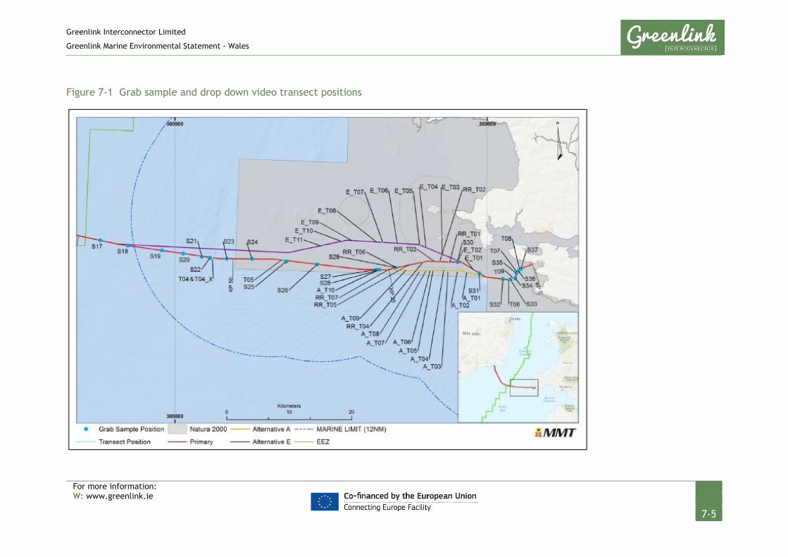
Greenlink Interconnector Limited
Greenlink Marine Environmental Statement - Wales
For more information: W: www.greenlink.ie
7-5
Figure 7-1 Grab sample and drop down video transect positions

Greenlink Interconnector Limited
Greenlink Marine Environmental Statement - Wales
For more information: W: www.greenlink.ie
7-6
7.2 Consultation
Table 7-1 summarises the relevant consultation responses on benthic and intertidal ecology. The steps taken to contact stakeholders for comments on the EIA scope is documented in Chapter 5.
Table 7-1 Consultation responses – benthic and intertidal ecology
Stakeholder Summary of Consultation Response How response has been addressed
Comments received on Natural Resources Wales (NRW) Scoping Opinion SC1816
NRW The EIA must clarify whether a cable joint
will be located within a sensitive area, and
what the significance of effects from this
would be.
A cable joint is not planned to occur within a
sensitive benthic habitat.
NRW If mattressing/use of aggregates is needed in
sensitive/designated areas there must be
consideration of the effect of this.
External cable protection will be required within
the Pembrokeshire Marine SAC due to hard ground
conditions. The significance of effects on the
habitats and SAC have been assessed in Section 7.6
and the Greenlink Habitats Regulations Assessment
(HRA) – Technical Appendix C.
NRW All available information, including NRWs
pre-application advice and the MarLIN’s
habitat sensitivity assessments must be used
to evaluate the significance of effects in the
EIA.
This chapter draws on site specific information
obtained by the Greenlink cable route survey, as
well as the NRW pre-application advice and MarLIN
sensitivity assessments.
NRW NRW TE provided advice on known survey
results. If gaps in knowledge exist and there
are areas of low confidence, we recommend
that an exercise is undertaken in which
degrees of confidence in the areas mapped
is provided.
The entire Proposed Development has been
successfully mapped in full. The survey reports
are provided as Technical Appendices I, J and K
and have been used to inform the baseline
description (Section 7.3) and the significance
assessment (Section 7.6).
NRW Micro-siting to avoid reef features would be
preferable to movement of boulders.
Boulders may likely form part of the ‘Reef’
feature of the Pembrokeshire Marine SAC.
Post-survey route development has been
undertaken to avoid large boulders. It is
anticipated that the Installation Contractor will
undertake further micro-routeing but to ensure a
robust worst-case assessment, areas where
boulder clearance may be required have been
assessed in Section 7.6.2.
NRW The HDD exit hole is considered as a
potential impact pathway as Freshwater
West intertidal is a SAC habitat with the
‘Mudflats and sandflats’ feature. This must
be appropriately assessed in the ES.
Chapter 6 concluded that trenching within the
intertidal zone at Freshwater West has the
potential to have a Significant effect on coastal
processes. Project Specific Mitigation has
therefore been proposed (PS1, PS4) and an

Greenlink Interconnector Limited
Greenlink Marine Environmental Statement - Wales
For more information: W: www.greenlink.ie
7-7
Stakeholder Summary of Consultation Response How response has been addressed
exclusion zone established at Freshwater West.
No intrusive works will be undertaken between
MHWS and mean low water (LWM). The effects of
cable installation on subtidal habitats has been
assessed in Section 7.6.
NRW The ES and HRA should consider the effects
of seabed preparation (e.g. pre-sweeping) on
the Turbot Bank which is an Annex 1 habitat
and is part of the ‘Sandbanks which are
slightly covered by seawater all the time’
features of Pembrokeshire Marine SAC.
The Greenlink HRA (Technical Appendix C) and
Section 7.6.2 assess the effect of pre-sweeping on
Turbot Bank.
NRW It is not clear how the habitats identified in
Table 5-1 relate to biotopes identified within
the surveys and for which sampling locations.
We recommend that NRW TE preliminary
advice on biotope mapping provided to
Greenlink should also be used to establish
the biotope maps for the chosen cable route.
The UK Scoping Report was submitted ahead of the
cable route survey taking place, and therefore
Table 5-1 of the UK Marine Scoping Report
provided indicative EUNIS habitats based on
broadscale maps of the region. The baseline
presented in Section 7.3 has been informed by the
cable route survey and provides site specific
information, which has taken into consideration
recommendations received from NRW.
NRW There does not appear to be any reference
to invasive species in the report or to any
biosecurity measures planned. These must
be considered within the ES.
The UK Scoping Report had proposed to scope the
pressure ‘introduction or spread of non-indigenous
species’ out of the ES but assessment has now been
provided in Section 7.6.5.
Comments received on Superseded Scoping Report which are relevant to the Proposed Development
MMO The introduction of such external cable
protection into an otherwise soft sediment
environment needs to be investigated in the
ES as this constitutes a permanent seabed
effect. In addition, the use of external cable
protection could cause significant effect to
seabed features, particularly reef habitat.
The introduction of external cable protection and
the associated pressures on subtidal habitats has
been assessed fully in Section 7.6.
NRW Grapnel has potential to damage seabed
habitats through clearance of sessile
organisms. This should be considered for
relevant SAC habitats.
The potential damage by seabed clearance
(including grapnel) on subtidal habitats has been
addressed in Section 7.6.2 under the pressure
penetration / and or disturbance of the seabed’.
NRW The most up to date habitat shapefile should
be acquired from JNCC.
The most recent habitat shapefile updates (14-03-
19) have been acquired from the JNCC website.

Greenlink Interconnector Limited
Greenlink Marine Environmental Statement - Wales
For more information: W: www.greenlink.ie
7-8
7.3 Existing Baseline
7.3.1 Overview
Benthic ecology describes the assemblages of organisms living in (infauna) or on (epifauna) the seabed, and their diversity, abundance and function. Benthic communities include those found on the sea floor from the intertidal zone to the deepest parts of the marine environment. The structure of benthic communities varies temporally and spatially depending on a wide range of physical factors of which water depth, sediment type, particle size and supply of organic matter are key variables.
The Proposed Development crosses the Pembrokeshire Marine / Sir Benfro Forol Special Area of Conservation (SAC) from KP0 to KP49.59. The SAC supports habitat features of varying individual scale, distribution, significance, quality and sensitivity. Biogeographically, the SAC sits on the boundary between northern and southern species, making the area high in biological diversity. The mixed sediments support burrowing macrofauna living within and on the sediment surface. More specifically, this area is inhabited by rare infauna including, molluscs (Ensis and Arctica); anthozoans (Mesacmea, Peachia, Aureliania); tube living polychaetes and echinoderms. Epifauna includes a relatively isolated population of great scallop (Pecten maximus) and various species living on reefs and in stony beds, molluscan shell debris and in association with species consolidating mobile substrates, e.g. Ross coral (Pentapora folicea) (CCW 2005).
A primary reason for the selection of the Pembrokeshire Marine / Sir Benfro Forol SAC is the presence of extensive areas of the Annex I listed ‘Reef’ habitat. Extensive areas of sublittoral rocky reef stretch offshore from the coastline and between the Pembrokeshire islands. These reefs support extensive areas of tide-swept kelp and species-rich red algal populations and, across the large areas of deeper rock reef, a wide range and abundance of invertebrate animal communities, with hydroid, bryozoan, soft coral and anemone species (JNCC 2019).
Other Annex I habitats present as a qualifying feature, but not a primary reason for selection of the SAC include (but are not limited to) ‘Sandbanks which are slightly covered by sea water all the time’, and ‘Mudflats and sandflats not covered by seawater at low tide’1.
Further offshore at the UK/Republic of Ireland median line, bottom-dwelling communities are dominated by highly abundant and diverse polychaetes. The substrate is predominantly soft sediments containing patches of muddy, sandy gravel (DTI 2005).
A total of 22 habitats were identified by the benthic survey within the Proposed Development.
1 The Greenlink Marine HRA (Technical Appendix C) provides details of all qualifying habitat features of the Pembrokeshire Marine / Sir Benfro Forol SAC. The ones mentioned in the text are those relevant to the Proposed Development.

Greenlink Interconnector Limited
Greenlink Marine Environmental Statement - Wales
For more information: W: www.greenlink.ie
7-9
7.3.2 Freshwater West intertidal ecology and habitats
The baseline intertidal ecology at Freshwater West is detailed in the intertidal survey report, see Technical Appendix K. Figure 7-2 shows the beach as seen from the air; the image was taken during the Greenlink drone survey to establish the topography.
Figure 7-2 Aerial image of Freshwater West September 2018
Source: MMT The habitat map produced by the intertidal Phase 1 walkover survey is provided as Figure 7-3.
Freshwater West consists predominantly of hard rocky substrate, shingle and fine sand habitats. The majority of the intertidal area within the survey area was characterised by barren littoral coarse sand (EUNIS biotope A2.111) (Table 7-2). This dominant biotope was fringed by barren littoral shingle (A2.111) along the upper shore overlain by a narrow strandline biotope constituted by decomposing seaweed supporting sandhopper (Talitrid amphipods) communities (A2.211). The lower extent of the dominant A2.111 biotope was fringed by littoral medium-fine sand supporting amphipods and the polychaete worms Scolelepis spp. (A2.223). The north of the survey area extended across a complex mosaic of littoral rock biotopes spanning the full range of the typical zonation expected on an exposed rocky coastline. This included lichen and barnacle dominated biotopes in the supralittoral (B3.111 and B3.1132) and upper shore zones (A1.112, A1.1121, A1.1122) and the typical fucoid dominated biotopes in mid-lower shore areas (A1.212, A1.213 and A1.3141) interspersed with coralline crust-dominated (A1.411) and green and red
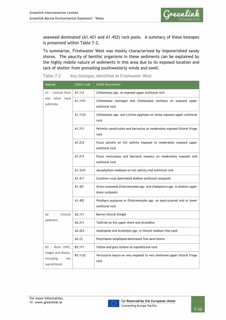
Greenlink Interconnector Limited
Greenlink Marine Environmental Statement - Wales
For more information: W: www.greenlink.ie
7-10
seaweed dominated (A1.421 and A1.452) rock pools. A summary of these biotopes is presented within Table 7-2.
To summarise, Freshwater West was mostly characterised by impoverished sandy shores. The paucity of benthic organisms in these sediments can be explained by the highly mobile nature of sediments in this area due to its exposed location and lack of shelter from prevailing southwesterly winds and swell.
Table 7-2 Key biotopes identified at Freshwater West
Habitat EUNIS Code EUNIS Description
A1 - Littoral Rock
and other hard
substrata
A1.112 Chthamalus spp. on exposed upper eulittoral rock
A1.1121 Chthamalus montagui and Chthamalus stellatus on exposed upper
eulittoral rock
A1.1122 Chthamalus spp. and Lichina pygmaea on steep exposed upper eulittoral
rock
A1.211 Pelvetia canaliculata and barnacles on moderately exposed littoral fringe
rock
A1.212 Fucus spiralis on full salinity exposed to moderately exposed upper
eulittoral rock
A1.213 Fucus vesiculosus and barnacle mosaics on moderately exposed mid
eulittoral rock
A1.3141 Ascophyllum nodosum on full salinity mid eulittoral rock
A1.411 Coralline crust-dominated shallow eulittoral rockpools
A1.421 Green seaweeds Enteromorpha spp. and Cladophora spp. in shallow upper
shore rockpools
A1.452 Porphyra purpurea or Enteromorpha spp. on sand-scoured mid or lower
eulittoral rock
A2 - Littoral
sediment
A2.111 Barren littoral shingle
A2.211 Talitrids on the upper shore and strandline
A2.223 Amphipods and Scolelepis spp. in littoral medium-fine sand
A2.23 Polychaete/amphipod-dominated fine sand shores
B3 - Rock cliffs,
ledges and shores,
including the
supralittoral
B3.111 Yellow and grey lichens on supralittoral rock
B3.1132 Verrucaria maura on very exposed to very sheltered upper littoral fringe
rock

Greenlink Interconnector Limited
Greenlink Marine Environmental Statement - Wales
For more information: W: www.greenlink.ie
7-11
Figure 7-3 EUNIS biotope mapping and sampling locations at Freshwater West

Greenlink Interconnector Limited
Greenlink Marine Environmental Statement - Wales
For more information: W: www.greenlink.ie
7-12
7.3.3 Subtidal ecology and habitats
Review of the geophysical data, ground-truthed by video transects and infaunal grab samples identified 22 habitats within the Proposed Development from mean low water springs to the UK / Republic of Ireland median line. These are mapped and presented in Figures 7-4 to 7-9 (Drawing P1975-HAB-003 Sheet 1 to Sheet 6).
Table 7-3 presents a description of each habitat identified, with images underneath. Two Annex I habitats, including three sub-types were identified in the Proposed Development. These are discussed in detail in Section 7.3.4.

Greenlink Interconnector Limited
Greenlink Marine Environmental Statement - Wales
For more information: W: www.greenlink.ie
7-13
Table 7-3 Habitats present within the Proposed Development
EUNIS Habitat code Indicative KPs Associated Sample Station(s)
JNCC Equivalent Habitat Infaunal analyses from grab samples
A4.111, Balanus crenatus and Tubularia indivisa on extremely tide-swept circalittoral rock
KP16 - KP21 Four single camera drops (RR_D01 – D04)
CR.HCR.FaT.BalTub, Balanus crenatus and Tubularia indivisa on extremely tide-swept circalittoral rock
-
A4.13, Mixed faunal turf communities on circalittoral rock
KP2 – KP3 Transects E_T04, E_T05 CR.HCR.XFa, Mixed faunal turf communities
-
A4.138, Molgula manhattensis with a hydroid and bryozoan turf on tide-swept moderately wave-exposed circalittoral rock
KP2 - KP3, KP4 - KP5
Transects DDV_T06- DDV_T09
CR.HCR.XFa.Mol, Molgula manhattensis with a hydroid and bryozoan turf on tide-swept moderately wave-exposed circalittoral rock
-
A4.213, Urticina felina and sand-tolerant fauna on sand-scoured or covered circalittoral rock
KP10 - KP12, KP24 - KP25
Transect A_T01 CR.MCR.EcCr.UrtScr, Urticina felina and sand-tolerant fauna on sand-scoured or covered circalittoral rock
-
A4.2212, Sabellaria spinulosa, didemnid and small ascidians on tide-swept moderately wave-exposed circalittoral rock
KP42 – KP43 Transect T05 CR.MCR.CSab.Sspi.As, Sabellaria spinulosa, didemnids and other small ascidians on tide-swept moderately wave-exposed circalittoral rock
-
A5.13, Infralittoral coarse sediment KP0 – KP1 - SS.SCS.ICS, Infralittoral coarse sediment
-
A5.14, Circalittoral coarse sediment KP20 - KP24 - SS.SCS.CCS, Circalittoral coarse sediment
-
A5.141, Pomatoceros triqueter with barnacles and bryozoan crusts on unstable circalittoral cobbles and pebbles
KP15 - KP23 Transects RR_T01 - RR_T05
SS.SCS.CCS.SpiB, Spirobranchus triqueter with barnacles and bryozoan crusts on unstable circalittoral cobbles and pebbles
-
A5.142, Mediomastus fragilis, Lumbrineris spp. and venerid bivalves in circalittoral coarse sand or gravel
KP24 - KP28, KP33 - KP37
Grab Station: S26, S27 SS.SCS.CCS.MedLumVen, Mediomastus fragilis, Lumbrineris spp. and venerid bivalves in circalittoral coarse sand or gravel
S26, S27 - The fauna comprised Lanice conchilegala tubes, Actiniaria, Hydrozoa, bryzoans and echinoderm Ophiura albida. The infaunal assemblage was characterised by the echinoderms E. pusillus, and Amphhipholis squamata, numerous polychaetes such as Ampharete lindstroemi, A. octocirrata, L. cingulata, a high abundance of the amphipod Ampelisca spinipes as well as numerous molluscs

Greenlink Interconnector Limited
Greenlink Marine Environmental Statement - Wales
For more information: W: www.greenlink.ie
7-14
EUNIS Habitat code Indicative KPs Associated Sample Station(s)
JNCC Equivalent Habitat Infaunal analyses from grab samples
A. alba, Hiatella arctica, K. suborbicularis, K. bidentate, Thracia villosiuscula, T. ovata and Diplodonta rotundata.
A5.143, Protodorvillea kefersteini and other polychaetes in impoverished circalittoral mixed gravelly sand
KP2 - KP6 Grab station: S36 SS.SCS.CCS.Pkef, Protodorvillea kefersteini and other polychaetes in impoverished circalittoral mixed gravelly sand
S36, S33 - Infauna was characterised by low abundances of infauna, consisting of polychaetes P. kefersteini, Glycera lapidum, Exogone verugera, Notomastus and Nematods as well as sipunculid Phascolion strombus.
A5.15, Deep circalittoral coarse sediment
KP23 - KP25, KP53 - KP59
Transect RR_T06, Grab station: S22, S29
SS.SCS.OCS, Offshore circalittoral coarse sediment
S22, S29 - The infaunal community was dominated by the echinoderm Amphiura filiformis and E. pusillus, the polychaetes Paradoneis lyra and Lumbrineris cingulate, Nemertea and mollusc Clausinella fasciata. Small isolated clusters of S. spinulosa were present at S29.
A5.24, Infralittoral muddy sand KP0 – KP1 - SS.SSa.IMuSa, Infralittoral muddy sand -
A5.25, Circalittoral fine sand KP2 - KP4, KP5 - KP11
Grab station: S31, S32, S35
SS.SSa.CFiSa, Circalittoral fine sand S31, S32, S35- The infauna was characterized by molluscs A. prismatica, T. ovata, Kurtiella bidentata, Goodallia triangularis, Asbjornsenia pygmaea, polychaetes O. borealis, Lumbrineris cingulate, Glycinde nordmanni, Nephtys cirrosa and various species of amphipods The infauna was relatively low in species diversity and abundances at S35. The sample was characterized by molluscs A. alba and Timoclea ovata, amphipod Bathyporeia elegans and different polychaetes
A5.251, Echinocyamus pusillus, Ophelia borealis and Abra prismatica in circalittoral fine sand
KP25 - KP27, KP58 - KP67, KP70 - KP74
Grab station: S17, S19 SS.SSa.CFiSa.EpusOborApri, Echinocyamus pusillus, Ophelia borealis and Abra prismatica in circalittoral fine sand
The infauna at grab stations S17, S19 and S28 included the echinoderms A. filiformis, E. pusillus, and polychaetes O. borealis, G. lapidum and L. cingulate, the mollusc C.fasciata and Nemertea.
A5.252, Abra prismatica, Bathyporeia elegans and polychaetes in circalittoral fine sand
KP3 - KP4 Grab station: S34 SS.SSa.CFiSa.ApriBatPo, Abra prismatica, Bathyporeia elegans and polychaetes in circalittoral fine sand
S34 - The infaunal community was relatively low in species diversity and abundances. The community species composition was characterized by molluscs Abra prismatica, T. ovata, polychaetes Travisia forbesii, Ophelia borealis and amphipod B. elegans.
A5.261, Abra alba and Nucula nitidosa in circalittoral muddy sand or slightly mixed sediment
KP0 – KP3 Grab station: S37 SS.SSa.CMuSa.AalbNuc, Abra alba and Nucula nitidosa in circalittoral muddy sand or slightly mixed sediment
S37 - The infauna comprised predominantly of molluscs A. alba, N. nitidosa, Fabulina fabula as well as polychaetes Magelona filiformis and Spiophanes bombyx.
A5.27, Deep circalittoral sand KP27 -34, KP41 - KP43, KP48 - KP51, KP52 - KP53
- SS.SSa.OSa, Offshore circalittoral sand -

Greenlink Interconnector Limited
Greenlink Marine Environmental Statement - Wales
For more information: W: www.greenlink.ie
7-15
EUNIS Habitat code Indicative KPs Associated Sample Station(s)
JNCC Equivalent Habitat Infaunal analyses from grab samples
A5.272, Owenia fusiformis and Amphiura filiformis in deep circalittoral sand or muddy sand
KP65 – KP71 Grab station: S18 SS.SSa.OSa.OfusAfil, Owenia fusiformis and Amphiura filiformis in offshore circalittoral sand or muddy sand
S18 - The infauna was characterised by echinoderm A. filiformis, polychaetes L. cingulate and Owenia sp. and Nemertea.
A5.44, Circalittoral mixed sediments KP6 - KP7, KP8 - KP10,
- SS.SMx.CMx, Circalittoral mixed sediment
-
A5.45, Deep circalittoral mixed sediments
KP42 - KP43 - SS.SMx.OMx, Offshore circalittoral mixed sediment
-
A5.451, Polychaete-rich deep Venus community in offshore mixed sediments
KP10 - KP15, Grab station: S30 SS.SMx.OMx.PoVen, Polychaete-rich deep Venus community in offshore gravelly muddy sand
S30 - High diversity and abundance of infaunal species. The infauna was characterised by numerous polychaetes which were dominated by Sabellaria spinulosa and Syllis armillarisa as well as molluscs Kellia suborbicularis, Modiolula phaseolina, Gari telinella, Venus casina, Hiatella arctica and Sphenia binghami. The sample also contained numerous specimens of echinoderm Amphipholis squamata.
A5.611, Sabellaria spinulosa on stable circalittoral mixed sediment
KP33 - KP59 Grab station: S20, S21, S23, S24, S25 Transect T04, T04_X
SS.SBR.PoR.SspiMx, Sabellaria spinulosa on stable circalittoral mixed sediment
S20, S21, S23 and S24 – Grab samples contained the following infauna: S. spinulosa, the echinoderm A.filiformis, and polychaetes Owenia sp. L. cingulate, A.lindstroemi, Ampelisca spinipes and K. suborbicularis.

Greenlink Interconnector Limited
Greenlink Marine Environmental Statement - Wales
For more information: W: www.greenlink.ie
7-16
A4.13, Mixed faunal turf communities on
circalittoral rock A4.138, Molgula manhattensis with a
hydroid and bryozoan turf on tide-swept
moderately wave-exposed circalittoral
rock
A4.213, Urticina felina and sand-
tolerant fauna on sand-scoured or
covered circalittoral rock
A4.2212, Sabellaria spinulosa, didemnid and small
ascidians on tide-swept moderately wave-exposed
circalittoral rock
A5.14, Circalittoral coarse sediment
A5.141, Pomatoceros triqueter with
barnacles and bryozoan crusts on unstable
circalittoral cobbles and pebbles
A5.142, Mediomastus fragilis,
Lumbrineris spp. and venerid bivalves in
circalittoral coarse sand or gravel
A5.143, Protodorvillea kefersteini and other
polychaetes in impoverished circalittoral mixed
gravelly sand
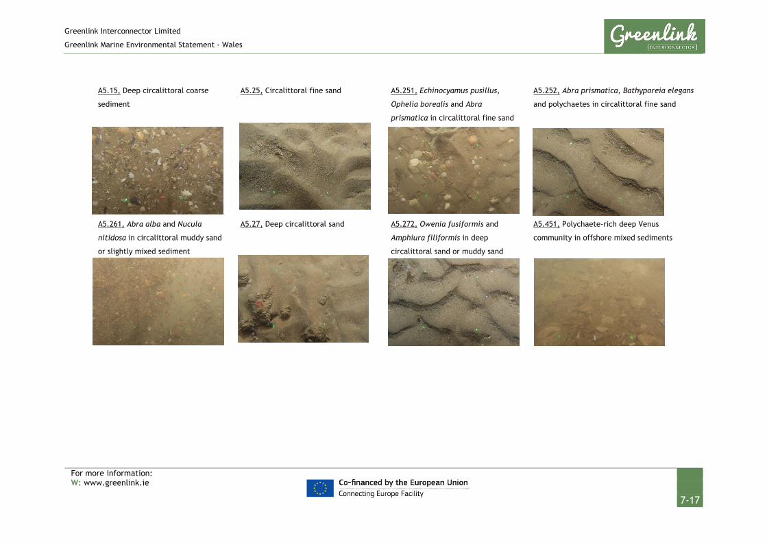
Greenlink Interconnector Limited
Greenlink Marine Environmental Statement - Wales
For more information: W: www.greenlink.ie
7-17
A5.15, Deep circalittoral coarse
sediment
A5.25, Circalittoral fine sand
A5.251, Echinocyamus pusillus,
Ophelia borealis and Abra
prismatica in circalittoral fine sand
A5.252, Abra prismatica, Bathyporeia elegans
and polychaetes in circalittoral fine sand
A5.261, Abra alba and Nucula
nitidosa in circalittoral muddy sand
or slightly mixed sediment
A5.27, Deep circalittoral sand
A5.272, Owenia fusiformis and
Amphiura filiformis in deep
circalittoral sand or muddy sand
A5.451, Polychaete-rich deep Venus
community in offshore mixed sediments

Greenlink Interconnector Limited
Greenlink Marine Environmental Statement - Wales
For more information: W: www.greenlink.ie
7-18
A5.611, Sabellaria spinulosa on stable
circalittoral mixed sediment

GREENLINK INTERCONNECTORBENTHIC HABITATS
Survey Data - Sheet 1
Chris GoodeEmma Langley
Monday, April 8, 2019 12:40:35WGS_1984_UTM_Zone_30N
D_WGS_1984DCCAE; UKHO; CDA; OSOD; OSI; MMT; Greenlink
WGS_1984
NOTE: Not to be used for Navigation
© Copyright Department of Communications, Climate Action and Environment (DCCAE); Contains public sector information, licensed under the Open Government Licence v2.0, from the UKHO, 2018.; Contains data from UKOGD.; Contains Ordnance Survey data © Crown copyright and database right 2013; Contains Ordnance Survey Ireland data © OSi 2014
Anna Farley
KP 0
KP 5
KP 10
KP 15
Sheet - 1Sheet - 2
345000
345000
350000
350000
355000
355000
57200
00
57200
00
57250
00
57250
00
57300
00
57300
00
LegendFreshwater WestGreenlink Route Centreline (Indicative)Proposed Development
MMT SurveyEUNIS Classification
A4.13A4.138A4.213A4.213/ A4.241A4.221A4.241A5.13A5.14A5.141A5.143A5.15A5.24A5.25A5.252A5.261A5.44A5.451A5.611
0 0.5 1 1.5 2km © Metoc Ltd, 2019.
All rights reserved.
J:\P1975\Mxd\06_HAB\P1975-HAB-003.mxd
Created ByReviewed By
DateProjection
DatumData Source
File Reference
Spheroid
Approved By
Drawing No: P1975-HAB-003 A
MarineSpace SurveyEUNIS Classification
A1.112A1.1121A1.1122A1.211A1.212A1.213A1.3141
A1.411A1.421A1.452A2.111A2.211A2.223A2.231B3.111B3.1132

GREENLINK INTERCONNECTORBENTHIC HABITATS
Survey Data - Sheet 2
Chris GoodeEmma Langley
Monday, April 8, 2019 12:40:35WGS_1984_UTM_Zone_30N
D_WGS_1984DCCAE; UKHO; CDA; OSOD; OSI; MMT; Greenlink
WGS_1984
NOTE: Not to be used for Navigation
© Copyright Department of Communications, Climate Action and Environment (DCCAE); Contains public sector information, licensed under the Open Government Licence v2.0, from the UKHO, 2018.; Contains data from UKOGD.; Contains Ordnance Survey data © Crown copyright and database right 2013; Contains Ordnance Survey Ireland data © OSi 2014
Anna Farley
KP 15KP 20
KP 25
Sheet - 1
Sheet - 2
Sheet - 3
330000
330000
335000
335000
340000
340000
57200
00
57200
00
57250
00
57250
00
57300
00
57300
00
LegendGreenlink Route Centreline (Indicative)Proposed Development
MMT SurveyEUNIS Classification
A4.13A4.1312A4.132A4.21A4.213A4.213/ A4.241A4.2212A4.241A5.14A5.141A5.142A5.15A5.251A5.27A5.45A5.451A5.611
0 0.5 1 1.5 2km © Metoc Ltd, 2019.
All rights reserved.
J:\P1975\Mxd\06_HAB\P1975-HAB-003.mxd
Created ByReviewed By
DateProjection
DatumData Source
File Reference
Spheroid
Approved By
Drawing No: P1975-HAB-003 A

GREENLINK INTERCONNECTORBENTHIC HABITATS
Survey Data - Sheet 3
Chris GoodeEmma Langley
Monday, April 8, 2019 12:40:35WGS_1984_UTM_Zone_30N
D_WGS_1984DCCAE; UKHO; CDA; OSOD; OSI; MMT; Greenlink
WGS_1984
NOTE: Not to be used for Navigation
© Copyright Department of Communications, Climate Action and Environment (DCCAE); Contains public sector information, licensed under the Open Government Licence v2.0, from the UKHO, 2018.; Contains data from UKOGD.; Contains Ordnance Survey data © Crown copyright and database right 2013; Contains Ordnance Survey Ireland data © OSi 2014
Anna Farley
KP 30
KP 35
KP 40
Sheet - 2
Sheet - 3Sheet - 4
320000
320000
325000
325000
330000
330000
57200
00
57200
00
57250
00
57250
00
57300
00
57300
00
LegendGreenlink Route Centreline (Indicative)Proposed Development
MMT SurveyEUNIS Classification
A4.13A4.1312A4.221A4.2212A5.141A5.142A5.15A5.27A5.45A5.611
0 0.5 1 1.5 2km © Metoc Ltd, 2019.
All rights reserved.
J:\P1975\Mxd\06_HAB\P1975-HAB-003.mxd
Created ByReviewed By
DateProjection
DatumData Source
File Reference
Spheroid
Approved By
Drawing No: P1975-HAB-003 A

GREENLINK INTERCONNECTORBENTHIC HABITATS
Survey Data - Sheet 4
Chris GoodeEmma Langley
Monday, April 8, 2019 12:40:35WGS_1984_UTM_Zone_30N
D_WGS_1984DCCAE; UKHO; CDA; OSOD; OSI; MMT; Greenlink
WGS_1984
NOTE: Not to be used for Navigation
© Copyright Department of Communications, Climate Action and Environment (DCCAE); Contains public sector information, licensed under the Open Government Licence v2.0, from the UKHO, 2018.; Contains data from UKOGD.; Contains Ordnance Survey data © Crown copyright and database right 2013; Contains Ordnance Survey Ireland data © OSi 2014
Anna Farley
KP 45KP 50KP 55
Sheet - 3Sheet - 4Sheet - 5
305000
305000
310000
310000
315000
315000
57200
00
57200
00
57250
00
57250
00
57300
00
57300
00
LegendGreenlink Route Centreline (Indicative)Proposed Development
MMT SurveyEUNIS Classification
A4.221A4.2212A5.15A5.27A5.45A5.611
0 0.5 1 1.5 2km © Metoc Ltd, 2019.
All rights reserved.
J:\P1975\Mxd\06_HAB\P1975-HAB-003.mxd
Created ByReviewed By
DateProjection
DatumData Source
File Reference
Spheroid
Approved By
Drawing No: P1975-HAB-003 A

GREENLINK INTERCONNECTORBENTHIC HABITATS
Survey Data - Sheet 5
Chris GoodeEmma Langley
Monday, April 8, 2019 12:40:35WGS_1984_UTM_Zone_30N
D_WGS_1984DCCAE; UKHO; CDA; OSOD; OSI; MMT; Greenlink
WGS_1984
NOTE: Not to be used for Navigation
© Copyright Department of Communications, Climate Action and Environment (DCCAE); Contains public sector information, licensed under the Open Government Licence v2.0, from the UKHO, 2018.; Contains data from UKOGD.; Contains Ordnance Survey data © Crown copyright and database right 2013; Contains Ordnance Survey Ireland data © OSi 2014
Anna Farley
KP 55
KP 60
KP 65
KP 70Sheet - 4
Sheet - 5
Sheet - 6
290000
290000
295000
295000
300000
300000
57250
00
57250
00
57300
00
57300
00
57350
00
57350
00
LegendGreenlink Route Centreline (Indicative)Proposed DevelopmentUK 12nm Territorial Sea Limit
MMT SurveyEUNIS Classification
A5.15A5.251A5.272A5.611
0 0.5 1 1.5 2km © Metoc Ltd, 2019.
All rights reserved.
J:\P1975\Mxd\06_HAB\P1975-HAB-003.mxd
Created ByReviewed By
DateProjection
DatumData Source
File Reference
Spheroid
Approved By
Drawing No: P1975-HAB-003 A

GREENLINK INTERCONNECTORBENTHIC HABITATS
Survey Data - Sheet 6
Chris GoodeEmma Langley
Monday, April 8, 2019 12:40:35WGS_1984_UTM_Zone_30N
D_WGS_1984DCCAE; UKHO; CDA; OSOD; OSI; MMT; Greenlink
WGS_1984
NOTE: Not to be used for Navigation
© Copyright Department of Communications, Climate Action and Environment (DCCAE); Contains public sector information, licensed under the Open Government Licence v2.0, from the UKHO, 2018.; Contains data from UKOGD.; Contains Ordnance Survey data © Crown copyright and database right 2013; Contains Ordnance Survey Ireland data © OSi 2014
Anna Farley
KP 70
KP 75
KP 80Sheet - 5
Sheet - 6
Sheet - 7
280000
280000
285000
285000
290000
290000
57250
00
57250
00
57300
00
57300
00
57350
00
57350
00
LegendGreenlink Route Centreline (Indicative)Proposed DevelopmentIrish OffshoreMedian Line
MMT SurveyEUNIS Classification
A5.251A5.252A5.272
0 0.5 1 1.5 2km © Metoc Ltd, 2019.
All rights reserved.
J:\P1975\Mxd\06_HAB\P1975-HAB-003.mxd
Created ByReviewed By
DateProjection
DatumData Source
File Reference
Spheroid
Approved By
Drawing No: P1975-HAB-003 A
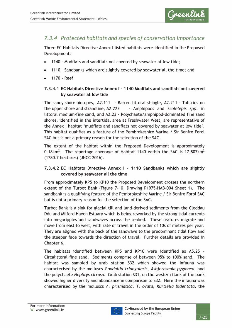
Greenlink Interconnector Limited
Greenlink Marine Environmental Statement - Wales
For more information: W: www.greenlink.ie
7-25
7.3.4 Protected habitats and species of conservation importance
Three EC Habitats Directive Annex I listed habitats were identified in the Proposed Development:
• 1140 - Mudflats and sandflats not covered by seawater at low tide;
• 1110 - Sandbanks which are slightly covered by seawater all the time; and
• 1170 - Reef
7.3.4.1 EC Habitats Directive Annex I – 1140 Mudflats and sandflats not covered by seawater at low tide
The sandy shore biotopes, A2.111 - Barren littoral shingle, A2.211 - Talitrids on the upper shore and strandline, A2.223 - Amphipods and Scolelepis spp. in littoral medium-fine sand, and A2.23 - Polychaete/amphipod-dominated fine sand shores, identified in the intertidal area at Freshwater West, are representative of the Annex I habitat ‘mudflats and sandflats not covered by seawater at low tide’. This habitat qualifies as a feature of the Pembrokeshire Marine / Sir Benfro Forol SAC but is not a primary reason for the selection of the SAC.
The extent of the habitat within the Proposed Development is approximately 0.18km2. The reportage coverage of Habitat 1140 within the SAC is 17.807km2 (1780.7 hectares) (JNCC 2016).
7.3.4.2 EC Habitats Directive Annex I – 1110 Sandbanks which are slightly covered by seawater all the time
From approximately KP5 to KP10 the Proposed Development crosses the northern extent of the Turbot Bank (Figure 7-10, Drawing P1975-HAB-004 Sheet 1). The sandbank is a qualifying feature of the Pembrokeshire Marine / Sir Benfro Forol SAC but is not a primary reason for the selection of the SAC.
Turbot Bank is a sink for glacial till and land-derived sediments from the Cleddau Ddu and Milford Haven Estuary which is being reworked by the strong tidal currents into megaripples and sandwaves across the seabed. These features migrate and move from east to west, with rate of travel in the order of 10s of metres per year. They are aligned with the back of the sandwave to the predominant tidal flow and the steeper face towards the direction of travel. Further details are provided in Chapter 6.
The habitats identified between KP5 and KP10 were identified as A5.25 - Circalittoral fine sand. Sediments comprise of between 95% to 100% sand. The habitat was sampled by grab station S32 which showed the infauna was characterised by the molluscs Goodallia triangularis, Asbjornsenia pygmaea, and the polychaete Nephtys cirrosa. Grab station S31, on the western flank of the bank showed higher diversity and abundance in comparison to S32. Here the infauna was characterised by the molluscs A. prismatica, T. ovata, Kurtiella bidentata, the
Greenlink Interconnector Limited
Greenlink Marine Environmental Statement - Wales
For more information: W: www.greenlink.ie
7-26
polychaetes O. borealis, Lumbrineris cingulate, Glycinde nordmanni and different amphipods (MMT 2019).
The extent of habitat 1110 within the SAC is reported as 414.12km2 (41411.55 hectares) (JNCC 2016). Of this area, the Turbot Bank covers approximately 19.10km2. The Proposed Development covers approximately 3.05km2 of this extent; equivalent to 15.97% of the Turbot Bank; and 0.74% of the wider habitat in the SAC.
7.3.4.3 EC Habitats Directive Annex I – 1170 Reefs
‘Reef’ is a primary reason for the selection of the Pembrokeshire Marine / Sir Benfro Forol SAC. All three sub-types of Annex I Reef habitat was identified by the cable route survey within the Proposed Development; bedrock reef, stony reef, and biogenic reef. The location of the habitat is displayed in Figures 7-10 to 7-13, (Drawings P1975-HAB-005, P1975-HAB-004 Sheet 2, P1975-HAB-006, and P1975HAB-004 Sheet 5).
The extent of habitat 1170 within the SAC is reported as 409.97km2 (40997.43 hectares) (JNCC 2016). Maps showing the extent of ‘Reef’ habitat are available from the JNCC, which classifies the area according to confidence in the presence of the habitat. The JNCC maps indicate a slightly higher estimate of reef in the SAC although confidence in some areas is given as low. The habitat maps indicate Bedrock reef covers an area of 377km2, whilst stony reef covers 70km2. In addition, the reef extends outside of the SAC boundaries.
Intertidal The littoral rock habitat (A1) encountered during the phase 1 intertidal survey at the Freshwater West landfall is representative of Annex I bedrock reef habitat. The habitat lies close to the base of the cliffs at the northern end of Freshwater West. Post-survey the boundary for the Proposed Development was refined to exclude this area.
The cliffs are also a designating feature of the adjacent Limestone Coast of South West Wales / Arfordir Calch faen de Orllewin Cymru SAC and the Broomhill Burrows Site of Special Scientific Interest (SSSI), and Angle Peninsula Coast / Arfordir Penrhyn Angle SSSI.

GREENLINK INTERCONNECTORANNEX I HABITATS
Survey Data - KP 0 to KP 12
Chris GoodeEmma Langley
Thursday, April 25, 2019 15:09:36WGS_1984_UTM_Zone_30N
D_WGS_1984DCCAE; UKHO; CDA; OSOD; OSI; MMT; Greenlink
WGS_1984
NOTE: Not to be used for Navigation
© Copyright Department of Communications, Climate Action and Environment (DCCAE); Contains public sector information, licensed under the Open Government Licence v2.0, from the UKHO, 2018.; Contains data from UKOGD.; Contains Ordnance Survey data © Crown copyright and database right 2013; Contains Ordnance Survey Ireland data © OSi 2014
Anna Farley
KP 0KP 1
KP 2
KP 3
KP 4KP 5KP 6KP 7KP 8
KP 9
KP 10
KP 11
KP 12
350000
350000
355000
355000
57200
00
57200
00
57250
00
57250
00
LegendFreshwater WestGreenlink Route Centreline (Indicative)Proposed Development
Annex I Habitat ClassificationBedrock ReefPotential Bedrock Reef
Protected Sandbank Slightly Covered by SeawaterSandbank Area (High Confidence)
0 0.5 1 1.5 2km © Metoc Ltd, 2019.
All rights reserved.
J:\P1975\Mxd\06_HAB\P1975-HAB-005.mxd
Created ByReviewed By
DateProjection
DatumData Source
File Reference
Spheroid
Approved By
Drawing No: P1975-HAB-005 A

GREENLINK INTERCONNECTORANNEX I HABITATS
Survey Data - Sheet 2
Chris GoodeEmma Langley
Monday, April 8, 2019 12:43:10WGS_1984_UTM_Zone_30N
D_WGS_1984DCCAE; UKHO; CDA; OSOD; OSI; MMT; Greenlink
WGS_1984
NOTE: Not to be used for Navigation
© Copyright Department of Communications, Climate Action and Environment (DCCAE); Contains public sector information, licensed under the Open Government Licence v2.0, from the UKHO, 2018.; Contains data from UKOGD.; Contains Ordnance Survey data © Crown copyright and database right 2013; Contains Ordnance Survey Ireland data © OSi 2014
Anna Farley
KP 15KP 20
KP 25
Sheet - 1
Sheet - 2
Sheet - 3
330000
330000
335000
335000
340000
340000
57200
00
57200
00
57250
00
57250
00
57300
00
57300
00
LegendGreenlink Route Centreline (Indicative)Proposed Development
Annex I Habitat ClassificationBedrock ReefLow/Medium Grade Stony ReefPotential Bedrock ReefPotential Biogenic ReefPotential Stony Reef
Protected Sandbank Slightly Covered by SeawaterSandbank Area (High Confidence)
0 0.5 1 1.5 2km © Metoc Ltd, 2019.
All rights reserved.
J:\P1975\Mxd\06_HAB\P1975-HAB-004.mxd
Created ByReviewed By
DateProjection
DatumData Source
File Reference
Spheroid
Approved By
Drawing No: P1975-HAB-004 A
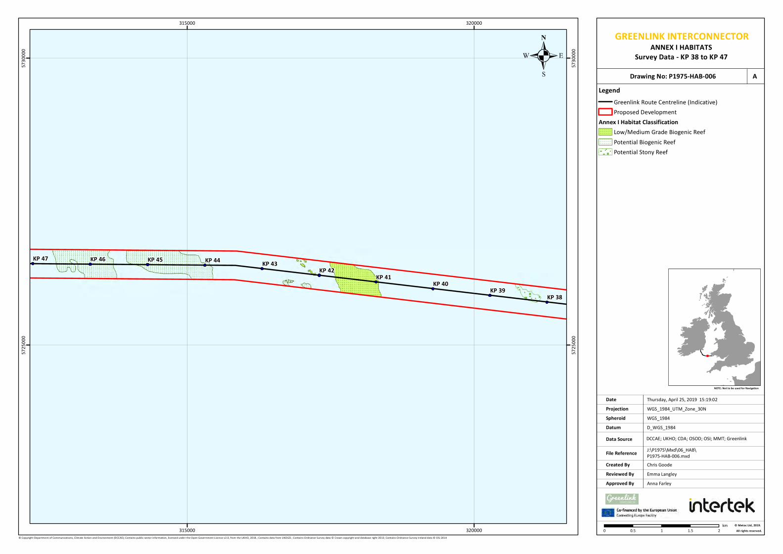
GREENLINK INTERCONNECTORANNEX I HABITATS
Survey Data - KP 38 to KP 47
Chris GoodeEmma Langley
Thursday, April 25, 2019 15:19:02WGS_1984_UTM_Zone_30N
D_WGS_1984DCCAE; UKHO; CDA; OSOD; OSI; MMT; Greenlink
WGS_1984
NOTE: Not to be used for Navigation
© Copyright Department of Communications, Climate Action and Environment (DCCAE); Contains public sector information, licensed under the Open Government Licence v2.0, from the UKHO, 2018.; Contains data from UKOGD.; Contains Ordnance Survey data © Crown copyright and database right 2013; Contains Ordnance Survey Ireland data © OSi 2014
Anna Farley
KP 38KP 39
KP 40KP 41
KP 42KP 43KP 44KP 45KP 46KP 47
315000
315000
320000
320000
57250
00
57250
00
57300
00
57300
00
LegendGreenlink Route Centreline (Indicative)Proposed Development
Annex I Habitat ClassificationLow/Medium Grade Biogenic ReefPotential Biogenic ReefPotential Stony Reef
0 0.5 1 1.5 2km © Metoc Ltd, 2019.
All rights reserved.
J:\P1975\Mxd\06_HAB\P1975-HAB-006.mxd
Created ByReviewed By
DateProjection
DatumData Source
File Reference
Spheroid
Approved By
Drawing No: P1975-HAB-006 A
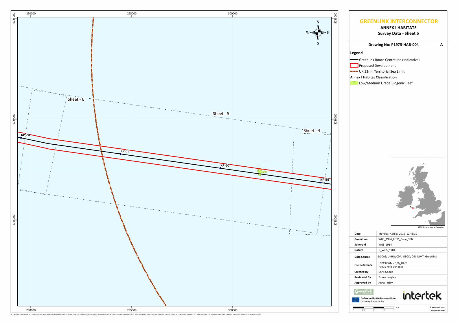
GREENLINK INTERCONNECTORANNEX I HABITATS
Survey Data - Sheet 5
Chris GoodeEmma Langley
Monday, April 8, 2019 12:43:10WGS_1984_UTM_Zone_30N
D_WGS_1984DCCAE; UKHO; CDA; OSOD; OSI; MMT; Greenlink
WGS_1984
NOTE: Not to be used for Navigation
© Copyright Department of Communications, Climate Action and Environment (DCCAE); Contains public sector information, licensed under the Open Government Licence v2.0, from the UKHO, 2018.; Contains data from UKOGD.; Contains Ordnance Survey data © Crown copyright and database right 2013; Contains Ordnance Survey Ireland data © OSi 2014
Anna Farley
KP 55
KP 60
KP 65
KP 70Sheet - 4
Sheet - 5
Sheet - 6
290000
290000
295000
295000
300000
300000
57250
00
57250
00
57300
00
57300
00
57350
00
57350
00
LegendGreenlink Route Centreline (Indicative)Proposed DevelopmentUK 12nm Territorial Sea Limit
Annex I Habitat ClassificationLow/Medium Grade Biogenic Reef
0 0.5 1 1.5 2km © Metoc Ltd, 2019.
All rights reserved.
J:\P1975\Mxd\06_HAB\P1975-HAB-004.mxd
Created ByReviewed By
DateProjection
DatumData Source
File Reference
Spheroid
Approved By
Drawing No: P1975-HAB-004 A

Greenlink Interconnector Limited
Greenlink Marine Environmental Statement - Wales
For more information: W: www.greenlink.ie
7-31
Subtidal
Bedrock Reef
Within the Proposed Development bedrock reef (as defined using the Irving 2009 criteria) is present from approximately KP1.5 to KP5.2. As illustrated in Figure 7-10 (Drawing P1975-HAB-005), the cable centreline has been routed through a channel of finer sediments in the bedrock reef between KP2.027 to KP4.998.
The sedimentary bedrock, surrounding the channel, is classified as A4.138 - Molgula manhattensis with a hydroid and bryozoan turf on tide-swept moderately wave-exposed circalittoral rock (Figure 7-14) and is dominated by ascidians and hydrozoans. Image analysis from transects (Transects DDV_T06 to DDV_T09) showed similar composition with high diversity and colonisation by ascidians Dendrodoa grossularia, Polycarpa sp. and M. manhattensis. Other taxa identified include poriferans, Tubularia sp., Caryophyllia smithii with hydrozoans and bryozoans (Figure 7-15 a-d).
Figure 7-14 Image T06_014 of Annex (1170) - Bedrock reefs
Habitat A4.138 – Molgula manhattensis with a hydroid and bryozoan turf on tide-swept moderately wave-exposed
circalittoral rock
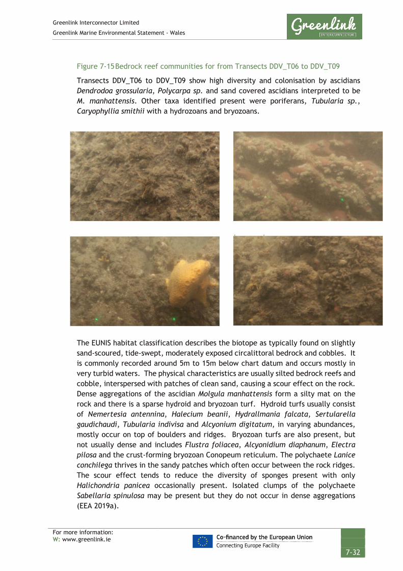
Greenlink Interconnector Limited
Greenlink Marine Environmental Statement - Wales
For more information: W: www.greenlink.ie
7-32
Figure 7-15 Bedrock reef communities for from Transects DDV_T06 to DDV_T09
Transects DDV_T06 to DDV_T09 show high diversity and colonisation by ascidians Dendrodoa grossularia, Polycarpa sp. and sand covered ascidians interpreted to be M. manhattensis. Other taxa identified present were poriferans, Tubularia sp., Caryophyllia smithii with a hydrozoans and bryozoans.
The EUNIS habitat classification describes the biotope as typically found on slightly sand-scoured, tide-swept, moderately exposed circalittoral bedrock and cobbles. It is commonly recorded around 5m to 15m below chart datum and occurs mostly in very turbid waters. The physical characteristics are usually silted bedrock reefs and cobble, interspersed with patches of clean sand, causing a scour effect on the rock. Dense aggregations of the ascidian Molgula manhattensis form a silty mat on the rock and there is a sparse hydroid and bryozoan turf. Hydroid turfs usually consist of Nemertesia antennina, Halecium beanii, Hydrallmania falcata, Sertularella gaudichaudi, Tubularia indivisa and Alcyonium digitatum, in varying abundances, mostly occur on top of boulders and ridges. Bryozoan turfs are also present, but not usually dense and includes Flustra foliacea, Alcyonidium diaphanum, Electra pilosa and the crust-forming bryozoan Conopeum reticulum. The polychaete Lanice conchilega thrives in the sandy patches which often occur between the rock ridges. The scour effect tends to reduce the diversity of sponges present with only Halichondria panicea occasionally present. Isolated clumps of the polychaete Sabellaria spinulosa may be present but they do not occur in dense aggregations (EEA 2019a).

Greenlink Interconnector Limited
Greenlink Marine Environmental Statement - Wales
For more information: W: www.greenlink.ie
7-33
The extent of the habitat within the Proposed Development has been calculated as 1.12km2. However, it is evident from a combination of the Greenlink and SECAMs bathymetry data that exposed bedrock covers a greater extent. The Joint Nature Conservation Committee (JNCC) data for potential Annex I reefs show the area for the feature covers 7.10km2; although confidence in the overall extent is given as very poor. This aligns with findings from the Greenlink reconnaissance survey which identified areas of bedrock reef outside of the extent given in the JNCC GIS layer, but also confirmed that reef was not present in certain areas.
Small areas of outcropping bedrock reef have been identified in the sand channel between KP2.38 and KP2.41. Although micro-routeing around these features may be feasible, approximately 30m of the indicative Greenlink centreline will cross the habitat. There are no still photographs of this specific area.
The indicative Greenlink centreline also crosses the Bedrock reef habitat at approximately KP5 for 140m. However in this area, bathymetry data and transect T06 identify a narrow (approximately 20m wide) channel through which installation is feasible. It is possible that this may be a thin veneer of sediment over the bedrock but Figure 7-16 (Drawing P1975-SURV-008) shows that the Bedrock Reef habitat is not present in this channel. Sediments are sandy and similar to those identified on Turbot Bank, directly to the west.
Potential Bedrock Reef
Potential bedrock reef habitats were patchy and identified within the Proposed Development ranging from KP23.5 to KP24.5 (Figure 7-11, Drawing P1975-HAB-004 Sheet 2).
Transect RR_T06 crossed the smaller areas of bedrock that was identified in the geophysical data. The bedrock was largely covered by sediment, with only small outcropping patches. The outcropping bedrock had a sparse epifauna consisting of mainly anemones and hydrozoans, with the biotope classified as A4.213 – Urticina feline and sand-tolerant fauna on sand-scoured or covered circalittoral rock. Due to the lack of conspicuous bedrock reef formations, the bedrock was classified as Annex I (1170) – Potential Bedrock Reef.
The EUNIS habitat classification describes the biotope as typically found on tide-swept circalittoral bedrock, and cobbles on gravel and sand. It is characterised by scour-tolerant robust species. The dominant species is the anemone Urticina feline which can tolerate the high levels of abrasion associated with the interface between sand and rock. The sponge Ciocalypta penicillus is also very characteristic of shifting sand-covered rock. The number of other species found tends to be limited due to the high levels of scour associated with the physical conditions in which the biotope is found (EEA 2019b).
Post-survey the indicative Greenlink centreline has been adjusted to avoid crossing this habitat.

. GREENLINK INTERCONNECTORSURVEY DATA
Environmental Transect 06
Chris CarrollChris Goode
Tuesday, April 2, 2019 15:10:59WGS_1984_UTM_Zone_30N
D_WGS_1984ESRI; OSOD; MMT; Greenlink
WGS_1984
NOTE: Not to be used for Navigation
© Crown Copyright, 2015. All rights reserved. Licence No: EK001-1001-WEB105. © Esri. Contains Ordnance Survey data © Crown copyright and database right 2013. ©Greenlink Ltd. Not to be used for Navigation.
Anna Farley
A
A
A
A
A
A
A
A
A
A
A
A
A
A
A
A
A
A
A
5
T06_001T06_002
T06_003T06_004
T06_005
T06_006T06_007
T06_008T06_009
T06_010T06_011
T06_012T06_013
T06_014T06_015
T06_016T06_017
T06_018
353200
353200
353600
353600
57228
00
57228
00
57232
00
57232
00
57236
00
57236
00
LegendKP
A Transect Photo PositionPost Survey Route
Survey Bathymetry Below LAT (m)High : 36.13
Low : 26.25
0 50 100 150m © Metoc Ltd, 2019.
All rights reserved.
J:\P1975\Mxd\02_SURV\P1975-SURV-008.mxd
Created ByReviewed By
DateProjection
DatumData Source
File Reference
Spheroid
Approved By
. Drawing No: P1975-SURV-008 AMMT_953_OC_DDV_A_T06_010
MMT_953_OC_DDV_A_T06_009
MMT_953_OC_DDV_A_T06_008
MMT_953_OC_DDV_A_T06_011
MMT_953_OC_DDV_A_T06_007

Greenlink Interconnector Limited
Greenlink Marine Environmental Statement - Wales
For more information: W: www.greenlink.ie
7-35
Stony Reef
Medium Grade Stony Reef was identified across the extent of the Proposed Development from KP15.0 to KP20.2, and then in wide patches from KP20.6 to KP22.1 (Figure 7-11, Drawing P1975-HAB-004 Sheet 2). It mainly consisted of cobbles and boulders which harboured a rich epifaunal community. The habitat was classified as A5.141 - Pomatoceros triqueter with barnacles and bryozoan crusts on unstable circalittoral cobbles and pebbles (Figure 7-18).
The EUNIS habitat classification describes the biotope as characterised by a few abundant robust and or fast growing short-lived species which are able to colonise pebbles and unstable cobbles which are regularly moved by wave and tidal action. The main cover organisms tend to be restricted to calcareous tube worms such as Pomatoceros triqueter (or P. lamarcki), small barnacles including Balanus crenatus and Balanus balanus, and a few bryozoan and coralline algal crusts. Scour action from the mobile substratum prevents colonisation by more delicate species. Occasionally in tide-swept conditions tufts of hydroids such as Sertularia argentea and Hydrallmania falcata are present (EEA 2019c).
Imaged by transects RR_T01, RR_T02, RR_T03, RR_T04 and RR_T05, the seabed was covered by cobbles greater than 0.064m in diameter for 50% to 80% of the area. The maximum elevation was 0.2m, and combined with an extent greater than 25m2 in each transect this led the reef assessment (using Irving 2009 criteria) to conclude that the seabed in the area meets the criteria for a Medium Grade Stony Reef.
Figure 7-17 Image T03_001 of Annex I (1170) – Medium Grade Stony Reef with the habitat A5.141 – Pomatoceros triqueter with barnacles and bryozoan crusts on unstable circalittoral cobbles and pebbles.

Greenlink Interconnector Limited
Greenlink Marine Environmental Statement - Wales
For more information: W: www.greenlink.ie
7-36
The extent of the habitat within the Proposed Development has been estimated as 3.04km2. It overlaps two areas identified on the JNCC data for potential Annex I reefs with poor confidence.
A further area of potential stony reef habitat has been identified within the Proposed Development between KP38.15 to KP38.36. The habitat has been classified as A5.611 - Sabellaria spinulosa on stable circalittoral mixed sediment. This was interpreted as potential stony reef due to the density of cobbles and boulders interpreted from the geophysical data. The extent of this area is 0.05km2. It lies within the potential stony reef habitat identified in the JNCC data for potential Annex I reefs.
There is the sufficient area to the south of this habitat for the cable route to avoid the habitat.
Biogenic reef
A number of areas of potential, low-grade and medium grade biogenic reef were identified within the Proposed Development as shown in Figure 7-12 (Drawing P1975-HAB-006), Figure 7-13 (Drawing P1975-HAB-004 Sheet 5) and outlined in Table 7-4. The JNCC Annex I reef habitat map has not identified reef in this area; nor did it identify biogenic reef as potentially occurring within the SAC.
Table 7-4 Areas of biogenic reef
KP Start KP end Classification EUNIS
habitat
Extent (km2) Can the habitat be
avoided
KP43.9 KP45.23 Potential A5.611 0.515 No – extends across width
of Proposed Development
KP45.6 KP46.6 Potential A5.611 0.426 No – extends across width
of Proposed Development
KP42.0 KP42.6 Potential A5.611 4 small discrete
patches = 0.0106
Yes – small area in south of
Proposed Development
KP40.9 KP41.7 Low-grade A5.611 0.352 No – extends across width
of Proposed Development
KP57.98 KP58.11 Low-grade A5.15 0.075 Yes – centreline could be
routed to the south
KP42.0 KP42.6 Medium-grade A5.611 7 small discrete
patches = 0.0084
Yes - centreline could be
routed to the south
The majority of biogenic reef habitats were identified to be A5.611 - Sabellaria spinulosa on stable circalittoral mixed sediment, with the exception of one area of low-grade biogenic reef in habitat A5.15 – Deep circalittoral coarse sediment.
The EUNIS habitat classification for A5.611 - Sabellaria spinulosa on stable circalittoral mixed sediment describes the biotope as having high abundances of the

Greenlink Interconnector Limited
Greenlink Marine Environmental Statement - Wales
For more information: W: www.greenlink.ie
7-37
tube-building polychaete S.spinulosa. S.spinulosa typically forms loose agglomerations of tubes forming a low-lying matrix of sand, gravel, mud and tubes on the seabed. The infauna comprises typical sublittoral polychaete species such as Protodorvillea kefersteini, Pholoe synophthalmica, Harmothoespp, Scoloplos armiger, Mediomastus fragilis, Lanice conchilega and cirratulids, together with the bivalve Abra alba, and tube building amphipods such as Ampelisca spp. The epifauna comprise a variety of bryozoans including Flustra foliacea, Alcyonidium diaphanum and Cellepora pumicosa, in addition to calcareous tubeworms, pycnogonids, hermit crabs and amphipods. The reefs formed by S.spinulosa consolidate the sediment and allow the settlement of other species not found in adjacent habitats leading to a diverse community of epifaunal and infauna species (EEA 2019d).
S.spinulosa was identified in grab samples S20 through to S27, S29 and S30. The average number of individuals per m2 ranged from 5 at S22 and S29 to a maximum of 1720 at S20. Average percentage coverage in site photos also ranged from no visible presence at S22, S24, S27 and S30 through to 24% at S20.
Figure 7-18 shows the seabed at grab station S25, located within the low grade biogenic reef identified between KP40.9 and KP41.7. Grab station S25 showed an average abundance of 1495 individuals per m2. Species coverage ranged between 7% and 17%, with an average coverage of 12%, based on image analysis from the site. The elevation of the tube aggregations was assessed to vary between flat seabed and 5 cm.
Figure 7-18 Annex I (1170) – Low Grade Biogenic reef with the habitat A5.611 – Sabellaria spinulosa on stable circalittoral mixed sediment (Image S25_003).

Greenlink Interconnector Limited
Greenlink Marine Environmental Statement - Wales
For more information: W: www.greenlink.ie
7-38
Figure 7-19 shows the seabed at grab station S20, located within the low grade biogenic reef identified between KP57.98 and KP58.11. Grab station S20 showed an average abundance of 1720 specimens per m2. Imaging analysis of the S.spinulosa aggregations revealed a species coverage between 12% and 35%, with an average coverage of 25%. The elevation of the tube aggregations was assessed to vary between flat seabed and 5 cm. Although the patchiness matched a medium grade S.spinulosa reef, the generally low elevation of the aggregations resulted in the area being classified as low grade biogenic reef.
Figure 7-19 Annex I (1170) – Low Grade Biogenic reef with the habitat A5.611 – Sabellaria spinulosa on stable circalittoral mixed sediment (Image S20_005).
Several patchy areas of medium grade biogenic reef were located within the Proposed Development to the north of the indicative Greenlink centreline between KP42.0 and KP 42.60. The cable can be routed to avoid these areas.
S.spinulosa was identified on the bedrock during video transect T05 at KP42.055. The transect was planned to ground-truth bedrock identified in the geophysical data. It was difficult to assess to what extent the outcropping bedrock under the S.spinulosa aggregations added to the extent as no bedrock was visible through the dense aggregations of S.spinulosa. As the bedrock was not the prevailing reef forming substrate in the area, the S.spinulosa was considered to represent a reef. Due to the elevation (tube building height) being up to 10cm, the 10,000m2 extent and the % cover ranging between 20%-30% the area was classified as a Medium grade reef (using Gubbay 2007). Figure 7-20 provides a representative photograph of the habitat.

Greenlink Interconnector Limited
Greenlink Marine Environmental Statement - Wales
For more information: W: www.greenlink.ie
7-39
Figure 7-20 Annex I (1170) – Medium Graded Biogenic Reef on the habitat A4.2212 – Sabellaria spinulosa didemnid and small ascidians on tide-swept moderately wave-exposed circalittoral rock (image T05_013)
7.3.4.4 Environment (Wales) Act 2016 – Section 7 Priority species and habitats
The following habitats found within the Proposed Development are listed on the interim Priority Habitats lists issued by the Welsh Government (Welsh Government 2016a):
• Fragile sponge & anthozoan communities on subtidal rocky habitats
• Subtidal sands and gravels
• Subtidal mixed muddy sediments
• Mud habitats in deep water
None of the macrofauna species listed in the Environment (Wales) Act interim Priority Species list (Welsh Government 2016b) were identified by the cable route survey within the Project Development.
7.3.1 Natural evolution of the baseline
The natural evolution of the baseline has been compiled using information from the Offshore Energy Strategic Environmental Assessment 3 (OESEA 3) (DECC 2016). Over the last 11,000 years seabed habitats around the UK have been subject to change associated with post-glacial trends in sea level, climate and sedimentation. In the shorter term, seasonal, inter-annual and decadal natural changes in benthic habitats, community structure and individual species population dynamics may

Greenlink Interconnector Limited
Greenlink Marine Environmental Statement - Wales
For more information: W: www.greenlink.ie
7-40
result from physical environmental influences (e.g. episodic storm events; hydroclimatic variability i.e. hot summers and cold winters; and sustained trends) and/or ecological influences such as reproductive cycles, larval settlement, predation, parasitism and disease.
As a result of climate change certain habitats around the UK are predicted to decline e.g. it is predicted that blue mussel beds will decline significantly in number by 2050 and are set to be lost completely by 2100. In addition, it expected that climate change will:
• Increase the number of invasive non-native species;
• Shift the distribution of habitats and species;
• Increase the risk of disease to species from new pathogens as their distributions shift; and
• Result in an increase in storms which could damage areas of high biodiversity.
Taken this information into consideration, it is expected that over the lifetime of the Proposed Development (40 years) habitats could be effected by shorter term seasonal events (i.e. storm events) but longer term effects as a result of climate change may also be observed.
7.4 Potential Pressure Identification and Zone of Influence
A scoping exercise undertaken to inform the content of the EIA has excluded the following pressures from further consideration in this topic Chapter. Explanation for the exclusion is provided in Chapter 5, Table 5-2:
• Hydrocarbon and PAH contamination; and
• Temperature changes – local.
The pressures listed in Table 7-5 will be assessed further. For each pressure the assessment considered the different aspects of the project during installation, operation (including repair & maintenance) and decommissioning. In order to evaluate the most significant effects, the largest zone of influence from these aspects was selected. The zones of influence are presented in Table 7-5.
Table 7-5 Pressure identification and zone of influence – benthic and intertidal ecology
Project Phase Project
Activity
Aspect Potential Impact Receptor Zone of
Influence
Installation Cable burial Pre-
sweeping
Penetration
and/or
disturbance of
the substrate
below the
surface of the
seabed,
Sand
habitats
20m x
approximately
5.6km
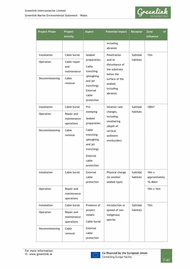
Greenlink Interconnector Limited
Greenlink Marine Environmental Statement - Wales
For more information: W: www.greenlink.ie
7-41
Project Phase Project
Activity
Aspect Potential Impact Receptor Zone of
Influence
including
abrasion
Installation Cable burial Seabed
preparation.
Cable
trenching
(ploughing
and jet
trenching)
External
cable
protection
Penetration
and/or
disturbance of
the substrate
below the
surface of the
seabed,
including
abrasion
Subtidal
habitats
15m
Operation Cable repair
and
maintenance
Decommissioning Cable
removal
Installation Cable burial Pre-
sweeping
Seabed
preparation.
Cable
trenching
(ploughing
and jet
trenching)
External
cable
protection
Siltation rate
changes,
including
smothering
(depth of
vertical
sediment
overburden)
Subtidal
habitats
100m*
Operation Repair and
maintenance
operations
Decommissioning Cable
removal
Installation Cable burial External
cable
protection
Physical change
(to another
seabed type)
Subtidal
habitats
10m x
approximately
16.46km
Operation Repair and
maintenance
operations
10m x 1km
Installation Cable burial Presence of
project
vessels
Cable burial
External
cable
protection
Introduction or
spread of non-
indigenous
species
Subtidal
habitats
15m
Operation Repair and
maintenance
operations
Decommissioning Cable
removal

Greenlink Interconnector Limited
Greenlink Marine Environmental Statement - Wales
For more information: W: www.greenlink.ie
7-42
Project Phase Project
Activity
Aspect Potential Impact Receptor Zone of
Influence
Cable
removal
Operation Operation of
cables
Emission of
EMF
Electromagnetic
Field effects
Subtidal
species
2m (distance
at which EMF
attenuates to
background
levels)
* Chapter 6 concluded that whilst individual silt particles will remain in suspension for extended
periods (up to 14 hours), sand particles suspended by installation activities will settle out of the water
column quickly. Changes in sediment properties will not be detectable beyond 100m of the trench.
7.5 Embedded Mitigation
The project description, Chapter 4, provides the current ‘base case’. This includes mitigation measures which form part of the design and are therefore an inherent part of the Proposed Development and comprise embedded or primary mitigation. The embedded mitigation relevant to benthic and intertidal ecology is provided in Table 7-6 below. When undertaking the EIA it is assumed that these measures will be complied with; either as a matter of best practice or to ensure compliance with statute.
Table 7-6 Embedded mitigation
ID Embedded mitigation measure
EM6 Ballast water discharges from Project vessels will be managed under the International
Convention for the Control and Management of Ships’ Ballast Water and Sediments
standard.
EM8 The latest guidance from the GB non-native species secretariat (2015) will be followed
and a Biosecurity Plan produced pre-installation.
EM13 HDD will be used for the cable landfalls to avoid disturbance of sensitive habitats (e.g.
dune system) and disruption on beaches.
EM14 Route engineering was undertaken during the marine survey to avoid sensitive habitats
where possible or to reduce the distance the submarine cable corridor crosses a sensitive
feature.
EM15 Submarine cables will be bundled together, which reduces the seabed footprint of
installation activities and the electromagnetic field generated during operation, thus
minimising any potential compass deviation effects
EM18 Deployment of anchors/anchor chains on the seabed will be kept to a minimum in order
to reduce disturbance to seabed.

Greenlink Interconnector Limited
Greenlink Marine Environmental Statement - Wales
For more information: W: www.greenlink.ie
7-43
ID Embedded mitigation measure
EM26 Post-installation inspection surveys will be conducted along the length of the cables on a
regular basis.
EM29 Rock and mattresses will only be deployed where adequate burial cannot be achieved.
The footprint of the deposits will be the minimum required to ensure cable safety and
rock berm stability.
7.6 Significance Assessment
7.6.1 Summary of Assessment
Table 7-7 presents the summary of the impact assessment conducted on the Proposed Development. Sections 7.6.2 to 7.6.6 provide the justification for the conclusions. Where the assessment concluded the effects are significant, Project Specific Mitigation has been proposed and is described in Section 7.7. Where there is still potential for residual effects this is discussed further in Section 7.8.

Greenlink Interconnector Limited
Greenlink Marine Environmental Statement - Wales
For more information: W: www.greenlink.ie
7-44
Table 7-7 Impact assessment summary – benthic and intertidal ecology
Determination of potential effect Impact Assessment Consideration of mitigation
Residual effect assessment
Section Project Phase Aspect Embedded mitigation (Table 7-6)
Pressure Receptor Magnitude Sensitivity Significance Project Specific Mitigation (Table 7-11)
Magnitude Sensitivity Significance of Residual Effect
7.6.2 Installation Cable burial EM13, EM14, EM15, EM18, EM29
Penetration and/or disturbance including abrasion
Intertidal habitats
- - No effect PS1 - - -
Pre-sweeping Cable burial Cable removal
Sandy habitats (A5.142, A5.251. A5.272)
Low Low Negligible - - - -
Installation Operation (Repair & Maintenance) Decommissioning
Pre-lay grapnel run Seabed preparation Cable burial Cable removal
Annex I Bedrock reef habitat
Low Medium Minor PS2 Low Medium Minor
Annex I Stony reef habitat
Low Medium Minor PS6 Low Medium Minor
Annex I Biogenic reef habitat
Low Medium Minor - Low Medium Minor
Other subtidal habitats
Low Medium Minor - Low Medium Minor
7.6.3 Installation Operation (including repair & maintenance) Decommissioning
Pre-sweeping, Cable burial Cable removal
EM14, EM15
Changes in siltation rate, including smothering
Subtidal habitats Negligible Medium Negligible - - - -
7.6.4 Installation Operation (including repair & maintenance)
Cable protection EM14, EM15 EM29,
Physical change (to another seabed type
Bedrock & Stony Reef habitat
Low Medium Minor PS2, PS6, PS7 Low Medium Minor
Other subtidal habitats
Low Medium Minor - Low Medium Minor
7.6.5 Installation Presence of project vessels Cable burial
EM6, EM8 Introduction or spread of non-indigenous
Subtidal habitats (A5.251, A5.252, A5.261 and A5.451)
Negligible High Negligible PS7, PS8 - - -

Greenlink Interconnector Limited
Greenlink Marine Environmental Statement - Wales
For more information: W: www.greenlink.ie
7-45
Determination of potential effect Impact Assessment Consideration of mitigation
Residual effect assessment
Section Project Phase Aspect Embedded mitigation (Table 7-6)
Pressure Receptor Magnitude Sensitivity Significance Project Specific Mitigation (Table 7-11)
Magnitude Sensitivity Significance of Residual Effect
Operation (including repair & maintenance) Decommissioning
External cable protection Cable removal
species Other subtidal habitats
Negligible Low Negligible PS7, PS8 - - -
7.6.6 Operation Operating cables EM15 Electromagnetic changes
Benthic species Low Low Negligible - - - -

Greenlink Interconnector Limited
Greenlink Marine Environmental Statement - Wales
For more information: W: www.greenlink.ie
7-46
7.6.2 Penetration and/or disturbance of the substrate below the surface of the seabed, including abrasion (change to seabed feature)
7.6.2.1 Installation Intertidal habitats and species
The ‘base case’ being assessed is that horizontal directional drilling (HDD) will be used at Freshwater West; embedded mitigation EM13. Chapter 6 identified there is the potential for a significant effect if trenching across the intertidal area is required, and therefore Project Specific Mitigation (PS1) has been proposed. This commits GIL, to ensuring that the HDD exits below the low water mark. Compliance with PS1 will mean that there will be No Effect on intertidal habitats or species.
Subtidal habitats This pressure is associated with activities that disturb the seabed but where there is limited or no loss of substrate from the system. Activities considered by the assessment that cause this pressure include cable route preparation e.g. boulder clearance, pre lay grapnel run, pre-sweeping; and cable burial e.g. jetting and plough trenching.
As the Proposed Development from KP0 to KP49.7 is within the Pembrokeshire Marine / Sir Benfro Forol SAC, the pressure has also been assessed within the Greenlink Marine HRA – Technical Appendix C. As the Proposed Development crosses areas of Annex I habitat, it concluded that there is the potential for likely significant effects and that an Appropriate Assessment is required.
The seabed within the direct zone of influence of the installation will be temporarily disturbed. The actual cable installation is a one-off event, but the seabed along the cable centreline could be disturbed on two to three discrete occasions within approximately a three month period. The first occasion will be for any seabed preparation works e.g. boulder clearance, pre-sweeping; the second occasion will be the pre-lay grapnel run; and the third occasion will be the cable lay and burial. These activities will be within the same zone of influence. When assessing the significance of the effect the assessment has considered the culmination of these activities.
It is likely that a high proportion of the benthic invertebrates within the width of the plough/trench footprint, will be susceptible to mortality, injury or displacement as a result of coming into contact with the route clearance grapnel, boulder clearance plough, dredging and/or cable installation machinery. This is more likely to affect sessile species such as Sabellaria spinulosa, bryozoans and hydroids and less mobile species such as echinoderms and polychaetes. Activities causing displacement and injury to infaunal species could also result in increased predation resulting from exposure of individuals.
The magnitude of the effect has been assessed as low for the following reasons:

Greenlink Interconnector Limited
Greenlink Marine Environmental Statement - Wales
For more information: W: www.greenlink.ie
7-47
• Disturbance will be brief and is equivalent to a one-off event which will not be repeated.
• The zone of influence is narrow in comparison to the wider extent of habitats in the Proposed Development and surrounds.
• Sediment will not be removed or altered leaving the underlying character of the habitat similar to that pre-development.
To determine the sensitivity of habitats within the Proposed Development an assessment has been carried out using information provided on the Marine Life Information Network (MarLIN). A wide range of habitats were identified in the Proposed Development of which Circalittoral fine sand (A5.25), polychaete-rich deep Venus community in offshore mixed sediments (A5.451), Pomatoceros triquieter with barnacles and bryozoan crusts on unstable circalittoral cobbles and pebbles (A5.141), Deep circalittoral sand (A5.27), Sabellaria spinulosa on stable circalittoral mixed sediment (A5.611) and Echinocyamus pusillus, Ophelia borealis and Abra prismatica in circalittoral fine sand (A5.251) represent the dominant habitats. Table 7-8 presents an assessment of the sensitivity of habitats to the pressures penetration and/or disturbance of the substratum below the surface and abrasion / disturbance of the substratum on the surface of the seabed.

Greenlink Interconnector Limited
Greenlink Marine Environmental Statement - Wales
For more information: W: www.greenlink.ie
7-48
Table 7-8 Sensitivity of habitats within the Proposed Development to the pressures penetration and abrasion
EUNIS habitat Penetration and/or disturbance of the substratum below the surface
Abrasion/disturbance of the substratum on the surface of the seabed
Resistance Resilience Sensitivity Confidence* Resistance Resilience Sensitivity Confidence*
A4.111 - Balanus crenatus and Tubularia indivisa on extremely tide-swept circalittoral rock
Not relevant Medium High Low High
A4.13 - Mixed faunal turf communities on circalittoral rock Not relevant Low Medium Medium Medium-Low
A4.138 - Molgula manhattensis with a hydroid and bryozoan turf on tide-swept moderately wave-exposed circalittoral rock
Not relevant Medium High Low High
A4.213 - Urticina felina and sand-tolerant fauna on sand-scoured or covered circalittoral rock
Not relevant Low Medium Low Medium
A4.2212 - Sabellaria spinulosa, didemnid and small ascidians on tide-swept moderately wave-exposed circalittoral rock
None Medium Medium Medium Low Medium Medium Low
A5.13 - Infralittoral coarse sediment Medium High Low High Medium High Low Medium
A5.14 - Circalittoral coarse sediment Medium High Low Low Low High Low High
A5.141 - Pomatoceros triqueter with barnacles and bryozoan crusts on unstable circalittoral cobbles and pebbles
Low High Low High Low High Low High
A5.142 - Mediomastus fragilis, Lumbrineris spp. and venerid bivalves in circalittoral coarse sand or gravel
Medium High Low High-Medium
Medium High Low High-Low
A5.143 - Protodorvillea kefersteini and other polychaetes in impoverished circalittoral mixed gravelly sand
Medium High Low High Medium High Low Low
A5.15 - Deep circalittoral coarse sediment Medium High Low High Medium High Low Medium
A5.24 - Infralittoral muddy sand Medium High Low Medium Low Medium Medium High
A5.25 - Circalittoral fine sand Medium High Low High-medium
Medium High Low Low
A5.251 - Echinocyamus pusillus, Ophelia borealis and Abra prismatica in circalittoral fine sand
Medium High Low High - medium
Medium High Low Low
A5.252 - Abra prismatica, Bathyporeia elegans and polychaetes in circalittoral fine sand
Medium High Low High - medium
Medium High Low Low
A5.261 - Abra alba and Nucula nitidosa in circalittoral muddy sand or slightly mixed sediment
Medium High Low High - medium
Medium High Low Low
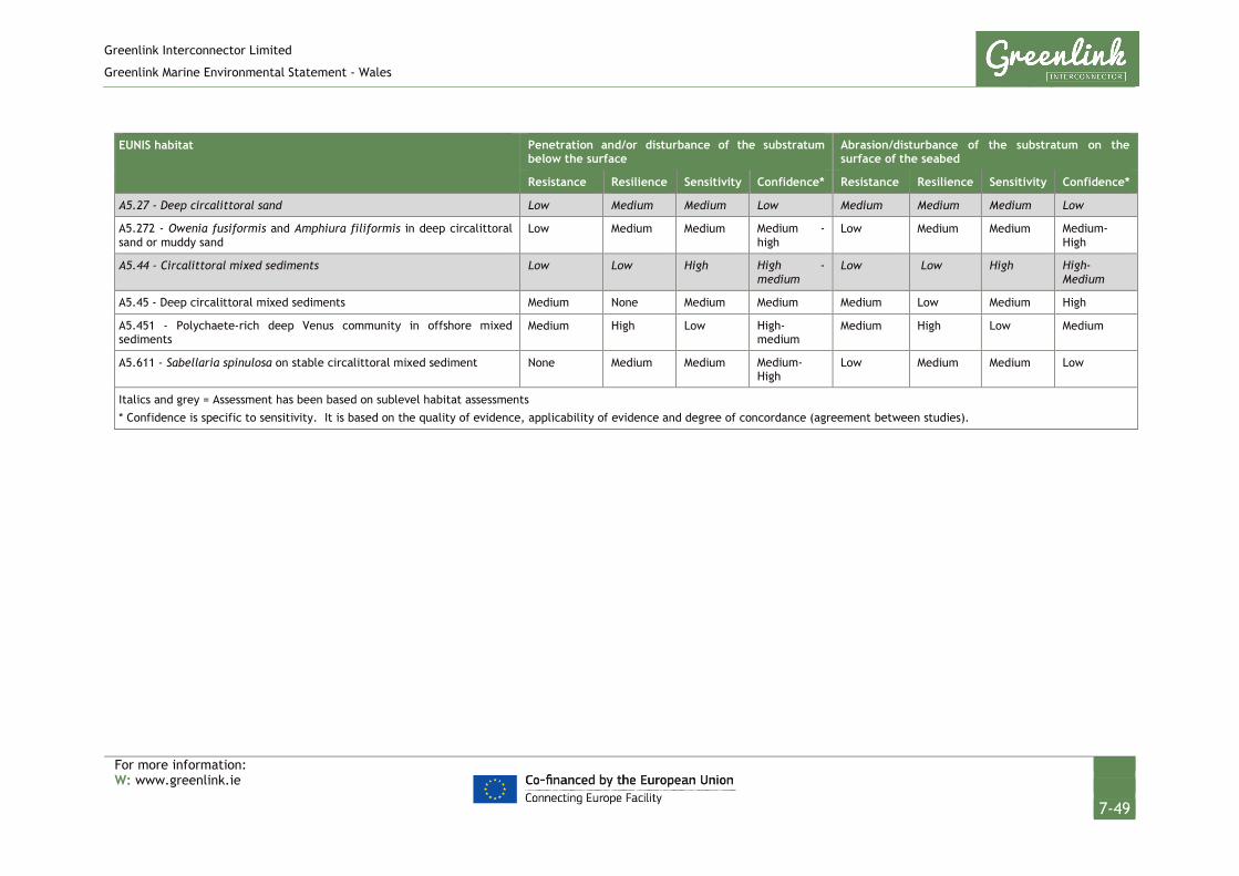
Greenlink Interconnector Limited
Greenlink Marine Environmental Statement - Wales
For more information: W: www.greenlink.ie
7-49
EUNIS habitat Penetration and/or disturbance of the substratum below the surface
Abrasion/disturbance of the substratum on the surface of the seabed
Resistance Resilience Sensitivity Confidence* Resistance Resilience Sensitivity Confidence*
A5.27 - Deep circalittoral sand Low Medium Medium Low Medium Medium Medium Low
A5.272 - Owenia fusiformis and Amphiura filiformis in deep circalittoral sand or muddy sand
Low Medium Medium Medium - high
Low Medium Medium Medium-High
A5.44 - Circalittoral mixed sediments Low Low High High - medium
Low Low High High-Medium
A5.45 - Deep circalittoral mixed sediments Medium None Medium Medium Medium Low Medium High
A5.451 - Polychaete-rich deep Venus community in offshore mixed sediments
Medium High Low High-medium
Medium High Low Medium
A5.611 - Sabellaria spinulosa on stable circalittoral mixed sediment None Medium Medium Medium-High
Low Medium Medium Low
Italics and grey = Assessment has been based on sublevel habitat assessments * Confidence is specific to sensitivity. It is based on the quality of evidence, applicability of evidence and degree of concordance (agreement between studies).

Greenlink Interconnector Limited
Greenlink Marine Environmental Statement - Wales
For more information: W: www.greenlink.ie
7-50
The discussion below has been split into five categories as follows:
• Sand habitats within the zone of influence of pre-sweeping
• Annex I Bedrock Reef habitat
• Annex I Stony Reef habitat
• Annex I Biogenic Reef habitat
• Other subtidal habitats
Sand habitats within the zone of influence of pre-sweeping
The widest zone of influence is associated with pre-sweeping of sandwaves. This will be a localised activity that will potentially be required at two locations. The combined length of cable route that may require pre-sweeping is 5.6km. The width of seabed disturbed is estimated to be up to 100m. The indicative pre-sweeping locations identified by the cable burial risk assessment are between KP25.8 and KP26.4 (a distance of 600m) and between KP64 and KP69 (approximately 5km). They are not located on the Annex I protected sandbank feature - Turbot Bank.
The habitats at the two locations are A5.142 - Mediomastus fragilis, Lumbrineris spp. and venerid bivalves in circalittoral coarse sand or gravel; and A5.251 - Echinocyamus pusillus, Ophelia borealis and Abra prismatica in circalittoral fine sand and A5.272 - Owenia fusiformis and Amphiura filiformis in deep circalittoral sand or muddy sand. Of the three habitats, A5.272 is the most sensitive to disturbance, with a medium sensitivity. The key species in the biotope are shallower burrowers, found close to the sediment surface. Sampled by grab station S18, the infaunal composition was characterised by the brittlestar, Amphiura filiformis and the polychaetes Lumbrineris cingulate and Owenia fusiformis and Nemertea. Owenia fusiformis can form tubes up to 30cm deep, whilst brittlestar are epifaunal fragile species. As fragile, effectively sessile species, animals in the zone of influence will be killed. Higher densities are expected to occur in summer when animals spawn. As cable installation is likely to take place between April and October it will overlap with this period of higher density. Although the habitat will have little resistance to the activity, resilience is medium as recovery from effects will occur through migration of adults from the surrounding unaffected area and through recruitment of juveniles from planktonic larvae. Recruitment rates will depend on favourable hydrodynamic conditions but as the habitat has been widely identified within the Proposed Development (and EMODNet [2019] shows the broadscale habitat A5.27 covers extensive areas of the Celtic Sea) recovery is expected to occur within 2 years.
As effects are short-term and the habitats identified are not Annex I listed the sensitivity of the effect has been assessed as low (using the criteria established in Chapter 5).
The overall sensitivity of the predominantly sandy subtidal habitats to pre-sweeping and cable installation has been assessed as Negligible and is Not Significant.

Greenlink Interconnector Limited
Greenlink Marine Environmental Statement - Wales
For more information: W: www.greenlink.ie
7-51
Annex I Bedrock Reef habitat
The extent of Annex I Bedrock Reef habitat within the Proposed Development has been calculated as 1.12km2. This represents approximately 15.8% of the known bedrock reef habitat within the Pembrokeshire Marine / Sir Benfro Forol SAC; acknowledging that confidence in the extent within the SAC is very poor.
The Annex I Bedrock Reef habitat has been classified as A4.138 - Molgula manhattensis with a hydroid and bryozoan turf on tide-swept moderately wave-exposed circalittoral rock. Table 7-8 identifies that this habitat has low sensitivity to abrasion. The characterising species, Molgula manhattenis is a small solitary ascidian (sea squirt) which can form dense aggregations. It is short-lived with a life-span of less than 1 year and reproduces several times during this period. Recruitment is generally from existing individuals no more than a few kilometres away, but the fast growth rates means recolonization, and a dense cover can be established within about two months of disturbance (Stamp 2016).
Bedrock reef is a qualifying feature of the Pembrokeshire Marine / Sir Benfro Forol SAC and is of high environmental value as it supports a diverse range of algae, invertebrates and fish species. The EIA has therefore concluded that the sensitivity of the habitat should be increased from low to medium in recognition that the habitat is a key contributor to the overall biodiversity of the SAC.
The conservation objectives for the site state that to achieve favourable status:
• The overall distribution and extent of the habitat feature within the site and each of the main component parts is stable or increasing.
• The physical, biological and chemical structure and functions necessary for the long-term maintenance and quality of the habitat are not degraded; and
• The presence, abundance, condition and diversity of typical species is such that habitat quality is not degraded.
The presence and location of the Annex I habitat offshore was taken into consideration during the design (routeing) of the Proposed Development. SECAMS bathymetry data and JNCC habitat maps were used to identify a suitable cable route through the SAC that avoids or minimises the crossing of the known and potential features (embedded mitigation EM14). Route engineering and additional survey was undertaken during the cable route survey to visualise a sand channel through the bedrock reef, to further avoid crossing Bedrock reef features. The ‘base case’ development being assessed is therefore an installation corridor that avoids crossing Annex I Bedrock reef habitat offshore.
However, a small area of outcropping Bedrock reef has been identified within the sand channel that it may not be feasible to avoid. The extent of disturbance would be approximately 30m long x 15m wide (450m2; between KP2.38 and KP2.41). If jetting or plough trenching is used in this area (it may require external cable protection), the seabed will experience temporary disturbance but the underlying character and composition will not change. There is sufficient habitat in the

Greenlink Interconnector Limited
Greenlink Marine Environmental Statement - Wales
For more information: W: www.greenlink.ie
7-52
surrounding Proposed Development (within 100m) that will be undisturbed to allow recruitment and recolonisation.
The indicative Greenlink centreline crosses a second area classified as Bedrock Reef at KP5. However, analysis of video transect 06 photographs (Figure 7-16 Drawing P1975-SURV-008) shows that there is a small sand covered channel through the habitat and that habitat A4.138 is not present. Therefore, it is concluded that there will be no effect on Annex I Bedrock Reef in this area.
The EIA concluded that the effect will be temporary (habitat recovery will occur within a year), the area disturbed will be very small (450m2, approximately 0.006% of the Bedrock Reef in the SAC) and the Proposed Development will not affect, other than temporarily the structure or function of the Annex I Bedrock Reef. The significance of the effect has been assessed as Minor and is Not Significant.
It is acknowledged that should the base case being assessed change, the significance of the effect could become more significant. Therefore, to ensure that the Annex I Bedrock Reef remains protected within the Proposed Development, Project Specific Mitigation (PS2) has been proposed, in the form of exclusion zones around the identified Annex I Bedrock Reef habitat.
Annex I Stony Reef habitat
Annex I Stony Reef classified as medium grade, was identified across the extent of the Proposed Development from KP15.0 to KP20.2, and then in wide patches from KP20.6 to KP22.1 (Figure 7-11, Drawing P1975-HAB-004 Sheet 2). It mainly consists of cobbles and boulders which harbour a rich epifaunal community. The habitat has been identified as A5.141 - Pomatoceros triqueter with barnacles and bryozoan crusts on unstable circalittoral cobbles and pebbles (Figure 7-18).
Habitat A5.141 has a low sensitivity to penetration and abrasion. The fauna associated with this habitat are typically fast-growing epifauna, that are opportunistic as the habitat experiences seasonal and sporadic cycles of severe scour. The pebbles and cobbles are likely to be moved by the tidal streams in the region, which will be more severe during winter storms.
Studies off Chesil Beach, Dorset (cited in Tillin and Tyler-Walters 2016) showed that the epifaunal community coverage decreased in October, scoured away by winter storms, but was recolonised in May to June. As the Greenlink cable route survey was undertaken during winter months it is possible that the survey may therefore have under-represented the abundance of epifaunal communities that will be present during cable installation. However, Tillin and Tyler-Walters (2016) state that the habitat is characterised by short-lived species, that mature rapidly. There is a relatively extended reproductive season and pelagic larvae. As the habitat covers an extensive area within the Proposed Development, in comparison to the zone of influence, there will be a good larval supply to support colonisation of the disturbed area. Recolonization is expected to occur rapidly post-disturbance; within 1 year.

Greenlink Interconnector Limited
Greenlink Marine Environmental Statement - Wales
For more information: W: www.greenlink.ie
7-53
Stony Reef contributes to the Reef qualifying feature of the Pembrokeshire Marine / Sir Benfro Forol SAC. Overall the Reef habitat within the SAC has high environmental value as it supports a diverse range of algae, invertebrates and fish species. The EIA has therefore concluded that the sensitivity of the habitat should be increased from low to medium in recognition that the habitat is a key contributor to the overall biodiversity of the SAC.
If jetting or plough trenching is used in this area (it may require external cable protection), the seabed will experience temporary disturbance but the underlying character and composition will not change. The cobbles will not be removed from the Proposed Development, and will be used to cover the cable returning the seabed to a similar state as pre-installation. The area of habitat disturbed by cable installation will be approximately 7km x 15m (0.105km2); approximately 3.5% of the habitat identified within the Proposed Development, and 0.15% of the wider extent of stony reef within the SAC. It should be noted that JNCC habitat maps show Stoney reef extends outside the boundary of the SAC as well.
The EIA concluded that as the effect will be temporary (recovery within 1 year) and the area disturbed small in the context of the wider habitat the Proposed Development will not affect, other than temporarily the structure or function of the Annex I medium grade Stony Reef. The significance of the effect has been assessed as Minor and is Not Significant.
Annex I Biogenic Reef habitat
Annex I Biogenic Reef classified as potential through to medium grade has been identified within the Proposed Development. There is sufficient room within the Proposed Development for the indicative Greenlink centreline to avoid areas classed as medium grade.
The areas of biogenic reef were mainly classified as habitat A5.611 - Sabellaria spinulosa on stable circalittoral mixed sediment, with the exception of one area of low-grade biogenic reef in habitat A5.15 – Deep circalittoral coarse sediment. A5.611 has a higher sensitivity to the pressure penetration than A5.15, and has been classed as medium.
Tillin et al. (2018) provides evidence from various studies (e.g. Gibb et al. 2014, Tillin et al. 2015, Vorberg 2000, Cunningham et al. 1984, and Holt et al. 1998) to assess the likely recovery rate of S.spinulosa reefs from effects. It reports data is limited with significant information gaps. Recovery rates are likely to be determined by a range of factors such as the degree of effect, the season of effect, larval supply and local environmental factors including hydrodynamics. There is evidence from studies on S.alveolata reefs which suggest that areas of limited damage on a reef (small impact) could be repaired rapidly (within weeks) through tube-building activities of adults, whereas following a medium effect recovery would be likely to occur within two years. Some thin crusts of S.spinulosa are relatively ephemeral and disappear following natural disturbance such as storms but

Greenlink Interconnector Limited
Greenlink Marine Environmental Statement - Wales
For more information: W: www.greenlink.ie
7-54
recover the following year, suggesting that recovery is high (within two years) even where reefs are removed.
Approximately 3.13km of the cable route will cross potential or low grade Biogenic reef. The area of habitat disturbed by cable installation will be approximately 0.05km2; approximately 3.6% of the habitat identified within the Proposed Development. JNCC habitat maps do not show biogenic reef as occurring within the Pembrokeshire Marine / Sir Benfro Forol SAC.
Cable installation will temporarily disturb the seabed, but the underlying composition and character will not change. Given the wider area of habitat compared to the zone of influence of installation, recovery via recruitment from the surrounding area is likely to occur in the short-term (within two years). The significance of the effect has been assessed as Minor and is Not Significant.
Other subtidal habitats
Generally, the other subtidal habitats identified in the Proposed Development have low to medium sensitivity to the pressure. The exception is for A5.44 Circalittoral mixed sediments.
The assessment for A5.44 is based on the EUNIS sub-level habitat A5.442 - Sparse Modiolus modiolus, dense Cerianthus lloydii and burrowing holothurians on sheltered circalittoral stones and mixed sediment, as this is the only EUNIS sub-level habitat that has been assessed by MarLIN. The two featured species of the habitat are particularly sensitive to activities which cause abrasion and disturbance; Cerianthus lloydii is a tube-dwelling anemone, whilst Modiolus modiolus (blue mussel) are large, sessile and shallowly buried individuals unable to escape from activities which penetrate the seabed. The habitat A5.44 was identified on the Turbot Bank (Annex I sandbank feature), interpreted from sidescan sonar data. It was not sampled by any grabs.
The Turbot Bank is exposed to wave action, suggesting that epifauna and infauna present will be characteristic of moderately strong tidal currents, and given the dominance of sand and coarse sediments, can be viewed as adaptable to physical disturbance. Many infaunal species may live at depths where they will be protected from surface disturbance and in areas where direct loss occurs, it is likely that adjacent areas will act to replenish communities rapidly as most infaunal species are mobile and the zone of influence is narrow. The EIA therefore concluded that the sensitivity category of high presented in Table 7-8 is over conservative for the habitat and has reduced the sensitivity to medium.
The overall significance of the effect on the other subtidal habitats in the Proposed Development has been assessed as Minor and is Not Significant.
7.6.2.2 Operation (including maintenance and repair) No disturbance or habitat loss will occur from the operating cables. Effects during any unforeseen repair and maintenance works will be of smaller magnitude when compared to cable installation. The assessment considered five discrete cable

Greenlink Interconnector Limited
Greenlink Marine Environmental Statement - Wales
For more information: W: www.greenlink.ie
7-55
repairs during operation and concluded that, given the sensitivity of habitats within the Proposed Development to penetration and abrasion, the significance of the effect remains Minor and is Not Significant.
7.6.2.3 Decommissioning Two options will be considered at decommissioning; leaving the cables in-situ and removing them. If the cables are left in-situ there will be no effect on intertidal benthic and estuarine habitats and species during decommissioning. However, if the option to remove the cables (and any associated protection) is selected, this process would essentially be the same as installation activities but in reverse. Therefore, any effects that could arise due to the decommissioning phase of the Proposed Development will be of a comparable magnitude to those assessed above for cable installation and so the effect has been assessed Minor and is Not Significant.
7.6.3 Siltation rate changes, including smothering (depth of vertical sediment overburden)
7.6.3.1 Installation The area surrounding the cable trench is likely to be affected by the suspension and subsequent deposition of sediments as a result of installation activities. Pre-sweeping and jet trenching will cause a greater level of sediment suspension compared to the use of ploughing equipment.
Although modern equipment and installation techniques have reduced the re-suspension of sediment during cable trenching activities, remaining suspended sediment dispersed into the water column has the potential to affect sessile filter feeders and, once settled out, could potentially smother organisms within the deposition area. Suspended sediments can obstruct the filtration mechanisms of some benthic and pelagic species. For example, some types of worm and brittlestars can be affected through the clogging of gills or damage to feeding structures. Suspended sediments can also attach to fish eggs causing abnormalities or death. It can also affect the growth of the macrobenthos and may have a lethal effect on some species.
Chapter 6 concluded that the change in suspended sediments (water clarity) as a consequence of cable installation is Negligible and is Not significant for the following reasons:
• Increases in SPM concentrations will be brief (restricted to the immediate period when cable burial is taking place)
• Sand and gravel disturbed during the cable burial operations will settle back to the seabed very rapidly (within 3 minutes) and the footprint is unlikely to extend any great distance from the cable route (median settling distance is 27m for sand).
• Silts, clay and chalk particles will remain in suspension for a greater period of time (up to 14 hours) and will be dispersed over a much greater distance,

Greenlink Interconnector Limited
Greenlink Marine Environmental Statement - Wales
For more information: W: www.greenlink.ie
7-56
depending upon the strength of the tidal currents. However, the depth of deposition over such a large area is likely to be unnoticeable.
• It is predicted that the change is suspended sediment concentrations will be within the normal environmental variation experienced after storm conditions in the region.
This has led to the magnitude of the effect of siltation rate changes on subtidal habitats being assessed as negligible. Some subtidal habitats within the Proposed Development will be exposed to more than one occasion of siltation changes e.g. from seabed preparation and subsequent cable lay. The activities will be separated temporally. No activities within the Proposed Development will accumulate in a manner that causes the magnitude of the effect to increase.
To determine the sensitivity of habitats within the Proposed Development an assessment has been carried out using information provided on the Marine Life Information Network (MarLIN). Table 7-9 identifies that the subtidal habitats identified within the Proposed Development generally have low to medium sensitivity to the pressure smothering and heavy siltation rate changes.
Table 7-9 Sensitivity of habitats within the Proposed Development to the pressure smothering and siltation rate changes (heavy)
EUNIS habitat Resistance Resilience Sensitivity Confidence*
A4.111 - Balanus crenatus and Tubularia indivisa on extremely tide-swept circalittoral rock Medium High Low Low
A4.13 - Mixed faunal turf communities on circalittoral rock Low Medium Medium Low
A4.138 - Molgula manhattensis with a hydroid and bryozoan turf on tide-swept moderately wave-exposed circalittoral rock
Medium High Low Low
A4.213 - Urticina felina and sand-tolerant fauna on sand-scoured or covered circalittoral rock Low High Low Low
A4.2212 - Sabellaria spinulosa, didemnid and small ascidians on tide-swept moderately wave-exposed circalittoral rock
None Medium Medium Low
A5.13 - Infralittoral coarse sediment Low Medium Medium Low
A5.14 - Circalittoral coarse sediment Medium Medium Medium Low-High
A5.141 - Pomatoceros triqueter with barnacles and bryozoan crusts on unstable circalittoral cobbles and pebbles
Medium High Low Medium
A5.142 - Mediomastus fragilis, Lumbrineris spp. and venerid bivalves in circalittoral coarse sand or gravel Medium Medium Medium Low-High
A5.143 - Protodorvillea kefersteini and other polychaetes in impoverished circalittoral mixed gravelly sand
No Evidence
No Evidence
No Evidence
Not Relevant
A5.15 - Deep circalittoral coarse sediment Medium Medium Medium Low-High
A5.24 - Infralittoral muddy sand Low Medium Medium Low-High
A5.25 - Circalittoral fine sand Medium High Low Medium
A5.251 - Echinocyamus pusillus, Ophelia borealis and Abra prismatica in circalittoral fine sand Low Medium Medium Low-High

Greenlink Interconnector Limited
Greenlink Marine Environmental Statement - Wales
For more information: W: www.greenlink.ie
7-57
EUNIS habitat Resistance Resilience Sensitivity Confidence*
A5.252 - Abra prismatica, Bathyporeia elegans and polychaetes in circalittoral fine sand Low Medium Medium Low-High
A5.261 - Abra alba and Nucula nitidosa in circalittoral muddy sand or slightly mixed sediment Low Medium Medium Low-High
A5.27 - Deep circalittoral sand Low Medium Medium Medium-High
A5.272 - Owenia fusiformis and Amphiura filiformis in deep circalittoral sand or muddy sand Low Medium Medium Medium-
High
A5.44 - Circalittoral mixed sediments Low Low High Medium-High
A5.45 - Deep circalittoral mixed sediments Medium Medium Medium Low-High
A5.451 - Polychaete-rich deep Venus community in offshore mixed sediments Medium Medium Medium Low-High
A5.611 - Sabellaria spinulosa on stable circalittoral mixed sediment None Medium Medium Low
Italics and grey = Assessment has been based on sublevel habitat assessments * Confidence is specific to sensitivity. It is based on the quality of evidence, applicability of evidence and degree of concordance (agreement between studies).
The sensitivity of subtidal habitats has been assessed as medium, recognising the differing sensitivities (identified in Table 7-8) within the Proposed Development. The overall significance of the effect has been assessed as Negligible and is Not Significant.
The potential effect of this pressure on the Pembrokeshire Marine / Sir Benfro Forol SAC has also been assessed within the Greenlink Marine HRA – Technical Appendix C. The HRA concluded no potential for significant effects and that an Appropriate Assessment is not required for this pressure.
7.6.3.2 Operation (including maintenance and repair) No seabed disturbance or siltation rate changes will occur from the operating cables. Effects during any unforeseen repair and maintenance works will be of smaller magnitude when compared to cable installation. The assessment considered five discrete cable repairs during operation and concluded that as the sensitivity of habitats within the Proposed Development remains the same as for installation, the overall significance of the effect remains Negligible and is Not Significant.
7.6.3.3 Decommissioning Two options will be considered at decommissioning; leaving the cables in-situ and removing them. If the cables are left in-situ there will be no effect on intertidal benthic and estuarine habitats and species during decommissioning. However, if the option to remove the cables (and any associated protection) is selected, this process would essentially be the same as installation activities but in reverse. Therefore, any effects that could arise due to the decommissioning phase of the Proposed Development will be of a comparable magnitude to those assessed above for cable installation and so the effect has been assessed Negligible and is Not Significant.

Greenlink Interconnector Limited
Greenlink Marine Environmental Statement - Wales
For more information: W: www.greenlink.ie
7-58
7.6.4 Physical change (to another seabed type)
7.6.4.1 Installation External cable protection (i.e. concrete mattresses / rock berm) will be installed where the Proposed Development crosses a third-party telecommunications cable, and where ground conditions are unsuitable for cable burial. It is possible that up to 16.46km of the Proposed Development will require external cable protection. The footprint has been reduced by embedded mitigation EM15 and EM29. However, where it is used the seabed habitat within the footprint of the external cable protection will be lost and replaced with, in places, a harder substrate, changing the seabed type.
The crossing location lies outside of the Pembrokeshire Marine / Sir Benfro Forol SAC, but other indicative areas for external cable placement are within the site. Table 7-10 summarises the habitats within which external cable protection could be installed and the estimated length of protection required. The total loss of habitat within the SAC as a result of external cable protection has been calculated as 0.164km2. Of this value 0.0017km2 will be within Annex I Bedrock Reef habitat and 0.08km2 will be within Annex I Stony Reef – medium grade habitat. These values represent less than 0.001% of the area of Bedrock Reef, and 0.11% of the Stony Reef in the Pembrokeshire Marine / Sir Benfro Forol SAC .
Table 7-10 Habitats within which external cable protection could be installed
EUNIS habitat Distance crossed
Presence of Annex I habitat
A5.251- Echinocyamus pusillus, Ophelia borealis and Abra prismatica in circalittoral fine sand
120m No
A4.138 - Molgula manhattensis with a hydroid and bryozoan turf on tide-swept moderately wave-exposed circalittoral rock.
30m (+140m*)
Yes - Bedrock Reef
A5.143 - Protodorvillea kefersteini and other polychaetes in impoverished circalittoral mixed gravelly sand. A5.25 - Circalittoral fine sand
200m No
A5.451 - Polychaete-rich deep Venus community in offshore mixed sediments A4.213 - Urticina felina and sand-tolerant fauna on sand-scoured or covered circalittoral rock
3000m No
A5.141 - Pomatoceros triqueter with barnacles and bryozoan crusts on unstable circalittoral cobbles and pebbles A5.14 – Circalittoral coarse sediment
8000m Medium grade stony reef
A5.27 – Deep circalittoral sand 3000m No
A5.611 - Sabellaria spinulosa on stable circalittoral mixed sediment A5.45 – Deep circalittoral mixed sediments
2000m Yes – potential biogenic reef
*Between KP2.7 and KP2.9 the cable route crosses Bedrock reef, but video transect shows narrow sand channel which is feasible for installation which is not classed as A4.138; Section 7.3.4.3
It is likely that a high proportion of the benthic invertebrates within the width of the footprint, will be susceptible to mortality, injury or displacement as a result of the activities. The habitat beneath the external cable protection will be completely removed. Where external cable protection is installed, the underlying Reef habitat
Greenlink Interconnector Limited
Greenlink Marine Environmental Statement - Wales
For more information: W: www.greenlink.ie
7-59
will be lost, but it will be replaced by a suitable hard, stable habitat for colonising communities. The external cable protection might be a slightly less complex habitat than that which occurs naturally, which might result in a comparative reduction in the diversity of species. However, there is sufficient habitat in the surrounding area to allow recruitment and colonisation of the protection material.
MarLIN (2019) identifies that the habitats identified in Table 7-9 have a high sensitivity to the pressure, because a permanent change in substrate type would lead to the biotope being re-classified.
Material used for rock berms is typically coarse gravel, cobbles and boulders. Chapter 4 indicates that rock sizes will likely be in the range of 2-22cm. Langhamer (2012) comment that “in comparison to boulders, gravel protection will result in low diversity and abundance of organisms due to a more unstable environment”.
In areas where there is stony or bedrock reef, the surrounding substrate is stable cobbles, boulders and bedrock and the dominant epifaunal species are rapid colonisers, capable of early reproduction and rapid growth. Therefore, it is expected that epifauna will be able to colonise the new substrate.
The external protection in sandy habitats will inevitably support the settlement of non-local hard bottom fauna that may not be representative of the surrounding benthos. Evidence (in discussion below) suggests that effects on the local fauna in soft sediment areas will in most cases be very localised but long-term.
The above conclusions are supported by evidence from post-construction monitoring of offshore windfarms. The examples provided below are from the introduction of a hard substrate into a predominantly sandy environment. This however can be used to infer that colonisation of external protection in areas, where there is already rock habitat, will likely be quicker i.e. as colonisation of external protection on sand habitats is dependent on the passive transport of adult organisms or the availability of larvae from the surrounding region.
Case Studies on the Offshore Windfarm Egmond aan Zee, Prinses Amalia Wind Farm and Horns Rev Wind Farm found that the density of species on scour protection material were high and the number of species observed increased with time. In addition, in many cases the number of rare species had also increased (Waardenburg et al 2017). Studies (Lindeboom et al 2011) at OWEZ identified 11-17 hard substratum benthos species on the rock material, noting the surrounding habitat was sandy. At the Horns Rev windfarm the scour protection has been colonised by sea anemones and the soft coral Alcyonium digitatum (Langhamer 2012). Monitoring of the Nord Stream pipeline in Swedish waters showed that over a period of four years a general increase in epifauna was seen on the introduced hard substrate (pipeline and rock berms) (Nord Stream 2014).
The external cable protection could be viewed as an artificial reef. The OSPAR Commission (2009) defines an artificial reef, as a ‘submerged structure placed on the seabed deliberately, to mimic some characteristics of a natural reef. It could be partly exposed at some stages of the tide’. This places the external cable

Greenlink Interconnector Limited
Greenlink Marine Environmental Statement - Wales
For more information: W: www.greenlink.ie
7-60
protection material outside the formal definition on the basis of purpose. However, almost all man-made structures placed on the seabed are rapidly and quickly colonised by marine organisms (Linley et al 2007). The effects of artificial reefs are ambiguous with Linley et al (2007) citing studies such as Ambrose and Anderson (1990) which have shown that some species of infauna were enhanced whilst others were depressed. It is therefore acknowledged that whilst the external cable protection could enhance the productivity and biodiversity of the habitat, it will also represent a variation on the habitat that was previously there.
Although evidence above suggests that the introduction of external cable protection in sandy areas could increase the biodiversity of the area, it will result in a long-term change in habitat. Taking this into account and given that sand habitat is widespread and external cable protection on sandy sediments is not within a protected site, the sensitivity of the habitat has been assessed as medium. External cable protection will be very localised and will not change the character and composition of the habitat as a whole, therefore the magnitude has been assessed as low. The overall significance of the effect has been assessed as Minor and is Not Significant for subtidal sand habitats.
Where external cable protection is deposited in areas of Annex I Reef habitat, the seabed height will become elevated in comparison to the surrounds. Large boulders, up to 2m high, have been observed in the area and therefore structures of this height are not uncommon in the area. Camera drops on these boulders were undertaken during the cable route survey. Imagery indicates the presence of habitat A4.111 - Balanus crenatus and Tubularia indivisa on extremely tide-swept circalittoral rock. This biotope is characterised by a few species that are capable of maintaining a strong foothold in strong tides, either by forming a flat adherent crust, or by having strong attachment points. Species typically associated with the biotope include hydroids, sponges and anemones, as well as mobile species such as starfish, crab and whelk (Tillin 2016). The species associated with the biotope grow rapidly, are short-lived, and generally thought of as early colonisers of bare surfaces. Tillin (2016) cite evidence of Balanus crenatus colonising artificial reef structures and sublittoral rock surfaces within months. For example, the ship, HMS Scylla was colonised by Balanus crenatus four weeks after sinking in March; the timing of the sinking would have ensured a good larval supply. This suggests that the height of the external cable protection will not detrimentally effect the function of the reef habitat but will provide alternative areas for colonisation by species in the surrounds.
The potential effect of this pressure on the Pembrokeshire Marine / Sir Benfro Forol SAC has also been assessed within the Greenlink Marine HRA – Technical Appendix C. The HRA concluded potential for likely significant effects and that an Appropriate Assessment is required for this pressure. Further assessment, in Stage 2 (Information to Inform the AA), concluded that given species from the surrounds will colonise the cable protection, the distribution, extent, structure and function and the condition and diversity of the habitat will not be degraded in the long-term. The HRA therefore concluded that the integrity of the Pembrokeshire Marine / Sir
Greenlink Interconnector Limited
Greenlink Marine Environmental Statement - Wales
For more information: W: www.greenlink.ie
7-61
Benfro Forol SAC would not be adversely affected by the Proposed Development. In line with this conclusion, the sensitivity of the reef habitat has been assessed as medium, recognising that although the habitat is a designating feature of an SAC the distribution and extent, structure and function and quality and diversity of the habitat will not be altered in the long-term. The magnitude of the effect has been assessed as low given the small, localised footprint of the pressure, the potential for colonisation of the external cable protection, and the wider extent of the habitat within the region. The overall significance of the effect has been assessed as Minor and is Not Significant.
7.6.4.2 Operation (including maintenance and repair) Effects during any unforeseen repair and maintenance works will be of a smaller magnitude when compared to cable installation. The assessment considered five discrete cable repairs during operation and concluded that as the sensitivity of habitats within the Proposed Development remains the same as for installation, the overall significance of the effect remains Moderate and is Significant.
7.6.5 Introduction or spread of non-indigenous species
7.6.5.1 Installation, Operation (including maintenance and repair) and decommissioning
MarLIN (2019) identifies that the majority of habitats within the Proposed Development are not sensitive (e.g. A4.111, A4.213, A4.2212 and A5.611) to the pressure. The exception is habitats A5.251, A5.252, A5.261 and A5.451 which have been assessed as having a high sensitivity. There is concern that the slipper limpet Crepidula fornicata may settle on stones in substrates and hard surfaces such as bivalve shells in these habitats. The species has a high dispersal potential with pelagic larvae. Temporary disturbance of the seabed i.e. through cable installation, could therefore allow juveniles to settle in a new area.
Slipper limpet are well established in the Milford Haven Waterway (and Pembrokeshire Marine / Sir Benfro Forol SAC) having first been recorded in 1953. However, Bohn (2014) indicates that it currently appears to be absent in subtidal habitats. Slipper limpet were not identified by the cable route survey (MMT 2019) within the Proposed Development.
The introduction of invasive non-native species (e.g. through discharge of ballast water from project vessels) will be managed under the International Convention for the Control and Management of Ship’s Ballast Water and Sediments (embedded mitigation EM6). The latest guidance from the GB non-native species secretariat (2015) will be followed and a Biosecurity Plan produced pre-installation (embedded mitigation EM8). This would include factors such as origins of the vessels and ensuring that relevant equipment is cleaned before use. Taking the embedded mitigation into consideration, the magnitude of the effect has been assessed as negligible.

Greenlink Interconnector Limited
Greenlink Marine Environmental Statement - Wales
For more information: W: www.greenlink.ie
7-62
The overall significance of the effect has been assessed as Negligible and is Not Significant.
As Best Practice, Project Specific Mitigation (PS8) has been proposed.
7.6.6 Electromagnetic changes
7.6.6.1 Operation The Greenlink cables will be installed in direct contact with each other (bundled configuration, embedded mitigation EM15), with currents flowing in opposite directions. Magnetic (B) fields will emanate into the surrounding environment; although they will attenuate with distance (both horizontally and vertically). Movement through the B fields i.e. water currents or organisms swimming through, creates an induced electric (iE) field. The effect will be present along the Proposed Development.
The background geomagnetic field for the Celtic Sea is approximately 48.7 μT (Natural Resources Canada 2019), with the background iE field calculated as between 34.09 μV/m and 48.7 μV/m in Irish waters.
It has been calculated that the Greenlink cables will generate B fields of 21μT directly over the cables reducing to natural background levels within 2m. The iE fields are estimated to be between 48.79 and 69.7 μV/m at 1m from the cables. No detectable change above background geomagnetic fields will be noticeable at 2m from the cables.
The effect of EMF on benthic species is largely unknown. There is little and contradicting evidence of interactions with anthropogenic sources of magnetic fields. As benthic communities are typified by sessile or low-mobility species, which are unlikely to navigate using magnetic fields and anomalies, these species, are less likely to be affected than more mobile species such as teleost fish or elasmobranchs, which are assessed in Chapter 8. The exception could be crustaceans, such as edible crabs (Cancer pagurus), lobster (Homarus gammarus) and prawns (e.g. Nephrops norvegicus). The brown shrimp (Crangon crangon) has been recorded as being attracted to AC magnetic fields of the magnitude expected from submarine power cabling (ICES 2003). However, Bochert and Zettler (2004) found no effects of exposure to static B fields upon the same species, nor upon the round crab (Rhithropanopeus harrisii), an isopod (Saduria entomon) or the mussel (Mytilus edulis). Demonstrations of B fields ranging between 1-100μT delaying embryonic development in sea urchins (Zimmerman et al. 1990), and of high frequency AC EMF causing cell damage to barnacle larvae and interfering with their settlement (Leya et al. 1999), contrasts with anecdotal evidence of benthic invertebrates living directly upon DC electrodes (Nielson 1986) with no apparent effects (Swedpower 2003). The sensitivity of the receptor to EMF has been assessed as low.
A number of marine invertebrate species that inhabit the Proposed Development are magnetically sensitive, including important commercially targeted taxa such as lobster, crabs, shrimps, and molluscs. As discussed above, B and iE fields generated
Greenlink Interconnector Limited
Greenlink Marine Environmental Statement - Wales
For more information: W: www.greenlink.ie
7-63
by the Proposed Development will attenuate to below background geomagnetic field levels within 2m of the cables.
Potential effects will largely be negated by cable burial; burial to a depth of at least 0.6m will prevent most invertebrates (except deep borrowing species such as certain Crustacea and bivalve molluscs) encountering the strongest fields present on the cable surfaces. In addition, embedded mitigation EM15, bundling of the cables, also significantly reduces the magnitude of the effect. The magnitude of the effect has been assessed as low, as although it will be a long-term change, the alteration will be extremely localised, and the underlying character of the baseline will be similar to the pre-development situation.
The overall significance of the effect has been assessed as Negligible and is Not Significant.
7.7 Project Specific Mitigation
In addition to the embedded mitigation outlined in Table 7-6, Table 7-11 presents measures that GIL is committed to adopting.
Table 7-11 Project specific mitigation – benthic and intertidal ecology
ID Project Specific Mitigation
PS1 No intrusive works will be undertaken at Freshwater West between mean high water springs
and mean low water springs.
PS2 Exclusion zones have been established around Annex I bedrock reef features; shown on
Figure 7-21, Drawing P1976-INST-009. No intrusive works (e.g. cable installation, deposit
of external cable protection material) will be undertaken within these exclusion zones.
PS4 The preference is to bury the HDD duct exit and all cables in sediment to the required
depth of lowering. No external cable protection should be deposited at the HDD exit point.
PS6 A burial assessment study will be carried out by the Installation Contractor that defines
the feasibility of achieving the required depth of burial. When determining the installation
technique for the cable route between KP15 and KP23 the preference shall be to bury the
cable in sediment. If ground conditions do not allow this then cutting should be investigate
as the next alternative. External cable protection shall only be consider as the final option,
and if necessary, the Installation Contractor shall seek to minimise the footprint (length
and width) of external cable protection required between KP15 and KP23 (Annex I stony
reef).
PS7 Where external cable protection is used between KP15 and KP23 (Annex I Stony Reef) an
environmental monitoring plan will be established to monitor colonisation of the external
cable protection to demonstrate that the structure and function of the Reef feature has
not been adversely affected in the long-term.
The monitoring programme will be developed in consultation with NRW. It is proposed
that one or more of transects MMT (2019) RR_T02, RR_T03 and RR_T04 are re-surveyed as
a control, with additional video transects taken along the external cable protection to

Greenlink Interconnector Limited
Greenlink Marine Environmental Statement - Wales
For more information: W: www.greenlink.ie
7-64
ID Project Specific Mitigation
record epifauna. Monitoring would be planned to coincide with the first two routine cable
inspection surveys. It is expected that the first inspection survey will be undertaken within
the first three years of installation, with a second survey undertaken within three years of
the first survey.
All footage will also be reviewed for the presence of non-indigenous species.
The objectives of monitoring colonisation of the external cable protection will be to
establish an evidence base to inform future development within the Pembrokeshire Marine
/ Sir Benfro Forol SAC e.g. renewable energy generation. It will also confirm (or otherwise)
the conclusion that the deposition of the external protection material adds to the Reef
habitat within the SAC; albeit artificially.
PS8 A tool box talk will be given ahead of all works. It will provide key identifying features for
slipper limpet. Any slipper limpet found during installation will be kept & destroyed.

GREENLINK INTERCONNECTORINSTALLATION
Annex I Habitat Exclusion Zones - UK Route
Chris GoodeEmma Langley
Monday, April 29, 2019 08:37:30WGS_1984_UTM_Zone_30N
D_WGS_1984OS; MMT; ESRI; Greenlink
WGS_1984
NOTE: Not to be used for Navigation
Contains Ordnance Survey data © Crown copyright and database right 2013
Anna Farley
352500
352500
355000
355000
357500
357500
57225
00
57225
00
57250
00
57250
00
57275
00
57275
00
LegendIndicative Greenlink Route CentrelineProposed DevelopmentAnnex I Habitat Exclusion ZoneDecommissioned MOD Cable Avoidance ZoneTrenching Exclusion Zone
0 250 500 750 1,000m © Metoc Ltd, 2019.
All rights reserved.
J:\P1975\Mxd\15_INST\P1975-INST-009.mxd
Created ByReviewed By
DateProjection
DatumData Source
File Reference
Spheroid
Approved By
Drawing No: P1975-INST-009 A

Greenlink Interconnector Limited
Greenlink Marine Environmental Statement - Wales
For more information: W: www.greenlink.ie
7-66
7.8 Residual Effect
The assessment presented in Section 7.6 identified two potential pressures could have significant effects on the receptor. The significance of these pressures was re-assessed taking into consideration the Project Specific Mitigation outlined in Section 7.7 to determine if a significant residual effect remains.
7.8.1 Penetration and/or disturbance of the substrate below the surface of the seabed, including abrasion
The assessment identified that subtidal habitats within the Proposed Development have a medium sensitivity to the pressure penetration and/or disturbance of the substrate below the surface of the seabed, including abrasion. Extensive route development was undertaken during design (routeing) to identify an alternative route through the Pembrokeshire Marine / Sir Benfro Forol SAC that avoided Annex I habitat features. The Proposed Development represents the best alternative and has been optimised to avoid crossing Annex I habitat where possible, embedded mitigation EM14. The cables will also be bundled into the same trench to reduce the footprint of the Proposed Development (embedded mitigation EM15). In addition, Project Specific Mitigation in the form of exclusion zones (PS2, Figure 7-21, Drawing P1975-INST-009) have been established around the Annex I reef habitat within the Proposed Development. GIL will ensure that the Installation Contractor adheres to these exclusions. No further Project Specific Mitigation can be proposed that reduces the footprint, magnitude or sensitivity of the effect and therefore the significance of the residual effect remains Minor and is Not Significant.
7.8.2 Physical change (to another seabed type)
The assessment identified that the Proposed Development will have an effect of Minor significance on subtidal habitats. The preference is to bury the cables in sediment as this is the most cost-effective method of protection. External cable protection will only be deployed where adequate burial cannot be achieved. The footprint of the deposits will be the minimum required to ensure cable safety and rock berm stability (embedded mitigation EM29).
The alternative routes identified through the Pembrokeshire Marine / Sir Benfro Forol SAC also crossed extensive areas of Annex I reef habitat; and longer sections of external cable protection would have been required on these route options. The route developed, through consultation with NRW, is seen to be the best alternative. External cable protection in the area of Stony Reef is expected to be colonised by the surrounding epifauna rapidly.
The EIA concluded that burial in sediment and external cable protection, if required across the Stony Reef would have an effect of Minor significance. Project Specific Mitigation (PS6) has been proposed which outlines the environmental recommendations for cable protection between KP15 and KP23. A burial assessment study will be carried out by the Installation Contractor that defines the feasibility

Greenlink Interconnector Limited
Greenlink Marine Environmental Statement - Wales
For more information: W: www.greenlink.ie
7-67
of achieving the required depth of burial. When determining the installation technique for the cable route between KP15 and KP23, GIL will indicate that the preference shall be to bury the cable in sediment. If ground conditions do not allow this then cutting should be investigate as the next alternative. External cable protection shall only be considered as the final option, if necessary. The Installation Contractor shall seek to minimise the footprint (length and width) of external cable protection required between KP15 and KP23 (Annex I stony reef).
Project Specific Mitigation in the form of exclusion zones (PS2, Figure 7-21, Drawing P1975-INST-009 overleaf) have also been established around the majority of Annex I Bedrock Reef habitat within the Proposed Development. Micro-routeing will also be used to avoid Annex I habitat where possible. However, in certain areas the features cover the entire width of the Proposed Development and cannot be avoided. GIL will ensure that the Installation Contractor adheres to these exclusions.
No further Project Specific Mitigation can be proposed that reduces the footprint, magnitude or sensitivity of the effect. Where external cable protection is used monitoring has been recommended (PS7). Although monitoring will not reduce the effect, the objective is to validate the conclusion of short-term effects. It is thought monitoring would be beneficial for the management of the Pembrokeshire Marine SAC given that a number of renewable energy projects are proposed for testing and development within the SAC. Validating the conclusions of the Greenlink Marine HRA will support the decision making for future applications.
Taking the Project Specific Mitigation into consideration, the significance of the residual effect remains Minor and Not Significant in areas of Annex Bedrock and Stony reef and Minor and is Not Significant in all other subtidal habitats.

Greenlink Interconnector Limited
Greenlink Marine Environmental Statement - Wales
For more information: W: www.greenlink.ie
7-68
1 Ambrose, R.F. and Anderson, T.W. (1990). Influence of an artificial reef on the surrounding infaunal community. Marine Biology, 107, 41-52
2 Bochert, R. and Zettler, M.L. (2004). Long-term exposure of several marine benthic animals to static magnetic fields. Bioelectromagnetics 25: 498-502.
3 Bohn, K. (2014) The distribution and potential northwards spread of the invasive slipper limpet Crepidula fornicate in Wales, UK. Natural Resources Wales Report No. 40. August 2014.
4 Countryside Council for Wales (CCW) (2005). Pembrokeshire Marine European Site. Advice provided by the Countryside Council for Wales in fulfilment of Regulation 33 of the Conservation (Natural Habitats, &c.) Regulations 1994.
5 Davies, J., Baxter, J., Bradley, M., Connor, D., Khan, J., Murray, E., Sanderson, W., Tumbull, C. and Vincent, M., 2001. Marine Monitoring Handbook. Joint Nature Conservation Committee.
6 DECC, 2016. Offshore Energy SEA 3: Appendix 1 Environmental Baseline: Benthos [Online]. URL https://assets.publishing.service.gov.uk/government/uploads/system/uploads/attachment_data/file/504527/OESEA3_A1a2_Benthos.pdf (accessed 6.4.19).
7 DTI (2005). Synthesis of information on the benthos of area SEA 6.
8 EEA (2019a). Molgula manhattensis with a hydroid and bryozoan turf on tide-swept moderately wave-exposed circalittoral rock [online] Available at:
https://eunis.eea.europa.eu/habitats/2130 (Accessed March 2019).
9 EEA (2019b). Urticina felina and sand-tolerant fauna on sand-scoured or covered circalittoral rock. [online] Available at: https://eunis.eea.europa.eu/habitats/2120 (Accessed April 2019)
10 EEA (2019c). Pomatoceros triqueter with barnacles and bryozoan crusts on unstable circalittoral cobbles and pebbles [online] Available at: https://eunis.eea.europa.eu/habitats/2097 (Accessed April 2019)
11 EEA (2019d) Sabellaria spinulosa on stable circalittoral mixed sediment [online] Available at: https://eunis.eea.europa.eu/habitats/1693 (Accessed April 2019)
12 EMODNet (2019). EMODnet broad-scale seabed habitat map for Europe (EUSeaMap) [online] Available at: https://www.emodnet-seabedhabitats.eu/access-data/launch-map-viewer/ (Accessed April 2019)
13 GB Non-native species secretariat (2015). http://www.nonnativespecies.org/index.cfm?sectionid=53 (Accessed March 2019).
14 Gubbay, S. (2007). Defining and managing Sabellaria spinulosa reefs: Report of an inter-agency workshop 1-2 May, 2007. JNCC Report No. 405.
15 Intertek EWCS (2019). Greenlink Marine Habitats Regulation Assessment.
16 Irving, R. (2009). The identification of the main characteristics of stony reef habitats under the Habitats Directive.
REFERENCES
Greenlink Interconnector Limited
Greenlink Marine Environmental Statement - Wales
For more information: W: www.greenlink.ie
7-69
Peterborough, UK: Joint Nature Conservation Committee.JNCC (2016). Natura 2000 Standard Data Form, Site UK0013116. Pembrokeshire Marine / Sir Benfro Forol [online] Available at: http://jncc.defra.gov.uk/ProtectedSites/SACselection/n2kforms/UK0013116.pdf (Accessed April 2019)
17 JNCC (2019). Pembrokeshire Marine / Sir Benfro Forol. [online] Available at: http://jncc.defra.gov.uk/ProtectedSites/SACselection/sac.asp?EUcode=UK0013116 (Accessed April 2019)
18 Langhamer, O (2012). Artificial reef effect in relation to offshore renewable energy conversion. State of the art. Scientific word journal.
19 Lindeboom, H.J., Kouwenhoven, H.J., Bergman, M.J.N., Bouma, S., Brasseur, S., Daan, R., Fijn, R.C., de Haan, D., Dirksen, S., van Hal, R., Hille Ris Lambers, R., ter Hofstede, R., Krijgsveld, K.L., Leopold, M. and Scheidat. (2011) Short term ecological effects of an offshore wind farm in the Dutch coastal zone; a compilation. Environmental Research Letters, 6.
20 Linley E.A.S., Wilding T.A., Black K., Hawkins A.J.S. and Mangi S. (2007) Review of the reef effects of offshore wind farm structures and their potential for enhancement and mitigation. Report from PML Applications Ltd and the Scottish Association for Marine Science to the Department for Business, Enterprise and Regulatory Reform Contract No: RFCA/005/0029P (BERR).
21
22 MarineSpace (2018). Greenlink Interconnector Cable Landfall Locations (Wales and Ireland) - Intertidal Walkover Survey Report 2018.
23 MarLIN. (2019). The Marine Life Information Network. [online] Available at: www.marlin.ac.uk (Accessed April 2019).Natural Resources Canada (2019). [Online] Available at: https://www.nrcan.gc.ca/home (Accessed March 2019)
24 Nord Stream (2014) Results of Environmental and Socio-Economic Monitoring 2014. August 2015 [Online] Available at: https://www.nord-stream.com/press-info/library/?pk=250 (Accessed April 2019)
25 OSPAR Commission (2009) Assessment of construction or placement of artificial reefs. Biodiversity Series Publication 438/2009.
26 Parry, M.E.V. (2015). Guidance on Assigning Benthic Biotopes using EUNIS or the Marine Habitat Classification of Britain and Ireland.
27 Pidduck, E., Jones, R., Daglish, P., Farley, A., Morley, N., Page, A. and Soubies, H. (2017). Identifying the possible impacts of rock dump from oil and gas decommissioning on Annex I mobile sandbanks – JNCC Report No: 603. [online] Available at: http://jncc.defra.gov.uk/pdf/Report_603_web.pdf (Accessed April 2019)
28 Stamp, T.E. (2016). Molgula manhattensis with a hydroid and bryozoan turf on tide-swept moderately wave-exposed circalittoral rock. In Tyler-Walters H. and Hiscock K. (eds) Marine Life Information Network: Biology and Sensitivity Key Information Reviews, [online]. Plymouth: Marine Biological Association of the United Kingdom. Available at: https://www.marlin.ac.uk/habitat/detail/1063 (Accessed April 2019)

Greenlink Interconnector Limited
Greenlink Marine Environmental Statement - Wales
For more information: W: www.greenlink.ie
7-70
29 Swedpower (2003). Electrotechnical studies and effects on the marine ecosystem for BritNed Interconnector.
30 Tillin, H.M. 2016. [Balanus crenatus] and [Tubularia indivisa] on extremely tide-swept circalittoral rock. In Tyler-Walters H. and Hiscock K. (eds) Marine Life Information Network: Biology and Sensitivity Key Information Reviews, [on-line]. Plymouth: Marine Biological Association of the United Kingdom. [cited 16-05-2019]. Available from: https://www.marlin.ac.uk/habitat/detail/349
31 Tillin, H.M. and Tyler-Walters, H. (2016). Spirobranchus triqueter with barnacles and bryozoan crusts on unstable circalittoral cobbles and pebbles. In Tyler-Walters H. and Hiscock K. (eds) Marine Life Information Network: Biology and Sensitivity Key Information Reviews, [online]. Plymouth: Marine Biological Association of the United Kingdom. Available at: https://www.marlin.ac.uk/habitat/detail/177 (Accessed April 2019)
32 Tillin, H.M., Marshall, C. and Gibb, N. (2018). Sabellaria spinulosa on stable circalittoral mixed sediment. In Tyler-Walters H. and Hiscock K. (eds) Marine Life Information Network: Biology and Sensitivity Key Information Reviews, [online]. Plymouth: Marine Biological Association of the United Kingdom. Available at: https://www.marlin.ac.uk/habitat/detail/377 (Accessed April 2019)
33 Waardenburg, B., Lengkeek, W., Didderen, K., Teunis, M., Driessen, F., Coolen, J.W.P., Vergouwen, S.A., Raaijmakers, T.C., Vries de M.B AND Koningsveld van M (2017). Eco-friendly design of scour protection: potential enhancement of ecological functioning in offshore wind farms. [online] Available at:
http://edepot.wur.nl/411374 (Accessed April 2019)
34 Welsh Government (2016a). Environmental (Wales) Act 2016. Section 7 – list of the habitats of principal importance for the purpose of maintaining and enhancing biodiversity in relation to Wales. [Online] Available at: file:///C:/Users/matthias.thomsen/Downloads/masterss7habitatslistmay%202016.pdf (Accessed April 2019).
35 Welsh Government (2016b). Environment (Wales) Act 2016, Section 7 - list of the living organisms of principal importance for the purpose of maintaining and enhancing biodiversity in relation to Wales. [Online] Available at: file:///C:/Users/matthias.thomsen/Downloads/master%20s7%20species%20list%20may%202016%20final.pdf (Accessed April 2019).
36 Wyn, G., Brazier, P., Birch, K., Bunker, A., Cooke, A., Jones, M., Lough, N., McMath, A. and Roberts, S., 2006. Handbook for Marine Intertidal Phase 1 Biotope Mapping Survey.
37 Zimmermann, S., Zimmermann, A.M., Winters, W.D. and Cameron, I.L. (1990). Influence of 60-Hz magnetic fields on sea urchin development, Bioelectromagnetics, 11: 37-45.

Greenlink Interconnector Limited
Greenlink Marine Environmental Statement - Wales
For more information: W: www.greenlink.ie
8-1
8. Fish and Shellfish This Chapter describes the existing baseline environment for fish and shellfish, identifies the pressures associated with the Proposed Development on the receptor, presents the findings of the environmental impact assessment, and describes how significant effects (if any) will be mitigated.
The Proposed Development refers to the Welsh Marine components of Greenlink from mean high-water springs (MHWS) at the Welsh landfall at Freshwater West, Pembrokeshire to the UK / Republic of Ireland median line. It comprises:
• Two high voltage direct current (HVDC) electricity power cables;
• A smaller fibre-optic cable for control and communication purposes;
• All associated works required to install, test, commission and complete the aforementioned cables; and
• All associated works required to operate, maintain, repair and decommission the aforementioned cables, including five repair events over the 40 year lifetime of Greenlink.
The Proposed Development includes the following phases, all of which are assessed within this chapter:
• Installation;
• Operation (including repair and maintenance activities); and
• Decommissioning.
Where relevant, any limitations related to the baseline conditions, data sources or scientific understanding / interpretation within the process of assessing the effects have been highlighted.
8.1 Data Sources
Baseline conditions have been established by undertaking a desktop review of published information and through consultation with consultees e.g. Natural Resources Wales (NRW), Marine Management Organisation (MMO). The data sources used to inform the baseline description and assessment include, but are not limited to the following:
• Marine survey reports (MMT 2019);
• UK sea fisheries annual statistics report (MMO 2018b);
• Cefas Sensitivity Maps (Coull et al. 1998, Ellis et al. 2012); and
• Offshore Energy Strategic Environmental Assessment 3 (DECC 2016).
• Technical Appendix D - Noise Assessment
• Technical Appendix E – Herring Spawning and Sandeel Assessment

Greenlink Interconnector Limited
Greenlink Marine Environmental Statement - Wales
For more information: W: www.greenlink.ie
8-2
• Other data sources are referenced in the text and listed at the end of the Chapter.
8.2 Consultation
Table 8-1 summarises the relevant consultation responses on fish and shellfish. The steps taken to contact stakeholders for comments on the EIA scope is documented in Chapter 5.
Table 8-1 Consultation responses – fish and shellfish
Stakeholder Summary of Consultation Response How response has been addressed
Comments received on NRW Scoping Opinion (SC1816)
Natural Resources Wales (NRW)
The pressure descriptions of displacement, reduction in water depth and loss of fisheries habitats/fish stocks must be considered for Fish and Shellfish
These pressures are covered in the following sections:
- Displacement of fish as a result of marine cable installation is covered in Section 8.6.3.
- A reduction in water depth will not effect fish and shellfish ecology, the potential effects from the installation of external cable protection is covered in Section 8.6.2.
- Loss of fish habitat is covered in Sections 8.6.1 and Section 8.6.2.
NRW Many of the pressures descriptions identified for the Physical Environment should also include potential impacts on Intertidal and Benthic, as well as Fish and Shellfish. These include water flow, water exposure changes, temperature changes, changes in suspended solids and hydrocarbon and polyaromatic hydrocarbon (PAH) contamination. The impacts of invasive non-native species (INNS) should also be considered, as described in Table 1-3; Table 8-1 has screened out INNS in the summary table.
Chapter 6 - Physical Environment concluded that cable installation activities would not effect local water flow or wave exposure. Therefore, these pressures have not been assessed in this chapter.
The marine cable survey identified no sediment contamination within the Proposed Development (See Chapter 6) and therefore the pressure hydrocarbon and PAH contamination has been screened out of the EIA for the receptor fish and shellfish.
Chapter 6 concluded that changes in suspended solids will be brief and within the natural background levels of variation and therefore the pressure changes in water clarity have been screened out of the EIA for the receptor fish and shellfish.
As proposed in the scoping report temperature changes have been screened out. Justification is provided in Chapter 5.
Comments received on Superseded Scoping Report which are relevant to the Proposed Development
MMO Recommend that the EIA considers the impacts to thornback ray nursery grounds which are found along the proposed cable route (Coull et al, 1998
Potential effects on thornback ray nursery grounds have been considered in Section 8.6.1.

Greenlink Interconnector Limited
Greenlink Marine Environmental Statement - Wales
For more information: W: www.greenlink.ie
8-3
Stakeholder Summary of Consultation Response How response has been addressed
and Ellis et al, 2012) given that thornback ray lay benthic egg cases.
MMO Recommended that the EIA should adequately assess the potential effects upon sandeel spawning and nursery grounds, as well as hibernating grounds. Sandeel are an important prey item. Suggested that particle size analysis (PSA) samples should be analysed to determine presence of sandeel habitat. Any limitations and caveats should be noted.
The potential for the Proposed Development to contain sandeel habitat has been assessed in Technical Appendix E this has used Regional sandeel habitat data, and site specific PSA. The baseline is summarized in Section 8.3.3 and effects on sandeel are assessed in Section 8.6.1.
MMO The MMO recommended that the EIA considers seabass in the context of the current special protection measures in place i.e. are cabling activities likely to disturb nursery grounds or juvenile fish.
Consideration of impacts to seabass nursery grounds has been provided in Section 8.6.1.
MMO The MMO recommended that the EIA should consider disturbance to twaite shad (Alosa fallax) and Allis shad (Alosa alosa). It should also consider their ability to transit successfully during migration; and whether there are any effects of the electromagnetic fields (“EMF”) on this species.
Section 8.6.4 has considered the disturbance to twaite shad and Allis shad.
MMO Recommended the inclusion of a map in the burial assessment which illustrates the areas where cable burial is limited due to local seabed geology (or other receptors in the area), and indicates the areas where magnetic field strength would be greatest, would be beneficial as it would highlight any potential effects to electrosensitive fish, this should be presented in the ES.
A map showing where cable burial is limited is provided in Chapter 4, Figure 4-18.
The potential for electromagnetic effects on fish has been assessed in Section 8.6.4.
MMO Commented the cable is likely to pass through brown crab (Cancer pagurus), lobster (Homarus gammarus) and whelk (Buccinum undatum) habitat outside the 12nm limit. The MMO have Recommended that the impact on the ecology of these species is also considered in the EIA.
The ecology of brown crab, lobster and whelk have been covered in Section 8.3.5 and an impact assessment is provided in Section 8.6.1, 8.6.2, and 8.6.4.

Greenlink Interconnector Limited
Greenlink Marine Environmental Statement - Wales
For more information: W: www.greenlink.ie
8-4
8.3 Existing Baseline
8.3.1 General overview
The Offshore Energy Strategic Environmental Assessment (OESEA) 3 has been used to provide information on fish assemblages in the Celtic Sea (regional sea 4). The variable seabed conditions across the south-western coasts of England and Wales supports a wide variety of fish species with distinct assemblages associated with particular seabed conditions. Sandy inshore areas support large numbers of juvenile flatfish and sandeel, with seasonal populations of sprat and herring. Rockier strata are characterised by small species such as wrasse, gobies and blennies as well as juvenile Pollock (Pollachius). A number of demersal (bottom dwelling) fish spawn and have nursery grounds in the offshore and nearshore area, whilst pelagic (free swimming) fish such as mackerel and herring range widely within the region, migrating between summer feeding grounds and overwintering grounds (Cefas 2005).
8.3.2 Spawning and nursing grounds
Fisheries sensitivity maps (Coull et al. 1998; Ellis et al. 2012) provide information on spawning (the location where eggs are laid) and nursery areas (the location where juveniles are common) for fish-stocks in the region. Ellis et al. (2012) has identified data gaps in understanding the extent of spawning and nursery grounds in the Western English Channel and Celtic Sea and acknowledges that further work may be required in this region to provide a similar understanding comparable to the North Sea (Ellis et al. 2012).
Data available for the region indicates that the Proposed Development passes within, or close to the spawning grounds for nine commercially important fish species (see species listed under Table 8-2 sub-heading spawning period, Figure 8-1 Drawing P1975-FISH-001, and Figure 8-2 Drawing P1975-FISH-002). The Proposed Development is located in International Council for the Exploration of the Sea (ICES) rectangle 32E4 and 32E3, within ICES area VIIg. The waters of the area also act as a nursery for eleven commercially important fish species (see species listed under Table 8-2 sub-heading nursery period; Figure 8-1 Drawing P1975-FISH-001, and Figure 8-2 Drawing P1975-FISH-002).

Greenlink Interconnector Limited
Greenlink Marine Environmental Statement - Wales
For more information: W: www.greenlink.ie
8-5
Table 8-2 Summary of spawning and nursery areas for the main commercial species
Species Spawning period
Nursery period
Spawning aquatic zone
Atlantic Cod (Gadus morhua) - Jan – Jun Demersal
Mackerel (Scomber scrombrus) - Mar - Sep Pelagic
Lemon Sole (Microstomus kitt) Apr - Sep Apr - Nov Demersal
Norway lobster (Nephrops norvegicus) Gravid females and juveniles can be found all year round
Demersal
Whiting (Merlangius merlangus) - Feb - Aug Demersal
Tope shark (Galeorhinus galeus) Viviparous species (gravid females can be found all year).
Demersal
Sprat (Sprattus sprattus) May - Aug (Peak May - Jun)
- Pelagic
Herring (Clupea harengus) Jan - Apr - Demersal
Angler (Lophius piscatorius) - Jan – Aug Demersal
Blue Whiting (Micromesistius poutassou) - Apr - Aug Pelagic
Ling (Molva molva) Feb - May Feb - Jul Pelagic
Thornback Ray (Raja clavate) Feb - Nov* Feb - Nov Demersal
European hake (Merluccius merluccius) - Jan – Aug Demersal
Sandeel (Ammodytidae) Nov - Feb - Demersal
Sole (Solea solea) Mar - May (Peak spawning April)
- Demersal
Source: Coull et al. (1998), Ellis et al. (2012). * Ellis et al. (2012) states that there are insufficient data
on occurrence of eggs or egg bearing females to delineate spawning grounds but these should broadly
overlap with nursery grounds.
The spawning and nursery areas through which the Proposed Development passes are widespread, covering a large area of the Celtic and Irish Sea (see Figure 8-1 Drawing P1975-FISH-001, and Figure 8-2 Drawing P1975-FISH-002). Some species spawn within the water column and have extensive spawning grounds. Tidal currents then carry pelagic spawned, fertilised eggs and tiny juvenile fish species (both pelagic and demersal) within the plankton to nursery areas. Some species deposit their eggs in a certain habitat type and therefore have more restricted spawning areas. Nursery grounds are areas where juvenile fish occur at higher densities, have reduced rates of predation and have faster growth rates than other habitats, which result in nursery grounds providing a greater contribution to adult recruitment (Ellis et al. 2012). Once grown, most fish leave their nursery grounds.

Greenlink Interconnector Limited
Greenlink Marine Environmental Statement - Wales
For more information: W: www.greenlink.ie
8-6
The species most likely to be affected by the Proposed Development are those with demersal (bottom dwelling) life stages, e.g. species which lay their eggs on specific seabed types, such as cod and sole, larval or juvenile ages, or species that live in contact with the seabed e.g. sandeel. Sandeel are of particular importance as they are an important component to food webs and are protected under the UK Biodiversity Action Plan (UKBAP) (see Section 8.3.3 for more information). Pelagic spawners such as Atlantic mackerel and sprat release their eggs into the water column and are therefore less sensitive to project activities.
Some species produce a vast amount of eggs in a single mass spawning event meaning that they have a short population doubling time e.g. sprat which can double their population in less than 15 months (DECC 2009). Therefore, providing an important food source for foraging mobile species. As pelagic spawners, sprat spawning and nursery areas are widely distributed through the Celtic and Irish Seas (Figure 8-2 Drawing P1975-FISH-002).
The wider region has been identified as a high intensity spawning ground for sole, and sprat and low intensity spawning ground for lemon sole, ling, sandeel and sole and a low intensity nursery ground for cod, mackerel, lemon sole, whiting, anglerfish, blue whiting, ling and European hake (Coull et al. 1998 and Ellis et.al. 2012). The Proposed Development lies in areas frequented by thornback ray and tope that use the area as both spawning and nursing grounds.
The overall likelihood of presence of juveniles within the first year of their life in the vicinity of the Proposed Development has been determined to be low for all species except cod, haddock, whiting, European hake and horse mackerel which have been determined to be moderate to high (Aires et al. 2014). Likelihood of presence of juveniles has been defined with reference to the Random Forest probability of presence scale, low probability is defined as 0 ranging to high probability at around 0.99 (maximum score is dependent on species type and ranges from 0.525 for herring to 0.99 for haddock).

Chris GoodeEmma Langley
Friday, April 5, 2019 15:24:02WGS_1984_UTM_Zone_30N
D_WGS_1984DCCAE; UKHO; CDA; GEBCO; CEFAS; Greenlink
WGS_1984
NOTE: Not to be used for Navigation
© Copyright Department of Communications, Climate Action and Environment (DCCAE); Contains public sector information, licensed under the Open Government Licence v2.0, from the UKHO, 2018.; Contains data from UKOGD.; © The GEBCO Digital Atlas published by the British Oceanographic Data Centre on behalf of IOC and IHO, 2003; Data from Ellis, J.R. et al. (2012) Spawning and Nursery Grounds of Selected Fish Species in UK Waters.CEFAS Lowestoft Science Series Technical Report, 147: 55pp.
Anna Farley
© Metoc Ltd, 2019.All rights reserved.
J:\P1975\Mxd\07_FISH\P1975-FISH-001.mxd
Drawing No: P1975-FISH-001 A
300000 350000570
0000
57500
00300000 350000
57000
00575
0000
300000 350000570
0000
57500
00
300000 350000
57000
00575
0000
57000
00575
0000
300000 350000 300000 350000
57000
00575
0000
Lemon Sole Ling
Anglerfish
HerringHake
Blue Whiting
Mackerel
Cod
Horse Mackerel
Created ByReviewed By
DateProjection
DatumData Source
File Reference
Spheroid
Approved By
0 10 20 30 40km
LegendProposed DevelopmentIrish OffshoreROI 12nm Territorial Sea LimitUK 12nm Territorial Sea LimitMedian Line
Nursery GroundsAnglerfishBlue WhitingCodHakeHerringLemon SoleLingMackerel
Spawning GroundsCodEuropean HakeHerringHorse MackerelLemon SoleLingMackerel
GREENLINK INTERCONNECTORFISH SPAWNING AND NURSEY AREAS
UK Waters - Sheet 1 of 2

GREENLINK INTERCONNECTOR
Chris GoodeEmma Langley
Monday, April 8, 2019 08:51:40WGS_1984_UTM_Zone_30N
D_WGS_1984DCCAE; UKHO; CDA; GEBCO; CEFAS; Greenlink
WGS_1984
NOTE: Not to be used for Navigation
© Copyright Department of Communications, Climate Action and Environment (DCCAE); Contains public sector information, licensed under the Open Government Licence v2.0, from the UKHO, 2018.; Contains data from UKOGD.; © The GEBCO Digital Atlas published by the British Oceanographic Data Centre on behalf of IOC and IHO, 2003; Data from Ellis, J.R. et al. (2012) Spawning and Nursery Grounds of Selected Fish Species in UK Waters.CEFAS Lowestoft Science Series Technical Report, 147: 55pp.©
Anna Farley
© Metoc Ltd, 2019.All rights reserved.
J:\P1975\Mxd\07_FISH\P1975-FISH-002.mxd
FISH SPAWNING AND NURSEY AREASUK Waters - Sheet 2 of 2
Drawing No: P1975-FISH-002 A
300000 350000570
0000
57500
00300000 350000
57000
00575
0000
300000 350000570
0000
57500
00
300000 350000
57000
00575
0000
57000
00575
0000
300000 350000 300000 350000
57000
00575
0000
Spurdog Tope Shark
Nephrops
SpratSole
Plaice
Whiting
Sandeel
Spotted Ray and Thornback Ray
Created ByReviewed By
DateProjection
DatumData Source
File Reference
Spheroid
Approved By
0 10 20 30 40km
LegendProposed DevelopmentIrish OffshoreROI 12nm Territorial Sea LimitUK 12nm Territorial Sea LimitMedian Line
Nursery GroundsNephropsPlaiceSandeelSpotted RaySpurdogThornback RayTope SharkWhiting
Spawning GroundsNephropsPlaiceSandeelSoleSpratWhiting
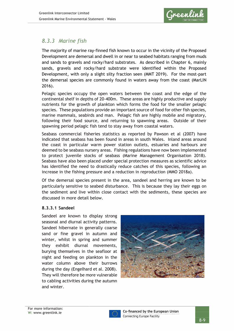
Greenlink Interconnector Limited
Greenlink Marine Environmental Statement - Wales
For more information: W: www.greenlink.ie
8-9
8.3.3 Marine fish
The majority of marine ray-finned fish known to occur in the vicinity of the Proposed Development are demersal and dwell in or near to seabed habitats ranging from muds and sands to gravels and rocky/hard substrates. As described in Chapter 6, mainly sands, gravels and rocky/hard substrate were identified within the Proposed Development, with only a slight silty fraction seen (MMT 2019). For the most-part the demersal species are commonly found in waters away from the coast (MarLIN 2016).
Pelagic species occupy the open waters between the coast and the edge of the continental shelf in depths of 20-400m. These areas are highly productive and supply nutrients for the growth of plankton which forms the food for the smaller pelagic species. These populations provide an important source of food for other fish species, marine mammals, seabirds and man. Pelagic fish are highly mobile and migratory, following their food source, and returning to spawning areas. Outside of their spawning period pelagic fish tend to stay away from coastal waters.
Seabass commercial fisheries statistics as reported by Pawson et al (2007) have indicated that seabass has been found in areas in south Wales. Inland areas around the coast in particular warm power station outlets, estuaries and harbours are deemed to be seabass nursery areas. Fishing regulations have now been implemented to protect juvenile stocks of seabass (Marine Management Organisation 2018). Seabass have also been placed under special protection measures as scientific advice has identified the need to drastically reduce catches of this species, following an increase in the fishing pressure and a reduction in reproduction (MMO 2018a).
Of the demersal species present in the area, sandeel and herring are known to be particularly sensitive to seabed disturbance. This is because they lay their eggs on the sediment and live within close contact with the sediments, these species are discussed in more detail below.
8.3.3.1 Sandeel
Sandeel are known to display strong seasonal and diurnal activity patterns. Sandeel hibernate in generally coarse sand or fine gravel in autumn and winter, whilst in spring and summer they exhibit diurnal movements, burying themselves in the seafloor at night and feeding on plankton in the water column above their burrows during the day (Engelhard et al. 2008). They will therefore be more vulnerable to cabling activities during the autumn and winter.

Greenlink Interconnector Limited
Greenlink Marine Environmental Statement - Wales
For more information: W: www.greenlink.ie
8-10
As a key prey species, reductions in sandeel populations can result in low breeding success in seabird colonies and reduction in predatory fish stocks, therefore sandeel are important both commercially and ecologically.
Although sandeel have only been identified as spawning along the Proposed Development, sandeel generally spawn where they are found and their larvae are pelagic. Sandeel larvae remain pelagic for between 2-5 months after which they are thought to over-winter/hibernate in sand (DECC 2016).
Juvenile and adult sandeels are largely resident and rarely disperse over distances greater than 30km (RSPB 2017). Studies have found that sandeel do not migrate between fishing grounds, which may suggest that sandeel are not successful re-colonisers (Jensen et al. 2011). This limited movement of sandeel between areas is believed to be associated with the patchy distribution of suitable sandeel habitat (RSPB 2017).
A study by Holland et al. (2005) showed that areas which contained a high proportion of medium and coarse sand (particle size 0.25 to 2.0mm) were preferred seabed habitats for sandeel. However, it was found that the fraction of silt was just as critical as the level of coarse and medium sand. A high percentage of the habitat was occupied by sandeel where the silt content was below 2%. Above 4% silt the occupancy and density of sandeel was extremely low. Therefore, an ideal habitat would be a combination of low silt concentrations (<4%) and high fractions of medium and coarse sand (Holland et al. 2005). Sandeel may become more widely distributed and occupy a greater range of sediment patches in years of high abundance, when competition for prime habitat is high.
A sandeel habitat assessment has been completed for the Proposed Development (Technical Appendix E). It concluded that the Proposed Development interacts with 12.78 km2 of potential sandeel habitat within Welsh waters. The area in which this habitat is present falls to the west, close to the UK / Republic of Ireland median line and correlates with the British Geological Survey (BGS) data layers showing the presence of sand and slightly gravelly sand as well as the Coull et al. (1998) data layer, and Vessel Monitoring System (VMS) data.
8.3.3.2 Herring
Herring have a specific habitat preference which limits the spatial extent of their spawning grounds. Eggs adhere to the seabed and can form extensive egg beds, meaning they are particularly sensitive to seabed disturbance. The suitability of the seabed substrate as a spawning habitat for herring, is a function of:
• Particle size - spawning typically occurs on coarse gravel (0.5-5cm) to stone (8-15cm) substrates (ICES 2012);

Greenlink Interconnector Limited
Greenlink Marine Environmental Statement - Wales
For more information: W: www.greenlink.ie
8-11
• Seabed features – preference for crest of ridges and ripples rather than hollows (ICES 2012);
• High oxygenation of sediments e.g. well mixed-waters (Behrens 2007);
• Current speed – prefer reasonably strong tidal currents (1.5 to 3 knots) (Reid et al. 1999); and
• Water depth – prefer relatively shallow water (approximately 15-40m deep) (Reid et al. 1999).
Herring numbers fluctuate annually and herring often abandon and then return to suitable areas, therefore all suitable areas of herring spawning habitat are important to maintain a resilient herring population.
Marine Space et al. (2013) categorise seabed sediments into four herring sediment preferences groups depending on their mud and gravel content. A herring spawning assessment has been completed for the Proposed Development (Technical Appendix E). It concluded that the Proposed Development interacts with 7.75km2 of ‘potential’ herring spawning habitat within Welsh waters. This area falls just offshore of Freshwater West and it corresponds with the Coull et al. (1998) data layer showing the presence of Atlantic herring spawning areas. However, when comparing the BGS data layer in this area with the project-specific particle size analysis (PSA) data many of the samples gathered in this area are shown to differ from the BGS data layer. There are a number of PSA data samples that are identified as Sand, this may therefore suggest that this area is less suitable for Atlantic herring spawning than is suggested by the ‘original’ assessment (see Technical Appendix E for further detail).
8.3.4 Diadromous fish
It is possible that diadromous species may be found near the Proposed Development at certain times of the year. Diadromous species are those which migrate between marine and freshwater as part of their lifecycle and include species such as lamprey, salmonids and European eel; the Celtic Sea is an important migration route for these species. Diadromous fish either spawn in fresh water and feed at sea (anadromous) or spawn at sea and feed in fresh water (catadromous). Table 8-3 summarises the potential presence along the Proposed Development.
The anadromous sea lamprey (Petromyzon marinus) and river lamprey (Lampetra fluviatilis) are listed on Annex II of the EC Habitats Directive and are a qualifying feature for the Pembrokeshire Marine / Sir Benfro Forol SAC, which the Proposed Development crosses. Both species are widespread in the UK. During the marine phase of their life cycle, river lamprey predominantly inhabit estuarine and inshore areas. Sea lamprey are much larger and more oceanic and have been recorded 400km or more from the nearest land and at depths of up to 1000m (NRW 2016).
Adult river lamprey migrate from the sea through the SAC entering rivers between October and December to spawn. Juvenile river lamprey generally migrate downstream into estuaries and inshore waters in spring, though autumn migrations have also been recorded.

Greenlink Interconnector Limited
Greenlink Marine Environmental Statement - Wales
For more information: W: www.greenlink.ie
8-12
Adult sea lamprey migrate through the SAC between March and June to spawn. Juvenile sea lamprey migrate downstream between December and June and spend some time feeding in the estuary and inshore waters before moving off shore in search of larger prey. Accordingly, various biological stages of both sea and river lamprey should be assumed to be present within the Proposed Development all year round.
Twaite shad (Alosa fallax) and Allis shad (Alosa alosa) are both members of the herring family. They are listed as Annex II species on the EC Habitats Directive and are qualifying features of the Pembrokeshire Marine / Sir Benfro Forol SAC. In addition, they are also listed as UK BAP priority fish species. Shad spend most of their adult lives in the sea but spawn in rivers (or, occasionally, in the upper reaches of estuaries) in early summer. Shad migrate through estuaries between March and May on their way to the spawning grounds, some of which repeat spawn between June and July. Juveniles generally migrate to estuaries and inshore waters between August and October, where they spend some time feeding. Older fish are typically found in shoals in deeper water and are capable of migrating in excess of 1000km. It is therefore possible that shad maybe observed feeding within the Proposed Development.
The Atlantic salmon (Salmo salar) and sea trout (Salmo trutta) may also be found within the Proposed Development (DECC 2016). Atlantic salmon is listed on Annex II on the EC Habitats Directive. Salmon and sea trout spawn within freshwater but complete their lifecycle in the sea. Other diadromous species that may be present are European eel (Anguilla anguilla), which are also listed on Annex II of the EC Habitats Directive and are a UK BAP species.
Table 8-3 Diadromous ray-finned fish with potential to be present along the Proposed Development
Species Scientific name Type of migration Migration through inshore waters
River Lamprey Lampetra fluviatilis Anadromous Oct - Dec
Sea Lamprey Petromyzon marinus Anadromous Mar - Jun
Twaite Shad Alosa fallax Anadromous Mar - Jul
Allis Shad Alosa alosa Anadromous Mar - Oct
Salmon Salmo salar Anadromous Autumn - winter
Sea Trout Salmo trutta Anadromous Apr - Oct
European eel Anguilla anguilla Catadromous Uncertain
Source: DECC (2016) NRW (2016)

Greenlink Interconnector Limited
Greenlink Marine Environmental Statement - Wales
For more information: W: www.greenlink.ie
8-13
8.3.5 Elasmobranchs (sharks, rays and skates)
Elasmobranchs (sharks, skates and rays) are among the most vulnerable marine fish due to their slow growth rates, late maturity, low fecundity and productivity which limits their capacity to recover from population declines. All sharks and rays are on the OSPAR Commission1 list of threatened and declining species.
8.3.5.1 Rays and Skates
A number of ray species are present in the region; thornback ray, cuckoo ray (Leucoraja naevus), small eyed ray (Raja microocellata) and spotted ray (Raja montagui) (DECC 2016). These species lay their egg cases on the seabed. The thornback ray has both nursing and spawning grounds in the area and is therefore is vulnerable to cable activities (Ellis et al. 2012). Spurdogs, starry smooth-hounds and lesser and greater spotted dogfish may also be found (DECC 2016).
The basking shark (Cetorhinus maximus) is the largest fish in the North Atlantic and the second largest in the world. The shark is commonly seen at the surface in the summer months, particularly around the western coasts of the UK, but it is less clear where they spend the winter. The lesser and greater spotted dogfish (Scyliorhinus canicula and Scyliorhinus stellaris) are also very abundant around western UK waters. Oceanic sharks such as blue sharks (Prionace glauca), thresher shark (Alopias vulpinus) and mako sharks (Isurus oxyrinchus) may also make seasonal visits to the region (DECC 2016).
8.3.6 Shellfish
Brown crab (Cancer pagurus), green crab (Carcinus maenas), velvet crab (Necora puber), spider crab (Maja squinado) and lobster (Homarus gammarus) are all abundant in the region (DECC 2016). Shellfish typically live on or in the seabed. Catch statistics for Wales indicate that five known species of shellfish were landed into Wales between 2013-2017, crab, lobster, nephrops, scallops and whelks (MMO 2018b). The MMO has indicated that in the offshore Welsh territorial waters, the Proposed Development will pass through areas of edible brown crab, lobster and whelk (Buccinum undatum) habitat, further detail on these species is provided in Section 8.3.6.1, 8.3.6.2 and 8.3.6.3.
Offshore Nephrops grounds exist in the Celtic Sea, to the south of Ireland (DECC 2016). Scallops and queen scallops are abundant on sandy sediments along the coasts of south Wales (DECC 2016).
8.3.6.1 Brown crab
The brown (edible) crab is a target commercial species. They reach a maximum size of approximately 27cm and can live up to 15 years. The females move inshore in late spring to moult and shortly afterwards mating occurs. The females store the sperm,
1 The Convention for the Protection of the Marine Environment of the north-East Atlantic or OSPAR Convention.

Greenlink Interconnector Limited
Greenlink Marine Environmental Statement - Wales
For more information: W: www.greenlink.ie
8-14
then in late summer move offshore again and use the stored sperm to fertilise their eggs in the winter. The females carry their eggs under their abdomen; this is commonly known as being ‘berried’. The larvae are pelagic and drift with water movements until they settle to the seabed as miniature adults (about 2.5mm in size) in summer or autumn depending on latitude and water temperature. Juvenile crabs are more commonly found in shallow inshore waters (MarLIN 2018).
The brown crab is most abundant on rocky grounds, where it hides in holes and crevices. The crab is generally found in shallow water close to shorelines, although it can be found in water as deep as 100m. Brown crab are abundant, particularly on the rocky shores of north Wales and the Lleyn Peninsula (DECC 2016). The status of the stock of female Edible Crab in the Celtic Sea is approaching the level associated with maximum sustainable yield (Cefas 2017).
8.3.6.2 Lobster
Lobster are a nocturnal, solitary creature that hides in holes during the day. They are found on rocky seabeds living in holes and excavated tunnels from the lower shore to approximately 60m in depth. During summer they live in shallow waters but retreat to deeper waters in the winter months. Lobster feed on a variety of ground dwelling invertebrates like crabs, molluscs, sea urchins, polychaete worms and starfish, but occasionally also fish, plants and carrion. Spawning usually occurs in the summer, the eggs are fertilized as they are extruded through the small ducts and are carried underneath the abdomen for 9-12 months.
8.3.6.3 Whelks
The common whelk (Buccinum undatum) is a large carnivorous whelk that grows up to 10cm high and 6cm wide. The species is found occasionally in the intertidal area, but more usually sub-tidally down to approximately 1200m deep (Marlin 2018). Whelk prefer muddy sand, gravel and rock habitats where they feed on polychaete worms and other molluscs, such as bivalves. It also scavenges for carrion, which it detects by ‘smell’ using a 'siphon', which is used to funnel water to the gills, and sensory organs. Breeding takes place from October to May, and they spawn in November. Their eggs attach to rocks, shells and stones in protective capsules grouped together in large masses of over 2000 eggs (DECC 2016). The species is widely distributed around the North Atlantic up to Iceland and is common around the UK and northwest European coasts.
8.3.7 Species of conservation importance
8.3.7.1 Environment (Wales) Act 2016 – Section 7 Priority species
The following species, which have the potential to be within the Proposed Development are listed on the interim Priority Species lists issued by the Welsh Government (Welsh Government 2016):

Greenlink Interconnector Limited
Greenlink Marine Environmental Statement - Wales
For more information: W: www.greenlink.ie
8-15
Table 8-4 Environment (Wales) Act 2016 - Section 7 Priority species present within the Proposed Development
Species Common name How considered in assessment
Ammodytes marinus Sandeel Focus species due to sensitivity to seabed disturbance, see Section 8.3.3.1
Clupea harengus Herring Focus species due to sensitivity to seabed disturbance, see Section 8.3.3.2
Gadus morhua Cod Considered under heading marine fish, see Section 8.3.3
Lophius piscatorius Angler
Merlangius merlangus Whiting
Merluccius merluccius European hake
Molva molva Ling
Scomber scombrus Mackerel
Trachurus trachurus Horse mackerel
Solea solea Sole
Pleuronectes platessa Plaice
Galeorhinus galeus Tope shark Considered under heading elasmobranchs, see Section 8.3.5
Prionace glauca Blue shark
Cetorhinus maximus Basking shark
Raja clavata Thornback ray
Petromyzon marinus Sea lamprey Considered under heading diadromous fish, see Section 8.3.4
Lampetra fluviatilis River lamprey
Alosa fallax Twaite shad
Alosa alosa Allis shad
Salmo salar Atlantic salmon
Salmo trutta Sea trout
Anguilla anguilla European eel
8.3.7.2 Annex II and IV Species
Sea lamprey, river lamprey, and Allis shad are Annex II species of the Habitats Directive (92/43/EEC) as a species of community interest whose conservation requires the designation of special areas of conservation. These species are a

Greenlink Interconnector Limited
Greenlink Marine Environmental Statement - Wales
For more information: W: www.greenlink.ie
8-16
qualifying feature of the Pembrokeshire Marine SAC, but not a primary reason for site selection. There is potential that these species will be located within the Proposed Development, as discussed in Section 8.3.4.
Salmon is an Annex II species and although not a designating feature of the Pembrokeshire Marine SAC, it may also be present within the Proposed Development, as discussed in Section 8.3.4.
8.3.8 Natural evolution of the baseline
The natural evolution of the baseline has been compiled using information from the Offshore Energy Strategic Environmental Assessment 3 (OESEA 3) (DECC 2016). The OESEA reports that there have been substantial changes in the fish communities in the north-east Atlantic over several decades. Fish species will undergo natural variation in population size, largely as a result of year to year variation in recruitment success. These population trends will be influenced by human exploitation (i.e. over fishing) and broad-scale climatic and hydrological variations.
As well as coming under severe pressure from anthropogenic factors (i.e. fishing), fish communities are likely to be affected by future climate change through a rise in sea temperatures. Climate change may influence fish distribution and abundance by affecting growth rates, recruitment rates, behaviour, survival and responses to changes at other trophic levels, although the OESEA reports that exact responses are very difficult to predict.
Habitat requirements are likely to play a significant role in vulnerability to climate change, with species such as plaice and herring being vulnerable at different stages in their life-cycles (during nursing and spawning periods). For shellfish species, it is expected that a change in sea temperatures will affect the settlement of bivalve species and could alter the distribution of migratory crustaceans i.e. lobster and crab.
A decline in sandeel populations around the UK has been adversely correlated with a rise in sea temperatures. In addition, increasing freshwater temperatures over the past four decades have implications for the survival rates of juvenile diadromous fish, although not necessarily negative ones. Salmon populations have been declining as a result of warmer sea temperatures, while twaite shad and sea lamprey demonstrate increased larval survival due to warmer temperatures.
Although rising sea temperatures can have adverse effects on certain individual fish species i.e. sandeel, assessments have also found that species richness in the seas around the UK has increased. The increase in species richness, along with an increase in small southerly species is possibly influenced by the release of predation pressure from large, exploited commercial fish, acting in combination with the changing climate.
Many fish are subject to pressure from commercial fisheries which target commercially valuable species and, potentially, non-target species. It is expected that fishing pressure will enhance the effects of climate change. This has already been observed off the south west coast of Britain, where commercially exploitable

Greenlink Interconnector Limited
Greenlink Marine Environmental Statement - Wales
For more information: W: www.greenlink.ie
8-17
warm water species (i.e. skates and rays) have been unable to respond to more favourable conditions due to increased fishing pressure.
From the above it is expected that fish species observed along the Proposed Development will respond differently to pressures from climate change and commercial fishing. Species like salmon and sandeel are likely to decline, whereas populations of sea lamprey and twaite shad are likely to increase. Corresponding to a rise in sea temperatures, southern warm water fish species are likely to increase their distribution northwards. However this increase is likely to be counteracted by an increase in fish exploitation.
8.4 Potential Pressure Identification and Zones of Influence
A scoping exercise undertaken to inform the content of the EIA has excluded the following pressures from further consideration in this topic Chapter. Explanation for the exclusion is provided in Chapter 5, Table 5-2.
• Death or injury by collision (all species but in particular basking shark);
• Visual disturbance;
• Siltation rate changes, including smothering (depth of vertical sediment overburden);
• Temperature change; and
• Hydrocarbon and PAH contamination.
The pressures listed in Table 8-5 will be assessed further. For each pressure the assessment considered the different aspects of the project during installation, operation (including repair & maintenance) and decommissioning. In order to evaluate the most significant effects, the largest zone of influence from these aspects was selected. The zones of influence are presented in Table 8-5.
Table 8-5 Pressure identification and zone of influence – fish and shellfish
Project Phase Project Activity
Aspect Potential Impact Receptor Zone of Influence
Installation Cable burial Pre-sweeping Penetration and/or disturbance of the substrate below the surface of the seabed, including abrasion
Species with demersal life stages
20m x 600m
Operation Offshore repair and maintenance operations
Cable trenching (ploughing and jet trenching)
15m
Decommissioning Cable removal
Operation Offshore repair and maintenance operations
External cable protection
Physical change (to another seabed type)
Discrete locations but combined = 16.2km x 10m wide
Cable burial Pre- & post-installation survey
Underwater noise changes
Clupeids: Herring
2.2km
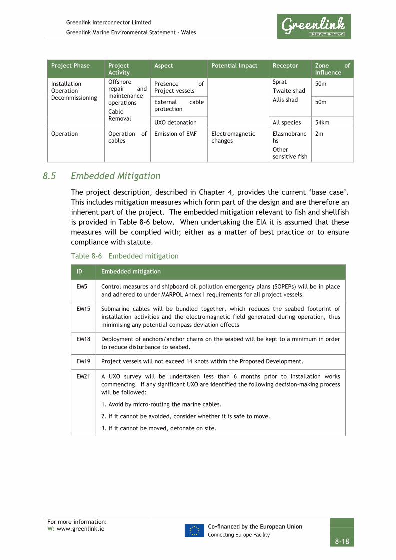
Greenlink Interconnector Limited
Greenlink Marine Environmental Statement - Wales
For more information: W: www.greenlink.ie
8-18
Project Phase Project Activity
Aspect Potential Impact Receptor Zone of Influence
Installation Operation Decommissioning
Offshore repair and maintenance operations Cable Removal
Presence of Project vessels
Sprat Twaite shad Allis shad
50m
External cable protection
50m
UXO detonation All species 54km
Operation Operation of cables
Emission of EMF Electromagnetic changes
Elasmobranchs Other sensitive fish
2m
8.5 Embedded Mitigation
The project description, described in Chapter 4, provides the current ‘base case’. This includes mitigation measures which form part of the design and are therefore an inherent part of the project. The embedded mitigation relevant to fish and shellfish is provided in Table 8-6 below. When undertaking the EIA it is assumed that these measures will be complied with; either as a matter of best practice or to ensure compliance with statute.
Table 8-6 Embedded mitigation
ID Embedded mitigation
EM5 Control measures and shipboard oil pollution emergency plans (SOPEPs) will be in place and adhered to under MARPOL Annex I requirements for all project vessels.
EM15 Submarine cables will be bundled together, which reduces the seabed footprint of installation activities and the electromagnetic field generated during operation, thus minimising any potential compass deviation effects
EM18 Deployment of anchors/anchor chains on the seabed will be kept to a minimum in order to reduce disturbance to seabed.
EM19 Project vessels will not exceed 14 knots within the Proposed Development.
EM21 A UXO survey will be undertaken less than 6 months prior to installation works commencing. If any significant UXO are identified the following decision-making process will be followed:
1. Avoid by micro-routing the marine cables.
2. If it cannot be avoided, consider whether it is safe to move.
3. If it cannot be moved, detonate on site.

Greenlink Interconnector Limited
Greenlink Marine Environmental Statement - Wales
For more information: W: www.greenlink.ie
8-19
8.6 Significance Assessment
8.6.1 Summary of Assessment
Table 8-7 presents the summary of the impact assessment conducted on the Proposed Development activities. Sections 8.6.1 to 8.6.5 provide the justification behind the conclusions. Project Specific Mitigation, if proposed, is described in Section 8.7. Where there is potential for residual effects this is discussed further in Section 8.8.

Greenlink Interconnector Limited
Greenlink Marine Environmental Statement - Wales
For more information: W: www.greenlink.ie
8-20
Table 8-7 Impact assessment summary – fish and shellfish
Determination of potential effect Impact assessment Consideration of mitigation
Residual effect assessment
Section Project Phase Aspect Embedded Mitigation (Table 8-6)
Potential Pressure
Receptor Magnitude Sensitivity Significance Project Specific Mitigation
Magnitude Sensitivity Significance of Residual Effect
8.6.2 Installation Operation (Repair & Maintenance) Decommissioning
Pre-sweeping Cable trenching (ploughing and jet trenching)
EM18 Penetration and/or disturbance of the substrate below the surface of the seabed, including abrasion
Demersal species – herring and sandeel
Low Medium Minor - Low Medium Minor
8.6.3 Installation Operation (Repair & Maintenance) Decommissioning
External cable protection
EM18 Physical change (to another seabed type)
Herring Low Medium Minor - Low Medium Minor
Sandeel and other demersal species
Low Low Negligible - - - -
8.6.4 Installation Operation (Repair & Maintenance) Decommissioning
Survey (SSS, MBES, SBP)
None Underwater noise changes
All species Low Low Negligible - - - -
Herring during spawning
Low Medium Minor - Low Medium Minor
Installation Operation (Repair & Maintenance) Decommissioning
Presence of Project vessels Cable protection
EM19 Underwater noise changes
All species Low Low Negligible - - - -
Herring during spawning
Low Medium Minor - Low Medium Minor
Installation Operation (Repair & Maintenance) Decommissioning
UXO detonation
EM21 Underwater noise changes
Hearing specialist fish species - herring
Low Medium Minor - Low Medium Minor
8.6.5 Operation Operation of cables
EM15 Electromagnetic changes
Elasmobranchs and Demersal species
Low Low Negligible - - - -

Greenlink Interconnector Limited
Greenlink Marine Environmental Statement - Wales
For more information: W: www.greenlink.ie
8-21
8.6.2 Penetration and/or disturbance of the substrate below the surface of the seabed, including abrasion
8.6.2.1 Installation
Activities that physically disturb the seabed e.g. pre-sweeping, pre lay grapnel run, plough trenching and jet trenching, have the potential to disturb species with demersal life stages (e.g. herring, cod), larval or juvenile ages, or fish and shellfish species that live in contact with the seabed (e.g. sandeel). Although disturbed, the composition of sediments are unlikely to significantly change and the habitat should be suitable for demersal spawning once activities have ceased.
The only change in seabed sediments would be if external cable protection is installed e.g. concrete mattresses / rock berms. This would result in a physical change (to another seabed type), which is assessed in Section 8.6.2 below. This is only proposed for a small section of seabed; a length of 16.34km, which will result in 0.16km2 of permanent seabed change – a negligible amount in the context of the habitat available within the wider area.
Cable installation activities are more likely to take place during spring and summer, due to potentially better weather during this time. Table 8-2 (Section 8.3.2) identifies that spawning species are present in the Proposed Development all year round. Of the species present, sandeel and herring are particularly sensitive to habitat disturbance. A full assessment of herring and sandeel habitat can be found in Technical Appendix E.
Sandeel The Proposed Development crosses a historical sandeel fishing area, and interacts with 12.78km2 of suitable sandeel habitat (identified through production of a ‘heat’ map, see Technical Appendix E). Installation of the cable will not result in changes to the sediment composition unless external cable protection is installed. Comparison of the indicative installation locations and the ‘heat’ maps (Technical Appendix E) indicates that majority of external cable protection is proposed for areas that fall outside potential sandeel habitat and only discrete location are proposed within; this is discussed further in Section 8.6.2.
The temporary and localised nature of the installation, the lack of change to sediment composition from the activities, the small scale zone of influence and the low number of sandeel removed and/or displaced within the Proposed Development, indicates that the magnitude of the effect is low. The sensitivity of sandeel has been assessed as be medium as installation will be outside their dormant phase. Sandeel are likely to recover from the temporary disturbance within the short-term and therefore the overall significance of the effect has been assessed as Minor and is Not Significant.
Herring The Proposed Development interacts with 7.75km2 of suitable herring spawning habitat (Technical Appendix E); although comparison of the BGS data layer with the

Greenlink Interconnector Limited
Greenlink Marine Environmental Statement - Wales
For more information: W: www.greenlink.ie
8-22
project-specific particle size analysis (PSA) data suggests that this area is less suitable for Atlantic herring spawning than is suggested. In addition, the Irish Sea is not known to be an area that supports high levels of herring spawning populations.
Installation of the cable will not result in changes to the sediment composition unless external cable protection is installed. Comparison of the indicative locations and the ‘heat’ maps (Technical Appendix E) indicates that external cable protection is proposed in two small areas within the potential herring spawning area; equivalent to 0.0034km2 of permanent sediment change. This is assessed in Section 8.6.2.
For the remainder of the Proposed Development, the temporary and localised nature of the installation, the lack of change to sediment composition from the activities, the small scale zone of influence, the wider availability of suitable habitat indicates that the magnitude of the effect is low. The sensitivity of herring has been assessed as medium. Herring are likely to recover from the temporary disturbance within the short-term and therefore the overall significance of the effect has been assessed as Minor and is Not Significant.
Other Fish and Shellfish Species The potential effect on other species with demersal life stages, including thornback ray and seabass, is expected to be the same as for sandeel and herring. The effects of the installation activities are short term and any disturbance is temporary, transient and localised. Specifically, regarding seabass is consideration of critical habitat used for nursery of juveniles. These habitats are associated with estuaries and harbours and unlikely to have any significant interaction with the Proposed Development. In addition, the area effected by the Proposed Development is minimal in terms of the extended spawning areas available for fish species within the region. Mobile fish and shellfish species (such as brown crab and lobster) will be able to relocate away from the installation activity to nearby alternative habitat and will return to the area once activity has ceased. Localised mortality may occur within species with limited mobility e.g. bivalve molluscs, but the pressure will be extremely localised and will not have an effect at a population level. This assessment takes into consideration embedded mitigation EM18. The effect of disturbance to species with a demersal life stage has been assessed as Minor and is Not Significant.
8.6.2.2 Operation (including maintenance and repair)
No seabed disturbance will occur from the operating cables. Effects during any unforeseen repair and maintenance works will be of a smaller magnitude when compared to cable installation. The assessment considered five discrete cable repairs during operation and concluded that the effects will be reduce to Negligible due to the restricted duration and spatial extent of works and is Not Significant.
8.6.2.3 Decommissioning
Two options will be considered at decommissioning; leaving the cables in-situ and removing them. If the cables are left in-situ there will be no effects on fish and shellfish during decommissioning. However, if the option to remove the cables (and
Greenlink Interconnector Limited
Greenlink Marine Environmental Statement - Wales
For more information: W: www.greenlink.ie
8-23
any associated protection) is selected, this process would essentially be the same as installation activities but in reverse. Therefore, any effects that could arise due to the decommissioning phase of the project will be of a comparable magnitude to those assessed above for cable installation and so the effect has been assessed as Minor and is Not Significant.
8.6.3 Physical change (to another seabed type)
8.6.3.1 Installation
External cable protection (concrete mattresses / rock berm) will be used at crossing locations and where burial depth cannot be achieved i.e. due to ground conditions. Where external cable protection is used the seabed habitat within the footprint of the berm will be lost and replaced with potentially harder substrate, changing the seabed type.
Within the Proposed Development one third-party asset crossing is required with an estimated seabed footprint of 0.001km2 (Section 4.7.4, Table 4-5). In addition, up to 0.16km2 of habitat may receive external cable protection due to hard ground conditions (Section 4, Table 4-7).
Sandeel The extent of suitable habitat in the sediments adjacent to the Proposed Development has been calculated using the methodology produced by MarineSpace (2013) (See Technical Appendix E), which suggests that similar habitat to that found within the Proposed Development is available outside the Proposed Development. Although there is a small amount of suitable sandeel habitat within the Proposed Development, there are extensive areas present within the broader Irish Sea region. External cable protection is not proposed for any areas that interact with potential suitable sandeel habitat. As habitat loss is small scale, only within discrete areas along the Proposed Development where there is generally a low potential for suitable sandeel habitats, the magnitude and the sensitivity of the effect have both been assessed as low. The overall significance of the effect has been assessed Negligible and is Not Significant.
Herring Comparison of the indicative external cable protection locations and the ‘heat’ maps (Technical Appendix E) indicates that protection is proposed in two small areas within the potential herring spawning area; equivalent to 0.0034km2 of permanent habitat loss. In the context of the potential herring spawning habitat available within the Irish Sea region this amounts to 0.0004% of the available area. Due to the small scale habitat loss and the wider availability of suitable habitat, the magnitude of the effect has been assessed as low. The sensitivity of herring has been assessed as medium. The overall significance of the effect has been assessed as Minor and is Not Significant.
Greenlink Interconnector Limited
Greenlink Marine Environmental Statement - Wales
For more information: W: www.greenlink.ie
8-24
Other Fish and Shellfish Species The potential effect of physical change to the seabed due to the installation of cable protection on fish species with demersal life stages, including thornback ray and seabass, is expected to be limited. The seabed footprint of cable protection is minimal in the context of the wider area available within the region for fish spawning. Figures 8-1 and 8-2 (Drawings P1975-FISH-001 and P1975-FISH-002) demonstrate the potential spawning and nursery areas available for fish species within the region; it is evident that such habitats are extensive and therefore, the loss of a small amount of suitable habitat is unlikely to affect species at a population level. Fish species are mobile and will have access to suitable spawning and nursery areas even when considering the small loss of habitat due to installation of cable protection.
Mobile fish and shellfish species (such as brown crab and lobster) will be able to relocate away from the installation activity to nearby alternative habitat, and will return to the area once activity has ceased. Localised mortality may occur within species with limited mobility e.g. bivalve molluscs, but the effect will be extremely localised and will not have an effect at a population level.
This assessment takes into consideration embedded mitigation EM15 and EM18 which seek to reduce the footprint of activities. The magnitude of the effect is considered to be low in the context of the available habitat within the region, and the sensitivity of fish species is considered low as a result of their mobility allowing them to move to alternative spawning and nursery grounds. The significance of the effect has been assessed as Negligible and is Not Significant.
8.6.3.2 Operation (including repair and maintenance)
Effects during any unforeseen repair and maintenance works are likely to be on a significantly smaller scale than those assessed above for installation. The assessment considered five discrete cable repairs during operation and concluded that the overall significance of the effect is Negligible and is Not Significant.
8.6.3.3 Decommissioning
Two options will be considered at decommissioning; leaving the cables in-situ and removing them. If the cables are left in-situ there will be no additional effects on fish and shellfish during decommissioning. However, if the option to remove the cables (and any associated protection) is selected, this process would essentially be the same as installation activities but in reverse. Therefore, any effects that could arise due to the decommissioning phase of the project will be of a comparable magnitude to those assessed above for cable installation and so the effect has been assessed as Negligible and is Not Significant.
Greenlink Interconnector Limited
Greenlink Marine Environmental Statement - Wales
For more information: W: www.greenlink.ie
8-25
8.6.4 Underwater noise changes
8.6.4.1 Installation, Operation (including maintenance and repair) and Decommissioning
The ability of fish to hear noise is dependent on their hearing structures, which indicate their sensitivity to sound. Sound pressure is only detected by those species possessing a swim bladder; the otolith organ acts as a particle motion detector and where linked to the swim bladder, converts sound pressure into particle motion, which is detected by the inner ear. High sensitivity hearing species such as clupeids (herring, sprat, twaite shad and allis shad) have specialisations of the auditory apparatus where the swim bladder and inner ear are intimately connected and are able to detect frequencies to over 3kHz; with optimum sensitivity between 300Hz-1kHz (Nedwell et al. 2007). Medium sensitivity species (including cod and European eel) have a swim bladder but no specialisation of the auditory apparatus. Low sensitivity species with no swim bladder include bass, cod and flat fish such as plaice (Nedwell et al. 2004). There is also potential for some fish and shellfish species to be vulnerable to acoustic survey activities during sensitive life stages, for example during the egg and larvae development stages.
Existing environmental conditions of background noise within the sea are considered when assessing anthropogenic activities that produce additional sound. Sources of background noise come from shipping, interaction of waves and currents with the sea bed, seabed development and operation, fishing industry and recreational activities (Bass and Clark 2003, Southall et al. 2007, OSPAR 2009, Hawkins and Popper 2012, Popper et al. 2014). Fish are likely to become habituated to levels of background noise. A decreased responsiveness over time could arise through a change in tolerance, through habituation (Radford et al. 2016, Nedelec et al. 2016). Therefore, effects are only expected if sound produced during the Proposed Development is significantly above the background noise levels.
Marine cable installation, operation and decommissioning will generate underwater sound from a number of sources:
• Cable laying and rock placement (including presence of vessels);
• Geophysical survey; and
• UXO detonation (if required).
To calculate the zone of influence for recoverable and temporary injury to fish an assessment has been conducted which combines literature review with underwater sound modelling. Sound propagation modelling, using a geometric spreading calculation, was used to determine the range at which the received sound attenuates to levels below defined thresholds for injury and disturbance. The assessment used thresholds for injury derived from Popper et al (2014). These reflect the current state of scientific knowledge.

Greenlink Interconnector Limited
Greenlink Marine Environmental Statement - Wales
For more information: W: www.greenlink.ie
8-26
The sound levels, injury thresholds, the calculations and the resulting zones of influence are described and provided in full in Technical Appendix D; and key information relevant to the assessment is summarised below.
Cable laying and rock placement Cable laying activities together with related activities including rock placement are continuous (non-pulse) activities expected to generate sounds up to 191dB re 1µPa @1m (0-peak). For non-pulse activities it is unlikely that death or tissue damage (barotrauma) will occur to fish. The typical behavioural response to sounds by fish might range from no change in behaviour, to a mild awareness (startle response) to larger movements of temporary displacement for the duration of the sound (Popper and Hastings 2009). Popper et al. (2014) identified that there is no direct evidence of permanent injury to fish species from shipping and other continuous noise (such as cable installation).
Clupeids are the only hearing specialist fish present within the Proposed Development. Nedwell et al. (2012) reviewed herring sensitivity to sources of noise from non-pulse cable laying operations (i.e. cable lay and trenching) and proposed effect ranges. Clupeids are expected to show strong avoidance behaviour (i.e. reaction by virtually all individuals) within 8m of the works, whilst significant avoidance (85% of individuals will react to noise) is expected within 66m.
Technical Appendix D concluded that for vessel noise, rock placement and cable trenching the zone of influence for fish recoverable injury is 17m, and the zone of influence for temporary injury is 110m. These results are slightly more conservative than the study by Nedwell et al (2012) but are generally consistent.
It has been estimated that on average 637 vessels pass the Proposed Development every month (Chapter 13). In addition, within the vicinity of the Proposed Development there are disposal sites, military practice areas, and marine energy test areas. Therefore, it is likely that existing background noise levels from shipping within the Celtic Sea will mask the disturbance effect to herring within the Proposed Development.
The presence of several vessels and continued noise with 24-hour operations means it is likely that the most hearing specialist fish will demonstrate temporary avoidance behaviour from early on in and remain outside the zone of influence (conservatively 110m radius) of operations for the duration of the installation activities. The works will not lead to any long term displacements as they are transient and temporary. Individuals would be expected to be able to return once the operation had passed through. However, it should be noted that the ability of small fish to take avoiding action may be limited, and temporary displacement may not therefore occur.
Temporary displacement of mobile species in the marine environment is not expected to result in significant adverse effects for the individuals concerned unless it interferes with a critical lifecycle activity such as spawning. Herring are considered to have low sensitivity to underwater sound changes except within the spawning period (September-March) when sensitivity is medium. An assessment of herring

Greenlink Interconnector Limited
Greenlink Marine Environmental Statement - Wales
For more information: W: www.greenlink.ie
8-27
spawning within the vicinity of the Proposed Development has shown that there is potential use, but no confirmed sites within the area for spawning (see Technical Appendix E). Therefore, the magnitude of effect upon herring spawning within the Proposed Development will be low.
In addition, twaite shad and allis shad spawn within rivers therefore there will be no interaction with spawning activity. However, juvenile shad are known to forage in the nearshore environment, so some interaction may be possible. Considering the extent of inshore habitat available the likely magnitude of effect on juvenile twaite and allis shad has been assessed as low.
Based on the above discussion, any disturbance effects from noise associated with operations will be localised, temporary and transient and therefore the magnitude of the effect is assessed as low. The sensitivity of receptors to underwater sound changes has been assessed as low for all species with the exception of herring during the spawning period when the sensitivity increases to medium. The overall significance of the effect has been assessed as:
• Negligible and Not Significant for all species with the exception of herring; and
• Minor and Not Significant for herring during spawning.
This assessment has taken into account embedded mitigation, EM19, which will ensure that vessel speeds are limited to reduce the amount of noise emitted into the water column.
Geophysical survey Geophysical survey activities are not considered in the discussion above; although like cable trenching and rock placement they are considered a continuous sound source. Geophysical survey techniques will be used during pre-installation surveys and post-installation inspection surveys (see Chapter 4). Most noise from a geophysical survey is likely to be generated at frequencies greater than 1kHz, above the auditory capacity of fish (generally between 0.2Hz to 1kHz). In addition, sound from survey equipment is targeted towards the seabed, meaning that effects to fish are only expected if they are within the immediate zone of ensonification below the survey vessel.
Technical Appendix D concluded that for geophysical survey the zone of influence for temporary injury is 2.2km. However, it should be noted that the spreading model assumes that sound is spread geometrically away from the source with an additional frequency-dependent absorption loss; it therefore provides conservative estimates. It does not take into consideration the conditions within the area, such as bathymetry, water depth or sediment type and thickness; all of which reduce the propagation of sound, and would reduce the zone of influence.
The potential zone of influence is transient as it moves slowly in a constant direction along the principal survey line orientation. It is expected that fish will avoid the area once operations have started and are extremely unlikely to move towards the sound source. Therefore, it is extremely unlikely that fish will experience a significant

Greenlink Interconnector Limited
Greenlink Marine Environmental Statement - Wales
For more information: W: www.greenlink.ie
8-28
effect other than temporary displacement from the immediate area surrounding the survey activity.
No conclusive records of a decline in catch rates have been noted following geophysical survey activities (Thompson et al. 2014), which suggests that fish return to areas after the temporary displacement.
For the same reasons as the assessment for cable trenching and rock placement, the sensitivity of receptors to underwater sound changes has been assessed as low for all species with the exception of herring during the spawning period when the sensitivity increases to medium. The magnitude of the effect has been assessed as low, due to the transient and temporary nature of the effect.
The overall significance of the effect has been assessed as:
• Negligible and Not Significant for all species with the exception of herring; and
• Minor and Not Significant for herring during spawning.
UXO detonation It is unknown how many, if any, UXO detonations will be required within the Proposed Development. The Proposed Development passes through the Castlemartin Firing Range, so it is highly likely that UXO will be encountered. The Greenlink UXO desk-based assessment (1st Line Defence 2018) also identified a high-risk area in the St Georges Channel; a former WWII sea mine ground.
A UXO survey has been completed for the section of the Proposed Development within the Castlemartin Firing Range which has identified a few magnetic anomalies but there is sufficient space within the application area for the cable to be micro-sited around any potential UXO (in accordance with the decision-making process outlined in EM21 i.e. first avoid, then remove, and if neither previous option is feasible, detonate). An additional UXO survey will be completed ahead of the installation campaign to ensure that any new UXO or UXO that has moved is identified.
Should UXO be found which require clearance by detonation it is assumed that there would be a relatively large release of impulsive sound energy, creating high amplitude shock waves (von Benda-Beckmann et al. 2015). Peak source levels would depend on the quantity and nature of explosive material.
Underwater explosion produces a pressure waveform with rapid oscillations from positive pressure to negative pressure which results in rapid volume changes in gas-containing organs. Damage to visceral organs is most often the cause of fish mortality following exposure to underwater explosions. The most commonly injured organs are those with air spaces that are affected by the explosion’s shock wave passing through the body of the fish, these include the body cavity, the pericardial sack and gut, however injuries of the swim bladder are most common. The swim bladders are subject to rapid contraction and overextension in response to explosive shock waveforms. Species which do not possess a swim bladder or have small swim bladders are likely to be more resistant to noise generated from explosions (Keevin and Hempen 1997).

Greenlink Interconnector Limited
Greenlink Marine Environmental Statement - Wales
For more information: W: www.greenlink.ie
8-29
The precise injury effect range cannot be stated in advance of information on the nature and quantity of explosive material potentially involved, which will not be known until a UXO is identified. To provide a worst-case, Technical Appendix D modelled the sound from a 794kg explosive (equivalent to a sea mine), which 1st Line Defence (2018) identified as the largest explosive device to have been used historically in the region. It should be noted that this size of magnetic anomaly has not been identified in the 2019 UXO data from Castlemartin Firing Range.
The modelling results concluded that mortality and potential mortal injury was possible within 6.2km of the detonation source. Results from the assessment are highly conservative, due to the high explosive weight used to estimate the sound levels. In addition, the geometric spreading modelling does not take into consideration variables such as water depth, source and receiver depths, temperature gradients, salinity, seabed ground conditions, bathymetry, water depth or sediment type and thickness, all of which affect received levels.
A wide number of fish species may be present in the vicinity of the Project Development, including species which are UK BAP priority species and species listed in Annexes of the EC Habitats Directive. Clupeids such as Atlantic herring, sprat and twaite shad, as well as salmon and European eels will be most sensitive to an explosion as they all have swim bladders. However, the explosion will be brief, with the shock waves attenuating rapidly in the water column, thus resulting in a restricted lethal zone (Continental Shelf Associates, Inc 2004). The magnitude of the effect has therefore been assessed as low. The sensitivity of the receptor has been assessed as medium as there is the potential that individuals will be killed, although the activity is unlikely to affect the viability of any species, populations or stocks. The overall significance of the effect of UXO detonation has been assessed as Minor and is Not Significant.
8.6.5 Electromagnetic changes
8.6.5.1 Operation
When operating, the cables will generate an electromagnetic field (EMF) consisting of a magnetic (B) field and an induced electric (iE) field (described further in Chapter 4). The effect will be present along the entire marine cable route.
The Greenlink cable system is comparable to the Nemo Link and BritNed interconnectors in terms of system, capacity and bundling. It has been calculated that the Greenlink cables will generate B fields of 21µT directly over the cables reducing to natural background levels within 2m. The iE fields are estimated to be between 48.79 and 69.7 μV/m at 1m from the cables. No detectable change above background geomagnetic fields will be noticeable at 2m from the cables.
Whilst it is acknowledged that a number of taxonomic groups potentially occurring in the vicinity of the Proposed Development are sensitive to electric and or magnetic fields there is limited understanding of the response to anthropogenic magnetic and iE fields and therefore any effects.

Greenlink Interconnector Limited
Greenlink Marine Environmental Statement - Wales
For more information: W: www.greenlink.ie
8-30
A range of potential effects of the generation of EMF during the operation of a subsea power cable have been identified. Thomsen et al (2015) (cited in NIRAS 2017) suggests that the most likely effects relate to attraction or avoidance of the iE field associated with cables. Adverse effects to individuals and potentially populations could result if there was a repulsion from an area or confusion between anthropogenic and bioelectric fields (NIRAS 2017). Other potential pressures from iE fields include confusion with bioelectric fields and physiological effects.
Potential effects on species which utilise magnetic fields for navigation and or orientation may occur if anthropogenic electromagnetic fields interfere with natural behaviour. Some studies (e.g. (Zimmerman et al. 1990; Cameron et al. 1993) cited in NIRAS 2017) have also identified the potential for artificial magnetic fields to have physiological effects on developing eggs, embryos or larvae (NIRAS 2017).
Induced electric (iE) fields The predominant groups of marine organisms that are electroreceptive are elasmobranchs (sharks, skates and rays) and holocephalans (chimaeras such as ratfish), which possess specialist electroreceptive organs called ampullae. They have an extremely acute sense, sensitive to 5 to 20 nV/m, which is used for detecting the bioelectric fields of prey, predators and conspecifics (organisms of the same species), orientating to ocean currents and sensing their magnetic compass headings (e.g. EC 2018, Boehlert and Gill 2010), as well as for navigation (NIRAS 2017). Agnathans (jawless fish e.g. sea and river lamprey) are also electrosensitive but do not possess specialised electroreceptors; they are able to detect induced voltage gradients associated with water movement through the geomagnetic field. Teleost fish such as European eel, cod, plaice and Atlantic salmon are also electrosensitive.
Three potential pressures resulting from iE fields are possible: repulsion; confusion with bioelectric fields; and physiological effects. These are considered in turn below:
Repulsion
Elasmobranchs are known to be repelled by strong electric fields, which has previously raised concerns that cables inducing such electric fields may act as barriers to movement across areas (e.g. between feeding, mating and nursery areas).
Exactly what magnitude of electric field induces an avoidance response in elasmobranchs is less certain. NIRAS (2017) reports that avoidance behaviour has only been documented in a few elasmobranchs; when small-spotted catsharks (Scyliorhinus canicula) were presented with DC electric fields of 1,000 μV/m (Gill & Taylor 2001), and when silky (Carcharhinus falciformis), white tip reef (Traenodon obesus) and zebra (Stegostoma fasciatum) sharks were presented with both DC and AC fields of 1,000μV/m (Yano et al. 2000). As these studies didn’t consider a range of field strengths an avoidance threshold cannot be deduced. However, other research demonstrated repeated, unequivocal attraction behaviour to DC fields of approximately 60 μV/m ([Kalmijn 1982; Kimber et al. 2011] cited in NIRAS 2017), and whilst the latter study recorded the majority of responses to DC fields of

Greenlink Interconnector Limited
Greenlink Marine Environmental Statement - Wales
For more information: W: www.greenlink.ie
8-31
approximately 400 to 600 μVm as attraction, some occurrences of avoidance were observed. NIRAS (2017) suggests based on the discussion above, that the threshold electric field between attraction and avoidance lies somewhere between approximately 400 and 1,000 μV/m.
Given the approach to cable installation (burial/covering) and the fact that cables will be bundled together (EM15) which reduces the generation of EMF, induced electric fields sufficient to exceed this threshold will not be present. The induced electric field at 1m from the cables has been estimated to between 48.79 and 69.7 μV/m at 1m; significantly below the threshold.
It is therefore concluded that it is very unlikely that there will be iE fields strong enough to result in an avoidance response from electroreceptive fish.
Confusion with bioelectric fields
Elasmobranchs are responsive to electric fields below those that elicit repulsive reactions, and use them for detecting prey, predators and mates and for navigation (Tricas & Sisneros 2004, cited in NIRAS 2017). The concern is that elasmobranchs will be confused by anthropogenic electric field sources and unable to distinguish them from natural fields of similar strength. Potentially, they may waste time and energy “hunting” electric fields such as those associated with subsea electrical cables whilst searching for bioelectric fields associated with their prey.
Pelagic species such as the basking shark are unlikely to be affected due to their habits leading them to be distant from the seabed and strongest iE fields. Benthic species, which are more likely to encounter the iE fields around the cables, include several commercially important species that have also suffered significant population declines, such as skates, rays and spurdogs. iE fields will represent a very minor change (comparable to the maximum natural background iE field), therefore the potential effects are insignificant.
Physiological effects
Physiological effects upon elasmobranchs are unlikely due to the relatively weak electric fields involved. Some research (Sisneros et al. 1998; Ball 2007 cited in NIRAS 2017) suggests embryonic thornback rays may have stopped body movement upon sensing artificial electrical fields because they were minimising detection as the electric fields were similar to those of predators. Whilst there is potential for HVDC iE fields to affect this behaviour, there is no evidence to confirm it. The potential for a significant proportion of a population e.g. a ray breeding ground to be affected by a linear cable is likely to be limited. iE fields will represent a very minor change (comparable to the maximum natural background iE field) to the natural electric field of the Earth, therefore the potential effects are insignificant. Therefore, it is unlikely that there would be significant physiological effects occurring due to exposure to iE fields.

Greenlink Interconnector Limited
Greenlink Marine Environmental Statement - Wales
For more information: W: www.greenlink.ie
8-32
Magnetic (B) fields Magnetically sensitive marine organisms may be split into two main groups; the first directly detect magnetic fields through the use of magnetic particles (magnetite) within their tissues whilst the second indirectly detect the presence of a magnetic field by detection of the iE field.
Physiological effects
Shellfish
There is little evidence to suggest any significant effects on physiological development from magnetic field detection. Whilst Zimmerman et al. (1990) (cited in NIRAS 2017) demonstrated B fields ranging between 1-100μT delayed embryonic development in sea urchins and Leya et al. (1999) (cited in NIRAS 2017) demonstrated high frequency AC EMF causing cell damage to barnacle larvae and interfering with their settlement, these studies contrast with Nielsen (1986) (cited in NIRAS 2017) who provides evidence of benthic invertebrates living directly upon DC electrodes with no apparent effects (Walker 2001; Swedpower 2003) (cited in NIRAS 2017). It appears that DC magnetic fields cause fewer biological effects upon these taxa than AC magnetic fields, although this assumption is made tentatively owing to a lack of supporting studies (NIRAS 2017).
Fish
There is limited evidence to suggest that there could be physiological effects on fish from the generated electromagnetic fields of the cables. Demersal fish are most likely to come into contact with the cables (NIRAS 2017). Shallow sandy areas, in particular, are important nursery areas for many demersal fish species (e.g. herring), but in such areas the cables will be buried to 0.6m to 1m which will prevent fish (including eggs and juveniles) from encountering the stronger fields, including those on the cable surfaces.
In areas where the cables cannot be buried, and they are protected by external cable protection it is possible fish could inhabit crevices in the rock and get close to the cables but external cable protection can also reduce detection of EMF and it is thought unlikely to result in physiological effects.
The only evidence for physiological effects relates to fish embryonic development, which Cameron et al. (1985) and Cameron et al. (1993) (cited in NIRAS 2017) demonstrated was delayed by AC magnetic fields. However, AC fields are not comparable to static DC fields and as such a similar effect from DC fields should not be implied (NIRAS 2017).
Conclusion The effect of EMF will be present along the entire Proposed Development for the lifetime of the operating cable, but due to the extremely localised nature of the pressure it will only result in a minor shift away from baseline conditions. Therefore, the magnitude of the effect is assessed as low. As discussed above, any effects upon fish and shellfish behaviour will be localised and brief, with normal movement and

Greenlink Interconnector Limited
Greenlink Marine Environmental Statement - Wales
For more information: W: www.greenlink.ie
8-33
migration expected to resume beyond the zone of influence (less than 5m of the cables). Any fish species that remain within the elevated EMF zone are expected to be tolerant to this level without adverse effects. Therefore, the sensitivity has been assessed as low. Overall the significance of the effect has been assessed as Negligible and is Not Significant.
8.7 Project Specific Mitigation
No additional project specific mitigation is required beyond those measures already detailed and considered within the assessment envelope i.e. embedded mitigation.
8.8 Residual Effect
The assessment presented in Section 8.6 identified that three potential pressures could have a minor effect. The significance of these effects was therefore re-assessed taking into consideration any Project Specific Mitigation proposed in Section 8.7.
8.8.1 Penetration and/or disturbance of the substrate below the surface of the seabed, including abrasion
The assessment identified that fish species with demersal life stages, specifically herring and sandeel, would be affected by the Proposed Development. Deployment of anchors/anchor chains on the seabed will be kept to a minimum in order to reduce disturbance to seabed as per embedded mitigation EM18. However, species with demersal life stages, including herring and sandeel, will still be affected by disturbance and the residual effect remains Minor and is Not Significant.
8.8.2 Physical change (to another seabed type)
The assessment identified that herring would be affected by a change in seabed type as a result of the deposition of external cable protection e.g. concrete mattresses / rock berm. Comparison of the indicative external cable protection locations and the ‘heat’ maps (Technical Appendix E) indicates that protection is proposed in two small areas within the potential herring spawning area; equivalent to 0.0034km2 of permanent habitat loss. In the context of the potential herring spawning habitat available within the Irish Sea region this amounts to 0.0004% of the available area. No further Project Specific Mitigation can be proposed that would reduce this footprint and therefore the significance of the residual effect remains Minor and is Not Significant.
8.8.3 Underwater noise changes
The assessment identified that there is potential for herring to be affected by the Proposed Development due to underwater noise during the construction phase. The residual effect is considered to be Minor and is Not Significant.

Greenlink Interconnector Limited
Greenlink Marine Environmental Statement - Wales
For more information: W: www.greenlink.ie
8-34
The assessment identified that if UXO detonation is required, there could be Minor significant effects on fish within the immediate vicinity, including physical injury or death. UXO detonation will only be used once all other options are exhausted, as per embedded mitigation measure EM21. However, mitigation will not reduce fish sensitivity further and the residual effect remains Minor and is Not Significant.

Greenlink Interconnector Limited
Greenlink Marine Environmental Statement - Wales
For more information: W: www.greenlink.ie
8-35
1 Bass, A.H. and Clark, C.W. (2003). The physical acoustics of underwater sound communication. In Simmons AM, Fay RR, Popper AN (eds) Acoustic Communication. New York: Springer-Verlag, pp 15-64
2 Behrens, J.W. and Steffensen, J.F. (2007). The effect of hypoxia on behavioural and physiological aspects of lesser sandeel, Ammodytes tobianus (Linnaeus, 1785). Marine Biology, 150: 1365–1377.
3 Bendall, V., Ellis, J.R., Hetherington, S.J., McCully, S., Righton, D. and Silva, J.F. (2013). Preliminary observations on the biology and movements of porbeagle Lamna nasus around the British Isles. Collective Volume of Scientific Papers ICCAT 69: 1702-1722.
4 Bochert, R. and Zettler M.L. (2004). Long-term Exposure of Several Marine Benthic Animals to Static Magnetic Fields. Bioelectromagnetics 25: 498-502.
5 Boehlert, G.W., and Gill, A.B. (2010). Environmental and ecological effects of ocean renewable energy development: A current synthesis. Oceanography 23(2):68–81. [Online] Available at: https://tos.org/oceanography/article/environmental-and-ecological-effects-of-ocean-renewable-energy-development (Accessed January 2019)
6 BOEMRE (2011). Effects of EMF from undersea power cables on elasmobranchs and other marine species. Final Report.
7 Cefas. (2005). Provision of fishing activity data for the DTI Strategic Environmental Assessment 6.
8 Cefas. (2017). Edible crab (Cancer pagurus). [online] Available at: https://assets.publishing.service.gov.uk/government/uploads/system/uploads/attachment_data/file/722904/Cefas_Crab_Stock_Assessment_2017.pdf [Accessed November 2018].
9 Coull, K.A., Johnstone, R., and Rogers, S.I. (1998). Fisheries Sensitivity Maps in British Waters. Edition 1.
10 DECC (2009). Offshore Energy Strategic Environmental Assessment. SEA8. Department of Energy and Climate Change. January 2009.
11 DECC (2010). Severn tidal power SEA topic paper: migratory and estuarine fish, 280pp
12 Department of Energy and Climate Change (DECC) (2016). Offshore Energy Strategic Environmental Assessment. Department of Energy and Climate Change. March 2016. [online] Available at: https://www.gov.uk/government/consultations/uk-offshore-energy-strategic-environmental-assessment-3-oesea3 (Accessed April 2019)
13 DTI. (2009). Fish and Shellfish Environmental Baseline. Appendix A.3a.4.1.
14 Ellis, J., Milligan, S. Readdy, L., Taylor, N and Brown, M. (2012). Spawning and Nursery Grounds of Selected Fish Species in UK Waters. Science Series Technical Report No. 147. Cefas, Lowestoft.
15 Engelhard, G.H., van der Kooij, J., Bell, E.D., Pinnegar, J.K., Blanchard, J.L., Mackinson, S. and Righton, D.A. (2008). Fishing mortality versus natural predation on
REFERENCES
Greenlink Interconnector Limited
Greenlink Marine Environmental Statement - Wales
For more information: W: www.greenlink.ie
8-36
diurnally migrating sandeels Ammodytes marinus. Marine Ecology Progress Series, 369, pp.213-227.
16 European Commission (EC) (2018). Guidance on energy transmission infrastructure and EU nature legislation. [online] Available at: http://ec.europa.eu/environment/nature/natura2000/management/docs/Energy%20guidance%20and%20EU%20Nature%20legislation.pdf (Accessed January 2019)
17 Gill, A.B. and Bartlett, M. (2010). Literature review on the potential effects of electromagnetic fields and subsea noise from marine renewable energy developments on Atlantic salmon, sea trout and European eel.
18 Gill, A.B., Gloyne-Phillips, I. T., Neal, K.J. and Kinber, J.A. (2005). The potential effects of electromagnetic fields generated by sub-sea power cables associated with offshore wind farm developments on electrically and magnetically sensitive marine organisms – a review. Report to COWRIE, London, 90pp.
19 Hawkins, A.D. and Popper, A.N. (2012) Effects of Noise on Fish, Fisheries, and Invertebrates in the U.S. Atlantic and Arctic from Energy Industry Sound-Generating Activities. Draft Literature Synthesis. U.S. Department of the Interior Bureau of Ocean Energy Management.
20 Holland, G.J., Greenstreet, S.P.R., Gibb, I.M., Fraser, H.M. and Robertson, M.R. (2005). Identifying Sandeel Ammodytes marinus sediment habitat preferences in the marine environment. Marine Ecology Progress Series Vol. 303: 269-282. [online] Available at: https://www.int-res.com/articles/meps2005/303/m303p269.pdf (Accessed April 2019)
21 ICES. (2012). 6.4.9 Advice May 2013, ECOREGION North Sea, STOCK Herring in Subarea IV and Divisions IIIa and VIId (North Sea autumn spawners), Advice for 2013. [online] Available at: http://www.ices.dk/sites/pub/Publication%20Reports/Advice/2013/2013/her-47d3.pdf (Accessed April 2019)
22 ICES. (2013). North Sea Rays and skates in Divisions and Subarea IIIa, IV, and VIId, e (Kattegat, Skagerrak, North Sea, and English Channel). Section 6.4.25. ICES Advice, 2013.
23 Jensen, H., Rindorf, A., Wright, P.J. and Mosegaard, H. (2011). Inferring the location and scale of mixing between habitat areas of lesser sandeel through information from the fishery. ICES Journal of Marine Science: Journal du Conseil, 68 (1), pp. 43-51.
24 Keevin, T.M. and Hempen G.L. (1997). The environmental effects of underwater explosions with methods to mitigate impacts.
25 Maitland, P.S. and Hatton-Ellis, T.W. (2003). Ecology of the Allis and Twaite Shad: Conserving Natura 2000 Rivers Ecology Series No. 3. English Nature, Peterborough, 28pp.
26 MarineSpace Ltd, ABPmer Ltd, ERM Ltd, Fugro EMU Ltd and Marine Ecological Surveys Ltd. (2013). Environmental Effect Pathways between Marine Aggregate Application Areas and Atlantic Herring Potential Spawning Habitat: Regional Cumulative Impact Assessments. Version 1.0. A report for the British Marine Aggregates Producers Association.
27 MMO. (2018a). Guidance on 2018 bass fishing published. [online] Available at: https://www.gov.uk/government/news/guidance-on-2018-bass-fishing-published (Accessed November 2018)
28 MMO. (2018b). UK sea fisheries annual statistics report 2017. [Online] Available at:

Greenlink Interconnector Limited
Greenlink Marine Environmental Statement - Wales
For more information: W: www.greenlink.ie
8-37
https://www.gov.uk/government/statistics/uk-sea-fisheries-annual-statistics-report-2017 (Accessed November 2018).
29 MMT (2019) Greenlink Environmental Survey Report. Revision 02. March 2019
30 Nedelec S.L., Mills S.C., Lecchini D., Nedelec B., Simpson S.D., Radford A.N. (2016), Repeated Exposure to noise increases tolerance in a coral reef fish. Environmental Pollution Volume 216. [online] Available at: http://www.sciencedirect.com/science/article/pii/S0269749116304468 (Accessed April 2019)
31 Nedwell, J.R., Edwards, B., Turnpenny, A.W.H., and Gordon, J. (2004). Fish and Marine Mammal Audiograms: A summary of available information.
32 Nedwell, J.R., Parvin, S.J., Edwards, B., Workman, R., Brooker, A.G. and Kynoch, J.E. (2007). Measurement and interpretation of underwater noise during construction and operation of offshore wind farms in UK water.
33 Nedwell, J., Mason, T., Barham, R and Cheesman, S (2012). Assessing the environmental impact of underwater noise during offshore windfarm construction and operation. Proceedings of Acoustics 2012 – Fremantle. 21-23 November 2012, Fremantle, Australia [online] Available at: https://www.acoustics.asn.au/conference_proceedings/AAS2012/papers/p116.pdf (Accessed April 2019)
34 Neo, Y.Y., Parie L, Bakker F., Snelderwaard P., Tudorache C, Schaaf M., Slabbekoorn H. (2015). Behavioral changes in response to sound exposure and no spatial avoidance of noisy conditions in captive zebrafish. Front Behav Neurosci. 2015; 9: 28. [Online] Available at:
https://www.ncbi.nlm.nih.gov/pmc/articles/PMC4330796/citedby/
35 NIRAS (2017). Electromagnetic Fields – Marine Ecological report. Viking Link. January 2017
36 NRW. (2016). Pembrokeshire Marine Special Area of Conservation [Online] Available at: http://www.pembrokeshiremarinesac.org.uk/ (Accessed August 2018)
37 OSPAR (2009), Assessment of the environmental impacts of cables. OSPAR Commission. 19 pp.
38 OSPAR Convention (2012). Guidelines on Best Environmental Practice (BEP) in Cable Laying and Operation. Agreement 2012-2. Source: OSPAR 12/22/1, Annex 14. [online] Available at: https://www.gc.noaa.gov/documents/2017/12-02e_agreement_cables_guidelines.pdf (Accessed March 2019)
39 Pawson, M.G., Pickett., D.G., Leballeur. B.M and M Fritsch. (2007). Migrations, fishery interactions, and management units of sea bass (Dicentrarchus labrax) in Northwest Europe. ICES Journal of Marine Science, 64: 332–345.
40 Popper, A. N., Hawkins, A. D., Fay, R. R., Mann, D. A., Bartol, S., Carlson, T. J., Coombs, S., Ellison, W. T., Gentry, R. L., Halvorsen, M. B., Løkkebog, S., Rogers, P. H., Southall, B. L., Zeddies, D. G., and Tavolga, W. N. (2014). Sound Exposure Guidelines for Fishes and Sea Turles: A Technical Report prepared by ANSI-Accredited Standards Committee S3/SC1 and registered with ANSI.
41 Popper, E.N. and Hastings, M.C. (2009). The effects of human-generated sound on fish. Integrative Zoology. Volume 4. Pg 43-52.

Greenlink Interconnector Limited
Greenlink Marine Environmental Statement - Wales
For more information: W: www.greenlink.ie
8-38
42 Radford, A., Lebre, L., Lecaillon, G., Nedelec, S. and Simpson, S. (2016). Repeated exposure reduced the response to impulsive noise in European seabass. Global Change Biology, 22: 3349-3360.
43 Reid, R.N., Cargnelli, L.M., Griesbach, S.J., Packer, D.B., Johnson, D.L., Zetlin, C.A., Morse, W.W. and Berrien, P.L. (1999). Atlantic Herring, lupea harengus, Life History and Habitat Characteristics. Essential Fish Habitat Source Document. National Oceanic and Atmospheric Administration (NOAA) Technical Memorandum NMFS-NE-126.48 p.
44 RSPB. (2017). A literature review of the lesser Raitt’s) sandeel Ammodytes marinus in European waters. [Online] Available at: https://ww2.rspb.org.uk/Images/Green%2C%20E.%202017.%20A%20literature%20review%20of%20the%20lesser%20(Raitt%E2%80%99s)%20sandeel%20Ammodytes%20marinus%20in%20European%20waters.%20Roseate%20Tern%20LIFE%20Recovery%20Project.%20RSPB._tcm9-454700.pdf/ (Accessed November 2018)
45 Southall, B.L., Bowles, A.E., Ellison, W.T., Finneran, J.J., Gentry, R.L., Greene Jr., C.R., Kastak, D., Ketten, D.R., Miller, J.H., Nachtigall, P.E., Richardson, W.J., Thomas, J.A., and Tyack, P.L. (2007). Marine mammal noise exposure criteria: Initial scientific recommendations. Aquatic Mammals 33, 411-521.
46 The Marine Life Information Network (MARLIN) Website. (2018). Species, habitat and sensitivity information. [Online] Available at: https://www.marlin.ac.uk (Accessed August 2018)
47 Thompson R., Sporcic M., Foster S., Haddon M., Potter A., Carroll A., Przeslawski R., Knuckey I., Koopman M., Hartog J. (2014). Examining Fisheries Catches and
Catch Rates for Potential Effects of Bass Straight Seismic Surveys
48 Welsh Government (2016). Environment (Wales) Act 2016, Section 7 - list of the living organisms of principal importance for the purpose of maintaining and enhancing biodiversity in relation to Wales. [Online] Available at: file:///C:/Users/matthias.thomsen/Downloads/master%20s7%20species%20list%20may%202016%20final.pdf (Accessed April 2019).
49 Westerberg H. and Begout-Anras M. L. (2000). Orientation of silver eel (Anguilla anguilla) in a disturbed geomagnetic field. In: A. Moore and I. Russell (eds.) Advances in FishTelemetry. Proceedings of the 3rd Conference on Fish Telemetry. Lowestoft: CEFAS, pp. 149-158. As cited in Westerberg, H. and I. Lagenfelt. 2008. Sub-sea Power Cables and the Migration Behaviour of the European eel. Fisheries Management and Ecology 15(5-6):369-375.

Greenlink Interconnector Limited
Greenlink Marine Environmental Statement - Wales
For more information: W: www.greenlink.ie
9-1
9. Birds This Chapter describes the existing baseline environment for birds, identifies the pressures associated with the Proposed Development on the receptors, presents the findings of the environmental impact assessment, and describes how significant effects (if any) will be mitigated.
The Proposed Development refers to the Welsh Marine components of Greenlink from mean high-water springs (MHWS) at the Welsh landfall at Freshwater West, Pembrokeshire to the UK/Republic of Ireland median line. It comprises:
• Two high voltage direct current (HVDC) electricity power cables;
• A smaller fibre-optic cable for control and communication purposes;
• All associated works required to install, test, commission and complete the aforementioned cables; and
• All associated works required to operate, maintain, repair and decommission the aforementioned cables, including five repair events over the 40 year lifetime of Greenlink.
The Proposed Development includes the following phases, all of which are assessed within this chapter:
• Installation;
• Operation (including repair and maintenance activities); and
• Decommissioning.
Where relevant, any limitations related to the baseline conditions, data sources or scientific understanding / interpretation within the process of assessing the effects have been highlighted.
9.1 Data Sources
Baseline conditions have been established by undertaking a desktop review of published information. The data sources used to inform the baseline description and assessment include, but are not limited to the following:
• Site documents for the Skomer, Skokholm and the seas off Pembrokeshire Special Protection Area (SPA), Skokholm Site of Special Scientific Interest (SSSI), Grassholm SPA/SSSI, Skomer Island and Middleholm SSSI, Angle Peninsula Coast SSSI, Broom Hill Burrows SSSI, Castlemartin Coast SPA, Castlemartin Range SSSI;
• Wintering bird survey summary note (Arup 2019a);
• Breeding bird survey report 2018 (Arup 2019b);
• Preliminary Habitats Regulations Assessment (Welsh Onshore) (Arup 2018);
• Analysis of Chough productivity and recreational use in Pembrokeshire (Poole 2003);
Greenlink Interconnector Limited
Greenlink Marine Environmental Statement - Wales
For more information: W: www.greenlink.ie
9-2
• Departmental brief; Proposals to extend Skokholm and Skomer Special Protection Area Advice to the Welsh and UK Government (NRW 2015);
• Seabird foraging ranges (Thaxter et al 2012); and
• Other data sources as listed at the end of the Chapter.
9.1.1 Bird Surveys
Bird surveys were conducted for the Welsh Onshore and therefore are largely focused on inland areas however, they do include the area up to the HDD compound close to the landfall at Freshwater West. Survey methodology was agreed with NRW.
9.1.1.1 Breeding Bird Surveys
Breeding bird surveys were undertaken between May and July 2013 and April and June 2018. The survey methods were derived from current best practice as described in Bird Census Techniques (Bibby 2000) and Bird Monitoring Methods (Gibert et al 1998), and conformed to the recommendations of the RSPB, the BTO and the Joint Nature Conservation Committee (JNCC). Surveys consisted of walking pre-defined transect routes in all accessible habitat types.
9.1.1.2 Winter Bird Surveys
Wintering bird surveys were undertaken during the wintering months (October to March inclusive) of 2013-2014, 2015-2016.
Wintering Bird Surveys have also been undertaken between 2018-2019; vantage points and transect locations are shown on Figure 9-1. The survey methods were derived from current best practice as described in Bird Census Techniques (Bibby 2000) and Bird Monitoring Methods (Gilbert et al. 1998). To survey the target winter species on site (waterfowl, waders, red-billed chough and gulls) a number of different methods were adopted. All other Annex I species and colour-ringed individuals were noted where possible on all surveys. Surveys were conducted monthly from October 2018 to March 2019.
Given records of red-billed chough on site, a specific survey was conducted to confirm their presence and use of the site over winter. Following the methodology outlined in Bird Monitoring Methods (Gilbert et al. 1998), a vantage point watch (from position 51.665603, -5.063364) of 1.5 hrs was conducted monthly from within suitable foraging habitat in the vicinity of known breeding sites (and where red-billed chough were known to be present from records). Any red-billed chough observed were recorded noting flock size, time, behaviour and position, including mapped flightlines.
Other general winter bird assemblages on site were recorded along a walked transect. The transect route was devised in order to encompass a range of representative habitats on site which had the potential to support wintering birds. Primary habitats for selection included waterbodies, fields and coastal habitats. All

Greenlink Interconnector Limited
Greenlink Marine Environmental Statement - Wales
For more information: W: www.greenlink.ie
9-3
target species within (at minimum) 250m of the transect route were recorded. Any target species noted had their position, behaviour and any flightlines recorded, noting if possible, whether a mobile flock may be contributing to individuals observed later on the transect. The timing of the transect was targeted to align with high tide, with consideration for corresponding winter bird surveys undertaken on the same day.
9.1.1.3 Survey limitations
The bird surveys will not produce a comprehensive list of all birds using the site, as this will be limited by factors that influence their presence (e.g. activity timing, migration, disturbance levels, crypsis).
Transects were selected to cover as much of the site(s) as possible.
Whilst the survey transects passed through a large area, not all of the areas within the site were surveyed. An assessment can however be made of the habitats within the survey area as to their nature conservation value and potential to support protected or priority species.
Transects were completed along permissive paths and roads only, meaning that the area surveyed was limited to the availability of such access.
It is important to note that bird counts represent a ‘snapshot’ of bird numbers during a count session, so in general and taking into account all potential sources of error, resulting data are regarded to be underestimates of population size.

Greenlink Interconnector Limited
Greenlink Marine Environmental Statement - Wales
For more information: W: www.greenlink.ie
9-4
Figure 9-1 Wintering Bird Surveys
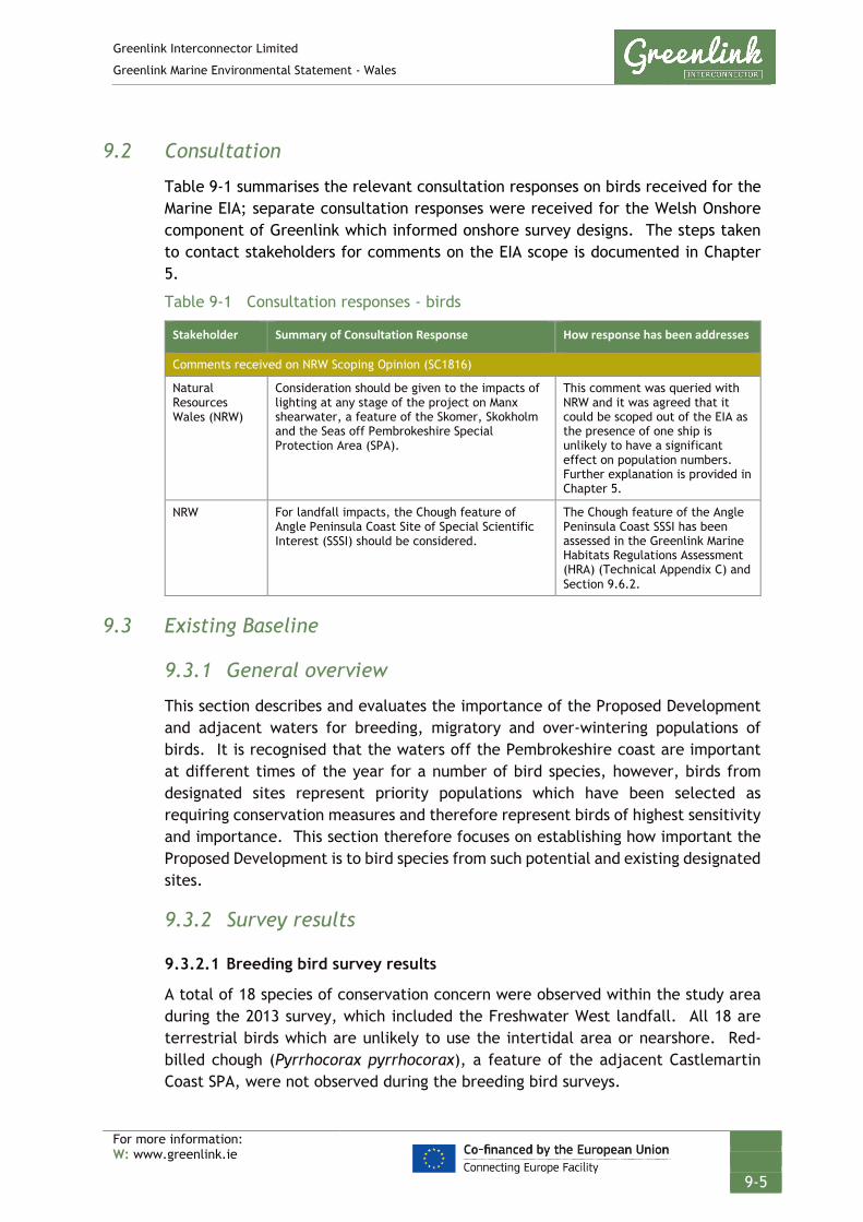
Greenlink Interconnector Limited
Greenlink Marine Environmental Statement - Wales
For more information: W: www.greenlink.ie
9-5
9.2 Consultation
Table 9-1 summarises the relevant consultation responses on birds received for the Marine EIA; separate consultation responses were received for the Welsh Onshore component of Greenlink which informed onshore survey designs. The steps taken to contact stakeholders for comments on the EIA scope is documented in Chapter 5.
Table 9-1 Consultation responses - birds
Stakeholder Summary of Consultation Response How response has been addresses
Comments received on NRW Scoping Opinion (SC1816)
Natural Resources Wales (NRW)
Consideration should be given to the impacts of lighting at any stage of the project on Manx shearwater, a feature of the Skomer, Skokholm and the Seas off Pembrokeshire Special Protection Area (SPA).
This comment was queried with NRW and it was agreed that it could be scoped out of the EIA as the presence of one ship is unlikely to have a significant effect on population numbers. Further explanation is provided in Chapter 5.
NRW For landfall impacts, the Chough feature of Angle Peninsula Coast Site of Special Scientific Interest (SSSI) should be considered.
The Chough feature of the Angle Peninsula Coast SSSI has been assessed in the Greenlink Marine Habitats Regulations Assessment (HRA) (Technical Appendix C) and Section 9.6.2.
9.3 Existing Baseline
9.3.1 General overview
This section describes and evaluates the importance of the Proposed Development and adjacent waters for breeding, migratory and over-wintering populations of birds. It is recognised that the waters off the Pembrokeshire coast are important at different times of the year for a number of bird species, however, birds from designated sites represent priority populations which have been selected as requiring conservation measures and therefore represent birds of highest sensitivity and importance. This section therefore focuses on establishing how important the Proposed Development is to bird species from such potential and existing designated sites.
9.3.2 Survey results
9.3.2.1 Breeding bird survey results
A total of 18 species of conservation concern were observed within the study area during the 2013 survey, which included the Freshwater West landfall. All 18 are terrestrial birds which are unlikely to use the intertidal area or nearshore. Red-billed chough (Pyrrhocorax pyrrhocorax), a feature of the adjacent Castlemartin Coast SPA, were not observed during the breeding bird surveys.
Greenlink Interconnector Limited
Greenlink Marine Environmental Statement - Wales
For more information: W: www.greenlink.ie
9-6
Initial discussion with NRW on the 18th November 2013 confirmed that specific red-billed chough surveys, would not be required to support the Welsh Onshore ES.
A total of 56 species were recorded during the 2018 breeding bird surveys. Lesser black-backed gull, gannet, great black-backed gull and herring gull (designating species of SPAs in the vicinity) were recorded by the survey but breeding is not assumed to occur in the Wales Onshore component or Proposed Development for these species. No red-billed chough were observed.
9.3.2.2 Wintering bird survey results
Wintering bird surveys 2013-2014, 2015-2016: Results indicated that although a number of chough were observed, activity at the Freshwater West HDD Compound site is believed to be low.
Wintering bird survey 2018-2019: A maximum of four red-billed chough were observed on site foraging in fields to the west of the site around Freshwater West on a number of occasions. Four red-billed chough (assuming two pairs) represents 8% of the wintering Castlemartin Coast SPA population (cited as 24 pairs). A number of waders and waterfowl were observed on site foraging, loafing and flying across the site.
9.3.3 European and nationally important conservation sites for birds
The most important national and international seabird populations are protected within designated sites including SPAs, Ramsar sites, SSSIs and Marine Conservation Zones (MCZs). The Greenlink Marine Habitat Regulations Assessment – Wales (Technical Appendix C) identified nine designated sites for birds within 10km of the Proposed Development. Whilst it is acknowledged that some marine birds can forage long distances and therefore have the potential to travel to the Proposed Development from sites beyond 10km, as the distance from the Proposed Development increases so does the area of alternative foraging sites available to these birds. In turn, the probability of significant numbers of individuals being present within the Proposed Development from protected sites further afield gets lower as the distance increases.
The nine identified sites were assessed during the Stage 1 Screening of the HRA to determine if there was potential for connectivity to the Proposed Development.
For eight of the nine sites, a possible pathway between the Proposed Development and the site was identified. Further details on these eight sites is provided in the following sub-sections.

Greenlink Interconnector Limited
Greenlink Marine Environmental Statement - Wales
For more information: W: www.greenlink.ie
9-7
Table 9-2 SPAs assessed in the HRA Stage 1 Screening (Technical Appendix C)
Site name & code
Distance to Proposed Development
Qualifying features* HRA Stage 1 Screening Conclusion
UK9014051: Skomer, Skokholm and the Seas off Pembrokeshire/ Sgomer, Sgogwm a Moroedd Penfro SPA
Within Annex I species (breeding):
• Red-billed Chough (Pyrrhocorax pyrrhocorax)
• Short-eared owl (Assio flammeus) • European Storm petrel (Hydrobates
pelagicus) Regular occurring migratory species:
• Lesser black-backed gull (Larus fuscus)
• Manx shearwater (Puffinus puffinus)
• Puffin (Fratercula arctica). Seabird assemblage:
• Regularly supports at least 20,000 seabirds in any season
No likely significant effects.
UK9014061: Castlemartin Coast SPA
Within Annex I species (breeding):
• Red-billed chough No likely significant effects.
UK9014041: Grassholm / Ynys Gwales SPA SSSI 0594: Grassholm / Ynys Gwales SSSI
8.55km Migratory species:
• Gannet (Morus bassanus) Other breeding species noted in SSSI citation:
• Guillemot • Razorbill • Shag • Kittiwake • Herring gull • Lesser Black-backed gull • Great Black-backed gull
No likely significant effects.
SSSI 1136: Broomhill Burrows SSSI
Within • Red-billed Chough • Lapwing (Vanellus vanellus)
Conservation objectives will not be hindered
SSSI 0923: Arfordir Penrhyn Angle / Angle Peninsula Coast SSSI
0.06km • Red-billed Chough Conservation objectives will not be hindered
SSSI 0140: Castlemartin Range SSSI
0.54km Breeding birds:
• Red-billed chough • Guillemot (Uria aalge) • Razorbill (Alca torda) • Kittiwake (Rissa tridactyla) • Puffin • Fulmar (Fulmarus glacialis) • Lesser-black backed gull (Larus
fuscus) • Herring gull (L. argentatus) • Shag (Phalacrocorax aristotelis) Over winter:
Conservation objectives will not be hindered

Greenlink Interconnector Limited
Greenlink Marine Environmental Statement - Wales
For more information: W: www.greenlink.ie
9-8
Site name & code
Distance to Proposed Development
Qualifying features* HRA Stage 1 Screening Conclusion
• Lesser-black backed gull • Oystercatcher (Haematopus
ostralegus) • Curlew (Numenius arquata) • Dunlin (Calidris alpine) • Grey plover (Pluvialis squatarola) • Whimbrel (N. phaeopus) • Lapwing • Golden plover (P. apricaria)
SSSI 0282: Milford Haven Waterway SSSI
1.44km Migratory waterfowl The site was screened out.
SSSI 0297: Skokholm SSSI
3.15km Breeding birds:
• Manx shearwater • Puffin • Atlantic Storm petrel • Razorbill • Guillemot • Lesser Black-backed gull • Fulmar • Herring gull (Larus argentatus) • Greater Black-backed gull • Red-billed chough
Screened out as assessed as a component of the Skomer, Skokholm and the Seas off Pembrokeshire/ Sgomer, Sgogwm a Moroedd Penfro SPA
SSSI 0953: Skomer Island and Middleholm SSSI
6.83km Breeding birds:
• Manx shearwater • Puffin • Atlantic Storm petrel • Razorbill • Guillemot • Lesser Black-backed gull • Kittiwake • Red-billed chough
Other breeding birds include waders
and terrestrial birds.
Screened out as assessed as a component of the Skomer, Skokholm and the Seas off Pembrokeshire/ Sgomer, Sgogwm a Moroedd Penfro SPA
* Note – only the bird qualifying features of the sites are listed in the table. For a full list of qualifying features for each site please refer to Greenlink Marine HRA (Technical Appendix C)
Sources: JNCC (2019), JNCC (2001), CCW (1987), CCW (2003), CCW (2011), CCW (2002), CCW (2001a,b,c), NRW (2014)
The eight sites to be discussed have been grouped into three categories. Protected sites are shown in Chapter 11:
• Skomer, Skokholm and the seas off Pembrokeshire / Sgomer, Sgogwm a moroedd Benfro SPA and its component SSSIs
• Sites that support red-billed chough
• Grassholm SPA

Greenlink Interconnector Limited
Greenlink Marine Environmental Statement - Wales
For more information: W: www.greenlink.ie
9-9
9.3.3.2 Skomer, Skokholm and the seas off Pembrokeshire SPA and its component SSSIs
The Proposed Development crosses Skomer, Skokholm and the seas off Pembrokeshire SPA, which is located off the south-west tip of Pembrokeshire and covers 1,668km2. The original Skokholm and Skomer SPA was designated in 1982, covering an area of 4.27km2, and protects the following marine birds: European storm-petrel, Manx shearwater, Atlantic puffin, and lesser black-backed gull and breeding seabird assemblage. The islands of Skomer and Skokholm support the largest concentrations of breeding seabirds in England and Wales; the breeding seabird assemblage totals over 394,000 birds. The islands support the largest breeding colony of Manx shearwater in the world (316,000 pairs) and one of the largest colonies of lesser-black-backed gull in Britain (over 10,000 occupied nests).
Skokholm and Skomer SPA was reclassified in 2014 and the boundary extended by a 4km radius around the islands, adding a marine area of 143.48km2. The extended boundary included waters vital for essential ecological requirements (e.g. preening, bathing, displaying, loafing/ resting at sea) for Manx shearwater and Atlantic puffin (as individual qualifying features) as well as common guillemot and razorbill (as component species of the seabird assemblage). In 2017, the seaward boundary of the site was extended by 1524 km2 to encompass two additional marine areas to the south-west of Pembrokeshire, which were identified as hotspots for foraging Manx shearwater, and one area immediately west of Skomer Island, identified as a hotspot for foraging Atlantic puffin.
To set the boundaries for the SPA, JNCC undertook analysis of seabird densities to identify concentrations or ‘hotspots’ of birds offshore. Density maps presented in NRW (2015) show important areas for Manx shearwater and Atlantic puffin (see Figure 9-2, Drawing P1975-BIRD-001).
Skokholm SSSI and Skomer Island and Middleholm SSSI are component parts of the SPA. The species of special interest are the same as the main SPA designation and are listed in Table 9-2 above.
9.3.3.3 Sites that support Red-billed Chough
The chough is a rare and threatened British bird and is in decline across much of its European range. Consequently, it is listed as a species of European conservation concern and is on Annex I of the EC Birds Directive.
The availability of suitable nest sites and the extent and quality of foraging habitat are the two main limiting factors for chough (Newbery et al 1998 cited in Rylands et al 2012). Their preferred habitat is grazed grassland and heathland close to suitable nesting sites on rock faces and in caves. Chough prefer short pasture less than 5cm in height and soft soil it can probe with its long bill to feed on invertebrates. As such, coastal strips of maritime heath and short grazed pasture are extremely important to them (RSPB 2019 and The Wildlife Trust of South & West Wales 2011).

Greenlink Interconnector Limited
Greenlink Marine Environmental Statement - Wales
For more information: W: www.greenlink.ie
9-10
The breeding season for chough begins in late March to early April when they begin to build nests. In Pembrokeshire, this is usually deep inside an inaccessible sea cave or cliff crevice. Chough are central place foragers whilst breeding, and to improve fledgling success it is critical that they can spend most of their time foraging close to the nest. Where suitable habitat exists, they spend over half their time within 100m of the nest and a major part of the time within 300m of the nest (Kerbiriou et al 2006 cited in Rylands et al 2012).
Although found along rocky coastlines they are essentially terrestrial birds which feed onshore.
The CCW Science Report Analysis of Chough productivity and recreational use in Pembrokeshire (Poole 2003) identified that the bulk of the Pembrokeshire red-billed chough population are located away from the Proposed Development, along the south coast of Pembrokeshire; principally, around the Castlemartin Range (The Stacks), St. Govan’s Head, Stackpole Head and Lydstep Point.
The report indicates that the nearest nesting roost of the satellite population on the Angle Peninsula is approximately 1.5km to the east in Parsons Quarry Bay. The report also identifies an intermittently held feeding territory, occupied during only two of the nine monitoring years, at the Furzenips on Freshwater West beach; approximately 1.5km to the south of the landfall site (Arup 2018).
Castlemartin Coast SPA This site qualifies under Article 4.1 of the Birds Directive by supporting between 12-14 pairs of breeding Red-billed Chough; about 4% of the British population (CCW 1994).
The site comprises a 20km linear section of rocky coast with sea cliffs. Behind the cliff edges, there are species-rich maritime grasslands in front of maritime heath. Rough winter grazing by sheep and cattle maintains the character of the maritime grasslands. The cliffs are of importance for breeding Chough, which exploit their immediate hinterland. The birds depend on the diverse mix of habitats present within the site and their continued low-intensity agricultural management (CCW 1994).
The site also holds regionally important cliff-nesting seabird populations, principally at Stack Rocks; which is a primary reason for the designation of the Castlemartin Coast SSSI (see Section 9.3.3.6). The site includes parts of the Broomhill Burrows SSSI.
Broomhill Burrows SSSI This site is primarily designated for one of Pembrokeshire's largest dune systems with extensive and diverse dune slack vegetation. However, the SSSI citation (CCW 1987) notes that lapwing breed in the dune slacks and Red-billed Chough are regularly seen feeding in the insect-rich turf.
This site is within the boundary of the Castlemartin Coast SPA.
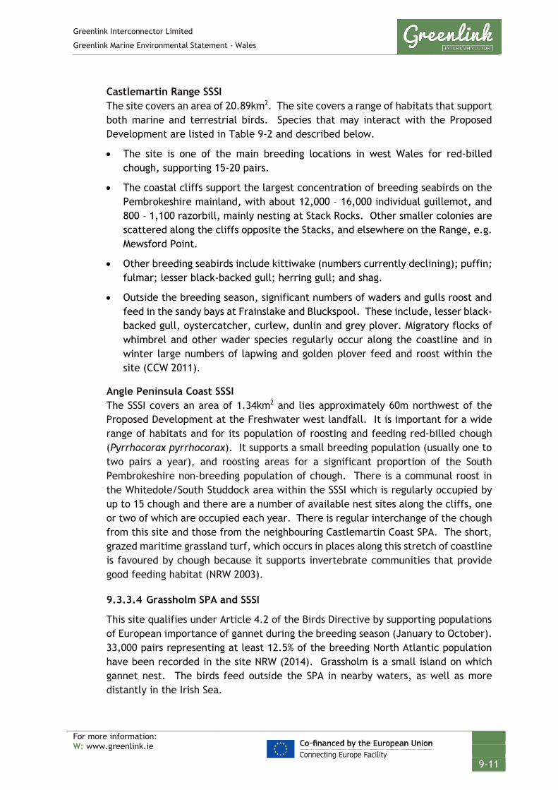
Greenlink Interconnector Limited
Greenlink Marine Environmental Statement - Wales
For more information: W: www.greenlink.ie
9-11
Castlemartin Range SSSI The site covers an area of 20.89km2. The site covers a range of habitats that support both marine and terrestrial birds. Species that may interact with the Proposed Development are listed in Table 9-2 and described below.
• The site is one of the main breeding locations in west Wales for red-billed chough, supporting 15-20 pairs.
• The coastal cliffs support the largest concentration of breeding seabirds on the Pembrokeshire mainland, with about 12,000 – 16,000 individual guillemot, and 800 – 1,100 razorbill, mainly nesting at Stack Rocks. Other smaller colonies are scattered along the cliffs opposite the Stacks, and elsewhere on the Range, e.g. Mewsford Point.
• Other breeding seabirds include kittiwake (numbers currently declining); puffin; fulmar; lesser black-backed gull; herring gull; and shag.
• Outside the breeding season, significant numbers of waders and gulls roost and feed in the sandy bays at Frainslake and Bluckspool. These include, lesser black-backed gull, oystercatcher, curlew, dunlin and grey plover. Migratory flocks of whimbrel and other wader species regularly occur along the coastline and in winter large numbers of lapwing and golden plover feed and roost within the site (CCW 2011).
Angle Peninsula Coast SSSI The SSSI covers an area of 1.34km2 and lies approximately 60m northwest of the Proposed Development at the Freshwater west landfall. It is important for a wide range of habitats and for its population of roosting and feeding red-billed chough (Pyrrhocorax pyrrhocorax). It supports a small breeding population (usually one to two pairs a year), and roosting areas for a significant proportion of the South Pembrokeshire non-breeding population of chough. There is a communal roost in the Whitedole/South Studdock area within the SSSI which is regularly occupied by up to 15 chough and there are a number of available nest sites along the cliffs, one or two of which are occupied each year. There is regular interchange of the chough from this site and those from the neighbouring Castlemartin Coast SPA. The short, grazed maritime grassland turf, which occurs in places along this stretch of coastline is favoured by chough because it supports invertebrate communities that provide good feeding habitat (NRW 2003).
9.3.3.4 Grassholm SPA and SSSI
This site qualifies under Article 4.2 of the Birds Directive by supporting populations of European importance of gannet during the breeding season (January to October). 33,000 pairs representing at least 12.5% of the breeding North Atlantic population have been recorded in the site NRW (2014). Grassholm is a small island on which gannet nest. The birds feed outside the SPA in nearby waters, as well as more distantly in the Irish Sea.

Greenlink Interconnector Limited
Greenlink Marine Environmental Statement - Wales
For more information: W: www.greenlink.ie
9-12
The SSSI citation lists other seabirds as nesting on the island; listed in Table 9-2 above.
9.3.3.5 Environment (Wales) Act 2016 – Section 7 Priority species
The following species found within the Proposed Development are listed on the interim Priority Species lists issued by the Welsh Government (Welsh Government 2016):
Table 9-3 Environment (Wales) Act Section 7 priority species within Proposed Development
Species Common name
Larus argentatus subsp. argenteus Herring gull
Pyrrhocorax pyrrhocorax Chough

GREENLINK INTERCONNECTORLocations of Rafting Manx Shearwater (after McSorley et al 2008)
in Relation to the Proposed Development and Existing Shipping Activity
Chris GoodeEmma Langley
Wednesday, May 8, 2019 08:12:04WGS_1984_UTM_Zone_30N
D_WGS_1984UKHO; CDA; OSOD; JNCC; Ocenaeering; Greenlink; Intertek
WGS_1984
NOTE: Not to be used for Navigation
Contains public sector information, licensed under the Open Government Licence v2.0, from the UKHO, 2018.; Contains data from UKOGD.; Contains Ordnance Survey data © Crown copyright and database right 2013; Licence No: EK001-1001-WEB105. Not to be used for Navigation.; Open Government Licence reproduced with permission of the Marine Management Organisation; Contains Data produced by the JNCC, McSorley et al., 2008; Contains Joint Nature Conservation Committee data © copyright and database right [2018]. Contains Natural England data © copyright and database right [2018]. Contains Natural Resource Wales data © copyright and database right [2018]. Contains UK Hydrographic Office data © copyright and database right [2018]. Contains Ordnance Survey data © copyright and database right [2018]. Contains public sector information licensed under the Open Government Licence v3.0; © Oceaneering AIS Data 2018
Anna Farley
Skomer, Skokholmand the Seas off
Pembrokeshire - SPA
CastlemartinCoast- SPA
Grassholm- SPA
Ramsey and St David`sPeninsula Coast - SPA
Ramsey and St David`sPeninsula Coast - SPA
Ramsey and St David`sPeninsula Coast - SPA
Ramsey and StDavid`s Peninsula
Coast - SPA
300000
300000
325000
325000
350000
350000
57000
00
57000
00
57250
00
57250
00
57500
00
57500
00
LegendManx Shearwater Rafting LocationFreshwater WestProposed DevelopmentIrish OffshoreUK 12nm Territorial Sea LimitMedian Line
Protected SiteSPAImportant Area - Atlantic PufficImportant Area - Manx Shearwater
0 2.5 5 7.5 10km © Metoc Ltd, 2019.
All rights reserved.
J:\P1975\Mxd\13_BIRD\P1975-BIRD-001.mxd
Created ByReviewed By
DateProjection
DatumData Source
File Reference
Spheroid
Approved By
Drawing No: P1975-BIRD-001 A
Skokholm
Skomer
3.13 km
7.00 km
0 2.5 5 7.5 10km
BIRD ACTIVITY

Greenlink Interconnector Limited
Greenlink Marine Environmental Statement - Wales
For more information: W: www.greenlink.ie
9-14
9.3.4 Natural evolution of the baseline
The natural evolution of the baseline has been compiled using information gathered from the Offshore Energy Strategic Environmental Assessment 3 (OESEA 3) (DECC 2016). In 2011 the EU published advice on offshore wind farm (OWF) development in regard to European sites, with attention paid to potential effects they may have on bird species. The report highlighted the negative effects OWF development may have on species such as loss of habitat, collision risks or barrier effects. Species listed included those that are found in the vicinity of the Proposed Development such as herring gull and chough. While currently no proposals have been submitted to NRW for offshore wind projects, with offshore wind being of great importance to the UK government in meeting its’ future energy needs (BEIS 2019) this could change, which may in turn lead to changes in local bird populations and distribution.
Climate change is another factor that may further effect local bird populations in the future; with rising temperatures and sea levels potentially leading to changes in prey distribution and loss of nesting/feeding habitat onshore through beach erosion and retraction. This could have an effect on species such as the red-billed chough, with important feeding sites such as the Broomhill Burrows SSSI being affected by erosion and reducing the availability of invertebrate prey.
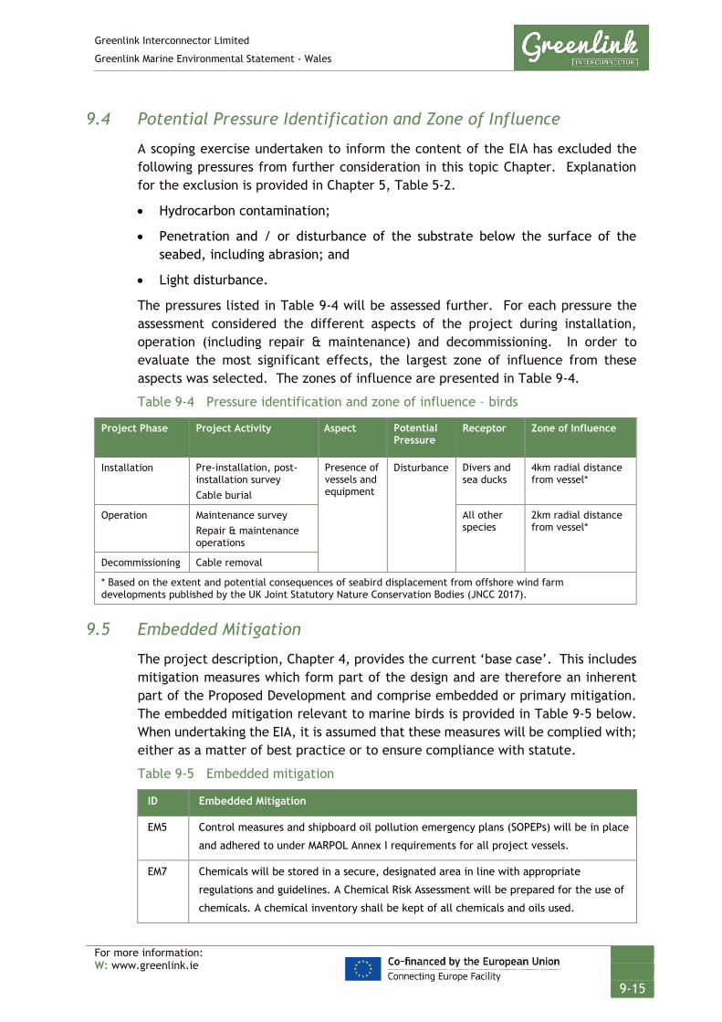
Greenlink Interconnector Limited
Greenlink Marine Environmental Statement - Wales
For more information: W: www.greenlink.ie
9-15
9.4 Potential Pressure Identification and Zone of Influence
A scoping exercise undertaken to inform the content of the EIA has excluded the following pressures from further consideration in this topic Chapter. Explanation for the exclusion is provided in Chapter 5, Table 5-2.
• Hydrocarbon contamination;
• Penetration and / or disturbance of the substrate below the surface of the seabed, including abrasion; and
• Light disturbance.
The pressures listed in Table 9-4 will be assessed further. For each pressure the assessment considered the different aspects of the project during installation, operation (including repair & maintenance) and decommissioning. In order to evaluate the most significant effects, the largest zone of influence from these aspects was selected. The zones of influence are presented in Table 9-4.
Table 9-4 Pressure identification and zone of influence – birds
Project Phase Project Activity Aspect Potential Pressure
Receptor Zone of Influence
Installation Pre-installation, post-installation survey Cable burial
Presence of vessels and equipment
Disturbance Divers and sea ducks
4km radial distance from vessel*
Operation Maintenance survey Repair & maintenance operations
All other species
2km radial distance from vessel*
Decommissioning Cable removal
* Based on the extent and potential consequences of seabird displacement from offshore wind farm developments published by the UK Joint Statutory Nature Conservation Bodies (JNCC 2017).
9.5 Embedded Mitigation
The project description, Chapter 4, provides the current ‘base case’. This includes mitigation measures which form part of the design and are therefore an inherent part of the Proposed Development and comprise embedded or primary mitigation. The embedded mitigation relevant to marine birds is provided in Table 9-5 below. When undertaking the EIA, it is assumed that these measures will be complied with; either as a matter of best practice or to ensure compliance with statute.
Table 9-5 Embedded mitigation
ID Embedded Mitigation
EM5 Control measures and shipboard oil pollution emergency plans (SOPEPs) will be in place
and adhered to under MARPOL Annex I requirements for all project vessels.
EM7 Chemicals will be stored in a secure, designated area in line with appropriate
regulations and guidelines. A Chemical Risk Assessment will be prepared for the use of
chemicals. A chemical inventory shall be kept of all chemicals and oils used.

Greenlink Interconnector Limited
Greenlink Marine Environmental Statement - Wales
For more information: W: www.greenlink.ie
9-16
ID Embedded Mitigation
EM19 Project vessels will not exceed 14 knots within the Proposed Development.
9.6 Significance Assessment
9.6.1 Summary of assessment
Table 9-6 presents the impact assessment conducted on the Proposed Development activities. Section 9.6.2 provides justification for the conclusions. Where the assessment concluded the effects are significant, Project Specific Mitigation has been proposed and is described in Section 9.7. Where there is potential for residual effects, this is discussed further in Section 9.8.

Greenlink Interconnector Limited
Greenlink Marine Environmental Statement - Wales
For more information: W: www.greenlink.ie
9-17
Table 9-6 Impact assessment summary – birds
Determination of potential effect Impact assessment Consideration of mitigation
Residual effect assessment
Section Project Phase
Aspect Embedded Mitigation
(Table 9-5)
Potential Pressure
Receptor Magnitude Sensitivity Significance Project Specific Mitigation
Magnitude Sensitivity Significance of Residual Effect
9.6.2 Installation
Operation
Decommissioning
Presence of vessels and equipment
EM5, EM7 and EM19
Disturbance Skomer, Skokholm and the seas off Pembrokeshire / Sgomer, Sgogwm a moroedd Benfro SPA, & component SSSI for puffin & Manx shearwater
Negligible Medium Negligible - - - -
Castlemartin Coast SPA, & SSSIs for chough
Negligible Low Negligible - - - -
Grassholm SPA / SSSI for gannet
Negligible Low Negligible - - - -
All other seabirds Negligible Low Negligible
Greenlink Interconnector Limited
Greenlink Marine Environmental Statement - Wales
For more information: W: www.greenlink.ie
9-18
9.6.2 Disturbance
9.6.2.1 Installation
Disturbance is predicted to be limited to that initiated by the movement of the project vessels or intra-project cumulative effects from noise associated with the Wales Onshore works at the HDD compound potentially interacting with works in the nearshore area (should they overlap temporally). Birds may take evasive action, but a single disturbance event does not have any immediate effect on the survival or productivity of an individual bird. Repeated disturbance, or disturbance over an extended period of time, can affect survival and productivity.
The most disruptive activities are those that are sudden, noisy or fast. As such, helicopters and speedboats usually cause the greatest disturbance (Natural England and Suffolk Coast and Heaths 2012). Vessels travelling at faster speeds cause a greater level of disturbance in terms of the proportion of birds flushing and at further distances (Bellefleur et al. 2009; Ronconi and St Clair 2002).
The marine works will be a series of one-off events over short periods of time, typically separated temporally. For example, pre-installation survey will involve the transit of a single vessel along the cable centerline, with the vessel continually moving, over a duration of a few weeks. This would typically occur several months in advance of the actual installation works. The installation will involve the cable lay vessel, and potentially smaller support vessels i.e. to facilitate the cable pull-in at the landfall, again with the installation spread continually moving through the Proposed Development. The project vessels will be slow moving, only between 100 – 500 m / hour, which is slower than walking speed (generally assumed to be 5 km / hour). At such slow speeds, the vessels are effectively stationary in terms of bird displacement. Studies have shown that slow moving vessels cause little disturbance to birds and birds may habituate to frequent and relatively benign events and noises (Hill et al 1997 in Natural England and Suffolk Coast and Heaths 2012).
To assess the significance of effects on different bird species the sites identified in Table 9-2 have been grouped into three categories:
• Skomer, Skokholm and the seas off Pembrokeshire / Sgomer, Sgogwm a moroedd Benfro SPA and its component SSSIs
• Sites that support red-billed chough
• Grassholm SPA
Sensitivity to displacement differs considerably between seabird species. The Joint SNBC Interim Displacement Advice Notice (2017) provides a scoring system to help assist in the assessment of species susceptibility to disturbance by windfarm structures, ship and helicopter traffic. This metric gives an indication of which species are expected to be most susceptible to displacement effects. As a general guide any species scoring 3 or more should be considered further. This scoring system has been used in the below assessment.

Greenlink Interconnector Limited
Greenlink Marine Environmental Statement - Wales
For more information: W: www.greenlink.ie
9-19
Skomer, Skokholm and the seas off Pembrokeshire / Sgomer, Sgogwm a moroedd Benfro SPA and its component SSSIs The component SSSIs included in the assessment are Skokholm SSSI and Skomer Island and Middleholm SSSI.
To set the boundaries for the SPA, the Joint Nature Conservation Committee (JNCC) undertook analysis of seabird densities to identify concentrations or ‘hotspots’ of birds offshore. Density maps presented in NRW (2015) show important areas for Manx shearwater and Atlantic puffin. During Greenlink route development, the position of the SPA boundary was taken into consideration and the length of cable route within the site boundary was minimised where possible. Figure 9-2 (Drawing P1975-BIRD-001) shows starting from Freshwater West the Proposed Development initially follows the southern boundary of the northern section of the SPA which is identified as important for Atlantic puffin. The Proposed Development then takes the shortest route through the larger area identified as important for Manx shearwater before the Proposed Development continues just above the northern boundary of the SPA.
As the Proposed Development crosses waters important for Atlantic puffin and Manx shearwater the potential for effects on this species is assessed below.
Atlantic Puffin
Puffin arrive at breeding colonies in March and April and leave again by the beginning of August. Figure 9-2 (Drawing P1975-BIRD-001) identifies that the waters to the west and southwest of Skomer and Skokholm are important for Atlantic puffin. The Proposed Development crosses this area for approximately 4km (~KP19 – KP23).
Atlantic puffin has a score of 2 for disturbance susceptibility which suggests it is unlikely to be sufficiently disturbed by the presence of vessels to be displaced for a significant period.
In addition, shipping activity in this area is moderate due to the presence of routes to Milford Haven and the Rosslare to Pembroke ferry route (visible on Figure 9-2, Drawing P1975-BIRD-001 as a diagonal northwest to southeast yellow line in the shipping density) and the presence of a traffic separation zone to the north of the Proposed Development through which ships transit in and out of the Irish Sea. Against this level of activity, the introduction of the project vessel(s) is unlikely to have any significant effect. Given the Proposed Development is at the southern limit of the area important for Atlantic puffin any disturbance is likely to be temporary and limited in extent. The project vessels will be continuously moving through the Proposed Development therefore their presence in any one location will be transient allowing any disturbed birds to return within a brief period of time.

Greenlink Interconnector Limited
Greenlink Marine Environmental Statement - Wales
For more information: W: www.greenlink.ie
9-20
In addition, the Proposed Development passes >2km south of the islands of Skokholm and Skomer (i.e. outside of the zone of influence for disturbance). It is therefore unlikely that nesting birds will be disturbed should any works temporally overlap with the breeding season.
Manx shearwater
Manx shearwater score 1 for disturbance susceptibility and therefore would not normally require further assessment. However as Manx shearwater is a qualifying feature of the 4km marine extension around Skomer and Skokholm they have been included in the assessment.
During the breeding season (April to August) prior to dusk, adult Manx shearwater assemble in flocks or ‘rafts’ on the surface of the sea 1-10 km from the colony. When darkness falls, these ‘rafting’ birds, of up to 10,000 individuals in some locations, fly to their burrows to feed their chicks (McSorley et al. 2008). Radio-telemetry tracking of breeding Manx shearwater was undertaken at Skomer island from May to August in 2003 (McSorley et al. 2008). The results of the tracking indicated that overall the birds formed rafts most often to the north of the island and no rafts were formed before 19:00. Birds moved significantly closer to the colony as the evening progressed.
Figure 9-2 (Drawing P1975-BIRD-001) shows the locations of rafting Manx shearwater from the 2003 tracking data in relation to the Proposed Development. The closest known areas of rafting Manx shearwater are located at least 5.96km to the north of the Proposed Development. Should rafting Manx shearwater be present within the Proposed Development during works, any disturbance will take place within the context of existing sources of disturbance, such as commercial shipping, commercial fishing and recreational vessels in the area. Figure 9-2 (Drawing P1975-BIRD-001) shows that there are high densities of shipping present along the Proposed Development, south of Skokholm island within the SPA 4km extension. It is therefore likely that the Manx shearwater will be habituated to vessel noise, lights and physical presence and the addition of the project vessel(s) is unlikely to be noticeable against natural variation in shipping levels.
Conclusion
The sensitivity of Atlantic puffin and Manx shearwater has been assessed as Medium. This reflects that although the species are designating features of an international designation and therefore would be classed as having high sensitivity using the definitions in Chapter 5, there sensitivity to the pressure is low.
Any disturbance will be temporary and localised. Birds will be able to return to the area shortly after the vessels have passed through. The magnitude of the effect has therefore been assessed as negligible. The overall significance of effect has been assessed as Negligible and is Not Significant.

Greenlink Interconnector Limited
Greenlink Marine Environmental Statement - Wales
For more information: W: www.greenlink.ie
9-21
This potential effect has also been assessed within the Greenlink Marine HRA – Technical Appendix C. The Stage 1 Screening concluded no likely significant effects and that an Appropriate Assessment is not required for these activities.
Sites that support red-billed chough This assessment covers the following sites Castlemartin Coast SPA; Broomhill Burrows SSSI (component of Castlemartin Coast SPA); Angle Peninsula Coast SSSI; and Castlemartin Range SSSI. These sites are designated wholly or in part for red-billed chough, a member of the crow family.
NRW scoping opinion letter (ref: SC1816 29 January 2019) requested that for landfall effect, the Chough feature of Angle Peninsula Coast SSSI should be considered. Post-cable route survey the Proposed Development boundaries have been refined at Freshwater West, to exclude areas of the beach which would be unfavourable to cable installation. The Proposed Development no longer overlaps with the Angle Coast SSSI, but still lies approximately 60m from the site boundary at its closest point at Freshwater West.
As chough are terrestrial birds, and do not use the intertidal area for foraging, the EIA has primarily assessed whether there is the potential for intra-project cumulative effects from disturbance with Wales Onshore and the Proposed Development.
Chough were not recorded during the Wales Onshore breeding bird survey (Arup 2018). The only area that is likely to be utilized by chough is the HDD compound above Freshwater West. The preliminary Wales Onshore HRA has concluded that the Wales Onshore works are unlikely to have any significant effects on chough. This is based on:
• The wintering bird survey results indicated that a maximum of four red-billed chough were observed in the HDD compound area at any given time (assumed to be two pairs) which represents 8% of the wintering Castlemartin Coast SPA population (cited as 24 pairs).
• The distance from individual territories - the bulk of the Pembrokeshire red-billed chough population are located away from the Proposed Development, along the south coast of Pembrokeshire; principally, around the Castlemartin Range (The Stacks), St. Govan’s Head, Stackpole Head and Lydstep Point.
• The limited area affected by the works in relation to the available feeding habitat, combined with the temporary nature of the cable installation works, the subsequent reinstatement of the construction area and maintenance of the existing land management regime post-installation.

Greenlink Interconnector Limited
Greenlink Marine Environmental Statement - Wales
For more information: W: www.greenlink.ie
9-22
The main cause of concern for chough with respect to the Proposed Development is works in the nearshore area disturbing them when they are foraging i.e. on the adjacent cliffs, grass and heathlands.
When foraging, the birds spend a proportion of their time in 'vigilance' behavior, when they are keeping a look-out for danger. The more time spent on vigilance, the less time spent feeding, which can lead to subtle effects on the amounts and types of food taken back to the nest, with subsequent effects on the development of the nestlings (Poole 2003).
A study by Owen (1988, cited in Poole 2003) on vigilance by foraging choughs in relation to tourist disturbance suggested that chough feeding in open areas had a minimum flight distance of 35m i.e. they would take to flight if walkers got to that distance. In areas of medium to heavy cover, the flight distance reduced to 32 and 22m respectively.
The two closest chough territories to the landfall site (Parsons Quarry Bay on the Angle Peninsula and Furzenips on Freshwater West beach) are both approximately 1.5km from the Proposed Development. During the most sensitive time, during the breeding season, chough are likely to spend most of their time foraging between 100m to 300m from the nest, over 1km from the Proposed Development. Therefore, chough have been assessed as having low sensitivity to the Proposed Development.
Since most disturbance occurs when people come within 35m of foraging chough it has been concluded that the magnitude of the effect is Negligible given the distances to the known territories. The overall significance of effect has been assessed as Negligible and is Not Significant.
The assessment has also considered the potential for intra-project effects on chough from the Welsh Onshore and Proposed Development. The assessment for the Proposed Development (above) and the preliminary Wales Onshore HRA individually concluded that there were unlikely to be any significant effects on this species as a result of the Proposed Development or Welsh Onshore. This was based on the low numbers of chough observed in the vicinity of the landfall during the bird surveys undertaken; the distance (>1km) of known chough territories from the proposed works and the relatively short distances (35m) from the source of disturbance for chough to show vigilance behaviour. Based on this and combined with the fact that the Welsh Onshore works are unlikely to take place during the same season as the nearshore works, it has been concluded that there are unlikely to be any significant intra-project effects on birds.
The potential effects on chough have also been assessed within the Greenlink Marine HRA – Technical Appendix C for the four sites discussed. The Stage 1 Screening concluded no likely significant effects on any of the sites and that an Appropriate Assessment is not required for these activities.
Grassholm SPA / SSSI Gannet forage over large distances; Thaxter et al. (2012) estimate a maximum range of 590km during the breeding season. Given this site is just over 8.5km from the

Greenlink Interconnector Limited
Greenlink Marine Environmental Statement - Wales
For more information: W: www.greenlink.ie
9-23
Proposed Development, gannet from this site are likely to be present within the vicinity of the Proposed Development.
The Joint SNCB Interim Displacement Advice Note (2017) notes that although their disturbance susceptibility score is 2, suggesting displacement is not of concern, there are empirical studies suggesting that they are sensitive to displacement. However, the Proposed Development will take place against moderate shipping activity in the region due to the presence of the routes to Milford Haven, the traffic separation zone to the north of the corridor through which ships transit in and out of the Irish Sea, and Pembroke to Rosslare Ferry route. Against this level of activity, the introduction of the project vessel(s) is unlikely to be noticeable against normal daily and seasonal fluctuations in activity. The sensitivity has therefore been assessed as low.
Any disturbance caused by the project will be temporary in nature and limited in extent. Birds will be able to return to the area shortly after the vessels have passed through. In addition, the Proposed Development passes >2km south of the island of Grassholm (i.e. outside of the zone of influence for disturbance). It is therefore unlikely that nesting birds will be disturbed by the presence of the project vessels. The magnitude of the effect has therefore been assessed as negligible.
The overall significance of effect has been assessed as Negligible and is Not Significant.
This potential effect has also been assessed within the Greenlink Marine HRA – Technical Appendix C. The Stage 1 Screening concluded no likely significant effects and that an Appropriate Assessment is not required for these activities.
All other species The most sensitive species to the Proposed Development have been assessed above. There will be no works within the intertidal zone so waders using Freshwater West will not be affected by the Proposed Development. For all other marine birds that use the Proposed Development e.g. for foraging, loafing, bathing, flying across, any disturbance caused by project vessels will be temporary in nature and limited in extent. Birds will be able to return to the area shortly after the vessels have passed through. The area is subject to moderate levels of shipping, fishing and recreational activity and against this baseline the addition of a few vessels is unlikely to be noticeable within the normal day-to-day and seasonal changes in activity levels. All other birds species have been assessed as having low sensitivity, with the magnitude of effect as negligible. The overall significance of the effect on other bird species has been assessed as Negligible and is Not Significant.
9.6.2.2 Operation (including maintenance and repair)
No disturbance will occur from the operating cables. Effects during any unforeseen repair (up to 5 discrete events) and maintenance works will be of a smaller magnitude when compared to cable installation, due to the restricted duration and spatial extent of works and has been assessed as Negligible and is Not Significant.

Greenlink Interconnector Limited
Greenlink Marine Environmental Statement - Wales
For more information: W: www.greenlink.ie
9-24
9.6.2.3 Decommissioning
Two options will be considered at decommissioning; leaving the cables in-situ and removing them. If the cables are left in-situ there will be no effects on birds during decommissioning. However, if the option to remove the cables (and any associated protection) is selected, this process would essentially be the same as installation activities but in reverse. Therefore, any effects that could arise due to the decommissioning phase of the project will be of a comparable magnitude to those assessed above for cable installation as so the effect has been assessed as Negligible and is Not Significant.
9.7 Project Specific Mitigation
No project specific mitigation is proposed.
9.8 Residual Effect
The assessment presented in Table 9-6 concluded that there will be no residual effects on birds.

Greenlink Interconnector Limited
Greenlink Marine Environmental Statement - Wales
For more information: W: www.greenlink.ie
9-25
1 Arup (2018) Greenlink Preliminary Habitats Regulations Assessment (Welsh Onshore) 25 July 2018.
2 Arup (2019a) Greenlink Onshore Wales. Winter Bird Survey (2018/2019) Summary Note.
3 Arup (2019b) Breeding Bird Survey Report 2018. Issue | March 2019
4 Ash, D (2014). Photograph of red-billed chough. [online] Available at: https://en.wikipedia.org/wiki/Red-billed_chough#/media/File:Red-billed_Chough_Sikkim_India.jpg (Accessed April 2019)
5 BEIS (2019) Industrial Strategy Offshore Wind Sector Deal. Available at: https://assets.publishing.service.gov.uk/government/uploads/system/uploads/attachment_data/file/786278/BEIS_Offshore_Wind_Single_Pages_web_optimised.pdf (Accessed: 3 April 2019).
6 Bellefleur, D. Lee, P. and Ronconi, R.A. (2009). The ipacts of recreational boat traffic on Marbled Murrelets (Brachyramphus marmoratus). J Environ Manage. 2009 Jan;90(1):531-8. doi: 10.1016
7 Bibby, B.B. (2000) Bird Census Techniques. London: Academic Press.
8 Countryside Council for Wales (1987), Broomhill Burrows Site of Special Scientific Interest Citation [online] Available at: https://naturalresources.wales/media/660298/SSSI_1136_Citation_EN0015d06.pdf (Accessed April 2019)
9 Countryside Council for Wales (1994). Citation for Castlemartin Coast SPA. [online] Available at:
https://naturalresources.wales/media/632535/SPA_UK9014061_Register_Entry_EN001.pdf (Accessed April 2019)
10 Countryside Council for Wales (2001a), Skokholm Site of Special Scientific Interest Citation [online] Available at: https://naturalresources.wales/media/640019/SSSI_0297_Citation_EN001df49.pdf (Accessed April 2019)
11 Countryside Council for Wales (2001b), Skomer Island and Middleholm Site of Special Scientific Interest Citation [online] Available at: https://naturalresources.wales/media/655933/SSSI_0953_Citation_EN0017dbd.pdf (Accessed April 2019)
12 Countryside Council for Wales (2001c), Grassholm / Ynys Gwales Site of Special Scientific Interest Citation [online] Available at: https://naturalresources.wales/media/647055/SSSI_0594_Citation_EN00138d8.pdf (Accessed April 2019)
13 Countryside Council for Wales (2002), Milford Haven Waterway Site of Special Scientific Interest Citation [online] Available at: https://naturalresources.wales/media/639589/SSSI_0282_Citation_EN0010ded.pdf (Accessed April 2019)
14 Countryside Council for Wales (2003), Arfordir Penrhyn Angle / Angle Peninsula Coast Site of Special Scientific Interest Citation [online] Available at: https://naturalresources.wales/media/655205/SSSI_0923_Citation_EN0017f83.pdf (Accessed April 2019)
REFERENCES

Greenlink Interconnector Limited
Greenlink Marine Environmental Statement - Wales
For more information: W: www.greenlink.ie
9-26
15 Countryside Council for Wales (2011), Castlemartin Range Site of Special Scientific Interest Citation [online] Available at: https://naturalresources.wales/media/636244/SSSI_0140_Citation_EN0013d7a.pdf (Accessed April 2019)
16 DECC (2016) ‘Offshore Energy SEA 3: Appendix 1 Environmental Baseline: Birds’. Available at: https://assets.publishing.service.gov.uk/government/uploads/system/uploads/attachment_data/file/504531/OESEA3_A1a6_Birds.pdf (Accessed: 4 June 2019).
17 Gilbert, G.G., Gibbons, D.W. and Evans, J. (1998). Bird Monitoring Methods: A manual of techniques. Bedfordshire, RSPB.
18 JNCC (2001). Castlemartin Coast SPA. [online] Available at: http://jncc.defra.gov.uk/page-2062-theme=default (Accessed April 2019)
19 JNCC (2017). Joint SNCB Interim Displacement Advice Note (2017). [online] Available at: http://jncc.defra.gov.uk/pdf/Joint_SNCB_Interim_Displacement_AdviceNote_2017.pdf (Accessed April 2019)
20 JNCC (2019). Skomer, Skokholm and the Seas off Pembrokeshire/ Sgomer, Sgogwm a Moroedd Penfro SPA [online] Available at: http://jncc.defra.gov.uk/page-7497 (Accessed April 2019)
21 McSorley, C.A., Wilson, L.J., Dunn, T.E., Gray, C., Dean, B.J., Webb, A and Reid, J.B (2008). Manx shearwater Puffinus puffinus evening rafting behaviour around colonies on Skomer, Rum and Bardsey: its spatial extent and implications for recommending seaward boundary extensions to existing colony Special Protection Areas in the UK. JNCC Report No. 406. [online] Available at:
http://jncc.defra.gov.uk/pdf/jncc406_web.pdf (Accessed April 2019)
22 Natural England and Suffolk Coast and Heaths (2012). A simple method for assessing the risk of disturbance to birds at coastal sites. November 2012. [online] Available at: http://www.suffolkcoastandheaths.org/assets/Projects--Partnerships/Stour--Orwell/disturbance/A-simplemethod-for-assessing-the-risk-of-disturbance-tobirds-at-coastal-sites.pdf (Accessed February 2019).
23 Natural Resources Wales (2003). Site of Special Scientific Interest Citation. Pembrokeshire. Arfordir Penrhyn Angle/ Angle Peninsula Coast.
24 Natural Resources Wales (2014). Grassholm SPA Entry in the register of European Sites for Wales. [online] Available at: https://naturalresources.wales/media/632432/SPA_UK9014041_Register_Entry001.pdf (Accessed April 2019).
25 Natural Resources Wales / Joint Nature Conservation Committee (2015). Departmental Brief. Proposals to extend Skokholm and Skomer Special Protection Area and rename it as Skomer, Skokholm and the Seas off Pembrokeshire /Sgomer, Sgogwm A Moroedd Penfro Special Protection Area. Advice to the Welsh Government and UK Government. Natural Resources Wales Joint Nature Conservation Committee. June 2015. [Online] Available at: https://naturalresources.wales/media/675732/departmental-brief-skomer-skokholm-and-the-seas-off-pembrokeshire-pspa-final.pdf (Accessed April 2019).
26 Pembrokeshire Coast National Park Authority (2019) National Park Management Plan 2015-2019.

Greenlink Interconnector Limited
Greenlink Marine Environmental Statement - Wales
For more information: W: www.greenlink.ie
9-27
27 Poole, A. (2003). Analysis of chough productivity and recreational use in Pembrokeshire, Rep. No. 553. CCW, Bangor
28 Ronconi, R. and St. Clair, C. (2002). Management options to reduce boat disturbance on foraging black guillemots (Cepphus grylle) in the Bay of Fundy. Biological Conservation. 108. 265-271. 10.1016/S0006-3207(02)00126-X.
29 RSPB (2019). Chough – breeding and nesting habitats). [online] Available at: https://www.rspb.org.uk/birds-and-wildlife/wildlifeguides/bird-a-z/chough/breeding-and-nesting-habits/ (Accessed February 2019)
30 Rylands, K., Mucklow, C. and Lock, L. (2012). Management for choughs and coastal biodiversity in Cornwall: the need for grazing. The RSPB South West England Regional Office. June 2012. http://ww2.rspb.org.uk/Images/Management_for_choughs_and_coastal_biodiversity_tcm9-330224.pdf (Accessed April 2019).
31 Thaxter, C.B., Lascelles, B., Sugar, K., Cook, A.S.C.P., Roos, S., Bolton, M., Langdton, R.H.W., and Burton, N.H.K. (2012). Seabird foraging ranges as a preliminary tool for identifying candidate Marine Protected Areas. Biological Conservation
32 The Crown Estate (2018) ‘The Crown Estate shares further detail on plans for Round 4, including proposed locations to be offered for new seabed rights’. Available at: https://www.thecrownestate.co.uk/en-gb/media-and-insights/news/2018-the-crown-estate-shares-further-detail-on-plans-for-round-4-including-proposed-locations-to-be-offered-for-new-seabed-rights/ (Accessed: 4 June 2019).
33 The Wildlife Trust of South and West Wales (2011). Skomer Island Chough Factsheet [online] Available at: https://www.welshwildlife.org/wp-content/uploads/2011/05/Chough.pdf (Accessed April 2019).
34 Welsh Government (2016). Environment (Wales) Act 2016, Section 7 - list of the living organisms of principal importance for the purpose of maintaining and enhancing biodiversity in relation to Wales. [Online] Available at: file:///C:/Users/matthias.thomsen/Downloads/master%20s7%20species%20list%20may%202016%20final.pdf (Accessed April 2019).
Greenlink Interconnector Limited
Greenlink Marine Environmental Statement - Wales
For more information: W: www.greenlink.ie
10-1
10. Marine Mammals and Reptiles This Chapter describes the existing baseline environment for marine mammals and reptiles, identifies the pressures associated with the Proposed Development on the receptors, presents the findings of the environmental impact assessment, and describes how significant effects (if any) will be mitigated.
The Proposed Development refers to the Welsh Marine components of Greenlink from mean high-water springs (MHWS) at the Welsh landfall at Freshwater West, Pembrokeshire to the UK/Republic of Ireland median line. It comprises:
• Two high voltage direct current (HVDC) electricity power cables;
• A smaller fibre-optic cable for control and communication purposes;
• All associated works required to install, test, commission and complete the aforementioned cables; and
• All associated works required to operate, maintain, repair and decommission the aforementioned cables, including five repair events over the 40 year lifetime of Greenlink.
The Proposed Development includes the following phases, all of which are assessed within this chapter:
• Installation;
• Operation (including repair and maintenance activities); and
• Decommissioning.
Where relevant, any limitations related to the baseline conditions, data sources or scientific understanding / interpretation within the process of assessing the effects have been highlighted.
10.1 Data Sources
Baseline conditions have been established by undertaking a desktop review of published information. The data sources used to inform the baseline description and assessment include, but are not limited to the following:
• Atlas of the Marine Mammals of Wales (Baines and Evans 2012);
• Offshore Energy Strategic Environmental Assessment (DECC 2016);
• Atlas of cetacean distribution in northwest European waters (Reid et al. 2003);
• Estimates of cetacean abundance in European Atlantic waters in summer 2016 from the SCANS-III (Hammond et al. 2017);
• Site documents for the Pembrokeshire Marine / Sir Benfro Forol Special Area of Conservation (SAC) (NRW 2017), Cardigan Bay/ Bae Ceredigion SAC (NRW 2018) and West Wales Marine / Gorllewin Cymru Forol SAC (JNCC 2019);
• Sea Watch Foundation sightings data (Sea Watch Foundation 2019); and

Greenlink Interconnector Limited
Greenlink Marine Environmental Statement - Wales
For more information: W: www.greenlink.ie
10-2
• Other data sources as listed at the end of the Chapter.
10.2 Consultation
Table 10-1 summarises the relevant consultation responses on marine mammals and reptiles. The steps taken to contact stakeholders for comments on the EIA scope is documented in Chapter 5.
Table 10-1 Consultation responses – marine mammals
Stakeholder Summary of Consultation Response How response has been addresses
Comments received on NRW Scoping Opinion (SC1816)
Natural
Resources
Wales
(NRW)
Would welcome the use of marine mammal
sighting data from the cable route survey to
inform the baseline description.
Sightings data has been used to
inform the baseline description –
Section 10.3.
NRW Information on the predicted source level,
frequency and duration of noisey activities
must be provided in the ES.
Information is provided in Technical
Appendix D and has been used to
inform the assessment in Section
10.6.2.
NRW Consideration should be given to the
measures to avoid disturbance to grey seals
and it should be noted that Pembrokeshire
Marine SAC is the most important breeding
site for Grey seal in Wales. The project must
avoid undertaking noisy activities within the
SAC during the Grey seal pupping season
(August – January). Boat transit within 100
metres from any haul-out sites must also be
avoided and groups of mothers and their
young must be completely avoided.
The closest haul-out sites to the
Proposed Development are 4.5km
distant. The effects on grey seal
from Underwater noise changes are
considered in Technical Appendix D
and Section 10.6.2.
NRW Under the potential pressure underwater
noise, unexploded ordnance must be
included.
The effects of unexploded ordnance
detonation are assessed in Section
10.6.2 and Technical Appendix D.
NRW The project should also consider impacts on
other EPS cetacean species likely to be
found in the area, in particular Minke whale,
common dolphin and Risso’s dolphin.
All EPS cetacean species likely to be
found in the Proposed Development
are identified in the baseline
(Section 10.3) and effects assessed
in Section 10.6.
Comments received on Superseded Scoping Report which are relevant to the Proposed Development
NRW It is recommended that the US National
Oceanic and Atmospheric Administration
(NOAA) National Marine Fisheries Service
The NMFS issued a 2018 revision to
the 2016 guidance on Underwater
Thresholds for Onset of Permanent

Greenlink Interconnector Limited
Greenlink Marine Environmental Statement - Wales
For more information: W: www.greenlink.ie
10-3
Stakeholder Summary of Consultation Response How response has been addresses
(NMFS) (2016) criteria is used for thresholds
of marine mammal permanent threshold
shift (PTS) and temporary threshold shift
(TTS).
and Temporary Threshold Shifts.
The 2018 guidance has been used in
the noise assessment presented in
Technical Appendix D and
summarised in Section 10.6.2.
10.3 Existing Baseline
10.3.1 General overview
Marine mammals present in the Proposed Development include cetaceans (whales, dolphins and porpoises), pinnipeds (seals) and potentially otter. Chelonians (marine turtles) are the only type of reptile that may potentially be encountered.
Most cetaceans and pinnipeds are wide-ranging and individuals encountered within UK waters form part of much larger biological populations; the ranges of which extend into the North Atlantic and North West European waters. As a result management units (MUs) have been outlined for seven of the common regularly occurring species following advice from the Sea Mammals Research Unit and the International Council for the Exploration of the Sea (ICES) (DECC 2016). These provide an indication of the spatial scales at which effects of anthropogenic activities should be taken into consideration. Species present in the Proposed Development for which MUs have been defined are shown in Table 10-2.
10.3.2 Cetaceans
Since 1990, eighteen species of cetacean have been recorded in Welsh waters (Baines and Evans 2012). Five species are relatively common, namely harbour porpoise (Phocoena phocoena); common bottlenose dolphin (Tursiops truncatus); short-beaked common dolphin (Delphinus delphis); Risso’s dolphin (Grampus griseus) and minke whale (Balaenoptera acutorostrata).
Table 10-2 lists twelve species1 which may be present in the Proposed Development and provides an appraisal of the frequency of sightings. Generally, the greatest numbers of cetacean species are present in coastal waters within summer months2.
Harbour porpoise and short-beaked common dolphin are the most abundant and commonly sighted species in the area, with most sightings taking place during summer months. The Proposed Development crosses the West Wales Marine / Gorllewin Cymru Forol Special Area of Conservation (SAC) which has recently been designated to conserve harbour porpoise. It is possible the common bottlenose dolphin from the Cardigan Bay / Bae Ceredigion SAC may also be present in the
1 The remaining six species which have been sited in Welsh waters, were not observed in the region surrounding the Proposed Development. 2 Following advice from NRW (Lily Pauls 2018, personal communication, 06 September), summer has been classified as April to September and winter classified as October to March.

Greenlink Interconnector Limited
Greenlink Marine Environmental Statement - Wales
For more information: W: www.greenlink.ie
10-4
relation to the Proposed Development. Sections 10.3.2.1 to 10.3.2.3 provides further information on harbour porpoise, common dolphin and bottlenose dolphin.
Other toothed whales (e.g. white-beaked dolphin and long-finned pilot whale) are sighted in low numbers, most frequently between spring and autumn. Baleen whales (e.g. minke, humpback and fin whale) may also be sighted. The most frequently sighted baleen whale is the minke, with peak sightings taking place from May to September.
There is no sightings data available on the Sea Watch Foundation website specifically for Pembrokeshire and the Proposed Development (for the period October 2018 to February 2019). However, harbour porpoise and short-beaked common dolphin sightings have been recorded off the north coasts of Devon and Cornwall, and around Swansea (Glamorgan) during the period; and common bottlenose dolphin and harbour porpoise were sighted regularly off the coast of Ceredigion around Cardigan Bay (www.seawatchfoundation.org.uk).
Table 10-2 Cetacean species recorded near to the Proposed Development
Species Frequency of sightings* Estimation of
density
(animals/km2)**
Applicable
MU***
Abundance of
animals in
MU***
Toothed whales (odontocetes)
Harbour porpoise
(Phocoena phocoena)
Common in high numbers from
June through the
autumn/winter. Peak period in
August.
0.118-0.239 Celtic and Irish
Seas
47,229
Short-beaked common
dolphin (Delphinus
delphis)
Mainly summer visitors, moving
away to the south from
December to April associated
with prey items.
0.374 Celtic &
Greater North
Seas
56,556
Common bottlenose
dolphin (Tursiops
truncatus)
Common in low numbers year-
round but most frequent in
summer.
0.008 - 0.06 Offshore
Channel and SW
England
4,856
Irish Sea 397
Striped dolphin
(Stenella coeruleoalba)
Occasional sightings, most
frequent in summer and early
autumn months.
0.005 N/A No data
available
Risso’s dolphin
(Grampus griseus)
Summer and autumn visitor with
highest sighting rates between
July to October
0.031 Celtic &
Greater North
Seas
No data
available

Greenlink Interconnector Limited
Greenlink Marine Environmental Statement - Wales
For more information: W: www.greenlink.ie
10-5
Species Frequency of sightings* Estimation of
density
(animals/km2)**
Applicable
MU***
Abundance of
animals in
MU***
Atlantic white-sided
dolphin
(Lagenorhynchus
acutus)
May - November No data available Celtic &
Greater North
Seas
69,293
White-beaked dolphin
(Lagenorhynchus
albirostris)
More regular in late summer –
autumn.
No data available Celtic &
Greater North
Seas
15,895
Long-finned pilot whale
(Globicephala melas)
Most frequent between April and
September.
No data available N/A No data
available
Killer whale (Orcinus
orca)
Occasional sightings off the south
coast of Ireland and northern and
Western Scotland, but rare in the
Irish Sea and south-western UK
waters.
No data available N/A No data
available
Baleen whales (mysticetes)
Minke whale
(Balaenoptera
acutorostrata)
Peak period April to September. 0.011 – 0.017 Celtic &
Greater North
Seas
23,528
Humpback whale
(Megaptera
novaengliae)
Occasional sightings. No data available N/A No data
available
Fin whale
(Balaenoptera
physalus)
Occasional sightings between
June and Decembers
No data available N/A No data
available
Sources: * Baines and Evans (2012), Reid et al (2003), ** Hammond et al (2017) ICES Management
Units D and E (Celtic/Irish seas) and *** DECC (2016).
The baseline description below focuses on three cetacean species: Harbour porpoise; common bottlenose dolphin; and short-beaked common dolphin. These species have been selected as they are either a Qualifying Feature of an SAC in the region (harbour porpoise and common bottlenose dolphin), or they are the most abundant species in the region (short-beaked common dolphin).

Greenlink Interconnector Limited
Greenlink Marine Environmental Statement - Wales
For more information: W: www.greenlink.ie
10-6
Harbour porpoise
Harbour porpoise is the most common cetacean in Welsh and UK waters, it is wide-ranging and abundant, both coastally and offshore, with the most sightings occurring in the coastal area. Harbour porpoise generally prefer coarser sediments which is the habitat of sandeel, a known prey species (DECC 2016). Within Welsh territorial waters, count rates from
vessel surveys are highest off north and west Anglesey (particularly around Point Lynas & South Stack, Holyhead); the southwest coast of the Llŷn Peninsula; southern Cardigan Bay; in the vicinity of Strumble Head and the west Pembrokeshire islands (Skomer & Ramsey); and south of the Gower Peninsula east into Swansea Bay (Figure 10-1).
Figure 10-1 Long term sighting rates (vessel counts per 10km) of harbour porpoise
Source: Baines and Evans (2012)
The Proposed Development lies within the Celtic and Irish Sea MU. Within the MU, harbour porpoise survey data has been analysed and modelled to determine areas of high porpoise density. Areas of high density have been designated as SACs. Within the Celtic and Irish Sea MU, there are currently four SACs, which from south

Greenlink Interconnector Limited
Greenlink Marine Environmental Statement - Wales
For more information: W: www.greenlink.ie
10-7
to north are the Bristol Channel Approaches / Dynesfeydd Môr Hafren SAC; the West Wales Marine / Gorllewin Cymru Forol SAC; the North Anglesey Marine/ Gogledd Môn Forol SAC; and the North Channel SAC. This network of protected sites will contribute towards maintaining the favourable conservation status of the wider population of harbour porpoise (JNCC 2017). The Proposed Development crosses the West Wales Marine / Gorllewin Cymru Forol SAC.
Within the MU animals are thought to move between preferred summer and winter grounds. The West Wales Marine / Gorllewin Cymru Forol SAC and the North Anglesey Marine / Gogledd Môn Forol SAC have been identified as important during the summer season (containing persistent high densities). Whilst the Bristol Channel Approaches / Dynesfeydd Môr Hafren SAC and areas in Cardigan Bay have been identified as important for harbour porpoise during the winter.
It is estimated that the West Wales Marine / Gorllewin Cymru Forol SAC supports over 5,000 individuals for at least part of the year (summer); representing approximately 5.4% of the population within the UK part of the Celtic and Irish Seas MU3. The site’s selection assessment document (JNCC 2017) notes that harbour porpoise within the MU prefer water depths shallower than 40m, and that lower densities are observed in areas with high levels of shipping activity (based on a threshold of approximately 50 ships per day in summer).
To summarise, harbour porpoise is likely to be present within the Proposed Development throughout the year, but densities will be highest during summer months.
Short-beaked common dolphin
Short-beaked common dolphin is present in the offshore waters to the west of Pembrokeshire throughout the year but are most common from May to September. This peak in abundance coincides with the mating/calving period, and there are indications that juvenile numbers increase in later summer (Baines and Evans 2012).
Distribution is largely centred in an area offshore, as illustrated in Figure 10-2, which extends eastwards towards the coast of west Pembrokeshire and the islands of Skomer, Skokholm, Grassholm and the Smalls. The high-density area may be associated with a frontal system of high primary productivity, termed the Celtic Sea Front (Baines and Evans 2012). Strong seasonal shifts in abundance have also been noted, with winter inshore movements onto the Celtic shelf and into the western English Channel (DECC 2016).
3 JNCC (2017) notes that this estimate was based on July 2005 SCANS-II survey data and it is unlikely to be reflective of abundances in other months, especially winter. Therefore the estimate is merely indicative and cannot be considered as a specific population number for the site.
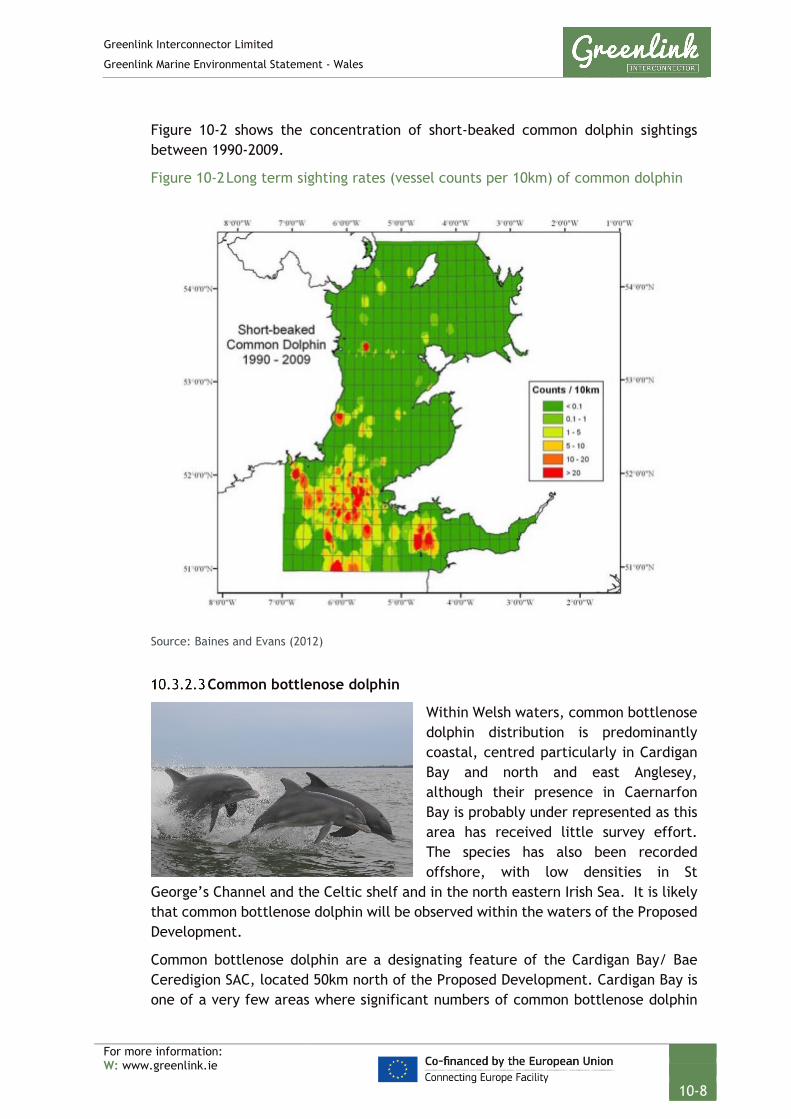
Greenlink Interconnector Limited
Greenlink Marine Environmental Statement - Wales
For more information: W: www.greenlink.ie
10-8
Figure 10-2 shows the concentration of short-beaked common dolphin sightings between 1990-2009.
Figure 10-2 Long term sighting rates (vessel counts per 10km) of common dolphin
Source: Baines and Evans (2012)
Common bottlenose dolphin
Within Welsh waters, common bottlenose dolphin distribution is predominantly coastal, centred particularly in Cardigan Bay and north and east Anglesey, although their presence in Caernarfon Bay is probably under represented as this area has received little survey effort. The species has also been recorded offshore, with low densities in St
George’s Channel and the Celtic shelf and in the north eastern Irish Sea. It is likely that common bottlenose dolphin will be observed within the waters of the Proposed Development.
Common bottlenose dolphin are a designating feature of the Cardigan Bay/ Bae Ceredigion SAC, located 50km north of the Proposed Development. Cardigan Bay is one of a very few areas where significant numbers of common bottlenose dolphin

Greenlink Interconnector Limited
Greenlink Marine Environmental Statement - Wales
For more information: W: www.greenlink.ie
10-9
occur regularly (Baines and Evans 2012). The Lleyn Peninsula and the Sarnau / Pen Llŷn a’r Sarnau SAC, located 121km to the north of the Proposed Development and within the north of Cardigan Bay, lists common bottlenose dolphin as a qualifying feature. Population dynamics discussed below will be applicable to both the Lleyn Peninsula and the Sarnau /Pen Llŷn a’r Sarnau and Cardigan Bay / Bae Ceredigion SACs.
The common bottlenose dolphin population of Cardigan Bay has been estimated to consist of around 100-300 individuals. The number of individuals increases through the summer months, as does the group size reaching a peak in late September and October. There are marked seasonal trends in distribution, with high coastal sighting rates in the summer and autumn, contrasting with low rates in late winter and early spring. During summer months, smaller groups of animals are concentrated in the coastal area and appear to use the inshore waters of Cardigan Bay for both feeding and reproduction, and in the summer months calves and juveniles are often observed with adult individuals or groups (Baines and Evans 2012 and NRW 2018).
Coastal sighting rates drop in late winter and early spring, but this may be a reflection of poorer weather conditions and observers watching the coast. Aerial surveys in Cardigan Bay show a clear preference to offshore areas of the bay during the winter. In addition, there appears to be a northward shift in distribution in the last quarter of the year that may suggest dispersal into the Irish Sea during the winter, and this is the period when largest group sizes (50-150 individuals) have been recorded in North Wales and in Manx waters. However, aerial surveys have observed that at least some animals remain in Cardigan Bay in the winter (Baines and Evans 2012).
Relatively high proportions of juveniles have been recorded throughout Cardigan Bay, and to a lesser extent in North Wales and in Manx waters. Young have been observed in most months of the year, but particularly between April and October. The relatively high sighting rates in Cardigan Bay during summer, with small groups occurring all along the coast, suggests that the Bay is utilised particularly as a calving area for the species (Baines and Evans 2012 and NRW 2018).
Figure 10-3 shows the concentration of common bottlenose dolphin sightings between 1990-2009.
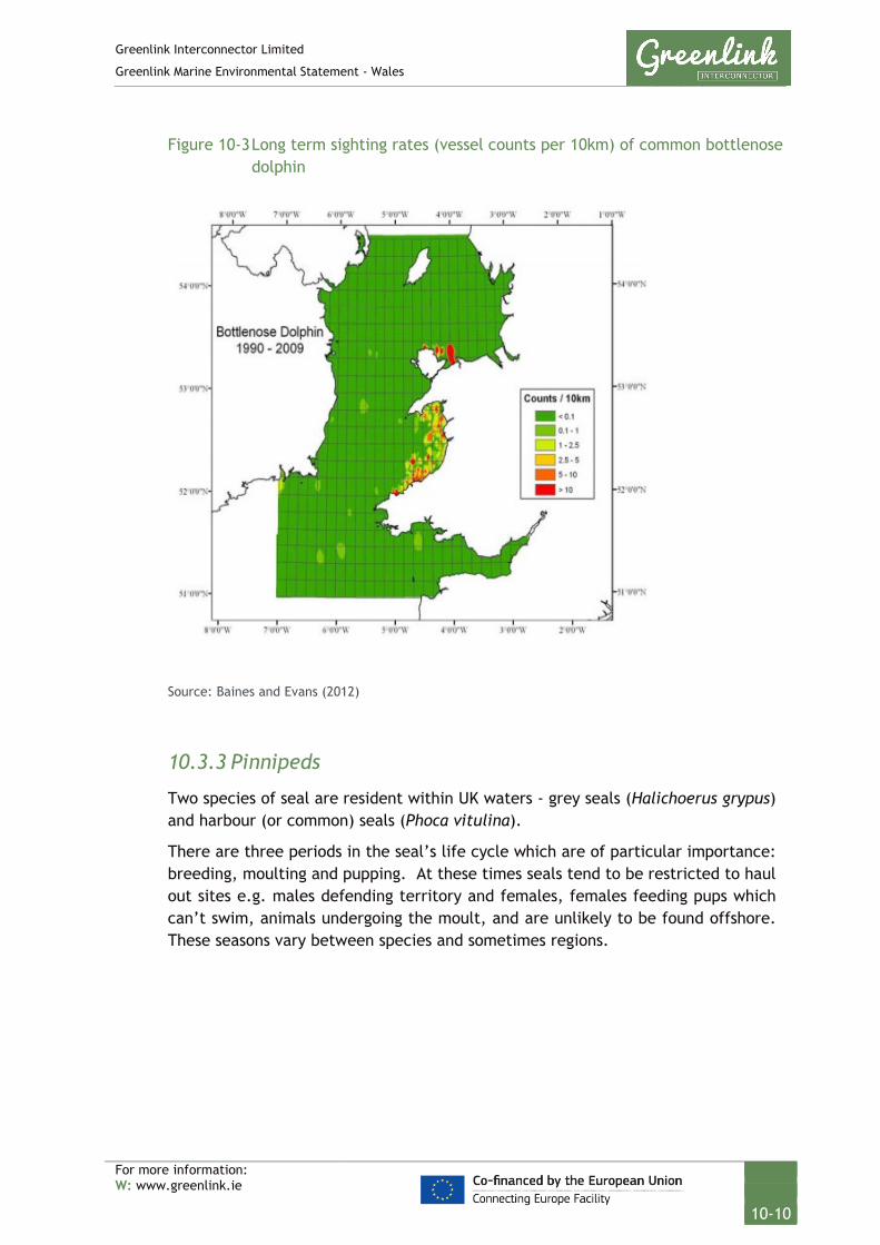
Greenlink Interconnector Limited
Greenlink Marine Environmental Statement - Wales
For more information: W: www.greenlink.ie
10-10
Figure 10-3 Long term sighting rates (vessel counts per 10km) of common bottlenose dolphin
Source: Baines and Evans (2012)
10.3.3 Pinnipeds
Two species of seal are resident within UK waters - grey seals (Halichoerus grypus) and harbour (or common) seals (Phoca vitulina).
There are three periods in the seal’s life cycle which are of particular importance: breeding, moulting and pupping. At these times seals tend to be restricted to haul out sites e.g. males defending territory and females, females feeding pups which can’t swim, animals undergoing the moult, and are unlikely to be found offshore. These seasons vary between species and sometimes regions.

Greenlink Interconnector Limited
Greenlink Marine Environmental Statement - Wales
For more information: W: www.greenlink.ie
10-11
Grey seal Grey seals are present in coastal waters around Wales throughout the year, with pup production highest in Pembrokeshire (Baines and Evans 2012). The Proposed Development lies within the South West England MU and Wales MU for grey seal.
Grey seal are a designating feature of the Pembrokeshire Marine/Sir Benfro Forol SAC (which the Proposed Development
crosses), but animals from the Pen Llyn a’r Sarnau / Lleyn Peninsula and the Sarnau SAC and Bae Ceredigion / Cardigan Bay SAC may also be in the region.
Grey seals utilising the area of the Pembrokeshire Marine/Sir Benfro Forol SAC comprise the major proportion of an isolated breeding population, in which their breeding ecology differs from that of grey seal elsewhere. The population size estimate is approximately 5,000 individuals. Pupping time occurs primarily from August through to December. After three weeks the pups moult, with adults congregating in large numbers on beaches between December and February to moult. Pup production in 2012 was estimated to be 250 in the South West England MU and 1650 in the Welsh MU.
Grey seal can be found within the Pembrokeshire Marine/Sir Benfro Forol SAC all year and favour rocks to haul out such as those present at Stack Fort in Milford Haven, Skomer and Skokholm (Pembrokeshire Marine Special Area of Conservation 2016).
It is estimated (based on Figure 10-4, Russell et al 2017) that the mean number of individuals in the waters of the Proposed Development will vary from 5 to 10 individuals per 5km2. The closest known haul-out sites to the Proposed Development are Linney Head (approximately 4.5km east); and Skokholm Island (approximately 4.5km north); see Figure 10-5.

Greenlink Interconnector Limited
Greenlink Marine Environmental Statement - Wales
For more information: W: www.greenlink.ie
10-12
Figure 10-4 Grey seal at-sea usage: mean
Source: Russell et al (2017)

Greenlink Interconnector Limited
Greenlink Marine Environmental Statement - Wales
For more information: W: www.greenlink.ie
10-13
Figure 10-5 Grey seal breeding locations in Pembrokeshire Marine SAC
Source: http://www.pembrokeshiremarinesac.org.uk/images/Map%206.gif

Greenlink Interconnector Limited
Greenlink Marine Environmental Statement - Wales
For more information: W: www.greenlink.ie
10-14
Harbour seal Harbour seal are widespread around the shores of the UK, but population density varies greatly from place to place with low numbers recorded at many sites. Sightings of harbour seal within the Pembrokeshire Marine / Sir Benfro Foro SAC and along the Proposed Development are infrequent (< 1 individuals per 5km2), as illustrated in Figure 10-6.
Figure 10-6 Harbour seal at-sea usage: mean
Source: Russell et al (2017)
Greenlink Interconnector Limited
Greenlink Marine Environmental Statement - Wales
For more information: W: www.greenlink.ie
10-15
10.3.4 Chelonians
There are five species of marine turtle that have been recorded in British waters. The leatherback turtle (Dermochelys coriacea) is the largest of all the marine turtles and the most commonly recorded turtle in UK waters. There are approximately 33 animals sighted per year in all UK waters (approximately 88% of all turtle sightings) (DECC 2016).
Although the vast majority of turtles recorded in British waters are leatherback turtles, loggerhead turtles (Caretta caretta) and Kemp’s ridley turtles (Lepidochelys kempii) have also occasionally been recorded. Loggerhead turtles have been recorded in low numbers throughout the year and are lethargic due to the low water temperature of UK waters (DECC 2016).
Most turtle sightings are on the west and south coasts of Ireland, southwest England, south and northwest Wales, the west coast of Scotland, Orkney and Shetland. The Irish Sea is considered a through route for leatherbacks passing from south Ireland and south west England through to Northern Ireland and the west coast of Scotland. Leatherback turtles are most commonly observed around the UK and Ireland between June and October, with peak abundances in August (DECC 2016).
10.3.5 Otter
Otter (Lutra lutra) are semi-aquatic mammals which may inhabit rivers, lakes, coastal areas and marshy areas some distance from open water. Coastal populations utilise shallow, inshore marine areas for feeding but also require fresh water for bathing and terrestrial areas for resting and breeding holts. They are commonly seen foraging within a narrow zone close to the shore (<100m) and only rarely cover larger distances, moving between islands (DECC 2016). Otter are a qualifying feature of both the Carmarthen Bay and Estuaries / Bae Caerfyrddin ac Aberoedd, and the Pembrokeshire Marine / Sir Benfro Forol SACs.
Otter are frequent throughout the Pembrokeshire Marine/ Sir Benfro Forol SAC both on open coast and in the Milford Haven waterway especially in areas where there is good access to the sea, sufficient tree and scrub cover and near streams where salt water can be washed off. Otters present within the SAC are part of a wider population living around freshwater habitats in Pembrokeshire, which itself is not completely isolated but extends further afield and between which there are movements and exchanges. Otters within the SAC mostly use moderately sheltered waters close to the shore but spraint (otter dung) records indicate a wide feeding range (NRW 2017).
Potential resting sites in the SAC are in areas with dense vegetation cover on coastal streams draining into the site, rock cavities, reed beds, tree root systems and scrub. No holts are known but potential holt (breeding) sites are present within the site in the Milford Haven waterway, mostly in the Cleddau / Daugleddau (NRW 2017).
An otter survey was carried out between August and September 2018 as part of a suite of ecological surveys to inform the Wales Onshore ES (Arup 2019). This
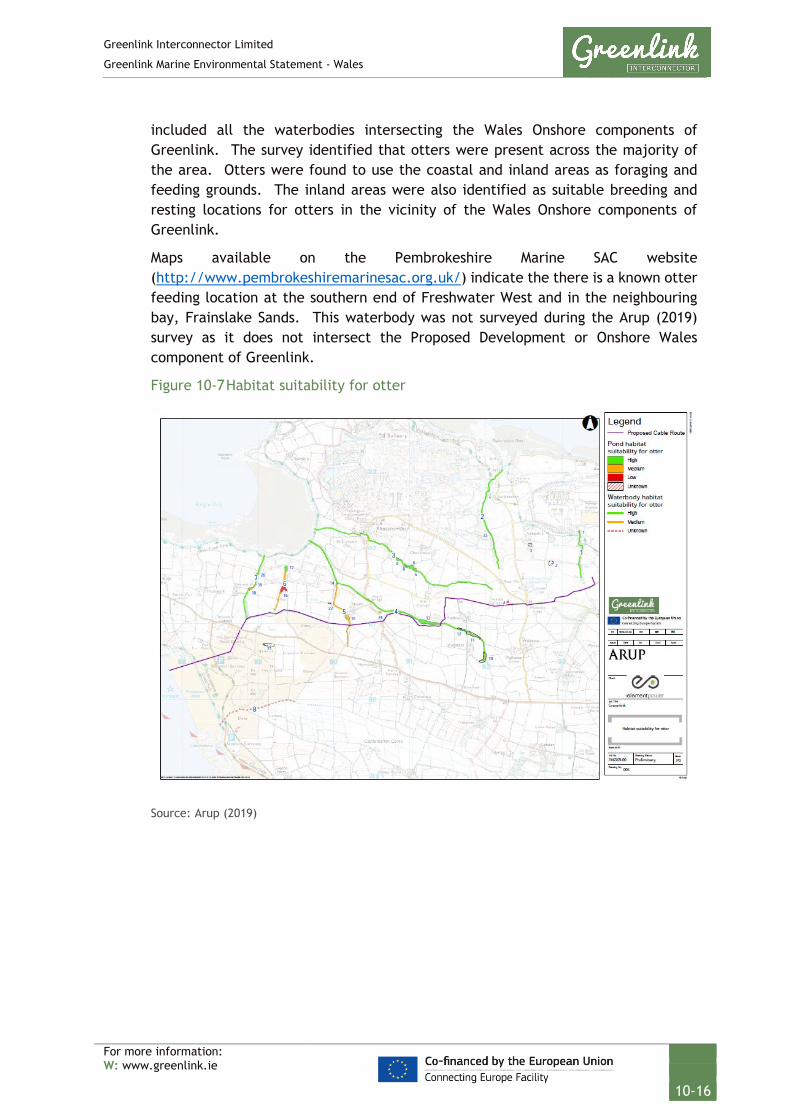
Greenlink Interconnector Limited
Greenlink Marine Environmental Statement - Wales
For more information: W: www.greenlink.ie
10-16
included all the waterbodies intersecting the Wales Onshore components of Greenlink. The survey identified that otters were present across the majority of the area. Otters were found to use the coastal and inland areas as foraging and feeding grounds. The inland areas were also identified as suitable breeding and resting locations for otters in the vicinity of the Wales Onshore components of Greenlink.
Maps available on the Pembrokeshire Marine SAC website (http://www.pembrokeshiremarinesac.org.uk/) indicate the there is a known otter feeding location at the southern end of Freshwater West and in the neighbouring bay, Frainslake Sands. This waterbody was not surveyed during the Arup (2019) survey as it does not intersect the Proposed Development or Onshore Wales component of Greenlink.
Figure 10-7 Habitat suitability for otter
Source: Arup (2019)

Greenlink Interconnector Limited
Greenlink Marine Environmental Statement - Wales
For more information: W: www.greenlink.ie
10-17
10.3.6 Summary
Table 10-3 highlights the periods when marine mammals and reptiles species are most likely to be present within or near to the Proposed Development.
Table 10-3 Seasonal summary of marine mammal and reptile presence within and near the Proposed Development
Receptor Associated protected area*
Winter Summer Winter
Jan Feb Mar Apr May Jun Jul Aug Sep Oct Nov Dec
Harbour
porpoise
West Wales Marine/
Gorllewin Cymru Forol
SAC
Short
beaked
common
dolphin
None
Bottlenose
dolphin
Cardigan Bay/ Bae
Ceredigion SAC
Other
toothed
wales
None
Baleen
wales
None
Harbour
seal
None Infrequent visitors to area
Grey seal Pembrokeshire Marine/
Sir Benfro Forol SAC
Moult Pupping
Leatherback
turtle (and
other
turtles)
None
Otter Pembrokeshire Marine/
Sir Benfro Forol SAC
*Associated protected sites are only those closest to the Proposed Development.

Greenlink Interconnector Limited
Greenlink Marine Environmental Statement - Wales
For more information: W: www.greenlink.ie
10-18
10.3.7 Protected species and species of conservation importance
There is legislation in place which protects marine mammals and reptiles in UK waters. Table 10-4 summarises the key legislation and how it applies to the species identified as present in the Proposed Development.
Table 10-4 Legislation protecting marine mammals and reptiles
Legislation / Convention
Ceta
cean
s
Pinn
iped
s
Chel
onia
ns
Ott
er
The Conservation of
Offshore Marine Habitats
and Species Regulations
2017
Include the necessary legal
measures to fulfil the
requirements of:
• The Convention on the
Conservation of Migratory
Species of Wild Animals
(Bonn Convention); and
• EC Habitats Directive
(particularly in relation to
European Protected
Species)
*
The Conservation of
Habitats and Species
Regulations 2017
*
Wildlife and Countryside
Act 1981 – Schedule 5
*
OSPAR (Convention for the Protection of the Marine
Environment of the North-East Atlantic) list of threatened
and/or declining species
Harbour
porpoise
Loggerhead
turtle,
leatherback
turtle
* Listed as animals which may not be taken or killed in certain ways
All cetaceans, chelonians and otter are listed on Annex IV of the EC Habitats Directive as European Protected Species. It is an offence to deliberately kill, injure or disturb animals classed as EPS.
The following protected sites list a cetacean or otter as a designating feature. These are assessed in detail in the Greenlink HRA (Technical Appendix C).
• West Wales Marine / Gorllewin Cymru Forol SAC - harbour porpoise;
• Pembrokeshire Marine/ Sir Benfro Forol SAC - grey seal;
• Bristol Channel Approaches/ Dynesfeydd Môr Hafren SAC – harbour porpoise;
• North Anglesey Marine/ Gogledd Môn Forol SAC – harbour porpoise;
• Cardigan Bay/ Bae Ceredigion SAC – bottlenose dolphin and grey seal;
• Cardigan Bay / Bae Ceredigion SAC – bottlenose dolphin; and
• Lleyn Peninsula and the Sarnau / Pen Llyn a’r Sarnau SAC – bottlenose dolphin and grey seal.

Greenlink Interconnector Limited
Greenlink Marine Environmental Statement - Wales
For more information: W: www.greenlink.ie
10-19
10.3.7.1 Environment (Wales) Act 2016 – Section 7 Priority species The following species found within the Proposed Development are listed on the interim Priority Species lists issued by the Welsh Government (Welsh Government 2016):
Table 10-5 Environment (Wales) Act 2016 - Section 7 Priority species present within the Proposed Development
Species Common name
Delphinus delphis Common dolphin
Grampus griseus Risso’s dolphin
Lagenorhynchus acutus Atlantic white-sided dolphin
Lagenorhynchus albirostris White-beaked dolphin
Phocoena phocoena Harbour porpoise
Stenella coeruleoalba Striped dolphin
Tursiops truncatus Bottlenose dolphin
Lutra lutra Otter
Balaenoptera acutorostrata Minke whale
Balaenoptera physalus Fin whale
Globicephala melas Long-finned pilot whale
Megaptera novaeangliae Humpback whale
Orcinus orca Killer whale
10.3.8 Natural evolution of the baseline
The natural evolution of the baseline has been compiled using information gathered from the Offshore Energy Strategic Environmental Assessment 3 (OESEA 3) (DECC 2016). Range shifts in species distribution as a result of climate change are predicted to occur in the north-east Atlantic, and by extension the Celtic Sea, as average sea temperatures rise, with evidence of shifts already being reported. Species that prefer colder waters such as the white-beaked dolphin may move further northward while warm-water species such as the striped dolphin may become more common in the Irish Sea (DECC 2016). Fishing is another pressure which could affect populations of marine mammals along the Proposed Development
Grey seal populations in the Pembrokeshire Marine SAC and the UK as a whole have stabilised in recent years after a period of growth, with their conservation status being considered favourable for the future (JNCC 2013a). Harbour porpoise in the West Wales Marine SAC have a current favourable status which is set to continue

Greenlink Interconnector Limited
Greenlink Marine Environmental Statement - Wales
For more information: W: www.greenlink.ie
10-20
into the future, providing conservation measures are maintained and further measures are taken (JNCC 2013b).
It is acknowledged that currently marine mammals’ responses to climate change in UK waters are poorly understood, with difficulties in surveying current populations leading to gaps in data used to estimate abundances. It is recognised however that climate change could lead to changes in physical habitat, food webs and an increases susceptibility to disease and contaminants. Populations that have been subject to frequent monitoring, such as the bottlenose dolphin population in Cardigan Bay to the north of the Proposed Development, have shown declines in the past 10 years, with prey availability being seen as a potential factor in this decline (Lohrengel et al. 2018).
From the information provided above, it can be predicated that some populations of marine mammal species observed along the Proposed Development will remain in a favourable condition, providing conservation measures are adopted. However, without conservation measures some populations (i.e. bottlenose dolphin in Cardigan Bay) may see increasing declines.
10.4 Potential Pressure Identification and Zone of Influence
A scoping exercise undertaken to inform the content of the EIA has excluded the following pressures from further consideration in this topic Chapter. Explanation for the exclusion is provided in Chapter 5, Table 5-2.
• Death of injury by collision; and
• Hydrocarbon contamination.
The pressures listed in Table 10-6 will be assessed further. For each pressure the assessment considered the different aspects of the project during installation, operation (including repair & maintenance) and decommissioning. In order to evaluate the most significant effects, the largest zone of influence from these aspects was selected. The zones of influence are presented in Table 10-6.
Table 10-6 Pressure identification and zone of influence – marine mammals and reptiles
Project Phase Project Activity
Aspect Potential Pressure Receptor Zone of Influence
Installation Cable burial Continuous noise – vessel dynamic positioning thrusters, cable trenching, rock or concrete mattress placement
Underwater noise changes - physical injury
Cetacean Pinniped Otter
No effect
Operation Repair & maintenance operations
Underwater noise changes - disturbance
Cetacean Pinniped Otter
130m
Decommissioning Cable removal
Installation Pre-installation, post-installation survey
Continuous noise – Geophysical survey
Underwater noise changes – physical injury
Cetacean Pinniped Otter 180m

Greenlink Interconnector Limited
Greenlink Marine Environmental Statement - Wales
For more information: W: www.greenlink.ie
10-21
Project Phase Project Activity
Aspect Potential Pressure Receptor Zone of Influence
Operation Maintenance survey Underwater noise
changes - disturbance
Cetacean Pinniped Otter
2.6km Decommissioning Survey
Installation Cable burial Impulsive noise e.g. Unexploded ordnance (UXO) detonation
Underwater noise changes - physical injury
Cetacean 27km
Pinniped 17km
Otter 7.6
Chelonian 6.2
Operation Repair & maintenance operations
Underwater noise changes - disturbance
Cetacean 54km
Pinniped
Otter
Operation Presence of cables
Magnetic fields (B fields)
Electromagnetic changes – impairment of navigation or orientation
Cetaceans 2m from the cables
* Defined in Technical Appendix D – Noise Assessment
10.5 Embedded Mitigation
The project description, Chapter 4, provides the current ‘base case’. This includes mitigation measures which form part of the design and are therefore an inherent part of the Proposed Development and comprise embedded or primary mitigation. The embedded mitigation relevant to marine mammals and reptiles is provided in Table 10-7. When undertaking the EIA it is assumed that these measures will be complied with; either as a matter of best practice or to ensure compliance with statute.
Table 10-7 Embedded mitigation
ID Embedded Mitigation
EM19 Project vessels will not exceed 14 knots within the Proposed Development.
EM20 GIL will require that the appointed contractor(s) follows the ‘JNCC guidelines for
minimising the risk of injury and disturbance to marine mammals from seismic
surveys’ (JNCC 2017) (or subsequent amendments), appropriate to sub-bottom
profiling and multi-beam and echo-sounder surveys respectively. In particular:
• Establishing a 500m mitigation zone for marine mammal observation.
• Provide non-dedicated marine mammal observers to implement the JNCC guidelines
within the Pembrokeshire Marine / Sir Benfro Forol SAC and West Wales Marine /
Gorllewin Cymru Forol SAC.
• Undertake pre-survey search - On-board marine mammal observer (MMObs) will
scan the waters surrounding the vessel for 30 minutes before operations start to
determine whether any marine mammals are within 500m of the survey equipment.
Greenlink Interconnector Limited
Greenlink Marine Environmental Statement - Wales
For more information: W: www.greenlink.ie
10-22
ID Embedded Mitigation
• Where possible, according to the operational parameters of the equipment
concerned, its acoustic energy output shall commence from a lower energy start-
up and thereafter be allowed to gradually build up to the necessary maximum
output over a period of at least 15 minutes, with the duration from the start of the
soft start until the start of the survey line being a maximum of 25 minutes.
• If the device cannot be ramped up then it shall be switched on and off in a
consistent sequential manner over a period of 20 minutes prior to commencement
of the full necessary output.
EM21 A UXO survey will be undertaken less than 6 months prior to installation works
commencing. If any significant UXO are identified the following decision-making
process will be followed:
1. Avoid by micro-routing the marine cables.
2. If it cannot be avoided, consider whether it is safe to move.
3. If it cannot be moved, arrange for detonation.
EM23 GIL will require that the appointed UXO contractor follows the JNCC guidelines for
minimising the risk of injury to marine mammals from using explosives (JNCC 2010, or
as updated) including:
• Establishing a default 1km mitigation zone for marine mammal observation,
measured from the explosive source and with a circular coverage of 360 degrees.
• Providing a trained Marine Mammal Observer to implement the guidelines outlined
in Section 2.1 to 2.4 e.g. pre-detonation search of mitigation zone.
• Only commence explosive detonations during daylight hours and good visibility.
• Accurately determine the amount of explosive required for the operation, so that
the amount is proportionate to the activity and not excessive.
• If necessary, plan the sequence of multiple explosive discharges so that, wherever
possible, the smaller charges are detonated first to maximise the ‘soft-start’ effect.
10.6 Significance Assessment
10.6.1 Summary of assessment
Table 10-8 presents the impact assessment conducted on the Proposed Development activities. Sections 10.6.2 and 10.6.3 provide justification for the conclusions. Where the assessment concluded the effects are significant, Project Specific Mitigation has been proposed and is described in Section 10.7. Where there is still potential for residual effects, this is discussed further in Section 10.8.

Greenlink Interconnector Limited
Greenlink Marine Environmental Statement - Wales
For more information: W: www.greenlink.ie
10-23
Table 10-8 Impact Assessment Summary – Marine mammals and reptiles
Determination of potential impact Impact assessment Consideration of mitigation
Residual Impact assessment
Section Project Phase Aspect Embedded mitigation
(Table 10-7)
Potential Pressure Receptor Magnitude Sensitivity Significance Project Specific Mitigation
(Table 10-11)
Magnitude Sensitivity Significance of Residual Effect
10.3.2 10.3.3 10.3.5
Installation
Operation
Impulsive noise e.g. UXO detonation
EM21, EM23 Underwater noise changes - injury
Marine mammals
Medium High Major PS9, PS10, P11, PS12
Low Medium Minor
10.3.4 Sea turtles Low Medium Minor PS9, PS10, P11, PS12
Low Low Negligible
10.3.2 10.3.3 10.3.5
Underwater noise changes - disturbance
Marine mammals
Low High Moderate PS9, PS10, P11, PS12
Low Medium Minor
10.3.2 10.3.3 10.3.5
Installation
Operation
Decommissioning
Continuous noise – Geophysical survey
EM20 Underwater noise changes - injury
Marine mammals
Low Negligible Negligible - - - -
Underwater noise changes - disturbance
Low Medium Minor - Low Medium Minor
10.3.2 10.3.3 10.3.5
Installation
Operation
Decommissioning
Continuous noise – vessel dynamic positioning thrusters, cable trenching, external cable protection placement
- Underwater noise changes - injury
Marine mammals
Negligible Negligible Negligible - - - -
Underwater noise changes - disturbance
Low Medium Minor - - - -

Greenlink Interconnector Limited
Greenlink Marine Environmental Statement - Wales
For more information: W: www.greenlink.ie
10-24
Determination of potential impact Impact assessment Consideration of mitigation
Residual Impact assessment
Section Project Phase Aspect Embedded mitigation
(Table 10-7)
Potential Pressure Receptor Magnitude Sensitivity Significance Project Specific Mitigation
(Table 10-11)
Magnitude Sensitivity Significance of Residual Effect
10.3.2 Operation Magnetic field (B fields)
- Electromagnetic changes – impairment of navigation or orientation
All cetacean species
Low Negligible Negligible - - - -

Greenlink Interconnector Limited
Greenlink Marine Environmental Statement - Wales
For more information: W: www.greenlink.ie
10-25
10.6.2 Underwater noise changes
Installation, Operation (including maintenance and repair) and decommissioning
One of the most important environmental concerns related to the Proposed Development is the potential effects of underwater sound. This pressure considers the potential for marine mammals to be affected by sound associated with activities undertaken during each phase of the Proposed Development.
Both cetaceans and pinnipeds have evolved to use sound as an important aid in navigation, communication and hunting (Richardson et al. 1995). It is generally accepted that exposure to anthropogenic sound can induce a range of behaviour effects to permanent injury in marine mammals. Loud and prolonged sound above background levels is considered to be noise and may have an effect on marine life. This may mask communicative or hunting vocalisations, preventing social interactions and effective hunting.
High intensity noises such as from seismic survey, explosions and pile driving can cause temporary or permanent changes to animals’ hearing if the animal is exposed to the sound in close proximity and, in some circumstances, can lead to the death of the animal (Richardson et al. 1995). Where the threshold of hearing is temporarily damaged, it is considered a temporary threshold shift (TTS), and the animal is expected to recover. If there is permanent damage (permanent threshold shift (PTS)) where the animal does not recover, social isolation and a restricted ability to locate food may occur, potentially leading to the death of the animal (Southall et al. 2007).
Behavioural disturbance from underwater sound sources is more difficult to assess than injury and is dependent upon many factors related to the circumstances of the exposure (Southall et al. 2007, NFMS 2018). An animal’s ability to detect sounds produced by anthropogenic activities depends on its hearing sensitivity and the magnitude of the noise compared to the amount of natural ambient and background anthropogenic sound. In simple terms for a sound to be detected it must be louder than background and above the animal’s hearing sensitivity at the relevant sound frequency.
Behavioural responses caused by disturbance may include animals changing or masking their communication signals, which may affect foraging and reproductive opportunities or restrict foraging, migratory or breeding behaviours; and factors that significantly affect the local distribution or abundance of the species. An animal may swim away from the zone of disturbance and remain at a distance until the activities have passed. Behavioural disturbance to a marine mammal is hereafter considered as the disruption of behavioural patterns, for example: migration, breeding and nursing.
To calculate the zone of influence for both levels of effect (injury and disturbance), an assessment has been conducted which combines literature review with

Greenlink Interconnector Limited
Greenlink Marine Environmental Statement - Wales
For more information: W: www.greenlink.ie
10-26
underwater sound modelling. Sound propagation modelling, using a geometric spreading calculation, was used to determine the range at which the received sound attenuates to levels below defined thresholds for injury and disturbance. The assessment has used both the recently published American National Marine Fisheries Service (NMFS) (2018) thresholds for the onset of PTS and TTS and the thresholds defined by Southall et al. (2007). These reflect the current peer-reviewed published state of scientific knowledge.
The sound levels, injury and disturbance thresholds, the calculations and the resulting zones of influence are described and provided in full in Technical Appendix D; and key information relevant to the assessment is summarised below.
Southall et al. (2007) and the NFMS (2018) separate marine mammals into five groups based on their functional hearing as summarised in this section.
Table 10-9 Marine mammal groups based on auditory bandwidth
Group (based on auditory
bandwidth) *
Species observed along Greenlink route
Low-frequency cetaceans (LFC) Minke whale, Humpback whale and Fin whale
Mid-frequency cetaceans (MFC) Short-beaked common dolphin, Common bottlenose dolphin,
Stripped dolphin, Risso’s dolphin, Atlantic white-sided dolphin,
White-beaked dolphin, Long-finned pilot whale and Killer whale
High-frequency cetaceans
(HFC)
Harbour porpoise
Pinnipeds (Phocid) in water
(PIW)
Grey seal, harbour seal
* Based on NFMS (2018)
In addition, underwater sound is categorised into two distinct types: impulsive and continuous (i.e. non-pulse). Activities undertaken during the Proposed Development fall into both categories, as outlined in Table 10-10. Sound sources were obtained through literature review (referenced in Technical Appendix D).
Table 10-10 summarises the zones of influence for each sound category, activity and marine mammal group as calculated in Technical Appendix D.

Greenlink Interconnector Limited
Greenlink Marine Environmental Statement - Wales
For more information: W: www.greenlink.ie
10-27
Table 10-10 Zones of influence for each sound category, activity and marine mammal group
Type of Noise
Activity I O D Zone of influence
Injury Disturbance
LFC MFC HFC PIW LFC MFC HFC PIW
Impulsive UXO detonation* 13km 5.8km 23km 13km 54km
Continuous
Geophysical survey 40m 7m 180m 40m 2.6km
Vessel dynamic positioning (DP) thrusters
Threshold not exceed – No effect
50m
Cable trenching Threshold not exceed – No effect
17m
Rock placement Threshold not exceed – No effect
130m
Key: I = Installation, O= Operation (including maintenance and repair), D = Decommissioning
* denotes worst-case, based on 794kg explosive detonation.
Although modelling indicates the risk of injury, it should be noted that the calculation for injury and disturbance does not account for the directional quality of the noise source, seabed interactions, seabed type, change in salinity, bathymetry, temperature or density, which would reduce the zone of influence. In addition to cylindrical spreading loss for acoustic propagation in the water column, higher frequency acoustic energies are more quickly absorbed through the water column than sounds with lower frequencies. Due to these factors, the distances for the zones of influence are highly conservative and worst case.
The majority of cetacean species identified with the potential to be present within Proposed Development are mid-frequency cetaceans with the exception of minke whale which, like other baleen whales, is more sensitive at lower frequencies and harbour porpoise which is sensitive at higher frequencies.
Injury from continuous sound – cable installation
There is little information on potential effects of sound on marine mammals, resulting from the installation and operation of subsea cables; research has typically focused on high intensity impulsive sound sources such as seismic survey and piling. The Oslo and Paris (OSPAR) Convention (2012) considered that sound associated with the installation, removal or operation of submarine cables is less harmful compared to impulsive sound activities such as seismic surveys, military activities or construction work involving pile driving (OSPAR Convention 2012). However, frequent noise exposure can lead to longer term effects associated with continuous stress (National Research Council 2003). Chronic stress in marine mammals can result in infectious, neoplastic, allergic, inflammatory and autoimmune diseases, and also can reduce reproduction; however, stress-induced reactions are hard to identify (National Research Council 2003).

Greenlink Interconnector Limited
Greenlink Marine Environmental Statement - Wales
For more information: W: www.greenlink.ie
10-28
Technical Appendix D and Table 10-10 concludes that sound resulting from cable installation activities (DP vessel, trenching, rock placement etc.) does not exceed the thresholds for permanent (PTS) or temporary (TTS) injury. Cetaceans and pinnipeds are therefore not at risk of injury from the cable installation, and the significance of the effect has been assessed as Negligible and is Not Significant.
This potential effect has also been assessed within the Greenlink Habitats Regulations Assessment (HRA) – Technical Appendix C, with respect to potential effects on the West Wales Marine / Gorllewin Cymru Forol SAC designated for harbour porpoise and the Pembrokeshire Marine/ Sir Benfro Forol SAC designated for grey seal. The HRA concluded no potential for significant effects and that an Appropriate Assessment is not required for these activities.
Injury from continuous sound – geophysical survey
Geophysical survey will be used pre-installation to confirm that no new obstructions have appeared on the seabed since the cable route survey was undertaken. It will also be used post-installation to confirm burial depth or conduct inspection surveys.
Technical Appendix D (with worst-case zones of influence summarised in Table 10-10) concludes that:
• Minke whale (low-frequency cetacean) are vulnerable to permanent injury with 15m and to temporary injury within 40m of the multi-beam echosounder.
• Toothed whales and dolphins (mid-frequency cetaceans), which are the majority of species encountered in the Proposed Development, are vulnerable to permanent injury within 2.6m and to temporary injury within 7m of the multi-beam echosounder.
• Harbour porpoise (high-frequency cetacean) are vulnerable to sound generated by the multi-beam echosounder, sidescan sonar and sub-bottom profilers with the largest zone of influence being from the multibeam echosounder. Permanent injury could occur within 110m and temporary injury within 180m of the multi-beam echosounder.
• Pinnipeds in water are vulnerable to sound from the multi-beam echosounder and sidescan sonar, with permanent injury potentially occurring within 15m and temporary injury within 40m of the multi-beam echosounder.
There is the potential for harbour porpoise and grey seal from the West Wales Marine / Gorllewin Cymru Forol SAC and Pembrokeshire Marine/ Sir Benfro Forol SAC, respectively, to be present within the Proposed Development. Individual animals from other protected sites may also be present within the Proposed Development as marine mammals are highly mobile.
The most sensitive species to underwater sound changes within the Proposed Development is harbour porpoise. As part of an appropriate assessment looking at effects of underwater sound on an area of importance for harbour porpoise, BEIS (2018) stated that "Geophysical surveys (primarily 2D and 3D seismic) have the potential to generate sounds that exceeds thresholds of injury, but only within a

Greenlink Interconnector Limited
Greenlink Marine Environmental Statement - Wales
For more information: W: www.greenlink.ie
10-29
limited range from source (tens to hundreds of metres); for site surveys [which includes sub-bottom profilers], the range from source over which injury may occur will be even smaller." For geophysical survey it is best practice to follow the JNCC guidelines for minimising the risk of injury to marine mammals from geophysical surveys (JNCC 2017). JNCC (2017) affirms that adherence to the guidelines constitutes best practice and will, in most cases, reduce the risk of deliverable to injury to marine mammals to negligible levels. Adherence to the guidelines has been incorporated into the Proposed Development as embedded mitigation EM20.
In line with the conclusions of the HRA, the EIA process has concluded that the embedded mitigation EM20 (adherence to JNCC guidelines for geophysical survey) reduces the sensitivity of the receptors (harbour porpoise and grey seal) to negligible. The magnitude has been assessed as low because there will be site specific changes in sound levels. The overall significance of the effect has been assessed as Negligible and is Not Significant.
This potential effect has also been assessed within the Greenlink Habitats Regulations Assessment (HRA) – Technical Appendix C with respect to potential effects on the West Wales Marine / Gorllewin Cymru Forol SAC designated for harbour porpoise and the Pembrokeshire Marine/ Sir Benfro Forol SAC designated for grey seal. The HRA concluded no potential for significant effects and that an Appropriate Assessment is not required for these activities.
Injury from impulsive sound
It is unknown how many, if any, UXO detonations will be required within the Proposed Development. The Proposed Development passes through the Castlemartin Firing Range, so it is highly likely that UXO will be encountered. The Greenlink UXO desk-based assessment (1st Line Defence 2018) also identified a high-risk area in the St Georges Channel; a former WWII sea mine ground.
A UXO survey has been completed for the section of the Proposed Development within the Castlemartin Firing Range which has identified a few magnetic anomalies but there is sufficient space within the application area for the cable to be micro-sited around any potential UXO (in accordance with the decision-making process outlined in EM21 i.e. first avoid, then remove, and if neither previous option is feasible, detonate). An additional UXO survey will be completed ahead of the installation campaign to ensure that any new UXO or UXO that has moved is identified.
Should UXO be found which require clearance by detonation it is assumed that there would be a relatively large release of impulsive sound energy, creating high amplitude shock waves (von Benda-Beckmann et al. 2015). Peak source levels would depend on the quantity and nature of explosive material. At close range there would be risk of mortality as relatively small quantities of explosive can result in significant sound pressure levels, e.g. Richardson et al. (1995) reported that 0.5kg of TNT was associated with a peak of 267dB re 1µPa @ 1m.
The precise injury effect range cannot be stated in advance of information on the

Greenlink Interconnector Limited
Greenlink Marine Environmental Statement - Wales
For more information: W: www.greenlink.ie
10-30
nature and quantity of explosive material potentially involved, which will not be known until a UXO is identified. To provide a worst-case, Technical Appendix D modelled the sound from a 794kg explosive (equivalent to a sea mine), which 1st Line Defence (2018) identified as the largest explosive device to have been used historically in the region. It should be noted that this size of magnetic anomaly has not been identified in the 2019 UXO data from Castlemartin Firing Range.
Results from the assessment are highly conservative, due to the high explosive weight used to estimate the sound levels. In addition, the geometric spreading modeling does not take into consideration variables such as water depth, source and receiver depths, temperature gradients, salinity, seabed ground conditions bathymetry, water depth or sediment type and thickness, all of which affect received levels.
The modelling results provided in Technical Appendix D and summarised in Table 10-10, conclude that cetaceans and pinnipeds are at risk of temporary and permanent injury from UXO detonation. At close range there would be risk of mortality as relatively small quantities of explosive can result in significant sound pressure levels.
• Minke whale (low-frequency cetacean) are vulnerable to permanent injury within 13km and to temporary injury within 17km from the UXO detonation;
• Toothed whales and dolphins (mid-frequency cetaceans), which are the majority of species encountered in the Proposed Development, are vulnerable to permanent injury within 5.8km and to temporary injury within 8.6km of the UXO detonation;
• Harbour porpoise (high-frequency cetacean) are vulnerable to permanent injury within 23km and to temporary injury within 27km of the UXO detonation; and
• Pinnipeds in water are vulnerable to permanent injury with 13km and to temporary injury within 17km from the UXO detonation.
Von Benda-Beckmann et al. (2015) studied the impact of UXO detonations on harbor porpoise in the North Sea. The study showed that a detonation of 263kg of explosive (794kg explosive weight has been used for this assessment) could result in physical injury within 500m of the explosion.
Although all species are at risk of injury from an UXO detonation, harbour porpoise are the species likely to be affected over the greatest distance – 23km for permanent (PTS) and 27km for temporary injury. The Proposed Development crosses the West Wales Marine / Gorllewin Cymru Forol SAC, which is designated to conserve harbour porpoise. The SAC supports approximately 5.4% of the UK Celtic and Irish Seas management unit population (over 5,000 individuals) and covers an area of 7,376km2.
The Conservation Objectives and Advice on Operations published by the JNCC (2019) for the SAC suggests…
“noise disturbance within an SAC from a plan/project individually or in

Greenlink Interconnector Limited
Greenlink Marine Environmental Statement - Wales
For more information: W: www.greenlink.ie
10-31
combination is significant if it excludes harbour porpoises from more than
1. 20% of the relevant area of the site in any given day, and
2. An average of 10% of the relevant area of the site over a season.”
A single UXO detonation, could cause sound levels sufficient to cause temporary injury to harbour porpoise over a 27km radial distance; 2290km2. This is equivalent to noise disturbance over 31% of the West Wales Marine / Gorllewin Cymru Forol SAC area for a day.
This potential effect has also been assessed within the Greenlink Habitats Regulations Assessment (HRA) – Technical Appendix C. The HRA concluded significant effects are likely and that an Appropriate Assessment is required.
In line with the conclusions of the Greenlink HRA, the EIA process has concluded that as harbour porpoise are a designating feature of the West Wales Marine / Gorllewin Cymru Forol SAC the sensitivity of the receptor is high. The magnitude has been assessed as medium because the spatial extent of the effect is greater than the Proposed Development footprint, and it exceeds the JNCC (2019) threshold for a significant effect. The overall significance of the effect has been assessed as Major and is Significant.
Effect of impulsive sound from UXO detonations on sea turtles has also been considered in Technical Appendix D. Mortality and potential mortal injury were considered likely to occur within 6.2km and 4.2km respectively of the sound source. Sea turtles are unlikely to be found in high numbers in the Proposed Development, as they are rare visitor (see Section 10.3.4). The effects on sea turtles is therefore considered to be Minor and is Not Significant.
Project Specific Mitigation has been proposed in Section 10.7, to reduce the significance of the residual effect.
Disturbance from continuous sound – cable installation The modelling conducted in Technical Appendix D concluded that all marine mammals are vulnerable to disturbance from cable installation activities, but the zone of influence is small; 130m radial distance from activities. The cable installation activities will move slowly along the cable route and although animals may briefly avoid the activity they will return to an area once the activity has passed through. The current level of shipping and ambient sound within the Celtic Sea will not increase significantly from the presence of the project vessels during the cable installation.
The assessment concluded that the magnitude of the effect was negligible and that the sensitivity was negligible, given the small zone of influence, the brief nature of the effects and the mobile nature of the animals. The overall significance has been assessed as Negligible and is Not Significant.

Greenlink Interconnector Limited
Greenlink Marine Environmental Statement - Wales
For more information: W: www.greenlink.ie
10-32
Disturbance from continuous sound – geophysical survey
The geometric spreading model (Technical Appendix D) suggests that disturbance could occur within up to 2.6km from the sound source as a worst-case. This suggests that all marine mammals could be disturbed by the sound emitted by the SBP, MBES and SSS. The worst-case disturbance is resulting from noise emitted from the SBP.
Evidence of the effects of geophysical surveys on cetaceans is limited but BEIS (2018) summarises the results of a study carried out in the Moray Firth that observed responses to a 10-day 2D seismic survey. The 2D seismic survey took place in September 2011 and exposed a 200km2 area to noise throughout that period. A 470 cubic inch airgun array was used, which generated peak-to-peak source levels of 242-253 dB re-1μPa @ 1m4. A relative decrease in density of harbour porpoise within 10km of the survey vessel was reported. However, these effects were short-lived, with porpoise returning to the area within 19 hours after cessation of activities. BEIS (2018) also states that “information on the potential effects of other geophysical surveys (e.g. sub-bottom profilers) is currently very limited and the most recent UK Offshore Energy Strategic Environmental Assessment (DECC 2016) concluded that effects are negligible but with a high degree of uncertainty”.
The underwater sound changes associated with the geophysical survey, and therefore the associated potential for disturbance is generally acknowledged as small when compared to activity such as use of air guns during 2D and 3D seismic and wind farm piling. The proposed geophysical surveys would be restricted in duration and will progress slowly within the Proposed Development. Animals will have sufficient time to avoid the survey vessel, and it is unlikely that they will swim over operating equipment. Animals may actively avoid the survey but as demonstrated by the research in the Moray Firth will return to the area once the survey has passed through i.e. within a day if not hours. The surveys would therefore not act as a barrier to migration routes or cause significant long-term disturbance.
Marine mammals are highly mobile, and species identified as likely to be observed in the Proposed Development range widely across their management unit. While the sound generated by the geophysical survey may create a disturbance for marine mammals that lead to them avoiding the area for a short-time, the species are wide ranging and will return.
It is likely that marine mammals within the application area will experience transient disturbance and the embedded mitigation EM20 (i.e. following JNCC guidelines for minimising the risk of injury and disturbance to marine mammals from seismic surveys’) will help to reduce the likelihood of significance effects. The assessment has therefore concluded that the significance of the effect on any marine mammals is Minor and is Not Significant.
4 In comparison Technical Appendix D identifies that the highest sound pressure level will be generated by the MBES and will be 235 dB0-peak re 1μPa2-s

Greenlink Interconnector Limited
Greenlink Marine Environmental Statement - Wales
For more information: W: www.greenlink.ie
10-33
Disturbance from impulsive sound
In the event that UXO detonation is required, it is likely to result in disturbance to marine mammals over a large area, regardless of the weight of the explosive. As mentioned above, the case specific disturbance range cannot be stated in advance of information on the nature and quantity of explosive material potentially involved; this assessment therefore presents a worst-case. Disturbance resulting from a single 794kg UXO detonation would cover an area of up to 9,160km2, which represents an area greater than 20% of the West Wales Marine / Gorllewin Cymru Forol SAC; and therefore could result in a likely significant effect, prior to the implementation of any project specific mitigation. However, it is anticipated that any behavioural effects will be reversible. The UXO detonation would be discrete, one-off occurrences and effects are brief.
This potential effect has also been assessed within the Greenlink Habitats Regulations Assessment (HRA) – Technical Appendix C. The HRA concluded significant effects are likely and that an Appropriate Assessment is required.
In line with the conclusions of the Greenlink HRA, the EIA process has concluded that as harbour porpoise are a designating feature of the West Wales Marine / Gorllewin Cymru Forol SAC the sensitivity of the receptor is high. The magnitude has been assessed as low because the spatial extent of the effect is greater than the Proposed Development footprint but the disturbance will be brief (one-event in one day). However, it exceeds the JNCC (2019) threshold for a significant effect. The overall significance of the effect has been assessed as Moderate and is Significant.
Project Specific Mitigation has been proposed in Section 10.7, to reduce the significance of the residual effect.
10.6.3 Electromagnetic changes
Operation (including maintenance and repair)
Cetaceans are thought to use the magnetic particles in their tissues to detect magnetic fields (Kirschvink 1997, cited in NIRAS 2017). The mechanism of how this is done is still unknown, but it is generally acknowledged that they are able to use magnetic cues, such as the Earth’s geomagnetic field to navigate their environment during migration. Marine mammals are potentially sensitive to minor changes in magnetic fields and local variations cause by power cable electromagnetic fields.
The background geomagnetic field in the vicinity of the Proposed Development is anticipated to be approximately 48.7 µT (Natural Resources Canada 2019). Submarine power cables generate magnetic fields owing to the electric current flowing along the cables. The magnitude of the magnetic field (B field) produced is directly dependent on the level of flow.
In addition, localised static electric fields may be induced as seawater (tidal flow) or other conductors such as marine organisms pass through the DC cable’s magnetic

Greenlink Interconnector Limited
Greenlink Marine Environmental Statement - Wales
For more information: W: www.greenlink.ie
10-34
field. These induced electric fields (iE fields) will attenuate with both horizontal and vertical distance from the cable conductor. Burial depth can reduce the effect range of EMFs but to a lesser extent than cable bundling, due to mutual cancellation of the positive and negative poles and currents travelling in opposite directions.
It has been calculated that the Greenlink cables will generate B fields of 21µT directly over the cables reducing to natural background levels within 2m. The iE fields are estimated to be between 48.79 and 69.7 μV/m at 1m from the cables. No detectable change above background geomagnetic fields will be noticeable at 2m from the cables.
Emissions of magnetic fields (B fields) have the potential to cause temporary changes in swim direction or greater detours during migration in sensitive species (Gill et al. 2005). This may temporarily affect sensitive species crossing the submarine cables or passing along their length, and therefore temporarily reduce their navigational ability when within the immediate vicinity of the cables. The implications for temporary loss of navigation for cetaceans are not fully understood. However, there have been no reported effects to the migration of harbour porpoise or other cetacean over existing interconnector cables (Gill et al. 2005). Harbour porpoise migration across the Skagerrak and western Baltic Sea has been observed unhindered despite several crossings over operating sub-sea HVDC cables (Walker 2001, cited in NIRAS 2017).
Owing to their predominantly pelagic existence, the rapid attenuation of the B field to background levels or below within 2m of the cables, the water depth greater than 2m over most of the Proposed Development, combined with lack of evidence of effects upon cetaceans, it is expected that cetaceans will be unaffected by magnetic fields from the Proposed Development.
There had been a widely held view that cetaceans are not sensitive to electric fields, however, a study by Czech-Damal et al. (2011) (cited in NIRAS 2017) which demonstrated electroreception of AC fields in a dolphin suggests that this may be incorrect. The authors state that their perception system appears to be far less sensitive than those used by elasmobranchs; a 460 μV/m threshold of sensitivity was established, approximately three orders of magnitude lower than elasmobranchs (NIRAS 2017). However, given that the cables will be buried to 1m below the seabed; and iE fields above 460 μV/m are typically found within 0.5m of the cables (i.e. within the seabed); and that the predominant habitat of cetaceans is pelagic they are expected to be unaffected by iE fields.
In conclusion, it is very unlikely that marine mammals will be exposed to the strongest fields which would cause behavioural effects. The magnitude of the effect has been assessed as low because although it will be a long-term change, the alteration will be extremely localised (within 2m of the cables) and the underlying character of the baseline will be similar to the pre-development situation. As cetaceans are EPS the receptor value should have been categorised as high. However, expert judgement has reduced this to low as a classification of high would suggest that the cetacean have low tolerance to the change and they would not

Greenlink Interconnector Limited
Greenlink Marine Environmental Statement - Wales
For more information: W: www.greenlink.ie
10-35
recover, effectively resulting in injurious effects to the population. The assessment has concluded that it is unlikely that the cetaceans will be sensitive to the localised change and therefore a classification of negligible is more appropriate; as the species population viability will not be effected by the pressure. The assessment therefore concluded that the significance of the effect will be Negligible and is Not Significant.
There is no current evidence to suggest that pinnipeds are directly influenced by, sensitive to, or use the Earth’s magnetic fields for navigation, therefore no effect to seal species is expected.
10.7 Project Specific Mitigation
In addition to the embedded mitigation outlined in Table 10-7, Table 10-11 presents Project Specific Mitigation that GIL is committed to adopting.
Table 10-11 Project Specific Mitigation – marine mammals and reptiles
ID Project Specific Mitigation Measure
PS9 Greenlink will apply for an EPS License for UXO detonation.
PS10 If UXO detonation is required, Passive Acoustic Monitoring (PAM) will be used during periods
of darkness and poor visibility (e.g. fog and increased sea states) when marine mammal
observers (MMObs) watches may be reduced in their effectiveness and in order to permit
24-hour monitoring.
PS11 Activation of an acoustic deterrent device (ADD) for 20 to 60 minutes prior to UXO
detonation dependent on UXO charge size. The selection process of the ADD will be done in
consultation with NRW.
PS12 If the UXO identified is great than 10kg than a soft-start procedure will also be used in
combination with the ADDs. In this scenario, the marine mammal observers would conduct
a pre-start search, the ADDs would be activated and then a sequence of small to large
charges would be implemented to allow additional time for marine mammals to leave the
area of potential effect. Typically, charges of 50g, 100g, 150g and 200g would be deployed
5 minutes after the deactivation of the ADD, and would be sequenced to commence at 5
minute intervals, with the a further 5 minute interval before the detonation of the UXO.
An additional 250g charge may be added to the sequence if the UXO requiring detonation is
greater than 250kg.
10.8 Residual Effect
The assessment presented in Section 10.6 identifies that three potential pressures could have significant effects. The significance of these pressures was re-assessed taking into consideration the Project Specific Mitigation outlined in Section 10.7 to determine if a significant residual effect remains.

Greenlink Interconnector Limited
Greenlink Marine Environmental Statement - Wales
For more information: W: www.greenlink.ie
10-36
10.8.1 Underwater noise changes
Geophysical survey
The assessment concluded that the geophysical survey is likely to disturb marine mammals within 2.6km of the survey vessels. The significance of the effect has been assessed as Minor. Industry best practice is to follow the JNCC guidelines for minimising the risk of injury and disturbance to marine mammals from seismic surveys which have been embedded into the ‘base case’ project design as EM20. The geophysical surveys will be one-off events, with disturbance temporary. Animals are expected to return to the area shortly after the survey has moved through. No further mitigation has been proposed and the residual effect remains Minor and is Not Significant.
UXO detonation
If UXO detonation, is required it is concluded that there will be a significant effect on marine mammals, which could include physical injury or death from exposure to large and sudden pressure changes at close range.
Marine mammals are a European Protected Species and the Proposed Development crosses two SACs designated to conserve harbour porpoise and grey seal, respectively.
The most effective mitigation is to avoid the need for detonation completely. Embedded mitigation EM21 seeks to do this by establishing a decision making strategy in which UXO detonation is the last option. If UXO detonation is the only feasible option, the target could either be detonated in-situ (typically the preferred option for health and safety reasons); or relocated on the seabed and then detonated. Relocation could occur when detonating in-situ would compromise the safety of Greenlink, third party assets or the public, or where one UXO is relocated close to another to allow a single detonation to take place.
For UXO detonation it is best practice to follow the JNCC guidelines for minimising the risk of injury to marine mammals from using explosives (see embedded mitigation EM21). However, to further reduce the significance of the effect GIL has selected a range of project-specific mitigation measures, as described below.
In consultation with NRW, acoustic deterrent devices (ADDs) will be selected and deployed. ADDs are used to exclude animals from a mitigation zone and are used in conjunction with visual and / or acoustic monitoring and should normally be used for as short period as necessary to minimise the introduction of additional noise. These devices emit medium to high frequency sounds that deter animals from injury zones. They have been widely used by offshore industries during pile-driving, and at windfarms for UXO clearance activities (McGarry et al. 2018). McGarry et al. (2017) observed that fleeing individuals were at least 1,500 m from the sound source when exposed to the ADD for 15 minutes. It is therefore considered that the use of ADDs combined with marine mammal observations for this purpose would be more effective than traditional passive mitigation methods.

Greenlink Interconnector Limited
Greenlink Marine Environmental Statement - Wales
For more information: W: www.greenlink.ie
10-37
The use of Passive Acoustic Monitoring (PAM) systems has also been identified as a further mitigation measure. PAM is a software system that utilises hydrophones to detect the vocalisations of marine mammals. It is useful during periods of darkness, poor visibility or when the sea state is not conducive to visual mitigation. A PAM system would be used to support the marine mammal visual observations and will be used during periods of darkness and/or poor visibility. It would be operated by a suitably trained and experienced marine mammal observer (MMObs). The PAM system typically comprises signal processing equipment located in a control room, an intermediary deck cable, and a towing cable terminating with a hydrophone array. The PAM system would be optimised for the real-time detection (i.e. live visual display and audible output) of marine mammals know to be present within the Proposed Development. A PAM system could be used in conjunction with ADDs – this would enable the MMObs to monitor the presence or absence of cetaceans within the zone of influence prior to detonating any UXO.
If the UXO identified is great than 10kg than a soft-start procedure will also be used in combination with the ADDs. In this scenario, the marine mammal observers would conduct a pre-start search, the ADDs would be activated and then a sequence of small to large charges would be implemented to allow additional time for marine mammals to leave the area of potential effect. Typically, charges of 50g, 100g, 150g and 200g would be deployed 5 minutes after the deactivation of the ADD, and would be sequenced to commence at 5 minute intervals, with the a further 5 minute interval before the detonation of the UXO. An additional 250g charge may be added to the sequence if the UXO requiring detonation is greater than 250kg. This soft start procedure would give a minimum deterrence time of 50 minutes (25 minutes ADD and 25 minutes soft start) prior to detonation. Based on a swimming speed of 1.5m/s (Otani et al 2000) marine mammals should clear a radius of 4.5km over this duration.
Whilst this range is not beyond the predicted range of effect for injury, it must be noted that the predicted ranges are based on highly conservative assumptions. No consideration has been given to the effects bathymetry, seabed sediments and temperature and salinity profiles will have on propagation; all which will attenuate sound, reducing the range of effect. In addition, the noise level at the water’s surface (where marine mammals are expected to be fleeing) would be much lower than modelling suggests. This point is supported by von Benda-Beckmann et al (2015) which cites uncertainty in predicted impact ranges beyond 2km due to calculations not considering the effects of cavitation and wind-generated bubbles which supports attenuation.
Greenlink will also apply for an EPS Licence prior to the start of operations.
The measures proposed above are in line with Industry Best Practice for UXO detonation and it is expected that implementation will reduce the significance of the effect from Moderate to Minor, which is Not Significant.

Greenlink Interconnector Limited
Greenlink Marine Environmental Statement - Wales
For more information: W: www.greenlink.ie
10-38
1 Baines, M.E. and Evans, P.G.H. (2012). Atlas of the Marine Mammals of Wales. CCW Monitoring Report No. 68. 2nd edition. 139pp.
2 Department of Energy and Climate Change (DECC) (2016). Offshore Energy Strategic Environmental Assessment. Department of Energy and Climate Change. March 2016.
3 DECC (2016). Offshore Energy SEA 3: Appendix 1 Environmental Baseline - Marine and other mammals. Department of Energy and Climate Change. March 2016.
4 Gill A.B., Gloyne-Phillips, I., Neal, K.J. & Kimber, J.A. (2005). The potential effects of electromagnetic fields generated by sub-sea power cables associated with offshore wind farm developments on electrically and magnetically sensitive marine organisms – a review. COWRIE Report 1.5 EMF, London, pp90.
5 Hammond, P,S., Lacey, C., Gilles, A., Viquerat, S., Börjesson, P., Herr, H., Macleod, K., Ridoux, V., Santos, M.B., Scheidat, M., Teilmann, J., Vingada, J., Øien, N. (2017). Estimates of cetacean abundance in European Atlantic waters in summer 2016 from the SCANS-III aerial and shipboard surveys. [Online] Available at: https://synergy.st-andrews.ac.uk/scans3/files/2017/04/SCANS-III-design-based-estimates-2017-04-28-final.pdf (Accessed August 2018).
6 Joint Nature Conservation Committee (JNCC) (2013). Third Report by the United Kingdom under Article 17 on the implementation of the Directive from January 2007 to December 2012 Conservation status assessment for Species: S1364 - Grey
seal (Halichoerus grypus) [Online]. URL http://jncc.defra.gov.uk/pdf/Article17Consult_20131010/S1351_UK.pdf (Accessed June 2019).
7 JNCC (2013). Third Report by the United Kingdom under Article 17 on the implementation of the Directive from January 2007 to December 2012 Conservation status assessment for Species: S1351 - Harbour porpoise (Phocoena phocoena) [Online]. URL http://jncc.defra.gov.uk/pdf/Article17Consult_20131010/S1364_UK.pdf (accessed June 2019).
8 JNCC (2017) West Wales Marine Selection Assessment Document, January 2017 [Online] Available at: jncc.defra.gov.uk/pdf/WestWalesMarineSelectionAssessmentDocument.pdf (Accessed August 2018).
9 JNCC (2019) Harbour Porpoise (Phocoena phocoena) Special Area Of Conservation: West Wales Marine / Gorllewin Cymru Forol Conservation Objectives and Advice on Operations. March 2019. [online] Available at: http://jncc.defra.gov.uk/pdf/WestWales_ConsAdvice.pdf (Accessed April 2019)
10 Lohrengel, K., Evans, P.G.H., Lindenbaum, C.P., Morris, C.W., Stringell, T.B (2018). Bottlenose Dolphin Monitoring in Cardigan Bay, 2014 - 2016 104.
11 McGarry, T., Boisseau, O., Stephenson, S., Compton, R. (2017). Understanding the Effectiveness of Acoustic Deterrent Devices (ADDs) on Minke Whale (Balaenoptera acutorostrata), a Low Frequency Cetacean. ORJIP Project 4, Phase 2. RPS Report
REFERENCES
Greenlink Interconnector Limited
Greenlink Marine Environmental Statement - Wales
For more information: W: www.greenlink.ie
10-39
EOR0692. Prepared on behalf of The Carbon Trust. November 2017.
12 McGarry, T., de Silva, R., Canning, S., Mendes, S., Prior, A., Stephenson, S. & Wilson, J. (2018). Guide for the selection and deployment of acoustic deterrent devices. JNCC Report No. 615, JNCC, Peterborough. ISSN 0963-8091.
13 Natural Resources Wales (NRW) (2017). Pembrokeshire Marine / Sir Benfro Forol Special Area of Conservation. [Online] Available at: https://www.naturalresources.wales/media/684519/pembrokeshire-marine-reg-37-report-2018.pdf (Accessed August 2018).
14 Natural Resources Wales (NRW) (2018). Cardigan Bay/ Bae Ceredigion Special Area of Conservation. [Online] Available at: http://www.naturalresources.wales/media/684512/cardigan-bay-reg-37-report-2018.pdf (Accessed August 2018).
15 NIRAS (2017). Appendix H – Electromagnetic Fields – Marine Ecological Report Viking Link. Prepared by NIRAS for National Grid. Document reference: VKL-07-30-J800-015. August 2017.
16 NRW (2016)Pembrokeshire Marine Special Area of Conservation [Online] Available at: http://www.pembrokeshiremarinesac.org.uk/ (Accessed August 2018)
17 Otani, S., Naito, T., Kato, A., and Kawamura, A. (2000). Diving behaviour and swimming speed of a free-ranging harbour porpoise (Phocoena phocoena). Marine Mammal Science, Volume 16, Issue 4, pp 811-814, October 2000.Russell, D.J.F., Jones, E.L and Morris, C.D. (2017). Updated Seal Usage Maps: The Estimated at-sea Distribution of Grey and Harbour Seals. Scottish Marine and Freshwater Science Vol 8 No 25.
18 Reid, J.B., Evans, P.G.H. and Northridge, S.P. (2003). Atlas of Cetacean distribution in north-west European waters. Joint Nature Conservation Committee, Peterborough, UK.
19 Russell, D.J.F., Jones, E.L. and Morris, C.D. (2017). Updated seal usage maps: The estimated at-sea distribution of grey and harbour seals. Scottish Marine And Freshwater Science Report Vol 8 No 25. [online] Available at: https://data.marine.gov.scot/sites/default/files/SMFS%200825.pdf (Accessed March 2019)
20 The University of Rhode Island (2017). Discovery of Sound in the Sea (DOSITS). Behavioural Changes in Mammals [online] Available at: https://dosits.org/animals/effects-of-sound/potential-effects-of-sound-on-marine-mammals/behavioral-changes-in-mammals/ (Accessed April 2019)
21 von Benda-Beckmann, A.M., Aarts, G., Özkan Sertlek, H., Lucke, K., Verboom, W.C., Kastelein, R.A., Ketten, D.R., van Bemmelen, R., Lam, F.P.A., Kirkwood, R.J., and Ainslie, M.A. (2015). Assessing the Impact of Underwater Clearance of Unexploded Ordnance on Harbour Porpoises (Phocoena phocoena) in the Southern North Sea. Aquatic Mammals 2015, 41(4), 503-523, DOI 10.1578/AM.41.4.2015.503
22 Welsh Government (2016). Environment (Wales) Act 2016, Section 7 - list of the living organisms of principal importance for the purpose of maintaining and enhancing biodiversity in relation to Wales. [Online] Available at: file:///C:/Users/matthias.thomsen/Downloads/master%20s7%20species%20list%20may%202016%20final.pdf (Accessed April 2019).

Greenlink Interconnector Limited
Greenlink Marine Environmental Statement - Wales
For more information: W: www.greenlink.ie
11-1
11. Protected Sites There are many international and national protected sites of conservation value near and in the wider region of the Proposed Development. To ensure that the Proposed Development does not have a significant effect, either alone or in combination with other plans or projects, Habitats Regulations Assessment (HRA) has been carried out to support the competent authority in undertaking Appropriate Assessment (AA).
This chapter explains the HRA process, and summarises the findings of the Greenlink Marine Habitat Regulations Assessment; provided as Technical Appendix C
The HRA covers the Proposed Development i.e. the Welsh Marine components of Greenlink from mean high-water springs (MHWS) at the Welsh landfall at Freshwater West, Pembrokeshire out to the UK/Ireland median line. The Proposed Development comprises:
• Two high voltage direct current (HVDC) electricity power cables;
• A smaller fibre-optic cable for control and communication purposes;
• All associated works required to install, test, commission and complete the aforementioned cables; and
• All associated works required to operate, maintain, repair and decommission the aforementioned cables, including five repair events over the 40 year lifetime of Greenlink.
The Proposed Development includes the following phases, all of which are assessed within the HRA:
• Cable installation
• Cable operation (including maintenance and repair)
• Cable decommissioning
Separate HRAs and Natura Impact Statements (NIS) have been prepared which cover individually the Welsh Onshore; the Irish Onshore; and the Irish Marine and Irish Offshore. Once submitted these will be available online at www.greenlink.ie.
11.1 Requirement for HRA
The Birds Directive (2009/147/EC) and the Habitats Directive (92/42/EEC) put an obligation on European Union (EU) Member States to establish the Natura 2000 network of sites of highest biodiversity importance for rare and threatened habitats and species across the EU. The network comprises Special Areas of Conservation (SACs) designated under the Habitats Directive, and Special Protection Areas (SPAs) designated under the Birds Directive. SPAs and SACs are designated by the individual member states.

Greenlink Interconnector Limited
Greenlink Marine Environmental Statement - Wales
For more information: W: www.greenlink.ie
11-2
UK Government policy (ODPM Circular 06/2005) states that sites designated under the Convention on Wetlands (Ramsar, Iran 1971) known as the "Ramsar Convention" are also included under the definition Natura 2000. The vast majority of Ramsar sites are also classified as SPAs.
Collectively, SPAs, SACs and Ramsar sites are referred to as European sites under UK Regulations.
A key protection mechanism under these directives is to consider the possible nature conservation implications of any plan or project on the European site network before any decision is made to allow that plan or project to proceed. Each plan considered for approval, must take into consideration the possible effects it may have in combination with other plans and projects on the conservation objectives of the site. If the project is likely to have a significant negative effect on a European site, either alone or in combination with other plans or projects, it must undergo an appropriate assessment (AA) by the competent authority (those with decision making powers).
The obligation to undertake AA derives from Article 6(3) and 6(4) of the Habitats Directive, and both involve a number of steps and tests that need to be applied in sequential order. Each step in the assessment process precedes and provides a basis for other steps. The results at each step must be documented so there is transparency of the decisions made.
Normally, the competent authorities cannot consent the plan / project without first having ascertained that it will not have an adverse effect on the integrity of the site concerned.
If an adverse negative effect is identified it may be possible to adjust the plan/project or introduce certain mitigation measures to avoid or pre-empt, remove or reduce effects to a non-significant level so that the plan/project may be approved (European Commission 2018b).
The European Commission’s methodological guidance (EC 2002) outlines a four-stage approach to the process, where the outcome at each successive stage determines whether a further stage in the process is required. The four stages are shown in Figure 11-1. The four stages collectively make up what is referred to in the UK as the Habitats Regulations Assessment process.
Figure 11-1 Stages of HRA
The requirements for AA are transposed into UK statute through The Conservation of Habitats and Species Regulations 2017 (CHSR) for territorial waters (out to 12 nm); and The Conservation of Offshore Marine Habitats and Species Regulations

Greenlink Interconnector Limited
Greenlink Marine Environmental Statement - Wales
For more information: W: www.greenlink.ie
11-3
2017 (OMHSR) for UK Exclusive Economic Zone waters. Collectively they are referred to as the ‘Habitat Regulations’.
Whilst the obligation to undertake the AA is derived from Articles 6(3) and 6(4) of the Habitats Directive, it is Regulation 28 of the OMR and 63 of the CHSR that sets out procedural requirements. They require that the applicant provide such information as the component authority may reasonably require for the purposes of assessment or to enable them to determine whether an Appropriate Assessment is required.
There is no statutory method for undertaking the HRA process, but Welsh Government (2017) guidance outlines the steps to be taken by the applicant at each Stage. This guidance was followed when preparing the Greenlink Marine HRA (Technical Appendix C).
11.2 Consultation
GIL has consulted with Natural Resources Wales (NRW) throughout project design (cable routeing) to identify the ecological constraints and sensitivities of the habitats and species in the area. A scoping opinion from NRW was received on the broader EIA which has informed the HRA process.
Table 11-1 summarises the relevant consultation responses on protected sites.
Table 11-1 Consultation responses
Stakeholder Summary of Consultation Response How response has been addressed
Comments received on NRW Scoping Opinion (SC1816)
NRW If mass flow excavation is required on Turbot Bank this may compromise the structure and function of the SAC feature and the significance of any likely effect must be considered in the HRA.
Analysis of the cable route survey data suggests that pre-sweeping will not be required on the Turbot Bank. However, to ensure that the HRA is robust this potential effect has been screened in and assessed, with Project Specific Mitigation proposed should the Installation Contractor indicate pre-sweeping is necessary.
NRW Micro-siting to avoid reef features would be preferable to movement of boulders. Boulders may likely form part of the ‘Reef’ feature of the Pembrokeshire Marine SAC.
Noted. This has been incorporated as a Project Specific Mitigation (PS?).
NRW Consideration should be given to the impact of lighting on Manx shearwater, a feature of the Skomer, Skokholm and the Seas off Pembrokeshire Special Protection Area (SPA).
This comment was discussed with NRW and it was subsequently agreed that the pressure could be scoped out. Justification for this decision is provided in Chapter 5.
NRW For landfall impacts, the Chough feature of Angle Peninsula Coast Site of Special Scientific Interest (SSSI) should be considered
The HRA screened all SSSIs within 10km of the Proposed Development for chough as a Qualifying Feature.
NRW HRA must ensure that the correct site features and all relevant SSSI’s are listed.
The HRA lists all site features and all relevant SSSIs.

Greenlink Interconnector Limited
Greenlink Marine Environmental Statement - Wales
For more information: W: www.greenlink.ie
11-4
Stakeholder Summary of Consultation Response How response has been addressed
NRW Consideration should be given to the measures to avoid disturbance to grey seals and it should be noted that Pembrokeshire Marine SAC is the most important breeding site for Grey seal in Wales. The project must avoid undertaking noisy activities within the SAC during the Grey seal pupping season (August – January). Boat transit within 100 metres from any haul-out sites must also be avoided and groups of mothers and their young must be completely avoided.
The closest grey seal haul-out is at Linney Head, 3.5km south of the Proposed Development. The base case being assessed includes the implementation of embedded mitigation to reduce the effects of continuous noise e.g. geophysical survey (see Chapter 4 and Chapter 10). The HRA has assessed the potential for likely significant effects from underwater noise changes on grey seal. It reached a conclusion of Likely Significant Effect (LSE) in relation to detonation of unexploded ordnance and provides information to inform an Appropriate Assessment.
NRW The relevant Marine Mammal Management Units should be used to screen for harbour porpoise, bottlenose dolphin and grey seal.
Marine mammal management units were used to define the search area for relevant European sites within the HRA.
11.3 Stage 1 Screening
The Proposed Development crosses the following European sites:
• Pembrokeshire Marine / Sir Benfro Forol SAC (site code: UK0013116);
• West Wales Marine / Gorllewin Cymru Forol SAC (site code: UK0030397);
• Skomer, Skokholm and the Seas off Pembrokeshire / Sgomer, Sgogwm a Moroedd Penfro SPA (site code: UK9014051);
In addition the landfall at Freshwater West is within the:
• Castlemartin Coast SPA (site code: UK9014061); and
• Limestone Coast of South West Wales / Arfordir Calchfaen de Orllewin Cymru SAC (site code: UK0014787).
The Proposed Development is not directly connected with or necessary to the management of the European sites. Therefore, under the Habitats Regulations it is necessary that the Proposed Development should be subject to the HRA process.
To determine whether the Proposed Development is likely to have a significant effect on any European sites, either individually or in-combination with other plans or projects, Stage 1 AA screening was carried out (Technical Appendix C – Section 4).
The screening assessed the five European sites listed above, and an additional seven European sites that were either within the direct zone of influence of the Proposed Development or contain mobile Annex II species which could potentially travel into the Proposed Development. In addition, twelve Sites of Special Scientific Interest (SSSIs) and one Marine Conservation Zone (MCZ) were also screened. Technical Appendix C, Table 4-3 lists all the sites screened by the HRA. Figure 11-2 (Drawing P1975-PROT-001) shows the sites crossed by the Proposed Development.

GREENLINK INTERCONNECTORPROTECTED SITES
UK Waters
Chris GoodeEmma Langley
Monday, April 8, 2019 12:00:50WGS_1984_UTM_Zone_30N
D_WGS_1984NRW; JNCC; DCCAE; UKHO; CDA; GEBCO; Greenlink
WGS_1984
NOTE: Not to be used for Navigation
© CNC/NRW All rights Reserved. Contains Ordnance Survey Data. Ordnance Survey Licence number 100019741. Crown Copyright and Database Right.; Contains public sector information licensed under the Open Government Licence v3.0. Link: http://www.nationalarchives.gov.uk/doc/open-government-licence/version/3/; Contains Joint Nature Conservation Committee data © copyright and database right [2018]. Contains Natural England data © copyright and database right [2018]. Contains Natural Resource Wales data © copyright and database right [2018]. Contains UK Hydrographic Office data © copyright and database right [2018]. Contains Ordnance Survey data © copyright and database right [2018]. Contains public sector information licensed under the Open Government Licence v3.0.; © Copyright Department of Communications, Climate Action and Environment (DCCAE); Contains public sector information, licensed under the Open Government Licence v2.0, from the UKHO, 2018.; Contains data from UKOGD.; © The GEBCO Digital Atlas published by the British Oceanographic Data Centre on behalf of IOC and IHO, 2003;
Anna Farley
Skomer, Skokholmand the Seas off
Pembrokeshire - SPA
CastlemartinCoast- SPA
Grassholm- SPA
Ramsey and St David`sPeninsula Coast - SPA
PembrokeshireMarine/ Sir Benfro
Forol - SAC
West Wales Marine/ Gorllewin Cymru
Forol - SAC
Bristol ChannelApproaches / Dynesfeydd
Môr Hafren - SAC
300000
300000
325000
325000
350000
350000
57000
00
57000
00
57250
00
57250
00
57500
00
57500
00
LegendFreshwater WestProposed DevelopmentIrish OffshoreUK 12nm Territorial Sea LimitMedian Line
Environmental DesignationsSACSAC - Harbour PorpoiseSPAMCZSSSI
0 2.5 5 7.5 10km © Metoc Ltd, 2019.
All rights reserved.
J:\P1975\Mxd\08_PROT\P1975-PROT-001.mxd
Created ByReviewed By
DateProjection
DatumData Source
File Reference
Spheroid
Approved By
Drawing No: P1975-PROT-001 A

Greenlink Interconnector Limited
Greenlink Marine Environmental Statement - Wales
For more information: W: www.greenlink.ie
11-6
A review of the Proposed Development identified seven pressures that could be exerted on Qualifying Features during installation, maintenance, repair, operation and decommissioning. These were:
• Penetration and/or disturbance of the substrate below the surface of the seabed, including abrasion
• Siltation rate changes, including smothering (depth of vertical sediment overburden)
• Hydrological changes (inshore/local)
• Physical change (to another seabed type)
• Disturbance
• Underwater noise changes
• Electromagnetic changes
Sites were assessed to determine if there was a potential pressure-receptor pathway between the Proposed Development and the Qualifying Feature(s).
Initial screening (Technical Appendix C, Section 4.2.1.3) concluded, that it is considered possible that there exists a pressure-receptor pathway between the Proposed Development and the Qualifying Interests of eleven of the twelve European sites reviewed, and three of the twelve SSSIs assessed (Table 11-2). Further analysis (Technical Appendix C, Section 4.3), taking into consideration the sites conservation objectives, identified two sites where it cannot be ruled out that the Proposed Development will not have a likely significant effect. Table 4-6 summarises the conclusions of the assessment of likely significant effects.
Screening has concluded that Appropriate Assessment is required for:
• Pembrokeshire Marine / Sir Benfro Forol SAC (site code: UK0013116)
• West Wales Marine / Gorllwein Cymru Forol SAC (site code: UK0030397)

Greenlink Interconnector Limited
Greenlink Marine Environmental Statement - Wales
For more information: W: www.greenlink.ie
11-7
Table 11-2 European Sites screened in – Summary of potential for likely significant effects
Site Name Applicable Qualifying Feature Potential Pressure on Site Conclusion
Pembrokeshire Marine / Sir Benfro Forol SAC Reef Penetration and/or disturbance including abrasion & Physical change (to another seabed type)
LSE. AA is required
Sandbanks which are slightly covered by seawater all the time
Penetration and/or disturbance including abrasion
No potential for LSE
Grey seal Underwater noise changes LSE. AA is required
Disturbance (visual) No potential for LSE
Otter Underwater noise changes / Disturbance No potential for LSE
Allis shad & Twaite shad Underwater noise changes No potential for LSE
Skomer, Skokholm and the seas off Pembrokeshire /Sgomer, Sgogwm a moroedd Penfro SPA
Breeding birds Disturbance No potential for LSE
West Wales Marine / Gorllewin Cymru Forol SAC Harbour porpoise Underwater noise changes LSE. AA is required
Castlemartin Coast SPA Red-billed chough Disturbance No potential for LSE
Grassholm SPA Gannet Disturbance No potential for LSE
Bristol Channel Approaches/ Dynesfeydd Môr Hafren SAC Harbour porpoise Underwater noise changes No potential for LSE
North Anglesey Marine / Gogledd Môn Forol SAC Harbour porpoise Underwater noise changes No potential for LSE
North Channel SAC Harbour porpoise Underwater noise changes No potential for LSE
Carmarthen Bay and Estuaries / Bae Caerfyrddin ac Aberoedd SAC
Allis shad & Twaite shad Underwater noise changes No potential for LSE
Bae Ceredigion / Cardigan Bay SAC Bottlenose dolphin Underwater noise changes No potential for LSE
Pen Llyn a’r Sarnau / Lleyn Peninsula and the Sarnau SAC Bottlenose dolphin Underwater noise changes No potential for LSE
Broomhill Burrows SSSI Red-billed chough Disturbance No potential for LSE
Arfordir Penrhyn Angle / Angle Peninsula Coast SSSI Red-billed chough Disturbance No potential for LSE
Castlemartin Range SSSI Breeding seabirds Disturbance No potential for LSE
Greenlink Interconnector Limited
Greenlink Marine Environmental Statement - Wales
For more information: W: www.greenlink.ie
11-8
11.4 Stage 2 Appropriate Assessment
The Stage 1 Screening concluded that there is the potential for likely significant adverse effects on the following two sites and that an AA is required:
• Pembrokeshire Marine / Sir Benfro Forol SAC (site code: UK0013116) – reef andgrey seals
• West Wales Marine / Gorllwein Cymru Forol SAC (site code: UK0030397) –harbour porpoise
The AA is a focused and detailed impact assessment of the implications of the plan of project alone and in combination with other plans and projects, on the integrity of a European site in view of its conservation objectives. It is undertaken by the competent authority, which for Marine Licence applications is Natural Resources Wales. To inform the AA, the applicant (i.e. Greenlink Interconnector Limited) must provide ‘Information to Inform AA’ which provides data and information on the project and an analysis of potential effects on the European site.
Information to inform AA has been provided in the Greenlink Marine HRA (Technical Appendix C, Section 5). It concluded that the Proposed Development:
• Will not have an adverse effect on the integrity of the Pembrokeshire Marine /Sir Benfro Forol SAC, either alone or in combination with other plans or projects.
• Will not have an adverse effect on the integrity of the West Wales Marine /Gorllwein Cymru Forol SAC, either alone or in combination with other plans orprojects.
Project specific mitigation has been proposed and is provided in Tables 11-3 and 11-4. This mitigation has also been incorporated into the relevant topic chapters e.g.Chapter 7 and Chapter 10.
Table 11-3 Project specific mitigation – Pembrokeshire Marine / Sir Benfro Forol SAC – reef
ID Project Specific Mitigation
PS2 Exclusion zones have been established around Annex I bedrock reef features; shown on
Figure 7-21, Drawing P1976-INST-009. No intrusive works (e.g. cable installation, deposit
of external cable protection material) will be undertaken within these exclusion zones.
PS6 A burial assessment study will be carried out by the Installation Contractor that defines
the feasibility of achieving the required depth of burial. When determining the installation
technique for the cable route between KP15 and KP23 (medium grade Stony Reef) the
preference shall be to bury the cables in sediment. If ground conditions do not allow this
then cutting should be investigated as the next alternative. External cable protection shall
only be considered as the final option, and if necessary, the Installation Contractor shall
seek to minimise the footprint (length and width) of external cable protection required
between KP15 and KP23 (Annex I stony reef).

Greenlink Interconnector Limited
Greenlink Marine Environmental Statement - Wales
For more information: W: www.greenlink.ie
11-9
ID Project Specific Mitigation
PS7 Where external cable protection is used between KP15 and KP23 (Annex I Stony Reef) an
environmental monitoring plan will be established to monitor colonisation of the external
cable protection to demonstrate that the structure and function of the Reef feature has
not been adversely affected in the long-term.
The monitoring programme will be developed in consultation with NRW. It is proposed
that one or more of transects MMT (2019) RR_T02, RR_T03 and RR_T04 are re-surveyed as
a control, with additional video transects taken along the external cable protection to
record epifauna. Monitoring would be planned to coincide with the first two routine cable
inspection surveys. It is expected that the first inspection survey will be undertaken within
the first three years of installation, with a second survey undertaken within three years of
the first survey.
All footage will also be reviewed for the presence of invasive non-native species.
The objectives of monitoring colonisation of the external cable protection will be to
establish an evidence base to inform future development within the Pembrokeshire Marine
/ Sir Benfro Forol SAC e.g. renewable energy generation. It will also confirm (or otherwise)
the conclusion that the deposition of the external protection material adds to the Reef
habitat within the SAC; albeit artificially
Table 11-4 Project specific mitigation – Pembrokeshire Marine / Sir Benfro Forol SAC – grey seals and West Wales Marine / Gorllwein Cymru Forol SAC – harbour porpoise
ID Project Specific Mitigation Measure
PS9 Greenlink will apply for an EPS License for UXO detonation.
PS10 If UXO detonation is required, Passive Acoustic Monitoring (PAM) will be used during periods
of darkness and poor visibility (e.g. fog and increased sea states) when marine mammal
observers (MMObs) watches may be reduced in their effectiveness and in order to permit
24-hour monitoring.
PS11 Activation of an acoustic deterrent device (ADD) for 20 to 60 minutes prior to UXO
detonation dependent on UXO charge size. The selection process of the ADD will be done
in consultation with NRW.
PS12 If the UXO identified is great than 10kg than a soft-start procedure will also be used in
combination with the ADDs. In this scenario, the marine mammal observers would conduct
a pre-start search, the ADDs would be activated and then a sequence of small to large
charges would be implemented to allow additional time for marine mammals to leave the
area of potential effect. Typically, charges of 50g, 100g, 150g and 200g would be deployed
5 minutes after the deactivation of the ADD, and would be sequenced to commence at 5
minute intervals, with the a further 5 minute interval before the detonation of the UXO.
An additional 250g charge may be added to the sequence if the UXO requiring detonation
is greater than 250kg.

Greenlink Interconnector Limited
Greenlink Marine Environmental Statement - Wales
For more information: W: www.greenlink.ie
12-1
12. Commercial Fisheries This Chapter describes the existing baseline environment in terms of commercial fisheries, identifies the pressures associated with the Proposed Development on the receptor, presents the findings of the environmental impact assessment, and describes how significant effects (if any) will be mitigated.
The Proposed Development refers to the Welsh Marine components of Greenlink from mean high-water springs (MHWS) at the Welsh landfall at Freshwater West, Pembrokeshire to the UK/Republic of Ireland median line. It comprises:
• Two high voltage direct current (HVDC) electricity power cables;
• A smaller fibre-optic cable for control and communication purposes;
• All associated works required to install, test, commission and complete the aforementioned cables; and
• All associated works required to operate, maintain, repair and decommission the aforementioned cables, including five repair events over the 40 year lifetime of Greenlink.
The Proposed Development includes the following phases, all of which are assessed within this chapter:
• Installation;
• Operation (including repair and maintenance activities); and
• Decommissioning.
Where relevant, any limitations related to the baseline conditions, data sources or scientific understanding / interpretation within the process of assessing the effects have been highlighted.
This chapter does not discuss effects relating to shipping and navigation, and recreational fishing, which are presented within Chapter 13 and Chapter 14, respectively.
12.1 Data Sources
Baseline conditions have been established by undertaking a desktop review of published information complemented by consultation with key local, regional and national fishing organisations. The data sources used to inform the baseline description and assessment are detailed in the table below, along with any limitations presented:
Table 12-1 Data sources and associated limitations
Organisation Dataset Limitations
Marine
Management
GIS dataset for UK and non-UK
>15m vessels fishing activity
(2007-2010)
- Data only available until 2010 due to
data privacy

Greenlink Interconnector Limited
Greenlink Marine Environmental Statement - Wales
For more information: W: www.greenlink.ie
12-2
Organisation Dataset Limitations
Organisation
(MMO)
- Inshore fleet not generally represented
as only >15m vessels
MMO UK and foreign fleet landings
into UK ports (2011-2015)
- At the time of writing Greenlink
Commercial Fisheries Technical Report
(Technical Appendix E) data was only
available up to and including 2015
MMO Fishing activity data for UK
vessels >15m using VMS (2012-
2015)
- At the time of writing Greenlink
Commercial Fisheries Technical Report
(Technical Appendix E) data was only
available up to and including 2015
- Inshore fleet not generally represented
as only >15m vessels
MMO UK fleet landings by selected
ICES Rectangle (2012-2016)
- At the time of writing Greenlink
Commercial Fisheries Technical Report
(Technical Appendix E) data was only
available up to and including 2016
MMO Marine Information System
Natural
Resources
Wales (NRW)
Welsh Government Marine
Planning Portal Sea Fish Atlas
(2010)
- Data gained from a one-off study in
2010, nothing more recent available
Scientific,
Technical &
Economic
Committee for
Fisheries
(STECF)
European Commission non-UK
landings by ICES rectangles
(2012-2016)
- At the time of writing Greenlink
Commercial Fisheries Technical Report
(Technical Appendix E) data was only
available up to and including 2016
12.2 Study Area
The study area for this Chapter covers the Proposed Development. The Proposed Development is further defined in that it lies within the following International Council for the Exploration of the Sea (ICES) rectangles:
• 32E4; and
• 32E3.
The Irish Marine and Irish Offshore components of Greenlink lie within ICES rectangles 32E and 33E3.
Following data analysis within the Greenlink Commercial Fisheries Technical Report (Technical Appendix E) and stakeholder consultation, rectangle 32E4 will be the focus of this Environmental Statement (ES).
ICES rectangles are shown on Figure 12-1 (Drawing P1975-LOC-009).

GREENLINK INTERCONNECTORROUTE OVERVIEW
ICES Rectangles - UK Waters
Chris GoodeEmma Langley
Monday, May 13, 2019 08:26:46WGS_1984_UTM_Zone_30N
D_WGS_1984UKHO; GEBCO; MarineFind; ICES; Greenlink
WGS_1984
NOTE: Not to be used for Navigation
Contains public sector information, licensed under the Open Government Licence v2.0, from the UKHO, 2018.; © The GEBCO Digital Atlas published by the British Oceanographic Data Centre on behalf of IOC and IHO, 2003; Charts from MarineFIND.co.uk © Crown Copyright, 2015. All rights reserved. Licence No: EK001-1001-WEB105. Not to be used for Navigation.; Source: ICES
Anna Farley
31E3
32E3
31E4
32E4
300000
300000
325000
325000
350000
350000
57000
00
57000
00
57250
00
57250
00
57500
00
57500
00
0 2.5 5 7.5 10km © Metoc Ltd, 2019.
All rights reserved.
J:\P1975\Mxd\01_LOC\P1975-LOC-010.mxd
Created ByReviewed By
DateProjection
DatumData Source
File Reference
Spheroid
Approved By
Drawing No: P1975-LOC-009 ALegend
UK 12nm Territorial Sea LimitMedian LineICES Rectangle

Greenlink Interconnector Limited
Greenlink Marine Environmental Statement - Wales
For more information: W: www.greenlink.ie
12-4
12.3 Consultation
Table 12-1 summarises the relevant consultation responses on commercial fisheries. The steps taken to contact stakeholders for comments on the EIA scope is documented in Chapter 5.
Ahead of the cable route survey three fishing organisations were identified as having interests in the Proposed Development. Contact with these organisations has focused on the following objectives:
• Providing an update/introduction to Greenlink and updates as necessary i.e. pre- and post-survey;
• Establishing a constructive dialogue throughout the development and installation process;
• Discussing the key findings of the review of MMO/EU data to identify any particular anomalies or inaccuracies;
• Obtaining information on nearshore fishing activity (by <10m vessels) whose activity may not be fully recorded in official MMO/EU data-sets; and
• Understanding specific concerns members have in relation to installation activities.
Table 12-2 Consultation responses – commercial fisheries
Stakeholder Summary of Consultation Response How response has been addressed
Comments received on NRW Scoping Opinion (SC1816)
None received - -
Comments received on Superseded Scoping Report which are relevant to the Proposed Development
Marine Management
Organisation (MMO)
It is unclear within the scoping report
whether or not fishing vessels will be able
to operate with towed fishing gear over
the cable once laid. This requires
clarification and the effects should be
considered alongside possible mitigation
measures in the EA.
The cables will be buried or where burial
is not feasible externally protected, and
towing allowed to continue. The risk of
snagging the cables has been assessed in
Section 12.7.6.
MMO Information from the Cefas Quarter 4
Westerly groundfish survey, which was
undertaken in November / December until
2011 in the Irish Sea and Celtic Sea, may
also be valuable, with one fishing station
in ICES rectangle 32E4 providing useful
fisheries data. The survey data can be
downloaded from the ICES DATRAS
website:
http://datras.ices.dk/Home/Default.aspx
This data has not been used to date as
more recent ICES landings data were
available.

Greenlink Interconnector Limited
Greenlink Marine Environmental Statement - Wales
For more information: W: www.greenlink.ie
12-5
Stakeholder Summary of Consultation Response How response has been addressed
MMO The cable is likely to pass through brown
crab (Cancer pagurus), lobster (Homarus
gammarus) and whelk (Buccinum
undatum) habitat outside the 12nm limit.
The importance of these species in the
vicinity of the proposed cable route has
been identified within the commercial
fisheries section of the scoping report, it
is therefore important that any impact on
the ecology of these species is also
considered in the EA.
Indirect effect upon commercial fisheries
via disturbance to habitat is assessed
within Sections 12.7.3 and 12.7.4.
MMO Industry consultation is vital in order to
identify areas of significant importance
for commercial shellfish species as the
majority of the vessels targeting these
species are under 10m in length and
therefore aren’t required to have VMS.
Further, continued engagement with
commercial fishing industry is strongly
advised for the lifetime of the project.
Early engagement was undertaken on
Greenlink through development of the
Greenlink Commercial Fisheries Technical
Report (Technical Appendix E) and
fisheries liaison activities ahead of the
cable route survey. This engagement will
continue through installation and
operation of the Proposed Development.
Details of meetings held with key fisheries
stakeholders can be found in Technical
Appendix B.
Comments received from Fisheries Liaison
West Wales Shell
Fisherman’s
Association (WWSFA)
Raised concern regarding potential
disruption to be caused by cable route
survey and future installation. However,
felt that this could be managed through
contact with individual members.
Contact made with individual members to
discuss Proposed Development, survey
operations and future installation plans.
Welsh Fisherman’s
Association (WFA) &
South & West Wales
Fishing Communities
(S&WWFC)
Both the WFA and W&WWFC were content
that engagement with the WWSFA and its
members would cover key fishermen in
the area of the Proposed Development.
Contact made with individual members to
discuss Proposed Development, survey
operations and future installation plans.
12.4 Existing Baseline
This section provides a summary of the baseline environment which is described in more detail in the Greenlink Commercial Fisheries Technical Report (Technical Appendix E).
12.4.1 Welsh Fisheries
Commercial fishing is widely distributed throughout the entire Irish Sea. In Welsh waters demersal and shellfish are the key target species groups. The most

Greenlink Interconnector Limited
Greenlink Marine Environmental Statement - Wales
For more information: W: www.greenlink.ie
12-6
important shellfish species include crabs, lobster, whelk, Nephrops, scallops and razor clams, whilst key demersal target species include cod; haddock; ling; monkfish; plaice; ray; skate; and sole. Pelagic fish landings from this area are mainly of herring and mackerel, and of relatively less economic importance compared to shellfish and demersal species.
In 2013, Welsh vessels landed a total of 13,300 tonnes of shellfish and demersal fish which represents 3% of the total landings in the UK by UK vessels (Pantin et al. 2015). The Welsh fleet operates from ports all over Wales, with the most active ports being Milford Haven, Fishguard, Holyhead, Saundersfoot and Swansea. The fisheries in Wales are predominantly for shellfish species, with a very small portion landing demersal fish. The most landed species into Welsh ports by UK vessels are scallops, whelks and crabs. Even though shellfish species are the most important commercial species, there is a severe lack of consistent and quality data for these species (with the possible exception of scallops) in the UK and therefore sound stock assessments have not been achievable at regional levels.
The shellfish industry in south Wales is now considered to be of the greatest local economic importance in terms of commercial fishing activity. Netting restrictions have been introduced around much of the Welsh coast, although various types are still used to catch bass, rays, cod, flatfish and crustacea. Since the late 1980s, the bass rod and line fishery has also proved popular amongst both commercial and recreational fishermen.
12.4.2 Fisheries near the Proposed Development
The Welsh fisheries are particularly characterised by valuable potting grounds for crab, lobster and whelk around the Pembrokeshire coast, with mollusc fisheries also taking place in some estuaries and bays.
With the exception of larger vessels working out of Milford Haven, most fishing off the southwest coast of Wales occurs close inshore, with very few boats working outside 6 miles. Inshore fishing activities are often inhibited by prevailing westerly winds during the winter.
Indicative areas for static and mobile gear fishing are shown in Figures 12-2 and 12-3.
The closest main Welsh fishing port to the Proposed Development is Milford Haven, on the west coast of Wales. In February 2018, there were 416 fishing vessels registered to the Port of Milford Haven, 93% of which were 10m and under (MMO 2018). 122 of those vessels form the Pembrokeshire fleet, with only 14 vessels over 10m (MMO 2018).
12.4.2.1 Shellfish
Most fishermen working from the Pembrokeshire coast rely heavily on potting for crabs and lobsters, with activity peaking during the warmer months. Pots and nets are also used for crawfish around the rocky Pembrokeshire coast and for spider

Greenlink Interconnector Limited
Greenlink Marine Environmental Statement - Wales
For more information: W: www.greenlink.ie
12-7
crabs both inshore and offshore. Pots are also set for prawns in parts of the north Pembrokeshire coast and there is some limited potting for green crab in Milford Haven.
Starting in 1995, a significant whelk fishery has developed in Carmarthen Bay and offshore of the Gower, Fishguard and Milford Haven. Larger vessels target the latter fisheries during the winter and set up to 2,000 pots each. Up to 1,000 pots per boat are used on inshore grounds. Effort is dependent upon price, which has generally seen an increase from £600/tonne in 1996 to around £2,000-£2,500/tonne today. Several local and (mainly) Scottish visiting boats dredge for scallops in Cardigan Bay, particularly in winter, landing into Fishguard and Milford Haven.
The whelk fishery in the region of the Proposed Development and Wales as a whole may be subject to change during 2019 as the Welsh Government plans to implement a ‘Whelk Welsh Statutory Instrument’ due to concerns over the sustainability of stocks and possible over exploitation and size at maturity.
Consultation was carried out in 2017 and the Welsh Government planned to implement this new Statutory Instrument in Spring 2019. At the time of writing, this is yet to go ahead. Once implemented this would impact on the whelk fishery by restricting the size of individuals that can be retained and landed and placing a cap on the total allowable monthly landings of 20 tonnes per vessel from January to September each year and 5 tonnes per vessel from October to December.
12.4.2.2 Demersal Fish
Flatfish and rays (principally thornback) are taken in fixed nets and otter and beam trawls from spring through to the end of the year. Boats using gill nets and otter trawls take cod and whiting during the colder months. Large-meshed tangle nets are used for rays and large flatfish such as turbot. In many areas, Welsh Government (previously South Wales Sea Fisheries Committee) byelaws prohibit netting between April and October, and a Minimum Mesh Size (MMS) of 100mm is in place for all nets, except trawls and purse seines.
The trawler fleet concentrates its efforts in the Bristol Channel and Cardigan Bay and lands a mixed catch throughout the year. These trawlers (mostly <10m) fish mainly inshore, and competition outside 6miles from the coast can be intense, especially when the sole fishery attracts visiting beam trawlers from the south coast of Devon, Cornwall and Belgium.
The majority of otter trawling effort is by Devon and Cornish vessels operating twin rig gear. There is also increasing Belgian activity in the 6-12mile zone.
12.4.2.3 Pelagic Fish
Bass are caught in fixed and drift nets, by rod and line, on longlines and, more recently, in high lift trawls, increasingly throughout the year. Mullet are sometimes taken as a bycatch in nets. The bass rod and line fishery has expanded since the late-1980s which is likely to be a result of byelaws mentioned above, the low cost of fishing gear and the high demand for this species. The popularity of bass angling
Greenlink Interconnector Limited
Greenlink Marine Environmental Statement - Wales
For more information: W: www.greenlink.ie
12-8
has also increased demand for sandeel as bait and many rod and line fishermen also utilise sandeel nets to collect this species in shallow sandy bays to provide bait for their bass fishing activity. Mackerel are caught in drift nets and by hand-lining and the charter angling sector is highly dependent on mackerel during the summer. Sprats are occasionally taken in mid-water trawls and inshore in gill nets (Walmsley and Pawson 2007).
12.4.2.4 Local fleet
Through consultation with key fisheries organisations undertaken prior to survey works in summer 2018, it was found that off the coast of south Pembrokeshire, in the vicinity of the Proposed Development there may be up to 8 inshore fishing vessels (under 10m) deploying in excess of 5,000 pots off the coast of Pembrokeshire.
After further discussion and identification of individual vessels it is now known that of the Pembrokeshire fleet, two of the larger potting vessels (over 10m) and one small potting vessel (under 10m) regularly operate within the Proposed Development in ICES rectangle 32E4. Additionally, there are two other potting vessels from nearby north Devon, on the English coast which operate out of Milford Haven for large parts of the year and fish in the area of the Proposed Development.
These identified vessels in the vicinity of the Proposed Development focus fishing efforts on crab, lobster and whelk at specific times throughout the year.
The crab and lobster fishery have defined peak periods in the area of the Proposed Development, June to December for crab and March to October for lobster. Whelk differs in that it is targeted all year-round, however in the region of the Proposed Development the key period seems to run from February into the late summer months. These findings match broadly with results detailed in Greenlink Commercial Fisheries Technical Report (Technical Appendix E) from MMO landings data (Section 12.4.3.2, Table 12-3). Any discrepancies between landings data and findings from stakeholder consultation can likely be attributed to the <15m fleet being underrepresented within the official MMO data.
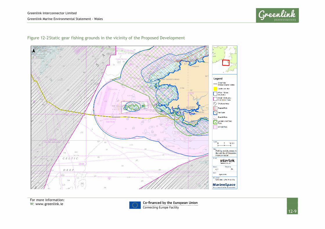
Greenlink Interconnector Limited
Greenlink Marine Environmental Statement - Wales
For more information: W: www.greenlink.ie
12-9
Figure 12-2 Static gear fishing grounds in the vicinity of the Proposed Development

Greenlink Interconnector Limited
Greenlink Marine Environmental Statement - Wales
For more information: W: www.greenlink.ie
12-10
Figure 12-3 Mobile gear fishing grounds in the vicinity of the Proposed Development

Greenlink Interconnector Limited
Greenlink Marine Environmental Statement - Wales
For more information: W: www.greenlink.ie
12-11
12.4.3 Overview of Landings Data
12.4.3.1 Landings by Weight and Value
Based on MMO data, the maximum weight and value of landings by all vessels over the period assessed (2012-2016) were from ICES Rectangle 32E4 which covers the Proposed Development inshore region (MMO 2017).
Over this period, for all vessels, over 5.4 million tonnes of fish (all species) were landed with a value of over £10.5 million. Of this value, £6.6 million was landed by <10 m vessels with the remaining £3.9 million landed by the >10m fleet. 86.7% of the total value of landings from 32E4 were represented by shellfish. These data highlight the importance of the Welsh inshore static gear (potting) fishery in the area of the Proposed Development.
With respect to individual species, within 32E3 (mainly Offshore Ireland) and 32E4 (Proposed Development), whelk was the species with the greatest weight of landings and the second largest value of landings, followed by Crab (C.P. Mixed Sexes), Haddock, Lobster (highest value species) and Spider Crab.
12.4.3.2 Temporal Trends (2012 – 2016)
Whilst landings by weight and value varied within ICES Rectangle 32E4 between 2012-2016, generally there were no obvious trends in terms of increases or decreases in either of these values.
In terms of intra-annual variation, landings for all species/vessels combined over the period 2012-2016 peaked in June/July, with a clear seasonal pattern of highest weight/value of landings between May and October each year.
When assessed in more detail, peak landings within 32E3 (mainly Offshore Ireland) were actually slightly later in the year around September/October.
Figure 12-4 shows seasonality in landed weight and value into ICES rectangle 32E4 between 2012-2016. This trend suggests that the busiest period for fishermen in the vicinity of the Proposed Development is the summer months. As discussed above, discrepancies between trends in the official landings data and findings from consultation, particularly in relation to the cable route survey, may be due to the main fishing fleet (<15m in length) being under represented within the MMO data.

Greenlink Interconnector Limited
Greenlink Marine Environmental Statement - Wales
For more information: W: www.greenlink.ie
12-12
Figure 12-4 Seasonal trends in landed weight (tonnes) and value (£) from ICES rectangle 32E4 between 2012-2016
Source: MMO (2017)
For the top five individual species landed in the region of the Proposed Development, Table 12-3 details the key periods for landings by weight and value from MMO data and the key periods understood from consultation:
Table 12-3 Key fishing periods from MMO data and consultation
Species Source J F M A M J J A S O N D
Whelk MMO Data
Consultation
Crab MMO Data
Consultation
Haddock MMO Data
Consultation
Lobster MMO Data
Consultation
Spider
crab
MMO Data
Consultation
12.4.3.3 Spatial Distribution (2012 – 2016)
The spatial distribution of fishing activity/value in the entire region was presented within the Greenlink Commercial Fisheries Technical Report (Technical Appendix E) via the review and analysis of Vessel Monitoring Systems (VMS) data. Fishing generally occurs across the entire length of the Proposed Development, although
0
200000
400000
600000
800000
1000000
1200000
1400000
1600000
0
100
200
300
400
500
600
700
800
900
Jan Feb Mar Apr May Jun Jul Aug Sept Oct Nov Dec
Land
ed V
alue
(£)
Land
ed W
eigh
t (to
nnes
)
Sum of Landed Weight (tonnes) Sum of Value (£)

Greenlink Interconnector Limited
Greenlink Marine Environmental Statement - Wales
For more information: W: www.greenlink.ie
12-13
there appears to be a greater concentration of activity in the inshore region (32E4). There is a focus of activity by non-UK vessels in the Offshore Ireland (32E3) section.
To try and further differentiate areas of particular value along Greenlink, the value of landings has been calculated based on fishery limits, i.e. UK 6nm, UK 12nm etc. This analysis has provided the following average annual values of landings over the 2012-2016 study period;
• UK coast to 6nm: £1.3 million per annum;
• 6nm to 12nm: £3.7 million per annum;
• Outside 12nm: £4.8 million per annum;
Further data on fishing activity off the Welsh coast has been obtained via review of a range of data sources which have all been collated on the Wales Marine Planning Portal. These data corroborate the official MMO data in that they highlight the distribution of potting activity off the Welsh coast and also demonstrate otter and beam trawling activity in the inshore region and also further offshore.
12.4.4 Natural evolution of the baseline
The natural evolution of the baseline has been compiled using information from the Offshore Energy Strategic Environmental Assessment 3 (OESEA 3) (DECC 2016). The fishing industry is a dynamic and rapidly evolving industry with frequent and sometimes unpredictable changes in fish abundance and distribution, climatic conditions, management regulations and fuel costs all affecting activity. Recent years have seen a decline in the UK fishing industry. Over the last 10-15 years, a number of new fisheries have developed targeting less traditional food species, such as shellfish (whelks and razorshells in the Irish Sea) but also for finfish. This is particularly the case in the southern regions, where species diversity is higher and the abundances of many warm water species are increasing.
In the coming years, UK fisheries are likely to be subject to substantial changes as a result of technical developments, economics and changes in management strategy as well as changes in target species abundance, composition and distribution. As reported in various news articles, its currently unknown the effects Brexit could have on the UK fishing industry. However, it could lead to more fish being landed by British boats.
12.5 Potential Pressure Identification and Zone of Influence
A scoping exercise undertaken to inform the content of the EIA excluded the pressure ‘snagging resulting from obstructions on the seabed’ from further consideration in this topic chapter. This was based on the aim of GIL to ensure that the cable was either buried to an agreed “safe” target depth or protected with cable protection, resulting in this pressure not being an issue. However, Irish stakeholders requested this pressure was included and as best practice it has therefore also been assessed in this topic chapter covering Welsh fisheries. This

Greenlink Interconnector Limited
Greenlink Marine Environmental Statement - Wales
For more information: W: www.greenlink.ie
12-14
represents a precautionary approach as GIL maintain their objective of installing the cable in a way that leaves no seabed obstructions.
The pressures listed in Table 12-4 will be assessed further. For each pressure the assessment considered the different aspects of the project during installation, operation (including repair & maintenance) and decommissioning. In order to evaluate the most significant effects, the largest zone of influence from these aspects was selected. The zones of influence are presented in Table 12-4
Table 12-4 Pressure identification and zone of influence – Commercial Fisheries
Project Phase Project Activity Aspect Potential Pressure Receptor Zone of Influence
Installation Cable burial Presence of installation vessels & equipment
Temporary displacement of fishing activity (including required static gear clearance)/ Restricted access to fishing grounds
Mobile gear (dredgers / trawlers)
Static gear (pots / traps)
1km x 12km (in any 24 hour period)
Operation Repair & maintenance operations
1km x 1km
Decommissioning Cable removal 1km x 12km (in any 24 hour period)
Installation Seabed preparation,
Cable burial
Pre-sweeping, pre-lay grapnel run, plough & jet trenching
Temporary habitat disturbance affecting spawning, nursery or recruitment to stocks
Demersal fisheries
1km x 12km (in any 24 hour period)
Operation Repair & maintenance operations
Plough & jet trenching
1km x 1km (5 discrete locations)
Decommissioning Cable removal Plough & jet trenching
1km x 12km (in any 24 hour period)
Installation Cable burial Cable protection
Permanent habitat loss affecting spawning, nursery or recruitment to stocks
Demersal and shell fisheries
16.37km (absolute worst-case)
Operation Repair & maintenance operations
Cable protection
10m (maximum rock berm width)
Decommissioning Cable and protection removal
Cable protection
16.37km (absolute worst-case)
Installation Seabed preparation,
Cable burial
Pre-sweeping, plough & jet trenching
Changes in suspended sediments (water clarity) indirectly leading to effects on commercially targeted species
Razor clams and scallop
100m
Operation Repair & maintenance operations
Plough & jet trenching

Greenlink Interconnector Limited
Greenlink Marine Environmental Statement - Wales
For more information: W: www.greenlink.ie
12-15
Project Phase Project Activity Aspect Potential Pressure Receptor Zone of Influence
Decommissioning Cable removal Plough & jet trenching
Installation Cable burial Exposed cable on seabed
Snagging resulting from obstruction on the seabed
Fishing vessels – Mobile gear (dredgers / trawlers)
16.37km (absolute worst-case)
Operation Repair & maintenance operations
Exposed cable on seabed, Cable protection
10m (maximum rock berm width)
Decommissioning Cable left in-situ Exposed cable on seabed, Cable protection
16.37km (absolute worst-case)
Operation Operational cables Cable protection e.g. rock berm
Change in water depth
Fishing vessels
10m (maximum rock berm width)
Operation Operational cables Emission of EMF
Electromagnetic changes – deviation of magnetic compasses
Vessels operating with magnetic compass
2m
Electromagnetic
changes –
interference with
inertial navigation
Vessels
operating
with INS and
GPS systems
12.6 Embedded Mitigation
Chapter 4 provides the current ‘base case’. This includes mitigation measures which form part of the design and are therefore an inherent part of the Proposed Development and comprise embedded or primary mitigation. The embedded mitigation relevant to commercial fisheries is provided in Table 12-5 below. When undertaking the EIA it is assumed that these measures will be complied with; either as a matter of best practice or to ensure compliance with statute.
Table 12-5 Embedded mitigation
ID Embedded mitigation measure
EM1 Early consultation with relevant contacts to warn of impending activity, with vessels requested to remain at least 500m away from cable vessels during installation, repair and decommissioning.
EM2 Project vessels will comply with the International Regulations for Preventing Collisions at Sea, 1972 (COLREGs) – as amended, particularly with respect to the display of lights, shapes and signals.
Greenlink Interconnector Limited
Greenlink Marine Environmental Statement - Wales
For more information: W: www.greenlink.ie
12-16
ID Embedded mitigation measure
EM3 Project vessels will exhibit signals in accordance with the UK Standard Marking Schedule for Offshore Installations.
EM10 Notice will be given to sea users in the area via Notices to Mariners, Kingfisher Bulletins, NAVTEX, and NAVAREA warnings. Particular attention will be paid to ensuring the following organisations receive the notifications: Castlemartin Firing Range, Milford Haven Port Authority, South Pembrokeshire RNLI, RYA, Maritime and Coastguard Agency (MCA), Welsh Fishermen’s Association, South and West Wales Fishing Communities, Welsh Marine Fisheries Advisory Group, West Wales Shell Fisherman’s Association, individual local fishermen (as identified during marine survey campaign), Pembrokeshire Coast National Park Authority, META, Bombora Wave Power, Irish Ferries.
EM11 ‘As-laid’ co-ordinates of the cable route will be recorded and circulated to the UK Hydrographic Office (UKHO) and KIS-ORCA Service. Cables will be marked on admiralty charts and fisherman’s awareness charts (paper and electronic format).
EM15 Submarine cables will be bundled together, which reduces the seabed footprint of installation activities and the electromagnetic field generated during operation, thus minimising any potential compass deviation effects
EM18 Deployment of anchors/anchor chains on the seabed will be kept to a minimum in order to reduce disturbance to seabed.
EM22 Guard vessels will be used (subject to risk assessment) during installation activities to communicate with third party vessels within the vicinity of cable sections that remain unburied between cable lay and burial.
EM24 A cable burial plan will be produced which outlines proposed method statements and cable protection measures for approval by the Regulator and discussion with fisheries stakeholders
EM25 Effective channels of communication will be established and maintained between GIL and commercial fishing interests. This will include the appointment of a Fisheries Liaison Officer (FLO).
EM26 Post-installation inspection surveys will be conducted along the length of the cables on a regular basis.
EM27 Post-installation compass deviation surveys will be undertaken to confirm compass deviation levels and the results forwarded to the UKHO and MCA.
EM28 Cable protection material (rock berms and mattresses) will be designed to be over-trawlable.
EM29 Rock and mattresses will only be deployed where adequate burial cannot be achieved. The footprint of the deposits will be the minimum required to ensure cable safety and rock berm stability.

Greenlink Interconnector Limited
Greenlink Marine Environmental Statement - Wales
For more information: W: www.greenlink.ie
12-17
12.7 Significance Assessment
12.7.1 Summary of assessment
Table 12-6 presents the impact assessment conducted on the Proposed Development activities. Sections 12.7.2 to 12.7.8 provide the justification for the conclusions. Where there is potential for residual effects, this is discussed further in Section 12.9. Where the assessment concluded the effects are significant, Project Specific Mitigation has been proposed and is described in Section 12.8.

Greenlink Interconnector Limited
Greenlink Marine Environmental Statement - Wales
For more information: W: www.greenlink.ie
12-18
Table 12-6 Impact Assessment Summary – Commercial Fisheries
Determination of Potential Effect Impact Assessment Consideration of Mitigation
Residual Effect Assessment
Section Project Phase Aspect Potential pressure
Embedded Mitigation
(Table 12-5)
Receptor Magnitude Sensitivity Significance Project Specific Mitigation
(Table 12-8)
Magnitude Sensitivity Significance of Residual Effect
12.7.2 Installation Presence of installation vessels & equipment
Temporary displacement of fishing activity/ restricted access to fishing grounds
EM1, EM10, EM25
Fishing vessels – Mobile gear (dredgers / trawlers)
Static gear (pots / traps)
Low Medium Minor - Low Medium Minor
Operation (including repair & maintenance)
Negligible Low Negligible - - -
Decommissioning Low Medium Minor Negligible Medium Negligible
12.7.3 Installation Pre-sweeping, plough & jet trenching
Temporary disturbance of habitat affecting spawning, nursery or recruitment to commercial stocks
EM15, EM29 Demersal & Shellfish fisheries
Low Medium Minor - Low Medium Minor
Operation (including repair & maintenance)
Plough & jet trenching
EM15, EM29 Low Negligible Negligible - - - -
Decommissioning Plough & jet trenching
- Negligible Medium Minor - Negligible Medium Minor
12.7.4 Installation Cable protection
Permanent loss of habitat affecting spawning, nursery or recruitment to commercial stocks
EM15,EM14, EM18, EM29
Demersal & Shellfish fisheries
Negligible Medium Negligible - - - -
Operation (including repair & maintenance)
Cable protection
Negligible Medium Negligible - - - -
Decommissioning Cable protection
- Negligible Medium Negligible - - - -
12.7.5 Installation Pre-sweeping, plough & jet
Changes in suspended sediments (water clarity) indirectly
Razor clams and scallops
Negligible Negligible Negligible - - - -

Greenlink Interconnector Limited
Greenlink Marine Environmental Statement - Wales
For more information: W: www.greenlink.ie
12-19
Determination of Potential Effect Impact Assessment Consideration of Mitigation
Residual Effect Assessment
Section Project Phase Aspect Potential pressure
Embedded Mitigation
(Table 12-5)
Receptor Magnitude Sensitivity Significance Project Specific Mitigation
(Table 12-8)
Magnitude Sensitivity Significance of Residual Effect
trenching leading to effects on commercially targeted species
Operation (including repair & maintenance)
Plough & jet trenching
Negligible Negligible Negligible - - - -
Decommissioning Plough & jet trenching
Negligible Negligible Negligible - - - -
12.7.6 Installation Cable burial
Snagging resulting from obstruction on the seabed
EM1, EM10, EM22, EM24
Fishing vessels – Mobile gear (dredgers / trawlers)
Low Low Negligible - - - -
Operation (including repair & maintenance)
Cable protection
EM1, EM10, EM11, EM22, EM25, EM26
Low Medium Minor PS4, PS13 Low Low Negligible
Decommissioning Cable left in-situ
- Low Medium Minor PS13 Low Low Negligible
Note: Electromagnetic changes and changes in water depth effects are presented in Chapter 13.

Greenlink Interconnector Limited
Greenlink Marine Environmental Statement - Wales
For more information: W: www.greenlink.ie
12-20
12.7.2 Temporary displacement of fishing activity (including required static gear clearance) / restricted access to fishing grounds
12.7.2.1 Installation
The Proposed Development has the potential to effect commercial fishing activity (both static and mobile gear) during installation via temporary displacement and temporary restricted access to fishing grounds.
Ahead of the installation vessels arriving on site, fisherman will be asked to move static gear away from the Proposed Development. It has been assumed that cable installation will be able to progress at 500m/hour (best case, but dependent on ground conditions). The zone of influence is therefore up to 12km long during any given 24-hour period. 73.9km of the cable lies in Welsh waters and so it is predicted here that installation would take a minimum of just over six days; assuming simultaneous lay and burial. For the installation phase, the Proposed Development would be split into blocks, similar to those used during the cable route surveys, of which there would be three within Welsh waters. To ensure that fishing gear is clear of the area well ahead of the installation vessels arriving and for the safety of all vessels, GIL will request, via direct communication with individual fishermen through the project FLO, that gear is clear of each block for the duration of works. It is currently estimated that this would be up to five days per block (15 in total), but this will be subject to change depending on installation methodology/seabed conditions and also weather.
Depending on the method of cable installation (e.g. post-lay burial), burial may also only be undertaken several weeks after the cables are laid. The cables will lay exposed on the seabed in this interim period and it is expected that all fishing stakeholders will be requested to avoid these areas until the cable is fully protected. This will result in additional temporary disturbance and temporary displacement of fishing activity. In areas where cable burial is achieved, this additional delay will not arise.
Even though it is estimated that these excluded zones will be restricted to small areas of the Proposed Development, in terms of assessing a worst-case scenario of disturbance and displacement via initial cable installation and subsequent avoidance of areas where surface-laid cable may exist (pre-installation of cable protection), a precautionary figure of 45 days has been used.

Greenlink Interconnector Limited
Greenlink Marine Environmental Statement - Wales
For more information: W: www.greenlink.ie
12-21
Table 12-7 Worst-case displacement
Cable installation Zone of Influence
Displacement period Realistic displacement for fishermen
Precautionary displacement
500m/hour, 12km in any given 24 hour period
6 days (based on best-case installation scenario)
5 days per block, 15 days total
45 days (takes into account slower installation progress due to hard ground and the need for cable burial/protection to be implemented)
In reality this displacement is expected to be of a much lesser duration for most vessels/areas as fishing will be permitted in many areas within days of successful cable burial in softer sediments. However, some discrete areas may require exclusion of fishing activity for this longer time period.
Within each block, all vessels will also be requested to remain a 500m radial distance from installation vessels and exposed cables temporarily laid on the seabed (as part of any cable post-lay-burial methodology). This temporary ‘exclusion’ zone will be mobile and move at the rate of progress of the associated vessels (expected to be 500m/hr). Vessels will be able to operate in the area once cable burial/protection works were complete. In addition to this, there may be temporary localised pre-installation works, associated with pre-sweeping and preparation at crossings, which would also require a 500m radial exclusion zone.
Therefore, the worst-case footprint of displacement for the local fishing fleet is 74km2 over a period of approximately 45 days, exclusive of weather. It is fully understood that individual fishermen have preferred fishing grounds, whether that be due to target species or vessel capabilities, but it is unlikely that any individual vessel would be displaced for the full estimated 45 day disruption period.
Information derived from the Greenlink Commercial Fisheries Technical Report (Technical Appendix E) as well as public consultation shows the Proposed Development passes through important local brown crab, lobster and whelk fishing grounds and it is acknowledged that some displacement is unavoidable for all types of commercial fisheries. Fishing grounds will be temporarily reduced and additional effort will be required to relocate static gear.
In addition to this, it is recognised that much of the fishing fleet is small (<10m); vessels which will be sensitive to weather and sea state and may be limited to where they are able to relocate gear. The inshore region near to the Proposed Development may present additional problems with relocation due to restrictions imposed by the Ministry of Defence (MoD) at Castlemartin Firing Range. Vessels using mobile fishing gear will more easily be able to avoid the temporary restriction, while static gear can be re-deployed once operations in the area are complete.

Greenlink Interconnector Limited
Greenlink Marine Environmental Statement - Wales
For more information: W: www.greenlink.ie
12-22
Good communication of the proposed works to the local fishing industry will be implemented via the FLO at least one month prior to the works commencing and also via Radio Navigational Warnings and NAVTEX (Embedded mitigation, EM1, EM10 and EM25). GIL already has well-established communication with the local fishing industry and individual fishermen in the region of the Proposed Development are known and in contact with the Greenlink FLO. These individuals have previously cooperated with gear clearance associated with the pre-construction phase of the project.
To reduce any further displacement to fishing activities all construction and support vessels will follow existing shipping routes to gain access to the Proposed Development.
The sensitivity of commercial fisheries has been assessed as medium based on the evidence provided above. With the successful implementation of the above embedded mitigation measures, via the well-established system of fisheries liaison for Greenlink, along with the transient and localised nature of the displacement, the magnitude of the pressure will be low. It is concluded that the overall significance of the effect will be Minor and is Not Significant.
12.7.2.2 Operation (including repair & maintenance)
Even though the greatest scope for temporary disturbance will arise during the installation phase, there may be a requirement to undertake cable repair or maintenance works during the operational phase. Up to five discrete repair events have been considered by the assessment. There may also be requirements to undertake asset management surveys of the installed cable over its lifetime.
All these activities have the potential to create the same temporary disturbance as described for the main installation phase. However, any such effects will be of a smaller magnitude than those assessed above for cable installation, and therefore the effect has been assessed as Negligible and is Not Significant.
12.7.2.3 Decommissioning
At this stage the exact method of decommissioning that the Proposed Development will adopt is not known . One option, which would present the worst-case impact in terms of temporary displacement and restricted access to fishing grounds, is to leave the cable in-situ. In this instance even after the lifetime of the Proposed Development the cable infrastructure may remain on the seabed which could pose additional displacement should the cable become unburied. In the event of this occurring the local fishing fleet may potentially need to avoid some areas of the cable route over a longer period than experienced during installation. The effect of this potential method of decommissioning on commercial fishery receptors has been assessed here as Minor and Not Significant. In recognition of this potential ongoing effect, project specific mitigation is discussed in Section 12.9.3.
The alternative option is to remove the cable (and any associated protection). This process would essentially be the same as installation activities but in reverse.

Greenlink Interconnector Limited
Greenlink Marine Environmental Statement - Wales
For more information: W: www.greenlink.ie
12-23
Therefore, any effects that could arise due to the decommissioning phase of the project will be of a comparable magnitude to those assessed above for cable installation.
12.7.3 Temporary habitat disturbance affecting spawning, nursery or recruitment to commercial stocks
12.7.3.1 Installation
The exact technique for cable installation will depend on ground conditions and will vary along the length of the Proposed Development but will include the following methods:
• Jet-trenching; or
• Plough trenching.
A trailing suction hopper dredger or mass flow excavator will also be used for sandwave preparation (pre-sweeping) activities.
Each technique has the potential to result in an indirect effect to commercial fisheries target species as a result of disturbance to habitats affecting spawning, nursery or recruitment of stocks and/or the temporary displacement of fish from the wider area.
Potential effects upon fish resources, including potential effects on spawning and nursery grounds of commercially targeted species are assessed within Chapter 8. The assessment took into consideration efforts made during engineering to avoid sensitive habitats or to reduce the distance cables crossed a feature (EM14) and embedded mitigation EM18 and EM29 which seek to minimise the footprint of the Proposed Development on the seabed. The assessment concluded that the significance of potential effects on the most sensitive species, herring and Sandeel, would be Minor and Not Significant.
Noting the above conclusion, the consequent effect on commercial fisheries is judged to be Minor and Not Significant as no large-scale changes in distribution or type of target species are envisaged via these works, either in the short-term or longer-term.
12.7.3.2 Operation (including repair & maintenance)
Effects during any unforeseen repair and maintenance works are likely to be on a significantly smaller scale than those assessed above for installation. Therefore, the magnitude of the effect is reduced to negligible and the effect of disturbance to the habitat affecting recruitment to stocks is assessed to be Negligible and is Not Significant.
12.7.3.3 Decommissioning
The worst-case option during the decommissioning phase of the Proposed Development for commercial fish receptors in terms of habitat disturbance and

Greenlink Interconnector Limited
Greenlink Marine Environmental Statement - Wales
For more information: W: www.greenlink.ie
12-24
recruitment to stocks will be to remove the cable (and any associated protection). This process would essentially be the same as installation activities but in reverse. Therefore, any effects that could arise due to the decommissioning phase of the Proposed Development will be of a comparable magnitude to those assessed above for cable installation and so the effect has been assessed as Minor and Not Significant.
The other option for decommissioning the Proposed Development is to leave the cables in-situ, which would present a lesser effect in terms of recruitment to stocks via no additional habitat disturbance.
12.7.4 Permanent habitat loss affecting spawning, nursery or recruitment to commercial stocks
12.7.4.1 Installation
Potential effects upon fish resources, including potential effects of permanent habitat loss via cable protection on spawning and nursery grounds of commercially targeted species are assessed within Chapter 8. Taking into consideration embedded mitigation EM29, this concluded that the significance of any such effects would be Negligible and Not Significant.
Noting the above conclusion, the consequent effect on commercial fisheries has been assessed as Negligible and Not Significant as no large-scale changes in distribution or type of target species are envisaged via this permanent habitat loss, either in the short-term or longer-term.
12.7.4.2 Operation (including repair & maintenance)
Effects during any unforeseen repair and maintenance works are likely to be on a significantly smaller scale than those assessed above for installation. Therefore, the overall significance of the effect is assessed as Negligible and is Not Significant.
12.7.4.3 Decommissioning
An option during the decommissioning phase will be to remove cable protection. In this instance habitats would be subject to localised disturbance, following which the seabed would be allowed to return to its pre-construction state. It is possible that during decommission any existing rock placement could remain in-situ, therefore reducing the effect via disturbance. Whichever option for decommissioning is undertaken, both will result in a similar or lesser magnitude effect to that assessed for installation and therefore the effect is predicted to be Negligible and Not Significant.

Greenlink Interconnector Limited
Greenlink Marine Environmental Statement - Wales
For more information: W: www.greenlink.ie
12-25
12.7.5 Changes in suspended sediments (water clarity) indirectly leading to effects on commercial targeted species
12.7.5.1 Installation
Installation of the Proposed Development has the potential to create sediment plumes and deposition effects on such species and consequent effects on commercial fishermen that target these species.
Chapter 6 concluded that changes in suspended solids would be brief, and will not elevate suspended sediment concentrations above those experienced through natural variation. Potential effects upon fish resources, including sediment plumes and/or deposition effects on commercially targeted species were screened out of the assessment in Chapter 8.
Taking into account the above, no effects upon commercially important target species are predicted. The consequent indirect effect on commercial fisheries has been assessed as Negligible and is Not Significant.
12.7.5.2 Operation (including repair & maintenance)
Any effects of sediment plumes and/or deposition during any unforeseen repair and maintenance works are likely to be on a significantly smaller scale than those assessed above for installation. The indirect effect on commercial fisheries from repair or maintenance activities has been assessed as Negligible and is Not Significant.
12.7.5.3 Decommissioning
An option during decommissioning will be to leave the cables in-situ to reduce any further effects to receptors. The worst-case however is to remove the cables by de-trenching. Any plume/deposition effects that could arise due to the decommissioning phase will be similar to those assessed for cable installation and operation and therefore the effect has been assessed as Negligible and is Not Significant. If the cable were to be left in-situ then no impact pathway would exist for effects on commercial fish receptors.
12.7.6 Snagging resulting from obstruction on seabed
12.7.6.1 Installation
The primary installation technique for the Proposed Development aims to achieve a burial depth of between 0.6m and 1.0m (depending on ground conditions) along the length of the cables. The cable route survey and a smaller pre-installation survey will allow the cable route centreline to be micro-routed around regions of exposed bedrock and reef and the cables will be laid within sand channels that exist between these areas of harder substrate. In the event that cable burial to the target depths cannot be achieved, it is proposed that cable protection in the form of rock placement would be installed.

Greenlink Interconnector Limited
Greenlink Marine Environmental Statement - Wales
For more information: W: www.greenlink.ie
12-26
Between the initial cable lay works and rock placement activities, there may be a period of time, possibly up to several weeks, where the cable would remain unburied on the seabed and would represent a snagging risk to a number of gear types (dredges/trawls). In the event of this, a guard vessel would be present at all times to warn other sea users of the potential obstruction (EM22) and regular NtM’s would be issued to keep the commercial fishing industry informed (EM1, EM10).
Due to the fact that the installation plan aims for the cable to be buried and that any instances of this not being achieved will be mitigated by additional measures, it is expected that the risk of snagging on an unburied cable would be minimal. The cable burial plan will be provided to NRW for approval and discussed with the fishing organisations (EM24). Any areas where burial is not achieved are likely to be over a short distance (absolute worst-case will be 16.37km of cable protection required, accounting for 22.16% of the Proposed Development in Welsh waters) and able to be managed in the short-term via the embedded mitigation measures discussed above. The magnitude of the effect has been assessed as low and given the use of guard vessels the sensitivity has been assessed as low. The assessment concluded that the significance of the effect is Negligible and is Not Significant.
12.7.6.2 Operation (including repair & maintenance)
Once installed the ‘as-laid’ coordinates of the cables will be recorded and circulated to the UK Hydrographic Office (UKHO) and KIS-ORCA Service. The cables will be marked on admiralty charts and fishermen’s awareness charts (electronic and paper) (EM11). Fishermen in the area will have been aware of the installation activities and the embedded mitigation will ensure that commercial fisheries are aware of the new infrastructure.
During the operation phase, the risk of fishing gear snagging on parts of the cable will be a function of the long-term burial of the cable and also the types of fishing activity that occur. A cable burial risk assessment, which considered sediment types, sediment mobility and fishing risks, has been undertaken to determine the minimum depth cables should be buried to prevent future cable exposure. During operation surveys will be conducted along the length of the cable on a regular basis (EM26) to confirm cables remain buried. If cable exposure should occur the embedded mitigation measures detailed for the installation phase would be adopted, i.e. presence of a guard vessel (EM22) and notification issued to the commercial fishing industry and wider sea users (EM1, EM10, EM25). It is expected that cable exposure, if any, would be isolated and of a short spatial scale. Once identified the risk would be managed sufficiently to reduce the effect upon commercial fishery receptors. However, it is recognised that should any cable exposure not be identified immediately commercial fisheries are sensitive to snagging. Although the likelihood of an identified exposure occurring is low, taking a precautionary approach, the sensitivity has been assessed as medium and the magnitude as low. The overall significance of the effect during the operation phase has been assessed as Minor and is Not Significant.
Greenlink Interconnector Limited
Greenlink Marine Environmental Statement - Wales
For more information: W: www.greenlink.ie
12-27
To further reduce the risks associated with this potential effect, Project Specific Mitigation has been proposed in Section 12.9.3.
12.7.6.3 Decommissioning
In terms of snagging risk, the worst-case for commercial fisheries receptors would be the cables remaining in-situ, representing an ongoing risk. It is assessed here that this form of decommissioning would represent a medium magnitude impact to commercial fish receptors at a low sensitivity and is concluded that the overall significance of the effect is Minor and is Not Significant. In recognition of this ongoing risk, project specific mitigation methods are discussed in Section 12.9.3.
12.7.7 Change in water depth
12.7.7.1 Operation
This pressure on fishing vessels effects the craft ability to navigate. The embedded mitigation, listed in Table 12-5, associated with this pressure is EM29. The significance of the effect has been assessed as part of the Navigation Risk Assessment, provided in Chapter 13.
Section 13.6.2 concluded that the rock berms will be a new permanent feature. There will be sufficient under keel clearance at the proposed rock berm locations to ensure safe navigation.
12.7.8 Electromagnetic changes – deviation of magnetic compasses and interference with inertial navigation systems
12.7.8.1 Operation
This pressure on fishing vessels effects the crafts ability to navigate. The significance of the effect has been assessed as part of the Navigation Risk Assessment, provided in Chapter 13.
Chapter 13 looked at two possible effects that an electromagnetic change can have on navigation: deviation of magnetic compasses; and interference with inertial navigation systems.
Section 13.6.4 concluded that vessels navigating using magnetic compasses are considered able to make the necessary adjustments to a slight compass deviation reading. The section concluded that the overall significance of the effect is Negligible and is Not Significant.
It further concluded, that the effect of interference with inertial navigation was Negligible and is Not Significant.
Global positioning systems (GPS) use radio signals that will be subject to no or negligible effects from EMF emanating from the marine cables. These systems are therefore unaffected by external magnetic fields.

Greenlink Interconnector Limited
Greenlink Marine Environmental Statement - Wales
For more information: W: www.greenlink.ie
12-28
12.8 Project Specific Mitigation
In addition to the embedded mitigation outlined in Section 12.6, Table 12-8 presents Project Specific Mitigation that GIL is committed to adopting.
Table 12-8 Project specific mitigation – commercial fisheries
ID Project Specific Mitigation Measure
PS4 The preference is to bury the HDD duct exit and all cables in sediment to the required depth of lowering. No external cable protection should be deposited at the HDD exit point.
PS13 Review of operational phase asset management surveys will be undertaken and any areas of exposure/reduced depth of burial communicated to the fishing industry via Notice to Mariners.
12.9 Residual Effect
The assessment presented in Section 12.7 identifies that a number of potential pressures could have significant effects on the receptor. The significance of these pressures was re-assessed taking into consideration any Project Specific Mitigation outlined in Section 12.8 to determine if a significant residual effect remains.
12.9.1 Temporary displacement of fishing activity/restricted access to fishing grounds
12.9.1.1 Installation and Decommissioning
No additional Project Specific Mitigation has been identified to further reduce the significance of this effect and therefore the significance remains as Minor and is Not Significant.
12.9.2 Temporary habitat disturbance affecting spawning, nursery or recruitment to stocks
12.9.2.1 Installation and Decommissioning
No additional Project Specific Mitigation has been identified to further reduce the significance of this effect and therefore the significance remains as Minor and is Not Significant.
12.9.3 Snagging resulting from obstruction on seabed
12.9.3.1 Operation
During the operation phase, if routine asset management surveys identify any areas of cable exposure or reduced depth of burial, then this will be communicated quickly and clearly to all relevant fishing organisations via a NtM (PS13). Where appropriate, a guard vessel would also be deployed ahead of any remedial works being undertaken (EM22).

Greenlink Interconnector Limited
Greenlink Marine Environmental Statement - Wales
For more information: W: www.greenlink.ie
12-29
With the successful implementation of the embedded mitigation measures i.e. use of NtMs (EM10), guard vessels (EM22) and appointment of project-specific FLO (EM25) and also Project Specific Mitigation (PS4 – ensure HDD exit and cables are buried, and PS13 - review of asset management surveys for cable exposures and communication of this to the fishing industry), the residual effect during the operational phase will be reduced from Minor to Negligible and is Not Significant.

Greenlink Interconnector Limited
Greenlink Marine Environmental Statement - Wales
For more information: W: www.greenlink.ie
12-30
1 Coull, K.A., Johnstone, R., and S.I. Rogers. (1998). Fisheries Sensitivity Maps in British Waters. Published and distributed by UKOOA Ltd.
2 Department of Energy and Climate Change (DECC) (2016). Offshore Energy Strategic Environmental Assessment. Department of Energy and Climate Change. March 2016.
3 Marine Management Organisation (MMO) (2017). UK fleet landings by ICES Rectangle (2012-2016). [online] Available at: https://www.gov.uk/government/statistical-data-sets/uk-fleet-landings-by-ices-rectangle [Accessed December 2018].
4 MMO (2018). Vessel list under and over 10 metres. January 2018. [online] Available at: https://www.gov.uk/government/statistical-data-sets/vessel-lists-over-10-metres [Accessed October 2018].
5 Nautilus Consultants Ltd (2000). Study into Inland and Sea Fisheries in Wales. Prepared
for National Assembly of Wales. August 2000. [online] Available at: http://www.nautilus-consultants.co.uk/sites/default/files/wales.pdf (Accessed March 2019)
6 Pantin, J.R., Murray, L.G., Hinz, H., Le Vay, L. and Kaiser, M.J. (2015). The Inshore Fisheries of Wales: a study based on fishers’ ecological knowledge. Fisheries & Conservation report No. 42, Bangor University. Pp.60
7 Scientific, Technical and Economic Committee for Fisheries (STECF) (2018). Fisheries Dependent Information: Data by quarter-rectangle. [online] Available at: https://stecf.jrc.ec.europa.eu/dd/effort/graphs-quarter [Accessed December 2018].
8 Walmsley S.A. and Pawson, M.G., (2007). The coastal fisheries of England and Wales, Part V: a review of their status 2005–6. Sci. Ser. Tech Rep., Cefas Lowestoft, 140: 83pp.
REFERENCES

Greenlink Interconnector Limited
Greenlink Marine Environmental Statement - Wales
For more information: W: www.greenlink.ie
13-1
13. Shipping and Navigation This Chapter describes the existing baseline for shipping activities (including fishing and recreational boating), identifies the pressures associated with the Proposed Development on the receptors, presents the findings of the environmental impact assessment, and describes how significant effects (if any) will be mitigated.
The Proposed Development refers to the Welsh Marine components of Greenlink from mean high-water springs (MHWS) at the Welsh landfall at Freshwater West, Pembrokeshire to the UK/Republic of Ireland median line. It comprises:
• Two high voltage direct current (HVDC) electricity power cables;
• A smaller fibre-optic cable for control and communication purposes;
• All associated works required to install, test, commission and complete the aforementioned cables; and
• All associated works required to operate, maintain, repair and decommission the aforementioned cables, including five repair events over the 40 year lifetime of Greenlink.
The Proposed Development includes the following phases, all of which are assessed within this chapter:
• Installation;
• Operation (including repair and maintenance activities); and
• Decommissioning.
Where relevant, any limitations related to the baseline conditions, data sources or scientific understanding / interpretation within the process of assessing the effects have been highlighted.
13.1 Data Sources
A Navigation Risk Assessment (NRA) has been undertaken for the Proposed Development. Baseline conditions have been established by undertaking a desktop review of published information and available data. The data sources used to inform the baseline description and assessment include, but are not limited to the following:
• AIS data covering the Proposed Development between August 2017 to June 2018 (Oceaneering 2018);
• Greenlink Interim Cable Burial Risk Assessment Report (Intertek EWCS 2018);
• Greenlink Cable Route Report (Intertek EWCS 2019); and
• Admiralty charts (FindMaps 2018).

Greenlink Interconnector Limited
Greenlink Marine Environmental Statement - Wales
For more information: W: www.greenlink.ie
13-2
13.1.1 Study Area
For the NRA a study area of approximatively 30km wide either side of the Proposed Development has been defined from MHWS to the UK / Republic of Ireland median line, as shown in Figure 13-1 (Drawing P1975-AIS-001).
The study area covers the Proposed Development from KP0.0 to KP73.8.
All AIS data and navigational features dataset presented in this Chapter are limited to the area of assessment.
13.1.2 Cable Burial Risk Assessment Report and Cable Route Report
The primary source of information used in this Chapter were the Greenlink Cable Route Report (Intertek EWCS 2019) and the Interim Cable Burial Risk Assessment Report (Intertek EWCS 2018) which included a review of the Cable route selection process and risk identification and assessment of anthropogenic hazards to the cables such as fishing and ship’s anchors.
Within the Marine Induced Hazards review (undertaken as part of the Interim Cable Burial Risk Assessment Report, Intertek EWCS 2018), Automatic Identification System (AIS) data was used to examine the frequency of vessel movements and density of shipping. AIS data from August 2017 to June 2018 (Oceaneering 2018) were analysed to ensure consideration was given to seasonal variations.
As per Regulation 19 of Chapter V, Safety of Navigation, of the Annex to the International Convention for the Safety of Life at Sea (SOLAS V) (which came into force 1 July 2002), an AIS must be installed and operated on: all ships of 300 gross tonnage and upwards engaged on international voyages; cargo ships of greater than 500 gross tonnage not engaged on international voyages; and all passenger vessels irrespective of size. In recent years, AIS has increasingly been installed by other maritime users on smaller craft, including yachts, fishing vessels, and pleasure craft, making it a robust and reliable indicator of marine traffic.

GREENLINK INTERCONNECTORAIS DATA
Study Area - UK Waters
Chris GoodeEmma Langley
Monday, April 8, 2019 12:13:34WGS_1984_UTM_Zone_30N
D_WGS_1984DCCAE; UKHO; CDA; GEBCO; Greenlink
WGS_1984
NOTE: Not to be used for Navigation
© Copyright Department of Communications, Climate Action and Environment (DCCAE); Contains public sector information, licensed under the Open Government Licence v2.0, from the UKHO, 2018.; Contains data from UKOGD.; © The GEBCO Digital Atlas published by the British Oceanographic Data Centre on behalf of IOC and IHO, 2003;
Anna Farley
250000
250000
300000
300000
350000
350000
57000
00
57000
00
57500
00
57500
00
LegendFreshwater WestProposed DevelopmentIrish OffshoreIrish MarineStudy Area (UK Waters)ROI 12nm Territorial Sea LimitUK 12nm Territorial Sea LimitMedian Line
0 5 10 15 20km © Metoc Ltd, 2019.
All rights reserved.
J:\P1975\Mxd\14_AIS\P1975-AIS-001.mxd
Created ByReviewed By
DateProjection
DatumData Source
File Reference
Spheroid
Approved By
Drawing No: P1975-AIS-001 A
Greenlink Interconnector Limited
Greenlink Marine Environmental Statement - Wales
For more information: W: www.greenlink.ie
13-4
13.2 Consultation
Table 13-1 summarises the relevant aspects of the consultation responses on the NRA. The steps taken to contact stakeholders for comments on the EIA scope is documented in Chapter 5.
Table 13-1 Consultation responses – shipping and navigation
Consultee Summary of Consultation Responses How/where addressed
Comments received on NRW Scoping Opinion (SC1816)
Natural
Resources
Wales (NRW)
NRA must include appropriate risk mitigation
measures and a detailed methodology, including
assessments on collision risk, emergency
response, marking and lighting during the works
and the promulgation of Notices to Mariners. It
should include considerations for the effects on
vessel navigation and communication
equipment, as well as any electromagnetic
deviation on ships compasses. We would
however expect a deviation survey post the
cable being laid.
The NRA is presented in this chapter.
Compliance with national and
international statute is part of the ‘base
case’ design of the Proposed
Development – see embedded mitigation
EM1, EM2, EM3, and EM10 (Section 13.5).
Post-installation compass deviation
surveys will be undertaken to confirm
compass deviation levels (embedded
mitigation EM8)
NRW Attention should be paid to cabling routes and
burial depth for which a Burial Protection Index
study must be completed and, subject to the
traffic volumes, an anchor penetration study
may be necessary.
A cable burial risk assessment including
traffic volume and anchor penetration
study has been undertaken (Intertek
EWCS 2018) and has been used to inform
the NRA.
NRW Any consented cable protection works must
ensure existing and future safe navigation is not
compromised, accepting a maximum of 5%
reduction in surrounding depth referenced to
Chart Datum.
An assessment of the significance of
effect from a change in water depth as a
consequence of external cable
protection is provided in Section 13.6.3.
NRW Consideration should be given within the NRA to
both the regulations and the traffic
environment. A method statement must be
included considering the need for guard and
support vessels to mitigate potential risks whilst
transiting roughly perpendicular through the
Traffic Separation Scheme (TSS) lanes.
The requirement for guard and support
vessels during installation activities is
considered in Section 13.6.2 and
embedded mitigation EM22.
NRW Prior consultation and engagement is
encouraged with local maritime stakeholders in
advance and during the works.
Consultation has been undertaken with
key navigational stakeholders in the
region including Milford Haven Port
Authority, Castlemartin Firing Range,
Irish Ferries, fishing organisations and
individual fishermen (See Technical
Appendix B for list of key meetings).
Ongoing engagement is part of the ‘base

Greenlink Interconnector Limited
Greenlink Marine Environmental Statement - Wales
For more information: W: www.greenlink.ie
13-5
Consultee Summary of Consultation Responses How/where addressed
case’ design of the Proposed
Development – see embedded mitigation
EM1 and EM25 (Section 13.5).
Comments received on Superseded Scoping Report which are relevant to the Proposed Development
Milford Haven
Port Authority
(MHPA)
Any mitigation measures as a result of the NRA
should be discussed with MHPA.
Project specific mitigation specific to
Milford Haven Port Authority is included
in Section 13.7 (see PS14). These have
been discussed with MHPA.
Royal yachting
Association
(RYA)
Recreational boating should be considered in the
NRA and should be considered in the assessment
of effects of EMF on navigational safety
Recreational boating is considered in the
NRA and Section 13.6.3 presents the
assessment of effects from EMF on
navigational safety.
RYA Request confirmation that the effects on
recreational boating from changes in water
depth due to rock protection will be considered
for all sections of the proposed cable corridor,
not just shipping lanes.
The significance of effect of a change in
water depth as a consequence of
external cable protection is presented in
Section 13.6.3.
RYA Anchoring of commercial shipping has been
scoped out of the EIA, but there is not mention
of whether there may be an issue for the
anchoring or recreational vessels.
The rationale for scoping out the
commercial shipping can equally be
applied to the recreational vessels, and
is presented in Chapter 5.
Chamber of
Shipping
Recommends that NRA includes full seasonal
variation.
AIS data from all seasons has been
utilised and considered in the
assessment.
Chamber of
Shipping
Please provide clarity on the length of time a
commercial vessel may be required to deviate
from normal routeing when approaching the IMO
Traffic Separation Scheme (TSS) and what will
be exclusion zone around the project vessels.
This information is provided in Section
13.6.2.
Chamber of
Shipping
Please provide details of the seabed preparation
that will be required near shipping lanes
including length of time of disruption.
Seabed preparations and time scales for
disruption are provided in the Section
13.6.2.
Chamber of
Shipping
The routeing of the Stena Line Ferry Service
from Pembroke to Rosslare should be considered
by the NRA.
An assessment of effect on the ferry
route is provided in Section 13.6.2. This
has been informed by consultation with
Irish Ferries.
Chamber of
Shipping
It would be considered prudent to continue to
include “Risk of ship collisions” and “Accidental
anchoring or emergency anchoring on
unburied/buried cable” in the Shipping and
Navigation receptor until the full NRA has been
undertaken and the baseline established.
The NRA has been undertaken and these
pressures remain scoped out. Further
detail has been provided in Chapter 5.

Greenlink Interconnector Limited
Greenlink Marine Environmental Statement - Wales
For more information: W: www.greenlink.ie
13-6
13.3 Existing Baseline Description
13.3.1 Shipping Overview
Eleven months of AIS data from August 2017 to June 2018 (Oceaneering 2018) were analysed to examine the types of shipping occurring near the Proposed Development and the typical movement of vessel activity.
A total of 8,125 unique ships were recorded in the dataset in the study area between August 2017 to June 2018.
The majority of vessels operating, during the period analysed, were cargo (44.9%), ‘other / unknown’ vessels (i.e. vessel with vessel type not informed on AIS data set) and tanker vessel which accounted for 25.2% and 20.8%, respectively (see Figure 13-2).
The ‘other / unknown’ vessels types have lengths varying from 0 to 345m. However, 76% of the ‘other / unknown’ vessels are below 30m long with vessel draught ranging from 0 to 8m, which are likely to be recreational or fishing boats.
Figure 13-2 Proportion of vessel types operating within the UK Study Area
Vessel counts peak during August 2017 and October 2017 and then again between March 2018 to June 2018. The busiest month was May 2018 with unique vessels numbers reaching 906 in the period assessed (Figure 13-3). The summer / autumn peak in traffic would typically coincide with the installation season for submarine cables and the high recreational vessel period.
Passenger vessel2.31%
Cargo vessel44.90%
High Speed Craft0.95%Law Enforcement
vessel0.32%
Pilot vessel0.62%
Tanker vessel20.81%
Port Tender vessel0.50%
Search and Rescue vessel1.06%
Tug3.15%
Wing in Ground vessel0.17%
Other / Unknown25.21%

Greenlink Interconnector Limited
Greenlink Marine Environmental Statement - Wales
For more information: W: www.greenlink.ie
13-7
Figure 13-3 Number of unique vessels counts per month (August 2017 to June 2018) in the UK Study Area
13.3.2 Navigational Features and Anchorage
There are a number of navigation features near the Proposed Development associated with harbours, anchoring areas, dumping ground, Military practice area, existing subsea cables, navigation lines and Traffic Separation zones, all of which are charted to aid navigation as presented in Figure 13-5 (Drawing P1975-INFR-001).
There are no pipelines or windfarms within the study area. Currently, there are no established renewable energy sites within the study area; although it is known that Marine Energy Wales (MEW) are proposing a marine energy test area close to the Proposed Development, within which Bombora Wave power are proposing to test a device. This is discussed in Chapter 14 and is shown on Figure 13-5 (Drawing P1975-INFR-001).
There are six cables passing through the study area; although only one cable (Pan European Crossing 2 Cable) crosses the Proposed Development at KP59.8.
There are two IMO-adopted traffic separation schemes (TSS) and associated navigation marks that separate the in-bound and out-bound shipping along the Proposed Development, between KP53 to KP57 and KP63 to KP67 orientated in a north-south direction. The Proposed Development crosses perpendicular to these two lanes, minimising the risks of encountering traffic during survey, installation and any operations and maintenance campaigns. This leads to a distinct area of intense shipping activity along these zones as illustrated in Figure 13-6 (Drawing P1975-AIS-003).
A total of 2,548 unique vessels intersecting with the Proposed Development were recorded in the study area dataset between August 2017 to June 2018.
A detailed analysis of the types of ships intersecting with the Proposed Development (see Figure 13-4) shows that most of the ships intersecting are Cargo (44.1%) and
Aug-17 Sep-17 Oct-17 Nov-17 Dec-17 Jan-18 Feb-18 Mar-18 Apr-18 May-18 Jun-18Number of Unique Vessels (UK Waters) 684 680 676 446 447 450 454 677 681 906 905
0
100
200
300
400
500
600
700
800
900
1000

Greenlink Interconnector Limited
Greenlink Marine Environmental Statement - Wales
For more information: W: www.greenlink.ie
13-8
Tanker (27.5%). This correspond to the two shipping lanes identified in Figure 13-6 (Drawing P1975-AIS-003).
Figure 13-4 Proportion of vessel types intersecting the Proposed Development
The other area of increased shipping traffic is between KP6 to 16. This area is associated with the ports of Milford Haven and Pembroke Dock.
Defined anchoring areas are restricted to the nearshore areas (Figure 13-5 Drawing P1975-INFR-001) close to active ports. These areas have been avoided during the route selection process, thus there are no charted anchorage areas in the vicinity of the Proposed Development.
There are no aggregate extraction sites in the study area.
RYA clubs, training centres, marinas and offshore routes are illustrated in Figure 13-7 (Drawing P1975-RYA-001). Figure 13-8, reproduced from the RYA, presents a heat map of recreation boating activity. Several training centres and clubs are located in the Milford Harbour area. Areas of moderate intensity recreational boating interact with the Proposed Development for limited sections, but the Proposed Development is outside of general boating areas, high intensity areas and generally crosses the offshore routes perpendicular. There is therefore, the potential for some interaction between recreational vessels during survey, installation and any operations and maintenance campaigns.
The Proposed Development passes through the Castlemartin Firing Range. In the Firing Range armoured units practice direct-fire live gunnery exercises, with both on-land impact areas and a large offshore sea danger area. Coastal and marine access is restricted during live firing and range safety boats move vessels through the sea danger area as quickly as possible during live firing. Vessel density over the Proposed Development through the sea danger area is similar to other nearshore areas (Figure 13-6 Drawing P1975-AIS-003).
Passenger vessel2.28%
Cargo vessel44.15%
High Speed Craft1.30%Law Enforcement
vessel0.16%
Pilot vessel0.27%
Tanker vessel27.55%
Port Tender vessel0.12%
Search and Rescue vessel0.16%
Tug1.81%
Wing in Ground vessel0.08%
Other / Unknown22.14%

GREENLINK INTERCONNECTORINFRASTRUCTURE
Other Marine Users - UK Waters
Chris GoodeEmma Langley
Thursday, June 6, 2019 08:29:32WGS_1984_UTM_Zone_30N
D_WGS_1984UKHO; CDA; TCE; GEBCO; KIS-ORCA;MarineFind; Oceanwise; Greenlink
WGS_1984
NOTE: Not to be used for Navigation
Contains public sector information, licensed under the Open Government Licence v2.0, from the UKHO, 2018.; Contains data from UKOGD.; © Crown Copyright [2017]; © The GEBCO Digital Atlas published by the British Oceanographic Data Centre on behalf of IOC and IHO, 2003; Copyright © KIS-ORCA; Charts from MarineFIND.co.uk © Crown Copyright, 2015. All rights reserved. Licence No: EK001-1001-WEB105. Not to be used for Navigation.; © British Crown and OceanWise, 2019. All rights reserved. License No. EK001-ET18184 Not to be used for Navigation
Anna Farley
300000
300000
325000
325000
350000
350000
57000
00
57000
00
57250
00
57250
00
57500
00
57500
00
0 2.5 5 7.5 10km © Metoc Ltd, 2019.
All rights reserved.
J:\P1975\Mxd\10_INFR\P1975-INFR-001.mxd
Created ByReviewed By
DateProjection
DatumData Source
File Reference
Spheroid
Approved By
Drawing No: P1975-INFR-001 ALegend
Freshwater WestProposed DeveloopmentIrish OffshoreUK 12nm Territorial Sea LimitMedian Line
Wrecks and ObstructionsDangerous WreckNon-Dangerous WreckWreck Showing Any Portion of Hull or SuperstructureFoul GroundUndefined ObstructionUnderwater RockFoul area
InfrastructureWellTelecom (Active)Telecom (Disused)Shoreline ConstructionHydrocarbon Field
Dumping Ground
Anchorage Area
Fishery ZoneCaution AreaRestricted Area
Harbour Area (Administrative)
Traffic Separation Zone
Military Practice Area
Marine Energy Test Area (META)
Bombora Cable Route Search Area
Wave Lease Site


GREENLINK INTERCONNECTORRECREATIONAL BOATING
Royal Yachting Association Sites - UK Waters
Chris GoodeEmma Langley
Monday, April 8, 2019 09:00:51WGS_1984_UTM_Zone_30N
D_WGS_1984UKHO; CDA; GEBCO; MarineFind; RYA; Greenlink
WGS_1984
NOTE: Not to be used for Navigation
Contains public sector information, licensed under the Open Government Licence v2.0, from the UKHO, 2018.; Contains data from UKOGD.; © The GEBCO Digital Atlas published by the British Oceanographic Data Centre on behalf of IOC and IHO, 2003; Charts from MarineFIND.co.uk © Crown Copyright, 2015. All rights reserved. Licence No: EK001-1001-WEB105. Not to be used for Navigation.; © Data reproduced under licence from the Royal Yachting Association
Anna Farley
300000
300000
325000
325000
350000
350000
57000
00
57000
00
57250
00
57250
00
57500
00
57500
00
0 2.5 5 7.5 10km © Metoc Ltd, 2019.
All rights reserved.
J:\P1975\Mxd\12_RYA\P1975-RYA-001.mxd
Created ByReviewed By
DateProjection
DatumData Source
File Reference
Spheroid
Approved By
Drawing No: P1975-RYA-001 ALegend
RYA UK Coastal Atlas of Recreational Boating
Freshwater WestProposed DevelopmentIrish OffshoreUK 12nm Territorial Sea LimitMedian Line
RYA ClubsRYA Training CentresMarinasOffshore RoutesGeneral Boating Areas

Greenlink Interconnector Limited
Greenlink Marine Environmental Statement - Wales
For more information: W: www.greenlink.ie
13-12
Figure 13-8 RYA heat map of recreation boating around the coast based on AIS data
13.3.3 Natural evolution of the baseline
The natural evolution of the baseline has been compiled using information from Maritime 2050 (Department of Transport 2019). The maritime sector in the UK operates at an international level and is affected by global shifts and trends. Future trends are likely to be driven by changes in global pollution, economy and climate change. It is predicated that by 2050 the global maritime sector will be handling three times as much cargo as it is currently. Therefore, it is expected that shipping activity around the Proposed Development is likely to gradually increase.
13.4 Potential Pressure Identification and Zone of Influence
A scoping exercise undertaken to inform the content of the EIA has excluded the following pressures from further consideration in this topic Chapter. Explanation for the exclusion is provided in Chapter 5, Table 5-2.
• Risk of ship collisions; and
• Accidental anchoring or emergency anchoring on unburied / buried cable.

Greenlink Interconnector Limited
Greenlink Marine Environmental Statement - Wales
For more information: W: www.greenlink.ie
13-13
The pressures listed in Table 13-2 will be assessed further. For each pressure the assessment considered the different aspects of the project during installation, operation (including repair & maintenance) and decommissioning. In order to evaluate the most significant effects, the largest zone of influence from these aspects was selected. The zones of influence are presented in Table 13-2.
Table 13-2 Pressure identification and zone of influence – shipping and navigation
Project Phase Project
Activity
Aspect Potential Impact Receptor Zone of
Influence
Installation Cable burial Presence of
project vessels
Displacement of
vessels
Commercial
shipping,
recreational boating,
fishing vessels
1km wide x
12km along
centreline (in
any 24-hour
period)
Operation Repair &
maintenance
operations
Decommissioning Cable
removal
Operation Cable
protection
External cable
protection
Change in water
depth
Commercial
shipping,
recreational boating,
fishing vessels
10m wide by
1.5m high
Operation Operation of
cable
Emission of
EMF
Electromagnetic
changes – deviation
of magnetic
compasses
Vessels operating
with a magnetic
compass
2m
Operation Operation of
cable
Emission of
EMF
Electromagnetic
changes -
interference with
inertial navigation
Vessels operating
with INS and GPS
systems
2m
13.5 Embedded Mitigation
The project description, Chapter 4, provides the current ‘base case’. This includes mitigation measures which form part of the design and are therefore an inherent part of the Proposed Development and comprise embedded or primary mitigation. The embedded mitigation relevant to shipping and navigation is provided in Table 13-3 below. When undertaking the EIA it is assumed that these measures will be complied with; either as a matter of best practice or to ensure compliance with statute.
Table 13-3 Embedded mitigation
ID Embedded Mitigation
EM1 Early consultation with relevant contacts to warn of impending activity, with vessels requested
to remain at least 500m away from cable vessels during installation, repair and
decommissioning.

Greenlink Interconnector Limited
Greenlink Marine Environmental Statement - Wales
For more information: W: www.greenlink.ie
13-14
ID Embedded Mitigation
EM2 Project vessels will comply with the International Regulations for Preventing Collisions at Sea,
1972 (COLREGs) – as amended, particularly with respect to the display of lights, shapes and
signals.
EM3 Project vessels will exhibit signals in accordance with the UK Standard Marking Schedule for
Offshore Installations.
EM10 Notice will be given to sea users in the area via Notices to Mariners, Kingfisher Bulletins,
NAVTEX, and NAVAREA warnings. Particular attention will be paid to ensuring the following
organisations receive the notifications: Castlemartin Firing Range, Milford Haven Port Authority,
South Pembrokeshire RNLI, Royal Yacht Association (RYA), Maritime and Coastguard Agency
(MCA), Welsh Fishermen’s Association, South and West Wales Fishing Communities, Welsh
Marine Fisheries Advisory Group, West Wales Shell Fisherman’s Association, individual local
fishermen (as identified during marine survey campaign), Pembrokeshire Coast National Park
Authority, META, Bombora Wave Power, Irish Ferries.
EM11 ‘As-laid’ co-ordinates of the cable route will be recorded and circulated to the UK Hydrographic
Office (UKHO), KIS-ORCA service and any other relevant authorities. Cables will be marked on
Admiralty Charts and fisherman’s awareness charts (paper and electronic format).
EM15 Submarine cables will be bundled together, which reduces which reduces the seabed footprint
of installation activities and the electromagnetic field generated during operation, thus
minimising any potential compass deviation effects
EM16 Procedures to minimise disruption near high density shipping areas will include, for example,
avoidance of anchoring near busy areas when Project vessels are waiting on weather; and the
presence of a guard vessel in areas of significant vessel traffic. Installation vessels will have
passage planning procedures, holding positions (e.g. if waiting on weather), traffic monitoring
(e.g. radar, AIS, and visual), means of communication with third-party vessels, and emergency
response plans in the event a third-party vessel approaches on a collision course.
EM17 Agreed Castlemartin Firing Range access and communication protocol.
• GIL will notify Castlemartin Firing Range a minimum of two weeks prior to commencement, of any works (survey, installation / construction, repair or maintenance) to be carried out in the Sea Danger Area (SDA). This notice will be provided in writing.
• Prior to works commencing within the SDA, GIL and their appointed contractor will arrange a meeting with Castlemartin Firing Range to provide a briefing of the works to be undertaken in the SDA; confirm timescales; confirm lines of communication; and understand what live firing activity will be undertaken during the period.
• During activity within the SDA, or within close proximity, GIL’s appointed contractor will provide daily briefings to Castlemartin Control that will cover: name of vessel(s) involved and exact location of works for the day.
• The Installation Contractor will be requested to design the programme for installation works to minimise disruption to Castlemartin Firing Range. All activities related to a particular phase within the SDA should be completed before work progresses to a new section of the application area.
EM22 Guard vessels will be used (subject to risk assessment) during installation activities to
communicate with third party vessels within the vicinity of cable sections that remain unburied
between cable lay and burial.

Greenlink Interconnector Limited
Greenlink Marine Environmental Statement - Wales
For more information: W: www.greenlink.ie
13-15
ID Embedded Mitigation
EM25 Effective channels of communication will be established and maintained between the Project
and commercial fishing interests. This will include the appointment of a Fisheries Liaison
Officer (FLO).
EM26 Post-installation inspection surveys will be conducted along the length of the cables on a
regular basis.
EM27 Post-installation compass deviation surveys will be undertaken to confirm compass deviation
levels and the results forwarded to the UKHO and MCA.
EM29 Rock and mattresses will only be deployed where adequate burial cannot be achieved. The
footprint of the deposits will be the minimum required to ensure cable safety and rock berm
stability.
13.6 Significance Assessment
13.6.1 Summary of Assessment
Table 13-4 presents the summary of the impact assessment conducted on the Proposed Development activities. Sections 13.6.2 to 13.6.4 provide the justification for these conclusions. Where the assessment concluded the effects are significant, Project Specific Mitigation has been proposed and is described in Section 13.7. Where there is potential for residual effects, this is discussed further in Section 13.8.

Greenlink Interconnector Limited
Greenlink Marine Environmental Statement - Wales
For more information: W: www.greenlink.ie
13-16
Table 13-4 Impact assessment summary – shipping and navigation
Determination of potential effect Impact assessment Consideration of
mitigation
Residual Effect Assessment
Section Project Phase Aspect Embedded
Mitigation
(Table13-3)
Potential Pressure Receptor Magnitude Sensitivity Significance Project Specific
Mitigation
(Table 13-6)
Magnitude Sensitivity Significance of
Residual Effect
13.6.2 Installation
Operation
Decommissioning
Presence of
Project
vessels
EM1, EM2,
EM3, EM10,
EM16, EM17,
EM22, EM25,
Displacement of
vessels
Commercial
shipping,
recreational
boating, fishing
vessels
Low Medium Minor PS14, PS15 Low Medium Minor
13.6.3 Operation Presence of
Rock berm
EM11, EM15,
EM29,
Change in water
depth - affecting safe
navigation
Commercial
shipping,
recreational
boating, fishing
vessels
Low Low Negligible PS4 - - -
13.6.4 Operation Operation of
cable
EM11, EM15,
EM27,
Electromagnetic
changes – deviation in
magnetic compasses
Commercial
vessels operating
using a magnetic
compass
Low Low Negligible - - - -
Operation Operation of
cable
EM11, EM15,
EM27,
Electromagnetic
changes –
Interference with
inertial navigation
(INS) and global
positioning systems
(GPS)
Commercial
vessels operating
with INS and GPS
systems
Negligible Negligible Negligible - - - -
Greenlink Interconnector Limited
Greenlink Marine Environmental Statement - Wales
For more information: W: www.greenlink.ie
13-17
13.6.2 Displacement of vessels
13.6.2.1 Installation
As a worst case (in relation to maximum area for disruption) a cable trenching (jetting or installation in a pre-cut trench or backfill) could progress at approximately 500m/hour (12km per day). However, realistic speeds dependent on soil conditions and inclusive of maintenance and burial survey, are more usually ~5km/day for jetting, ~2 km/day in simultaneous lay-and-burial mode for ploughing and ~1.8km per day for cutting. Vessels will be requested to remain at least 500m from project vessels whilst they are engaged in cable installation activities. This is due to the cable lay vessel’s limited ability to manoeuvre whilst undertaking operations.
Therefore, as a worst case the maximum area for disruption would be 1km wide by 12km long per 24 hour period. The more likely area would be 1km wide by between ~2km and 5km long per 24 hour period.
The areas with the highest vessel density are those associated with vessels passing through TSS zone Off Smalls. The Proposed Development passes to the south, and partially through the southern end of the TSS zone. The length of the Proposed Development through the area of highest vessel density associated with each of the two TSS lanes is approximately 5.7km for each (11.4km for both). This would therefore require a disturbance of up to 3 days for each of the high vessel density areas associated with the TSS zone (up to 6 days for both areas).
Fishermen would be requested to clear grounds ahead of the vessel. Depending on the sediment type and the estimated rate of progression the amount of time they would need to be out of an area will vary. For example, in sandy sediments cable lay could progress quickly and an area may only need to be clear for 3 days. Other times this could be longer (further assessment on effects on commercial fisheries is presented in Chapter 12, Section 12.7.2).
It has been assumed that vessels will be requested to stay out of a particular zone for 5 days. In areas where hard substrate and difficult conditions for trenching make the installation slower the area to be cleared can be reduced but the number of days that the area is required to be cleared for may be greater.
All vessels associated with the project will display the required navigational lights and signals (EM2 and EM3). Notice will be given to sea users in the area via Notices to Mariners, Kingfisher Bulletins, NAVTEX, and NAVAREA warnings. Attention will be paid to ensuring the following organisations receive the notifications: Castlemartin Firing Range, Milford Haven Port Authority, South Pembrokeshire RNLI, Royal Yacht Association (RYA), Maritime and Coastguard Agency (MCA), Pembrokeshire Coast National Park Authority, META, Bombora Wave Power, Irish Ferries, relevant fisheries associations and groups, individual local fishermen (as identified during marine survey campaign) (EM10).

Greenlink Interconnector Limited
Greenlink Marine Environmental Statement - Wales
For more information: W: www.greenlink.ie
13-18
Procedures to minimise disruption near high density shipping areas will include, for example, avoidance of anchoring near busy areas when project vessels are waiting on weather; and the presence of a guard vessel in areas of significant vessel traffic. Installation vessels will have passage planning procedures, holding positions (e.g. if waiting on weather), traffic monitoring (e.g. radar, AIS, and visual), means of communication with third-party vessels, and emergency response plans in the event a third-party vessel approaches on a collision course (EM16).
Guard vessels will be used (subject to risk assessment) during installation activities to communicate with third party vessels within the vicinity of cable sections that remain unburied between cable lay and burial (EM22). It is anticipated that guard vessels will also be required during the installation across the highest vessel density areas including the TSS zone.
These restrictions may cause disruption to shipping activity in the area by requiring alteration of planned/designated routes, such as those to/from the major ports of Milford Haven and Pembroke Dock. This will apply to both commercial shipping (e.g. freighters, tankers, passenger vessels) and non-commercial vessels (e.g. recreational craft and fishing vessels).
The Rosslare to Pembroke Ferry Service has been considered in this assessment (constituting part of the AIS dataset). The operator of the Ferry service has confirmed that the short section of intersection between the Proposed Development and the ferry route (approximately 11km) is far enough from the mouth of Milford Haven to allow for room to manoeuvre. As per mitigation measures the required notifications and broadcast would ensure that all ferries would be aware of the operations and be able to plan accordingly.
It is expected that maximum displacement will occur during cable installation in the marked navigation channels between KP53 to KP57 and KP63 to KP67, as these areas will contain the highest concentration of shipping activity. Since the project vessels will be moving along at the rate of cable lay (up to 500m per hour depending upon the installation method), any disruption will be temporary in any one location. However, this will depend on weather and seabed conditions which will affect installation progress. As shipping will have to make minor diversions to avoid the installation activity the sensitivity has been assessed as medium. The magnitude of the displacement has been assessed as low because it will be temporary. It is concluded that the overall significance of the effect will be Minor and is Not Significant.
13.6.2.2 Operation (including maintenance and repair)
During normal operation there may be limited effect on shipping from (though not frequent) survey of the buried cables, to monitor depth of burial. These surveys will be carried out by a vessel that would travel the entire submarine cable route.
In the unlikely event that a cable repair is required, the activity would typically be carried out by a single vessel. However, the vessel may be on site for several weeks, with limited ability to manoeuvre. Although it would display the required

Greenlink Interconnector Limited
Greenlink Marine Environmental Statement - Wales
For more information: W: www.greenlink.ie
13-19
navigational lights and signals, depending on the location of the repair it could cause serious disruption i.e. if within a busy navigation channel.
Given the burial specification of the cable system, the likelihood of a fault occurring is very low. The magnitude of the effect will be low as any repair works are site specific and temporary. The sensitivity to shipping is medium as acceptable alternatives will be available for shipping to re-route around the affected area. The assessment has considered the potential for five discrete cable repairs and concluded that the overall significance of the effect will be Minor and is Not Significant.
13.6.2.3 Decommissioning
An option during the decommissioning phase of the Proposed Development will be to remove the cables (and any associated protection). This process would essentially be the same as installation activities but in reverse. Therefore, any effects that could arise due to the decommissioning phase of the project will be of a comparable magnitude to those assessed above for cable installation and so the effect has been assessed as Minor and is Not Significant.
The alternative is to leave the cables in-situ, and if this option is selected there will be no displacement effect on shipping and navigation.
13.6.3 Change in water depth
13.6.3.1 Operation
Rock berms for the purposes of cable protection will generally be up to 1 to 1.5 m high. The UK Maritime and Coastguard Agency (MCA) require that any cable protection works must ensure existing and future safe navigation is not compromised. Generally, they are prepared to accept a maximum of 5% reduction in surrounding depth referenced to chart datum (CD) if the depth reductions do not compromise safe navigation. However, the presence of the maximum height rock berm (1.5m) at any water depths less than 30m has the potential to change the chart datum by more than 5%.
Rock and mattresses will only be deployed where adequate burial cannot be achieved. The footprint of the deposits will be the minimum required to ensure cable safety and rock berm stability (embedded mitigation EM29).
As described in the project description (Chapter 4), rock berm will be used in two scenarios; to facilitate the crossing of third-party infrastructure; and where the required cable burial depth cannot be achieved due to soil conditions e.g. rock or hard soil close to the surface.
The cable burial risk assessment (Intertek EWCS 2018) has identified that approximately 16.34km of the cable route within the Proposed Development may require either cutting below the base of the sand unit to achieve the required burial depth or external cable protection such as rock. A further 0.12km of the cable

Greenlink Interconnector Limited
Greenlink Marine Environmental Statement - Wales
For more information: W: www.greenlink.ie
13-20
route will require rock placement only as the Proposed Development crosses the Pan European Crossing 2 cable.
Of these indicative areas only two short sections between KPKP2.38 and KP2.41 (30m long) and KP2.7 and KP2.9 (200m long), are in water depths of less than 30m.
To determine the potential effect on marine users for a change in water depth at this location, an assessment was undertaken to determine (based on current use of the area) if the proposed reduction in water depth would significantly alter the under keel clearance depths available to marine users. A summary of this assessment is presented in Table 13-5.
AIS data from August 2017 to Jun 2018 was analysed to establish the maximum draught of vessels that crosses the location of the potential rock berm placements as an indication of current and likely future use of the area.
The draughts of all vessels crossing the potential rock berm placements were determined either from the AIS data set or a search based on their unique identifying number (MMSI number). Where a maximum draught could not be established by the desk-based exercise, assumptions on the draught were made based on the type of vessel.
The draught was used to calculate the under keel clearance. First the safety clearance was calculated based on a vessel dynamic draught i.e., the draught of the vessel once the impact of motion due to swell and waves is taken into consideration. Dynamic draught was assumed to 10% of the vessel draught (NOREL 2014). Guidance to developers in assessing minimum water depth of tidal devices (a comparable navigation hazard (NOREL 2014)), indicates that an additional 30% should be added on to the dynamic draught to calculate a safety clearance depth. As illustrated in Figure 13-9 the under keel clearance is then considered to be the distance from the safety clearance depth to the top of the obstruction, in this case the 1.5m high rock berm. For example, a vessel may only navigate a stretch of water if they are guaranteed an under keel clearance depth of 2m. Reducing the value of the under keel clearance could mean that they are unable to operate on routinely used shipping routes.

Greenlink Interconnector Limited
Greenlink Marine Environmental Statement - Wales
For more information: W: www.greenlink.ie
13-21
Figure 13-9 Under keel clearance
Table 13-5 Summary of change of water depth significance assessment
Rock berm
location – KP
Range
Water Depth
range Reason for
Rock Placement
Maximum
Reduction
of water
Depth
Maximum
vessel draft
crossing at
location
Under keel
clearance
Safe
Navigation?
From To From To
2.38 2.41 22.5 25 Hard substrate 6.7% 7.4 10.64 Yes
2.7 2.9 27 28 Hard substrate 5.6% 7.4 15.14 Yes
The cable route at KP2.38 to KP2.9 lies within a channel that is approximately 50m wide and approximately 4m deeper than the surrounding seabed. The channel is not marked on Admiralty charts. A 1.5m high rock berm within this channel would not protrude above the height of the surrounding seabed. Based on this fact the magnitude of the effect has been assessed as low. As the assessment concluded that there is sufficient under keel clearance the sensitivity of the effect has been assessed as low. In addition, there will be acceptable alternative routes around the obstruction. The overall significance of the effect has been assessed as Negligible and is Not Significant.
Chart datum lowest astronomical tide (m)
Maximum draught (m)
Dynamic draught (m) i.e. max draught +10%
Safety clearance (m) i.e. dynamic draught +30%
Under keel clearance (m)
1.5m rock bermNOT TO SCALE

Greenlink Interconnector Limited
Greenlink Marine Environmental Statement - Wales
For more information: W: www.greenlink.ie
13-22
13.6.4 Electromagnetic changes
13.6.4.1 Operation
Submarine HVDC cables generate magnetic fields due to the current flowing along the marine cables. The magnitude of the magnetic fields produced is directly dependent upon the amount of current flowing through the cables. The cable sheathing is used to prevent the propagation of electric fields into the surrounding environment. The movement of sea water or marine organisms through the static magnetic fields will create small, localised induced electric fields.
The ‘base case’ is that the submarine cables will be bundled together (embedded mitigation EM15), which reduces the electromagnetic field generated during operation. It is estimated that the electromagnetic field will be elevated above the background geomagnetic field up to 2m from the cables; for most of the cable route the cables will be buried to a minimum of 0.6m below the seabed and therefore most of the field will be dissipated within ground conditions. As a worst case it is assumed that an electromagnetic change may be experienced in water depths of less than 5m. Therefore potential effects on shipping, recreational and fishing vessels are restricted to these water depths.
Post-installation, compass deviation surveys will be undertaken to confirm compass deviation levels and the results forwarded to the UKHO and MCA (EM27).
Deviation in magnetic compasses The electromagnetic fields that will be generated by the marine cables may have a small localised effect that could potentially cause compass deviation in ships using magnetic compasses.
The degree of compass deviation can vary depending on the alignment of the cable relative to the Earth’s natural magnetic field, the proximity of the marine cables to each other, and the water depth. The closer cables are to each other, the greater the cancelling effect between the two cables. Given that the cables are to be bundled together (EM15) any compass deviation is expected to be very small even in shallow waters.
Although commercial vessels are unlikely to be operating in shallow waters it should also be noted that few commercial vessels will operate solely using magnetic compasses. However, magnetic compasses still serve as an auxiliary navigation system, and some smaller craft (fishing or leisure) may rely on it as their sole means of navigation, especially in bad visibility or at night.
Given the very small expected compass deviation the sensitivity has therefore been assessed as low. The magnitude of the effect has been assessed as low given the brief change as a vessel passes over the cables, and the very small zone of influence (less than 2m from the cables). Therefore, the overall significance of the effect is assessed as Negligible and is Not Significant.

Greenlink Interconnector Limited
Greenlink Marine Environmental Statement - Wales
For more information: W: www.greenlink.ie
13-23
Interference with inertial navigation Vessels and military craft navigating using inertial navigation systems (INS) and global positioning systems (GPS) have negligible sensitivity to EMF emanating from the operational cables. One of the main advantages of marine gyrocompasses (used in INS) over magnetic compasses is that they are unaffected by external magnetic fields which can deflect normal compasses. Modern INS equipment generally uses laser technology and resonating quartz devices and are self-contained. As a result, EMF will have no, or a negligible effect, on their function. GPS use radio signals that, again, will be subject to no or negligible effects from EMF emanating from the marine cables. As these systems are unaffected by external magnetic fields, the magnitude of this potential effect is also negligible. Therefore, the effect is assessed as Negligible and is Not Significant.
13.7 Project Specific Mitigation
In addition to the embedded mitigation outlined in Table 13-3, Table 13-6 presents Project Specific Mitigation that GIL is committed to adopting.
Table 13-6 Project specific mitigation – shipping and navigation
ID Project Specific Mitigation
PS4 The preference is to bury the HDD duct exit and all cables in sediment to the required depth of
lowering. No external cable protection should be deposited at the HDD exit point.
PS14 GIL will apply for a Milford Haven Port Authority Marine Works Licence for all installation /
construction, repair and maintenance activities.
GIL will notify Milford Haven Port Authority (MHPA) a minimum of two weeks prior to
commencement, of any works (survey, installation, repair or maintenance) to be carried out in
Harbour Authority Waters. This notice will be provided in writing.
Prior to works commencing, GIL and their appointed contractor will arrange a meeting with
MHPA to provide a briefing of the works to be undertaken in Harbour Authority Waters; confirm
timescales; confirm lines of communication; and understand what activity will be undertaken
during the period.
During activity within the Harbour Authority Waters, or within close proximity, GIL’s appointed
contractor will provide daily briefings to MHPA that will cover: name of vessel(s) involved and
exact location of works for the day.
PS15 In periods of poor visibility, especially in high density shipping areas, restrictions such as
temporary cessation of installation activity may be considered to reduce the risk of collisions.
13.8 Residual Effect
The assessment presented in Section 13.6 identified one potential pressure that could have a minor effect. The significance of the effect was re-assessed taking into consideration the Project Specific Mitigation proposed in Section 13.7 above.
Greenlink Interconnector Limited
Greenlink Marine Environmental Statement - Wales
For more information: W: www.greenlink.ie
13-24
13.8.1 Displacement of vessels
The assessment concluded that the presence of the project vessels during installation and repair and maintenance activities has the potential to have a Minor effect which is Not Significant. To reduce the sensitivity of shipping to the effect additional Project Specific Mitigation has been proposed. This includes ensuring that the Installation contractor establishes a communications protocol with Milford Haven Port Authority (PS14) to ensure disruption is minimised and considering temporary cessation of activities in periods of poor visibility and high density shipping (PS15). Although both additional measures will facilitate the management of the disruption, in effect reducing the sensitivity of shipping, the assessment concluded that as there will still be temporary loss of access that will require re-routing the sensitivity of the receptor remains as medium. The overall significance of the residual effect therefore remains as Minor and is Not Significant.
Greenlink Interconnector Limited
Greenlink Marine Environmental Statement - Wales
For more information: W: www.greenlink.ie
13-25
1 Department of Transport (2019). Maritime 2050 navigating the future. [online] https://assets.publishing.service.gov.uk/government/uploads/system/uploads/attachment_data/file/773178/maritime-2050.pdf (Accessed June 2019)
2 Intertek EWCS (2018). Greenlink Interim Cable Burial Risk Assessment, Intertek Report no. P1975J1_R4574_Rev1
3 Intertek EWCS (2019). Greenlink Cable Route Report, Intertek Report no. P1975_BN4437_Rev3
4 Oceaneering (2018) AIS data for period August 2017 to June 2018.
5 FindMaps (2019). Admiralty charts (under GIS licence to Intertek EWCS)
REFERENCES

Greenlink Interconnector Limited
Greenlink Marine Environmental Statement - Wales
For more information: W: www.greenlink.ie
14-1
14. Offshore Infrastructure and Other Marine Users This Chapter describes the existing baseline environment in terms of maritime assets and marine stakeholders, identifies the pressures associated with the Proposed Development on the receptor, presents the findings of the environmental impact assessment, and describes how significant effects (if any) will be mitigated.
The Proposed Development refers to the Welsh Marine components of Greenlink from mean high-water springs (MHWS) at the Welsh landfall at Freshwater West, Pembrokeshire to the UK / Republic of Ireland median line. It comprises:
• Two high voltage direct current (HVDC) electricity power cables;
• A smaller fibre-optic cable for control and communication purposes;
• All associated works required to install, test, commission and complete the aforementioned cables; and
• All associated works required to operate, maintain, repair and decommission the aforementioned cables, including five repair events over the 40 year lifetime of Greenlink.
The Proposed Development includes the following phases, all of which are assessed within this chapter:
• Installation;
• Operation (including repair and maintenance activities); and
• Decommissioning.
Where relevant, any limitations related to the baseline conditions, data sources or scientific understanding / interpretation within the process of assessing the effects have been highlighted.
14.1 Data Sources Baseline conditions have been established by undertaking a desktop review of published information and through consultation with stakeholders e.g. The Crown Estate, Marine Energy Wales, Bombora Wave Power and Ministry of Defence (MoD). The data sources used to inform the baseline description and assessment include, but are not limited to the following:
• The Marine Aggregates Capability and Portfolio Report 2017 (Crown Estate 2017);
• UK Coastal Atlas of Recreational Boating (Royal Yacht Association (RYA 2018);
• Offshore Oil and Gas Activity map (Oil and Gas Authority 2018); and
• Other data sources as listed at the end of the Chapter.
Greenlink Interconnector Limited
Greenlink Marine Environmental Statement - Wales
For more information: W: www.greenlink.ie
14-2
14.2 Consultation Table 14-1 summarises the relevant consultation responses on offshore infrastructure and other marine users. The steps taken to contact stakeholders for comments on the EIA scope is documented in Chapter 5.
Table 14-1 Consultation responses
Stakeholder Summary of Consultation Response How response has been addressed
Comments received on NRW Scoping Opinion (SC1816)
None received
Comments received on Superseded Scoping Report which are relevant to the Proposed Development
Royal Yachting Association (RYA)
Noted that the RYA UK Coastal Atlas of Recreational Boating data was used to inform the Scoping report and expects that the data are also used to inform the EIA.
Data source has been used to inform Section 14.7.3 and Figure 14-1.
RYA Requests that recreational boating should be considered with other vessels in the navigation risk assessment (NRA).
Recreational boating has been assessed in the NRA – See Chapter 13.
RYA Requests that the effects of electromagnetic fields (EMF) on magnetic compasses is also considered in relation to recreational users.
The assessment of the effects of EMF on magnetic compasses is provided in Chapter 13 and has taken into consideration recreational boating.
RYA Sought confirmation that any changes to seabed bathymetry that reduce water depth e.g. use of rock protection, are considered in terms of potential impacts on navigational safety.
Chapter 13 assesses the effects of a reduction in water depth. It accounts for all vessel types (including recreational boating).
RYA Anchoring of commercial shipping has been scoped out of the EA, but there is no mention as to whether there may be an issue for the anchoring of recreational vessels. The landfall site at Freshwater West is not a particularly utilised area for anchoring, but may be used intermittently or in an emergency situation.
The cable will be protected (either through burial or protection measures) from anchoring. The cable burial risk assessment considered the risk posed by recreational anchoring when determining recommended burial depths.
RYA Consideration of potential impacts on tourism and recreation may be better placed in a separate section to its current consideration with MoD uses, disposal sites, oil and gas infrastructure and other marine developments, to ensure clarity of information.
This comment has not led to any amendments to the structure of the ES as it was felt by the project team that its position in the chapter was appropriate.

Greenlink Interconnector Limited
Greenlink Marine Environmental Statement - Wales
For more information: W: www.greenlink.ie
14-3
14.3 Existing Baseline The following receptors have been considered in this section:
• Oil and gas infrastructure
• Military sites
• Dredging and disposal sites
• Renewable energy and windfarm sites
• Cables and pipelines
• Recreation
Figure 13-5 (Drawing P1975-INFR-001) and Figure 14-1 (Drawing P1975-RYA-001, at the end of this section) provide an overview of marine users and recreational sailing near the Proposed Development, respectively.
14.3.1 Oil and Gas Infrastucture
The seas off Pembrokeshire are not important for oil and gas exploration or production. In 2018, six licenced blocks (102/10, 102/15, 103/6, 103/7, 103/10, 103/11) were offered as part of the 31st Oil and Gas Authority (OGA) Licencing Round which the Proposed Development crosses or is adjacent to. Although the licence blocks were offered, these may not have been applied for and also may not be granted. The results of the licence round will not be announced until after ES submission.
The nearest well is 50/10-1 located approximately 9.53km north west in licence block 50/10. This well is owned by Mobil and was decommissioned in 1994. There are ten abandoned wells in the lower section of the Celtic Sea, dating back to 1974. Abandoned wells are left capped with no structures above the seabed. None are closer than 10km to the Proposed Development.
14.3.2 Military
The Proposed Development crosses the northern boundary of the Castlemartin Firing Range between KP0.940 and KP12.645, a distance of 11.71km; shown in Figure 13-5 (Drawing P1975-INFR-001) as a Military Practice area (purple and white hatching). The Proposed Development then runs adjacent to the Castlemartin Firing Range for 6.11km until KP18.755. The Firing Range covers a sea area of approximately 420km2; whilst the range on land covers approximately 16km2. The ranges are active for 44 weeks of the year and when in use can include a coastal exclusion zone of 22km off the coast or as little as 5.6km depending on equipment used (MHPA 2016). When the range is active, recreational boating and anchoring is restricted and safety vessels will be present.
Predominantly used by the RAC (Royal Armoured Corps) as a tank range, the Castlemartin area has been used extensively by both British and West German armed forces since its requisition in 1938. Its usage is also recorded to include infantry

Greenlink Interconnector Limited
Greenlink Marine Environmental Statement - Wales
For more information: W: www.greenlink.ie
14-4
training, such as small arms training and naval aerial bombing, which is indicated to have taken place within an area immediately bordering Freshwater West Beach (1st Line Defence 2018).
There are no other current active military practice areas within the vicinity of the Proposed Development; although the area was used extensively during World War I and World War II by the military.
Review of the UXO data acquired within Castlemartin Firing Range suggests that identified magnetic anomalies can be micro-routed around.
14.3.3 Dredging and disposal sites
There are no marine aggregate extraction application or option areas near to the Proposed Development. The closest marine aggregate extraction area is the Area 476 licence area, which lies off the Gower Peninsula (approximately 35km across land).
Disposal Sites are shown on Figure 13-5 (Drawing P1975-INFR-001); these areas can be open/current or closed/historic and are typically designated for dumping of dredged material or ship waste but can also include chemical or ex-munition waste. Two Disposal Sites are within close proximity to the Proposed Development; which has been routed to avoid the Disposal Sites. These Disposal Sites are now closed but were historically used for disposal of disused explosives.
14.3.4 Renewable energy and wind farm sites
14.3.4.1 Wave energy
Marine Energy Wales (MEW) is developing a Marine Energy Test Area (META) project in and around the Milford Haven Waterway. The objective of the META is to provide an area in which wave devices can be tested in sheltered conditions before installation further offshore. META Site 8 – East Pickard Bay lies at the northern end of Freshwater West; shown on Figure 13-5 (Drawing P1975-INFR-001) and Figure 14-2 (Drawing P1975-INFR-003). The other META sites are sited within the Milford Haven Waterway.
Bombora Wave Power plans to test the new 1.5 MW mWave prototype (Bombora 2018) within the META Site 8 and in 2018 installed metocean moorings to monitor wave conditions. Deployment of the prototype is anticipated to occur in the second quarter of 2020, with the device in the water for 6-12 months. The device will be installed at the 10m (lowest astronomical tide) water depth contour. It will be a gravity base structure (i.e. will not require intrusive anchoring or piles to keep it in place) and will be approximately 75m x 16m (1200m2).
Bombora Wave Power are currently considering the possibility of connecting the device to land via a data cable. There are several options for the cable protection and route. It is expected the cable would be surface laid and protected with clam shells. It is possible that rock protection may be used but this could not be
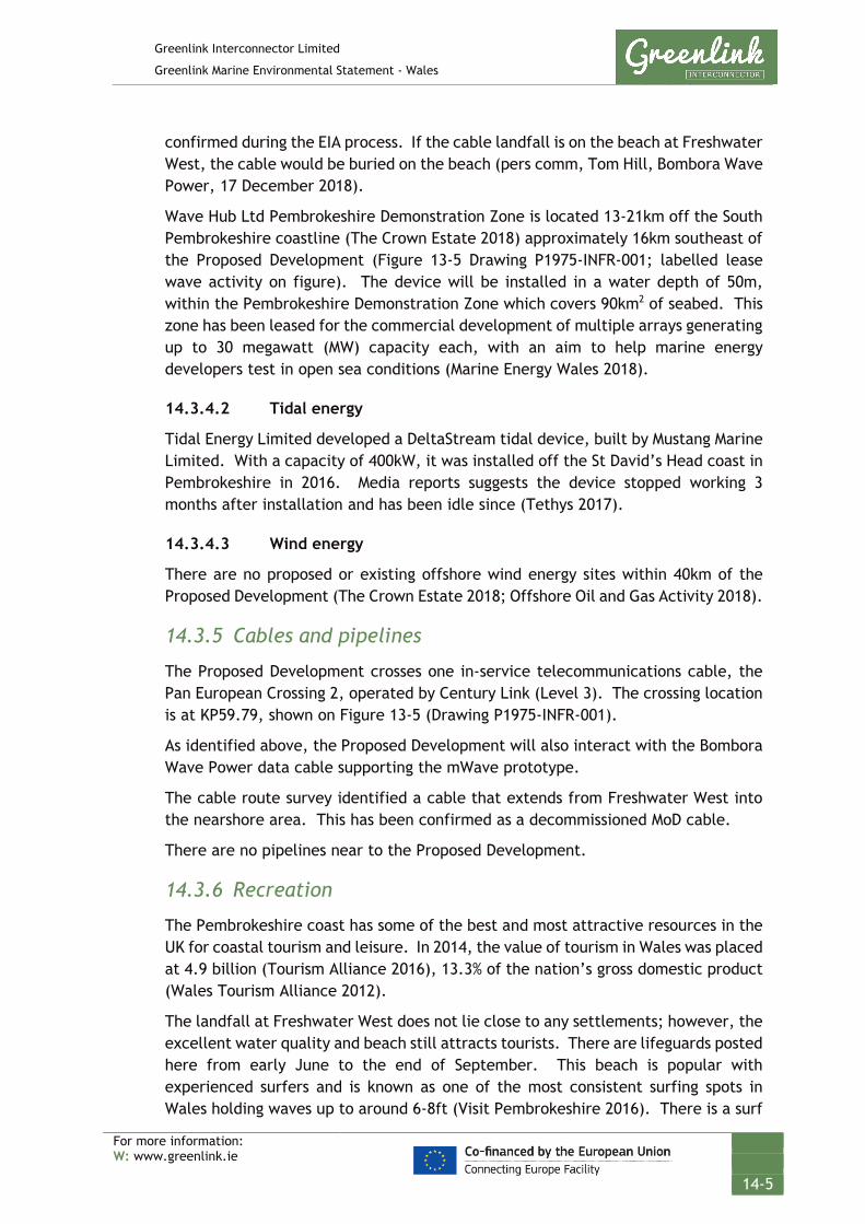
Greenlink Interconnector Limited
Greenlink Marine Environmental Statement - Wales
For more information: W: www.greenlink.ie
14-5
confirmed during the EIA process. If the cable landfall is on the beach at Freshwater West, the cable would be buried on the beach (pers comm, Tom Hill, Bombora Wave Power, 17 December 2018).
Wave Hub Ltd Pembrokeshire Demonstration Zone is located 13-21km off the South Pembrokeshire coastline (The Crown Estate 2018) approximately 16km southeast of the Proposed Development (Figure 13-5 Drawing P1975-INFR-001; labelled lease wave activity on figure). The device will be installed in a water depth of 50m, within the Pembrokeshire Demonstration Zone which covers 90km2 of seabed. This zone has been leased for the commercial development of multiple arrays generating up to 30 megawatt (MW) capacity each, with an aim to help marine energy developers test in open sea conditions (Marine Energy Wales 2018).
14.3.4.2 Tidal energy
Tidal Energy Limited developed a DeltaStream tidal device, built by Mustang Marine Limited. With a capacity of 400kW, it was installed off the St David’s Head coast in Pembrokeshire in 2016. Media reports suggests the device stopped working 3 months after installation and has been idle since (Tethys 2017).
14.3.4.3 Wind energy
There are no proposed or existing offshore wind energy sites within 40km of the Proposed Development (The Crown Estate 2018; Offshore Oil and Gas Activity 2018).
14.3.5 Cables and pipelines
The Proposed Development crosses one in-service telecommunications cable, the Pan European Crossing 2, operated by Century Link (Level 3). The crossing location is at KP59.79, shown on Figure 13-5 (Drawing P1975-INFR-001).
As identified above, the Proposed Development will also interact with the Bombora Wave Power data cable supporting the mWave prototype.
The cable route survey identified a cable that extends from Freshwater West into the nearshore area. This has been confirmed as a decommissioned MoD cable.
There are no pipelines near to the Proposed Development.
14.3.6 Recreation
The Pembrokeshire coast has some of the best and most attractive resources in the UK for coastal tourism and leisure. In 2014, the value of tourism in Wales was placed at 4.9 billion (Tourism Alliance 2016), 13.3% of the nation’s gross domestic product (Wales Tourism Alliance 2012).
The landfall at Freshwater West does not lie close to any settlements; however, the excellent water quality and beach still attracts tourists. There are lifeguards posted here from early June to the end of September. This beach is popular with experienced surfers and is known as one of the most consistent surfing spots in Wales holding waves up to around 6-8ft (Visit Pembrokeshire 2016). There is a surf

Greenlink Interconnector Limited
Greenlink Marine Environmental Statement - Wales
For more information: W: www.greenlink.ie
14-6
school located in the main car park during the summer months. The Welsh National Surfing Championships are regularly held at Freshwater West around May. This beach is also within the Pembrokeshire Coast National Park and the coastal paths are often used by walkers.
Recreational cruising routes, general sailing and racing areas are also present off the Pembrokeshire coast, as illustrated in Figure 14-1 (Drawing P1975-RYA-001), with routes between Lands End and North Wales passing 10nm offshore of the Pembrokeshire coast. Several large marinas are found within Milford Haven such as the Milford Marina and Neyland Yacht Haven. The RYA Coastal Atlas shows that recreational vessels are present in low to medium intensity in the area of the Proposed Development (RYA 2018).

GREENLINK INTERCONNECTORRECREATIONAL BOATING
Royal Yachting Association Sites - UK Waters
Chris GoodeEmma Langley
Monday, April 8, 2019 09:00:51WGS_1984_UTM_Zone_30N
D_WGS_1984UKHO; CDA; GEBCO; MarineFind; RYA; Greenlink
WGS_1984
NOTE: Not to be used for Navigation
Contains public sector information, licensed under the Open Government Licence v2.0, from the UKHO, 2018.; Contains data from UKOGD.; © The GEBCO Digital Atlas published by the British Oceanographic Data Centre on behalf of IOC and IHO, 2003; Charts from MarineFIND.co.uk © Crown Copyright, 2015. All rights reserved. Licence No: EK001-1001-WEB105. Not to be used for Navigation.; © Data reproduced under licence from the Royal Yachting Association
Anna Farley
300000
300000
325000
325000
350000
350000
57000
00
57000
00
57250
00
57250
00
57500
00
57500
00
0 2.5 5 7.5 10km © Metoc Ltd, 2019.
All rights reserved.
J:\P1975\Mxd\12_RYA\P1975-RYA-001.mxd
Created ByReviewed By
DateProjection
DatumData Source
File Reference
Spheroid
Approved By
Drawing No: P1975-RYA-001 ALegend
RYA UK Coastal Atlas of Recreational Boating
Freshwater WestProposed DevelopmentIrish OffshoreUK 12nm Territorial Sea LimitMedian Line
RYA ClubsRYA Training CentresMarinasOffshore RoutesGeneral Boating Areas

Greenlink Interconnector Limited
Greenlink Marine Environmental Statement - Wales
For more information: W: www.greenlink.ie
14-8
14.3.7 Natural evolution of the baseline
The coasts and seas of the UK are intensively used for numerous activities of local, regional and national importance including coastally located power generators and process industries, port operations, shipping, oil and gas production, fishing, aggregate extraction, military practice, as a location for submarine cables and pipelines and for sailing, racing and other recreation (DECC 2016).
The Welsh Government are “strongly committed to unlocking the energy in the seas” around Wales (Welsh Government 2012) with an aim of capturing at least 10% (8 kWh/d/p) of the potential tidal stream and wave energy off the Welsh coastline by 2025 (Welsh Government 2010). In “Taking Wales Forward 2016 – 2021” the Government sets out it will deliver a sustainable Wales. The statement highlights the opportunities to develop renewable energy. With the presence of the Pembrokeshire Demonstration Zones and the Marine Energy Test Areas there is likely to be an increase in renewable energy developments over the lifetime of the Proposed Development.
14.4 Potential Pressure Identification and Zone of Influence A scoping exercise undertaken to inform the content of the ES has excluded the following pressures from further consideration in this topic Chapter. Explanation for the exclusion is provided in Chapter 5, Table 5-2.
• Accidental anchoring or emergency anchoring on unburied / buried cable
• Damage to or interference of an external cable asset
The pressures listed in Table 14-2 will be assessed further. For each pressure the assessment considered the different aspects of the project during installation, operation (including repair & maintenance) and decommissioning. In order to evaluate the most significant effects, the largest zone of influence from these aspects was selected. The zones of influence are presented in Table 14-2
Table 14-2 Pressure identification and zone of influence – offshore infrastructure and other marine users
Project phase Project Activity
Aspect Potential Pressure Receptor Zone of influence
Installation Cable installation
Presence of project vessels
Displacement of vessels
Military vessels, recreational boating
1km wide x 12km along centreline (in any 24 hour period)
Operation Repair and maintenance operations
Decommissioning Cable removal
Installation Cable installation
Presence of project vessels in nearshore
Disturbance Bathers, surfers, and other beach users.
Freshwater West

Greenlink Interconnector Limited
Greenlink Marine Environmental Statement - Wales
For more information: W: www.greenlink.ie
14-9
Project phase Project Activity
Aspect Potential Pressure Receptor Zone of influence
Recreational boating
Installation Cable installation
Presence of project vessels
Disruption Castlemartin Firing Range
22.715km2 (see Figure 14-3)
Operation Repair and maintenance operations
Decommissioning Cable removal
Operation Operational cables
External cable protection
Change in water depth
Military vessels, recreational boating
10m (maximum width)
Operation Operational cables
Emission of EMF Electromagnetic changes – deviation of magnetic compasses
Vessels operating with a magnetic compass
2m
Electromagnetic changes - interference with inertial navigation
Vessels operating with INS and GPS systems
Installation Cable installation
Presence of project vessels
Restricted development options
Wave energy test site
Proposed Development
Operation Operational cables
Presence of installed submarine cables
Note: it was determined that the other marine activities identified in the area were of sufficient distance from the Proposed Development that there would be no interaction.
14.5 Embedded Mitigation The project description, Chapter 4, provides the current ‘base case’. This includes mitigation measures which form part of the design and are therefore an inherent part of the Proposed Development and comprise embedded or primary mitigation. The embedded mitigation relevant to other marine users is provided in Table 14-3 below. When undertaking the EIA it has been assumed that these measures will be complied with; either as a matter of best practice or to ensure compliance with statute and consents.
Table 14-3 presents measures (not a definitive list) that the Proposed Development will adhere to in order to ensure legal compliance.

Greenlink Interconnector Limited
Greenlink Marine Environmental Statement - Wales
For more information: W: www.greenlink.ie
14-10
Table 14-3 Embedded mitigation
ID* Embedded mitigation
EM1 Early consultation with relevant contacts to warn of impending activity, with vessels requested to remain at least 500m away from cable vessels during installation, repair and decommissioning.
EM2 Project vessels will comply with the International Regulations for Preventing Collisions at Sea, 1972 (COLREGs) – as amended, particularly with respect to the display of lights, shapes and signals.
EM3 Project vessels will exhibit signals in accordance with the UK Standard Marking Schedule for Offshore Installations.
EM10 Notice will be given to sea users in the area via Notices to Mariners, Kingfisher Bulletins, NAVTEX, and NAVAREA warnings. Particular attention will be paid to ensuring the following organisations receive the notifications: Castlemartin Firing Range, Milford Haven Port Authority, South Pembrokeshire RNLI, RYA, Maritime and Coastguard Agency (MCA), Welsh Fishermen’s Association, South and West Wales Fishing Communities, Welsh Marine Fisheries Advisory Group, West Wales Shell Fisherman’s Association, individual local fishermen (as identified during marine survey campaign), Pembrokeshire Coast National Park Authority, META, Bombora Wave Power, Irish Ferries.
EM11 ‘As-laid’ co-ordinates of the cable route will be recorded and circulated to the UK Hydrographic Office (UKHO) and KIS-ORCA Service. Cables will be marked on admiralty charts and fisherman’s awareness charts (paper and electronic format).
EM12 Crossing Agreements will be produced with cable owners. The Crossing Agreement describes the rights and responsibilities of the parties and also the design of the crossing. Crossing design will be in line with industry standards, using procedures and techniques agreed with the cable owners.
EM15 Submarine cables will be bundled together, which reduces which reduces the seabed footprint of installation activities and the electromagnetic field generated during operation, thus minimising any potential compass deviation effects.
EM17 Agreed Castlemartin Firing Range access and communication protocol
• GIL will notify Castlemartin Firing Range a minimum of two weeks prior to commencement, of any works (survey, installation / construction, repair or maintenance) to be carried out in the Range. This notice will be provided in writing.
• Prior to works commencing within the Range, GIL and their appointed contractor will arrange a meeting with Castlemartin Firing Range to provide a briefing of the works to be undertaken in the Range; confirm timescales; confirm lines of communication; and understand what live firing activity will be undertaken during the period.
• During activity within the Range, or within close proximity, GIL’s appointed contractor will provide daily briefings to Castlemartin Control that will cover: name of vessel(s) involved and exact location of works for the day.
• The Installation Contractor will be requested to design the programme for installation works to minimise disruption to Castlemartin Firing Range. All activities related to a particular phase within the Range should be completed before work progresses to a new section of the application area.
EM27 Post-installation compass deviation surveys will be undertaken to confirm compass deviation levels and the results forwarded to the UKHO and MCA.
EM29 Rock and mattresses will only be deployed where adequate burial cannot be achieved. The footprint of the deposits will be the minimum required to ensure cable safety and rock berm stability.

Greenlink Interconnector Limited
Greenlink Marine Environmental Statement - Wales
For more information: W: www.greenlink.ie
14-11
14.6 Significance Assessment
14.6.1 Summary of assessment
Table 14-4 presents the impact assessment conducted on the Proposed Development activities. Sections 14.6.2 to 14.6.7 provide the justification for the conclusions. Where the assessment concluded the effects are significant, Project Specific Mitigation has been proposed and is described in Section 14.7. Where there is potential for residual effects this is discussed further in Section 14.8.

Greenlink Interconnector Limited
Greenlink Marine Environmental Statement - Wales
For more information: W: www.greenlink.ie
14-12
Table 14-4 Impact assessment summary – offshore infrastructure and other marine users
Determination of Potential Effect Impact Assessment Consideration of Mitigation
Residual Impact Assessment
Section Project Phase Aspect Potential pressure
Embedded Mitigation
(Table 14-3)
Receptor Magnitude Sensitivity Significance Project Specific Mitigation
(Table 14-5)
Magnitude Sensitivity Significance of Residual Effect
14.6.2 Installation
Operation (including repair & maintenance)
Decommissioning
Exclusion zone around project vessels
Disruption EM17 Castlemartin Firing Range
Low Medium Minor PS20 Low Medium Minor
14.6.3 Installation
Operation (including repair & maintenance)
Presence of project vessels in nearshore
Disturbance EM1, EM10 Bathers, surfers, and other beach users. Recreational boating
Low Medium Minor PS1, PS16, PS17 Low Medium Minor
Installation
Operation
Exclusion zone around cables
Restricted development options
EM1, EM10, EM15
Bombora Wave Power
Medium Medium Moderate PS18, PS19 Low Medium Minor
EM1, EM10, EM15
Future users of META Site 8
Medium Medium Moderate PS18, PS19 Low Medium Minor

Greenlink Interconnector Limited
Greenlink Marine Environmental Statement - Wales
For more information: W: www.greenlink.ie
14-13
14.6.2 Disruption to Castlemartin Firing Range
14.6.2.1 Installation, Operation (including maintenance and repair), Decommissioning
The Proposed Development crosses the Castlemartin Firing Range for 11.71km and runs parallel to the boundary for a further 6.11km (Figure 13-5, Drawing P1975-INFR-001). Project activities within the Range, whether this be pre-installation seabed preparation, cable trenching, repair and maintenance or activities associated with decommissioning will require an exclusion zone around them to minimise the risk of collision with the near stationary project vessels or disruption to works. Notice will be given to marine users requesting that they stay a minimum of 500m away from project vessels (EM1). However, this exclusion zone and the presence of the project vessels in the Range means that military activities on the Castlemartin Firing Range may be disrupted. For example, firing from a specific range to offshore may not be possible for the duration of the works. The exclusion area will cover approximately 22.715km2 (shown on Figure 14-3, Drawing P1975-INFR-003), temporarily reducing the size of the SDA by 5.4%.
GIL have been in consultation with Castlemartin Firing Range since 2016 to ensure that the route developed through the Range is acceptable to the Ministry of Defence and would not compromise the ability of the Range to operate. The Castlemartin Firing Range closes during specific periods of the year (Easter and August) and ideally works should be carried out during these periods. However, as it cannot be guaranteed that works can be completed during these periods GIL have sought to agree an access and communication protocol with Castlemartin Firing Range. The following has been agreed (Embedded Mitigation EM17).
Taking the embedded mitigation into consideration, the temporary nature of the disruption, and the fact that once work ceases the Range will be fully operational again, the magnitude of the effect has been assessed as low. The sensitivity of the receptor has been assessed as medium because the presence of the exclusion zone and project vessels will temporarily limit options on the Range. Therefore, the overall significance of the effect is assessed as Minor and is Not Significant.
14.6.3 Disturbance to beach users
14.6.3.1 Installation Operation (including maintenance and repair), Decommissioning
The ‘base-case’ for cable installation at Freshwater West is to use horizontal directional drilling (HDD); a trenchless installation technique. The EIA process, recorded in Chapter 6 concluded that the HDD needs to exit below the low water to ensure that there is no significant effects on the beach and coastal processes. This has been incorporated into the design of the Proposed Development and no works are planned between mean high water springs and low water. Therefore access on the beach will not be restricted.

Greenlink Interconnector Limited
Greenlink Marine Environmental Statement - Wales
For more information: W: www.greenlink.ie
14-14
Works associated with the cable pull-in and trenching from the HDD exit will be undertaken in the nearshore. Vessels could be present for discrete periods for up-to a few weeks, although it is more likely that durations will be in the order of days.
Experience from other cable projects suggests that effects through noise or light pollution and associated landscape effects due to the nearshore works will be temporary and localised and not expected to result in significant disruption or distraction to recreational activity.
Due to the temporary nature of the works the magnitude of the effect has been assessed as low. Sensitivity is dependent on the timing of the nearshore works. For example, if works coincided with the National Surfing Championships (1 week in May) or occurred during the peak tourist season (i.e. July and August) the sensitivity would be assessed as medium because nearshore works at this time could potentially effect higher numbers of users. As a worst-case, the impact assessment has assumed that works could occur during these peak periods and assumed a sensitivity of medium. The overall significance of the effect is assessed as Minor and is Not Significant.
Although the assessment has concluded effects are Not Significant in recognition that activity in the nearshore and how it disturbs recreational users is subjective Project Specific Mitigation has been proposed as best practice.
14.6.4 Restricted development options
14.6.4.1 Operation (including maintenance and repair)
The Proposed Development overlaps with META Site 8 (shown on Figure 14-3 Drawing P1975-INFR-003). Once the Proposed Development is installed there will be a zone around the cables in which no other development activity can be undertaken, so as not to risk damage to the Proposed Development. This work restriction zone is a legal area that will be defined in and controlled by GIL’s Crown Estate Licence. In water depths up to 55m below chart datum the exclusion zone is 250m either side of the centre line; extending to 500m either side, in water depths greater than 55m (The Crown Estate 2010). If a third party wishes to undertake works within the exclusion zone then a Proximity Agreement will need to be agreed with GIL.
The EIA project team assessed two scenarios for this pressure: the significance of the effect on Bombora Wave Power; and the significance of the effect on a future but unknown development within META Site 8.
Significance of effect on Bombora Wave Power GIL is aware that Bombora Wave Power plan to test a wave device within the META Site 8 during second quarter 2020. The EIA has therefore considered three scenarios; installation activities overlap temporally; the wave device is installed first; Greenlink is installed first.
As shown in Figure 14-2 (Drawing P1975-INR-003) the Proposed Development overlaps one of Bombora Wave Power’s cable corridor options. In all three scenarios

Greenlink Interconnector Limited
Greenlink Marine Environmental Statement - Wales
For more information: W: www.greenlink.ie
14-15
identified above, if this option is selected GIL and Bombora will require a proximity agreement to allow paralleling of the cables. The installation of Greenlink will also limit Bombora to using the northern section of their proposed cable corridor, reducing the area identified for cable installation by 0.043km2.
GIL have a constructive relationship with Bombora Wave Power with both parties committed to cooperative development e.g. sharing marine survey data. As the projects develop; Bombora confirms which cable route option will be selected; and installation schedules are confirmed; further discussions will be held. The magnitude of the receptor has been assessed as medium because the Proposed Development will cause a local change to Bombora’s plans i.e. by reducing the area available in one of the cable corridors. The sensitivity of the receptor has been assessed as medium because although there will be a loss of access, there are acceptable alternatives available for the Bombora cable development. The significance of the effect on Bombora Wave Power has been assessed as Moderate and is Significant. Project specific mitigation has therefore been proposed.
Significance of effect on future unknown development in META Site 8 The magnitude of the effect has been assessed as medium because the change to the baseline is very localised, only effecting a small area of the META Site 8 (0.043km2) and there is the opportunity through proximity agreements, to reduce the spatial extent of the exclusion zone through mutual agreement between GIL and a third-party developer.
The beach at Freshwater West is long and there are acceptable alternatives available for landing additional cables i.e. for testing wave power devices in META Site 8, if necessary. GIL has a constructive relationship with META with both parties committed to cooperative development. Any future development within META Site 8 will be working against a baseline which contains the Proposed Development and therefore should be able to adapt to the exclusion zone or seek a Proximity Agreement with GIL. The sensitivity of the receptor has therefore been assessed as medium. The significance of the effect on future development within META Site 8 has been assessed as Moderate and is Significant. Project specific mitigation has therefore been proposed.
14.6.5 Displacement of vessels
14.6.5.1 Installation, Operation (including maintenance and repair) and decommissioning
This pressure on recreational and military vessels effects the crafts ability to navigate. The significance of the effect has been assessed as part of the Navigation Risk Assessment, provided in Chapter 13.
The assessment presented in Section 13.6.2 took into consideration embedded mitigation EM2, EM3, EM10, EM16 and EM22 which seek to reduce the significance of effects on navigational stakeholders by providing notice of activities and appropriately marking project vessels.

Greenlink Interconnector Limited
Greenlink Marine Environmental Statement - Wales
For more information: W: www.greenlink.ie
14-16
Section 13.6.2 concluded that as the Proposed Development passes to the south, and partially through the offshore Traffic Separation Scheme ‘Off Smalls’ and that vessels will be requested to stay away from specific areas as installation progresses the significance of the effect is Minor and is Not Significant.
14.6.6 Change in water depth
14.6.6.1 Operation
This pressure on recreational and military vessels effects the craft ability to navigate. The embedded mitigation, listed in Table 14-5, associated with this pressure is EM29. The significance of the effect has been assessed as part of the Navigation Risk Assessment, provided in Chapter 13.
Section 13.6.3 concluded that the external cable protection will be a new permanent feature. There will be sufficient under keel clearance at the proposed external cable protection locations to ensure safe navigation. The section concluded that the overall significance of the effect is Negligible and is Not Significant.
14.6.7 Electromagnetic changes – deviation of magnetic compasses and interference with inertial navigation systems
14.6.7.1 Operation
This pressure on recreational and military vessels effects the crafts ability to navigate. The significance of the effect has been assessed as part of the Navigation Risk Assessment, provided in Chapter 13.
Chapter 13 looked at two possible effects that an electromagnetic change can have on navigation: deviation of magnetic compasses; and interference with inertial navigation systems.
Section 13.6.4 concluded that vessels navigating using magnetic compasses are considered able to make the necessary adjustments to a slight compass deviation reading. The section concluded that the overall significance of the effect is Negligible and is Not Significant.
It further concluded, that the effect of interference with inertial navigation was Negligible and is Not Significant.
Global positioning systems (GPS) use radio signals that will be subject to no or negligible effects from EMF emanating from the marine cables. These systems are therefore unaffected by external magnetic fields.
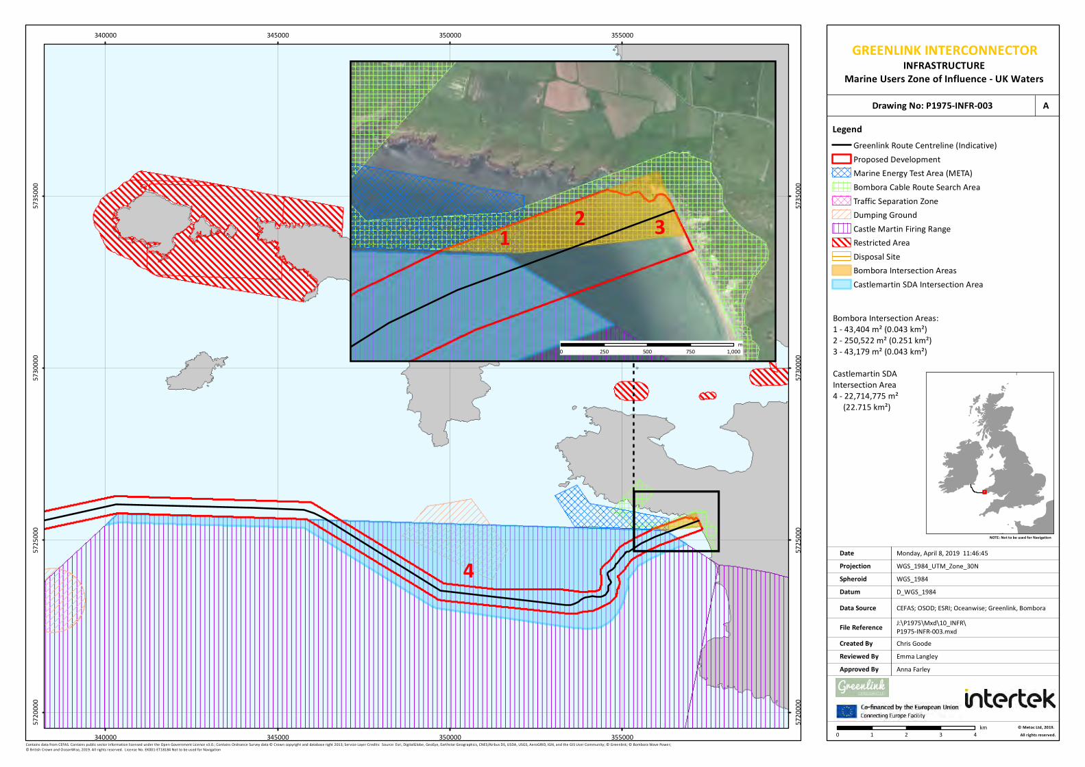
Chris GoodeEmma Langley
Monday, April 8, 2019 11:46:45WGS_1984_UTM_Zone_30N
D_WGS_1984CEFAS; OSOD; ESRI; Oceanwise; Greenlink, Bombora
WGS_1984
NOTE: Not to be used for Navigation
Contains data from CEFAS. Contains public sector information licensed under the Open Government Licence v3.0.; Contains Ordnance Survey data © Crown copyright and database right 2013; Service Layer Credits: Source: Esri, DigitalGlobe, GeoEye, Earthstar Geographics, CNES/Airbus DS, USDA, USGS, AeroGRID, IGN, and the GIS User Community; © Greenlink; © Bombora Wave Power; © British Crown and OceanWise, 2019. All rights reserved. License No. EK001-ET18184 Not to be used for Navigation
Anna Farley
4
340000
340000
345000
345000
350000
350000
355000
355000
57200
00
57200
00
57250
00
57250
00
57300
00
57300
00
57350
00
57350
00
LegendGreenlink Route Centreline (Indicative)Proposed DevelopmentMarine Energy Test Area (META)Bombora Cable Route Search AreaTraffic Separation ZoneDumping GroundCastle Martin Firing RangeRestricted AreaDisposal SiteBombora Intersection AreasCastlemartin SDA Intersection Area
0 1 2 3 4km © Metoc Ltd, 2019.
All rights reserved.
J:\P1975\Mxd\10_INFR\P1975-INFR-003.mxd
Created ByReviewed By
DateProjection
DatumData Source
File Reference
Spheroid
Approved By
Bombora Intersection Areas:1 - 43,404 m² (0.043 km²)2 - 250,522 m² (0.251 km²)3 - 43,179 m² (0.043 km²)Castlemartin SDA Intersection Area4 - 22,714,775 m² (22.715 km²)
1 2 3
0 250 500 750 1,000m
GREENLINK INTERCONNECTORINFRASTRUCTURE
Marine Users Zone of Influence - UK WatersDrawing No: P1975-INFR-003 A

Greenlink Interconnector Limited
Greenlink Marine Environmental Statement - Wales
For more information: W: www.greenlink.ie
14-18
14.7 Project Specific Mitigation In addition to the embedded mitigation outlined in Section 14.5, Table 14-5 presents Project Specific Mitigation that GIL is committed to adopting.
Table 14-5 Project specific mitigation – offshore infrastructure and other marine users
ID Project Specific Mitigation
PS1 No intrusive works will be undertaken at Freshwater West between mean high water springs and mean low water springs
PS4 The preference is to bury the HDD duct exit and all cables in sediment to the required depth of lowering. No external cable protection should be deposited at the HDD exit point.
PS16 GIL to liaise with Welsh Surfing Federation 12-months prior to installation works at Freshwater West to ensure nearshore works scheduling is optimized to avoid National Surf Championships if possible.
PS17 No works to be undertaken on beach at Freshwater West during July and August (inclusive).
PS18 Cooperation with META Site 8 and Bombora Wave Power
PS19 GIL to cooperate in reaching mutually agreeable terms for proximity agreements with wave energy developers using META Site 8.
PS20 GIL and installation contractor to look at feasibility of scheduling works within Castlemartin Firing Range during Easter and August shut-down periods.
14.8 Residual Effect The results of the impact assessment indicated that three pressures could potentially have a minor to significant effect. The significance of these pressures was re-assessed taking into consideration the Project Specific Mitigation outlined in Section 14.7 to determine if a significant residual effect remains.
14.8.1 Disturbance to beach users
The assessment identified that the Proposed Development has the potential to have an effect of Minor significance on recreational users of the beach. Although this is Not Significant, review of the baseline identified two periods of concern where Project Specific Mitigation could potentially reduce the significance of effects; a week during May when the National Surf Championships are held at Freshwater West; and July and August when visitor numbers peak due to the holiday season. Mitigation has therefore been proposed, PS1, PS16 and PS17 to ensure beach access is not restricted and minimise the presence of vessels in the nearshore at these times. Taking this mitigation into consideration, the significance of the effect remains Minor and Not Significant.
14.8.2 Disruption to Castlemartin Firing Range
The Proposed Development passes directly through the Castlemartin Firing Range. An access and communication protocol has been developed by GIL, in consultation

Greenlink Interconnector Limited
Greenlink Marine Environmental Statement - Wales
For more information: W: www.greenlink.ie
14-19
with the Ministry of Defence, to minimise the disruption to the Range’s operation. However, temporary disruption to activities is still possible. Further mitigation has been proposed (PS20), which seeks to plan works within the Range during periods of range closure (i.e. Easter and August). However, as this may not be possible, the residual effect remains as Minor, which is Not Significant.
14.8.3 Restricted development options
The Proposed Development passes directly through the area identified by Bombora Wave Power as a possible cable corridor for their wave energy device. The two projects are being developed concurrently and it is possible that the installation of Greenlink will limit the route to shore Bombora Wave Power’s cables could take. GIL will cooperate with Bombora Wave Power and maintain close communications (PS18) throughout the project to ensure the parties work together so that the projects can successfully co-exist. As part of this cooperation they will, if necessary, negotiate mutually agreeable terms for proximity agreements (PS19). Taking this mitigation into consideration the residual effect has been assessed as Minor and Not Significant.

Greenlink Interconnector Limited
Greenlink Marine Environmental Statement - Wales
For more information: W: www.greenlink.ie
14-20
1 1st Line Defence (2018). Detailed Unexploded Ordnance (UXO) Risk Assessment. Greenlink Cable Route. Report Reference DA2985-00.
2 Bombora Wave Power (2018). Projects. Pembrokeshire, Wales. [Online] Available at: http://www.bomborawave.com/projects
3 GOV.UK (2019). Offshore wind energy revolution to provide a third of all UK electricity by 2030 [Online] Available at: https://www.mhpa.co.uk/uploads/2018%20documents/Castlemartin%20Firing%20Range.pdfhttps://www.gov.uk/government/news/offshore-wind-energy-revolution-to-provide-a-third-of-all-uk-electricity-by-2030 [Accessed June 2019]
4 MHPA (2016). Castlemartin Firing Range. [Online] Available at: https://www.mhpa.co.uk/uploads/2018%20documents/Castlemartin%20Firing%20Range.pdf [Accessed 18/12/2018]
5 Oil and Gas Authority (2018). Offshore Oil and Gas Activity. [Online] Available at: https://ogauthority.maps.arcgis.com/apps/webappviewer/index.html?id=adbe5a796f5c41c68fc762ea137a682e [Accessed 18/12/2018]
6 Submarine cable networks (2017). [Online] Available at: https://www.submarinenetworks.com/systems/trans-atlantic/hibernia-atlantic [Accessed 18/12/2018]
7 Tethys (2017). Ramsey Sound [Online] Available at: https://tethys.pnnl.gov/annex-iv-sites/ramsey-sound [Accessed 18/12/2018]
8 The Crown Estate (2010). THE CROWN ESTATE’S HEADS OF TERMS FOR SUBMARINE TELECOMMUNICATION CABLES – Standard Licence. [Online] Available at: https://www.thecrownestate.co.uk/media/1766/heads_of_terms_for_submarine_telecoms_cables.pdf [Accessed 18/12/2018]
9 The Crown Estate (2017). Marine aggregates. Capability and Portfolio 2017. [Online] Available at: https://www.thecrownestate.co.uk/media/2483/marineplusaggregates_2017_web.pdf [Accessed 18/12/2018]
10 Royal Yacht Association (RYA) (2018). UK Coastal Atlas of Recreational Boating.
11 Welsh Government (2010) A low carbon revolution – The Welsh Assembly Government Energy Policy Statement. March 2010.
12 Welsh Government (2012) Energy Wales: A Low Carbon Transition. March 2012
13 Welsh Government (2016) Taking Wales Forward 2016 – 2021.
REFERENCES
https://ogauthority.maps.arcgis.com/apps/webappviewer/index.html?id=adbe5a796f5c41c68fc762ea137a682e

Greenlink Interconnector Limited
Greenlink Marine Environmental Statement - Wales
For more information: W: www.greenlink.ie
15-1
15. Marine Archaeology This Chapter describes the existing baseline environment in terms of marine archaeology, identifies the pressures associated with the Proposed Development on the receptor, presents the findings of the environmental impact assessment, and describes how significant effects (if any) will be mitigated.
The Proposed Development refers to the Welsh Marine components of Greenlink from mean high-water springs (MHWS) at the proposed Welsh landfall at Freshwater West, Pembrokeshire to the UK/Republic of Ireland median line. It comprises:
• Two high voltage direct current (HVDC) electricity power cables;
• A smaller fibre-optic cable for control and communication purposes;
• All associated works required to install, test, commission and complete the aforementioned cables; and
• All associated works required to operate, maintain, repair and decommission the aforementioned cables, including five repair events over the 40 year lifetime of Greenlink.
The Proposed Development includes the following phases, all of which are assessed in this chapter:
• Installation;
• Operation (including repair and maintenance activities); and
• Decommissioning.
Where relevant, any limitations relating to the baseline conditions, data sources or scientific understanding / interpretation in the process of assessing the effects have been highlighted.
15.1 Data Sources
GIL commissioned Cotswold Archaeology to undertake a desk-based assessment of the environmental baseline for marine archaeology to inform the EIA process. The marine archaeological technical report (Technical Appendix G) consulted a number of primary sources and synthesised information in order to describe the baseline. Information taken from the earlier marine archaeology desk-based assessment (DBA) (Cotswold Archaeology 2018) and the data gathered through marine geophysical and geotechnical cable route surveys were key components of the report.
Only information pertaining to the data sources and previous work undertaken for the Proposed Development will be referred to in this chapter. The full assessments (also covering the Irish Marine and Irish Offshore components of Greenlink) are provided in Technical Appendix G.

Greenlink Interconnector Limited
Greenlink Marine Environmental Statement - Wales
For more information: W: www.greenlink.ie
15-2
15.1.1 Desk-based studies
15.1.1.1 Marine Archaeology DBA & Marine Archaeological Technical Report
The marine archaeology DBA for the Proposed Development included an assessment of the marine and coastal cultural assets potentially affected by Greenlink (Cotswold Archaeology 2018). The purpose of the assessment was to identify any sites and features of cultural heritage significance within and in proximity to the Proposed Development, up to MHWS (unless otherwise stated), that may be affected. The results of the DBA outlined the archaeological potential of the marine environment and included information on sites and areas of archaeological significance identified within and in proximity to Greenlink.
The DBA focussed on three route options (A, B and E), of which one (E) has been taken forward for EIA with a slight variation. The study area which was not assessed as part of the DBA due to this subsequent variation during cable route survey has been assessed in this Chapter.
The DBA included a documentary and cartographic search utilising a variety of sources in order to locate all known cultural heritage assets within a cable study corridor (CSC) (a 1km swath of the seabed). Each possible route option was assessed ahead of the cable route survey, and the archaeological potential of the area was evaluated. Sources considered for this assessment included, where relevant:
• Information held on the National Monuments Record of Wales (NMRW) by the Royal Commission on the Ancient and Historical Monuments of Wales (RCAHMW);
• Archaeological records in the Historic Environment Record (HER) held by Dyfed Archaeological Trust;
• Aerial photographs held by the Welsh Assembly Government and/or the RCAHMW;
• Pembrokeshire Seascape Character Assessment;
• Pembrokeshire archives, for a review of cartographic information;
• The OceanWise Wrecks and Obstructions database;
• UK Hydrographic Office (UKHO) review of cartography, historic charts and sailing directions;
• Ministry of Defence (military remains only);
• UK Receiver of Wreck (RoW);
• Records held with the Archaeology Data Service (ADS);
• Marine Environment Data Information Network (MEDIN);
• Readily accessible published sources and grey literature (e.g. results from previous studies);
• Relevant external marine historic environment specialists;
• British Geological Survey regional guide and previous work in the area;

Greenlink Interconnector Limited
Greenlink Marine Environmental Statement - Wales
For more information: W: www.greenlink.ie
15-3
• Relevant dive groups and local interest groups;
• Relevant external marine historic environment specialists (e.g. palaeo-environmental); and
• Relevant Strategic Environmental Assessment (SEA) reports (e.g. UK Continental Shelf SEA archaeological baseline) and Coastal Survey Assessment reports.
Of those listed above, the key data sources were the NMRW, the UKHO entries (as held by OceanWise) and the Dyfed Archaeological Trust HER.
The DBA included all known and potential maritime cultural heritage assets identified in the course of the assessment. These were each assigned a unique Cotswold Archaeology (CA) number for ease of identification in illustrations and throughout the text. These CA numbers have been replicated in this document, with reference only to those which may be affected by the Proposed Development.
The wreck types were defined as follows:
• ‘Live’ - those for which there is a known location which has been verified by recent surveys;
• ‘Dead’ - sites that have been recorded in a certain location, but which have not been detected by repeated or the most recent surveys; and
• Lifted - those which have been removed from their recorded location.
Where a live wreck has been identified this information is provided in the baseline; a wreck in a known location that has not been identified is referred to as unidentified. Where the status of a wreck discussed in the baseline is given as ‘unknown’, this means that it is not recorded whether the wreck is live, dead or lifted.
The baseline information established through the collation and interpretation of the relevant information available through these sources formed the primary source of background detail for the marine archaeological technical report (Technical Appendix G), alongside the results of recent geophysical surveys (discussed below). The detail presented in the marine archaeological technical report is the existing baseline assessed below (Section 15.3).
Full details of the methodologies applied in the marine archaeology DBA and re-laid in the marine archaeological technical report are available in Technical Appendix G.
15.1.1.2 Limitations of desk-based studies and their data sources
One of the greatest limitations when researching known and potential offshore cultural heritage is the difficulty of locating recorded maritime losses. For many losses the location of the sinking of the vessel can be in the form of a general area description, as in ‘SW and W from southern Wales or ‘not confirmed as present at this location, but may possibly be in the vicinity’, which is not useful practically for the purpose of accurate assessment, except to show the potential exists to encounter lost cultural remains.
Greenlink Interconnector Limited
Greenlink Marine Environmental Statement - Wales
For more information: W: www.greenlink.ie
15-4
Many wrecks have been identified through sonar survey but this too presents difficulties as many of these wrecks have been located using GPS, which until relatively recently was only accurate to 100m (see Satchell 2012); or by DECCA which can give locations accurate to only one kilometre. In addition, recorded maritime losses are heavily biased towards the 19th and 20th centuries when more comprehensive records of losses began to be compiled by the UKHO.
The details for specific offshore cultural heritage assets in the study area were acquired from the three main sources cited above. All these databases are each derived, in turn, from a variety of sources including various published lists of marine losses and marine surveys. Consequently, there are considerable overlaps and discrepancies between the datasets.
The figures are projected in WGS_1984_UTM_Zone_30N.
The status of wrecks (‘live’, ‘dead’, or lifted) was determined based on the information available at the time of writing.
The various datasets used in the compilation of the DBA have been amalgamated to remove duplicate entries.
The wrecks discussed in the DBA (Technical Appendix G) related to the Proposed Development and covered all Dyfed Archaeological Trust HER, NMRW, and UKHO entries (as held by OceanWise) in the study area including dead entries. Dead entries were included in the DBA, if applicable, because although wrecks may not have been detected in recent surveys the recorded locations may still contain remains of cultural heritage interest. Given locational discrepancies (Satchell 2012) the possibility that wrecks lie outside previous search areas cannot be discounted.
The old archaeological adage that absence of evidence is not evidence of absence was deemed appropriate in the context of the desk-based assessment. In some cases, however, it was clear from the details of data entries that there is no reason to believe that there are now or ever have been archaeological remains. These entries were discussed in the assessments, if appropriate, on a case-by-case basis.
All the data held by OceanWise, the Dyfed Archaeological Trust HER and the NMRW was considered, and for completeness, listed and cross-referenced. Information from the relevant areas of the Pembrokeshire Seascape Character Assessment website was assessed and, where deemed appropriate, was referred to accordingly.
15.1.2 Geophysical survey data
Geophysical and geotechnical survey data acquired during the Greenlink cable route survey by MMT during September 2018 – December 2018 and March 2019 has been reviewed by Cotswold Archaeology and our colleagues at COARS (University of Southampton) (Cotswold Archaeology 2019) (discussed in Technical Appendix G); the information from this assessment has informed this chapter.
The results of the survey have been incorporated into the marine archaeological technical report and the baseline which follows below. Full details of the survey

Greenlink Interconnector Limited
Greenlink Marine Environmental Statement - Wales
For more information: W: www.greenlink.ie
15-5
equipment specifications and the survey methodology are contained in the technical report (Technical Appendix G).
15.1.2.1 Limitations of geophysical survey
As outlined in the technical report (Technical Appendix G) the marine geophysical survey utilised the four main geophysical techniques, including sidescan sonar (SSS), magnetometry, and sub-bottom profiler (SBP), as well as bathymetric survey data collected using a multibeam echo sounder (MBES). Whilst three of these techniques, SSS, MBES, and magnetometry, are useful prospection tools scanning wide swaths of the seabed, the SBP data is collected over only a very narrow field. Consequently, the ability to detect non-ferrous buried remains, with little or no surficial signature, is very limited.
Equally, the range of geophysical techniques that can be deployed on terrestrial sites, to detect a wide variety of site types and archaeological features, are far less effective in the saline environment of the foreshore and intertidal zones. Consequently, although the techniques employed in this environment are effective and have produced some very interesting results, the results are not as finely nuanced as they would be if a wider range of techniques could be deployed, so some potentially archaeological features may not be detected.
15.2 Consultation
Table 15-1 summarises the relevant consultation responses on marine archaeology. The steps taken to contact stakeholders for comments on the EIA scope is documented in Chapter 5.
Table 15-1 Consultation responses – marine archaeology
Stakeholder Summary of Consultation Response How response has been addressed
Comments received on NRW Scoping Opinion (SC1816)
RCAHMW Section 6 of the Scoping Opinion covers the Human Environment, encompassing the historic environment. It refers to the need for the EIA to cover the appropriate route option(s) taken forward with regard to the potential impact upon archaeological deposits through the intertidal zone.
It was requested that the technical specification of further work should have input from appropriate archaeological consultants before tendering to the hydrographic survey company, with reference to specific guidance documents which were provided.
The Proposed Development has been fully assessed through the 2018 Marine Archaeological DBA and through this ES chapter, which will refer to the impact assessments made regarding heritage assets above MHWS by ARUP.

Greenlink Interconnector Limited
Greenlink Marine Environmental Statement - Wales
For more information: W: www.greenlink.ie
15-6
15.3 Existing baseline
This section provides a summary of the baseline environment as understood through the results of previous work within the 1km CSC. In-depth details of the marine historic environment can be sought from the data sources provided in Technical Appendix G.
15.3.1 Offshore route context
The landfall at Freshwater West has been plotted over existing UKHO swath bathymetry covering the Proposed Development, with background bathymetry derived from the EMODnet regional Digital Terrain Models (DTM), at a resolution of 0.125 minute * 0.125 minute. The bathymetry clearly shows the presence of the main deep associated with St George’s Channel between Wales and Ireland, which reaches a maximum depth of -140m chart datum (CD). The available bathymetry suggests that there are data available covering the approaches to the proposed landfall location (SEACAMS, University of Bangor), although access to the raw data was unavailable which limits the confidence in the palaeoenvironmental (e.g. presence of palaeo-channel visible on the seabed) and archaeological record (e.g. wreck sites).
Modelling presented by Chiverell et al. (2013) suggests that the Irish Sea Ice Sheet (ISIS) would have retreated to the north of the Celtic Sea area by 23.7 to 23.0 kilo annum (ka – thousand years). The expansion and retreat of the ISIS along St George’s Channel and into the Celtic Sea resulted in the deposition of thick Pleistocene deposits (e.g. Blundell et al. 1968; Garrad 1977).
Scourse & Furze (2001) present the results of a series of boreholes from the centre of St George’s Channel, showing that, in the upper 5-10m of those intersecting with the Proposed Development, a series of glacio-fluvial and glacio-lacustrine deposits are overlain by late-glacial / Holocene marine gravel and marine sand. The boreholes containing Pleistocene Tills are present in the deeper central section of St George’s Channel.
To the east, the underlying mudstone bedrock is present closer to the seabed surface, although south of Milford Haven there is a persistent weathered bedrock record in the shallow cores. Surface gravels and shelly sands overlying the till / bedrock were most common closer to the shore, whereas muddy sands were more prevalent in the deeper offshore areas. Evans (1990) suggests that much of the seabed of the Celtic Sea consists of a thin lag deposit reworked from pre-existing deposits.
The retreat of the ISIS coupled with sea level rise led to the submersion of coastal areas. The rate of change of this relative sea-level (RSL) has been constrained by studies using sea level index points (SLIPs). The most recent review of SLIPs for the British Isles has been presented by Shennan et al. (2018) which indicates only one SLIP for south Wales (Pembrokeshire), derived from the submerged forest at Freshwater West.
The modelled RSL suggests that, after the retreat of the ISIS, a land bridge no longer existed between Wales and Ireland in St George’s Channel, and it is therefore

Greenlink Interconnector Limited
Greenlink Marine Environmental Statement - Wales
For more information: W: www.greenlink.ie
15-7
improbable that palaeo-environmental material associated with submerged palaeo-landscapes exists in the main channel area (see Westley & Edwards 2017).
15.3.1.1 Geophysical survey results
The offshore geophysical surveys were undertaken in order to determine whether there would be any effect to potential archaeological features during proposed coring in advance of the construction phase of the scheme. During the survey, multibeam echosounder (MBES), sidescan sonar (SSS), magnetometer and sub-bottom profiler (SBP) data were collected.
Analysis of the marine geophysical datasets identified 84 anomalies with archaeological potential (CA2062-2140, CA2144-2148). Other geophysical anomalies identified within the survey data, notably the side scan sonar, consisted of small (<2m) boulders, sometimes with associated scour, within areas where bedrock was not exposed on the surface. These anomalies did not have associated magnetic signals so are interpreted as being natural in origin and are therefore not listed as having archaeological potential (see Figures 19 and 20 and Table 4 in Technical Appendix G).
Of the 84 anomalies identified, none were identified as wreck sites or were identified as having high archaeological potential. 24 were deemed to have medium potential, typically consisting of magnetic anomalies exceeding 25 nanotesla (nT) and sometimes had associated bathymetric or SSS anomalies. These might suggest metallic objects upon, or just under, the seabed. No corresponding anomalies were identified in the neighbouring sub-bottom surveys, though survey lines rarely directly coincided with the position of these anomalies visible in the surface datasets. The remaining 60 anomalies were identified as having low archaeological potential.
A review of the sub-bottom seismic survey data has identified nine areas where features of archaeological potential are present along the Proposed Development. The distribution of these areas is shown in Technical Appendix G, Figure 21.
Illustrations of a selection of these areas, including corresponding sub-bottom seismic lines, are provided in Appendix 4 of Technical Appendix G.
The geophysical survey report proposed that the anomalies identified should be protected by archaeological exclusion zones (AEZs) in order to prevent development effects to the potential marine archaeological resource in these areas.
15.3.2 Landfall site context – Freshwater West
A palaeo-channel associated with the Castlemartin Corse stream was detected crossing the Proposed Development, in the project-specific bathymetric survey data collected by MMT. A broad ‘channel’ area was noted in the sub-bottom data off the beach at Freshwater West. This area is believed to be beyond the ISIS limit so it could preserve older Pleistocene material. The palaeoenvironmental potential of this area was first established by Leach (1913) who identified a series of flint scatters below a layer of undisturbed peat, following a survey of the outermost submerged forest that

Greenlink Interconnector Limited
Greenlink Marine Environmental Statement - Wales
For more information: W: www.greenlink.ie
15-8
had become exposed to the north of Little Furznip near the mouth of Castlemartin Brook.
Sampling of the peat at the low water mark by H. Godwin (in Wainwright 1961; 1963 Appendix II) was undertaken for pollen and plant macrofossils analysis, which identified that the assemblage was dominated by Quercus (oak) and Alnus glutinosa (alder) pollen, the latter also present within the macrofossil record along with a series of other aquatic / wetland plant species. The macrofossils notably showed a transition from a fen wood at the base of the sequence to one with ‘more muddy conditions’ at the top. A radiocarbon date was also obtained from the lower wood peat which produced a date of 5210-4550 cal. BC (Q-530; 5960±120 BP; Godwin & Switsur 1964).
It is noted that the majority of recorded locations for the submerged forest are inaccurate. A map regression, taking information and illustrations from these previous works, would suggest that the two submerged forest exposures are located just beyond (south of) the CSC. The submerged forest still exists on the beach, as it was observed after storms in 2015, pictured below in Figure 15-1.
Figure 15-1 Remains of the submerged forest preserved in the exposed peats on the foreshore (courtesy of Intertek)

Greenlink Interconnector Limited
Greenlink Marine Environmental Statement - Wales
For more information: W: www.greenlink.ie
15-9
15.3.2.2 Landfall survey results
The landfall surveys comprised walk-over, hand-held metal detector and terrestrial geophysical (electrical conductivity) surveys.
The surveys identified two features which cross the sand. These are decommissioned Ministry of Defence cables. The presence of bedrock was detected on the north-east portion of the beach while a possible channel or break in the bedrock can be seen truncating the centre of the Proposed Development. Two small ferrous anomalies were detected on the northern edge of this channel, which appear unlikely to represent unexploded ordnance (UXO).
No features of archaeological potential were identified at the landfall location.
15.3.3 Maritime cultural heritage
15.3.3.1 Palaeoenvironmental deposits
As discussed in Section 15.3.1, there is evidence to suggest that palaeoenvironmental material exists in proximity to the landfall location, and along the offshore route.
15.3.3.2 Wrecks and obstructions
The details of each recorded wreck/obstruction have been collated in a series of tables and assigned ‘CA’ reference numbers (Table 15-2). The location of these wrecks/obstructions are shown in Figure 15-2 and Figure 15-3. Table 15-2 shows the wrecks/obstructions which were identified in the DBA within the 1km wide CSC. It includes two additional records (CA24 & CA25) which have since been identified as a result of new data searches. Searches were undertaken post-survey to ensure coverage of the entire Proposed Development following route development during the cable route survey. These two additional records have been described below. Full descriptions of the remainder of the records can be found in Section 6 of the DBA (Cotswold Archaeology 2018).
Numbers missing from this sequence include those:
1. in the Greenlink Marine Environmental Impact Assessment Report, which covers the Irish Marine and Irish Offshore components;
2. which were assessed at the DBA stage for alternative routes which have not been taken forward; or
3. which are addressed in the EIAs for Wales Onshore or Irish Onshore as they are above MHWS and therefore beyond the scope of this marine archaeology chapter.

Greenlink Interconnector Limited
Greenlink Marine Environmental Statement - Wales
For more information: W: www.greenlink.ie
15-10
Table 15-2 Wrecks/obstructions recorded within the 500m radius CSC
CA no. Name Type Date Status Source & ref. no.
CA2 Wreck, possibly Willemoes of Thuro
Wreck Modern (1924)
Live RCAHMW 273193 / 420445
CA5 Thorold Wreck Modern (1940)
Live OceanWise
1001707586
CA8 Off Milford Haven Site (possible area of multiple wrecks/aircraft)
Multi period
Unknown
RCAHMW 506396
See Technical Appendix G, Table 3
CA9 Freshwater West Site (possible area of multiple wrecks/aircraft)
Multi period
Unknown
RCAHMW 525694
Technical Appendix G, Table 3
CA13 Unnamed wreck Wreck Unknown Dead OceanWise
1001695736
CA14 Unnamed wreck Wreck Post Medieval
Live RCAHMW 518432
CA16 Saint Jaques Wreck and two associated findspots
Modern (1917)
Live
OceanWise 1001695624
RCAHMW 273164 / 518626 / 518627
CA17 Margaret Wreck Modern (1893)
Dead RCAHMW 273052
CA24 Concha Wreck Modern (1958)
Live OceanWise 1001695677 RCHAMW 273235
CA25 Gisella Wreck Modern (1917)
Live
OceanWise 1001695671
RCAHMW 237169
CA8 and CA9 refer to areas in which a large number of wrecks have been recorded with limited attributed information. A full list of the wrecks covered under CA8 and CA9 is provided in Appendix 1 of Technical Appendix G. The locational information for these wrecks is considered to be dubious.
Potential effects on the settings of assets in proximity to the Proposed Development but above MHWS are addressed in the Wales Onshore ES.
Sites added due to route development during cable route survey:
• The Concha (CA24) was a circa 53m by 12m steel-hulled cargo vessel built in 1919. On 10 September 1958, the Concha was on passage from Dublin to Swansea when
Greenlink Interconnector Limited
Greenlink Marine Environmental Statement - Wales
For more information: W: www.greenlink.ie
15-11
there was an explosion and fire in the ship's engine room. The wreck was last recorded in 1976 and is thought to lie at a depth of approximately 48m (Coflein NPRN 273235).
• A wreck, thought to be that of the Gisella, (CA25) was a steel-hulled steamship built in 1904. It sank in November 1917 around 3.2km south-south-west of Skokholm Island, after picking up cargo in Cardiff. It had been badly damaged by a German mine, and was then torpedoed by UC77, resulting in the loss of two lives. The position of this wreck was recorded in 1978 (Coflein NPRN 273169).
15.3.3.3 Pembrokeshire Seascape Character Areas
The Proposed Development is located in the region of five of the Pembrokeshire Seascape Character Areas (SCAs). These areas were assessed by the Pembrokeshire Coast National Park Authority (PCNPA) and fed into supplementary planning guidance (SPG) in 2013. This allowed a better definition of the terrestrial and marine environments on the Pembrokeshire coastline, and therefore provided developers and decision-makers with a better understanding of how development proposals may affect the present coastline. The SCAs which are relevant in the context of this Proposed Development include those listed below, with information taken from the appendices of the PCNPA Seascape Character Assessment SPG (2013).
Foreshore:
• SCA34: Freshwater West
• A summary of the key characteristics includes the well-known large waves and strong dangerous currents, the sandy beach with rock outcrops, a large dune system behind the beach, broad views, and low-key recreational activities.
• Physical influences include a redstone headland with earlier exposed mudstones and siltstones, jagged low cliffs in places, sandy intertidal areas between rocky cuestas. The beach is well-known for its exposed character, strong waves and currents. There is also reference to the aforementioned submerged prehistoric forest. Intertidal areas are subject to wind and wave erosion, and the sea is subject to high wave stress.
• Cultural influences include a number of terrestrial archaeological sites (largely historic and modern military heritage), and reference to an unidentified wreck site within 500m of the Proposed Development. It is likely that this refers to wreck CA2 (Table 15-2).
• It has many aesthetic qualities, and contributes significantly towards local leisure and recreational services.
• There are various factors which presently affect the special qualities of this SCA, although none are imposing on the rich archaeology or cultural heritage of the area.
• SCA35: Castlemartin Coastal Waters

Greenlink Interconnector Limited
Greenlink Marine Environmental Statement - Wales
For more information: W: www.greenlink.ie
15-12
• This SCA covers the remote, rugged coastline of vertical limestone cliffs, with arches and stacks. The coast here is very exposed, with shallow waters.
• There are panoramic views and minimal intrusion from local leisure activities.
• The cliff-tops are primarily semi-natural grassland.
• There are aesthetic qualities, although much of the area is very exposed, wild, and dangerous at the cliff-edge.
• There are historic links between early Christianity and the sea here, as well as historic and modern military heritage sites. Wrecks off the coast are well beyond the route of the Proposed Development.
• There are various factors which presently affect the special qualities of this SCA, although none are imposing on the rich archaeology or cultural heritage of the area.
Offshore:
• SCA28: West Open Sea
• This SCA encompasses a large area of sea, which has a sandy gravel sea floor 30-100m deep with low wave stress. The open sea is used by commercial vessels, ferries and a few cruising leisure boats.
• The area’s qualities are determined almost entirely by the natural forces of water, through swell and waves, and wind.
• Cultural influences include the use of the area from prehistory to the present day as part of the Western trade route. There are many wrecks in the area, most of which were sunk by German vessels and aircraft.
• There are a few factors which presently affect the special qualities of this SCA, although none are imposing on the rich archaeology or cultural heritage of the area.
• SCA29: Southern Inshore Waters
• This SCA encompasses a large area of sea, which is moderately deep across much of it. There is low wave stress, and it is busy with vessels approaching the coast at Milford Haven, where there are numerous wrecks.
• The area’s qualities are determined primarily by the natural forces of water, through swell and waves, and wind.
• This area has strong linkages with the maritime trade-routes of western Britain since prehistory.
• There are a few factors which presently affect the special qualities of this SCA, although none are imposing on the rich archaeology or cultural heritage of the area.
• SCA44: Western Offshore - very deep water

Greenlink Interconnector Limited
Greenlink Marine Environmental Statement - Wales
For more information: W: www.greenlink.ie
15-13
• This is an area of deep (over 100m) open sea on a gravelly sand seabed, where the Bristol Channel joins the Irish Sea.
• It is used by commercial shipping, with safe water west of the Smalls
• The area’s qualities are determined primarily by the natural forces of water, through swell and waves, and wind.
• There are a number of wrecks in the area.
• There are a few factors which presently affect the special qualities of this SCA, although none are imposing on the rich archaeology or cultural heritage of the area.

Fig. 2 Fig. 3
240000 250000 260000 270000 280000 290000 300000 310000 320000 330000 340000 350000 36000057
0000
057
1000
057
2000
057
3000
057
4000
057
5000
057
6000
057
7000
057
8000
057
9000
058
0000
0
PROJECT TITLEGreenlink Interconnector
FIGURE TITLE
Proposed Development
DRAWN BYCHECKED BY
FIGURE NO.PROJECT NO
0 15km
08/05/20191:400,000APPROVED BY
RLFZAMTW
770349DATESCALE@A3
Legend
Welsh ProposedDevelopment
Greenlink IrishMarine & IrishOffshoreComponents
Median line
15-1
we
Service Layer Credits: Esri, Garmin, GEBCO, NOAA NGDC, and othercontributors
Coordinate System: WGS 1984 UTM Zone 30NProjection: Transverse MercatorDatum: WGS 1984False Easting: 500,000.0000False Northing: 0.0000Central Meridian: -3.0000Scale Factor: 0.9996Latitude Of Origin: 0.0000Units: Meter
Andover CirencesterExeterMilton KeynesSuffolk
01264 34763001285 77102201392 82618501908 56466001449 900120
±

CA5CA13
CA14
310000 320000 33000057
2000
057
3000
0
PROJECT TITLE
FIGURE TITLE
Greenlink Interconnector
Wrecks and obstructions
DRAWN BYCHECKED BY
FIGURE NO.PROJECT NO
0 4.25km
09/05/20191:100,000APPROVED BY
RLFZAMTW
770349DATESCALE@A3
LegendWrecks andobstructions
Greenlink RouteCentreline(Indicative)
ProposedDevelopment
15-2
we
Service Layer Credits: Esri, Garmin, GEBCO, NOAA NGDC, and othercontributors
Coordinate System: WGS 1984 UTM Zone 30NProjection: Transverse MercatorDatum: WGS 1984False Easting: 500,000.0000False Northing: 0.0000Central Meridian: -3.0000Scale Factor: 0.9996Latitude Of Origin: 0.0000Units: Meter
Andover CirencesterExeterMilton KeynesSuffolk
01264 34763001285 77102201392 82618501908 56466001449 900120
±
CA14CA13
CA5

CA2
CA8
CA9
CA16
CA17CA24
CA25
330000 340000 350000 36000057
1000
057
2000
057
3000
0
PROJECT TITLE
FIGURE TITLE
Greenlink Interconnector
Wrecks and obstructions
DRAWN BYCHECKED BY
FIGURE NO.PROJECT NO
0 4.25km
09/05/20191:100,000APPROVED BY
RLFZAMTW
770349DATESCALE@A3
LegendWrecks andobstructions
Greenlink RouteCentreline(Indicative)
ProposedDevelopment
15-3
we
Service Layer Credits: Esri, Garmin, GEBCO, NOAA NGDC, and othercontributors
Coordinate System: WGS 1984 UTM Zone 30NProjection: Transverse MercatorDatum: WGS 1984False Easting: 500,000.0000False Northing: 0.0000Central Meridian: -3.0000Scale Factor: 0.9996Latitude Of Origin: 0.0000Units: Meter
Andover CirencesterExeterMilton KeynesSuffolk
01264 34763001285 77102201392 82618501908 56466001449 900120
±CA25
CA24
CA17CA4
CA3
CA9
CA2
CA8
CA16

Greenlink Interconnector Limited
Greenlink Marine Environmental Statement - Wales
For more information: W: www.greenlink.ie
15-17
15.4 Potential Pressure Identification and Zone of Influence
A scoping exercise undertaken to inform the content of the EIA identified that all pressures associated with the receptor marine archaeology should be taken forward for further assessment.
The pressures listed in Table 15-3 will be assessed. For each pressure the assessment considered the different aspects of the Proposed Development during installation, operation (including repair & maintenance) and decommissioning. In order to evaluate the most significant effects, the largest zone of influence from these aspects was selected. The zone of influence are presented in Table 15-3.
Any wrecks/obstructions identified in the DBA beyond the zone of influence have not been assessed further in this Chapter.
Table 15-3 Pressure identification and zone of influence – Marine archaeology
Project Phase
Project Activity
Aspect Potential Pressure
Receptor Zone of Influence
Installation Seabed preparation,
Cable burial
HDD, boulder clearance, pre-sweeping, pre-lay grapnel run, plough & jet trenching, cable protection, anchors
Direct damage to wrecks and obstructions, and other archaeological sites
Potential palaeoenvironmental deposits
Currently unknown/unrecorded wrecks and obstructions, and archaeological sites and artefacts directly on the route of the proposed cable
Known wrecks and obstructions, and archaeological sites and artefacts directly within the Proposed Development, including areas of archaeological potential identified in geophysical survey results
SCAs
100m*
Installation Seabed preparation,
Cable burial
Pre-sweeping, plough and jet trenching, cable protection
Indirect damage to wrecks and obstructions, and archaeological
Potential palaeoenvironmental deposits
100m*

Greenlink Interconnector Limited
Greenlink Marine Environmental Statement - Wales
For more information: W: www.greenlink.ie
15-18
Project Phase
Project Activity
Aspect Potential Pressure
Receptor Zone of Influence
Operation Maintenance and repair
Plough and jet trenching, cable protection
sites – caused by potential scour and plume effects causing burial or exposure of sites resulting in increased protection to, or deterioration of, assets in the vicinity.
Currently unknown/unrecorded wrecks and obstructions, and archaeological sites and artefacts directly on the route of the proposed cable
Known wrecks and obstructions, and archaeological sites and artefacts directly within the Proposed Development, including areas of archaeological potential identified in geophysical survey results
SCAs
Installation Cable lay Intertidal works
Operation Maintenance and repair
Decommissioning
Cable removal
* worst case zone of influence associated with pre-sweeping. Sand will settle out of suspension within 3 minutesup to 50m either side of the trench. Finer sediment fractions e.g. fine sand, very fine sand and silt has thepotential to travel further, up to 11km prior to settling but suspended sediment concentrations will be in linewith levels associated with natural background variation – see Chapter 6. Zone of influence for other aspectsis up to 15m.
15.5 Embedded Mitigation
The project description, Chapter 4, provides the current ‘base case’. This includes mitigation measures which form part of the design and are therefore an inherent part of the Proposed Development and comprise embedded or primary mitigation. The embedded mitigation relevant to marine archaeology is provided in Table 12-5 below. When undertaking the EIA it is assumed that these measures will be complied with; either as a matter of best practice or to ensure compliance with statute.
Table 15-4 Embedded mitigation – marine archaeology
ID Embedded mitigation measure
EM13 HDD will be used for the cable landfalls to avoid disturbance of sensitive habitats (e.g. dune system) and disruption on beaches.
EM18 Deployment of anchors/anchor chains on the seabed will be kept to a minimum in order to reduce disturbance to seabed.

Greenlink Interconnector Limited
Greenlink Marine Environmental Statement - Wales
For more information: W: www.greenlink.ie
15-19
ID Embedded mitigation measure
EM29 Rock and mattresses will only be deployed where adequate burial cannot be achieved. The footprint of the deposits will be the minimum required to ensure cable safety and rock berm stability.
EM30 Prior to any installation works, a project-specific Written Scheme of Investigation (WSI) and a Protocol for Archaeological Discoveries (PAD) will be prepared in accordance with current guidelines. The WSI will set out the project scope of works and will detail any mitigation measures (if any) that are required. The PAD will include contact details for all relevant personnel, including key members of the project team, the archaeological consultant, and the relevant authorities. The PAD will outline the key roles and responsibilities of all personnel, should anything of archaeological potential be unexpectedly encountered in the course of the works, to ensure appropriate actions are undertaken. This may include the implementation of a temporary exclusion zone until further assessment has been undertaken.
15.6 Significance Assessment
15.6.1 Summary of assessment
Table 15-5 presents the impact assessment conducted on the Proposed Development activities. Sections 15.6.2 and 15.6.3 provide the justification for these conclusions. Where the assessment concluded the effects are significant, Project Specific Mitigation has been proposed and is described in Section 15.8. Where there is potential for residual effects, these are discussed further in Section 15.7.

Greenlink Interconnector Limited
Greenlink Marine Environmental Statement - Wales
For more information: W: www.greenlink.ie
15-20
Table 15-5 Impact assessment summary – Marine archaeology
Determination of Potential Effect Impact Assessment Consideration of Mitigation
Residual Effect Assessment
Section Project Phase
Aspect Potential Pressure
Embedded Mitigation
(Table 15-4)
Receptor Magnitude Sensitivity Significance Project Specific Mitigation
(Table 15-6)
Magnitude Sensitivity Significance of Residual Effect
15.6.2 Installation Operation (including maintenance & repair) Decommissioning
HDD, boulder clearance, pre-sweeping, pre-lay grapnel run, plough & jet trenching, cable protection, anchors, Cable repair Cable removal
Direct damage to wrecks and obstructions, and archaeological sites
EM13 EM18 EM29 EM30
Potential palaeoenvironmental deposits
Low Medium Minor PS1 Low Medium Minor
Known wrecks and obstructions, and archaeological sites and artefacts directly within the Proposed Development, including areas of archaeological potential identified in geophysical survey results
Negligible High Negligible PS1, PS21 - - -
Currently unknown/unrecorded wrecks and obstructions, and archaeological sites and artefacts directly within the Proposed Development
Negligible High Negligible - - - -
SCAs Negligible Low Negligible PS1 - - -
15.6.3 Installation Operation (including
Pre-sweeping, plough and jet trenching,
Indirect damage to wrecks and obstructions,
EM13 EM18 EM29
Potential palaeoenvironmental deposits
Negligible Medium Negligible - - - -
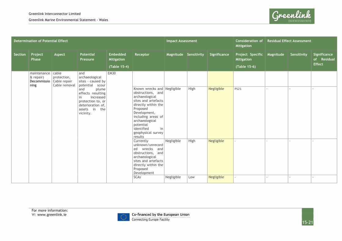
Greenlink Interconnector Limited
Greenlink Marine Environmental Statement - Wales
For more information: W: www.greenlink.ie
15-21
Determination of Potential Effect Impact Assessment Consideration of Mitigation
Residual Effect Assessment
Section Project Phase
Aspect Potential Pressure
Embedded Mitigation
(Table 15-4)
Receptor Magnitude Sensitivity Significance Project Specific Mitigation
(Table 15-6)
Magnitude Sensitivity Significance of Residual Effect
maintenance & repair) Decommissioning
cable protection, Cable repair Cable removal
and archaeological sites – caused by potential scour and plume effects resulting in increased protection to, or deterioration of, assets in the vicinity.
EM30
Known wrecks and obstructions, and archaeological sites and artefacts directly within the Proposed Development, including areas of archaeological potential identified in geophysical survey results
Negligible High Negligible PS21 - - -
Currently unknown/unrecorded wrecks and obstructions, and archaeological sites and artefacts directly within the Proposed Development
Negligible High Negligible - - - -
SCAs Negligible Low Negligible - - - -

Greenlink Interconnector Limited
Greenlink Marine Environmental Statement - Wales
For more information: W: www.greenlink.ie
15-22
15.6.2 Direct damage to archaeological assets
15.6.2.1 Installation
Palaeoenvironmental deposits A study of the foreshore at the potential landfall location has identified deposits that have the potential to provide palaeoenvironmental evidence, which could enhance our understanding of the prehistoric period in the area, and may be of medium sensitivity. It is reasonable to assume that such deposits, if present, represent a tiny fraction of a much more extensive landscape. Therefore, the localised effect of the proposed work (c 10m deep HDD) across the foreshore associated with the Proposed Development would have a direct effect on only a miniscule proportion of it. The magnitude of impact on this receptor will therefore be low. The overall significance of the effect has been assessed as Minor and is Not Significant.
Wrecks, obstructions, and geophysical survey anomalies In summary, the investigations to date have determined that there are no known archaeological features, wrecks, or obstructions recorded along the indicative Greenlink Route Centreline (see Figures 15-2 to 15-4), based upon the variety of datasets, survey results, and other resources studied. Therefore, there will be no direct effect on any known wrecks, obstructions, or archaeological features should this route be applied.
However, the following wrecks/obstructions have been identified within the Proposed Development, and therefore may be subject to direct impact should the Greenlink Route Centreline be altered within the Proposed Development.
• CA8 – this spot point (Figure 15-3) represents the potential general location of numerous aircraft and vessels thought to have been wrecked in the area. This approximate judgement may be the result of various factors. Recorded incidents at sea are often assigned arbitrary co-ordinates, usually coinciding with the corner of a grid square, when an incident is recorded in a particular location but no physical evidence of the incident (such as wreckage) has been found. This could be the result of poor recording of an incident, perhaps when lives were at risk, or no obvious landmark was visible. Alternatively, the wreckage could have been buried, dispersed or destroyed subsequently through the actions of natural forces in a dynamic environment. A full list of the wrecks associated with this spot point is provided in Technical Appendix G; Appendix 1.
• CA16 - The wreck site of what is believed to be the Saint Jaques (CA16a, see Technical Appendix G), recorded during a marine geophysical survey by Wessex Archaeology in 2010. This steel-hulled steamship was built in Dunkirk in 1909, with a gross tonnage of 2,459. It sank when it was torpedoed by German submarine UC51 in September 1917 while transporting coal from Barry, South Wales to Tunisia. The wreck now lies on a sandy seabed at 29m depth. The partially buried wreck measured 70.2m x 23.5m. Divers recorded the bow to the east of the main wreck, and buried propellers have been reported nearby (Coflein

Greenlink Interconnector Limited
Greenlink Marine Environmental Statement - Wales
For more information: W: www.greenlink.ie
15-23
NPRN 273164). These separate components may be part of two sites of multiple findspots (CA16b & c, see Technical Appendix G) which are thought to be debris from the Saint Jaques, in close proximity to the bulk of the ship. The proximity of the debris is such that this has been represented as one single point for the purposes of this ES. See Technical Appendix G for more detailed positional information.
There is also some potential for the presence of previously unrecorded wrecks/obstructions within the Proposed Development. Although no anomalies were identified in the geophysical survey data, the absence of archaeological sites cannot be guaranteed. Any unknown sites that might be encountered would be of high sensitivity.
Any known and potential wrecks/obstructions on the indicative cable route centreline would be sensitive to the direct effects of the Proposed Development and would result in the complete removal of any potential assets along the Proposed Development, with no potential recoverability. However, the embedded mitigation in place ensures that any assets which may be subject to these effects will be appropriately managed through the implementation of a temporary AEZ (EM30). As such, the magnitude of the effect has been assessed as negligible, taking into consideration the assets across the wider area which contribute further to retaining the character of the existing marine historic environment which will not be subject to effects. In conclusion, the significance of effect upon the potential marine archaeology resource is Negligible and is Not Significant.
Pembrokeshire Seascape Character Areas The special qualities of the SCAs relevant to this Proposed Development include rich archaeology, and cultural heritage. These qualities refer to historic trading routes, military heritage, and terrestrial archaeology.
In terms of the marine archaeology which contributes to the SCAs, the assessment above has determined that there is no known marine archaeology in the immediate vicinity of the Proposed Development, and therefore the existing heritage resource will not be changed as a result of the Proposed Development.
Any presently unrecorded marine archaeology which may be effected as a result of the Proposed Development is not anticipated to result in the widespread loss of significant cultural heritage resources. The potential for marine archaeology to be present within the SCAs and in the immediate vicinity of the Proposed Development is anticipated to be low. If present, the sensitivity of the receptor is likely to be low, given the large areas the SCAs and marine historic environment covers, and that terrestrial archaeology and other special qualities of the SCAs dominate their character. As such, there will be a negligible direct change to the SCAs’ special qualities, equating to an effect of negligible magnitude. The overall significance of the effect has been assessed as Negligible and is Not Significant.

Greenlink Interconnector Limited
Greenlink Marine Environmental Statement - Wales
For more information: W: www.greenlink.ie
15-24
15.6.2.2 Operation (including repair and maintenance)
No seabed disturbance will occur from the operation of the cables. Effects during any unforeseen repair and maintenance works will be of smaller magnitude to those for the cable installation. Given the sensitivity of archaeological assets within the Proposed Development to intrusive seabed works, however, the significance of the effect remains Minor and is Not Significant.
15.6.2.3 Decommissioning
Two options will be considered at decommissioning; leaving the cables in-situ or removing them. If the cables are left in-situ there will be no effect on archaeological assets during decommissioning. If the option to remove the cables (and any associated protection) is selected, however, this process would essentially be the same as installation activities but in reverse. Any effects that might arise due to the decommissioning phase of the Proposed Development will therefore be of a comparable magnitude to those assessed above for cable installation and so the effect has been assessed Minor and is Not Significant.
15.6.3 Indirect damage to archaeological assets
15.6.3.1 Installation
Palaeoenvironmental deposits A study of the foreshore at the potential landfall location has identified deposits that have the potential to provide palaeoenvironmental evidence, which could enhance our understanding of the prehistoric period in the area, and may be of Medium Value. Palaeo-landscapes are potentially very extensive landscapes so the foreshore deposits probably represent a very small fraction. The indirect effects of the Proposed Development, a c 10m deep HDD, are therefore unlikely to result in substantial change to the greater palaeoenvironmental landscape and the evidence it contains. If present, the magnitude of effects resulting from the indirect effects associated with this receptor is considered to be Negligible and is Not Significant.
Wrecks, obstructions and geophysical anomalies Four wrecks/obstructions have been identified within the zone of influence, including CA2, CA4, CA13 and CA25 (Table 15-2 and Figures 15-2 and 15-3). The potential for encountering any presently unknown sites in the zone of influence is minimal given the limited number of known sites and identified anomalies.
At this stage, it is considered unlikely that there will be any effects to heritage assets within the zone of influence, except in the unlikely event that the final Greenlink Route Centreline meets the border of the Proposed Development. However, an assessment of potential indirect effects within the zone of influence will be made in order to illustrate the worst-case outcome, as follows.
Any known or potential wrecks/obstructions within the zone of influence may be subject to indirect effects during the installation, operation, and decommissioning of the proposed cable. These effects may be caused as a result of potential scouring or

Greenlink Interconnector Limited
Greenlink Marine Environmental Statement - Wales
For more information: W: www.greenlink.ie
15-25
plume effects as identified in Table 15-3, which may cause some exposure or coverage of assets, resulting in potential deterioration or increased protection of assets in the vicinity. Each metre of trench will result in the displacement of 1.5m3 of sediment, with the majority returning directly to the trench (80% for jetting and 95% for ploughing), and the remainder being released. As outlined in Chapter 6, gravel will settle within 1.79m with median depth of layer being 126mm. Sand will settle within 16m of the trench with median depth of layer 18.8mm and silt will settle within 4.5km with median depth of layer 0.046mm. With the embedded mitigation in place, only the settlement of silt could potentially effect known assets, but the projected variation in seabed level (0.046mm) is minimal. The magnitude of indirect effects would therefore be negligible, given that the scouring effects are very localized, and that burial would have a minor beneficial effect.
The assets may be of evidential and historical value, given the information which they may retain about the past. This equates to a high sensitivity, relative to the seascape-wide heritage resource of comparable features.
However, the embedded mitigation in place ensures that any assets which may be subject to indirect effect will be appropriately managed through the implementation of a temporary AEZ (EM30). As such, the magnitude of impact would be low, taking into consideration the assets across the wider area which contribute further to retaining the character of the existing marine historic environment which will not be subject to effects. In conclusion, the significance of effect upon the potential marine archaeology resource is Negligible and is Not Significant.
Pembrokeshire Seascape Character Areas As above, this assessment has determined that there is no known marine archaeology within the zone of influence, and therefore the existing heritage resource will not be changed as a result of the Proposed Development.
Any presently unrecorded marine archaeology which may be effected as a result of the Proposed Development is not anticipated to result in the widespread loss of significant cultural heritage resources. The potential for marine archaeology to be present within the SCAs and within the zone of influence is anticipated to be low. If present, it is likely to be of low sensitivity to the SCAs and to the marine historic environment, given the large areas they cover, and that terrestrial archaeology and other special qualities of the SCAs dominate their character. As such, there will be a negligible indirect change to the SCAs’ special qualities, equating to a negligible magnitude of effect. The significance of the effect has been assessed as Negligible and is Not Significant.
15.6.3.2 Operation (including repair and maintenance)
No seabed disturbance will occur from the operation of the cables. Effects during any unforeseen repair and maintenance works will be of smaller magnitude to those for the cable installation. Given the sensitivity of archaeological assets within the Proposed Development to intrusive seabed works, however, the significance of the effect remains Negligible and is Not Significant.
Greenlink Interconnector Limited
Greenlink Marine Environmental Statement - Wales
For more information: W: www.greenlink.ie
15-26
15.6.3.3 Decommissioning
Two options will be considered at decommissioning; leaving the cables in-situ or removing them. If the cables are left in-situ there will be no effect on archaeological assets during decommissioning. If the option to remove the cables (and any associated protection) is selected, however, this process would essentially be the same as installation activities but in reverse. Therefore, any effects that might arise due to the decommissioning phase of the Proposed Development will be of a comparable magnitude to those assessed above for cable installation and so the effect has been assessed as Negligible and is Not Significant.
15.7 Project Specific Mitigation
In addition to the embedded mitigation outlined in Table 15-4, Table 15-6 presents Project Specific Mitigation that GIL is committed to adopting.
Table 15-6 Project specific mitigation – marine archaeology
ID Project Specific Mitigation
PS1 No intrusive works will be undertaken at Freshwater West between mean high water springs and mean low water springs.
PS21 Archaeological exclusion zones (AEZs), the specific location and extent of which are provided in Technical Appendix G, Table 4 shall be imposed. No intrusive works shall be undertaken in these areas.
With specific reference to the vague record for numerous wreck sites within the Proposed Development at site id CA8, the lack of any clear features of archaeological origin identified in the region during geophysical survey implies that it is proportionate to suggest that no further mitigation is necessary. However, as the area can be considered as being of higher archaeological potential, greater vigilance should be observed.
15.8 Residual Effect
By establishing AEZs around known locations of archaeological potential (PS21) and by following embedded mitigation such as establishing a Protocol for Archaeological Discoveries (EM30), the residual effects of the Proposed Development upon the marine historic environment will be Not Significant.

Greenlink Interconnector Limited
Greenlink Marine Environmental Statement - Wales
For more information: W: www.greenlink.ie
8-27
1 Cotswold Archaeology. (2018). Greenlink Interconnector Project: Marine Archaeology Desk-Based Assessment. CA Report 18254
2 Cotswold Archaeology. (2019). Greenlink Interconnector Project: Archaeological Assessment of Marine Geophysical Data. CA Report number TBC
3 Satchell, J.(2012). Maritime Archives and the Crown Estate Project Report
REFERENCES

Greenlink Interconnector Limited
Greenlink Marine Environmental Statement - Wales
For more information: W: www.greenlink.ie
16-1
16. Cumulative Effects Assessment (CEA)
16.1 Introduction
This Chapter describes the assessment of cumulative effects from the Proposed Development with other past, present and reasonably foreseeable plans, projects or licensed activities.
The Proposed Development refers to the Welsh Marine components of Greenlink from mean high-water springs (MHWS) at the Welsh landfall at Freshwater West, Pembrokeshire to the UK / Republic of Ireland median line. It comprises:
• Two high voltage direct current (HVDC) electricity power cables;
• A smaller fibre-optic cable for control and communication purposes;
• All associated works required to install, test, commission and complete the aforementioned cables; and
• All associated works required to operate, maintain, repair and decommission the aforementioned cables, including five repair events over the 40 year lifetime of Greenlink.
The Proposed Development includes the following phases, all of which are assessed within this chapter:
• Installation;
• Operation (including repair and maintenance activities); and
• Decommissioning.
Potential cumulative effects (PCE) are assessed using the methodology described in the sections below. The methodology uses the definitions as defined in the MMO Strategic Framework for Scoping Cumulative Effects (MMO 2014):
• Cumulative effects are “effects that result from incremental changes caused by other past, present or reasonably foreseeable actions together with the project”.
While a single activity may result in an effect that is Not Significant, when combined with other effects (Not Significant or Significant), collectively it can result in an cumulative effect that is Significant.
• Plans, projects and activities are human activities taking place in the marine environment. A plan typically covers a large area and lays out the foundation for future projects (e.g. The Crown Estate Round 3 offshore wind plan). Projects are individual developments that may have arisen out of the plan (e.g. an individual wind farm). Activities are typically wide ranging and occur outside of a defined project or plan and include for example commercial fishing.
• Pressures are defined as the mechanism through which an activity has an effect on any part of the ecosystem (Robinson et al. 2008 cited in MMO 2014).

Greenlink Interconnector Limited
Greenlink Marine Environmental Statement - Wales
For more information: W: www.greenlink.ie
16-2
• A receptor is any ecological or other specific feature which is sensitive to or has the potential to be affected by a pressure (IEEM 2010, MMO 2014).
• An effect is the consequence of a pressure that can be measured. Effects can only occur when a pressure is present within an environment that is sensitive to it.
• A pathway is linking the source of a pressure and the receptor together. A pathway to one or several receptors is dependent on the source of a pressure, and needs to be defined on a case by case basis.
The assessment is based on the best data available on other plans and projects and their timelines which is currently in the public domain or has been provided to Greenlink Interconnector Limited (GIL). It assumes that information made publicly available is accurate and relies on collaborative interactions with statutory consultees, authorities and other developers to identify any changes in information pertinent to the assessment.
Where relevant, any limitations related to the baseline conditions, data sources or scientific understanding / interpretation within the process of assessing the impacts have been highlighted.
16.2 Part 1 – Intra-project effects
Typically, intra-project effects can occur between different components of the same project from activities which are geographically close to each other and have the potential for the pressures they exert on receptors to overlap spatially and temporally. For a linear interconnector cable project such as Greenlink, the scope of intra-project effects is limited to the interfaces between onshore and offshore project components i.e. between the Proposed Development and Welsh Onshore at the intertidal area. At the marine interfaces e.g. between the Proposed Development and Offshore Ireland, the effects from the cable installation will move with the installation spread and therefore there is no spatial or temporal overlap; it is a continuation of the effects along the linear project. The significance of effects on receptors is therefore considered by the individual EIAs. No effects have been identified within the Proposed Development, Offshore Ireland and Marine Ireland that could accumulate to have a significant effect.
Table 16-1 identifies the potential pressure-receptor pathways at the interface between the proposed Development and Onshore Wales which have been identified and considered by the EIA process. No other intra-project effects have been identified. The significance of effects has been assessed in the relevant topic chapters, with the conclusion summarised in Table 16-1.

Greenlink Interconnector Limited
Greenlink Marine Environmental Statement - Wales
For more information: W: www.greenlink.ie
16-3
Table 16-1 Potential intra-project effects
Interface Receptor Pressure Potential effect Section
Proposed Development & Wales Onshore
Recreation Visual Disturbance
There is the potential that if works in the nearshore area occur at the same time as works at the Welsh Onshore HDD compound there could be a temporary elevation in the visual disturbance to recreational users of Freshwater West. The significance of the effect reflects the potentially high sensitivity of the receptor at certain times of the year i.e. May 2020, July and August. However Project Specific Mitigation in the form of seasonal restrictions have been proposed in both the Wales Onshore ES and this ES to reduce the significance of the effect.
14.6.2.1
Proposed Development & Wales Onshore
Birds Visual Disturbance
There could be potential for intra-project effects on bird species which could be affected by both the onshore and offshore works. Chough have been identified as having this potential however, based on the Proposed Development EIA and the preliminary Wales Onshore HRA it has been concluded that due to low numbers of chough observed during surveys in the vicinity of the landfall, the distance to known chough territories and the timings of onshore vs offshore works, no significant intra-project effects are expected.
9.6.2.1
16.3 Part 2 – CEA with other projects/plans & activities
16.3.1 Data Sources Projects, plans and licensed activities considered in the cumulative effects assessment (CEA) include, but are not limited to, marine renewable energy sites, offshore wind farms, marine aggregate sites, disposal sites, cables and pipelines, port and harbour activities, oil and gas activities and military areas.
Data on such projects, plans or licensed activities have been established through a desktop review of published information and through consultation with stakeholders e.g. Natural Resources Wales (NRW) The Crown Estate, Marine Energy Wales, Bombora Wave Power and Ministry of Defence (MoD). The data sources used to inform the CEA include but are not limited to the following:
• UKDEAL:
• National Infrastructure Planning website;
• Natural Resources Wales website;
• Marine Energy Wales website;

Greenlink Interconnector Limited
Greenlink Marine Environmental Statement - Wales
For more information: W: www.greenlink.ie
16-4
• The Crown Estate Website: Offshore wind farm and marine aggregate digital data;
• The Marine Aggregates Capability and Portfolio Report 2017 (Crown Estate 2017);
• UK Coastal Atlas of Recreational Boating (Royal Yacht Association (RYA 2018);
• Scoping consultation responses from the Defence Infrastructure Organisation (DIO) and the Department for Business, Energy and Industrial Strategy (BEIS) (formerly the Department for Energy and Climate Change (DECC)).
• Offshore Oil and Gas Activity map (Oil and Gas Authority 2018); and
• Other data sources as listed at the end of the Chapter.
16.3.2 Welsh National Marine Plan A requirement of the draft Welsh National Marine Plan (WNMP) is that proposed developments should demonstrate that they have assessed potential cumulative effects and, in order of preference:
a. avoid adverse effects; and/or
b. minimise effects where they cannot be avoided; and/or
c. mitigate effects where they cannot be minimised.
If significant adverse effects cannot be adequately addressed, a clear and convincing justification for proceeding is required. Proposed developments that contribute to positive cumulative effects are encouraged.
Any adverse cumulative effects of the Proposed Development and nearby projects, plans or licenced activities will be assessed in this chapter.
The draft Welsh National Marine Plan (WNMP) also states that interconnector cables are ‘of strategic national and international economic importance and are essential activities to support the activities of other sectors covered by this plan including Blue Growth1 aspirations.’ (Welsh Government 2018). The Proposed Development will enable sharing of electrical resources between Wales and Ireland, this represents a positive environmental effect by reducing wastage of surplus energy and it will enable areas to develop renewable energy ensuring connectivity to wider markets.
16.3.3 Limitations and Assumptions The information used to inform the CEA is subject to the following limitations or assumptions:
• Third party and publicly available data is correct at the time of publication of the Environmental Statement (ES).
1 Blue Growth is the long term strategy to support sustainable growth in the marine and maritime sectors as a whole.
Greenlink Interconnector Limited
Greenlink Marine Environmental Statement - Wales
For more information: W: www.greenlink.ie
16-5
• Given that the Proposed Development is not scheduled to commence construction until 2020 (dependant on receiving the required permits and consents), information on some other projects (e.g. extent, schedules) and future plans was not available at the time of the assessment. The assessment has been based on the latest available information.
• Where information was not available, but the spatial extent of an effect could be inferred based on expert knowledge, these projects have been taken forward for assessment.
• Best efforts have been made to either source publicly available information or contact appropriate developers to request information on plans and projects. This process is in line with the MMO (2014) guidance and ensures that only cumulative effects for which there is a high degree of confidence are assessed. Where there was limited information or there was not enough certainty to carry out the assessment, these projects have been scoped out of the CEA.
• Where license information was reviewed, only projects with sufficient information that enabled assessment were utilized.
16.3.4 Consultation The steps taken to contact stakeholders for comments on the EIA scope are documented in Chapter 5. None of the stakeholders contacted raised any comments with respect to the scope of the CEA, but information regarding potentially relevant projects was provided by NRW and The Crown Estate.
16.3.5 Summary of CEA Methodology The steps to implement the CEA are based on the steps outlined in the MMO Strategic Framework for Scoping Effects (MMO 2014). They are noted below and described in the following sections.
Step 1: Complete an activity / pressure / receptor matrix for each phase of the Proposed Development and where a pressure-receptor pathway is present, identify the spatial and temporal extents of pressures (e.g. the maximum zone of influence for each pressure and the temporal extent of each Proposed Development phase).
Step 2: Define a study area around the Proposed Development and identify projects, plans and licensed activities within that area.
Step 3: Complete an activity / pressure / receptor matrix for each type of project, plan and licensed activity within the study area to identify common pressures on each receptor.
Step 4: Identify if the maximum zone of influence of the pressures of the Proposed Development overlaps spatially with those from other projects or plans. If there is no spatial overlap, that specific pressure-receptor pathway will be screened out. If there is a spatial overlap, the pathway continues to the next step in the process.

Greenlink Interconnector Limited
Greenlink Marine Environmental Statement - Wales
For more information: W: www.greenlink.ie
16-6
Step 5: Identify if the pressures of the Proposed Development phases overlap temporally with the pressures of the scoped-in projects. If there is no temporal overlap or if a review of publicly available information and consultation with the appropriate developer did not identify specific timelines, the specific pressure-receptor pathway will be screened out. If there is a temporal overlap the pathway continues to the next step.
Step 6: Undertake the assessment on Screened in projects/plans/activities, where both a spatial and temporal overlap has been identified.
16.3.6 Step 1: Activity / Pressure / Receptor Matrix The first step in the CEA is to create a matrix for the Proposed Development that identifies activities (during each phase) and their resultant pressures on individual environmental receptors. The EIA established for each pressure the worst-case zone of influence (the spatial extent over which a pressure effects a receptor); which has been used in the assessment.
The activity / pressure / receptor matrix for the Proposed Development is presented in Table 16-2 below:

Greenlink Interconnector Limited
Greenlink Marine Environmental Statement - Wales
For more information: W: www.greenlink.ie
16-7
Table 16-2 Activity / pressure / receptor matrix for the Proposed Development
Development Phase
Activity Pressure source Pressure Receptor Zone of influence (m)
I O D
Pre-installation survey Inspection survey Pre-decommissioning survey
Continuous sound: geophysical survey
Underwater noise changes: Injury
Marine mammals 180
Underwater noise changes: Disturbance
Marine mammals 2600
Fish (clupeids: herring, sprat, twaite and allis shad) 2200
Seabed preparation Impulsive sound: UXO detonation
Underwater noise changes: Injury
Marine mammals 27000
Underwater noise changes: Disturbance
Marine mammals 54000
Fish (clupeids: herring, sprat, twaite and allis shad) 54000
Survey Cable burial Cable repair & maintenance Cable removal
Presence of project vessels and equipment
Disturbance (physical) Birds 4000
Beach users (e.g. bathers, surfers, dogs, walkers) Immediate
Underwater noise changes: Injury
Marine mammals No effect
Underwater noise changes: Disturbance
Marine mammals 130
Fish (clupeids: herring, sprat, twaite and allis shad) 50
Disturbance / Disruption to planned routes and working areas
Commercial fisheries: Static gear fishery 1000 by 12000
Commercial fisheries: Mobile gear 500 (radius)
Recreational sailing
Recreational and other water users; Surfing/swimming/coasteering etc.
Commercial shipping
MOD exercise area
Marine renewable test site
Seabed preparation Pre-sweeping Sediments 20

Greenlink Interconnector Limited
Greenlink Marine Environmental Statement - Wales
For more information: W: www.greenlink.ie
16-8
Development Phase
Activity Pressure source Pressure Receptor Zone of influence (m)
I O D
Cable burial Cable repair & maintenance Cable removal
Pre-lay grapnel run, ploughing and jetting.
Penetration and/or disturbance or the substrate below the surface of the seabed, including abrasion
Marine archaeology 20
Benthic communities 20
Fish (species with demersal life stages) 20
Changes in suspended solids (water clarity)
Water quality 100
Seabed preparation Cable burial Cable repair & maintenance Cable removal
Pre-sweeping Pre-lay grapnel run, ploughing and jetting.
Siltation rate changes, including smothering (depth of vertical sediment overburden)
Benthic communities 40
Marine archaeology 40
Temporary habitat disturbance affecting spawning, nursery or recruitment to commercial stocks
Commercial fisheries 40
Permanent habitat loss affecting spawning, nursery or recruitment to commercial stocks
Commercial fisheries 10 x 16370
Indirect effects on commercial target species from changes in water clarity
Commercial fisheries 100
Cable burial Cable repair & maintenance Cable removal
Jetting and ploughing. External cable protection.
Introduction or spread of invasive non-native species
Benthic communities 15
Cable burial Cable repair & maintenance Cable removal
Presence of exposed cable on the seabed; formation of berms and anchor mounds
Snagging Commercial fisheries Immediate
Cable protection External cable protection
Physical change (to another seabed type)
Sediments 10 (radius of protection)
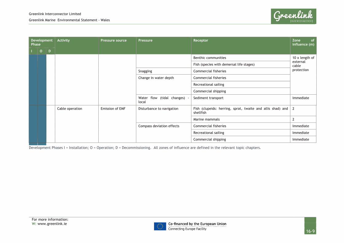
Greenlink Interconnector Limited
Greenlink Marine Environmental Statement - Wales
For more information: W: www.greenlink.ie
16-9
Development Phase
Activity Pressure source Pressure Receptor Zone of influence (m)
I O D
Benthic communities 10 x length of external cable protection
Fish (species with demersal life stages)
Snagging Commercial fisheries
Change in water depth Commercial fisheries
Recreational sailing
Commercial shipping
Water flow (tidal changes) - local
Sediment transport Immediate
Cable operation Emission of EMF Disturbance to navigation Fish (clupeids: herring, sprat, twaite and allis shad) and shellfish
2
Marine mammals 2
Compass deviation effects Commercial fisheries Immediate
Recreational sailing Immediate
Commercial shipping Immediate
Development Phases I = Installation; O = Operation; D = Decommissioning. All zones of influence are defined in the relevant topic chapters.

Greenlink Interconnector Limited
Greenlink Marine Environmental Statement - Wales
For more information: W: www.greenlink.ie
16-10
16.3.6.1 Define the Project Phases
The temporal extent is the time period covered by each phase of the Proposed Development. The Proposed Development will have three phases: installation; operation, during which maintenance and repair operations may take place; and decommissioning.
The installation phase for the Proposed Development is currently planned between 2020 and 2023.
The operational phase considered by the CEA is 40 years (the expected design life of an interconnector cable), nominally between 2023 and 2063. Pressures during the typical operation of submarine cables are restricted to the emission of electromagnetic fields (EMF) and presence of the cable protection materials.
Once installed, submarine cables are not expected to require routine maintenance. Should a cable fault be detected, maintenance and repair activities will be on a smaller and more localised scale than the installation operations and as such are not expected to have any significant effects. Pressures from maintenance and repair operations are considered by the CEA; however, as any future requirements for repair and maintenance are unknown, timings cannot be included in the assessment.
How and when decommissioning of the Proposed Development takes place is not known. It has been assumed for the purposes of this CEA to take place at the end of expected design life (40 years), nominally between 2063 and 2066 (depending on when commissioning occurs). The two options for decommissioning are leave the cables in situ or remove the cables. The latter, is likely to represent the worst case scenario in terms of environmental effects and has therefore been considered in this CEA. Given the lack of certainty over other plans and projects 40 years into the future, only a high-level assessment has been conducted.
Unplanned events are incidents or non-routine events that have the potential to trigger effects that would otherwise not be anticipated during the normal course of installation or operation. By their nature, unplanned events have no temporal scope, as they could occur at any phase and any location of the Proposed Development. The probability of an unplanned event occurring is very low. Unplanned events have been scoped out of the CEA as it is not possible to assign a spatial and temporal scope to the event.
16.3.7 Step 2: Define Study Area and Identify Projects The nature of linear interconnector cable projects mean that the majority of potential pressures result in temporary or short-term and localised effects. Most effects, as a result of the Proposed Development, will be restricted to a zone within 10km either side of the cable trench. An initial area of search of 10km has therefore been applied either side of the Proposed Development to identify plans and projects for inclusion within the CEA. At the landfall, the study area includes up to MHWS.

Greenlink Interconnector Limited
Greenlink Marine Environmental Statement - Wales
For more information: W: www.greenlink.ie
16-11
Known types of projects, plans and licensed activities considered by the CEA include:
• Renewable energy projects i.e. offshore wind farms;
• Sites for marine aggregate dredging and disposal;
• Cables and pipelines;
• Oil and gas exploration and development;
• Carbon Capture and Storage; and
• Military Practice Areas.
Known projects, plans and licensed activities within the 10km study area have been identified and mapped using a geographical information system (GIS). These are listed in Table 16-3 and illustrated in Figure 16-1 (Drawing P1975-CUMU-001).
Consultation with appropriate authorities and a desk-top review of published literature and websites has not identified any additional plans for consideration within 10km of the Proposed Development.
Commercial fisheries and shipping interests have been scoped out of the list of projects within 10km of the Proposed Development for consideration in the CEA, but are still included as potential receptors. These activities are considered to represent baseline conditions, and are not considered as projects, plans or licensed activities having the potential to result in a PCE in-combination with the Proposed Development.
Recreational use of the nearshore of the Proposed Development is noted, with planned events such as the beach clean at Freshwater West in November by National Trust (2019), walkers, bathers, surfers etc.. These activities are considered to represent baseline conditions and have been scoped out of the list of projects within 10km of the Proposed Development, but are still included as potential receptors.
Table 16-3 Projects within 10km of the Proposed Development for consideration within the CEA
Project Category
Name / Type of Project
Status Operator/Owner/ Other Details
Closest Distance+ (km)
Disposal sites Milford Haven (LU170) Closed Milford Haven Port Authority
0.25km
Milford Haven Three (LU169)
Open Milford Haven Port Authority
8km
St Ann’s Head (LU180) Closed Milford Haven Port Authority
2km
Neyland (LU190) Open Milford Haven Port Authority
10km
Munitions dump sites (two delineated)
Disused MOD 1.2km 4km
Cables Pan European Crossing 2 (Telecom)**
Active Century Link (Level 3)
0km

Greenlink Interconnector Limited
Greenlink Marine Environmental Statement - Wales
For more information: W: www.greenlink.ie
16-12
Project Category
Name / Type of Project
Status Operator/Owner/ Other Details
Closest Distance+ (km)
Submarine cables in the estuary (Milford Haven) (undefined)
Unknown Unknown 5km
Dredging Maintenance dredging Active Milford Haven Port Authority
3km
Military Practice area
Castlemartin Firing Range
Active MOD 0km
Marine energy
Marine energy test area (META)
Site 8 Proposed Marine Energy Wales
0km
Site 7 6km
Site 1-5
8km
Bombora Wave Power Seacam device (linked to META 8)
Prospective Bombora Wave Power
0km
Wave Dragon Test Site Prospective Wave Dragon Wales Ltd
3.5km
Scientific Surveys
Marker buoy deployment (Bombora Wave Power)
Installed Bombora Wave Power
0km
Bangor University Scientific Research Surveys
Licence Bangor University 0.5km
Deposit of scientific experiment and marker buoys
Licence University College of Swansea
0.5km
MacroBioCrude project
Uncertain (Licence until 2018)
Swansea University
8-10km
Marine Benthic Invertebrate / Sediment Grab Sampling
Proposed Natural Resources Wales
2.2km
Oil and Gas Seismic survey Prospective ENI UK 2km
Wellhead 50/10-1 Disused Mobil 9.5km
Construction
Milford Haven Port Development
Prospective Milford Haven Port Authority
7km
Neyland Yacht Haven Marina (Piling works)
Active Neyland Yacht Haven Ltd
10km
Salvaging of anchors and chains
Licence Mr J Middleton 4 km
Jetty Maintenance Licence Puma Energy (UK) Ltd
5 km
Deposit of a temporary trackway and jetty
Licence REM Engineering Limited
4.5km
+ To the Proposed Development ** Previously known as UK Ireland Crossing 2

GREENLINK INTERCONNECTORCUMULATIVE EFFECTS Projects, Plans, and LIcences Activities within 10km of Proposed Developemnt - UK Waters
Chris GoodeEmma Langley
Friday, May 17, 2019 15:52:28WGS_1984_UTM_Zone_30N
D_WGS_1984
UKHO; CDA; DCCAE; KISORCA; CEFAS; GEBCO; NRW
WGS_1984
NOTE: Not to be used for Navigation
Contains public sector information, licensed under the Open Government Licence v2.0, from the UKHO, 2018.; Contains data from UKOGD.; © Copyright Department of Communications, Climate Action and Environment (DCCAE); Copyright © KIS-ORCA; Contains data from CEFAS. Contains public sector information licensed under the Open Government Licence v3.0.; © The GEBCO Digital Atlas published by the British Oceanographic Data Centre on behalf of IOC and IHO, 2003
Anna Farley
SOLASUK-IRELAND CROSSING 2
50/10-1
275000
275000
300000
300000
325000
325000
350000
350000
56750
00
56750
00
57000
00
57000
00
57250
00
57250
00
0 2.5 5 7.5 10km © Metoc Ltd, 2019.
All rights reserved.
J:\P1975\Mxd\17_CUMU\P1975-CUMU-001.mxd
Created ByReviewed By
DateProjection
DatumData Source
File Reference
Spheroid
Approved By
Drawing No: P1975-CUMU-001 ALegend
Proposed DevelopmentIrish OffshoreUK 12nm Territorial Sea LimitMedian Line10km BufferWellScientific_SurveysTelecom CableBombora Cable AreaMarine Energy Test Area
Marine Licence ApplicationsConstructionRemovalTracersConstructionDredge/Disposal
Martello Quays
Neyland MarinaReplacement
Milford Haven Maintenance Dredging
Pembroke Dock Seaweed FarmDisposal SitesOpenClosedExplosives Dumping GroundMilitary Practice Area
Wave Dragon Test Site
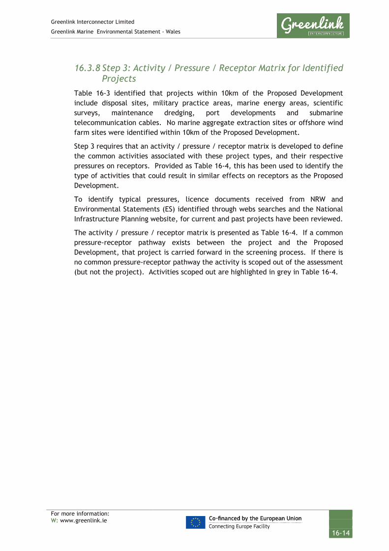
Greenlink Interconnector Limited
Greenlink Marine Environmental Statement - Wales
For more information: W: www.greenlink.ie
16-14
16.3.8 Step 3: Activity / Pressure / Receptor Matrix for Identified Projects
Table 16-3 identified that projects within 10km of the Proposed Development include disposal sites, military practice areas, marine energy areas, scientific surveys, maintenance dredging, port developments and submarine telecommunication cables. No marine aggregate extraction sites or offshore wind farm sites were identified within 10km of the Proposed Development.
Step 3 requires that an activity / pressure / receptor matrix is developed to define the common activities associated with these project types, and their respective pressures on receptors. Provided as Table 16-4, this has been used to identify the type of activities that could result in similar effects on receptors as the Proposed Development.
To identify typical pressures, licence documents received from NRW and Environmental Statements (ES) identified through webs searches and the National Infrastructure Planning website, for current and past projects have been reviewed.
The activity / pressure / receptor matrix is presented as Table 16-4. If a common pressure-receptor pathway exists between the project and the Proposed Development, that project is carried forward in the screening process. If there is no common pressure-receptor pathway the activity is scoped out of the assessment (but not the project). Activities scoped out are highlighted in grey in Table 16-4.

Greenlink Interconnector Limited
Greenlink Marine Environmental Statement - Wales
For more information: W: www.greenlink.ie
16-15
Table 16-4 Activity / pressure / receptor matrix for Projects within 10km
Note: Cells highlighted in Grey = Scoped out of assessment - no common pressure-receptor pathway
Project category
Development Phase
Activity Pressure source Pressure Receptor
I O D
Cables Inspection survey Pre-decommissioning survey
Continuous sound: geophysical survey
Underwater noise changes: Injury Marine mammals
Underwater noise changes: Disturbance
Marine mammals
Fish (clupeids: herring, sprat, twaite and allis shad)
Survey Cable repair & maintenance (including cable burial) Cable removal
Presence of project vessels and equipment
Disturbance (physical) Birds
Beach users (e.g. bathers, surfers, dogs, walkers)
Underwater noise changes: Injury Marine mammals
Underwater noise changes: Disturbance
Marine mammals
Fish (clupeids: herring, sprat, twaite and allis shad)
Disturbance / Disruption to planned routes and working areas
Commercial fisheries: Static gear fishery
Commercial fisheries: Mobile gear
Recreational sailing
Recreational and other water users; Surfing/swimming/coasteering etc.
Commercial shipping
MOD exercise area
Marine renewable test site
Seabed preparation Cable repair & maintenance (including cable burial) Cable removal
Pre-sweeping Pre-lay grapnel run, ploughing and jetting.
Penetration and/or disturbance or the substrate below the surface of the seabed, including abrasion
Sediments
Marine archaeology
Benthic communities
Fish (species with demersal life stages)
Changes in suspended solids (water clarity)
Water quality

Greenlink Interconnector Limited
Greenlink Marine Environmental Statement - Wales
For more information: W: www.greenlink.ie
16-16
Note: Cells highlighted in Grey = Scoped out of assessment - no common pressure-receptor pathway
Project category
Development Phase
Activity Pressure source Pressure Receptor
I O D
Seabed preparation Cable burial Cable repair & maintenance Cable removal
Pre-sweeping Pre-lay grapnel run, ploughing and jetting.
Siltation rate changes, including smothering (depth of vertical sediment overburden)
Benthic communities
Marine archaeology
Temporary habitat disturbance (affecting spawning, nursery or recruitment to commercial stocks)
Commercial fisheries
Fish and shellfish
Benthic community
Permanent habitat loss (affecting spawning, nursery or recruitment to commercial stocks)
Commercial fisheries
Fish and shellfish
Benthic community
Indirect effects on commercial target species from changes in water clarity
Commercial fisheries
Birds
Cable burial Cable repair & maintenance Cable removal
Jetting and ploughing. External cable protection.
Introduction or spread of invasive non-native species
Benthic communities
Cable burial Cable repair & maintenance Cable removal
Presence of exposed cable on the seabed; formation of berms and anchor mounds
Snagging Commercial fisheries
Cable protection External cable protection Physical change (to another seabed type)
Sediments
Benthic communities
Fish (species with demersal life stages)
Snagging Commercial fisheries
Change in water depth Commercial fisheries
Recreational sailing
Commercial shipping

Greenlink Interconnector Limited
Greenlink Marine Environmental Statement - Wales
For more information: W: www.greenlink.ie
16-17
Note: Cells highlighted in Grey = Scoped out of assessment - no common pressure-receptor pathway
Project category
Development Phase
Activity Pressure source Pressure Receptor
I O D
Water flow (tidal changes) - local Sediment transport
Commercial shipping
Cable operation Emission of EMF Disturbance to navigation Fish (clupeids: herring, sprat, twaite and allis shad) and shellfish
Marine mammals
Compass deviation effects Commercial fisheries
Recreational sailing
Commercial shipping
Disposal site Disposal Presence of project vessels
Disturbance (physical) Birds
Beach users (e.g. bathers, surfers, dogs, walkers)
Underwater noise changes: Injury Marine mammals
Underwater noise changes: Disturbance
Marine mammals
Fish (clupeids: herring, sprat, twaite and allis shad)
Disturbance / Disruption to planned routes and working areas
Commercial fisheries: Static gear fishery
Commercial fisheries: Mobile gear
Recreational sailing
Recreational and other water users; Surfing/swimming/coasteering etc.
Commercial shipping
MOD exercise area
Marine renewable test site
Sediment release Siltation rate changes, including smothering (depth of vertical sediment overburden)
Benthic communities
Marine archaeology
Commercial fisheries

Greenlink Interconnector Limited
Greenlink Marine Environmental Statement - Wales
For more information: W: www.greenlink.ie
16-18
Note: Cells highlighted in Grey = Scoped out of assessment - no common pressure-receptor pathway
Project category
Development Phase
Activity Pressure source Pressure Receptor
I O D
Temporary habitat disturbance (affecting spawning, nursery or recruitment to commercial stocks)
Fish and shellfish
Benthic community
Permanent habitat loss (affecting spawning, nursery or recruitment to commercial stocks)
Commercial fisheries
Fish and shellfish
Benthic community
Indirect effects on commercial target species from changes in water clarity
Commercial fisheries
Birds
Impulsive sound: UXO detonation
Underwater noise changes: Injury Marine mammals
Underwater noise changes: Disturbance
Marine mammals
Fish (clupeids: herring, sprat, twaite and allis shad)
Inspection survey Pre-decommissioning survey
Continuous sound: geophysical survey
Underwater noise changes: Injury Marine mammals
Underwater noise changes: Disturbance
Marine mammals
Fish (clupeids: herring, sprat, twaite and allis shad)
Oil and Gas Inspection survey Prospecting survey
Continuous sound: geophysical survey
Underwater noise changes: Injury Marine mammals
Underwater noise changes: Disturbance
Marine mammals
Fish (clupeids: herring, sprat, twaite and allis shad)
Presence of project vessels and equipment
Disturbance (physical) Birds
Underwater noise changes: Injury Marine mammals
Underwater noise changes: Disturbance
Marine mammals
Fish (clupeids: herring, sprat, twaite and allis shad)
Disturbance / Disruption to planned routes and working areas
Commercial fisheries: Static gear fishery
Commercial fisheries: Mobile gear

Greenlink Interconnector Limited
Greenlink Marine Environmental Statement - Wales
For more information: W: www.greenlink.ie
16-19
Note: Cells highlighted in Grey = Scoped out of assessment - no common pressure-receptor pathway
Project category
Development Phase
Activity Pressure source Pressure Receptor
I O D
Recreational sailing
Commercial shipping
MOD exercise area
Dredging Maintenance dredging Presence of vessels Disturbance (physical) Birds
Commercial fisheries: Static gear fishery
Underwater noise changes: Injury Marine mammals
Underwater noise changes: Disturbance
Marine mammals
Fish (clupeids: herring, sprat, twaite and allis shad)
Disturbance / Disruption to planned routes and working areas
Commercial fisheries: Mobile gear
Recreational sailing
Recreational and other water users; Surfing/swimming/coasteering etc.
Commercial shipping
MOD exercise area
Marine renewable test site
Removal of sediment by use of dredge equipment (suction hopper or bucket etc.t)
Disturbance (physical) Birds
Underwater noise changes: Injury Marine mammals
Underwater noise changes: Disturbance
Marine mammals
Fish (clupeids: herring, sprat, twaite and allis shad)
Siltation rate changes, including smothering (depth of vertical sediment overburden)
Benthic communities
Marine archaeology
Permanent habitat loss Commercial fisheries

Greenlink Interconnector Limited
Greenlink Marine Environmental Statement - Wales
For more information: W: www.greenlink.ie
16-20
Note: Cells highlighted in Grey = Scoped out of assessment - no common pressure-receptor pathway
Project category
Development Phase
Activity Pressure source Pressure Receptor
I O D (affecting spawning, nursery or recruitment to commercial stocks)
Fish and shellfish
Benthic community
Indirect effects on commercial target species from changes in water clarity
Commercial fisheries
Birds
Penetration and/or disturbance or the substrate below the surface of the seabed, including abrasion
Sediments
Marine archaeology
Benthic communities
Fish (species with demersal life stages)
Changes in suspended solids (water clarity)
Change in water depth Commercial fisheries
Recreational sailing
Commercial shipping
Water flow (tidal changes) - local Sediment transport
Commercial shipping
Inspection survey Continuous sound: geophysical survey
Underwater noise changes: Injury Marine mammals
Underwater noise changes: Disturbance
Marine mammals
Fish (clupeids: herring, sprat, twaite and allis shad)
Scientific survey Equipment deployment Equipment presence Equipment retrieval
Presence of project vessels and equipment
Disturbance (physical) Birds
Benthic community
Underwater noise changes: Injury Marine mammals

Greenlink Interconnector Limited
Greenlink Marine Environmental Statement - Wales
For more information: W: www.greenlink.ie
16-21
Note: Cells highlighted in Grey = Scoped out of assessment - no common pressure-receptor pathway
Project category
Development Phase
Activity Pressure source Pressure Receptor
I O D
Underwater noise changes: Disturbance
Marine mammals
Fish (clupeids: herring, sprat, twaite and allis shad)
Disturbance / Disruption to planned routes and working areas
Commercial fisheries: Static gear fishery
Commercial fisheries: Mobile gear
Recreational sailing
Recreational and other water users; Surfing/swimming/coasteering etc.
Commercial shipping
MOD exercise area
Marine renewable test site
Grab sampling Removal of discrete seabed samples
Temporary habitat disturbance (affecting spawning, nursery or recruitment to commercial stocks)
Commercial fisheries
Fish and shellfish
Benthic community
Permanent habitat loss (affecting spawning, nursery or recruitment to commercial stocks)
Commercial fisheries
Fish and shellfish
Benthic community
Scientific survey Continuous sound: geophysical survey
Underwater noise changes: Injury Marine mammals
Underwater noise changes: Disturbance
Marine mammals
Fish (clupeids: herring, sprat, twaite and allis shad)
Military Practise Area
Military practise exercises Restricted access to area Disturbance / Disruption to planned routes and working areas
Commercial fisheries: Static gear fishery
Commercial fisheries: Mobile gear
Recreational sailing
Recreational and other water users; Surfing/swimming/coasteering etc.

Greenlink Interconnector Limited
Greenlink Marine Environmental Statement - Wales
For more information: W: www.greenlink.ie
16-22
Note: Cells highlighted in Grey = Scoped out of assessment - no common pressure-receptor pathway
Project category
Development Phase
Activity Pressure source Pressure Receptor
I O D
Commercial shipping
Marine renewable test site
Impulsive sound: UXO detonation
Underwater noise changes: Injury Marine mammals
Underwater noise changes: Disturbance
Marine mammals
Fish (clupeids: herring, sprat, twaite and allis shad)
Marine energy Inspection survey Continuous sound: geophysical survey
Underwater noise changes: Injury Marine mammals
Underwater noise changes: Disturbance
Marine mammals
Fish (clupeids: herring, sprat, twaite and allis shad)
Installation of equipment Cable installation, repair or removal
Presence of project vessels and equipment
Disturbance (physical) Birds
Beach users (e.g. bathers, surfers, dogs, walkers)
Underwater noise changes: Injury Marine mammals
Underwater noise changes: Disturbance
Marine mammals
Fish (clupeids: herring, sprat, twaite and allis shad)
Disturbance / Disruption to planned routes and working areas
Commercial fisheries: Static gear fishery
Commercial fisheries: Mobile gear
Recreational sailing
Recreational and other water users; Surfing/swimming/coasteering etc.
Commercial shipping
MOD exercise area
Marine renewable test site
Seabed preparation Impulsive sound: UXO detonation
Underwater noise changes: Injury Marine mammals
Marine mammals

Greenlink Interconnector Limited
Greenlink Marine Environmental Statement - Wales
For more information: W: www.greenlink.ie
16-23
Note: Cells highlighted in Grey = Scoped out of assessment - no common pressure-receptor pathway
Project category
Development Phase
Activity Pressure source Pressure Receptor
I O D
Underwater noise changes: Disturbance
Fish (clupeids: herring, sprat, twaite and allis shad)
Seabed preparation Cable repair & maintenance (including cable burial) Cable removal
Pre-sweeping Pre-lay grapnel run, ploughing and jetting.
Penetration and/or disturbance or the substrate below the surface of the seabed, including abrasion
Sediments
Marine archaeology
Benthic communities
Fish (species with demersal life stages)
Changes in suspended solids (water clarity)
Water quality
Seabed preparation Cable burial Cable repair & maintenance Cable removal Equipment placement
Pre-sweeping Pre-lay grapnel run, ploughing and jetting.
Siltation rate changes, including smothering (depth of vertical sediment overburden)
Benthic communities
Marine archaeology
Temporary habitat disturbance (affecting spawning, nursery or recruitment to commercial stocks)
Commercial fisheries
Fish and shellfish
Benthic community
Permanent habitat loss (affecting spawning, nursery or recruitment to commercial stocks)
Commercial fisheries
Fish and shellfish
Benthic community
Indirect effects on commercial target species from changes in water clarity
Commercial fisheries
Birds
Cable burial Cable repair & maintenance Cable removal
Jetting and ploughing. External cable protection.
Introduction or spread of invasive non-native species
Benthic communities

Greenlink Interconnector Limited
Greenlink Marine Environmental Statement - Wales
For more information: W: www.greenlink.ie
16-24
Note: Cells highlighted in Grey = Scoped out of assessment - no common pressure-receptor pathway
Project category
Development Phase
Activity Pressure source Pressure Receptor
I O D
Cable burial Cable repair & maintenance
Presence of exposed cable on the seabed; formation of berms and anchor mounds
Snagging Commercial fisheries
Cable protection Equipment placement
External cable protection Physical change (to another seabed type)
Sediments
Benthic communities
Fish (species with demersal life stages)
Snagging Commercial fisheries
Change in water depth Commercial fisheries
Recreational sailing
Commercial shipping
Water flow (tidal changes) - local Sediment transport
Commercial shipping
Construction Pre-installation survey Inspection survey
Continuous sound: geophysical survey
Underwater noise changes: Injury Marine mammals
Underwater noise changes: Disturbance
Marine mammals
Fish (clupeids: herring, sprat, twaite and allis shad)
Seabed preparation for construction
Impulsive sound: UXO detonation
Underwater noise changes: Injury Marine mammals
Underwater noise changes: Disturbance
Marine mammals
Fish (clupeids: herring, sprat, twaite and allis shad)
Survey Piling works Salvaging Jetty maintenance Placement of trackway
Presence of project vessels and equipment
Disturbance (physical) Birds
Beach users (e.g. bathers, surfers, dogs, walkers)
Underwater noise changes: Injury Marine mammals
Underwater noise changes: Disturbance
Marine mammals
Fish (clupeids: herring, sprat, twaite and allis shad)

Greenlink Interconnector Limited
Greenlink Marine Environmental Statement - Wales
For more information: W: www.greenlink.ie
16-25
Note: Cells highlighted in Grey = Scoped out of assessment - no common pressure-receptor pathway
Project category
Development Phase
Activity Pressure source Pressure Receptor
I O D
Disturbance / Disruption to planned routes and working areas
Commercial fisheries: Static gear fishery
Commercial fisheries: Mobile gear
Recreational sailing
Recreational and other water users; Surfing/swimming/coasteering etc.
Commercial shipping
MOD exercise area
Marine renewable test site
Seabed preparation Development Piling works Salvage
Investigations and jetting of seabed Piling of seabed
Penetration and/or disturbance or the substrate below the surface of the seabed, including abrasion
Sediments
Marine archaeology
Benthic communities
Fish (species with demersal life stages)
Changes in suspended solids (water clarity)
Water quality
Temporary habitat disturbance (affecting spawning, nursery or recruitment to commercial stocks)
Commercial fisheries
Fish and shellfish
Benthic community
Permanent habitat loss (affecting spawning, nursery or recruitment to commercial stocks)
Commercial fisheries
Fish and shellfish
Benthic community
Indirect effects on commercial target species from changes in water clarity
Commercial fisheries
Birds
Piling works Pile equipment Introduction or spread of invasive non-native species
Benthic communities

Greenlink Interconnector Limited
Greenlink Marine Environmental Statement - Wales
For more information: W: www.greenlink.ie
16-26
Note: Cells highlighted in Grey = Scoped out of assessment - no common pressure-receptor pathway
Project category
Development Phase
Activity Pressure source Pressure Receptor
I O D
Piling works Impulsive sound: piling works
Underwater noise changes: Injury Marine mammals
Underwater noise changes: Disturbance
Marine mammals
Fish (clupeids: herring, sprat, twaite and allis shad)

Greenlink Interconnector Limited
Greenlink Marine Environmental Statement - Wales
For more information: W: www.greenlink.ie
16-27
16.3.9 Step 4: Identify Spatial Overlaps For there to be a PCE, effects from the Proposed Development and other plans and projects must overlap spatially. If there is no spatial overlap between the pressures, the pressure from the plan or project can be screened out at this stage.
The zone of influence for each pressure from the Proposed Development was identified during the EIA and presented in the specific topic Chapters. The zone of influences are summarised in Table 16-2.
The zone of influence for each pressure for the Proposed Development was compared with the distance to each plan or project screened in during Step 2. The results are presented in Table 16-5. Each pressure is categorised as follows:
• Proposed Development and plan/project have no common pressure-receptor pathway – pressure is screened out;
• There is a potential common pressure-receptor pathway between the Proposed Development and plan/project, but the plan/project is outside the Proposed Development’s zone of influence - pressure is screened out; and
• There is a potential common pressure-receptor pathway between the Proposed Development and plan/project and the plan/project is within the Proposed Development’s zone of influence – pressure is screened in and taken to Step 5.
Table 16-5 identifies that there are no common pressure-receptor pathways or the pathway is outside the Proposed Development’s zone of influence for the following projects. Therefore they have been screened out of the assessment at this stage:
• Milford Haven Three (LU169)
• Neyland (LU190)
• Subsea cables in estuary (undefined)
• MacroBioCrude project
• Wellhead 50/10-1
• Salvaging of anchors and chains
• Jetty Maintenance
• Deposit of a temporary trackway and jetty
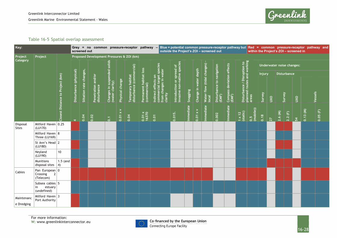
Greenlink Interconnector Limited
Greenlink Marine Environmental Statement - Wales
For more information: W: www.greenlinkinterconnector.eu
16-28
Table 16-5 Spatial overlap assessment
Key: Grey = no common pressure-receptor pathway – screened out
Blue = potential common pressure-receptor pathway but outside the Project’s ZOI – screened out
Red = common pressure-receptor pathway and within the Project’s ZOI – screened in
Project Category
Project Cl
oses
t D
ista
nce
to P
roje
ct (
km)
Proposed Development Pressures & ZOI (km)
Dis
turb
ance
(ph
ysic
al)
Silt
atio
n ra
te c
hang
es,
Pene
trat
ion
and/
or
dist
urba
nce
Chan
ges
in s
uspe
nded
sol
ids
(wat
er c
lari
ty)
Phys
ical
cha
nge
Tem
pora
ry h
abit
at
dist
urba
nce
(com
mer
cial
)
Perm
anen
t ha
bita
t lo
ss
(com
mer
cial
)
Indi
rect
eff
ects
on
com
mer
cial
tar
get
spec
ies
from
cha
nges
in w
ater
cl
arit
y
Intr
oduc
tion
or
spre
ad o
f in
vasi
ve n
on-n
ativ
e sp
ecie
s
Snag
ging
Chan
ge in
wat
er d
epth
Wat
er f
low
(ti
dal c
hang
es)
- lo
cal
Dis
turb
ance
to
navi
gati
on
(EM
F)
Com
pass
dev
iati
on e
ffec
ts
(EM
F)
Dis
turb
ance
/ D
isru
ptio
n to
pl
anne
d ro
utes
and
wor
king
ar
eas
Underwater noise changes:
Injury Disturbance
Surv
ey
UXO
Surv
ey
UXO
Ves
sels
4 0.04
0.02
0.1
0.01
x v
0.04
0.01
x
1637
0
0.01
0.01
5.
Imm
edia
te
0.01
x v
Imm
edia
te
0.00
2
Imm
edia
te
1 x
12
(sta
tic)
0.5
(mob
ile))
0.18
27
2.6
(M)
2.2
(F)
54
0.13
(M
)
0.05
(F)
Disposal Sites
Milford Haven (LU170)
0.25
Milford Haven Three (LU169)
8
St Ann’s Head (LU180)
2
Neyland (LU190)
10
Munitions disposal sites
1.5 (and 4)
Cables Pan European Crossing 2 (Telecom)
0
Subsea cables in estuary (undefined)
5
Maintenanc
e Dredging
Milford Haven Port Authority
3

Greenlink Interconnector Limited
Greenlink Marine Environmental Statement - Wales
For more information: W: www.greenlinkinterconnector.eu
16-29
Key: Grey = no common pressure-receptor pathway – screened out
Blue = potential common pressure-receptor pathway but outside the Project’s ZOI – screened out
Red = common pressure-receptor pathway and within the Project’s ZOI – screened in
Project Category
Project
Clos
est
Dis
tanc
e to
Pro
ject
(km
)
Proposed Development Pressures & ZOI (km)
Dis
turb
ance
(ph
ysic
al)
Silt
atio
n ra
te c
hang
es,
Pene
trat
ion
and/
or
dist
urba
nce
Chan
ges
in s
uspe
nded
sol
ids
(wat
er c
lari
ty)
Phys
ical
cha
nge
Tem
pora
ry h
abit
at
dist
urba
nce
(com
mer
cial
)
Perm
anen
t ha
bita
t lo
ss
(com
mer
cial
)
Indi
rect
eff
ects
on
com
mer
cial
tar
get
spec
ies
from
cha
nges
in w
ater
cl
arit
y
Intr
oduc
tion
or
spre
ad o
f in
vasi
ve n
on-n
ativ
e sp
ecie
s
Snag
ging
Chan
ge in
wat
er d
epth
Wat
er f
low
(ti
dal c
hang
es)
- lo
cal
Dis
turb
ance
to
navi
gati
on
(EM
F)
Com
pass
dev
iati
on e
ffec
ts
(EM
F)
Dis
turb
ance
/ D
isru
ptio
n to
pl
anne
d ro
utes
and
wor
king
ar
eas
Underwater noise changes:
Injury Disturbance
Surv
ey
UXO
Surv
ey
UXO
Ves
sels
4 0.04
0.02
0.1
0.01
x v
0.04
0.01
x
1637
0
0.01
0.01
5.
Imm
edia
te
0.01
x v
Imm
edia
te
0.00
2
Imm
edia
te
1 x
12
(sta
tic)
0.5
(mob
ile))
0.18
27
2.6
(M)
2.2
(F)
54
0.13
(M
)
0.05
(F)
Military
Practice
Areas
Castlemartin Firing Range
0
Marine Energy
META Site 8 0 META Site 7 6 META Site 1-5 8
Bombora Wave Power Seacam device
0
Wave Dragon 3.5 Scientific Surveys
Marker buoy deployment (Bombora Wave Power)
0

Greenlink Interconnector Limited
Greenlink Marine Environmental Statement - Wales
For more information: W: www.greenlinkinterconnector.eu
16-30
Key: Grey = no common pressure-receptor pathway – screened out
Blue = potential common pressure-receptor pathway but outside the Project’s ZOI – screened out
Red = common pressure-receptor pathway and within the Project’s ZOI – screened in
Project Category
Project
Clos
est
Dis
tanc
e to
Pro
ject
(km
)
Proposed Development Pressures & ZOI (km)
Dis
turb
ance
(ph
ysic
al)
Silt
atio
n ra
te c
hang
es,
Pene
trat
ion
and/
or
dist
urba
nce
Chan
ges
in s
uspe
nded
sol
ids
(wat
er c
lari
ty)
Phys
ical
cha
nge
Tem
pora
ry h
abit
at
dist
urba
nce
(com
mer
cial
)
Perm
anen
t ha
bita
t lo
ss
(com
mer
cial
)
Indi
rect
eff
ects
on
com
mer
cial
tar
get
spec
ies
from
cha
nges
in w
ater
cl
arit
y
Intr
oduc
tion
or
spre
ad o
f in
vasi
ve n
on-n
ativ
e sp
ecie
s
Snag
ging
Chan
ge in
wat
er d
epth
Wat
er f
low
(ti
dal c
hang
es)
- lo
cal
Dis
turb
ance
to
navi
gati
on
(EM
F)
Com
pass
dev
iati
on e
ffec
ts
(EM
F)
Dis
turb
ance
/ D
isru
ptio
n to
pl
anne
d ro
utes
and
wor
king
ar
eas
Underwater noise changes:
Injury Disturbance
Surv
ey
UXO
Surv
ey
UXO
Ves
sels
4 0.04
0.02
0.1
0.01
x v
0.04
0.01
x
1637
0
0.01
0.01
5.
Imm
edia
te
0.01
x v
Imm
edia
te
0.00
2
Imm
edia
te
1 x
12
(sta
tic)
0.5
(mob
ile))
0.18
27
2.6
(M)
2.2
(F)
54
0.13
(M
)
0.05
(F)
Bangor University Scientific Research Surveys
0.5
Deposit of scientific experiment and marker buoys
0.5
MacroBioCrude project
8-10
Marine Benthic Invertebrate / Sediment Grab Sampling
2.2
Oil and Gas Seismic survey
2
Wellhed 50/10-1
9.5

Greenlink Interconnector Limited
Greenlink Marine Environmental Statement - Wales
For more information: W: www.greenlinkinterconnector.eu
16-31
Key: Grey = no common pressure-receptor pathway – screened out
Blue = potential common pressure-receptor pathway but outside the Project’s ZOI – screened out
Red = common pressure-receptor pathway and within the Project’s ZOI – screened in
Project Category
Project
Clos
est
Dis
tanc
e to
Pro
ject
(km
)
Proposed Development Pressures & ZOI (km)
Dis
turb
ance
(ph
ysic
al)
Silt
atio
n ra
te c
hang
es,
Pene
trat
ion
and/
or
dist
urba
nce
Chan
ges
in s
uspe
nded
sol
ids
(wat
er c
lari
ty)
Phys
ical
cha
nge
Tem
pora
ry h
abit
at
dist
urba
nce
(com
mer
cial
)
Perm
anen
t ha
bita
t lo
ss
(com
mer
cial
)
Indi
rect
eff
ects
on
com
mer
cial
tar
get
spec
ies
from
cha
nges
in w
ater
cl
arit
y
Intr
oduc
tion
or
spre
ad o
f in
vasi
ve n
on-n
ativ
e sp
ecie
s
Snag
ging
Chan
ge in
wat
er d
epth
Wat
er f
low
(ti
dal c
hang
es)
- lo
cal
Dis
turb
ance
to
navi
gati
on
(EM
F)
Com
pass
dev
iati
on e
ffec
ts
(EM
F)
Dis
turb
ance
/ D
isru
ptio
n to
pl
anne
d ro
utes
and
wor
king
ar
eas
Underwater noise changes:
Injury Disturbance
Surv
ey
UXO
Surv
ey
UXO
Ves
sels
4 0.04
0.02
0.1
0.01
x v
0.04
0.01
x
1637
0
0.01
0.01
5.
Imm
edia
te
0.01
x v
Imm
edia
te
0.00
2
Imm
edia
te
1 x
12
(sta
tic)
0.5
(mob
ile))
0.18
27
2.6
(M)
2.2
(F)
54
0.13
(M
)
0.05
(F)
Constructio
n
Milford Haven Port Development
7
Neyland Yacht Haven Marina (Piling works)
10
Salvaging of anchors and chains
4
Jetty Maintenance
5
Deposit of a temporary trackway and jetty
4.5
v = variable length along the cable route; M = marine mammals; F = fish and shellfish

Greenlink Interconnector Limited
Greenlink Marine Environmental Statement - Wales
For more information: W: www.greenlinkinterconnector.eu
16-33
16.3.10 Step 5: Identify Temporal Overlaps For there to be a PCE, effects from the Proposed Development and other plans and projects must overlap temporally as well as spatially. For all pressures that were screened in during Step 4 the next phase is to identify the time period over which the activities are likely to be carried out. If there is a temporal overlap with the Proposed Development project phases, the project or plan will continue to the next step of the CEA.
To identify potential temporal overlap, a project timeline has been developed. This timeline aims to compare the Proposed Development installation, operation and decommissioning periods with current and future activities of the plans and projects identified in Table 16-5.
Information regarding timelines has been obtained through consultation with developers and operators and review of Environmental Statements and websites.
The timeline presented in Table 16-6 classifies projects, plans and licenses as follows:
• Pre-construction – this involves surveying activities and design of the project;
• Construction;
• Operational;
• Closed or non-operational (e.g. constructed but not in use); and
• No known timeline.
When a project has no known timeline, this has been screened out of the CEA, as no temporal overlap can be identified with confidence. This includes projects at an early design, pre-planning stage and/or optional licences.

Greenlink Interconnector Limited
Greenlink Marine Environmental Statement - Wales
For more information: W: www.greenlink.ie
16-33
Table 16-6 Project timeline
Key: No known timeline
Pre-construction
Construction Operational Closed or non-operational
Greenlink Project Installation Phase
* Denotes up to 40 years planned design life for Greenlink Project
Project Category
Name / Type of Project
Status 2019 2020 2021 2022 2023 2024 2064 *
Disposal sites
Milford Haven (LU170) Closed
St Ann’s Head (LU180) Closed
Munition disposal (x2) Disused
Cables Pan European Crossing 2 (Telecom)
Installed
Maintenance Dredging
Milford Haven Port Authority
Active
Military Practice areas
Castlemartin Firing Range
Active
Marine energy
Marine energy test area (META)
Site 8 Proposed/Development
Site 7 Proposed
Site 1-5 Proposed
Bombora Wave Power Seacam device (META8)
Proposed
Wave Dragon Proposed
Scientific Surveys
Marker buoy deployment (Bombora Wave Power)
Installed
Bangor University Scientific Research Surveys
Licenced
Deposit of scientific experiment and marker buoys
Licenced

Greenlink Interconnector Limited
Greenlink Marine Environmental Statement - Wales
For more information: W: www.greenlink.ie
16-34
Key: No known timeline
Pre-construction
Construction Operational Closed or non-operational
Greenlink Project Installation Phase
* Denotes up to 40 years planned design life for Greenlink Project
Project Category
Name / Type of Project
Status 2019 2020 2021 2022 2023 2024 2064 *
Marine Benthic Invertebrate / Sediment Grab Sampling
Renewal licence
Oil and Gas Seismic survey Proposed
Construction Milford Haven Port Development
Proposed
Neyland Yacht Haven Marina (Piling works)
Licenced

Greenlink Interconnector Limited
Greenlink Marine Environmental Statement - Wales
For more information: W: www.greenlink.ie
16-35
The two sediment disposal sites are closed and no longer accept any disposal; both Milford Haven (LU170) and St Ann’s Head (LU180) sites have been screened out of the assessment.
The munitions disposal sites identified on Admiralty Charts are no longer in use and there are currently no plans to reopen. Therefore, the sites have been screened out of the assessment.
Although the Pan European Crossing 2 (Telecom) is operational as identified in Table 16-6, there are no scheduled maintenance activities or works, other than those linked to the Proposed Development, and therefore no PCE. Therefore, the asset has been screened out of the assessment.
The Marine Energy Test Areas (META) have limited information on the current schedule of development for the sites. However, it is understood that sites 6, 7 and 8 are currently in the scoping process prior to the writing of an ES. Further information on the use of META Site 8 by Bombora Wave Power indicates that the schedule for installation of a wave device is planned for 2020, with operation of the device anticipated for 6-12 month. Due to the unconfirmed timescales the META sites 1-7 have been screened out of the assessment; as there a no permanent exclusion zone around the sites, only around the devices present within the sites, the META site 8 with one proposed device and some initial scheduling has been included in the cumulative assessment as part of the Bombora Wave Power device project.
An application was submitted to BEIS for a seismic survey over St Georges Bank. ENI confirmed in a letter to the Mr Lake (Ceredigion MP, dated 31 May 2019) that “following internal review and further discussions with the regulator (BEIS) it now has no plans to carry out the seismic survey in St Georges Channel or Cardigan Bay”. The project has therefore been screened-out.
A wave testing site has been proposed approximately 25km south west of the mouth of the Cleddau Estuary. The project, Wave Dragon project consists seven 4MW-scale Wave Dragon wave energy converter devices. The scoping opinion was for the test deployment for a period of up to 40 months, of a single unit only with a generating capacity of 3MW. It is not planned to be grid connected. Although there are shared receptor pressure pathways, as no confirmed schedule is known for this project and an ES assessment is still to be completed for the project within which the Proposed Development will be included as part of the cumulative assessment (scoping opinion; NRW 2018a), the project is noted, but has been screened out of the assessment.
Milford Haven Port has plans to develop part of the waterfront, a scoping opinion has been issued (NRW 2018b) and the development will be required to undergo an ES in which a cumulative assessment will be undertaken. However, at this time no schedule or further information is able to be provided to be included in this assessment.

Greenlink Interconnector Limited
Greenlink Marine Environmental Statement - Wales
For more information: W: www.greenlink.ie
16-37
A licence granted for Bangor University Scientific Research Surveys is understood to be open until 2021. No further information is confirmed and therefore cannot be reasonably assessed in line with the Proposed Development so has been screened out of the assessment.
16.3.11 Pathways Screened In Following consideration of the spatial and temporal overlaps, the pressure-receptor pathways presented in Table 16-7 have been screened in as PCE and will be considered in Step 6.
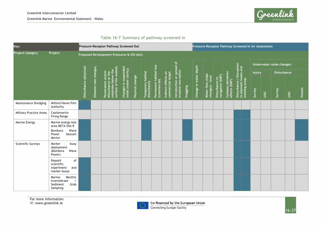
Greenlink Interconnector Limited
Greenlink Marine Environmental Statement - Wales
For more information: W: www.greenlink.ie
16-37
Table 16-7 Summary of pathway screened in
Key: Pressure-Receptor Pathway Screened Out Pressure-Receptor Pathway Screened In for Assessment
Project Category Project Proposed Development Pressures & ZOI (km)
Dis
turb
ance
(ph
ysic
al)
Silt
atio
n ra
te c
hang
es,
Pene
trat
ion
and/
or
dist
urba
nce
or t
he
subs
trat
e be
low
the
su
rfac
e of
the
sea
bed,
Chan
ges
in s
uspe
nded
so
lids
(wat
er c
lari
ty)
Phys
ical
cha
nge
Tem
pora
ry h
abit
at
dist
urba
nce
(i
l)
Perm
anen
t ha
bita
t lo
ss
(com
mer
cial
)
Indi
rect
eff
ects
on
com
mer
cial
tar
get
i f
h
i
Intr
oduc
tion
or
spre
ad o
f in
vasi
ve n
on-n
ativ
e i
Sn
aggi
ng
Chan
ge in
wat
er d
epth
Wat
er f
low
(ti
dal
chan
ges)
- lo
cal
Dis
turb
ance
to
navi
gati
on (
EMF)
Com
pass
dev
iati
on
effe
cts
(EM
F)
Dis
turb
ance
/ D
isru
ptio
n to
pla
nned
rou
tes
and
wor
king
are
as
Underwater noise changes:
Injury Disturbance
Surv
ey
UXO
Surv
ey
UXO
Ves
sels
Maintenance Dredging Milford Haven Port Authority
Military Practice Areas Castlemartin Firing Range
Marine Energy Marine energy test area META Site 8 Bombora Wave Power Seacam device
Scientific Surveys Marker buoy deployment (Bombora Wave Power)
Deposit of scientific experiment and marker buoys
Marine Benthic Invertebrate / Sediment Grab Sampling

Greenlink Interconnector Limited
Greenlink Marine Environmental Statement - Wales
For more information: W: www.greenlink.ie
16-38
Key: Pressure-Receptor Pathway Screened Out Pressure-Receptor Pathway Screened In for Assessment
Project Category Project Proposed Development Pressures & ZOI (km)
Dis
turb
ance
(ph
ysic
al)
Silt
atio
n ra
te c
hang
es,
Pene
trat
ion
and/
or
dist
urba
nce
or t
he
subs
trat
e be
low
the
su
rfac
e of
the
sea
bed,
Chan
ges
in s
uspe
nded
so
lids
(wat
er c
lari
ty)
Phys
ical
cha
nge
Tem
pora
ry h
abit
at
dist
urba
nce
(i
l)
Perm
anen
t ha
bita
t lo
ss
(com
mer
cial
)
Indi
rect
eff
ects
on
com
mer
cial
tar
get
i f
h
i
Intr
oduc
tion
or
spre
ad o
f in
vasi
ve n
on-n
ativ
e i
Sn
aggi
ng
Chan
ge in
wat
er d
epth
Wat
er f
low
(ti
dal
chan
ges)
- lo
cal
Dis
turb
ance
to
navi
gati
on (
EMF)
Com
pass
dev
iati
on
effe
cts
(EM
F)
Dis
turb
ance
/ D
isru
ptio
n to
pla
nned
rou
tes
and
wor
king
are
as
Underwater noise changes:
Injury Disturbance
Surv
ey
UXO
Surv
ey
UXO
Ves
sels
Construction Neyland Yacht Haven Marina (Piling works)

Greenlink Interconnector Limited
Greenlink Marine Environmental Statement - Wales
For more information: W: www.greenlink.ie
16-39
16.3.12 Step 6: Cumulative Effects Assessment
16.3.12.1 Introduction
Common pressure-receptor pathways between the Proposed Development and a plan or project have been assessed for the potential for cumulative effect. If there is a common pressure-receptor pathway for more than one plan or project, the timeline for each plan or project is revisited to identify if any of the projects or plans temporally overlap. The cumulative effects from the combined projects are then assessed i.e. rather than just the cumulative effects of the Proposed Development and an individual plan or project. Consideration is given to whether the pressures identified occur once or are repeated in a manner that could have an additive effect.
The assessment follows the EIA methodology established in Chapter 5, which considers the magnitude of the pressure on a receptor and the sensitivity of the receptor to the pressure to evaluate the significance of the effect. For consistency with the EIA, cumulative effects are discussed by receptor and by project phase.
Information on the significance of effects from other plans and projects has been taken from their respective EIAs. If an assumption has been made, this is made clear in the assessment.
16.3.12.2 Assessment
Table 16-9 presents the cumulative effects assessment conducted on the Proposed Development activities. Brief justification for the conclusion has been provided in table. Where a conclusion of Negligible significance or above has been reached this is discussed in Sections 16.3.12.3 onwards.

Greenlink Interconnector Limited
Greenlink Marine Environmental Statement - Wales
For more information: W: www.greenlink.ie
16-40
Table 16-8 Assessment of PCE
Determination of Potential Cumulative Effect Cumulative Effect Assessment
Receptor Pressure Proposed Development Project Phase*
Activity Screened in Magnitude Sensitivity Significance
Physical conditions and marine processes
Physical change (to another seabed type) I; O None - - No PCE
Changes in suspended solids (water clarity)
I; O; D None - - No PCE
Penetration and/or disturbance or the substrate below the surface of the seabed, including abrasion
I; O; D None - - No PCE
Benthic and intertidal ecology
Penetration and/or disturbance or the substrate below the surface of the seabed, including abrasion
I; O; D None - - No PCE
Siltation rate changes, including smothering (depth of vertical sediment overburden)
I; O; D None - - No PCE
Introduction or spread of invasive non-native species
I; O; D None - - No PCE
Physical change (to another seabed type) I; O None - - No PCE
Fish and shellfish Penetration and/or disturbance or the substrate below the surface of the seabed, including abrasion
I; O; D None - - No PCE
Physical change (to another seabed type) None - - No PCE
Underwater noise changes: Disturbance I; O; D • META Site 8 Bombora Wave Power Seacam device
• Marine Benthic Invertebrate / Sediment Grab Sampling
• Neyland Yacht Haven Marina (Piling works)
Low - Negligible
Low Negligible
Not
Significant

Greenlink Interconnector Limited
Greenlink Marine Environmental Statement - Wales
For more information: W: www.greenlink.ie
16-41
Determination of Potential Cumulative Effect Cumulative Effect Assessment
Receptor Pressure Proposed Development Project Phase*
Activity Screened in Magnitude Sensitivity Significance
Marine birds Disturbance (Physical) I; O; D • META Site 8 Bombora Wave Power Seacam device
• Deposit of scientific experiment and marker buoys
• Marine Benthic Invertebrate / Sediment Grab Sampling
Negligible Medium Negligible
Not
Significant
Marine mammals Underwater noise changes: Disturbance or injury
I; O; D • META Site 8 Bombora Wave Power Seacam device
• Marine Benthic Invertebrate / Sediment Grab Sampling
• Neyland Yacht Haven Marina (Piling works)
Low -
Negligible
Medium Minor
Not
Significant
Disturbance to navigation (EMF) IO None - - No PCE
Commercial fisheries Permanent habitat loss affecting spawning, nursery or recruitment to commercial stocks
I; O; D None - - No PCE
Temporary habitat disturbance affecting spawning, nursery or recruitment to commercial stocks
I; O; D • META Site 8 Bombora Wave Power Seacam device
Low Low Negligible
Not
Significant
Indirect effects on commercial target species from changes in water clarity
I; O; D None - - No PCE
Snagging I; O • META Site 8 Bombora Wave Power Seacam device
Low Low Negligible
Not
significant
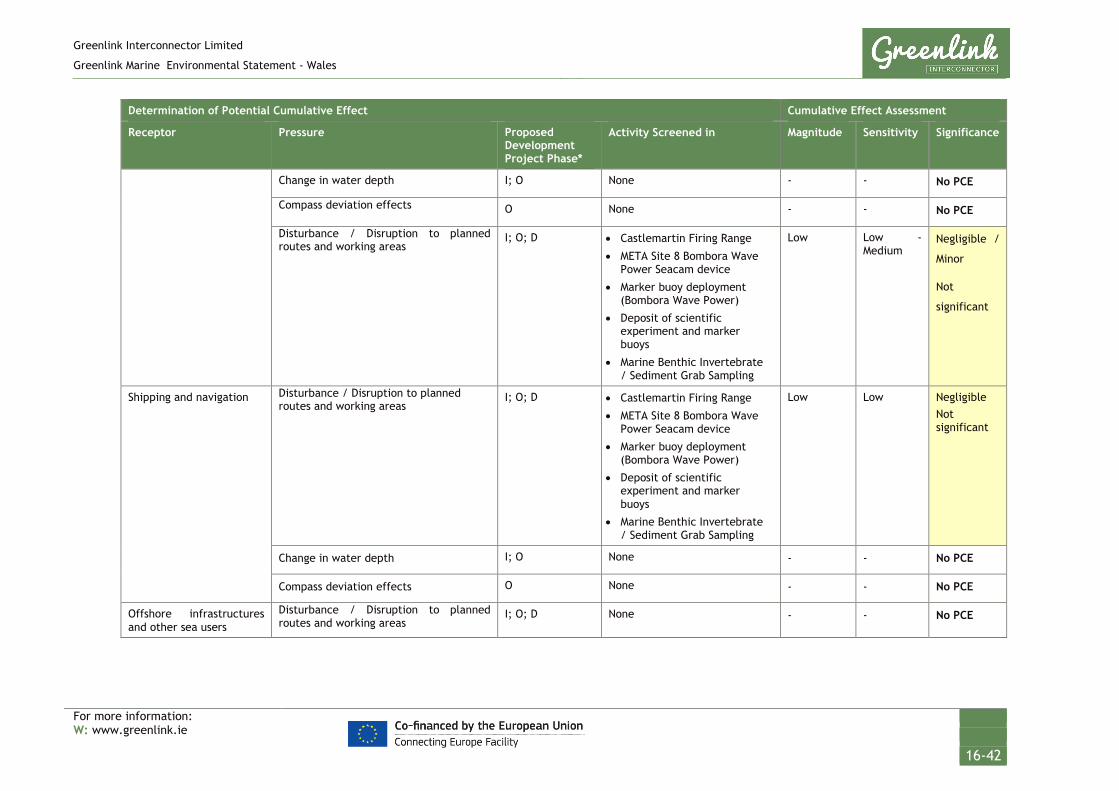
Greenlink Interconnector Limited
Greenlink Marine Environmental Statement - Wales
For more information: W: www.greenlink.ie
16-42
Determination of Potential Cumulative Effect Cumulative Effect Assessment
Receptor Pressure Proposed Development Project Phase*
Activity Screened in Magnitude Sensitivity Significance
Change in water depth I; O None - - No PCE
Compass deviation effects O None - - No PCE
Disturbance / Disruption to planned routes and working areas
I; O; D • Castlemartin Firing Range
• META Site 8 Bombora Wave Power Seacam device
• Marker buoy deployment (Bombora Wave Power)
• Deposit of scientific experiment and marker buoys
• Marine Benthic Invertebrate / Sediment Grab Sampling
Low Low - Medium
Negligible /
Minor
Not
significant
Shipping and navigation Disturbance / Disruption to planned routes and working areas
I; O; D • Castlemartin Firing Range
• META Site 8 Bombora Wave Power Seacam device
• Marker buoy deployment (Bombora Wave Power)
• Deposit of scientific experiment and marker buoys
• Marine Benthic Invertebrate / Sediment Grab Sampling
Low Low Negligible Not significant
Change in water depth I; O None - - No PCE
Compass deviation effects O None - - No PCE
Offshore infrastructures and other sea users
Disturbance / Disruption to planned routes and working areas
I; O; D None - - No PCE

Greenlink Interconnector Limited
Greenlink Marine Environmental Statement - Wales
For more information: W: www.greenlink.ie
16-43
Determination of Potential Cumulative Effect Cumulative Effect Assessment
Receptor Pressure Proposed Development Project Phase*
Activity Screened in Magnitude Sensitivity Significance
Recreation Disturbance / Disruption to planned routes and working areas
I; O; D • Castlemartin Firing Range
• META Site 8 Bombora Wave Power Seacam device
• Marker buoy deployment (Bombora Wave Power)
• Deposit of scientific experiment and marker buoys
• Marine Benthic Invertebrate / Sediment Grab Sampling
Low Medium Minor
Not
significant
Change in water depth I; O None - - No PCE
Compass deviation effects O None - - No PCE
Marine archaeology Penetration and/or disturbance or the substrate below the surface of the seabed, including abrasion
I; O; D None - - No PCE

Greenlink Interconnector Limited
Greenlink Marine Environmental Statement - Wales
For more information: W: www.greenlink.ie
16-44
16.3.12.3 Fish and Shellfish
Underwater noise change
Table 16-9 Screening Summary – Underwater Noise Change
Zone of influence (km)
Activity Screened in
Projects screened in
Vessels Injury 0.05 Marine Energy META Site 8 Bombora Wave Power Seacam device
Scientific Surveys Marine Benthic Invertebrate / Sediment Grab Sampling
Vessels Disturbance 0.13 Marine Energy META Site 8 Bombora Wave Power Seacam device
Scientific survey Marine Benthic Invertebrate / Sediment Grab Sampling
Geophysical Survey
Injury 2.2 None None
Geophysical Survey
Disturbance 2.6 None None
UXO Disturbance 54 Construction Neyland Yacht Haven Marina (piling works)
Installation During the Proposed Development’s installation phase, activities creating a PCE for fish are the survey operations, UXO clearance (if required), vessel noise including dynamic positioning vessels and rock placement operations.
Fish can incur death, permanent and temporary hearing injuries from loud and intense sound pressure level changes. Other responses to lower levels of sound are more subtle and include avoidance, changes in swimming behaviour and orientation, startle reactions and changes in schooling patterns and distribution (Popper et al. 2014). Fish are likely to return to an area following noise disturbance or may become habituated to continuous sound sources.
The disturbance and subsequent displacement of animals from an area surrounding a development has the potential to displace fish from feeding or breeding banks and if the disturbance is large enough may restrict migration routes. A number of noisy activities can reduce the suitable available habitat for fish species and may lead to a PCE.
It has been identified that the META site 8 is scheduled to undergo installation in 2020 at the same time as the Proposed Development. Currently any noise during the installation phase is likely to be restricted to vessel movement, which has been included in this assessment. Installation for the project would be at one location for discrete periods of time. There are no current plans for piling (gravity base foundations). GIL is aware that a pre-installation geophysical survey has already been undertaken.

Greenlink Interconnector Limited
Greenlink Marine Environmental Statement - Wales
For more information: W: www.greenlink.ie
16-45
Although no project have currently been screened in, there is potential for geophysical surveys to be undertaken during the installation phase of the Proposed Development, such as Milford Haven maintenance dredging (to confirm dredging depth), or potentially in relation to the piling works. However, this is not confirmed, and no schedules are known and so cannot be included in this assessment.
There is a licence for piling within the estuary, which would correspond to a noise disturbance comparable to detonation of UXO, however this work planned to be completed before the end of 2019 and therefore unless there are unforeseen circumstances are unlikely to overlap with the installation of the Proposed Development.
In general, most fish are hearing generalists and hear well in the range within which most energy from anthropogenic noise sources is emitted, i.e. relatively low frequency sound below 1 kHz, with peak perception between approximately 100 – 400 Hz and relatively poor sensitivity. Hearing specialist fish such as herring are able to hear relatively high frequency sounds (to over 3 kHz) with optimum sensitivity between 300 Hz and 1 kHz (Popper et al. 2014). As there are no confirmed plans for geophysical survey, the main noise would be related to the presence of vessels. This pressure-receptor pathway is in line with the background variations.
One possible noise related pressure-receptor pathway that occurs during installation is detonation of UXO. There are a number of projects that may discover or cause detonation of UXO, including the Milford Haven maintenance dredging, potential clearance of the META site 8, military exercises and piling works at Neyland Marina. As there are no current plans for specific UXO removals, any effect would be based on speculation and is unable to be assessed.
With the projects being undertaken, the magnitude of any underwater noise is likely to be low or negligible. The sensitivity is assessed as low due to tolerance of change and not varying far from the baseline conditions for the receptor. Therefore, the cumulative effect would be a Negligible and Not Significant.
Operation No noise emissions are expected from the operating cable. Noise emissions during the operational phase may be produced from survey and maintenance activities. Any effects will be similar to the installation phase and unlikely to produce PCE.
Decommissioning It is currently unknown if any other development or decommissioning will be occurring at the same time as the Proposed Development’s decommissioning activities. The worst case underwater noise generated by the Proposed development’s activities is the use of sub bottom profiler during geophysical survey. PCEs cannot be defined without knowing which other operations will be occurring during the decommissioning phase of the Proposed Development.

Greenlink Interconnector Limited
Greenlink Marine Environmental Statement - Wales
For more information: W: www.greenlink.ie
16-46
16.3.12.4 Marine Birds
Physical Disturbance
Table 16-10 Screening summary – Physical Disturbance
Zone of influence (km)
Activity Screened in Projects screened in
Marine energy META Site 8 Bombora Wave Power Seacam device
Scientific surveys Deposit of scientific experiment and marker buoys
Marine Benthic Invertebrate / Sediment Grab Sampling
Installation Chapter 9 identified that disturbance is predicted to be limited to that initiated by the movement of the project vessels or intra-project cumulative effects from noise in the nearshore area (should they overlap temporally). Birds may take evasive action, but a single disturbance event does not have any immediate effect on the survival or productivity of an individual bird. Repeated disturbance, or disturbance over an extended period of time, can affect survival and productivity.
The most disruptive activities are those that are sudden, noisy or fast. Vessels travelling at faster speeds cause a greater level of disturbance in terms of the proportion of birds flushing and at further distances (Bellefleur et al. 2009; Ronconi and St Clair 2002).
The puffin, Manx shearwater and gannet could be disturbed during foraging offshore due to the presence of installation vessels. It was concluded in the assessment that any disturbance will be localised, transient and temporary as project vessels progress along the cable route.
The screening process identified a number of projects, plans and licensed activities that could result in a PCE on marine birds in combination with the installation of the Proposed Development. These projects include the Bombora Wave Power device (installation), retrieval of scientific equipment and marker buoy and Marine Benthic Invertebrate / Sediment Grab Sampling. It is considered that, due to the transient, temporary and localised presence of vessels as part of these activities, the magnitude is negligible and the sensitivity is at greatest medium, therefore the potential for cumulative effect is Negligible and Not Significant.

Greenlink Interconnector Limited
Greenlink Marine Environmental Statement - Wales
For more information: W: www.greenlink.ie
16-47
16.3.12.5 Marine Mammals
Underwater noise change
Table 16-11 Screening summary – Disturbance or Injury from Underwater Noise
Zone of influence (km)
Activity Screened in
Projects screened in
Vessels Injury None None None
Vessels Disturbance 0.13 Marine Energy META Site 8 Bombora Wave Power Seacam device
Scientific survey Marine Benthic Invertebrate / Sediment Grab Sampling
Geophysical Survey
Injury 0.18 None None
Geophysical Survey
Disturbance 2.6 None None
UXO Injury 27 Construction Neyland Yacht Haven Marina (piling works)
UXO Disturbance 54 Construction Neyland Yacht Haven Marina (piling works)
The common pressure-receptor pathway that could result in PCE during each phase of the Proposed Development is the generation of underwater noise which could potentially disturb or injure marine mammals. Project activities such as the movement and presence of vessels (all project phases), the installation of rock protection (installation), detonation of UXO (if required) and geophysical survey (all phases) will generate underwater noise emissions.
The table above presents the numerous plans, projects and licensed activities within 10km which could also generate underwater noise, resulting in a PCE.
Installation As discussed in Section 16.3.12.3, it has been identified that the META site 8 is scheduled to undergo installation in 2020 at the same time as the Proposed Development. Currently any noise during the installation phase is likely to be restricted to vessel movement, which has been included in this assessment. Installation for the project would be at one location for discrete periods of time. There are no current plans for piling (gravity base foundations).
Although no project have currently been screened in, there is potential for geophysical surveys to be undertaken during the installation phase of the Proposed Development, such as Milford Haven maintenance dredging (to confirm dredging depth), or potentially in relation to the piling works. However, this is not confirmed, and no schedules are known and so cannot be included in this assessment.
There is a licence for piling within the estuary, which would correspond to a noise disturbance comparable to detonation of UXO, however this work planned to be completed before the end of 2019 and therefore unless there are unforeseen
Greenlink Interconnector Limited
Greenlink Marine Environmental Statement - Wales
For more information: W: www.greenlink.ie
16-48
circumstances are unlikely to overlap with the installation of the Proposed Development. The works were also not continuous throughout the year, and therefore do not add to a cumulative effect.
Any disturbance and subsequent displacement of animals from an area surrounding a development has the potential to affect communication, feeding and foraging opportunities and may restrict migration routes. A number of similar noisy activities can reduce the suitable available habitat for marine mammals and may lead to PCE.
As there are no confirmed plans for geophysical survey, the main noise would be related to the presence of vessels. This pressure-receptor pathway is in line with the background variations.
One possible noise related pressure-receptor pathway that occurs during installation is detonation of UXO. There are a number of projects that may also discover or cause detonation of UXO, including the Milford Haven maintenance dredging, potential clearance of the META site 8, military exercises and piling works at Neyland Marina. As there are no current plans for specific UXO removals or detonations, any effect would be based on speculation and is unable to be assessed. The identification of UXO is covered by the embedded mitigation EM21, with detonation as a last resort. Only one detonation maximum is anticipated during installation of the Proposed Development, therefore there is limited PCE.
With the projects being undertaken, the magnitude of any underwater noise is likely to be low or negligible. On average the sensitivity is assessed as medium due to tolerance of change and number of species, although it is generally anticipated that conditions will not vary far from the baseline conditions for the receptor. Therefore, the cumulative effect would be a Minor and Not Significant
Operation No noise emissions are expected from the operating cable. Noise emissions during the operational phase may be produced from survey and maintenance activities. Any effects will be similar to the installation phase and unlikely to produce PCE.
Decommissioning It is currently unknown if any other development or decommissioning will be occurring at the same time as the Proposed Development’s decommissioning activities. The worst case underwater noise generated by the Proposed Development’s activities is the use of sub bottom profiler during geophysical survey. The PCE cannot be defined without knowing which other operations will be occurring for the Proposed Development and for other projects.

Greenlink Interconnector Limited
Greenlink Marine Environmental Statement - Wales
For more information: W: www.greenlink.ie
16-49
16.3.12.6 Commercial Fisheries
Temporary habitat disturbance affecting spawning, nursery or recruitment to commercial stocks
Table 16-12 Screening summary – Temporary Habitat Disturbance
Zone of influence (km)
Activity Screened in Projects screened in
0.04 Marine Energy META Site 8 Bombora Wave Power Seacam device
Installation and Operation As part of the Proposed Development pre-sweeping, pre-lay grapnel run, plough trenching and jet trenching all have the potential to result in an indirect impact to commercial fisheries resource as a result of the loss or disturbance of habitat affecting spawning, nursery grounds or recruitment of stocks.
A number of projects, plans and licensed activities had similar receptor pressure pathways, but due to the locations and/or timescales many were screened out. One project remained, the Bombora Wave Power device. As discussed in previous sections the META site 8, where the Bombora Wave Power device will be situated, is scheduled to undergo installation in 2020 at the same time as the Proposed Development. The placement of the device on the seabed will result in temporary displacement of discrete areas of the seabed. The device is only planned to be present for 1 – 12 months.
There is potential for a cable route to be installed as part of the META 8 site, however this is currently not confirmed and any development would require an assessment prior to installation.
Other projects that had similar pressure receptor pathways that were deemed to no create a cumulative effect were the dredging and disposal, grab sampling and construction and development in the estuary or along the coast.
Due to the relatively short term period and size of the area affected, the effect on species with a demersal life stage due to habitat disturbance during the installation, operation or decommissioning has been assessed as low for both magnitude and sensitivity. This should therefore lead to a low magnitude and sensitivity for temporary seabed disturbance in relation to the commercial fisheries. The PCE has been assessed as Negligible and Not significant.
Decommissioning It is currently unknown if any other development or decommissioning will be occurring at the same time as the Proposed Development’s decommissioning activities. The PCE cannot be defined without knowing which other operations will be occurring for the Proposed Development and for other projects.
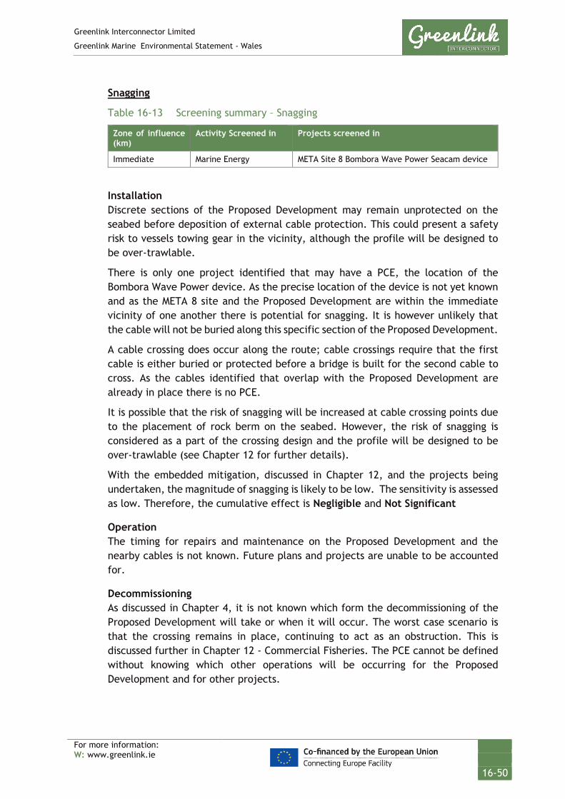
Greenlink Interconnector Limited
Greenlink Marine Environmental Statement - Wales
For more information: W: www.greenlink.ie
16-50
Snagging
Table 16-13 Screening summary – Snagging
Zone of influence (km)
Activity Screened in Projects screened in
Immediate Marine Energy META Site 8 Bombora Wave Power Seacam device
Installation Discrete sections of the Proposed Development may remain unprotected on the seabed before deposition of external cable protection. This could present a safety risk to vessels towing gear in the vicinity, although the profile will be designed to be over-trawlable.
There is only one project identified that may have a PCE, the location of the Bombora Wave Power device. As the precise location of the device is not yet known and as the META 8 site and the Proposed Development are within the immediate vicinity of one another there is potential for snagging. It is however unlikely that the cable will not be buried along this specific section of the Proposed Development.
A cable crossing does occur along the route; cable crossings require that the first cable is either buried or protected before a bridge is built for the second cable to cross. As the cables identified that overlap with the Proposed Development are already in place there is no PCE.
It is possible that the risk of snagging will be increased at cable crossing points due to the placement of rock berm on the seabed. However, the risk of snagging is considered as a part of the crossing design and the profile will be designed to be over-trawlable (see Chapter 12 for further details).
With the embedded mitigation, discussed in Chapter 12, and the projects being undertaken, the magnitude of snagging is likely to be low. The sensitivity is assessed as low. Therefore, the cumulative effect is Negligible and Not Significant
Operation The timing for repairs and maintenance on the Proposed Development and the nearby cables is not known. Future plans and projects are unable to be accounted for.
Decommissioning As discussed in Chapter 4, it is not known which form the decommissioning of the Proposed Development will take or when it will occur. The worst case scenario is that the crossing remains in place, continuing to act as an obstruction. This is discussed further in Chapter 12 - Commercial Fisheries. The PCE cannot be defined without knowing which other operations will be occurring for the Proposed Development and for other projects.

Greenlink Interconnector Limited
Greenlink Marine Environmental Statement - Wales
For more information: W: www.greenlink.ie
16-51
Disturbance / Disruption to planned routes and working areas
Table 16-14 Screening summary – Disturbance / Disruption to planned routes and working areas
Zone of influence (km)
Activity Screened in Projects screened in
Mobile gear
0.5 MOD Castlemartin Firing Range
Marine Energy META Site 8 Bombora Wave Power Seacam device
Scientific surveys Marker buoy deployment (Bombora Wave Power)
Deposit of scientific experiment and marker buoys
Static gear
1km x 12km installation 1km radius during ops
MOD Castlemartin Firing Range
Marine Energy META Site 8 Bombora Wave Power Seacam device
Scientific surveys Marker buoy deployment (Bombora Wave Power)
Deposit of scientific experiment and marker buoys
Installation, Operation, Decommissioning For the Proposed Development, fishing vessels will be requested to stay at least 500m radius away from vessels during installation, maintenance and future decommissioning activities. This will temporarily displace fishing activity from traditional grounds. The zone of influence will move as activity progresses along the cable route. Ahead of the installation, fishermen will be asked to move their static fishing gear away from the Proposed Development. Fishermen will be asked to remain out of the Proposed Development for up to three days before installation. The zone of influence is 1km x 12km (see Chapter 12).
Other projects, plans and licensed activities are likely to have similar restrictions around their activities at the installation or operational phase. The installation period at the META site 8 and any presence of marker buoys will likely temporally and spatially overlap with the Proposed Developments installation period. They may require similar restrictions around vessels; however, this is currently unconfirmed. There may also be restrictions should any repair or maintenance works be required for the operational cable, Pan European Crossing 2, however there are no current plans at this time.
The Castlemartin Firing Range overlaps the Proposed Development and although active there are not continuous activities within this area; there are currently no planned activities, however there is embedded mitigation implemented (Chapter 14). Generally, more localised areas will be affected by activities. As both the activity within the Firing Range and the Proposed Development are of fairly short timescales any PCE should be minor.

Greenlink Interconnector Limited
Greenlink Marine Environmental Statement - Wales
For more information: W: www.greenlink.ie
16-52
Any restrictions implemented during installation of known project, any potential future maintenance and repair activities for cables, or for activities other projects, could have a PCE, but all projects are anticipated to be of a short timescale and at discrete locations. The magnitude of the effect has been assessed as low and the sensitivity of commercial fisheries is low, resulting in a Negligible cumulative effect which is deemed Not Significant.
Operation Fishing grounds will be accessible after the equipment and project vessels leave the working area.
The effects of the potential repair activities on access to fishing grounds would be temporary and localised. Vessels using mobile fishing gear will be able to avoid the activity, while static gear can be re-deployed, once operations in the area are complete. Restrictions surrounding the other projects would also be temporary and it is unlikely that these restrictions would overlap over repeated and long periods of time. The effects of reduced access to fishing grounds have been assessed as Negligible cumulative effect which is Not Significant.
Decommissioning As discussed in Chapter 4, it is not known which form the decommissioning of the Proposed Development will take or when it will occur. The worst case scenario is removal of the cable upon decommissioning, which would be similar to installation but in reverse. The PCE cannot be defined without knowing which other operations will be occurring for the Proposed Development and for other projects.
16.3.12.7 Shipping and Navigation
Table 16-15 Screening summary – Disturbance / Disruption to planned routes and working areas
Zone of influence (km)
Activity Screened in Projects screened in
1km radius MOD Castlemartin Firing Range
Marine Energy META Site 8 Bombora Wave Power Seacam device
Scientific surveys Marker buoy deployment (Bombora Wave Power)
Deposit of scientific experiment and marker buoys
Installation, Operation, Decommissioning Chapter 14 concluded that a temporary 500m radial restriction around project vessels could result in temporary disruption of planned routes in the vicinity of the Proposed Development.
As discussed in Section 16.3.12.6, other projects, plans and licensed activities are likely to have similar restrictions around their activities at the installation or operational phase. The installation period at the META site 8 and any presence of marker buoys will likely temporally and spatially overlap with the Proposed

Greenlink Interconnector Limited
Greenlink Marine Environmental Statement - Wales
For more information: W: www.greenlink.ie
16-53
Developments installation period. They may require similar restrictions around vessels; however, this is currently unconfirmed. There may also be restrictions should any repair or maintenance works be required for the operational cable, Pan European Crossing 2, however there are no current plans at this time.
The Castlemartin Firing range overlaps the Proposed Development and although active there are not continuous activities within this area; there are currently no planned activities, however there is embedded mitigation implemented (Chapter 14). Generally, more localised areas will be affected by activities. As both the activity within the Firing Range and the Proposed Development are of fairly short timescales any PCE should be minor.
Any restrictions implemented during installation of known project, any potential future maintenance and repair activities for cables, or for activities other projects, could have a PCE, but all projects are anticipated to be of a short timescale and at discrete locations. The magnitude of the effect has been assessed as low and the sensitivity is low, resulting in a Negligible cumulative effect which is deemed Not Significant.
Operation Restricted areas will be accessible after the equipment and project vessels leave the working area.
The effects of the potential repair activities on access would be temporary and localised. Vessels will be able to avoid the activity. Restrictions surrounding the other projects would also be temporary and it is unlikely that these restrictions would overlap over repeated and long periods of time. The effects of disruption to shipping have been assessed as Negligible cumulative effect which is Not Significant.
Decommissioning As discussed in Chapter 4, it is not known which form the decommissioning of the Proposed Development will take or when it will occur. The worst case scenario is removal of the cable upon decommissioning, which would be similar to installation but in reverse. The PCE cannot be defined without knowing which other operations will be occurring for the Proposed Development and for other projects.
16.3.12.8 Recreation
Table 16-16 Screening summary – Disturbance / Disruption to planned routes
Zone of influence (km)
Activity Screened in Projects screened in
500m radius MOD Castlemartin Firing Range
Marine Energy META Site 8 Bombora Wave Power Seacam device
Scientific surveys Marker buoy deployment (Bombora Wave Power)
Deposit of scientific experiment and marker buoys

Greenlink Interconnector Limited
Greenlink Marine Environmental Statement - Wales
For more information: W: www.greenlink.ie
16-54
Operation Chapter 14 concluded that a temporary 500m radial restriction around project vessels, could result in temporary disruption of recreational activities in the vicinity of the Proposed Development.
As discussed in Section 16.3.12.6 and 16.3.12.7, other projects, plans and licensed activities are likely to have similar restrictions around their activities at the installation or operational phase.
The installation period at the META site 8 and any presence of marker buoys will likely temporally and spatially overlap with the Proposed Developments installation period. They may require similar restrictions around vessels; however, this is currently unconfirmed. There is potential for cable installation works linked to the META 8 site, however this is currently not scheduled and any PCE will be assess as part of the development.
There may be restrictions should any repair or maintenance works be required for the operational cable, Pan European Crossing 2, however there are no current plans at this time. There is also limited interaction with recreational vessels at the distance offshore.
The Castlemartin Firing Range overlaps the Proposed Development and although active there are not continuous activities within this area; there are currently no planned activities, however, there is embedded mitigation implemented (Chapter 14). Generally, more localised areas will be affected by activities. As both the activity within the Firing Range and the Proposed Development are of fairly short timescales any PCE should be minor.
Any restrictions implemented during installation of known project, any potential future maintenance and repair activities for cables, or for activities other projects, could have a PCE, but all projects are anticipated to be of a short timescale and at discrete locations. The magnitude of the effect has been assessed as low and the sensitivity is medium, resulting in a Minor cumulative effect which is deemed Not Significant.
Operation Restricted areas will be accessible after the equipment and project vessels leave the working area.
The effects of the potential repair activities on access would be temporary and localised. Vessels will be able to avoid the activity. Restrictions surrounding the other projects would also be temporary and it is unlikely that these restrictions would overlap over repeated and long periods of time. The effects of disruption to recreation have been assessed as Negligible cumulative effect which is Not Significant.
Decommissioning As discussed in Chapter 4, it is not known which form the decommissioning of the Proposed Development will take or when it will occur. The worst case scenario is

Greenlink Interconnector Limited
Greenlink Marine Environmental Statement - Wales
For more information: W: www.greenlink.ie
16-55
removal of the cable upon decommissioning, which would be similar to installation but in reverse. The PCE cannot be defined without knowing which other operations will be occurring for the Proposed Development and for other projects.
16.3.12.9 Identified Projects
Within 10km of the Proposed Development a number of projects were identified, Table 16-3, and whilst there are shared receptor-pressure pathways between the Proposed Development and projects, apart from potential discussed in Sections 16.3.12.2 - 16.3.12.8, there are currently no other known combined spatial or temporal overlaps with the Proposed Development.
16.3.12.10 Protected Sites
A cumulative effects assessment has been conducted as part of the Greenlink Marine HRA - Technical Appendix C to assess whether effects from other plans and projects in-combination with the potential effects of the Proposed Development may lead to a likely significant effect (LSE) on European sites.
The assessment followed the same approach as outlined above and assessed the same plans and projects. It concluded that four projects had common receptor-pressure pathways which could increase the likelihood of the Proposed Development having a likely significant effect on a European Site, as follows:
• Milford Haven Port Authority Maintenance Dredging;
• Castlemartin Firing Range;
• Bombora Wave Power Seacam Device (META Site 8); and
• Marine Benthic Invertebrate / Sediment Grab Sampling.
The assessment concluded there is no potential for a PCE between the Proposed Development and any other known project, plan or activity that could adversely effect the integrity of a European Site.
16.4 Part 3 – Transboundary Effects
The Convention on Environmental Impact Assessment in a Transboundary Context 1991 sets out the obligations of parties to assess the transboundary environmental effect of certain activities at an early stage of planning. It also lays down the general obligations of states to notify and consult each other on all major projects under consideration that are likely to have a significant adverse environmental effect across boundaries.
It is anticipated that transboundary effects will be limited to sediment dispersion and underwater noise. These effects will be limited in spatial extent in close proximity to the jurisdictional boundary. For example, underwater noise could disturb marine mammals within 2.6km of the median line in an adjacent territory as the pre-installation geophysical survey moves along the cable route and reaches the median line administrative boundary. The EIAs for the Proposed Development and Irish Marine and Irish Offshore concluded that the effects from the pressure

Greenlink Interconnector Limited
Greenlink Marine Environmental Statement - Wales
For more information: W: www.greenlink.ie
16-57
underwater noise changes are not significant and therefore transboundary effects will also be not significant.
A wrapper document which summarises all components of the planning application (Welsh Onshore, Welsh Marine, Irish Offshore, Irish Marine, Irish Onshore), will be prepared and will be available online at www.greenlink.ie once all planning applications have been submitted.

Greenlink Interconnector Limited
Greenlink Marine Environmental Statement - Wales
For more information: W: www.greenlink.ie
16-57
1 BERR (2008). Review of cabling techniques and environmental effects applicable to the offshore wind farm industry. http://webarchive.nationalarchives.gov.uk/+/http:/www.berr.gov.uk/files/file43527.pdf
2 Marine Management Organisation (2014). A Strategic Framework for Scoping Cumulative Effects. A report produced for the Marine Management Organisation, pp 224. MMO Project No: 1055. ISBN: 978-1-909452-34-3
3 Marine Energy Wales (2019). META. Marine Energy Test Area; The Sites. Available at: https://www.marineenergywales.co.uk/meta-sites/ [Accessed April 2019]
4 Popper A.N, Hawkins A.D, Fay R.D., Mann D.A., Bartol S., Carlson T.J., Coombs S., Ellison W.T., Gentry R. L., Halvorsen M.B.,Løkkeborg S., Rogers P.H., Southall B.L., Zeddies D.G., Tavolga W.n., (2014), Sound Exposure Guidelines for Fishes and Sea Turtles: A Technical Report prepared by ANSI-Accredited Standards Committee S3/SC1 and registered with ANSI
5 MCA (Maritime Coastguard Agency) (2016) Safety of Navigation: Offshore Renewable Energy Installations (OREIs) - Guidance on UK Navigational Practice, Safety and Emergency Response. MGN 543 (M+F).
6 National Trust (2019) Beach clean at Freshwater West. Available at: https://www.nationaltrust.org.uk/events/984062c1-7830-42bb-90b9-e3c99563c1a6/pages/details [Accessed April 2019]
7
8 Natural Resources Wales (2018a) Screening and scoping opinion under the marine works (Environmental Impact Assessment) Wave Dragon Wales. Regulations 2007 (as amended). Available at https://cdn.naturalresources.wales/media/687556/sc1812-screening-and-scoping-opinion.pdf?mode=pad&rnd=131885743150000000 [Accessed May 2019]
9 Natural Resources Wales (2018b) Screening and scoping opinion under the marine works (Environmental Impact Assessment) Regulations 2007 (as amended). Request for scoping opinion – Pembroke Dock Marine. Available at https://cdn.naturalresources.wales/media/687506/final-sc1810-scoping-opinion-new-template.pdf?mode=pad&rnd=131878033800000000 [Accessed May 2019]
10 Natural Resources Wales (2019) Marine Licencing Decisions. Available at: https://naturalresources.wales/permits-and-permissions/permit-applications-consultations-and-decisions/marine-licensing-decisions/?lang=en [Accessed April 2019]
11 Natural Resources Wales (2019) Marine Licences Wales (Mapping portal). Available at: http://lle.gov.wales/map/ [Accessed April 2019]
12 Welsh Government (2018) Draft Welsh National Marine Plan. Number: WG31640. Available at: https://gov.wales/sites/default/files/consultations/2018-02/draft-plan-en.pdf [Accessed April 2019]
REFERENCES

Greenlink Interconnector Limited
Greenlink Marine Environmental Statement - Wales
For more information: W: www.greenlink.ie
17-1
17. Schedule of Mitigation This Chapter presents the Embedded Mitigation and Project Specific Mitigation to be incorporated into the design, installation, operation (including repair and maintenance) and decommissioning of the Proposed Development. These measures have been transposed from Chapter 4 and Chapters 6 to 17 of this ES and a Schedule of Mitigation prepared (Tables 17-1 and 17-2). For each measure, the receptor for which it is proposed and the Chapter it can be found in is listed.
The Schedule of Mitigation will form the basis of an Environmental Management Plan (EMP) to be implemented in all project phases. In stating the Embedded Mitigation (Table 17-1) and Project Specific Mitigation (Table 17-2) within the ES, GIL and their appointed Contractor are committed to the effective implementation of all those measures in the EMP.
The EMP will be prepared by the appointed Contractor and will form the basis of the approach to mitigating potential effects on the natural and human environment and local community. The EMP will be supported by a number of additional documents including: Cable Burial Plan; Waste Management Plan; and Oil Spill Contingency Plan and will address any additional requirements and conditions identified during the Foreshore licensing process.
The EMP (including additional supporting plans) will be submitted to Natural Resources Wales and relevant consultees for approval prior to commencement of installation activities.

Greenlink Interconnector Limited
Greenlink Marine Environmental Statement - Wales
For more information: W: www.greenlink.ie
17-2
Table 17-1 Embedded Mitigation
ID Chapter Embedded mitigation measure
EM1 12, 13, 14 Early consultation with relevant contacts to warn of impending activity, with vessels requested to remain at least 500m away from cable vessels during installation, repair and decommissioning.
EM2 12, 13, 14 Project vessels will comply with the International Regulations for Preventing Collisions at Sea, 1972 (COLREGs) – as amended, particularly with respect to the display of lights, shapes and signals.
EM3 12, 13, 14 Project vessels will exhibit signals in accordance with the UK Standard Marking Schedule for Offshore Installations.
EM4 Project vessels will be equipped with waste disposal facilities (sewage treatment or waste storage) to IMO MARPOL Annex IV Prevention of Pollution from Ships standards.
EM5 8, 9 Control measures and shipboard oil pollution emergency plans (SOPEPs) will be in place and adhered to under MARPOL Annex I requirements for all project vessels.
EM6 7 Ballast water discharges from Project vessels will be managed under the International Convention for the Control and Management of Ships’ Ballast Water and Sediments standard.
EM7 9 Chemicals will be stored in a secure, designated area in line with appropriate regulations and guidelines. A Chemical Risk Assessment will be prepared for the use of chemicals. A chemical inventory shall be kept of all chemicals and oils used.
EM8 7 The latest guidance from the GB non-native species secretariat (2015) will be followed and a Biosecurity Plan produced pre-installation.
EM9 An Environmental Management Plan (EMP) and an Emergency Spill Response Plan will be developed and implemented for the installation phase.
EM10 12,13,14 Notice will be given to sea users in the area via Notices to Mariners, Kingfisher Bulletins, NAVTEX, and NAVAREA warnings. Particular attention will be paid to ensuring the following organisations receive the notifications: Castlemartin Firing Range, Milford Haven Port Authority, South Pembrokeshire RNLI, RYA, Maritime and Coastguard Agency (MCA), Welsh Fishermen’s Association, South and West Wales Fishing Communities, Welsh Marine Fisheries Advisory Group, West Wales Shell Fisherman’s Association, individual local fishermen (as identified during marine survey campaign), Pembrokeshire Coast National Park Authority, META, Bombora Wave Power, Irish Ferries.
EM11 12,13,14 ‘As-laid’ co-ordinates of the cable route will be recorded and circulated to the UK Hydrographic Office (UKHO) and KIS-ORCA Service. Cables will be marked on admiralty charts and fisherman’s awareness charts (paper and electronic format).
EM12 14 Crossing Agreements will be produced with cable owners. The Crossing Agreement describes the rights and responsibilities of the parties and also the design of the crossing. Crossing design will be in line with industry standards, using procedures and techniques agreed with the cable owners.
EM13 6, 7, 15 HDD will be used for the cable landfalls to avoid disturbance of sensitive habitats (e.g. dune system) and disruption on beaches.

Greenlink Interconnector Limited
Greenlink Marine Environmental Statement - Wales
For more information: W: www.greenlink.ie
17-3
ID Chapter Embedded mitigation measure
EM14 6, 7 Route engineering was undertaken during the marine survey to avoid sensitive habitats where possible or to reduce the distance the submarine cable corridor crosses a sensitive feature.
EM15 6, 7, 8, 13 Submarine cables will be bundled together, which reduces the seabed footprint of installation activities and the electromagnetic field generated during operation, thus minimising any potential compass deviation effects
EM16 13 Procedures to minimise disruption near high density shipping areas will include, for example, avoidance of anchoring near busy areas when Project vessels are waiting on weather; and the presence of a guard vessel in areas of significant vessel traffic. Installation vessels will have passage planning procedures, holding positions (e.g. if waiting on weather), traffic monitoring (e.g. radar, AIS, and visual), means of communication with third-party vessels, and emergency response plans in the event a third-party vessel approaches on a collision course.
EM17 13, 14 Agreed Castlemartin Firing Range access and communication protocol.
• GIL will notify Castlemartin Firing Range a minimum of two weeks prior to commencement, of any works (survey, installation / construction, repair or maintenance) to be carried out in the Range. This notice will be provided in writing.
• Prior to works commencing within the Range, GIL and their appointed contractor will arrange a meeting with Castlemartin Firing Range to provide a briefing of the works to be undertaken in the Range; confirm timescales; confirm lines of communication; and understand what live firing activity will be undertaken during the period.
• During activity within the Range, or within close proximity, GIL’s appointed contractor will provide daily briefings to Castlemartin Control that will cover: name of vessel(s) involved and exact location of works for the day.
• The Installation Contractor will be requested to design the programme for installation works to minimise disruption to Castlemartin Firing Range. All activities related to a particular phase within the Range should be completed before work progresses to a new section of the application area.
EM18 6, 7, 8, 12, 15
Deployment of anchors/anchor chains on the seabed will be kept to a minimum in order to reduce disturbance to seabed.
EM19 8, 9, 10 Project vessels will not exceed 14 knots within the Proposed Development.
EM20 10 GIL will require that the appointed contractor(s) follows the ‘JNCC guidelines for minimising the risk of injury and disturbance to marine mammals from seismic surveys’ (JNCC 2017) (or subsequent amendments), appropriate to sub-bottom profiling and multi-beam and echo-sounder surveys respectively. In particular:
• Establishing a 500m mitigation zone for marine mammal observation.
• Provide non-dedicated marine mammal observers (MMObs) to implement the JNCC guidelines within the Pembrokeshire Marine / Sir Benfro Forol SAC and West Wales Marine / Gorllewin Cymru Forol SAC.
• Undertake pre-survey search - On-board MMObs will scan the waters surrounding the vessel for 30 minutes before operations start to determine whether any marine mammals are within 500m of the survey equipment.

Greenlink Interconnector Limited
Greenlink Marine Environmental Statement - Wales
For more information: W: www.greenlink.ie
17-4
ID Chapter Embedded mitigation measure
• Where possible, according to the operational parameters of the equipment concerned, its acoustic energy output shall commence from a lower energy start-up and thereafter be allowed to gradually build up to the necessary maximum output over a period of at least 15 minutes, with the duration from the start of the soft start until the start of the survey line being a maximum of 25 minutes.
• If the device cannot be ramped up then it shall be switched on and off in a consistent sequential manner over a period of 20 minutes prior to commencement of the full necessary output.
EM21 8, 10 A UXO survey will be undertaken less than 6 months prior to installation works commencing. If any significant UXO are identified the following decision making process will be followed: 1. Avoid by micro-routeing the marine cables. 2. If it cannot be avoided, consider whether it is safe to move. 3. If it cannot be moved, detonate on site.
EM22 12, 13 Guard vessels will be used (subject to risk assessment) during installation activities to communicate with third party vessels within the vicinity of cable sections that remain unburied between cable lay and burial.
EM23 10 GIL will require that the appointed UXO contractor follows the JNCC guidelines for minimising the risk of injury to marine mammals from using explosives (JNCC 2010, or as updated) including:
• Establishing a default 1km mitigation zone for marine mammal observation, measured from the explosive source and with a circular coverage of 360 degrees.
• Providing a trained marine mammal observer (MMObs) to implement the guidelines outlined in Section 2.1 to 2.4 e.g. pre-detonation search of mitigation zone.
• Only commence explosive detonations during daylight hours and good visibility.
• Accurately determine the amount of explosive required for the operation, so that the amount is proportionate to the activity and not excessive.
• If necessary, plan the sequence of multiple explosive discharges so that, wherever possible, the smaller charges are detonated first to maximise the ‘soft-start’ effect.
EM24 6, 12 A cable burial plan will be produced which outlines proposed method statements and cable protection measures for approval by the Regulator and discussion with fisheries stakeholders
EM25 12, 13 Effective channels of communication will be established and maintained between the Project and commercial fishing interests. This will include the appointment of a Fisheries Liaison Officer (FLO).
EM26 6, 12, 13 Post-installation inspection surveys will be conducted along the length of the cables on a regular basis.
EM27 12, 13 Post-installation compass deviation surveys will be undertaken to confirm compass deviation levels and the results forwarded to the UKHO and MCA.

Greenlink Interconnector Limited
Greenlink Marine Environmental Statement - Wales
For more information: W: www.greenlink.ie
17-5
ID Chapter Embedded mitigation measure
EM28 12 Cable protection material (rock berms and mattresses) will be designed to be over-trawlable.
EM29 6, 12, 13, 15 Rock and mattresses will only be deployed where adequate burial cannot be achieved. The footprint of the deposits will be the minimum required to ensure cable safety and rock berm stability.
EM30 15 Prior to any installation works, a project-specific Written Scheme of Investigation (WSI) and a Protocol for Archaeological Discoveries (PAD) will be prepared in accordance with current guidelines. The WSI will set out the project scope of works and will detail any mitigation measures (if any) that are required. The PAD will include contact details for all relevant personnel, including key members of the project team, the archaeological consultant, and the relevant authorities. The PAD will outline the key roles and responsibilities of all personnel, should anything of archaeological potential be unexpectedly encountered in the course of the works, to ensure appropriate actions are undertaken. This may include the implementation of a temporary exclusion zone until further assessment has been undertaken.
Table 17-2 Project Specific Mitigation
ID Chapter Project Specific Mitigation
PS1 6, 7, 14, 15 No intrusive works will be undertaken at Freshwater West between mean high water springs and mean low water springs.
PS2 6, 7 Exclusion zones have been established around Annex I bedrock reef features; shown on Figure 7-21, Drawing P1975-INST-009. No intrusive works (e.g. cable installation, deposit of external cable protection material) will be undertaken within these exclusion zones.
PS3 6 An exclusion zone has been established on the upper beach terrace at Freshwater West, shown on Drawing P1975-INST-001. No intrusive works should be carried out in this area unless further assessment is undertaken to determine the significance of effects on coastal processes. Any intrusive works between MHWS and MLWS would require a variation to the Marine Licence.
PS4 6, 7, 12, 13, 14
The preference is to bury the HDD duct exit and all cables in sediment to the required depth of lowering. No external cable protection should be deposited at the HDD exit point.
PS5 6 Should dredging be employed rather than mass flow excavator for pre-sweeping, sand should be deposited up-current and as close to the disturbed sandwaves as possible so that sand can naturally migrate back onto the sandwaves.
PS6 6, 7 A burial assessment study will be carried out by the Installation Contractor that defines the feasibility of achieving the required depth of burial. When determining the installation technique for the cable route between KP15 and KP23 (medium grade Stony Reef) the preference shall be to bury the cables in sediment. If ground conditions do not allow this then cutting should be investigated as the next alternative. External cable protection shall only be considered as the final option, and if necessary, the Installation Contractor shall seek to minimise the footprint (length and width) of external cable protection required between KP15 and KP23 (Annex I stony reef).

Greenlink Interconnector Limited
Greenlink Marine Environmental Statement - Wales
For more information: W: www.greenlink.ie
17-6
ID Chapter Project Specific Mitigation
PS7 7 Where external cable protection is used between KP15 and KP23 (Annex I Stony Reef) an environmental monitoring plan will be established to monitor colonisation of the external cable protection to demonstrate that the structure and function of the Reef feature has not been adversely affected in the long-term. The monitoring programme will be developed in consultation with NRW. It is proposed that one or more of transects MMT (2019) RR_T02, RR_T03 and RR_T04 are re-surveyed as a control, with additional video transects taken along the external cable protection to record epifauna. Monitoring would be planned to coincide with the first two routine cable inspection surveys. It is expected that the first inspection survey will be undertaken within the first three years of installation, with a second survey undertaken within three years of the first survey. All footage will also be reviewed for the presence of invasive non-native species. The objectives of monitoring colonisation of the external cable protection will be to establish an evidence base to inform future development within the Pembrokeshire Marine / Sir Benfro Forol SAC e.g. renewable energy generation. It will also confirm (or otherwise) the conclusion that the deposition of the external protection material adds to the Reef habitat within the SAC; albeit artificially.
PS8 7 A tool box talk will be given ahead of all works. It will provide key identifying features for slipper limpet. Any slipper limpet found during installation will be kept & destroyed.
PS9 10 Greenlink will apply for an EPS License for UXO detonation.
PS10 10 If UXO detonation is required, Passive Acoustic Monitoring (PAM) will be used during periods of darkness and poor visibility (e.g. fog and increased sea states) when marine mammal observer (MMObs) watches may be reduced in their effectiveness and in order to permit 24-hour monitoring.
PS11 10 Activation of an acoustic deterrent device (ADD) for 20 to 60 minutes prior to UXO detonation dependent on UXO charge size. The selection process of the ADD will be done in consultation with NRW.
PS12 10 If the UXO identified is great than 10kg than a soft-start procedure will also be used in combination with the ADDs. In this scenario, the marine mammal observers would conduct a pre-start search, the ADDs would be activated and then a sequence of small to large charges would be implemented to allow additional time for marine mammals to leave the area of potential effect. Typically, charges of 50g, 100g, 150g and 200g would be deployed 5 minutes after the deactivation of the ADD, and would be sequenced to commence at 5 minute intervals, with the a further 5 minute interval before the detonation of the UXO. An additional 250g charge may be added to the sequence if the UXO requiring detonation is greater than 250kg.
PS13 12 Review of operational phase asset management surveys will be undertaken and any areas of exposure/reduced depth of burial communicated to the fishing industry via Notice to Mariners.
PS14 13 GIL will apply for a Milford Haven Port Authority Marine Works Licence for all installation / construction, repair and maintenance activities. GIL will notify Milford Haven Port Authority (MHPA) a minimum of two weeks prior to commencement, of any works (survey, installation, repair or maintenance) to be carried out in Harbour Authority Waters. This notice will be provided in writing. Prior to works commencing, GIL and their appointed contractor will arrange a meeting with MHPA to provide a briefing of the works to be undertaken in Harbour Authority Waters; confirm timescales; confirm lines of communication; and understand what activity will be undertaken during the period.
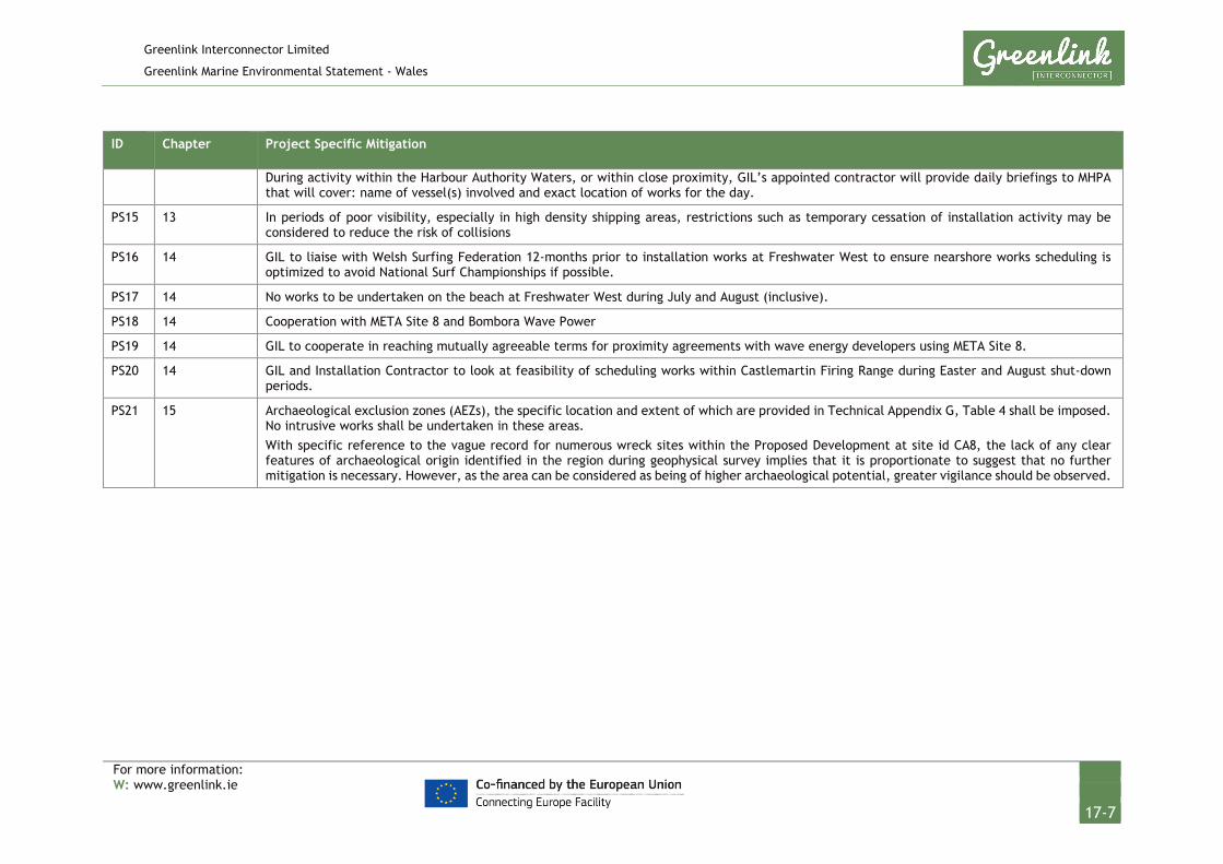
Greenlink Interconnector Limited
Greenlink Marine Environmental Statement - Wales
For more information: W: www.greenlink.ie
17-7
ID Chapter Project Specific Mitigation
During activity within the Harbour Authority Waters, or within close proximity, GIL’s appointed contractor will provide daily briefings to MHPA that will cover: name of vessel(s) involved and exact location of works for the day.
PS15 13 In periods of poor visibility, especially in high density shipping areas, restrictions such as temporary cessation of installation activity may be considered to reduce the risk of collisions
PS16 14 GIL to liaise with Welsh Surfing Federation 12-months prior to installation works at Freshwater West to ensure nearshore works scheduling is optimized to avoid National Surf Championships if possible.
PS17 14 No works to be undertaken on the beach at Freshwater West during July and August (inclusive).
PS18 14 Cooperation with META Site 8 and Bombora Wave Power
PS19 14 GIL to cooperate in reaching mutually agreeable terms for proximity agreements with wave energy developers using META Site 8.
PS20 14 GIL and Installation Contractor to look at feasibility of scheduling works within Castlemartin Firing Range during Easter and August shut-down periods.
PS21 15 Archaeological exclusion zones (AEZs), the specific location and extent of which are provided in Technical Appendix G, Table 4 shall be imposed. No intrusive works shall be undertaken in these areas. With specific reference to the vague record for numerous wreck sites within the Proposed Development at site id CA8, the lack of any clear features of archaeological origin identified in the region during geophysical survey implies that it is proportionate to suggest that no further mitigation is necessary. However, as the area can be considered as being of higher archaeological potential, greater vigilance should be observed.

Greenlink Interconnector Limited
Greenlink Marine Environmental Statement - Wales
For more information: W: www.greenlink.ie
18-1
18. Summary and Conclusions The ES presents a comprehensive assessment of the potential effects of the installation, operation (including maintenance and repair) and decommissioning of the Proposed Development, and sets out Embedded Mitigation and proposes Project Specific Mitigation to avoid or reduce significant effects to an acceptable level.
The Embedded Mitigation and Project Specific Mitigation will form the basis of an Environmental Management Plan to be implemented during the installation and operation of the submarine cables.
Following the environmental impact assessment of the residual effects on the physical, biological and human environments, the following can be concluded:
• Intrusive works on the beach at Freshwater West have the potential to cause significant effects on coastal processes. GIL is proposing to employ a trenchless technique (horizontal directional drilling) whereby the sensitive dunes and intertidal area is avoided. This will ensure that there is no effect on coastal processes.
• The main effects associated with the Proposed Development are predicted to be localised, temporary disturbance to the seabed during installation. For the majority of subtidal habitats (benthic communities) and fish species this will result in effects which are not significant. Trenching across areas of Bedrock Reef, and pre-sweeping of sandwaves could cause significant effects. Exclusion zones and Project Specific Mitigation has been proposed that either remove the pathway for effects or reduce the significance of the effects to minor, which is not significant.
• Installation, maintenance and decommissioning activities will generate underwater noise which has the potential to cause minor disturbance effects to fish and marine mammals. For all the activities proposed, with the exception of UXO detonation, the assessment concluded that the effects will be not significant.
• If required, UXO detonation has the potential to have a significant effect on marine mammals including grey seal a Qualifying Feature of the Pembrokeshire Marine / Sir Benfro Forol SAC, and harbour porpoise a Qualifying Feature of the West Wales Marine / Gorllewin Cymru Forol SAC. The most effective mitigation is to avoid the need for detonation completely, but if this is not feasible, Project Specific Mitigation, following Industry Best Practice has been proposed. Implementation of measures such as using passive acoustic monitoring to support marine mammal observer watches, the use of acoustic deterrent devices and soft start charges to encourage animals to flee will reduce the significance of the residual effect to not significant.
• The preferred protection method is to bury the cables in the seabed. However, the cable route survey has identified that ground conditions for approximately 16.34km of the Proposed Development may be unsuitable and external cable

Greenlink Interconnector Limited
Greenlink Marine Environmental Statement - Wales
For more information: W: www.greenlink.ie
18-2
protection will be required. A cable burial plan will be produced by the Installation Contractor outlining proposed method statements and cable protection requirements for approval by NRW and discussion with fisheries stakeholders to reduce/avoid disruption to fisheries interests as much as possible. Effective channels of communication will be established and maintained between the appointed Installation Contractor and commercial fishing interests. This will include the appointment of a Fisheries Liaison Officer (FLO). Guard vessels may be used if sections of the cable are exposed between lay and burial.
• The Proposed Development crosses the Pembrokeshire Marine / Sir Benfro Forol SAC for approximately 50km. In relation to the SAC and the Qualifying Features the EIA concluded:
• Extensive areas of outcropping Bedrock Reef have been avoided close to the coast by following a sediment channel. Exclusion zones have been established around the Qualifying Feature to avoid effects.
• Localised, narrow areas of the Qualifying Feature Stony Reef habitat will be covered by external cable protection. The rock will provide a suitable hard substrate for colonisation. The characterising species of the habitats have been identified as short-lived, fast-growing, opportunistic epifauna which have fast rates of colonisation. Colonisation of the rock berms is therefore expected in the short-term and the overall significance of the effect has been assessed as not significant.
• Installation will temporarily disturb seabed sediments and habitats on the protected sandbank Turbot Bank and in areas identified as Biogenic Reef but rapid recovery is predicted and the overall significance of the effect has been assessed as not significant.
• UXO detonation, if required, has the potential for significant effects on the Qualifying Feature grey seal, which can be reduced to not significant through the implementation of Project Specific Mitigation (as discussed above).
• The EIA concluded that the significance of effects on all seabirds (including Qualifying Features of SPAs) is negligible and not significant. This took into consideration the presence of the vessels associated with installation, operation or decommissioning activities.
• During operation, the cables will generate low electromagnetic fields that will emanate up to 2m from the cables before diminishing to natural background levels. There will be no significant effects on biological receptors (e.g. fish, marine mammals) and the fields will not interfere with navigation systems for commercial shipping or recreational boating.
• The presence of the cable installation vessels will cause temporary disturbance to fishing and shipping activity in the vicinity of the Proposed Development. Disruption will be limited to discrete sections of the Proposed Development, confined to the location of the maintenance or repair activity, or progressing

Greenlink Interconnector Limited
Greenlink Marine Environmental Statement - Wales
For more information: W: www.greenlink.ie
18-3
along the Proposed Development during installation and decommissioning. Communication protocols are proposed with Milford Haven Port Authority and Castlemartin Firing Range and procedures to minimise disruption near high density shipping areas will be developed and implemented. The residual effect has been assessed as not significant.
• There is the potential that presence of the Proposed Development will restrict development options within the Marine Energy Wales Marine Energy Test Area (META) Site 8; which Bombora Wave Power are proposing to use in 2020 and 2021. GIL has been in consultation with Marine Energy Wales and Bombora Wave Power since early 2018 but will continue to cooperate in reaching mutually agreeable terms for proximity agreements. The residual effect has been assessed as not significant.
• The EIA concluded the effects on marine archaeology will be not significant. This conclusion took into consideration embedded mitigation which includes preparing a Written Scheme of Investigation for the Proposed Development and establishing and implementing a Protocol for Archaeological Discoveries (PAD). Archaeological exclusion zones will be implemented around the geophysical anomalies identified.
• There will be no significant cumulative effects with other existing and proposed projects and plans during the installation and operation of the Proposed Development. The potential for cumulative effects has been identified but all effects are not significant.
• Any effects from decommissioning activities (cable removal) will be broadly similar to those during installation. The appropriate method of cable decommissioning will be considered towards the end of the interconnectors life. This will consider hazards presented by leaving the cables in situ and potential disturbances if removed entirely. The effects of removal are predicted to be minor and temporary in nature, and will be considered thoroughly at the time of removal.