Geoarchaeology of Upper Palaeolithic loess sites located within a transect through Moravian valleys,...
13
Geoarchaeology of Upper Palaeolithic loess sites located within a transect through Moravian valleys, Czech Republic L. Lisá a, * , J. Ho sek b, c , A. Bajer d , T. Matys Grygar e , D. Vandenberghe f a Institute of Geology, Academy of Sciences of the Czech Republic, Rozvojova 269, Prague 165 00, Czech Republic b Czech Geological Survey, Klárov 3, Prague 118 21, Czech Republic c Institute of Geology and Palaeontology, Faculty of Science, Charles University in Prague, Albertov 6, Prague 2, Czech Republic d Faculty of Forestry and Wood Technology, Mendel University, Zem ed elská 3, Brno 613 00, Czech Republic e Institute of Inorganic Chemistry, Academy of Sciences of the Czech Republic, 250 68 Re z, Czech Republic f The Research Foundation e Flanders (FWO e Vlaanderen), Laboratory of Mineralogy and Petrology (Luminescence Research Group), Department of Geology and Soil Science, Ghent University, Krijgslaan 281 (S8), B-9000 Gent, Belgium article info Article history: Available online xxx abstract The Middle and Upper Palaeolithic sites situated within the system of Moravian and South Silesian valleys are key localities for understanding the patterns of seasonal mobility that enabled humans to exploit the North European Plain, and a possibility to distinguish the importance of the weather and climate for their subsistence practises. Loess accumulations that have covered the best preserved open air Palaeolithic sites in Central Europe display the climatic record covering at least 30,000 years. The sedimentological, microstratigraphical and geochemical record of three studied Upper Palaeolithic loess sites show significant changes, documenting increased precipitation towards the north. A progressive coarsening of the loess deposits during the Upper Pleniglacial, contrasting with the progressive fining toward the North European glaciation was detected. This methodological approach explains more pre- cisely the context of formation processes connected also with human activity within the corridor be- tween the North European Plain and the Danube Basin, through which a wide range of organisms, including humans and their prey species, were channelled. Ó 2013 Elsevier Ltd and INQUA. All rights reserved. 1. Introduction Upper Palaeolithic sites located along a transect between the Danube region, Moravian valleys, and the North European Plain offer unique insights into an early episode of modern human adaptations to the landscape (Otte, 1981; Svoboda et al., 2002; Oliva, 2005, 2007; Lisá et al., 2013). The system of Moravian valleys, oriented mainly NeS or NEeSW (Czudek, 1997), provides a valuable archaeological trap for two reasons. First, it constitutes wide river valleys between transcontinental mountain ranges through which a wide range of organisms, including humans and their prey species, were channelled: this has always been the principal access route to the North European Plain from the Danube Basin (Skutil, 1955; Valoch, 1979; Svoboda et al., 2002; Trinkaus and Svoboda, 2006). Second, it is also a trap for wind- blown sediments flowing preferentially from the W or NW, SW to the E or NE, SE (Lisá, 2004; Lisá and Uher, 2006; Lisá et al., 2009) that have accumulated to considerable depths around many a hilly protuberance in that landscape. It is these deep accumula- tions of loess that have covered the best preserved open air Palaeolithic sites in Europe (Svoboda et al., 2002). The litholog- ical record of those localities was described mainly in the case of the famous Dolní V estonice old brickyard section (Klíma et al., 1962; Bábek et al., 2011; Antoine et al., 2013), but the geochemical and micromorphological record of other localities situated more northerly in Moravia was less studied. Instru- mental sedimentological analyses can bring valuable information about environmental conditions which Palaeolithic hunters had to accept in hunting large mammals. The main question addressed in this paper is, therefore: is it possible to distinguish any significant lithological or geochemical differences between three of the most important Upper Palaeolithic regions within Moravia and use the interpretations of those differences to discuss climatic changes of Middle and Upper Pleniglacial and the reasons which enabled humans to exploit the North Euro- pean Plain, and subsequently even colder regions? * Corresponding author. E-mail address: [email protected] (L. Lisá). Contents lists available at ScienceDirect Quaternary International journal homepage: www.elsevier.com/locate/quaint 1040-6182/$ e see front matter Ó 2013 Elsevier Ltd and INQUA. All rights reserved. http://dx.doi.org/10.1016/j.quaint.2013.08.058 Quaternary International xxx (2013) 1e13 Please cite this article in press as: Lisá, L., et al., Geoarchaeology of Upper Palaeolithic loess sites located within a transect through Moravian valleys, Czech Republic, Quaternary International (2013), http://dx.doi.org/10.1016/j.quaint.2013.08.058
Transcript of Geoarchaeology of Upper Palaeolithic loess sites located within a transect through Moravian valleys,...

lable at ScienceDirect
Quaternary International xxx (2013) 1e13
Contents lists avai
Quaternary International
journal homepage: www.elsevier .com/locate/quaint
Geoarchaeology of Upper Palaeolithic loess sites located within atransect through Moravian valleys, Czech Republic
L. Lisá a, *, J. Ho�sek b, c, A. Bajer d, T. Matys Grygar e, D. Vandenberghe f
a Institute of Geology, Academy of Sciences of the Czech Republic, Rozvojova 269, Prague 165 00, Czech Republicb Czech Geological Survey, Klárov 3, Prague 118 21, Czech Republicc Institute of Geology and Palaeontology, Faculty of Science, Charles University in Prague, Albertov 6, Prague 2, Czech Republicd Faculty of Forestry and Wood Technology, Mendel University, Zem�ed�elská 3, Brno 613 00, Czech Republice Institute of Inorganic Chemistry, Academy of Sciences of the Czech Republic, 250 68 �Re�z, Czech Republicf The Research Foundation e Flanders (FWO e Vlaanderen), Laboratory of Mineralogy and Petrology (Luminescence Research Group),Department of Geology and Soil Science, Ghent University, Krijgslaan 281 (S8), B-9000 Gent, Belgium
a r t i c l e i n f o
Article history:Available online xxx
* Corresponding author.E-mail address: [email protected] (L. Lisá).
1040-6182/$ e see front matter � 2013 Elsevier Ltd ahttp://dx.doi.org/10.1016/j.quaint.2013.08.058
Please cite this article in press as: Lisá, L., etvalleys, Czech Republic, Quaternary Internat
a b s t r a c t
The Middle and Upper Palaeolithic sites situated within the system of Moravian and South Silesianvalleys are key localities for understanding the patterns of seasonal mobility that enabled humans toexploit the North European Plain, and a possibility to distinguish the importance of the weather andclimate for their subsistence practises. Loess accumulations that have covered the best preserved openair Palaeolithic sites in Central Europe display the climatic record covering at least 30,000 years. Thesedimentological, microstratigraphical and geochemical record of three studied Upper Palaeolithic loesssites show significant changes, documenting increased precipitation towards the north. A progressivecoarsening of the loess deposits during the Upper Pleniglacial, contrasting with the progressive finingtoward the North European glaciation was detected. This methodological approach explains more pre-cisely the context of formation processes connected also with human activity within the corridor be-tween the North European Plain and the Danube Basin, through which a wide range of organisms,including humans and their prey species, were channelled.
� 2013 Elsevier Ltd and INQUA. All rights reserved.
1. Introduction
Upper Palaeolithic sites located along a transect between theDanube region, Moravian valleys, and the North European Plainoffer unique insights into an early episode of modern humanadaptations to the landscape (Otte, 1981; Svoboda et al., 2002;Oliva, 2005, 2007; Lisá et al., 2013). The system of Moravianvalleys, oriented mainly NeS or NEeSW (Czudek, 1997), providesa valuable archaeological trap for two reasons. First, it constituteswide river valleys between transcontinental mountain rangesthrough which a wide range of organisms, including humans andtheir prey species, were channelled: this has always been theprincipal access route to the North European Plain from theDanube Basin (Skutil, 1955; Valoch, 1979; Svoboda et al., 2002;Trinkaus and Svoboda, 2006). Second, it is also a trap for wind-blown sediments flowing preferentially from the W or NW, SW to
nd INQUA. All rights reserved.
al., Geoarchaeology of Uppeional (2013), http://dx.doi.or
the E or NE, SE (Lisá, 2004; Lisá and Uher, 2006; Lisá et al., 2009)that have accumulated to considerable depths around many ahilly protuberance in that landscape. It is these deep accumula-tions of loess that have covered the best preserved open airPalaeolithic sites in Europe (Svoboda et al., 2002). The litholog-ical record of those localities was described mainly in the case ofthe famous Dolní V�estonice old brickyard section (Klíma et al.,1962; Bábek et al., 2011; Antoine et al., 2013), but thegeochemical and micromorphological record of other localitiessituated more northerly in Moravia was less studied. Instru-mental sedimentological analyses can bring valuable informationabout environmental conditions which Palaeolithic hunters hadto accept in hunting large mammals. The main questionaddressed in this paper is, therefore: is it possible to distinguishany significant lithological or geochemical differences betweenthree of the most important Upper Palaeolithic regions withinMoravia and use the interpretations of those differences todiscuss climatic changes of Middle and Upper Pleniglacial andthe reasons which enabled humans to exploit the North Euro-pean Plain, and subsequently even colder regions?
r Palaeolithic loess sites located within a transect through Moraviang/10.1016/j.quaint.2013.08.058

L. Lisá et al. / Quaternary International xxx (2013) 1e132
2. Geographical and sedimentological background
Three key localities for Moravian Upper Palaeolithic history areused in this study. The localities are typical for long term temporaryGravettian occupation (Nývltová Fi�sáková, 2013) and are situatedalong a transect between South Moravia (Dolní V�estonice), CentralMoravia within Moravian Gate (P�redmostí), and NortheEastMoravia (Ho�s�tálkovice locality near Pet�rkovice). The imaginarysection connecting those three localities provides informationabout the different sedimentological records preserved, and thedifferences of environmental conditions which Palaeolithic huntershad to accept in hunting large mammals.
The Last Glacial loess formation within the area of CentralEurope was strongly influenced by its geographical position be-tween two glaciers. In that time Moravia and Silesia were situatedin the narrowest part of the non-glaciated area and became veryimportant for loess formation as well as for the fauna (Lo�zek, 1968;Horá�cek and Lo�zek, 1988), flora (Frenzel, 1968) and human migra-tions (Svoboda et al., 2002).
2.1. Dolní V�estonice II (DV II)
This section was excavated in the context of the archaeologicalresearch of the Gravettian site during the 2005 season. The studiedsection is located in anthropogenic terraces on the slope above thefamous Dolní V�estonice e old brickyard section. The 4.2 m thickprofile DV II covers the Gravettian cultural layer and the UpperPleniglacial sedimentary record correlated with the upper part ofthe old brickyard section. The section in the old brickyard repre-sents the most prominent loess section accessible today in CentralEurope and, therefore, enormous numbers of different researchefforts weremade there (Klima et al., 1962; Demek and Kukla,1969;Haesaerts and Mestdagh, 2000; Fuchs et al., 2012; Antoine et al.,2013). Approximately 18 m of loess, loess like deposits, and pale-osols cover a relatively complete Last climatic cycle and displaywarming, cooling, and wetting trends. The loess was in this casederived mainly from frost shattered and weathered magmatic andmetamorphic rocks situated to the west, deposited as eluvial de-posits or as river alluvium (Lisá, 2004; Lisá and Uher, 2006; Lisáet al., 2009), and calcareous Miocene deposits (Adamová,Havlí�cek, 1998). The provenance during the last glacial period didnot change (Lisá et al., 2009) and the grain size differences dependmostly on the wind speed or post-depositional weathering.
2.2. P�redmostí
Close to the town of P�rerov, and to the southern entrance to theMoravian Gate, a series of loess deposits has been extensivelyexcavated. A rescue excavation in the last century produced aconsiderable body of data relating to various Palaeolithic episodes,mainly of Gravettian Age (Svoboda et al., 1994). P�redmostí is locatedat the southern entrance of the Moravian Gate, one of the mostimportant passing points of prehistoric routes in Central Europe(Svoboda et al., 1994). Originally two limestone formations, atSkalka in the south and Hradisko in the north, emerged from theNeogene and Quaternary deposits. Both of them have nearly dis-appeared due to limestone exploitation. Several mineral springsources are known close to the site, which formed travertine de-posits (Kovanda, 1971). One, with a constant temperature of 12 �Cwas located directly at the foot of the former Skalka hill (Svobodaet al., 1994). The cultural content of this locality has been classi-fied as Gravettian or Pavlovian with a hypothetical Aurignacianhorizon below. The Gravettian was dated approximately to 26e27 ka (Svoboda et al., 1994).
Please cite this article in press as: Lisá, L., et al., Geoarchaeology of Uppevalleys, Czech Republic, Quaternary International (2013), http://dx.doi.or
2.3. Ho�s�tálkovice
Ho�s�tálkovice is situated in Northern Moravia in the Ostravaregion. This locality is 1.5 km from Pet�rkovice, famous for theVenus finding (Svoboda, 2004). Unfortunately, Pet�rkovice couldnot be included in this research because of technical problems.Ho�stálkovice, nevertheless, offers the similar stratigraphy(Folprecht, 1934; Neruda and Nerudová, 2000) and its location wassuitable for our research. The site was excavated in 1992 by P.Neruda (Neruda and Nerudová, 2000). This site lies beyond theMoravian Gate at the opening of the North European Plain. It hasalso a significant history of archaeological investigation, allowingus to target location of an approximately 1.6 deep test pit tocapture the layer with Gravettian artefacts.
3. Methodology
3.1. Micromorphology
Microstratigraphical study, micromorphology in archaeologicalcontext, was applied in all three localities. In total, 53 samples forthin sections were taken. A micromorphological approach coversdescriptive microstratigraphical analyses (Bullock et al., 1985)includingmicrofabric types, structural andporosity features, naturalinclusions, anthropogenic inclusions, and pedofeatures (Macphailand Cruise, 2001). Such application of soil micromorphology toarchaeology was introducedmainly by Goldberg (1983) and latelyiswell established in the literature (French, 2003; Goldberg andMacphail, 2006). Samples were taken in Kubiena boxes (9 � 5 cm),slowly dried, impregnated by a polymer resin, processed into thinsections and then studied according to Bullock et al. (1985) andStoops (2003). A record was made of the microfabric types, struc-tural and porosity features, natural inclusions, anthropogenic in-clusions and pedofeatures (Macphail and Cruise, 2001).
3.2. Geochemistry e quantitative analysis of expandable clayminerals (CEC)
The cation exchange capacity (CEC) was determined using aprocedure proposed byMeier and Kahr (1999) for pure claymineralspecimens and then optimised for sediments and soils (Grygaret al., 2009). [Cu(trien)]2þ solution was obtained fromCuSO4$5H2O (Penta, Czech Republic) and trien, triethylenetetr-amine (1,4,7,10-tetraazadekane, SigmaeAldrich), to the final con-centration 0.01 M with a potentiometric control of the constantligand-to-metal ratio (Grygar et al., 2009). A fine dry powder (100e500 mg) was placed in a 50 mL beaker, wetted and then suspendedby stirring in 5 mL of distilled water; then 5 mL 0.01 M Cu-triensolution was added, and the suspension stirred for a further5 min using a magnetic stirrer. The suspension was then filteredinto a 50 mL flask and the solid washed with several aliquots ofdistilled water, and the final volume of the filtrate made to 50 mL.The solutions were analyzed by AAS (Cu and Mg) and AES (Ca andNa). The sample weight for analysis was adjusted depending on itsactual CEC to consume about 50% of [Cu(trien)]2þ using the routinedescribed by Grygar et al. (2009).
3.3. Bulk magnetic susceptibility (MS)
Unoriented samples were collected at 5 cm intervals fromcleaned profiles. Low frequency magnetic susceptibility (clf) wasmeasured at 0.976 kHz and high frequency magnetic susceptibility(chf), at 3.904 kHz, using a MFK1 kappabridge (AGICO, Brno). Thedifference between the two measurements gives the frequencydependent susceptibility, expressed here as a percentage of cfd
r Palaeolithic loess sites located within a transect through Moraviang/10.1016/j.quaint.2013.08.058

L. Lisá et al. / Quaternary International xxx (2013) 1e13 3
(cfd% ¼ (clf � chf)/clf � 100). This parameter is widely used todetermine the concentration of magnetic particles close to super-paramagnetic (SP)/stable single domain (SSD) boundary (Liu et al.,2005). This grain size fraction is proposed to have formed duringpedogenesis (Evans and Heller, 2003; Dearing et al., 1996).
3.4. Particle size distribution function (PSDF)
Samples for particle size distribution were collected at 5 cmintervals from cleaned profiles from all three studied section(Figs. 2 and 3). Particle-size analysis (PSA) is a measurement of thesize distribution of individual particles in a soil sample (Gee andBauder, 1986). Particle size distribution was established using aMalvern Mastersizer 2000. Samples of air dried and roughlycrushed sediments were gently disaggregated and dispersed in de-ionized water. Organic matter was removed by addition ofhydrogen peroxide accompanied by gentle warming at 40 �C untileffervescence stopped. The supernatant was removed aftercentrifugation and the sample rinsed with two changes of deion-ised water. The samples were then re-homogenised in a minimumof water using a whirly mixer and then sub-sampled for particlesize analysis. Two sub-samples were taken from each sample andanalysed sequentially, and the graphs presented are the mean ofthe two measurements.
3.5. OSL dating
DV II section was sampled in two positions. DV2/1 comes fromthe depth of 435 cm and corresponds to the base of cultural layermixed with soil material. DV2/2 comes from the depth of 265 cmand corresponds to the position directly above gley II. layer (Fig. 2).Three locations were sampled at Ho�s�tálkovice. HB 13 came from160 cm depth at the very base of the section on the contact between
Fig. 1. Location of
Please cite this article in press as: Lisá, L., et al., Geoarchaeology of Uppevalleys, Czech Republic, Quaternary International (2013), http://dx.doi.or
redeposited terrace sediments and redeposited loess-like sedi-ments. THV2 came from a depth of 65 cm where some of the ar-tefacts occurred. THV1 came from 35 cm depth, on the contactbetween E soil horizon and the loess-like sediment below (Fig. 2).P�redmostí was not sampled due to the technical problems duringthe fieldwork organisation.
Samples were dated by OSL in the Laboratory of Mineralogy andPetrology (Luminescence Research Group), Department of Geologyand Soil Science, Ghent University in Belgium. by applying the SAR-OSL protocol to sand-sized (63e90 mm) quartz. This fraction wasextracted from the inner material of the sampling tubes usingconventional sample preparation procedures (HCl, H2O2, sieving,heavy liquids, and HF). OSL measurements were performed usingan automated Risø TL/OSL-DA-12 reader. The equivalent dose (De)was determined using the single-aliquot regenerative-dose (SAR)protocol as described by Murray and Wintle (2000, 2003). Low-level high-resolution gamma-ray spectrometry was used for thedetermination of the natural dose rate. The annual dose wascalculated from the present-day radionuclide activities using theconversion factors of Adamiec and Aitken (1998). An internal doserate of 0.013 � 0.003 Gy ka�1 was assumed (Vandenberghe et al.,2008). Both the beta and gamma contributions were corrected forthe effect of moisture by generally accepted procedures.
4. Results
4.1. Stratigraphy
4.1.1. Southern Dolní V�estonice sectionThe lithostratigraphy was examined in a 4.2 m high freshly
cleaned vertical section (Fig. 2) containing several horizons withdifferent contexts, coded as DV II. Generally, the profile is mainlycomposed of fine grained loess and loess-like sediments which
studied sites.
r Palaeolithic loess sites located within a transect through Moraviang/10.1016/j.quaint.2013.08.058

Fig. 2. The sedimentological description of loess sections Dolní V�estonice, P�redmostí and Ho�s�tálkovice together with the main geochemical, magnetic and grain size proxies.
L. Lisá et al. / Quaternary International xxx (2013) 1e134
were post-depositionally influenced by changing climatic condi-tions. There is a dark brown horizon of re-deposited laminated soil,probably of Cambisol type (40 cm) found in the very bottom, fol-lowed by the complex of thin loess layers (approximately 15 cmeach), and one darker layer (10 cm), described as Gravettianoccupational layer (10 cm) with the macroscopic presence ofcharcoal and fine freezing and thawing laminae (less than 1 cm) inthe loess layers below and above. The loess deposition grades intotwo lighter horizons (17 and 10 cm) divided by a loess horizon(10 cm). Those horizons were interpreted as gley horizons. The partof the section above is composed by loessic material with a group of
Please cite this article in press as: Lisá, L., et al., Geoarchaeology of Uppevalleys, Czech Republic, Quaternary International (2013), http://dx.doi.or
slightly browner horizons (1e5 cm). The section is ended by a darkbrown aggraded Chernozem-type Holocene soil horizon.
4.1.2. Intermediate P�redmostí u P�rerova sectionIn contrast to the cultural layer excavated in the DV II sections, in
which burnt charcoal is a conspicuous hearth component, burntmammoth bones predominate here, suggestive of a difference inresource availability between the sites (Beresford-Jones et al.,2010). However, another, microcharcoal containing layer wasmicromorphologically confirmed the cultural layer. The lithologicalsection of P�redmostí (Fig. 2) contained a dark brown horizon of re-
r Palaeolithic loess sites located within a transect through Moraviang/10.1016/j.quaint.2013.08.058

Fig.
3.Th
egrainsize
distribu
tion
withinstud
iedsites.
L. Lisá et al. / Quaternary International xxx (2013) 1e13 5
Please cite this article in press as: Lisá, L., et al., Geoarchaeology of Upper Palaeolithic loess sites located within a transect through Moravianvalleys, Czech Republic, Quaternary International (2013), http://dx.doi.org/10.1016/j.quaint.2013.08.058
L. Lisá et al. / Quaternary International xxx (2013) 1e136
deposited arctic soil in the very bottom followed by a thick culturallayer containing mammoth bones and burned bones together withcharcoal and loess-like sediment intercalations (Fig. 2). There isevidently slight re-deposition by gelifluction. This layer is overlainby loess deposits with a number of features typical of frost action,including frost wedges and other micromorphologically detectedfeatures. Three thin gley horizons were present. The upper part ofthe section continues with monotonous loess deposition contain-ing thin darker layers containing decomposed organic matter. Thesection is capped by a Holocene Cambisol.
4.1.3. Northern Ho�s�tálkovice near Pet�rkovice loess like sedimentarysection
Approximately 1.5 m thick sedimentary cover (Fig. 2) lies on theridge between Pet�rkovice and Ho�s�tálkovice. The geological back-ground of Ho�s�tálkovice section is composed of re-deposited terrace
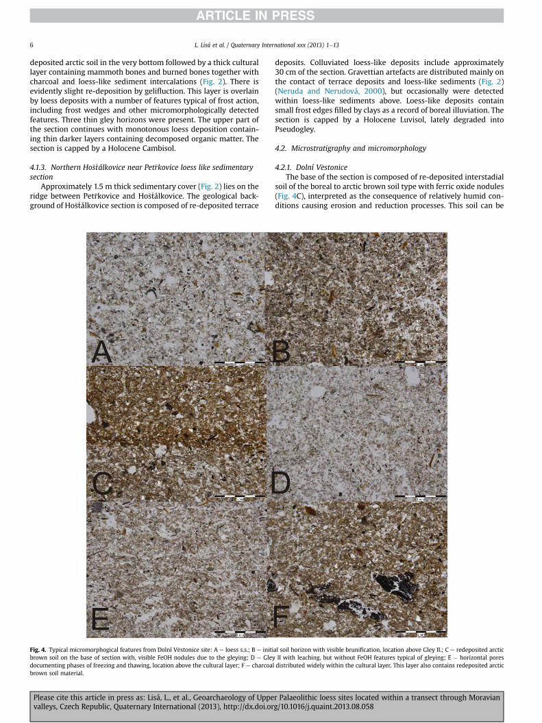
Fig. 4. Typical micromorphogical features from Dolní V�estonice site: A e loess s.s.; B e initibrown soil on the base of section with, visible FeOH nodules due to the gleying; D e Gleydocumenting phases of freezing and thawing, location above the cultural layer; F e charcoalbrown soil material.
Please cite this article in press as: Lisá, L., et al., Geoarchaeology of Uppevalleys, Czech Republic, Quaternary International (2013), http://dx.doi.or
deposits. Colluviated loess-like deposits include approximately30 cm of the section. Gravettian artefacts are distributed mainly onthe contact of terrace deposits and loess-like sediments (Fig. 2)(Neruda and Nerudová, 2000), but occasionally were detectedwithin loess-like sediments above. Loess-like deposits containsmall frost edges filled by clays as a record of boreal illuviation. Thesection is capped by a Holocene Luvisol, lately degraded intoPseudogley.
4.2. Microstratigraphy and micromorphology
4.2.1. Dolní V�estoniceThe base of the section is composed of re-deposited interstadial
soil of the boreal to arctic brown soil type with ferric oxide nodules(Fig. 4C), interpreted as the consequence of relatively humid con-ditions causing erosion and reduction processes. This soil can be
al soil horizon with visible brunification, location above Gley II.; C e redeposited arcticII with leaching, but without FeOH features typical of gleying; E � horizontal poresdistributed widely within the cultural layer. This layer also contains redeposited arctic
r Palaeolithic loess sites located within a transect through Moraviang/10.1016/j.quaint.2013.08.058

L. Lisá et al. / Quaternary International xxx (2013) 1e13 7
interpreted as an early stage cambisol. Gelifluction features areconnected mainly with the cultural layer (Fig. 4F), which show acontinuing relatively cold and humid environment. Freezing e
thawing features (Fig. 4E) above the cultural layer indicate frostheaving, related to the development of ice lenses as the conse-quence of cold and relatively humid conditions. Those features arenot very common, in contrast to P�redmostí and Ho�s�tálkovice. Twohorizons of the frost gley surprisingly do not contain ferric oxide(Fig. 4D) nodules. The absence of freezing e thawing features to-ward the Holocene layer is probably the result of a cold and dryLGM environment. The slightly darker horizons differ from pureloess (Fig. 4A) by initial brunification (Fig. 4B). The presence ofdarker horizons (Fig. 4) within this part of the section is thereforethe result of transitory periods of increased humidity and initialstages of pedogenic weathering.
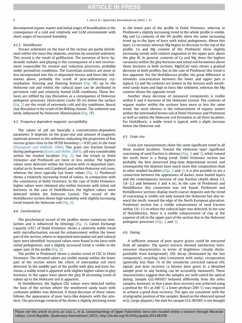
Fig. 5. Typical micromorphological features from P�redmostí and Ho�s�tálkovice sections: A e
FeOH; B e cultural layer with burned and unburned bones from P�redmostí; C e horizontal pP�redmostí and appearance of such features within all rest of section; D e Gley horizonwith Fthawing (Ho�s�tálkovice). Those pores were secondary during Holocene pedogenesis, iluviate
Please cite this article in press as: Lisá, L., et al., Geoarchaeology of Uppevalleys, Czech Republic, Quaternary International (2013), http://dx.doi.or
4.2.2. P�redmostíRe-deposited interstadial soil of the boreal to arctic brown soil
type at the base (Fig. 5A) has ferric oxide nodules formed underrelatively humid conditions causing erosion and reduction pro-cesses. A thick cultural layer with bioturbation (Fig. 5B) indicatesstable humid conditions. The cultural layer contains frequentlyfragments of burned bones (Fig. 5B), but little or no charcoal. A layerwhich contains microcharcoal was micromorphologically identi-fied above the first cultural layer. The presence of freezing andthawing structures (Fig. 5C) above the cultural layer is the result ofpersistent cold and relatively humid conditions. The presence offrost wedges (without flat bottoms) and gleying above (Fig. 5D) isthe result of cold, humid conditions and probably also an initialstage of permafrost. Continuing freezing and thawing features to-ward the Holocene horizon with thin horizons containing
redeposited arctic brown soil at the base of P�redmostí section containing nodules ofores documenting phases of freezing and thawing, location above the cultural layer ineOH nodules from P�redmostí; E � horizontal pores documenting phases of freezing andd by clays; F e Luvic horizon from locality Ho�s�tálkovice.
r Palaeolithic loess sites located within a transect through Moraviang/10.1016/j.quaint.2013.08.058
L. Lisá et al. / Quaternary International xxx (2013) 1e138
decomposed organic matter and initial stages of brunification is theconsequence of a cold and relatively wet LGM environment withshort stages of increased humidity.
4.2.3. Ho�s�tálkoviceTerrace sediments on the base of the section are partly distrib-
uted within the loess-like deposits, overlain by unsorted sediment.This record is the result of gelifluction. The presence of ferric hy-droxide nodules and gleying is the consequence of a wet environ-ment responsible for erosion and reduction processes, probablyunder permafrost conditions. The Gravettian artefacts are more orless incorporated into the re-deposited terrace and loess-like sed-iments above, probably the result of post-sedimentary cry-oturbation. Freezing and thawing features (Fig. 5E) up to theHolocene soil and within the cultural layer can be attributed topersistent cold and relatively humid LGM conditions. Those fea-tures are infilled by clay illuviation as a consequence of Holocenepedogenic processes. Desiccation cracks 50 cm below the surface(Fig. 2) are the result of extremely cold and dry conditions. Borealclay illuviation is the result of the Bölling climate. The sediment waslately influenced by Holocene illimerisation (Fig. 5F).
4.3. Frequency dependent magnetic susceptibility
The values of cfd are basically a concentration-dependentparameter. It depends on the grain-size and amount of magneticmaterials present in the sediment, indicating the proportion of fineviscous grains close to the SP/SD boundary (w0.02 mm) in the total(Thompson and Oldfield, 1986). This grain size fraction formedduring pedogenesis (Evans and Heller, 2003). cfd vary considerablywithin the studied localities (Fig. 2), but the trends in DolníV�estonice and P�redmostí are more or less similar. The highestvalues were detected within the horizon with re-deposited inter-stadial arctic brown soil (Cambisol) and within Holocene soil cover,whereas the loess typically has lower values (Fig. 2). P�redmostíshows a relatively increasing trend of values, in comparison withthe consistency at Dolní V�estonice. In the case of Dolní V�estonice,higher values were obtained also within horizons with initial soilhorizons. In the case of Ho�s�tálkovice, the highest values weredetected within the Holocene Luvisol. The record of theHo�s�tálkovice section shows high variability with slightly increasingtrend toward the Holocene soil (Fig. 2).
4.4. Geochemistry
The geochemical record of the profiles shows numerous simi-larities and is influenced by lithology (Fig. 2). Cation ExchangeCapacity (CEC) of Dolní V�estonice shows a relatively stable trendwith microfluctuation, except for enhancement within the lowerpart of the section, where re-deposited interstadial soil and culturallayer were identified. Increased values were found in the loess withinitial pedogenesis, and a slightly increased trend is visible in theupper part of the profile (Fig. 2).
The profile in P�redmostí shows a similar trend of CEC to DolníV�estonice. The elevated values are visible mainly within the lowerpart of the section where the relicts of interstadial soil weredetected. In the middle part of the profile with gley and loess ho-rizons, a stable trend is apparent with slighter higher values in gleyhorizons. In the upper loess above the gley III increasing trend ofvalues up to the Holocene soil is apparent.
In Ho�s�tálkovice, the highest CEC values were detected withinthe base of the section where the weathered sandy loam withcarbonate pebbles was detected. A sharp decrease of those valuesfollows the appearance of pure loess-like deposits with the arte-facts. The percentage content of Na shows a slightly declining trend
Please cite this article in press as: Lisá, L., et al., Geoarchaeology of Uppevalleys, Czech Republic, Quaternary International (2013), http://dx.doi.or
in the lower part of the profile in Dolní V�estonice, whereas inP�redmostí a slightly increasing trend in the whole profile is visible.Mg and Ca contents of the DV profile show the same increasingtrend up to the layer of loess with initial pedogenesis. Above thislayer, Ca increases whereas Mg begins to decrease to the top of theprofile. Ca and Mg content of the P�redmostí show slightlyincreasing trends with relative stagnation in the upper part, abovethe gley III. In general, contents of Ca and Mg show the highestvariations within the gley horizons and initial soil formations abovethose horizons in both sections. MgO/CaO ratio shows a gradualdecrease in both profiles, but in the case of P�redmostí this trend isless apparent. For the Ho�s�tálkovice profile, the great difference inelements concentration between the lower and upper part istypical. Ca and Na contents are lowest in the horizon with weath-ered sandy loam and high in loess-like sediment, whereas the Mgcontent shows the opposite trend.
Another sharp decrease of measured components is visiblewithin E and A horizons of the Holocene Luvisol. The contents oforganic matter within the sections have more or less the sametrend: the most obvious is the enhancement of organic matterwithin the interstadial brown soil of Dolní V�estonice and P�redmostías well as within the Holocene soil formation in all three localities.For Ho�s�tálkovic, a stable trend is typical, with a slight increasebelow the Holocene soil.
4.5. Grain size
Grain size measurements show the same significant trend in allthree studied localities. Toward the Holocene layer significantcoarsening of sand fraction is obvious (Figs. 2 and 3), while towardthe north there is a fining trend. Dolní V�estonice section hasprobably the best preserved long-time depositional record, andconsequently the deposits have much more fine composition thanin other studied localities (Figs. 2 and 3). It is also possible to see aconnection between the appearance of darker, more humid layersand the contemporary increase of clay fraction (depth about 1.2,1.8e2.2 and between 3 and 4 m). In the case of P�redmostí andHo�s�tálkovice this connection was not found. P�redmostí andHo�s�tálkovice sections display much coarser deposits and the trendof coarsening is visible not only toward the Holocene but also to-ward the north, toward the edge of the North European glaciation.P�redmostí section has a visible enhancement of sand fractionwithin 1.0e1.5 mwhere the cultural layer was detected. In the caseof Ho�s�tálkovice, there is a visible enhancement of clay at theexpense of silt in the upper part of the section due to the Holocenepedogenic processes (Figs. 2 and 3).
4.6. Dating
A sufficient amount of pure quartz grains could be extractedfrom all samples. The quartz extracts showed satisfactory lumi-nescence characteristics in terms of brightness (clearly distin-guishable from background), OSL decay (dominated by the fastcomponent), recycling ratio (consistent with unity), recuperation(generally less than 1% of the sensitivity corrected natural OSLsignal) and dose recovery (a known dose given to a bleachedsample prior to any heating can be accurately measured). Thesecharacteristics suggest that the samples are well-suited for opticaldating. Sample GLL-091927 behaved differently from the othersamples, however, in that a poor dose recovery was achieved usinga preheat for 10 s at 240 �C; a lower preheat (200 �C) was requiredto achieve a good dose recovery. The ages are consistent with thestratigraphic position of the samples. Based on the observed spreadinDe (large aliquots), the date for sample GLL-081901 is not thought
r Palaeolithic loess sites located within a transect through Moraviang/10.1016/j.quaint.2013.08.058

L. Lisá et al. / Quaternary International xxx (2013) 1e13 9
to be an accurate sedimentation age. This sample may be affectedby postdepositional mixing and/or incomplete resetting.
4.6.1. Luminescence characteristics and De-determinationFig. 1 shows a representative luminescence decay and growth
curve for sample GLL-081902. The luminescence signal decaysrapidly with stimulation time (Fig. 1, inset); this is characteristic forquartz dominated by the fast component. The doseeresponse curvecan be approximated satisfactorily by the sum of a single saturatingexponential and a linear component. Fig. 1 also illustrates thegenerally good behaviour of the samples in the SAR protocol; therecycling ratios are close to unity (indicating that sensitivitychanges occurring throughout the measurement procedure areaccurately corrected for) and the growth curves pass close to theorigin (demonstrating that recuperation is negligible).
Fig. 2 summarises the dose recovery data. Within analyticaluncertainty, the measured dose does not differ from the given dosebymore than 5% (Fig. 2A); the average recovered to given dose ratiofor the five samples is 1.01 � 0.02. Fig. 2B shows the correspondingvalues for the recycling ratio and recuperation; the average valuesare 0.98 � 0.01 and 0.05 � 0.01%, respectively. For each sample, atleast 18 replicate measurements of De were made. Values wereaccepted if recuperation did not exceed 5% of the corrected naturalOSL signal and if the recycling or depletion ratio did not deviate bymore than 10% from unity. The average De’s (�1 standard error) aresummarised in Table 1.
Table 1Radionuclide concentrations used for dose rate evaluation, estimates of past water content (F*W), calculated dose rates, equivalent doses (De), optical ages, and random (sr),systematic (ssys) and total (stot) uncertainties. The uncertainties mentioned with the De and dosimetry data are random; all uncertainties represent 1s.
Sample(field code)
Sample(GLL code)
Depth(cm)
234Th(Bq kg�1)
226Ra(Bq kg�1)
210Pb(Bq kg�1)
232Th(Bq kg�1)
40K(Bq kg�1)
F*W(%)
Total dose rate(Gy ka�1)
De (Gy) Age(ka)
sr(%)
ssys(%)
stot
(%) (ka)
THV1 081901 35 42 � 3 45 � 1 39 � 1 49.5 � 0.3 573 � 4 24 � 6 2.95 � 0.02 15 � 2 (17) 5.3 9.9 9.8 14.0 0.7THV2 081902 65 36 � 2 48 � 1 42 � 2 52.7 � 0.5 600 � 5 25 � 6 3.03 � 0.03 77 � 2 (18) 26 2.3 10.2 10.5 3HB13 091927 160 36 � 3 43 � 1 40 � 2 47.7 � 0.4 521 � 5 21 � 5 2.81 � 0.03 141 � 4 (24) 50 3.3 9.1 9.7 5DV2/2 091902 265 36 � 2 43 � 1 39 � 1 52 � 1 559 � 5 23 � 6 2.86 � 0.02 92 � 6 (17) 32 6.1 9.8 11.5 4DV2/1 091901 435 45 � 3 49 � 1 41 � 2 57 � 1 482 � 5 23 � 6 2.78 � 0.02 115 � 5 (18) 41 4.2 9.9 10.7 4
Radionuclide concentrations used for dose rate evaluation, estimates of past water content (F*W), calculated dose rates, equivalent doses (De), optical ages, and random (sr),systematic (ssys) and total (stot) uncertainties. The uncertainties mentioned with the De and dosimetry data are random; all uncertainties represent 1s.
4.6.2. Dose rate determinationThe radionuclide activity concentrations and calculated total
dose rates are given in Table 1.
4.6.3. Optical agesTable 1 summarises all analytical results, and shows the calcu-
lated optical ages. The present-day dose rate was assumed to haveprevailed throughout the entire period of burial. Uncertainties onthe luminescence ages were calculated following the error assess-ment system proposed by Aitken and Alldred (1972) and Aitken(1976). All sources of systematic uncertainty were as quantifiedby Vandenberghe et al. (2004; see also Vandenberghe, 2004).
For most samples, the systematic uncertainty is dominant in theoverall uncertainty on the ages and varies between w9 and 10% (1sigma). For sample GLL-081901, both the random and systematicuncertainty are w10%.
5. Discussion
5.1. Sedimentary and micromorphological record of MiddlePleniglacial (MIS3) and Upper Pleniglacial (MIS 2) in Moravia
The environmental record of the Middle and Upper Pleniglacialin Moravia was studied in detail mainly in context of loess deposits
Please cite this article in press as: Lisá, L., et al., Geoarchaeology of Uppevalleys, Czech Republic, Quaternary International (2013), http://dx.doi.or
(Lo�zek, 1953, 1964; Kukla, 1975; Frechen et al., 1999; Antoine et al.,2013). The Middle Pleniglacial in Europe is marked by the appear-ance of brown soil complexes as Stillfried-B from Lower Austria(Haesaerts et al., 2003), Vytachiv soil complex of Ukraine(Gerasimenko, 2006), the Gräselberger and Lohne Boden in Ger-many (Frechen, 1999; Antoine et al., 2009) the Saint-Acheul-Villiers-Adam soil complex in Northern France (Antoine et al.,2003), and Les Vaux soil in Belgium (Haesaerts, 1985). The soildevelopment in this case corresponds to warmer and more humidconditions and it is widely associated with the Hengelo andDenekamp insterstadials. Those periods were interrupted mainlyby the phases of erosion, and thus the sedimentary record is usuallyvery fragmented. In Moravia the three interstadials of the MiddlePleniglacial are supposed to be preserved as the PKI pedo-complexdescribed by Klima (1969) and dated at w30e35 ka, and by theBohunice soil (Valoch, 1976) dated at w45e50 ka (Richter et al.,2009). Antoine et al. (2013) mentioned erosion processes result-ing from warming phases of one of those interstadials thatenhanced the seasonal degradation of the permafrost active layerleading to solifluxion-related deformation and alteration of the gleyhorizon preserved above the re-deposited interstadial soil.
Two sections included in our research, Dolní V�estonice andP�redmostí, contain re-deposited arctic brown soil (Cambisol),which corresponds to one or more of those interstadials. In bothcases, the soil sediment was re-deposited and contains ferric oxidenodules indicating the presence of water and buried organic matter
(Fig. 4). Berendorf-Jones et al. (2011) described this horizon as anInterstadial A Cambisol horizonwith theweak B-horizon above andcovered by redeposited reworked palaeosol loam. However,micromorphological study did not confirm preservation of the insitu A horizon. A similar situation appeared in case of P�redmostílocality. The weak interstadial soil horizon was eroded and rede-posited. The interstadial soil was not preserved at Ho�s�tálkovice.This finding corresponds to the results of the excavations of Nerudaand Nerudová (2000). This type of paleosol is not known from thisarea, probably because of strong erosion and fragmentation of thesediment record and also because the environment of NorthernMoravia and Lower Silesia was probably generally much colderthan Central and Southern Moravia. Due to the fragmentation ofsedimentary record of the Ho�s�tálkovice section, it is quite difficultto use it for geochemical comparison with the sedimentary recordpreserved in central and southern Moravia. The first OSL data fromOstrava region concerning this context estimated the base of thesection at 50 ka, which indicates that the arctic soil did not develophere or was removed by erosion.
Typical cultural layers containing charcoal or burned boneswere described only in Dolní V�estonice and P�redmostí, while inHo�s�tálkovice only the accumulations of artefacts were detected. 14Cdata recently published by Berensdorf-Jones et al. (2011) from theDV II show awide range between 25.570 and 28.850 ka uncal. After
r Palaeolithic loess sites located within a transect through Moraviang/10.1016/j.quaint.2013.08.058

L. Lisá et al. / Quaternary International xxx (2013) 1e1310
calibration, this fits the date from the cultural layer by OSL dating,32 ka. The artefact accumulation from Ho�s�tálkovice was dated as26 ka, which make the finding a little bit older than the findingsfrom nearby Pet�rkovice (Svoboda, 2008).
The tundra gley horizons preserved above the soil sediments ofthe Middle Pleniglacial were described in Dolní V�estonice (Klimaet al., 1962; Antoine et al., 2013) and interpreted as cold humidepisodes of the Middle and Upper Pleinglacial. In the old V�estonicebrickyard, Antoine et al. (2013) have recently described one gleyhorizon connected with the Middle Pleniglacial which underwentstrong solifluction process due to one of the humid interstadialphases of the Middle Pleniglacial (frost creep). The solifluctionresulted in thin, discontinuous undulated iron oxide bandsthroughout the unit, and two gley horizons connected with theUpper Pleniglacial. The section situated above the old brickyarddisplays only two gley horizons which are in situ and have no ferricoxide nodules or accumulations. The third gley horizon was prob-ably redeposited together with the paleosol, which would explainredoximorphic features founded within this redeposited horizon.Such an interpretationwould also fit to the findings of Antoine et al.(2013) from the old brickyard. It is quite possible that those ferricoxide accumulations described by Antoine et al. (2013) wereformed mainly due to the specific geomorphologic position in thelandscape. Berensdorf-Jones et al. (2011) described from this sec-tion only lenses of gley above the cultural layer and gleyic featuresfrom the cultural layer, but not from redeposited soil below. OurOSL date sampled in the uppermost part of the upper gley horizonwas estimated as 32 ka. That position in the old brickyard was incontrast to the date by Fuchs et al. (2012) at 21.7 ka.
One ormore gley horizons togetherwith frost features includingfrost wedges were also mentioned by �Zebera et al. (1955) and latelyby Svoboda et al. (1994) in P�redmostí with no further details ofinterpretation. Demek and Svoboda (2008) described strongleaching and the presence of frost wedges in Pet�rkovice. In thesame publication, Svoboda (2008) partly rejected Demek andSvoboda’s interpretation, and interpreted those wedges as theresult of Holocene pedogenesis. According to our OSL data, theinfilling of the frost wedges is estimated at 5.3 ka, but the infillingcould be much younger than the development of the wedges.
According to Antoine et al. (2013) the transition from MiddlePleniglacial gley horizons to the Upper Pleniglacial loess in DolníV�estonice is abrupt and marked by a drastic increase in sedimen-tation rate due to a return of cold and arid conditions. In the studiedsections, this phase of the sedimentary record is quite homogenousand the cold and arid conditions are recorded by the increasednumber of frost features, which are much more evident inP�redmostí and Ho�s�tálkovice. In the case of V�estonice andP�redmostí, the sedimentary record of wind deposition is inter-rupted by thin layers of organic-matter rich layers corresponding toshort phases of increased humidity. Toward the north there is anevident decrease of the mass of sediment, which could correspondto the increased wind intensity due to the geomorphology andposition much closer to the North European glaciation that did notallow aeolian material deposition.
5.2. The interpretation of geochemical, magnetic and grain sizeproxies of studied sections in context of Middle and UpperPleniglacial
The profiles fromDolní V�estonice and P�redmostí are muchmoresuitable for detailed correlation and paleoenvironmental inter-pretation from proxy analyses than is Ho�s�tálkovice. The reason is afragmentation of the sedimentary record and weaker pedogenesisin the case of Ho�stálkovice, where the paleoenvironmental record
Please cite this article in press as: Lisá, L., et al., Geoarchaeology of Uppevalleys, Czech Republic, Quaternary International (2013), http://dx.doi.or
was mainly inferred from micromorphological and sedimentolog-ical approaches.
Grain size records of Dolní V�estonice and P�redmostí showsimilar features. Above the interstadial soils, the silt fractioncontinuously decreases, whereas the sand fraction of the sedimentshows an increasing trend. Based on the interval of a higher sandinput it is possible to correlate these profiles (Fig. 3). Several cyclescan be seen, each being characterised by an abrupt increase of thesand component, followed by a short-term decrease. In these sitesstrong colluvial or water transport has not been noted. Therefore,these variations can be entirely attributed to the input of aeoliansand associated with climatic deterioration, increase of wind in-tensity and higher accumulation rate during MIS 2. Grain-size an-alyses from both sites are generally in accordance with previousmeasurements from the Upper Weichselian part of the old brick-yard profile in Dolní V�estonice (Shi et al., 2003; Antoine et al., 2013).Inputs of coarse aeolian material during the Upper Pleniglacialwere also reported and correlated within several sites from sub-Atlantic region to the western Ukraine (Antoine et al., 2009;Bokhorst et al., 2010; Rousseau et al., 2011) as well as in China LoessPlateau (Nugteren et al., 2004). These events were correlated with adust median in NGRIP record and associated to Heinrich eventsH3eH1 (Antoine et al., 2009). While a gradual coarsening trend is asignificant feature in Dolní V�estonice, in the upper part ofP�redmostí this trend is not so apparent. That can be a signal oflower wind intensity in the final phase of the Upper Pleniglacial inthe Central Moravia in comparisonwith South Moravia. A distinctlyhigher percentage of sand in the sediment of Dolní V�estonice ascompared with P�redmostí indicates lower energy of wind transportduring Upper Pleniglacial in Central Moravia. Evident fining of thegrain composition toward to the north is also visible (Fig. 3),together with the progressive reduction of the thickness of thedeposited material. The fining trend probably reflects the changingprovenance (Lisá, 2004; Lisá and Uher, 2006; Lisá et al., 2009)especially the possible appearance of glacial deposits (Lisá, 2004)toward the north. The geomorphology and the lack of westerlysituated wide valleys with thick alluvial plain also play a role.
Higher values of frequency dependent magnetic susceptibilitysuggest the presence of ultra-fine grained (pedogenetic) magnetiteor maghemite (Worn, 1998; Liu et al., 2005). In Dolní V�estonice andP�redmostí, slightly higher values were found in the horizons withinitial pedogenesis (and gley horizons) and significant high valuesin redeposited brown soil horizons. The magnetic enhancement isprobably caused by increased activity of soil bacteria during theMiddle Pleniglacial and climatically favourable periods (micro-interstadials) of the Upper Pleniglacial. Good correlation of thefrequency-dependent magnetic susceptibility with the organiccontent was found in both sections. That denotes a connectionbetween vegetation development (humid climate?) and the in-tensity of pedogenesis. In contrast, weak magnetic signal of pureloess accumulation indicates colder (and drier) condition andminimal pedogenetic processes. With regard to relatively narrowprovenance source of the Moravian loess during Upper Pleistocene(Lisá, 2004), changes in the chemical composition in the profilescould relate to postdepositional processes.
Continuously decreasing MgeCa ratio (expressed here as MgO/CaO) in the pedo-sedimentary record could be caused by gradualdecline of precipitation in the study area during MIS 2. Mg and Caare present in primary carbonates, abundant in the loess deposits.Free Mg content can be enhanced by weathering of pyroxene,amphibole, and biotite, and Ca mainly from Ca-feldspar. Mg isretained much more strongly on clay than Ca, due to the largedifference in atomic diameter (Perel’mman,1977). A higher amountof percolating rainwater therefore leads to stronger leaching of Carelative to Mg and increasing of Mg/Ca ratio (MgO/CaO) (Bokhorst
r Palaeolithic loess sites located within a transect through Moraviang/10.1016/j.quaint.2013.08.058

L. Lisá et al. / Quaternary International xxx (2013) 1e13 11
et al., 2009). Both elements are also taken up by plants, although Cais much more important with a biogenic coefficient of 0.17, versus0.02 for Mg (Perel’man, 1977). The ratio could be, therefore, alsoinfluenced by the density of the vegetation cover. In comparisonwith the decreasing trend in Dolní V�estonice, P�redmostí shows aslightly increasing MgO/CaO trend, suggesting wetter conditions inCentral Moravia during MIS 2.
During chemical weathering of loess, ion exchange and layerstransformation of clay minerals occurs, that leads to modified oftheir structure and clay neoformation. The [Cu(trien)]2þ ion israther selective to expandable clay minerals, and thus increasedCEC values are most likely attributable to a higher concentration ofthe most common expandable clay minerals, i.e. smectite struc-tures, whereas lower concentrations indicate increased presence ofthe weak expandable clay mineral, i.e. illite (Bábek et al., 2011). Thestructure of expanded clay minerals is typical for more humid en-vironments, and its low amount in the sediment suggests thatconditions were likely arid (and acidic) and they has been largelydepleted or least altered. The smectite/illite ratio in the loess seriescan be used as a proxy for humidity. Even if CEC has rarely beenused for loess/paleosols sequences, several studies suggest CEC canbe correlated with other indicators of weathering intensity relatedto precipitation such as magnetic susceptibility, diffuse reflectancespectroscopy and element ratios of Rb, Ca and Sr (Maher, 1998;Bokhorst et al., 2008; Bábek et al., 2011). In DV and P�redmostí, thatis suggested by an apparent relationship of CECwithMgO/CaO ratioand magnetic susceptibility that denotes a connection of weath-ering intensity with pedogenesis and amount of precipitation.
In general, the sedimentological, magnetic and geochemicalresults from all sections show significant climatic deterioration inUpper Pleniglacial by comparison with Upper Middle Pleniglacialconditions. That is recorded as gradual increasing wind intensityand a relative decline of precipitation. Nevertheless, in comparisonwith Dolní V�estonice, the proxy record from P�redmostí suggestsrelatively more favorable climatic conditions.
5.3. Gravettian migrations during the Middle and UpperPleniglacial within Moravian valleys
One of the goals set at the beginning of this paper was to discussreasons which enabled humans during the Upper Pleniglacial toexploit the North European Plain, and subsequently even colderregions. One of the possible explanations is the presence of thewater in the cold, and subsequently very dry glacial landscape (Lisáet al., 2013). Humidity seems to be themost important factor for thepresence of vegetation, and subsequently animals and humans. Themost important factors limiting the presence of human camps inthe landscape is the presence of tectonically predisposed wideopen valleys with the river network and with the close proximity ofnarrowing in the landscape. Oliva (2007) and Svoboda et al. (2003)discuss the importance of the presence of a river network. Duringthe Glacial period, braided rivers (French et al., 2007) resulting fromappreciable sediment load, rapid and large variations in discharge,and erosion formed the fluvial landscape of the Paleolithic inCentral Europe. The alluvial zone differed from the recent one quitesignificantly. The presence of water in the landscape raised thetemperature below rivers and along the margins, which resulted infurther melting of permafrost along the banks and distinct bankmorphology. Tectonic activity often brings water to the surface ascourse and springs. Deep water circulations were probably alsiactive during the LGM.
Another important factor is the precipitation, which wasprobably distributed differently within the Moravian landscape. Asvisible from the sedimentological micromorphological and thegeochemical record, Central and Northern Moravia was during the
Please cite this article in press as: Lisá, L., et al., Geoarchaeology of Uppevalleys, Czech Republic, Quaternary International (2013), http://dx.doi.or
Middle and Upper Pleniglacial more humid than Southern Mora-via. This fact can be connected with the more hilly geomorphology(Czudek, 1997), but also with the shorter distance from the NorthEuropean glaciation. The proposed movement to the more cold,but subsequently also more humid regions in the transect fromthe Danube to the North European Plains can be compared withthe movement to the Carpathians valleys as described by Svoboda(2001). Those valleys were described as warmer refugia (Musil,2003), but the key factor was possibly the presence of humidity.Together with the possible presence of permafrost, such areaswere much more suitable for the vegetation growth than the driersouth. Rich vegetation growing over permafrost, because thepermafrost layer catches the humidity, are known from recentarctic areas (Beilman, 2001; Payette et al., 2004). The presence ofwater connected with growing vegetation is one of the limitingfactors of mammoth migrations (Gröning and Saller, 1998), andtherefore also the limiting factor for Gravettian hunters’migrations.
6. Conclusions
Studied loess sites fromNorthern, Southern and CentralMoraviaprovide a suitable archive for detailed study of the palae-oenvironmental changes during Upper Paleolithic period. Using amulti-proxy approach combining micromorphological, sedimen-tological, rock-magnetic, and geochemical methods, we havedemonstrated that:
1. The sedimentary record within the studied transect differs, theamount of deposited or preserved sedimentary record de-creases toward the north.
2. The most evident difference in micromorphological record isthe increasing presence of freezing and thawing features to-ward the north. The strong postsedimentary influence atHo�s�tálkovice precluded detailed study.
3. The particle grain distribution record of three studied UpperPalaeolithic loess sites show a progressive coarsening of theloess deposits during the Upper Pleniglacial. A progressivefining is visible toward the North European glaciation.
4. The geochemical record of the studied sections showsnumerous similarities and is influenced by lithology. CationExchange Capacity (CEC) of Dolní V�estonice shows a relativelystable trend with microfluctuations except for enhancementwithin the lower part of the section, where the re-depositedinterstadial soil and cultural layer were identified. Increasedvalues were found in the loess with initial pedogenesis, and aslightly increased trend is visible in the upper part of the pro-file. The profile in P�redmostí shows a similar trend.Ho�s�tálkovice section displayed the highest CEC values withinthe base, due to the weathered sandy loam with carbonatepebbles. A sharp decrease of those values follows the appear-ance of pure loess-like deposits with the artefacts.
5. New OSL Ages were determined for Dolní V�estonice, and thefirst OSL dating for Ho�s�tálkovice. In Dolní V�estonice the age ofthe cultural layer was estimated to 41 ka and the age of the gleylayer to 32 ka. Ho�s�tálkovice, the age of the base of the sectionwas estimated to 50 ka, the position of artefact findings 26 ka,and the infilling of frost edges 5.3 ka. OSL dating for DolníV�estonice and Ho�s�tálkovice brought slightly older dates thanexpected.
6. The reason that humans could exploit the North European Plainand even colder regions could have been the presence of waterin the cold and arid glacial landscape. According to sedimen-tological and geochemical records, the more northerly regionswere more humid than the regions to the south.
r Palaeolithic loess sites located within a transect through Moraviang/10.1016/j.quaint.2013.08.058

L. Lisá et al. / Quaternary International xxx (2013) 1e1312
Acknowledgements
The authors would like to thank the Archaeological Departmentof the University of Cambridge and the European CommissionMarie Curie Intra-European Fellowship program for support. Thisresearch was also financed by the institutional research plan of theInstitute of Geology AS CR, v. v. i, No. AV0 Z 30130516 and by theInstitutional research plan of FWT Mendel University in Brno, No.MSM 6215648902. We would like to thank Dr. M. Chadima fromAgico a.s. company for allowing measurement of magnetic prop-erties of studied sediments, to Prof. Ji�rí Svoboda andMartin K. Jonesto provide us with access to the excavation in Dolni Vestonice, toMgr. P. Drechsler for providing access to the section in P�redmost,and especially to dr. Peter Neruda for the possibility to samplematerial from the Ho�stálkovice locality. Authors would also like tothank Alena �Samonilová for the very helpful comments and editingof the English text.
References
Adamiec, G., Aitken, M., 1998. Dose-rate conversion factors: update. Ancient TL 16,37e50.
Adamová, M., Havlí�cek, P., 1998. Fossil soils geochemistry of the most importantMoravianlocalities. Zpr. geol. Výzk. v Roce 1997, 54e62.
Aitken, M.J., 1976. Thermoluminescence age evaluation and assessment of errorlimits: revised system. Archaeometry 18, 233e238.
Aitken, M.J., Alldred, J.C., 1972. The assessment of error limits in thermolumines-cence dating. Archaeometry 14, 257e267.
Antoine, P., Catt, J., Lautridou, J.P., Sommé, J., 2003. The loess and coversands ofNorthern France and Southern England. Journal of Quaternary Sciences 18,309e318.
Antoine, P., Rousseau, Moine, O., Rousseau, D.D., Kunesch, S., Hatté, C., Lang, A.,Zöller, L., 2009. Evidence of rapid and cyclic eolian deposition during the LastGlacial in European loess series (Loess Events): the high-resolution recordsfrom Nussloch (Germany). Quaternary Science Reviews 28, 2955e2973.
Antoine, P., Rosseau, D.D., Degeai, J.P., Moine, O., Lagroix, F., Kreutzer, S., Fuchs, M.,Hatté, Ch., Gauthier, C., Svoboda, J., Lisa, L., 2013. High-resolution record of theenvironmental response to climatic variations during the last interglacial-glacial cycle in central Europe: the loess-palaeosol sequence of DolníV�estonice (Czech Republic). Quaternary Science Reviews 67, 17e38.
Bábek, O., Chlachula, J., Grygar, T.M., 2011. Non-magnetic indicators of pedogenesisrelated to loess magnetic enhancement and depletion: examples from theCzech Republic and southern Siberia. Quaternary Science Reviews 30, 967e979.
Beilman, D.W., 2001. Plant community and diversity change due to localizedpermafrost dynamics in bogs of western Canada. Canadian Journal of Botany 79,983e993.
Beresford-Jones, D., Johnson, K., Pullen, A.G., Pryor, A.J.E., Svoboda, J., Jones, M.,2010. Burning wood or burning bone? A reconsideration of flotation evidencefrom Upper Palaeolithic (Gravettian) sites in Moravian Corridor. Journal ofArchaeological Science 37, 2799e2811.
Beresford-Jones, D., Taylor, S., Paine, C., Pryor, A., Svoboda, J., Jones, M., 2011. Rapidclimate change in the Upper Palaeolithic: the record of charcoal conifer ringsfrom the Gravettian site of Dolní V�estonice, Czech Republic. Quaternary ScienceReviews 30, 1948e1964.
Bokhorst, S., Bjerke, J.W., Bowles, F.P., Melillo, J.M., Callaghan, T.V., Phoenix, G.K.,2008. Impacts of extreme winter warming in the sub-Arctic: growing seasonresponses of dwarf-shrub heathland. Global Change Biology 14, 2603e2612.
Bokhorst, S., Bjerke, J.W., Davey, M., Taulavuori, K., Taulavuori, E., Laine, K.,Callaghan, T.V., Phoenix, G.K., 2010. Impacts of extreme winter warming eventson plant physiology in a sub-Arctic heath community. Physiol Plant 140, 128e140.
Bullock, P., Federoff, N., Jongerius, A., Stoops, G., Tursina, T., Babel, U., 1985. Hand-book for Soil Thin Section Description. Waine Research Publications, Wolver-hampton, UK.
Czudek, T., 1997. Reliéf Moravy a Slezska v kvartéru. SURSUM, Ti�snov (in Czech).Dearing, J.A., Dann, R.J.L., Hay, K., Lees, J.A., Loveland, P.J., Maher, B.A., O’Grady, K.,
1996. Frequency-dependent susceptibility measurements of environmentalmaterials. Geophysical Journal International 124, 228e240.
Demek, J., Kukla, J., 1969. Periglazialzone, Löss und Paläolithicum der Tschecho-slowakei. Tsechoslowakische Akademie der Wissenschaften, GeographischesInstitut, Brno, p. 158 (in German).
Demek, J., Svoboda, J., 2008. Quaternary stratigraphy. In: Svoboda, J. (Ed.),Pet�rkovice on Shouldered Points and Female Figurines. Institute of Archaeologyat Brno, Academy of Sciences of the Czech Republic, Brno, pp. 28e30.
Evans, M.E., Heller, F., 2003. Environmental Magnetism, Principles and Applicationsof Enviromagnetics. Academic Press, An imprint of Elsevier Science, Oxford.
Folprecht, J., 1934. Výzkumné práce na praehistorickém sídli�sti v Pet�rkovicích.P�ríroda 27 (3), 77 (in Czech).
Please cite this article in press as: Lisá, L., et al., Geoarchaeology of Uppevalleys, Czech Republic, Quaternary International (2013), http://dx.doi.or
Frechen, M., 1999. Upper Pleistocene loess stratigraphy in Southern Germany.Quaternary Geochronology 18, 243e269.
Frechen, M., Zander, A., Cílek, V., Lo�zek, V., 1999. Loess chronology of the LastInterglacial/Glacial cycle in Bohemia and Moravia, Czech Republic. QuaternaryScience Rewiews 18, 1467e1493.
French, Ch.A., 2003. Geoarchaeology in Action: Studies in Soil Micromorphologyand Landscape Evolution. Routhledge.
French, C., Lewis, H., Green, M., Allen, M.J., Scaife, R., Gardiner, J.,Samarsundera, E., 2007. Studying land use from monuments: archaeologyand environment on Bottlebush, Wyke and Gussage Cow Downs’. In: Pre-historic landscape development and human impact in the upper Allen valley,Cranborne Chase, Dorset. McDonald Institute for Archaeological Research,Cambridge.
Frenzel, B., 1968. Grundz}uge der pleistozänen Vegetationsgeschichte Nord-Eura-siens. Erdwissenschaftliche Forschungen (I), Wiesbaden (in German).
Fuchs, M., Kreutzer, S., Rousseau, D.D., Antoine, P., Hatté, C., Lagroix, F., Moine, O.,Gauthier, C., Svoboda, J., Lisá, L., 2012. The loess sequence of Dolní V�estonice,Czech Republic: a new OSL-based chronology of the Last Climatic Cycle. Boreas.http://dx.doi.org/10.1111/j.1502e3885.2012.00299.x.
Gee, W., Bauder, J.W., 1986. Particle-size analyses. In: Klute, Arnold (Ed.),Methods of Soil Analysis: Part 1dPhysical and Mineralogical Methods. SSSAbook series 5.1.
Gerasimenko, N., 2006. Upper Pleistocene loess-palaeosol and vegetationalsuccessions in the Middle Dnieper Area, Ukraine. Quaternary Int. 149, 55e66.
Goldberg, P., 1983. Applications of micromorphology in archaeology. In: Bullock, P.,Murphy, C.P. (Eds.), Soil Micromorphology, Techniques and Applications, vol. 1.AB Academic Publishers, Berkhamsted, United Kingdom, pp. 139e150.
Goldberg, P., Macphail, R.I., 2006. Practical and Theroetical Geoarchaeology. Black-well Publishing, Oxford, 455pp.
Gröning, K., Saller, M., 1998. Der Elefant in Natur und Kulturgeschichte. Könemann,Köln.
Grygar, T., Sv�etlík, I., Lisá, L., Koptíková, L., Bajer, A., Wray, D.S., Ettler, V.,Mihaljevi�c, M., Nováková, T., Koubková, M., Novák, J., Má�cka, Z., Smetana, M.,2009. Geochemical tools for the stratigraphic correlation of floodplain depositsof the Morava River in Strá�znické Pomoraví, Czech Republic from last millen-nium. Catena 80, 106e121.
Haesaerts, P., 1985. Les lœss du Pléistocène supérieur en Belgique ; comparaisonsavec les séquences d’Europe centrale. Bulletin de l’Association Française pourl’Etude du Quaternaire 2/3, 105e115.
Haesaerts, P., Mestdagh, H., 2000. Pedosedimentary evolution of the last interglacialand the early glacial sequence in the European loess belt from Belgium tocentral Russia. Geologie en Mijnbouw/Netherlands Journal of Geosciences 79(2/3), 313e324.
Haesaerts, P., Borziak, I., Chirica, V., Damblon, F., Koulakovska, L., Van der Plicht, J.,2003. The East-Carpathian loess record: a reference for the Middle and LatePleniglacial stratigraphy in central Europe. Quaternaire 14 (3), 163e188.
Horá�cek, I., Lo�zek, I., 1988. Paleozoology and mid-European quaternary past: scopeof the approach and selected results. Rozpravy �CSAV-MPV 94, 1e106.
Klíma, B., 1969. Pet�rkovice II. Nová Paleolitická stanice v Ostrav�e. ArcheologickéRozhledy 21, 583e595 (in Czech).
Klima, B., Kukla, J., Lozek, V., De Vries, H., 1962. Stratigraphie des Pleistozäns undAlter des Paläolithischen Rastplatzes in der Ziegelei von Dolni Vestonice (Unter-Wisternitz). Antropozoikum 11, 93e145 (in German).
Kovanda, J., 1971. Kvartérní vápence �Ceskoslovenska. Anthropozoikum 7, 7e236 (inCzech).
Kukla, G., 1975. Loess stratigraphy of central Europe. In: Butzer, K.W., Isaac, G.L.(Eds.), After the Australopithecines. Mouton Publishers, The Hague, pp. 99e188.
Lisá, L., 2004. Exoscopy of Moravian eolian sediments. Bulletin Geosciences 79 (3),177e182.
Lisá, L., Uher, P., 2006. Provenance of Wurmian loess and loess-like sediments ofMoravia and Silesia (Czech Republic): a study of zircon typology and cath-odoluminiscence. Geologica carpatica 57 (5), 397e403.
Lisá, L., Buriánek, D., Uher, P., 2009. New approach to garnet redistribution duringaeolian transport. Geological Quarterly 53 (3), 333e340.
Lisá, L., �Skrdla, P., Havlín Nováková, D., Bajer, A., �Cejchan, P., Nývltová Fi�sáková, M.,Lisý, P., 2013. The role of abiotic factors in ecological strategies of Gravettianhunter-gatherers within Moravia, Czech Republic. Quaternary International (inpress).
Liu, Q.S., Torrent, J., Maher, B.A., Yu, Y.J., Deng, C.L., Zhu, R.X., Zhao, X.X., 2005.Quantifying grain size distribution of pedogenic magnetic particles in Chineseloess and its significance for pedogenesis. Journal of Geophysical Research 110,B11102. http://dx.doi.org/10.1029/2005JB003726.
Lo�zek, V., 1953. Pleistocénní mekký�si z gravettského sídli�ste u Dolních V�estonic.Monumenta Archeologica 2, 45e51.
Lo�zek, V., 1964. Mittel- und jungpleistozäne Löb-Serien in der Tschechoslowakeiund ihre Bedeutung für die Löb-Stratigraphie Mitteleuropas. Report of the IVInternational Congress on Quaternary, pp. 525e549. Warschau.
Lo�zek, V., 1968. }Uber die malakozoologische Charakteristik der pleistozänenWarmzeiten mit besonderer Ber}ucksichtung des letzten Interglazials. Berichteder Deutschen Ges. f. Geol. Wiss., R.A 14 (4), 439e469. Berlin.
Macphail, R.I., Cruise, G.M., 2001. The soil micromorphologist as team player: amultianalytical approach to the study of European microstratigraphy. In:Goldberg, P., Holliday, V., Ferring, R. (Eds.), Earth Science and Archaeology.Kluwer Academic/Plenum Publishers, New York, pp. 241e267.
r Palaeolithic loess sites located within a transect through Moraviang/10.1016/j.quaint.2013.08.058

L. Lisá et al. / Quaternary International xxx (2013) 1e13 13
Maher, B.A., 1998. Magnetic properties of modern soils and loessic paleosols: im-plications for paleoclimate. Palaeogeography, Palaeoclimatology, Palaeoecology137, 25e54.
Meier, L.P., Kahr, G., 1999. Determination of the cation exchange capacity (CEC) ofclay minerals using the complexes of copper (II) ion with triethylenetetramineand tetraethylenepentamine. Clays Clay Miner. 47, 386e388.
Murray, A.S., Wintle, A.G., 2000. Luminescence dating of quartz using an improvedsingle-aliquot regenerative-dose protocol. Radiation Measurements 32, 57e73.
Murray, A.S., Wintle, A.G., 2003. The single aliquot regenerative dose protocol:potential for improvements in reliability. Radiation Measurements 37, 377e381.
Musil, R., 2003. The Middle and Upper Palaeolithic game suite in central andSoutheastern Europe. In: van Andel, T.H., Davies, W. (Eds.), Neanderthals andModern Humans in the European Landscape during the Last Glaciations:Archaeological Results of the Stage 3 Project. McDonald Institute Monographs,Cambridge, pp. 167e190.
Neruda, P., Nerudová, Z., 2000. Archeologická sondá�z na lokalit�e Ho�s�tálkovice II eHladová vrch o. Ostrava. Acta Historica et museologica Universitatis SilesianaeOpaviensis. 5, 116e122 (in Czech).
Nývltová Fi�sáková, M., 2013. Seasonality of Gravettian sites in the Middle DanubeRegion and adjoining areas of Central Europe. Quaternary International. http://dx.doi.org/10.1016/j.quaint.2011.08.017.
Nugteren, G., Vandenberghe, J., Ko van Huissteden, J., Zhisheng, A., 2004. A Qua-ternary climate record based on grain size analysis from the Luochuan loesssection on the Central Loess Plateau, China. Global and Planetary Change 41 (3-4), 167e183.
Oliva, M., 2005. Palaeolithic and Mesolithic Moravia. MZM, Brno.Oliva, M., 2007. Gravettien na Morav�e. Dissertatiiones archaeologicae Brunheses/
Pragensesque Brno, Praha.Otte, M., 1981. Le gravettien en Europe centrale. Disertationes archeologicae Gan-
denses 20. Brugge.Payette, S., Delwaide, A., Caccianiga, M., Beauchemin, M., 2004. Accelerated thawing
of subarctic peatland permafrost over the last 50 years. Geophysical ResearchLetters 31, L18208. http://dx.doi.org/10.1029/2004GL020358.
Perel’man, A.I., 1977. Geochemistry of Elements in the Supergene Zone. KeterpressEnterprises, Jerusalem.
Richter, D., Tostevin, G., Skrdla, P., Davies, W., 2009. New radiometric ages for theEarly Upper Palaeolithic type locality of Brno-Bohunice (Czech Republic):comparison of OSL, IRSL, TL and 14C dating results. Journal of ArchaeologicalScience 36, 708e720.
Rousseau, D.D., Antoine, P., Gerasimenko, N., Sima, A., Fuchs, M., Hatté, C., Moine, O.,Zöller, L., 2011. North Atlantic abrupt climatic events of the Last Glacial periodrecorded in Ukrainian loess deposits? Clim. Past 7, 221e234.
Shi, C., Zhu, R., Glass, B.P., Liu, Q., Zeman, A., Suchy, V., 2003. Climate variations sincethe last interglacial recorded in Czech loess. Geophysical Research Letters 30(11), 1562.
Please cite this article in press as: Lisá, L., et al., Geoarchaeology of Uppevalleys, Czech Republic, Quaternary International (2013), http://dx.doi.or
Skutil, J., 1955. P�rísp�evek k poznání paleolitika Moravské brány. Anthropozoikum 4,447e468 (in Czech).
Stoops, G., 2003. Guidelines for Analysis and Description of Soil and Regolith ThinSections. Soil Science Society of America, Inc., Madison, Wisconsin, USA.
Svoboda, J., 2001. On the Middle to Upper Paleolithic transition in north Eurasia.Archaeol. Ethnol. Anthropol. Eurasia 4 (8), 30e37. Rusko: Institute of Archae-ology and Ethnography.
Svoboda, J. (Ed.), 2008. Pet�rkovice on Shouldered Points and Female Figurines.Institute of Archaeology at Brno, Academy of Sciences of the Czech Republic,Brno.
Svoboda, J., Lo�zek, V., Svobodová, H., �Skrdla, P., 1994. P�redmostí after 110 years.Journal of Field Archaeology 21, 457e472.
Svoboda, J., Havlí�cek, P., Lo�zek, V., Macoun, J., Musil, R., P�richystal, A., Svobodová, H.,Vl�cek, E., 2002. Paleolithic of Moravia and Silesia. In: The Dolní V�estoniceStudies, vol. 8. Brno.
Svoboda, J., Havlí�cek, P., Lo�zek, V., Macoun, J., Musil, R., P�richystal, A., Svobodová, H.,Vl�cek, E., 2003. Paleolit Moravy a Slezska, 2., aktualizované vydání e Paleolithicof Moravia and Silesia, 2nd revised edition. Dolní V�estonice Studies vol. 8. Brno2002.
Svoboda, J., 2004. Continuities, discontinuities, and interactions in Early UpperPaleolithic technologies. In: The Early Upper Paleolithic beyond WesternEurope. University of California Press, USA, pp. 30e49.
Thompson, R., Oldfield, F., 1986. Environmental Magnetism. Allen and Unwin,London.
Trinkaus, E., Svoboda, J., 2006. Early Modern Human Evolution in Central Europe:the People of Dolní Vĕstonice and Pavlov. Oxford University Press, Oxford.
Valoch, K., 1976. Die altsteinzeitliche Fundstelle in Brno-Bohunice, vol. 4. StudiArcheologickeho ustavu Ceskoslovenske Akademie ved v Brne, Brno.
Valoch, K., 1979. Paleolit st�redního pomoraví. Studie Muzea Krom�e�rí�sska 1, 22e35(in Czech).
Vandenberghe, D., 2004. Investigation of the Optically Stimulated LuminescenceDating Method for Application to Young Geological Samples. Ph.D. thesis. GhentUniversity.
Vandenberghe, D., Kasse, C., Hossain, S.M., De Corte, F., Van den haute, P., Fuchs, M.,Murray, A.S., 2004. Exploring the method of optical dating and comparison ofoptical and 14C ages of Late Weichselian coversands in the southernNetherlands. Journal of Quaternary Science 19, 73e86.
Vandenberghe, D., De Corte, F., Buylaert, J.-P., Ku�cera, J., Van den haute, P., 2008. Onthe internal radioactivity in quartz. Radiation Measurements 43, 771e775.
Worn, H.U., 1998. On the superparamagneticdstable single domain transition formagnetite, and frequency dependence of susceptibility. Geophys. J. Int 133,201e206.
�Zebera, K., Lo�zek, V., Kneblová, V., Fejfar, O., Mazánek, M., 1955. Zpráva o druhéetap�e geologického výzkumu kvartéru v P�redmostí u P�rerova na Morav�e.Anthropozoikum 4, 291e362.
r Palaeolithic loess sites located within a transect through Moraviang/10.1016/j.quaint.2013.08.058