Site formation and Archaic geoarchaeology along the Jordan River, Great Salt Lake Valley, Utah USA
12
Site formation and Archaic geoarchaeology along the Jordan River, Great Salt Lake Valley, Utah USA Kathleen Nicoll a, * , Andrew T. Yentsch b , Kevin T. Jones c , Ronald J. Rood d a University of Utah, Department of Geography, 260 S. Central Campus Dr. Rm. 270 (270 OSH), Salt Lake City, UT 84112-9155, USA b Environmental Planning Group (EPG), 208 East 800 South, Salt Lake City, UT 84124, USA c Ancient Places Consulting, 2135 South 2000 East, Salt Lake City, UT 84106, USA d Cultural Resource Analysts, Inc. (CRA), 596 South 750 West, Suite 210, Woods Cross, UT 84010, USA article info Article history: Available online xxx abstract Excavations of a terrace of the Jordan River in the southern Salt Lake Valley, Utah, have revealed numerous prehistoric finds, including pithouse dwelling structures. Replicate AMS dates corroborate that “the Prison Site” (42SL186) preserves one of the oldest dwelling structures in the eastern Great Basin, which is securely dated to w2500e2300 cal BP. This archaeological context provides an opportunity to reconstruct prehistoric lifeways within an underrepresented region of the American West during the timeframe when economies in the region were shifting toward increased sedentism, and from foraging to farming, and the cultivation of maize. Observations of the local stratigraphy, site formation, soil for- mation, and bioturbation confirm that this open-air site has stratigraphic integrity and is not significantly disturbed. The site is located in a silty loam terrace that was repeatedly reoccupied during the Archaic, from 3000e1500 cal BP. A high subsurface artifact density includes nearly 30,000 lithic materials recovered in the subsurface from a buried housepit preserved at w40e50 cm below the modern ground surface, as well as three areas subjected to limited testing. This is unprecedented for an Archaic site in this portion of the Salt Lake Valley, an area that is facing rapid urbanization and development pressures. This site indicates the intensity of hunteregatherer activities proximal to a perennial wetland. Finds from site 42SL186 are from intact contexts with strong potential to revise what is known about chronology, subsistence and settlement patterning, seasonality and mobility, and site structure and function for Archaic groups in the Eastern Great Basin. Ó 2013 Elsevier Ltd and INQUA. All rights reserved. 1. Introduction It is rare to find new prehistoric archaeological sites in the Southwestern USA that have potential for changing what we know: there must be excellent feature preservation, sufficient dateable material to obtain precise and replicate temporal control, and the access, time, and money to mount a proper excavation and conduct the research analyses. As the western USA develops and its land- scape is increasingly bulldozed, the primary contexts that preserve our heritage are increasingly at risk (Baldrica and Kolvet, 2009). Although Cultural Resource Management (CRM) regulations require archaeological excavations prior to disruption associated with major construction projects, consulting firms usually conduct this work, and the results are not always published or communi- cated to a wider audience. The Wasatch Front of northern Utah is a rapidly urbanizing area that faces significant population growth and development pres- sures (Yidana et al., 2010). In the Salt Lake Valley, archaeological excavations mandated on state regulated lands subject to highway construction in the 1990s discovered two habitation structures, a roasting pit, and a possible activity area adjacent to the Jordan River, a tributary of the Great Salt Lake (Fig. 1). Archaeological site 42SL186 e informally called “the Prison Site” due to its proximity to a state penitentiary e was initially surveyed and documented in association with state-funded road building and recontouring ac- tivities in the early 1990s (Birnie, 2000; Yentsch et al., 2009). The 1994 CRM report by Sagebrush Archeological Consultants describes one radiocarbon determination on charcoal recovered from a buried thermal feature, which dated to w3040 cal BP (Beta-69460; Polk et al., 1994). In the mid-2000s, additional archaeological studies and site assessment commenced in advance of disturbance and installation of light-rail transportation in the area. Further excavation and in- tegrated assessment of site 42SL186 in the southern Salt Lake Valley * Corresponding author. Tel.: þ1 510 825 1229 (mobile); fax: þ1 801 581 8219. E-mail addresses: [email protected] (K. Nicoll), [email protected] (A.T. Yentsch), [email protected] (K.T. Jones), [email protected] (R.J. Rood). Contents lists available at ScienceDirect Quaternary International journal homepage: www.elsevier.com/locate/quaint 1040-6182/$ e see front matter Ó 2013 Elsevier Ltd and INQUA. All rights reserved. http://dx.doi.org/10.1016/j.quaint.2013.08.044 Quaternary International xxx (2013) 1e12 Please cite this article in press as: Nicoll, K., et al., Site formation and Archaic geoarchaeology along the Jordan River, Great Salt Lake Valley, Utah USA, Quaternary International (2013), http://dx.doi.org/10.1016/j.quaint.2013.08.044
-
Upload
independent -
Category
Documents
-
view
1 -
download
0
Transcript of Site formation and Archaic geoarchaeology along the Jordan River, Great Salt Lake Valley, Utah USA

Site formation and Archaic geoarchaeology along the Jordan River,Great Salt Lake Valley, Utah USA
Kathleen Nicoll a, *, Andrew T. Yentsch b, Kevin T. Jones c, Ronald J. Rood d
a University of Utah, Department of Geography, 260 S. Central Campus Dr. Rm. 270 (270 OSH), Salt Lake City, UT 84112-9155, USAb Environmental Planning Group (EPG), 208 East 800 South, Salt Lake City, UT 84124, USAc Ancient Places Consulting, 2135 South 2000 East, Salt Lake City, UT 84106, USAd Cultural Resource Analysts, Inc. (CRA), 596 South 750 West, Suite 210, Woods Cross, UT 84010, USA
a r t i c l e i n f o
Article history:Available online xxx
a b s t r a c t
Excavations of a terrace of the Jordan River in the southern Salt Lake Valley, Utah, have revealednumerous prehistoric finds, including pithouse dwelling structures. Replicate AMS dates corroborate that“the Prison Site” (42SL186) preserves one of the oldest dwelling structures in the eastern Great Basin,which is securely dated to w2500e2300 cal BP. This archaeological context provides an opportunity toreconstruct prehistoric lifeways within an underrepresented region of the American West during thetimeframe when economies in the region were shifting toward increased sedentism, and from foragingto farming, and the cultivation of maize. Observations of the local stratigraphy, site formation, soil for-mation, and bioturbation confirm that this open-air site has stratigraphic integrity and is not significantlydisturbed. The site is located in a silty loam terrace that was repeatedly reoccupied during the Archaic,from 3000e1500 cal BP. A high subsurface artifact density includes nearly 30,000 lithic materialsrecovered in the subsurface from a buried housepit preserved at w40e50 cm below the modern groundsurface, as well as three areas subjected to limited testing. This is unprecedented for an Archaic site inthis portion of the Salt Lake Valley, an area that is facing rapid urbanization and development pressures.This site indicates the intensity of hunteregatherer activities proximal to a perennial wetland. Finds fromsite 42SL186 are from intact contexts with strong potential to revise what is known about chronology,subsistence and settlement patterning, seasonality and mobility, and site structure and function forArchaic groups in the Eastern Great Basin.
! 2013 Elsevier Ltd and INQUA. All rights reserved.
1. Introduction
It is rare to find new prehistoric archaeological sites in theSouthwestern USA that have potential for changing what we know:there must be excellent feature preservation, sufficient dateablematerial to obtain precise and replicate temporal control, and theaccess, time, and money to mount a proper excavation and conductthe research analyses. As the western USA develops and its land-scape is increasingly bulldozed, the primary contexts that preserveour heritage are increasingly at risk (Baldrica and Kolvet, 2009).Although Cultural Resource Management (CRM) regulationsrequire archaeological excavations prior to disruption associatedwith major construction projects, consulting firms usually conductthis work, and the results are not always published or communi-cated to a wider audience.
The Wasatch Front of northern Utah is a rapidly urbanizing areathat faces significant population growth and development pres-sures (Yidana et al., 2010). In the Salt Lake Valley, archaeologicalexcavations mandated on state regulated lands subject to highwayconstruction in the 1990s discovered two habitation structures, aroasting pit, and a possible activity area adjacent to the JordanRiver, a tributary of the Great Salt Lake (Fig. 1). Archaeological site42SL186e informally called “the Prison Site” due to its proximity toa state penitentiary e was initially surveyed and documented inassociation with state-funded road building and recontouring ac-tivities in the early 1990s (Birnie, 2000; Yentsch et al., 2009). The1994 CRM report by Sagebrush Archeological Consultants describesone radiocarbon determination on charcoal recovered from aburied thermal feature, which dated tow3040 cal BP (Beta-69460;Polk et al., 1994).
In the mid-2000s, additional archaeological studies and siteassessment commenced in advance of disturbance and installationof light-rail transportation in the area. Further excavation and in-tegrated assessment of site 42SL186 in the southern Salt Lake Valley
* Corresponding author. Tel.: !1 510 825 1229 (mobile); fax: !1 801 581 8219.E-mail addresses: [email protected] (K. Nicoll), [email protected]
(A.T. Yentsch), [email protected] (K.T. Jones), [email protected] (R.J. Rood).
Contents lists available at ScienceDirect
Quaternary International
journal homepage: www.elsevier .com/locate/quaint
1040-6182/$ e see front matter ! 2013 Elsevier Ltd and INQUA. All rights reserved.http://dx.doi.org/10.1016/j.quaint.2013.08.044
Quaternary International xxx (2013) 1e12
Please cite this article in press as: Nicoll, K., et al., Site formation and Archaic geoarchaeology along the Jordan River, Great Salt Lake Valley, UtahUSA, Quaternary International (2013), http://dx.doi.org/10.1016/j.quaint.2013.08.044

had several objectives, including: (1) describe the local stratigraphyand pedogenetic development of the area; (2) assess the contextualintegrity of prehistoric cultural features preserved in the JordanRiver terrace; (3) acquire 14C AMS dates on replicate contexts inorder to confirm the earlier age determinations reported by Polket al. (1994); and (4) conduct a pilot study of suitable contexts toanalyze for botanical remains, including Zea spp. mays (maize),which may help frame broader questions associated with thetransition to agriculture in this region.
This paper presents the results of surface survey, excavation, andlab assessment from the site.We describe the style of site formationand human use, discuss soil formation and bioturbation in thesediments, and relate the degree of preservation of cultural fea-tures. We replicate age determination on the thermal featureassociated with the habitation structure described in 1994, andfurther describe at least two additional pit structures, one of whichwas excavated in its entirety. Replicate AMS radiocarbon de-terminations from the excavated structure date the site to theArchaic (2400 BP), and confirm that this is one of the oldestsecurely dated prehistoric occupations in the Salt Lake Valley.Hence, site 42SL186 is an exceptionally valuable archaeologicalcontext containing the oldest dwelling structures documented thusfar in the eastern Great Basin region.
2. Study site 42SL186 description
The 42SL186 study site is located south of Salt Lake City, Utahnear the town of Riverton, and west of I-15 and the Denver & RioGrande railroad tracks. This region is in the southern part of theintermontane basin between the Wasatch and the Oquirrh Moun-tains known as the Salt Lake Valley. The archaeological site isdesignated 42SL186, but is popularly known as “The Prison Site,”owing to its location near the Utah State Penitentiary. It is situated
on a Quaternary bluff or terrace (Qt) along the right bank overlookto the perennial Jordan River at a mean elevation w1340 masl (mabove sea level), or 4400 ft on USGS topographic maps.
The westward view to the Jordan River affords awide vantage tolocal wetlands, active hot springs and a meandering streambedsituated within a 0.8 km (0.5 mile)-wide riparian valley bottom(Fig. 2). The topographic elevation of the bluffs achieves amaximum of w1349 masl (4425 ft), which coincides with a levelthat is approximate to the Stansbury level of ancient pluvial LakeBonneville, around 1372 masl (4500 ft), as mapped by Gilbert(1890), Currey et al. (1983), and Personius and Scott (1992). Localgeomorphic contexts suggest that the Jordan River has incised thelocal valley fill up to 24 m (w80 ft) as the river flows northwardfrom the freshwater Utah Lake (mean elevation w1585 masl, or5200 ft) toward its base level in the modern hypersaline Great SaltLake (mean elevation w1280 masl or 4200 ft). South of the studysite, the Jordan River has carved roughly 80 m of relief along theJordan Narrows, the water gap through the Traverse Mountains(Mower, 1968).
Today the flow of the Jordan River is sluggish (averagew379,900,000 m3/y over the past 50 years), and the freshwaterstream is regulated with its waters locally diverted for irrigationand other purposes (U.S. Department of the Army Corps ofEngineers, 1970; Hely et al., 1971; USGS National WaterInformation System, 2009; Yidana et al., 2010). Since settlementof the Salt Lake Valley in the mid-1800s, the area surrounding theJordan River has been among the most managed and diverted riversystems in the American West (Marine and Price, 1964). The firstpublished scientific investigations of this waterway recognized theimportance of groundwater inputs (Richardson, 1906). Intensivecanal development took place between 1847 and 1882, and a damwas built in the Jordan Narrows area in 1872. Historical floods haveaffected the stream course in the valley floor, but records indicate
Fig. 1. Study location in double box, with the main physiographic provinces of Utah labeled. The Jordan River is apparent as the hydrological connector between Great Salt Lake(labeled GSL) and Utah Lake (labeled UL). Note: The Utah State Archaeologist is not allowing the authors to provide more precise site descriptors or a more detailed map.
K. Nicoll et al. / Quaternary International xxx (2013) 1e122
Please cite this article in press as: Nicoll, K., et al., Site formation and Archaic geoarchaeology along the Jordan River, Great Salt Lake Valley, UtahUSA, Quaternary International (2013), http://dx.doi.org/10.1016/j.quaint.2013.08.044

that the Jordan River has not reached its maximum bankfull stagerecently (Morgan, 1947). Records from the Army Corps of Engineersstate that intensive irrigation caused the Jordan River to becomeentrenched in 1963.
The baseflow of the Jordan River is derived largely from outflowof Utah Lake to the terminal Great Salt Lake, which is a local baselevel (or sink) at the continental scale, because this drainage doesnot reach the Pacific Ocean. Additional flow contributions to theJordan River include those tributaries draining off the WasatchMountains (e.g., Willow Creek, Corner Canyon Creek, Big Cotton-wood Creek, Little Cottonwood Creek, Mill Creek, and others) aswell as groundwater inputs as seepage at springs (Klauk, 1984).Near the study site, steamvapor is apparent and attests to dischargeof several thermal springs in the vicinity.
At the study site, the modern steppe vegetation is dominated bywoody shrubs, including sagebrush (Artemisia tridentata), rabbit-brush (Chrysothamus nauseosus), and greasewood (Sarcobatus ver-miculatus); as well as grasses and chenopods. The valley bottomcontains a variety of riparian species, including cottonwood (Pop-ulus spp.) and willow (Salix sp.). Sedges and emergent marsh spe-cies such as saltgrass (Distichlis spicata), rushes (Juncus spp.), cattail(Typha angustifolia), bulrush (Schoenoplectus spp.), and arrowcane(Phragmites spp.) are present in thewaterlogged soils andwetlands,which are palustrine following the descriptive criteria of Cowardinet al. (1979) and Yidana et al. (2010). The adjacent developed areasalong the Jordan contain non-native species that have invaded thearea, including crested wheatgrass (Agropyron cristatum), cheat-grass (Bromus tectorum), Russian olive (Elaeagnus angustifolia), andtamarisk (Tamarix spp.). During the excavation period of this study,there was an abundance of wildlife observed at the site, includingreptiles, rodents, deer, black bear, and a variety of birds.
The Wasatch and Oquirrh Mountains dominate the local phys-iography, with high elevation peaks w3353 masl (or 11,000 ft) tothe east and west. The Traverse Mountains (eastern peakw2098 masl or 6882 ft) extend out from the mountain-front andcomprise the eastern and southern flank of the Salt Lake Valley. TheJordan River flows from south to north within a valley flanked bynormal faults. This area is located along the junction between theBasin & Range and the Rocky Mountain physiographic provinces.The local geology includes rocks dating from the Precambrianthrough the Pliocene, and basin fill up to 1200 m (w4000 ft) thick(Arnow et al., 1970). In the Wasatch Mountains, the rocks consist of
Precambrian, Paleozoic, Mesozoic, and Cenozoic sandstone, lime-stone, shale, conglomerate, siltstone, tuffaceous clay, tillite,quartzite, schist and gneiss; local intrusive rocks consist of Paleo-gene monzonite, diorite, and granodiorite intrusives. The OquirrhMountains consists primarily of Paleozoic sedimentary rocks, andintrusive and extrusive Cenozoic rocks, many of which host metalores. The Traverse Mountains are Paleozoic sedimentary rocks and
Fig. 2. Photograph taken from the top of the terrace over the Jordan River, overlooking the valley in a NW direction.
Fig. 3. Study Site Map along the Jordan River terrace (hach marks). Note: The UtahState Archaeologist is not allowing the authors to provide more precise site descriptorsor a more detailed map.
K. Nicoll et al. / Quaternary International xxx (2013) 1e12 3
Please cite this article in press as: Nicoll, K., et al., Site formation and Archaic geoarchaeology along the Jordan River, Great Salt Lake Valley, UtahUSA, Quaternary International (2013), http://dx.doi.org/10.1016/j.quaint.2013.08.044

Cenozoic silicic volcanics (Biek, 2005; Hintze and Kowallis, 2009).The Salt Lake Valley fill includes lacustrine silts that were depositedduring the transgressive stages of the ancient Lake Bonneville priorto the Last Glacial Maximum (LGM), as well as Pleistocene glacialoutwash, Late Quaternary alluvium, and Holocene-modern riverand wind-blown deposits.
Adjacent to the eastern edge of the study area, there is aprominent bench called the “Point of theMountain,”which extendsfrom the Traverse Mountains. This lacustrine spitebar complex andwave-cut terrace is comprised of quartzite gravels and cobblesderived from the local Pennsylvanian Oquirrh Formation, and oc-casional calcareous sandstone and limestone units. In some areas,the quartzite bedrock has been broken and cemented in place (Biek,2005). A significant pediment surface has formed on the OquirrhFormation and extends northwest from the East Traverse Moun-tains into the Salt Lake Valley, where it is covered by youngersediments, including lakeshore sands and gravels, alluvial fans, andspitebar complexes of Lake Bonneville (Stokes, 1986).
The Quaternary sediments exposed in the Jordan Valley gener-ally consist of unconsolidated deposits of boulders, gravel, sand, silt,and clay deposited by streams, lakes, glaciers, wind, and masswasting during Quaternary and Recent time. In the Jordan Narrows,gravel and clay have been logged to a depth of approximately 45 m
(150 ft) before reaching bedrock (Klauk, 1984). Much of the quartzin these sediments is derived from the Paleozoic Oquirrh Forma-tion, which weathered into cobbles and gravels that were roundedand reshaped by fluviolacustrine activity during the Quaternary.This local quartzite was a suitable raw material for tool manufac-ture and is an abundant element in the local prehistoric archaeo-logical record.
3. Materials and methods
3.1. Field survey
A pedestrian survey was accomplished on the 80 acre site andsurrounding terrain. Path interval surface sampling was conductedon several occasions by archaeologists from the Antiquities Sectionof the Utah Division of State History, participating with archaeol-ogists from the Department of Anthropology at the University ofUtah and volunteers from the local archaeological community.Detailed profile descriptions, sampling and photographic docu-mentation were conducted in sediment pits, archaeological testunits and backhoe trenches for the purposes of identifying andcorrelating the main stratigraphic units present (Yentsch et al.,2009; Fig. 3). Sediment characteristics (e.g., color, mineralogy,
Fig. 4. Representative archaeological finds from 42SL186, the “Prison Site:” A) representative flake recovered from the excavated pithouse (Feature 25); B) quartzite flakes of amicrolithic typology recovered during walking survey; C) microdebitage of a different source material; and D) a grinding stone (mano).
K. Nicoll et al. / Quaternary International xxx (2013) 1e124
Please cite this article in press as: Nicoll, K., et al., Site formation and Archaic geoarchaeology along the Jordan River, Great Salt Lake Valley, UtahUSA, Quaternary International (2013), http://dx.doi.org/10.1016/j.quaint.2013.08.044
sediment size, pedogenic development, structures, bioturbation,etc.) were identified and described using standard soil geomorphicmethods (Birkeland et al., 1991; FAO, 2006). Munsell charts wereused for description and to compare dry sediment and soil colors(Munsell Color, 1990) within the sediment types and featuresdelineated by the site archaeologist. Geographic coordinates wererecorded for each descriptive locality using a hand-held GPS (Nicoll,2008). The approach to the geomorphological research wasdesigned after key concepts outlined in Finkel (1980) and Trimble(1998). Geoarchaeological and soil interpretations were guided byMandel and Bettis (2001), Stein (2001), and many of the referencestherein.
3.2. Analyses
Representative sediment samples collected for analysis wereoven-dried and sieved to 2 mm, and samples were split into grainsize populations ranging from gravel (>2 mm) to fine material(<2 mm). The fine fraction was further analyzed in the labora-tory. Soil pH was determined potentiometrically using a 1:2.5ratio with H2O and KCl (McLean, 1982). The total carbonatecontent was measured volumetrically using a calcimeter, aftertreating the sample with dilute H2O2 and HCl washes (Nelson,1982). The soil organic matter was determined on a separatesplit using a wet oxidation technique (Nelson and Sommers,1982). Cation exchange capacity (CEC) was determined by NH4
-
retention after leaching with a solution (pH 7) of 1 N NH4OAc(Rhoades, 1982a). Effective cationic exchange capacity (ECEC) wasdetermined as the sum of bases extracted using the same solu-tion. Soil salinity was evaluated by measuring the electrolyticconductivity (ECe) of the saturation paste extract at 25 "C(Rhoades, 1982b). Particle size distribution of samples wasdetermined by the pipette method (i.e., Stokes settling), aftereliminating organic matter with H2O2 washes, and dispersing thesoil with sodium hexamethaphosphate (Gee and Bauder, 1986).The soils were classified according to the USDA Soil Taxonomysystem (Soil Survey Staff, 2006).
Nine samples collected from four subsurface cultural featurespreserved at the site were submitted for AMS radiocarbon dating.The contexts sampled were linked to specific features that wereextensively documented. Charcoal samples were sampled wher-ever possible; otherwise bulk sediments were collected. Beta An-alytic Laboratories determined the radiocarbon ages. Calibrationsto the calendric time scale used the INTCAL04 database (Reimer and28 others, 2004).
4. Results
4.1. Sediment characteristics
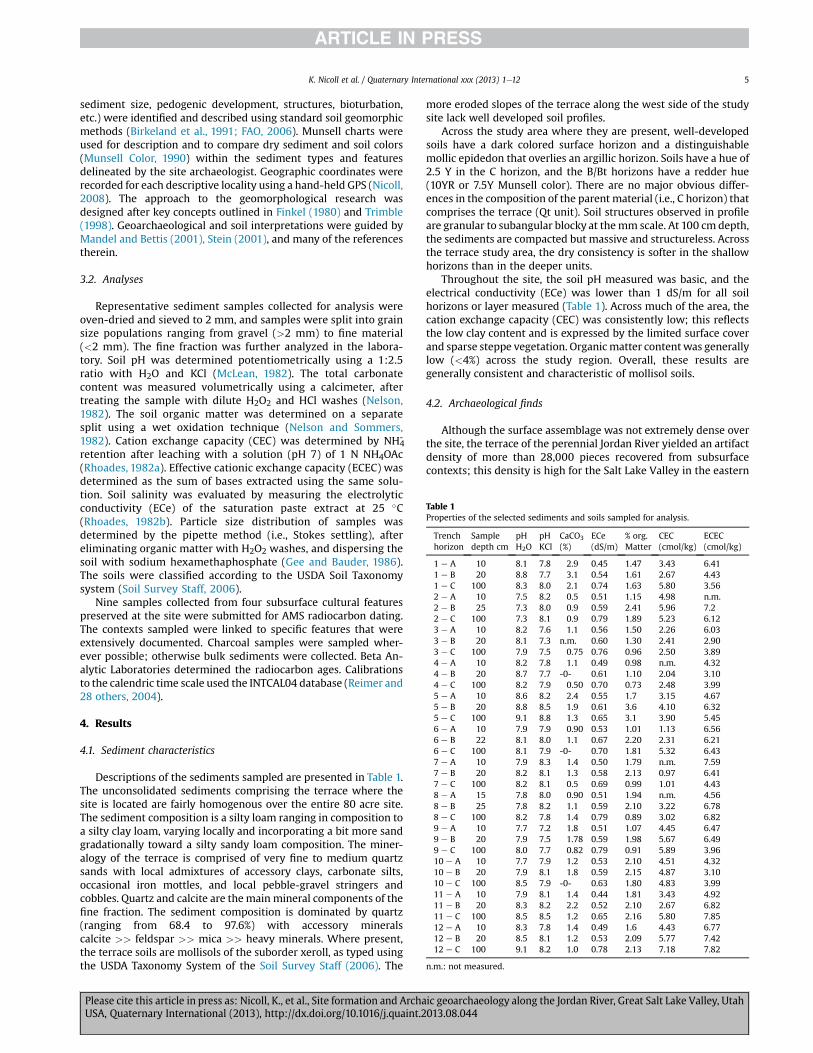
Descriptions of the sediments sampled are presented in Table 1.The unconsolidated sediments comprising the terrace where thesite is located are fairly homogenous over the entire 80 acre site.The sediment composition is a silty loam ranging in composition toa silty clay loam, varying locally and incorporating a bit more sandgradationally toward a silty sandy loam composition. The miner-alogy of the terrace is comprised of very fine to medium quartzsands with local admixtures of accessory clays, carbonate silts,occasional iron mottles, and local pebble-gravel stringers andcobbles. Quartz and calcite are the main mineral components of thefine fraction. The sediment composition is dominated by quartz(ranging from 68.4 to 97.6%) with accessory mineralscalcite >> feldspar >> mica >> heavy minerals. Where present,the terrace soils are mollisols of the suborder xeroll, as typed usingthe USDA Taxonomy System of the Soil Survey Staff (2006). The
more eroded slopes of the terrace along the west side of the studysite lack well developed soil profiles.
Across the study area where they are present, well-developedsoils have a dark colored surface horizon and a distinguishablemollic epidedon that overlies an argillic horizon. Soils have a hue of2.5 Y in the C horizon, and the B/Bt horizons have a redder hue(10YR or 7.5Y Munsell color). There are no major obvious differ-ences in the composition of the parent material (i.e., C horizon) thatcomprises the terrace (Qt unit). Soil structures observed in profileare granular to subangular blocky at themm scale. At 100 cm depth,the sediments are compacted but massive and structureless. Acrossthe terrace study area, the dry consistency is softer in the shallowhorizons than in the deeper units.
Throughout the site, the soil pH measured was basic, and theelectrical conductivity (ECe) was lower than 1 dS/m for all soilhorizons or layer measured (Table 1). Across much of the area, thecation exchange capacity (CEC) was consistently low; this reflectsthe low clay content and is expressed by the limited surface coverand sparse steppe vegetation. Organicmatter contentwas generallylow (<4%) across the study region. Overall, these results aregenerally consistent and characteristic of mollisol soils.
4.2. Archaeological finds
Although the surface assemblage was not extremely dense overthe site, the terrace of the perennial Jordan River yielded an artifactdensity of more than 28,000 pieces recovered from subsurfacecontexts; this density is high for the Salt Lake Valley in the eastern
Table 1Properties of the selected sediments and soils sampled for analysis.
Trenchhorizon
Sampledepth cm
pHH2O
pHKCl
CaCO3
(%)ECe(dS/m)
% org.Matter
CEC(cmol/kg)
ECEC(cmol/kg)
1 e A 10 8.1 7.8 2.9 0.45 1.47 3.43 6.411 e B 20 8.8 7.7 3.1 0.54 1.61 2.67 4.431 e C 100 8.3 8.0 2.1 0.74 1.63 5.80 3.562 e A 10 7.5 8.2 0.5 0.51 1.15 4.98 n.m.2 e B 25 7.3 8.0 0.9 0.59 2.41 5.96 7.22 e C 100 7.3 8.1 0.9 0.79 1.89 5.23 6.123 e A 10 8.2 7.6 1.1 0.56 1.50 2.26 6.033 e B 20 8.1 7.3 n.m. 0.60 1.30 2.41 2.903 e C 100 7.9 7.5 0.75 0.76 0.96 2.50 3.894 e A 10 8.2 7.8 1.1 0.49 0.98 n.m. 4.324 e B 20 8.7 7.7 -0- 0.61 1.10 2.04 3.104 e C 100 8.2 7.9 0.50 0.70 0.73 2.48 3.995 e A 10 8.6 8.2 2.4 0.55 1.7 3.15 4.675 e B 20 8.8 8.5 1.9 0.61 3.6 4.10 6.325 e C 100 9.1 8.8 1.3 0.65 3.1 3.90 5.456 e A 10 7.9 7.9 0.90 0.53 1.01 1.13 6.566 e B 22 8.1 8.0 1.1 0.67 2.20 2.31 6.216 e C 100 8.1 7.9 -0- 0.70 1.81 5.32 6.437 e A 10 7.9 8.3 1.4 0.50 1.79 n.m. 7.597 e B 20 8.2 8.1 1.3 0.58 2.13 0.97 6.417 e C 100 8.2 8.1 0.5 0.69 0.99 1.01 4.438 e A 15 7.8 8.0 0.90 0.51 1.94 n.m. 4.568 e B 25 7.8 8.2 1.1 0.59 2.10 3.22 6.788 e C 100 8.2 7.8 1.4 0.79 0.89 3.02 6.829 e A 10 7.7 7.2 1.8 0.51 1.07 4.45 6.479 e B 20 7.9 7.5 1.78 0.59 1.98 5.67 6.499 e C 100 8.0 7.7 0.82 0.79 0.91 5.89 3.9610 e A 10 7.7 7.9 1.2 0.53 2.10 4.51 4.3210 e B 20 7.9 8.1 1.8 0.59 2.15 4.87 3.1010 e C 100 8.5 7.9 -0- 0.63 1.80 4.83 3.9911 e A 10 7.9 8.1 1.4 0.44 1.81 3.43 4.9211 e B 20 8.3 8.2 2.2 0.52 2.10 2.67 6.8211 e C 100 8.5 8.5 1.2 0.65 2.16 5.80 7.8512 e A 10 8.3 7.8 1.4 0.49 1.6 4.43 6.7712 e B 20 8.5 8.1 1.2 0.53 2.09 5.77 7.4212 e C 100 9.1 8.2 1.0 0.78 2.13 7.18 7.82
n.m.: not measured.
K. Nicoll et al. / Quaternary International xxx (2013) 1e12 5
Please cite this article in press as: Nicoll, K., et al., Site formation and Archaic geoarchaeology along the Jordan River, Great Salt Lake Valley, UtahUSA, Quaternary International (2013), http://dx.doi.org/10.1016/j.quaint.2013.08.044

Great Basin region (Fig. 4). Surface finds included projectile points(almost exclusively in the form of dart points), bifaces, unifaces,scrapers, drills, lithic debitage (or waste flakes) from tool produc-tion and rejuvenation, grinding tools (manos and metates), fire-cracked rock (FCR), and faunal (bone) remains (Yentsch et al., 2009).
Archaeological data recovery efforts at the site resulted in thediscovery of three buried cultural features at about 50 cm depthbelow the present ground surface, including two dwelling struc-tures (housepits) and a roasting pit, as well as a localized use-areasurface dating to the Archaic Period. One of the dwellings (Feature25) was excavated in its entirety. Floor-fill of the second dwellingstructure (Feature 26) was sampled for radiometric determination,and was re-buried for future study.
During backhoe exploration for buried cultural features, acarbon-stained sediment layer was discovered in one of thetrenches. This stain was clearly visible in the profiles of both trenchwalls at a depth of 49 cm below present ground surface (cm bpgs).The sediment matrix was a fine-grained, pale brown sandy silt (2.5YR 5/3). The stain measured 3.54 m in length, had a maximumthickness (depth of fill) of 21 cm, and contained numerous pieces oflithic debitage, ground stone fragments, and FCR that protruded outof the exposed surface (Yentsch and Rood, 2007).
Excavation of Feature 25 revealed that this stained sedimentlayer is oriented in an elliptical, basin-shaped depression. Thefeature measures 4.5 m north-to-south and 3.9 m east-to-west.This structure was cut into a layer of the 2.5 YR 5/3 fine-grained,pale brown sandy-silt by its prehistoric occupants, the level oforigin being between 40 and 50 cm bpgs (Yentsch and Rood, 2007;Yentsch et al., 2009). The fill sediment was considerably darkerthan that surrounding the feature. The entire fill was removed,revealing a highly compacted floor at approximately 55e65 cmbpgs, which was not visible in profile. The floor was very hard,with some structure, and pocked with insect cases containing fillof both lighter and darker color, giving the sediment a mottledappearance.
During the removal of fill, several concentrations of FCR andfaunal bone were encountered at the floor contact. Four such fea-tures were identified within the structure, and one of these is likelya centralized hearth: it was a fairly simple constructed featureimmediately on the occupation surface, consisting of an amor-phous, roughly circular area of charcoal-stained sediment. Thisstain was basin-shaped in profile, with no apparent modification ofthe ground surface, and lacking an intentionally excavated pit orrock lining. This featuremeasured 83 cm in length, was 72 cmwide,and had a maximum depth of 6 cm.
Evidence from the excavation suggests that Feature 25 was ahabitation structure. The shallow, basin shape, along with thepresence of a central fire hearth, and artifacts on the floor supportthis conclusion. The size and shape of the basin are consistent withboth the excavated remains of house structures and thosedescribed in the ethnographic, ethnohistoric, and archaeologicalrecord of the region; see references in Yentsch et al. (2009). Nodefinite break was observed around the perimeter of the basin thatwould indicate the former presence of a door or entryway. Suchaccess features are noted in both the archaeological and historic-ethnohistoric literature (Yentsch and Rood, 2007). There is thepossibility, however, that any type of entrance (if present) couldhave been destroyed by the backhoe during excavation of thetrench. No pits or other internal features that could be interpretedas storage facilities were identified. No post molds were foundwithin or directly adjacent to the feature; therefore it is notpossible to make any statements about a possible superstructure.There is no evidence to suggest that the structure had burned.Calibrated dates obtained from six bulk sediment samples inTable 2 tightly cluster around an age of 2340 cal BP, suggesting a
temporal placement for this structure during the MiddleArchaic.
Excavations in Feature 25 produced numerous artifacts fromboth the fill and the floor contact (n # 5333). Artifacts included onelarge corner-notched biface (likely a knife) recovered from the floorcontact, flaked stone tools (n # 7), lithic debitage (n # 844), groundstone (a metate fragment), one stone bead, FCR (n # 1855), bonetools (n # 3), incised and painted bone gaming pieces, and faunalremains (n # 2622), the majority of which were heavily processedand fragmented (Yentsch et al., 2009). Given the radiocarbon dates,the lack of pottery is commensurate with the occupation of the siteduring the pre-ceramic period.
As part of the investigations at the site, analysis of plant pollen,starch, phytolith, and organic residues (FTIR) was conducted onground stone artifacts, fire-cracked rock (FCR), and bulk sedimentsfrom all buried features. Evidence for maize from samples from theroasting pit and housepit included Zea rondel phytoliths andorganic residues that compositionally match maize oil, protein, andcupules. The confirmed presence of the maize (corn) domesticateZea ssp. mays in site features dating w2400e3000 cal BP (Yentschet al., 2009) was unexpected, and offers some (albeit limited)insight into the local economies located along the geographic pe-riphery of known centers of maize production during this time inantiquity. The fact that no actual maize pollen was recovered mayreflect preservation conditions, or it could indicate that maize wasnot grown directly on the site with maize products brought in froma more distant source. As such, these discoveries underscore theimportance of additional field studies in this portion of the easternGreat Basin in order to resolve the chronology of the transition tofood production and patterns of exchange between hunteregath-erer and emergent village societies.
4.3. Geochronology of human activities
Nine AMS radiocarbon dates confirm Archaic ages for the site,with occupation since 3060 cal yr BP (Table 2). The AMS dates fororganics sampled suggest recurrent activities over w1400 years,rendering this the oldest securely dated Archaic settlement withpithouse-type structures in the eastern Great Basin. As such, thesite provides a valuable new context for reconstructing prehistoric
Table 2AMS determinations for site 42SL186 along the Jordan River, Salt Lake Valley, UT.
Sample ID C-14 age Intercept(cal)a
Context of organic materialsampledb
Beta-235165 2320 $ 40 2340 Floor fill of pithouse (F25)Beta-235166 2410 $ 40 2360 Floor fill of pithouse (F25)Beta-235167 2450 $ 40 2480 Floor fill of pithouse (F25)Beta-235168 2330 $ 40 2340 Charcoal hearth in floor,
pithouse F25Beta-235169 2360 $ 40 2350 Charcoal hearth in floor,
pithouse F25Beta-235170 2280 $ 40 2330 Charcoal hearth in floor,
pithouse F25Beta-235171 2000 $ 50 1940 floor fill of pithouse (F26)Beta-235172 1720 $ 40 1620 Floor fill of pithouse (F26)Beta-236619 2910 $ 40 3060 Replicate context (F19) for
Beta-69460Beta-69460 3040 $ 80 ** Date reported by Sagebrush
Consultants (1993)
a Mean age determinations are reported. Calibrations to the calendric time scaleused the INTCAL04 database (Reimer and 28 others, 2004).
b Determinations were assessed on charcoals (where present) or bulk samplesobtained from the features. Four subsurface cultural features were sampled in two ofthe dwelling features excavated, denoted F25 and F26, and a replicate at F19 asoriginally determined in 1993 by the Sagebrush Archaeological Consultants (Polket al., 1994).
K. Nicoll et al. / Quaternary International xxx (2013) 1e126
Please cite this article in press as: Nicoll, K., et al., Site formation and Archaic geoarchaeology along the Jordan River, Great Salt Lake Valley, UtahUSA, Quaternary International (2013), http://dx.doi.org/10.1016/j.quaint.2013.08.044

lifeways immediately prior to the arrival of agriculture in the re-gion. The recovery of evidence of maize in deposits of this age el-evates the significance of the Prison Site, as it may provideimportant insights into the early practice of agriculture or the use ofagricultural products in the Salt Lake Valley. Additional analysis ofmaterial from this site will have important implications for thearchaeology and culture history of the entire region.
5. Discussion
5.1. Site formation and pedogenesis
Fig. 5 depicts the comparable thickness of soil layers describedfrom the Prison Site, as they vary by position along the slope. It ispossible that slope wash processes and erosion have influenced thelocal micro-relief; the cross-section showing topography alongsection across the valley suggests that there is degradation of thebluff towards the river channel. The thickest soil profiles are pre-served in the upslope terrace positions.
The stratigraphic relationships exposed in the trenches provideevidence for pedogenesis (i.e., soil formation) and bioturbationacross the site. Bioturbation, the disturbance of sediment layers bybiological activity, has been fairly extensive across the site, on ascale that is comparable to other open-air archaeological sites, andconcentrated in the top 20 cm of the terraces. The biologically-mediated disturbance of sediments and soil along the surfaceis mainly due to (1) trampling of the modern surface by cattle(and goats); (2) rooting activity and disturbance due to the
establishment of vegetation. Krotovina structures (root haloes, fil-led traces, and iron-stained root haloes) are common. Other bio-turbation features observed include large burrows (up to 15 cm indiameter), which are attributable to rodents, and smaller burrows(up to 2 cm in diameter) caused by insects and worms.
It is likely that bioturbation has acted to concentrate artifacts atthe surface by mixing the sediments and moving buried materialsupward. Bioturbation in general acts to “turn over” the sedimentcolumn and mix particles and organic materials together. Some ofthe bioturbation features incorporate the silt-rich parent materialwithin burrow-fill, mixing materials in the top 20 cm of the terrain.
A minor amount (<5%) of calcium carbonate is present withinthe surface layers of sediment (e.g., Av horizons) and the Bt hori-zons. This low concentration is typical of Mollisol soils, which arewell drained. The accumulation of calcium carbonate probably re-sults from illuviation, a process by which fine-grained material ordusts accumulate on the surface and subsequently wash down ortranslocate through the sediment mixture. The calcium carbonatesilts may be aerosols and particulate dusts sourced to local lime-stone outcrops. There are not significant accumulations of calciumcarbonate (caliche) within deeper soil horizons, which reflects theyoung (Holocene) age of these soils. The study site may be viewedas a terrace with monogenetic soils of sub-equilibrium age, withzonal to azonal attributes, and very limited calcium carbonateaccumulation or caliche formation.
A railroad line that transects the eastern perimeter of the studyarea has influenced pedogenesis locally. The incorporation of slag insoils and sediments located within 50 feet of the track attests to the
Fig. 5. An elevational cross-section of the Jordan River Terrace, showing the soils described in the survey. A) Lateral and vertical krotovina (burrows) to 80 cm depth in pit Test Unit#1; B) Test Unit #1 Feature 3 shows a thicker B horizon upslope; C) Trench 7 shows soils with a thick Bt horizon in a stable areas of the terrace, the sediments of which accumulatedat w4450 ft, the same elevation as the Stansbury deposits of Lake Bonneville.
K. Nicoll et al. / Quaternary International xxx (2013) 1e12 7
Please cite this article in press as: Nicoll, K., et al., Site formation and Archaic geoarchaeology along the Jordan River, Great Salt Lake Valley, UtahUSA, Quaternary International (2013), http://dx.doi.org/10.1016/j.quaint.2013.08.044

efficiency of particle mixing via bioturbation over historical time-scales (Fig. 6). In the region east of the railroad line near Trench 1,slag pieces from the surface Av horizon are mixed downsection todepths of 60 cm. The trench exposure shows the bits of slag that arefloating in the silty loam sediment matrix. Since the railroad hasbeen present in the area since the late 1800s, some temporal con-straints can be placed upon the efficiency of the sediment mixing.Furthermore, the amount of slag incorporated demonstrates thedegree of sediment turnover via bioturbation, which is concen-trated in the top sediment layer to 30 cm depth.
The sediments in the upland areas of the terrace exhibit evi-dence of soil formation processes. Along the surface mantle, ve-sicular horizons (Av units) up to 5 cm thick are present, even inareas that have been trampled by cattle. Strong horizonation (Av, Bt,C) has developed, and thick soil layers are present where sedimentsurfaces have been relatively stable (i.e., minimal erosion) for sometime, and weathering (e.g., illuviation, hydrolysis) and bioturbationhave continued. The maximum thickness observed for an Av and Bthorizon is w85 cm.
The thickest, most developed soils are mollisols, and these arelocated along the eastern edge of the study area surveyed. Thesesoils have centimeter scale peds and may even be cumulic, havingexperienced more than one phase of pedogenesis, or soil devel-opment. The photo in Fig. 5C is located in an upslope positionwithin a stable portion of the terrace at an elevation approximatewith the Stansbury Palaeo-Shoreline of ancient Lake Bonneville.The thickest packages with soil development are along the highestelevations across the site (e.g., Trench 5).
In an area exposed by backhoe excavation near Trench 4, exca-vators revealed an area of carbon-stained soil, possibly from a firehearth (Feature 33) discovered within a house structure (Feature25). Disseminated and comminuted charcoal from the Feature 33hearth was AMS-dated to w2340 cal BP. During antiquity, this areawas the site of human activity and the floor of the structure at adepth w50 cm below the present ground surface was preserved(depicted on Figs. 7 and 8).
The sediment depicted in the floor of the Trench 4 at Feature 25exhibits a distinctive pelleted texture, mottles, and iron staining.The mottles (circular concretions) and iron stains are relict fromhuman activities; the unit constitutes a living floor (Fig. 8). Onepossible explanation for the pelleted character of the sedimentmaking up the floor involves food preparation and other relatedactivities by those frequenting the area; animal fats and cookingdrippings may have coagulated the sediment matrix, which pre-served as a characteristic unit. Ironically this unit was not signifi-cantly bioturbated, suggesting that the internal cohesion of thepellets helped to preserve it since its use during antiquity.
To sum, the Jordan River Terrace has been reasonably stable, andexperienced soil development over Late Holocene time. However,the degree of bioturbation in the area was limited, and did notsignificantly mix the entire sediment column thickness to 2 m intotal depth. As such, the sediments have not been disturbed, andthe overall site preservation is high. Bioturbation has clearlybrought some buried artifacts up to the ground surface, and mixedslag particles through the sediment column at locations near therailroad line. Excavation shows that the cultural features buried atdepths below 50 cm remain well preserved. Hence this assessmentof site formation and preservation substantiates that the buriedfloors of the ancient pithousesmay be considered primary contexts,and that the associated hearths, charcoal, and comminuted animalbones are likely in situ.
5.2. Geoarchaeology and site formation
Geomorphic and soil stratigraphy demonstrates that the sub-surface cultural features are in primary contexts, and that the intactfeatures are located within a stratigraphic unit that can be corre-lated across the site and within the larger geographical region.From a sedimentological and geomorphic point of view, there is oneprimary stratigraphic unit across the site: a fluviolacustrine terracethat has been modified by surface weathering, soil formation pro-cesses, slope wash, and bioturbation. These modification processes
Fig. 6. Photos of trenches east of Trench 1, showing the presence of slag materials incorporated from the nearby railroad bed (labeled). These slag within the section attest to theefficiency of particle mixing via bioturbation.
K. Nicoll et al. / Quaternary International xxx (2013) 1e128
Please cite this article in press as: Nicoll, K., et al., Site formation and Archaic geoarchaeology along the Jordan River, Great Salt Lake Valley, UtahUSA, Quaternary International (2013), http://dx.doi.org/10.1016/j.quaint.2013.08.044

were not strong enough to obscure the living floor in the housepit(Feature 25), which was quite well preserved.
Artifacts are present at a relatively low density on the surface,but in great numbers in subsurface deposits associated with pre-historic house and activity areas. Nearly 30,000 artifacts werecollected, the majority consisting of lithic debitage and FCR, likelyused for cooking in baskets. Items identified include Archaic pro-jectile points of various styles (Elko Series, Pinto, and Gypsum),bifacially and unifacially flaked lithic tools, lithic debitage,groundstones (both manos and metates), FCR, and bone faunalremains. The quartzites of the Oquirrh Formation outcropping inthe Traverse Mountains clearly have provided an abundant source
of rawmaterial that was suitable for the manufacture of lithic tools.Moreover, the proximal location of the site in an overlook to wet-lands would have drawn people to the area for hunting and otheractivities (e.g., Weide, 1978; Thomas, 1999).
The richness of in situ archeological remains preserved at site42SL186 is unique for the Salt Lake Valley, partly because fewarchaeological sites in the valley have escaped destruction bymodern construction as the area faces intense development. Mostof the material record for the Archaic period (roughly 8000 BP to2000 BP in this area) has been excavated from rockshelters andcaves, which have better preservation conditions as compared toopen-air sites; open-air sites are often too highly oxidized andrarely preserve organic material other than bone and carbonizedwood (e.g., Fowler and Fowler, 2008). Nonetheless, this remarkablesite on the terrace of the Jordan River has yielded evidence of twonon-portable dwelling structures, a localized use-area surface, theremains of a roasting pit, and a living floor with abundant faunalremains and lithics.
The Feature 25 housepit (Figs. 7e9) contained >8000 pieces ofdebitage, 100 ! pieces of ground stone, and w1500 pieces of FCR.Burned mammal bones are abundant; more than 2600 pieces ofcomminuted bone suggest a high degree of food processing. Therewas an interesting lack of fish and bird bones encountered on thesite, which suggests a broad spectrum diet that included resourcesprocured beyond the immediate wetlands. The large amount ofhighly fragmented and burned animal bone and the association of ashallow hearth feature and FCR from the interior of Feature 25suggest bone processing was an activity conducted within theexcavated house. The fragmentation of some very low-utility bone(namely mule deer phalanges) may indicate some degree of foodstress or insecurity, leading to questions about the seasonality ofoccupation being during the winter or early spring when foodstores may be depleted.
The structure near Trench 4 was probably composed of brush,and may have been the locus of seasonal activities near the
Fig. 7. The landscape setting of trench 4, showing the area of the living floor depicted in Fig. 8 in the dashed box.
Fig. 8. The mottled appearance of the living floor with an in situ hearth, inside theexcavated pithouse (Feature 25). The matrix color is 2.5 Y 5/3, and the stains are 7.5 Y5/3-6/6.
K. Nicoll et al. / Quaternary International xxx (2013) 1e12 9
Please cite this article in press as: Nicoll, K., et al., Site formation and Archaic geoarchaeology along the Jordan River, Great Salt Lake Valley, UtahUSA, Quaternary International (2013), http://dx.doi.org/10.1016/j.quaint.2013.08.044

freshwater and other wetland resources in the Jordan River Valley.The related artifact assemblage and associated vertebrate remainssuggests that food preparation and cooking activities occurredwithin the area. Given the rate of bioturbation observed in thesediments, it is remarkable that the living floor of Feature 25remained intact, and could be recognized in the site stratigraphy ofthe excavation. Considering the dwelling structures were probablysimple windbreaks made of brushes and grasses, this degree ofpreservation and human activity is quite extraordinary.
The pre-agricultural history of the eastern Great Basin is notknown in full detail, owing to a scarcity of well-preserved archae-ological sites (e.g., Arnold, 1996; Huckell, 1996). The Archaic Periodin Western North America includes pre-agricultural hunting andgathering cultures (Kelly, 1995; Vierra, 2005). Eastern Great Basin
records are primarily reconstructed from dry cave sites, includingDanger Cave (Jennings, 1957), Hogup Cave (Aikens, 1970), Bonne-ville Estates Rock Shelter (Goebel et al., 2004), and Sudden Shelter(Jennings et al., 1980). Prior tow2000 BP, Archaic hunteregatherersled highly mobile lifestyles centered on opportunistic foraging andhunting (e.g., Lyneis, 1978; Cordell, 1997; Thomas, 1999; Vierra,2005; Table 3). The “Desert Culture” originally described byJennings (1957) remains a valid and reasonably accurate descrip-tion for the very successful adaptation to the arid western land-scape. The transition to a more sedentary lifeway occurredthroughout the region approximately 2000 years ago was concur-rent with the adoption of cultigens such as maize and other crops,which became important dietary components as domesticatesspread into the Great Basin from southwestern sources (Wilde andNewman, 1989; Matson, 1991, 1999; Smith, 2005; Staller et al.,2006).
The occupation at 42SL186 spans the Archaic period, a time justprior to the initial appearance of the Fremont Culture that becamewidespread throughout the region approximately 2000 years ago,and featured farming, ceramics, the use of bow and arrow, andsubstantial architecture (see Simms, 2008). At 42SL186, evidence ofmaize was found on artifacts dating to approximately 3000 BP,nearly 1000 years earlier than generally expected for the area. Thisalone indicates the significance of site 42SL186, and suggests that itcontains potential for revising ideas about chronology, subsistenceand settlement patterning, seasonality and mobility, and sitestructure and function. The potential for significantly earlier use ofmaize in the region than previously thought has significant impli-cations for understanding Archaic period adaptations in this part ofthe eastern Great Basin.
6. Conclusions
Nearly 30,000 prehistoric artifacts were collected from sub-surface deposits at site 42SL186. This site (“the Prison Site”) islocated along the Jordan River in the southern Salt Lake Valley, on
Fig. 9. The excavation of the dwelling structure (feature 25) at trench 4, with the4.5 % 3.9 m sub-circular outline of the pit structure indicated (dashed lines). Photo-graph taken by site archaeologist Yentsch.
Table 3Great Basin Archaeology during the Holocene.
K. Nicoll et al. / Quaternary International xxx (2013) 1e1210
Please cite this article in press as: Nicoll, K., et al., Site formation and Archaic geoarchaeology along the Jordan River, Great Salt Lake Valley, UtahUSA, Quaternary International (2013), http://dx.doi.org/10.1016/j.quaint.2013.08.044

a fairly stable terrace made of Lake Bonneville and fluvial sedi-ments. Initial survey in 1993 discovered a hearth feature that wasradiocarbon dated to w3080 BP in a CRM report prepared bySagebrush Archeological Consultants (Polk et al., 1994). This initialradiometric date, and subsequent replication by Antiquities Sec-tion archaeologists as presented in this paper, confirms that thislocale is among the earliest dated occupation sites in the Salt LakeValley.
Subsequent survey and excavation at this site confirms thatprehistoric cultural features are intact within the terrace (Yentschand Rood, 2007; Yentsch et al., 2009), and the original sedimentarchitecture is well preserved, and features have not been obscuredby pedogenesis or bioturbation. New AMS dates on a hearth featurelocated in an excavated pithouse floor context (Feature 25)corroborate the antiquity of prehistoric human activities in this partof the eastern Great Basin. Several determinations on comminutedcharcoal and organic matter in stratigraphic contexts providereplicate age control averaging w2340 cal BP for the living floor.The dated cultural features are in primary stratified contexts thathave not experienced post-depositional alteration or erosion. Assuch, these new dates corroborate the original geochronology ofthe site as originally reported by Sagebrush Archaeological Con-sultants, LLC. These results verify the antiquity of the 42SL186 siteas the oldest dated site for human occupation and habitationwithinthe Salt Lake Valley.
New archaeological contexts such as the 42SL186 site are vitalfor reinvigorating discussions and reconstructions of prehistoriclifeways. Data from this site indicate that the Archaic-Fremontpeople behaved differently than the models originally proposedfor the “Desert Culture” in the region (Jennings, 1957; Aikens, 1978;Bettinger, 1993; Thomas, 1999). Models for Late Holocene hunteregatherer strategies in the Great Basin have emphasized theimportant role of wetlands in fostering sedentism during theMiddle-Late Archaic (e.g., Kelly, 1997 and references therein;Madsen and Simms, 1998; Madsen and Kelly, 2008), despite theinherent biases posed by the records of these kinds of sites (e.g.,Hockett, 2010). The discovery of a new site enables reassessment ofthe local resource base during the critical juncture when peoplewere settling down and embracing agricultural economies in thispart of the semi-arid American southwest (Kennett andWinterhalder, 2006).
Such a high subsurface artifact density for an Archaic open-airsite is unprecedented in this part of Utah (Duke and Haynes,2009), and not only elevates the significance of this site, butprovides an opportunity to query methodology and to reappraisethe role of lithic scatters as valuable reconstructive tools forGreat Basin archaeology. This site also raises several interestingquestions. For example, in considering the transition to seden-tism, how much does scatter matter in designating a settlementlocus? Did aggregation and the establishment of residencesoccur earlier in time than scholars have thought? When was thenascent shift from foraging to farming? Was maize (corn) actu-ally grown at this locale, and if so, when, and how intensively?Otherwise, what does the presence of maize at the site indicate?What were the climate conditions like here in the Late Holocene,w3000 years ago? Discoveries from site 42SL186 have just begunto inform perspectives on the local resource base and lifeways inthis under-documented part of the semi-arid eastern GreatBasin.
Acknowledgements
Thanks to the Utah Division of State History, the Utah StatewideArchaeological Society, and themany volunteers who donated theirtime toward this excavation. We acknowledge with thanks the
helpful comments from D. Craig Young and another anonymousreviewer. K. Nicoll would like to formally document the degree towhich this project and paper benefitted from the support andvision of Andy Yentsch, Kevin Jones, Ron Rood and many others atthe Antiquities Section of the Utah Division of State History. K Nicollalso thanks J. Onken, D. Madsen and R. Cote for technical advice,and numerous students for help with the lab analyses. Funding wasprovided by the Gladys Cole Award of the Geological Society ofAmerica and NSF Geomorphology & Land Use Dynamics grant #58501618.
References
Aikens, C.M., 1970. Hogup Cave. In: University of Utah Anthropological Papers 93.University of Utah Press, Salt Lake City.
Aikens, C.M., 1978. Archaeology of the Great Basin. Annu. Rev. Anthropol. 7, 71e87.Arnold, J.E., 1996. The archeology of complex hunteregatherers. J. Anthropol.
Archaeol. 12, 75e119.Arnow, T., Van Horn, R., LaPray, R., 1970. The Pre-Quaternary Surface in the Jordan
Valley, Utah. In: USGS Professional Paper 70-D. Geological Survey Research,pp. D257eD261.
Bettinger, R.L., 1993. Doing Great Basin archaeology recently: coping with vari-ability. J. Archaeol. Res. 1, 1059-0161.
Biek, R., 2005. The Traverse Mountains e new geologic maps and explosive sub-urban growth. Utah Geol. Miner. Surv. Notes 37 (1), 1e5.
Birkeland, P.W., Machette, M.N., Haller, K., 1991. Soils as a Tool for Applied Qua-ternary Geology. In: Utah Geological Survey Miscellaneous Publication 91-3.Utah Geological Survey.
Birnie, R.I., 2000. Monitoring of Recontouring Activities at Archaeological Site42SL186 (Letter Report 5135-02-20006 for State Historical Preservation Office(SHPO), State Project #U99PD06815).
Baldrica, A., Kolvet, R.C., 2009. CRM: the next generation. In: Hockett, B. (Ed.), Past,Present and Future Issues in Great Basin Archaeology: Papers in Honor of DonD. Fowler. U.S. Department of the Interior Bureau of Land Management CulturalResource Series No. 20, Elko, NV, pp. 10e20.
Cordell, L., 1997. Archaeology of the Southwest. Academic Press, San Diego, CA,pp. 101e126.
Cowardin, L.M., Carter, V., Golet, F.C., LaRoe, E.T., 1979. Classification of Wetlandsand Deepwater Habitats of the United States. US Fish and Wildlife Service,Washington, D.C, pp. 1e103.
Currey, D.R., Atwood, G., Mabey, D.R., 1983. Map 73, Major Levels of Great Salt Lakeand Lake Bonneville. State of Utah Department of Natural Resources, UtahGeological and Mineral Survey.
Duke, D., Haynes, G., 2009. Asking why in Great Basin lithic studies. In: Hockett, B.(Ed.), Past, Present and Future Issues in Great Basin Archaeology: Papers inHonor of Don D. Fowler. U.S. Department of the Interior Bureau of Land Man-agement Cultural Resource Series No. 20, Elko, NV, pp. 146e168.
FAO, 2006. Guidelines for Soil Description, fourth ed., p. 97 Rome.Finkel, C.W., 1980. Stratigraphic principles and practices as related to soil mantles.
Catena 7, 169e194.Fowler, C.S., Fowler, D.D. (Eds.), 2008. The Great Basin e People and Place in Ancient
Times. School for Advanced Research Press, Santa Fe, NM, pp. 1e166.Gee, G.W., Bauder, J.W., 1986. Particle-size analysis. In: Klute, A. (Ed.), Methods of
Soil Analysis. Part 1: Physical and Mineralogical Methods, second ed. AmericanSociety of Agronomy, Madison, Wisconsin, pp. 383e412.
Gilbert, G.K., 1890. Lake Bonneville. In: U.S. Geological Survey Monograph, vol. 1,438 p.
Goebel, T., Graf, K., Hockett, B., Rhode, D., 2004. Late Pleistocene humans at Bon-neville Estates rockshelter, eastern Nevada. Curr. Res. Pleistocene 20, 20e23.
Hockett, B., 2010. Back to study hall: further reflections on large game huntingduring the Middle Holocene in the Great Basin. Am. Antiq. 75, 962e965.
Hely, A.G., Mower, R.W., Harr, C.A., 1971. Water Resources of Salt Lake County. UtahDepartment of Natural Resources Technical Publication No. 21, Utah, p. 244.
Hintze, L.F., Kowallis, B.J., 2009. Geological History of Utah. Brigham Young Uni-versity Geology Studies Special Publication 9, p. 225.
Huckell, B.B., 1996. The archaic prehistory of the North American Southwest.J. World Prehist. 10, 305e373.
Jennings, J., 1957. Danger Cave. In: University of Utah Anthropological Papers 27.University of Utah Press, Salt Lake City.
Jennings, J.D., Schroedl, A.R., Holmer, R.N., 1980. Sudden Shelter. In: University ofUtah Anthropological Papers 103. University of Utah Press, Salt Lake City.
Kelly, R.L., 1995. The Foraging Spectrum: Diversity on Hunteregatherer Lifeways.Smithsonian Institution Press, Washington, D.C, pp. 125e440.
Kelly, R.L., 1997. Late Holocene great basin prehistory. J. World Prehist. 11, 1e49.Kennett, D.J., Winterhalder, B., 2006. Behavioral Ecology and the Transition to
Agriculture. University of California Press, Berkeley, California, USA, pp. 1e394.Klauk, R.H., 1984. Low-temperature Geothermal Assessment of the Jordan Valley,
Salt Lake County, Utah. Utah Geological and Mineral Survey Report of Investi-gation No. 185, 3; and US. Department of Energy Report DOE/ET/2 6393eTGDE85 000616, pp. 1e165.
K. Nicoll et al. / Quaternary International xxx (2013) 1e12 11
Please cite this article in press as: Nicoll, K., et al., Site formation and Archaic geoarchaeology along the Jordan River, Great Salt Lake Valley, UtahUSA, Quaternary International (2013), http://dx.doi.org/10.1016/j.quaint.2013.08.044

Lyneis, M.M., 1978. On the correspondence between villages and wetlands in theGreat Basin. J. Calif. Anthropol. 5, 289e292.
McLean, E.O., 1982. Soil pH and lime requirement. In: Page, A.L., Miller, R.H.,Keeney, D.R. (Eds.), Methods of Soil Analysis. Part 2: Chemical and Microbio-logical Properties, second ed. American Society of Agronomy, Madison, WI,pp. 199e224.
Madsen, D.B., Simms, S.R., 1998. The Fremont complex: a behavioral perspective.J. World Prehist. 12, 255e336.
Madsen, D.B., Kelly, R.L., 2008. The “good sweet water” of great basin marshes. In:Fowler, C.S., Fowler, D.D. (Eds.), The Great Basin e People and Place in AncientTimes. School for Advanced Research Press, Santa Fe, NM, pp. 79e85.
Mandel, R.D., Bettis III, E.A., 2001. Use and analysis of soils by archaeologists andgeoscientists. In: Goldberg, P., Holliday, V.T., Ferring, C.R. (Eds.), Earth Sciencesand Archaeology. Kluwer Academic Publishers, NY, pp. 173e204.
Marine, I.W., Price, D., 1964. Geology and ground-water resources of the JordanValley, Utah. Utah Geol. Miner. Surv. Water Res. Bull. 7, 1e68.
Matson, R.G., 1991. The Origins of Southwestern Agriculture. University of ArizonaPress, Tucson.
Matson, R.G., 1999. The spread of maize to the Colorado Plateau. Archaeol. South-west 13, 10e11.
Morgan, D.L., 1947. The Great Salt Lake. University of Utah Press, Salt Lake City, ISBN0-87480-478-7.
Mower, R.W., 1968. Ground-water Discharge Toward Great Salt Lake Through ValleyFill in the Jordan Valley, Utah. In: USGS Professional Paper 600-D. GeologicalSurvey Research, pp. D71eD74.
Munsell Color, 1990. Munsell Soil Color Charts. MacBeth Division of KollmorgenInstruments Corporation, Baltimore, MD.
Nelson, R.E., 1982. Carbonate and gypsum. In: Page, A.L., Miller, R.H., Keeney, D.R.(Eds.), Methods of Soil Analysis. Part 2: Chemical and Microbiological Proper-ties, second ed. American Society of Agronomy, Madison, Wisconsin. USA,pp. 181e198.
Nelson, R.E., Sommers, L.E., 1982. Total carbon and organic matter. In: Page, A.L.,Miller, R.H., Keeney, D.R. (Eds.), Methods of Soil Analysis. Part 2: Chemical andMicrobiological Properties, second ed. American Society of Agronomy, Madison,WI, pp. 539e557.
Nicoll, K., 2008. Geomorphic Setting and Geoarchaeology of 42SL186 “the PrisonSite” Located East of the Jordan River, Southern Salt Lake Valley (TechnicalReport Submitted to the State of Utah, Antiquities Section of the Utah Divisionof State History), p. 24.
Personius, S.F., Scott, W.E., 1992. Surficial Geologic Map of the Salt Lake CitySegment and Parts of Adjacent Segments of the Wasatch Fault Zone, Davis, SaltLake, and Utah Counties. U.S. Geological Survey, Utah (Miscellaneous In-vestigations Series Map I-2106, Scale 1:50,000).
Polk, M.R., Weymouth, H.M., Murray, S.L., 1994. A Cultural Resources Inventory of the13800 South/West Valley Highway Alternative, Salt Lake County, Utah. StateProject Number U-93-SJ-029p, s. Archaeological Report No. 578. SagebrushArchaeological Consultants LLC, Ogden. Submitted toBIO/WEST, Inc., Logan,Utah.
Reimer, P.J., 28 others, 2004. IntCal04 terrestrial radiocarbon age calibration, 0e26 cal kyr BP. Radiocarbon 46, 1029e1058.
Rhoades, J.D., 1982a. Cation exchange capacity. In: Page, A.L., Miller, R.H.,Keeney, D.R. (Eds.), Methods of Soil Analysis. Part 2: Chemical and
Microbiological Properties, second ed. American Society of Agronomy, Madison,WI, pp. 149e158.
Rhoades, J.D., 1982b. Soluble salts. In: Page, A.L., Miller, R.H., Keeney, D.R.(Eds.), Methods of Soil Analysis. Part 2: Chemical and MicrobiologicalProperties, second ed. American Society of Agronomy, Madison, WI. USA,pp. 167e180.
Richardson, G.B., 1906. Underground Water in the Valleys of Utah Lake and JordanRiver, Utah. In: USGS Water Supply Paper 157, pp. 1e81.
Simms, Steven R., 2008. Ancient Peoples of the Great Basin and Colorado Plateau.Left Coast Press, Walnut Creek, CA.
Smith, B.D., 2005. Documenting the transition to food production alongthe borderlands. In: Vierra, B.J. (Ed.), The Late Archaic Across the BorderlandsFrom Foraging to Farming. University of Texas Press, Austin, pp. 300e316.
Soil Survey Staff, 2006. Keys to Soil Taxonomy, tenth ed. USDA-Natural ResourcesConservation Service, Washington, DC, p. 332.
Staller, J.E., Tykot, R.H., Benz, B.F. (Eds.), 2006. Histories of Maize: MultidisciplinaryApproaches to the Prehistory, Linguistics, Biogeography, Domestication, andEvolution of Maize. Academic Press, Boston, MA, pp. 109e121.
Stein, J.K., 2001. A review of site formation processes and their relevance to geo-archaeology. In: Goldberg, P., Holliday, V.T., Ferring, C.R. (Eds.), Earth Sciencesand Archaeology. Kluwer Academic Publishers, NY, pp. 37e51.
Stokes, W.L., 1986. Geology of Utah. In: Utah Museum of Natural History OccasionalPaper 6, pp. 1e317.
Thomas, D.H., 1999. Foreward. In: Hemphill, B.E., Larsen, C.S. (Eds.), PrehistoricLifeways in the Great Basin Wetlands e Bioarchaeological Reconstruction andInterpretation. University of Utah Press, Salt Lake City, UT.
Trimble, S.W., 1998. Dating fluvial processes from historical data and artifacts. Ca-tena 31, 283e304.
U.S. Department of the Army Corps of Engineers, 1970. Interim Survey forFlood Control on Jordan River Basin. Salt Lake County Streams. Utah, AppendixA e Hydrology, 1970.
USGS National Water Information System, 2009. Data online at http://waterdata.usgs.gov/nwis (last accessed 15.01.09.).
Vierra, B.J. (Ed.), 2005. The Late Archaic across the Borderlands from Foraging toFarming. University of Texas Press, Austin, pp. 1e328.
Weide, M.L., 1978. On the correspondence between villages and wetlands in theGreat Basin. J. Calif. Anthropol. 5, 289e292.
Wilde, J.D., Newman, D.E., 1989. Late archaic corn in the eastern great basin. Am.Anthropol. 91, 712e720.
Yentsch, A.T., Rood, R.J., 2007. The prison site: evidence for late archaic housepits inthe Salt lake valley. Utah Archaeol. 20, 43e59.
Yentsch, A.T., Rood, R.J., Jones, K.T., Fenner, L.A., 2009. Archaeological In-vestigations at the Prison Site (42SL186). In: Antiquities Section SelectedPapers, New Series, vol. VIII, Number 17. Antiquities Section, Utah Divisionof State History, Salt Lake City. Available online at: http://www.history.utah.gov/archaeology/i_love_archaeology/documents/ASSP%20Vol%20VIII%20(17)-%20Prison%20Site%202009%20final.pdf.
Yidana, S.M., Lowe, M., Emerson, R.L., 2010. Wetlands in Northern Salt Lake Valley,Salt Lake County, Utah e an Evaluation of Threats Posed by Ground-waterDevelopment and Drought (Report of Investigation 268). Utah Department ofNatural Resources, Utah Geological Survey, p. 38.
K. Nicoll et al. / Quaternary International xxx (2013) 1e1212
Please cite this article in press as: Nicoll, K., et al., Site formation and Archaic geoarchaeology along the Jordan River, Great Salt Lake Valley, UtahUSA, Quaternary International (2013), http://dx.doi.org/10.1016/j.quaint.2013.08.044