4304732167.pdf - Utah - Oil and Gas
140
CNG Pmducing Company A CNG COMPANY November 26, 1991 CONF \D ENT \AL Mr. Ed Forsam U.S. Department of the Interior Bureau of Land Management Vernal District Office 170 South 500 East 10V 2 9 1991 Vernal, UT 84078 DIVISION OF RE: River Bend Unit Application for Permit to Drill OIL GAS&MINING River Bend Unit 15-13E Section 13 T10S-R19E Gentlemen: Enclosed please find originaland two copies of the subject applications. Attachment to this applicationincludes the following: Attachment No. 1 Location Attachment No. 2 Certification Statement Attachment No. 3 BOP Stack Schematic Attachment No. 4 Drilling Plan Attachment No. 5 13 Point Surface Use Plan Attachment No. 6 Water Source and Access Route Attachment No. 7 Water Permit CNG PRODUCINGCOMPANY is requesting all information be held confidential. It ul 5 la eciated if this permit could be expeditedsince drilling is planned to begin on Shouldyou have any questions please feel free to contacteither my sself at (504) 593-7739 or the project engineer, Doss Bourgeois at (504) 593-7719. y rs Susan M. Hebert, Regulatory Reports Asst.II Enclosure cc: Utah Board of Oil, Gas & CNG Pmducing Company A CNG COMPANY November 26, 1991 CONF \D ENT \AL Mr. Ed Forsam U.S. Department of the Interior Bureau of Land Management Vernal District Office 170 South 500 East 10V 2 9 1991 Vernal, UT 84078 DIVISION OF RE: River Bend Unit Application for Permit to Drill OIL GAS&MINING River Bend Unit 15-13E Section 13 T10S-R19E Gentlemen: Enclosed please find originaland two copies of the subject applications. Attachment to this applicationincludes the following: Attachment No. 1 Location Attachment No. 2 Certification Statement Attachment No. 3 BOP Stack Schematic Attachment No. 4 Drilling Plan Attachment No. 5 13 Point Surface Use Plan Attachment No. 6 Water Source and Access Route Attachment No. 7 Water Permit CNG PRODUCINGCOMPANY is requesting all information be held confidential. It ul 5 la eciated if this permit could be expeditedsince drilling is planned to begin on Shouldyou have any questions please feel free to contacteither my sself at (504) 593-7739 or the project engineer, Doss Bourgeois at (504) 593-7719. y rs Susan M. Hebert, Regulatory Reports Asst.II Enclosure cc: Utah Board of Oil, Gas &
-
Upload
khangminh22 -
Category
Documents
-
view
0 -
download
0
Transcript of 4304732167.pdf - Utah - Oil and Gas

CNG PmducingCompany A CNG COMPANY
November 26, 1991 CONF\DENT\ALMr. Ed ForsamU.S. Department of the InteriorBureau of Land ManagementVernal District Office170 South 500 East 10V 2 9 1991Vernal, UT 84078
DIVISIONOFRE: River Bend UnitApplication for Permit to Drill OILGAS&MININGRiver Bend Unit 15-13ESection 13 T10S-R19E
Gentlemen:
Enclosed please find originaland two copies of the subject applications. Attachment to thisapplicationincludes the following:
Attachment No. 1 LocationAttachment No. 2 Certification StatementAttachment No. 3 BOP Stack SchematicAttachment No. 4 Drilling PlanAttachment No. 5 13 Point Surface Use PlanAttachment No. 6 Water Source and Access RouteAttachment No. 7 Water Permit
CNG PRODUCINGCOMPANY is requesting all information be held confidential.
It ul5
la eciated if this permit could be expeditedsince drilling is planned to begin on
Shouldyou have any questions please feel free to contacteither my sself at (504) 593-7739 orthe project engineer, Doss Bourgeois at (504) 593-7719.
y rs
Susan M. Hebert,Regulatory Reports Asst.II
Enclosure
cc: Utah Board of Oil, Gas &

Form 3160-3 SUBMIT INTRIPLI Form opproved.(Novamtier1088) .
(Other instruction Budget Burseu No.1004-0136(formerly e-ssict ES on reverse siday =-·-.-- s···y.-•••; ••••
DE T OF THE INTERIOR 5. LEASE DESIGNATION AND SERIAL NO.
BUREAUOF LANDMANAGEMENT U-013766APPLICATIONFOR PEAMITTO DRILL,DEEPEN,OR PLUG BACK 6. IFINDIAN,ALLOTTEEORTRIBENAME
la. TYPEOF WORKDRILL(X) DEEPEN () PLUGBACKj) 7. UNITAGREEMENTNAME
b. TYPEOFWELL RiverBend UnitOILWELL() GAS WELLjM) OTHER SINGLE2ONEgjMULTIPLEZONEj] 8. FARMORLEASENAME
2. NAMEOF OPERATOR RBUCNG PRODUCINGCOMPANY 9. WELL NO.
3. ADDRESSOFOPERATOR 15-13ECNG Tower, 1460 Paydras St., New Odeans, LA 70112-6000 10. FIELDANDPOOL, OR LDCAT
4. LOCATIONOFWELL(Report location citerly and in accor a with any 3tats requirements.*) Asiand ag ga suffoce15tYFSL&1050' FEL Sect.13,T105,R19E .5
° Ÿ-- 11. SE3C.,T., R ., ORBLK.AND SURVEYOR AREA
At proposed prod.zonsSame 13-T10S-R19E
14. DISTANCEINMILESANDDIRECHONAROMNEAAESTTOWNOR POSTOFFICE* 12. COUNTYORPARIS13. STATE10 Miles SW of Ouray Unitah Utah
15. DISTANCEFROM PROPOSEDA 16. NO.OFACRESINLEAS-17. No. 06 ACRESABBIGNEDLOCATIONTO NEAREST TO THISWELLPROPERTY OR LEASE LINE,FT.(Alsoto naarast drig. unit line if any) 5458' 1,097.87 80
18. DISTANCEFROM PROPOSED LOCATION* 19. PROPOSED DEPTH 20. ROTARYOR CABLETOOLSTO NEARESTWELL,DRILLING,COMPLETED, *
OR APPLIEDFOR, ON THISLEASE,FT. 2602' 7,600' OT C Rotary21. ELEVATIONS(Showwhether DF, RT, GR, etc.) 22. APPROX. DATEWORKWILLSTART
51so'GR March 15, 199223. PROPOSED CASINGANDCEMENTINGPROGRAMSIZE OF HOLE SIZEOF CASING WEIGHTPER FOOT SETTINGDEPT4 QUANTITYOF CEMENT
12 114" 8 548" 248 +1-.gó
T- Cement to Surhoe
7 7Æ" 6 1/2" 176 +/-7,600 Cement Calo to Suthoe1. Drii a 12 1/4" hole withan air rig to +1-400', run 8 5/8', H-40 casing and cement to surface.2. NU and pressure test BOP stack prior to drillingout below surface pipe.3. Opemte pipe rams daily and blind rams as possible.4. DrŒa 7 78" hole to 7,600' witha salt water mud system. Coring is possible. DST's will
needed to evaluate unexpected shows.5. Run logs, set B 1/2", 17#, N 80 & K-55 oasing as dictated by driRing shows, tests, and sing
program may be modified to provide added burst strengh if needed for frac program. NOV2 9 $¾6. Primary zones of interest are the Wasatch, Chapita Wells & Uteland Buttes.7. ANzones indicating potentialfor econominaiy recoverable reserves wii be tested in a normal. DMSIONOF
prudent manner· OILGAS&MININGF9RMATION TOPS DEPTHSWasatch 4,7W'Chaplin WeRs 5,460'Uteland Buttes 6,550'ǵ§iProducing respectfully request that all information concerning this well be held cordidential.IN ABOVESPACE DESCRIBEPROPOSED PROGRAM: If proposal is to despan or plug back, give data on present productive zone and proposednew productive zone. If proposal is to drill or despan directionally, give partinent data on subsurface locations and measured and trus verticle depth
MSIN-ED
TITLE Supervisor. TA 1
(Tidsspace for Faderal y Stata ca use) UlL,6 Ao. AWUMWINePERMTNO. 43 '
) MPROVALDATE DATE: 'Ÿ--wpnoveney Trn.E -
00NDITl0NSOFAPPROVAL,IFANY:WELL SPACIN : A/f-Et¾
*See instructions On ReverseSideTitle 18 U 8 C Section 1001 makes it a crime for any person knowingly andwillfullyto make to any department or egency of the United States

CNG PROD NG CO. LOC IN THE SW# OF THE SEl OF
WELL LOCATION PLAT SECTION 13, T10S, RIPE, S.L.B.&M.
RBU 15-13E
N TN
SCALE:1"=1000'
Z
RBU 1 5- 1 3EEGROUNDELEV- 5/90'
150 /850'
W.C. S 89°40' W 2653.43' (basis)
LEGEND & HO7£S SURVEYOR'S ¢ERT/F/¢ATE* Original corner monuments found
and used by this survey. I hereby certify that this plat was preparedfrom field notes of an actual survey
The General Land Office (G.L.O.) performed by me, during which the shownplat was used for reference and monuments were found or established.calculations, as was the U.S.G.S.map.
J ry D. d, Registered LandCert. No. 3817 (Utahl
JERRY D. ALLREDA ASSOCIATES
121 NorusCenter BireetP.O.Drasser0
DUCHESNE,UTAN940218 Nov. '91 79-128-215
CNG PROD NG CO. LOC IN THE SW# OF THE SEl OF
WELL LOCATION PLAT SECTION 13, T10S, RIPE, S.L.B.&M.
RBU 15-13E
N TN
SCALE:1"=1000'
Z
RBU 1 5- 1 3EEGROUNDELEV- 5/90'
150/850'
W.C. S 89°40' W 2653.43' (basis)
LEGEND & HO7£S SURVEYOR'S ¢ERT/F/¢ATE* Original corner monuments found
and used by this survey. I hereby certify that this plat was preparedfrom field notes of an actual survey
The General Land Office (G.L.O.) performed by me, during which the shownplat was used for reference and monuments were found or established.calculations, as was the U.S.G.S.map.
J ry D. d, Registered LandCert. No. 3817 (Utahl
JERRY D. ALLREDA ASSOCIATES
121 NorusCenter BireetP.O.Drasser0
DUCHESNE,UTAN940218 Nov. '91 79-128-215

(Ill (III
CONFllENTIAl.DRILLINGPLAN
APPROVALOF OPERATIONS
November 26, 1991
Attachment for Perait to DrillName of Operator: CM PRODUCI- COMPARTAddreast CM TONER - 1450 POTDRASSTREET
REg not.RAER, LA 70112-6000
NELL LOCATION: Well No. 15-13E
Uintah, Utah
Uintah
Formation DeathWasatch Tongue 4200'Green River Tongue 4550'Wasatch 4700'Chapita Nella 5450'Uteland Buttes 6550'
3. ESTINATEDDEPTHSOF ARTICIPATED WATER. OIL. SAS OR MIERRAI R
Formattaq ARgh Remarks
Wasatch Tongue 4200' 011 2one
Chapita Vella 5450' Gas 2one
Uteland Buttes 6550' Gas 2one
4. PROPOSED CASIUSPROGRAN
8-5/8•, 240/ft, H-40, O'-390' - Cemented to Surface5%•, 174/ft, N-80 & K-55, O'- 7600' - Cemented to Surface
5, OPERATOR¶ WIIIN44 SPEÇIFICATIONS POR PRESSURE CONTROL
BOP stack has a 3000 psi working pressure. BOP will be pressure testedto 2,700 psi before drilling casing gement plug. PApe reas will beoperated daily and blind raus as possible.
6. The well is to be drilled with a Potassium Chloride mud systemmaintaining a weight of approximately

e eCONRDENTIAL
River Bend Unit 15-13E Page 2November 25, 1991
7. AUIILIART EDUIPMENTTO BE USED
1. Kelly Cook.2. Full opening valve on floor with DP connection for use when Kelly
is not in string.3. Pit volume totalizer equipment vill be used.
8. TESTIES. EllIBIW. ANDCORI- PROGRANSTO BE FOLLOWED
A and logger will be used from 3,500' to TD. Possible DST in WasatchTongue. The logging prograa vill include Dual Lateral/GR log TD toSurface, Density/Neutron - TD -
3,500* possible dipseter and rotary coresover selected intervals.
9. ARTICIPATEDABRORMALPRESSURES OR TEMPERATUREßEEPECTED
No normal pressures are anticipated nor is the area known for abnormaltemperatures. The formations to be penetrated do not contain H,S gas.The anticipated bottoa hole pressure is 2,610 PSI.
10. WATgRSUPPLY
A. Water to be used for drilling will be hauled from CNG's OSC #1 velllocated in Section 17-T10S-R20E. Application 954801 User's claim- Code $49, Serial 0801.
B. No pipelines are anticipated. Hauling vill be on the road(s) shownin Attachment No. 3.
C. No water well is anticipated to be drilled at this time.
11. CENENTSTSTERS
Lead Slurry - 195 sk DS Hi-Lift, 31 D-44 Salt, 100/sk D-42 Ko11te,.25f/sk
D-29 Celloflake.
Tail Slurry - 335 sk RFC 10-0 (thixotopic).
12. ANTICIPATEDSTARTIES DATEANDDURATIONOF THE OPERATIONS
Starting Datet March 15, 1992
Durations 20

Revised November 1990
Date NOS Received:
CONDITIONSOF APPROVAL CONFIDENTIALFOR THE SURPACEUSE PROGRANOF TNEAPPLICATIONFOR PERNITTO DRILL
Company/Operator: CNg PRODUCINGÇQg?ANY
Well Name & Humbert RBU 15-13E
Lesee Number: 0-9‡ 765
Location: SWI4 of SE/4 Sec. 13 T. 19S R. &
Surface Ovnershipt Bureau of Land Management
NOTIFICATION REOUIRENENTS
Location Construction - forty-eight (48) hours prior to construction oflocation and access roads.
Location Completion - prior to moving on the drilling rig.
Spud Notice - at least twenty-four (24) hours prior to apudding thewell.
Casing String and - twenty-four (24) hours prior to running casing andCementing cementing all casing strings.
BOP and Related - twenty-four (24) hours prior to initiating pressureEquipment Testa testa.
First Production - within five (5) business days after new well beginsNotice or production resuaes after well has been off production
žor more than ninety (90) days.
For more specific details on notification requirements, please check theConditions of Approval for Notice to Drill and Surface Use

g g8. THIRTEERPOINT SURFACEUSE PROGRANs
Nuitipoint Reguirement to Accompany APD
1. Existina Roads - describe the following and provide a legible map,labeled and showings
a. Proposed wellaite as staked and access route to location,including distances from point where access route exista establishroads. (Actual staking should include tot directional referencestakes.)
b. Route leddiatance fros nearest town or locatablere£erence point,such as a highway or county road, to where well access routeleaves sain road.
c. Access roadts) to location color-coded or labeled.
d. Plans for improvement and/or maintenance of existing roads.(Appropriate rights-of-way for off lease roads should beattached.)
2. Planned Access Roads--describe the following and provide a map ofsuitable scale indicating all necessary access roads (permanent andtemporary) to be constructed or reconstructed, showing:
a. Length - 500'
b. Vidth - 30 foot right-of-way with 18 foot running surface maximum.
c. Maximum grades - 8x
d. Turnouta -
e. Drainage design - Bar P‡ty
f. Location and size of cu1verta and/or bridges, and briefdescription of any major cuts and tills - None
g. Surfacing material (source) - Pet‡ve
h. Recessary gates, cattleguards, or tence cuts and/or modificationto existing facilities - None
(New or reconstructed roads are to be centerline-flagged at time oflocation staking.)
A11 travel will be confined to existing access road righta-of-way.
Access roads and surface disturbing activities will gonform tostandards outlined in the Bureau of Land Management and Porest Servicepublication: Surface Operatina Standards for 011 and Gas Explorationand Develoament. (1989).

O ANFilENTIALThe road shall be constructedlupgraded to meet the standarde of the anticipatedtraffic flow and a11-weather road requirements. Construction/upgrading shallinclude ditching, draining, graveling, crowning, and capping the roadbed asnecessary to provide a well constructed safe road. Prior to upgrading, the roadshall be cleared of any anos cover and allowed to dry completely. Traveling offthe 30 foot right-of-way will not be allowed. Road drainage crossings shall beof the typical dry creek drainage crossing type. Crossings shall be designedso they will not cause eiltation or accumulation of debria in the drainagecrossing nor shall the drainages be blocked by the roadbed. Erosion of drainageditches by runoff water shall be prevented by diverting water off at frequentintervals by means of cutouts. Upgrading shall not be allowed during muddyconditions. Should mud holes develop, they shall be tilled in and detours aroundthem avoided.
Right-of-Vay Application needed.
Not needed
The operator/leasee or his/her successor shall he responsible for allmaintenance on cattleguards or gates associated with this oil and/orgas operation.
3. Location of Ex‡ating Wells - describe the following and provide a mapor plat of all wells within a 1 mile radius of the proposed welllocation showing and identižying existing:
a. Water wellsb. Abandoned vellac. Temporarily abandoned volled. Disposal wellae. Drilling wellef. Producing wellag. Shut-in wellah. Injection vella
4. Locetion of Exist(ng and/or Proposed Facilities
a. On we11 pad: Show the following existing area facilities anddimensions to be utilized if the well is successfully completedfor production (detail painting plans and color if applicable)
(1) Tank batteries(2) Production facilities(3) 011 gathering lines(4) Gas gathering lines(5) Injection lines(G.) Disposal lines(7) Surface pita (separate application per NTL-28 requirements)
(Indicate 12 any of the above lines are buried.)

OO CONRDW"b. Of£ vell pad: Same as above. Off lease flovlines may require
rights-of-way or special use permits, check with the DistrictOffice Realty Specialist. (Include a diagram of the proposedattendant lines, i.e., flow11nee, pover11nee, etc., 12 off wellpad location.)
(1) Proposed location and attendant lines shall be flagged offof ve11 pad prior to archaeological clearance.
(2) Dimensions of facilities
(3) Construction methods and materials
(4) Protective seasures and devices to protect livestock andwildlife
gig: Operator has option of submitting information under 4A andB, after well is completed for production, by applying forapproval of subsequent operations.
If storage facilities/tank batteries are constructed on thislease, the facility/battery or the well pad shall be surroundedby a containment dike of sufficient capacity èo contain, at aminiana, the entire content of the largest tank within thefacility/battery, unless more stringent protective requirementsare deemed necessary by the authorized officer.
Tank batteries will be placed on the East side
All permanent (on alte for six sonths or longer) atructuresconstructedorinata11ed (including pumping units) will be painteda flat, non-reflective, earthtone color to match on of thestandardenvironmental colora, as determinedby the Rocky MountainFive State Interagency Committee. A11 facilities will be paintedwithin 6 months of installation. Facilities required to complywith 0.S.H.A. (Decupational Safety and Health Act) will beexcluded.
The required paint color is Desert Ten .
If at any time the facilities located on public land andauthorized by the terms of the lease are no longer included inthe lease (due to a contraction in the unit or other lease or unitboundary change), BLM vill process a change in authorization tothe appropriate statute. The authorization will be subject toappropriate rental or other financial obligation se determinedby the authorized officer.

ONFIDENTIAL5. Location and Tyne of Water Supply
a. Show location and type of water supply, either by 1/4, 1/4 sectionon a map or by written description OSC 91
b. State method of transporting water, and show any roads orpipelines needed,
c. It water well is to be drilled on lease, so state.
•The operator vill be responsible for acquiring the necessarypermit to obtain water to be used for drilling activities.
6. Source of Cpnetrygtton Wateriale
a. Show information either on map or by written description -
b. Identify if from Federal or Indian (tribal or allotted) land.
c. Describe where materials such as sand, gravel, stone, and soilmaterial are to be obtained and used.
*If fill materials are needed to construct roads or well sites,proper permits must be obtained from the Surface NanagementAgency, unless materials are obtained from a private source.
•A mineral materials application (is/is not) required.
7. Nethods of Handlinq Waste Disposal
a. Describe methods and location of proposed safe containment anddisposal of each type of waste material, including:
(1) Cuttings - bury in pit(2) Sevage - haul to sever lagoon(3) Garbage (trash) and other vaste material - haul to disposal(4) Salts - not used(5) Chemicals - non-toxic only; evaporate in pits
b. Provide a plan for eventual disposal of drilling fluida and anyproduced oil or water recovered during testing operations,
evaporate in pit - no oil anticipated
*Burning vill not be allowed. All trash must be contained in atrash cage and hauled away to an approved disposal site at thecompletion of the drilling activities.
On SLN a¢ainistered lands:
The reserve pit sha11 be constructed so as not to leak, breek, or allow

DNF\0BlT!\LThe reserve pit (shall/shall not) be lined.
"If a plastic nylon reinforced liner is used, it will be a minimum of10 mil thickness with sufficient bedding (either straw or dirt) tocover any rocks. The liner will overlap the pit valle and be coveredwith dirt and/or rocks to hold it in place. No trash, scrap pipe,etc., that could puncture the liner will be disposed of in the pit.More stringent protective requirements may be deemed necessary by theA.O.*
After first production, produced waste water will be confined to alined pit or storage tank for a period not to exceed ninety (90) days.During the 90 day period, in accordance with NTL-28, an applicationfor approval of a permanent disposal method and location, along withrequired water analysis, shall be submitted for the AOes approval.Failure to file an application within the time allowed will beconsidered an incident of noncompliance.
On BIA administered lands:
All reserve pits will be lined with either native clay, commercialbentonite or plastic aufficient to prevent seepage. (If a plasticnylon reinforced liner is used, it shall be torn and perforated afterthe pit dries and before backfilling o£ the reserve pit.)
To protect the environment.If the reserve pit is lined the operator will provide the BLE achemical analysis of the fluids in that pit no later than 90 daysafter the well completion to determine the method for finalreclamation of the reserve pit. If the elemental concentrationsshown by the chemical analysis exceeda the requirements describedby Part II, Standards of Guality for Waters of the State,WastevaterDisposa1 Regulations, State of Utah Division ož Health,the contents and liner vill be removed and disposed of at anauthorized disposal site.
To protect the environment (without a chemical analysis).
Reserve pits will be constructed so as not to leak, break, or allowdischarge of liquida.
Storage tanks will be used it drill sites are located on tribalirrigable land, flood plains, or on lands under crop production.
After first production, produced waste water will be confined to alined pit or storage tank for a period not to exceed ninety (90) days.During the 90 day period, in accordance with NTL-28, an applicationfor approval of a permanent disposal method and location, along withrequired water analysis, shall be submitted for the AO's approval.Pellure to file an application within the time allowed will beconsidered an incident of noncompliance.

O 90 NFl0P'"i8. A
Camp facilities or airstrips vill not be allowed unlese otherwiseapproved.
9. Ve11 Site Layout--provide a plat (not less than 1* = 50') showing:
a. Cross-sections of proposed drill pad with approximate cuts andfills and the relation to topography.
b. Location of and tanks, reserve, and flare pita, pipe racks, livingfacilities, and soil material stockpiles, etc. (Approval as usedin this section means field approval of location.)
c. Rig orientation, parking ares, and access roads, etc.
The reserve pit will be located on the : Southepet corner
The flare pit will be located downvind of the prevailing wind directionon the South sidea minimum of 100 feet from the well head and 30 feet from the reservepit fence.
The stockpiled topsoil (first four inches) vill be stored on the:Northwest corner
Access to the well pad will be from the:North Center
Diversion ditch(es) shall be constructed on theside of the location (above / below) the cut slope, draining to the
Soil compacted earthen berm(s) shall be placed on theside(s) of the location between the .
The drainage(s) shall be diverted around thesidets) of the well pad location.
The reserve pit and/or pad location shall be constructed long andnarrow for topographic reasons .
The corner of the well pad will be rounded off toavoid the .
Fencing Requirementp
All pits will be fenced according to the following minimum standards:
a. 39-inch not vire shall he used with at least one stand of barbedwire on top of the net wire (barbed wire is not necessary if pipeor some type of reinforcement rod is attached to the top of theentire fence).

CONFlNTIALb. The net wire shall be no more than 2-inches above the ground.
The barbed wire shall be 3-inches above the not wire. Totalheight of the fence shall be at least 42-inches.
c. Corner posts shall be cemented and/or braced in such a manner tokeep the fence tight at all times.
d. Standard steel, wood, or pipe poets shall be used between thecorner braces. Maximum distance between any two poste shall beno greater than 16 feet.
e. All wire shall be stretched, by using a stretching device, beforeit is attached to the corner posts.
The reserve pit fencing vill be on three sidea during drillingoperations and on the fourth side when the rig moves off the location.Pits will be fenced and maintained until clean-up.
Each existing fence to be crossed by the access road shall be bracedand tied ožž before cutting so as to prevent slacking of the wire.The opening shall he closed temporarily as necessary duringconstruction to prevent the escape of livestock, and upon completionof construction the fence shall he repaired to BLN or SNAapecifications. A cattleguard with an adjacent 16 foot gate shall beinstalled in any fence where a road is to be regularly travelled. Ifthe well is a producer, the cattleguard (sha11/sha11 not) bepermanently mounted on concrete bases. Prior to a new road, crossingany fence located on federal land, or any fence between federal landand private land, the operator will contact the BLM, who will in turncontact the grazing permittee or owner of said fence and offer him/herthe opportunity to be present when the fence is cut in order to satisfyhimself/herself that the fence is adequately braced and tied off.
10. Plans for Restoration of Surface
a. Producing Location
Immediately upon well completion, the location and surroundingarea will be cleared ož all unused tubing, equipment, debris,materials, trash, and junk not required for production.
Immediately upon well completion, any hydrocarbons on the pitshall be removed in accordance with 43 CFR 3162.7-1.
If a plastic nylon reinforced liner is used, it shall be torn andperforated before backfilling of the reserve pit.
The reserve pit and that portion of the location not needed forproduction facilities/operations will be recontoured to theapproximate natural contours. The reserve pit will be reclaimedwithin 6 aonth; fros the date of well completion. Beforeany dirt work takes place, the reserve pit must be completely dryand all cana, barrela, pipe, etc., will be removed.

O CONFllf"MContact appropriate surface management agency for required seedmixture.
b. Dry Hole/Abandoned Location
At such time as the well is plugged and abandoned, the operatorshall submit a subsequent report of abandonment and BLE willattach the appropriate surface rehabilitation conditions ofapproval.
On SIA administered landa:
Abandoned well sites, roads, or other diaturbed areas will berestored to near their original condition. This procedure villinclude: ta) re-establishing irrigation systems where applicable,(b) re-establishing soil conditione in irrigated fields in aucha way as to ensure cultivation and harvesting of cropa and, tc)ensuringrevegetation ofthe disturbed areas tothe specificationsof the Ute Indian Tribe or the BIA at the time of abandonment.
11. Surface Ownership:
Access Road: Bureau of Land NanagementLocation: Bureau of Land Manaqement
*If the access road and/or location involves private or state agencyowned surface, a copy of the surface owners agreement is required priorto approval of the APD."
12. Otþer Additiong1 Information
a. The Operator is responsible for informing all persona in the areawho are associated with this project that they will be subjectto prosecutionžorknowinglydisturbinghistoric orarchaeologicalsites, orfor collecting artifacts. Ifhistoric or archaeologicalmaterials are uncovered during construction, the operator is toimmediately stop work that might further disturb auch materials,and contact the authorized officer (AO). Within five working daysthe AO will infore the operator as to :
-whether the materials appear eligible for the National Registerof Historic Places;
-the mitigation measures the operator vill likely have toundertake before the site can be used (assuming in situpreservation is not necessary); and
-a time frame for the AO to complete an expedited review under36 CFR 800.11 to confirm, through the State Historic PreservationOfficer, that the žindings of the AO are correct and thatmitigation is appropriate.

• • cowmaIf the operator wishes, at any time, to relocate activities toavoid the expense of mitigation and/or the delays associated withthis process, the AO vill assume responsibility for whateverrecordation and stabilization of the exposed materials may berequired. Otherwise, the operator will be responsible tomitigation costs. The AO will provide technical and proceduralguidelines for the conduct of mitigation. Upon verification fromthe AO that required mitigation has been completed, the operatorvill then be allowed to resume construction.
b. The operator will control noxious veeds along right-of-way forroads, pipelines, well sites, or other applicable facilities.A list of noxious veeds may be obtained from the BLH, or theappropriate County Extension Office. On BLE administered landit is required that a Pesticide Use Proposal shall he submitted,and given approval, prior to the application of herbicides orother pesticides or possible hazardous chemicals.
c. Drilling rige and/or equipment used during drilling operationson this well site will not be stacked or stored on Federal Landaafter the conclusion of drilling operations or at any other timewithout BLM authorization. However, if BLN authorization isobtained, it is only a temporary measure to allow time to makearrangements for permanentatorage oncommercial facilities. (TheBLN does not seek to compete with private industry. There arecommercial facilities available for stacking and storing drillingriga.)
On BIA adsinistered lang:
Operator's employees, including subcontractors, will not gatherfirewood along roads constructed by operators. If wood cutting isrequired, a permit will be obtained from the Forestry Department ofthe BIA pursuant to 25 CPR 169.13 'Assessed Damages Incident to Right-of-Way Authorization*. All operators, subcontractors, vendors andtheir employees or agenta may not disturb salable timber (includingfirewood) without a duly granted wood permit from the BIA Forester.
If the surface rights are owned by the Ute Indian Tribe and mineralrights er owned by another entity, an approved rights-of-way will beobtained from the BIA before the operator begina any constructionactivities. If the surface is owned by another entity and the mineralrights are owned by the Ute Indian Tribe, rights-of-way will beobtained from the other entity.
All roads constructed by operators on the Uinte and Ouray IndianReservation will have appropriate signe. Signs will be neat and ofsound construction. They will state: (a) that the land is owned bythe Ute Indian Tribe, (b) the name of the operator, (c) that firearmsare prohibited to all non-Ute Tribal members, (d) that permits mustbe obtained from the BIA before cutting firevood or other timberproducts and (e) only authorized personnel permitted.

All well ette locations on the Uinta and Ouray Indian Reservation willhaveen appropriate sign indicating the name of the operator, the leaseserial number, the well name and number, the survey description of thevoll (either footages or the quarter-quarter section, the section,township, and range).
Additional Surface Stimulationa
No construction or drilling activities shall he conducted betweenand because of
No surface occupancy will be allowed within 1,000 feet of any sagegrouse strutting ground.
No constructionor exploration activitiesare permitted within1.5mileradius of sage grouse strutting grounds from April 1 to June 30.
There shall he no surface disturbance within 600 £eet of live water(includes stock tanks, springs, and guzzlers).
No cottonwood trees will be removed or damaged.
A allt catchment dan and basin will be constructed according to BLEspecifications approximately it. East of thelocation, where flagged.
13. Lessee's or Operators Representative and Certification
Representative
Namet
Address:
Phone

e OCONFllENTIAL
A11 1ease and/or unit operations will be conducted in such a mannerthat full compliance la sade with all applicable lave, regulations,Onshore 011 and Gas Orders, the approv¾ plan of operations, and anyapplicable Notice to Leegees. The operator is fully responsible forthe actione of his subcontractors. A copy of these conditiong Fillbe furnished the field representative to insure compliance.
A complete copy of the approved APDand ROWgrant, if applicable, shallbe on location during construction o£ the location and drillingactivities.
The operator or his/her contractor sha11 contact the BLE Office at(801) 789-1362forty-eight (48) hours prior to construction activities.
The BLNOffice shall he notified upon site completion prior to movingon the drilling rig.
Certification:
I hereby certify that I, or persons under my direct aupervision, haveinspected the proposed drillaite and access route; that I am feuillar withthe conditions which currently exist; that the statements made in this planare true and correct to the best of my knowledge; and, that the workassociated with the operations proposed here will be performed by
CNG Producinq Company and itscontraatore and subcontractors in conformity with this plan and the terasand conditions under which it la approved. This statement is subject tothe provisions of 18 U.S.C. 1001 for the filing of a false statement.
,Does R. BourgeoisNovember 26, 1991 i gendusupervisor.Orla. Eng.
Date Name and Title
Onsite Date: November 21, 1991
Participante on Joint Inspection
Greq Darliqqton National Rea. Prot. Spec.Karl Wriqht National Res. Prot. Spec.Frank Dudley National Res. Prot. Spec.Darwin Nulland Manager

ÛNG PRODUG/NGCO *''*""'" '** '"f* ****.'section is, rios, was, J¿.a
WELL LAYOUT PLATRau 1 s-1 SE
// Albrerve IsrA Jeoo /
ESERVEerr sr arooLrox
¢#rnou exormorav av syso go
PresŒs
forov
& DEER
O ¢pp' II'lllir*illilliti -
,\ Ærssere Ipas oos nousr $1 \ ,,, i
PI PE NA¢ 5 EX¢AVATÆW /":50marfaldL STA I $0sid¢xPRE
OP¢erms
TORSDVLstocxpar
,,,4,, a
STA OfDO
/"r30'srA os ao
¿~.so' Arenoxtuare quamrir/EScurs 74taa y./' &c&aferyt/)
' JERRY D. ALLRED& ASSOClarat · ryoo y,/s / O .
121 North Carster Suest/ PO Drawer C
OUCHESNE.UTAH $4021J N'av '97 79 -/fo- g/5 ison
ÛNG PRODUG/NGCO *''*""'" '** '"f* ****.'section is, rios, was, J¿.a
WELL LAYOUT PLATRau 1 s-1 SE
// Albrerve IsrA Jeoo /
ESERVEerr sr arooLrox
¢#rnou exormorav av syso go
PresŒs
forov
& DEER
O ¢pp' II'lllir*illilliti -
,\ Ærssere Ipas oos nousr $1\ ,,, i
PI PE NA¢ 5 EX¢AVATÆW /":50marfaldL STA I $0sid¢xPRE
OP¢erms
TORSDVLstocxpar
,,,4,, a
STA OfDO
/"r30'srA os ao
¿~.so' Arenoxtuare quamrir/EScurs 74taa y./' &c&aferyt/)
'JERRY D. ALLRED& ASSOCla
rat · ryoo y,/s / O .
121 North Carster Suest/ PO Drawer C
OUCHESNE.UTAH $4021J N'av '97 79 -/fo- g/5 ison

$54GJ a$54GJ a

LEGEND'
0 * Oil Line. 8 = Sas Line ·
Nater LineR * Reifef Line (Pressure)C = Condensate LineV = Vent Line0 = Drain Line
- · Þ<3 SC • Valve, seiled closedN * MeterP • Paap :
Flow Direction, NormalLines crossing unconnecte
SP = Back Pressara Valva- SNS = Sealed Nben Shipping
. SUS• Sealed Unless ShippingT • Heat Trace Line8 • ReatersNGC• NGCProoer.ty
8G ProdiacingCoirspanyrry P.O. Ban 1360 .a NOONadh SMe Street
""$'?"".

STATEOF UTH.
orts..Th. me... m me feasme.rua.s. s.wie h. Jfran . mangue.Inn whmmamma asuppi.....mee es.namam seemshe mano en es ensemagysygenearen headmg •Ex¢amsomy.For the purpose of a the right to use a persion of the unapproÿriated water of the State ofUtah. for uses indicated ( in the proper box or boxes, application as herehw made to the StateEngineer. based upon the Bowing showmg of facts, submitted m accordancewith the requirements et. the Laws of Utah.
1. IrrigationDDomestic StockwateringOMunicipal Power Mining OtherUscsË2. The.name.of.the applicant is . MPf T1 'nr ww e - n fn3. The PosrOffice. dd=cssef thexpplicancis4. The.quanssty of.water toabe sg ATW second-fearandjnr wr·íces5, rhamme 4. rahamsmNar fyri iMYi °7tr4114mg ven. Tarstir? 1 tn TW•mher 1
(M4eeamp..., smaam) 4Durt (Monos (thvinrher wr•·newind -Vimen m
(Mamemp.... (Mamma (any) (tigast (Day)and storedeach year (if stored) from .Tanny 1 . tn thwrher 1
(Mamal (Day) (Mana) (Day)6. The drainage area to which the direct sourceof supply belongsis
(Lean staaki7. The direct source of supply is*.1tdarrynnnå minray tem M.Riwr Thnmdrn
(Name of agens er othe somes)which is tributary vn tributary to•Nase.-Mme waar a enha dhusted fmm a wei, a tunasi,er dralm.As seem should asdesignaisi e "UndsmunungWent"In afbst senes sad the remaming aband be InftMaak.E Ibs ennes a a essess, a a sto, as a dram.se nadissa a As thatspues. ossut se same, g and in ibe samandsisseems,dodgaaen tits abesmm. a atà utbetuw.s••œ diswsmmay smL swapeness.er be diseasedbefess teamène med shammelmit wetet been a spues itaus m a antest swiam shamma belasdimrene. shedescsseusesehemidhadesignatagas a sessa and aat a spemg.s. The point of diversion from the sourceta in County,simatedat a point*
Neta.--Thepoint of dimessenman be imentai deitsusty by sensis sad distsaas et by eaki--9-=aank er suush.andeast erwens with refamans se a Unhed Stains isadaussey essaar er Unissò5tasse mm..mimonumans. af a distaamat misnaissei alcher.or iat a gemmer distanee, to some premmans sat poemammatanarat ohjass. No appassmen wtli he seemsed for SSag m midsk thegemt ofdiseason a not danast delbstely.9. 'nw «Hverring and rarrvinn werkt will enesi., of A 7 5/8" well auct 2500' deep
.
10. If water is to be stored. of reservoir in acre-fees / height of dam..sf....area inundated in acres Irraf subdivision of area immelarsi d' En J tu .get /^1 floss en«.
LI. If application is for irrigation purposes, the legaisubdivisionsÁfthe area irrigated are as follows:
Total . Acres12. Is the land owned by the applicant? Yes No If "No," explain on page2.13. Is this water to be used supplementally wnh other water rights? Yes, No...L11"yes," identify other water rights on page 2.1+. If applicatiun is for powerpurposes,desenhe type of plant, size and rated capacity.
15. If applicnion is for mming, the water will be tised in MiningDistrict atthe mine, where the following ores are mixed16. If applienton is for stockwatering urposes, number and kind of stock watered la & - -
17. If application is for domestic purposes. number of persons or families18. If application à for muntrinal rmrnnree mme ni mimirip Gry19. If zopitcation is for other uses, include general description of proposed uscs Od1Hnr Ri.vethPnri
0. Give olace of use by legal subdivision of the United States i.ana Survey for all uses desenhed in paragrapna 14 to 19, inci.
1. The use of water as set forh yt isapplientionwill cons me - econd footandlar merefeet or water and Ad4 ? second feet and/ or acre feet wi I be returned to the naturastream ur source at a point described as

i
usa page 4 it addiUensi explanatory la needed.)The quantity of water sought to be appropriated is limited to that, whichcan be beneficially used for the purpose herein described
•tt &ppitemmt is a serporation er other organization, signatete taust be the name of such corporation er organisationby its proper offiner, or in the name et the paswaarship by one et the partners, and the names of the other parmer...ballbe listed. It a corporation er parenarship, the altidsvit below need not be tilled in. If there se more than one appucant,a power et attorney, aushersasar one to set for all, shonid Accompany the Appuestion.
DECLARATION OF CITIZENSHIP
On tha...........f.fé.-.,.........dsy of ( / 'm ISS. personasty appeared before me, ar.atary puntie for the State of Utah. the affere appucans who. on enth, declared that he se a satisen et the Unisen Stataa.or hoe gestatst Als intent2en to basease auch a gatigels.
My commission expires:
(sum / yetary

Form 3160-5 . UNIT S RMAPPROVEDDEPARTMENT INTERIOR UDGETBUREAUNO.1004-0135BUREAUOF t.ANDMANAGEMENT EXPIRES:MARCH31, 1993
5. Leese Designationand Serial No.SUNDRY NOTICES ANDREPORTS ON WELLS U-013765
Do not use this form for proposals to driR or to deepen or twentry to a 6. If Indian, ANottee or Tribe NamedRerent reservoir. Use "APPLIGATIONFOR *
SUBMIT IN TRIPLICATE1. Type of WeR 7. IfUnit or CA, Agreement Designation
||Oil Wei (X)Gas Wei ( ¡Other bl0V2 9 1991 "I'•' •"d ""*2. Name of Operator 8. Wei Name and No.
CNG PRODUCING COMPANY 15-13E3. Address and Telephone No. DIV1010NOf 9. API Well No.
GNG Tower - 1450 Paydras Street, New Orleans, GLÑÑ2&gNG4. Location of Wei (Footage, Seo., T., R., M., or Survey Description) 10. Field and Pool, or Exploratory Area
Surface - 150' FSL & 1850' FEL SECT. 13, T108, R19E isinnd11. County or Parish, State
Uintah, UtahCHECK APPROPRIATE BOX(S) TO INDICATE NATURE OF NOTICE, REPORT OR OTHER DATATYPE OF SUBMISSION TYPE OF ACTION[ ] Notice of intent j ) Abandonment ( j Change of Plans
() Recompletion [ j New Construction(X) Subsequent Report [ j Plugging Back jj Non-Routine Fracturing
() Casing Repair ( j Water Shut-OR() Final Abandonment Notice [ ] AReringCasing () Gonversion to injection
(X)Other - Variance I I Dispose Waterin casing (Note: Report results of multiple
completion on Well Gompletion orRecompletion Report and Log form.)
13. Describe Proposed or Completed Operations (Clearly state all pertinent details, and give pertinent dates, includingestimated date of starting any proposed work. If we!I is directionaRy driHed, givesubsurface locations and measuredand true vertical depths for aH markers and zones pertinent to the work.)*
Under Onshore Order e2,casing and cementing requirements, it states " AIIcasing, except the conductorcasing, shaR be new or reconditioned and tested used assing that meets or exceeds API standards for new casing"the 8 5/8" 24& H-40 surface casing designed for this weRand other weHs in the River Band Unit meets all of theabove criteria for the order. The 8 5/8" casing is a limited service pipe which means a does not meet APIstandards. However, the pipe is new and was Hydro statically tested to 2,700 PSI which equals API standards for8 Sta" 244 K-55 casing.
We respectfully submt this sundry and attached letter from the company the pipe was purchased from.
If any additional information is needed, please advis.· CONFilENTIAL14. I hereby certify that the forgoing is true and correct
Signed Title Sugervisor. DriHing Eng. Date November 26, 1991Doss R. Bourgeois
(This space (or Federal or State oRice use)
Approved by Thle DateConditions of approval, Kany:
Tale 18 U.S.C. Section 1001, makes k a admeforany person knowinglyand wilfuiyto make to any departmers oragency of the Unted States any false, flothious or Amudulera statements or represernations as to any smttermilhin its .
*See inetructions on Reverse
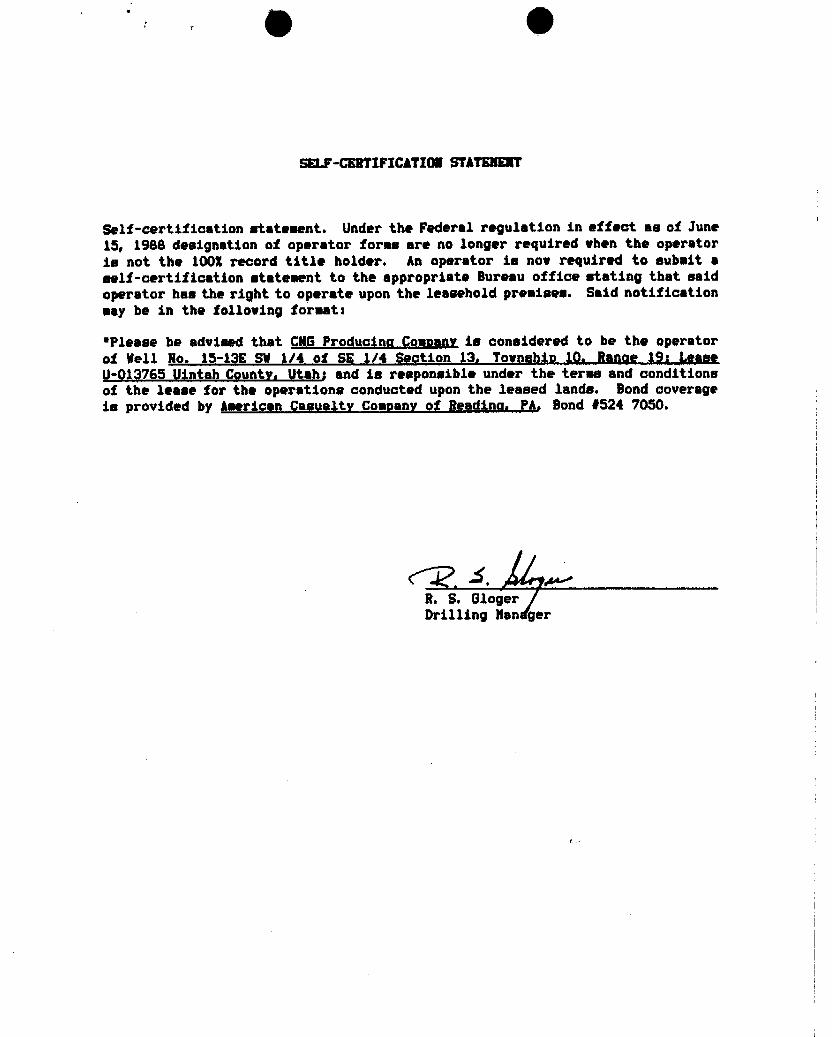
SELF-CERTIFICATION STATHET
Self-certification statement. Under the Federal regulation in effect as of June15, 1988 designation of operator forms are no longer required when the operatoris not the 1005 record title holder. An operator is now required to submit aself-certification statement to the appropriate Bureau office stating that saidoperator has the right to operate upon the leasehold premises. Said notificationmay be in the following format:
*Please be advised that CNGProducina Company is considered to be the operatorof Well No. 15-13E SW 1/4 of SS 1/4 $9ction 13, Townghip 10, Range 19¡ LeaseU-913765 Vintah County, Utah; and is responsible under the terna and conditionsof the lease for the operations conducted upon the leased lands. Bond coverageis provided by American Casualty Comnany of Readina, PA. Bond f524 7050.
I
R. S. G1ogerDrilling Nan

g · g
SOP STACK
ORILLING NIPPLE
-PLOW ONELLOW LINE
MYOnta
PIPE RAMS
BLINO RAMS
SPOOLKILL LINE
E LINE
HEAD
CHOKE MANIFOLDADJUSTABLE CHOKE
- TO MUO TANVALV C
CHOWE LIN€
1 TO RIT
ATTAClamlT 0
g · g
SOP STACK
ORILLING NIPPLE
-PLOW ONELLOW LINE
MYOnta
PIPE RAMS
BLINO RAMS
SPOOLKILL LINE
E LINE
HEAD
CHOKE MANIFOLDADJUSTABLE CHOKE
- TO MUO TANVALV C
CHOWE LIN€
1 TO RIT
ATTAClamlT 0
JPrR TOR (', - r•
- OATE
NELL NAHE ßÛ \
SEC 3 ST COONTY n
CHECK OFF:
API NUMBER
NTIAL8 ND
.NEARL
L A FIELD POTASH OROIL SHALE .
PR C
A PAPOVALLETTER:R&l5-2-3RGl5-3-2
R615-3-3 -
CAUSE NO. & DATE .
STIPULATION :
CONFIDENTIALPFRIOD
ON,..
0218 T
JPrR TOR (', - r•
- OATE
NELL NAHE ßÛ \
SEC 3 ST COONTY n
CHECK OFF:
API NUMBER
NTIAL8 ND
.NEARL
L A FIELD POTASH OROIL SHALE .
PR C
A PAPOVALLETTER:R&l5-2-3RGl5-3-2
R615-3-3 -
CAUSE NO. & DATE .
STIPULATION :
CONFIDENTIALPFRIOD
ON,..
0218 T

Pa StatÊofUtahDEPARTMENT OF NATURAL RESOURCES
Norman H. BangerterDIVISIONOF OIL, GAS AND MINING
Governor
Dee C. Hanseri355 West North Temple
Executive Director 3 Triad Center. Suite 350
Dianne R. Nielson, Ph.D. Salt Lake City. Utah 84180-1203
Division Director 801-538-5340
December 9, 1991
CNG Producing CompanyCNG Tower - 1450 Poydras StreetNew Orleans, Louisiana 70112-6000
Gentlemen:
Re: RBU 15-13E We!I, 150 feet from the south line, 1850 feet from the east line, SW 1/4SE 1/4, Section 13, Township 10 South, Range 19 East, Uintah County, Utah
Pursuant to Utah Code Ann. § 40-6-18, (1953, as amended), Utah Admin. R. 615-2-
3, and Utah R. 615-3-4, approval to drillthe referencedwell is hereby granted.
In addition, the following specific actions are necessary to fully comply with thisapproval:
1. Compliance with the requirementsof Utah Admin. R. 615-1 et seq., OilandGas General Rules.
2. Compliance with Utah Admin. R. 615-3-7, Well Control and Utah Admin. R.615-3-13 Casing Tests, specifically regarding BOP equipment and surfacecasing testing procedures.
3. Notification within 24 hours after drilling operations commence.
4. Submittal of Entity Action Form, Form 6, withinfive working days followingcommencement of drilling operations and whenever a change in operationsor interests necessitates an entity status change.
5. Submittal of the Report of Water Encountered During Drilling, Form 7.
6. Prompt notificationprior to commencing operations, ifnecessary, to plug andabandon the well. Notify Frank R. Matthews, Petroleum Engineer, (Office)(801)538-5340, (Home) (801)476-8613, or R.J. Firth, Associate Director,(Home) (801)571-6068.
an equal opportunity

OPage 2CNG Producing CompanyRBU 15-13E WellDecember 9, 1991
7. Compliance with the requirements of Utah Admin. R. 615-3-20, Gas Flaringor Venting, if the well is completed for production.
Prior to commencement of the proposed drilling operations, plans for facilities fordisposal of sanitary wastes at the drill site should be submitted to the local healthdepartment. These drilling operations and any subsequent well operations should beconducted in accordance with applicable state and local health department regulations.A list of local health departments and copies of applicable regulations are available fromthe Department of Environmental Quality,Division of Drinking Water/Sanitation, telephone(801)538-6159.
This approval shall expire one (1) year after date of issuance unless substantial andcontinuous operation is underway or an application for an extension is made prior to theapproval expiration date. The API number assigned to this well is 43-047-32167.
Sincerely,
R.JAssoc te Director, Oiland Gas
IdcEnclosurescc: Bureau of Land Management
J.L. Thompson

O OCNG ProducingCompany ZJC
December 19, 1991
DEC2 0 891
DtEd Forshma
nterior DIVISiONOFBureau of Land Management /(,7 OILGAS&MININGVernal District Office170 South 500 East CC /JVernal, UT 84078
RE: Archeological - Environmental Reports for River Bend UnitRBU 8-2F, RBU 5-17E, RBU 3-3E, RBU 15-10E, RBU 1-20E, RBU 13-23E,RBU 5-24E, RBU 15-13E, RBU 14-18F, RBU 1-25E, RBU 7-15E, RBU 8-18F,RBU 3-16F, and RBU 13-10F
Dear Ed:
Enclosed please find archeological reports for the above captioned wells.Shirley Finn is on vacation and I wasn't sure if she had sent you copies ofthese reports before she left, so I sent them again in case she did not. Bettersafe then sorry as the saying goes.
If there is anything I can do from my end to make the processing of theseapplications easier, please do not hesitate to let me know. I realize that youmust be swamped with applications this time of the year with everyone trying tospend their budget money.
If you have any questions or need any further information, please feel freeto contact me at (504) 593-7260 or our project engineer, David Linger, at (504)593-7779. Have a safe and happy holiday!
Sincerely,
Susan M. HebertRegulatory Reports Asst. II
Enclosure
cc: Tammy SearingUtah Board of Oil, Gas & Hining

O OAKHEOLOGK4LEtilRO E%TAL
22No. 1 -1)E /
No, 5-24E
4
No 1 25E
55
2
T. 10 .
R. 19 EastMeridian: Salt Lake B. & M. Quod:
Big Pack Mtn.Project: GNG-91-10 MAP 5 NW, Utah .Cultural Resource SurveySeries: Uinta Basin 7.5 minute-USGSr.: 12-5-91 of Proposed Units 15-13E,
5-24E, and 1-25E in the ****" 'Well Location aWild Horse LocalityPreviously SurveyT eAcre Survey
Access Route2, 64¤ -
,1 mile Isolated

Department of the Interior Authorization No .U.9.1.A.F.7.7.8.b. .
,Bureau of Land Ma ement
.Utah State Of e Report Accept le Yes
__No
(AERC FORMAT)Mitigation Acceptable Yes No
Summary Report of Comments:Inspection for Cultural Resources |
|
W I LD H 0 RSE BENCH L 0 C A T I ONS1. Reoort Title . . . . . . . . . . . . . . . . . . . . . . . . . . . . . . .
CNG PRODUCTION - UNITS 3-3E, 15-10E, 15-13E, 7-15E,1-20E, 13-23E, 5-24E, 1-25E, 8-2F, 5-17F, 8-18F, 14-18F
7, Deyel opmenÇompany1 2 6 1 9 9 1 UT-91-54937
3. Rev.ort Dat.e . . . . . . . . 4. Antiaui.ties Permit No.
A ERC CNG - 9 1 - 1 0 Uintah5. .Res.oonsible Inst.i.tuti.on . . . . . . . . . . . . . . . . County
6. Fieldwork1 0 S 1 9 E 3 1 0 1 3 1 5
Locati.on: TWN . . . . . RNG . . . . . Section. . .\. . . . . . . . .
7..Resource 1 0 S 1 9 E 2 0 2 3 2 4 2 5Area. TWN . . . . . RNG . . . . . Section. . . . . . . . . . . .
.B.C. 1 0 S 2 0 E 2 1 7 1 8TWN . . . . . RNG . . . . . Section. . . . . . . . . . . .
Descriotion..of..Examinat en Procedures; The archeologist, F.R. Hauck, andfield assistant Lance Harding intensively examined these units and theproposed access routes by walking a series of 10 to 20 meter-wide transects.Ten acre parcels were examined around the following locations: (see page 2)
1 . 7 I9..Linear Miles-ßur.v.eyed . . . . . . . 10. Inventor.v Tvoe , ,
and/or iDefinable Acres Surveyed . . . . . . . R = Reconnaissance
and/or I = IntensiveLegally Undefinable 7 0 S = Statistical Sample
Acres Surveyed . . . . . . .
11. Descrioti.on of..FindinRa.: .12. Number Sites Found .2. . . .
Two cultural resource sites were identified (No sites = 0)during the survey. These sites include 13. Collection: .Y.42UN 1951 and 42UN 1952 (see page 2) (Y = Yes, N = No)
14...Ac.tual/Potential Na.tional Rezister Properties .Affected:The National Register of Historic Places (NRHP) has been consulted and noregistered properties will be affected by the proposed development (see pg. 2)
15. .Literature.Saarch. Locqtion/ Date: Utah SHPO 11-14-91Vernal District Office Records 11-20-91
16. ConcLusion/ Recommendations:AERC recommends that a cultural resource clearance be granted to CNG ProducingCompany for these proposed developments based on the following stipulations:(see page 2).
17. Sianature of Administrator Administrator& Field Supervisor
FieldUT 8100-3 (2/85)
(Iþ (ilARCHEOLOGICAL- ENVIRONMENTAL
RESEARCHCORPORATIONP.O. Box 853 Bountiful, Utah 84010
Tel: (801) 292-7061, 292-9668
December 4, 1991
Subject: CULTURAL RESOURCE EVALUATIONS OF PROPOSEDWELL LOCATIONS IN THE WILD HORSE BENCH -
COTTONWOOD WASH LOCALITIES OF UINTAH COUNTY,UTAH
Project: CNG PRODUCTION CO. -- 1991 DevelopmentProgram for Units 8-2F, 5-17F, 3-3E, 15-10E, 1-20E, 13-23E, 5-24E, 15-13E, 14-18F, 1-25E, 7-15E, and 8-18F
Project No.: CNG-91-10
Permit No.: Dept. of Interior -- UT-91-54937
Utah State Project No.: UT-91-AF-778b (
To: Mr. Darwin Kulland, CNG Producing Company, P.O. Box 1360,Roosevelt, Utah 84066
Mr. David Little, District Manager, Bureau of LandManagement, 170 South 500 East, Vernal, Utah 84078
Info: Antiquities Section, Division of State History, 300 RioGrande, Salt Lake City, Utah 84101
DEC2 0 1391
DiVISIONOFOILGAS&

3-3E, 15-10E, 7-15E, 1-20E, -25E, 8-18F, AND 14-18F. g alternative access routewas examined into Unit 8- which was examined by AWC several months ago andreported October 29, 1991 (cf., UT-91-AF-636bs). The following locations and accessroutes were originally evaluated by AERC several years ago, their newly staked padsand access routes were revisited during this project to insure that they were stilllocated within the surveyed areas: 13-23E (cf., UT-88-AF-194bs), 15-13E (cf., UT-86-AF-827b), 5-24E (cf., UT-86-AF-209b), 5-15F (cf., AERC Paper No. 18 -- MAPCO SampleUnit 166 [Norman and Hauck Final Reoort on the Manco River Bend Cultural MitimationStydy, dated June 1980]).
11...continued:
Site Descriations.:. Site 42UN 1951 consists of a lithic scatter that is partiallyexposed in the south facing slope and terrace directly above the drainage channel.This site measures ca. 30 x 40 meters in size and contains a wide assortment oflithic types in a moderate density. The site is primarily a core reduction locuswhere localized slate, green mudstone, brown chert, quartzite cobbles and white-red,brown, or clear cherts were reduced. The number of secondary flakes on this siteindicate biface preparation also occurred. Only three tools observed, two choppersand a biface fragment. No features observed.
Site 42UN 1952 consists of a buried open occupation that is identifiableprimarily by the presence of oxidized sandstone fragments which have been partiallyexposed in dune matrices. This site measures ca. 50 x 150 meters in size and isfound in three distinct units. Unit A is on the sandy bluff that has been undercutby the channel and measures ca. 20 x 30 meters and contains intrusive sandstone andslate. Some of the sandstone fragments exhibit oxidization. Unit B is a 10 x 15meter dispersed scatter of oxidized sandstone and shale fragments on the site'swestern periphery and the south base on the ledge. Unit C is a 10 x 20 meterdispersed scatter of oxidized sandstone fragments and two oxidized cobbles (one isa mano) on the site's eastern periphery at the base of the ledge about 40 meterswest of the road. Units B and C appear to be mostly buried in sand depositsresulting from the decomposition of the ledge that marks the northern periphery ofthis site. No evidence of cultural material was observed along the ledge basebetween Units B and C. No diagnostic artifacts or intact features observed.
ik. continued.:
3ite 42UN 1951 is outside the pad area. The access route passes ca. 25 metersSE and outside of the site's southeastern periphery.
Site 42UN 1952 is well outside the development zone and could only be disturbedby secondary activities, e.g., vandalism. Secondary destruction is not anticipatedhowever, since this site is not readily identifiable.
1.6. .cont.inued.:
1. All vehicular traffic, personnel movement, construction and restorationaperations should be confined to the locations examined as referenced in thiseport, and to the existing roadways and/or evaluated access routes• Laidrestriction .is esoecially..Der.tinent to the develonment and use of.the access routeinto..Unit..14-.18F.
2. All personnel should refrain from collecting artifacts and from disturbingany significant cultural resources in the area.
3. The authorized official should be consulted should cultural remains from>ubsurface deposits be exposed during construction work or if the need arises to'elocate or otherwise alter the location of the exploration

(Iþ (ikARCHEOLOGICAL- ENVIRONMENTAL
RESEARCHCORPORATIONP.O. Box 853 Bountiful, Utah 84010
Tel: (801) 292-7061, 292-9668
December 4, 1991
Subject: CULTURAL RESOURCE EVALUATIONS OF TWO PROPOSEDUTE TRIBAL WELL LOCATIONS IN THE WILLOW CREEKCANYON LOCALITY OF UINTAH COUNTY, UTAH
Project: CNG PRODUCING COMPANY -- 1991 DevelopmentProgram - Units 3-16F and 13-10F
Project No.: GNG-91-11
Permit No.: Dept. of Interior -- UT-91-54937
Utah State Project No.: UT-91-AF-7791
To: Mr. Darwin Kulland, CNG Producing Company, PLO. Box 1360,Roosevelt, Utah 84066
Mr. Roland McCook, Bureau of Indian Affairs,P.O. Box 190, Fort Duchesne, Utah 84026
Mr. Jay MountainLion, Ute Indian Tribe, Energy &Minerals Dept., P.O. Box 190, Fort Duchesne,Utah 84026
Info: Antiquities Section, Division of State History, 300 RioGrande, Salt Lake City, Utah 84101
DEC20 691
DMSION OFOILGAS&

GKNERAL INFORMAT.ION;
On November 19, 1991, F. Richard Hauck and Lance Harding ofAERC conducted cultural resource evaluations of two proposed welllocations for CNG Production of Roosevelt, Utah. This project ison Ute Tribal lands in the Willow Creek locality of Uintah County.Mr. Jay MountainLion of the Energy & Minerals Departmentaccompanied the evaluations.
The proposed well units are as follows:
Ute Tribal Uni.t No. 13-10FUnit No. 13-10F is located in the SW 1/4 of Section 10,
Township 10 South, Range 20 East, Salt Lake Base & Meridian. Thislocation is immediately adjacent to the existing roadway in WillowCreek.
Ute..Tri.bal Unit .No. 3-16FUnit No. 3-16F is located in the NW 1/4 of Section 16,
Township 10 South, Range 20 East, Salt Lake Base & Meridian. Thislocation is accessible via a .2 mile-long access route from theexisting roadway.
The project areas are at the 4800 and 5000 foot elevationsabove sea level. These units are situated in the Atriplexcommunity. The Atriolex community is dominated by Atrinlex soo.,_Chrzzo.thamaue naume,.oz.ua, and Sarcobatus vermiculatus.
FIL.E SKARCH.: A records search was conducted on 11-14-91 at theAntiquities Section of the Utah State Division of History in SaltLake City. This search provided information that no previouslyrecorded cultural resources are situated in the immediatedevelopment areas. No known National Register sites are situatedin the project area.
RESEARCH METHODS: To conduct the current evaluation, thearchaeologists walked a series of 10 to 15 meter wide transectsacross the potential well locations including buffer zones aroundeach periphery. These intensive surveys included about three acresat each location.
Double 20 meter-wide transects were walked along the stakedaccess route associated with Unit 3-16F.
RESUþTS: No historic or prehistoric activity areas or isolatedartifacts were found in association with the two proposed welllocations or the access route into Unit

(Ib (ikCONCLUSION .AND RECOMMENDATIONS: The proposed development of thetwo units will have no adverse effect on the existing culturalresource sites in their general vicinities with compliance to therecommendations provided in this report. AERC recommends that acultural resource clearance be granted to CNG Production relativeto the development and production of these proposed well locationsbased upon adherence to the following stipulations:
1. all vehicular traffic, personnel movement, andconstruction should be confined to the surfaces examined asreferenced in this report, and to the existing roadways and/orevaluated access routes;
2. all personnel should refrain from collecting artifacts andfrom disturbing any cultural resources in the area; and
3. the authorized official should be consulted shouldcultural remains from subsurface deposits be exposed during thedevelopment program or if the need arises to relocate or otherwisealter the location of the construction area.
F. Richard Hauck, Ph.D.President and Principal
Investigator

Form 3160-3,
SUBMIT IN TRIPL1 Form approved.(Novainbar 1983) (Other instruction Budget Bureau No. 1004-0136fformerly9-ssic) UNITED ATES on reverse sidel "-r -^m-.es. som
DEPARTM T OF THE INTERIOR 5. LEAsE DESIGNATION AND SERIAL NO.
BUREAUOF LANDMANAGEMENT U-013765APPLIGATIONFOR PERMIT TO DRILL, DEEPEN, OR PLUS BAGK 6. IF INDIAN, ALLOTTEE OR TRIBENAME
la. TYPE OF WORKDRILL(X) DEEPEN [ ] PLUG BACK[ ] 7. UNITAGREEMENTNAME
b. TYPE OF WELL River Bend UnitOILWELL() GASWELL(Xj OTHER SINGLEZONE ( j MULTIPLEZONE 8. FARMOR LEASENAME
2. NAMEOF OPERATOR RBUGNG PRODUGING COMPANY 9. WELLNO.
3. ADDRESS OF OPERATOR 15-13EGNG Tower, 1450 Poydras St., New Orleans, LA '7011 40 0 10. FIELDAND POOL, OR WILDCAT
4. LOCATION OF WELL(Report location clearly and in accordance with a tína a ants.*) IslandAt surface 150'FSL&1650' FELSect.13,T108,R19E 11. SESC.,T., R., M., OR BLK.
DIVISIONOF AND SURVEYOR AREAAt proposed prod.zon. OILGAS&MININGSame Í 7 13-T10S-R19E
14. DISTANCEINMILESANDDIRECTIONFROM NEARESTTOWN OR POST OFFICE* 12. COUNTYOR PARISi 13. STATE10 Miles SW of Ouray Unitah Utah
15. DISTANCEFROM PROPOSED* 16. NO. OF ACRES IN LEAS. 17. NO. OF ACRES ASSIGNEDLOCATIONTO NEAREST TOTHIS WELLPROPERTY OR LEASELINE,FT.(Also to nearest drig. unit line if any) 5453' 1,097.87 80
18. DISTANCEFROM PROPOSED LOCATION* 19. PROPOSED DEPTM 20. ROTARY OR CABLETOOLSTO NEARESTWELL, DR1LLING,COMPLETED,OR APPLIED FOR, ON THIS LEASE, FT. 2602' 7,600' Rotary
21. ELEVATIONS(Show whether DF, RT, GR, etc.) 22. APPROX. DATEWORKWILLSTART5180'GR March 15, 1992
23. PROPOSED CASING AND CEMENTING PROGRAMSIZE OF HOLE SIZE OF CASING WEIGHT PER FOOT SETTING DEPTH QUANTITYOF CEMENT
12 1/4" 8 6/8" 24# +I- $¶0 T Gement to Surface7 7/8" 5 1/2" 17# +/-7,600 Gement Galo to Surface
1. Drill a 12 1/4" hole with an air rig to +/-400', run 8 5/8", H-40 casing and cement to surface.2. NU and pressure test BOP stack prior to drilling out below surface pipe.3. Operate pipe rams daily and blind rams as possible.4. Drill a 7 718" hole to 7,600' with a salt water mud system. Coring is possible. DST's willbe run as
needed to evaluate unexpected shows.5. Run logs, set 5 1/2", 17#, N 80 & K-55 casing as dictated by drilling shows, tests, and logs. Casing
program may be modified to provideadded burst strengh if needed for frac program.6. Primary zones of interest are the Wasatch, Chapita Wells & Uteland Buttes.7. AII zones indicating potential for economically recoverable reserves will be tested in a normal,
prudent manner.FORMATION TOPS DEPTHSWasatch 4,700 CONFilENilALGhapita Wells 5,450'Uteland Buttes 6,550'CNG Producing respectfully request that all information concerning this well be held confidential.IN ABOVE SPACE DESCRIBE PROPOSED PROGRAM: If proposal is to deepen or plug back, give data on present productiva zona and proposednew productive zone. If proposal is to drill or deepen directionally, give partinent data on subsurface locations and measured and true verticle depthGive b
ED TITLE Supervisor. Drillina Engineering DATE 11/26/91
(This spaca for FaÊ$N A1TACHEDPERMIT NO. 4 f. TOOP ?Y APPROVAL DATE
APPROVED BY TITLE. ASSISTAWDISTR!CT DATE DEC1 9 14¶
CONDITIONS OF APPROVAL, IF ANY: lŠ¾QERf
() 8ggfy)gg *See Instructions On Reverse Side NOTICEOFAPPROVALTitia 18 U.S.C. Section 1001, makes it a crime for any person knowingly and willfullyto make to any department or agency of the United States

O O
CONDITIONS OF APPROVALAPPLICATION FOR PERMIT TO DRILL
Company/Operator: CNG PRODUCINGCOMPANY
Well Name & Number: 15-13E River Bend Unit
Lease Number: U-013765
Location: 150' FSL 1850' FEL Sec. 13 T. 105 R. 19E
Surface Ownership: Public Lands Administered by the ELM
NOTIFICATION REQUIREMENTS
Location Construction - at least forty-eight (48) hours prior to con-struction of location and access roads.
Location Completion - prior to moving on the drilling rig.
Spud Notice - at least twenty-four (24) hours prior to spuddingthe well.
Casing String and - at least twenty-four (24) hours prior to runningCementing casing and cementing all casingstrings.
BOP and Related - at least twenty-four (24) hours prior to initiat-ing Equipment Tests pressure tests.
First Production - within five (5) business days after new wellbegins Notice or production resumes after wellhas been off production for more than ninety (90)days.
For more specific details on notification requirements, please check theconditions of Approval for Notice to Drill and Surface Use

O O
Approval of this application does not warrant or certify that the applicant holdslegal or equitable title to those rights in the subject lease which would entitlethe applicant to conduct operations thereon.
All lease and/or unit operations will be conducted in such a manner that fullcompliance is made with applicable laws, regulations (43 CFR 3100), Onshore Oiland Gas Orders, and the approved plan of operations. The operator is fullyresponsible for the actions of his subcontractors. A copy of these conditionswill be furnished the field representative to insure compliance.
Be aware fire restrictions may be in effect when location is being constructedand/or when well is being drilled. Contact the appropriate Surf ace ManagementAgency for information.
A. DRILLING PROGRAM
1. Estimated Depth at Which Oil, Gas, Water, or Other Mineral BearinqZones are Expected to be Encountered
Report ALJ water shows and water-bearing sands to Tim Ingwell ofthis office. Copies of State of Utah Form OGC-8-X are acceptable.If noticeable water flows are detected, submit samples to thisoffice along with any water analyses conducted.
All usable water and prospectively valuable minerals (as describedby BLMat onsite) encountered during drilling, will be recorded bydepth and adequately protected. All oil and gas shows will betested to determine commercial potential.
2. Pressure Control Equipment
The BOP and related equipment shall meet the minimumrequirements ofOnshore Oil and Gas Order No. 2 for equipment and testing require-ments, procedures, etc. and individual components shall be operableas designed.
The special drilling requirements in Onshore Order No. 2 regardingair or gas drilling shall be adhered to, if air is used as theprincipal drilling medium, i.e. , if the rig mud pumps are not beingutilized while drilling.
Test charts, with individual test results identified, shall bemaintained on location while drilling and shall be made ,available toa BLM representative upon request.
3. Casing Program and Auxiliary Equipment
Surface casing shall have centralizers on the bottom three joints,with a minimumof one centralizer per joint.
As a minimum, the usable water and oil shale resources shall beisolated and/or protected by having a cement top for the productionintermediate casing at least 200 f eet above the top of the Mahoganyoil shale, identified at +1818 feet. If gilsonite is

O O
while drilling, it shall be isolated and/or protected via thecementing program.
4. Mud Program and circulating Medium
Hazardous substances specifically listed by the EPA as a hazardouswaste or demonstrating a characteristic of a hazardous waste willnot be used in drilling, testing, or completion operations.
No chromate additives will be used in the mud system on Federal andIndian lands without prior ELM approval to ensure adequate protec-tion of fresh water aquifers.
5. Coring, Loqqing and Testing Program
Daily drilling and completion progress reports shall be submitted tothis office on a weekly basis.
All Drill Stem Tests (DST) shall be accomplished during daylighthours, unless specific approval to start during other hours isobtained from the Authorized Of f icer (AO). However , DSTs may beallowed to continue at night if the test was initiated duringdaylight hours and the rate of flow is stabilized, and if adequatelighting is available (i.e., lighting which is adequate forvisibility and vaporproof for safe operations). Packers can bereleased, but tripping should not begin before daylight unless priorapproval is obtained from the AO.
A cement bond log (CBL) shall be utilized to determine the 1;og ofcement (TOC) and bond quality for the production casing.
Whether the well is completed as a dry hole or as a producer , "WellCompletion and Recompletion Report and Log" (Form 3160-4) will besubmitted not later than thirty (30) days after completion of thewell or after completion of operations being performed, in accor-dance with 43 CFR 3164. Two copies of all logs, core descriptions,core analyses, well-test data, geologic summaries, sample descrip-tion, and all other surveys or data obtained and compiled during thedrilling, workover, and/or completion operations, will be filed withForm 3160-4. Samples (cuttings, fluids, and/or gases) will besubmitted when requested by the AO.
6. Notifications of Operations
No location will be constructed or moved, no well will be plugged,and no drilling or workover equipment will be removed from a well tobe placed in a suspended status without prior approval of the AQ.If operations are to be suspended, prior approval of the AO will beobtained and notification given before resumption of operations.
Operator shall report production data to MMS pursuant to 30 CFR216.5 using form

O O
Immediate Report: Spills, blowouts, fires, leaks, accidents, or anyother unusual occurrences shall be promptly reported in accordancewith the requirements of NTL-3A or its revision.
If a replacement rig is contemplated for completion operations, a"Sundry Notice" (Form 3160-5) to that effect will be filed, forprior approval of the AO, and all conditions of this approved planare applicable during all operations conducted with the replacementrig.
The date on which production is commenced or resumed will be con-strued for oil wells as the date on which liquid hydrocarbons arefirst sold or shipped from a temporary storage facility, such as atest tank, and for which a run ticket is required to be generated,or the date on which liquid hydrocarbons are first produced into apermanent storage facility, whichever first occurs; and for gaswells as the date on which associated liquid hydrocarbons are firstsold or shipped from a temporary storage facility, such as a testtank, and for which a run ticket is required to be generated, or thedate on which gas is first measured through permanent meteringfacilities, whichever first occurs.
Should the well be successžully completed for production, the AOwill be notified when the well is placed in a producing status.Such notification will be sent by telegram or other written communi-cation, not later than five ( 5) days following the date on which thewell is placed on production.
Gas produced from this well may not be vented or flared beyond aninitial authorized test period of thirty ( 30 ) days or 50 MMCFfollowing its completion, whichever occurs first, without the priorwritten approval of the AO. Should gas be vented or flared withoutapproval beyond the authorized test period, the operator may be dir-ected to shut-in the well until the gas can be captured or approvalto continue venting or flaring as uneconomic is granted and theoperator shall be required to compensate the lessor for that portionof the gas vented or flared without approval which is determined tohave been avoidably lost.
A schematic facilities diagram as required by 43 CFR 3162.7-2, 3162.7-3, and 3162.7-4 shall be submitted to the appropriate DistrictOffice within 30 days of installationor first production, whicheveroccurs first. All site security regulations as specified in OnshoreOil and Gas Order No. 3 shall be adhered to. All product linesentering and leaving hydrocarbon storage tanks will be effectivelysealed in accordance with 43 CFR 3162.7-4.
No well abandonment operations will be commenced without the priorapproval of the AO. In the case of newly drilled dry holes or fail-ures, and in emergency situations, oral approval will be obtainedfrom the AO. A "Subsequent Report of Abandonment" Form 3160-5, willbe filed with the AO within thirty (30) days following completion ofthe well for abandonment. This report will indicate where plugswere placed and the current status of surface restoration.

(Iþ (Iþ
abandonment will not be approved until the surface reclamation workrequired by the approved APD or approved abandonment notice has beencompleted to the satisfaction of the AO or his representative, orthe appropriate Sur f ace Managing Agency .
7. Other Information
All loading lines will be placed inside the berm surrounding thetank battery.
All of f -lease storage , of I-lease measurement , or commingling on-lease or off-lease will have prior written approval from the AO.
Gas meter runs for each well will be located within 500 feet of thewellhead. The gas flowline will be buried or anchored down from thewellhead to the meter and 500 feet downstreamof the meter run.orany production facilities. Meter runs will be housed and/or fenced.
The oil and gas measurement facilities will be installed on the welllocation. The oil and gas meters will be calibrated in place priorto any deliveries. Tests for meter accuracy will be conductedmonthly for the first three months on new meter installations and atleast quarterly thereafter. The AO will be provided with a date andtime for the initial meter calibration and all future meter provingschedules. A copy of the meter calibration reports will be submit-ted to the Vernal District Office. All meter measurement facilitieswill conform with the Onshore Oil and Gas Order No. 4 for liquidhydrocarbons and Onshore Oil and Gas Order No. 5 for natural gasmeasurement.
The use of materials under BLM jurisdiction will conform to 43 CFR3610.2-3.
There will be no deviation from the proposed drilling and/or work-over program without prior approval from the AO. Safe drilling andoperating practices must be observed. All wells, whether drilling,producing, suspended, or abandoned, will be identified in accordancewith 43 CFR 3162.
"Sundry Notice and Report on Wells" (Form 3160-5) will be filed forapproval for all changes of plans and other operations in accordancewith 43 CFR 3162.3-2.
Section 102(b)(3) of the Federal Oil and Gas Royalty Management Actof 1982, as implemented by the applicable provisions of the operat-ing regulations at Title 43 CFR 3162.4-1(c), requires that "notlater than the 5th business day after any well begins production onwhich royalty is due anywhere on a lease site or allocated to alease site, or resumes production in the case of a well which hasbeen off production for more than 90 days, the operator shall notifythe authorized officer by letter or sundry notice, Form 3160-5, ororally to be followed by a letter or sundry notice, of the date onwhich such production has begun or

(Ib (il
If you fail to comply with this requirement in the manner and timeallowed, you shall be liable for a civil penalty of up to $10,000per violation for each day such violation continues, not to exceeda maximum of 20 days. See Section 109(c) (3) of the Federal Oil andGas Royalty Management Act of 1982 and the implementing regulationsat Title 43 CFR 3162.4-1(b)(5)(ii).
APD approval is valid for a period of one (1) year from the signa-ture date. An extension period may be granted, if requested, priorto the expiration of the original approval period.
In the event af ter-hour approvals are necessary, please contact oneof the following individuals:
3erald E. Kenczka (801) 781-1190Petroleum Engineer
Ed Forsman (801) 789-7077Petroleum Engineer
BLM FAX Machine: (801)

O O
EPA"S LIST OF NONEXEMPTEXPLORATION AND PRODUCTION WASTES
While the following wastes are nonexempt, they are not necessarily hazardous:
Unused fracturing fluids or acids
Gas plant cooling tower cleaning wastes
Painting wastes
Oil and gas service company wastes, such as empty drums, drum rinsate,vacuum truck r insate , sandblast media , painting wastes , spend solvents ,spilled chemicals, and waste acids.
Vacuum truck and drum rinsate from trucks and drums, transporting orcontaining nonexempt waste .
Refinery wastes
Liquid and solid wastes generated by crude oil and tank bottom reclaimers
Used equipment lubrication oils
Waste compressor oil, filters, and blowdown
Used hydraulic fluids
Waste solvents
Waste in transportation pipeline-related pits
caustic or acid cleaners
Boiler cleaning wastes
Boiler refractory bricks
Incinerator ash
Laboratory wastes
Sanitary wastes
Pesticide wastes
Radioactive tracer wastes
Drums, insulation, and miscellaneous

O O
Additional Surface Stipulations
A silt catchment dam and basin will be constructed according to ELMspecifications east of the location, where flagged.
See attached Flowline
O O
Additional Surface Stipulations
A silt catchment dam and basin will be constructed according to ELMspecifications east of the location, where flagged.
See attached Flowline

(il (il
CONDITIONS OF APPROVAL
1. No blading will be allowed on surface pipelines.
2. Vehicle use will be restricted to the pipeline route. It would bepreferable if the pipe was welded in central staging areas and thendragged across the ROWwith a CAT.
3. The Book Cliff Resource Area minerals staff will be notified twenty-four(24) hours prior to starting construction.
4. All surface lines will be either black or brown in color.
5. Construction of the pipeline will not occur during periods of wet soilconditions.
6. If any cultural resources are found during construction, all work willstop and the Vernal District BLM office will be notified.
7. The metering of all gas will be done in accordance with Onshore Order

O O
DIVISION OF OIL, GAS AND MINING
SPUDDING INFORMATION
NAME OF COMPANY: CNG 43-047-32167
WELL NAME: RBU 15-13E
Section 13 Township 10S Range 19E County UINTAH
Drilling Contractor SST
Rig # 1
SPUDDED: 1-20 02-
CONFIDENTIALHow DRY HOLE
Drilling will commence
Reported by RON (LEON ROSS)
Telephone # 722-4469
Date 1-24-92 SIGNED

· -.. -· -« um i nua i A I am FORMAPPROVEDDEPARTMENT INTERIOR OGET BUREAUNO.1GG4-ûl35BUREAUOF LA NAGEMENT PIRES: MARGH 31, 1993
5. Lease Designation and serial No.SUNDRY NOTICES AND REPORTS ON WELLS U-013765
Do not use this form for proposals to drill or to deepen or reentry to a 6. If Indian, Allottee or Tribe Namedifferent reservoir. Use "APPLICATION FOR PERMIT -
" for such gro osalsSUBMIT IN THIPLICATO
1. Type of Well 7. If Unit or CA, Agreement Desigration[ LOil Well [X] Gas Well I ] Other River Bend Unit
2. Name of Operator 8. Well Name and No.GNG PRODUCING COMPANY 15-13E
3. Address and Telephone No. 9. API WeH No.GNG Tower - 1450 Paydras Street, New Orleans L 0 43-047-32167
4. Location of Well (Footage, Sec., T., R., M., or Sur 10. Field and Pool, or Exploratory AreaSurface - 150' FSL & 1,850' FEL of Sea.13-T10S-R19E island
11. Gounty or Parish, StateUinlah, Utah
CHECK APPROPRIATEBOX(!) TO INDICATENATURE OF NOTICE, REPORT, OR OTHER DATATYPE OF SUBMISSION TYPE OF ACTIONj ] Notice of Intent j ] Abandonment ( ] Change of Plans
[ ] Recompletion [ ] New Gonstruction[X] Subsequent Report | ] Plugging Back [ ] Non-Routine Fracturing
[ ] Casing Repair [ ] Water Shut-Off[ ] Final Abandonment Notice [ ] Altering Casing ( ] Corwersion to Injection
IXIOther - Spud Notice [ ] Dispose Water(Note: Report results of multiplecompletion on Well Completion orRecompletion Report and Log form.)
13. Describe Proposed or Completed Opera ions (Glearly state a11pertinent delails, and give pertinent dates, includingestimated date of starting any proposed work. If well is directiormily drilled, give subsurface locations and measureand true vertical depths for all markers and zones pertinent to the work.)*
This is to notify you that the RBU 15-13E was spudded by Ross Drilling on 01-24-92.
They drilled 384' of 12 1/4" hole and ran 9 jts of 8 5/8" 24# H-40 casing.
Cemented with 10 bbis gelled water followed by 224 sks "G" Poz with 2¾ S-19.Displaced with 20.9 bbis fresh water. Set shoe at 381.11'.
I 1 I I IIII II14. I hereby certify that the forgoing is true and correct
signed , Title Requintory Reports Asst. II Date February 13, 1992Susan M. Hebert
(This space for Federal or State office use)
Approved by Title DateConditions of approval, if any:
Title 18 U.S.C. Section 1001, makes it a crime for any person knowingly and willfully to make to any department oragency of the United States any false, fictitious or fraudulent statements or representations as to any matterwithin its jurisdiction.
*See Instructions on Reverse

STATE OF UTAHDIVISION OF OIL, GAS AND MlNING OPERATOR GNG Producing Company OPERATOR ACCT. No. NO605
ENHTY AGTION FORM - FORM 6 ADDREss GNG Tower
1450 Poydras Stred
New Orleans, LA 70112-6000o ACTioN CURRENT NEW API NUMBER WELL NAME WELLLOCATION , 9 Ub EFFECTIVE
CODE ENTITY NO. ENTITY NO. QQ SC TP RG COUO ÜAÌE DATE
B 99Ÿ$ O O90 43-047-321 67 RBU 15-13E SW SE 13 TOS 19E Uintah 01/24/92WELL 1 COMMENTs: This well is located within River Bend Unit on BLM land.
WELL3 COMMENTS:
CLoo WELL 4 COMMENTS:
i
WELL 5 COMMENTS
ACTIONCODES(See instruction on back of form)bnHshnw ana
(un I
rin ni
C - Re-essign wtu from one existing antityto another existing antity SignatureD - Re-assign wen from one axisting antityto a new entityE - Othar(explain in comments section) Regulatory Reports Assistant II February 13, 1992
Title DateNOTE: Use COMMENT section to explain why much Action Code was selected.
(5/89) Phone No. (504}

FEE - 1 4 - 9 2 FR I 1 i :04 UN I E AR DEN P -
UNIBARENERGYSERVICES,INC.
February 14, 1992
DMSIONOILGASA WMNG
Mr. Steve ShellenbergMr. Doss BourgeoisMr. Dave LingerMr. Bill FloresCNG Producing Company1450 Poydras StreetNew Orleana, Louisiana 70130-6000
RE: DAP Mud ProposalRiver Bend Project
Gentlemen:
Attached please find UNIBAR's recommended mud program for use of DAP mud on theRiver Bend Project.
We feel that the KCl/aerated water program we have been following is successful,but the resulting corrosion control costa are higher than acceptable. The con-version to DAP from KCl vill not affect any other parameters, but it shoulddrastically reduce your corrosion costs.
DAP (Diamsonium phosphate) is a very strong inhibitor when present in con-centrations above 4 ppb. The ammonium fon «I11 base exchange in an active clayas readily as a potasetum ton will, with the resulting dehydration and claycollapse. This prevente the clay from hydrating and causing wellbore instabi-lity,
e do not expect the inhibition prov1ded by the DAP to be better than the KCL,but there are two advantages we do expect. The absence of the C1" fon will pre-vent disperefon of the shales. This is a problem that is usually only seen whenthe wellbore is open for an extended period of time.
The negatively charged CI~ion will migrate between in-situ clay platelets,
which exhibit a net negative charge on their faces. The opposing force causesthe platelets to move apart, most often into the wellbore itself. The result issloughing shale. In essence the use of KC1 prevents the clay from swe11tug, butmay cause dispersion pToblems anyway. The use of DAP avoids this dispersionproblem, while still protecting the clays from hydration.
Coroorate Office: 10777 Westheimer Rd. • Suite960 • Houston, Texas 77Ô42-3486• Tel: (713) 789-1422 • Fax: (713) 789-1704Sales Office: 410 17th Street • Suite 540 • Denver, Colorado 80202 • Tel: (303) 892-5610 • Fax; (303)
rbE - 1 4 - 9 2 FR I 1 3 :05 UN I E A RDEN
MARO2 1992CNGProducing CompanyFebruary 14, 1992Page 2 WSiCNOF
DR.GASS MINWO
It is commonly known that corrosion of metal goods is accelerated in a brackishenvironment. The use of 3% KCL. for instance, results in a chloride con-centration of at least 14,000 mg/1. This concentration may increase as the K+fon fa used up in base exchange reactions.
Even though DAP is commonly referred to as a salt. It will not introduce any Cl¯
fons when mixed. The absence of the chlorides will result in lower corrosionrates, which will be seen in corrosion cost reductions as well.
To summarize, we feel that replacing KCl with DAP on this project will result ina lower corrosion control cost, without any disadvantages. Wellbore stabilityshould be the same, and our actual mud cost should be quite similar. The pro-ducts we use to mud up at TD will not change in composition or concentration.Easically, we have something to gain and nothing to lose in the conversion.
Thank you for taking the time to visit with me on this last week. We appreciatethe opportunity to present this information to you, and we look forward toworking with you on this idea, Our suggestion would be to switch one rig to aDAP system for at least 3 ve118 before a comparison between the two systems can
e made. Please do not hesitate to call if you have any questions, or ff we canbe of further assistance.
Sincerely,
UNISAR ENERGY SERVICES. ING.
Tom eelerTechnical Service

Form 3160-5 UNIT ATES RM APPROVEDDEPARTMENT O E INTERIOR DGET BUREAU NO. 1004-0135BUREAU OF LAND MANAGEMENT EXPIRES: MARGH 31, 1993
5. Lease Designation and Serial No.SUNDRY NOTICES AND REPORTS ON WELLS U-013765
Do not use this form for proposals to drill or to deepen or reentry to a 6. If Indian, Allottee or Tribe Namedifferent reservoir. Use "APPLICATION FOR PERMIT -
" for such proposalsSUBMIT IN TRIPLICATE
1. Type of Well 7. If Unit or CA, Agreement Designation[ ] Oil Well [X] Gas Well [ ] Other River Bend Unit
2. Name of Operator 8. Well Name and No.CNG PRODUCING COMPANY 15-13E
3. Address and Telephone No. 9. API Well No.CNG Tower - 1450 Poydras Street, New Orleans, LA 70112-6000 43-047-32167
4. Location of Well (Footage, Sec., T., R., M., or Survey Description) 10. Field and Pool, or Exploratory AreaSurface - 150' FSL & 1,850' FEL of Sec. 13-T10S--R19E island
11. Gounty or Parish, StateUintah, Utah
CHEGK APPROPRIATE BOX(E) TO INDIGATE NATURE OF NOTICE, REPORT, OR OTHER DATATYPE OF SUBMISSION TYPE OF AGTION[X] Notice of Intent [ ] Abandonment [ ] Change of Plans
( ] Recompletion [ ] New Construction[ j Subsequent Report [ ] Plugging Back [ ] Non-Routine Fracturing
I ] casingRepair [ I Water Shut-Off( ] Final Abandonment Notice ( ] Altering Casing ( ] Conversion to Injection
IX]Other - Amend Drilling [ ] Dispose WaterPermit (Note: Report results of multiple
completion on Well Gompletion orRecompletion Report and Log form.)
13. Describe Proposed or Completed Operations (Clearly state all pertinent details, and give pertinent dates, includingestimated date of starting any proposed work. If well is directionally drilled, give subsurface locations and measureand true vertical depths for all markers and zones pertinent to the work.)*
CNGP is panning to change mud systems on RBU 15-13E from the Potassuim Ghloride mud system to a DAP(Diamonium Phosphate) mud system. Please find attached Unibar's proposal.
If you have any questions, please feel free to contact me at (504) 593-7779.
ACCEPTED sy THE STATE O2 92OF UTAH DIVISIONOF
DATE:
Signed \ Title Senior Drilling Engineer Date February 25, 1992David'L.fing
(This space for Federal or State office use)
Approved by Title DateConditions of approval, if any:
Title 18 U.S.C. Section 1001, makes it a crime for any person knowingly and willfully to make to any department oragency of the United States any false, fictitious or fraudulent statements or representations as to any matterwithin its jurisdiction.
*See Instructions on Reverse

STATE OF UTAHDIVISION OF OIL, GAS & MINING
DRILLING INSPECTION FORM
COMPANY: CNG PRODUCING REPRESENTATIVE: JIM JACKSON
WELL NAME: RBU 15-13 E API #: 43-047-32167
OTR OTR: SWSE SECTION: 13 TWP: 10 SOUTH RANGE: 19 EAST
CONTRACTOR: SST ENERGY RIG #: 1 - RUSS BURDICK
INSPECTOR: CAROL KUBLY TIME: 1145 HRS DATE: 02.28.92
OPERATIONS: DRILLING DEPTH: 2537'
SPUD DATE: DRY: 01.24.92 RIG: 02.27.92 T.D DATE: DEPTH:
Y WELL SIGN Y BOPE Y SANITATION
N FLOW LINE Y BLOOIE LINE N H2S POTENTIAL
Y ENVIRONNENTAL POLLUTION CONTROL N FIRE HAZARDS
Y RESERVE PIT Y FLARE PITY FENCED Y LINES RUNN LINED PLASTIC
RUBBERBENTONITE
Y BOP RAM TEST RECORDED IN IADC BOOK?
Y BOP TRAINING RECORDED IN IADC BOOK?
N/A COMPLIANCE WITH PRESITE STIPULATIONS (IF NO, EXPLAIN BELOW).
FEDERAL LEASE
LEGEND: (Y) - YES (N) - NO : (N/A) - NOT APPLICABLE
REMARKS: RESERVE PIT 1/4 FULL. LOCATION OK. BOP TESTED 02.26.92
LATEST DEVIATION SURVEY @ 1400' = 1

Form 3160-5 UNITED S RM APPROVEDDEPARTMENT O NTERIOR DGET BUREAU NO. 1004-0135BUREAU OF LAND AGEMENT EXPIRES: MARGH 31, 1993
5. Lease Designation and Serial No.SUNDRY NOTICES AND REPORTS ON WELLS U-013765
Do not use this form for proposals to drill or to deepen or reentry to a 6. If Indian, Allottee or Tribe Namedifferent reservoir. Use "APPLICATION FOR PERMIT -
" for such proposalsSUBMIT IN TRIPLICATE
1. Type of Well 7. If Unit or CA, Agreement DesignationI ] Oil Well [X] Gas Well [ ] Other River Bend Unit
2. Name of Operator 8. Well Name and No.GNG PRODUCING COMPANY 15-13E
3. Address and Telephone No. 9. API Well No.CNG Tower - 1450 Poydras Street, New Orleans, LA 70112-6000 43-047-32167
4. Location of Well (Footage, Sec., T., R., M., or Survey Description) 10. Field and Pool, or Exploratory AreaSurface - 150' FSL & 1850' FEL of Sec. 13-T10S-R19E Island
11. County or Parish, StateUintah, Utah
CHECK APPROPRIATE BOX(E) TO INDICATE NATUREOF NOTICE, REPORT, OR OTHER DATATYPE OF SUBMISSION TYPE OF ACTION( ] Notice of Intent j ] Abandonment I ] Change of Plans
[ ] Recompletion [ ] New Gonstruction(X) Subsequent Report ( ] Plugging Back [ ] Non-Routine Fracturing
I ] Casing Repair [ ] Water Shut-Off[ ] Final Abandonment Notice ( ] Altering Casing [ ] Conversion to Injection
[XIOther - Weekly Report j ] Dispose Water(Note: Report results of multiplecompletion on Well Gompletion orRecompletion Report and Lag form.)
13. Describe Proposed or Gompleted Operations (Clearly state a11pertinent details, and give pertinent dates, includingestimated date of starting any proposed work. If well is directionally drilled, give subsurface locations and measureand true vertical depths for all markers and zones pertinent to the work.)*
February 26 - February 28, 1992
MAR0 4 1992Rig up. Test BOPs - tested OK. Rig up. Pick up drill bit and trip in hole. Drill cement and shoe.Drilling 396' - 508' with fluid. Survey at 5,29'. Drilling with fluid. Rig service - adjust load ongenerators. Drilling with nerated fluid. Changed rotating head rubber. Drilling with aerated figySON OFSurvey at 994'. Drilling with aerated fluid. Survey at 1,400'. Dril ing with aernted fluid. Surg¡g GAS&MININGat 1,930'. Mud wt. 8.5. TD at 2,010'.
14. I hereby certify that the forgoing is true and correct
Signed Title Regulatory Reports Asst, 11 Date February 28, 1992Susan M. Hebert
(This space for Federal or State office use)
Approved by Title DateConditions of approval, if any:
Title 18 U.S.C. Section 1001, makes it a crime for any person knowingly and willfully to make to any department oragency of the United States any false, fictitious or fraudulent statements or representations as to any matterwithin its jurisdiction.
*See instructions on Reverse
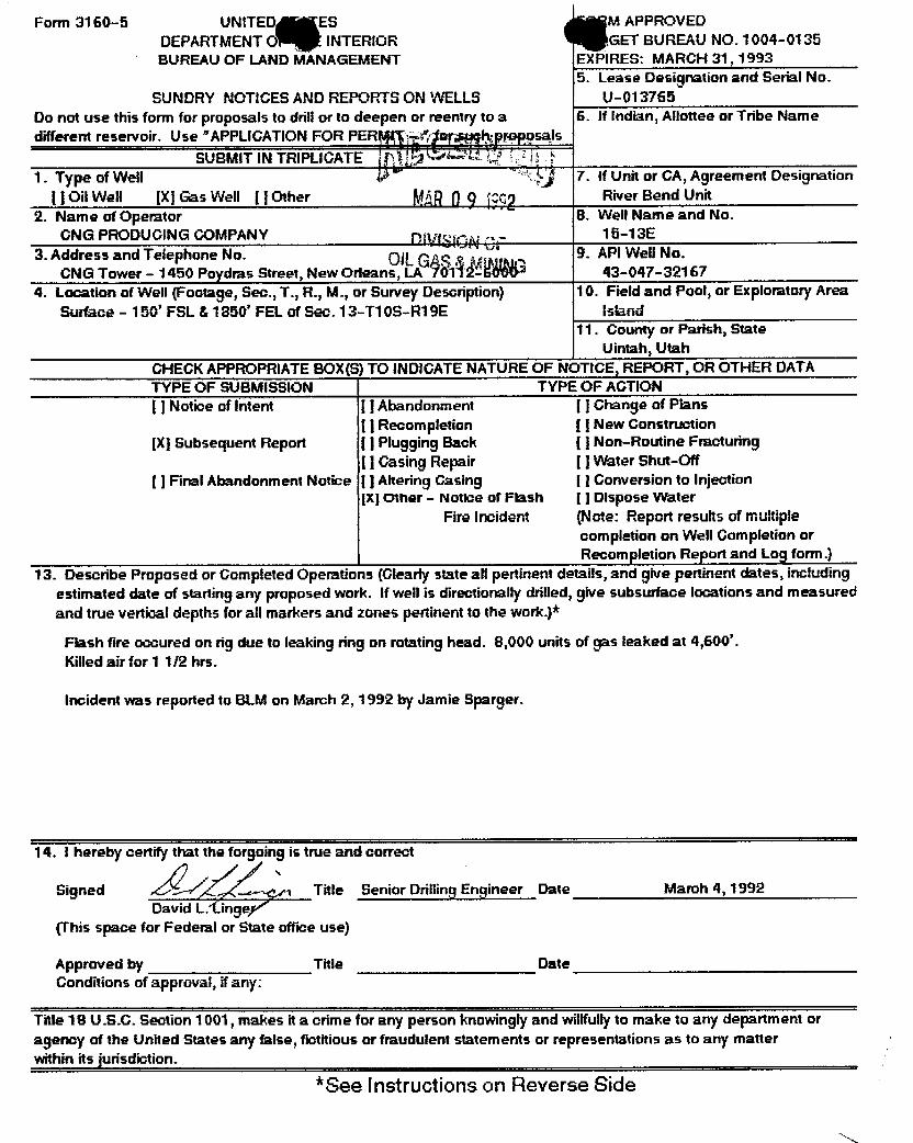
Form 3160-5 UNITED ES M APPROVEDDEPARTMENT O INTERIOR GET BUREAU NO. 1004-0135BUREAU OF LAND MANAGEMENT EXPIRES: MARCH 31, 1993
5. Lease Designation and Serial No.SUNDRY NOTICES AND REPORTS ON WELLS U-013765
Do not use this form for proposals to drill or to deepen or reentry to a 6. If Indian, Allottee or Tribe Namedifferent reservoir. Use "APPLICATION FOR PER ggg psals
SUBMIT IN TRIPLICATE1. Type of We11 ) 7. If Unit or CA, Agreement Designation
( jOil Well [X] Gas Well [ IOther River Bend Unit2. Name of Operator 8. Well Name and No.
CNG PRODUGING COMPANY 15-13E3. Address and Telephone No. Oi
" 9. API weilNo.CNG Tower - 1450 Paydras Street, New Orleans, m 14BRE 43-047-32167
4. Location of We11(Footage, Sec., T., R., M., or Survey Description) 10. Field and Pool, or Exploratory AreaSurface - 150' FSL & 1850' FEL of Sec. 13-T10S-R19E Island
11. County or Parish, StateUintah, Utah
CHECK APPROPRIATE BOX(S) TO INDICATENATURE OF NOTIGE, REPORT, OR OTHER DATATYPE OF SUBMISSION TYPE OF ACTIONj ] Notice of Intent j ] Abandonment [ ] Change of Plans
() Recompletion [ j New Construction[X] Subsec¡uent Report j ] Plugging Back ( ) Non-Routine Fracturing
I ] Casing Repair [ ] Water Shut-Off
[ ] Final Abandonment Notice j ] Ahering Casing [ ] Conversion to InjectionIX) Other - Notice of Flash [ ] Dispose Water
Fire Incident (Note: Report results of multiplecompletion on Well Gompletion orRecompletion Report and Log form.)
13. Describe Proposed or Gompleted Operations (Clearly state all pertinent details, and give pertinent dates, includingestimated date of starting any proposed work. If well is directionally drilled, give subsurface locations and measuredand true vertical depths for all markers and zones pertinentto the work.)*
Flash fire accured on rig due to leaking ring on rotating head. 8,000 units of gas leaked at 4,600'.Killed air for 1 1/2 hrs.
Incident was reported to BLM on March 2, 1992 by Jamie Sparger.
14. I hereby certify that the forgoing is true and correct
signed a Title Senior Drilling Engineer Date March 4, 1992David L.iinge
(This space for Federal or State office use)
Approved by Title DateConditions of approval, if any:
Title 18 U.S.C. Section 1001, makes it a crime for any person knowingly and willfully to make to any department oragency of the United States any false, fictitious or fraudulent statements or representations as to any matterwithin its jurisdiction.
*See Instructions on Reverse

DIVISIONOF OIL, GAS ANDMINING
REPORT OF WATER ENGOUN DURING DRILLING - FORM i(1
1. Well name and number: RBU 15-13EAPI number: 43-047-32167
2. Well location: QQ SW SE section 13 township 108 range 19E county Uintah
3. Well operator: GNG Producing GomganyAddress: GNG Tower - 1450 Poydras Street phone: (604) 593-7000
New Orleans, LA 70112-6000
4. Drilling contractor: S.S.T. Energy GorporationAddress: 999 18th Street, Suite 1690 phone: (303) 293-8188
Denver, GO 80202
5. Water encountered (continua on reverse side if necessary)
Depth Volume Qualityfrom to (flow rate or head) (fresh or salty)3,290' 3,300' 50 BPH Fresh
6. Formation tops: Wasatch Tongue 4,200'
If an analysis has been made of the water encountered, please attach a copy of thereport to this form,
I certify that this report is true and complete to the best of my knowledge.
Name David L. Linger SignatureTitle Senior Drt!!!ng Engineer Date March 4, 19 2

STATE OF UTAHDIVISION OF OIL, GAS & MINING
DRILLING INSPECTION FORM
COMPANY: CNG PRODUCING REPRESENTATIVE: MIKE ANTHONY
WELL NAME: RBU 15-13 E API #: 43-047-32167
GTR OTR: SWSE SECTION: 13 TWP: 10 SOUTH RANGE: 19 EAST
CONTRACTOR: SST ENERGY RIG #: 1 - JON HUSGRAVE
INSPECTOR: CAROL KUBLY TIME: 1330 HRS DATE: 03.06.92
OPERATIONS: DRILLING DEPTH: 6973'
SPUD DATE: DRY: 01.24.92 RIG: 02.27.92 T.D DATE: DEPTH:
Y WELL SIGN Y BOPE Y SANITATION
N FLOW LINE Y BLOOIE LINE N H2S POTENTIAL
Y ENVIRONMENTAL POLLUTION CONTROL N FIRE HA2ARDS
Y RESERVE PIT Y FLARE PITY FENCED Y LINES RUNN LINED PLASTIC
RUBBERBENTONITE
Y BOP RAM TEST RECORDED IN IADC BOOK?
Y BOP TRAINING RECORDED IN IADC BOOK?
N/A COMPLIANCE WITH PRESITE STIPULATIONS (IF NO, EXPLAIN BELOW).
FEDERAL LEASE
LEGEND: (Y) - YES : (N) - NO : (N/A) - NOT APPLICABLE
REHARKS: RESERVE PIT 3/4 FULL. 80PE TESTED 02.26.92 - OK
LATEST DEVIATION SURVEY AT 6607' = 1 1/2

Form 3160-5 UNITED S APPROVEDDEPARTMENT OF ERIOR GET BUREAU NO. 1004-0135BUREAUOF LAND MANAGEMENT EXPIRES: MARCH 31, 1993
5. Lease Designation and Serial No.SUNDRY NOTICESANDRE U-013765
Do not use this form for proposals to drill or to fed typ 6. If Indian, Allottee or Tribe Namedifferent reservoir. Use "APPLICATION FOR 1T -
" for such osals
1. Type of Well 7. If Unit or GA, Agreement Designation
( ] Oil We11 [X] Gas Well [ ] Other DMSION OF River Bend Unit2. Name of Operator OiLGAS&MINING s. wellName and No.
GNG PRODUCING COMPANY 15-13E
3. Address and Telephone No. 9. API Well No.CNG Tower - 1450 Poydras Street, New Orleans, LA 70112-6000 43-047-32167
4. Location of We11(Footage, Sec., T., R., M., or Survey Description) 10. Field and Pool, or Exploratory AreaSurface - 150' FSL & 1850' FEL of Sec. 13-T10S-R19E Island
11. Gounty or Parish, StateUintah, Utah
CHEGK APPROPRIATE BOX(E) TO INDICATE NATURE OF NOTICE, REPORT, OR OTHER DATATYPE OF SUBMISSION TYPE OF ACTIONlj Notice of Intent [ ] Abandonment j ] Change of Plans
[ ] Recompletion ( ] New Construction(X) Subsequent Report ( ] Plugging Back [ ] Non-Routine Fracturing
i ] Gasing Repair () Water Shut-Off
[ ] Final Abandonment Notice j ] Altering Casing [ ] Gonversion to injectionIX]Other - Weekly Report j ] Dispose Water
(Note: Report results of multiplecompletion on Well Gompletion orRecompletion Report and Log form.)
13. Describe Proposed or Completed Operations (Clearty state all pertinent details, and give pertinent dates, includingestimated date of starting any proposed work. If well is directionally drilled, give subsurface locations and measureand true vertical depths for all markers and zones pertinent to the work.)*
February 29 - March 6, 1992
Drilling with nerated fluid. Survey at 2,580'. Repair - remove hydromatic sprocket. Drilling with aerated fluid.Repair - install hydromatic sprocket. Drilling with aerated fluid. Survey at 3,200'. Drilling with aerated fluid.Rig service - check BOPs. Drilling with aerated fluid. Survey at 4,229'. Rig service. Drilling with aerated fluid.Survey at 4,730'. Drilling with aerated fluid. Drilling - cut air at 4,775' due to high gas readings - leaking head.Regained circulation. Survey. Drilling with fluid 5,515-5,570'. Pump pill, drop survey and trip out with bit.Repair rotating head. Trip in hole with new bit. Wash and ream 170' to TD. Drilling 5,570-5,638'. Service rig.Drilling 5,638--6,123'. Survey at 6,075'. Drilling 6,123-6,625'. Survey at 6,607'. Drilling 6,625-6,816'. Mud wt.8.6. TD at 6,810'.
14. I hereby certify that the forgoing is true and correct
Signed (, M Title Regulatory Reports Asst. 11 Date March 6, 1992Susan M. Hebert
(This space for Federal or State office use}
Approved by Title DateConditions of approval, if any:
Title 18 U.S.C. Section 1001, makes it a crime for any person knowingly and willfully to make to any department oragency of the United States any false, fictitious or fraudulent statements or representations as to any matterwithin its urisdiction.
*See Instructions on Reverse

Form 3160-5 UNITED S M APPROVEDDEPARTMENT OF TERIOR GET BUREAU NO. 1004-0135BUREAU OF LAND M GEMENT PIRES: MARCH 31, 1993
5. Lease Designation and Serial No.SUNDRY NOTICES AND REPORTS ON WELLS U-013765
Do not use this form for proposals to drill or to deepen or reentry to a 6. If Indian, Allottee or Tribe Namedifferent reservoir. Use "APPLICATIONFOR P " hproposals
SUBMIT IN TRIPLICATE1. Type of Well 7. If Unit or GA, Agreement Designation
i ] Oil Well jX] Gas Well j ] Other River Bend Unit2. Name of Operator 8. Well Name and No.
GNG PRODUCING COMPANY 15-13E3. Address and Telephone No. 9. API Well No.
GNG Tower - 1450 Poydras Street, New Orlean9,1 %f3WiÜ00 43-047-321674. Location of Well (Footage, Sec., T., R., M., or Survey Description) 10. Field and Pool, or Exploratory Area
Surface - 150' FSL & 1850' FEL of Sec. 13-T10S-R19E Island11. Gounty or Parish, State
Uintah, UtahCHECK APPROPRIATE BOX(E)TO INDICATE NATURE OF NOTIGE, REPORT, OR OTHER DATATYPE OF SUBMISSION TYPE OF AGTIONi ] Notice of Intent j ] Abandonment [ ] Ghange of Plans
() Recompletion () New Construction[XISubsequent Report () Plugging Back [ j Non-Routine Fracturing
[ ] Casing Repair [ ] Water Shut-Off[ ] Final Abandonment Notice [ ] Altering Gasing ( ] Gorwersion to Injection
IXIOther - Weekly Report [ ] Dispose Water(Note: Report results of multiplecompletion on Well Gompletion orRecompletion Report and Log form.)
13. Describe Proposed or Completed Operations (Clearly state all pertinent details, and give pertinent dates, includingestimated date of starting any proposed work. If well is directionally drilled, give subsurface locations and measureand true vertical depths for all markers and zones pertinent to the work.)*
March 7 - March 13, 1992
Drilling. Trip for new bit. Drilling. Drill to TD of 7,300'. Circulate and condition hole. Short trip. No fill onbottom. Circulate and condition hole. Chain out for open hole logs. Loggers TD at 7,302'. Trip in hole. Circulateand condition hole. Lay down drill pipe & drill collar. Rig up and run 5 1/2" casing. Run 150 jts 5 1/2" 17# N-80casing with guide shoe, float collar, & 13 centralizers to a TD of 6,510'. Circulate and condition hole. Rig upDowell and cement 5 1/2" casing with 357 sks lead and 665 sks tail cement and displace with 149 1/4 bbis 2½KCL water with clay stabilizer. Plug down and held OK. Circulate 10 bbis cement. Pick up BOP stack and set5 1/2" casing slip in full tension of 118,000#. Cut off casing and rig down Dowell. Clean and jet pits. Releaserig 3/9/92.
14. I hereby certify that the forgoing is true and correct
Signed Title Requiatory Reports Asst.11 Date March 13, 1992Susan M. Hebert
(This space for Federal or State office use)
Approved by Title DateConditions of approval, if any:
Title 18 U.S.C. Section 1001, makes it a crime for any person knowingly and willfullyto make to any department oragency of the United States any false, fictitious or fraudulent statements or representations as to any matterwithin its jurisdiction.
*See instructions on Reverse

Form 3160-5 UNITED S M APPROVEDDEPARTMENT OF THE TERIOR BUDGET BUREAU NO. 1004-0135BUREAU OF LAND MANAGEMENT EXPIRES: MARCH 31, 1993
5. Lease Designation and Serial No.SUNDRY NOTIGES AND REPORTS ON WELLS U-013765Do not use this form for proposals to drill or to deepen or reentry to a 6. If Indian, Allottee or Tribe Namedifferent reservoir. Use "APPLICATION FOR PER
SUBMIT IN TRIPLICATE1. Type of Well }} 7. If Unit or GA, Agreement Designation
( ) Oil Weil [X] Gas Well I ] Other MÂR2 7 2 River Bend Unit2. Name of Operator 8. Well Name and No.CNG PRODUCING GOMPANY pyg ; 15-13E3. Address and Telephone No OILGÞS &MUNG 9. API Well No.CNG Tower - 1450 Poydras Street, New Orleans, LA 70112-GOOO 43-047-321674. Location of Well (Footage, Sec., T., R., M., or Survey Description) 10. Field and Pool, or Exploratory AreaSurface - 150' FSL & 1850' FEL of Sec. 13-T10S-R19E island
11. County or Parish, StateUintah, Utah
CHECK APPROPRIATE BOX(!) TO INDICATE NATURE OF NOTICE, REPORT, OR OTHER DATATYPE OF SUBMISSION TYPE OF ACTION[ ] Notice of Intent [ ] Abandonment ( ) Change of Plans
[ ] Recompletion [ ] New Construction(X]Subsequent Report ( ] Plugging Back ( ) Non-Routine Fracturing
[ ] Casing Repair [ ] Water Shut-OffI ] Final Abandonment Notice ( ] Altering Gasing [ ] Conversion to injection
jXIOther - Weekly Report ( ] Dispose Water(Note: Report results of multiplecompletion on Well Gompletion orRecompletion Report and Log form.)13. Describe Proposed or Completed Operations (Clearly state all pertinent details, and give pertinent dates, includingestimated date of starting any proposed work. If well is directionally drilled, give subsurface locations and measureand true vertical depths for all markers and zones pertinent to the work.)*
March 14 - March 20, 1992
Rig up tubing head and BOP. Pressure test BOP to 3500 PSI. Rig up Halliburton Logging Services. Run in holeand run GRICCL from 6,411-4,500'. Pull out of hole. Pick up 4" casing gun loaded with 4 SPF. PerforateZone #1 6,150-6,170'. No pressure increase. Pull out of hole. Rig down wireline truck. Rig up Western fracequipment and Airco co2 equipment. Tested lines to 6500 PSI. Pumped breakdown with 20/oKCL. Formationbroke at 4000 PS1. Pumped 182,500 lbs of 20/40 frac sand, 749 bbis of X--linked Gel, 20/o KGL & 68 tons GO2.Sand ramped from 1-8 PPG and 142 bbis 20/oKCL flush. Total fluid pumped 948 bbis. Average treating pressure2625 PSI. Rig down Western frac equipment and Airco CO2 trucks. Opened well to pit on 18/64 choke. Flowingback frac fluid. Flowing casing to pit on 18/64 choke. Casing had 1500 PSI, returning treating fluid. Well flowingto pit on 18/64 choke with 1500 PSI on casing, mist will not burn. Rig up Halliburton Logging Services wirelinetruck. Pick up and run in hole with 5 1/2" bridge plug, setting tool, and CCL, to 6,040'. Tie un with OR, CCL andset bridge plug at 6.000'. Pull out of hole and lay down GCL and setting tool. Bled pressure to 1250 PSI in 15minutes. Built to 1650 PSI. Open well on 18/64 choke. Pressure held at 1650 PSI. Pick up CCL and run in holeto top of bridge plug. Set down. Pull out of hole and lay down. Bled pressure off through flowline. Pressurebuilt to 1250 PSI in 2 minutes. Plug leaking. Left well shut in.
14. I hereby certify that the forgoing is true and correctSigned
, Title Requiatory Reports Asst. 11 Date March 20, 1992Susan M. Hebert
(This space for Federal or State office use)Approved by Title Date
Gonditions of agraval, if any:I me i B U.b.G. Section 1001, makes it a onme for any person Rhowiriëlv and¯wditülIÿ¯to
diãRe to any department or ¯¯
agency of the United States any false, fictitious or frEtudulent statemeÍTts or represe'ntations as to any matterwithm its

Form 3160-5 UNITED ST APPROVEDDEPAftTMENT OF T EniOn CT DUntAU NO. 1004-018-
BUREAU OF LAND MAN GEMENT EXPIRES: MARCH 31, 19935. Lease Designation and Bertal No.
SUNDRY NOTICES ANDREPOITTSON WELLS U-013755Do not use this form for proposals to drill or to deepen or reentry to a 6. If Indian, Allottee or Tribe Namedifferent reservoir. Use "APPLICATION FOR P p sais
SUBMIT IN TRIPLICATE L.a1. Type of Well 7. If Unit or CA, Agreement DesignationI ] Oil Well [X) Gas Well [ j Other River Bend Unit2. Name of Operator 8. We!!Name and No,GNG PRODUCING COMPANY 15-13E3. Address and Telephone No. 9. API Well No.
GNG Tower - 1450 Poydras Street, New Orleans, 70112-6000 43-047-321674. Location of We11(Footage, Sec., T., R., M., or Survey Description) 10. Field and Pool, or Exploratory AreaSurface - 150' FSL & 1850' FEL of Sec. 13-T10S-R19E Island
11. Gounty or Parish, StateUintah, Utah
CHEGK APPROPRIATEBOX(E) TO INDICATENATUREOF NOT CE, REPORT, OR OTHER DATATYPE OF SUBMISSION TYPE OF ACTIONI ] Notice of Intent [ ] Abandonment ( ) Change of PIsns
j ] Recompletion j ] New GonstructionIX] Subsequent Report ( ] Plugging Back ( ) Non-Routine Fracturing
j ] Gasing Repair [ ] Water Shut-Off( ) Firmi Abandonment Notice I j Altering Gasing [ ] Gonversion to injection
IXjOther - Weekly Report [ ] Dispose Water(Note: Report results of multiplecompletion on Well Completion orRecompletion Report and Log form.)!3. Describe Proposed or Completed Operations (Clearly state all pertinent details, and give pertinent dates, includingestimated date of starting any proposed work. If well is directionally drilled, give subsurface locations and measureand true vertical depths for all markers and zones pertinent to the work.)*
March 21 - March 27, 1992Rig up Halliburton Logging Service wireline truck. Pick up 5 1/2" bridge plug, setting tool & CCL. Run in holeto 6,970', correlate with GRICCL and set bridge plug at 5,920'. Pull out of hole and lay down setting tool. Bledpressure to 900 PSI. Shut in welL Pressure steady. Pick up 4" casing gun loaded with 1 SPF, and CCL. Run inhole to 5,890'. Garrelate with compensated density neutron log and perforate Zone #2 (5,724-22', 5,717', 5,714',5.710'. 5,482'. 5,480', 5,418'. 5,474', & 6,472'. Pull out of hole and lay down gun and GGL. All shots fired. Rigdown Halliburton Logging Service. Left well shut in. Rig up Wester Company. Pressure test lines to 6000 PSI.Fill hole with 131 bbis KGL water. Pump 20 bbis 5¾ HGL with 22 ball sealers. Well broke at 4300 PSI. Balledout with 12 bbis acid left in casing. Surged off balls. Pump acid flush to bottom perfs. Surge balls off perfs andwaited for CO2 boaster. Hook up and test CO2 to 6000 PSI. Frac well using 239,000 lbs of 16/30 frac sand, 78tons CO2, & 1,573 bbis water. Flowing casing to pit on 18/64 choke. Casing had 1350 PSI, returning gas, mist ofwater, and small amount of GO2. Would bum then go out when GO2 hit. Retuming at the rate of 2,796 MGFID.Left well flowing. Well flowing to pit on 18/64 choke. Casing had 1400 PSI. Will burn but goes out. Light tomedium mist. Bringing back a little liquid. Left flowing to pit. Flowing casing to pit on 18/64 choke. Gasing had1300 PSI. would burn, returning gas at the rate of 2,692 MCFID with trace of yellow oil. Rig up Halliburton LoggingSermces. Run in hole and set bridge plug at 5,220'. Pull out of hole. Bled casing pressure down to 1000 PSI.Pick up 4" casing gun loaded with 4 SPF. Perforate Zone #3 4,902-12' & 4,928-38'. Rig down wireline truck.
16. ' hereby certify that the forgoing is true and correctSigned SIR Å•g Title Regulatory Reports Asst. 11 Date March 27, 1992
Susan M. Hebert(This space for Federal or State office use)
Approvea by Title DateConditions of approval, if any:
istle 18 U.S.G. Section 1001, makes it a onme for any përsonTnowinglÿ and¯wilitully to make to any department oragency of the United States any false, fictitious or fraudulent statements or representations as to any matterwithin its jurisdiction.*Saa inntriartione an Ommma

Form 3160-5 UNITED STAPPAOVEDDEPARTMENT OF ERIOR ET BUREAU NO- 1004-0135BUREAU OF LAND MAN GEMENT EXPIRES: MARCH 21 1992
5. Lease Designation and Seriai No.SUNDRY NOTICES AND REPORTS ON WELLS U-013765Do not use this form for proposals to drill or to deepen or reentry to a G. If Indian, Allottee or Tribe Namedifferent reservoir. Use "APPLICATION FOR PERMIT -
' i r> proposalsSUBMIT IN TRIPLICATE
1 Type of Well7. If Unit or GA, Agreement Designation( ] Oil Well (X) Gas Well [ ] Other River Bend Unit2. Name of Operator8. Well Name and No.GNG PRODUCING GOMPANY i 15-13E3. Address and Telephone No. 9. API Well No.CNG Tower - 1450 Poydras Street, New Orleans 43-047-321674. Location of Well (Footage, Sec., T., R., M., or Survey Description) 10. Field and Pool, or Exploratory AreaSurface - 150' FSL & 1850' FEL of Sec. 13-T10S-R19E island11. County or Parish, State
Uintah, UtahGHECK APPROPRIATE BOX(S) TO INDICATENATUREOF NOTICE, REPORT, OR OTHER DATATYPE OF SUBMISSION TYPE OF ACTIONj ] Notice of Intent ( ] Abandonment I ] Change of Plans( ] Recompletion [ ] New Construction[X] Subsequent Report [ ] Plugging Back [ ] Non-Routine FracturingI ] Casing Repair [ ] Water Shut-OffI ] Final Abandonment Notice ( ] Aftering Casing [ ] Conversion to injectionIX]Other - Weekly Report [ ] Dispose Water
(Note: Report results of multiplecompletion on Well Completion orRecompletion Report and Log form.)13. Describe Proposed or Completed Operations (Glearly state all pertinent details, and give pertinent dates, includingestimated date of starting any proposed work. If well is directionally drilled, give subsurface locations and measuresand true vertical depths for all markers and zones pertinent to the work.)*
March 28 - April 3, 1992Rig up Western. Pressure test lines to 6000 PSI. Pumped 101 bbis 2¾ KCL water. Broke down well. Wellbroke at 2100 PSI. Cool down lines with CO2. Frac well using 121,000 lbs of 16/30 frac sand, 40 tons CO2and 732 bbis water. Well was sanding up at end of flush. Flowing casing to pit on 18/64 choke. Gasing had450 PSI returning gas at the rate of 932 MGFID. Would bum was dry. Open well, bled casing pressure downto 700 PSI. Rig up rig and equipment. Gontrol well with 200 bbis of 2¾ KCL water. Run in hole with retrievinghead. Pick up and run in hole with 40 jts. Well started flowing. Pump 100 bbis into zone. Shut in for 1/2 br.Bled pressure down to 160 PSI. Well started flowing. Pump 100 bbis into well. Pressure up to 1600 PSI. Shutdown to let gas break out. Well had 450 PSI on tubing and casing. Bled pressure off. Pick up and run in holewith 2 3/8" tubing, tag sand at 6,081'. Clean out sand to bridge plug at 5,220'. Girculate hole clean. Releasebridge plug. Circulate for 1 hr. Control well. Pull out of hole with 10 stands. Well started flowing. Control well.Pull out of hole with tubing. Lay down bridge plug. Run in hole with retrieving head to 4,650'. Well startedflowing. Control well. Run in hole, tag sand at 5,680'. Pull up to 5,600'. Rig up drilling head. Well didn't haveany pressure. Clean out sand from 5,700' to bridge plug at 5,920'. Circulate hole clean. release bridge clug. Puli2 stands. Got stuck at 5,792'. Circulate and work tubing. Free up plug. Pull out of hole. Lay down bridge plug.Run in hole with retrieving head and 182 jts to 5,930'.
i 4. I hereby certify that the forgoing is true and correctSigned ign & ,¾ Title Requiatory Reports Asst. 11 Date April 3, 1992Susan M. Hebert
(This space for Federal or State office use)Approved by Title Date
m s¯ita afimáloränV úërso¯nkriowmúlv arid Willtùlly to make to any department oragency of the United States any false, fictitious or fraudulent statement's or representations as to any ràatterwithin rts

Form 3160-5 UNITED ST APPROVEDDEPARTMENT OF T TERIOR ET BUREAU NO. 1004-0135BUREAU OF LAND MANAGEMENT EXPIRES: MARCH 31, 1993
5. Lease Desigration and Senal No.SUNDRY NOTIGES AND REPORTS ON WELLS 0-013765
Do not use this form for proposals to drill or to deepen or reentry to a 6. If Indian, Allottee or Tribe Namedifferent reservoir. Use "APPLICATION FOR PE is
SUBMIT IN TRIPLICATE1. Type of Well 7. If Unit or CA, Agreement Designation
( ] Oil Well (X] Gas Well [ ] Other River Bend Unit2. Name of Operator 8. Well Name and No.
GNG PRODUCING GOMPANY 15-13E3. Address and Telephone No. 9. API Well No.
CNG Tower - 1450 Poydras Street, Neworlean 43-047-321674. Location of Well (Footage, Sec., T., R., M., or Survey Description) 10. Field and Pool, or Exploratory Area
Surface - 150' FSL & 1850' FEL of Sec. 13-T10S-R19E island11. Gounty or Parish, State
Uintah, UtahCHECK APPROPRIATE BOX(S) TO INDICATENATUREOF NOTICE, REPORT, OR OTHER DATATYPE OF SUBMISSION TYPE OF ACTION\ ] Notice of Intent j ] Abandonment I ] Change of Plans
[ ] Recompletion ( ) New Construction[X] Subsequent Report [ ] Plugging Back j ] Non-Routine Fracturing
[ ] Casing Repair [ ] Water Shut-Off[ ] Final Abandonment Notice [ ] Aftering Gasing ( ) Conversion to injection
[Xj Other - Weekly Report ( ) Dispose Water(Note: Report results of multiplecompletion on Well Completion orRecompletion Report and Log form.)
13. Describe Proposed or Completed Operations (Glearly state all pertinent details, and give pertinent dates, includingestimated date of starting any proposed work. If well is directionally drilled, give subsurface locations and measure.and true vertical depths for all markers and zones pertinent to the work.)*
April 4 - April 10, 1992Run in hole to bridge plug at 6,000'. Release bridge plug. Pull out of hole and lay down bridge plug. Run in holewith nipple, 29 jts of 2 3!8" tubing, packer, 2 jts of tubing, sliding sleeve, 140 jts tubing at 5,275'. Rig up HalliburtonLogging Service. Run tracer scan log across Zone #2. Tag TD with wireline truck at 6,180'. Run log from 5.370'to 5,830'. Log showed all perforations treated. Rig down wireline truck. Run in hole with tubing to 6,188'.Girculate and clean out sand to 6.286'. Pull out of hole to 6,120'. Landed tubing seating nipple at 6.119', packerat 5,208' and sliding sleeve at 5,144. No pressure on well. Nipple down BOP. Nipple up tree. Begin swabbingwell. Made 27 runs. Swab back estimated 182 bbis. Well started flowing. Left tubing flowing on 18/64 choke with900 PSI on tubing and 550 PSI on casing. Flowing tubing to pit on 18/64 choke. Tubing had 1400 PSI and casinghad 1600 PSI. Gas would burn until water hit. Returning gas and mist of water at the rate of 2,899 MGFID.Flowmg tubing to pit on 18/64 choke. Tubing had 1600 PSI and casing had 1760 PSI returning gas at the rate of3.314 MGFID, would burn.
t 4. I hereby certify that the forgoing is true and correctSigned Sig , Title Regulatory Reports Asst. Il Date April 10, 1992
Susan M. Hebert;This space for Federal or State office use)
Approved by Title DateConditions of approval, if any:
; itle 18 U.S.G. Section 1001, makes it a cnme for any person knowingly and willfully to make to any department oragency of the United States any false, fictitious or fraudulent statements or representations as to any matterwhhin rts
Form 3160-5 UNITED ST APPROVEDDEPARTMENT OF T TERIOR ET BUREAU NO. 1004-0135BUREAU OF LAND MANAGEMENT EXPIRES: MARCH 31, 1993
5. Lease Desigration and Senal No.SUNDRY NOTIGES AND REPORTS ON WELLS 0-013765
Do not use this form for proposals to drill or to deepen or reentry to a 6. If Indian, Allottee or Tribe Namedifferent reservoir. Use "APPLICATION FOR PE is
SUBMIT IN TRIPLICATE1. Type of Well 7. If Unit or CA, Agreement Designation
( ] Oil Well (X] Gas Well [ ] Other River Bend Unit2. Name of Operator 8. Well Name and No.
GNG PRODUCING GOMPANY 15-13E3. Address and Telephone No. 9. API Well No.
CNG Tower - 1450 Poydras Street, Neworlean 43-047-321674. Location of Well (Footage, Sec., T., R., M., or Survey Description) 10. Field and Pool, or Exploratory Area
Surface - 150' FSL & 1850' FEL of Sec. 13-T10S-R19E island11. Gounty or Parish, State
Uintah, UtahCHECK APPROPRIATE BOX(S) TO INDICATENATUREOF NOTICE, REPORT, OR OTHER DATATYPE OF SUBMISSION TYPE OF ACTION\ ] Notice of Intent j ] Abandonment I ] Change of Plans
[ ] Recompletion ( ) New Construction[X] Subsequent Report [ ] Plugging Back j ] Non-Routine Fracturing
[ ] Casing Repair [ ] Water Shut-Off[ ] Final Abandonment Notice [ ] Aftering Gasing ( ) Conversion to injection
[Xj Other - Weekly Report ( ) Dispose Water(Note: Report results of multiplecompletion on Well Completion orRecompletion Report and Log form.)
13. Describe Proposed or Completed Operations (Glearly state all pertinent details, and give pertinent dates, includingestimated date of starting any proposed work. If well is directionally drilled, give subsurface locations and measure.and true vertical depths for all markers and zones pertinent to the work.)*
April 4 - April 10, 1992
Run in hole to bridge plug at 6,000'. Release bridge plug. Pull out of hole and lay down bridge plug. Run in holewith nipple, 29 jts of 2 3!8" tubing, packer, 2 jts of tubing, sliding sleeve, 140 jts tubing at 5,275'. Rig up HalliburtonLogging Service. Run tracer scan log across Zone #2. Tag TD with wireline truck at 6,180'. Run log from 5.370'to 5,830'. Log showed all perforations treated. Rig down wireline truck. Run in hole with tubing to 6,188'.Girculate and clean out sand to 6.286'. Pull out of hole to 6,120'. Landed tubing seating nipple at 6.119', packerat 5,208' and sliding sleeve at 5,144. No pressure on well. Nipple down BOP. Nipple up tree. Begin swabbingwell. Made 27 runs. Swab back estimated 182 bbis. Well started flowing. Left tubing flowing on 18/64 choke with900 PSI on tubing and 550 PSI on casing. Flowing tubing to pit on 18/64 choke. Tubing had 1400 PSI and casinghad 1600 PSI. Gas would burn until water hit. Returning gas and mist of water at the rate of 2,899 MGFID.Flowmg tubing to pit on 18/64 choke. Tubing had 1600 PSI and casing had 1760 PSI returning gas at the rate of3.314 MGFID, would burn.
t 4. I hereby certify that the forgoing is true and correctSigned Sig , Title Regulatory Reports Asst. Il Date April 10, 1992
Susan M. Hebert;This space for Federal or State office use)
Approved by Title DateConditions of approval, if any:
; itle 18 U.S.G. Section 1001, makes it a cnme for any person knowingly and willfully to make to any department oragency of the United States any false, fictitious or fraudulent statements or representations as to any matterwhhin rts

CNG ProducingConapany GC
April 22, 1992
APR2 7 1992Mr. David LittleDistrict Manager DIVISIONOFDept. of the Interior OILGAS&MININGBureau of Land ManagementVernal District Office170 South 500 EastVernal, UT 84078
RE: Application for Disposal of Produced WaterNTL-2B
Dear Mr. Little:
Pursuant to NTL-28 Revised August 1, 1978, CNG Producing Company herebymakes applications under Section 1, Exception No. 4. This request is for a 40x 40 x 6' pit adjacent to gas separator in which production water is collected.The wells make less than five (5) bble per day. The evaporation rate for thearea is four (4) feet per year and the percolation rate of the soil isapproximately 1" per day.
Some of the pits are unlined, (except with native clay), when they are notlocated next to drainage. These pits have also been tested for water loss. Thepits that showed water loss are lined with native clay and a .12 mil liner.
The accompanying map shows the location of the pits, however, exact locationof the pits have been submitted with the site security diagram. All wells arelocated within the River Bend Unit, Uintah County, Utah.
Well Name Lease Number Well Location Section, Township & Range
1. RBU 8-2F ML-10716 SE NE 2-T10S-R20E2. RBU 9-9E U-03505 NE SE 9-T10S-R19E3. RBU 5-13E U-013765 SW NW 13-T105-R19E4. RBU 13-13E U-01376 SW SW 13-T105-R19E5. RBU 15-13E U-013765 SW SE 13-T105-R19E6. RBU 7-15E U-013766 SW NE 15-T10S-R19E7. RBU 1-16E ML-13214 NE NE 16-T105-R19E9. RBU 3-17FX U-013769-C NE NW 17-T10S-R20E9. RBU 8-18F U-013769 SE NE 18-T10S-R20E
10. RBU 13-23E U-013766 SW SW 23-T105-R19E11. RBU 5-24E U-013794 SW NW 24-T105-R19E12. RBU 13-358 U-017713 SW SW

Mr. David Little, District Manager • Page 2Bureau of Land Management April 22, 1992
If you have any questions or need any further information, please feel freeto contact either myself at (504) 593-7260 _ or our project engineer, ScotChildress, at (504) 593-7574. Thank you for your cooperation.
Sincerely,
Susan H. HebertRegulatory Reports Asst. II
Enclosure
cc: Utah Board of Oil, Gas & MiningYvonne AbadieScot ChildressBrian CoffinDarwin KullandJim NicasRBU Well

Form 3160-5 UNITED STATES 8-UMM AffhüVtu
DEPARTMENT OF 'NTERIORGE¯i B̄UREAU NO.1004-0135
BUREAU OF LAND AGEMENT ES: MARCH 31, 19935. Lease Designation and Serial No.
SUNDRY NOTICES AND REPORTS ON WELLS U-013765
Do not use this form for proposals to drill or to deepen or reentry to a 6. If Indian, Allottee or Tribe Name
different reservoir. Use "APPLICATION FOR PERMIT -" for such proposals
SUBMIT IN TRIPLICATE1. Type of Well 7. If Unit or CA, Agreement Designation
( ] Oil Well [X] Gas Well ( ] Other River Bend Unit
2. Name of Operator 8. Well Name and No.CNG PRODUGING GOMPANY 15-13E
3. Address and Telephone No. 9. API Weli No.GNG Tower - 1450 Poydras Street, New Orleans, LA 70112-6000 43-047-32167
4. Location of Well (Footage, Sec., T., R., M., or Survey Description} 10. Field and Pool, or Exploratory Area
Surface - 150' FSL & 1,850' FEL of Sec. 13-T105-R19E Island11. County or Parish, State
Uintah, Utah
CHECK APPROPRIATE BOX(5) TO INDICATE NATURE OF NOT CE, REPORT, OR OTHER DATA
TYPE OF SUBMISSION TYPE OF ACTION
I ] Notice of Intent [ ] Abandonment [ ] Change of Plans
[ ] Recompletion [ ] New GonstructionIX] Subsequent Report [ ] Plugging Back I ] Non-Routine Fracturing
i j Casing Repair [ ] Water Shut-Off
( ] Final Abandonment Notice ( ] Altering Casing [ ] Conversion to injectionIX]Other - Notice of First [ ] Dispose Water
Production (Note: Report results of multiplecompletion on Well Completion orRecompletion Report and Log form.)
13. Describe Proposed or Gompleted Operations (Clearty state all pertinent details, and give pertinent dates, includingestimated date of starting any proposed work. If well is directionally drilled, give subsurface locations and measure
and true vertical depths for all markers and zones pertinent to the work.)*
Well was placed on initial production on April 22, 1992 at 10:00 AM.
Note: Verbal notification of initial production telephoned into BLM by Sue Hebert, CNG. Informationgiven to Sally Gardner, BLM on April 24, 1992, 2:25 PM.
APR2 7 1992
DIVISioNOF
14. I hereby certify that the forgoing is true and correct UILGAS&MINING
Signed . Title Regulatory Reports Asst. II Date April 24, 1992Susan M. Hebert
(This space for Federal or State office use)
Approved by Title DateConditions of approval, if any:
Title 18 U.S.C. Section 1001, makes it a crime for any person knowingly and willfully to make to any department or
agency of the United States any false, fictitious or fraudulent statements or representations as to any matterwithin its jurisdiction.
*See Instructions on Reverse

OCNGProducing
-
Conapany
Hay 7, 1992
Mr. Ed ForsmanU.S. Dept. of the InteriorBureau of Land ManagementVernal District Office170 South 500 EastVernal, UT 84078
RE: River Bend Unit Well Completion ReportsRBU 15-13E Section 13-T10S-R19ERBU 7-15E Section 15-T10S-R19E
Dear Ed:
Enclosed please find the original and two copies of the above referencedreports.
CNG Producing Gompany is requesting all information be held confidential.
Should you have any questions please feel free to contact either myself,at (504) 593-7260, or the project engineer, Scot Childress, at (504) 593-7574.
Sincerely,
usan H. HebertRegulatory Reports Asst. II
Enclosure
cc: Es. Tammy Searing - Utah Department of Oil, Gas & MiningYvonne AbadieScot ChildressVirginia CorpeningBrian CoffinDarwin KullandDamain MontelaroRon MuellerJim NicasRBU Well filesPG&E Resources

s--···--.----> rorm approvaa.
(formerly 9-330) UNITED STATES SUBMir IN DUPLI Budgat Bureau No. 1004-0137
DEPARTMENT OF T (Saa otner m- expires August 31, 1985BUNEAU OF LAND MANA .tmetia....
reverse side) 3. LtAut UtWIWNAIION ANDSERIALNO
WELL COMPLET1ON OR RECOMPLETK)N REPORT AND LOG* U-013765b. IE INDIAN, ALLUI IEE us
la. TYPE OF WELL: OIL GAS TRIBE NAMEWELL WELL DRY Other
I. UNI I AGHt.htMEN I NAMbib. TYPE OF COMPLETION: River Bend Unit
NEW WORK DEEP- PLUG DIFF p. PANM UN LCAut NAM:r"""1 r""1WELL OVER EN BACK RESVR. RBU
d. NAME UF AI GN ' U. WCLL NU.GNG Producing Company 15-13E
3. ADUHtWW UN UPERAIGH 1U. FitLU ANU PUUL, UH WILUCAlCNG Tower - 1450 Poydras St., NewOrleans, LA 70112-6000 island
4. LUCAl ION DE WELL (Hiporf location cleartyandin accordaner with anystafr 11. WhG., I ., H., M., UH ULUUK ANL
At surface 150' FSL & 1,850' FEL of Sec. 13--T10S-R19E OS SURVEY OR AREA
At top prod.interval reported below
i Sec 13-T105-R19EAt total depth
14. FENMil NU. lUAltlUWURD 12. UUUNIYUH 13. MIAlt-PARISH
43-047-32167 12/09/91 Uintah Utai,10. UAl t 1b. UAl t I .U. lf . UAl t UOMF {HeddY to prod.} 15. ELEVAI ION(UE 15!. ELtV. UANINUMt.AU
SPUDDED REACMED RKB,RT, GR, ETÒ.)*01/24/92 03/08/92 04/03/92 5,180 GR
20. TOTAL DEPTH 21. PLUG, BACK T.D. 22. IF MULTIPLE COMPL., 23. INTERVALS ROTARY CABLEMD &TVD MD &TVD HOW MANY* DRILLED BY TOOLS TOOLS
7,300' 3 Zones ----------> ROTARY24. PRODUCING INTERVAL(S). OF TMIS COMPLETION - TOP, BOTTOM, NAME (MD AND TVD)* 25. WAS DIRECTIONAL
SURVEY MADE6,144-86', 5,470-88', 4,928-4,938', 5,708-24', 4,902-12' No26)YPE ELECTRICANDOTHERLOGS RUN 27. WASWELL COREDGR, Di DensityNutron,Gal int iIl knfa .1-31-91 No28. GASING RECORD (Report all strings set in well)CA8ING SIZE WEIGMT, LBET. DEPTH SET (MD) MOLE SIZE CEMENTINGRECORD AMOUNT PULLED
8 BIB" 24# 384' 12 1/4" 224 sks Poz "G" with 20/o S-195 1/2" 17# 6,510' 7 5/8" 357 sks lead cement & 665 sks ta I cement
29. LINER RECORD 30. TUBING RECORDSIZE TOP (MD) BOTTOM (MD) SACKS CEMENT* SCREEN (MD) BIZE DEPTM SET (MD) PACKER SET (MD)
2 7/8" 6,188' 5,208'
31. PERFORATIONRECORD(Interval, size and number) 32. ACID, SMOT,FRACTURE,CEMENTSQUEEZE, ETC.UCPII1lNitHVAL(MU) AMUUNI AND RIND UF MAltHIAL UdtU
Zone #1 - 6,150 - 6,170' Zona #1 182,500 lbs of 20/40 frac sandZone #2 - 5,724, 5,722', 5,717', 5,714', 5,710', 5,482', 5,480', Zona 82 240,000 Ibs of 16/30 froc sand
5,4TB', 5,474', 5,472' Zona #3 120,000 lbs of 16/30 frac sandZona #3 - 4,902 - 4,912' A4,928-38'
.id. PHUUUL IIGNJAI t FINU i FNUUUU i IGN WHUUUUi lUN Mt I (Hoteing, ges uit, pump¢ng - sire and gg of pump) \WELL WÍAl UN (Producing or shut-n04/22/92 Flowing Producing
RAIK UF Ihmi MUUNW I CWitu UMUKE WILt PNUU'N PUH UIL-UBL. WAW-MUF. WAltW-U$L. WAS-UIL HAllUTEST PERIOD
04023192 24 ---------> - 809 - -
-LUW. I UDif1b VWED . UAUIING PNEUUUN . CALUULAI EL UIL-DDL. WAU-MUE. WAl tN•UBL UIL WNAVI I T - (GUNN.)24 HR RATE
1700 1700 --------> 0 809 - -
34. UIUPUNI I IUf1 UF WAb (Hold, Usta for tual, V ntad, etc.) I BW I WI I NCootU UYSold Mitch Mall
do. Lloi UE Al IALHMl-Nlo
30. I haraby CtFtitythat the TOftgOi g and attached i rmation is completa and correct as data‡mintWTrðm all availabit racoFØs.
SIGNED TITLE Supervisor, Prod. E . DATE April 27, 1992w. searchildress=gm¯r
Adesarmi unta on Haverse Bede)iltle 15 U.u.U. section luul, makes it a crima for any person knowingly and wilitully to make to any department or agenty of theUnited Utates any talsa, tactitious or traudulent statements or representations as to any matter withm its

37.
SUM
MA
RY
OF
POR
OU
STO
NES
(Sho
wal
lim
porta
ntzo
nes
ofpo
rosi
tyan
dco
nten
tsth
ereo
f;co
red
inte
rval
s:an
dan
drili
-mem
,te
sir,
ciu
dir
gde
pth
inte
rni
te:te
d,-a
:Maa
ned,
time
tooi
open
,flo
win
gan
dsh
ut-in
pres
sure
s,an
d38
.G
EOLO
GiC
AL
MA
RK
ERS
ftCO
Vifl
iff
FOR
MA
TIO
NTO
PB
OTT
OM
DES
CR
IPTi
ON
,C
ON
TEN
TS,
ETC
.TO
PN
AM
ETR
UE
Was
atch
6,14
4'6,
186'
sdst
,w
h-gy
,si
t&
ppr
heav
ies,
vfgr
-fgr
,sa
-sr,
MEA
S.D
EPTH
VER
T.D
EPTH
cale
,th
e
Was
atch
6,00
4'6,
016'
aaW
asat
chTo
ngue
4,18
6'4,
186'
Was
atch
5,70
8'5,
724'
aaG
reen
Riv
erTo
ngue
4,53
6'4,
536'
Was
atch
5,47
0'5,
488'
aaW
asat
ch4,
710'
4,71
0'
Was
atch
4,92
8'4,
938'
aaC
hapi
taW
ells
5,44
0'5,
440'
Was
atch
4,90
2'4,
912'
aaU
tela
ndB
utte
s6,
506'
6,50
6'
I I

& ' ' laL--
& ' ' la
L--

O O
STATE OF UTAHDIVISION OF OIL, GAS & MINING
WELL CONPLETION FORM
COMPANY: CNG PRODUCING
WELL NAME: RBU 15-13E API #: 43-047-32167
GTR OTR: SWSE SECTION: 13 TWP: 10 SOUTH RANGE: 19 EAST
INSPECTOR: CAROL KUBLY TIME: 1622 HRS DATE: 05.28.92
WELL STATUS: PGW PRODUCING FORMATION: WSTC
SPUD DATE: 01.24.92 T.D. DATE: 03.02.92 DEPTH: 7300'
IP: BOPD: NCFPD: 809 BWPD:
Y WELL SIGN __Y_ HOUSEKEEPING_
Y__ SECURITY
Y_
RESERVE PIT __Y_ FLARE PIT N__ EMERGENCY PIT
N__ FLARING __N__ VEMTING __Y_
METERING
LEGEND: (Y) - YES (N) - NO (P) - PROBLEN (N/A) - NOT APPLICABLE
FACILITIES INSPECTED: LOCATION, WELL HEAD, DEHYDRATOR W/ METER,
CONDENSATE TANK
REMARKS: PGW - TP = 1450 #, CP = 1500 # TANK SEALED, METERING
RESERVE PIT FENCED ON 4 SIDES AND ALMOST DRY.

.A TAKE- -DEM-
United States Department of the I erior amucARmmmmmm-----------mm
BUREAUOF LAND MANAGEMENT
c '/ Vernal District Office170 South 500 East '" "E"
Vernal, Utah 84078Phone (801) 789-1362 FAX (801) 789-3634 3162.32
UTO85
JUL 31 1992CNG Producing CompanyAttn: Susan HebertRegulatory Reports AssistantCNG Tower, 1450 Polydras StreetNew Orleans, LA 70112-6000
Re: NTL-2BApplications for 12 wellsin River Bend UnitUintah County, Utah
Dear Ms. Hebert:
In your letter of April 22, 1992, you requested NTL-2B authorization for 12 wells. We have reviewed yourrequest for permission to dispose of produced water at these locations as per the regulations underSection IV e×ception4. The volume of water to be disposed of per facility does not exceed 5 barrels perday on a monthly basis.
Your request includes two wells located on State of Utah leases where the State of Utah has jurisdictionover regulating your production of produced water. The RBU 8-2F well involves Federal Surface. For itwe simply stipulate that the pit size not exceed 40 feet by 40 feet by 6 feet and the APD fencingrequirements be followed when you seek your required NTL-2B approval from the state of Utah for thetwo state wells:
RBU8-2F on lease ML-10716 SENE, Sec. 2, T10S, R20E .Î- 01/7.) ¡]£BU 1-16E on lease ML-13214 NENE, Sec. 16, T10S, R19E 3- Q·ýÿ.. yy y gg
For the other 10 wells, your request is approved subject to guidelines and requirements provided for inSection V, NTL-2B, and subject to the stipulations:
1. No pit larger than 40 feet by 40 feet by 6 feet is authorized as a permanent disposal pit at any ofthese 10 wells unless it is justifiedby a subsequent request from CNG and substantialevidenceto support that request.
2. The fencing requirements in the approved APD for each well site will be followed.
DIV L, GAS

CNG should be aware that the following requirements were part of the APD approvals for the 10 wells:
Fencinq Requirements
All pits willbe fenced according to the following minimumstandards:
a. 39-inch net wire shall be used with at least one strand of barbed wire on top of the netwire (barbed wire is not necessary if pipe or some type of reinforcement rod is attachedto the top of the entire fence).
b. The net wire shall be no more than 2 inches a ove the ground. The barbed wire shallbe 3 inches above the net wire. Total height of the fence shall be at least 42 inches.
c. Corner posts shall be cemented and/or braced in such a manner to keep the fence tightat all times.
d. Standard steel, wood, or pipe posts shall be used between the corner braces.Ma×imum distance between any two posts shall be no greater than 16 feet.
e. All wire shall be stretched, by using a stretching device, before it is attached to thecorner posts.
A recent inspection of these 10 well sites showed that one of them had a drain pit constructed as part oftheir recent installation of production equipment. You have requested only one pit at each well in.yourletter. A separate request is needed if additional drain pits are needed. Drain pits are presently at the 7-
13E, 5-14E, 13-14E, 9-20F, 15-23E,and 13-24E wells. The drain pit at well 5-13E is filed for in your otherletter of April 22, 1992.
A list of the 10 wells where one NTL-2B pit is authorized under this approval is as follows:
Well Name Lease Number Well Location Section, Township, & Range
1. RBU 9-9E U-03505 NESE 9-T10S-Ri9EA 4Ä-017-ÄI72 Ÿ2. RBU 5-13E U-013765 SWNW 13-T10S-R19E </Ja97, J/7 /
3. RBU 13-13E U-013765 SWSW 13-T10S-R19E 4.L-c47-Al 274. RBU 15-13E U-013765 SWSE 13-T10S-R19E ÑJ-047-ÄlHo 75. RBU 7-15E U-013766 SWNE 15-T10S-R19E 91047-12 / 6 66. RBU 3-17FX U-013769-C NENW 17-T10S-R20E 9],0 47.21/ 1/7. RBU 8-18F U-013769 SENE 18-T10S-R20E J-07/7-h./ÑŸ8. RBU 13-23E U-013766 SWSW 23-T10S-R19E 42-ox/7-J i c9. RBU 5-24E U-013794 SWNW 24-T10S-R19E (7.oë7-JJ /fd10. RBU 13-358 U-017713 SWSW 35-T 9S-R19E ·¶J - Of 7-Jlo ÿý Ce

RECOVED
CNG Producingcompany AUG-120992
DIV.OIL, GAS, MING G
April 22, 1992½22L
Mr. David Little ici
District ManagerDept. of the Interior .
Bureau of Land Management
Vernal District Ožfice170 South 500 EastVernal, UT 84078
RE: Application for Disposal of Produced Water
NTL-28
Dear Mr. Little:
Pursuant to HTL-2B.Revised August 1, 1978, CNG Producing Company hereby
makes applications under Section 1, Exception No. 4. This request is for a 40
x 40 x 6' pit adjacent to gas separator in which production water is collected.
The wells make less than five (5) bble per day. The evaporation rate for the
area is four (4) feet per year and the percolation rate of the soil is
approximately 1" per day.
Some of the pits are unlined, (except with native clay), when they are not
located next to drainage. These pits have also been tested for water loss. The
pits that shoved water loss are lined with native clay and a .12 mil liner.
The accompanying map shows the location of the pits, however, exact location
of the pits have been submitted with the site security diagram. All veils are
located within the River Bend Unit, Uintah County, Utah.
Well Name Lease Humber Well Location Section, Township & Range
1. RBU 8-2F 1 NL-10718 1 SE HE 2-T10S-R20E e
2. RBU 929E ULO3505 NE SE-9-T105-R19E
3. RBU 5-13E U-013765 SW HW 13-T105-R19E
4. RBU 13-13E U-01376 SW SW 13-T105-R19E
5. RBU 15-13E U-013765 SW SE13-T105-R19E
6. RBU 7-15E U-013766 SW NE 15-T105-R19E
7. RBU 1-16E ML-13214 HE NE 16-T10S-R19E
9. RBU 3-17FX U-013769-C NE HW 17-T105-R20E
9. RBU 8-18F U-013769 SE NE 18-T105-R20E
10. RBU 13-23E U-013766 SW SW 23-T105-R19E
11. RBU 5-24E 01013794 SW NW 24-T105-R19E
12. RBU 13-35B U-017713 SW SW

Nr. David Little, District Manager Page 2
Bureau of Land Management April 22, 1992
If you have any questions or need any further information, please feel free
to contact either myself at (504) 593-7260 or our project engineer, Scot
Childress, at (504) 593-7574. Thank you for your cooperation.
Sincerely,
Susan H. HebertRegulatory Reports Asst. II
Enclosure
cc: Utah Board of 011, Gas & HiningYvonne AbadieScot ChildressBrian CoffinDarwin KullandJim NicasRBU Well
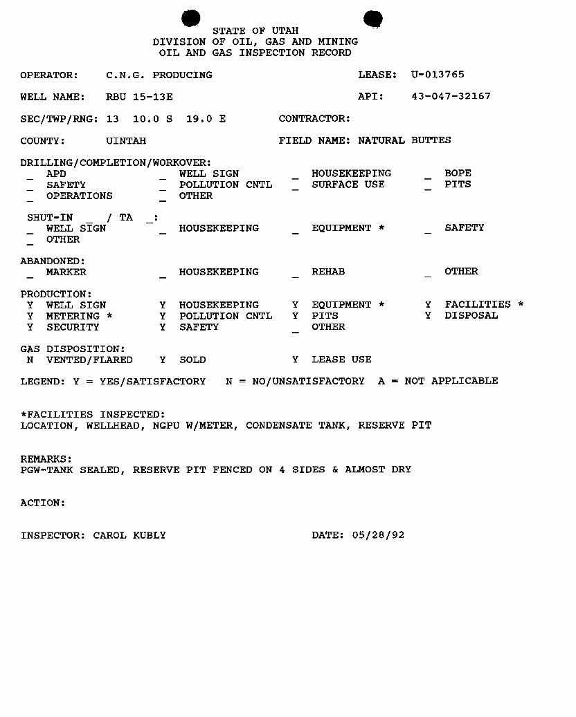
STATE OF UTAHDIVISION OF OIL, GAS AND MINING
OIL AND GAS INSPECTION RECORD
OPERATOR: C.N.G. PRODUCING LEASE: U-013765
WELL NAME: RBU 15-13E API: 43-047-32167
SEC/TWP/RNG: 13 10.0 S 19.0 E CONTRACTOR:
COUNTY: UINTAH FIELD NAME: NATURAL BUTTES
DRILLING|COMPLETION/WORKOVER:APD WELL SIGN HOUSEKEEPING BOPESAFETY POLLUTION CNTL SURFACE USE PITSOPERATIONS OTHER
SHUT-IN_
| TA :WELL SIGN HOUSEKEEPING EQUIPMENT * SAFETYOTHER
ABANDONED:MARKER HOUSEKEEPING REHAB OTHER
PRODUCTION:Y WELL SIGN Y HOUSEKEEPING Y EQUIPMENT * Y FACILITIES *
Y METERING * Y POLLUTION CNTL Y PITS Y DISPOSALY SECURITY Y SAFETY OTHER
GAS DISPOSITION:N VENTED/FLARED Y SOLD Y LEASE USE
LEGEND: Y = YES/SATISFACTORY N = NO/UNSATISFACTORY A = NOT APPLICABLE
*FACILITIES INSPECTED:LOCATION, WELLHEAD, NGPU W/METER, CONDENSATE TANK, RESERVE PIT
REMARKS:PGW-TANK SEALED, RESERVE PIT FENCED ON 4 SIDES & ALMOST DRY
ACTION:
INSPECTOR: CAROL KUBLY DATE:

CNG ProducingCompany A CNG COMPANY
CNG Tower1450 Poydras StreetNew Orleans. LA 70112-6000
NOV3 0 1992
Mr. Ed Forsman DIVISIONOFU. S. Dept. of the Interior OILGAS&MININGBureau of Land ManagementVernal District Office170 South 500 EastVernal, UT 84078
RE: Confidentiality onRiver Bend Unit Wells
Dear Ed:
Please accept this letter as evidence that we would like to extend theconfidential period for another year or as long as is permissible by law on thefollowing River Bend Unit well:
Well Name Utr/Otr Section API Humber
RBU 8-2F SE NE 2-T10S-R20E 43-047-32136
RBU 15-13E SW SE j3-T10S-R19E 43-047-32167
RBU 7-15E SW ME 15-T105-R19E 43-047-32166
RBU 8-18F SE NE 18-T105-R20E 43-047-32149
RBU 1-20F NE NE 20-T10S-R20E 43-047-32146]AÀÀRBU 9-21E NE SE 21-T10S-R19E 43-047-32128
RBU 13-23E SW SW 23-T105-R19E 43-047-32153
If you have any questions or need any additional information, please feelfree to contact me at (504) 593-7260. Thanks for your continued cooperation.
Sincerely,
Susan M. HebertRegulatory Reports Asst. II
cc: Ms. Tammy Searing - Utah Board of Oil, Gas & HiningYvonne AbadieRBU Well

p eUnited States Department of the Interior
BUREAU OF LAND MANAGEMENTUtah State OfficeP.O. Bo×45155
Salt Lake City, UT 84145-0155
In Reply Refer To:3100 y ggU-01470-A et al(UT-932)
NOTICE
Dominion Exploration & Production, inc. : Oiland Gas Leases1450 Poydras StreetNew Orleans, LA 70112-6000
Name Chanqe Recoqnized
Acceptable evidence has been received in this officeconcerningthe change of name of CNGProducing Company to Dominion Exploration & Production, Inc. on Federal oil and gas leases.
The oilandgas lease filesidentifiedontheenclosed exhibithave been noted as tothe name change.The exhibitwas compiled from your list of leases and a list of leases obtained from our automatedrecords system. We have not abstracted the lease files to determine ifthe entityaffected by the namechange holds an interest in the leases identified nor have we attempted to identify leases where theentity is the operator on the ground maintaining no vested record titleoroperatingrights interests.
. We are notifyingthe Minerals Management Service and allapplicable Bureau of Land Managementofficesof the name change by a copyof this notice. Ifadditionaldocumentation for changes ofoperator are required by our Field Offices, you willbe contacted by them.
The followinglease on your list is closed on the records of this office:U-029277.
Due tothe name change, the name ofthe principalon the bond is required to be changed from CNGProducing Companyto Dominion Exploration &Production, Inc. on Bond No. 524 7050 (BLMBond No.WY1898). You may accomplishthisname changeeitherbyconsentofthesurety on theoriginalbondor by a rider to the original bond. Otherwise, a replacement bond with the new name should befurnished to the Wyoming State Office.
12/ Robert Lopez
Robert LopezChief, Branch ofMinerals Adjudication
Enclosure RECE iExhibitof Leases
JUNO5 1
DIVISION 1FOIL,GAS

9 Occ: Wyoming State Office
New Mexico State OfficeMoab Field OfficeVernal Field OfficeMMS-Reference Data Branch, MS 3130, Box 5860, Denver, CO 80217State of Utah, DOGM,Attn: Jim Thompson (Ste. 1210), Box 145801, SLC, UT 84114-5801Irene Anderson (UT-932)Teresa Thompson (UT-931)LaVerne Steah
9 Occ: Wyoming State Office
New Mexico State OfficeMoab Field OfficeVernal Field OfficeMMS-Reference Data Branch, MS 3130, Box 5860, Denver, CO 80217State of Utah, DOGM,Attn: Jim Thompson (Ste. 1210), Box 145801, SLC, UT 84114-5801Irene Anderson (UT-932)Teresa Thompson (UT-931)LaVerne Steah

9 •FORM9
STATE OF UTAHDIVISIONOF OIL,GAS &MINING 5. Lease Designation and Serial Number:
VARIOUSSUNDRY NOTICES AND REPORTS ON WELLS 6. If Indian,Allottee or Tribe Name:
Do not use this forn for proposals to drii new wells, deepen existing wells or to menier plugged and abandoned wens. 7. Unit Agreement Name:Use APPLlCAT10N FOR PERMIT TODRILL OR DËËPEN forn forsuch proposais.
1. Type of Well : 8. Well Name and Number:OIL GAS O OTHER: VARIOUS
. Name of Operator: 9. API Well NumberDOMINIONEXPLORATION &PRODUCTION, INC.
3. Address and Telephone Number: 10. Field and Pool, or Wildcat:1460 Poydras Street, New Orleans, LA 70112-6000 (504) 593-7260 Natural Buttes 630
4. Location of WellFootages: County: UINTAHQQ, Sec, T., R., M.: State: UTAH
11. CHECKAPPROPRIATEBOXESTO INDICAE NATURE OF NOTICE, REPORT, OR OTHERDATANOTICE OF INTENT SUBSEQUENTREPORT
(SUBMITIN DUPLICATE) (Submit Original Form Only)
O Abandon New Construction Abandon* New Construction
Repair Casing Pull or Alter Casing Repair Casing Pull or Alter Casing
O Change of Plans Recomplete Change of Plans Repedorate
O convento injection Repedorate Convert to injection Vent or Flare
O Fracture Treat or Acidize Vent or Flare Fracture Treat or Acidize Water Shut-Off
MultipleCompletion O Water Shut-Off Other OPERATOR NAMECHANGE FOR WELLS
Other Date of work completion
Approximate date work will start Repod gesults of MuNipleCompletion and Recompletion to diflemnt reservoirs on WËLL
COMPLETION OR RECOMPLETioN REPORT AND LOG form.
*Must be accompanled by a cement vedlication report.
12. DESCRIBE PROPOSED OR COMPLETION OPERATIONS (Clearly State all pertinent details, and give pertinent dates. If well Is dimetionally ddlied. give subsurface locations and measured and true
vertic.al depths for all markers and zones pertinent to this work.)
Please be advised that effective April 12, 2000, CNG Producing Company has changed its name to DominionExploration& Production, Inc.and would like to transfer the well permits into the name of DominionExploration& Production, Inc. Our new bond has been filedand is pendinga U umber is 76S 63050 361.
Sr. Vice-President - CNG Producing Company
RECEIVEDJUN29 2000DIVISION OF
OIL,GAS ANDMINING
13.
Name &Signature: ' Title: Sr. Vice-President - DominionExpl &Prod., Inc. Date: June 26, 2000John R. Lewis
(This space for State use only)
(4/94) (See Institictions on Reverse

Dominion Exploration & Production, Inc,1450 Poydras Street, New Orleans, LA 70112-6000
ominion-Phone: 504-593-7000
June 27, 2000
Mr. Jimmy ThompsonUtah Board of Oil Gas & Mining1594 West North TempleSuite 1210Salt Lake City, UT 84114-5801
RE: Name Change Documentation for CNG Producing Company
Dear Mr. Thompson:
CNG Producing Company has become Dominion Exploration & Production, Inc.effective April 12, 2000. Enclosed please find a sundry regarding the name change with anattached listing of all the permits in the name of CNG Producing Company to be changed toDominion Exploration & Production, Inc. Also enclosed please find a Form UIC5 for theTransfer of Authority to Inject for the Federal #1-26B well.
If you have any questions or require any additional information, please contact me at(504) 593-7260.
Sincerely,
DOMINION EXPLORATION & PRODUCTION, INC.
Susan H. SachitanaRegulatory Reports Administrator
Enclosure
cc: Nelda Decker
RECEIVEDJUN2 ti 2000DIVISIONOF
OIL,GAS AND

Well Name Api Well Code Operator Narne Production Status Loaso TypeAMY THORPE -USA 1 4303731283 DOMINION EXPLORATION & PR LA BLMKENNETH TAYLOR - USA 1 4303731284 DOMINION EXPLORATION & PR LA BLMTRUDI FED 2-17 4303731453 DOMINION EXPLORATION & PR PA BLM
ARTIN FED 1 4303731479 DOMINION EXPLORATION & PR PA BLM#3 4304730104 DOMINION EXPLORATION & PR PA BLM
OSC #5 )A- 4304730129 DOMINION EXPLORATION & PR PR STATENABL #1-2 - R ß LL 4304730153 DOMlNION EXPLORATION & PR PA BLMRBU #11-21E 4304730414 DOMINION EXPLORATION & PR PA BLMRBU #11-36B 4304730583 DOMINION EXPLORATION & PR DA STATEFEDERAL #1-26A 4304730716 DOM1NIONEXPLORATION & PR PA BLMFEDERAL #6-30B 4304730733 DOMINION EXPLORATION & PR PA BLMBARTON FEDERAL #1-26 4304731179 DOMINION EXPLORATION & PR PR BLMRBU #6-20 4304731190 DOMINION EXPLORATION & PR PR STATERBU #16-2D 4304731353 DOMINlON EXPLORATION & PR PR STATEHILLCREEK FEDERAL #1-29/2 a 4304731522 DOMINlON EXPLORATION & PR PR BLMRBU #10X-15E 4304731551 DOMIN10N EXPLORATION & PR PA BLM- EEK STATE #1-32 4304731560 DOMINION EXPLORATION & PR UNK STATE
& (LL CREEK FEDERAL #1-27 4304731675 DOMINlON EXPLORATION & PR PR BLMRBU #11-318 4304731765 DOMIN10N EXPLORATION & PR LA BLM
T 4304731777 DOMINION EXPLORATION & PR PR STATESADDLE-TREl- DRAW 4-31 4304731780 DOMlNION EXPLORATION & PR LA BLMSADDLE TREE DRAW 16-31 4304731781 DOMINION EXPLORATION & PR l_A BLM
ADDLE TREE DRAW 13-34 4304731782 DOM1NIONEXPLORAT1ON & PR LA BLMSTATE #12-36E) 4304731784 DOMINION EXPLORATION & PR t A STATER$O¯Ñ3'lW)¯¯
4304731832 DOMlNION EXPLORATION & PR PA BLMRBU #16-19C 4304731841 DOMINION EXPLORATION & PR DA BLMEVANS FEDERAL #3-25 4304731878 DOMINION EXPLORATION & PR PR BLM
ERAL #41-26 4304731879 DOMINION EXPLORATION & PR PR BLMSTA_TE_#11-3_6Ë) 4304732019 DOMINION EXPLORATION & PR PR STATERBU #7-13E 4304732051 DOMINION EXPLORATION & PR LA BLMRBU #7-16F 4304732104 DOMINION EXPLORATION & PR LA BLMRBU #15-15F 4304732109 DOMINION EXPLORATION & PR LA ÏÁ)RBU #7-15F 4304732111 DOMIN10N EXPLORATION & PR LA )RBU #7-23E 4304732125 DOMINION EXPLORATION & PR LA BLMRBU #6-19F 4304732126 DOMINION EXPLORATION & PR LA BLMRBU #3-17F 4304732127 DOMINION EXPLORATION & PR LA BLMRBU #15-10E 4304732139 DOMINlON EXPLORATION & PR LA BLMRBU #3-15F 4304732140 DOMIN10N EXPLORATION & PR LA BLMRBU #3-3E 4304732152 DOMIN10N EXPLORATION & PR l.A BLMRBU #5-24E 4304732154 DOMINION EXPLORATION & PR LA BLMRBU #5-17F 4304732165 DOMINION EXPLORATION & PR LA BLMRBU #15-13E 4304732167 DOMINION EXPLORATION & PR LA BLMRRU #3-19FX 4304732216 DOMINION EXPLORATION & PR LA BLMSTATE 2-32 4304732221 DOMINION EXPLORATION & PR PR STATESTATF #5-36B ) 4304732224 DOMINION EXPLORATION & PR PR STATEFEDERAL #13-26B 4304732237 DOMINION EXPLORATION & PR PR BLM
4304732249 DOMINION EXPLORATION & PR PR STATERBU #11-21F 4304732262 DOMINION EXPLORATION & PR LA BMRBU #4-15F 4304732269 DOMINION EXPLORATION & PR PA BIARBU #1-3E 4304732272 DOMINION EXPLORATION & PR LA BLMRBU #16-9E 4304732273 DOMINION EXPLORATlON & PR LA BLMRBU #3-10E 4304732291 DOMINION EXPLORATION & PR PA BLMRBU #7-23E 4304732294 DOMINION EXPLORATION & PR LA BLMRBU #13-19F2 4304732311 DOMINION EXPLORATION & PR LA BLMRBU #12-2F 4304732316 DOMINION EXPLORATlON & PR LA STATERRU #7-20E 4304732332 DOMINION EXPLORATlON & PR LA BLMRBU #13.34B 4304732334 DOMINION EXPLORATION & PR PA BLMRBU #9-20E 4304732335 DOMIN10N EXPLORATION & PR LA BLMRBU #7-19F 4304732360 DOMIN10N EXPLORATION & PR LA BLMRBU #13-23F 4304732361 DOMINION EXPLORATION & PR LA BLMEVANS FEDERAL #12-25A 4304732394 DOMIN10N EXPLORATION & PR PR BLMFVANS FEDERAL #32-26 4304732395 DOMIN1ONEXPLORATION & PR PR
JUN29 2000O O DIVISION
Well Name Api Well Code Operator Narne Production Status Loaso TypeAMY THORPE -USA 1 4303731283 DOMINION EXPLORATION & PR LA BLMKENNETH TAYLOR - USA 1 4303731284 DOMINION EXPLORATION & PR LA BLMTRUDI FED 2-17 4303731453 DOMINION EXPLORATION & PR PA BLM
ARTIN FED 1 4303731479 DOMINION EXPLORATION & PR PA BLM
#3 4304730104 DOMINION EXPLORATION & PR PA BLMOSC #5 )A- 4304730129 DOMINION EXPLORATION & PR PR STATENABL #1-2 - R ß LL 4304730153 DOMlNION EXPLORATION & PR PA BLMRBU #11-21E 4304730414 DOMINION EXPLORATION & PR PA BLMRBU #11-36B 4304730583 DOMINION EXPLORATION & PR DA STATEFEDERAL #1-26A 4304730716 DOM1NIONEXPLORATION & PR PA BLMFEDERAL #6-30B 4304730733 DOMINION EXPLORATION & PR PA BLMBARTON FEDERAL #1-26 4304731179 DOMINION EXPLORATION & PR PR BLMRBU #6-20 4304731190 DOMINION EXPLORATION & PR PR STATERBU #16-2D 4304731353 DOMINlON EXPLORATION & PR PR STATEHILLCREEK FEDERAL #1-29/2 a 4304731522 DOMINlON EXPLORATION & PR PR BLMRBU #10X-15E 4304731551 DOMIN10N EXPLORATION & PR PA BLM- EEK STATE #1-32 4304731560 DOMINION EXPLORATION & PR UNK STATE
& (LL CREEK FEDERAL #1-27 4304731675 DOMINlON EXPLORATION & PR PR BLMRBU #11-318 4304731765 DOMIN10N EXPLORATION & PR LA BLM
T 4304731777 DOMINION EXPLORATION & PR PR STATESADDLE-TREl- DRAW 4-31 4304731780 DOMlNION EXPLORATION & PR LA BLMSADDLE TREE DRAW 16-31 4304731781 DOMINION EXPLORATION & PR l_A BLM
ADDLE TREE DRAW 13-34 4304731782 DOM1NIONEXPLORAT1ON & PR LA BLMSTATE #12-36E) 4304731784 DOMINION EXPLORATION & PR t A STATER$O¯Ñ3'lW)¯¯
4304731832 DOMlNION EXPLORATION & PR PA BLMRBU #16-19C 4304731841 DOMINION EXPLORATION & PR DA BLMEVANS FEDERAL #3-25 4304731878 DOMINION EXPLORATION & PR PR BLM
ERAL #41-26 4304731879 DOMINION EXPLORATION & PR PR BLMSTA_TE_#11-3_6Ë) 4304732019 DOMINION EXPLORATION & PR PR STATERBU #7-13E 4304732051 DOMINION EXPLORATION & PR LA BLMRBU #7-16F 4304732104 DOMINION EXPLORATION & PR LA BLMRBU #15-15F 4304732109 DOMINION EXPLORATION & PR LA ÏÁ)RBU #7-15F 4304732111 DOMIN10N EXPLORATION & PR LA )RBU #7-23E 4304732125 DOMINION EXPLORATION & PR LA BLMRBU #6-19F 4304732126 DOMINION EXPLORATION & PR LA BLMRBU #3-17F 4304732127 DOMINION EXPLORATION & PR LA BLMRBU #15-10E 4304732139 DOMINlON EXPLORATION & PR LA BLMRBU #3-15F 4304732140 DOMIN10N EXPLORATION & PR LA BLMRBU #3-3E 4304732152 DOMIN10N EXPLORATION & PR l.A BLMRBU #5-24E 4304732154 DOMINION EXPLORATION & PR LA BLMRBU #5-17F 4304732165 DOMINION EXPLORATION & PR LA BLMRBU #15-13E 4304732167 DOMINION EXPLORATION & PR LA BLMRRU #3-19FX 4304732216 DOMINION EXPLORATION & PR LA BLMSTATE 2-32 4304732221 DOMINION EXPLORATION & PR PR STATESTATF #5-36B ) 4304732224 DOMINION EXPLORATION & PR PR STATEFEDERAL #13-26B 4304732237 DOMINION EXPLORATION & PR PR BLM
4304732249 DOMINION EXPLORATION & PR PR STATERBU #11-21F 4304732262 DOMINION EXPLORATION & PR LA BMRBU #4-15F 4304732269 DOMINION EXPLORATION & PR PA BIARBU #1-3E 4304732272 DOMINION EXPLORATION & PR LA BLMRBU #16-9E 4304732273 DOMINION EXPLORATlON & PR LA BLMRBU #3-10E 4304732291 DOMINION EXPLORATION & PR PA BLMRBU #7-23E 4304732294 DOMINION EXPLORATION & PR LA BLMRBU #13-19F2 4304732311 DOMINION EXPLORATION & PR LA BLMRBU #12-2F 4304732316 DOMINION EXPLORATlON & PR LA STATERRU #7-20E 4304732332 DOMINION EXPLORATlON & PR LA BLMRBU #13.34B 4304732334 DOMINION EXPLORATION & PR PA BLMRBU #9-20E 4304732335 DOMIN10N EXPLORATION & PR LA BLMRBU #7-19F 4304732360 DOMIN10N EXPLORATION & PR LA BLMRBU #13-23F 4304732361 DOMINION EXPLORATION & PR LA BLMEVANS FEDERAL #12-25A 4304732394 DOMIN10N EXPLORATION & PR PR BLMFVANS FEDERAL #32-26 4304732395 DOMIN1ONEXPLORATION & PR PR
JUN29 2000O O DIVISION

FROM i CNG - OPERAT I ONS 504 593 7452 19 -29 13: 58 #814 P . 02/02
State of Utah /0 EMODEPAATMENT OF COMMERCE ' FileNumber
¯
Division of Corporadens& CommerciniCodecheekAppropriate Box
ForeignProfit Corporation ns.coForeignNon·Ÿrofit Corporation 535.ut)Applicadon To Amend The O ŸoreignLimitedPannership 52,$.0µ
O Foreign Limiled Liability Company 535.00CERTIFICATE OF AUTHORITY ORREGISTRATION of
C P ompany
Delawarenams ol Homselate
1. AMENDINGTHE BUSINESS NAMEThe businessname is changedto: Dominion Exploration& Productiori, Inc.The corporation shall useas its name in Utah: DominionExploration& Production,Inc,
Theeqrporviion shaft me its nanW H $411(Flik 05 MI.GAlma lhim thans 4 tWN ilva 12Did)
NOTE: If the business name has changed ils name in the home state,a copy of the Certificateof Amendment or a certified copy of theamendmem mustaccompany thisappheation.
Check the following:gij The name of the corporationis changing it's namein Utah to the new nameofthe corporation in the home stale.[ ] The name of the corporation is being changed in Utah to comply with Utah stateInsurance Regulations.
IL AMENDING THE DURATION OF THE BUSINESS EX.ISTENCEThe businessesperiod of duration is changed to:
III. AMENDINGTHE STATE OR COUNTRY OF INCORPORATION/REGISTRATIONThe corporation's stateor country of incorporation/registrationis changed to:
IV. Other:(Limind Parmershipchanging Q.narsiP=nnus.Limited Companies changing Members or Manages- Change ofimitment who is managing, sic I
Use anunachedshwatif needed.
Underpenaltiesof perjury, I declarethis Application to Arnend the Certificateof Authority or Registrationto be.to the bes w ed nd belief, true and correct.
,,. /- f, , ÂM Vice Presidem& Corporate Secretary Ap ISignature Title Depa ntof Conunerce
blvision of Corporadens and ConunercialCodei Herebycertifythat olng ledandapprowdon thi ayin the offlCe of this Dhrt n and he asuf
STATEOF UTAH this certificatethereof.DIVISION OF CORPORATIONS Examiner Date
AND COMMERCIALCODE160 East 300 South/ Box 146705Sak I,akeCity,UT 84I14-6705
. 2 ¯°-' "s-.'Ç>..,iENSON
ServiceCenter (801)530-4549 e ·· NWeb Site:http://www.commerce.state.utus Date: 04/25/E000
Receipt Number 2E156
common\rorms\Mismensen APR25 2000RevitudDI-14•00

Division of Oil, Gas and MiningROUTING:
OPERATOR CHANGE WORKSHEET2-cow * sgp
Check cach listed item when completed. Write N/A if item is not applicabic 3-JLT 6-FILE
Change of Operator (Well Sold) Designation of Agent
X Operator Name Change Only Merger
The operator of the well(s) listed below has changed, effective: 4-12-00
TO:(New Operator) DOMINION EXPL & PROD INC. FROM:(Old Operator) CNG PRODUCING COMPANY
Address: 1450 POYDRAS STREET Address: 1450 POYDRAS STREET
NEW ORLEANS, LA 70112-6000 NEW ORLEANS, LA 70112-6000
Phone: 1-(504)-593-7000 Phone: 1-(504)-593-7000
Account NO. N1095 Account No. N0605
WELL(S): CA Nos. or RIVER BEND UnitName: NATURAL 1-2 API: 43-047-30153 Entity: 11377 S 02 T 10S R 20E Lease: ML-10716
Name: RBU 11-21E API: 43-047-30414 Entity: 9010 S 21 T 10S R 19E Lease: U-013766
Nanie: RBU ll-31B API: 43-047-31765 Entity: 9010 S 21 T 10S R 19E Lease: U-013766Name: RBU 3-10D API: 43-047-31832 Entity: 4955 S 10 T 10S R 18E Lease: U-013818-A
Name: RBU 16-19C API: 43-047-31841 Entity: 4955 S 10 T 10S R 18E Lease: U-013818-A
Name: RBU 7-13E API: 43-047-32051 Entity: 7050 S 13 T 10S R 19E Lease: U-013765
Name: RBU 7-18F API: 43-047-32104 Entity: 99998 S 18 T 10S R 20E Lease: U-013769Name: RBU 7-23E API: 43-047-32125 Entity: 99998 S 23 T 10S R 19E Lease: U-01376Name: RBU 6-19F API: 43-047-32126 Entity: 99998 S 19 T 10S R 20E Lease: U-013769A
Name: RBU 3-17F API: 43-047-32127 Entity: 7050 S 17 T 10S R 20E Lease: U-013769C
Name: RBU 15-10E API: 43-047-32139 Entity: 99998 S 10 T 10S R 19E Lease: U-013792
Name: RBU 3-15F API: 43-047-32140 Entity: 99998 S 15 T 10S R 20E Lease: U-7206
Name: RBU 3-3E API: 43-047-32152 Entity: 99998 S 03 T 10S R 19E Lease: U-013765Name: RBU 5-24E API: 43-047-32154 Entity: 7050 S 24 T 10S R 19E Lease: U-013794Name: RBU 5-17F API: 43-047-32165 Entity: 99998 S 17 T 10S R 20E Lease: U-013769CName: RBU 15-13E API: 43-047-32167 Entity: 7050 S 13 T 10S R 19E Lease: 0-013765
OPERATOR CHANGE DOCUMENTATION
YES 1. A pending operator change file has been set up.
YES 2. (R649-8-10) Sundry or other legal documentation has been received from the FORMER operator on 6-29-00.
YES 3. (R649-8-10) Sundry or other legal documentation has been received from the NEW operator on 6-29-00
YES 4. The new company has been looked up in the Department of Commerce, Division of Corporations Databaseif the new operator above is not currently operating any wells in Utah. Is the operator registered with the State?Yes/No If yes, the company file number is SEE ATTACHED . If no, Division letter was mailed tothe new operator on

YES 5. Federal and Indian Lea ells. The BLM or the BIA has approve merger, name change or operatorchange for all wells listed ve involving Federal or Indian leases on 6-2-00
N/A 6. Federal and Indian Units. The BLM or the BlA has approved the successor of unit operator for all wells listedabove involving unit operations on
N/A 7. Federal and Indian Communitization Agreements ("CA"). The BLM or the BIA has approved the operatorchange for all wells listed above involved in the CA on
N/A 8. Underground Injection Control ("UIC") Program. The Division has approved UIC Form 5, Transfer ofAuthority to Inject, for the enhanced/secondary recovery unit/project and/or for the water disposal well(s) listedabove.
YES 9. Changes have been entered in the Oil and Gas Information System for each well listed on 7-25-00
YES 10. Changes have been included on the Monthly Operator Change letter on 7-25-00
STATE BOND VERIFICATION
N/A l. State We11(s) covered by Bond No.
FEE WELLS - BOND VERIFICATION / LEASE INTEREST OWNER NOTIFICATION
N/A 1. (R649-3-1) The NEW operator of any fee lease well(s) listed above has furnished a proper bond.
N/A 2. A copy of this form has been placed in the new and former operator's bond files on
N/A 3. The FORMER operator has requested a release of liability from their bond as of todays date ? Ifyes, Division response was made to this request by letter dated . (see bond file).
N/A 4. (R649-2-10) The Former operator of any Fee lease wells listed above has been contacted and informedby letter dated , of their responsibility to notify all interest owners of this change.
N/A 5. Bond information added to RRDMS on
N/A 6. Fee wells attached to bond in RRDMS on
FILMING
1. All attachrnents to this form have been microfilmed on .
FILING
l. Originals/Copies of all attachments pertaining to each individual well have been filed in each well file.
2. The original of this form has been filed in the operator file and a copy in the old operator file.

Fonn31 5 ITED STATES FORMAPPROVED
(Aug.se 1999) DEPARTMENT OPTIIE INTERIOR g No , 000BUREAUOPLAND MANAGEMENT 5. MMNo.
SUNDRY NOTICESANDREPORTS ON WELLS IfW13765Do not use ifils forat for proposef tocfri&or la townier en &If indian,ARothyorTribe Name
abandoned weH. Use form 31004(APDþbre chproposals.7 if UnigptCA/Ageoment,Name an&or No.
1. Type of WeN RIVERBEND UNIT
O 8. WWNamean&No.Oil Wen GasWell Olher
2. NamsofOperabr RBU 15-13E
DOMINION EXPL. & PROD., INC. 9. APIWeHNo.
3a. Address 34. Phone No. Uncludearam code) 43-047-32167
CNG TOWER, '1450 POYDRASSTREET 281/873-3692 "" """'°"°"
NEW ORLEANS, LA70112 NATURAL BUTTES4. Imation of Wei fFoomme.&ic.. T. A. M.. or arrwraardiodes)150' FSL & 1850'FEL OFSEC. 13-T10S-R19E
IL CoungetPatish, State
UINTAHCOUNTY, UTAH
12. CHECKAPPROPRIATEBOX(ES)TO INDICATENATUREOF NOTICE,REPORT, OROTi R DATA
TYPEOF SUBMISSION TYPEOF ACTION
Nodutofintent Om O o•••• --<s..ren..···> O w•••=swo«0 sa.,c..... O FamuseTwat Rælanska W&latogrhy
O SubmuemRepan O c.a.awa O NewConsungdon Other RIGUPO o--a. el... O Pkg and Aba... O T..p..,ay as.....
PRODUCTION LINESO re-me.ma=·····m•e.• O c..-oreen.. O PlugBack O WaterDisposat
13. Describe Proposed or Cooanspleted Operation (citarly state all pertident details, laeluding estimated starting date of any proposed woyk and Approximate duration thereof. Ifthe proposal is to deepen dimctionally or resemplete horizontally,.give subsurface locations and measured and true verticht depths of *Hpartineat amtkers and zones. Attachthe Bond under which the work will be portanned or provide the Bond No. on file with BLM/SIA. Required subsequent reports aball be filed within 30 days followingcompletion of the involved operations. If the operation results in a omkiplecompletion or recompletion in a new interval, a Form 3166-4 sháU be filed once testing has beencompleted. Final Absadomment Notices shall be filed only after att setnirements. ineinding reclamation, have been completed, and the operasdr has determined that the finalsite is ready for final inspection.)
RIG UP ALL PRODUCTION LINES TO PRODUCTION TANKS. PULL WATER FROM BOTTOM OF PRODUCTIONTANK AND DISPOSE AT THE RBU 16-19F.
RECEOCTO6DIVISIC
OIL, GAS Ab.D
14. I haeby certify ität theforegoingis trumamt tonectName (Pringed/I)‡a#DIANN F WERS noe REGULATORY REPORTS ADMINSTRATOR
s nas. 09/26/00' messaaneemmenstemmeaum
Approved by Tide DateConditions of approval, if any,am attached. Appmvalof thisaeticedoes not warrait or certifythatthe applicant holds legalor equilable tide to thoserights in the subjectlease whichwould entide athe og in con#iot glions
Fonn31 5 ITED STATES FORMAPPROVED
(Aug.se 1999) DEPARTMENT OPTIIE INTERIOR g No , 000BUREAUOPLAND MANAGEMENT 5. MMNo.
SUNDRY NOTICESANDREPORTS ON WELLS IfW13765Do not use ifils forat for proposef tocfri&or la townier en &If indian,ARothyorTribe Name
abandoned weH. Use form 31004(APDþbre chproposals.7 if UnigptCA/Ageoment,Name an&or No.
1. Type of WeN RIVERBEND UNIT
O 8. WWNamean&No.Oil Wen GasWell Olher
2. NamsofOperabr RBU 15-13E
DOMINION EXPL. & PROD., INC. 9. APIWeHNo.
3a. Address 34. Phone No. Uncludearam code) 43-047-32167
CNG TOWER, '1450 POYDRASSTREET 281/873-3692 "" """'°"°"
NEW ORLEANS, LA70112 NATURAL BUTTES4. Imation of Wei fFoomme.&ic.. T. A. M.. or arrwraardiodes)150' FSL & 1850'FEL OFSEC. 13-T10S-R19E
IL CoungetPatish, State
UINTAHCOUNTY, UTAH
12. CHECKAPPROPRIATEBOX(ES)TO INDICATENATUREOF NOTICE,REPORT, OROTi R DATA
TYPEOF SUBMISSION TYPEOF ACTION
Nodutofintent Om O o•••• --<s..ren..···> O w•••=swo«0 sa.,c..... O FamuseTwat Rælanska W&latogrhy
O SubmuemRepan O c.a.awa O NewConsungdonOther RIGUP
O o--a. el... O Pkg and Aba... O T..p..,ay as.....PRODUCTION LINESO re-me.ma=·····m•e.• O c..-oreen.. O PlugBack O WaterDisposat
13. Describe Proposed or Cooanspleted Operation (citarly state all pertident details, laeluding estimated starting date of any proposed woyk and Approximate duration thereof. Ifthe proposal is to deepen dimctionally or resemplete horizontally,.give subsurface locations and measured and true verticht depths of *Hpartineat amtkers and zones. Attachthe Bond under which the work will be portanned or provide the Bond No. on file with BLM/SIA. Required subsequent reports aball be filed within 30 days followingcompletion of the involved operations. If the operation results in a omkiplecompletion or recompletion in a new interval, a Form 3166-4 sháU be filed once testing has beencompleted. Final Absadomment Notices shall be filed only after att setnirements. ineinding reclamation, have been completed, and the operasdr has determined that the finalsite is ready for final inspection.)
RIG UP ALL PRODUCTION LINES TO PRODUCTION TANKS. PULL WATER FROM BOTTOM OF PRODUCTIONTANK AND DISPOSE AT THE RBU 16-19F.
RECEOCTO6DIVISIC
OIL, GAS Ab.D
14. I haeby certify ität theforegoingis trumamt tonectName (Pringed/I)‡a#DIANN F WERS noe REGULATORY REPORTS ADMINSTRATOR
s nas. 09/26/00' messaaneemmenstemmeaum
Approved by Tide DateConditions of approval, if any,am attached. Appmvalof thisaeticedoes not warrait or certifythatthe applicant holds legalor equilable tide to thoserights in the subjectlease whichwould entide athe og in con#iot glions

rannalso-s UNITED STATES FORM APPROVED
(Ausust 1999) DEPARTMENT OF THE INTERIOR p?," iBUREAUOFLANDMANAGEMENT 5. IÀseSerblNo,
SUNORYNOTICESANDREPORTS ON WELLS U-013765Do no¢use gds Arm for þroposalto drgtor to ¢e-en&T BR 4, if B 4. ARouse or TribeNaum
abandon f weÆ Use Form 3189.3 (APD}for such proposals.
1. ItU er CA/Agnepunt. Naumand/or No.
1. Type ofWeltRIVER BEND UNIT
O O 8. WeRNadmandNo.Oil Wei GasWeg Other
2. NamofOperatur RBU 15-13E
DOMINION EXPL. & PROD.,INC.9. AnwenNo.
3a. Adkass 3b Phone No. Umstadtenn ¢¢de) 43.047.32167
CNG TOWER, 1450 POYORASSTREET 281/873-3692
NEWORLEANS,LA70112 NATURALBUTTES4. Location of WeR(Foomer.Nec..T.,k.. M., or .9mvv Dracringen)
150' FSL & 1850'FEL OFSEC. 13-T10S-RI9E11. ComtyorParieb. State
UINTAH COUNTY, UTAH
12. CMECKAPPROPRIATEBOX(ES)TO INDICATENATUREOF NOTICE,REPORT, OROTHERDATA
TYPE OF $UBMISSION TYPE OF ACTION
No e onamnt Am¾a O Deepen Pmducam (Slar sam) O w.••rm.«
O a.., c.a. O Fra.... T...t 8 -e. O w.nr...o
O SubsequentRepet O c.usa...ar O s.wco...=no. O """" es.r COVER PITSO Chuge Mans O Ping ami Abemion Tenema& Abendon
O Fim! Almimm Nodee Cmt M14... O Plug Back O waarI ....*
13. Describe Proposed or CoommpletedOperation (clearly state all pertinent details, inciadingestimated starting date of any proposed Werk and appypianste duration thereof. If i
the proposal is to deepen directionally or secomplete horizontally, give subsurface locations and sneasmed and true vertical depas *f all portinent klarkers and zones. Attachthe Bond under which the woth will be perfortned or provide the bond No. on file with BLM/BIA. Required subsequentappris shall be filed within 30 days followingcompletion of the favolved operations, if the operation results in a multiple completion or recompletion in a new interval, a Fotta 3160-4 shalibe flied once testing has beencompleted. Final Abandominist Notices shall be filed only aner all requirements, incinding reclassation, have been completed, and the operator hat determined that the finalsite is ready for final inspection.)
COMPLETELY COVERPITÄ
OIL, GAS A .
14. l hereby certify thathe itstgelbg45trat andconectName (Pringedrippoi@DIANN FLOWERS Tine REGULATORY REPORTSADMINSTRATOR
si,..... / A ..;osse 09/26/00
,
wo mansen nessa.oa smedeemanApproved by Tide .
DateConditions of approval, if any,aseanact-L Approvalof this aplicedoesnot wanart or certify thatthe applicant holds legal or equitabis tide 10 dieserightsin the subject leasewhich woukl entide ogg¡ggthe agicant to conductytions
rannalso-s UNITED STATES FORM APPROVED
(Ausust 1999) DEPARTMENT OF THE INTERIOR p?," iBUREAUOFLANDMANAGEMENT 5. IÀseSerblNo,
SUNORYNOTICESANDREPORTS ON WELLS U-013765Do no¢use gds Arm for þroposalto drgtor to ¢e-en&T BR 4, if B 4. ARouse or TribeNaum
abandon f weÆ Use Form 3189.3 (APD}for such proposals.
1. ItU er CA/Agnepunt. Naumand/or No.
1. Type ofWeltRIVER BEND UNIT
O O 8. WeRNadmandNo.Oil Wei GasWeg Other
2. NamofOperatur RBU 15-13E
DOMINION EXPL. & PROD.,INC.9. AnwenNo.
3a. Adkass 3b Phone No. Umstadtenn ¢¢de) 43.047.32167
CNG TOWER, 1450 POYORASSTREET 281/873-3692
NEWORLEANS,LA70112 NATURALBUTTES4. Location of WeR(Foomer.Nec..T.,k.. M., or .9mvv Dracringen)
150' FSL & 1850'FEL OFSEC. 13-T10S-RI9E11. ComtyorParieb. State
UINTAH COUNTY, UTAH
12. CMECKAPPROPRIATEBOX(ES)TO INDICATENATUREOF NOTICE,REPORT, OROTHERDATA
TYPE OF $UBMISSION TYPE OF ACTION
No e onamnt Am¾a O Deepen Pmducam (Slar sam) O w.••rm.«
O a.., c.a. O Fra.... T...t 8 -e. O w.nr...o
O SubsequentRepet O c.usa...ar O s.wco...=no. O """" es.r COVER PITSO Chuge Mans O Ping ami Abemion Tenema& Abendon
O Fim! Almimm Nodee Cmt M14... O Plug Back O waarI ....*
13. Describe Proposed or CoommpletedOperation (clearly state all pertinent details, inciadingestimated starting date of any proposed Werk and appypianste duration thereof. If i
the proposal is to deepen directionally or secomplete horizontally, give subsurface locations and sneasmed and true vertical depas *f all portinent klarkers and zones. Attach
the Bond under which the woth will be perfortned or provide the bond No. on file with BLM/BIA. Required subsequentappris shall be filed within 30 days followingcompletion of the favolved operations, if the operation results in a multiple completion or recompletion in a new interval, a Fotta 3160-4 shalibe flied once testing has beencompleted. Final Abandominist Notices shall be filed only aner all requirements, incinding reclassation, have been completed, and the operator hat determined that the final
site is ready for final inspection.)
COMPLETELY COVERPITÄ
OIL, GAS A .
14. l hereby certify thathe itstgelbg45trat andconectName (Pringedrippoi@DIANN FLOWERS Tine REGULATORY REPORTSADMINSTRATOR
si,..... / A ..;osse 09/26/00
,
wo mansen nessa.oa smedeemanApproved by Tide .
DateConditions of approval, if any,aseanact-L Approvalof this aplicedoesnot wanart or certify thatthe applicant holds legal or equitabis tide 10 dieserightsin the subject leasewhich woukl entide ogg¡ggthe agicant to conductytions

Form 3160-5
t^me**) UNITED STATES FORM APPROVED, DEPARTMENT OF THE INTERIOR OMB No. 1004-0135
BUREAU OF LAND MANAGEMENT Expires: November 30, 20005 Lease Serial No.
SUNDRY NOTICES AND REPORTS ON WELLS U-013765Do not use this form for proposals to drill or to re-enter an 6 If Indian, Allottee or Tribe Name
abandoned well. Use Form 3160-3 (APD) for such proposals.SIIBMIT IN TRIPLICATE - Other Instructions on reverse side 7 If Unit or CA/Agreement, Name and/or No.
I. TypeofWell River Bend Unitil Well Gas Well ther 8 Well Name and No.
2. NameofOperator RBU 15-13E9 API Well No.
DOMINION EXPLORATION & PRODUCTION, INC.3a. Address Suite 600 3b. Phone No. (include area code) 43-047-3216714000 QUAIL SPGS PKWY, OKLA CITY, OK 73134 405-749-1300 10. Field and Pool, or Exploratory Area4. Location of Well (Footage, Sec., T., R., M., or Survey Description)
Natural Buttes11. County or Parish, State
151' FSL & 1850' FEL, Sec. 13-10S-19EUintah Co., Utah
12. CHECK APPROPRIATE BOX(ES) TO INDICATE NATURE OF NOTICE, REPORT OR OTHER DATA
TYPE OF SUBMISSION TYPE OF ACTION
Notice of Intent Acidize Deepen Production (Start/Resume) Water Shut-Off
Altering Casing Fracture Treat Reclamation Well Integrity
O Subsequent Report Casing Repair New Construction Recomplete Other
Change Plans Plug and Abandon Temporarily Abandon
O Final Abandonment Notice Conven to injection Plug Back Water Disposal
13 Describe Proposed or Completed Operation (clearly state all pertinent details, including estimated stading date of any proposed work and approximate duration thereof.If the proposal is to deepen directionally or recomplete horizontally, give subsurface locations and measured and true vertical depths of all pertinent markers and zones.Attach the Bond under which the work willbe pedormed or provide the Bond No, on file with BLM/BIA. Required subsequent reports sha11be filed within 30 daysfollowing completion of the involved operations. If the operation results in a multiple completion or recompletion in a new interval, a Form 3160-4 shall be filed oncetesting has been completed. Final Abandonment Notices shall be filed only after all requirements, including reclamation, have been completed and the operator hasdetermined that the site is ready for final inspection3
Dominion request permission to deepen the existing RBU 15-13E from 6 f(Ÿto 8,600' utilizing the attacheddrilling plan and deepening procedure. The existing wellsite willnot be expanded beyond the existingdisturbance and the original pit will be excavated and re-lined. RECEIVED
JUNO8 2007
DIV.0FOIL,GAS&MINING
14. I hereby certify that the foregoing is true and correctName (Prmred Taped)
Carla Christian Title Supervisor, Regulatory Reports
Signature '\\ Date 5-Jun-07
Approved by
THIS SPACE FOR FEDERAL OR STATE DELEsYE
G. HILL osteó(ot(eConditions of approval, an ach Approval of this notice does not warrant or ENVIRONMENlAL MANAGEHcertify that the applicant not al or equitable title to those rights in the subject lease Otticewhich would entitle the applicant onduct operations thereon.
Title 18 U.S.C. Section 1001 and Title 43 U.S.C. Section 1212, makes it a crime for any person knowingly and willfully to make to any department or agency of theUnited States any false, fictitious or fraudulent statements or representations as to any matter within its jurisdiction.
AlderalAppmval of tidiActionla

vulvl11910N EXPLR. & PROD., INC.1 ivo, II,id.5, D.L..ti.dCM.Well location, RBU #15-13E, located os shown i.nN89°40'E
- 5339.40' (G.L.O.)the SW 1/4 SE 1/4 of Section 13, T10S, R19E,ross BrassS.L.B.&M., Uintah County, Utah.Cop, P//e of
stones
BASIS OF ELEVATIONSPOT ELEVATIONLOCATEDAT THE SOUTHWEST CORNER OFSECTION 20, T10S, R20E, S.L.B.&M. TAKEN FROM THE BIG PACKMTN. NW QUADRANGLE,UTAH, UINTAH COUNTY 7.5 MINUTEQUAD. (TOPOGRAPHIC MAP) PUBLISHED BY THE UNITED STATESDEPARTMENT OF THE INTERIOR, GEOLOGICALSURVEY. SAID----
ELEVATIONIS MARKEDAS BEING5251 FEET.
BASIS OF BEARINGSBASIS OF BEARINGSIS A G.P.S. OBSERVATION.
1956 ÐrossCop, 0.5' H/gh,P//e of Stones,steel P&e
A àI 1928 Brass Ncap, o.o' er .
Steel Post
o °o
o°o
oo o - o
- mmmmmmm-SCALE
THISIS TO CERTlFY THAT THE P GP FROMFIELD NOTES OF ACTUALSUR Y ME OR YROU /15--13E
, SUPERVISIONAND THAT THE RE I TO THE
C - 33 00 G.)= 5773' BEST OF MY KNOWLEDGEAN
A L589 41'44"W - 2619.09' (Meas.) 26S20
5(0"
1956 Ðross Cop, PRe NHOof stones,steel Pee
UINTAH ENGINEERING & LAND SURVEYINGf956 Ðrasscap, o.s 24 85 SOUTH 200 EAST - VERNAL, UTAH 84078s'L°'p,*
(435) 789-1017LEGEND (NAD 83)
SCALE DATE SURVEYED: DATE DRAWN:LATlTUDE = 39 56'26.08" (39.940578) 1" = 1000' 07-06-06 04-20-07= 90 SYMBOL LONGITUDE= 109°43'41.79" (109.728275) PARTY REFERENCES(NAD 27) B.B. T.A. C.H. G.L.O. PLAT= PROPOSEDWELLHEAD· LATITUDE = 39°56'26.21" (39.940614) r. H N f WEATHER FILEA = SECTION CORNERS LOCATED. LONGITUDE= 109°43°39.29"(109.727581) i WARM DOMINl0NEXPLR.& PROD.,
vulvl11910N EXPLR. & PROD., INC.1 ivo, II,id.5, D.L..ti.dCM.Well location, RBU #15-13E, located os shown i.nN89°40'E
- 5339.40' (G.L.O.)the SW 1/4 SE 1/4 of Section 13, T10S, R19E,ross BrassS.L.B.&M., Uintah County, Utah.Cop, P//e of
stones
BASIS OF ELEVATIONSPOT ELEVATIONLOCATEDAT THE SOUTHWEST CORNER OFSECTION 20, T10S, R20E, S.L.B.&M. TAKEN FROM THE BIG PACKMTN. NW QUADRANGLE,UTAH, UINTAH COUNTY 7.5 MINUTEQUAD. (TOPOGRAPHIC MAP) PUBLISHED BY THE UNITED STATESDEPARTMENT OF THE INTERIOR, GEOLOGICALSURVEY. SAID----
ELEVATIONIS MARKEDAS BEING5251 FEET.
BASIS OF BEARINGSBASIS OF BEARINGSIS A G.P.S. OBSERVATION.
1956 ÐrossCop, 0.5' H/gh,P//e of Stones,steel P&e
A àI 1928 Brass Ncap, o.o' er .
Steel Post
o °o
o°o
oo o - o
- mmmmmmm-SCALE
THISIS TO CERTlFY THAT THE P GP FROMFIELD NOTES OF ACTUALSUR Y ME OR YROU /15--13E
, SUPERVISIONAND THAT THE RE I TO THE
C - 33 00 G.)= 5773' BEST OF MY KNOWLEDGEAN
A L589 41'44"W - 2619.09' (Meas.) 26S20
5(0"
1956 Ðross Cop, PRe NHOof stones,steel Pee
UINTAH ENGINEERING & LAND SURVEYINGf956 Ðrasscap, o.s 24 85 SOUTH 200 EAST - VERNAL, UTAH 84078s'L°'p,*
(435) 789-1017LEGEND (NAD 83)
SCALE DATE SURVEYED: DATE DRAWN:LATlTUDE = 39 56'26.08" (39.940578) 1" = 1000' 07-06-06 04-20-07= 90 SYMBOL LONGITUDE= 109°43'41.79" (109.728275) PARTY REFERENCES(NAD 27) B.B. T.A. C.H. G.L.O. PLAT= PROPOSEDWELLHEAD· LATITUDE =39°56'26.21" (39.940614) r. H N f WEATHER FILEA = SECTION CORNERS LOCATED. LONGITUDE= 109°43°39.29"
(109.727581) i WARM DOMINl0NEXPLR.& PROD.,

WORKSHEETAPPLICATION FOR PERMIT TO DRILL
APD RECEIVED: 06/08/2007 API NO. ASSIGNED: 43-047-32167
WELL NAME: RBU 15-13E
OPERATOR: DOMINION EXPL & PROD ( N1095 ) PHONE NUMBER: 405-749-1300
CONTACT: CARLA CHRISTIAN
PROPOSED LOCATION: INSPECT LOCATN BY: / /
SWSE 13 100S 190E . .
Tech Review Initials DateSURFACE: 0151 FSL 1850 FEL
BOTTOM: 0151 FSL 1850 FEL Engineering
COUNTY: UINTAH GeologyLATITUDE: 39.94060 LONGITUDE: -109.7279
UTM SURF EASTINGS:608685 NORTHINGS: 4421729 Surface
FIELD NAME: NATURAL BUTTES ( 630 )
LEASE TYPE: 1 - Federal
LEASE NUMBER: U-013765 PROPOSED FORMATION: MVRD
SURFACE OWNER: 1 - Federal COALBED METHANE WELL? NO
RECEIVED AND/OR REVIEWED: LOCATION AND SITING:
// Plat R649-2-3.
Bond: Fed[1] Ind[] Sta[] Fee[] Unit: RIVER BEND(No. 765630500330 )
Potash (Y/N)R649-3-2. General
AÁ Oil Shale 190-5 (B) or 190-3 or 190-13 Siting:460 From Qtr/Qtr & 920' Between Wells
v/' Water PermitR649-3-3. Exception
(No.43-10447 )/'Drilling Unit
AÁ RDCC Review (Y/N)Board Cause No: 4-0/
(Date: Eff Date:M/A Fee Surf Agreement (Y/N) Siting• 49mrÍ f .nn
AFP Intent to Commingle (Y/N) R649-3-11. Directional Drill
COMMENTS:
WORKSHEETAPPLICATION FOR PERMIT TO DRILL
APD RECEIVED: 06/08/2007 API NO. ASSIGNED: 43-047-32167
WELL NAME: RBU 15-13E
OPERATOR: DOMINION EXPL & PROD ( N1095 ) PHONE NUMBER: 405-749-1300
CONTACT: CARLA CHRISTIAN
PROPOSED LOCATION: INSPECT LOCATN BY: / /
SWSE 13 100S 190E . .
Tech Review Initials Date
SURFACE: 0151 FSL 1850 FEL
BOTTOM: 0151 FSL 1850 FEL Engineering
COUNTY: UINTAH GeologyLATITUDE: 39.94060 LONGITUDE: -109.7279
UTM SURF EASTINGS:608685 NORTHINGS: 4421729 Surface
FIELD NAME: NATURAL BUTTES ( 630 )
LEASE TYPE: 1 - Federal
LEASE NUMBER: U-013765 PROPOSED FORMATION: MVRD
SURFACE OWNER: 1 - Federal COALBED METHANE WELL? NO
RECEIVED AND/OR REVIEWED: LOCATION AND SITING:
// Plat R649-2-3.
Bond: Fed[1] Ind[] Sta[] Fee[] Unit: RIVER BEND(No. 765630500330 )
Potash (Y/N)R649-3-2. General
AÁ Oil Shale 190-5 (B) or 190-3 or 190-13 Siting:460 From Qtr/Qtr & 920' Between Wells
v/' Water PermitR649-3-3. Exception
(No.43-10447 )/'Drilling Unit
AÁ RDCC Review (Y/N)Board Cause No: 4-0/
(Date: Eff Date:M/A Fee Surf Agreement (Y/N) Siting• 49mrÍ f .nn
AFP Intent to Commingle (Y/N) R649-3-11. Directional Drill
COMMENTS:

HI
ISLAND UNIT 53ISLAND UNIT 54ISLAND UNIT 55
g ISLAND UNIT 56 ISLAND UNIT 13
ISLAND UNIT 11 ISLAND U 87BHL 13 *,
ISLAND U 52ISLAND U 51
ISLAND UNif 67 ,-- ISLAND U SO' BHL
ISLAND UNIT 68 ISLAND U 38 SO
ISLAND UNIT 10
os,HL
T10S R19ET10S R2OE
BRBU 2 13E 39
RBU 4-13ERBU 3 13E ISLA UNIT 39
RIVER BEND UNITBHlfE RB 4-14E NATURAL BUTTES FIELD
CAUSE: 259-01 / 8-18-2006RBU 1 14E RBU 8 13E
RBU 7 13ERBU 6-13E RBU 7 13E
BHL21-18F
RBU 5-13E
RBU 8 14EO BHL '« RBU 25-13E 25 E
RBU 8-14E 13 RBU 3H3E RBU 2HSFRBU -13E RBU 12-18F
BHL25 4E
RBU [1-13E
RBU -13ERB BHLRBU 9-13E 28 ISF
RBU 12 13E
RBU 25-14E31 E BHL
RBU 14EO32
RBU 9 14E RBU 13 RF2
RBU 16-14EO BHL RBU 14 13E RBU 15 13E RBU 16 13E16 14E
RBU 13-13ERB i ORBU 18 2‡ERBU 24E
BHL
RBU 16-14E BHL 17-24E2 E 19-24E
E
U 20-19F
RBU 1-13E BHL -19Fe RBU 7-23E 4 4E RBU 1 4E
RBU 3-2‡E
RBU 2 24E
OPERATOR: DOMINION EXPL & PROD (N1095)
SEC: 13 T.10S R. 19E
FIELD: NATURAL BUTTES (630)
COUNTY: UINTAH
CAUSE: 259-01 / 8-18-2006WellGsStatus
< LOCATION ABANDONEDNEW LOCATION N
Field Status Unit Status PLUGGED & ABANDONEDABANDONED
(¯¯)EXPLORATORY PRODUCING GASACTIVE PS LRAGE O OD IGNGOIL
COMBINED NF SECONDARY SHUT-IN OIL W EINACTIVE NODING
TEMP. ABANDONEDPROPOSED
PP GAS O TEST WELL
RMNGAETED PP GEOTHERML A WATER INJECTION S
PP OIL g WATER SUPPLY PREPARED BY: DIANA MASONSECONDARY WATER DISPOSAL DATE: 21-JUNE-2007TERMINATED

DOMINION EXPLORATION & PRODUCTION INC.RBU 15-13E
Sec 13-10S-19EUINTAH co., UTAH
API No. 43-047-32167
Date: May 17, 2007
Deepen the well to Mesaverde.
WELL DATA:
ELEVATION: 5173'TD: 8600'CASING: 5-1/2" 17#, N-80 at 6510'CURRENT PERFS: 4902'-4938' OA
5472'-5724' OA6150'-6170' OA
Prior to the drilling rig, a workover rig should have moved to location to squeeze existing perfs,pull and lay down tubing, and drill some cement in float shoe to ensure clean wellbore for drill out.
BACKGROUND INFORMATION:
The well was drilled and completed by CNG in 1992. The well was completed in three separateintervals (4902-6170' OA) in the Wasatch zones. The well did not penetrate the Mesaverde.
DETAILED PROCEDURE:
1. MIRU drilling rig.
2. Install and test BOPE.
3. PU 4-3/4" bit, BHA, and 2-7/8" DP.
4. Drillout 5-1/2" shoe jointand perform FIT.
5. Trip pipe for 4-3/4"x5-1/2" bi-center bit, drill to ± 8600'.
6. Log well with slimhole triple-combo log.
7. RIH to condition hole for running liner.
8. PU & RIH 4" Liner, set hanger, cement in place.
9. POOH, PU polish mill, RIH to polish tie-back sleeve, POOH laying down DP.
10. Rig down, release

DRILLING PLAN
APPROVAL OF OPERATIONS
Attachment for Drilling Permit to Deepen from the Wasatch zone to the Mesaverde zone (8600')
Name of Operator: Dominion Exploration & ProductionAddress: 14000 QuailSprings Parkway, Suite 600
Oklahoma City, OK 73134Well Location: RBU #15-13E
151' FSL & 1850° FELSection 13-I0S-19E
Uintah County, UT
I. GEOLOGIC SURFACE FORMATION Uintah
2. ESTIMATED DEPTHS OF IMPORTANT GEOLOGIC MARKERS
Formation Depth
Shoe of 5 ½' Production Csg. 6,510Uteland Buttes 6,860'Mesaverde 7.750'
3. ESTIMATED DEPTHS OF ANTICIPATED WATER. OIL, GAS OR MINERALS
Formation Depth Typ_e
Chapita Wells (Shoc) 6,5\0' GasUteland Buttes 6.860' GasMesaverde 7,750 Gas
4. PROPOSED CASING PROGRAM
AII casing used to drill this well will be new casing.
Type Size Weight Grade Conn. Top Bottom Hole
Liner 4" l 1.0 ppf L-80 FJ 4.700 8.600' 5 US" (bi-center bit)
Note: The liner will have flush joint connections.Liner grade will be L-80 or equivalent pressure rated pipe.
5. OPERATOR'S MINIMUM SPECIFICATIONS FOR PRESSURE CONTROL
Production/Liner hole: Prior to drilling out the production casing shoe, 3,000 psi or greater BOP equipment will beinstalled. The pipe rams will be operated at least once per day from surface to total depth. The blind rams will be testedonce per day from surface to total depth if operations

DRILLING PLAN
APPROVAL OF OPERATIONS
A diagram of the planned BOP equipment for normal drilling operations in this area is attached. As denoted there will betwo valves and one check valve on the kill line, two valves on the choke line, and two adjustable chokes on the manifoldsystem. The BOP "stack" will consist of two BOP rams (I pipe, 1 blind) and one annular type preventer, all rated to aminimum of 3,000 psi working pressure.
The BOP equipment will be pressure tested prior to drilling out surface casing shoe and anytime a new casing string is set.All test pressures will be maintained for fifteen (15) minutes without any significant pressure decrease. Clear water will becirculated into the BOP stack and lines prior to pressure testing. The following test pressures will be used as a minimumfor various equipment items.
1. Annular BOP 1,500 psi2. Ram type BOP 3,000 psi3. Kill line valves 3,000 psi4. Choke line valves and choke manifold valves 3,000 psi5. Chokes 3,000 psi6. Casing, casinghead & weld 1,500 psi7. Upper kelly cock and safety valve 3,000 psi8. Dart valve 3,000 psi
6. MUD SYSTEMS
• KCL mud system will be used to drill well.• The mud system will be monitored manually/visually.• The pit that was utilized when RBU #15-13E was originally drilled will be excavated and re-lined. This pit will
be utilized for deepening this well and for drilling the other directional wells that originate from this drillsite.See attachment for location of the mud pit.
Depths Mud Weight (ppe) Mud System
6.510' -8,600' 8.8 Fresh water 2% KCL/KCL mud system
7. BLOOIE LINE
• An automatic igniter will not be installed on blooie line. The blooie will have a constant ignition source.• A "target tee" connection will be installed on blooie line for 90° change of directions for abrasion resistance.• "Target tee" connections will be a minimum of 50' from wellhead.• The blooie line discharge will be a minimum of 80' from the wellhead.
8. AUXILIARY EQUIPMENT TO BE USED
a. Kelly cock.b. Full opening valve with drill pipe connection will be kept on floor. Valve will be used when the kelly is not in string.
9. TESTING. LOGGING, AND CORING PROGRAMS TO BE FOLLOWED
• One electric line wire-log will be run from total depth to production casing.• The gamma ray will be left on to record from total depth to 4.700'.• Other log curves (resistivities, porosity, and caliper) will record from total depth to production casing.
10. ANTICIPATED ABNORMAL PRESSURES OR TEMPERATURES EXPECTED
• Expected BHP 2,500-3,000 psi (lower than normal pressure gradient).• No abnormal temperature or pressures are anticipated.• The formations to be penetrated do not contain known H2S

DRILLING PLAN
APPROVAL OF OPERATIONS
I1. WATERSUPPLY
• No water pipelines will be laid for this well.• No water well will be drilled for this well.• Drilling water for this will be hauled on the road(s) shown in Attachment No. 3.• Water will be hauled from: Water Permit # 43-10447 Section 9, Township 8 South, Range 20 East
12. CEMENT SYSTEMS
a. Liner Cement:• Drill 5 1/8" hole (bi-center bit) to 8.600'±, run and cement 4" liner.• Liner top to be at 4.700' (top of existing perforation is at 4,902 ).• After plug is displaced to the liner float collar, set the hanger, reverse circulate out excess cement, and pressure
test the liner hanger to 1,000#.• The liner and casing (including the liner lap) will be pressure tested prior to subsequent completions.
Hie CementT_yp_e _Sacks Interval Density _Yield Volume Volume
Tail 215 4,700' -8,600' 13.0 ppg I.58 CFS 222 CF 332 CF
Liner cement design volume is an estimate based on 50% excess of gauge hole. Actual volumes will be calculated fromcaliper log to bring lead cement to liner top + 15% excess.
Tail Mix: Halliburton 50/50 Poz Premium AG (w/gel, silicate, FLA).
Slurry yield: 1.58 cf/sack Slurry weight: 13.00 #/gal.Water requirement: 7.96 gal/sackCompressives @ 145°F: 1006 psi after 24 hours
13. ANTICIPATED STARTING DATE AND DURATION OF THE OPERATIONSStarting Date: August 15, 2007Duration: 10

3000 psi. ROTATING80P Equipment HEAD
3000psi WP
ANNULARPREVENTOR
CHOKEMANIFOLD2" MIN. ADJUSTABLE 3000 psi
CHOKE BLINDRAMS
TOMUD/GASSEPARATORORPIT O O 3000 psio o PIPERAMS
O3" WIN. MANUAL MANUALRATEDTO
VALVE VALVE
O
. 00 PSIG
MANUAL REMOTEVALVE VALVE
LINEPIT TOaçoçoappaçoaçappoçoop op oo 3000 pL
MANIFOLDCHECK
0 VALVE
-- CASINGHEADWITHTHD'O
QUTLETSANDO VALVES
2" MIN REMOTE
[
OPCEHROATED
TOMUO/GASSEPARATORORPIT

où MINION EXPLR. & PROD., 1NC.LOCATION LAYOUT FOR
RBU #15--13E4, SECTION 13, T10S, R19E, S.L.B.&M.
C-2.5, 151' FSL 1850' FEL F-5.5'E/. 75.2
J5
C-0.4 gound r,SCALE: 1" = 50' El 717' as NeeDATE: 07-07-06
Drawn By S.L. Approx.REV: 04-20-07 C.H. TOP of
Cut Slope
NO1EF/are Pit is to be/ocated a min. of tri nPit100' from the We//Head
111111/ ARE P/T
C-5.2' PIPE RACKS
E/. 7Z9'!!!III I
20' WIDE BENCH C 0. GRADE1 0
Ei.3
- rotorPit capacity b /15-1JE --
_ yyW/2' of Freeboa d-
C-0.7, o C-0.25 E/. 77.6'= 14,560 Bb/s. ±
E/. 7J 4Total P/t Volume___
a-- = 4,260 Cu. Yds WATER--- PUMP
TOLET O¯¯¯
MUD SHEDo Em
Approx.o ¯
I I -e- d Toe of- 7'l I l I - ' " "" I 2 Filt slopePOWER
TR SH TOOLS Existing j& _o±50
-- Existing Berm | .
Pipe/ine--
--- FUEL
-- RESERVE P/TS _ Exisüng--- (8' D••p) _
Building C-2.4 STORAGEE/. 75.1> TANK
Sto. 0+00E/. 78.5'
4C-15.8' 20' WIDE BENCH(btm. pit) c-2.g' E-5.2'
E/. 75. y E/. 67.5'
Elev. Ungraded Ground at /19-24E Location Stoke = 5172.7' UINTAH ENCINEERING & LAND SURVEYINGElev. Graded Ground at /19-24E Location Stake = 5172.7 es s.. zoo s...•v.s.a. at.»evora•tras>
où MINION EXPLR. & PROD., 1NC.LOCATION LAYOUT FOR
RBU #15--13E4, SECTION 13, T10S, R19E, S.L.B.&M.
C-2.5, 151' FSL 1850' FEL F-5.5'E/. 75.2
J5
C-0.4 gound r,SCALE: 1" = 50' El 717' as NeeDATE: 07-07-06
Drawn By S.L. Approx.REV: 04-20-07 C.H. TOP of
Cut Slope
NO1EF/are Pit is to be/ocated a min. of tri nPit100' from the We//Head
111111/ ARE P/T
C-5.2' PIPE RACKS
E/. 7Z9'!!!III I
20' WIDE BENCH C 0. GRADE
1 0
Ei.3
- rotorPit capacity b /15-1JE --
_ yyW/2' of Freeboa d-
C-0.7, o C-0.25 E/. 77.6'= 14,560 Bb/s. ±
E/. 7J 4Total P/t Volume___
a-- = 4,260 Cu. Yds WATER--- PUMP
TOLET O¯¯¯
MUD SHEDo Em
Approx.o ¯
I I -e- d Toe of- 7'l I l I - ' " "" I 2 Filt slopePOWER
TR SH TOOLS Existing j& _o±50
-- Existing Berm | .
Pipe/ine--
--- FUEL
-- RESERVE P/TS _ Exisüng--- (8' D••p) _
Building C-2.4 STORAGEE/. 75.1> TANK
Sto. 0+00E/. 78.5'
4C-15.8' 20' WIDE BENCH(btm. pit) c-2.g' E-5.2'
E/. 75. y E/. 67.5'
Elev. Ungraded Ground at /19-24E Location Stoke = 5172.7' UINTAH ENCINEERING & LAND SURVEYINGElev. Graded Ground at /19-24E Location Stake = 5172.7 es s.. zoo s...•v.s.a. at.»evora•tras>

v0MINION EXPLR. & PROD., INC.I.IliligTYPICAL CROSS SECTIONS FOR gygX-Section
scale RBU #15-13ESECTION 13, T10S, R19E, S.L.B.&M.
1" - 50' 151° FSL 1850' FELDATE: 07-07-06
Drown By S.L.REV: 04-20-07 C.H.
Preconstruction 65' 125'Grade
Finished GradeCUT /
SM. J+JS
10 100' 35' 125'
S/op e 1 1/2.· 1----
--
. Location Stake
10 100 35' 125'
CUTS M. 0+50
135' 125'
S M. 0+00* NO1E
FILL QUANT/TY/NCLUDES5X FOR COMPACTION
EXCESS MATERIAL = 5,650 Cu. Yds.APPROXIMATE YARDAGES Pit Bockfill = 2,1]O Cu. Yds.
(1/2 Pit Vol.)TOTAL CUT = 7 760 CU.YDS EXCESS UNBALANCE = J,520 Cu. Yds.FILL = 2, 110 CU.YDS. (After Interim Rehabilitation)
UINTAH ENGINEERING & LAND SURVEYING86 So. 200 East * Vernal. Utah 84078 • (436)
v0MINION EXPLR. & PROD., INC.I.IliligTYPICAL CROSS SECTIONS FOR gygX-Section
scale RBU #15-13ESECTION 13, T10S, R19E, S.L.B.&M.
1" - 50' 151° FSL 1850' FELDATE: 07-07-06
Drown By S.L.REV: 04-20-07 C.H.
Preconstruction 65' 125'Grade
Finished GradeCUT /
SM. J+JS
10 100' 35' 125'
S/op e 1 1/2.· 1
-----
-. Location Stake
10 100 35' 125'
CUTS M. 0+50
135' 125'
S M. 0+00* NO1E
FILL QUANT/TY/NCLUDES5X FOR COMPACTION
EXCESS MATERIAL = 5,650 Cu. Yds.APPROXIMATE YARDAGES Pit Bockfill = 2,1]O Cu. Yds.
(1/2 Pit Vol.)TOTAL CUT = 7 760 CU.YDS EXCESS UNBALANCE = J,520 Cu. Yds.FILL = 2, 110 CU.YDS. (After Interim Rehabilitation)
UINTAH ENGINEERING & LAND SURVEYING86 So. 200 East * Vernal. Utah 84078 • (436)

T10 S
E TOPO "B"
EXISTING LOCATION:RBU #15-13E
R R19 20
LEGEND: DOMINION EXPLR. & PROD., INC.PROPOSED LOCATION N RBU #15-13E
SECTION 13, T10S, R19E, S.L.B.&M.151' FSL 1850' FEL
Uintah Engineering & Land Surveying TOPOGR A PH I c 0 12 0685 South 200 East Vernal, Utah 84078 ÑI A Ÿ MONT DAY YEAR(435) 789-1017 * FAX (435) 789-1813
SCALE:1:100,000 DRAWNBY:C.P. REV:04-20-07C.H.

R RS
13
N
4
o
LEGEND: DOMINION EXPLR. & PROD., INC.EXISTING ROAD N RBU #15-13E
SECTION 13, TIOS, RI9E, S.L.B.&M.151' FSL 1850' FEL
E Uintah Engineering & Land Surveying TOPOGR A PH I e 0 12 0685 South 200 East Vernal, Utah 84078 ÑI A MONT DAY VEAR(435) 789-1017 * FAX (435) 789-1813SCALE:1" = 2000 DRAWNBY:C.P. REV:04-20-07C.H.

T10S
19 20
26 ' 3c
LEGEND: DOMINION EXPLR. & PROD., INC.p' DISPOSAL WELLS WATER WELLS N RBU #15-13EO PRODUCINGWELLS ABANDONEDWELLS SECTION 13, T10S, RI9E, S.L.B.&M.
SHUT IN WELLS - - TEMPORARILVABANDONED 151' FSL 1850'
T10S
19 20
26 ' 3c
LEGEND: DOMINION EXPLR. & PROD., INC.p' DISPOSAL WELLS WATER WELLS N RBU #15-13EO PRODUCINGWELLS ABANDONEDWELLS SECTION 13, T10S, RI9E, S.L.B.&M.
SHUT IN WELLS - - TEMPORARILVABANDONED 151' FSL 1850'

State -f UtahDEPARTMENT OF NATURAL RESOURCES
MICHAEL R. STYLERExecutive Director
JON M. HUNTSMAN, JR.Division of Oil Gas and Mining
Governor JOHN R. BAZADivision DirectorGARY R. HERBERT
Lieutenant Governor
June 21, 2007
Dominion Exploration & Production, Inc.14000 QuailSprings Parkway, Suite 600Oklahoma City, OK 73134
Re: River Bend Unit 15-13E Well, 151' FSL, 1850' FEL, SW SE, Sec. 13, T. 10 South,R. 19 East, Uintah County, Utah
Gentlemen:
Pursuant to the provisions and requirements of Utah Code Ann.§ 40-6-1 et seq., UtahAdministrative Code R649-3-1 et seq., and the attached Conditions of Approval, approval to drillthe referenced well is granted.
This approval shall expire one year from the above date unless substantial and continuousoperation is underway, or a request for extension is made prior to the expiration date. The APIidentification number assigned to this well is 43-047-32167.
Sincerely,
Gil HuntAssociate Director
pabEnclosures
cc: Uintah County AssessorBureau of Land Management, Vernal Office
UTAH
DNR
1594 West North Temple, Suite 1210, PO Box 145801, Salt Lake City, UT 84114-5801telephone (801) 538-5340 • facsimile (801) 359-3940 • TTY (801) 538-7458 • www ogm.utah.goy OIL, GAS &

Operator: Dominion Exploration & Production, Inc.Well Name & Number River Bend Unit 15-13E
API Number: 43-047-32167Lease: U-013765
Location: SW SE Sec. 13 T. 10 South R. 19 East
Conditions of Approval
1. GeneralCompliance with the requirements of Utah Admin. R. 649-1 et seq., the Oil and GasConservation General Rules, and the applicable terms and provisions of the approvedApplication for permit to drill.
2. Notification RequirementsNotify the Division with 24 hours of spudding the well.
• Contact Carol Daniels at (801) 538-5284.
Notify the Division prior to commencing operations to plug and abandon the well.• Contact Dustin Doucet at (801) 538-5281 office (801) 733-0983 home
3. Reporting RequirementsAll required reports, forms and submittals will be promptly filed with the Division,including but not limited to the Entity Action Form (Form 6), Report of WaterEncountered During Drilling (Form 7), Weekly Progress Reports for drilling andcompletion operations, and Sundry Notices and Reports on Wells requesting approval ofchange of plans or other operational actions.
4. State approval of this well does not supersede the required federal approval, which must beobtained prior to

Division of Oil, Gas and Mining ROUTING
OPERATOR CHANGE WORKSHEET 1. DJJ
X - Change of Operator (Well Sold) Operator Name Change/MergerThe operator of the well(s) listed below has changed, effective: 7/1/2007
FROM: (oldOperator): TO: ( New Operator):N1095-Dominion Exploration & Production, Inc N2615-XTO Energy Inc
14000 QuailSprings Parkway, Suite 600 810 Houston StOklahoma City, OK 73134 Fort Worth, TX 76102
Phone: 1 (405) 749-1300 Phone: 1 (817) 870-2800
CA No. Unit: RIVER BENDWELL NAME SEC TWN RNG API NO ENTITY LEASE TYPE WELL WELL
NO TYPE STATUSSEE ATTACHED LIST
OPERATOR CHANGES DOCUMENTATIONEnter date after each listed item is completed1. (R649-8-10) Sundry or legal documentation was received from the FORMER operator on: 8/6/20072. (R649-8-10) Sundry or legal documentation was received from the NEW operator on: 8/6/20073. The new company was checked on the Department of Commerce, Division of Corporations Database on: 8/6/20074a. Is the new operator registered in the State of Utah: Business Number: 5655506-0143
4b. If NO, the operator was contacted contacted on:5a. (R649-9-2)Waste Management Plan has been received on: IN PLACE5b. Inspections of LA PA state/fee well sites complete on: n/a5c. Reports current for Production/Disposition & Sundries on: ok
6. Federal and Indian Lease Wells: The BLM and or the BIA has approved the merger, name change,or operator change for all wells listed on Federal or Indian leases on: BLM BIA
7. Federal and Indian Units:The BLM or BIA has approved the successor of unit operator for wells listed on:
8. Federal and Indian Communization Agreements ("CA"):The BLM or BIA has approved the operator for all wells listed within a CA on:
9. Underground Injection Control ("UIC") The Division has approved UIC Form 5, Transfer of Authority toInject, for the enhanced/secondary recovery unit/project for the water disposal well(s) listed on:
DATA ENTRY:1. Changes entered in the Oil and Gas Database on: 9/27/20072. Changes have been entered on the Monthly Operator Change Spread Sheet on: 9/27/20073. Bond information entered in RBDMS on: 9/27/20074. Fee/State wells attached to bond in RBDMS on: 9/27/20075. Injection Projects to new operator in RBDMS on: 9/27/20076. Receipt of Acceptance of Drilling Procedures for APD/New on: 9/27/2007BOND VERIFICATION:1. Federal well(s) covered by Bond Number: UTB0001382. Indian well(s) covered by Bond Number: n/a3a. (R649-3-1) The NEW operator of any state/fee well(s) listed covered by Bond Number 104312762
3b. The FORMER operator has requested a release of liability from their bond on: 1/23/2008The Division sent response by letter on:
LEASE INTEREST OWNER NOTIFICATION:4. (R649-2-10) The NEW operator of the fee wells has been contacted and informed by a letter from the Division
of their responsibility to notify all interest owners of this change on:COMMENTS:
XTO - RIVER BEND (DOMINION) FORM A.xis
Division of Oil, Gas and Mining ROUTING
OPERATOR CHANGE WORKSHEET 1. DJJ
X - Change of Operator (Well Sold) Operator Name Change/MergerThe operator of the well(s) listed below has changed, effective: 7/1/2007
FROM: (oldOperator): TO: ( New Operator):N1095-Dominion Exploration & Production, Inc N2615-XTO Energy Inc
14000 QuailSprings Parkway, Suite 600 810 Houston StOklahoma City, OK 73134 Fort Worth, TX 76102
Phone: 1 (405) 749-1300 Phone: 1 (817) 870-2800
CA No. Unit: RIVER BENDWELL NAME SEC TWN RNG API NO ENTITY LEASE TYPE WELL WELL
NO TYPE STATUSSEE ATTACHED LIST
OPERATOR CHANGES DOCUMENTATIONEnter date after each listed item is completed1. (R649-8-10) Sundry or legal documentation was received from the FORMER operator on: 8/6/20072. (R649-8-10) Sundry or legal documentation was received from the NEW operator on: 8/6/20073. The new company was checked on the Department of Commerce, Division of Corporations Database on: 8/6/20074a. Is the new operator registered in the State of Utah: Business Number: 5655506-0143
4b. If NO, the operator was contacted contacted on:
5a. (R649-9-2)Waste Management Plan has been received on: IN PLACE5b. Inspections of LA PA state/fee well sites complete on: n/a
5c. Reports current for Production/Disposition & Sundries on: ok
6. Federal and Indian Lease Wells: The BLM and or the BIA has approved the merger, name change,or operator change for all wells listed on Federal or Indian leases on: BLM BIA
7. Federal and Indian Units:The BLM or BIA has approved the successor of unit operator for wells listed on:
8. Federal and Indian Communization Agreements ("CA"):The BLM or BIA has approved the operator for all wells listed within a CA on:
9. Underground Injection Control ("UIC") The Division has approved UIC Form 5, Transfer of Authority toInject, for the enhanced/secondary recovery unit/project for the water disposal well(s) listed on:
DATA ENTRY:1. Changes entered in the Oil and Gas Database on: 9/27/20072. Changes have been entered on the Monthly Operator Change Spread Sheet on: 9/27/20073. Bond information entered in RBDMS on: 9/27/20074. Fee/State wells attached to bond in RBDMS on: 9/27/20075. Injection Projects to new operator in RBDMS on: 9/27/20076. Receipt of Acceptance of Drilling Procedures for APD/New on: 9/27/2007BOND VERIFICATION:1. Federal well(s) covered by Bond Number: UTB0001382. Indian well(s) covered by Bond Number: n/a3a. (R649-3-1) The NEW operator of any state/fee well(s) listed covered by Bond Number 104312762
3b. The FORMER operator has requested a release of liability from their bond on: 1/23/2008The Division sent response by letter on:
LEASE INTEREST OWNER NOTIFICATION:4. (R649-2-10) The NEW operator of the fee wells has been contacted and informed by a letter from the Division
of their responsibility to notify all interest owners of this change on:COMMENTS:
XTO - RIVER BEND (DOMINION) FORM A.xis

STATEOFUTAH FORM9DEPARTMENTOF NATURALRESOURCES
DIVISIONOF OIL,GAS AND MINING 5. LEASEDESIGNATIONANDSERIALNUMBER:
SUNDRYNOTICES AND REPORTSON WELLS 6. IFINDIAN,ALLOTTEEORTRIBENAME:
7. UNITor CAAGREEMENTNAME:Do not use this form for proposals todrill new wells, significantly deepen existing wells below current bottom-hole depth, reenter plugged wells, or to
drill horizontal laterals. Use APPUCATION FOR PERMITTO DRILLform for suchproposals.1. TYPE OF WELL 8. WELLNAMEand NUMBER:
OIL WELL GAS WELL OTHERSEE ATTACHED
2. NAMEOF OPERATOR: 9. API NUMBER:
XTO Enerqy Inc. SEE ATTACHED3. ADDRESS OF OPERATOR: 810 Houston Street PHONE NUMBER: 10. FIELDANDPOOL, OR WILDCAT:
crry Fort Worth srure TX »76102 (817) 870-2800 Natural Buttes4. LOCATIONOF WELL
FOOTAGESATSURFACE: SEE ATTACHED COUNTY: Uintah
QTR/QTR, SECTION, TOWNSHIP, RANGE, MERIDIAN: STATE:UTAH
CHECK APPROPRIATE BOXES TO INDICATENATURE OF NOTICE, REPORT, OR OTHER DATATYPE OF SUBMISSION TYPE OF ACTION
ACIDIZE DEEPEN REPERFORATE CURRENT FORMATIONNOTICE OF INTENT
(Submit in Duplicate) ALTERCASING FRACTURETREAT SIDETRACKTO REPAIR WELL
Approximate date work willstart: CASING REPAIR NEWCONSTRUCTION TEMPORARILYABANDON
O CHANGETO PREVIOUS Pl.ANS OPERATOR CHANGE TUBINGREPAIR
O CHANGETUBING PLUGANDABANDON VENT OR FIARE
SUBSEQUENT REPORT CHANGEWELLNAME PLUG BACK WATERDISPOSAL(Submit Original Form Only)
O CHANGEWELLSTATUS PRODUCTION(START/RESUME) WATER SHUT-OFFDate of work completion:
COMMINGLEPRODUCING FORMATIONS RECLAMATIONÒF WELLSITE OTHER:
CONVERTWELLTYPE RECOMPLETE - DIFFERENT FORMATION
12. DESCRIBE PROPOSED OR COMPLETED OPERATIÒNS. Clearly show all pertinent details including dates, depths, volumes, etc.
Effective July 1, 2007, XTO Energy Inc. has purchased the wells listed on the attachment from:
Dominion Exploration & Production, Inc.14000 Quail Springs Parkway, Suite 600Oklahoma City, OK 73134
James D. AbercrombieSr. Vice President, General Manager - Western Business Unit
Please be advised thatXTO Energy Inc. is considered to be theoperator on the attached list and is responsibleunder the terms and conditions of the lease for the operations conducted upon the lease lands. Bond coverageis provided by Nationwide BLM Bond #104312750 and Department of Natural Resources Bond #104312762.
NAME(PLEASEPRINT) Win S. Ryan, J TITLE Sr. Vice President - Land Administration
SIGNATURE DATE 7/31/2007
(Thisspacefor RECEIVED
(5/2000)ÛÎVÎSlon ofOil,GasandMining (See Instructions on Reverse Side) DN.OFOIL,GAS&MINING
EadeneRussell, Engineering
STATEOFUTAH FORM9DEPARTMENTOF NATURALRESOURCES
DIVISIONOF OIL,GAS AND MINING 5. LEASEDESIGNATIONANDSERIALNUMBER:
SUNDRYNOTICES AND REPORTSON WELLS6. IFINDIAN,ALLOTTEEORTRIBENAME:
7. UNITor CAAGREEMENTNAME:Do not use this form for proposals todrill new wells, significantly deepen existing wells below current bottom-hole depth, reenter plugged wells, or to
drill horizontal laterals. Use APPUCATION FOR PERMITTO DRILLform for suchproposals.1. TYPE OF WELL 8. WELLNAMEand NUMBER:
OIL WELL GAS WELL OTHERSEE ATTACHED
2. NAMEOF OPERATOR: 9. API NUMBER:
XTO Enerqy Inc. SEE ATTACHED3. ADDRESS OF OPERATOR: 810 Houston Street PHONE NUMBER: 10. FIELDANDPOOL, OR WILDCAT:
crry Fort Worth srure TX »76102 (817) 870-2800 Natural Buttes4. LOCATIONOF WELL
FOOTAGESATSURFACE: SEE ATTACHED COUNTY: Uintah
QTR/QTR, SECTION, TOWNSHIP, RANGE, MERIDIAN: STATE:UTAH
CHECK APPROPRIATE BOXES TO INDICATENATURE OF NOTICE, REPORT, OR OTHER DATATYPE OF SUBMISSION TYPE OF ACTION
ACIDIZE DEEPEN REPERFORATE CURRENT FORMATIONNOTICE OF INTENT
(Submit in Duplicate) ALTERCASING FRACTURETREAT SIDETRACKTO REPAIR WELL
Approximate date work willstart: CASING REPAIR NEWCONSTRUCTION TEMPORARILYABANDON
O CHANGETO PREVIOUS Pl.ANS OPERATOR CHANGE TUBINGREPAIR
O CHANGETUBING PLUGANDABANDON VENT OR FIARE
SUBSEQUENT REPORT CHANGEWELLNAME PLUG BACK WATERDISPOSAL(Submit Original Form Only)
O CHANGEWELLSTATUS PRODUCTION(START/RESUME) WATER SHUT-OFFDate of work completion:
COMMINGLEPRODUCING FORMATIONS RECLAMATIONÒF WELLSITE OTHER:
CONVERTWELLTYPE RECOMPLETE - DIFFERENT FORMATION
12. DESCRIBE PROPOSED OR COMPLETED OPERATIÒNS. Clearly show all pertinent details including dates, depths, volumes, etc.
Effective July 1, 2007, XTO Energy Inc. has purchased the wells listed on the attachment from:
Dominion Exploration & Production, Inc.14000 Quail Springs Parkway, Suite 600Oklahoma City, OK 73134
James D. AbercrombieSr. Vice President, General Manager - Western Business Unit
Please be advised thatXTO Energy Inc. is considered to be theoperator on the attached list and is responsibleunder the terms and conditions of the lease for the operations conducted upon the lease lands. Bond coverageis provided by Nationwide BLM Bond #104312750 and Department of Natural Resources Bond #104312762.
NAME(PLEASEPRINT) Win S. Ryan, J TITLE Sr. Vice President - Land Administration
SIGNATURE DATE 7/31/2007
(Thisspacefor RECEIVED
(5/2000)ÛÎVÎSlon ofOil,GasandMining (See Instructions on Reverse Side) DN.OFOIL,GAS&MINING
EadeneRussell, Engineering

N1095 DOMINIONE and P, INC. to N2615 XTO ENERGY, INC.
RIVER BEND UNIT
api well name qtr_qtr sec twp rng lease_num entity Lease well stat4304730087 OSCU 2 NWSE 03 100S 200E U-037164 7050 Federal GW P4304730266 RIUJ 11-18F NESTV 18 100S 200E 0-013793 7050 Federed G'A¥ P4304730374 RBRJ 11-13E PUBSTV 13 100S 190E U-013765 7050 Federed GINVP4304730375 RIUJ ll-15F NESTV 15 100S 200E 0-7206 7050 Federed GGV P4304730376 RBU 7-21F SWNE 21 100S 200E U-013793-A 7050 Federal GW P4304730405 RIRJ ll-19F PUBSTV 19 100S 200E U-013769-A 7050 Federed GNV P4304730408 RIRJ 11-10E FESSTV 10 100S 190E 0-013792 7050 Federed GNV P4304730410 RERJ 11-14E 10BSTV 14 100S 190E 0-013792 7050 Federed GNV P4304730411 RERJ 11-23E IBBSTV 23 100S 190E U-013766 7050 Federed GNV P4304730412 10BU ll-16F FDSSTV 16 100S 200E U-7206 7050 Federed Cïn' P4304730585 RBU7-llF STVNE 11 100S 200E 0-01790 7050 Federed GNV P4304730689 RERJ 11-3F 10BSTV 03 100S 200E 0-013767 7050 Federed GNV P4304730720 FU3U7-3E STV>IE 03 100S 190E 0-013765 7050 Federed (ini P4304730759 RERJ 11-24E PUBSMT 24 100S 190E 0-013794 7050Federed GNV P4304730761 ILBU7-10F STV>Hi 10 100S 200E 0-7206 7050 Federed GNV P4304730762 RBU 6-20F SENW 20 100S 200E U-013793-A 7050 Federal GW P4304730768 RBU 7-22F SWNE 22 100S 200E 14-20-H62-2646 7050 Indian GW P4304730887 RERJ 16-3F SESE 03 100S 200E 0-037164 7050Federed GNV P4304730915 RIRJ 1-15E >HENE 15 100S 190E U-013766 7050 Federed GNV P4304730926 RIRJ 1-14E NF14E 14 100S 190E 0-013792 7050 Federed GNV P4304730927 RIRJ 1-22E FU3NE 22 100S 190E U-013792 7050 Federed GNV P4304730970 RBU 1-23E NENE 23 100S 190E U-013766 7050 Federal GW P4304730971 ICBU4-19F FTWGivV19 100S 200E U-013769-A 7050 Federed GNV P4304730973 RIPU 13-11F STVSTV 11 100S 200E 0-7206 7050 Federed TVD A4304731046 RBU 1-10E >TWTUB 10 100S 190E EL013792 7050Federed GNV S4304731115 RERJ 16-16F SESE 16 100S 200E U-7206 7050 Federed GNV P4304731140 10BU 12-18F 149VSTV 18 100S 200E U-013793 7050 Federed (IMF P4304731141 RBU 3-24E NENW 24 100S 190E U-013794 7050 Federal GW P4304731143 RBU 3-23E NENW 23 100S 190E U-013766 7050 Federal GW P4304731144 RIPU9-23E NESE 23 100S 190E UL013766 7050 Federed GNV P4304731145 fl3U9-14E >DESE 14 100S 190E 0-013792 7050 Federal COWP4304731160 RBU3-15E NENNV 15 100S 190E 0-013766 7050 Federed figr P4304731161 RBU 10-15E NWSE 15 100S 190E U-013766 7050 Federal GW P4304731176 KBU9-10E f(BSE 10 100S 190E U-013792 7050 Federed GNV P4304731196 10BU3-14E SF149V 14 100S 190E 0-013792 7050 Federed (IET P4304731252 FŒfD8-4E SF14E 04 100S 190E 0-013792 7050 Federed GNV P4304731322 RBU 1-19F NENE 19 100S 200E U-013769-A 7050 Federal GW P4304731323 RBU5-10E SMOSTV 10 100S 190E 0-013792 7050Federed GNV P4304731369 RBU 3-13E NENW 13 100S 190E U-013765 7050 Federal GW P4304731518 RBU 16-3E SESE 03 100S 190E 0-035316 7050 Federed GNV P4304731519 RIBU 11-11F NESTV 11 100S 200E U-7206 7050 Federed GGV P4304731520 RBU 1-17F NF14E 17 100S 200E U-013769-B 7050 Federed GGV P4304731605 KBU9-13E NESE 13 100S 190E 0-013765 7050Federed GNV P4304731606 RBU 3-22E NENW 22 100S 190E U-013792 7050 Federal GW P4304731607 RBU 8-24E SENE 24 100S 190E U-013794 7050 Federal GW P4304731608 RBU 15-18F STVSE 18 100S 200E U-013794 7050 Federed GNV P
1

N1095 DOMINIONE and P, INC. to N2615 XTO ENERGY, INC.
RIVER BEND UNIT
api well name qtr_qtr sec twp rng lease num entity Lease well stat4304731613 RBU 5-11F SWNW 11 100S 200E 0-7206 7050 Federal GNV P4304731615 RBU 4-22F NWNW 22 100S 200E U-0143521-A 7050 Federal GW S4304731652 ILBU6-17E STENNV 17 100S 190E 0-03535 7050 Federed GNVP4304731715 FU30T5-13E Sã\749V 13 100S 190E U-013765 1050 Federal GVV P4304731717 RBU 13-13E STVSTV 13 100S 190E U-013765 7050 Federed GAV P4304731739 RBU 9-9E NESE 09 100S 190E U-03505 7050 Federal GW P4304732033 RBU 13-14E SWSW 14 100S 190E U-013792 1050 Federal GW P4304732037 RBU 11-3E NESW 03 100S 190E U-013765 7050 Federal GW P4304732038 IUBLI6-18F SF249V 18 100S 200E U-013769 7050 Federal (TYVP4304732040 RITU15-24E STVSE 24 100S 190E U-013794 7050 Federed (int P4304732041 RBU5-14E SVWVVV14 100S 190E 0-013792 7050Federed GNV P4304732050 RBU 12-20F NWSW 20 100S 200E U-0143520-A 7050 Federal GW P4304732051 RBU7-13E SMORE 13 100S 190E U-013765 7050 Federed GNV P4304732070 RBU 16-19F SESE 19 100S 200E U-013169-A 7050 Federal WD A4304732071 RBU 9-22E NESE 22 100S 190E U-013792 7050 Pederal GW P4304732072 RBU 15-34B SWSE 34 090S 190E U-01773 7050 Federal GW P4304732073 RBU 11-15E NESW 15 1005 190E U-013766 7050 Federal GW P4304732074 10BU13-21F STVSTV 21 100S 200E U-0143520-A 7050 Federal GON P4304732075 RBU 10-22F NWSE 22 100S 200E U-01470-A 7050 Federal GW P4304732081 RBU9-20F NESE 20 100S 200E U-0143520-A 7050 Federed GNV P4304732082 10BLJ15-23E STVSE 23 100S 190E 11-013766 7050 Federal GNV P4304732083 RBU 13-24E $WSW 24 100S 190E U-013794 0ŠÏÏFederal GW P4304732095 PJfD3-21E NENTV 21 100S 190E U-013766 7050 Federed GNV P4304732103 itBU 15-17F STVSE 17 100S 200E U-013769-C 7050 Federed GNV P4304732105 10BU 13-19F SNVSVV 19 100S 2002 U-013769-A 7050 Federed GBYP4304732107 RBU 1-21E FUENE 21 100S 190E 0-013766 7050 Federed GNV P4304732128 RBU 9-21E NESE 21 100S 190E U-013766 7050 Federal GW P4304732129 RBU9-17E f(BSE 17 1005 190E U-03505 7050 Federed GNV P4304732133 RB3D13-14F STVSTV 14 1005 200E C-013793-A 7050 Federed GNV P4304732134 ltBU9-11F IdBSE 11 100S 200E U-7206 7050 Federed GNV P4304732138 FUBIJ5-21F STYT49V21 100S 200E 10-013793 7050 Federal (19V P4304132146 RBU 1-20E NENE 20 100S 190E U-03505 7050 Federal GW P4304732149 ICBLI8-18F SF24E 18 1005 200E U-013769 7050 Federed (197 P4304732153 10BU 13-23E STVSTV 23 100$ 190E U-13766 7050 Federed GBWP4304732154 RBU 5-24E SWNW 24 100S 190E U-013794 7050 Federal GW P4304732156 RBU 5-14F SWNW 14 100S 200E U-013793A 7050 Federal GW P4304732166 RBU7-15E STVNŒl 15 1005 190E 0-013766 7050 Federed GSV P4304732167 RBU 15-13E STVSE 13 100S 190E 0-013765 7050 Federed GNVP4304732189 RBU 13-10F SWSW 10 100S 200E 14-20-H62-2645 7050 Indian GW P4304732190 RIPU 15-10E STVSE 10 100S 190E U-013792 7050 Federed GNV P4304732191 RBU 3-17FX NENW 17 100S 200E U-013769-C 7050 Federal GW P4304732197 ICBC 13-15E STVSTV 15 100S 190E 0-013766 7050 Federed CONP4304732198 10107-22E SMORE 22 100$ 190E U-Ol3792 7050 Federed GNV P4304732199 FUTU5-23E STWSTV23 100S 190E 0-013766 7050 Federed GNV P4304732201 RBU 13-18F STVSTV 18 100S 200E U-013793 7050 Federed GGV S4304732211 RBU 15-15E SWSE 15 100S 190E 0-013766 1050 Federal GW P
2

N1095 DOMINIONE and P, INC. to N2615 XTO ENERGY, INC.
RIVER BEND UNIT
api well name qtr_qtr sec twp rng lease num entity Lease well stat4304732213 RBU 5-19F SWNW 19 100S 200E U-013769-A 7050 Federal GW P4304732217 RBU9-17F f(BSE 17 100S 200E U-013769-C 7050 Federed GGV P4304732219 IUBU15-14E STVSE 14 100S 190E U-013792 7050 Federed G'A¥ P4304732220 RB135-3E SMOSTV03 100S 190E U-03505 7050 Federed GNV P4304732228 RBU9-3E T(BSE 03 100S 190E U-035316 7050 Federed GNV P4304732239 RBU7-14E SVR4E 14 100S 190E 0-103792 7050 Federed GGV P4304732240 llBU9-14F f(BSE 14 100S 200E U-013793-A 7050 Federed GNV P4304732242 RBU5-22E SVGVNV22 100S 190E 0-013792 7050 Federed GNV P4304732263 FU3U8-13E SETTE 13 100S 190E U-Ol3765 7050 Federed Ciur p4304732266 RBU 9-21F NESE 21 100S 200E U-0143520-A 7050 Federal GW P4304732267 RBU 5-10F SWNW 10 100S 200E U-7206 7050 Federal GW P4304732268 RBU9-10F f(ESE 10 100S 200E U-7206 7050Federed GNV P4304732269 RBU 4-15F NWNW 15 100S 200E INDIAN 7050 Indian GW PA4304732270 RBU 14-22F SESW 22 100S 200E U-0143519 7050 Federal GW P4304732276 RBU5-21E SMlivV 21 100S 190E U-013766 7050Federed GNV P4304732289 KBU7-10E SMURE 10 100S 190E U-013792 7050 Federed GVV P4304732290 RBU 5-17F SWNW 17 100S 200E U-013769-C 7050 Federal GW P4304732293 RBU 3-3E NENW 03 100S 190E U-013765 7050 Federal GW P4304732295 RBU 13-22E SWSW 22 100S 190E U-013792 7050 Federal GW P4304732301 RBU 7-21E SWNE 21 100S 190E U-013766 7050 Federal GW P4304732309 1080 15-21F SVVSE 21 100S 200E C-0143520-A 7050 Federed (Twr P4304732310 ICBU 15-20F STVSE 20 100S 200E U-0143520-A 7050 Federed GBY P4304732312 RBU 9-24E NESE 24 100S 190E U-013794 7050 Federal GW P4304732313 RBU 3-20F NENW 20 100S 200E U-013793-A 7050 Federal GW P4304732315 IU30tll-21F knBSTV 21 100S 200E U-0143520-A 7050 Federed GRWP4304732317 10BU 15-22E STVSE 22 100S 190E U-013792 7050 Federed Cini P4304732328 RBU 3-19FX NENW 19 100S 200E U-013769-A 7050 Federal GW P4304732331 ILBU2-11F N3VIDE 11 100S 200E U-01790 7050 Federal GNV P4304732347 RBll3-11F FUiliyV 11 100S 200E U-7206 7050 Federed Cig, p4304732391 RBU 2-23F NWNE 23 100S 200E U-013793-A 7050 Federal GW S4304732392 fl3U 11-14F FIESTV 14 100S 200E U-013793-A 7050 Federed GON P4304732396 RBU 3-21F NENW 21 100S 200E U-013793-A 7050 Federal GW P4304732407 RBU 15-14F STVSE 14 100S 200E U-013793-A 7050 Federed GNV P4304732408 RBU 4-23F NWNW 23 100S 200E U-013793-A 7050 Federal GW P4304732415 RBU 3-10EX (RIG SKID) NENW 10 100S 190E UTU-035316 7050 Federal GW P4304732483 RBU 5-24EO SWNW 24 100S 190E U-013794 11719 Federal OW S4304732512 RIfD8-11F SEllE 11 100S 200E U-01790 7050 Federed GBWP4304732844 RBU 15-15F SWSE 15 100S 200E 14-20-H62-2646 7050 Indian GW P4304732899 RBU 3-14F NENW 14 100S 200E U-013793-A 7050 Federal GW P4304732900 RBU 8-23F SENE 23 100S 200E U-013793-A 7050 Federal GW P4304732901 RBU 12-23F NWSW 23 100S 200E U-01470-A 7050 Federal GW P4304732902 FU3tl 1-15F 14E JE 15 100S 200E U-7260 7050 Federal (TVVS4304732903 10BC 3-15F NElivV 15 100S 200E U-7260 7050 Federed fint P4304732904 RBU9-15F NESE 15 100S 200E U-7260 7050 Federal GNV P4304732934 RBU 3-10F NENW 10 100S 200E U-7206 7050 Federal GW P4304732969 RIPU 11-10F NESTV 10 100S 200E 0-7206 7050 Federed GNV P
3

N1095 DOMINIONE and P, INC. to N2615 XTO ENERGY, INC.
RIVER BEND UNIT
api well name qtr qtr sec twp rug lease num entity Lease well stat4304732970 10BU 12-15F ITVVSTV15 100S 200E U-7206 7050 Federal Cigr p4304732971 10BU 15-16F STVSE 16 100S 200E U-7206 7050 Federed G'B¥ S4304732972 RBU 1-21F NENE 21 100S 200E U-013793-A 7050 Federal GW P4304732989 1080-13-10E STVSVV 10 100S 190E 0-013792 7050 Federed CON P4304732990 IUBU13-18F2 STVSTV 18 100S 200E 0-013793 7050 Federed GNV P4304732991 RBU6-19F SEN3W 19 100S 200E C-013769-A 7050 Federed GNV P4304733033 RBU 7-23E NWNE 23 100S 190E U-013766 7050 Federal GW P4304733034 ILBU9-18F NESE 18 100S 200E 0-013794 7050 Federed GNV P4304733035 RBU 14-19F SESW 19 100S 200E U-013769-A 7050 Federal GW P4304733087 RBU 6-23F SENW 23 100S 200E U-013793-A 7050 Federal GW P4304733088 RBUl-10F NENE 10 100S 200E U-7206 7050 Federed GNV P4304733089 ICBU8-22F SE14E 22 100S 200E U-0143521 7050 Federal COWP4304733090 IU3U ll-22F FUESTV 22 100S 200E 0-0143519 7050 Federed G'3¥ P4304733091 IUBU16-22F SESE 22 100S 200E D-01470-A 7050 Pedered CTW'P4304733156 RBU 4-14E NWNW 14 100S 190E U-013792 7050 Federal GW P4304733157 10BU7-19F STV>UE 19 100S 200E U-013769-A 7050 Federed (ini P4304733158 RBU 7-20F SWNE 20 100S 200E U-013793-A 7050 Federal GW P4304733159 RBU7-24E SMORE 24 100S 190E 0-013794 7050 Federed GNV P4304733160 RBU8-15E SENE 15 100S 190E U-013766 7050 Federed GNV P4304733161 RBU 16-10E SESE 10 100S 190E U-013792 7050 Federed GNV P4304733194 10BU2-14E FTW14E 14 100S 190E 0-013792 7050 Federed GNV P4304733272 1030 13-3F STVSTV 03 100S 200E 0-013767 7050 Federed GNV P4304733361 RBU 5-3F SWNW 03 100S 200E U-013767 7050 Federal GW P4304733362 RBUl5-10F STVSE 10 100S 200E U-7206 7050 Federed GNV P4304733363 RBU5-16F STUSTV 16 100S 200E U 7206 7050 Federed GNV P4304733365 10BU 12-14E FIVVSTV14 100S 190E U-013792 7050 Federed (TET P4304733366 RBU 5-18F SWNW 18 100S 200E U-013769 7050 Federal GW P4304733367 RBU 10-23F NWSE 23 100S 200E U-01470-A 7050 Federal GW P4304133368 1030 14-23F SESTV 23 100S 200E U-01470-A 7050 Federed CON S4304733424 RBU 5-20F SWNW 20 100S 200E U-013793-A 7050 Federal GW P4304733643 RBU2-13E >(474E 13 100S 190E 0-013765 7050 Federed GNV P4304133644 RBU 4-13E NWNW 13 100S 190E U-013765 7050 Federal GW P4304733714 RBU 4-23E NWNW 23 100S 190E U-013766 7050 Federal GW P4304733715 IUBU6-13E SF149V 13 100S 190E U-013165 7050 Federed 60W P4304733716 RBU 10-14E NWSE 14 100S 190E U-013792 7050 Federal GW
P¯
4304733838 10BU8-10E SF24E 10 100S 190E U-013792 7050 Federed GBWP4304733839 RBU 12-23E NWSW 23 100S 190E U-013766 7050 Federal GW P4304733840 RBU 12-24E NWSW 24 100S 190E U-013794 7050 Federal GW P4304733841 RBU 14-23E SE$9V 23 100S 190E U-013766 7050 Federed GNV P4304734302 RBU 1-23F NENE 23 100S 200E UTU-013793-A 7050 Federal GW P4304734661 RBU 16-15E SESE 15 100S 190E 0-013766 7050 Federed GNVP4304734662 RBU 10-14F NWSE 14 100S 200E U-013793-A 7050 Federal GW P4304734663 RBU6-14E SEFTW' 14 100S 190E 0-013792 7050 Federed GNV P4304734670 RBU 8-23E NENE 23 100S 190E U-013766 7050 Federal GW P4304734671 FUTD4-24E NENE 23 100S 190E 0-013766 7050 Federed GNV P4304734701 ICBU 12-11F SF199V 11 100S 200E U-7206 7050 Federed CBY P
4

N1095 DOMINIONE and P, INC. to N2615 XTO ENERGY, INC.
RIVER BEND UNIT
api well_name qtr qtr sec twp rng lease num entity Lease well stat4304734702 RBU 2-15E NWNE 15 100S 190E U-013766 7050 Federal GW P4304734703 RBU 4-17F NWNW 17 1005 200E U-013769-C 7050 Federal GW P4304734745 RBU 10-20F NESE 20 100S 200E U-0143520-A 7050 Federal GW P4304734749 10BU7-18F STVFIE 18 100S 200E U-013769 7050 Federed G'W' P4304734750 RBU 12-10F SWSW 10 100S 200E 14-20-H62-2645 7050 Indian GW P4304734810 IU3U 10-13E NTVSE 13 100S 190E U-013765 7050 Federed GGV P4304734812 RTRJ 1-24E NENE 24 100S 190E U-013794 7050 Federed GNV P4304734826 RBU 12-21F NESE 20 100S 200E U-0143520-A 7050 Federal GW P4304734828 RBU 4-15E NWNW 15 100S 190E U-013766 7050 Federal GW P4304734844 RIRJ 14-14E $ESTV 14 100S 190E 0-013792 7050 Federed GNV P4304734845 RBU 10-24E NWSE 24 100S 190E U-013794 7050 Federal GW P4304734888 RBU 4-21E NWNW 21 100S 190E U-013766 7050 Federal GW P4304734889 RIRJ 16-24E $ESE 24 100S 190E 0-13794 7050 Federed GNV P4304734890 RERJ 12-18F2 NIVSTV 18 100S 200E U-013793 7050 Federed GNV P4304734891 PJ3U 10-23E FIESTV 23 10ûS 190E U-013766 7050 Federal (19V P4304734892 IUBU8-22E SF24E 22 100S 190E U-013792 7050 Federed fin' P4304734906 RBU 6-22E SENW 22 100S 190E U-013792 7050 Federal GW P4304734907 RBU 2-24E NWNE 24 100S 190E U-013794 7050 Federal GW P4304734910 ILBU4-16F ITRS497 16 100S 200E U-7206 7050 Federed Ciñ7 P4304734911 RBU 12-19F NWSW 19 100S 200E U-013769-A 7050 Federal GW P4304734912 RBU 14-20F SESW 20 100S 200E U-0143520-A 7050 Federal GW P4304734942 IU3U 1-22F FTWT47V23 100S 200E C-013793-A 7050 Federed Gl¥ P4304734945 IU3U8-19F SElfB 19 1005 200E D-013769-A 7050 Federed GAV P4304734946 RIBU8-20F SEFUE 20 100S 200E U-013793-A 7050 Federed GNV P4304734962 FU3U12-17F ff9VSTV '17 100S 200E U-013769-C 7050 Federed (int P4304734963 10BU2-17F FTW14E 17 100S 200E U-013769-C 14117 Federed GBV P4304734966 RBU 14-18F SESTV 18 100S 200E U-013793 7050 Federed GNV P4304734967 10BU 10-18F 149VSE 18 100S 200E U-013794 7050 Federed (TOT P4304734968 10BU 10-19F ITYVSE 19 100S 200E U-013769-A 7050 Federed Cint P4304734969 PJ3tl 10-3E 149VSE 03 1005 190E U-035316 7050 Federal (TVVP4304734970 RBU 12-3E NWSW 03 100S 190E U-013765 7050 Federal GW P4304734911 RBU 15-3E SW$E 03 100S 190E U-35316 7050 Federal GW P4304734974 RBU 12-10E NWSW 10 100S 190E U-013792 14025 Federal GW P4304734975 RBU 14-10E NENW 15 100S 190E U-013766 7050 Federal GW P4304734976 RIRJ 16-13E SESE 13 100S 190E U-013765 7050 Federed CPA' P4304734977 RBU8-14E $ENE 14 100S 190E 0-013792 7050 Federed GNV P4304734978 10BU6-15E SF149V 15 100S 190E U-013166 7050 Federed 60W P4304734979 RBU 12-15E NWSW 15 100S 190E U-013766 7050 Federal GW P4304734981 RIMD16-17E SESE 17 100S 190E L'-013766 7050 Federed GAV P4304734982 PJ3U8-21E SE14E 21 100S 190E 0-013766 7050 Federed GAVP4304734983 RBU 4-22E NWNW 22 100S 190E U-013792 7050 Federal GW P4304734986 RBU 2-20F NWNE 20 1005 200E U-03505 7050 Federal GW P4304734987 RBU 9-20E SWNW 21 1005 190E U-03505 7050 Federal GW P4304734989 RBU 7-20E NENE 20 100S 190E U-03505 7050 Federal GW P4304734990 10BU8-20E SvvbnW 21 100S 190E 0-03505 14164 Federed GGV P4304735041 1030 16-23E STVSE 23 100S 190E 0-013766 7050 Federed Cygr p
5

N1095 DOMINIONE and P, INC. to N2615 XTO ENERGY, INC.
RIVER BEND UNIT
api well name qtr_qtr sec twp rng lease_num entity Lease well stat4304735042 RBU 12-22E NWSW 22 100S 190E U-013792 14165 Federal GW P4304735058 RBU 7-23F SWNE 23 100S 200E U-013793-A 7050 Federal GW P4304735059 RBU 12-13E NWSW 13 100S 190E U-013765 7050 Federal GW P4304735060 RIRJ 14-13E SESTV 13 100S 190E 0-013765 7050Federed GNV P4304735061 RBU 2-22E NWNE 22 100S 190E U-013792 7050 Federal GW P4304735062 RBU 6-24E SENW 24 100S 190E U-013794 7050 Federal GW P4304735082 RBU4-17E If%9497 17 100S 190E U-03505 7050Federed GNV P4304735086 RBU 16-14E NENE 23 100S 190E U-013792 7050 Federed GNV P4304735087 RBU 2-3E NWNE 03 100S 190E U-013765 7050 Federal GW P4304735088 RBU 6-3E SENW 03 100S 190E U-03505 7050 Federal GW P4304735100 RBU 10-10E NWSE 10 100S 190E U-013792 7050 Federal GW P4304735101 FŒŒU16-22E SESE 22 100S 190E 0-013792 7050 Federed GNV P4304735112 RIRJ 14-24E SESTV 24 100S 190E 0-013794 7050Federed GNV P4304735129 RBU 6-21F SENW 21 100S 200E U-013793-A 7050 Federal GW P4304735170 FŒfD1-9E 10ESE 09 100S 190E 0-03505 7050Federed GNV P4304735171 RBU 16-9E NESE 09 100S 190E U-013765 7050 Federal GW P4304735232 1030 14-21F SESTV 21 100S 200E U-0143520 7050 Federed (in' P4304735250 FUBlJ13-19F2 ff9VSTV 19 100S 200E IJ-013769-A 7050 Federal (TVVP4304735251 RlfD 15-19F STVSE 19 100S 200E U-013769-A 7050Federed GNVP4304735270 RERJ 16-21E SESE 21 100S 190E 0-013766 7050Federed GNV P4304735304 IUBLIl3-20F STVSTV 20 100S 200E U-013769 7050 Fedend Cigr p4304735305 RBU 4-21F NWNW 21 100S 200E U-013793-A 7050 Federal GW P4304735306 1030 16-21F SESE 21 100S 200E U-0143520-A 7050 Federed GR¥ P4304735468 FU3U15-22F STVSE 22 100S 200E U-01470-A 7050 Federed CDA'P4304735469 ICBLI 11-23F SF249V 23 100S 200E U-01470A 7050 Federed CiñT P4304735549 RBU 1-14F NENE 14 100S 200E UTU-013793-A 7050 Federal GW P4304735640 RBU 2-21E NWNE 21 100S 190E U-013766 7050 Federal GW P4304735644 RBU 10-17E NWSE 17 100S 190E U-013766 7050 Federal GW P4304735645 RBU 12-21E NWSW 21 100S 190E U-013766 7050 Federal GW P4304736200 FU3U8-17E STVbHE 17 100S 190E U-013766 7050 Federed GDA'P4304736201 RERJ 15-17EX STVSE 17 100S 190E 0-013766 7050 Federed GNV P4304736293 RBU 2-10E NWNE 10 100S 190E U-013792 7050 Federal GW P4304736294 ILBU6-10E FUENTV 10 100S 190E 0-013792 7050 Federed GNV P4304736296 RBU6-21E SEliñ7 21 100S 190E 0-013766 7050Federed GNV P4304736297 RBU 10-22E NWSE 22 100S 190E U-013792 7050 Federal GW P4304736318 RERJ 14-22E SESTV 22 100S 190E 0-013792 7050Federed (TW' P4304736427 KBU9-15E I(BSE 15 100S 190E 0-013766 7050Federed GNV DRL4304736428 RBU 2-17E NWNE 17 100S 190E U-013766 7050 Federal GW P4304736429 RBU 1-17E NENE 17 100S 190E U-013766 7050 Federal GW DRL4304736432 RBU 3-19F2 NWNW 19 100S 200E U-013769-A 15234 Federal GW P4304736433 RBU 14-17F SESTV 17 100S 200E U-03505 7050Federed GNV P4304736434 10BU2-19F Ffn24E 19 100S 200E U-013769-A 7050 Federed GGV P4304736435 RBU 5-19FX SWNW 19 100S 200E U-013769-A 15855 Federal GW P4304736436 RBU 4-20F NWNW 20 100S 200E U-013793-A 7050 Federal GW P4304736605 RBU 16-14F SESE 14 100S 200E U-013793A 7050 Federed GNVP4304736608 RBU 4-3E NWNW 03 100S 190E U-035316 7050 Federal GW P
6

N1095 DOMINIONE and P, INC. to N2615 XTO ENERGY, INC.
RIVER BENDUNIT
api well name qtr qtr sec twp rng lease_num entity Lease well stat4304736609 FU3D8-3E SElfB 03 100S 190E U-013765 7050 Federed CPW P4304736610 RBU 14-3E SESW 03 100S 190E U-013765 7050 Federal GW P4304736686 RBU 13-3E NWSW 03 100S 190E U-013765 15235 Federal GW P4304136810 RBU 1-3E NENE 03 100S 190E 0-013765 7050 Federal GW DRL4304736850 RBU2-10F >0404E 10 100S 200E U-7206 7050 Federed GAV P4304136851 RBU 8-21F SENE 21 100S 200E U-013793-A 7050 Federal GW P4304731033 RBU4-10E SYŒNTV10 100S 190E 0-035316 7050Federed GNV P4304737057 RBU 11-17E NWSE 17 100S 190E U-03505 7050 Federal GW DRL4304737058 RBU 3-17E NENW 17 100S 190E U-03505 7050 Federal GW P4304737201 RBU 3-23F NENW 23 100S 200E U-013793-A 7050 Federal OW P4304731341 RBU 11-20F NESW 20 1005 200E U-0143520-A 7050 Federal GW P4304137342 RBU5-15F SMONVV15 100S 200E 0-7206 7050 Federed ONV P4304737343 RBÜ10-16F NWSE 16 ÏÖÕS 200E U-7206 7050 Federal OW P4304137344 RBÜ9-16F NESE 16 ÏÕÜS 200E U-7206 7050 Federal OW S4304737450 RBUl4-17E SESTV 17 100S 190E 0-03505 7050Federed GNVP4304737747 RBU 15-9E NWNE 16 100S 190E U-013765 7050 Federal GW DRL4304737893 RBU 9-4EA SENE 04 100S 190E U-03505 7050 Federal GW P4304737998 ICBU 13-23F STVSTV 23 100S 200E U-01470-A 7050 Federal CDArP4304738181 RBU 12-4E SWNW 04 100S 190E U-03576 99999 Federal GW DRL4304738182 RBU 11-4E SE/4 04 100S 190E U-03505 99999 Federal GW DRL4304738294 RBU 2-4E NWNE 04 100S 190E U-013792 7050 Federal GW DRL4304738295 RBU 5-4E SWNW 04 100S 190E U-03576 99999 Federal GW DRL4304738543 10BU28-18F NESE 13 100S 190E U013793-A 7050 Federed (TW' DICL4304738548 RBU 32-13E NESE 13 100S 190E U-013765 7050 Federal GW DRL4304738555 RBU 27-18F SWSW 18 100S 200E U-013793 7050 Federal GW DRL4304738556 10BU27-18F2 STVSTV 18 100S 200E 0-013793 7050 Federed GNV DICL4304738557 IUBU30-18F STVSTV 18 100S 200E U-013793 7050 Federed GMr p4304738558 10BU29-18F STVSTV 18 100S 200E 0-013793 7050 Federed CB¥ DICL4304738595 RBU 31-10E NENE 15 100S 190E U-013792 7050 Federal GW DRL4304738596 RBU 17-15E FUENE 15 100S 190E 0-013766 7050 Federed GNV DICL4304738780 RBU 8B-17E SENE 17 100S 190E U-013766 7050 Federal GW DRL
7

N1095 DOMINIONE and P, INC. to N2615 XTO ENERGY, INC.
RIVER BEND UNIT
api well name qtr_qtr sec twp rug lease_num entity Lease well stat4304730153 NATURAL 1-2 SENW 02 100S 200E ML-10716 11377 State OW PA4304730260 RBU 11-16E FDESTV 16 100S 190E NIL-13214 7050 State GRV S4304730583 IU3U ll-36B FIESTV 36 090S 190E NIL,22541 99998 State FLA PA4304730608 IUBU8-16D SF1(B 16 100S 180E híL-13216 99998 State FLA PA4304730760 RIPU ll-2F NESTV 02 100S 200E AfL-10716 9966 State CON S4304731740 RBU 1-16E NENE 16 100S 190E ML-13214 7050 State GW P4304732026 PJ3tl 16-2F SESE 02 100S 200E NILel0716 7050 State (19V P4304732042 10BU9-16E }TBSE 16 100S 190E ALL-13214 7050 State Cinr p4304732108 RIPU 14-2F SESTV 02 100S 200E MI,10716 7050 State GNV P4304732136 IUBU8-2F SET(B 02 100S 200E báL,10716 7050 State Ciur p4304732137 RBU 5-16E SWNW 16 100S 190E ML-13214 7050 State GW P4304732245 IUBU7-16E STV>IE 16 100S 190E 14£,13214 7050 State CDY PA4304732250 ICBLI13-16E STVSTV 16 100S 190E $4£,13214 7050 State COWS4304732292 RIPU 15-16E STVSE 16 100S 190E 201,13214 7050 State (TW' PA4304732314 RBU 10-2F NWSE 02 100S 200E ML-10716 7050 State GW P4304732352 RBU 3-16F NENW 16 100S 200E ML-3393-A 7050 State GW P4304733360 RBU I-16F NENE 16 100S 200E ML-3393 7050 State GW P4304734061 RIDJ6-16E STVbli 16 100S 190E AdL-13214 7050 State Cigr p4304734167 RBU 1-2F NENE 02 100S 200E ML-10716 State GW LA4304734315 STATE 11-2D NESW 02 100S 180E ML-26968 State GW LA4304734903 FUBU14-16E STVSTV 16 100S 190E báL,13214 7050 State D PAL
4304735020 1080 8-16E SElfB 16 100S 190E AfL-13214 7050 State GNY P4304735021 IUBU10-16E STVSE 16 100S 190E NIL-13214 7050 State GNY P4304735022 10BU 12-16E FIESTV 16 100S 190E bdLel3214 7050 State CON P4304735023 RBU 16-16E STVSTV 15 100S 190E AfL-13214 7050 State GBV P4304735033 IUBU2-16E FTW14E 16 100S 190E }¿1,13214 7050 State GB¥ P4304735081 IUBU15-2F STVSE 02 100S 200E }41,10716 7050 State Ciñ7 P4304735348 RBU 13-16F NWNW 21 100S 200E ML-3394 7050 State GW DRL4304736169 RBU 4-16E NENW 16 100S 190E ML-13214 7050 State GW P4304736170 RBU 3-16E NENW 16 100S 190E ML-13214 7050 State GW P
1

United StatesDepartment of the InteriorBUREAU OF LAND MANAGEMENT
Utah State Office TAKE PRIDE'P.O. Box 45155 IN ggt|ÇA
Salt Lake City, UT 84145-0155
INREPLY REFER TO3180UT-922
Dominion Exploration & Production, Inc.Attn: James D. Abercrombie14000 Quail Springs Parkway, #600Oklahoma City, OK 73134-2600
August 10, 2007
Re: River Bend UnitUintah County, Utah
Gentlemen:
On August 8, 2007, we received an indenture dated June 30, 2007, whereby Dominion Exploration& Production, Inc. resigned as Unit Operator and XTO Energy Inc. was designated as SuccessorUnit Operator for the River Bend Unit, Uintah County, Utah.
This indenture was executed by all required parties and the signatory parties have complied withSections 5 and 6 of the unit agreement. The instrument is hereby approved effective August 15,2007. In approving this designation, the Authorized Officer neither warrants nor certifies that thedesignated party has obtained all required approval thatwouldentitle itto conduct operations underthe River Bend Unit Agreement.
Your statewide oil and gas bond No. UTBOOO138will be used to cover all operations within theRiver Bend Unit.
It is requested that you notifyall interested parties of the change in unit operator. Copies of theapproved instruments are being distributed to theappropriatefederal offices,with one copy returnedherewith.
Sincerely,
/s/ Greg J. Noble
Greg J. NobleActing Chief, Branch of Fluid Minerals
Enclosure RECEIVEDAUG162007
DlkOFOIL,MS &

OSTATEOFUTAH FORM9
DEPARTMENT OF NATURALRESOURCESDIVISIONOF OIL,GAS AND MINING 5. LEASEDESIGNATIONANDSERALNUMBER:
U-0137656. IF INDIAN,ALLOTTEEOR TRIBE NAMESUNDRY NOTICES AND REPORTS ON WELLS7. UNITor CA AGREEMENTNAME:
Do notuse this form for proposals to drillnewwells,signdcantly deepen existing wells below current bottom-hole depth, reenter plugged wells, or t° RIVERBEND UNITdrillhorizontal laterals. Use APPLiCATIONFOR PERMITTO DRILLform for such proposals.
1. TYPE OF WELL 8. WELL NAMEand NUMBER:OILWELL GAS WELL 2 OTHER RBU 15-13E
2. NAMEOF OPERATOR: 9. API NUMBER:
XTO ENERGY INC. 43047321673. ADDRESSOF OPERATOR: PHONE NUMBER: 10. FlELD AND POOL, OR WLDCAT:
382 CR 3100 AZTEC sys NM , 87410 (505) 333-3100 NATURALBUTTES4. LOCATIONOF WELL
FOOTAGESATSURFACE: 151' FSL & 1850' FEL COUNTY: UlNTAH
QTR/QTR, SECTION, TOWNSH1P,RANGE, MERIDIAN: SWSE 13 10S 19E S STATE:UTAH
11. CHECK APPROPRIATE BOXES TO INDICATENATUREOF NOTICE, REPORT, OR OTHER DATATYPE OF SUBMISSION TYPE OF ACTION
O ACID1ZE DEEPEN REPERFORATE CURRENT FORMATIONNOT1CEOF INTENT
(Submit in Duplicate) ALTER CASING FRACTURETREAT SIDETRACKTO REPAIR WELL
Approximate date workwillstart: CASING REPAIR NEWCONSTRUCTION TEMPORARlLYABANDON
3/25/2008 CHANGETO PREMOUS PLANS OPERATOR CHANGE TUBINGREPAIR
CHANGE TUBING PLUG AND ABANDON VENT OR FLARE
O SUBSEQUENT REPORT CHANGE WELLNAME PLUG BACK WATER D1SPOSAL(Submit Original Form Only)
CHANGE WELLSTATUS PRODUCDON (START/RESUME) WATER SHUT-OFF
Date ofwork completion:COMMINGLEPRODUClNG FORMATIONS RECLAMATIONOF WELL SITE OTHER:
CONVERT WELLTYPE RECOMPLETE - DIFFERENT FORMATION
12. DESCRIBE PROPOSED OR COMPLETED OPERATIONS. Clearly show all pertinent details including dates, depths, volurnes, etc.
XTO Energy Inc. proposes to ternporarily abandon this well per attached procedure. Site diagram for well attached also.
COPYSENTTOOPERATOR
NAME(PLEASEPRI ) C. PERK T1TLE REGULATORY COMPLIANCE TECH
SIGNATURE DATE 3/20/2008
(This space for State use only) Ace i FederalApprovalOfThisQ ACli0nIS NBC6SSâly
0(5/2000) S . sonReverseSide)
DIV.0FOlL,GAS&

River Bend Unit #15-13ESec 13, T 10 S, R 19 EUintah County, Utah
TA Well to Drill New Well
Surf csg: 8-5/8", 24#, J-55 csg @384'. Cmt circ to surf.
Prod csg: 5-1/2", 17#, N-80 esg @6,510'. Cmtd w/1,022 sxs omt, did not cire omt to surf. TOCunknown. PBTD 6,400'.
Tbg: 189 jts of 2-3/8", 4.7#, N-80 tbg, EOT @6,104', SN @6,103'.
Perfs: WASATCH: 4,902'-4,912', 4,928'-4,938', 5,472', 5,474', 5,478', 5,480', 5,482', 5,484',5,710', 5,714', 5,717', 5,722', 5,724', 6,l50'-6,170'.
Production: Plunger Lift, 60 MCFPD, 0 BOPD, 0 BWPD.
Purpose: The RBU#15-l3E need to be TA'd in order for two pad well, the RBU 18-24E and RBU19-24E, to be drilled
1. Cycle and recover plunger. MIRU SLU. Recover plunger if it doesn't cycle and recover BHBS. RunGyro fr/surf t to 3,000'. POH w/WL & Gyro. Send result to John Egelston, Drilling Engineer, inFarmington office. RDMO WL.
2. MIRU PU. Blow down and kill well w/2% KCl wtr treated w/biocide & scale inhibitor.
3. ND WH, NU BOP. TTH and tag fill. TOH 100 jts of2-3/8" original tbg.
4. PU 5-1/2" Model C RBP, 4' perf sub, & MU to 89jts 2-3/8" tbg remaining in well.
5. TIH w/tail sub, perf sub, 5-1/2" RBP, ret head, & 100 jts of tbg. Displace well w/±70 bb1s2% KCl wtr
containing biocide & scale inhibitor. PT RBP to 1,000 psi . Ld tbg on hgr. ND BOP, install 2" vlv in
hgr. RDMO PU.
Regulatory:
• Submit NOI to TA well, submit Sundry after task has been performed, submit NOI to reactivate TA'd
well, submit Sundry after RWTP.
Equipment:
• 5-1/2" RBP, 4' perf sub, 10jts of2-3/8"

RIVER BEND UNIT15-13EWELLBORE DIAGRAM
KB:5,194' DATAGL: 5,180, LOCATION: 15f FSL & 1,850' FEL, SEC 13, T 10S, R 19ECORR: 14 COUNTYlŠTATE: UINTAH COUNTY, UTAH
FIELD: NATURALBUTTES12-1/4" HOLE FORMATION: MESAVERDElWASATCH
FED LEASE #: UO13765 API #: 43-047-32167
CTOC WELL #:8-5/8", 24# CSG @384· SPUD DATE: 01/24/92 COMPLETION DATE: 04/03/92CMTDWl224 SX TYPE G CMT IP: 2,899 MCFPDCIRC CMTTO SURF. PRODUCTION METHOD: PLNGR
TUBING STRING: 189 JTS 2-3/8", 4.7#, N-80 TBG, SN@ 6,103', EOT@ 6,104PERFS: WASATCH: 4,902'-4,912', 4,928'-4,938', 5,472', 5,474', 5,478', 5,480', 5,482', 5,484',
5,710', 5,714', 5,71T, 5,722', 5,724', 6,150'-6,170'.
HISTORY01/24/92: SPUD 12-1/4" HOLE. SET 8-5/8", 24#, J-55 ST&C CSG @384'.CMTD CSG Wl224 SX
TYPE G CMT. CIRC CMT TO SURF.03/06/92: DRILLED 7-7/8" HOLE TO 6,810'. GAS LEAK DUE TO LEAKING RING ON ROTATING
7-7/8"HOLE HEAD (4,600', 8,000 UNITS OF GAS LEAKED).03/13/92: DRLD TO TD @7,300'. HALLIBURTONLOG WlGR,DLL, DENSITYlNEUTRON, CAL.
SET 5-1/2", 17#, N-80 CSG @6,510', FC @6,420'. PBTD @6,400'.MRK JT @5,204'.CMTD Wl357 SX HILIFT (10.8 PPG, 3.91 CFISK YlELD) + 665 SKS (14.2 PPG, 1.61CF/SK YlELD) DID NOT CfRC CMT TO SURF.
03/13/92: MIRU WL. RAN GR/CCL FR/6,411' TO 4,500'. PERF WA STG#1 FR/6,150'-6,170' Wl4JSPF.
03/16/92: WESTERN FRAC'D WA FR/6,150'-6,170' DWN S-1/2" CSG W749 BBLS FLUID, 30Q35#XL CMHPG CO2 FOAM CARRYlNG 182,500#20/40 SD, 68 TONS CO2. DH SDCONC 1-8.0 PPG. ISIP 2,650 PSIG. 5 " 2,530 PSIG. FLOW WELL BACKON 18/64"CHOKE, 1,250 PSI TSTD 3300 MCFD.
03/20/92: SET RBP @ 5,920'. PERF WA STG#2 FR/5,472', 5,474', 5,478', 5,480', 5,482', 5,484',5,710', 5,714', 5,71T, 5,722', 5,724' (11 HOLES, 22 GM, 0.4")
03/23/92: BALLOUTWlACID. WESTERN FRAC'D WA FR/5,472'-5,724' DWN 5-1/2" CSG W1185BBLS FLUID, 30Q 35#XL CMHPG CO2 FOAM CARRYING 239,000#16/30 SD, 78TONS CO2. DH SD CONC 1-8.0 PPG. ATP 3,650 PSI, ISJP 2,850 PSIG. 5 "2,7100PSIG. FLOW WELL BACK ON 18/64" CHOKE, 1,250 PSI. TSTD 2,796MCFD &TR OFYELLOW OIL.
03/26/92: PERF STG #3 FR/4,902'-4,912' & 4,928'-4,938' (4 JSPF). FRACD STG#3 Wl30Q CO2WA:4,902'-4,938' FOAM @25 BPM Wl121,000 16/30 SD, SD CONC 1.0-8.0 PPG DH &40 TONS CO2.
ATR 25 BPM. ISIP 3,150 PSI. FLOW WELL, GAS RATE OF 932 MCFPD. CO ANDRETRIEVE RBPS. RAN TRACER LOGS ON STG#2 (RAN FR/5,370'-5,830'). TRACERLOG SHOWS ALLZONES TREATED.
04/04/92: RIH Wl2-3/8" 4.7# N-80 TBG AND PKR. LD EOT @6,120', SN @6,119', OTIS RHPKR @ 5,208', &OTIS SLIDING SLEEVE @ 5,144'. SWAB WELL. 2,899 MCFPD, TBG
WA:5,472'-5,724' 1,600 PSI, CSG 1,750 PSI, 18/64" CHOKE.01/03/96: NO FURTHER WELL DATAREPORTED. WBD DATED 01/03/1996 INDICATES PKR
AND DH ASSEMBLY CHANGED OUT. 189 JTS 2-3/8", 4.7#, N-80 TBG, SN@ 6,103',EOT@ 6,104'.
05/17/07: DOMINION SUBMITTED PLAN TO DEEPEN WELL TO +/- 8,600' AND HANGA 4"LINER
WA:6,150'-6,170'
5-1/2", 17#, N-80, LT&CCSG @6,510'
PBTD:6,400 CMTDWl357SX LEAD+ 665 SX TAILCMT
TD: 7,300 DIDNOT CIRC CMTTO SURF.
River Bend Unit #15-13E doc l of I ML

STATEOF UTAH FORMeDEPARTMENTOF NATURALRESOURCES
DIVISIONOF OfL,GASANDMININGU-013765
SUNDRYNOTICESANDREPORTSONWELLS L*"°7. UNITarCAAGREEMENTNAME
cena u..no em,er ampo..iamen n.wwens,ognEcanUyWapen weinImlowcmrmth nuole OpHAmenbrplugged er* River Bend Unitenorienni.ii.i.mi.. u..merucanON POR 10 DRI unkreuch p!0poa5IB.
1. WPE OF WEROIL WELL GASWB.L 2 GTHER
1 NMROFOPERAmt 9. APINUMBER:
XTOEnergy, Inc. 4304732167& ADDRESSOFOPERATOR: PHONENUMBElt & FIELDANDPOOL.ORWLDCAT
P.O. Box 1360 eny Roosevet STATE UT , 84066 (435) 722-4521 Undesignated4. r.ocanONOPWEI.L
FOGrAGEBETSURFAce 15f FSL & 1,850'FEL counst UIntah
graarR SECHON.10MSHIP, IMNGE, MERmt SWSE 13 10S 19E S sixteUTAH
u. CHECK APPROPRIATE BOXES TO INDICATENATUREOF NOTICE,REPORT, OR OTHER DATATYPEOF SUBMISSION TYPEOF ACTION
O ^=== O DEEPEN WORFORANCURRENTFORMADONO NORCE OF INTENT(6--> O n-=nome
. O PR^ tum===w O SDEMACKTOREWRWEU.
app..u....amn.num.e CA NSER WCONSTRUGWON WMPORARD.YABMDON
O CHMBE TOMEMOUS UNS OPERICR CM TUBMGREPAR
O CHMGETUNNO PLUSMAS ON MTORM
2 SUBBEQUNT CHANGER MME PLUGMCK WFER DSPOSM.(submitOdginniFoun only)
O CHANGEWEU.SWUS PRODUCRON(STMr-UME) MRSHUT-WDaleoFearkcompledarc
O CQiMENGLEPRODUGNSm¶CNB RECMMARONOFWEŒ80E OTHER Permit Extension
O CONVERFWELLTYPE RECHTE- D-NT W10N
12. DESCRIBEPROPOSED OR COMPLETEDOPERATIONS.Cleady show all parlinert detaile includirg dates, depths, volumes,ato
XTO Energy, Inc. hereby requests a oneyear extension of thestate permitfor the referenced well.
This is the firstextension that has been requested.
Approved by theUtah Divisionof
Oil,Gas and Mining
COPYWNT TOR
MME(PLESEPRU Kendell Johnson TITLE AgOnt IOrXTO Energy, Inc.
SGNKlURE DKTE 5/9/2008
(ThbapaceforSinisessonly)
(mooo) (seeInstru:Inns onReveme

Application for Permit to DrillRequest for Permit Extension
Validation(thisformshouldaccarnpanytheSundry NoHoerequesing permitextension)
API: šõ¢ãžiniWell Name: RBU1.513ELocation: ISP FSL & 1,850' FEL, SW SE, See. 13, 108-19ECompany Permit issued to: XTOEnergy, Inc.Date Original Permit issued: 6mü007
The undersigned as ownerwithlegal rightsto drillon thepropertyas permittedabove,hereby verifiesthatthe iriformation as submittedin thepreviouslyapprovedapplicationtodrill,remains validand does notrequirerevision.
Followinq is a checkIlst of some itema related to the application,whichshouldbeverified.
If located on private land, has the ownershipchanged, if so, has the surfaceagreementbeen updatedŸYesONol21
Have anywells been drilled in the vicinityofthe proposed wellwhichwouldaffectthe spacingor sitingrequirementsfor thislocation? YesONol21
Has there been any unit or other agreementsput in plaœ thatcouldaffect thepennittingor operationofthisproposed well?YesONol21
Have there been anychanges in the access route including ownership,or right-of-way,whichcouldaffecttheproposed location? YesONo121
Has the appoved source ofwater for drillingchanged? YesO Nol2\
Have there been any physical changesto the surfaœ location or access routewhichwillrequirea changein plans from what was discussed at the onsiteevaluation? YesO Nol2l
is bonding stillin place, whichcovers thisproposed well?Yesl21NoO
saamDate
Title: KendeR Johmon
Representing: XTO Energy,
Application for Permit to DrillRequest for Permit Extension
Validation(thisformshouldaccarnpanytheSundry NoHoerequesing permitextension)
API: šõ¢ãžiniWell Name: RBU1.513ELocation: ISP FSL & 1,850' FEL, SW SE, See. 13, 108-19E
Company Permit issued to: XTOEnergy, Inc.Date Original Permit issued: 6mü007
The undersigned as ownerwithlegal rightsto drillon thepropertyas permittedabove,hereby verifiesthatthe iriformation as submittedin thepreviouslyapprovedapplicationtodrill,remains validand does notrequirerevision.
Followinq is a checkIlst of some itema related to the application,whichshouldbeverified.
If located on private land, has the ownershipchanged, if so, has the surfaceagreementbeen updatedŸYesONol21
Have anywells been drilled in the vicinityofthe proposed wellwhichwouldaffectthe spacingor sitingrequirementsfor thislocation? YesONol21
Has there been any unit or other agreementsput in plaœ thatcouldaffect thepennittingor operationofthisproposed well?YesONol21
Have there been anychanges in the access route including ownership,or right-of-way,whichcouldaffecttheproposed location? YesONo121
Has the appoved source ofwater for drillingchanged? YesO Nol2\
Have there been any physical changesto the surfaœ location or access routewhichwillrequirea changein plans from what was discussed at the onsiteevaluation? YesO Nol2l
is bonding stillin place, whichcovers thisproposed well?Yesl21NoO
saamDate
Title: KendeR Johmon
Representing: XTO Energy,
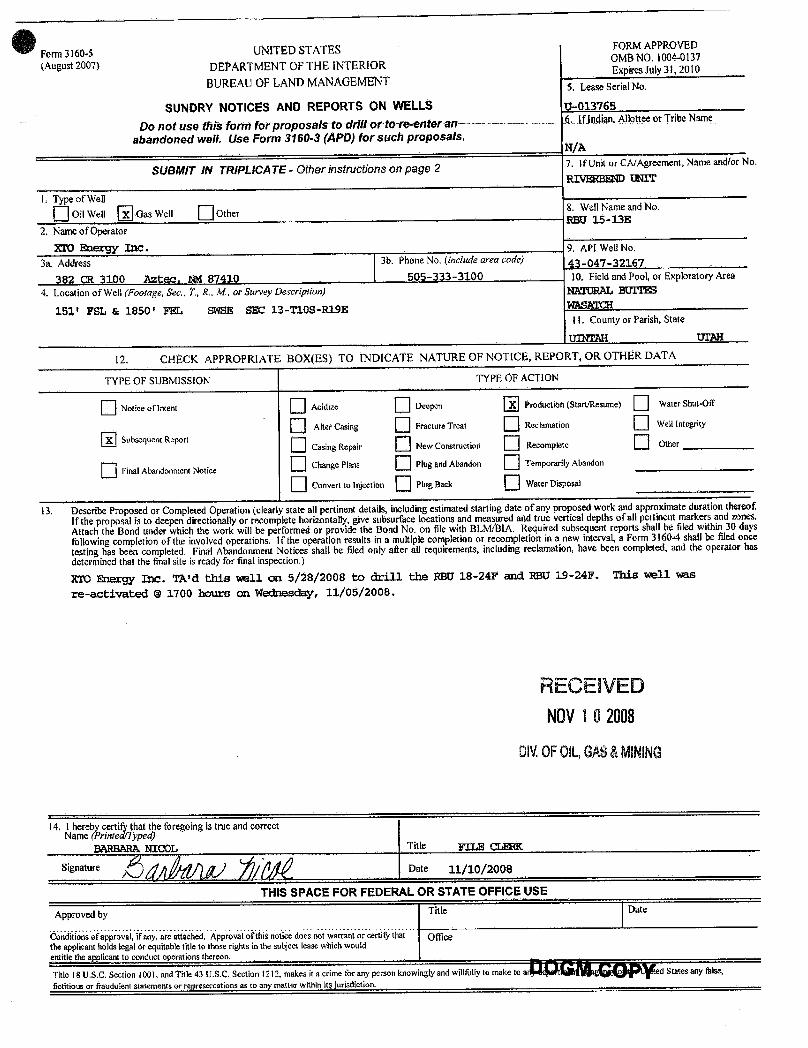
Form 3160-5 UNITED STATES FORMAPPROVED
(August 2007) DEPARTMENT OF THE INTERIOROMBNO. 1004-0137ExpiresJuly31, 2010
BUREAUOF LANDMANAGEMENT 5. Lease Serial No.
SUNDRY NOTICES AND REPORTS ON WELLS U-013765
Do not use thifform forproposals to drittor to re-enteran-- 6. IfJndian,Allouee or Tribe Name
abandoned well. Use Form 3160-3 (APD) for such proposals.N/A
SUBMIT IN TRIPLICATE - Other instructions on page 2 7. If Unit or CA/Agreement, Name and/or No.
RIVERBEND UNIT
I. Typeof Wei
O on well UGas Well 06 r8. Wemme andNo.ROU 15 13D
2. NameofOperator9 API Well No.
3a. Address 3b. PhoneNo. (include area code) 43 -047-32167
302 CR 3100 Aztec, 1 1 87410 505-333-3100 1(L Field and Pool, or ExploratoryArea
4. LocationofWell (Footage, Sec., T, R., M, or Survey Description) BTURAL BUITES
151' FSL 6: 1850' FEt, SWSE SEC 13-T108-R19EI1. County or Parish, State
umTAE UrAH
12. CHECK APPROPRIATE BOX(ES) TO INDICATE NATURE OF NOTICE, REPORT, OR OTHER DATA
TYPE OF SUBMISSION TYPE OF ACTION
O Notice of1ntent O - 0 - Ð Production (Start/Resume) Wo ShmŒ
Cäng Racture heat RecImion gry
SubsequentReportCasingRepair New Construction Recompletc Other
O Final Abandonment NoticeChange %ns Plug and Abandon Temporarily Abandon
O e-leasan O rissa==* O wat«roissosat
13. DescribeProposed or CompletedOperation (clearly state all pertinentdetails, includingestimated starting date ofany proposed work and approximate duration thereof.If the proposal is to deepen directionally or recomplete horizontally, give subsurface locationsand measured and true vertical depths ofall pertinentmarkers and zones.Attach the Bond under which the work will be performedor provide the Bond No. on file with BLM/BIA. Required subsequent reports shall be filed within 30 days
followingcompletion of the involvedoperatioits. If the operation results in a multiple completion or recompletionin a new interval,a Form 3160-4 shall be filedonce
testing has been completed. Final Abandonment Notices shall be filed only after all requirements, includingreclamation,have been completed, and the operator hasdetermined that the finalsite is ready for final inspection.)
XTO Energy Inc. TAld this well on 5/28/2008 to drill the RBU 18-24F and RBG 19-24F. This well wasre-activated @ 1700 hours on Wednesday, 11/05/2008.
RECEIVEDNOV1 0 2008
DIV.0FOIL,GAS&MINING
14. I herebycertify that the foregoing is true and correctName (Printed/Typed)
BARBARAblICOL Title FILE CLERK
Signature Date 11/10/2008
THIS SPACE FOR FEDERAL OR STATE OFFICE USE
Approved by Title Date
ndÏtÍonsofipilovaÍ,ÍÌan aie aiidei i ÄpprovaloÏtÑsnoiice does not warrant or certifythat OllÏcethe applicantholds legal or equitable title to those rights in the subject lease whichwouklentitle the applicant to conduct operations thereon.
Title 18IJ.S.C. Section 1001, and Title 43 U.S.C. Section 1212, makes it a crime for any person knowingly and wildbily to make to a ed States any false,fictitious or fraudulent statements or representations as to any matter within its

API Well No: 43047321670000
STATE OF UTAHDEPARTMENT OF NATURAL RESOURCES
DIVISION OF OIL, GAS, AND MINING
FORM 9
5.LEASE DESIGNATION AND SERIAL NUMBER: U-013765
SUNDRY NOTICES AND REPORTS ON WELLSDo not use this form for proposals to drill new wells, significantly deepen existing wells below currentbottom-hole depth, reenter plugged wells, or to drill horizontal laterals. Use APPLICATION FOR PERMIT TODRILL form for such proposals.
6. IF INDIAN, ALLOTTEE OR TRIBE NAME:
7.UNIT or CA AGREEMENT NAME: RIVER BEND
1. TYPE OF WELL Gas Well
8. WELL NAME and NUMBER: RBU 15-13E
2. NAME OF OPERATOR: XTO ENERGY INC
9. API NUMBER: 43047321670000
3. ADDRESS OF OPERATOR: 382 Road 3100 , Aztec, NM, 87410
9. FIELD and POOL or WILDCAT: NATURAL BUTTES
4. LOCATION OF WELL FOOTAGES AT SURFACE: 0151 FSL 1850 FEL QTR/QTR, SECTION, TOWNSHIP, RANGE, MERIDIAN: Qtr/Qtr: SWSE Section: 13 Township: 10.0S Range: 19.0E Meridian: S
COUNTY: UINTAH
STATE: UTAH
11.
CHECK APPROPRIATE BOXES TO INDICATE NATURE OF NOTICE, REPORT, OR OTHER DATA
TYPE OF SUBMISSION TYPE OF ACTION
NOTICE OF INTENTApproximate date work will start:
5/14/2010
SUBSEQUENT REPORTDate of Work Completion:
SPUD REPORTDate of Spud:
DRILLING REPORTReport Date:
ACIDIZE ALTER CASING CASING REPAIR
CHANGE TO PREVIOUS PLANS CHANGE TUBING CHANGE WELL NAME
CHANGE WELL STATUS COMMINGLE PRODUCING FORMATIONS CONVERT WELL TYPE
DEEPEN FRACTURE TREAT NEW CONSTRUCTION
OPERATOR CHANGE PLUG AND ABANDON PLUG BACK
PRODUCTION START OR RESUME RECLAMATION OF WELL SITE RECOMPLETE DIFFERENT FORMATION
REPERFORATE CURRENT FORMATION SIDETRACK TO REPAIR WELL TEMPORARY ABANDON
TUBING REPAIR VENT OR FLARE WATER DISPOSAL
WATER SHUTOFF SI TA STATUS EXTENSION APD EXTENSION
WILDCAT WELL DETERMINATION OTHER OTHER:
12. DESCRIBE PROPOSED OR COMPLETED OPERATIONS. Clearly show all pertinent details including dates, depths, volumes, etc.
XTO hereby requests a one year extension on the State permit for thereferenced well.
NAME (PLEASE PRINT) Eden Fine
TITLE Permitting Clerk
SIGNATURE N/A
DATE 8/13/2009
PHONE NUMBER:505 333-3159 Ext
PHONE NUMBER505 333-3664
August 13, 2009
August 13, 2009
iPI Well No: 43047321670000
FORM 9
STATE OF UTAHDEPARTMENT OF NATURAL RESOURCES
DIVISION OF OIL, GAS, AND MINING EASEnD5ESIGNATION AND SERIAL NUMBER:
SUNDRY NOTICES AND REPORTS ON WELLS 6. IF INDIAN, ALLOTTEE OR TRIBE NAME:
Do not use this form for proposals to drill new wells, significantly deepen existing wells below currentbottom-hole depth, reenter plugged wells, or to drill horizontal laterals. Use APPLICATION FOR PERMIT TO 7.UNIT or CA AGREEMENT NAME:
DRILL form for such proposals. RIVER BEND
1. TYPE OF WELL 8. WELL NAME and NUMBER:Gas Well RBU 15-13E
2. NAME OF OPERATOR: 9. API NUMBER:XTO ENERGY INC 43047321670000
3. ADDRESS OF OPERATOR: PHONE NUMBER: 9. FIELD and POOL or WILDCAT:382 Road 3100 , Aztec, NM, 87410 505 333-3159 Ext NATURAL BUTTES
4.LOCATIONOFWELL COUNTY:FOOTAGES AT SURFACE: UINTAH
0151 FSL 1850 FELQTR/QTR, SECTION, TOWNSHIP, RANGE, MERIDIAN: STATE:
Qtr/Qtr: SWSE Section: 13 Township: 10.05 Range: 19.0E Meridian: 5 UTAH
11.CHECK APPROPRIATE BOXES TO INDICATE NATURE OF NOTICE, REPORT, OR OTHER DATA
TYPE OF SUBMISSION TYPE OF ACTION
ACIDIZE ALTER CASING CASING REPAIR
/ NOTICE OF INTENTApproximate date work will start: CHANGE TO PREVIOUS PLANS CHANGE TUBING CHANGE WELL NAME
5/14/2010CHANGE WELL STATUS COMMINGLE PRODUCING FORMATIONS CONVERT WELL TYPE
SUBSEQUENT REPORT DEEPEN FRACTURE TREAT NEW CONSTRUCTIONDate of Work Completion:
OPERATOR CHANGE PLUG AND ABANDON PLUG BACK
PRODUCTION START OR RESUME RECLAMATION OF WELL SITE RECOMPLETE DIFFERENT FORMATION
SPUD REPORTDate of Spud: REPERFORATE CURRENT FORMATION SIDETRACK TO REPAIR WELL TEMPORARY ABANDON
TUBING REPAIR VENT OR FLARE WATER DISPOSAL
DRILLING REPORT WATER SHUTOFF SI TA STATUS EXTENSION APD EXTENSIONReport Date:
WILDCAT WELL DETERMINATION OTHER OTHER:
12. DESCRIBE PROPOSED OR CC MPLETED OPERATIONS. Clearly show all pertinent details including dates, depths, volumes, etc.
XTO hereby requests a one year extension on the State permit for thereferenced well. Approved by the
Utah Division ofOil, Gas and Mining
Date: Au st 13, 2009
By:
NAME (PLEASE PRINT) PHONE NUMBER TITLEEden Fine 505 333-3664 Permitting Clerk
SIGNATURE DATEN/A 8/13/2009
RECEIVED August 13,

The Utah Division of Oil, Gas, and Mining
- State of Utah- Department of Natural Resources
Electronic Permitting System - Sundry Notices
Request for Permit Extension Validation Well Number 43047321670000
API: 43047321670000Well Name: RBU 15-13E
Location: 0151 FSL 1850 FEL QTR SWSE SEC 13 TWNP 100S RNG 190E MER SCompany Permit Issued to: XTO ENERGY INC
Date Original Permit Issued: 6/21/2007
The undersigned as owner with legal rights to drill on the property as permitted above, hereby verifies thatthe information as submitted in the previously approved application to drill, remains valid and does notrequire revision. Following is a checklist of some items related to the application, which should be verified.
If located on private land, has the ownership changed, if so, has the surface agreement beenupdated? Yes No
Have any wells been drilled in the vicinity of the proposed well which would affect the spacing orsiting requirements for this location? Yes No
Has there been any unit or other agreements put in place that could affect the permitting or operationof this proposed well? Yes No
Have there been any changes to the access route including ownership, or rightof- way, which couldaffect the proposed location? Yes No
Has the approved source of water for drilling changed? Yes No
Have there been any physical changes to the surface location or access route which will require achange in plans from what was discussed at the onsite evaluation? Yes No
Is bonding still in place, which covers this proposed well? Yes No
Signature: Eden Fine Date: 8/13/2009
Title: Permitting Clerk Representing: XTO ENERGY INC
August 13, 2009
August 13, 2009
UTAH
DNR The Utah Division of Oil, Gas, and Mining'
- State of Utah- Department of Natural ResourcesElectronic Permitting System - Sundry Notices
OTI GAS MlNTNG
Request for Permit Extension Validation Well Number 43047321670000
API: 43047321670000Well Name: RBU 15-13E
Location: 0151 FSL 1850 FEL QTR SWSE SEC 13 TWNP 1005 RNG 190E MER SCompany Permit Issued to: XTO ENERGY INC
Date Original Permit Issued: 6/21/2007
The undersigned as owner with legal rights to drill on the property as permitted above, hereby verifies thatthe information as submitted in the previously approved application to drill, remains valid and does notrequire revision. Following is a checklist of some items related to the application, which should be verified.
•If located on private_land, has the ownership changed, if so, has the surface agreement beenupdated? I___|I Yes I_Ð_I No
• Have any wells been drilled in the vicinity of the_proposed well which would affect the spacing orsiting requirements for this location? I:___) Yes _®_) No
• Has there been any unit or other agreements put in place that could affect the permitting or operationof this proposed well? I i Yes i i No
• Have there been any changes to the access route including ownership, or rightof- way, which couldaffect the proposed location? I___) Yes I _I No
• Has the approved source of water for drilling changed? I __I Yes i i No
• Have there been any physical changes to the surface location or access route which will require achange in plans from what was discussed at the onsite evaluation? I___I Yes I®I No
Approved by the•Is bonding still in place, which covers this proposed well? I§|I Yes i i No Utah Division of
Oil, Gas and MiningSignature: Eden Fine Date: 8/13/2009
Title: Permitting Clerk Representing: XTO ENERGY INC Date: August 13, 2009
By:
RECEIVED August 13,
UTAH
DNR The Utah Division of Oil, Gas, and Mining'
- State of Utah- Department of Natural Resources
Electronic Permitting System - Sundry NoticesOTI GAS MlNTNG
Request for Permit Extension Validation Well Number 43047321670000
API: 43047321670000Well Name: RBU 15-13E
Location: 0151 FSL 1850 FEL QTR SWSE SEC 13 TWNP 1005 RNG 190E MER SCompany Permit Issued to: XTO ENERGY INC
Date Original Permit Issued: 6/21/2007
The undersigned as owner with legal rights to drill on the property as permitted above, hereby verifies thatthe information as submitted in the previously approved application to drill, remains valid and does notrequire revision. Following is a checklist of some items related to the application, which should be verified.
•If located on private_land, has the ownership changed, if so, has the surface agreement beenupdated? I___|I Yes I_Ð_I No
• Have any wells been drilled in the vicinity of the_proposed well which would affect the spacing orsiting requirements for this location? I:___) Yes _®_) No
• Has there been any unit or other agreements put in place that could affect the permitting or operationof this proposed well? I i Yes i i No
• Have there been any changes to the access route including ownership, or rightof- way, which couldaffect the proposed location? I___) Yes I _I No
• Has the approved source of water for drilling changed? I __I Yes i i No
• Have there been any physical changes to the surface location or access route which will require achange in plans from what was discussed at the onsite evaluation? I___I Yes I®I No
Approved by the•Is bonding still in place, which covers this proposed well? I§|I Yes i i No Utah Division of
Oil, Gas and MiningSignature: Eden Fine Date: 8/13/2009
Title: Permitting Clerk Representing: XTO ENERGY INC Date: August 13, 2009
By:
RECEIVED August 13,

API Well No: 43047321670000
STATE OF UTAHDEPARTMENT OF NATURAL RESOURCES
DIVISION OF OIL, GAS, AND MINING
FORM 9
5.LEASE DESIGNATION AND SERIAL NUMBER: U-013765
SUNDRY NOTICES AND REPORTS ON WELLSDo not use this form for proposals to drill new wells, significantly deepen existing wells below currentbottom-hole depth, reenter plugged wells, or to drill horizontal laterals. Use APPLICATION FOR PERMIT TODRILL form for such proposals.
6. IF INDIAN, ALLOTTEE OR TRIBE NAME:
7.UNIT or CA AGREEMENT NAME: RIVER BEND
1. TYPE OF WELL Gas Well
8. WELL NAME and NUMBER: RBU 15-13E
2. NAME OF OPERATOR: XTO ENERGY INC
9. API NUMBER: 43047321670000
3. ADDRESS OF OPERATOR: 382 Road 3100 , Aztec, NM, 87410
9. FIELD and POOL or WILDCAT: NATURAL BUTTES
4. LOCATION OF WELL FOOTAGES AT SURFACE: 0151 FSL 1850 FEL QTR/QTR, SECTION, TOWNSHIP, RANGE, MERIDIAN: Qtr/Qtr: SWSE Section: 13 Township: 10.0S Range: 19.0E Meridian: S
COUNTY: UINTAH
STATE: UTAH
11.
CHECK APPROPRIATE BOXES TO INDICATE NATURE OF NOTICE, REPORT, OR OTHER DATA
TYPE OF SUBMISSION TYPE OF ACTION
NOTICE OF INTENTApproximate date work will start:
6/21/2011
SUBSEQUENT REPORTDate of Work Completion:
SPUD REPORTDate of Spud:
DRILLING REPORTReport Date:
ACIDIZE ALTER CASING CASING REPAIR
CHANGE TO PREVIOUS PLANS CHANGE TUBING CHANGE WELL NAME
CHANGE WELL STATUS COMMINGLE PRODUCING FORMATIONS CONVERT WELL TYPE
DEEPEN FRACTURE TREAT NEW CONSTRUCTION
OPERATOR CHANGE PLUG AND ABANDON PLUG BACK
PRODUCTION START OR RESUME RECLAMATION OF WELL SITE RECOMPLETE DIFFERENT FORMATION
REPERFORATE CURRENT FORMATION SIDETRACK TO REPAIR WELL TEMPORARY ABANDON
TUBING REPAIR VENT OR FLARE WATER DISPOSAL
WATER SHUTOFF SI TA STATUS EXTENSION APD EXTENSION
WILDCAT WELL DETERMINATION OTHER OTHER:
12. DESCRIBE PROPOSED OR COMPLETED OPERATIONS. Clearly show all pertinent details including dates, depths, volumes, etc.
XTO hereby requests a one year extension on the State permit for thereferenced well.
NAME (PLEASE PRINT) Eden Fine
TITLE Permitting Clerk
SIGNATURE N/A
DATE 6/28/2010
PHONE NUMBER:505 333-3159 Ext
PHONE NUMBER505 333-3664
June 28, 2010
June 30, 2010
iPI Well No: 43047321670000
FORM 9
STATE OF UTAHDEPARTMENT OF NATURAL RESOURCES
DIVISION OF OIL, GAS, AND MINING EASEnD5ESIGNATION AND SERIAL NUMBER:
SUNDRY NOTICES AND REPORTS ON WELLS 6. IF INDIAN, ALLOTTEE OR TRIBE NAME:
Do not use this form for proposals to drill new wells, significantly deepen existing wells below currentbottom-hole depth, reenter plugged wells, or to drill horizontal laterals. Use APPLICATION FOR PERMIT TO 7.UNIT or CA AGREEMENT NAME:
DRILL form for such proposals. RIVER BEND
1. TYPE OF WELL 8. WELL NAME and NUMBER:Gas Well RBU 15-13E
2. NAME OF OPERATOR: 9. API NUMBER:XTO ENERGY INC 43047321670000
3. ADDRESS OF OPERATOR: PHONE NUMBER: 9. FIELD and POOL or WILDCAT:382 Road 3100 , Aztec, NM, 87410 505 333-3159 Ext NATURAL BUTTES
4.LOCATIONOFWELL COUNTY:FOOTAGES AT SURFACE: UINTAH
0151 FSL 1850 FELQTR/QTR, SECTION, TOWNSHIP, RANGE, MERIDIAN: STATE:
Qtr/Qtr: SWSE Section: 13 Township: 10.05 Range: 19.0E Meridian: 5 UTAH
11.CHECK APPROPRIATE BOXES TO INDICATE NATURE OF NOTICE, REPORT, OR OTHER DATA
TYPE OF SUBMISSION TYPE OF ACTION
ACIDIZE ALTER CASING CASING REPAIR
/ NOTICE OF INTENTApproximate date work will start: CHANGE TO PREVIOUS PLANS CHANGE TUBING CHANGE WELL NAME
6/21/2011CHANGE WELL STATUS COMMINGLE PRODUCING FORMATIONS CONVERT WELL TYPE
SUBSEQUENT REPORT DEEPEN FRACTURE TREAT NEW CONSTRUCTIONDate of Work Completion:
OPERATOR CHANGE PLUG AND ABANDON PLUG BACK
PRODUCTION START OR RESUME RECLAMATION OF WELL SITE RECOMPLETE DIFFERENT FORMATION
SPUD REPORTDate of Spud: REPERFORATE CURRENT FORMATION SIDETRACK TO REPAIR WELL TEMPORARY ABANDON
TUBING REPAIR VENT OR FLARE WATER DISPOSAL
DRILLING REPORT WATER SHUTOFF SI TA STATUS EXTENSION APD EXTENSIONReport Date:
WILDCAT WELL DETERMINATION OTHER OTHER:
12. DESCRIBE PROPOSED OR CC MPLETED OPERATIONS. Clearly show all pertinent details including dates, depths, volumes, etc.
XTO hereby requests a one year extension on the State permit for thereferenced well. Approved by the
Utah Division ofOil, Gas and Mining
Date 2010
NAME (PLEASE PRINT) PHONE NUMBER TITLEEden Fine 505 333-3664 Permitting Clerk
SIGNATURE DATEN/A 6/28/2010
RECEIVED June 28,

The Utah Division of Oil, Gas, and Mining
- State of Utah- Department of Natural Resources
Electronic Permitting System - Sundry Notices
Request for Permit Extension Validation Well Number 43047321670000
API: 43047321670000Well Name: RBU 15-13E
Location: 0151 FSL 1850 FEL QTR SWSE SEC 13 TWNP 100S RNG 190E MER SCompany Permit Issued to: XTO ENERGY INC
Date Original Permit Issued: 6/21/2007
The undersigned as owner with legal rights to drill on the property as permitted above, hereby verifies thatthe information as submitted in the previously approved application to drill, remains valid and does notrequire revision. Following is a checklist of some items related to the application, which should be verified.
If located on private land, has the ownership changed, if so, has the surface agreement beenupdated? Yes No
Have any wells been drilled in the vicinity of the proposed well which would affect the spacing orsiting requirements for this location? Yes No
Has there been any unit or other agreements put in place that could affect the permitting or operationof this proposed well? Yes No
Have there been any changes to the access route including ownership, or rightof- way, which couldaffect the proposed location? Yes No
Has the approved source of water for drilling changed? Yes No
Have there been any physical changes to the surface location or access route which will require achange in plans from what was discussed at the onsite evaluation? Yes No
Is bonding still in place, which covers this proposed well? Yes No
Signature: Eden Fine Date: 6/28/2010
Title: Permitting Clerk Representing: XTO ENERGY INC
June 28, 2010
June 30, 2010
UTAH
DNR The Utah Division of Oil, Gas, and Mining'
- State of Utah- Department of Natural ResourcesElectronic Permitting System - Sundry Notices
OTI GAS MlNTNG
Request for Permit Extension Validation Well Number 43047321670000
API: 43047321670000Well Name: RBU 15-13E
Location: 0151 FSL 1850 FEL QTR SWSE SEC 13 TWNP 1005 RNG 190E MER SCompany Permit Issued to: XTO ENERGY INC
Date Original Permit Issued: 6/21/2007
The undersigned as owner with legal rights to drill on the property as permitted above, hereby verifies thatthe information as submitted in the previously approved application to drill, remains valid and does notrequire revision. Following is a checklist of some items related to the application, which should be verified.
•If located on private_land, has the ownership changed, if so, has the surface agreement beenupdated? I___|I Yes I_Ð_I No
• Have any wells been drilled in the vicinity of the_proposed well which would affect the spacing orsiting requirements for this location? I:___) Yes _®_) No
• Has there been any unit or other agreements put in place that could affect the permitting or operationof this proposed well? I i Yes i i No
• Have there been any changes to the access route including ownership, or rightof- way, which couldaffect the proposed location? I___) Yes I _I No
• Has the approved source of water for drilling changed? I __I Yes i i No
• Have there been any physical changes to the surface location or access route which will require achange in plans from what was discussed at the onsite evaluation? I___I Yes I®I No
Approved by the•Is bonding still in place, which covers this proposed well? I§|I Yes i i No Utah Division of
Oil, Gas and MiningSignature: Eden Fine Date: 6/28/2010
Title: Permitting Clerk Representing: XTO ENERGY INC Date: June 30, 2010
By:
RECEIVED June 28,
UTAH
DNR The Utah Division of Oil, Gas, and Mining'
- State of Utah- Department of Natural Resources
Electronic Permitting System - Sundry NoticesOTI GAS MlNTNG
Request for Permit Extension Validation Well Number 43047321670000
API: 43047321670000Well Name: RBU 15-13E
Location: 0151 FSL 1850 FEL QTR SWSE SEC 13 TWNP 1005 RNG 190E MER SCompany Permit Issued to: XTO ENERGY INC
Date Original Permit Issued: 6/21/2007
The undersigned as owner with legal rights to drill on the property as permitted above, hereby verifies thatthe information as submitted in the previously approved application to drill, remains valid and does notrequire revision. Following is a checklist of some items related to the application, which should be verified.
•If located on private_land, has the ownership changed, if so, has the surface agreement beenupdated? I___|I Yes I_Ð_I No
• Have any wells been drilled in the vicinity of the_proposed well which would affect the spacing orsiting requirements for this location? I:___) Yes _®_) No
• Has there been any unit or other agreements put in place that could affect the permitting or operationof this proposed well? I i Yes i i No
• Have there been any changes to the access route including ownership, or rightof- way, which couldaffect the proposed location? I___) Yes I _I No
• Has the approved source of water for drilling changed? I __I Yes i i No
• Have there been any physical changes to the surface location or access route which will require achange in plans from what was discussed at the onsite evaluation? I___I Yes I®I No
Approved by the•Is bonding still in place, which covers this proposed well? I§|I Yes i i No Utah Division of
Oil, Gas and MiningSignature: Eden Fine Date: 6/28/2010
Title: Permitting Clerk Representing: XTO ENERGY INC Date: June 30, 2010
By:
RECEIVED June 28,

STATE OF UTAHDEPARTMENT OF NATURAL RESOURCES
DIVISION OF OIL, GAS, AND MINING
FORM 9
5.LEASE DESIGNATION AND SERIAL NUMBER: U-013765
SUNDRY NOTICES AND REPORTS ON WELLSDo not use this form for proposals to drill new wells, significantly deepen existing wells below currentbottom-hole depth, reenter plugged wells, or to drill horizontal laterals. Use APPLICATION FOR PERMIT TODRILL form for such proposals.
6. IF INDIAN, ALLOTTEE OR TRIBE NAME:
7.UNIT or CA AGREEMENT NAME: RIVER BEND
1. TYPE OF WELL Gas Well
8. WELL NAME and NUMBER: RBU 15-13E
2. NAME OF OPERATOR: XTO ENERGY INC
9. API NUMBER: 43047321670000
3. ADDRESS OF OPERATOR: PHONE NUMBER: 382 Road 3100 , Aztec, NM, 87410 505 333-3159 Ext
9. FIELD and POOL or WILDCAT: NATURAL BUTTES
4. LOCATION OF WELL FOOTAGES AT SURFACE: 0151 FSL 1850 FEL QTR/QTR, SECTION, TOWNSHIP, RANGE, MERIDIAN: Qtr/Qtr: SWSE Section: 13 Township: 10.0S Range: 19.0E Meridian: S
COUNTY: UINTAH
STATE: UTAH
11.
CHECK APPROPRIATE BOXES TO INDICATE NATURE OF NOTICE, REPORT, OR OTHER DATA
TYPE OF SUBMISSION TYPE OF ACTION
NOTICE OF INTENTApproximate date work will start:
8/1/2011
SUBSEQUENT REPORTDate of Work Completion:
SPUD REPORTDate of Spud:
DRILLING REPORTReport Date:
ACIDIZE ALTER CASING CASING REPAIR
CHANGE TO PREVIOUS PLANS CHANGE TUBING CHANGE WELL NAME
CHANGE WELL STATUS COMMINGLE PRODUCING FORMATIONS CONVERT WELL TYPE
DEEPEN FRACTURE TREAT NEW CONSTRUCTION
OPERATOR CHANGE PLUG AND ABANDON PLUG BACK
PRODUCTION START OR RESUME RECLAMATION OF WELL SITE RECOMPLETE DIFFERENT FORMATION
REPERFORATE CURRENT FORMATION SIDETRACK TO REPAIR WELL TEMPORARY ABANDON
TUBING REPAIR VENT OR FLARE WATER DISPOSAL
WATER SHUTOFF SI TA STATUS EXTENSION APD EXTENSION
WILDCAT WELL DETERMINATION OTHER OTHER: OPEN ADD'L PAY
12. DESCRIBE PROPOSED OR COMPLETED OPERATIONS. Clearly show all pertinent details including dates, depths, volumes, etc.
XTO Energy Inc. intends to open additional pay in this well per the attachedprocedure.
NAME (PLEASE PRINT) PHONE NUMBER Barbara Nicol 505 333-3642
TITLE Regulatory Compliance Tech
SIGNATURE N/A
DATE 6/21/2011
06/21/2011
Jun. 21, 2011
Sundry Number: 16094 API Well Number: 43047321670000Sundry Number: ËËaÊÀp?S Ngr: 43047321670000
Action is Necessary
FORM 9STATE OF UTAH
DEPARTMENT OF NATURAL RESOURCESDIVISION OF OIL, GAS, AND MINING EASE D5ESIGNATION AND SERIAL NUMBER:
SUNDRY NOTICES AND REPORTS ON WELLS 6. IF INDIAN, ALLOTTEE OR TRIBE NAME:
Do not use this form for proposals to drill new wells, significantly deepen existing wells below currentbottom-hole depth, reenter plugged wells, or to drill horizontal laterals. Use APPLICATION FOR PERMIT TO 7.UNIT or CA AGREEMENT NAME:
DRILL form for such proposals. RIVER BEND
1. TYPE OF WELL 8. WELL NAME and NUMBER:Gas Well RBU 15-13E
2. NAME OF OPERATOR: 9. API NUMBER:XTO ENERGY INC 43047321670000
3. ADDRESS OF OPERATOR: PHONE NUMBER: 9. FIELD and POOL or WILDCAT:382 Road 3100 , Aztec, NM, 87410 505 333-3159 E×t NATURAL BUTTES
4.LOCATIONOFVVELL COUNTY:FOOTAGES AT SURFACE: UINTAH
0151 FSL 1850 FELQTR/QTR, SECTION, TOWNSHIP, RANGE, MERIDIAN: STATE:
Qtr/Qtr: SWSE Section: 13 Township: 10.05 Range: 19.0E Meridian: S UTAH
11.CHECK APPROPRIATE BOXES TO INDICATE NATURE OF NOTICE, REPORT, OR OTHER DATA
TYPE OF SUBMISSION TYPE OF ACTION
ACIDIZE ALTER CASING CASING REPAIR
NOTICE OF INTENTApproximate date work will start: CHANGE TO PREVIOUS PLANS CHANGE TUBING CHANGE WELL NAME
8/1/2011CHANGE WELL STATUS COMMINGLE PRODUCING FORMATIONS CONVERT WELL TYPE
SUBSEQUENT REPORT DEEPEN FRACTURE TREAT NEW CONSTRUCTIONDate of Work Completion:
OPERATOR CHANGE PLUG AND ABANDON PLUG BACK
PRODUCTION START OR RESUME RECLAMATION OF WELL SITE RECOMPLETE DIFFERENT FORMATION
SPUD REPORTDate of Spud: REPERFORATE CURRENT FORMATION SIDETRACK TO REPAIR WELL TEMPORARY ABANDON
TUBING REPAIR VENT OR FLARE WATER DISPOSAL
DRILLING REPORT WATER SHUTOFF SI TA STATUS EXTENSION APD EXTENSIONReport Date:
WILDCAT WELL DETERMINATION OTHER OTHER: OPEN ADD'L PAY
12. DESCRIBE PROPOSED OR C( MPLETED OPERATIONS. Clearly show all pertinent details including dates, depths, volumes, etc.
XTO Energy Inc. intends to open additional pay in this well per the attachedprocedure.
Accepted by theUtah Division of
Oil, Gas and Mining
Date: 06/21/2 1
By:
NAME (PLEASE PRINT) PHONE NUMBER TITLEBarbara Nicol 505 333-3642 Regulatory Compliance Tech
SIGNATURE DATEN/A 6/21/2011
RECEIVED Jun. 21,
Sundry Number: ËËaÊÀp?S Ngr: 43047321670000
Action is Necessary
FORM 9STATE OF UTAH
DEPARTMENT OF NATURAL RESOURCESDIVISION OF OIL, GAS, AND MINING EASE D5ESIGNATION AND SERIAL NUMBER:
SUNDRY NOTICES AND REPORTS ON WELLS 6. IF INDIAN, ALLOTTEE OR TRIBE NAME:
Do not use this form for proposals to drill new wells, significantly deepen existing wells below currentbottom-hole depth, reenter plugged wells, or to drill horizontal laterals. Use APPLICATION FOR PERMIT TO 7.UNIT or CA AGREEMENT NAME:
DRILL form for such proposals. RIVER BEND
1. TYPE OF WELL 8. WELL NAME and NUMBER:Gas Well RBU 15-13E
2. NAME OF OPERATOR: 9. API NUMBER:XTO ENERGY INC 43047321670000
3. ADDRESS OF OPERATOR: PHONE NUMBER: 9. FIELD and POOL or WILDCAT:382 Road 3100 , Aztec, NM, 87410 505 333-3159 E×t NATURAL BUTTES
4.LOCATIONOFVVELL COUNTY:FOOTAGES AT SURFACE: UINTAH
0151 FSL 1850 FELQTR/QTR, SECTION, TOWNSHIP, RANGE, MERIDIAN: STATE:
Qtr/Qtr: SWSE Section: 13 Township: 10.05 Range: 19.0E Meridian: S UTAH
11.CHECK APPROPRIATE BOXES TO INDICATE NATURE OF NOTICE, REPORT, OR OTHER DATA
TYPE OF SUBMISSION TYPE OF ACTION
ACIDIZE ALTER CASING CASING REPAIR
NOTICE OF INTENTApproximate date work will start: CHANGE TO PREVIOUS PLANS CHANGE TUBING CHANGE WELL NAME
8/1/2011CHANGE WELL STATUS COMMINGLE PRODUCING FORMATIONS CONVERT WELL TYPE
SUBSEQUENT REPORT DEEPEN FRACTURE TREAT NEW CONSTRUCTIONDate of Work Completion:
OPERATOR CHANGE PLUG AND ABANDON PLUG BACK
PRODUCTION START OR RESUME RECLAMATION OF WELL SITE RECOMPLETE DIFFERENT FORMATION
SPUD REPORTDate of Spud: REPERFORATE CURRENT FORMATION SIDETRACK TO REPAIR WELL TEMPORARY ABANDON
TUBING REPAIR VENT OR FLARE WATER DISPOSAL
DRILLING REPORT WATER SHUTOFF SI TA STATUS EXTENSION APD EXTENSIONReport Date:
WILDCAT WELL DETERMINATION OTHER OTHER: OPEN ADD'L PAY
12. DESCRIBE PROPOSED OR C( MPLETED OPERATIONS. Clearly show all pertinent details including dates, depths, volumes, etc.
XTO Energy Inc. intends to open additional pay in this well per the attachedprocedure.
Accepted by theUtah Division of
Oil, Gas and Mining
Date: 06/21/2 1
By:
NAME (PLEASE PRINT) PHONE NUMBER TITLEBarbara Nicol 505 333-3642 Regulatory Compliance Tech
SIGNATURE DATEN/A 6/21/2011
RECEIVED Jun. 21,

Jun. 21, 2011
Sundry Number: 16094 API Well Number: 43047321670000Sundry Number: 16094 API Well Number: 43047321670000
Riverbend Unit 15-13ESec 13, T 10 S, R 19 E
API: 43-047-32167Uintah County, Utah
Open Additional Pay
Surf. csg: 8-5/8", 24#, H-40, ST&C esg @400'. Circ cmt to surf.Prod csg: 5-1/2", 17#, N-80, LT&C esg @6,500'. PBTD (FC)@ 6,422'.Cement: 357 sks lead (10.8 ppg, 3.91 cf/sk) and 665 sks tail (14.2 ppg, 1.61 ef/sk) cmt. Cire 10.0
bbls cmt to surface.Tbg: MS, SN, 189 jts, 2-3/8", 4.7#, N-80 EUE, 8RD tbg. SN @6,103'. EOT 6,104'.Perforations: Wasatch: 4,902'-4,912', 4,928'-4,938', 5,472'-5,482', 5,710'-5,724', 6,l50'-6,170'.Status: Plunger lift, 60 MCFPD, trace of water and oil.Purpose: Open additional pay in the Wasatch and commingle with existing production
OAP Procedure
1) MI & set 2 - 500 bbl frac tanks and fill w/KCl substitute water. Set flowback tank.
2) MIRU PU. MI approximately 500' of 2-3/8", 4.7#, L-80 tbg.
3) Blow well down and kill well w/KCI substitute water.
4) ND WH. NU and pressure test BOP.
5) TIH with 2-3/8" tbg. Tag fill. Report any fill to Mike Logan. TOH with tbg.
6) TIH with bit & scraper on 2-3/8" tubing. CO to PBTD (FC) @6,422'.TOH, LD BHA and tbg.
7) MI approximately 6,000' of 3-1/2", 9.3#, N-80 frac string.
8) MIRU wireline truck. RU full lubricator. Correlate with the RBU 08-13E Halliburton compensateddensity/neutron log dated 03/08/92.
9) Set 5-1/2" 8K CBP @+/- 6,090'. Perf Wasatch w/3-3/8" esg gun with 2 JSPF (Titan EXP-3323-361T, 22.7 gm, 120 deg phasing, 0.36" dia., 35.63" penetration, 25 holes). POH with csg gun.RDMO WL.
Wasatch OAP PerfsPerf Depth Interval # of Holes6,004'-6,0 16' 12' 25
Total 12' 25
10) PU and TIH with Weatherford 5-1/2" HD frac packer on 3-1/2", 9.3#, N-80 frac string (burst 10,160psi, 80%=8,128 psi, capacity =0.0087 bbl/ft ). Set packer at +/- 5,850'. NU 10,000 psi gate valveon top of BOPs.
-l-
RECEIVED Jun. 21,
Sundry Number: 16094 API Well Number: 43047321670000
Riverbend Unit 15-13ESec 13, T 10 S, R 19 E
API: 43-047-32167Uintah County, Utah
Open Additional Pay
Surf. csg: 8-5/8", 24#, H-40, ST&C esg @400'. Circ cmt to surf.Prod csg: 5-1/2", 17#, N-80, LT&C esg @6,500'. PBTD (FC)@ 6,422'.Cement: 357 sks lead (10.8 ppg, 3.91 cf/sk) and 665 sks tail (14.2 ppg, 1.61 ef/sk) cmt. Cire 10.0
bbls cmt to surface.Tbg: MS, SN, 189 jts, 2-3/8", 4.7#, N-80 EUE, 8RD tbg. SN @6,103'. EOT 6,104'.Perforations: Wasatch: 4,902'-4,912', 4,928'-4,938', 5,472'-5,482', 5,710'-5,724', 6,l50'-6,170'.Status: Plunger lift, 60 MCFPD, trace of water and oil.Purpose: Open additional pay in the Wasatch and commingle with existing production
OAP Procedure
1) MI & set 2 - 500 bbl frac tanks and fill w/KCl substitute water. Set flowback tank.
2) MIRU PU. MI approximately 500' of 2-3/8", 4.7#, L-80 tbg.
3) Blow well down and kill well w/KCI substitute water.
4) ND WH. NU and pressure test BOP.
5) TIH with 2-3/8" tbg. Tag fill. Report any fill to Mike Logan. TOH with tbg.
6) TIH with bit & scraper on 2-3/8" tubing. CO to PBTD (FC) @6,422'.TOH, LD BHA and tbg.
7) MI approximately 6,000' of 3-1/2", 9.3#, N-80 frac string.
8) MIRU wireline truck. RU full lubricator. Correlate with the RBU 08-13E Halliburton compensateddensity/neutron log dated 03/08/92.
9) Set 5-1/2" 8K CBP @+/- 6,090'. Perf Wasatch w/3-3/8" esg gun with 2 JSPF (Titan EXP-3323-361T, 22.7 gm, 120 deg phasing, 0.36" dia., 35.63" penetration, 25 holes). POH with csg gun.RDMO WL.
Wasatch OAP PerfsPerf Depth Interval # of Holes6,004'-6,0 16' 12' 25
Total 12' 25
10) PU and TIH with Weatherford 5-1/2" HD frac packer on 3-1/2", 9.3#, N-80 frac string (burst 10,160psi, 80%=8,128 psi, capacity =0.0087 bbl/ft ). Set packer at +/- 5,850'. NU 10,000 psi gate valveon top of BOPs.
-l-
RECEIVED Jun. 21,

Jun. 21, 2011
Sundry Number: 16094 API Well Number: 43047321670000Sundry Number: 16094 API Well Number: 43047321670000
1l) Frac Wasatch OAP fr/6,004'-6,016' w/60,000# proppant.
12) SWI overnight. Install flowback manifold. Flowback well thru a choke manifold to flowback tank.Start with a 16/64" choke. Increase choke size as appropriate.
13) ND 10,000 psi gate valve. Unseat packer. TOH and LD frac string and packer. Control well withtreated KCl water.
14) MIRU AFU if necessary. TIH with bit on 2-3/8" tbg. CO to CBP @6,090'.DO CBP and CO toPBTD. TOH with BHA.
15) TIH w/NC, SN, and 2-3/8", 4.7#, N-80/L-80, EUE, 8rd tbg. Land tubing at ±6,140', SN at ±6,139'.ND BOP. NU WH
16) Swab well until clean fluid is obtained and well kicks off. RDMO PU.
17) Report rates and pressures on test reports.
Regulatory:
• Submit NOI for the OAP in the Wasatch• Submit subsequent sundry after work has been completed
-2-
RECEIVED Jun. 21,
Sundry Number: 16094 API Well Number: 43047321670000
1l) Frac Wasatch OAP fr/6,004'-6,016' w/60,000# proppant.
12) SWI overnight. Install flowback manifold. Flowback well thru a choke manifold to flowback tank.Start with a 16/64" choke. Increase choke size as appropriate.
13) ND 10,000 psi gate valve. Unseat packer. TOH and LD frac string and packer. Control well withtreated KCl water.
14) MIRU AFU if necessary. TIH with bit on 2-3/8" tbg. CO to CBP @6,090'.DO CBP and CO toPBTD. TOH with BHA.
15) TIH w/NC, SN, and 2-3/8", 4.7#, N-80/L-80, EUE, 8rd tbg. Land tubing at ±6,140', SN at ±6,139'.ND BOP. NU WH
16) Swab well until clean fluid is obtained and well kicks off. RDMO PU.
17) Report rates and pressures on test reports.
Regulatory:
• Submit NOI for the OAP in the Wasatch• Submit subsequent sundry after work has been completed
-2-
RECEIVED Jun. 21,

STATE OF UTAHDEPARTMENT OF NATURAL RESOURCES
DIVISION OF OIL, GAS, AND MINING
FORM 9
5.LEASE DESIGNATION AND SERIAL NUMBER: U-013765
SUNDRY NOTICES AND REPORTS ON WELLSDo not use this form for proposals to drill new wells, significantly deepen existing wells below currentbottom-hole depth, reenter plugged wells, or to drill horizontal laterals. Use APPLICATION FOR PERMIT TODRILL form for such proposals.
6. IF INDIAN, ALLOTTEE OR TRIBE NAME:
7.UNIT or CA AGREEMENT NAME: RIVER BEND
1. TYPE OF WELL Gas Well
8. WELL NAME and NUMBER: RBU 15-13E
2. NAME OF OPERATOR: XTO ENERGY INC
9. API NUMBER: 43047321670000
3. ADDRESS OF OPERATOR: PHONE NUMBER: 382 Road 3100 , Aztec, NM, 87410 505 333-3159 Ext
9. FIELD and POOL or WILDCAT: NATURAL BUTTES
4. LOCATION OF WELL FOOTAGES AT SURFACE: 0151 FSL 1850 FEL QTR/QTR, SECTION, TOWNSHIP, RANGE, MERIDIAN: Qtr/Qtr: SWSE Section: 13 Township: 10.0S Range: 19.0E Meridian: S
COUNTY: UINTAH
STATE: UTAH
11.
CHECK APPROPRIATE BOXES TO INDICATE NATURE OF NOTICE, REPORT, OR OTHER DATA
TYPE OF SUBMISSION TYPE OF ACTION
NOTICE OF INTENTApproximate date work will start:
8/9/2012
SUBSEQUENT REPORTDate of Work Completion:
SPUD REPORTDate of Spud:
DRILLING REPORTReport Date:
ACIDIZE ALTER CASING CASING REPAIR
CHANGE TO PREVIOUS PLANS CHANGE TUBING CHANGE WELL NAME
CHANGE WELL STATUS COMMINGLE PRODUCING FORMATIONS CONVERT WELL TYPE
DEEPEN FRACTURE TREAT NEW CONSTRUCTION
OPERATOR CHANGE PLUG AND ABANDON PLUG BACK
PRODUCTION START OR RESUME RECLAMATION OF WELL SITE RECOMPLETE DIFFERENT FORMATION
REPERFORATE CURRENT FORMATION SIDETRACK TO REPAIR WELL TEMPORARY ABANDON
TUBING REPAIR VENT OR FLARE WATER DISPOSAL
WATER SHUTOFF SI TA STATUS EXTENSION APD EXTENSION
WILDCAT WELL DETERMINATION OTHER OTHER:
12. DESCRIBE PROPOSED OR COMPLETED OPERATIONS. Clearly show all pertinent details including dates, depths, volumes, etc.
XTO Energy hereby requests a one (1) year extension of the State APD for thereferenced well.
NAME (PLEASE PRINT) PHONE NUMBER Krista Wilson 505 333-3647
TITLE Permitting Tech
SIGNATURE N/A
DATE 8/10/2011
08/10/2011
Aug. 10, 2011
Sundry Number: 17446 API Well Number: 43047321670000
FORM 9STATE OF UTAH
DEPARTMENT OF NATURAL RESOURCESDIVISION OF OIL, GAS, AND MINING EASE D5ESIGNATION AND SERIAL NUMBER:
SUNDRY NOTICES AND REPORTS ON WELLS 6. IF INDIAN, ALLOTTEE OR TRIBE NAME:
Do not use this form for proposals to drill new wells, significantly deepen existing wells below currentbottom-hole depth, reenter plugged wells, or to drill horizontal laterals. Use APPLICATION FOR PERMIT TO 7.UNIT or CA AGREEMENT NAME:
DRILL form for such proposals. RIVER BEND
1. TYPE OF WELL 8. WELL NAME and NUMBER:Gas Well RBU 15-13E
2. NAME OF OPERATOR: 9. API NUMBER:XTO ENERGYINC 43047321670000
3. ADDRESS OF OPERATOR: PHONE NUMBER: 9. FIELD and POOL or WILDCAT:382 Road 3100 , Aztec, NM, 87410 505 333-3159 E×t NATURAL BUTTES
4.LOCATIONOFVVELL COUNTY:FOOTAGES AT SURFACE: UINTAH
0151 FSL 1850 FELQTR/QTR, SECTION, TOWNSHIP, RANGE, MERIDIAN: STATE:
Qtr/Qtr: SWSE Section: 13 Township: 10.05 Range: 19.0E Meridian: S UTAH
11.CHECK APPROPRIATE BOXES TO INDICATE NATURE OF NOTICE, REPORT, OR OTHER DATA
TYPE OF SUBMISSION TYPE OF ACTION
ACIDIZE ALTER CASING CASING REPAIR
/ NOTICE OF INTENTApproximate date work will start: CHANGE TO PREVIOUS PLANS CHANGE TUBING CHANGE WELL NAME
8/9/2012CHANGE WELL STATUS COMMINGLE PRODUCING FORMATIONS CONVERT WELL TYPE
SUBSEQUENT REPORT DEEPEN FRACTURE TREAT NEW CONSTRUCTIONDate of Work Completion:
OPERATOR CHANGE PLUG AND ABANDON PLUG BACK
PRODUCTION START OR RESUME RECLAMATION OF WELL SITE RECOMPLETE DIFFERENT FORMATION
SPUD REPORTDate of Spud: REPERFORATE CURRENT FORMATION SIDETRACK TO REPAIR WELL TEMPORARY ABANDON
TUBING REPAIR VENT OR FLARE WATER DISPOSAL
DRILLING REPORT WATER SHUTOFF SI TA STATUS EXTENSION APD EXTENSIONReport Date:
WILDCAT WELL DETERMINATION OTHER OTHER:
12. DESCRIBE PROPOSED OR C( MPLETED OPERATIONS. Clearly show all pertinent details including dates, depths, volumes, etc.
XTO Energy hereby requests a one (1) year extension of the State APD for thereferenced well.
Approved by theUtah Division of
Oil, Gas and Mining
Date: 08/10/2011
By:
NAME (PLEASE PRINT) PHONE NUMBER TITLEKrista Wilson 505 333-3647 Permitting Tech
SIGNATURE DATEN/A

The Utah Division of Oil, Gas, and Mining
- State of Utah- Department of Natural Resources
Electronic Permitting System - Sundry Notices
Request for Permit Extension Validation Well Number 43047321670000
API: 43047321670000Well Name: RBU 15-13E
Location: 0151 FSL 1850 FEL QTR SWSE SEC 13 TWNP 100S RNG 190E MER SCompany Permit Issued to: XTO ENERGY INC
Date Original Permit Issued: 6/21/2007
The undersigned as owner with legal rights to drill on the property as permitted above, hereby verifies thatthe information as submitted in the previously approved application to drill, remains valid and does notrequire revision. Following is a checklist of some items related to the application, which should be verified.
If located on private land, has the ownership changed, if so, has the surface agreement beenupdated? Yes No
Have any wells been drilled in the vicinity of the proposed well which would affect the spacing orsiting requirements for this location? Yes No
Has there been any unit or other agreements put in place that could affect the permitting or operationof this proposed well? Yes No
Have there been any changes to the access route including ownership, or rightof- way, which couldaffect the proposed location? Yes No
Has the approved source of water for drilling changed? Yes No
Have there been any physical changes to the surface location or access route which will require achange in plans from what was discussed at the onsite evaluation? Yes No
Is bonding still in place, which covers this proposed well? Yes No
Signature: Krista Wilson Date: 8/10/2011
Title: Permitting Tech Representing: XTO ENERGY INC
Aug. 10, 2011
Sundry Number: 17446 API Well Number: 43047321670000
UTAH
DNR The Utah Division of Oil, Gas, and Mining- State of Utah- Department of Natural ResourcesElectronic Permitting System - Sundry Notices
TI, BAS Pr N1NTMG
Request for Permit Extension Validation Well Number 43047321670000
API: 43047321670000Well Name: RBU 15-13E
Location: 0151 FSL 1850 FEL QTR SWSE SEC 13 TWNP 100S RNG 190E MER SCompany Permit Issued to: XTO ENERGY INC
Date Original Permit Issued: 6/21/2007
The undersigned as owner with legal rights to drill on the property as permitted above, hereby verifies thatthe information as submitted in the previously approved application to drill, remains valid and does notrequire revision. Following is a checklist of some items related to the application, which should be verified.
•If located on private_land, has the ownership changed, if so, has the surface agreement beenupdated? O Yes No
• Have any wells been drilled in the vicinity of the roposed well which would affect the spacing orsiting requirements for this location? O Yes No
• Has there been any unit or other agreements put in place that could affect the permitting or operationof this proposed well? O Yes @ No
• Have there been any changes to the access route including ownership, or rightof- way, which couldaffect the proposed location? O Yes @ No
• Has the approved source of water for drilling changed? O Yes @ No
• Have there been any physical changes to the surface location or access route which will require achange in plans from what was discussed at the onsite evaluation? O Yes @ No
• Is bonding still in place, which covers this proposed well? @ Yes O No
Signature: Krista Wilson Date: 8/10/2011Title: Permitting Tech Representing: XTO ENERGY
UTAH
DNR The Utah Division of Oil, Gas, and Mining- State of Utah- Department of Natural Resources
Electronic Permitting System - Sundry NoticesTI, BAS Pr N1NTMG
Request for Permit Extension Validation Well Number 43047321670000
API: 43047321670000Well Name: RBU 15-13E
Location: 0151 FSL 1850 FEL QTR SWSE SEC 13 TWNP 100S RNG 190E MER SCompany Permit Issued to: XTO ENERGY INC
Date Original Permit Issued: 6/21/2007
The undersigned as owner with legal rights to drill on the property as permitted above, hereby verifies thatthe information as submitted in the previously approved application to drill, remains valid and does notrequire revision. Following is a checklist of some items related to the application, which should be verified.
•If located on private_land, has the ownership changed, if so, has the surface agreement beenupdated? O Yes No
• Have any wells been drilled in the vicinity of the roposed well which would affect the spacing orsiting requirements for this location? O Yes No
• Has there been any unit or other agreements put in place that could affect the permitting or operationof this proposed well? O Yes @ No
• Have there been any changes to the access route including ownership, or rightof- way, which couldaffect the proposed location? O Yes @ No
• Has the approved source of water for drilling changed? O Yes @ No
• Have there been any physical changes to the surface location or access route which will require achange in plans from what was discussed at the onsite evaluation? O Yes @ No
• Is bonding still in place, which covers this proposed well? @ Yes O No
Signature: Krista Wilson Date: 8/10/2011Title: Permitting Tech Representing: XTO ENERGY

RECEIVED: Jun. 04, 2012
STATE OF UTAHDEPARTMENT OF NATURAL RESOURCES
DIVISION OF OIL, GAS, AND MINING
FORM 9
5.LEASE DESIGNATION AND SERIAL NUMBER: U-013765
SUNDRY NOTICES AND REPORTS ON WELLS
Do not use this form for proposals to drill new wells, significantly deepen existing wells belowcurrent bottom-hole depth, reenter plugged wells, or to drill horizontal laterals. Use APPLICATIONFOR PERMIT TO DRILL form for such proposals.
6. IF INDIAN, ALLOTTEE OR TRIBE NAME:
7.UNIT or CA AGREEMENT NAME: RIVER BEND
1. TYPE OF WELL Gas Well
8. WELL NAME and NUMBER: RBU 15-13E
2. NAME OF OPERATOR: XTO ENERGY INC
9. API NUMBER: 43047321670000
3. ADDRESS OF OPERATOR: PHONE NUMBER: 382 Road 3100 , Aztec, NM, 87410 505 333-3145 Ext
9. FIELD and POOL or WILDCAT: NATURAL BUTTES
4. LOCATION OF WELL FOOTAGES AT SURFACE: 0151 FSL 1850 FEL QTR/QTR, SECTION, TOWNSHIP, RANGE, MERIDIAN: Qtr/Qtr: SWSE Section: 13 Township: 10.0S Range: 19.0E Meridian: S
COUNTY: UINTAH
STATE: UTAH
11.
CHECK APPROPRIATE BOXES TO INDICATE NATURE OF NOTICE, REPORT, OR OTHER DATA
TYPE OF SUBMISSION TYPE OF ACTION
NOTICE OF INTENTApproximate date work will start:
4 /30 /2013
SUBSEQUENT REPORTDate of Work Completion:
SPUD REPORTDate of Spud:
DRILLING REPORTReport Date:
ACIDIZE ALTER CASING CASING REPAIR
CHANGE TO PREVIOUS PLANS CHANGE TUBING CHANGE WELL NAME
CHANGE WELL STATUS COMMINGLE PRODUCING FORMATIONS CONVERT WELL TYPE
DEEPEN FRACTURE TREAT NEW CONSTRUCTION
OPERATOR CHANGE PLUG AND ABANDON PLUG BACK
PRODUCTION START OR RESUME RECLAMATION OF WELL SITE RECOMPLETE DIFFERENT FORMATION
REPERFORATE CURRENT FORMATION SIDETRACK TO REPAIR WELL TEMPORARY ABANDON
TUBING REPAIR VENT OR FLARE WATER DISPOSAL
WATER SHUTOFF SI TA STATUS EXTENSION APD EXTENSION
WILDCAT WELL DETERMINATION OTHER OTHER:
12. DESCRIBE PROPOSED OR COMPLETED OPERATIONS. Clearly show all pertinent details including dates, depths, volumes, etc.
XTO Energy requests a one (1) year extension of the State APD for thereferenced well.
NAME (PLEASE PRINT) PHONE NUMBER Richard L. Redus 303 397-3712
TITLE Regulatory
SIGNATURE N/A
DATE 6 /4 /2012
June 05, 2012
Sundry Number: 26346 API Well Number: 43047321670000Sundry Number: 26346 API Well Number: 43047321670000
FORM 9STATE OF UTAH
DEPARTMENTOF NATURALRESOURCES5.LEASE DESIGNATION AND SERIAL NUMBER:DIVISION OF OIL, GAS, AND MINING U-013765
SUNDRY NOTICES AND REPORTS ON WELLS 6. IF INDIAN, ALLOTTEE OR TRIBE NAME:
Do not use this form for proposals to drill new wells, significantly deepen existing wells belowcurrent bottom-hole depth, reenter plugged wells, or to drill horizontal laterals. Use APPLICATION 7.UNITor CA AGREEMENT NAME:
FOR PERMIT TO DRILL form for such proposals. RIVER BEND
1. TYPE OF WELL 8. WELL NAME and NUMBER:Gas Well RBU 15-13E
2. NAME OF OPERATOR: 9. API NUMBER:XTO ENERGY INC 43047321670000
3. ADDRESS OF OPERATOR: PHONE NUMBER: 9. FIELD and POOL or WILDCAT:382 Road 3100 , Aztec, NM, 87410 505 333-3145 Ext NATURALBUTTES
4. LOCATION OF WELL COUNTY:FOOTAGESAT SURFACE: UINTAH
0151 FSL 1850 FELQTRIQTR, SECTION, TOWNSHIP, RANGE, MERIDIAN: STATE:
QtrlQtr: SWSE Section: 13 Township: 10.0S Range: 19.0E Meridian: S UTAH
CHECK APPROPRIATE BOXES TO INDICATENATURE OF NOTICE, REPORT, OR OTHER DATA
TYPE OF SUBMISSION TYPE OF ACTION
ACI DIZE ALTER CASING CASING REPAIRNOTICE OF INTENT
Approximate date work will start: CHANGE TO PREVIOUS PLANS CHANGE TUBING CHANGE WELL NAME
4/30/2013CHANGE WELL STATUS COMMINGLE PRODUCING FORMATIONS CONVERT WELL TYPE
SUBSEQUENTREPORT DEEPEN FRACTURETREAT NEWCONSTRUCTIONDate of Work Completion:
OPERATOR CHANGE PLUG AND ABANDON PLUG BACK
PRODUCTION START OR RESUME RECLAMATION OF WELL SITE RECOMPLETE DIFFERENT FORMATIONSPUD REPORT
Date of Spud: REPERFORATE CURRENT FORMATION SIDETRACK TO REPAIR WELL TEMPORARY ABANDON
TUBING REPAIR VENT OR FLARE WATER DISPOSAL
DRILLING REPORT WATER SHUTOFF SI TA STATUS EXTENSION APD EXTENSIONReport Date:
WILDCAT WELL DETERMINATION OTHER OTHER:
12. DESCRIBE PROPOSED OR COMPLETED OPERATIONS. Clearly show all pertinent details including dates, depths, volumes, etc.
XTO Energy requests a one (1) year extension of the State APD for the Approved by thereferenced well. Utah Division of
OFI, Gas and Mining
Date: June 05, 2012
By:
NAME (PLEASE PRINT) PHONE NUMBER TITLERichard L. Redus 303 397-3712 Regulatory
SIGNATURE DATEN/A 6/4/2012
RECEIVED: Jun. 04,
Sundry Number: 26346 API Well Number: 43047321670000
FORM 9STATE OF UTAH
DEPARTMENTOF NATURALRESOURCES5.LEASE DESIGNATION AND SERIAL NUMBER:DIVISION OF OIL, GAS, AND MINING U-013765
SUNDRY NOTICES AND REPORTS ON WELLS 6. IF INDIAN, ALLOTTEE OR TRIBE NAME:
Do not use this form for proposals to drill new wells, significantly deepen existing wells belowcurrent bottom-hole depth, reenter plugged wells, or to drill horizontal laterals. Use APPLICATION 7.UNITor CA AGREEMENT NAME:
FOR PERMIT TO DRILL form for such proposals. RIVER BEND
1. TYPE OF WELL 8. WELL NAME and NUMBER:Gas Well RBU 15-13E
2. NAME OF OPERATOR: 9. API NUMBER:XTO ENERGY INC 43047321670000
3. ADDRESS OF OPERATOR: PHONE NUMBER: 9. FIELD and POOL or WILDCAT:382 Road 3100 , Aztec, NM, 87410 505 333-3145 Ext NATURALBUTTES
4. LOCATION OF WELL COUNTY:FOOTAGESAT SURFACE: UINTAH
0151 FSL 1850 FELQTRIQTR, SECTION, TOWNSHIP, RANGE, MERIDIAN: STATE:
QtrlQtr: SWSE Section: 13 Township: 10.0S Range: 19.0E Meridian: S UTAH
CHECK APPROPRIATE BOXES TO INDICATENATURE OF NOTICE, REPORT, OR OTHER DATA
TYPE OF SUBMISSION TYPE OF ACTION
ACI DIZE ALTER CASING CASING REPAIRNOTICE OF INTENT
Approximate date work will start: CHANGE TO PREVIOUS PLANS CHANGE TUBING CHANGE WELL NAME
4/30/2013CHANGE WELL STATUS COMMINGLE PRODUCING FORMATIONS CONVERT WELL TYPE
SUBSEQUENTREPORT DEEPEN FRACTURETREAT NEWCONSTRUCTIONDate of Work Completion:
OPERATOR CHANGE PLUG AND ABANDON PLUG BACK
PRODUCTION START OR RESUME RECLAMATION OF WELL SITE RECOMPLETE DIFFERENT FORMATIONSPUD REPORT
Date of Spud: REPERFORATE CURRENT FORMATION SIDETRACK TO REPAIR WELL TEMPORARY ABANDON
TUBING REPAIR VENT OR FLARE WATER DISPOSAL
DRILLING REPORT WATER SHUTOFF SI TA STATUS EXTENSION APD EXTENSIONReport Date:
WILDCAT WELL DETERMINATION OTHER OTHER:
12. DESCRIBE PROPOSED OR COMPLETED OPERATIONS. Clearly show all pertinent details including dates, depths, volumes, etc.
XTO Energy requests a one (1) year extension of the State APD for the Approved by thereferenced well. Utah Division of
OFI, Gas and Mining
Date: June 05, 2012
By:
NAME (PLEASE PRINT) PHONE NUMBER TITLERichard L. Redus 303 397-3712 Regulatory
SIGNATURE DATEN/A 6/4/2012
RECEIVED: Jun. 04,

RECEIVED: Jun. 04, 2012
The Utah Division of Oil, Gas, and Mining
- State of Utah- Department of Natural Resources
Electronic Permitting System - Sundry Notices
Request for Permit Extension Validation Well Number 43047321670000
API: 43047321670000Well Name: RBU 15-13E
Location: 0151 FSL 1850 FEL QTR SWSE SEC 13 TWNP 100S RNG 190E MER SCompany Permit Issued to: XTO ENERGY INC
Date Original Permit Issued: 6 /21 /2007
The undersigned as owner with legal rights to drill on the property as permitted above, hereby verifies that theinformation as submitted in the previously approved application to drill, remains valid and does not require revision.Following is a checklist of some items related to the application, which should be verified.
If located on private land, has the ownership changed, if so, has the surface agreement been updated? Yes No
Have any wells been drilled in the vicinity of the proposed well which would affect the spacing or sitingrequirements for this location? Yes No
Has there been any unit or other agreements put in place that could affect the permitting or operation of thisproposed well? Yes No
Have there been any changes to the access route including ownership, or rightof- way, which could affect theproposed location? Yes No
Has the approved source of water for drilling changed? Yes No
Have there been any physical changes to the surface location or access route which will require a change inplans from what was discussed at the onsite evaluation? Yes No
Is bonding still in place, which covers this proposed well? Yes No
Signature: Richard L. Redus Date: 6 /4 /2012
Title: Regulatory Representing: XTO ENERGY INC
Sundry Number: 26346 API Well Number: 43047321670000Sundry Number: 26346 API Well Number: 43047321670000
UTAH
DNR The Utah Division of Oil, Gas, and Mining'
- State of Utah- Department of Natural ResourcesElectronic Permitting System - Sundry Notices
OTI. EMI Pr N1NTrie
Request for Permit Extension Validation Well Number 43047321670000
API: 43047321670000Well Name: RBU 15-13E
Location: 0151 FSL 1850 FEL QTR SWSE SEC 13 TWNP 100S RNG 190E MER SCompany Permit Issued to: XTO ENERGY INC
Date Original Permit Issued: 6/21/2007
The undersigned as owner with legal rights to drill on the property as permitted above, hereby verifies that theinformation as submitted in the previously approved application to drill, remains valid and does not require revision.Following is a checklist of some items related to the application, which should be verified.
* If located on private land, has the ownership changed, if so, has the surface agreement been updated? OYes No
• Have any wells been drilled in the vicinity of the proposed well which would affect the spacing or sitingrequirements for this location? O Yes No
• Has there been any unit or other agreements put in place that could affect the permitting or operation of thisproposed well? (_) Yes No
• Have there been any changes to the access route including ownership, or rightof- way, which could affect theproposed location? O Yes i No
· Has the approved source of water for drilling changed? O Yes No
• Have there been any physical changes to the surface location or access route which will require a change inplans from what was discussed at the onsite evaluation? Yes No
' Is bonding still in place, which covers this proposed well? Yes No
Signature: Richard L. Redus Date: 6/4/2012Title: Regulatory Representing: XTO ENERGY INC
RECEIVED: Jun. 04,
Sundry Number: 26346 API Well Number: 43047321670000
UTAH
DNR The Utah Division of Oil, Gas, and Mining'
- State of Utah- Department of Natural Resources
Electronic Permitting System - Sundry NoticesOTI. EMI Pr N1NTrie
Request for Permit Extension Validation Well Number 43047321670000
API: 43047321670000Well Name: RBU 15-13E
Location: 0151 FSL 1850 FEL QTR SWSE SEC 13 TWNP 100S RNG 190E MER SCompany Permit Issued to: XTO ENERGY INC
Date Original Permit Issued: 6/21/2007
The undersigned as owner with legal rights to drill on the property as permitted above, hereby verifies that theinformation as submitted in the previously approved application to drill, remains valid and does not require revision.Following is a checklist of some items related to the application, which should be verified.
* If located on private land, has the ownership changed, if so, has the surface agreement been updated? OYes No
• Have any wells been drilled in the vicinity of the proposed well which would affect the spacing or sitingrequirements for this location? O Yes No
• Has there been any unit or other agreements put in place that could affect the permitting or operation of thisproposed well? (_) Yes No
• Have there been any changes to the access route including ownership, or rightof- way, which could affect theproposed location? O Yes i No
· Has the approved source of water for drilling changed? O Yes No
• Have there been any physical changes to the surface location or access route which will require a change inplans from what was discussed at the onsite evaluation? Yes No
' Is bonding still in place, which covers this proposed well? Yes No
Signature: Richard L. Redus Date: 6/4/2012Title: Regulatory Representing: XTO ENERGY INC
RECEIVED: Jun. 04,

RECEIVED: Oct. 18, 2012
STATE OF UTAHDEPARTMENT OF NATURAL RESOURCES
DIVISION OF OIL, GAS, AND MINING
FORM 9
5.LEASE DESIGNATION AND SERIAL NUMBER: U-013765
SUNDRY NOTICES AND REPORTS ON WELLS
Do not use this form for proposals to drill new wells, significantly deepen existing wells belowcurrent bottom-hole depth, reenter plugged wells, or to drill horizontal laterals. Use APPLICATIONFOR PERMIT TO DRILL form for such proposals.
6. IF INDIAN, ALLOTTEE OR TRIBE NAME:
7.UNIT or CA AGREEMENT NAME: RIVER BEND
1. TYPE OF WELL Gas Well
8. WELL NAME and NUMBER: RBU 15-13E
2. NAME OF OPERATOR: XTO ENERGY INC
9. API NUMBER: 43047321670000
3. ADDRESS OF OPERATOR: PHONE NUMBER: PO Box 6501 , Englewood, CO, 80155 303 397-3727 Ext
9. FIELD and POOL or WILDCAT: NATURAL BUTTES
4. LOCATION OF WELL FOOTAGES AT SURFACE: 0151 FSL 1850 FEL QTR/QTR, SECTION, TOWNSHIP, RANGE, MERIDIAN: Qtr/Qtr: SWSE Section: 13 Township: 10.0S Range: 19.0E Meridian: S
COUNTY: UINTAH
STATE: UTAH
11.
CHECK APPROPRIATE BOXES TO INDICATE NATURE OF NOTICE, REPORT, OR OTHER DATA
TYPE OF SUBMISSION TYPE OF ACTION
NOTICE OF INTENTApproximate date work will start:
SUBSEQUENT REPORTDate of Work Completion:
9 /24 /2012
SPUD REPORTDate of Spud:
DRILLING REPORTReport Date:
ACIDIZE ALTER CASING CASING REPAIR
CHANGE TO PREVIOUS PLANS CHANGE TUBING CHANGE WELL NAME
CHANGE WELL STATUS COMMINGLE PRODUCING FORMATIONS CONVERT WELL TYPE
DEEPEN FRACTURE TREAT NEW CONSTRUCTION
OPERATOR CHANGE PLUG AND ABANDON PLUG BACK
PRODUCTION START OR RESUME RECLAMATION OF WELL SITE RECOMPLETE DIFFERENT FORMATION
REPERFORATE CURRENT FORMATION SIDETRACK TO REPAIR WELL TEMPORARY ABANDON
TUBING REPAIR VENT OR FLARE WATER DISPOSAL
WATER SHUTOFF SI TA STATUS EXTENSION APD EXTENSION
WILDCAT WELL DETERMINATION OTHER OTHER: OAP
12. DESCRIBE PROPOSED OR COMPLETED OPERATIONS. Clearly show all pertinent details including dates, depths, volumes, etc.
XTO Energy Inc. has opened additional pay in this well per the attachedsummary report.
NAME (PLEASE PRINT) PHONE NUMBER Barbara Nicol 303-397-3736
TITLE Regulatory Compliance Tech
SIGNATURE N/A
DATE 10/18/2012
October 30, 2012
Sundry Number: 31157 API Well Number: 43047321670000Sundry Number: 31157 API Well Number: 43047321670000
FORM 9STATE OF UTAH
DEPARTMENTOF NATURALRESOURCES5.LEASE DESIGNATION AND SERIAL NUMBER:DIVISION OF OIL, GAS, AND MINING U-013765
SUNDRY NOTICES AND REPORTS ON WELLS 6. IF INDIAN, ALLOTTEE OR TRIBE NAME:
Do not use this form for proposals to drill new wells, significantly deepen existing wells belowcurrent bottom-hole depth, reenter plugged wells, or to drill horizontal laterals. Use APPLICATION 7.UNITor CA AGREEMENT NAME:
FOR PERMIT TO DRILL form for such proposals. RIVER BEND
1. TYPE OF WELL 8. WELL NAME and NUMBER:Gas Well RBU 15-13E
2. NAME OF OPERATOR: 9. API NUMBER:XTO ENERGY INC 43047321670000
3. ADDRESS OF OPERATOR: PHONE NUMBER: 9. FIELD and POOL or WILDCAT:PO Box 6501 , Englewood, CO, 80155 303 397-3727 Ext NATURALBUTTES
4. LOCATION OF WELL COUNTY:FOOTAGESATSURFACE: UINTAH
0151 FSL 1850 FELQTRIQTR, SECTION, TOWNSHIP, RANGE, MERIDIAN: STATE:
QtrlQtr: SWSE Section: 13 Township: 10.0S Range: 19.0E Meridian: S UTAH
CHECK APPROPRIATE BOXES TO INDICATENATURE OF NOTICE, REPORT, OR OTHER DATA
TYPE OF SUBMISSION TYPE OF ACTION
ACI DIZE ALTER CASING CASING REPAIR
NOTICE OF INTENT CHANGE TO PREVIOUS PLANS CHANGE TUBING CHANGE WELL NAMEApproximate date work will start:
CHANGE WELL STATUS COMMINGLE PRODUCING FORMATIONS CONVERT WELL TYPE
SUBSEQUENT REPORTDate of Work Completion: DEEPEN FRACTURE TREAT NEW CONSTRUCTION
9/24/2012OPERATOR CHANGE PLUG AND ABANDON PLUG BACK
SPUD REPORT PRODUCTION START OR RESUME RECLAMATION OF WELL SITE RECOMPLETE DIFFERENT FORMATIONDate of Spud:
REPERFORATE CURRENT FORMATION SIDETRACK TO REPAIR WELL TEMPORARY ABANDON
TUBING REPAIR VENT OR FLARE WATER DISPOSAL
DRILLING REPORTReport Date: WATER SHUTOFF SI TA STATUS EXTENSION APD EXTENSION
WILDCATWELLDETERMINATION OTHER OTHER: OAP
12. DESCRIBE PROPOSED OR COMPLETED OPERATIONS. Clearly show all pertinent details including dates, depths, volumes, etc.
XTO Energy Inc. has opened additional pay in this well per the attached Accepted by thesummary report. Utah Division of
Oil, Gas and Mining
FOR RECORD ONLYOctober 30, 2012
NAME (PLEASE PRINT) PHONE NUMBER TITLEBarbara Nicol 303-397-3736 Regulatory Compliance Tech
SIGNATURE DATEN/A 10/18/2012
RECEIVED: Oct. 18,
Sundry Number: 31157 API Well Number: 43047321670000
FORM 9STATE OF UTAH
DEPARTMENTOF NATURALRESOURCES5.LEASE DESIGNATION AND SERIAL NUMBER:DIVISION OF OIL, GAS, AND MINING U-013765
SUNDRY NOTICES AND REPORTS ON WELLS 6. IF INDIAN, ALLOTTEE OR TRIBE NAME:
Do not use this form for proposals to drill new wells, significantly deepen existing wells belowcurrent bottom-hole depth, reenter plugged wells, or to drill horizontal laterals. Use APPLICATION 7.UNITor CA AGREEMENT NAME:
FOR PERMIT TO DRILL form for such proposals. RIVER BEND
1. TYPE OF WELL 8. WELL NAME and NUMBER:Gas Well RBU 15-13E
2. NAME OF OPERATOR: 9. API NUMBER:XTO ENERGY INC 43047321670000
3. ADDRESS OF OPERATOR: PHONE NUMBER: 9. FIELD and POOL or WILDCAT:PO Box 6501 , Englewood, CO, 80155 303 397-3727 Ext NATURALBUTTES
4. LOCATION OF WELL COUNTY:FOOTAGESATSURFACE: UINTAH
0151 FSL 1850 FELQTRIQTR, SECTION, TOWNSHIP, RANGE, MERIDIAN: STATE:
QtrlQtr: SWSE Section: 13 Township: 10.0S Range: 19.0E Meridian: S UTAH
CHECK APPROPRIATE BOXES TO INDICATENATURE OF NOTICE, REPORT, OR OTHER DATA
TYPE OF SUBMISSION TYPE OF ACTION
ACI DIZE ALTER CASING CASING REPAIR
NOTICE OF INTENT CHANGE TO PREVIOUS PLANS CHANGE TUBING CHANGE WELL NAMEApproximate date work will start:
CHANGE WELL STATUS COMMINGLE PRODUCING FORMATIONS CONVERT WELL TYPE
SUBSEQUENT REPORTDate of Work Completion: DEEPEN FRACTURE TREAT NEW CONSTRUCTION
9/24/2012OPERATOR CHANGE PLUG AND ABANDON PLUG BACK
SPUD REPORT PRODUCTION START OR RESUME RECLAMATION OF WELL SITE RECOMPLETE DIFFERENT FORMATIONDate of Spud:
REPERFORATE CURRENT FORMATION SIDETRACK TO REPAIR WELL TEMPORARY ABANDON
TUBING REPAIR VENT OR FLARE WATER DISPOSAL
DRILLING REPORTReport Date: WATER SHUTOFF SI TA STATUS EXTENSION APD EXTENSION
WILDCATWELLDETERMINATION OTHER OTHER: OAP
12. DESCRIBE PROPOSED OR COMPLETED OPERATIONS. Clearly show all pertinent details including dates, depths, volumes, etc.
XTO Energy Inc. has opened additional pay in this well per the attached Accepted by thesummary report. Utah Division of
Oil, Gas and Mining
FOR RECORD ONLYOctober 30, 2012
NAME (PLEASE PRINT) PHONE NUMBER TITLEBarbara Nicol 303-397-3736 Regulatory Compliance Tech
SIGNATURE DATEN/A 10/18/2012
RECEIVED: Oct. 18,

RECEIVED: Oct. 18, 2012
Sundry Number: 31157 API Well Number: 43047321670000Sundry Number: 31157 API Well Number: 43047321670000
Riverbend Unit 15-13E
7/19/2012: MIRU.Perfs 4,902'-6,170'. EOT @6,104'. PBTD @6,422'. ND WH. NU BOP. LDtbg hgr. TOHwl189 jts 2-3/8" tbg,2-3/8" sn & 2-3/8" MSC.
7/20/2012: TlH w/4-3/4" bit, 5-1/2" scr, SN & 198 jts 2-3/8", 4.7#, L-80, EUE tbg.Tgd @6,370' (30' fill).RUAFU & estab circ. Circ & CO to PBTD.
7/23/2012: MIRU WLU. RIH w/4-3/4" GR to 6250'. POH & Ld GR. RIH set 12K CBP @ 6,090'. RIH w/3-1/8"csg guns loaded w/Titan EXP-3323-361T, 22.7 gm chrgs. Perf stage 1 WA intv fr/6,004' - 6,016' w/2 SPF(120 deg phasing, 0.36" EHD, 35.63" pene., tti 25 holes). POH & LD perf guns. PU & TlH w/5-1/2" HD pkr &178 jts 3-1/2", 9.3#, N-80, EUE, 8rd tbg. EOT @5,850'.
7/24/2012: Set HD pkr @5,855' w/45K compr. MlRU acid service. PT surf lines to 7,000 psig. Fill tbg w/50bbls TFW. PT tbg to 6,000 psig for 30 mins, tstd gd. Increase to 8,300 psig to brk disc. EIR w/TFW @2.5BPM & 1,500 psig. Pump 1,000 gals 15% HCL wladds &38 bio balls, poor BA, flsh w/75 bbls TFW. Afteracid IR was 4.5 BPM @ 2,000 psig. ISIP 970 psig & 5 min SIP 250 psig. RDMO.
7/31/2012: Set pkr @5,855' w/40k compression. MIRU frac equip. Held safety mtg & PT all surface lines to9,000 psig, held gd. Fill 3-1/2" frac string w/60 bbls 2% KCL wtr & EIR. Fracd WA perfs fr/6,004' - 6,016' dwn3-1/2" tbg w/34,314 gals 50Q YF120 N2 fld carrying 47,158# white 20/40 & 10,372# SLC 20/40 sd. Used469 MSCF N2. Flshd frac w/64 bis foamed YF120 gel wtr. Max DH sd conc 4 ppg. ISIP 2,802 psig, 5" SIP2,757 psig. 0.75 psilft FG. SWI & record tbg psig. SWI 8 hrs. OWU @ 01:00 hrs 14/64" ck. 8-1-2012. FTP760 - 500 psig on 14/64" ck. Returns Non burnable gas, fluid & trace sand. 36 tti bls, 5 hrs.
8/1/2012: Returns Non burnable gas fluid trace sand. 84 ttl bls 24 hrs. Well loaded up & died @2:00 a.m.
8/2/2012: OWU 12:00 12/64 ck. flowed 1 hr died. N2 Test 15:00 hrs 8/2/2012 11% N2 74% Meth.
9/6/2012: MIRU. Pmp 50 bbls TFW dwn tbg. RIsd Weatherford HD Pkr. TOH & LD 3-1/2" frac string ontrailer, LD pkr.
9/7/2012: MU & TlH w/4-3/4" bit, XO, SN, 188 jts 2-3/8", 4.7#, L-80 EUE tbg. Tg @6,084' (6' fill). RU pwrswvl & AFU, estab circ. CO sd to CFP @ 6,090'. DO CBP. TIH wltbg & tgd 150' fill@ 6,261'. CO to 6,395'(PBTD @6,422'). Circ cIn for 1 hr. LD 12 jts tbg. EOT @6,148'.
9/10/2012: TOH w/190 jts 2-3/8" tbg. LD bit & scr. TlH w/2-3/8" MSC, 2-3/8" SN & 190 jts 2-3/8" tbg.Broached all tbg w/1.90" OD broach. ND BOP. Ld tbg wldonut tbg hgr. NU WH, SN @6,143'. EOT @6,144'. PBTD @6,422'. Perfs fr/4,902'-6,170'. RU swb tls. BFL @5,400' FS. S. O BO, 20 BLW, 10 runs, 84hrs, FFL @5,500' FS. Fld smpls of cln wtr wltr silt. pH 7. SICP 190 psig.
9/11/2012: RU swb tls. BFL @5,600' FS. S. O BO, 13 BLW, 13 runs, 8 hrs, FFL @6,000' FS. Fld smpls ofcln wtr wltr silt. SICP 130 psig. Did not drp BHBS. RDMO. Suspd reports for OAP, WO SWU.
9/19/2012: MIRU SWU. RU swb tls & RIH. BFL @ 5,200' FS. S 0 BO, 15 BW, 15 runs (10 hrs). FFL @5,900' FS.
9/20/2012: RU swb tls & RIH. BFL @ 5,400' FS. S 0 BO, 16 BW, 16 runs (10 hrs). FFL @6,000' FS.
9/21/2012: RU swb tls & RIH. BFL @ 5,100' FS. S 0 BO, 7 BW, 7 runs (5 hrs). FFL @ 5,300' FS. RDMOSWU.
9/24/2012: Drop new PCS BHBS w/SV & AD & PCS brush pingr & SWl for 60". CycId pingr to surf & RWTP9/24/12.
================================Riverbend Unit
Sundry Number: 31157 API Well Number: 43047321670000
Riverbend Unit 15-13E
7/19/2012: MIRU.Perfs 4,902'-6,170'. EOT @6,104'. PBTD @6,422'. ND WH. NU BOP. LDtbg hgr. TOHwl189 jts 2-3/8" tbg,2-3/8" sn & 2-3/8" MSC.
7/20/2012: TlH w/4-3/4" bit, 5-1/2" scr, SN & 198 jts 2-3/8", 4.7#, L-80, EUE tbg.Tgd @6,370' (30' fill).RUAFU & estab circ. Circ & CO to PBTD.
7/23/2012: MIRU WLU. RIH w/4-3/4" GR to 6250'. POH & Ld GR. RIH set 12K CBP @ 6,090'. RIH w/3-1/8"csg guns loaded w/Titan EXP-3323-361T, 22.7 gm chrgs. Perf stage 1 WA intv fr/6,004' - 6,016' w/2 SPF(120 deg phasing, 0.36" EHD, 35.63" pene., tti 25 holes). POH & LD perf guns. PU & TlH w/5-1/2" HD pkr &178 jts 3-1/2", 9.3#, N-80, EUE, 8rd tbg. EOT @5,850'.
7/24/2012: Set HD pkr @5,855' w/45K compr. MlRU acid service. PT surf lines to 7,000 psig. Fill tbg w/50bbls TFW. PT tbg to 6,000 psig for 30 mins, tstd gd. Increase to 8,300 psig to brk disc. EIR w/TFW @2.5BPM & 1,500 psig. Pump 1,000 gals 15% HCL wladds &38 bio balls, poor BA, flsh w/75 bbls TFW. Afteracid IR was 4.5 BPM @ 2,000 psig. ISIP 970 psig & 5 min SIP 250 psig. RDMO.
7/31/2012: Set pkr @5,855' w/40k compression. MIRU frac equip. Held safety mtg & PT all surface lines to9,000 psig, held gd. Fill 3-1/2" frac string w/60 bbls 2% KCL wtr & EIR. Fracd WA perfs fr/6,004' - 6,016' dwn3-1/2" tbg w/34,314 gals 50Q YF120 N2 fld carrying 47,158# white 20/40 & 10,372# SLC 20/40 sd. Used469 MSCF N2. Flshd frac w/64 bis foamed YF120 gel wtr. Max DH sd conc 4 ppg. ISIP 2,802 psig, 5" SIP2,757 psig. 0.75 psilft FG. SWI & record tbg psig. SWI 8 hrs. OWU @ 01:00 hrs 14/64" ck. 8-1-2012. FTP760 - 500 psig on 14/64" ck. Returns Non burnable gas, fluid & trace sand. 36 tti bls, 5 hrs.
8/1/2012: Returns Non burnable gas fluid trace sand. 84 ttl bls 24 hrs. Well loaded up & died @2:00 a.m.
8/2/2012: OWU 12:00 12/64 ck. flowed 1 hr died. N2 Test 15:00 hrs 8/2/2012 11% N2 74% Meth.
9/6/2012: MIRU. Pmp 50 bbls TFW dwn tbg. RIsd Weatherford HD Pkr. TOH & LD 3-1/2" frac string ontrailer, LD pkr.
9/7/2012: MU & TlH w/4-3/4" bit, XO, SN, 188 jts 2-3/8", 4.7#, L-80 EUE tbg. Tg @6,084' (6' fill). RU pwrswvl & AFU, estab circ. CO sd to CFP @ 6,090'. DO CBP. TIH wltbg & tgd 150' fill@ 6,261'. CO to 6,395'(PBTD @6,422'). Circ cIn for 1 hr. LD 12 jts tbg. EOT @6,148'.
9/10/2012: TOH w/190 jts 2-3/8" tbg. LD bit & scr. TlH w/2-3/8" MSC, 2-3/8" SN & 190 jts 2-3/8" tbg.Broached all tbg w/1.90" OD broach. ND BOP. Ld tbg wldonut tbg hgr. NU WH, SN @6,143'. EOT @6,144'. PBTD @6,422'. Perfs fr/4,902'-6,170'. RU swb tls. BFL @5,400' FS. S. O BO, 20 BLW, 10 runs, 84hrs, FFL @5,500' FS. Fld smpls of cln wtr wltr silt. pH 7. SICP 190 psig.
9/11/2012: RU swb tls. BFL @5,600' FS. S. O BO, 13 BLW, 13 runs, 8 hrs, FFL @6,000' FS. Fld smpls ofcln wtr wltr silt. SICP 130 psig. Did not drp BHBS. RDMO. Suspd reports for OAP, WO SWU.
9/19/2012: MIRU SWU. RU swb tls & RIH. BFL @ 5,200' FS. S 0 BO, 15 BW, 15 runs (10 hrs). FFL @5,900' FS.
9/20/2012: RU swb tls & RIH. BFL @ 5,400' FS. S 0 BO, 16 BW, 16 runs (10 hrs). FFL @6,000' FS.
9/21/2012: RU swb tls & RIH. BFL @ 5,100' FS. S 0 BO, 7 BW, 7 runs (5 hrs). FFL @ 5,300' FS. RDMOSWU.
9/24/2012: Drop new PCS BHBS w/SV & AD & PCS brush pingr & SWl for 60". CycId pingr to surf & RWTP9/24/12.
================================Riverbend Unit

Form 3160-4 UNITED STATES-- DOGMCO PY FORM APPROVED
(August 2007) DEPARTMENT OF THE INTERIOR OMB NO. 1004-0137BUREAU OF LAND MANAGEMENT Expires July 31, 2010
WELL COMPLETION OR RECOMPLETION REPORT AND LOG 5, Lease Serial No.UTU-013765
la. Type of Well O Oil Well Gas Well Dry Other 6. If Indian, Allotee or Tribe Name
b. Type of Completion: New Well § Work Over Deepen Plug Back Diff.Resvr,.7. Unit or CA Agreement Name and No.Other
RIVERBEIND UNIT2. Name of Operator 8. Lease Name and Well No.• RBU 15-13E
3. Address 3a. Phone No. (include area code) 9. API WellNo.382 CR 3100, AZTEC, Ni 87410 505-33 Û 43-047-32167
4. Location of Well (Report location clearly and in accordance withFederal requirements)*10.Field and Pool, or Exploratory
At surface 1850 ' FEL & 15 ' FSL Û$ m BUTIESll.Sec., T., R., M., or Block and
ßurvey or AreaAt top prod, interval reported below smE a OF0tL,GAS AN%WSE SEC. 13-T10S-R19E12.County or Parish 13.State
At total depth
14. Date Spudded 15. Date T.D. Reached 16. Date Completed 17. Elevations (DF, RKB, RT, GL)*OD & A Ready to Prod.
01/24/1992 03/08/1992 9/24/2012 5180 ' GL18. Total Depth: MD 7300: 19. Plug Back T.D.: MD 6422: 20. Depth Bridge Plug Set: MD
TVD TVD TVD21. Type Electric & Other Mechanical Logs Run (Submit copy of each) 22. Was well cored? No Yes (Submit analysis)
Was DST run , No Yes (Submit reportPREVIOUSLY SIERSITII|[) Directional Survey? No Yes (Submit copy)
23. Casing and Liner Record (Report all strings set in well)
Hole Size Size/Grade Wt.(#ft.) Top (MD) Bottom (MD) StageDCemhenter No fSke & $1 Vol. Cement Top* Amount Pulled
12-1/4" 8-5/8" 24# SURF 384' , 224 SK G SURF7-5/8. 5-1/2" 17# SURF 6510' 1022 SK
24. Tubing Record
Size Depth Set (MD) Packer Depth (MD) Size Depth Set (MD) Packer Depth (MD) Size Depth Set (MD} Packer Depth (MD)2-3/8" | 6144'
25. Producing Intervals 26. Perforation RecordFormation Top Bottom Perforated Interval Size No. Holes Perf. Status
A) WSTC (PREV.REPORTED) 4902 ' 6170 ' 4902 ·- 6170 ' OPEN
B) WSTC (NEW) 6004' 6016' 6004' - 6016' 0.36" 25 OPENC)
D)
27. Acid, Fracture, Treatment, Cement Squeeze, Etc.Depth Interval Amount and Type of Material
4902 ' -6170 ' (PREV RPT) Frac. w/182, 500# 20/40 frac sd. & 360,000# 16/30 frac ad.6004' - 6016• (NEW) A. w/1000 g 15% HC1 acid. Frac w/34,314 g 500 N2 fld carrying 57,530# 20/40 sd.
28. Production - Interval ADate First Test Hours Test Oil Gas Water Oil Gravity Gas Production MethodProduced Date Tested Production BBL MCF BBL Corr. API Gravity
9/24/2012 10/7/2012 24 --> 0 75 2.5 PIDNGEIR LIETChoke Tbg. Press. Csg. 24 Oil Gas Water Gas: Oil Well StatusSize F1wg. Press. Hr. BBL MCF BBL Ratio
48/64. SI 95 117 0 75 2.5 PRODUCING28a.Production-Interval BDate First Test Hours Test Oil Gas Water Oil Gravity Gas Production MethodProduced Date Tested Production BBL MCF BBL Corr. API Gravity
Choke Tbg, Press. Csg. 24 Oil Gas Water Gas: Oil Well StatusSize Flwg Press. Hr. BBL MCF BBL Ratio
SI - DOGM COPy(See instructions and spaces for additional data on page

28b.Production - Interval C •
Date First Test Hours Test Oil Gas Water Oil Gas Production MethodProduced Date Tested Production BBL MCF BBL Gravity Gravity
Corr. APIChoke Tbg. Press. Csg. 24 Oil Gas Water Gas: Oil Well StatusSize F1wg. Press. Hr. BBL MCF BBL Ratio
SI ---
28c.Production-Interval DDate First Test Hours Test Oil Gas Water Oil Gas Production MethodProduced Date Tested Production BBL MCF BBL Gravity Gravity
---> Corr. APIChoke Tbg. Press. Csg. 24 Oil Gas Water Gas: Oil Well StatusSize F1wg. Press. Hr. BBL MCF BBL Ratio
SI --->
29. Disposition of Gas (Sold,usedforfuel,vented etc.)SOID
30. Summary of Porous Zones (Include Aquifers): 31. Formation (Log) Markers
Show all important zones of porosity and contents thereof: Cored intervals and all drill-stem tests,including depth interval tested, cushion used, time tool open, flowing and shut-in pressures andrecoveries
TopFormation Top Bottom Descriptions, Contents, etc. Name
Meas.Depth
WASATCH TONGUE 4186'GREEN RIVER TOIBUE 4536'
WASATCH 4710'
CHAPITA WELLS 5440'
UTEI D BUTTES 6506'
32. Additional remar ts (include plugging procedure):
33. Indicate which items have bee attached by placing a check in the appropriate boxes:
Electrical/Mechanica1Logs (1 full set req'd) Geologic Report DST Repon Directional Survey
Sundry Notice for plugging and cement verification Core Analysis Other:
34. I hereby certify that the foregoing and attached information is complete and correct as determined from all availablerecords (see attached instructions)*
Name (pleaseprinÛ BARBARA A. MICOL Title REGOLATORY COMPLIANCE TECHNICIAN
Signature Date 10/18/2012
Title 18 U.S.C. Section1001 and Title 43 U.S.C. Section1212, make it a crime for any person knowingly and willfully to make to any department or agency of the UnitedStates any false,fictitiousor fraudulent statements or representations as to any matter within its jurisdiction.
(Continued on page 3) (Form 3160-4, page

Division of Oil, Gas and Mining
Operator Change/Name Change Worksheet-for State use only
Effective Date' 7/112020 FORMER OPERATOR: NEW OPERA TOR: XTO Energy, Inc. Utah Gas Op Ltd
Groups: "
Hill Creek River Bend Little .Canyon Big Pack
.' , "
WELL INFORMATION:
WeUName Range
See Attached List -
Total Well Count: 600 Pre-Notice Completed: 812612020 OPERATOR CHANGES DOCUMENTATION: I . Sundry or legal documentation was received from the FORM ER operator on:
2. Sundry or legal documentation was received from the NEW operator on: 3. New operator Division of Corporations Business Number:
REVIEW: Receipt of Acceptance of Drilling Procedures for APD on: Reports current for ProductionlDisposition & Sundries: OPS/SlrrA well(s) reviewed for full cost bonding: Approved by Dustin UIC5 on all disposaVinjectionlstorage weU(s) Approved on: Approved by Dayne Surface Facility(s) included in operator change:
NEW OPERA TOR BOND VERIFICATION:
Statelfee well(s) covered by Bond Number(s):
DATA ENTRY: Well(s) update in the RBDMS on: Group(s) update in ROBMS on :
Surface Facilities update in RBDMS on:
Entities Updated in RBDMS on:
RLBOOI5799
IOn12020 IOn12020 IOn12020 IOnt2020
COMMENTS: Need SI plan and plugging estimate for the LCU 7-2H
Dir
10636157-0161
IOn12020 10/512020 91212020 Hill Creek Kings Canyon little canyon RBU 1l-18F RBU 9-17E
River Bend SWD 1 Tap 1 Tap2 Tap 3 TapS West Willow Creek
NA
Entity Number
7/112020 7/112020
LCU 7-2H well had plugging operations started on 10/512020, revived approval from Dustin to make the operator change.
Status
10/9/2020

STATE OF UTAH DEPARTMENT OF NATURAL RESOURCES
DIVISION OF OIL, GAS AND MINING
SUNDRY NOTICES AND REPORTS ON WELLS
00 not use 1/1,. fo<m for proPosals to drjl new wells. sign,ficantly deepen e .. stong we!!s below current bottom·hole depth. reenter plugge<l wells. or to drill honzon.ol lo.e",t • . Use APPUCATtON FOR PERMIT TO DRILL form for svch prOllosals.
1. TYPE OF WELL OIL WELL 0 GAS WELL IZI OTHER __________ _
2. NAME OF OPERATOR:
XTO Ener~lY Inc
STAI~ TX ll" 77389 I PHONE NUMBER:
(800) 299-2800 3. ADDRESS OF OPERATOR:
22777 Springwoods Villagtj CITY Spring
4. LOCATION OF WELL
FOOTAGES AT SURFACE: Multiple (See Attached List)
OTRIOTR, SECTION. TOWNSHIP. RANGE. MERIDIAN'
FORM 9
5. LEASE DESIGNATION AND SERIAL NUMBER:
Multiple (See Attached List) 6. IF INDIAN. AlLOTIEE OR TRIBE NAME:
NIA 7. UNIT or CA AGREH4ENT NAME:
Multiple (See Attached list) 8. WELL NAME and NUMBER:
Multiple (See Attached list) 9. API NUMBER:
Multiple 10. FIELD AND POOL OR WILDCAT:
Multiple (See Attached List)
COUNTY: Multiple
STATE.
UTAH
11 . CHECK APPROPRIATE BOXES TO INDICATE NATURE OF NOTICE, REPORT, OR OTHER DATA
TYPE OF SUBMISSION TYPE OF ACTION
!2l 0 ACIDIZE 0 DEEPEN 0 REPERFORATE CURRENT FORMATION NOTICE OF INTENT
(Sobmil in Duplicate) 0 AlTER CASING 0 FRACTURE TREAT 0 SIDETRACK TO REPAIR WELL
Appro.imate dale work will start 0 CASING REPAIR 0 NEW CONSTRUCTION 0 TEMPORARILY ABANDON
7/112020 0 CHANGE TO PREVIOUS PLANS 121 OPERATOR CHANGE 0 TUBING REPAIR
0 CHANGE TUBING 0 PLUG AND ABANDON 0 VENT OR FLARE
0 SUBSEQUENT R EPORT 0 CHANGE WELL NAME 0 PLUG BACK 0 WATER DISPOSAL (Submit Original Form Only)
0 CffANGE WELL STATUS 0 PRODUCTION (STARTIRESUME) 0 WATER SHUT·OFF Date of .. VQfk comp{eboo:
0 COMMINGLE PRODUCING FORMATIONS 0 RECLAMATION OF WELL SITE 0 OTHER:
0 CONVERT WELL TYPE 0 RECOMPLETE • DIFFERENT FORMATION
12. D E SC RIBE PROPOSED OR COMPLETED OPERATIONS. Clearly show all pertin ent details in~lud ing d ates. depths. v olumes. etc.
Seller / From: XTO Energy Inc 22777 Springwoods Village Parkway Spring, TX 77389-1425 817.378.5572
Buyer 1 To: Utah Gas Op Ltd 8310 South Valley Highway, Suite 300 Englewood, CO 80112 402.206.7756
Effective July 1, 2020 interest assigned or transferred from XTO Energy Inc. (XTO) to Utah Gas Op Ltd (UGC) hereby certifies that it is authorized by the proper lease interest owner to conduct lease operations and is responsible under the terms and conditions of the leases associated with the attached list of wells. Bond coverage pursuant to 43 CFR 3104 for lease activities is provided by Utah Gas Op Ltd with their BLM Bond No. RLB0015799.
TITLE
DATE
(This space for St~t. VIO only)
. 512000) (See Instructions on Reverse Side)
Land Mgr A&D, as Agent and Attorney in Fact
7/1/2020
APPROVED OCT 07 2020
~ Of!- GAS & MININ~ .
By:~gJLt{)..9d fi..oO ....

STATE OF UTAH DEPARTMENT OF NATURAL RESOURCES
DIVISION OF OIL, GAS AND MINING
TRANSFER OF AUTHORITY TO INJECT Well Name and Number River Bend Unit 13-11 F
Location of Well
Footage : 96FSL and 315 FWL
QQ, Section, Township, Range: SWSW 11 10S 20E
I EFFECTIVE DATE OF TRANSFER: _7_1_1/_20_2_0 ___ _
CURRENT OPERA TOR
Company: XTO Energy Inc
Address : 22777 Springswoods V illage Parkway
city Spring state TX zi~ 77389
Phone: (817) 870-2800
Comments'
NEW OPERA TOR
Company: Utah Gas Op L TO
Address: 8310 S Valley Hwy, Ste 300
cit~ Englewood state CO ziQ 801 12
Phone: (402) 206-7756
Comments
(This space for State use only) Accepted by the
, 12/2019)
Utah Division of Oil, Gas and Mining
Sep 02,2020
t?~ Permit Manager
County : Uintah
State : UTAH
Name:
Signature :
Title:
Date:
Name:
Signature:
Title:
Date:
API Number 4304730973
Field or Unit Name Natural Buttes
Lease Designation and Number UTU7206
Phyllis Hinze
p~~*=,¥ Agent and Attorney-in-Fact
J J I JUJZO
Aaron Martinsen
~ Chief Executive Officer
7-J-2v
~ EPA approval required
Max Inj. Press. ~I ax Inj. Ra te Perm. Inj. Interva l Packer Depth Next MIT Due
UIC FORM 5

STATE OF UTAH DEPARTMENT OF NATURAL RESOURCES
DIVISION OF OIL , GAS AND MINING
TRANSFER OF AUTHORITY TO INJECT Well Name and Number
River Bend Unit 4-22F INJ Location of Well
Footage . 891 FNL and 1164 FWL
QQ. Section, Township. Range: NWNW 22 10S 20E
I EFFECTIVE DATE OF TRANSFER: _7_/1_/2_0_2_0 __ _
CURRENT OPERATOR
Company: XTO Energy Inc
Address : 22777 Springswoods Village Parkway
city Spring state TX zip 77389
Phone: (817) 870-2800
Comments:
NEW OPERATOR
Company: Utah Gas Op LTD
Address: 8310 S Valley Hwy, Ste 300
cit~ Englewood state CO zip 80112
Phone: (402) 206-7756
Comments:
(This space for State use only) Accepted by the Utah Division of
Oil, Gas and Mining Sep 02,2020
FOR RECORD ONLY
Q~ Permit Manager
( 1212019)
County : Uintah
State : UTAH
Name:
Signature:
Title:
Date:
Name:
Signature:
Title:
Date:
API Number
4304731615 Field or Unit Name
Natural Buttes Lease Designation and Number
UTU0143521A
Phyllis Hinze
Aaron Martinsen
~~ Chief Executive Officer
7-1--;LD
~ EPA approval required
Nlax Illj . Pres. Max Inj. Rate Perm. Inj. Interval Packer Deplh Next M IT Due
UIC FORM 5

STATE OF UTAH DEPARTMENT OF NATURAL RESOURCES
DIVISION OF OIL, GAS AND MINING
TRANSFER OF AUTHORITY TO INJECT Well Name and Number HILL CREEK UNIT 01-28F INJ
Location of Well
Footage : 767' FNL & 628' FEL
QQ, Section, Township, Range: NENE 28 10S 20E
I EFFECTIVE DATE OF TRANSFER: _7_/1_/2_0_2_0 __ _
CURRENT OPERATOR
Company: XTO ENERGY INC,
Address : 22777 SPRINGSWOOD VILLAGE PARKWAY
cit~ SPRING state TX ziQ 77389-1425
Phone: (817) 870-2800
Comments:
NEW OPERATOR
Company: UTAH GAS OP LTD
Address: 8310 SOUTH VALLEY HIGHWAY, SUITE 300
cit~ ENGLEWOOD state CO zip 80112
Phone: (402) 206-7756
Comments:
(This space for State use only)
Transfer approved by:
Accepted by the Utah Division of
Oil. Gas and Mining
Title: Sep 02,2020 FOR RECORD ONLY
Q~ Permit Manager
Comments:
(612018)
County : UINTAH
State : UTAH
Name:
Signature:
Title:
Date:
API Number 4304733671
Field or Unit Name HILL CREEK
Lease Designation and Number 1420H624783
Phyllis Hinze
PWj,eMdz±-:y Agent and Attorney-in-Fact
7/1/2020
Name: Aaron Martinsen
Signature: ~ Title: Chief Executive Officer
Date: 7/1/2020
Approval Date:
@ EPA approval required
UIC FORM 5