Geoarchaeology and Paleoenvironmental Context of the Burntwood Creek Rockshelter, High Plains of...
19
Research Article Geoarchaeology and Paleoenvironmental Context of the Burntwood Creek Rockshelter, High Plains of Northwestern Kansas, U.S.A. Laura R. Murphy * and Rolfe D. Mandel Kansas Geological Survey, University of Kansas, Lawrence, Kansas Correspondence *Corresponding author; E-mail: [email protected] Received 27 October 2011 Accepted 26 January 2012 Scientific editing by Jamie Woodward Published online in Wiley Online Library (wileyonlinelibrary.com). doi 10.1002/gea.21412 The first systematic geoarchaeological study of a rockshelter in Kansas yielded information about rockshelter formation, Holocene paleoenvironments, ar- chaeological site formation processes, and prehistoric human habitation and site use. The rockshelter was carved by groundwater sapping; colluvium, al- luvium, and roof-fall debris subsequently accumulated on its floor. An assem- blage of Late Archaic (∼2000–4000 14 C years before present [yr B.P.]) cultural deposits (lithic material, bone, and charcoal) is preserved in a 2-m thick pack- age of colluvium and alluvium in front of the shelter. Chipped stone analysis indicates that Late Archaic occupants of the shelter were using mostly local materials and resharpening their stone tools at the shelter. Stable carbon iso- tope and phytolith analyses indicate that a mixed C 3 and C 4 plant community existed in the study area and that it changed in composition through the late Holocene. Based on the phytolith assemblage from an unlined fire pit at the front of the shelter, Late Archaic people used local hackberry trees for fuel and/or food. C 2012 Wiley Periodicals, Inc. INTRODUCTION The search for Paleoindian and Archaic archaeological sites on the High Plains of western Kansas has focused mostly on alluvial terraces in stream valleys (Mandel, 1992, 1995, 2006). One deeply stratified Early Paleoin- dian site (Mandel, Holen, & Hofman, 2005) and a few Late Archaic sites (Mandel, 2012) have been recorded, but the pre-Ceramic archaeological record has remained elusive (see Table I for the cultural chronology). The paucity of recorded Paleoindian and Archaic sites on the High Plains is attributed to lack of visibility due to deep burial or to removal by stream erosion (Mandel, 1995, 2006; Mandel, Holen, & Hofman, 2005). In other words, cultural deposits in open-air alluvial settings are prone to the effects of geomorphic processes (Mandel, 2008; Beeton & Mandel, 2011). Rockshelters in western Kansas have great potential for containing stratified cultural deposits, but have not received much attention from archaeologists. In general, rockshelters are important sedimentary and environmen- tal archives (Woodward & Goldberg, 2001) that hold records of local landscape evolution, site formation pro- cesses, and paleoenvironments because they are sediment traps protected from erosion, and archaeological mate- rials are often sealed under roof-fall blocks (Goldberg & Mandel, 2008). Also, autochthonous and allocthonous sediment can fill and seal rockshelters and their archaeo- logical deposits relatively quickly (Collins, 1991; Farrand, 2001a). Despite shorter lifespans compared to caves, eth- noarchaeological research has demonstrated that rock- shelters were long-term focal points of hunter-gatherer activities such as tool maintenance, food processing, and cooking (Binford, 1978; Gorecki, 1991; Walthall, 1998). Hence, rockshelters can be singularly important archives of prehistoric human ecology and culture history (e.g., Martin et al., 1993; Abbott, 1997; Kourumpas et al., 2009). North American rockshelters such as Rodgers Shel- ter in west-central Missouri (Wood & McMillan, 1976), Meadowcroft Shelter in Pennsylvania (Donahue & Adovasio, 1990), and Bonneville Estates Rockshelter in Nevada (Goebel, 2003) have yielded well-preserved archaeological materials that typically represent multi- ple and/or seasonal occupations. Many rockshelters and caves have been investigated in the Black Hills of western South Dakota (Over, 1936; Weston, 1982; Martin et al., 344 Geoarchaeology: An International Journal 27 (2012) 344–362 Copyright C 2012 Wiley Periodicals, Inc.
Transcript of Geoarchaeology and Paleoenvironmental Context of the Burntwood Creek Rockshelter, High Plains of...
Research Article
Geoarchaeology and Paleoenvironmental Context of theBurntwood Creek Rockshelter, High Plains of NorthwesternKansas, U.S.A.Laura R. Murphy* and Rolfe D. Mandel
Kansas Geological Survey, University of Kansas, Lawrence, Kansas
Correspondence*Corresponding author;
E-mail: [email protected]
Received27 October 2011
Accepted26 January 2012
Scientific editing by Jamie Woodward
Published online in Wiley Online Library
(wileyonlinelibrary.com).
doi 10.1002/gea.21412
The first systematic geoarchaeological study of a rockshelter in Kansas yieldedinformation about rockshelter formation, Holocene paleoenvironments, ar-chaeological site formation processes, and prehistoric human habitation andsite use. The rockshelter was carved by groundwater sapping; colluvium, al-luvium, and roof-fall debris subsequently accumulated on its floor. An assem-blage of Late Archaic (∼2000–4000 14C years before present [yr B.P.]) culturaldeposits (lithic material, bone, and charcoal) is preserved in a 2-m thick pack-age of colluvium and alluvium in front of the shelter. Chipped stone analysisindicates that Late Archaic occupants of the shelter were using mostly localmaterials and resharpening their stone tools at the shelter. Stable carbon iso-tope and phytolith analyses indicate that a mixed C3 and C4 plant communityexisted in the study area and that it changed in composition through the lateHolocene. Based on the phytolith assemblage from an unlined fire pit at thefront of the shelter, Late Archaic people used local hackberry trees for fueland/or food. C© 2012 Wiley Periodicals, Inc.
INTRODUCTION
The search for Paleoindian and Archaic archaeologicalsites on the High Plains of western Kansas has focusedmostly on alluvial terraces in stream valleys (Mandel,1992, 1995, 2006). One deeply stratified Early Paleoin-dian site (Mandel, Holen, & Hofman, 2005) and a fewLate Archaic sites (Mandel, 2012) have been recorded,but the pre-Ceramic archaeological record has remainedelusive (see Table I for the cultural chronology). Thepaucity of recorded Paleoindian and Archaic sites on theHigh Plains is attributed to lack of visibility due to deepburial or to removal by stream erosion (Mandel, 1995,2006; Mandel, Holen, & Hofman, 2005). In other words,cultural deposits in open-air alluvial settings are proneto the effects of geomorphic processes (Mandel, 2008;Beeton & Mandel, 2011).
Rockshelters in western Kansas have great potentialfor containing stratified cultural deposits, but have notreceived much attention from archaeologists. In general,rockshelters are important sedimentary and environmen-tal archives (Woodward & Goldberg, 2001) that holdrecords of local landscape evolution, site formation pro-cesses, and paleoenvironments because they are sediment
traps protected from erosion, and archaeological mate-rials are often sealed under roof-fall blocks (Goldberg &Mandel, 2008). Also, autochthonous and allocthonoussediment can fill and seal rockshelters and their archaeo-logical deposits relatively quickly (Collins, 1991; Farrand,2001a). Despite shorter lifespans compared to caves, eth-noarchaeological research has demonstrated that rock-shelters were long-term focal points of hunter-gathereractivities such as tool maintenance, food processing, andcooking (Binford, 1978; Gorecki, 1991; Walthall, 1998).Hence, rockshelters can be singularly important archivesof prehistoric human ecology and culture history (e.g.,Martin et al., 1993; Abbott, 1997; Kourumpas et al.,2009).
North American rockshelters such as Rodgers Shel-ter in west-central Missouri (Wood & McMillan, 1976),Meadowcroft Shelter in Pennsylvania (Donahue &Adovasio, 1990), and Bonneville Estates Rockshelterin Nevada (Goebel, 2003) have yielded well-preservedarchaeological materials that typically represent multi-ple and/or seasonal occupations. Many rockshelters andcaves have been investigated in the Black Hills of westernSouth Dakota (Over, 1936; Weston, 1982; Martin et al.,
344 Geoarchaeology: An International Journal 27 (2012) 344–362 Copyright C© 2012 Wiley Periodicals, Inc.
MURPHY AND MANDEL THE BURNTWOOD CREEK ROCKSHELTER RECORD, NW KANSAS
Table I Cultural chronology for the Central Plains of North America.
Cultural Periods Ages, 14C yr B.P.a
Ceramic 200–2000
Late Archaic 2000–4000
Middle Archaic 4000–6000
Early Archaic 6000–9000
Paleoindian 9000–11,600
aAges are approximate (Hoard & Banks, 2006).
1993), a region where Cretaceous–Paleogene limestonehas undergone extensive dissolution. Comparatively lit-tle, however, is known about rockshelters formed in theMiocene–Pliocene Ogallala Formation of the High Plains.Only a few rockshelters or caves have been studied onthe High Plains in Nebraska (Bell & Cape, 1936; Palmeret al., 2010), Colorado (Wood, 1967; Tate, 1999), and Ok-lahoma (Lintz & Zabawa, 1984). Prior to our study of theBurntwood Creek Rockshelter, none of the 34 prehistoricrockshelter and cave sites in Kansas (Kansas State Histor-ical Society, 2008) has been studied in detail.
The Burntwood Creek Rockshelter formed in the cal-crete escarpment of the Ogallala Formation on the westside of Burntwood Creek valley in northwestern Kansas(Figures 1, 2a,b). The rockshelter is within sight of a largebone bed (site 14RW2) (Figure 2c), a Late Paleoindianbison jump believed to be associated with the Allen tech-nological complex that dates to ca. 9500–8500 14C yearsbefore present (yr B.P.) (Russell & Hofman, 2006). Initialtests at the rockshelter revealed archaeological materialsuch as bone, charcoal, and chipped stone recovered fromthree shallow 1 × 1 m test excavations (Stein, 2005) (Test1–3 in Figure 3a). Thus, in an effort to find Paleoindiancultural deposits in a stratified context, we launched a de-tailed investigation of the Burntwood Creek Rockshelterbecause it seemed likely the people responsible for theLate Paleoindian bison kill inhabited the rockshelter.
Although archaeological testing in the shelter did notrecord any definitive Paleoindian artifacts, stratified LateArchaic cultural deposits occur in the fill at the frontof the rockshelter. Our investigation yielded informationabout how the rockshelter formed and retreated throughtime, the subsistence and lithic procurement strategies ofLate Archaic people who occupied the shelter, the siteformation processes that affected the cultural deposits,and the environmental conditions during the period ofoccupation.
ENVIRONMENTAL SETTING
The Burntwood Creek Rockshelter is located inRawlins County, Kansas, along Burntwood Creek(39◦56′05.35′ ′N, 101◦21′35.06′ ′W), a low-order inter-
mittent S-N flowing stream in the Republican Riverbasin (Figure 1). The locality is within the High Plainssubprovince of the Great Plains physiographic province(Fenneman, 1931). The High Plains developed whenclastic sediments were shed from the Rocky Mountainsand transported eastward during the Miocene andearliest Pliocene, forming an extensive plain of sand andgravel (Frye & Leonard, 1952; Buchanan, 1984; Ludvig-son et al., 2009). The Ogallala Formation is comprised ofthese coarse-grained sediments (Merriam, 1963). Thereare many strongly indurated petrocalcic horizons in theOgallala Formation; the most distinct of these horizons isthe resistant “caprock” caliche that forms the surface ofthe Ogallala (Reeves, 1976). The caprock is several me-ters thick, preserving the plateau topography of the HighPlains. Springs occur along the High Plains escarpmentand where the Ogallala Formation, a major aquifer, isexposed in the walls of stream valleys (Mandel, 2006).In northwestern Kansas, the High Plains is mantledby Quaternary loess, and where the loess is dissectedexposures of the underlying Ogallala caprock occur.
The climate of northwestern Kansas is semiarid andcharacterized by hot summers and cold winters (Man-del, 2006). Average summer and winter temperaturesare 18.7◦C and 3.3◦C, respectively, and the mean annualprecipitation is 52.8 cm (High Plains Regional ClimateCenter, 2011).
The study area has a drought-resistant short-grass com-munity of blue grama (Bouteloua gracilis) and buffalograss (Buchloe dactyloides), and a mixed-grass prairie com-munity of big bluestem (Andropogon gerardii) and littlebluestem (Schizachyrium scoparium). Prickly pear (Oputinasp.) and yucca (Yucca glauca) are also present (Wedel,1986). Riparian trees include cottonwood (Populus del-
toides), black willow (Salix nigra), and hackberry (Celtisoccidentalis) (Kuchler, 1974; Lauver et al. 1999; USDANRCS, 2010) (Figure 2c).
RECORDED SITES IN BURNTWOOD CREEKVALLEY
Four archaeological sites have been recorded alongBurntwood Creek near the rockshelter: 14RW2, 14RW3,14RW4, and 14RW5 (Figure 1a; Stein, 2005). Sites14RW4 and 14RW5 have not yet been excavated, butchipped stone scatters occur on the land surface at bothsites. Site 14RW2, the Late Paleoindian bison jump, isa thick accumulation of Bison antiquus bones (Russell& Hofman, 2006). A Late Paleoindian “Allen” projectilepoint was found in the bone bed. Murphy and Man-del (2007) reported radiocarbon ages of 8880 ± 25 and9220 ± 25 yr. B.P. determined on charcoal associated
Geoarchaeology: An International Journal 27 (2012) 344–362 Copyright C© 2012 Wiley Periodicals, Inc. 345
THE BURNTWOOD CREEK ROCKSHELTER RECORD, NW KANSAS MURPHY AND MANDEL
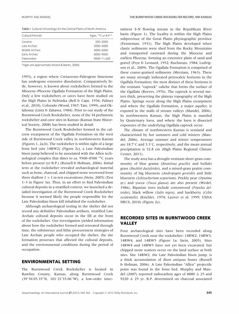
Figure 1 (a) Modified Google Earth image of the Burntwood Creek locality showing five recorded archaeological sites (imagery date: 16 March 2006).
The black dots represent locations of permanent data benchmarks set between 2006 and 2007. The inset map shows the location of the Burntwood
Creek Rockshelter in northwestern Kansas in relation to surrounding states. (b) Illustration showing the general rockshelter fills from A-A′ (a) and the
approximate location of Trenches 1 and 3A. The illustration is not to scale.
with bone in the “south gully,” or the southern extentof the bone bed (Figure 1a, Table II). Site 14RW3 con-tains many fragments of bison bone that represent a killor butchering site of unknown relationship to 14RW2.
Approximately 3 km to the north and east ofthe Burntwood Creek Rockshelter are sites 14RW419,14RW420, and 14RW421, all of which are chipped stonesurface scatters of unknown cultural affiliation (see Stein,
2005). One additional site, 14RW417, contains an iso-lated Late Archaic or Early Ceramic projectile point.
MULTIPLE PROXIES
Multiple lines of evidence are necessary to assess siteformation processes and reconstruct paleoenvironments
346 Geoarchaeology: An International Journal 27 (2012) 344–362 Copyright C© 2012 Wiley Periodicals, Inc.
MURPHY AND MANDEL THE BURNTWOOD CREEK ROCKSHELTER RECORD, NW KANSAS
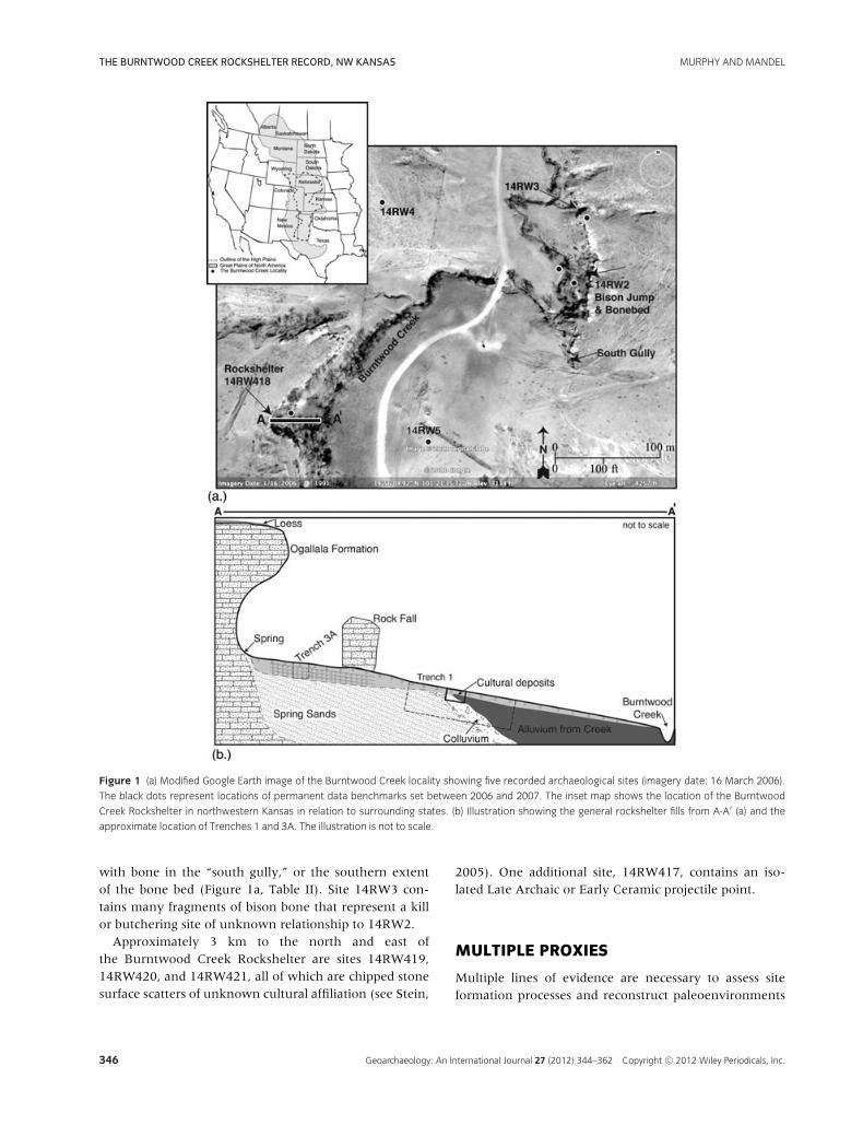
Figure 2 Photographs of the Burntwood Creek
Rockshelter and surrounding landscape. (a) View to the
west of the rockshelter from above. Note the pour-off
at the top of the shelter roof. (b) The Burntwood Creek
Rockshelter formed in the Ogallala formation. View is to
the northwest. (c) The surrounding landscape from the
top of the rockshelter, with a view of the Late
Paleoindian bison jump (14RW2) to the east.
in rockshelters because of the many potential sedimentsources, and the post-depositional processes that can al-ter the record. In this study, we use pedologic and litho-logic description, grain-size analysis (pipette and Ro-Tap R© methods), optical cathodoluminescence (CL) andepifluorescence (EF) microscopy, stable carbon isotopes,and phytoliths. Traditional characterization of grain sizesis important for determining sediment source and trans-port, as well as depositional history (Hassan, 1978; Man-del & Simmons, 1997; Woodward & Bailey, 2000; Far-rand, 2001a,b; Kourumpas et al., 2009), but grain-sizeanalysis alone is not enough for a robust interpretationof past environments (Mandel & Simmons, 1997).
Stable carbon isotope ratios determined on pedogeniccarbon (Boutton, 1996) paired with the extraction ofphytoliths, or “plant stones” (Piperno, 2006), from soilsand sediments has proved effective for paleoenvironmen-tal reconstruction (Fredlund & Teiszen, 1997; Kelly et al.,1998; Cyr et al., 2011). Changes in the relative propor-tions of C3 versus C4 species inferred from the δ13C val-ues on soil organic matter (SOM) can be compared to thephytolith data, and inferences can be made about the in-put of carbon from C3 trees and shrubs that are under-represented in the phytolith record (Fredlund & Tieszen,1997; Piperno, 2006). Specific phytolith differentiationamong the major grass subfamilies (e.g., Chloridoideae,Panicoideae, Pooideae) allows a more-refined assessmentof the stable carbon isotope data. Because C4 warm/moistpanicoids and C4 warm/dry chloridoids can be differen-tiated based on phytolith morphotypes, more precise pa-leoenvironmental assessments can be made compared tothe broad trends in stable carbon isotope values alone.
CL and EF microscopy is used in sedimentary geol-ogy to infer carbonate formation, paleohydrologic pro-cesses, and post-depositional sediment overprinting (cf.Meyers, 1974; Ten Have & Heijnen, 1985; Ludvigson,1989; Bruckschen, Neuser, & Richter, 1992; Habermann,Neuser, & Richter, 1998; McGarry & Baker 2000; Boggs &Krinsley, 2006; Rainey & Jones, 2007). These techniquescan strengthen interpretation better than lithologic de-scription and grain-size analysis alone. CL provides theability to analyze diagenesis of carbonate sedimentaryrocks, such that reducing phreatic environments will pro-duce a bright orange image due to manganese previouslystable in solution (Boggs & Krinsley, 2006). With the EFtechnique, organic acids that assimilate in the carbonatematrix are brightly reflected, and organic acids that havebeen subjected to digenesis will reflect with less inten-sity (Rainey & Jones, 2007). The EF method is usefulfor determining primary depositional fabrics of carbon-ates that have been subjected to overprinting (Rainey &Jones, 2007).
METHODS
In 2007, three backhoe trenches were excavated at theBurntwood Creek Rockshelter (Figure 3a). In order toprevent destruction of cultural resources, trenching wascarefully monitored by archaeologist Jack Hofman andus. Cultural materials encountered during trenching wererecorded with a total station and collected. Trench 1 was∼18 m long, 1.5 m wide, and 2.5 m deep (Figures 1b,3b). Care was taken to leave a hearth feature and lithic
Geoarchaeology: An International Journal 27 (2012) 344–362 Copyright C© 2012 Wiley Periodicals, Inc. 347
THE BURNTWOOD CREEK ROCKSHELTER RECORD, NW KANSAS MURPHY AND MANDEL
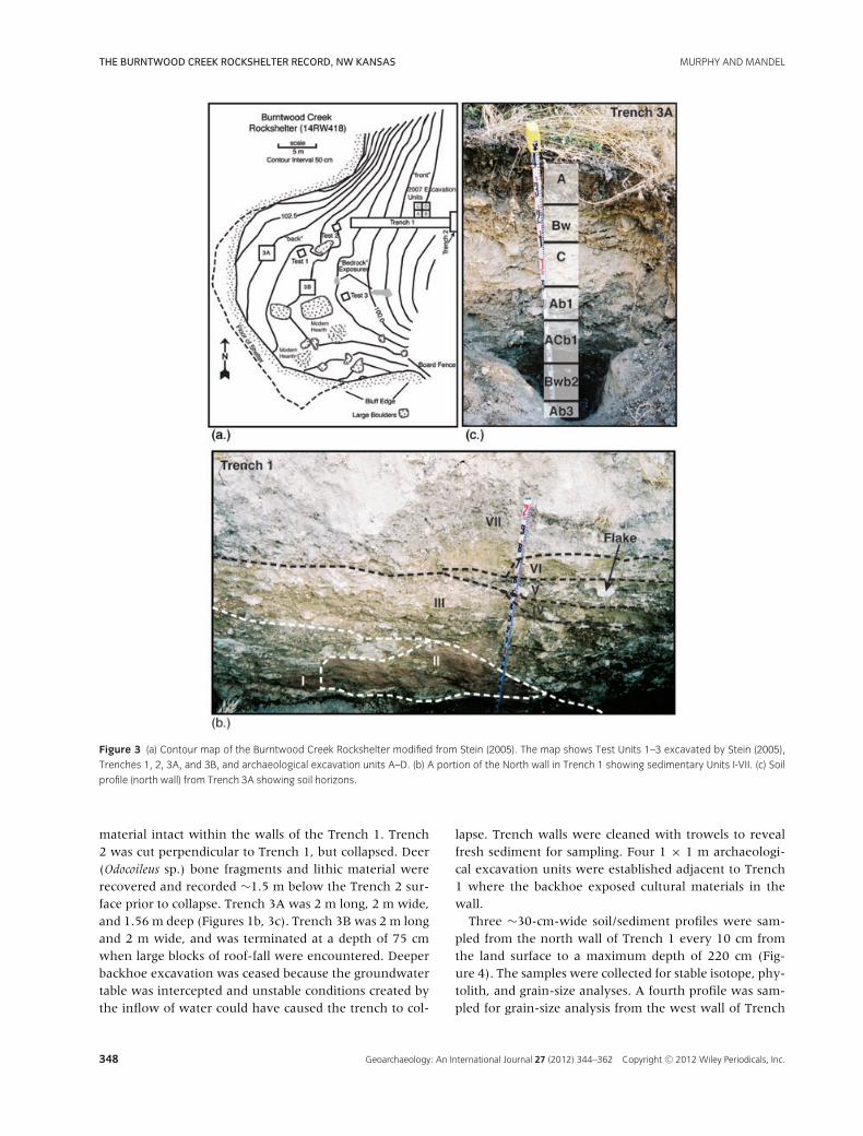
Figure 3 (a) Contour map of the Burntwood Creek Rockshelter modified from Stein (2005). The map shows Test Units 1–3 excavated by Stein (2005),
Trenches 1, 2, 3A, and 3B, and archaeological excavation units A–D. (b) A portion of the North wall in Trench 1 showing sedimentary Units I-VII. (c) Soil
profile (north wall) from Trench 3A showing soil horizons.
material intact within the walls of the Trench 1. Trench2 was cut perpendicular to Trench 1, but collapsed. Deer(Odocoileus sp.) bone fragments and lithic material wererecovered and recorded ∼1.5 m below the Trench 2 sur-face prior to collapse. Trench 3A was 2 m long, 2 m wide,and 1.56 m deep (Figures 1b, 3c). Trench 3B was 2 m longand 2 m wide, and was terminated at a depth of 75 cmwhen large blocks of roof-fall were encountered. Deeperbackhoe excavation was ceased because the groundwatertable was intercepted and unstable conditions created bythe inflow of water could have caused the trench to col-
lapse. Trench walls were cleaned with trowels to revealfresh sediment for sampling. Four 1 × 1 m archaeologi-cal excavation units were established adjacent to Trench1 where the backhoe exposed cultural materials in thewall.
Three ∼30-cm-wide soil/sediment profiles were sam-pled from the north wall of Trench 1 every 10 cm fromthe land surface to a maximum depth of 220 cm (Fig-ure 4). The samples were collected for stable isotope, phy-tolith, and grain-size analyses. A fourth profile was sam-pled for grain-size analysis from the west wall of Trench
348 Geoarchaeology: An International Journal 27 (2012) 344–362 Copyright C© 2012 Wiley Periodicals, Inc.
MURPHY AND MANDEL THE BURNTWOOD CREEK ROCKSHELTER RECORD, NW KANSAS
Table II Radiocarbon ages from Trenches 1 and 3A at the rockshelter (14RW418) and the “south gully” of the Late Paleoindian bison bone bed (14RW2).
Site Material Dating Depth Unit/ Calibrated
Number Location assayed Method (cm)a Soil δ13C 14C age yr. BP Lab. No. Age
14RW418 Trench 1 Charcoal AMS 100 IV −25.9 1930 ± 30 ISGS-A0859 1873 ± 30
14RW418 Trench 1 Bone AMS 200 IV −7.8 2230 ± 30 ISGS-A0867 2251 ± 59
14RW418 Trench 1 Feature 1 Charcoal AMS 70–74 V NR 2250 ± 20 UCI-41885 2278 ± 54
14RW418 Trench 1 Feature 1 Charcoal AMS 90 IV NR 2205 ± 20 UCI-41886 2226 ± 52
14RW418 Trench 1 Feature 2 Charcoal AMS 95–100 IV NR 2315 ± 20 UCI-41887 2336 ± 8
14RW418 Trench 1 Feature 2 Charcoal AMS 100–105 IV NR 2235 ± 20 UCI-41888 2252 ± 56
14RW418 Trench 1 Charcoal AMS 150–160 IV NR 2285 ± 30 UCI-41889 2317 ± 35
14RW418 Trench 3A SOM C 54–64 Soil 2 −22.1 710 ± 70 ISGS-6125 661 ± 45
14RW418 Trench 3A SOM C 93–103 Soil 3 −15.7 114.9 ± 0.5 ISGS-6199 138 ± 67
14RW418 Trench 3A SOM C 116–126 Soil 4 −20.4 102.4 ± 0.5 ISGS-6126 127 ± 79
14RW2 “South gully” Charcoal AMS 200 NR 8880 ± 25 UCI-41891 10,024 ± 60
14RW2 “South gully” Charcoal AMS 322 NR 9220 ± 25 UCI-41890 10,373 ± 60
aDepths are presented as centimeters below surface.
SOM: soil organic matter; C: conventional dating; NR: not reported.
Figure 4 Trench 1 north wall profile showing sedimentary units, profiles, and AMS 14C ages. Note that profile 4 was taken from the west wall of the
trench.
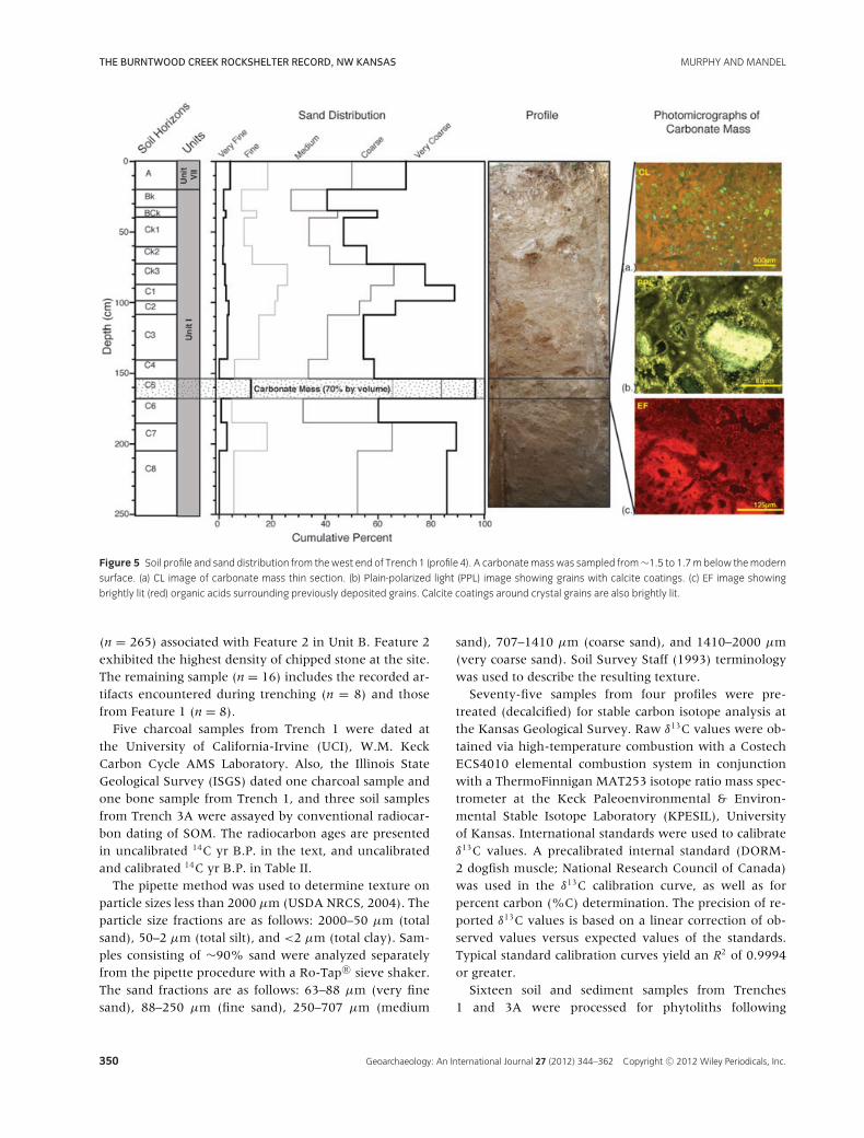
1 to a depth of 250 cm (Figure 5). A secondary carbon-ate mass was sampled from the lower half of Profile 4.Two thin sections from the top and bottom of the car-bonate mass were polished, scanned under transmittedlight, analyzed with a petrographic microscope, and thenbombarded with electrons using optical CL and EF tech-niques. In Trench 3A, soil samples were collected every10 cm for stable isotope, phytolith, and grain-size analy-ses. Trench 3B had a similar soil profile as Trench 3A, soit was described but not sampled.
Sedimentary units in the trenches were identified onthe basis of lithologic characteristics. Roman numeralsdesignate the sedimentary units, beginning with Unit I
at the bottom of each section. Soils were described usingMunsell color charts and standard terminology presentedby Soil Survey Staff (1993) and Birkeland (1999).
Four 1 × 1 m archaeological test units were excavatedby hand adjacent to Trench 1 (Units A–D, Figure 1b) in2007. Bone, charcoal, and chipped stone were mappedwith a total station and collected. Sediment from UnitsA through D was passed through 1/4- and 1/8-inch (6.4and 3.2 mm) screens, and all cultural materials were col-lected, washed, cataloged, and curated at the Archaeolog-ical Research Center, Biodiversity Institute, University ofKansas. A total of 281 pieces of chipped stone were ana-lyzed, which includes a sample of mapped lithic material
Geoarchaeology: An International Journal 27 (2012) 344–362 Copyright C© 2012 Wiley Periodicals, Inc. 349
THE BURNTWOOD CREEK ROCKSHELTER RECORD, NW KANSAS MURPHY AND MANDEL
Figure 5 Soil profile and sand distribution from thewest end of Trench 1 (profile 4). A carbonatemasswas sampled from∼1.5 to 1.7mbelow themodern
surface. (a) CL image of carbonate mass thin section. (b) Plain-polarized light (PPL) image showing grains with calcite coatings. (c) EF image showing
brightly lit (red) organic acids surrounding previously deposited grains. Calcite coatings around crystal grains are also brightly lit.
(n = 265) associated with Feature 2 in Unit B. Feature 2exhibited the highest density of chipped stone at the site.The remaining sample (n = 16) includes the recorded ar-tifacts encountered during trenching (n = 8) and thosefrom Feature 1 (n = 8).
Five charcoal samples from Trench 1 were dated atthe University of California-Irvine (UCI), W.M. KeckCarbon Cycle AMS Laboratory. Also, the Illinois StateGeological Survey (ISGS) dated one charcoal sample andone bone sample from Trench 1, and three soil samplesfrom Trench 3A were assayed by conventional radiocar-bon dating of SOM. The radiocarbon ages are presentedin uncalibrated 14C yr B.P. in the text, and uncalibratedand calibrated 14C yr B.P. in Table II.
The pipette method was used to determine texture onparticle sizes less than 2000 μm (USDA NRCS, 2004). Theparticle size fractions are as follows: 2000–50 μm (totalsand), 50–2 μm (total silt), and <2 μm (total clay). Sam-ples consisting of ∼90% sand were analyzed separatelyfrom the pipette procedure with a Ro-Tap R© sieve shaker.The sand fractions are as follows: 63–88 μm (very finesand), 88–250 μm (fine sand), 250–707 μm (medium
sand), 707–1410 μm (coarse sand), and 1410–2000 μm(very coarse sand). Soil Survey Staff (1993) terminologywas used to describe the resulting texture.
Seventy-five samples from four profiles were pre-treated (decalcified) for stable carbon isotope analysis atthe Kansas Geological Survey. Raw δ13C values were ob-tained via high-temperature combustion with a CostechECS4010 elemental combustion system in conjunctionwith a ThermoFinnigan MAT253 isotope ratio mass spec-trometer at the Keck Paleoenvironmental & Environ-mental Stable Isotope Laboratory (KPESIL), Universityof Kansas. International standards were used to calibrateδ13C values. A precalibrated internal standard (DORM-2 dogfish muscle; National Research Council of Canada)was used in the δ13C calibration curve, as well as forpercent carbon (%C) determination. The precision of re-ported δ13C values is based on a linear correction of ob-served values versus expected values of the standards.Typical standard calibration curves yield an R2 of 0.9994or greater.
Sixteen soil and sediment samples from Trenches1 and 3A were processed for phytoliths following
350 Geoarchaeology: An International Journal 27 (2012) 344–362 Copyright C© 2012 Wiley Periodicals, Inc.
MURPHY AND MANDEL THE BURNTWOOD CREEK ROCKSHELTER RECORD, NW KANSAS
methods outlined by Piperno (2006). Two lycopodiumspore tablets, each containing 18,585 spores, were addedto each sample to calculate phytolith concentration (phy-toliths per gram of pretreated sediment) (Cyr et al., 2011).Plant species nomenclature follows the PLANTS Database(USDA, 2010). Grass phytoliths are presented by threedominant subfamilies: Pooideae, Panicoideae, and Chlori-doideae (Brown, 1984; Fredlund and Teiszen, 1994). Di-cots, elongate cells, and phytolith concentrations also areincluded in the results following methods of Twiss, Suess,& Smith (1969) and Brown (1984).
RESULTS
Front of the Burntwood Creek Rockshelter
Lithology
Seven major sedimentary units were identified at thefront of the rockshelter in Trench 1 (Figure 4). Unit Iconsists of stratified parallel and cross-bedded sands (Fig-ure 5, Table III). Cross-strata dip ∼25◦ from the backof the shelter to the east. A discontinuous 20-cm-thicklayer of calcium carbonate is present 1.1–1.3 m belowthe top of Unit I (Figure 5). This carbonate unit in-corporates silicate sands from above and below. Petro-graphic CL imaging indicated manganese-activated CL inthe calcite (Figure 5a). EF petrography of the carbonateshowed significant heterogeneity in emitted light inten-sity, indicating variability in the purity of the carbonatemass (Figure 5c). Brightly lit organic acids in pore flu-ids surround large crystal grains, and thin calcite coat-ings surround many clasts (Figure 5b). Units II, III, V,and VII contained unsorted, nonimbricated fine gravel tocobble-sized weathered clasts of Ogallala Group sedimen-tary rocks (Table IV). Unit IV is a well-sorted silt loamdeposit that thickens to the east. Grain-size data from thethickest section of Unit IV exhibit three upward-fining se-quences indicated by increases in clay and silt accompa-nied by decreases in sand (Table IV).
Stable isotopes
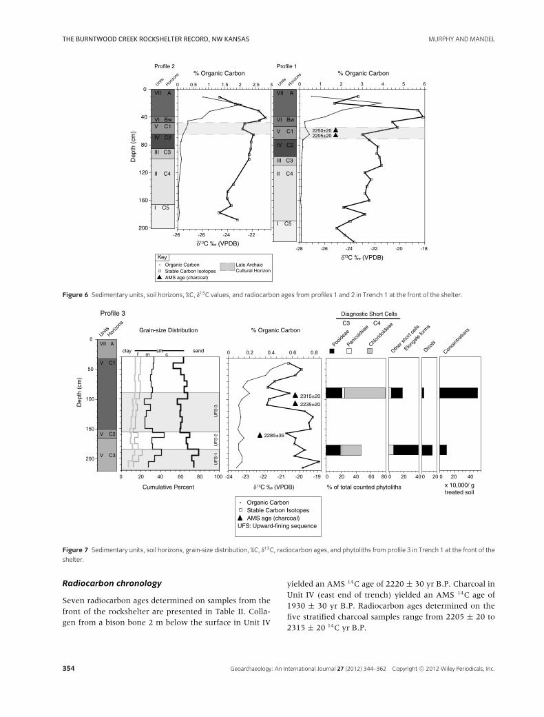
The δ13C values from Profiles 1 and 2 in Trench 1 (Fig-ure 6) generally reflect a typical C3 plant community.The δ13C values are 1–2‰ higher from the base to thetop of both profiles, indicating a general increase in theproportion of C4 plants. However, the δ13C values tendto vary, trending toward more negative δ13C values inUnit V, the unit containing an unlined fire pit or hearthfeature. The C content is high in the surface soil and de-creases abruptly with depth (Figure 6).
The δ13C values from Profile 3 in Trench 1 varythroughout the profile. The maximum and minimum val-ues are offset by ∼3‰ (Figure 7). In general, δ13C valuesaverage –20‰. The peak C value of 0.6% is at the top ofthe profile and C content generally decreases with depth.
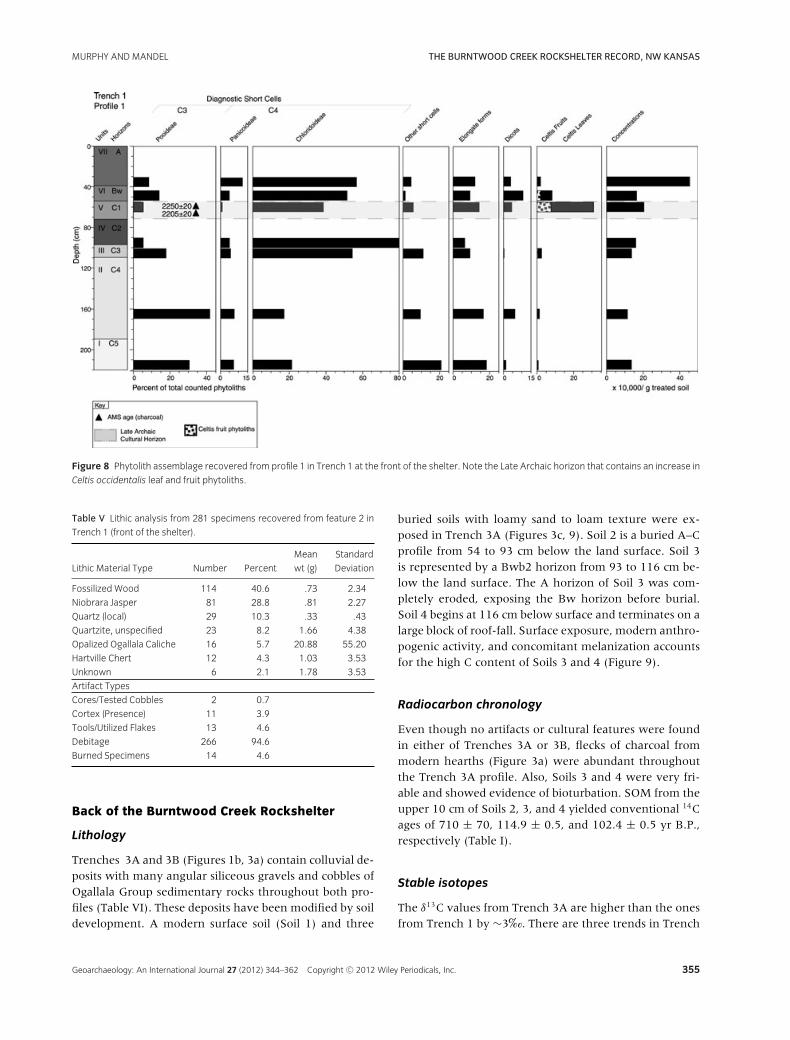
Phytoliths
The phytolith data for Profile 1 have three trends (Fig-ure 8). First, C3 pooids dominate in Unit I, coincidingwith low δ13C values. Second, Units II and III exhibit alarge increase in C4 chloridoids, indicating increased arid-ity that is not well represented in the δ13C data. Third,hackberry fruit (9%) and leaf phytoliths (20%) appear inUnits IV and V. More broken phytoliths and unidentifiedshort cells occur in Units I and II compared to the otherunits in Trench 1.
In Profile 3, phytoliths were extracted from the bottomand top of Unit V only (Figure 7). The bottom sample(185–195 cm) produced a grass assemblage consisting ofa relatively equal number of pooids and chloridoids withfew panicoids. At 40–50 cm, C4 chloridoids are dominant.The phytolith assemblage from 185 to 195 cm corrobo-rates δ13C values, but the phytoliths from 40 to 50 cmdo not closely correlate with δ13C values. Dicot cells aremore abundant in the bottom sample than the top.
Archaeology
We recorded two unlined hearth features (Features 1 and2) in archaeological units A and B adjacent to Trench 1(Figures 1b, 3a). Feature 1 in Unit V contained burnedhackberry seeds, charcoal, chipped stone, and bone frag-ments. Feature 2 in Unit IV contained chipped stone, bi-son elements, and deer- and bison-sized bone, includingone right bison maxilla with the full tooth row (P2-M3).Two retouched flakes, one of which was burned, werefound directly under the third molar (M3). Five layersof charcoal exposed 1.0–1.3 m below the land surfacewere separated by thin layers of silt and contained largeamounts of chipped stone and burned deer and bisonbone fragments. One layer of charcoal in the north wall ata depth of 1.5 m was not associated with cultural material(Figure 4).
Six lithic types were identified from the total sampleanalyzed (n = 281): fossilized wood (40.6%), Niobrarajasper (28.8%), quartz (10.3%), quartzite (8.2%) opal-ized Ogallala caliche (5.7%), and Hartville chert (4.3%).The material of six specimens (2.1%) could not be iden-tified (Table V). Nearly 95% of the sample is debitage,and the remaining ∼5% consists of tools, utilized flakes,preforms, or tested Ogallala cobbles (Table V).
Geoarchaeology: An International Journal 27 (2012) 344–362 Copyright C© 2012 Wiley Periodicals, Inc. 351
THE BURNTWOOD CREEK ROCKSHELTER RECORD, NW KANSAS MURPHY AND MANDEL
Table
IIISo
ildescriptio
nforprofile4inTren
ch1(fron
tofthe
shelter).
Dep
thSo
ilMun
sell
Lower
(cm)
Horizon
Color
Texture
Structure
Roo
tsPores
Con
centratio
nsCon
sisten
cyBou
ndary
Other
Profile4
D,M
0–20
A10
YR5/2,
4/2
VGRSL
1fsbk–
1fgr
mv1
,1,&
3;c2
cv1&1;
m,TU
FRCS
Com
mon
krotov
ina3–
5cm
in
diameter
20–3
5Bk
10YR
6/3,
5/3
GRSL
v1fsbk
cv1&1;
f2&3
c,TU
m1&2Kfi;cv1KT
FRGS
35–4
0BCk
10YR
6/35/3
GRLS
v1sbk
cv1&1
cv1&1
m1&2Kfi;cv1KT
FRGS
40–6
0Ck1
10YR
6/4,
5/4
FGRLS
m–sg
cv1&1
cv1&1
cv1KT;c1D5Y
5/4mo
FRAW
Stratifi
ed
60–7
3Ck2
2.5Y
6/4,
5/4
CBLS
m–sg
cv1&f;f2
&3
cv1&1
fv1KT;c1D5Y
5/4,
2.5Y
6/6&6/8mo
FRAW
73–8
8Ck3
10YR
6/4,
5/4
GRS
m–sg
fv1&1
cv1&1;
c,TU
f1&2KT
FRAS
Fewlenses
ofsiliceo
usgravel
88–9
9C1
10YR
6/4,
5/4
FGRS
m–sg
fv1&1
cv1&1
c1D5Y
5/4mo
FRAS
Stratifi
ed,interbed
ded
with
fine
siliceo
usgravel
99–1
09C2
10YR
6/6,
5/6
Sm–sg
fv1&1
cv1,
f1FR
AS
109–
140
C3
10YR
6/4,
5/4
GRS
m–sg
fv1&1
cv1,
f1c1F10
YR5/6&5Y
6/6
FRAW
140–
154
C4
2.5Y
5/4,
5/3
Sm–sg
fv1
fv1&1
FRAW
Stratifi
ed
154–
168
C5
2.5Y
7/3,
6/3
CBFS
mfv1
FIAI
70%Carbon
atebyvo
lume
168–
185
C6
2.5Y
5/4,
6/6
FSm–sg
fv1&1
c1D2.5Y
6/6mo
FIAS
Stratifi
ed;cross-bed
ded
185–
205
C7
5Y6/3,
5/3
Sm
–f1
&2
FIAS
205–
250
C8
10YR
6/4,
5/4
Sm–sg
–f1
&2
c1F2.5Y
5/4&6/4mo
FR–
D:d
ryco
lor;M:m
oistco
lor;CB:cob
bly;V
GR:verygravelly;G
R:g
ravel;FG
R:fine
gravel;S:san
d;FS:finesand
;SL:sand
yloam
;LS:loam
ysand
.Deg
reeof
expression:
v1:verywea
k;1:
wea
k;Size:f:fine
;m:
med
ium;c:coa
rse;Structure:gr:g
ranu
lar;sbk:suban
gularblocky;m:m
assive;sg:
sing
legrain.
Freq
uenc
y:vf:veryfew;f:few
;c:com
mon
;m:m
any;Size:v1:
very
fine;1:
fine;2:
med
ium;3
:coa
rse;TU
:tub
ular
(worm
burrows).
Con
trast:F:faint;D:d
istin
ct;Typ
e:K:
calcium
carbon
ate;T:thread
s;fi:films;mo:
mottle
s.
FR:friab
le;FI:firm.
Distin
ctne
ss:A
:abrupt;C:clear;G
:gradua
l;To
pog
raphy
:S:smoo
th,W
:wavy.
352 Geoarchaeology: An International Journal 27 (2012) 344–362 Copyright C© 2012 Wiley Periodicals, Inc.
MURPHY AND MANDEL THE BURNTWOOD CREEK ROCKSHELTER RECORD, NW KANSAS
Table
IVSo
ildescriptio
nforprofiles
1,2,
and3inTren
ch1(fron
tofthe
shelter).
Dep
thSo
ilMun
sell
Lower
(cm)
Unit
Horizon
Color
Texture
Structure
Roo
tsPores
Con
centratio
nsCon
sisten
cyBou
ndary
Other
Profile1
Profile2
D,M
0–40
0–40
VII
A10
YR4/2,
3/2
GRSL
1fgr
mv1
&1
cv1&1;
m,TU
–FR
AW
40–4
540
–48
VI
Bw
2.5Y
3/5,
4/3
FGRSiL
1fsbk
cv1&1
cv1&1;
m,TU
f1F10
YR5/6mo;
c
10YR
5/6oc
pf
FRAW
Laminated
inlower
5cm
,parts
alon
gbed
dingplane
s
55–7
348
–64
VC1
2.5Y
6/3,
5/3
SLm
cv1
m,TU
f1F2.5Y
6/6mo
FIAW
Com
mon
flecksof
very
fine
charco
al,culturaldep
osits
in
upper
5cm
73–9
864
–84
IVC2
2.5Y
R5/3,
4/3
FGRSiL
m–
cv1
f1P7.5Y
R3/3&
c1D2.5Y
6/6mo
FIAW
Fewco
bbles(Oga
llala)tap
ering
totheea
st
98–1
1084
–99
IIIC3
2.5Y
5/3,
4/3
CBSL
mfv1
cv1&1;
f,TU
f1F5Y
R4/4mo
FIAW
110–
190
99–1
66II
C4
7.5Y
R6/4,
5/4
FGRSL
mf1
f2&3
f1F5Y
R4/4mo
FRAW
190–
220
166–
186
IC5
2.5Y
5/3,
4/3
FGRSL
m–sg
fv1&1
c2&3
f1F2.5Y
R4/4mo
L–
Profile3
0–15
0IV
C1
2.5Y
R5/3,
4/3
FGRL-SiL
Stratifi
ed
150–
165
IVC2
2.5Y
R5/3,
4/3
CBSiL
165–
215
IVC3
2.5Y
R5/3,
4/3
SiL
Stratifi
ed
D:dry
color;M:m
oistco
lor;CB:cob
bly;G
R:g
ravel;FG
R:fine
gravel;SL:sand
yloam
;L:loa
m;SiL:siltloam
.
Deg
reeof
expression:
1:wea
k;Size:f:fine
,Struc
ture:g
r:gran
ular;sbk:suban
gularblocky;m:m
assive;sg:
sing
legrain.
Freq
uenc
y:f:few;c:com
mon
;m:m
any;Size:v1:
very
fine;1:
fine;2:
med
ium;3
:coa
rse;TU
:tub
ular
(worm
burrows).
Con
trast:F:faint;D:d
istin
ct;P
:prominen
t;Type:mo:
mottle
s;oc
:organ
icco
ats;pf:ped
faces.
FR:friab
le;FI:firm;L:loo
se.
Distin
ctne
ss:A
:abrupt;To
pog
raphy
:W:w
avy.
Geoarchaeology: An International Journal 27 (2012) 344–362 Copyright C© 2012 Wiley Periodicals, Inc. 353
THE BURNTWOOD CREEK ROCKSHELTER RECORD, NW KANSAS MURPHY AND MANDEL
Figure 6 Sedimentary units, soil horizons, %C, δ13C values, and radiocarbon ages from profiles 1 and 2 in Trench 1 at the front of the shelter.
Figure 7 Sedimentary units, soil horizons, grain-size distribution, %C, δ13C, radiocarbon ages, and phytoliths from profile 3 in Trench 1 at the front of the
shelter.
Radiocarbon chronology
Seven radiocarbon ages determined on samples from thefront of the rockshelter are presented in Table II. Colla-gen from a bison bone 2 m below the surface in Unit IV
yielded an AMS 14C age of 2220 ± 30 yr B.P. Charcoal inUnit IV (east end of trench) yielded an AMS 14C age of1930 ± 30 yr B.P. Radiocarbon ages determined on thefive stratified charcoal samples range from 2205 ± 20 to2315 ± 20 14C yr B.P.
354 Geoarchaeology: An International Journal 27 (2012) 344–362 Copyright C© 2012 Wiley Periodicals, Inc.
MURPHY AND MANDEL THE BURNTWOOD CREEK ROCKSHELTER RECORD, NW KANSAS
Figure 8 Phytolith assemblage recovered from profile 1 in Trench 1 at the front of the shelter. Note the Late Archaic horizon that contains an increase in
Celtis occidentalis leaf and fruit phytoliths.
Table V Lithic analysis from 281 specimens recovered from feature 2 in
Trench 1 (front of the shelter).
Mean Standard
Lithic Material Type Number Percent wt (g) Deviation
Fossilized Wood 114 40.6 .73 2.34
Niobrara Jasper 81 28.8 .81 2.27
Quartz (local) 29 10.3 .33 .43
Quartzite, unspecified 23 8.2 1.66 4.38
Opalized Ogallala Caliche 16 5.7 20.88 55.20
Hartville Chert 12 4.3 1.03 3.53
Unknown 6 2.1 1.78 3.53
Artifact Types
Cores/Tested Cobbles 2 0.7
Cortex (Presence) 11 3.9
Tools/Utilized Flakes 13 4.6
Debitage 266 94.6
Burned Specimens 14 4.6
Back of the Burntwood Creek Rockshelter
Lithology
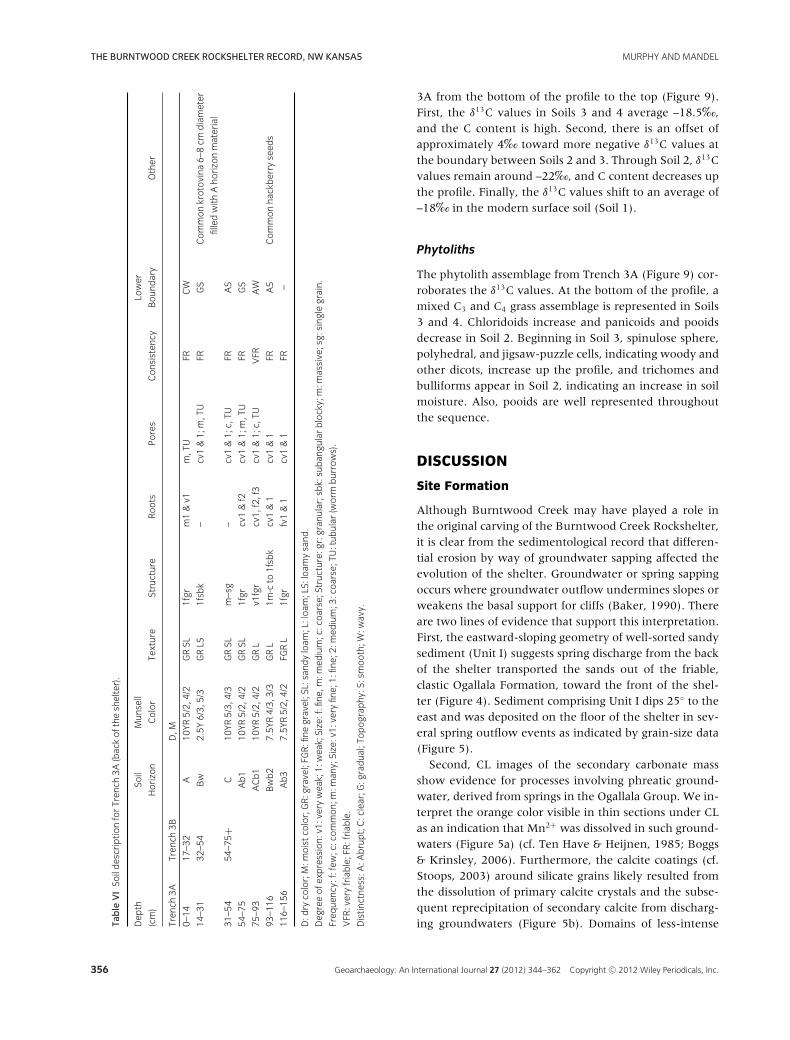
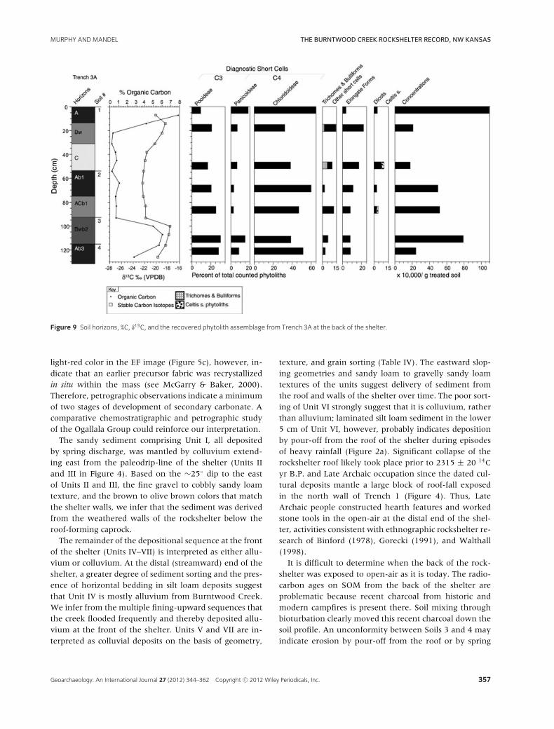
Trenches 3A and 3B (Figures 1b, 3a) contain colluvial de-posits with many angular siliceous gravels and cobbles ofOgallala Group sedimentary rocks throughout both pro-files (Table VI). These deposits have been modified by soildevelopment. A modern surface soil (Soil 1) and three
buried soils with loamy sand to loam texture were ex-posed in Trench 3A (Figures 3c, 9). Soil 2 is a buried A–Cprofile from 54 to 93 cm below the land surface. Soil 3is represented by a Bwb2 horizon from 93 to 116 cm be-low the land surface. The A horizon of Soil 3 was com-pletely eroded, exposing the Bw horizon before burial.Soil 4 begins at 116 cm below surface and terminates on alarge block of roof-fall. Surface exposure, modern anthro-pogenic activity, and concomitant melanization accountsfor the high C content of Soils 3 and 4 (Figure 9).
Radiocarbon chronology
Even though no artifacts or cultural features were foundin either of Trenches 3A or 3B, flecks of charcoal frommodern hearths (Figure 3a) were abundant throughoutthe Trench 3A profile. Also, Soils 3 and 4 were very fri-able and showed evidence of bioturbation. SOM from theupper 10 cm of Soils 2, 3, and 4 yielded conventional 14Cages of 710 ± 70, 114.9 ± 0.5, and 102.4 ± 0.5 yr B.P.,respectively (Table I).
Stable isotopes
The δ13C values from Trench 3A are higher than the onesfrom Trench 1 by ∼3‰. There are three trends in Trench
Geoarchaeology: An International Journal 27 (2012) 344–362 Copyright C© 2012 Wiley Periodicals, Inc. 355
THE BURNTWOOD CREEK ROCKSHELTER RECORD, NW KANSAS MURPHY AND MANDEL
Table
VISo
ildescriptio
nforTren
ch3A
(backof
theshelter).
Dep
thSo
ilMun
sell
Lower
(cm)
Horizon
Color
Texture
Structure
Roo
tsPores
Con
sisten
cyBou
ndary
Other
Tren
ch3A
Tren
ch3B
D,M
0–14
17–3
2A
10YR
5/2,
4/2
GRSL
1fgr
m1&v1
m,TU
FRCW
14–3
132
–54
Bw
2.5Y
6/3,
5/3
GRLS
1fsbk
–cv1&1;
m,TU
FRGS
Com
mon
krotov
ina6–
8cm
diameter
filledwith
Aho
rizonmaterial
31–5
454
–75+
C10
YR5/3,
4/3
GRSL
m–sg
–cv1&1;
c,TU
FRAS
54–7
5Ab1
10YR
5/2,
4/2
GRSL
1fgr
cv1&f2
cv1&1;
m,TU
FRGS
75–9
3ACb1
10YR
5/2,
4/2
GRL
v1fgr
cv1,
f2,f3
cv1&1;
c,TU
VFR
AW
93–1
16Bwb2
7.5Y
R4/3,
3/3
GRL
1m-cto
1fsbk
cv1&1
cv1&1
FRAS
Com
mon
hackberry
seed
s
116–
156
Ab3
7.5Y
R5/2,
4/2
FGRL
1fgr
fv1&1
cv1&1
FR–
D:d
ryco
lor;M:m
oistco
lor;GR:g
ravel;FG
R:fine
gravel;SL:sand
yloam
;L:loa
m;LS:loam
ysand
.
Deg
reeof
expression:
v1:verywea
k;1:
wea
k;Size:f:fine
,m:m
edium;c:coa
rse;Structure:gr:g
ranu
lar;sbk:suban
gularblocky;m:m
assive;sg:
sing
legrain.
Freq
uenc
y:f:few;c:com
mon
;m:m
any;Size:v1:
very
fine;1:
fine;2:
med
ium;3
:coa
rse;TU
:tub
ular
(worm
burrows).
VFR
:veryfriable;FR:friab
le.
Distin
ctne
ss:A
:Abrupt;C:clear;G
:gradua
l;To
pog
raphy
:S:smoo
th;W
:wavy.
3A from the bottom of the profile to the top (Figure 9).First, the δ13C values in Soils 3 and 4 average –18.5‰,and the C content is high. Second, there is an offset ofapproximately 4‰ toward more negative δ13C values atthe boundary between Soils 2 and 3. Through Soil 2, δ13Cvalues remain around –22‰, and C content decreases upthe profile. Finally, the δ13C values shift to an average of–18‰ in the modern surface soil (Soil 1).
Phytoliths
The phytolith assemblage from Trench 3A (Figure 9) cor-roborates the δ13C values. At the bottom of the profile, amixed C3 and C4 grass assemblage is represented in Soils3 and 4. Chloridoids increase and panicoids and pooidsdecrease in Soil 2. Beginning in Soil 3, spinulose sphere,polyhedral, and jigsaw-puzzle cells, indicating woody andother dicots, increase up the profile, and trichomes andbulliforms appear in Soil 2, indicating an increase in soilmoisture. Also, pooids are well represented throughoutthe sequence.
DISCUSSION
Site Formation
Although Burntwood Creek may have played a role inthe original carving of the Burntwood Creek Rockshelter,it is clear from the sedimentological record that differen-tial erosion by way of groundwater sapping affected theevolution of the shelter. Groundwater or spring sappingoccurs where groundwater outflow undermines slopes orweakens the basal support for cliffs (Baker, 1990). Thereare two lines of evidence that support this interpretation.First, the eastward-sloping geometry of well-sorted sandysediment (Unit I) suggests spring discharge from the backof the shelter transported the sands out of the friable,clastic Ogallala Formation, toward the front of the shel-ter (Figure 4). Sediment comprising Unit I dips 25◦ to theeast and was deposited on the floor of the shelter in sev-eral spring outflow events as indicated by grain-size data(Figure 5).
Second, CL images of the secondary carbonate massshow evidence for processes involving phreatic ground-water, derived from springs in the Ogallala Group. We in-terpret the orange color visible in thin sections under CLas an indication that Mn2+ was dissolved in such ground-waters (Figure 5a) (cf. Ten Have & Heijnen, 1985; Boggs& Krinsley, 2006). Furthermore, the calcite coatings (cf.Stoops, 2003) around silicate grains likely resulted fromthe dissolution of primary calcite crystals and the subse-quent reprecipitation of secondary calcite from discharg-ing groundwaters (Figure 5b). Domains of less-intense
356 Geoarchaeology: An International Journal 27 (2012) 344–362 Copyright C© 2012 Wiley Periodicals, Inc.
MURPHY AND MANDEL THE BURNTWOOD CREEK ROCKSHELTER RECORD, NW KANSAS
Figure 9 Soil horizons, %C, δ13C, and the recovered phytolith assemblage from Trench 3A at the back of the shelter.
light-red color in the EF image (Figure 5c), however, in-dicate that an earlier precursor fabric was recrystallizedin situ within the mass (see McGarry & Baker, 2000).Therefore, petrographic observations indicate a minimumof two stages of development of secondary carbonate. Acomparative chemostratigraphic and petrographic studyof the Ogallala Group could reinforce our interpretation.
The sandy sediment comprising Unit I, all depositedby spring discharge, was mantled by colluvium extend-ing east from the paleodrip-line of the shelter (Units IIand III in Figure 4). Based on the ∼25◦ dip to the eastof Units II and III, the fine gravel to cobbly sandy loamtexture, and the brown to olive brown colors that matchthe shelter walls, we infer that the sediment was derivedfrom the weathered walls of the rockshelter below theroof-forming caprock.
The remainder of the depositional sequence at the frontof the shelter (Units IV–VII) is interpreted as either allu-vium or colluvium. At the distal (streamward) end of theshelter, a greater degree of sediment sorting and the pres-ence of horizontal bedding in silt loam deposits suggestthat Unit IV is mostly alluvium from Burntwood Creek.We infer from the multiple fining-upward sequences thatthe creek flooded frequently and thereby deposited allu-vium at the front of the shelter. Units V and VII are in-terpreted as colluvial deposits on the basis of geometry,
texture, and grain sorting (Table IV). The eastward slop-ing geometries and sandy loam to gravelly sandy loamtextures of the units suggest delivery of sediment fromthe roof and walls of the shelter over time. The poor sort-ing of Unit VI strongly suggest that it is colluvium, ratherthan alluvium; laminated silt loam sediment in the lower5 cm of Unit VI, however, probably indicates depositionby pour-off from the roof of the shelter during episodesof heavy rainfall (Figure 2a). Significant collapse of therockshelter roof likely took place prior to 2315 ± 20 14Cyr B.P. and Late Archaic occupation since the dated cul-tural deposits mantle a large block of roof-fall exposedin the north wall of Trench 1 (Figure 4). Thus, LateArchaic people constructed hearth features and workedstone tools in the open-air at the distal end of the shel-ter, activities consistent with ethnographic rockshelter re-search of Binford (1978), Gorecki (1991), and Walthall(1998).
It is difficult to determine when the back of the rock-shelter was exposed to open-air as it is today. The radio-carbon ages on SOM from the back of the shelter areproblematic because recent charcoal from historic andmodern campfires is present there. Soil mixing throughbioturbation clearly moved this recent charcoal down thesoil profile. An unconformity between Soils 3 and 4 mayindicate erosion by pour-off from the roof or by spring
Geoarchaeology: An International Journal 27 (2012) 344–362 Copyright C© 2012 Wiley Periodicals, Inc. 357
THE BURNTWOOD CREEK ROCKSHELTER RECORD, NW KANSAS MURPHY AND MANDEL
flow. If the unconformity is a result of roof pour-off, thissuggests the roof collapsed sometime between 2400 and1000 yr. B.P., leaving the back of the shelter exposed tothe open-air. This relative chronology is likely given thetime-transgressive retreat of the rockshelter roof duringits relatively short lifespan (cf. Laville, Rigaud, & Sackett,1980; Goldberg & Mandel, 2008).
Archaeology
The Burntwood Creek Rockshelter was repeatedly occu-pied during the late Holocene. We associate the stratifiedcultural deposits with Late Archaic people on the basis ofseven 14C ages (1930 ± 30 yr B.P. to 2315 ± 20 14C yrB.P.), which fall solidly within the accepted age range forLate Archaic (Table I). Furthermore, ceramics are absentin the deposits. The unlined hearth features in associa-tion with faunal and chipped stone assemblages repre-sent small, multiple campsites. The lithic sample studiedfrom Features 1 and 2, consisting mostly of small piecesof debitage and shatter suggests the area just outside therockshelter overhang was used for resharpening or re-touching stone tools. The sample appears to be represen-tative of the material types and manufacture stage in thethree adjacent excavation units. Most of the lithic mate-rial (∼65%) would have been available from the local en-vironment. For example, the Ogallala Formation wouldhave yielded silicified wood, opalized caliche, quartz, andquartzite clasts. The high percentage of debitage and thelow percentage of primary cortical flakes, however, makeit unlikely that local materials were initially worked on-site. The small percentages of Niobrara Jasper (Kansassource ∼50 km away) and Hartville Chert (Hartville Up-lift, Wyoming, ∼400 km away) indicate some movementand/or trade throughout the region.
The presence of hackberry leaf and fruit phytoliths inthe front and back fills of the shelter indicates hackberrytrees were nearby, depositing leaves on the land surfaceas they do today. However, given the concentration ofhackberry phytoliths and seeds within Feature 1, hack-berry probably was used by the Late Archaic people forfuel or food as has been indicated from the archaeob-otanical record of several Late Archaic and Early Ceramicsites in the Central Plains (Adair, 2003; Scarry, 2003). Al-though hackberry fruits are relatively poor sources of pro-tein, fat, and carbohydrates (Scarry, 2003), they wouldhave been one of only a few sources of fleshy fruits, alongwith yucca. Furthermore, hackberry fruits are availableduring the fall and winter (Scarry, 2003), implying a fallor winter occupation of the shelter if the fruits were be-ing consumed when ripe rather than being burned at anygiven time.
Paleoenvironment
In both the front and back of the shelter, the δ13C valueson soil represent C3 or a mixed C3 and C4 plant com-munity, suggesting no major climate shifts in the lateHolocene. There is, however, a 3‰ offset between thefront and back of the shelter, indicating that the propor-tions of C3 and C4 plants were different. We attribute thelower δ13C values and phytolith composition at the frontof the shelter in Unit IV to Late Archaic hearth activities.
In general, the phytolith analysis yielded a diverse andwell-preserved assemblage of C3 and C4 grasses and C3
dicots such as hackberry (C. occidentalis) that were repre-sentative of the local environment. However, in Trench1 many broken phytoliths were recorded in Units I andII. Based on their degree of wear, and the greater propor-tion of C3 pooids, the dominant grass subfamily duringthe Miocene–Pliocene (Stromberg, 2002), to C4 chlori-doids, it is likely that those phytoliths were derived di-rectly from the Ogallala Formation during groundwatersapping and erosion of the shelter walls. It is not likelyother sediment sources contributed to Units I and II; thus,they are ancient phytoliths that were liberated from theOgallala Formation. Also, two samples from the Unit IValluvium in Profile 3 in Trench 1 have low phytolith con-centrations and are poorly preserved due to alluvial trans-port in Burntwood Creek. Redeposition of these phy-toliths makes paleoenvironmental interpretation difficult.Nonetheless, the phytoliths from the alluvium likely re-flect the plant community within the Burntwood Creekbasin.
The grasses of the C4 Chloridoideae were the mostabundant of the three subfamilies in both trenches, butthe abundance of chloridoids in both profiles is incon-sistent with δ13C values most likely due to modern andancient anthropogenic carbon input around activity ar-eas, or detrital carbon from multiple sediment sources.It is possible that chloridoids are a better indicator ofaridity than stable carbon isotopes, or that they producemore phytoliths than the other subfamilies—two hy-potheses that remain untested. Nevertheless, chloridoidswere growing on and around the rockshelter and theirphytoliths were transported into the rockshelter throughcolluvial and alluvial processes, but chloridoids at thesite also deposited the phytoliths. The C3 Pooideae docu-mented at depth (Units I and II) in Trench 1 and through-out the profile in Trench 3A is consistent with lower δ13Cvalues. The δ13C values from the surface soil and threeburied soils in Trench 3A indicate an increase in moisturebefore a gradual drying at the back of the shelter. TheC4 Panicoideae are not well represented at the rockshel-ter; their highest numbers are ∼15% of the phytoliths re-covered from Soils 1 and 4 in Trench 3A. Long-shanked
358 Geoarchaeology: An International Journal 27 (2012) 344–362 Copyright C© 2012 Wiley Periodicals, Inc.

MURPHY AND MANDEL THE BURNTWOOD CREEK ROCKSHELTER RECORD, NW KANSAS
lobate panicoid phytoliths are easily broken during rede-position and can be mistaken for the saddle shapes ofchloridoid phytoliths in two-dimensional analysis (Sud-bury, 2011). However, during analysis, phytoliths wererotated to examine their three-dimensional shape.
CONCLUSIONS
The Burntwood Creek Rockshelter formed in the Ogal-lala Formation in part through the process of ground-water sapping and spring action. The roof subsequentlyretreated as it periodically collapsed over the last ∼2500years. As the rockshelter evolved, alluvium from Burnt-wood Creek, colluvium, and large blocks of roof-fall man-tled sandy spring deposits on its floor. These processesworked to both preserve and destroy the archaeologicalrecord at the rockshelter.
The riparian environment near the rockshelter in-cludes two sources of water: a spring emanating from theOgallala Formation and Burntwood Creek. Both sourceswould have been attractive to humans moving throughthe High Plains. We conclude from paleoenvironmentalanalyses that a mixed C3 and C4 plant community thrivedwithin and around the rockshelter and changed in com-position during the late Holocene. The differences in plantcommunity composition between the soil at the front andback of the shelter are likely a result of differences in wa-ter availability and exposure to sunlight as the rockshelterroof retreated. Differences in plant community composi-tion between the sedimentary units at the front of theshelter are likely a result of changes in sediment source.Also, the hearth activities of Late Archaic people affectedstable carbon isotope values and the composition of phy-tolith assemblages.
Excellent phytolith preservation (i.e., no dissolutionpits and few broken phytoliths) suggests that with theexception of Units I and II in Trench 1, and the alluviumfrom Burntwood Creek (Unit IV), redeposition was lim-ited. The phytoliths from units I and II likely representgrasses of Miocene–Pliocene age, and phytoliths from thealluvium represent snapshots of basin-wide grasses fromthe late Holocene. Also, C4 chloridoid phytoliths recov-ered in the laminated portion of Unit VI in Trench 1 mayhave come from the pour-off at the top of the shelter.
The Burntwood Creek Rockshelter provided a short-term camping locality for Late Archaic people. They leftbehind a mostly debitage (tertiary flakes) chipped stoneassemblage along with a small amount of deer and bi-son remains. Thus, the people who used the rocksheltermay have been responsible for the chipped stone surfaceassemblages at the other recorded sites in the valley. Acomparison of the chipped stone assemblages at each site
will aid in resolving the question of cultural affiliation. Atthis time, there is no evidence for Late Archaic activitiesat the bison jump at 14RW2 or the bone bed at 14RW3,although we do know that Late Archaic people were par-ticipating in large bison kills on the High Plains (Toddet al., 2001). Also, we do not have evidence that the rock-shelter was used while the Late Paleoindian bison jumpat 14RW2 was used. If a Late Paleoindian component didexist at the shelter, the sediments that would have con-tained those specific cultural deposits probably were re-moved by stream erosion during the middle Holocene, aprocess that occurred in most low-order streams acrossthe Central Plains (Mandel, 1995, 2006). Thus, there islow potential for finding deposits at the rockshelter thatpredate the late Holocene.
We graciously thank Dean and Theresa Knapp for allowing ac-cess to the Burntwood Creek Rockshelter. Jack Hofman (Uni-versity of Kansas) assisted us in the field and was involved withthe lithic analysis. Mark Volmut (University of Kansas) helpedus in the field and provided assistance with bone identifica-tion. Steve Bozarth (University of Kansas) assisted with phy-tolith identification. Greg Ludvigson (Kansas Geological Survey)aided in thin-section petrology. We thank Daphne Fautin (Uni-versity of Kansas), Jon Smith (Kansas Geological Survey), RobertM. Joeckel (University of Nebraska), and Paul Goldberg (BostonUniversity) for helpful suggestions in the early stages of themanuscript. Finally, we thank Joe Artz and two anonymous ref-erees for their valuable comments and suggestions. Our researchwas supported by the University of Kansas Odyssey Archaeolog-ical Research Fund and by a Carroll D. Clark Research Awardfrom the Department of Anthropology, University of Kansas.
REFERENCES
Abbott, J.T. (1997). Stratigraphy and geoarchaeology of the
Red Canyon rockshelter, Crook County, Wyoming.
Geoarchaeology: An International Journal, 12(4), 315–335.
Adair, M.J. (2003). Great plains paleoethnobotany. In P. E.
Minnis (Ed.), Plants and people in ancient eastern North
America (pp. 258–346). Washington: Smithsonian
Institution.
Baker, V.T. (1990). Spring sapping and valley network
development, with case studies by R. C. Kochel, V. R.
Baker, J. E. Laity, & A. D. Howard. In C.G. Higgins & D.R.
Coates (Eds.), Groundwater geomorphology: The role of
subsurface water in Earth-surface processes and landforms
(pp. 235–265). Boulder, Colorado: Geological Society of
America Special Paper 252.
Beeton, J.M., & Mandel, R.D. (2011). Soils and
late-Quaternary landscape evolution in the Cottonwood
River basin, East-Central Kansas: Implications for
archaeological research. Geoarchaeology: An International
Journal, 26(5), 693–723.
Bell, E.H., & Cape, R.E. (1936). The rock shelters of western
Nebraska in the vicinity of Dalton, Nebraska. In E.H. Bell
Geoarchaeology: An International Journal 27 (2012) 344–362 Copyright C© 2012 Wiley Periodicals, Inc. 359
THE BURNTWOOD CREEK ROCKSHELTER RECORD, NW KANSAS MURPHY AND MANDEL
(Ed.), Chapters in Nebraska archaeology, Vol. 1 (pp.
357–399). Lincoln: University of Nebraska.
Binford, L.R. (1978). Nunamiut ethnoarchaeology. New York:
Academic Press.
Birkeland, P.W. (1999). Soils and geomorphology, 3rd ed.
New York: Oxford University Press.
Boggs, S., & Krinsley, D. (2006). Application of
cathodoluminescence imaging to the study of sedimentary
rocks. New York: Cambridge University Press.
Boutton, T.W. (1996). Stable carbon isotope ratios of soil
organic matter and their use as indicators of vegetation and
climate change. In T.W. Bouttton & S. Yamasaki (Eds.),
Mass spectrometry of soils. New York: Marcel Dekker, Inc.
Bowman, P.W. (1960). Coal-Oil Canyon (14LO1): Report on
preliminary investigations. Bulletin No. 1. Kansas
Anthropological Association, 1–70. Topeka, Kansas.
Brown, D. (1984). Prospects and limits of a phytolith key for
grasses in the central United States. Journal of
Archaeological Science, 11, 345–368.
Bruckschen, P., Neuser, R.D., & Richter, D.K. (1992). Cement
stratigraphy in Triassic and Jurassic limestones of the
Weserbergland (northwestern Germany). Sedimentary
Geology, 81(3–4), 195–214.
Buchanan, R. (1984). Kansas geology: An introduction to
landscapes, rocks, minerals, and fossils. Lawrence:
University Press of Kansas.
Collins, M. (1991). Rockshelters and the early archaeological
record in the Americas. In T.D. Dillehay & D. Meltzer
(Eds.), The first Americans: Search and research (pp.
157–182). Boca Raton: CRC Press.
Cyr, H., McNamee, C., Amundson, L., & Freeman, A. (2011).
Reconstructing landscape and vegetation through multiple
proxy indicators: A geoarchaeological examination of the
St. Louis Site, Saskatchewan, Canada. Geoarchaeology: An
International Journal, 26(2), 165–188.
Donahue, J., & Adovasio, J.M. (1990). Evolution of sandstone
rockshelters in eastern North America: A geoarchaeological
perspective. Geological Society of America, Centennial
Special, 4, 231–251.
Farrand, W.R. (2001a). Archaeological sediments in
rockshelters and caves. In J.K. Stein & W.R. Farrand (Eds.),
Sediments in context (pp. 29–66). Salt Lake City: The
University of Utah Press.
Farrand, W.R. (2001b). Sediments and stratigraphy in
rockshelters and cave: A personal perspective on principles
and pragmatics. Geoarchaeology: An International Journal,
16(5), 537–557.
Fenneman, N.M. (1931). Physiography of western United
States. New York: McGraw-Hill Book Company.
Fredlund, G.G., & Tieszen, L. (1994). Modern phytolith
assemblages from the North American Great Plains.
Journal of Biogeography, 21(3), 321–335.
Fredlund, G.G., & Tieszen, L.L. (1997). Phytolith and carbon
isotope evidence for late Quaternary vegetation and
climate change in the southern Black Hills, South Dakota.
Quaternary Research, 47, 206–217.
Frye, J.C., & Leonard, A.B. (1952). Pleistocene geology of
Kansas. Lawrence: University of Kansas.
Goebel, T., Graf, K.E., Hockett, B., & Rhode, D. (2003).
Late-Pleistocene humans at Bonneville Estates rockshelter,
eastern Nevada. Current Research in the Pleistocene, 20,
20–23.
Goldberg, P., & Mandel, R.D. (2008). Caves and rockshelters.
In D. M. Pearsall (Ed.), Encyclopedia of archaeology. New
York: Academic Press.
Gorecki, P. (1991). Horticulturalists as hunter-gatherers: Rock
shelter usage in Papua New Guinea. In C. Gamble & W.
Boismier (Eds.), Ethnoarchaeological approaches to mobile
campsites. Hunter-gatherer and pastoralist case studies.
Ann Arbor: Ethnoarchaeological Series 1, International
Monographs in Prehistory.
Habermann, D., Neuser, R.D., & Richter, D.K. (1998). Low
limit of Mn2+-activated cathodoluminescence of calcite:
State of the art. Sedimentary Geology, 116, 13–24.
Hassan, F.A. (1978). Sediments in archaeology: Methods and
implications for palaeoenvironmental and cultural analysis.
Journal of Field Archaeology, 5(2), 197–213.
High Plains Regional Climate Center. (2011). Period of record
monthly climate summary for McDonald, Kansas (145127).
http://www.hprcc.unl.edu/cgi-bin/cli perl lib/cliMAIN.
pl?ks5127.
Hoard, R.J., & Banks, W.E. (2006). Kansas archaeology.
Lawrence: University of Kansas Press.
Kansas State Historical Society. (2008). Kansas State Historical
Society Archeological Inventory. Topeka, KS: Kansas State
Historical Society.
Kelly, E.F., Blecker, S.W., Yonker, C.M., Olson, C.G., Wohl,
E.E., & Todd, L.C. (1998). Stable isotope composition of
soil organic matter and phytoliths as paleoenvironmental
indicators. Geoderma, 82, 59–81.
Kourampas, N., Simpson, I.A., Perera, N., Deraniyagala, S.U.,
& Wijeyapala, W.H. (2009). Rockshelter sedimentation in a
dynamic tropical landscape: Late Pleistocene-early
Holocene archaeological deposits in Kitulgala Beli-lena,
southwestern Sri Lanka. Geoarchaeology: An International
Journal, 24(6), 677–714.
Kuchler, A.W. (1974). A new vegetation map of Kansas.
Ecology, 55(3), 586–604.
Lauver, C.L., Kindscher, K., Faber-Langendoen, D., &
Schneider, R. (1999). A classification of the natural
vegetation of Kansas. The Southwestern Naturalist, 44(4),
421–443.
Laville, H., Rigaud, J.-P., & Sackett, J. (1980). Rockshelters of
the Perigord: Geological stratigraphy and archaeological
succession. New York: Academic Press.
Lintz, C., & Zabawa, L.G. (1984). The Kenton caves of
western Oklahoma. In R. E. Bell (Ed.), Prehistory of
Oklahoma (pp. 161–174). Orlando: Academic Press.
360 Geoarchaeology: An International Journal 27 (2012) 344–362 Copyright C© 2012 Wiley Periodicals, Inc.
MURPHY AND MANDEL THE BURNTWOOD CREEK ROCKSHELTER RECORD, NW KANSAS
Ludvigson, G.A. (1989). Observations on the
cathodoluminescence petrography of the Coralville
Formation near Iowa city: Implications for regional
diagenetic patterns in the Devonian Cedar Valley group.
Iowa City: Geologic Society of Iowa Guidebook 51.
Ludvigson, G.A., Sawin, R.S., Franseen, E.K., Watney, W.L.,
West, R.R., & Smith, J.J. (2009). A review of the
stratigraphy of the Ogallala Formation and revision of
Neogene (“Tertiary”) nomenclature in Kansas. Current
Research in Earth Sciences, Bulletin 256, part 2.
http://www.kgs.ku.edu/Current/2009/Ludvigson/
index.html, 1–9.
Mandel, R.D. (1992). Soils and Holocene landscape evolution
in central and southwestern Kansas: Implications for
archaeological research. In V.T. Holliday (Ed.), Soils in
archaeology (pp. 41–100). Washington, D.C.: Smithsonian
Institution Press.
Mandel, R.D. (1995). Geomorphic controls of the archaic
record in the Central Plains of the United States. In E. A.
Bettis, III (Ed.), Archaeological geology of the archaic
period in North America (pp. 37–66). Boulder, Colorado:
Geological Society of America Special Paper 297.
Mandel, R.D. (2006). Late Quaternary and modern
environments in Kansas. In R. J. Hoard & W. E. Banks
(Eds.), Kansas archaeology (pp. 10–27). Lawrence:
University of Kansas Press.
Mandel, R.D. (2008). Buried Paleoindian-age landscapes in
stream valleys of the central plains, USA. Geomorphology,
101, 342–361.
Mandel, R.D. (2012). Late Quaternary landscape evolution in
western Kansas: Implications for archaeological research.
Lawrence, KS: Kansas Geological Survey Bulletin.
Mandel, R.D., & Simmons, A.H. (1997). Geoarchaeology of
the Akrotiri Aetokremnos rockshelter, southern Cyprus.
Geoarchaeology: An International Journal, 12(6), 567–605.
Mandel, R.D., Holen, S., & Hofman, J.L. (2005).
Geoarchaeology of Clovis and potential pre-Clovis cultural
deposits at the Kanorado locality, northwestern Kansas.
Current Research in the Pleistocene, 22, 56–57.
Martin, J.E., Alex, R.A., Alex, L.M., Abbott, J.P., Benton,
R.C., & Miller, L.F. (1993). The Beaver Creek Shelter
(39CU799): A Holocene succession in the Black Hills of
South Dakota. Plains Anthropologist, 38(145), 17–36.
McGarry, S., & Baker, A. (2000). Organic acid fluorescence:
Applications to speleothem paleoenvironmental
reconstruction. Quaternary Science Reviews, 19,
1087–1101.
Merriam, D.F. (1963). The geologic history of Kansas.
Lawrence, Kansas: Kansas Geological Survey Bulletin 162.
Meyers, W.J. (1974). Carbonate cement stratigraphy of the
Lake Valley formation (Mississippian) Sacramento
Mountains, New Mexico. Journal of Sedimentary
Petrology, 44, 837–861.
Murphy, L.R., & Mandel, R.D. (2007). Geoarchaeology of the
Burntwood Creek Rockshelter (14RW418), northwest
Kansas. Paper presented at the Annual Geological Society
of America Conference. Denver.
Over, W.H. (1936). The archaeology of Ludlow Cave and its
significance. American Antiquity, 2(2), 126–129.
Palmer, L., Mandel, R.D., Kruse, J.M., & Gillen, T. (2010).
Archaeological site testing for national register nomination:
25GD66, 25GD67, 25MO32, 25MO37/122, and 25MO82,
Morrill and Garden counties, Nebraska. Lawrence, Kansas:
Archeology Laboratory, Augustana College, Sioux Falls,
South Dakota and the Kansas Geological Survey,
University of Kansas.
Piperno, D. (2006). Phytoliths: A comprehensive guide for
archaeologists and paleoecologists. Lanham, MD: AltaMira
Press.
Rainey, D.K., & Jones, B. (2007). Rapid cold water formation
and recrystallization of relict bryophyte tufa at the Fall
Creek Cold Springs, Alberta Canada. Canadian Journal of
Earth Sciences, 44, 889–909.
Reeves, C.C., Jr. (1976). Quaternary stratigraphy and geologic
history of the southern High Plains. In W. C. Mahaney
(Ed.), Quaternary stratigraphy of North America.
Stroudsburg, Pennsylvania: Dowden, Hutchinson, and
Ross.
Russell, J.P., & Hofman, J.L. (2006). Research at the
Burntwood Creek site, Kansas. Proceedings of the 64th
Annual Plains Anthropological Conference. Topeka,
Kansas.
Scarry, C.M. (2003). Patterns of wild plant utilization in the
prehistoric eastern Woodlands. In P. E. Minnis (Ed.),
People and plants in ancient eastern North America (pp.
50–104). Washington: Smithsonian Institution.
Soil Survey Division Staff. 1993. Soil survey manual. United
States Department of Agriculture, Handbook No. 18. U.S.
Government Printing Office, Washington, DC. 437 pp.
Stein, M. (2005). The 2005 Kansas archeology training
program: Archeological survey in Rawlins, Sherman,
Thomas, and Wallace counties, Kansas (No. B3601).
Topeka: Kansas State Historical Society.
Stromberg, C.A.E. (2002). The origin and spread of
grass-dominated ecosystems in the late Tertiary of North
America: Preliminary results concerning the evolution of
hypsodonty. Palaeogeography, Palaeoclimatology,
Palaeoecology, 177, 59–75.
Stoops, G. (2003). Guidelines for analysis and description of
soil and regolith thin sections. Madison, Wisconsin: Soil
Science Society of America, Inc.
Sudbury, J.B. (2011). Quantitative phytolith analysis–A
working example from modern prairie soils and buried
Holocene A horizons. Phytolith Press Research Monograph
1. Ponca City, Oklahoma: Phytolith Press.
Tate, M. (1999). Archaic stage. In K. P. Gilmore, M. Tate, M.
L. Chenault, B. Clark, T. McBride, & M. Wood (Eds.),
Colorado prehistory: A context for the Platte River Basin
(pp. 91–174). Denver: Colorado Council of Professional
Archaeologists.
Geoarchaeology: An International Journal 27 (2012) 344–362 Copyright C© 2012 Wiley Periodicals, Inc. 361
THE BURNTWOOD CREEK ROCKSHELTER RECORD, NW KANSAS MURPHY AND MANDEL
Ten Have, T., & Heijnen, W. (1985). Cathodoluminescence
activation and zonation in carbonate rocks: An
experimental approach. Geologie en Mijnbouw, 64,
297–310.
Todd, L.C., Jones, D.C., Walker, R.S., Burnett, P.C., &
Eighmy, J. (2001). Late Archaic bison hunters in northern
Colorado: 1997–1999 excavations at the Kaplan-Hoover
bison bonebed (5LR3953). Plains Anthropologist, 46(176),
125–147.
Twiss, P.C., Suess, E., & Smith, R.M. (1969). Morphological
classification of grass phytoliths. Proceedings of the Soil
Science Society of America, 33, 109–115.
USDA NRCS. (2004). Soil survey laboratory methods manual
(pp. 735): Soil survey investigations report No. 42, Version
4.0. National Resources Conservation Service. Lincoln,
Nebraska.
USDA NRCS. (2010). The PLANTS Database. Baton Rouge,
LA: National Plant Data Center. http://plants.usda.gov.
Walthall, J.A. (1998). Rockshelters and hunter-gatherer
adaptation to the Pleistocene/Holocene transition.
American Antiquity, 62(2), 223–
238.
Wedel, W.R. (1986). Central Plains prehistory: Holocene
environments and culture change in the Republican River
Basin. Lincoln: University of Nebraska Press.
Weston, T. (Ed.). (1982). Archeological investigations at Cold
Brook and Cottonwood Springs reservoirs, Fall River
County, South Dakota. Project Report Series No. 50.
Omaha, Nebraska: U.S. Army Corps of Engineers.
Wood, J.J. (1967). Archaeological Investigations in
northeastern Colorado. Unpublished Ph.D. Dissertation,
Boulder, Colorado: University of Colorado.
Wood, W.R., & McMillan, R.B. (1976). Prehistoric Man and
his environments: A case study in the Ozark Highland.
New York: Academic Press.
Woodward, J.C., & Bailey, G.N. (2000). Sediment sources and
terminal Pleistocene geomorphological processes recorded
in rockshelter sequences in north-west Greece. In I. D. L.
Foster (Ed.), Tracers in geomorphology (pp. 521–551).
New York: John Wiley & Sons Ltd.
Woodward, J.C., & Goldberg, P. (2001). The sedimentary
records in Mediterranean rockshelters and caves: Archives
of environmental change. Geoarchaeology: An
International Journal, 16(4), 327–354.
362 Geoarchaeology: An International Journal 27 (2012) 344–362 Copyright C© 2012 Wiley Periodicals, Inc.