Basement Control on Shaping and Infilling of Valleys Incised at the Southern Coast of Brittany,...
20
BASEMENT CONTROL ON SHAPING AND INFILLING OF VALLEYS INCISED AT THE SOUTHERN COAST OF BRITTANY, FRANCE DAVID MENIER Université de Bretagne Sud, Campus de Tohannic, 56017 Vannes, France e-mail: [email protected] JEAN-YVES REYNAUD Muséum National d’Histoire Naturelle, 43 rue Buffon, 75005 Paris, France JEAN-NOËL PROUST AND FRANÇOIS GUILLOCHEAU Université de Rennes, Géosciences Rennes, UMR 6118, 35042, Rennes cedex, France POL GUENNOC B.R.G.M, 3 Avenue C.Guillemin, B.P. 45060 Orléans cedex 2, France STÉPHANE BONNET Muséum National d’Histoire Naturelle, 43 rue Buffon, 75005 Paris, France BERNADETTE TESSIER Université de Caen, CNRS UMR 6143, rue des tilleuls, 14032 Caen, France AND EVELYNE GOUBERT Université de Bretagne Sud, Campus de Tohannic, 56017 Vannes, France ABSTRACT: The shape and infilling of the submerged parts of valleys incised along the southern coast of Brittany (France) have been investigated using very high-resolution seismics and a small number of piston cores. The valley location and morphology are found to be controlled mostly by submarine topography, which is marked by a well-developed fault zone that lies between the modern coast and a prominent basement-cored island and shoal complex located 5–15 km offshore. The faults controlled the shape of the valley networks and the amount of incision along the valley profile. They were probably active until the end of incision, because the valley thalwegs show scarps up to 10 meters high where they are crossed by these faults. The valleys were incised during the Quaternary lowstands of sea level, and most of the fill was emplaced during the last postglacial sea-level rise. The valley fills form a transgressive succession, consisting mainly of fluvial deposits at the base (possibly amalgamated from older sequences) overlain by tide-dominated estuarine deposits and capped by offshore muds. The most prominent internal surfaces are the tidal- and wave-ravinement surfaces. The valley-fill architecture is strongly dependent on the valley morphology (depth of incision, width of the valleys, and extent of estuarine intertidal areas). Estuarine deposits inside narrow and linear valleys are mostly aggrading muds, whereas those inside large and dendritic valleys dominantly comprise sandier, tidal-channel and bar deposits. Incised Valleys in Time and Space SEPM Special Publication No. 85, Copyright © 2006 SEPM (Society for Sedimentary Geology), ISBN 1-56576-122-7, p. 37–55. INTRODUCTION Late Quaternary shelf deposits provide the most precise records of environmental changes triggered by rapid and high- amplitude sea-level changes (e.g., Demarest and Kraft, 1987). The associated depositional sequences are best preserved within in- cised-valley systems (e.g., Ashley and Sheridan, 1994; Thomas and Anderson, 1994). In this paper we examine an incised-valley system that was filled during the last sea-level rise with mainly estuarine to marine deposits. Transgressive estuarine deposits dominate within the valleys incised offshore on passive-margin continental shelves. The eastern coast of the USA provides good examples of these valleys (e.g., Belknap et al., 1994; Guttierrez et al., 2003). The most prominent surfaces inside these deposits do not correspond to sequence-stratigraphic key surfaces but are controlled by hydrodynamic changes, namely wave and tide ravinements (e.g., Dalrymple et al. 1992, 1994 ; Foyle and Oertel, 1997; Allen and Posamentier, 1993, 1994; Reynaud et al. 1999) as synthesized by the Zaitlin et al. (1994) model. These changes reflect changes of the landscape of the valleys as they are flooded by the sea. In what way and how much may the character and architec- ture of valley-fill deposits change as valley morphology changes? Few previously published studies demonstrated the influence of second-order factors on valley-fill architecture, such as sediment supply or coastal morphology (e.g., Ricketts, 1990; Lobo et al., 2001). One way to address the problem is to study adjacent valleys that have a similar history but differ strongly in shape from each other due to local basement controls. Valleys incised along the SE coast of Brittany (France) provide examples of this. The aim of this paper is to synthesize data showing the shapes of the submerged valleys and the architecture of their infill. It aims to interpret the observed differences and similarities in terms of the control that the valley morphology exerts on hydrodynamics during the last sea-level rise over the area. It is postulated that the incised-valley model of Zaitlin et al. (1994) is relevant for appre- ciating these differences and similarities (Proust et al., 2001; Menier, 2004). Because this study relies mostly on seismic evi- dence, there will be no attempt to question the model from a facies point of view. The southern Brittany coast and related shelf have experi- enced a very low average rate of subsidence over the last 40 Ma, and, except over short periods, the shoreline might have re- mained at its present-day location (Guillocheau et al., 2003). The rivers in this area have a graded depositional profile (Bonnet et al., 2000). They supply a small amount of sediment to the shelf,
-
Upload
independent -
Category
Documents
-
view
1 -
download
0
Transcript of Basement Control on Shaping and Infilling of Valleys Incised at the Southern Coast of Brittany,...
37BASEMENT CONTROL ON SHAPING AND INFILLING OF INCISED VALLEYS, SOUTHERN COAST OF BRITTANY, FRANCE
BASEMENT CONTROL ON SHAPING AND INFILLING OF VALLEYSINCISED AT THE SOUTHERN COAST OF BRITTANY, FRANCE
DAVID MENIERUniversité de Bretagne Sud, Campus de Tohannic, 56017 Vannes, France
e-mail: [email protected] REYNAUD
Muséum National d’Histoire Naturelle, 43 rue Buffon, 75005 Paris, FranceJEAN-NOËL PROUST AND FRANÇOIS GUILLOCHEAU
Université de Rennes, Géosciences Rennes, UMR 6118, 35042, Rennes cedex, FrancePOL GUENNOC
B.R.G.M, 3 Avenue C.Guillemin, B.P. 45060 Orléans cedex 2, FranceSTÉPHANE BONNET
Muséum National d’Histoire Naturelle, 43 rue Buffon, 75005 Paris, FranceBERNADETTE TESSIER
Université de Caen, CNRS UMR 6143, rue des tilleuls, 14032 Caen, FranceAND
EVELYNE GOUBERTUniversité de Bretagne Sud, Campus de Tohannic, 56017 Vannes, France
ABSTRACT: The shape and infilling of the submerged parts of valleys incised along the southern coast of Brittany (France) have beeninvestigated using very high-resolution seismics and a small number of piston cores. The valley location and morphology are found to becontrolled mostly by submarine topography, which is marked by a well-developed fault zone that lies between the modern coast and aprominent basement-cored island and shoal complex located 5–15 km offshore. The faults controlled the shape of the valley networks andthe amount of incision along the valley profile. They were probably active until the end of incision, because the valley thalwegs show scarpsup to 10 meters high where they are crossed by these faults. The valleys were incised during the Quaternary lowstands of sea level, andmost of the fill was emplaced during the last postglacial sea-level rise. The valley fills form a transgressive succession, consisting mainlyof fluvial deposits at the base (possibly amalgamated from older sequences) overlain by tide-dominated estuarine deposits and capped byoffshore muds. The most prominent internal surfaces are the tidal- and wave-ravinement surfaces. The valley-fill architecture is stronglydependent on the valley morphology (depth of incision, width of the valleys, and extent of estuarine intertidal areas). Estuarine depositsinside narrow and linear valleys are mostly aggrading muds, whereas those inside large and dendritic valleys dominantly comprisesandier, tidal-channel and bar deposits.
Incised Valleys in Time and SpaceSEPM Special Publication No. 85, Copyright © 2006SEPM (Society for Sedimentary Geology), ISBN 1-56576-122-7, p. 37–55.
INTRODUCTION
Late Quaternary shelf deposits provide the most preciserecords of environmental changes triggered by rapid and high-amplitude sea-level changes (e.g., Demarest and Kraft, 1987). Theassociated depositional sequences are best preserved within in-cised-valley systems (e.g., Ashley and Sheridan, 1994; Thomasand Anderson, 1994). In this paper we examine an incised-valleysystem that was filled during the last sea-level rise with mainlyestuarine to marine deposits. Transgressive estuarine depositsdominate within the valleys incised offshore on passive-margincontinental shelves. The eastern coast of the USA provides goodexamples of these valleys (e.g., Belknap et al., 1994; Guttierrez etal., 2003). The most prominent surfaces inside these deposits donot correspond to sequence-stratigraphic key surfaces but arecontrolled by hydrodynamic changes, namely wave and tideravinements (e.g., Dalrymple et al. 1992, 1994 ; Foyle and Oertel,1997; Allen and Posamentier, 1993, 1994; Reynaud et al. 1999) assynthesized by the Zaitlin et al. (1994) model. These changesreflect changes of the landscape of the valleys as they are floodedby the sea.
In what way and how much may the character and architec-ture of valley-fill deposits change as valley morphology changes?
Few previously published studies demonstrated the influence ofsecond-order factors on valley-fill architecture, such as sedimentsupply or coastal morphology (e.g., Ricketts, 1990; Lobo et al.,2001). One way to address the problem is to study adjacentvalleys that have a similar history but differ strongly in shapefrom each other due to local basement controls. Valleys incisedalong the SE coast of Brittany (France) provide examples of this.The aim of this paper is to synthesize data showing the shapes ofthe submerged valleys and the architecture of their infill. It aimsto interpret the observed differences and similarities in terms ofthe control that the valley morphology exerts on hydrodynamicsduring the last sea-level rise over the area. It is postulated that theincised-valley model of Zaitlin et al. (1994) is relevant for appre-ciating these differences and similarities (Proust et al., 2001;Menier, 2004). Because this study relies mostly on seismic evi-dence, there will be no attempt to question the model from a faciespoint of view.
The southern Brittany coast and related shelf have experi-enced a very low average rate of subsidence over the last 40 Ma,and, except over short periods, the shoreline might have re-mained at its present-day location (Guillocheau et al., 2003). Therivers in this area have a graded depositional profile (Bonnet etal., 2000). They supply a small amount of sediment to the shelf,
D. MENIER. J.-Y. REYNAUD, J.-N. PROUST, F. GUILLOCHEAU, P. GUENNOC, S. BONNET, B. TESSIER, AND E. GOUBERT38
which is mostly bypassed to the outer shelf margin and deep seaduring lowstands. After a long continental planation stagewhich started 30 million years ago (Guillocheau et al., 2003),incised valleys developed during the Quaternary glacial cycleswhen sea level reached as low as -120 m (Fairbanks, 1989).Lowstand rivers did incise the shelf down to 70 m below presentsea level (Boillot et al., 1971; Menier, 2004); beyond that depth,because of the very low gradient of the shelf (Vanney, 1977),they may have adapted to the changing base level by sinuosityadjustments (cf. Miall, 1991; Schumm and Ethridge, 1994; Thorne,1994).
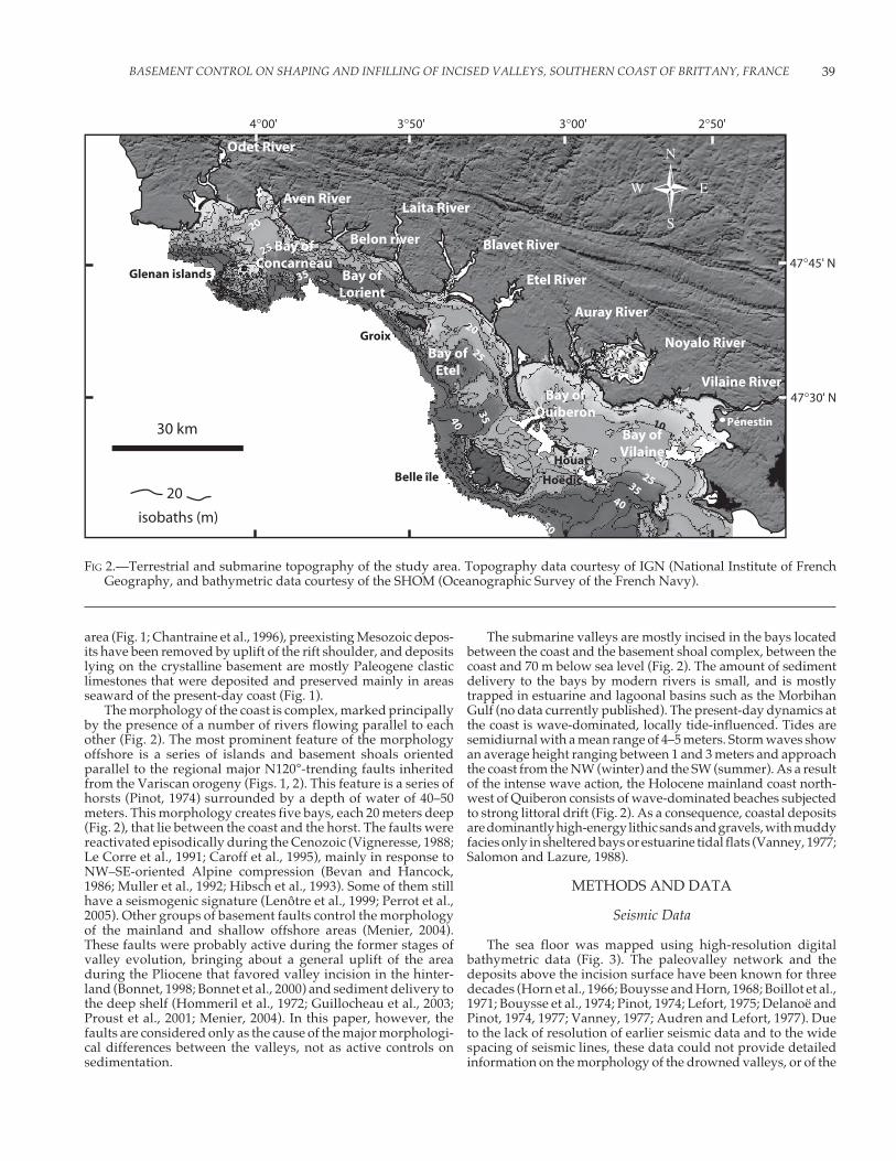
The four submerged valleys studied in this paper constitutethe seaward extension of the main river valleys of southernBrittany (Fig. 1). They are developed and preserved mostly inthe large bays located between the present-day coast and abasement shoal complex located 5–15 km offshore between aseries of islands (Figs. 1, 2). Between the coast and across thebasement shoal line, the average gradient of the shelf increasesfrom 0.057° to 0.12° (Fig. 2). Farther seaward, the gradient of theshelf is 0.038°. This feature has a direct influence on the amountand location of incision and infilling of the submerged valleys.
Several of these valleys have been studied in detail (Proust et al.,2001; Loget, 2001), and most of the results have been reported inMenier (2004). However, the present paper is the first attempt to(1) demonstrate the inheritance of faults in shaping the valleysand (2) examine the interaction between the topography of thetransgressed estuaries and the tidal wave that enter them andthe influence that this has on the nature of the valley-fillingdeposits.
STUDY AREA
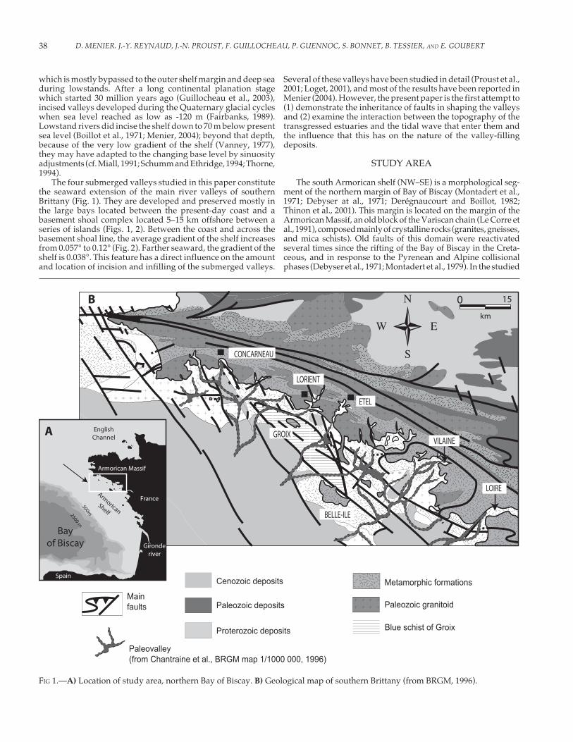
The south Armorican shelf (NW–SE) is a morphological seg-ment of the northern margin of Bay of Biscay (Montadert et al.,1971; Debyser at al., 1971; Derégnaucourt and Boillot, 1982;Thinon et al., 2001). This margin is located on the margin of theArmorican Massif, an old block of the Variscan chain (Le Corre etal., 1991), composed mainly of crystalline rocks (granites, gneisses,and mica schists). Old faults of this domain were reactivatedseveral times since the rifting of the Bay of Biscay in the Creta-ceous, and in response to the Pyrenean and Alpine collisionalphases (Debyser et al., 1971; Montadert et al., 1979). In the studied
FIG 1.—A) Location of study area, northern Bay of Biscay. B) Geological map of southern Brittany (from BRGM, 1996).
39BASEMENT CONTROL ON SHAPING AND INFILLING OF INCISED VALLEYS, SOUTHERN COAST OF BRITTANY, FRANCE
area (Fig. 1; Chantraine et al., 1996), preexisting Mesozoic depos-its have been removed by uplift of the rift shoulder, and depositslying on the crystalline basement are mostly Paleogene clasticlimestones that were deposited and preserved mainly in areasseaward of the present-day coast (Fig. 1).
The morphology of the coast is complex, marked principallyby the presence of a number of rivers flowing parallel to eachother (Fig. 2). The most prominent feature of the morphologyoffshore is a series of islands and basement shoals orientedparallel to the regional major N120°-trending faults inheritedfrom the Variscan orogeny (Figs. 1, 2). This feature is a series ofhorsts (Pinot, 1974) surrounded by a depth of water of 40–50meters. This morphology creates five bays, each 20 meters deep(Fig. 2), that lie between the coast and the horst. The faults werereactivated episodically during the Cenozoic (Vigneresse, 1988;Le Corre et al., 1991; Caroff et al., 1995), mainly in response toNW–SE-oriented Alpine compression (Bevan and Hancock,1986; Muller et al., 1992; Hibsch et al., 1993). Some of them stillhave a seismogenic signature (Lenôtre et al., 1999; Perrot et al.,2005). Other groups of basement faults control the morphologyof the mainland and shallow offshore areas (Menier, 2004).These faults were probably active during the former stages ofvalley evolution, bringing about a general uplift of the areaduring the Pliocene that favored valley incision in the hinter-land (Bonnet, 1998; Bonnet et al., 2000) and sediment delivery tothe deep shelf (Hommeril et al., 1972; Guillocheau et al., 2003;Proust et al., 2001; Menier, 2004). In this paper, however, thefaults are considered only as the cause of the major morphologi-cal differences between the valleys, not as active controls onsedimentation.
The submarine valleys are mostly incised in the bays locatedbetween the coast and the basement shoal complex, between thecoast and 70 m below sea level (Fig. 2). The amount of sedimentdelivery to the bays by modern rivers is small, and is mostlytrapped in estuarine and lagoonal basins such as the MorbihanGulf (no data currently published). The present-day dynamics atthe coast is wave-dominated, locally tide-influenced. Tides aresemidiurnal with a mean range of 4–5 meters. Storm waves showan average height ranging between 1 and 3 meters and approachthe coast from the NW (winter) and the SW (summer). As a resultof the intense wave action, the Holocene mainland coast north-west of Quiberon consists of wave-dominated beaches subjectedto strong littoral drift (Fig. 2). As a consequence, coastal depositsare dominantly high-energy lithic sands and gravels, with muddyfacies only in sheltered bays or estuarine tidal flats (Vanney, 1977;Salomon and Lazure, 1988).
METHODS AND DATA
Seismic Data
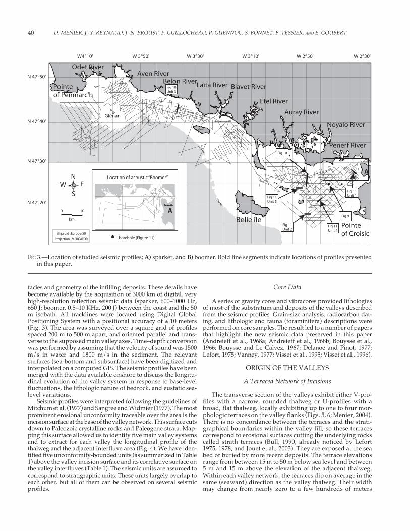
The sea floor was mapped using high-resolution digitalbathymetric data (Fig. 3). The paleovalley network and thedeposits above the incision surface have been known for threedecades (Horn et al., 1966; Bouysse and Horn, 1968; Boillot et al.,1971; Bouysse et al., 1974; Pinot, 1974; Lefort, 1975; Delanoë andPinot, 1974, 1977; Vanney, 1977; Audren and Lefort, 1977). Dueto the lack of resolution of earlier seismic data and to the widespacing of seismic lines, these data could not provide detailedinformation on the morphology of the drowned valleys, or of the
FIG 2.—Terrestrial and submarine topography of the study area. Topography data courtesy of IGN (National Institute of FrenchGeography, and bathymetric data courtesy of the SHOM (Oceanographic Survey of the French Navy).
D. MENIER. J.-Y. REYNAUD, J.-N. PROUST, F. GUILLOCHEAU, P. GUENNOC, S. BONNET, B. TESSIER, AND E. GOUBERT40
facies and geometry of the infilling deposits. These details havebecome available by the acquisition of 3000 km of digital, veryhigh-resolution reflection seismic data (sparker, 600–1000 Hz,650 J; boomer, 0.5–10 KHz, 200 J) between the coast and the 50m isobath. All tracklines were located using Digital GlobalPositioning System with a positional accuracy of ± 10 meters(Fig. 3). The area was surveyed over a square grid of profilesspaced 200 m to 500 m apart, and oriented parallel and trans-verse to the supposed main valley axes. Time–depth conversionwas performed by assuming that the velocity of sound was 1500m/s in water and 1800 m/s in the sediment. The relevantsurfaces (sea-bottom and subsurface) have been digitized andinterpolated on a computed GIS. The seismic profiles have beenmerged with the data available onshore to discuss the longitu-dinal evolution of the valley system in response to base-levelfluctuations, the lithologic nature of bedrock, and eustatic sea-level variations.
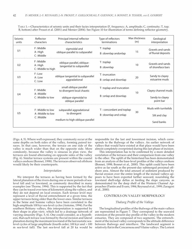
Seismic profiles were interpreted following the guidelines ofMitchum et al. (1977) and Sangree and Widmier (1977). The mostprominent erosional unconformity traceable over the area is theincision surface at the base of the valley network. This surface cutsdown to Paleozoic crystalline rocks and Paleogene strata. Map-ping this surface allowed us to identify five main valley systemsand to extract for each valley the longitudinal profile of thethalweg and the adjacent interfluve area (Fig. 4). We have iden-tified five unconformity-bounded units (as summarized in Table1) above the valley incision surface and its correlative surface onthe valley interfluves (Table 1). The seismic units are assumed tocorrespond to stratigraphic units. These units largely overlap toeach other, but all of them can be observed on several seismicprofiles.
Core Data
A series of gravity cores and vibracores provided lithologiesof most of the substratum and deposits of the valleys describedfrom the seismic profiles. Grain-size analysis, radiocarbon dat-ing, and lithologic and fauna (foraminifera) descriptions wereperformed on core samples. The result led to a number of papersthat highlight the new seismic data preserved in this paper(Andreieff et al., 1968a; Andreieff et al., 1968b; Bouysse et al.,1966; Bouysse and Le Calvez, 1967; Delanoë and Pinot, 1977;Lefort, 1975; Vanney, 1977; Visset et al., 1995; Visset et al., 1996).
ORIGIN OF THE VALLEYS
A Terraced Network of Incisions
The transverse section of the valleys exhibit either V-pro-files with a narrow, rounded thalweg or U-profiles with abroad, flat thalweg, locally exhibiting up to one to four mor-phologic terraces on the valley flanks (Figs. 5, 6; Menier, 2004).There is no concordance between the terraces and the strati-graphical boundaries within the valley fill, so these terracescorrespond to erosional surfaces cutting the underlying rockscalled strath terraces (Bull, 1990, already noticed by Lefort1975, 1978, and Jouet et al., 2003). They are exposed at the seabed or buried by more recent deposits. The terrace elevationsrange from between 15 m to 50 m below sea level and between5 m and 15 m above the elevation of the adjacent thalweg.Within each valley network, the terraces dip on average in thesame (seaward) direction as the valley thalweg. Their widthmay change from nearly zero to a few hundreds of meters
FIG 3.—Location of studied seismic profiles; A) sparker, and B) boomer. Bold line segments indicate locations of profiles presentedin this paper.
41BASEMENT CONTROL ON SHAPING AND INFILLING OF INCISED VALLEYS, SOUTHERN COAST OF BRITTANY, FRANCE
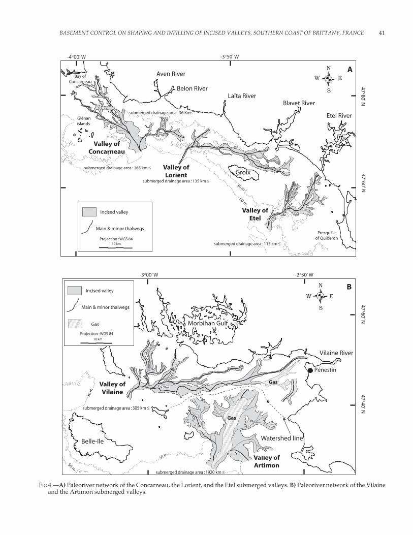
FIG 4.—A) Paleoriver network of the Concarneau, the Lorient, and the Etel submerged valleys. B) Paleoriver network of the Vilaineand the Artimon submerged valleys.
D. MENIER. J.-Y. REYNAUD, J.-N. PROUST, F. GUILLOCHEAU, P. GUENNOC, S. BONNET, B. TESSIER, AND E. GOUBERT42
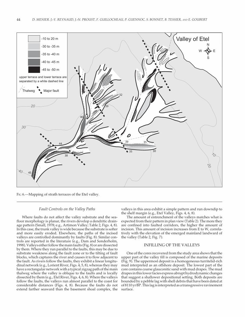
(Figs. 4, 5). Where well expressed, they commonly occur at thesame depths on both sides of the valley, forming paired ter-races. In that case, however, the terrace on one side of thevalley is much wider than that on the opposite side. Morecommonly, because the valley is sinuous in plan view, theterraces are found alternating on opposite sides of the valley(Fig. 6). Similar terrace systems are present within the coastalvalleys onshore (Bonnet, 1998). The terraces observed offshorewould likely be their counterparts.
Interpretation
We interpret the terraces as having been formed by thelateral planation of the rivers during one or more periods of sea-level fall and/or lowstand, as commonly described in manyexamples (see Thorne, 1994). This is supported by the fact thatthey can be traced over tens of kilometers along the valleys, andthey do not depend on local erosion. Each terrace level mayrepresent a level of fluvial entrenchment at a given time, theupper terraces being older than the lower ones. Similar terracesin the Seine and Somme valleys have been correlated to thehigh-amplitude 100 kyr sea-level cycles (Antoine, 1994). For thesouthern Brittany valleys, this interpretation is supported bytheir shape in plan view, which led to a drainage network ofvarying sinuosity (Figs. 5, 6). One could consider, as a hypoth-esis, that each terrace was formed by fluvial incision and lateralplanation during the maximum lowstand of the last eustatic sea-level cycles of large amplitude (fourth order; 100 kyr and > 100m sea-level fall). The last sea-level fall at 20 ka would be
responsible for the last and lowermost incision, which corre-sponds to the thalwegs of the valleys. An earlier network ofvalleys that would have existed at that place would have beenalmost completely overprinted during this last phase of incision.
This interpretation has to be confirmed by a more detailedcorrelation of the terraces and their comparison from one valleyto the other. The uplift of the hinterland has been demonstratedfrom an analysis of the base-level profiles of the valleys onshore(Bonnet, 1998; Bonnet et al., 2000). This uplift could have beenactive as far south as the present-day submerged proximal off-shore area. Almost the total amount of sediment produced byfluvial erosion over the entire length of the incised valleys ap-pears to have been exported farther seaward, nourishing thelowstand shelf-edge deltas or feeding the slope canyons, asdemonstrated for the deep shelf of the Western Channel Ap-proaches (Pantin and Evans, 1984; Reynaud et al., 1999; Zaragosiet al., 2000).
CONTROLS ON VALLEY MORPHOLOGY
Thalweg Profile of the Valleys
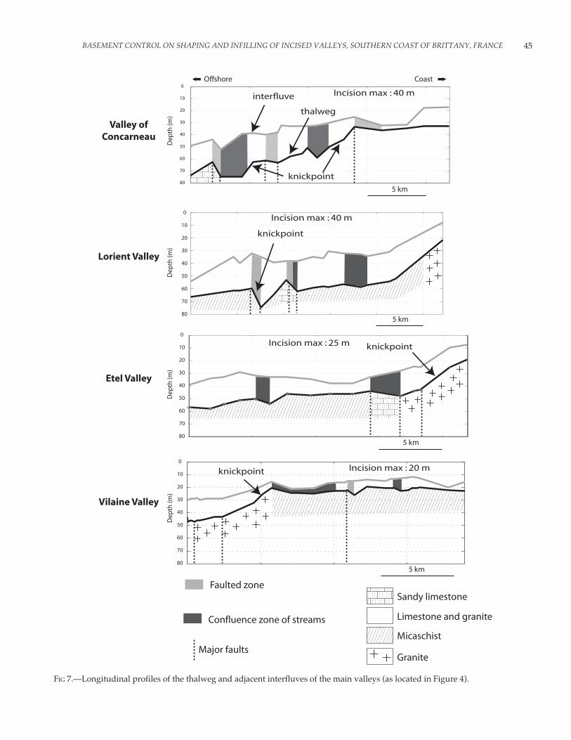
The longitudinal profiles of the thalwegs of the main valleysare represented in Figure 7. They correspond to the seawardextension of the present-day profile of the valley in the modernestuaries. They are composed of two segments. The entrench-ment of the incised valley corresponds to the altitude differencebetween thalwegs and interfluve. The landward segment isrelatively flat in the Concarneau and Vilaine valleys. The Lorient
TABLE 1.—Characteristics of seismic units and their facies interpretation (F, frequency; A, amplitude; C, continuity; T, top;B, bottom) after Proust et al. (2001) and Menier (2004). See Figure 10 for illustration of terms defining reflector geometry.

43BASEMENT CONTROL ON SHAPING AND INFILLING OF INCISED VALLEYS, SOUTHERN COAST OF BRITTANY, FRANCE
and Etel valleys are steeper in their landward part and flattenseaward. The lower, most seaward part of this segment is about30 m deeper than the knickpoint (particularly in the Concarneauand Lorient valleys). The same profiles are observed from onevalley to the other but with a vertical offset pointing to a generaldeepening from the east (knickpoint at 20 m below present sealevel in the Vilaine valley) to the west (knickpoint at 35 m in theConcarneau valley). Locally, the profiles exhibit “saw tooth”sections, with an incision depth locally varying up to 80% of thetotal amount of incision (Fig. 7). The thalwegs may even diplandward over short distances. While substratum lithology haslittle if any influence on the longitudinal profile of the valleys,the “accidents” in slope profile are located (1) at the junctionbetween two valley branches and (2) where N120° or N160°faults cross the valley (Figs. 5, 6, 7). The latter case seems to bethe dominant control, inasmuch as the interfluves of the valleysfollow the same offset pattern. Where they cross major faults,the valley thalwegs may show abrupt elevation changes of up to10 m . Today, such dip inversions in the thalweg profiles are notdemonstrated in the emerged sections of the valleys, perhapsbecause they are masked by sediments.
Major faults cross the study area, related to the southern partof a major Variscan shear zone (Fig. 1, faults N120°) that has beenreactivated several times during the Neogene (Boillot et al., 1971;Pinot, 1974; Vanney, 1977). The basement shoal complex isbounded by such faults (Figs. 1, 5). It is worth noting that theknickpoint of the thalweg profiles coincides with this structuralline. The longitudinal profiles of the thalweg of the valleys exhibitabrupt changes in slope that superpose to major regional faults(Figs. 6, 7). Relying on the idea that the thalwegs of the valleyswere incised in response of the last glacial sea-level lowstand, thefaulting may even have been active until short a time before finalincision of the thalweg (so that the related scarps could not havebeen planated by fluvial processes) or even after incision ceased.This is supported by (1) the saw-tooth profile of the thalwegs and(2) the local offset of lowermost deposits inside the valley by thefaults (Proust et al., 2001). However, there is no clear evidence offaulting that would have affected the valley fill above theselowermost deposits. The faults occur in the submarine topogra-phy as scarps, the landward part of which corresponds to bedrockoutcrops. The same pattern applies onshore, where terraces areoffset by the faults (Bonnet, 1998; Bonnet et al., 2000).
FIG 5.—Contour map of the surface at the base of the Lorient valley. Contours in meters, based on seismic data using a sedimentvelocity = 1800 m/s. Dashed lines indicate major faults as mapped from seismic data. Inset: cross section of the valley showingthalweg, interfluves, and terraces.
D. MENIER. J.-Y. REYNAUD, J.-N. PROUST, F. GUILLOCHEAU, P. GUENNOC, S. BONNET, B. TESSIER, AND E. GOUBERT44
Fault Controls on the Valley Paths
Where faults do not affect the valley substrate and the sea-floor morphology is planar, the rivers develop a dendritic drain-age pattern (Small, 1978; e.g., Artimon Valley; Table 2, Figs. 4, 8).In this case, the trunk valley is wide because the substrate is softerand more easily eroded. Elsewhere, the paths of the incisedvalleys are controlled dominantly by faults (Fig. 8). Similar con-trols are reported in the literature (e.g., Dam and Sonderholm,1998). Valleys either follow the main faults (Fig. 8) or are dissectedby them. Where they run parallel to the faults, this may be due tosubstrate weakness along the fault zone or to the tilting of faultblocks, which captures the river and causes it to flow adjacent tothe fault. As rivers follow the faults, they exhibit a linear longitu-dinal network (e.g., Lorient River, Figs. 4, 5, 8), whereas they mayhave a rectangular network with a typical zigzag path of the mainthalweg where the valley is oblique to the faults and is locallydissected by them (e.g., Etel River, Figs. 4, 6, 8). Where the valleysfollow the faults, the valleys run almost parallel to the coast forconsiderable distances (Figs. 4, 8). Because the faults do notextend farther seaward than the basement shoal complex, the
valleys in this area exhibit a simple pattern and run downdip tothe shelf margin (e.g., Etel Valley, Figs. 4, 6, 8).
The amount of entrenchment of the valleys matches what isexpected from their pattern in plan view (Table 2). The more theyare confined into faulted corridors, the higher the amount ofincision. This amount of incision increases from E to W, correla-tively with the elevation of the emerged mainland landward ofthe valley (Table 2, Fig. 7).
INFILLING OF THE VALLEYS
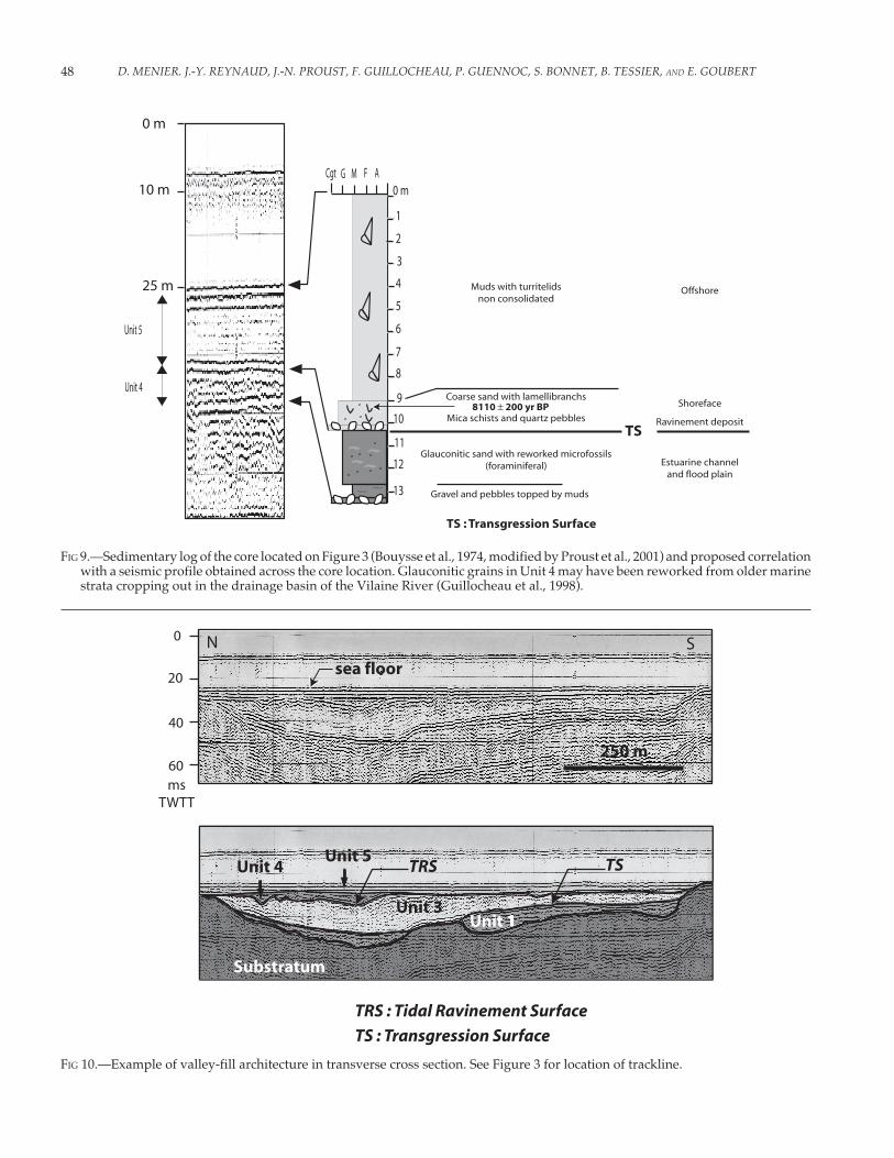
One of the cores recovered from the study area shows that theupper part of the valley fill is composed of the marine deposits(Fig. 9). The uppermost deposit is a homogeneous turritelid-richmud interpreted as an offshore deposit. The lowest part of thecore contains coarse glauconitic sand with mud drapes. The muddrapes in this lower facies express abrupt hydrodynamic changesthat suggest a shallower depositional setting. Both deposits arebounded by a pebble lag with shell debris that have been dated atof 8110 yr BP. This lag is interpreted as a transgressive ravinementsurface.
FIG 6.—Mapping of strath terraces of the Etel valley.
45BASEMENT CONTROL ON SHAPING AND INFILLING OF INCISED VALLEYS, SOUTHERN COAST OF BRITTANY, FRANCE
FIG 7.—Longitudinal profiles of the thalweg and adjacent interfluves of the main valleys (as located in Figure 4).
D. MENIER. J.-Y. REYNAUD, J.-N. PROUST, F. GUILLOCHEAU, P. GUENNOC, S. BONNET, B. TESSIER, AND E. GOUBERT46
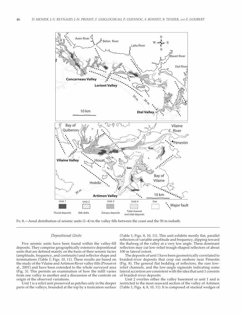
FIG 8.—Areal distribution of seismic units (1–4) in the valley fills between the coast and the 50 m isobath.
Depositional Units
Five seismic units have been found within the valley-filldeposits. They comprise geographically extensive depositionalunits that are defined mainly on the basis of their seismic facies(amplitude, frequency, and continuity) and reflector shape andterminations (Table 1; Figs. 10, 11). These results are based onthe study of the Vilaine and Artimon River valley fills (Proust etal., 2001) and have been extended to the whole surveyed area(Fig. 3). This permits an examination of how the infill variesfrom one valley to another and a discussion of the controls onorigin of the observed variations.
Unit 1 is a relict unit preserved as patches only in the deeperparts of the valleys, bounded at the top by a truncation surface
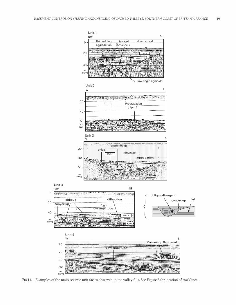
(Table 1; Figs. 8, 10, 11). This unit exhibits mostly flat, parallelreflectors of variable amplitude and frequency, dipping towardthe thalweg of the valley at a very low angle. These dominantreflectors may cut low-relief trough-shaped reflectors of about100 m lateral extent.
The deposits of unit 1 have been geometrically correlated tobraided-river deposits that crop out onshore near Pénestin(Fig. 8). The general flat bedding of reflectors, the rare low-relief channels, and the low-angle sigmoids indicating somelateral accretion are consistent with the idea that unit 1 consistsof braided-river deposits.
Unit 2 overlies either the valley basement or unit 1 and isrestricted to the most seaward section of the valley of Artimon(Table 1; Figs. 4, 8, 10, 11). It is composed of stacked wedges of
47BASEMENT CONTROL ON SHAPING AND INFILLING OF INCISED VALLEYS, SOUTHERN COAST OF BRITTANY, FRANCE
oblique parallel, plane to sigmoid reflectors dipping < 8° towardthe sea (southwest) or the valley thalweg over a > 160° span.
Unit 2 is truncated at the top by an erosional surface. It is notin connection with either unit 3 or unit 4.
Unpublished area data reveal that unit 2 is composed mostlyof coarse-grained pebbly sand and gravel with abundant shelldebris. The abundant shell remains suggest that this deposit ismarine in origin. Rounded pebbles are related to high deposi-tional energy. The coarse-grained sediments could be reworkedfrom the underlying fluvial deposits in unit 1. The dip of unit 2internal reflectors suggests that they are accretion surfaces oflobate sediment bodies that flank basement highs and tend toprograde toward the thalwegs of the valleys. These sedimentbodies are therefore likely to correspond to shoreface banks at theseaward end of the valley (Figs. 4, 8, 11).
Unit 3 is present only in narrow valleys, where it forms themain part of the valley fill (Table 1; Figs. 8, 9, 10). It is bounded atthe top by a sharp erosion surface and is composed of low-amplitude flat parallel reflectors onlapping the valley walls andlocally downlapping to the base of the unit. The reflectors in unit3 exhibit a very low-angle dip (about 0.1°) toward the thalweg ofthe valley. They express a centripetal infilling of the valley (fromthe edges to the thalweg), with dominant sigmoids backed to thevalley walls, passing to concave-up surfaces in the valley axisnear the top of the unit. In restricted areas, the seismic facies ofunit 3 is chaotic or transparent (Figs. 8, 10, 11).
The reflector geometry suggest infilling of the valley by lateralaccretion, under the action of currents following the valley paths.The low-amplitude seismic facies and the large-scale homogene-ity of the sigmoids as well as their very low angle of dip suggestthat these are formed by accretion of muddy sediments, underlow to moderate currents that would not be able to channelize thedeposit. This is supported by the very low dip of the accretionsurfaces. The sigmoids can be traced over two-thirds of thethickness of the unit (about 7 m), suggesting that depositionoccurred below such a water depth at least. These argumentspoint to deposition of unit 3 below sea level in a sheltered area.The weak to moderate currents that are recorded in this unit arelikely to be tidal in origin. This suggest that unit 3 was depositedin an estuarine setting as the valleys were drowned by the sea(Figs. 8, 10, 11). The chaotic to transparent acoustic facies pointsto the presence of gas, which is very commonly reported in clayeyorganic-rich sediments from estuarine valleys (e.g., Mullins andHalfman, 2001; Garcia-Gil et al., 2002; Baltzer et al., 2005).
Unit 4 corresponds to the lower, sandy glauconitic depositsampled by the core in Figure 9. This unit has an erosional basalsurface that corresponds to the cored pebble lag (Fig. 9), istraceable over the entire area (Table 1; Figs. 8, 10, 11). It isrelatively flat in the seaward part of the area, but it delineates asinuous channel network up to 5 km wide in more landwardareas. The amount of erosion at the bases of these channelsdecreases at the landward end of the unit. Unit 4 is made up of
TABLE 2.—Synthesis of geomorphic and facies information for the southern Brittany incised valleys.
D. MENIER. J.-Y. REYNAUD, J.-N. PROUST, F. GUILLOCHEAU, P. GUENNOC, S. BONNET, B. TESSIER, AND E. GOUBERT48
FIG 9.—Sedimentary log of the core located on Figure 3 (Bouysse et al., 1974, modified by Proust et al., 2001) and proposed correlationwith a seismic profile obtained across the core location. Glauconitic grains in Unit 4 may have been reworked from older marinestrata cropping out in the drainage basin of the Vilaine River (Guillocheau et al., 1998).
FIG 10.—Example of valley-fill architecture in transverse cross section. See Figure 3 for location of trackline.
49BASEMENT CONTROL ON SHAPING AND INFILLING OF INCISED VALLEYS, SOUTHERN COAST OF BRITTANY, FRANCE
FIG 11.—Examples of the main seismic-unit facies observed in the valley fills. See Figure 3 for location of tracklines.
D. MENIER. J.-Y. REYNAUD, J.-N. PROUST, F. GUILLOCHEAU, P. GUENNOC, S. BONNET, B. TESSIER, AND E. GOUBERT50
stacked subunits composed of sigmoid, oblique to flat reflectorsdelineating cut-and-fill channels up to 300 meters in cross section(Figs. 9, 10). The fills are commonly marked by reflectors of highamplitude, whereas the associated flat deposits may be nearlytransparent (Fig. 9).
The deposit sampled in unit 4 contains numerous grains ofglauconite and foraminifers (Fig. 9). Although glauconite maybe reworked from older marine strata (Guillocheau et al., 1998),the mud drapes in the sands point to abrupt current changes,which are very typical of tidal-estuary environments (muddrapes deposited at slack water and reworked by peak cur-rents). The cut-and-fill pattern of the deposit would likely bedue to the onset of a strong tidal current regime in the estuarineenvironment, leading to dominantly channelized deposits. Thehigher-amplitude facies the channel fills would match the(muddy) pebble and gravel deposits that are common withintidal channels. In this respect, the base of this unit, marked by apebble-rich clay layer (Fig. 9), would correspond to a tidalravinement surface (Figs. 10, 11). The tidal ravinement would beforced by constriction of the tidal flow inside the valley. Thedecreasing amount of erosion at this surface toward the land-ward end of the valley is consistent with the landward decreaseof tidal energy that has to occur inside the estuaries. Unit 5corresponds to the upper, muddy deposit sampled by the core inFigure 9. Due to the presence of turritellids, this deposit isinterpreted as a quiet offshore setting. Unit 5 extends over theentire valley system, overlapping valley interfluves (Table 1;Figs. 8, 10, 11). It is bounded at the base by a high-amplitudeerosion surface that correlates to the top of unit 2. This surfacematches the bedrock pebble and shelly lag sampled in the samecore (Fig. 9). Most of this unit is composed of flat-bedded, aggrad-ing deposits of low seismic amplitude that may even be trans-parent in the central parts of the valleys. Landward from Houat,Hoëdic, and Glénans islands (Fig. 1), the upper part of the unitcontains flat-based and convex-up depositional shapes, up to 5m high, that exhibit internal oblique bedding (Figs. 10, 11).
Unit 5, offshore deposits, was emplaced at full transgressionover the area, inasmuch as it overlaps most of the valley inter-fluves. Because of that, tidal flows were no longer constrainedwithin the valleys at that time and tidal currents were thus verylow. This is also why this mud is almost flat bedded and aggrad-ing, except for the convex-up depositional flows that locally occurnear the seabed and that are interpreted as offshore banks. Theflat and widespread lag at the base of the unit is interpreted as awave ravinement surface. It is preserved at a depth of about -35m below present sea level (Fig. 9), and dated at 8110 ± 200 yr B.P.From eustatic and local sea-level curves (Morzadec-Kerfourn,1974; Fairbanks, 1989), this points to a water depth of about 8 mat the time of formation of the wave ravinement surface. This isshallow compared to the range of depth of storm wave base inoceanic borders but is to be related to the presence of the base-ment shoal that breaks the Atlantic swells seaward from thevalleys. This sheltering effect is also recorded in the grain size ofthe Unit 5 deposit, which is finer landward from the basementshoal than seaward of it.
Depositional Story
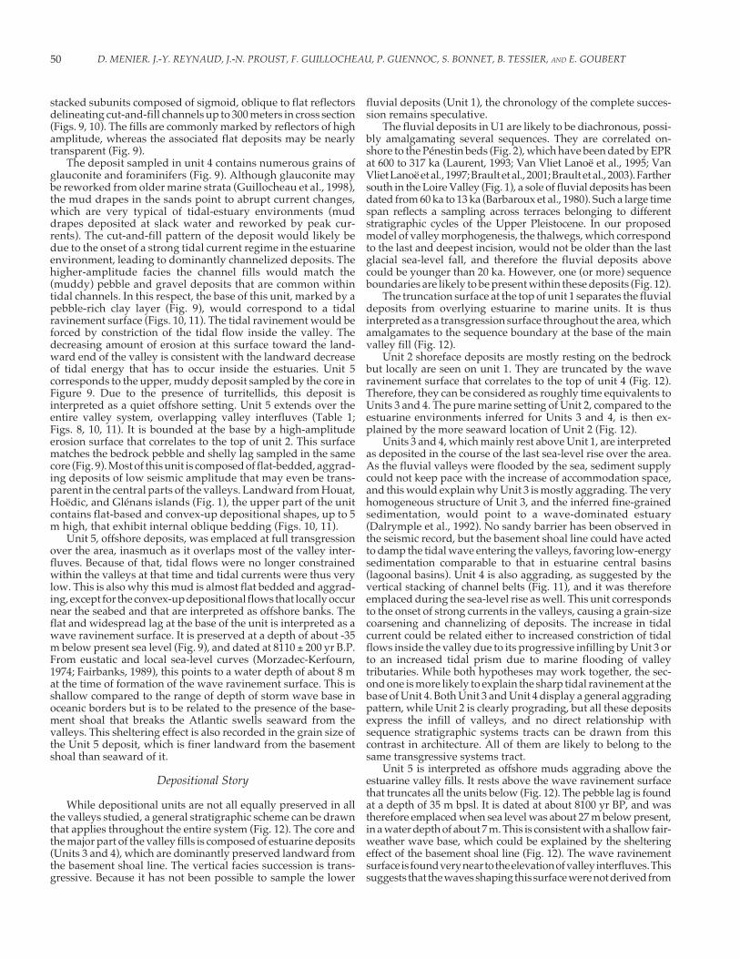
While depositional units are not all equally preserved in allthe valleys studied, a general stratigraphic scheme can be drawnthat applies throughout the entire system (Fig. 12). The core andthe major part of the valley fills is composed of estuarine deposits(Units 3 and 4), which are dominantly preserved landward fromthe basement shoal line. The vertical facies succession is trans-gressive. Because it has not been possible to sample the lower
fluvial deposits (Unit 1), the chronology of the complete succes-sion remains speculative.
The fluvial deposits in U1 are likely to be diachronous, possi-bly amalgamating several sequences. They are correlated on-shore to the Pénestin beds (Fig. 2), which have been dated by EPRat 600 to 317 ka (Laurent, 1993; Van Vliet Lanoë et al., 1995; VanVliet Lanoë et al., 1997; Brault et al., 2001; Brault et al., 2003). Farthersouth in the Loire Valley (Fig. 1), a sole of fluvial deposits has beendated from 60 ka to 13 ka (Barbaroux et al., 1980). Such a large timespan reflects a sampling across terraces belonging to differentstratigraphic cycles of the Upper Pleistocene. In our proposedmodel of valley morphogenesis, the thalwegs, which correspondto the last and deepest incision, would not be older than the lastglacial sea-level fall, and therefore the fluvial deposits abovecould be younger than 20 ka. However, one (or more) sequenceboundaries are likely to be present within these deposits (Fig. 12).
The truncation surface at the top of unit 1 separates the fluvialdeposits from overlying estuarine to marine units. It is thusinterpreted as a transgression surface throughout the area, whichamalgamates to the sequence boundary at the base of the mainvalley fill (Fig. 12).
Unit 2 shoreface deposits are mostly resting on the bedrockbut locally are seen on unit 1. They are truncated by the waveravinement surface that correlates to the top of unit 4 (Fig. 12).Therefore, they can be considered as roughly time equivalents toUnits 3 and 4. The pure marine setting of Unit 2, compared to theestuarine environments inferred for Units 3 and 4, is then ex-plained by the more seaward location of Unit 2 (Fig. 12).
Units 3 and 4, which mainly rest above Unit 1, are interpretedas deposited in the course of the last sea-level rise over the area.As the fluvial valleys were flooded by the sea, sediment supplycould not keep pace with the increase of accommodation space,and this would explain why Unit 3 is mostly aggrading. The veryhomogeneous structure of Unit 3, and the inferred fine-grainedsedimentation, would point to a wave-dominated estuary(Dalrymple et al., 1992). No sandy barrier has been observed inthe seismic record, but the basement shoal line could have actedto damp the tidal wave entering the valleys, favoring low-energysedimentation comparable to that in estuarine central basins(lagoonal basins). Unit 4 is also aggrading, as suggested by thevertical stacking of channel belts (Fig. 11), and it was thereforeemplaced during the sea-level rise as well. This unit correspondsto the onset of strong currents in the valleys, causing a grain-sizecoarsening and channelizing of deposits. The increase in tidalcurrent could be related either to increased constriction of tidalflows inside the valley due to its progressive infilling by Unit 3 orto an increased tidal prism due to marine flooding of valleytributaries. While both hypotheses may work together, the sec-ond one is more likely to explain the sharp tidal ravinement at thebase of Unit 4. Both Unit 3 and Unit 4 display a general aggradingpattern, while Unit 2 is clearly prograding, but all these depositsexpress the infill of valleys, and no direct relationship withsequence stratigraphic systems tracts can be drawn from thiscontrast in architecture. All of them are likely to belong to thesame transgressive systems tract.
Unit 5 is interpreted as offshore muds aggrading above theestuarine valley fills. It rests above the wave ravinement surfacethat truncates all the units below (Fig. 12). The pebble lag is foundat a depth of 35 m bpsl. It is dated at about 8100 yr BP, and wastherefore emplaced when sea level was about 27 m below present,in a water depth of about 7 m. This is consistent with a shallow fair-weather wave base, which could be explained by the shelteringeffect of the basement shoal line (Fig. 12). The wave ravinementsurface is found very near to the elevation of valley interfluves. Thissuggests that the waves shaping this surface were not derived from
51BASEMENT CONTROL ON SHAPING AND INFILLING OF INCISED VALLEYS, SOUTHERN COAST OF BRITTANY, FRANCE
oceanic swells propagating inside the valleys (these would havebeen damped by the islands and the sinuous paths of the valleys),but rather originated inside the basin, located landward from thebasement shoal line as soon as the valley interfluves were floodedby the sea in the course of the transgression (so that a sufficient fetchcould permit waves to form there). In this respect, it is a bayravinement surface, as defined by Allen and Posamentier (1993) andillustrated in the buried offshore incised valleys of western Brit-tany (Reynaud et al., 1999). The bedrock pebbles and abundantshell debris concentrated at this surface would have been re-worked from the interfluves of the valleys, as these were rapidlyswept by the retreating estuarine shorelines. Because large wavesnever could develop inside this coastal basin, wave ravinementrapidly ceased as water depth became greater than 7 to 10 m (8000yr BP), allowing deposition of dominantly suspended sediments.Similar upper-valley fills have been found in incised valleys thatevolved into larger embayments under transgression (Kindingeret al., 1994; Reynaud et al., 1999; among others). The wave ravine-ment surface is thus a good time line in this basin, as well as the bestcandidate for tracing the maximum flooding surface (Fig. 12),although no evidence of renewed progradation is seen in Unit 5. Itis worth noting that although the area still experiences large tides,deposition has no longer been tide-dominated after valley inter-fluves were flooded. The rare bars preserved at the top of Unit 5could represent the only hints of tidal influence in this offshoresystem (not taking into account the present-day estuaries, land-ward of it, which are still tide-dominated).
VALLEY FILL CONTROLLED BYVALLEY MORPHOLOGY
Shelf Slope and Valley Morphology
The interplay of several fault systems across the study area isresponsible for the contrast between the morphologies of thevalleys in plan view and along their longitudinal profile (Fig. 7).Although these faults might have been reactivated until veryrecently, they never affect the estuarine to marine valley fills, sothat the same tectonic valley morphology as at present alreadyexisted as it was infilled by sediments.
The depth, width, and amount of incision of the valleys areinfluenced by the magnitude of base-level fall as incision pro-
ceeded (see Miall, 1991). This magnitude is directly controlled bythe difference between the slope of the rivers and the slope of theshelf where rivers are forced to flow at lowstand. The shelf slopedip is about 0.23° in the western part of the study areas, where thevalleys are linear, narrow, and deeply incised (Concarneau andLorient Valleys; Fig. 2). By contrast, the average shelf slope isabout 0.075° in the east, where the shallow submarine areas (fromthe coast to the basement shoal line; Fig. 2) are not steeper than themainland. As expected, the valleys flowing through this domainare overall wider, dendritic in shape, and less incised (ArtimonValley; Fig. 4).
Size of the Tidal Prism
Valley morphology controls the size of the tidal prism, that is,the volume of water exchanged during one half tidal cyclethrough the valley section. The size of the tidal prism increaseswith the tidal range and the extent of intertidal areas inside theestuary. There is no hint that tidal range would have changedunder regional oceanographic controls in the course of the lastsea-level rise. By contrast, the hypsometry of the mapped coastalarea shows that the extent of intertidal surfaces inside the valleysmay have changed greatly through transgression (Fig. 4). There-fore, we consider that this is the main parameter driving the tidalprism. In this respect, there is a significant difference between thelinear valleys that lack tributaries (small surface, small tidalprism), and the dendritic valley networks (large surface, largetidal prism) (Table 2). Tidal currents are scaled to the ratio of thetidal prism to the entire volume of the incised-valley system.They would increase with an increase of the tidal prism or adecrease in water depth in the flooded valley.
As a consequence, the currents in the linear, long trunk valleyssuch as Lorient Valley (Figs. 4, 5, 8) would have been much slowerthan in those with numerous lateral branches that were part of thesame estuarine system, such as Artimon Valley (Figs. 4, 8). Thiscould partly explain why narrow and linear valleys are mostlyfilled up by Unit 3 (muddy, aggrading deposits, indicating slowcurrents), while large, dendritic ones mostly comprise Unit 4deposits (tidal channel and bars, indicating faster currents; Figs.8, 9, 10).
This contrast may apply to the successive stages of infilling ofone valley as well, because most of the valleys widen upward in
FIG 12.—Southern Brittany incised-valley-fill model. Sequence-stratigraphic surfaces: SB, sequence boundary; TS, transgressivesurface; MFS, maximum flooding surface.
D. MENIER. J.-Y. REYNAUD, J.-N. PROUST, F. GUILLOCHEAU, P. GUENNOC, S. BONNET, B. TESSIER, AND E. GOUBERT52
cross section (Fig. 8). The increased channeling in unit 4 would berelated to the increase in tidal prism that occurred when thebroader parts of the tributary valleys were flooded (Fig. 8). Whensea level was lower and only the narrow parts of the valleyscutting through the basement shoal line were affected by tides,tidal currents would have been slower because the tidal prismwas smaller. This is supported by the fact that Unit 4 is bestexpressed in the valleys where the valley floor is incised not muchdeeper than 40 m (Etel and Vilaine Valleys; Figs. 4, 7, 8).
Friction and Constriction of Currents
Another reason for finding Unit 3 deposits mostly in narrow,linear valleys is that these valleys are isolated from the open seaby one or several narrow passes (Lorient and Vilaine Valleys;Figs. 4, 8). In such valleys, tidal flows are likely to be damped byfriction on the valley walls and the tidal wave energy dissipatedby diffraction through the tidal passes (a “hyposynchronous”estuary). Friction would have been increased even more by thelongitudinal, locally zigzag pattern of these valleys (Etel andVilaine; Figs. 4, 6). On the other hand, flow constriction couldhave been enhanced in the entrances of the narrow valleys, suchas the Lorient and Vilaine valleys, bringing about increasedtidal scour that would have removed all older deposits (Fig. 8).However, this effect would not have extended very far inwardin those valleys, as opposed to friction and dissipation of thetidal wave. By contrast, where the valley entrances are broader,deposition of sediments supplied by tides at the mouth of theestuary could have been preserved. This is the way one caninterpret the coarse-grained, prograding shorefaces of Unit 2(Artimon valley; Fig. 8).
Magnitude of Incision
Most of the thalweg profiles of the valleys have a concave-upshape in their seaward part (Fig. 7), some ending landward at aknickpoint, from where the thalweg is almost flat farther land-ward. The actual knickpoint is articulated around the basementshoal line (Figs. 7, 12), where the magnitude of incision is maxi-mum, and not in the landward part, as expected if the knickpointwere around the modern coast (see Miall, 1991; Schumm, 1993;Talling, 1998; Thomas and Anderson, 1994). As a consequence,there is more accommodation space in the seaward part of theincised valleys than in the general case. Also, the amount ofaccommodation space throughout the valleys is proportional totheir length. At the time of valley incision, the basement shoal lineacted as a barrier against the streams that had to find an obliqueway between the islands to reach the outer shelf, so that the lengthof the valleys is much longer than it should be, taking intoconsideration only the regional slope.
Therefore, there is a net excess of accommodation at the endof the stratigraphic cycle, in contrast to the most common case(see Heap and Nichol, 1997). This would explain why estuarinedeposits (Units 3–4) were not able to fill up the entire valley (Fig.8). The amount of preserved estuarine deposition is scaled to themagnitude of valley incision but cannot keep pace with it. There-fore, Unit 5 marine deposits are thicker where the valley is moreincised (Table 2, Figs. 7, 8). Also, the depressed areas of the seafloor indicate the location of the most incised parts of the valleys(underfilled segments of the valleys).
Preservation of Deposits
The transgressive deposits around and seaward from thebasement shoal line are prograding (Unit 2), whereas they are
aggrading landward of it (Units 3–4). The basement shoal line isthus also responsible for a major dynamic change, which iscompared to that of a mobile sandy barrier in a wave-dominatedestuary (Dalrymple et al., 1992). The similarity with a wave-dominated estuary is that the sills between the islands act as tidalpasses, through which tidal currents are forced (Figs. 2, 4). Thebedrock “barrier” is responsible for breaking wave energy propa-gating from the open ocean to the coast. However, the basementshoal line does not follow a continuous retreat of the shorelinethroughout the sea-level rise, in contrast to the model of wave-dominated estuaries with mobile, sandy barriers (see Nichol etal., 1994). Therefore, the preservation potential of the sedimentsdeposited behind this line is much higher than it would be in thewave-dominated estuarine model. The presence of wave erosionat the base of Unit 5 does not prevent offshore muds to aggradeover tens of meters above, a situation that is relatively uncommonin offshore settings at such latitudes. The bedrock high continuesto act as a barrier, protecting the area behind from the fullintensity of the waves.
CONCLUSIONS
The valleys incised along the southern Armorican coast wereformed through several incision cycles, likely related to the lastfew 100 kyr eustatic cycles of the Quaternary, with the interplayof neotectonic movements (faults, uplift). Above a patchy of basalunit of older fluvial deposits, the valley filled during the lastpostglacial sea-level rise under the dominant action of tides. Mostof the valley fill corresponds to the transgressive to early high-stand depositional systems tracts. The main deposits are aggrad-ing estuarine muds (Unit 3) and tidal-channel belts (Unit 4).Shoreface bars (Unit 2) may be preserved at the seaward end ofone of the valleys. The estuarine deposits are capped by offshoremuds (Unit 5). The most prominent boundaries within the valleysare the tidal ravinement surface at the base of the tidal channelbelts and the wave ravinement surface at the base of the offshoremuds.
This study illustrates the genetic linkage between valleymorphology and the architecture of the valley fill. The shape ofthe south Armorican valleys is very complex, with each valleyhaving a different shape, because of a strong local tectoniccontrol on the river paths and depth of incision. The differencesobserved with the Zaitlin et al. (1994) incised-valley model areinterpreted as caused mainly by the variations in the magnitudeof incision that are forced by topographic heterogeneities, namelythe presence of a submerged basement shoal line up to 30 km offthe modern coast. The most important result is that linear, deepand narrow valleys are prone to fill mostly with aggradingestuarine muds (Unit 3), while tidal-channel belts (Unit 4) arebest expressed in dendritic, shallow and wide valleys. Thedifference in current speed that produced these differences isproportional to the surface area of the related estuaries (i.e., thetidal prism). Tidal modeling would be the next step toward theassessment of the control by tides on the infilling of such incisedvalleys.
Due to the anomalously high accommodation space createdoffshore by incision across the irregular shelf topography, low-stand and highstand fluvial deposit are not volumetricallyimportant in these valleys, and estuarine deposits were not ableto fill the accommodation space completely. Therefore, thevolumetrically most important component of the valley fills isoffshore mud. However, the main reason there is marine mudhere is the sheltering provided by the offshore bedrock shoalcomplex, which prevents dispersion of the mud by marineprocesses.

53BASEMENT CONTROL ON SHAPING AND INFILLING OF INCISED VALLEYS, SOUTHERN COAST OF BRITTANY, FRANCE
ACKNOWLEDGMENTS
This study has been funded by the Région Bretagne (Cotarmorproject managed by Jean-Noël Proust), INSU CNRS, GéosciencesRennes within the framework of oceanographic mission expedi-tion CIRMAT (IFREMER). The authors wish to thank the ServiceHydrographique et Oceanographique de la Marine (SHOM).The authors wish to thank sincerely P. Leroy (Université deBretagne Occidentale), I. Thinon (BRGM), A.-S. Alix (IFREMER),Y. Quété (Université de Rennes 1), F. Le Moigno (Université deBretagne Sud), and A. Baltzer (Université de Caen) for theircollaboration.
REFERENCES
ANDREIEFF, P., BOILLOT, G., AND GENNESSEAUX, M., 1968a, Pré reconnaissancegéologique du Sud du Massif Armoricain: affleurements de dépôtsaquitaniens: Académie des Sciences (Paris), Comptes Rendus, v. 266,p. 1220–1222.
ANDREIEFF, P., BOILLOT, G., BUGE, E., AND GENNESSEAUX, M., 1968b, Donnéesrécentes sur l’éocène au large de la Bretagne méridionale: SociétéGéologique de France, Comptes Rendus Sommaire des Séances, v. 5,p. 161–162.
ANTOINE, P., 1994, The Somme valley terrace system, (northern France): amodel of river response to Quaternary climatic variations since800,000 BP: Terra Nova, v. 6, p. 453–464.
ALLEN, G.P., AND POSAMENTIER, H.W., 1993, Sequence stratigraphy andfacies model of an incised valley fill: The Gironde estuary, France:Journal of Sedimentary Petrology, v. 63, p. 378–391.
ALLEN, G.P., AND POSAMENTIER, H.W., 1994, Transgressive facies and se-quence architecture in mixed tide and wave-dominated incised val-leys: example from the Gironde estuary, France, in Dalrymple, R.W.,Boyd, R., and Zaitlin, B.A., eds., Incised-Valley Systems: Origin andSedimentary Sequences: SEPM, Special Publication 51, p. 225–240.
AUDREN, C., AND LEFORT, J.P., 1977, Géologie du plateau continental sud-armoricain entre les îles de Glénan et de Noirmoutier. Implicationgéodynamiques: Société Géologique de France, Bulletin, v. 109, p.395–404.
ASHLEY, G.M., AND SHERIDAN, R.E., 1994, Depositional model for valleys-fills on a passive continental margin, in Dalrymple, R.W., Boyd, R.,and Zaitlin, B.A., eds., Incised-Valley Systems: Origin and Sedimen-tary Sequences: SEPM, Special Publication 51, p. 285–301.
BALTZER, A., TESSIER, B., NOUZE, H., BATES, R., MOORE, C., AND MENIER, D.,2005, Seistec seismic profiles: a tool to differentiate gas signatures:Marine Geophysical Researches, v. 26, p. 235–245.
BARBAROUX, L., DUPLAIX, S., AND VISSET, L., 1980, Les alluvions anciennessubmergées de la basse Loire dans la région de Saint-Nazaire, (Loire-Atlantique): Institut Géologique du Bassin d’Aquitaine, Bordeaux,Bulletin, v. 28, p. 51–70.
BELKNAP, D.F., KRAFT, J.C., AND DUNN, R.K., 1994, Transgressive valley-filllithosomes: Delaware and Maine, in Dalrymple, R.W., Boyd, R., andZaitlin, B.A., eds., Incised-Valley Systems: Origin and SedimentarySequences: SEPM, Special Publication 51, p. 303–320.
BEVAN, T.G., AND HANCOCK, P.L., 1986, A Late Cenozoic regionalmesofracture system in southern and northern France: GeologicalSociety of London, Journal, v. 143, p. 355–362.
BOILLOT, G., BOUYSSE, P., AND LAMBOY, M., 1971, Morphology, sedimentsand Quaternary history of the continental shelf between the Straits ofDover and Cape Finisterre: ICSU/SCOR Working Party 31 Sympo-sium, Cambridge, U.K., 1971: Delany, F.M., ed., The Geology of theEast Atlantic Continental Margin: Institute of Geological Sciences, v.70/15, p. 75–90.
BONNET, S., 1998, Tectonique et dynamique du relief: le socle armoricainau Pléistocène: Université de Rennes I, Thesis, Mémoire de GéosciencesRennes, 352 p.
BONNET, S., GUILLOCHEAU, F., BRUN, J.-P., AND VAN DEN DRIESSCHE, J., 2000,Large scale relief development related to Quaternary tectonic uplift ofProterozoic–Paleozoic basement: The Armorican Massif, NW France:Journal of Geophysical Research, v. 105, p. 19,273–19,288.
BOUYSSE, P., AND LE CALVEZ, Y., 1967, Etude des fonds marins compris entrePenmarc’h et Groix, (Sud-Finistère): France, Bureau de Recherche etde Géologie Minière, Bulletin, v. 2, p. 39–73.
BOUYSSE, P., AND HORN, R., 1968, Nouvelles données sur la structure duplateau continental sud-armoricain: Académie des Sciences (Paris),Comptes Rendus, v. 267, p. 690–693.
BOUYSSE, P., CHATEAUNEUF, J.-J., AND TERS, M., 1974, Présence d’Yprésien,niveau transgressif et taux de sédimentation flandriens en baie deVilaine (Bretagne méridionale): Académie des Sciences (Paris),Comptes Rendus, v. 279, p. 1421–1424.
BRAULT, N., GUILLOCHEAU, F., PROUST, J.-N., NALPAS, T., BONNET, S., BOURQUIN,S., AND BRUN, J.-P., 2001, Evolution du système fluviatile de Pénestin(Morbihan): Conséquences géomorphologiques: Société Géologiquede France, Bulletin, v. 5, p. 563–572.
BRAULT, N., BOURQUIN, S., GUILLOCHEAU, F., DABARD, M.-P., BONNET, S.,COURVILLE, P., ESTÉOULE-CHOUX, J., AND STEPANOFF, F., 2003, Mio-Plioceneto Pleistocene paleotopographic evolution of Brittany (France) froma sequence stratigraphic analysis relative influence of tectonics andclimate: Sedimentary Geology, v. 163, p. 175–210.
BULL, W.B., 1990, Stream-terrace genesis: implications for soil develop-ment: Geomorphology, v. 3, p. 351–367.
CAROFF, M., BELLON, H., CHAURIS, L., CARRON, J.-P., CHEVRIER, S., GARDINIER,A., COTTEN, J., LE MOAN, Y., AND NEIDHART, Y., 1995, Magmatismefissural triasico-liasique dans l’ouest du Massif Armoricain (France):pétrologie, géochimie, âge et modalités de la mise en place: CanadianJournal of Earth Sciences, v. 32, p. 1921–1936.
CHANTRAINE J., AUTRAN, A., CAVELIER C., ET AL., 1996, Carte Géologique dela France au 1/1000000: France, Bureau de Recherche et de GéologiqueMinière.
DAM, G., AND SONDERHOLM, M., 1998, Sedimentological evolution of a fault-controlled Early Paleocene incised-valley system, Nuussuaq Basin,West Greenland, in Shanley, K.W., and McCabe, P.J., eds., RelativeRole of Eustasy, Climate, and Tectonism in Continental Rocks: SEPM,Special Publication, 59, p. 109–122.
DALRYMPLE, R.W., ZAITLIN, B.A., AND BOYD, R., 1992, Estuarine facies mod-els: Conceptual basis and stratigraphic implications: Journal of Sedi-mentary Petrology, v. 62, p. 102–111.
DALRYMPLE, R.W., BOYD, R., ZAITLIN, B.A., 1994, Incised-valley systems:origin and sedimentary sequences, in Dalrymple, R.W., Boyd, R., andZaitlin, B.A., eds., Incised-Valley Systems: Origin and SedimentarySequences: SEPM, Special Publication 51, p. 45–60.
DEBYSER, J., LE PICHON, X., AND MONTADERT, L., 1971, Histoire structurale duGolfe de Gascogne: Institut Français de Pétrole, Editions Technip,Paris, I & II.
DELANOË, Y., AND PINOT, J.-P., 1974, Etude structurale du Tertiaire de larégion du banc Bertin entre Belle-Île et les îles de Glénan, Bretagneméridionale: Union des Océanographes Français, Bulletin, v. 9, p. 59–64.
DELANOË, Y., AND PINOT, J.-P., 1977, Littoraux et vallées holocènes submergésen Baie de Concarneau (Bretagne méridionale): Association Françaisepour l’Etude du Quaternaire, Bulletin, v. 3, p. 27–38.
DEMAREST, J.M., AND KRAFT, J.C., 1987, Stratigraphic record of quaternarysea levels: implication for more ancient strata, in Nummedal, D.,Pilkey, O.H., and Howard J.D., eds.: Sea-level Changes and CoastalEvolution: SEPM, Special Publication 41, p. 223–239.
DERÉGNAUCOURT, D., AND BOILLOT, G., 1982, Structure géologique du Golfede Gascogne: France, Bureau de Recherche et Géologique Minière,Bulletin, v. 1, p. 149–178.
FAIRBANKS, R.G., 1989, A 17000 years glacio-eustatic sea level record:influence of glacial melting rates on the Younger Dryas event anddeep-ocean circulation: Nature, v. 342, p. 637–642.
D. MENIER. J.-Y. REYNAUD, J.-N. PROUST, F. GUILLOCHEAU, P. GUENNOC, S. BONNET, B. TESSIER, AND E. GOUBERT54
FOYLE, A.M., AND OERTEL G.F, 1997, Transgressive systems tract develop-ment and incised-valley fills within a Quaternary estuary-shelf sys-tem: Virginia inner shelf, USA: Marine Geology, v. 137, p. 227–249.
GARCIA-GIL, S., VILAS, F., AND GARCIA-GARCIA, A., 2002, Shallow gas featuresin incised-valley fills (Ria de Vigo, NW Spain): a case study incontinental shelf research: Marine Geology, v. 22, p. 2303–2315.
GUILLOCHEAU, F., BONNET, S., BOURQUIN, S., DABARD, M.-P., OUTIN, J.-M., AND
THOMAS, E., 1998, Mise en évidence d’un réseau de paléovalléesennoyées (paléorias) dans le Massif Armoricain: une nouvelleinterprétation des sables pliocènes armoricains: Académie des Sci-ences (Paris), Comptes Rendus, v. 327, p. 237–243.
GUILLOCHEAU, F., BRAULT, N., THOMAS, E., BARBARAND, J., BONNET, S., BOURQUIN,S., ESTEOULE-CHOUX, J., GUENNOC, P., MENIER, D., NÉRAUDEAU, D., PROUST,J-N., AND WYNS, R., 2003, Histoire géologique du Massif Armoricaindepuis 140 Ma (Crétacé–Actuel): Association Géologique du Bassinde Paris, v. 1, p. 13–28.
GUTTIERREZ, B.T., UCHUPI, E., DRISCOLL, N.W., AND AUBREY, D.G., 2003,Relative sea-level rise and the development of valley-fill and shallow-water sequences in the Nantucket Sound, Massachusetts: MarineGeology, v. 193, p. 295–314.
HEAP, A.D., AND NICHOL, S.L., 1997, The influence of limited accommo-dation space on the stratigraphy of an incised-valley succession:Weity River estuary, New Zealand: Marine Geology, v. 144, p. 229–252.
HIBSCH, C., CUSHING, E., CABRERA, J., MERCIER, J., PRASIL, P., AND JARRIGE, J.-J.,1993, Paleostress evolution in Great Britain from Permian to Ceno-zoic: a microtectonic approach to the geodynamic evolution of thesouthern UK basins: Centre de Recherche Exploration-Production,Elf-Aquitaine, Bulletin, v. 17, p. 303–330.
HOMMERIL, P., LARSONNEUR, C., AND PINOT, J.-P., 1972, Les sédiments duprécontinent armoricain: Société Géologique de France, Bulletin, v. 4,p. 238–245.
HORN, R., VANNEY, J.R., BOILLOT, G., BOUYSSE, P., AND LECLAIRE, L., 1966,Résultats géologique d’une prospection sismique par la méthode“boomer” au large du massif Armoricain méridional: Académie desSciences (Paris), Comptes Rendus, v. 263, p. 1560–1563.
JOUET, G., AUGRIS, C., HALLEGOUËT, B., LE ROY, P., AND ROLET, J., 2003, Lavallée d’Ys: un paléoréseau hydrographique immergé en baie deDouarnenez (Finistère, France): Académie des Sciences (Paris),Comptes Rendus, v. 335, p. 487–494.
KINDINGER, J.L., BALSON, P.S., AND FLOCKS, J.G., 1994, Stratigraphy of Missis-sippi–Alabama shelf and Mobile River incised-valley system, inDalrymple, R.W., Boyd, R., and Zaitlin, B.A., eds., Incised-ValleySystems: Origin and Sedimentary Sequences: SEPM, Special Publica-tion 51, p. 83–96.
LAURENT, M., 1993, Datation par résonance de spin electronique (ESR) dequartz de formations quaternaires: comparaison avec lepaléomagnétisme. Muséum National d’Histoire Naturelle etUniversité de Rennes 1, Thesis, 103 p.
LE CORRE, C., AUVRAY, B., BALLÈVRE, M., AND ROBARDET, M., 1991, Le MassifArmoricain: Société Géologique de France, Strasbourg, Bulletin, v. 1-2, p. 31–103.
LEFORT, J.-P., 1975, Le socle périarmoricain: étude géologique etgéophysique du socle submergé à l’Ouest de la France: Université deRennes, Thesis d’Etat, 250 p.
LEFORT, J.-P., 1978, Les prolongements submergés du massif armoricain:Etude de géologie et de géophysique marine: Société Géologique deFrance, Mémoires, v. 6, p. 1–67.
LENÔTRE, N., THIERRY, P., BLANCHIN, R., AND BROCHARD, G., 1999, Currentvertical movement demonstrated by comparative levelling in Brit-tany: Tectonophysics, v. 301, p. 333–344.
LOBO, F.J., HERNANDEZ-MOLINA, F.J., SOMOZA, L., AND DIAT DEL RIO, V., 2001,The sedimentary record of the post-glacial transgression on the Gulfof Cadiz continental shelf (Southwest Spain): Marine Geology, v. 178,p. 171–195.
LOGET, N., 2001, Structuration des bassins tertiaires et morphogenèse desvallées fossiles en baie de Concarneau: Mémoire de GéosciencesRennes, 21 p.
MENIER, D., 2004, Morphologie et remplissage des vallées fossiles sud-armoricaines: Apport de la stratigraphie sismique: Université deRennes, Thesis, Mémoire de Géosciences Rennes, 216 p.
MIALL, A.D., 1991, Stratigraphic sequences and their chronostratigraphiccorrelation: Journal of Sedimentary Petrology, v. 61, p. 497–505.
MITCHUM, J.R., VAIL, P.R., AND THOMPSON, S., III, 1977, Seismic stratigraphyand global changes of sea level, Part 6: Stratigraphic interpretation ofseismic reflection patterns in depositional sequences, in Payton, C.E.,ed., Seismic Stratigraphy—Applications to Hydrocarbon Explora-tion: American Association of Petroleum Geologist, Memoir, v. 26, p.117–133.
MONTADERT, L., DAMOTTE, B., DELTEIL, J.R., VALERY, P., AND WINNOCK, E.,1971, Structure géologique de la marge continentale septentrionaledu Golfe de Gascogne (Bretagne et entrée de la Manche): EditionsTechnip., Histoire Structural du Golfe de Gascogne, vol. 1, p. 2–22.
MONTADERT, L., ROBERTS, D.G., DE CHARPAL, O., GUENNOC, P., AND SIBUET., J.-C., 1979, Northeast Atlantic passive continental margin: Rifting andsubsidence processes, in Usher, J.L., ed., Deep Drilling Results in theAtlantic Ocean: Washington, D.C., American Geophysical Union,Continental Margin and Paleo-Environment, p. 154–186.
MORZADEC-KERFOURN, M.-T., 1974, Variation de la ligne de rivagearmoricaine au quaternaire, analyses de dépôts organiques littoraux:Société Géologique et Minérale de Bretagne, Mémoires, v. 17, 208 p.
MULLINS, H.T., AND HALFMAN, J.D., 2001, High resolution seismic reflectionevidence for Middle Holocene environmental change, Owaxco Lake,New York: Quaternary Research, v. 55, p. 322–331.
MULLER, B., ZOBACK, M.L., FUCHS, K., MASTIN, L., GRESERSEN, S., PAVONI, N.,STEPHANSSON, O., AND LJUNGGREN, C., 1992, Regional pattern of tec-tonic stress in Europe: Journal of Geophysical Research, v. 97, p.11,783–11,803.
NICHOL, S.L., BOYD, R., AND PENLAND, S., 1994, Stratigraphic response ofwave-dominated estuaries to different relative sea-level and sedi-ment-supply histories: Quaternary case studies from Nova Scotia,Louisiana, and Eastern Australia, in Dalrymple, R.W., Boyd, R., andZaitlin, B.A., eds., Incised-Valley Systems: Origin and SedimentarySequences: SEPM, Special Publication 51, p. 265–284.
PANTIN, H.M., AND EVANS, C.D.R., 1984, The quaternary history of thecentral and Southwestern Celtic Sea: Marine Geology, v. 57, p. 259–293.
PERROT, J., ARROUCAU, P., GUILBERT, J., DEVERCHÈRE, J., MAZABRAUD, Y., ROLET,J., MOCQUET, A., MOUSSEAU, M., AND MATIAS, L., 2005, Analysis of theMw 4.3 Lorient earthquake sequence: A multidisciplinary approachto the geodynamics of the Armorican Massif, westernmost France:Geophysical Journal International, v. 162, p. 935–950.
PINOT, J.-P., 1974, Le pré-continent breton, entre Penmarc’h, Belle-Île etl’escarpement continental, étude géomorphologique: Lannion,Impram eds., 256 p.
PROUST, J.-N., MENIER, D., GUILLOCHEAU, F., GUENNOC, P., BONNET, S.,ROUBY, D., AND LE CORRE, C., 2001, Les vallées fossiles de la baie de laVilaine: nature et évolution du prisme sédimentaire côtier duPléistocène armoricain: Société Géologique de France, Bulletin, v.172, p. 737–749.
REYNAUD, J.-Y., TESSIER, B., PROUST, J.-N., DALRYMPLE, R., BOURILLET, J.-F., DE
BATIST, M., MARSSET, T., AND BERNÉ, S., 1999, Architecture and se-quence stratigraphy of a late neogene incised valley at the shelfmargin, southern celtic sea: Journal of Sedimentary Research, v. 69,p. 351–364.
RICKETTS, B.D., 1990, Lower Paleocene drowned valley and barred estuar-ies, Canadian Arctic Islands: aspects of their geomorphological andsedimentological evolution, in Smith, D.G., Reinson, G.E., Zaitlin,B.A., and Rahmani, R.A., eds., Clastic Tidal Sedimentology: CanadianSociety of Petroleum Geologists, Memoir 16, p. 91–106.
55BASEMENT CONTROL ON SHAPING AND INFILLING OF INCISED VALLEYS, SOUTHERN COAST OF BRITTANY, FRANCE
SALOMON, J.-C., AND LAZURE, P., 1988, Etude par modèle mathématique dela circulation marine entre Quiberon et Noirmoutier: IFREMER(Institut Français de Recherche de la Mer), Rapport, 104 p.
SANGREE, J.B., AND WIDMIER, J.M., 1977, Seismic interpretation of clasticdepositional facies, in Payton, C.E., ed., Seismic Stratigraphy—Appli-cations to Hydrocarbon Exploration: American Association of Petro-leum Geologists, Memoir 26, p. 165–184.
SCHUMM, S.A., 1993, River response to baselevel change: Implications forsequence stratigraphy: Journal of Geology, v. 101, p. 279–294.
SCHUMM, S.A., AND ETHRIDGE, F.G., 1994, Origin, evolution and morphol-ogy of fluvial valleys, in Dalrymple, R.W., Boyd, R., and Zaitlin, B.A.,eds., Incised-Valley Systems: Origin and Sedimentary Sequences:SEPM, Special Publication 51, p. 13–26.
SMALL, R.J., 1978, The Study of Landforms; A Textbook of Geomorphol-ogy: Cambridge, U.K., Cambridge University Press, 502 p.
SWIFT, D.J.P., 1975, Tidal sand ridges and shoal-retreat massifs: MarineGeology, v. 18, p. 105–134.
TALLING, P.J., 1998, How and where do incised valleys form if sea levelremains above the shelf edge?: Geology, v. 26, p. 87–90.
THOMAS, M.A., AND ANDERSON, J.B., 1994, Sea-level controls on the faciesarchitecture of the Trinity/Sabine incised-valley system, Texas conti-nental shelf, in Dalrymple, R.W., Boyd, R., and Zaitlin, B.A., Incised-Valley Systems: Origin and Sedimentary Sequences: SEPM, SpecialPublication 51, p. 63–82.
THINON, I., FILDAGO-GONZALEZ, L., RÉHAULT, J.-P., AND OLIVET, J.-P., 2001,Déformations pyrénéennes dans le golfe de Gascogne: Académie desSciences (Paris), Comptes Rendus, v. 332, p. 561–568.
THORNE J., 1994, Constraints on riverine valley incision and the responseto sea-level change based on fluid mechanics, in Dalrymple, R.W.,Boyd, R., and Zaitlin, B.A., eds., Incised-Valley Systems: Origin andSedimentary Sequences: SEPM, Special Publication 51, p. 29–43.
VANNEY, J.R., 1977, Géomorphologie de la marge continentale sud-armoricaine: Paris, publication de la Sorbonne, 473 p.
VAN VLIET LANOË, B., HALLEGOUET, B., BONNET, S., AND LAURENT, M., 1995,Evidences d’une activité séismique au pléistocène moyen et supérieurdans le Massif Armoricain. Implications pour la géodynamique dupergélisol européen: Association Française EnvironnementsPériglaciaires et Comptes Rendus du Groupe Régionalisation dePériglaciaire, v. 2, p. 4–22.
VAN VLIET LANOË, B., HALLEGOUET, B., BONNET, S., AND LAURENT, M., 1997,Neotectonic and seismic activity in the Armorican and Cornubianmassifs : regional stress field with glacio-isostatic influence?: Journalof Geodynamics, v. 24, p. 219–239.
VIGNERESSE, J-L., 1988, La fracturation post-hercynienne du MassifArmoricain d’après les données de la géophysiques: Géologie de laFrance, v. 4, p. 3–10.
VISSET L., SELLIER D., AND L’HELGOUAC’H, J., 1995, Le paléoenvironnement dela région de Carnac, sondage dans le marais de Kerdual, La Trinité-sur Mer (Morbihan): Revue Archéologique de l’Ouest, v. 12, p. 57–71.
VISSET, L., L’HELGOUAC’H, J., AND BERNARD J., 1996, La tourbière submergéede la pointe de Kerpenhir à Locmariaquer. Etude environnementaleet mise en évidence de déforestations et de pratiques agricolesnéolithiques: Revue Archéologique de l’Ouest, v. 13, p. 79–87.
ZAITLIN, B.A., DALRYMPLE, R.W., AND BOYD, R., 1994, The stratigraphicorganization of incised-valley systems associated with relative sea-level change, in Dalrymple, R.W., Boyd, R., and Zaitlin, B.A., eds.,SEPM, Special Publication 51, p. 45–60.
ZARAGOSI, S., AUFFRET, G.A, FAUGÈRES, J.-C, GARLAN, T., PUJOL, C., AND
CORTIJO, E., 2000, Physiography and recent sediment distribution ofthe Celtic Deep-sea Fan, Bay of Biscay: Marine Geology, v. 169, p. 207–237.

D. MENIER. J.-Y. REYNAUD, J.-N. PROUST, F. GUILLOCHEAU, P. GUENNOC, S. BONNET, B. TESSIER, AND E. GOUBERT56