Modeling the Evolution of Incised Streams in Hammar Mesopotomian Marsh with emphasis on the...
10
Modeling the Evolution of Incised Streams in Hammar Mesopotomian Marsh with emphasis on the Contribution of Tidal Flow in the Filling Requirements A. H. Alkaabi 1 A. Ramamurthy 2 H.A. Al-Thamiry 3 A.A. Ali 3 1 Visiting Professor, Dept. of Building, Civil and Environmental Engineering, Univ. of Concordia, Montreal, CANADA. 2 Professor, Dept. of Building, Civil and Environmental Engineering, Univ. of Concordia, Montreal, CANADA. 3 Lecturer, Dept. of Water Resources Engineering, University of Baghdad, IRAQ. 1 Introduction Tidal flow may contribute significantly in the amount of water to be considered in the restoration of wetlands, particularly when these wetlands were subjected to a drying process and there are shortages in the availability of water coming from highlands. The Mesopotamian marshes (The Iraqi Wetlands) are Al-Hammar Marsh, Al-Huwaiza Marsh, and Central Marshes (Al- Qurna). These marshes were subjected during the last two decades to a drying process for mostly political reasons. The present study concerned with the Al-Hammar Marshes. After the last war in 2003 the aim of the new Iraqi authorities is to restore these marshes and their unique ecosystem. Many studies had been conducted and other still in progress concerning different aspects of the drying process impacts and the identification of the most suitable strategies for this restoration. Although the quality of water available for marshes restoration is of vital importance, the water quantity is also important and essential for the purpose of ecosystem restoration. Some of these studies were concerned directly or indirectly to the availability of water quantity aspects. United Nation Environmental Program (UNEP) and American University Beirut (AUB) (1988) had conducted a study for supporting the environmental management of these marshes. The effects of water deficiency in Tigris and Euphrates Rivers due to Turkish and Syrian water management strategies were investigated indicating the effect of these strategies on water quantity of Tigris and Euphrates Rivers water especially for the restoration of the Mesopotamian Marshes associated with the reduction of flows. UN and the World Bank (2003) had conducted a study of water and sanitation in Iraq, with its relation to marshes restoration process. The study indicates the high TDS values at south of Iraq near the marsh area compared to those values at the Iraqi-Turkish and Iraqi-Syrian borders. The Italian Ministry of the Environmental and Territory and The Free Iraq Foundation (2006) had conducted a hydrological study for an integrated water resources management study in Iraq related to the restoration process. Al-Samarai (1999) had conducted a study of evaluation of the irrigation and drainage projects that had been constructed after the drying process in the marshes area. The UNEP (2003) had conducted a desk study on the environment in Iraq identifying some effects on the marshes environments due to the drying process. The Iraq Foundation (2003) had conducted a study for building a scientific basis for restoration of the Mesopotamian Marshlands. The study 2833 World Environmental and Water Resources Congress 2009: Great Rivers © 2009 ASCE Downloaded 31 Oct 2009 to 131.84.105.87. Redistribution subject to ASCE license or copyright; see http://www.ascelibrary.org
Transcript of Modeling the Evolution of Incised Streams in Hammar Mesopotomian Marsh with emphasis on the...

Modeling the Evolution of Incised Streams in Hammar Mesopotomian Marsh with emphasis on the Contribution of Tidal Flow in the Filling Requirements
A. H. Alkaabi1 A. Ramamurthy2 H.A. Al-Thamiry3 A.A. Ali3
1Visiting Professor, Dept. of Building, Civil and Environmental Engineering, Univ. of Concordia, Montreal, CANADA. 2Professor, Dept. of Building, Civil and Environmental Engineering, Univ. of Concordia, Montreal, CANADA.3Lecturer, Dept. of Water Resources Engineering, University of Baghdad, IRAQ.
1 Introduction
Tidal flow may contribute significantly in the amount of water to be considered in the restoration of wetlands, particularly when these wetlands were subjected to a drying process and there are shortages in the availability of water coming from highlands. The Mesopotamian marshes (The Iraqi Wetlands) are Al-Hammar Marsh, Al-Huwaiza Marsh, and Central Marshes (Al-Qurna). These marshes were subjected during the last two decades to a drying process for mostly political reasons. The present study concerned with the Al-Hammar Marshes. After the last war in 2003 the aim of the new Iraqi authorities is to restore these marshes and their unique ecosystem. Many studies had been conducted and other still in progress concerning different aspects of the drying process impacts and the identification of the most suitable strategies for this restoration. Although the quality of water available for marshes restoration is of vital importance, the water quantity is also important and essential for the purpose of ecosystem restoration. Some of these studies were concerned directly or indirectly to the availability of water quantity aspects. United Nation Environmental Program (UNEP) and American University Beirut (AUB) (1988) had conducted a study for supporting the
environmental management of these marshes. The effects of water deficiency in Tigris and Euphrates Rivers due to Turkish and Syrian water management strategies were investigated indicating the effect of these strategies on water quantity of Tigris and Euphrates Rivers water especially for the restoration of the Mesopotamian Marshes associated with the reduction of flows. UN and the World Bank (2003) had conducted a study of water and sanitation in Iraq, with its relation to marshes restoration process. The study indicates the high TDS values at south of Iraq near the marsh area compared to those values at the Iraqi-Turkish and Iraqi-Syrian borders. The Italian Ministry of the Environmental and Territory and The Free Iraq Foundation (2006) had conducted a hydrological study for an integrated water resources management study in Iraq related to the restoration process. Al-Samarai (1999) had conducted a study of evaluation of the irrigation and drainage projects that had been constructed after the drying process in the marshes area. The UNEP (2003) had conducted a desk study on the environment in Iraq identifying some effects on the marshes environments due to the drying process. The Iraq Foundation (2003) had conducted a study for building a scientific basis for restoration of the Mesopotamian Marshlands. The study
2833World Environmental and Water Resources Congress 2009: Great Rivers © 2009 ASCE
Downloaded 31 Oct 2009 to 131.84.105.87. Redistribution subject to ASCE license or copyright; see http://www.ascelibrary.org
indicate the need of conducting restoration process during high flow periods to flush out the salts and contaminants from the flooded area which means that at the beginning of the restoration process the water salinity going to be high. UNEP (2003) had conducted a progress report of environment in Iraq mentioning some environmental effects of the drying process. The study had concluded that the water quality will get better as the restoration process continued year after year. UNEP (2001) had conducted a study of the Mesopotamian Marshlands a demise of an ecosystem. The study had focused on the different impacts of the drying process on the ecosystem of the marshlands. The US Agency of International Development (2004) had conducted a study of Iraq marshlands restoration program. The part of this study which concerned with water quantity had indicated high shortages in water according to season. AMAR International Charitable Foundation (2003) had conducted a study of the human and environmental aspects of Iraqi Marshlands. The study had also concluded the shortage of water availability.
The main conclusions of reviewing the above mentioned studies are the deficiencies in Tigris and Euphrates Rivers flow. This deficiency has to be considered in the restoration of the Mesopotamian Marshes. The planning target of the new Iraqi authorities and the international environmental agencies is to restore this ecosystem again. The center for restoration of Iraqi marshes (CRIM) is one of the establishments of the ministry of water resources in Iraq. This center is responsible of conducting the studies and the required activities for marshes restoration. The present study was conducted with the corporation of CRIM for the Al-Hammar Marshes and devoted for the study of the Arabian Gulf tidal flow control to contribute to Al-Hammar Marsh. A mathematical model for the flow in this domain was built. HEC-RAS Software (version 3.1.3) and HEC-GeoRAS extension
under Arc-View GIS software are adopted in the implementation of this model. The model runs give an estimate of the percentage of water flowing in or out from the marsh. For a full restoration the need of this study is essential.
2 Materials and Methods
Study Site Description Hammer Marsh is the largest marsh among the Mesopotamian Marshes located on the right side of Euphrates River just before the confluence with Tigris River at Qurna City to form Shat AL-Arab River. The marsh starts from the ends of Euphrates River branches at Nasiriya. These branches are Ghlaiween, Safha, Okeka and Beni-Hassan Rivers, and then downstream Sook AL Sheyukh the AL-Hafara River. Karmet beni-seed and Om-Nakhla Cross Regulators are exist to control the water entering the marsh from these branches. In addition, there are escapes and culverts below AL Nasiriya-Qurna Road to allow Tigris River flow from the Central Marshes at Qurna to Hammar marsh during flood season. The south petroleum company has executed embankments to protect oil fields. This embankment became a central road connecting north part of Hammer Marsh with the south part at Rumaila. This road has 334 culverts with total length of 4350 m. The design capacity of these culverts is a flood of 100 years return period, which is the same of 1969. Before drying, in the eightieth of the last century, The Hammar Marsh is part of a complicated interconnected system for water exchange between Tigris, Euphrates, shat AL-Arab Rivers. The branches of Euphrates River are the main feeding sources for Hammar Marsh. The flows of these branches are controlled by several regulators of a fluctuating capacity between 50-500m³/s. In addition to the above regulators as a feeding control structures, there is also a direct
2834World Environmental and Water Resources Congress 2009: Great Rivers © 2009 ASCE
Downloaded 31 Oct 2009 to 131.84.105.87. Redistribution subject to ASCE license or copyright; see http://www.ascelibrary.org

feeding from the opening through the right embankments of Euphrates River with a capacity of 500m³/s. During the flood season of Tigris River, the water is flowing from Central Marsh to Hammar Marsh through escapes and culverts. These escapes are either a pipe or series of pipes or flow in culverts under bridges. Jehala escape is the largest one with 84 m water way. Sometime the water flow overpasses the road parallel to Euphrates River conveying water from Central Marshes to Hammar Marsh. During flood season, Hammar Marsh becomes a connected lake, while during dry season; it becomes disconnected shallow small lakes.
Figure 1: Location of Study Area
The water depths in these lakes are 0.2-0.5m. In this process, the surface area changes from 3000 km² with 5 km³ flood season storage capacity to a 600 km² with 0.2 km³ storage capacity during dry season. The accumulated water of Hammar Marsh is discharged as an outflow to Shatt Al-Arab River by Al-Shafi, Al-Ghameej and Garmet Ali Rivers. The Arabian Gulf tidal effect
reaches the location of the marsh outlet into Shatt Al-Arab River. The problem is to estimate the amount of water flowing in or out from the marsh during a year. The drying process of a 90% of the marsh area after 1990 has caused a considerable change in all the topographical features of Hammar Marsh. Raising Euphrates River shoulders played an important role in the drying of marshes. High level embankments were executed on both sides of Euphrates River with length reaching 94 km in addition to shoulder rising of Ghlaiween, Ekeka and Bani Hassan Rivers. These branches were combined to form assignee channel which meets Euphrates River near Al Fuhood village. This was done to prevent the water from reaching the marsh. Shoulder rising were also executed on several other rivers which have indirect role in the process of the drying operation. In order to complete the process of drying, Al-Huriya river was executed with maximum discharge of 300m3/sec which draws great part of the Euphrates River flow in Nasiriya to be transported far from Hammar Marsh and discharges in Main Outfall Drain. Basra water supply project which crosses the marsh causes obstruction to the movement of water inside the marsh The declared goal of this drying process was to obtain agricultural land for operating of about 500,000 donums. This area is distributed between Al-Shafee, Al-Malha and Um-Nakhla Irrigation Projects.
Hydrological Data Analysis In the present study the hydrologic
data is the tool in the evaluation of the existing hydraulic boundary conditions of the study area. The data of precipitation, evaporation and water resources are collected from the Directorates of MOWR records, Meteorological stations records and that available in the literatures and in previous studies.
STUDY AREA
2835World Environmental and Water Resources Congress 2009: Great Rivers © 2009 ASCE
Downloaded 31 Oct 2009 to 131.84.105.87. Redistribution subject to ASCE license or copyright; see http://www.ascelibrary.org
The rainy seasons in Iraq are from October to May. The months January and February have the maximum rainfall. The analysis of the precipitation data of marshland area for the period (1987-2005), for Nasiriya and Basra governates showed that the average precipitation in Basra for the last 19 years is 144 mm/year, while in Nasiriya is 124mm/year.
The evaporation rates represent the main water losses. The evaporation is effected by air humidity, wind speed and air temperature. Evaporation of the Southern Iraq zone is studied for the last 19 years. The locations of the meteorological stations of Nasiriya are (Lat 31 1, Long 46 14) and Basra station (Lat 30 25, Long 44 50). Moreover the evapo-transpiration, the combined effect of evaporation and water used by plants, must be taken into consideration in the study. The evapo-transpiration has higher values than evaporation only especially in the hot seasons. According to (New Eden Plan, 2006), the monthly evapo-transpiration for Hammar marsh area was calculated using Penman equation with the data of the meteorological stations. The evaporation in Nasiriya is 2874 mm/year, while in Basra is 2253 mm/year. The reason of this difference is the low humidity in Al-Nasiriya. The averaged yearly evaporation is 2563.5 mm, while the averaged evapo-transpiration is 2909.3 mm in the same region. The above figures provide an idea that the evapo-transpiration in study area is 12% higher than the evaporation. So, these values will be considered in the model.
To estimate the required inflow to balance the evaporation in the marsh, the evaporation and precipitation data are used. The required discharge to balance the evaporation for an area of 1000 km2 in Al-Hammar is about 88m3/sec.
The main source of water in the Hammer marsh area is Euphrates River. The averaged maximum monthly discharge for the period (1980-1997) is 1429m3/s, while the
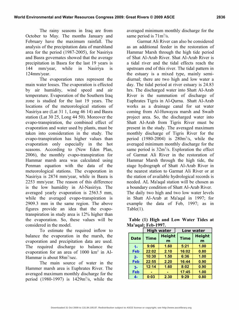
averaged minimum monthly discharge for the same period is 71m3/s. Garmat Ali River can also be considered as an additional feeder in the restoration of Hammar Marsh through the high tide period of Shat Al-Arab River. Shat Al-Arab River is a tidal river and the tidal effects reach the upstream end of this river. The tidal pattern in the estuary is a mixed type, mainly semi-diurnal; there are two high and low water a day. The tidal period at river estuary is 24.83 hrs. The discharged water into Shatt Al-Arab River is the summation of discharge of Euphrates Tigris in Al-Qurna. Shatt Al-Arab works as a drainage canal for sat water coming from Al-Huwayza marsh and Swaib project area. So, the discharged water into Shatt Al-Arab from Tigris River must be present in the study. The averaged maximum monthly discharge of Tigris River for the period (1980-2004) is 280m3/s, while the averaged minimum monthly discharge for the same period is 32m3/s. Exploration the effect of Garmat Ali River in the restoration of Hammar Marsh through the high tide, the stage hydrograph of Shatt Al-Arab River in the nearest station to Garmat Ali River or at the station of available hydrological records is needed. AL Ma'aqal station will be chosen as a boundary condition of Shatt Al-Arab River.The daily two high and two low water levels in Shatt Al-Arab at Ma'aqal in 1997; for example the data of Feb, 1997; as in Table(1).
Table (1) High and Low Water Tides at Ma'aqal; Feb-1997.
High water Low water
Date TimeHeight
mTime
Height m
1-Feb
9:06 1.60 5:21 1.0022:02 2.10 16:02 0.80
2-Feb
10:30 1.50 6:36 1.0022:55 2.20 16:44 0.90
3-Feb
12:14 1.60 8:02 0.90 - - 17:45 1.00
4- 0:03 2.30 9:29 0.80
2836World Environmental and Water Resources Congress 2009: Great Rivers © 2009 ASCE
Downloaded 31 Oct 2009 to 131.84.105.87. Redistribution subject to ASCE license or copyright; see http://www.ascelibrary.org

Feb 14:06 1.70 19:00 1.105-
Feb1:11 2.30 10:47 0.80
15:12 1.90 20:20 1.106-
Feb2:09 2.40 11:51 0.80
16:11 2.00 21:40 1.107-
Feb3:00 2.40 12:43 0.70
17:04 2.00 22:53 1.108-
Feb3:52 2.40 13:25 0.80
17:50 2.10 23:58 1.109-
Feb4:42 2.40 14:00 0.80
18:30 2.20 - - 10-Feb
5:29 2.40 0:59 1.1019:04 2.20 14:28 0.80
11-Feb
6:18 2.30 1:56 1.1019:39 2.20 14:54 0.90
12-Feb
7:12 2.20 3:00 1.2020:19 2.20 15:20 0.90
13-Feb
8:05 2.00 4:07 1.1020:58 2.20 15:44 0.90
14-Feb
9:04 1.80 5:11 1.1021:44 2.20 16:12 0.90
15-Feb
10:20 1.60 6:22 1.0022:32 2.10 16:47 0.90
16-Feb
12:10 1.50 7:41 0.9023:33 2.10 17:37 1.00
17-Feb
13:42 1.50 9:05 0.80- - 18:43 1.10
18-Feb
0:45 2.10 10:22 0.7014:49 1.60 19:58 1.20
19-Feb
1:47 2.20 11:17 0.7015:38 1.80 21:13 1.20
20-Feb
2:35 2.30 11:58 0.8016:22 1.90 22:15 1.30
21-Feb
3:16 2.30 12:32 0.8016:59 2.00 23:02 1.20
22-Feb
3:53 2.30 13:00 0.9017:30 2.10 23:40 1.20
23-Feb
4:30 2.30 13:27 1.0017:57 2.10 - -
24-Feb
5:03 2.20 0:16 1.2018:18 2.10 13:51 1.00
25-Feb
5:38 2.20 0:56 1.2018:39 2.20 14:10 1.00
26-Feb
6:13 2.20 1:41 1.2019:03 2.20 14:27 1.00
27-Feb
6:49 2.10 2:29 1.2019:30 2.20 14:39 1.00
28-Feb
7:23 2.00 3:18 1.2020:00 2.20 14:46 1.00
Topographical Data Analysis The topographical information is consists of two parts; The collected data from different sources and the topographical survey with ground equipments. During the surveying, collected data from different sources are available. The team focus attention towards newly satellite images that providing a scope details of Hammar Marsh, the length and location of channels or rivers, the intersection of the existing rivers or channels with each others, and specifying the location of the existing hydraulic structures. Using the ground equipments, 50 cross sections and 7 profiles are surveyed. The location of the 50 surveyed cross sections is in Al-Hammar marsh inner and outer boundaries with seven longitudinal profiles. 15 cross sections of Shatt Al-Arab River had been collected from MOWR, the Directorate of Gages which have been surveyed in 2006. These cross sections are started from Al-Qurna towards Al-Maqal. Table (2) shows the GPS of the collected cross sections.
Table (2) Location of Shatt Al-Arab River Cross Sections
Section Name East North
Sec 1 733240 3432822Sec 2 736675 3431203Sec 3 736256 3428553Sec 4 737905 3423778Sec 5 740808 3419814Sec 6 742967 3416669Sec 7 746129 3411977Sec 8 750656 3407584Sec 9 759993 3404755Sec 10 764771 3392047Sec 11 765740 3387447Sec 12 766277 3386570Sec 13 767431 3385152Sec 14 768565 3384244Sec 15 770365 3383385
2837World Environmental and Water Resources Congress 2009: Great Rivers © 2009 ASCE
Downloaded 31 Oct 2009 to 131.84.105.87. Redistribution subject to ASCE license or copyright; see http://www.ascelibrary.org

DEM and Storage CurvesThese surveying details are used to create the updated digital elevation model (DEM) concerning the Hammar Marshes. The DEM of Hammar Marsh is shown in Figure 3. With the help of Arc-View software, the updated DEM will provide a powerful background for the analysis, particularly the stage-volume and area-elevation curves of the marsh area within any scenario of inundation. In addition to that, DEM grids are necessary in the construction of the numerical model as a geometric data. The stage-volume and area-elevation curves are shown in Figures 15 and 16. The increment in surface area due to the water level variation gives good idea about the best required amount of water to inundate a reasonable area of the marsh. From the percentage increment of surface area, water level of 2.7 m AMSL is the goal of our study. This water level will provide storage of 1477milion m3 with a surface area of 1331 Km2.
3 Model Results and Discussion Studying the tidal effect of Shatt Al-Arab on Hammar Marsh through Garmat Ali River needs an estimation of the discharged tidal water into the marsh during the high water tide. A hydrologic routing model and steady / unsteady hydrodynamic circulation model (RMA2) were prepared to analyze flow pattern inside the marsh. A finite element meshes of about 4000 elements have been developed over an area of 1552 km2 is shown in Figure 4. The model inlets are presented along the direction of the proposed locations of feeding, the first location is the ends of Um Nakhla project canals, the second location is the main canals of Al-Malha project and the last location is the main two canals of Al-Shafi and Al-Ghumaeech project. The outlet is located near
the drying embankment in the south-east part of the marsh near Garmat Ali River. The culverts along Ar Rumailla road are also considered. The meshes are built using an adaptive tessellation technique for triangle elements and a patch technique for rectangular one. A total number of 80 cross sections were constructed and obtained from the DEM through the Arc-View GIS with HEC- GEO-RAS extension. These cross sections are covering the marsh area with different spacing according to the hydraulic requirements. The hydrologic data of the recent years have been used in the implementation of the hydraulic model. The existing marsh hydraulic structure (Ar Rumaila culverts are taken into Consideration in the model. The boundary conditions are defined as a flow hydrograph in all feeding locations while the downstream boundary condition is considered as a stage hydrograph taken into consideration the tidal effect to investigate the location of stagnant and to estimate the amount of water that may enter from the tidal phenomena with and without a hydraulic structure. The Manning n is to be taken 0.045 for non vegetated portion when the water depth becomes more than 2 m; while it is equal to 0.070 for vegetated areas when the water depth becomes less than 2 m. The value of eddy viscosity affects stability and turbulent fluid characteristics. Ultimately, more than one technique was adapted in the definition of the eddy viscosity number. Depending on the results of model, a construction of a head regulator on Garmat Ali River with a designed discharge of 500m3/sec near the navigation locks on the drying embankment is necessary to control tidal flow, as well as a gated structure in Ar Rumaila road site instead or with the existing 334 pipes. The designed discharge of the structure is 600m3/sec. The locations of the proposed hydraulic structures are shown in Figure 5.
2838World Environmental and Water Resources Congress 2009: Great Rivers © 2009 ASCE
Downloaded 31 Oct 2009 to 131.84.105.87. Redistribution subject to ASCE license or copyright; see http://www.ascelibrary.org

The effect of tidal wave on discharged water into or out of the marsh without a hydraulic structure at the down stream end is shown in Figure 6. The net inflow water into the marsh is started when water level at Garmat Ali River is higher than 2.1 m. The period of 25 days will provide an extra storage of 64.8 million m3 within the marsh area during the high water tide. In other words it represents about 15% reduction in the required inflow discharges from all feeders for the purpose of restoration. The depths of water, inundated areas and velocity trace are shown in figures 7, 8, 9, 10, 11 and 12. The green color in the all figures concerning water depth represents the shallow regions while the blue color represents the deep areas. The velocity circulations are inserted as a hyperlink to explain the locations of stagnant velocities, locations of high velocity and the inundated areas within the marsh. It is worthwhile to notice that the vegetation effects have been taken into consideration in the analysis of flow circulation within the region in terms of short velocity vectors and islands. These figures are repeated for three different discharge scenarios:- The normal required discharge of 200m3/sec.- The minimum required discharge of 80m3/sec.- The maximum Flood discharge of 600m3/sec. 4 Conclusions
1- 15% reduction in the required inflow discharges from all feeders for the purpose of restoration can be acheived.The net inflow water into the marsh is started when water level at Garmat Ali River is higher than 2.1 m. The period of 25 days will provide an extra storage of 64.8 million m3 within the marsh area during the high water tide.
2- Construction of a head regulator on Garmat Ali River with a designed discharge of 500m3/sec near the navigation locks on the drying embankment is necessary to control tidal flow, as well as a gated structure in Ar Rumaila road site instead or with the existing 334 pipes. The designed discharge of the structure is 600m3/sec.
5 References1. Al-Samari, M. J. “Irrigation and Drainage Projects in Messan, Basra, and Nasiriya”, Ph.D. Thesis, University of Baghdad. Iraq 1999.2. ”Building a Scientific Basis for Restoration of the Mesopotamian Marshlands”, The Iraq Foundation, 2003. 3. ”Desk Study on the Environment in Iraq”, UNEP, 2003.4. ”Environment in Iraq: UNEP Progress Report”, 2003.5. ''General Scheme of Water Resources and Land Development in Iraq", Ministry of Irrigation of Iraq. Moscow-Baghdad 1982.6. “HEC-RAS Manual”, US Army Corps of Engineers, Hydrologic Engineering Center HEC, USA Oct 2002.7. “HEC Geo-RAS Manual”, US Army Corps of Engineers, Hydrologic Engineering Center, USA Oct 2002.8. ”Iraq Marshlands Restoration Program”, U.S. Agency for International Development, Iraq 2004.9. "Mathematical Model of Flow in Hammar Marsh, Restoration of Central Marshes Study Volume V”, AL-Tawasul International Company for Engineering Design and Consultants, CRIM, Baghdad, Iraq 2006.10. “Meteorological Stations Records of Southern Region of Iraq”, Ministry of Transportation and Communications, 2006.11. ”The Mesopotamian Marshlands: Demise of an Ecosystem”, UNEP, 2001.
2839World Environmental and Water Resources Congress 2009: Great Rivers © 2009 ASCE
Downloaded 31 Oct 2009 to 131.84.105.87. Redistribution subject to ASCE license or copyright; see http://www.ascelibrary.org

12. "Navigation Study of Euphrates River", SOGREAH Consulting Engineering, Grenoble, France 1986.13. “NEW EDEN Master Plan for Integrated Water Resources Management in the Marshlands area”, Ministry of Water Resources, Ministry of Environment, Ministry of Municipalities and Public Works which Prepared in cooperation with the Italian Ministry for the environment and Territory and the Free Iraq Foundation, Italy April 2006.14. SMS Manual, Environmental Modeling Research Laboratory, Brigham Young University, USA, Dec 2003.15. "Shatt Al-Arab Project", Feasibility report, POL Service and Hydroproject, Basrah, Iraq 1981.16. “Support for the Environmental Management of the Iraqi Marshes”, UNEP and AUB, Volume II-B, 1988.17. "The problem of high water levels in Al-Hammar Marsh", Ministry of Irrigation of Iraq, Al-Furat Center1989.18. "The Study of Al-Hammar Marsh and Shatt Al-Arab River", Ministry of Irrigation of Iraq, Al-Furat Center 1987. 19. "Topographical Surveying, Restoration of Hammar Marshes Study Volume VI", AL-Tawasul International Company for Engineering Design and Consultants, CRIM, Baghdad, Iraq 2006.20. .”The Iraqi Marshlands: A Human and Environmental Study”, AMAR International Charitable Foundation, Iraq 2003. 21. “Water and Sanitation”, United Nation and World Bank, Working Paper, October 2003.
2840World Environmental and Water Resources Congress 2009: Great Rivers © 2009 ASCE
Downloaded 31 Oct 2009 to 131.84.105.87. Redistribution subject to ASCE license or copyright; see http://www.ascelibrary.org

Ma in O u tfu l l D ra in
Beni Hassan
Sook Al-Sheukh
B a g h d a d - B a s r a h R a i lr o a d
Swaib River
Tigris
Maisan River
Euphrates River
Shatt Al-Arab
Ar R
umay
lla R
oad
Al-Fuhood
Hammar Marsh
Ar rumaylla road.shpEuphrates- shatt al- arab.shpOil fields.shpRailroad.shpRoads.shpHumedy.shpTwin balance reservoirs.shpMOD
40 0 40 80 Kilometers
S
N
EW
Figure 2: Main Obstructions before 1990
2841World Environmental and Water Resources Congress 2009: Great Rivers © 2009 ASCE
Downloaded 31 Oct 2009 to 131.84.105.87. Redistribution subject to ASCE license or copyright; see http://www.ascelibrary.org

2842World Environmental and Water Resources Congress 2009: Great Rivers © 2009 ASCE
Downloaded 31 Oct 2009 to 131.84.105.87. Redistribution subject to ASCE license or copyright; see http://www.ascelibrary.org