The Kabul, Kunduz, and Helmand Valleys and the national ...
462
Foreign field Research Program << tutored by Other of Naval Research Report No. 5 The Kabul, Kunduz, and Hebnand Valleys and The National Economy of Afghanistan A study of Regional Resourced and the Comparative Advantages of Development .Aloys Arthur Michel Digitized by Google
-
Upload
khangminh22 -
Category
Documents
-
view
1 -
download
0
Transcript of The Kabul, Kunduz, and Helmand Valleys and the national ...

Foreign field Research Program
<< tutored by Other of Naval Research
Report No. 5
The Kabul, Kunduz, and Hebnand Valleys
and
The National Economy of Afghanistan
A study of Regional Resourced and the
Comparative Advantages of Development
.Aloys Arthur Michel
Digitized by Google
Foreign Field Research Program Sponsored by- Office of Naval Research Report No. 5
[THE KABUL, KUNDUZ, AND HELMAND VALLEYS AND THE NATIONAL ECONOMY OF AFGHANISTAN
A study of Regional Resources and the Comparative Advantages of Development
Aloys Arthur Michel //
National Academy of Sciences - National Research Council Washington, D. C.
1959
Digitized by Google
6^7
NATIONAL ACADEMJf OF SCIENCES - NATIONAL RESEARCH COUNCIL Division of Earth Sciences
This is the fifth of a series of reports to be issued under the Foreign Field Research Program administered by the Divi- sion of Earth Sciences, with the financial sponsorship of the Geography Branch, Office of Naval Research.
Submitted in partial fulfillment of the requirement for the degree of Doctor of Philosophy, under the Joint Committee on Graduate Instruction, Columbia University.
ii ,;o,_cL£3/^J^dby<
iii
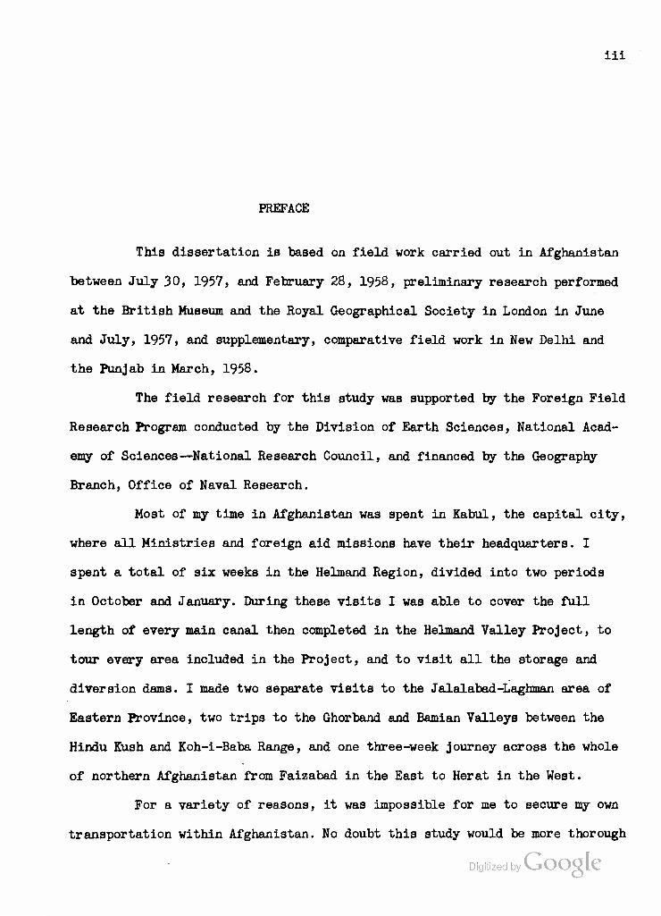
PREFACE
This dissertation is based on field work carried out in Afghanistan
between July 30, 1957, and February 28, 1958, preliminary research performed
at the British Museum and the Royal Geographical Society in London in June
and July, 1957, and supplementary, comparative field work in New Delhi and
the Punjab in March, 1958.
The field research for this study was supported by the Foreign Field
Research Program conducted by the Division of Earth Sciences, National Acad-
emy of Sciences—National Research Council, and financed by the Geography
Branch, Office of Naval Research.
Most of my time in Afghanistan was spent in Kabul, the capital city,
where all Ministries and foreign aid missions have their headquarters. I
spent a total of six weeks in the Helmand Region, divided into two periods
in October and January. During these visits I was able to cover the full
length of every main canal then completed in the Helmand Valley Project, to
tour every area included in the Project, and to visit all the storage and
diversion dams. I made two separate visits to the Jalalabad-Laghman area of
Eastern Province, two trips to the Ghorband and Bamian Valleys between the
Hindu Kush and Koh-i-Baba Range, and one three-week journey across the whole
of northern Afghanistan from Faizabad in the East to Herat in the West.
For a variety of reasons, it was impossible for me to secure my own
transportation within Afghanistan. No doubt this study would be more thorough
Digitized by VJOOQLC

iv
and more immediate had a vehicle been at my constant disposal, but I did
manage to cover over 5000 miles by car and plane within the country. As a
consequence, I feel greatly indebted to the persons who made transportation
available at various times, as well as to those who facilitated the "house-
keeping" arrangements for me and my wife. These include Mr. Sheldon T. Mills,
United States Ambassador to Afghanistan; Dr. Najib-Ullah, Afghan Ambassador
to the United States; Dr. Christy Wilson of the Kabul Community Church; Dr.
Harold Amoss of the Asia Foundation; Drs. Ralph Spence, Willis Griffin and
Meynard Eyestone of the Teachers College, Columbia University Team in Kabul;
Mr. Nathaniel Patterson, Area Director for the International Cooperation
Administration in the Helmand Valley; Drs. Abdul Kayeum and Abdul Wakil,
Vice Presidents of the Helmand Valley Authority; and Mr. T.Y. Johnston of
Morrison-Knudsen Afghanistan, Inc.
A second round of thanks is due to the many persons who contributed
information, criticism and guidance in the preparation of this study. An ex-
haustive list of these sources will be found in the Table of Interviews ap-
pended to the Bibliography, but the contributions made by certain individuals
were so outstanding as to require acknowledgement in this Preface. These persons
include Robert W. Snyder, Director of the United States Operation Mission
(International Cooperation Administration) in Afghanistan; H.A. Swanson, Chief
of the Industry, Mining and Surface Transportation Division at the Mission;
Paul Johnson, Chief of the Agriculture and Natural Resources Division; and
James Cudney, Chief of the Communications Media Branch. Robert H. Burns and
William Anderson, of the University of Wyoming Team, and Mohammed Payendah,
of the Vocational-Agricultural School at Kabul, provided useful information
on agricultural and pastoral techniques in Afghanistan, as well as excellent
traveling companions on a road-tour of northern Afghanista^tizd&by GeorgeCjLc
Cressey of Syracuse University accompanied us on the early portion of this
tour and furnished stimulating suggestions and field interpretations. His
Excellency Governor Gholam Haider Adalat of Maimana Province vas most
generous in taking time to discuss the problems of the karakul industry
during a visit to his province. Dr. Arnold J. Krochmal, Research Director
of the Vfyoming Team, gave much assistance regarding Afghan horticulture,
that of the Jalalabad region in particular. Deputy Director Mohammed Yusuf
Mail of the Royal Afghan Ministry of Agriculture, and Messrs. Mohammed
Omar and Faizal Rahim, his assistants, furnished some of the more recent
and reliable statistical data relating to crop production and planting
schedules. Deputy Minister Saiyid Alishah Mazumi and Messrs. Ghulam Azizi,
Mohammed Massa and Abdullah Rahimi, all of the Ministry of Mines and In-
dustries, furnished valuable information on industrial programming and coal
and petroleum exploitation in Afghanistan, and facilitated entree into RGA
enterprises.
General thanks are due to the staff of the new Ministry of Planning,
and especially to Dr. M.M. Hassanein, the United Nations Adviser to that
Ministry, whose assistance made possible the author's analysis of recent
Afghan foreign trade statistics. Bryan Baas, then Acting Economic Attache at
the United States Embassy, and Edwin Bohlen, Second Secretary at the Embassy,
also provided assistance with regard to Afghan trade patterns. Dr. Peter G.
Pranck, of Robert College, Istanbul, furnished valuable interpretations of the
Afghan economy during his visit to Kabul in August, 1957, and during my visit
to Istanbul at the end of March, 1958. He was also good enough to read and
criticize a part of the manuscript.
Dr. Daniel Hopkinson, Resident Representative at the United Nations
Digitized by VJOOQLC
vi
Technical Assistance Mission in Kabul, was most cooperative in providing
access to Mission materials and introduction to Mission personnel. Of the
latter, I am especially indebted to R.P. Davidson, Albert T. Peterson, and
Hans H. Buchmann, all of the Food and Agriculture Organization, for their
assistance with and criticism of the chapter on the Kunduz Region.
Turning to the Helmand Region, several members of the Helmand Valley
Authority, in addition to Drs. Kayeum and Wakil, must be thanked for their
aid. These include Carl 0. Kohler, Chief Adviser to the Authority, and
n»haffar Shuja, hydrologist and watermaster. Within the International Coop-
eration Administration in the Helmand, Nathaniel Patterson did more than
any other single person to insure the success of my Helmand studies, but
grateful appreciation must also be extended to P.P. Fitzhugh, the expert
in animal husbandry, I.A. Heckmiller, hydrologist, and Ralph Bailey, public
health officer. Richard Hughes of the Wyoming Team, who formerly ran the
Marja experimental farm, provided invaluable assistance in familiarizing
us with the Helmand Project areas. The same is true of George Anderson of
the Morrison-Knudsen Afghanistan office at Kandahar, where George Byrne and
Dale Shockley furnished access to certain useful reports and surveys concer-
ning the Project. Mr. Shockley at Kandahar and Dr. Claude Fly at the San Fran-
cisco office of Morrison-Knudsen read and criticized the Helmand portions of
this study, and while I cannot agree with all of their comments, I am grateful
to them for their assistance. Ralph G. Wadsworth of the Tudor Engineering
Company, Washington,, D.C., is thanked for reading the same portions and for
his comments.
Finally, I wish to thank in no perfunctory manner my wife, Constance
George Michel, for her unstinted encouragement and assistance both while we
were in the field as well as in the preparation of this manuscritfFI.Both phases igi ize y ^
of the work required patience, persistence and devotion, in all of which she

vii
excelled. Her own study of Afghan social geography, prepared as a Master,s
Essay for Columbia University, provides a valuable supplement to the fol-
lowing work which concentrates on the physical and economic aspects of
Afghan geography.
The present dissertation was prepared under the direction of
John E. Orchard, Professor of Economic Geography and Chairman, Committee
on Advanced Instruction and Degrees in Geography, Columbia University.
Dr. Orchard*s guidance was of great help in designing and executing this
study, as well as in presenting the results in what is hoped to be a
logical and correct manner. The work has also benefited from a number of
suggestions made by the following members of the Columbia University faculty:
Phillip Bacon, Associate Professor of Geography in Teachers College; Charles
Issawi, Associate Professor of Near and Middle East Economics; Willard J.
Jacobson, Associate Professor of Natural Sciences in Teachers College; and
Leonard Zobler, Associate Professor of Geography in Barnard College.
• • •
Acknowledgement is gratefully extended to the United States Inter-
national Cooperation Administration, and particularly to Afghanistan Desk
Officers Veston B. Drake and Ruth Fitzmaurice, for unfailing cooperation
over the course of this study and for the use of the following reports:
Kimler, Courtney. Field Survey of Afghanistan's Industry, Transportation, and Electric Power Resources (TOICA A-144)• Prepared for International Cooperation Administration, Kabul, Afghanistan. Kabul: April, 1956.
Koebig and Koebig, Consulting Engineers. Report on Transportation Facil- ities of Afghanistan and Pakistan. Prepared for International Coop- eration Administration, Los Angeles: 1957.
Tudor Enginerring Company, Inc. Report on Development of Helmand Valley, Afghanistan. Prepared for the International Cooperation Administra- tion. Washington: Tudor Engineering Co., 1956.
Digitized by Google
\
viii
A NOTE ON AFGHAN STATISTICS
The fiscal and statistical systems which "developed" nations have
come to regard as prerequisite to governmental administration and commercial
activity are lacking in most of the "underdeveloped" nations of the world.
Afghanistan is no exception. Indeed, there may be some truth in the notion
current among Western anthropologists that some societies have as little re-
gard for statistical compilation as other societies have exhibited for recorded
history. This is to say that the value attached to maintaining periodical series
of data is much greater in some cultures than in others, and that the Western
researcher who ventures outside his own cultural cocoon may find himself in
a sort of statistical vacuum.
None of the foregoing is presented as adverse criticism of the non-
statistical societies. Absence of statistical data becomes a disadvantage only
when such a society attempts to adopt the business or administrative methods
of the Western world or, conversely, when a researcher attempts to analyze
such a society in the usual Western terms. But the author merely wishes to
caution his reader, at the start, that he must not expect the neat periodical
tabulations, correlations and computations to which he perhaps has been ac-
climated. The following study is one in which a great many qualitative state-
ments and judgments must perforce be made without the usual statistical under-
pinning which Western scholarship assumes as a matter of course.
Lest the reader surmise, however, that the author is merely attempting
to provide himself with a carte blanche for unsubstantiated generalization, let
Digitized by VJOOQLC

ix
it be said that wherever reasonably accurate statistical materials were
discovered they have been embodied in this study. Furthermore, use has been
made of some data that are likely to be accurate within certain limits, and
these limits have been indicated in the text or in footnotes. Finally, lest
the reader further surmise that the author has failed to uncover valid
statistical materials which are in existence but buried in some dusty minis-
terial closets, I should like to quote from two reports by Dr. Gregory Frum-
kin of the Geneva Office of the International Labor Organization who served
as United Nations Statistical Adviser to Afghanistan in 1951-1952. Dr. Frum-
kln had access, on an official level, to many sources which were barred to
the present author, and his reports provided some of the more useful data
and interpolations which I have embodied into this study. Nevertheless, Dr.
Frumkin felt constrained to state:
Last year a prominent Afghan told me: "There is no such thing as Afghan statistics". He added that it would take many years before a satis- factory statistical organization could be set up and made to work properly. I think he was right.
The student, expecially the Westerner, must not be deceived by the statistical vacuum in this country and by its primitive technical level. In Western countries people are accustomed to learn about a country's conditions through statistical and similar information. Books, reports, balance sheets are the main investigating tool of a student. In Afghan- istan he has to discover and study things on the spot. A book or a report, far from being the starting point of an enquiry, will be its terminus.
Such tentative production data as have recently been collected by the Ministry of Finance as a rule represent guesses made with the assistance .. of village eldermen, referred to as "grey beards, with great experience".
And in his Synopsis of Afghan Agricultural Statistics. Dr. Frumkin remarks:
Agricultural "statistics" which are under the responsibility of the Ministry of Finance, are embodied in a number of books and heaps of big sheets, but the subject appears to be somewhat outside the control of the Statistical Office of the Ministry.
Gregory Frumkin, Report on Journey to the Northern Provinces, in files of United Nations Technical Assistance Mission, Kabul, Afghanistan. (Kabul, 1952) (Mimeographed.)
Digitized by VJOOQIC
Such data are a by-product of taxation. It should be noted, how- ever, that a) the administrative staff frequently lacks the essential qualifications, b) there is no proper cadastral survey, c) there are no reliable data either on area or on production. Much of the information quoted or reported as to area appears to represent obsolete "estimates'1
made in times when taxation was mostly in kind. Current records of pro- duction do not exist.^
In all fairness to the Afghan Government, it must be pointed out
that attempts are being made to correct the situation which Frumkin describes
above. Some of his own recommendations have already borne fruit. The present
United Nations Statistical Adviser, Dr. Mustafa Mohammed Hassanein, is doing
excellent work with a young and enthusiastic staff at the new Ministry of
Planning, and has already succeeded in producing a fairly reliable series of
Import-export data which are used in Part II of this study. In addition, the
Public Administration Advisory Team, provided by the United States Inter-
national Cooperation Administration to work with the Ministry of Finance, is
aiding in the introduction of a modern system of fiscal accounting. However,
the situation in 1957-1958 still bore sufficient resemblance to that encoun-
tered by Dr. Frumkin six years before to require this preliminary warning to
the reader of the present study. The author could well adopt a third excerpt
from Dr. Frumkin's reports as a concise summation of his use of certain Afghan
statistics in this study:
An endeavor has been made by me to present the data in a logical and uniform way, accompanied by explanatory notes. The neat presentation of the subject should not deceive the reader; the data cannot in any way be con- sidered as "statistics". However inadequate and misleading they may be, it is hoped that the assembling of such data in an intelligible way may facil- itate the critical appraisement of the situation with regard to factual in- formation. Agricultural statistics are, in the case of Afghanistan, still to be created.^
Gregory Frumkin, Synopsis of Afghan Agricultural Statistics. United Nations Technical Assistance Mission, Kabul. (Kabul: December, 1952), p. 1. (Mimeographed.)
2Ibid.. p. 2. Digitized by Google

xi
TABLE OF CONTENTS
Page PREFACE ii
A NOTE ON AFGHAN STATISTICS vii
TABLE OF CONTENTS x
LIST OF TABLES xlii
LIST OF MAPS xvii
GLOSSARY xviii
INTRODUCTION: THE LOGIC OF THE STUDY 3
Historical Setting Geographical Setting Political and Economic Considerations Methodology
PART I. REGIONAL STUDIES Chapter
I. THE KABUL VALLEY 23
The Kabul River The Jalalabad Oasis Kabul City and Environs Jabal Seraj and Gulbahar
II. THE KUNDUZ VALLEY AND RELATED AREAS 76
The Upper Valley The Pul-i-Khumri Node The Baghlan Node The Kunduz Node Mazar-i-Sharif and Maimana
III. THE HELMAND VALLEY: GEOGRAPHICAL AND HISTORICAL SETTING 139
The Helmand and Arghandab Rivers History of the Helmand Valley Project
Digitized by Google

xii
IV. THE HELMAND VALLEYs THE PROJECT AREAS ALONG THE HELMAND 172
Virgin Lands - Nad-i-Ali and Marja Stabilized Areas - Kajakai to Girishk and Sera;) Enlarged Areas - Shamalan and Darwesnan Prospective Areas - Garmsel, Chakansur and
Dasht-i-Bakwa
V. THE HELMAND VALLEY: THE PROJECT AREAS ALONG THE ARGHANDAB 207
Reinforced Areas - North and Central Arghandab Doubtful Potential - The Tarnak Area
VI. HYDROELECTRIC, INDUSTRIAL AND COMMERCIAL FEATURES OF THE HELMAND VALLEY PROJECT 223
VII. EVALUATION OF THE HELMAND VALLEY PROJECT WITHIN ITS OWN REGION 235
PART II. INTERREGIONAL ANALYSIS
VIII. THE DIRECTION OF AFGHAN ECONOMIC DEVELOPMENT 257
Disadvantages of Mineral Development at the Present Time
Advantages of Increased Domestic Production and Processing of Agricultural and Pastoral Commodities
H. THE LOCATION OF AFGHAN ECONOMIC DEVELOPMENT 300
Cotton Sugar Beets Citrus Fruits Deciduous Fruits and Nuts Cattle Hides and Leather Sheep and Goat Skins Karakul Wool
I. POWER RESOURCES AND REQUIREMENTS OF INDUSTRIAL DEVELOP- MENT 348
Hydroelectricity Coal Petroleum
Digitized by Google
xiii
XI. TRANSPORTATION RESOURCES AND REQUIREMENTS OF DEVELOPMENT. 365
Road Patterns and General Conditions Regional Road Conditions and Prospects for Extension
and Maintenance Selection, Standardization, and Maintenance of
Equipment
XII. THE THREE REGIONS AND THE NATIONAL ECONOMY OF AFGHAN- ISTAN 403
The National Economic Situation Afghan Developmental Policy: Economic, Social and
Political Factors Evaluation
BIBLIOGRAPHT 429
CHRONOLOGICAL LIST OF INTERVIEWS AND VISITS MADE IN AFGHANISTAN FOR THIS STUDY 435
Digitized by Google

xiv
LIST OF TABLES
Table Page 1. Jalalabad Crop Rotation Patterns 37
2. Grain Production in Kabul and Parwan Provinces .... 57
3. Wheat Varietal Tests at Ali-abad Station, Kabul. ... 61
4-. Kunduz River Discharge at Pul-i-Khumri Based on Records for the Seven Afghan Years (1329-1335) or March 21, 1950 Through March 20, 1956 33
5. Production at Pul-i-Khumri Cotton Textile Plant. ... 87
6. Acreages Served by Canals in the Pul-i-Khumri Node . . 97
7. Acreages Served by Canals in the Baghlan Node 93
8. Supply of Sugar Beets for Processing Plant at Baghlan. 101
9. Varietal Test of Sugar Beets at Baghlan, 1952 102
10. Recovery and Production of Sugar at Baghlan 105
11. Meteorological Data for Thirty-One Months at Baghlan . 110
12. Canals and Acreages Served in the Kunduz Node 124
13. Acres Irrigable From the Kunduz River Alone 128
14. Average Yield of Leading Crops in Kataghan Province, 1956 Harvests (in pounds per acre) 129
15. Cotton Production in Mazar-i-Sharif Province, 1951 . . 134
16. Annual Run-off of Helmand and Arghandab Rivers in Acre Feet 142
17. Mean Rainfall and Evaporation at Kandahar in Inches. . 14.3
18. Mean Rainfall and Evaporation at Chah-i-Anjirs or Marja in Inches 144
Digitized by Google

XV
19. Mean Monthly Maximum and Minimum Temperatures in Degrees Fahrenheit ..,.. 144,
20. Nad-i-Ali: Estimated Percentages in Each Land Class. ' 173
21. East Marjas Estimated Percentages in Each Land Class 181
22. Seraj: Estimated Percentages in Each Land Class. . . 188
23. SharonIan and Darweshan - Land Use in 1947 (in Acres) 190
24.. Lower Helmand: Estimated Percentages in Each Land Class 202
25. Lower Helmand Land Use in 194-7 203
26. Land Use at Beginning of Helmand Valley Project (1947) 212
27* Arghandab Areas: Estimated Percentages in Each Land Class. , 213
28. Tarnakt Estimated Percentages in Each Land Class . . 216
29* Dried Fruit Production at Pushtoon Industries} Kandahar, 1950 231
30. Approximate Estimate of Number of New Farms in Ulti- mate Development of Upper Helmand Valley ...... 237
31. Koh-i-Khan Nashin Iron Ore Assay 264
32. Afghan Exports,1951-52 Through 1956-57 in Millions of Afghanis 267
33. Afghan Exports 1953-54 Through 1955-56 By Quantity . 268
34. Afghan Imports 1951-52 Through 1956-57 in Millions of Afghanis 271
35. Afghan Imports 1954-55 Through 1956-57 By Quantity . 272
36. Existing and Proposed Import Tariff Rates 276
37. Afghan Trade in Cotton and Cotton Piece Goods, 1954-55 Through 1956-57 279
38. Afghan Exports of Sheep and Goat Skins, 1954-55 Through 1956-57 286
39. Afghan Broadtail Skin Exports, 1954-55 Through 1956-57 . . DkjitieecibA. 288

XVl
40. Afghan Wool Exports, 1954-55 Through 1956-57 289
41. Afghan Karakul Exports, 1954-55 Through 1956-57. ... 293
42. Afghan Dried Fruit Exports, 1954-55 Through 1956-57. . 294
43. Afghan Fresh Fruit Exports, 1954-55 Through 1956-57. . 294
44" Potential Cotton Groving Areas in the Helmand Valley (in acres) 306
45. Cotton Varietal Tests at Marja in 1955 308
46. Planting Methods for Cotton at Marja in 1955 308
47. Some Suggested Rotations for Sugar Beets 314
48. Average Fruit Exports from Kabul Area, 1943-44. Through 194.5-46 in metric tons 320
49. Average Fruit Exports from Kandahar Area, 1943-44 Through 1945-46 in metric tons 320
50. Afghanistant Livestock Population 326
51. Distribution of Karakul Sheep 334
52. Karakul Exports and Flocks 336
53. Comparative Regional Advantages for Production and Processing of Key Agricultural and Pastoral Commodi- ties 347
54. Afghanistan: Coal Production 1950-51 to 1956-57, in Short Tons 355
55. Comparative Regional Advantages in Power for Processing Industries 363
56. Afghan Highway Construction Cost Estimates 374
57. Afghan Highway Construction Cost Estimates 377
58. Afghanistan Highways - Freight Traffic - 1956-57 ... 381
59. Comparative Costs and Transit Time /in Rs/ Shipment of 2000 Lbs. Merchandise Karachi to Kabul 382
60. Comparative Regional Advantages in Road Transportation 401
61. Comparative Regional Advantages for Production of Key Commodities Including Power and Transportation Consid- erations 402 *
xvii
62. Possible Future External Debt of Afghanistan 405
63. Currency Issued and in Circulation, and Free Market Value of the Afghani 406
64. Cost of Living in Kabul 407
65. Ad Valorem Duties on Certain Imported Goods 409
Digitized by Google
xviii
LIST OF MAPS
Map Page 1. Afghanistan 2
2. The Kabul Valley of Afghanistan 22
3. The Kunduz Valley and Mazar-i-Sharif Area of Afghanistan 75
4-. The Kunduz Valley: Pul-i-Khumri and Baghlan Nodes . 81
5. The Kunduz Valley: Kunduz Node 103
6. The Helmand Valley of Afghanistan Showing Areas Subject to Development 133
7. The Helmand Valley in the Vicinity of Laahkar Gah and Girishk 171
8. The Arghandab Valley in the Vicinity of Kandahar. . 206
9. Old Canals Fed From the South Canal Wasteway in the Vicinity of Kandahar, Afghanistan 210
10. Road Network of Afghanistan and External Rail Connections 364
Digitized by Google
xlx
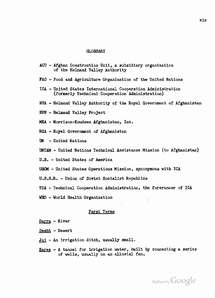
GLOSSARY
ACU - Afghan Construction Unit, a subsidiary organization of the Helmand Valley Authority
FAO - Food and Agriculture Organization of the United Nations
ICA - United States International Cooperation Administration (formerly Technical Cooperation Administration)
HVA - Helmand Valley Authority of the Royal Government of Afghanistan
HVP - Helmand Valley Project
MKA - Morrison-Knudsen Afghanistan, Inc.
RGA - Royal Government of Afghanistan
UN - United Nations
UNTAM - United Nations Technical Assistance Mission (to Afghanistan)
U.S. - United States of America
USQM - United States Operations Mission, synonymous with ICA
U.S.S.R. - Union of Soviet Socialist Republics
TCA - Technical Cooperation Administration, the forerunner of ICA
WHO - World Health Organization
Farsi Terms
Darra - River
Dasht - Desert
Jui - An irrigation ditch, usually small.
Karez - A tunnel for irrigation water, built by connecting a series of wells, usually on an alluvial fan.
Digitized by Google
INTRODUCTION
THE LOGIC OF THE STUDY
Digitized by Google

•v..^-. VJ... •
Digitized by Google
INTRODUCTION THE LOGIC OF THE STUDY
Historical Setting
The Kingdom of Afghanistan was formed as a national state by
Ahmad Shah Durrani in the middle of the eighteenth century. Following the
death of the Persian Emperor Nadir Shah in 1747, the Afghan contingents of
his army withdrew to Kandahar where they chose their general, Ahmad Khan,
to serve as King. He then chose the title Ahmad Shah Durrani. Under his
leadership, the Abdali and Ghilzai tribal confederations united the Persian
provinces north and south of the Hindu Kush with their diverse ethnic groups:
Tajiks, Uzbeks and Turkmen in the North, Hazara Mongols in the central moun-
tains, and Pushtuns, or "true Afghans", in the South. With the third battle
of Panipat and the Afghan capture of Delhi, the Afghan Empire reached its
zenith in 1761.
Ahmad Shah Durrani's successors were less successful campaigners,
and had to contend with the power of the British in India and the British-
supported Sikhs in the Punjab and Peshawar areas. Civil strife and dynastic
quarrels were added to external threats, and it was only in 1880 that the
kingdom emerged in its present configuration. Thanks to a Memorandum of
Obligation with the British, the Amir Abdur Rahman was able to secure Herat
and the northwestern areas against Persian and Russian threats. The western
and northern boundaries were surveyed by British and British-Russian commissions
between 1885 and 1903. As the price of British support0ig^pwje|y^^^fghanistan

had to surrender control over tribal areas In the Northwest Frontier and
over its own foreign policy.
The position of Afghanistan as a "buffer state" thus dates from the
period when the Russian and British Empires were thrusting towards each other
in South Central Asia, and particularly from the 1907 Anglo-Russian general
settlement which cleared the way for their alliance in the First World War.
As the lines were drawn, therefore, Afghanistan was not forced to choose
between Russia and Britain, and managed to resist the invitations of Germany
and Turkey to raise the Moslems in a jihad against the Allies. In 1919, how-
ever, King Habibullah was assassinated. His young successor, Amanullah Khan,
undoubtedly influenced by the need to consolidate his position, launched an
attack on the Northwest Frontier in an attempt to recover the tribal areas.
Despite the success of General Nadir Khan in the Kurram Valley, the month-long
conflict was abortive as far as Afghan aims were concerned, and after British
and Indian forces had re-invaded Afghanistan the Amir sued for peace. Nego-
tiations lasted for two years, by which time the British, more from weariness
than from weakness, were ready to concede Afghanistan full independence and
control over its foreign affairs. Since the Afghans had already entered into
direct relations with the Soviet Union, and since it would have required a
full-scale campaign to restore the old domination, the British did little more
than recognize the fact that Afghanistan was prepared to plot its own diplomatic
course in South Central Asia and the world.
Indeed, for most of the ensuing decade, King Amanullah did just that,
both domestically and in foreign policy. After introducing a plethora of reforms,
he embarked in 1927 on a tour of European and Middle Eastern capitals and the
Soviet Union. He was apparently deeply influenced by what he saw, particularly
Digitized by VJOO^LC in Turkey. But he lacked the degree of domestic control necessary to impose his
more radical reforms in the face of strong opposition from the conservative
religious mullahs who succeeded in turning the tribes against him. When a
local brigand led a rising against Kabul in 1929, the disaffected army proved
unequal to the task and Amanullah was forced to abdicate and flee. The en-
suing chaos and carnage in Kabul brought General Nadir Khan back from a
health resort in France. After initial difficulties due to his lack of per-
sonal wealth, he was able to conciliate the tribes, organize an army and
recapture the capital.
Nadir Khan was proclaimed King in October, 1929, and took up the
tasks of restoring internal order and inaugurating a more moderate and
reasonable program of modernization. Indeed, the wisdom of Nadir Shah lay
in his ability to distinguish the practicable from the impossible, as well
as in a concentration upon economic rather than social reforms. Nadir Shah
was tragically assassinated in 1933, but his son, Zahir Shah, has continued
his policies with considerable success since that time. Afghanistan obtained
a new constitution, giving it the form of a limited monarchy. Actually, the
office of Prime Minister was filled by one of the King's uncles until 1953,
and since then by his cousin, Prince Sardar Mohammed Daud, so that close
family relationships have reinforced the solidarity of the Afghan Government.
Afghanistan joined the League of Nations in 1934-, starting a tradition
of active interest in international organizations which has carried over into
the United Nations, its Economic and Social Council, the International Bank
for Reconstruction and Development and several of the United Nations sub-
sidiary organs. Nor have foreign commercial relations been neglected. The
regularization of state finances under Nadir Shah was augmented in 1939 by the
"T'he Queen dressed in Western fashion on the tour and after her'return to Kabul publicly discarded the veil and encouraged other women to follow her 0*VOI¥IT»1 O

establishment of a State Bank (Da Afghanistan Bank) with correspondents in
Bombay, Karachi, Munich, Paris, London and New York. Concessions were granted
for foreign minerals prospecting and foreign investments were encouraged.
While the Afghan Government of the nineteen-thirties did not renew Amanullah'a
unsuccessful experiments with "technical assistance" from the Soviet and Ger-
man Governments, it did embark upon a small-scale program of land develop-
ment in the He "Inland Valley with the aid of hired Japanese engineers. Further-
more, the Government of Zahir Shah, like that of his father, concentrated
upon creating the matrix of stability, sound financing and improved com-
munications within which German and Japanese firms could do business and
provide engineering services and equipment in Afghanistan. In a laissez-
faire business climate, the Bank-i-Millie Afghan, a private institution with
many members of the royal house among its shareholders, was able to encourage
the development of local private enterprise. The result was the rapid develop-
ment of the Kunduz Valley, in northeastern Afghanistan, including the con-
struction of the cotton gin and soap plant at Kunduz, the cotton textile fac-
tory at Pul-i-Khumri and the sugar beet processing factory at Baghlan. The
main protagonist of this development was Abdul Majid Zabuli, who became
Minister of National Economy from 1939 to 1950. His guiding principle seems
to have been to secure a maximum return for the Bank's investors. Though in
later years he was much criticized for failing to meet the capital needs of
small businessmen and farmers, he must be credited with organizing the capital
for Afghanistan's most successful industrial enterprises. To be sure, his task
was facilitated by the Bank-i-Millie•s monopoly of export-import financing,
particularly of karakul exports which provided the major source of hard foreign
currency. Until 1939 most of the karakul trade went to London; after the out- Digitized by VJOOQLC
break of war, it shifted to New York, and dollars replaced pounds sterling in

Afghanistan's foreign exchange earnings.
During the Second World War, neutral and remote Afghanistan was
unable to obtain manufactured goods despite her ability to pay for them.
As a result, she emerged with an excellent reserve of foreign currency, and
with a determination to reduce her dependence upon imports for her economy.
Plans were made for Increasing domestic production of cotton piece-goods and
sugar, two of the major import categories. At the same time, it was decided
to devote a considerable share of the exchange reserves to development of
the nation's resources in order to raise the standard of living of Afghan-
istan's ten million permanent Inhabitants and two million nomads.
Geographical Setting
Since this study is primarily concerned with the effects and pros-
pects of Afghan economic development, it will be well to provide the reader
with a preliminary overview of the environment to which any enterprises or
projects must adjust. Unfortunately, nature did not endow Afghanistan with
an abundance of useful resources. The country, variously estimated at around
250,000 square miles In area, lies astride the Hindu Rush ranges which pose
a formidable barrier to transportation except in the western portions where
the mountains diverge and diminish in height. In the southwest, the ranges
are finally buried in the sands of the Seistan Basin, a vast region of in-
terior drainage with a chain of ephemeral lakes at its center. Even here,
elevations are generally In excess of 2000 feet, rising to the north and east
along the extension of the Iranian plateau. Both Kandahar and Herat, Afghan-
istan's second and third largest cities, lie at elevations of about 3000 feet,
while Kabul, the capital and largest city, is about 5800 feet above sea level.
The only section of Afghanistan lower than 1000 feet in gle^ajtip^J^ies along

the Amu Darya in the North from Termez to west of Andkhui. North of Kabul,
the Hindu Kush and associated ranges reach 15,000 to 18,000 feet, while in
eastern Afghanistan and the Wakhan Corridor heights of over 20,000 feet are
common. The eastern margin of the Iranian plateau may be traced in a series
of fault scarps, transverse to the Hindu Kush, and overlooking the Indus
Plain. But only the Jalalabad Oasis, midway between Kabul and the Khyber Pass,
offers an expanse of 2000-foot "lowland" comparable to that around Peshawar.
Afghanistan is not only high and ruggedj it is dry. Located in the
zone where the low-latitude deserts of Arabia and Iran pass into the middle-
latitude deserts of Central Asia, Afghanistan is too far west to receive any
substantial rainfall from the Arabian Sea monsoon system, although the moun-
tains of the southeastern plateau scarp may bring down same of this moisture
in the form of summer showers. Generally speaking, what rainfall is received
occurs in winter and is traced by some observers to westerly winds and Medi-
terranean influence. If the Mediterranean is the ultimate source, then most of
the moisture has apparently been lost on the way, for precipitation in western
Afghanistan is on the order of five inches per year or less. However, the
phenomenon popularly known as the "hundred days wind", which blows at Herat,
comes predominantly from the North and in the winter months the whole country
is affected by the Asiatic high which sends frigid northerly and northeasterly
winds down to and across the Hindu Kush.
Perhaps when a more consistent record of readings has been established,
the genesis of Afghanistan's climate can be more accurately determined. For our
purposes, it is enough to describe its effects, and these apparently vary much
more widely in response to elevation than they do in response to latitude.
Kandahar, at 3200 feet, has an average annual rainfall of about eight inches-
a mean January temperature of 43.5°F. and a mean July temperature of 87.6°F.

Kabul, at 5800 feet, has an annual rainfall of 12.4.6 inches, a mean January
temperature of 28.2°F. and a mean July temperature of 76.3 F. In the North,
low-lying but open to the Asiatic highs in winter, Baghlan reports a mean
temperature of 36.9 F for the coldest month (22 December - 19 January) and
a mean temperature of 100 F. for the warmest month (23 June - 23 July).
Baghlan, at 2000 feet, can be expected to be warmer than Kandahar in summer,
and not as cold as Kabul in winter, despite its direct exposure to the nor-
therly winds. Average annual precipitation at Baghlan amounts to some 9-76
inches, which is closer to that in Kandahar than in Kabul. Since all three
stations exhibit late winter and early spring precipitation maxima, with
practically rainless summers and autumns, it would seem logical that the oro-
graphic factor is mainly responsible for the observed quantitative differences.
Certainly, one has to go fairly high into the mountains to find a dense snow
cover. At Kabul in the winter of 1957-58, the snow cover was sporadic and
became continuous only when one climbed to 7000 feet or so. Of course, the
higher peaks can extract snow from even the cold and relatively dry winter
northerlies. Thus, the 10,000 foot passes are frequently blocked, while the
15,000 foot mountains remain snow-capped for about ten months out of the year.
It is apparently this snow cover, plus the absorption and percolation
of runoff in the highest valleys, that feeds Afghanistan's major streams, since
large glaciers exist only in the extreme east of the country (Wakhan corridor).
Even the vegetative cover is too sparse to serve as a reservoir, forests being
confined to the eastern ranges and highland shrubs and grasses being generally
sparse or ephemeral. In the light of the preceding data on rainfall patterns,
it is almost superfluous to state that highland dry-farming of hardy grains
See Chapter II for annual records.
Digitized by VJOOQLC

10
is the only form of agriculture in Afghanistan that does not depend upon
irrigation. The headwaters of most rivers can be traced to high mountain
springs and seepages, and only the multiplicity of such sources in the cen-
tral mountainous region can explain the maintenance of flow of the perennial
streams past the end of the spring runoff period. Of these streams, only the
Kabul reaches exterior drainage, flowing over the fractured edge of the
plateau in a series of antecedent gorges to join the Indus at Attock. The
Kunduz River drains the opposite or northern flanks of the eastern Hindu
Kush into the Amu Darya, which forms about half of Afghanistan's northern
border and then continues northwest to the Aral Sea. The streams which drain
the western Hindu Kush, or its outlier, the Band-i-Turkestan Range, do not
even reach the Amu Darya but die in the sands of the Karakum Desert. These
include the Murghab, which waters the Merv oasis, and the Hari Rud, which
serves Herat and then turns north to become the Tedzhen. The largest stream
in Afghanistan, the Helmand, is consequent upon the uplifted Iranian Plateau.
Together with its principal tributaries, the Helmand flows, in general, south-
westerly, and ends in the afore-mentioned system of ephemeral lakes in the
Chakansur or Seistan Basin on the Iranian border.
The drainage pattern, thus, is generally centrifugal from the central
mountain region, and many of the major towns and cities are located where the
streams emerge from the foothills onto the surrounding plain. This is not sur-
prising, for the requirements of irrigated agriculture with respect to both
perennial water supply and gently-sloping landform are exacting. If one super-
imposes upon them the dictates of a road system, which can penetrate the cen-
tral mountains at very few places and must generally circumscribe them instead,
the sites of such places as Pul-i-Khumri, Tashkurganj Mazar-i-Sharif, ancient Digitized by VJOOQLC
Balkh, Maimana, Bala Murghab, Herat, Farah and Kandahar are largely explained.
11
It should also be noted that Kabul, the capital of Afghanistan, is located
In a veil-watered upland basin which commands the most practicable route
from the plains of India to the passes of the Hindu Kush and on to Central
Asia. The Jalalabad Oasis Is located on this same route where the K»fai1
River, after spilling over the eastern edge of the Iranian Plateau, is
finally able to receive large tributaries and widen its floodplain to an
extent comparable with thataround Kabul City.
In Afghanistan, as in other arid countries, we can expect to find
population concentrations where reliable water supply, suitable landform,
and trade-transportation routes coincide. What is of even greater interest
and significance for future development, however, is that there are apparently
only two regions within Afghanistan where the water requirements of Irrigation
agriculture can be. met to any great extent far enough away from the central
mountains that the spread of cultivation will not be Impeded by adverse land-
forms. These are the two regions in which major streams issuing from the moun-
tains are joined by sizeable tributaries at some distance across the plain.
The first of these is the lower Kunduz Valley in which the Kunduz River, after
watering Pul-i-Khumri and Baghlan, flows out on the plain to the city of Kun-
duz where it receives the Khanabad River from the east and continues, re-
inforced, to the Amu Darya. In a sense, this region might also be termed the
left-bank Amu region, because it is extended to the east by irrigation from
the Amu Darya and from its higher Afghan tributary, the Kokcha River. Similarly,
to the west, there are a number of would-be tributaries of the Amu Darya which
fail to reach it but do serve to Irrigate such places as Mazar-i-Sharif, Balkh,
Aq Chah, Shibarghan, Andkhui, Daulatabad and Maimana. These might also be in-
cluded in a "left-bank Amu region", but do not possess the capability for ex- Digitized by VjOOQlC
pansion since the water supply cannot be greatly Increased as is the case in

12
the "Kunduz Valley" with the Kokcha "extension". We shall have occasion to
discuss the "Mazar-i-Sharif - Maimana extension" too, but for its potential
in grazing rather than in cultivation agriculture.
The second of these regions of potential irrigation development is
the Helmand Valley. At Qala Bist, some fifty miles after it has left the
mountains, the Helmand River is joined by the Arghandab. The Arghandab itself
includes the waters of several streams, the Tarnak, Arghastan and Dori Rivers,
which join it in the vicinity of Kandahar, also at a fair distance from the
mountains. Along these sub-tributaries, along the Arghandab, and along the
Helmand above and below Qala Bist and extending to the Chakansur Basin, are the
largest floodplain and terrace landforms in Afghanistan, served by the largest
river system in terms of both length and flow. The availability of level land
and plenty of water were among the major factors which led the Royal Govern-
ment of Afghanistan (abbreviated as "RGA* henceforth) to select the Helmand
Region for a small-scale development program prior to World War II, and for
a much larger program beginning in 1946. Political and social factors also
played a large part in choosing this region for governmental development rather
than the Kunduz Valley where a start had already been made by private capital.
We must now briefly review these political factors.
Political and Economic Considerations
With the independence and partition of India and Pakistan in 1947,
Afghanistan revived its old claim to the Pushtun areas of the Northwest Fron-
tier. At least, Kabul demanded that these tribal brothers of the "true Afghans"
be accorded a right to elect for independence in the plebiscite. It was expected
that an independent "Pushtunistan" would develop close ties with Kabul and
serve to offset the minority position (about 40 per cent)Dof.z£taue Afgha*if£>
13
or Pushtuns within Afghanistan. After all, in Afghan eye a it was only the
intrusion of the British and the concessions they had extracted from Abdur
Rahman which had placed the artificial "Durand Line" across the Pushtun
areas and made it the Northwest Frontier of India. But the 1947 plebiscite
offered only a choice between India and Pakistan, and, while less than half
of the Northwest Frontier inhabitants voted, the majority elected for Paki-
stan.
Failing to secure the separation of "Pushtunistan", the next most
desirable alternative for Kabul was to settle within Afghanistan the nomadic
Pushtuns who spend the summer in the Afghan highlands and the winter in the
Indus Valley. To achieve this settlement, it was essential to demonstrate
that Afghanistan had more to offer them, economically as well as socially,
than the new state, of Pakistan. By concentrating developmental efforts in
the Helmand Valley rather than in the North, Afghanistan could make many of
the Pushtuns into full-time citizens, regular tax-payers, and active sup-
porters of the dominant minority in Kabul. After all, the Helmand-Arghandab
Region was the ancestral home of the Abdali Pushtuns who had founded the
Durrani dynasty at Kandahar in 1747. So, from the viewpoint of the Kabul
government two hundred years later, a re-emphasis upon the economic, social
and political role of the South offered many advantages over any enhancement
of what private investment had already achieved in the North. Furthermore,
with the resignation of Abdul Majid Zabuli in 1950, the RGA began to take a
far more active interest in the entire economic sector of Afghan life. In
September, 1953, the uncle of the present King resigned his post as Prime
Minister to be succeeded by the incumbent, H.R.H. Mohammed Daud Khan, a
believer in strict governmental control of banking and commerce and a person
who lacked his predecessor's financial ties with the private Bank-i-Millie.
The high point of this shift in personnel and policy was apparently reached

14
with the appointment of General Abdul toalik, formerly Quartermaster General
of the Afghan Army, as Minister of Finance. General Malik had served for a
number of years in Turkey where he had been impressed with the theory and
practice of a state-guided economy. He proceeded to apply the principles of
"etatism" in Afghanistan by forcing the Bank-i-Millie to sell 63 per cent
of the stock of the Consolidated Cotton Company and 51 per cent of the stock
of the General Electric Company (then building the Sarobi Dam) to the Ministry
of Finance. He also nationalized the Cement Company and negotiated the $5
million credit with Czechoslovakia under which the cement mill at Jabal Seraj
has since been built. In order to cater to those sectors of the economy neg-
lected by the Bank-i-Millie, two new banks were established in 1954 under
the aegis of the RGA-owned Da Afghanistan or State Bank: the Afghan Com-
mercial Bank, with a capital of about $6 million, to make low-interest small
loans to traders and thus break the Bank-i-Millie*s monopoly of import-export
financing, and the Agricultural and Home Industry Bank, with a capital of
about $7.5 million for loans to small farmers, artisans and cottage industries.
Textile resale prices and the profit rate of the Textile Company, owned chiefly
by the Bank-i-hilUe, were placed under strict control, and the foundations
of the Bank itself were further threatened by a suit for tax evasion. This
suit was finally dismissed after several years of litigation. General Malik,
who in the interim had added the title of Minister of National Economy to
that of Finance Minister, was removed from both positions in July, 1957, and
placed under arrest on charges of conspiring to overthrow the Government.
ISee Peter G. Franck, "Economic Progress in an Encircled Land," The Middle East Journal. X, No. 1 (Winter, 1956), p. 48.
2Ibid.. p. 49. Digitized by VJOOQLC
2

15
There followed the recall of the ambitious but hastily-drawn Five
Tear Plan of Afghanistan, issued at the end of 1956 under General Malik's
direction. The Ministry of National Economy was restyled as the Ministry of
Commerce and its Planning Section was re-established as a new ministry under
the close personal supervision of the Prime Minister himself, and instructed
merely to coordinate and verify plans submitted by the various Ministries
without the stipulation of target dates But there is little doubt that the
removal of General Malik did not mark a return of the type of governmental
thinking which prevailed prior to 1950 or 1953. Rather, it appears that
there are at least two schools of thought among Afghan Government officials.
One of them, strongly advocated by the present Minister of Mines and Indus-
tries, with the full support of Prime Minister Daud, calls for the continu-
ation of what the Five Tear Plan termed a "guided economy". This policy was
summed up by the Prime Minister himself in a speech on February 5, 1954:
My Government's economic policy is based on the principle that both Government and private enterprises should function for the benefit of the country and general welfare of the people. In the future, the full economic resources of the country, private and public, will function in such a manner as to provide maximum benefit to all sections of the population. Therefore, for the coordination of the country's economic activities it is necessary that the Government, which represents all sections of the population, guide and regulate such activities.2
Despite the subsequent dismissal of Malik and the dropping of the suit against
the Bank-i-Millie, there is no doubt that this fundamental policy of govern-
mental guidance remains that of the Prime Minister and of the other most in-
fluential officials in the RGA. A less vociferous minority is known to favor
a return to a freer type of economy with the major reliance for development
Afghanistan Mission to the United Nations, The Five Tear Plan of Afghanistan, (New Tork, 1956), p. 1. (Hektographed.)
Digitized by VjOOQlC
2Ibid., p. 2.

16
placed upon private capital and, presumably, upon the Bank-i-Millie.
But this school of thought is currently out of favor and presumably will
remain so for some time.
It might be thought that some definite correlation could be estab-
lished between the rentier clasB and the partisans of a laissez-faire econ-
omy. Such, however, does not appear to be the case. In fact, the principal
clients of the Bank-i-Millie are well-to-do merchants, not landowners, and
it was founded by commercial, not agrarian, interests.
In contrast to other nations of South and Southwest Asia, Afghan-
istan's upper classes have derived their wealth more from trade than from
the exploitation of mineral deposits or land ownership. The importance of
the nomadic or powindah trade among the Pushtuns, together with the high
social esteem given to mobile activities (leadership of the migration, skill
in battle, raiding and horsemanship) in comparison with sedentary farming
may account for this situation. There is still a considerable overlapping of
tribal habitats and land settlement patterns. That is to say, many villagers
consider their lands as the joint possession of the clan which occupies the
village. The process so common in British India, whereby the tax collectors
managed to identify themselves as the owners of the land, was never widespread
in Afghanistan.
While there are some large landholdings in every region of Afghan-
istan, and particularly in the Kunduz Region where swampy areas were reclaimed
tin the 1930s and sold in large blocks, Afghanistan is far less troubled by
land tenure problems than many Asiatic nations. Land ownership is much more
widely distributed in Afghanistan than in neighboring countries, and while
statistics are, as usual, conspicuous by their absence i^jAflzJ^t^^Ctk*1*
17.
[between one-third and one-half of Afghanistan's farmers ovm_spme__land.
Of even greater significance ig_ttlfL fnet that moftt lea3org_of land have
fewer than three tenants, and frequently only one. The typical Afghan land-
lord is himself a fnrmnr and lirea near tfaa figldg hfi rpintfl. Ibn flfrnfntfm
landlord, residing in the_eiiy and oollooting his rents through an agent,
is far less common, except in northern Afghanistan and some downstream Hel-
mand areas. Between the two classes just described would be a sizeable
number of khan** who reside in the villages, own most of the fields sur-
rounding them and hire laborers for their own cultivation at the same time
as they rent fields to tenant farmers. The share-cropping system in Afghan-
istan is similar to that in many Middle Eastern countries: one-fifth of the
crop goes to the man who provides each of the elements, land, water, seed,
labor and Implements with bullocks. But it is modified by the fact that the
khan usually has tribal and social bonds with, and obligations towards, his
tenants and hired laborers (who may coincide to some extent), and lay the
custom of making only annual agreementgj^*"""" inwriljrrfl and tenant^This
custom is of enormous importance^ for it means that the Afghan tenant is
free to change landlords if he lsjl^.-fpfttif^ggj rl!lT.'t^L Y^TPfl• Thus^jthe
Afghan peasant is not bound to t.hftgrvjT^«wH whiP* he mflj *>* ^ debt to JL
money-lender the money-lender is_ more likely to be a town or village mer-
chant, or even a nomad, than the owner of_the land which the ^peasant jtills.
The Agricultural and Home Industry Bank, established in 1954, is designed to
help the small farmer to Improve his status at the same time as the Helmand
Valley Project offers him the opportunity to relocate if he finds his situ-
ation too difficult. The very rapid filling up of the newly settled lands
3-Louis Dupree, "The Changing Character of South-Central Afghanistan Villages," Human Organization. XIV, No. 4- (Winter, 1956), Dgpii 26-29.
18
in the Project, combined with the long waiting lists for prospective settlers,
indicates not only that many Afghan farmers thought they could improve their
lot but that the traditional mobility of the tenurial system allowed them
to take advantage of what they thought would be improved conditions.
. It is a clear indication of the natural conditions which prevail in i'
Afghanistan that water rights are as important, or more so, as rights in land.
In fact, except in Mazar-i-Sharif Province, non-irrigated land may be culti-
vate^! Jay—anyone, does not become personal property and is not taxed^JThe
cultivator pays a small fee to establish his claim to the drjr£arjned_crop,
bu^ifjie allows this land to lie fallow anyone may harvest what grows on it.
Thus, rights in land become important only when water is brought to it. And
if the canal is built by the members of a village, which usually means the
members of a clan, then they share in the water which it carries in propor-
tion to their land holdings or to some agreed pattern. The village water-
master, an elected official, supervises the use of village canal water and
the hours during which a farmer may apply it to his fields. A well-to-do
farmer may be recognized by his water rights as readily as by his land holdings.
Only the very rich build and own private canals.
Methodology
The geographer may proceed from the physical and human resouroe base
to an evaluation of regional potential, but he too must take into account
political and social forces which modify the conclusions to be drawn from
any purely economic assessment of regional or national prospects. In the
following study, an attempt will be made to set forth a regional geographic
analysis which can be used to appraise developmental decisions in Afghanis-
tan. In the main, the regional analysis will be limited to the Kabul, Kun-
duz and Helmand Valleys since these are apparently the only regions which

19
the Government of Afghanistan or private capital is now seriously concerned
in developing. As we have seen, only the Kunduz and Helmand Regions offer
prospects for substantial areal enlargement of irrigated agriculture,
whereas the Kabul Region assumes its importance from being the hinterland
of the capital and the largest city-market of the nation. While the land-
form of most of the Kabul Valley inhibits large-scale agricultural expansion,
the waters of the Kabul River offer a considerable hydroelectric potential
which is gradually being harnessed to support the processing and service
industries of the capital area. Social and political factors also tend to
make Kabul City the locus of RGA- and foreign-supported "impact" schemes
designed to serve or impress the more influential citizens of Afghanistan
as well as the foreign community.
We shall, therefore, begin our study with a description of the Kabul
Region, proceed to the Kunduz which is more intimately related to the first
and finally discuss the Helmand Region which is less closely tied to Kabul.
While all relevant factors will be indicated in their proper locational
setting, most of the analysis will be postponed to Part II where inter-
regional comparisons become possible. In this section, the economic choices
confronting the RGA will be projected against the regional backgrounds. The
desirability of concentrating upon agricultural production and increased
domestic processing of agricultural raw materials will be contrasted with
that of mineral development. Topical analysis will begin with a considera-
tion of the regional resource base for those commodities which figure
largest in the Import-export pattern. Then the modifying factors of power
and transportation requirements will, in turn, be analyzed. Thus the char-
Digitized by Google

20
acteristics of the three regions will be presented so as to indicate
which areas are best suited for the specific lines of development most
beneficial to the regional and national economies. Finally, the means
available to RGA. for financing development, the policies which are likely
to guide such development, and the political and social implications of
these policies will be reviewed. The author will conclude with his own
appraisal of the prospects for Afghan economic development.
Digitized by Google

PART I
REGIONAL STUDIES
Digitized by Google

^-^H
Digitized by Google
23
I. THE KABUL VALLEY
The Kabul River
The Kabul River, the only major Afghan stream to reach exterior
drainage, rises in the 9000-foot high Unai Pass (see Map 2, p. 22) and
flows eastwards over the fractured edge of what Puron aptly terms the
"Iranian* plateau^ into the valley of the Indus, which it joins at Attock.
The Kabul may probably be considered an antecedent stream which maintained
its flow during the uplifting and faulting of the ranges of eastern Afghan-
istan. A number of terrace remnants to the east of Kabul City indicate
that the stream was occasionally ponded back, but this may well have oc-
curred in periods of Pleistocene glaciation rather than during the Ter-
tiary uplifts. The evidence of downcutting in the eastern ridges of the
Kabul Corridor, and in the Upper and Lower Gorges of the river, is so
strong as to suggest that the flow was impeded for only relatively short
periods, if at all, during the raising and faulting of the north-south
trending ridges.
Prom its souroe, some thirtyj •< »*»"- ml lag y^gt. nf KwHii . fl-it.y], the
river describes a large bend to the south, so that it actually flows some
sixty miles before reaching the capital. The river enters Kabul from the
southwest via the intensively cultivated Chardeh Valley. At the outskirts
of the city, the Kabul River is joined by the Paghman, a short stream
^•Raymond Furon, L'Iran: Perse et Afghanistan (Paris: Payot, 1951), Introduction.
Digitized by VJOOQLC

24
draining the southern end of the high Paghman Range which forms
the western wall of the Kabul Corridor. In summer, when the Kabul
River is almost dry, the Paghman still contributes a steady flow from
, snow-covered peaks which rise to 15,417 feet.
After meandering through the old quarter of Kabul City, the
river crosses the swampy plain to the east for some five miles to its
juncture with the Logar River. This tributary drains the southern section
of the north-south Kabul Corridor. A highly seasonal stream itself, the
Logar makes a substantial contribution to the spring runoff of the Kabul.
About ten miles below its juncture with the Logar, the Kabul River
enters its Upper Gorge, the Tang-i-Gharu. This remarkable, fifteen-mile
section of nearly vertical cliffs includes one eighty-foot waterfall and
many sections of rapids. In all, the river drops almost 2000 feet in the
Upper Gorge alone, while in some places the cliffs rise 700 feet above
the bed of the stream. Construction of a road of any sort through this
gorge had to await modern machinery and blasting techniques. The narrow
shelf which in recent years has been cut into the cliffs and through five
tunnels is a tribute to Afghan persistence and hard work. Supported by
high stone retaining walls for most of its length, the Gorge Road gener-
ally follows the southern or right bank of the river, though three bridges
have been constructed to locate short sections on the northern side. In the
waterfall section, a double switchback carries the road up some 400 feet i
Within a linear mile and provides some spectacular outlooks by day. At
flight the Gorge Road, despite its constantly-improving engineering, is
enough to try the soundest nerves.
Below the waterfall section, the Kabul Valley widens and begins to
exhibit small floodplain sections with some irrigated grain fields and

25
pomegranate orchards. Here also is a section in which lateral alluvial
fans pour their sands and boulders into the stream, almost blocking it
in some places and seasons. Several 1000-foot high bluffs of alluvium
were probably deposited as terraces while the stream was blocked by ice
in the two-mile gorge section downstream. This "nodal" pattern, with small
floodplains or terrace sections separated by transverse schist or granite
ridges, is highly characteristic of northeastern Afghanistan where the
raising of the Hindu Kush on a general east-west axis and the fracturing
of the eastern edge of the Iranian plateau acted more or less at right
angles to one another. The final node in the Upper Gorge is closed by a i
short, sheer gorge known as "Naghlu" which is to become the site of a
Soviet-engineered storage dam and hydroelectric station. Surveys for its
construction have now been completed, with the cost estimated at $20,000,000
for an initial capacity of 30,000 to 40,000 kva.
Below the Naghlu section, the Kabul River describes a wide, five-
mile long bend to the south, in the course of which it receives the waters
of the Panjshir River which drains the southern flanks of the Hindu Kush
and the upper reaches of the Kabul Corridor. The combined flow is now held
[in the 1,400,000 cubic-meter reservoir behind the Sarobi Dam. This project
was begun in 1953 by the German firm of Siemens-Schukert on behalf of the
Jsubaequi
chosen site, Sarobi, lies at the western entrance to the Lower Gorge of
the Kabul. Here is the point where the direct route to the north along the
^-Afghanistan Mission to the United Nations, The Five Year Plan of Afghanistan (New York, 1956), p. 165. (Hektographed.) The ultimate poten- tial capacity of the dam is reported to be 60,000 kva. Courtney Kimler, Field Survey of Afghanistan's Industry. Transportation and Electric Power Resources. United States Operations Mission/Afghanistan (International Cooperation Administration) (Kabul: April, 1956), p. 5. (Hektographed.)
Digitized by VjOOQlC
lbeequently-nationalized General Electric Company of Afghanistan. The
26
Panjshir meets the old route to Kabul City, which still is used for truck
traffic and which diverges to the southwest along the Tezin Darra and thence
over the Lataband Pass to the capital. Thus, the dam serves the purposes
of a bridge as well, providing the only crossing of the Kabul River be-
tween the bridges of the Upper Gorge and the suspension bridge at Darunta
above Jalalabad. The reservoir also receives the highly seasonal flow of
the Tezin Darra, which has been bridged for the Gorge Road. Finally, it
is possible to travel from Sarobi to the south and east along the old
road via Surkhpul and Nlmla to Jalalabad. This historic route has passed
into disuse since the Lower Gorge Road was opened for truck as well as car
traffic. Therefore, while it is undoubtedly correct that use of the Naghlu
site for the first Kabul River dam would have offered greater reservoir
capacity and power potential than the Sarobi site, selection of the latter
provided many transportation advantages and gave considerable impetus to
Sarobi town, the largest center on the Kabul River between the capital and
Jalalabad.
i The 80-foot Sarobi Dam, which cost $14,000,000, was substantially
completed in May, 1957, with the putting into operation of the first
ill,000 kva generator. A transmission line to Kabul had been built over
the Lataband Pass route, and a second was being constructed along the
Panjshir to the new textile plant at Gulbahar. As this plant comes into
production, it will require the output of the second 11,000 kva generator
installed in the Sarobi powerhouse, 3700 meters downstream and 52 meters
below the dam. Provision has been made for future addition of a third unit
of the same capacity, at which time a third intake gate can be added to the
two now opening into the long 24-square-meter feeder tunnel from the dam
to the turbine penstocks. Thus the capacity of Sarobi can [jjJejtj|'f&
s4£^OQ

27
33,000 kva when needed, and construction of a lower intake, a 4-700-meter
tunnel and a 22,000 kva powerhouse could further increase it if desired.
However, it is likely that the construction of the Naghlu dam will pre-
clude such an enlargement of the Sarobi project in the foreseeable future.
Indeed, there are several other excellent potential hydroelectric sites
on the Kabul River, integrated development of which should command high
priority in planning circles of the Royal Government of Afghanistan
(henceforth, RGA). No other streams in eastern Afghanistan offer such
excellent sites and potential power heads along with an annual runoff
2 estimated at about two million acre-feet.
Below Sarobi, the Kabul River flows through its Lower Gorge, the
rang-i-Vereshmin. In length, though not in drop, this section is comparable
xo the Upper Gorge, with steep walls of schist or granite and no traces <f
floodplain or cultivation. The road through this section is confined to
the southern bank, and is still being improved and widened. It reduces by
some fifty miles and four hours the old journey to Jalalabad via Surkhpul
and Nimla, which crosses the Siah Kuh range and, when the bridge is intact,
the Surkhab River. The Nimla route would, if properly maintained, provide
a valuable alternate to the Gorge Road. It did so in February, 1958, when
engineers attempting to widen the Gorge Road blasted out its "natural
tunnel" section and brought the overhanging cliff down into the river bed,
thus forming a temporary lake and demonstrating the advantages of still
•1-Kimler, pp. 4--5.
^A. T. Petersen and Saiffudin Shansab, Irrigation in Afghanistan. Soils Laboratory, Ministry of Agriculture, Kabul. In files of Ministry of Agriculture "and United Nations Technical Assistance Mission, Kabul, Afghan- istan. (Kabul: August 26, 1956), p. 2. (Typed.)
Digitized by VJOOQLC

28
another potential dam site. However, so many humped crossings of small
irrigation ditches (.juis) would have to be reconstructed with small
bridges or culverts before the Nimla road could be rendered fit for sus-
tained and reasonably rapid movement that the alternate will probably be
almost completely abandoned once the Gorge Road is completed and, as is
now proposed, paved from Kabul to the Pakistan border.
The Jalalabad Oasis
Once clear of the Lower Gorge, the Kabul River flows practically
unobstructed to the Pakistan border. This entire section of the valley
may be described as the "Jalalabad Oasis". It is true that at Darunta
the arid hills of the Dasht-i-Gambiri separate the Laghman Valley from
the Jalalabad Basin, with a transverse schist ridge providing a site
which is being surveyed by Soviet engineers for a dam to impound water
for irrigating the oasis. But the climatic, vegetative and agricultural
patterns of the Laghman Valley, of the Surkhab Valley below Nimla, and
of the Jalalabad area itself are sufficiently similar to one another, as
well as sufficiently distinct from other agricultural regions in Afghan-
istan, to warrant consideration as one unit in this study. The Kunar River,
paralleling the Northwest Frontier of Pakistan for eighty miles, enters
the Kabul River below Jalalabad. The Kunar Valley gives access to the
high, forested regions of Eastern (Mashriqi) Provinoe. Its lower reaches
may also be included in the Jalalabad Oasis. Access from Jalalabad City
to both the Kunar and the Laghman Valleys is provided by the suspension
bridge which crosses the Kabul River at the eastern end of the Darunta
Gorge.
Thus defined, the Jalalabad Oasis is roughly equivalent to the
Digitized by Google

29
productive area of Eastern Province, of which Jalalabad City is the
administrative capital, principal city and major market. The Jalalabad
Oasis represents the only large floodplain development on the Kabul
River between the city of Kabul and the Pakistan border. It is distin-
guished from the former by being approximately 4000 feet lower in
elevation and, as a consequence, by possessing a completely different
micro-climate and vegetative pattern. For these reasons we shall de-
scribe the Jalalabad Oasis before returning to a more complete discus-
sion of the upland Kabul Basin.
The Jalalabad Oasis is often termed "subtropical" on the basis
of its distinctive crop pattern: citrus fruits, sugar cane and rice.
But it must clearly be understood that, despite a high local humidity
in summer arising from the confluence of the above-mentioned rivers,
the Jalalabad climate has no relation to the humid subtropical climate
type. The Jalalabad climate has more resemblanoe to the "dry summer
subtropical" or "Mediterranean" type. Citrus, sugar cane, and rice can
be grown only under intensive irrigation, as is the case with citrus in
Southern California. Actually, the appropriate climatic analog for
Jalalabad in the United States would probably be the Imperial Valley
or the citrus-producing regions of Arizona. Dr. Arnold J. Krochmal has
By proceeding immediately with our discussion of the Jalalabad Oasis, we shall also lend a directional orientation to this chapter and make it possible to contrast, in a logical sequence of elevation, the other areas of the Kabul watershed: the environs of Kabul City including the Chardeh, Logar and Charikar Valleys and the higher Ghorband and Panj- shir Valleys. This presentation has the advantage of making a direct tran- sition to Chapter II, "The Kunduz Valley", and perhaps of serving to orient the future visitor to Afghanistan, who, if he enters by the usual road through the Kbyber Pass, must follow this sequence.
Digitized by VJOOQLC

30
compared it to the Salt River Valley in the latter state. Jalalabad's
six to eight inches of rainfall per year are distinctly limited to the
winter or early spring months. Frosts are possible but infrequent, while
p the summer maximum daily temperature may reach 120°F. or somewhat higher.
Because of its low elevation of 1800 to 2000 feet, and the shel-
tering effects of high mountains to the west, north and south, Jalalabad
enjoys a climate unique within Afghanistan. Areas in the North or in
the Southwest having equally low or lower elevations are open to winds
from the north or west which cool them in winter and dessicate them in
summer. Jalalabad, entrenched among the Kashmund, Siah Kuh and Safed
Kuh ranges, is able to retain the warmth of its 34°30' sunshine in all
seasons. Although the evaporation losses in summer are great, the com-
bined contributions of three or four perennial streams draining snow-
capped mountains maintain Jalalabad's agriculture in a state of relatively
high intensity for Afghanistan. Indeed, in further contrast to the re-
mainder of the country, Jalalabad seems to be the only area with a high
relative humidity in summer. This feature, arising from the confluence
of the streams, poses a severe malarial problem and makes the Jalalabad
oasis in summer as disagreeable as the Indus Valley. In winter, however,
moderate temperatures combined with the beauties of the Safed Kuh and
Kashmund ranges have made Jalalabad the chosen residence for the King
and for othera high-placed in government or fortune.
Arnold J. Krochmal, Report of Trip to Jalalabad. July 12-33, 1957. Ministry of Agriculture, Kabul. (Kabul, 1957), pi. 1 (Hektographed.) Dr. Krochmal is Director of Agricultural Research on the Wyoming University Team which provides technical assistance to the Royal Afghan Ministry of Agriculture by contractual arrangement with the United States International Cooperation Administration.
%o systematic meteorological records for Jalalabad are (avatilabjjLb>

31
Climatic, water-supply and soil advantages have combined with
those of location to give the Jalalabad Oasis a relatively high pop-
ulation density. Though the figures are highly dubious, it is estimated
that Eastern Province in 1952 had a population of 1,140.000 persons most
of whom are concentrated in the Jalalabad Oasis as we have defined it
above.
Land-use patterns in the Jalalabad Oasis are also unusual. Citrus
fruits are grown in ornamental plantings in the gardens of estates as
well as in orchards. Both types of plantings are represented within the
city limits and to a distance of twenty or thirty miles up the Surkhab
Valley. There is also a beautiful garden of citrus and exotic trees at
Kalat-us-Siraj in the Laghman Valley, but apart from the limes grown in
the Abdul Khel region of this same valley neither of the northern tribu-
taries, Laghman or Kunar, is particularly used for citrus irrigation.
The citrus fruits of Jalalabad and the Surkhab Valley include
sweet and sour oranges, tangerines, grapefruit, lemons and limes. The
thin-skinned sweet orange known as Molta grows on small, overpruned trees,
2 commonly infected with leaf drop or limb necrosis. Propagation methods
are poor: "Cuttings of sour orange, Citrus aurantifolia L.. are used as
rootstock for Molta fruiting-wood, a very undesirable practice and one
that leads to low yields and poor trees, and may be correlated with Quick
3 Decline disease found in California and perhaps existing in Jalalabad.1'
Sobeir Said, "Die Wirtschaftliche Bedeutung Afghanistans unter Geog- raphischen Aspekten" (unpublished seminar paper, Professor F. Marbach, Bern University Switzerland, 1952), p. 5. Unfortunately we have no acceptable estimates of the arable area in the Jalalabad Oasis.
2 Krochmal, pp. 1 and 5.
3ibid., p. 1.

32
All citrus appears to be heavily attacked by scale and rust. Local farmers
complain of fruit abscission, but without experimentation it is impossible
to determine whether this is more than normal "drop" and, if so, whether
it may not be due to a miscalculation in the frequency and quantity of
application of irrigation water. Orange trees in Jalalabad yield a fair
crop only every third year.
The sour oranges (Narindj) which have yellow skins are not as
large as the usual Florida variety. Their taste is that of a combination
of orange and grapefruit. The sweet oranges, on the other hand, are very
similar in appearance and taste to the usual California product. Jalalabad
grapefruit tend to be large, up to eight or nine inches in diameter, but
have a very thick rind of about three-quarters of an inch so that the
edible portion is not commensurate with the size of the fruit. The total
annual production in Eastern Province of oranges and tangerines is estimated 1
by Frumkin at 210 tons per year. There are also substantial quantities
of deciduous fruits, mulberries and nuts, of which 1800 tons of pome-
granates, 334- tons of grapes and 7750 tons of mulberries represent the
2 major categories produced in the oasis in one year.
Dr. Krochmal's recommendations for development of the Jalalabad
citrus industry include propagation studies to determine the best root-
stocks, varietal studies for higher yields and larger fruits, study of
water requirements for increased yields, improvement of cultural practices
and development of methods for controlling insects and diseases including
Gregory Frumkin, Synopsis of Afghan Agricultural Statistics. United Nations Technical Assistance Mission, Kabul. (Kabul: December, 1952), Table IV and notes thereto. (Mimeographed.)
2lbid.
Digitized by VjOOQlC

33
fruit and flower drop. In time, he believes, it may be possible to use
the sour oranges for local juice extraction or other processing. At present,
however, sweet oranges and grapefruit are sold locally or tranported to
the Kabul market, often arriving in damaged condition due to poor pack-
aging and the state of the roads. The proposed paving of the Gorge Route
should greatly reduce injury to this fruit as well as the length of time
it must spend en route to market.
2 A second distinctive crop of the Jalalabad Oasis is sugar cane.
The local or vatani variety has been grown here for generations. It is
soft and quite sweet to the taste, containing about 15$ sugar by weight.
At one time, apparently, a hybrid, Coimbatore cane was introduced from
India. This harder and less sweet cane has only 9-10$ sugar content but
is much more resistant to the two diseases which now affect about 4-0$ of
the sugar cane in the Jalalabad Oasis. "Red rot*, caused by the fungus
Colletotrichum falcatum. dries up the cane, wilts the tops and converts
some of the sugar into alcohol. A second disease, a smut (Ustilago
scitaminea), causes the cane to waste its energy in producing black
shoots or "whips" at the joints between sections. These whips are filled
with spores which propagate the disease when the whips burst or are broken.
To control these diseases it is necessary carefully to remove the infected
canes and burn them. No cane from an infected area should be used as seed.
iKrochmal, passim. In addition to this report on Jalalabad, Dr. Krochmal is now preparing a study of Afghan agriculture which will represent the first definitive work on the subject since publication of the result of Vavilov's and Bukinich's 1924 field expedition in N.I. Vavilov and D.D. Bukinich, Agricultural Afghanistan. Institute for Applied Botany (Leningrad, 1929).
Tfost of the technical information on sugar cane was obtained from Mr. M.L. Gattani, the United Nations Food and Agriculture Organization plant pathologist at Kabul in an interview on December U> 1957.

34
Mr. Gattani, the United Nations (henceforth, UN) Food and Agriculture
Organization (henceforth, FAO) plant pathologist at Kabul, has had post-
ers prepared in Farsi, describing the diseases and instructing farmers
how to combat them. He has also recommended to the RGA that several new
varieties of Coimbatore cane be imported and tested at Jalalabad. These
varieties are disease-resistant and, to some extent, frost-resistant.
Thus it would be possible to plant seed sections of cane in November,
instead of in March as is now the case, in order to advance and extend
the ripening period some seven or eight months later. Sugar cane is
generally considered to require a minimum of 3000 degree days over 60°F.
in order to achieve full ripening and maximum sugar content. While we
have no long-range meteorological data for Jalalabad, observers are
agreed that cane planted in March is generally not fully ripened by
November when it is customarily harvested. Furthermore, while a light
frost will not kill sections of cane planted in the earth, or harm cut
cane which is buried for storage until it can be processed, it does
produce a chemical alteration in standing, uncut cane which drastically
lowers its sugar content. Therefore, the whole future of a cane sugar
industry at Jalalabad depends not only upon introduction of disease-
resistant varieties but upon acceptance of varieties or planting shedules
which will produce fully-ripened cane early enough in the autumn to
allow a processing period or "campaign" several weeks in duration. Mr.
Gattani believes that with pre-winter plantings enough cane could be
provided for a three-month campaign from October through December.
Others believe that the whole season at Jalalabad is too short or too
cool for proper ripening of any varieties of cane on a scale sufficient
to support a local extractive industry. Indeed, the entire present annual

35
production of Eastern Province is estimated at only some 25,000 tons of 1
sugar cane, almost all of which is crudely processed to make ghur, an
impure, dark-hrown product containing all the molasses. Even on a basis
of a 10 per cent recovery, the total present production of cane would
thus contribute only 2500 tons of sugar as compared with the 20,000 tons
imported into Afghanistan in 1956-57.
In the endeavor to reduce dependence upon Imports, however, the
RGA has assembled at Jalalabad the now-obsolete cane sugar processing
equipment which it purchased from Maschinenfabrik Sangerhausen, Germany,
in 1928, and transported to Afghanistan by 193A- Erection of a factory
building was begun in 1952 and substantially completed in 1957, by the
end of which year the equipment was in operating condition. The Indian
technicians hired to supervise operations, however, had no idea how much
sugar cane would be available from the local farmers. This would depend,
of course, upon how much the Government Monopolies were willing to pay
for sugar cane, since the farmers had the alternative of processing it
themselves into ghur, or of consuming it directly by cutting and chewing.
The technicians did know that the plant as constituted could produce only
fifty tons of sugar per day on a basis of 5 per cent extraction of sugar
from the cane. They-expressed the hope that with experience and willing-
ness on the part of Government Monopolies to make further investment in
changes of equipment and layout production might eventually be raised to
120 tons per day on a basis of 10 per cent recovery from improved varieties
•'•Frumkin, Synopsis . . ., notes to Table II.
Digitized by Google

36
of cane having 13 per cent sugar content.
It la apparent that even If the whole present production of the
province were collected, a most unlikely assumption, the plant as con-
stituted could process the 25,000 tons of cane in twenty-five days. To
keep the factory operating for ninety days would therefore require al-
most four times the present production of cane, or over four times present
production if efficiency of extraction and yield of cane were raised to
120 tons per day and 10 per cent, respectively. Hence it is apparent
that the program envisaged by Mr. Gattani will require not only intro-
duction of new cane varieties and new planting habits among the local
farmers but a substantial increase in the acreage devoted to sugar cane
in the Jalalabad Oasis. Present yields are estimated at about six tons
per acre, so that we may assume approximately 4200 acres are planted
to sugar cane each year. This is not unlikely, as sugar cane fits into
two of the three traditional rotation patterns of the Jalalabad area.
(See Table 1 on the following page.)
To achieve a fourfold, or greater, increase in sugar cane pro-
duction, therefore, the Government Monopolies would have to offer a price
for sugar cane which would enable it to compete with rice, the most remun-
erative crops of the Oasis, or with other direct consumption crops. Taking
transportation costs into account, the Government price for sugar cane
would have to be even higher in order to further intensify production
around Jalalabad or to compensate farmers for hauling it in from outlying
-'-Interview with Messrs. L.B. Paul, D.P. Bantra, and other tech- nicians at Jalalabad Sugar Factory, November 26-27, 1957- In a letter to the author in October, 1958, Dr. Krochmal reported that the Government Monopolies' had decided to invest in additional machinery to raise the capacity of the Jalalabad mill to 100 tons per day, and added that the previous production had amounted only to 25 tons per day:x:a^h^r ^pQ(^w[g 50 hoped for.

37
TABLE 1
JALALABAD CROP ROTATION PATTERNS
First Year I II III
March planting Oct.-Nov. harvest Nov.-Dec. planting
sugar cane sugar cane
winter wheat
sugar cane sugar cane -fallow-
rice rice
winter wheat
Second Year I II III
March planting June harvest July planting Oct.-Nov. harvest Nov.-Dec. planting
winter wheat corn (maize) corn (Maize) -fallow-
rice
rice -fallow-
winter wheat corn (maize) corn (maize) -fallow-
Third Year R e p e t i t i o n of First Year
districts. The resultant reduction in ghur production would probably raise
the demand for processed sugarj inversely, if the Government price were
not sufficiently high the farmers would always have the alternative of
using the cane themselves for direct consumption or ghur production.
Finally, this whole operation would have to be carried out within ninety
miles of Peshawar, from which place imported sugar is now being sold on
the Jalalabad market, and at an equal distance, from Kabul, the principal
domestic market to be supplied from the Jalalabad Sugar Factory. Therefore,
while the suggested improvements in varieties, cultivation practices and
processing capacity could be expected to supply about one-half of Afghan-
Digitized by Google

38
istan's annual sugar imports, reckoned on a basis of a ninety-day
campaign at 120 tons per day, this could be achieved at Jalalabad only
in direct competition with other, presently more profitable, crops, and
in competition with imported sugar which finds at Jalalabad its most
accessible market. For these reasons, the RGA, while continuing to
experiment with operation of the Jalalabad mill, would be well-advised
to consider the alternatives of increasing sugar-beet production in the
Kunduz region, where approximately 5000 tons of sugar per year are now
produced, and in the Helmand, where sugar beet cultivation could advan-
tageously be introduced. We shall return to a consideration of the pos-
sibilities of increasing domestic sugar production after our review of
the capacities of each of these regions to compete with Jalalabad.
Rice is the third distinctive crop of the Jalalabad Oasis, al-
though Eastern Province ranked second to Kataghan Province (in the Kun-
duz Valley) in rice production in the years 1952-1955. Over this period,
Eastern Province, which is agriculturally practically synonymous with
the Jalalabad Oasis, produced an average of 75,000 metric tons of rice
per year, or approximately 25 per cent of the annual national production.
Rice requires both more water and more labor than sugar cane, but it
yields the farmer a higher return both in nutritive value and in price,
measured on an areal basis. Farmers in the Laghman Valley area of the
Jalalabad Oasis estimate their rice yields at about 2650 pounds per acre,
from a sowing of 40 or 42 pounds of seed rice per acre. This yield com-
pares well with the 3142 pounds per acre obtained by mechanical methods
Mohammed Yusuf Mail, Rice Production of Afghanistan, Ministry of Agriculture, Kabul. In files of Ministry of Planning, Kabul, Afghanistan. (Kabul, 1955), passim. (Mimeographed.)
Digitized by Google
39
in the United States. It is high in comparison with India's 1210
pounds per acre and Pakistan's 1344- pounds per acre, but low in
comparison with the 3756 and 4833 pounds per acre obtained, respec-
tively, in Japan and Egypt. Yields in the Jalalabad Oasis could be
raised if more fertilizer were available, and it is possible that
experimentation would indicate higher yielding varieties which might
be introduced. At present, although no pure strains exist, two general
varieties are recognized at Jalalabad according to length of grain and
type of leaf. The so-called look rice is characterized by a thin leaf
and short grain, hulled samples averaging 0.18 inches in length. Boreek
rice has a wider leaf and a longer grain with hulled samples averaging
0.26 inches. The boreek variety is preferred for consumption, but look
rice will yield higher returns on the poor soils.
Probably no great improvement could be made in the traditional
rice cultivation practices in the Jalalabad Oasis. Afghan skill in
utilizing every piece of land to which water can be brought is well
demonstrated in this area. Mechanization would do nothing to increase
yield per acre and would play havoc with the bunds surrounding the basins
or paddies as well as with the ownership pattern which they frequently
serve to mark. Nor is it necessary to conserve labor inasmuch as the
Jalalabad Oasis is rather densely populated, no large industrial develop-
ment is expected, and the alternative crops such as sugar cane or citrus
fruits require less rather than more labor than rice. Indeed, rice culti-
-HJnited Nations, Food and Agriculture Organization, Yearbook of Food and Agriculture Statistics. 1957. Vol. XI, Part I (Production) (Rome, 1958), pp. 48-49. Figures converted from kg/hectare to lbs/acre.
Digitized by Google

AO
vation seems to offer an ideal land-use for the Jalalabad Oasis and
one of the most profitable occupations for its people. In the tradi-
tional pattern, the basins or paddies are cleaned, leveled and given a
pre-planting irrigation in late February or early March. Rice is then
sown broadcast and the paddies flooded for 120 days. At the end of June,
bunches of five or six plants are tranplanted by hand into rows in the
mud of prepared paddies. These new fields are then flooded for 4-0 days,
drained, and re-irrigated only once every 10 to 15 days. By the end of
October, the rice is ready for harvest.
In contrast to rice cultivation, harvesting and threshing methods
could considerably be Improved both to reduce the amount of grain lost
in processing and to make the farmers1 task less onerous. In the pres-
ent method, the harvester uses a small sickle with a very short blade,
only three or four inches long. This forces him (or her) to bend low
and hold the stalks with one hand while cutting them, about half an inch
from the ground, with the other. Use of a scythe or a scythe-with-cradle
would make this task both easier and more efficient.
The cut grain is then laid in windrows in the paddies to dry for
four days or so, then gathered and stacked in circular piles over which
several yoked beasts are driven in circles to thresh the grain. The straw
is then collected for use as fuel or to be mixed with mud for building
purposes. On a breezy day, the chaff is winnowed out by hand in the open
air on hard-packed mud winnowing floors. The grain which remains is then
gathered and put into a small mud oven where it is roasted to harden it
and to crack open the tough hull. Finally, it is brought to a crude,
water-driven stamping mill where metal-shod walking beams pound the grain
—— Digitized by GoOglC
^he loss of grain caused by the shattering of see heads when _xv_ .„ A v^ro^T- t.«nria to offset the saving in labor.

41
fed into earthen pits in the floor and from which the indifferently-
clean brown rice is removed. The brown rice may or may not be tumbled
about to remove the bran. As do Americans, most Afghans prefer the
polished but less nourishing white rice to the brown. However, rice is
a luxury grain in Afghanistan, usually reserved for feasts or guests,
and few people can afford it, even unpolished, as a regular item of
consumption. A considerable amount of the rice produced at Jalalabad
is shipped to Kabul where more ready customers for this product are
to be found.
We have already indicated that Eastern Province contributes
about one-quarter (actually 25.5 per cent) of Afghanistan's total annual
rice production. Based on a yield of 2650 pounds per acre, this produc-
tion of 75,000 metric tons would indicate that approximately 62,500 acres
are annually devoted to rice under one of the rotation schemes indicated
in Table 1. While rice at Jalalabad requires eight or nine months out
of the year to ripen, it can readily be succeeded by winter wheat, and
the wheat, in turn, by corn. Thus, it is common to obtain three crops
in two years on some of the rice lands. Where rice and sugar cane are
alternated, each requiring the major part of one year, the fields must
either be left fallow in the winter or devoted to a quick-growing and
hardy crop such as spinach or onions. Sugar cane, like rice, can form
part of the winter wheat-summer corn biennial rotation pattern. Thus,
in addition to 75,000 metric tons of rice and perhaps 25,000 tons of
sugar cane, Eastern Province annually produces about 130,000 tons of
Digitized by Google
42
1 wheat and 70,000 tons of corn. Unfortunately, the absence of reliable
data regarding yields per acre and the comparative importance of each
of these rotation schemes makes it impossible to estimate the acreage.
devoted to each of these crops within the Jalalabad Oasis. But the amount
of dry-farmed grain produced away from the Oasis would be insignificant
when compared with that grown under irrigation. Eastern Province is
responsible for about 11 per cent of the national corn crop but only
about 6 per cent of the national wheat crop.
The total area under cultivation in either Eastern Province or
in the Jalalabad Oasis is also an unknown quantity. Frumkin's estimate
of about 116,000 acres in croplands, orchards and gardens is undoubtedly
too low. He himself characterizes the data furnished to him on "Land Use
by Provinces" as "utterly unreliable and even misleading".^ If we may
assume that these data reflect reasonably correct proportions. that is,
if they may be taken as representative although incomplete, they indicate
that orchards and gardens occupy less than 3 per cent of the area devoted
to irrigated cropland in Eastern Province.
The prospects for increasing the cultivated area in Eastern
Province depend primarily upon the possibility of making more water
available from the Kabul River. This expansion will entail the construc-
tion of a storage dam in the Darunta Gorge, a project which, with its
associated distributary system, is estimated to require five years and
Mohammed Tusuf Mail, Corn and Wheat Production of Afghanistan. Ministry of Agriculture, Kabul. In files of Ministry of Planning, Kabul, Afghanistan. (Kabul, 1955), passim. (Mimeographed.) Averages are computed for the three years 1952-1955 (Afghan years 1331-1334).
2Ibid.
3 Frumkin, Synopsis . . ., Table 1 and notes thereto.
Digitized by Google

43
_rt 1 to cost $8 millions. Initial surveys for the dam were conducted by
Soviet engineers in the winter of 1957-58. At the same time, the
Russians laid out a drain through the marshes which lie between the
sugar factory, on a low terrace, and the river itself. Here the
Government Monopolies hope to plant sugar cane, but the swampy soils
are very heavy with clays, severely waterlogged and will require very
careful management to support any crop at all. The more fertile soils
in the Oasis are generally deep alluvial silt loams, light gray or
tan in color. Their fertility has undoubtedly been maintained by
additions from the muddy irrigation waters as well as by some appli-
cation of manure and ashes over generations of cultivation. Drainage
is generally adequate except in the areas immediately adjacent to the
streams. A survey made by Morrison-Knudsen Afghanistan, Inc. (henceforth,
MKA) in 194-7 indicated that some 14,000 acres might potentially be
suitable for irrigation from a dam at Darunta, while a further 27,000
acres in the Batikot Flat southeast of Jalalabad would require additional
2 structures. In the more distant future, it is possible that some addi-
tional lands could be irrigated in the lower Runar Valley. The Laghman
and Surkhab areas, however, appear to have little to offer in potential
increments of irrigated land.
• • •
To summarize the Importance of the Jalalabad Oasis within Afghan-
istan, we may state that at present it is the only area of citrus fruit
and large-scale sugar cane growth in the country. Furthermore, the Jalalabad
Afghanistan Mission to the United Nations, The Five Year Plan of Afghanistan, p. 46.
2Krochmal, p. 8. I was unable to obtain any confirmation^^(^lese estimates from MKA in Kandahar in January, 1958.

u
Oasis is the second most important rice-producing area of Afghanistan
and "exports" much of this production to Kabul City. The principal
local significance of rice cultivation is to put a heavy pressure
upon land use by dominating two of the three common rotational systems.
Although more wheat is grown in any given year thai rice, and almost as
much corn as rice, it can be said that where the local topography,
available water and soil fertility are such as to allow rice cultivation,
rice will be grown to the exclusion of other crops. Thus the hopes for
an expansion in sugar cane acreage to the point where it can support
a profitable processing industry run counter to the present economic
interest of the Jalalabad farmer. The price incentives which can be
offered are known only to the Government Monopolies, if they are known
at all. We shall return to a discussion of the prospects for sugar cane,
as well as those of the Jalalabad citrus industry, in Chapters VIII and H,
after we have surveyed the agricultural capacities and potentials of the
other major regions of Afghanistan.
Kabul City and Environs
We must now shift our attention some ninety miles further west
and some 4000 feet higher than the Jalalabad Oasis to the upper basin
of the Kabul River. Here, as we have already indicated, the capital and
largest city of Afghanistan has developed on the plateau where the Kabul
River receives affluents from the Paghman Range on the west and the Logar
Valley to the south. To the north, over a low ridge, the fertile Charikar
or Koh-i-Daman Valley, watered by the Panjshir and Shakar Darra Rivers,
Both names are used, "Koh-i-Daman" sometimes indicating the southern and "Charikar" the northern part of what is structurally and topographically one continuous valley.
Digitized by VjOOQlC
45
provides sin additional agricultural base for the capital. Apart from
the ill-drained areas to the east of Kabul, this highland basin offers
good alluvial soils and a healthy climate. Its meagre rainfall of 12.5
inches per year is supplemented by the runoff of perennial streams fed
by the snows and springs of nearby mountains. The heat of summer at
34°4-0' north latitude is moderated by the 5800-foot elevation so that
even the average maximum temperature for July is only 92°, while the
average minimum for January is a bearable 19.2°F. The relative
humidity reaches its highest average of 73$ in January, and falls to
a mere 38$ in June and July. Thus there is little cloudiness and the
intense solar radiation in the high, clear atmosphere is able to heat
the soil rapidly even in winter. What snow falls usually melts in a
few days, and the moisture it contributes supplements the irrigation
water applied to hardy winter vegetables, vetches, legumes and the
winter wheat or barley which generally survives the cold. In many re-
spects the climate of Kabul is comparable with that in northern Colo-
rado or Wyoming, at the foot of the Rockies, with pleasant summers
and vigorous but bearable winters.
But other factors in addition to an agreeable climate and the
proximity of well-watered floodplains must be considered in explaining
the development of Kabul City. Of primary importance is the fact that
from Kabul it is possible to dominate all the major routes of eastern
Afghanistan. The ancient caravan trails through the Kurram and lower
Kabul Valleys converge at Kabul City before going west or north to the
Weather data from records kept by the British Embassy, Kabul, Afghanistan.
Digitized by Google

46
passes of the Koh-i-Baba or Hindu Kush ranges. While Kabul could be
by-passed by following the Panjshir Valley, this route required crossing
the Kabul River at Sarobi, a difficult feat, while whoever commanded '
Kabul City could easily reach out to dominate the Panjshir route as
well. Furthermore, the routes from the south and southwest, via Gardez
and Ghazni, also converge at Kabul to skirt the Paghman Range. Thus it
was no personal whim but rather a strategic decision of far-reaching
consequence when the son of Ahmad Shah Durrani transferred the capital
from Kandahar to Kabul around 1775.
Tactical as well as strategic considerations were of importance
in the days of rifles and direct-trajectory artillery. The site of Kabul
City is surrounded by hills on three sides. To the west is a steep ridge,
pierced only in the narrow gorge cut by the Kabul River after receiving
the Paghman. This cleft, known as the "Gate of the Lion", still contains
the ruins of an old mud-and-stone wall built to secure it against at-
tackers. Today it separates the older parts of Kabul from the rapidly
expanding "Fourth Quarter". To the south, where the Logar River pierces
the natural ramparts, the citadel or "Bala Hissar" was built and con-
nected by walls to the defense works on the west. Today this fort serves
as a military academy. To the north and northwest of Kabul, one can still
observe the trenches dug during the 1929 insurrection to defend the
capital against rebels attacking from the Koh-i-Daman Valley. A low
pass in the ridge, called the Khalrkhana, separates the Immediate Kabul
watershed from streams draining northeastwards into the Panjshir, which
1-No doubt Timur Shah was also influenced by the possibility of protecting his Indus Valley holdings from Kabul.
Digitized by Google
47
rejoins the Kabul at Sarobi. The highway to the north crosses this
passj the highways to the east follow the Kabul River to its Upper
Gorge or traverse the swamps towards the Lataband Pass. To the south,
one road parallels the Logar River towards Gardez while another as-
cends the Chardeh Valley southwestwards towards Ghazni and Kandahar.
With a horse or camel, it is possible to ascend along the Kabul River
to the Unai Pass and then move north or west into the Hazarajat. Due
westwards, the Paghman Valley leads to the summer residences of the
King and Prime Minister, at the foot of the towering Paghman Range.
Thus, the site of Kabul City offers relatively easy access to the
routes of eastern Afghanistan which lead to India, Turkestan or the
Kandahar region and, indirectly, to the northwest and Herat.
A city located at or near the site of Kabul could be expected
to become a sort of inland entrepot from which Imports could be dis-
persed and where goods for export could be collected, processed and
packed prior to transport.over the Lataband Pass or other routes to
the markets of Peshawar and India. Such indeed has become its commercial
function on a scale worthy of the strategic and administrative center of
Afghanistan. All of the karakul exports, the principal earner of hard
foreign currencies, are assembled in the Kabul warehouses of the ex-
porting agencies before being shipped or flown to New York, London or
Vest German markets. Despite the recent establishment of a Karakul Coop-
erative, most karakul exports are financed by the Bank-i-Millie, whose
headquarters are in Kabul. All karakul skins must be cleared through
the Kabul Customs House although they are produced exclusively in
northern and northwestern Afghanistan. This is true also of the exported
Digitized by VJOOQLC

4-8
carpets, production of which centers in the area from Maimana to Herat.
Most of the dried fruit exports, which in recent years have become the
leading category of exports, are assembled and packed at Kabul for
shipment to Pakistan or India. In the export of fresh fruits, Kabul
rivals Kandahar in the south. The same is true for exports of wool,
which are collected, sorted and packed for shipment in Kabul or Kan-
dahar, both cities having small wool-processing plants. On the Import
side, the Government Monopolies at Kabul handle all imports of trucks,
gasoline and kerosene, as well as all sugar sold in the country, whether
imported or produced at Baghlanr The leading categories of imports,
cotton and artificial silk piece goods, tea and notions of all kinds,
find at Kabul their largest market as well as the most convenient bulk-
breaking point. The sprawling and more or less specialized bazars of
the capital trade in everything from Jalalabad citrus fruits to rubber
goods made in Japan or Akron. Imported leather is worked up by local
cobblers or sold by Kabul middlemen for use in outlying cities and
villages.
The oldest industries in Kabul are located just inside the
"Gate of the Lion" where a small canal provides water for the wool
textile plant and arsenal established during the reign of King Habib-
ullah (1901-1919)• The woolen mill works exclusively "on Government
account11, producing heavy, natural-colored material for military
uniforms and blankets. Its equipment is archaic and largely in dis-
repair, since it includes some spinning mu].es and some machines bearing
the date 1908 for which no replacement parts are available. A hydro-
electric plant was established by King Habibullah at Jabal Seraj near
Charikar in order to supply this plant as well as the arsenal and
— Digitized by VjOOfllC
1Import and resale of the coumodities uentioned is handled ex-

49
palace. Yet there are many hand-operated looms in addition to the ten
power-driven automatic looms. Roving must be performed by hand, usually
by small boys not yet in their teens. The capacity of the plant is
limited to about 4-00 meters of cloth per day plus some excess yarn
which is sent to the Government prison for weaving. Since the woolen
mill is exclusively an RGA enterprise, it operates outside the regular
economy and, indeed, is probably too obsolete even to be adapted for
modern wool processing, although its mechanical wool washers and cen-
trifugal cleaning machine could doubtlessly be put to good use in pre-
paring local wool for export.
In startling contrast to the Government woolen mill is the
Jangalak industrial center located southwest of the city on the right
bank of the Kabul River. This small complex was built by the Unlmac
firm of Austria for the Textile Company. Housed in half a dozen pre-
stressed concrete sheds and shops, the Jangalak section includes a
well-equipped lumber mill for slabbing, planing and sanding the timber
brought by truck from Eastern and Southern Provinces, a wood-working
shop which can convert this lumber into anything from fruit crates to
office furniture, and a metal-working shop where most of the machines
have been ruined through operation without coolants. In one large shed,
wooden truck frames and bus bodies are fitted onto the International
Harvester chassis imported by Government Monopolies, and concrete
blocks are made using cement imported from Pakistan. Another shed is
to become a Soviet-financed and -supervised motor vehicle repair shop.
A forge is provided to fashion hardware and parts for the wood-working
and repair shops. Waste from the lumber-mill is burned in a steam-
Digitized by Google

50
boiler to provide electricity for the complex and to drive a com-
pressor which liquefies air to furnish oxygen for acetylene welding.
All in all, the Jangalak center can perform many useful service fun-
ctions for the Kabul community and for transportation maintenance in
particular. It may serve as a model for the development of a similar
"industrial district" at Kandahar, which will be discussed in Chap-
ter III.
Adjoining the Jangalak center is the private Shaker Ceramic
Factory, which went into production seven months after construction
was begun in 1957. This remarkable achievement is due in large
measure to the energy of the company's president, who had spent a
number of years in Japan as an export-import trader and who was able
to persuade the Japanese to help cut themselves out of the Afghan
porcelain market by selling him the machines and lending him the
technicians to establish a domestic ceramic industry. By November
of 1957, the plant was producing 600 teapots, 2000 handle-less cups
and 700 or 800 plates per day, and it was hoped to eventually reach
a capacity of 10,000 pieces per day, at which point the staff of
120 employees and apprentices would have grown to about 300. The
factory has its own trucks, which bring feldspar from the Kunar Val-
ley, gypsum from Jalalabad, talc for glaze from Southern Province,
kaolin and ball clay from the north, and ravelite from the Hazarajat.
Local chellstone and quartz are used. The plant is also equipped to
make porcelain insulators for the Communications Ministry, which can
be used on the very transmission line that supplies the factory and
Kabul from Sarobi. This line comes over the ridge behind the plant,
Digitized by VjOOQlC

51
where the Siemens Electric Company maintains its electrical equipment
and parts storage depot. A closer degree of integration is difficult
to imagine.
Between the Jangalak area and the city proper, but on the left
bank of the Kabul River, is located the euphonious Hajari Najari plant,
a privately-owned stone-cutting and furniture-making establishment. Its
location beside the Ministry of Mines and Industries is apparently merely
coincidental, although the Hajari Najari does process most of the semi-
precious stones available in Kabul, prices for which are supposedly
set by the Ministry. On a larger scale, the Hajari Najari cuts marble
and "Oriental alabaster" and produces beautifully inlaid table-tops,
carved lamp bases and stone cigarette boxes and ash trays. It is also
the manufacturer of most of the upholstered furniture in the capital,
although there are many imitators of its "Afghan modern" style in the
bazar.
At the extreme western edge of Kabul City are located the grain
elevator and modern bakery, collectively known as the "Silo", built by
the Russians under a |3.5 million loan extended in 1954* This plant,
operated by the Ministry of Finance for some unknown reason, turns out
dark, whole-wheat bread in loaves which are generally unacceptable to
the populace which prefers an unleavened pancake-like type of bread
known as nan. So most of the "Silo's" output goes to the Afghan army,
schools and institutions, while the people continue to bake their own.
Paradoxically, most of the United States1 wheat which was shipped to
Afghanistan under Public Law IfiO (allowing repayment in local currency
which may be devoted to ICA-approved development P^oJs^jfj^M^J^^Q

52
into the "Silo" and been turned into Russian-type bread. So in this
instance, at least, neither the U.S.S.R. nor the U.S.A. is receiving
much credit for assistance extended to Afghanistan, inasmuch as it
makes its appearance in a somewhat unpalatable form.
The remaining industries of Kabul are located on the eastern
margins of the city. On the road which parallels the Kabul River is
located a government-owned modern slaughterhouse and refrigerated
meat-storage plant which processes sheep, goats and beef for the
capital's open-air meat shops. The privately-owned Iqbal tannery
and shoe factory is located close to the slaughterhouse which provides
many of its hides. But neither the tannery nor the ice plant and sto-
rage facilities of the slaughterhouse are used at anything like their
capacity, while the mechanized assembly line of the shoe factory has
not been in operation since 1954- Two or three essential machines are
lacking in the shoe assembly line, while half of those remaining have
been damaged by improper use or lack of maintenance. So despite the
existence of a shoe factory with a nominal capacity of from 120,000
to 180,000 pairs of shoes per year, Afghanistan continues to import
shoes and the Kabul bazar is replete with shops in which local artisans
make shoes and sandals from imported leather. The Iqbal tannery could
probably process ten times the 10,000 or 12,000 cattle hides now
handled each year. It has a well laid out system of concrete tanning
pits, housed in sheds, a mechanical fleshing machine, three rotating
vats for cleaning and chemical-treating operations, and a complete set
of mechanical buffing, polishing and leather-cutting machines. let des-
pite the existence of this equipment, the tannery is still employing
hand-scraping and vegetable-tanning methods.
53
In the winter of 1957-58.. a technical expert from West Germany
arrived in Kabul to inspect the tannery and to assist the Iqbal Company
in adopting modern chrome-tanning processes with the aid of credits
extended by German manufacturers of chemicals and equipment. If the
expert, Mr. Heinz Heckhoff, is successful in this endeavor, the next
step would be to rehabilitate the shoe factory and then to increase
the number of hides made available to the tannery from the slaughter-
house or from farmers and herdsmen who slaughter their own animals.
We shall consider some of the implications of Afghanistan's need to
import processed leather while domestic sources remain largely untapped
in Chapters VIII and H.
Due east of Kabul City on the road to the Lataband Pass are
located the coal-briquetting plant which mixes the powdered product
of the Ishpushta mine with molasses from the Baghlan Sugar Factory and
presses the mixture into hard cakes for use in Kabul factories, bazar
forges and shops, offices and well-to-do homes. Nearby is the asphalt
plant established with Soviet assistance for paving the streets of the
capital some three years ago. Between these plants and the Kabul River
are the site of the abortive cement plant which was to have been built
some twenty or thirty years ago and the site of some new construction,
part of which may be turned over to the United States Operations Mission
(ICA) for use as a $400,000 motor vehicle repair shop for servicing the
trucks being purchased by RGA Government Monopolies with loan funds
advanced by the Richards Mission in 1957 (see Chapter XI). Such a
shop might have been established in Jangalak had not the Russians been
given priority, but the proposed location on the eastern outskirts will
be more convenient for chassis and tank trucks shipped $iiiaz<Peshawar, most
54
of which are now stored In a Government Monopolies repair shop nearly.
The agricultural patterns of the Kabul area are an expression
of its location, its climate and soils, and of its administrative and
commercial functions. In the gardens of the city and in the adjoining
sections of the Chardeh and Logar Valleys, the production of vegetables
and fruit for the urban population takes precedence over the more ex-
tensive grain farming characteristic of areas further removed from the
capital. The same is true of the Koh-i-Daman or Char Hear Valley to the
north of the capital which, because of its abundant water, fertile
coalescing floodplains and moderated winter climate (Charikar is al-
most 1000 feet lower than Kabul and is sheltered by the mountains to
the north and west) is able to supply a considerable amount of truck
produce to the capital over the easy road which connects them.
While a growing season of only seven months between frosts can
be counted on, it frequently lasts longer, and by planting hardy vege-
tables after the August grain harvest two crops a year can usually be
obtained. Actually, in the Logar Valley and seme parts of the upper
(southern) Koh-i-Daman, water is more of a limitation than either
growing season or land, so that a seoond crop is started on a previ-
ously fallow field as early in the summer as it is possible to divert
irrigation water from a ripening field of grain. The second orop will
generally be a legume, a vetch or a root-crop, two grain crops in one
year being unusual. For a given piece of land, the Kabuli farmer generally
must choose between winter wheat which can profit by snow melt-water plus
some irrigation in the spring runoff period, followed by beans, tomatoes,
lettuoe or spinach, or spring wheat or corn which will ripen too late Digitized by VJOOQLC
to allow planting of anything but the hardy root crops such as turnips,

55
caProttoor potatoes in the same field. Since winter wheat generally
survives, providing it is not attacked by rust in the spring rainy
period as occurred in 1957, the first pattern usually prevails.
Farther from the city, grains become relatively more important,
as do deciduous fruit trees, grapes and melons which cannot compete for
land and water closer to Kabul. There are few canals near or far from
the city, however, which are not lined with poplars for wood and
building poles, willows for firewood and thatch, or mulberry trees for
fruit, firewood and boards. In each of the tributary valleys there is
some degree of specialization. The narrow Paghman Valley is known for
its excellent potatoes and many orchards and tree plantations. The
broad, flat-floored Chardeh Valley becomes a patchwork of wheat, corn
and rice fields once the city is left behind. In the Logar, where water
is particularly scarce, grains and melons are common with most fields
fallowed in one out of two or three years. Paradoxically, wherever a
water-supply can be assured a water-intensive crop such as rice, or
trees for poles and wood, is grown.
Since the whole Kabul "corridor" decreases in elevation from
south to north, that is, from the upper Logar Valley through the city
of Kabul and, ignoring the low Khairkhana ridge, on through the Koh-i-
Daman Valley to the Charikar area, it is in the latter region that crops
requiring warmth and a long growing season are most intensively culti-
vated. Grapes reach their greatest intensity in the Khwaja Serai area
of the southern, higher and better-drained Koh-i-Daman Valley. On the
driest areas, melons with their long, water-gathering root systems are
planted and carefully tended by farmers who will maintain an all-night
vigil to prevent theft of the ripening crop. Toward the northern end of
56
the valley around Charikar, cultivation of rice and some permanent
pasture along the coalescing Shakar Darra, Ghorband and Panjshir
Rivers is common. There is also some vertical zonation of the Koh-i-
Daman Valley contributed by the alluvial fans which extend eastwards
from the Paghman escarpment and which presumably have helped to
force the Shakar Darra and Ghorband-Panjshir Rivers towards the east
before their conjunction. At the high apexes of these fans are located
such deciduous fruit centers as Istalif, which can tap the mountain
streams for its irrigation canals and also take advantage of air-
drainage into the valley in winter. Lower down came the fields of
wheat, barley and corn, then the vineyards, more or less clustered
along the Kabul-Charikar road for ease of collection and marketing.
Finally, to the north and east come the lowland rice fields and pas-
tures. To the east of Charikar, terrace remnants at Jabal Seraj and
Gulbahar provide some variation in this pattern, while along the
Ghorband or Panjshir Rivers, which drain the southern flanks of the
Hindu Kush, one can climb to 10,000-foot passes, passing successively
through the upper limits of rice, corn, wheat and barley cultivation.
The Ghorband and Panjshir Valleys, painstakingly terraced to conserve
every possible foot of cultivable land to which water is brought in an
elaborate system of canals and aqueducts, are also major suppliers of
deciduous fruits and nuts to the Kabul market and for export.
As for production statistics, we meet our usual handicaps and
impasses. But since the upper basin of the Kabul River lies in two
provinces, Kabul and Parwan, with the boundary between them trav-
ersing the Koh-i-Daman Valley just north of Istalif, we may make some
acceptable comparisons of grain production and perhaps of ZaMxttse in

57
these provinces. For these purposes, it is permissible roughly to
equate Kabul Province with the Logar, Chardeh, Paghman and southern
Koh-i-Daman (Khwaja Serai region) Valleys since the agricultural pro-
duction of the large western extension of the province into the moun-
tains of the Hazarajat cannot be very substantial in comparison with
the production directly tributary to Kabul City, the capital of the
province as well as of the nation. With respect to Parwan Province,
the major agricultural areas include the well-watered lowlands around
Charikar, its capital, the lower reaches of the Panjshir and Ghorband
Rivers before their junction, and the fertile Bamian Valley beyond the
Shibar Pass which actually lies within the Kunduz-Amu Darya watershed.
There is, however, no present possibility of breaking down the totals
given for Parwan, but it would be correct to assume that any agricul-
tural produce exported from the Bamian Valley finds its way to Kabul
and not to the cities of the North. Here, then, for what they are worth,
are the grain production figures for Kabul and Parwan Provinces.
TABLE 2
GRAIN PRODUCTION IN KABUL AND PARWAN PROVINCES
Kabul Province Parwan Province
Average Annual Production (1952-55) Average Annual Production (1952-55) in Metric Tons as % of National in Metric Tons as % of National
Wheat 157,608 7.5 157,399 7.4- Corn 37,890 6.0 4,166 2.0 Rice 36,^56 12.4 24,683 9.0
aMail, Rice Production of Afghanistan and Corn and Wheat Production of Afghanistan, passim.
Digitized by VJOOQIC
58
Considered together, Kabul and Parw*n Provinces thus produce
about 16 per cent of the wheat grown in Jlfghanistan, 8 per cent of the
corn, and 21 per cent of the rice. If we add to these figures those
given on page 42 for Jalalabad Province, we see that the Kabul River
Valley as a whole produces about 22 per cent of Afghanistan's wheat,
19 per cent of its oorn, and approximately 47 P61" cen^ °f its rice.
Although these figures are subject to rather large margins of error,
they still serve to emphasize the relative Importance of the Kabul
Valley within Afghanistan and to indicate that considerable amounts
of grain are available within the watershed for support of the large
population centered in and around the capital. In most years, however,
wheat is brought to Kabul from Kandahar and even Herat.
Estimates furnished to Frumkin, which must be considered quite
unreliable, indicated that the cultivated areas of Kabul and Parwan
Provinces were approximately equal, 155,650 and 149,370 acres res-
pectively, and that the proportion of orchard and garden land in
Parwan was about three times that in Kabul, 15.1 per cent and 5.2
per cent respectively. If we may assume that the estimates, though in-
complete, are reasonably fair samples, they serve to bear out the rela-
tive Importance of Parwan in fruit and nut production. Similarly, if
Frumkin's estimates that 10.5 per cent of the cultivated land in Kabul
Province and 5.0 per cent of that in Parwan are non-irrigated land are
also representative, they would indicate the relatively minor shares of
dry farming on the upland areas which comprise the western parts of Kabul
"Frumkin, Synopsis . . . , Table 1.
Digitized by VJOOQLC

59
Province and the western and northern parts of Parwan Province. On
the other hand, it makes sense that dry farming is apparently much
more significant in the higher portions of the Kabul River Valley than
it is in the Jalalabad Oasis, for example.
It is safe to conclude that most of this non-irrigated cul-
tivation represents spring wheat or barley which can be planted on the
uplands in March or April as soon as the earth has thawed and in time
to profit by the melt-water and spring rains. But in terms of both
area and yield, spring wheat is far less important than winter wheat
in the Kabul Valley and in Afghanistan in general, just as dry farming
is far less important than irrigated agriculture. This conclusion, which
agrees with our statement on page 55 regarding the cropping pattern
around Kabul, is supported by Warren L. Smith, research agronomist and
statistician on the Wyoming University Team in Kabul, who estimates that
90 per cent of the wheat grown on irrigated land, and an even higher
percentage of the yield from irrigated fields, is winter wheat.
Winter wheat is planted in the Kabul area from early September
to late November. At least one preplanting irrigation is always necessary;
more are desirable. From December on, winter rains and melting snows can
usually be relied upon as sources of moisture. By July of the following
year, the crop can be harvested. Usually, the same short sickle used for
rice at Jalalabad is employed to cut wheat. Recently, however, UN FAO
technicians have been introducing Austrian-made scythes and scythe-cradles.
Cut grain is not bundled or stacked as it would be in Europe} rather, it
•'•Warren L. Smith, Varietal Tests of Winter Wheat in Afghanistan. Bulletin 101, The Royal Afghan Ministry of Agriculture and the University of Wyoming Ali-Abad Agricultural Researoh and Experimental Station, Kabul, Afghanistan (Kabul: November, 1957), p. 1. (Mimeographed.)
Digitized by Google

60
is merely laid in windrows or in large piles to dry in the low-
humidity air. Then the cut-over field is carefully gleaned by the
womenfolk, and even the upper roots may be pulled out by the crown
for use as fuel before cattle, donkeys or sheep are turned onto the
fields to browse on what little stubble remains. Threshing is performed
by yoked teams of animals outdoors on smooth, hard-packed earthen thresh-
ing floors. After hand-winnowing the straw is separated for use as
fuel or mixed with mud for construction, and the grain is carted to
one of the many small, local, water-driven mills along the irrigation
canals or small streams. These mills are located at small drop sites
and utilize horizontal millstones driven by a vaned wooden wheel
mounted horizontally beneath the milling floor. The new Soviet-built
grain elevator, flour mill and bakery which came into operation in
1956 is conveniently located for receiving the grain produced in the
Chardeh Valley as well as RGA-imported supplies.
At the Ali-Abad Experimental Station of the Ministry of Agri-
culture, which is located at the northern end of the Chardeh Valley,
the University of Wyoming ICA-contract team has conducted varietal
tests of twenty-four native and seven imported wheat strains. In 1956,
a "normal'1 year with no significant rust problem, the native varieties
yielded best. In 1957, with severe rust infestation due to heavy spring
rains, imported rust-resistant strains outyielded most of the native
varieties. In the following table, the imported varieties are indicated
by the symbol +. All varieties were grown as winter wheat and were not
irrigated.
Digitized by Google
i

61
TABLE 3
WHEAT VARIETAL TESTS AT ALI-ABAD STATION, KABULa
Rank
1956
Variety Yield in Bushels/Acre
1 2 3 A 5
Kandahar Red Logar Valley Maimana No. 2 Netared Girishk No. 1
39.98 33.25 31.70 31.38 31.25
Rank
1957
Variety Yield in Bushels/Acre % Rust
1 2 3 A 5
+ Nebred + Cheyenne
Herat Pink Maimana No. 1
+ Pawnee
48.13 36.23 31.-40 31.13 30.95
U 5
75 82 80
Smith, Table 1, pp. 6-7. Because of the limited nature of the sample made, a difference of 9-65 bushels/acre will be statistically sig- nificant in 19 cases out of 20 in the 1956 data and one of 9.91 bushels/ acre in the same number of cases in the 1957 data. It is unfortunately Impossible to make comparisons between the two years in terms of indi- vidual varieties since the 1957 test was conducted on land of higher fertility. Ibid., p. 10.
Based on these data, Mr. Smith concludes:
The variety Nebred has been found to be superior to local varieties in seasons of high rust incidence and in rust-free seasons to yield not significantly from the best. Cheyenne similarly has been found second to Nebred in these respects. Present data strongly indicate that distribution of Nebred might well result in considerable in- crease in wheat yields.
1Ibid., p. 13.
Digitized by Google

62
The difficulty in recommending import and distribution of
Nebred wheat lies not only in the expense involved, including that of
demonstrating its superiority to farmers who cannot visit the Ali-Abad
station, but in the fact that, according to the Afghans, the severe
1957 rust infestation was truly exceptional. If this is so, then it
would seem advisable to concentrate upon a local variety such as
"Kandahar Red", growing it for seed at the experiment station and
perhaps attempting to inbreed a certain amount of rust-resistance.
As Mr. Smith would agree, much more research is needed, including
varietal testing of pure lines of native varieties which are only
beginning to become available in sufficient quantities on the farm.
For 1958, 39 test varieties were planted and the Nebred seed on hand
was planted for seed increase, to be followed by distribution.
Improvement of wheat yields through better seed selection and
cultivation and harvesting techniques is certainly indicated for the
Kabul area where horizontal expansion is inhibited partly by compe-
tition of other crops (near the city) but principally by scarcity of
land and water. Improved rotational practices, including more use of
legumes, introduction of the "green manure" concept, which depends
upon provision of cheaper wood or coal briquets as an alternate source
of fuel to roots and stalks, and a reduction of harvesting, threshing
and milling losses, all would go far to increase effective wheat pro-
duction in Kabul and Parwan Provinces, and in other parts of the nation
as well.
We shall return to the Implications of the recurrent shortages
of grain, which have to be met by imports, in Chapter VIII. But it
should be noted here that no other crop is so vital to the Digitized SJ^Google

63
standard of living. Though not as highly valued as rice, wheat is
definitely the staple of the Afghan diet. Grown in every province, it
furnishes the substance of the round, unleavened, pancake-shaped nan
Which is, literally, the Afghan's daily bread. This bread is usually
baked in small pits dug in the ground or in the raised earthen floors
of the bake-shops. A fire is built at the bottom of the pit and the
dough, made merely of a mixture of flour and water, is slapped on the
sides where it quickly bakes and can be peeled off by the dexterous
baker before it dries out completely and falls into the embers. In
such a city as Kabul, nan will be baked early in the morning and again
late in the afternoon, as it is preferably consumed hot from the oven.
For most Afghans a large slice of nan and a cup of warm tea constitute
a full meal, and it is indeed one which makes up in nutritional value
what it may lack in variety since the whole-wheat flour retains most
of its natural protein, minerals and vitamins. This point is worth
emphasizing, for probably 80 per cent or more of the food energy ob-
tained by Afghans is derived from wheat. Meat and dairy products are
available as a matter of course only to the nomads and to well-to-do
city dwellers. A good variety of seasonal fruits and vegetables is
available in the bazars, of course, but they serve more to lend variety
to the diet rather than to boost its calorific content.
Maize in Afghanistan serves both as human food and animal
fodder. Both hot, roasted corn-on-the-cob and pop-corn can be pur-
chased ready-to-eat in the bazars, and shelled corn or corn meal is
a minor item in the peasants' diet. Most corn in Afghanistan is of the
flint variety, tending to be hard by Western standards but less prone
Digitized by VJOOQLC
64
to shrivel and rot. In the Kabul area, it is planted in late April or
early May. As is the case with wheat, corn is sown broadcast on pre-
irrigated, lightly-plowed, bunded fields. It nay be irrigated half a
dozen times over the summer. By the end of September it is generally
ready for harvest, which means uprooting the entire plant. Shocking
is done by hand and usually by the women, with the ears being dried
on well-guarded rooftops for several days before the corn is stored
in mud-and-straw bins. The corn leaves, the stalks, and the dried roots
are used as fuel. So are the corn cobs after shelling. In some areas
where rushes or willow branches are not to be had, the corn stalks
may be used to make thatch roofs or as reinforcements in mud-wall con-
struction. The use of the corn plant for silage is entirely foreign to
Afghan agriculture, but the Wyoming University team and the Ministry of
Agriculture have been experimenting with mechanical choppers and earthen
silage pits. The Ministry's cattle herd is partly fed with corn silage,
and sorghums introduced for the same purpose have been grown on the
Ali-Abad farm. So far, the results with sorghums have not been overly
encouraging, but further testing is in order before conclusions are drawn.
The Westerner is usually impressed with the thinness of stand
and shortness of plants in Afghan corn fields, factors due to the mixed
varieties used, the lack of fertilization and to a general shortage of
water. But the number of ears on each plant is good, and they are usually
well-covered with regular and fairly large kernels. While experiments at
Ali-Abad and in the Helmand Valley have indicated that American varieties
of dent corn can do well under proper conditions, there is as yet no
sufficient basis for recommendations concerning importation or up^ Digitized by VJOOQLC
breeding of local maize varieties.

65
Both corn and wheat cultivation may be observed in almost any
cultivable part of Afghanistan with little variation in local technique.
Both crops are dry-farmed in the upper valleys and on hills where no
irrigation water is available. The result is, as one would expect, even
thinner stands than elsewhere, with stunted plants, especially as the
upper limits for each grain are reached (roughly, 8000 feet for corn
and 11,000 feet for wheat). But despite diminished yields, the crops
grow, and people eke out an existence with their aid.
We have already indicated that deciduous fruit and nut cul-
tivation, while found in both the Chardeh and Paghman Valleys, is most
concentrated in the Koh-i-Daman or Charikar Valley and along the two
streams which flow into it at its northern end, the Panjshir and
Ghorband Rivers. In the southern part of the Koh-i-Daman Valley,
which lies within Kabul Province, grape production is concentrated
around Khwaja Serai and the north-south highway, with deciduous fruits
including apples, peaches, pears and plums higher on the alluvial fans
such as the one at Istalif. In the northern end of the valley, within
Parwan Province, both vineyards and orchards are concentrated around
the towns of Charikar, Jabal Seraj and Gulbahar, all of which can be
irrigated by canals from the coalescing streams along former terraces
or present floodplains. This production is supplemented by that which
is brought down from the Panjshir and Ghorband Valleys. Most of it is
forwarded to Kabul, and a large proportion of the fruit production of
Kabul and Parwan Provinces finds its way into foreign trade via Peshawar.
Since the processing, packaging and forwarding of deciduous fruits is
an Important source of revenue to the upper Kabul River Valley as well
as to Afghanistan as a whole, we shall now consider some of its aspectSjTp
and possibilities for Improvement.

66
Grapes provide the largest single source of fresh and dried
fruit production in the Koh-i-Daman Valley, which is dotted by mud-
walled drying houses, easily recognized by their small, square air
vents high up on the sides and the absence of any other opening except
for one small, easily-sealed door. Within the houses, bunches of grapes
are hung from poles set into slots in the wall, and the grapes dry to
raisins in from two to nine months after the harvest, which extends
from the end of August to the end of November. If the season is un-
usually humid, however, mildew may attack the grapes and spoil the
resulting raisins. Another method of preserving the late-harvested
grapes is to wrap them in cotton inside small, round boxes made of
thin wood (not unlike those used for Camembert cheese). In this form,
the grapes can be kept in mud-walled "cold-storage" houses through
the winter without losing much of their large, firm and juicy quality.
They can then be offered at a premium price on the Kabul market in
February or March or even be exported without damage thanks to their
excellent, though costly, method of packaging.
Methods of grape cultivation in Afghanistan are different from
those in Europe or the United States. Due to the scarcity of wood in any
form, trellises cannot be built. So the vines are set out in piles of
earth which have been heaped up between irrigation furrows. The plants
grow as straggling bushes. Naturally, this interferes with pruning and
thus reduces yields from plants which often carry excessive dead-weight.
But it simplifies the propagation of the vines, which need merely to be
Around Kandahar, in low, southern Afghanistan where the sun gets too hot even for grapes, the practice is to dig deep, parallel trenches, plant the vines in the bottom and train them along the sides by means of pegs driven into the earth. These trenches almost invariably, run £a*at-west, with the vines trained on the southern or shady side.
67
buried until they have taken root and then cut from the parent vine.
Unfortunately, the grapevines of the Koh-i-Daman or Charikar
Valley are heavily infected with powder mildew, estimated at 30 per cent
to 4.0 per cent coverage at Istalif or Charikar. Mr. Gattani of the UN
FAO is introducing sulfur dusting, using muslin sacks as spreaders, to
combat this disease. Downy mildew, for which Bordeaux mixture is a specific,
has not yet put in its appearance in this region.
Attention has also been directed to improving the processing of
grapes. In 1947, Alfred M. Sabin was employed by MKA on behalf of the
Afghan government to investigate the deciduous fruit industry. He re-
ceived a considerable amount of cooperation from the Itehadia Company,
the largest of the private fruit dealers in Kabul, and was able to con-
duct experiments in mechanical drying. For seedless grapes he found
that cost of processing 5000 kilos, including washing, dipping in lye,
sulfuring, drying, screening and sacking would be |22.20 or $4-44 per
metric ton, excluding fuel costs. If an oil-burning drier were used, the
total cost would rise by $12.84. per tonj a coal-burning drier would add
$7.80 to the $4.44- figure. Since the present method of drying in the
raisin houses was estimated to cost only $6.65 per ton in total, it
would be hard to justify a shift to mechanical processing even on the
grounds of sanitation and Improved appearance. Where labor costs may
amount to only $.60 per day for one man working eight hours, it is
indeed difficult to justify mechanization in many areas besides that
of fruit-processing.
1 Alfred B. Sabin, Preliminary Report on Survey of Processing and Packing of Fruits and Fruit Products - The Kingdom of Afghanistan. Prepared for Morrison-Knudsen, Afghanistan, Inc. (Kandahar: November 1, 1947), Table 7. (Hektographed.) This report will be oited henceforth as Sabin ReportyQ

68
Apples, quinces and stone-fruits grown on the alluvial fans
and terraces within the Koh-i-Daman or Charikar Valley tend to be the
produce of fairly large orchards owned by well-to-do farmers or land-
lords. In the Panjshir and Ghorband Valleys, the pattern of ownership,
like the fields themselves, is much more fragmented. At any rate, the
collection, processing, packaging and exporting of deciduous fruits
and nuts are entirely in the hands of private individuals in the Kabul
region, as they are at Jalalabad, in Kandahar or in northern Afghan-
istan. Even the Itehadia Company at Kabul or the Pushtoon Industries
at Kandahar control only relatively small shares of the total market.
This feature, unfortunately, has its drawbacks as far as quality con-
trol and uniform standards are concerned. While there appears to be
no lack of supply, over 50 per cent of the deciduous fruits exhibited
in the Kabul market are diseased due to Insects or damaged due to
Improper collecting, packaging and transportation practices. Walnuts,
the major nut export of the Kabul region, and mulberries are by nature
more resistant to damage and come through in far better condition. We
shall consider the problems of the fruit processing and exporting
industry further in Chapter H.
Jabal Seraj and Gulbahar
To the northeast of Charikar, a short, steep river flows due
south from the 12,000-foot Salang Pass in the main Hindu Kush range
and Joins the Ghorband River Just before its Juncture with the Panjshir.
Where the "Salang" River Issues from the mountains, a large terrace
remnant provided the site for a canal, small reservoir and penstock
intake which were constructed here in the years 19M-1918 under the
direction of an American engineer. The hydroelectrio starts&<teda1&'the

69
foot of the terrace utilizes the 120-foot drop to produce an average
of 1600 kw. Most of this power goes, during daytime hours, to Kabul
City, but 200 or 300 kw are used in the small cotton textile mill
built in Jabal Seraj between 1934. and 1938 by the RGA and sold to
the Textile Company in 1941. This obsolete mill has an annual capacity
of one million meters of piece goods plus about 350,000 square meters
of special weave textiles made on hand looms. It also has small-scale
finishing and dyeing facilities which have long been used to process
part of the white piece goods output of the Textile Company's Pul-i- •
Khumri mill, located north of the Hindu Kush. The Pul-i-Khumri
capacity has recently been raised to 25 or 26 million square meters
per year, and a brand new, completely-integrated cotton textile mill
with an ultimate capacity of 35 million square meters of piece goods
has been completed at Gulbahar, to the east of Jabal Seraj and on a
terrace overlooking the Panjshir River. The Gulbahar plant will take
over all finishing and dyeing operations from Jabal Seraj, which will
be used only as a training shop for, textile workers and perhaps to
produce special-order, hand-woven goods. In like manner, the 22,000 kva
Sarobi Dam and hydroelectric station have dwarfed the output at Jabal
Seraj and will supply the bulk of the power needed for the Gulbahar
mill over a 55-mile, 110,000-volt transmission line. As we shall see
in Chapter I, however, there will probably be a shortage in the Sarobi-
Kabul-Gulbahar grid during the fall and winter months when demand is
highest in relation to run-off in the Kabul watershed. For this reason,
a 2800-kva thermal plant has been included in the Gulbahar complex, and
there are plans for developing the hydroelectric potential of the Panjshir
Digitized by VJOOQLC
70
above Gulbahar if the Naghlu installation on the Kabul River is not
undertaken in time to meet the growing demand for electricity in the
grid. Inasmuch as the Gulbahar textile plant will draw on Kabul water-
shed power, and because its location is largely market-oriented with
respect to the capital, it definitely forms a part of the Kabul
region industrial picture. But for the purposes of this study, we
shall defer a more complete description and analysis of the Gulbahar
installation to Chapter II where we can consider it in relation to
the major sources of raw material in the Kunduz region and in its
proper historical and technological relation to the textile facilities
at Pul-i-Khumri and the ginning facilities at Kunduz.
One final industrial installation must be mentioned here, how-
ever . This is the newly-completed cement plant at Jabal Seraj. The
100-metric ton per day mill, built under the $5 million loan extended
by Czechoslovakia in 195A» was located at Jabal Seraj after a good
deal of discussion regarding the proper location of Afghanistan's
first cement plant. Surveys made by an industrial engineer on the
United Nations Technical Assistance Mission had recommended that the
mill be built at Pul-i-Khumri, near the Kar Kar coal mines and with
abundant local supplies of good limestone and gypsum. A ready market
for cement is also to be found in the Kunduz Valley. However, the
Ministry of Mines and Industries decided that the Kabul market should
^Marcel Croisier, Extraits de l1Etude Generale sur les Possi- bilities de Fabrication de Ciment en Afghanistan. In files of United Nations Technical Assistance Mission, Kabul, Afghanistan (Kabul, 1952), passim. (Typed.)
Digitized by Google

71
take precedence even if it was necessary to bring coal from north of
the Hindu Kush to supply the plant. A belt of semi-metamorphosed
(crystalline) limestone had been located by the German firm of Kochs
in the folded and faulted strata just north of Jabal Seraj where the
Salang River cuts through the sedimentary formations. So the plant
was assembled, a small-gauge railway constructed and a quarry opened.
However, the initial supply of gypsum for the mill was brought all
the way from Pul-i-Khumri, while the extremely friable coal of the
Ishpushta mine, located just north of the main Hindu Kush range and
near the Great North Road which follows the Bamian and Surkhab Rivers,
was being trucked in over the 9800-foot Shibar Pass and over almost
125 miles of unimproved roads. At the end of February, 1958, the plant
had built up a four-months supply, calculated on the basis of from
24 to 30 tons of coal per 100 tons of cement, and was just beginning
to operate its limestone crushers preparatory to making the first
batch of cement. Enough gypsum was on hand for six months' operation,
calculated at three tons per 100 tons of cement. But it appeared highly
desirable for the plant to develop a local source of gypsum as quickly
as possible. Limestone and water are available in sufficient quantity,
but the cement mill also runs the risk of a shortage of electric
power since it will require 12,000 kwh per 100 tons of cement. The
electricity and coal needs of the Jabal Seraj cement factory will be
reconsidered under "Power Resources and Requirements1* of Afghan industry
in Chapter I and related to the hope of building a second Czech-financed
cement mill, with a capacity of 200 metric tons per day, at Pul-i-Khumri.
^Information on the cement plant is from an interview of Feb- ruary 8, 1958, with Mr. Puchek, one of the Czechoslovakia!! engineerjSQo[g at Jabal Seraj.

72
Before we make our figurative journey over the Shibar Pass
and into the Kunduz watershed, it would be well to point out that there
is one possibility for radically reducing the long haul between the
Jabal Seraj cement mill, the Gulbahar textile plant and their raw
material bases in the Kunduz Valley. This involves the construction
of a motor vehicle road over the Salang Pass and down to the Kunduz
River at Doshi. Such a road would shorten the present journey from
Charikar to Doshi by about 80 miles, putting Jabal Seraj and Gul-
bahar within about 90 miles of Pul-i-Khumri instead of the present
180. It would apparently entail, however, the construction of a
900-foot rock tunnel beneath the highest part of the Salang Pass,
especially if it were to be fit for truck traffic and snow-free for
most of the winter. Soviet engineers have surveyed this route, and it
may be included among the projects financed by their $100 million
dollar 1955 loan to Afghanistan. It is said that the cost of the
road, including the tunnel, would amount to something like |19,000,000.
• • • •
In summarizing the present economic importance of the upper
Kabul River Basin, including Kabul City and its environs and the entire
Koh-i-Daman or Charikar Valley, it may be said that this is the region
exhibiting the greatest diversity of industrial and commercial fun-
ctions. It boasts both the earliest industrial developments, in the
Kabul arsenal and woolen mill and the Jabal Seraj hydroelectric plant
which supplied them, and the most recent, in the Gulbahar textile mill
and the Jabal Seraj cement plant. In addition to the spinning and
weaving of wool and cotton, the region is engaged in the processing of
hides and skins, and of karakul pelts and fruits for the export market.

73
Kabul City is the principal recipient of imported materials and
manufactured goods, performing both the distributive and commercial-
financial functions involved. Its location makes it the transportation
hub of eastern Afghanistan, and its facilities include, or soon will
include, shops for completing, repairing and maintaining the vehicles
which are Imported to serve its hinterland. The administrative function
of the capital city enhances the concentration of population at Kabul,
and renders it the primary recipient of both governmental attention
and of foreign-aid "impact" projects. Its importance as a market should
increase as road conditions improve and as the administrative-commercial
functions multiply, bringing still more people into the region and,
presumably, raising their living standards and capacity to buy.
The climate, soils and perennial water supply of the upper Kabul
Basin have provided a sound foundation for the support of its inhabitants.
In addition, the Kabul River and certain of its affluents offer a hydro-
electric energy potential which is as yet only slightly harnessed. A
properly-paced development program can make additional power available
to meet the growing demands of industry in Kabul City and in the Char-
ikar Valley, although it is possible that temporary bottlenecks will
occur. The major limitations, however, would appear to be the depen-
dence of the region upon external sources of such raw materials as
cotton and coal and the restrictions imposed by landform and elevation
upon expansion of agriculture. These limitations would remain even if
the presently unreliable and highly seasonal runoff were regulated by
means of storage dams on the upper Kabul and its tributaries. Therefore,
while the upper Kabul region can continue for some time to provide most
of its own consumption needs in grain, vegetables and fruits^b^rb cannot

74
embark upon any large-scale cultivation of cotton, sugar beets, or
other technical crops needed as raw materials for consumer industries.
The abilities of the Kunduz and Helmand Valleys to supply these products
for the needs of Kabul and of Afghanistan as a whole will be explored
in the following chapters.
Digitized by Google

Digitized by Google

76
II. THE KUNDUZ VALLETLAND RELATED AREAS
Generally speaking, the Kunduz River drains the northern slopes
of the Hindu Rush mountains into the Amu Darya. It is true that the
southernmost tributary of the Kunduz, the Bamian River, rises south
of the Hindu Kush, between it and the en echelon Koh-i-Baba Range, and
then flows north in a remarkable, antecedent gorge cut through the main
range. At Doab ("two waters") the clear Bamian is joined by the muddy
Surkhab ("red water") and the resultant stream, under the latter name,
flows east to Doshi where it receives the Darra Anderab and turns north
under the name "Kunduz". Near the city of Kunduz, the river receives the
Khanabad River, and then flows northwest to join the Amu Darya at a point
due south of Stallnabad and approximately opposite the mouth of the Vaksh.
The watershed of the Kunduz River is roughly coincident with the Afghan
province of Kataghan, whose present capital is at Baghlan, midway between
Doshi and Kunduz City.
It should also be pointed out that the Kokcha River, which drains
the complex Afghan portion of the Pamir Knot, including parts of the Hindu
Kush, enters the Amu Darya about sixty miles upstream from the mouth of
the Kunduz. Sinoe only the lowest portion of the Kokcha River can be used
for any extensive irrigation, and since this portion is connected by the
"Hrhe author is indebted to Mr. R.P. Davidson, Agronomist, and Mr. Albert T. Petersen, Irrigation Engineer, both of the United Nations Food and Agriculture Organization staff in Kabul, who provided much valuable information on the Kunduz region and who read and oritioized a draft of this chapter in December, 1957. Responsibility for any remaining errors and for all conclusions rests, of course, with the author.

77
left-bank floodplain of the Amu Darya with the lower Kunduz, we shall
consider the areas irrigated from the Kokcha, or from the Amu Darya
between the Kokcha and the Kunduz, as a part of the Kunduz Valley
region for the purposes of this chapter and this essay. This means that
we are excluding the mountainous province of Badakhshan from our dis-
cussion.
To the west of the Kunduz Region, but connected to it by roads
across the foothills and alluvial fans to the south of the Amu Darya,
lie the provinces of Mazar-i-Sharif and Malmana, both of which take
their names from their capital cities. In these provinces, the principal
agricultural regions are not along the Amu Darya but either at the base
of the foothills or at some distance out on the alluvial fans where the
ground-waters can. be easily tapped for Irrigation. Four or five small
rivers issue from the ranges which parallel the Hindu Kush but fail to
reach the Amu Darya, although they probably did so at one time. Now
their lower courses and distributaries serve to feed canal systems
making possible the oasis agriculture of such cities as Tashkurghan,
Mazar-i-Sharif, Balkh, Aq Chah, Shibarghan, Andkhui, Daulatabad and
Maimana, none of which is located on the Amu Darya. This "Mazar-Malmana
Region", as we shall term it, is important not only as a granary for its
own population but as a valuable adjunct to the cotton production of the
Kunduz-Kokcha region and as the major area of karakul sheep grazing in
Afghanistan. Thus, we must consider the Mazar-Malmana Region as a sup-
plier of much of the cotton which is ginned at Kunduz and processed at
Pul-i-Khumri and Gulbahar, and as the source of most of the karakul which
is marketed through Kabul. Therefore, we shall include a discussion of the
Digitized by VJOOQLC

78
northern plains regions of Mazar-i-Sharif and Maimana Provinces in this
chapter, although they are not actually a part of the Kunduz watershed.
Thus our discussion of the Kunduz Valley will be broadened by including
areas both to the east (Kokcha) and west (Mazar-Malmana) which are
economically, though not physiographically, a part thereof, and whose
surface transportation connections with Kabul are exclusively through the
Kunduz Valley.
The Upper Valley
The Bamian Valley, between the Hindu Kush and the Koh-i-Baba ranges,
is a fertile and intensely-cultivated oasis which became a center of
Buddhist culture in the first centuries A.D. After the advent of Islam,
and more particularly after the invasions of the Mongols, the population
was decimated and the valley declined. Though it never recovered its
earlier significance or population, the Bamian oasis was of some importance
as a way-station on the old caravan routes between the Shibar and the Ak
Robat passes until the 1930's. In that decade, under the inspiration of
Nadir Shah, the "Great North Road11 was cut and blasted through the Bamian
Gorge, a magnificent, sheer-walled canyon previously impassable to man or
beast. Today, the combined effects of this road and the increasing use of
trucks for transportation have made the Bamian oasis of little importance
except to nomads seeking the summer pastures of the high central plateaus.
Bamian remains of great interest to the few tourists who visit Afghanistan,
but even this feature is capitalized upon by only one shoddy hotel. The
agriculture of the oasis is of primarily local significance.
Practically no cultivation is possible in the Bamian Gorge, but
there are "nodal" oases along the upper Surkhab River and around Doab where
the rivers meet. The importance of Doab lies in its way-statistf SJim^i^o*^

79
which includes the services of a vehicle repair shop and of a modern,
government owned hostel. If the poor, twisting road up the Surkhab is
improved and extended towards the untapped coal deposits at Darra-i-Suf,
it will be possible to reach Mazar-i-Sharif along this route and the
crossroads function of Doab will be greatly enhanced. As it is now,
almost all of the traffic is generated by the kunduz Valley and its
connections with Mazar-i-Sharif, or by the small and inferior deposits
of coal which are mined at Ishpushta, in a lateral canyon some five miles
below Doab along the Surkhab.
Between Doab and Doshi, the Surkhab cuts through a dozen rock
barriers, usually swinging wide behind them to broaden the valley to a
mile or so of well-watered floodplain. Some of these sections are devoted
to cultivation of wheat, corn, rice and melons, but for four-fifths of
this sixty-mile journey the traveler finds himself in barren terrain with
only a meagre cover of sage-brush and camel's thorn on the alluvial fans
and well-worn talus slopes. In the vicinity of Barfak, the road departs
from the river and crosses some true badlands territory where the weary
traveler may be slightly relieved by the vivid coloring of the sedimentary
formations. The major economic significance of the Doab-Doshi stretch lies
in the possibility of utilizing one or more of the short gorge sections as
the site of a storage dam to hold water for regularized discharge to supply
irrigation needs in the Kunduz region. The best of these sites is probably
that below the mouth of the Darra Palandeh (see Map 3), where it might also
be possible to generate some hydroelectric power to supplement the pro-
duction at Pul-i-Khumri.
At Doshi, where the Darra Anderab joins the Surkhab to Digitized by ®58§Ie

80
Kunduz River, an oasis of 2000 or 3000 acres is devoted to rice in the
low-lying flood plain fields and to rotated wheat and corn in the higher
fields fed by a small canal system. There is also some nodalized cul-
tivation upstream along the Darra Anderab. Doshi is another way-station
on the highway, with spare-parts shops in its bazar and a few restaurants
specializing in eggs fried in butter or lamb's fat.
Below Doshi, the sedimentary cliffs close in again, and the road
is confined to the right bank of the Kunduz for a dozen miles or so. Then
the bluffs retreat to the east, and the road crosses the enormous alluvial
fan formed by the intermittent Sinj itak stream (see Map 4-) • The dimensions
of the fan are approximately five miles from north to south and two and
one-half miles from its apex to the 30- to 60-foot high bluffs which
overhang the floodplain of the Kunduz River. At the northern extremity
of the fan another intermittent stream enters the Kunduz, while the lower
reaches of the fan are severely gullied, posing serious problems of road
construction and maintenance. The entire five-mile, north-south section
of the road across the Qalagai fan was being reconstructed in the autumn
of 1957 with Soviet equipment and engineering assistance. Many stone-and-
concrete culverts had to be built to provide for carrying the spring
run-off safely under the road, but the shifting nature of the distrib-
utaries made it uncertain that complete success could be achieved in this
respect.
Only a small section of the Qalagai fan is under cultivation, being
watered by a short canal leading from the Kunduz River around the base of
the hills on the southeastern edge. But since the general slope of the fan
is from 3 to U per cent towards the river, and since the soil and drainage
Digitized by Google

MAP 4 THE KUNDUZ VALLEY
PUL-I-KHUMRI AND BAGHLAN NODES Scale in Miles
5 K) 15
81
Digitized by Google
82
characteristics of the fan appear to be good, it has been suggested
that cotton cultivation might be expanded in this area to supply the
mill further north at Pul-i-Khumri. From 5,000 to 10,000 additional
acres could be watered by Improving the diversion structure, enlarging
the canal, and, if power were available, pumping water from the canal
to the higher reaches of the fan for gravity distribution. Alternatively,
water might be pumped directly from the river and gravity flow utilized
throughout. Mr. A.T. Petersen, the UN FA0 irrigation engineer, estimated
that the project would require between 1,000 and 2,000 kilowatts, pre-
sumably from the station at Pul-i-Khumri, and he has recommended the 1
project to the RGA for early consideration.
The irrigated portion of the Qalagai fan would be extended
mainly in the southern half. The lowest part of the fan, in the north-
west, is not presently cultivated and could be flooded over with little
loss beyond some relocation of the road. Such flooding would ensue if
the advantages offered by a transverse sedimentary ridge which terminates
the fan on the north and which is cut by the Kunduz River were utilized
in the construction of a dam. A seven-year discharge record compiled by
Mr. Peterson from flow measurements at the Pul-i-Khumri barrage indicates
that approximately 2 million acre-feet would be available in this section
of the river in an average year. In this respect see Table 4- on the following
page.
Despite the wide variations between the wettest and driest years
•'•Albert T. Peter sen, Monthly Report for February. 1957. in files of United Nations Technical Assistance Mission, Kabul, Afghanistan. (Kabul; March 18, 1957), passim. (Typed.)
Digitized by Google

o
H
CM
s
<D <D
&
I o in
o o
n & -p
o •H
I
a)
bo
o in
•H P
5
o
•a b
in
5
3
4J ^ S c^ 3
° fi Q O Q O O Q I oooooooooo QOQQQOOOOO
\0u\r(OOrHO«)iAN«)^ CMtOC^VWOC-F-tO ooo
HHHHHHHHCM
OOOOOOOOOOOO oooooooooooo •*t -«*vO Hcf\NOC~vfir\C\JtOvO
vO OO C^ O tO H 833 OCY CMvOH-~t^pJcr\t»vOC\iO^
•»* -»T O C\ O C^ CN <«M» V\ C\j O-
c^ irj vo -«T c^ m c<\ c^ c<\ c^ c*\ CM
voto-^c-ooqjr-cnt'-cMo C^CMH
o E 0) d ID
«
nj •>
A .8 -P +>
<D
n u
& 3
M
ID
83
1 >ogIe

84
of record, which are characteristic of precipitation and run-off in
semi-arid regions, and which reach a factor of over five times for the
period June 23 - July 23, it is apparent that the maximum discharge
occurs in June and the minimum in February-March. A storage dam located
just above Pul-i-Khumri would, of course, never have to hold the total
annual discharge of some 2 million acre-feet at any given time. But it
could do a great deal towards retaining the peak run-off for late summer
irrigation needs as well as towards preventing the destructive floods
which often wipe out irrigation structures and newly-planted crops. Such
damage is particularly harmful because much of the growing season is
lost before the diversion structures and canals can be repaired. A
final advantage of a storage dam at the northern end of the Qalagai
alluvial fan would accrue from the ability to apportion run-df in response
to the needs of the power station at Pul-i-Khumri and any others that may
be constructed further downstream. Since there might well develop some
conflict between irrigation and power needs, however, the Qalagai project
would best be undertaken by or under an RGA-constituted authority and
preferably as a part of an integrated development scheme f<r the entire
Kunduz River Valley.
The Pul-i-Khumri Node
The only existing hydroelectric development on the Kunduz River
was undertaken by private enterprise. In the years 1938-1943, the Textile
Company, with the backing of the Bank-i-Millie, built a cotton spinning
and weaving mill at Pul-i-Khumri and in connection therewith replaced the
old bridge with a concrete barrage and power drop structure, surmounted by
a one-lane roadway. The barrage design, construction and installation of
Digitized by VJOOQLC

85
equipment were undertaken by Siemens Electric of Germany, and the power
plant went into operation in 1942. It includes three 2000 kva generators,
but seldom operates at more than 3500 kw in summer or 2000 kw in winter
due to the lack of storage capacity and the highly variable run-off
indicated above. The power generated serves the textile mill, the workers'
settlements and town of Pul-i-Khumri, and has recently been extended over
a 10-mile transmission line to the northeast to provide 80 to 120 kw for
operating the hoists, ventilators and other equipment installed by ICA
in the coal mine at Kar Kar. The existing hydroelectric capacity at Pul-i-
Khumri is, therefore, quite strained at most seasons, and the RGA is
looking for means of increasing output at mlnlmum expense. Soviet engineers
have been asked to survey the possibility of constructing a short, 6.5
meter feeder canal from the barrage and installing a new drop structure
with additional turbo-generators at the downstream end. Mr. Petersen has
concluded, however, that full utilization of the present 6000 kva capacity
plus the proposed addition of 3000 or 4°00 kva would require a flow of 60
cubic meters per second, a quantity which is available only three to
five months of each year unless additional storage capacity is provided
(see Table 4).
Further demands upon the Pul-i-Khumri power station will result
from recent additions to the capacity of the textile mill. The original,
British-made equipment included 15,000 spindles and 550 power looms with
a capacity of 6.7 square meters of cloth each per hour. In 1953, the
spinning capacity was doubled by the addition of 15,000 more spindles of
German make. Since then, substantial Improvements have been made at Pul-i-
Khumri under the direction of the Gherzi Company of Zurich which is also
supervising the design and installation at the new Gulbahar plan?. A~<iew
86
building has been completed at Pul-i-Khumri and the entire plant
provided with an electric heating and air-conditioning system for
temperature and humidity control. A third increment of 15,000 spindles,
and 304 automatic looms, all of German manufacture, have been added to
the 30,000 spindles and 550 looms previously installed. The theoretical
annual capacity of the Pul-i-Khumri mill has thereby been raised from
16 to 28 million square meters of cloth. On the more practical basis
of 85 per cent efficiency, it is expected that about 25 million square
meters of all-white cotton piece goods will be produced per year. Even
this output will represent a more-than-50 per cent increase in pro-
duction over the level attained in recent years; see Table 5. The large
increments between 1952-53 and 1953-54 represent the installation of the
first 15,000 additional spindles. These created an imbalance which at
first was corrected by operating the old looms on a three 8-hour shift
basis while holding the spinning sections to a two 8-hour shift basis.
Now, with the addition of the 304 automatic looms, and the raising of
the spindle capacity to 45,000, the plant will operate on a two 8-hour
shift basis throughout. It is still expected that spindle output will
exceed loom capacity so that about 52,000 five-kilogram skeins of yarn
per year will be available for sale on the bazar or directly to house-
hold weavers from whom the Company later buys back woven goods at
stipulated prices.
Since 1955, textile wholesale prices and profit rates have been
controlled by the government and are confidential matters. Some infor-
mation is available, however, with respect to wages and fringe benefits
at the plant. The number of employees, who include many young boys
chosen for their small hand size and manual dexterity in a country whej@Q
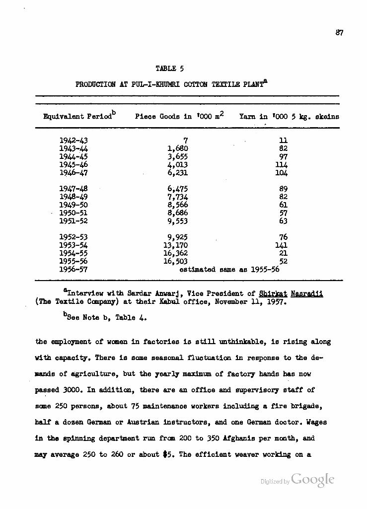
87
TABLE 5
PRODUCTION AT PUL-I-KHUMRI COTTON TEXTILE PLANT*
b o Equivalent Period Piece Goods in '000 nr Yarn in '000 5 kg. skeins
1942-43 1943-44 1944-45 1945-46 1946-47
1947-48 1948-49 1949-50 1950-51 1951-52
1952-53 1953-54 1954-55 1955-56 1956-57
7 1,680 3,655 4,013 6,231
6,475 7,734 8,566 8,686 9,553
11 82 97 114 104
89 82 61 57 63
9,925 76 13,170 141 16,362 21 16,503 52
estimated same as 1955-56
aInterview with Sardar Anwarj, Vice President of Shirkat Nasrad.1i (The Textile Company) at their Kabul office, November 11, 1957.
See Note b, Table 4.
the employment of women in factories is still unthinkable, is rising along
with capacity. There is some seasonal fluctuation in response to the de-
mands of agriculture, but the yearly maximum of factory hands has now
passed 3000. In addition, there are an offioe and supervisory staff of
some 250 persons, about 75 maintenance workers including a fire brigade,
half a dozen German or Austrian instructors, and one German doctor. Wages
in the spinning department run from 200 to 350 Afghanis per month, and
may average 250 to 260 or about $5. The efficient weaver working on a
Digitized by Google
88
piecework basis may average $9 or $10 per month, and bonuses are
given to those who exceed 80 per cent of the rated capacity. Fringe
benefits include one free meal per shift, free work clothes, housing
and medical care. Obviously, the wage-benefit structure is designed to
discourage labor turnover, which nevertheless remains a serious problem
despite the fact that Pul-i-Khumri has a population of about 12,000
par sons.
Adjoining the factory, and now spreading to the opposite, east-
ern side of the Kunduz River, are rows of small, white-washed adobe
houses providing about one-quarter of the workers with some of the best
family housing to be found in Afghanistan. The factory's kitchen and
dining room serve about 800 persons at one time, and there is a hospital
with 95 beds and three doctors. Warehouse capacity for four months1
production and an eighteen-month supply of spare parts are provided,
and the factory has its own foundry and machine and carpentry shops to
handle simple repairs, parts-fabrication and a few jobbing orders from
the local bazar or passing vehicles. One of the original purposes of
the Jangalak complex at Kabul was to fabricate spare parts for both
the Pul-i-Khumri textile plant and the new factory which has been built
at Gulbahar.
Although they are located on opposite slopes of the Hindu Kush,
the Textile Company plants at Pul-i-Khumri and Gulbahar will be so
closely integrated in function that it is more logical to discuss them
^Courtney Kimler, Field Survey of Afghanistan's Industry, Trans- portation and Electric Power Resources» T0ICA A-144 of International Cooperation Administration (Kabul: April, 1956), p. 11. (Hektographed.) Mr. Kimler served as Industry Consultant for ICA in Kabul.
Digitized by Google

89
both at this point. Hence we have postponed consideration of Gulbahar
from its mention in the chapter on the Kabul Valley (see page 70), and
we ask the reader to bear in mind that we are about to make a locational
hiatus and will return to the Kunduz region after completing this dis-
cussion of Textile Company operations.
Two generalizations will help to clarify the cotton-processing
situation in Afghanistan: l) although it is olimatologically possible
to grow cotton both in the Jalalabad Oasis and in the Helmand Valley,
all cotton which has been processed by the Textile Company has come
from areas north of the Hindu Kush, namely the Kunduz Valley and the
Mazar-i-Sharif area; 2) the Pul-i-Khumri cotton textile factory has
never had its own dyeing, printing and finishing facilities, but has
shipped a portion of its white piece goods output to the old plant at
Jabal Seraj for these operations. The new mill at Gulbahar will take
over these operations from Jabal Seraj and will continue to perform
them, on a much larger scale, for Pul-i-Khumri until such facilities
are constructed north of the mountains. Unless and until a second
cotton-growing base is created in the Helmand Valley, the Gulbahar
mill will remain dependent upon the North for its raw material, and the
general flow of cotton will be from the producing areas of the North to
Pul-i-Khumri and Gulbahar for processing and then on to the Kabul and
southern markets, with a temporary back-flow of finished goods from
Gulbahar to the markets of the North.
The Gulbahar textile factory is the largest industrial enter-
prise in Afghanistan and one of the most modern of its kind in the
world. Designed by the Gherzi Company of Zurich, and constructed by the
Digitized by VJOOQLC
^
90
German firm of Hochtief, its cost is estimated at $26 million,
including that of equipment. Construction was begun in March, 1953,
and was 80 per cent completed in February, 1958, when the first cleaning
and spinning sections went into operation. Its annual capacity when in
full operation will be 35 million square meters of unfinished white
piece goods and up to 60 million square meters of finished and dyed
goods including those brought from Pul-i-Khumri.
The Gulbahar factory is located on an old terrace to the east
of and about 150 feet above the Panjshir River where it issues from
the mountains. A small barrage in the river impounds water which is
raised at a rate of 1200 cubic feet per hour by eight pumps into
a 35,600 cubic-foot reservoir located on a hillside above the factory.
Thus a clean water supply is assured. There is also a possibility of
harnessing the Panjshir further upstream to provide hydroelectrioity
for factory operations. At present, power is obtained via a 55-mile
power line from the hydroelectric station at Sarobi. The abundant
supply of clean water, the available and potential hydroelectricity,
and the proximity to the Kabul market, about 45 miles to the south,
were the major factors determining location of the plant.
Operations at Gulbahar are housed in two huge, windowless and
completely air-conditioned buildings, one for cleaning and spinning
operations, the other for finishing, dyeing and weaving. A separate
completely-integrated "waste" plant will process cotton of a staple
length too short for the main spinning section. The operations sections
-'•Information on Gulbahar from visit of February 8, 1958, including interviews with representatives of the Textile Company, the Gherzi Company and Hochtief.
Digitized by VJOOQLC
91
of the plant include a total of 100,000 square meters of floor space.
Thanks to the air-conditioning system, it will be possible to replace
the entire interior atmosphere of these sections twenty-one times per
day and to adjust temperature and humidity to conform to the optimum
conditions for each particular operation. Overhead fluorescent fixtures
provide even lighting in the windowless plants.
In addition to the operations sections, the Gulbahar factory
has outlying warehouses, workshops and training sections, office
buildings, and 100 housing units which were built nearby under a
separate $400,000 contract in 1957. A modernistic mosque and a rapidly-
growing bazar section complete the picture of self-sufficiency.
The Gulbahar plant will operate for seme time on a one-shift
basis until enough workers have been trained to raise operations to
the 35 million square meter level, which presupposes a two 8-hour shift
regime. Eventually, over 2000 employees will be required to run the
factory's 35,000 spindles and 1700 looms. About 55 foreign technicians
will be on hand for the first three years of plant operation, after
which trained Afghan counterparts will take over.
It should be noted that the Gulbahar plant is designed for the
permanent handling of at least 8 million square meters of piece goods
from the Pul-i-Khumri factory in addition to its own maximum production
of 35 million square meters. Until Pul-i-Khumri obtains its own finishing
and dyeing sections, it will be sending more than 8 million square meters
south to Gulbahar each year. With increasing sophistication of the market,
i.e., with Afghan consumers able to afford and demanding colored cloth,
the amount of undyed piece goods which can be sold will continue to fall.
Digitized by VJOOQLC

92
The Gherzi Company representative at Gulbahar estimates that it is
already below the 20 million square meter level. To supply the growing
market, the Gulbahar weaving mill will include 112 special 4-color
looms in addition to its 1600 automatic looms.
Two possible bottlenecks may retard full utilization of Gul-
bahar capacity. The first is a shortage of power. The Sarobi hydro-
electric station can produce 22,000 kw if both 11,000 kva generators
are operated simultaneously and at full capacity. But such operation
would be foolhardy for any protracted period because of its deleterious
effects upon the equipment. At present, demand in the Kabul region
amounts to a daily maximum of about 7300 kw, and the second Sarobi
generator can be kept in standby condition or used alternatively to
even out deterioration. But Gulbahar in full operation will require
14,000 kw, of which Sarobi could supply 12,000 in the late spring
and summer months of heavy run-off but only 7000 in fall and winter
when less water is available. To make up the difference, a 2800 kw
thermal plant has been installed at Gulbahar, but even this addition
will leave a shortage of about 4000 kw in fall and winter months. Hence
the desirability of constructing a hydroelectric station on the Panjshir
becomes more obvious unless the RGA indicates that the third 11,000 kva
unit will be added at Sarobi or the new hydroelectric station completed
at Naghlu (see pages 25-27) before Gulbahar demand reaches its peak.
These alternatives, as well as the difficulties inherent in reliance
upon thermal power in Eastern Afghanistan (the Gulbahar thermal plant
would require 5000 to 6000 tons of coal or the equivalent in fuel oil
llbid. Digitized by Google
93
each year) will be further explored in Chapter X.
The second bottleneck may develop in the supply of raw material.
Out of an annual estimated production of 20,000 tons of ginned cotton,
including 15,000 tons from Kataghan Province and 5000 from Mazar-i-
Sharif, the expanded Pul-i-Khumri operations will require 3700 tons,
Gulbahar 5200, and the old plant at Jabal Seraj about 700 tons. While
the total of these requirements is slightly less than the annual pro-
duction of ginned ootton, Afghanistan has agreed to export considerable
amounts of ginned cotton to the Soviet Union, Czechoslovakia and West
Germany in repayment of development loans. Thus there arises an urgent
need for expanding the production of raw cotton in Afghanistan in order
to meet both domestic and foreign commitments. The possibilities of doing
so, both in the old areas of cultivation in the North and in the new
lands of the Helmand Valley, will be a recurring theme of this study.
Indeed, since even with Gulbahar and Pul-i-Khumri operating at capacity
domestic cotton textile production will amount only to about one-half 2
of the estimated 120 million square meters annually consumed, a con-
siderable amount of foreign exchange could be saved by increasing both
the quantity of raw cotton grown in Afghanistan and the amount domes-
tically processed. This aspect will receive particular attention in
Chapter VIII. For the present, it is enough to note that a lack of
cotton may actually serve to retard full production at Gulbahar until
such time as sufficient hydroelectric power is available. Whether such
•'•Interview with Mr. Akbar Saifi, Vice President of The Textile Company, at Gulbahar, February 8, 1958.
Consensus in discussion at Gulbahar, February 8, 1958. Cf. Donald N. Wilber (ed.), Afghanistan ("Country Survey Series"} New Haven: Human Relations Area Files, 1956), p. 240.
%
a situation would be preferable to one in which the cotton was available
and the power was not may, however, be doubted.
Transportation of ginned cotton from the North, of white piece
goods from Pul-i-Khumri, and of coal for the thermal plant from Ish-
pushta or Kar Kar is an additional but less serious problem. The
200-odd mile trip over the present roads is a two-day, tedious and
rough journey, but no insuperable obstacle. Construction of the pro-
posed Salang Pass route would, of course, considerably shorten this
trip.
We must now shift our attention back north to the Pul-i-Khumri
node, the importance of which is not limited to hydroelectric power and
the textile mill, but extends to transportation and agriculture as well.
The former significance is summed up in the name "Pul-i-Khumri", which
means "bridge of Khumri", for the dam causeway replaced a bridge which
served for many years as the only road span across the Kunduz River.
Downstream it was possible to ford the Kunduz in the dry season, and
there was a ferry service at Kunduz town, but for the heavy run-off
period at least "the bridge of Khumri" offered the only sure way across
the stream. And even in the dry season, many travelers and most vehicle
drivers between Kunduz and Mazar-i-Sharif would take the long way round
via Pul-i-Khumri rather than try to cross the Gawar Desert which lies
between the two cities. The indirect route has been shortened within
the last year by the construction of a road bridge at Sintut, just above
the transverse ridge which closes the Pul-i-Khumri node on the north
(see Map 4-)» but Pul-i-Khumri remains an Important way-station on the
roads from Mazar-i-Sharif or Kunduz to Kabul, which converge at the
barrage.

95
From the narrow funnel where the barrage is located, the flood-
plain widens and sweeps around the northern end of the limestone ridge
to the west of the river. This extension, in the vicinity of Ghori (see
Map 4-) forms the major agricultural section of the Pul-i-Khumri node,
and is irrigated by four major canals. The highest of these, the Gow-
argan Canal, begins at the barrage and describes a large S-curve at the
foot of the ridge and out into the Ghori area. The other canals leave
the river further downstream and trend northwestwards in the direction
of the Dasht-i-Khwaja Alwan area. The area irrigated by the Gowargan
Canal, which lies southwest of the road to Mazar-i-Sharif, Is devoted mainly
to irrigated grains and cotton. As usual, the better-watered areas are
planted to rice, and the higher areas to wheat or corn and cotton, with
patches of melons, vegetables and vetches. On the higher non-irrigated
slopes in the vicinity of Dahana, barley replaces wheat and the quality
of the crop has given some fame to the region. Northeast of the road,
sugar beets assume considerable importance, and it was actually to im-
prove connections with this area that the Sugar Company at Baghlan
employed Unimac of Austria to build the Sintut bridge at a reported cost
of $62,000. It is hoped to extend the largest of the three canals
watering this area, the Gumarek, further north to add 5000 or 10,000
acres here for cultivation of sugar beets and cotton. But any extension
of the canal system depends upon provision of additional storage upstream .
To the east of the river, two canals water the Pul-i-Khumri node.
One of these, the Baladuri, also begins at the bridge-barrage. The other,
Interviews with Albert T. Petersen, December, 1957, at United Nations Food and Agriculture Organization office, Kabul, Afghanistan.
Digitized by VJOOQLC

96
known as the Adjmir, begins opposite the Gumarek Canal and passes
through the Slntut gorge Into the Baghlan node. The Adjmir Canal is
thus over 25 miles in length, and serves some 30,000 acres, although
its average flow in 1956 was only 8 cubic meters per second. It was
recommended for pilot project improvement by Mr. A. T. Petersen, the
UN FAO irrigation specialist, who pointed out that the diversion
structure at the head of the canal is composed only of stones, brush
and reeds, which are usually washed away by the spring floods, and
that the canal must be maintained across eight washes on alluvial
fans, one or more of which usually discharges debris into the canal
or breaks its banks each year. In the spring of 1956, a heavy rain-
storm caused the Adjmir Canal to burst its banks near Baghlan, washing
out or damaging 70 houses in that city. In all, the losses due to
breaks in the intake structure or in the canal banks were estimated
to have cost the equivalent of 10,000 tons of sugar beets plus an
unknown quantity of wheat in that season alone. Mr. Peterson's re-
commendations include improvement of the diversion structure and
inlet, realignment of a section of the canal, and provision of storm
drains and wasteways to ensure that canal flow and distribution are 1
maintained throughout the growing season and from one year to the next.
His calculations of the areas served by the principal canals in the
Pul-i-Khumri node furnish an estimate of the total area under irrig-
ated cultivation there. ii 11 ii i ii. i - . _ _ . . . ~
A. T. Petersen, "Progress Report on the Improvement of the Adjmir Canal", letter to the Royal Afghan Ministry of Agriculture, dated March 7, 1957. In files of United Nations Food and Agriculture Organization, Kabul, Afghanistan.
Digitized by Google
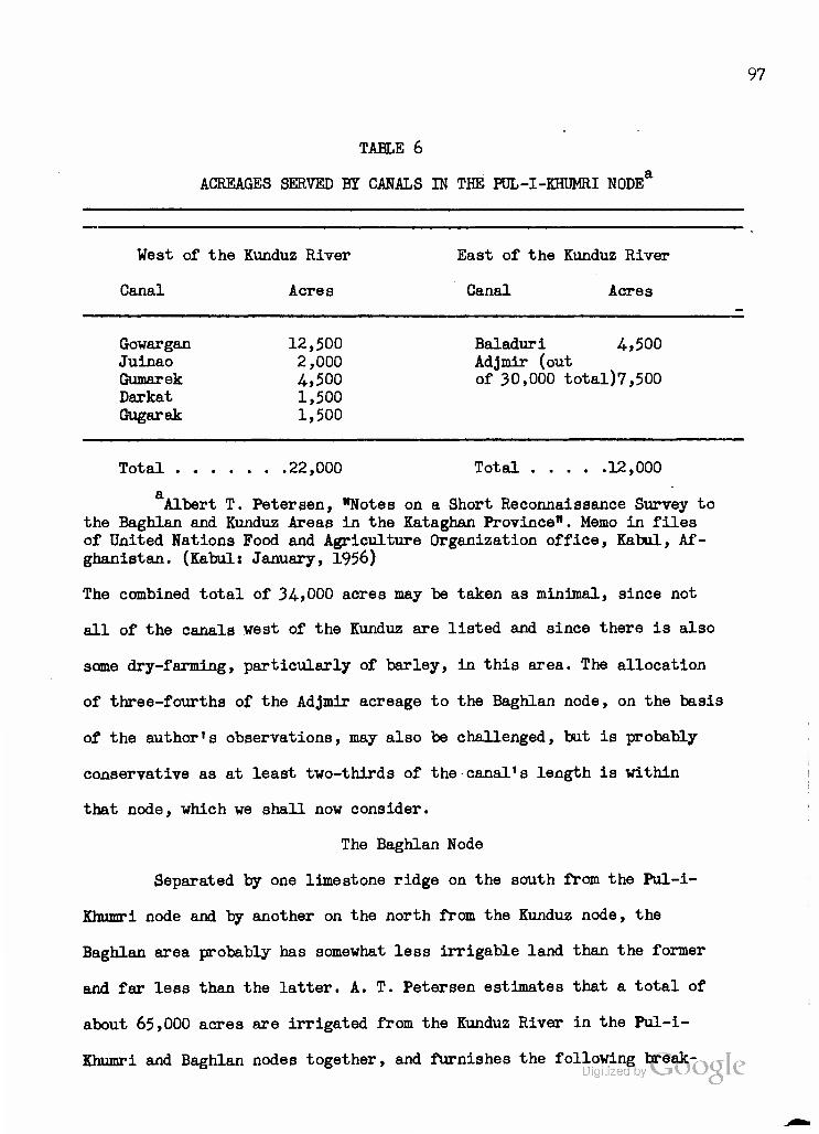
TABLE 6
ACREAGES SERVED BY CANALS IN THE FUL-I-KHUMRI NODE
97
West of the Kunduz River
Canal Acres
East of the Kunduz River
Canal Acres
Gowargan Juinao Gumarek Darkat Gugarak
12,500 2,000 4,500 1,500 1,500
Baladuri 4,500 Adjmir (out of 30,000 total)7,500
Total 22,000 Total 12,000
Albert T. Petersen, "Notes on a Short Reconnaissance Survey to the Baghlan and Kunduz Areas in the Kataghan Province". Memo in files of United Nations Food and Agriculture Organization office, Kabul, Af- ghanistan. (Kabul: January, 1956)
The combined total of 34,000 acres may be taken as minimal, since not
all of the canals west of the Kunduz are listed and since there is also
some dry-farming, particularly of barley, in this area. The allocation
of three-fourths of the Adjmir acreage to the Baghlan node, on the basis
of the author's observations, may also be challenged, but is probably
conservative as at least two-thirds of the canal's length is within
that node, which we shall now consider.
The Baghlan Node
Separated by one limestone ridge on the south from the Pul-i-
Khumri node and by another on the north from the Kunduz node, the
Baghlan area probably has somewhat less irrigable land than the former
and far less than the latter. A. T. Petersen estimates that a total of
about 65,000 acres are irrigated from the Kunduz River in the Pul-i-
Khumri and Baghlan nodes together, and furnishes the following bfSak^^

93
down of canal service.
TABLE 7
ACREAGES SERVED BY CANALS IN THE BAGHLAN N0DEa
West of the Kunduz River East of the Kunduz River
Canal Acres Canal Acres
Kokchinar no estimate Adjmir 22,500 Jangharek 5,000 Shabudin 1,500 Bagishamal 2,000
Total 30,000
T»etersen, "Notes on a Short Reconnaissance Survey . . . ".
Again, 30,000 acres would be a minimal estimate since the Kokchinar
Canal, which fringes the Gawar Desert (see Map 4-) is not included and
since other, minor canals may be left out as is any acreage contributed
by dry-farming. The largest contribution is that made on the east bank
by the Adjmir Canal, and hopes for improving agriculture in the Baghlan
node center upon the rehabilitation of this canal to prevent washouts
and consequent losses. In the autumn of 1957, it was reported that the
Governor of Kataghan Province ha3 joined with local landowners in an
"Irrigation Committee" to implement the UN FAO plan and the surveys
made by the FAO topographers in September, 1957. While this local
initiative may result in some conflict with the operations of the
Albert T. Petersen, Monthly Reports for September and October, 1957, in files of United Nations Food and Agriculture Organization office, Kabul, Afghanistan. (Kabul: October 15 and November 16, 1957), passim.
Digitized by Google
99
Ministry of Agriculture in Kabul, it is indicative of the urgency of
the problem in local thinking. While it might be possible to increase
the area under irrigation by constructing a dam in the Sintut gorge,
which would necessitate relocation of the road and the bridge, it is
certainly of more immediate importance and less costly to restore and
improve the canal.
Baghlan is the capital of Kataghan Province, the administrative
offices having been moved here from Khanabad several years ago. They
are now housed in a series of new concrete and adobe buildings located
in the center of the node. To the south of "Administrative Baghlan"
is the old town of that name, with the main bazar area. At the southern
end of the node, separated by some five miles from "Old Baghlan" is the
industrial area usually referred to as "New Baghlan". This section was
built in the late 1930's and early 1940's around the sugar beet pro-
cessing plant which went into production in 1940. It includes the
factory, its experimental dairy farm, the District Agricultural Office,
and a fairly new, arcaded bazar along with attractive residences, a
hotel, and gardens. The population of Baghlan District, which inoludes
all of these towns, is probably over 35,000 people.
The sugar factory at Baghlan was another creation of Abdul
Madjid Zabuli and the Bank-i-Millie. Machinery made by Skoda and
originally intended for Argentina, it is said, was purchased in 1938
after the Nazi "conquest" of Czechoslovakia. The total cost of purchase,
transportation, assembly and housing of the machines was approximately
$1 million, with the Bank supplying the bulk of the capital. The
(Baghlan) Afghan Sugar Manufacturing Company has not been nationalized,
and about 85 per cent of the ownership remains in private hands. The

100
sugar, however, can only be marketed through the Government Monopolies,
which also control all imports of sugar. Thus it is impossible to ob-
tain data on either processing or wholesale oosts. In the Kabul bazar,
which is as far south as Baghlan sugar is transported, it sells far
about ten cents a pound, the same as sugar imported from Pakistan.
In the Baghlan bazars, it meets with competition from imported Soviet
cube or block sugar which, however, oommands a slightly higher price
since it is "refined", i.e., goes through a final activated charooal
treatment to whiten it. Baghlan sugar is not refined, and is sold in
granulated form.
The Baghlan sugar factory has a rated capacity of 60,000 to
70,000 metric tons of beets per season on a basis of 700 tans per day
for 90 to 100 days. But Mr. Mau, the Austrian ohief engineer, oonsiders
55,000 tons the optimum from operational and maintenance points of
view. However, the matter has never been put to an aotual test,
inasmuch as the supply of sugar beets has never exceeded 45,000 tons
in any season and has usually been considerably less) see Table 8 on
the following page. It is apparent that the area devoted to sugar beets
has varied considerably and that the quantity of beets available for
processing is by no means solely dependent upon the area planted.
Variations in the quality of the seed, in the amount and regularity
of Irrigation water, in the intensity of summer heat, and in the
fertility and drainage of the soils all contribute to variations in
the yield per acre, which averaged 4«3 metric tons far the years
1954-56 but only 2.7 tons per acre for the three preceding years.
^•Interview and visit to the Baghlan sugar factory, September 21, 1957. " Digitized by CJ

TABLE 8
SUPPLY OF SUGAR BEETS FOR PROCESSING HiANT AT BAGHLAN*
101
Tear Number of Acres Planted to Beets
Metric Tons of Sugar Beets Available for
Plant
Number of Days for
Processing
1940 2,800 8,378 23.5 1941 4,800 28,829 40.5 1942 5,800 22,165 32. 1943 9,700 30,536 40. 1944 9,300 37,655 82.
1945 9,800 36,600 58. 1946 11,400 25,051 ? 1947 sugar beet land devoted to wheat under Government decree 1948 R R It it
1949 11,600 31,900 43.
1950 8,600 33,708 48. 1951 11,100 33,538 47.5 1952 11,600 22,846 41. 1953 12,200 39,928 56. 1954 9,600 41,273 63.
1955 9,177 44,815 60.5 1956 9,158 33,489 57.
aPrlvate communication (in German) from the Afghan Sugar Manu- facturing Company to the author, November, 1957.
Generally speaking, sugar beets require fairly heavy irrigation until
late in the growing season, heavy but well-drained soils, and no ex-
tremes of heat. In reoent years, some progress has been made in ap-
plying waste from the plant as fertilizer or In adapting good rotational
patterns, but all too little experimentation has been oonducted with
respect to best-suited varieties of seed. In 1952, one test of half a
dozen varieties, conducted by the Agriculture Department of the Sugar
Company, produced the following results. Digitized by Google

102
TABLE 9
VARIETAL TEST OF SUGAR BEETS AT BAGHLAN, 1952
Seed Average Weight Percent Purity in Beet Yield Sugar Yield Variety of Beets Sugar Percent per acre in per acre in
in grams kg- kg-
Danish 666 15.35 86.3 21,039 2786 American 730 17.00 87.2 15,608 2314 Persian 4628 788 17.40 85.6 15,713 2200 Persian 4496 605 15.60 85.3 20,537 2200 German 761 15.20 85.1 16,293 2107 Afghan local 622 15.80 85.1 16,030 2140
aL. C !. Jain. The Economic Development of Afghanistan, in files of United Nations Technical Assistance Mission, Kabul, Afghanistan, Industry Section, Chapter VI (Kabul, 1953), p. 1. Jain served as UN economic ad- viser to Afghanistan from January until November, 1953.
The calculations on sugar yield per acre in the right-hand column in-
dicate that the Danish variety, despite the small size of the beet, is
the highest yielder both in tons of beets and in tons of sugar per acre
planted. However, nothing has been done towards introduction of Danish
sugar beet seed or towards testing other varieties which might yield
even better results. The problem of increasing the per-acre yield is a
very serious one, for sugar beets must compete with the better-paying
cotton crop in the Kunduz Valley and in some years must compete with
wheat as well. The completion of the Sintut bridge leading to the Ghori
region, where approximately two-thirds of the sugar beets are now grown,
will insure the regular delivery of the beets grown in that area but
will not increase the total amount available unless it is supplemented
with an extension of the Gumarek Canal (see Map 4) aad of the irrigated
area devoted to sugar beets. In the absence of a large-scale develop-
ment program along the Kunduz, which would provide ample land and water
103
for cotton, grain, and sugar beets, the only possibilities open to the
Sugar Company are continued efforts to improve yeild by furnishing
better seed, making waste available for use as fertilizer, and en-
couraging the farmers to use better plows which will turn under
stubble and weeds and bring new minerals to the surface. Improved
cultural practices and the adoption of rotations including alfalfa
would also serve to eliminate the Dodder, Black-root, and Fusarium
yellow diseases which infect a part of the crop, but fortunately the
1 disease problem is not serious.
It might appear that the simplest solution to the short supply
of sugar beets would be to raise the present price of $5.00 to #5.4-0
per ton which is paid by the Sugar Company to the farmers for their
crop. Since the Sugar Company has no control over the retail price of
sugar, which is set by Government Monopolies, there is no way for it
to pass along this increased cost. Furthermore, since the Consolidated
Cotton Company has been nationalized, it is not to the interest of the
RGA to improve the competitive position of sugar beets vis-a-vis cotton
in the Kunduz region. The only competitive measure left to the Sugar
Company is the practice of extending credit to the farmers in the form
of advance payments and seed at the start of the season. The farmers,
many of whom are large landholders with 100 acres or more at their
disposal, must then contract to deliver their sugar beets at fixed
prices to the Company. Actually, since there is no alternative use for .
the beets, the Sugar Company can count on the crop once it is in the
Ibid., p. 3 and interviews with R.P. Davidson, Agronomist on UN FA0 staff, Kabul, on December 11, 1957, and at Baghlan, on September 20-21, 1957. Cf. Report to the Royal Government of Afghanistan on Sugar Beet Production. United Nations Food and Agriculture Organization Report No." 14S (Rome: August, 1953).
Digitized by VjOOQlC

104
ground, barring floods, breaks In the canals or unusual dry or hot
spells. One final difficulty, however, resides in getting the farmers
to plant their crops early enough so that the plant can spread its
operations over three months or more instead of being deluged with
beets in the last few weeks of the growing season. Here a system of
payments which put the premium upon early deliveries would be of
considerable help in enabling the plant to make full use of its
operational capacity.
The Sugar Company owns half a dozen trucks and hires more to
bring in the beets during the processing period or "campaign". The
beets are weighed as they come into the factory compound, then are
dumped into large, Y-shaped cement troughs for washing. From these
they are conveyed by water In sluices to a forked conveyor which lifts
them to the top of the plant and drops them into slicing machines.
The sliced pulp is then gravity-fed into the boiling vats where about
13 per cent by weight is recovered in the form of a heavy syrup. The
pulp is removed, dried, and either returned to the farmers for use as
fertilizer or fed to the dairy cattle on the company1s experimental
farm which adjoins the factory.
After purification of the syrup, vacuum-evaporation, crystal-
lization, centrifuging and purging, the sugar is mechanically dried,
Vibrated to break it into granules, screened and conveyed into bins •
or hoppers from which it can be poured into sacks. No "refined* sugar
is produced, the end-product being off-white in color but perfectly
acceptable and palatable. Second-run "brown" sugar also finds a local
market in the making of ghur. But the molasses, which contains 20, per Digitized by VJOOQLC
cent alcohol by weight, may not legally be distilled and so is either
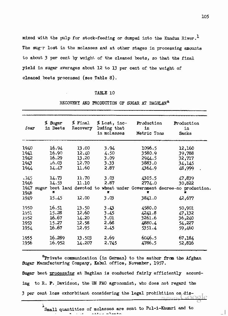
105
mixed with the pulp for stock-feeding or dumped into the Kunduz River. ^
The sug-r lost in the molasses and at other stages in processing amounts
to about 3 per cent by weight of the cleaned beets, so that the final
yield in sugar averages about 12 to 13 per cent of the weight of
cleaned beets processed (see Table 8).
TABLE 10
RECOVERY AND PRODUCTION OF SUGAR AT BAGHLANa
% Sugar % Final % Lost, inc- iear in Beets Recovery luding that
in molasses
Production Production in in
Metric Tons Sacks
1096.5 12,160 3580.9 39,788 29U-5 32,717 3883.0 34,H5 4364.9 48,999
1940 16.94 13.00 3.94 19a 16.90 12.40 4-50 1942 16.29 13.20 3.09 1943 x6.03 12.70 3-33 1944 14.47 11.60 2.87
.945 14.73 11.70 3.03 4305.5 47,839 1946 14-53 11.10 2.87 2774-0 30,822 1947 sugar beet land devoted to wheat under Government decree-no production. 1948 " " " " 1949 15.45 12.00 3.03 3841.0 42,677
1950 16.51 13.50 3.43 4580.0 50,901 1951 15.28 12.60 3.45 4241.8 47,132 1952 16.67 14.20 3.01 3261.6 36,240 1953 15.27 12.58 2.68 4880.4 54,227 1954 16.67 12.95 2.45 5351.4 59,460
1955 16.289 13.503 2.69 6046.5 67,184 1956 16.952 14.207 2.745 4786.5 52,816
aPrivate communication (in German) to the author from the Afghan Sugar Manufacturing Company, Kabul office, November, 1957.
Sugar beet -processing at Baghlan is conducted fairly efficiently accord-
ing to R. P. Davidson, the UN FA0 agronomist, who does not regard the
3 per cent loss exhorbitant considering the legal prohibition on dis- niqiti7Prl hy \ lOOQJg
Small quantities of molasses are sent to Pul-i-Khumri and to J- j-i _n __j

106
tillation into alcohol. The problem is clearly one of beet •production.
since the existing capacity is not fully utilized and since the Sugar
Company has indicated, to Mr. Davidson and to the author, its desire
to double processing capacity at Baghlan if a sufficient supply of
beets could be assured. Ultimately, the problem rests with the RGA
which controls the price structure, including any commission charged
by Government Monopolies, as well as the foreign exchange reserves
which would have to be allocated to procure additional processing
equipment. At present, the sugar produced at Baghlan is sold only
as far south as Kabul. The whole of southern and southwestern Afghan-
istan must be supplied with Imported sugar while some Soviet cube-
sugar is offered for sale in the North. Ve shall discuss the problem
of utilizing foreign exchange to import products which could be
produced domestically, and the alternatives of growing and pro-
ducing sugar from cane at Jalalabad or from beets in the Helmand,
in Chapters VIII and II.
While awaiting the RGA decision on the type and location of
increased sugar production, the Sugar Company at Baghlan is not just
marking time. It has started an experimental livestock farm on which
500 cattle, 600 to 700 sheep, 100 horses, 20 mules and 20 camels are
being fed largely on a mixture of sugar beet pulp and molasses. The
purposes of the experiment include the breeding and nourishing of
better milch cows and of superior draft animals in general.
The Sugar Company has also established a silkworm breeding
station where Japanese, Chinese and Italian worms are being cross-
bred under the guidance of two UN FA0 experts. The mulberry tree
thrives in northern Afghanistan, and some specialists consider the QQ
leaves produced here superior to those of the Far East. It is felt

107
that silkworms fed on these superior leaves will produce better fiber.
Silkworm eggs are distributed from the station to local families who
raise the warms on wooden racks, replenished every two hours with
hand-picked, tender leaves. When the worms have spun their cocoons,
they are now sold back to the station for processing, bat a program is
under way to teach farmers how to kill the worms in boiling water and
to unwind the cocoons on frames. Simple apparatus for reeling, twisting
or "throwing" and weaving were exhibited by the Sugar Company at the
Jeshyn Fair In Kabul in August, 1957. Bicycle wheels had been adapted
as flywheels on some reeling and throwing machines, while others had
food treadles. Two men working together could handle about fifteen
pounds of cocoons per day. Silk weaving has been done for centuries
throughout northern Afghanistan , and presently earns about $.16 per
square meter. Each weaver can expect to produce about five square
meters per day, and since it is estimated that the total marketed
production of natural silk cloth in Afghanistan amounts to about
67,000 square meters per year there must be upwards of 50 looms in
operation for the commercial sector alone. The possibilities of ex-
panding this production for export, or to replace some of the imported
natural silk or artificial silk goods, remain to be developed. The
relative scarcity of labor In the Kunduz Valley and the competition
of agriculture and other industries militate against the widespread
adoption of silk growing. On the other hand, this is an industry well-
Dr. Kintson Keh of the UN FA0 staff in Kabul is of this opinion. Cf. Klmler, p. 18 and report of the visit of United States Embassy and International Cooperation Administration officials to Baghlan in May, 1957, ifl files of U.S. Embassy and U.S. Operations Mission, Kabul^,
„ Digitized by VJOOQLC
^Kimler, p. 18.

LU Q
8 o <
Q O 4 «
108 o O z * O $
o > d 2 •
M ui o < _l > IE <t
* a
Z> ; o a. K o •*•
* £ *• * i
MA
P
5
'AL
LE
Y:
KU
N
2
• o
2 1 IS
IN I >
^ u Q z z J
M
W <»2 *g 2 1! 3 »• Z_l K _ u •> 5 o z
o>
FOR
M L
I (G
EN
ER
A
CO
NTO
U
STR
EA
M
STR
EA
M
PO
SS
IBL - 1 i *
X WMf
Digitized by Google
109
adapted to tap the labor of women, children and old men in the
villcjea if it turns out to be more profitable than the weaving of
cotton and woolen goods. While it is doubtful that Afghanistan can
ever become a serious exporter of raw silk in the face of competition
from Japan and from synthetics, it is conceivable that domestic pro-
duction can replace the import of raw silk and of natural silk piece
goods, which reached 35.7 metric tons in 1956-57. An increase in the
15 per cent ad valorem duty on silk piece goods imports would serve
as an incentive to the domestic production, but it must first be
determined whether the domestic cost can be competitive with imports
even if t,uch additional protection is extended.
A final contribution made by the Sugar Company has been the
maintenance, since 1955, of the only meteorological station in the
Kunduz Valley. Since we are about to turn our attention to cotton
production, it will be well to indicate here, by means of the temp-
erature and precipitation records, how well the Kunduz climate is
suited for the growth of cotton. See Table 11 on the following page.
The Kunduz Node
While the data in Table 11 represent only the beginning of a
meteorological record for the Kunduz Valley, they suffice to indicate
that the climate in the lower reaches of the river is highly suitable
for cotton and other heat-tolerant, irrigated crops. The warm, prac-
tically rainless growing season from March through October eliminates
2 almost g"11 danger from pests and disease , allows careful control of
iFrom import data made available to the author by the Ministry of Planning, Kabul, in December, 1957.
R. P. Davidson states that only aphis pests have^^iTfd no bollworms or stainers.

no
TABLE 11
METEOROLOGICAL DATA FOR THIRTT-ONE MONTHS AT BAGHLAN
Year: Equivalent Period Average Temp, in C.
1955-6 1956-7 1957 Rainfall in Millimeters 1955-6 1956-7 1957
March 21 - April 20 April 21 - May 21 May 22 - June 22 June 23 - July 23 July 24 - August 23 August 24- - September 23 September 24 - October 23 October 24 - November 22 November 23 - December 21 December 22 - January 19 January 20 - February 18 February 19 - March 20
19.5 19.1 14.9 101 13.5 87 24 30.2 20.5 51 51 95 32 25.2 missing 0 0 missing 37 38.6 missing 0 0 missing 38 31.8 29.2 0 0 0 39 28.8 25.3 0 0 0 25.3 20.6 18.3 0 1 13 20.7 15.7 0 0 10.8 8.9 0 19 5.4 0.0 20 10 8.3 1.0 27 9U 10.9 12.0 49 51
aData in files of A. T. Petersen, Irrigation Engineer, UN FA0 office, Kabul, Afghanistan.
the water which is nade available to the plants, and generally insures
a dry harvest period. Conditions are quite similar to those in the
irrigated cotton areas of southwestern U. S. and California. The winter
and early spring precipitation serves to build up soil moistura, while
the discharge of the Kunduz River (see Table 4) rises from April through
June when the water requirements of cotton are greatest. The cotton is
usually sown broadcast in late April and May, after the basin-fields
have been given a pre-planting irrigation and light plowing. By late
July, when available water may decrease, the peak demands of cotton have
been met and the irrigation supplies may be diverted to other crops.
Cultivation and harvesting of cotton is performed entirely by hand in
the Kunduz Valley. The harvesting usually begins in late September lest
Digitized by Google

Ill
showers or early frost damage the crop. After the bolls have been
picked, the stalks and roots are also pulled out for use as fodder
or fuel. The raw cotton is brought to agents of the Consolidated Cotton
Company of Kunduz who pay the farmers approximately four cents per
pound with slight variations to reflect four rough grades based on
length, strength and color of fibre. The raw cotton is then collected
by Cotton Company trucks or rented vehicles and brought to one of the
many gins in the lower Kunduz, Khanabad and Kokcha areas. The southern-
most of these gins is located in Baghlan, while the cotton growing area
extends downstream from Pul-i-Khumri to below Kunduz, eastwards along
the Khanabad River as far as Taliqan, and recommences along the Amu
Darya below the Kokcha River from Khwaja-Gar to Imam Saiyid (see
Map 3). There is also a considerable cotton-producing region centered
around Mazar-i-Sharif, which contributes approximately 5000 metric
tons of ginned cotton annually through its own "Industrial Society",
established in 1951.
The only data concerning the relative importance of the different
cotton producing areas are those which date from a survey made by
Frumkin in 1951. At that time, he found that the "Industrial Society"
of Mazar-i-Sharif processed about 7000 out of an estimated 9800 metric
tons of raw cotton available in Mazar-i-Sharif Province, while the seven
ginning plants operated by the Consolidated Cotton Company cf Kunduz
within Kataghan Province processed the following quantities: Kunduz,
7,202 metric tons; Baghlan, 378 metric tons; Khanabad, 994- metric tons;
Gregory Frumkin, Report on Journey to the Northern Provinces, in files of United Nations Technical Assistance Mission, Kabul, Afghanistan. (Kabul, 1952), pp. 35 ff. and Annex D. (Mimeographed.)
Digitized by VJOOQ LC

112
Taliqan, 1423 metric tons; Khwaja-Gar, 3383 metric tonsj Imam Saiyid,
5380 metric tonsj and Kalazal, 1358 metric tons. These figures come
to a total of 20,118 metric tons of raw cotton. Frumkin stated at
the time of his survey that it was quite possible that about one-
third of the cotton grown in Kataghan was not ginned by the Consol-
idated Cotton Company. This inference provides one explanation of
the fact that the Cotton Company has been able to double its pro-
duction of ginned cotton from approximately 6700 metric tons in 1951
(on the basis of 33 per cent recovery of lint) to almost 15,000
metric tons in 1957. In fact, Klmler reports that the Company's
purchases of raw cotton jumped from 14-,l60 metric tons in 1953 to
2 32,350 metric tons in 1954 and to 47,270 metric tons in 1955. So it
is quite possible that, at the time of Frumkin1s survey, as much as
one-half of the cotton produced in Kataghan Province was not being
ginned by the Company but being cleaned in cottage industry! There
does not seem to be any other explanation for the Company's ability
to increase its purchases so rapidly. Since the price structure
reported by Frumkin in 1951 is almost identical with that given in
1957, whereas the Afghani has depreciated in the interim, it appears
that even at four cents a pound the Cotton Company can buy all the
raw cotton it needs, at least up to the 45,000 or 47,000 metric ton
level attained in 1955 and 1957. We have already seen that at this
price cotton has been able to keep sugar beets off many of the fields
•^•Interviews of January 2 and February 12, 1958 with Mr. Beheroz of the Consolidated Cotton Company Office in Kabul, Afghan- istan.
Rimler, p. 7. Digitized by VJOOQLC

113
in the Baghlan node.
The Consolidated Cotton Company of Kunduz, 63 per oent of
whose stook was acquired by the Ministry of Finance in 1955, is
gradually adjusting to provide a larger ginned ootton base for Afghan-
istan' a textile industry and for exports. In 1957, it replaced the old
gins at Kunduz with eight new British models each having a capacity of
1500 pounds per hour and capable of extracting up to 37 per cent by
1 weight of lint from long-staple cotton. It has also replaced or in-
creased the number of gins in the outlying towns and plans to add
several new ginning centers to its operations. But the most spectacular
Improvements are those being carried out in Kunduz itself, a rapidly
growing city with a present population of perhaps 30,000, where the
Company has employed Unimac of Austria to build new warehouse and
operating facilities including equipment for making cooking oil,
margarine and soap from cottonseed oil. The old operations of the
plant have largely been modernized with the installation of air-
suction and blower systems to carry the raw cotton from the storage
sheds directly to the ginning plant and to feed the ginned ootton
automatically to the cleaners and the hydraulic baling press. A narrow
gauge railway then transports the bales to either of two warehouses with
an 8000-bale capacity each.
From the gins, the cottonseed is carried to machines which de-
hull it and then press it to extract the oil, about 20 to 24 per cent by
weight being obtained. When installation of new oil recovery equipment
Data on plant and operations from interviews with Messrs. Fox and Meyer, Austrian and German engineers, at the Cotton Company plant in Kunduz, September 25-26, 1957.

1M
is completed, it will be possible to process 100 tons of seed In a
24-hour period. The presses will haye to operate almost around the
clock to handle the seed produced by the new gins, some 86 or 68
metric tons per 8-hour shift. Storage capacity for 2000 cubio meters
of cottonseed oil is also being completed. For some years, the Cotton
Company has used its oottonseed oil to make coarse laundry soap,
utilising lye from wood ashes. Now it is building a modern processing
plant to manufacture both laundry and hand (refined) soap in a three-
to-one ratio. Another plant, nearly completed in the fall of 1957,
will refine oottonseed oil for cooking purposes and to make mar-
garine which, it is hoped, will be able to compete with sheep's fat
on the Afghan market. The refining equipment, manufactured in Hamburg-
Harburg, Vest Germany, includes machinery for forming one- and flye-
kilo tin cans out of imported tin-plate. Metal drums or wooden barrels*
of 200-kilo capacity will also be used If arrangements can be made to
manufacture them as well.
When it is considered that every piece of machinery and eyery
steel tank-plate, including those for the hydrogenation vats whioh
must be tin-lined and for the pressure tank to store the hydrogen,
have had to be shipped from Germany, most of it by way of the U.S.S.R.,
the accomplishment over the past five years is commendable. But the
engineers on the scene estimated that it might require another two
or three years before the margarine and soap plants can come into op-
eration. Supply of tin-plate for making cans will be a continuing
^Unfortunately, most of the seed-cake is being burned in the plant's boiler room which supplies steam to operate the baling and seed presses. Only a small part of the seed-cake is now being locally^T^ sold for use as livestock feed.
115
problem since it must be imported. So will the supply of diesel oil
for the plant's generators, though the coLpletion of a 1400 kva hydro-
eleotrio station on the Khanabad River, also being built by Unlmac for
the Cotton Company, will considerably reduce the plant's fuel needs.
In contrast to the Textile Company, the Consolidated Cotton
Company is unlikely to be bothered by a shortage of raw material, since
all cotton whether consumed domestically or exported must first be
ginned. It has been reported, however, that some of the better grades
of cotton, ginned at Imam Saiyid, Khwaja-Gar and Taliqan, are being
exported directly to the Soviet Union and so never reach the Kunduz
plant. In addition to the Soviet Union, Czechoslovakia and West Ger-
many have trade or credit agreements with Afghanistan which call
for exchange of raw cotton, among other commodities, in return for
manufactures, motor vehicles or gasoline. While Afghanistan can obtain
hard foreign exchange by the export of karakul and soft exchange by the
export of fruit to Pakistan or India, cotton and wool are the najor
items of interest to the Soviet bloc countries and West Germany. The
Bonn government, in fact, sent a cotton grading and marketing expert
to Afghanistan in the winter of 1957-58 as part of its new technical
assistance program. The expert's task will be to assist in improving
present grading practices down to the level of the individual cotton
farmer. It has been estimated that from 5 to 10 per cent of the cotton
grown in northern Afghanistan is 1 9/16 inches long, but the average
^By Mr. Fox at the Cotton Conpany in Kunduz.
Digitized by Google

116
staple length Is between 1 and 1 3/l6 Inches. With more careful
seed selection, production and grading, Afghanistan should be able
to compete on the 1 3/8 Inch or "Egyptian high-count" cotton market.
Standardization of cotton grades would mark a great advance in Afghan
cotton marketing. At present, Afghan cotton can be sold only by means
of lot samples and not by specifying a standard grade. The result of
this tiiue-consuming and uncertain procedure, distasteful to most buyers,
is the relegation of Afghan cotton to a position in the world market
which is lower than its average quality could justify. A further re-
sult is that several thousand tons of Afghan cotton are now held in
storage in Hamburg for the lack of buyers.
Along with iiuproved grading procedures should go standard-
ization and up-grading of the seed used. The original cotton seed
introduced into northern Afghanistan from Russia was American Upland.
This subsequently was mixed with strains brought frou. Central Asia.
In 1952, American technicians added three more strains to the mixture.
Mr. Davidson, whose specialty is cotton, has suggested the use of
isolated trial plots where crossbreeding would be impossible for
five more American varieties, using Acala 1517 as the control strain.
In the meantime he has recommended to the Cotton Company that it try
to segregate the seed from the better grades of cotton ginned and re-
turn only this to the farmers. It is a Company practice to issue about
4.8 pounds of seed per acre to the farmers with whom it enters into
contracts for the return of specific amounts of cotton. The Company
sells seed too, and even exports a small quantity.
Digitized by Google

117
Mr. Davidson, supported by Kataghan agricultural officers,
puts the average yield of raw cotton at about 960 pounds per acre.
If this is correct, then the purchase by the Cotton Company of 4-5,000
metric tons of raw cotton would indicate that slightly over 100,000
acres are devoted to cotton production in Kataghan Province. And since
there is certainly some additional production for cottage industry
use, the figure is likely to be greater rather than less. In fact,
Kimler reports that the Company's purchases of 32,350 metric tons
of raw cotton in 1954 represented the produce of 85,500 acres, while
1 the purchase of 4-7,270 metric tons in 1955 represented 169,000 acres I
Of course, these acreage figures may be exaggerated since it is to
the farmers1 advantage to report low yields in order to obtain more
free seed and higher cash advances from the Company. We cannot assume
that the proportions established by Frumkin in 1951 (see page 11])
still hold true today among the various cotton gins, especially as the
overall ginned production has increased so spectacularly and as the
local ginning capacities have been changed. We do know, for example,
that about two-thirds of the cotton now being ginned at Taliqan comes
2 from Khwaja-Gar where the gins are overtaxed. But we unfortunately
cannot make any quantitative determinations with respect to the con-
centration of cotton production within Kataghan Province. Qualitatively
speaking, on the basis of personal observation, the importance increases
Kimler, p. 7.
2 Interview with Mr. Hans H. Buchmann, UN FA0 Farm Implements
Specialist, Kabul, December, 1957.
Digitized by VJOOQLC
118
northwards from Pul-i-Khumri to Kunduz and remains great to the
east around Khanabad and Taliqan. On the basis of expert observation,
cotton is the single most important crop on the lands irrigated from
the Kokcha and Amu Darya Rivers in the vicinity of Khwaja-Gar and Imam 1
Saiyid.
In the Khwajja-Gar - Imam Saiyid region, as along the Kunduz
River, the insurance and increase of the water supply is the key to
maintenance and expansion of cotton production. In 1957, for example,
the spring run-off which broke the banks of the Adjmir Canal in the
Pul-i-Khumri and Baghlan nodes also caused breaks in canals in the
Imam Saiyid area with a resultant loss of about 30 per cent of the
cotton before the system was repaired. In order to add new acreage to
this area, which is reported to have excellent soils thanks to loessal
materials added to its alluvium, it will be necessary to make more use
of water from the Kokcha River. The problem there is that the river in
its lower course has cut a deep gorge along the strike of south-dipping
sandstones and so flows at a depth of 15 to 30 feet below the cultivable
terraces. Hence some type of mechanical device is required to lift the
water to the level of the fields. One survey of the problem has been
made by the Swedish firm SINTAB, which proposed a high dam and gravity
flow canals at an estimated cost of $12 million. A second survey, by
Siemens-Schuckert Company, suggests that the porous sandstone of the
gorge will not provide a satisfactory reservoir. Their plan is to
construct a low barrage in the gorge to provide a sufficient head for
^Interviews with R. P. Davidson and Hans H. Buchmann. Mr. Buchmann is one of the few foreigners who has been admitted to this politically sensitive Uzbek area on the left bank of the Amu Darya.
Digitized by VJOOQLC

119
the generation of around 4-500 kw and to use this power to pump
up enough water to irrigate .125,000 acres. This scheme would cost
only $2.5 million. No decision has been reached by RGA on the relative
merits of these two alternatives. A. T. Petersen feels that more
careful soil and topographical surveys are necessary before a wise
choice can be made.
Another problem indicated by the UN FA0 specialists is that
the Khwaja-Gar - Imam Saiyid area is underpopulated. The section is
inhabited principally by Uzbeks and Turkmeni, many of whom formerly
owned lands on both sides of the Amu Darya and moved freely across the
frontier to till their lands or to transfer their animals from pasture
to pasture. Since the Bolshevik revolution, and mare particularly since
the collectivization program of the early 1930's, they have taken up
permanent residence in Afghanistan. Some of them, particularly among
the Uzbeks who have a long tradition of sedentary agriculture, are
excellent farmers. But there are not enough of them, and it has been
an RGA policy to encourage these minority groups to move further south
away from the frontier. Thus any program to increase cotton production
along the Amu Darya would have to include the resettlement, presumably
of Afghans, in the Khwaja-Gar - Imam Saiyid area to work the new lands.
With additional water and farmers, Mr. Buchmann of the UN FA0 estimated
that this area could produce up to four times as much cotton as it now
does, but he declares himself unable to estimate the present size of
the crop. Mr. Davidson indicated that between 15,000 and 20,000 tons
of the 4-5,000 tons processed by the Cotton Company comes from areas
adjacent to the Kunduz River. This would Imply that 20,000 to 25,000 Digitized by VjOOQlC
tons, or somewhat over one-half of the total, comes from areas irrigated

120
from the Kokcha, Amu Darya and Taliqan-Khanabad Rivers.
Taliqan lies at the extreme eastern end of the Kunduz node
as we are defining it, where the Taliqan River joins the Khanabad River.
These perennial streams drain the western flanks of the Khwaja Mohanned
Range of Badakhshan Province westward into the Kunduz River (see Map 3).
The town of Taliqan has a Cotton Company ginning plant and five or
six warehouses, and processes much of the Khwaja-Gar crop for export
to the Soviet Union. There is an unimproved road connecting those two
towns, another from Taliqan to Faizabad in Kataghan Province, and a
much better one along the bluffs and barren alluvial fans north of
the Khanabad River leading to Khanabad and Kunduz (see Map 5). South
of the river are high, fertile terraoes, well-irrigated from upstream
intakes and devoted to wheat and ootton. Where the Khanabad River
issues from the foot-hills to widen its floodplain, a six-span stone
and concrete bridge carries the new road across the river to join the
old one along the terraces and into Khanabad. One kilometer below the
bridge is the new diversion structure and intake for the six-kilometer
canal which feeds the Cotton Company's power station on the north
bank opposite Khanabad. This installation, built by Unlmac of Austria
and Siemens Electric of Germany, utilizes a flow of seven cubic meters
per second and a drop of thirty meters to drive four turbo-generators
with a combined capacity of 1400 kva. The power is carried via a
thirty-kilometer transmission line to the cotton gins and cottonseed
oil processing plants at Kunduz.
The foot-hills on the eastern margins of the Khanabad Oasis
evidently receive more than the average precipitation for the region,
Digitized by VJOOQLC

121
since they are covered with a patchwork of dry-farmed grain fields,
a raoher unusual sight in Afghanistan. Perhaps the source of moisture
is a proximate one, for the lower reaches of the Khanabad River are
wide, poorly-drained and swampy. In fact, the Khanabad Oasis is
somewhat similar to that at Jalalabad and seldom suffers from a
shortage of water. Much of the land below the bridge and south of the
river was drained about thirty years ago under the direction of an
energetic provincial governor who encouraged well-to-do Kabulese
and retired government officials to invest in the land, at about
$1 an acre, ".lear the dense marsh vegetation and install drainage
works, lialaria continued to be a severe problem at both Khanabad and
Kundu? untilth. UN WHO teams began work about ten years ago. Now the
disease has been practically eradicated, the population of Khanabad
has risen to over 20,000 and the value of some of the land in the
Khanabad region has risen to $100 per acre. There still remain areas
to be cleared and drained, and waterlogging is a common problem on
many farms in wet years, but the fertility is maintained by alluvial
increments from the river and canal waters. In fact, it is quite likely
that the lowlands around Khanabad represent the most intensively cul-
tivated area in all of Afghanistan. They serve to make Kataghan Province
the leading producer of rice in the country, with approximately one-
third of the annual crop as compared to one-quarter from Eastern Pro-
vince. Rice, wheat, corn, gram or field beans, a rich variety of vege-
tables, melons, flax, sesame, hemp, alfalfa and clover follow each other
in a multitude of rotational patterns on the rich, clayey soils. The
horticultural products of the bottomlands include edible beets, potatoes,
onions, carrots and vetches, along with deciduous fruits, grapes^Q^^
122
same pistachio and mulberry trees. No citrus can be grown, however,
due to the severe winters when this part of Afghanistan is exposed
to the Central Asian high pressure system.
To the west of Ehanabad on the road to Kunduz a slight rise
in the landform marks the edge of the Ehanabad River floodplain, and
cotton replaces rice as the dominant crop on the higher and better-
drained soils. Thus Khanabad may be regarded as the center of rice
production, with cotton growing areas to the east, towards Taliqan,
and to the west, towards Kunduz, as well as on higher lands within
the Ehanabad Oasis. Flax and sesame, valued for their seeds, hemp
for rope-making, and variow pasture-fodder crops are to be found in
the areas of both cities, as are wheat and corn. The comparative im-
portance of the region in industrial or technical crops (cotton,
sugar beets toward the south, flax, sesame, hemp) and in rice and
other specialties is reflected in the fact that despite the intense
cultivation in the Ehanabad-Eunduz area, Eataghan Province as a whole
contributes an average of only 10 per cent to Afghanistan's annual
wheat production and about 6 per cent of the annual corn production.
This combination of diversified and intensive cultivation is
largely due to the relative fertility and good drainage characteristics
of soils in the Eunduz region.Loassal and alluvial soil additions,
plus increasing use of rational rotation patterns and organic fertilizers
Based on the data compiled by Mohammed Tusuf Mail, Director of Agronomy, Ministry of Agriculture, Eabul, 1955, on the provincial pro- duction of rice, wheat and corn in the years 1952-1954, in the files of the Ministry of Planning, Eabul, Afghanistan.
Digitized by Google

123
such as sugar beet pulp, maintain these soils in somewhat better
condition than those of the upper Kabul Valley or the lands along
the Helmand. Another factor in preserving the comparatively good con-
dition of Kunduz Valley soils is the pattern of land ownership. Many
of the areas drained in the 1930s became the property of well-to-do
persons and have been kept in large units of 500 to 1000 acres and
even more. On such large tracts, it is much easier to follow rotational
patterns which restore soil fertility than it is on the smaller holdings
common, say, in the Kabul Region. Large landowners are better able to
employ fertilizers, whether artificial, natural or green manures, as
well as !.o make use of mechanization. Most of the privately-owned farm
tractors in Afghanistan, where there are not very many, are to be found
in the Kunduz Region.
Generally speaking, the Kunduz sandy loams are well-suited
for cotton, wheat, corn and melon production in all areas of good
drainage. This includes the alluvial terraces of both the Kunduz and
Khanabad Rivers and most of the Kunduz flood plain. But the Khanabad
flood plain is too low and wet for these crops and so is mainly de-
voted to rice and horticulture, where clayey alluvium or loess pre-
dominates, the soil tends to cake and to have a high water table
during the spring run-off period. Here drainage is required. Alkali
problems exist in some areas, particularly along the Kunduz River
to the northwest of Kunduz City. For such areas, R. P. Davidson
has found that the introduction of alfalfa into the rotation is as
beneficial as a dressing of 100 kilograms of ammonium nitrate and
Digitized by Google

124
100 kilograms of superphosphate per acre.
The irrigation needs of the Kunduz node agricultural area are
drawn from both the Khanabad and the Kunduz Rivers. The principal canals
are shown on Map 5 but the complex nature of the pattern, which includes
the intermittent flow of the Darra Shorab River, and the Naki Canal
which behaves as a distributary of the Khanabad River in periods of
high run-off, are better indicated by the following tabulation which
also indicates the approximate area irrigated from each canal. These
are listed roughly in order from west to east.
TABLE 12
CANALS AND ACREAGES SERVED IN THE KUNDUZ N0DEa
Canal Acreage Canal Acreage
Chardaragh Aliabad Naki, West branch Naki, East branch Gaukush Malarghi Jargozar Nawabat
50,000 5,500 7,000 5,500 8,000 2,500 2,000 1,500
Gur Tepa Tobrakash Sadgow Kushi Said Ali Abadula
Unallocated land
7,500 8,000 8,000 6,000 5,500 8,000
70,000
Total . 82,000 Total . . . 113,000
aAlbert the Baghlan and
T. Petersen, "Notes on Kunduz ... •, passim
a Short Reconnaissance L.
Survey to
The grand total of 195,000 acres represents A. T. Petersen's estimate
of lands presently irrigated in the Kunduz node as we have defined it
except for the areas between Taliqan and the bridge over the Khanabad
River, so that we may safely assume that at least 200,000 acres are being
irrigated here. The amount of dry farming cannot be estimated on the basis
interview of September 21, 1957, at Baghlan. Digitized by GuU^lt:

125
of present data, but we have pointed out its importance in the region
immediately to the east of Khanabad.
The areas irrigated from the Khanabad River might be extended
by further clearing and drainage, but it appears that no more water
can be drawn from the river than is presently done without provision
of some storage facilities upstream. In fact, Mr. Petersen found in
November, 1956, that the Naki and Gaukush Canals together were sub-
tracting 27 cubic meters per second or just about the total flow of
the river at that time. Since the intakes of these canals lie down-
stream from the Cotton Company power plant barrage, it may be necessary
to construct a second barrage, just below the intakes, behind which the
tailrace from the power plant could return the flow into the river
channel and thence into the canals. Otherwise, Mr. Petersen fears,
there will not be sufficient flow in the Khanabad River to operate
the power plant and maintain irrigation needs in the dry season of
1 most years.
The situation along the Kunduz River is somewhat better. Here
Mr. Petersen feels that both the Chardaragh and the Aliabad Canals
could be extended if improved intakes and canal cross-sections were
constructed. The Chardaragh Canal, to the west of the Kunduz River,
is already over 30 miles in length, and sections of it have been al-
lowed to cave in. This deterioration has slowed the velocity to only
twelve cubic meters per second with the result that many of the
Albert T. Petersen, Monthly Report for November and December. 1956, in files of United Nations Food and Agriculture Organizatio office, Kabul, Afghanistan. (Kabul: January 12, 1957), passim.
Digitized by Google

126
numerous laterals do not receive sufficient water, especially at
the lower end of the canal. Restoration of proper functioning would
include replacement of the present stone and reed barrage in the
Kunduz River with a proper concrete dam to raise the water level
about one meter and to provide a small storage capacity. It would
also be necessary to clean out the canal, restore proper gradients,
and install gates to regulate flow into the laterals. With this
accomplished, the supply of water could be insured to the 50,000
acres under cultivation and it might be possible to add up to 10,000
additional acres at the lower end of the canal. However, the extension
of irrigation along the lower Kunduz is likely to run into problems
of alkalization. Except in the Kalazal cotton area, a number of
canals have been abandoned here, probably due to increasing alkalin-
ization or salinization of the soils.
In the Aliabad area, east of the Kunduz River, there is also
a present shortage of water which has forced some water-driven mills
to cease operations although the existing crude diversion structure
is intact. The terraces east of the Kunduz in this vicinity already
support over 5,000 acres of cultivation including much cotton, but
this acreage might be doubled if barrages were constructed in the
river and electric power employed to pump water up onto the terraces
for a gravity canal system. There is a good site for a large dam and
storage reservoir behind the transverse ridge (Band-i-Kataghan) whioh
separates the Kunduz node from the Baghlan node to the south.
Thus it appears that the development of the Kunduz River,
from Qalagai through Pul-i-Khumri and Baghlan to Kunduz, would
logically entail an integrated system of storage dams and diversion

127
barrages, with the utilization of discharge to generate enough
hydroelectric power to drive pumps for raising water onto fertile
terraces where it cannot practically he brought by gravity flow. The
same general approach would apply to the lower Kokcha-area. If we
may take 400,000 acres as a reasonable approximation of the total
area presently irrigated in the Kunduz River Valley and lower Kokcha-
Amu Darya region, then it might be possible to add approximately
150,000 acres to this by implementing the proposals set forth above
for the Qalagai, Dasht-i-Khwaja Alwan, Adjmir, Chardaragh, Aliabad
and Kokcha areas. Not the least of the benefits of such an integrated
development scheme would be the firming-up of water supply to the
presently-irrigated areas and the elimination of such destructive
spring floods as that of 1957. The two million acre feet annually
discharged in the Kunduz Valley would provide five acre feet for the
area presently under cultivation from the Kunduz and all additions
up to 34-0,000 acres, calculated on a basis of 85 per cent efficiency
in water use. This appears to be ample for the irrigation of all
areas and additions discussed in this chapter, which are summarized
in Table 13 on the following page. The 119,000 figure (see Table 13)
must, again, be considered as minimal} quite possibly the amount of
land irrigated from the Kunduz River alone is around 200,000 acres.
But the point is that there are definite possibilities for expansion
of irrigated acreage along the Kunduz if an integrated approach is
"^he figure of 5 acre-feet is taken as a safe maximum above the requirements calculated by A.T. Petersen for certain crops in the Kunduz region and including allowances for losses in distribution and by evap- oration and consumptive transpiration: cotton, 4S"; sugar beets, 4-0"; winter wheat, 30". Albert T. Petersen, "Some Notes on Irrigation in Afghanistan", in files of UN FAO office, Kabul, Afghanistan. (Kabu March 20, 1957), passim. (Typed.)

128
TABLE 13
AREAS IRRIGABLE FROM THE KUNDDZ RIVER ALONE
Area Acreage Presently Irrigated
Possible Additions in Acres
Qalagai Pul-i-Khumri Node Baghlan Node Kunduz Node
? 34.000+ 30,000+ 55,000+
5,000 to 10,000 5,000 to 10,000 none designated
15,000
adopted. To these
. . . . 119,000+
possibilities may be added the
25,000 to 35,000
smaller potential
remaining along the Khanabad River, which would have to be tapped
through a combination of additional storage capacity and further
drainage work, and the 125,000-acre potential on the lower Kokcha.
Either the integrated development of the Kunduz or the expansion
of irrigation from the Kokcha will cost the Afghan government several
millions of dollars. Whether such expenditures are feasible in the
foreseeable future is doubtful, In view of the heavy RGA commitment
in the Helmand Valley and under other developmental programs. To the
extent that it has not already been mooted by prior commitments, the
question of alternative allocations of developmental capital will be
analysed in the final chapters of this study. For the present, it is
enough to establish that there are definite possibilities for expansion
in the North which, although not on as large a scale as that undertaken
in the Helmand, might yield a more immediate and higher per-acre return
then is possible in the South, if the funds for an integrated development
were available. Part of this argument has been presented in the form of
Digitized by Google

1^9
qualitative statements regarding the agriculture of the Kunduz and
Kokcha region and in the form of the available quantitative figures
relative to the importance of this region in such crops as cotton,
sugar beets and rice. The remainder of the argument must wait until
we are able to present comparable information concerning the Helmand
Valley Region. But we can both summarize the agricultural productivity
of the Kunduz Valley Region and provide a basis for later comparisons
with the Helmand if we present here the data which were gathered by
the author on his brief visit to this region and which were later
verified by Mr. R. P. Davidson of the UN FAO Office in Kabul as being
reasonable estimates.
TABLE U
AVERAGE YIELDS OF LEADING CROPS IN KATAGHAN PROVINCE, 1956 HARVESTS8
( in pounds per acre)
Crop Average Yield Average Yield Crop Baghlan Kunduz
Average Yield Average Baghlan Yield
Kunduz
Cotton 960 960 Rice 2560 2880 Wheat 1440 1440 Corn, shelled 2560 3040 Barley 1120 960 Millet 1260 -
Sesame 896 800 Hemp 22,400
Flax 864 Sugar Beets92l6 Potatoes 2560 Onions 1600 Carrots 4480 Vetches 960 WatermelonsSOOO Melons 64.OO
1,280
800 I6,000b
l6,000b
aData from interviews with Baghlan and Kunduz District Agricultural Officers on September 22 and September 28, 1957, respectively, checked by R. P. Davidson when he read the first draft of this chapter in Kabul, December, 1957.
^Melons at Kunduz are larger and therefore heavier than those at Baghlan. The white melon of Kunduz is considered by many to be the finest flavored in Afghanistan.
130
Mazar-i-Sharif and Maimana
Before we turn our attention to southwestern Afghanistan, we
must say a few words about the provinces of Mazar-i-Sharif and Maimana
which, although not administratively or topographically part of the
Kunduz Valley are nevertheless sufficiently similar thereto in their
economy as to warrant consideration as extensions of the same region.
These similarities are of two major sorts: l) the principal non-
consumption crop of all three provinces is cotton, much of which
finds its way to the mills of the Textile Company} 2) the Afghan
karakul-grazing region extends across the entire north-central por-
tion of the country and includes the foothill and lowland pastures
of Maimana, Mazar-i-Sharif and Kataghan Provinces. In addition to
these similarities, the three provinces are bound together by the
fact that transportation is much easier among them than it is from
either Maimana to Herat or from Kataghan to Kabul, and by the fact
that Mazar-i-Sharif and Maimana surface transportation must pass
through Kataghan, and principally through Pul-i-Khumri, in order to
reach the capital and major market place of Afghanistan. Until very
recently, all karakul fur, followed this route, but in 1956 direct
air transportation was established between Mazar-i-Sharif and Kabul
and in 1957 this service was extended to Maimana. Some, but not all,
of the karakul is now being flown directly to Kabul, where it must
clear through the marketing agencies and customs before being exported.
Topographically, both Mazar-i-Sharif and Maimana Provinces are,
like Kataghan, tributary to the Amu Darya, but none of their major
streams succeeds in reaching that river today although at least some
Digitized by VJOOQLC

131
of them probably did at times in the past. Instead, like the i'iurghab
and Hari Rud Rivers to the west, these streams die in the deserts
after serving to support oases in their delta regions. From east to
vest, these streams and their delta oases are the Khulm River which
waters Tashkurghan, the Balkh-Ab which still supplies the village of
that ancient and glorious name as well as the modern city of Mazar-i-
Sharif, the Ab-i-Safed which waters Shibarghan and the Ram-Gul-Tagao
which supports most of the agricultural centers of Maimana Province
and ends in the vicinity of Andkhui.
It is possible to reach Mazar-i-Sharif directly from Kunduz
City by fording the Kunduz River and then driving westwards across
the shifting sands of the Dasht-i-Gawar. But as we have explained
earlier in this chapter, it is more practical for vehicles to ascend
the Kunduz Valley as far as Pul-i-Khumri and then to take the road
which leads northwestwards across the barrage-bridge through Ghori
and over a low pass into the valley of the Khulm River. The first oasis
of any size watered by the Khulm is Haibak, which produces some cotton
for shipment to Pul-i-Khumri and which boasts both Zoroastrian and
Buddhist temples to attract the archaeologist and tourist. There is
some small cultivation northwest of Haibak along the Khulm as far as
Dalkhaki where the river cuts through an east-west ridge, but con-
siderably more to the south of Tashkurghan ("the place of the rock"
in Turkic) where the Khulm is evidently antecedent upon transverse
ridges of faulted and folded sedimentary rocks, producing a spectacular
gorge which has given the city its name. In all probability, both
Alexander the Great and Jenghiz Khan passed through this near-vertical Digitized by VJOOQLC

132
cleft in their invasions of Afghanistan. On the northern side of the
uplift, a hogback ridge of grey sandstone runs for miles to east and
west and stands as a rampart against the sand seas of Central Asia
which extend northwards as far as the eye can see, interrupted only
by partly-buried "island-mountains".
The Tashkurghan oasis supports a city of over 20,000 persons
engaged in agriculture and in commercial and service functions generated
by the traffic which converges here from Kunduz, Haibak and Mazar-i-
Sharif. There are many walled orchards for deciduous fruit in and near
the city, but to the west, towards Mazar-i-Sharif City, the belt of
irrigated agriculture trends northward following the line where the
water table in the alluvial fans comes close enough to the surface to
be tapped by wells or by karezes. The road, which stays higher on the
fans to avoid the finer sands lower down, crosses nearly barren country
supporting only sagebrush and camel's thorn in scattered clumps.
Mazar-i-Sharif, the principal city of northern Afghanistan,
has a population in the vicinity of 45,000 people. It is the present-
day successor to Balkh, the silk-road city known to Marco Polo, which
lies same twenty miles to the northwest. The importance of Hazar-i-
Sharif is partly religious, since it takes its name, meaning "the
tomb of the saint", from the magnificent 15th-century mosque built
over the supposed resting-place of All, the son-in-law of Mohammed.
^Exploration at Balkh by the French Archaeological Mission has uncovered evidence that the site was occupied by a major city as far back as the 7th or 8th century A.D. Attempts to identify Balkh as the site of Bactra, the capital of the Bactrian kingdom conquered by Alex- ander the Great and the center of the succeeding Greco-Bactrian, Tokhari and Kushan empires have thus far proven unsuccessful.
Digitized by Google
133
The town also has considerable military significance as the major
center of the Afghan Army north of the Hindu Kush and as the site of
a modern airfield, separate from the commercial airport, where Soviet
ins'tructors are training Afghan jet pilots. The major function of
Mazar-i-Sharif today is as the principal depot where shipments of
Soviet gasoline and diesel fuel are stored after being Imported from
the Russian railheads at Khelif and Termez (see Map 3) or from fuel
barges brought along the Amu Darya to these points. The oil-storage
capacity in the vicinity of Mazar-i-Sharif is now presumably about
50,000 cubic meters, and the importance of this fuel to the Afghan
economy may roughly be judged from the fact that on one day in October,
1957, no less than 10 tank trucks were counted moving south on the
road between Tashkurghan and Haibak. Other tank trucks carry fuel
westwards into Maimana Province, and it is not uncommon to see camel
caravans laden with the characteristic blue, 13-gallon cans in which
the Russian package their "benzin" moving westwards from Mazar-i-
Sharif.
Also of significance for our study is Mazar-i-Sharif's function
as the center of a cotton growing area second in importance only to
that in the Kunduz-Kokcha region. When Gregory Frumkin visited the
"Industrial Society" in Mazar-i-Sharif in 1951, he found that they
were collecting cotton from Balkh, Aq Chah, Daulatabad (to the north
of Balkh and not to be confused with the town of the same name in
Maimana Province), Shibarghan (on the road to Maimana), Sar-i-Pul
(south of Shibarghan) and Shor Tepe (north of Daulatabad and near the
Amu Darya). The officers of the Society estimated that the total cotton the total cotton Digitized by VJOOQLC
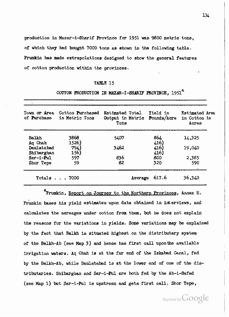
134
production in Mazar-i-Sharif Province for 1951 was 9800 metric tons,
of which they had bought 7000 tons as shown in the following table.
Frumkin has made extrapolations designed to show the general features
of cotton production within the provinces.
TABLE 15
COTTON PRODUCTION IN MAZAR-I-SHARIF PROVINCE, 1951*
Town or Area Cotton Purchased Estimated Total Yield in Estimated Area of Purchase in Metric Tons Output in Metric Pounds/Acre in Cotton in
Tons Acres
Balkh 3868 5407 864 14,325 Aq Chah 1526) 416) Daulatabad 794) 3462 416) 19,040 Shibarghan 156) 416) Sar-i-Pul 597 836 800 2,385 Shor Tepe 59 82 320 590
Totals . . . 7000 Average 617.6 36,340
rrumkin, Report on Journey to the Northern Provinces. Annex H.
Frumkin bases his yield estimates upon data obtained in interviews, and
calculates the acreages under cotton from them, but he does not explain
the reasons for the variations in yields. Some variations may be explained
by the fact that Balkh is situated highest on the distributary system
of the Balkh-Ab (see Map 3) and hence has first call uponthe available
irrigation waters. Aq Chah is at the far end of the Iskabad Canal, fed
by the Balkh-Ab, while Daulatabad is at the lower end of one of the dis-
tributaries. Shibarghan and Sar-i-Pul are both fed by the Ab-i-Safed
(see Map l) but Sar-i-Pul is upstream and gets first call. Shor Tepe,
Digitized by Google
135
with the lowest yield of all, must rely upon irrigation from the Amu
Darya. It is also interesting to note that Mazar-i-Sharif itself is
not included in the cotton growing districts. This is partly the
result of pressure upon the land near the city to grow food crops
for the population, but it can also be seen from the map that the
major part of the Balkh-Ab's water is carried, naturally or by canal,
to the west of Mazar-i-Sharif and not towards the city itself which is
fed by only a few small canals. Thus it would be difficult to explain
the present site of the principal city in the "Bactra-Balkh" area
merely on the basis of periodical shifts in the distributary pattern,
although there may have been a time when more of the flow diverged
towards the east than is now the case.
Unfortunately, very little information exists regarding the
flow of the Balkh-Ab or the amount of water available in the dis-
tributaries or canals. Presumably, in a withering stream of this
sort, all the water which can be tapped by present means is already
utilized, so that it is probably futile to speculate upon possibilities
of expanding the area under cultivation until the time when the RGA
is able to undertake a program of run-off measurement as a preliminary
to the possible erection of storage dams in the mountains to the south.
One of the sources of the Balkh-Ab, the Band-i-Amir lakes in the cen-
tral Hindu Rush, provides one of the most beautiful scenic vistas in
Afghanistan, but it will require more than their storage capacity to
increase the amount of water available for irrigation in the Mazar-i-
Sharif region.
Under the present conditions, Mazar-i-Sharif Province ^PoyidesT igi ize y ^
J
136
a valuable supplement to the cotton-growing capacity of the Kunduz River
Valley region. Despite the low per-acre yields, which presumably could be
increased by better seed selection and rotational practices, the con-
tribution of about 5000 tons of ginned cotton in 1957 represented one-
quarter of the cotton available for industrial processing or export in
Afghanistan. That part of the Mazar-i-Sharif production which is destined
for domestic spinning can easily be transported to the millet Pul-i-
Khumri and forwarded from there, if desired, to Gulbahar. Later, if
improved roads are built between Mazar-i-Sharif and Doab to tap the
Darra-i-Suf coal measures (see Map 3 and Chapters X and XI), it will be
even easier to supply the Gulbahar mill from the cotton fields and gins
of Mazar-i-Sharif Province. In the meantime, that portion of the cotton
producing industry located in Mazar-i-Sharif Province - that is to say,
the "Industrial Society" which may be independent of the nationalized
Cotton Company but which is reportedly a more recent creation of the
Bank-i-Millie - is in an excellent position to supply ginned cotton for
export to the Soviet Union on Afghan Government account. The Society
would also be in a good position to build up a local cotton spinning
and weaving industry were it not for the fact that the Pul-i-Khumri and
Gulbahar mills will for some time to come need all the cotton which can
be produced within Afghanistan and which is not exported.
The author has no detailed information regarding the agriculture
of Maimana Province. The province is separated by fine sand or loessal
hills from the Shibarghan area of Mazar-i-Sharif, and on the north,
beyond Andkhui, it merges into the sands of the southeastern Karakum
rather than extending to the Amu Darya which is no longer the Afghan-
Digitized by VJOOQLC

137
Soviet border this far west. To the south, the Band-i-Turkestan Range,
a northwesterly branch of the Hindu Kush, separates the province from
that of Herat and can be crossed by vehicle only in the Murghab Valley
at the west. A large part of the province of Maimana lies in foothill
country, and its capital is located where the Ram-Gul-Tagao River, or
one of its principal tributaries, issues from these foothills. The low
hills are covered with sagebrush, or its equivalent, and with tough
bunch-grass which is, apparently, the favorite food of the karakul
sheep. At any rate, these sheep, whose skins bring $7.50 or more each
on the New York market, thrive on this sparse vegetation so long as
their water and shelter needs are met, and the greatest concentration
of karakul sheep in Afghanistan is within Maimana Province. The problems
of ensuring their well-being, and of meeting competition from the Soviet
Union and the Union of South Africa on the world karakul (Astrakhan or
"Persian lamb") market will be further analyzed in Chapters VIII and
II. Our consideration must first be directed to the third major economic
region of Afghanistan, the Helmand Valley.
Digitized by Google
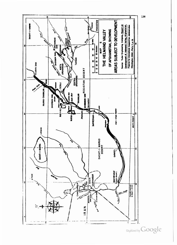
138
Digitized by Google

139
III. THE HELMAND VALLEY GEOGRAPHICAL AND HISTORICAL SETTING
The Helmand and Arghandab Rivers
The Helmand River is the longest stream in Afghanistan, with
a watershed occupying over forty per cent of the country,s area. The
Helmand itself rises between the Koh-i-Baba and Pagbman Ranges, some
twenty-five miles due west of Kabul City. In fact, the Helmand and the
Kabul Rivers drain opposite slopes of the 14,000-foot Unai Pass and
at one point flow within five linear miles of one another. The general
course of the Helmand is southwestwards to its junction with the
Arghandab at Qala Bist, some 350 miles from the source. Thereafter,
the combined waters describe a huge semi-circle, some 250 miles long,
to the south, west and north. They never reach exterior drainage, but
are absorbed in the marshes and sinks of the Chakansur Basin along
the Iranian frontier.
Though its flow varies greatly from season to season and
from year to year, the Helmand is one of the few perennial streams
in Afghanistan. Prior to the filling of the Kajakai reservoir in
1953-54-) the lowest recorded natural flow in the Helmand above the
dam was 1620 second feet on July 22, 1953, and the highest was some
50,100 second feet on April 26 or 27, 1949. As a result of the con-
^The present gaging station is located two kilometers below the Kajakai dam and records controlled runoff from approximately 16,300 square miles. The figure given for July 22, 1953, was obtained from a gaging station maintained above the reservoir, filling of which was begun in April, 1953.
Digitized by VjOOQlC
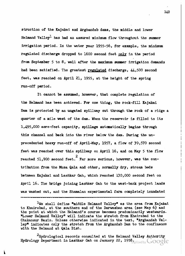
140
struction of the Kajakai and Arghandab dams, the middle and lower
Helmand Valley1 has had an assured minimum flow throughout the summer
irrigation period. In the water year 1955-56, for example, the minimum
regulated discharge dropped to 1600 second feet only in the period
from September 5 to 8, well after the maximum summer irrigation demands
had been satisfied. The greatest regulated discharge, 44,500 second
feet, was reached on April 21, 1955, at the height of the spring
run-off period.
It cannot be assumed, however, that complete regulation of
the Helmand has been achieved. For one thing, the rock-fill Kajakai
Dam is protected by an ungated spillway out through the rock of a ridge a
quarter of a mile west of the dam. When the reservoir is filled to its
1,495,000 acre-feet capacity, spillage automatically begins through
this channel and back into the river below the dam. During the un-
precedented heavy run-off of April-May, 1957, a flow of 39,570 second
feet was reached over this spillway on April 16, and on May 5 the flow
2 reached 51,900 second feet. Far more serious, however, was the con-
tribution from the Musa Qala and other, normally dry, stream beds
between Kajakai and Lashkar Gah, which reached 130,000 second feet on
April 16. The bridge joining Lashkar Gah to the west-bank project lands
was washed out, and the Shamalan experimental farm completely inundated
•'•We shall define "middle Helmand Valley" as the area from Kajakai to Khairabad, at the southern end of the Darweshan area (see Map 6) and the point at which the Helmandfs course becomes predominantly westwards. "Lower Helmand Valley" will indicate the stretch from Khairabad to the Chakansur Basin. Unless otherwise indicated in the text, "Arghandab Val- ley" indicates only the stretch from the Arghandab Dam to the confluence with the Helmand at Qala Bist.
Hydrological records consulted at the Helmand Valley Authority Hydrology Department in Lashkar Gah on January 22, 1958^ it

141
and, far all practical purposes, ruined.
The Arghandab River rises near the Dasht-i-Nawar ephemeral
lake. Records from the gaging station twenty miles upstream from the
Arghandab Dam indicate that the flow of this stream is even more ir-
regular than that of the Helmand. The maTMimnn unregulated flow of
28,000 second feet was recorded on March 11, 1949, and the minimum
of 44 second feet on September 7-8, 1948. In the spring floods of 1957,
the flow at the gaging station reached 22,500 second feet on May 6,
and water passed over the automatic spillways of the dam during the 1
period from April 4 to July 19. The extremely erratic behavior of
the Arghandab, even when compared with the Helmand (see table below),
poses serious problems both in reservoir operation and in planning
irrigation use of the water. Roughly 100,000 acres of land in the Kan-
dahar region are irrigated from the Arghandab in any given season. The
Dori, Arghastan and Tarnak Rivers, which join the Arghandab near Kan-
dahar, are also highly seasonal and erratic in their flow. Some small
use is made of their waters in the ancient and highly developed irrigation
system of this area, but the Helmand Valley Project has not attempted to
draw on them except to the extent that their flow contributes to that
in the Helmand above the new Darweshan diversion dam.
Like other Afghan streams, the Helmand and Arghandab derive
most of their water from winter and early spring rain augmented through
summer by melting snows in the central mountains. Arid lands, lacking
Vegetative cover to retain rainfall, are noted for rapid run-off. It
may be assumed that the spring flood pattern of the Helmand-Arghandab
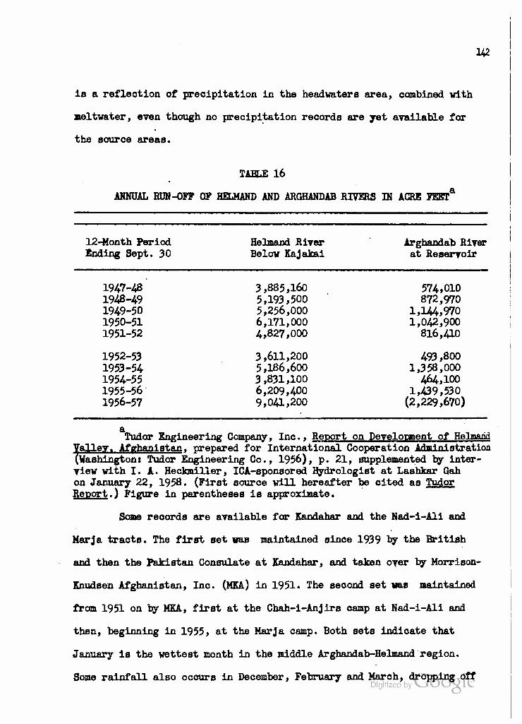
142
is a reflection of precipitation in the headwaters area, combined with
meltwater, even though no precipitation records are yet available for
the source areas.
TABLE 16
ANNUAL RUN-OFF OP HELHAND AND ARGHANDAB RIVERS IN ACRE FEET4
12-Month Period Helmand River Arghandab River Ending Sept. 30 Below Kajakai at Reservoir
1947-48 3,885,160 574,010 1948-49 5,193,500 872,970 1949-50 5,256,000 1,144,970 1950-51 6,171,000 1,042,900 1951-52 4,827,000 816,410
1952-53 3,611,200 493,800 1953-54 5,186,600 1,358,000 1954-55 3,831,100 464,100 1955-56 6,209,400 1,439,530 1956-57 9,041,200 (2,229,670)
a Tudor Engineering Company, Inc., Report on Development of Helmand
Valley. Afghanistan, prepared for International Cooperation Administration (Washingtoni Tudor Engineering Co., 1956), p. 21, supplemented by inter- view with I. A. Heckmiller, ICA-sponsored Hydrologlst at Lashkar Gah on January 22, 1958. (First source will hereafter be cited as Tudor Report.) Figure in parentheses is approximate.
Some records are available far Kandahar and the Nad-i-Ali and
Marja tracts. The first set was maintained since 1939 by the British
and then the Pakistan Consulate at Kandahar, and taken over by Morrison-
Knudsen Afghanistan, Inc. (MKA) in 1951. The second set was maintained
from 1951 on by MKA, first at the Chah-i-Anjirs camp at Nad-i-Ali and
then, beginning in 1955, at the Narja camp. Both sets indicate that
January is the wettest month in the middle Arghandab-Helmand region.
Same rainfall also occurs in December, February and March, dropping off

U3
la April and Hay. The months of June through November are almost,
if not entirely, rainless. At the same time, the evaporation rises
to many times the rainfall so that there is a net loss of soil moisture
over the year.
TABLE 17
MEAN RAINFALL AND EVAPORATION AT KANDAHAR IN IN0HESa
Month Rainfall Evaporation Month Rainfall Evaporation
January 2.46 1.70 July .17 10.28 February 1.53 2.86 August 0.00 10.06 March 1.61 3.75 September 0.00 7.18 April •47 6.28 October .03 4.97 May .23 8.83 November .18 2.75 June 0.00 10.09 December 1.16 1.70
Rainfall data for period 1939-57; evaporation data for period 1951-57 only. Morrison-Knudsen Afghanistan, Weather fhwmnn-ry. Drawings FSKA l66 and 356, Kandahar, Afghanistan. Calculations by the author.
It is important to note that for every month but January the average
evaporation exceeds the average preoipitation. This continuing natural
dessication poses severe problems for the farmer and the irrigation
engineer inasmuch as evaporation of water from the surface accelerates
the capillary rise of soil water and the deposition of salts in the
upper horizons.
One hundred miles further west, along the Helmand, the situation
is even worse. See Table 18 on the following page. Evaporation rates
Vary according to temperature. The temperature regimes for Kandahar
and Chah-i-Anjirs/Marja are given in Table 19» and cross comparisons
are made with rainfall and evaporation in Figure 1.
Digitized by VJOOQLC

144
TABLE 18
MEAN RAINFALL AND EVAPORATION AT CHAH-I-ANJIRS OR MARJA IN INCHES6
Month Rainfall Evaporation Month Rainfall Evaporation
January February March
1.46 •91
1.51 April May June
.33
.04 0.00
2.74 4-17 5.99 9.78 14-14 18.19
July August September October November December
.09 0.00 0.00 ,10
0.00 .62
17.35 15.82 12.11 8.66 6.13 3-10
All data calculated from MKA, Weather finrnnwry- Drawings FSEA 166 and 356, Kandahar, Afghanistan. Data for 1951-54 are from the station at Chah-i-Anjirs. In January, 1955* this station was moved to the Marja camp, about 20 miles away. The difference in location may have a slight effect upon the averages, but since no other data are available these presented are done so with this qualification.
TABLE 19
MEAN MONTHLY MAXIMUM AND MINIMUM TEMPERATURES IN DEGREES FAHRENHEIT a.
Month Kandahar Chah-i -Anjirs/Marja Maximum Minimum Maximum Minimum
January 54.2 32.7 58.4 33.9 February 61.0 39.7 64.8 40.1 March 71.5 46.5 72.0 48.8 April 82.5 53.5 88.2 58.4 May 93.7 61.1 99.1 67.6 June 101.7 66.2 106.4 72.8
July 103.8 71.5 108.5 77.0 August 100.2 67.2 103.1 68.7 September 92.4 55.9 97.2 59.2 October 79-5 44.7 81.9 44.2 November 69.8 36.6 72.0 39.0 December 60.0 34.1 62.8 34.8
aSame as Table 18,
Digitized by Google

H5
FIG. I - CLIMOGRAPHS FOR KANDAHAR AND
CHAH-I-ANJIRS OR MARJA, AFGHANISTAN
-100
< o < <*
Q 2
z <
o
Z
UJ ac r> »- < a: UJ a. Ui
JFMAMJJASOND
KANDAHAR, AFGHANISTAN
z o »- <
O
UI £ z
a "~ z <
< JFMAMJ JASOND
CHAH-I-ANJIRS OR MARJA, AFGHANISTAN
MEAN MONTHLY MAXIMUM TEMPERATURE
MEAN MONTHLY MINIMUM TEMPERATURE
EZ?3 EVAPORATION Digitized by GoOgk E^^ RAINFALL
U6
Thus it appear a that it is generally warmer at Chah-i-Anjirs or Marja
than in Kandahar. Although the difference may be less than one degree
in winter, it spreads to five or six degrees in mid-summer. The dif-
ference is due, in the main, to the slightly higher elevation at Kan-
dahar and to the fact that the terrace tracts of Nad-i-Ali and Marja
lie west of the Helmand with deserts on all sides. Kandahar, between
the Arghandab and the Tarnak, has considerable expanses of trees in
and near the city.
Rainfall is also somewhat greater at Kandahar, with almost
eight inches falling in the average year, than west of the Helmand
where only five inches oocur. Rainfall is also more effeotive at Kan-
dahar where evaporation totals only 10.01 inches during the four
months (December-March) when 6.76 inches of the precipitation occurs.
West of the Helmand, the 4.50 inches of rain falling in these months
is pitted against an evaporation of 16.00 inches.
No records of relative humidity are available, but it is
apparent from the above data that it must be extremely low except in
localities adjacent to streams and canals.
In terms of analogs, the Environmental Protection Division of
the Quartermaster Research and Development Command of the United States
Army found Knndahar to be closely analogous to Tuma, Arizona, in the
following respects: mean temperature of warmest month (Kandahar 87.6°P.
in July) Tuma 91.3°F. in July), mean daily maximum temperature of the
warmest month (Kandahar 103.8°F. in July; Tuma 106.0°P. in July), and
mean daily temperature range of the warmest month (July), but Tuma has
a higher absolute maximum temperature and is also warmer than Kandahar
in the winter. Kandahar is wetter than Tuma (7.83 compared 7%Q$\A inches
147
in an average year) although it is less cloudy. However, there is
little doubt that the most analogous area in the United States for
the Helmand Valley is that of southern Arizona or southeastern Cal-
ifornia, especially when comparable elevations are selected.
Thus, the climate of the Helmand Valley may be described as
very dry (semi-arid to arid), cool in winter, hot in summer but gener-
ally quite viable. As is the case in southern Arizona water is the
sine qua non for existence, and almost all agriculture is irrigated
agriculture. Population is concentrated along the streams and canals,
reaching its greatest density in the Kandahar area where irrigation,
agriculture and trade' have been most highly developed. The city of
Kandahar itself has between 75,000 and 80,000 people. The six districts
of Kandahar Province, including the capital, which lie within the Pro-
2 ject area are estimated to contain some 224,000 people. These are
concentrated in and around the city, especially to the south and west
as far as the Tarnak and Arghandab River3 and upstream on both sides
of the Arghandab about as far as the diversion dam (see Map 6). In the
new province of Girishk, which includes the remainder of the project
3 areas, some 378,000 people are said to live. As would be expected,
they are concentrated on and near the Helmand floodplain above and
below Girishk. This area has been settled for centuries, and for at
1United States Army, Quartermaster Research and Development Center, Environmental Protection Division, Analogs of Yuma Climate in South Central Asia (Natick, Massachusetts: June, 1955), Figures 2, 3, At 5, 6, 7, 8, and 10.
2 Tudor Report, p. 84.
3Ibid.
Digitized by VjOOQlC
148
least 250 years by Afghans. In the 1930fs the RGA settled a mmber
of Uzbek families from northern Afghanistan in the Seraj area, between
the confluent Helmand and Arghandab.
History of the Helmand Valley Projeot
The Seraj area was the first in the Helmand Region to benefit
from government construction. During the years 1910-1914, Governor
Osman of Kandahar, inspired perhaps by tales of the ancient "Sughra"
Canal in the Seraj, had a new canal dug from an intake placed In the
Helmand at Sanjin, just below the mouth of the Musa Qala. The canal
extended southwards and eventually some of its branches reached the
Arghandab above Qala Bist. In 1930-31, German engineers (perhaps the
same crew that built the girder bridge over the Helmand at Girishk)
repaired the Seraj canal and installed a siphon near the intake.
Finally, in 1941, the present King had three jetties built In the
Helmand to protect the Seraj intake.
Meanwhile, attention shifted to the'opposite bank of the Hel-
mand. Late in the 1930's, the RGA called in a team of Japanese en-
gineers to improve the old Deh Adam Khan Canal which had been func-
tioning for some 200 years. It began above Girishk and irrigated lands
on the right bank of the Helmand as far as the water would reach. The
Japanese planned to enlarge the canal and change its alignment in
order to increase the area which could be irrigated from it. However,
Only some nine miles of the new canal were dug, using hand methods
%ost of the historical information in this and the following paragraphs was obtained in an interview with Mr. Sayyed Wahdat Shah, Vice President in Charge of Technical Matters, Helmand Valley Authority, at Kandahar on January 28, 1958.
Digitized by VJOOQLC

U9
exclusively, before the exigencies of World War II caused the de-
parture of the Japanese in February, 1942. The Afghans continued to
work under the direction of Mr. Sayyed Wahdat Shah, a Cornell-trained
engineer, who had completed another sixteen miles by 194-6. Mr. Shah
also made two important changes in the plans: l) he relocated the
proposed intake structure to its present position above Girishk
where a small island divides the Helmand, and 2) he rerouted the
section he supervised onto higher land, preferring to cut and blast
through the hard conglomerate of the terraces rather than to fill on
the floodplain as the Japanese had been doing. The problems which arise
from filling on soils containing highly permeable gypsum phases will be
discussed later in this chapter; suffice it to say that they were
recognized by at least one engineer before the "Helmand Valley Project",
as such, began.
By 1946, Mr. Mohammed Ludin, Minister of Public Works and former
General Director of Irrigation, had persuaded the RGA to irrigate not
only the floodplain below Girishk but the Nad-i-Ali and Marja tracts
on the terraces or benches to the southwest. This involved enlarging
and partially rerouting what was now called the "Boghra" Canal, bi-
furcating it in the vicinity of Chah-i-Anjirs, and running separate
branches to the floodplain and terrace areas. It also involved the con-
struction of a much larger diversion dam and intake than had been planned,
along with many reinforced concrete outlet and drop structures. In short,
the Ludin plan required the use of modern equipment and engineering
techniques far beyond what the Afghans themselves could supply.
Digitized by Google

150
At the same time, the RGA in Kabul and particularly the Minister
of National Economy, Abdul Madjid Zabuli Khan, were thinking in terms
of a more coordinated development program than had been pursued before
the war, and one which could be financed from reserves accumulated
during the conflict when karakul exports earned many dollars but few
imports were obtainable. The defeat of Germany and Japan ruled out
approaches to either of the nations which heretofore had provided most
of Afghanistan's engineering services. Of the victorious Allies, both
Russia and Britain had long been considered foes of Afghanistan. But
the United States appeared sufficiently remote, disinterested and well-
equipped to meet the need. So the RGA turned to the Idaho firm of
Morrison-Knudsen (MK henceforth) to continue the work in the Helmand
and to undertake other irrigation and road construction projects in
Afghanistan.
At first, the RGA employed MK as a sort of adjunct to the Ministry
of Public Works, and MK engineers carried out many surveys in the capital
and various parts of the country. For some time it appeared that MK
would reconstruct the 151-mile Kabul-Torkham road. The contract signed
between RGA and MK in 1946 called for work on this road, on the 315-mile
stretch from Kabul to Kandahar, and on the 73-mile link from Kandahar
to Girishk. But when MK estimated $26.4 million as the cost of these
2 three projects, construction was "postponed". At one time it was even
^The MK barracks, later taken over by the Ministry of Public Works, can still be seen a few miles west of Jalalabad on the road to Kabul.
^Peter J, Franck, Obtaining Financial Aid for a Development Plan. The Export-Import Bank of Washington Loan to Afghanistan. U.S. Congress, 83rd Cong., 2nd Sees., Committee Print, September 30, 1953. Printed for the Use of the Committee on Banking and Currency (Washington, l°;54-)> p. U including footnote 25.
151
rumored that MK would construct a two-kilometer bridge across the Amu
Darya at TermezJ And for a number of years MK was slated to build the
Sarobi Dam in the Kabul River gorge. But here, too, MK's estimate was
too high and in 1950 the RGA awarded the contract to Siemens-Schuckert
of West Germany. By that time, MK had become exclusively concerned with
the Helmand Valley Project.
In 1946, the Morrison-Knudsen Company established an affiliate,
Morrison-Knudsen Afghanistan, Inc., (MKA) in San Francisco to handle
its work in Afghanistan. The RGA turned over to MKA the old palace of
Manzel Bagh, east of Kandahar, for use as a base camp and administrative
headquarters. The proximity of the Helmand-Arghandab region to the rail-
head at Chaman, Northwest Frontier Provinces (then Indiaj after 1947,
Pakistan) made logistical problems much simpler than they would have
been for a project of like magnitude located near Kabul or north of
the Hindu Kush. Still, the first task was to rebuild or improve the
access roads in the area. The Chaman-Kandahar road was re-aligned,
widened and reconstructed with proper foundation aggregate and a surface
of loose gravel that, properly maintained, is almost as good as asphalt
or concrete in that practically rainless area, and much easier to re-
pair in case of flash floods. Proper bridges were put across the
Arghastan and Arghandab Rivers, while fording of the Tarnak was facil-
itated by a concrete dip, well-ballasted above and below to prevent
undercutting by the stream. Smaller streams and washes WBre similarly
provided with concrete dips, another superior adaptation to local con-
ditions where bridges can be wrecked by flash floods whereas the rubble
deposited on the dips can be cleared away by bulldozers within a few
hours after the water has subsided. Digitized by Google
152
MKA also Improved the Kandahar-Girishk road to render it suitable
for rapid movement of men, materials and equipment to the forward oper-
ations camp which they established on the eastern bank of the Helmand
a few miles above Girishk. This was at the point chosen by Mr. Shah
for the diversion dam and opposite the proposed intake structure for the
Boghra Canal. As we have indicated, MKA was brought into the Helmand by
RGA to build these two structures and to enlarge and extend the Boghra
Canal so as to provide water for the Nad-i-Ali and Marja terrace tracts
in addition to the Helmand floodplain (henceforth called "Shamalan"
area, designating all the floodplain watered by the Boghra Canal). In
addition, the RGA wanted MKA to construct a combination storage and power
dam on the Arghandab River above the fruit-growing region near Kandahar.
"Adding 315,000 acre-feet of stored water to the natural flow in the
low-water season was expected to meet the full water requirements of
4.3 acre-feet of water a year for 120,000 acres. . . . The reservoir
cost was estimated at nearly |9.7 million with an additional #1 million
for canal repairs, land levelling, and road building."
The idea for the Kajakai Dam on the Helmand River apparently
originated with MKA. In April, 1948, with work on the diversion dam and
the first 30 kilometers of the Boghra Canal well under way, an MKA survey
revealed that the Nad-i-Ali and Marja terrace soils were shallow, under-
2 lain by dense gravelly subsoils, poorly drained and saline in places.
The floodplain soils in the Shamalan were afflicted in places by high
1Ibid., p. 16.
2 Ibid., p. 17 and footnote 28.
Digitized by Google
153
water table and surface accumulation of salts. But, despite the
presentation of this information to the RGA, its import, and partic-
ularly that of the dense subsoils, was apparently minimized by one or
both of the parties.
By the fall of 1948> the Government had mixed feelings about further Helmand development. . . . the diversion of water to the tablelands during the low-water season would take water away from bottomlands downstream unless an upstream reservoir stored flood- water. While prestige considerations suggested completion of the limited Boghra project, economic wisdom seemed to advise an en- largement of its scope before continuation. The growing shortage of exchange forced a decision.
M-K advocated an integrated valley development, including a major reservoir dam upstream at Kajakai, and completed field sur- veys for the dam by September, 1943. For a comprehensive project M-K was reluctant to count on more than 4-00,000 acres for irri- gation and settlement until a thorough survey of the entire valley had been made. But the Afghans saw no need for such a survey. M-K and the mission /"Afghan economic mission to Washington] concluded that even a 20 percent margin of error in estimating the acreage or water supply could not detract from the project's intrinsic value.
A comprehensive project, based on intelligent guesses by M-K and the mission was estimated to cost $63.7 million, with #53.7 million of it in foreign exchange.
While the contractor was thus the moving force behind the Helmand
storage dam (Kajakai) project, the RGA, or rather the Afghan Economic
Mission established in Washington in the fall of 194# under the direc-
tion of the Minister of National Economy, Abdul Madjid Zabuli Khan,
must take the responsibility for continuation of the Boghra project.
MK's agronomist had recommended that it be deferred until surveys had
established that there was enough water available to serve both the
2 terrace lands and the presumably more fertile floodplain areas. But
J-Ibid.. pp. 17-18.
2Ibid.. p. 20 and footnote 35.
Digitized by Google
154
the diversion dam and the Boghra intake structure were more than half
completed toy the beginning of 1949.
. . . the calculation of economic benefits from a single canal project vas particularly difficult. Without a reservoir the large diversion needed would withdraw much water from other areas. But without the maximum use of water in the Boghra area, the invest- ment there could not be fruitful. So the mission was forced to present the Boghra benefits as directly dependent on the building of a reservoir. . . . The construction cost for the Boghra was estimated at $7.2 million above the $2.5 million already spent.1
The Helmand Valley Project had now begun to mushroom. Starting
with the simple desire to rehabilitate and extend the old Deh Adam Khan
Canal on the floodplain near Girishk, using foreign engineering but
local hand labor, the idea had grown into that of a bifurcated Boghra
Canal to Irrigate the entire Shamalan floodplain plus the large Nad-i-
Ali and Marja tracts on the terraces. To accomplish this, MKA was
brought into the Valley. The contractor soon suggested that it would
be necessary to provide a storage dam and reservoir on the Helmand
in order to accomplish the RGA's objectives. Of course, it would have
been possible to call a halt to the half-completed Boghra works, es-
pecially in view of the soil and drainage problems which were becoming
apparent, but this would have resulted in a serious loss of face far
both RGA and MKA. within Afghanistan. It might also have meant operating
at a level that was uneconomical for MKA, and thus ultimately far RGA,
given the facilities, equipment, materials and manpower that had al-
ready been brought into the Valley. It appeared that a level of spend-
ing of $4 million per year was necessary to keep MKA operating above
the break-even point. So the alternative was to turn to the United
1Ibld.. p. 20.
Digitized by Google
155
States Export-Import Bank for a development loan.
On February 11, 194-9, the Afghan Economic Mission in Washington
submitted a request to the Export-Import Bank for a loan of $55 million
to finance Helmand Valley development and other items in Minister
Zabuli's plan. On May 31, the Bank rejected the request but suggested
that certain specific projects might be resubmitted. Despite the Min-
ister's conviction that his plan represented an integrated whole of
interdependent agricultural and industrial projects, the list was
reduced and resubmitted to the Bank. This time, the Bank indicated that
top priority should be given to the Helmand Valley Project in order
to expand agricultural acreage and eliminate the repeated food shor-
tages in Afghanistan. It also indicated that the Helmand Valley Project
would involve about as much of a commitment as the bank was willing to
make. Minister Zabuli protested that the agricultural projects alone
could not produce returns in time to meet Afghanistan's repayment and
foreign exchange commitments, but the Bank remained adamant. Finally,
after extensive negotiations and revisions, the Bank approved a $21
million loan in November, 1949. This was to include the gross dollar
requirements of MKA's Arghandab, Kajakai and Boghra Canal projects.
As of September 1, 1949, the Afghans had paid M-K fll.l million for purchases in the United States and Pakistan and |8.9 million for services and purchases in Afghanistan (inclusive of a fl.3 million contractor's fee). About $4-6 million of this was the value of machinery, equipment, camps and shops. In an M-K letter to Department of State, September 29, 1949, M-K admitted that "there should have been more ... to show for this large ex- penditure . "l
1Ibid., p. 34> footnote 64.
Digitized by Google

156
Delays over details of the loan and RGA's second contract with MKA
held up the signing of the loan agreement until April 21, 1950. Mean-
while, Minister Zabuli was having difficulties in the Afghan Parliament
over the dwindling foreign exchange reserves, the high cost of MKA
projects, and the rising cost of living. In June, 1950, he resigned,
and the loan agreement and MKA contract were tabled in Kabul until the
autumn. It actually took until March of 1951 before red tape was cleared
away and the RGA could draw on the loan funds.
The contractor was now able to return to work. The Bogbra
diversion dam and intake structure had been completed by the end of
1949. Water was turned into the first section of the canal in the spring
of 1950. By this time, thirty-eight miles of canal had.been dug and
six concrete siphons, passing under streams or washes, were completed.
The Boghra Canal included a drop structure near Girishk where a small •
hydroelectric station could later be installed. The 1950 loan provided
funds for partial lining of the canal from station 56+500 to station
75+100 (see Map 7) where it was to bifurcate a second time with one
branch going to the West Marja tract and the other curving eastwards
and ending in a desert sink. About 67 per cent of the East Marja Branch
was also to be lined to prevent leakage in gypsum or other permeable
soils.
Leakage from the Boghra Canal and its laterals, combined with
poor Irrigation practices, soon brought the water table in the Nad-i-Ali
area up from a depth of sixteen feet to within a few inches of the
2 surface. Although no groundwater survey had been made, the increasing
-krhis designation indicates 56.5 kilometers from the start of the canal.
Digitized by VjOOQlC Tranck, Obtaining Financial Aid . . .. p. 39.

157
surface salt accumulations afforded visual evidence of the poor
drainage characteristics of the tract, and particularly of the serious-
ness of the problem of impermeable substrata which had previously-
been underestimated. Lining of canals and laterals, installation
of drains, and training of settlers in better water use practices
now became pressing needs.
MEA's original task had been to construct dams and intakes,
main canals and wasteways, laterals and sublaterals. From the latter,
RGA and the settlers were to construct feeders and farm ditches bringing
water to land which they had previously demarcated, leveled and prepared
for crops. But the Afghans fell so far behind with their part of the
task that in 1951 they asked MKA to assume it for 16,000 acres in
the Nad-i-Ali tract. By the end of 1952, the contractor, on schedule,
had completed drop structures and lateral outlets on the Boghra Canal
to the end of the Nad-i-Ali tract (station 51+000) and had completed
the land preparation as requested. But while 10,500 acres were under
cultivation, only 1,500 were being worked by settlers. Large landowners
were farming 6000 acres, the RGA had incorporated 2000 into an exper-
imental farm, and MKA was farming the remainder. Meanwhile, 15,000
settler applications had piled up due to the lack of administrative
machinery for processing them either in Kabul or in the Valley. Finally,
in July, 1952, under prodding by the Export-Import Bank, the RGA
established the autonomous Helmand Valley Authority (HVA henceforth)
to process settler applications, determine plot sizes and farm and
village locations, and help the settlers construct their homes, prepare
their land and follow superior cropping and water use practices. The
engineer of the Export-Import Bank had advocated in May, 1952, the
lOfficially promulgated only on December U> 1952, however.
158
increase of farm size from 10 or 12.5 acres to 15, and the adoption
of irrigated pasture for sheep and cattle, with wheat sown on only
one-fourth of the acreage in any given year. The HVA did decree an
increase in plot sizes, as recommended, but the task of converting the
grain-growing Afghan farmer to animal husbandry was to prove almost
impossible. The Bank's engineer estimated, also in May, 1952, that the
additional cost of Helmand Valley development, including settlement
of farmers and proper training of technicians to assist them and to
2 operate the project, would amount to some $4-6 millions.
The unanticipated high costs for settlement and drainage, along
with a much slower rate of return than had been hoped for, caused the
RGA-HVA to drop the 23-kilometer West Marja extension of the Boghra
Canal, thereby saving some $844,000. But the bifurcation structure at
station 75+100 (see Map 7) was built, and the West Marja extension
can be added if and when cultivation practices have advanced to the
point where profitable use can be made of its soils. It should be
pointed out that the Boghra Canal was designed and constructed with
both East and West Marja tracts in view, and before detailed soil and
drainability surveys had been made of either. This means that the cross-
section of the Boghra down to the bifurcation at 75+100 is designed
for a flow of 2500 second feet. Operation of the canal for East Marja
alone, at a rate of only 1500-1600 second feet, has given rise to serious
difficulties of maintenance and water supply through outlets designed
1Ibid., p. 40.
2Ibid., p. 41.
Digitized by VJOOQLC
159
for the originally projected rate of flow.
MKA reconnaissance surveys indicated a higher proportion of
good land in the East Marja tract than in either West Marja or Nad-i-
Ali, so construction of the East Marja branch of the Boghra Canal was
continued. MKA also proposed constructing 25 of the 4-0 miles of the
Shamalan branch along the route of old canals on the Helmand flood-
plain rather than on the terrace to the west. This avoided disturbing
the old ownership pattern in the areas that were under cultivation in
the Shamalan tract and reduced the estimated cost by about $500,000.
Thus, the Shamalan Canal, which takes off from the Boghra at station
31+681, merely intercepts and feeds the old canal intakes. Since the
complex floodplain is highest close to the Helmand, the canal follows
the river and the laterals are all on the western side, between the
canal and the terrace bluffs. Collector drains return the waters to
the Helmand by passing under the canal at suitable places. This system
is a logical one except for the fact that the Shamalan in some places
is so close to the Helmand as to be threatened if the river shifts its
course. During the floods in the spring of 1957, the berm of the Shamalan
Canal was nearly breached in two places, and was saved only by emer-
gency sandbagging operations. As has been indicated, the flood completely
wrecked the experimental farm built between the canal and the river
opposite Lashkar Gah. Receding waters left the water table in the
Shamalan tract, already aggravated by several years of over-irrigation
and poor drainage, higher than ever. In the fall and winter of 1957-58,
salt accumulations were painfully evident along much of the Shamalan
^Tbid., p. 38, footnote 74; p. 40, footnote 81. Digitized by Google
160
Canal.
Aa for the storage facility aspects of the second MKA-RGA
contract, the Arghandab Dam, 18 miles north of Kandahar, was completed
on schedule and at a saving of some $2.5 million over the original
estimate. It was dedicated on December 27, 1952. More thorough sur-
veying along the Arghandab led to an increase in the estimate of
irrigable land from 120,000 to 156,000 acres, meaning an increase in
new land which could be brought under cultivation from an estimated
20,000 to 56,000 acres.
Construction at Kajakai, which required preliminary work on
the long, winding road from Kandahar and on the shorter one from
Girishk, had encountered some delays and extra costs. However, storage
in the reservoir began in April, 1953.
By that time, the funds from the Export-Import Bank loan were -
nearly exhausted. After seven, interrupted, years of work, and the
expenditure of over $40 millions, the RGA and MKA had storage dams on
the Arghandab and Helmand, a diversion dam and two long feeder canals
on the Helmand, and some 18,500 acres of partially developed, sparsely
settled land in the Nad-i-Ali tract. It had become obvious that a
system of deep drains would have to be incorporated into the Nad-i-Ali
project. Indications from surveys in the East Marja tract led to the
same conclusion while, as mentioned above, the Vest Marja project was
completely abandoned. In addition, it became apparent that the Boghra
Canal would have to be lined from stations 47+100 to 56+500 to prevent
leakage into the Nad-i-Ali water table.
Ibid., pp. 38, 45.
161
In order once again to save the Project, an optimistic, 87-
page prospectus was prepared, augmented by economic justifications
projecting income from the Helmand and Arghandab areas to the year
2050. With this document, the Helmand Valley Development Program.
July. 1953 (HVDP of 1953 henceforth) , the RGA approached the Export-
Import Bank for a second loan in the amount of $36 millions. The plan
called for drainage and land development work in Nad-i-Ali, water
delivery and drainage systems in East Marja and the Shamalan, and
land development on the East Marja tract. It proposed to build a new
intake structure on the Helmand, midway between Kajakai and Girishk,
"There has been some confusion as to the origin of this pros- pectus. While the author was in Afghanistan, MKA provided'him with an 87-page, hektographed document bearing the title Helmand Valley Develop- ment Program. July. 1953. He assumed that this document was prepared by Morrison-Knudsen, Afghanistan, Inc., and hektographed by "them in Kandahar. However, he has since been informed by Mr. Claude L. Fly, of the International Engineering Company, Inc., a Morrison-Knudsen affiliate in San Francisco, California, that
. . . this /the Helmand Valley Development Program/ is the program of the Government of Afghanistan, and that MKA played only such part in its development as requested by the Govern- ment. The Chief of ICA Helmand Valley Operations, Mr. Torbert, was Chairman of the Committee to develop the outline and ma- terial for this document. The document was a product of the committee composed of ICA, HVA, Export-Import Bank and MKA representatives with some participation by the Food and Agri- cultural Organization of the United Nations and the U.S. Em- bassy at Kabul. (Excerpt from a letter from Claude L. Fly to the author, August 18, 1958.)
Prior to the receipt of Mr. Fly's letter, it was the author's Impression that the work of the committee which he mentions was embodied in the Report on the Development Program of the Government of Afghanistan, dated October 1, 1953, and published by the International Engineering Company, Inc., while the July, 1953, Helmand Valley Development Program reflected only the work of MKA. At any rate, the references in the present study are to the July, 1953, 87-page plus tables, hektographed, document, which will be cited as "HVDP of 1953" henceforth.
Digitized by Google

162
complete with canals, laterals and trunk drains to serve the Seraj
area. The prospectus also called for Installation of generators in
the Boghra drop structure near Girishk and for the construction of
a complete pover plant at the Arghandab Dam. A diversion dam was to
be built downstream on the Arghandab to serve canals extending along
both sides of the stream. One of these proposed canals, the "South
Arghandab Canal", was to extend as far as the Tarnak region, south
of Kandahar and between the Arghastan and Tarnak Rivers (see Map 8).
Here, 70,000 acres of land were to be irrigated and provided with
drains at a cost of $6.5 millions. The plan further called for the
development of the Darweshan floodplain area, downstream from the
Shamalan and on the opposite bank of the Helmand, and of part of the
Chakansur Basin at the end of the river to utilize exoess water stored
in the Kajakai reservoir. The Helmand Valley Project was continuing
to grow apace I As a final item, the RGA included the paving of Kabul's
streets, saying that this project was much needed to Impress local
public opinion.
After further surveys and justifications by the United States
Technical Cooperation Administration, operative in the Helmand after
July, 1953, and its own staff, the Export-Import Bank granted a loan
of $18.5 million, or roughly half the sum requested. The Bank specific-
ally excluded the Kabul street-paving which was subsequently undertaken
by the Russians. Arghandab power, the right-bank "North Arghandab Canal",
hr anck, Obtaining Financial Aid-. . . . p. 45.
Digitized by Google

163
Tarnak drainage, and the entire Seraj and Chakansur proposals
were also dropped. But RGA and MKA were guaranteed the funds necessary
to continue with the remaining features of the plan.
A third contract was signed between RGA and MKA on June 21,
1954> tut approved by RGA only on February 18, 1955. Moreover, during
the period May 21 to November 30, 1955, the Afghan-Pakistan dispute
over the Pushtun border region resulted in the closing of the frontier
to MKA and other shipments. As a result of both sets of delays, all
work except that on Marja and Shamalan irrigation and drainage and
that on interproject roads was postponed until early 1956.
In the next two years, Project operations moved swiftly. Arghan-
dab Diversion Dam and the South Canal were completed in the spring of
1957. The name "South Canal" was now applied only to the portion
paralleling the Arghandab River, from the south end of which the
"Tarnak Canal* was extended in a large eastward loop to the banks of
the Tarnak River (see Map 8). The canal was carried under this river
in a siphon and then sealed at the northeast corner of the Tarnak area,
pending allocation of further funds for the Tarnak irrigation and
drainage network.
Along the Helmand, the power installation at Girishk, begun
in mid-1956, was scheduled for completion in April, 1958, though
leakage in the Boghra Canal, behind the drop structure, would have to
be repaired before a full head of water could be provided for generation.
Here, MKA had abandoned Mr. Shahfs cutting method and had built, the
canal on permeable bottomland soils. Further downstream, the diversion
dam at Darweshan (see Map 7) was begun in May, 1957, and completed in
February, 1958. Some 50 miles of the Darweshan Canal, complete with
drains, would be completed by the time the second loan funds were

164
exhausted* It was unlikely that further Export-Import Bank funds would
be forthcoming for the Project, but the United States International
Cooperation Administration (ICA), successor to the Teohnical Cooper-
ation Administration (TCA), had now beoome sufficiently Involved in
the Helmand that funds might reasonably be expected from this source.
United States' Point Four assistance was extended to the Helmand
Valley Project (HVP) on June 23, 1952.1 The firat technicians arrived in
the Valley in the fall of 1952, but could not become effective until the
spring of 1953* A United States Operations Mission had been established
since early 1951 In Kabul and was engaged in giving teohnical assistance
In education, agriculture, industry and administration to the Afghan govern-
ment. As a result, the program in the Helmand began as a step-child, and
although it later obtained its own area director very little could be done
in the Valley without time-consuming correspondence and/or journeys to Kabul,
not to mention Washington. In point of fact, it was not until the Soviet
Union entered the field of Afghan development assistance on a large
scale in December, 1955. that the United States Government began to
take a more serious view of its program in Afghanistan. It then became
obvious to Washington that the practical distinction between the Helmand
Valley Project, which had been commenced years before by the Afghan govern-
ment, with Afghan funds, and the American Point Four program, of which tech-
nical assistance to the Helmand Valley Authority was a comparatively minor
facet, simply did not exist In the minds of the Afghan people in general
or of most Afghan officials. Because an American engineering and construc-
tion firm, Morrison-Knudsen Afghanistan, Inc., had been employed to do the
•^Letter to the author from Ruth Fitzmaurice, Afghanistan Desk, International Cooperation Administration, Washington, D.C., FeDTQar^jAj JL959.

165
work in the Helmand, that Project had become, in the Afghans1 eyes,
the measure of American ability and American prestige. While American
technicians had been sent into the Helmand in 1952 only at the urgent
request-1- of the RGA, faced with an almost insuperable problem of
settling nomads and displaced farmers on lands with very serious
tillage problems, these settlers and their compatriots did not dis-
tinguish between the TCA or ICA adviser who was supposed to "recommend"
but not "do" and the MKA engineer who was supposed to "do" but not
"recommend". Since there existed, within the MKA organization, a
Land Development Department which was charged with soils and drainage
analysis, crop experimentation, and the development of cultural tech-
niques which could be recommended to the Helmand Valley Authority,
the confusion of the Afghans may readily be understood. MKA had main-
tained agronomists, hydrologists and soil technicians on its staff
since the inception of its work in Afghanistan. Given this background,
the assignment of TCA agronomists, hydrologists, extension supervisors,
community development specialists, public health advisers, and admin-
istrative specialists to assist the HVA could hardly fail to be inter-
preted by the Afghans as an endorsement by the United States Government
of the RGA-MKA program, over and above that Implied by the Export-Import
Bank loans.
Still, the fact remains that American Point Four assistance
to the Helmand Valley Project came about after the nature and size of
the project had largely been determined by the RGA and its contractor.
A similar request was made at the time by RGA to the United Nations Technical Assistance Mission in Kabul, but without effect.
Digitized by Google
166
Aid was extended on an ad hoc basis to meet a special plea of the
RGA, and without the deliberation on the part of TCA or ICA that
would have been necessary to formulate and activate an integrated
program of technical assistance. Technical assistance was grafted
onto the Helmand Valley program in mid-growth. Those who assign
responsibility to the TCA or ICA for the formulation of the Project
or for its development through the second Export-Import Bank loan,
simply do not know the facts or have not taken the care to distinguish
a private American construction firm from an agency of the United
States Government. The Export-Import Bank, which is supposed to
ascertain that its loans will contribute to the economy of the country
they sustain and that there is every likelihood of repayment, and
which maintains a degree of field supervision, may have to bear part
of the responsibility. But in the last analysis, primary responsibility
for Helmand Valley development up to the spring of 1958 has remained
with the Government of Afghanistan and with its hired contractor,
Morrison-Knudsen.
Now that the second Export-Import Bank loan has been exhausted,
the RGA has applied to ICA for further developmental assistance. Some
of this has been awarded, more is forthcoming or under deliberation.
MKA is no longer working for the RGA, but for ICA, and that agency
will have to assume far more responsibility than the Export-Import
Bank ever had for the use of its funds. We shall analyze the present
position of the projects in the Helmand Valley as well as the alter-
natives open to ICA and the RGA. In so doing, we shall make use of
Digitized by Google

167
the information presented above, as well as that contained in the
Tudor Report, the first independent engineering study made of the
Helmand Valley Project. The Tudor Report was prepared in the summer
and autumn of 1956. When it became apparent that the Helmand Valley
Project would largely devolve upon the International Cooperation Admin-
istration, ICA/Washington called in the Tudor Engineering Company to
make an unbiased survey of the accomplishments to date, and the prob-
lems which had arisen. Under the leadership of former Governor Leonard
B. Jordan of Idaho, the Tudor field team arrived in Afghanistan July
19» 1956. Six weeks later they returned to the United States and began
the preparation of their report, which was submitted to ICA in November.
The short period spent in the field combined with the complexity
1 of the Project compelled the team to rely on secondary source materials.
They were in no position to make independent surveys. But with access
to the MKA files at Kandahar, San Francisco and Washington, and a good
deal of assistance from the ICA mission in Afghanistan, the Tudor team
assembled a surprisingly accurate and competent study of the Project.
Furthermore, based on the team members' extensive experience with
other irrigation and development projects, a series of recommendations
for future action were embodied in the report. Naturally, these recommen-
dations could not please all the parties concerned. By the time of the
Tudor survey, too many false starts had been made and too many conflicts
of interest had arisen for the RGA, MKA, the Export-Import Bank and ICA
to see eye-to-eye on all future lines of action. Nor was the Tudor Report
in any way binding on any of these parties. It represented only a survey
Interview with Mr. Ralph G. Wadsworth, Assistant Team Leader, at the offices of the Tudor Engineering Company in Washington, Dj^)0crJ June 16, 1958.
163
by an outside party hired for the job by ICA, which remained at liberty
to accept, reject or alter the recommended courses of action. But the
report did bring together in workable, or debatable, form most of the
relevant information available at the time. And, by presenting its
recommendations in the form of a two-phase program, with one phase
nearing completion and the other to be deferred for a number of years,
the Report formed the basis for a logical discussion of the relative
priorities to be assigned to various features of the Project. In order
to clarify these aspects, and to bring the Tudor information up to
date, we shall now examine, area by area, the various tracts now in-
cluded or definitely planned for development in the Helmand Valley Pro-
ject. At the end of this examination, we should be in a position to
review the Tudor recommendations and priorities and to analyze them
in terms of information gathered by the author in the field and in
terms of the most recent developments in ICA policy.
Throughout the forthcoming area analyses, the following points
should be kept in mind by the reader:
l) Almost all of the existing information with respect to soil
and drainage characteristics in the Helmand comes from the Engineering
Department of MKA in Kandahar. MKA was finally authorized by RGA to
proceed with detailed soil and drainage surveys only in 1955-56 for
Marja, 1956-57 for Nad-i-Ali, and the same general period for other
project areas. During the Tudor survey, this information, in its in-
complete and partially tabulated state, was made available to the team,
Digitized by Google
169
and found its way into the Tudor Report. Later and more complete tabu-
lations were made available to the author during his stay in Afghanistan.
These tabulations were then in the form of a final draft of the HelTnanH
Valley Survey Report on "Soil and Water Resources of Southwestern Afghan-
istan". This draft had yet to be submitted to the San Francisco office of
MKA and then to the Helmand Valley Authority. Revisions would be made by
MKA and HVA before any of the information was published. HVA-RGA approval
would be necessary before funds could be dispersed for publication. At the
time of writing, the Helmand Valley Survey Report (HVSR henceforth) had not
been published and it was possible that it would not be approved or released.
Therefore, we must use the preliminary figures, bearing in mind that they
do not, and never may, represent commitments on the part of MKA or HVA and
RGA. They are certainly better than the partial estimates available to the
Tudor team, but it would be an injustice to the parties concerned to present
or handle them as final figures.
2) All MKA estimates refer to potential land classes. that is, to
the classification which the land may acquire if and when certain recla-
mation and improvement practices are undertaken. In a footnote to the HVSR
draft, MKA points out:
Costs of reclamation are not made a part of the classification - only physical potentialities are considered. If costs, when determined, are considered too high, a lesser degree of use may be found or the land omitted from development.1
In conformance with standards established in the United States, MKA divided
the project lands into the following general classifications:
Class I - Land which is suitable for irrigation of all climatically adapted crops with no restrictions in use other than good irrigation fann- ing practices. Such practices include the use of good rotations with soil-building crops. The use of moderate amounts of manures and commercial fertilizers may be required for high yields but fair to good yields can
Jigitized by VjQ'CK?l€
HVSR draft, Supplement No. 6, Table 7, footnote 5.
170
be maintained for a long period of time with minimum fertility manage- ment. Routine smoothing and floating for seed bed preparation and irri- gation is a regular practice. Only simple surface drainage coupled with proper use of water should be necessary to maintain the soil in a well- drained condition. Surface soils should be easily tilled with no special treatment necessary to control crusting, salts or alkali. The soils are deep and roots, air and water penetrate readilyj yet the water holding capacity is good. Topographic conditions are such that land development is relatively easy.
Class II - Land which is suitable for irrigation of a majority of the climatically adapted crops but requires one more easily applied prac- tice in addition to good irrigation farming methods to maintain produc- tivity. Generally Class II lands will be less productive, be adapted to a narrower range of crops, be more expensive to develop, or be more costly to farm than Class I lands. Special practices which may be required in- clude: (l) Land leveling, (2) Wind or water erosion control, (3) Special irrigation development such as bench leveling, and irrigation methods such as contour irrigation and restricted water use, (4) Special tillage oper- ations to correct surface crusting on hard pan layers, (5) Removal of rocks, trees, or other debris, (6) correction of low fertility by special appli- cation of fertilizers or soil amendments, and (7) Minor improvement of sur- face and subsoil drainage and removal of salts where such improvements are easily accomplished and will result in higher sustained yields. If tempor- ary limitations such as stoniness or need for leveling can be removed and do not recur these lands may be reclassified as Class I.
Class III - Land which is suitable for irrigation of a limited number of climatically adapted crops but requires special treatment to overcome major deficiencies and maintain yields. Generally these are lands of mar- ginal and restricted suitability requiring careful management for even fair to good yields of adapted crops. Major drainage measures such as deep open ditches and tile drains may be needed. Reclamation practices to control salinity and alkalinity may be required. Other measures may include extensive leveling of uneven topography or terracing and contour irrigation of steep slopes. Some soils of this class have such low water holding capacity and high permeability that irrigation must be frequent and with high heads and short runs. Soils with low fertility requiring continuous use of large quantities of fertilizers will be placed in this class. Class III includfis some lands subject to annual damaging overflows but otherwise productive. Economic justification of development of Class III lands must carefully weigh costs of development and farming costs against net returns which will commonly be low from these lands.
Class IV - Land which is not suitable for continuous irrigation of common tilled crops but has limited use for these crops. It can be irrigated safely and with fair to good yields when in vegetation such as trees for woodland products or grasses and legumes for hay or pasture, Such lands may be too shallow, too steep, too frequently overflowed or too wet, saline or alkaline for practical and economic development as cropland. Under special situations, such as easily available water supplies, irrigation to produce trees for fuel or forage for livestock may be justified.
Class V - Land which is unsuited for irrigation of crops. Such lands include steep or broken areas, mountains, river wash, stream beds, extremely rocky or gravelly soils, sand dunes, marshes, and salt or alkali flats are
not practical to reclaim.l Digitized by GoOgle __
-"-Volume II, Technical Handbook. Land Development Department, MKA, Kandahar, just 21, 1954. quoted in Tudor Report, pp. 30-31. See also HVDP, pp. 67-68.

l?i
Digitized by Google

172
IV. THE HELMAND VALLEY THE PROJECT AREAS ALONG THE HELMAND
Virgin Lands - Nad-i-Ali and Marja
As the Helmand Valley Project was translated into reality, it was
land in the Nad-i-Ali tract that was first to be newly settled. Then
called simply "Boghra", none of the tract's 25,000 gross acres was under
cultivation at the start of operations in 1947. Ruins of an old fort in
Nad-i-Ali village indicate that it was garrisoned centuries ago, but
there is no record of old irrigation systems or of long-continued culti-
vation such as characterizes other sections included in the Project.
The project is located on an old river terrace, with land slopes ranging from 0.120 to 0.075 percent. The soils are shallow over permeable gravels. The gravels are underlain successively by a few inches to a foot or two of slowly permeable conglomerate. ... Interspersed in the irrigable soils and intercepting many of the canals, laterals and farm ditches, are numerous highly permeable sand and gravel ridges which are often underlain by gypsum deposits. In addition to being shallow, these soils have a low water-holding capacity and, therefore, require frequent irrigation.
The HVSR draft reports 754 soil samples from Nad-i-Ali, of which 497 were
2 non-saline, 180 saline-alkali, 31 saline and 46 non-saline-alkali. It
establishes the gross project acreage as 25,000, but excludes 4376 of these
acres, including villages, as "non-reclaimable". Of the 20,624 acres re-
maining, over half (11,366) are said to have no salinity or alkalinity
3 affecting crops and to require only drainage. Another 3594 acres are
^•Tudor Report, p. 32.
2 HVSR draft, Table 40, p. 96. For definitions of these categories,
see U.S., Department of Agriculture, Diagnosis and Improvement of Saline and Alkali Soils. Agriculture Handbook No. 60, (Washington: U.S. Government Printing Office, 1954), pp. 4-6.
Digitized by VJOOQ LC 3HVSR draft, Table 41, p. 97.

173
affected by "slight to moderate salinity and alkalinity" but "crops
do well". 5664 acres have moderate to severe salinity and alkalinity,
but could be reclaimed.
These estimates are considerably more optimistic than those in
the HVDP of 1953j which were based on a much larger total area. Allowing
for the difference in base areas, they are more optimistic than those
in the Tudor Report.
TABLE 20
NAD-I-ALI: ESTIMATED PERCENTAGES IN EACH LAND CLASS
Report Total Area Class I II III IV
HVDP of 1953 40,095
TUDOR REPORT, 1956 18,500
HVSR draft 20,624
In the HVSR draft, based on surveys made in 1955-57 and only partially
available to Tudor, MKA has apparently upgraded a considerable amount of
land formerly in Classes III and IV. Some of this is traceable to the
fact that the contractor surveyed 25,000 acres and completely eliminated
19$ of them as "non-reclaimable". However, the increase in the remaining
acreage, from 18,500 to 20,624 is not sufficiently large to account for
the overall reduction in Class IV land from 84$ to 29$. Apparently , the
contractor's confidence in the possibilities of drainage and leaching
increased considerably between the time of the Tudor visit and the com-
pilation of the HVSR draft. The Tudor team recognized the difficulties
inherent in reclamation and stated:
0 0 3 97
0 2 14 84
0 8 63 29
Digitized by Google
in
Despite the construction of 80 miles of tile and open drains, extremely serious waterlogging and salinity problems have occurred as the combined result of canal seepage, flat gradients, frequent irrigations, low heads, and poor water management. Each year since the first crop, average wheat yields have decreased, presumably due to salinity and decreasing soil fertility, and each year more land has gone completely out of production. Also with the advent of irrigation, weeds have become a serious problem.^
The Tudor Report therefore recommended that only 18 kilometers of outlet
drains and farm drainage on five test areas of approximately 1500 acres
2 should be completed in Phase I. They felt that no further work should
be undertaken until it had been established that additional drains would
be effective towards making land productive for ordinary crops. Some ICA
and HVA technicians felt, however, that without extension of the drainage
system no land in Nad-i-Ali could be kept in satisfactory production for
any sort of crop, including hay and pasture. Farmers were encouraged to
dig their own farm drains, but no funds were available, at the end of
3 1957, to dig the main collector drains. There was hope, however, that
ICA could be persuaded to allocate funds to complete the drainage network.
In actuality, the 20,624 net acres of the Nad-i-Ali tract are now
almost completely settled. 1248 families, averaging perhaps 5-8 persons,
were on the land in January, 1958, and another 100-150 families were
4 awaiting settlement. Each family had an allotment of 15 acres within a
kilometer or so of its village, as well as a small garden plot adjoining
-^Tudor Report, p. 32.
2Ibid., pp. 168-169.
3Interview with Dr. Abdul Wakil, Vice President of Helmand Valley Authority in Charge of Agriculture, Nad-i-Ali, January 26, 1958.
•Ibid.
Digitized by Google

175
the mud-walled, multi-family house. From two to four families in the
dwelling unit share the two acre plot around it. Although land abandon-
ment within the tract reached as high as 7000 acres in the 1956-67 period,
it apparently has fallen off with the digging of drains and the use of
salt-tolerant crops. During 1957, the HVA allowed Nad-i-Ali settlers
rent-free use of out-of-project lands if they would dig drains on their
own, salinized plots. HVA also allowed some non-settlers to farm on-project
lands in exchange for their digging drains on them.
But even if the farm and collector drain problems are solved, the
entire cultivation pattern of the Nad-i-Ali tract must be adjusted to its
difficult soils. We have mentioned above that the size of holdings was
increased from 10 or 12.5 to 15 acres in order to help farmers cope with
waterlogging and salinization of portions of their land. The expectation
was that larger plots would enable settlers to adopt cultivated pasture
and hay crops and a livestock economy. Such has not been the case. Most
of the cultivated fields in Nad-i-Ali are still sown to wheat, the Afghan
staple. Although the mild climate and the reliable supply of irrigation
water permit double-cropping, the practice has not generally been adopted.
Sometimes fear of increasing still further the surface accumulation of
salts has kept farmers from planting and irrigating a second crop. But
most settlers still seem bound by the tradition of fallowing a field
after harvest, sometimes for a full year or two if fertility seems low.
A few farmers put in corn right after winter wheat, a profitable practice
only where fertility is higher than in most of Nad-i-Ali. Still fewer
put in alfalfa, one of the recommended semi-salt-tolerant rotation crops.
The value of green manure has yet to be learned in an area where grasses
are cut off right at the crown, or indeed grubbed up for the sak^jjf^fhe

176
fuel value of the roots, and cattle or sheep turned onto the stubble.
It is difficult to convince the farmers to leave anything in the ground,
and impossible to persuade them to turn under a crop which could be used
for fodder. As in all hand-to-mouth agriculture, this year's actuality
looks much better than next year's possibility.
Probably the ideal use for Nad-i-Ali soils, certainly for those
in Class IV, is in soil-building pasture crops. If they were sown to hay
or alfalfa for four or five years, it would be possible to obtain one
really good wheat crop which would also serve as seed-bed preparation
for planting more alfalfa or grass. Eventually, after some decades, the
soils would be sufficiently improved in structure, organic material and
available nitrogen to stand more frequent cropping. The addition of arti-
ficial fertilizers, particularly phosphates, would be most advantageous
but this is far beyond the financial capacity of the settlers. Indeed,
the whole program of handling the problem soils of Nad-i-Ali is one that
transcends the ability and resources of the settlers. Ideally, the lands
ought to be taken over by the HVA and mechanically tilled for at least
twenty years to build the soils up to a point where individualistic agri-
culture can have some hope of success. The Afghan farmer, even with same
financial assistance, cannot postpone his cash crop long enough to make a
proper rotation, and he is even less able to take most of his land out of
grains and vegetables for an extended period of alfalfa and hay cultivatioa.
At the time of increasing the Nad-i-Ali plots, an HVA Committee discussed
making a 20,000 Afghani (#400) loan to each family to enable them to buy
sheep and adopt an Irrigated pasture-grazing regime. But it was calculated
that it would take the farmers 4-0 years to pay off such a loan from their Digitized by VJOOQLC

177
15-acre plots and 20 years to pay it off even if the plots were in • 1
creased still further to 20 acres.
As it is, the 15-acre plots are far from being intensively culti-
vated. Most of the farmers' efforts go into the small vegetable gardens
around their homes; the rest are directed to raising grain wherever the
soil is not too saline or badly drained. The alternative of moving
Nad-i-Ali settlers over to the Marja tract was dismissed, if it ever
was considered, as entailing too much administrative confusion and
loss of face. Nor could ICA assistance be expected for large-scale,
mechanical cultivation of a project area designed to settle nomads
and poor farmers according to traditional, individualistic tenure systems.
So even though the 2000-acre "experimental" farm at Nad-i-Ali is largely
being used by HVA for machine-cultivated grain and forage crops for the
2 government-owned herds, the continued settlement of almost 14-00 families
in the tract has committed HVA (and ICA) to make the best of the existing
situation.
Undoubtedly, some improvement can be made in Nad-i-Ali cultivation
even under the present conditions. If the settlers may continue to use
the out-of-project lands as a stop-gap, moving from area to area as
salinity rises and fertility drops, some soil-building, salt-tolerant
crops can be grown on the debased, in-project lands. Alkali sacaton,
salt grass, Nuttall alkali grass, Bermuda grass, Rhodes grass, Rescue
grass or Birdsfoot trefoil have been found suitable on similar soils in
1Ibid.
In 1957, however, the farm produced only enough hay for 25 head, and 2^2 tons had to be purchased to carry the stock of 130 oxen and cattle through the winter. Interview with Mr. P.P. Fitzhugh, ICA Livestock Ad- visor to HVA, Lashkar Gah, October 17, 1957.
tock Ad- Xjoogle
178
the United States. Canada wild rye, Western wheat grass and barley
grown for hay are also good possibilities, though the presence of
boron in some soil phases at Nad-i-Ali may diminish yields or fodder-
value. As a field crop, barley should do better here than wheat. So
would rape, but there is little demand for it.
There has been some discussion of applying counterpart funds,
generated by United States wheat grants to Afghanistan under Public
Law 480, to assisting Nad-i-Ali farmers in the purchase of sheep and
cattle and of the seed for pasture crops. ICA has introduced Columbia
sheep for crossbreeding with local Ghilzai strains on the experimental
farm. The Columbia wool brings about $.20 per pound or twice as much as
the Ghilzai, and the Columbia sheep yields 15 or 16 pounds of wool
compared with 5 or 6 pounds from the Ghilzai. The policy is to release
Columbia sheep to the settlers only if they agree to graze them on
irrigated pasture within the Nad-i-Ali or Marja tracts. This rule is
designed to maintain superior quality and to encourage farmers to
plant forage crops. It is hoped to place a Columbia ram in each of the
Nad-i-Ali and Marja tract villages for upbr^eding purposes. An attempt
is also being made to develop an all-white Ghilzai strain from care-
fully selected (about 1 in 1000) individuals, as white wool, if properly
U.S. Department of Agriculture, Diagnosis and Improvement of Saline and Alkali Soils. Agriculture Handbook No. 60 (Washington: US. Government Printing Office, 1954), P» 67. Based upon his observations in the Gezira area of the Sudan, Prof. William A. Hance of Columbia University has suggested (interview of January 2, 1959) the periodic use of salt-bush (Atriplex) to clear the salt from the salinized soils of the Helmand. While this highly salt-tolerant shrub, apparently native to the Great Basin of the United States, should perform the clearing function quite well, its use would have to be balanced against salt- tolerant crops which have a value as forage or fodder besides.
2 In contrast to the soils of Florida, which under a humid sut
tropical climate may be deficient in the boron necessary'^ordproper c«©^ tie metabolism, the arid soils of Afghanistan may have too much boron, which then acts as a poison in the forage.
179
segregated, also brings a higher price.
IGA has also introduced Brown Swiss cattle to uphreed local strains
and Improve their milking qualities. They need careful veterinary attention
as several calves have been lost to foot and mouth disease and to faulty
inoculation for rinderpest. In June, 1957, the HVA purchased four head
each of the Sahiwal and Tharparka strains from India. These cattle are
more resistant than Brown Swiss to local diseases and heat, while Sahiwal
cows are fairly good milkers. The Brown Swiss cattle will be restricted to
irrigated pastures and maintained as a separate breed, while the Indian
cattle will be unrestricted as to grazing and breeding.
All imported bullocks have proven superior to native strains in
draft capacity. In November, 1956, a herd of mares was acquired by HVA
from the Ministry of Defense to cross with Herati jacks to produce mules
for draft purposes. The need of stronger bullocks and mules became obvious
when ICA introduced a number of wooden plows with simple metal plowshares.
Local Afghan bullocks simply could not pull these plows through the heavy,
salt-caked soils of Nad-i-Ali, and the farmers reverted to traditional,
light "stick" plows with small, metal-shod points.
Another avenue of improvement is through tree cultivation, both for
fruit crops and wood. Nurseries have been started in both Nad-i-Ali and
Marja, and the village chiefs (maliks) have been supplied with deciduous
fruit saplings and encouraged to grow model orchards. Trees are better able
to force their roots through the heavy soils, than grasses, grains or vege-
tables, and there is a good demand for fruit along the Helmand. Willows and
mulberries have also been distributed, and some trees along the laterals
Interview with P.P. Fitzhugh on October 17, 1957, and interview with Dr. Abdul Wakil in the Marja area, October H, 1957.
180
are now five years old and of fair size. But it will be some time
before settlers can use much of this wood for fuel and afford to leave
crop roots and animal dung in the soils to increase its organic content
and improve its tilth. The ornamental and shade value of trees on the
treeless terrace lands is also of considerable psychological importance,
but the use of pine seedlings for this purpose along the Shamalan Canal
seems less practical than that of the faster-growing willows or mul-
berries would have been. The thin, high poplar, another fast-growing
tree common along roads and in orchards in eastern Afghanistan, is
absent along the Helmand, a fact which is reflected in the construction
of some houses with arched, mud-brick roofs requiring no horizontal,
wooden poles for support. The tamarisk or salt-cedar grows well here,
but is reserved for cemeteries or religious shrines. A similar respect
for all trees, until they have reached optimum size, would be highly
desirable in an area where strong protective measures are necessary to
allow anything but a cash crop to reach maturity. The wooded island in
the Helmand at Lashkar Gah, to which public access is prohibited, is
probably the only example of natural ellmay vegetation in the area.
The Marja area, in many respects similar to Nad-i-Ali, also lies
on old terrace land, from five to ten miles west of the Helmand, opposite
and southwest of Lashkar Gah (see Map 7). The average slope is 0.10 per
cent to the south and east. The Boghra Canal passes along the northwest
margin of the tract, and its East Marja branch extends for some six miles
along the western boundary, then turns east through the central portion
for five miles. As was true at Nad-i-Ali, there was no cultivation previous
to Project development, which began in 1952. Now the tract has been pro-
vided with some 92.35 kilometers of laterals, running roughly west-east

181
from the East Marja branch, and 40.85 kilometers of main drains,
running north-south. In addition, 140 kilometers of sublaterals and
455 kilometers of farm ditches, constructed by HVA's Afghan Construction
Unit (ACU) and the settlers, respectively, have been built. Pram May to
December, 1957, approximately five hundred families were settled on
the Marja tract, with another five hundred scheduled to arrive in the
following months. Sizes of individual plots vary according to the land
class ification.
The total size of the East Marja tract is about 27,000 acres.
The HVDP of 1953 listed 27,580 potential net irrigable acres, which
had been reduced to 27,190 by the time of the Tudor survey, along with
some changes in classification. By the time the HVSR draft was prepared,
better soil and drainability surveys led to a reduction of the acreage
to 24,979 acres, of which 6552 were classified as ,,non-reclaimable,'. In-
other words, if and when the necessary leaching and drainage are accom-
plished, a total of only 18,427 acres will be in Class IV or above. There
is no Class I land. Class II could amount to 3764 acres; Class III, 7524
acres] and Class IV, 7139 acres. In percentage terms, the estimates compare
as follows:
TABLE 21
EAST MARJA x ESTIMATED PERCENTAGES IN EACH LAND CLASS
Report Total Area Class I II III IV in Acres
HVDP of 1953 27,580 0 36.9 25.5 27.6 TUDOR REPORT, 1956 27,190 0 30. 28. 42. HVSR draft 18,427 0 20. 41. 39.
The steady decrease, not only in total area, but in the percentage estimated

132
as potentially Class II land seems to reflect growing pessimism with
reference to the East Marja tract. In the HVSR draft, MKA reported 236
soil samples from this area, of which 150 were non-saline, 68 saline,
16 saline-alkali, and 2 non-saline but alkali. The Tudor team reported:
Some of the soils are moderately deep, but most are shallow silt loams and sandy loams, lying over slowly permeable soil material which is underlain by impermeable conglomerate. Loose sand and gravels occur in and near the northeast and the southwest part of the project. These soils are only moderately fertile, and a large proportion of them are saline even before irrigation. The subsoils of the Marja are similar to those of the Nad-i-Ali. Hence, equally difficult problems of canal and ditch leakage, irrigation water management, waterlogging and salinity will arise when these lands are put under cultivation. In addition, wind erosion control is required. On portions of the Marja area, soil and salinity con- ditions are similar to those described above for the Nad-i-Ali tract and. in some locations drainage costs will prove to be un- economic.
For administrative purposes, the 27,000-odd acres originally
included in the Marja tract were divided into nine sections of roughly
3000 acres each, bounded by laterals and drains. Each section is similarly
subdivided into three longitudinal subsections, each one kilometer wide
and each having two villages. The villages are designed to accommodate
forty families each, and are so located that no field in a subsection is
more than one kilometer from the village where its owner lives. In the
center of each 3000-acre section will be a mosque, school, metal-working
shop for implement making and repair, and various small bazar shops to
serve the six villages. Roughly in the center of the whole tract, the
new tcwn of "Marja" will be built to serve as the area's principal market
and administrative center.
Previous to the arrival of the first settlers in May, 1957» the
1HVSR draft, Table 40, p. 96.
2Tudor Report, p. 32. Digitized by GoOgk

183
HVA plowed and seeded some of their land to wheat and alfalfa so that the
new farmers might have a head start. Some local farmers, non-settlers, were
allowed to put in crops on the lands of late arrivals, sharing the crop with
the settlers, who kept three-fifths. The settlers had to harvest and thresh
the grain in July and August, after which some of them planted corn as a
second crop. Non-settlers were also permitted to farm out-of-project lands
adjoining the Marja laterals and were supplied with presently excess water.
They must pay a rent of 160 pounds of grain per acre, and presumably may
use the Land for only one year} erection of anything but temporary shelters
is forbidden to non-settlers.
The permanent settlers in the Marja tract are provided with one
hundred dollars' worth of building material for permanent homes, built of
sun-dried brick with some wood for door and window frames and roof support.
HVA has been trucking in conglomerate from the Seraj area for use in foun-
dations. HVA has also constructed three model homes and a school building
at "Maria" for demonstration purposes. But none of the settlers observed
at Marja in the autumn and winter of 1957-58 seemed sufficiently affluent
to follow such substantial plans. They are required to build in assigned
locations and to keep tents and mud huts out of the permanent dwelling
areas. But most of the houses follow very simple, square patterns, with
only one or two rooms and a minimum of windows. None of the multiple-family
units of the type built by MKA in Nad-i-Ali is to be seen in Marja, although
some settlers are temporarily housed in former construction barracks near
the Marja area. Fortunately, the winter of 1957-58 was a mild one along
the Helmand, for few of the Marja settlers had had time to complete their
Interviews with Dr. Abdul Wakil, October H, 1957 and January 26, 1958.
Digitized by VJOOQLC

184
homes•
The newly-arrived family is given about ten dollars in cash, 500
pounds of grain for food or seed, some basic farming implements, a yoke
and one bullock. The settlers are expected to team up their bullocks for
plowing until each family has enough money to buy a second beast. The land
they are assigned has an average value of one hundred and fifty dollars,
based on its assumed productivity: 10 acres of Class II land, 12.5 of
1 Class III and 15 of Class IV.
Aocording to the latest acreage figures, these farm sizes would
permit the settlement of approximately 375 families on Class II lands,
600 on Class III, and 475 on Class IV. Of the total of 1450 farm units,
about 1000 were settled by mid-1958. Most of these were in the northeastern
and central portions of the Marja tract. They are located, generally speaking,
on the Class II and Class III soils, but the soil phases in the Marja area
are so minutely interwoven that the better lands appear as islands or
peninsulas among Class IV and Class V soils. Along the western and south-
western edges of the tract, these poorer classes predominate. Salt deposits
are apparent on the surface along with wind-blown sand from the surrounding
desert. Some of this sand, naturally, accumulates in the canals and laterals,
but it has not yet become a serious problem. Nor has there yet been any
indication of serious leakage from the East Marja branch. The fact that
a complete drainage network was incorporated into the Marja area before
irrigation began should prevent the rapid rise of the water table which
occurred in Nad-i-Ali, even if irrigation practices do not improve. Further-
more, the fact that the percentage of alkali soils in the Marja tract is
Tudor Report, p. 92.
Digitized by Google

185
much lover than in Nad-i-Ali should make cultivation of the former 1
considerably simpler. Nevertheless, cultivation of the Class IV Marja
lands, and probably of the Class III as well, should be subject to the
same limitations and conditions which have been set forth above for
those in Nad-i-Ali.
Stabilized Areas - Kajakai to Girishk and Seraj
We have just considered the principal areas of new land developed
in the Helmand Valley Project: the Nad-i-Ali and Marja tracts. Both are
located to the west of the Helmand, on old terrace lands some distance
above and removed from the river. They had not been used for agriculture
for centuries, if ever, due to the difficulty of supplying water to them
prior to the construction of the Boghra and East Marja Canals. Perhaps
they were used for an occasional, dry-farmed winter grain crop. If agri-
culturalists ever irrigated these lands, they must have discovered the
problems of salinity and drainage and abandoned their attempts. They
have, at any rate, left no trace of their success or failure.
On the long, narrow flood plain of the Helmand, however, men
have struggled with soil and water problems for centuries. Here was land
of low but definite productivity, if water could be supplied to it in
sufficient and not excessive quantity. A fall-sown crop might be washed
away by the spring floods, which occasionally carried dikes and ditches
with them, or parched by the sun in years of low run-off. At least as
far back as the legendary, original "Boghra" canal, the Helmand farmers
Salinity can generally be controlled by careful leaching (application of water in slight excess of irrigation requirements after a preliminary flushing to drive salts down and keep them down) while alkalinity requires soil amendment or special cropping practices. Good subsoil drainage is, of course, necessary for successful leaching.
Digitized by' Google

186
struggled to divert enough of the Helmand's water into their irrigation
ditches to allow spring irrigation of crops. Although the climate was
eminently suitable, they had no way to store enough water to grow a
second crop during the summer and autumn. The most important benefit
of the Kajakai storage dam to date has undoubtedly been the insurance
of a firm and regulated water supply to these old areas of cultivation.
Even if Nad-i-Ali and part of Marja were abandoned, this benefit would
remain, although it would hardly justify so large and expensive an
undertaking.
When MKA came into the Helmand area in 1947, they estimated that
perhaps 20,000 acres were under cultivation along the Helmand between
Kajakai and Girishk. Of these, 10,000 acres were in crops, 4000 in or-
chards, and 6000 in vineyards. In addition, 2500 acres showing signs of
previous cultivation had been abandoned, another 2500 were recently idle,
possibly as part of the rotation scheme, and some 3500 were completely
undeveloped. By 1953, MKA. estimated that 28,500 acres were being culti-
vated, of which 25$ consisted of Class I lands, 25$ of Class II, 30$ of
Glass III, and 20$ of Class IV. The HVSR draft reports about 36,500 acres
now being irrigated, and states that of 49 soil samples taken 47 were
3 non-saline and 2 non-saline-alkali. Little detailed surveying has been
done since no construction is planned in the area, although HVA indicated
that Improved intake structures might be provided for the old canals if
4 a real need develops. Flumes and a few turnouts were provided for these
"SlVDP of 1953, Table 3B.
2Ibld., Table 3.
^HVSR draft, Table 40, p. 96; cf. Tudor Report. p. 34« Digitized by VJOOQLC
^Interview with Mr. Carl 0! Kohler, January 11, 1958.
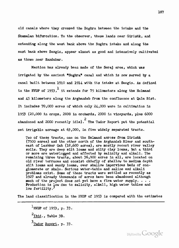
187
old canals where they crossed the Boghra between the intake and the
Shamalan bifurcation. To the observer, these lands near Girishk, and
extending along the west bank above the Boghra intake and along the
east bank above Sangin, appear almost as good and intensively cultivated
as those near Kandahar.
Mention has already been made of the Seraj area, which was
irrigated by the ancient "Sughra'' canal and which is now served by a
canal built between 1910 and 1914 with its intake at Sangin. As defined
in the HVDP of 1953, it extends for 75 kilometers along the Helmand
and 4-5 kilometers along the Arghandab from the confluence at Qala Bist.
It includes 70,000 acres of which only 24,000 were in cultivation in
1953 (20,000 in crops, 2000 in orchards, 2000 in vineyards, plus 6000
x 2
abandoned and 2000 recently idle). The Tudor Report put the potential
net irrigable acreage at 63,000, in five widely separated tracts.
Two of these tracts, one on the Helmand across from Girishk (7500 acres) and the other north of the Arghandab River and south- east of Lashkar Gah (18,600 acres), are mostly recent river valley soils. They are deep silt loams and silty clay loams, but a third or more are waterlogged and affected by salinity and alkali. The remaining three tracts, about 36,900 acres in all, are located on old river terraces and consist chiefly of shallow to medium depth silt loams and sandy loams, over shallow impervious beds of con- glomerate or shale. Serious water-table and saline and alkali problems exist. Some of these tracts were settled as recently as 1927 and already thousands of acres have been abandoned although much of the project does not yet have a firm water supply. . . . Production is low due to salinity, alkali, high water tables and low fertility.3
The land classification in the HVDP of 1953 is compared with the estimates
•'"HVDP of 1953, p. 33.
2Ibid., Table 3B.
3 Tudor Report, p. 33-
Digitized by Google
138
which were furnished by the contractor to the Tudor group in the
following table.
TABLE 22
SERAJ: ESTIMATED PERCENTAGES IN EACH LAND CLASS
Report Area in Acres Class I II III IV
HVDP of 1953
TUDOR REPORT, 1956
68,000
63,000
10
4
30
17
30
27
30
52
For the HVSR, MKA surveyed 105,908 acres in the Seraj area. 40,864.
were eliminated as non-irrigable or not recommended for development.
56,800 acres were found to have no particular salinity or alkalinity,
while 8244 would require drainage and leaching. Thus, the 65,044 acres
which would justify development represent a reasonable compromise between 1
the two earlier estimates. Soil quality is only fairj 350 out of 619 samples
2 were non-saline while 225 were saline-alkaline, but the low estimated
cost of developing 25,000 acres may make the Seraj worthy of improvement
in the future. MKA tentatively estimated the cost at |3 million for ir-
rigation and drainage construction plus another $3.7 million for land
3 development, if that is carried out by the contractor. The original plan
was to construct a new intake on the Helmand below the old one at Sangin
and to excavate a canal with a capacity of 1050 second-feet for 11.5
HVSR draft, Table 41, p. 97.
2 Ibid.. Table 40, p. 96.
^Tudor Report, Table 24, p. 173.
139
kilometers to intersect the old, 4-50 second-feet canal, about 30
kilometers below its intake. Prom that intersection, the old canal was
to be enlarged to 1050 second-feet for about 14 kilometers. Then, the
new canal would branch off, leaving 400 second-feet in the old canal
and carry the remainder south towards the Arghandab River which it would
parallel as far as Qala Bist. A complete system of drains was also to
be provided.
We have seen that the Seraj proposal had to be dropped when the
second Export-Import Bank loan was made. Subsequently, the Tudor Report
recommended that the work be postponed to Phase II and then be limited
to improving the present intake and canal system and providing drainage
outlets. More recently, ICA has considered making funds available for
improving the intakes without waiting for Phase II. There is an evident
need for some assistance to the farmers in the Seraj, which is one of -
the few areas in the Helmand experiencing any sort of population pressure.
It will be remembered that the Seraj was opened to Uzbek and Turkmen
settlers from northern Afghanistan in the 1930fs. Where perhaps 1000
families had been expected, about 10,000, including Afghans from other
parts of the Helmand-Arghandab, moved in. Some of these farmers have
since had to shift their lands, within the Seraj, as they became too
saline to yield reasonable crops. Although the assured water supply in
the Helmand since the completion of the Kajakai Dam has been helpful,
some improvement of the intakes and canals is indicated to take full
benefit of this advantage. MKA estimated that the 20,000 acres in culti-
vation in 1947 expanded to 24,000 in 1953 and to 35,000 in 1957 in res-
ponse to improved water supply. Although this rise might be expected
to reach 40,000 acres by I960, MKA cautions: "Seraj will slowlyVexp^nd

190
under private enterprise to the capacity of its present system. Very
little 'reclaimable' lands will be reclaimed by that date".1
Enlarged Areas - Shamalan and Darweshan
The Shamalan area of the Helmand Valley Project comprises the long,
narrow, right-bank floodplain of the Helmand from the Boghra bifurcation
at station 31+680.54- to the old settlement of "Shamalan'1 about forty
mile8 to the south. South of Shamalan village, the left-bank floodplain
becomes wider than the right. Here begins the Darweshan area, named for
a village near its northern end. It continues along the river in a south-
southwesterly direction to the village of Khalrabad, whence the Helmand
flows predominantly west. Thus, the Shamalan area represents a narrow
strip of cultivable land opposite the high bluffs of the edge of the
Registan desert, while Darweshan begins where these bluffs subside and
where the Dasht-i-Margo or "Desert of Death" comes right down to the
Helmand on the opposite, right-hand bank. In these two strips, as in the
Garmsel area downstream (see below), farmers have used the Helmand's
waters to fight the desert for several centuries. In 1947, MKA estimated,
19,000 acres were under cultivation in the Shamalan and 9500 in the
Darweshan, in roughly the following pattern.
TABLE 23
SHAMALAN AND DARWESHAN - LAND USE IN 1947 (IN ACRES)a
Area Orchards Vineyards Croplands Recently Idle Abandoned Undeveloped
Shamalan 1,000 1,000 Darweshan 500 1,000
17,000 8,000
16,000 15,000 25,320 5,000 8,000 36,000
aHVDP of 1953, Table 3B.
Digitized by
TIVSR draft, Supplement 7, Table L4, footnote 3.
191
The Shamalan Branch of the Boghra Canal was constructed under
the first (1950-54-) Export -Import Bank loan and the drains under the
second. The forty-one mile canal incorporates about 25 miles of pre-
existing but improved canals. It commands 66,500 acres, of which the
original turnout system was to serve the 19,000 acres already under
cultivation. The HVDP of 1953 proposed to rehabilitate 73 kilometers of
old, hand-excavated laterals, to level 15,000 additional acres, and to
add 121 kilometers of main drains. By the completion of this program,
in 1957, the area annually farmed had risen to 35,000 acres, and it
was anticipated that fuller use of the irrigation system could expand
this to 44>000 acres by I960. This roughly coincides with the estimate
of 42,325 potential net irrigable acres given by MKA to the Tudor team,
and incorporated into their report. The HVSR draft reported the surveying
of 65,000 acres, from which 20,628 were eliminated as non-reclaimable.
The remaining 44,372 acres included 23,352 which had no salinity or
alkalinity affecting crops and 10,375 acres with slight to moderate 2
salinity or alkalinity not seriously affecting crops. The remaining
10,64.5 acres, of moderate to severe salinity and/or alkalinity could
feasibly be reclaimed. These figures cannot directly be translated into
the classification scheme we have been using, but since the breakdown
in the Tudor Report covers the same general area, 42,325 acres, its
classification may be of some help: Class I, 32$ j Class II, 51/6} Class III,
3 13%; and Class IV, 4^- The important point here is the high percentage
"HlVSR draft, Supplement No. 7, Table 14.
2Ibid.. Table 41, p. 97.
^Tudor Report. p. 33. The classification in the HVDP of 1953 was based on 75,320 acres and is not comparable: Class I, 40$j Class II, 30/Gj Class III, 21.6$; Class IV, 8.4$.

192
of land In Class I and Class II as compared with Nad-1-All or Marja.
In the Shamalan, over 80 per cent of the acreage cited is suitable
for irrigation of a majority or all of the climatically adapted crops.
Where "one or more easily applied practice in addition to good irrigation
farming methods1' is required, that practice is drainage, and the necessary
drains have been provided for the expansion of agriculture to the
44>000-acre level. What apparently is delaying the settlement of nev
farmers on the Shamalan tract is the lack of reliable cadastral surveys.
One such survey was made recently by apprentice surveyors from Kabul,
but so much Class V land was included that the HVA does not yet know
where and to what extent new settlers can be introduced.
There will, of course, continue to be problems in the use of
Shamalan soils. The RVSR draft reported that of 655 soil samples from
the Shamalan, 286 were saline-alkali, though evidently not as seriously
affected as those in Nad-i-Ali and Marja. 283 samples were non-saline,
2 16 saline and 68 alkali. The Tudor Report also foresaw difficulties in
utilization.
The soils are dominantly silts and very fine sandy loams, with stratified silty and sandy deposits indicating past changes in the location of the river channel. . . . The depth to permeable sands and gravels is variable and, where they are deep, irrigation has resulted in waterlogging, the accumulation of soluble salts and alkali, and, in the subsequent abandonment of some of the land. Recent increased irrigation has led to rising water table over much of the area. Closely spaced farm drains will be required to lower the water table in the many areas containing deep silts, and soil amendments in addition to leaching will be required for the re- clamation of some areasr
One clear illustration of the problems of Shamalan irrigation was
1Interview with Dr. Abdul Wakil, January 26, 1958. 2
HVSR draft, Table 40, p. 96.
3 Tudor Report. p. 33.

193
provided in the first experimental farm run by the Wyoming University
Team under ICA contract. The farm was located in the Shamalan tract,
directly opposite Lashkar Gah. The American agronomist in charge put
ten acre feet of water through the farm soil without appreciable
1 diminution of salts in the upper horizons. Of course, the location of
the farm between the Shamalan Canal and the Helmand River, in contrast
to most Shamalan lands which lie on the far side of the canal, contrib-
uted to waterlogging and the rise of salts in the soil. (The farm,
completely inundated during the spring, 1957, floods has since been
relocated on the Mar;)a terrace tract.) But this experience demonstrated
the need of a closely-spaced system of farm drains feeding into those
built by the contractor and ACU to carry off subsurface water. It also
emphasizes the need of training farmers, new and old, in the proper use
of irrigation water, i.e., in using a minimum rather than a maximum of
water and in performing night irrigation rather than leaving the water
running through the laterals and into the subsoil.
It is only in the central or Nawa section of the Shamalan Canal
that there is any substantial cultivation east of the canal, i.e., between
the canal and the river. Most of the farms are located west of the canal,
between it and the 20 to 30-foot bluff marking the edge of the flood-
plain and the beginning of the pebble-strewn (probably, desert pavement)
terrace on which the Nad-i-Ali and Marja tracts are located. As one
might expect, most of the area is sown to grain: winter wheat, some-
times followed by corn, with more intensive horticulture around the
villages. Trees of any variety are found only near the villages where
Interview with Richard L. Hughes, Wyoming Team AgronomistV^k^ Lashkar Gah, October 15, 1957.

194
their owners can protect them. In the widest part of the tract, opposite
and below Qala Bist, where cultivation is relatively intense, there are
scattered vineyards and some fruit trees.
One must not have the impression of continuous cultivation along
the Shamalanj it is far from that. In the wide, south-central section,
cultivated fields are almost contiguous, but even here there are patches
of land left fallow until fertility returns or salts subside. At the
extreme north and south ends of the tract are long stretches which are
never cultivated where salts are visible in wide patches on the surface,
and the same is true of the narrow section just above and below the
Lashkar Gah bridge where canal and river are only a short distance
apart. Here the canal was nearly breached in two places during the 1957
floods, and the receding water left sands and salts to impede cultivation.
Salt-tolerant camel's thorn and tough grasses are the first to reclaim
such lands, and their removal poses yet another problem to the farmer.
Even the banks of the canal become overgrown with reeds and
grasses after a few years, and the work of removing them occupies the
farmers for a Jfi-d&y period when the water is shut off in January-Feb-
ruary. The profuse but useless vegetation must be cut and burned and
the accumulated silt removed from the bottom of the canal. The latter
operation is handicapped by the fact that the HVA Operations and Main-
tenance Department has only one dragline. During the 1958 cleaning
period, this was being used on the Boghra Canal, above the Girishk
power drop which was about to come into operation. Clearing of the
Shamalan was left to teams of local farmers "recruited" by the sub-
governors of the tract. Although canal cleaning is directly related to
their profitable use of its waters, it is apparently difficult tp keep
Digitized by VJOOQLC
195
the farmers at this work. RVA Operations and Maintenance personnel
patrol the canals, supervising and encouraging the workers who, armed
with only long-handled spades, must dig the silt from the lower parts
of the berms and pack it on the higher, trying to keep an angle of
sixty degrees with the bottom. They must also try to remove the silt
which accumulates behind each drop structure, and to restore the
eroded berms just above and below these structures. Undercutting of
the concrete structures could become a serious problem if the cuts
were not filled in each year and covered or "rip-rapped" with concrete
blocks or pieces of conglomerate.
As indicated above, the Darweshan area is very similar to the
Shamalan, of which it may be considered a left-bank continuation. The
landform, however, includes not only recent floodplain with v ery sandy
and gravelly soils, but remnants of a higher terrace or bench with more
silty soils, a feature generally absent in the Shamalan. The total arable
area in the Darweshan tract was estimated at 58,500 acres in 1953 and
later reduced to around 50,000. For the RVSR, MKA surveyed 73,910 acres
in the Darweshan, of which 24,579 were eliminated as non-reclaimable. Of
the remaining 49,331 acres, 42,768 had no serious salinity or alkalinity
problems, and 6,563 were considered irrigable after feasible reclamation.
While there is no way to convert these figures directly into land class-
ifications, the estimates given to the Tudor group relate to approximately
the same land area (50,773 acres), and may be considered relevant: Class I,
16%; Class II, 34%J Class III, 49%; Class IV, 1%. As is the case with
The estimates in the HVDP of 1953 were based on a total area of 58,500 acres and on very sketchy reconnaissance surveys or aerial photos: Class I, 30%; Class II, 30%; Class III, 20%; Class IV, 20%. They can be considered of only historical interest.

196
the Shamalan tract, a relatively high percentage of the land is in-
cluded in Classes I and II, and almost all of the remainder is in
Class III. The situation is not as good as in the Shamalan, where over
80 per cent of the land was in the first two classes, but it is still
favorable in comparison to Nad-i-Ali and Marja. Furthermore, although
the limited soil surveys conducted in Darweshan (117 samples, of which
79 were saline-alkali, 28 non-saline, 9 saline and 1 non-saline-alkali)
are not as promising as those in Shamalan, the experience accumulated on
the latter tract, particularly with regard to leaching and drainage, may
enable Darweshan farmers to avoid the down-grading which has occurred
in same Shamalan soils.
MKa estimated that only 9500 acres of the Darweshan tract were under
cultivation in 1947. By the time construction finally got under way in
1956, perhaps twice this area was being cultivated, thanks to the re-
liable water supply in the Helmand. But it was again cut back, perhaps
to 8500 acres, as construction interrupted irrigation by cutting through
the old, hand-dug canals and laterals. It is hoped that the new system
will bring an increase in the acreage to 35,000 acres under cultivation
in I960.1
Here it should be pointed out that only two-thirds of the Darweshan
area as above defined are presently scheduled for development. The Tudor
Report recommended that the remainder of the area be developed only in
2 Phase II. Actually, the funds from the second Export-Import Bank loan
expired before all of the Phase I work could be completed, and a special
•'•HVSR draft, Supplement No. 7, Table H.
2 Tudor Report. pp. 169, 173-
Digitized by Google
197
grant of #200,000 was made by ICA to the contractor to finish this
work. The principal structures include a diversion dam in the Hel-
mand about 60 miles downstream from Girishk and 5 miles above the
village of "Darweshan" (see Map 7). The dam is of novel design for
Afghanistan, consisting of a stepped barrage across the greater part
of the river so designed as to provide automatic regulation of spillage
at certain heights. At the eastern end, three vertical-lift spillways
provide additional regulation when flow drops below the lowest step
of the barrage, while next to them are the bascules governing canal
intake. Water may be admitted at will into three conduits from which
it is discharged into the 1000 second-feet capacity canal. The Dar-
weshan Canal is designed for irrigation of the entire tract extending
some 50 miles down to Ehairabad, but it has as yet been dug only as
far as Lakhi village, approximately 38 miles from the intake.
The engineering of the Darweshan Canal and associated drainage
network entailed some special problems, for on the complex Darweshan
floodplain, as in the Shamalan, the slope of the land in many sections
is away from the river. The canal generally rides the highest part of
the floodplain, sending laterals to both sides, while the main drains
in the northern section, in the vicinity of Darweshan village, make
large semicircles around to the depression to the southeast where the
floodplain merges with the sands of the Registan desert. At one point
in the middle of the canal, a drain from the area between the canal
and the river has to pass under the canal itself to reach this de-
pression. Here, as in all sections where the canal is built above the
permeable floodplain rather than through the denser terrace remnants,
the berms must be lined with silty-clay to prevent leakage. Thus,
198
lesson of the Bogfara Canal has been learned and applied to the Dar-
weshan.
Generally speaking, the engineering of the Darweshan Canal
appears to be quite good. It will undoubtedly fulfil its function of
supplying a sustained and eontrolable amount of water to lands pre-
viously subject to drought or flood. If the lessons of land management
learned in Nad-i-Ali and Shamalan are also applied to the Darweshan,
the drainage system incorporated in the project can undoubtedly keep
the water table at a safe depth and prevent additional sallnization of
surface soils. But this will require ACU and the local farmers to com-
plete a dense network of farm and feeder drains to supplement what MKA
has built. As the Tudor Report cautionedi
The important soils of this project /^arweshan/ are located on a long silty bench flanked on both sides by lower river benches containing a limited amount of good Irrigable land. . . . The soils are chiefly deep silt loams and silty clay loams with some sandy bottom lands and considerable saline and alkali areas. The soils are underlain by sand, coarse gravel and conglomerate rocks at depths of 5 to 15 or 20 feet. High water tables exist in only a portion of the Irrigable lands at present, but the drainage problem is becoming more serious as more water is being applied to the land. Extensive waterlogged areas now exist, and the water table is now above the conglomerate layer in many places. Closely spaced and expensive drains will be required in the development program.1
A further problem concerning the future of Darweshan lands is one
of cost of development. The addition of 21,849 acres to the 12,000 already
cultivated in the Upper Darweshan was estimated in the Tudor Report to be
2 costing $266 per acres. The Phase II portion of the project, adding
10,424 acres to the 6500 now under cultivation in Lower Darweshan, was
estimated to cost $316 per acre. The first part of this investment has,
of course, already been made, and the only question with respect to the
-Wor Report, p. 33.
2Ibid., p. 180.
199
Upper Darveshan is whether, and in how long a period, the increased
production from the irrigated area will repay the allocated cost of
development. But the development of the Lower Darweshan will have to
compete for capital resources with other areas including the Seraj,
whose per acre cost of development through Phase II is estimated at
only $205. Meanwhile, the operation of the Darweshan Canal, designed
for 50,000 acres, to irrigate only 34>000, may involve some of the
problems which have arisen with the Boghra after the exclusion of
the West Marja tract (see Chapter III).
Prospective Areas - Garmsel, Chakansur and Dasht-i-Bakwa
The Garmsel area may be regarded as a westward extension of the
Darweshan from Khairabad to Chahar Bur jak or Upper Mirabad (see Map 6).
Here, floodplain soils quite similar to those of Darweshan lie between
terraces or bluffs which rise continuously as one travels westward. As
in the Darweshan, the floodplain soils have been cultivated for years,
but there is no farming on the adjoining desert benches.
The soils are mostly sandy loams and loams over river gravels and sands. The surface of most of the area is hummocky, and much of the land is now saline or has a high water table, or both. Most of the land is subject to annual flooding. Production is low and uncertain, and only a small percentage of the land is under annual cultivation.
For the HVSR, MKA surveyed 154*827 acres in the Garmsel area, of which
97,612 were eliminated as non-developable. Of the 57,215 acres remaining
17,328 had no particular salinity or alkalinity problems, and 38,392 could
"Tudor Report. p. 35. MKA estimated 24-,500 acres under cultivation in 194-7.
Digitized by Google
200
1 feasibly be reclaimed. Development would include improvement of
present irrigation systems and provision of drainage outlets. However,
the Tudor group was not requested by ICA to make recommendati ons on the
areas below Darweshan, and Garmsel figures neither in the Phase II
Tudor recommendations nor in any other plans published to date. While
its development would serve the purpose of using more Helmand water
within Afghanistan, any economic justification for the expenditures
involved would have to await results in the Darweshan tract above it.
Downstream from Chahar Burjak, the Helmand swings north, and
the distributary system begins. Most of the distributaries flow across
the border into Iran, as does the main stream after it has served as
the frontier for a short distance. The Helmand has shifted its course
to the expense of Iran since the 1872 boundary agreement, so that there
are now disputes as to both land and water ownership in this region. The
Iranians have dammed one of the distributaries, the "Rud-i-Seistan", for
their own irrigation needs, and the barrage sometimes ponds water back
onto cultivated lands within Afghanistan. In years of serious floods,
in fact, the whole Chakansur marsh becomes inundated and spills over
into a series of depressions, which form a huge semicircle to the west,
within Iran, and eventually may spill back into the Gaud-i-Zirreh, in
Afghanistan (see Map 6). This danger, plus the desire to make all
possible use of Helmand water within Afghanistan, has led the RGA to
^SR draft, Table £L, p. 97. The classification estimates given to the Tudor group in 1956 were based on an area of 43,4-75 acres. While not directly comparable to the HVSR figures, they indicate less good land proportionally than in either Shamalan or Darweshan: Class I, 12^j Glass II, 32$j Class III, A2%} Class IV, L#.
Digitized by Google
201
consider plans for development of the lower Helmand. One scheme is to
develop the Garmsel and Chakansur areas along the lines of the projects
upstream. A more vigorous approach is embodied in the plan to construct
a dam or barrage on the Helmand below Chahar Burjak and divert excess
flow direct^ into the Gaud-i-Zirreh depression by means of deepening
the Rud-i-Kushk. Since at least 35 million acre-feet could be stored in
the Gaud-i-Zirreh, such a diversion would give Afghanistan a strangle-
hold over Iranian irrigation in the Chakansur Basin. A bilateral approach
to the problem, with Iran bearing its share of the cost of a project
designed to benefit both neighbors, would be the most logical solution.
But despite the establishment of a neutral Helmand River Delta Com-
mission in 1950, and its finding that there were 150,000 delta acres
irrigated with Helmand water in Iran compared to only 36,000 in Afghan-
istan, no cooperative planning has been forthcoming. The United States,
whioh urged the establishment of the Commission, has since avoided
involvement in the matter, for fear of having to choose one side or
another of a political impasse. The Tudor team was specifically instructed
to stay out of the Chakansur region, and it does not figure in their
recommendations, though it is briefly described in the body of the Report.
Figures on potential net irrigable acres in the Chakansur have been revised downward a number of times and now stand at 65,000 acres, although preliminary reconnaissance suggests that 250,000 acres may eventually be reclaimed. Land classes have not yet been assigned, but the soils range widely from very sandy river bottom or river terrace soils to heavy saline-alkali soils, only three to six feet above lake basin clays and shales. Salty and alkali areas are extensive, the surface is very irregular, and sand dunes are in active movement over much of the area. Drainage is only fair on about half the area even
Iprahck, Obtaining Financial Aid. . .. pp. 1+L-1&.
Digitized by VjOOQlC

202
though the tilled lands are shifted about each year as floods, high water tables, and salts continually restrict production. Yields are very low, and haye decreased markedly since a survey made in 1903-05.
The HVSR draft reports 129 soils sampled from Chakansur, of which 46
were non-saline, 71 saline-alkali, and 6 each saline or alkali alone.2
For surrey purposes, MKA has made a threefold division of the Helmand
below Upper Mirabad (Chahar Burjak). Only a very rough reconnaissance
survey of these divisions was carried out prior to the HVDP of 1953,
which proposed partial development of the Chakansur Basin. The figures
are oited here merely as an indication of the relative values of these
areas since no other estimates on this basis are available.
TABLE 24
LOWER HELMAND l ESTIMATED PERCENTAGES IN EACH LAND CLASS11
Area Estimated Acreage Classification of Lands Class I II III . IV
Upper Mirabad to the Iranian Di- version 42,750
%
15
%
30
%
30
%
25
Chakansur Plain 235,600 20 30 30 20
Chakansur Marsh 38,000 20 80
aHVDP of 1953.
Of the three divisions, the Chakansur Plain evidently holds the greatest
promise, both in extent and in percentage of good lands. This fact is borne
•kudor Report. p. 35.
2HVSR draft, Table 40, p. 96. Digitized by Google

203
out by the distribution of settlement and cultivation. In 194-7, MKA
reports, the 316,350 acres classified above resolved into the following
breakdown. (Garmsel is included for comparative purposes).
TABLE 25
LOWER HELMAND LAND USE IN 1947a
Area Crop- Orchards Vine- Recently Abandoned Unde- land yards Idle veloped
Upper Mirabad to the Iranian Diversion
I 11,000
N A 500 ORES 1000 10,000 12,500 7,750
Chakansur Plain 25,000 1000 2500 25,000 100,000 82,000
Chakansur Marsh - - - 8,000 30,000
Garmsel (93,100 sur- veyed) 20,000 2000 2500 10,000 15,000 43,600
a HVDP of 1953, Table 3B.
Thus the Garmsel floodplain, amounting in this survey to about 40 per
cent of the Ghakansur Plain area surveyed, had over 80 per cent as much
area under cultivation and proportionally much less land abandoned. While
no firm conclusions can be drawn from figures of this nature, there does
seem to be at least the indication that settlers prefer the poorest of
the floodplain lands to the best of those in the delta. Actually, though
the proportion of recently abandoned land to total area is the same for
both Chakansur Plain and Garmsel, there are indications that the acreage
annually farmed in the delta must be rotated over approximately 100,000
acres due to shifts in river channels, alluvial deposits, and wind-blown
sand. Any future development program would face the problems of water,
. ., Digitized by - soil and sand stabilization to a much greater degree than has ye
GQOQIC et been

204
encountered in the Helmand Valley Project.
For the HVSR, MKA surveyed a total of 554,335 acres in the three
Chakansur or delta divisions. 40$>910 were eliminated as Impracticablefor
development. Of the 14-5,425 acres remaining, far less than the 316,350
estimated in 1953 (above), 110,447 have no particular reclamation needs,
and 36,978 would require drainage and leaching. MKA states, hoveveri
"Chakansur potential may be as low as 65,000 acres with no major develop-
ment program to as high as 250,000 maximum". Far more intensive surveying
is apparently necessary before sound recommendations oan be forthcoming
and again, as in the oase of the Garmsel traot, the suooess or failure
of the upstream areas will go far to condition RGA attitudes towards
the Chakansur, despite the desire to limit the benefits of the Kajakai
storage dam which redound to Iranian farmers.
The Bakwa plains area, surrounded by deserts, lies within and
north of the great bend of the Helmand on the road from Girishk to Far ah.
Physiographioally, it is a part of the Helmand Valley only in that it
lies between the Khash Rud and the Khuspas Rud, both of which drain into
the Chakansur Basin. Both of these rivers feed small amounts of Irrigated
agriculture, and ACU has built new bridges improving communications from
the area north to Farah and Herat and east to Girishk and Kandahar. MKA
has been authorized by the HVA to survey the Bakwa plains with a view to
future development. The HVSR draft reports that of 147 soil samples, 128
2 were non-saline and only 15 saline-alkaline. This compares quite well
with the other areas reported, and indicates that Bakwa may have considerable
1HVSR draft, Supplement No. 7, Table 14, footnote 4.
2Ibid.. Table 40, p. 96. Digitized by VJOOQLC
205
potential. Of some 200,000 acres originally considered, however, it is
unlikely that the completed surveys will justify development on even
one-half from a land classification standpoint.
If and when it is decided that the advantages of devebpment
justify the costs, and the funds are available, it will be necessary
to design an irrigation system for Bakwa based on the Khash Rud or
Khuspas Rud or both. It is conceivable that water could be brought
from the Helmand below Kajakai, but this would be an extremely exten-
sive and costly undertaking. Utilization of the Khash Rud or Khuspas
Rud would, of course, increase the amount of control which can now be
exercised over water flowing into the Chakansur Basin, with all the
advantages and problems that entails for the RGA and the people who
live in the Basin.
Comment of Dale R. Shockley, Chief of the Engineering Department, Morrison-Knudsen, Afghanistan, Kandahar, upon this manuscript when it was submitted to him in February, 1958.
Digitized by Google

206
sr V
N \ \
1 \ \
\ ti I
V
3?
I I 1 % 1^1^
\ .\ 2
•\
.s> \
^ .^
.t J | Z s « • >- • | J
i
<
i!
Digitized by Google
207
V. THE HELMAND VALLEY THE PROJECT AREAS ALONG THE ARGHANDAB
Reinforced Areas - North and Central Arghandab
We must now shift our attention eastward to consider the areas
around Kandahar which have been or can be benefitted by development of
the Arghandab River. The Arghandab storage dam, completed at the end
of 1952, is located about 18 miles north-northeast of Kandahar at a
point where the reservoir capacity of the valley could substantially
be increased by a series of six small dikes built in the saddles of
the ridge to the west. Storage capacity is 388,000 acre feet, but the
reservoir has been filled completely only two or three times since con-
struction of the dam. Two uncontrolled spillways are cut through the
rock ridge west of the reservoir at a level five meters below the crest
of the dam and dikes. These spillways were under water during the period
from April 4 to July 19, 1957. Through the western rock abutment, a
264 meter tunnel, 5.4 meters in diameter, is the ordinary outlet for
reservoir discharge, which is regulated by two valves in the control
house below the dam. Each of these valves can discharge up to 1000
seoond-feet at full reservoir capacity. The discharge tunnel whioh feeds
them will serve as the manifold for turbine penstocks when four 3200 kw
generators are installed. ICA has allocated one million dollars in
special Fiscal Year 1958 assistance for preliminary work on the Arghandab
1 The storage dam on the Arghandab River is usually referred to merely
as the "Arghandab Damn. We shall follow this usage, indicating "Diversion Dam" whenever we refer to the barrage downstream at the South Canal intake.
Digitized by Google
203
power house, which will be located between the :hxm end the present
irrigation valve control house.
Water discharged at Arghandab Dam for irrigation purposes flows
down the bed of the Arghandab River to the Diversion Dam about 12
miles north of Kandahar. Here begins the "South Canal", which is the
source of irrigation water for the lands on the left bank of the
Arghandab as far as the Baba Wali Wasteway (see Map 8), at which
point the "Tarnak Canal" branches off to the south and east. As we
have seen, it was originally planned to construct a "North Arghandab
Canal" along the right bank of the river. When that plan was abandoned'
in favor of carrying water from the "South Arghandab Canal" as far as
the Tarnak area, the name "South Canal" came to denote only that
portion which paralleled the river; the extension was called the
"Tarnak Canal". Similarly, the name "South Arghandab", which implied
a contradistinction from "North Arghandab", was abandoned in favor of
"Central Arghandab" to denote the lands watered from the "South Canal",
but none of those to be watered from the Tarnak Canal. We shall, in
general, adhere to this usage, but wherever "South Arghandab" appears
in the text, as it may for references prior to 1955, it may be taken
to mean "Central Arghandab", i.e., those lands watered from the "South
Canal".
The South Canal has replaced the old Patow Canal on the left
bank of the Arghandab. In fact, for about one-half of its length, the
South Canal occupies the much-improved bed of its predecessor. Below
the King's Garden (see Map 8), the Patow Canal diverges towards the
river, while the South Canal continues to hug the feet of the dry hills
and alluvial fans to the east, maintaining its elevatiori^&ymuch as
209
possible. Between the King's Garden and the Baba Mali bifurcation, the
South Canal feeds four or five other pre-existing canals in addition to
the Patow (see Map 9). At the bifurcation, the South Canal turns towards
the river in a wasteway which cuts across and feeds the Patow, Rhorabad,
1 Jui Shah, Noshay Jon, Meon Jui and Punjab Canals before spilling any
excess into the Arghandab River. This function of the South Canal is
extremely important, as can be seen from Map 9. The Arghandab near
Kandahar has supplied water for centuries to a score or more of hand-
dug and -maintained canals which feed the comparatively rich orchards
and croplands. The Kandahar oasis, shifting slightly from century to
century in response to the availability of better water and soils or
to defense requirements, is one of the most ancient sites of urban
civilization in Afghanistan. Its canals are its veins, carrying the
life-giving water of the Arghandab River to the relatively fertile and
well-tilled fields of the oasis. Maps 8 and 9, which show how these old
canals ramify throughout the oasis, as well as how they are incorporated
into the Helmand Valley Project, indicate the skill of the Afghan
agriculturalist in bringing water to the better soils of this area.
The Patow Canal, for example, flows right through present-day Kandahar
and then subdivides into three canals flowing south, towards the Tarnak
River. A branch of the Noshay Jon Canal, the Nakwadak, actually crosses
the Tarnak on a flume to bring water to Nakwadak village. Further east,
the Rhorabad Canal also crosses the Tarnak to water one of the principal
vineyards of the Tarnak area. The Punjab, as its name implies, divides
into five smaller canals which water the region southwest of Kandahar.
There are still other canals of considerable importance which have
their intakes on the south bank of the Arghandab below the Baba Wali
n3r Nakwadak.
le Bate WaJri Digitized by VjQQQLg
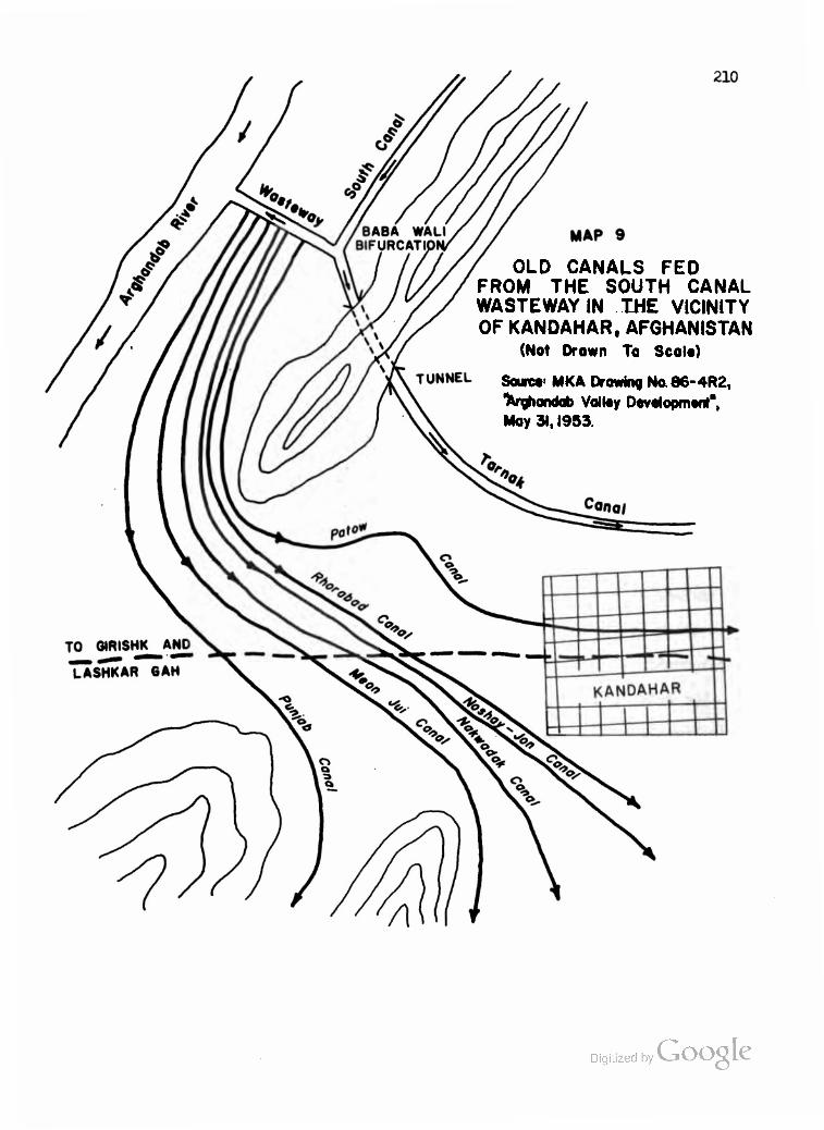
OLD CANALS FED FROM THE SOUTH CANAL WASTE WAY IN THE VICINITY OF KANDAHAR, AFGHANISTAN
(Not Drown To Scolo)
Sourct< MKA Drawing No.86-4R2, "ferghandob Voiloy Devotopmont", May 31,1953.
Digitized by Google

211
Wasteway outlet. One of them, the Salian, Is carried in a karez right
through the ridge south of the Kandahar-Glrishk highway in an effective
anticipation of the tunneling of the new Tarnak Canal through the same
general formation north of the highway. As we have seen in Chapters
I and II, there is apparently little to desire in the Afghan's ability
to locate the best soils of a region and to design methods of bringing
water to them. Conversely, where lands within feasible reach of a source
of irrigation water have been left alone or abandoned, there is generally
a sound reason for the Afghan's disinterest.
To the north of the Arghandab, a similar network of old canals
now enjoys the benefits of a regulated discharge of water for two-season
agriculture. Some of these canals are of exceptional length, as Map 8
indicates. The longest, the Zanzigar, has a total length of over twenty
miles. Although some of the intakes may be improved under the Helmand
Valley Project, the major scheme to reinforce them by constructing a
58 kilometer, 900 second-feet "North Arghandab Canal" from the Diversion
Dam to water 54>000 acres north of the river was abandoned during the
negotiations over the second Export-Import Bank loan. MKA sources state
1 that the project was not dropped due to a lack of funds, but because
it turned out to be unfeasible.
All of the land in North Arghandab is being cultivated now which can be cultivated without extensive reclamation. As a matter of fact, over 4->000 acres now being farmed are in very poor condition, because of salts and high water tables. To reach the goal of allocated water use for 4C,200 net acres will require the reclamation of approximately 8,500 acres from a condition so saline and wet that only salt grasses and occasional scant/ crops are harvested, together with the re- clamation of another 5,300 acres that Is so salty it is now barren. Thus there can be no expansion in the North Arghandab tract. On the
^•Comments of Dale R. Shockley, Chief of the Engineering Department, MKA, Kandahar, on a draft of the present paper, Februaryujgjg^by(
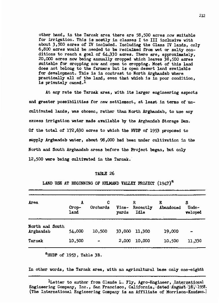
212
other hand, in the Tarnak area there are 58,500 acres now suitable for irrigation. This is mostly in classes I to III inclusive with about 3,500 acres of IV included. Including the Class IV lands, only 6,800 acres would be needed to be reclaimed from wet or salty con- ditions to reach a goal of 64,330 acres. There are, approximately, 20,000 acres now being annually cropped which leaves 38,500 acres suitable for cropping now and open to cropping. Most of this land does not belong to the farmers but is open desert land available for development. This is in contrast to North Arghandab where practioally all of the land, even that which is in poor condition, is privately owned.1
At any rate the Tarnak area, with its larger engineering aspects
and greater possibilities for new settlement, at least in terms of un-
cultivated lands, was ohosen, rather than North Arghandab, to use any
excess irrigation water made available by the Arghandab Storage Dam.
Of the total of 172,630 acres to which the HVDP of 1953 proposed to
supply Arghandab water, about 98,000 had been under cultivation in the
North and South Arghandab areas before the Project began, but only
12,500 were being cultivated in the Tarnak.
TABLE 26
LAND USE AT BEGINNING OF HELMAND VALLEY PROJECT (1947)*
Area ACRES Crop- Orchards Vine- Recently Abandoned Unde- land yards Idle veloped
North and South Arghandab 54,000 10,500 33,000 11,300 19,000
Tarnak 10,500 - 2,000 10,000 10,500 11,330
aHVDP of 1953, Table 3B.
In other words, the Tarnak area, with an agricultural base only one-eighth
^Letter to author from Claude L. Fly, Agro-Engineer, International Engineering Company, Inc., San Francisco, California, dated August 18, 1958. (The International Engineering Company is an Affiliate of Morrison-Knudsen.)

213
as large as North and South Arghandab combined, had almost as much land
"recently idle" (perhaps due to lack of water as well as to the rotation
pattern) and more than half as much land "abandoned" before the Project
began. Apparently, Tarnak land was far less desirable to the local far-
mer than land in North or South Arghandab. As a reflection of this fact,
Tarnak offered 11,330 undeveloped acres; Arghandab areas offered none.
Ve shall analyze the possibilities and problems of the Tarnak at the end
of this section.
The HVDP of 1953 listed 54,000 acres of potentially Irrigable
land in the North Arghandab area, half of which was not then irrigated
or irrigated only occasionally. By the time of the Tudor survey, this
had been reduced to 40,235 potential net irrigable acres. Unfortunately,
we have no breakdown by land classes between the two Arghandab sections
in the HVDP of 1953, but the overall classification is included along
with the 1956 Tudor Report breakdowns. Please note that the term "Central
Arghandab" had superseded "South Arghandab".
TABLE 27
ARGHANDAB AREAS: ESTIMATED PERCENTAGES IN EACH LAND CLASS
Report Total Area PERCENTAGES in Acres Class I II III IV
HVDP of 1953 128,300 41.6 49.2 H-6 14.6
IDQR REPORT,1956a
North Arghandab 40,235 50. 2. 39. 9. Central Arghandab 80,475 32. 21. 47. 0.
The total acreage for North and Central Arghandab in the Tudor Report is 120,710 acres.
iHVDP of 1953, p. 4. Digitized by Google

214
For the HVSR, MKA surveyed 67,685 acres in North Arghandab, from which
the HVSR draft eliminated 23,951 as "non-irrigable or not recommended"
for development. Of the 43,734- acres remaining, 35,443 (or 81.1 per cent)
had no serious salinity or alkalinity problems and 8291 (or 18.9 per cent)
would be Irrigable after feasible reclamation. According to the infor-
mation received from Mr. Claude L. Fly of the International Engineering
Company and quoted above, the net acreage has been reduced to 40>200,
of which 13,500 (or 33.6 per cent) would require reclamation.
By comparison, in Central Arghandab, where 132,220 acres were
surveyed and 44*795 eliminated, the remaining 87,425 usable acres (over
twice the amount in North Arghandab) break down into better categories:
78,085 (or 89.3 per cent) with no serious alkalinity or salinity and
9340 (or 10.7 per oent) irrigable after feasible reclamation. The soil
survey report in the HVSR does not distinguish between North and Central
(or South) Arghandab. Of 217 samples taken in the entire Arghandab area,
150 were non-saline, II saline, 36 saline-alkali, and 20 non-saline but
2 alkali. The Tudor Report describes the soil complex of the North Arghan-
dab area as follows;
It is composed chiefly of deep silt loams and silty clay loams on sloping valley fills and along the margins of old river terraces. Moderately deep to shallow ailt loams over moderately deep gravel and conglomerate rock lie along the upper part of the area adjoining the desert. Highly saline and alkali soils and waterlogged areas are 'found in a number of places, due primarily to a lack of drainage facilities. The soils'are moderately fertile and production is fair to good. About 26,800 acres are farmed regularly, and the remainder lacks a water supply or is abandoned because of saline-alkali or high water-table conditions.
1HVSR draft, Table 41, p. 97.
2Ibid.. Table 40, p. 96.
^Tudor Report. p. 34. Digitized by Google

215
As for Central Arghandab:
The soils are mostly deep silt loams and silty clay loams on recent and fairly recent river terraces. However, there are some shallow to moderately deep soils on older river terraces in the upper end, some fine-textured soils difficult to drain in the south-central portion of the area, and severe salinity, alkali, and waterlogged conditions in the southern part of the area. Most of the upper end and the portions along the river are now being farmed to fruit and truck crops, and wheat is the principal crop in the lower areas. Production is poor to good varying with fer- tility, water supply, salinity, alkali and water-table levels.
There cannot be much doubt about the productivity of most of the
Arghandab soils, which have supported Kandahar for generations. Accor-
ding to MKA, the areas which received reasonably firm water supply
before the Project included lands adjacent to the Patow Canal, about
one-third of the deep alluvial soils north of the Arghandab opposite
the old Patow diversion (about three miles above the present Diversion
Dam) and extending westward along the river, and the irrigable river-
bottom lands extending less than half the distance to the confluence
2 of the Helmand and Arghandab Rivers. This area was planted to deciduous
fruit trees (apples, apricots, peaches, pears, pomegranates, quinces)
and horticultural crops and vineyards. It comprises the leading fruit-
producing and -exporting region of Afghanistan and is the basis for the
Pushtun Industries and other fruit drying and packaging operations in
Kandahar. The orchards are concentrated along the old Patow and Punjab
Canal routes, including their branches, while the vineyards stretoh
vest and southwest from Kandahar, especially along the northern side of
the Arghandab. In the area to the south of Kandahar, where canal and
Ibid.
2 HVDP of 1953, p. 21.
Digitized by VJOOQLC
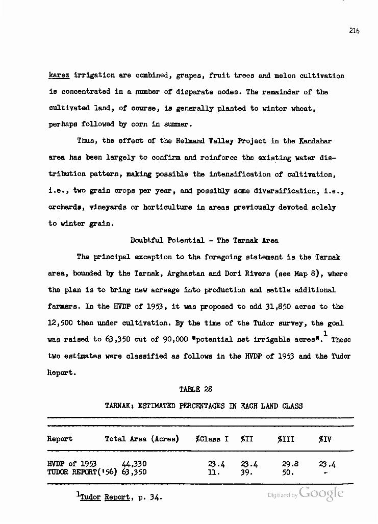
216
karez irrigation are combined, grapes, fruit trees and melon cultivation
is concentrated in a number of disparate nodes. The remainder of the
cultivated land, of course, is generally planted to winter wheat,
perhaps followed by corn in summer.
Thus, the effect of the Helmand Valley Project in the KwnrinhnT
area has been largely to confirm and reinforce the existing water dis-
tribution pattern, making possible the intensification of cultivation,
i.e., two grain crops per year, and possibly same diversification, i.e.,
orohards, vineyards or horticulture in areas previously devoted solely
to winter grain.
Doubtful Potential - The Tarnak Area
The principal exception to the foregoing statement is the Tarnak
area, bounded by the Tarnak, Arghastan and Dori Rivers (see Hap 8), where
the plan is to bring new acreage into production and settle additional
farmers. In the HVDP of 1953, it was proposed to add 31,850 acres to the
12,500 then under cultivation. By the time of the Tudor survey, the goal
was raised to 63,350 out of 90,000 "potential net Irrigable acres". These
two estimates were classified as follows in the HVDP of 1953 and the Tudor
Report.
TABLE 28
TARNAK: ESTIMATED PERCENTAGES IN EACH LAND CLASS
Report Total Area (Acres) ^Class I 211 £111 *IV
HVDP of 1953 44,330 TUDOR REPORT('56) 63,350
23.4 11.
23.4 39.
29.8 50.
23.4
1Tudor Report. p. 34-

217
For the HVSR, MKA surveyed 110,656 acres, of which 40,711 were eliminated
as non-irrigable or not recommended for development. The 69,945 acres re-
maining were not broken down into land classes, but it was tentatively
stated that 60,227 of them have no serious salinity or alkalinity problems,
and that the 10,168 which require drainage and leaching include 9065
potential Class I or II land and 1103 potential Class III. According to
more recent information received from Mr. Claude L. Fly (see above) the
total has been reset at "58,500 acres now suitable for irrigation" of
which 3500 acres are in Class IV and the remainder in Classes I to III.
Mr. Fly also states that by reclaiming 6800 acres, including the Class IV
lands, a goal of 64,330 acres could be reached. If we take this last figure
as the basis for calculation, the per-acre cost of development through
Phase II would be about $274 per acre or somewhat more than that of Upper
2 Darweshan ($266) and considerably more than that of Seraj ($205). Work
on the project through Phase I was to include "temporary and partial water
service to upper portion of Tarnak area by (l) constructing a lateral to
a point southeasterly of the Kandahar International Airport, (2) construc-
ting a lateral to the village of Khush-Ab, and (3) cleaning out the lower
10 kilometers of the Nakwadak and Rhorabad Canals and constructing siphon
extensions /to replace existing flumes/ across the Tarnak River into the
Tarnak Area.* This work has had to be postponed due to lack of funds. At
HVSR draft, Table 41, p. 97, including footnote 2.
p Cf. Tudor Report, p. 180. The cost on the basis of the acreage in-
cluded in the Tudor estimate (63,350 acres) would have been $279 per acre.
3 Tudor Report, p. 169.
Digitized by VJOOQLC

218
laat report, ICA was considering additional assistance to oomplete
enough of the Tarnak water distribution system to irrigate from 15,000
to 18,000 acres. Meanwhile, the Tarnak Canal has been completed from the
Babe Wali bifurcation to and under the Tarnak River (see Map 8), at a
cost of about $3 million. The canal is sealed at the end of the siphon
and, at present, provides no water to the Tarnak tract.
There has been considerable discussion of the feasibility of
providing Arghandab water to the Tarnak area on a sustained basis while
still meeting previous commitments to the North and Central Arghandab
areas. The Tudor group strongly recommended that a survey of water dis-
tribution and use in the Arghandab Valley be undertaken before further
] construction was accomplished on the Tarnak Canal and distribution system.
This survey was originally recommended by ICA and MKA engineers to the
HVA in August, 1955, and the proposed survey procedure was outlined to
HVA by MKA in March, 1956. Tables 18 and 19 of the HVSR draft indicate
that an "Arghandab-Tarnak Water Allocations Study" was made by MKA in
1956 and revised to June 2, 1957. The study indicates that using only
Arghandab River water there would be a sufficient supply in seven years
out of ten to irrigate 185,000 acres in North and Central Arghandab and
Tarnak. This would mean supplying the 116,728 presently irrigable acres
in North and Central Arghandab, as well as up to 68,272 acres in Tarnak,
or approximately 4000 more acres than are proposed for irrigation in the
Tarnak area. If additional water from the Tarnak, Arghastan and Dori
Rivers (see Map 8) was applied, a total of 193,000 net Irrigable acres
1Ibid., p. 24.
Digitized by Google

219
could be secured. Mr. Fly states:
There is adequate water for 7C# or better of the years. The dry years can be anticipated soon enough to cut back all summer crops and reserve the storage in the reservoir for the permanent orchard and vineyard crops. A rather complete set of recommendations were made by American-Afghan groups to the Helmand Valley Authority as to the methods, the construction work and other measures which should be undertaken in the Arghandab-Tarnak area to obtain ef- ficient use and distribution of the water supply.^
Debate on the wisdom of enlarging Tarnak irrigation has contin-
ued among the interested parties. The Tudor experts have been called
upon for further analysis. In the latest development known to the author,
Mr. Clifford £. Plummer, the team's irrigation expert and currently a
Chief Engineer at the Modesto Irrigation District in California, has
stated that he would not consider extension of the Project into the
Tarnak reckless on the basis of what has been done in some American
irrigation experience.
In the opinion of the author, however, comparisons of the situa-
tion in the Tarnak area with American experience are of limited value. The
resources of the RGA, which have already been severely strained by the
Helmand Valley Project, cannot be compared with those of the United States
Federal Government or of our southwestern States. If, as Mr. Fly suggests,
Arghandab-Tarnak summer crops could be cut back in those years in which
runoff measurements indicate that there will not be sufficient water to
service all developed acres, then it might be feasible to administer
this section of the Project in such a fashion that the gains obtained in
good years by extension of irrigation in the Tarnak would not be offset
^•Letter to the author, dated August 18, 1958.
bant Team Lc
Google Interview with Mr. Ralph G. Wadsworth, Assistant Team Leader,
Tudor Engineering Company, Washington, D.C., on June 16, 1958. Digitized by

220
by losses in poor years and thus make a net contribution to agricultural
production. But how are the farmers to be compensated for their losses
in poor years? And how is such a system of crop and/or acreage restric-
tions to be administered without arousing farmer resentment and charges
of discrimination? There is nothing in HVA's experience along the Hel-
mand to suggest that such a system can be administered efficiently and
fairly, especially when the apparatus must be put into action over a
period of a few weeks or months at the most.
In the light of HVA experience with settled nomads and relocated
farmers on the Nad-i-Ali and Marja tracts, it would appear almost im-
possible to administer such a system in the Arghandab-Tarnak area, at
least in the foreseeable future. Extension of Tarnak irrigation may
appear desirable because it would make additional lands available for
settlement. But the HVA would then be faced not only with most of the
problems incident to such settlement in Nad-i-Ali and Marja, but with
those of recurrent water shortages as well, problems which have not and
probably will not arise along the Helmand.
Of course, it may be said that the Tarnak soils selected for
development are better than those of East Marja and much better than
those of Nad-i-Ali, especially if adequate drains are provided and they
are handled correctly from the beginning. However, out of I46 soil
samples reported in the HVSR draft, MKA found 30 non-saline, 38 saline,
73 saline-alkali and 5 non-saline-alkali, and the Tudor Report states:
the lands are primarily deep silt loams and silty clay loams in a fairly recent river terrace, with some sandier soils along river bottoms and moderately deep to shallow loams and sandy loams over desert outwash in the northeasterly end. There are numerous wet areas, one large fine-textured slowly drainable area, and numerous
HVSR draft, Table 40, p. 96.

221
fairly large severely-affected saline-alkali areas. . . . These soils appear to be moderately fertile. Production is uncertain, depending on availability of water.
There is apparently very little production in the Tarnak at present.
A visit to the area in January, 1958, confirmed by a close analysis of
an aerial mosaic, indicates that production during the winter season
may be closer to 5000 acres than to 12,500 (see Table 26). Perhaps
the latter figure was arrived at by including double cropping on some
of the old, Irrigated lands. At any rate, there seems to be little
agriculture of any importance along the Arghastan and Dori Rivers to
the south of the tract. The three principal villages are located in the
north-central portion of the area: Rhorabad, Rahwani and Nakwadak. The
first and third are furnished with Arghandab water by flumes built over
the low-lying Tarnak; Rahwani receives its water from a small diversion
dam built in the Tarnak. A considerable reliance is placed on karezes
in the central and west-central portions of the tract. To the southwest,
there is an increasing occurrence of surface salts and of jaru grass
which is said to indicate wet and salty conditions. Nye grass, also
salt-tolerant, is in evidence on drier ground. Along the lower Tarnak,
where it flows into the Dori River, a number of villages are being
abandoned due to increasing salinity. It is extremely difficult to
estimate population in an area such as this; there are always more
people living there than one would believe possible. But probably no
more than 2000 persons live in the thirty-odd, small, mud-and-straw Tarnak
villages. The most prosperous of these are the ones along the northern
"Tudor Report. p. 34«
Digitized by VJOOQLC

222
edge of the tract. There, one can find large vineyards and the high,
mud-walled raisin houses, surrounded by fields of winter wheat. Carrots,
turnips, potatoes, etc., help the villagers through the winter, as
melons do in the summer, but the level of cultivation and of living
in the Tarnak seems considerably below that closer to Kandahar.
To locate additional farmers, whether untrained nomads or mar-
ginal farmers relocated from other areas, would probably depress its
present low average living standard. Nothing in the experience of
Nad-i-Ali or Marja has indicated that the HVA is equipped to provide
new settlers in Tarnak with adequate extension service and training
for them to make a successful adaptation even to somewhat better soils
and a prearranged drainage system. Despite the political attractiveness
of opening 50,000 or 60,000 acres to settlement, the RGA will be well-
advised to postpone Tarnak development until HVA extension service and
community development personnel in sufficient numbers and quality are
available. Even then, the RGA should carefully analyze the question of
whether it would not prefer an assured return in produce and tax-revenue
from the well-established Arghandab lands to an uncertain return from a
larger area, along with the political, social and economic problems
inherent in such uncertainty.
Digitized by Google

:m
VI. HYDROELECTRIC, INDUSTRIAL AND COMMERCIAL FEATURES OF THE HELMAND VALLEY PROJECT
In addition to the agricultural improvement of the areas ju3t
discussed, the Helmand Valley Project embodies hydroelectric aspects
upon which certain Industrial and commercial developments can be based.
As is customary with such river development schemes, the Project vas
presented, costed and justified as a multi-purpose approach embodying
flood control, irrigation and hydroelectric power generation.
Topography and elevation have given Afghanistan an enormous hydro-
electric potential which is well represented in its largest river system.
The combined runoff of the Helmand and Arghandab, though highly variable
from year to year, is probably sufficient to generate over one billion
kilowatt hours of electricity annually. By taking advantage of un-
usually good site features at Kajakai, MKA was able to design and con-
struct a dam that now stores 1.5 million acre feet of water and which
can later be enlarged to hold over 2.5 million. If and when a market
is developed for it, a 120,000 kva capacity can be installed at the
mouth of the power tunnel which was built in the eastern abutment of
2 the dam and then sealed. According to estimates in the HVDP of 1953,
based on records up to that time, the following amounts of the installed
capacity would be available for the indioated percentages of the timet
1 Tudor Report. p. 56.
2HVDP of 1953, p. 43.
Digitized by VJOOQLC

224
66,000 kw and over. . . . 100$ 77,000 kw and over. ... 7556 87,600 kw and over. ... 50$
Assuming a load factor of 50$, a connected load of at least 132,000 kw
could be served at all times, and one of 175,000 kw at least 50$ of the 1
time. The cost of such an installation at Kajakai is now estimated at 2
$12 million. The only apparent present use for the power would be in a
fixed nitrogen fertilizer plant, using air and water as raw materials
and supplying much-needed fertilizer to the Valley and perhaps for ex-
port. But until thoroughgoing analysis demonstrates a sizeable market
it is not possible to justify the installation.
Meanwhile, power needs along the Helmand are to be met by diesel
units and by the installation of two 1500 kva generators in the Boghra
Canal drop structures two kilometers above Girishk. This installation
was completed early in 1958 at a cost of fl.6 millions, but indications
were that operation would be retarded until leakage through the canal
berms had been repaired. The Westinghouse turbo-generators are specially
designed to operate at the low, 17-feet, head available. Since the demand
along the Helmand is still very small, it is planned to use only one of
3 the generators in alternation. Provision is made for the addition of
a third 1500 kva unit if and when required. 3500 kw would be firm power
available at all times.
-'•Ibid., p. 44-
2 United States OperationsMission to Afghanistan (ICA), Mission's
Monthly Reports for February. March and April, 1958 (TOICA A-986, May, 1958) (Kabul, 1958), (Hektographed.), p. 12.
Visit to station and interviews with Mr. O'Connor, MKA turbine-en- gineer, and Mr. Short, Westinghouse electrical engineer supervising in- stallation, January 20, 1958.
Digitized by VJOOQLC
^HVDP of 1953, p. 42.

225
Glrishk, with a population of about 5000, has previously
depended upon two 50 kva diesel generators, but might now absorb
three or four times this amount. Lashkar Gah, connected to Glrishk
via a 50-kilameter transmission line, has been relying on 350 kva
diesel power. Since this new city, the present headquarters of the
HVA, will eventually replaoe Glrishk as the capital of the province,
demand will expand as facilities are added. The ACU depot at Chah-i-
Anjirs, and the HVA camps at Nad-i-Ali and Marja have been put down
for 200, 400 and 400 kw, respectively, but this appears to be
overly optimistic. If and when rural electrification is brought to
the Nad-i-Ali and Marja settlers, demand will rise, but it is more
than likely that the 3000 kva capacity now installed will be adequate
for years to come. The only drastic increase in power consumption in
the Girishk-Lashkar Gah area would result from the establishment of
a cotton gin or sugar beet processing plant (see Chapter U). In that
unlikely event, the third 1500 kva unit could easily be installed.
At Kandahar, on the other hand, there has been a shortage of
electric power for some time. The Kandahar Electric Company, a branch
of the nationalized General Electric Company of Kabul, has an installed
capacity of 264 kva at a hydroelectric plant on the Patow Canal and
256 kva from a diesel unit. The hydroelectric unit, built by German
engineers in 1934* operates at only 160-170 kw, however, and much of
its output, along with that of the diesel unit, is taken by the Kandahar
Woolen Mill. The Mill has a 220 kw diesel unit, in poor condition, serving
only as standby capaoity. Pushtoon Industries, the fruit processing plant,
"Tudor Report. p. 124. Digitized by VJOOQLC

21b
owns a 200 kw diesel unit, and sells much of its output to the Electric
Company. Thus, in summer daytime, the load on the Kandahar system may
be only 150 or 200 kw, of which 80 to 100 kw are taken by the Woolen
Mill. But on a winter evening, the load rises to about 850 kw, pro-
ducing a severe drain on the system. Since power is sold to some 2000
residential users at a subsidized rate of six cents per kwh, it is
apparently capacity rather than expense whioh restricts use in Kandahar.
In fact, it is estimated that present demand would easily absorb the
output of a 2000 kw system at this rate.
A number of surveys have been conducted on present and future
power needs in the Kandahar area. All agree that the ultimate solution
lies in the installation of the 12,800 kva capacity planned for the
Arghandab Dam (3000+ kw 100$ of the time; 4000+ kw 67% of the time;
.2 3 5000+ kw 54% of the time). The Tudor Report recommended in November,
1956, that the construction of the Arghandab power plant with two of
the four projected 3200 kva units be undertaken without further delay
at an estimated cost of |2.4 million, including transmission facilities.
As an interim measure, the Report called for the immediate installation
at Kandahar of two 500 kva diesel units, oosting $100,000 each. These
units would serve as supplementary power after the hydroelectric instal-
lation was completed. Inasmuch as the period of construction of the
Arghandab facilities and transmission lines is estimated at two years,
^•HVDP of 1953, p. 45, and Tudor Report, pp. 122-123. The subsidized industrial rate is three cents per kwh. Kabul rates are about one-third those in Kandahar.
2HVDP of 1953, p. 42.
3 Tudor Report, pp. 126, 129.

227
it is difficult to understand why this recommendation was not carried
out forthwith. Had it been, Arghandab power would have been available
to Kandahar by the fall of 1958.
In comparison to the areas to be supplied by the $1.6 million
Boghra power plant, the demand for electricity in Kandahar was clearly
established as far back as 1953. let, despite the Tudor recommendations,
not even the two 500 kva diesel units were provided. In the spring of
1958, yet another survey was made by the Siemens Electric Company.
They estimated that a 1500 kva hydroelectric unit might be built at
a 20 meter head in one of the canals south of Kandahar. This would
cost $535,000 plus $140,000 in Afghanis, and would require 18 months
to construct. In view of this estimate and of the fact that constant
flow in the canal could not be assumed, the ICA field recommendation
was to proceed with Arghandab power installation.
ICA's reluctance to tackle the Kandahar power shortage is even
more difficult to understand when one considers the proposals for the
Kandahar Industrial District and the Kandahar International Airport,
both of which will have sizeable power requirements. In fact, the ICA
Mission in Kabul has estimated that the combined needs of these two
programs and of the Kandahar factories will amount to 1500 kw for the
? next three years and then rise to 4000 kw for the following seven years.
Lack of additional electric power for work at the Kandahar International
Airport has already forced the contractor to order diesel units, re-
quiring eight months to install, at an estimated cost of $550,000. Had
United States Operations Mission to Afghanistan (ICA), Mission's Monthly Reports for February, March and April, 1958, pp. 10 and 12.
2Ibid.. p. 12.
228
the Arghandab development been undertaken at the time of the Tudor
recommendation, with or without the interim procurement of diesel-
electric capacity, hydroelectric power would have been available for
the Kandahar International Airport in the autumn of 1958*
The Airport project is of only incidental importance to our study.
It envisages the creation, in the Tarnak area, of a modern, concrete runway
airfield capable of handling jet passenger planes. The genesis of the idea
may be traced to the old International Civil Aviation Organization program
attached to the United Nations Technical Assistance Mission in Kabul. The
supposed advantage of the project resides in the fact that use of the
Kandahar field would shave about 600 air-miles off the route from Teheran
to New Delhi via Karachi. Its disadvantages lie in the facts: (l) that
savings are proportionally less for aircraft using other routes between
the Middle East and New Delhi} (2) that the huge supplies of jet aviation
fuel required can presumably be brought in only via Pakistan or from the
U.S.S.R. via Herat if the Russians can be persuaded to provide fuel for
Kandahar rather than for a jet field of their own construction, e.g., that
near Kabul} (3) that the untold physical and political difficulties of mov-
ing large quantities of any material through the overcrowded port of
Karachi, up the Northwest Railway to Quetta, and then by truck to Kandahar
have as yet been solved only on paper in the Afghanistan-Pakistan transit
agreement of June, 1958} and (4) that the Pakistan government can cut tills
"pipeline" to Kandahar at will should the competitive effects be felt too
severely at Karachi's own international airport or should new political
difficulties arise over Pushtunistan. Nevertheless, the United States
Government has extended a grant of $3.6 million and a loan of $1.8
million for the construction of the Kandahar International Digitize iSe^Qoogle
229
made other grants and loans for communications, navigation aids, organ-
ization and training of the Afghan Department of Civil Aviation, and
providing equipment and assistance for Ariana Afghan Airlines under
an Air Transportation Development Project signed with RGA in June, 1956.
Teams from the D. S. Civil Aeronautics Authority and Pan American Air-
lines, which haB accepted Ariana as a subsidiary, have been in the
field for over a year working on the project in cooperation with the
ICA mission. Basic construction work on the airfield is scheduled for
completion by Morrison-Knudsen International in the fall of 1958, and
a contract has been signed with Pacific Architects to design and engineer
the buildings and supporting systems at the airport. For better or for
worse, and for reasons best left to the reader's imagination, there will
probably be a fully-equipped, up-to-date landing field for jet airliners
at Kandahar sometime in 1959 or early I960. Whether it will contribute
anything to the economy of Afghanistan, which is spending fl million in
Afghanis towards construction alone, is certainly open to question. At
any rate, it may seriously be doubted that the airport will contribute
substantially to the economy of Kandahar or the Helmand Valley. There is
little in the area to attract tourists, and almost nothing in the way
of local souvenirs to be sold to transients at the airport. The RGA might
set up a cuBtoms-free shop selling Afghan rugs and karakul caps, or high-
class imports, but income from such an arrangement plus that from operating
the field under the supply handicaps indicated above can hardly offset
investment costs so long as Karachi stays in operation. The very range of
jet liners and the possibilities of improved air-refueling may make it
unnecessary for flights from the Middle East to New Delhi to put down
anywhere in between. Cargo planes will continue to use the present Kandahar
230
airport which is being expanded, under the same US-RGA agreement, to
handle DC-4.'s on a 2000-meter runway. So, aside from providing employ-
ment to a few hundred Kandahar is, and adding to the already-excessive
demand for available power, the potential material effects of the
International Airport on Kandahar would appear to be very slight.
A much better case can be made for the Kandahar Industrial Dis-
trict, which is still in the survey stage although the initial project
agreement was signed between ICA and RGA on April 30, 1957. It pro-
vided for an initial expenditure of |95,000 from Fiscal Tear 1958
funds, plus $1000 in RGA funds to survey and design a series of fmnT\
shops or plants in adjoining buildings to be constructed at Kandahar.
A total investment of fl.5 million is envisaged when local Afghan
capital can be mobilized to build, equip and operate the shops on a
private enterprise basis. The Minister of Mines and Industries has re-
peatedly stated that Afghan entrepreneurs are seriously interested and
have directed repeated inquiries at his Ministry regarding the project.
If the shops, whioh presumably would include a glass-making and blowing
plant, a small forge and foundry, a metal-working shop, a woodworking
mill, a tannery, an automotive repair shop, and a shop for manufacture
and repair of simple electrical fixtures, oan be effectively set up
and operated, they will supply many needs which at present can be met
only by crude work in the bazar or by imports via Kabul or Pakistan. Here
is an example of an instance in which the ICA program, with a modest
outlay of US and RGA funds, can both stimulate private investment and
help to fill Immediate and urgent needs of the Kandahar population. Again,
it is difficult to understand why at least the surveying had not been
accomplished more than one year after the signing of thejjnrejjinil nary
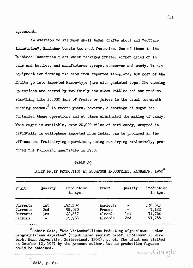
231
agreement.
In addition to its many small bazar crafts shops and "cottage
industries", Kandahar boasts two real factories. One of these is the
Pushtoon Industries plant which packages fruits, either dried or in
cans and bottles, and manufactures syrups, conserves and candy. It has
equipment for forming tin cans from imported tin-plate, but most of the
fruits go into imported Mason-type jars with gasketed tops. The canning
operations are served by two fairly new steam kettles and can produce
something like 15,000 jars of fruits or juices in the usual two-month
canning season. In recent years, however, a shortage of sugar has
curtailed these operations and at times eliminated the making of candy.
When sugar is available, over 20,000 kilos of hard candy, wrapped in-
dividually in cellophane imported from India, can be produced in the
off-season. Fruit-drying operations, using sun-drying exclusively, pro-
duced the following quantities in 1950:
TABLE 29
DRIED FRUIT PRODUCTION AT PUSHTOON INDUSTRIES, KANDAHAR, 1950*
Fruit Quality Production in kgs.
Fruit Quality Production in kgs.
Currants 1st 194,302 Apricots - 148,643 Currants 2nd 98,080 Prunes - 7,122 Currants 3rd 42,837 Almonds 1st 71,768 Raisins — 59,768 Almond s 2nd 71,766
Sobeir Said, "Die Wirtschaftliche Bedeutung Afghanistans unter Geographischen Aspekten" (unpublished seminar paper, Professor F. Mar- bach, Bern University, Switzerland, 1952), p. 61. The plant was visited on October 12, 1957 by the present author, but no production figures could be obtained.
Digitized hy \ lOOQlg
Said, p. 6l.

232
Dried fruits are packed in half- and one-pound preprinted cardboard
boxes or in larger wooden crates for export. But by far the greater
part of the Kandahar area's dried fruit exports, and almoat all of the
area's fresh fruit exports are handled by small operators or by the
1 newly-formed fruit-export corporation.
Mention has been made of the Pushtoon Industries' 200 kva diesel
generator. In winter, most of the power is sold to the Kandahar Electric
Company at 5.2 cents per kwh. In summer, the power is used to run the
company's ice-plant from which about 16,000 10-kilogram blocks are
sold to the populace each year instead of being used to refrigerate
fresh fruit exports to Quetta.
The Kandahar Woolen Mill, established before World War II by
Kandahar investors and the Bank-i-Millie, could produce over 135,000
square meters of coarse wool cloth per year, but usually produces far
less due to the poor condition of its equipment. In 1954> it produced
70,000 square meters; in 1955, 52,500 square meters; and in 1956, only
2 48,000 square meters, chiefly due to a lack of spare parts. Excess yarn
is sold as such or woven into shawls, mufflers or blankets. Raw wool,
received in lorries, is weighed, mechanically washed in a series of tanks
and spread in the sun to dry. Since most of the plant's output is of
mixed, natural color goods, and since it has its own bleaching and dye
works, there is apparently no attempt to sort wool by color or to grade
it. The scouring capacity is sufficient to handle wool for export, but
there is no baling press, so that the bales occupy far more space than is
Tudor Report, p. 132.
Tfilber, Afghanistan, p. 263 and Tudor Report, p. 134- Only 25,000 square meters were produced in 1950 when 32,000 kg. of yarn, 8000 shawls or mufflers and 1500 blankets were also made. Said, p. 6l.
233
necessary for their weight.
The wool which is used in the plant's operations is first cen-
trifuged to free it from the dust of the drying yard. It is then pro-
cessed on standard carding, spinning and weaving machines of a more
recent vintage than those in the RGA woolen mill at Kabul, including
2160 spindles and 20 large and 15 small looms. 75 per cent of the
present production, however, is devoted to the same, heavy, dun-colored
material made of unsorted wool which the Kabul plant turns out for
military use. The Kandahar plant is equipped to weave tweeds with
material bleached and colored in its own dyeing plant, and some fairly
substantial green, blue and gray material of this sort is manufactured.
The blankets, shawls and mufflers mentioned above are made on a piece-
work basis on special looms.
As has been mentioned, the Woolen Mill takes about 80-100 kw
from the Kandahar grid during daytime hours. Its own 220 kw diesel unit
is in unsatisfactory condition and serves only as a stand-by. The manage-
ment of this privately-owned enterprise is known to be interested in ex-
panding their productive capacity, but no investment in additional
machinery can be justified until the power to run it is available. The
first step, at any rate, would be to obtain enough spare parts to re-
activate and maintain in operation the installed capacity of the mill.
The remaining industries of the Kandahar area are limited to
those of the bazar and cottage. As is true at Kabul, the Kandahar bazar
includes several dozen handicraft shops making shoes from local and im-
ported leathers, sheet or bar metal products (pails, stove pipes, grills,
rough hardware and tools) from scrap or imported stock, ceramic bowls and
" Digitized by LiUUV LC
Hfisit to the Kandahar Woolen Mill of October 12, 1957.
234
water-pipes, and simple wooden and metal utensils. Cottage industries
of the area include the weaving of woolen and cotton cloth, the making
of coarse rugs, principally of cotton, and the embroidery of skull-caps
which is a regional and highly-developed artistic specialty. As is
generally true of all Afghan handicraft industry, the workshops of
Kandahar and its region have reached that stage beyond which the in-
dividual entrepreneur or farmer cannot go without sizeable capital in-
vestment. Hence the logic and necessity of the Kandahar Industrial Dis-
trict, and of a sufficient power source to supply it, are compelling.
Digitized by Google
235
VII. EVALUATION OF THE HELMAND VALLEY PROJECT WITHIN ITS OWN REGION
In Chapters IV and V we have made a survey of the areas presently-
included or scheduled for development under the Helmand Valley Project.
We have seen that of the two "virgin land" areas Nad-i-Ali is almost
completely settled with 1400 families and Marja about two-thirds settled
with 1000 out of a possible 1450 families. We have questioned the wisdom
of leaving the cultivation of Nad-i-Ali up to the individual farmer
whose experience has taught him to farm for today and leave tomorrow
to itself, but we have also seen the physical, psychological and political
obstacles in the way of a more rational handling of Nad-i-Ali lands. We
have noted that the experience of Nad-i-Ali, combined with more thorough
after-knowledge of soil conditions and problems, led to the abandonment
of the West Marja tract proposal and to the allotment of acreage in East
Marja according to the supposed carrying capacity in the different soil
classes.
In the case of Seraj, we have seen that the area offers comparatively
inexpensive development possibilities through the improvement and exten-
sion of the present irrigation system, but that it is already overcrowded
in terms of its productive capacity and presumably would not offer to
the RGA the basis for additional settlement except at the continued ex-
pense of the present population. We have discussed the floodplain Shamalan
area, with its drainage problems, and observed that its capacity for ad-
ditional settlement can be determined only after a better cadastral survey
has been conducted. We have compared the Darweshan area to the Shamalanjl(
236
hoping that the experience In the latter could be applied to the Dar-
weshan. The lower third of Darweshan will presumably be in line for
development before the Garmael area, about which comparatively little
is yet known. Opportunities for development in the Chakansur Basin run
afoul of political complications which the United States has no desire
to aggravate, while the apparently more promising Bakwa plains would
require elaborate construction not now within the means of RGA or ICA.
In the Kandahar area, we have described the productivity of the
long-cultivated North and Central (South) Arghandab areas and compared *
them with the largely vacant Tarnak tract, expansion of which would
compete In some years for the water available in the Arghandab. The
shortage of HVA and ICA extension and advisory services to assist farm-
ers in adjusting to cultivation of new lands argues against develop-
ment in the near future of an area that might become, in many respects,
another Nad-i-Ali. But here, again, economic and social considerations
come up against business and political interests. The contractor is
eager to complete the job and reduce, for RGA's sake as well as its
own, the high proportion of overhead to operating costs. RGA seems
primarily interested in developing more acres for nomads and tenant
farmers, whether or not they can make an early success of them, and
secondarily interested in making the utmost use of the Helmand-Arghandab
waters on its side of the frontier. Neither MKA nor RGA can be expected
to admit that the project is already overextended and that a great deal
of slow, unostentatious, and perhaps even unpopular training and edu-
cation must be performed before even those farmers and ex-nomads now
living in the project areas can begin to reap the benefits which were Digitized by VJOOQLC
originally held out to them.

237
As described In the HVDP of 1953, the Project was designed to
Irrigate some 820,000 acres, including 248,000 acres then in cultivation 1
or being prepared for crops. On the new lands made available by the
Project, 700,000 nomads were to be settled. By 1956, the Tudor group,
using estimates furnished by MKA at that time and applying the Marja
2 farm allotments throughout, calculated that only seme 117,146 new acres,
providing farms for 10,314 additional families, could be developed
through Phase II on the following tracts:
TABLE 30
APPROXIMATE ESTIMATE OF NUMBER OP NEW FARMS IN ULTIMATE DEVELOPMENT OF UPPER HELMAND VALLEIa
Name of Project Number of Acres New Farms
1,651 1,219 1,488 1,668 1,028 1,029 2,231
10,3H
aTudor Report, Table No. 29, p. 182.
These estimates include lower Darweshan but exclude Nad-i-Ali. Since we
know that 1400 families have been settled on Nad-i-Ali, we can add these
to the total. Since we also know that only 1450 families can be settled in
T.etter from Claude L. Fly to author, August 18, 1958. See Wilber, Afghanistan, p. 224.
27.5 acres of Class I: 10 of Class II} 12.5 of Class III and 15 of Class IV land. Digitized by^OOgK
Marja 21,190 Shamalan 12,325 Darweshan 15,846 Seraj 21,500 North Arghandab 10,325 Central Arghandab 11,375 Tarnak 24,675
Totals . - . . . . . 117,146
238
Marja, we can reduce the total by the difference between that and the
1651 postulated by Tudor. While we seriously doubt that Seraj or Tarnak
can take anything like the settlement postulated, «re shall give thea
the benefit of the doubt for this estimate. The result, liberally 1
biased, is 11,513 families, or, at most, 92,104- persons.
It Is, of course, true that these Tudor figures relate only to
the Upper Helmand and Arghandab project areas. If we add the HVSR
draft's Nad-i-Ali acreage (20,624.) and the estimated 137,140 developable
acres not now under cultivation in Garmsel and Chakansur, we more than
double the acreage figure computed by Tudor and arrive at 274*910 acres.
We can also add the 14,054 acres by which the developable land estimates
in the HVSR exceed those given above for the seven tracts listed. This
brings the total to 288,964. acres. Thus, with the greatest leeway, we
could not estimate more than 300,000 newly developable acres in an area
once thought to contain over 572,000. The Bakwa plains area, with at most
100,000 developable acres, was not originally part of the Project, was
not so considered by Tudor, and could only with great expense and dif-
ficulty be Irrigated with HfliwAnH water. Even if we now include it, we
are left with slightly over one half of the original estimate.
To convert these acreage estimates into terms of new farms is
difficult since we lack reliable estimates of land classification in
Garmsel and Chakansur (see Chapter IV). If we take the estimates given
to Tudor in 1956 for Garmsel and apply them to the HVSR draft acreage
estimate, admitting all the errors such a calculation may entail, they
~Tudor Report. p. 86, reckons on a basis of from 5 to 7 persons per family. After our experience of the Afghan Joint family system, and to avoid being accused of niggardly estimation, we prefer to use 8 persons as the average. ^
239
Indicate that 2966 new families might be settled an Garmsel, Chakansur
is more of a problem, since the HVSR draft cut the developable acreage
estimate from 316,350 to 145,425. But presumably 104,425 of these acres
are already under cultivation, hence not available for new settlement.
Even if the remaining 41>000 acres are potentially half Class I and half
Class II lands, a liberal assumption, they could accommodate only 4782
families. Thus, at the most, we can increase our potential total for
settlement in the Helmand Valley Project lands (Bakwa being excluded for
the reasons listed above) by 7748 families or seme 61,984 persons. This
addition brings the total contribution to the settlement problem to some
154*088 people out of the projected 700,000, with an average of less than
two acres per person on a basis of an eight-person family.
The preceding calculations have been made on the basis of the
information contained in the Helmand Valley Development Program of 1953,
the Tudor Report of 1956 and the draft of the Helmand Valley Survey Report
consulted by the author when in Kandahar, in 1957. They are subject to
all the limitations of these sources, as explained at the end of Chapter
III, and to subsequent revision of the Helmand Valley Survey Report. They
are also subject, as such calculations usually are, to differences of
opinion and evaluation. As a result, they are sharply at variance with
the calculations made by Mr. Claude L. Fly of the International Engineering
Company, a subsidiary of Morrison-Knudsen. In order to be scrupulously
fair to Mr. fly and to the contractor, the following quotations from his
letter of August 18, 1958 to the author are included:
There are still 1,200,000 net acres of irrigable and reclaimable land on the books which are reachable by the Helmand and Arghandab waters. There are over one million net acres still in the area which was included in the 1953 Development Program Study. About 715,000 acres are feasible for present project studies and 600,000 acres are nearly certain for some development. So, you see, there is not a really drastic reduction in

240
acreage. As stated above, there have been some changes in certain project recommendations based on the country's financial situation and the extreme difficulties of development of certain lands. For instance the Chakansur area has been cut to about 44$ of its original acreage as far as the pre- sent recommended studies are concerned. The Nad-i-Ali was cut to about 60$ but other areas such as the Darweshan have increased as much as 8255, the Seraj has increased 66$ and the Tarnak has increased 78$ over the original figures. So, while there have been changes caused by the data accumulated from surveys and laboratory examinations and field studies carried on throughout the six year period, there has been no drastic change in the total acreage of land which is available for consideration in the Helmand Valley Development Program.
... In the gross area of the Helmand Valley there were about 340*000 cultivated acres in 1953 out of a total of 1,160,000 potential. This was prior to the development. In 1957, the acreage increased by 133,000. This is a 45$ increase within the Helmand Valley proper and is due mostly to the influence of the two regulation reservoirs. However, only 20,000 "new" acres can be attributed directly to the government of Afghanistan projects, Marja and Nad-i-Ali. Most of the development has been by private enterprise.
Mr. Fly is certainly correct in pointing out that the major benefits
of the Helmand Valley Project have been those contributed to and utilized by
private enterprise. Indeed, as has been stated in this study, the most out-
standing benefit of the Project has undoubtedly been the provision of a firm
and controllable water supply along both rivers allowing cultivators to pro-
duce two or more crops per year without fear of water shortage or, in most
years, of inundation. For the very reason that much of the better agricul-
tural land was in cultivation or at least under private ownership with some
memory or prospect of cultivation, it is impossible to assay the worth of
the Project with reference solely to the RGA-owned lands or settlement thereon.
In fact, until proper cadastral surveys have been carried out in all of the
Project areas, it is impossible to determine how much of the land is avail-
able for Government-sponsored new settlement. And it is clear that the RGA-
sponsored settlement programs have been, and will be, paralleled by an en-
tirely unofficial and hence unrecorded influx of farmers who are acquiring
lands benefited by the Project or entering into tenancy arrangements with
the owners of these lands.

241
For all of these reasons, it is most difficult to arrive at any
single, conclusive evaluation of the cultivation and settlement aspects of
the Project. We have presented two evaluations, the author's and Mr. Ply's.
Experience will indicate which is closer to reality. We have already in-
dicated in Chapter III that MKA was reluctant in 1948 to count on more than
400,000 acres for irrigation and settlement in a comprehensive project. If
the author has adopted an overly-conservative approach to this very dif-
ficult problem, it is because he firmly believes that a hard look at the
realities of development to date and the prospects for the future is an
essential first step for analyzing and evaluating the Helmand Valley Pro-
ject with a view to future improvement.
The second step, it would seem, is the prevention of any further
deterioration in present project lands, and the delay of further develop-
ment until it is certain that it will contribute to, rather than detract
from, the living standards of the people concerned. In other words, the
interval of several years prescribed by the Tudor group between their
2 Phase I and Phase II should be observed, and the Tarnak development should
be entirely shifted to Phase II. This will allow time for ACU to complete
land development work in Marja, Shamalan and Darweshan, for cadastral sur-
veys in the latter two areas, and for settlement of new farmers in accord-
ance with the results of these surveys. It will give HVA an opportunity
to train those cadres of extension and community development workers so
essential to the success of new settlement projects. And it should provide
enough time for the RGA to reconsider one of the most basic questions in-
Part of the difference between the estimations appears to be due to the fact that Mr. Fly has included areas in the Bakwa plains and along the upper tributaries of the Arghandab River which are excluded from the author's calculations.
Tudor Report. pp. 168 ff.

242
volved In the Project, namely, whether the EGA is primarily Interested
In Increasing production and living standards in the Valley or whether
the primary aim Is to settle nomads and relocate tenant farmers. The
equation of these two alms In thinking relative to the project is
probably one of the main causes of the problems which have arisen. It
has been assumed that the settled nomad or the tenant farmer who is given
land of his own will ipso facto be in an improved position. Not only is
this a specious assumption, but experience in Nad-i-Ali and Marja has 1
indicated that just the reverse is true. Let us look at the two oases,
nomad and tenant farmer, separately.
The nomad is a part-time citizen. It is estimated that two million
people make an annual migration from the warm and winter-watered plains
of Pakistan to the rich summer pastures of Afghanistan's central moun-
tains. They cross the frontier at Innumerable points between Torkham
(Kbyber Pass) and Spin Baldak (Chaman route). Their routes and places of
encampment are fixed by tradition and enforced, if necessary, by the
tribesmen's own rifles. As recently as 1929» they have played a decisive
role in changing the character of the central government In Kabul. They
may be persuaded to settle, particularly If a profitable example can be
shown, but the prospects of forcible settlement in the Iranian fashion
are militarily and politically Impossible in Afghanistan.
Naturally, the central government would like to have as many of
the nomads settled as is possible. They could then be claimed and taxed
as full-time citizens, and it is assumed that their living standard and
the gross national produce would both be increased thereby. Undoubtedly,
"The Tudor Report. p. 87, estimates that grain yields on a 13.5 acre farm at Nad-i-Ali had fallen from 8100 pounds in the first year^f^T settlement to 3700 pounds by 1956.

243
a great deal of what legalisticalQy could be termed " smugglingn is car-
ried on by the nomads. But inasmuch as they have carried .small manufactured
items into Afghanistan and wool, woven goods and dairy products out of
Afghanistan for centuries, it is both more charitable and more realistic
to look upon this traffic as legitimate commerce, contributing to the
Afghan and Pakistan economies as well as to the nomads. In fact, by
taxing each tribe as it crosses the border, on the basis of a value de-
clared by the chief, the RGA recognizes the place of such commerce. It
also recognizes the practical impossibility of inspecting the baggage
of each caravan with its hundreds of households and beasts of burden.
The central government lacks both the power to compel the tribes to sub-
mit to such inspection and the personnel to carry it out. Adequate cus-
toms control would require the policing of the entire border, might re-
sult in a continued state of warfare as the tribes sought to evade or
resist inspection, and would surely cost more than it would save. And,
even if trucks can oarry goods more cheaply than caravans, it will be
some time before the road network and vehicle fleet are adequate to as-
sune the transportation of all goods now moved by caravan.
From its own point of view, the RGA's desire to settle the nomads
is perfectly understandable. But the outside observer may well ask: l) is
not the present contribution of the nomads, in terms of goods brought into
Afghanistan for sale in the bazars, and in terms of the milk, butter, yo-
gurt, meat, sheep's fat, wool and woven products sold before they recross
the frontier, far more than these people can contribute when settled on
lands they do not know how to till and which, to date, have baffled the
efforts of even experienced agriculturalists? 2) are not the taxes they
now pay for transit privileges a net gain compared to the 18-year delay

m
before they would begin to pay taxes on the allocated lands, If they re-
main as settlers that long, particularly in view of the fact that RGA
must make outlays to settle and feed the nomads until their crops begin
coming In? 3) how can RGA continue the program of settlement, without
recourse to force, If all It has to offer are the problem soils of
Marja and perhaps Tarnak or the somewhat better soils of Shamalan and
Darweshan which nevertheless require very careful management to avoid
over-Irrigation and saliniaation?
Of course, there are no objective answers to these questions
since we have no reliable estimates of the amount and value of nomad
commerce nor even of the exact amount of their present tax contributions.
But that the questions are legitimate ones, worthy of careful consider-
ations in Kabul, is demonstrated by the fact that of the 2500 families
now settled on Nad-i-All and Marja only about one-half represent ex-
nomads and that the proportion of nomads among new settlers has steadily
decreased since Nad-i-Ali settlement began.
On the other hand, If the ideal land use patterns for Nad-i-Ali
and Marja were adopted and the poorer soils were devoted to cultivated
pasture then the RGA might secure an augmented economic contribution
from the nomads' livestock, either by convincing the nomads to settle or
by making some arrangement whereby they could graze their animals on
Irrigated pastures mechanically plowed and re seeded In rotation with
same grain. Some of the nomads could probably be persuaded to pay for the
use of such lands either instead of or on the way to and from their tradi-
tional summer grazing areas. Such an arrangement seems far more logical
Estimated at $320 per family in Nad-i-Ali and from #100 to |120 per family in Marja. Tudor Report, p. 181.
245
than a sudden shift to sedentary agriculture though it might actually
lead to a voluntary transition by some nomads to a settled life based
on livestock raising on irrigated pastures. Yet another possible alter-
native resides in offering the nomads the rental of Project lands, on a
proper rotational basis, for planting grain crops in the spring and har-
vesting them in the fall, with HVA responsible for irrigating them during
the summer while the nomads are in their traditional summer grazing areas.
Turning now to the problem of the resettled tenant farmers, the
situation is not much brighter. These people represent formerly landless
farmers, principally from the upper Tarnak and Ghazni areas but with
something of a national representation. Under the traditional tenancy
system in Afghanistan, they used to provide labor and perhaps oxen and
implements and received, accordingly, one- or two-fifths of the grain
crops and somewhat more of the fruits and vegetables they tilled. Either
the landlord or the traditional use pattern determined what crops were
to be planted on what land, and there was a rough idea of what yields
could be expected in a normal year. Now these farmers must make their
own decisions with respect to land that has not previously been cultivated
and which poses problems of drainage and salinity they have not previously
encountered. They have always applied every bit of water they could get
for fear of later shortages; if they do that now their lands become
waterlogged and saline or alkaline. They are told that alfalfa and grass
crops will restore these soils and build up their fertility, but they
have always lived hand-to-mouth and they cannot eat grass at the end
of the season. They are told that manure must be applied to the soil and
stubble plowed under, but if they do this they will have no fuel. They are
advised that irrigated pasture and sheep-grazing or dairying is the ideal
46
use for their lauds, but they have no money to purchase animals or the
food they will need until the meat and milk are ready. Although they have
been furnished with some grain, building materials, one ox, a yoke and
some implements upon arrival, they are on their own after the first year.
The advisory service, though it got off to a good beginning, is woefully
inadequate. It is no wonder that some of these families have left in
despair, although it is impossible to get accurate figures on the
number involved.
The need most apparent to one who has been in the Helmand Valley
Project areas is for a vastly Improved and sustained program of agricul-
tural extension service among the new farmers. This does not mean ex-
tension service in the American sense, i.e., the availability of agents
to whom specific problems may be submitted on the initiative of the far-
mer. It means a thorough-going program of farmer education and assistance
similar to that which has been developed in India. The technician must go
out to the farmer, awaken his interest, ask him his needs, and guide him
in the solution of his most pressing problems. The expert must both con-
duct demonstrations himself and make arrangements with progressive farmers
to follow Improved methods on their own plots where their neighbors can
easily observe the results. If such demonstration plots could be provided
among the new settlers in the Project, it would not be long before even
the established farmers of the region learned of these efforts and
emulated those that proved superior to traditional methods.
Unfortunately, Afghanistan simply does not have enough trained
personnel for this sort of program. From 1952 to 1955 the Vocational
Agricultural ("Vo-Ag") School in Kabul, an ICA project, supplied thirty-
five graduates for work in the Helmand Valley. These were mostly boys with

247
the equivalent of a U.S. vocational'high-school education. Because of
their youth, all but ten had to enter the Army by the end of 1957. Mean-
while, replacement had fallen to the rate of two Vo-Ag graduates per year.
Apparently, young men with even this much education can obtain better jobs
with private businesses or with other government agencies than in the HVA.
The social value of agriculture or any form of manual labor is so low in
Afghan eyes that Vo-Ag graduates cannot be attracted to the Helmand for
idealistic reasons alone. Even the attempt to establish a branch of the
Vo-Ag sohool at Kandahar failed because it was apparent that the student
body would be composed of urban youths who would not put their knowledge
to work in either the established villages or the new ones in the Project.
In another attempt to meet this problem, HVA established an
Agricultural Extension Training Center at Nad-i-Ali in 1956. The Center
has to rely on men with only a six-year elementary education, but because
many of these had completed their military service they have provided a
relatively stable core for the program. In 1956, 22 students completed the
six-month course; in 1957, 33j in early 1958, l£> were under training, though
some presumably would not be graduated from the program. An attempt is
made to recruit only men from local villages who will remain with the Pro-
ject, or at least will go back to farming communities where their knowledge
can be put to use. Of oourse, the literacy rate was very low, but these
"village level workers* could compensate for it by their familiarity with
local dialects and village conditions. On the other hand, the problem of
communication between American technicians or instructors was more complex
than with Vo-Ag graduates, who have studied English. A few of the Afghan
interviews with Mr. Mabub, HVA Offioer in Charge of Extension Training, October 17, 1957 and January 23, 1958.

248
Instructors have studied abroad, either at the American University in
Beirut or in the United States.
As far as the ICA technical assistance program is conoerned, it
has practically come to a standstill. The last American agricultural
technician in the Valley was scheduled to leave in the autumn of 1958.
Then only the IGA Area Dlxeotor and the Public Health Service doctor,
both dedicated men, would remain. Job turnover among the Americans has
been extremely high, and one technician recruited in 1958 for community
development work in the Helmand refused to go beyond Kabul. The IGA
program in the Valley will have to be rebuilt from scratch if anything
further is to be done to make a success of lands already under culti-
vation and those scheduled for settlement.
This need to reconstruct the program, however, can have positive
value if some of the previous errors are now avoided. U.S. technical
assistance in the Helmand Valley has been devoted to service and experi-
mental projeots. It has provided hydrological, operation and maintenance,
and public health advisory services on a more or less sustained basis.
At various times, the IGA agricultural program inHhe Helmand has In-
cluded experts in animal husbandry, forestry, horticulture, agronomy, soil
management and irrigation. But these experts have tended to regard them-
selves as acting in a purely advisory capacity, and ICA policy has tended
to reinforce this conception. It is, of course, a difficult matter to
tread the path between advice and direction in a country sensitive to
political encroachment. Furthermore, the early difficulties encountered
The University of Wyoming, under contract with ICA, supplied an agronomist to supervise work on the experimental farm in Shamalan, later moved to Marja, but aside from incidental instruction of the actual workers on the farm no Afghans were being treated as trainees under this project.
249
by RGA and MKA in Valley development led ICA to avoid becoming involved
to the extent of recommending large-scale measures and programs. The re-
sult has been that the various experts have limited themselves to suggesting
certain useful, but very partial, attacks upon the basic and serious prob-
lems in the area. Cattle, sheep and hens have been imported to upbreed
local stock. One agronomist apparently sought a solution to the soil prob-
lem in the cultivation of tolerant sweet-potatoes, and devoted much of
his time to devising means of storing them and of persuading the Afghans
to eat them. Still other crops foreign to local cultivation or consumption
habits have been introduced and grown for seed increase with little assurance
that they will be accepted. The forestry project has been concerned with
cultivating seedlings for eventual fuel and lumber production, and a
number of useful windbreaks have been planted. But the use of ornamental
pines rather than faster-growing willows or mulberries in some areas is
a dubious application of nursery management.
In short, despite five years of technical assistance to the Helmand
Valley Project, during which time personnel have come and gone, the ICA
program has made little progress in getting across to the farmer the basic
information and techniques he needs to make use of his problem soils and to
improve hiB production. For these reasons, the following suggestions are
put forth for consideration if and when the ICA program is reactivated;
l) With RGA-HVA concurrence, technical assistance to the Helmand
Valley Project must take the form of agricultural education and extension
work, either directly with the farmers or through direct, participation in
the HVA Agricultural Extension Training Center. Interpreters will be needed
in either case, but, if carefully selected, they can profit by the experience
and later serve as counterparts or instructors themselves. '

250
2) The RGA should be urged to consider Afghan extension workers
in the sane category as school teachers. This meanB that such personnel
should be draft-exempt on the understanding that they will spend a oertaln
number of years In the profession. The exemption, plus a raise in pay
which could be supported by ICA directly or through P.L. J&O counter-
part funds generated by the wheat loans, may encourage more Vo-Ag graduates
to eerre in the Helmand. In addition, a number of scholarships could be
made available from such funds to students at Vo-Ag with the understanding
that they will be required to serve for a number of years in .the Valley.
3) American personnel hired for work in the Helmand should be
fully briefed on the nature of their work and living conditions before
contracts are Bigned. The emphaBis must be put on selecting persons capable
of teaching through interpreters and motivated by the desire to pull this
specific project out of its present state of torpidity.
A) In addition to agricultural extension personnel, a number of
experts in oommunity development should be provided. Such persons Bhould
serve both SB field supervisors for Afghan village level workers and as
instructors to train these workers and their own Afghan counterparts. If
such personnel cannot be secured in the United StateB, where we have not
had much experience with this sort of work, third-oountry procurement,
e.g., of Indians who are politically highly acceptable to Afghanistan,
Bhould be undertaken.
5) Future settlers, whether ex-nomads or tenant farmers, should be
given verbal and audio-visual orientation during the period when they ere
awaiting land allotments. This should pose no particular problem inasmuch
as such settlers usually spend a number of weeks in the old construction
Digitized by VJOOQLC

251
camps or on the mar gins of the Marja tract before they can be put onto
the land. This period should, of course, be reduced, but it can also be
put to far better use in instructing settlers as to the problems they
will face and as to what means are available to solve them.
6) In the specific case of settlers on lands which are best
cultivated in irrigated pasture, financial assistance in grant or loan
form should be extended to enable them to purchase animals and to feed
themselves and their flocks until crops and animals are mature. The cost
of this procedure might be reduced by an agreement whereby HVA would
mechanically cultivate grain and hay on its own lands or on unused project
and out-of-project lands and make food and fodder available to the settlers
concerned. Such mechanical cultivation of grains and legumes, in proper
rotation, might also serve to upgrade these lands for future settlement.
Public Law 480 counterpart funds would appear eminently suitable for use
in supporting the irrigated pasture, animal purchase, and mechanical
cultivation programs.
The foregoing suggestions do not imply that in the writer's opinion
the Helmand Valley Project is a failure. Rather, it is believed that the
Project is now in one of its moBt critical stages, and that what is done
by ICA and HVA in the ensuing months can radically affect its future one
way or another. In 1958, ICA transferred a grant of |Q..5 million, originally
scheduled for Kabul University, to complete the Upper Darweshan project,
to begin work on Arghandab power, to enable ACU to build a permanent bridge
across the Helmand at Lashkar Gah, and presumably to repair the Boghra
Canal leakage. There is no doubt that all of these projects are well-justified.
Allocation of another $1.5 million from unassigned Fiscal Year 1958 funds Digitized by VjOOQlC
was being considered to finance construction of intakes for the Seraj area,
_J
252
to build an Irrigation network to serve 15,000 to 18,000 acres in the
Tarnak, and to provide $350,000 worth of supervisory services and equip-
ment for the Afghan Construction Unit to use in land development. Of
these projects, only Tarnak irrigation appears inadvisable, for the
reasons set forth above. An RGA request^ for planning of "irrigation,
engineering and drainage in the Central and North Arghandab area to
improve efficiency of use of irrigation water through allocation, measure-
ment, control, conveyance and management of available water supply" and
for "construction of intake structures at five /North Arghandab/ inlets
to existing Irrigation canals to permit control and regulation of diversion
of irrigation water" seems more sensible in view of what is known of the
relative values of North Arghandab and Tarnak for intensive agriculture,
rather than mere allocation of acreage to settlers. Nor should it be
forgotten that when proper cadastral surveys are carried out in the Arghan-
dab areas, as well as in Shamalan and Darweshan, it may be entirely feasible
to looate the 2057 families postulated by the Tudor Report on these two
areas. ICA technical assistance for Fiscal Year 1958 was also to include
furnishing of a surveyor and engineer to aid HVA in cadastral work in
either Shamalan or Darweshan, with concurrent training of Afghan appren-
tices. Such surveys should be made for all areas presently developed,
and could well be extended to Seraj, although, as has been indicated, the
present crowding in that area would not allow the provision of 1668 new
farms envisaged by Tudor without the perpetuation of present unsatisfactory
conditions.
•"•Set forth in Letter of Agreement between RGA and MKA, October, 1958.
Digitized by Google
253
While there is as yet no way to estimate hov many new families
have moved onto privately-owned lands benefitted by the Project, it is
apparent that most of the previously-settled areas are enjoying an economic
revival. In North and Central Arghandab, in Shamalan and Darweshan, farm-
ers have been able to water lands previously usable in only one out of
two or three seasons. Much land now bears two crops a year where previously
water was available for only one, and that without assurance. Where ex-
cessive irrigation had harmed Shamalan soilB, the new drainage network
combined with farmer education may be able to reclaim and upgrade them.
In Darweshan, it is hoped to avoid the mistakes of Shamalan and prevent
water-logging and resultant salinization from the start.
The area from Kajakai to Girishk, and the Seraj, although not yet
included in the Project, have also profited from firm and reliable water
supplies. The same can be said of the downstream areas of Garmsel and
Chakansur. The Tudor Report estimated increases in crop values achieved
since the beginning of the project at 107,900,000 Afghanis ($2,158,000 at
free market rates) for the Arghandab-Tarnak areas, at 97,300,000 Afghanis
(fa.,946,000) for the Middle Helmand areas as we have defined them, and at
32,800,000 ($656,000) for the Garmsel and Chakansur areas. While such
estimates must be taken cum grano sails, no one can deny that substantial
benefits have accrued from the water supply and flood control features of
the Project.
We have also indicated that there is much to be gained from the
hydroelectric features of the Project. Indeed, more prompt action on the
Arghandab power plant could have made such benefits available to Kandahar
"HPudor Report. p. 186. Digitized by Google
254
consumers, including the International Airport, the Woolen Mill, and
Pushtoon Industries, by the fall of 1953. The Kandahar Industrial Dis-
trict, if and when it is constructed, vlll also profit by this source of
power, which may well become a magnet for further economic development.
In conclusion, then, we may repeat that the benefits inherent
in the Helmaod Valley Project are still within reach. On the basis of
the author's estimates given above one may reasonably expect that an
eventual area of over 288,900 acres may be added onto the cultivable
acreage of Afghanistan, an increase of some %. On the basis of Mr. Fly's
estimates, 600,000 to 715,000 acres may be addedt
The principal point which we have to consider in respect to Afghan- istan is that we have here in the southwest area over one million acres of usable land and we have also over ten million acre-feet of usable water. This is about twice the amount of necessary water for the proper irrigation of the lands that are potentially available. A very conservative estimate of the worth of these land and water re- sources, when properly developed, would be about $120 per acre in annual gross income.
Considering only the areas for which development is now assured, i.e.,
eliminating Tarnak, Seraj, and the lower third of Darweshan, Garmsel and
2 Chakansur, irrigable acreage will have been increased by some 131,000
acres (author's estimates) without allowance for double cropping. If,
Tietter from Claude L. Ply, August 18, 1958.
^The Tudor Report. p. 185, estimated that over the whole Helmand Valley, including the areas here excluded, the area annually irrigated had increased by 1956 by some 122,000 acres, an increase of 60$. The author's estimate, which relates only to the areas where development work has actually been undertaken and which can provide land for new settlers if cadastral sur- veys are undertaken, is based on the HVSR draft estimates of total potential irrigable acreage and of changes in acres annually farmed. HVSR draft, Supple- ment No. 7, Table No. 14. In the absence of clear data relevant to the two Arghandab areas, we have assumed that about 8000 additional acres will be as- certained to be the property of private owners and the remaining 28,000 acres as available for settlement.
Digitized by Google

255
thanks to careful reclamation end cultivation practices, i-he 65,000 still
vacant of these acres can bo hi*ought up to their potential land classifi-
cation, they would support some 6000 additional families, or 48,000 more
people than are now settled in the Valley. Even if few of these future
settlers come from nomad tribes, the use of these lands will be a net
gain in production. For the resettled tenant farmers, the chance to
cultivate their own lands is an opportunity to raise their own production,
their standard of living and their self-esteem. The important thing is
to assure either nomads or tenantB that the promise of the Helmand Valley
Project can be fulfilled. If the proposed agricultural extension and com-
munity development program can be implemented in the making of good farm-
ers and healthy citizens, then the Project will be as much of a success
as its inherent geographic limitations allow. In view of the continuing
paucity of factual data, no more objective statement can yet be made.
Digitized by Google
PART II
INTERREGIONAL ANALYSIS
Digitized by Google

257
VIII. THE DIRECTION OP AFGHAN ECONOMIC DEVELOIMENT
The suryey of the three regions which appear to hold the key
to Afghanistan's future economic development has now been completed.
Only the Kabul, Kunduz and Helmand Valleys offer the necessary com-
bination of soils, water, population, looation with respect to foreign
markets and sourceB of supply, plus some existing industrial base upon
whioh to build. At any rate, only these three areas are under active
consideration by the RGA and private interests for large-scale invest-
ment of Afghanistan's limited capital resources. Given these facts, it
is the next task of this study to analyze according to type and looa-
tion the proposed investments which can produce optimum results, meas-
ured in terms of a higher standard of living for the Afghan people.
In the author's opinion, such a standard of living must include qual-
ities of self-sustenance and security in order to be acceptable to the
Government and the leading entrepreneurs of Afghanistan. That is, the
economy must not be one based primarily upon external economic assist-
ance, liable to collapse if such assistance is withdrawn, and it must
not be one purchased at the cost of incurring enmities which might
lead to the termination of the Afghan way of life, as distinct from
that of other nations. In short, the economy which is ultimately de-
veloped in Afghanistan must be designed to sustain traditional Afghan
independence and neutrality among power bloos. With these qualifica-
tions in mind, and the preceding regional studies upon which to draw,
we may now proceed with an economic-geographic analysis of the^most Digitized by VJOOQLC
advantageous directions of development.

258
Disadrantages of Mineral Development at the Present Tine
In the preceding chapters, we have written very little concerning
the mineral resources of Afghanistan. The principal reason for this hia-
tus is the general laok of information on Afghan geology and mineralogy.
A Geological Survey Department was established under the Ministry of
Mines and Industries only in 1955, and very few sections of Afghanistan
have as yet been geologically mapped.^ Naturally enough, the RQA is more
interested in exploration designed to locate precious metals or minerals
commanding a high price on the world market than in the tedious and less
Immediately rewarding plotting of stratigraphio formations and petrography,
let, except for the element of chance, sometimes guided by local hearsay,
it is only such pedestrian work that can lay a sound foundation for the
discovery and commercial exploitation of mineral wealth. Credit for rec-
ognition of this fact is due both to the Ministry and to the United Na-
tions Technical Assistance Mission (UNTAM henceforth) which continues to
provide expert geological and topographical assistance. The United States
ICA Mission has also assisted by paying most of the cost of an extensive
aerial photography survey carried out by Fairchild in the autumn of 1957 •
This photogrammetrie survey, from which a basic reconnaissance map at a
1)250,000 scale and partial studies at 1*50,000, both with 100-meter
contours, are now being furnished to the RQA, represents the first step
towards obtaining reliable topographical sheets from which structural
interpretation and ground surveys can proceed. But restriction to these
scales and contour Interval, combined with the "strategic" exolusion of
a 50-mile wide zone in northern Afghanistan, will limit the usefulness
^Marcel Schwob, "The Economic Challenge in Afghanistan," United Nations Review. II (July, 1955), pp. 25-27.
Digitized by VjUUyiC

259
of even this reconnaissance mapping. In particular, the Sar-i-Pul
area of petroleum seepages and test drillings is not included. It
has been reported that an East European concern will map the excluded
portions on a comparable scale, but no such work has yet begun.
Ve shall discuss the petroleum situation further in Chapter I,
but for the present it may be said that no indication of the extent of
the deposits is yet available. Nor is it apparent how substantial de-
posits, even i£ located, could be developed. Presumably, Afghan crude
oil could be piped from Sar-i-Pul to the Amu Darya and then taken by
barge and railroad for processing in Soviet Central Asia or on the Cas-
pian. But by the time the products were returned to Afghanistan the cost
would probably be almost as high as that of the Soviet gasoline and kero-
sene now being imported. Perhaps the Afghans could exchange crude oil for
Soviet refinery products or persuade the Soviets to help them build a
simple tharma] process plant for the refining of diesel fuel, gasoline
and kerosene. Bie preparation of aviation fuel in quantities sufficient
for the Kandahar International Airport is far beyond prospective abil-
ities, even if lighter grades of crude than those yet sampled are found
at Sar-i-Pul (see Chapter X). At best, Afghanistan might eventually re-
duce its import requirements for some petroleum products or develop a
market for crude oil to offset some of the foreign exchange costs, but
^Interview with Mr. Russell, ICA photomapping expert, at Kanda- har, October 10, 1957.
^Interview with Mr. Massa, petroleum engineer, Ministry of Mines and Industries, Kabul, February 13, 1958.
Digitized by Google

260
this is likely to be both far in the future and on a comparatively
small scale.
The situation with respect to coal is somewhat similar, nnd will
also be discussed in detail in Chapter X. The most that can be hoped for
in this direction is an increased supply for domestic needs resulting in
less reliance upon imported die el fuel. No coal is presently imported or
exported, and transportation difficulties seem to rule out any such traf-
fic in the foreseeable future.
The domestic demand for coal will increase as domestic cement-
producing capacity grows. We hare seen in Chapter I that the first Af-
ghan cement mill, with a capacity of 100 tons per day, went into opera-
tion at Jabal Seraj in 1958. A site at Pul-i-Khumri, north of the moun-
tains, appears to be even more promising, and may get a 200 ton per day
cement plant in the near future. While it is unreasonable to expect Af-
ghanistan ever to become an exporter of cement to the U.S.S.R. or to
Pakistan, the nation should eventually be able to meet its own needs,
thus conserving the foreign exchange previously devoted to imports. In
fact, of the possibilities for mineral development, coal and cement are
the most promising yet known and may represent the only areas where such
development can make an immediate and considerable contribution to the
Afghan economy.
For years, the high cost of Imported cement has been burdening construction projects, especially those of Morrison-Knudsen Afghan- istan in the Helmand Valley. At an estimated annual consumption rate of 20,000 tons, price savings would be in the neighborhood of $200,000 a year since the delivered cost of foreign cement in Kabul has been running as high as $40 per ton, while local cement is expected to sell for |30.1
iWilber, Afghanistan, p. 2^6. Digitized by Google

261
In the realm of semi-precious minerals, Afghanistan has been
noted for centuries for the high quality of its lapis lazuli. Most of
this gem stone comes from the mountainous province of Badakhshan and
can be exploited only because of its high value with respect to weight.
Much of the lapis lazuli is processed in the privately-owned Hajari
Najari plant adjoining the Ministry of Mines and Industries in Kabul
and sold at prices fixed by the RGA. The Ministry is keenly interested
in increasing extraction and export of this mineral and employs some
of its best talent for prospecting work, to which geological mapping
is often subordinated. But neither the lapis lazuli nor the sporadic
appearance of rubies and precious metals can be regarded as a serious
contribution to the economy at present. Nor can much be expected from
the scattered known deposits of copper, lead, zinc and other base met-
als, although systematic exploration of the complex stratigraphy of
o central Afghanistan may, of course, produce unforeseeable developments.
Two attempts at mining known ore deposits have both fallen short
of expectations. West of Mohammed Aga in the Logar Valley, eleven sur-
face occurrences of ohromite were surveyed and plotted for the RGA by
M. E. Volin of the United States Department of the Interior, who pre-
pared a thorough report on his explorations in 1950.3 Mr. Volin esti-
llnterview with Mr. Nicholas Galakhoff, DNTAM geologist, at Tali- qan, September 23, 1957.
^See International Engineering Company, HftiTnanH Valley Industrial Survey. Phase I Report, prepared for Morrison-Knudsen Afghanistan, Inc. (San Francisco, 1955).
^M. E. Volin, Chromite Deposits in Logar Valley, Kabul Province. Afghanistan. prepared for the Government of Afghanistan (Washington, U. S. Dept. of the Interior, 1950).
Digitized by VJOOQIC

262
mated the total reserves as 181,200 tons with a CS^Qj content ranging
from 35.8 per oent to 57.5 per oent, but only 27,760 tons meet or ex-
ceed the current 50 per oent G^O^ Minima specification for metallur-
gical ohramlte. The cost of mining this ore and shipping it to the
Eastern Coast of the United States was estimated at $36 per ton, and
a profit of $12 per ton was anticipated. However, no farther steps hare
been taken to realise even this |325,000, and it is apparent that either
a considerably higher world market price or closer markets will be nec-
essary before mining of the remaining lower-grade ore, amounting to over
84 per oent of the deposit, can eren be considered. Reduction of the ex-
tremely high transport costs by improvement of the roads connecting the
Logar Valley and the railhead at Peshawar In Pakistan would be of some
assistance, but there remains the problem of improving mining operations
and obtaining timber from the Gardes region, another 80 miles beyond the
deposits. Perhaps the Afghans themselves consider the base too small for
expansion in the light of Mr. Volin's investigations.
It Darra Moor in Eastern Province, about 40 miles northeast of
Jalalabad, is a deposit of perhaps 1000 tons of beryl which has been
mined since 1954 at a rate of 30 or 40 tons per year for export. In
1957, an engineer of the Ministry of Mines and Industries personally
supervised the mining and packing of 60 tons of beryl for sale to the
United States firm of C. Tennant Sons and Company. This promising ar-
rangement, made with 1CA encouragement, turned sour when it was found,
after shipment was oompleted, that the ore contained less than the 10
per cent of beryllium commercially acceptable. But since it also con-'
tained 2.5 per cent lithium, efforts were made to save some of RGA's
Digitized by VJOOQLC
263
money by selling it for lithium extraction in the United States.
On the northern slopes of the Safed Kuh range in Eastern Province
are many outcrops of talc. These are exploited in crude fashion by the
Shinwari tribesmen who carry the talc over the passes for sale in Pakistan,
but the RGA does not gain any revenue from this traffic.
During MKA operations in the Helmand Valley, several deposits of
2 iron ore were located and analyzed. The best of these apparently 1B the
estimated two to three million tons of magnetite ore at Haji Alam, about
30 miles east of Kajakai Dam and off the old Kajakai to Kandahar road.
1 sample of this ore showed 64.. 17 per cent iron content with low (0.01
per cent) sulfur and (0.016 per cent) phosphorus inclusions. But the
total amount of this ore is not considered to justify smelting under
present conditions, especially in view of the lack of satisfactory
coking coal in the region. Proposals to utilise Kajakai power for an
electric furnace operation are presently, if not permanently, out of
the question, the meager needs of Kandahar being satisfied by scrap and
by imparts of perhaps 125 tons of primary iron and steel products per
year. Nor would this amount and quality of ore suffice for profitable
export. Of more Interest might be the unusual combination of ferro-
aanganese and rare earth elements in the Koh-i-Khan Nashin Ridge, about
18 miles south of Khairabad at the lower end of the Darweshan area. A
United States Operations Mission to Afghanistan (ICA), Mission's Monthly Report (TOICA A-629, January, 1958) (Kabul, 1958), pp. 4-5. (Hektographed.)
o International Engineering Company, Helmand Valley Industrial Survey . . ..
Section B-IV.
3Ibid., p. 25.
4-Ibid., Section VII, p. 12.
Digitized by VjOOQlC

264
sample of this ore assayed as follows:
TABLE 31
KOH-I-KHAN NASHIN IRON ORE ASSAY*
Compound Percentage Compound Percentage
CaO 30 MgO 10 Pe203 16.52 BaO 10 Mn02 11.12 Rare Earth Oxides 2.5
a International Engineering Company, Hftiirmnfl Valley Industrial Sur-
vey . . .. Section B-IV, p. 9.
Farther south, near the Pakistan border, are the Malik Ookand de-
posits of "Oriental Alabaster" (essentially, marble rather than gypsum or
"New World Alabaster"). This material is much fayored for ornamental stone-
work and is easily quarried. Transportation across the desert payement here
would be easier than in most parts of Afghanistan, but this factor is off-
set by the comparatively low value of the material. In fact, the absence
of any known bulk commodity in sufficient quantity and value to justify
export was one of the principal reasons for recent recommendations that
the railroad not be extended from Spin Baldak to Kandahar in the foresee-
1 able future.
The fact that the need to provide bulk transport for mineral prod-
ucts of any sort did not enter into the 1957 transit study of southern
and eastern Afghanistan (to be discussed in Chapter XI) is another in-
fcoebig and Koebig, Consulting Engineers, Report on Transportation Facilities of Afghanistan and Pakistan, prepared for International Coop- eration Administration (Los Angeles, 1957), pp. V and 111, 117. This doc- ument will henceforth be referred to as Koebig and Koebig Report.
Digitized by Google

265
dioation of the fallacy of looking to mineral development, aside from
fuels (see Chapter I) as a primary basis of Afghan economic development,
is far as Afghanistan's mineral resources are now known—and it must be
emphasized that this is not very far Indeed—it is apparent that trans-
portation obstacles would represent only a secondary problem. The pri-
mary problem at present is the lack of knowledge of any large quantities
of high quality minerals in demand at home or on the world market. Eyen
in the oases of chromite and beryl, where serious efforts at exploita-
tion have been made, the results have been discouraging. Petroleum and
coal extraction, whioh could help meet domestic needs and perhaps re-
plaoe same fuel imports, are in the early stages of development. Afghan-
istan lacks the cadre of trained engineers properly to survey the nation
and adequately to develop known or discovered deposits. The nation laoks
the capital to hire outside technicians for this work or to make the
initial, usually high-cost, investments in extractive facilities. Vhile
some of these servioes have been provided as technical assistance by the
United States and the United Nations, it is unlikely that any capitalist
country or company would make substantial investments in extractive in-
dustries of a neutral area bordering the Iron Curtain. Presumably, some
of the technical assistance and development capital needed will be forth-
coming from the Soviet Union, under the $100 million credit line extended
in December, 1955, or from other nations in the Soviet Bloc. But such
assistance can probably be called forth only by adequately-demonstrated
opportunities for economic or political gain, which the EGA may be re-
luctant to offer.
At any rate, until the RGA can provide or obtain the personnel
Digitized by VJOOQLC
_J
266
and equipment necessary for thorough exploration, sampling and testing,
the problems of extraction, transportation and processing of non-fuel
minerals, serious as they are, remain somewhat academic. In the mean-
time, it is obvious that Afghanistan must look elsewhere for the means
of improving its living standards and its bargaining position vis-a-vis
the outside world. It is one of the principal themes of this study that
those means can be obtained most readily by a concentration of available
oapital and teohnical services in the agricultural sector of the Afghan
economy, and more particularly upon certain key crops or products in
that sector. These possibilities will now be discussed in a general
fashion, and then, in Chapter U, related to the three regions which
we have studied in detail in Chapters I through VII.
Advantages of Increased Domestic Production and Processing of Agricultural and Pastoral Commodities
One fairly reliable guide to the productive capacities of a nation
lies in its import-export data. Those goods which a country cannot produce
it must do without or import. Those products in which it enjoys a compar-
ative productive advantage it can usually export profitably. While such
considerations as weight, bulk, perishability and distance to market will
influence the flow of trade, the presence of certain commodities high on
a nation's foreign trade list year after year is a reliable index to its
needs and capacities. Thus, if we consider Afghanistan's exports for the
six-year period 1951-52 through 1956-57, we find that no mineral raw ma-
terials or products even appear among the major categories as they are
officially listed:
Digitized by Google

267
!»
H
i NO
O H
I
m ©
A C*N.
a p al o
ON
I
ON
o>
I
s ON H
? CM lf\ ON
CM »A I
s
3
»
ON
NO
)S
(V
SI
f\
CM
P £
NO
>T»
CM ON at c«\
•n to CM CM
I NO CM
CM
ON vO tO
UN. C«\
Q
CM
to O
CM ON
to
"N. <*%,
NO 3
NO
o ON a o •sf O u> CM t- »f\ c*\
H CM w> c*\.
CM
NO
a-g 5 h m 3 3
C*> NO UN,
ON CM
ON
CM O C*N.
NO to
NO »* H • • • O ON fr» c\ NO a »r» -* NO «A to ON
«r\ H N2 NO ^
CN'nOHCMCMCMCM
C*> £-
8 3 in
NO ONNO C^ONNO ONtO
CM NO •4- to e^ »A
CM
NO
m •p
. 3 I I I a * n m -P ft PH » H •P 3 o _ -p a 8, « £ ^ | | I . rSod8£<§l3cq
© £
o
ON
tcj >*
^ n 5 n s»s - O t-tO C*\ CM ir\ • O -4-
4
*-3 & ^ 3 g »
g 3 £ g a
1
3 *
o
H
ON
I NO
A
to ON
to
s ON
NO
to CM
p
1 o O E-t
Digitized by
o n

268
A distinct aeries of data on exports by quantity from 1953-54
through 1955-56 bears out the absence of mineralogioal items among
Afghanistan's principal exports)
TABLE 33
AFGHAN EXPORTS 1953-54 THROUGH 1955-56 BI QUANTITXa
Category Unit 1953-54 1954-55 1955-56 Average
Carpets •000 m2 180.0 228.0 153.0 187.0
Gut Casings •000 loops 769.5 1046.9 1451.0 1089.1
Raw Cotton 1000 m.t. 10.68 12.55 6.15 9.79
Dried Fruits '000 m.t. 17.05 42.84 22.75 27.55
Fresh Fruits •000 m.t. 18.63 28.46 18.47 21.85
Hides and Skins '000 pieces 1137.6 1217.5 1642.0 1332.4
Karakul Pelts '000 pieces 1251.7 I846.6 1743.1 1613.8
Oil Seeds 1000 m.t. 2.84 4.12 3.56 3.51
Raw Wool •000 m.t. 5.09 5.26 7.77 6.04
international Monetary ghanistan. Part II. Appendix I
• Fund, Report on 1956 Consultations - Af- (Washington* November 28, 1956), p. 39.
Of the two series of export data, that relating to exports by
value is probably the more accurate as well as the more recent, inasmuch
as it resulted from a careful reappraisal of the records at the Central
Customs House in Kabul under the supervision of personnel from the Min-
istries of Planning and Commerce aided by their UNTAM advisor. Work is
continuing on an equivalent series; of data by quantity, but for the
present the series of export data by value will serve our purposes.
269
While these value data could be meaningfully expressed in dollars only
by adjusting them in terms of the constantly depreciating value of the
Afghani over the six-year period oovered, they are quite adequate in the
form given to indicate the relations among the principal items of Afghan
export trade. From these figures, it is apparent that four or five agri-
cultural commodities clearly dominate Afghanistan's export trade. The
combined values for dried and fresh fruits would exceed those of any
single commodity in each of the six years reported* Dried fruits alone
held first place in four of the years, but yielded to raw cotton in
1952-53 and to karakul skins in 1956-57* Karakul has been in second
place more often than rav cotton, but fell even below wool in 1952-53.
Wool displaced raw cotton in 1951-52 and in 1955-56, while fresh fruits
have shown increasing strength over the last three years and displaced
wool in 1956-57* Perhaps the only safe generalization regarding Afghan-
istan's leading exports is to say that dried fruits, karakul and raw
cotton are the leading commodities, with year-to-year variations in
production and/or sales determining the exact rank. Fluctuations in
exports of all five leading commodities have been both wide and erratic
over the six year period, partly due to the frontier dispute with Pakis-
tan, but they have been more stable in the last three years during which
the North West Frontier was generally open and by which time outlets by
air and through the U.S.S.R. had been developed.
It may also be said that while the absence of known sources of
mineral wealth forces same countries to rely exclusively upon their
agricultural products, it seems that in Afghanistan the agricultural
Digitized by VJOOQLC

270
sector will continue to enjoy certain particular advantages even if
future minerological exploration is highly successful. For example, it
is generally conceded by buyers of karakul skins, known in the United
States as "Persian lamb", that the best grades of Afghan skins are su-
perior to any exported by the Soviet Union or the Union of South Africa,
Afghanistan's principal competitors in this market. Of course, this
advantage can be lost if Afghanistan falls behind in upbreeding and
care of flocks (see Chapter IX), but for the time-being at least Af-
ghanistan is in a superior competitive position quality-wise.
As a second example, it is highly probable that both West Pak-
istan and India will continue to be deficient in deciduous fruit pro-
duction, while Afghanistan, by maintaining her surplus, can continue
to enjoy the advantages of her proximate location to this large market.
Afghan meat, dairy products and sheep and goats likewise will continue
to find a ready outlet in Vest Pakistan, while surplus wool and woven
products are likely to remain in high demand not only in Pakistan and
India but, in the better qualities, in the U.S.S.R., West Germany and
the United States. The cotton grown in the Eunduz Valley, though sub-
ject to poor cultivation and mixing of varieties, is nevertheless able
to compete with long-staple varieties in Europe when it is properly
graded and marketed. It is also being accepted by West Germany and the
U.S.S.R. in repayment for development loans to Afghanistan. These ex-
amples are given not to suggest that Afghanistan possesses any absolute
and eternal advantages along the lines enumerated, but rather to indicate
some of the preferable directions for agricultural development and exports.
We shall return to this theme after a review of Afghanistan's imports.
Wilber, Afghanistan, p. 289.

271
CO <D
as1 <D U M g
•p d BJ O
*4 H
tfN.
NO
ON
NO in
I m m
«n m
3
ON H
PN. m I
CM m ON
CM m l
fn o>
(^ NO NO v\ c- ir\ ITv UN. NO W c- to c\ l> IT\ ON NO o m Tv O fl f rH vO c*\ CM CM
CN. rH CM
to n H O PN,
H
O ON to ON o -* m -^ ON NO ON C\ • • • • • • • * • • • », o CM NO c- o H NO ^ to 3
CM
ON m
rH t-4 H
c*- «o 3 NO VN. CM ^ m p O
ON H
cr\
m -* ON H C*\. CM -t C*N. m t» c*\. NO
O to
m m Q 3 m 9£ ON
CM 3 rH
ON H 3 8
NO
H
NO to to to H O ON m UN. ON. to H
P 8 5 3 4 Q O CM
C*\ <£ 3 8 NO NO
Si ir\ IT\ CM
H
ON r- H o NO CM CM NO ON NO to NO • • • • • • • • • • • • 8 8 tfN H c» C*N. Nf H m to -* "3 H CM IA
CN, a C*\ o H
H c«\ 3 a H
o ON O C"- O -t ON H NO ON NO H • • • • • • • • • • f • ?; Q O
CM NO H 3 8 m 3 3 £ H
SI NO
8 H
to ITi m NO m ON ON in ON o to ON • • • • • • • a • • « • WN. H 3 ON NO
ON H
NO ->* m
o m 4 WN.
N2 H
CM
O Q H t» ^t to o m -«* o H O
H CM
ON CN.
(D 0 o m
3
m
55 NO CM
m
H
m •8 o ho
<D O (D
•H
Pi CM m 3
m
•8 o bo
tl
NO CN. &t f
m
o 3 h
"8 O 1=1
si
I 1 I S ti
o m oJ
C3
ID
g <§ »t|
1 m
•P
1 Si § H •p •H
ff) 0] +> X) <D <D O J§git
•d
o w
edl iOooi

272
m
o +^
CO
3 «t^ ^ m
+> O a H © o •>
(D en in CM en vO vO co vO • ^1 bo C\i vO
$ en ON o ON in in S 1 aJ Ci C-
* t> in o
» CM l 1 1 -P 0 U -* vO C- o o CO en ON S P •S *t •N ^ •* •* •* 4H O
$ CM H
-4- en t> CM 3 CM O <D n n
to • •st • ON ON • >t ON • in • • |3
3 +3 3
CO CM O
in 5 ON
t^
$ H in H 5 CO
sO
ON 5§ Q ON ->3- in
in
P ON •H C
4 O fN •» r> •s •s «N •v •N •v •* •\ a a 1 En CO en 3 3 CM
vO in en
CO H in
3 CM c»
GA f
ra
of Pla
P rt Of
t> vO to °i H en t> •«* in -4- in (D G^ &
m 1 CM vO* •4 CM CM l> UN. o
• in
• sO
• -4- ^ O
r- V0 m » vO o
ON CM
H in SI CM
ON o CM
en 1
» ' S 1 VH "9
m ON •» •s •* •* *l •t •t o "H l H C- irv CM en CM ON c*> H s
vO H H d) in O <D ON ^J3 H m +3
NO -4- o en -* CM C^ «> 0^ H ON H m Pi m • • • • • • • • •
0 &? en C3 1
ON" 3 CO en vO in CO sf CO -* ON vO O &
H B m 8 ON O -** in 8 m 1 in H 1 O m H CO r- vO o vO en sO CO
«rt 5
3-p -..3
i—3 Orf ON •s •t •N •\ •t •\ •t •*
H
H NO H
in vO H H
CM ON CA in
3 UN m L in CO vO CM ^* -4- <n c> in I r*
-* ir\ • • * • • • • rj CO • d -d w O^
l O ON
H vO $
ON CM
ON ^ si CM
H vO
* o'dlc en ON q p
H in en 3 CO O CO CO o en 4 M vO H o ON en CM vO H in CM H a] r- PHP
co H H
• •p •P
• •p 00
• -P
<<H ©
m a) %jj 00 • • • • • • • <D • m • m
* •p •H
-p 0
o
e o
•P • 0
P
0 P
0 p p 0
O
O CO
•H o ffl •p
1 3 t=> £J o o o Pi o P, o a) fn o o o o r*J •» m* m ^ ». a a)
51
0) 00 to
o o bo
CD o CD
•H
piled by Mi
Kabul; mad
O •d •8 Pi
•8 •H o
bfl g CQ 5 ©
& 1 1 P td
0> o •H
CO
3 O B O ho
a) o
3* bO T3 0) 3 <D Pi O 60 co p 3 .3 % q
o •H § s
at * 5 oJ H •O > o Si H ja xt o & o ra o H q -p 3 p B •P B •rl
o on 3 -p p bb d cd n) -P (D cd 1 A o
o $ S EH CO
i-5 CO
HH O H
O
Digitized by VJ OCK lie
273
If ve exclude "notions1* which cannot be considered as a sin-
gle commodity, the salient features of the import pattern appear to bet
1) the relatively minor place taken by durable goods and fuel
relative to processed or even semi-processed (sugar, tea) consumption
goods which are agricultural in originj
2) the predominance of cotton piece goods among imports over
the entire six-year period;
3) the steadily increasing challenge by artificial silk piece
goods to the predominance of cotton piece goods) and
4) a general alternation between sugar and tea far third and
fourth place, except for 1954-55 when cars and trucks ranked fourth
and sugar fifth.
These import data are even more significant when projected against
the domestic economic background set forth in Chapters I through VII and
when compared with the leading categories of exports. Afghanistan not
only imports, in manufactured or processed form, commodities which it
produces domestically, but actually exports some of the raw materials
which are used to make these commodities. For example, cotton piece goods
are the prinoipal import; raw cotton is among the leading exports. Afghan-
istan produces approximately 20,000 metric tons of ginned cotton per year
of which only 9400 metric tons can be processed in domestic textile mills
if operated at full capacity. let the country must import an average of
over 7000 metric tons of cotton piece goods^ at an average annual oost
of over 375 million Afghanis (|7.5 million at today's free market rate).
^Average for the years 1954-55 through 1956-57 based on quantity import data made available to the author by the Ministry of Planning in December, 1957* Ultimate sources same as those of value import data.

274
Even with allowances for loss of weight in processing, it is apparent
that Afghanistan's raw cotton production would be sufficient to meet
her cotton piece goods requirements in an average year providing!
a) sufficient processing capacity were available, and b) there were
no requirement to export raw cotton to meet prior commitments. Even
though we cannot assume b) to be true, the savings in foreign exchange
over the past three years would have amounted to 110.3, 273.7 and 168.6
million Afghanis, respectively, or an average of 184-2 million Afghanis
($3.7 million) which could have been devoted to direct payment of for-
eign indebtedness or to procurement of industrial goods which Afghanis-
tan cannot make for herself.
Of course, one must not forget that it costs Afghanistan some-
thing to make her own cotton textiles, and these costs partially off-
set those of imports. While RGA controls over profit rates and whole-
sale prices of the Textile Company (see Chapter II), combined with min-
imum resale prices on some imported textiles, obscure the actual cost-
price relationships, one may conclude from the eagerness of the Textile
Company to expand its production at both Pul-i-Khumri and Gulbahar that
domestically-produoed cloth can still be sold at a considerable advan-
tage over imported. The same reasoning applies to the Baghlan Sugar Com-
pany, which would like to double its processing capacity if a sufficient
supply of beets were assured. And, although operations have only recent-
ly begun at the Jabal Seraj cement plant, one may safely assume that
domestically-produced cement will undersell the imported product, at
least south of the Hindu Kush. It will be rewarding to observe the de-
l-See Wilber, Afghanistan, p. 280. Google

275
velopment of both the sugar and cement markets as the impact of the
RGA-owned cane sugar plant at Jalalabad and cement mill at Jabal Seraj
is felt upon the domestic economy.
It should also be pointed out that the Afghan tariff system
affords a measure of protection to domestic producers of certain goods,
and may do so to an even greater extent if it is increased as was pro-
posed in the Five Tear Plan. The existing and proposed tariff rates on
each of the major import categories listed above are given in Table 36.
The Five Tear Plan explicitly described the tariff policy of Afghanistan
as one "which serves a double purpose, namely protection and provision of
revenue in Afghanistan, /however^/ its revenue character is of greater
importance due to the fact that industry has not developed much. There-
fore such fiscal and protective policies are proposed that on the one
hand the customs duty will be coordinated with the economic and financial
conditions of the country, and on the other will encourage export and in-
dustrialization."2 Thus, it may be argued that protectionism has played
some part in the development of domestic industries since 1934 when the
^•See Wilber, Afghanistan, p. 243: "As regards further investments, the cotton textile market, after the completion of the current projects under way /Pul-i-Khumri and Gulbahar/, theoretically leaves a balance of prospective imports of about 30 to 45 million meters. However, much of this constitutes rayon and high count cotton cloth which the Afghan mills do not make and in which foreign mills would perhaps retain a quality ad- vantage even if Afghan mills did. There is doubt that much inroad can be made into this part of the textile market. In cement and sugar there def- initely seems to be a future, but expansion in both fields depends on the expansion of complementary productive capacity, i.e., coal and beets."
While the general tenor of this extract is undoubtedly correct, it is believed to be overly pessimistic as regards cotton textile prospects. On the basis of an estimated 120 million square meters annually consumed in Afghanistan (see Chapter II), the gap which will remain after the new capacity is fully utilized apparently is of the order of 57 million square meters of cotton piece goods alone. Provision of additional capacity to fill this gap will be discussed in Chapter U.
^he Five Year Plan of Afghanistan, p. 222.

276
present tariff schedule was inaugurated, and would play a greater role
if the proposed increases were adopted*
TABLE 36
EXISTING AND PROPOSED IMPORT TARIFF RATESa
Commodity Existing Rate in
Per Cent
Proposed Rate in
Per Cent
Proposed Increase As A Percentage of Existing Rate
Passenger Vehicles 30 30 0
Kerosene 34 35 3
Building Materials various various various
Ironware various various various
Cotton piece goods 35 40 H
Artificial Silk piece goods 35 50 42
Sugar 35 35 0
Tea 35 35 0
Leather 30 30 0
Leather goods 30 60 100
Notions 35 60 71
aAfsrhanistan Mission to the United Nations. The Five Tear Plan of Afghanistan, pp. 223-224. Note that trucks and gasoline, both Imported only by Government Monopolies, are not taxed as are passenger vehicles and kero- sene which are Imported on private account. Why sugar, another Government Monopolies item, is taxed is not clear; since the duty is passed along to the consumer it cannot be considered a tax on Government Monopolies, but may_serve to raise the price of imported sugar to that of the domestic.
It is apparent from the preceding schedules that the RGA does not consider
additional tariff protection necessary to stimulate further domestic pro-
Digitized by VJOOQLC

277
duction of either sugar or leather. The proposed additional five per
cent tariff on cotton piece goods and the additional 15 and 30 per cent
tariffs on rayon and leather goods, respectively, may result either in
higher revenues to the RGA or in stimulation of domestic industry.
One might, of course, inquire how domestic industry would fare
if all of the above tariffs were reduced or abolished. It is conceivable,
for example, that in the case of sugar the imported product could under-
sell the domestic in some parts of Afghanistan. This is probably true
for cane sugar at Jalalabad, within easy reach of a cane sugar refinery
at Peshawar. By extension, it would be true for either Imported or domes-
tic cane sugar transported from Jalalabad to Kabul so long as the refinery
there is handicapped by obsolete equipment and a capacity so small as to
be, perforce, inefficient. Even with respect to the beet sugar operations
at Baghlan, it is not possible for Government Monopolies to calculate the
true costs of production until the scale of operations comes closer to the
capaoity of the plant. But at least the operations at Baghlan are consid-
ered technically efficient in comparison with foreign standards, making
allowances for the fact that distillation of the molasses is prohibited.
Similarly, the new cotton textile mill at Gulbahar, if properly operated,
should be able to compete with any in Asia. And both Gulbahar and the
recently improved mill at Pul-i-Khumri would have to be operated rather
inefficiently before it was possible for other nations to undersell Af-
ghan cotton piece goods manufactured within sight of the cotton fields
(Pul-i-Khumri) or on the road between the gins and the main market (Gul-
bahar) . The same argument would apply to leather if the tannery at Kabul
were operated as efficiently as the Textile Company and Sugar Company
plants. Whether it applies to leather goods and rayon, however, may be

273
questioned.
Let us assume, for the purposes of discussion, that the tariffs
on cotton and rayon piece goods, leather and leather goods and sugar are
all protectionist in effect. Insofar as this is true, they act as taxes
upon the Afghan consumer, just as do the prices established by Government
Monopolies for domestic sugar or imported tobacco products. If the RGA
were to abolish these tariffs, it would seriously reduce a source of
revenue which brought in 41 per cent of the Government's income in 1954-
55. These revenues would have to be replaced by increasing duties on
other imports, or by additional land, property or income taxes. To what
extent the net position of the Afghan consumer would or would not be im-
proved by such changes cannot be considered in this study, but we cer-
tainly may assume that it is highly unlikely that the RGA, which has
adopted the philosophy of the "guided economy'', would abolish tariffs
on the enumerated items in the near future. For although one reads no
chauvinistic demands for autarky in the Government-controlled Afghan
press, nor claims that Afghanistan is being exploited by its trading
partners, nor even expressions of resentment at the fact that the nation
remains dependent upon imports of many items, it is unrealistic to expect
the Afghan Government, in this mid-Twentieth Century world, to throw open
its frontiers to free trade imports. While the RGA has avoided the tempta-
tion which often besets underdeveloped nations to embark upon large scale
industrial construction for which neither the raw material base nor a
developed market are available, it has indicated time and again that it
expects to achieve some measure of self-sufficiency in the products for
^The Five Year Plan of Afghanistan, p. 222. Digitized by Google
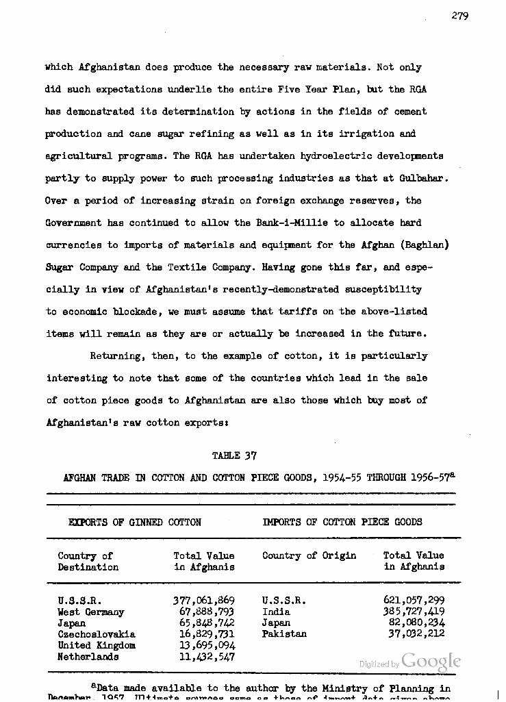
279
which Afghanistan does produce the necessary raw materials. Not only
did such expectations underlie the entire Five Year Plan, but the RGA
has demonstrated its determination by actions in the fields of cement
production and cane sugar refining as well as in its irrigation and
agricultural programs. The RGA has undertaken hydroelectric developments
partly to supply power to such processing industries as that at Gulbahar.
Over a period of increasing strain on foreign exchange reserves, the
Government has continued to allow the Bank-i-Millie to allocate hard
currencies to imports of materials and equipment for the Afghan (Baghlan)
Sugar Company and the Textile Company. Having gone this far, and espe-
cially in view of Afghanistan's recently-demonstrated susceptibility
to economic blockade, we must assume that tariffs on the above-listed
items will remain as they are or actually be increased in the future.
Returning, then, to the example of cotton, it is particularly
interesting to note that some of the countries which lead in the sale
of cotton piece goods to Afghanistan are also those which buy most of
Afghanistan's raw cotton exports:
TABLE 37
AFGHAN TRADE IN COTTON AND COTTON PIECE GOODS, 1954--55 THROUGH 1956-57a
EXPORTS OF GINNED COTTON IMPORTS OF COTTON PIECE GOODS
Country of Total Value Destination in Afghanis
Country of Origin Total Value in Afghanis
U.S.S.R. 377,061,869 U.S.S.R. 621,057,299 West Germany 67,888,793 India 385,727,419 Japan 65,848,742 Japan 82,080,234- Czechoslovakia 16,829,731 Pakistan 37,032,212 United Kingdom 13,695,094 Netherlands 11,432,547
Digitized by LiOOQU
aData made available to the author by the Ministry of Planning in

280
It would appear that the chief offender in this "colonial" type of
transaction is the Soviet Union. It should, however, be pointed out
that the U.S.S.R., Czechoslovakia and West Germany all have bilateral
commodity exchange agreements with Afghanistan, which account for
their high rank among recipients of raw cotton imports.
The only way for Afghanistan to break out of this vicious cir-
cle is to increase her domestic cotton textile capacity, so that she
can reduce her imports of piece goods while maintaining her exports
of raw cotton. Of course, increased exports and improved marketing
of wool and karakul, which bring in primarily hard currencies, would
also serve to enable Afghanistan to meet her obligations under these
commodity exchange agreements, all of which allow balancing in dol-
lars or sterling. We shall discuss the possibilities for expanded
cotton, wool and karakul production in Chapter H.
The second largest import oategory, artificial silk piece goods,
is also one manufactured from agricultural raw materials. At least, we
may assume that almost all of this category represents rayon rather
than nylon which is more expensive and is poorly adapted for tradition-
al Afghan apparel needs. Domestic manufacture of rayon from cotton lint-
ers or other sources of cellulose would obviate a substantial portion
of the cost of the rapidly growing imports, providing that a sizeable
and efficient plant could be established. As a matter of fact, the
first step in this direction is already under consideration. The Pres-
ident of the Shaker Ceramic Factory in Kabul has begun inquiries in
Japan regarding the establishment of a 5000-spindle, 60-loom rayon
Digitized by Google

281
piece goods plant which would utilize imported yarn.-*- The plant would
cost oyer $300,000, but would represent a start towards saving some of
the almost 300 million Afghanis ($6 million) spent on rayon imports in
the last reported year. By later expansion to include a synthetic fiber
manufacturing plant, using imported chemicals but local cellulose (cot-
ton linters, hemp, bagasse or reeds from poorly-drained sections), or
by locating this chemical-processing stage in Jalalabad with its ex-
cess swamp vegetation, the savings on imports might be further increased.
At any rate, no special agricultural development would be needed to sup-
port a domestic rayon industry, but only more efficient utilization of
existing sources of cellulose, including wood. For this reason, no
looational analysis or cultivation recommendations will be made in the
following chapter, but the possibilities of reducing rayon imports may
be kept in mind for the economic analysis in Chapter III.
Interview of November 3, 1957, with Mr. Abdul Hadishakur, who has spent several years in Japan in the export-import trade. Mr. Hadi- shakur indicated that the textile equipment would probably be secured from the Tsudakoma Company, which would also be asked to supply advis- ory engineers. This procedure was followed very successfully by Mr. Hadishakur in establishing the Shaker Ceramic Factory, an outstanding example of what can be done to replace imports by domestic manufactures (see Chapter I). The factory was built in ten months during 1957, at a cost of about $24-0,000, of which #150,000 went to Japanese firms for equipment, materials and advisory services. In 1956-57, Afghanistan imported a total of 785,777 kilos of glass and chinaware from Japan, the U.S.S.R., Pakistan and India at a total cost of about $356,000. When the Shaker plant reaches full production, it will turn out some three million teapots, cups and plates per year. Estimating 10 pieces to the kilo, this would represent a saving of some 300,000 kilos or about $136,000 per year. While Shaker price policy is not yet final, an indication of the savings anticipated is found in the fact that in February, 1958, the plant was able to export some of its own merchan- dise and to sell it in West Pakistan.
^For example, at the Jangalak lumber mill, which adjoins the Shaker factory, sawdust and wood scraps are burned in the power plant because of the high cost of such alternate fuels as coal, coal briQ( quets or fuel oil.

^82
With regard to sugar, Afghan imports from 1954-55 through
1956-57 averaged 11,810 metric tons at an average yearly cost of
about $1.7 million. Production at the Baghlan Sugar Factory averaged
about 5400 tons annually in these three years (see Chapter II). The
sugar cane mill at Jalalabad was not yet in operation. We have es-
timated that if enough sugar beets were grown in the Baghlan area so
that the plant could be operated at full capacity, it might produce
as much as 2,000 additional tons per year, resulting in a saving of
some L4.5 million Afghanis or $290,000 of the amount now spent on
imports. Furthermore, if the production of sugar beets could be in-
creased to 100,000 tons per year by more intensive cultivation and
the addition of new irrigated lands such as those available in the
Dasht-i-Khwaja Alwan area (see Map 4-) > and if the Sugar Company could
fulfill its desire to double present processing capacity, reason-
ably estimated at 55,000 tons per year, then the domestic sugar pro-
duction could be raised to between 14,000 and 15,000 tons per year
and sugar Imports practioally eliminated. A discussion of the pos-
sibilities at Baghlan, Jalalabad and in the Helmand Valley, which is
now entirely dependent upon imports, follows in Chapter U.
Most Afghan sugar is consumed in tea, the usual practice being
to pour half an inch or more of sugar into the bottom of the cup or
bowl before adding the tea, which can be replenished several times
before more sugar is needed. Unfortunately, we have no figures on the
number of cups of tea consumed per person per annum, but field observa-
tions combine with the high place of tea on the import list to indicate
the popularity of this drink among all who can afford it. Over the years
Digitized by VJOOQLC

283
1954-55 through 1956-57, tea imports averaged 2,935,781 kilos, which
represents about .29 kilos or .64 pounds per person in the settled
population. The average annual consumption far an adult living in a
city or village is undoubtedly much greater. Tea is the urban Afghan
drink T>ar excellence and no meal is considered complete without it.
It is often consumed between meals in the place of soft drinks or
the forbidden alcoholic beverages. But there appears to be very little
Afghanistan can do to avoid the average annual expenditure (over the
last three years) of some $2.65 million for Importing tea from Pakis-
tan, India and Japan. Even the Jalalabad oasis is far too dry for tea
cultivation and lacks the large amount of cheap, skilled labor neces-
sary for successful tea cultivation. However, the fact that most of
the Imported tea comes from India and Pakistan, nearby soft-currency
trading partners, and is relatively easy to transport, argues that
the Afghan economy does not suffer seriously in this respect.
Consideration of the import figures on leather and leather goods,
however, does give one pause. These items, coming predominantly from
Pakistan with small increments of unfinished leather from India, were
seriously curtailed during the height of the Pushtunistan dispute and
have not yet regained their former position. But the real question is,
why should Afghanistan, with an estimated 2 to 2.5 million head of cat-
tle, have to import leather and leather goods in any substantial quan-
tities at all? The answer lies in the failure to organize or utilize
domestic tanning capacity of sufficient size and quality to provide
the raw materials needed for leather products. We have already seen
that there does exist, on the outskirts of Kabul, a modern tannery
Digitized by VJOOQLC
284
and shoe faotory with an estimated daily tanning capacity of 2000
square feet of chrome cow leather, 1600 pounds of ox leather and
about 200 sheep and goat skins.1 Despite its annual capacity of
120,000 cattle hides, this plant handles only some 10,000 to 12,000,
and, indeed, only about 40,000 cattle hides are estimated to reach
the market from domestic herds each year.* The rest are either used
for cottage industry needs or wasted through careless flaying and a
lack of any appreciation of their value on the part of the farmers,
a factor which indicates the almost complete absenoe of proper mar-
keting channels and transportation facilities. Thus Afghanistan is
forced to import an average of 325.6 metric tons of chrome leather
each year, according to the Ministry of Planning.
In addition to tanning ten or more times the present number of
skins, the Kabul plant could manufacture between 120,000 and 180,000
pairs of boots and shoes eaoh year on its assembly line. But the lack
of two machines and damage to others through faulty use paralyzes the
entire operation. No shoes have been manufactured by machinery in Af-
ghanistan since 1954- when this plant turned out 4000 pairs of shoes
for general consumption and 6000 pairs of military boots. Meanwhile,
the nation is Importing an average of |235,000 worth of tanned leather
per year, from which local artisans produce about 375,000 pairs of
^Marcel Croisier, Industrial Development of Afghanistan. Memo- randum in files of UNTAM, Kabul, Afghanistan (Kabul: n.d.), pp. 1-9, passim. (Typed.)
^Marcel Croisier, Le Developpement Industriel de l1Afghanistan, prepared for the Government of Afghanistan under the Technical Assistance Program, United Nations (Dossier No. TAA 173/l/08; Report No. TAA/AFG/l) (New Tork: May 6, 1955), Annex V, p. 137.
3Kimler, p. 28 and author's visit of February 20, 1958.
285
shoes, and also Imports some $158,000 worth of finished leather goods,
most of which represent shoes manufactured abroad. If, as Croisier es-
timates, about two-thirds of the Afghan population wear either Western-
type shoes or the local leather sandals (paizars). then the domestic
market could absorb all that the Kabul shoe factory can turn out and
considerably more. At the present time, many of the Afghans in towns
and cities are wearing imported rubber overshoes or second-hand shoes
because the price of new leather shoes, whether Imported or made of
imported leather, is prohibitive. Yet the three foreign experts who
have investigated the Afghan leather industry, Marcel Croisier of the
UNTAM, Courtney Kimler of the United States ICA Mission, and Heinz
Heckhoff of the Vest German technical assistance group, all agree
that managerial initiative in the Improvement and utilization of
existing processing capacity and in the organization of a better
hide-collecting system is »01 that is lacking to establish one or
more profitable domestic leather enterprises.
So here is yet another opportunity of replacing imports with
domestic products and realizing considerable savings in foreign ex-
change. It seems likely that the heavier grades of leather for use in
soles will have to be imported for some time, but there is no logical
reason why the Kabul tannery should not receive and process three
times the 40,000 hides now reaching the market instead of one-quarter
or one-third this number. With this end in view, Mr. Heinz Heckhoff,
a West German tanning expert, was sent to Kabul as part of Bonn's
•Point Four" program in the winter of 1957-58. It was his hope to
persuade the management of the Kabul tannery to adopt chrome-tanning
Digitized by VJOOQLC

286
processes throughout their plant, with the aid of German chemicals and,
perhaps, credit assistance. Mr. Heckhoff is not concerned with the re-
habilitation of the shoe assembly line, about half of which he estimates
would require replacement or repair before use. But he indicated that the
successful completion of his own mission might well lead to the assign-
ment of a second expert to advise on manufacturing operations.
The primary requisite for increasing leather and leather goods
output, of course, is an increase in the number and quality of hides en-
tering the market. This is a matter which we shall discuss in the next
chapter. But we must first return to the export side of Afghanistan's trade
ledger in order to complete our discussion of the directions in which the
present terms of trade may be improved.
For example, we find that in the last three reported years, Afghan-
istan exported an average of 35.2 million Afghanis (#704.,000 at free market
rates) worth of sheep and goat skins, chiefly to the following countries:
TABLE 38
AFGHAN EXPORTS OF SHEEP AND GOAT SKINS, 1954-55 THROUGH 1956-578-
Country of Destination Total Value in Afghanis
India 57,558,8M
U.S.S.R. 31,554,106
West Germany 6,298,112
Pakistan 2,572,276
aData from Ministry of Planningj ultimate sources same as preceding data on exports.
Interview with Mr. Heinz Heckhoff in Kabul, February 20, 1958.
Digitized by Google
287
According to our quantitative data, these exports averaged 1,333,700
skins over the three years 1953-54 through 1955-56. Yet the Ministry of
Finance estimates that there are at least 20 million sheep and goats in
Afghanistan. On this basis, if Afghanistan comes up to the world average
of 33 per cent annual, slaughterings of such animals, there would be 6.6
million skins available each year. Indeed, inasmuch as the Afghan diet
prefers sheep and goat meat to beef, it is likely that at least this
many animals are killed and flayed each year. Why, then, do only 20 per
cent of the available bides reach the export market? The fact that some of
them are shipped as far as West Germany, Great Britain and Singapore indicates
that there is a good demand for them on the world market, as does the value
of the exports to India and the U.S.S.R. Apparently sheep and goat skin
exports are the victims of the same lack of organized marketing channels
which appears to afflict the leather industry, though with the difference
that here there is a good external market waiting to be served.
As is true of Afghan cow and steer leather, sheep and goat skins also
Buffer from poor processing. Most of the merchants who purchase sheep and
goat skins from farmers and herdsmen perform a simple drying or salting opera-
tion rather than incur the expense of having the skins properly tanned or at
least "pickled" with acid. According to Croisier, the Iqbal Tannery processed
only 30,000 of the 1,265,000 skins exported in 1950-51, and the production does
2 not seem to have picked up much since. The result is an unnecessarily high
amount of spoilage and consequently a lowering of the price for Afghan sheep
and goat skins on the world market. While it would probably not pay to com-
plete the tanning process in Afghanistan, since importers have their own par-
Croisier, Le Deyeloppement Industriel . . .. Annex V, pp. 136-137.
2 Ibid., p. 13B and visit by the author of FebruarjsrigSlOadb$5j&0

288
ticular requirements with regard to preparation, the foreign exchange
earned by this category of exports would be Increased If both quality
and quantity of production could be Improved. We shall consider this
subject further In Chapter IX.
In addition to the export of depilated sheep and goat skins,
there is a sizeable export of broadtail sheep pelts complete with the
voolt
TABLE 39
AFGHAN BROADTAIL SKIN EXPORTS, 1954-55 THROUGH 1956-57*
Country of Destination Total Value in Afghanis
U.S.S.R 17,988,722
United Kingdom 7,576,519
United States 441,060
aData made available to the author by the Ministry of Planning in December, 1957. Ultimate sources are the same as those of import data given above.
The problems involved in increasing this trade are similar to those of
sheep and goat skins which will be discussed in Chapter IX.
Of far greater significance than broadtail skins, gut casings, or
live sheep and goats is the category of exported wool, which has ranked in
third or fourth place in recent years. Afghan wool marketing is beset
with problems very similar to those of cotton, namely, a lack of quality
control, standardization and grading. The two wool-processing plants
in the country, at Kabul and Kandahar, do almost nothing in the prep-
aration of wool for export, although the latter has excess scouring
capacity specifically designed for cleaning export wool on a fee basis.
As is the case with skins, which we have described above, mjeieeJaan^ai$Me)fer
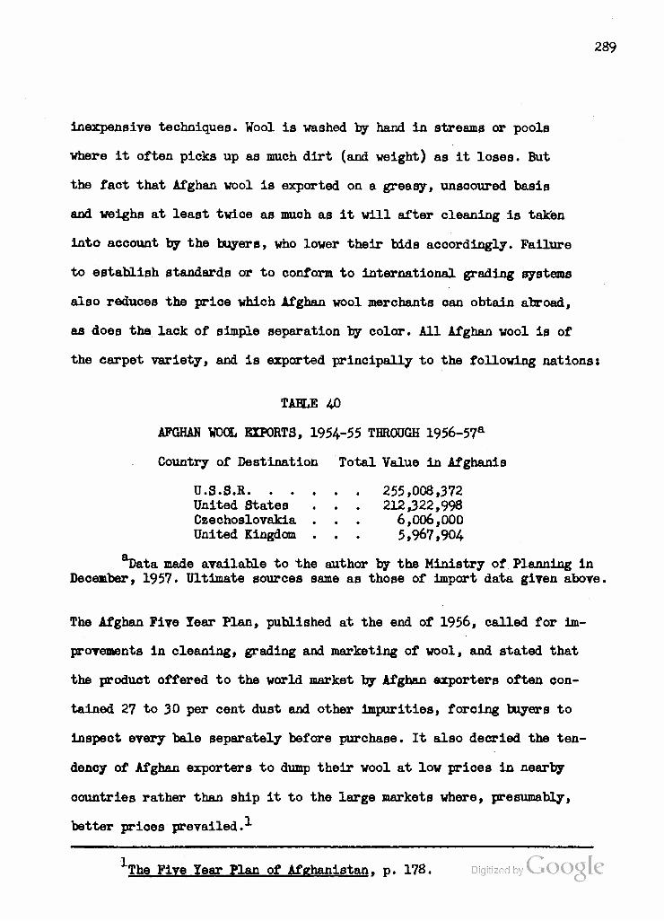
289
inexpensive techniques. Wool is washed by hand in streams or pools
where it often picks up as much dirt (and weight) as it loses. But
the fact that Afghan wool is exported on a greasy, unsooured basis
and weighs at least twice as much as it will after cleaning is taken
into account by the buyers, who lower their bids accordingly. Failure
to establish standards or to conform to international grading systems
also reduces the price which Afghan wool merchants can obtain abroad,
as does the lack of simple separation by color. All Afghan wool is of
the carpet variety, and is exported principally to the following nations:
TABLE 40
AFGHAN WOOL EXPORTS, 1954-55 THROUGH 1956-57a
Country of Destination Total Value in Afghanis
U.S.S.R 255,008,372 United States . . . 212,322,998 Czechoslovakia . . . 6,006,000 United Kingdom . . . 5,967,904
T)ata made available to the author by the Ministry of Planning in December, 1957. Ultimate sources same as those of import data given above.
The Afghan Five Tear Plan, published at the end of 1956, called for im-
provements in cleaning, grading and marketing of wool, and stated that
the product offered to the world market by Afghan exporters often con-
tained 27 to 30 per cent dust and other impurities, forcing buyers to
inspect every bale separately before purchase. It also decried the ten-
dency of Afghan exporters to dump their wool at low prices in nearby
countries rather than ship it to the large markets where, presumably,
better prices prevailed.
The Five Year Plan of Afghanistan, p. 178.

290
Until December, 1957, the United Nations Technical Assistance
Mission in Kabul provided an expert in vool marketing to advise Afghan
merchants in the grading and preparation of vool for market. This ex-
pert was Instrumental in aiding the Ministry of National Economy to
organize the Wool Exporting Syndicate in 1955, while the UN FAO agri-
cultural cooperative expert has assisted in the formation of flock-
owners cooperatives. These cooperatives are eligible for credit from
the RGA-sponsored Agriculture and Cottage Industries Bank established
in 1954- The aim of the UN-RGA program is to increase both the quantity
and quality of wool exports, and to ensure that all exported wool com-
plies with standards established by the Syndicate. UN veterinarians
have made contributions towards Improved stock-raising techniques and
animal health in northern Afghanistan, where karakul flocks predominate,
while the ICA-sponsored Wyoming University team has done work in the
Helmand region with imported Columbia and local Ghilzai sheep (see
Chapter IV). The last director of the Wyoming team, Dr. Robert H. Burns
is an authority on wool grading and marketing, and attempted while in
Afghanistan to make his wide experience available to Afghan herders
and merchants. We shall discuss the range, feed, water, shelter and
veterinary requirements of Afghan sheep in general, and of the karakul
flocks in particular, in reference to the major areas of sheep-grazing
in Chapter U.
It is roughly estimated that of the wool produced in Afghanistan
each year, 6,000 tons are exported and 2,000 tons used domestically for
the weaving of carpets, felts and rough cloth.^ The export of carpets,
1 Ibid., p. 179. Google
291
a fluctuating and less Important item than wool, may be treated
adequately in this chapter. Woolen carpets, of characteristic Afghan
as opposed to Persian design, are produced principally in the north-
western region from Aq Chah to Herat, and represent almost entirely
a cottage-industry product though there are two or three rug "fac-
tories" in the latter city. The main collecting points are Herat and
Andkhui, which serre also as the principal markets for internal and
export trade. While same carpets are offered for sale in Kabul, at
prices 150 to 200 per cent those of Herat, many of the finer ones
are shipped right through the capital for export, principally to
West Germany, Switzerland, Great Britain, Saudi Arabia, Iran, India
and Singapore. It is surprising that the United States buys only a
small number of these beautiful and extremely well-made carpets,
which offer geometrical patterns quite distinct from the floral types
made in Iran. The so-called Mowri variety, which is produced in a
limited region along the upper Murghab River, is especially delicate
in workmanship and restrained in color. These and the other exported
varieties are definitely in the realm of luxury goods, whose quality
and variety depend upon the fact that they are handmade by skillful
artisans trained from early youth. An attempt to increase the quantity
marketed, as by mechanization, would serve only to diminish their value.
As far as quality improvement is concerned, the author does not pre-
sume to suggest any changes in what amounts to the folk art par ex-
cellence of Afghanistan. In order to preserve the present market,
however, the laws requiring the use of color-fast, imported dyes
Digitized by Google

292
exclusively should be more vigorously enforced, since it is still
possible to buy a beautiful carpet and nave it ruined when its dyes
begin to fade or run. The value of the product would also be enhanoed
if more care were taken by the middlemen to keep carpets clean while
they are being stretched to shape and transported to market. The faot
that many of these carpets are now being exported by air is an indica-
tion both of their high intrinsic value and of a fairly competent
marketing system.
The carpet8, prayer rugs and saddle-bags woven south of the
Hindu Kush are of much poorer quality, being made of coarse wool or
cotton and generally dyed with inferior, vegetable colors. Many of
these are made by nomads in their summer encampments, and while some
are carried out for sale in Pakistan or India they do not figure in
the export ledger.
Karakul fur, on the other hand, is a most important export
item, sometimes taking first place on the list. Indeed, through the
period of World War II, karakul was by far Afghanistan's most import-
ant foreign exchange earner. During the war, New York replaced London
as the principal world market and storage center for karakul, and the
Afghan American Trading Oompany acquired storage space for up to one
million pelts in order to avoid flooding the market at any given time.
But in the postwar years, a change of style resulted in a serious drop
in the price of karakul, which has only recently begun to be reversed.
Although Afghan karakul is generally conceded to be the finest in the
world, competition from the Soviet Union and the Union of South Africa
is increasingly being felt, and was among the reasons for the continued
Digitized by VJOOQLC

293
lovi value of the skins even in 1947 and 1948 when serious droughts
reduced the number of Afghan skins available. A further handicap lies,
again, in the failure to grade the skins, the Afghan preference being
to market karakul in lots which contain some prime pelts, some poor
ones, and a majority of mediocre to good skins. Buyers are naturally
reluctant to purchase such lots when the Russians or South Africans
will offer them a quantity of skins of a certain grade for a certain
price. The difficulties of breeding and herding karakul are of con-
siderable importance to the Afghan economy. They have received atten-
tion from the UNTAM and other sources, and will be analyzed in Chapter
IX. Karakul remains Afghanistan's major source of hard foreign exchange,
dollars, sterling and marks, as may be judged from the following list
of leading importers.
TABLE 41
AFGHAN KARAKUL EXPORTS, 1954-55 THROUGH 1956-57a
Country of Destination Total Value in Afghanis
U.S.A 778,915,428
United Kingdom .... 195,143,171
West Germany .... 612,200
aData made available to the author by the Ministry of Planning in December, 1957. Ultimate sources same as those of import data given above.
The major source of soft foreign exchange, and in recent years
Afghanistan's single most important export, is dried fruit. Fortunately
the greatest share by far of this trade is with India, whose rupee is
fairly stable and from which Afghanistan imports large amounts of cotton
textiles and other manufactures, rather than with Pakistani^tteBej£?£)S.R.
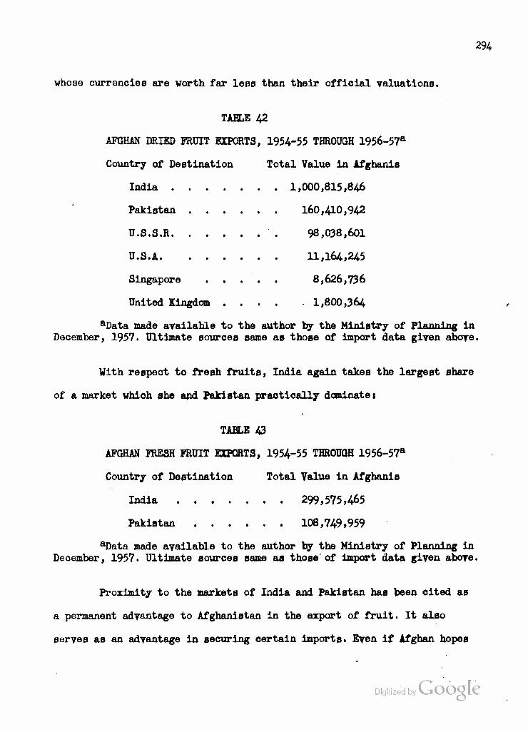
294
whose currencies are worth far less than their official valuations.
TABLE 42
AFGHAN DRIED FRUIT EXPORTS, 1954-55 THROUGH 1956-57a
Country of Destination Total Value in Afghanis
India 1,000,815,846
Pakistan 160,410,942
U.S.S.R 98,038,601
U.S.A 11,164,245
Singapore 8,626,736
United Kingdom .... 1,800,364
aData made available to the author by the Ministry of Planning in December, 1957. Ultimate sources same as those of import data given above.
With respect to fresh fruits, India again takes the largest share
of a market which she and Pakistan practically dominate 1
TABLE 43
AFGHAN FRESH FRUIT EXPORTS, 1954-55 THROUGH 1956-57a
Country of Destination Total Value in Afghanis
India 299,575,465
Pakistan 108,749,959
aData made available to the author by the Ministry of Planning in Deoember, 1957. Ultimate sources same as those'of import data given above.
Proximity to the markets of India and Pakistan has been cited as
a permanent advantage to Afghanistan in the export of fruit. It also
serves as an advantage in securing certain imports. Even if Afghan hopes
Digitized by Google
295
for reducing imports of cotton and rayon piece goods, leather and
sugar can be realized through increased domestic production, there
will remain many Indian and Pakistani products complementary to the
Afghan economy: rubber tires, bicycles, horse-drawn carriages (gadis).
building materials, electrical fittings, copperware, stationery, med-
icines, tea and notions. While Afghanistan seems to have only fruits
and cotton as major offerings to India and Pakistan, the market in
the Subcontinent for the former can probably be increased several
fold. It may also be possible to market more of the dried fruit pro-
duced in northern Afghanistan in the Soviet Union, though very little
information is available on this traffic. However, the problems of
increasing domestic production in the Kabul and Kandahar regions,
and of improving transportation and marketing to India and Pakistan,
will be carefully analyzed in Chapters II and XI with parts of the
discussion applicable to production in the North and sale to the U.S.S.R.
The final item in our table of Afghan exports, sesame seed, is
of interest only because of its wide distribution pattern. It is ex-
ported to West Germany, Netherlands, United Kingdom, Iran, India, Pak-
istan and the U.S.S.R. Produced chiefly in northern Afghanistan, sesame
is not sufficiently important for further consideration in this study.
There is one other item, however, which does not appear in the
tables but which must be mentioned both because of its universal com-
petition with cash crops in Afghanistan and because it has recently been
necessary to make imports of what had always been considered an item in
which Afghanistan was self-sufficient. The reference is to wheat, the
Digitized by VJOOQLC
296
Afghan staff of life. Most writers on Afghan agriculture stress the
nation's self-sufficiency in food, and particularly in food grains.
While it is probably correct that famines, as they are known in India
and Pukistan, have seldom if ever occurred in Afghanistan, this seems
to be due to the comparatively low density of population of this moun-
tainous country even in relation to its relatively low proportion of
arable land. But it is a disturbing fact that in five of the past
twelve years the Afghan wheat crop proved insufficient for what RGA
considered the normal level of consumption to be maintained. In 1947,
1953, 195^, 1957 and 1958, the United States supplemented the Afghan
food supply with sales, grants or loans of wheat. The recent loans have
been made under Public Law 480 which allows repayment for surplus wheat
to be made in local currency and devoted to developmental expenses ap-
proved by United States agencies. Furthermore, it may be recalled that
in 1947 and 1948 no sugar beets were grown in Baghlan because RGA de-
cided that the land was needed for wheat. This recurrence of wheat
shortages is a factor that must be kept in mind in any analysis of the
possibilities of expanding production of cash or industrial crops. No
improvement in the living standard of the average Afghan can be ex-
pected if lowered costs of cotton piece goods, leather and sugar are
offset by higher costs of wheat flour and the unleavened bread which
is the mainstuy of his diet.
We have aeen that there already exists competition between wheat,
on tho one hand, and sugar boetc or ootton, en the other, in the Kunduz
Valley, and botwteti wheat and forage or cash crops in the Helmand. But
Digitized by VJOOQLC

297
in the chapter which follows, we shall endeavor to demonstrate that
not only Is such a competition resolvable but that Afghanistan can,
in time, increase both its domestic food production, including wheat,
and its output and consumption of the key agricultural and pastoral
commodities, cotton, sugar, fruits, wool, hides and karakul. We shall
attempt to show that a concentrated emphasis upon such production,
combined with the processing of agricultural and pastoral raw mat-
erials to a much greater extent than at present, can improve the
Afghan standard of living in two wayst
1) directly, by making more food and clothing available to
the population and by Increasing the amounts of fruits, wool, hides
and karakul available for export, and
2) indirectly, by saving foreign exchange presently devoted
to imports of ootton and rayon piece goods, sugar and leather, and
by making it possible to reallocate this foreign exchange to Increased
Imports of commodities which the Afghan economy cannot provide for it-
self, such as tea, rubber goods, vehicles, fuel, lubricants, metal
products and notions.
Included in these benefits will be savings in transportation,
particularly on such two-way items as raw cotton exports and cotton
and rayon piece goods imports, hide exports and leather imports and
on sugar which can be brought to the consumer much more cheaply from
domestic faotories than from.abroad once a reasonable scale of pro-
duction is obtained.
In all probability, of course, developing Afghanistan can never
be freed from dependence upon imports and the transportation costs Digitized by fcoagb
i%
dependence entails. Indeed, Uu directions of economic development sug-
gested in this chapter are net i.o bo interpreted as proposals for autarky
and increased isolation in Afghaniotan. On the contrary, they are designed
to enable the Afghan economy to develop along the lines of its own great-
est comparative advantages so that its continuing commerce with the world
will be of more benefit not only to Afghanistan but to its trading part-
ners as well. Hand in hand with an improved living standard will come an
increased demand for, and capacity to acquire, those foreign products
which Afghanistan cannot advantageously produce for herself. To maintain
the present system, whereby Afghanistan produces certain raw materials
and imports products manufactured from those very raw materials, or others
which she could easily provide for herself, ultimately harms all partners
to the transactions. But by a more rational use of the nation's known re-
sources, including the improvements in production, processing, assembly
and marketing which are discussed in the following chapters, both the in-
ternal economy and the extern?*! bargaining position of Afghanistan can
considerably be enhanced. If such improvements require readjustments
within or among Afghanistan's trading partners, then these adjustments
must be put down to the price of progress. In view of the material we
have presented and analyzed in this study, no other lines of development
appear as promising as those just suggested.
There is nothing novel in the use of a nation's import-export data
as indications of the directions in which its economic development ought
logically to proceed. But such an analysis must be carefully related to
the actual human and physical resourcos of the nation lest it lead to
Digitized by Google
299
unfounded judgments and unrealistic courses of action. Ve have at-
tempted to provide this geographical orientation in Part One of this
study which was devoted to description and analysis of the three most
important regions of Afghanistan. On the basis of these regional stud-
ies, and same additional comments at the start of the present chapter,
we have determined that the mineral industries, with the possible ex-
ception of ooal and cement, cannot yet provide the basis far Afghan
economic development. Indeed, even ooal and cement are to be regarded
as permissive factors rather than as active agents of that development.
Thus we are left with the conclusion that the agricultural and pastoral
sectors of the economy must provide the raw material basis for processing
industry in Afghanistan at least for the foreseeable future. This con-
clusion led us to try to isolate those agricultural and pastoral com-
modities whose production and processing would be most beneficial to
the Afghan economy through directly increased consumption or through
elimination of exchange-consuming imports and enhancement of exchange-
earning exports.
In Chapter IX we shall discuss the production of these commodi-
ties against the regional background of Part One in the effort to deter-
mine where and how they can best be produced. In Chapter X we shall con-
sider fuel and power resources as supplementary locational factors, and
in Chapter XI we shall try to ascertain how the Afghan transportation sys-
tem will tend to favor one region or another by making it possible to
bring power, in the form of transportable fuel, to raw materials, or
Vice versa, and by facilitating inter-regional or international trade.
Digitized by Google

300
H. THE LOCATION OF AFGHAN ECONOMIC DEVELOPMENT
Every agricultural product has its own particular requirements
with respect to growing season, water, soils and cultivation practices.
Pastoral animals, too, require certain types of forage or fodder, drinking
water, shelter in winter, and a certain amount of space in whioh to move
about. Both crops and animals require the care of skilled and interested
persons who recognize the interrelations among these factors as well as
their own personal dependence upon them. In the regional surveys of the
Kabul, Kunduz and Helmand Valleys of Afghanistan, we have indicated the
general similarities or contrasts with respect to climate, present or
potential availability of water and arable or grazing land, existing
vegetative cover, soil types and problems, and present or potential
population. Against this background we must now project the specific
requirements of the crops and pastoral products which we have singled out
as of key importance for the development of the Afghan economy. Such a
projection will indicate which areas are best suited for production of
the key commodities.
But production alone is not enough. In-the last chapter, we have
stressed the need for the Afghan economy to advance in the direction of
processing these key commodities either to reduce import requirements or
to enhance export potential. For processing industries, other requirements
must be met. There must be either some existing processing capacity, or the
financial and technical ability to create it. There must be an actual or
potential labor force and the prospect of sufficient power to carry ^u^f Digitized by *

301
the processing. Lastly, there must be a market, local or remote, and the
means for bringing the processed commodities to that market. In our re-
gional surveys, we have also discussed these factors in general terms.
Now we must analyze more closely the physical and human factors involved
in producing each of the key agricultural commodities singled out in the
preceding chapter• and those involved in processing and marketing them.
Cotton
The cotton plant requires about seven frost-free months, and is
generally conceded to yield best towards the northern limit (approximately
40 N) of its cultivation. Its moisture requirements can ideally be supplied
by irrigation, since too much moisture in the seedbed may cause the seed
to rot, while rainfall during the ripening period may produce disease or
excess vegetative growth at the expense of the bolls. Desirable soils vary
from sandy loams to silt loams, but too much of the clay component will
cause the plant to put its energy into stalk rather than fruit and may
also produce water-logging and consequent fungus growth. Cotton requires
considerable labor both for thinning and weeding in the early part of the
season and for harvesting at the end.
We have seen in Chapter II that the Kunduz node offers excellent
climatic and soil conditions for cotton, as is indicated by its predominance
in cotton production within Afghanistan. The average reported yield of 308
pounds of ginned cotton (925 lbs. unginned) per acre compares fairly well
with the overall U.S. national average of 317 pounds of ginned cotton per
acre and with the 1957 national average of 388 pounds per acre, though not
with the 1958 all-time record of 469 pounds or the 1957 California yield
Howard C. Rather and Carter M. Harrison, Field Cropffiflftrfojfiff 1
McGraw-Hill, 1951), p. 395.

302
1 of 1035 pounds per acre for irrigated cotton. In comparison with Egypt,
where £18.3 pounds of ginned cotton per acre were obtained by irrigation
in 1956, the Kunduz yield is low, although it far surpasses Pakistan's
1956 yield of 196 pounds of ginned cotton per acre and India's 1956 yield
2 of only 89 pounds per acre. The fact that the Kunduz yield of raw cotton
almost equals the Soviet yield of 930 pounds (310 lbs. ginned) per acre
is an indication of the analogous nature of northern Afghanistan to the
Central Asian areas where perhaps 85 per cent of Soviet cotton is pro-
duced, if not of analogous cultivation practices. The principal factors
which keep yield per acre at a low level in the Kunduz node are an un-
dependable water supply and poor cultivation practices. Those factors
inhibiting a larger total crop for domestic and export needs include the
limited amount of presently irrigable land, competition of grain crops,
and a potential shortage of labor, in addition to the preceding factors.
We have discussed in Chapter II the proposals for improving the
amount and reliability of water available for irrigation in the Kunduz
region. Unfortunately, the integrated development of the lower Kunduz Valley,
even without storage and power facilities higher up on the river, appears
to be now far beyond the means of the RGA. In acknowledgement of its
strained financial position, the RGA announced at the end of 1957 that it
would accept no more foreign loan assistance. Since it is most unlikely
that any nation will come forward with a grant to develop the Kunduz, the
only apparent means of financing such a project would be to allocate a large
U.S. Department of Agriculture, Agricultural Marketing Service, Crop Reporting Board, Crop Production, 19% Annual Summary. CR Pr 2-1(58) (Wash- ington, D.C.: December 17, 1958), pp. 19 and 92.
FAO of UN, Yearbook of Food and Agriculture Statistics, 1957, pp. 66-67.
Digitized by doogle
303
part of the #100 million Soviet credit line to Kunduz Valley develop-
ment. Since it is not known just what part of that loan remains un-
commited, and since there has been no known official suggestion that
the Kunduz might be financed thereby, it would be foolhardy to predict
any full-scale attempt to harness Kunduz water resources in the fore-
seeable future. Many regrets have been expressed that the Helmand Project
was carried to such lengths at the expense of the Kunduz, but such hind-
sight is of no value at this date. Obviously, it would have been almost
a political impossibility to bring an American engineering firm into this
area at any time after 1950. Equally Improbable would have been the securing
of Export-Import Bank loans to support Kunduz development.
Thus, economic and political reasons compel RGA to defer any
fundamental effort to increase and regulate water supply and thus to extend
irrigable acreage in the Kunduz region. Some gains may still be realized
from improved intake structures and canal berms capable of resisting the
inroads of heavy spring runoff. Such comparatively inexpensive projects
should receive careful attention from the Ministries of Agriculture and
Public Works. Other benefits would accrue from the use of tested and
carefully segregated cotton seed, as discussed in Chapter II, and from
any Increased use of fertilizers. Standardization upon the best-adapted
varieties and considerably improved grading practices, also discussed in
Chapter II, would serve both to increase yields and to raise the price
which Afghan cotton commands on the world market. UN and West German tech-
nical assistance is available for these tasks. While rotation with alfalfa
would do much to improve yield per acre and to retard soil exhaustion, it
would not help increase the total amount of cotton available in any one
year or lessen the competition of cotton with grains and vegetables for the
304
scarce land in the Kunduz region. For a solution to this problem, as well
as to that of a potential shortage of agricultural labor in parts of the
Kunduz region,, one is presently compelled to• look beyond the region.
Most of the Kabul Valley is too high, and cool for successful cotton
cultivation, although a certain amount is grown in the low Jalalabad oasis
for local use. Undoubtedly, cotton acreage around Jalalabad could be ex-
panded, but this expansion would have to be made at the expense of other
crops such as citrus fruits and rice which bring a much higher return per
acre. Under present conditions at Jalalabad, cotton would have to compete,
disadvantageously, for water as well as for land. Furthermpre, there would
be limits upon the amount of land which could be devoted to cotton even if
the Darunta storage dam is built and 41*000 acres added to. the oasis (see
Chapter I).
In the Helmand, on the other hand, we have to date the definite
addition of at least 131,000 firmly-watered acres of which 65,000 or so
are still vacant. In the Nad-i-Ali and Marja tracts, we have a total of
39>051 acres, mostly settled, on which farmers are apparently earning less
than the low average national farm income. What they need is a cash crop,
and, while irrigated pasture cattle- or sheep-raising may be the ultimate
answer for at least the Class IV lands, we have seen the difficulties in-
herent in its adoption. Many of the resettled tenant farmers, however, have
had some experience with cotton culture, since this crop is grown to a small
extent in many of the low-lying areas of Afghanistan. Furthermore, it is
grown by the old settlers along the Helmand and Arghandab, and a small,
antiquated cotton gin has already been furnished by the Cotton Company to
Lashkar Gah, at HVA request. The Company has occasionally furnished seed
and purchased the ginned cotton produced in the vicinity of Lashkar Gah.
305
For Helmand soils, cotton has the important advantage of being
salt-tolerant. Not only is the Helmand water supply far more secure now
than that in the Kunduz, but the two-season agriculture of the Helmand
region gives it an absolute advantage over northern Afghanistan. Cotton
need not be grown at the expense of a green manure, but alternately with
alfalfa, root crops, or even as a late crop following winter wheat. An
excellent rotation pattern, designed to improve both farm income and
soil fertility, would alternate cotton and alfalfa as summer crops, with
winter wheat in between.
In tests conducted on five test plots in the Marja area in 1955,
cotton yields averaged 732.6 pounds per acre of unginned cotton. Where
100 pounds of nitrogenous fertilizer per acre were applied, the yield rose
to 854-0 poundsj with 100 pounds of phosphatic fertilizer, to 800 j and
2 with 100 pounds of each type, to 1130 pounds. The tests indicated, however,
that variations in soil types may have even more to do with results than
the amounts and types of fertilizer applied, since the average yield on
two plots of fairly high and uniform natural fertility rose to 1587.7
3 pounds per acre with 100 pounds of each type of fertilizer.
In an attempt to estimate potential cotton-producing capacity of
the Helmand-Arghandab region, the ICA agronomist C.C. Brookshier drew up
the following summary in 1956.
U.S. Department of Agriculture, Diagnosis and Improvement of Saline and Alkali Soils, p. 67, comparing relative yield on a saline soil as com- pared with yield on a non-saline soil under similar growing conditions.
2 "Notes of Fertilizer Tests on Cotton at Marja for 1955", typed
memorandum in files of HVA Agricultural Office, Lashkar Gah, Afghanistan.
3Ibid.
Digitized by Google

306
in 0)
W
H
B
CJ
O
s §
2
id <D
4
§8 88 tf\ o o o CM H CM CM
o o m o CM c^
8 888 o o o o o
o o o o o o o o o o o o O Q O
o o o o o o °33 UV
O O
O O O o o o o q o
o o o o o o C^cr\
o o o o O »T\ c*\
§o o o o TV O O H C*\CA
o o o o o o moo H c*\cn
o o o O Q O o o o
o o o o o o CM c^
o o o CM
o o IT*
o o
o o o J5
8 in
8 o o o o CM
o o o ir\
•a EH
rH •H
i I
*
H o
+>
I a I o
Digitized by Google

307
These estimates were based on the assumption that the Rural
Development program of farmer education and guidance would begin in 1957
for the Nawa (Central Shamulan) area, in 195B for the Darweshan and Cen-
tral Arghandab, in 1959 for the Tarnak and North Arghandab, in I960 for
the area from Girishk to Nawa and for Seraj, and in 1961 for the area
from Kajakai to Girishk. The fact that this program hiss failed to develop
as planned postpones but does not vitiate the estimated cotton-producing
potential. On the other hand, the need to materialize some of this po-
tential, for both local and national purposes, re-emphasizes what has
been said in Chapter VII about the urgency of extension and community develop-
ment work in the Helmand.
Excluding the Tarnak potential from these estimates, for reasons
given in Chapter V, we have 2^,000 acres of land irrigated by the Project
and 7500 acres of land irrigated from the less reliable farmer-made di-
versions in the old areas of cultivation. As we have seen, there is a
fair possibility of providing Seraj lands with a reliable supply of water.
The same is true of North Arghandab. While no Nad-i-Ali acreage is included
in the above estimates, the devotion of some 34->500 acres in the tracts
listed to cotton for one season of the year could add 11,488 metric tons
of raw cotton to Afghanistan's annual domestic production assuming yields
equal to those of the average, unfertilized fields at Marja.
Varietal tests conducted at Marja in 1955 indicate that there may
be advantages in using imported seed rather than that obtained from the
Kunduz region, although the shortness of the testing period and the small
number of varieties tested would indicate that further testing is needed
before deciding:
Digitized by VJOOQLC

308
TABLE 45
COTTON VARIETAL TESTS AT MARJA IN 1955* (Average of 25 Sample Plantings in pounds)
Variety Yields Per Acre
Acala 44 1080.94 Koker 995-44 Delta Pine 954-45 Paymaster 934.36 Acala Afghanistan 816.6
Memorandum in files of Wyoming University Team Research Office, Lashkar Gah, Afghanistan.
Varietal tests at Nad-i-Ali indicated that the Acala and Uka varieties 1
were best adapted. But even more significant than varietal differences
are the gains to be had from improved cultural practices. A test on com-
parative planting methods made at Marja in 1955 gave the following results:
TABLE 46
PLANTING METHODS FOR COTTON AT MARJA IN 1955a
(Average of 25 Sample Plantings in pounds)
Method of Planting Yield Per Acre
Side of row 1499.0 Center of bed 1354-3 Broadcast 892.0 Flat in Rows 870.0 Dry in Furrows 864.0
Memorandum in files of Wyoming University Team Research Office, Lashkar Gah, Afghanistan.
If these figures are representative, a two-thirds increase in yield may
be expected if the present Afghan method of planting cotton broadcast
»- 1 Robert G. Moncure, Suggestions and Comments on Agricultural Pro-
duction in the Helmand Valley. TCA/A-1 of Technical Cooperation Administration in files of International Cooperation Administration, Lashkar Gah, Afghan- istan (Girishk: April 13, 1953), pp. 9-10. (Mimeographed.)
Digitized by Google

309
can be replaced by planting the seed in the sides of the irrigation
furrows. Thus, by a combination of improved seed selection, better planting
and cultivation methods and fertilization, the yields of unginned cotton
in the Helmand might almost be made to compare with those attained in
California. Doubling the present yield of 732.6 pounds through these methods
does not seem impracticable, and the contribution of over 20,000 tons of
unginned cotton would go a long way towards meeting Afghanistan's domestic
and export needs.
On a ginned basis, this Helmand contribution would add 6000 or
7000 tons to the present annual production of approximately 20,000 tons.
This would provide 16,000 or 17,000 tons over the ultimate requirements
of the Gulbahar and Pul-i-Khumri plants, enabling Afghanistan not only to
maintain her present export level of 10,000 to 15,000 tons per year, but
to increase it. Perhaps more desirable would be the expansion of domestic
cotton processing facilities so that Afghanistan might satisfy a larger
share of her own annual cotton piece goods needs. These are estimated at
approximately 120 million square meters, of which the existing facilities
will provide only 63 million square meters, even with Gulbahar operating
at full capaoity. Thus, the development of an agricultural base for cotton
in the Helmand could provide the foundation for another processing plant
on the order of that of Gulbahar, utilizing another 5,200 metric tons of
ginned ootton to produce 35,000,000 square meters of piece goods per year.
Such a plant would cost approximately $30,000,000 at today's prioes, and
could certainly not be undertaken by the Textile Company until Gulbahar
begins to pay off. The first goal is to ensure a sufficient raw material
supply to allow existing mills to be used to full oapacity. Only when that
stage has been reached can valid judgments be reached concerning the effect igi ize y ^

310
of the 35 or 40 per cent import tariff on cotton piece goods and the
political-economic desirability of further domestic processing capacity.
At the same time, the savings in foreign exchange now devoted to
cotton piece goods imports will rise as Gulbahar production increases,
and can be channeled by RGA exchange control into Helmand Valley cotton
production and the first stage of processing, namely, a modern, large-
capacity gin similar to that at Kunduz. Such a facility, whether operated
by the RGA-controiled Consolidated Cotton Company, as seems preferable,
or directly by the HVA, would have the immediate effect of T»»1H "g more
cotton available for export. Whether these exports go to repay West
German, Czech or Soviet credits, or are sold on the world market, their
effect will also be a net gain in the amount of foreign exchange which
RGA has at its disposal.
Sugar Beets
None of the 5400 tons of sugar produced at Baghlan is sold south
of Kabul, the southern and western portions of Afghanistan being supplied
by imports which average almost 12,000 metric tons per year. The Sugar
Company at Baghlan would like to double its present capacity, variously
estimated from 55,000 to 70,000 tons of beets (7700 to 9800 tons of sugar
at 14. per cent recovery). It has never succeeded in obtaining more than
4.5,000 tons from the farmers who prefer to grow better-paying crops such
as wheat or cotton. Until it is possible to operate the sugar factory at
capacity for a number of years, the true costs of producing sugar at
Baghlan will not be known, even to the Sugar Company or the Government
Monopolies through which all sugar, domestic and imported, is sold at
approximately $.10 per pound, hardly an excessive price in comparison with
that in the U.S.A. The eagerness of the Sugar Company to expandcapacit^

311
however, indicates that they are satisfied with the profitableness
of the undertaking.
Completion of the new bridge to the Dasht-i-Khwaja Alwan area
will improve accessibility to additional lands suitable for beet growing.
The proposed extension of the Gumarek Canal into this region could add
from 5000 to 10,000 acres of irrigated land. But even if all of this new
land were devoted to sugar beets, an unlikely assumption, the available
supply would be increased by only 20,000 to 40,000 tons, and still fall
short by an equal amount of the 115,000 tons necessary for domestic self-
sufficiency at present levels of consumption.
This calculation is based on the average of the sugar imports
for the last three years (see Table 35) and the average of the yield per
acre for sugar beets in these three years. The average yield for the period
1954-55 through 1956-57 was 4«3 metric tons per acre (See Table 8), a con-
siderable improvement over the 2.7 tons per acre in the preceding three
years, but still far below the average for Europe in 1956 (10.1 metric
tons per acre) or the United States (15.0), and somewhat below that for
Iran (5.6). Increased use of waste from the mill and of some artificial
fertilizers are to be credited with this improvement, though the experi-
mental yields obtained by the Sugar Company in 1952 (Table 9) indicate
that much better results could be obtained even with the local variety,
and a substantial further increase if Danish seed were imported.
But despite the possibilities of increased acreage and improved
cultural techniques, it is apparent that it will be difficult to satisfy
FA0 of UN, Yearbook of Food and Agriculture Statistics, 1957. p. 68.
Digitized by Google
312
Afghanistan's sugar requirements from the Eunduz region alone since com-
petition for labor and land will continue. In recognition of this fact,
the RGA has recently completed the assembly of an obsolete sugar cane
mill at Jalalabad. The mill was put into operation in 1957-58 on an ex-
perimental and admittedly uneconomical basis with a rated capacity of
only 50 tons of sugar per day. Actual output seems to have averaged only
1 25 tons of sugar per dayI Funds have been allocated for increasing the
processing capacity to 100 tons per day but the plant may still face
supply difficulties since the local farmers have the alternative of pro-
ducing ghur from their cane if prices offered by the plant are unattrac-
tive. Furthermore, there exist serious problems of a short growing season
with frost danger, inferior cane, and two diseases lowering sugar content
(see Chapter I). Under these handicaps it is paradoxically true that the
higher the capacity the greater is the problem of obtaining sufficient
cane to operate for more than one month out of the year. One month's
operation at 100 tons per day would contribute some 3000 tons which, when
added to the 5400 tons produced in recent years at Kunduz would total only
8^00 tons. This would be 3000 tons short of the average imports over the
last three years, and almost 11,000 tons short of the 19>925 metric tons
imported in 1956-57. Therefore, even though we do not know the costs of
production at Jalalabad, it is safe to say that any decision to expand
sugar cane capacity there must be carefully balanced against possibilities
for expansion of production from beets not only in the Kunduz but in the
Helmand as well.
The sugar beet prefers at least a five and one-half month growing
Letter from Arnold J. Krochmal to the author, November,^4958. Digitized by VJOOQLC

313
season with varm but not excessively hot temperatures and a good deal
of sunshine as it ripens. Dry conditions and moderate temperatures at
the end of the growing period tend to produce the highest sugar content.
The plant is fairly resistant to frost at either end of the growing
season, however, and is salt tolerant except in the very early period
of growth. The pH factor is more critical, one of 7 to 8 being preferable
while acid soils are completely unfit for sugar beets. Fertile, heavy
loams with high silt or even clay content appear best adapted, although
the plant will do well even in fine sandy loam provided it is deep and
fertile enough. Soil drainage must be good} where the beets are grown
over hardpan or in muck, the size of the beet or its sugar content, or
both, suffer greatly. Labor requirements are also high for thinning the
young plants and for pulling the mature beets from the ground and "topping"
them, i.e., cutting off the leaves and crown which are low in sugar content.
Irrigation is a highly desirable means of cultivation as the water supply
can be reduced towards the end of the season, forcing the plant to devote
its energy to sugar production.
Comparing these requirements with our descriptions of the various
Helmand-Arghandab areas, we see that the recent alluvial soils of the
Shamalan, Darweshan, Seraj and North and Central Arghandab tracts should be
sufficiently heavy and deep, while those of the older terraces In Nad-i-All
r and Marja appear too sandy and shallow for successful cultivation of sugar
beets (see the respective soil descriptions in Chapters IV and V). While
Boderate alkalinity appears to be a benefit rather than a detriment, it
"Rather and Harrison, pp. 379-380 and U.S. Department of Agriculture, Diagnosis and Improvement of Saline and Alkali Soils, pp. 66-67.
Digitized by Google

3K
would be necessary to keep down the salts from the time of planting until
the young plants are established. This can be accomplished in the course
of the pre-planting irrigation, providing good drainage is achieved both
for flushing and to maintain the low water table required for successful
growth. Along with moderate alkalinity, the sugar beet's main chemical
requirement is for potash, the one element that is generally not deficient
in Afghan soils. Thus the Helmand appears suitable for sugar beet culti-
vation. While its high daily maximum summer temperatures are undesirable,
they are partly offset by the rapid night cooling in this arid region.
Furthermore, it would be possible to plant the frost-tolerant beets
early in the spring or late in the summer since winter frosts occur only
occasionally in December or January. Sugar beets fit well into a rotation
including alfalfa, barley and corn or field beans, all of which are
eminently desirable crops in the Helmand-Arghandab region:
TABLE 47
SOME SUGGESTED ROTATIONS FOR SUGAR BEETSa
Crop Pariod of Growth
1.Sugar beets late summer, autumn - late winter, spring 2.Barley, seeded to alfalfa winter - summer 3.Alfalfa summer - winter 4..Alfalfa winter - spring 5.Corn or field beans summer - summer, autumn
aAdapted from Rather and Harrison, p. 380.
The inclusion of corn in the rotation prevents the transmission of the
fungi which cause the Black-root disease from the alfalfa to the sugar
beets, while the inclusion of barley deters the reverse process. As far as
Helmand agriculture is concerned, such a pattern would have the advantage of
including consumption crops (barley, corn, field beans), a cash crop (sugar
Digitized by VJOOQLC

315
beets), and the legumes (alfalfa, field beans) so necessary to improve
soil structure and available nitrogen content as well as to provide forage
for animals. In fact, the sugar beets themselves leave the soil in ex-
cellent condition for the following grain crop, while "the harvested tops
from an acre of beets, plus the sugar [remaining] after the extraction,
equal the stock feeding value of the entire product from an average acre
of corn". Hence, the value of sugar beets as a crop to agriculture in
tiie Helmand Region should be considered along with the value of the ex-
tracted sugar to the Afghan economy.
In sugar beet tests conducted in the Helmand by MKA and ICA agrono-
mists, an average yield of 10 tons per acre was obtained, while on Class II
lands exclusively this average rose to 12 tons per acre, and on Class I
lands to 15 tons per acre. While these tests must be regarded with the
same reservations as those conducted by the Sugar Company at Baghlan (see
Chapter II), the agronomists estimated "conservatively'' that the following
yields might be obtained by the farmers themselves making full use of green
manures, legumes and farm manures, but without commercial fertilizers: 12
tons per acre on Class I lands; 10 tons per acre on Class II lands; 8 tons
per acre on Class III lands; and 6 tons per acre on Class IV lands. Also
assumed was an agricultural extension and education program to secure better
cultivation methods and the use of improved seed and crop rotations. As late
•4f.S. Woytinsky and E.S. Woytinsky, World Population and Production (New York: The Twentieth Century Fund, 1953), p. 569.
2HVDP of 1953, Worksheet No. 1.
3Ibld.. Worksheet No. 4.
4lbid.. p. 60.
Digitized by VJOOQLC

316
aa 1956, F.O. Youngs, who had worked in the Valley for both MKA and ICA,
concluded: "sugar beets have given very good yields in trial plantings in
the Helmand Valley. They might easily be grown on sufficient scale to sup-
port a sugar factory, and could become an important cash crop."
Several HVA officials, interviewed by the author in 1957-58, ex-
pressed the desire to move ahead with the sugar beet program and to establish,
either at Lashkar Gah or Kandahar, a small processing plant. For the reasons
stated above, however, this is a decision that must be made in Kabul by
the Ministry of Mines and Industries or at a higher level. It must be
based in part upon information regarding cost of sugar produced at Baghlan
and Jalalabad and of imported sugar, available only to Government Mono-
polies. But the Helmand does appear to have three absolute advantages over
the other two areas for sugar beet production: l) a firm supply of irrigation
water, 2) excess available land at present, 3) potential savings in trans-
portation costs if an area now totally dependent upon imports can be pro-
vided with its own local sugar supply. A fourth advantage, in the availa-
bility of hydroelectric power at either Lashkar Gah or Kandahar, is partially 2
offset by the lack of local coal for the steam boilers. Yet these com-
parative advantages of the Helmand, plus the need for developing new agri-
cultural patterns to upgrade soils and provide cash income for settlers,
should figure heavily in the locational decisions of the RGA. While labor
is short in the Kunduz and at Jalalabad has the profitable alternatives of
rice and citrus cultivation, there will be an increasing surplus in the
Helmand, as the settlement programs continue, which could be devoted to sugar
^Memorandum of May 7, 1956, in Wyoming University Research Team files, Lashkar Gah, Afghanistan.
o Baghlan uses coal from nearby Kar Kar, while the Jalalabad plant burns
bagasse for generation of steam and electricity. Electrical heating for steam generation may prove to be more economical than importing either coal or diesel fuel from Pakistan, though coal is available in the Quetta region.
317
beet as well as to cotton cultivation.
Citrus Fruits
Of the two regions in Afghanistan which are climatically suited
for citrus fruits, only the Jalalabad oasis has developed a production
of commercial significance. This may well be the result primarily of cul-
tural factors since the Jalalabad region is within easy access of the Pesh-
awar area of Pakistan, where citrus groves abound, while the Helmand-Arghan-
dab region is further removed from a source of seedlings and grafts. The
only competent authority to survey citrus production in recent years, Dr.
Arnold Krochmal, Research Director of the Wyoming University Team, has
been quoted at some length in Chapter I on citrus cultivation at Jalalabad.
His conclusions point to the need of greatly Improved techniques, disease
prevention, and the introduction of improved varieties. If sugar production
is expanded at Jalalabad, it might eventually provide the basis for the
production of citrus preserves, but there is little likelihood that Afghan-
istan would enter the export market with such commodities any more than it
now does with citrus fruits. The oranges, grapefruit, limes and lemons grown
in the Jalalabad oasis are either locally consumed or transported to Kabul
where they command good prices in the winter season. Improvement of packing
aethods and of the Gorge Road would go far to raise the quality of the fruit
as it arrives in the capital as well as the price it commands. Unfortunately,
ao figures are available regarding the quantity of this internal commerce.
There would appear to be room for expansion of citrus production at Jalalabad
if the schemes for reclamation and irrigation enumerated in Chapter I are put
into effect, and there is apparently no shortage of labor, at least for orchard
crops with their limited seasonal demands. Digitized by Google

318
In early 1958, Dr. Krochmal and Mr. Abdul Hakim, Assistant
Director of Agriculture for the HVA, made a trip to Greece to purchase
citrus and olive trees for planting in the Helmand region. This venture,
which is being financed by the HVA, is one of the most promising in Afghan
agriculture. It will, of course, require from five to ten years before the
results can be ascertained, but there is apparently no reason why citrus
cultivation should not flourish in the Helmand-Arghandab region providing
an additional source of income to both old and new settlers. Here, again,
the need of increased sugar supplies is evident if any of this potential
production is to be processed for export, e.g., to the Quetta region.
Introduction of olive trees is more dubious, however, since
utilization will depend upon a change in the consumption patterns of the
population. Although wild olive trees abound in Eastern and Southern
Provinces, the olive and its oil have no place in the Afghan diet. While
olive oil is easy to produce and has a high value for its weight, there is
no existing market in Afghanistan, Pakistan or India and farther trans-
portation is likely to prove inordinately expensive.
Also questionable are the proposals to introduce date palm culti-
vation into the Helmand. Although the trees are grown to some extent in the
Jalalabad oasis, they are far more sensitive to cold than citrus trees. A
few seedlings have been planted at Nad-i-Ali to determine whether they will
withstand the winters, and there were plans to make additional trials in
the almost frost-free Shamalan and Chakansur areas. But it requires five
or six years before an offshoot can be planted in its permanent area and
another eight to ten years before it begins to bear. Date palms are found
Moncure, pp. 13-15. Digitized by Google

319
in ornamental plantings in the Bakwa area, but there is no reported use
of the fruit. The trees are very high in their water consumption, requiring
about nine acre feet each per year. Thus they would compete with other,
probably more valuable, produce along the Helmand.
Deciduous Fruits and Nuts
Of greater present and potential importance than citrus fruits
are those deciduous varieties which provide one of Afghanistan's leading
sources of export revenue. Both the Kandahar and Kabul regions figure
largely in this trade, while northern Afghanistan and Herat export dried
fruits to the U.S.S.R. In terms of production, the Kabul and Parwan Prov-
inces are most important in pomegranates. While grapes are important in
all parts of Afghanistan suitable for their growth, Kandahar predominates
in grape production, most of which goes into raisins, and also in plums
and perhaps in peaches. Apricot production is about evenly divided among
Kabul-Parwan, Kandahar and the Kunduz Valley, with a considerable output
in Mazar-i-Sharif and Herat as well. Apples are also important in Mazar-i-
Sharif, while quinces are a specialty there. In addition to citrus, the
Jalalabad oasis specializes in figs, which are also important in Kandahar
and Maimana. Eastern Province is second to Kabul-Parwan in pomegranates.
Melons, as we have indicated, are to be found all over Afghanistan, and
there is some inter-regional trade in different varieties, as well as some
exportation from Kabul. The following tables, though somewhat out of date,
indicate the pattern of fruit exports from Kabul and Kandahar as established
by Mr. Sabin in 1947:
Digitized by Google

320
TABLE 48
AVERAGE FRUIT EXPORTS FROM KABUL AREA, 1943-44 THROUGH 1945-46 in metric tone
Freeh Fruits Tonnage Dried Fruits Tonnage
Grapes 3317 Green raisins 3789 Melons 442 Red raisins 941 Apples 128 "Gholadin" raisins 201 Apricots 10 Dried apricots 16 Pomegranates 4287 Prunes 308 Quinces 1 Others 8
Total .... 8193 5255
a Sabin Report, pflfls-im.
TABLE 49
AVERAGE FRUIT EXPORTS FROM KANDAHAR AREA, 1943-44- THROUGH 1945-46* in metric tons
Fresh Fruits Tonnage Dried Fruits Tonnage
Grapes 4991 Green raisins 4423 Apples 1048 Red raisins 1471 Apricots 343 Black raisins 946 Pomegranates 2080 "Manuka" raisins 11 Quinces 12 Abjosh raisins 2483 Peaches 87 Slaka Parah raisins 3675 Plums 7 Dried figs 450 Pears 5
Total . 8573 13,459
aSabln Report, passim.
Digitized by Google
321
Nuts are of primarily domestic importance, with the pistachios
of northern Afghanistan brought to market in Kabul- as are the "pine
nuts" (Pinus Gerardiana Wall) of eastern Afghanistan. The upper Kabul
Valley leads in production of walnuts, but almonds are more important
at Kandahar and in the northern provinces. The fruit of the mulberry
tree (shah tut) is commonly consumed in the Kabul Valley, including
Jalalabad, and throughout northern Afghanistan with the greatest pro- 1
duetion in the Herat area.
In most respects, fruit and nut production in the north of
Afghanistan is more similar to that in Kandahar than either region's
production is to that of Kabul. This fact is largely explained by the
considerably higher elevations of the Kabul-Parwan region, just as
Jalalabad, lower and protected by mountains, has its own distinctive
fruit production. Thus, internal trade in fruit and nuts is characterized
by some interchange between Kabul and Jalalabad (raisins and almonds for
citrus fruit) while northern Afghanistan supplies its distinctive crop
of pistachios to the Kabul and Jalalabad markets. There is a small ex-
change of fruit and nut varieties between Kabul and Kandahar, but none
between Kandahar and the North. Not only distance but similarity of local
types of production rule out such an exchange. Kandahar, on the other
hand, is well-placed to export to Pakistan, as is the North with respect
to the U.S.S.R.
For these reasons, our enquiry need not be directed towards de-
Discussion based on Vavilov and Bukinich, and on Frumkin, Synopsis of Afghan Agricultural Statistics, passim. The latter, as Dr. Frumkin is quick io point out, can hardly be presented as true "statistics" but do serve tb indicate the relative importance of agricultural production in different areas.

322
termining which region of Afghanistan is best suited for production
of deciduous fruits and nuts. We have just seen that each of the major
regions has its own specialties and that none is without the benefits of
several varieties which may, indeed, be grown extensively in the others
as well. Nor do we yet have to concern ourselves with the problem of in-
creasing production of the different varieties since there is no apparent
shortage of seasonal fruits either for domestic consumption or for sale
abroad. Rather, the observer is likely to conclude that a great deal of
deciduous fruit is wasted in Afghanistan through damage by insects or
diseases or else in improper handling and transportation. In contrast to
the situation in cotton and sugar, the major problem of the Afghan de-
ciduous fruit industry is not one of production but of quality control
and marketing. Care of the fruit before and after picking so that it can
command a good price on the domestic or foreign market is much more urgent
than the planting of additional trees or the making of new grafts. Of
course, this is not to say that the introduction at least for test pur-
poses of new varieties of deciduous fruits may not be as beneficial as
in the case of the citrus industry, especially if new varieties prove
more disease-resistant. Nor could one state that the bearing stock will
not require replacement and enlargement to satisfy a growing demand. When
this time arrives, it is likely that the orchard lands along the Arghandab,
now receiving ample water, will be able to expand before those in Kabul-
Parwan or in the North. But it does appear that the greatest immediate
gain is to be had by a much better use of the resources on hand, in other
words, by vastly improving fruit processing.
We have discussed in Chapters I and VI the existing situation with
respect to the processing of deciduous fruits in Kabul anc DigjtizedbvCjOQQlC
i Kandahar, the
323
only locations where it has been put on an industrial basis. Few
sections of the Afghan economy stand in such dire need of reorganization
and revitalization^ In further contrast to cotton and sugar, processing
of which is in the hands of a few relatively large private firms or RGA-
controlled plants, the processing of fruits and nuts for the domestic and
export markets is fractionalized among scores of small operatives who pay
little attention to standards of grading, cleaning or packaging. While
there are two sizeable concerns in this field, the Itehadia Company in
Kabul and Pushtoon Industries in Kandahar, they control only relatively
small shares of the market, and their own performance in the above res-
pects is far from outstanding. Indeed, the failure of Pushtoon Industries
to add to the export of fruit products led to the formation of a new
company in Kandahar designed specifically for this purpose. However,
the long delay in the establishment of the ICA-sponsored Kandahar Indus-
trial District (see Chapter VI) and the failure to increase the available
power supply in the city have delayed activation of this enterprise. Mean-
while, RGA has neglected to implement the 10-year old Sabin Report on the
Afghan Fruit Industry, which called for:
1) the establishment of an experimental project at Kandahar which would a) operate the Pushtoon Industries on a businesslike basis, keeping formal records of throughput and costs, heretofore lacking, b) operate an experimental sun-drying yard at Kandahar, and c) op- erate an experimental dehydratorj
2) hire a qualified experimental project manager to supervise the precedingj
3) conduct similar experiments at Kabul in cooperation with Abdul Rashid Khan, President of the Itehadia Companyj and
4) pursuing the following research project in the Ministry of Agri- culture and other governmental agencies:
a) improvement of quality of yields of fruit tree1^ WP^§A? b) study of local boxwood and pulpwood trees to determine location and quantity of suitable varieties for container manufacture,

324
c) importing foreign trees, shrubs and vines which show possibilities of better production, d) investigating local production of sufficient sugar to supply local needs and canning and preserving requirements, e) investigating methods for mining and transport of Ish- pushta coal to cut costs and insure delivery of 1500 to 2000 tons per year.
Further recommendations called for the preparation of cost estimates for
processing machinery to clean, stem and process 5 tons of raisins per
hour, to dehydrate 5 tons of raisins or other fruits in a 24.-hour period,
and to wash, sort and pack 5 tons of fresh fruits per hour. Sabin also
envisaged setting up a new canning plant with an hourly capacity of one
ton of apricots, peaches or pears, and including tin can fabricating
equipment and a machine shop. He foresaw the need of washing, dipping
and handling equipment for dry yard operations where the cost of mechan-
ical dehydration could not be justified (see Chapter I). He wanted plans
'and estimates drawn for providing 30-kilo wood and fibreboard boxes, and
for supplying clean water and ice to the processing plants and to refrig-
erated trucks which would haul their produce to market.
In short, the Sabin Report set forth a complete program for the
modernization and partial mechanization of the Afghan fruit industry in
Kandahar and Kabul. Yet, over the past ten years, next to nothing has been
done to implement his suggestions. As a matter of fact, the only concrete
examples of action along this line are in the grape-dusting efforts of Mr.
Gattani and the recent trip of Dr. Krochmal, made at the request of the
Ministry of Agriculture, to Quetta to purchase 133 improved varieties of
apple, peach; pear and plum trees from the Pakistan Government Fruit
Experiment Station for transfer to the Ministry's experimental orchard at
Sabin Report, pp. 2-3.
Digitized by Google

325
Bene Hissar near Kabul. The efforts of Kandahar businessmen, to provide
refrigerated storage space languish. The 1260 cubic meter fruit storage
room at the Kabul slaughterhouse remains unused and nothing has been done
to procure or equip refrigerated trucks though the Kandahar-Spin Baldak
route is certainly adequate for their operation and the Kabul-Torkham
route soon will be.
Here is another area to which RGA attention should be invited by
the possibilities of increasing foreign exchange earnings. The encouraging
rise in fresh fruit exports in recent years is a clear invitation to in-
crease supplies and quality to meet demand. In fact, the falling off in
the last two years in dried fruit exports may well be an indication of
increased competition from cleaner and better prepared products, since
the demand for fresh fruit in India and Pakistan has continued to grow.
Cattle Hides and Leather
While the major problem in deciduous fruits is the processing
bottleneck, that in hides and leather lies in both processing and supply.
We have discussed in Chapters I and VIII the processing difficulties at
the Iqbal Tannery and Shoe Factory in Kabul. We have also mentioned in
Chapter I that the modern slaughterhouse in Kabul handles only some
75,000 animals per year, mainly sheep, while the Iqbal Tannery processes
only some 10,000 out of the estimated 4-0,000 cowhides available in the
country each year. The only apparent reason for this gross under-utilization
of existing facilities lies in the seeming indifference of farmers and
merchants to the higher prices which may be obtained for better quality
Cf. Tudor Report, p. 132, Digitized by Google

326
offerings.
Probably the best estimates of the animal population of Afghan-
istan are those made available by the Ministry of Finance from tax col-
lection operations in 1953-54 and 1954.-55:
TABLE 50
AFGHANISTAN: LIVESTOCK POPULATION
Animal 1953-54 1954-55
Cattle 2,500,000 2,000,000 Broadtail sheep 13,800,000 14,000,000 Goats 5,900,000 6,000,000 Karakul sheep 3,700,000 4,000,000
If these estimates are seriously in error, they are probably on the low
side, due to concealment of taxable beasts. Hence, any calculations made
therefrom will tend to be conservative, as is desirable for present pur-
puses. The sharp decline in the cattle herd between the two years re-
ported was due to a severe outbreak of rinderpest and other diseases. It
has probably been largely restored by now, and we can reasonably take 2.3
million as an estimate of present cattle population.
According the Marcel Croisier, the UNTAM Industrial Economist who
worked in Afghanistan in 1954, only about 100,000 out of 2,000,000 cattle
were being slaughtered annually, while deaths from disease ranged anywhere
from 1000 to 200,000 in different years. If we take Croisier's average of
Croisier, Le Developpement Industriel de l1Afghanistan, Annex V, pp. 136-137.
Digitized by VJOOQLC

327
200,000 to 270,000 annual cattle deaths from all causes, and increase
it by 7 per cent to correspond with our 2.3 million estimate for the
total herd, we arrive at 214,000 to 289,000 annual deaths from all
causes. That this is still far below the world average annual slaughterings
of 15 to 20 per cent of cattle herds is largely due to the low demand for
beef in the Afghan diet since no cattle are killed for the sake of their
hides alone. Nor would it make much sense to try to change the Afghan
diet or to convince the farmer that he ought to slaughter a draft bul-
lock or a milch cow for the sake of its hide. But that fact that of a
potential 214,000 to 289,000 hides per year only 40,000 become available
for the market must be set down to indifference on the part of the herd-
ers and, by extension, to poor organization and low price offerings on
the part of the middlemen. Even within the limits set by the Afghan diet,
at least five times the present number of cattle hides could be supplied
to the domestic market. The Iqbal Tannery, operated at capacity, could
take 120,000 of these, leaving 80,000 for processing in local tanning
facilities or at the proposed Kandahar Industrial District. This would
not make Afghanistan self-sufficient in leather since heavier grades of
sole leather would still have to be imported, but it would effectively
reduce the amounts of lighter grades which have to be purchased abroad.
The requirements for this improvement, however, are considerable.
First of all, the middlemen will have to establish a grading system for
hides with price gradients to match. Presumably, these will have to be
significantly higher than the present prices in order to interest herders
and farmers in proper care of animals, careful flaying and satisfactory
drying and preserving methods. Since no additional tariff protection ia Digitized by VJOOQLC

328
contempltted the middlemen will have to be persuaded to operate on
smaller margins and larger volumes than at present. Transportation
problems will need to be solved, particularly in the northern provinces.
In this area, ON FAO experts in animal husbandry, veterinary medicine
and cooperative marketing can be expected to help, but the major impetus
must come from the many private dealers in hides and skins, stimulated
perhaps by the Ministry of Agriculture and the Commercial Bank established
in 1954- by the RGA to make loans to small traders at lower interest than
the Bank-i-Millie.
Only in the Helmand could the RGA itself afford a major program
of cattle products improvement by tying it in with HVA extension and
education work. Since a small privately-owned tannery is supposed to be
provided in the Kandahar Industrial District, the HVA could hold out to
the farmers an additional source of income by the sale of their cattle
hides. To the extent that an irrigated pasture economy can be developed
in the Nad-i-Ali and Marja areas, and we have seen the obstacles which
it faces, superior cattle properly nourished and properly slaughtered
could provide a source of high-quality hides that would command superior
prices. By processing these in a modern tannery at Kandahar, local supply
could probably replace much of the Imported leather which is now used in
the Kandahar shoe bazar even though it is not proposed to increase the
existing 30 per cent tariff on such imports. Actually, leather produced
in Afghanistan should not require any sort of tariff protection in order
tc be able to compete with imports of all but the heavy grades of sole
leather. Given a well-organized collection system bringing in a sufficient
quantity of hides, the processing of chrome leather is simple enough to
allow both the Iqbal Tannery and the proposed tannery at Kandahar to

3^9
compete for the domestic market. Such, at least, was the logic of
Heinz Heckhoff's mission to Kabul (see Chapter VIII).
Such reasoning may not, however, be applicable to the shoe in-
dustry. The fact that scores of cobblers in Kabul and Kandahar engage
in working up primarily imported leathers into shoes while the mechanized
shoe-assembly line at the Iqbal plant stands idle is an indication that it
might not pay to rehabilitate the plant. We have seen that it is proposed
to double the existing 30 per cent tariff on imported leather goods.
While this would advantage the Iqbal factory over imported shoes it
would also advantage the hendicraft shoe industry just as much. Here we
see the contrast between an industry in which machinery must remain in
competition with hand-labor and one, such as sugar refining, which cannot
be performed by hand. Here is also a contrast between an industry which
must compete with hand-labor within the domestic market and one such as
chrome tanning which would be performed by similar methods whether in
Afghanistan or abroad.
Sheep and Goat Skins
Afghanistan exported an average of 1.3 million sheep and goat
skins over the years 1953-54- through 1955-56, with the total rising
rapidly through the period. The sharp contrast of sheep and goat skins
exports with cowhide leather imports is to be explained not only by the
general lack of interest in beef and cowhides, but by the fact that Afghan-
istan has herds of approximately 14 million sheep, excluding karakul, and
6 million goats. If slaughterings here come up to the world average of
33 per cent, there should be a potential of 4--6 million broadtail sheep-
skins and 2 million goatskins available for sale. Actually, the demand for

330
both mutton and goat meat being what it is, at least 6.6 million skins
are probably flayed each year, though only slightly over one million
come onto the market. Of course, the treating and working of sheepskin
arid goatskin is considerably easier than cowhide, and so we may assume
that there is a significant "cottage industry" production of leather
and leather goods, which is not the case with cowhide. But it would
seem that between 2 and 3 million additional skins could be brought
onto the market if collection and processing systems were improved. At
present, of over 1.3 million sheep and goat skins exported only about
30,000 have been processed through the Kabul tannery, capable of handling
2 two or three times that number. Northern Afghanistan is dotted with
local tanneries which process small batches of skins in crude vats set
in the ground or made of cow or horse-hides sewn together and suspended
from a wooden frame. Vegetable tanning solutions made from local plants
or solutions of common salt and barley are employed. Other skins are
simply spread to dry in the sun. In either case, quality control is ab-
sent and skins are actually apt to pick up dirt, rather than lose it,
in the processing.
In Maimana Province, in the heart of the karakul sheep district
(see Map 1 and Chapter II), an energetic Governor has closed all but four
tanneries in an effort to enforce better processing techniques, and to
Croisier, Le Developuement Industriel de l1Afghanistan, pp. 136-137 and 14-0, estimates that 7 to 8 million out of 30 million sheep and goats die or are slaughtered each year. These figures, based on 194*8 data, appear too high, at least for today's conditions.
o The daily capacity is estimated at 200 such skins. But, as Croisier
points out, an additional 20,000 skins are usually processed for the home market.
Digitized by Google
331
reduce smuggling, but this example has little effect elsewhere. The
sheep and goat skin industry is entirely in the hands of small, private
operators who usually find sun-drying or salting more economical than
even the crude operations just described or the transportation of the
skins to Kabul for true tanning. They are correct insofar as sun-drying
reduces weight by about 70 per cent while the dehydration inherent in
salting or piokling reduces it by only 20 per cent. But rapid drying in
the hot sunmer sun is apt to make the fleshy surface hard, while leaving
the interior soft, liable to rot, and subject to insect attack.
Improvements in the quality of marketed sheep and goat skins need
not entail centralization of the industry, although use of the Kabul tan-
nery to.its 60,000 or 70,000 skin yearly capacity is certainly indicated.
Similarly, the inclusion of a modern tannery in the Kandahar Industrial
District would enable exports from the southern region to command far
higher prices on the world market. But for northern and western Afghanistan,
and for skins from other areas which cannot make use of tanneries in Kabul
or Kandahar, considerable improvement could be had by the adoption of
simple chemical techniques. Croisier recommends that the buyers supply
arsenate of soda and naphthaline to the herders and farmers in these regions.
Dipping of skins in a U per cent solution of the former will safeguard
them from insect attack, while coating the insides with a solution of salt
and naphthaline will dry them properly throughout the fleshy portion. Supply
of such chemicals would cost less than one cent per skin and would more
than pay its way in reduced spoilage.
In 1954> when Croisier made his study, buyers were paying from $.35
to $.4-3 per skin according to quality, and making a profit of at least $.15
Digitized by VJOOQLC

332
per skin on sale to exporters. If the average of 1.3 million skins ex-
ported over the last three years could be increased by even half of the
two or three million skins which apparently are wasted each year, profits
to the middlemen would be increased by from $150,000 to $225,000 annually.
Of course, some improvements in the system of collection and in depots
and storage facilities would have to be made, but these would hardly negate
the advantages to be gained by the individual buyers, especially if they
combined their efforts in such cooperative organizations as are now being
formed by wool growers. It is difficult to blame anything but a lack of
initiative for this foregone opportunity, since even the present trans-
portation system is adequate to handle larger quantities of the comparatively
small, light-weight and unbreakable skins, several thousand of which can be
loaded into the typical Afghan lorry.
The forage, shelter, water and veterinary requirements of the Afghan
sheep and goat industry, which are the most important factors in the number
and quality of animals, skins and wool, will be discussed in the following
section on karakul production where these factors are most crucial and where
most attention is being directed to them. The export of broadtail sheep pelts
is dependent upon these factors as well as those above, and need not be
separately discussed.
Karakul
The export of karakul pelts, for many years Afghanistan's outstand-
ing foreign exchange earner, is the most highly organized commercial oper-
ation in the country. Since World War II, the Afghan-American Trading Com-
Croisier, Le Developpement Industriel de 1'Afghanistan, p. 14-0.
Digitized by Google

333
pany in New York has maintained huge stocks of pelts and has served as
the principal foreign outlet for karakul. Until the establishment of an
RGA-sponsored exporting agency in 1954-> karakul exports had always been
financed exclusively by the Bank-i-Millie, which thus controls the Afghan-
American Trading Company and the half dozen private purchasing agencies
within Afghanistan. Of the latter, the "Karakul Shirkat" is the largest
with about 50 per cent of the total business. It maintains a \arge ware-
house in Kabul and several others in the major cities of the northern
karakul region. Its plant at Mazar-i-Sharif handles about 400,000 skins
per year and that in Andkhui from 100,000 to 150,000. A second plant in
1 Andkhui, owned by a different agency, has a capacity of 100,000 skins.
All karakul moves through Kabul and is cleared at the Kabul Customs House.
In recent years, increasing numbers of skins have been flown to their
overseas destimation, usually via Teheran and Beirut. This fact alone
testifies to the value of the pelts which sell in New York at prices from
$7 to $15 apiece depending upon quality and seasonal fluctuations in supply
and demand.
An interesting feature of the karakul trade is the fact that no
skins for export are tanned in Afghanistan. Manufacturers of "Persian
lamb" garments find it impossible to reprocess skins tanned by inferior
Afghan methods and so prefer to import "fresh" skins. So the skins are
just fleshed, dried, baled and shipped. It might also be noted that karakul
lambs must be killed at birth or within a few days thereof in order to ob-
•hcimler, p. 17.
Digitized by Google

334
tain the tightly-curled pelts desired by fashion-conscious Western ladies,
from whom the ungentle consequences of their tastes in fur are usually
concealed.
L.C. Jain, former UN Economic Adviser to the RGA, estimated that
the karakul industry employs over one million persons in northern Afghan-
istan at one time or another during the year. Concentrations of the flocks
were estimated by Jain as follows (see Map l):
•
TABLE 51
DISTRIBUTION OF KARAKUL SHEEpa
District Number of Sheep
Maimana 500,000 Andkhui 120,000 Aqchah 500,000 Shirbarghan 300,000 Mazar-i-Sharif 500,000 Tashkurghan 100,000 Kunduz 500,00C
Total 2,520,000
a Jain, p. 12.
Another 2,500,000 sheep are usually spread throughout other districts of
the North, but except for the northeastern part of Herat Province, they
are all to be found within Maimana, Mazar-i-Sharif or Kataghan Provinces.
There are no karakul flocks in southwestern, southeastern or extreme
northeastern Afghanistan. A combination of cultural and biotic factors
seems to explain this distinct regionalization. The karakul sheep as a
distinct breed probably developed in the Bukhara region of Turkestan, and
was brought south of the Amu Darya by Turkic (i.e., Uzbek and Turkmen)
pastoralists. Here they found the plains and foothills covered with sedge-
meadowgrass vegetation upon which the flocks could thrive. ftlzwas possible

335
to develop a short range nomadism between the foothills and mountainsides
in simmer and the low plains bordering the Amu Darya and other streams in
winter. South of the Hindu Kush the sedge-meadowgrass vegetative community
does not exist, and the Pushtun and Ghilzal nomads developed a longer range
migration from the Indus Valley to the southern flanks of the Hindu Kush
utilizing breeds such as the Ghilzal, Kandahar! and Baluchi sheep which can
subsist on the wormwood-tragacanth vegetative community of this region and
withstand the longer annual journeys. Karakul grazing, with its emphasis on
production of many and high-quality lambs, is much more dependent upon type
and quantity of feed for the ewes and upon short range operations.
Within northern Afghanistan the locational pattern shifts with the
seasons, the karakul flocks moving northwards to lower areas In the winter
and southwards into the central mountain pastures In the summer. Similarly,
the numbers of sheep will fluctuate from season to season (an estimated 30
per cent of the flocks was lost in the hard winter of 1947-48), but as has
just been explained they will never include the ordinary nunbers of young
male lambs. Some female lambs are also killed when prices are high, but
generally they are saved to maintain and enlarge the flock. About six lambs
can be expected over the life of the normal ewe, multiple births being un-
common.
According to some rather elaborate calculations made by Gregory
Frumkin, the UN Statistical Adviser in Kabul in 1952, one can estimate the
total size of the karakul herd for a given year by multiplying the number
of skins marketed by 2.85. The difficulty with this estimate, as Frumkin
^See I.A. Linchevsky and A.V. Prozorovsky, "The Basic Principles of the Distribution of the Vegetation of Afghanistan," Kew Bulletin. No. 2 (1949), pp. 179-214 and map.
Digitized by VJOOQLC

336
points out, is that figures are reported only for skins exported. while
a fairly large number are used within the country, principally in mnklng
hats. Furthermore, the skins are not necessarily exported in the same
year as they are produced, large stocks sometimes being maintained in
Kabul warehouses. Since the karakul processing season extends from mid-
March to mid-June, however, we may assume that none of the current year's
production is exported before the Afghan year begins on March 21, but
may be exported up to the following March 20. For a rough estimation,
therefore, here are the export figures as reported by Frumkin and by the
Five Year Plan, with the numbers of range animals they would represent
according to Frumkin*s 2.85 factor:
TABLE 52
KARAKUL EXPORTS AND FL0CKSa
Year Karakul Skins Presumed Size Year Karakul Skins Presumed Size Exported of Range Flocks Exported of Range Flocks
1945 3,340,000 9,519,000 1950 2,451,000 6,985,350
1946 1,537,000 4,380,450 1951 1,423,156 4,055,550
1947 2,396,000 6,868,600 1952 1,005,041 2,864,250
1948 2,075,000 4,573,375 1953 1,336,277 3,984,390
1949 1,633,000 4,654,050 1954 1,846,611 5,263,950
T'rumkin, Report on Journey to the Northern Provinces. p. 53, and The Five Year Plan of Afghanistan, p. 176.
Digitized by Google

337
These figures do not tally too well with those given in Tables 32 and
33 and require further elucidation.
The estimate for 194-5-46 is greatly exaggerated by the surge
in exports which occured when transportation facilities became available
at the end of the war; there were never 9•5 million karakul sheep in
Afghanistan. Kimler estimates a production of 2,4-00,000 skins in 194-5
which would correspond to a range flock of 6,840,000 animals. The sharp
drops between 194-5 and 1946, and between 1947 and 1948 correspond to
severe winters. The decline in exports following 1952 is due to in-
creased competition from Soviet and South African sources of karakul
but was apparently offset by rising world prices for karakul.
The problems facing Afghanistan's karakul industry, therefore,
do not lie so much in increased production as in enhanced ability to
compete on the New York and London markets. Sales by graded lots would
be far more advantageous than the mixed lots now employed and the elimi-
nation of unsaleable skins at the source, or at least at Kabul, would
result in savings in transportation and storage. Such grading would also
take full advantage of the market preference for Afghan karakul. However,
the inherent advantages of the Afghan flocks may not always give them an
advantage since it is possible to improve quality and tightness of curl
by selective breeding. It is necessary, therefore, to safeguard and even
improve the already high quality of Afghan karakul, and particularly to
keep animals in good health so that fewer miscarriages or inferior lambs
result.
kimler, p. 17.
Digitized by VJOOQLC

338
To aid the karakul industry, the ON Technical Assistance
Mission had a karakul expert on its staff until December, 1957. His
task was to advise both the karakul companies and the herders in matters
of pelt grading, processing and marketing. The UN FAO adviser on agri-
cultural cooperatives is still at work on a program to enable the
associated karakul agencies to finance such improvements. Since prices
paid to farmers for pelts vary from one-third to two-thirds of the
New York value of the skins, there would seem to be some margin for coop-
erative improvement. Since 1955, however, the RGA has forced the agencies
to pay higher minimums to the breeders so that there may have to be some
measure of agreement reached among Government, karakul agencies and
breeders' cooperatives to pay the increased costs.
A further item of well-justified expenditure would be to provide
the breeders with instructions and materials for the animal health
program recognized by FAO and ICA experts as essential both for karakul
and for other types of sheep in the country. Infestation with liver fluke
is common among sheep watered both along the Amu Darya and along the
streams of the Helmand-Arghandab system. This parasite is spread through
the intermediate host of fresh water snails which may also thrive in
watering holes. Addition of as little as one part of copper sulphate
per million parts of drinking water will kill the snail hosts without
injuring the sheep or edible grasses adjoining watering places. For treat-
ment of sheep already infected, carbon tetrachloride may be administered
in liquid paraffin or raw linseed oil, but care is necessary with this
form of treatment. The copper sulphate treatment of water supplies is also
effective against some forms of roundworms, probably the second most pre-
valent disease of sheep in Afghanistan. For other types, phenotniazine

339
added to salt-licks is highly efficacious. Anthrax. the scourge of
Western sheep before the days of Pasteur, is not a common malady among
Asiatic breeds.
The complicated nature of these and other sheep diseases is
a further argument for the rapid expansion of animal husbandry and
veterinarian services within the Afghan Ministry of Agriculture. This
program, still in its infancy, will receive impetus from the newly es-
tablished faculty of Agriculture and Engineering in Kabul University,
which is staffed in large part by Americans on the University of Wyoming
ICA contract team. The system of agricultural research stations must
also be expanded, particularly in the northern karakul region where
there is no station between Mazar-i-Sharif and Herat. The Governor of
Maimana Province has attempted to fill this gap by establishing an ex-
perimental farm of his own at the provincial capital. However, he must
look to Kabul to supply veterinarian assistance, and he hopes to see
the establishment of veterinary centers in Maimana, Mazar-i-Sharif and
Kataghan Provinces where special attention can be directed to the needs
1 of the karakul industry.
Governor Gholam Haider Adalat of Maimana is deeply concerned
with the problems of karakul raising which supplies the major share of
income for his province. In addition to the control which he has es-
tablished over local tanneries he is devoting attention to the problems
of winter feed and water for the flocks. He stated that in the dry winter
of 1956-57 lack of water and moisture-containing fodder produced a 50 per
Interviews with Gholam Haider Adalat, Governor of Maimana Province, October 3-4 at Maimana.
Digitized by VJOOQLC

340
cent proportion of stillbirths among the ewes of Maimana Province.
In recent years of below-average precipitation sheep have had to be
driven over long distances to reach the Amu Darya when local water holes
gave out. This results in quick denudation along the drive routes, so
that late-comers find no forage along the way and may go for two or
three days without food. While sheep can withstand short periods of
hunger and thirst, they should have about 1.5 gallons of water daily
and they should not be driven over three or four miles to get it, es-
pecially if they are pregnant. Governor Haider has applied to the
Ministries of Agriculture and of Mines and Industries for pumps to
bring up water and establish a number of perennial watering depots
along the routes of the sheep migrations. He is also considering the
suggestion made by Dr. Burns of the Wyoming Team to dig deep wells and
provide reservoirs if mechanical pumps cannot be obtained. And he has
urged the Ministry of Agriculture to provide storage facilities for
salt, grain and food concentrates for the sheep of the North which
generally have to rely upon the sparse, but evidently nourishing and
well-adapted, local sedges and grasses and on a very few areas of
irrigated pasture along the rivers. It should be said to the credit of
the sheep herders, however, that the northern Afghan foothills are dotted
in autumn with small enclosures made of piled and bundled fodder, pains-
takingly cut and stored to carry the sheep through the winter. The en-
closures also serve to provide them with some shelter from the cold
winds, at least until the fodder is consumed.
The preceding lines of action are applicable, of course, not
only to karakul but to all types of Afghan sheep in the South as well as
in the North. Their implementation, whether under the direction of {£Be-v(
341
karakul cooperatives, the Ministry of Agriculture, or the HVA, can do
much to improve the quality and quantity of animals, pelts, hides and
wool throughout Afghanistan. But before passing to a discussion of the
Afghan wool industry, one further avenue of development, open only to
the karakul breeders, should be discussed.
Ve have stated above that the problem of karakul production,
in viev of the present state of demand on the world market and of com-
petition from Soviet and South African sources of supply, is not one of
quantity but of quality production. Constant upbreeding may be essential
if Afghanistan is to maintain its present lead in smooth, glossy and
tightly curled karakul pelts. Another possibility also exists in the
creation of new types and colors of karakul by selective breeding. In
Maimana Province a small flock of golden or honey-colored karakul sheep
is now being developed. At present, it produces only some 5000 pelts
a year, or less than enough for a dozen coats produced according to the
exacting matching requirements of the New lork "Persian lamb" trade. But
if this color catches the fancy of the American, British, or Vest European
fur-buying public, it could result in a partial rejuvenation of the karakul
trade and a confirmation of Afghanistan's advantage in that market.
It would be foolish, of course, to suggest that the Afghan karakul
industry rely upon rapidly-changing tastes for its economic salvation.
Enforcement of quality control and grading at the source can do far
more to Improve sales and prices in New York. But at the same time the
Company might accept the suggestion of Governor Haider that it make a
serious effort to interest fur fashioners in this "mutation karakul" and
see how matters develop. There is no necessary reason for "Persian lamb"
to remain almost exclusively a sober, middle-aged fashion^ ,

342
Wool
With the exception of certain remarks on cow hides and karakul,
all that has been said in the preceding sections is relevant to a dis-
cussion of the Afghan wool industry. Even the adult karakul sheep are
shorn and make their contribution to Afghan wool production, while the
sheep and goat skins discussed above are shorn of their fleece before
salting or tanning. Afghanistan produced some 8,400 tons of wool in
1956-57, of which only 2000 tons were used domestically by the Kabul and
Kandahar factories and cottage industry, including carpetmaking. Average
exports for the three years 1953-54 through 1955-56 came to 6,040 tons per
year. These exports represent almost entirely carpet wool rather than
apparel wool, and came principally from collecting depots in Kabul, Kan-
dahar, and Herat. While mechanical facilities are available for scouring
wool at both the Kabul and Kandahar factories, we have seen that little
use is made of them by exporters, with the result that the wool, washed
in cold and sometimes stagnant water, retains most of its natural grease
and picks up considerable quantities of dirt. While grease retention may
be an advantage, preventing felting in shipment, up to 30 per cent of
dirt accumulation serves to increase transport costs and reduce its price
on the world market. In order to remedy this situation, the Ministry of
National Economy in 1955 instigated the formation of a Wool Exporting
Syndicate financed through the new Afghan Commercial Bank. This company
purchased over 6000 tons of wool in 1956 for export in accordance with new
sorting and baling rules. Private merchants were left free to export any
remaining wool, provided they complied with the standards established by the
'h'he Five Year Plan of Afghanistan, p. 179. Digitized by VJOOQIC

343
Syndicate. At the same time, the Flook Owners Cooperative for Wool,
established with the assistance of the UN FAO experts, was directing
its attention to improved methods of shearing and of washing wool either
before shearing with chemicals or after shearing with warm water. Washing
of shorn wool with chemicals to remove all of the grease, however, is not
recommended beoause of the felting problem in transportation. But it would
seem logical for the Flock Owners Cooperative to work towards the es-
tablishment of one or more modern wool cleaning plants in northern Afghan-
istan which would have the immediate effect of increasing income from ex-
ported wool and which might eventually provide the basis for a wool textile
plant similar to those in Kabul or Kandahar but presumably of modern design.
The greatest Improvement which might be made in the wool industry
would be to take advantage of the large amounts of wool which are wasted
within the country. Improper shearing, failure to shear the estimated 14
million sheep as often as is possible, and failure to provide adequate
forage and fodder to allow the sheep to grow wool and meat at full capacity
all result in considerable annual losses. While wool yields per animal
differ widely among various sheep breeds, we may take the Ghilzai and
Kandahari breeds as representative of most fat-tailed Afghan sheep. Their
yield is estimated at 5 to 6 pounds per animal. On this basis, and making
allowance for the lambs in the population, there should still be an annual
clip of over 25,000 metric tons of wool, with only one shearing per year,
and at prevailing standards of nourishment and care. The fact that apparently
only one-third of this amount reaches the marketed sector indicates the
need for considerable improvements not only in collection, grading and
marketing, but in the rural extension and education field which we have
Digitized by VJOOQLC

344
emphasized time and again throughout this study. At present, such
aotivity is under way only in the Helmand, where the use of irrigated
pasture and imported Columbia Sheep is being pushed by the HVA and ICA.
Until the Ministry of Agriculture's system of research stations is con-
siderably expanded and provided with animal husbandry experts and ex-
perimental flocks, we must expect that livestock efforts will remain
restricted to the Helmand, except for the early attention which may be
forthcoming for karakul flocks in the North. While more could be desired,
the handicaps are obvious, and it is more practical to concentrate on
the Helmand area where the organizational framework is available and
where distinct possibilities exist both for upbreeding the strains and
for introducing a system of irrigated pasture far superior to anything
now known in the country. Furthermore, sheep raising on the problem
tracts of Nad-i-Ali and Marja is probably the most desirable economic
use for their lower class soils, and can be more easily adopted by
former nomads than the foreign cattle-dairy culture represented by the
introduction of Brown Swiss cattle.
The recommendation to concentrate efforts for improvement of
sheep raising and wool production in the Helmand, for the present, is not
based on any particular preference for development in that region, inasmuch
as other parts of Afghanistan have as good or better climate and natural
vegetation patterns for flock maintenance. But the Helmand, because it
has been the locale of the Project, now has a better water distribution
system for both irrigation of pasture land and flock watering. Equally
important, it has the rudiments of an agricultural extension and education
system which can provide the assistance in sheep breeding, care and shearing
Digitized by VJOOQLC
345
necessary to produce a substantial increase in available wool supplies.
Finally, while the Woolen Mill at Kandahar is in definitely unsatisfactory
condition, it is at least more modern in its equipment and outlook than
that at Kabul, and improvement and expansion of its facilities can be
envisaged when the power requirements can be met.
t • •
We have now completed our analysis of the physical and human
resource base for production and processing of Afghanistan's key crops
and pastoral products. In the case of cotton and sugar beets, we have
seen that while the Kunduz has the advantages of experience and es-
tablishment, it will be restricted in terms of land, irrigation water
and perhaps labor until the RGA is able to embark on a Kunduz Valley
development program similar in scope, if not in size, to that in the
Helmand. We have indicated the advantages of embarking upon cotton and
sugar beet growing and processing programs in the Helmand, which needs
cash crops fitting both the limitations of the local soils and the needs
of the local population.
As for citrus fruits, we have determined that while the Helmand
may come into the industry at some time in the future, for the present
the Jalalabad oasis holds the advantages of an eminently suitable climate,
established production and access to the Kabul winter market. For de-
ciduous fruits and nuts, the production of well-established areas around
Kandahar and Kabul and in the North appears to be ample for the present,
while the Kandahar (Arghandab) region has the best possibilities for
future expansion thanks to the Helmand Valley Project. This industry's
immediate prospects, however, depend very heavily upon Improved collection,
Digitized by VJOO^LC processing and marketing activities, and we have considered the most e
346
sential measures to be taken along those lines, especially with a view
to increasing exports of this Important foreign exchange earner.
Leather, sheep and goat skins and wool have been analyzed in
terms of the present organization of collecting and processing activities
and, by reference to karakul herding, in regard to natural resource bases
in grazing land, forage, fodder and water and to the human base in ex-
perience in care of flocks. Shortcomings in both stock-raising and mar-
keting have been listed along with corrective measures to be taken. While
the Helmand area appears to have the best potential for cattle and sheep
expansion, there does not appear to be any reason for a major relocation
of this industry, especially of its karakul section long-established in
the northern part of the country. The needs for improvement of collection
and processing facilities, particularly of the wool factories in Kabul and
Kandahar, have been stressed.
While the foregoing analysis, as summarized in the table on the
next page, is indicative of the relative advantages of each of our regions
for production of the crops and commodities discussed, an examination of the
prospects for future expansion must also include analysis of the relative
regional potentials in each of two "permissive'' factors, namely, power and
transportation. Therefore, the tentative summation in the following table
will serve only for purposes of summation and reference, and must be modified
in accordance with power and transportation considerations in the following
chapters.
Digitized by Google
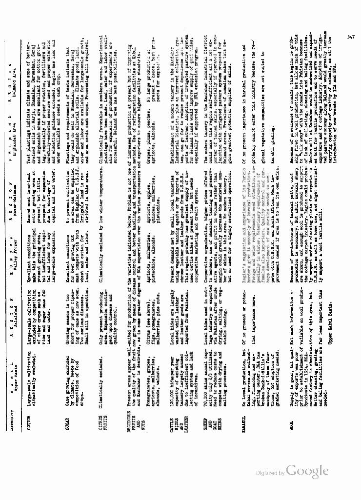
o * 3
55 «
*4
ws
,1 o
°1
a D •
n u
<i a.
*> m o u S 0 0 0 . 0
U fci P 5 o O •) -M p. O
* j2 ? S* « o JB «-i o q a W ~P «
•p o H TJ a a • o «j c o 0 &.+> P o -P 0 0 «H o 4-> 0 o 0 p, n o o. o.Ti o
?illS35
q o bo « 0
33111 a © • • O-HCQ I 4
t-4 H • 0 0 P P.01 U U 0 P. • 3 MD«
•H » t-i n P I, -H 3.8 °-93
3 5 0 UH *«
V 0 PQ 0 P
o»u b s S£ al C M M
33.83.8 Of ftH 0
•H J3 H P bflP a
O O 0 o
0 -P 0 «d
3*"8 H 0 O
yT? 0 O .• P iH
P
» o S. p.
t 8
6. .8
j, |
3 3
4oJ H
& b
as as JH fl a «3 o o u
it . I
£3
a 0
^ s JJ u o
• a *j £ n . a
L. -•- "
l|| Ci &
..: •.-. 1- O Q ti *-• B
L! 0 t>
r) d^ I
«1 P 0 U t, *
1- 1*1
:i; ii it-
I S . P 0
8. jj
o
1> CO 0 iJ - > 0
" aSl- ^i, o • H
PS
••"•3
•H "ri n 0 p O 1} r.,45 fa
•p 3 d 8 +3 bo
OH H0 p. 0 8
AS > • 9«< fti, *
-i J: Z o a • r o <9II
bB 0
Ujl JljOH
0r-l-t»4JCHOBLB HO-HOl-J 8 K Q
P ^ H H O O T* *H 0 • H +3 0 OUO
^P ntn-lo C«*H
o 0 o H «M « 9 +>
a >,• ^i ,H & B pc S'A oijoti tr* a'S
347
i i p, u ja OH
> -a co a P > 0 3 fa -»J d • 6 p, u 0
1 f^ •3 o 5 -P 3 a o a • d H
4> I A o o I 3 n q *H "8 3 1
.3
Digitized by Google

348
X. POWER RESOURCES AND REQUIREMENTS OF INDUSTRIAL DEVELOPMENT
A nation can often achieve savings of foreign exchange by re-
placing Imported products with products made at home either from domestic
or imported raw materials. Import controls and tariffs are commonly used
to achieve this replacement. Such measures, which often result in sub-
stantially higher prices to the consumer, should not be taken unless these
prices can legitimately be justified as temporary expedients designed to
enable domestic industry to achieve a volume of production at which it
will become competitive with imports or unless the nation is particularly
vulnerable to economic blockade in time of war or political unrest. We
have seen that the economic policy of the RGA, especially in the light
of the deprivations suffered during World War II and the Pakistan blockades,
is more likely to move towards increased protectionism rather than away from
it, at least with respect to the commodities listed in Table 36. While it is
not proposed to increase the tariff rates for imports of sugar and leather,
we have seen that it is a shortage of raw materials (sugar beets and hides)
rather than incentive which prevents full utilization of existing domestic
productive capacity for both of these commodities. The proposed increase in
the tariff on imported cotton piece goods would provide some additional in<=»
centive to the newly-increased domestic capacity, while the much larger in-
crease proposed for rayon might stimulate creation of such an industry (see
Chapter VIII). The proposed increase on leather goods imports, however, would
probably benefit bazar cobblers as much as the inoperative Kabul shoe factory.
But we have not been concerned merely with the imports. A nation
may also increase its foreign exchange by exporting larger j$ua#jU.^ipig)C

349
of raw materials or by exporting them in a more valuable, processed form,
in better qualities and grades, and/or in a superior state of freshness
and cleanliness. Our analysis of Afghanistan's export commodities has in-
cluded ginned cotton, fruits and nuts, karakul pelts, sheep and goat skins
and raw wool. If we combine the processing requirements of these exports
with those of the above Import commodities, we arrive at the following list
of activities which would appear, under existing conditions, to be most
advantageous for the developing Afghan industrial economyj
1) Improved grading and ginning of cotton for both export and
domestic use, combined with increased domestic spinning and weaving of
cotton piece goods as opposed to imports thereof;
2) increased domestic production of sugar, both to reduce present
imports of refined sugar and to facilitate development of a fruit-processing
industry;
3) Improved cleaning, processing and packaging of fruits and nuts
for domestic use and export as opposed to shipment of unclean, poorly-packaged
products liable to spoilage and commanding only inferior prioes;
4) increased domestic manufacture of leather in all available grades,
perhaps followed by rehabilitation of existing shoe-manufacturing capacity,
as opposed to importation of leather and leather goods;
5) improved collection, grading and domestic processing of sheep
and goat skins, broadtail pelts, and possibly of karakul, as opposed to the
waste of skins and inferior processing methods now employed;
6) improved collection, grading and cleaning and baling of raw wool
as opposed to the export of dirty, mixed and bulky wool, and improved pro-
cessing of what domestic wool is machine-woven within the country.
Digitized by VJOOQLC

350
Each of the preceding activities will have its transportation re-
quirements, a subject discussed in Chapter XI. They will also have their
power requirements, whether for electricity to run cotton gins, spindles
and looms, or for steam to operate dye works, tanneries, pressure kettles
for canning, and retorts for sugar purification. In Afghanistan, only three
sources of such energy are now available: hydroelectricity, coal and imported
fuel oil. Wood is extremely scarce and expensive and no long range or heavy
fuel demands can be predicated upon the meagre supply. Instead, attention
is being devoted to means for increasing the amounts of coal mined and at
the same time to means of exploiting the promising petroleum deposits in
northern Afghanistan. We shall now briefly consider each of these energy
sources, so as to be able to superimpose regional power resources upon the
comparative scheme of physical and human factors which we have just presented.
Hydroelectricitjr"
In the presumed absence of an integrated development of the Eunduz
Valley, only the Kabul and Helmand regions are in a position to offer sub-
stantial amounts of hydroelectricity to processing industries. In the Kabul
2 Valley, the Sarobi Dam is now in operation with a maximum theoretical output
""The very considerable area for expansion is indicated by the following figures on total electricity generation (hydroelectric and thermal) before the Sarobi plant began operation in May, 1957:
1950-51 1951-52 1952-53 1953-5A 195A-55 1955-56 1956-57 Electrical Energy (Million KWH) S.3 8.8 7-9 20.8 22.7 24.3 29-3
The source for these figures is: Ministry of Mines and Industries and ICA Minerals Adviser, estimates in files of United States Operations Mission (ICA), Kabul, Afghanistan.
"That is, running both generators simultaneously, an unsoundrnFnaejdure from the maintenance standpoint and one which allows no "standby'' oapacity.

351
of 22,000 kva from two 11,000 kva units, and can be raised to 33,000 kva
by the addition of a third generator without additional heavy construction.
Provision of a fourth 11,000 kva unit is also possible, but would entail
building a new intake, tunnel and powerhouse. Of more immediate signifi-
cance, however, is the Soviet-engineered plan for a storage and power-dam
at Naghlu for which surveys have been completed. This project, which may
require five years for construction, will provide between 30,000 and 40,000
kw presumably without detriment to the storage and generating capacities at
Sarobi, five miles downstream. If we can count, therefore, on a minimum
of 50,000 kw, firm power, on the Kabul River after five years' time, there
should be an ample supply for wool, fruit and leather processing, the three
major industries which we have indicated as most advantageous to expand in
Kabul City. The bottleneck, if any, will occur in the intervening period,
or if Naghlu is not constructed as planned. We have stated in our discussion
of the Gulbahar cotton textile plant (Chapter II) that it will require
14,000 kw when in full operation. A shortage of cotton, or of trained
operatives, may delay the attainment of full production for several years,
perhaps until Naghlu power is available. But if Gulbahar reaches capacity
before additional electric power is available, then there will be a shortag.
of at least 4-000 kw in the Sarobi-Kabul-Gulbahar grid in fall and winter
months when runoff water is low and when the demands of the capital are
highest. Under these conditions, while Kabul City requires about 7000 to
8000 kw, Sarobi output is limited to 14-15,000 kw. Sarobi could provide the
additional 2000-3000 kw for new industrial demand only at the further expense
of Gulbahar and, hence, of the cotton textile industry which we have singled
out as of particular importance. Therefore, it would seem advisable for.the Digitized by VJOOQLC
Textile Company to undertake the hydroelectric development of the nearby

352
Panjshir River at an early date to ensure its own hydroelectric needs.
Meanwhile, the RGA through its Ministries of Public Works and Mines and
Industries must determine how soon it can expect to have Naghlu power
available, and on this basis decide whether or not to install the additional
unit at Sarobi. If it appears that Gulbahar demand will rise slowly, and
that Naghlu can be counted upon within five years as envisaged in the Five
Year Plan, then it probably is not Justifiable to add a third unit to
Sarobi at this time, since needs for Kabul City, including the expanded
woolen, leather and fruit processing operations, may not go above 10,000
to 11,000 kw within this period.
In the Helmand, though the present situation is poorer than that
at Kabul, the outlook is brighter. Completion of the Arghandab power in-
stallation even after two years will provide 5400 kva for Kandahar's present
consumers, the Kandahar International Airport and the proposed Kandahar
Industrial District. Since it is estimated that the demand will exceed
6000 kw only after ten years time, and since it will be possible to increase
the Arghandab capacity by two successive additions of 3200 kva apiece, there
would appear to be no problem, in the long run, for the increased processing
of fruits, wool, leather, and perhaps of cotton and sugar which we have pos
tulated for this area. Power will continue to be a severe limitation until
Arghandab generation begins, of course, since the existing facilities cannot
me«t even present demand, but since it will require at least a year to make
the recommended improvements in processing capacity, as well as to construct
the Kandahar Industrial District, diesel generators can probably fill the few
-^The Five Year Plan of Afghanistan, p. 165. Digitized by VjOOQlC

353
months' gap remaining until Arghandab generation and transmission begin.
Once the canal leakage is repaired the Boghra power station, with a
theoretical capacity of 3000 kva and a potential of 4-500 kva, should produce
ample power for present and prospective needs, even if rural electrification
is undertaken and if the recommended cotton and sugar beet processing plants
are located there rather than in Kandahar. Thus, in the Helmand at least,
hydroelectric power is no limitation on the location and expansion of pro-
cessing industry, and is even an attracting influence for that industry in
the case of sugar beets and cotton, compared with the Kunduz Valley. Probably
the most logical locational decision would be to place cotton gins in both
Lashkar Gah and Kandahar, with the textile plant in Kandahar, where more
skilled labor is available. The proposed sugar factory could be located near
either Kandahar or Lashkar Gah, depending upon whether beets are grown more
successfully along the Arghandab or in the Shamalan-Darweshan; probably, they
will compete more strongly for land along the Helmand than in the horticul-
tural areas near Kandahar. As for wool processing, it would be preferable to
improve the Kandahar plant before the one at Kabul, not only because its
facilities are basically better but because the additional drain on Kabul
power could thus be postponed until Naghlu is in operation.
Coal
Afghanistan has two operating coal mines, a score or so of locally-
exploited surface occurrences, and one really promising but undeveloped coal
deposit. The two mines are located at Ishpushta, about 160 road miles north-
west of Kabul in the Bamian-Surkhab gorge near Doab, and at Kar Kar, about 15
miles northeast of Pul-i-Khumri. The Kar Kar mine, with an estimated 300,000
to 400,000 tons of reserves in seams from 9-20" thick, is strategically placed

354
for supplying the lower Kunduz Valley, and the Baghlan Sugar Factory in
particular. The bituminous coal it produces is of fair quality, giving
5000 to 6000 calories per pound, though it is not suitable for coking.
The estimated 100,000 tons of coal at Ishpushta is friable, at best, and
is often reduced to a powder by the time it reaches Kabul. There it is usually
mixed with molasses, from Baghlan, and pressed into briquets for use in the
RGA arms factory, the Woolen Mill, the Shaker Ceramic Factory, the "Silo"
flour mill and bakery or for heating offices and the more opulent homes in
the capital.
A serious shortage of coal is certain to develop as the new Czech-
built cement plant at Jabal Seraj goes into operation. To operate at its
100 metric ton daily capacity, this plant will consume between 2U and 30
metric tons of coal per day, or approximately 8000 metric tons per year. The
mill had built up a four months supply prior to commencing operations in
rt 2 early 1958. Fortunately, the fuel injector for the rotary cement kiln is
adapted to use powdered coal or fuel oil. The delivery of 100 International
Harvester coal trucks under Special Fiscal Year 1957 Assistance extended by
the Richards Mission was expected to improve the transportation situation,
but the crucial problem remains production at the mines. The following tablt
analyzes this production for the past 7 years.(See Table 54- on the next page.
This slow but steady improvement is principally due to the fact that
the ICA had project agreements with RGA since 1953 under which a highly-com-
petent Minerals Adviser, borrowed from the U.S. Bureau of Mines, advised on
operations and on the installation of some mechanical equipment, also provided
by ICA. ICA Project No. 06-21-003 entitled "Mineral Resources and Coal Pro-
All estimates from interview with Paul Hamer, ICA Minerals Adviser, Kabul, Afghanistan on February 27, 1958.
Visit to Jabal Seraj cement plant and interview with Mr. Pucek, Chiei'
w^^noo-r.. on February 8, 1958.

355
duction" has Included exploration and appraisal of new sources of coal
as well as improvement of extraction methods and lowering of costs at
the existing mines. These costs amount to about $1 per ton at the mine,
and, due to transportation difficulties, about $5 per ton at Kabul.
TABLE 54
AFGHANISTAN: COAL PRODUCTION 1950-51 TO 1956-57, IN SHORT TONS
Mines 1950-51 1951-52 1952-53 1953-54 1954-55 1955-56 1956-57
Kar Ear 6,500 11,200 13,100 Ishpushta breakdown not available 10,912 10,292 14»650 Darra-i-Suf 1,500
Total . . . 10,100 H,100 14,500 16,800 17,412 22,992 27,750
Tlinistry of Mines and Industries and ICA Minerals Adviser, Report to the Royal Government of Afghanistan. March. 1957. in files of USOM (ICA), Kabul, Afghanistan. As of March 21, 1957 (end of Afghan year 1335), 16,000 short tons of coal remained untransported at Kar Kar and Ishpushta.
The adviser, Paul Hamer, has visited outcrops throughout northern and
eastern Afghanistan, including the almost inaccessible deposits of Obeh, 55
miles east of Herat, which were found to be insufficient to justify the high
costs of development. In Mr. Hamer's opinion, the Darra-i-Suf deposits alone
offer a semi-permanent solution to Afghanistan's growing coal needs. Located
"'"At Masjh-i-Ghobi, 108 km. NE of Herat (34°37'N, 63o09!E), a single seam 0.9 to 1.0 meters thick is estimated to contain 210,000 metric tons of meas- ured and indicated coal and 1,050,000 metric tons of inferred coal within 200- 300 meters of the surface. A seam 52 meters down now is being worked with 5 shafts and drifts at 9 meters intervals - recovery may be only 20 per cent with present methods. Ministry of Mines and Industries and ICA Minerals Adviser, Report to the Royal Government of Afghanistan. March. 1957.
Digitized by Google
356
about 85 miles south of Mazar-i-Sharif, the several outcrops indicate
probable reserves of about 5 million tons of good quality (8000 calories
per pound), non-friable coal which could withstand the transportation in-
volved. The possible reserves here are much larger but can be estimated
only by driving shafts, as has been done at Kar Kar. To date, they have
been mined only on an experimental basis (see Table 54) and cannot be com-
mercially exploited until access roads are provided.
Two alternative routes exist to the Darra-i-Suf coal deposits.
The trail leading south from Mazar-i-Sharif along the Balkh Ab could be
improved and extended along the Darra-i-Suf to the mines (see Map 3) This
would be the simplest method, involving a minimum of expensive construction
work, but would require a journey of some 210 miles to Pul-i-Khumri, followed
by another 235 miles to Kabul. The alternative is to put a more difficult
but far shorter route over the mountains into the Surkhab Valley, and join
it with the Great North Road at Doab. This would bring the Darra-i-Suf mines
75 miles closer to Kabul than those at Kar Kar. While the very difficult
construction of a road over the Salang Pass (see Chapter 11) would return
the advantage to Kar Kar, the future needs of the Kunduz Valley will probably
continue to demand a large share of the Kar Kar output as they do at present,
especially if a new cement plant is built at Pul-i-Khumri.
The importance, particularly to Kabul, Jabal Seraj and Gulbahar, of
developing coal mining at Darra-i-Suf has repeatedly been emphasized by Mr.
Hamer to the Ministry of Mines and Industries. The Ministry has even had the
route surveyed for the shorter road to Doab, via the upper Surkhab Valley,
and obtained an estimate of $120,000 from the German firm of Kochs. The main
difficulty apparently lies in the fact that it is the responsibility of the
Ministry of Public Works to undertake construction, and that Ministry has its

357
hands full. It is also possible that, after its experience in the Kabul
Gorge, the Ministry would prefer to construct the easier route from Darra-i-
Suf to Mazar-i-Sharif. A further difficulty, perhaps, resides in the failure
of Afghan officials to realize that production of 100 tons per day, the
present average, could easily be doubled without further investment. There
is too great a tendency to regard the improvements over the last five years
as substantial gains rather than as merely an indication of what could be
done. The provision of electrically operated hoists at Kar Kar and of ven-
tilators at Kar Kar and Ishpushta was not an end in itself but a means to
greatly increased production, which, in Mr. Hamer's opinion, could easily
reach 50,000 tons per year. This would, however, exhaust the known reserves
within ten years unless further seams were discovered in the course of
mining, as is not unlikely. Since even now when coal sells at 265 Afghanis
($5.30) per ton the estimated national demand is for 97,000 tons per year
(of which at least 30,000 tons could be sold in Kabul), it is obvious that
the basic need remains that of exploiting the much larger reserves available
at Darra-i-Suf.
One problem which requires immediate attention if the Kar Kar out-
put is to be raised and Darra-i-Suf brought into production is the provision
of pit-props. The coal mines of northeastern Afghanistan are in an even
poorer position with reference to mine timber than the chromite deposits of
the Logar Valley since there are no natural forests in Kataghan Province
Interview with Mr. Paul Hamer, Kabul, Afghanistan on February 27, 195o
2G.V Ganeshan, Field Evaluation of ICA Project No. 06-21-003. Evalu- ation Report No. TA-1, in ICA files, Kabul, Afghanistan (Kabul: June 22, 1957).
Digitized by Google

358
and irrigated stands of poplars are both scarce and expensive. Some metal
props have been imported from Germany at almost prohibitive cost, but the
logical solution lies in the immediate establishment of poplar nurseries
along the Kunduz and Darra-i-Suf Rivers.
As a locational factor for the industries we have stressed, coal
is less important than hydroelectricity. Insofar as steam-generated power
may be substituted for hydroelectricity, however, coal certainly gives an
advantage to the Kunduz Valley first, and to the Kabul Valley second, leaving
the Helmand region a very poor third. In fact, the Minister of Mines and In-
dustries has indicated that he has no hope of locating developable coal
sources in southern Afghanistan, and that in future planning reliance will
be placed solely upon hydroelectric power in the South with coal reserved
for use in the North and around Kabul. In line with our conclusions re-
garding the financial obstacles to early large-scale harnessing of water
resources in the Kunduz, it is probably wise to rely upon coal and steam-
generated electricity for expansion of industrial needs in the near future.
However, one is forced to ask whether official optimism with regard to pro-
duction of coal at Kar Kar and Ishpushta has not already led to overexpansioi
and overplanning of the industries which require coal as a raw material or
as a fuel. For example, the Jabal Sera;) cement plant will require 4-000 ton
of coal per year for capacity operation, while the thermal station at nearby
Gulbahar Textile Factory will need between 5000 and 6000 tons for supplemental
electric generation and to supply steam to the finishing and dye works. Add
this 9000 or 10,000 tons to the 4O00 used in the short operating season at
the Baghlan Sugar Factory, and one arrives at the total annual output attained
Reported in a memorandum from G.V. Ganeshan to the Acting Director, USOM, dated July 11, 1957, in ffles of ICA, Kabul, Afghanistan.
359
at either Kar Kar or Ishpushta, leaving leas than one-half of the 30,000
tons estimated demand for Kabul itself. Thus, any expansion of operations
at Baghlan would be precluded until Kar Kar and Ishpushta are raised to
the 50,000 ton annual output envisioned by Mr. Hamer, who has certainly
done all an outsider can do to realize such a production. Furthermore, the
scheme to erect a second cement mill at Pul-i-Khumri, with a daily capacity
of 150 tons, would certainly have to be postponed until the Darra-i-Suf
deposits can be tapped to supply the additional 12,000 tons of coal per
year which such a plant would require.
Thus, we have a situation in Coal production not unlike that in the
Rahul hydroelectric grid, since in both instances large-scale construction
will have to be undertaken before utilization of energy resources can be
brought into line with immediate or near-future requirements. In both instances,
also, diesel fuel generation may have to be employed as a stop-gap measure
until capacity catches up with demand. In the longer run, however, the develop-
ment of an efficient coal-extraction industry can provide Afghanistan with a fuel
base for all presently foreseeable thermal needs, whether or not the petroleum
indications at Sar-i-Pul measure up to Afghan expectations. By tapping the
Darra-i-Suf coal deposits in addition to those at Kar Kar and Ishpushta,
Afghanistan can assure itself of sufficient fuel for an expanding cement and
kiln-brick industry and simultaneously reduce the use of the nation's limited
wood supplies for fuel and construction purposes. Increasing utilization of the
hydroelectric potential of Afghanistan's major streams will further aid in the
conservation of trees, scrub growth and stubble now consumed as fuel. In this
way, rational utilization of known coal and hydroelectric resources can com-
pensate for two major known deficiencies: low timber reserves and the resultant Digitized by VJOOQLC
removal of most of the combustible plant cellulose which otherwise would be left

360
to contribute organic material to the soil.
Petroleum
The history of petroleum exploration in Afghanistan provides an
excellent illustration of the political overtones of economic development
in that country. Preliminary investigations had been made by American en-
gineers prior to World War II, resulting in the specification of certain
areas of seepage and of structural formation as likely locations for
test-drilling. When the Afghan Government, after the War, determined to
conduct exploratory drilling in the most promising of these locations, at
Sar-i-Pul, 70 miles southwest of Mazar-i-Sharif, political considerations
ruled out the choice of American teams for the work. At the request of the
RGA, the UNTAM departed from its usual sphere of activity to supply a
Dutch geologist in 1950 and a Dutch oil drilling specialist in 1951. But
the agreement with a French petroleum concern to conduct the drilling, worked
out under UNTAM auspices, was vetoed in August, 1953, by the Soviet Union as
involving nationals of a power allied with the United States.
It was not until 1956-57 that Swedish technicians and equipment could
be obtained by the Ministry of Mines and Industries for exploratory work at
Sar-i-Pul. Exploration was carried out under the direction of Mr. Massa, an
Afghan petroleum engineer with degrees from Louisiana State University and tl.
University of Houston and experience in the southwestern U.S. After mapping
the anticline on a scale of 1:10,000, stratigraphic drilling was begun. In
the spring of 1957, the first coring was driven to a depth of 817 meters before
This may be regarded as a negative contribution, merely leaving to th< soil what is its due. A further, positive, contribution to Afghan agriculture may later be realized by utilizing coal and hydroelectric power for the pro- duction of nitrogenous and phosphatic fertilizers. The latter requires the lo- cation and exploitation of phosphatic minerals, as well as the use of sulphuric acid derivable from sulphur deposits in Maimana.

361
deviation of the bore required a halt to activities. The core samples
showed 12 horizons with some oil content, and those from the 590 meter
level yielded samples of a heavy petroleum with a specific gravity of 1.28.
Other sandstone samples showed air bubbles escaping, while there was enough
pressure at some depths to blow mud out of the well.
A second coring passed the 850 meter depth and showed high pressure
gas and petroleum below it, but due to a lack of the heavy barite mud used
to maintain pressure in the well this operation had to be stopped in October,
1 1957. The second well gave indications of sufficient pressure to produce a
natural flow of petroleum if lined and capped. Early in 1958, drilling on
the second well was resumed after a supply of barite had been obtained from
2 India. Proposals were also made for aerial surveying and photo-mapping of
the entire Sar-i-Pul region on a scale of 1:60,000 as a preliminary to
further exploration.
In short, while the ultimate potential for petroleum occurrence in
northern Afghanistan is possibly great, we simply do not have sufficient
factual data on which to base any estimates. While it is extremely hazardous
to generalize from one sample, the high specific gravity of the crude oil
recovered and its asphaltic base do not bode well for future production of
gasoline or other light petroleum fractions. Perhaps the most that can be
hoped for is some eventual contribution to the diesel fuel needs of the
country, with refining performed by simple thermal distillation or fraction-
Interview with Mr. Massa and inspection of samples at Ministry of Mines and Industries, Kabul, Afghanistan on November 13, 1957.
2 Interview with Mr. Massa on February 13, 1958.
Digitized by Google

362
ating. While even this may involve some sort of exchange agreement with
the Soviet Union, it could save Afghanistan part of the foreign currency
which now goes into purchases of diesel fuel. A gradual shift from gasoline
to diesel units in the Afghan truck fleet could further increase the savings,
while use of the heavier fractions in road surfacing would provide a further
boon to local transportation. As has been indicated in Chapter VIII, how-
ever, the political and economic obstacles to any commercial petroleum
development are considerable, and it is difficult to see how even a sizeable
discovery of petroleum could be put to use of the local economy within the
next five years, the period in which the energy needs of Afghanistan will
reach a critical level in relation to available resources.
Regional power resources are summarized in the following table
for comparison with the production resources summarized in Table 53.
However, the Dutch geologist supplied by the UN in 1950 predicted that any petroleum found would be not only heavy and asphaltic but high in sulfur and low in volatile components, necessitating the use of a cracking process. Peter G. Franck, Technical Assistance Through the United Nations, The UN Mission in Afghanistan. 1950-53 ("Hands Across Frontiers; Case Studies in Technical Cooperation," Publications of the Netherlands Universities Foun- dation for International Cooperation; Leyden, Netherlands: A.W. Sijthoff, n.d.) p. 32.
Digitized by Google

363
a
s o 5
fe
g
a 1 H 3
5
£2
i-4 W M ©
33
O C
W T
« 3
N
t=>
w fe>fj » © <P
M > Pn
o
t-3 in
« Sii «* P.
o -H o m a -p P.-H
13 -P • §a ©
© m -P
o « 3
© CO
© •P
•a o
•p
0)
8 «$
o
o
m «H 00 at
§
a> •p
•p 01 0)
a> X> +> o
a)
•P
0) • •H -P
a> +>
a) a> -P -rl fl o a p -P M 3
VH H 0 O H •p h H ©
M O © 3 2 g ,Q rt ,Q o
w ©
a
tJ 1 Vl © no op fl T3 -P • So a fl J3 xl -p i-i © © -P ra
o
SSS'cLo'a o •H
Disadv
by loc
must d
on sh
i from n
Hindu •P
(0 ©
8
8
©
O
©
©
a.
ss
to
©
I
•tf
-P IQ
©
9 -P
> O T3 O <a H © ^ •H >» O
n h h -P © o
o* • ft-Hff! 9 © •
•H CO
o co
P*
Digitized by Google

Digitized by Google
365
XI. TRANSPORTATION RESOURCES AND REQUIREMENTS OF DEVELOPMENT
Throughout this study, we have made references to the existing
road network of Afghanistan and its generally unsatisfactory condition
for the convenient and rapid movement of persons and goods which is es-
sential to an integrated economy. In a country which has no railroads,
and where air transportation has topographic, climatic, and economic limita-
tions, the highway assumes primary importance as the means of assembling
and marketing local products, of distributing imports from beyond the re-
gional or the national frontiers, and of moving persons in response to
social or economic needs and desires. This statement was true a thousand
years ago, when two of the major "Silk Routes" passed through Afghanistan,
converging at Balkh, and it will remain true for some time into the future,
even if trucks and busses entirely replace the camel and the donkey as
carriers, and even if a greatly expanded air fleet and all-weather airports
are provided. Judging by the amount of over-crowded bus traffic today the
Afghan has lost none of his love of movement, and even when population dis-
tribution attains a greater degree of coincidence with economic resources
it can be expected that social as well as trading propensities will maintain
a high degree of mobility among the people. Furthermore, as Prof. Jean
Gottmann points out, there is every reason to expect that improved trans-
portation facilities will serve to generate increased travel and traffic
just as they did after Lyautey's work in Morocco.
Private communication to the author, December, llQiS7acl by VJ
366
With these considerations in mind, let us briefly review what we
have set forth in the regional chapters with respect to road patterns and
conditions, and then discuss the prospects for improvement and extension of
the road network and for improvements in the size and state of maintenance
of transportation and road-construction equipment.
Road Patterns and General Conditions
The existing road network of Afghanistan may most readily be de-
scribed as a huge circle around the central mountainous mass, which is pierced
only where the Great North Road was cut through the Bamian-Surkhab gorge in
the 1930's (see Map 10). This circle connects Kabul with the major cities of
the North, Pul-i-Khumri, Baghlan, Kunduz, Tashkurghan, Mazar-i-Sharif, Andkhui,
Maimana, Qala Nao and Herat, in the northwest. In the opposite direction it
links the capital with Ghazni, Kandahar, Girishk, Farah, and, again, Herat.
Traffic between Kabul and Herat, therefore, may choose between the northern
and the southern route, with the choice largely dependent upon season and
type of load. In winter, when the Hindu Kush passes may be blocked by snow,
and the northern route covered by drifts, preference is given to the southern
route which encounters high elevations only in the stretch from Kabul to
Ghazni. Heavy equipment, entering Afghanistan from the Soviet railhead at
1 Kushka, north of Herat, will follow the easier southern route in any season.
Branching out from this huge circle are the northern feeder routes
from Herat to Meshed or to Kushka, from Mazar-i-Sharif to Khelif or Termez,
and from Kunduz to Qizil Qala and Faizabad. South of the mountains, the two
feeders from Kabul through Jalalabad and the Khyber Pass to Peshawar and from
Kandahar through Chaman to Quetta have historically been of the greatest im-
This was demonstrated by the shipments destined for the Textile Factory at Gulbahar, 50 miles north of Kabul and at the foot of the Hindu Kush. Shipped from West Germany across the Soviet Union during the Pakistan blockade XcyeSnat-
•ials took the longer but easier route from Herat through Kandahar rather than empt to cross the Hindu Kush passes.

367
portance for trade as well as for military movement. Recent governmental
efforts at road construction have been almost exclusively concerned with i
these feeders, a fact which underscores the importance attached to foreign
trade in the economic life of Afghanistan. Morrison-Knudsen was originally
brought into Afghanistan to improve the roads from Torkham (Khyber Pass)
to Kabul, from Kabul to Kandahar, and from Kandahar to Girishk (see Chapter
III). When cost estimates proved too high, the contractor was left with the
stretch from Kandahar to Chaman and with interproject roads in the Helmand
Valley Project. The Ministry of Public Works, employing a series of German,
Chechoslovakian and Japanese engineers, assumed responsibility for the
Torkham-Kabul stretch. When Soviet assistance became available it was de-
voted to improving the feeders from Khelif to Mazar-i-Sharif and from Qizil
Qala to Kunduz, and, by extension, to sections of the long road from Kunduz
to Kabul so that Soviet imports could more easily be brought to the capital.
Except for reconstruction of a few culverts and bridges, the long stretches
from Mazar-i-Sharif to Herat, from Herat to Girishk, and from Kandahar to
Kabul have been left untouched. Thus we find in the locational pattern of
recent road construction another confirmation of our premise that the most
likely areas for development are the Kabul, Kunduz and Helmand Valleys.
A few generalizations regarding Afghan roads may serve to give the
reader a fairly accurate notion of the present condition of at least 95 per
cent of the trunk roads of the country. The Afghan road network is thin,
poorly maintained and inadequate even to the needs of the 3500-odd non-
military trucks and 500-odd private or public automobiles which operate upon
it. Generally speaking, however, the roads do serve to connect the principal
cities in the most direct fashion possible, given the resources which have
heretofore been available for constructing them. The P&ttegn^iSj,
while such a project as the Salang Pass tunnel would considerably shorten the

368
route from Kabul to the Kunduz Region, the existing road, via the Shibar
Pass and the Bamian Gorge, might be improved at considerably less cost.
Counting approximately 2500 miles of "all-weather" but unpaved
roads and 1500 miles of "seasonal" roads, the road density in Afghanistan
is about .016 linear miles per square mile, or .0004 linear miles per
person of the settled population. Iran in 1956 had only .008 linear miles
per square mile of roads of all types, but this represented .0007 linear
miles per person. Pakistan in 1957 had about ten times the linear road
mileage per square mile found in Afghanistan, but only the same small
fraction of a linear mile per person as found in Iran. India in 1956 had
.252 linear miles of road per square mile, but only.0008 linear miles per
person. For what the comparison is worth, the United States had 1.15 linear
2 miles of road per square mile and .2 linear miles per person in 1957.
Afghanistan's 4-000-odd motor vehicles may be contrasted with 60,000 in
Iran, 54,000 in Pakistan, 380,000 in India, and 66 million in the United
3 States.
Of the 4000-odd miles of road in Afghanistan which are fit at one
season or another for motor vehicles, less than 400 are fit for operation
at an average speed of 20 miles per hour or more. These would include the
65-mile stretch from Spin Baldak to Kandahar, the 90-mile road from Kandah-M
Based on estimates of 3845 km. of all-weather roads and 2266 km. of seasonal roads in 1955. Afghanistan, Ministry of Finance, Afghanistan: Basic Economic Statistics (Kabul: December 31> 1955) (MimeographedT)
All data except Afghanistan's from The Statesman's Year-Book. 1958 (London: Macmillan & Co., Ltd., 1958).
3Ibid.
Digitized by Google
369
to Lashkar Gah with a branch to Glrishk, and the various lnter-project
roads, same of them located on canal berms, connecting Glrishk through
Had-i-Ali and Marja or Shamalan to Darweshan. It would also Include 50-odd
miles of paved roads In and around Kabul and the sections improved with
Soviet assistance in the Charikar Valley and In the Eunduz Valley. Con-
ditions of alignment, grade and surface which render the remaining 90 per
cent of Afghanistan's roads unfit for rapid or comfortable motor vehicle
operation will be discussed in detail in the following paragraphs.
Incongruous as it may appear in this arid land, water is the worst
enemy of road construction. Winter and spring rains falling upon barren and
rocky soils are not absorbed to any great extent but run off rapidly and
unpredictably. A wash which carries a flood in one season may carry only
a triokle for several succeeding years. Hence it is almost impossible to
determine safe minimum sizes for bridge openings and culverts without
running into impracticable expenses. A flood of large proportions has rock-
moving capacities almost unimagineable to one who has not observed the
piles of alluvial debris left in the dry wash beds. Rocks up to three feet
in diameter may be moved by flash floods with sufficient force to demolish
almost any type of bridge pier. Furthermore, the shifting runoff of an
alluvial fan may gouge an entirely new channel, ripping out a road where
no need for preventative barrages or culverts could reasonably have been
foreseen. Since most of Afghanistan's roads have to be built across alluvial
fans to avoid the rough topography above and the shifting sands below them,
the only practical outlook is to expect to have washouts and the ensuing
delays from time to time. In fact, both MKA and Soviet engineers have adopted
the practice of constructing concrete dips to carry roads across washes rather
than build expensive bridges which may be wrecked by the^oatf ty<ftrt!erfP|f^

370
flash floods. These dips can be forded at low water and can be cleared
of rubble within a few hours after serious floods have subsided.
Perhaps as a result of years of trial-and-error experience with
floods and washouts, the alignment and grade of most Afghan roads is
surprisingly good. Especially in the high passes such as the Lataband
(near Kabul), the Shibar (near Bamian) and the Sabzak (over the Paro-
pamisus between Qala Nao and Herat), the engineering is more or less com-
petent for the present stage of traffic development. However, considerable
improvement in road width, in eliminating blind corners, and in providing
room for passing on turns is essential if these roads are to carry heavier
traffic without serious increases in the accident rate. It is not only
on the high passes that such improvements are indicated for some of the
most dangerous blind curves in Afghanistan occur where the roads run a-
round fairly low terraces or foothills. Only the present low frequency
and low speed of traffic prevents more deaths than now occur at such points.
Drainage and surfacing of Afghan roads are extremely poor or even
non-existent. Since there is very little rainfall, it is hard to Justify
humped roads with parallel drainage ditches. But banking of curves will
have to be introduced as surface conditions improve to the point where high
speeds are possible. At present, 20 miles per hour is considered good speed
for a truck or bus on almost all Afghan roads, due to the constantly
varying but constantly inferior surface condition. In one sense, most of
the relatively flat surfaces of Afghanistan - alluvial fans, foothills,
terraces, desert pavement - consist of the raw materials for road construction.
which frequently has taken the form of simply laying out a right of way,
cutting it through any sharp rises and scooping up rocks, sand and silt
to fill in the low spots. Indeed, in many areas it is pref exajp^e, to drire[g
371
cross-country parallel to a road rather than on the road, while in the
Dasht-i-Margo the desert pavement serves as a limitless roadbed for any-
one who has a compass.
What is lacking is not road-building material but equipment and
supervised labor to screen it into proper aggregate sizes laid in dimin-
ishing sequence above a properly constructed, heavy-duty foundation. While
a hard surface may ultimately be desirable, it is not necessary if proper
construction and maintenance procedures are followed. As it is now, traffic
over a newly built or newly repaired road very soon scatters the smaller
pebbles, sand and silt, leaving only the boulders to bruise vehicle tires
and passengers. The typically overladen Afghan truck or lorry is the worst
offender. Jerry-built roads simply Cannot withstand the heavy traffic which
soon reduces them to washboards, at which point the road crews merely shovel
in some handy rocks and dirt and the process begins all over again. When
rain falls, or snow melts, such roads become either quagmires of mud or
patchworks of bung holes which are apt to wreck the springs, if not the
axles, of the vehicles attempting to use them. Nor is mechanical scraping
any answer, for the blades merely reveal more of the same., potentially
hazardous, rock and earth mixture.
Passing from the general to the particular, we can assess the possib-
ilities for reconstruction and extension of the road system by a review of
the regions chosen for analysis in this study and for improvement by the RGA.
Regional Road Conditions and Prospects for Extension and Maintenance
We have described some of the features of the Torkham-Kabul road in
Chapter I on the Kabul Valley. Between the border station at Torkham and
Jalalabad (52 miles), this road is in good condition with respect to alignment

372
and grade. The Ministry of Public W'.vlca m.-j devote! considerable effort
to improving this stretch in recent years, and is completing several
brick and masonry culverts in sections where small streams and washes
cross from the Safed Kuh foothills on the south to the Kabul River north
of the road. However, the surface will have to be completely rebuilt with
proper aggregates before this section can be paved, as is now proposed
under an ICA development grant.
Beyond Jalalabad, after passing through the Darunta Gorge (see
Map 2), the road continues around terraces on the southern bank of the
river or across alluvial fans at some distance from it. Here, little work
has been done, and surface conditions are deplorable, with the road degen-
erating to a mere trace across the rubble in several washes. While grade is
still no problem, it will be necessary to realign some sections of this
stretch and to construct culverts or, preferably, dips across the washes
before proper surfacing and paving can even be considered.
Approximately 30 miles west of Jalalabad the road and the Kabul
River both pass into the 20 mile Lower Gorge section leading to Sarobi. Here
work is still in progress to widen the road and shore it up above the
rushing stream. Alignment and width are being improved with the aid of
dynamite and Soviet drills, compressors, bulldozers and trucks. The gradient
is gradual though the road passes several seotions of river rapids. At
Sarobi, the valley widens, and the truck route branches off along the Tezin
Darra toward the Lataband Pass. This truck route has some difficult sections
in washes, but will become an alternate when the Uppper Gorge section has been
widened sufficiently to accomodate trucks and busses. The Lataband Pass
route may continue to be used by heavy trucks to avoid the steep grades of
the Upper Gorge route. Digitized by Google

373
The Gorge Route, above Sarobi, passes through the Naghlu section,
where some 11 miles of it will have to be rerouted to allow construction
of the Naghlu Dam by the Russians. This rerouting may prove to be a difficult
problem because of the rugged terrain and mica schist transverse ridges, but
presumably it will also eliminate the floodplain and alluvial fan sections
which are also in wretched condition. Fortunately, the 15-mile Upper Gorge
section, where most of the difficult work required to raise the road some
2000 feet past the Kabul falls and rapids section has been completed, will
not be affected by the Naghlu construction.
The final section of the road, where it crosses the floor of the
Kabul Basin for some 18 miles from the top of the Gorge to the start of
the city pavement, require's only a proper foundation and surfacing. It
seems likely that work under the ICA proposal will begin with this section,
since Kabul has an asphalt plant, and be extended downstream, while a traveling
asphalt unit based on Jalalabad works on the section from that city to Torkham
and then starts upstream towards Sarobi. Since no contract has yet been
awarded for the work, which may be done by the Ministry with ICA supplying
only materials and technicians, it is impossible to state how soon one can
expect to see it completed. Costs of resurfacing and paving were estimated
at $5,080,000 in all currencies by the ICA-sponsored Koebig and Koebig survey
team, which also recommended postponement of this work until the Spin Baldak-
Kabul road had been improved. But the RGA has insisted that the Kabul-Torkham
route be given priority, and so it will probably be paved under a special
agreement with ICA and separate from the other work recommended by Koebig and
Koebig.
^Letter to the author from R.D. Spencer, Vice-President of Koebig and Koebig, October 27, 1958.
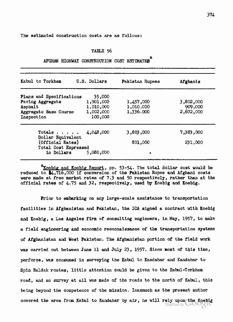
374
The estimated construction costs are as follows:
TABLE 56
AFGHAN HIGHWAY CONSTRUCTION COST ESTIMATES
Kabul to Torkham U.S. Dollars Pakistan Rupees Afghanis
Plans and Specifications 35,000 Paving Aggregate 1,901,000 1,457,000 3,802,000 Asphalt 1,010,000 1,010,000 909,000 Aggregate Base Course 1,002,000 1,336.000 2,672,000 Inspection 100,000
Totals 4,048,000 3,803,000 7,383,000 Dollar Equivalent (Official Rates) 801,000 231,000 Total Cost Expressed
in Dollars 5,080,000
koebig and Koebig Report, pp. 53-54- The total dollar cost would be reduced to $4,716,000 if conversion of the Pakistan Rupee and Afghani costs were made at free market rates of 7.3 and 50 respectively, rather than at the official rates of 4*75 and 32, respectively, used by Koebig and Koebig.
Prior to embarking on any large-scale assistance to transportation
facilities in Afghanistan and Pakistan, the ICA signed a contract with Koebig
and Koebig, a Los Angeles firm of consulting engineers, in May, 1957, to make
a field engineering and economic reconnaissance of the transportation systems
of Afghanistan and West Pakistan. The Afghanistan portion of the field work
was carried out between June 11 and July 23, 1957. Since most of this time,
perforce, was consumed in surveying the Kabul to Kandahar and Kandahar to
Spin Baldak routes, little attention could be given to the Kabul-Torkham
road, and no survey at all was made of the roads to the north of Kabul, this
being beyond the competence of the mission. Inasmuch as the present author
covered the area from Kabul to Kandahar by air, he will rely upon the Koebig * DigitizedbyVjOOgie
375
and Koebig study for a description of the southern routes, and return
to his own experiences for a description of the roads to the north.
From Spin Baldak to Kandahar is approximately 65 miles (103 kilo- meters) . Spin Baldak is the first town in Afghanistan after crossing the Pakistan Border near Chaman. The road from here to Kandahar has served as the main supply line for the Helmand Valley Project for the last 10 years, and in 1948 an American contracting firm completed its reconstruction. It has a grade and alignment according to good engin- eering practice in the United States, and consists of a smooth gravel surface over a waterbound macadam base. ... a speed of 50 miles (80 kilometers) per hour can readily be maintained over almost the- entire length without damage to vehicles. . . . This 65 miles of road is by far the best and most modern highway in Afghanistan. With the prospective growth of Kandahar and the Helmand Valley, it will undoubt- edly continue to be one of the most important.
From Kandahar to Kabul is a distance of 305 miles or 488 kilometers. . . . Generally, this road is in poor condition. Over most of its length gravel has been applied in an attempt to make it passable during the wet season and to reduce dust during the dry season. This treatment would have been much more beneficial if the larger stones had been rejected. As it is, the large stones make the surface very rough and eliminate any possibility of performing effective maintenance. Over most of this road, a speed of 20 miles (32 kilometers) per hour is definitely abusive to vehicles. Eighteen hours driving time for the 305 miles is about a normal trip, but under these conditions trucks and buses do not enjoy a long life. For the most part the grade and alignment of this road is satisfactory.
Going northeasterly, from Kandahar, the route follows the westerly bank of the Tarnak River for 160 miles, or halfway to Katul. With minor exceptions, grades on this section are extremely flat, averaging less than one half percent. From here to a point seven miles north of Ghazni the road follows a broad, flat valley with easy grades and good align- ment. Then there is a climb for six miles to an elevation of just over 8,200 feet (2500 meters). Even here grades are not excessive, the maximum being about five percent, and the alignment is fair, but some relocation would be desirable when improvements are made. . . . Proceeding northerly the road next follows a wide, high valley through some arid and some cultivated land. This is the area where some difficulty is encountered with snow during the winter season. However, a reasonable amount of snow removal equipment operating over an improved roadway should be able to keep traffic moving under all but the most severe conditions. The last 25 miles of this route descends gradually into Kabul at an elevation of 5,900 feet (1800 meters).
The Koebig and Koebig Report recommends that priority be given to
paving the Spin Baldak to Kandahar highway with a hard surface 23-feet wide
and adequate for two-way traffic, and to reconstructing the Kandahar to Kabul
Dlylilzetl by VJOOQLC
Koebig and Koebig Report, pp. 31-35.

376
road. It is proposed to provide the latter with one 12-foot paved lane
on a 32-foot roadbed, with the shoulders to be used in passing for the
time being. No work other than surfacing would be necessary on the MKA-
built road from the frontier to Kandahar. The Kandahar to Kabul road,
however, would require some relocation in the Jalaogir Pass section,
53 miles from Kandahar, and for about 5 miles in the section north of 1
Ghazni. The Report suggests that reinforced concrete pipe made in Afghan-
istan could be used to carry irrigation ditch (Jui) crossings at safe
levels under the road, but since a plant to manufacture this pipe would
cost at least $25,000 the estimates are based on the use of imported cor-
2 rugated metal, locally fashioned into pipes. Use of a travelling asphalt-
mixing plant employing aggregate up to one inch in size and capable of
paving one mile per day is recommended. Presumably, asphalt would be brought
up from Karachi in drums, and work would proceed from Kandahar towards
Kabul. The Report divides the Kandahar-Kabul road into six sections, each
roughly 50 miles in length, and estimates that the entire job could be
done in less than 3 years after survey and design work has begun. The cost
estimates are as described in Table 57 on the following page.
The Koebig and Koebig team recommended that the Spin Baldak to
Kandahar and Kandahar to Kabul roads be improved as the first Afghan con-
tribution to a proposed Afghanistan-Pakistan joint transportation program.
The dollar costs of this program, which includes substantial improvements of
Pakistan's North Western Railway and the Port of Karachi, were to be met by
an ICA loan under the relatively new Development Loan Fund, which has easier
1Ibid., p. 38.
Digitized by VJOOQLC
2Ibid.
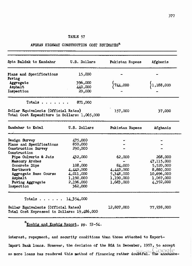
TABLE 57
AFGHAN HIGHWAY CONSTRUCTION COST ESTIMATESa
377
Spin Baldak to Kandahar U.S. Dollars Pakistan Rupees Afghanis
Plans and Specifications Paving Aggregate Asphalt Inspection
15,000
396,000 440,000 20,000
744,000 !1,188, 000
Totals 871,000
Dollar Equivalents (Official Rates) Total Cost Expenditure in Dollars: 1,065,000
157,000 37,000
Kandahar to Kabul U.S. Dollars Pakistan Rupees Afghanis
Design Survey 475,000 .
Plans and Specifications 850,000 - - Construction Survey 290,000 - - Construction Pipe Culverts & Juis 432,000 62,000 268,000 Masonry Arches - - 47,115,000 Concrete Dips 108,000 84,000 5,520,000 Earthwork 4,440,000 4,440,000 8,880,000 Aggregate Base Course 4,011,000 5,348,000 10,696,000 Asphalt 1,190,000 1,190,000 1,067,000 Paving Aggregate 2,196,000 1,683,000 4,392,000
Inspection 362,000
14,3 54,000
Dollar Equivalents (Official Rates) 12,807,000 77,938,000 Total Cost Expressed in Dollars: 19,486,000
a Koebie and Koebip; Reoort, Dp. 53-54.
interest, repayment, and security conditions than those attached to Export-
Import Bank loans. However, the decision of the RGA in December, 1957, to accept
no more loans has rendered this method of financing rather doubtful. The announce-

378
ment in July, 1958, of the signing of an Afghan-Pakistan Transit Compact
may mark the revival of interest in the plan which envisaged a customs-
free stone in Karachi harbor where Afghan imports could be unloaded from
ships, reloaded onto railway cars, and sealed for transportation through
Quetta to Chaman. At Spin Baldak a railway spur with unloading facilities
on the Afghan side of the border was to be built. These steps, plus |13
million worth of improvements to the Chaman branch of the North Western
Railway and the highway improvements from Spin Baldak to Kabul, as des-
cribed above, were to form Phase I of the transit program, at a total cost
of |27,884,000, 23,863,000 Pakistan Rupees, and 79,126,000 Afghanis, or
135,322,000 total at official rates, of which over 60 per cent would be
devoted to projects within Afghanistan.
Paving the Kabul-Torkham highway, widening the pavement on the
Kandahar-Kabul road to two lanes, and further improvements on the Chaman
branch of the North Western Railway and to Karachi Port were to be post-
poned to Phase II, the total oost of which was estimated at $24,771,000,
14*782,500 Pakistan Rupees, and 11,393,000 Afghanis, or a total cost of
$28,239,000 at official rates, of which over 70 per cent would be devoted
to improvements within Pakistan. We have indicated above that the Kabul-*
Torkham paving project has since been made the subject of a special, high-
priority project.
Improvements on the Indus River route of the North Western Railway,
leading to Peshawar ( and Landi Khana on the Afghan frontier), and unloading
facilities to replace those of Peshawar, though much desired by Pakistan
and Afghanistan, respectively, were not recommended, due to high estimated
costs. Extension of the railroad from Spin Baldak to Kandahar and later from
Kandahar to Kabul, determined to be feasible from the engineering polfifcOfc

379
view, was ruled out by the fact that it would cost an estimated
|OLl6,114.,000 for construction and equipment, or five times the cost
of improving the highway which would remain in direct competition.
Thus, the logic of the Koebig and Koebig study favors those who
have long maintained that Afghanistan can skip the railroad age altogether.
Certainly, in the absence of any known bulk minerals to export (see
Chapter VIII) it would be impossible to provide sufficient payloads for
return trips to Pakistan, and truck traffic can be improved to handle all
foreseeable imports. But the Koebig and Koebig study does far more than
justify future dependence upon road transportation in Afghanistan. It
proposes a program of development whereby Pakistan harbor and railroad
facilities would be improved to support a single main artery of trade for
Afghanistant the route by rail through Quetta and Chaman to Spin Baldak,
and then by road to Kandahar and on to Kabul. The alternate and presently
much more important route via Peshawar is not to be improved under this
program. The major reason given for this choice is the present and pro-
spective congestion of rail traffic on the "main line" of the North Western
Railway, which leads from Karachi to Multan and then divides, with one
branch going to Lahore and the other to Peshawar.
While it is perfectly correct that concentration of Afghan traffic
on the Quetta line (628 miles from Karachi to Chaman) would save about 25
per cent in the freight costs compared with use of the route via Peshawar
2 (971 miles from Karachi to Landi Khana), the total burden now placed
upon the North Western Railway by Afghan trade amounts to only some 107,574-
1Ibid., p. 113.
2Ibid., p. 74- C^r\r\n\o v Digitized by VJOOQLC
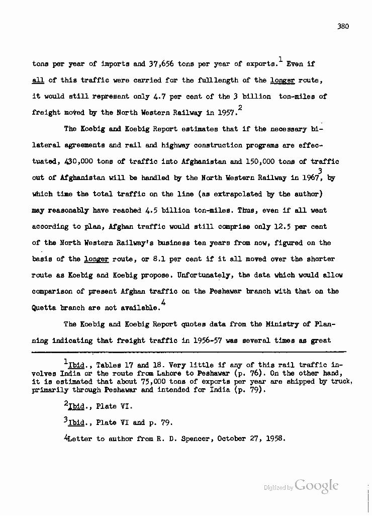
380
tons per year of imports and 37,656 tons per year of exports. Even if
all of this traffic were carried for the full length of the longer route,
it would still represent only 4*7 per cent of the 3 billion ton-miles of
2 freight moved by the North Western Railway in 1957.
The Eoebig and Eoebig Report estimates that if the necessary bi-
lateral agreements and rail and highway construction programs are effec-
tuated, 430,000 tons of traffic into Afghanistan and 150,000 tons of traffic
, 3 out of Afghanistan will be handled by the North Western Railway in 1967, by
which time the total traffic on the line (as extrapolated by the author)
may reasonably have reached 4-5 billion ton-miles. Thus, even if all went
according to plan, Afghan traffic would still comprise only 12.5 per cent
of the North Western Railway's business ten years from now, figured on the
basis of the longer route, or 8.1 per cent if it all moved over the shorter
route as Eoebig and Eoebig propose. Unfortunately, the data which would allow
comparison of present Afghan traffio on the Peshawar branch with that on the
A Quetta branch are not available.
The Eoebig and Eoebig Report quotes data from the Ministry of Plan-
ning indicating that freight traffic in 1956-57 was several times as great
^-Ibid., Tables 17 and 18. Very little if any of this rail traffic in- volves India or the route from Lahore to Peshawar (p. 76). On the other hand, it is estimated that about 75,000 tons of exports per year are shipped by truck, primarily through Peshawar and intended for India (p. 79).
2Ibid., Plate VI.
3Ibid.. Plate VI and p. 79.
^Letter to author from R. D. Spencer, October 27, 1958.
Digitized by Google
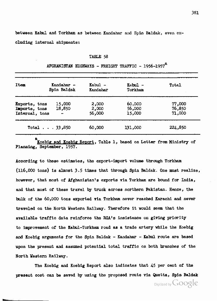
381
between Kabul and Torkham as between Kandahar and Spin Baldak, even ex-
cluding internal shipments:
TABLE 58
AFGHANISTAN HIGHWAYS - FREIGHT TRAFFIC - 1956-1957**
Item Kandahar - Spin Baldak
Kabul - Kandahar
Kabul - Torkham
Total
Exports, tons 15,000 Imports, tons 18,850 Internal, tons
2,000 2,000 56,000
60,000 56,000 15,000
77,000 76,850 71,000
Total . . . 33,850 60,000 131,000 224,850
a Koebig and Koebie Reoort. Table 1, based on Letter from Ministry of
Planning, September, 1957.
According to these estimates, the export-import volume through Torkham
(116,000 tons) is almost 3.5 times that through Spin Baldak. One must realize,
however, that most of Afghanistan's exports via Torkham are bound for India,
and that most of these travel by truck across northern Pakistan. Hence, the
bulk of the 60,000 tons exported via Torkham never reached Karachi and never
traveled on the North Western Railway. Therefore it would seem that the
available traffic data reinforce the RGA's insistence on giving priority
to improvement of the Kabul-Torkham road as a trade artery while the Koebig
and Koebig arguments for the Spin Baldak - Kandahar - Kabul route are based
upon the present and assumed potential total traffic on both branches of the
North Western Railway.
The Koebig and Koebig Report also Indicates that 45 per cent of the
present cost can be saved by using the proposed route via Quetta, Spin Baldak
Digitized by VJOOQIC

3S2
and the Kandahar-Kabul highway rather than the route via Peshawar:
TABLE 59
COMPARATIVE COSTS AND TRANSIT T3MF /f& R§7 SHIPMENT OF 2000 LBS. MERCHANDISE KARACHI TO KABUIT
Item Present Cost Through Unbonded Shipment via Pesh-
awar
Estimated Cost Through Transit Facilities via Spin
Baldak
Port of Karachi Handling, Inspection, etc. 56/8 Port Trust Dues (estimate) 50/0
Railway Charges To Peshawar 146/8 To Spin Baldak
Lorry - Peshawar to Kabul at Rs.700 175/0 for 4 tons or $.20 per ton-mile
Lorry - Spin Baldak to Kabul at $.04 per ton-mile
Border transfer Handling, Cooliage 45/0 Storage, Sealing, etc. 25/0 Clearing and Forwarding (estimate) 25/0
30/0 50/0
100/0
71/0
20/0 10/0 10/0
Totals: In Pakistan Rupees In U.S. Dollars
523/10 $110.00
291/0 $61.00
^oebig and Koebig Report, Table 7, p. 25 and p. 11.
Several questions arise from examination of this table. Could not the estimated
savings at the Port of Karachi Transit Facility apply whether the freight moves
forward via either Chaman or Peshawar? Although the North Western Railway is
1 apparently reluctant to furnish service beyond Peshawar, establishment of a
Letter to author from R.D. Spencer, October 27, 1958. Digitized by Google
383
bonded transfer facility there or at Landi Kotal or Torkham would seem
to offer the same savings estimated to accrue from such a facility at
Spin Baldak. Applying the estimated port and transfer facility savings
to the cost of shipment via Peshawar would reduce it by 81/8 rupees or
#17.16 at the official rate used in Table 59- Thus the ratio of costs
between the two routes would be reduced to $92.84- to $61.00
The major part of the remaining difference is accounted for by
the actual freight charges With respect to the railway freight, it is
clear that the advantage lies with the shorter route to Spin Baldak. But
trucking charges from Peshawar to Kabul (185 miles) will probably not
remain so high as #.20 per mile. With the Gorge Road improved and the
entire Kabul-Torkham road paved, trucking rates may be reduced almost
as much as those on the Kabul-Spin Baldak route. While the arduous nature
of the Upper Gorge section of the Kabul-Torkham route may mean that costs
per ton-mile will always remain higher than on the Kabul-Spin Baldak route,
where lower gradients will permit the use of larger trucks, the fact that
the Kabul-Torkham route is less than one-half as long as the Kabul-Spin
Baldak route is a permanent advantage to the former. And it has been es-
timated that, despite the use of smaller trucks, costs on the Kabul-Torkham
route may be brought as low as $.07 and even $.06 per mile. At these rates,
and making equal allowances for port and transfer facility savings, shipment
via Torkham would cost only $68.79 or $66.94 per ton in comparison with $61 00
for shipment via Spin Baldak.
If the cost of truck transportation on the Kabul-Spin Baldak route
•''Ibid.
Digitized by Google
3^4
can be brought as low as $.04. per ton-mile, then it will be cheaper to use
that route. In fact, even if both truck rates fell below $.0526 per ton-mile
it would pay to use the longer-road, shorter-rail haul (total 1003 miles)
via Spin Baldak rather than the longer-rail, shorter-road (total 1156
miles) haul via Peshawar, rail rates remaining unchanged. But the estimated
Phase I cost of improving the Kabul-Spin Baldak road as proposed in the
Koebig and Koebig Report (see Table 57) would amount to $20.551,000r or
an amount equal to $.988 for each ton-mile driven over this road in 1956-57
(see Table 58). The estimated $5,080,000 (see Table 56) coat of paving the
Kabul-Torkham road would represent only $.258 for each ton-mile driven in
1956-57. Finally, the Phase II widening of the Kabul-Kandahar road would
cost an additional $8,121,000, making the eventual cost $1,379 for each
ton-mile driven in 1956-57.
On this basis., it would take about 37 years for the savings involved
in using the Spin Baldak route (assuming $.04 per ton-mile there as against
$.07 on the Kabul-Torkham route) to repay the costs of improving it rather
than the route from Kabul to Torkham. Of course, such comparisons are vitiated
by the fact that traffic will undoubtedly increase on both routes in the
future, and more rapidly on the one which is first improved.
The Koebig and Koebig Report also states that 80 per cent of the
present transit time could be saved by using the Spin Baldak route with the
1 proposed facilities. It is quite true that freight shipped from Karachi to
2 Kabul via Peshawar may take from 7 to 17 weeks, but most of the delay is
incurred in Karachi Port or in trans-shipping to trucks at Peshawar. Since
Koebig and Koebig Report. Table 7.
Ibid., p. 11.

3o5
almost no freight is presently moved from Karachi to Kabul over the Spin
Baldak route, we have no figures for comparison purposes, but it would
seem that the time savings which might be realized will depend more upon
the transit facilities established and the relations prevailing between
Afghanistan and Pakistan than upon which route is selected. The same
applies to losses through spoilage, damage, loss and theft.
Economic considerations such as the preceding may account for the
RGA insistence that completion of the Kabul to Torkham highway be given
preference. Certainly, in the present condition of the Afghan economy and
of national finances, it must appear preferable to spend 7,383,000 Afghanis
and 3,803,000 Pakistan Rupees, while incurring a debt of only $4,048,000
to spending 79,126 000 Afghanis and 13,551,000 Pakistan Rupees and incurring
a debt of fcl.5,225,000.1
Furthermore, we have seen that the Kabul Region is economically
dependent upon the Kunduz rather than upon the Helmand for many of its raw
material needs. While the Helmand's economy is more similar to that of the
Kunduz rather than either of these is to that of Kabul, the Helmand is as
yet too undeveloped to supplant the Kunduz Region as Kabul's supplier of
such commodities as cotton and sugar, and is unlikely ever to be able to
supply it with coal or karakul. Therefore, it stands to reason that Kabul
can more easily allow the Helmand to develop its own economy in comparative
isolation, while seeking to strengthen its ties with the North, which has
always been, and continues to be, politically more vulnerable than the South.
Reasons of prestige tend to reinforce this political reasoning with
regard to transportation development. The Kabul-Torkham route, and partic-
1 ^ . If ICA decides to make a grant for either part ofDjtb^g bYvjhO©5P.os*'
to RGA will be reduced accordingly.

386
ularly its Gorge section, is identified as an Afghan Government project.
Not only the Ministry of Public Works but the entire Government must be
anxious to see this road completed and in regular use as evidence of what
they can accomplish on their own. Furthermore, since most of the visitors
who enter Afghanistan by land do so at Torkham, the propaganda value of a
proper continuation of the paved highway which ends at the Pakistan border
is evident.
Finally, and we shall want to consider this faotor further in
Chapter III, the system proposed by Koebig and Koebig would have the result
of maklng Kabul dependent upon transit through Kandahar, a position which
would be rejeoted by many Kabulese on historical grounds as well as those
of internal politics. The founder of the Afghan State, Ahmad Shah Durrani,
established its capital at Kandahar in 1747. His son moved it to Kabul for
Btrategio reasons, and at Kabul it has remained except for comparatively
brief periods. The feeling among the more influential Afghans in government
and business is that Kabul must remain the center of control in every possible
respect or run the danger of losing the North, either to Soviet subversion
or to a renascence of separatist tendencies all too evident in the past and
reinforced by ethnic differences. If the Kabul-Torkham route were allowed
to deteriorate, even relatively, to the advantage of the southern route,
there would be protests not only in the capital but in the Kunduz, Mazar-i-
Sharif, Maimana and Herat regions to the effect that the central government
was showing additional favoritism to the Helmand Region and allowing itself
to become an economic dependency of Kandahar.
So we may conclude that while the program of road development proposed
by Koebig and Koebig would advantage the Helmand Region, and perhaps the
Upper Kabul Valley as well, its chances of adoption by the Afghan Government

387
at this tine are slim indeed. It is far more likely that the ROA will pick
out the parte which appeal to its own desires, such as the transit arrange-
ments with Pakistan, the transit facilities at Karachi and Spin Baldak,
and perhaps the paving of the road from Spin Baldak to Kandahar, and let
the rest die on the yine. If this analysis is correct, then we may expect
Kabul to retain and enhanoe its function as the major entrepot, for im-
ports and exports, with Kandahar developing as a secondary center of
regional rather than national Importance.
In commodity terms, the Peshawar-Torkham-Kabul route will presumably
continue to be used for the bulk of Afghan imports as well as for exports
of fresh and dried fruits, nuts, skins and raw wool from the Upper Kabul
.Valley and of truck transported karakul pelts. In addition, ginned cotton
destined for Japan or countries of Western Europe will presumably oontinue
to use this route, while that intended for West Germany will ohoose be-
tween this route and that via the U.S.S.R. in accordance with prevailing
political conditions.
The Helmand Region is already feeling the effects of its superior
road network and connection with Chaman. Presumably these highways will oon-
tinue to aid the Region in importing building materials, coal and fuel oil,
and in exporting fresh and dried fruits, hides and skins and raw wool. As
we have seen, it is hoped to reduce the imports of sugar and leather and
to begin the export of ginned cotton and perhaps of citrus fruits from
this Region. The Helmand may eventually be able to add ginned cotton and
processed beet sugar to its present shipments of fruits and grain to the
Kabul Region, but unless same considerable improvements of the Kandahar-
Kabul road are made the South will have no great transportation advantage Digitized by VJOOQ LC
over the North except in winter.

338
In the meantime, and regardless of the final decision on implem-
enting the Koebig and Koebig proposals, ICA has put into effect a program
for Improving construction and maintenance work on the roads of southern
and eastern Afghanistan. Utilizing funds provided by the Riohards Mission
to the Middle East in early 1957, ICA promulgated Project Agreement 06-31-
009, signed on June 6, 1957, with the Afghan Ministry of Publio Works.
Under this agreement, ICA promised to provide a grant of $1 million for
technical support and #1 million as a loan for equipment and supplies,
including local costs, to secure the following objectivest
a) to provide the services of four road construction and maintenance
technicians to advise the Ministry in establishing a modern road organization)
b) introducing modern methods of surveying, design and specification!
c) establishing and operating a training program for engineers, equip-
ment operators, mechanios and administrators)
d) improving construction and maintenance activities on the Kabul to
Torkham and Kabul to Kandahar roads, later including other main roadsj
e) providing the necessary supplies and equipment for the preceding.
To implement this program, ICA promptly signed a contract with the
E.B. Steels Company whereby three highway engineers arrived in Kabul at the
end of August. After initial orientation and establishment of working relation-
ships with the Ministry of Public Works, the team was able to proceed with
its program for training young men in practical aspects of highway construc-
2 tion, including operation of equipment. A Technicians Training Course was
In files of United States Operations Mission (ICA), Kabul, Afghanistan. In addition to the $2 million from Richards Funds, #132,000 had previously been provided for the project.
United States Operations Mission to Afghanistan (ICA), Mission's Monthly Report. (T0ICA A-455) (Kabult November, 1957), pp. 4-5. (Hektographed.)
389
conducted from December 16, 1957 through February 27, 1958. A project
implementation order for #1,468,881 of road construction equipment was
1 prepared and forvarded to Washington in November, 1957. Subsequently,
Washington was requested to include a traveling asphalt plant to be used,
initially, to pave the 65 miles of road from Torkham to Jalalabad in ao-
2 cordance with EGA desires, for which surveys and estimates continued
through the month of January. Initial EGA disappointment that the Steele
Company engineers were not to be used as construction supervisors had
apparently been overcome by April, 1958, though difficulties with respect
to the establishment of a materials testing laboratory were still being
3 encountered. The team was called upon to help survey the rerouting of
the Gorge Road around the Naghlu dam-site, as it began to appear the
wishes of RGA in giving priority to the Kabul-Torkham section would be
implemented by ICA. With good reason in the author's opinion, ICA is
stressing not only construction of new roads but the maintenance of
existing arteries in order to prevent the rapid deterioration of both
roads and vehides (see below) under present operating conditions.
To this summary of prospects for improvement on the eastern and
southern sections of the road network, serving the Kabul and Helmand Valleys,
we must now add one relating to the northern seotions, the Charikar and
Kunduz Valleys and the Mazar-i-Sharif - Maimana extension, as defined for
Ibid., and United States Operations Mission to Afghanistan (ICA), Mission's Monthly Reports for February. March and April. 1958. p. 13.
^United States Operations Mission to Afghanistan (ICA), Mission's Monthly Report. (TOICA A-545) (Kabul* December, 1957), p. 5.(Hektographed.)
^United States Operations Mission to Afghanistan (ICA), Mission's Monthly Reports for February. March «nd Ap^l* 1958. pp. 10, 13-H* (Hekto- graphed.) Digitized by VJUVT

390
purposes of this study. In Chapters I and II we have Indicated the locations
1 of the prinoipal routes to the north of Kabul. Leaving the capital over
the low Khairkhana Pass, one continues on paved highway for about five
miles into the Charikar (Koh-i-Daman) Valley. The remainder of this north-
south road is being worked on by Afghan crews under Soviet engineers, who
have established an asphalt dump and mechanical aggregate separators in
a camp near Ehwaja Serai. A large stone-masonry bridge has been built
across the treacherous Shakar Darra wash, with smaller culverts over beds
of other streams draining from the Paghman Range towards the Panjshir River.
North of Charikar, the road turns west along the Ghorband River towards
the Shibar Pass. Except for bridge repairs very little recent work has
been done on this stretch and there are long sections with extremely bad
surface conditions. Alignment and grade could also be improved, especially
where the road bends sharply back into washes that could be bridged or
where it climbs abruptly onto terraces in order to avoid such curves. If
it were possible to locate and maintain some sections of this road on the
floodplain its length could be shortened at the same time that a higher
speed was rendered possible. As has been remarked, the engineering through
the Shibar Pass is quite good, and requires only widening of the road, es-
pecially on the hairpin turns, and Improvement of the surface.
Once over the pass the road descends more gradually towards the
Bamian Gorge. A short section of the road just before Bulola runs right
along the bed of a short stream which drains the western side of the pass
and is consequently impassable in flood times although a high stone dike
has been built to keep rubble off the road. This section must be rerouted
or raised above its present level.
After crossing the Bamian River vt.u of Bulola, the road turns north DiyilizuU Uy
•••For the place names which follow see Maps 2-5 in addition to Map 10.
391
along its left bank and enters the magnificent deep gorge which penetrates
the heart of the Hindu Kush. This is the section described as the Great
North Road, built on the initiative of King Nadir Shah in the 1930's. The
first Afghan motor road designed specifically for motor vehicles, it is a
marvelous feat of both engineering and simple hard work, and requires
only a better surface and some widening to adapt it for heavier traffic.
Improvement even as far as Ishpushta would considerably ease the bottle-
neck in bringing coal from the mine to Kabul, while the proposed route
to the Darra-i-Suf field would branch off at Doab along the valley of
the Surkhab.
From Doab to Doshi, the northern road is almost entirely neglected,
sometimes plowing through alluvial sands and sometimes twisting over rubble.
The road requires considerable re-alignment and, above all else, the re-
building of the roadbed with properly graded aggregates to support a smooth
surface, whether or not this is paved. Indeed, this road is like many others
in the country with respect to the many sections which cross alluvial fans
and are liable to washouts, and a paved surface would only increase the effort
and expense of repairs. Spraying the top aggregate layer with an asphalt
binder would, however, probably justify the expense if only by keeping dust
out of the travelers1 mouths and vehicles' carburetors.
Between Doshi and Pul-i-Khumri in the Qalagai area (see Chapter II)
reconstruction of the road is nearing completion. Under the direction of
Soviet engineers, and using Soviet materials and equipment, Afghan crews
have straightened, widened and resurfaced the road, building many culverts
and small bridges provided to carry it across deep washes on the enormous 0
alluvial fan. Whether these structures will prove sufficient for future
flash floods remains to be seen, but no one can deny that Rgis^ittus^effort

392
baa been made to tackle thl8 serioua problem on a highly important sec-
tion of the northern route. For it is just north of here, at Pul-i-Khumri,
that the roada from Mazar-i-Sharif and Kunduz join. Both of these routes
are being used for import8 from the Soviet Union, and Soviet engineera
are alao at work between Baghlan and Kunduz, and reportedly, between Kunduz
and Imam Saiyid on the Amu Darya. For the greater part of this distance,
the road follows the Kunduz River, either on the floodplain or on the low
terraces to the east of the stream. There is no need for realignment ex-
cept in a few sections where the road climbs abruptly over transverse lime-
stone ridges. At one of these points, Sintut, at the northern end of the
Baghlan node, the road has already been rerouted alongside the river to
connect with the new bridge. But this whole section from Pul-i-Khumrl to
Kunduz and on to the Amu Darya will have to receive a rebuilt surface before
it is fit for high-speed traffic.
The feeder routes out to Khanabad and Taliqan need the same treat-
ment with perhaps some realignment where the Taliqan road skirts the bluffs
north of the Khanabad River. The extension from Taliqan to Faizabad is in
particularly poor condition in all respects, but is not of sufficient economic
importance to justify a high priority in improvement. While the road from
Imam Saiyid to Pul-i-Khumri ia highly important for Soviet merchandise
moving along into Afghanistan, that from Khelif to Mazar-i-Sharif and on
to Pul-i-Khumri is the chief route for petroleum Imports. Petroleum moves
over this road in preference to that from Imam Saiyid because of the super-
iority of the unloading facilities on the Amu Darya at Khelif and because
Mazar-i-Sharif has a Soviet-built tank farm. The route ia not particularly
difficult although there are two or three low passes between Pul-i-Khumri
and Haibak. The remainder of the route liea across aemi-aridjiPfl^jna and
393
requires reconstruction rather than realignment or regrading. South of
Tashkurghan, this road passes through remarkable east-vest sedimentary
formations, in a splendid vertical gorge cut by a small, antecedent stream.
This gap was used by Alexander the Great and by Genghis Khan in their
invasions of Afghanistan, and should be all means be preserved for its
historic as well as geomorphic significance.
From Tashkurghan vest to Mazar-i-Sharif and beyond tovards Ehelif
and Shibarghan, the road follow the foot of alluvial fans sloping from
the hogbacks tovards the Amu Darya. Here again, only the surface requires
improvement, but that is enough of a job in itself especially as it is
complicated by many .1ui crossings under the road in the region around Mazar-
i-Sharif. West of Mazar-i-Sharif, the distributaries of the Balkh-Ab and
of the Ishkabad Canal may also require rabridging. It is only in the region
betveen Shibarghan and Maimana that soft desert sands beoome a real obstacle
since up to the former city the road is located on the firmer alluvial fans
or foot-hills slopes. But in the Andkhul region the foot-hills give place to
sand dunes, and vehicles easily become trapped in them. A short-out from
Shibarghan to Daulatabad avoids most of these traps, but it is poorly marked
and in many places amounts only to a trail across the desert. This region
vill eventually require rerouting, realignment and reconstruction of its
roads to fit into a modern highway system. At present, however, the traffic
diminishes greatly west of the Ehelif turnoff, and, as we have seen, the
karakul pelts which form the chief eoonomic product of the Maimana area are
fairly light, small in size and sufficiently valuable to be flown out from
Maimana to Kabul if need be.
The roads from Maimana to Herat and on the Farah and Glrishk need
not be described in detail as they lie outside our field of disoussion.
394
Generally speaking the former section compares with that from Kabul to
Pul-i-Khumri, with the Sabzak Kotal being a rough equivalent of the Shibar
Pass though in a more beautiful setting. Those who have made the journey
by road from Herat to Girishk (the present author flew) describe it as
similar to that from Kabul to Kandahar, with no steep grades or passes but
with considerable difficulties in crossing the Khash and Khuspas Rivers
in flood time. New bridges across the rivers are being completed by ACU
according to MKA standards and should greatly Improve transportation be-
tween the Herat region and the Helmand.
In summation, then, the Kunduz Valley and Mazar-i-Sharif - Malmana
extension may be regarded as comparatively well-favored for internal trans-
portation and for transit of goods to and from the Soviet Union, but not
for connection with the Kabul Valley. We have seen that in terms of com-
modity flow it is the topographical barrier between Ishpushta, Pul-i-Khumri,
Kar Kar, Baghlan and Kunduz, on the one. hand, and Kabul, Jabal Seraj and
Charikar on the other, that hampers the southward movement of coal, cotton
textiles, ginned cotton and sugar in sufficient amounts to sustain the Kabul
area's markets and new industries. The same is true of merchandise imported
via Kabul for sale in the North, and of Soviet goods imported for sale in
Kabul, of which gasoline, kerosene and fuel oil are the most important.
This problem might be solved by construction of the Salang Pass road and
tunnel, but it would seem more economical to improve the existing road to
the point where good speeds can be maintained by trucks. Snow removal equip-
ment would be necessary to keep either road open through the winter months.
Thus it may be said that the Kunduz Region is separated from Kabul
by a topographic barrier more formidable than the somewhat longer distance
Digitized by VJOOQLC
395
which separates Kabul from the Helmand Valley. Yet both because Kabul feels,
and has long felt, the Russian political challenge in the North, and be-
cause the economy of the Kunduz Region is complementary to that of Kabul,
both in supplying raw materials and exports which clear through the capital
and in utilizing items imported via Kabul, efforts such as that involved
in the Great North Road have been made to bind these regions together. Kabul
is playing a difficult game these days, trying to employ Soviet technical
and economic assistance to bind to it a region which is topographically
thrown towards the Amu Darya and which is, even now, being flooded with
Soviet goods. To the extent that the ginned cotton and fruits of northern
Afghanistan go directly to the U.S.S.R., Kabul is also losing control over
the economy of its northern provinces. But so long as the bulk of the ginned
cotton comes to Gulbahar, so long as the karakul must clear through Kabul,
and so long as the Kunduz Region finds its best market for sugar, cotton
textiles and surplus rice and wheat in the capital, the political and
economic ties of the North to Kabul will continue.
Selection, Standardization, and Maintenance of Equipment
We have just discussed the generally unsatisfactory condition of
Afghanistan's highways, particularly in the regions most promising for develop-
ment, together with the measures which are being undertaken to improve them.
A final aspect of the problem relates to the deleterious effect of these
conditions upon vehicles operated over Afghan roads, and to the efforts of
the RGA to select and maintain in operation the vehioles best suited for
operation under conditions which are certain to continue for several years
even in the areas now being improved. Today, it is estimated that the life
of a truck in Afghanistan is limited to 60,000 miles, or only a fraction of Digitized by VJOOQ LC
what its useful life could be under "normal" operating conditions. Wear and
396
tear on axles, springs and frames, abnormally great due to the surface
conditions of the roads, are aggravated by the tendency of Afghans severely
to overload their vehicles so that the maximum possible payload may be
handled on each slow and costly trip. It is a common practice to replace
the original springs of a new vehicle with heavy-duty springs to permit
this overloading, and the traveler often encounters parked trucks with
several hand-jacks set under them to relieve the springs of the load during
the non-operating period. Splayed wheels, trucks halted by loss of a wheel
or axle and spring failure are other common sights. The effects upon tires
are equally disastrous, it being estimated that only 25 per cent of those
ultimately discarded could possibly be recapped. New tires, euphemistically
recorded as "pneumatic rubber motor covers", figure large on the list of
imported manufactured goods, but do. not represent the heavy-duty articles
which ought to be employed for Afghan conditions.
To simplify repair parts, storage and repair procedures, the RGA
in 1954 decided to standardize on International Harvester trucks except
for Soviet- and Czech-built vehicles reoeived under Bloc credits and military
assistance. International Harvester has conducted an aggressive sales cam-
paign in Afghanistan for a number of years which, together with excellent
performance, paid off both in the 1954 standardization decision and in a
more recent stipulation by the RGA that 550 trucks supplied under an ICA
loan must be "proprietarily procured" from International Harvester. This
procedure provoked protests from General Motors, which recently announced that
its Chevrolet Division has developed a heavy axle truck especially suited for
11 1 •
United States Operations Mission to Afghanistan (ICA), Mission's Monthly Report for November. 1957. p. 5-
Digitized by Google
397
1 Afghan conditions. But at present perhaps 70 per cent of the operating
fleet in Afghanistan is composed of the 2500 International Harvester
2 trucks Imported since 1954> while most of the remaining 1000-odd com-
mercial vehicles consist of Zis, Praha and some old Chevrolet trucks. As
has been pointed out in Chapter I, all vehicles imported are handled through
Government Monopolies, which has now established a veil-stocked warehouse
for International Harvester spare parts with the assistance of the present
3 International Harvester resident representative in Kabul.
The Richards Mission also provided funds for the improvement of
Afghanistan's truck fleet. Under an agreement signed on June 27, 1957,
with the RGA Transportation Department, ICA agreed to grant #50,000 for
technical cooperation aspects of a program vhioh embodied a $2.4. million
dollar loan to:
a) provide assistance in improving the organization and management
of truck transport facilities}
b) purchase trucks and spare parts;
c) purchase imported building supplies, tools, equipment and materials
for construction and operation of motor vehicle repair and maintenance shops
in Kabul and Kandahar and one truck assembly plant at Kandahar}
d) provide on the same basis battery repair and rebuilding shops and
vulcanizing and recapping shops}
United States Operations Mission to Afghanistan (ICA), Mission's Monthly Reports for February. March and April. 1958. p. 14.
^Report of June 13, 1957, in ICA files, Kabul, Afghanistan.
3 Interview with Mr. Kenneth Milnes, International Harvester represen-
tative, at Government Monopolies, February 6, 1958.
^Project Agreement 06-39-048 in files of ICA, Kabul, Afghanistan.
Digitized by VJOOQLC

398
e) construct additional repair and service shops in provincial
centers as agreed in the future.
Of the $2.4. million loan, Richards Mission Funds comprised $2.2 million.
The loan was to be allocated as follows: $1.7 million for vehicles and
$700,000 for materials and equipment. It represented an underwriting by
the U.S. Government of part of the $5.5 million in orders which RGA had
previously placed with International Harvester. These included 100 tank
trucks (30x1500 gals., 60x2000 gals., and 10x2500 gals.), 200 10-ton truck
chassis and 700 8-ton truck chassis. 550 vehicles, including 30 petroleum
tank trucks, have so far been shipped by International Harvester under
this project, which assumes that RGA will pay all handling and trans-
portation costs from Karachi to Kabul or Kandahar. The present procedure
is to ship knocked-down truck chassis to Peshawar, where they are assem-
bled, and then to drive them up to Kabul where the truck or bus bodies
are added in the Jangalak workshop (see Chapter I). Under this ICA-agree-
ment, facilities for ohassis-assembly and body construction will be pro-
vided at Kandahar to handle components shipped by rail to Chaman and then,
presumably, on flat-bed trucks into Kandahar. The agreement also calls for
the construction and equipment of two new vehicle repair shops, one in
each of the aforementioned cities.
Until the end of 1957, it was hoped by ICA that a section of the
Jangalak plant would be made available for a repair shop. However, in Jan-
uary, 1958, the RGA decided to turn over the Jangalak space to the Soviets
for construction of a similar facility, while the Americans were relegated
to a site on the outskirts of the city where the private Afghan Motor Ser-
vice has a partially completed motor vehicle repair facility. This move has
made it necessary to increase the allocation for the Kabul workshop from

399
1350,000 to $400,000, while reducing that for Kandahar from #350,000 to
. 1 1300,000, It is hoped that most of the dollars can be reserved for the
purchase of equipment with RGA contributing local materials and labor. ICA
is to provide a specialist in motor vehicle maintenance and repair shop
management to this project.
Thus we may conclude with the observation that, in sharp contrast
to such projects as the Helmand Valley agricultural program, Arghandab power,
and the Kandahar Industrial District, ICA has moved with considerable alacrity
in the field of surface transportation. Of course, the real impetus to this
program came from the Richards Mission which cynical observers might have
considered a hasty and ill-advised attempt to "buy" friends in the Middle
East in the period following the Suez debacle and the promulgation of the
Eisenhower Doctrine. If such motivation figured in the Richards Mission goals,
the very definite snub involved in RGA's assignment of the Jangalak facility
for the Soviet vehicle repair shop indicates that it did not succeed in
Kabul. However, the rapid delivery of 550 new vehicles, including badly
needed petroleum trucks, the establishment of the two new vehicle repair
facilities, and the rapid furnishing of badly needed technical and advisory
services to the Ministry of Public Works may prove in the long run to be
well-considered methods of rendering the Afghan economy more viable and hence,
presumably, less dependent upon Soviet assistance and less prone to seek
violent means of readjustment.
Such speculations will be continued and developed in the following
chapter, but it Bhould be emphasized here, at the close of this seotion on
transportation, that the possibilities of constructive contribution to develop-
•MJnited States Operations Mission to Afghanistan (ICA), Mission's Monthly Report for January, 1958 (T0ICA A-629, January, 1958) (Kabul, 1958), p. 6 (Hektographed.) and United States Operations Mission to Afghanistan, Mission'e Monthly Reports for February. March and April. 1958. p. 10.
400
ment are particularly great in this field where comparatively small invest-
ments may have inordinate effects upon the nature and direction of trade.
This fact is illustrated by the Koebig and Koebig proposal which would, if
carried into effect, substantially advantage the Helmand-Kandahar region over
that of Kabul and, by extension, over northern Afghanistan. However, the
proposal might ultimately defeat its own implicit ends, for by weakening
Kabul at the expense of Kandahar it would weaken Kabul's control over the
North, and throw the northern provinces even more heavily into dependence
upon Soviet imports and Soviet markets. So long as some goods from Kabul,
whether manufactured in Gulbahar, e.g., or imported from Peshawar, reach
the northern bazars, the hold of Soviet goods will not become exclusive. But
if the hold of the capital is weakened to the point where Kabul, itself,
becomes dependent upon Kandahar, then the traditional balance will be broken
and the North, perforce, left to direct its trade across the Amu frontier.
In Table 60 regional conditions in road transportation are compared,
and in Table 6l these advantages and disadvantages along with those in power
(Table 55) are superimposed upon those listed in Table 60 for production of
each of the key commodities in this study.
Digitized by Google

401
§ •< +?
ss
M
w
o W El
•n
2
« g
N
X I
N
SB &
jS ! *> TJ
•g « t, a 3 2 ,-j 3 -H JS
d "5. •*• QJ i-a qo o> rac d xi rH
„j q
IV i « t, a> o I C £ rH O
a3£ 5 3 Q-H o
*H o
Vi p h -H « o o ** to (XO -H
l-t ^3
n J3 a o & H t>. a
F O -P iH
o n a
n xi •&
8?
§1 •P a
a o
3 -3 ia
O Qffl
o TJ u «
+> a o
§1 I n 3 n I «H ^ -H
rH T* -tP V3 -P
B rH O •H T3 tH TJ
a p, a> H o a IIH9 O f-i &T
H HA a a cd M +> -H (>.-H o h H a o q o n TI " J -r} C *H -n 3d
§ -3
£ P.
&3a •rt +> tj iH
•s-s sg r-l XJ O l»
o o « d L o o
Hi H HA d xj «
m d -a
> n o +> a « .8-S"3 _ M «
o o » :^& q • a o H a
•H g o
O O +> e « -H
a
"II +3 a o 3 H » a
•p aj an £ e a t>. •p o M o o -rt H +> P. bo d
von
3 o 8 o CQ q o
q 8 o o o 0) xl no 3 I) J (, o
a in k, 3&
?3s. 5 o b -H CUr-l 5 XI
q d • o o >-> H « -a
-P o J> d *i ,H
8 S^fi q & q +» « on o o qvi-H o o A d o +> -a
O Jo *> I t> o <d t, ^H •
O a) 0 -o
5 qig'Sa^
+j xi on « C «H -rt «- fl d o +> 'O
a
n -P __ . „ M T3 a) 3 0.0 V OH
o h >• ffl H L, O U •. 1 (d
-J3^ i/ ii, ti fi, +3 a> a
cd q ed m H li •( < J 3 V
"3
5
q I bp I o q x; u
-O "O -rt +> -rt n >H o > *H n 0 hoolm 9 •d *• h ^ * •rt d R. t>. •> OS H Brtt> •rt I 3 rt T) 0)
a eg
w 3 doc] t. CO +J
H I O h a to d d o 3 s I .
nS-a^S^s- god
3jj a1 <r XI *d *rt *4 XI
O -rt POA 0
•I -a Olid O t» 01 B. o y
q k.3
a> co i U -H (
a •a •a •H O O > U h m Q oo can
P
o 3 q P q J 3H
o !o 'd onto
qua) O rH
sis TJ O
O TJ •I C b
^q^ o o
2Sl 3s
3S £
C, (d ^1
01
q +> •rt 8 o 3 8
o o d ^ o o box, 53 P.-
i 3 S. 1
b f
ixj p.^ A -o 3 t, 3 «j « e
5 C» CM X* +> +» x> V
o^Sn^&g
vg ti o h o & § *3 « S f g
+> 3 « x> e a 0 „ a o X>
1 o
u o u _ .. o on
a O -rt -rt E -rt
8 TJ 3 3
XI o
1 ! Digitized by Coogle

TUU 61
CXMNJUTIVI MQIOIU. ADVAMTACKfl TOR IRODOCTKW UT KKY 0(M«X)1TIU 1HCUD1HO FWOt AND IKAhSPUfiTATlLM CONSIWtWUM
I 1 I 1 I IfpfWT B*»ln
• « 0 I 0 • I u a D o t h E C I 0 • Valley Proper H.i-iT -Malmeno
ellent conditions Ri]>nii3l' t. <T irrigated gr. Wth but n.> large u-« la .r.MMiod by a
inikM! „| irrigated luck of c-.jlt.l ^<-i • 1 lkcly due to hifh probnbiy by « 1-uk -*f Hal coal*. B»at io- water a* well Area will «d >u*ea with reaped Continue to supply Ha «ilstli>r proouaelng glrj.ed colL-n t^ Pu)-1- llHlaa md fur til. Khumrl ainl for export to ta t. <T via the er via the Sorltl Union. let Union
H I L H i 1 D Arghai,dab AT**
I I 0 1 0 « hulmend ATM
Large-scale cultivation excluded by climate end by competition of food oropa for 1*/J Ginned notion can be brought to new Oulbahar Bill from Kundus Region al- tbouch routs ne«ds Im- provement . Short-run power shortage possible.
L*rc"-a«.ni» <--ulllvatlon excluded by <.«(--! ill n of i-thtr cr \ a «Kich as rloe and eugtr cu^, Area con VMII/ bo ap- plied with lap*>rted cot- ton ploce r^ode frtm Vest Pakistan, *i»i Ultr with x «Ja Miifictur<Hi at Gulbahar.
IV-al potential «roa for oottnn aultl*%tlon. U-.ter, Ui*] end l«.l»r itrn Hvullebl*. Teet », I i.i.Ur.ua indicate ou'tnblilty of region for gr will nf ooiti.f. K.'n'..'n ne>*de cash crops. Sufficient hydr'Wt'Clrlclly available In near ruturo Tor flea, later for kill. Ration la wull-altueted for exports rla Pakistan and could alao supply part or Oulbahar's needa, na|x.clnlly If transport between Kandahar and Kabul la improved ae propoeed by Koeblg * Koeblg.
Sugar can* Is excluded by climate, auger beet a by competition of food oropa for land. Area will con- tinue to Import Hi sugar needs froa other rafloni or from Pakistan.
Short growing season and two diseases make larro- SC&le cune supply problem- atical Fucli>ry now In e»- p«r laei.tal ,>p*ratl,>n la obsolete. Iran would bar* to ctaipota with sugar Im- ported from p*al.awer with no ar^at Iranapnrlatlnnal adTantagei towarda Kabul.
Kxcwllrnt oomllt K'J.i Fur augar bant growth, but crop auiat cjapoUj With whoat and ott—i for 1BI4, watar, labor. Baghlnn factory could double lta SS.OuO-ton capacity If aaaurod of •upply. Kar Kar oo«l Is aapla for raflnary but truiaport to KaUU poor.
Nv proaoot jj-dductl'Ki alucr ttw-ra ii ni pro- C aslng plant airi no da- Band for beats Araa cat) ba au|<pll4*J althar froa Bnahlan >>T by lap<Tta froa II.33.H. No aarloua traiiaport obatncl»a and 1 lit la proapact of l^cal au(ar production datjalop- Uu| In futura.
Barring a lar(a-acal» davalop»ant of tha Jbindua Vxllay, thla Rajlon haa thw baat potential for augur baal cultivation. Uator, Ural and labor nr« avallabla. Trlali Indicate that augar baati d>' wall, and they fit Into a daalrabla rotation pqtlurn. Ragl.>n »a<-da caah oropa. la too raajota t> be auppllad frua Kundua. O-JW laporta augar. Power potential for raflnary la good, but fttnl wiiull hava to ba brought In unlasa prooasa wars completely alactrlflad. hagloo's frult-prooaaa- lng lnduatry anaurai looal axpandlng aarkat.
CITRUS Cllaatloally axcludad, but Only praaa.it araa of pri- pavlng of Oorga Riad should duct.on but ri(uiii,i, la
ntUlTfl facllltete Import of wall- haaparad by dla<">a* and paakad fruit froa Jalalabad- eoapatltlon uf cthur oropa.
Cllantlcnlly axcludad by low wlntar teafjoruturas. Cor.eiderabl* lmprovav-nt In Intfttnol tranaporte- ll on wilt ba nacaaaary bnfira thla R«gl>n cv. af- ford to Import oltrua from Jalalabad Oniila
Climatically favtrabla, with sufflclaot land, witar and labor uvuiiablo. Expurlaontal piant- in^a havr baan amd- and should bo auccassful at laast In Shamalnn, Darwashan and Choianaur araaa.
DCCI0U0U8 froblaa Is not ona of In- FrcbUaia are slalLar to PKUITfl eraasad production but of thoaa of Uppar Basin. Area
AMI) dlaaaaa and quality control not as important In decId- •UTS with batter handling and uous production as In olt-
paoklng- Araa u»<*od In ax- rua, but lta l»riduoua ports to Pakistan and India, fruite '.M nuia 'J-e aora Paving of Oorga Road will oonr^nlot.tly Icatod for facilitate transportation, axp«n to Pakistan. India, raduoa daaaga to fruit In than nra thosa of Upper shipment. Kabul basin.
Ineulflclant 1nfurmat1on la available on status of thla IrJuatry In th« k.rth. Proauaably ouuld laprovo nunllty of lta exporLs to UiS.S R Sl.lpa ofily nuts to Kabul K«*glon «/«d them preatott no graat problaas of packaging and transport.
first-ranking fruit «n(Hj-iing rsgloti with •xc< ilent aarkat In ^>klata^. Naods includa dlaoaso 'ittd quality con- trol, belter packing aid parhnpa rafTigara- llon L'>cal Industry has lnggvd In taking advnntngv of domeatlo and furalgn aarkata Pouar, road* axoallent.
Itiiasiir taaparatoraa aay bo axoasalra for aoma varlatlvs, but If n— porlmantal plantings ara auocaoaful area of- fara greatest potential for axpanslon of decid- uous fruit prodmotlon. Klnotrlo poinr aaaured for prooaaslng needs. Road system axcellaot If properly aalntelnad.
CATTLI Only area with a aodarn HIDI3 tannery capable or large- AND aoale produotlon- Oapaolty
LtATKaa of 120,000 hides par year Is only 1/10 to l/o util- ised due to poor collect- ing system and leak of ln- oentlvs for farmers to preserve sad sell hides.
Improvement of tranaporl links with Kabul should permit sals of area's hide* for proooaelng there, but proatally to Pakistan Bay result In contlnuod rail' anca upon Imported leather add leather goods unl*-ss Kabul prices are reduced.
•faaent demands aat by small, local tanneries ualttg crude tarhnlquoe and vegelablu rcrtgi-nls, and by Imports of ata-amm leather aiil Leather goods- Roglun could support on* or sort lnrge- scnle mndnrn tennertoa If Incontlw imd oollfC- tlon problams nra solved. KunJus Vallay would h>va sufficient cicClrlclty ajtd coal to su|>p<'«"t' such a tannery, ualn^ olwelcala lap-irted frtai th« U.S.3.R. or West Gerauuiy. keglofi ur^l»ubtedly has Large but untappud hide raauuroes.
Preaont deaands aat largely by lmporta of chroma leathrr and leather goods from Pakistan. Kanda- har bnier haa largr cobbler and harness section. Kanduhar lnduatrial Dietrlcl will Includa a SWAI- orn tannary. Klocttlc power will soon ba aaaured. nnd If pasture-aooiioay is adopted In eoaa of li'la/ind areas the supply of superior hides car. probably ba greatly Improved. Transportation s/atoa Is adequate to facllltete collection of hides through Improved organisation.
SHB* Kabul tannery could pro- AMD cess bOl aora skins for
QOAT both domestic use and ax- SKIMS port of a higher-quality
product- Supply problums •taller to those of cattle hides but potential even greater onoa organised.
Improvement of tranaport Should allow better col- lection and export of sup- erior skins. Shipment to Kabul for tanning ttardly economic bul a oor.trul tannery could be estnb- llahad In Jalalabad.
Kxtenslon of the oooperaltve hnr-Jllng karakul oould IBAJT -V tity or skins collected for ( liti.nerlta or In 1 JC»! liuintil'u witli laprovod a>'thoda ind materials. Pr..bl.-ma oi nn.aitl health ar.l nourlahaunt similar to Lli»u of kM-akul (>••• l«iw). TranapoTl no serious |in>blue u« aklnu no compacl IUKI unbr*",kablo, but Ircnritiv" w.l qual- ity control problums must be s^lv.-d flrot.
TP'uilsalloiiS itow Several feature oomblne to give Region excellent qunlIty and quon- pr..specis in skinsI Irrigated pastures on It* easing In central new Project lands, plus Intensified wan of these
1>UH1S by nomads with their large Hooka could grr-nlly InaToaSu aupplleS| proposed Kandahar tan- nery w.«ld process sk nsj good roevla offer eaay colltctK.i, and ex]«rt of MJ'te, preferably after tinning t>t Kudahar or In local but modernised taraiorlaa.
•o looal production. Kabul sarvaa as the col- lecting and olearing center for exports. ROA has broken Bank-1-Mtllle monopoly on export finan- cing by establishment of the Karakul Cooperative.
N" locd production. Improvemt-nt of tn« Knbul- Tnrkhnm road will make 11 easier to trojisport kara- kul from the wnrohouses In Kabul to the ratlhtad at Poehnwar, but some skins may oontlnue to ba flown abroad..
This Is the tradltl"nal nM w 11 --.i-' - I l ial.•-! glon -(' karakul pr<jductl>>i>, »u«J h I . .ml '» •, b- dlcpliioad by any "tlM-r In Afgl. i.l r."..«. I" '• ..rdor to meet forelgi. omipatlt ion In- knrrul lualry. with II- Ittlp >T i^-wly -I'IIL- bi lul« i '-• eratlvea auat da vote ln<-r»i,eir.# »:i i.-nt .. i. t- rangv fneU ud water roquIr.-fcniitB ns Wll "i vfL*Tlnory unro and lapn-vi-d br<vding jmrl.. LVvnlupment of new color strains ID nr»a.ijin* Skin tanning a/d grnding tie.Kls ltUmtK.i.. ho particular tranaportatlon probU-as involv-d.
M-> present produotlon nor reel likelihood of fuiurt- development of karakul breeding bocauaa Region lacks propor graslng vegetation as well „» Iterdaaati familiar with karakul raising, fell the local broods of broadtail abeop, providing pi-lta for export, as well as wool, need the aajsa nltontion to r*tadt water, health and breeding aa do tto karakul. HVA and 1CA axtenslou programs nra •isaantlul to assist nardars and sot Liars In providing suoh attention.
Kabul la the center of a good "woolshod" extending back Into the surrounding mountains. As usual, col- lecting facilities need lm prorement. and the Wool Im- porting Company has bean established to promote It. The hQA woolen alll la very obsolete and needs replaoe- ment of Its equipment and wool alaanlng faolllllaa.
Mot auch Information is available on wool produc- tion In the Jalalabad 0a- sls- Presumably cllmntx Is not conducive to Itoi.vy fleeco. Tru- Kabul-TiTklwia road provides a good ex- port route, but any locnl
uyool expiirted Is probably not cleaned, sorted or Uilod rurj sallsfaotorliy
B>cauon of tin- prodimtijince of kiirakul sh»cp In thin hugl.i>, there Is c-Aparallvely lllll.- pro- ducti.m ',f WCK.1 as such, alihough Lhe anturn knr- »ikul rua*.lDa «re shorn. Host of tho pr'-ducti.)r goos Iriio o.ttugc lmlustry for wvnvlikR •>!' oonrea cl.th aid Mo* curpete. Tharr- la no w. ..Iwn m'll In the korth and proapocta for eaUbllnhli^ ono Cinnnt be evnluato.1 on the basts of lh» 1 I• 1 t*«d Information avallnbla.
Ihla reglnn probably produces and markets more w.ui than any of the others, but a large part .f it la exporled, nn the hoof or otherwise, by
tveukdlc herders- With the adoption of an Irrl- (f'llrtd nfislura oooiitsxy tn the Hulaajid, produc- 11 >n could tio increased and organ lied so that a-ma uf the clip ooaes onto the dtawatlc market, Cluanlng and grading facilities need much lm- pr»voeent and this should ba done In conjunction with «nliu-gement of the woolen mill at Kandahar. Sufflolent slectrlo power will bo avallabla and roads for collodion and uaport are good.
Digitized by Google

403
III. THE THREE REGIONS AND THE NATIONAL ECONOMY OF AFGHANISTAN
The National Economic Situation
The regional description in Chapters I through VII and the
economic-geographic analysis of Chapters VIII through II have served, it
is hoped, to indicate to the reader the lines along which the Afghan economy
may reasonably be expected to develop. It should also be clear that certain
lines of development are pretty well foreclosed, at least in the present
state of knowledge of Afghanistan's resources. Thus, mineralogical develop-
ment will be limited to coal mining and perhaps petroleum extraction pending
the discovery of ores in sufficient quantity and quality to overcome trans-
portation handicaps and claim a place on the world market. At present, the
world market is not sufficiently interested in the quantity and types of
ores and gems which remote Afghanistan offers for any great reliance to be
placed thereon. Indeed, there are only a handful of Afghan products which
do seriously interest the world market, and these are all either agricul-
tural or pastoral products such as cotton, wool, fresh and dried fruits,
karakul furs and carpets made from wool. We have pointed out that these
products can continue to command foreign markets only if their quality is
raised and grading and marketing practices improved. Thus, for Afghanistan
to be able to finance any of her own development, she must concentrate on
improving exports in order to maintain and enlarge their foreign exchange
earning capacity in the face of competition, and at the same time reduce
non-essential imports.

404
Fcr several years following World War II, Afghanistan was able
to finance capital development ty means of dollar earnings built up prin-
cipally from karakul marketing. Those reserves are now practically ex-
hausted, while Afghanistan has borrowed, or agreed to borrow, foreign
capital as is shown in Table 62 following to continue her developmental
efforts.
While Afghanistan's net foreign exchange holdings fell to minus
#571,700 for fiscal year 1953-54* and were only plus $291,300 at the end
of fiscal year 1955-56, the nation's precious metal reserves remained con-
stant at 149,686,100 over this period and have not yet been touched. By
Afghan law the sum of foreign exchange holdings plus precious metal re-
serves must constitute 30 per cent of the value of bank notes issued, and
since the State Bank (Da Afghanistan Bank) calculates its reserves at the
gold parity rate of 16.8 Afghanis to the dollar, the lowest and hence the
most conservative of several official exchange rates, there was, in August,
1956, room for a 40 per cent expansion of the 1,993 million Afghani notes in
circulation. The sizeable inflation of the Afghani which has accompanied
note issue in recent years, however, was reflected in the declining pur-
chasing power of the Afghani and had a considerable influence upon the RGA
decision, at the end of 1957, to accept no more foreign loans. In this res-
pect, see Table 63.
^udor Report, p. 163.
Digitized by VJOOQLC

4* CO
° I <D R
»n P ©
St to m 0} ON H H
•* •*
1 1 O o
•P p o o
o o
3°
o
O
CO
in
r CO
s
»n o* O^m
H • S3
-p ^s a o, a> T*
13
$* §1 *
m p o*
I Q I -* O - ir\ 4i in j
o
ca
H
o o o cvi
3 $1 a to
HI
a>
P o
3 I a a E *!
m
to a
in
3 o
1
sO
•a) M
1' O CO
•rl • •SB
S CO • 03
13
^ ^
q
o o
CO
CO
8
405
in in H
£ Digi
p o H
zed b' Google

I
I B
6
«H m o © <D a
3Q
> <D
p£
r< a>
3
lb p a>
A 8
I 1
CM
c3 XI 0) o
o o a CM
Ifcl XI
a a a m a ^j 5^ *a *a *a in o o
vO ->* C» CN. O C\
a
CO
a
CM in
m m • • en -*
O c*> *>* m so in iri «\ v\ lf\ 0N Q\ 0\ 0\ 0\ H H H H H
vO 8i £
O 3 O CD t-» O •-» SZ! fe
ana
3 3 3
CM CO
I 3 o s
to
i-4
Horn 5 t o CM \D \0
H H
m
in in
> in
in in ON
a a
sO in
m
23
3 1 3 3 3
S
3 in
CM
J XI H o LA •»
|«
I' •£>
•H 5 &J) m p
CM in
£ 4 £ U 4 4 4
NO NO m m ON o
8
IP S
co a
o o
in
t> in
o CM
CD
CM in
II II
4 4
fc O
in
p o O
S3 o • m in
II
CO in cr
o3 XI
CD
406
9 p CO
•H
I 2
& CO
I CO
o cd p p ->»
8 o W
.& p o -p
3 15
3
bso
O P<
4 P
is g
O CO
gitioed Google

407
A further indication of the inflationary trend in recent years is
provided by the cost of living indices prepared by the Economic Attache Office
of the United States Embassy in Kabul.
TABLE 64.
COST OF LIVING IH KABUL (Indices from 1955-57)
Item 12A5/55 5/7/56 llA/56 2/16/57 4/20/57 6/5/57
Flour 100.0 10^.5 159.1 154-5 140.9 163.6 Roghan (Sheep Fat) 100.0 94-0 102.7 106.4 145.7 150.2 Mutton 100.0 150.0 137.5 187.5 200.0 175.0 Rice 100.0 100.0 145.0 137.5 137.5 130.0 Sugar 100.0 100.0 124.1 124.1 111.1 111.1
Fruita 100.0 152.0 63.5 110.5 279.4 300.0 Vegetablesa 100.0 100.0 90.0 115.8 2a.2 176.4a
Eggs 100.0 68.6 125.0 125.0 125.0 125.0 Tea 100.0 91.7 91.7 91.7 100.0 91.7 Spices 100.0 91.5 243.7 111.5 114.1 129.6
Nanb n.a. n.a. n.a. n.a. 100.0 100.0b
Wood 100.0 111.1 122.2 155.5 155.6 155.5 Charcoal 100.0 100.0 120.0 130.0 129.0 120.0 Eleotricity° 100.0 100.0 100.0 100.0 100.0 100.0 Clothes 100.0 102.3 90.1 83.8 73.1 76.3
Rent 100.0 100.0 168.8 239.9 320.0 320.0 Miscellaneous 100.0 100.0 100.0 100.0 100.0 100.0
Combined Index weighted according to middle class spending habitslOO.O 104.2 130.8 153.6 184.3 182.6
Seasonal variations present.
T'ixed price.
While this index is compiled for the purpose of calculating oost-of-living
allowances for Foreign Service personnel, and is therefore weighted according Digitized by VJUUVK
to middle class or white-collar spending habits, it does serve to indicate the

408
rapid rJse in the ccst of such ba3ic commodities as flour, mutton, roghan,
eggs, fruit and vegetables. Increases in rent, wood and charcoal,, on the
other hand, have far less influence upon the general population whose
standards of housing and fuel consumption are far below those of the middle
class or foreign community.
The inflationary effect is, of course, characteristic of the early
stages of economic development, wherein incomes of laborers rise before
additional consumption goods, made possible by capital investment in in-
dustry or agriculture, come into being. For example, the construction of
the cotton textile factory at Gulbahar has contributed to employment and
wage-income since 1953, but its cotton piece goods began to become available
only in 1958. The presence of an increasingly large foreign community in
Kabul may also have something to do with this rise in prices to the ex-
tent that this higher-income group is bidding against the local populace
for some items. However, one suspects that most Kabuli merchants fit their
prices, exoept on controlled items, to their customer's presumed ability to
pay, another factor tending to exaggerate the implications of the above in-
dices. But when these indioes, for all their limitations, are considered in
conjunction with the currency and valuation data in Table 63, little doubt
remains that a considerable inflation has occurred.
In the Helmand Region, where the irrigation projects should eventually
increase the output and hence lower the price of grains, fruit and vegetables,
the immediate effect of the added employment of construction workers, drivers
and auxiliary services was similar to that around Kabul. The building of the
Kandahar International Airport, the Kandahar Industrial District and the in-
stallation of Arghandab power are likely to keep incomes and demand ahead of
Digitized by VJOOQLC
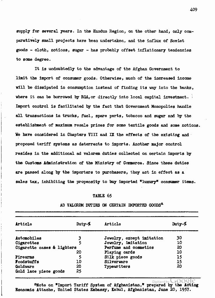
409
supply for several years. In the Kunduz Region, on the other hand, only com-
paratively small projects have been undertaken, and the influx of Soviet
goods - cloth, notions, sugar - has probably offset inflationary tendencies
to same degree.
It is undoubtedly to the advantage of the Afghan Government to
limit the import of consumer goods. Otherwise, much of the increased income
will be dissipated in consumption instead of finding its way into the banks,
where it can be borrowed by RGA,or directly into local capital investment. :
Import control is facilitated by the fact that Government Monopolies handle
all transactions in trucks, fuel, spare parts, tobacco and sugar and by the
establishment of maximum resale prices for some textile goods and some notions.
We have considered in Chapters VIII and II the effects of the existing and
proposed tariff systems as deterrents to imports. Another major control
resides in the additional ad valorem duties collected on certain imports by
the Customs Administration of the Ministry of Commerce. Since these duties
are passed along by the importers to purchasers, they act in effect as a
sales tax, inhibiting the propensity to buy Imported "luxury" consumer items.
TABLE 65
AD VALOREM DUTIES ON CERTAIN IMPORTED G00DSa
Article Tfo.tj-% Article Da.tj-%
Automobiles 3 Cigarettes 5 Cigarette cases & lighters
20 Firearms 5 Foodstuffs 10 Qoldware 20 Gold lace piece goods 25
Jewelry, except imitation 30 Jewelry, imitation 10 Perfume and cosmetics 20 Playing cards 10 Silk piece goods 15 Silverware 15 Typewriters 20
Digitized by LJOOQLC aNote on "Import Tariff System of Afghanistan," prepared by the Acting
Eoonomlo Attache, United States Embassy, Kabul, Afghanistan, June 20, 1957.

410
The Inhibiting effect of regular tariffs and special ad valorem
duties upon imports of consumer goods is augmented by the policy of valuing
the goods at three different exchange rates according to their ultimate des-
tination. Goods intended for RGA use are valued at a rate of 20.25 Afghanis
to the dollar; those for developmental purposes at 32 Afghanis per dollarj
and those for ordinary consumers at the free market rate which in 1958 was
approximately 55 Afghanis to the dollar.
The use of a multiple exchange rate for currency transactions serves
as a third mechanism for controlling imports on non-essential goods and for
assuring to the RGA a certain share of all foreign exchange received in pay-
ment for Afghan exports. For example, karakul exporters are required to sell
all of their foreign exchange receipts to the State Bank as follows: 60 per
cent at the rate of 20 Afghanis per dollar and 20 per cent at the rate of
28 Afghanis per dollar. For exporters of cotton and wool, the ratio is re-
versed: 20 per cent of foreign exchange receipts are bought at 20 Afghanis
per dollar and 80 per cent at 28 Afghanis per dollar, evidently on the pre-
mise that more stimulation is needed here than for karakul exports.
The RGA buys all foreign exchange received by its diplomatic repre-
sentatives abroad at the 21 Afghani per dollar rate, and requires foreigners
working in Afghanistan on RGA contract to accept 30 per cent of their salaries
at the 16.8 Afghani per dollar rate. Foreign exchange received for other ex-
ports, for services of Afghans abroad or from the foreign community and
tourists in Afghanistan may be sold on the free market or used by its hold-
ers to buy additional imports. But since the bulk of hard foreign exchange
(dollars, sterling, marks, Swiss francs) is obtained from karakul, wool and
cotton exports, the RGA is in a good position to control the nature and quan-
tity of most imports. This control is effectuated by the use of two different

411
rates In State Bank sales of foreign currency to would-be importers. Thus,
dollars are made available at 20.25 Afghanis for Imports of sugar, petroleum
and lubricating oils, of equipment for Government development projects and
budgetary items, for buying gold, or for expenses of Afghan students abroad,
while importers of vehicles and parts (including Government Monopolies), of
industrial and textile goods, and local government agencies and Afghans going
abroad for medical care can buy dollars at 32.35 Afghanis each. Importers of
other goods, considered non-essential, are left to buy their dollars at the
free market rate, somewhat higher than the 55 Afghanis paid for dollars.
Controls over foreign exchange and imports form a major and neces-
sary part of the RGA's efforts not to be cheated by inflation and profiteering
out of the gains it has a right to expect from its investment and borrowing
programs. At the same time, it must increasingly be realized in Kabul that
the principal benefits to be achieved by planned development will come from
a re-oriented national economy with Its emphasis upon production and export
of those commodities in which Afghanistan has and can maintain a comparative
advantage combined with a progressive reduction in imports of goods which
Afghanistan can provide for herself. A large portion of this study has been
devoted to demonstrating that these comparative advantages lie in agricultural
and pastoral commodities and in increased domestic processing thereof, util-
izing known resources of coal and hydroelectric power. Before proceeding" to
an analysis of the non-economic factors involved in a decision to move along
the lines indicated, it is well to note that the estimated foreign exchange
savings on imports of cotton piece goods and sugar alone could amount to
almost eight times the foreign exchange reserves of Afghanistan in 1954-55,
the best of recent years, which were 26,475,120 Afghanis or $1,575,900 at
iTudor Report. p. 163. There would, of course, be some foreign ex- change expenditures for the capital goods, fuel and incidental raw iLaterials needed to raise and maintain domestic production capacity at the level of demand.
412
the most conservative rate (16.8) used by the State Bank. Calculated at
the free market rate of 50 Afghanis to the dollar, a fair average for
recent years, these savings would total almost $4 millions or enough to
service the entire potential foreign debt shown in Table 62.
Afghan Developmental Policy: Economic, Social and Political Factors
Having established both the most promising directions for Afghan
economic development and the optimum locational distribution for each type
of development, as well as the means at the disposal of the Afghan Govern-
ment for encouraging and directing such development, it remains to enquire
into the exact nature which such development is likely to assume. In this
enquiry we must move beyond that comparatively objective area in which we
can analyze physical and human resources, power and transportation facil-
ities, import-export statistics and fiscal data into a realm where we must
try to take account of such non-objective considerations as governmental
developmental policies and the fluctuating social and political factors
which tend to shape or alter them. If, in so doing, we move into rather more
nebulous territory than we have covered previously, we are at the.same time
moving closer to a correct appreciation of the true position of the Afghan
economy today, of its developmental potentials and of the prospects of
attaining those potentials.
We may start by reiterating one basic fact which is clear to all
students of contemporary Afghan affairs: the RGA has inextricably involved
itself in the economic development of the nation on a scale previously unknown.
This characteristic appears to be common to most "underdeveloped" nations which,
particularly since the end of World War II, have accepted the premise that
government can no longer content itself with the role of a mere onlooker and
Digitized by VJOOQLC

413
malntainer of the framework of law and order within which private enter-
prise is to take the lead in investment and construction. Rather, the tech-
nological lag appears so great, the need for large-scale, deferred-amor-
tization projects so vast, that only national and supranational agencies
can attempt to underwrite the capital-intensive projects so necessary to
faring such development into being. In the case of a nation so remote and
resource-poor as Afghanistan, lacking moreover the advantages of well-es-
tablished ties with political or economic blocs, it is inevitable that the
government take the lead in development, using its established authority
to direct and control the utilization of the resource base and of any created
or borrowed capital surpluses. Neither domestic nor foreign capital can be
expected to invest in Afghanistan on a scale sufficient to provide the
desired rate of economic growth. Furthermore, since the private investor
must of necessity look to immediate or short-range returns, it is left to
the government to take the longer view and to provide the economic as well
as the social-legal framework within which the private entrepreneur can
operate. If, in the process, freedom of private allocational decision is
somewhat curbed, this is the price which must be paid, and few students of
developmental economics would seriously argue the point. At any rate, it
can be safely stated that the conditions which prevailed in Afghanistan from
1929 to 19^6, during which period the RGA concentrated upon maintaining a
stable matrix for laissez-faire enterprise, have gone the way of the prewar
pound sterling. Beginning in 1946 with the hiring of MKA, and especially after
the resignation of Abdul Majid Zabuli as Minister of National Economy in 1950,
the Afghan Government has assumed primary responsibility for initiating and
coordinating economic development projects in the oountry. While the high
degree of government involvement represented by the work of General Malik as Digitized by VJOOQLC
AU
Minister of Finance and Minister of National Economy has perhaps been sub-
ject to some retrenchment since his ouster in July, 1957 (see Chapter I),
it is most Important to realize that the present orientation of the RGA with
respect to "guidance" of the national economy is more than an expression of
the personal convictions of certain ministers. Rather, it appears as an out-
growth of a logical evolution of government policy, and one which is likely
to be continued indefinitely, not only for the economio reasons set forth
above but because of certain historical-social and political considerations
which must now be discussed.
The Afghan Government, although certainly a tight social group
based primarily on family or olan allegiance, is not conspicuously wealthy.
In fact, it is well known that Nadir Shah's major handicap, upon his return
to Afghanistan during the 1929 insurrection, was his lack of personal wealth
to hire and equip an army. His appeal was primarily to the tribal loyalties
of the Abdali Pushtuns and to the conservative religious leaders who had
been outraged by Amanullah's radical reforms. The common people, especially
those in and around Kabul, regarded Nadir Shah as a savior from the chaotic
rapacity of the rebel, Bacha-i-Saqao, and his cause took on messianic over-
tones which were confirmed by his martyrdom in 1933 • Nothing which Nadir
Shah did in his four-year reign, and nothing done since 1933 by his son, the
present king Zahir Shah, has alienated these feelings. In distinct contrast
to the personal aggrandizement which has characterized the rulers of other
Asiatic monarchies, at least until recent years, the royal house of Afghan-
istan has not utilized its position primarily to enrich its members. The
break with the Bank-i-Millie interests in 1953 merely emphasized the fact
that the rulers of Afghanistan prefer to be regarded as the leaders of the
struggle against poverty for a higher general living standard rather than as
1 Digitized by VJOOQLC Specifically, the Yahya Khel family of the Mohammedzai clan of thec
rrani (Abdali) Pushtuns.
415
the leaders and benefactors of a form of econo&Jc exploitation. The
royalty maintains the degree of ostentation which is considered es-
sential to its domestic and international prestige, but is careful not
to give offense by any form of "conspicuous consumption". Of course, the
cynic might put this down to Afghanistan's lack of readily exploitable
resources, particularly the mineral wealth to be found in Iran, Iraq,
Saudi Arabia and the Gulf Sheikdoms, as well as to the precarious balance
of power which characterized the early years of the present ruling house.
But the author believes that the major credit for the situation in Afghan-
istan is due to the sincerity and far-sightedness of the King and Prime
Minister. At any rate, it is the effect and not the cause of the situation
which concerns us here.
One principal effect of the RGAfs recognition and leadership of
popular social-economic goals is the virtual absence of any known left-
wing outgroup. Here, again, the cynic might point to the restrictions im-
posed upon press polemics, enhanced by the prevalent illiteracy, and to
the curbs upon partisan political activity. But the fact remains that the
best-organized out-group - and even it is not completely excluded from
ministerial representation - is one which would move Afghanistan to the
right of present governmental policy. Thus it might be said that Zahir
Shah's Government has succeeded where Farouk's and Faisal's failed, and
has done so without even a Mossadegh interlude. By identifying itself with
the nationalistic and social-economic desires of the Afghan people, the
present ruling group has reduced discontent to a degree which mere re-
pression could never hope to attain.
Another effect or manifestation of the political wisdom of the RGA
course is that Afghanistan so far has been eminently successful in main-

416
taining its traditional position of neutrality between its northern neighbor
and whatever external power opposed Russian-Soviet interests in South Central
Asia. The neutrality policy may be regarded as a logical extension of Afghan
nationalism and desire for unfettered independence. But here again the RGA
policy has proven, up to the time of writing, to be as rewarding in external
as it has in domestic relations. In fact, in recent years the U.S.S.R has
gone out of its way to use Afghanistan as an example of its post-Stalin regard
for neutralism. Here the cynical observer may point out that the U.S.S.R has
probably gained as much politically as it has given economically in this ex-
change, but the fact that the Soviet leaders included Afghanistan in their
late-1955 state visits to South Asia and entertained Zahir Shah in Moscow
in July, 1957, stands in sharp contrast to the pattern of relations between
1 the U.S.S.R. and other Asian monarchies. Such Soviet endorsement of the
ruling group of Afghanistan, which has no recognized Communist Party, may be
regarded as a further success for that group both in maintaining its own
position within Afghanistan and in maintaining Afghanistan's position in the
world. While it would be foolhardy, especially after the events of July, 1958,
in Iraq, to state categorically that there is no danger of a leftist coup in
Afghanistan, one may at least consider such a development unlikely so long
as RGA continues its present policies, and this for at least two major reasons.
From the Afghan point of view, the present Government is the embodiment of
the national struggle for independence, world prestige and an Improved domestic
living standard. From the Soviet point of view, as exemplified in the post-
Stalin foreign policy, there is no need for anything so abrupt as a coup in
Afghanistan.
•*-It should be noted that Riza Shah Pahlevi of Iran visited Moscow in June, 1956, but that the U.S.S.R. has sent neither top-ranking visitors nor large-scale assistance to Iran.

U7
It may be well to pause and examine this last assertion lest it
appear too glib without elucidation. One may assume that the ultimate aim
of Soviet foreign policy is the triumph of "Socialism" in every country,
as the Russians themselves would be the first to admit, and that this goal
coincides to a certain extent with the traditional aims of Russian nationalism
and expansionism. At the same time, the Soviet Union has been wary of "cap-
italist encirclement" ever since the days of the intervention which followed
the Bolshevik Revolution. Whether this fear of encirclement is today as real
as it was when the U.S.S.R. was a comparatively weak power, of course, may be
debated, but the end product of Soviet theoretical, political and strategic
motivations is sufficiently fused that we need not try to assign individual
weights to them. Thus we may say that, with regard to the nations which border
the U.S.S.R., Soviet policy amounts to the following points, roughly in order
of priority: l) they must not be controlled by powers hostile to the U.S.S.R.j
2) they must pursue foreign policies compatible with those of the U.S.S.R.}
and 3) they must eventually be brought into the "Socialist" camp in accor-
dance with the dictates of Marxist-Leninist theory and of Russian national
interest. Especially since the death of Stalin, it has appeared that the U.S.S.R.,
with a firm belief that time is on its side, is primarily concerned with ac-
complishing the first two steps and is willing to be patient concerning the
third, rather than proceeding as bluntly as was done in Eastern Europe in 1945
or Czechoslovakia in 194-8. Analysis of the differences between the Polish and
Hungarian "revolutions" in the fall of 1956 will serve to bear out this con-
clusion.
Applying these three goals to Soviet-Afghan relations, we can see that
the first was achieved as long ago as the Russo-British settlement of 1907 which
guaranteed that Afghanistan would not be used as a base of.operations^against

413
the Russian Empire. This achievement was confirmed by the Third Afghan-
British Wax in 1919-1921 which resulted in assumption by Afghanistan of
complete control over its foreign relations, and by the signing of Soviet-
Afghan treaties of neutrality and non-aggression in 1926 and 1931. The 1931
treaty was renewed for a period of ten years on the occasion of Khrushchev's
and Bulganin's visit to Kabul in December, 1955. At the same time, the
U.S.S.R. achieved a fulfillment of its second goal in the form of joint
Soviet-Afghan statements favoring co-existence, the banning of atomic weapons,
and the admission of Communist China to the United Nations. Afghan foreign
policy can hardly be regarded as incompatible with that of the U.S.S.R. Further-
more, so long as Afghanistan continues to hew firmly to these positions and
to her traditional neutrality, the U.S.S R. cannot make any overt gestures
against Afghan independence without seriously alarming the "non*-aligned"
nations of South Asia, principally India and Indonesia, which are much more
important prizes for Communism and Russia in the long run.
This brings us to the third goal, the achievement of "Socialism"
in nations bordering the U.S.S.R. and eventually throughout the world. Not
only would any overt political or military action to achieve this goal in
Afghanistan tip the hand of the U.S.S.R. before Asian and world opinion, but
the acquisition of the Afghan economy, with its serious problems, would in
no way compare with the acquisition of an oil-rich Southwest Asian nation or
of India or Indonesia. Present-day Afghanistan would present to the Soviet
Union the same sort of problems which it faced with the Kazakhs and Kirghiz
in Central Asia, both after the Revolution and in the early years of collec-
tivization. The Soviet Union has probably little desire to repeat these ex-
periences. And if she had, the lessons of post-Stalin Soviet policy in the
Middle East seem to indicate that she would vastly prefer to operate/by^eco^ Digitized by" G6c6g\
419
nomic and psychological-warfare means, which might bring into being a satel-
lite government, rather than by overt action which would probably produce a
lingering guerilla war with the Pushtun tribes, if not with the regular Afghan
Army. We shall return to the question of economic penetration a bit later.
But It should be said here that there is as yet no sign of psychological
or propaganda warfare between the U.S.S.R. and Afghanistan. And it may be
worth repeating that, in the author's opinion, the U.S.S.R. has far more to
lose than to gain by any hasty form of action against Afghan sovereignty.
Before leaving this section dealing with political considerations,
we must look at the other side of the coin, free Afghanistan's value to the
Vest. Economic contributions being minimal, this value is principally political
and strategic. The political value, of course, resides in the existence of
twelve million independent Afghans in the heart of Asia and on the southern
border of the Soviet Union. The value of Afghanistan as a proving ground for
free ideas, to the extent that they can be circulated, and for Western enter-
prise, engineering and aid programs in direct contact with their Soviet counter-
parts, must not be underemphasized. While Afghanistan is dwarfed by India, where
the same sort of struggle is going on for democracy, its survival and advance-
ment may actually be more significant to the smaller, independent nations of
Asia and Africa than that of the truncated Subcontinent whose needs and cul-
tural olaims are better known, and better presented, in Washington and London.
With respect to the strategic value of Afghanistan, however, con-
siderable updating and reappraisal appear in order. In the days of land-tied
armies, from Alexander to Alamein, the possession of the Khyber Pass and the
passes of the Hindu Kush was rightly regarded as a considerable military advan-
tage for anyone who sought to invade India or Central Asia. Today, the missile, Digitized by VJOOQLC
The Bomb, the airplane and the parachute have considerably vitiated, if they

420
have not entirely eliminated, such strategic concepts. One nuclear explosion,
correctly placed, could deny the use of the Khyber Pass to a land army for
months or years. Another could destroy the Sarobi Dam and turn the uncontrolled
waters of the Kabul River into the Lower Gorge. A third could seal the Great
North Road, so painstakingly carved through the Hindu Rush. At the same time,
airborne armies could pass over Afghanistan in a matter of hours, to land either
in Central Asia or on the U.S.-constructed fields in West Pakistan. The vaunted
"strategic value" of Afghanistan must now be regarded as greatly depreciated
by technology.
To sum up, Afghanistan's present value is simply thist to the Russians,
a useful example of Soviet economic and technical cooperation with an under-
developed Asian nation which is already in the political status of an Austria
or a Sweden and which may eventually become a Finland or even a Czechoslovakia;
to the West, a country whose actual possession by the Russians would greatly
discomfort the "Bagdad Pact" partners of Iran and Pakistan, but whose loss
would presumably have little effect upon the ultimate defensibility of either
of these nations and even less upon the Free World position in Asia since it
would alarm the non-aligned nations without discrediting the West which is in
no way committed to the defense of Afghanistan. Thus, paradoxically, the
U.S.S.R. may be more hesitant to incorporate Afghanistan into its bloc for fear
of repercussions among the uncommitted nations than for fear of retaliation
by the West. A Soviet take-over in Kabul might do as much to drive South Asia
into the SEATO alliance as the Prague coup did to expedite the formation of
NATO. So long as the Bagdad Pact and SEATO appear to be ready to fall apart of
their own accord, or to be held together only by the action of military dictator-
ships, the Soviet Union can well afford to postpone the actual acquisition of
250,000 square miles of barren territory and 12 million people whose standard
' Digitized by VJOOCMC of living is below that even of their cousins in Soviet Central Asia. The Party

A21
Line, well-known by now for its flexibility, can easily accommodate a pro-
gressive monarch among the U.S.S.R.'s friendly neighbors, while the Voice of
America is busy explaining, or avoiding mention of, the existence of military
rule in Pakistan.
Evaluation
He who ventures to predict events in the Middle East may be foolish,
but he who assumes that conditions will remain static is not only foolish but
blind as well. On the basis of the information presented in this essay, and
on the basis of even less quantified impressions received in Afghanistan, the
author feels obliged to conclude with his personal assessment of the prospects
for regional development in Afghanistan. And since the regions which have been
ohosen are so preponderant within the Afghan national economy, the author may
be permitted to draw same general conclusions with respect to national economic
prospects.
Assuming then that the foregoing historical, political and social
analyses are generally correct, and that one can reasonably expect a distinct
Afghan society and economy to continue to develop along the present lines at
least until the start of World War III, the following conclusions can probably
be supported on the basis of the material presented and a few additional, un-
attributable insightst
1) The Kabul Valley. The hinterland of Afghanistan's capital provides
a satisfactory agricultural base for the maintenance and gradual expansion of
that city as well as for the export of deciduous fruits and nuts to Pakistan
and India. The progress made in expanding or intensifying this base and the
export industry depends upon the wisdom with which the RGA makes use of its
resource base and of existing foreign credits and technical assistance services. igi ize y ^
The major need of the fruit export industry is for quality control and improved

422
packaging and transport. Since the industry is completely in private hands,
one must either wait for competition to force upgrading of produce or advocate
the extension of RGA "guidance" to this area, presumably through the Ministry
of Agriculture. In view of the importance of fruit exports in Afghanistan's
foreign exchange earnings, the same sort of government attention as has been
extended to karakul exports is probably advisable.
The importance of Kabul City as a collecting, distributing and finan-
cial-administrative center, as well as its deliberately-chosen locational ad-
vantages as the seat of the Afghan Government, assure its continued and ex-
panding importance, and probably dominance, within the nation. While landform,
and to some extent climate, serve to limit agricultural expansion in the Upper
Kabul Basin, the outstanding advantage inherent in waterpower potential ensures
the continued development of processing industry to supply both local and
national markets. We have seen how improvements at the Iqbal Tannery and Shoe
Factory could greatly reduce Afghan Imports of leather and leather goods. A
completely new woolen mill may be needed to replace or augment the production
at the obsolete RGA-owned installation, but more immediate and less costly steps
could be taken to Improve the quality and grading of the raw wool which is now
collected at Kabul for processing and export. The most hopeful sign in this
region is the completion, by private enterprise, of the Gulbahar Cotton Textile
Mill whose production, combined with that of the enlarged Pul-i-Khumri plant,
will go far towards reducing Afghan imports of cotton piece goods. The new
Czech-built cement plant at Jabal Seraj represents the first step in the provi-
sion of another basic material in which Afghanistan is fully capable of self-
sufficiency.
The specialized agricultural patterns of the Jalalabad oasis will con-
tinue to ensure its unique place within the national economy of AfghanistaJiQl
423
Here* too, quality control, including disease prevention, for citrus fruits
and sugar cane, are among the urgent requirements and should receive im-
mediate attention from RGA and foreign, including United Nations, technical
agencies. In the long run, it may well be found impracticable to produce
sugar from cane here, particularly if the proposed sugar beet cultivation
in the Helmand is successful. But the Jalalabad region will remain highly
important in rice cultivation, and there is a distinct possibility for the
extension of irrigated agriculture, probably with the aid of Soviet technical
assistance.
2) The Kunduz Valley. The area most developed by private capital
has now become the principal focus of Soviet technical assistance in Afghan-
istan. Soviet Improvement of the roads leading from the Amu Darya to Kunduz
and Pul-i-Khumri is well under way, and Soviet engineers have surveyed the
short-cut route over the Hindu Kush via the Salang Pass to Jabal Seraj and
Kabul. It is also possible that some of the uncommitted portion of the $100
million Soviet loan may be devoted to an integrated program for the Kunduz
Valley, but barring such a program the lack of a reliable water supply will
continue to be the major handicap to expanded agricultural production in this
region of comparatively fertile and well-drained soils. In some areas, a short-
age of labor, not found in the Kabul or Helmand Regions, will also retard
development. However, there exist a number of small-scale development projects,
designed to increase the output of the technical crops, cotton and sugar beets,
which should receive early RGA attention if an integrated program, vastly to
be preferred, is not yet financially feasible.
Early attention to increased coal output at Kar Kar and the tapping
of the rich Darra-i-Suf deposits, which require an access road, is also highly
important if the industrial promise of the Kunduz Valley, and indeed of they Digitized by VjOOQlC
Kabul Region, is not to be neglected. The petroleum explorations at Sar-i-Pul,

U2U
however, are not yet sufficiently advanced to allow any sound evaluation or
prognostication. A cement mill at Pul-i-Khumri may be erected with Czecho-
slovakian assistance if experience at Jabal Sera;) indicates such a step to
be desirable.
The region from Mazar-i-Sharif to Maimana is important both in sup-
plementing the cotton production of the Kunduz Valley proper and, together
with the Kunduz, as the center of the production of karakul fur, still Afghan-
istan's principal hard currency earner. The problems of that industry in meeting
foreign competition necessitate better organization and marketing techniques,
but also go back to the proper marshalling of fodder and water reserves and
to increased use of veterinary medicine and sanitary techniques. They are
being dealt with by United Nations technical assistance programs, but require
fuller support from the Ministry of Agriculture and the karakul producers'
cooperatives.
c) The Helmand Valley. This region has been discussed at considerable
length both because of the amount of quantitative information available and
because it is the only region within Afghanistan where a large-scale expansion
of irrigated agriculture is presently under way. Although this expansion, as
now envisaged, is regarded by the author as overly ambitious, it is felt that
the project has yet to prove itself one way or another. There is still time
to save most of the expense and effort which have gone into the Helmand Valley
Project provided that all parties thereto are able to take a new, clear and
objective look at the situation as it actually exists and adjust their hopes
and plans accordingly. The principal needs are for curtailment of any further
expansion without more careful study than has previously characterized the
program, for withdrawal from marginal areas or putting them under large-scale
cultivation of legumes and fodder crops with the RGA bearing the financial burden
425
inherent in deferred returns, and for a concentration of effort upon the
areas of fairly good soil and drainage in order to realize, in farmer in-
come and government tax revenues, some of the financial benefits inherent
in the project. At the same time, the HVA and ICA must face up to the enor-
mous problem of educating resettled tenant farmers and ex-nomads to the type
of agriculture which can make the Helmand lands pay. At present, the ICA
agricultural program in the Helmand has practically collapsed, and no amount
of United States Government support for the Kandahar International Airport
or Industrial Center or for Arghandab power can offset the damage done to
American prestige by the failures on Nad-i-Ali. This is a job for dedicated
men, to be sure, but the time has come for the governments of both Afghan-
istan and the United States to decide whether they are going to write off
these lands as a costly lesson, or whether they will make the painful, pedes-
trian effort, benefitting from recent Indian experience, to develop a type
of prosperous, self-conscious agriculture in southwestern Afghanistan which
can compete with the collectives of the Ferghana Valley for the interest and
admiration of arid zone inhabitants of South Central and Southwest Asia.
Returning to the consideration of the Afghan economy as a whole,
it is fairly evident that the nation, in its efforts to maintain national
independence and simultaneously to develop its economy, has divided itself
into several "spheres of involvement". United States* interest centers on the
Helmand Valley and has, wittingly or not, taken the position of favoring Kan-
dahar over Kabul as the transportation and commercial center of the nation.
This position ultimately is untenable, for the Durrani Afghans long ago decided,
despite their personal attachment to the South, that the only way to rule Afghan-
istan was from Kabul. It is also a fallacious position from the Amerioan point
of view, for in the long run the work done by ICA-contract teaSDryservxng the
426
Ministries of Education and Agriculture at Kabul may prove as influential
as the projects in the Helmand in providing a base for responsible and
literate democracy in a free Afghanistan.
The Soviet "sphere" of course includes all the Afghan areas bordering
on the Soviet Union, within which Moscow exercises a virtual veto power
with respect to even United Nations operations (as witness the proposed
contracts for petroleum exploration). But the Soviet sphere also extends
across the Hindu Kush to include construction of the jet air-field at Bagram
and possible improvement of the Kabul airport, as well as the Salang Pass
surveys, the famous Kabul road-paving project and the engineering studies
for the Naghlu and Darunta Bams on the Kabul River. The Soviet effort is
supported by that of the Czechs, embodied in the Jabal Seraj cement plant.
To a slight extent, Vest German technical assistance may be said
to augment American, but it is primarly commercially-oriented, as is the
work of the Siemens-Shuckert, Koch and Unimac (Austrian) firms. The work of
the French archaeological mission is distinctly non-political in character.
So are the efforts of the United Nations Technical Assistance Mission and
Specialized Agencies, although their ultimate importance in such fields as
malaria control, veterinary medicine, producers1 cooperatives organization,
karakul and wool grading and marketing, cotton cultivation, irrigation, statis-
tical surveying, economio planning and airline development, to mention only
those referred to in this study, cannot be overestimated. It is a genuine
pity that in the few areas where American and United Nations technical as-
sistance programs have overlapped, such as in the community development projects
in the Logar Valley, cooperation has been something less than conspicuously
successful. In the North, where the greater part of the UN effort is directed,
it is largely ignored by the Russians except for occasional vetoes (oi^e^tiain
projects in certain areas.
427
Faced with these various influences, the official Afghan attitude
is definitely one of non-involvement, and certainly should be so as far as
political matters are concerned. But the vise reluctance of most Afghan of-
ficials to become too closely identified with any foreign group or project,
combined with the insufficient number of veil-trained Afghan administrators,
technicians and engineers, and the short tenure of most foreign aid personnel
require many of the development projects to be held to vhat appears a snail's
pace. The sagaoity of the more responsible members of the RGA cannot be
doubted, however, and one of the author's most forceful Impressions vas that
Afghan officials cannot be pressured or oajoled into doing anything which
they remotely suspect may be inimical to the future good of their country.
Woe betide the "expert" of whatever nationality who tries to bulldoze his
way through Afghan officialdom i he will eat his heart out in grief and frus-
tration before his short term of service expires.
It has been indicated that the likelihood of rapid Internal change,
Whether through revolution or subversion, is small. In all probability the
development of the Afghan economy, under RGA "guidance" will continue gradu-
ally along the lines established in the paper barring some violent upheaval
of external origin. There remain, however, two major points which the author
would emphasize in concluding this study. The principal internal factor which
oould change the Afghan's attitude of acceptance and even enthusiasm for his
Government's economic policy is run-away inflation resulting from an overly-
ambitious program of capital expenditure unaccompanied by early increases in
available consumer goods. We have traced out the mechanism of this process at
the start of this chapter, and demonstrated the soundness of the RGA decision
(somewhat unwelcome among American officials) to accept no more foreign credit.
It should now be added, and this is the second point, that if Afghanistan, even
428
without accepting additional foreign loans, utilizes the $100 million credit
line extended by the U.S.S.R. in 1955 at a greatly accelerated rate, even
for so worthwhile a project as the integrated development of the Kunduz Valley,
it runs the dual risk of promoting inflation at home and of mortgaging itself
to the Soviet bloc. While the U.S.S.R. will advance capital goods under the
loan, Afghanistan must pay labor costs in local currency, adding to the domes-
tic inflationary pressure. At the same time, Afghan repayments in materials
such as cotton which are thus withdrawn from foreign-exchange-earning exports
will serve to reduce the already critically low reserves held by the State
Bank. If repayment is made in Afghanis, as the terms of the loan apparently
allow, the Russians will be in a position to lower still further the value
of the Afghani on the world market and thereby to accelerate the domestic
inflation. Alternately, the ability to obtain goods from the Russians for
"soft" Afghanis may stimulate the RGA presses to print rapidly-devaluating
amounts of currency and leave Afghanistan with virtually no source of com-
mercial credit other than the U.S.S.R. Thus Afghanistan, whether she likes it
or not, may eventually find herself economically tied to the Soviet Union
in much the same manner as is Finland, and thereby indirectly deprived of
that independence of political action which the Afghans have always cherished
so highly.
Digitized by Google

429
BIBLIOGRAPHY
Official Documents and Reports
Royal Government of Afghanistan
Afghanistan Mission to the United Nations. The Five Year Plan of Afghanistan. New York, 1956. (Hektographed.)
Krochmal, Arnold J. Report of Trip to Jalalabad, July 12-13, 1957. Ministry of Agriculture, Kabul. Kabul, 1957. (Hektographed.)
Mail, Mohammed Yusuf. Rice Production of Afghanistan. Ministry of Agriculture, Kabul. Kabul, 1955. (Mimeographed.)
.. Corn and Wheat Production of Afghanistan. Ministry of Agriculture, Kabul. In files of Ministry of Planning, Kabul, Afghanistan. Kabul, 1955. (Mimeographed.)
Ministry of Finance. Afghanistani Basic Economic Statistics. Kabuli December, 1957. (Mimeographed.)
Ministry of Mines and Industries and ICA Minerals Adviser. Report to the Royal Government of Afghanistan, March, 1957. In files of the United States Operations Mission to Afghanistan (ICA), Kabul, Afghanistan. Kabul, 1957. (Hektographed.)
Notes of Fertilizer Tests on Cotton at Marja for 1955. Memorandum in Files of Helmand Valley Authority Agricultural Office, Lashkar Gah, Afghanistan. Lashkar Gah, 1955. (Typed.)
Petersen, Albert T., and Saiffudin, Shansab. Irrigation in Afghanistan. Soils Laboratory, Ministry of Agriculture, Kabul. In files of the Ministry of Agriculture and of the United Nations Technical Assistance Mission (ICA), Kabul, Afghanistan. Kabul: August 26, 1956. (Typed.)
Smith, Warren L. Varietal Tests of Winter Wheat in Afghanistan. Bulletin 101, The Royal Afghan Ministry of Agriculture and the University of Wyoming Ali-Abad Agricultural Research and Experimental Station, Kabul, Afghan- istan. Kabul: November, 1957. (Mimeographed.)
United Nations and Affiliated Organizations
Croisier, Marcel. Extraits.de l'Etude Generals sur les Possibilites de Fabrication de Ciment en Afghanistan. In files of United Nations Tech- nical Assistance Mission, Kabul, Afghanistan. Kabul, 1952. (Typed.)
. Industrial Development of Afghanistan. Memorandum in files of United Nations Technical Assistance Mission, Kabul, Afghanistan. Kabul, n.d. (Typed.)
430
Le Developpement Industrie! de 1'Afghanistan. Prepared for the Government of Afghanistan under the Technical Assistance Program, United Nations (Dossier No. TAA 173/1/08; Report No. TAA/AFG/I). New York: May 6, 1955.
Food and Agriculture Organization. Report to the Royal Government of Af- ghanistan on Sugar Beet Production. Report No. 148. Rome* August, 1953.
Yearbook of Food and Agriculture Statistics, 1957, II, Part I ("Production"). Rome, 1958.
Frumkin, Gregory. Report on Journey to the Northern Provinces. In files of United Nations Technical Assistance Mission, Kabul, Afghanistan. Kabul, 1952. (Mimeographed.)
.. Synopsis of Afghan Agricultural Statistics. United Nations Tech- nical Assistance Mission, Kabul, Afghanistan. Kabul* December, 1952* (Mimeographed.)
International Monetary Fund. Report on 1956 Consultations - Afghanistan. Washingtoni November 28, 1956.
Jain, L.C. The Economic Development of Afghanistan. In files of United Nations Technical Assistance Mission, Kabul, Afghanistan. Kabul, 1953* (Mimeographed.)
Petersen, Albert T. Kunduz River Discharge at Pul-i-Khumri, Seven Years Records (1329-1335). In files of United Nations Food and Agriculture Organization, Kabul, Afghanistan. Kabul, n.d. (Typed.)
.. Monthly Report for November and December, 1956. In files of United Nations Food and Agriculture Organization, Kabul, Afghanistan. Kabul: January 12, 1957. (Typed.)
.. Monthly Report for February, 1957. In files of United Nations Technical Assistance Mission, Kabul, Afghanistan. Kabul: March 18, 1957. (Typed.)
.. Monthly Report for September, 1957. In files of United Nations Food and Agriculture Organization, Kabul, Afghanistan. Kabul: October 15, 1957. (Typed.)
.. Monthly Report for October, 1957. In files of United Nations Food and Agriculture Organization, Kabul, Afghanistan. Kabul: November 16, 1957. (Typed.)
. Notes on a Short Reconnaissance Survey to the Baghlan and Kunduz Areas in the Kataghan Province. In files of United Nations Food and Agriculture Organization, Kabul, Afghanistan. Kabul: January, 1956.
Digitized by Google
431
Progress Report on the Improvement of the Adjmir Canal. Letter to the Royal Afghan Ministry of Agriculture, March 7, 1957. In files of the United Nations Food and Agriculture Organization, Kabul, Afghanistan. (Typed.)
Some Notes on Irrigation in Afghanistan. In files of the United Nations Food and Agriculture Organization, Kabul, Afghan- istan. Kabul: March 20, 1957. (Typed.)
United States Government Agencies
Cotton Varietal Tests at Marja. Memorandum in files of Wyoming University Research Team, International Cooperation Administration, Lashkar Gah, Afghanistan.
Department of Agriculture, Agricultural Marketing Service, Crop Reporting Board. Crop Production, 1958 Annual Sumnary. (CR Pr 2-1 (58).) Washing- ton! December 17, 1958.
Diagnosis and Improvement of Saline and Alkali Soils. Agriculture Handbook No. 60. Washington: U.S. Government Printing Office, 1954-
Franck, Peter J. Obtaining Financial Aid for A Development Plan, The Export- Import Bank of Washington Loan to Afghanistan. (United States Congress, 83rd Cong., 2nd Sess.j Committee Print, September 30, 1953J Printed for the Use of the Committee on Banking and Currency) Washington: U.S. Gov- ernment Printing Office, 1954.
Ganeshan, G.V. Field Evaluation of International Cooperation Administration Project No. 06-21-003. Evaluation Report No. TA-1. In files of Interna- tional Cooperation Administration, Kabul, Afghanistan. Kabul: June 22, 1957. (Typed.)
Memorandum to the Acting Director, United States Operations Mis- sion (ICA), July 11, 1957. In files of International Cooperation Admin- istration, Kabul, Afghanistan. (Typed.)
Import Tariff System of Afghanistan. Note Prepared by Acting Economic Attache, United States Embassy, Kabul, Afghanistan, June 20, 1957. In files of Economic Attache's Office, United States Embassy, Kabul, Afghanistan. (Typed.)
Kimler, Courtney. Field Survey of Afghanistan's Industry, Transportation, and Electrio Power Resources (T0IGA A-144). Prepared for International Coop- eration Administration, Kabul, Afghanistan. Kabul: April, 1956. (Hekto- graphed.)
Koebig and Koebig, Consulting Engineers. Report on Transportation Facilities of Afghanistan and Pakistan. Prepared for International Cooperation Ad- ministration. Los Angeles: 1957.
432
Moncure, Robert G. Suggestions and Comments on Agricultural Production in the Helmand Valley (TCA/A-1 of Technical Cooperation Administration). In files of International Cooperation Administration, Lashkar Gah, Afghanistan. Girishk, Afghanistan: April 13, 1953. (Mimeographed.)
Planting Methods for Cotton at Marja in 1955. Memorandum in files of Wyoming University Research Team, International Cooperation Administration, Lash- kar Gah, Afghanistan. (Typed.)
United States Army, Quartermaster Research and Development Center, Environ- mental Protection Division. Analogs of Tuma Climate in South Central Asia. Natick, Massachusetts: June, 1955.
United States Operations Mission to Afghanistan (ICA). Mission's Monthly Report (TOICA A-455, November, 1957). Kabul, 1957. (Hektographed.)
.. Mission's Monthly Report (TOICA A-545, December, 1957). Kabul, 1957. (Hektographed.)
.. Mission's Monthly Report (TOICA A-629, January, 1958). Kabul, 1958. (Hektographed.)
. Mission's Monthly Reports for February, March and April, 1958 (TOICA A-986, May, 1958). Kabul, 1958. (Hektographed.)
. Project Agreement 06-31-009, signed June 6, 1957, with Afghan Ministry of Public Works. In files of United States Operations Mis- sion (ICA), Kabul, Afghanistan.
.. Project Agreement 06-39-048, signed June 27, 1957, with Afghan Transportation Department. In files of United States Operations Mis- sion (ICA), Kabul, Afghanistan.
Tudor Engineering Company, Inc. Report on Development of Helmand Valley, Afghanistan. Prepared for the International Cooperation Administration. Washington: Tudor Engineering Co., 1956.
Volin, M.E. Chromite Deposits in Logar Valley, Kabul Province, Afghanistan. Prepared for the Government of Afghanistan. Washington: U.S. Department of the Interior, 1950.
Morrison-Knudsen Afghanistan, Inc. Documents and Reports
International Engineering Company. Helmand Valley Industrial Survey, Phase I Report. Prepared for Morrison-Knudsen Afghanistan, Inc. San Francisco, 1955.
Digitized by Google
433
Morrison-Knudsen Afghanistan, Inc. Weather Summary, Drawings FSKA 166 and 356. Kandahar, Afghanistan, n.d.
.. HeIniand Valley Development Program, July, 1953. Kandahar, Afghan- istan. (Hektographed.)
. Helmand Valley Survey Report. In draft form. Consulted at Kan- dahar, Afghanistan.
Sabin, Alfred B. Preliminary Report on Survey of Processing and Packing of Fruits and Fruit Products - The Kingdom of Afghanistan. Prepared for Morrison-Knudsen, Afghanistan, Inc. Kandahar: November 1, 1947. (Hekto- graphed.)
Books, Articles and Periodicals
"Afghan," The Encyclopaedia of Islam. New Edition, I, Fasciculus 4. London: Luzac and Co., 1955, 216-221.
"Afghanistan," The Encyclopaedia of Islam. New Edition, I, Fasciculus 4« London: Luzac and Co., 1955, 221-233.
Dupree, Louis. "The Changing Character of South-Central Afghanistan Villages," Human Organization. XIV, No. 4 (Winter, 1956), 26-29.
Franck, Peter G. "Economic Progress in an Encircled Land," The Middle East Journal. X, No. 1 (Winter, 1956), 43-59.
.. Technical Assistance Through the United Nations, The UN Mission in Afghanistan, 1950-53. (Hands Across Frontiers Case Studies in Tech- nical Cooperation, Publications of the Netherlands Universities Founda- tion for International Cooperation.) Leyden, Netherlands: A.W. Sijthoff, n.d.
Fraser-Tytler, W. Kerr, Sir. Afghanistan, A Study of Political Developments in Central and Southern Asia. London: Oxford University Press, 1953.
"Kabul," Tb£ Encyclopaedia of Islam. II. London: Luzac and Co., 1927, 594- 596.
"Kandahar," The Encyclopaedia of Islam. II. London: Luzac and Co., 1927, 711-712.
Linchevsky, I.A., and Prozorovsky, A.V. "The Basic Principles of the Dis- tribution of the Vegetation of Afghanistan." Kew Bulletin. No. 2 (1949), 179-214, with map.
Digitized by Google

A3A
Rather, Howard C, and Harrison, Carter M. Field Crops. New York: McGraw- Hill, 1951.
Schwob, Marcel. "The Economic Challenge in Afghanistan," United Nations Review. II (July, 1955), 25-27.
The Statesman's Year-Book, 1958. London: Macmillan & Co., Ltd., 1958.
Sykes, Percy. A History of Afghanistan. 2 vols. London: Macmillan & Co., Ltd., 1940.
Vavilov, N.I., and Bukinich, D.D. Agricultural Afghanistan. Bulletin of Applied Botany, of Genetics and Plant-Breeding, Supplement 33. In- stitute for Applied Botany, Leningrad, 1929.
Wilber, Donald N. (Editor). Afghanistan. (Country Survey Series.) New Haven: Human Relations Area Files, 1956.
Uoytinsky, W.S., and Woytinsky, E.S. World Population and Production. New York: The Twentieth Century Fund, 1953.
Digitized by Google
435
CHRONOLOGICAL LIST OF INTERVIEWS AND VISITS MADE IN AFGHANISTAN FOR THIS STUDY
August 1, 1957, at Kabul. Interviews with Sheldon T. Mills, United States Ambassador to Afghanistan, and with Bryan Baas, Acting Economic Attache, United States Embassy.
August 3, 1957, at Kabul. Interview with Ralph Lane, Cultural Affairs Officer, United States Information Service Library.
August 7, 1957, at Kabul. Interview with Harold Amoss, Representative of the Asia Foundation in Afghanistan.
August 8, 1957, at Kabul. Interview with Prof. Daniel Schlumborger of the French Archaeological Delegation in Afghanistan, and visit to the Dele- gation Library.
August 10, 1957, at Kabul. Interview with Harvey Coverley, Deputy Direotor of the United States Operations Mission (ICA) in Afghanistan.
. Interview with Paul Johnson, Chief of the Agriculture and Natural Resources Division and Helmand Valley Advisor for Agriculture, ICA.
. Interview with Dr. Anas, Deputy Minister of Education, Royal Afghan Ministry of Education.
August 12, 1957, at Kabul. Interview with H.A. Swanson, Chief of Industry, Mining and Surface Transportation Division, ICA.
August 13, 1957, at Kabul. Visit to the Afghan Institute of Technology, a vocational high-school for training in mechanics, engineering and com- munications, staffed in part by personnel of the Teachers' College (Columbia University) and Wyoming University ICA-contract Teams.
August 14., 1957, at Kabul. Interview with Peter J. Franck, Professor of Econ- omics at Robert College, Istanbul, and formerly (1948-49) Consultant to the Afghan Economic Mission to Washington. (See Bibliography.)
August 17, 1957, at Kabul. Visit to Jangalak workshop of the Textile Company.
August 19, 1957, at Kabul, Conference at Economic Attache's Office, United States Embassy, with Peter J. Franck, Bryan Baas, and Edwin Bohlen, Second Secretary at the Embassy.
August 22, 1957, at Kabul. Interview with J.G. Evans, ICA Program Offioer.
.. Interview with Roger Piat, Deputy Resident Representative, United Nations Technical Assistance Mission to Afghanistan.
. Interview with Col. Thomas Hodges, United States Military Attaohe to Afghanistan.
Digitized by VJOOQLC

436
August 24-25, 1957, at Kabul. Visits to Jeshyn Fair (Afghan National Trade and Industry Fair), including exhibits of the Textile Company, Consoli- dated Cotton Company, Afghan (Baghlan) Sugar Company, Hajari Najari Wood- and Stone-Working Plant, Helmand Valley Authority and various Ministries of the Royal Government of Afghanistan.
September 3, 1957, at Kabul. Interview with Paul Hamer, ICA Minerals Advisor to Royal Afghan Ministry of Mines and Industries.
Interview with Mason Beers, Representative of the Near East Foundation.
Interview with Daniel K. Hopkinson, Resident Representative, United Nations Technical Assistance Mission to Afghanistan.
. Interview with M.M. Hassanein, Senior Economic Advisor, United Nations Technical Assistance Mission to Afghanistan, and Advisor to the Royal Afghan Ministry of Planning.
September 4» 1957, at Kabul. Interview with Mohammed Omar Afzal, Agricultural Statistician, Royal Afghan Ministry of Agriculture. Visit to Ministry's Laboratory for Soils, Entomology and Plant Pathology.
September 5, 1957, at Kabul. Interviews with R.P. Davidson, Agronomist, United Nations Food and Agriculture Organization, and Hans H. Buchmann, Farm Implements Specialist, UNFAO.
September 9, 1957, at Kabul. Interview with Mohammed Tusuf Mail, Deputy Director of Agronomy, Royal Afghan Ministry of Agriculture.
September 11, 1957, at Kabul. Visit to Ali-Abad Agricultural Research and Experimental Station, Royal Afghan Ministry of-Agriculture, conducted by Dale Fritz, Irrigation Specialist, Wyoming University ICA-contraot Team.
September 12, 1957, at Kabul. Interview with Abdul Sattar Shalizi, President, Royal Afghan Department of Press and Publications*
. Interview with Daniel K. Hopkinson, Resident Representative, UNTAM.
. Interview with Albert T. Peterson, Irrigation Engineer, UNFAO.
September 13, 1957. Visit to Pagbman Valley.
September 15, 1957. Interviews with Dr. Sultan Popol, Minister of Education, and Dr. Mohammed Akram, Professor of Geology, Kabul University.
September 20-21, 1957, at Baghlan. Interviews with R.P. Davidson, Agronomist, UNFAO.
September 21, 1957, at Baghlan. Interview with Mr. Nau, Chief Engineer of the Afghan Sugar Company, and visit to Sugar Beet Processing Plant.
Digitized by Google

437
September 22, 1957, at Baghlan. Interview with District Agricultural Officer.
September 23, 1957, at Taliqan. Interview with Messrs. Galakhoff and Hashim, Geologists from UNTAM and Ministry of Mines and Industries, respectively.
September 25, 1957, at Faizabad. Interview with the Governor of Badakhshan Province.
September 27-28, 1957, at Eunduz. Interviews with Messrs. Fox and Meyer, En- gineers, Consolidated Cotton Company, and visits to plant.
September 28, 1957, at Kunduz. Interview with Abdul Nairn, District Agricul- tural Officer.
September 30, 1957, at Mazar-i-Sharif. Interviews with the Governor of Mazar- i-Sharif Province and the Provincial Director of Agriculture.
October 2-3, at Maimana. Interviews with His Excellency Gholam Haider Adalat, Governor of Maimana Province, and visits to agricultural experiment sta- tion, local tannery and karakul storehouse.
October 7, 1957, at Herat. Interviews with the Governor of Herat Provinoe and the Provincial Dlreotor of Agriculture.
October 10, 1957, at Kandahar. Interview with T. T. Johnston, Director of Op- erations, Morrison-Knudsen Afghanistan, Inc.
. Interview with Dr. Sayyed Wahdat Shah, Vice President of the Helmand Valley Authority in Charge of Technical Matters.
. Interview with Mr. Russell, Photomapping Expert, ICA.
October 10, 12, 1957, at Kandahar. Interviews with George Byrne, Acting Head, Engineering Department, Morrison-Knudsen Afghanistan, Inc.
October 12, 1957, at Kandahar. Visits to Kandahar Woolen Mill and Pushtoon Industries.
Ootober 14* 1957, at Lashkar Gah. Interview with Dr. Abdul Kayeum, Vice President of the Helmand Valley Authority.
October 14, 1957, at Marja. Interview with Dr. Abdul Wakil, Vice President of the Helmand Valley Authority in Charge of Agrioulture, and visit to area.
October 15, 1957, at Lashkar Gah. Interview with Nathaniel R. Patterson, Area Director for the International Cooperation Administration in the Helmand Valley.
.. Interview with Richard L. Hughes, Agronomist, Wyoming University ICA-contract Team, in Charge of Helmand Valley Agricultural Experimental Station at Marja, and visits to Marja, Nad-i-Ali, Shamalan and Darweshan areas accompanied by Mr. Hughes.
Digitized by VJOOQLC
433
October 16, 1957, at Lashkar Gah. Interview with Carl 0, Kohler, Jr., Chief Advisor to the Helmand Valley Authority.
October 17, 1957, at Lashkar Gah. Interview with Mr. Mabub, Helmand Valley Authority Officer in Charge of Extension Training.
. Interview with P. Preston Fitzhugh, ICA Livestock Advisor to HVA.
October 19, 1957, at Kandahar. Interview with Walter G. Firestone, MKA Soils Engineer.
October 20, 1957. Visit to Arghandab Storage Dam, Arghandab Diversion Dam and Central Arghandab Area.
October 24, 1957, in Kabul. Interview with William Anderson, Associate Director of the Vocational-Agricultural School, staffed in part by personnel of the Wyoming University ICA-contract Team.
October 24, 26, 27, 29, at Kabul. Interviews with Dr. Arnold J. Krochmal, Director of Research, Wyoming University ICA-contract Team.
November 2, 1957, at Kabul. Interview with Jon Mohammed of Afghan (Baghlan) Sugar Company, Kabul Office.
November 3, 1957, at Kabul. Visit to Shaker Ceramic Factory and interview with Abdul Hadishakur, Director and Owner.
November 4> 1957, at Kabul. Interviews with Ian W. Kelton, FAO Representative and Agricultural Advisor, Albert T. Peterson, FAO Irrigation Engineer, and Hans H. Buchmann, FAO Farm Implements Specialist.
November 5, 1957, at Kabul. Interview with Dr. Hari G. Gupta, Community Development Advisor, UNTAM.
. Interview with Robert M. Snyder, Chief of Mission, ICA.
November 6, 1957, at Kabul. Interview with Albert T. Peterson, FAO Irrigation Engineer.
November 9-10, 1957. Visit to Laghman Valley, Jalalabad Oasis.
November 11, 1957, at Kabul. Interview with Sardar Anwarj, Vice President of the Textile Company.
November 13, 1957, at Kabul. Interviews with Saiyid Ahmad Alishah Mazumi, President of Industrial Section, Royal Afghan Ministry of Mines and Industries, Ghulam Azizi, Assistant to Mr. Mazumi, Mr. Massa, Petroleum Engineer of the Ministry, and Abdullah Rahimi, President of the Coal Union.
Digitized by Google
439
November 16, 1957. Visit to Logar Valley Community Development Centers, accompanied by Ch'un Wu, Community Development Expert, UNTAM, and A.F. Khalifa, Agricultural Extension Specialist, FAO.
November 21, 23, 1957, at Kabul. Interviews with Faizal Rahlm, Agricultural Statistician, Royal Afghan Ministry of Agriculture.
November 26-27, 1957, at Jalalabad. Interviews with Messrs. L.B. Paul, D.P. Bantra and other technicians at Government Monopolies Sugar Cane Pro- cessing Plant, and visits to plant.
November 29, 1957, at Kabul. Interview with Paul Earner, ICA Minerals Advisor to Royal Afghan Ministry of Mines and Industries.
December 4, 1957, at Kabul. Interview with M. L. Gattani, FAO Plant Pathologist.
December 7, 10, 1957, at Kabul. Interviews with Faizal Rahim, Agricultural Statistician, Royal Afghan Ministry of Agriculture.
December 12, 1957, at Kabul. Interview with M.M. Hassanein, DNTAM Economic Advisor to Royal Afghan Ministry of Planning.
December 12, IB, 1957, at Kabul. Interviews with Edwin Bohlen, Second Secretary, United States Embassy.
December 31, 1957, at Kabul. Interview with Morgan Holmes, Civil Aviation Ad- ministration Airport Engineer attached to ICA Air Transportation Division.
December, 1957, at Kabul. Various Interviews with Albert T. Peterson, FAO Irrigation Engineer, Hans H. Buchmann, FAO Farm Implements Specialist, and R.P. Davidson, FAO Agronomist.
January 2, 1958, at Kabul. Interview with Mr. Beheroz of the Consolidated Cotton Company.
January 4> 1958, at Kandahar. Interview with Dale Shockley, Head, Engineering Department, Morrison-Knudsen Afghanistan, Inc.
January 5, 1958. Visit to Tarnak area accompanied by George Anderson, Engineer- ing Department, Morrison-Knudsen Afghanistan, Ino.
January 11, 1958, Lashkar Gah. Interview with Carl 0. Kohler, Jr., Chief Ad- visor to the Helmand Valley Authority.
January 12, 1958, Lashkar Gah. Interview with Dr. Ralph Bailey, United States Public Health Service doctor attached to ICA.
January 13, 1958. Visit to Shamalan area, accompanied by Abdul Ghaffar Shuja, Watermaster and Hydrologist, HVA.
January 20, 1958. Visits to Marja, Nad-i-Ali, Girishk and Shamalan areas, ac- companied by Abdul Ghuffar Shuja, Interviews at Boghra Power Station with Mr. O'Connor, MKA Turbine Engineer and Mr. Short, Westinghouse Electrical Engineer.

440
January 21, 1958. Visit to Darweshan area, accompanied by Dr. Ralph Bailey.
January 22, 1958, at Lashkar Gah. Interview with Dr. Abdul Kayeum, Vice President of Helmand Valley Authority.
. Interview with I.A. Heckmiller, Hydrologist provided toy ICA to HVA.
. Visit to Marja Experimental Farm, accompanied by Donald Brown of Wyoming University ICA-contract Team.
January 23, 1958, at Lashkar Gah. Interview with Mr. Matoub, BVA Officer in Charge of Extension Training.
. Interview with Nathaniel R, Patterson, Area Director for ICA in the Helmand Valley.
January 24-25, 1958. Visit to Kajakai Dam, accompanied by Abdul Ghaffar Shuja.
January 26, 1958, at Lashkar Gah and Nad-i-Ali. Interview with Dr. Abdul Wakll, Vice President of HVA in Charge of Agriculture, and visit to Nad-i-Ali area, accompanied by Dr. Wakil.
January 28, 1958, at Kandahar. Interview with Dr. Sayyed Wahdat Shah, Vice Pres- ident of HVA in Charge of Technical Matters.
. Interview with Dale Shockley, Head, Engineering Department, Morrison- Knudsen Afghanistan, Inc.
January 30, 1958, at Kabul. Interview with Robert M. Snyder, Chief of Mission, ICA.
.. Interviews with Robert H. Burns, Chief of Wyoming University ICA- contract Team, Dr. Arnold J. Krochmal, Director of Research for the Team, and Warren L, Smith, Agricultural Statistician for the Team.
February 3, 1958, at Kabul. Interviews with Dr. Rau, West German Technical Assistance Economic Advisor to the Royal Afghan Ministry of Commerce, and Dr. Willbrandt, Agricultural Economist, UNTAM.
February 5, 1958, at Kabul. Interview with Robert H. Burns, Chief of Wyoming University ICA-contract Team.
February 6, 1958, at Kabul. Interview with Kenneth Milnes, International Har- vester Resident Representative in Afghanistan.
February 8, 1958, at Jabal Sera;}. Interview with Mr. Pucek, Chief Engineer at RGA Cement Plant, and visit to the plant.
February 8, 1958, at Gulbahar. Interview^with Akbar Saifi, Vice President of the Textile Company, and with various representatives of the Textile Com- pany, the Gherzi Company of Zurich, and the Hochtief Company of West Germany. Visit to the Cotton Textile Plant.
Digitized by VJOOQLC

4U
February 12, 1958, at Kabul. Interview with Mr. Beheroz of the Consolidated Cotton Company.
February 13, 1958, at Kabul. Interview with Mr. Masaa, Petroleum Engineer, Royal Afghan Ministry of Mines and Industries.
February H, 1958, at Kabul. Interview with M. M. Hassanein, UNTAM Economic Advisor to Royal Afghan Ministry of Planning.
February 16, 1958, at Kabul. Visit to Hajari-Najari Wood- and Stone-Working Factory.
February 19, 1958, at Kabul. Visits to RGA Woolen Mill and Iqbal Shoe Factory and Tannery.
February 20, 1958, at Kabul. Conference with Dr. Rau, West German Technical Assistance Economic Advisor, Heinz Heckhoff, West German Technical As- sistance Tanning Expert, and Mr. Meyer, West German Technical Assistance Expert in Cotton Marketing,
February 23, 1958, at Kabul. Visit to Shaker Ceramics Factory, and interview with Abdul Hadishakur, Director and Owner,
February 25, 1958, at Kabul. Interview with D. E. Nemetz, Chief of Public Administration Advisory Division, ICA.
February 27, 1958, at Kabul. Interview with Paul Hamer, ICA Minerals Advisor to the Royal Afghan Ministry of Mines and Industries.
Digitized by Google