Geotour France 2: The Pink Granite Coast; Brittany at its best
16
1 Geotour France 2: The Pink Granite Coast; Brittany at its best We are in the old and mysterious lands of the sorceress Morgana, the Arthurian legends, and the irreducible Gauls led by Astérix. But we are also surrounded by Hercynian granite intrusions, including the famous one of Ploumanac’h. R. Oyarzun 1 & P. Cubas 2 Retired Associate Professors of Geology 1 and Botany 2 , UCM-Madrid (Spain) “La Couronne du Roi Gradlon” (the Crown of King Gradlon), curious form of a coarse-grained hybrid (felsic-mafic) granite outcrop with deep pink feldspar crystals in the town of Trégastel (Côtes d’Armor) Date of the visit to the places here presented: August 12-14, 2010 Geotours travelers: P. Cubas & R. Oyarzun Aula2puntonet - 2021 www.aulados.net Geotours France 2 2021
-
Upload
khangminh22 -
Category
Documents
-
view
0 -
download
0
Transcript of Geotour France 2: The Pink Granite Coast; Brittany at its best

1
Geotour France 2: The Pink Granite Coast; Brittany at its best
We are in the old and mysterious lands of the sorceress Morgana, the Arthurian
legends, and the irreducible Gauls led by Astérix. But we are also surrounded by
Hercynian granite intrusions, including the famous one of Ploumanac’h.
R. Oyarzun1 & P. Cubas2
Retired Associate Professors of Geology1 and Botany2, UCM-Madrid (Spain)
“La Couronne du Roi Gradlon” (the Crown of King Gradlon), curious form of a coarse-grained hybrid (felsic-mafic) granite outcrop
with deep pink feldspar crystals in the town of Trégastel (Côtes d’Armor)
Date of the visit to the places here presented:
August 12-14, 2010
Geotours travelers:
P. Cubas & R. Oyarzun
Aula2puntonet - 2021
www.aulados.net Geotours France 2 2021

2
Lannion, the perfect "base of operations".
www.aulados.net Geotours France 2 2021

3
Introduction
Where to start? Brittany is one of those regions of the world where everything or almost
everything seems interesting or spectacular, but the remarkable thing is that it not only seems to
be but it is.
Location of Brittany and its Departments, location of the Pink Granite Coast and Lannion (asterisk), the latter being the ideal place
to start exploring the area. On the right: coat of arms of Brittany. Images1-3.
Whether you are looking for history, landscapes, beaches, water sports, hiking, charming villages,
Celtic culture, menhirs or simply gastronomy, everything is in there, including the mythical village
(from the comics) of those irreducible Gauls led by Astérix, that the only thing they feared was
“that the sky would fall on their heads”, or the sorceress Morgana, intermingled with the Arthurian
legends, Camelot and Brocéliande. Also, pay attention to the Celtic language still spoken in
Brittany, the Breton, which is closely related to the Cornish, and more distantly related to the
Welsh Celtic language (Wikipedia 2021a).
Brittany: interceltic festival of Lorient. On the right Lorient coat of arms. Images4,5.
In addition, if one menhir impresses, you have to try to observe thousands of them aligned as in
Carnac. The Carnac alignments are the most famous and impressive megalithic assemblages of
the Neolithic. It is the prehistoric site with the greatest wealth of megaliths in the world, almost
3000 menhirs that were built between 6000 and 2000 BC (Wikipedia 2021b).
Pink Granite Coast * Lannion
Part of the menhir alignments of Ménec in Carnac. Image6 (Yolan Chériaux).
Brittany
www.aulados.net Geotours France 2 2021

4
Beyond the ultimate significance of the alignments of menhirs (a matter of discussion), what we
do know is that their construction was possible thanks to the presence of Hercynian (= Variscan)
granite outcrops, specifically the local granite: Carnac-Sarzeau (of Pennsylvanian age).
Sites of menhirs, dolmens and other megalithic structures in Brittany. Gassien et al. (2020).
If there is something Brittany has is granites, and in the Department of Côtes d’Armor some
outcrops are specifically recognized today as one of the greatest tourist attractions of this region
of France. This is the “Pink Granite Coast” (Côte de Granit Rose) and the best outcrops are
located along a strip that borders the coast from Milliau Island in the southwest to Ploumanac’h in
the northeast (e.g. Lardeux et al. 2005).
Apart from granites, the geology also includes large areas of metamorphic rocks, and the reason
why is simple, these units belong to the Armorican Massif, which together with the French Central
Massif, the Hesperian Massif (Spain-Portugal), the Rhenish Massif (Germany) and the Bohemian
Massif (mainly in the Czech Republic), constitute the large zones of deep deformation that
resulted from the Hercynian Tectonic Cycle (= Variscan Tectonic Cycle).
3D block diagram of the Armorican Massif. Adapted from SIGES Bretagne (2021).
(tumba de galería)
(tumba de corredor)
www.aulados.net Geotours France 2 2021

5
But we don’t want to give the impression that a visit to Brittany only involves geology, menhirs or
related topics. As we mentioned at the beginning, Brittany is a little, or should we say, a lot of
everything, and that “a lot of” includes, for example, typical dishes. In this regard, what is more
typical in Brittany than a galette? The galette is the archetypal gastronomic specialty of the
region, being a variant of the crêpes, but in which buckwheat flour is used for the dough instead
of white wheat.
The perfect little restaurant in Lannion (Madame Flock's Crêperie). Right: Lannion Coat of Arms: Image7.
And the perfect galette (Madame Flock's Super Galette Complete). Left: Côtes d’Armor coat of arms: Image8.
Lannion
Côtes d’Armor
Having said all this, we will now go on to tell the geological part of this geotour, starting with the
regional context, to end with a visit to the Ploumanac’s Intrusive Complex (Pink Granite Coast),
the primary reason for this trip.
www.aulados.net Geotours France 2 2021

6
Geology
We will refer now to the Armorican Massif, not without first drawing the attention onto the origin of
the name. It may come from the Celtic expression are mori (“in the sea”), which evolved to
Aremorica or “country facing the sea” (Wikipedia 2021c). It should also be clarified that the
Armorican Massif concept goes geographically beyond Brittany, also encompassing Normandy.
Incidentally, the name Brittany (Breizh in Breton) derives from the Latin “Britannia”, meaning “land
of the Britons” (Wikipedia 2021d) and applies (de facto) to Brittany and Great Britain.
Ballèvre et al. (2013) indicate that the Armorican Massif can be divided into four main domains,
which differ in 1) the nature and history of the Proterozoic basement; 2) its Paleozoic sedimentary
and/or magmatic history; and 3) in the nature and age of the Paleozoic deformation. See the next
figure and table.
This map of the Armorican Massif (Ballèvre et
al. 2013) shows the large tectonic domains
formed in response to the separation induced
by the regional Carboniferous shears, the
intensity of deformation and the Hercynian
metamorphism.
The table shows the main characteristics of the
four tectonic domains of the Armorican Massif.
Some of the the domains differ in their
palaeogeographic origin, and they are mainly
distinguished by the intensity of the
deformation during the Hercynian orogenesis
(Ballèvre et al. 2013).
www.aulados.net Geotours France 2 2021

7
Our geotour will take us to the northeast of the Léon domain (see previous figure), where the
magmatism developed late with respect to the Hercynian (= Variscan) orogenesis. This is
somewhat what happened also in the Spanish Central System (Central Iberian Zone of the
Hesperian Massif), where granites (s.l.) were preferentially emplaced during a post-orogenic
extensional episode of late Hercynian age (Doblas et al. 1994a,b).
The granites are not usually particularly “showy rocks”, in fact, after a long walk in the field the
rock may not have changed almost anything in its appearance (same as in the case of the dull
dolostones). However, this is different in the area chosen for the geotour, because the
Ploumanac'h intrusion is anything but boring. In fact, the Pink Granite Coast is one of the main
tourist attractions in Brittany, and is worth a visit whether you are a geologist or not. If you love
photography, this is the place to go.
The pink granite outcrops are striking, both for their color (conditioned by the presence of almost
50% microcline) and for their erosional forms, which include large rounded blocks of metric scale
forming spectacular “granite chaos”. The color of potassium feldspar (either orthoclase or
microcline) is usually white although it changes to pale pink and reddish due to the presence of
iron (Fe3+), especially in the case of microcline (Haldar & Tišljar 2014). The classic site
sightseeing is around the Min Ruz Lighthouse in Pors Kamor (Ploumanac’h).
The Ploumanac’h granite is a shallow (epizone) plutonic complex consisting of three main phases
that were successively emplaced, so that the youngest one forms the nucleus of the complex
(Barriére 1976; Lardeux et al. 2005). Radiometric dating of the granite gives ages of 300 ± 5 Ma
(whole rock) and 300 ± 6 Ma (K-Ar in biotite) (Adams 1976).
Left: geology of the Ploumanac’h Intrusive Complex; adapted from: Barriêre (1977; original figure), Santarelli (2011). Circles and
numbers: observation sites along the geotour. Right: a sample of La Clarté facies (very rich in pink microcline) from Site 1.
www.aulados.net Geotours France 2 2021

8
We shall start the geotour moving clockwise from Pointe Bihit to Ploumanac’h, showing the most
characteristic images of each site and making simple and brief descriptions of the outcrops. It is
not intended here to show all the variety of rock types along the route, although key lithological
features of the intrusion will be displayed, either because they are of geological interest or the
landscape deserves it.
The Pointe de Bihit (Site 0) is actually a “mini peninsula” about to become an island (here
the French word presqu'île [almost an island] applies perfectly), being the perfect site to
observe the metamorphic host rocks of the Ploumanac'h intrusion that include the Gneiss
of Trébeurden, an orthogneiss 2 Ga old (Santarelli 2011). The site also offers excellent
views of the Bay of Lannion.
The Pointe de Bihit (Site 0)
The outcrops are almost completely covered with crustose lichens, which generally prevent direct inspection without
the use of a hammer, which (by the way) is an increasingly restricted practice, sometimes totally banned by the
regional or local authorities in Europe. However, small lichen-free patchy sectors allow observation of quartz and
feldspar and an incipient fabric (foliation, see white dashed lines). These rocks are reminiscent of some ortho-derived
leucogneisses from the Sierra de Madrid (Spain), with a foliation that is also poorly developed.
GPS parking site:
N48º45’36.91’’
W3º34’37.85’’
Google Earth
www.aulados.net Geotours France 2 2021

9
In front of the Island of Milliau (Île Milliau) (Site 1). This sector offers the first views of
Ploumanac’h granite in its external facies (La Clarté facies), with its characteristic pink-
reddish color, being a granite rich in microcline. One of the most remarkable landscape
aspects of the sector is the existence of what the Frech geologists call a “granite chaos”.
The term granite chaos comes from the stacking of large rounded granite blocks
(“chirons” in French), arranged one on top of the other or isolated. The images below
correspond to the Trébeurden marina sector (next to Porz Termen beach), near Le
Castel.
Granite chaos in the beach sector of Trébeurden. La Clarté facies.
Left, peculiar shapes in the granite chaos. Right, the marina and pink granite outcrops.
The pink granite and the marina at Trébeurden beach. On the right a mineralogical-textural detail of the
granite; note the massive presence of microcline (white arrow), and quartz (yellow arrow).
GPS parking site
N48º46’07.55’’
W3º35’07.39’’
Google Earth
www.aulados.net Geotours France 2 2021

10
Near Toénot (Site 2) we enter the “transitional facies”. These rocks correspond to a
grayish fine-grained granite of the type locally known as Aganton, typical of the
transitional facies. The rock is a monzogranite formed by microcline, plagioclase, quartz,
and biotite, which compared to La Clarté facies (apart from the difference in color: from
pink to slightly pinkish gray), is poorer in quartz but richer in plagioclase (Plaine 2013).
Attention: intense sunlight can make the granites look more pinkish than they are on a
gray day.
The monzogranite of Toénot, see in the background Goaz Trez beach.
Rounded shapes of granite. Right, decompression joints (arrows), see in the background the island of Molène.
Pegmatitic feldspar veins cutting the granite. Right, a detail of the previous image.
GPS parking site
N48º47’15.99’’
W3º34’49.59’’
Google Earth
www.aulados.net Geotours France 2 2021

11
In Kastell Hereg (Maison de la Reserve Naturelle des Sept-Îles), Île Grande (Site 3), the
internal facies of the intrusion finally emerge: the so-called “Île Grande Granite”. We
visited and inspected the two-mica granites. The rock is a relatively fine-grained
leucogranite, and its mineralogical composition includes quartz, microcline, plagioclase,
biotite, muscovite, and cordierite, with apatite, zircon, and tourmaline as accessory
minerals (Plaine 2013).
Leucogranite outcrop near Kastell Hereg. Note the fracturing of the granite due to various sets of joints.
More fracturing. Right, curved decompression joints (arrows).
Left, straight (yellow arrows) and curved joints (white arrows). Right, the two-mica leucogranite.
GPS parking site
N48º48’12.87’’
W3º35’01.63’’
Google Earth
www.aulados.net Geotours France 2 2021

12
Trégastel (Site 4) is one of the most interesting sites from the point of view of granite
petrology. There we find rocks that we will refer to as: 1) “hybrids” between La Clarté type
facies and the mafic rocks of the area (see geological map), and 2) pink granite facies
typical of La Clarté (pink granite s.s.). The hybrid rocks in turn present numerous mafic
xenoliths with large residual feldspar crystals suggesting unmixing phenomena in the
magmatic chamber. The ideal place to observe these features is the so-called “Couronne
du Roi Gradlon”.
“Hybrid” rocks of the Couronne du Roi Gradlon with numerous mafic xenoliths (arrows).
“Hybrid” rock (within the “Couronne”) with a xenolith (arrow). Right: detail of the xenolith with feldspars (arrow).
Hybrid rock: feldspars in a mafic matrix. On the right, typical La Clarté facies (pink in color) with sub-horizontal
decompression joints highlighted by erosion (arrow).
GPS parking site
N48º49’46.20’’
W3º31’10.52’’
Google Earth
www.aulados.net Geotours France 2 2021
13
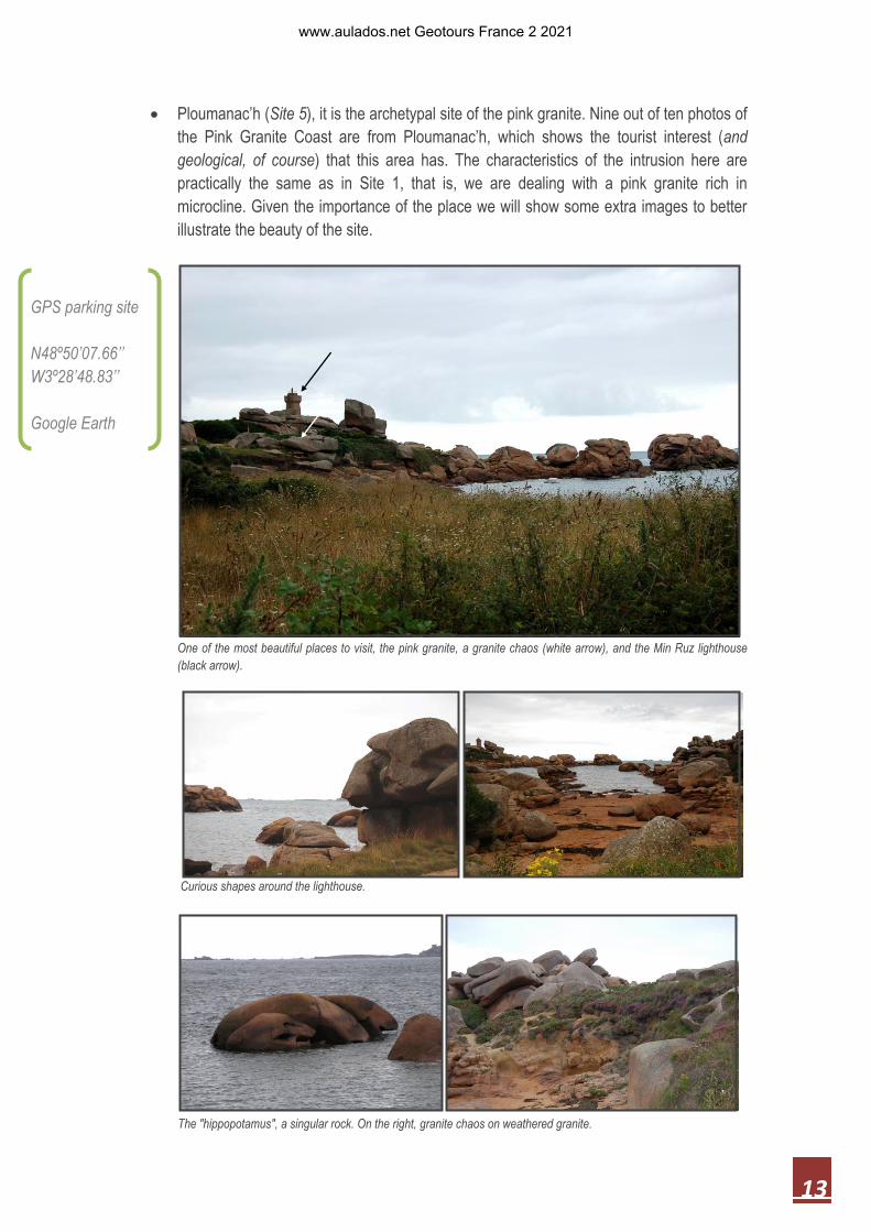
Ploumanac’h (Site 5), it is the archetypal site of the pink granite. Nine out of ten photos of
the Pink Granite Coast are from Ploumanac’h, which shows the tourist interest (and
geological, of course) that this area has. The characteristics of the intrusion here are
practically the same as in Site 1, that is, we are dealing with a pink granite rich in
microcline. Given the importance of the place we will show some extra images to better
illustrate the beauty of the site.
One of the most beautiful places to visit, the pink granite, a granite chaos (white arrow), and the Min Ruz lighthouse
(black arrow).
Curious shapes around the lighthouse.
GPS parking site
N48º50’07.66’’
W3º28’48.83’’
Google Earth
The "hippopotamus", a singular rock. On the right, granite chaos on weathered granite.
www.aulados.net Geotours France 2 2021

14
More granite chaos. On the right a rock (of the same chaos) that appears to have been sculpted by Henry Moore.
Ulex gallii (caution: pretty yellow flowers on thorny plants) and heather growing amidst the “chaos”.
The pink and "not" so pink granite. On the right, detail of its mineralogy and texture; quartz (yellow arrow),
microcline (white arrow), and plagioclase (black arrow).
Well, this all what we wanted to show this time.
Hasta la próxima – Goodbye – à bientôt – dʼar cʼhentañ gwel
Paloma & Roberto
www.aulados.net Geotours France 2 2021

15
References: C.J.D. Adams (1976) Geochronology of the Channel Islands and adjacent French mainland, Journal of the Geologial Society London, 132: 233-250. M. Ballèvre, V. Bosse, M.P. Dabard, C. Ducassou, S. Fourcade, J.L. Paquette, J.J. Peucat & P. Pitra (2013) Histoire
géologique du Massif Armoricain: Actualité de la recherche. Bulletin de la Société géologique et minéralogique de
Bretagne, 10-11: 5-96
M. Barrière (1976) Architecture et dynamisme du complexe éruptif centré de Ploumanac’h (Bretagne) Bulletin
BRGM, 3: 247-295.
M. Doblas et al. (1994a) Variscan-late Variscan-early Alpine progressive extensional col¬lapse of central Spain.
Geodinamica Acta, 7: 1-14.
M. Doblas et al. (1994b) Extensional tectonics in the central Iberian Peninsula during the Variscan to Alpine
transition. Tectonophysics, 238: 95-116.
B.A. Duff (1979) The palaeomagnetism of Cambro-Ordovician redbeds, the Erquy Spilite Series and the Trtégaste-
Ploumanac'h granite complex, Armorican Massif (France and the Channel Islands). Geophysical Journal of the Royal
Astronomical Society, 59: 345-365.
P. Gassien, F. Cousseau & M. Besse (2020) Le mégalithisme en Bretagne. SY-GAIA, https://sy-gaia.ch/le-
megalithisme-en-bretagne/
S.K. Haldar & J. Tišljar (2014) Basic Mineralogy: Alkali Feldspars. In: S.K. Haldar & J. Tišljar (eds) Introduction to
Mineralogy and Petrology, Elsevier, 39-79.
H. Lardeux et al. (2005) Guide Géologique de la Bretagne. Guides Géologiques Régionaux, Dunod, 221 pp.
J. Plaine (2004) Joyau géologique du Trégor, le magmatisme composite du complexe granitique de Ploumanac’h,
Côtes-d’Armor, France. https://sgmb.univ-rennes1.fr/geotopes/decouvertes/23-decouvertes/67-ploumanac-h
N. Santarelli (2011) Promenade géologique dans le granite de Ploumanac’h et son encaissant. Amis –Trégor 2011.
http://www.amis-mineraux.fr/conferences/conference%20_26_mars_2011.pdf
SIGES Bretagne (2021) Histoire géologique de la Bretagne. http://sigesbre.brgm.fr/Histoire-geologique-de-la-
Bretagne-59.html
Wikipedia (2021a) Breton language. https://en.wikipedia.org/wiki/Breton_language
Wikipedia (2021b) Carnac. https://es.wikipedia.org/wiki/Carnac
Wikipedia (2021c) Armórica. https://es.wikipedia.org/wiki/Arm%C3%B3rica
Wikipedia (2021d) https://en.wikipedia.org/wiki/Brittany#:~:text=The%20word%20Brittany%2C%20along%20with,the
%20Roman%20province%20of%20Britain.
www.aulados.net Geotours France 2 2021

16
Source of some of the images (Internet): 1. https://fravatoutca.wordpress.com/2015/07/27/petit-tour-en-bretagne-1-guidel-plage-la-laita-gr-34/ 2. http://www.livingthedrea.com/new-blog/a-laise-breizh 3. https://en.wikipedia.org/wiki/Armorial_of_France#/media/File:BlasonBretagne.svg 4. https://www.francetoday.com/culture/brittany_travel_festival_interceltique_de_lorient/ 5. https://fr.geneawiki.com/index.php?title=Fichier:Blason_Lorient-56121.png 6. https://commons.wikimedia.org/wiki/File:Menhirs_carnac.jpg 7. https://www.heraldry-wiki.com/heraldrywiki/wiki/Lannion 8: https://www.heraldry-wiki.com/heraldrywiki/wiki/C%C3%B4tes-d%27Armor
www.aulados.net Geotours France 2 2021