Geoarchaeology as a tool to understand ancient navigation in ...
14
HAL Id: hal-02937277 https://hal-amu.archives-ouvertes.fr/hal-02937277 Submitted on 12 Aug 2021 HAL is a multi-disciplinary open access archive for the deposit and dissemination of sci- entific research documents, whether they are pub- lished or not. The documents may come from teaching and research institutions in France or abroad, or from public or private research centers. L’archive ouverte pluridisciplinaire HAL, est destinée au dépôt et à la diffusion de documents scientifiques de niveau recherche, publiés ou non, émanant des établissements d’enseignement et de recherche français ou étrangers, des laboratoires publics ou privés. Distributed under a Creative Commons Attribution - NonCommercial - NoDerivatives| 4.0 International License Geoarchaeology as a tool to understand ancient navigation in the northern Persian Gulf and the harbour history of Siraf Majid Pourkerman, Nick Marriner, Christophe Morhange, Morteza Djamali, Giorgio Spada, Sedighe Amjadi, Matteo Vacchi, Hamid Lahijani, Mohammad Esmaeili Jelodar, Hossein Tofighian, et al. To cite this version: Majid Pourkerman, Nick Marriner, Christophe Morhange, Morteza Djamali, Giorgio Spada, et al.. Geoarchaeology as a tool to understand ancient navigation in the northern Persian Gulf and the harbour history of Siraf. Journal of Archaeological Science: Reports, Elsevier, 2020, 33, pp.102539. 10.1016/j.jasrep.2020.102539. hal-02937277
-
Upload
khangminh22 -
Category
Documents
-
view
0 -
download
0
Transcript of Geoarchaeology as a tool to understand ancient navigation in ...

HAL Id: hal-02937277https://hal-amu.archives-ouvertes.fr/hal-02937277
Submitted on 12 Aug 2021
HAL is a multi-disciplinary open accessarchive for the deposit and dissemination of sci-entific research documents, whether they are pub-lished or not. The documents may come fromteaching and research institutions in France orabroad, or from public or private research centers.
L’archive ouverte pluridisciplinaire HAL, estdestinée au dépôt et à la diffusion de documentsscientifiques de niveau recherche, publiés ou non,émanant des établissements d’enseignement et derecherche français ou étrangers, des laboratoirespublics ou privés.
Distributed under a Creative Commons Attribution - NonCommercial - NoDerivatives| 4.0International License
Geoarchaeology as a tool to understand ancientnavigation in the northern Persian Gulf and the harbour
history of SirafMajid Pourkerman, Nick Marriner, Christophe Morhange, Morteza Djamali,Giorgio Spada, Sedighe Amjadi, Matteo Vacchi, Hamid Lahijani, Mohammad
Esmaeili Jelodar, Hossein Tofighian, et al.
To cite this version:Majid Pourkerman, Nick Marriner, Christophe Morhange, Morteza Djamali, Giorgio Spada, et al..Geoarchaeology as a tool to understand ancient navigation in the northern Persian Gulf and theharbour history of Siraf. Journal of Archaeological Science: Reports, Elsevier, 2020, 33, pp.102539.�10.1016/j.jasrep.2020.102539�. �hal-02937277�
Geoarchaeology as a tool to understand ancient navigation in the northernPersian Gulf and the harbour history of SirafMajid Pourkermana,g, Nick Marrinerb,⁎, Christophe Morhangea, Morteza Djamalic,g,Giorgio Spadad, Sedighe Amjadie,g, Matteo Vacchif, Hamid Lahijanig,Mohammad Esmaeili Jelodarh, Hossein Tofighiani, Abdolmajid Naderi Beniga Aix Marseille Univ, CNRS, IRD, INRAE, Coll France, CEREGE, Aix-en-Provence, Franceb CNRS, ThéMA UMR 6049, Université de Bourgogne Franche-Comté, 32 rue Mégevand, Besançon Cedex 25030, Francec Institut Méditerranéen de Biodiversité et d’Ecologie (IMBE/UMR7263), Aix Marseille Université, Avignon Université, CNRS, IRD, IMBE, Technopôle Arbois-Méditerranée,Bât. Villemin, BP 80, F-13545 Aix-en-Provence cedex 04, FrancedDipartimento di Scienze Pure e Applicate, Urbino University ''Carlo Bo'', Urbino, Italye Department of Geology, Faculty of Sciences, Ferdowsi University of Mashhad, Mashhad, IranfDipartimento di Scienze Della Terra, Università di Pisa, 56126 Pisa, Italyg INIOAS (Iranian National Institute for Oceanography and Atmospheric Sciences), No. 3, Etemad Zadeh St., Fatemi Ave., Tehran, IranhDepartment of Archaeology, Faculty of Letters and Humanities, University of Tehran, 1417614418 Tehran, Irani Institute of Archaeology of Iran, Underwater Archaeology Department, Archaeology Research Centre, Si-e Tir St, Imam Khomeini St, Tehran, Iran
A R T I C L E I N F O
Keywords:SirafGeoarchaeologyPersian GulfShamal windsCoastal geomorphologyRelative sea level
A B S T R A C T
Historical texts and archaeological studies attest to the maritime and trade importance of the Persian Gulf since the Sassanid Empires. Nonetheless, there is a paucity of data regarding ancient navigation and the reasons for a shift in m aritim e trade from the western (e.g. Shatt-al-Arab) to eastern (Siraf) Persian Gulf by the Abbasid dynasty. For some scholars, Siraf was occupied between 360 and 977 CE, after which time an earthquake en-trained the dem ise of the city. However, it is unclear when Siraf was founded and how natural navigation conditions changed for ocean-going vessels in harbours of the NW Persian Gulf. To address this knowledge gap, we here present new geoarchaeological data from Siraf. Two anthropogenic facies were detected in drilled cores. They suggest that Siraf dates back to 2 BC-317 CE. After a hiatus, a second occupation phase began during the reign of Shapur II. Relative Sea-Level (RSL) fluctuations, climate change and Persian Gulf bathymetry all affected the possible nautical accessibility of this ancient Persian harbour. A fall in RSL, leading to a shortening of navigable water columns and amplified summer-time Shamal wind from 550 CE onwards possibly led to a loss in the importance of Shatt-al-Arab and other ports in the western Persian Gulf. It appears to have made Siraf the best alternative for seafarers. According to the wind regimes, the best time for arrival and departure from Siraf was August and October, respectively. RSL rise and increasing coastal erosion during the winter-time Shamal winds led to the degradation of harbour potentialities and was possibly at the origin of economic decline and poorly adapted harbour works at Siraf during a 150-year period between 850 and 1000 CE.
1. Introduction
Although the history of maritime trade in the Persian Gulf datesback to the 3rd century BCE (Caspers, 1971), maritime trade did notthrive until the 8th century CE onwards. During the 9th to 10th cen-turies AD, historians such as Tabari, al-Istakhri, Ibn Hawqal, al-Mas’udi(Tabari, 1987, al-Istakhri 1870, Ibn Hawqal 1965, al-Mas‘udi, 1962)describe Siraf as the most important port of the Persian Gulf. Much ofour understanding of Siraf’s archaeological record is attributed to the
work of Stiffe (1895); Whitehouse (1968)); Whitehouse (1969, 1970);Whitehouse (1971) and Whitehouse and Williamson (1973). Since thesestudies, however, just a handful of investigations and excavations havetaken place in Siraf (Khakzad and Trakadas, 2014; Pashazanous et al.,2014; Khakzad et al., 2015). Numerous knowledge gaps remain re-garding the rise and fall of Siraf as a key port settlement.Geoarchaeological studies based upon geoscience tools have the
potential to answer key archaeological questions about ancient sites(Marriner and Morhange, 2007; Marriner et al., 2005, 2010, 2017).
⁎ Corresponding author.E-mail address: [email protected] (N. Marriner).
https://doi.org/10.1016/j.jasrep.2020.102539
T

Geoarchaeological studies in coastal areas can shed light on human-environment interactions using a multidisciplinary framework thatmarries archaeology, geomorphology, palaeoclimatology, relative sea-level changes, biology and geochemistry (Marriner and Morhange,2007; Ferrario, et al., 2015). However, very few geoarchaeologicalstudies have been undertaken on medieval Mediterranean harbours(Marriner et al., 2006; Morhange and Marriner, 2010; Goiran et al.,2014, Vacchi et al., 2020). In a similar vein, no comprehensivegeoarchaeological studies have been conducted on ancient harbours ofthe Persian Gulf from this period (Pourkerman et al., 2018).Apologus, formerly known as Ubulla, was the most important port
in the northwest Persian Gulf during Sassanid to Abbasid periods (LeStrange, 1905). The port was located at the mouth of the Shatt-al-ArabRiver. Basra (Abbasid capital) was supported by Ubulla port. The tradeseasons in Basra were mediated by the rhythm of the Indian monsoon.The ships and goods arrived in July and vessels had to depart before theonset of Indian Ocean winds in October (Potter, 2009). By the earlycenturies of Islam, maritime trade in Ubulla declined. There was asuccessful transition of the most important harbours from Ubulla(northwest) to Siraf (center) (Sheriff, 1987).The aim of this paper is to investigate the impacts of RSL and cli-
mate changes on ancient navigation in the Persian Gulf, including thedisplacement of important harbours from the northwest to the centralpart of the Gulf. In this study, we also analyze Siraf’s infrastructure andits coastal morphology in order to shed light on its evolution duringmediaeval times.
2. Geological and geomorphological settings
The present morphological features of the Persian Gulf are the resultof Paleozoic to Quaternary orogeny (Kashfi, 1976; Alavi, 1994, 2004;Sharland et al., 2004). The main axis of the asymmetric Persian Gulffollows the Zagros folding system (Fig. 1). The axis has generated twomain synclines in the western and central northern half of the Gulf,named the western and central basins (Seibold and Vollbrecht, 1969)(Fig. 1). The basins are connected through transverse shoal betweentwo synclinal areas reflected to uplift along the northward prolongationof the Qatar Arc (Ras-e-Motaf). In the central basin, the axis is situatedclose to the Iranian coast, in the Kangan area. This section of the Gulf isgenerally steeper and deeper than the western basin and contains hugefolds with steeply-dipping flanks in the hinterland. These features havecreated narrow coastal plains associated with numerous ephemeralstreams, estuaries and a steep coastal bathymetry close to the shoreline(Fig. 1) (Purser and Seibold, 1973).Marl (Kazhdomi, Mishan), sandstone with gypsum and marl
(Aghajari) and conglomerates with calcareous sandstone (Bakhtiyari)are the main Cretaceous-Pliocene formations that folded in the lastZagros orogenic movement during Miocene/Pliocene times. Erosion hasgenerated a scarp-and-valley landscape (Fig. 2). Siraf is flanked bycalcareous sandstone with interlayers of conglomerate rock to thenorth, into which several wells and graves have been cut (Wilkinson,1974).The Persian Gulf coastal morphology is influenced by plate and salt
tectonic regimes. Three morphological zones are recognizable: (i) ZoneI: gently sloping marshland coasts with permanent rivers (Shat-al-Arab,Zohre, Hilla and Mand) and several ephemeral rivers with high sedi-ment supply to the shallow coastal zone; (ii) Zone II diapiric upliftingcoasts with salt domes; and (iii) Zone III rocky coasts with steep coastalslopes (Fig. 1). The ancient city of Siraf is located in zone III, in thecentral basin. It is characterized by a narrow coastal plain and nu-merous short fluvial systems, including three ephemeral rivers (Figs. 2and 3) (Whitehouse, 1968).
3. Palaeoenvironments and salt tectonics
During the early Holocene inundation of the Persian Gulf (10.5–9.5
kyr BP) (Lambeck, 1996), the mean latitudinal position of the summerITCZ advanced rapidly northwards. A RSL highstand of +2 m occurredaround 7.1–6.89 kyr B.P. (Lambeck, 1996; Lokier et al., 2015). At thistime, monsoon rains migrated further north than at present, over thePersian Gulf and Iran (Fleitmann et al., 2003; Djamali et al., 2010.Enhanced precipitation over northern Oman and the central part of thePersian Gulf, resulted from the more northerly monsoon position(Fleitmann and Matter, 2009). It would have been conducive toheightened erosion of continental zones and increased sedimentsupply/progradation to/of coastal areas. A comparable situation hasbeen observed along the coastline of the Nile Delta, which, after a phaseof deltaic growth and progradation has become more vulnerable tocoastal erosion during the past 4000 years, due to falling sedimentsupply Marriner et al., 2013). For instance, in the Bay of Abukir, on thewestern flank of the delta, the ancient cities of Eastern Canopus andHerakleion today lie 5–7 m below current mean sea level (Flaux et al.,2017).Furthermore, it is possible that inundation of the Persian Gulf led to
increased vertical stress of the basin floor that could have reactivatedregional salt domes. The salt domes lie in the Hormuz formation andwere active before the Zagros folding. The domes were reactivated bysubsidence resulting from Zagros tectonic events (Jahani et al., 2007).The distribution of the salt domes is depicted in Fig. 1. Deformation of anarrow zone along the Persian Gulf littoral has led to a concentration ofdomes along the present coast that are classified as active salt domes(zone II) (Jahani et al., 2007). These coastal salt domes could have beenreactivated following the displacement of salt to the edge of the areadue to basin subsidence resulting from increased vertical stress (Woodet al., 2012).
4. Meteorological and physical oceanography
The main weather phenomenon in the Persian Gulf is a strongnorthwesterly Shamal wind that occurs during summer and winter(Perrone, 1979). The summer Shamal winds result from interactionbetween summer monsoon low-pressure systems over NW India, thatextend to the W to SE parts of the Gulf, and stationary high-pressuresystems over the Mediterranean with a ridge extending SE towards theNW of the Persian Gulf (Bartlett, 2004). Winter Shamal wind over thenorth of the Persian Gulf is affected by cold air carried into the regionby quasi-stationary Siberian high pressure in the east (Crook, 2009). Itis usually interrupted by a frontal system that is created in the east ofthe Mediterranean Sea and tracks to the southeast following the polarfront jet. The frontal system moves toward the Persian Gulf with thepolar front jet behind and sub-tropical jet ahead of the frontal systemconverge, strengthening the system and generating strong wind at thefront. The NW wind is strong during its passage over the northernPersian Gulf and it reaches five times its initial surface speed (15–20 m/s) in the central part of the Gulf (Thoppil and Hogan, 2010). The in-tensity of the Shamal wind is enhanced by the funnel-like structure ofthe Zagros Mountain along the Iranian coast (Giannakopoulou andToumi, 2012). The other weather system that affects the summer-timeShamal wind is the Indian Ocean Dipole (IOD). A positive IOD leads todecreased summer precipitation in the Persian Gulf and increasingduration and intensity of the summer Shamal wind (Al Senafi and Anis,2015). The winter Shamal brings cold and dry air that leads to fallingtemperatures and evaporation (Thoppil and Hogan, 2010). The winter-time Shamal wind, that blows during January and February, creates thehighest waves in the middle part (central basin) of the Persian Gulf,whereas, the summer-time Shamal (June and July) influences thenorthwestern part of the Persian Gulf, especially at Shatt-al-Arab andRas-e-Motaf. The intensity of the Shamal wind is attenuated followingthe summertime Shamal and it reaches its minimum during Septemberand October (Kamranzad, 2018).Evaporation and freshwater inputs create differences in water den-
sities between the northern and southern parts of the Persian Gulf. This

feature leads to marine water inflow via the Straits of Hormuz, beforeflowing in a NW direction along the Iranian coast (Reynolds, 1993). Itsubsequently splits into two branches: (i) one branch continues on a NWpath, while (ii) the second veers offshore and joins the returningsoutheastern flow. The Shamal wind intensifies the outflowing branch(Thoppil and Hogan; 2010). Water circulation and the distribution ofbasin wave power is represented in Fig. 5. The highest wave energy,with an anti-clockwise whirlpool under storm conditions, occurs in theRas-e-Motaf. This part of the Persian Gulf is known as Iran’s “Bermudatriangle” and it has been an area of numerous shipping accidents(Kamranzad et al., 2013).The Persian Gulf has semi-diurnal and diurnal tides with an oscil-
lation period between 21.6 and 27 h (Defant, 1961). The tidal currentsare mediated by Persian Gulf water circulation and bathymetry. In theBandar-e Abbas (Straits of Hormuz), because of water exchanges be-tween the Persian Gulf and the Oman Sea, tidal currents are faster andMean Higher High Water (MHHW) is higher than elsewhere in the Gulf
(Table 1). Tidal currents are also strong in shallow waters (Pous et al.,2012). MHHW in the Shatt-al-Arab estuary is +3 m and MLLW is 0.4 m.
5. The ancient urban fabric of Siraf
The port of Siraf was a point of connection between the Persian Gulfand the Far East. Merchants imported spices, silk and other luxurygoods, and exported pearls, Arabian-produced frankincense and otherprecious resins (Whitehouse and Williamson, 1973). Our knowledge ofthe ancient urban fabric of Siraf is limited because of sparse excavationsand the loss of ancient remains due to natural and anthropogenic ac-tivities. In this study, we focus on the work of Whitehouse, 1968, 1969,1970, 1971, who performed a comprehensive investigation of medievalSiraf, producing valuable data and maps. The buildings generallymanifest a NE-SW orientation except the great mosque (for religiousreasons) and benefit from shallow wells (Fig. 3).The archaeological excavation by Whitehouse (1968) in the
Fig. 1. A) General morphology of the Persian Gulf with the location of some of its ancient harbours and distribution of the salt domes in southern Iran (Arian andNoroozpour, 2015) (B) 3D coastal morphology of the harbours. The black arrows denote the positions of the Shatt-al-Arab delta and the Siraf coastline. Thebathymetry values are also valid for B.

northwest area of the great mosque (section B) (Fig. 3) elucidated threeimportant occupation layers. The earliest occupation (Period 1) con-tained undisturbed beach sand, located 1 m above current sea level. Itlies beneath mixed sand and clay with a horizon showing abundantSassanid-Islamic pottery (before cal. 825 CE). Period 2 contains fourgenerations of buildings that are covered by rubble from the collapse oflarge buildings. The approximate age of period 2 is between 825 ± 25to 977 ± 78 AD. Finally, period 3, dating to the late 11th century CEonwards, comprises a poor agricultural soil.Construction materials were selected as a function of accessibility to
natural resources. Bakhtiray conglomerate was exploited as a source ofrubble and the Aghajari formation was quarried for gypsum. Thesematerials were broadly used for building constructions and city pro-tection structures. Cooked gypsum was employed as cement and forinterior-exterior facing. The cooked gypsum absorbs humidity from theair and would have helped to decrease inside temperatures duringwarm and humid seasons. The use of rubble stone materials withgypsum mortar, in addition to gypsum as an interior decorative mate-rial, was very common under Sassanian rule (Huff, 1986).
6. Methods and data acquisition
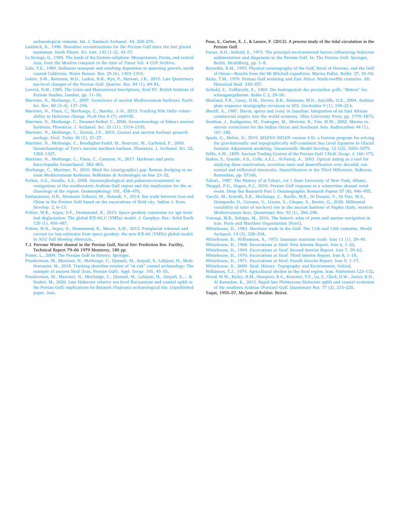
The main parts of the coastal zone in the medieval sector of Siraf arecovered by gravel. The gravel accumulations result from the destructionof archaeological remains by coastal erosion (Pourkerman et al., 2018).A continuous series of 3-m cores was drilled using a vibracore in the SEpart of the medieval Bazaar at 17 cm above current Mean Sea Level(MSL) (Fig. 3). The core tubes were immediately transported to thelaboratory for nondestructive magnetic susceptibility analysis (MS).
The coring site was levelled using a theodolite and benchmarked re-lative to current sea level. All depths are relative to present mean sealevel. A 2.4 m outcrop section was logged at a site called the “Potter’sQuarter” (Fig. 3) where a whole sedimentary sequence was observedbeneath an ancient building.Before subsampling, magnetic susceptibility was measured using a
Bartington MS2C 100-mm diameter loop sensor with an MS2 meter.Magnetic susceptibility was measured every 2 cm (Delile et al., 2014),in order to probe human impacts on the sedimentary properties.High-resolution sampling was undertaken on each of the cores (44
sub-samples over 3 m). Each sample was split into two subsamples forgrain-size, organic matter and carbonate-content analyses. Wet sievingwas employed to separate the>2 mm and<63 µm fractions. Drysieving was performed for the sand granulometry and a laser grain-sizeanalyzer (Horiba La 950 E) was used for the silt/clay fractions. Thesediments were classified and plotted on a ternary diagram using themethodology outlined by Folk (1954, 1980). Organic Matter (OM) andcarbonate content were measured using Loss-On-Ignition (LOI) at550 °C and 950 °C (Heiri et al., 2001). The mean grain size was cal-culated using Folk and Ward (1957). The chronological data are basedon the correlation of core facies with archaeological excavation datafrom Siraf. Juvenile marine shells contained in the anthropogenic facieswere used for radiocarbon dating. The 14C data were calibrated usingCalib version 7.1.0 online version (http://calib.org) and a standardPersian Gulf marine reservoir age (Southon et al., 2002) (Table 2).Historic wind directions and durations were obtained from the databaseof the Iranian Meteorological Office (http://irimo.ir). Bathymetricmaps and 3D models of the seafloor were created based on hydrologicalmaps of the Iranian National Cartographic Center and international
Fig. 2. Geological and geomorphological map of the Siraf watershed. The background image derives from Google Earth Pro and shows the ancient urban fabric inJuly 2018. Most of the historic sectors have been destroyed with the exception of some coastal quarters at risk from coastal erosion.

chart series published by the United Kingdom hydrographic office inscales 1:100,000 for the Persian Gulf and 1:20,000 for the Shatt-al-Arabpro-delta area.The RSL curve was obtained by a Glacial Isostatic Adjustment (GIA)
simulation in which we adopted model ICE-6G (VM5a) of Peltier et al.(2012) and Peltier et al. (2015). The simulation used the ICE-6G(VM5a) model through the program SELEN4 (Spada and Melini, 2019).SELEN4 solves the Sea-Level Equation by taking into account the hor-izontal migration of shorelines, for the transition from grounded tofloating ice and for the effects of rotational feedbacks on sea level. TheSea-Level Equation was solved using a pseudo-spectral approach with aspatial resolution corresponding to the maximum harmonic degreelmax = 256, on a grid with a spacing of ~40 km.
7. Results
7.1. Present-day wind and wave regimes
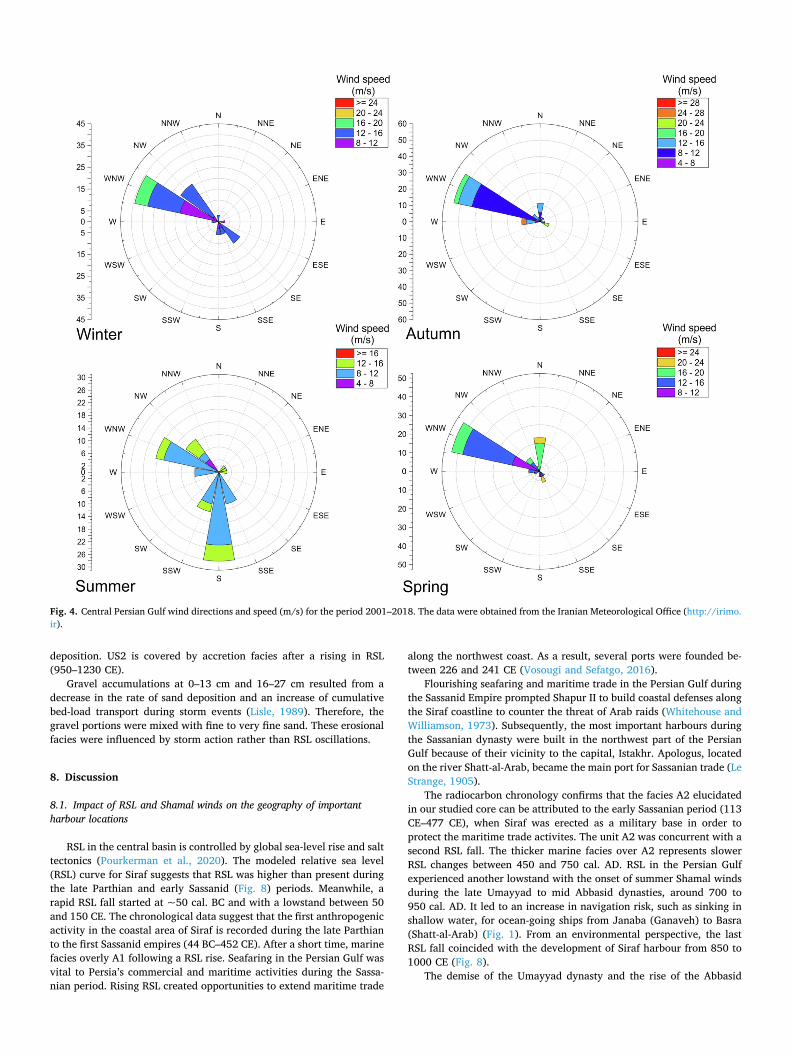
The winter and summer-time Shamal winds have a WNW direction.The wind speed in wet seasons (Oct-Mar) is stronger than in dry sea-sons, although wind duration in the dry seasons (Apr-Sep) is longer(Table 3, Fig. 4). Secondary wind directions in the dry and wet seasonsblow from the S and NW respectively. The NW wind direction is lessfrequent and blows in April, October and November, for around 83 dayswith an average speed of 14 m/s. It is as strong as the WNW Shamalwind. The S wind is weaker than the dominant wind direction and itblows from July to September for 118 days with an average speed of9.75 m/s. The S wind is the dominant wind in August.
Fig. 3. Map of Medieval Siraf, with the location and orientation of its buildings (Whitehouse, 1968). The rose diagram shows that the ancient buildings trend towardsthe north. The most important waterfront remains are A) the Potter’s Quarter, B) the great mosque and C) the Bazaar. The different colours represent differentorientations. D) Rock cut grave at Shilau valley and E) water front remains that exposed severe coastal erosion (Pourkerman et al., 2018).
Table 1Geomorphological zonation and tidal levels at different sites from the Strait of Hormuz to Shatt-al-Arab.
Place Lat N Long E Height in meters above datum Class
MHHW MLHW MHLW MLLW
Bandar-e Abbas 29° 22′ 56° 17′ 3.4 2.6 1.4 0.7 Zone IIAsaluyeh* 27° 28′ 52° 37′ 1.6 1.5 0.7 0.3 Zone IIIBandar-e Bushehr 28° 54′ 50° 45′ 1.9 1.3 1.1 0.5 Zone IBandar-e Ganaveh 29° 34′ 50° 31′ 2.2 1.5 1.3 0.6 Zone IImam Hassan 29° 50′ 50° 15′ 2.4 1.7 1.3 0.6 Zone IShatt-al-Arab 29°50′ 48°43′ 3.0 2.4 1.3 0.4 Zone I
* Asaluyeh is the nearest tide gauge station to the site of ancient Siraf.
7.2. Fresh-water management system
According to field observations, the city is located in a coastal desertwith average precipitation of 13.2 mm/yr. Flash flooding takes placeduring winter and autumn; at the time of writing, the most recent ex-ample dated to the 23rd March 2020. The city’s fresh water was sup-plied by harnessing and storing rainfall via numerous wells and cisternson the hills overlooking Siraf, and stocked in alluvial sediments over-looking the ancient settlement (Fig. 3). The wells, excavated into thehills, are protected from sediment influx by manmade rocky stairs,plastered mortared rubble and a 5–10 cm protuberance. Further fea-tures of the wells are shallow rills to direct water to the well mouth.Pronounced water erosion in the upstream Shilau valley, with severaloutlet tunnels, was observed on the downside of the wells. Shallowwells (upper present sea-level) and cisterns are reported for medievalSiraf, for both cultivation and domestic purposes (Whitehouse, 1968,1969, 1971) (Fig. 6).
7.3. Paleoenvironmental analysis
7.3.1. Upper shore faciesThe stratigraphic units were bounded between two upper shore
facies (US1 and US3 at the base and top, respectively). Another uppershore facies was also logged at 72–82 cm (US2). The US1 transitionedbetween slightly gravelly sand ((g) S) with bivalve shells and juvenileshells of Veneridae to gravelly sand (g S) with abundant shell debris. Anincrease in OM is observed between 284 and 267 cm; OM decreaseswith rising carbonate and sediment grain size. MS in the US1 is alsorepresented decrease trend from base to top (1.4 × 10⁻⁴SI to4.06 × 10−5SI). The facies changes in US1 represent rising energyconditions due to the transition in sedimentary environments fromlower shoreface to upper shoreface following a sea-water regression.US2 is made of gravelly sand with fine shell debris and sand. US2 se-diments comprise medium to fine sands. Gravel decreases dramaticallyfrom base to top concurrent with increasing fine sand ((g) S). An inversetrend is observed for MS (2.5 × 10⁻⁵SI to 5.06 × 10⁻⁵SI) (Fig. 7). Theincrease of carbonate content in this facies is related to increasing shelldebris. The positive correlation between MS and carbonate contentresults from the impact of winnowing on magnet mineral residuals andbioclast debris reworking. US3 transitions from gravelly sand to slightlygravelly sand. The mean sediment grain size decreases upwards. Themain difference between the facies US2 and US3 is the absence of bi-valve shells at US2. It is suggested that US2 is more under the influenceof wind processes than coastal action.The sediment outcrop exposed in the Potter’s Quarter shows a
shoreface facies between 95 and 200 cm above present-day sea level. Itcontains light brown shelly sand with ceramics at the top, with alluvial
facies at the base. The alluvial facies comprises fine sand and silt withinterlayers of cobbles in a sandy silt matrix. This facies attests toflooding events during heavy precipitation and debris flows resultingfrom flashflood events. A narrow coastal plain void of any significantvegetation cover increased the risk of flooding at Siraf. The thickness ofthe outcrop facies decreases from west to east of the Potter’s Quartersection (Fig. 3E).
7.3.2. Unit B (anthropogenic facies)7.3.2.1. Anthropogenic facies. Two important anthropogenic facies (A1and A2) are recorded at 203–240 and 149–178 cm. According toradiocarbon analysis, A1 is dated to 44 cal. BC – 425 cal. AD; itcomprises a very compacted facies, with iron and ceramic fragments.A1 is located above US1 and the facies comprises 30–89% gravel andthe mean grain size is between 1 to −1.1 phi. The MS data manifeststhree peaks in this unit, with a maximum of 1.03 × 10⁻³ (SI) and anaverage of 7 × 10⁻⁴ (SI). Meanwhile, we did not observe upper shorefacies above A1 and beneath A2, suggesting the resumption ofanthropogenic activities shortly after the RSL fall (Fig. 8). A2contained coarser sediments (−0.6 to −1.11 phi) with 65–90% ofthe sediments comprising gravels. A sample from this secondanthropogenic facies yielded a calibrated radiocarbon age of113–477 cal. AD. Two MS peaks of 1.53 × 10⁻³ and 1.21 × 10⁻³
are logged in this unit, with an average MS of 6.6 × 10⁻⁴SI (Fig. 7).
7.3.2.2. Erosion and accretion facies. The marine facies above A1 isgenerally made-up of sandy gravel sediments. The gravel abundancechanged from 70% to 46%, from base to top. Furthermore, MSdecreased from base to top (6.78 × 10⁻⁴SI to 4.63 × 10⁻⁵SI)consistent with a decreasing gravel fraction. Sediment texturechanged to gravelly sand with significant decline in carbonate thatoverlies the accretion facies. Fining upward in the accretion zone isconsistent with a fall in energy dynamics. The same trend is observedfor A2, the main difference being that the erosion and accretion faciesabove it are thicker than A1. It could suggest that RSL oscillations in thecentral part of the Persian Gulf happened over longer periods (Fig. 8).In other words, RSL oscillations in the Persian Gulf were controlled byhydrostatic pressure changes over the central basin floor resulting fromglobal sea-level fluctuations (Pourkerman et al., 2020). The thickness oferosion-accretion facies decrease upwards and end at US2. The faciesare recognized by changes in sedimentary structures and manifestreworked manmade material in the stratigraphic column. The sedimentgrain size in the erosional facies is upward fining. 46–75% of thesediment properties are created by>2 mm portions and the sedimenttexture is sandy gravel. Upwardly decreasing magnetic susceptibilityvalues (1.2 × 10⁻⁴SI and 1.6 × 10⁻⁴SI) over the anthropogenic faciesrepresents a rapid rise in RSL and increasing marine-sediment
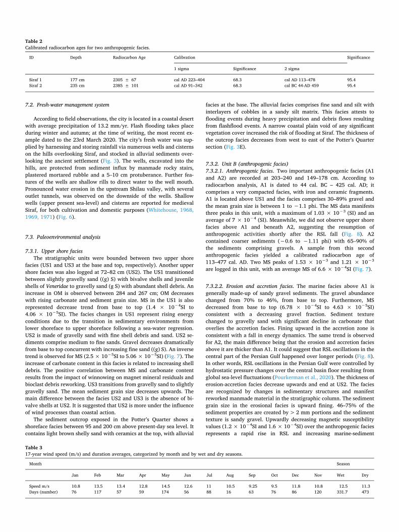
Table 2Calibrated radiocarbon ages for two anthropogenic facies.
ID Depth Radiocarbon Age Calibration Significance
1 sigma Significance 2 sigma
Siraf 1 177 cm 2305 ± 67 cal AD 223–404 68.3 cal AD 113–478 95.4Siraf 2 235 cm 2385 ± 101 cal AD 91–342 68.3 cal BC 44-AD 459 95.4
Table 317-year wind speed (m/s) and duration averages, categorized by month and by wet and dry seasons.
Month Season
Jan Feb Mar Apr May Jun Jul Aug Sep Oct Dec Nov Wet Dry
Speed m/s 10.8 13.5 13.4 12.8 14.5 12.6 11 10.5 9.25 9.5 11.8 10.8 12.5 11.3Days (number) 76 117 57 59 174 56 88 16 63 76 86 120 331.7 473
deposition. US2 is covered by accretion facies after a rising in RSL(950–1230 CE).Gravel accumulations at 0–13 cm and 16–27 cm resulted from a
decrease in the rate of sand deposition and an increase of cumulativebed-load transport during storm events (Lisle, 1989). Therefore, thegravel portions were mixed with fine to very fine sand. These erosionalfacies were influenced by storm action rather than RSL oscillations.
8. Discussion
8.1. Impact of RSL and Shamal winds on the geography of importantharbour locations
RSL in the central basin is controlled by global sea-level rise and salttectonics (Pourkerman et al., 2020). The modeled relative sea level(RSL) curve for Siraf suggests that RSL was higher than present duringthe late Parthian and early Sassanid (Fig. 8) periods. Meanwhile, arapid RSL fall started at ~50 cal. BC and with a lowstand between 50and 150 CE. The chronological data suggest that the first anthropogenicactivity in the coastal area of Siraf is recorded during the late Parthianto the first Sassanid empires (44 BC–452 CE). After a short time, marinefacies overly A1 following a RSL rise. Seafaring in the Persian Gulf wasvital to Persia’s commercial and maritime activities during the Sassa-nian period. Rising RSL created opportunities to extend maritime trade
along the northwest coast. As a result, several ports were founded be-tween 226 and 241 CE (Vosougi and Sefatgo, 2016).Flourishing seafaring and maritime trade in the Persian Gulf during
the Sassanid Empire prompted Shapur II to build coastal defenses alongthe Siraf coastline to counter the threat of Arab raids (Whitehouse andWilliamson, 1973). Subsequently, the most important harbours duringthe Sassanian dynasty were built in the northwest part of the PersianGulf because of their vicinity to the capital, Istakhr. Apologus, locatedon the river Shatt-al-Arab, became the main port for Sassanian trade (LeStrange, 1905).The radiocarbon chronology confirms that the facies A2 elucidated
in our studied core can be attributed to the early Sassanian period (113CE–477 CE), when Siraf was erected as a military base in order toprotect the maritime trade activites. The unit A2 was concurrent with asecond RSL fall. The thicker marine facies over A2 represents slowerRSL changes between 450 and 750 cal. AD. RSL in the Persian Gulfexperienced another lowstand with the onset of summer Shamal windsduring the late Umayyad to mid Abbasid dynasties, around 700 to950 cal. AD. It led to an increase in navigation risk, such as sinking inshallow water, for ocean-going ships from Janaba (Ganaveh) to Basra(Shatt-al-Arab) (Fig. 1). From an environmental perspective, the lastRSL fall coincided with the development of Siraf harbour from 850 to1000 CE (Fig. 8).The demise of the Umayyad dynasty and the rise of the Abbasid
Fig. 4. Central Persian Gulf wind directions and speed (m/s) for the period 2001–2018. The data were obtained from the Iranian Meteorological Office (http://irimo.ir).
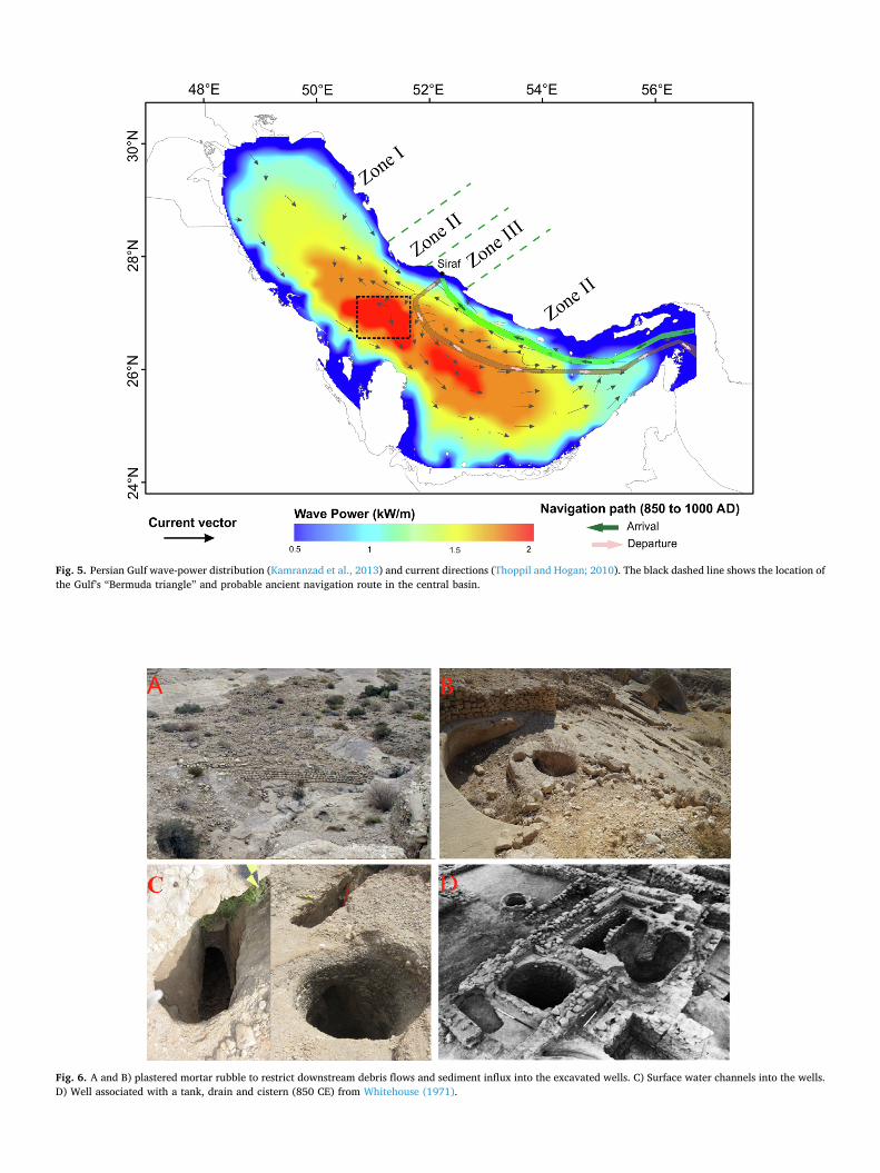
Fig. 5. Persian Gulf wave-power distribution (Kamranzad et al., 2013) and current directions (Thoppil and Hogan; 2010). The black dashed line shows the location ofthe Gulf’s “Bermuda triangle” and probable ancient navigation route in the central basin.
Fig. 6. A and B) plastered mortar rubble to restrict downstream debris flows and sediment influx into the excavated wells. C) Surface water channels into the wells.D) Well associated with a tank, drain and cistern (850 CE) from Whitehouse (1971).
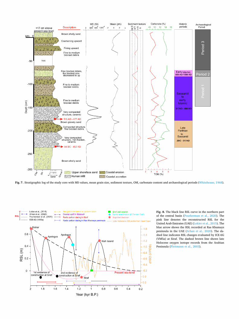
Fig. 7. Stratigraphic log of the study core with MS values, mean grain size, sediment texture, OM, carbonate content and archaeological periods (Whitehouse, 1968).
Fig. 8. The black line RSL curve in the northern partof the central basin (Pourkerman et al., 2020). Thepink line denotes the reconstructed RSL for theUnited Arab Emirates (UAE) (Lokier et al., 2015). Theblue arrow shows the RSL recorded at Ras Khumayspeninsula in the UAE (Arhan et al., 2020). The da-shed line indicates RSL changes evaluated by ICE-6G(VM5a) at Siraf. The dashed brown line shows lateHolocene oxygen isotope records from the ArabianPeninsula (Fleitmann et al., 2003).

dynasty in 750 CE was associated with the introduction of Islamicmaritime trade. By that time, RSL was at a lowstand and the Shatt-al-Arab river channel had prograded into the sea over its palaeo-delta. Thedelta was prograding by fluvial and tidal processes. It had negligibleimpacts on the pro-delta that was below low-tide level. A small andshallow tidal channel developed at the delta front. As a result, the na-vigable water column became too shallow during low-tide in the Shatt-al-Arab estuary. This acted as an obstacle for ocean-going vessels toenter and navigate the Shatt-al-Arab river channel. As a result, ocean-going vessels were no longer able to use the harbours at Shatt-al-Araband in zone I (Figs. 9 and 1).
“In this deadly sea (Persian Gulf) several dangerous routes exist and thetoughest one is Jannaba (Bandar-e Ganaveh) to Basra, the so-called Hor-eJannaba, which is a terrible place during storms. Also, there is a place calledKheshbat at 6 meel (distance unit) from Abadan on the sea, along the Tigrisriver. In some cases the water is so shallow that big ships cannot enter, evenat high tide. Several towers have been erected in order to guide the ships tothe Tigris estuary using fire light at night. Those ships that deviate from thepath run aground in shallow water” (Ibn Hawqal, 1965)These environmental changes led to a shift in the location of the
most important harbours from the west (zone I) to the central basin(zone III) of the Persian Gulf (Apologus to Siraf). During the latter halfof the ninth century, the harbours of Apologus and Basra went intodecline at the same time as Siraf grew in importance (Ricks, 1970). Sirafbecame a key maritime port due to the location of the site (close to Ras-e-Motaf), relative coastal stability with low vertical movements and asteep coastal morphology (Fig. 9).Southward migration of the monsoon between 750 BCE to 650 CE
led to an interruption of precipitation in northern Oman (Fleitmann andMatter, 2009) and decreasing summer Shamal wind intensity. North-west harbours were more accessible for merchants through Ras-e-Motaf. The monsoon resumed after 650 CE, coincident with an in-tensification of summer Shamal winds (Fig. 8). Around this time, thereis evidence of dune reactivation in the south of the Persian Gulf (Stokeset al., 2003; Parker and Goudie, 2008).
Navigation risks in the western part of the Persian Gulf increasedduring summer months by the interaction of Persian Gulf water circu-lation and summer Shamal winds at Ras-e-Motaf. The most significantimpact of the summer Shamal wind was on Ras-e-Motaf. Ras-e-Motaflies on the border between the central and the western basins (zone III).Due to its unique morphology, the highest wave energy in the PersianGulf is created in this area during storm conditions (Kamranzad et al.,2013). Therefore, navigating through the Ras-e-Motaf was dangerousfor sea-going vessels, and damage/sinking was not uncommon.A RSL rise after 950 CE, and increasing monsoon activities, led to
significant erosion of the Siraf structures in the coastal zone and mar-itime trade shifted to Kish Island (Figs. 7 and 8). The most importantbarrier to rekindling prosperity in western ports such as Siraf wasseafaring conditions. Ocean-going vessels accessed the Persian Gulf viathe Strait of Hormuz when the counter wind and swell was minimum.During the dry season, particularly in August, the impacts of the
summer-time Shamal wind on the central basin was minimum.Furthermore, the S winds and the NNE to NE surface current directionswere favorable to seafaring in the central basin.Inaccessibility of the western basin’s ports eventually led to them
being superseded by ports in the central basin. Furthermore, the winter-time Shamal wind began in October with minimum intensity. WNWwinds, with southeastward surface currents, allowed vessels to travelfrom the Persian Gulf into the Indian Ocean. As a result, Siraf providedthe best alternative roadstead for Persian and Arabian harbours in thewestern basin.
8.2. Advantages of Siraf as an important harbour
The falling RSL provided Siraf with suitable conditions for seafarersto access both the hinterland and the sea. The advantage of Siraf was:(i) its unique coastal morphology; (ii) its location in the Gulf (thenearest possible place to Ras-e-Motaf); and (iii) its close ties with thehinterland. The harbour of Siraf is located in zone III. Its connection tothe deep water was possible via its steep coastal morphology (Fig. 9).
Fig. 9. 3D model of Shatt-al-Arab submarine river delta and Siraf coastal morphology.

The close proximity of Siraf to Firuzabad made Siraf’s port facilitiesparticularly attractive to seafarers and merchants. The city’s initialmilitary vocation (Lowick, 1985) was gradually superseded by a com-mercial raison d’être and Siraf became one of the main trade cities of thePersian Gulf. Concurrent with the decline of the port of Apologusaround 750 CE, the first evidence of trade with China is observed atSiraf (Whitehouse, 2009; Pashazanous et al., 2014). Underwater sur-veys have demonstrated that the city extended at least 300 m from thepresent shoreline (Khakzad et al., 2015). This suggests that falling RSLand positive coastal sediment budgets allowed the medieval city toextend seawards.According to the stratigraphic section and Whitehouse (1968) the
city is erected atop coastal sandy sediments with shell fractions. Thefacies constituted a permeable basement for the transfer of fresh water.A modified Qanat system was designed for collecting and transferringfreshwater to the city. The technique was adapted to Siraf’s geomor-phological context, characterized by saline seawater levels to the southand the hills to the north. The Qanat system comprised a series of wellsdug into alluvial sediments beneath the groundwater level in foothillsand water flow by gravity via a network of gently sloping tunnels thattransported water to lower elevations (Beaumont, 1971). At Siraf, thewells were dug into the sandstone with interlayers of conglomerates onthe steeper hillside slopes. The wells were interconnected via under-ground tunnels and/or permeable layers.The exposed coastal section of medieval Siraf, shows interlayers of
fine sand with pebbles that translate flooding (Fig. 10). To alleviateflood damage but harness water for consumption during the wet sea-sons, the local watershed was extensively modified. Several variously-sized dams, sandstone carving and plastered rubble were used to alle-viate water energy and trap water on the hillside. Water was collectedin numerous wells behind the dams. Nonetheless, these hillside wellswere not sufficient in meeting the needs of all domestic and agriculturalactivities. Whitehouse (1968) has suggested that other wells and cis-terns were used to tap underground water resources.Collected water was discharged downstream and transported to the
irrigation system or stored underground in wells and cisterns. Thedifferent densities between the saline sea water and fresh water createda mixing zone (Back et al., 1986) that ensured that fresh water did notflow into the sea. Furthermore, the unique geomorphology of Siraf,with a small and flat tidal area, reduced the mixing zone (Pourkermanet al., 2018). Therefore, the city possessed a sustainable fresh-waterresource, in the form of shallow wells (above sea level), for domesticand agriculture purposes (Fig. 10).
8.3. The decline of Siraf
In the eleventh century, the great port of Siraf went into decline andKish Island replaced it for maritime trade (Whitehouse, 1983). Al-Mu-qaddasi reported that the 977 CE earthquake significantly damagedSiraf. According to archaeological excavations and the voyage de-scriptions of Ya¯qu¯t, medieval Siraf was used until the 13th century CE(al-Muqaddasi, 1906, Whitehouse and Williamson, 1973; Ya¯qu¯ t,1955, Whitehouse, 2009; Pashazanous et al., 2014). Environmentalfactors such as RSL and climate changes probably contributed to thegradual demise of Siraf.In Abu Dhabi, RSL reached the present level after 1.17 kyr B.P.
(Lokier et al., 2015). A highstand is recorded between 950 and 1230 CE(Arhan et al., 2020) that it is correlated with the US2 marine facies.Rising RSL and increasing summer Shamal wind intensity (Fig. 8) ac-centuated erosion of Siraf’s port. The coastal stratigraphy shows twoerosional facies over the anthropogenic horizons that clearly underlinethe impacts of marine currents on anthropogenic facies.The Shamal winds, which played an important role in developing
maritime trade at Siraf, turned into a hazard during the ensuing phaseof RSL rise. The foundations of medieval Siraf were sensitive to erosion.Erosion removed the lower compact sediments leading to the collapseof overlying infrastructure. Due to the absence of robust constructionmaterials, coastal processes easily eroded gypsum between the plas-tered rubble. Therefore, the structures were easily degraded and thesediment fractions reworked by coastal processes and longshore cur-rents. This could explain why there are no reports of preserved un-derwater structures in Siraf. Furthermore, RSL rise significantly com-promised the city’s water resources. RSL rise, led to salt-water intrusioninto wells. Access to fresh water in the city therefore became limited. Inlight of the environmental impacts on civil and trade infrastructure,Siraf’s population gradually migrated away from the city.Due to changing coastal processes, erosion took place with the re-
working of finer sediment stocks. Erosional facies between the accretionlayers suggest a fall in sediment supply during RSL rise or an increase inenvironmental energy resulting from storm events during an in-tensification of monsoon events between 1600 and 1500 CE (Fig. 8). Inboth cases, coarse sediment derives from the erosion of waterfrontanthropogenic remains. Erosion of the coastal archaeology is clearlyattested along the present shoreline (Pourkerman et al., 2018).
Fig. 10. Stratigraphic section of the ancient wall in the Potter’s Quarter, I) A: natural deposits and B: Ancient wall II) Cross section of the well.

9. Conclusion
Maritime trade in the Persian Gulf was very important for Sassanianand Islamic dynasties, who prioritized the best locations for commercialports. Several archeological studies have been undertaken on medievalSiraf and other ports of the Persian Gulf. However, numerous questionsremain unanswered. In conclusion, we would like to insist on the fol-lowing factors to explain the evolution of medieval Siraf.
Early evidence of human settlement in Siraf dates back to earlySassanid and possibly late Parthian periods.Siraf became important for Persian Gulf maritime trade becauseother important ports (e.g. Apologus, Bushehr, Mahruban) locatedin the western basin could not be used by ocean-going vessels.Climate change, RSL fall, coastal morphology and the Shamal windswere keys factors in the rise in importance of Siraf for maritimetrade. The ports located in Shatt-al-Arab and the western PersianGulf lost their significance when RSL in the Gulf reached a lowstandafter 1.4 kyr B.P. and a more vigorous summer-time Shamal dis-connected the western and central basins of the Persian Gulf.The fresh water-management system of Siraf was unique and cle-verly adapted to the local geomorphology. Its design was based onthe local environment, and its lithological and sedimentologicalproperties. It was a modified version of the Qanat system, adapted tothe coastal environment. In addition to meeting the fresh-waterdemands of the city, it also alleviated the impact of flooding eventsfrom the northern hills.The decline of medieval Siraf partially resulted from RSL rise andwinter-time Shamal winds that eroded waterfront infrastructure anddegraded harbour amenities.Seafarers exploited the Shamal winds for sailing in the Persian Gulf.August and October were the best times for the arrival and de-parture of ocean-going vessels in the central basin, respectively.The RSL results show that sea level rose from its lowstand positionto present levels between 1.1 and 1 kyr BP.
During the last two last decades, concurrent with oil-gas industrydevelopments in the coastal zone, several archaeological sites havebeen destroyed due to industrial constructions and urbanization. Anumber of heritage remains have already been lost and others are atrisk. This study has revealed the importance of geoarchaeological stu-dies in understanding the environmental evolution of ancient maritimesites of the Persian Gulf.
CRediT authorship contribution statement
Majid Pourkerman: Conceptualization, Data curation, Formalanalysis, Investigation, Methodology, Project administration, Software,Validation, Visualization, Writing - original draft, Writing - review &editing. Nick Marriner: Validation, Writing - review & editing.Christophe Morhange: Supervision, Validation, Writing - review &editing. Morteza Djamali: Funding acquisition, Supervision,Validation, Writing - review & editing. Giorgio Spada: Data curation,Formal analysis, Methodology, Software, Validation, Writing - review &editing. Sedighe Amjadi: Validation, Writing - review & editing.Matteo Vacchi: Validation, Writing - review & editing. HamidLahijani: Funding acquisition, Validation, Writing - review & editing.Mohammad Esmaeili Jelodar: Resources, Validation, Writing - review& editing. Hossein Tofighian: Resources, Writing - review & editing.Abdolmajid Naderi Beni: Funding acquisition, Resources, Writing -review & editing.
Acknowledgements
This work was supported by the Center of International ScientificStudies and Collaborations (CISSC), Iran National Science Foundation
(INSF grant number 94-44915), the French Embassy in Iran, CampusFrance (PHC GUNDISHAPUR 2016–2017, project number 35630QH)and Labex OT-Med (ANR-11-LABX-0061). Radiocarbon datings werefunded through the project “LIA HAOMA” supported by the CentreNational de Recherche Scientifique (CNRS, France). The study was alsosupported by Iran’s National Elite Foundation.
References
Al Senafi, F., Anis, A., 2015. Shamals and climate variability in the Northern Arabian/Persian Gulf from 1973 to 2012. Int. J. Climatol. 35 (15), 4509–4528.
Alavi, M., 1994. Tectonics of the Zagros orogenic belt of Iran: new data and interpreta-tions. Tectonophysics 229 (3–4), 211–238.
Alavi, M., 2004. Regional stratigraphy of the Zagros fold-thrust belt of Iran and its pro-foreland evolution. Am. J. Sci. 304 (1), 1–20.
Al-Istakhri, (1870), M. J. de Goeje (trans. & ed.), Kitab Al-Masalik wa-al-Mamalik. Leiden.al-Mas‘udi, A. L. H. (1962). Les prairies d’or. Trans. C. Barbier de Meynard, Pavet de
Courteille, and Charles Pellat. Paris: Société asiatique.Al-Muqaddasi,, 1906. Ahsan al-Taqasim fi Ma’rifat al-Aqalim. Bibliotheca Georaphorum
Arabicorum, Leiden.Arhan, D., Pavlopoulos, K., Fouache, E., 2020. Holocene relative sea-level variations and
archeological implications, Abu Dhabi western region, United Arab Emirates. Arab. J.Geosci. 13 (6), 1–16.
Arian, M., Noroozpour, H., 2015. Tectonic geomorphology of Iran’s salt structures. OpenJ. Geol. 5 (02), 61.
Back, W., Hanshaw, B.B., Herman, J.S., Van Driel, J.N., 1986. Differential dissolution of aPleistocene reef in the ground-water mixing zone of coastal Yucatan Mexico. Geology14 (2), 137–140.
Bartlett, K.S., 2004. Dust Storm Forecasting For Al Udeid Ab, Qatar: An EmpiricalAnalysis. Master’s thesis. Air University, Islamabad.
Beaumont, P., 1971. Qanat systems in Iran. Hydrol. Sci. J. 16 (1), 39–50.Caspers, E.C.D., 1971. New archaeological evidence for maritime trade in the Persian Gulf
during the Late Protoliterate period. East West 21 (1/2), 21–44.Crook, J. (2009). Climate analysis and long range forecasting of dust storms in Iraq. Naval
Postgraduate School Monterey CA.Defant, A., 1961. Physical Oceanography 1, Pergamon.Delile, H., Mazzini, I., Blichert-Toft, J., Goiran, J.P., Arnaud-Godet, F., Salomon, F.,
Albarède, F., 2014. Geochemical investigation of a sediment core from the Trajanbasin at Portus, the harbour of ancient Rome. Quat. Sci. Rev. 87, 34–45.
Djamali, M., Akhani, H., Andrieu-Ponel, V., Braconnot, P., Brewer, S., de Beaulieu, J.-L.,Fleitmann, D., Fleury, J., Gasse, F., Guibal, F., Jackson, S.T., Lézine, A.-M., Médail, F.,Ponel, P., Roberts, N., Stevens, L., 2010. Indian Summer Monsoon variations couldhave affected the early-Holocene woodland expansion in the Near East. Holocene 20,813–820.
Ferrario, M.F., Brunamonte, F., Caccia, A., Livio, F., Martinelli, E., Mazzola, E., Michetti,A.M., Terrana, S., 2015. Buried landscapes: Geoarchaeology of the roman harbour ofComo (N Italy). Alp. Mediterr. Quat 28 (2).
Flaux, C., Marriner, N., el-Assal, M., Kaniewski, D., Morhange, C., 2017. Late Holoceneerosion of the Canopic promontory (Nile Delta, Egypt). Marine Geol. 385, 56–67.
Fleitmann, D., Matter, A., 2009. The speleothem record of climate variability in SouthernArabia. Comptes Rendus Geosci. 341 (8–9), 633–642.
Fleitmann, D., Burns, S.J., Mudelsee, M., Neff, U., Kramers, J., Mangini, A., Matter, A.,2003. Holocene Forcing of the Indian Monsoon Recorded in a Stalagmite fromSouthern Oman. Science 5626, 1737–1739.
Folk, R.L., 1980. Petrology of Sedimentary Rocks. Hemphill Publishing Company.Folk, R.L., Ward, W.C., 1957. Brazos River bar [Texas]; a study in the significance of grain
size parameters. J. Sedim. Res. 27 (1), 3–26.Folk, R.L., 1954. The distinction between grain size and mineral composition in sedi-
mentary rock nomenclature. J. Geol. 62 (4), 344–359.Giannakopoulou, E.M., Toumi, R., 2012. The Persian Gulf summertime low-level jet over
sloping terrain. Quart. J. Royal Meteorol. Soc. 138 (662), 145–157.Goiran, J.P., Salomon, F., Mazzini, I., Bravard, J.P., Pleuger, E., Vittori, C., Boetto, G.,
Christiansen, J., Arnaud, P., Pellegrino, A., Pepe, C., 2014. Geoarchaeology confirmslocation of the ancient harbour basin of Ostia (Italy). J. Archaeol. Sci. 41, 389–398.
Heiri, O., Lotter, A.F., Lemcke, G., 2001. Loss on ignition as a method for estimatingorganic and carbonate content in sediments: reproducibility and comparability ofresults. J. Paleolimnol. 25, 101–110. https://doi.org/10.1023/A:1008119611481.
Huff, D., 1986. Architecture: III: Sasanian period. Encyclopedia Iranica 2, 329–334.Ibn Hawqal, (1965), J. H. Kramers (trans. & ed.), Kitab Surat al-Ard. Bibliotheca
Georaphorum Arabicorum, Leiden.Jahani, S., Callot, J.P., de Lamotte, D.F., Letouzey, J., Leturmy, P., 2007. The salt diapirs
of the eastern Fars Province (Zagros, Iran): A brief outline of their past and present.In: Thrust Belts and Foreland Basins. Springer, Berlin, Heidelberg, pp. 289–308.
Kamranzad, B., 2018. Persian Gulf zone classification based on the wind and wave cli-mate variability. Ocean Eng. 169, 604–635.
Kamranzad, B., Etemad-Shahidi, A., Chegini, V., 2013. Assessment of wave energy var-iation in the Persian Gulf. Ocean Eng. 70, 72–80.
Kashfi, M.S., 1976. Plate tectonics and structural evolution of the Zagros geosyncline,southwestern Iran. Geol. Soc. Am. Bullet. 87 (10), 1486–1490.
Khakzad, S., Trakadas, A., 2014. The world in a grain of sand: Siraf. In: Sindbæk, S.,Trakadas, A. (Eds.), The World in the Viking Age, 108–110. Roskilde.
Khakzad, S., Trakadas, A., Harpster, M., Wittig, N., 2015. Maritime Aspects of MedievalSiraf, Iran: a pilot project for the investigation of coastal and underwater
archaeological remains. Int. J. Nautical Archaeol. 44, 258–276.Lambeck, K., 1996. Shoreline reconstructions for the Persian Gulf since the last glacial
maximum. Earth Planet. Sci. Lett. 142 (1–2), 43–57.Le Strange, G., 1905. The lands of the Eastern caliphate: Mesopotamia, Persia, and central
Asia, from the Moslem conquest to the time of Timur Vol. 4 CUP Archive.Lisle, T.E., 1989. Sediment transport and resulting deposition in spawning gravels, north
coastal California. Water Resour. Res. 25 (6), 1303–1319.Lokier, S.W., Bateman, M.D., Larkin, N.R., Rye, P., Stewart, J.R., 2015. Late Quaternary
sea-level changes of the Persian Gulf. Quarter. Res. 84 (1), 69–81.Lowick, N.M., 1985. The Coins and Monumental Inscriptions, Siraf XV. British Institute of
Persian Studies, London, pp. 11–16.Marriner, N., Morhange, C., 2007. Geoscience of ancient Mediterranean harbours. Earth-
Sci. Rev. 80 (3–4), 137–194.Marriner, N., Flaux, C., Morhange, C., Stanley, J.-D., 2013. Tracking Nile Delta vulner-
ability to Holocene change. PLoS One 8 (7), e69195.Marriner, N., Morhange, C., Doumet-Serhal, C., 2006. Geoarchaeology of Sidon's ancient
harbours, Phoenicia. J. Archaeol. Sci. 33 (11), 1514–1535.Marriner, N., Morhange, C., Goiran, J.P., 2010. Coastal and ancient harbour geoarch-
aeology. Geol. Today 26 (1), 21–27.Marriner, N., Morhange, C., Boudagher-Fadel, M., Bourcier, M., Carbonel, P., 2005.
Geoarchaeology of Tyre’s ancient northern harbour, Phoenicia. J. Archaeol. Sci. 32,1302–1327.
Marriner, N., Morhange, C., Flaux, C., Carayon, N., 2017. Harbours and ports.Encyclopedia Geoarchaeol. 382–403.
Morhange, C., Marriner, N., 2010. Mind the (stratigraphic) gap: Roman dredging in an-cient Mediterranean harbours. Bollettino di Archeologia on line 23–32.
Parker, A.G., Goudie, A.S., 2008. Geomorphological and palaeoenvironmental in-vestigations in the southeastern Arabian Gulf region and the implication for the ar-chaeology of the region. Geomorphology 101, 458–470.
Pashazanous, H.R., Montazer Zohouri, M., Ahmadi, T., 2014. Sea trade between Iran andChina in the Persian Gulf based on the excavations of Sīrāf city. Indian J. Econ.Develop. 2, 6–13.
Peltier, W.R., Argus, D.F., Drummond, R., 2015. Space geodesy constrains ice age term-inal deglaciation: The global ICE-6G_C (VM5a) model. J. Geophys. Res.: Solid Earth120 (1), 450–487.
Peltier, W.R., Argus, D., Drummond, R., Moore, A.W., 2012. Postglacial rebound andcurrent ice loss estimates from space geodesy: the new ICE-6G (VM5a) global model.In AGU Fall Meeting Abstracts.
T.J. Perrone Winter shamal in the Persian Gulf, Naval Env Prediction Res. Facility,Technical Report 79–06 1979 Monterey, 180 pp.
Potter, L., 2009. The Persian Gulf in History. Springer.Pourkerman, M., Marriner, N., Morhange, C., Djamali, M., Amjadi, S., Lahijani, H., Shah-
Hoesseini, M., 2018. Tracking shoreline erosion of “at risk” coastal archaeology: Theexample of ancient Siraf (Iran, Persian Gulf). Appl. Geogr. 101, 45–55.
Pourkerman, M., Marriner, N., Morhange, C., Djamali, M., Lahijani, H., Amjadi, S.,... &Naderi, M., 2020. Late Holocene relative sea-level fluctuations and coastal uplift inthe Persian Gulf: implications for Bataneh (Najirum) archaeological site. Unpublishedpaper, Iran.
Pous, S., Carton, X. J., & Lazure, P. (2012). A process study of the tidal circulation in thePersian Gulf.
Purser, B.H., Seibold, E., 1973. The principal environmental factors influencing Holocenesedimentation and diagenesis in the Persian Gulf. In: The Persian Gulf. Springer,Berlin, Heidelberg, pp. 1–9.
Reynolds, R.M., 1993. Physical oceanography of the Gulf, Strait of Hormuz, and the Gulfof Oman—Results from the Mt Mitchell expedition. Marine Pollut. Bullet. 27, 35–59.
Ricks, T.M., 1970. Persian Gulf seafaring and East Africa: Ninth-twelfth centuries. Afr.Historical Stud. 339–357.
Seibold, E., Vollbrecht, K., 1969. Die bodengestalt des persischen golfs. "Meteor" for-schungsergebnisse. Reihe C 2, 29–56.
Sharland, P.R., Casey, D.M., Davies, R.B., Simmons, M.D., Sutcliffe, O.E., 2004. Arabianplate sequence stratigraphy–revisions to SP2. GeoArabia 9 (1), 199–214.
Sheriff, A., 1987. Slaves, spices and ivory in Zanzibar: Integration of an East Africancommercial empire into the world economy. Ohio University Press, pp. 1770–1873.
Southon, J., Kashgarian, M., Fontugne, M., Metivier, B., Yim, W.W., 2002. Marine re-servoir corrections for the Indian Ocean and Southeast Asia. Radiocarbon 44 (1),167–180.
Spada, G., Melini, D., 2019. SELEN4 (SELEN version 4.0): a Fortran program for solvingthe gravitationally and topographically self-consistent Sea Level Equation in GlacialIsostatic Adjustment modeling. Geoscientific Model Develop. 12 (12), 5055–5075.
Stiffe, A.W., 1895. Ancient Trading Centres of the Persian Gulf: I Siráf. Geogr. J. 166–173.Stokes, S., Goudie, A.S., Colls, A.E.L., Al-Farraj, A., 2003. Optical dating as a tool for
studying dune reactivation, accretion rates and desertification over decadal, cen-tennial and millennial timescales. Desertification in the Third Millenium. Balkema,Rotterdam, pp. 57166.
Tabari,, 1987. The History of al-Tabari, vol 1 State University of New York, Albany.Thoppil, P.G., Hogan, P.J., 2010. Persian Gulf response to a wintertime shamal wind
event. Deep Sea Research Part I: Oceanographic Research Papers 57 (8), 946–955.Vacchi, M., Ermolli, E.R., Morhange, C., Ruello, M.R., Di Donato, V., Di Vito, M.A.,
Giampaola, D., Carsana, V., Liuzza, V., Cinque, A., Boetto, G., 2020. Millennialvariability of rates of sea-level rise in the ancient harbour of Naples (Italy, westernMediterranean Sea). Quaternary Res. 93 (1), 284–298.
Vosougi, M.B., Sefatgo, M., 2016. The historic atlas of ports and marine navigation inIran. Ports and Maritime Organization [Farsi].
Whitehouse, D., 1983. Maritime trade in the Gulf: The 11th and 12th centuries. WorldArchaeol. 14 (3), 328–334.
Whitehouse, D., Williamson, A., 1973. Sasanian maritime trade. Iran 11 (1), 29–49.Whitehouse, D., 1968. Excavations at Siraf: First Interim Report. Iran 6, 1–22.Whitehouse, D., 1969. Excavations at Siraf: Second Interim Report. Iran 7, 39–62.Whitehouse, D., 1970. Excavations at Siraf: Third Interim Report. Iran 8, 1–18.Whitehouse, D., 1971. Excavations at Siraf: Fourth Interim Report. Iran 9, 1–17.Whitehouse, D., 2009. Siraf, History. Topography and Environment, Oxford.Wilkinson, T.J., 1974. Agricultural decline in the Siraf region. Iran. Paléorient 123–132.Wood, W.W., Bailey, R.M., Hampton, B.A., Kraemer, T.F., Lu, Z., Clark, D.W., James, R.H.,
Al Ramadan, K., 2012. Rapid late Pleistocene/Holocene uplift and coastal evolutionof the southern Arabian (Persian) Gulf. Quaternary Res. 77 (2), 215–220.
Yaqut, 1955–57, Mu’jam al-Buldan. Beirut.