Deep Space Navigation - NASA
33
Deep Space Navigation, the Celestial Reference Frame, and Very Long Baseline Interferometry 3 rd U.S. VLBA Reference Frame and Navigation Meeting Joseph Lazio, Joseph Guinn Earth at Launch Earth at Arrival Mars at Launch Mars at Arrival 10 months 15 min light time Typical Earth to Mars Trajectory
-
Upload
khangminh22 -
Category
Documents
-
view
2 -
download
0
Transcript of Deep Space Navigation - NASA

Deep Space Navigation, the Celestial Reference
Frame, and Very Long Baseline Interferometry3rd U.S. VLBA Reference Frame and Navigation Meeting
Joseph Lazio, Joseph Guinn
Earth at LaunchEarth at Arrival
Mars at Launch
Mars at Arrival10 months
15 min light time
Typical Earth to Mars
Trajectory
Deep Space Navigation 2
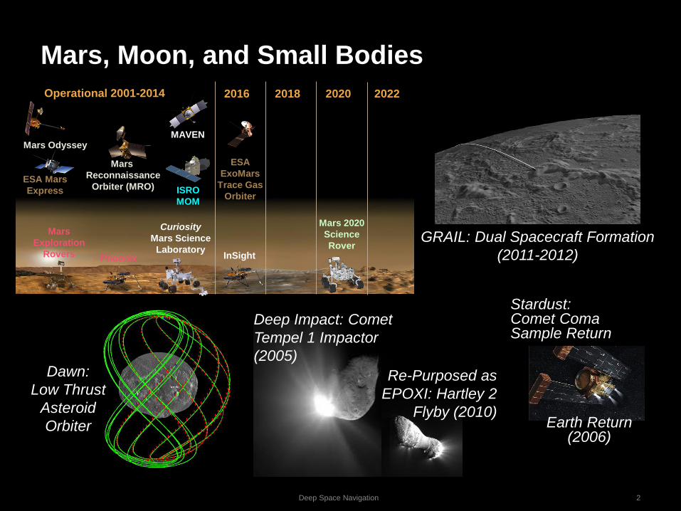
Mars, Moon, and Small Bodies
GRAIL: Dual Spacecraft Formation
(2011-2012)
Dawn:
Low Thrust
Asteroid
Orbiter
Stardust: Comet Coma Sample Return
Deep Impact: Comet
Tempel 1 Impactor
(2005)
Re-Purposed as
EPOXI: Hartley 2
Flyby (2010)Earth Return
(2006)
Mars
Reconnaissance
Orbiter (MRO)ESA Mars
Express
Mars Odyssey
Operational 2001-2014
MAVEN
2016 2018 2020
Curiosity
Mars Science
Laboratory
Mars 2020
Science
Rover
2022
ESA
ExoMars
Trace Gas
Orbiter
Mars
Exploration
Rovers InSight
ISRO
MOM
Phoenix

UH
F A
ntenna
Cam
era X
-Band P
atch Arra
y
IRIS
Radio
C&
DH
Electronics
EP
S E
lectronics
Star T
racker &
AC
S E
lectronics
MM
A H
aWK
Solar P
anels
Additional
Solar P
anel
AC
S C
old Gas
(hidden)
Batteries A
CS
RW
A (3x)
(hidden)
New Horizons Pluto
Juno
Jupiter
Orbiter
Cassini Saturn Tour
Outer Planet MissionsInterplanetary
CubeSats
Europa Clipper
Galileo
Jovian
Tour

Deep Space Navigation 4
Deep Space Navigation
1. Positions and Physical Models of Celestial Bodies
2. “Flyable” Trajectories
3. Fly the Trajectory
Includes VLBI and Celestial Reference Frame
4. High precision dynamic and measurement models– Relativity – lots of gravity and high speeds tweak onboard clocks
– Non-gravitational – spacecraft attitude control, venting, leaking and
outgassing perturb trajectories
– Maneuvers
Four Things Needed Beyond Low Earth Orbit
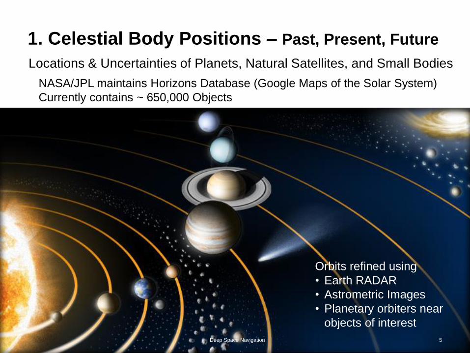
1. Celestial Body Positions – Past, Present, Future
Orbits refined using
• Earth RADAR
• Astrometric Images
• Planetary orbiters near
objects of interest
Locations & Uncertainties of Planets, Natural Satellites, and Small Bodies
5Deep Space Navigation
NASA/JPL maintains Horizons Database (Google Maps of the Solar System)
Currently contains ~ 650,000 Objects

Deep Space Navigation 6
Optimal Trajectory Design
2. “Flyable” Travel Plan
Hohman transfer orbitCredit: Phoenix7777
Interplanetary Superhighway

Deep Space Navigation 7
Aside: Low-Thrust and Low-Energy Trajectories
2. “Flyable” Trajectories
GRAIL low-energy
trajectory enabled mission
to reduce fuel
requirements and lunar
arrival velocity
Earth-Moon
Rotating Frame
Earth
Asteroid Retrieval Mission
Distant Retrograde Orbit (DRO)
Stable storage orbit (> 100 yr)
proposed by NASA/JPL MD/Nav
Dawn low-thrust trajectory
achieved total Dv > 10 km/s.
Allowed both Vesta and
Ceres to be explored

Deep Space Navigation 8
3. Fly the Trajectory
Spacecraft state vector =𝒙, 𝒗; 𝒕
➢ Ensure that actual
trajectory is sufficiently
close to planned
trajectory
➢ Requires measurements
from which state vector
can be estimated
➢ Requires monitoring• Relative motions ~ 10 km/s
• Non-gravitational forces

3. Fly the Trajectory
R
right
ascension a
declination d
• Range (R)In practice, not used often
• Range-rate ሶ𝑹 or Doppler (vz)
• Plane of sky (a, d)➢ Measured relative to Celestial
Reference Frame
• Proper motion (ma, md)In practice, not used
Deep Space Navigation 9

Collect Measurements
DSN Advanced
Interferometric
(DDOR, VLBA)
ESA
DSN
State of the Art
Ground-based
Radio Navigation(MER, PHX, MSL)
Deep Space Navigation 10

Deep Space Navigation 11
3. Fly the Trajectory
∆DOR provides Plane-of-Sky
measurements
• Determine position of
spacecraft relative to
stationary reference source
of known position
• Essential beyond lunar
orbit
• Complementary to line-of-
sight from Doppler and
RangeOptical analogy is “Optical
Astrometry”▪ Uses star catalog
instead of quasars
▪ Gaia
∆DOR (Delta-Differential One-Way Range)

Deep Space Navigation 12
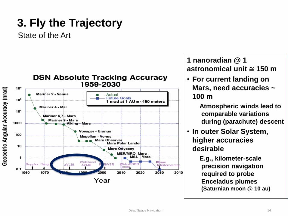
State of the Art
3. Fly the Trajectory

Deep Space Tracking Stations
New Norcia
Cebreros
Malargüe
Canberra
Goldstone
Madrid
Usuda
UchinouraByalalu
13
NASA Deep Space Network and non-NASA
Deep Space Navigation 14
State of the Art
3. Fly the Trajectory
1 nanoradian @ 1
astronomical unit ≅ 150 m
• For current landing on
Mars, need accuracies ~
100 m
Atmospheric winds lead to
comparable variations
during (parachute) descent
• In outer Solar System,
higher accuracies
desirable
E.g., kilometer-scale
precision navigation
required to probe
Enceladus plumes (Saturnian moon @ 10 au)

15
right
ascension a
declination d
R
Deep Space Navigation
3. Fly the Trajectory: Toward the Future

16Deep Space Navigation
3. Fly the Trajectory: Toward
the Future
ICRF3 X-band
Defining
ICRF3 K-band
ICRF3 Ka-band
International Celestial
Reference Frame – Third
Realization (ICRF3)
➢ Notable factor – multi-
wavelength coverage: S-
X (legacy), K, X-Ka
• S-X under increasing
threat from radio
spectrum use
• K- and Ka-band are
growth for deep space
telecommunications
➢ Beyond ICRF3
• Southern Hemisphere
• Ecliptic+
• Increasing Wavelength
Coverage

Reference Frame Development
New Norcia
Cebreros
Malargüe
Canberra
Goldstone
Madrid
Usuda
UchinouraByalalu
17
VLBA(ngVLA)

18Deep Space Navigation
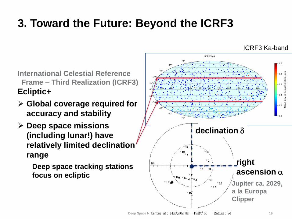
3. Toward the Future: Beyond the ICRF3
ICRF3 Ka-bandInternational Celestial Reference Frame –
Third Realization (ICRF3)
Southern Hemisphere
➢ Global coverage required for
accuracy and stability
➢ VLBA is northern hemisphere, deep-
space tracking has
notable southern
hemisphere coverage
19Deep Space Navigation
3. Toward the Future: Beyond the ICRF3
ICRF3 Ka-band
International Celestial Reference
Frame – Third Realization (ICRF3)
Ecliptic+
➢ Global coverage required for
accuracy and stability
➢ Deep space missions
(including lunar!) have
relatively limited declination
range
Deep space tracking stations
focus on ecliptic
right
ascension a
declination d
Jupiter ca. 2029,
a la Europa
Clipper

20Deep Space Navigation
3. Toward the Future
VLBA for Deep Space
Navigation
Possible improvements by
including the VLBA for deep
space navigation?
Mars approach example
NASA stations only: —
and —
NASA stations + VLBA
antennas: — and — Martin-Mur & Highsmith, “Mars Approach
Navigation Using the VLBA”

Deep Space Navigation 21
Summary
1. Positions and Physical Models of Celestial Bodies
2. “Flyable” Trajectories
3. Fly the TrajectoryIncludes VLBI and Celestial Reference Frame
Toward the Future: Beyond ICRF3
Southern Hemisphere
Ecliptic+VLBA for Deep Space Navigation?
4. High precision dynamic and measurement models
[T. Ely et al., “Comparison of Deep Space Navigation using Optical
Imaging, Pulsar Time-of-Arrival Tracking, and/or Radiometric
Tracking,” Acta Astronautica, submitted]

Backup Material

Deep Space Navigation 23
Current Deep Space Navigation Data Types
• Radio metric observations are based on light-time.
– Usually multiplied by speed to light to express as distance
– Accuracy of clocks at stations often limit accuracy
• Doppler measures rate of change of light time (velocity).
– Measurement precision is ~(l/1000)/100 s ~ 3 µm/100 s ~ 0.3 µm/s ~ c/1015
– Accuracy usually limited by solar plasma, ionosphere, or troposphere
– High accuracy of Doppler is essential for estimation of force models.
• Range measures absolute light time (1-way or 2-way).
– Radio uses group delay of modulation with accuracy ~ 1 m.
• 2-way range usually used; 1-way range requires much better clock accuracy
• Better accuracy not helpful, since transverse components much less well known
• VLBI or ∆DOR (delta-differenced one-way range)
– Measure difference of arrival time of signal from spacecraft at two stations
• ∆t/c divided by distance between stations, gives angular measure.
• Quasars (natural radio sources) used to calibrate difference in station clocks.

Deep Space Navigation 24
Orbit Error Components for Cruise
• Transverse position and velocity inferred from
– Time history of Doppler (signature from Earth rotation)
Singular for zero declination
– Difference in range measurements
Limited by station clock calibration to ~ 30 nanoradian
• VLBI/∆DOR measures transverse position directly.
Use of natural radio source as timing calibration signal enables accuracy
< 1 nanoradian
Range
r
z
y
x
Declination
Right Ascension
! Radial
! Declination
! Right Ascension
Spacecraft PositionUncertainty Ellipsoid
• For cruise, need to estimate
spacecraft position and velocity
as function of time
• Radial (to Earth) position and
velocity measured directly by
range and Doppler

6/14/15 IPPW-15 - Navigation 25
Sample X-band Doppler Residuals
• DSN Doppler files can be integrated to show actual measured
changes in range.
– Unknown constant bias must be estimated.
• Missing or deleted points complicate the integration.
– Require either correction for missing cycles or estimation of additional bias.
• Sample shown is at SEP ~ 90°, so limited by wet troposphere noise.

6/14/15 IPPW-15 - Navigation 26
Looking Ahead – Mission Concepts
Technology Infusion:• Deep Space Atomic Clock – to reduce DSN tracking needs
• Low-Thrust / Low-Energy Trajectories – to increase mass delivery
• Onboard Optical and Radio Navigation - to enable pinpoint landing and
autonomous operations
UH
F A
nte
nna
Cam
era
X-B
and P
atch
Arra
y
IRIS
Radio
C
&D
H E
lectro
nics
EP
S E
lectro
nics
Sta
r Tra
cker &
AC
S E
lectro
nics
MM
A H
aW
K
Sola
r Panels
Additio
nal
Sola
r Panel
AC
S C
old
Gas
(hid
den)
Batte
ries
AC
S R
WA (3
x)
(hid
den)

6/14/15 IPPW-15 - Navigation 27
Determine Natural Body Physical Models
Lunar
Gravity
Map
• Pole Orientations
• Spin Rates
• Shape Models
• Gravity Fields
Often needed for flight operations prior to availability from science team
Mars
Gravity
Map
Phobos Orientation
Vesta Shape Model

6/14/15 IPPW-15 - Navigation 28
Find ‘Global Minima’
Complex constraints
complicate the initial
search…
State of the art
techniques are used to
uncover exceptionally
strong trajectory
solutions…Launch Date
Arr
ival
Date
Pork Chop
Plot
Not always straightforward

6/14/15 IPPW-15 - Navigation 29
International Partnerships
ISRO Mars Orbiter
(Ongoing)
JAXA Hayabusa-2 Asteroid
Sample Return (2014-2020)
ESA Rosetta
Comet Rendezvous/Landing (2014)ESA Mars Express (2003)
Mars Orbit Insertion
JAXA Hayabusa-1 Comet Sample Return
(2010) Earth Return

6/14/15 IPPW-15 - Navigation 30
Entry Point Targeting
NASA Deep Space Entry/Re-Entry Experiences
Earth:
– Genesis (2004 direct entry)
– Stardust (2006 direct entry)
Mars:
– Viking 1,2 (1976 from orbit)
– Mars Pathfinder (1997 direct entry)
– Mars Exploration Rovers (2004 direct entry)
– Phoenix Mars Lander (2008 direct entry)
– Mars Science Laboratory (2012 direct entry)
Jupiter:
– Galileo (2003 from orbit)
Titan:
– Cassini-ESA/Huygens (2005 from Saturn orbit)

6/14/15 IPPW-15 - Navigation 31
Deep Space Navigation Components
• Deep Space Navigation refers to orbit determination & prediction,
and maneuver design to reach desired target at desired time.
– Target orbit/position is usually estimated in advance separately, but
sometimes improved with navigation data.
• Tracking data used from Earth observatories.
– Primarily done with antennas of the Deep Space Network (DSN) located in
Goldstone (CA), Madrid (Spain), and Canberra (Australia).
– Occasionally augmented by stations in Japan (ISAS), Australia, and
Argentina (ESA).
• Navigation phases include; cruise, planetary orbit, satellite tour.
– Cruise generally has weakest observation geometry.
• Most demanding performance to date is direct landing on Mars (MSL).
– Planetary orbiters generally have larger dynamical signature.
– Satellite tour (e.g. Galileo, Cassini) geometrically in-between
• Satellite orbit determination often requires spacecraft-based imaging

6/14/15 IPPW-15 - Navigation 32
Next Generation Mars Entry
Descent and Landing
TECHNOLOGY #1
Terrain Relative
Navigation (TRN)
TECHNOLOGY #2
Guidance for Fuel Optimal
Large Diverts (G-FOLD)
MSLPin-Point
(future)
Multi-
Point
(proposed for
M2020)
image
landmarks landing ellipse
TECHNOLOGY #3
Hazard Detection &
Avoidance

AutoNav
On July 4, 2005, AutoNav
enabled the third of NASA’s
first three comet nuclei
missions (at left); the other
two being:
Borrelly, Sept 2001,
Wild 2, Nov. 2002, both also
captured with AutoNav.
These were followed by
Hartley2 in 2010, and a
Tempel 1 revisit in 2011.
AutoNav placed optical
navigation elements onboard
for otherwise impossible
speedy turn-around of
navigation operations.
6/14/15 IPPW-15 - Navigation 33