Genesis and Dispersal of Carbonate Mud Relative to Late Quaternary Sea-Level Change Along a...
14
Copyright q 2005, SEPM (Society for Sedimentary Geology) 1527-1404/05/075-665/$03.00 Journal of Sedimentary Research Journal of Sedimentary Research, 2005, v. 75, 665–678 DOI: 10.2110/jsr.2005.054 GENESIS AND DISPERSAL OF CARBONATE MUD RELATIVE TO LATE QUATERNARY SEA-LEVEL CHANGE ALONG A DISTALLY-STEEPENED CARBONATE RAMP (NORTHWESTERN SHELF, WESTERN AUSTRALIA) GEORGE R. DIX, 1 NOEL P. JAMES, 2 T. KURTIS KYSER, 2 YVONNE BONE, 3 AND LINDSAY B. COLLINS 4 1 Department of Earth Sciences, Carleton University, and Ottawa Carleton Geoscience Centre, 1125 Colonel By Drive, Ottawa, Ontario K1S 5B6, Canada e-mail: [email protected] 2 Department of Geological Sciences and Geological Engineering, Queen’s University, Kingston, Ontario K7L 3N6, Canada 3 Geology and Geophysics (School of Earth and Environmental Sciences), University of Adelaide, Adelaide, South Australia 5005, Australia 4 Department of Applied Geology, Curtin University, Perth, Western Australia 6102, Australia ABSTRACT: Accumulation of carbonate mud is minor on the North- west Shelf (Western Australia), a broad (, 200–300 km wide), distally steepened, tropical carbonate ramp. It is negligible along most of the inner ramp (0 to 50 m water depth) owing to siliciclastic (riverine) input. It is also negligible along the mid (from 50 to 120 m) ramp, and where the entire ramp narrows to , 100 km, owing to constant re- working by storm waves and ocean swell. In these areas, carbonate mud is derived mostly from mechanical degradation of skeletal frag- ments, but this does not include calcified remains of calcareous green algae (e.g., Halimeda) although these plants grow locally. Only along the outer (120 to 200 m water depth) ramp and slope is there any relatively abundant accumulation of carbonate mud. Here the sediment consists of modern pelagic (foraminifer, pteropod, and nannoplantkon) ooze and aragonitic needle-rich (, 2 mm) micrite, the latter having an age (based on AMS 14 C) of ; 19 ka. Distribution of aragonite micrite defines an extensive (5.0 3 104 km 2 ), yet relatively narrow (, 40 km), tract running ; 600 km along the platform margin. Crystal morphology, mineralogy, and isotope (C, O) composition identify the micrite to be a seawater precipitate, its production and seaward export having occurred during the Last Glacial Maximum, when lowered sea level transformed the otherwise broad platform into a narrow epicon- tinental shelf margin, now the modern distal slope. Today, this sedi- ment body lies stranded in deep water, about 200–300 km seaward of the shallow inner ramp. The volume of micrite produced appears equal to the present-day production potential of the Great Bahama Bank. Rapid postglacial rise in sea level, and change in platform geometry, climate, and oceanography, were very influential factors, in addition to water depth and area of submergence, in the production and dis- tribution of aragonite micrite along the Northwest Shelf. In general: (1) epicontinental carbonate platforms can lack substantial micrite ac- cumulation when oceanic current and wave energies sweep unimpeded across a platform, and coastal clastics and absence of shoal barriers prevent development of protective lagoons and carbonate tidal flats; (2) not all highstand carbonate systems are associated with significant amounts of micrite in shallow water environments, nor do they nec- essarily export large volumes of micrite to the periplatform realm; and (3) some lowstand systems can produce and export volumes of carbon- ate mud that rival highstand systems. INTRODUCTION Micrite or clay-size carbonate is an important depositional constituent of most modern and ancient tropical, shallow-water (0 to 20 m) carbonate platforms (Bathurst 1975; Wilson 1975). Dynamic facies models illustrate inner shelf or ramp mud as an important facies in each system (lowstand, transgressive, and highstand) tract associated with a sea-level cycle (Sarg 1988; Schlager 1991; Burchette and Wright 1992; Handford and Loucks 1993; Read 1995). The origins of this carbonate mud include skeletal pro- duction and precipitation from seawater (Bathurst 1975; Shinn et al. 1989; Macintyre and Reid 1992; Robbins and Blackwelder 1992; Milliman et al. 1993). These sources are usually highly sensitive to environmental controls (Bathurst 1975; Robbins et al. 1997). As such, temporal variation in abun- dance of shelf-derived mud along carbonate slopes is a critical proxy for platform submergence (Schlager et al. 1994). Late Quaternary sedimentation along the Northwest Shelf, Western Aus- tralia (Fig. 1), illustrates a more complicated potential for micrite produc- tion; that is, there is a less direct response between production/accumulation potential and sea-level change. Along this platform margin, abundant shal- low-water carbonate mud is associated with recent glacial lowstand con- ditions, not the modern highstand setting. Influential factors prior to and during postglacial (, 18 ka) rise in sea level include rate of sea-level rise, oceanography, climate, and platform geometry and size. SETTING The area examined in this study is that part of the Northwest Shelf, Australia, seaward of a broad continental embayment between Dampier and Broome (Figs. 1, 2). This extensive carbonate platform (6.4 3 105 km 2 ) is a tropical, distally steepened, oceanic ramp (Read 1985; James et al. 2004). Bathymetry.—The ramp has a gentle (0.058) seaward gradient extending to a distal slope positioned ; 200 to 300 km offshore in water depths of about 200 m (Fig. 2). The continental embayment is expressed mostly by middle-ramp bathymetry: a drowned paleoshoreline lies along the base of an escarpment of ; 30 m relief in water depths of ; 125 m, immediately seaward of the 100 meter isobath (Fig. 2). The escarpment is the result of intertidal erosion during the sea-level lowstand (2125 m) at the end of the Last Glacial Maximum (; 19 ka; Yokoyama et al. 2001). The orientation of the 100 meter isobath suggests that the paleoshoreline bordered four shallow-water embayments (I–IV; Fig. 2) along the inner paleoplatform. Oceanography and Climate.—The Northwest Shelf is a very high-en- ergy environment because of cyclones (Lourensz 1981), storm and strong fair-weather waves (Jones 1973; James et al. 2004), and strong tidal cur- rents. There is a northward increase in tidal range from microtidal (, 2
Transcript of Genesis and Dispersal of Carbonate Mud Relative to Late Quaternary Sea-Level Change Along a...
Copyright q 2005, SEPM (Society for Sedimentary Geology) 1527-1404/05/075-665/$03.00
Journal ofSedimentaryResearch
Journal of Sedimentary Research, 2005, v. 75, 665–678DOI: 10.2110/jsr.2005.054
GENESIS AND DISPERSAL OF CARBONATE MUD RELATIVE TO LATE QUATERNARY SEA-LEVELCHANGE ALONG A DISTALLY-STEEPENED CARBONATE RAMP
(NORTHWESTERN SHELF, WESTERN AUSTRALIA)
GEORGE R. DIX,1 NOEL P. JAMES,2 T. KURTIS KYSER,2 YVONNE BONE,3 AND LINDSAY B. COLLINS4
1 Department of Earth Sciences, Carleton University, and Ottawa Carleton Geoscience Centre, 1125 Colonel By Drive, Ottawa, Ontario K1S 5B6, Canadae-mail: [email protected]
2 Department of Geological Sciences and Geological Engineering, Queen’s University, Kingston, Ontario K7L 3N6, Canada3 Geology and Geophysics (School of Earth and Environmental Sciences), University of Adelaide, Adelaide, South Australia 5005, Australia
4 Department of Applied Geology, Curtin University, Perth, Western Australia 6102, Australia
ABSTRACT: Accumulation of carbonate mud is minor on the North-west Shelf (Western Australia), a broad (, 200–300 km wide), distallysteepened, tropical carbonate ramp. It is negligible along most of theinner ramp (0 to 50 m water depth) owing to siliciclastic (riverine)input. It is also negligible along the mid (from 50 to 120 m) ramp, andwhere the entire ramp narrows to , 100 km, owing to constant re-working by storm waves and ocean swell. In these areas, carbonatemud is derived mostly from mechanical degradation of skeletal frag-ments, but this does not include calcified remains of calcareous greenalgae (e.g., Halimeda) although these plants grow locally. Only alongthe outer (120 to 200 m water depth) ramp and slope is there anyrelatively abundant accumulation of carbonate mud. Here the sedimentconsists of modern pelagic (foraminifer, pteropod, and nannoplantkon)ooze and aragonitic needle-rich (, 2 mm) micrite, the latter havingan age (based on AMS 14C) of ; 19 ka. Distribution of aragonitemicrite defines an extensive (5.0 3 104 km2), yet relatively narrow (,40 km), tract running ; 600 km along the platform margin. Crystalmorphology, mineralogy, and isotope (C, O) composition identify themicrite to be a seawater precipitate, its production and seaward exporthaving occurred during the Last Glacial Maximum, when lowered sealevel transformed the otherwise broad platform into a narrow epicon-tinental shelf margin, now the modern distal slope. Today, this sedi-ment body lies stranded in deep water, about 200–300 km seaward ofthe shallow inner ramp. The volume of micrite produced appears equalto the present-day production potential of the Great Bahama Bank.
Rapid postglacial rise in sea level, and change in platform geometry,climate, and oceanography, were very influential factors, in additionto water depth and area of submergence, in the production and dis-tribution of aragonite micrite along the Northwest Shelf. In general:(1) epicontinental carbonate platforms can lack substantial micrite ac-cumulation when oceanic current and wave energies sweep unimpededacross a platform, and coastal clastics and absence of shoal barriersprevent development of protective lagoons and carbonate tidal flats;(2) not all highstand carbonate systems are associated with significantamounts of micrite in shallow water environments, nor do they nec-essarily export large volumes of micrite to the periplatform realm; and(3) some lowstand systems can produce and export volumes of carbon-ate mud that rival highstand systems.
INTRODUCTION
Micrite or clay-size carbonate is an important depositional constituent ofmost modern and ancient tropical, shallow-water (0 to 20 m) carbonate
platforms (Bathurst 1975; Wilson 1975). Dynamic facies models illustrateinner shelf or ramp mud as an important facies in each system (lowstand,transgressive, and highstand) tract associated with a sea-level cycle (Sarg1988; Schlager 1991; Burchette and Wright 1992; Handford and Loucks1993; Read 1995). The origins of this carbonate mud include skeletal pro-duction and precipitation from seawater (Bathurst 1975; Shinn et al. 1989;Macintyre and Reid 1992; Robbins and Blackwelder 1992; Milliman et al.1993). These sources are usually highly sensitive to environmental controls(Bathurst 1975; Robbins et al. 1997). As such, temporal variation in abun-dance of shelf-derived mud along carbonate slopes is a critical proxy forplatform submergence (Schlager et al. 1994).
Late Quaternary sedimentation along the Northwest Shelf, Western Aus-tralia (Fig. 1), illustrates a more complicated potential for micrite produc-tion; that is, there is a less direct response between production/accumulationpotential and sea-level change. Along this platform margin, abundant shal-low-water carbonate mud is associated with recent glacial lowstand con-ditions, not the modern highstand setting. Influential factors prior to andduring postglacial (, 18 ka) rise in sea level include rate of sea-level rise,oceanography, climate, and platform geometry and size.
SETTING
The area examined in this study is that part of the Northwest Shelf,Australia, seaward of a broad continental embayment between Dampier andBroome (Figs. 1, 2). This extensive carbonate platform (6.4 3 105 km2)is a tropical, distally steepened, oceanic ramp (Read 1985; James et al.2004).
Bathymetry.—The ramp has a gentle (0.058) seaward gradient extendingto a distal slope positioned ; 200 to 300 km offshore in water depths ofabout 200 m (Fig. 2). The continental embayment is expressed mostly bymiddle-ramp bathymetry: a drowned paleoshoreline lies along the base ofan escarpment of ; 30 m relief in water depths of ; 125 m, immediatelyseaward of the 100 meter isobath (Fig. 2). The escarpment is the result ofintertidal erosion during the sea-level lowstand (2125 m) at the end of theLast Glacial Maximum (; 19 ka; Yokoyama et al. 2001). The orientationof the 100 meter isobath suggests that the paleoshoreline bordered fourshallow-water embayments (I–IV; Fig. 2) along the inner paleoplatform.
Oceanography and Climate.—The Northwest Shelf is a very high-en-ergy environment because of cyclones (Lourensz 1981), storm and strongfair-weather waves (Jones 1973; James et al. 2004), and strong tidal cur-rents. There is a northward increase in tidal range from microtidal (, 2
J S R666 G.R. DIX ET AL.
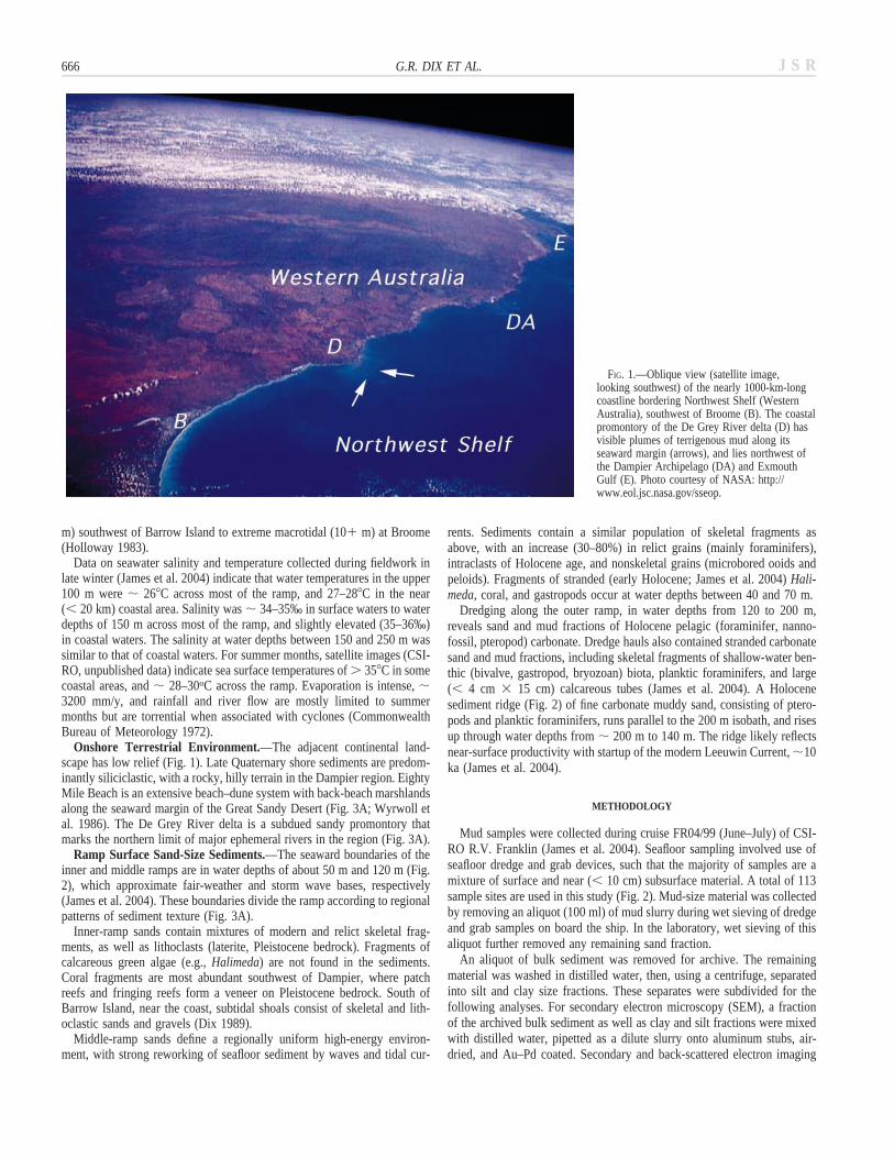
FIG. 1.—Oblique view (satellite image,looking southwest) of the nearly 1000-km-longcoastline bordering Northwest Shelf (WesternAustralia), southwest of Broome (B). The coastalpromontory of the De Grey River delta (D) hasvisible plumes of terrigenous mud along itsseaward margin (arrows), and lies northwest ofthe Dampier Archipelago (DA) and ExmouthGulf (E). Photo courtesy of NASA: http://www.eol.jsc.nasa.gov/sseop.
m) southwest of Barrow Island to extreme macrotidal (101 m) at Broome(Holloway 1983).
Data on seawater salinity and temperature collected during fieldwork inlate winter (James et al. 2004) indicate that water temperatures in the upper100 m were ; 268C across most of the ramp, and 27–288C in the near(, 20 km) coastal area. Salinity was ; 34–35‰ in surface waters to waterdepths of 150 m across most of the ramp, and slightly elevated (35–36‰)in coastal waters. The salinity at water depths between 150 and 250 m wassimilar to that of coastal waters. For summer months, satellite images (CSI-RO, unpublished data) indicate sea surface temperatures of . 358C in somecoastal areas, and ; 28–30oC across the ramp. Evaporation is intense, ;3200 mm/y, and rainfall and river flow are mostly limited to summermonths but are torrential when associated with cyclones (CommonwealthBureau of Meteorology 1972).
Onshore Terrestrial Environment.—The adjacent continental land-scape has low relief (Fig. 1). Late Quaternary shore sediments are predom-inantly siliciclastic, with a rocky, hilly terrain in the Dampier region. EightyMile Beach is an extensive beach–dune system with back-beach marshlandsalong the seaward margin of the Great Sandy Desert (Fig. 3A; Wyrwoll etal. 1986). The De Grey River delta is a subdued sandy promontory thatmarks the northern limit of major ephemeral rivers in the region (Fig. 3A).
Ramp Surface Sand-Size Sediments.—The seaward boundaries of theinner and middle ramps are in water depths of about 50 m and 120 m (Fig.2), which approximate fair-weather and storm wave bases, respectively(James et al. 2004). These boundaries divide the ramp according to regionalpatterns of sediment texture (Fig. 3A).
Inner-ramp sands contain mixtures of modern and relict skeletal frag-ments, as well as lithoclasts (laterite, Pleistocene bedrock). Fragments ofcalcareous green algae (e.g., Halimeda) are not found in the sediments.Coral fragments are most abundant southwest of Dampier, where patchreefs and fringing reefs form a veneer on Pleistocene bedrock. South ofBarrow Island, near the coast, subtidal shoals consist of skeletal and lith-oclastic sands and gravels (Dix 1989).
Middle-ramp sands define a regionally uniform high-energy environ-ment, with strong reworking of seafloor sediment by waves and tidal cur-
rents. Sediments contain a similar population of skeletal fragments asabove, with an increase (30–80%) in relict grains (mainly foraminifers),intraclasts of Holocene age, and nonskeletal grains (microbored ooids andpeloids). Fragments of stranded (early Holocene; James et al. 2004) Hali-meda, coral, and gastropods occur at water depths between 40 and 70 m.
Dredging along the outer ramp, in water depths from 120 to 200 m,reveals sand and mud fractions of Holocene pelagic (foraminifer, nanno-fossil, pteropod) carbonate. Dredge hauls also contained stranded carbonatesand and mud fractions, including skeletal fragments of shallow-water ben-thic (bivalve, gastropod, bryozoan) biota, planktic foraminifers, and large(, 4 cm 3 15 cm) calcareous tubes (James et al. 2004). A Holocenesediment ridge (Fig. 2) of fine carbonate muddy sand, consisting of ptero-pods and planktic foraminifers, runs parallel to the 200 m isobath, and risesup through water depths from ; 200 m to 140 m. The ridge likely reflectsnear-surface productivity with startup of the modern Leeuwin Current, ;10ka (James et al. 2004).
METHODOLOGY
Mud samples were collected during cruise FR04/99 (June–July) of CSI-RO R.V. Franklin (James et al. 2004). Seafloor sampling involved use ofseafloor dredge and grab devices, such that the majority of samples are amixture of surface and near (, 10 cm) subsurface material. A total of 113sample sites are used in this study (Fig. 2). Mud-size material was collectedby removing an aliquot (100 ml) of mud slurry during wet sieving of dredgeand grab samples on board the ship. In the laboratory, wet sieving of thisaliquot further removed any remaining sand fraction.
An aliquot of bulk sediment was removed for archive. The remainingmaterial was washed in distilled water, then, using a centrifuge, separatedinto silt and clay size fractions. These separates were subdivided for thefollowing analyses. For secondary electron microscopy (SEM), a fractionof the archived bulk sediment as well as clay and silt fractions were mixedwith distilled water, pipetted as a dilute slurry onto aluminum stubs, air-dried, and Au–Pd coated. Secondary and back-scattered electron imaging

J S R 667LATE QUATERNARY CARBONATE MUD, NORTHWEST SHELF
FIG. 2.—The study area along the Northwest Shelf, Australia (see box in inset map), illustrating bathymetry (meters), ramp divisions, transects of sample sites (numberedblack dots), and general hinterland geology. The positions of a Holocene pelagic ridge (thick black line) and four paleoembayments at 19 ka are indicated (I–IV). Modifiedfrom James et al. (2004). Inset map shows location of Bonaparte Gulf (B) referred to in the text.
used a JEOL 6400 SEM, set with a working distance of 15–17 mm, andaccelerating voltages of 15 and 20 kV.
Samples for stable (C, O) isotope analysis and X-ray diffractometry(XRD) were mixed with dilute hydrogen peroxide to remove organic ma-terial, then washed in distilled water and dried. For XRD analysis (Cu Ka),powdered samples were scanned from 4 to 64 degrees 2u to identify peaktypes, then stepwise analysis of individual carbonate peak areas (from 25to 32 degrees 2u) for weight percent calculation (Milliman 1974). A stan-dard error of 1 5% was determined for multiple repeats. The process forcarbon and oxygen isotope analysis followed McCrea (1950). Samples wererun on a MAT 252 at Queen’s University, and values are reported relativeto V-PDB. Three bulk samples of the clay fraction, clean of organic detri-tus, were sent to Isotrace Laboratories (Toronto) for AMS 14C age-datedetermination. Results were calibrated to calendar years using Bard et al.’s(1998) curves, and subtracting 400 years for the ocean reservoir effect.
RESULTS
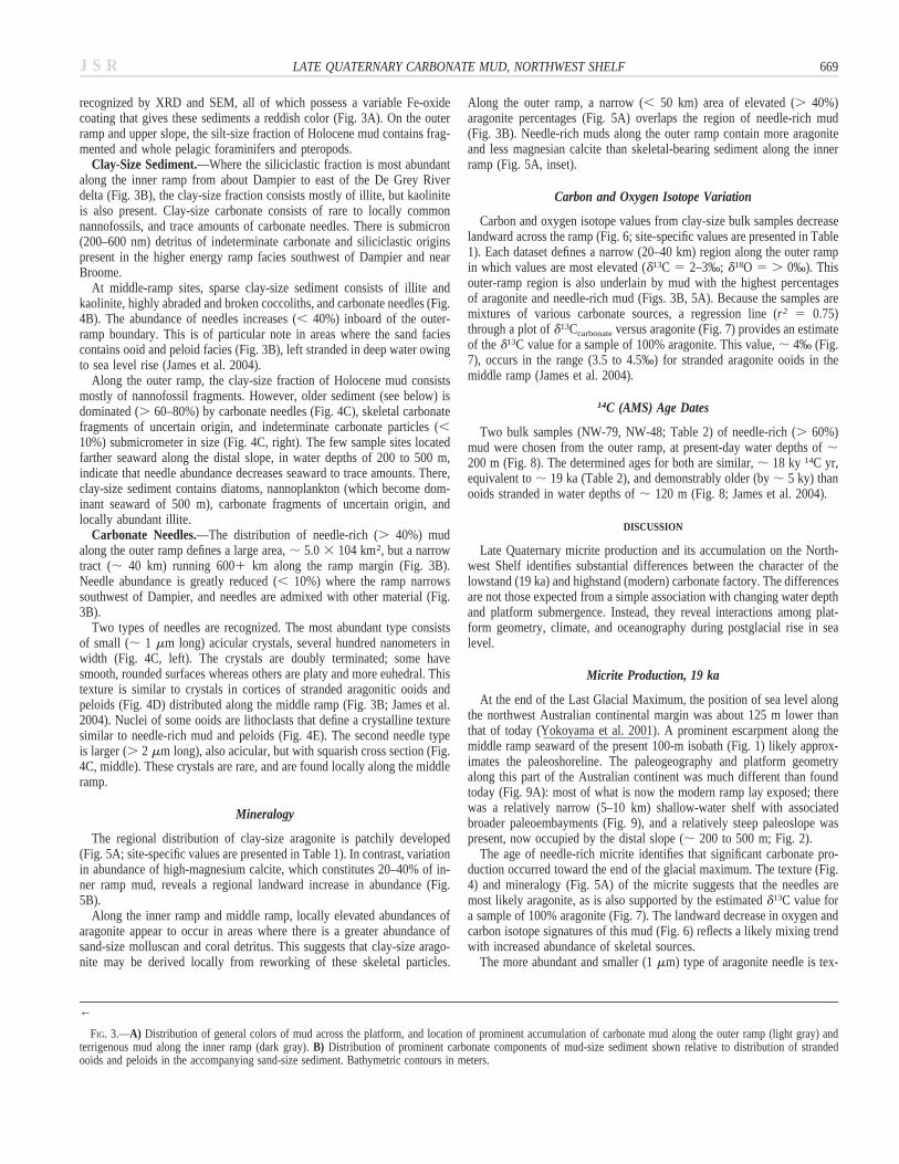
Distribution and Composition of Mud
Regional Distribution.—Carbonate mud is a significant part of surficialsediments only along the outer ramp, seaward of the 120 m isobath. In thisregion, modern and late Pleistocene sediment fractions (see below) are
present. Moving landward across the middle-ramp and inner-ramp areas,the abundance of siliciclastics increases (Fig. 3A). Carbonate or siliciclasticmud is negligible along the middle ramp and across the entire ramp south-west of Dampier, where the platform narrows to , 100 km (Fig. 2). Inthis latter region, mud-size sediment is preferentially trapped in the lee ofreefs and rock platforms protected from strong tidal currents. BetweenDampier and Broome, mud of mixed carbonate and terrigenous origin oc-curs along the shoreline (Fig. 4A). From about Dampier to east of the DeGrey River delta (Fig. 2), the mud fraction is predominantly terrigenouswith abundant clay-size sediment (Fig. 3B). This is qualitatively reflectedby an increased reddening of bulk sediment samples moving toward theshoreline, especially about the De Grey delta (Fig. 3A). There are smallplumes of reddish mud-laden water around this delta (Fig. 1); in coastalwaters south of Barrow Island, similar plumes migrate up and down thecoast daily because of strong tidal currents (Dix 1989).
Silt-Size Sediment.—On the inner ramp, silt-size sediment consists of30% carbonate and 70% siliciclastic sediment. Benthic skeletal fragmentsinclude mostly bivalves, gastropods, sponge spicules, foraminifers, andbryozoans. Diatoms are present locally, and coral sediment occurs south-west of Dampier. The ubiquity of planktic foraminifers illustrates the lackof an oceanic barrier along the ramp. The siliciclastic fraction of inner rampmud consists of quartz, pyroxene, amphibole, feldspar, and rock fragments,

J S R668 G.R. DIX ET AL.
J S R 669LATE QUATERNARY CARBONATE MUD, NORTHWEST SHELF
←
FIG. 3.—A) Distribution of general colors of mud across the platform, and location of prominent accumulation of carbonate mud along the outer ramp (light gray) andterrigenous mud along the inner ramp (dark gray). B) Distribution of prominent carbonate components of mud-size sediment shown relative to distribution of strandedooids and peloids in the accompanying sand-size sediment. Bathymetric contours in meters.
recognized by XRD and SEM, all of which possess a variable Fe-oxidecoating that gives these sediments a reddish color (Fig. 3A). On the outerramp and upper slope, the silt-size fraction of Holocene mud contains frag-mented and whole pelagic foraminifers and pteropods.
Clay-Size Sediment.—Where the siliciclastic fraction is most abundantalong the inner ramp from about Dampier to east of the De Grey Riverdelta (Fig. 3B), the clay-size fraction consists mostly of illite, but kaoliniteis also present. Clay-size carbonate consists of rare to locally commonnannofossils, and trace amounts of carbonate needles. There is submicron(200–600 nm) detritus of indeterminate carbonate and siliciclastic originspresent in the higher energy ramp facies southwest of Dampier and nearBroome.
At middle-ramp sites, sparse clay-size sediment consists of illite andkaolinite, highly abraded and broken coccoliths, and carbonate needles (Fig.4B). The abundance of needles increases (, 40%) inboard of the outer-ramp boundary. This is of particular note in areas where the sand faciescontains ooid and peloid facies (Fig. 3B), left stranded in deep water owingto sea level rise (James et al. 2004).
Along the outer ramp, the clay-size fraction of Holocene mud consistsmostly of nannofossil fragments. However, older sediment (see below) isdominated (. 60–80%) by carbonate needles (Fig. 4C), skeletal carbonatefragments of uncertain origin, and indeterminate carbonate particles (,10%) submicrometer in size (Fig. 4C, right). The few sample sites locatedfarther seaward along the distal slope, in water depths of 200 to 500 m,indicate that needle abundance decreases seaward to trace amounts. There,clay-size sediment contains diatoms, nannoplankton (which become dom-inant seaward of 500 m), carbonate fragments of uncertain origin, andlocally abundant illite.
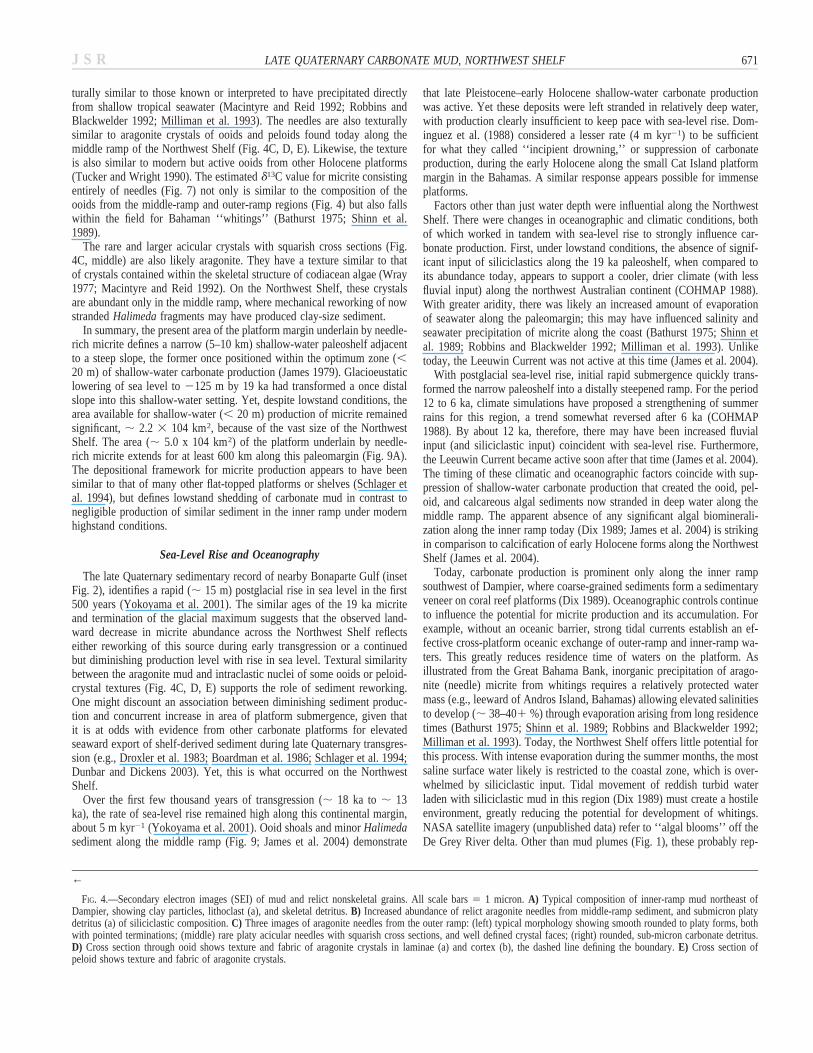
Carbonate Needles.—The distribution of needle-rich (. 40%) mudalong the outer ramp defines a large area, ; 5.0 3 104 km2, but a narrowtract (; 40 km) running 6001 km along the ramp margin (Fig. 3B).Needle abundance is greatly reduced (, 10%) where the ramp narrowssouthwest of Dampier, and needles are admixed with other material (Fig.3B).
Two types of needles are recognized. The most abundant type consistsof small (; 1 mm long) acicular crystals, several hundred nanometers inwidth (Fig. 4C, left). The crystals are doubly terminated; some havesmooth, rounded surfaces whereas others are platy and more euhedral. Thistexture is similar to crystals in cortices of stranded aragonitic ooids andpeloids (Fig. 4D) distributed along the middle ramp (Fig. 3B; James et al.2004). Nuclei of some ooids are lithoclasts that define a crystalline texturesimilar to needle-rich mud and peloids (Fig. 4E). The second needle typeis larger (. 2 mm long), also acicular, but with squarish cross section (Fig.4C, middle). These crystals are rare, and are found locally along the middleramp.
Mineralogy
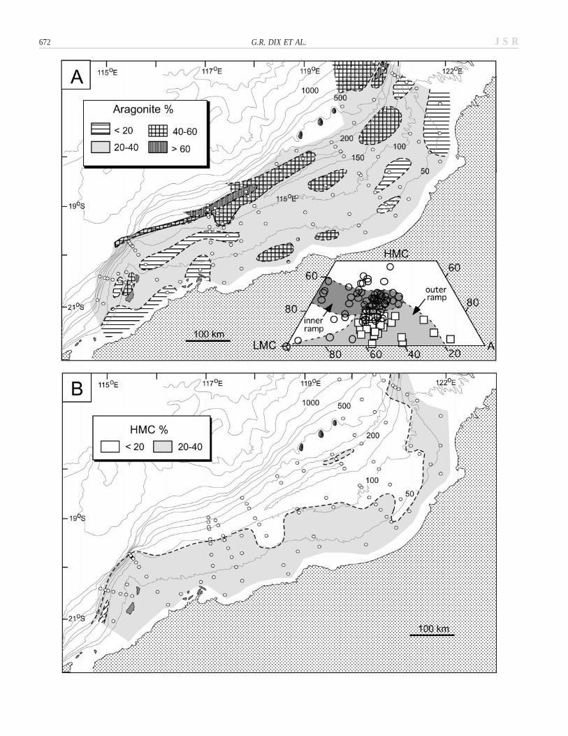
The regional distribution of clay-size aragonite is patchily developed(Fig. 5A; site-specific values are presented in Table 1). In contrast, variationin abundance of high-magnesium calcite, which constitutes 20–40% of in-ner ramp mud, reveals a regional landward increase in abundance (Fig.5B).
Along the inner ramp and middle ramp, locally elevated abundances ofaragonite appear to occur in areas where there is a greater abundance ofsand-size molluscan and coral detritus. This suggests that clay-size arago-nite may be derived locally from reworking of these skeletal particles.
Along the outer ramp, a narrow (, 50 km) area of elevated (. 40%)aragonite percentages (Fig. 5A) overlaps the region of needle-rich mud(Fig. 3B). Needle-rich muds along the outer ramp contain more aragoniteand less magnesian calcite than skeletal-bearing sediment along the innerramp (Fig. 5A, inset).
Carbon and Oxygen Isotope Variation
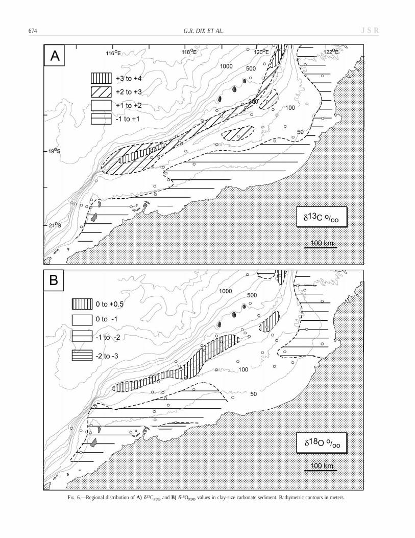
Carbon and oxygen isotope values from clay-size bulk samples decreaselandward across the ramp (Fig. 6; site-specific values are presented in Table1). Each dataset defines a narrow (20–40 km) region along the outer rampin which values are most elevated (d13C 5 2–3‰; d18O 5 . 0‰). Thisouter-ramp region is also underlain by mud with the highest percentagesof aragonite and needle-rich mud (Figs. 3B, 5A). Because the samples aremixtures of various carbonate sources, a regression line (r2 5 0.75)through a plot of d13Ccarbonate versus aragonite (Fig. 7) provides an estimateof the d13C value for a sample of 100% aragonite. This value, ; 4‰ (Fig.7), occurs in the range (3.5 to 4.5‰) for stranded aragonite ooids in themiddle ramp (James et al. 2004).
14C (AMS) Age Dates
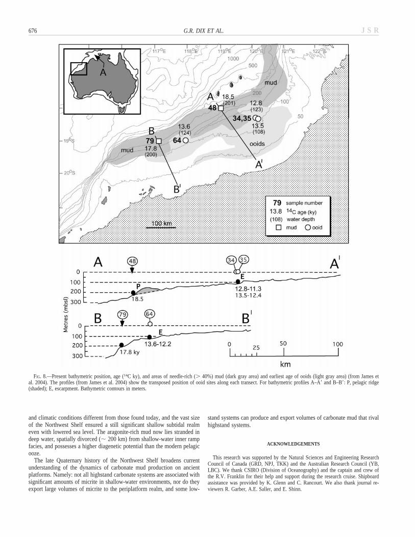
Two bulk samples (NW-79, NW-48; Table 2) of needle-rich (. 60%)mud were chosen from the outer ramp, at present-day water depths of ;200 m (Fig. 8). The determined ages for both are similar, ; 18 ky 14C yr,equivalent to ; 19 ka (Table 2), and demonstrably older (by ; 5 ky) thanooids stranded in water depths of ; 120 m (Fig. 8; James et al. 2004).
DISCUSSION
Late Quaternary micrite production and its accumulation on the North-west Shelf identifies substantial differences between the character of thelowstand (19 ka) and highstand (modern) carbonate factory. The differencesare not those expected from a simple association with changing water depthand platform submergence. Instead, they reveal interactions among plat-form geometry, climate, and oceanography during postglacial rise in sealevel.
Micrite Production, 19 ka
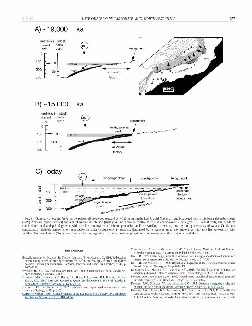
At the end of the Last Glacial Maximum, the position of sea level alongthe northwest Australian continental margin was about 125 m lower thanthat of today (Yokoyama et al. 2001). A prominent escarpment along themiddle ramp seaward of the present 100-m isobath (Fig. 1) likely approx-imates the paleoshoreline. The paleogeography and platform geometryalong this part of the Australian continent was much different than foundtoday (Fig. 9A): most of what is now the modern ramp lay exposed; therewas a relatively narrow (5–10 km) shallow-water shelf with associatedbroader paleoembayments (Fig. 9), and a relatively steep paleoslope waspresent, now occupied by the distal slope (; 200 to 500 m; Fig. 2).
The age of needle-rich micrite identifies that significant carbonate pro-duction occurred toward the end of the glacial maximum. The texture (Fig.4) and mineralogy (Fig. 5A) of the micrite suggests that the needles aremost likely aragonite, as is also supported by the estimated d13C value fora sample of 100% aragonite (Fig. 7). The landward decrease in oxygen andcarbon isotope signatures of this mud (Fig. 6) reflects a likely mixing trendwith increased abundance of skeletal sources.
The more abundant and smaller (1 mm) type of aragonite needle is tex-

J S R670 G.R. DIX ET AL.
J S R 671LATE QUATERNARY CARBONATE MUD, NORTHWEST SHELF
←
FIG. 4.—Secondary electron images (SEI) of mud and relict nonskeletal grains. All scale bars 5 1 micron. A) Typical composition of inner-ramp mud northeast ofDampier, showing clay particles, lithoclast (a), and skeletal detritus. B) Increased abundance of relict aragonite needles from middle-ramp sediment, and submicron platydetritus (a) of siliciclastic composition. C) Three images of aragonite needles from the outer ramp: (left) typical morphology showing smooth rounded to platy forms, bothwith pointed terminations; (middle) rare platy acicular needles with squarish cross sections, and well defined crystal faces; (right) rounded, sub-micron carbonate detritus.D) Cross section through ooid shows texture and fabric of aragonite crystals in laminae (a) and cortex (b), the dashed line defining the boundary. E) Cross section ofpeloid shows texture and fabric of aragonite crystals.
turally similar to those known or interpreted to have precipitated directlyfrom shallow tropical seawater (Macintyre and Reid 1992; Robbins andBlackwelder 1992; Milliman et al. 1993). The needles are also texturallysimilar to aragonite crystals of ooids and peloids found today along themiddle ramp of the Northwest Shelf (Fig. 4C, D, E). Likewise, the textureis also similar to modern but active ooids from other Holocene platforms(Tucker and Wright 1990). The estimated d13C value for micrite consistingentirely of needles (Fig. 7) not only is similar to the composition of theooids from the middle-ramp and outer-ramp regions (Fig. 4) but also fallswithin the field for Bahaman ‘‘whitings’’ (Bathurst 1975; Shinn et al.1989).
The rare and larger acicular crystals with squarish cross sections (Fig.4C, middle) are also likely aragonite. They have a texture similar to thatof crystals contained within the skeletal structure of codiacean algae (Wray1977; Macintyre and Reid 1992). On the Northwest Shelf, these crystalsare abundant only in the middle ramp, where mechanical reworking of nowstranded Halimeda fragments may have produced clay-size sediment.
In summary, the present area of the platform margin underlain by needle-rich micrite defines a narrow (5–10 km) shallow-water paleoshelf adjacentto a steep slope, the former once positioned within the optimum zone (,20 m) of shallow-water carbonate production (James 1979). Glacioeustaticlowering of sea level to 2125 m by 19 ka had transformed a once distalslope into this shallow-water setting. Yet, despite lowstand conditions, thearea available for shallow-water (, 20 m) production of micrite remainedsignificant, ; 2.2 3 104 km2, because of the vast size of the NorthwestShelf. The area (; 5.0 x 10⁴ km2) of the platform underlain by needle-rich micrite extends for at least 600 km along this paleomargin (Fig. 9A).The depositional framework for micrite production appears to have beensimilar to that of many other flat-topped platforms or shelves (Schlager etal. 1994), but defines lowstand shedding of carbonate mud in contrast tonegligible production of similar sediment in the inner ramp under modernhighstand conditions.
Sea-Level Rise and Oceanography
The late Quaternary sedimentary record of nearby Bonaparte Gulf (insetFig. 2), identifies a rapid (; 15 m) postglacial rise in sea level in the first500 years (Yokoyama et al. 2001). The similar ages of the 19 ka micriteand termination of the glacial maximum suggests that the observed land-ward decrease in micrite abundance across the Northwest Shelf reflectseither reworking of this source during early transgression or a continuedbut diminishing production level with rise in sea level. Textural similaritybetween the aragonite mud and intraclastic nuclei of some ooids or peloid-crystal textures (Fig. 4C, D, E) supports the role of sediment reworking.One might discount an association between diminishing sediment produc-tion and concurrent increase in area of platform submergence, given thatit is at odds with evidence from other carbonate platforms for elevatedseaward export of shelf-derived sediment during late Quaternary transgres-sion (e.g., Droxler et al. 1983; Boardman et al. 1986; Schlager et al. 1994;Dunbar and Dickens 2003). Yet, this is what occurred on the NorthwestShelf.
Over the first few thousand years of transgression (; 18 ka to ; 13ka), the rate of sea-level rise remained high along this continental margin,about 5 m kyr21 (Yokoyama et al. 2001). Ooid shoals and minor Halimedasediment along the middle ramp (Fig. 9; James et al. 2004) demonstrate
that late Pleistocene–early Holocene shallow-water carbonate productionwas active. Yet these deposits were left stranded in relatively deep water,with production clearly insufficient to keep pace with sea-level rise. Dom-inguez et al. (1988) considered a lesser rate (4 m kyr21) to be sufficientfor what they called ‘‘incipient drowning,’’ or suppression of carbonateproduction, during the early Holocene along the small Cat Island platformmargin in the Bahamas. A similar response appears possible for immenseplatforms.
Factors other than just water depth were influential along the NorthwestShelf. There were changes in oceanographic and climatic conditions, bothof which worked in tandem with sea-level rise to strongly influence car-bonate production. First, under lowstand conditions, the absence of signif-icant input of siliciclastics along the 19 ka paleoshelf, when compared toits abundance today, appears to support a cooler, drier climate (with lessfluvial input) along the northwest Australian continent (COHMAP 1988).With greater aridity, there was likely an increased amount of evaporationof seawater along the paleomargin; this may have influenced salinity andseawater precipitation of micrite along the coast (Bathurst 1975; Shinn etal. 1989; Robbins and Blackwelder 1992; Milliman et al. 1993). Unliketoday, the Leeuwin Current was not active at this time (James et al. 2004).
With postglacial sea-level rise, initial rapid submergence quickly trans-formed the narrow paleoshelf into a distally steepened ramp. For the period12 to 6 ka, climate simulations have proposed a strengthening of summerrains for this region, a trend somewhat reversed after 6 ka (COHMAP1988). By about 12 ka, therefore, there may have been increased fluvialinput (and siliciclastic input) coincident with sea-level rise. Furthermore,the Leeuwin Current became active soon after that time (James et al. 2004).The timing of these climatic and oceanographic factors coincide with sup-pression of shallow-water carbonate production that created the ooid, pel-oid, and calcareous algal sediments now stranded in deep water along themiddle ramp. The apparent absence of any significant algal biominerali-zation along the inner ramp today (Dix 1989; James et al. 2004) is strikingin comparison to calcification of early Holocene forms along the NorthwestShelf (James et al. 2004).
Today, carbonate production is prominent only along the inner rampsouthwest of Dampier, where coarse-grained sediments form a sedimentaryveneer on coral reef platforms (Dix 1989). Oceanographic controls continueto influence the potential for micrite production and its accumulation. Forexample, without an oceanic barrier, strong tidal currents establish an ef-fective cross-platform oceanic exchange of outer-ramp and inner-ramp wa-ters. This greatly reduces residence time of waters on the platform. Asillustrated from the Great Bahama Bank, inorganic precipitation of arago-nite (needle) micrite from whitings requires a relatively protected watermass (e.g., leeward of Andros Island, Bahamas) allowing elevated salinitiesto develop (; 38–401 %) through evaporation arising from long residencetimes (Bathurst 1975; Shinn et al. 1989; Robbins and Blackwelder 1992;Milliman et al. 1993). Today, the Northwest Shelf offers little potential forthis process. With intense evaporation during the summer months, the mostsaline surface water likely is restricted to the coastal zone, which is over-whelmed by siliciclastic input. Tidal movement of reddish turbid waterladen with siliciclastic mud in this region (Dix 1989) must create a hostileenvironment, greatly reducing the potential for development of whitings.NASA satellite imagery (unpublished data) refer to ‘‘algal blooms’’ off theDe Grey River delta. Other than mud plumes (Fig. 1), these probably rep-
J S R672 G.R. DIX ET AL.
J S R 673LATE QUATERNARY CARBONATE MUD, NORTHWEST SHELF
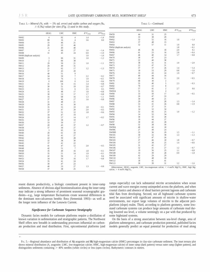
TABLE 1.—Mineral (%, with ; 5% std. error) and stable carbon and oxygen (‰,6 0.1‰) values for sites (Fig. 1) used in this study.
ARAG LMC HMC d13CPDB d18OPDB
NW02 4 92 4 1.4 21.4NW03 80 16 4 3.6 0.0NW04 33 46 21NW05 29 25 46NW06 21 40 40NW07 4 69 27 1.0 21.4NW08 31 45 24 0.9 21.0NW08 (duplicate analysis) 1.0 21.0NW09 3 66 31 1.0 21.2NW10 2 60 38NW11 29 50 21 1.0 21.1NW12 20 49 31NW13 21 62 17 1.2 21.3NW14 37 43 20NW16 40 51 9NW17 34 59 7 2.2 20.2NW18 19 76 5 1.9 20.1NW19 0 100 0 1.4 20.6NW21 31 54 15 1.4 20.8NW22 30 51 19 2.0 20.7NW23 41 53 6 2.5 0.5NW24 35 48 17 1.8 20.8NW25 30 53 17 1.7 20.8NW26 16 68 16 1.3 21.1NW27 37 46 17 1.6 20.8NW28 31 48 21NW29 29 41 30NW30 35 55 10 1.8 20.1NW31 33 47 20 2.0 20.5NW32 37 51 12 1.8 20.6NW33 34 47 19NW34 29 57 14 1.7 20.2NW35 32 58 10NW36 33 50 17NW37 20 43 37 1.2 20.7NW38 37 36 27NW39 3 65 32NW40 20 61 19NW41 32 41 27NW42 22 50 28NW43 32 38 30NW45 37 41 22NW46 41 47 12 2.0 20.5NW48 42 51 7NW49 35 49 16 1.8 20.1NW50 35 51 14 1.9 20.1NW51 42 56 2 2.2 0.4NW53 34 50 16 1.7 20.8NW54 35 41 24NW56 30 47 23NW57 40 33 27 1.3 20.8NW58 37 38 25
TABLE 1.—Continued.
ARAG LMC HMC d13CPDB d18OPDB
NW59 44 31 25NW60 33 38 29NW62 32 52 16 1.0 21.4NW63 37 48 15NW64 32 57 11 1.9 0.0NW64 (duplicate analysis) 1.8 20.1NW65 46 36 18 2.0 0.1NW66 61 23 16 2.8 20.4NW67 46 40 14 1.7 20.8NW70 30 47 23NW71 22 40 38NW72 38 31 31 1.0 22.0NW73 22 47 31NW74 37 37 26 1.4 21.4NW75 18 53 29 0.8 21.6NW76 33 43 24 1.9 20.7NW77 40 44 16NW78 43 46 11 2.0 20.5NW79 68 30 2NW81 55 40 5 2.3 20.3NW82 70 22 8NW83 57 41 2 2.7 0.6NW83A 31 65 4NW84 33 50 17 2.0 20.5NW85 20 47 33NW86 30 49 21NW87 29 43 28 1.3 21.4NW88 33 41 26 0.8 21.9NW91 32 37 31NW92 14 52 34NW93 32 43 25 1.0 21.2NW94 14 52 34NW95 30 42 28NW96 19 44 37NW97 30 42 28NW98 32 38 30NW99A 40 42 18NW99C 27 49 24NW99D 35 36 29 1.5 21.1NW101 30 32 38 1.3 21.3NW101 27 47 26NW103 37 46 18 1.8 20.7NW104 37 38 25 1.4 20.6NW105 31 42 27NW106 32 41 27 1.2 20.7NW107 19 56 25 1.1 20.8NW108 33 39 28 0.9 21.8NW109 42 29 29NW110 32 48 20NW112 18 41 41NW113 30 39 31 1.2 21.6
Abbreviations: ARAG, aragonite; LMC, low-magnesium calcite; , 4 mol% MgCO3; HMC, high Mg-calcite; . 4 mol% MgCO3.
←
FIG. 5.—Regional abundance and distribution of A) aragonite and B) high-magnesium calcite (HMC) percentages in clay-size carbonate sediment. The inset ternary plotshows mineral distribution (A, aragonite; LMC, low-magnesian calcite; HMC, high-magnesian calcite) of inner ramp (dark pattern) versus outer ramp (lighter pattern), anddistinguishes sediments containing . 40% needles (white circles) or less (open circles). Bathymetric contours in meters.
resent diatom productivity, a biologic constituent present in inner-rampsediments. Absence of obvious algal biomineralization along the inner rampmay indicate a strong influence of prominent seasonal oceanographic gra-dients—e.g., large temperature fluctuations create seasonal differences inthe dominant non-calcareous benthic flora (Semeniuk 1993)—as well asthe longer term influence of the Leeuwin Current.
Significance for Carbonate Sequence Stratigraphy
Dynamic facies models for carbonate platforms require a distillation ofknown variation in sedimentation and stratigraphic patterns. The NorthwestShelf offers new breadth in understanding processes influential on carbon-ate production and mud distribution. First, epicontinental platforms (and
ramps especially) can lack substantial micrite accumulation when oceancurrent and wave energies sweep unimpeded across the platform, and whencoastal clastics and absence of shoal barriers prevent lagoons and carbonatetidal flats from developing. Second, not all highstand carbonate systemsneed be associated with significant amounts of micrite in shallow-waterenvironments, nor export large volumes of micrite to the adjacent peri-platform (slope) realm. Third, according to platform geometry, some low-stand carbonate systems can produce large amounts of carbonate mud dur-ing lowered sea level, a volume seemingly on a par with that produced bysome highstand systems.
On the basis of a strong association between sea-level change, area ofplatform submergence, and carbonate production potential, published faciesmodels generally predict an equal potential for production of mud along
J S R674 G.R. DIX ET AL.
FIG. 6.—Regional distribution of A) d13CPDB and B) d18OPDB values in clay-size carbonate sediment. Bathymetric contours in meters.

J S R 675LATE QUATERNARY CARBONATE MUD, NORTHWEST SHELF
FIG. 7.—Comparison of d13CPDB values and aragonite percentages in needle-rich(. 40%) mud and skeletal-rich mud. Extrapolation of the distribution of needle-rich mud to 100% aragonite shows a d13CPDB end-member composition within therange of relict ooids from the middle ramp (from James et al. 2004).
TABLE 2.—Radiocarbon dates* and stable isotopes** of mud, Northwest Shelf.
Sample Location Depth (m) 14C age, Yr BP Cal Yrd13CPDB,
‰d18OPDB,
‰
NW-48 18807.79S, 118851.99W 211 18,500 6 120 19,379 2.35 0.06NW-79 19805.69S, 117803.99W 200 17,970 6 110 18,768 3.72 0.93
* Isotrace Laboratories; ** Queen’s University.
an inner shelf or ramp within successive systems tracts of a complete sea-level cycle. The Northwest Shelf reveals that other factors have profoundinfluence on mud production and its accumulation.
By at least 19 ka, sea-level variation typical of icehouse conditions (Read1995) moved a distally steepened slope into the optimum zone of tropicalcarbonate production. Sampling suggests that the needle-rich mud likelythins seaward, thereby defining a thin lowstand sedimentary wedge alongthe paleomargin. The volume of this sediment body is similar to that form-ing Holocene highstand sedimentary wedges described from Bahamianplatform margins (Wilbur et al. 1990; Glaser and Droxler 1991). Indeed,the timing for influx of large volumes of shelf-derived micrite along theNorthwest Shelf is reverse with respect to sea-level change to that definedalong Bahamian platforms (Droxler et al. 1983; Mullins 1983; Droxler andSchlager 1985; Haak and Schlager 1989; Droxler et al. 1990; Schlager etal. 1994).
The reason is that even during lowstand conditions the available area forshallow water micrite production on the Australian paleoshelf remainedlarge, ; 5.0 3 104 km2, up to ten times greater than the area associatedwith the modern Great Bahama Bank (; 3.3 3 103 km2; Robbins et al.
1997). If lowstand deposition at 19 ka was part of a longer (e.g., third-order) sea-level cycle, margin progradation associated with increased sed-imentation along the slope could rival what is normally considered typicalonly of highstand shedding (Schlager et al. 1994). Sarg (1988) documentedexamples of lowstand ‘‘autochthonous wedges,’’ but these are generallyassociated with significant shale or sandstone shelves. Along the NorthwestShelf during the recent sea-level lowstand, a drier climate and a still vastarea for shallow-water production conditions ensured that a significant vol-ume of aragonite mud could be generated with little terrigenous input.
For small sea-level falls along carbonate ramps, facies models (Burchetteand Wright 1992; Handford and Loucks 1993) propose that shallow-watermuddy facies keep pace with sea-level change such that these depositsbecome stratigraphically connected through time. Such a linkage is brokenif factors other than sea-level change influence sedimentation production(see above) or with large sea level variation as occurs during icehouseperiods (Burchette and Wright 1992; Read 1995). As shown by the lateQuaternary history of the Northwest Shelf, the lowstand carbonate mud isnow likely buried by a thin pelagic drape, and separated by some 200–300km from modern (highstand) inner-ramp sediments. With oceanographicfactors reducing the potential for highstand micrite production or its ac-cumulation, the lowstand carbonate sediments form a stranded (now, indeep water) shallow-water deposit of regional stratigraphic extent.
The diagenetic potential of such a regional (600 km long) stratigraphicbody with elevated abundance of aragonite, now in deep water, is signifi-cant. Near-surface lithification and porosity development may occur in thepresence of marine-derived pore waters when compared to the lesser po-tential of the overlying pelagic carbonate (Schlager and James 1978; Dixand Mullins 1988). This style of diagenesis, in combination with the scaleof deposit along a platform margin, offers a reservoir potential similar tothat of diagenetic traps of allochthonous deep-water deposits of ancientshelves (e.g., Hobson et al. 1985; Enos 1985). These attributes are distinctfrom those considered typical of ramps (Burchette and Wright 1992), yetthey might occur along ancient ramp margins during icehouse climates.
CONCLUSIONS
The late Quaternary history of shallow-water production of aragonite-rich micrite and its accumulation on the Northwest Shelf demonstrates theimpact of changing oceanography, climate, and platform geometry and sizein relation to variation in sea-level and platform submergence. These influ-ences engineered a reversal in the predicted timing of such production,under lowstand (19 ka) rather than current highstand conditions.
Today, an insignificant amount of carbonate mud is accumulating acrossmost of this distally steepened ramp because of oceanographic factors:siliciclastic input in the coastal region, high-energy waves and currents thatare unimpeded by coastal or shelfal barriers, and an absence of obviousbiomineralization by green calcareous algae. Along the outer ramp (in wa-ter depths of 1201 m), pelagic ooze, representing current highstand sedi-mentation, appears to overlie needle-rich (. 40%) aragonite mud that ac-cumulated toward the end of the Last Glacial Maximum, and forms a re-gional (; 600 km long) stratigraphic body along the paleomargin. Theneedles (texturally, compositionally) identify seawater precipitation withminor import of sediment from mechanical degradation of calcareous algae.A considerable volume of this sediment was produced under oceanographic
J S R676 G.R. DIX ET AL.
FIG. 8.—Present bathymetric position, age (14C ky), and areas of needle-rich (. 40%) mud (dark gray area) and earliest age of ooids (light gray area) (from James etal. 2004). The profiles (from James et al. 2004) show the transposed position of ooid sites along each transect. For bathymetric profiles A–A9 and B–B9: P, pelagic ridge(shaded); E, escarpment. Bathymetric contours in meters.
and climatic conditions different from those found today, and the vast sizeof the Northwest Shelf ensured a still significant shallow subtidal realmeven with lowered sea level. The aragonite-rich mud now lies stranded indeep water, spatially divorced (; 200 km) from shallow-water inner rampfacies, and possesses a higher diagenetic potential than the modern pelagicooze.
The late Quaternary history of the Northwest Shelf broadens currentunderstanding of the dynamics of carbonate mud production on ancientplatforms. Namely: not all highstand carbonate systems are associated withsignificant amounts of micrite in shallow-water environments, nor do theyexport large volumes of micrite to the periplatform realm, and some low-
stand systems can produce and export volumes of carbonate mud that rivalhighstand systems.
ACKNOWLEDGEMENTS
This research was supported by the Natural Sciences and Engineering ResearchCouncil of Canada (GRD, NPJ, TKK) and the Australian Research Council (YB,LBC). We thank CSIRO (Division of Oceanography) and the captain and crew ofthe R.V. Franklin for their help and support during the research cruise. Shipboardassistance was provided by K. Glenn and C. Rancourt. We also thank journal re-viewers R. Garber, A.E. Saller, and E. Shinn.
J S R 677LATE QUATERNARY CARBONATE MUD, NORTHWEST SHELF
FIG. 9.—Summary of events. A) A narrow paleoshelf developed seaward of 2125 m during the Last Glacial Maximum, and broadened locally into four paleoembayments(I–IV). Seaward export (arrows) and area of micrite distribution (light gray) are indicated relative to four paleoembayments (dark gray). B) Earliest postglacial sea-levelrise initiated ooid and peloid growth, with possible continuation of micrite production and/or reworking of existing mud by strong currents and waves. C) Modernconditions: a relatively narrow inner-ramp carbonate factory occurs only in areas not dominated by terrigenous input; the high-energy mid-ramp lies between the fair-weather (FWB) and storm (SWB) wave bases, yielding negligible mud accumulation; pelagic ooze accumulates on the outer ramp and slope.
REFERENCES
BARD, E., ARNOLD, M., HAMELIN, B., TISNERAT-LABRODE, N., AND CABIOCH, G., 1998, Radiocarboncalibration by means of mass spectrometer 230Th/234U and 14C ages of corals: an updateddatabase including samples from Barbados, Mururoa and Tahiti: Radiocarbon, v. 40, p.1085–1092.
BATHURST, R.G.C., 1975, Carbonate Sediments and Their Diagenesis: New York, Elsevier Sci-ence Publishing Company, 658 p.
BOARDMAN, M.R., NEUMANN, A.C., BAKER, P.A., DULIN, L.A., KENTER, R.J., HUNTER, G.E., AND
KIEFER, K.B., 1986, Bank top responses to Quaternary fluctuations in sea level recorded inperiplatform sediments: Geology, v. 14, p. 28–31.
BURCHETTE, T.P. AND WRIGHT, V.P., 1992, Carbonate ramp depositional environments: Sedi-mentary Geology, v. 79, p. 3–57.
COHMAP MEMBERS, 1988, Climatic changes of the last 18,000 years: observations and modelsimulations: Science, v. 206, p. 1043–1052.
COMMONWEALTH BUREAU OF METEOROLOGY, 1972, Climatic Survey: Northwest Region 6, WesternAustralia: Canberra (A.C.T.), Australian Publishing Service, 144 p.
DIX, G.R., 1989, High-energy, inner shelf carbonate facies along a tide-dominated nonrimmedmargin, northwestern Australia: Marine Geology, v. 89, p. 347–362.
DIX, G.R., AND MULLINS, H.T., 1988, Rapid burial diagenesis of deep-water carbonates, ExumaSound, Bahamas: Geology, v. 16, p. 680–683.
DOMINGUEZ, L.L., MULLINS, H.T., AND HINE, A.C., 1988, Cat Island platform, Bahamas: anincipiently drowned Holocene carbonate shelf: Sedimentology, v. 35, p. 805–819.
DROXLER, A.W., AND SCHLAGER, W., 1985, Glacial versus interglacial sedimentation rates andturbidite frequency in the Bahamas: Geology, v. 13, p. 799–802.
DROXLER, A.W., SCHLAGER, W., AND WHALLON, C.C., 1983, Quaternary aragonite cycles andoxygen-isotope record in Bahamian carbonate ooze: Geology, v. 11, p. 235–239.
DROXLER, A.W., HADDAD, G.A., MUCCIARONE, D.A., AND CULLEN, J.L., 1990, Pliocene–Pleisto-cene aragonite cyclic variations in Holes 714A and 716B (the Maldives) compared withHole 633A (the Bahamas): records of climate-induced CaCO3 preservation at intermediate

J S R678 G.R. DIX ET AL.
water depths, in Duncan, R.A., Backman, J., Peterson, L.C., et al., Proceedings of the OceanDrilling Program, Scientific Results: College Station, Texas, v. 115, p. 539–578.
DUNBAR, G.B., AND DICKENS, G.R., 2003, Late Quaternary shedding of shallow-marine carbonatealong a tropical mixed siliciclastic–carbonate shelf: Great Barrier Reef, Australia: Sedimen-tology, v. 50, p. 1061–1077.
EBERLI, G.P., AND GINSBURG, R.N., 1989, Cenozoic progradation of the northwestern GreatBahamas Bank: a record of lateral platform growth and sea level fluctuations, in Crevello,P.D., Wilson, J.L., Sarg, J.F., and Read, J.F., eds., Controls on Carbonate Platform andBasin Development, SEPM, Special Publication 44, p. 339–351.
ENOS, P., 1985, Cretaceous debris reservoirs, Poza Rica Field, Veracruz, Mexico, in Roehl,P.O., and Choquette, P.W., eds., Carbonate Petroleum reservoirs: New York, Springer-Ver-lag, p. 455–470.
GLASER, K.S., AND DROXLER, A.W., 1991. High production and highstand shedding from deeplysubmerged carbonates banks, northern Nicaragua rise: Journal of Sedimentary Petrology, v.61, p. 128–142.
HAAK, A.B., AND SCHLAGER, W., 1989, Compositional variations in calciturbidites due to sea-level fluctuations, late Quaternary, Bahamas: Geologishe Runschau, v. 78, p. 477–486.
HANDFORD, C.R., AND LOUCKS, R.G., 1993, Carbonate depositional sequences and systems tracts:responses of carbonate platforms to relative sea-level changes, in Loucks, R.G., and Sarg,J.F., eds., Carbonate Sequence Stratigraphy: American Association of Petroleum Geologists,Memoir 57, p. 3–41.
HOBSON, J.P., CALDWELL, C.D., AND TOOMEY, D.F., 1985, Early Permian deep-water allochthon-ous limestone facies and reservoirs, west Texas: American Association of Petroleum Ge-ologists, Bulletin, v. 69, p. 2130–2147.
HOLLOWAY, P.E., 1983, Tides on the Australian northwest shelf: Australian Journal of Marineand Freshwater Research, v. 34, p. 213–230.
JAMES, N.P., 1979, Introduction to carbonate facies models, in Walker, R.G., ed., Facies Mod-els: Geoscience Canada, Reprint Series 1, p. 105–107.
JAMES, N.P., BONE, Y., KYSER, T.K., DIX, G.R., AND COLLINS, L.B., 2004, Carbonate sedimen-tation on a tropical oceanic ramp: northwestern Australia: Sedimentology, v. 51, p. 1–27.
JONES, H.A., 1973, Marine geology of the northwest Australian continental shelf: AustraliaBureau of Mineral Resources, Geology and Geophysics, Bulletin 136, 102 p.
KENDALL, C.G.ST.C., AND SCHLAGER, W., 1981, Carbonate and relative changes in sea level:Marine Geology, v. 44, p. 181–212.
LOURENSZ, R.S., 1981, Tropical cyclones in the Australian region, July 1909 to June 1980:Commonwealth Bureau of Meteorology, Australian Government Publishing Service, 94 p.
Macintyre, I.G., and Reid, R.P., 1992, Comment on the origin of aragonite needle mud: apicture is worth a thousand words: Journal of Sedimentary Petrology, v. 62, p. 1095–1097.
MCCREA, J.M., 1950, On the isotope chemistry of carbonates and a paleotemperature scale:Journal of Chemical Physics, v. 18, p. 849–857.
MILLIMAN, J.D., 1974, Carbonates and the ocean, in Milliman, J.D., ed., Marine Carbonates:New York, Springer, 375 p.
MILLIMAN, J.D., FREILE, D., STEINEN, R.P., AND WILBER, R.J., 1993, Great Bahama Bank ara-
gonitic muds: mostly inorganically precipitated, mostly exported: Journal of SedimentaryPetrology, v. 63, p. 589–595.
MULLINS, H.T., 1983, Modern carbonate slopes and basins of the Bahamas, in Cook, H.E.,Hine, A.C., and Mullins, H.T., compilers, Platform Margin and Deep Water Carbonates:SEPM, Short Course Notes 12, p. 4-1–4-138.
READ, J.F., 1985, Carbonate platform facies models: American Association of Petroleum Ge-ologists, Bulletin, v. 69, p. 1–21.
READ, J.F., 1995, Overview of carbonate platform sequences, cycle stratigraphy and reservoirsin greenhouse an ice-house worlds, in Read, J.F., Kerans, C., and Weber, L.J., organizers,Milankovitch Sea-Level Changes, Cycles and Reservoirs on Carbonate Platforms in Green-house and Ice-House Worlds: SEPM, Short Course Notes 35, p. 1–102.
ROBBINS, L.L., AND BLACKWELDER, P.L., 1992, Biochemical and ultrastructural evidence for theorigin of whitings: a biologically induced calcium carbonate precipitation mechanism: Ge-ology, v. 20, p. 464–468.
ROBBINS, L.L., TAO, Y., AND EVANS, C.A., 1997, Temporal and spatial distribution of whitingson Great Bahama Bank and a new lime mud budget: Geology, v. 25, p. 947–950.
SARG, J.F., 1988, Carbonate sequence stratigraphy, in Wilgus, C.K., Posamentier, H.R., Ross,C.A., Kendall, C.G.St.C., eds., Sea-Level Changes: An Integrated Approach: SEPM, SpecialPublication 42, p. 155–182.
SCHLAGER, W., 1991, Depositional bias and environmental change—important factors in se-quence stratigraphy: Sedimentary Geology, v. 70, p. 109–130.
SCHLAGER, W., AND JAMES, N.P., 1978, Low-magnesian calcite limestones forming at the deep-sea floor, Tongue of the Ocean, Bahamas: Sedimentology, v. 25, p. 675–702.
SCHLAGER, W., REIJMER, J., AND DROXLER, A.W., 1994, Highstand shedding of carbonate plat-forms: Journal of Sedimentary Research, v. B64, p. 270–281.
SEMENIUK, V., 1993, The Pilbara coast: a riverine coastal plain in a tropical arid setting, north-west Australia: Sedimentary Geology, v. 83, p. 235–256.
SHINN, E.A., STEINEN, R.P., LIDZ, B.H., AND SWART, P.K., 1989, Whitings, a sedimentologicdilemma: Journal of Sedimentary Petrology, v. 59, p. 147–161.
TUCKER, M.E., AND WRIGHT, V.P., 1990, Carbonate Sedimentology: Oxford, U.K., BlackwellScientific Publications, 482 p.
WILBUR, R.J., MILLIMAN, J.D., AND HALLEY, R.B., 1990, Accumulation of bank-top sediment onthe western slope of Great Bahama Bank: rapid progradation of a carbonate megabank:Geology, v. 18, p. 970–974.
WILSON, J.L., 1975, Carbonate Facies in Geologic History: New York, Springer-Verlag, 471 p.WRAY, J.L., 1977, Calcareous Algae: Amsterdam, Elsevier, 185 p.WYRWOLL, K.H., MCKENZIE, N.L., PEDERSEN, B.J., AND TAPLEY, I.J., 1986, The Great Sandy
Desert of north west Australia: the last 7000 years: Search, v. 17, p. 208–210.YOKOYAMA, Y., DE DECKKER, P., LAMBECK, K., JOHNSTON, P., AND FIFIELD, L.K., 2001, Sea level
at the Last Glacial Maximum: evidence from northwestern Australia to constrain ice volumesfor oxygen isotope stage 2: Palaeogeography, Palaeoclimatology, Palaeoecology, v. 165, p.281–297.
Received 21 May 2004; accepted 10 December 2004.