From Mine to user - Archaeopress
151
From Mine to User: Production and Procurement Systems of Siliceous Rocks in the European Neolithic and Bronze Age edited by Françoise Bostyn, François Giligny and Peter Topping
-
Upload
khangminh22 -
Category
Documents
-
view
2 -
download
0
Transcript of From Mine to user - Archaeopress
Archaeopress Archaeology www.archaeopress.com
From Mine to User:Production and Procurement Systems of Siliceous Rocks in
the European Neolithic and Bronze Age
edited by
Françoise Bostyn, François Giligny and Peter Topping
Bostyn, Giligny and Topping (eds)
From
Mine to U
ser
From Mine to User: Production and Procurement Systems of Siliceous Rocks in the European Neolithic and Bronze Age presents the papers from Session XXXIII of the 18th UISPP World Congress (Paris, June 2018). 23 authors contribute nine papers from Parts 1 and 2 of the Session. The first session ‘Siliceous rocks: procurement and distribution systems’ was aimed at analysing one of the central research issues related to mining, i.e. the production systems and the diffusion of mining products. The impact of extraction on the environment, group mobility and the numbers involved in the exploitation phase were considered; mining products were also examined with a view to identifying local and imported/exported products and the underlying social organization relating to the different fields of activity. The second session ‘Flint mines and chipping floors from prehistory to the beginning of the nineteenth century’ focused on knapping activities. The significance of the identification of knapping workshops in the immediate vicinity of mine shafts and of their presence in villages as well as in intermediary places between the two was considered in the analysis of chaîne opératoire sequences. The potential of product quality and artefact distribution to contribute to the understanding of the social organisation of the communities being studied was also examined.
Françoise Bostyn is currently Professor at the University of Paris 1-Panthéon-Sorbonne. She specialises in the European Neolithic and works particularly on lithic industries, from the characterisation of resources and procurement systems, especially from flint mines, to the abandonment of tools within domestic settlements. Through technological and typological approaches, the questions of the organization of production at different scales, the structure of supply and exchange networks, and the emergence of craft specialists are explored from an evolutionary perspective, from the arrival of the first farmers in France until the emergence of the first hierarchical societies.
François Giligny has been Professor of Archaeological Methodology at Paris 1 Panthéon-Sorbonne University since 2009. Experienced in preventive archaeology, he conducts research and excavations in the Paris basin. He has created and since 2016 has been co-director of two professional master’s degree courses at Paris 1 Panthéon-Sorbonne: Master of Archaeology ‘Archaeological Engineering’ and Master in Heritage and Museums ‘Archaeological Heritage Mediation and Valorisation’. François is Scientific Director of the magazine « Les Nouvelles de l’archéologie » and is engaged in two UISPP Commissions for which he organised the 18th Congress in 2018 in Paris. His research topics include the European Neolithic, ceramic technology, archaeological methodology, digital heritage and digital archaeology.
Peter Topping is a Visiting Fellow at Newcastle University. His expertise lies in the analysis of multi-period landscapes, and his main research interest is the European Neolithic period. Formerly employed by RCHME and English Heritage, he has worked on Neolithic flint mines, causewayed enclosures and the Stonehenge landscape, amongst many others types of site. He has also participated in fieldwork led by the US National Park Service in Ohio and Minnesota, and is currently directing a project on prehistoric quarries in the Northumberland Cheviots, alongside researching European Neolithic mines and quarries for a Prehistoric Society research monograph.
Bostyn Giligny and Topping UISPP cover.indd 1Bostyn Giligny and Topping UISPP cover.indd 1 29/01/2021 15:30:2929/01/2021 15:30:29

From Mine to User:Production and Procurement Systems of Siliceous Rocks in the European Neolithic and
Bronze AgeProceedings of the XVIII UISPP World Congress
(4-9 June 2018, Paris, France)Volume 10
Session XXXIII-1&2
edited by
Françoise Bostyn, François Giligny and Peter Topping
Archaeopress Archaeology
Archaeopress Publishing LtdSummertown Pavilion18-24 Middle WaySummertownOxford OX2 7LG
www.archaeopress.com
ISBN 978-1-78969-711-7ISBN 978-1-78969-712-4 (e-Pdf)
© Archaeopress, UISPP and authors 2021
Cover image: Map of siliceous raw material deposits on the Ryczów Upland (drawing by M. T. Krajcarz)
This book is available direct from Archaeopress or from our website www.archaeopress.com
This work is licensed under a Creative Commons Attribution-NonCommercial-NoDerivatives 4.0 International License
UISPP PROCEEDINGS SERIES VOLUME 10 – From Mine to user: Production and Procurement Systems of Siliceous Rocks in the European Neolithic and Bronze Age
UISPP XVIII World Congress 2018
(4-9 Juin 2018, Paris)
Session XXXIII-1&2
VOLUME EDITORS: Françoise Bostyn, François Giligny, Peter Topping
SERIES EDITOR: The Board of UISPP
SERIES PROPERTY: UISPP – International Union of Prehistoric and Protohistoric Sciences © 2021, UISPP and authors
KEY-WORDS IN THIS VOLUME:Neolithic, Bronze Age, Europe, siliceous rocks, flint mines, procurement system
UISPP PROCEEDINGS SERIES is a printed on demand and an open access publication, edited by UISPP through Archaeopress
BOARD OF UISPP: François Djindjian (President), Marta Arzarello (Secretary-General), Apostolos Sarris (Treasurer), Abdulaye Camara (Vice President), Erika Robrahn Gonzalez (Vice President). The Executive
Committee of UISPP also includes the Presidents of all the international scientific commissions (www.uispp.org).
BOARD OF THE XVIIIe UISPP CONGRESS: François Djindjian, François Giligny, Laurent Costa, Pascal Depaepe, Katherine Gruel, Lioudmila Iakovleva, Anne-Marie Moigne, Sandrine Robert

Foreword to the XVIII UISPP Congress Proceedings
UISPP has a long history, originating in 1865 in the International Congress of Prehistoric Anthropology and Archaeology (CIAAP). This organisation ran until 1931 when UISPP was founded in Bern. In 1955, UISPP became a member of the International Council of Philosophy and Human Sciences, a non-governmental organisation within UNESCO.
UISPP has a structure of more than thirty scientific commissions which form a very representative network of worldwide specialists in prehistory and protohistory. The commissions cover all archaeological specialisms: historiography; archaeological methods and theory; material culture by period (Palaeolithic, Neolithic, Bronze Age, Iron Age) and by continents (Europe, Asia, Africa, Pacific, America); palaeoenvironment and palaeoclimatology; archaeology in specific environments (mountain, desert, steppe, tropical); archaeometry; art and culture; technology and economy; biological anthropology; funerary archaeology; archaeology and society.
The UISPP XVIII World Congress of 2018 was hosted in Paris by the University Paris 1 Panthéon-Sorbonne with the strong support of all French institutions related to archaeology. It featured 122 sessions, and over 1800 papers were delivered by scientists from almost 60 countries and from all continents.
The proceedings published in this series, but also in issues of specialised scientific journals, will remain as the most important legacy of the congress.
L’UISPP a une longue histoire, à partir de 1865, avec le Congrès International d’Anthropologie et d’Archéologie Préhistorique (C.I.A.A.P.), jusqu’en 1931, date de la Fondation à Berne de l’UISPP. En 1955, l’UISPP est devenu membre du Conseil International de philosophie et de Sciences humaines, associée à l’UNESCO. L’UISPP repose sur plus de trente commissions scientifiques qui représentent un réseau représentatif des spécialistes mondiaux de la préhistoire et de la protohistoire, couvrant toutes les spécialités de l’archéologie : historiographie, théorie et méthodes de l’archéologie ; Culture matérielle par période (Paléolithique, néolithique, âge du bronze, âge du fer) et par continents (Europe, Asie, Afrique, Pacifique, Amérique), paléoenvironnement et paléoclimatologie ; Archéologie dans des environnements spécifiques (montagne, désert, steppes, zone tropicale), archéométrie ; Art et culture ; Technologie et économie ; anthropologie biologique ; archéologie funéraire ; archéologie et sociétés.
Le XVIII° Congrès mondial de l’UISPP en 2018, accueilli à Paris en France par l’université Paris 1 Panthéon-Sorbonne et avec le soutien de toutes les institutions françaises liées à l’archéologie, comportait 122 sessions, plus de 1800 communications de scientifiques venus de près de 60 pays et de tous les continents.
Les actes du congrès, édités par l’UISPP comme dans des numéros spéciaux de revues scientifiques spécialisées, constitueront un des résultats les plus importants du Congrès.
Marta Azarello
Secretary-General / Secrétaire général UISPP

i
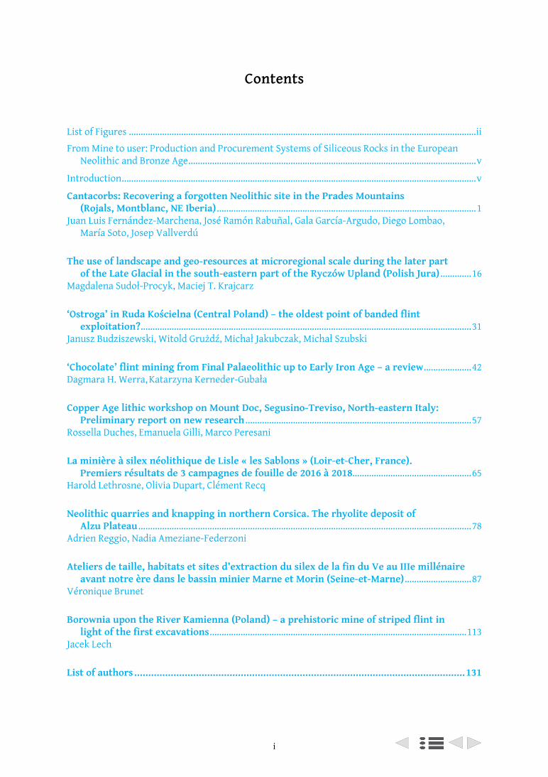
Contents
List of Figures ..................................................................................................................................................ii
From Mine to user: Production and Procurement Systems of Siliceous Rocks in the European Neolithic and Bronze Age .........................................................................................................................v
Introduction .....................................................................................................................................................v
Cantacorbs: Recovering a forgotten Neolithic site in the Prades Mountains (Rojals, Montblanc, NE Iberia) .............................................................................................................1
Juan Luis Fernández-Marchena, José Ramón Rabuñal, Gala García-Argudo, Diego Lombao, María Soto, Josep Vallverdú
The use of landscape and geo-resources at microregional scale during the later part of the Late Glacial in the south-eastern part of the Ryczów Upland (Polish Jura) .............16
Magdalena Sudoł-Procyk, Maciej T. Krajcarz
‘Ostroga’ in Ruda Kościelna (Central Poland) – the oldest point of banded flint exploitation? ...........................................................................................................................................31
Janusz Budziszewski, Witold Grużdź, Michał Jakubczak, Michał Szubski
‘Chocolate’ flint mining from Final Palaeolithic up to Early Iron Age – a review ....................42Dagmara H. Werra, Katarzyna Kerneder-Gubała
Copper Age lithic workshop on Mount Doc, Segusino-Treviso, North-eastern Italy: Preliminary report on new research ...............................................................................................57
Rossella Duches, Emanuela Gilli, Marco Peresani
La minière à silex néolithique de Lisle « les Sablons » (Loir-et-Cher, France). Premiers résultats de 3 campagnes de fouille de 2016 à 2018..................................................65
Harold Lethrosne, Olivia Dupart, Clément Recq
Neolithic quarries and knapping in northern Corsica. The rhyolite deposit of Alzu Plateau ............................................................................................................................................78
Adrien Reggio, Nadia Ameziane-Federzoni
Ateliers de taille, habitats et sites d’extraction du silex de la fin du Ve au IIIe millénaire avant notre ère dans le bassin minier Marne et Morin (Seine-et-Marne) ............................87
Véronique Brunet
Borownia upon the River Kamienna (Poland) – a prehistoric mine of striped flint in light of the first excavations ............................................................................................................113
Jacek Lech
List of authors ......................................................................................................................131
ii
List of Figures
J. L. Fernández-Marchena et al.: Cantacorbs: Recovering a forgotten Neolithic site
Figure 1. Location of the Cantacorbs site in the Iberian Peninsula ......................................................................... 2Figure 2. Faunal remains from Capdevila collection .................................................................................................. 5Figure 3. Map of the raw material outcrops from Capdevila collection lithic remains ........................................ 6Figure 4. Selection of retouched artifacts from the Capdevila collection .............................................................. 7Figure 5. Selection of retouched artifacts from the new excavations in Cantacorbs site .................................... 8Figure 6. Selection of borers and photograph of the only one of these perforators found in
the Capdevila collection ......................................................................................................................................... 10Figure 7. Selection of retouched artifacts and photograph of the artifacts located in
the Capdevila collection ......................................................................................................................................... 11Figure 8. 3D models of cores from the Capdevila collection (A) and from the new excavations (B) ................ 12
M. Sudoł-Procyk, M. T. Krajcarz: The use of landscape and geo-resources at microregional scale
Figure 1. Location of Ryczów Upland (A) within Kraków-Częstochowa Upland on a map of Poland .............. 17Figure 2. Map of siliceous raw material deposits on the Ryczów Upland ............................................................. 19Figure 3. The landforms in the surroundings of the chocolate flint outcrop based on the analysis
of Digital Terrain Model .......................................................................................................................................... 20Figure 4. Geomorphology of the selected area of flint mine in Udorka Valley and the progress of
archaeological works by July 2018 ........................................................................................................................ 20Figure 5. Cross-section along the slope in the area of flint mine in Udorka Valley ............................................ 21Figure 6. Pseudomorphs of ice wedges filled with loess, in which the flint artifacts were documented ........ 22Figure 7. Selected lithic artifacts from chocolate flint, Poręba Dzierżna, com. Wolbrom, małopolskie
voivodeship ............................................................................................................................................................... 23Figure 8. Selected lithic artifacts, Perspektywiczna Cave, com. Wolbrom, małopolskie voivodeship ............. 25Figure 9. Selected lithic artifacts, Kleszczowa, com. Pilica, śląskie voivodeship ................................................. 27Figure 10. Selected lithic artifacts from striped flint, Cisowa, com. Pilica, śląskie voivodeship ....................... 28Table 1. Sites with documented Late Paleolithic cultural levels in the southern part of Ryczów Upland,
included into this study .......................................................................................................................................... 18
J. Budziszewski et al.: ‘Ostroga’ in Ruda Kościelna (Central Poland)
Figure 1. Prehistoric mining fields of banded flint along the lower Kamienna river ......................................... 33Figure 2. Walk survey on the area of ‘Ostroga’ mining field in Ruda Kościelna, Ostrowiec Świętokrzyski
district ....................................................................................................................................................................... 34Figure 3. Visualisation of the quality of laser scanning at the area of ‘Ostroga’ mining field in Ruda
Kościelna, Ostrowiec Świętokrzyski district ........................................................................................................ 35Figure 4. Examples of different visualisations of digital terrain model of the ‘Ostroga’ mining field in
Ruda Kościelna, Ostrowiec Świętokrzyski district .............................................................................................. 35Figure 5. Pseudo-3D visualisation of the area of ‘Ostroga’ mining field in Ruda Kościelna, Ostrowiec
Świętokrzyski district ............................................................................................................................................. 36Figure 6. ‘Ostroga’ mining field in Ruda Kościelna, Ostrowiec Świętokrzyski district ....................................... 37Figure 7. ‘Ostroga’ mining field in Ruda Kościelna, Ostrowiec Świętokrzyski district ....................................... 38
D. H. Werra, K. Kerneder-Gubała: ‘Chocolate’ flint miningFigure 1. ‘Chocolate’ flint locations in pre-Quaternary formations on the northeastern outskirts of
the Holy Cross Mountains ...................................................................................................................................... 46Figure 2. a, b Orońsko site II, trench I-4; cd – Tomaszów, site 1 .............................................................................. 48Figure 3. a, b Polany Kolonie, site II; c, d – Polany II, Radom distr ......................................................................... 50Figure 4. Outline of shafts profiles from ‘chocolate’ flint mines in chronological order ................................... 51Table 1. Characteristics of ‘chocolate’ flint mine in chronological order ............................................................. 43
iii
R. Duches, E. Gilli, M. Peresani: Copper age lithic workshop on Mount Doc
Figure 1. Position of Mount Doc in the context of the Pre-Alps of Treviso .......................................................... 58Figure 2. Ridge of Mount Doc, location of the survey and excavation area .......................................................... 59Figure 3. Mount Doc-Segusino (Treviso) – Sector III, excavations 2003. Preforms ............................................. 60Figure 4. Mount Doc-Segusino (Treviso) – Sector III, excavations 2003. Core, refitting..................................... 61Figure 5. Mount Doc-Segusino (Treviso) – Sector III, excavations 2003. Core ..................................................... 62Figure 6. Mount Doc-Segusino (Treviso) – Sector III, excavations 2003. Tools .................................................... 63Figure 7. Mount Doc-Segusino (Treviso) – Surface collection findings ................................................................ 64
H. Lethrosne et al.: La minière à silex néolithique de Lisle « les Sablons »
Figure 1. A – Localisation du site de Lisle « les Sablons » ; B – le site dans son contexte topographique; C – Transect est-ouest des formations géologiques du coteau; D – Transect nord-sud des formations géologiques du coteau ........................................................................................................................ 67
Figure 2. A – Vue en plan de la fosse néolithique F9 ; B – Vue en coupe du comblement terminal de F7 et en plan le rejet des déchets de tailles en silex ................................................................................................ 70
Figure 3. A – Coupe de la fosse F10 dans la coupe géo-archéologique de référence. Le fait F12 est un fossé historique ; B – Vue en coupe de F10 .................................................................................................... 71
Figure 4. Fragments d’ébauches de haches en silex ................................................................................................. 75
A. Reggio, N. Ameziane-Federzoni: Neolithic quarries and knapping in northern Corsica
Figure 1. Localisation of ‘Plateau d’Alzu’ .................................................................................................................... 79Figure 2. The different areas of the site...................................................................................................................... 80Figure 3. a, the landscape in the quarry area; b, Punta Rusinca; c, shelter 1 ....................................................... 81Figure 4. 1 to 7, arrowhead in rhyolite from ‘Shelter 1’; 8, arrowhead in obsidian from ‘Shelter 1’;
9, arrowhead in rhyolite from quarry .................................................................................................................. 84
V. Brunet: Ateliers de taille, habitats et sites d’extraction du silexFigure 1. Localisation du secteur d’étude et du complexe minier Marne-Morin ................................................ 88Figure 2. Carte des sites étudiés du Néolithique moyen II ...................................................................................... 90Figure 3. Les datations radiocarbones disponibles pour le Néolithique moyen II .............................................. 92Figure 4. Carte des sites étudiés du Néolithique récent........................................................................................... 92Figure 5. Datations radiocarbone disponibles pour le IIIe millénaire ................................................................... 94Figure 6. Carte des sites étudiés du Néolithique final .............................................................................................. 95Figure 7. Les ressources siliceuses locales .................................................................................................................. 96Figure 8. Les matières premières au sein des assemblages étudiés ....................................................................... 96Figure 9. Répartition des plaquettes par contexte ................................................................................................... 97Figure 10. Stratégie d’acquisition, circulation et productions de la fin du Ve au IIIe millénaire ...................... 98Figure 11. Les haches taillées du Néolithique moyen II ......................................................................................... 102Figure 12. Les haches polies du Néolithique moyen II ........................................................................................... 103Figure 13. Les haches taillées du Néolithique récent ............................................................................................. 104Figure 14. Les haches polies du Néolithique récent ............................................................................................... 105Figure 15. Les haches taillées du Néolithique final ................................................................................................. 106Figure 16. Les haches polies du Néolithique final ................................................................................................... 107Figure 17. Les haches polies du dépôt ....................................................................................................................... 108Table 1. Les sites du Néolithique moyen II étudiés ................................................................................................... 91Table 2. Les sites du Néolithique récent étudiés ....................................................................................................... 93Table 3. Les sites du Néolithique final étudiés .......................................................................................................... 95Table 4. Les épaisseurs des plaquettes par période .................................................................................................. 97
J. Lech: Borownia upon the River Kamienna (Poland)Figure 1. Borownia flint mine site (Poland). Polished axe blade made from Upper Jurassic striped flint,
found in Segment B of the mining field ............................................................................................................. 114Figure 2. Borownia (Poland). Prehistoric mining field in division for segments A – E and
the Kamienna River valley ................................................................................................................................... 115

iv
Figure 3. Borownia (Poland). Segment A. Prehistoric mining field showing shaft hollows ............................. 116Figure 4. Borownia (Poland). Segment A. The main cross-shaped trench .......................................................... 117Figure 5. Borownia (Poland). Prehistoric flint mine. East fragment of filling in shaft A1.
Upper part after excavations ended in 2017 ..................................................................................................... 118Figure 6. Borownia (Poland). Segment A. Prehistoric flint mine ......................................................................... 119Figure 7. Borownia (Poland). Prehistoric flint mine. Trial reconstruction of shaft A1..................................... 119Figure 8. Borownia (Poland). Prehistoric flint mine. Trial reconstruction of segment A ................................ 120Figure 9. Borownia (Poland). Segment D. Prehistoric flint mine. Early axe roughout ..................................... 121Figure 10. Borownia (Poland). Flint mine. Radiocarbon dating ............................................................................ 123Table 1. Structure of flint and stone material from excavations carried out in 2017, divided into four
morphological groups ........................................................................................................................................... 121
v
From Mine to user: Production and Procurement Systems of Siliceous Rocks in the European Neolithic
and Bronze Age
Introduction
The 18th UISPP congress held in Paris in June 2018 provided the opportunity to assemble the members of the commission for ‘Flint Mining in Pre- and Protohistoric Europe’ as well as other European researchers during two full day conference sessions. The first session ‘Siliceous rocks: procurement and distribution systems’ was aimed at analysing one of the central research issues related to mining, i.e. the production systems and the diffusion of mining products. The reconstruction of extraction methods, the identification of specific toolkits developed for this activity, and the social organisation behind mining are key factors in the interpretation of mining phenomena. The impact of extraction on the environment is important but it can also be interpreted in terms of territoriality, and possibly associated with group mobility across wide areas. In this case the estimation of the number of people involved in the exploitation phase is fundamental, although this remains invariably a difficult question to answer. The study of mining products is a second area of research, more particularly in regard to the identification of imported products within the mass of local products, as well as the identification of local products destined to be exported. A central element in this is the definition of selection criteria relating to potential export products. The other area for consideration proposed to the conference participants related to the social organisation underlying the different fields of activities. The use of mapping and statistical tools can help to identify the production places and the scale of exchange systems involving intermediaries at several levels (villages or central places). This makes it possible to reconstruct the distribution networks of different products and to propose models involving territorial management at local, regional or long-distance scales.
The second session ‘Flint mines and chipping floors from prehistory to the beginning of the nineteenth century’ focused on knapping activities carried out on the periphery of the extraction sites. Excavations have provided evidence for the presence of knapping workshops in the immediate vicinity of the mine shafts, or in the upper fills of the shafts themselves, where knappers had cleaned up their working spaces or post-abandonment erosion phenomena had levelled the ground surface and filled low-lying surface features. In addition, recent studies have shown the existence of knapping areas within villages, as well as in sites which are considered as being intermediary places between extraction sites and the settlements. The analyses of the knapping workshops make it possible to describe the processes lying behind the debitage, to determine what the production aims were and as a result to identify groups of producers. The comparison of the various stages of the chaîne opératoire sequences, and the quality of the product make it possible to highlight different levels of skill and the artefact distributions can identify where more – or less – specialised actors participated in the distinct working spaces. This approach also contributes to an enhanced understanding of the social organisation of the communities being studied.
The contribution by Juan Luis Fernández-Marchena et al. presents the current knowledge concerning an often disregarded site, albeit one known as early as the 1930s, comprising an open-air workshop discovered in the Tarragona region. The data stemming from early surface collections and from recently resumed archaeological excavations, make it possible to describe the management and production systems for the local raw materials which were aimed at blade production. Abundant production waste was present as well as numerous hammerstones made from quartz and quartzite. 3D documentation of these workings was presented and considered
vi
an asset because of its academic value. Radiocarbon dating carried out on ancient materials made it possible to date these remains to the Post-Cardial Early Neolithic. The nature of this site – a unique case in the region because of its location at an altitude of 1000 m – raises the question of seasonality and its relationship with the settlement sites within a territory. The authors stress the fact that it is important not to disregard older documentation, which may have been the case for researchers who have had more abundant context-based data at their disposal since the large rescue excavations which were carried out during the 1980s and later. Nonetheless, it would be worth restudying the data from certain sites which are still poorly documented by excavations, and this current project contributes to this trend.
The paper by Magdalena Sudoł-Procyk and Maciej T. Krajcarz develops the territorial approach to a microregion in the southern part of Poland during the Final Palaeolithic. The circulation of raw materials, mainly ‘chocolate’ flint, is an indicator for reconstructing the mobility of human groups during that period. Several extraction sites were identified, including traces of pits still visible on the surface and in others recorded in the stratigraphy of the Kleszczowa region. Lithic analysis makes it possible to identify blade production which includes core shaping with crests. South-east of Ryczów occasional cave occupations occur, which are thought to form part of a logistical system with the open-air sites in the region of the Barańskie Mountains. The circulation of raw materials in the form of prepared cores was also established. The importance of these sites within a wider procurement network still remains to be determined in detail.
Remaining in Poland, the contribution of Janusz Budziszewski et al. looks at the issue of the earliest exploitation of ‘striped’ flint, an issue which has been debated for about a hundred years through an extensive literature. This type of flint was characteristic of the large flint mine of Krzemionki. Thanks to Lidar imaging and surface collection, a dozen new exploitation zones have been identified over the last few years including four mines encompassing areas ranging from 2 to 4 ha. The authors describe here one of the smallest sites which was discovered in 1982, the ‘Ostroga’ mine in Ruda Kościelna, situated upon a slope with a configuration which differs from the traditional mines located on plateaus. The extraction of raw material on a hillslope has influenced the downslope movement of soils and waste which are probably in secondary contexts, creating a characteristic relief across the site. The artefacts collected on the surface are few but from a technical point of view they are homogenous, and include flake production and axeheads with a quadrangular cross-section. This distinctively Neolithic tool production shows similarities with the sequence at Krzemionki and can probably be attributed to the Funnel Beaker Culture, or possibly to the Globular Amphora Culture. This hypothesis will be tested by excavation at this site.
An overview of ‘chocolate flint’ exploitation is presented here by Dagmara H. Werra and Katarzyna Kerneder-Gubała. This raw material, mentioned above for its use during the Final Palaeolithic, is one of the most renowned in Poland. It was used for a large number of products and was widely exploited by mining until the Bronze Age in the south-eastern part of Poland. It was exported as far as the Carpathian Basin. Five out of the twenty-six known sites are presented in more detail here: Orońsko, Tomaszów, Polany (site II), Polany Kolonie (site II) and Wierzbica ‘Zele’, which are located in two mining districts, Szydłowiec and Radom. The chronological development of extraction sites and their products is described, from the earliest mining dated to the Final Palaeolithic to those from the end of the Bronze Age. This development ranges from simple, relatively shallow shafts with or without a niche at the base during the Palaeolithic period, to narrow shafts up to 4.20 m deep with niches during the Middle and Final Neolithic, then to larger shafts up to 4 m deep during the Early and Middle Bronze Age and lastly very large shafts up to 7+ m deep during the Final Bronze Age. Blade production is evidenced for the Palaeolithic period. Blade production and rare axehead production is known during the Neolithic period, and raw materials of higher quality were chosen for blade production using unipolar or bipolar cores. During the Early Bronze Age bifacial debitage predominates. By the Late Bronze Age the blades and flakes are of a large size
vii
and flint was still used in central-eastern Europe. In conclusion, the authors highlight the quality and the longevity of exploitation of this raw material, including changes to the type and scale of extraction sites and their products but few changes to the extraction tools.
Rossella Duches, Emanuela Gilli, and Marco Peresani analyse the data stemming from a high-altitude site in the Italian Pre-Alps in the Treviso region, Mount Doc, which dates from the Neolithic/Bronze Age transition. This site was excavated during two seasons in 2001 and 2003 and yielded abundant lithic waste and several hammerstones defining a knapping workshop dedicated to the shaping of blocks, tabular sheets or blades. The initial stages of the chaîne opératoire for foliate points was identified, and the preforms appear to have been subsequently taken to a different place for finishing. The same situation applies to blade production. In addition, distinctive failed pieces were re-used on site, probably for the production of arrowheads, dagger blades and foliate scrapers. A radiocarbon date indicating the first half of the 5th millennium should be considered with caution, because the assemblage is more typical of the end of the 4th millennium BCE. Further radiocarbon dates are needed to confirm this hypothesis. Lastly, this site can be associated with a network connecting the Belluno valley with the high plain of Treviso which is thought to play a role in the supply of lithic products to this region.
Harald Lethrosne, Olivia Dupart and Clément Recq present the recent excavation of a site in the Loir valley, the site of Lisle ‘les Sablons’ in the Loir basin. This site was discovered early in the 19th century by field surveys and was covered by thick colluvial deposits which had disturbed abundant knapping waste, alongside shallow pits filled with waste, probably related to flint extraction. The aim of this extraction was the production of flaked axeheads, which lack the grinding and polishing stages and reveal poor skills. A more accurate dating of the site is awaited. The axeheads resemble other regional examples such as those discovered at Pezou ‘la Chenevière-Dieu’, also located in the Loir valley. The results are in keeping with the general framework of the evolution of axe production in Northern France, and make it possible to better understand territorial organisation and the role of sites related to lithic production in social and economic terms.
Adrien Reggio and Nadia Ameziane-Federzoni report on the exploitation of rhyolite, a volcanic rock on Corsica. Discovered during fieldwalking, this high altitude site on the Alzu plateau appears to be a quarry. Excavations were carried out both in the quarry and in shelters or open air areas. Flake debitage was discovered, as well as the reduction of blocks or the shaping of flakes in nearby shelters. In addition, the presence of imported materials such as obsidian was noted. The issue of the export of the products and the extent of their distribution still need to be characterised. The presence of arrowheads in nearby settlements is associated with this quarry. The presumed dating corresponds to the Torrean culture during the 3rd millennium BCE, who specialised in the exploitation of materials at higher altitudes.
Véronique Brunet provides an overview of the mining region surrounding the Jablines mine in the Marne valley near Paris, a region that produced axeheads between the end of the 5th and the 3rd millennium BCE. The documentation relating to the Jablines mine, which was excavated on the occasion of development-led investigations carried out in the 1980s, has now been completed by the discovery of peripheral workshops or intermediate workshops between this mine and the settlements, which were also discovered during salvage excavations. This evidence makes it possible to model the question of territorial organisation and economic specialisation at these sites. The products are distributed over a long period of time spanning two millennia and make it possible to analyse the issue of knapping skills.
Jacek Lech reviews the use of ‘striped’ flint in central Poland from the vast mining complex of Borownia, known since the 1920s. This site, originally dated to the Bronze Age, was exploited by a zone of mining shafts spread across an area of nearly 12 ha which has generally been very well preserved within a forest. Before 2017 it was only subject to non-destructive surface investigations,

viii
but following this date it was excavated with the aim of collecting evidence for absolute dating for the submission of a request for its inclusion on the list of UNESCO World Heritage Sites as part of the property ‘Krzemionki Prehistoric Striped Flint Mining Region’. During this project shafts were identified and dated to the end of the Neolithic/beginning of the Bronze Age. The production of axe blades has been attested as well as that of Zele-type knives, characteristic of the Early Bronze Age. Settlement sites related to the Globular Amphora Culture are probably associated with this extraction site as part of a zone of economic activity.
F. Bostyn, F. Giligny, P. Topping
From Mine to User (UISPP XVIII) (Archaeopress 2021): 1–15
Cantacorbs: Recovering a forgotten Neolithic site
Cantacorbs: Recovering a forgotten Neolithic site in the Prades Mountains
(Rojals, Montblanc, NE Iberia)
Juan Luis Fernández-Marchena1, José Ramón Rabuñal2,3, Gala García-Argudo1, Diego Lombao2,3, María Soto4,5, Josep Vallverdú2,3
1 Seminari d’Estudis i Recerques Prehistòriques (SERP), Secció de Prehistòria i Arqueologia. Facultat de Geografia i Història. Universitat de Barcelona. C/ Montalegre 6-8. 08001 Barcelona,
Spain2 Institut Català de Paleoecologia Humana i Evolució Social (IPHES). C/Marcel·lí Domingo s/n
(Edifici W3). Campus Sescelades. 43007 Tarragona, Spain3 Àrea de Prehistòria, Universitat Rovira i Virgili (URV), Campus Catalunya, Avinguda de
Catalunya 35, 43002 Tarragona, Spain4 Madrid Institute for Advanced Study. MIAS.Casa Velázquez. Ciudad Universitaria C/ de Paul Guinard,
3 28040 Madrid, Spain/Universidad Autónoma de Madrid C/Einstein, 13 Pabellón C 1a planta, 28049 Madrid, Spain
5 Departamento de Prehistoria y Arqueología. Fac. Filosofía y Letras. Universidad Autónoma de Madrid. Ciudad Universitaria de Cantoblanco, 28049 Madrid, Spain
[email protected] (corresponding author); [email protected] (corresponding author); [email protected]; [email protected];
[email protected]; [email protected]
The open-air site of Cantacorbs is a Neolithic chert workshop located on a calcareous mountaintop plateau (1022 masl), overlooking one of the main routes through the Prades Mountains (Tarragona, NE Iberian Peninsula). The main characteristic of the site is the abundance of knapped lithic material on the surface, in which all stages of the blade production sequence are represented. Raw material provenance shows a local range, with material coming mainly from two nearby procurement areas. The site was discovered in the 1930s, and despite having appeared in several publications, it has never been excavated using modern methods. A consequence of the time in which the first interventions were carried out has been the dispersal of the materials between different collections. This paper presents the first dating evidence for the site, as well as a comparative analysis between the materials of the Capdevila private collection and those of the first two recent field seasons.
Keywords: Early Neolithic, NE Iberia, high mountain, workshop, private collections
Résumé
Le site en plein-air de Cantacorbs est un atelier de taille du silex appartenant au Néolithique. Il est situé au sommet d’un haut plateau calcaire (à 1022 m d’altitude) et domine un des principaux itinéraires des Montagnes de Prades (Tarragone, Nord-Est de la Péninsule Ibérique). La principale caractéristique du site est l’abondance de matériaux lithiques taillés en surface, parmi lesquels toutes les étapes des chaînes opératoires laminaires sont représentées. La provenance des matières premières montre un ramassage local, provenant principalement de deux zones d’approvisionnement proches. Le site a été découvert dans les années 1930 et, malgré plusieurs publications, il n’a jamais été fouillé avec une méthodologie moderne. L’un des problèmes à l’époque des premières interventions est la dispersion des matériaux entre différentes collections privées. Ce travail présente la première datation du site, ainsi que l’analyse comparative des matériaux de la collection privée de Capdevila avec ceux des deux premières campagnes de fouilles au sein du nouveau projet en cours.
Mots-clés : Néolithique ancien, nord-est de la péninsule Ibérique, haute montagne, atelier, collections privées
J. L. Fernández-Marchena et al
2
1. Introduction
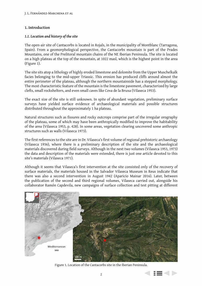
1.1. Location and history of the site
The open-air site of Cantacorbs is located in Rojals, in the municipality of Montblanc (Tarragona, Spain). From a geomorphological perspective, the Cantacorbs mountain is part of the Prades Mountains, one of the Prelitoral mountain chains of the NE Iberian Peninsula. The site is located on a high plateau at the top of the mountain, at 1022 masl, which is the highest point in the area (Figure 1).
The site sits atop a lithology of highly eroded limestone and dolomite from the Upper Muschelkalk facies belonging to the mid-upper Triassic. This erosion has produced cliffs around almost the entire perimeter of the plateau, although the northern mountainside has a stepped morphology. The most characteristic feature of the mountain is the limestone pavement, characterized by large clefts, small rockshelters, and even small caves like Cova de la Bruxa (Vilaseca 1953).
The exact size of the site is still unknown. In spite of abundant vegetation, preliminary surface surveys have yielded surface evidence of archaeological materials and possible structures distributed throughout the approximately 1 ha plateau.
Natural structures such as fissures and rocky outcrops comprise part of the irregular orography of the plateau, some of which may have been anthropically modified to improve the habitability of the area (Vilaseca 1953, p. 428). In some areas, vegetation clearing uncovered some anthropic structures such as walls (Vilaseca 1973).
The first references to the site are in Dr. Vilaseca’s first volume of regional prehistoric archaeology (Vilaseca 1936), where there is a preliminary description of the site and the archaeological materials discovered during field surveys. Although in the next two volumes (Vilaseca 1953, 1973) the data and description of the materials were extended, there is just one article devoted to this site’s materials (Vilaseca 1971).
Although it seems that Vilaseca’s first intervention at the site consisted only of the recovery of surface materials, the materials housed in the Salvador Vilaseca Museum in Reus indicate that there was also a second intervention in August 1942 (Aparicio Mainar 2016). Later, between the publication of the second and third regional volumes, Vilaseca carried out, alongside his collaborator Ramón Capdevila, new campaigns of surface collection and test pitting at different
Figure 1. Location of the Cantacorbs site in the Iberian Peninsula.
J. L. Fernández-Marchena et al
3
Cantacorbs: Recovering a forgotten Neolithic site
locations on the plateau. Capdevila began his collaboration with Dr. Vilaseca in 1967 (Capdevila Vallverdú 1996) as a member of the informants’ network of the Provincial Commissioner of Excavations (Alay 2015), directed by Dr. Vilaseca, and the rediscovery of the location of the site and a large amount of material can be attributed to his work.
Throughout multiple interventions at the site, the large amount of lithic remains scattered over the surface of the plateau was remarkable: ‘Chert remains are so abundant in Cantacorbs that they literally cover some spots in the plateau’ (Vilaseca 1936, p. 38). At the beginning, the paucity of diagnostic materials meant that the site could not be ascribed to any phase of Recent Prehistory (Vilaseca 1936). In his second volume, Vilaseca (1953) expanded his description of the site, characterizing it as one of the chert workshops of the Prades Mountains, where cores and blades are prominent. The lack of diagnostic elements, however, precluded a precise chrono-cultural ascription of the site beyond stating that it should correspond to a horizon between the Chalcolithic and the Bronze Age.
Later, some types of lithic tools were recovered, such as segments and borers; their similarity to artifacts from the Middle Neolithic of the French Languedoc, or Chasséen, places the date of the site further back in time than initially thought (Vilaseca 1971, 1973). Though the author acknowledged the scarcity of pottery and faunal remains, he did note the presence of deer. Regarding pottery, although he described some fragments with corded and incised decorations, and shapes that resemble Bell Beaker pottery (Vilaseca 1973), he did not confirm the presence of Bell Beaker culture at the site.
It is important to note that the Cantacorbs mountain is extensive, and it is possible that there are remains from different periods or even an extended diachrony in the occupations in certain areas. This is true at Cova de la Bruixa, located at the northern side of the mountain, in which apparently prehistoric pottery and metallic objects, such as a Visigothic buckle, have been found (Massó Carballido and Capdevila Vallverdú 1999).
1.2. Regional setting and contextualization of the collections
The archaeological sites studied or documented by Dr. Vilaseca and his collaborators, including Cantacorbs, are critical to understanding the prehistoric settlement dynamics in the Tarragona area. In spite of the large number of documented sites, most of them have never been excavated systematically, nor dated, and the materials have not been published or re-studied, so it is almost as if they actually do not exist.
For example, in the case of the Early Neolithic in the province of Tarragona, only those sites with dates or diagnostic pottery are taken into account: Cova de la Font Major (Cebrià et al. 2014), Cova del Vidre (Bosch 2016), Coll Blanc (Bravo, Garcia and Solà 2014), Timba dels Barenys (Miró 1994), Molins de la Vila (Adserias, Teixel and Griñó 2001 cited in (Oms and Martín 2018)), el Molló de la Torre (Bosch 1989 cited in (Oms and Martín 2018)), El Cavet (Fontanals et al. 2008), Cova del Garrofet (Oms, Mestres et al. 2016), Quimeres (Vilaseca 1945) or Cova Foradada (Oms, Cebrià et al. 2016).
Because of the understudied nature of the Early Neolithic in the region, and after Ramón Capdevila donated to IPHES two boxes of archaeological materials from his private collection (Capdevila Collection), a program of surveys and systematic excavations in Cantacorbs was designed. One of the main goals was to identify the exact location of Ramón Capdevila’s excavations. Despite the absence of plans or GPS coordinates, it was possible to locate the area thanks to unpublished pictures donated by Capdevila along with the archaeological materials. However, it was necessary to evaluate the technological and chrono-cultural homogeneity of the donated materials, as well as their correlation with the materials recovered during new excavations. Special effort was put
J. L. Fernández-Marchena et al
4
into trying to find the materials that appear in the illustrations published in Vilaseca’s original volumes, some of which are still missing (Vilaseca 1936, 1953, 1971, 1973).
After analyzing the Capdevila Collection, fieldwork began in 2017, and 12 m2 were excavated adjacent to Vilaseca and Capdevila’s initial excavation. In 2018, work continued in the same area given the richness of the archaeological deposits.
2. Materials and Methods
Here we present the first results of the study of the archaeological materials from the site of Cantacorbs, which were recovered from two sources. The first source of materials was the private collection known as the Capdevila Collection, that contains part of the material recovered during field surveys and excavations carried out from the early 20th century; the second was the recent excavations resumed by the Institut Català de Paleoecologia Humana i Evolució Social (IPHES), including the materials recovered during the first two fieldwork campaigns in 2017 and 2018. The first radiometric dating of the site, on a Columbella rustica shell bead from the Capdevila Collection, is also presented.
The Capdevila Collection contains 2518 knapped lithic remains, one ground stone axehead, four ceramic sherds, 71 faunal remains, and nine malacological remains. The material was donated to IPHES in two boxes, and was neither separated nor categorized. During the excavations carried out in 2017 and 2018, 927 knapped lithic remains and three ceramic sherds were recovered.
A specialized atlas was used for the taxonomic identification of the mollusk remains (Poppe and Goto 1991). The typological description of the ornaments followed the categories stablished for the Neolithic by J.Ll. Pascual Benito (1996).
For the chipped lithic assemblage, a morpho-technical analysis was carried out (Carbonell, Guilbaud and Mora 1983; Carbonell and Mora 1986; Carbonell et al. 1992). The retouched artifacts were typologically classified following J.J. Cabanilles’ typology, a reference for the study of the Recent Prehistory in the Mediterranean façade of the Iberian Peninsula (Cabanilles 2008).
To establish a preliminary approximation of the source areas of raw material procurement, macroscopic classifications of siliceous varieties of chert remains from the Capdevila Collection were compared with previously-described varieties from earlier regional research from the Prades Mountains (Soto 2015).
The materials recovered from current excavations were catalogued on site and deposited at the IPHES facilities. The Capdevila Collection, in contrast, was returned to Ramón Capdevila after the loan period. Because of that, classification, inventory, and graphic documentation of all the materials in the collection was prioritized.
3D models were produced to document the most remarkable materials from both the Capdevila Collection and the new excavations. They were rendered using the structured light Breuckmann SmartSCAN3D-HE Scanner with a 250 mm field of view (Breuckmann Optocat 2012 R2-2206 software). Non-commercial software was used to repair meshes in the models to maintain the original shape and edges of the tools and cores.
3. Results
3.1. Radiocarbon dating
An AMS radiocarbon date was obtained from a Columbella rustica shell bead from the Capdevila Collection (Beta – 484775), which yielded a conventional radiocarbon date of 6080 ± 30 BP, adjusted
5
Cantacorbs: Recovering a forgotten Neolithic site
for local reservoir correction (δ13C: +1.6‰) to 5959 ± 46 BP (6475 – 6275 cal BP; 4526 – 4326 cal BC) (Bronk Ramsey 2009; Reimer et al. 2013). This radiocarbon determination suggests an ascription of the occupation of Cantacorbs to the Postcardial Early Neolithic (Oms, Martín et al. 2016).
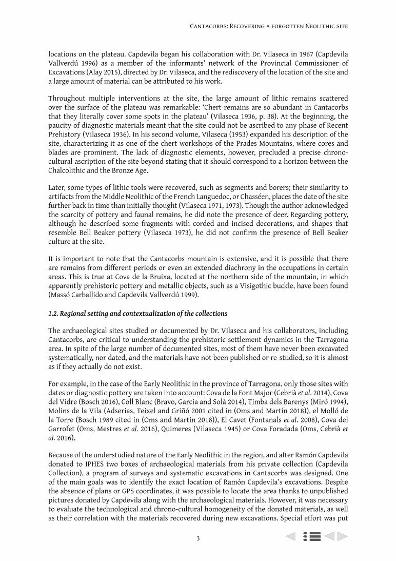
3.2. Faunal remains
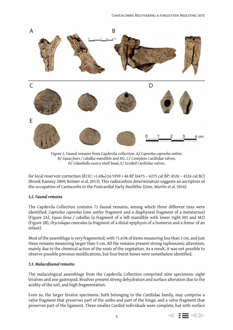
The Capdevila Collection contains 71 faunal remains, among which three different taxa were identified: Capreolus capreolus (one antler fragment and a diaphyseal fragment of a metatarsus) (Figure 2A), Equus ferus / caballus (a fragment of a left mandible with lower right M3 and M2) (Figure 2B), Oryctolagus cuniculus (a fragment of a distal epiphysis of a humerus and a femur of an infant).
Most of the assemblage is very fragmented, with 71.63% of items measuring less than 2 cm, and just three remains measuring larger than 5 cm. All the remains present strong taphonomic alteration, mainly due to the chemical action of the roots of the vegetation. As a result, it was not possible to observe possible previous modifications, but four burnt bones were nonetheless identified.
3.3. Malacofaunal remains
The malacological assemblage from the Capdevila Collection comprised nine specimens: eight bivalves and one gastropod. Bivalves present strong dehydration and surface alteration due to the acidity of the soil, and high fragmentation.
Even so, the larger bivalve specimens, both belonging to the Cardiidae family, may comprise a valve fragment that preserves part of the umbo and part of the hinge, and a valve fragment that preserves part of the ligament. Three smaller Cardiid individuals were complete, but with surface
Figure 2. Faunal remains from Capdevila collection. A/ Capreolus capreolus antler, B/ Equus feurs / caballus mandible and M2, C/ Complete Cardiidae valves,
D/ Columbella rustica shell bead, E/ Eroded Cardiidae valves.
J. L. Fernández-Marchena et al
6
alteration. Two of them show non-anthropic perforations in the umbo, due to wave action in one case and to marine predators (e.g. Muricidae or Naticidae) in the other (Figure 2C).
Three fragments present a high degree of rounding and erosion, and a discoidal shape (Figure 2E). As such, they could be characterized as preforms of discoidal beads with central perforations. This is characteristic of the Early Neolithic in the Mediterranean façade (Navarrete and Capel 1979; Pascual-Benito 1996), as is the Columbella rustica shell bead (Figure 2D) (Álvarez Fernández 2008). The relative chronology suggested by these ornaments is in accordance with the radiocarbon dating.
3.4. Lithic assemblages
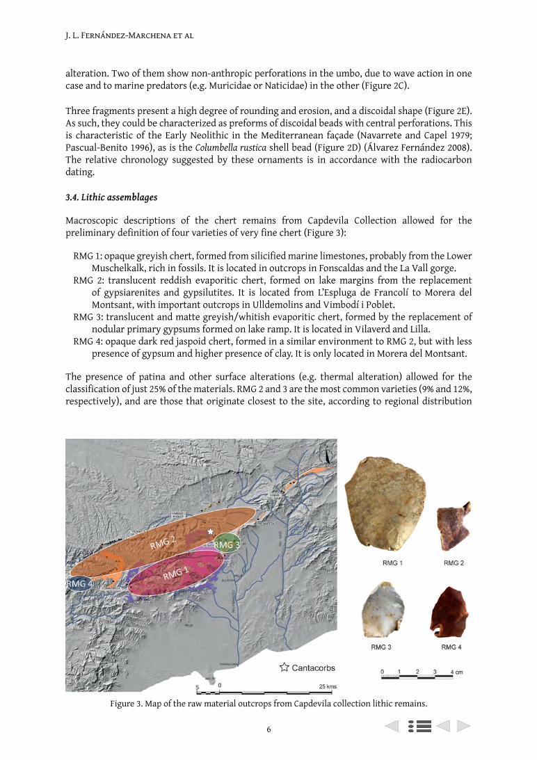
Macroscopic descriptions of the chert remains from Capdevila Collection allowed for the preliminary definition of four varieties of very fine chert (Figure 3):
RMG 1: opaque greyish chert, formed from silicified marine limestones, probably from the Lower Muschelkalk, rich in fossils. It is located in outcrops in Fonscaldas and the La Vall gorge.
RMG 2: translucent reddish evaporitic chert, formed on lake margins from the replacement of gypsiarenites and gypsilutites. It is located from L’Espluga de Francolí to Morera del Montsant, with important outcrops in Ulldemolins and Vimbodí i Poblet.
RMG 3: translucent and matte greyish/whitish evaporitic chert, formed by the replacement of nodular primary gypsums formed on lake ramp. It is located in Vilaverd and Lilla.
RMG 4: opaque dark red jaspoid chert, formed in a similar environment to RMG 2, but with less presence of gypsum and higher presence of clay. It is only located in Morera del Montsant.
The presence of patina and other surface alterations (e.g. thermal alteration) allowed for the classification of just 25% of the materials. RMG 2 and 3 are the most common varieties (9% and 12%, respectively), and are those that originate closest to the site, according to regional distribution
Figure 3. Map of the raw material outcrops from Capdevila collection lithic remains.
7
Cantacorbs: Recovering a forgotten Neolithic site
maps (Soto 2015, 2016). RMG 1 and 4, with source areas much more distant, are less well-represented (less than 1% of the assemblage).
Regarding the composition of the Capdevila Collection lithic assemblage, knapping products are the most represented (flakes and blades, complete and fragmented). Cores are almost exclusively pyramidal cores for blade production, and several core-shaping by-products (crested blades, core tablets...) have been identified. The presence of quartz and quartzite hammerstones, as well as a ground stone axehead, is also noteworthy.
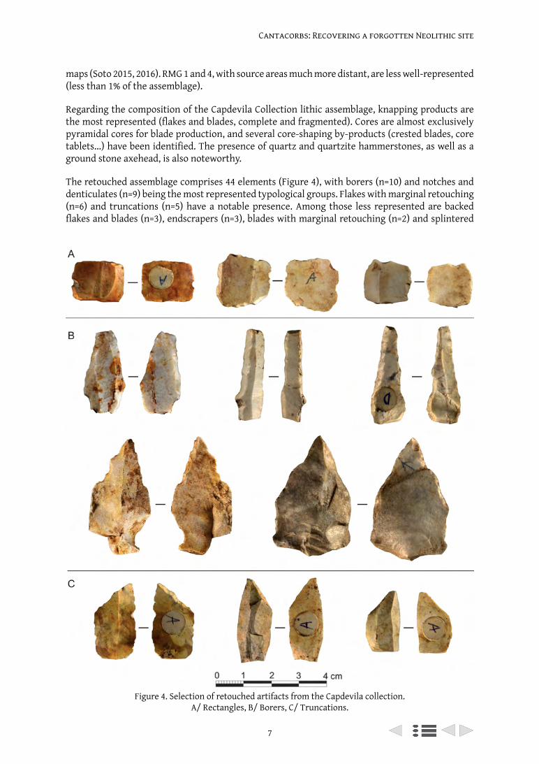
The retouched assemblage comprises 44 elements (Figure 4), with borers (n=10) and notches and denticulates (n=9) being the most represented typological groups. Flakes with marginal retouching (n=6) and truncations (n=5) have a notable presence. Among those less represented are backed flakes and blades (n=3), endscrapers (n=3), blades with marginal retouching (n=2) and splintered
Figure 4. Selection of retouched artifacts from the Capdevila collection. A/ Rectangles, B/ Borers, C/ Truncations.
J. L. Fernández-Marchena et al
8
pieces (n=2). The group of geometrics (n=4) is composed of one trapeze with retouching on the small base and three rectangles with abrupt retouching.
Excavations in 2017 and 2018 recovered 927 lithic remains. The assemblage has very similar characteristics to the Capdevila Collection. It predominantly comprises cortical and non-cortical flakes and blades, and cores are mostly pyramidal cores for blade production, with a scarce presence of flake cores. Several blade core preforms have also been identified. Again, core-shaping by-products are present, as well as quartz and quartzite hammers.
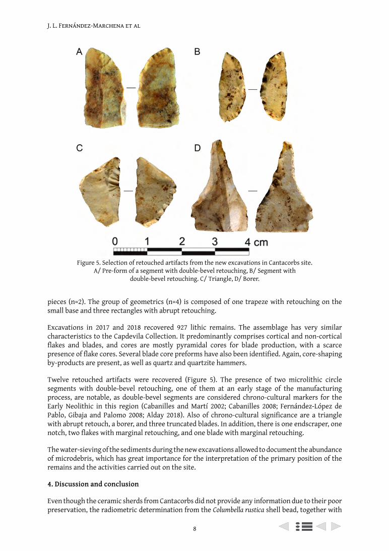
Twelve retouched artifacts were recovered (Figure 5). The presence of two microlithic circle segments with double-bevel retouching, one of them at an early stage of the manufacturing process, are notable, as double-bevel segments are considered chrono-cultural markers for the Early Neolithic in this region (Cabanilles and Martí 2002; Cabanilles 2008; Fernández-López de Pablo, Gibaja and Palomo 2008; Alday 2018). Also of chrono-cultural significance are a triangle with abrupt retouch, a borer, and three truncated blades. In addition, there is one endscraper, one notch, two flakes with marginal retouching, and one blade with marginal retouching.
The water-sieving of the sediments during the new excavations allowed to document the abundance of microdebris, which has great importance for the interpretation of the primary position of the remains and the activities carried out on the site.
4. Discussion and conclusion
Even though the ceramic sherds from Cantacorbs did not provide any information due to their poor preservation, the radiometric determination from the Columbella rustica shell bead, together with
Figure 5. Selection of retouched artifacts from the new excavations in Cantacorbs site. A/ Pre-form of a segment with double-bevel retouching, B/ Segment with
double-bevel retouching. C/ Triangle, D/ Borer.
9
Cantacorbs: Recovering a forgotten Neolithic site
the chrono-cutural significance of the malacological and lithic retouched assemblages, allow us to ascribe the site to the Postcardial Early Neolithic, a period scarcely represented in the province of Tarragona.
From the very beginning, the project of rediscovery and excavation of the Cantacorbs site has therefore contributed a great deal to our understanding of the occupational and land use patterns of the first farmers in NE Iberia. Its location at more than 1000 masl, at the top of the mountain, and on one of the highest peaks in the area (being surrounded by lower plains), demonstrates a settlement and land management pattern almost unknown for this period outside mountainous areas.
High mountain areas have traditionally been considered marginal areas for human settlement, but recent advances in research suggest otherwise (della Casa and Walsh 2007; Mazzucco, Clemente Conte and Gassiot 2019). A site is considered a high mountain site from 1000 masl (della Casa and Walsh 2007), mainly due to differences in climate that begin at that altitude, but also due to steep orography, vegetation scarcity, etc.
These kinds of areas are being increasingly studied by different research teams, traditionally focused on the great mountain ranges of the Alps (della Casa and Walsh 2007) or the Pyrenees (Gassiot et al. 2017). For the Early Neolithic in NE Iberia, the only sites that can be categorized in this group are caves and rockshelters in the Pyrenees. Most of the sites are distributed in Huesca (with Els Trocs (Rojo Guerra et al. 2013) or Coro Trasito (Clemente et al. 2014)), Girona (Mercadal et al. 2009), and in Andorra (where, besides the site of Balma Margineda (Oms, Gibaja et al. 2016), several structures have been dated to the Early Neolithic (Orengo et al. 2014)).
Resuming fieldwork in Cantacorbs allowed us to identify a settlement pattern not documented in this region to date, in which certain areas deemed inadequate a priori for habitation were occupied earlier than previously thought. The closest high mountain Early Neolithic sites seem to be related to short term occupations linked to cattle pasture (Clemente et al. 2014; Mazzucco, Clemente Conte and Gassiot 2019). This interpretation is reinforced by the paucity of archaeological materials at the sites, especially lithic industry.
Cantacorbs presents different characteristics than the aforementioned sites. First, with the data available to date, the area excavated can be interpreted as a high mountain knapping workshop, related to blade production, in which all the stages of the production sequence are present, from cortical flakes and preformed cores to core-shaping products and microdebris. The location of the site on a plateau at the top of the mountain adds interest to the interpretation, because almost all the knappable material is imported to the site: the closest raw material source is 5 km away in a straight line, but the altitude changes from 400 masl to more than 1000.
The study and radiometric determination presented here are just the first steps in a long-term project to locate more sites with similar characteristics in high mountain ranges. Vilaseca mentions some other similar sites in the region, such as Les Benes or Pla de Guardia (Vilaseca 1953), that would need to be re-located, the old collections re-studied, and the sites re-excavated systematically with modern methodological protocols. So, it is possible that what now seems to be a rare type of settlement in the region could eventually be recognized as a common settlement pattern thanks to the development of this research strategy focusing on the recovery and investigation of long-known sites, starting with Cantacorbs.
The second part of the discussion revolves around the urgent need to emphasize the value of old collections and recover them for research, as well as the need to cooperate with former collaborators of the Provincial Commissioners of Excavations. In this particular case, the project of recovery and reinvestigation of Cantacorbs would not be possible (or would be much more difficult) without
J. L. Fernández-Marchena et al
10
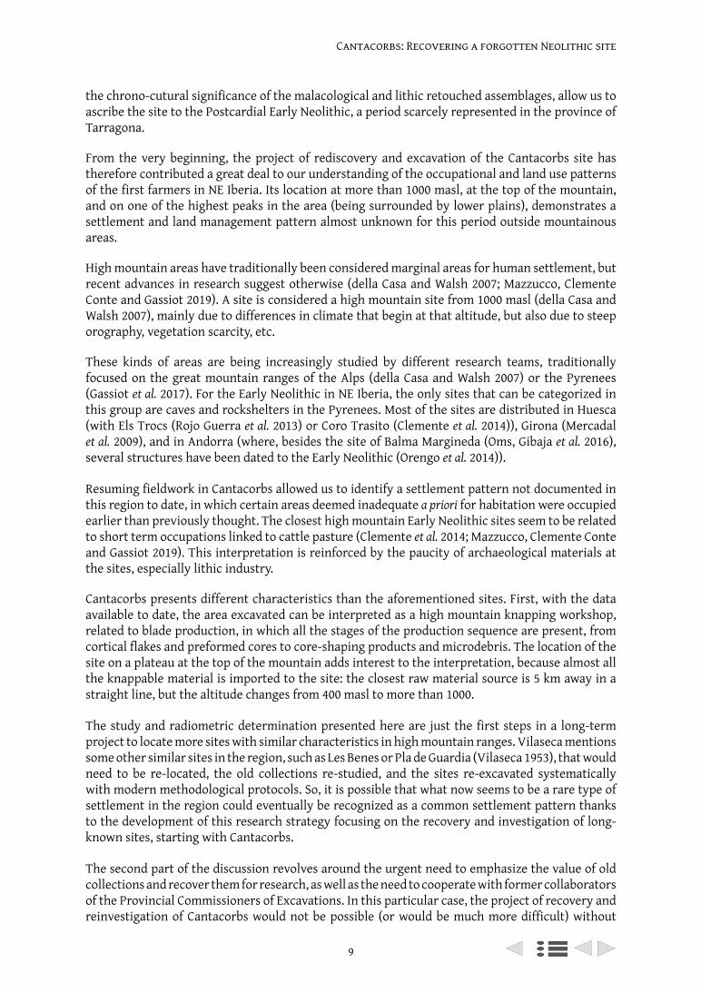
Ramón Capdevila’s collaboration. Although the materials on the Capdevila Collection were mostly unpublished, some appear in illustrations in Vilaseca’s work (Figure 6).
Even though the recovery of the materials of the Capdevila Collection was not done following modern excavation and registration protocols, resulting in the loss of context that hinders their correlation with the rest of the materials from the site, we cannot ignore their existence and must do our best to reverse the adverse effects of this kind of past unregulated or extralegal activities. It is necessary to recognize that continuing to overlook these collections would end up meaning total loss, not only of the materials, but also of any kind of information or data recorded or remembered by the ‘owners’ or keepers of these private collections (Shott 2008, 2018) (Figure 7).
In spite of the irregular enforcement of the former Spanish heritage laws by the Provincial Commissioners of Monuments (López Trujillo 2004), in provinces like Tarragona hundreds of sites were discovered thanks to the work of researchers like Dr. Vilaseca as the Provincial Commissioner of Excavations and the legalization in Catalonia of an Official Network of Collaborators, or amateur researchers (Alay 2015).
In archaeology, the context of materials and their documentation are key elements in research. In this sense, artifact collection by amateurs often results in the loss of a great deal of contextual information, which is in many cases irreparable. Nevertheless, it is essential, in research, to consider as much material or evidence as possible, whether it is recovered by professional archaeologists or amateur artifact collectors, because these materials may form a considerable proportion of the total archaeological remains from a given area (Shott 2008, 2017).
On this matter, collaboration with the keepers of old collections is key not only to recovering as much material as possible, but also to gathering as much information as possible regarding the context of their collections (location of recovery, possible existence of other collections…), and
Figure 6. Selection of borers drawn by Vilaseca (1971) (left) and photograph of the only one of these perforators found in the Capdevila collection (right), the number 6.
11
Cantacorbs: Recovering a forgotten Neolithic site
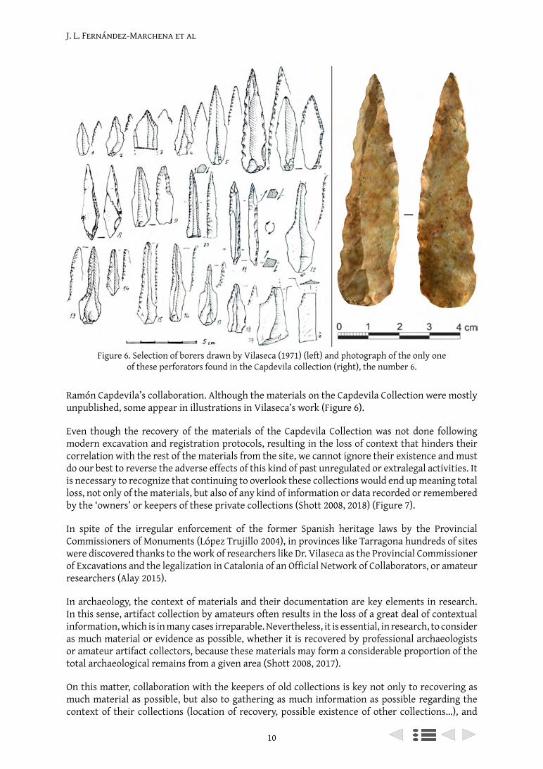
trying to mitigate the loss of context as much as possible (Shott 2008, 2018; Douglass et al. 2017). In this particular case, although the material from the Capdevila Collection was not recovered systematically, Ramón Capdevila took care in recording the locations where he found the materials, and is collaborating with archaeologists to, in some way, carry on his work.
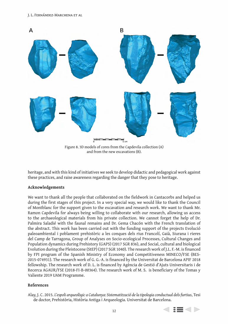
In the same way as other studies that work with materials from private collections (Douglass et al. 2017), our objective was to recover and document the collection, producing 3D models of the pieces that, due to their characteristics or typology, could provide particularly relevant information (Figure 8).
3D techniques not only have advantages when it comes to obtaining quantitative data that were very difficult to obtain accurately before the development of this technology (Grosman, Smikt and Smilansky 2008), but are also a tool that complements the documentation of heritage and allows for the dissemination and preservation of important data (Douglass et al. 2017). Thus, it is especially useful when dealing with private collections, as it allows researchers continued access to information without needing to turn to the physical materials, thereby facilitating their study.
In any case, and to conclude, it is necessary to stress the need to reinvestigate the archaeological materials recovered and the information recorded by amateurs and collaborators of the former Provincial Commissioners of Excavations before it is too late and that information is lost. In spite of the lack of academic training of most of the participants in the Commissioners’ network of collaborators, the information they may provide could be key to fully understanding the scope of the archaeological record, as well as the location of many unpublished archaeological sites.
Unquestionably, this kind of collaboration with collectors can recover, highlight, and integrate into current research the heritage amassed by these collectors, which has historically been overlooked by researchers (Shott 2018). We strongly condemn any kind of furtive and illegal action against
Figure 7. Selection of retouched artifacts drawn by Vilaseca (1973) (left) and (right) photograph of the artifacts located in the Capdevila collection (1, 2, 3, 4, 6, 7 and 9).
J. L. Fernández-Marchena et al
12
heritage, and with this kind of initiatives we seek to develop didactic and pedagogical work against these practices, and raise awareness regarding the danger that they pose to heritage.
Acknowledgements
We want to thank all the people that collaborated on the fieldwork in Cantacorbs and helped us during the first stages of this project. In a very special way, we would like to thank the Council of Montblanc for the support given to the excavation and research work. We want to thank Mr. Ramon Capdevila for always being willing to collaborate with our research, allowing us access to the archaeological materials from his private collection. We cannot forget the help of Dr. Palmira Saladié with the faunal remains and Dr. Gema Chacón with the French translation of the abstract. This work has been carried out with the funding support of the projects Evolució paleoambiental i poblament prehistòric a les conques dels rius Francolí, Gaià, Siurana i rieres del Camp de Tarragona, Group of Analyses on Socio-ecological Processes, Cultural Changes and Population dynamics during Prehistory (GAPS) (2017 SGR 836), and Social, cultural and biological Evolution during the Pleistocene (StEP) (2017 SGR 1040). The research work of J.L. F.-M. is financed by FPI program of the Spanish Ministry of Economy and Competitiveness MINECO/FSE (BES-2015-074931). The research work of G. G.-A. is financed by the Universitat de Barcelona APIF 2018 fellowship. The research work of D. L. is financed by Agència de Gestió d’Ajuts Universitaris i de Recerca AGAUR/FSE (2018-FI-B-00364). The research work of M. S. is beneficiary of the Tomas y Valiente 2019 UAM Programme.
References
Alay, J. C. 2015. L’espoli arqueològic a Catalunya: Sistematització de la tipologia conductual dels furtius, Tesi de doctor, Prehistòria, Història Antiga i Arqueologia. Universitat de Barcelona.
Figure 8. 3D models of cores from the Capdevila collection (A) and from the new excavations (B).
13
Cantacorbs: Recovering a forgotten Neolithic site
Alday, A. 2018. Regiones y transferencias en el camino del Neolítico ibérico: el caso de las armaduras líticas, Saguntum, 50: 9-33. doi: 0.7203/SAGVNTVM.50.10856.
Álvarez Fernández, E. 2008. The use of Columbella rustica (class: Gastropoda) in the Iberian Peninsula and Europe during the Mesolithic and the early Neolithic, in Hernández Pérez, M., Soler Díaz, J. A., and López Padilla, J. A. (eds) Actas del IV Congreso del Neolítico Peninsular. Alicante: Museo Arqueológico de Alicante-MARQ: 103-111.
Aparicio Mainar, R. 2016. Materials procedents de la Conca de Barberà als fons del Museu de Reus, Podall, 5: 244-266.
Bosch, J. 2016. La cerámica de la Cova del Vidre (Roquetes) y el Neolítico Cardial Franco-Ibérico, in MUPREVA (ed.) Del neolític a l’edat del bronze en el Mediterrani occidental. Estudis en homenatge a Bernat Martí Oliver. Valencia: Servicio de investigación prehistórica del Museo de Prehistoria de Valencia. Serie de Trabajos Varios: 109-115.
Bravo, P., Garcia, M. and Solà, E. 2014. Darreres aportacions al coneixement del neolític i l’edat del bronze al Camp de Tarragona: intervencions als terrenys de l’aeroport de Reus i a la partida de Coll Blanc (Reus, Baix Camp), Tribuna d’Arqueologia, 2011-2012: 173-188.
Bronk Ramsey, C. 2009. Bayesian Analysis of Radiocarbon Dates, Radiocarbon, 51(1): 337-360. Available at: https://journals.uair.arizona.edu/index.php/radiocarbon/article/view/3494.
Cabanilles, J. J. 2008. El utillaje de piedra tallada en la prehistoria valenciana. Aspectos tipológicos, estilísticos y evolutivos, Serie de Trabajos Varios del SIP, no 109. Valencia: Servicio de Investigación Prehistórica. Diputación de Valencia.
Cabanilles, J. J. and Martí, B. 2002. Poblamiento y procesos culturales en la Península Ibérica del VII al V milenio AC (8000-5500BP). Una cartografía de la neolitización, Saguntum, 5: 45-87.
Capdevila Vallverdú, R. 1996. Les meves vivències amb el doctor Salvador Vilaseca, Aplec de Treballs, 14: 11-12.
Carbonell, E., Rodríguez, J., Sala, R. and Vaquero, M. 1992. New elements of the Logical Analytical System. First International Meeting on Technical Systems to Configure Lithic Objects of scarce elaboration, Cahier Noir, 6: 3-61.
Carbonell, E., Guilbaud, M. and Mora, R. 1983. Utilización de la Lógica Analítica para el estudio de los tecnocomplejos a cantos tallados, Cahier Noir, 1: 3-64.
Carbonell, E. and Mora, R. 1986. El sistema lògico-analític i la teoria del ‘transfer’ en l’estudi dels complexes lítics. Barcelona: Societat Catalana d’Arqueologia.
della Casa, P. and Walsh, K. 2007. Introduction: Interpretation of sites and material culture from mid-high altitude mountain environments, Preistoria Alpina, 42: 5-8.
Cebrià, A., Fontanals, M. Martín Rodríguez, P. Morales, J. I., Oms, F.X., Rodríguez-Hidalgo, A., Soto, María, J. M. 2014. Nuevos datos para el Neolítico antiguo en el nordeste de la Península Ibérica procedentes de la Cova del Toll (Moià, Barcelona) y de la Cova de la Font Major (L’Espluga de Francolí, Tarragona), Trabajos de Prehistoria, 71(1): 134-145. doi: 10.3989/tp.2014.12128.
Clemente, I., Gassiot, E., Rey, J., Mazzucco, N., Obea, L. 2014. ‘Cort o Transito’ —Coro Trasito— o Corral de Tránsito: Una cueva pastoral del Neolítico antiguo en el corazón de Sobrarbe, In Clemente, I., Gassiot, E, and Rey, J. (eds), Sobrarbe antes de Sobrarbe: pinceladas de historia de los Pirineos. Zaragoza: Centro de Estudios de Sobrarbe (CES) e Instituto de Estudios Altoaragoneses (IEA): 11-32.
Douglass, M., Kuhnel, D., Magnani, M., Hittner, L., Chodoronek, M. and Porte, S. r 2017. Community outreach, digital heritage and private collections: a case study from the North American Great Plains, World Archaeology: 1-16. doi: 10.1080/00438243.2017.1309299.
Fernández-López de Pablo, J., Gibaja, J. F. and Palomo, A. 2008. Les armatures géométriques pendant le Néolithique dans l’est de la péninsule ibérique : aspects typologiques, technologiques et fonctionnels, in Pétillon, J.-M. et al. (eds), Recherches sur les armatures de projectiles du Paléolithique supérieur au Néolithique, XV2 congrès de l’UISPP. Toulouse: 339-351.
Fontanals, M., Belén García, A., Morales Hidalgo, J. I., Vergès Bosch Árbol J. M., Euba Rementeria I., Oms, F. X. 2008. El assentament litoral al aire lliure del Cavet (Cambrils, Tarragona), Butlletí Arqueòlogic, 30: 5-28.
Gassiot, E., Mazzucco, N., Clemente Conte I., David Rodríguez, A., Obea Gómez, L., Quesada Carrasco, M., Díaz Bonilla, S. 2017. The beginning of high mountain occupations in the Pyrenees. Human settlements and mobility from 18,000 cal BC to 2000 cal BC, in Catalan, J., Ninot, J. M., and
J. L. Fernández-Marchena et al
14
Aniz, M. M. (eds), High Mountain Conservation in a Changing World. Cham: Springer International Publishing: 75-105. doi: 10.1007/978-3-319-55982-7_4.
Grosman, L., Smikt, O. and Smilansky, U. 2008. On the application of 3-D scanning technology for the documentation and typology of lithic artifacts, Journal of Archaeological Science, 35(12): 3101-3110. doi: http://dx.doi.org/10.1016/j.jas.2008.06.011.
López Trujillo, M. A. 2004. Las Comisiones Provinciales de Monumentos, Quijotes del pasado, Zona Arqueológica, 3: 363-370.
Massó Carballido, J. and Capdevila Vallverdú, R. 1999. Sobre una placa de sivella visigòtica trobada a Rojals, Aplec de Treballs, 17: 5-8.
Mazzucco, N., Clemente Conte, I. and Gassiot, E. 2019. Lost in the mountains? The Cova del Sardo and the Neolithisation of the Southern Central Pyrenees (fifth-third mill. cal bc), Archaeological and Anthropological Sciences, 11(4), p. 14611475. doi: 10.1007/s12520-018-0603-0.
Mercadal, O., Aliaga, S., Esteve, X., Mangado, X., Nadal, J., Cubero, C., Álvarez, R. 2009. L’Assentament del neolític antic de les mines de Sanavastre (Sanavastre, Das, La Cerdanya), in Fullola, J. M., Valdeyron, N. and Langlais, M. (eds) Els Pirineus i les àrees circumdants durant el tardiglacial. Mutacions i filiacions tecnoculturals, evolució paleoambiental (16000-10000 BC). Puigcerdà: Institut d’Estudis Ceretans: 637-684.
Miró, J. M. 1994. La cronologia dels estils ceràmics neolítics a Catalunya i la datació de C14 de la Timba del Barenys (Riudoms, Tarragona), Saguntum, 27: 57-66.
Navarrete, M. S. and Capel, J. 1979. El material no ceramico de la Cueva del Agua de Prado Negro (Iznalloz, Granada), Cuadernos de Prehistoria y Arqueología de la Universidad de Granada, 4: 111-132.
Oms, F. X., Cebrià, A., Mestres, J., Fullola, J., Mendiela, S., Pedro, M., Morales, Juan, I., Nadal, J., Martín Rodríguez, P. 2016. La cova de la Guineu (Font-Rubí, Barcelona) i les relacions plana-muntanya al Penedès durant el neolític inicial, in MUPREVA (ed.) Del neolític a l’edat del bronze en el Mediterrani occidental. Estudis en homenatge a Bernat Martí Oliver. Valencia: Servicio de investigación prehistórica del Museo de Prehistoria de Valencia. Serie de Trabajos Varios: 97-107.
Oms, F. X., Gibaja, J. F., Mazzucco, N., Guilaine, J. 2016. Revisión radiocarbónica y cronocultural del Neolítico antiguo de la Balma Margineda (Aixovall, Andorra), Trabajos de Prehistoria, 73(1): 29-46. doi: 10.3989/tp.2016.12162.
Oms, F. X., Martín, A., Esteve, X., Mestres, J., Morell Rovira, B., Subirà, M., Gibaja, J. 2016. The Neolithic in Northeast Iberia: Chronocultural Phases and 14C, Radiocarbon, 58(2): 291-309. doi: 10.1017/rdc.2015.14.
Oms, F. X., Morales, J. I., Cebrià, A., Pedro, M. 2016. Una inhumació cardial a la cova Foradada (Calafell, Baix Penedès)?, In Esteve, X., Molist, N. and Sabaté, G. (eds), Jornades d’Arqueologia del Penedès 2011. Vilafranca del Penedès: 117-124.
Oms, F. X. and Martín, A. 2018. Els primers pagesos i ramaders del Nord-Est de la Península Ibèrica: el Neolític ca. 5600-2300 cal BC, in Remolins, G. and Gibaja, J. F. (eds), Les valls d’Andorra durant el Neolític: un encreuament de camins al centre dels Pirineus. Barcelona: Monografies del MAC 2. Museu d’Arqueologia de Catalunya: 37-62.
Orengo, H. A., Palet, J. M., Ejarque, A., Miras, Y., Riera, S. 2014. Shifting occupation dynamics in the Madriu–Perafita–Claror valleys (Andorra) from the early Neolithic to the Chalcolithic: The onset of high mountain cultural landscapes, Quaternary International, 353: 140-152. doi: http://dx.doi.org/10.1016/j.quaint.2014.01.035.
Pascual-Benito, J. L. 1996. Los adornos del Neolítico I en el País Valenciano, Recerques del Museu d’Alcoi, 5: 17-52.
Poppe, G. T. and Goto, Y. 1991. European seashells. Volume 1. Wieesbaden: Verlag Christa Hemmen.Reimer, P. J., Bard, E., Bayliss A., Warren Beck, J., Blackwell, P. G., Bronk Ramsey, C. et al. 2013. IntCal13
and Marine13 Radiocarbon Age Calibration Curves 0-50,000 Years cal BP, Radiocarbon, 55(04): 1869-1887. doi: doi:10.1017/S0033822200048864.
Rojo Guerra, M., Peña-Chocarro, L., Royo Guillén, J., Tejedor, C., Lagrán, I., Arcusa Magallón, H., Pena, R., Moreno-García, M., Mazzucco, N., Gibaja, J., Ortega, D., Kromer, B., Alt, K. 2013. Pastores trashumantes del neolítico antiguo en un entorno de alta montaña: Secuencia crono-cultural
15
Cantacorbs: Recovering a forgotten Neolithic site
de la cova de Els Trocs (San Feliú de Veri, Huesca), Boletín del Seminario de Estudios de Arte y Arqueología, 79: 9-55.
Shott, M. J. 2008. Equal o nll roofht w ded l e vdbr cted. A Proposal for Conservation of Private Collections in American Archaeology, SAA archaeological record, 8(2): 30-35.
Shott, M. J. 2017. Estimating the magntude of private collection of points and its effects on professional survey results, Advances in Archaeological Practice, 5(2): 125-137. doi: DOI:10.1017/aap.2017.8.
Shott, M. J. 2018. The Ethics of Professional-Collector Collaboration, in Shott, M. J., Seeman, M. F., and Nolan, K. C. (eds), Collaborative Engagement: Working with Private Collectons and Responsive Collectors. Midwest Archaeological Conference Occasional Papers No 3. Champaign: Midwest Archaeological Conference: 1-6.
Soto, M. 2015. Áreas y estrategias de aprovisionamiento lítico de los últimos cazadores-recolectores en las Montañas de Prades (Tarragona), Departament d’Història i Història de l’Art. Universitat Rovira i Virgili.
Soto, M. 2016. Procurement and mobility during the Late Pleistocene: Characterising the stone-tool assemblage of the Picamoixons site (Tarragona, NE Iberian Peninsula), Journal of Lithic Studies, 3(2). doi: 10.2218/jls.v3i2.1782.
Vilaseca, S. 1936. La industria del sílex a Catalunya: les estacions tallers del Priorat i extensions. Reus: Llibreria Nacional i Estrangera.
Vilaseca, S. 1945. La cueva III de Les Quimeres, término municipal de Pradell (Tarragona), Empuries: revista de món clàssic i antiguitat tardana, 7: 83-90.
Vilaseca, S. 1953. Las industrias del sílex tarraconenses. Madrid: Consejo Superior de Investigaciones Científicas. Instituto Rodrigo Caro.
Vilaseca, S. 1971. Perçoirs néolithiques de la province de Tarragone (Etude technologique comparative), Bulletin de la Société préhistorique de l’Ariège, 26: 115-121.
Vilaseca, S. 1973. Reus y su entorno en la Prehistoria. Reus: Asociación de estudios reusenses.
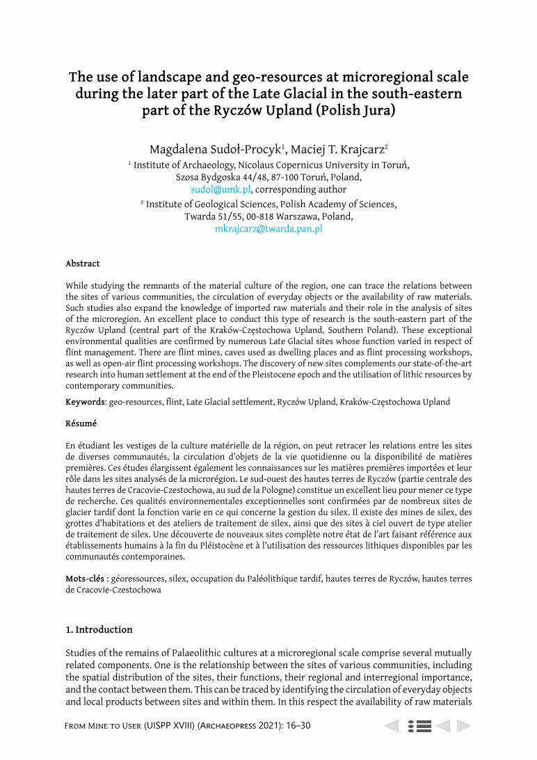
From Mine to User (UISPP XVIII) (Archaeopress 2021): 16–30
The use of landscape and geo-resources at microregional scale during the later part of the Late Glacial in the south-eastern
part of the Ryczów Upland (Polish Jura)
Magdalena Sudoł-Procyk1, Maciej T. Krajcarz2
1 Institute of Archaeology, Nicolaus Copernicus University in Toruń, Szosa Bydgoska 44/48, 87-100 Toruń, Poland,
[email protected], corresponding author2 Institute of Geological Sciences, Polish Academy of Sciences,
Twarda 51/55, 00-818 Warszawa, Poland, [email protected]
Abstract
While studying the remnants of the material culture of the region, one can trace the relations between the sites of various communities, the circulation of everyday objects or the availability of raw materials. Such studies also expand the knowledge of imported raw materials and their role in the analysis of sites of the microregion. An excellent place to conduct this type of research is the south-eastern part of the Ryczów Upland (central part of the Kraków-Częstochowa Upland, Southern Poland). These exceptional environmental qualities are confirmed by numerous Late Glacial sites whose function varied in respect of flint management. There are flint mines, caves used as dwelling places and as flint processing workshops, as well as open-air flint processing workshops. The discovery of new sites complements our state-of-the-art research into human settlement at the end of the Pleistocene epoch and the utilisation of lithic resources by contemporary communities.
Keywords: geo-resources, flint, Late Glacial settlement, Ryczów Upland, Kraków-Częstochowa Upland
Résumé
En étudiant les vestiges de la culture matérielle de la région, on peut retracer les relations entre les sites de diverses communautés, la circulation d’objets de la vie quotidienne ou la disponibilité de matières premières. Ces études élargissent également les connaissances sur les matières premières importées et leur rôle dans les sites analysés de la microrégion. Le sud-ouest des hautes terres de Ryczów (partie centrale des hautes terres de Cracovie-Czestochowa, au sud de la Pologne) constitue un excellent lieu pour mener ce type de recherche. Ces qualités environnementales exceptionnelles sont confirmées par de nombreux sites de glacier tardif dont la fonction varie en ce qui concerne la gestion du silex. Il existe des mines de silex, des grottes d’habitations et des ateliers de traitement de silex, ainsi que des sites à ciel ouvert de type atelier de traitement de silex. Une découverte de nouveaux sites complète notre état de l’art faisant référence aux établissements humains à la fin du Pléistocène et à l’utilisation des ressources lithiques disponibles par les communautés contemporaines.
Mots-clés : géoressources, silex, occupation du Paléolithique tardif, hautes terres de Ryczów, hautes terres de Cracovie-Czestochowa
1. Introduction
Studies of the remains of Palaeolithic cultures at a microregional scale comprise several mutually related components. One is the relationship between the sites of various communities, including the spatial distribution of the sites, their functions, their regional and interregional importance, and the contact between them. This can be traced by identifying the circulation of everyday objects and local products between sites and within them. In this respect the availability of raw materials
The use of landscape and georesources at microregional scale
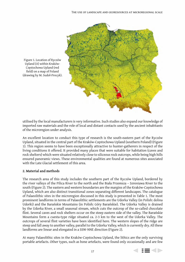
17
The use of landscape and georesources at microregional scale
utilised by the local manufacturers is very informative. Such studies also expand our knowledge of imported raw materials and the role of local and distant contacts used by the ancient inhabitants of the microregion under analysis.
An excellent location to conduct this type of research is the south-eastern part of the Ryczów Upland, situated in the central part of the Kraków-Częstochowa Upland (southern Poland) (Figure 1). This region seems to have been exceptionally attractive to hunter-gatherers in respect of the living conditions it offered. It provided many places that were suitable for habitation (caves and rock shelters) which were situated relatively close to siliceous rock outcrops, while being high hills ensured panoramic views. These environmental qualities are found at numerous sites associated with the Late Glacial settlement of this area.
2. Material and methods
The research area of this study includes the southern part of the Ryczów Upland, bordered by the river valleys of the Pilica River to the north and the Biała Przemsza – Szreniawa River to the south (Figure 2). The eastern and western boundaries are the margins of the Kraków-Częstochowa Upland, which are also distinct transitional zones separating different landscapes. The catalogue of Palaeolithic sites in the microregion discussed in this study is presented in Table 1. The most prominent landforms in terms of Palaeolithic settlements are the Udorka Valley (in Polish: dolina Udorki) and the Barańskie Mountains (in Polish: Góry Barańskie). The Udorka Valley is drained by the Udorka River, a small seasonal stream, which cuts the outcrop of the so-called chocolate flint. Several caves and rock shelters occur on the steep eastern side of the valley. The Barańskie Mountains form a cuesta-type ridge situated ca. 2-3 km to the west of the Udorka Valley. The outcrops of several flint varieties have been identified here. The western slopes of the ridge are steep and fall away to another valley, parallel to the Udorka Valley, which is currently dry. All these landforms are linear and elongated in a SSW-NNE direction (Figure 2).
At many Palaeolithic sites in the Kraków-Częstochowa Upland, the lithics are the only surviving portable artefacts. Other types, such as bone artefacts, were found only occasionally and are few
Figure 1. Location of Ryczów Upland (A) within Kraków-Częstochowa Upland (red field) on a map of Poland
(drawing by M. Sudoł-Procyk).
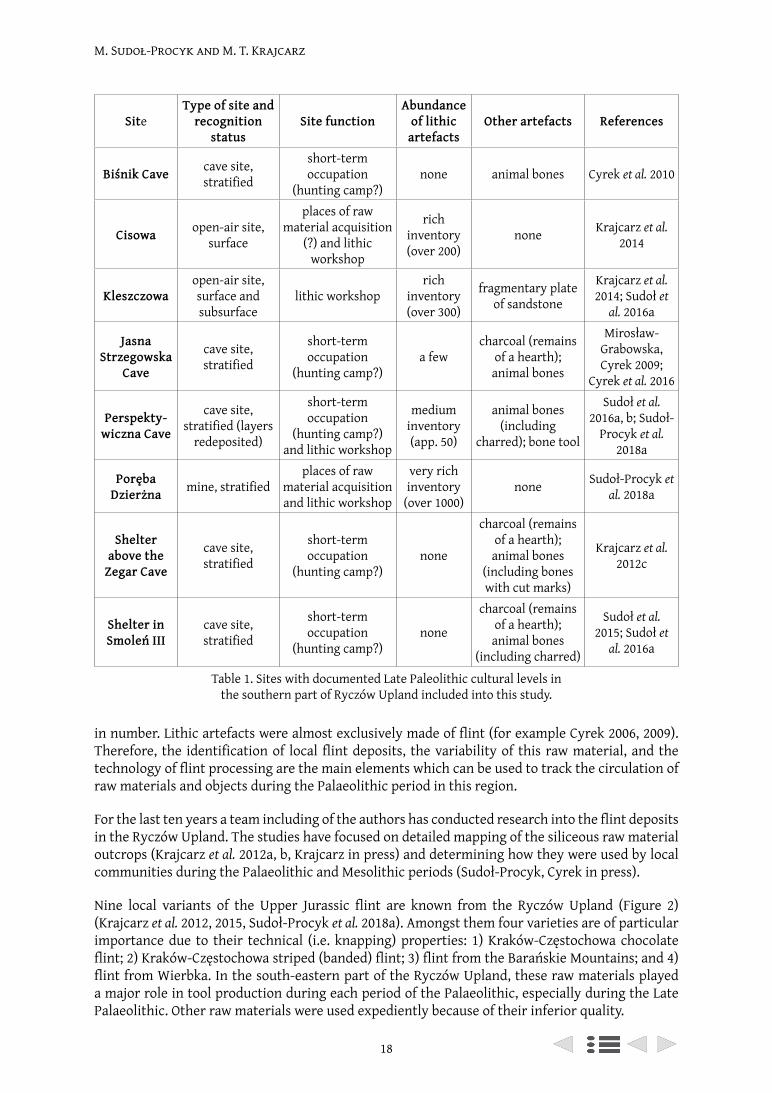
M. Sudoł-Procyk and M. T. Krajcarz
18
in number. Lithic artefacts were almost exclusively made of flint (for example Cyrek 2006, 2009). Therefore, the identification of local flint deposits, the variability of this raw material, and the technology of flint processing are the main elements which can be used to track the circulation of raw materials and objects during the Palaeolithic period in this region.
For the last ten years a team including of the authors has conducted research into the flint deposits in the Ryczów Upland. The studies have focused on detailed mapping of the siliceous raw material outcrops (Krajcarz et al. 2012a, b, Krajcarz in press) and determining how they were used by local communities during the Palaeolithic and Mesolithic periods (Sudoł-Procyk, Cyrek in press).
Nine local variants of the Upper Jurassic flint are known from the Ryczów Upland (Figure 2) (Krajcarz et al. 2012, 2015, Sudoł-Procyk et al. 2018a). Amongst them four varieties are of particular importance due to their technical (i.e. knapping) properties: 1) Kraków-Częstochowa chocolate flint; 2) Kraków-Częstochowa striped (banded) flint; 3) flint from the Barańskie Mountains; and 4) flint from Wierbka. In the south-eastern part of the Ryczów Upland, these raw materials played a major role in tool production during each period of the Palaeolithic, especially during the Late Palaeolithic. Other raw materials were used expediently because of their inferior quality.
Table 1. Sites with documented Late Paleolithic cultural levels in the southern part of Ryczów Upland included into this study.
SiteType of site and
recognition status
Site functionAbundance
of lithic artefacts
Other artefacts References
Biśnik Cave cave site, stratified
short-term occupation
(hunting camp?)none animal bones Cyrek et al. 2010
Cisowa open-air site, surface
places of raw material acquisition
(?) and lithic workshop
rich inventory (over 200)
none Krajcarz et al. 2014
Kleszczowaopen-air site, surface and subsurface
lithic workshoprich
inventory (over 300)
fragmentary plate of sandstone
Krajcarz et al. 2014; Sudoł et
al. 2016a
Jasna Strzegowska
Cave
cave site, stratified
short-term occupation
(hunting camp?)a few
charcoal (remains of a hearth); animal bones
Mirosław-Grabowska, Cyrek 2009;
Cyrek et al. 2016
Perspekty-wiczna Cave
cave site, stratified (layers
redeposited)
short-term occupation
(hunting camp?) and lithic workshop
medium inventory (app. 50)
animal bones (including
charred); bone tool
Sudoł et al. 2016a, b; Sudoł-
Procyk et al. 2018a
Poręba Dzierżna mine, stratified
places of raw material acquisition and lithic workshop
very rich inventory
(over 1000)none Sudoł-Procyk et
al. 2018a
Shelter above the
Zegar Cave
cave site, stratified
short-term occupation
(hunting camp?)none
charcoal (remains of a hearth); animal bones
(including bones with cut marks)
Krajcarz et al. 2012c
Shelter in Smoleń III
cave site, stratified
short-term occupation
(hunting camp?)none
charcoal (remains of a hearth); animal bones
(including charred)
Sudoł et al. 2015; Sudoł et
al. 2016a
M. Sudoł-Procyk and M. T. Krajcarz
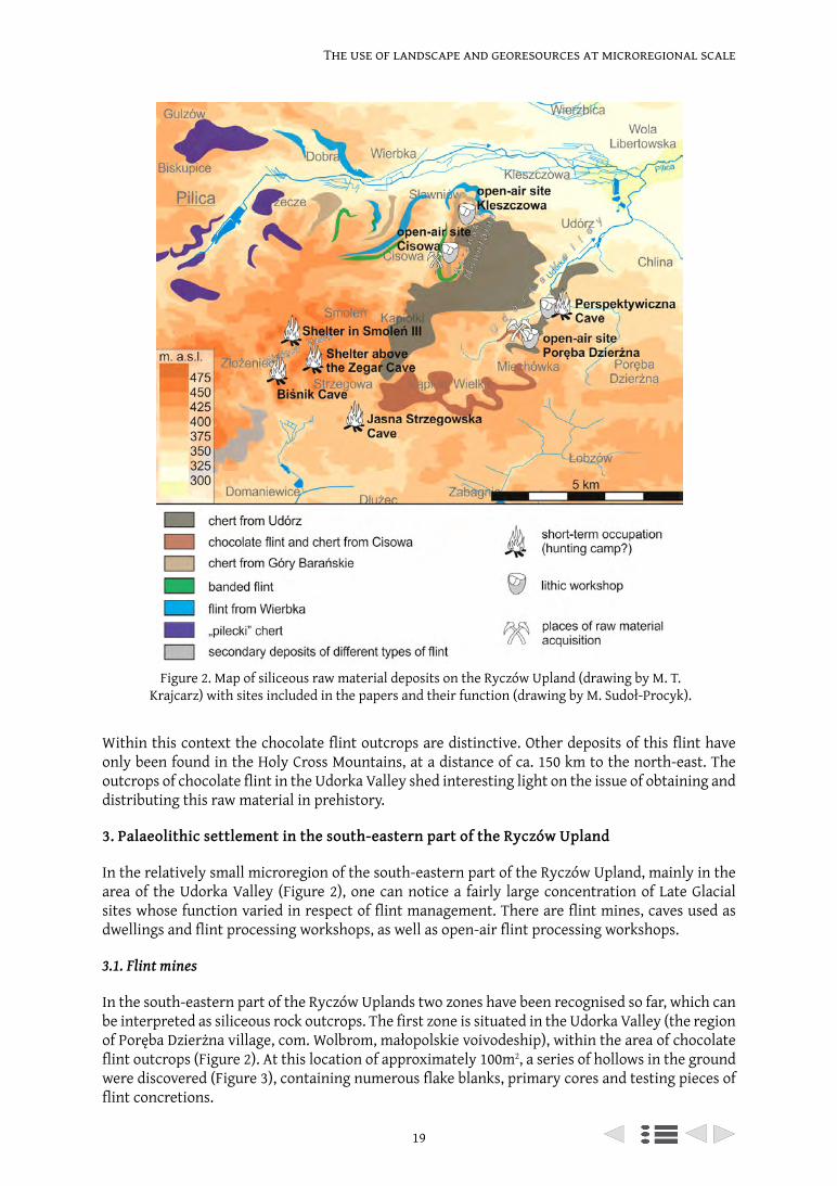
19
The use of landscape and georesources at microregional scale
Within this context the chocolate flint outcrops are distinctive. Other deposits of this flint have only been found in the Holy Cross Mountains, at a distance of ca. 150 km to the north-east. The outcrops of chocolate flint in the Udorka Valley shed interesting light on the issue of obtaining and distributing this raw material in prehistory.
3. Palaeolithic settlement in the south-eastern part of the Ryczów Upland
In the relatively small microregion of the south-eastern part of the Ryczów Upland, mainly in the area of the Udorka Valley (Figure 2), one can notice a fairly large concentration of Late Glacial sites whose function varied in respect of flint management. There are flint mines, caves used as dwellings and flint processing workshops, as well as open-air flint processing workshops.
3.1. Flint mines
In the south-eastern part of the Ryczów Uplands two zones have been recognised so far, which can be interpreted as siliceous rock outcrops. The first zone is situated in the Udorka Valley (the region of Poręba Dzierżna village, com. Wolbrom, małopolskie voivodeship), within the area of chocolate flint outcrops (Figure 2). At this location of approximately 100m2, a series of hollows in the ground were discovered (Figure 3), containing numerous flake blanks, primary cores and testing pieces of flint concretions.
Figure 2. Map of siliceous raw material deposits on the Ryczów Upland (drawing by M. T. Krajcarz) with sites included in the papers and their function (drawing by M. Sudoł-Procyk).
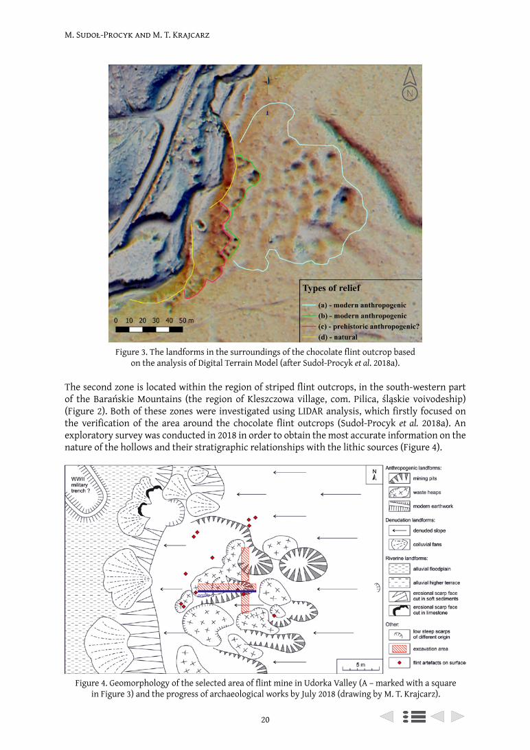
M. Sudoł-Procyk and M. T. Krajcarz
20
The second zone is located within the region of striped flint outcrops, in the south-western part of the Barańskie Mountains (the region of Kleszczowa village, com. Pilica, śląskie voivodeship) (Figure 2). Both of these zones were investigated using LIDAR analysis, which firstly focused on the verification of the area around the chocolate flint outcrops (Sudoł-Procyk et al. 2018a). An exploratory survey was conducted in 2018 in order to obtain the most accurate information on the nature of the hollows and their stratigraphic relationships with the lithic sources (Figure 4).
Figure 3. The landforms in the surroundings of the chocolate flint outcrop based on the analysis of Digital Terrain Model (after Sudoł-Procyk et al. 2018a).
Figure 4. Geomorphology of the selected area of flint mine in Udorka Valley (A – marked with a square in Figure 3) and the progress of archaeological works by July 2018 (drawing by M. T. Krajcarz).
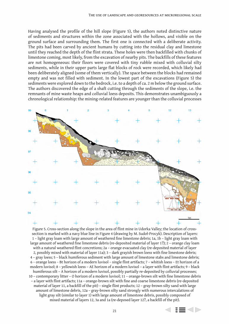
21
The use of landscape and georesources at microregional scale
Figure 5. Cross-section along the slope in the area of flint mine in Udorka Valley; the location of cross-section is marked with a navy blue line in Figure 4 (drawing by M. Sudoł-Procyk). Description of layers: 1 – light gray loam with large amount of weathered fine limestone debris; 1a, 1b – light gray loam with
large amount of weathered fine limestone debris (re-deposited material of layer 1?); 2 – orange clay loam with a natural weathered flint concretions; 2a – orange evacuated clay (re-deposited material of layer 2, possibly mixed with material of layer 11a); 3 – dark grayish brown loess with fine limestone debris;
4 – gray loess; 5 – black humiferous sediment with large amount of limestone stabs and limestone debris; 6 – orange loess – Bt horizon of a modern luvisol – single flint artifacts; 7 – whitish loess – Et horizon of a modern luvisol; 8 – yellowish loess – AE horizon of a modern luvisol – a layer with flint artifacts; 9 – black
humiferous silt – A horizon of a modern luvisol, possibly partially re-deposited by colluvial processes; 10 – contemporary litter – O horizon of a modern luvisol; 11 – orange-brown silt with fine limestone debris
– a layer with flint artifacts; 11a – orange-brown silt with fine and coarse limestone debris (re-deposited material of layer 11, a backfill of the pit) – single flint products; 12 – gray-brown silty sand with large
amount of limestone debris, 12a – gray-brown silty sand strongly with numerous intercalations of light gray silt (similar to layer 1) with large amount of limestone debris, possibly composed of
mixed material of layers 12, 3a and 1a (re-deposed layer 12?, a backfill of the pit).
Having analysed the profile of the hill slope (Figure 5), the authors noted distinctive nature of sediments and structures within the zone associated with the hollows, and visible on the ground surface and surrounding them. The first one is connected with a deliberate activity. The pits had been carved by ancient humans by cutting into the residual clay and limestone until they reached the depth of the flint strata. These holes were then backfilled with chunks of limestone coming, most likely, from the excavation of nearby pits. The backfills of these features are not homogeneous: their floors were covered with tiny rubble mixed with colluvial silty sediments, while in their upper parts large flat blocks of rock were recorded, which likely had been deliberately aligned (some of them vertically). The space between the blocks had remained empty and was not filled with sediment. In the lowest part of the excavations (Figure 5) the sediments were explored down to the bedrock, i.e. to a depth of ca. 2 m below the ground surface. The authors discovered the edge of a shaft cutting through the sediments of the slope, i.e. the remnants of mine waste heaps and colluvial loess deposits. This demonstrates unambiguously a chronological relationship: the mining-related features are younger than the colluvial processes
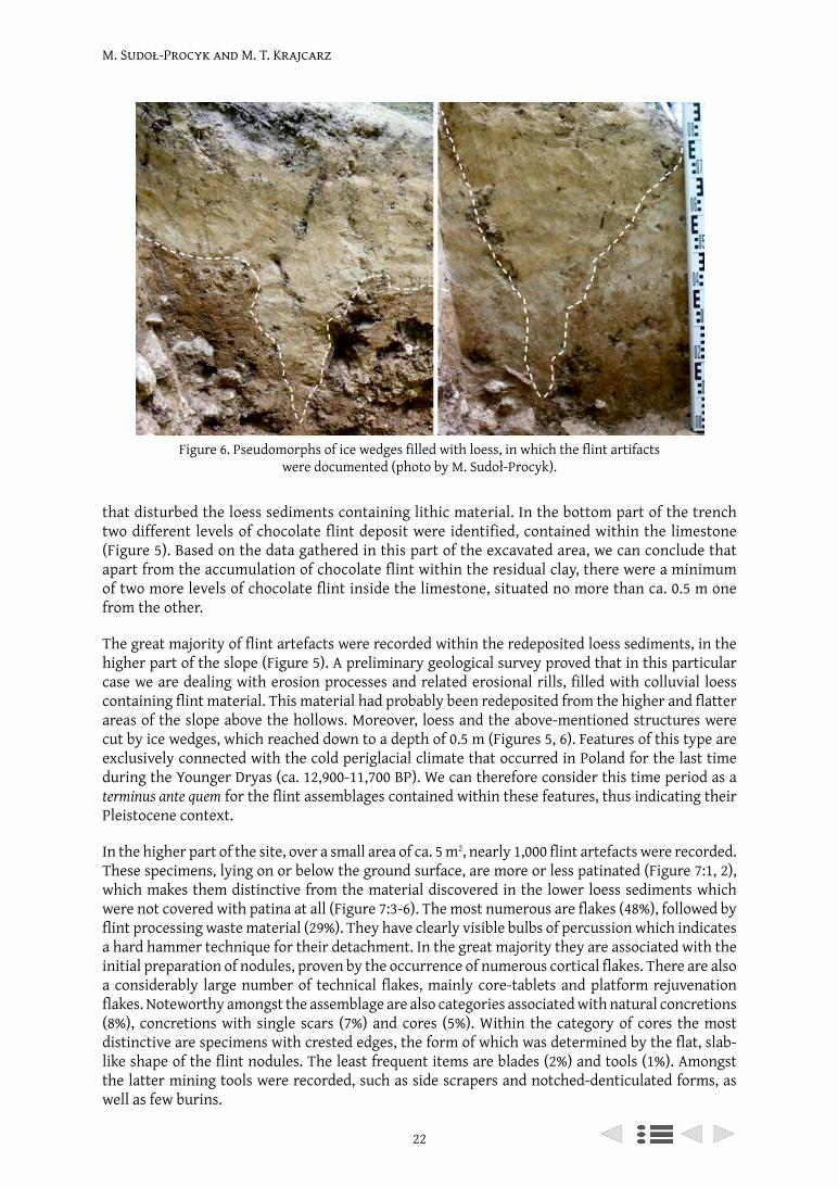
M. Sudoł-Procyk and M. T. Krajcarz
22
that disturbed the loess sediments containing lithic material. In the bottom part of the trench two different levels of chocolate flint deposit were identified, contained within the limestone (Figure 5). Based on the data gathered in this part of the excavated area, we can conclude that apart from the accumulation of chocolate flint within the residual clay, there were a minimum of two more levels of chocolate flint inside the limestone, situated no more than ca. 0.5 m one from the other.
The great majority of flint artefacts were recorded within the redeposited loess sediments, in the higher part of the slope (Figure 5). A preliminary geological survey proved that in this particular case we are dealing with erosion processes and related erosional rills, filled with colluvial loess containing flint material. This material had probably been redeposited from the higher and flatter areas of the slope above the hollows. Moreover, loess and the above-mentioned structures were cut by ice wedges, which reached down to a depth of 0.5 m (Figures 5, 6). Features of this type are exclusively connected with the cold periglacial climate that occurred in Poland for the last time during the Younger Dryas (ca. 12,900-11,700 BP). We can therefore consider this time period as a terminus ante quem for the flint assemblages contained within these features, thus indicating their Pleistocene context.
In the higher part of the site, over a small area of ca. 5 m2, nearly 1,000 flint artefacts were recorded. These specimens, lying on or below the ground surface, are more or less patinated (Figure 7:1, 2), which makes them distinctive from the material discovered in the lower loess sediments which were not covered with patina at all (Figure 7:3-6). The most numerous are flakes (48%), followed by flint processing waste material (29%). They have clearly visible bulbs of percussion which indicates a hard hammer technique for their detachment. In the great majority they are associated with the initial preparation of nodules, proven by the occurrence of numerous cortical flakes. There are also a considerably large number of technical flakes, mainly core-tablets and platform rejuvenation flakes. Noteworthy amongst the assemblage are also categories associated with natural concretions (8%), concretions with single scars (7%) and cores (5%). Within the category of cores the most distinctive are specimens with crested edges, the form of which was determined by the flat, slab-like shape of the flint nodules. The least frequent items are blades (2%) and tools (1%). Amongst the latter mining tools were recorded, such as side scrapers and notched-denticulated forms, as well as few burins.
Figure 6. Pseudomorphs of ice wedges filled with loess, in which the flint artifacts were documented (photo by M. Sudoł-Procyk).
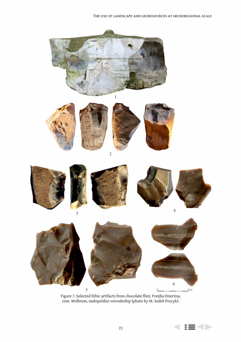
23
The use of landscape and georesources at microregional scale
Figure 7. Selected lithic artifacts from chocolate flint, Poręba Dzierżna, com. Wolbrom, małopolskie voivodeship (photo by M. Sudoł-Procyk).
M. Sudoł-Procyk and M. T. Krajcarz
24
At the present state of research, it is difficult to establish the relationships between the flint material and mining-related features under study. It is possible they may represent two different phases of flint extraction. Stratigraphic data seems to support a considerably young chronology for the mining features. At least one excavated mining pit is undoubtedly later than the flint assemblage mentioned above. Regardless of the chronology of the mining, a high percentage of Pleistocene artefacts associated with the initial phase of processing and located at the flint outcrop indicate the very localised procurement of chocolate flint during the Palaeolithic. Was this due to mining or simply the surface collection of pebbles from the Udorka stream channel remains an open question and needs further investigation.
The pre-mining site identified by this fieldwork is relatively small (ca. 150 x 150 m) and transformations of its surface are quite simple in nature. During a detailed analysis of digital terrain models and field surveys conducted in the Udorka Valley, the authors succeeded in recording similar though definitely smaller landform complexes in other parts of the region of chocolate flint outcrops (Sudoł-Procyk et al. 2018a). Survey studies are expected to deliver additional data on unrecognised areas that have not been excavated so far.
3.2. Caves – dwelling and flint processing workshop type
In the south-eastern part of the Ryczów Upland a few cave sites were recorded with traces of human settlement that can be linked to the younger part of the Last Glacial Period (Figure 2). These traces, possibly of short-term camps, were identified in caves in the Wodąca Valley, such as: Jasna Strzegowska Cave (Cyrek et al. 2016), Biśnik Cave (Cyrek et al. 2010), Shelter above the Zegar Cave (Krajcarz et al. 2012c), and Shelter in Smoleń III (Sudoł et al. 2016a). The identification of this evidence relies upon radiocarbon dating of rare bone material and the remains of hearths, as except for the Jasna Strzegowska Cave (Mirosław-Grabowska, Cyrek 2009), no flint artefacts were found at these sites.
Noteworthy amongst this evidence is the Late Palaeolithic assemblage obtained from the Perspektywiczna Cave, situated in the adjacent Udorka Valley (Sudoł et al. 2016a). Archaeological finds from this site can be linked with several episodes of settlement in the cave, one of which is dated to the Late Palaeolithic (Sudoł et al. 2016b). Within the redeposited sediments in the entrance zone of the cave, there were artefacts recorded typical of workshop sites. They are most likely the remains of a larger assemblage, the primary location of which has not yet been identified. The artefacts discovered in this location (few cores, blade and flake blanks, as well as numerous technical forms) prove that flint processing was undertaken at the site (Figure 8). The assemblage is made up of raw materials obtained from the surroundings of the cave. Chocolate flint is definitely predominant (Figure 8:1-5). Its outcrops are located within a distance of ca. 300 m from the site (Figure 2) (comp. section 3.1). Few artefacts (mostly blade blanks) were made of striped flint (Figure 8:6), flint from the Barańskie Mountains (Figure 8:7) and flint from Wierbka (Figure 8:8), the nearest outcrops of which are situated within a distance of 2 km (Figure 2). The fact that blade blanks which had been produced elsewhere were brought to this site is a strong indication of the existence of flint workshops adjacent to the outcrops of these raw materials, the exact location of which has not as yet been recognised (comp. section 3.3).
3.3. Open-air sites – flint processing workshop type
In the region of the so-called Barańskie Mountains two sites are known where relics of Palaeolithic flint workshops were recorded. The most interesting data so far was provided by the site in Kleszczowa (Sudoł et al. 2016a), situated on well exposed elevated terrain in close proximity to the edge of the slope. The outcrops of flint from the Barańskie Mountains and Wierbka were identified in the same area (Figure 2).
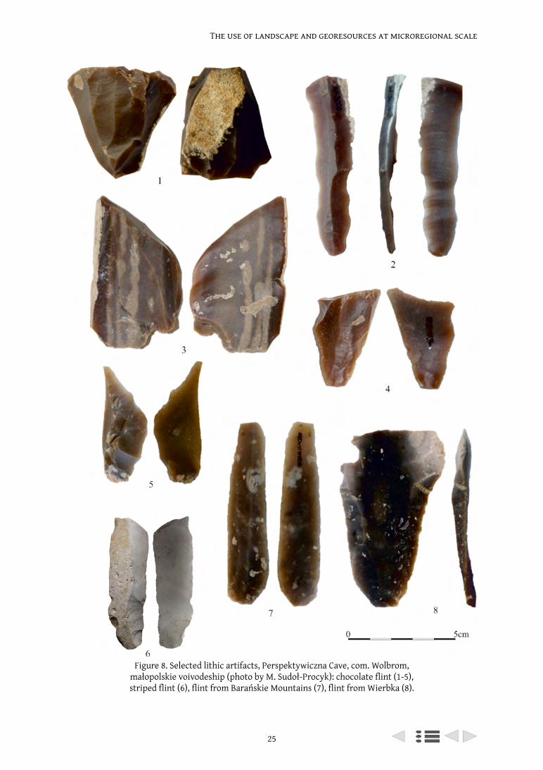
25
The use of landscape and georesources at microregional scale
Figure 8. Selected lithic artifacts, Perspektywiczna Cave, com. Wolbrom, małopolskie voivodeship (photo by M. Sudoł-Procyk): chocolate flint (1-5), striped flint (6), flint from Barańskie Mountains (7), flint from Wierbka (8).
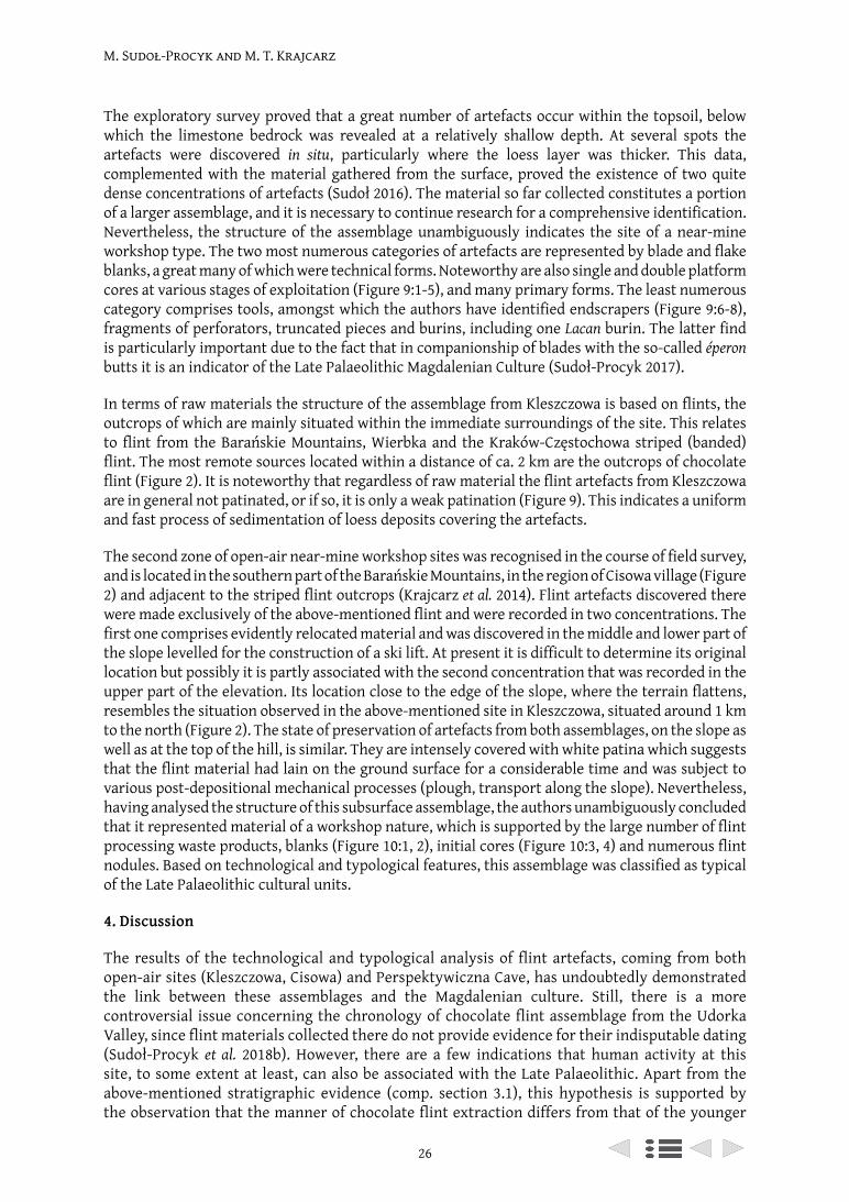
M. Sudoł-Procyk and M. T. Krajcarz
26
The exploratory survey proved that a great number of artefacts occur within the topsoil, below which the limestone bedrock was revealed at a relatively shallow depth. At several spots the artefacts were discovered in situ, particularly where the loess layer was thicker. This data, complemented with the material gathered from the surface, proved the existence of two quite dense concentrations of artefacts (Sudoł 2016). The material so far collected constitutes a portion of a larger assemblage, and it is necessary to continue research for a comprehensive identification. Nevertheless, the structure of the assemblage unambiguously indicates the site of a near-mine workshop type. The two most numerous categories of artefacts are represented by blade and flake blanks, a great many of which were technical forms. Noteworthy are also single and double platform cores at various stages of exploitation (Figure 9:1-5), and many primary forms. The least numerous category comprises tools, amongst which the authors have identified endscrapers (Figure 9:6-8), fragments of perforators, truncated pieces and burins, including one Lacan burin. The latter find is particularly important due to the fact that in companionship of blades with the so-called éperon butts it is an indicator of the Late Palaeolithic Magdalenian Culture (Sudoł-Procyk 2017).
In terms of raw materials the structure of the assemblage from Kleszczowa is based on flints, the outcrops of which are mainly situated within the immediate surroundings of the site. This relates to flint from the Barańskie Mountains, Wierbka and the Kraków-Częstochowa striped (banded) flint. The most remote sources located within a distance of ca. 2 km are the outcrops of chocolate flint (Figure 2). It is noteworthy that regardless of raw material the flint artefacts from Kleszczowa are in general not patinated, or if so, it is only a weak patination (Figure 9). This indicates a uniform and fast process of sedimentation of loess deposits covering the artefacts.
The second zone of open-air near-mine workshop sites was recognised in the course of field survey, and is located in the southern part of the Barańskie Mountains, in the region of Cisowa village (Figure 2) and adjacent to the striped flint outcrops (Krajcarz et al. 2014). Flint artefacts discovered there were made exclusively of the above-mentioned flint and were recorded in two concentrations. The first one comprises evidently relocated material and was discovered in the middle and lower part of the slope levelled for the construction of a ski lift. At present it is difficult to determine its original location but possibly it is partly associated with the second concentration that was recorded in the upper part of the elevation. Its location close to the edge of the slope, where the terrain flattens, resembles the situation observed in the above-mentioned site in Kleszczowa, situated around 1 km to the north (Figure 2). The state of preservation of artefacts from both assemblages, on the slope as well as at the top of the hill, is similar. They are intensely covered with white patina which suggests that the flint material had lain on the ground surface for a considerable time and was subject to various post-depositional mechanical processes (plough, transport along the slope). Nevertheless, having analysed the structure of this subsurface assemblage, the authors unambiguously concluded that it represented material of a workshop nature, which is supported by the large number of flint processing waste products, blanks (Figure 10:1, 2), initial cores (Figure 10:3, 4) and numerous flint nodules. Based on technological and typological features, this assemblage was classified as typical of the Late Palaeolithic cultural units.
4. Discussion
The results of the technological and typological analysis of flint artefacts, coming from both open-air sites (Kleszczowa, Cisowa) and Perspektywiczna Cave, has undoubtedly demonstrated the link between these assemblages and the Magdalenian culture. Still, there is a more controversial issue concerning the chronology of chocolate flint assemblage from the Udorka Valley, since flint materials collected there do not provide evidence for their indisputable dating (Sudoł-Procyk et al. 2018b). However, there are a few indications that human activity at this site, to some extent at least, can also be associated with the Late Palaeolithic. Apart from the above-mentioned stratigraphic evidence (comp. section 3.1), this hypothesis is supported by the observation that the manner of chocolate flint extraction differs from that of the younger
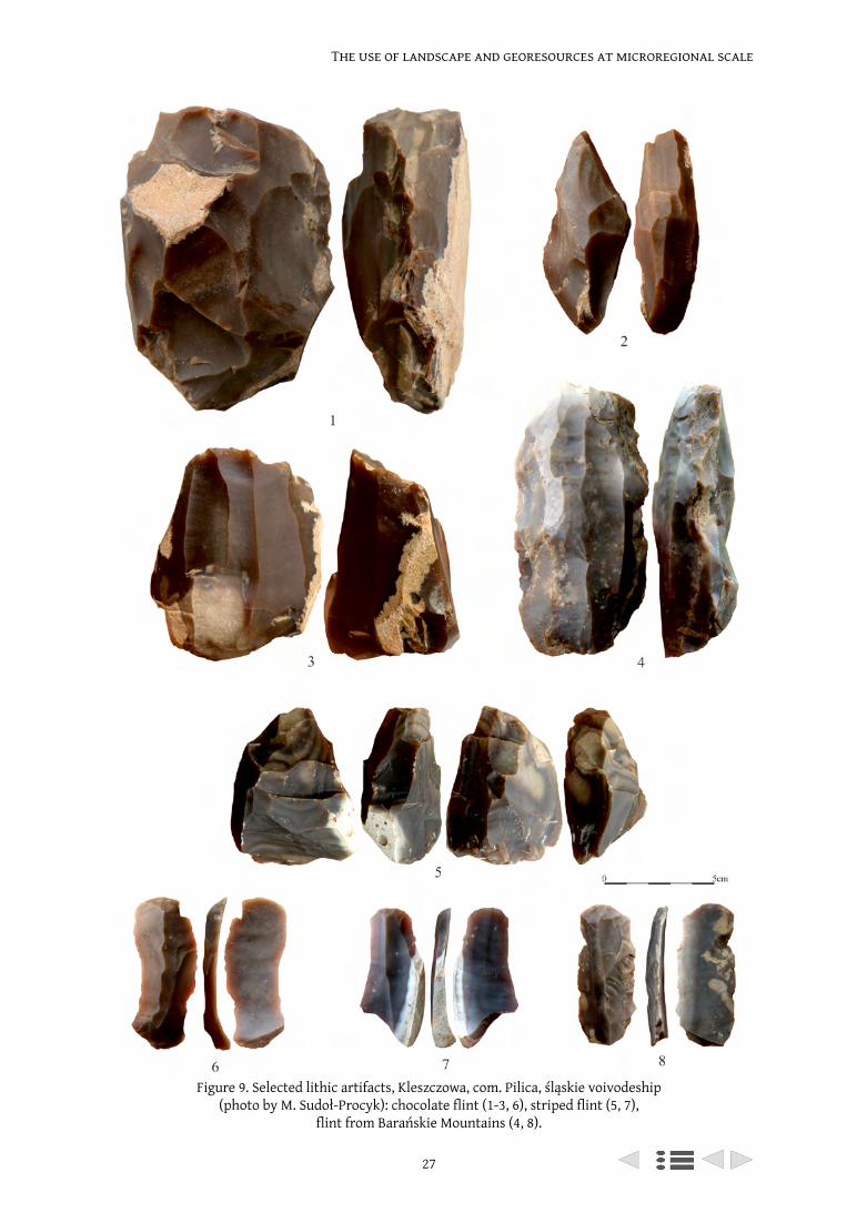
27
The use of landscape and georesources at microregional scale
Figure 9. Selected lithic artifacts, Kleszczowa, com. Pilica, śląskie voivodeship (photo by M. Sudoł-Procyk): chocolate flint (1-3, 6), striped flint (5, 7),
flint from Barańskie Mountains (4, 8).
M. Sudoł-Procyk and M. T. Krajcarz
28
mines of Jurassic flints preserved in situ in the north-eastern margin of the Holy Cross Mountains (Sudoł-Procyk et al. 2018a). This model is lent weight by the great contribution of chocolate flint in assemblages found at the Late Palaeolithic workshop sites and camps located close to these flint outcrops (comp. sections 3.2 and 3.3). Moreover, pre-cores and initial cores found at these sites (e.g. in Kleszczowa) exhibit analogous knapping technology as those recorded at the outcrops. It should also be emphasised that in the adjacent surroundings of the study area there are no younger (Mesolithic, Neolithic or Early Bronze Age) workshops that processed chocolate flint.
The studies conducted by the authors have delivered new data on human activity in the Late Palaeolithic in the central part of Kraków-Częstochowa Upland. This activity can be traced through the circulation of flint material between particular types of sites identified in this region, starting from the moment of their extraction, followed by initial treatment and ending with their utilisation, and with regard to certain categories of flint artefacts (e.g. fine blades or finished tools), their further interregional distribution.
This is perfectly demonstrable in the case of chocolate flint, which at the first stage of its ‘path’ was extracted and initially prepared near its extraction point. Then, in the form of primary cores,
Figure 10. Selected lithic artifacts from striped flint, Cisowa, com. Pilica, śląskie voivodeship (photo by M. Sudoł-Procyk).
29
The use of landscape and georesources at microregional scale
it reached more distant sites, namely camps and workshops, where mainly blades and tools were produced.
A similar chaine opératoire can be observed by analysing other local raw materials, e.g. striped flint and flint from the Barańskie Mountains. It is noteworthy that finished products in the form of blades and tools were brought to the inhabited caves, located within a distance of ca. 2 km; it would seem for purely utilitarian purposes, which is supported by the results of use-wear analysis. It is also interesting that the Late Palaeolithic assemblage from the Perspektywiczna Cave did not contain any specimens made of flint from Udórz, being an easily available raw material occurring in large quantities over the entire region under study, as well as in the surroundings of the above-mentioned site. This proves that the Late Palaeolithic hunters penetrating this region had an excellent acquaintance of raw materials and made conscious selections of flints.
5. Conclusions
The discovery of new sites in the south-eastern part of the Ryczów Upland complements our state-of-the-art research referring to human settlement at the decline of the Pleistocene Epoch and the utilisation of available lithic resources by contemporary communities. It seems that the location of sites is directly associated with outcrops of high quality siliceous rocks as presented in this paper (mainly chocolate flint), and that the region under study played a definite role in the communication routes of Late Palaeolithic (including Magdalenian) communities. What role it played in terms of the extraction and the distribution of siliceous rocks is a question to be answered by further research. This is particularly true for solving the issue of the presence of chocolate flint at Magdalenian sites outside the Kraków-Czestochowa Upland in Poland and its neighbouring territories. Moreover, being able to answer the question as to whether this raw material came from the Holy Cross Mountains or the Polish Jura region may shed a brand new light on the issue of its distribution.
Acknowledgements
The field studies were partially supported by a grant from the National Science Centre, Poland No. 2014/15/D/HS3/01302 and are continuing under grant No. 2018/30/E/HS3/00567.
References
Cyrek, K. 2006. The Palaeolithic of the Ojców Jura. In J. Lech and J. Partyka (eds). The Ojców Jura in Prehistory and in the Beginnings of the Polish State. Ojców: Ojców National Park: 313-334 (in Polish with English summary).
Cyrek, K. 2009. Archeological studies in caves of the Częstochowa Upland. In K. Stefaniak, A. Tyc, P. Socha (eds), Karst of the Częstochowa Upland and of the Eastern Sudetes. Palaeoenvironments and Protection. Studies of the Faculty of Earth Sciences. University of Silesia, No. 56, Sosnowiec-Wrocław: 145-160.
Cyrek, K., Krajcarz, M. T., Krajcarz, M., Sudoł, M. 2016. Gravettian layer of Jasna Strzegowska Cave. In P. Wojtal, J. Wilczyński (eds), Book of abstracts, International conference: 2nd World of Gravettian Hunters, Kraków, 16th – 20th May 2016, Kraków: Institute of Systematics and Evolution of Animals, Polish Academy of Sciences: 20-21.
Cyrek, K., Socha, P., Stefaniak, K., Madeyska, T., Mirosław-Grabowska, J., Sudoł, M., Czyżewski, Ł. 2010. Palaeolithic of Biśnik Cave (southern Poland) within the environmental background, Quaternary International, 220: 5-30. doi.org/10.1016/j.quaint.2009.09.014.
Krajcarz, M. T. (in press). Kartowanie pradziejowych złóż krzemienia na Wyżynie Krakowsko-Częstochowskiej. In B. Sałacińska, S. Sałaciński (eds), Studia nad Gospodarką Surowcami Krzemiennymi w Pradziejach. Krzemień jurajski w pradziejach, vol. 9, Warszawa-Kraków: Państwowe Muzeum Archeologiczne w Warszawie: 1-18 (in Polish with English abstract).
M. Sudoł-Procyk and M. T. Krajcarz
30
Krajcarz, M. T., Krajcarz, M., Sudoł, M., Cyrek, K. 2012a. From far or from near? Map of silicate raw material outcrops around the Biśnik Cave, In P. Neruda, Z. Nerudová (eds), Abstract Book and excursion guide, 9th SKAM Workshop Moravian Museum, Brno, Czech Republic, October 8–11, 2012, Brno: Ústav Anthropos, Moravské zemské museum: 15-16.
Krajcarz, M. T., Sudoł, M., Krajcarz, M., Cyrek, K. 2012b. From far or from near? Sources of Kraków-Częstochowa banded and chocolate silicite raw material used during the Stone Age in Biśnik Cave (southern Poland). Anthropologie. International Journal of Human Diversity and Evolution, 50 (4): 411-425.
Krajcarz, M. T., Sudoł, M., Krajcarz, M., Cyrek, K. 2012c. The site of Late Quaternary cave sediments – the Shelter above the Zegar Cave in Zegarowe Rocks (Częstochowa Upland), Przegląd Geologiczny, 60 (10): 546-553 (in Polish with English abstract).
Krajcarz, M. T., Sudoł, M., Krajcarz, M., Cyrek, K. 2014. Outcrops of striped flint on the Ryczów Upland (Kraków–Częstochowa Upland). In D. Piotrowska, W. Piotrowski, K. Kaptur, A. Jedynak (eds), Stone Age Mining: Krzemionki – Poland – Europe. On the ninetieth anniversary of the discovery of the Krzemionki mine, volume 1 Silex et Ferrum, Ostrowiec Świętokrzyski: Historical and Archaeological Museum in Ostrowiec Świętokrzyski: 319-338 (in Polish with English summary).
Mirosław-Grabowska, J., Cyrek, K. 2009. Archaeology and statigraphy of the Jasna Strzegowska Cave. In Stefaniak, K., Tyc, A., Socha, P. (eds), Karst of the Częstochowa Upland and of the Eastern Sudetes. Palaeoenvironments and Protection. Studies of the Faculty of Earth Sciences. University of Silesia, No. 56, Sosnowiec- Wrocław: 273-282.
Sudoł, M. 2016. Nowe stanowisko schyłkowopaleolityczne w Kleszczowej (Wyżyna Częstochowska). In J. M. Burdukiewicz, B. Kufel-Diakowska, A. Wiśniewski (eds), Abstracts book. 13th SKAM Lithic Workshop ‘The lithic artifacts – methods and history of research’, 28-30th of September 2016, Wrocław: Wroclaw University, Institute of Archaeology: 26-28 (in Polish).
Sudoł, M., Bokiniec, E., Krajcarz, M., Krajcarz, M. T., Trojan, A., Grafka, O. 2015. Human activity traces from Shelter in Smoleń III (central part of Kraków-Częstochowa Upland) from the last centuries of antiquity, Przegląd Archeologiczny, 63: 177-193.
Sudoł, M., Cyrek, K., Krajcarz, M., Krajcarz, M. T. 2016a. Around the Biśnik Cave – The area of human penetration during Palaeolithic, Anthropologie. International Journal of Human Diversity and Evolution, 54 (1): 49-68.
Sudoł, M., Krajcarz, M. T., Krajcarz, M. 2016b. The results of 2014-2016 interdisciplinary research of the Jaskinia Perspektywiczna (Częstochowska Upland). In. J. Urban (ed.), Materiały 50. Sympozjum Speleologicznego, Kielce-Chęciny, 20-23.10.2016, Kraków: Sekcja Speleologiczna Polskiego Towarzystwa Przyrodników im. Kopernika: 145-146 (in Polish).
Sudoł-Procyk M. 2017. Flint products from the Final Palaeolithic site Kleszczowa (Silesian Voivodeship), in the context of the raw material outcrops. In D. Werra, I. Sobkowiak-Tabaka, K. Kerneder-Gubała (eds), Abstracts book. Flint in time and space – Time and space in flint. Characteristic and distribution of siliceous rocks in prehistory, 18-20 Maj 2017, Warsaw: Institute of Archaeology and Ethnology Polish Academy of Sciences: 37-38.
Sudoł-Procyk, M., Budziszewski, J., Krajcarz, M. T., Jakubczak, M., Szubski, M. 2018a. The Chocolate Flint Mines in the Udorka Valley (Częstochowa Upland) – a Preliminary Report on the Field and Lidar Surveys. In D. H. Werra and M. Woźny (eds), Between History and Archaeology. Papers in honour of Jacek Lech, Oxford: Archaeopress Archaeology: 89-102.
Sudoł-Procyk, M., Cyrek, K. (in press). Jurassic flints in the Palaeolithic Age in the central part of the Polish Jura. In B. Sałacińska, S. Sałaciński (eds), Studia nad Gospodarką Surowcami Krzemiennymi w Pradziejach. Krzemień jurajski w pradziejach, vol. 9, Warszawa-Kraków: Państwowe Muzeum Archeologiczne w Warszawie: 1-25 (in Polish with English abstract).
Sudoł-Procyk, M., Krajcarz, M. T., Krajcarz, M. 2018b. The use of landscape and georesources at microregional scale during Late Glacial and Early Holocene – the case study of Udorka Valley (Polish Jura). In Book of abstracts, 18th UISPP World Congress, Paris, 4-9 june 2018: 2376-2377.
From Mine to User (UISPP XVIII) (Archaeopress 2021): 31–41
‘Ostroga’ in Ruda Kościelna (Central Poland) – the oldest point of banded flint exploitation?
Janusz Budziszewski1, Witold Grużdź2, Michał Jakubczak1, Michał Szubski1
1 Institute of Archaeology, University of Cardinal Stefan Wyszyński in Warsaw [email protected]; [email protected];
[email protected] State Archaeological Museum in Warsaw
Abstract
The outcrops of banded flint in the Kamienna River basin were located for the first time in 1921. The research that has been carried out since then has brought a good recognition of the entire flint mining area. The large and very well-preserved site of ‘Krzemionki’ is the most famous place. It is accompanied by nine smaller sites of various sizes and states of preservation.
One of the smallest sites associated with the exploitation of banded flint is the ‘Ostroga’ mining field in Ruda Kościelna. The location of the site lies on a slope, where it is relatively easy to discover the flint deposit and extract it with simple mining techniques. It is found together with debitage from tetrahedral axe production, implying that this site could be associated with the exploitation of banded flint by Neolithic Funnel Beaker Culture communities.
Keywords: flint mining, banded flint, LiDAR, Funnel Beaker Culture
Résumé
Les affleurements de silex zoné dans le bassin de la rivière Kamienna ont été localisés pour la première fois en 1921. La recherche qui a été effectuée depuis a permis de bien faire connaître la totalité de cette zone d’exploitation minière du silex. Le grand et très bien conservé site de ‘Krzemionki’ est le lieu le plus célèbre. Il est accompagné de neuf petits sites de taille et d’états de conservation variables.
L’un des plus petits sites associés à l’exploitation du silex zoné est le site minier ‘Ostroga’ à Ruda Kościelna. Son emplacement se trouve sur une pente, où il est relativement facile de mettre au jour le dépôt de silex et de l’extraire avec des techniques d’extraction simples. Il se trouve associé aux restes de débitage de production de hache tétraédrique, laissant entendre que ce site pourrait être associé à l’exploitation du silex zoné par les communautés de la culture néolithique des Gobelets en entonnoir.
Mots-clés : minières a silex, silex zoné, LiDAR, culture des Gobelets en entonnoir
1. Banded flint research history
The artefacts of banded flint were first noticed by German researchers Georg Wilke and Gustaw Kossinna, who during World War I tried to record the extremely impressive axes made from this raw material (Kossinna 1919). However, these first works contained many errors. The correct definition of the raw material and the supposed location of its outcrops in situ was first given in 1920 by Polish prehistorian Stefan Krukowski (Krukowski 1920: 199-203). It was he along with the geologist Jan Samsonowicz who in the following year discovered the first outcroppings of this raw material and the first place of its prehistoric exploitation (Krukowski 1921: 162-163, fig. 10). A year later, Jan Samsonowicz discovered the extensive ‘Krzemionki’ prehistoric mining field (Samsonowicz 1923: 20-23). This well-preserved site attracted the attention of successive generations of researchers
‘Ostroga’ in Ruda Kościelna (Central Poland)
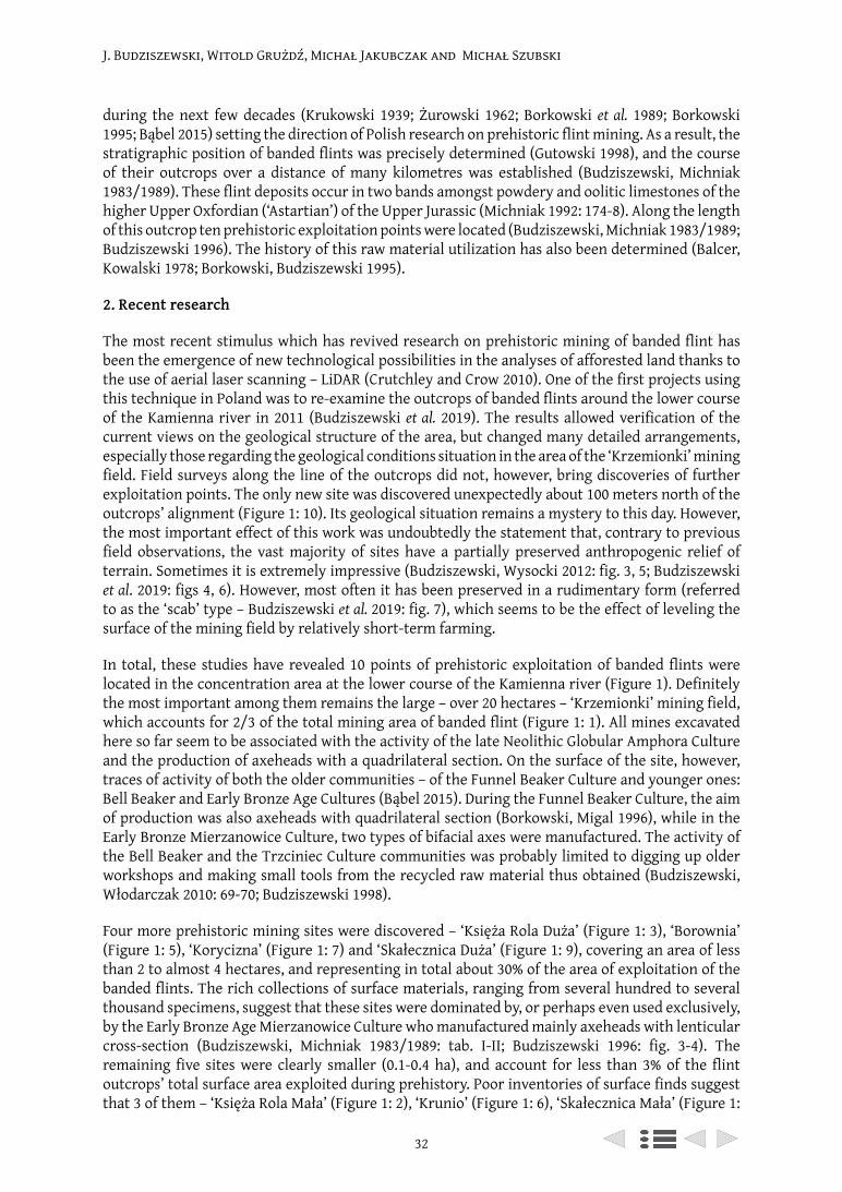
J. Budziszewski, Witold Grużdź, Michał Jakubczak and Michał Szubski
32
during the next few decades (Krukowski 1939; Żurowski 1962; Borkowski et al. 1989; Borkowski 1995; Bąbel 2015) setting the direction of Polish research on prehistoric flint mining. As a result, the stratigraphic position of banded flints was precisely determined (Gutowski 1998), and the course of their outcrops over a distance of many kilometres was established (Budziszewski, Michniak 1983/1989). These flint deposits occur in two bands amongst powdery and oolitic limestones of the higher Upper Oxfordian (‘Astartian’) of the Upper Jurassic (Michniak 1992: 174-8). Along the length of this outcrop ten prehistoric exploitation points were located (Budziszewski, Michniak 1983/1989; Budziszewski 1996). The history of this raw material utilization has also been determined (Balcer, Kowalski 1978; Borkowski, Budziszewski 1995).
2. Recent research
The most recent stimulus which has revived research on prehistoric mining of banded flint has been the emergence of new technological possibilities in the analyses of afforested land thanks to the use of aerial laser scanning – LiDAR (Crutchley and Crow 2010). One of the first projects using this technique in Poland was to re-examine the outcrops of banded flints around the lower course of the Kamienna river in 2011 (Budziszewski et al. 2019). The results allowed verification of the current views on the geological structure of the area, but changed many detailed arrangements, especially those regarding the geological conditions situation in the area of the ‘Krzemionki’ mining field. Field surveys along the line of the outcrops did not, however, bring discoveries of further exploitation points. The only new site was discovered unexpectedly about 100 meters north of the outcrops’ alignment (Figure 1: 10). Its geological situation remains a mystery to this day. However, the most important effect of this work was undoubtedly the statement that, contrary to previous field observations, the vast majority of sites have a partially preserved anthropogenic relief of terrain. Sometimes it is extremely impressive (Budziszewski, Wysocki 2012: fig. 3, 5; Budziszewski et al. 2019: figs 4, 6). However, most often it has been preserved in a rudimentary form (referred to as the ‘scab’ type – Budziszewski et al. 2019: fig. 7), which seems to be the effect of leveling the surface of the mining field by relatively short-term farming.
In total, these studies have revealed 10 points of prehistoric exploitation of banded flints were located in the concentration area at the lower course of the Kamienna river (Figure 1). Definitely the most important among them remains the large – over 20 hectares – ‘Krzemionki’ mining field, which accounts for 2/3 of the total mining area of banded flint (Figure 1: 1). All mines excavated here so far seem to be associated with the activity of the late Neolithic Globular Amphora Culture and the production of axeheads with a quadrilateral section. On the surface of the site, however, traces of activity of both the older communities – of the Funnel Beaker Culture and younger ones: Bell Beaker and Early Bronze Age Cultures (Bąbel 2015). During the Funnel Beaker Culture, the aim of production was also axeheads with quadrilateral section (Borkowski, Migal 1996), while in the Early Bronze Mierzanowice Culture, two types of bifacial axes were manufactured. The activity of the Bell Beaker and the Trzciniec Culture communities was probably limited to digging up older workshops and making small tools from the recycled raw material thus obtained (Budziszewski, Włodarczak 2010: 69-70; Budziszewski 1998).
Four more prehistoric mining sites were discovered – ‘Księża Rola Duża’ (Figure 1: 3), ‘Borownia’ (Figure 1: 5), ‘Korycizna’ (Figure 1: 7) and ‘Skałecznica Duża’ (Figure 1: 9), covering an area of less than 2 to almost 4 hectares, and representing in total about 30% of the area of exploitation of the banded flints. The rich collections of surface materials, ranging from several hundred to several thousand specimens, suggest that these sites were dominated by, or perhaps even used exclusively, by the Early Bronze Age Mierzanowice Culture who manufactured mainly axeheads with lenticular cross-section (Budziszewski, Michniak 1983/1989: tab. I-II; Budziszewski 1996: fig. 3-4). The remaining five sites were clearly smaller (0.1-0.4 ha), and account for less than 3% of the flint outcrops’ total surface area exploited during prehistory. Poor inventories of surface finds suggest that 3 of them – ‘Księża Rola Mała’ (Figure 1: 2), ‘Krunio’ (Figure 1: 6), ‘Skałecznica Mała’ (Figure 1:
J. Budziszewski, Witold Grużdź, Michał Jakubczak and Michał Szubski
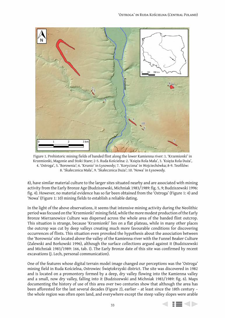
33
‘Ostroga’ in Ruda Kościelna (Central Poland)
8), have similar material culture to the larger sites situated nearby and are associated with mining activity from the Early Bronze Age (Budziszewski, Michniak 1983/1989: fig. 5, 9; Budziszewski 1996: fig. 4). However, no material evidence has so far been obtained from the ‘Ostroga’ (Figure 1: 4) and ‘Nowa’ (Figure 1: 10) mining fields to establish a reliable dating.
In the light of the above observations, it seems that intensive mining activity during the Neolithic period was focused on the ‘Krzemionki’ mining field, while the more modest production of the Early Bronze Mierzanowice Culture was dispersed across the whole area of the banded flint outcrop. This situation is strange, because ‘Krzemionki’ lies on a flat plateau, while in many other places the outcrop was cut by deep valleys creating much more favourable conditions for discovering occurrences of flints. This situation even provoked the hypothesis about the association between the ‘Borownia’ site located above the valley of the Kamienna river with the Funnel Beaker Culture (Zalewski and Borkowski 1996), although the surface collections argued against it (Budziszewski and Michniak 1983/1989: 166, tab. I). The Early Bronze date of this site was confirmed by recent excavations (J. Lech, personal communication).
One of the features whose digital terrain model image changed our perceptions was the ‘Ostroga’ mining field in Ruda Kościelna, Ostrowiec Świętokrzyski district. The site was discovered in 1982 and is located on a promontory formed by a deep, dry valley flowing into the Kamienna valley and a small, now dry valley, falling into it (Budziszewski and Michniak 1983/1989: fig. 6). Maps documenting the history of use of this area over two centuries show that although the area has been afforested for the last several decades (Figure 2), earlier – at least since the 18th century – the whole region was often open land, and everywhere except the steep valley slopes were arable
Figure 1. Prehistoric mining fields of banded flint along the lower Kamienna river: 1. ‘Krzemionki’ in Krzemionki, Magonie and Stoki Stare; 2-5. Ruda Kościelna: 2. ‘Księża Rola Mała’, 3. ‘Księża Rola Duża’,
4. ‘Ostroga’, 5. ‘Borownia’; 6. ‘Krunio’ in Łysowody; 7. ‘Korycizna’ in Wojciechówka; 8-9. Teofilów: 8. ‘Skałecznica Mała’, 9. ‘Skałecznica Duża’; 10. ‘Nowa’ in Łysowody.
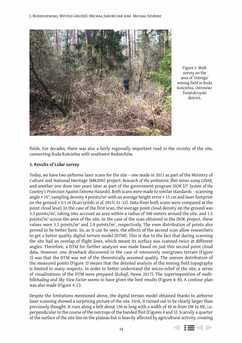
J. Budziszewski, Witold Grużdź, Michał Jakubczak and Michał Szubski
34
fields. For decades, there was also a fairly regionally important road in the vicinity of the site, connecting Ruda Kościelna with southwest Bodzechów.
3. Results of Lidar survey
Today, we have two airborne laser scans for the site – one made in 2011 as part of the Ministry of Culture and National Heritage (MKiDN) project: Research of the prehistoric flint mines using LiDAR, and another one done two years later as part of the government program ISOK (IT System of the Country’s Protection Against Extreme Hazards). Both scans were made to similar standards – scanning angle ≤ 25°, sampling density 4 points/m2 with an average height error ≤ 15 cm and laser footprint on the ground ≤ 0.5 m (Kurczyński et al. 2015: 31-32). Data from both scans were compared at the point cloud level. In the case of the first scan, the average point cloud density on the ground was 3.3 points/m2, taking into account an area within a radius of 500 meters around the site, and 1.5 points/m2 across the area of the site. In the case of the scan obtained in the ISOK project, these values were 3.3 points/m2 and 2.9 points/m2, respectively. The even distribution of points also proved to be better here. So, as it can be seen, the effects of the second scan allow researchers to get a better quality digital terrain model (DTM). This is due to the fact that during scanning the site had an overlap of flight lines, which meant its surface was scanned twice at different angles. Therefore, a DTM for further analyses was made based on just this second point cloud data. However, one drawback discovered in the case of intensively overgrown terrain (Figure 2) was that the DTM was not of the theoretically assumed quality. The uneven distribution of the measured points (Figure 3) means that the detailed analysis of the mining field topography is limited in many respects. In order to better understand the micro-relief of the site, a series of visualisations of the DTM were prepared (Kokajl, Hesse 2017). The superimposition of multi-hillshading and Sky View Factor seems to have given the best results (Figure 4: B). A contour plan was also made (Figure 4: C).
Despite the limitations mentioned above, the digital terrain model obtained thanks to airborne laser scanning showed a surprising picture of the site. First, it turned out to be clearly larger than previously thought. It runs along a belt about 150 m long with a width of 40 m from SW to NE, i.e. perpendicular to the course of the outcrops of the banded flint (Figures 4 and 5). Scarcely a quarter of the surface of the site lies on the plateau but is heavily affected by agricultural activity, creating
Figure 2. Walk survey on the
area of ‘Ostroga’ mining field in Ruda Kościelna, Ostrowiec
Świętokrzyski district.

35
‘Ostroga’ in Ruda Kościelna (Central Poland)
Figure 3. Visualisation of the quality of laser
scanning at the area of ‘Ostroga’ mining field in
Ruda Kościelna, Ostrowiec Świętokrzyski district. Digital terrain model
with point cloud density analysis. White spots
indicate areas where a height measurement of 1 square meter was not
possible to obtain.
Figure 4. Examples of different visualisations of digital terrain model of the ‘Ostroga’ mining field in Ruda Kościelna,
Ostrowiec Świętokrzyski district: A. Analytical
hillshading + hypsometric map; B. Multihillshading +
Sky View Factor; C. Contour map + hypsometric map.
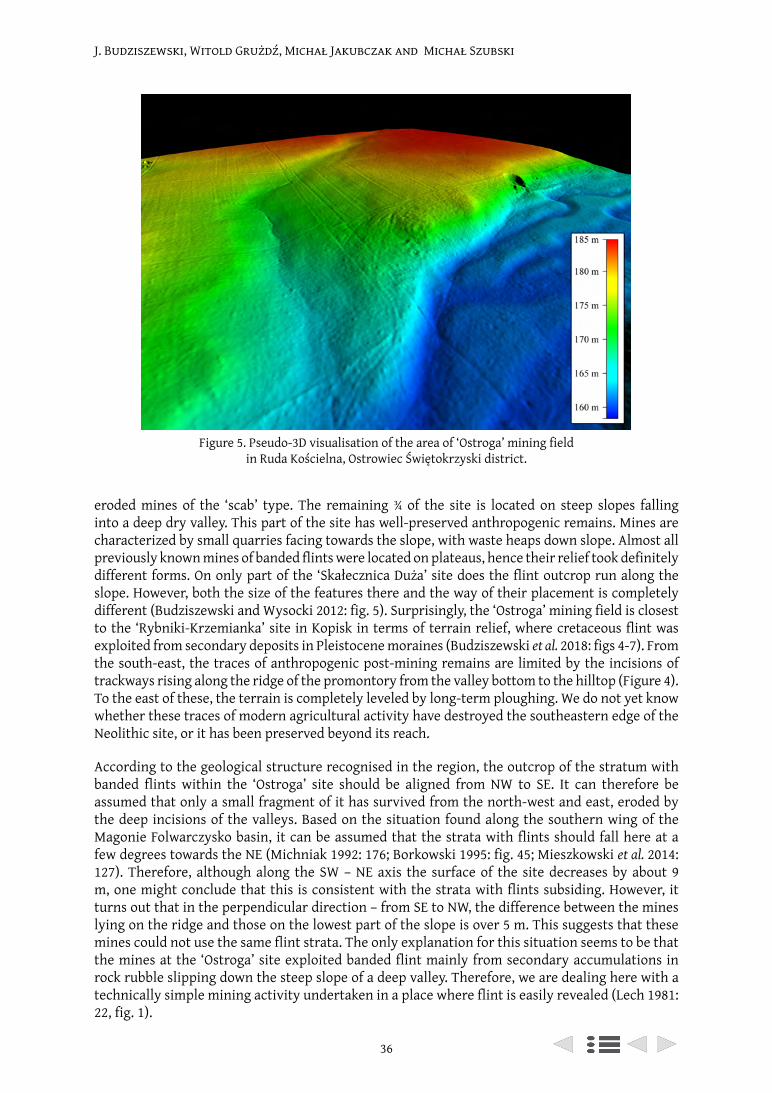
J. Budziszewski, Witold Grużdź, Michał Jakubczak and Michał Szubski
36
eroded mines of the ‘scab’ type. The remaining ¾ of the site is located on steep slopes falling into a deep dry valley. This part of the site has well-preserved anthropogenic remains. Mines are characterized by small quarries facing towards the slope, with waste heaps down slope. Almost all previously known mines of banded flints were located on plateaus, hence their relief took definitely different forms. On only part of the ‘Skałecznica Duża’ site does the flint outcrop run along the slope. However, both the size of the features there and the way of their placement is completely different (Budziszewski and Wysocki 2012: fig. 5). Surprisingly, the ‘Ostroga’ mining field is closest to the ‘Rybniki-Krzemianka’ site in Kopisk in terms of terrain relief, where cretaceous flint was exploited from secondary deposits in Pleistocene moraines (Budziszewski et al. 2018: figs 4-7). From the south-east, the traces of anthropogenic post-mining remains are limited by the incisions of trackways rising along the ridge of the promontory from the valley bottom to the hilltop (Figure 4). To the east of these, the terrain is completely leveled by long-term ploughing. We do not yet know whether these traces of modern agricultural activity have destroyed the southeastern edge of the Neolithic site, or it has been preserved beyond its reach.
According to the geological structure recognised in the region, the outcrop of the stratum with banded flints within the ‘Ostroga’ site should be aligned from NW to SE. It can therefore be assumed that only a small fragment of it has survived from the north-west and east, eroded by the deep incisions of the valleys. Based on the situation found along the southern wing of the Magonie Folwarczysko basin, it can be assumed that the strata with flints should fall here at a few degrees towards the NE (Michniak 1992: 176; Borkowski 1995: fig. 45; Mieszkowski et al. 2014: 127). Therefore, although along the SW – NE axis the surface of the site decreases by about 9 m, one might conclude that this is consistent with the strata with flints subsiding. However, it turns out that in the perpendicular direction – from SE to NW, the difference between the mines lying on the ridge and those on the lowest part of the slope is over 5 m. This suggests that these mines could not use the same flint strata. The only explanation for this situation seems to be that the mines at the ‘Ostroga’ site exploited banded flint mainly from secondary accumulations in rock rubble slipping down the steep slope of a deep valley. Therefore, we are dealing here with a technically simple mining activity undertaken in a place where flint is easily revealed (Lech 1981: 22, fig. 1).
Figure 5. Pseudo-3D visualisation of the area of ‘Ostroga’ mining field in Ruda Kościelna, Ostrowiec Świętokrzyski district.
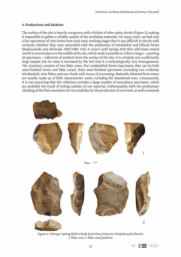
37
‘Ostroga’ in Ruda Kościelna (Central Poland)
4. Productions and datation
The surface of the site is heavily overgrown with a thicket of often spiny shrubs (Figure 2), making it impossible to gather a reliable sample of the workshop materials. For many years, we had only a few specimens of core forms from such early working stages that it was difficult to decide with certainty whether they were associated with the production of tetrahedral and bifacial forms (Budziszewski and Michniak 1983/1989: 164). It wasn’t until Spring 2018 that wild boars rooted mulch in several places in the middle of the site, which made it possible to collect a larger – counting 20 specimens – collection of artefacts from the surface of the site. It is certainly not a sufficiently large sample, but its value is increased by the fact that it is technologically very homogeneous. The inventory consists of two flake cores, five unidentified forms (specimens that can be both semi-finished forms and flake cores), three semi-finished specimens (including two evidently tetrahedral), nine flakes and one chunk with traces of processing. Materials obtained from mines are usually made up of little characteristic waste, including the abandoned ones. Consequently, it is not surprising that the collection includes a large number of amorphous specimens, which are probably the result of testing nodules of raw material. Unfortunately, both the preliminary checking of the flint concretion for its suitability for the production of core tools, as well as towards
Figure 6. ‘Ostroga’ mining field in Ruda Kościelna, Ostrowiec Świętokrzyski district: 1. flake core, 2. flake core/preform.
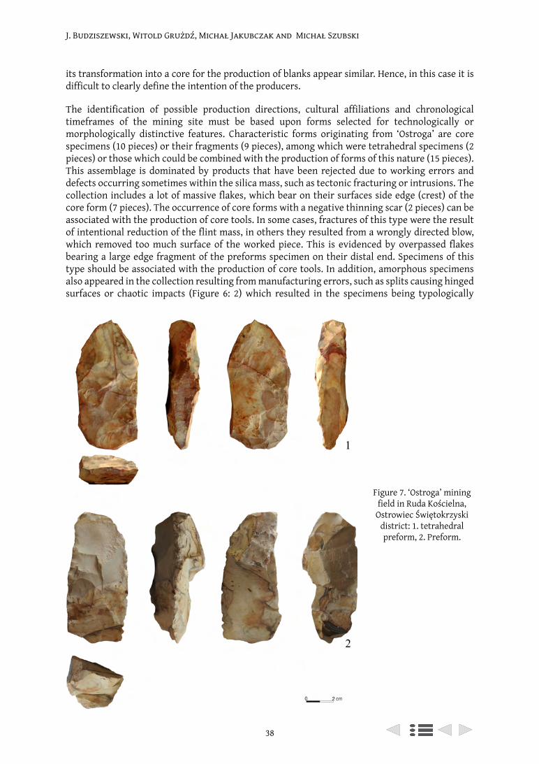
J. Budziszewski, Witold Grużdź, Michał Jakubczak and Michał Szubski
38
its transformation into a core for the production of blanks appear similar. Hence, in this case it is difficult to clearly define the intention of the producers.
The identification of possible production directions, cultural affiliations and chronological timeframes of the mining site must be based upon forms selected for technologically or morphologically distinctive features. Characteristic forms originating from ‘Ostroga’ are core specimens (10 pieces) or their fragments (9 pieces), among which were tetrahedral specimens (2 pieces) or those which could be combined with the production of forms of this nature (15 pieces). This assemblage is dominated by products that have been rejected due to working errors and defects occurring sometimes within the silica mass, such as tectonic fracturing or intrusions. The collection includes a lot of massive flakes, which bear on their surfaces side edge (crest) of the core form (7 pieces). The occurrence of core forms with a negative thinning scar (2 pieces) can be associated with the production of core tools. In some cases, fractures of this type were the result of intentional reduction of the flint mass, in others they resulted from a wrongly directed blow, which removed too much surface of the worked piece. This is evidenced by overpassed flakes bearing a large edge fragment of the preforms specimen on their distal end. Specimens of this type should be associated with the production of core tools. In addition, amorphous specimens also appeared in the collection resulting from manufacturing errors, such as splits causing hinged surfaces or chaotic impacts (Figure 6: 2) which resulted in the specimens being typologically
Figure 7. ‘Ostroga’ mining field in Ruda Kościelna,
Ostrowiec Świętokrzyski district: 1. tetrahedral preform, 2. Preform.
39
‘Ostroga’ in Ruda Kościelna (Central Poland)
attributed as flake cores (5 pieces). At the same time, their relationship with flake production should not be ruled out because in the collection are two flake cores used for the production of ad hoc blanks (Figure 6: 1). Most of the abandoned forms were rejected as a result of natural cracks, which prevented further production (5 pieces). As in the case of semi-finished products damaged by an overpassed percussion, so also in this case individual specimens have a similar shape to tetrahedral (Figure 7). However, there are no forms in the assemblage that could be associated with bifacial working.
The technology of producing tetrahedral tools observed on artefacts from the ‘Ostroga’ site is analogous to the one known from the workshop in ‘Krzemionki’ – the so called ‘slice’ method. It consists of the use of specific fragments of naturally cracked nodules for manufacturing axes with quadrilateral section (Hansen and Madsen 1982; Migal and Sałaciński 1996: 127-130). Tetrahedral forms from the ‘Ostroga’ site should be associated with the Neolithic period. However, it is not possible to specify whether we are dealing with products of the Funnel Beaker Culture community or that of the Globular Amphora Culture (Balcer and Kowalski 1978; Borkowski and Migal 1996; Budziszewski and Grużdź 2013).
5. Conclusion
As a result of recent research, the small ‘Ostroga’ mining field, covering less than 0.5 ha, revealed surprising features both in terms of the surface evidence of mining methods used to exploit the banded flints, as well as information concerning flint production. As the only one except the ‘Krzemionki’ mine complex, this site was clearly associated with the production of Neolithic axeheads with quadrilateral section. At present there is no more precise dating evidence available from the collected site materials. However, the location of the site on the hillslope, where it is relatively easy to discover flint deposits, and the simplicity of mining techniques used here, suggests that the ‘Ostroga’ site may be the oldest evidence associated with the exploitation of banded flint by the Neolithic Funnel Beaker Culture communities? Verification of this hypothesis requires at least a test excavation.
References
Balcer, B. and Kowalski, K. 1978. Z badań nad krzemieniem pasiastym w pradziejach. Wiadomości Archeologiczne, 43: 127-45.
Bąbel, J. T. 2015. ‘Krzemionki Opatowskie’. Monument prahistorii Europy. Kopalnie krzemienia pasiastego. Ostrowiec Świętokrzyski.
Borkowski, W. 1995. Krzemionki Mining Complex. Deposit Management System. Warszawa: Państwowe Muzeum Archeologiczne.
Borkowski, W. and Budziszewski, J. 1995. The use of striped flint in prehistory. Archaeologia Polona, 33: 71-87.
Borkowski, W. and Migal, W. 1996. Ze studiów nad użytkowaniem siekier czworościennych z krzemienia pasiastego. In Jaskanis, J. (eds), Z badań nad wykorzystaniem krzemienia pasiastego. Studia nad gospodarką surowcami krzemiennymi w pradziejach 3. Warszawa: Państwowe Muzeum Archeologiczne: 141-165.
Borkowski, W., Migal, W., Sałaciński, S. and Zalewski, M. 1989. Urgeschichtlicher Feuersteinbergbau im Gebiet von Krzemionki. Ein Bericht zum Stand der Forschung. Praehistorische Zeitschrift, 64/2: 64-207.
Budziszewski, J. 1996. Przyczynki do poznania gospodarki krzemieniem pasiastym we wczesnej epoce brązu. In Jaskanis, J. (eds), Z badań nad wykorzystaniem krzemienia pasiastego. Studia nad gospodarką surowcami krzemiennymi w pradziejach 3. Warszawa: Państwowe Muzeum Archeologiczne: 87-109.
Budziszewski, J. 1998. Świętokrzyski Okręg Pradziejowej Eksploatacji Krzemieni w dobie kultury trzcinieckiej. In A. Kośko and J. Czebreszuk (eds), ‘Trzciniec’ – system kulturowy czy interkulturowy proces? Poznań: Wyd. Poznańskie: 285-299.
J. Budziszewski, Witold Grużdź, Michał Jakubczak and Michał Szubski
40
Budziszewski, J. and Grużdź, W. 2013. O technikach i metodach krzemieniarskich. In M. M. Przybyła, A. Szczepanek, P. Włodarczak (eds), Koszyce, stanowisko 3. Przemoc i rytuał u schyłku neolitu, Ocalone Dziedzictwo Archeologiczne, 4, Kraków-Pękowice, s. 161-178.
Budziszewski, J., Jakubczak, M., Radziszewska, K. and Szubski, M. 2019. Prehistoric flint mine detection by aiborne laser scanning (ALS). Experiences from Poland 2011-2015. Anthropologica et Præhistorica, 127(2016): 139-152.
Budziszewski, J. and Michniak, R. 1983/1989. Z badań nad występowaniem, petrograficzną naturą oraz prahistoryczną eksploatacją krzemieni pasiastych w południowym skrzydle niecki Magoń – Folwarczysko. Wiadomości Archeologiczne, 49/2: 151-190.
Budziszewski, J., Szubski, M. and Jakubczak, M. 2018. O identyfikacji punktów pradziejowej eksploatacji krzemieni ze złóż wtórnych przy pomocy lotniczego skanowania laserowego. In Gojda, M. and Kobyliński, Z. (eds), Lotnicze skanowanie laserowe jako narzędzie archeologii. Archaeologica Hereditas, 11. Warszawa: UKSW: 215-231.
Budziszewski, J. and Włodarczak, P. 2010. Kultura pucharów dzwonowatych na Wyżynie Małopolskiej. Kraków: IAiE PAN, Oddz. w Krakowie.
Budziszewski, J. and Wysocki, J. 2012. Nowe możliwości detekcji materialnych śladów historii terenów leśnych – lotnicze skanowanie laserowe (LiDAR). In Z. Kobyliński (ed.), Konserwacja zapobiegawcza środowiska 1. Archaeologica Hereditas 1. Warszawa: UKSW: 117-125.
Crutchley, S. and Crow, P. 2010. The Light Fantastic. Using airborne lidar in archaeological survey. Swindon: English Heritage.
Gutowski, J. 1998. Oxfordian and Kimmeridgian of the northeastern margin of the Holy Cross Mountains, Central Poland. Geological Quarterly, 41(1): 59-72.
Hansen P. V. and Madsen B. 1983. Flint axe manufacture in the Neolithic. An experimental investigation of a flint axe manufacture site at Hastrup Vænget, East Zealand. Journal of Danish Archaeology, 2: 43-59.
Kokajl, Ž. and Hesse, R. 2017. Airborne laser scanning raster data visualization: A Guide to Good Practice. Prostor kraj, čas 14. Ljubljana: Založba ZRC.
Kossinna, G. 1919. Erläuterungen zur Karte der Funde gebänderter Feuersteingeräte. Mannus 10(1918): 202-206.
Krukowski, S. 1920. Pierwociny krzemieniarskie górnictwa, transportu i handlu w holocenie Polski, cz. 1. Wiadomości Archeologiczne, 5: 185-206.
Krukowski, S. 1921. Sprawozdanie z działalności państwowego urzędu konserwatorskiego na okręg warszawski południowy. Wiadomości Archeologiczne, 6: 156-167.
Krukowski, S. 1939. Krzemionki Opatowskie. Warszawa: Muzeum Techniki i Przemysłu.Kurczyński, Z., Stojek, E. and Cisło-Lesicka, U. 2015. Zadania GUGiK realizowane w ramach projektu
ISOK. In Wężyk, P. (ed.), Podręcznik dla uczestników szkoleń z wykorzystania produktów LiDAR, 2 ed. Warszawa: GUGiK: 22-58.
Lech, J. 1981. Górnictwo krzemienia społeczności wczesnorolniczych na Wyżynie Krakowskiej, koniec VI tysiąclecia – pierwsza połowa IV tysiąclecia p.n.e. Wrocław-Warszawa-Kraków-Gdańsk-Łódź: Ossolineum.
Mieszkowski, R., Welc, F., Budziszewski, J., Migal, W. and Bąkowska, A. 2014. Preliminary Results of the Ground Penetrating Radar (GPR) Prospection in the Area of the Prehistoric Flint Mine Borownia, South Eastern Poland. Studia Quaternaria, 31/2: 123-132.
Samsonowicz, J. 1923. O złożach krzemieni w utworach jurajskich północnowschodniego zbocza Gór Świętokrzyskich. Wiadomości Archeologiczne, 8/1: 17-24.
Michniak, R. 1992. Krzemienne złoże i geologia rezerwatu Krzemionki. Przegląd Geologiczny, 3(467): 173-180.
Migal, W. and Sałaciński, S. 1996. Eksperymentalne wytwarzanie siekier czworościennych z krzemienia pasiastego. In Jaskanis, J. (ed.), Z badań nad wykorzystaniem krzemienia pasiastego. Studia nad Gospodarką Surowcami Krzemiennymi w Pradziejach 3. Warszawa: Państwowe Muzeum Archeologiczne: 121-139.
Zalewski, M. and Borkowski, W. 1996. Zagadnienie chronologii pola eksploatacyjnego ‘Borownia’ w Rudzie Kościelnej, woj. tarnobrzeskie, w świetle nowych materiałów nakopalnianych i osadniczych. In Jaskanis, J. (ed.), Z badań nad wykorzystaniem krzemienia pasiastego Studia

41
‘Ostroga’ in Ruda Kościelna (Central Poland)
nad Gospodarką Surowcami Krzemiennymi w Pradziejach 3; Warszawa: Państwowe Muzeum Archeologiczne: 31-54.
Żurowski, T. 1962. Krzemionki Opatowskie pomnik starożytnego górnictwa. Rocznik Świętokrzyski, 1: 17-96.

From Mine to User (UISPP XVIII) (Archaeopress 2021): 42–56
‘Chocolate’ flint mining from Final Palaeolithic up to Early Iron Age – a review
Dagmara H. Werra1, Katarzyna Kerneder-Gubała1
1 Institute of Archaeology and Ethnology, Polish Academy of Sciences, al. Solidarności 105, 00-140, Warsaw, Poland
[email protected] ORCID 0000-0003-2233-1663; [email protected] ORCID 0000-0002-0559-9791
Abstract
‘Chocolate’ flint was the most important raw material used by prehistoric communities from the Palaeolithic to the Late Bronze Age in the north-east margin of the Holy Cross Mountains to as far away as the Carpathian Mountains. At present we know of 26 exploitation points of this raw material, which occurs in Upper Jurassic limestone deposits and karstic clays – the highest Oxfordian limestone and Lower Kimmeridgian. Five mining sites are presented in this article in chronological order to give an overview of their four main aspects – mining methods, mining tools, dating by radiocarbon determinations, and flint working.
Keywords: flint mining, ‘chocolate’ flint, Stone Age, Bronze Age, Poland
Résumé
Le silex «chocolat » était la matière première la plus importante utilisée par les communautés préhistoriques, du Paléolithique à l’âge du Bronze tardif, dans la marge nord-est des montagnes Sainte-Croix, jusqu’aux montagnes des Carpates. À l’heure actuelle, nous connaissons 26 zones d’exploitation de cette matière première, qui se trouvent dans les dépôts de calcaire et les argiles karstiques du Jurassique supérieur – le calcaire oxfordien le plus élevé et le Kimméridgien inférieur. Cinq sites miniers sont présentés dans cet article dans un ordre chronologique pour donner un aperçu de leurs quatre principaux aspects : méthodes d’extraction, outils miniers, datation par radiocarbone, et travail du silex.
Mots-clés : minière à silex, silex «chocolat », Néolithique, Pologne
1. Introduction
In Poland, in the area of the Vistula basin, there are substantial deposits of several kinds of flint which were widely used in prehistoric times. One of them is ‘chocolate’ coloured flint. These siliceous rocks can be found along the north-eastern edge of the Holy Cross Mountains (in Polish Góry Świętokrzyskie) where exploitation points are located, forming the most numerous and best recognized complex of prehistoric flint mining areas in Poland.
The history of research into this type of flint has been ongoing now for almost one hundred years. It began in the 1920s with two young researchers: archaeologist Stefan Krukowski and geologist Jan Samsonowicz (Krukowski 1922; 1923; Samsonowicz 1934; Krukowski 1939-1948). Since their studies, a considerable amount of research on ‘chocolate’ flint has been undertaken over the past several years. This research was pivotal in demonstrating that ‘chocolate’ flint was the most important raw material used by prehistoric communities from the Palaeolithic to the Late Bronze Age in the region of the north-east margin of the Holy Cross Mountains to as far away as the Carpathian Mountains (Schild 1971; Schild et al. 1977; Lech 1984; Schild et al. 1985; Lech 1997; Lech et al. 2011). ‘Chocolate’ flint artefacts have been identified among flint assemblages at archaeological sites in Belarus, Latvia, Lithuania, Czechia, Slovakia, Hungary and Ukraine (Schild 1976; Sulgostowska 2005; Budziszewski 2008; Sulgostowska 2008; Kozłowski 2013).
‘Chocolate’ flint mining
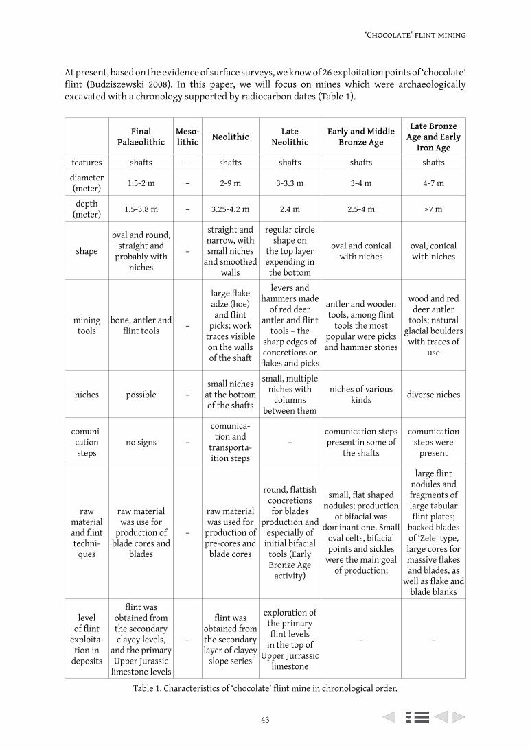
43
‘Chocolate’ flint mining
At present, based on the evidence of surface surveys, we know of 26 exploitation points of ‘chocolate’ flint (Budziszewski 2008). In this paper, we will focus on mines which were archaeologically excavated with a chronology supported by radiocarbon dates (Table 1).
Final Palaeolithic
Meso-lithic Neolithic Late
NeolithicEarly and Middle
Bronze Age
Late Bronze Age and Early
Iron Age
features shafts – shafts shafts shafts shafts
diameter (meter) 1.5-2 m – 2-9 m 3-3.3 m 3-4 m 4-7 m
depth (meter) 1.5-3.8 m – 3.25-4.2 m 2.4 m 2.5-4 m >7 m
shape
oval and round, straight and
probably with niches
–
straight and narrow, with small niches
and smoothed walls
regular circle shape on
the top layer expending in the bottom
oval and conical with niches
oval, conical with niches
mining tools
bone, antler and flint tools –
large flake adze (hoe) and flint
picks; work traces visible on the walls of the shaft
levers and hammers made
of red deer antler and flint
tools – the sharp edges of concretions or
flakes and picks
antler and wooden tools, among flint
tools the most popular were picks and hammer stones
wood and red deer antler
tools; natural glacial boulders with traces of
use
niches possible –small niches
at the bottom of the shafts
small, multiple niches with
columns between them
niches of various kinds diverse niches
comuni-cation steps
no signs –
comunica-tion and
transporta-ition steps
–comunication steps present in some of
the shafts
comunication steps were
present
raw material and flint techni-
ques
raw material was use for
production of blade cores and
blades
–
raw material was used for
production of pre-cores and
blade cores
round, flattish concretions for blades
production and especially of
initial bifacial tools (Early Bronze Age
activity)
small, flat shaped nodules; production
of bifacial was dominant one. Small
oval celts, bifacial points and sickles
were the main goal of production;
large flint nodules and fragments of large tabular flint plates;
backed blades of ‘Zele’ type, large cores for massive flakes and blades, as
well as flake and blade blanks
level of flint
exploita-tion in
deposits
flint was obtained from the secondary clayey levels,
and the primary Upper Jurassic
limestone levels
–
flint was obtained from the secondary layer of clayey
slope series
exploration of the primary flint levels
in the top of Upper Jurrassic
limestone
– –
Table 1. Characteristics of ‘chocolate’ flint mine in chronological order.
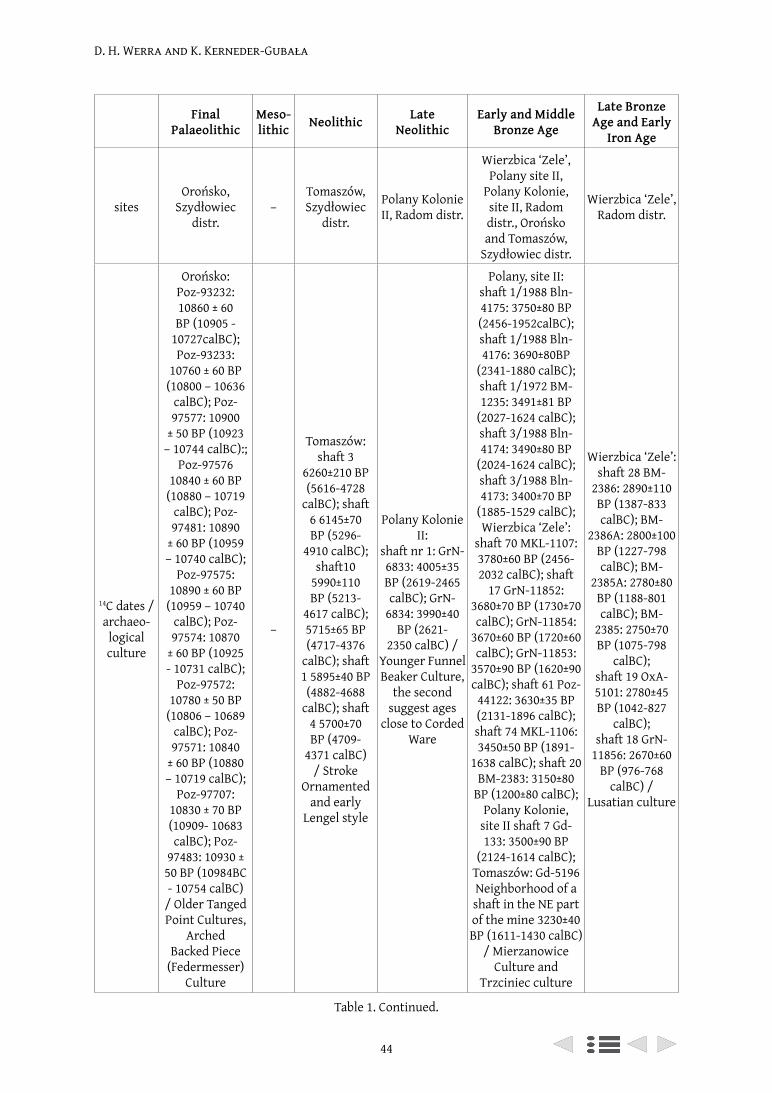
D. H. Werra and K. Kerneder-Gubała
44
Final Palaeolithic
Meso-lithic Neolithic Late
NeolithicEarly and Middle
Bronze Age
Late Bronze Age and Early
Iron Age
sitesOrońsko,
Szydłowiec distr.
–Tomaszów, Szydłowiec
distr.
Polany Kolonie II, Radom distr.
Wierzbica ‘Zele’, Polany site II,
Polany Kolonie, site II, Radom distr., Orońsko and Tomaszów,
Szydłowiec distr.
Wierzbica ‘Zele’, Radom distr.
14C dates / archaeo-logical culture
Orońsko: Poz-93232: 10860 ± 60 BP (10905 -
10727calBC); Poz-93233:
10760 ± 60 BP (10800 – 10636
calBC); Poz-97577: 10900
± 50 BP (10923 – 10744 calBC):;
Poz-97576 10840 ± 60 BP
(10880 – 10719 calBC); Poz-97481: 10890
± 60 BP (10959 – 10740 calBC);
Poz-97575: 10890 ± 60 BP
(10959 – 10740 calBC); Poz-97574: 10870
± 60 BP (10925 - 10731 calBC);
Poz-97572: 10780 ± 50 BP
(10806 – 10689 calBC); Poz-97571: 10840
± 60 BP (10880 – 10719 calBC);
Poz-97707: 10830 ± 70 BP (10909- 10683 calBC); Poz-
97483: 10930 ± 50 BP (10984BC - 10754 calBC)
/ Older Tanged Point Cultures,
Arched Backed Piece
(Federmesser) Culture
–
Tomaszów: shaft 3
6260±210 BP (5616-4728
calBC); shaft 6 6145±70 BP (5296-
4910 calBC); shaft10
5990±110 BP (5213-
4617 calBC); 5715±65 BP (4717-4376
calBC); shaft 1 5895±40 BP (4882-4688
calBC); shaft 4 5700±70 BP (4709-
4371 calBC) / Stroke
Ornamented and early
Lengel style
Polany Kolonie II:
shaft nr 1: GrN-6833: 4005±35 BP (2619-2465 calBC); GrN-
6834: 3990±40 BP (2621-
2350 calBC) / Younger Funnel Beaker Culture,
the second suggest ages
close to Corded Ware
Polany, site II: shaft 1/1988 Bln-4175: 3750±80 BP (2456-1952calBC); shaft 1/1988 Bln-4176: 3690±80BP
(2341-1880 calBC); shaft 1/1972 BM-1235: 3491±81 BP
(2027-1624 calBC); shaft 3/1988 Bln-4174: 3490±80 BP
(2024-1624 calBC); shaft 3/1988 Bln-4173: 3400±70 BP
(1885-1529 calBC); Wierzbica ‘Zele’:
shaft 70 MKL-1107: 3780±60 BP (2456-2032 calBC); shaft
17 GrN-11852: 3680±70 BP (1730±70 calBC); GrN-11854:
3670±60 BP (1720±60 calBC); GrN-11853:
3570±90 BP (1620±90 calBC); shaft 61 Poz-
44122: 3630±35 BP (2131-1896 calBC); shaft 74 MKL-1106: 3450±50 BP (1891-
1638 calBC); shaft 20 BM-2383: 3150±80
BP (1200±80 calBC); Polany Kolonie,
site II shaft 7 Gd-133: 3500±90 BP
(2124-1614 calBC); Tomaszów: Gd-5196 Neighborhood of a shaft in the NE part of the mine 3230±40 BP (1611-1430 calBC)
/ Mierzanowice Culture and
Trzciniec culture
Wierzbica ‘Zele’: shaft 28 BM-
2386: 2890±110 BP (1387-833 calBC); BM-
2386A: 2800±100 BP (1227-798 calBC); BM-
2385A: 2780±80 BP (1188-801 calBC); BM-
2385: 2750±70 BP (1075-798
calBC); shaft 19 OxA-5101: 2780±45 BP (1042-827
calBC); shaft 18 GrN-
11856: 2670±60 BP (976-768
calBC) / Lusatian culture
Table 1. Continued.
D. H. Werra and K. Kerneder-Gubała
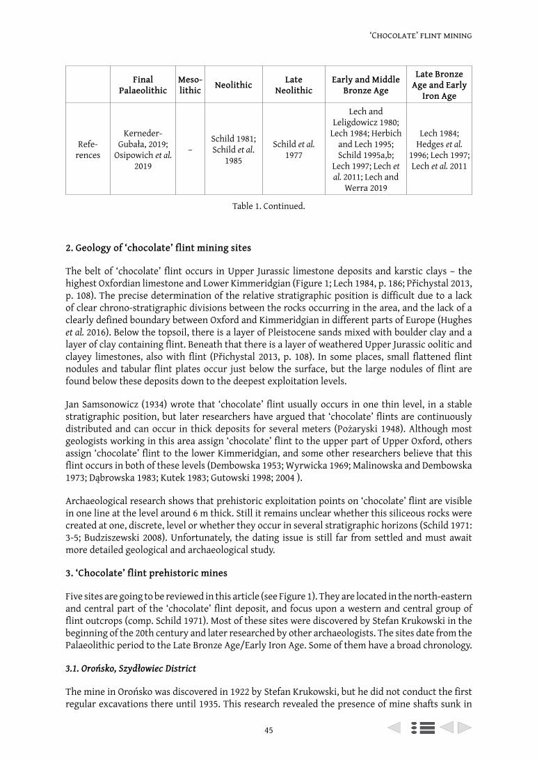
45
‘Chocolate’ flint mining
2. Geology of ‘chocolate’ flint mining sites
The belt of ‘chocolate’ flint occurs in Upper Jurassic limestone deposits and karstic clays – the highest Oxfordian limestone and Lower Kimmeridgian (Figure 1; Lech 1984, p. 186; Přichystal 2013, p. 108). The precise determination of the relative stratigraphic position is difficult due to a lack of clear chrono-stratigraphic divisions between the rocks occurring in the area, and the lack of a clearly defined boundary between Oxford and Kimmeridgian in different parts of Europe (Hughes et al. 2016). Below the topsoil, there is a layer of Pleistocene sands mixed with boulder clay and a layer of clay containing flint. Beneath that there is a layer of weathered Upper Jurassic oolitic and clayey limestones, also with flint (Přichystal 2013, p. 108). In some places, small flattened flint nodules and tabular flint plates occur just below the surface, but the large nodules of flint are found below these deposits down to the deepest exploitation levels.
Jan Samsonowicz (1934) wrote that ‘chocolate’ flint usually occurs in one thin level, in a stable stratigraphic position, but later researchers have argued that ‘chocolate’ flints are continuously distributed and can occur in thick deposits for several meters (Pożaryski 1948). Although most geologists working in this area assign ‘chocolate’ flint to the upper part of Upper Oxford, others assign ‘chocolate’ flint to the lower Kimmeridgian, and some other researchers believe that this flint occurs in both of these levels (Dembowska 1953; Wyrwicka 1969; Malinowska and Dembowska 1973; Dąbrowska 1983; Kutek 1983; Gutowski 1998; 2004 ).
Archaeological research shows that prehistoric exploitation points on ‘chocolate’ flint are visible in one line at the level around 6 m thick. Still it remains unclear whether this siliceous rocks were created at one, discrete, level or whether they occur in several stratigraphic horizons (Schild 1971: 3-5; Budziszewski 2008). Unfortunately, the dating issue is still far from settled and must await more detailed geological and archaeological study.
3. ‘Chocolate’ flint prehistoric mines
Five sites are going to be reviewed in this article (see Figure 1). They are located in the north-eastern and central part of the ‘chocolate’ flint deposit, and focus upon a western and central group of flint outcrops (comp. Schild 1971). Most of these sites were discovered by Stefan Krukowski in the beginning of the 20th century and later researched by other archaeologists. The sites date from the Palaeolithic period to the Late Bronze Age/Early Iron Age. Some of them have a broad chronology.
3.1. Orońsko, Szydłowiec District
The mine in Orońsko was discovered in 1922 by Stefan Krukowski, but he did not conduct the first regular excavations there until 1935. This research revealed the presence of mine shafts sunk in
Final Palaeolithic
Meso-lithic Neolithic Late
NeolithicEarly and Middle
Bronze Age
Late Bronze Age and Early
Iron Age
Refe-rences
Kerneder-Gubała, 2019;
Osipowich et al. 2019
–Schild 1981; Schild et al.
1985
Schild et al. 1977
Lech and Leligdowicz 1980;
Lech 1984; Herbich and Lech 1995; Schild 1995a,b;
Lech 1997; Lech et al. 2011; Lech and
Werra 2019
Lech 1984; Hedges et al.
1996; Lech 1997; Lech et al. 2011
Table 1. Continued.
D. H. Werra and K. Kerneder-Gubała
46
clays (Krukowski 1939-1948; Schild 1971; Kozłowski 2008). Recent excavations run by Katarzyna Kerneder-Gubała from the Institute of Archaeology and Ethnology of the Polish Academy of Sciences (further IAE PAN) since 2016, led to the discovery of other mine shafts sunk into limestone (Kerneder-Gubała et al. 2017; Kerneder-Gubała 2019; Osipowicz et al. 2019).
3.2. Tomaszów, Szydłowiec District
Tomaszów is located about 5 km south east from Orońsko (see 3.1 above). The sites in Tomaszów (workshop Tomaszów II and the mine Tomaszów I) were discovered by Krukowski in 1935 and next excavated by Romuald Schild and his team from the Institute of the History of Material Culture, Polish Academy of Sciences (further IHKM PAN; former IAE PAN) during 1973-1975, and the results were published in 1985. From the indications of the surface remains, the area of the mine is about 9,000 sq m. In the excavation trenches 24 shafts were exposed, eight of them were fully cross-sectioned, which is a very small percentage of this mine complex (Schild 1971; 1995; Schild et al. 1985).
Figure 1. ‘Chocolate’ flint locations in pre-Quaternary formations on the northeastern outskirts of the Holy Cross Mountains; 1 – Chronów-Kolonia, Szydłowiec dist.; 2 – Guzów Szydłowiec dist.; 3 – Orońsko ‘Mały Orońsk’ Szydłowiec dist.; 4 – Orońsko (Orońsk II) Szydłowiec dist.; 5 – Tomaszów Szydłowiec dist.;
6 – Rzeczków, Radom dist.; 7 – Wierzbica quarry, Radom dist.; 8 – Wierzbica ‘Zele’, Radom dist.; 9 – Wierzbica ‘Krzemienica’, Radom dist.; 10 – Polany kolonie IV, Radom dist.; 11 – Polany kolonie I, Radom dist.; 12 – Polany kolonie II, Radom dist.; 13 – Polany kolonie IIa, Radom dist.; 14 – Polany III, Radom dist.; 15 – Polany kolonie III, Radom dist.; 16 – Polany I, Radom dist.; 17 – Polany II, Radom dist.; 18 – Pakosław,
Radom dist.; 19 – Seredzice, Radom dist.; 20 – Seredzice ‘Kolonia’, Radom dist.; 21 – Iłża ‘Wąwóz Żuchowiec’, Radom dist.; 22 – Iłża ‘Krzemieniec’ II, Radom dist.; 23 – Iłża ‘Krzemieniec’ I, Radom dist.; 24 – Błaziny
Górne, Radom dist.; 25 – Prędocin, Radom dist.; 26 – Gliniany ‘Wzgórze Kruk’, Opatów dist. (Schild 1971, 1976; Balcer 1976; Dadlez et al. 2000; Budziszewski 2008; Budziszewski et al. 2015; Hughes et al. 2016,
fig. 1; sites listed in boldface print are discussed in the text). Graphic design: D.H. Werra.
47
‘Chocolate’ flint mining
3.3. Polany site II, Radom District
This mine was excavated in 1971-1972 by Maria Chmielewska and Jacek Lech from IHKM PAN. The results were published in 1988 in the journal Przegląd Archeologiczny.
In trench 1 from 1972, eight shafts were discovered. Initially, the site was associated with Palaeolithic communities activity, but during the excavations evidence of mining activity was confirmed. Afterwards, this early chronology was verified through radiocarbon dates (Chmielewska 1988). In the years 1985-1987, Tomasz Herbich used the electro-resistivity method to determine the scale and detail of the mining complex, and in 1988 his excavations confirmed the electro-resistivity results (Herbich and Lech 1995).
3.4. Polany Kolonie site II, Radom District
It is believed that this site was discovered by Stefan Krukowski in the beginning of the 20th century, but was known by another name – Wierzbica I. It was not excavated until 1971-1972. The excavations were led by Schild and his team, from IHKM PAN. The results were published in 1977. It is believed that the mine measured 1600 sq m, and consisted of about 20-60 shafts, but during the excavations only one full shaft and 8 partly excavated shafts were exposed (Schild et al. 1977).
3.5. Wierzbica ‘Zele’, Radom District
The Wierzbica ‘Zele’ mine was discovered by Stefan Krukowski before World War II and was excavated between 1979-1988 by Hanna and Jacek Lech. New excavations were conducted in the second decade of the 21st century by Jacek Lech, Kamil Adamczak and Dagmara H. Werra from IAE PAN. During these excavations, 81 archeological features were recorded (Lech 1984; 1997; Lech et al. 2011).
4. ‘Chocolate’ flint mines – overview
In this review of the abovementioned sites, we would like to focus on four main features – mining methods, mining tools, chronology based upon radiocarbon determinations, and flint working – arranged in chronological order.
4.1. ‘Chocolate’ flint mining during the Palaeolithic period
The only direct evidence for the mining of ‘chocolate’ flint in terms of features dated to the Palaeolithic period and made from buried sources of flint comes from one site – Orońsko II. In other mine complexes, single cores and blades, as well as regular processing workshops from this period are known from surface discoveries in their vicinity. The same applies to Polany (Schild 1980) or Iłża (Bednarz and Budziszewski 1997), but, to date, no mining objects have been found at these sites.
The shafts at Orońsko II were sunk in clays, karstic clays, as well as in the primary limestone beds. The features made in clays were straight and reached 3.4 m deep, but most of them didn’t exceed 2.5 m. They were narrow, from 1.5 to 2.0 m in diameter (Krukowski 1935; 1939-1948; Schild 1971; Kozłowski 2008), whereas shafts discovered recently that had been sunk in the primary flint beds were of two varieties (Figure 2a). First were the simple, straight shafts, that reached the limestone, but were not sunk more deeply, roughly 40 cm into the primary beds (shaft n°2). The second kind of extraction was probably a shaft which ended with a niche, or niches, and was much deeper than the first one (shaft no. 1, Figure 2b). The flint that occurs in the secondary deposits in clays must also have been of interest to the Palaeolithic miners.
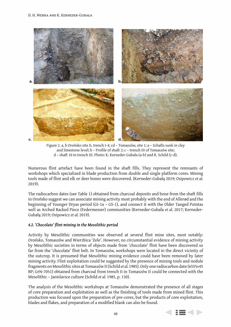
D. H. Werra and K. Kerneder-Gubała
48
Numerous flint artefact have been found in the shaft fills. They represent the remnants of workshops which specialized in blade production from double and single platform cores. Mining tools made of flint and elk or deer bones were discovered. (Kerneder-Gubałą 2019; Osipowicz et al. 2019).
The radiocarbon dates (see Table 1) obtained from charcoal deposits and bone from the shaft fills in Orońsko suggest we can associate mining activity most probably with the end of Allerød and the beginning of Younger Dryas period (GI-1a – GS-1), and connect it with the Older Tanged Pointas well as Arched Backed Piece (Federmesser) communities (Kerneder-Gubała et al. 2017; Kerneder-Gubałą 2019; Osipowicz et al. 2019).
4.2. ‘Chocolate’ flint mining in the Mesolithic period
Activity by Mesolithic communities was observed at several flint mine sites, most notably: Orońsko, Tomaszów and Wierzbica ‘Zele’. However, no circumstantial evidence of mining activity by Mesolithic societies in terms of objects made from ‘chocolate’ flint have been discovered so far from the ‘chocolate’ flint belt. In Tomaszów, workshops were located in the direct vicinity of the outcrop. It is presumed that Mesolithic mining evidence could have been removed by later mining activity. Flint exploitation could be suggested by the presence of mining tools and nodule fragments on Mesolithic sites at Tomaszów II (Schild et al. 1985). Only one radiocarbon date (6555±45 BP; GrN-7051) obtained from charcoal from trench II in Tomaszów II could be connected with the Mesolithic – Janislavice culture (Schild et al. 1985, p. 130).
The analysis of the Mesolithic workshops at Tomaszów demonstrated the presence of all stages of core preparation and exploitation as well as the finishing of tools made from mined flint. This production was focused upon the preparation of pre-cores, but the products of core exploitation, blades and flakes, and preparation of a modified blank can also be found.
Figure 2. a, b Orońsko site II, trench I-4; cd – Tomaszów, site 1; a – Schafts sunk in cley and limestone level; b – Profile of shaft 2; c – trench III of Tomaszów site;
d – shaft 10 in trench III. Photo: K. Kerneder-Gubała (a-b) and R. Schild (c-d).
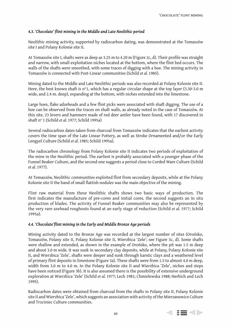
49
‘Chocolate’ flint mining
4.3. ‘Chocolate’ flint mining in the Middle and Late Neolithic period
Neolithic mining activity, supported by radiocarbon dating, was demonstrated at the Tomaszów site I and Polany Kolonie site II.
At Tomaszów site I, shafts were as deep as 3.25 m to 4.20 m (Figure 2c, d). Their profile was straight and narrow, with small exploitation niches located at the bottom, where the flint bed occurs. The walls of the shafts were smoothed, with some traces of digging with a hoe. The mining activity in Tomaszów is connected with Post-Linear communities (Schild et al. 1985).
Mining dated to the Middle and Late Neolithic periods was also recorded at Polany Kolonie site II. Here, the best known shaft is n°1, which has a regular circular shape at the top layer (3.30-3.0 m wide, and 2.4 m. deep), expanding at the bottom, with niches extended into the limestone.
Large hoes, flake adzeheads and a few flint picks were associated with shaft digging. The use of a hoe can be observed from the traces on shaft walls, as already noted in the case of Tomaszów. At this site, 23 levers and hammers made of red deer antler have been found, with 17 discovered in shaft no 1 (Schild et al. 1977; Schild 1995a)
Several radiocarbon dates taken from charcoal from Tomaszów indicates that the earliest activity covers the time span of the Late Linear Pottery, as well as Stroke Ornamented and/or the Early Lengyel Culture (Schild et al. 1985; Schild 1995a).
The radiocarbon chronology from Polany Kolonie site II indicates two periods of exploitation of the mine in the Neolithic period. The earliest is probably associated with a younger phase of the Funnel Beaker Culture, and the second one suggests a period close to Corded Ware Culture (Schild et al. 1977).
At Tomaszów, Neolithic communities exploited flint from secondary deposits, while at the Polany Kolonie site II the band of small flattish nodules was the main objective of the mining.
Flint raw material from these Neolithic shafts shows two basic ways of production. The first indicates the manufacture of pre-cores and initial cores, the second suggests an in situ production of blades. The activity of Funnel Beaker communities may also be represented by the very rare axehead roughouts found at an early stage of reduction (Schild et al. 1977; Schild 1995a).
4.4. ‘Chocolate’flint mining in the Early and Middle Bronze Age periods
Mining activity dated to the Bronze Age was recorded at the largest number of sites (Orońsko, Tomaszów, Polany site II, Polany Kolonie site II, Wierzbica ‘Zele’; see Figure 3c, d). Some shafts were shallow and extended, as shown in the example of Orońsko, where the pit was 1.5 m deep and about 3.0 m wide. It was sunk in secondary clay deposits, while at Polany, Polany Kolonie site II, and Wierzbica ‘Zele’, shafts were deeper and sunk through karstic clays and a weathered level of primary flint deposits in limestone (Figure 3a). These shafts were from 1.5 to almost 4.0 m deep, width from 3.0 m to 4.0 m. In the Polany Kolonie site II and Wierzbica ‘Zele’, niches and steps have been noticed (Figure 3b). It is also assumed there is the possibility of extensive underground exploration at Wierzbica ‘Zele’ (Schild et al. 1977; Lech 1981; Chmielewska 1988; Herbich and Lech 1995).
Radiocarbon dates were obtained from charcoal from the shafts in Polany site II, Polany Kolonie site II and Wierzbica ‘Zele’, which suggests an association with activity of the Mierzanowice Culture and Trzciniec Culture communities.

D. H. Werra and K. Kerneder-Gubała
50
The shafts were excavated using organic tools – antlers and wooden tools, as shown by examples recovered from Polany site II, Polany Kolonie site II and Wierzbica ‘Zele’. Flint mining tools such as picks (i.e. Polany site II; Chmielewska 1988, p. 157) and hammerstones are found at all of these sites.
It is not easy to distinguish between Early and Middle Bronze Age lithic assemblages (Schild et al. 1977; Lech 1981; Chmielewska 1988; Schild 1995b). In all of the sites discussed, bifacial technology was dominant. Small oval celts, bifacial points and sickles were the main products, made from small, flat flint nodules. Apart from bifacial axeheads and adzeheads, the same technique was used to produce sickles. Flake blanks were also obtained, but whether blade blanks were produced at this time is still open to question (Schild et al. 1977; Lech 1981; Chmielewska 1988; Schild 1995b; Lech et al. 2011: p. 113-114).
4.5. ‘Chocolate’ flint mining during the Late Bronze Age and Early Iron Age periods
Shafts dating to the Late Bronze Age and the Early Iron Age were observed only at the Wierzbica ‘Zele’ mining site, and they were the largest ones – 7 m deep and even 7 m wide, but the average were approximately 4 m. There were noticeable communication steps and niches (Lech 1997: p. 96; Lech et al. 2011: p. 112; Lech and Werra, 2019: p. 85).
Figure 3. a, b Polany Kolonie, site II; c, d – Polany II, Radom distr. a – Shaft 2 of the site; b – detail of shaft 1 (niches); c – shaft I/88 in cutting II/88; d – shaft 3/88 in cutting I/88.
Photo: R. Schild (a-b) and T. Herbich (c-d).
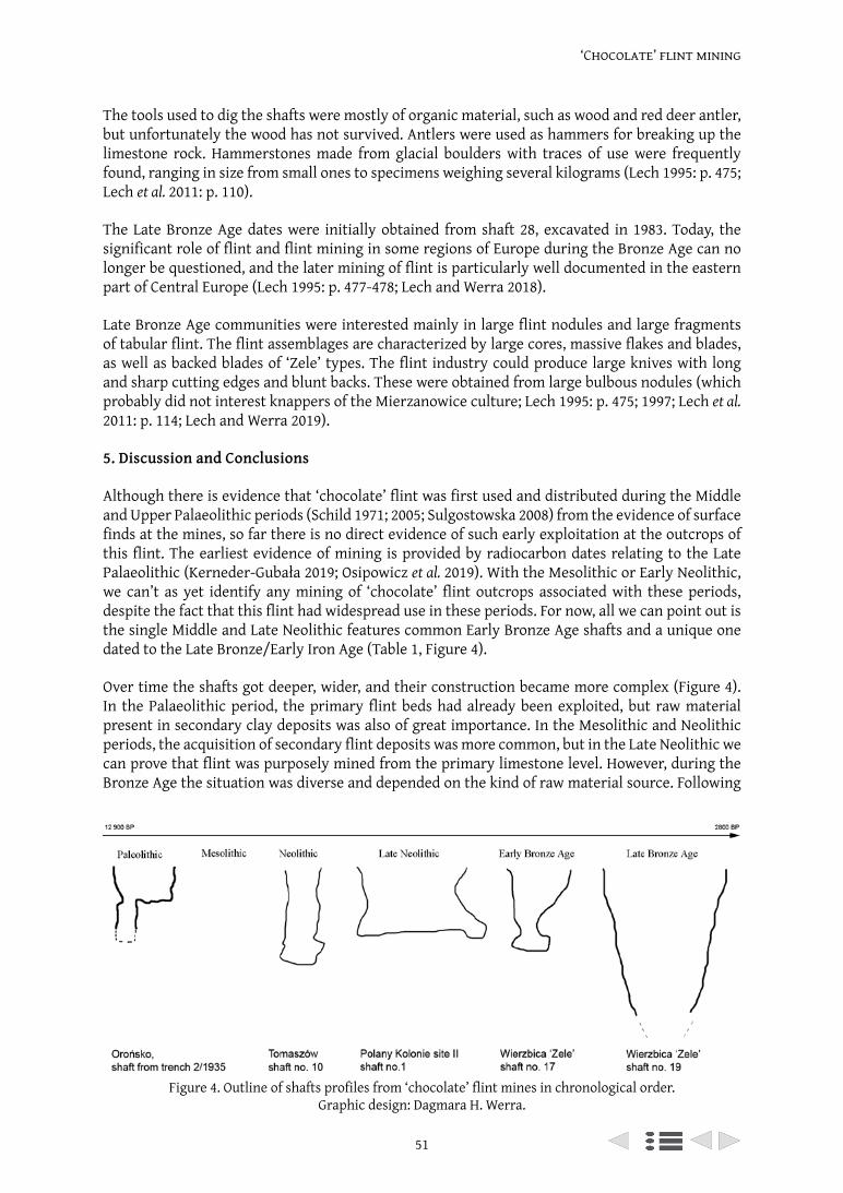
51
‘Chocolate’ flint mining
The tools used to dig the shafts were mostly of organic material, such as wood and red deer antler, but unfortunately the wood has not survived. Antlers were used as hammers for breaking up the limestone rock. Hammerstones made from glacial boulders with traces of use were frequently found, ranging in size from small ones to specimens weighing several kilograms (Lech 1995: p. 475; Lech et al. 2011: p. 110).
The Late Bronze Age dates were initially obtained from shaft 28, excavated in 1983. Today, the significant role of flint and flint mining in some regions of Europe during the Bronze Age can no longer be questioned, and the later mining of flint is particularly well documented in the eastern part of Central Europe (Lech 1995: p. 477-478; Lech and Werra 2018).
Late Bronze Age communities were interested mainly in large flint nodules and large fragments of tabular flint. The flint assemblages are characterized by large cores, massive flakes and blades, as well as backed blades of ‘Zele’ types. The flint industry could produce large knives with long and sharp cutting edges and blunt backs. These were obtained from large bulbous nodules (which probably did not interest knappers of the Mierzanowice culture; Lech 1995: p. 475; 1997; Lech et al. 2011: p. 114; Lech and Werra 2019).
5. Discussion and Conclusions
Although there is evidence that ‘chocolate’ flint was first used and distributed during the Middle and Upper Palaeolithic periods (Schild 1971; 2005; Sulgostowska 2008) from the evidence of surface finds at the mines, so far there is no direct evidence of such early exploitation at the outcrops of this flint. The earliest evidence of mining is provided by radiocarbon dates relating to the Late Palaeolithic (Kerneder-Gubała 2019; Osipowicz et al. 2019). With the Mesolithic or Early Neolithic, we can’t as yet identify any mining of ‘chocolate’ flint outcrops associated with these periods, despite the fact that this flint had widespread use in these periods. For now, all we can point out is the single Middle and Late Neolithic features common Early Bronze Age shafts and a unique one dated to the Late Bronze/Early Iron Age (Table 1, Figure 4).
Over time the shafts got deeper, wider, and their construction became more complex (Figure 4). In the Palaeolithic period, the primary flint beds had already been exploited, but raw material present in secondary clay deposits was also of great importance. In the Mesolithic and Neolithic periods, the acquisition of secondary flint deposits was more common, but in the Late Neolithic we can prove that flint was purposely mined from the primary limestone level. However, during the Bronze Age the situation was diverse and depended on the kind of raw material source. Following
Figure 4. Outline of shafts profiles from ‘chocolate’ flint mines in chronological order. Graphic design: Dagmara H. Werra.
D. H. Werra and K. Kerneder-Gubała
52
the Late Bronze Age, the selection of mined raw material and the level of its acquisition can be observed.
The use of deer antlers and flint tools in the form of picks is common in almost each epoch. Only in the Palaeolithic Orońsko mine have bone mining tools been found (Osipowicz et al. 2018).
Recently, forty six radiocarbon dates from five sites are associated with the ‘chocolate’ flint outcrops. Eleven of them come from Orońsko and are connected with the Final Palaeolithic, one from Tomaszów pointed to Mesolithic activity, nine with Neolithic and the remaining 25 from different sites of the Bronze Age.
Analysis of flint assemblages showed, that the most numerous raw materials were the natural nodules, sometimes with testing flakes removed, precores, roughouts of core tools and bifacial tools, flake and blade cores, and very rarely tools.
In the case of Palaeolithic assemblages, the materials from the shaft fills represented the remnants of blade production sequences, with a prevalence for initial phase products. In terms of Mesolithic assemblages, it was observed that flint typologies were not different from those known from non-mining Mesolithic sites. The Neolithic mines are associated with axeheads at an early stage of reduction and blade cores. Early and Middle Bronze Age is characterized by products of bifacial reduction, and the Late Bronze Age by large cores, and roughouts mostly of knives from large blade and flake blanks, including backed blades of the ‘Zele’ type (Lech and Werra 2019: p. 93).
In Poland, there are many deposits of good quality flints and other siliceous rocks that were exploited by mining methods since the Palaeolithic period. The outcrops with the surface evidences and mining features are located in many parts of Poland. There are Jurassic-Cracow flint, Striped flint and Świeciechów (gray white-spotted) flint. There are also raw materials which outcrop but do not have evidence of extraction, but it is known that they were used, such as the radiolarite from Pieniny Klippen Belt.
There are sites dated by radiocarbon assays that can be connected with the earliest exploitation of the range of Jurassic-Cracow flint outcrops: Zagacie and Wołowice, Lesser Poland Voivodeship (Dagnan-Ginter 1974; Pawłowska 2003). These sites correspond with the end of the Allerod and Younger Dryas, which is similar to the Orońsko mine. There were shallow pits, other than in Orońsko. The Final Palaeolithic flint exploitation can be also confirmed in sites like Trzebca, Gojść, Poznań – Starołęka, Greater Poland Voivodeship (Ginter 1974).
At present, the above mentioned site in Wołowice has also produced a Mesolithic date obtained directly from charcoal from the shaft filling, but there is no other case known from Poland (Dagnan-Ginter 1974).
Neolithic and Bronze Age mining sites with good chronological sequences obtained from 14C dates are more common in the area of the outcrops of diversified raw materials. Among others, it is worth mentioning the Jurassic-Cracow flint mines at Sąspów and Bębło, Lesser Poland Voivodeship, associated with Late Danubian communities. The shafts at these sites reached up to 5 m in depth (Lech 1971; 1972; 1974; 1975; 1981). The ‘Krzemionki Opatowskie’ prehistoric striped flint mining complex is one of the biggest, most complicated and important Neolithic mines in Europe. The site contains traces of very organized and highly sophisticated mining. The site consists of diversified techniques such as shafts, niches and even unique types of galleries. This mining is linked mainly with the Globular Amphora culture communities who used the raw material for the production of axeheads. The mine complex was also exploited by the communities of the Funnel Beaker Culture and during the Early Bronze Age (Krukowski 1939; Żurowski 1962; Sałaciński 1990; Lech 2004; Bąbel et al. 2005; Bąbel 2015). At this time the Świeciechów flint mine at Świeciechów-
53
‘Chocolate’ flint mining
Lasek, Lublin Voivodeship, was also of great importance. The mine was exploited by Funnel Beaker Culture communities, and its existence can be directly connected with the settlement in Ćmielów-Gawroniec, Ostrowiec Świętokrzyski district (Balcer 1975; 1976; 2002).
It is also worth pointing out as an example of early Bronze Age exploitation the mine in Ożarów ‘Za Garncarzami’, Świętokrzyskie Voivodeship. This flint mine was exploited there, alongside others, by the Mierzanowice culture. These miners used shallow pits and shafts, sometimes with niches, And the raw material was obtained for the production of bifacial tools, particularly sickles (Budziszewski 1980; 1986; 1997; Budziszewski and Grużdź 2014).
To summarise, ‘chocolate’ flint was one of the best quality types of flint used since the Palaeolithic period up to the Late Bronze/Early Iron Age, obtained through mining methods. Over time, shafts got deeper and wider, although the mining tools remained more or less the same. But the selection of flint material became more refined – during the Palaeolithic period shafts exploited not only the top of the limestone and first flint level, but also material from underlying clay was used. In the Neolithic period only flint from clay was used, then in the Late Neolithic miners started to dig into the limestone and even select flint from the beds to obtain the best quality material for the specified final product.
We can imagine that in the Bronze Age the flint mining sites were covered by natural nodules, precores, and roughouts. But prehistoric miners chose to dig out deep shafts. Of course this could have an economic reason. But we can also view mining in a ritual and symbolic way – the miners did not use materials from the surface, from the clay, but rather from a deep shaft, from a particularly flint level. All of this could have resulted from cultural reasons. Mining in the Late Bronze Age was not a haphazard activity, but possessed traditions, rules, and regulations. The specialization of labor which occurred here resulted from the needs of communities, their knowledge and skills, as well as from the conditions created by the natural environment in which people functioned. The size of the shafts indicates that in Central Poland, even at the time when metals were widely used to produce tools, flint continued to be an important raw material (Lech et al. 2015; Lech and Werra 2018).
Acknowledgements
The Authors are grateful to Prof Romuald Schild and Mgr Tomasz Herbich for sharing the original photography from Tomaszów and Polany II sites, and to Oliver George and Beata Kita for language correction. The excavations in Orońsko were conducted as part of the scientific project ‘Exploitation and processing of chocolate flint during Palaeolithic and Mesolithic in the North-Western part of its deposits based on non-invasive archeological and geophysical research and test-trenches’ financed by the National Science Centre (NCN) in Cracow (Poland) no. UMO-2015/17/N/HS3/01279). We would like to thank the anonymous reviewers for their valuable comments.
References
Balcer, B. 1975. Krzemień świeciechowski w kulturze pucharów lejkowatych. Eksploatacja, obróbka i rozprzestrzenienie. Wrocław-Warszawa-Kraków-Gdańsk: Instytut Archeologii i Etnologii Polskiej Akademii Nauk.
Balcer, B. 1976. Position and stratigraphy of flint deposits, development of exploitation and importance of the świeciechów flint in prehistory. Acta Archaeologica Carpathica, 16: 179- 199.
Balcer, B. 2002. Ćmielów–Krzemionki–Świeciechów. Związki osady neolitycznej z kopalniami krzemienia. Warszawa: Instytut Archeologii i Etnologii Polskiej Akademii Nauk.
Bąbel, J. T., Braziewicz, J., Jaskóła, M., Kretschmer, W., Pajek, M., Semaniak, J., Scharf, A. and Uhl, T. 2005. The Radiocarbon Dating of the Neolithic Flint Mines at Krzemionki in Central Poland,
D. H. Werra and K. Kerneder-Gubała
54
Nuclear Instruments and Methods in Physics Research Section B: Beam Interactions with Materials and Atoms, 240: 539-543.
Bąbel, J. T. 2015. ‘Krzemionki Opatowskie’. Monument prahistorii Europy. Kopalnie krzemienia pasiastego. Ostrowiec Świętokrzyski.
Bednarz, M. and Budziszewski, J. 1997. Potential of Detailed Archaeological Surveys of Flint Outcrop Areas. Case Study: Iłża Region (Central Poland). In R. Schild and Z. Sulgostowska (eds), Man and Flint. Proceedings of the VIIth In-ternational Flint Symposium Warszawa-Ostrowiec Świętokrzyski, September 1995. Warszawa: Instytut Archeologii i Etnologii PAN: 23-28.
Budziszewski, J. 1980. Der Ozarówer Feuerstein und die Probleme seiner Nutzung und Verteilung. In G. Weisgerber, R. Slotta and J. Weiner (eds), 5000 Jahre Feuersteinbergbau. Die Suche nach dem Stahl der Steinzeit. Bochum: Deutschen Bergbau-Museum 22: 318– 320.
Budziszewski, J. 1986. Exploration of the Mining Field ‘Za garncarzami’ in Ożarów, Tarnobrzeg Voivodship. Preliminary Report. In Biró, K. T. (ed.), Papers for the 1st International Conference on Prehistoric Flint Mining and Lithic Raw Material Identification in the Carpathian Basin, Budapest – Sümeg, 20–22 May 1986, Budapest: 69-82.
Budziszewski, J. 1997. C-14 dating of shallow flint mine sites. Case study from the ‘Za Garncarzami’ mining field in Ożarów (Central Poland). In R. Schild and Z. Sulgostowska (eds), Man and Flint. Proceedings of the VIIth International Flint Symposium Warszawa-Ostrowiec Świętokrzyski, September 1995. Warszawa: Instytut Archeologii i Etnologii PAN: 49-55.
Budziszewski, J. 2008. Stan badań nad występowaniem i pradziejową eksploatacją krzemieni czekoladowych. In W. Borkowski, J. Libera, B. Sałacińska and S. Sałaciński (eds), Krzemień czekoladowy w pradziejach. Materiały z konferencji w Orońsku, 08–10.10.2003. Studia nad gospodarką surowcami krzemiennymi w pradziejach 7, Warszawa-Lublin: Państwowe Muzeum Archeologiczne, Instytut Archeologii Uniwersytetu Marii Skłodowskiej-Curie w Lublinie, Stowarzyszenie Naukowe Archeologów Polskich Oddział w Warszawie: 33-106.
Budziszewski, J. and Grużdź, W. 2014. Kopalnia krzemienia w Ożarowie, stan. ‘Za garncarzami’, w świetle dawnych i nowych badań. In D. Piotrowska, W. Piotrowski, K. Kaptur and A. Jedynak (eds), Górnictwo z epoki kamienia: Krzemionki – Polska – Europa. W 90. rocznicę odkrycia kopalni w Krzemionkach. Silex et Ferrum 1, Ostrowiec Świętokrzyski: Muzeum Historyczno-Archeologiczne: 147–166.
Chmielewska, M. 1988. The early Bronze age flint mine at site II, Polany, Radom district, Przegląd Archeologiczny, 35: 139-181.
Dagnan-Ginter, A. 1974. Wołowice, pow. Kraków, Stanowisko 1. Informator Archeologiczny: 18-19.Dąbrowska, Z. 1983. Jura okolic Iłży. In Paleolntologia i stratygrafia jury i kredy okolic Iłży. Materiały VII
krajowej konferencji paleontologów – Iłża, 7-9 październik 1983, Iłża: 14-24.Dembowska, J. 1953. Górna jura między Radomiem a Jastrzębiem. Biuletyn Instytutu Geologicznego. Z
badań nad górną jurą w Polsce, 18: 31-46.Dadlez, R., Marek, S. and Pokarski, J. (eds) 2000. Mapa geologiczna Polski bez utworów kenozoiku,
skala 1: 1,000.000. Warszawa.Ginter, B. 1974. Wydobywanie, przetwórstwo i dystrybucja surowców i wyrobów krzemiennych w
schyłkowym paleolicie północnej części Europy Środkowej. Przegląd Archeologiczny, 21: 5-122.Gutowski, J. 1998. Oxfordian and Kimmeridgian of the northeastern margin of the Holy Cross
Mountains, Central Poland. Geological Quarterly, 42 (1): 59-72. Gutowski, J. 2004. Lower Kimmeridgian oolitic sedimentary cycle in the Wierzbica quarry, NE
margin of the Holy Cross Mts., Poland. Tomy Jurajskie, 2: 24-36.Herbich, T. and Lech, J. 1995. PL 5 Polany II, Radom Province. Archaeologia Polona, 33: 488-506.Hughes, R., Werra, D.H. and Siuda, R. 2016. On The Chemical Composition of ‘Chocolate’ Flint from
Central Poland. Archeologia Polona, 54: 99-114.Kerneder-Gubała, K. 2019. In Search of the Chocolate Flint Mines in Orońsko, Central-Southern
Poland. In Anthropologica et Præhistorica, Special Theme: Mining and Quarrying. Geological Characterisation, Knapping Processes and Distribution Networks during Pre- and Protohistoric Times 128: 199–208..
Kerneder-Gubała, K., Buławka, N., Buławka, S. and Szubski, M. 2017. GIS w badaniach powierzchniowych stanowisk górniczych na przykładzie kopalni krzemienia czekoladowego w Orońsku (gm. Orońsko, pow. szydłowiecki, woj. mazowieckie). Archeologia Polski, 62: 7-37.
55
‘Chocolate’ flint mining
Kozłowski, J. K. 2013. Raw materials procurement in the Late Gravettian of the Carpatian Basin. In Z. Master (ed.), The Lithic raw materials sources and interregional Human contacts in the Northern Carpathian Regions, Kraków-Budapest: Polish Academy of Arts and Sciences, Institute of Archaeological Sciences of the Eötvös Loránd University Budapest: 63-85.
Kozłowski, S. K. 2008. Legenda Orońska. In W. Borkowski, J. Libera, B. Sałacińska and S. Sałaciński (eds), Krzemień czekoladowy w pradziejach. Materiały z konferencji w Orońsku, 08–10.10.2003. Studia nad gospodarką surowcami krzemiennymi w pradziejach 7, Warszawa-Lublin: Państwowe Muzeum Archeologiczne, Instytut Archeologii Uniwersytetu Marii Skłodowskiej-Curie w Lublinie, Stowarzyszenie Naukowe Archeologów Polskich Oddział w Warszawie: 25-32.
Krukowski, S. 1922. Pierwociny krzemieniarskie górnictwa, transportu i handlu w holocenie Polski, cz. II. Wiadomości Archeologiczne, 7(1): 34-57.
Krukowski, S. 1923. Sprawozdania z działalności Państwowego Konserwatora Zabytków Prahistorycznych na okręg kielecki na rok 1922. Wiadomości Archeologiczne, 8: 69-70.
Krukowski, S. 1935. Notatnik z badań [Research notebook]. Manuscript in the collection of the State Archaeological Museum, Warsaw.
Krukowski, S. 1939-1948. Paleolit. In Encyklopedia polska PAU. Prehistoria ziem polskich, 4, Kraków: 1-117.
Krukowski, S. 1939. Krzemionki Opatowskie. Warszawa: Muzeum Techniki i Przemysłu. Kutek, J. 1983. O stratygrafii górnej jury między Iłżą i Śniadkowem. In Paleontologia i stratygrafia jury
i kredy okolic Iłży, Materiały VII Krajowej Konferencji Paleontologów – Iłża, 7-9 pażdziernik 1983, Iłża: 32-36.
Lech, J. 1971. Z badań nad kopalnią krzemienia na stanowisku I w Sąspowie, pow. Olkusz. In J. K. Kozłowski (ed.), Z badań nad krzemieniarstwem neolitycznym i eneolitycznym, Kraków,: Polskie Towarzystwo Archeologiczne i Muzeum Archeologiczne w Krakowie: 115-133.
Lech, J. 1972. Odkrycie kopalni krzemienia na stanowisku I w Sąspowie, pow. Olkusz. Sprawozdania Archeologiczne, 24: 37-47.
Lech, J. 1974. Bębło, pow. Kraków, stanowisko I. Informator Archeologiczny, p. 17.Lech, J. 1975. Neolithic Flint Mine and Workshops at Sąspów near Cracow. In F. H. G. Engelen
(ed.), Tweede Internationale Symposium over Vuursteen. 8-11 Mei 1975 – Maastricht, Staringia No. 3, Nederlandse Geologische Vereniging, Holand: 70-71 and 85.
Lech, J. 1981 Górnictwo krzemienia społeczności wczesnorolniczych na Wyżynie Krakowskiej. Koniec VI tysiąclecia – 1 połowa IV tysiąclecia p.n.e., Wrocław-Warszawa-Kraków-Gdańsk-Łódź: Zakład Narodowy im. Ossolińskich.
Lech, H. and J. 1984. The prehistoric flint mine at Wierzbica ‘Zele’: a case study from Poland. World Archaeology, 16(2): 190-208.
Lech, H. and J. 1997. Flint mining among Bronze Age communities: a case study from Central Poland. In R. Schild and Z. Sulgostowska (eds), Man and Flint, Warszawa: Instytut Archeologii i Etnologii Polskiej Akademii Nauk: 91-98.
Lech, J. 2004. O badaniach prehistorycznego górnictwa krzemienia i kopalni w Krzemionkach Opatowskich. Przegląd Archeologiczny, 52: 15-88.
Lech, J., Adamczak, K. and Werra, D. H. 2011. Extraction methods in the Bronze Age at the Wierzbica ‘Zele’ flint mine site (Central Poland): a model. In M. Capote, S. Consuerga, P. Díaz-del-Río and X. Terradas (eds), Proceedings of the 2nd Conference of the UISPP Commission on Flint Minning in Pre- and Protohistoric Times (Madrid, 14-17 October 2009), Oxford: Archeopress: 109–116. ‘BAR International Series’ 2260.
Lech, J. and Leligdowicz, A. 1980. Die Methoden der Versorgung mit Feuerstein und die lokalen Beziehungen zwischen den Siedlungen und Bergwerken im Weichselgebiet während des 5. Bis 2. Jt. v. u. Z. In F. Schlette (ed.), Urgeschichtliche Besiedlung in ihrer Beziehung zur natürlichen Umwelt, Halle (Saale): Wissenschaftliche Beiträge der Martin-Luther-Universität Halle-Wittenberg 1980/6 L 15, p. 151-184.
Lech, J., Piotrowska, D. and Werra, D. H. 2015. Between economy and symbol: flint in the Bronze Age in eastern Central Europe. In P. Suchowska-Ducke, S. Reiter and H. Vandkilde (eds), Forging Identities. The Mobility of Culture in Bronze Age Europe, vol. 1, Oxford: Archaeopress: 221–229. ‘BAR International Series’ 2771.
D. H. Werra and K. Kerneder-Gubała
56
Lech, J. and Werra, D. H. 2018. On the beginnings of prehistory and on chipped flints in the Late Bronze Age. In P. Valde-Nowak, K. Sobczyk, M. Nowak and J. Źrałka (eds), Amici magistro et collegae suo Ioanni Christopho Kozłowski dedicant, Kraków: Institute of Archaeology, Jagiellonian Univeristy: 577–584.
Lech, J. and Werra, D. H. 2019. The flint mine site Wierzbica Zeleʼ (Poland) and Bronze Age workshop materials after forty years of new research (1979-2018). Anthropologica et Præhistorica, 128: 81-95.
Malinowska, L., and Dembowska, J. 1973. Obrzeżenie Gór Świętokrzyskich w górnej jurze. In B. Słowańska and M. Bartyś-Pelc (eds), Budowa geologiczna Polski, t. 1: Stratygrafia, cz. 2: Mezozoik, Warszawa: 381-389.
Osipowicz, G., Kerneder-Gubała, K., Bosiak, M., Makowiecki, D. and Orłowska, J. 2019. The oldest osseous mining tools in Europe? New discoveries from the chocolate flint mine in Orońsko, site 2 (southern Poland). Quaternary International, 512: 82-98. https://doi.org/10.1016/j.quaint.2019.02.005
Pawłowska, M. 2003. Schyłkowopaleolityczna pracownia wiórów na stanowisku 2 w Zagaciu, gm. Czernichów. Materiały Archeologiczne, 36: 19-52.
Pożaryski, W. 1948. Jura i kreda między Radomiem, Zawichostem i Kraśnikiem. Biuletyn Państwowego Instytutu Geologicznego, 46: 1-106.
Přichystal, A. 2013. Lithic Raw Materials in Prehistoric Times of Eastern Central Europe. Brno.Sałaciński, S. 1990. New data on flint exploitation at Krzemionki (Poland). In M.-R. Seronie-Vivien
and M. Lenoir (eds), Le silex de sa genèse à l’outil. Actes du Ve Colloque international sur le silex (Vth International Flint Symposium), Bordeaux, 17 sept. – 2 oct. 1987, Paris: 211-216. Cahiers du Quaternaire 17.
Samsonowicz, J. 1934. Ogólna mapa geologiczna Polski w skali 1:100 000 ark. Opatów. Warszawa.Schild, R. 1971. Lokalizacja prahistorycznych punktów eksploatacji krzemienia czekoladowego na
północnowschodnim obrzeżeniu Gór Świętokrzyskich. Folia Quaternaria, 39: 1-61.Schild, R. 1976. Flint mining and trade in Polish prehistory as seen from the perspective of the
chocolate flint of central Poland. A second approach. Acta Archaeologica Carpathica, 16: 147-177.Schild, R. 1980. Introduction to Dynamic Technlogical Analysis of Chipped Stone Assemblages. In R.
Schild (ed.), Unconventional Archaeology: New approaches and goals in Polish archaeology, Warszawa: Zaklad Narodowy im. Ossolinskich: 57–86.
Schild, R. 1995a. PL 2 Tomaszów I, Radom Province. Archaeologia Polona, 33: 455-465.Schild, R. 1995b. PL 4 Polany Kolonie II, Radom Province. Archaeologia Polona, 33: 480-488.Schild, R., Królik, H. and Marczak, M. 1985. Kopalnia krzemian czekoladowego w Tomaszowie. Wrocław-
Warszawa-Kraków: Instytut Archeologii i Etnologii Polskiej Akademii Nauk. Schild, R., Królik, H. and Mościbrodzka, J. 1977. Kopalnia krzemian czekoladowego z przełomu neolitu
i epoki brązu w Polanach Koloniach. Wrocław-Warszawa-Kraków: Instytut Archeologii i Etnologii Polskiej Akademii Nauk.
Sulgostowska, Z. 2005. Kontakty społeczności późnopaleolitycznych i mezolitycznych między Odrą, Dźwiną i Górnym Dniestrem. Warszawa: Instytut Archeologii i Etnologii Polskiej Akademii Nauk.
Sulgostowska, Z. 2008. Szczególna pozycja krzemienia czekoladowego wśród społeczności między Odrą, Dźwiną i Dniestrem u schyłku paleolitu i w późnym mezolicie. In W. Borkowski, J. Libera, B. Sałacińska and S. Sałaciński (eds), Krzemień czekoladowy w pradziejach. Materiały z konferencji w Orońsku, 08–10.10.2003. Studia nad gospodarką surowcami krzemiennymi w pradziejach 7. Warszawa – Lublin: Państwowe Muzeum Archeologiczne, Instytut Archeologii Uniwersytetu Marii Skłodowskiej-Curie w Lublinie, Stowarzyszenie Naukowe Archeologów Polskich Oddział w Warszawie: 151-170.
Wyrwicka, K. 1969. Surowce węglanowe malmu Gór Świętokrzyskich – ich zastosowanie i perspektywy. Kwartalnik Geologiczny, 13 (2): 357-369.
Żurowski, T. 1962. Krzemionki Opatowskie, pomnik starożytnego górnictwa. In J. Pazdur (ed.), Materiały sesji naukowej poświęconej Zagłębiu Staropolskiemu, Rocznik Świętokrzyski 1, Warszawa: 17-96.
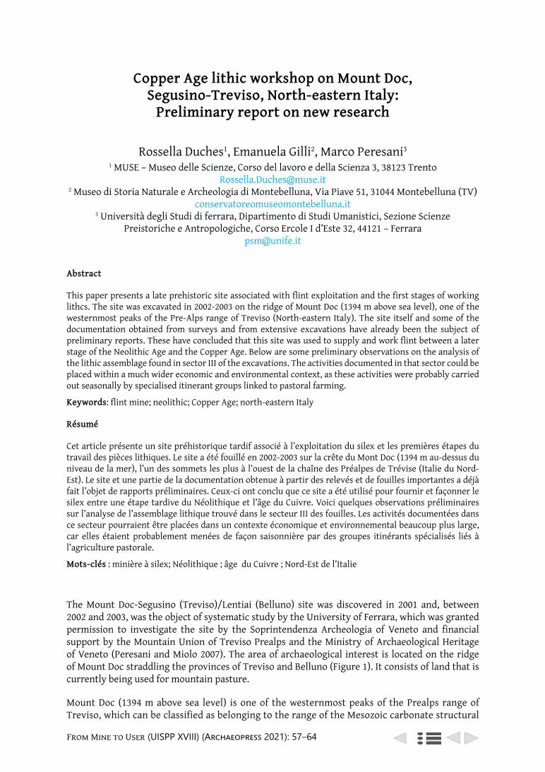
From Mine to User (UISPP XVIII) (Archaeopress 2021): 57–64
Copper Age lithic workshop on Mount Doc, Segusino-Treviso, North-eastern Italy:
Preliminary report on new research
Rossella Duches1, Emanuela Gilli2, Marco Peresani3
1 MUSE – Museo delle Scienze, Corso del lavoro e della Scienza 3, 38123 Trento [email protected]
2 Museo di Storia Naturale e Archeologia di Montebelluna, Via Piave 51, 31044 Montebelluna (TV) conservatoreomuseomontebelluna.it
3 Università degli Studi di ferrara, Dipartimento di Studi Umanistici, Sezione Scienze Preistoriche e Antropologiche, Corso Ercole I d’Este 32, 44121 – Ferrara
Abstract
This paper presents a late prehistoric site associated with flint exploitation and the first stages of working lithcs. The site was excavated in 2002-2003 on the ridge of Mount Doc (1394 m above sea level), one of the westernmost peaks of the Pre-Alps range of Treviso (North-eastern Italy). The site itself and some of the documentation obtained from surveys and from extensive excavations have already been the subject of preliminary reports. These have concluded that this site was used to supply and work flint between a later stage of the Neolithic Age and the Copper Age. Below are some preliminary observations on the analysis of the lithic assemblage found in sector III of the excavations. The activities documented in that sector could be placed within a much wider economic and environmental context, as these activities were probably carried out seasonally by specialised itinerant groups linked to pastoral farming.
Keywords: flint mine; neolithic; Copper Age; north-eastern Italy
Résumé
Cet article présente un site préhistorique tardif associé à l’exploitation du silex et les premières étapes du travail des pièces lithiques. Le site a été fouillé en 2002-2003 sur la crête du Mont Doc (1394 m au-dessus du niveau de la mer), l’un des sommets les plus à l’ouest de la chaîne des Préalpes de Trévise (Italie du Nord-Est). Le site et une partie de la documentation obtenue à partir des relevés et de fouilles importantes a déjà fait l’objet de rapports préliminaires. Ceux-ci ont conclu que ce site a été utilisé pour fournir et façonner le silex entre une étape tardive du Néolithique et l’âge du Cuivre. Voici quelques observations préliminaires sur l’analyse de l’assemblage lithique trouvé dans le secteur III des fouilles. Les activités documentées dans ce secteur pourraient être placées dans un contexte économique et environnemental beaucoup plus large, car elles étaient probablement menées de façon saisonnière par des groupes itinérants spécialisés liés à l’agriculture pastorale.
Mots-clés : minière à silex; Néolithique ; âge du Cuivre ; Nord-Est de l’Italie
The Mount Doc-Segusino (Treviso)/Lentiai (Belluno) site was discovered in 2001 and, between 2002 and 2003, was the object of systematic study by the University of Ferrara, which was granted permission to investigate the site by the Soprintendenza Archeologia of Veneto and financial support by the Mountain Union of Treviso Prealps and the Ministry of Archaeological Heritage of Veneto (Peresani and Miolo 2007). The area of archaeological interest is located on the ridge of Mount Doc straddling the provinces of Treviso and Belluno (Figure 1). It consists of land that is currently being used for mountain pasture.
Mount Doc (1394 m above sea level) is one of the westernmost peaks of the Prealps range of Treviso, which can be classified as belonging to the range of the Mesozoic carbonate structural
Copper Age lithic workshop on Mount Doc
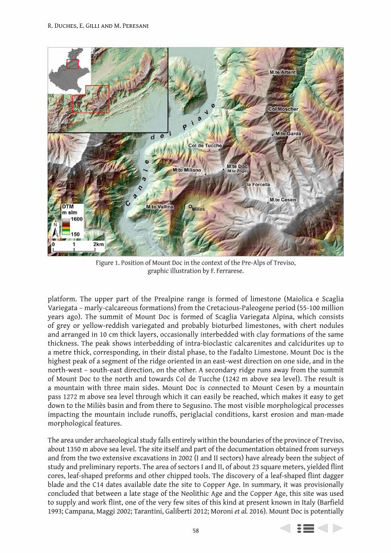
R. Duches, E. Gilli and M. Peresani
58
platform. The upper part of the Prealpine range is formed of limestone (Maiolica e Scaglia Variegata – marly-calcareous formations) from the Cretacious-Paleogene period (55-100 million years ago). The summit of Mount Doc is formed of Scaglia Variegata Alpina, which consists of grey or yellow-reddish variegated and probably bioturbed limestones, with chert nodules and arranged in 10 cm thick layers, occasionally interbedded with clay formations of the same thickness. The peak shows interbedding of intra-bioclastic calcarenites and calcidurites up to a metre thick, corresponding, in their distal phase, to the Fadalto Limestone. Mount Doc is the highest peak of a segment of the ridge oriented in an east-west direction on one side, and in the north-west – south-east direction, on the other. A secondary ridge runs away from the summit of Mount Doc to the north and towards Col de Tucche (1242 m above sea level). The result is a mountain with three main sides. Mount Doc is connected to Mount Cesen by a mountain pass 1272 m above sea level through which it can easily be reached, which makes it easy to get down to the Miliès basin and from there to Segusino. The most visible morphological processes impacting the mountain include runoffs, periglacial conditions, karst erosion and man-made morphological features.
The area under archaeological study falls entirely within the boundaries of the province of Treviso, about 1350 m above sea level. The site itself and part of the documentation obtained from surveys and from the two extensive excavations in 2002 (I and II sectors) have already been the subject of study and preliminary reports. The area of sectors I and II, of about 23 square meters, yielded flint cores, leaf-shaped preforms and other chipped tools. The discovery of a leaf-shaped flint dagger blade and the C14 dates available date the site to Copper Age. In summary, it was provisionally concluded that between a late stage of the Neolithic Age and the Copper Age, this site was used to supply and work flint, one of the very few sites of this kind at present known in Italy (Barfield 1993; Campana, Maggi 2002; Tarantini, Galiberti 2012; Moroni et al. 2016). Mount Doc is potentially
Figure 1. Position of Mount Doc in the context of the Pre-Alps of Treviso, graphic illustration by F. Ferrarese.
R. Duches, E. Gilli and M. Peresani
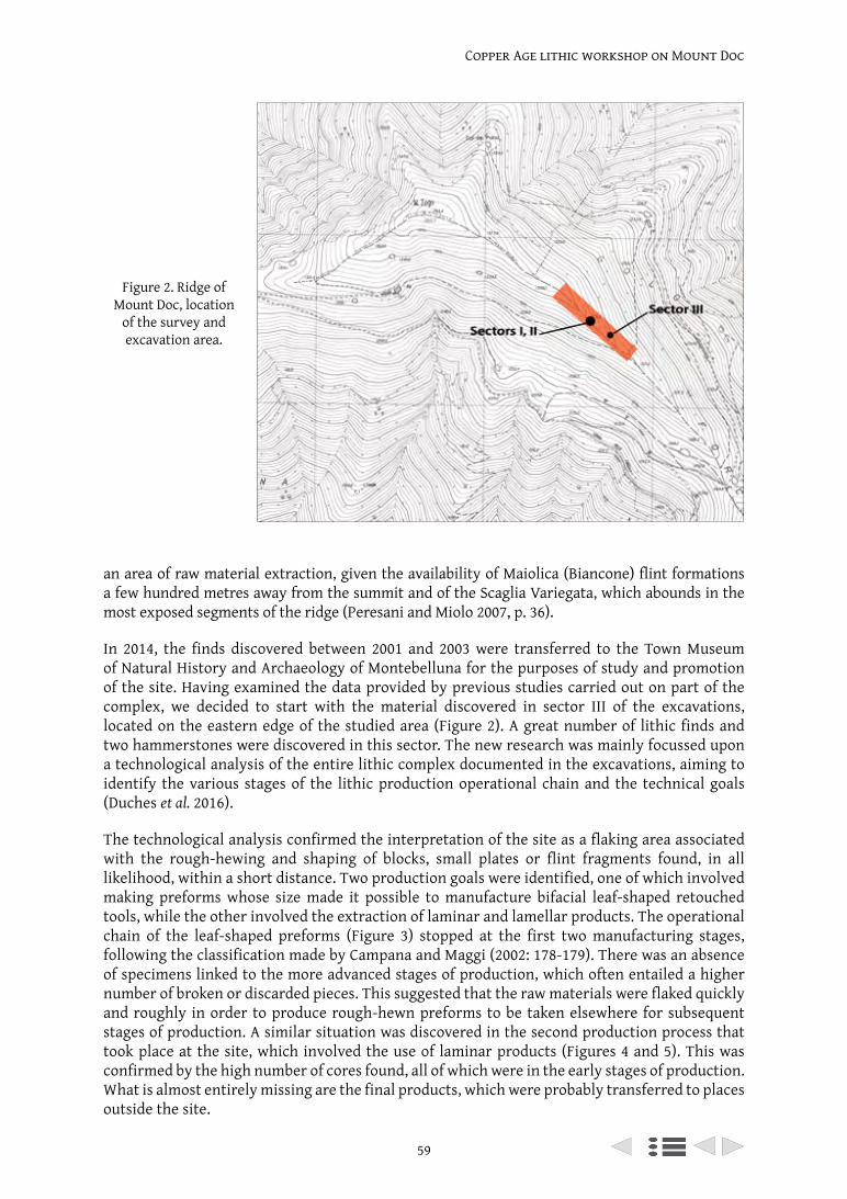
59
Copper Age lithic workshop on Mount Doc
an area of raw material extraction, given the availability of Maiolica (Biancone) flint formations a few hundred metres away from the summit and of the Scaglia Variegata, which abounds in the most exposed segments of the ridge (Peresani and Miolo 2007, p. 36).
In 2014, the finds discovered between 2001 and 2003 were transferred to the Town Museum of Natural History and Archaeology of Montebelluna for the purposes of study and promotion of the site. Having examined the data provided by previous studies carried out on part of the complex, we decided to start with the material discovered in sector III of the excavations, located on the eastern edge of the studied area (Figure 2). A great number of lithic finds and two hammerstones were discovered in this sector. The new research was mainly focussed upon a technological analysis of the entire lithic complex documented in the excavations, aiming to identify the various stages of the lithic production operational chain and the technical goals (Duches et al. 2016).
The technological analysis confirmed the interpretation of the site as a flaking area associated with the rough-hewing and shaping of blocks, small plates or flint fragments found, in all likelihood, within a short distance. Two production goals were identified, one of which involved making preforms whose size made it possible to manufacture bifacial leaf-shaped retouched tools, while the other involved the extraction of laminar and lamellar products. The operational chain of the leaf-shaped preforms (Figure 3) stopped at the first two manufacturing stages, following the classification made by Campana and Maggi (2002: 178-179). There was an absence of specimens linked to the more advanced stages of production, which often entailed a higher number of broken or discarded pieces. This suggested that the raw materials were flaked quickly and roughly in order to produce rough-hewn preforms to be taken elsewhere for subsequent stages of production. A similar situation was discovered in the second production process that took place at the site, which involved the use of laminar products (Figures 4 and 5). This was confirmed by the high number of cores found, all of which were in the early stages of production. What is almost entirely missing are the final products, which were probably transferred to places outside the site.
Figure 2. Ridge of Mount Doc, location
of the survey and excavation area.
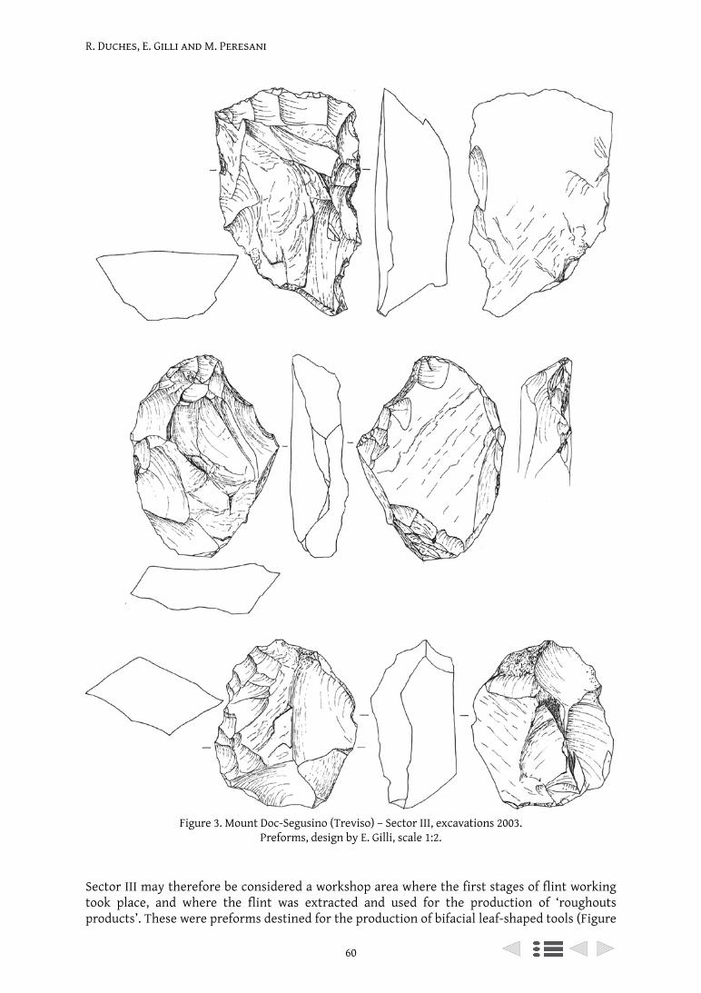
R. Duches, E. Gilli and M. Peresani
60
Sector III may therefore be considered a workshop area where the first stages of flint working took place, and where the flint was extracted and used for the production of ‘roughouts products’. These were preforms destined for the production of bifacial leaf-shaped tools (Figure
Figure 3. Mount Doc-Segusino (Treviso) – Sector III, excavations 2003. Preforms, design by E. Gilli, scale 1:2.
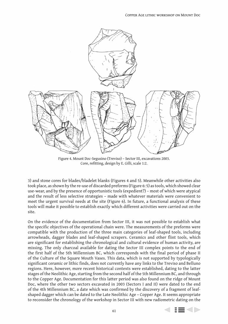
61
Copper Age lithic workshop on Mount Doc
3) and stone cores for blades/bladelet blanks (Figures 4 and 5). Meanwhile other activities also took place, as shown by the re-use of discarded preforms (Figure 6: 5) as tools, which showed clear use-wear, and by the presence of opportunistic tools (expedient?) – most of which were atypical and the result of less selective strategies – made with whatever materials were convenient to meet the urgent survival needs at the site (Figure 6). In future, a functional analysis of these tools will make it possible to establish exactly which different activities were carried out on the site.
On the evidence of the documentation from Sector III, it was not possible to establish what the specific objectives of the operational chain were. The measurements of the preforms were compatible with the production of the three main categories of leaf-shaped tools, including arrowheads, dagger blades and leaf-shaped scrapers. Ceramics and other flint tools, which are significant for establishing the chronological and cultural evidence of human activity, are missing. The only charcoal available for dating the Sector III complex points to the end of the first half of the 5th Millennium BC, which corresponds with the final period of phase II of the Culture of the Square Mouth Vases. This data, which is not supported by typologically significant ceramic or lithic finds, does not currently have any links to the Treviso and Belluno regions. Here, however, more recent historical contexts were established, dating to the latter stages of the Neolithic Age, starting from the second half of the 5th Millennium BC, and through to the Copper Age. Documentation for this latter period was also found on the ridge of Mount Doc, where the other two sectors excavated in 2003 (Sectors I and II) were dated to the end of the 4th Millennium BC, a date which was confirmed by the discovery of a fragment of leaf-shaped dagger which can be dated to the Late Neolithic Age – Copper Age. It seems appropriate to reconsider the chronology of the workshop in Sector III with new radiometric dating on the
Figure 4. Mount Doc-Segusino (Treviso) – Sector III, excavations 2003. Core, refitting, design by E. Gilli, scale 1:2.
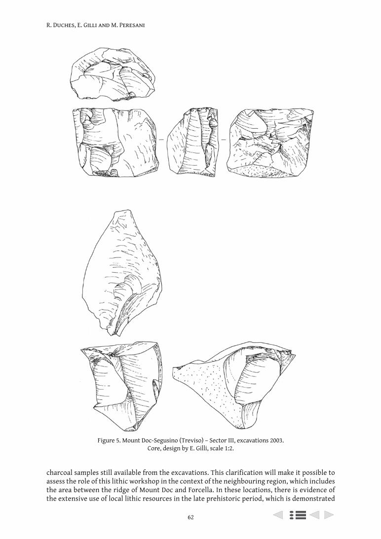
R. Duches, E. Gilli and M. Peresani
62
charcoal samples still available from the excavations. This clarification will make it possible to assess the role of this lithic workshop in the context of the neighbouring region, which includes the area between the ridge of Mount Doc and Forcella. In these locations, there is evidence of the extensive use of local lithic resources in the late prehistoric period, which is demonstrated
Figure 5. Mount Doc-Segusino (Treviso) – Sector III, excavations 2003. Core, design by E. Gilli, scale 1:2.
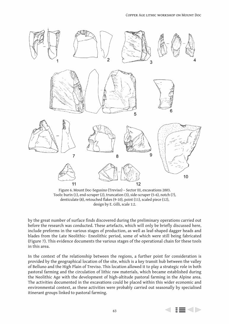
63
Copper Age lithic workshop on Mount Doc
Figure 6. Mount Doc-Segusino (Treviso) – Sector III, excavations 2003. Tools: burin (1), end-scraper (2), truncation (3), side-scraper (5-6), notch (7),
denticulate (8), retouched flakes (9-10), point (11), scaled piece (12), design by E. Gilli, scale 1:2.
by the great number of surface finds discovered during the preliminary operations carried out before the research was conducted. These artefacts, which will only be briefly discussed here, include preforms in the various stages of production, as well as leaf-shaped dagger heads and blades from the Late Neolithic- Eneolithic period, some of which were still being fabricated (Figure 7). This evidence documents the various stages of the operational chain for these tools in this area.
In the context of the relationship between the regions, a further point for consideration is provided by the geographical location of the site, which is a key transit hub between the valley of Belluno and the High Plain of Treviso. This location allowed it to play a strategic role in both pastoral farming and the circulation of lithic raw materials, which became established during the Neolithic Age with the development of high-altitude pastoral farming in the Alpine area. The activities documented in the excavations could be placed within this wider economic and environmental context, as these activities were probably carried out seasonally by specialised itinerant groups linked to pastoral farming.
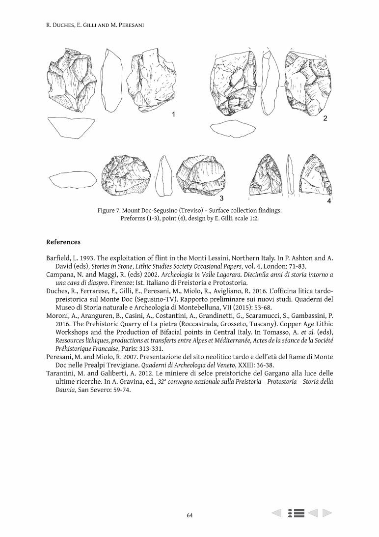
R. Duches, E. Gilli and M. Peresani
64
References
Barfield, L. 1993. The exploitation of flint in the Monti Lessini, Northern Italy. In P. Ashton and A. David (eds), Stories in Stone, Lithic Studies Society Occasional Papers, vol. 4, London: 71-83.
Campana, N. and Maggi, R. (eds) 2002. Archeologia in Valle Lagorara. Diecimila anni di storia intorno a una cava di diaspro. Firenze: Ist. Italiano di Preistoria e Protostoria.
Duches, R., Ferrarese, F., Gilli, E., Peresani, M., Miolo, R., Avigliano, R. 2016. L’officina litica tardo-preistorica sul Monte Doc (Segusino-TV). Rapporto preliminare sui nuovi studi. Quaderni del Museo di Storia naturale e Archeologia di Montebelluna, VII (2015): 53-68.
Moroni, A., Aranguren, B., Casini, A., Costantini, A., Grandinetti, G., Scaramucci, S., Gambassini, P. 2016. The Prehistoric Quarry of La pietra (Roccastrada, Grosseto, Tuscany). Copper Age Lithic Workshops and the Production of Bifacial points in Central Italy. In Tomasso, A. et al. (eds), Ressources lithiques, productions et transferts entre Alpes et Méditerranée, Actes de la séance de la Société Préhistorique Francaise, Paris: 313-331.
Peresani, M. and Miolo, R. 2007. Presentazione del sito neolitico tardo e dell’età del Rame di Monte Doc nelle Prealpi Trevigiane. Quaderni di Archeologia del Veneto, XXIII: 36-38.
Tarantini, M. and Galiberti, A. 2012. Le miniere di selce preistoriche del Gargano alla luce delle ultime ricerche. In A. Gravina, ed., 32° convegno nazionale sulla Preistoria – Protostoria – Storia della Daunia, San Severo: 59-74.
Figure 7. Mount Doc-Segusino (Treviso) – Surface collection findings. Preforms (1-3), point (4), design by E. Gilli, scale 1:2.
From Mine to User (UISPP XVIII) (Archaeopress 2021): 65–77
La minière à silex néolithique de Lisle « les Sablons » (Loir-et-Cher, France). Premiers résultats de 3 campagnes
de fouille de 2016 à 2018
Harold Lethrosne1, Olivia Dupart2, Clément Recq3 1 UMR 8215/Archéologie Pour Tous
[email protected] UMR 8215/université Paris 1 Panthéon-Sorbonne
[email protected] 3 Archéologie Pour Tous
Summary
Since 2016, an archaeological excavation has taken place at Lisle, on the ‘Les Sablons’ a Neolithic site (Loir-et-Cher, France). This paper focuses on presenting the first results from three excavation campaigns (2016 to 2018).
Located in the Paris basin, the site is located on the top of a hill in the Loir valley. At this location, the hill is cut by a thalweg, revealing the flint deposits in the clay above the Senonian chalk layers. The archeological site is thus situated on top of these clayey flint deposits.
The Sablons site has been known since the XIXth century, surface surveys having collected many bifacial preparation flakes and flint axe blade preforms. Flint axe production had thus already been identified on-site.
The first mechanical soundings and the excavations have revealed several archaeological layers with flint artifacts, but their altered surface condition indicated their subsurface movement. The geo-archaeological study demonstrated that these first layers are hillslope colluvium, deposited after the Neolithic occupation. These are associated with the erosion of the Neolithic ground surface. Beneath the colluvium three circular pits were discovered on the small surface excavated, their diameter measuring between 1.5 and 2.0 meters. The excavation of these pits has started but is ongoing. Their fill is composed of large amounts of flint knapping debris, organized in successive layers of rejected material. These pits, dug into the flint clayey deposits, are interpreted as raw material extraction pits, subsequently filled by the debris of stone-knapping workshops.
The first technological studies demonstrate that stone-knapping activity focuses on the making of flint axe blades. To date, only one ‘chaîne opératoire’ – production process – has been identified on the site. All the shaping processes are present, from the initial roughing-out with the removal of thick cortical flakes to the regularization of the blade with finer and smaller shaping flakes. Debitage characteristics and butt preparation display an evolution in knapping techniques during the shaping process.
The blanks used for this production can either be blocks, fragments of blocks, or big flakes. Some pieces show great regularity, whereas other preforms demonstrate a clear lack of mastery in stone-knapping techniques or a poor choice of blank. The reasons for abandoning preforms are mainly linked to the quality of the raw materials.
Other types of tool are scarce and opportunistic in nature: their blanks being axe blade shaping flakes.
Only one raw material has been exploited for the whole flint industry: it is a Secondary Era flint from the Upper Cretaceous with occasionally a grainy texture in the centre from poorly silicified geodes, creating a heterogeneous grey matrix. These flint nodules are several decimetres in length, sometimes branchy. According to the first petro-archaeological observations, the raw material is local, concerning flint extraction/mining as well as axe blade production.
The first excavation/fieldwork campaigns at the ‘Les Sablons’ site have thus allowed us to identify a neolithic mining site which specialized in flint-axe blade production. Further fieldwork will bring a better
La minière à silex néolithique de Lisle « les Sablons »
Harold Lethrosne, Olivia Dupart and Clément Recq
66
understanding of the site’s organization. Knowledge of the flint extraction methods and technique as well as the axe blade ‘chaîne opératoire’ in the Vendomois Loir area will also benefit from future excavation campaigns. In this region flint-axe production began during the late Neolithic period, whereas flint mining activity had developed earlier in the rest of the Paris Basin during the middle Neolithic.
Keywords: flint mining, neolithic, axeheads, chaine operatoire, Loir valley
Mots-clés :minière à silex, Néolithique, hache, chaîne opératoire, vallée du Loir
Résumé
Cet article présente les premiers résultats de trois campagnes de fouille archéologique programmée (2016-2018) sur une minière à silex néolithique à Lisle « les Sablons » localisée dans la vallée du Loir. Les matériaux siliceux extraits sont exploités pour la production de haches.
1. Introduction
Le site de Lisle « les Sablons » est connu depuis le XIXe siècle par des prospections de surface. Les nombreuses préparations de pièces bifaciales et d’ébauches de lames de haches en silex associées à de grandes quantités d’éclats découverts à la surface des champs cultivés ont orienté, dès cette période, l’interprétation de la fonction du site comme un atelier spécialisé dans le façonnage de haches en silex.
Le caractère dominant de cette chaîne opératoire de production dans la série lithique récoltée a permis plus récemment d’effectuer un rapprochement avec le site de Pezou « la Chenevière-Dieu » qui se trouve face au site des Sablons, à quelques kilomètres, sur l’autre rive du Loir. Fouillé par Jackie Despriée à la charnière des années 1960-1970, la « Chenevière-Dieu » s’avère être un site d’extraction de silex et de production de lames de haches en silex (Lethrosne, Despriée, 2014).
Au sein du même secteur géographique de la vallée du Loir, plusieurs autres indices de sites similaires aux « Sablons » et à la « Chenevière-Dieu » sont identifiés par des prospections (Lethrosne, Lecoeuvre, 2016). Tous ces indices de sites se localisent systématiquement à l’aplomb des affleurements des argiles à silex, dans un même contexte géologique et géomorphologique. L’hypothèse d’ateliers spécialisés localisés sur les gîtes même d’extraction de matériaux siliceux destinés à la production de haches est ainsi avancée. Elle a motivé la réalisation de sondages archéologiques en premier lieu sur le site des « Sablons », là où la série d’artefacts récoltés était la plus importante numériquement et la localisation des ramassages mieux définie.
Si le façonnage de haches a bien été reconnu au travers des artefacts récoltés en surface, une étude technologique approfondie de ces industries en silex constitue une opportunité pour mieux caractériser cette chaîne opératoire de production ainsi que ses corollaires socio-économiques à l’échelle du site même puis du territoire. De même, les problématiques liées aux modalités d’extraction des matières premières (techniques, stratégie d’exploitation, durée de l’activité) ne peuvent être que trop rarement abordées. Ce travail se propose de présenter les premiers résultats des trois campagnes de fouilles archéologiques programmées de deux semaines chacune, réalisées depuis 2016.
2. Contexte géographique et géomorphologique
Le gisement néolithique de Lisle « Les Sablons » se situe donc au sud-ouest du Bassin Parisien, dans la vallée du Loir qui recoupe à cet endroit la limite entre l’auréole crétacée et les formations lacustres tertiaires de Beauce, proche de la remontée structurale du socle armoricain (Despriée et al. 2003).
Harold Lethrosne, Olivia Dupart and Clément Recq
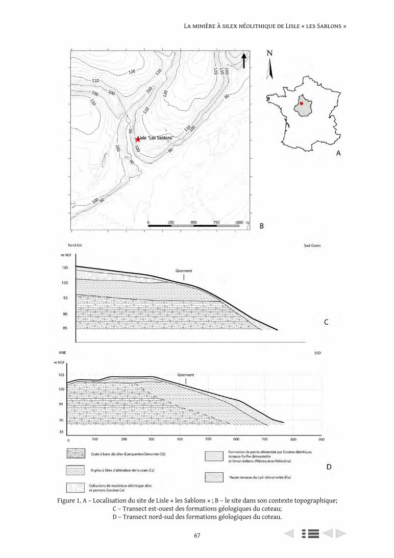
67
La minière à silex néolithique de Lisle « les Sablons »
Figure 1. A – Localisation du site de Lisle « les Sablons » ; B – le site dans son contexte topographique; C – Transect est-ouest des formations géologiques du coteau; D – Transect nord-sud des formations géologiques du coteau.
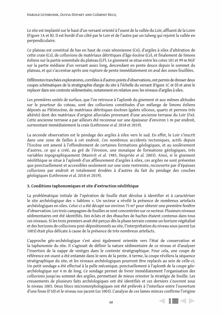
Harold Lethrosne, Olivia Dupart and Clément Recq
68
Le site est implanté sur le haut d’un versant orienté à l’ouest de la vallée du Loir, affluent de la Loire (Figure 1A et B). Il est bordé d’un côté par le Loir et de l’autre par un talweg qui rejoint la vallée en perpendiculaire.
Ce plateau est constitué de bas en haut de craie sénonienne (C6), d’argiles à silex d’altération de cette craie (Cs), de colluvions de matériaux détritiques d’âge éocène (Ce), et finalement de limons éoliens sur la partie sommitale du plateau (LP). Le gisement se situe entre les cotes 101 et 99 m NGF sur la partie médiane d’un versant assez long, descendant en pente douce depuis le sommet du plateau, et qui s’accentue après une rupture de pente immédiatement en aval des zones fouillées.
Différentes tranchées exploratoires, corrélées à d’autres points d’observations, ont permis de dresser deux coupes schématiques de la stratigraphie élargie du site à l’échelle du versant (Figure 1C et D) et ainsi le replacer dans son contexte sédimentaire, notamment en relation avec les niveaux d’argiles à silex.
Les premières unités de surface, que l’on retrouve à l’aplomb du gisement et aux mêmes altitudes sur le pourtour du coteau, sont des colluvions constituées d’un mélange de limons éoliens déposés au Pléistocène, de matériaux détritiques éocènes (galets siliceux, quartz et perrons très altérés) dont des matériaux d’origine alluviales provenant d’une ancienne terrasse du Loir (Fw). Cette ancienne terrasse a par ailleurs été reconnue sur une épaisseur d’environ 1 m par endroit, surmontant immédiatement la craie (Lethrosne et al. 2018 et 2019).
La seconde observation est le pendage des argiles à silex vers le sud. En effet, le Loir s’inscrit dans une zone de failles à cet endroit. Ces nombreux accidents tectoniques, actifs depuis l’Eocène ont amené à l’effondrement de certaines formations géologiques, et au soulèvement d’autres, ce qui a créé, au gré de l’érosion, une mosaïque de formations géologiques, très variables topographiquement (Manivit et al. 1983, Despriée et al. 2003). Ainsi, si le gisement néolithique se situe à l’aplomb d’un affleurement d’argiles à silex, ces argiles ne sont présentes que ponctuellement et accessibles seulement sur une zone restreinte, recouverte par d’épaisses colluvions par endroit et totalement érodées à d’autres du fait du pendage des couches géologiques (Lethrosne et al. 2018 et 2019).
3. Conditions taphonomiques et site d’extraction néolithique
La problématique initiale de l’opération de fouille était dévolue à identifier et à caractériser le site archéologique des « Sablons ». Un secteur a révélé la présence de nombreux artefacts archéologiques en silex. Celui-ci a été décapé sur environ 75 m² pour obtenir une première fenêtre d’observation. Les trois campagnes de fouilles se sont concentrées sur ce secteur. Plusieurs niveaux sédimentaires ont été identifiés. Des éclats et des ébauches de haches étaient contenus dans tous ces niveaux. Si les trois premiers avait été perçus dès la phase terrain comme un horizon végétalisé et des horizons de colluvions post-dépositionnels au site, l’interprétation du niveau sous-jacent (us 1003) était plus délicate à cause de la présence de très nombreux artefacts.
L’approche géo-archéologique s’est ainsi également orientée vers l’état de conservation et la taphonomie du site. Il s’agissait de définir la nature sédimentaire de ce niveau et d’analyser l’insertion de la nappe de vestiges dans le contexte stratigraphique. Pour cela, une coupe de référence est-ouest a été entamée dans le sens de la pente. A terme, la coupe révélera la séquence stratigraphique du site, et les niveaux archéologiques pourront être replacés au sein de celle-ci. Un petit sondage a été effectué à la pelle mécanique, ponctuellement à l’aplomb de la coupe géo-archéologique sur 4 m de long. Ce sondage permet de livrer immédiatement l’organisation des colluvions jusqu’au sommet des argiles, permettant de mieux orienter la stratégie de fouille. Les creusements de plusieurs faits archéologiques ont été identifiés et ces derniers s’ouvrent sous le niveau 1003. Deux blocs micromorphologiques ont été prélevés à l’interface entre l’ouverture d’une fosse (F10) et le niveau sus-jacent (us 1003). L’analyse de ces lames minces confirme l’origine
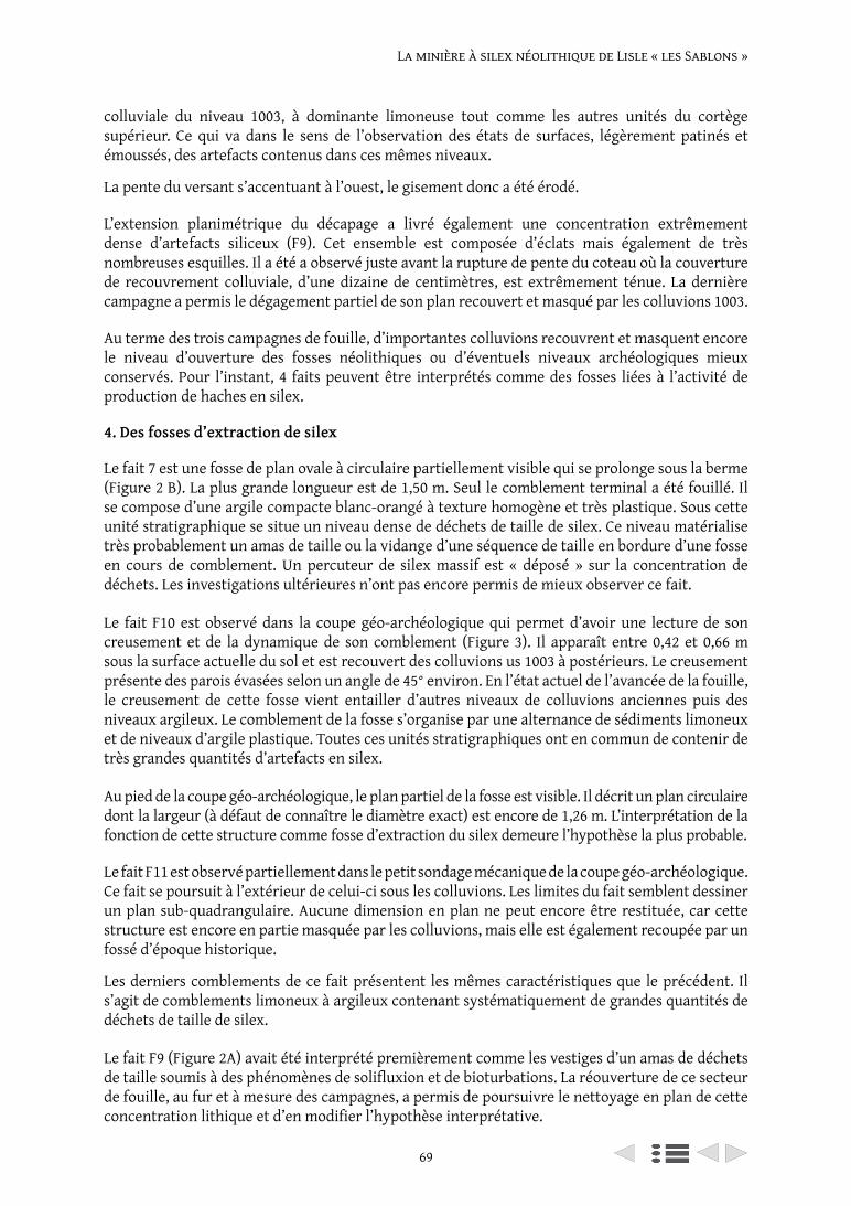
69
La minière à silex néolithique de Lisle « les Sablons »
colluviale du niveau 1003, à dominante limoneuse tout comme les autres unités du cortège supérieur. Ce qui va dans le sens de l’observation des états de surfaces, légèrement patinés et émoussés, des artefacts contenus dans ces mêmes niveaux.
La pente du versant s’accentuant à l’ouest, le gisement donc a été érodé.
L’extension planimétrique du décapage a livré également une concentration extrêmement dense d’artefacts siliceux (F9). Cet ensemble est composée d’éclats mais également de très nombreuses esquilles. Il a été a observé juste avant la rupture de pente du coteau où la couverture de recouvrement colluviale, d’une dizaine de centimètres, est extrêmement ténue. La dernière campagne a permis le dégagement partiel de son plan recouvert et masqué par les colluvions 1003.
Au terme des trois campagnes de fouille, d’importantes colluvions recouvrent et masquent encore le niveau d’ouverture des fosses néolithiques ou d’éventuels niveaux archéologiques mieux conservés. Pour l’instant, 4 faits peuvent être interprétés comme des fosses liées à l’activité de production de haches en silex.
4. Des fosses d’extraction de silex
Le fait 7 est une fosse de plan ovale à circulaire partiellement visible qui se prolonge sous la berme (Figure 2 B). La plus grande longueur est de 1,50 m. Seul le comblement terminal a été fouillé. Il se compose d’une argile compacte blanc-orangé à texture homogène et très plastique. Sous cette unité stratigraphique se situe un niveau dense de déchets de taille de silex. Ce niveau matérialise très probablement un amas de taille ou la vidange d’une séquence de taille en bordure d’une fosse en cours de comblement. Un percuteur de silex massif est « déposé » sur la concentration de déchets. Les investigations ultérieures n’ont pas encore permis de mieux observer ce fait.
Le fait F10 est observé dans la coupe géo-archéologique qui permet d’avoir une lecture de son creusement et de la dynamique de son comblement (Figure 3). Il apparaît entre 0,42 et 0,66 m sous la surface actuelle du sol et est recouvert des colluvions us 1003 à postérieurs. Le creusement présente des parois évasées selon un angle de 45° environ. En l’état actuel de l’avancée de la fouille, le creusement de cette fosse vient entailler d’autres niveaux de colluvions anciennes puis des niveaux argileux. Le comblement de la fosse s’organise par une alternance de sédiments limoneux et de niveaux d’argile plastique. Toutes ces unités stratigraphiques ont en commun de contenir de très grandes quantités d’artefacts en silex.
Au pied de la coupe géo-archéologique, le plan partiel de la fosse est visible. Il décrit un plan circulaire dont la largeur (à défaut de connaître le diamètre exact) est encore de 1,26 m. L’interprétation de la fonction de cette structure comme fosse d’extraction du silex demeure l’hypothèse la plus probable.
Le fait F11 est observé partiellement dans le petit sondage mécanique de la coupe géo-archéologique. Ce fait se poursuit à l’extérieur de celui-ci sous les colluvions. Les limites du fait semblent dessiner un plan sub-quadrangulaire. Aucune dimension en plan ne peut encore être restituée, car cette structure est encore en partie masquée par les colluvions, mais elle est également recoupée par un fossé d’époque historique.
Les derniers comblements de ce fait présentent les mêmes caractéristiques que le précédent. Il s’agit de comblements limoneux à argileux contenant systématiquement de grandes quantités de déchets de taille de silex.
Le fait F9 (Figure 2A) avait été interprété premièrement comme les vestiges d’un amas de déchets de taille soumis à des phénomènes de solifluxion et de bioturbations. La réouverture de ce secteur de fouille, au fur et à mesure des campagnes, a permis de poursuivre le nettoyage en plan de cette concentration lithique et d’en modifier l’hypothèse interprétative.
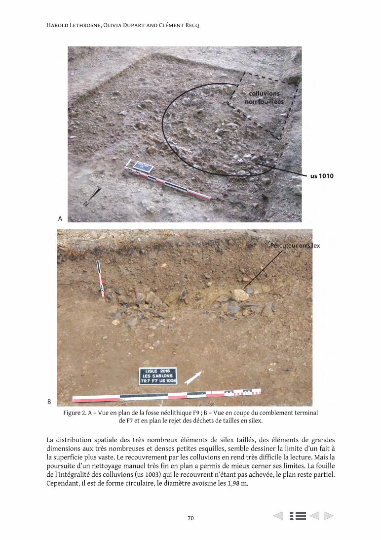
Harold Lethrosne, Olivia Dupart and Clément Recq
70
La distribution spatiale des très nombreux éléments de silex taillés, des éléments de grandes dimensions aux très nombreuses et denses petites esquilles, semble dessiner la limite d’un fait à la superficie plus vaste. Le recouvrement par les colluvions en rend très difficile la lecture. Mais la poursuite d’un nettoyage manuel très fin en plan a permis de mieux cerner ses limites. La fouille de l’intégralité des colluvions (us 1003) qui le recouvrent n’étant pas achevée, le plan reste partiel. Cependant, il est de forme circulaire, le diamètre avoisine les 1,98 m.
Figure 2. A – Vue en plan de la fosse néolithique F9 ; B – Vue en coupe du comblement terminal de F7 et en plan le rejet des déchets de tailles en silex.
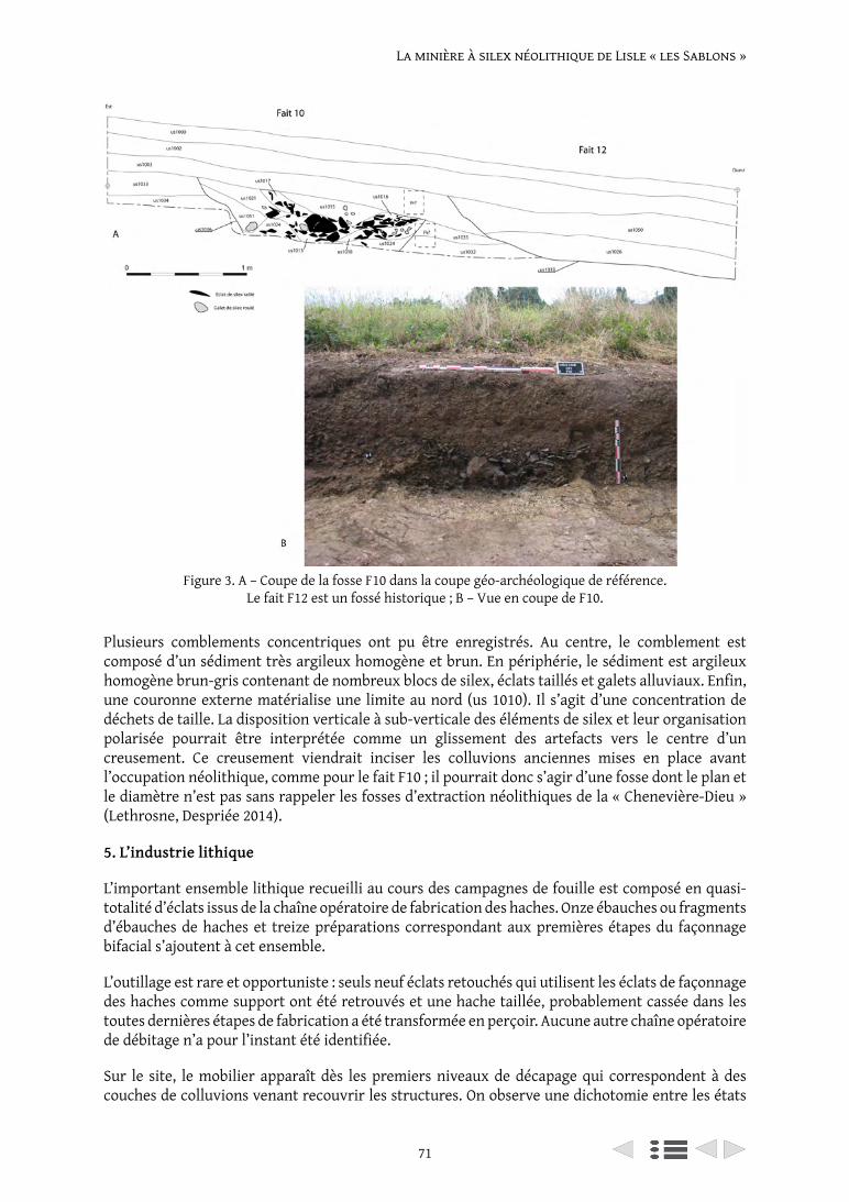
71
La minière à silex néolithique de Lisle « les Sablons »
Plusieurs comblements concentriques ont pu être enregistrés. Au centre, le comblement est composé d’un sédiment très argileux homogène et brun. En périphérie, le sédiment est argileux homogène brun-gris contenant de nombreux blocs de silex, éclats taillés et galets alluviaux. Enfin, une couronne externe matérialise une limite au nord (us 1010). Il s’agit d’une concentration de déchets de taille. La disposition verticale à sub-verticale des éléments de silex et leur organisation polarisée pourrait être interprétée comme un glissement des artefacts vers le centre d’un creusement. Ce creusement viendrait inciser les colluvions anciennes mises en place avant l’occupation néolithique, comme pour le fait F10 ; il pourrait donc s’agir d’une fosse dont le plan et le diamètre n’est pas sans rappeler les fosses d’extraction néolithiques de la « Chenevière-Dieu » (Lethrosne, Despriée 2014).
5. L’industrie lithique
L’important ensemble lithique recueilli au cours des campagnes de fouille est composé en quasi-totalité d’éclats issus de la chaîne opératoire de fabrication des haches. Onze ébauches ou fragments d’ébauches de haches et treize préparations correspondant aux premières étapes du façonnage bifacial s’ajoutent à cet ensemble.
L’outillage est rare et opportuniste : seuls neuf éclats retouchés qui utilisent les éclats de façonnage des haches comme support ont été retrouvés et une hache taillée, probablement cassée dans les toutes dernières étapes de fabrication a été transformée en perçoir. Aucune autre chaîne opératoire de débitage n’a pour l’instant été identifiée.
Sur le site, le mobilier apparaît dès les premiers niveaux de décapage qui correspondent à des couches de colluvions venant recouvrir les structures. On observe une dichotomie entre les états
Figure 3. A – Coupe de la fosse F10 dans la coupe géo-archéologique de référence. Le fait F12 est un fossé historique ; B – Vue en coupe de F10.
Harold Lethrosne, Olivia Dupart and Clément Recq
72
de surface altérés des pièces issues de ces horizons secondaires et ceux des artefacts provenant des comblements des structures qui présentent un très bon état de conservation.
L’analyse technologique de l’industrie en silex qui est présentée ici s’est principalement concentrée sur les ensembles bien caractérisés et bien conservés issus des structures en creux.
Le fait F7, fouillé et étudié en 2016, contenait pour seul outil un gros percuteur en silex (1426 g) et 477 artefacts parmi lesquels 248 éclats ont pu être formellement rattachés à la chaîne opératoire de fabrication des haches.
L’étude et la fouille du fait F10, débutée en 2017 et poursuivie en 2018 compose un nouvel ensemble qui, malgré un bon état de conservation des surfaces (arêtes très vives, absence de patine) présente une forte part fragmentaire (environ 80%) qui réduit les possibilités de détermination technologique : sur 2842 pièces issues des niveaux de comblement de cette structure, seuls 985 éclats se rattachent clairement à la chaîne opératoire de fabrication des haches. Cette fosse contenait également une préparation bifaciale et une préparation bifaciale bilatérale réalisées sur bloc et un outil sur éclat à bord abattu.
La dernière campagne de fouille en 2018 a permis de débuter la fouille d’une nouvelle structure (F11) et permet d’enrichir le corpus d’un nouvel ensemble de 1382 artefacts dont deux préparations et deux fragments d’ébauches de haches. Comme pour F10, les éclats, souvent fragmentés, sont moins aisément déterminables et seulement 500 pièces issues de ce fait ont pu être réintégrées dans la chaîne opératoire de fabrication des haches.
À ce jour, 5334 artefacts ont été étudiés. Ils représentent une masse totale de près de 90 kg.
Sur le site, un seul type de matière première a été repéré. Il s’agit d’un silex secondaire du crétacé supérieur qui se présente sous la forme de rognons pluridécimétriques, parfois branchus. Le cortex est très fin, d’un à deux millimètres d’épaisseur, et de couleur blanc cassé à beige. L’aspect macroscopique de la matrice est hétérogène : en partie sous-corticale, elle est translucide au grain fin et de teinte gris-blond, tandis que le cœur du matériau est de couleur gris à bleu ; la texture est hétérogène, parfois très grenue avec fréquemment des irrégularités (zones mal silicifiées, géodes). Ces différents défauts de la matrice rendent l’aptitude à la taille de qualité moyenne.
D’après les premières observations pétro-archéologiques, il s’agirait bien du silex local issu des argiles. Cette matière première présente les mêmes caractéristiques que celle utilisée sur le site d’extraction et les ateliers de façonnage de haches de Pezou « la Chenevière-Dieu » (Lethrosne 2012) situé sur l’autre rive de la vallée du Loir.
Les objectifs de l’étude technologique des ensembles issus des différentes structures visent à caractériser la ou les chaînes opératoires en présence et à en préciser les modalités techniques de réalisation. L’analyse de la répartition stratigraphique et spatiale des vestiges en fonction des critères technologiques a pour objectif de comprendre les modalités d’exploitation du site et son fonctionnement.
Les critères d’étude des déchets de taille ont été établis en fonction des travaux de référence sur les ateliers de taille de haches en contexte minier (Augereau 1995 ; Giligny et Bostyn 2016) qui définissent les critères morpho-techniques à prendre en compte dans la définition des étapes de la chaîne opératoire.
Les éclats ont été classés selon quatre étapes : le dégrossissage vise à enlever le cortex et les irrégularités du bloc, les éclats sont larges, très épais (la majorité d’entre eux ont des épaisseurs
73
La minière à silex néolithique de Lisle « les Sablons »
supérieures à 15 mm) et au moins 50% de leur surface est corticale. L’étape de mise en forme permet de débuter la mise en place du façonnage bifacial qui sera abouti lors de la phase de façonnage proprement dite. Les plages de cortex diminuent, elles sont généralement inférieures à 25% et les éclats deviennent majoritairement non corticaux à partir du façonnage. Les épaisseurs s’affinent, la plupart sont comprises entre 5 et 15 mm pour la mise en forme ; pour le façonnage, elles se distribuent également entre les classes les plus fines (0-5 mm) et les classes d’épaisseurs moyennes (5-15 mm). Les éclats deviennent arqués avec une plus forte proportion de talons dièdres formés par les négatifs des contre-bulbes des éclats précédents, en lien avec le caractère bifacial du façonnage. Si du cortex est présent, il s’agit de plages résiduelles généralement situées en partie distale. Les éclats de flûtage qui permettent d’amincir la pièce par un enlèvement longitudinal ont été intégrés à l’étape du façonnage. Les éclats de régularisation se caractérisent par des dimensions plus modestes (inférieure à 30 mm) et avec des épaisseurs toujours inférieures à 5 mm, ils sont systématiquement non corticaux.
Les résultats présentés se basent sur les éclats ayant pu être réintégrés dans la chaîne opératoire de fabrication des haches. Les éclats indéterminés sont généralement des éclats cassés mais leurs caractéristiques générales ne s’opposent pas à leur attribution à cette même chaîne opératoire.
L’analyse technologique du mobilier issu des structures en creux a permis de montrer que l’ensemble des étapes de la chaîne opératoire de fabrication des haches est présente sur le site.
On constate une distribution différentielle des étapes de façonnage entre les différentes structures.
Le fait F7 présente un ensemble lithique qui s’installe dans la partie sommitale du comblement de la fosse. L’organisation spatiale des éléments issus de cette structure évoque un amas. Plusieurs éléments lithiques ont pu être remontés, indiquant qu’au moins un bloc a été façonné sur place.
Les éclats les plus représentés sont ceux qui correspondent aux toutes premières étapes de la chaîne opératoire : 24 % appartiennent au dégrossissage et 21% à la mise en forme. Les éclats de façonnage représentent un peu moins de la moitié du corpus déterminable (44%) et les éclats de régularisation sont très peu représentés (11%).
Le fait F10 présente une organisation très différente. A la fouille, on perçoit nettement une organisation des couches comme autant de rejets successifs qui pourraient correspondre à des vidanges de zones d’ateliers.
La représentation des étapes de la chaîne opératoire est inversée par rapport au fait F7 : les éclats de dégrossissage et de mise en forme ne représentent plus que respectivement 6% et 9,5%. Le façonnage est également moins bien représenté que dans le premier ensemble (33%) tandis que les éclats de régularisation deviennent majoritaires à l’échelle des éléments caractérisés (51,5%).
Enfin, les dernières données issues de l’étude du fait F11 montrent que, comme pour le fait F10, les premières étapes de la chaîne opératoires sont mal représentées : 8% d’éclats de dégrossissage et 7,5% d’éclats de mise en forme. Le façonnage est en revanche largement majoritaire puisqu’il représente 55,5% des effectifs caractérisés ; les éclats de régularisation représentent 29% de cet ensemble.
Ces premiers éléments permettent de mettre en évidence une répartition différentielle des déchets de taille issus de la chaîne opératoire de fabrication des haches. Si toutes les étapes du processus de façonnage sont représentées sur le site, la composition des ensembles issus des trois faits dont l’étude a été entamée laissent clairement percevoir un tri entre ses différentes séquences. Cela sous-entend, soit une segmentation dans l’organisation de la production sur le site, soit une distribution séquencée des rejets des déchets de taille dans les structures en creux.
Harold Lethrosne, Olivia Dupart and Clément Recq
74
Sur l’ensemble du corpus, deux techniques de taille ont été mis en évidence. La percussion dure est clairement identifiée, en particulier lors des premières étapes de dégrossissage et de mise en forme. Néanmoins, assez tôt dans le processus de façonnage, certains éléments comme la présence d’une lèvre, la discrétion du point d’impact, un bulbe diffus et l’utilisation récurrente d’une préparation des talons par abrasion évoquent l’utilisation de la percussion directe tendre. Elle est plus clairement attestée lors du façonnage et elle est majoritairement utilisée pour le détachement des éclats de régularisation. Ces éléments sont interprétés comme significatifs de l’utilisation de la percussion tendre minérale qui a déjà été reconnue dans des contextes similaires, en particulier sur les ateliers de production de haches en silex de la vallée du Loing, notamment sur le site de Fontenay-sur-Loing « La Plaine du Bois des Courillons » (Creusillet, Bourne 2016).
L’évolution des stigmates de percussion au cours de l’avancement du processus de façonnage doit également prendre en compte le changement de gestuelle du tailleur induit par le caractère bifacial du façonnage. Cela entraîne la mise en œuvre d’un geste tangentiel qui permet d’obtenir un allongement des enlèvements tout en réduisant leur épaisseur. Ce changement de geste constitue une autre variable à prendre en compte dans les critères de reconnaissance du type de percuteur utilisé.
Les ébauches et préparations de haches retrouvées sur le site sont des déchets de fabrication et ne peuvent être strictement considérées comme des témoins représentatifs de l’objectif de production. Elles permettent néanmoins d’éclairer la mise en œuvre de la production sur le site et d’estimer le niveau de savoir-faire des tailleurs.
Les préparations correspondent aux premiers stades de mise en forme des ébauches. Elles sont généralement abandonnées avant la mise en place d’un façonnage bifacial bilatéral. Différents types de supports sont utilisés : blocs, fragments de bloc ou éclats. Pour un tiers des pièces, les causes de rejet sont en lien avec la présence d’irrégularités dans la matière première (diaclases, mauvaise silicification,...) qui entraînent des accidents, tandis que les autres préparations montrent des problèmes de morphologie du support (manque d’angulation). Certaines erreurs de taille ne permettent pas de poursuivre le façonnage.
Les ébauches sont les pièces pour lesquelles le façonnage est entamé. Comme pour les préparations, elles sont généralement façonnées sur bloc ou fragment de bloc mais plusieurs sont sur éclat (Figure 4). Elles présentent une morphologie ovalaire et des sections ovalaires ou losangiques. Pour 70% des ébauches, les causes d’abandon sont liées à la mauvaise qualité de la matière première.
Les ébauches entières ont des longueurs comprises entre 121 et 156 mm pour des largeurs allant de 52 à 103 mm. Les épaisseurs sont très variables (25 à 65) et sont liées au type de support utilisé. Proportionnellement, l’épaisseur des ébauches sur éclat a tendance à décroître par rapport à la largeur, contrairement aux ébauches sur bloc.
La morphologie des productions de Lisle correspond aux normes des produits déjà constatées lors des études précédentes sur les haches en silex dans la vallée du Loir Vendômois (Lethrosne et Lecoeuvre 2014).
Le produit le plus abouti découvert sur le site est un fragment mésio-distal de hache taillée dont la partie proximale a été façonnée en perçoir. La partie conservée du support montre que la hache présente des bords droits aux arêtes rectilignes, soignées par des éclats de régularisation. Le tranchant est légèrement curviligne, un peu dissymétrique, son fil un peu irrégulier ne montre que de rares négatifs d’éclats de régularisation. La longueur conservée de cette hache est de 114 mm. Sa largeur et son épaisseur sont respectivement de 58 et 23 mm.
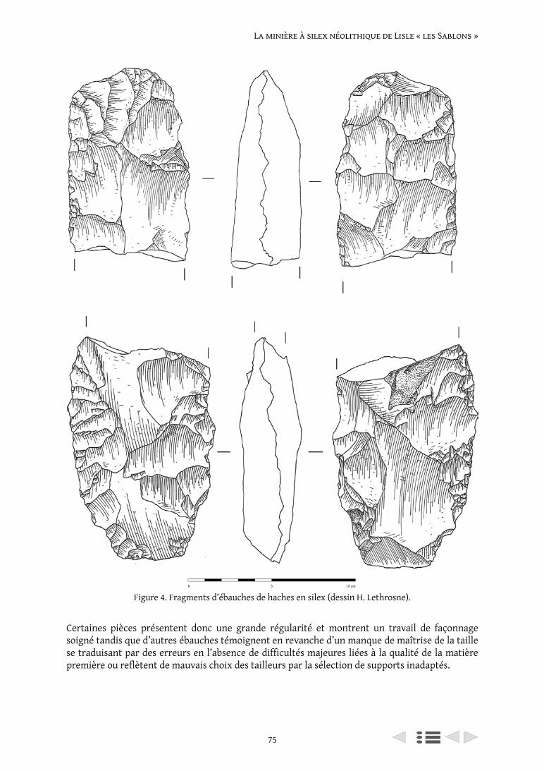
75
La minière à silex néolithique de Lisle « les Sablons »
Certaines pièces présentent donc une grande régularité et montrent un travail de façonnage soigné tandis que d’autres ébauches témoignent en revanche d’un manque de maîtrise de la taille se traduisant par des erreurs en l’absence de difficultés majeures liées à la qualité de la matière première ou reflètent de mauvais choix des tailleurs par la sélection de supports inadaptés.
Figure 4. Fragments d’ébauches de haches en silex (dessin H. Lethrosne).
Harold Lethrosne, Olivia Dupart and Clément Recq
76
6. Synthèse des résultats
A la suite de trois campagnes de fouilles archéologiques, il est établi que le site Néolithique des « Sablons » est affecté par d’importantes séquences de colluvions qui le recouvrent. Ces dernières sont composées de très nombreux déchets de taille remobilisés aux états de surface altérés. Les colluvions masquent encore en grande partie l’occupation Néolithique probablement en partie érodée. Celle-ci est pour l’instant reconnue uniquement par la présence de fosses, toutes comblées par de très grandes quantités de déchets de taille en silex. Si la fonction extractive de ces fosses reste toujours hypothétique, de nombreux indices s’accumulent dans ce sens.
Les premiers résultats de l’analyse technologique des déchets de production lithique permettent de confirmer la présence d’un atelier dédié à la fabrication exclusive de haches taillées où l’ensemble de la chaîne opératoire de production est effectuée sur place. Le tri des différentes étapes de la chaîne opératoire perceptible entre les ensembles de mobilier issus des structures en creux permet de mettre en évidence une segmentation de la chaîne opératoire sur le site ou une organisation séquencée des rejets de déchets de façonnage. Les productions montrent un degré de maîtrise de la taille variable qui ne dénote pas un niveau de savoir-faire très élevé des tailleurs fréquentant le site.
La chaîne opératoire de production des haches est déjà bien connue et documentée (Augereau 1995 ; Bostyn, Lanchon 1992). Par ce travail, il s’agit de poursuivre les problématiques existantes de technologie lithique en intégrant la question des modes de détachement en interrogeant les paramètres de geste et de percuteur. En effet, même si la chaîne opératoire de fabrication des haches est bien identifiée, les études technologiques demeurent numériquement faibles car elles concernent des quantités de mobilier démesurées. La multiplication des données apportera, sans en douter, des nuances et montreront une variabilité au sein de ces chaînes opératoires de production.
La poursuite des fouilles archéologiques sur le site des « Sablons » à Lisle porte sur cette double problématique des modalités d’extraction du silex et de fonctionnement du site ainsi que des méthodes et techniques de façonnage des haches en silex néolithique.
A terme, les résultats obtenus sur ce site seront replacés dans leur contexte, au sein du complexe minier Néolithique de la vallée du Loir afin d’aborder des problématiques d’organisation socio-économique et de structuration territoriale.
Remerciement
Les auteurs remercient Alexis Taylor (Paléotime) pour la traduction du résumé en anglais.
Références
Augereau, A. 1995. Les ateliers de fabrication de haches de la minière du ‘Grand-Bois-Marot’ à Villemaur-sur-Vanne (Aube), In Pélegrin, J. and Richard, A. (dir.), Les mines de silex au Néolithique en Europe. Avancées récentes, actes de la table-ronde internationale de Vesoul, 18-19 octobre 1991. Paris : CTHS: 145-158.
Bostyn, F. and Lanchon, Y. 1992. Jablines ‘le haut-Château’ (Seine-et-Marne), une minière de silex au Néolithique, DAF 35, Paris : Editions de la Maison des Sciences de l’Homme Paris.
Creusillet, M.-F. and Bourne, S. 2016. Production et diffusion des haches de la vallée du Loing. Les ateliers de Corquilleroy et de Fontenay-sur-Loing, Tours : FERACF.
Despriée, J., Voinchet, P., Bahain, J.-J., Falguères, C., Lorrain, J.-M. and Duvialard, J. 2003. Les nappes alluviales pléistocènes du Loir dans la région de Vendôme (Loir-et-Cher-France) : contexte morphosédimentaire et chronologie RPE, Quaternaire, 14(4): 207-218.
77
La minière à silex néolithique de Lisle « les Sablons »
Giligny, F. and Bostyn, F. 2016. La hache de silex dans le Val de Seine. Production et diffusion des haches au Néolithique, Leiden, Sidestone Press.
Lethrosne, H. 2012. La production spécialisée d’un outil domestique : l’exemple des productions de haches en silex de la minière néolithique de Pezou ‘La Chenevière-Dieu’ (Loir-et-Cher), Bulletin de la Société Préhistorique Française, 109(2): 311-327.
Lethrosne, H. and Despriée, J. 2014. Minières à silex et ateliers de façonnage de haches dans la vallée du Loir vedômois, l’exemple de Pezou ‘La Chenevière-Dieu’ (Loir-et-Cher), in : Louboutin, C., Verjux, C. (dir.) Zones de production et organisation des territoires au Néolithique. Espaces exploités, occupés, parcourus, 51, Tours : FERACF: 103-116.
Lethrosne, H. and Lecoeuvre, J.-M. 2014. Neolithic flint axes in the Loir Valley (France) : quarrying, production and distribution, In Giligny, F. and Bostyn, F. (dir.), Lithic Raw Material Ressources and Procurement in Pre- and Protohistoric Times, Proceedings of the 5th International Conference of the UISPP Commission on Flint Mining in Pre- and protohistoric Times (Paris, 10-11 September 2012), BAR International Series 2656 Oxford: Archaeopress: 61-72.
Lethrosne, H., Dupart, O. and Recq, C. 2018, Lisle ‘les Sablons’ (Loir-et-Cher). Une carrière de silex néolithique en Val du Loir Vendômois. Campagne de fouille archéologique programmée 2017, Orléans, SRA Centre.
Lethrosne, H., Dupart, O., Recq, C. and Delhommeau, E. 2019, Lisle ‘les Sablons’ (Loir-et-Cher). Une carrière de silex néolithique en val du Loir vendômois. Campagne de fouille archéologique programmée 2018, Orléans, SRA Centre.
Manivit, J., Desprez, N. and Despriée, J. 1983. carte géologique de la France à 1/50000, Selommes, 2020, Orléans : BRGM.
From Mine to User (UISPP XVIII) (Archaeopress 2021): 78–86
Neolithic quarries and knapping in northern Corsica. The rhyolite deposit of Alzu Plateau
Adrien Reggio1, Nadia Ameziane-Federzoni2
1 Aix Marseille Université, CNRS, Ministère de la Culture, LAMPEA, Aix-en-Provence, France [email protected] – corresponding author
2 Archéo‐île, UMR TRACES – CNRS UMR 5608; [email protected]
Abstract
The Alzu Plateau is an archaeological site located in the north of Corsica, at a height of around 1,600 metres above sea-level. A survey programme initiated in 2007 led to the discovery of a rhyolite deposit, and abundant Neolithic chipped stone in this material. The survey also resulted in the identification of several rock shelters with Neolithic material, located a few hundred metres from the rhyolite deposit.
Since 2016, as a result of these numerous discoveries (raw materials and tools) and the geographical location of the site, excavations have been carried out at the Alzu Plateau. The proximity between rock shelters and the rhyolite deposit provided the opportunity to study the complementarity between the archaeological sites, in a restricted area.
The preliminary results of the excavation confirm the Neolithic attribution and led to the identification of a rhyolite exploitation area and a settlement area under a rock shelter, with abundant debitage products, in particular arrowheads.
Keywords: rhyolite; quarries; settlement; arrowhead; Corsica
Résumé
Le site du Plateau d’Alzu est localisé dans le Nord de la Corse (région de Corte) à environ 1600 mètres d’altitude sur un substrat géologique hercynien cristallin. Des campagnes de prospection menées depuis 2008 ont permis la découverte d’un important gisement primaire de rhyolite. De nombreux vestiges d’objets taillés néolithiques dans cette matière ont été trouvés. Les prospections ont également occasionné l’identification de nombreux abris sous-roche, livrant du mobilier en surface, à une centaine de mètres du gisement de matière première.
L’intérêt des découvertes concernant les modalités d’exploitation (chaînes opératoires du bloc brut au produit fini) et l’organisation géographique (répartition des activités), ont mené à la réalisation de plusieurs opérations de sondage depuis 2016. En effet, la proximité entre le gisement de rhyolite, et les sites d’habitats permet d’aborder la question de la complémentarité entre site artisanal et sites d’habitat dans une même aire géographique.
Les résultats de ces fouilles nous ont permis de confirmer l’attribution au Néolithique et d’identifier une « zone d’exploitation » de la rhyolite et une zone d’habitat qui livre davantage de produits finis, notamment des armatures.
Mots-clés : rhyolite ; carriers ; habitat ; pointes de flèches ; Corse
1. Introduction
Corsica is an island without flint or obsidian deposits, where the main knappable local resource is rhyolite, a volcanic rock. The use of rhyolite began with the first human occupation of the island in the ninth millennium BC and intensified from the sixth millennium onwards (Camps 1988; Costa 2004).
Neolithic quarries and knapping in northern Corsica
79
Neolithic quarries and knapping in northern Corsica
The first research on the provenance of raw materials focused on obsidian and provided data on a Mediterranean exchange network between Sardinia and Corsica (Tykot 1997; Luglie et al. 2006; Orange et al. 2017). However, insular rhyolite holds a particular place in corsican lithic series, since it constitutes the only possible lithic marker of intra-island movements. Also, as part of academic research conducted by one of us (N.A.-F.) on how rhyolite is exploited and disseminated (Ameziane-Federzoni 1999; Ameziane-Federzoni 2011). Lot of rhyolite exists in Corsica, the famous one is the Monte Cintu rhyolite (in northern Corsica). Another important sources of rhyolite supplies have been located in the Centre of Corsica, on the Alzu Plateau. Following the discovery of a rhyolite quarry, research is currently in progress to identify the organisation of the ‘chaîne opératoire’, and the relationship between the quarry and settlements.
1.1. Geographical context
The Alzu Plateau is located in the centre of Corsica (Corte, fig. 1), on a ridge separating the valleys of Restonica and Tavignanu. It is a high-altitude plateau (1588 m) on a moderately sloping area on this steep and rocky ridge. From a geological point of view, in the Alzu Plateau area, a network of mixed alkaline calcareous basic/acid veins and aphanitic and/or porphyritic rocks, generally form small landforms in the topography (Amaudric Du Chaffaut et al. 1985).
Most of the rhyolite consist of a compact, siliceous rock with a greenish grey to black, we can find also some granite blocks around rhyolites blocks. This rock is hard, brittle (curved, conchoidal or unclear breakage) and produces a distinctive glassy sound during breakage. We can distinguish whitish phenocrysts (feldspath) and small phenocrysts (millimetres).
1.2. History
The Neolithic occupation of the Alzu Plateau was identified in 2003 (Allegrini-Simonetti et al. 2003). In 2008, as part of thematic prospecting for rhyolite sources related to the Tuani site, located in the
Figure 1. Localisation of ‘Plateau d’Alzu’ (red star; maps:
OCM landscape ©).
A. Reggio and N. Ameziane-Federzoni
80
Restonica Valley (Ameziane-Federzoni 2007), a survey was carried out on the Alzu Plateau. It found that the Alzu Plateau was a complex of rhyolite quarry and transformation and a settlement area (Ameziane-Federzoni 2014).
The quarry was precisely located by the impact of human activity on the geological environment which is still clearly visible. Indeed, the exploited rhyolite outcrops extend over an area of 13 hectares.
In view of the size of the site, its importance for understanding rhyolite exchange networks in Corsica during the Neolithic period, and the information it can provide on the first human occupation of the mountains (Ameziane-Federzoni et al. in press), excavations have been carried out since 2016 (under the direction of Ameziane-Federzoni).
In parallel with this fieldwork, an experimental study of rhyolite knapping was carried out.1
Three areas have been excavated to date: the first area is the quarry, the second is the Punta Rusinca rock shelter, and the last is an open area and a rock shelter, located between the two previous sites (Figure 2).
2. The sites
2.1. The quarry
Abundant evidence was found in the main rhyolite outcrop (landscapes with a mix of granitic and rhyolite blocks; Figure 3) area during the surveys (hammerstones, cores, debris, flakes, arrowheads)
1 Reggio, A., Ameziane-Federzoni, N. and Mayeur, G., work in progress: Expérimentation de débitage de rhyolite sur le Plateau d’Alzu.
Figure 2. The different areas of the site (map: Microsoft corporation ©, DigitalGlobe©, CNES 2019©).
A. Reggio and N. Ameziane-Federzoni
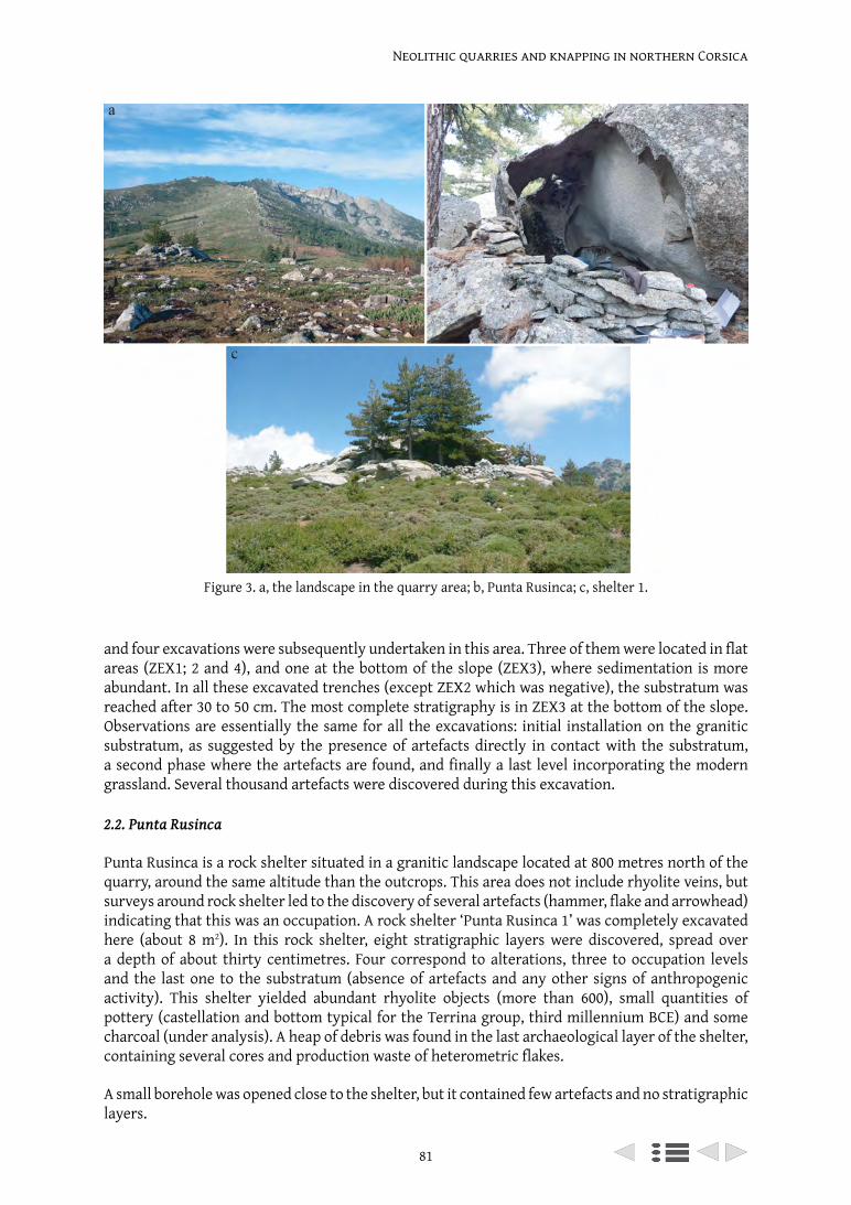
81
Neolithic quarries and knapping in northern Corsica
and four excavations were subsequently undertaken in this area. Three of them were located in flat areas (ZEX1; 2 and 4), and one at the bottom of the slope (ZEX3), where sedimentation is more abundant. In all these excavated trenches (except ZEX2 which was negative), the substratum was reached after 30 to 50 cm. The most complete stratigraphy is in ZEX3 at the bottom of the slope. Observations are essentially the same for all the excavations: initial installation on the granitic substratum, as suggested by the presence of artefacts directly in contact with the substratum, a second phase where the artefacts are found, and finally a last level incorporating the modern grassland. Several thousand artefacts were discovered during this excavation.
2.2. Punta Rusinca
Punta Rusinca is a rock shelter situated in a granitic landscape located at 800 metres north of the quarry, around the same altitude than the outcrops. This area does not include rhyolite veins, but surveys around rock shelter led to the discovery of several artefacts (hammer, flake and arrowhead) indicating that this was an occupation. A rock shelter ‘Punta Rusinca 1’ was completely excavated here (about 8 m2). In this rock shelter, eight stratigraphic layers were discovered, spread over a depth of about thirty centimetres. Four correspond to alterations, three to occupation levels and the last one to the substratum (absence of artefacts and any other signs of anthropogenic activity). This shelter yielded abundant rhyolite objects (more than 600), small quantities of pottery (castellation and bottom typical for the Terrina group, third millennium BCE) and some charcoal (under analysis). A heap of debris was found in the last archaeological layer of the shelter, containing several cores and production waste of heterometric flakes.
A small borehole was opened close to the shelter, but it contained few artefacts and no stratigraphic layers.
Figure 3. a, the landscape in the quarry area; b, Punta Rusinca; c, shelter 1.
Adrien Reggio1, Nadia Ameziane-Federzoni2
82
2.3. The Alzu/shelter sector
The ‘Alzu 1’ survey
The ‘Alzu 1’ open area, is located a few metres north of the quarry. Two levels mixed with the modern grassland contained artefacts. The position of this sector mid-slope obviously did not allow for the conservation of a significant stratigraphy. Archaeological artefacts are exclusively represented by rhyolite fragments.
Shelter 1
This shelter is located 300 metres from the quarry, 500 meters from Punta Rusinca and few meters from Shelter 1. During prospecting, numerous arrowheads in Alzu rhyolite and two in Monte Cintu rhyolite (other important rhyolite deposits of Corsica) were discovered nearby. A 5 m2 trench was opened and many rhyolites and more rarely obsidian artefacts were unearthed, spread over fifteen stratigraphic layers. The shelter yielded many arrowheads (about twenty over a few square meters in thirteen layers), similar to those found during prospecting. Some of these arrowhead tips bear traces of impact fractures, others are preforms (irregularity of the profile). The artefacts from this shelter are still being analysed.
3. Study of the lithic industry
3.1. Methodology
The first step consisted in classifying the objects by raw material. The overwhelming majority of artefacts are in Alzu rhyolite.
Then, the artefacts were divided into the following categories:
– preliminary flakes, with the presence of a ‘natural surface’ (for rhyolite artefacts, we subdivided the ‘natural surface’ category into cortex; epidote or naturally broken surfaces), based on experimental observations.
– simple flakes, with further subdivisions based on the presence of the removal scars on the upper surface. They are divided into laminar scars; unidirectional flake scars; multidirectional flake scars.
– cores, which are hierarchically classified.
For retouched pieces, the typology used for the Mesolithic and Neolithic in the south of France (Perrin et al. 2018).
3.2. Results
3.2.1. The quarry
Several thousand objects were discovered in the quarry, most of which are currently under study. Early observations show a significant representation of cortical flakes, shaping flakes and debris. Finished products are not very common, but some tools have been discovered, such as cortical flakes retouched (scrappers, for a short used?) and a very small arrowhead.
Cores are well represented (a study of the spatial distribution of core types is underway). They mainly show multidirectional scars or bifacial knapping on the flake edge.
3.2.2. La Punta Rusinca
The most important discovery made in this rock shelter is a concentration of four rhyolite cores, as well as some knapping products. Cortical fragments are not very common, and often of small size.
83
Neolithic quarries and knapping in northern Corsica
There is also a lot of small knapping waste. These products indicate that the debitage came from small blocks could have been reduced in the shelter. However, large fragments are also present in the shelter, and the cortical and shaping flakes corresponding to these nodules appear to be missing (study still in progress). Most of the tools are scrapers.
3.2.3. The Alzu/Shelter 1 sector
This is the most promising shelter. It has yielded a significant quantity of remains, and up until now, shaping flakes seem to be the most abundant artefacts. Cores are also present. The main discoveries from this shelter are arrowheads, mostly in Alzu rhyolite, as well as two others in obsidian.
4. Synthesis
4.1. Chaîne opératoire
Trends have already begun to emerge from the various studied assemblages (settlement area with two rock shelters and a rhyolite quarry). Shaping products are abundant in the quarry, but all the elements of the ‘chaîne opératoire’ are present, indicating that this site was also used as a workshop. Only tools are absent, with a few rare exceptions (some scrapers).
The Punta Rusinca rock shelter also contained artefacts from several stages of the ‘chaîne opératoire’. Cortical flakes and cores indicate that debitage came from the reduction of small blocks without cortical part (domestic production); some larger flakes indicate the importation of finished products, and tools are more common.
Shelter 1 contains many lithics, including small quantities of imported materials (obsidian). The categories represented are similar to those of Punta Rusinca, although in higher quantities. The novelty of this shelter lies in the presence of numerous arrowheads (Figure 4), mainly with stems and barbs.
In this shelter and on the rest of the plateau, arrowheads are present from different stages of the ‘chaîne opératoire’ (good-quality finished products, preforms, roughouts, broken by use). In view of the environmental context, it is tempting to interpret them as evidence of hunting activities. The presence of a significant number of preforms, roughouts and broken tips (sometimes in a good quality material) raises the question of apprenticeship too.
These initial results may indicate a dispersion of the ‘chaîne opératoire’ in time and space within this ‘mining complex’ (Labriffe (de), Thébault 1995).
4.2. Chronology
The exploitation of local raw materials, the low occurence of obsidian and the typology of the stemmed arrowheads are comparable to the characteristics of the Terrina chrono-cultural group (Camps 1988; Camps et al. 1988; Costa 2004; Tramoni et al. 2007; Tramoni, D’Anna 2016), during the third millennium BCE. The ceramic typology gives the same information.
5. Conclusion and prospects
To conclude, the Alzu Plateau provides a good opportunity for the study of mining complexes in general, owing to the conjunction of a settlement area and a raw material outcrop. To date, no large pits or other structures (Gauvry 2006) have been identified. Surface collection and quarrying are methods used. This was also the case at some other quarriyng sites, such as Ropa (Poland; Schmid 1973), Gorzow (Poland; Gauvry 2006) or Fornæs (Denmark; Becker and Weisgerber 1999).
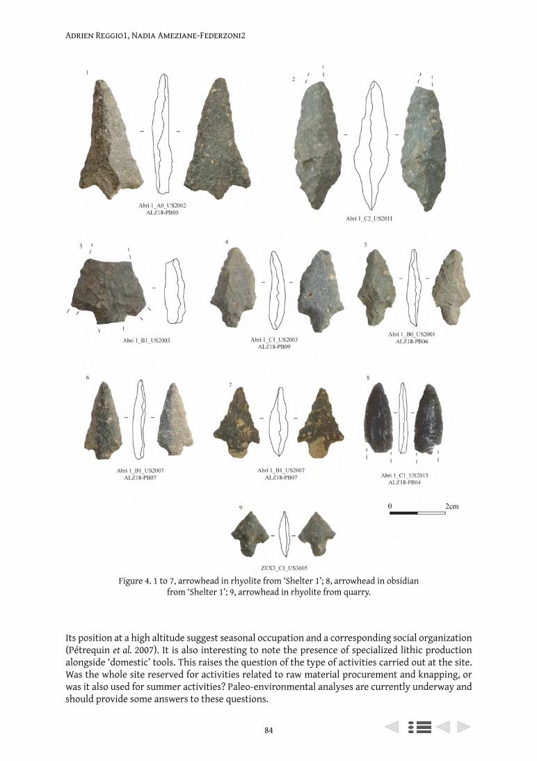
Adrien Reggio1, Nadia Ameziane-Federzoni2
84
Its position at a high altitude suggest seasonal occupation and a corresponding social organization (Pétrequin et al. 2007). It is also interesting to note the presence of specialized lithic production alongside ‘domestic’ tools. This raises the question of the type of activities carried out at the site. Was the whole site reserved for activities related to raw material procurement and knapping, or was it also used for summer activities? Paleo-environmental analyses are currently underway and should provide some answers to these questions.
Figure 4. 1 to 7, arrowhead in rhyolite from ‘Shelter 1’; 8, arrowhead in obsidian from ‘Shelter 1’; 9, arrowhead in rhyolite from quarry.
85
Neolithic quarries and knapping in northern Corsica
Geochemical analyses have been carried out on samples from several outcrops on the Alzu Plateau and on archaeological remains, in order to identify the scale of distribution of Alzu rhyolite (work in progress by Arthur Leck 2018).
It will also be interesting to determine whether Alzu rhyolite was exported to the neighbouring valleys in the form of blocks, cores, fragments or arrowheads.
Acknowledgements
S. Renault (LAMPEA) for helping us to build a research group, F. Federzoni for his drawings, J. Pélegrin (PreTech), P. Bodu (PreTech), P. Allard (PreTech) for their advice, M. Bailly (LAMPEA-AMU) for the correction, J.-F. Gibaja (IMF-CSIS Barcelona), P.-A. de Labriffe (Trajectoires-SRA Occitanie), A. D’Anna (LAMPEA) for references, C. Bressy-Leandri (TRACES-SRA Corse), F. Leandri (TRACES-DRAC Corsica) and P. Lefranc (Archimède) for their advice and help with the administrative part.
Thanks to the excavation team: M. Bergogne, F. Federzoni, C. Giuliani, E. Guerin, M. Khalil, G. Mayeur, S. Michelli, R. Vereecken and to the shepherds: A. Gambini, J. and D. Sabiani.
Thanks to reviewer, David Field and Peter Topping for their patience and their good advice.
References
Amaudric du Chaffaut, S., Bonin, B., Caron, J.-M. and Conchon, O. 1985. Notice explicative, Carte géol. France (1/50 000), feuille Venaco (1114). Orléans : BRGM.
Ameziane-Federzoni, N. 2011. Approvisionnement et diffusion de la rhyolite dans le Nord de la Corse au Néolithique ancien et moyen. Thèse de doctorat, Corte : Université de Corte.
Ameziane-Federzoni, N. 1999. Intérêt d’une étude des matières premières minérales pour une définition de l’espace d’approvisionnement. Application au site cardial de la Pietra (Balagne). Mémoire de DEA. Corte : Université de Corte.
Ameziane-Federzoni, N., Mazet, S., Perrin, T., Peche-Quilichini, K., Bontempi, J.-M., Leck, A., Marini, N., Martinet, L., Paolini-Saez, H., Reggio., A., in press. L’occupation de la montagne corse durant le Néolithique. Bilan des recherches récentes. In : Actes du Colloque 20 ans d’Archéologie en Corse 9-11 novembre 2017, Ajaccio : in press.
Ameziane-Federzoni, N., Ottaviani-Spella, M.-M., Berlinghi, A. and Quilichini, Y. 2014. L’exploitation d’un gîte primaire de rhyolite au cours de la préhistoire récente dans le centre de la Corse : l’exemple du plateau d’Alzu. In I. Sénépart., J. Cauliez., T. Perrin., E. Thirault (dir.), Chronologie de la Préhistoire récente dans le Sud de la France Acquis 1992-2012, actes des Xe RMPR (Porticcio, 18 – 20 octobre 2012), Toulouse : Archives d’Écologie Préhistorique: 411-421.
Ameziane-Federzoni, N., Peche-Quilichini, K., Paolini-Saez, H., Ottaviani-Spella, M.-M. et al. 2007. Rapport de fouilles du site de Tuani. Ajaccio : Service Régional de l’Archéologie
Becker, C. and Weisgerber, G., 1999. Katalog der Bergwerke – Dänemark. In G. Weisgerber., R. Slotta., J. Weiner (dir.), 5000 Jahre Feuersteinbergbau – Die Suche nach dem Steinzeit. Bochum : Bergbau-Museum Bochum, 77: 456-473.
Camps, G. 1988. Préhistoire d’une île. Les origines de la Corse. Paris : Errance.Camps, G., Vigne, J.-D., Cesari, J. and Gauthier, A. 1988. Terrina et le terrinien. Recherche sur le
chalcolithique de la Corse. Rome : Publication de l’Ecole Française de Rome, 109.Costa, L.-J. 2004. Corse préhistorique : peuplement d’une île et modes de vie des sociétés insulaires (IXème-
IIème millénaires av. J.-C.). Paris : Errance.Gauvry, Y. 2006. L’exploitation minérale à la Protohistoire ancienne dans la moitié nord de l’Europe. Émergence
d’un art mineur. Thèse de doctorat, Paris : Université Paris I – Panthéon Sorbonne.Labriffe (de), P.-A. and Thébault, D. 1995. Mines de silex et grands travaux, l’autoroute A5 et les
sites d’extraction du Pays d’Othe. In J. Pélegrin et A. Richard (dir.), Les mines de silex au néolithique en Europe: avancées récentes, actes de la table ronde internationale de Vesoul (18-19 oct. 1991), Paris : Documents préhistoriques: 47-66.
Adrien Reggio1, Nadia Ameziane-Federzoni2
86
Leck, A., Le Bourdonnec, F.-X., Gratuze, B., Dubernet, S., Ameziane-Federzoni, N., Bressy-Leandri, C., Chapoulie, R., Mazet, S., Bontempi, J.-M., Marini, N., Remicourt, M., Perrin., T. 2018. Provenance studies of Corsican rhyolite artefacts: Assessment of geochemical analysis methods. Compte-Rendu Palévol, 17: 220-232.
Lugliè, C., Le Bourdonnec, F.-X., Poupeau, G., Bohn, M., Meloni, S., Oddone, M., Tanda, G. 2006. A map of the Monte Arci (Sardinia Island, Western Mediterranean) obsidian primary to secondary sources. Implications for Neolithic provenance studies. Compte-Rendu Palévol, 5: 995-1003.
Orange, M., Le Bourdonnec, F.-X., Bellot-Gurlet, L., Lugliè, C., Dubernet, S., Bressy-Leandri, C., Scheffers, A., Joannes-Boyau, D. 2017. On sourcing obsidian assemblages from the Mediterranean area: analytical strategies for their exhaustive geochemical characterisation. Journal of Archaeological Science : Reports, 12: 834-844.
Perrin, T., Angelin, A. and Defranould, E. 2018. Liste typologique pour les industries de pierre taillée de la Préhistoire récente européenne, version 2018-02.15. Available at https://hal.archives-ouvertes.fr/hal-01638819v2/document [Accessed, April 1, 2019]
Pétrequin, P., Pétrequin, A.-M., Errera, M., Cassen, S., Croutsch, C., Dufraisse, A., Gauthier, E., Rossy, M. 2007. Les carrières néolithiques du Mont Viso (Piémont, Italie). Chronologie et conditions d’exploitation. In D. Daudry (dir.), Actes du XIe colloque sur les Alpes dans l’Antiquité Champsec/Val-de-Bagnes/Valais suisse (15-17 septembre 2006), Chambéry : Bulletin d’études préhistoriques et archéologiques alpines: 167-188.
Schmid, E. 1973. Die Reviere urgeschichtlichen Silexbergbaus in Europa. Der Anschnitt. 4 (25). Bochum : Jahrgang: 12-15.
Tramoni, P. and D’Anna, A. 2016. Le Néolithique moyen de la Corse revisité : nouvelles données, nouvelles perceptions. In T. Perrin., P. Chambon., J.-F. Gibaja., G. Goude (dir.), Le Chasséen, des Chasséens... Retour sur une culture nationale et ses parallèles, Sepulcres de fossa, Cortaillod, Lagozza : actes du colloque international (18 – 20 novembre 2014, Paris). Toulouse : Archives d’Écologie Préhistorique: 59-72.
Tramoni, P., D’Anna, A., Pasquet, A., Milanini, J.-L., Chessa, R. 2007. Le site de Tivulaghju (Porto-Vecchio, Corse-du-Sud) et les coffres mégalithiques du sud de la Corse, nouvelles données. Bulletin de la Société Préhistorique Française, 104 (2): 245-274.
Tykot, R.-H. 1997. Characterization of the Monte-Arci (Sardinia) obsidian sources. Journal of Archaeological Science, 24: 467-479.
From Mine to User (UISPP XVIII) (Archaeopress 2021): 87–112
Ateliers de taille, habitats et sites d’extraction du silex de la fin du Ve au IIIe millénaire avant notre ère dans
le bassin minier Marne et Morin (Seine-et-Marne)
Véronique BrunetInrap Centre-Île-de-France et UMR 8215 « Trajectoires »
Abstract
Archaeological documentation on the Jablines sector in Seine-et-Marne has grown in recent years, thanks to archaeological mitigation and several contemporary and functionally complementary sites have been discovered. They range from the end of the 5th to the 3rd millennium. An unpublished synthesis of a little over twenty lithic assemblages makes it possible to put into perspective the use of raw materials, artefact production, reduction techniques, and to identify the producers’ objectives. The study of workshops associated with domestic settlements, but still located outside the mining sector, showed against all expectations that they are axehead producing sites. In particular, they delivered axe blanks and shaping chips, which may indicate the existence of secondary centers of axe production. Workshops are interfaces between extraction sites and consumer sites. There has been an evolution, over time, in the quality of axehead production and in the objectives of production. These variations undoubtedly highlight a transformation in the relationship between producers and consumers.
Keywords: flint mine, workshop, settlement, axeheads
Résumé
La documentation archéologique sur le secteur de Jablines en Seine-et-Marne s’est accumulée ces dernières années grâce à l’archéologie préventive et plusieurs sites contemporains et fonctionnellement complémentaires ont été mis au jour. Ils s’échelonnent de la fin du Ve au IIIe millénaire. Une synthèse inédite d’un peu plus d’une vingtaine de séries lithiques permet de mettre en perspective les matières premières, les productions, les techniques de taille et d’identifier les objectifs des producteurs. L’étude d’ateliers associés à des occupations domestiques, mais toujours installés à l’extérieur de la minière a montré contre toute attente qu’il s’agit de sites producteurs, intermédiaires, de haches. Les ateliers sont des interfaces entre les sites d’extraction et les sites consommateurs. On remarque une évolution de la qualité de la production des haches et des objectifs du débitage au cours du temps. Ces variations mettent sans doute en évidence une transformation des relations entre tailleurs et consommateurs.
Mots-clés : minière à silex, atelier, habitat, haches
1. Introduction
La thématique offerte par la session XXXIII-2 « Flint mines and chipping floors from prehistory to the beginning of the nineteenth century » organisée dans le cadre du congrès de l’UISPP en 2018 nous permet de présenter les premiers résultats des études typo-technologiques réalisées sur une vingtaine de séries lithiques dans le bassin minier Marne et Morin (Seine-et-Marne). Les dates radiocarbone s’échelonnent du Néolithique moyen II au Néolithique final. Elles sont regroupées pour la plupart dans la plage de datation de la minière de Jablines qui présente la plus longue durée d’exploitation (Bostyn and Lanchon, 1992b). On dispose d’une documentation inédite provenant de fouilles préventives, la synthèse des données montre sur un axe diachronique, un échantillonnage de sites contemporains (habitat, atelier de taille, enceinte). Plus précisément, elle met en évidence une évolution de l’organisation de la production de haches.
Ateliers de taille, habitats et sites d’extraction du silex
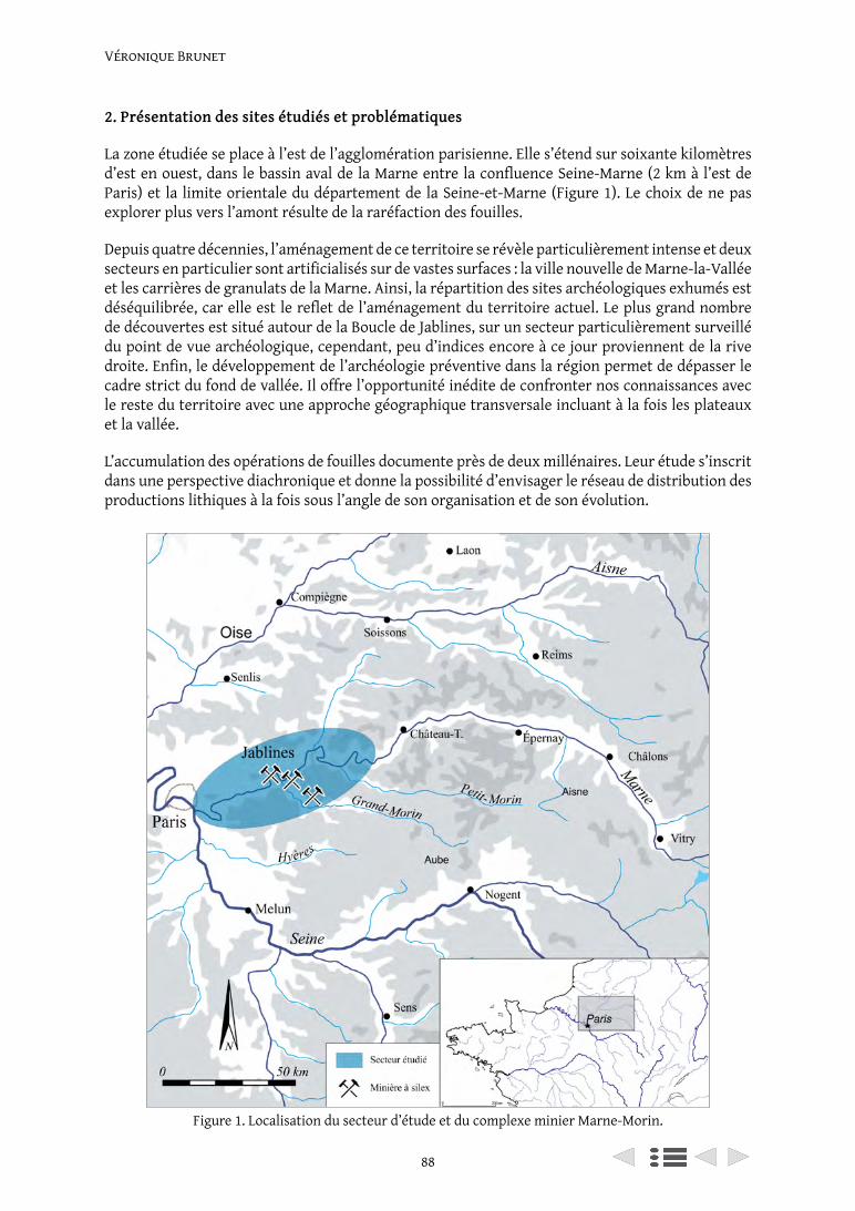
Véronique Brunet
88
2. Présentation des sites étudiés et problématiques
La zone étudiée se place à l’est de l’agglomération parisienne. Elle s’étend sur soixante kilomètres d’est en ouest, dans le bassin aval de la Marne entre la confluence Seine-Marne (2 km à l’est de Paris) et la limite orientale du département de la Seine-et-Marne (Figure 1). Le choix de ne pas explorer plus vers l’amont résulte de la raréfaction des fouilles.
Depuis quatre décennies, l’aménagement de ce territoire se révèle particulièrement intense et deux secteurs en particulier sont artificialisés sur de vastes surfaces : la ville nouvelle de Marne-la-Vallée et les carrières de granulats de la Marne. Ainsi, la répartition des sites archéologiques exhumés est déséquilibrée, car elle est le reflet de l’aménagement du territoire actuel. Le plus grand nombre de découvertes est situé autour de la Boucle de Jablines, sur un secteur particulièrement surveillé du point de vue archéologique, cependant, peu d’indices encore à ce jour proviennent de la rive droite. Enfin, le développement de l’archéologie préventive dans la région permet de dépasser le cadre strict du fond de vallée. Il offre l’opportunité inédite de confronter nos connaissances avec le reste du territoire avec une approche géographique transversale incluant à la fois les plateaux et la vallée.
L’accumulation des opérations de fouilles documente près de deux millénaires. Leur étude s’inscrit dans une perspective diachronique et donne la possibilité d’envisager le réseau de distribution des productions lithiques à la fois sous l’angle de son organisation et de son évolution.
Figure 1. Localisation du secteur d’étude et du complexe minier Marne-Morin.
89
Ateliers de taille, habitats et sites d’extraction du silex
Les recherches que nous poursuivons actuellement s’intéressent à l’industrie lithique autour du complexe minier de Jablines, l’un des plus importants d’Île-de-France au Néolithique. Après la fouille de Jablines, la question de la diffusion d’une partie de la production des lames de haches dans les habitats néolithiques voisins restait encore peu documentée en raison d’un secteur vide de sites contemporains (Bostyn and Lanchon 1992b, p. 210). Récemment, la découverte et l’étude de plusieurs ateliers de taille du silex associés à des occupations domestiques, mais toujours installées à l’extérieur de la minière, ont montré contre toute attente qu’il s’agit de sites producteurs de haches. Ceux-ci ont notamment livré des ébauches de hache et des éclats de façonnage indiquant l’existence de centres secondaires de production de haches. Si leur fabrication n’est donc pas strictement réservée aux lieux d’extraction, ces nouveaux sites « rajoutent un échelon supplémentaire dans la segmentation des réseaux de distribution des haches » (Aubry et al. 2014: p. 78).
L’étude des déchets de taille issus des ateliers permet de déterminer la matière première exploitée, les productions, les techniques de taille et d’identifier les objectifs des producteurs. La comparaison de la qualité technique mise en œuvre sur chacun des sites, la détermination des productions, permet de repérer s’il existe une segmentation des chaînes opératoires et d’apprécier les spécificités de chacun. On étudie ainsi, la ou les relations entre les différents types de sites : producteurs et consommateurs. Cette recherche s’appuie sur l’analyse de 23 séries lithiques provenant de sites datés du Néolithique moyen II au Néolithique final. Le mobilier pris en compte représente environ 230.000 pièces.
3. Le corpus et les éléments de datation
3.1. Le corpus et les éléments de datations disponibles pour le Néolithique moyen II (4 400/3 500 av. n. è.)
Des travaux de recherches ayant pour thématique la fonction des enceintes Michelsberg ont été menés récemment (ANR franco-allemande, MK Projekt, co-financement ANR et DFG). L’une des problématiques concernait l’exploitation des ressources lithiques dans le Bassin parisien et la gestion des territoires à l’horizon Chasséen-Michelsberg et des études ont été menées à cette occasion sur une enceinte de la vallée de la Marne (Aubry et al. 2014 ; Demoule et al. en cours).
En basse vallée de Marne, cet horizon est bien documenté par de nombreuses fouilles, et on dispose d’un grand nombre de gisements contemporains qui permettent d’en proposer certaines caractéristiques (Figure 2). Ce territoire s’organise autour d’abondantes ressources lithiques siliceuses, exploitées en puits de mine formant le complexe minier Marne-Morin, au sein duquel se trouve la minière de Jablines (Bostyn et Lanchon 1992b). Les enceintes sont localisées en fond de vallée, celles de Vignely et de Méry-sur-Marne ont été fouillées et sont attribuées au Michelsberg (Lanchon 2006; Bulard et al. 1996; Brunet V. et al. à paraître). Huit habitats ouverts sont situés sur le plateau à l’exception d’un seul. Une trentaine d’ateliers de taille du silex se répartissent dans les occupations domestiques (Brunet, V. 2007, 2013; Brunet, V. et Blaser 2014a; Brunet, V. et Le Jeune 2008). Ainsi, notre corpus est composé de dix sites fouillés dont trois sont localisés en fond de vallée et sept sur la frange septentrionale du plateau de Brie. La superficie moyenne des surfaces explorées est de 1,5 ha, pour un total de 19 ha cumulés (Figure 2).
Les habitats sont associés à des activités artisanales. Ils se singularisent par le regroupement d’ateliers de taille et de fosses d’extraction de limons avec au centre des plans de bâtiments originaux (Brunet, V. et Blaser 2014b; Brunet, V. et Colas 2018). Les ateliers de taille étudiés permettent d’en proposer un certain nombre de caractéristiques. Jusqu’à aujourd’hui, ces concentrations de pièces ont livré jusqu’à 160 kg de silex, répartis entre 15 et 150 m² de superficie. Les dimensions moyennes des plus grandes sont aux alentours de 32 m2, alors qu’elle n’est que d’une dizaine de mètres carrés
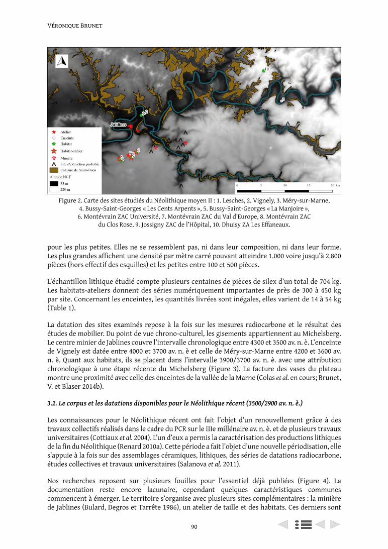
Véronique Brunet
90
pour les plus petites. Elles ne se ressemblent pas, ni dans leur composition, ni dans leur forme. Les plus grandes affichent une densité par mètre carré pouvant atteindre 1.000 voire jusqu’à 2.800 pièces (hors effectif des esquilles) et les petites entre 100 et 500 pièces.
L’échantillon lithique étudié compte plusieurs centaines de pièces de silex d’un total de 704 kg. Les habitats-ateliers donnent des séries numériquement importantes de près de 300 à 450 kg par site. Concernant les enceintes, les quantités livrées sont inégales, elles varient de 14 à 54 kg (Table 1).
La datation des sites examinés repose à la fois sur les mesures radiocarbone et le résultat des études de mobilier. Du point de vue chrono-culturel, les gisements appartiennent au Michelsberg. Le centre minier de Jablines couvre l’intervalle chronologique entre 4300 et 3500 av. n. è. L’enceinte de Vignely est datée entre 4000 et 3700 av. n. è et celle de Méry-sur-Marne entre 4200 et 3600 av. n. è. Quant aux habitats, ils se placent dans l’intervalle 3900/3700 av. n. è. avec une attribution chronologique à une étape récente du Michelsberg (Figure 3). La facture des vases du plateau montre une proximité avec celle des enceintes de la vallée de la Marne (Colas et al. en cours; Brunet, V. et Blaser 2014b).
3.2. Le corpus et les datations disponibles pour le Néolithique récent (3500/2900 av. n. è.)
Les connaissances pour le Néolithique récent ont fait l’objet d’un renouvellement grâce à des travaux collectifs réalisés dans le cadre du PCR sur le IIIe millénaire av. n. è. et de plusieurs travaux universitaires (Cottiaux et al. 2004). L’un d’eux a permis la caractérisation des productions lithiques de la fin du Néolithique (Renard 2010a). Cette période a fait l’objet d’une nouvelle périodisation, elle s’appuie à la fois sur des assemblages céramiques, lithiques, des séries de datations radiocarbone, études collectives et travaux universitaires (Salanova et al. 2011).
Nos recherches reposent sur plusieurs fouilles pour l’essentiel déjà publiées (Figure 4). La documentation reste encore lacunaire, cependant quelques caractéristiques communes commencent à émerger. Le territoire s’organise avec plusieurs sites complémentaires : la minière de Jablines (Bulard, Degros et Tarrête 1986), un atelier de taille et des habitats. Ces derniers sont
Figure 2. Carte des sites étudiés du Néolithique moyen II : 1. Lesches, 2. Vignely, 3. Méry-sur-Marne, 4. Bussy-Saint-Georges « Les Cents Arpents », 5. Bussy-Saint-Georges « La Manjoire »,
6. Montévrain ZAC Université, 7. Montévrain ZAC du Val d’Europe, 8. Montévrain ZAC du Clos Rose, 9. Jossigny ZAC de l’Hôpital, 10. Dhuisy ZA Les Effaneaux.
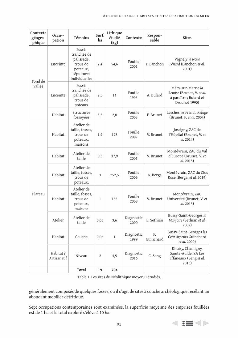
91
Ateliers de taille, habitats et sites d’extraction du silex
Contexte géogra-phique
Occu--pation Témoins Surf.
ha
Lithique étudié (kg)
Contexte Respon-sable Sites
Fond de vallée
Enceinte
Fossé, tranchée de palissade, trous de poteaux,
sépultures individuelles
2,4 54,6 Fouille 2001 Y. Lanchon
Vignely la Noue Fénard (Lanchon et al.
2001)
Enceinte
Fossé, tranchée de palissade, trous de poteaux
2,5 14 Fouille 1993 A. Bulard
Méry-sur-Marne la Remise (Brunet, V. et al.
à paraître ; Bulard et Drouhot 1990)
Habitat Structures fossoyées 5,3 2,8 Fouille
2003 P. Brunet Lesches les Prés du Refuge (Brunet, P. et al. 2004)
Plateau
Habitat
Atelier de taille, fosses,
trous de poteaux, maisons
1,9 178 Fouille 2007 V. Brunet
Jossigny, ZAC de l’Hôpital (Brunet, V. et
al. 2014)
Habitat Atelier de taille 0,5 37,9 Fouille
2001 V. BrunetMontévrain, ZAC du Val d’Europe (Brunet, V. et
al. 2015)
Habitat
Atelier de taille, fosses,
trous de poteaux,
3 252,5 Fouille 2006 A. Berga Montévrain, ZAC du Clos
Rose (Berga, et al. 2019)
Habitat
Atelier de taille, fosses,
trous de poteaux, maisons
1 155 Fouille 2008 V. Brunet
Montévrain, ZAC Université (Brunet, V. et
al. 2015)
Atelier Atelier de taille 0,05 3,6 Diagnostic
2000 E. SethianBussy-Saint-Georges la Manjoire (Sethian et al.
2002)
Habitat Couche 0,05 1 Diagnostic 1999
P. Guinchard
Bussy-Saint-Georges les Cent Arpents Guinchard
et al. 2000)
Habitat ? Artisanat ? Niveau 2 4,5 Diagnostic
2016 C. Seng
Dhuisy, Chamigny, Sainte-Aulde, ZA Les Effaneaux (Seng et al.
2016)
Total 19 704
Table 1. Les sites du Néolithique moyen II étudiés.
généralement composés de quelques fosses, ou il s’agit de sites à couche archéologique recélant un abondant mobilier détritique.
Sept occupations contemporaines sont examinées, la superficie moyenne des emprises fouillées est de 1 ha et le total exploré s’élève à 10 ha.
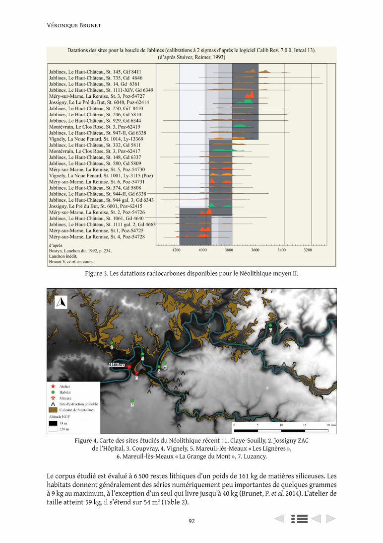
Véronique Brunet
92
Le corpus étudié est évalué à 6 500 restes lithiques d’un poids de 161 kg de matières siliceuses. Les habitats donnent généralement des séries numériquement peu importantes de quelques grammes à 9 kg au maximum, à l’exception d’un seul qui livre jusqu’à 40 kg (Brunet, P. et al. 2014). L’atelier de taille atteint 59 kg, il s’étend sur 54 m2 (Table 2).
Figure 3. Les datations radiocarbones disponibles pour le Néolithique moyen II.
Figure 4. Carte des sites étudiés du Néolithique récent : 1. Claye-Souilly, 2. Jossigny ZAC de l’Hôpital, 3. Coupvray, 4. Vignely, 5. Mareuil-lès-Meaux « Les Lignères »,
6. Mareuil-lès-Meaux « La Grange du Mont », 7. Luzancy.
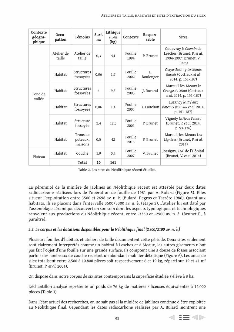
93
Ateliers de taille, habitats et sites d’extraction du silex
La pérennité de la minière de Jablines au Néolithique récent est attestée par deux dates radiocarbone réalisées lors de l’opération de fouille de 1981 par A. Bulard (Figure 5). Elles situent l’exploitation entre 3500 et 2698 av. n. è. (Bulard, Degros et Tarrête 1986). Quant aux habitats, ils se placent dans l’intervalle 3500/3300 av. n. è. (étape 2). L’atelier lui est daté par l’assemblage céramique découvert en son sein dont les aspects typologiques et technologiques renvoient aux productions du Néolithique récent, entre -3350 et -2900 av. n. è. (Brunet P., à paraître).
3.3. Le corpus et les datations disponibles pour le Néolithique final (2 800/2100 av. n. è.)
Plusieurs fouilles d’habitats et ateliers de taille documentent cette période. Deux sites seulement sont clairement interprétés comme un habitat à Lesches et à Meaux, les autres gisements n’ont pas fait l’objet d’une fouille sur une grande surface. Ils comptent une à douze de fosses associant parfois des lambeaux de couche recelant un abondant mobilier détritique (Figure 6). Les amas de silex totalisent entre 2.500 à 10.800 pièces soit respectivement 6 et 19 kg, réparti sur 19 et 41 m2 (Brunet, P. et al. 2004).
On dispose dans notre corpus de six sites contemporains la superficie étudiée s’élève à 8 ha.
L’échantillon analysé représente un poids de 76 kg de matières siliceuses équivalentes à 14.000 pièces (Table 3).
Dans l’état actuel des recherches, on ne sait pas si la minière de Jablines continue d’être exploitée au Néolithique final. Cependant les dates radiocarbone réalisées par A. Bulard montrent une
Contexte géogra-phique
Occu-pation Témoins Surf.
ha
Lithique étudié (kg)
Contexte Respon-sable Sites
Fond de vallée
Atelier de taille
Atelier de taille 0,3 94 Fouille
1994 P. Brunet
Coupvray le Chemin de Lesches (Brunet, P. et al. 1994-1997 ; Brunet, V.,
1996)
Habitat Structures fossoyées 0,06 1,7 Fouille
2002L.
Boulenger
Claye-Souilly les Monts Gardés (Cottiaux et al.
2014, p, 151-187)
Habitat Structures fossoyées 4 9,3 Fouille
2003 J. DurandMareuil-lès-Meaux la
Grange du Mont (Cottiaux et al. 2014, p, 151-187)
Habitat Structures fossoyées 0,86 1,4 Fouille
2003 Y. LanchonLuzancy le Pré aux
Bateaux (Cottiaux et al. 2014, p. 151-187)
Habitat Structure fossoyée 2,4 12,3 Fouille
2001 P. BrunetVignely la Noue Fénard (Brunet, P. et al. 2014,
p. 93-136)
HabitatTrous de poteaux, maisons
0,5 42 Fouille 2013 P. Brunet
Mareuil-lès-Meaux Les Lignères (Brunet, P. et al.
2014)
PlateauHabitat Couche 1,9 0,4 Fouille
2007 V. Brunet Jossigny, ZAC de l’Hôpital (Brunet, V. et al. 2014)
Total 10 161
Table 2. Les sites du Néolithique récent étudiés.
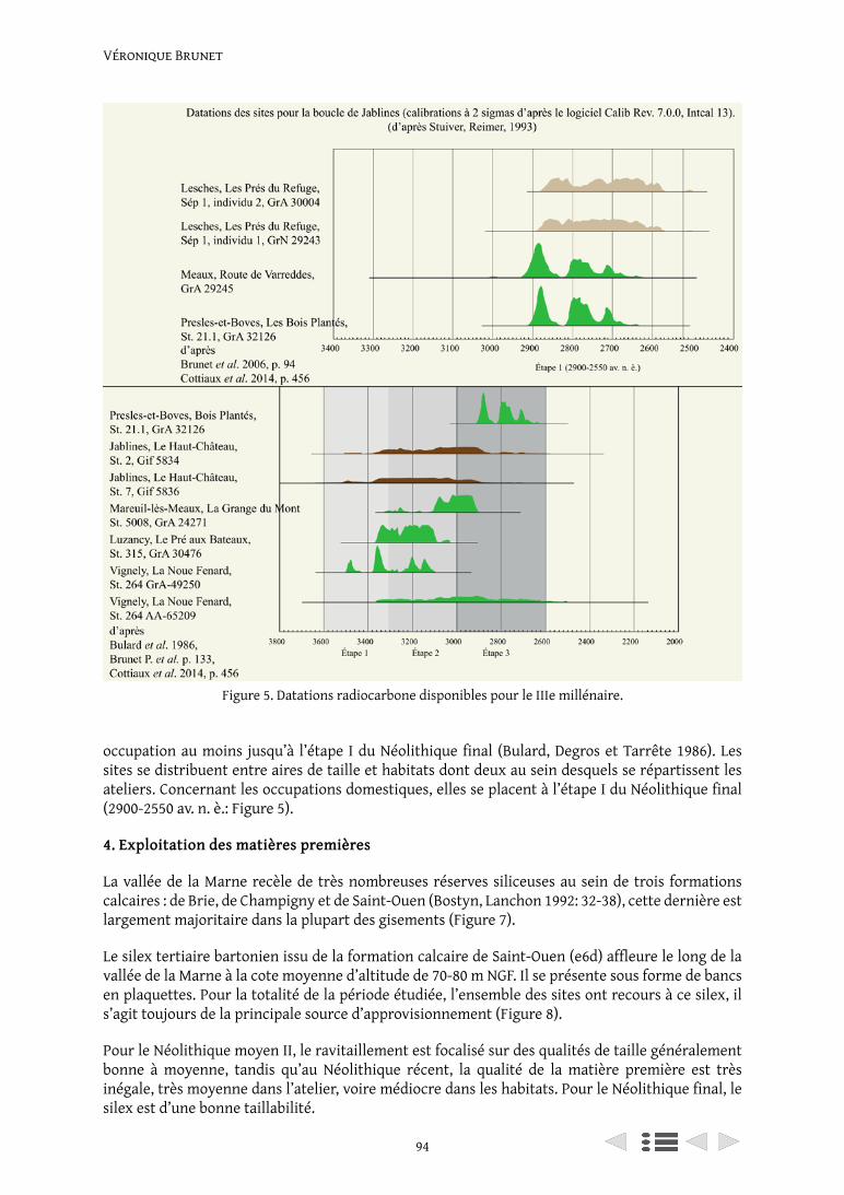
Véronique Brunet
94
Figure 5. Datations radiocarbone disponibles pour le IIIe millénaire.
occupation au moins jusqu’à l’étape I du Néolithique final (Bulard, Degros et Tarrête 1986). Les sites se distribuent entre aires de taille et habitats dont deux au sein desquels se répartissent les ateliers. Concernant les occupations domestiques, elles se placent à l’étape I du Néolithique final (2900-2550 av. n. è.: Figure 5).
4. Exploitation des matières premières
La vallée de la Marne recèle de très nombreuses réserves siliceuses au sein de trois formations calcaires : de Brie, de Champigny et de Saint-Ouen (Bostyn, Lanchon 1992: 32-38), cette dernière est largement majoritaire dans la plupart des gisements (Figure 7).
Le silex tertiaire bartonien issu de la formation calcaire de Saint-Ouen (e6d) affleure le long de la vallée de la Marne à la cote moyenne d’altitude de 70-80 m NGF. Il se présente sous forme de bancs en plaquettes. Pour la totalité de la période étudiée, l’ensemble des sites ont recours à ce silex, il s’agit toujours de la principale source d’approvisionnement (Figure 8).
Pour le Néolithique moyen II, le ravitaillement est focalisé sur des qualités de taille généralement bonne à moyenne, tandis qu’au Néolithique récent, la qualité de la matière première est très inégale, très moyenne dans l’atelier, voire médiocre dans les habitats. Pour le Néolithique final, le silex est d’une bonne taillabilité.
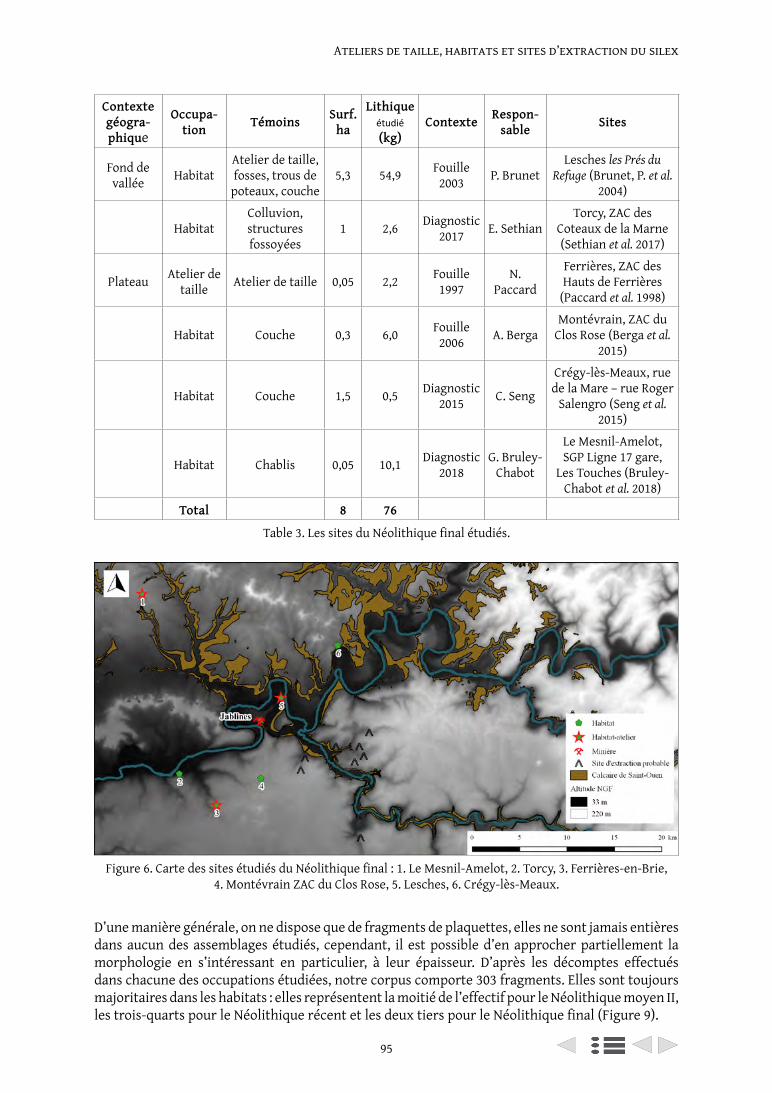
95
Ateliers de taille, habitats et sites d’extraction du silex
D’une manière générale, on ne dispose que de fragments de plaquettes, elles ne sont jamais entières dans aucun des assemblages étudiés, cependant, il est possible d’en approcher partiellement la morphologie en s’intéressant en particulier, à leur épaisseur. D’après les décomptes effectués dans chacune des occupations étudiées, notre corpus comporte 303 fragments. Elles sont toujours majoritaires dans les habitats : elles représentent la moitié de l’effectif pour le Néolithique moyen II, les trois-quarts pour le Néolithique récent et les deux tiers pour le Néolithique final (Figure 9).
Contexte géogra-phique
Occupa-tion Témoins Surf.
ha
Lithique étudié (kg)
Contexte Respon-sable Sites
Fond de vallée Habitat
Atelier de taille, fosses, trous de
poteaux, couche5,3 54,9 Fouille
2003 P. BrunetLesches les Prés du
Refuge (Brunet, P. et al. 2004)
HabitatColluvion, structures fossoyées
1 2,6 Diagnostic 2017 E. Sethian
Torcy, ZAC des Coteaux de la Marne (Sethian et al. 2017)
Plateau Atelier de taille Atelier de taille 0,05 2,2 Fouille
1997N.
Paccard
Ferrières, ZAC des Hauts de Ferrières
(Paccard et al. 1998)
Habitat Couche 0,3 6,0 Fouille 2006 A. Berga
Montévrain, ZAC du Clos Rose (Berga et al.
2015)
Habitat Couche 1,5 0,5 Diagnostic 2015 C. Seng
Crégy-lès-Meaux, rue de la Mare – rue Roger
Salengro (Seng et al. 2015)
Habitat Chablis 0,05 10,1 Diagnostic 2018
G. Bruley-Chabot
Le Mesnil-Amelot, SGP Ligne 17 gare,
Les Touches (Bruley-Chabot et al. 2018)
Total 8 76
Table 3. Les sites du Néolithique final étudiés.
Figure 6. Carte des sites étudiés du Néolithique final : 1. Le Mesnil-Amelot, 2. Torcy, 3. Ferrières-en-Brie, 4. Montévrain ZAC du Clos Rose, 5. Lesches, 6. Crégy-lès-Meaux.
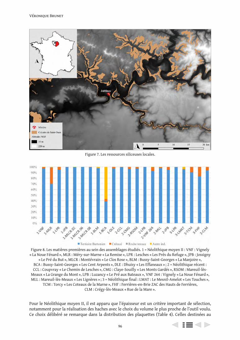
Véronique Brunet
96
Pour le Néolithique moyen II, il est apparu que l’épaisseur est un critère important de sélection, notamment pour la réalisation des haches avec le choix du volume le plus proche de l’outil voulu. Ce choix délibéré se remarque dans la distribution des plaquettes (Table 4). Celles destinées au
Figure 7. Les ressources siliceuses locales.
Figure 8. Les matières premières au sein des assemblages étudiés. 1 = Néolithique moyen II : VNF : Vignely « La Noue Fénard », MLR : Méry-sur-Marne « La Remise », LPR : Lesches « Les Prés du Refuge », JPB : Jossigny
« Le Pré du But », MLCR : Montévrain « Le Clos Rose », BLM : Bussy-Saint-Georges « La Manjoire », BCA : Bussy-Saint-Georges « Les Cent Arpents », DLE : Dhuisy « Les Effaneaux » ; 2 = Néolithique récent : CCL : Coupvray « Le Chemin de Lesches », CMG : Claye-Souilly « Les Monts Gardés », RSOM : Mareuil-lès-
Meaux « La Grange du Mont », LPB : Luzancy « Le Pré aux Bateaux », VNF 264 : Vignely « La Noue Fénard », MLL : Mareuil-lès-Meaux « Les Lignères » ; 3 = Néolithique final : LMAT : Le Mesnil-Amelot « Les Touches »,
TCM : Torcy « Les Coteaux de la Marne », FHF : Ferrières-en-Brie ZAC des Hauts de Ferrières, CLM : Crégy-lès-Meaux « Rue de la Mare ».
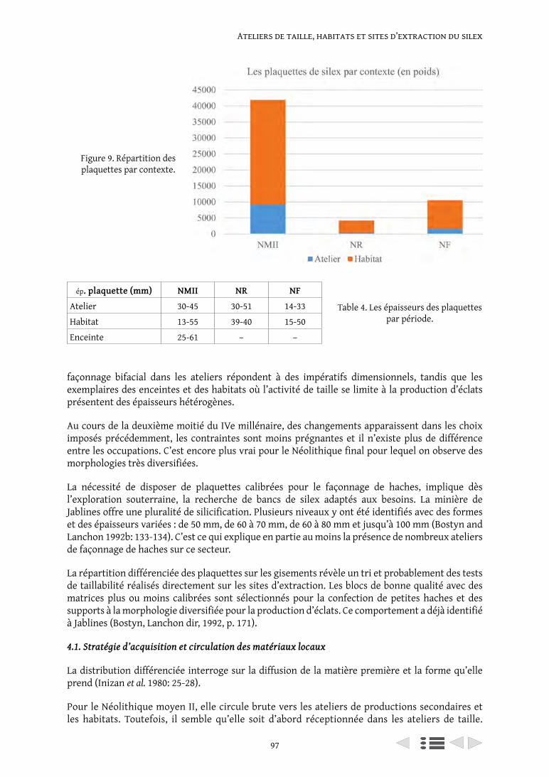
97
Ateliers de taille, habitats et sites d’extraction du silex
Figure 9. Répartition des plaquettes par contexte.
ép. plaquette (mm) NMII NR NF
Atelier 30-45 30-51 14-33
Habitat 13-55 39-40 15-50
Enceinte 25-61 – –
façonnage bifacial dans les ateliers répondent à des impératifs dimensionnels, tandis que les exemplaires des enceintes et des habitats où l’activité de taille se limite à la production d’éclats présentent des épaisseurs hétérogènes.
Au cours de la deuxième moitié du IVe millénaire, des changements apparaissent dans les choix imposés précédemment, les contraintes sont moins prégnantes et il n’existe plus de différence entre les occupations. C’est encore plus vrai pour le Néolithique final pour lequel on observe des morphologies très diversifiées.
La nécessité de disposer de plaquettes calibrées pour le façonnage de haches, implique dès l’exploration souterraine, la recherche de bancs de silex adaptés aux besoins. La minière de Jablines offre une pluralité de silicification. Plusieurs niveaux y ont été identifiés avec des formes et des épaisseurs variées : de 50 mm, de 60 à 70 mm, de 60 à 80 mm et jusqu’à 100 mm (Bostyn and Lanchon 1992b: 133-134). C’est ce qui explique en partie au moins la présence de nombreux ateliers de façonnage de haches sur ce secteur.
La répartition différenciée des plaquettes sur les gisements révèle un tri et probablement des tests de taillabilité réalisés directement sur les sites d’extraction. Les blocs de bonne qualité avec des matrices plus ou moins calibrées sont sélectionnés pour la confection de petites haches et des supports à la morphologie diversifiée pour la production d’éclats. Ce comportement a déjà identifié à Jablines (Bostyn, Lanchon dir, 1992, p. 171).
4.1. Stratégie d’acquisition et circulation des matériaux locaux
La distribution différenciée interroge sur la diffusion de la matière première et la forme qu’elle prend (Inizan et al. 1980: 25-28).
Pour le Néolithique moyen II, elle circule brute vers les ateliers de productions secondaires et les habitats. Toutefois, il semble qu’elle soit d’abord réceptionnée dans les ateliers de taille.
Table 4. Les épaisseurs des plaquettes par période.
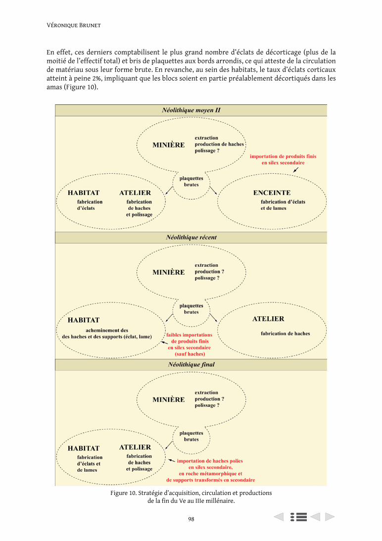
Véronique Brunet
98
En effet, ces derniers comptabilisent le plus grand nombre d’éclats de décorticage (plus de la moitié de l’effectif total) et bris de plaquettes aux bords arrondis, ce qui atteste de la circulation de matériau sous leur forme brute. En revanche, au sein des habitats, le taux d’éclats corticaux atteint à peine 2%, impliquant que les blocs soient en partie préalablement décortiqués dans les amas (Figure 10).
Figure 10. Stratégie d’acquisition, circulation et productions de la fin du Ve au IIIe millénaire.
99
Ateliers de taille, habitats et sites d’extraction du silex
Les ateliers fabriquent exclusivement les haches, la totalité de la chaîne opératoire y est représentée. Il est très occasionnel d’y trouver des nucléus. Les plus petits ateliers fonctionnent différemment, car leur production est tournée uniquement vers la réalisation de supports pour la confection d’outils sur éclat. Dans ce cas, les nucléus probablement sont préparés et débités in situ comme dans les habitats on y trouve les pièces de mise en forme de nucléus.
Dans les enceintes, l’approvisionnement est plus contrasté car les fragments de plaquettes sont relativement nombreux à Vignely alors qu’ils sont quasi inexistants à Méry-sur-Marne. De plus à Vignely, les pièces corticales atteignent 53% de l’effectif total et seulement 8% à Méry-sur-Marne. Par conséquent, la première enceinte semble avoir été directement approvisionnée en blocs bruts depuis les minières voisines. Quant à la seconde, elle est alimentée à partir de nucléus préalablement mis en forme (absence des pièces de mise en forme) pour la fabrication d’outils sur éclat en silex local. En revanche les produits exogènes sont acheminés sous la forme de produits semi-finis et finis dans l’enceinte (absence de nucléus). La production laminaire est réalisée in situ à Méry-sur-Marne uniquement, on n’a retrouvé aucun nucléus à lames à Vignely. Les haches polies ainsi que des ébauches déviantes sont acheminées dans les enceintes soit depuis les ateliers de productions intermédiaires ou directement de Jablines. Les pièces déviantes sont des produits « non conformes aux standards de production recherchés, cumulant des caractéristiques aberrantes » (Chauchat 1991; Augereau 2004a, p. 189). Les pièces déviantes sont réutilisées en nucléus ou en percuteur.
La distribution différenciée témoigne d’un réseau structuré et complexe de l’approvisionnement en ressources siliceuses. Les productions sont déterminées en fonction du lieu de leur réalisation (haches : ateliers, éclats : habitats, lames : enceinte) et font l’objet d’une redistribution suivant les besoins (Brunet, V. et al. en cours).
On a donc un territoire organisé avec des sites fonctionnellement complémentaires et dépendants les uns des autres.
Pour le Néolithique récent, la matière circule sous la forme de blocs bruts de la minière vers l’atelier au sein duquel sont préparées les haches. Dans ce dernier, on dispose de la totalité de la chaîne opératoire, ainsi que de nombreux fragments de plaquettes et de pièces corticales. Parallèlement est réalisée une production d’éclats (en faible quantité), les nucléus sont mis en forme, débités et entretenus dans l’atelier comme le montrent les pièces de mise en forme. Les habitats sont approvisionnés à partir de matériau à une échelle locale par l’exploitation de toutes les ressources siliceuses disponibles. Leur seul point commun est l’absence de fabrication de haches, deux gisements font exception, les sites de Mareuil-lès-Meaux « La Grange du Mont » et « Les Lignères ». Sur ces deux sites, une partie du matériel se rapporte au façonnage de pièces bifaciales, mais dont la finalité n’est pas la réalisation de hache. Dans le premier cas, il s’agit de récupérer les produits bifaciaux déviants et de tirer parti d’un tranchant qui est utilisé sans doute en percussion, il est alors fortement esquillé. Dans le second cas, la finalité du façonnage est la réalisation de pics. Toutefois, dans la majorité des cas, les faibles quantités d’éclats de façonnage montrent l’absence de productions de haches dans les habitats, seules les ébauches préformées et achevées y sont acheminées.
Au sein des habitats, les productions d’éclats sont numériquement supérieures à celles des lames. Les nucléus sont le plus souvent absents des occupations domestiques. Ils sont par conséquent alimentés directement en supports bruts et retouchés. Très occasionnellement, il existe des gisements où les nucléus sont mis en forme, débités et entretenus. Il s’agit de Vignely et de Mareuil-lès-Meaux « Les Lignères ». Le premier présente un assemblage particulier de vestiges orienté vers la chasse et la boucherie, avec un outillage spécifique lié à ces activités, avec une très forte proportion de grattoirs. Le second est le seul site du bassin aval de la Marne livrant un corpus lithique d’un poids de plus de 40 kg. La comparaison avec les autres occupations est

Véronique Brunet
100
par conséquent délicate au regard des quantités de la plupart des séries dont la moyenne est équivalente à 5 kg. La production laminaire semble avoir été réalisée à Mareuil-lès-Meaux « Les Lignères » et à Jossigny, car ce sont les seuls sites livrant des nucléus à lames. Les autres gisements semblent uniquement alimentés avec des lames à crête, lames de plein débitage, des pièces d’entretien et des outils.
Ainsi, au Néolithique récent, les chaînes opératoires sont segmentées et les occupations domestiques sont dépendantes les unes des autres et de la production des ateliers de productions (Figure 10).
Pour le Néolithique final, les bris de plaquettes sont plus nombreux dans les habitats que dans les ateliers. Leurs bords arrondis laissent penser qu’elles sont parvenues brutes directement depuis les sites d’extraction vers les gisements. Les éclats corticaux se répartissent à part égale entre les habitats et les ateliers. Dans ces derniers, la production de haches est majoritaire, on y trouve la totalité de la chaîne opératoire. Concernant la production d’éclats, elle est réalisée dans les ateliers et les habitats. Les nucléus y sont préparés, débités et entretenus pour réaliser les outils. Les effectifs des éclats dominent celui des lames. Ces dernières ne sont produites sur aucun gisement connu, les produits laminaires bruts ou retouchés sont acheminés directement dans les occupations domestiques.
Ainsi au Néolthique final, les habitats sont autonomes les uns des autres, ils fabriquent localement pour leurs besoins propres (Figure 10).
4.2. Les matériaux exogènes
Pour le Néolithique moyen II, l’approvisionnement se fait principalement par les enceintes avec l’apport de silex crétacé essentiellement. À Vignely, le Sénonien est majoritaire tandis qu’à Méry-sur-Marne c’est le Campanien (Brunet, V. et al. à paraître). La stratégie d’acquisition consiste à importer les supports sous leur forme achevée. Peu sont retouchés (48%) par rapport aux lames, ces dernières sont moins courantes, mais plus fréquemment transformées (60%). Les nucléus à lames sont peu nombreux, on ne les trouve que dans les enceintes et en très faible quantité.
Pour le Néolithique récent, les habitats sont alimentés de supports bruts, un tiers est acheminé sous la forme d’outils du crétacé majoritairement. La stratégie d’acquisition est la même qu’à la période précédente, les trois quarts de l’effectif sont constitués d’éclats, peu sont retouchés (26%), les supports laminaires sont donc moins courants, mais plus fréquemment transformés (44%). En ce qui concerne la production bifaciale, les apports sont particulièrement faibles, on ne compte qu’une seule hache polie en roche tenace, un pic ainsi que deux percuteurs en Crétacé dans la totalité des assemblages.
Pour le Néolithique final, les choix sont tout autres, l’accent est porté sur les supports laminaires, un sur deux est transformé. Les provenances se diversifient avec les silex du crétacé et du Turonien du Grand-Pressigny (une dizaine de poignards). Quant à la production bifaciale, les importations augmentent avec une nette préférence pour les roches tenaces au détriment du silex crétacé.
5. La production bifaciale au cours du temps
Tout au long de la période étudiée, les ateliers de productions intermédiaires semblent spécialisés dans la fabrication de haches. Au regard des quantités de déchets, on constate qu’il ne s’agit pas d’une production en série, à grande échelle, mais plutôt celle destinée à une consommation domestique. À titre de comparaison, l’un des amas de la minière de Jablines livre près de 277 kg
101
Ateliers de taille, habitats et sites d’extraction du silex
de silex taillés (Bostyn et Lanchon 1992b, p. 143). Le poids de silex des ateliers intermédiaires du Néolithique moyen II s’échelonne de 1 à 160 kg, du Néolithique récent de 59 kg et du Néolithique final de 2 à 19 kg, ce qui est peu comparativement.
Au début du IVe millénaire, la production bifaciale est axée sur la fabrication de haches. Le site d’extraction réalise de grands et de petits modules respectivement 30 cm et 10 à 17 cm (Bostyn et Lanchon 1992b). Les ateliers de productions intermédiaires créent uniquement les plus petits (de 12,6 à 14 cm). Les ébauches préparées dans les ateliers secondaires sont issues d’une production relativement peu standardisée et sont fabriquées à partir de supports variés : plaquettes et éclats (Figure 11). Les haches polies sont toutes brisées, à l’exception de deux, la plus grande mesure 12,6 cm. Elles sont trapézoïdales ou quadrangulaires. La section est biconvexe, parfois très plate. Les bords portent indifféremment des méplats (Figure 12).
Durant la seconde moitié du IVe millénaire, la production bifaciale se diversifie avec le façonnage de haches, de pics et de pièces bifaciales à tranchant actif (Figure 13). On sait par ailleurs que la minière de Jablines continue d’être exploitée, mais on n’en connaît ni les productions ni la diffusion. L’atelier fabrique des haches taillées de petits modules peu standardisés (entre 10 et 19,5 cm) et une longueur moyenne de 12,5 cm pour les haches polies (Figure 14).
Au cours du IIIe millénaire, la production bifaciale est à nouveau axée sur le façonnage de haches. La longueur des haches taillées est comprise entre 11,8 et 19 cm et de 7 à 20 cm pour les haches polies (Figures 15 and 16). Les formes sont variées : trapézoïdales à bords équarris ou à bords renflés avec un tranchant très étroit. Les sections sont plano-convexes, biconvexes dissymétriques. Deux lames polies aux bords renflés étaient associées à une hache taillée, formant probablement un dépôt sur le site de Lesches (Figure 17). Ces pièces de grandes dimensions trouvent une parenté avec un exemplaire découvert dans la sépulture collective de Montigny à Esbly située à quelques centaines de mètres du site de Lesches (Arnette 1961). Une autre similaire, est connue à Meaux, en contexte domestique (Brunet, P. et al. 2007, fig. 33). Toutes les catégories définies par C. Renard sont représentées dans notre corpus : les haches courtes entre 5 cm et 6 cm, les moyennes entre 9 cm et 13 cm et les plus longues autour de 15 cm (Renard 2010b, p. 240).
Durant les deux millénaires étudiés, les haches produites dans les ateliers intermédiaires sont distribuées localement dans les habitats, sépultures, enceintes et même probablement en minière. En effet, certaines pourraient avoir été utilisées pour l’extraction, nombreuses sont celles qui gisaient au fond des puits ou des galeries, leurs tranchants présentaient : « un aspect usé et esquillé », elles ont probablement été employées à des fins extractives (Bostyn et Lanchon 1992a, p. 174).
6. La production de haches dans les ateliers de productions intermédiaires, évaluation des savoir-faire
L’évaluation des niveaux de savoir-faire est rendue possible par le recensement des accidents de taille et des erreurs de débitage. L’appréciation des degrés de compétence technique peut également être approchée à partir de l’examen des talons des éclats détachés au percuteur tendre appartenant à la dernière étape du façonnage d’une ébauche de hache. Il s’agit de la phase de régularisation (Bostyn 2018; Bostyn et Cayol 2012, p. 155; Augereau 2004b, p. 188). Notre échantillon comporte au total 217 haches taillées et 100 polies.
Au Néolithique moyen II, les causes d’abandon des ébauches sont multiples. Des différences importantes au niveau des formes et des dimensions révèlent l’absence réelle de standardisation. Elles montrent que le choix du support n’est pas toujours optimal, ils sont parfois trop minces ou de mauvaise qualité. Elles peuvent aussi être liées à l’utilisation d’un percuteur inadéquat qui provoque trous ou gibbosités impossibles à récupérer. Certains ateliers réalisent les
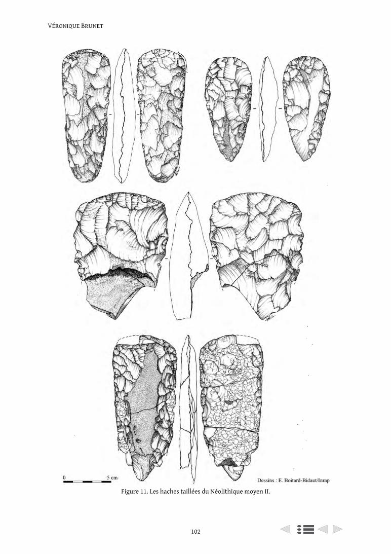
Véronique Brunet
102
Figure 11. Les haches taillées du Néolithique moyen II.
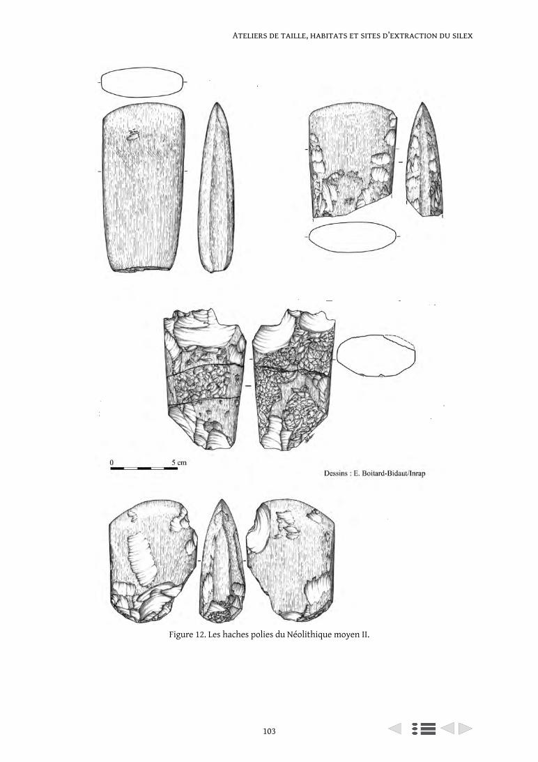
103
Ateliers de taille, habitats et sites d’extraction du silex
Figure 12. Les haches polies du Néolithique moyen II.
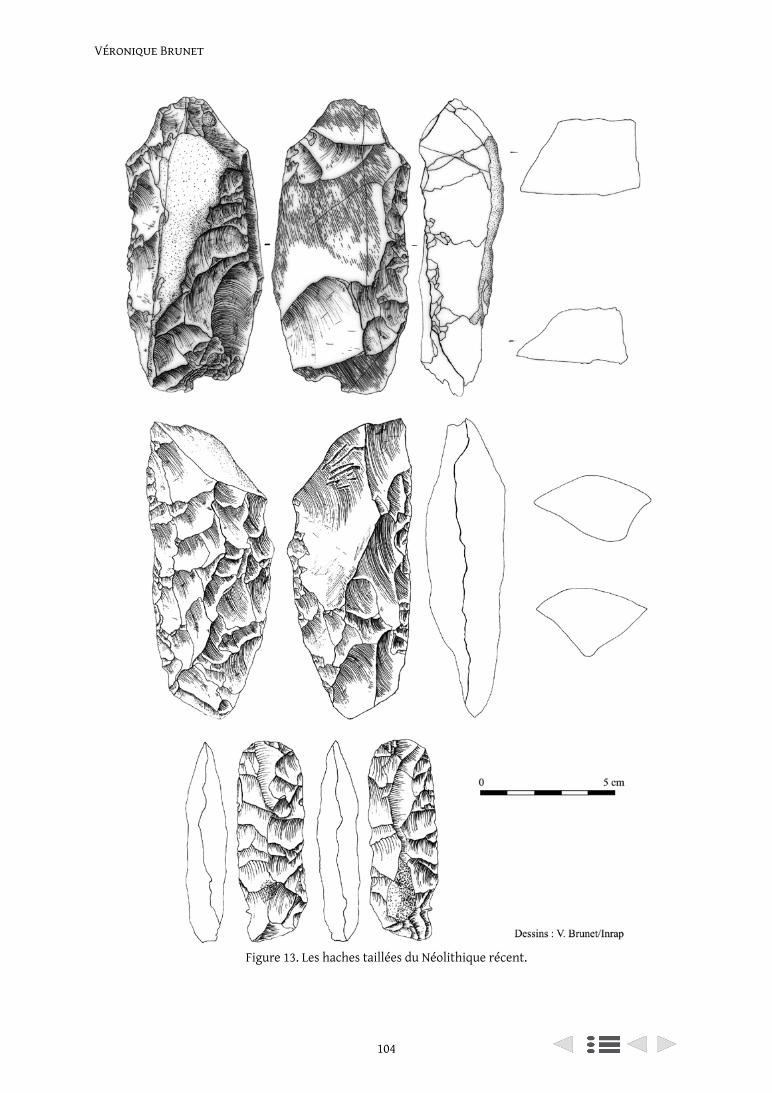
Véronique Brunet
104
Figure 13. Les haches taillées du Néolithique récent.
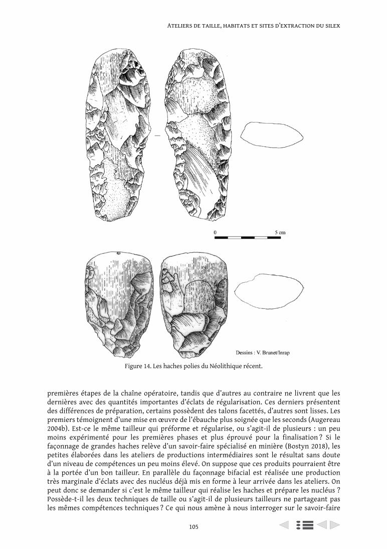
105
Ateliers de taille, habitats et sites d’extraction du silex
Figure 14. Les haches polies du Néolithique récent.
premières étapes de la chaîne opératoire, tandis que d’autres au contraire ne livrent que les dernières avec des quantités importantes d’éclats de régularisation. Ces derniers présentent des différences de préparation, certains possèdent des talons facettés, d’autres sont lisses. Les premiers témoignent d’une mise en œuvre de l’ébauche plus soignée que les seconds (Augereau 2004b). Est-ce le même tailleur qui préforme et régularise, ou s’agit-il de plusieurs : un peu moins expérimenté pour les premières phases et plus éprouvé pour la finalisation ? Si le façonnage de grandes haches relève d’un savoir-faire spécialisé en minière (Bostyn 2018), les petites élaborées dans les ateliers de productions intermédiaires sont le résultat sans doute d’un niveau de compétences un peu moins élevé. On suppose que ces produits pourraient être à la portée d’un bon tailleur. En parallèle du façonnage bifacial est réalisée une production très marginale d’éclats avec des nucléus déjà mis en forme à leur arrivée dans les ateliers. On peut donc se demander si c’est le même tailleur qui réalise les haches et prépare les nucléus ? Possède-t-il les deux techniques de taille ou s’agit-il de plusieurs tailleurs ne partageant pas les mêmes compétences techniques ? Ce qui nous amène à nous interroger sur le savoir-faire
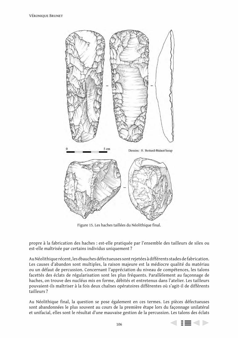
Véronique Brunet
106
Figure 15. Les haches taillées du Néolithique final.
propre à la fabrication des haches : est-elle pratiquée par l’ensemble des tailleurs de silex ou est-elle maîtrisée par certains individus uniquement ?
Au Néolithique récent, les ébauches défectueuses sont rejetées à différents stades de fabrication. Les causes d’abandon sont multiples, la raison majeure est la médiocre qualité du matériau ou un défaut de percussion. Concernant l’appréciation du niveau de compétences, les talons facettés des éclats de régularisation sont les plus fréquents. Parallèlement au façonnage de haches, on trouve des nucléus mis en forme, débités et entretenus dans l’atelier. Les tailleurs pouvaient-ils maîtriser à la fois deux chaînes opératoires différentes où s’agit-il de différents tailleurs ?
Au Néolithique final, la question se pose également en ces termes. Les pièces défectueuses sont abandonnées le plus souvent au cours de la première étape lors du façonnage unilatéral et unifacial, elles sont le résultat d’une mauvaise gestion de la percussion. Les talons des éclats
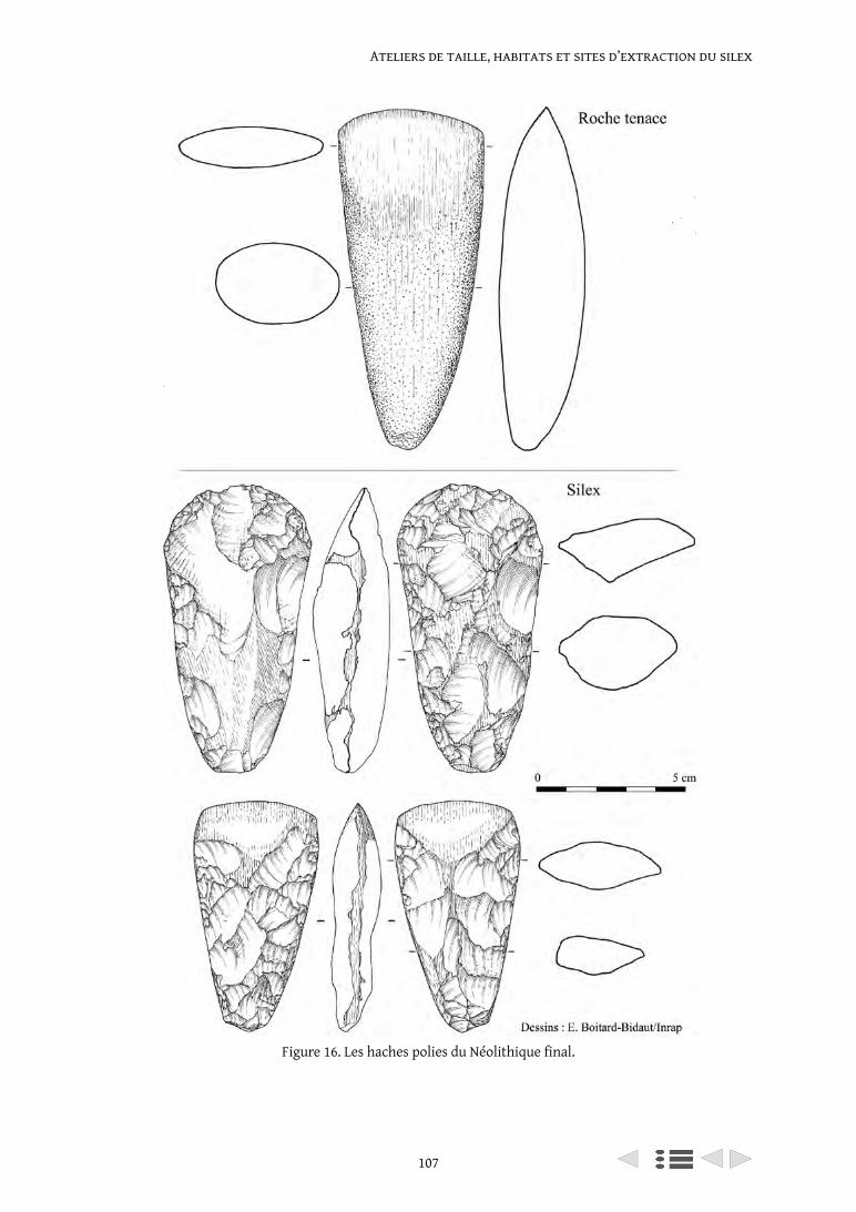
107
Ateliers de taille, habitats et sites d’extraction du silex
Figure 16. Les haches polies du Néolithique final.
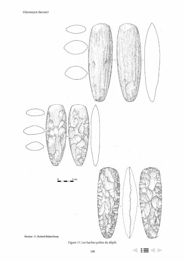
Véronique Brunet
108
Figure 17. Les haches polies du dépôt.
109
Ateliers de taille, habitats et sites d’extraction du silex
de régularisation sont majoritairement facettés. Les nucléus sont mis en forme, débités et entretenus à la fois dans les ateliers et l’habitat.
7. Conclusion
L’existence d’ateliers de productions intermédiaires, extérieurs aux habitats et aux minières correspond à un système de production différenciée des haches sur notre secteur. Leur rôle est majeur dans l’organisation des productions lithiques. Leur localisation fluctue au cours du temps variant de quelques dizaines de mètres à plusieurs kilomètres des occupations domestiques. Ils constituent une interface entre la minière et les habitats au sein desquels des tailleurs plus ou moins expérimentés pourraient y avoir exercé leur savoir-faire.
La comparaison des approvisionnements (locaux et exogènes) et des productions dans une perspective évolutive montre des sites fonctionnellement complémentaires et dépendants les uns des autres avec des habitats clairement assujettis aux ateliers pour la fabrication des haches. Concernant les matières premières exogènes, l’introduction au cours du temps semble se réaliser via les enceintes puis par les habitats. Seuls des outils sur éclat ou lame en matériaux exogènes sont acheminés dans les enceintes à l’exclusion de haches, en revanche, dès la fin du Néolithique des haches en crétacé et roche tenace sont finalement introduites avec l’outillage domestique. En terme évolutif, la création d’ateliers de productions intermédiaires de haches entre les enceintes et les minières cédera la place à des ateliers mêlant productions domestiques et bifaciales. Ces variations mettent sans doute en évidence une transformation des relations entre tailleurs et consommateurs.
Bibliographie
Arnette, S. 1961. Allées couvertes de ‘Seine-Oise-Marne’ dans la région d’Esbly. Gallia Préhistoire, IV: 77-83.
Aubry, L., Bostyn, F., Brunet V., Collet, H., Giligny, F., Liétar, C. et Manolakakis, L. 2014. Territoires et ressources lithiques dans le nord de la France et en Belgique dans l’horizon Chasséen-Michelsberg. In Actes du 30e colloque interrégional sur le Néolithique de Tours, 3-5 novembre 2011, Revue archéologique du Centre de la France. Supplément. Zones de productions et organisation des territoires au Néolithique. Espaces exploités, occupés, parcourus. Actes du 30e colloque interrégional sur le Néolithique (Tours, 2011). Tours: FERACF: 65-83.
Augereau, A. 2004a. L’industrie du silex du Ve au IVe millénaire dans le sud-est du Bassin parisien: Rubané, Villeneuve-Saint-Germain, Cerny et groupe de Noyen. Paris: Maison des Sciences de l’Homme (Documents d’Archéologie Française).
Augereau, A. 2004b. L’industrie du silex du Ve au IVe millénaire dans le sud-ouest du Bassin parisien : Rubané, Villeneuve-Saint-Germain, Cerny et groupe de Noyen. Paris : Maison des Sciences de l’Homme (Documents d’Archéologie Française).
Bostyn, F. 2018. Spécialistes et spécialisations : essai sur les industries lithiques du Néolithique ancien et moyen du nord-ouest de la France. Thèse d’habilitation à diriger des recherches, université de Paris 1 Panthéon-Sorbonne.
Bostyn, F. et Cayol, N. 2012. Productions de spécialistes, productions spécialisées : l’organisation des productions en silex sur les sites d’habitat du Villeneuve-Saint-Germain dans la moyenne vallée de l’Oise. Bulletin de la Société Préhistorique Française: 279-298.
Bostyn, F. et Lanchon, Y. 1992a. Jablines : le Haut Château (Seine-et-Marne) : une minière de silex au néolithique. Documents d’archéologie française ed. Éd. de la Maison des sciences de l’homme.
Bostyn, F. et Lanchon, Y. 1992b. Jablines le Haut-Château, Seine-et-Marne : une minière de silex au Néolithique. Paris: Éditions de la Maison des sciences de l’Homme, (Documents d’archéologie française).
Bruley-Chabot, G. et Brunet V. 2018. Le Mesnil-Amelot SGP Ligne 17 gare « Les Touches » phase 1. Pantin: Service Régional d’Archéologie d’Île-de-France, Paris, p. 117.
Véronique Brunet
110
Brunet P., Brunet V., Bémilli, C., Gosselin, R., Le Jeune, Y., André, M.-F., Cottiaux, R., Durand, J. et Renard, C. 2004. Deux sites de la fin du Néolithique en vallée de Marne : Lesches « Les Prés du Refuge » et Meaux « Route de Varreddes » (Seine-et-Marne). Résultats préliminaires. In Actes de la Journée d’information du 20 novembre 2004. Internéo 5. Paris: Éditions de l’Association pour les Études Interrégionales sur le Néolithique (INTERNEO) et de la Société Préhistorique Française: 101-114.
Brunet P., Cottiaux, R., André, M.-F., Bécu-Aïssou, B., Bémilli, C., Bertrand, C., Boitard-Bidaut, È., Durand, J., Eusèbe, S., Gosselin, R., Hamon, C., Le Jeune, Y., Maigrot, Y. et Pariat, J.-G. 2007. Meaux (Seine-et-Marne), « Route de Varreddes, Chemin de Flandres » : occupations du Néolithique sur les « Coteaux de la Justice ». Pantin : Inrap CIF/Saint-Denis : Service Régional d’Archéologie d’Île-de-France, p. 131.
Brunet, P., à paraître. La céramique du Néolithique récent de l’atelier de façonnage de haches de Coupvray « Le Chemin de Lesches » en Seine-et-Marne.
Brunet, P., Bémilli, C., Brunet V., Gosselin, R., Hamon, C. et Maigrot, Y. 2011. Vestiges de chasse au Néolithique récent : la fosse de Vignely au bord de la Marne. Archéopages, 28(28): 20-25.
Brunet, P., Bémilli, C., Brunet V., Hamon, C., Gosselin, R., Le Jeune, Y., Maigrot, Y. et Martineau, R. 2014. La fosse 264 du Néolithique récent de Vignely, la Noue Fénard (Seine-et-Marne). In La fin du IVe millénaire dans le Bassin parisien, le Néolithique récent entre Seine Oise et Marne (3500-2900 avant notre ère) sous la direction de R. Cottiaux et L. Salanova, Revue Archéologique de l’Est /Revue Archéologique d’Île-de-France. Paris: 93-136.
Brunet, V. 1996. Coupvray « Le Chemin de Lesches » (Seine-et-Marne). Un atelier de façonnage de haches en silex : approche technologique et typologique. Mémoire de D.E.A. sous la direction de Marion Lichardus. [Université de Paris 1, UFR d’Histoire de l’art et d’Archéologie] Paris.
Brunet, V. 2007. Cinq ateliers de taille de haches en silex du Néolithique moyen II découverts à Jossigny en Seine-et-Marne. Paris: INRAP, SRA DRAC Île-de-France: 16-17.
Brunet, V. 2013. Jossigny, un site du Néolithique moyen II sur le plateau briard (77) – POSTER. In Actes du 31e Colloque Internéo 2013-18 et 19 octobre 2013. Occupations et exploitations néolithiques : et si l’on parlait des plateaux ? Châlons-en-Champagne (51).
Brunet, V. et Blaser, R. 2014a. Productions lithiques en plateau et en fond de vallée au Néolithique moyen II : divergences techniques et économiques avec les exemples de Jossigny (77) et de Neuville-sur-Oise (95). In Actes de 31e Colloque Internéo 2013 des 17, 18 et 19 octobre 2013. Occupations et exploitations néolithiques : et si l’on parlait des plateaux ? Châlons-en-Champagne (51): Bulletin de la Société archéologique champenoise: 139-167.
Brunet, V. et Blaser, R. 2014b. Productions lithiques en plateau et en fond de vallée en habitat au Néolithique moyen II : divergences techniques et économiques avec les exemples de Jossigny « Le Pré du But » (77) et de Neuville-sur-Oise « Chemin Fin de l’Oise » (95). In C. Laurelut, J. Vanmoerkerke (dir.), Actes du 31e Colloque Internéo 2013 des 17, 18 et 19 octobre 2013 – Châlons-en-Champagne (51). Occupations et exploitations néolithiques : et si l’on parlait des plateaux ? Châlons-en-Champagne: Bulletin de la Société archéologique champenoise: 129-158.
Brunet, V., Boitard-Bidaut, È., Cayol, N., Traon-Maingaud, A., Monchablon, C., Hachem, L., Liétar, C., Barrey, M., Borgnon, C., Brunet P., Polloni, A., Chambon, P., Thomas, A., Leroyer, C., Traon-Maingaud, A., Monchablon, C., Pariat, J.-G., Salavert, A., Dietsch-Sellami, M.-F., Colas, C., Bostyn, F., Fronteau, G. et Le Jeune, Y., en cours. Le monument funéraire Cerny et l’enceinte Michelsberg de Vignely La Noue Fénard (Seine-et-Marne).
Brunet, V., Bulard, A., Boitard-Bidaut, È., Cayol, N., Irribarria, R., Monchablon, C., Traon-Maingaud, A. et Tresset, A., à paraître. L’enceinte du Néolithique moyen de La Remise à Méry-sur-Marne (Seine-et-Marne). Revue Archéologique d’Île-de-France.
Brunet, V. et Colas, C. 2018. Nouveaux bâtiments du Michelsberg récent à Jossigny and Montévrain (77) et Cuiry-lès-Chaudardes (02). In Deuxièmes Rencontres Nord-Sud de Préhistoire Récente Dijon 19-21 novembre 2015. Habitations et habitat du Néolithique à l’âge du Bronze en France et ses marges. Toulouse, France: Archives d’Écologie Préhistorique: 101-115.
Brunet, V., Durand, J., Bémilli, C., Bostyn, F., Brunet P., Casadéi, D., David, C., Dietsch-Sellami, M.-F., Duplessis, M., Henry-Duplessis, S., Lanchon, Y. et Monchablon, C. 2008. L’industrie en silex : approche technologique et typologique de la série du Néolithique récent dans Mareuil-lès-Meaux (Seine-
111
Ateliers de taille, habitats et sites d’extraction du silex
et-Marne), Rocade sud-ouest de Meaux : lots 2 et 5. Pantin : Inrap CIF: Service Régional d’Archéologie d’Île-de-France, Saint-Denis, p. 245.
Brunet, V. et Le Jeune, Y. 2008. Présentation préliminaire de l’occupation néolithique de Montévrain et de Jossigny (Seine-et-Marne). In InterNéo 7. Journées d’information du 22 novembre 2008. Paris: Éditions de l’Association pour les Études Interrégionales sur le Néolithique (InterNéo) et de la Société Préhistorique Française: 121-129, 3 fig.
Brunet, V., Paccard, N., Poulain, D. et André, M.-F. 1995. L’industrie en silex : approche technologique et typologique dans Ferrières-en-Brie (Seine-et-Marne), ZAC des Hauts-de-Ferrières (Première tranche). Pantin : Afan CIF: Service Régional de l’Archéologie d’Île-de-France, p. 23.
Brunet, V., Seng, C., Lepareux-Couturier, S. et Brunet P. 2015. Étude de l’industrie lithique néolithique dans Crégy-lès-Meaux (Seine-et-Marne), Rue de la Mare – rue Roger Salengro. Pantin: INRAP/Paris : Service Régional d’Archéologie d’Île-de-France, p. 65.
Brunet, V. et Sethian, E. 2018. Étude de l’industrie lithique néolithique dans Serris ZAC du Couternoy. Pantin: INRAP/Paris: Service Régional d’Archéologie d’Île-de-France.
Bulard, A., Degros, J. et Tarrête, J. 1986. Premières fouilles sur le site néolithique d’extraction du silex du Haut-Château à Jablines (Seine et Marne). In 10ème colloque interrégional sur le Néolithique : Caen, 30 septembre -2 octobre 1983, Revue Archéologique de l’Ouest. La Néolithisation, les minières à silex, les rapports entre l’Est et l’Ouest de la France, l’homme néolithique et son environnement. Rennes: Association pour la diffusion des recherches archéologiques dans l’Ouest de la France: 55-70.
Bulard, A., Drouhot, C., Augereau, A., Martinez, R. et Tresset, A. 1996. L’enceinte néolithique de Méry-sur-Marne (77). In journées archéologiques d’Île-de-France du 21-22 septembre 1996. Lagny-sur-Marne: Service Régional de l’archéologie d’Île-de-France, MCC, Préfecture de la région Île-de-France, DRAC.
Chauchat, C. 1991. L’approche technologique dans une étude régionale: le Paijanien de la côte du Pérou. In Actes des 11èmes rencontres internationales d’Archéologie et d’Histoire d’Antibes, oct. 1990, Juan-les-Pins. 25 ans d’études technologiques en préhistoire, bilan et perspectives. Juan-lès-Pins: Éditions APCA: 263-273.
Colas, C., Brunet V., Boitard-Bidaut, È., Cayol, N., Traon-Maingaud, A., Monchablon, C., Hachem, L., Liétar, C., Barrey, M., Borgnon, C., Brunet P., Polloni, A., Chambon, P., Thomas, A., Leroyer, C., Traon-Maingaud, A., Monchablon, C., Pariat, J.-G., Salavert, A., Dietsch-Sellami, M.-F., Bostyn, F., Fronteau, G. et Le Jeune, Y., en cours. La céramique de l’enceinte michelsberg de Vignely La Noue Fénard (Seine-et-Marne).
Cottiaux, R. 1991. Inventaire des sites d’habitat du 3e millénaire avant Jésus-Christ dans le Bassin parisien. Mémoire de D.E.A. Université Paris I Pathéon-Sorbonne.
Cottiaux, R. 2014. Les sites d’habitat du Néolithique récent dans la basse vallée de la Marne. In La fin du IVe millénaire dans le Bassin parisien, le Néolithique récent entre Seine Oise et Marne (3500-2900 avant notre ère) sous la direction de R. Cottiaux et L. Salanova, Revue Archéologique de l’Est /Revue Archéologique d’Île-de-France. Paris: 151-187.
Cottiaux, R., Augereau, A., Bouquet, L., Brunet P., Costa, L., Hamon, T., Ihuel, E., Langry-François, F., Lepareux-Couturier, S., Magne, P., Maingaud, A., Mallet, N., Martineau Rémi, Mille, B., Millet-Richard, L.-A., Polloni, A., Renard, C., Richard, G., Salanova, L. et Sidéra, I. 2004. Projet collectif de recherches « du Néolithique récent à l’Âge du Bronze ancien dans le Centre Nord de la France : définitions et interactions des groupes culturels » n° 2004-282. Rapport d’activité 2004. Pantin : Inrap CIF: Service Régional d’Archéologie d’Île-de-France, Saint-Denis, p. 257.
Demoule, J.-P., Lüth, F., Dubouloz, J., Giligny, F., Lanchon, Y., Van Montfort, B., Weller, O., Manolakakis, L., Hachem, L., Brunet V., Bostyn, F., Chartier, M., Colas, C., Collet, H., Cottiaux, R., Desloges, J., Duffraisse, A., Ghesquière, E., Laurelut, C., Le Bolloch, M., Le Maux, N., Leroyer, C., Maigrot, Y., Marcigny, C., Monchablon, C., Praud, I., Robert, B. et Salavert, A., en cours. De la culture matérielle à la structuration de l’espace : enceintes monumentales, ressources exploitées et territorialité dans l’aire du Michelsberg et des cultures voisines (4500-3500 BC). Nanterre (Maison Archéologie and Ethnologie): 8215-Trajectoires-MAE, 7194 et 7209-MNHM, 6566-CREAAH, 6249-Chrono-environnement, 7264-CEPAM), du CNRS, de l’Université de Paris 1, de l’INRAP, de l’Université de Reims et de la Sous-Direction de l’Archéologie (MCC) pour la France ; du Service Archéologique de Wallonie et de l’Université de Louvain, pour la Belgique ; du RGZm et de la Johannes Gutenberg-Universität
Véronique Brunet
112
de Mayence, de la RGK (DAI) de Francfort, de la Christian-Albrechts-Universität zu Kiel et des Landesdenkmalamt de Hesse et de Sachsen-Anhalt, pour l’Allemagne.
Inizan, M.-L., Reduron-Ballinger, M., Roche, H. et Tixier, J. 1980. Préhistoire de la pierre taillée, 1 : terminologie et technologie. Centre de Recherches et d’Études Préhistoriques ed.
Lanchon, Y. 2006. Fouille de sauvetage d’un monument funéraire et d’une enceinte néolithiques à Vignely « La Noue Fenard » (Seine-et-Marne) : premiers résultats. In Impact interculturels au Néolithique moyen, du terroir au territoire : sociétés et espaces. Actes du 25e colloque interrégional sur le Néolithique. Dijon: Revue Archéologique de l’Est: 335-351.
Renard, C. 2010a. L’industrie lithique à la fin du Néolithique dans le bassin de la Seine, de la deuxième moitié du IVe millénaire à la fin du IIIe millénaire av. J. -C. [online] Thèse de doctorat, Université Paris 1 Panthéon-Sorbonne. Available at: <http://www.theses.fr/2010PA010688> [Accessed 12 Apr. 2016].
Renard, C. M. 2010b. L’industrie lithique à la fin du Néolithique dans le bassin de la Seine de la deuxième moitié du IVe millénaire à la fin du IIIe millénaire av. J.-C. Thèse de Doctorat de l’Université de Paris I sous la direction de Laure Salanova. Paris 1 Panthéon-Sorbonne.
Salanova, L., Brunet P., Cottiaux, R., Hamon, T., Langry-François, F., Martineau, R., Polloni, A., Renard, C. et Sohn, M. 2011. Du Néolithique récent à l’âge du Bronze dans le centre Nord de la France : les étapes de l’évolution chrono-culturelle. In Bostyn, F., Martial, E., Praud, Y. (dir.). Actes du 29e colloque interrégional sur le Néolithique. Villeneuve-d’Ascq, 2-3 octobre 2009. Le Néolithique du nord de la France dans son contexte européen, habitat et économie aux 4è et 3è millénaire avant notre ère, Oct 2009. Villeneuve d’Ascq: Revue Archéologique de Picardie: 77-101.
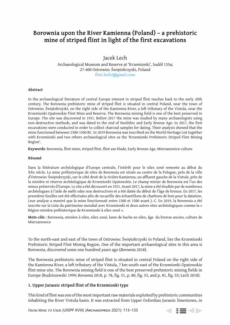
From Mine to User (UISPP XVIII) (Archaeopress 2021): 113–135
Borownia upon the River Kamienna (Poland)
Borownia upon the River Kamienna (Poland) – a prehistoric mine of striped flint in light of the first excavations
Jacek Lech Archaeological Museum and Reserve at ‘Krzemionki’, Sudół 135a;
27-400 Ostrowiec Świętokrzyski, Poland [email protected]
Abstract
In the archaeological literature of central Europe interest in striped flint reaches back to the early 20th century. The Borownia prehistoric mine of striped flint is situated in central Poland, near the town of Ostrowiec Świętokrzyski, on the right side of the Kamienna River, a left tributary of the Vistula, near the Krzemionki Opatowskie Flint Mine and Reserve. The Borownia mining field is one of the best preserved in Europe. The site was discovered in 1921. Before 2017 the mine was studied by many archaeologists using non-destructive methods, and was dated to the end of Neolithic and Early Bronze Age. In 2017, the first excavations were conducted in order to collect charcoal samples for dating. Their analysis showed that the mine functioned between 2300-1500 BC. In 2019 Borownia was inscribed on the World Heritage List together with Krzemionki and two others archaeological sites as the ‘Krzemionki Prehistoric Striped Flint Mining Region’.
Keywords: Borownia, flint mine, striped flint, flint axe blade, Early Bronze Age, Mierzanowice culture
Résumé
Dans la littérature archéologique d’Europe centrale, l’intérêt pour le silex zoné remonte au début du XXe siècle. La mine préhistorique de silex de Borownia est située au centre de la Pologne, près de la ville d’Ostrowiec Świętokrzyski, sur le côté droit de la rivière Kamienna, un affluent gauche de la Vistule, près de la minière et réserve archéologique de Krzemionki Opatowskie. Le champ minier de Borownia est l’un des mieux préservés d’Europe. Le site a été découvert en 1921. Avant 2017, la mine a été étudiée par de nombreux archéologues à l’aide de méth odes non destructives et a été datée du début de l’âge de bronze. En 2017, les premières fouilles ont été effectuées afin de recueillir des échantillons de charbons de bois pour la datation. Leur analyse a montré que la mine fonctionnait entre 2300 et 1500 avant J.-C. En 2019, la Borownia a été inscrite sur la Liste du patrimoine mondial avec Krzemionki et deux autres sites archéologiques comme la « Région minière préhistorique de Krzemionki à silex zoné ».
Mots-clés : Borownia, minière à silex, silex zoné, lame de hache en silex, âge du bronze ancien, culture de Mierzanowice
To the north-east and east of the town of Ostrowiec Świętokrzyski in Poland, lies the Krzemionki Prehistoric Striped Flint Mining Region. One of the important archaeological sites in this area is Borownia, discovered some one hundred years ago (Borownia 2018).
The Borownia prehistoric mine of striped flint is situated in central Poland on the right side of the Kamienna River, a left tributary of the Vistula, 7 km south-east of the Krzemionki Opatowskie flint mine site. The Borownia mining field is one of the best preserved prehistoric mining fields in Europe (Budziszewski 1999; Borownia 2018, p. 78, fig. 51, p. 80, fig. 53, and p. 81, fig. 55; Lech 2018).
1. Upper Jurassic striped flint of the Krzemionki type
This kind of flint was one of the most important raw materials exploited by prehistoric communities inhabiting the River Vistula basin. It was extracted from Upper Oxfordian Jurassic limestones, in
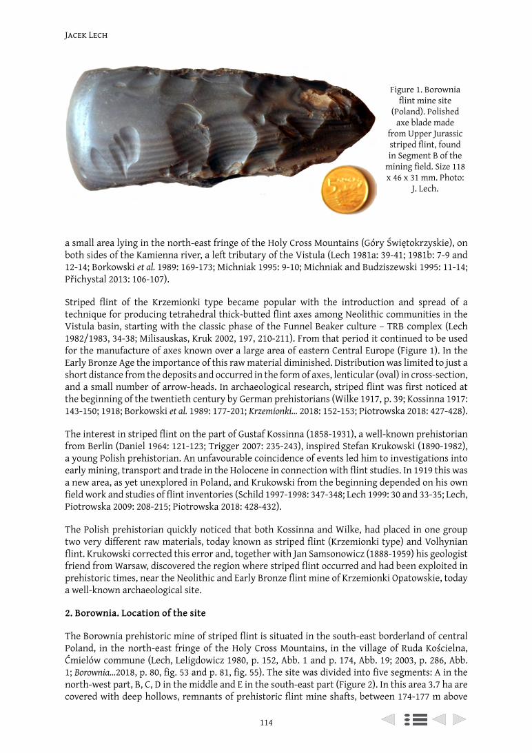
Jacek Lech
114
a small area lying in the north-east fringe of the Holy Cross Mountains (Góry Świętokrzyskie), on both sides of the Kamienna river, a left tributary of the Vistula (Lech 1981a: 39-41; 1981b: 7-9 and 12-14; Borkowski et al. 1989: 169-173; Michniak 1995: 9-10; Michniak and Budziszewski 1995: 11-14; Přichystal 2013: 106-107).
Striped flint of the Krzemionki type became popular with the introduction and spread of a technique for producing tetrahedral thick-butted flint axes among Neolithic communities in the Vistula basin, starting with the classic phase of the Funnel Beaker culture – TRB complex (Lech 1982/1983, 34-38; Milisauskas, Kruk 2002, 197, 210-211). From that period it continued to be used for the manufacture of axes known over a large area of eastern Central Europe (Figure 1). In the Early Bronze Age the importance of this raw material diminished. Distribution was limited to just a short distance from the deposits and occurred in the form of axes, lenticular (oval) in cross-section, and a small number of arrow-heads. In archaeological research, striped flint was first noticed at the beginning of the twentieth century by German prehistorians (Wilke 1917, p. 39; Kossinna 1917: 143-150; 1918; Borkowski et al. 1989: 177-201; Krzemionki… 2018: 152-153; Piotrowska 2018: 427-428).
The interest in striped flint on the part of Gustaf Kossinna (1858-1931), a well-known prehistorian from Berlin (Daniel 1964: 121-123; Trigger 2007: 235-243), inspired Stefan Krukowski (1890-1982), a young Polish prehistorian. An unfavourable coincidence of events led him to investigations into early mining, transport and trade in the Holocene in connection with flint studies. In 1919 this was a new area, as yet unexplored in Poland, and Krukowski from the beginning depended on his own field work and studies of flint inventories (Schild 1997-1998: 347-348; Lech 1999: 30 and 33-35; Lech, Piotrowska 2009: 208-215; Piotrowska 2018: 428-432).
The Polish prehistorian quickly noticed that both Kossinna and Wilke, had placed in one group two very different raw materials, today known as striped flint (Krzemionki type) and Volhynian flint. Krukowski corrected this error and, together with Jan Samsonowicz (1888-1959) his geologist friend from Warsaw, discovered the region where striped flint occurred and had been exploited in prehistoric times, near the Neolithic and Early Bronze flint mine of Krzemionki Opatowskie, today a well-known archaeological site.
2. Borownia. Location of the site
The Borownia prehistoric mine of striped flint is situated in the south-east borderland of central Poland, in the north-east fringe of the Holy Cross Mountains, in the village of Ruda Kościelna, Ćmielów commune (Lech, Leligdowicz 1980, p. 152, Abb. 1 and p. 174, Abb. 19; 2003, p. 286, Abb. 1; Borownia…2018, p. 80, fig. 53 and p. 81, fig. 55). The site was divided into five segments: A in the north-west part, B, C, D in the middle and E in the south-east part (Figure 2). In this area 3.7 ha are covered with deep hollows, remnants of prehistoric flint mine shafts, between 174-177 m above
Figure 1. Borownia flint mine site
(Poland). Polished axe blade made
from Upper Jurassic striped flint, found in Segment B of the
mining field. Size 118 x 46 x 31 mm. Photo:
J. Lech.
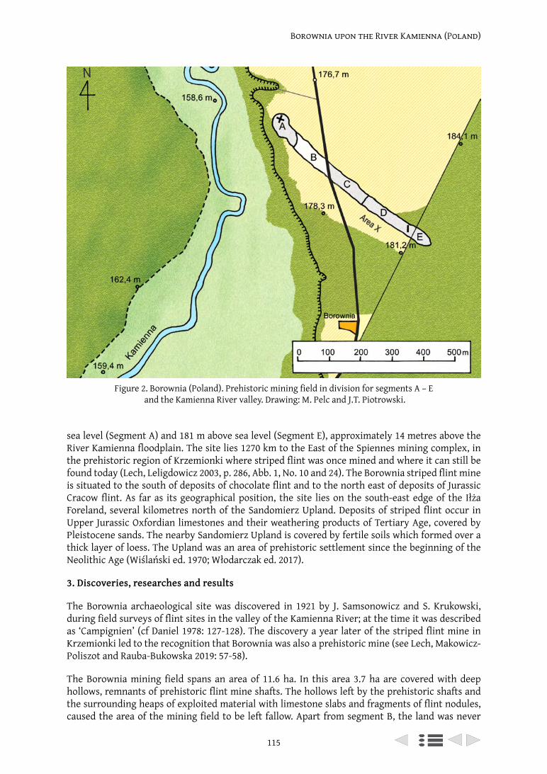
115
Borownia upon the River Kamienna (Poland)
sea level (Segment A) and 181 m above sea level (Segment E), approximately 14 metres above the River Kamienna floodplain. The site lies 1270 km to the East of the Spiennes mining complex, in the prehistoric region of Krzemionki where striped flint was once mined and where it can still be found today (Lech, Leligdowicz 2003, p. 286, Abb. 1, No. 10 and 24). The Borownia striped flint mine is situated to the south of deposits of chocolate flint and to the north east of deposits of Jurassic Cracow flint. As far as its geographical position, the site lies on the south-east edge of the Iłża Foreland, several kilometres north of the Sandomierz Upland. Deposits of striped flint occur in Upper Jurassic Oxfordian limestones and their weathering products of Tertiary Age, covered by Pleistocene sands. The nearby Sandomierz Upland is covered by fertile soils which formed over a thick layer of loess. The Upland was an area of prehistoric settlement since the beginning of the Neolithic Age (Wiślański ed. 1970; Włodarczak ed. 2017).
3. Discoveries, researches and results
The Borownia archaeological site was discovered in 1921 by J. Samsonowicz and S. Krukowski, during field surveys of flint sites in the valley of the Kamienna River; at the time it was described as ‘Campignien’ (cf Daniel 1978: 127-128). The discovery a year later of the striped flint mine in Krzemionki led to the recognition that Borownia was also a prehistoric mine (see Lech, Makowicz-Poliszot and Rauba-Bukowska 2019: 57-58).
The Borownia mining field spans an area of 11.6 ha. In this area 3.7 ha are covered with deep hollows, remnants of prehistoric flint mine shafts. The hollows left by the prehistoric shafts and the surrounding heaps of exploited material with limestone slabs and fragments of flint nodules, caused the area of the mining field to be left fallow. Apart from segment B, the land was never
Figure 2. Borownia (Poland). Prehistoric mining field in division for segments A – E and the Kamienna River valley. Drawing: M. Pelc and J.T. Piotrowski.
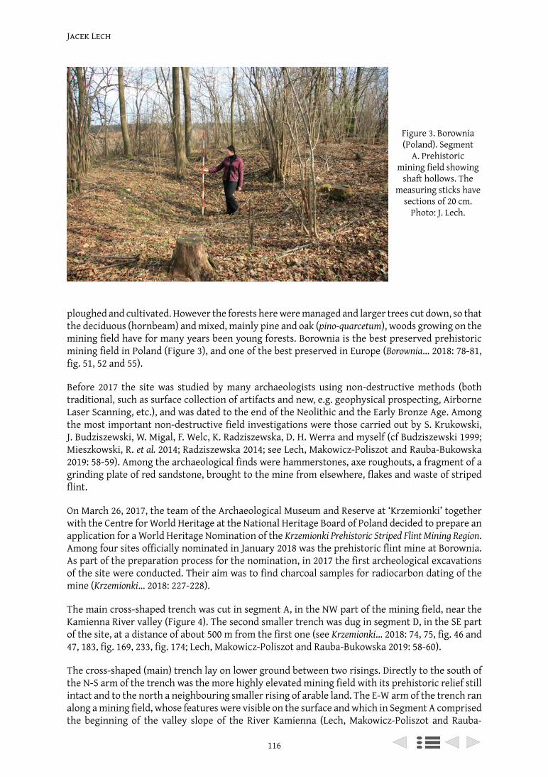
Jacek Lech
116
ploughed and cultivated. However the forests here were managed and larger trees cut down, so that the deciduous (hornbeam) and mixed, mainly pine and oak (pino-quarcetum), woods growing on the mining field have for many years been young forests. Borownia is the best preserved prehistoric mining field in Poland (Figure 3), and one of the best preserved in Europe (Borownia… 2018: 78-81, fig. 51, 52 and 55).
Before 2017 the site was studied by many archaeologists using non-destructive methods (both traditional, such as surface collection of artifacts and new, e.g. geophysical prospecting, Airborne Laser Scanning, etc.), and was dated to the end of the Neolithic and the Early Bronze Age. Among the most important non-destructive field investigations were those carried out by S. Krukowski, J. Budziszewski, W. Migal, F. Welc, K. Radziszewska, D. H. Werra and myself (cf Budziszewski 1999; Mieszkowski, R. et al. 2014; Radziszewska 2014; see Lech, Makowicz-Poliszot and Rauba-Bukowska 2019: 58-59). Among the archaeological finds were hammerstones, axe roughouts, a fragment of a grinding plate of red sandstone, brought to the mine from elsewhere, flakes and waste of striped flint.
On March 26, 2017, the team of the Archaeological Museum and Reserve at ‘Krzemionki’ together with the Centre for World Heritage at the National Heritage Board of Poland decided to prepare an application for a World Heritage Nomination of the Krzemionki Prehistoric Striped Flint Mining Region. Among four sites officially nominated in January 2018 was the prehistoric flint mine at Borownia. As part of the preparation process for the nomination, in 2017 the first archeological excavations of the site were conducted. Their aim was to find charcoal samples for radiocarbon dating of the mine (Krzemionki… 2018: 227-228).
The main cross-shaped trench was cut in segment A, in the NW part of the mining field, near the Kamienna River valley (Figure 4). The second smaller trench was dug in segment D, in the SE part of the site, at a distance of about 500 m from the first one (see Krzemionki… 2018: 74, 75, fig. 46 and 47, 183, fig. 169, 233, fig. 174; Lech, Makowicz-Poliszot and Rauba-Bukowska 2019: 58-60).
The cross-shaped (main) trench lay on lower ground between two risings. Directly to the south of the N-S arm of the trench was the more highly elevated mining field with its prehistoric relief still intact and to the north a neighbouring smaller rising of arable land. The E-W arm of the trench ran along a mining field, whose features were visible on the surface and which in Segment A comprised the beginning of the valley slope of the River Kamienna (Lech, Makowicz-Poliszot and Rauba-
Figure 3. Borownia (Poland). Segment
A. Prehistoric mining field showing
shaft hollows. The measuring sticks have
sections of 20 cm. Photo: J. Lech.
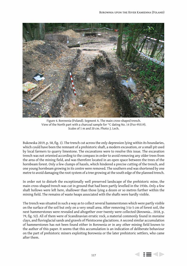
117
Borownia upon the River Kamienna (Poland)
Bukowska 2019, p. 58, fig. 1). The trench cut across the only depression lying within its boundaries, which could have been the remnant of a prehistoric shaft, a modern excavation, or a small pit used by local farmers to quarry limestone. The excavations were to resolve this issue. The excavation trench was not oriented according to the compass in order to avoid removing any older trees from the area of the mining field, and was therefore located in an open space between the trees of the hornbeam forest. Only a few clumps of hazels, which hindered a precise cutting of the trench, and one young hornbeam growing in its centre were removed. The southern end was shortened by one metre to avoid damaging the root system of a tree growing at the south edge of the planned trench.
In order not to disturb the exceptionally well preserved landscape of the prehistoric mine, the main cross-shaped trench was cut in ground that had been partly levelled in the 1930s. Only a few shaft hollows were left here, shallower than those lying a dozen or so metres further within the mining field. The remains of waste heaps associated with the shafts were hardly visible.
The trench was situated in such a way as to collect several hammerstones which were partly visible on the surface of the soil but only on a very small area. After removing 3 to 5 cm of forest soil, the next hammerstones were revealed and altogether over twenty were collected (Borownia… 2018, p. 79, fig. 52). All of them were of Scandinavian erratic rock, a material commonly found in moraine clays, and fluvioglacial sands and gravels of Pleistocene glaciations. A second similar accumulation of hammerstones has not been found either in Borownia or in any other mining field known to the author of this paper. It seems that this accumulation is an indication of deliberate behaviour on the part of prehistoric miners exploiting Borownia or the later prehistoric settlers, who came after them.
Figure 4. Borownia (Poland). Segment A. The main cross-shaped trench. View of the North part with a charcoal sample for 14C dating No. 14 (Poz-95519).
Scales of 1 m and 20 cm. Photo: J. Lech.
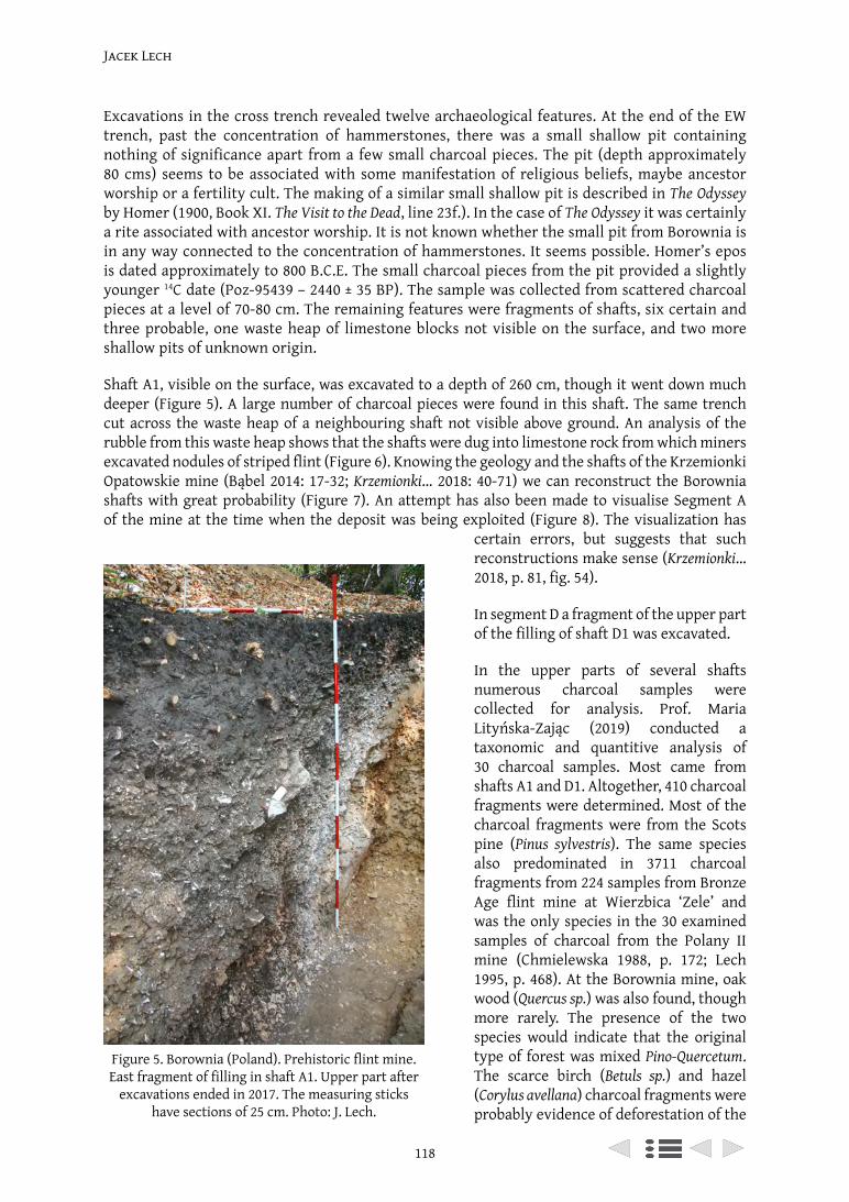
Jacek Lech
118
Excavations in the cross trench revealed twelve archaeological features. At the end of the EW trench, past the concentration of hammerstones, there was a small shallow pit containing nothing of significance apart from a few small charcoal pieces. The pit (depth approximately 80 cms) seems to be associated with some manifestation of religious beliefs, maybe ancestor worship or a fertility cult. The making of a similar small shallow pit is described in The Odyssey by Homer (1900, Book XI. The Visit to the Dead, line 23f.). In the case of The Odyssey it was certainly a rite associated with ancestor worship. It is not known whether the small pit from Borownia is in any way connected to the concentration of hammerstones. It seems possible. Homer’s epos is dated approximately to 800 B.C.E. The small charcoal pieces from the pit provided a slightly younger 14C date (Poz-95439 – 2440 ± 35 BP). The sample was collected from scattered charcoal pieces at a level of 70-80 cm. The remaining features were fragments of shafts, six certain and three probable, one waste heap of limestone blocks not visible on the surface, and two more shallow pits of unknown origin.
Shaft A1, visible on the surface, was excavated to a depth of 260 cm, though it went down much deeper (Figure 5). A large number of charcoal pieces were found in this shaft. The same trench cut across the waste heap of a neighbouring shaft not visible above ground. An analysis of the rubble from this waste heap shows that the shafts were dug into limestone rock from which miners excavated nodules of striped flint (Figure 6). Knowing the geology and the shafts of the Krzemionki Opatowskie mine (Bąbel 2014: 17-32; Krzemionki… 2018: 40-71) we can reconstruct the Borownia shafts with great probability (Figure 7). An attempt has also been made to visualise Segment A of the mine at the time when the deposit was being exploited (Figure 8). The visualization has
certain errors, but suggests that such reconstructions make sense (Krzemionki… 2018, p. 81, fig. 54).
In segment D a fragment of the upper part of the filling of shaft D1 was excavated.
In the upper parts of several shafts numerous charcoal samples were collected for analysis. Prof. Maria Lityńska-Zając (2019) conducted a taxonomic and quantitive analysis of 30 charcoal samples. Most came from shafts A1 and D1. Altogether, 410 charcoal fragments were determined. Most of the charcoal fragments were from the Scots pine (Pinus sylvestris). The same species also predominated in 3711 charcoal fragments from 224 samples from Bronze Age flint mine at Wierzbica ‘Zele’ and was the only species in the 30 examined samples of charcoal from the Polany II mine (Chmielewska 1988, p. 172; Lech 1995, p. 468). At the Borownia mine, oak wood (Quercus sp.) was also found, though more rarely. The presence of the two species would indicate that the original type of forest was mixed Pino-Quercetum. The scarce birch (Betuls sp.) and hazel (Corylus avellana) charcoal fragments were probably evidence of deforestation of the
Figure 5. Borownia (Poland). Prehistoric flint mine. East fragment of filling in shaft A1. Upper part after
excavations ended in 2017. The measuring sticks have sections of 25 cm. Photo: J. Lech.
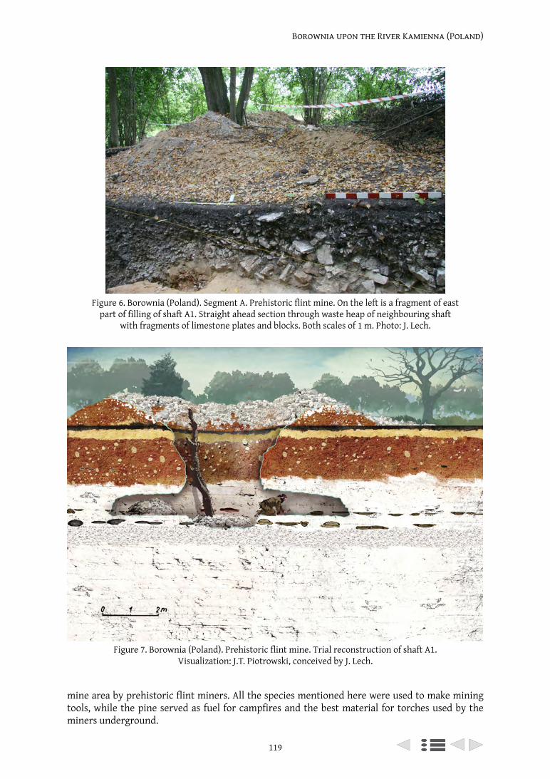
119
Borownia upon the River Kamienna (Poland)
mine area by prehistoric flint miners. All the species mentioned here were used to make mining tools, while the pine served as fuel for campfires and the best material for torches used by the miners underground.
Figure 6. Borownia (Poland). Segment A. Prehistoric flint mine. On the left is a fragment of east part of filling of shaft A1. Straight ahead section through waste heap of neighbouring shaft
with fragments of limestone plates and blocks. Both scales of 1 m. Photo: J. Lech.
Figure 7. Borownia (Poland). Prehistoric flint mine. Trial reconstruction of shaft A1. Visualization: J.T. Piotrowski, conceived by J. Lech.
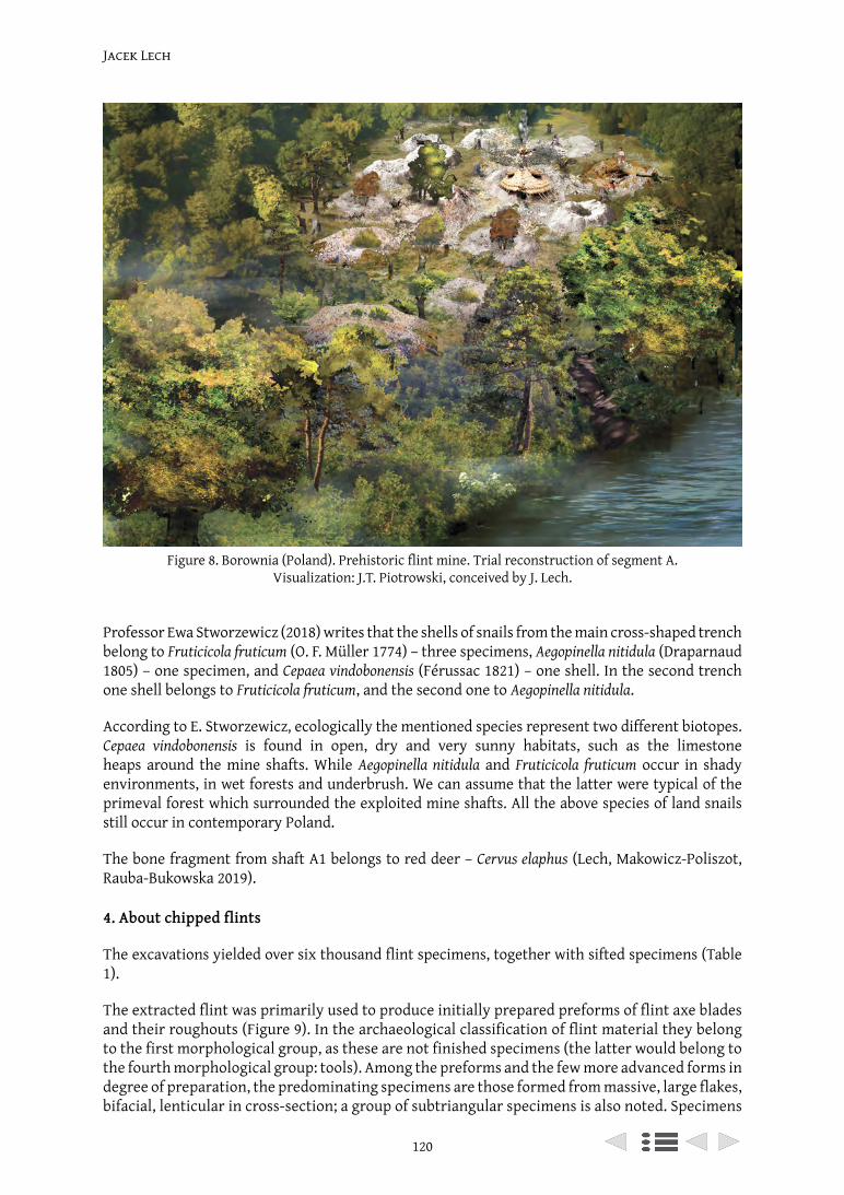
Jacek Lech
120
Professor Ewa Stworzewicz (2018) writes that the shells of snails from the main cross-shaped trench belong to Fruticicola fruticum (O. F. Müller 1774) – three specimens, Aegopinella nitidula (Draparnaud 1805) – one specimen, and Cepaea vindobonensis (Férussac 1821) – one shell. In the second trench one shell belongs to Fruticicola fruticum, and the second one to Aegopinella nitidula.
According to E. Stworzewicz, ecologically the mentioned species represent two different biotopes. Cepaea vindobonensis is found in open, dry and very sunny habitats, such as the limestone heaps around the mine shafts. While Aegopinella nitidula and Fruticicola fruticum occur in shady environments, in wet forests and underbrush. We can assume that the latter were typical of the primeval forest which surrounded the exploited mine shafts. All the above species of land snails still occur in contemporary Poland.
The bone fragment from shaft A1 belongs to red deer – Cervus elaphus (Lech, Makowicz-Poliszot, Rauba-Bukowska 2019).
4. About chipped flints
The excavations yielded over six thousand flint specimens, together with sifted specimens (Table 1).
The extracted flint was primarily used to produce initially prepared preforms of flint axe blades and their roughouts (Figure 9). In the archaeological classification of flint material they belong to the first morphological group, as these are not finished specimens (the latter would belong to the fourth morphological group: tools). Among the preforms and the few more advanced forms in degree of preparation, the predominating specimens are those formed from massive, large flakes, bifacial, lenticular in cross-section; a group of subtriangular specimens is also noted. Specimens
Figure 8. Borownia (Poland). Prehistoric flint mine. Trial reconstruction of segment A. Visualization: J.T. Piotrowski, conceived by J. Lech.
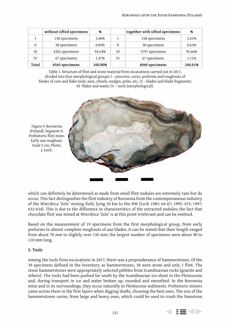
121
Borownia upon the River Kamienna (Poland)
which can definitely be determined as made from small flint nodules are extremely rare but do occur. This fact distinguishes the flint industry of Borownia from the contemporaneous industry of the Wierzbica ‘Zele’ mining field, lying 50 km to the NW (Lech 1983: 64-67; 1995: 475; 1997: 632-634). This is due to the difference in characteristics of the extracted nodules; the fact that chocolate flint was mined at Wierzbica ‘Zele’ is at this point irrelevant and can be omitted.
Based on the measurement of 19 specimens from the first morphological group, from early preforms to almost complete roughouts of axe blades, it can be stated that their length ranged from about 70 mm to slightly over 130 mm; the largest number of specimens were about 90 to 110 mm long.
5. Tools
Among the tools from excavations in 2017, there was a preponderance of hammerstones. Of the 39 specimens defined in the inventory as hammerstones, 38 were stone and only 1 flint. The stone hammerstones were appropriately selected pebbles from Scandinavian rocks (granite and others). The rocks had been pushed far south by the Scandinavian ice-sheet in the Pleistocene and, during transport in ice and water broken up, rounded and smoothed. In the Borownia mine and in its surroundings, they occur naturally in Pleistocene sediments. Prehistoric miners came across them in the first layers when digging shafts, choosing the best ones. The size of the hammerstones varies, from large and heavy ones, which could be used to crush the limestone
Figure 9. Borownia (Poland). Segment D.
Prehistoric flint mine. Early axe roughout. Scale 5 cm. Photo:
J. Lech.
without sifted specimens % together with sifted specimens %
I 158 specimens 3.46% I 158 specimens 2.61%
II 38 specimens 0.83% II 38 specimens 0.63%
III 4302 specimens 94.24% III 5797 specimens 95.66%
IV 67 specimens 1.47% IV 67 specimens 1.11%
Total 4565 specimens 100.00% 6060 specimens 100.01%
Table 1. Structure of flint and stone material from excavations carried out in 2017, divided into four morphological groups: I – precores, cores, preforms and roughouts of
blades of core and flake tools: axes, chisels, wedges, picks, etc.; II – blades and blade fragments; III -flakes and waste; IV – tools (morphological).
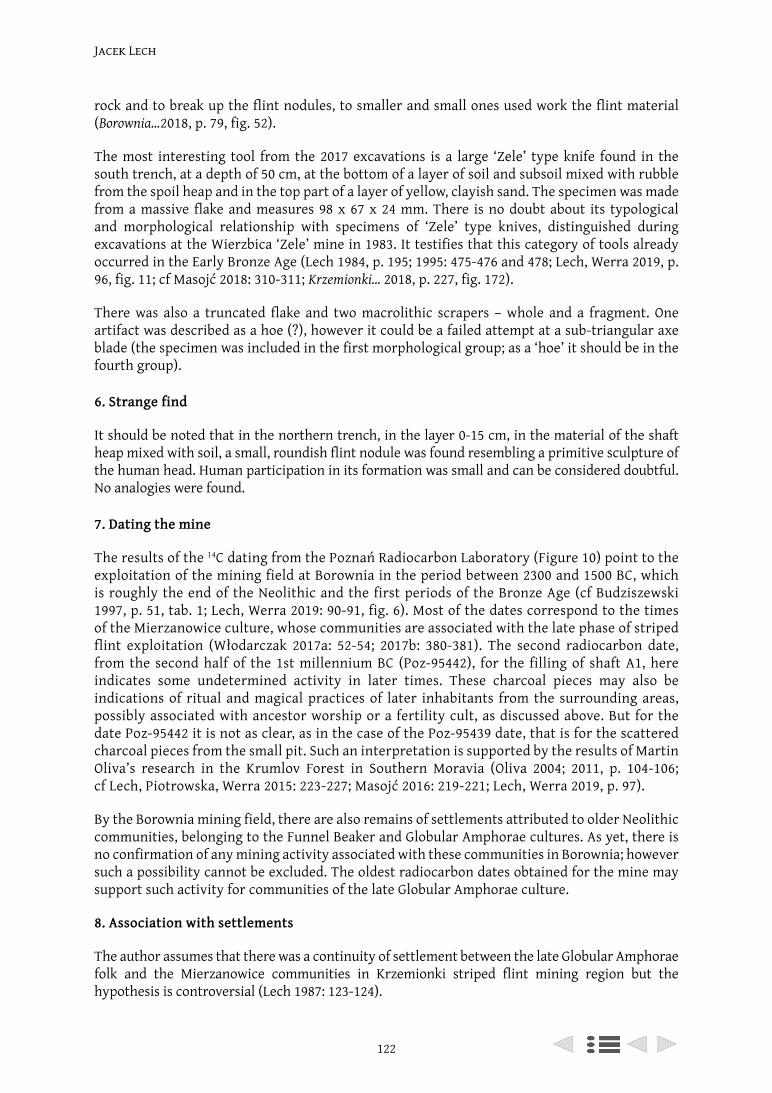
Jacek Lech
122
rock and to break up the flint nodules, to smaller and small ones used work the flint material (Borownia…2018, p. 79, fig. 52).
The most interesting tool from the 2017 excavations is a large ‘Zele’ type knife found in the south trench, at a depth of 50 cm, at the bottom of a layer of soil and subsoil mixed with rubble from the spoil heap and in the top part of a layer of yellow, clayish sand. The specimen was made from a massive flake and measures 98 x 67 x 24 mm. There is no doubt about its typological and morphological relationship with specimens of ‘Zele’ type knives, distinguished during excavations at the Wierzbica ‘Zele’ mine in 1983. It testifies that this category of tools already occurred in the Early Bronze Age (Lech 1984, p. 195; 1995: 475-476 and 478; Lech, Werra 2019, p. 96, fig. 11; cf Masojć 2018: 310-311; Krzemionki… 2018, p. 227, fig. 172).
There was also a truncated flake and two macrolithic scrapers – whole and a fragment. One artifact was described as a hoe (?), however it could be a failed attempt at a sub-triangular axe blade (the specimen was included in the first morphological group; as a ‘hoe’ it should be in the fourth group).
6. Strange find
It should be noted that in the northern trench, in the layer 0-15 cm, in the material of the shaft heap mixed with soil, a small, roundish flint nodule was found resembling a primitive sculpture of the human head. Human participation in its formation was small and can be considered doubtful. No analogies were found.
7. Dating the mine
The results of the 14C dating from the Poznań Radiocarbon Laboratory (Figure 10) point to the exploitation of the mining field at Borownia in the period between 2300 and 1500 BC, which is roughly the end of the Neolithic and the first periods of the Bronze Age (cf Budziszewski 1997, p. 51, tab. 1; Lech, Werra 2019: 90-91, fig. 6). Most of the dates correspond to the times of the Mierzanowice culture, whose communities are associated with the late phase of striped flint exploitation (Włodarczak 2017a: 52-54; 2017b: 380-381). The second radiocarbon date, from the second half of the 1st millennium BC (Poz-95442), for the filling of shaft A1, here indicates some undetermined activity in later times. These charcoal pieces may also be indications of ritual and magical practices of later inhabitants from the surrounding areas, possibly associated with ancestor worship or a fertility cult, as discussed above. But for the date Poz-95442 it is not as clear, as in the case of the Poz-95439 date, that is for the scattered charcoal pieces from the small pit. Such an interpretation is supported by the results of Martin Oliva’s research in the Krumlov Forest in Southern Moravia (Oliva 2004; 2011, p. 104-106; cf Lech, Piotrowska, Werra 2015: 223-227; Masojć 2016: 219-221; Lech, Werra 2019, p. 97).
By the Borownia mining field, there are also remains of settlements attributed to older Neolithic communities, belonging to the Funnel Beaker and Globular Amphorae cultures. As yet, there is no confirmation of any mining activity associated with these communities in Borownia; however such a possibility cannot be excluded. The oldest radiocarbon dates obtained for the mine may support such activity for communities of the late Globular Amphorae culture.
8. Association with settlements
The author assumes that there was a continuity of settlement between the late Globular Amphorae folk and the Mierzanowice communities in Krzemionki striped flint mining region but the hypothesis is controversial (Lech 1987: 123-124).
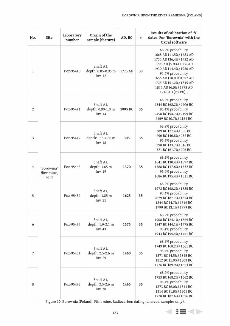
123
Borownia upon the River Kamienna (Poland)
No. Site Laboratory number
Origin of the sample (feature) AD, BC ±
Results of calibration of 14C
dates. For ‘Borownia’ with the OxCal software
1
‘Borownia’ flint mine,
2017
Poz-95440Shaft A1,
depth: 0.85-0.95 mInv. 12
1775 AD 30
68.2% probability1668 AD (11.5%) 1683 AD1735 AD (36,4%) 1782 AD1798 AD (5.9%) 1806 AD
1930 AD (14.4%) 1950 AD95.4% probability
1656 AD (18.0.%)1697 AD1725 AD (51.2%) 1815 AD1835 AD (6.0%) 1878 AD
1916 AD (20.1%)…
2 Poz-95441Shaft A1,
depth: 0.90-1.0 m Inv. 14
1885 BC 35
68.2% probability2344 BC (68.2%) 2206 BC
95.4% probability2458 BC (94.7%) 2199 BC2159 BC (0.7%) 2154 BC
3 Poz-95442Shaft A1,
depth:1.53-1.60 mInv. 18
305 35
68.2% probability389 BC (27.4%) 355 BC290 BC (40.8%) 232 BC
95.4% probability398 BC (33.7%) 346 BC321 BC (61.7%) 206 BC
4 Poz-95443Shaft A1,
depth: 1.65 mInv. 19
1370 35
68.2% probability1641 BC (30.4%) 1597 BC1588 BC (37.8%) 1532 BC
95.4% probability1686 BC (95.4%) 1511 BC
5 Poz-95452Shaft A1,
depth: 1.85 mInv. 21
1625 35
68.2% probability1972 BC (68.2%) 1885 BC
95.4% probability2029 BC (87.7%) 1874 BC1844 BC (4.7%) 1816 BC1799 BC (3.1%) 1779 BC
6 Poz-95494Shaft A1,
depth: 1.9-2.1 m Inv. 43
1575 35
68.2% probability1908 BC (24.1%) 1869 BC1847 BC (44.1%) 1775 BC
95.4% probability1943 BC (95.4%) 1751 BC
7 Poz-95451Shaft A1,
depth: 2.5-2.6 m Inv. 29
1460 35
68.2% probability1749 BC (68.2%) 1661 BC
95.4% probability1871 BC (4.5%) 1845 BC1812 BC (1.0%) 1803 BC
1776 BC (89.9%) 1623 BC
8 Poz-95493Shaft A1,
depth: 2.5-2.6 m Inv. 30
1465 35
68.2% probability1753 BC (68.2%) 1662 BC
95.4% probability1873 BC (6.0%) 1844 BC1814 BC (1.8%) 1801 BC
1778 BC (87.6%) 1626 BCFigure 10. Borownia (Poland). Flint mine. Radiocarbon dating (charcoal samples only).
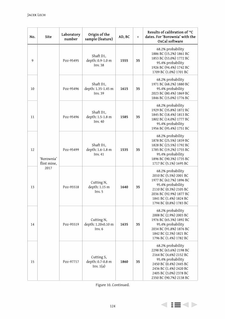
Jacek Lech
124
No. Site Laboratory number
Origin of the sample (feature) AD, BC ±
Results of calibration of 14C
dates. For ‘Borownia’ with the OxCal software
9
‘Borownia’ flint mine,
2017
Poz-95495Shaft D1,
depth: 0.9-1.0 m Inv. 38
1555 35
68.2% probability1886 BC (15.2%) 1861 BC1853 BC (53.0%) 1772 BC
95.4% probability1926 BC (94.4%) 1742 BC1709 BC (1.0%) 1701 BC
10 Poz-95496Shaft D1,
depth: 1.35-1.45 m Inv. 39
1615 35
68.2% probability1971 BC (68.2%) 1880 BC
95.4% probability2023 BC (80.4%) 1869 BC1846 BC (15.0%) 1776 BC
11 Poz-95496Shaft D1,
depth: 1.5-1.8 m Inv. 40
1585 35
68.2% probability1929 BC (35.8%) 1872 BC1845 BC (18.4%) 1813 BC1802 BC (14.0%) 1777 BC
95.4% probability1956 BC (95.4%) 1751 BC
12 Poz-95499Shaft D1,
depth: 1.6-1.8 m Inv. 41
1535 35
68.2% probability1878 BC (25.5%) 1839 BC1828 BC (23.5%) 1792 BC1785 BC (19.2%) 1755 BC
95.4% probability1896 BC (90.3%) 1735 BC1717 BC (5.1%) 1695 BC
13 Poz-95518Cutting N,
depth: 1.15 mInv. 5
1640 35
68.2% probability2010 BC (5.5%) 2001 BC
1977 BC (62.7%) 1896 BC95.4% probability
2110 BC (0.3%) 2105 BC2036 BC (92.9%) 1877 BC1841 BC (1.4%) 1824 BC1794 BC (0.8%) 1783 BC
14 Poz-95519Cutting N,
depth: 1.20±0.10 mInv. 6
1635 35
68.2% probability2008 BC (2.9%) 2003 BC
1976 BC (65.3%) 1892 BC95.4% probability
2034 BC (91.8%) 1876 BC1842 BC (2.3%) 1821 BC1796 BC (1.4%) 1782 BC
15 Poz-97717Cutting S,
depth: 0.7-0.8 mInv. 1(a)
1860 35
68.2% probability2298 BC (63.6%) 2198 BC2164 BC (4.6%) 2152 BC
95.4% probability2450 BC (0.4%) 2445 BC2436 BC (1.4%) 2420 BC2405 BC (3.0%) 2378 BC
2350 BC (90.7%) 2138 BC
Figure 10. Continued.
125
Borownia upon the River Kamienna (Poland)
No. Site Laboratory number
Origin of the sample (feature) AD, BC ±
Results of calibration of 14C
dates. For ‘Borownia’ with the OxCal software
16‘Borownia’ flint mine,
2017Poz-95517
Cutting SDepth: 0.7-0.8 m
Inv. 1(b)1830 35
68.2% probability2281 BC (19.8%) 2249 BC2232 BC (22.5%) 2190 BC2181 BC (25.8%) 2142 BC
95.4% probability2336 BC (1.0%) 2324 BC2308 BC (89.1%)2128 BC2089 BC (5.3%) 2047 BC
17
Polany II flint mine
Bln-4175 Shaft 1/1988,depth: 0.9-1.1 m 1800 80 68% probability
2319 – 2058 cal. BC
18 Bln-4176 Shaft 1/1988,depth: 1.4 m 1740 80 68% probability
2235 – 1982 cal. BC
19 BM-1235 Shaft 1/1972,floor 1541 81 68% probability
1931 – 1726 cal. BC
20 Bln-4173 Shaft 3/1988,depth: 0.5-0.7 m 1450 70 68% probability
1825 – 1622 cal. BC
21 Bln-4174 Shaft 3/1988,depth: 0.9-1.0 m 1500 90 68% probability
1886 – 1665 cal. BC
22
Wierzbica, flint mine
‘Zele’ (selection)
GrN-11852 Shaft 17 1730 70 68% probability2188 – 1980 BC
23 GrN-11854 Shaft 17 1720 60 68% probability2162 – 1978 BC
24 GrN-11853 Shaft 17 1620 90 68% probability2071 – 1799 BC
25 BM-2383 Shaft 20 1200 80 68% probability1509 – 1328 BC
26 BM-2385A Shaft 28 830 80 68% probability1054 – 863 BC
27 BM-2385 Shaft 28 800 70 68% probability989 – 847 BC
28 OxA-5101 Shaft 19 830 45 68% probability984 – 873 BC
29 GrN-11856 Shaft 18 720 60 68% probability894 – 810 BC
Figure 10. Continued.
More than six thousand flint artifacts indicate that bifacial axe heads were produced, of a type known from a nearby Mierzanowice settlement and cemetery, lying ten kilometres from the Borownia mine. There is strong evidence that the settlement complex was connected with the mine. Borownia lies outside the area of permanent settlement of Mierzanowice communities but the mine field formed part of the immediate zone of economic activity of the settlement. In the Early Bronze Age the striped flint was distributed over a radius of approximately 100 km from the mine (Balcer 1977: 190-191, 193-200 and 205-208; Bąbel 1985; 2013a: 101-103 and 119-123; Lech
Jacek Lech
126
1987: 114-130; 1991, p. 568; Kadrow 1995: 45-49; cf Borkowski et al. 1989, p. 198-201; Zalewski 1995: 168 and 171).
On the loess covered Sandomierz Upland, on the gentle slopes of the Gierczanka valley, there were several large settlements and a cemetery of the Mierzanowice culture communities, dated to the Early Bronze Age. Striped flint was used in the settlements and found in the graves (Bąbel 2013b: 11-199). The axes and their roughouts which occur here are the same as those known from the Borownia mining field (Balcer 1977: 190-191 and 195; Bąbel 2013a: 101-124; 2013b: 11-199).
9. Traces of the Great War 1914-1918
In the northern trench, located on the edge of the mine wasteland, covered with forest, the shell casing from a bullet of a Mosin rifle, M1891, was found. The bullet was, it seems, produced in 1914: v / w 19/14. Mosin rifles were developed in Russia and used by the Russian army before and during World War I, and later. Probably there were once many more such finds, but had been collected by ‘detectorists’. In the last thirty years searchers using metal detectors have been destroying archaeological sites in Poland. Also during the excavations in 2017, they found our trenches, and they were certainly there earlier. The discovered shell was probably the last such artefact in the archaeological cuttings, the last trace of earlier ones collected by them.
At the beginning of the Great War this area of the prehistoric mine was a wasteland covered with trees, dominating from the north east over the fairly wide valley of the River Kamienna. Fighting went on here, as it was a convenient point of resistence for Russian soldiers being attacked from the south by the troops of Emperor Franz Joseph.
10. Remarks on Polish Jura striped flint
Finally, it should be mentioned that an outcrop of typical striped flint was found recently on the other side of the Holy Cross Mountains (Krajcarz 2009). Outcrops of striped flint were also discovered on the Ryczów Upland in the Polish Jura, at a distance of about 130 km to the west, with a significant deviation to the south of the Krzemionki Opatowskie and Borownia mines. The latter was used in prehistoric times; it is similar to the Krzemionki type flint, but possible to distinguish (Krajcarz et al. 2014, 231-240).
On the Ryczów Upland this raw material was used at the turn of the Neolithic and Bronze Age. The modern day explorers who found it have suggested the term Kraków-Częstochowa striped flint (Krajcarz et al. 2014, 226-240). The discovery is worth further research, especially regarding the methods and scale of exploitation, as well as its area of distribution. From what is known so far, Krakow-Częstochowa striped flint was a locally used raw material, more intensively for the production of axes towards the end of the Neolithic and at the beginning of the Bronze Age (Krajcarz et al. 2014, 238-240). During this period, however, it is characteristic for communities to use deposits of siliceous rocks from a close proximity, even if they were of poor quality.
In the extensive, systematically researched settlement complex from the late Neolithic and Early Bronze Age in Iwanowice Włościańskie, Kraków distict, located about 40 km southeast of the Ryczów Upland, Kraków-Częstochowa striped flint occurred only in single specimens. Among the flint pieces examined by the author of this article, all from the site Babia Góra III and many from sites Babia Góra I and II and from ‘Klin’ in Iwanowice, I came across only one tool made of Kraków-Częstochowa striped flint. It is possible that this specimen was made from Kraków-Częstochowa striped flint, as were single pieces found on the western border of distribution, as shown on old maps showing the distribution of striped flint of the Krzemionki type in the Early Bronze Age (e.g. Lech 1991, 568-569; 1997, 632-634). It seems, however, that for the research of
127
Borownia upon the River Kamienna (Poland)
the Borownia mine reported here, this newly-distinguished variant of striped flint is of no great significance.
11. For the Future
On July 6, 2019, during the 43rd Session of the World Heritage Committee of UNESCO, it was decided to inscribe the ‘Krzemionki Prehistoric Striped Flint Mining Region’ on the World Heritage List. The inscription included three mines of striped flint: Krzemionki Opatowskie, Borownia and Korycizna, as well as the Gawroniec settlement at Ćmielów– site of the Funnel Beaker culture. Gawroniec was inhabited during the Neolithic by a community associated with the early phase of striped flint mining. The session took place in Baku, Republic of Azerbaijan.
Acknowledgments
The author would like to thank Mr. Włodzimierz Szczałuba MA, former director of the Historical and Archaeological Museum at Ostrowiec Świętokrzyski for his very important cooperation. Without the help and involvement of the Museum Director, the exploration of the Borownia mine in 2017 could not have taken place.
For the description of snail shells, many thanks to Professor Ewa Stworzewicz from the Institute of Systematics and Evolution of Animals of the Polish Academy of Sciences (in Cracow), for the palaeobotanical characterization of wood charcoal to Professor Maria Lityńska-Zając, and to Dr Danuta Makowicz-Poliszot and Dr Anna Rauba-Bukowska from the Institute of Archaeology and Ethnology in the Polish Academy of Sciences, Cracow branch for their investigation of bones. To Professor Tomasz Goslar, head of the Poznań Radiocarbon Laboratory, I express my gratitude for his dating of the charcoal from Borownia, crucial for our research. Finally, last but not least, for participation in the excavations and help, I would like to thank Artur Jedynak MA from the Museum staff, Maciej Berkowski BA as well as Iza Marszałek, Magdalena Pelc and Katarzyna Pęksa, my MA students from the Cardinal Stefan Wyszyński University in Warsaw.
References
Balcer, B. 1977. Osada kultury mierzanowickiej na stanowisku 1 w Mierzanowicach woj. Tarnobrzeskie [Summary: A settlement of the Mierzanowice culture at site 1 at Mierzanowice, Tarnobrzeg Voivodship]. Wiadomości Archeologiczne, 62(2): 175-212.
Bąbel, J. 1985. Weryfikacyjne badania powierzchniowe prowadzone w rejonie wsi Mierzanowice i Wojciechowice, woj. Tarnobrzeg [Summary: Verification surface survey in the surroundings of the villages of Mierzanowice and Wojciechowice, Tarnobrzeg province]. Sprawozdania Archeologiczne, 37: 55-71.
Bąbel, J. T. 2013a. Cmentarzyska społeczności kultury mierzanowickiej na Wyżynie Sandomierskiej. Część 1. Obrządek pogrzebowy [Summary: Cemeteries of Mierzanowice culture communities in the Sandomierz Upland (Vol. 1: Funeral rites; Vol. 2: Sources]. Rzeszów: Fundacja Rzeszowskiego Ośrodka Archeologicznego Instytutu Archeologii Uniwersytetu Rzeszowskiego.
Bąbel, J. T. 2013b. Cmentarzyska społeczności kultury mierzanowickiej na Wyżynie Sandomierskiej. Część 2. Źródła. Rzeszów: Fundacja Rzeszowskiego Ośrodka Archeologicznego Instytutu Archeologii Uniwersytetu Rzeszowskiego.
Bąbel, J. T. 2014. Krzemionki. Historical Monument, Reserve, Museum. Prehistoric mines of striped flint. Guidebook. Warsaw: Eneteia Publishing House.
Borkowski, W., Migal, W., Sałaciński, S., Zalewski, M. 1989. Urgeschichtlicher Feuersteinbergbau im Gebiet von Krzemionki. Praehistorische Zeitschrift, 64(2): 164-207.
Borownia, 2018. Borownia Mining Field. In Krzemionki… 2018: 74-81. Budziszewski, J. 1997. C-14 dating of shallow flint mine sites. Case study from the ‘Za garncarzami’
mining field in Ożarów (central Poland). In R. Schild, and Z. Sulgostowska (eds), Man and Flint. Proceedings of the VIIth International Flint Symposium Warszawa – Ostrowiec Świętokrzyski, September 1995. Warszawa: Institute of Archaeology and Ethnology Polish Academy of Sciences, 49-55.
Jacek Lech
128
Budziszewski, J. 1999. PL 8 Borownia, Ćmielów, Ruda Kościelna, Wojw. Tarnobrzeg. In G. Weisgerber, R. Slotta, J. Weiner (eds), 5000 Jahre Feuersteinbergbau. Die Suche nach dem Stahl der Steinzeit. Bochum: Herausgegeben vom Deutschen Bergbu-Museum 1980. 3. verbesserte, erweiterte und aktualisierte Auflage: 597-598.
Chmielewska, M. 1988. The Early Bronze Age flint mine at site II, Polany, Radom district. Przegląd Archeologiczny, 35: 139-181.
Daniel, G. 1964. The Idea of Prehistory. Harmondsworth, Middlesex: Penguin Books Ltd.Daniel, G. 1978. 150 Years of Archaeology. London: Gerald Duckworth and Co Ltd. Homer 1900. The Odyssey Rendered into English Prose for the Use of Those Who Cannot Read the
Original, by Samuel Butler. London: A.C. Fifield. The Internet Classics Archive: https://classics.mit.edu/Homer/odyssey.11.xi.html. Accessed March 23, 2020, 4.14 p.m.
Kadrow, S. 1995. Gospodarka i społeczeństwo. Wczesny okres epoki brązu w Małopolsce [Summary: Economy and Society. Early Bronze Age in Little Poland]. Kraków: Instytut Archeologii i Etnologii Polskiej Akademii Nauk.
Kossinna, G. 1917. Meine Reise nach West- und Ostpreussen und meine Berufung zu Generalfeldmarschall v. Hindenburg im August 1915. Mannus, 9 (1919): 119-195.
Kossinna, G. 1918. Erläuterungen zur Karte der Funde gebänderter Feuersteingeräte. Mannus, 10 (1919): 202-206.
Krajcarz, M. T., Krajcarz, M. 2009. The outcrops of Jurassic flint raw materials from south-western margin of the Holy Cross Mountains. Acta Archaeologica Carpathica, 44: 183-195.
Krajcarz, M. T., Sudoł, M., Krajcarz, M., Cyrek, K. 2014. Wychodnie krzemienia pasiastego na Wyżynie Ryczowskiej (Wyżyna Krakowsko-Częstochowska) [Summary: Outcrops of striped flint on the Ryczów Upland (Kraków-Częstochowa Upland)]. In D. Piotrowska et al. (eds), Górnictwo z epoki kamienia: Krzemionki – Polska – Europa. W 90. rocznicę odkrycia kopalni w Krzemionkach [Stone Age Mining: Krzemionki – Poland – Europe. On the Ninetieth Anniversary of the Discovery of the Krzemionki Mine]. Ostrowiec Świętokrzyski: Historical and Archaeological Museum in Ostrowiec Świętokrzyski: 225-244.
Krzemionki Prehistoric Striped Flint Mining Region. World Heritage Nomination. Poland. January 2018. [Ostrowiec Świętokrzyski: Historical and Archaeological Museum 2018].
Lech, H. and J. 1984. The prehistoric flint mine at Wierzbica ‘Zele’: a case study from Poland. World Archaeology, 16(2): 186-203.
Lech, H. and J. 1995. PL 3 Wierzbica ‘Zele’, Radom Province. Archaeologia Polona, 33: 465-480. Lech, J. 1981a. Flint Mining Among the Early Farming Communities of Poland. In F. H. G. Engelen
(ed.), Derde Internationale Symposium over Vuursteen. 24-27 Mei 1979 – Maastricht. Staringia, 6: 39-45.
Lech, J. 1981b. Flint Mining among the early farming communities of central Europe. Przegląd Archeologiczny, 28: 5-55.
Lech, J. 1982/1983. Flint work of the early farmers. Production trends in central European chipping industries from 4500-1200 BC. An outline. Acta Archaeologica Carpathica, 22: 5-63.
Lech, J. 1983. Flint Mining among the early farming communities of central Europe. Part II. The basis of research into flint workshops. Przegląd Archeologiczny, 30: 47-80.
Lech, J. 1987. Z badań nad górnictwem krzemienia społeczności rolniczych Europy Środkowej. Relacje przestrzenne kopalń i osad [Zusammenfassung: Aus den Forschungen über den Feuerstein-Bergbau der agrarischen Gesellschaften in Mitteleuropa. Räumliche Verhältnisse der Gruben und Siedlungen], Acta Archaeologica Carpathica, 26: 93-137.
Lech, J. 1991. The Neolithic-Eneolithic transition in prehistoric mining and siliceous rock distribution. In J. Lichardus (ed.), Die Kupferzeit als historische Epoche. Teil 2. Bonn: Dr. Rudolf Habelt GmbH: 557-574.
Lech, J. 1997. Remarks on prehistoric flint mining and flint supply in European archaeology. In A. Ramos-Millán and M. A. Bustillo (eds), Siliceous Rocks and Culture. Granada: Editorial Universidad de Granada. Campus Universitario de Cartuja: 611-637. ‘Colecctión Monográfica Arte y Arqueologia’.
Lech, J. 1999. Between Captivity and Freedom. Polish Archaeology in the 20th Century. Warsaw: Arwil.Lech J. 2018. Borownia upon the River Kamienna (Poland) – a prehistoric mine of striped flint in
light of the first excavations. In Books of Abstracts. 18th UISPP World Congress, Paris, June 2018: 2384-
129
Borownia upon the River Kamienna (Poland)
2385. Available at: https://uispp2018.sciencesconf.org/data/pages/33_UISPP_2018_Sessions_XXXIII_1_2_3.pdf [Accessed January 16, 2020]
Lech, J. and Leligdowicz, A. 1980. Die Methoden der Versorgung mit Feuerstein und die lokalen Beziehungen zwischen den Siedlungen und Bergwerken im Weichselgebiet während des 5. bis 2. Jt. v. u. Z. In F. Schlette (ed.), Urgeschichtliche Besiedlung in ihrer Beziehung zur natürlichen Umwelt. Halle (Saale): Wissenschaftspublizistik der Martin-Luther-Universität, Halle – Wittenberg: 151-184. ‘Wissenschaftliche Beiträge der Martin-Luther-Universität Halle – Wittenberg’ 1980/6 (L 15).
Lech, J. and Leligdowicz, A. 2003. Studien zum mitteleuropäischen Feuersteinbergbau in der Brozezeit. In Th. Stöllner et al. (eds), Man and Mining – Mensch und Bergbau. Studies in honour of Gerd Weisgerber on occasion of his 65th birthday. Bochum: Veröffentlichungen aus dem Deutschen Bergbau-Museum Bochum; Nr 114: 285-300. ‘Montanhistorische Zeitschrift Der Anschnitt’. Beiheft 16.
Lech, J., Makowicz-Poliszot, D. and Rauba-Bukowska, A. 2019. Identification of a fragment of an Early Bronze bone recovered from the Borownia striped flint mine in the Ostrowiec district (on the centenary of Polish research on prehistoric flint mining). Analecta Archaeologica Ressoviensia, 14: 57-68.
Lech, J. and Piotrowska, D. 2009. Stefan Krukowski (1890-1982) – Scholar of Prehistoric Flint Mining in Poland. A Supplement to the Book by Professor Stefan Karol Kozłowski. In J. M. Burdukiewicz et al. (eds), Understanding the Past. Papers offered to Stefan K. Kozłowski. Warsaw: Center for Research on the Antiquity of Southeastern Europe, University of Warsaw: 207-221.
Lech, J., Piotrowska, D. and Werra D. H. 2015. Between economy and symbol: flint in the Bronze Age in Eastern Central Europe. In P. Suchowska-Ducke, S. Scott Reiter, H. Vandkilde (eds), Forging Identities. The Mobility of Culture in Bronze Age Europe, 1. Oxford: British Archaeological Reports Ltd: 221-229. BAR IS 2771.
Lech, J. and Werra D. H. 2019. The flint mine site Wierzbica ‘Zele’ (Poland) and Bronze Age workshop materials after forty years of new research (1979-2018). Anthropologica et Præhistorica, 128/2017 (2019): 85-100.
Masojć, M. 2016. Late Bronze Age Flintworking from Ritual Zones in Southern Scandinavia. Oxford: Archaeopress Archaeology.
Masojć, M. 2018. Late Bronze Age flint assemblage from Open-pit Mine Reichwalde in Saxony, Germany. In D. H. Werra and M. Woźny (eds), Between History and Archaeology, Oxford: Archaeopress Archaeology: 301-312.
Michniak, R. 1995. Geology of the Holy Cross Mountains. In J. Budziszewski and R. Michniak (eds), VIIth International Flint Symposium, Warszawa – Ostrowiec Świętokrzyski, September 1995. Guide-Book of Excursion 2. Northern Footslopes of Holy Cross Mountains. Warsaw: Institute of Archaeology and Ethnology Polish Academy of Sciences: 6-11.
Michniak, R. and Budziszewski, J. 1995. Siliceous rocks of North-Eastern Mesozoic margin of the Holy Cross Mountains. In J. Budziszewski, R. Michniak (eds), VIIth International Flint Symposium, Warszawa – Ostrowiec Świętokrzyski, September 1995. Guide-Book of Excursion 2. Northern Footslopes of Holy Cross Mountains. Warsaw: Institute of Archaeology and Ethnology Polish Academy of Sciences: 11-19.
Mieszkowski, R., Welc, F., Budziszewski, J., Migal, W., Bąkowska, A. 2014. Preliminary results of the ground penetrating radar (GPR) prospection in the area of the prehistoric flint mine Borownia, southeastern Poland. Studia Quaternaria, 31(2): 123-132.
Milisausaks, S. and Kruk, J. 2002. Middle Neolithic, Continuity, Diversity, Inovations, and Greater Complexity. 5500/5000-3500/3000 BC. In S. Milisauskas (ed.), European Prehistory. A Survey. New York: Kluwer Academic / Plenum Publishers: 193-246.
Oliva, M. 2004. Flint mining, rondels, hillforts… Symbolic works or too much free time? Archeologické rozhledy, 56(3): 499-531.
Oliva, M. 2011. Chert mining in the Krumlov Forest (Southern Moravia). In M. Capote et al. (eds), Proceedings of the 2nd International Conference of the UISPP Commission on Flint Mining in Pre- and Protohistoric Times (Madrid, 14-17 October 2009). Oxford: Archaeopress: 97-107.
Jacek Lech
130
Piotrowska, D. 2018. Striped Flint and the Krzemionki Opatowskie Mine, Poland. The Beginnings. In D. H. Werra and M. Woźny (eds), Between History and Archaeology. Oxford: Archaeopress Archaeology: 427-433.
Přichystal, A. 2013. Lithic Raw Materials in Prehistoric Times of Eastern Central Europe. Brno: Masaryk University.
Radziszewska, K. 2014. Inwentaryzacja zniszczeń na powierzchni pradziejowych punktów eksploatacji krzemienia pasiastego [Summary: Inventory of surface devastation in places where striped flint was exploited]. In D. Piotrowska et al. (eds), Górnictwo z epoki kamienia: Krzemionki – Polska – Europa. W 90. rocznicę odkrycia kopalni w Krzemionkach [Stone Age Mining: Krzemionki – Poland – Europe. On the Ninetieth Anniversary of the Discovery of the Krzemionki Mine]. Ostrowiec Świętokrzyski: Historical and Archaeological Museum in Ostrowiec Świętokrzyski: 167-187.
Schild, R. 1997-1998. Stefan Krukowski (1890-1982): a reclusive eccentric within the archaeological establishment. Archaeologia Polona, 35-36: 343-356.
Trigger, B. G. 2007. A History of Archaeological Thought. Cambridge: Cambridge University Press. Second Edition.
Wilke, G. 1917. Die Herkunft der Kelten, Germanen und Illyrer. Mannus, 9: 1-54. Wiślański, T. (ed.) 1970. The Neolithic in Poland. Wrocław: Zakład Narodowy imienia Ossolińskich.
Wydawnictwo Polskiej Akademii Nauk.Włodarczak, P. 2017a. Małopolska at the beginning of the Bronze Age (2000-1600 BC). In U. Bugaj
(ed.), 2000-500 BC. Warszawa: Institute of Archaeology and Ethnology. Polish Academy of Sciences. In P. Urbańczyk (ed.), The Past Societies. Polish Lands from the First Evidence of Human Presence to the Early Middle Ages, 3.
Włodarczak, P. 2017b. Towards the Bronze Age in south-eastern Poland (2300-2000 BC). In P. Włodarczak (ed.): 377-397.
Włodarczak, P. (ed.) 2017. 5500-2000 BC. Warszawa: Institute of Archaeology and Ethnology. Polish Academy of Sciences. In P. Urbańczyk (ed.), The Past Societies. Polish Lands from the First Evidence of Human Presence to the Early Middle Ages, 2.
Zalewski, M. 1995. Utilisation du silex zone de Krzemionki et ľinfluence de ses gisements sur les réseaux sédentaires préhistoriques. In J. Pelegrin and A. Richard (eds), Les mines de silex au néolithique en Europe. Avancées récentes. [Paris] Comité des Travaux Historiques et Scientifiques: 167-172.
Archives consulted
Computer prints stored in the Archive of Archaeological Museum and Reserve ‘Krzemionki’: M. Lityńska-Zając 2019. Sprawozdanie z badań archeobotanicznych ze stanowiska 10 w Rudzie Kościelnej, gm. Ćmielów E. Stworzewicz 2018. Gastropoda z Borowni.
131
List of authors
Ameziane-Federzoni, NadiaArchéo-île and Laboratoire TRACES – UMR5608Université Toulouse Jean JaurèsMaison de la Recherche5, allées Antonio Machado31058 Toulouse cedex 9, FranceE-mail: [email protected]
Bostyn, FrançoiseUniversité Paris 1 Panthéon-Sorbonne : UMR 8215-Trajectoires3 rue Michelet75006 Paris, FranceE-mail: [email protected]
Brunet, VéroniqueInrap Centre-Île-de-FranceUMR 8215 « Trajectoires »Centre archéologique Inrap56 bd de CourcerinEspace Multi-Services — Lot 3477 183 Croissy-BeaubourgE-mail: [email protected]
Duches, RossellaMUSE – Museo delle ScienzeCorso del lavoro e della Scienza 338123 Trento, ItalieE-mail: [email protected]
Dupart, Olivia21 allée de l’université 92023 Nanterre Cedes 9 rue MalherE-mail: [email protected]
Fernández-Marchena, Juan LuisSeminari d’Estudis i Recerques Prehistòriques (SERP)Secció de Prehistòria i Arqueologia.Facultat de Geografia i HistòriaUniversitat de BarcelonaC/ Montalegre 6-808001 Barcelona, SpainE-mail: [email protected]
García-Argudo, GalaSeminari d’Estudis i Recerques Prehistòriques (SERP)Secció de Prehistòria i Arqueologia.Facultat de Geografia i Història
132
Universitat de BarcelonaC/ Montalegre 6-808001 Barcelona, SpainE-mail: [email protected]
Giligny, FrançoisUniversité Paris 1 Panthéon-Sorbonne3 rue Michelet75006 Paris, FranceE-mail: [email protected]
Gilli, EmanuelaMuseo di Storia Naturale e Archeologia di MontebellunaVia Piave 5131044 Montebelluna (TV), ItalieE-mail: conservatoreò@museomontebelluna.it
Krajcarz, Maciej T.Institute of Geological SciencesPolish Academy of SciencesTwarda 51/5500-818 Warszawa, PolandE-mail: [email protected]
Kerneder-Gubała, KatarzynaInstitute of Archaeology and EthnologyPolish Academy of Sciencesal. Solidarności 10500-140, Warsaw, PolandE-mail: gubał[email protected]
Lech, JacekArchaeological Museum and Reserve at ‘Krzemionki’Sudół 135ª27-400 Ostrowiec Świętokrzyski, PolandE-mail: [email protected]
Lethrosne, HaroldUMR 8215andArchéologie Pour Tous 21 allée de l’université92023 Nanterre Cedex, FranceE-mail: [email protected]
Lombao, DiegoInstitut Català de Paleoecologia Humana i Evolució Social (IPHES)C/Marcel·lí Domingo s/n (Edifici W3)Campus Sescelades43007 Tarragona, Spainand Àrea de Prehistòria, Universitat Rovira i Virgili (URV)Campus CatalunyaAvinguda de Catalunya 3543002 Tarragona, SpainE-mail: [email protected]
133
Peresani, MarcoUniversità degli Studi di ferraraDipartimento di Studi UmanisticiSezione Scienze Preistoriche e AntropologicheCorso Ercole I d’Este 3244121, Ferrara, ItalieE-mail: [email protected]
Rabuñal, José Ramón Instituto Universitario de Investigación en Arqueología y Patrimonio Histórico (INAPH)Universidad de AlicanteCarretera de San Vicente del Raspeig s/n03690, San Vicente del Raspeig, Alicante, SpainE-mail: [email protected]
Recq, ClémentArchéologie Pour Tous E-mail: [email protected]
Reggio, AdrienLAMPEA Aix Marseille Université/CNRS/Ministère de la CultureMaison méditerranéenne des sciences de l’homme5, rue du Château de l’horloge, BP 64713094 Aix-en-Provence, FranceE-mail: [email protected]
Soto, MaríaDept. of Anthropology and ArchaeologyUniversity of CalgaryCalgary. Alberta. T2N 1N4. CanadaE-mail: [email protected]
Sudoł-Procyk, MagdalenaInstitute of ArchaeologyNicolaus Copernicus University in ToruńSzosa Bydgoska 44/4887-100 Toruń, PolandE-mail: [email protected]
Topping, PeterUniversity of NewcastleE-mail: [email protected]
Vallverdú, JosepInstitut Català de Paleoecologia Humana i Evolució Social (IPHES)C/Marcel·lí Domingo s/n (Edifici W3)Campus Sescelades43007 Tarragona, Spainand Àrea de Prehistòria, Universitat Rovira i Virgili (URV)Campus CatalunyaAvinguda de Catalunya 35

134
43002 Tarragona, SpainE-mail: [email protected]
Werra, Dagmara H.Institute of Archaeology and EthnologyPolish Academy of Sciencesal. Solidarności 10500-140, Warsaw, PolandE-mail: [email protected]
Archaeopress Archaeology www.archaeopress.com
From Mine to User:Production and Procurement Systems of Siliceous Rocks in
the European Neolithic and Bronze Age
edited by
Françoise Bostyn, François Giligny and Peter Topping
Bostyn, Giligny and Topping (eds)
From
Mine to U
ser
From Mine to User: Production and Procurement Systems of Siliceous Rocks in the European Neolithic and Bronze Age presents the papers from Session XXXIII of the 18th UISPP World Congress (Paris, June 2018). 23 authors contribute nine papers from Parts 1 and 2 of the Session. The first session ‘Siliceous rocks: procurement and distribution systems’ was aimed at analysing one of the central research issues related to mining, i.e. the production systems and the diffusion of mining products. The impact of extraction on the environment, group mobility and the numbers involved in the exploitation phase were considered; mining products were also examined with a view to identifying local and imported/exported products and the underlying social organization relating to the different fields of activity. The second session ‘Flint mines and chipping floors from prehistory to the beginning of the nineteenth century’ focused on knapping activities. The significance of the identification of knapping workshops in the immediate vicinity of mine shafts and of their presence in villages as well as in intermediary places between the two was considered in the analysis of chaîne opératoire sequences. The potential of product quality and artefact distribution to contribute to the understanding of the social organisation of the communities being studied was also examined.
Françoise Bostyn is currently Professor at the University of Paris 1-Panthéon-Sorbonne. She specialises in the European Neolithic and works particularly on lithic industries, from the characterisation of resources and procurement systems, especially from flint mines, to the abandonment of tools within domestic settlements. Through technological and typological approaches, the questions of the organization of production at different scales, the structure of supply and exchange networks, and the emergence of craft specialists are explored from an evolutionary perspective, from the arrival of the first farmers in France until the emergence of the first hierarchical societies.
François Giligny has been Professor of Archaeological Methodology at Paris 1 Panthéon-Sorbonne University since 2009. Experienced in preventive archaeology, he conducts research and excavations in the Paris basin. He has created and since 2016 has been co-director of two professional master’s degree courses at Paris 1 Panthéon-Sorbonne: Master of Archaeology ‘Archaeological Engineering’ and Master in Heritage and Museums ‘Archaeological Heritage Mediation and Valorisation’. François is Scientific Director of the magazine « Les Nouvelles de l’archéologie » and is engaged in two UISPP Commissions for which he organised the 18th Congress in 2018 in Paris. His research topics include the European Neolithic, ceramic technology, archaeological methodology, digital heritage and digital archaeology.
Peter Topping is a Visiting Fellow at Newcastle University. His expertise lies in the analysis of multi-period landscapes, and his main research interest is the European Neolithic period. Formerly employed by RCHME and English Heritage, he has worked on Neolithic flint mines, causewayed enclosures and the Stonehenge landscape, amongst many others types of site. He has also participated in fieldwork led by the US National Park Service in Ohio and Minnesota, and is currently directing a project on prehistoric quarries in the Northumberland Cheviots, alongside researching European Neolithic mines and quarries for a Prehistoric Society research monograph.
Bostyn Giligny and Topping UISPP cover.indd 1Bostyn Giligny and Topping UISPP cover.indd 1 29/01/2021 15:30:2929/01/2021 15:30:29