REHABILITATION AND MINE CLOSURE PLAN (SIGMC)
77
Appendix H APPENDIX H: REHABILITATION AND MINE CLOSURE PLAN (SIGMC)
-
Upload
khangminh22 -
Category
Documents
-
view
0 -
download
0
Transcript of REHABILITATION AND MINE CLOSURE PLAN (SIGMC)

Appendix H
APPENDIX H: REHABILITATION AND MINE CLOSURE PLAN (SIGMC)

Appendix H

ST IVES GOLD MINE
REHABILITATION AND MINE CLOSURE PLAN
BEYOND 2018 PROJECT

All care has been taken to ensure the accuracy of this report at the time at the time of its creation which is based on information and data sourced for its intended purpose.
DOCUMENT INFORMATION
Document Name Rehabilitation and Mine Closure Plan
Prepared By Elina Vuorenmaa, Aimee Snowsill; Talis Consultants
Contributors Alex Langley, SIGMC
Prepared For Environmental Protection Authority Services
Version / Revision Rev 3 Date: 13/07/2018
Project No. TE16034 Submission Date: 9/08/2018

All care has been taken to ensure the accuracy of this report at the time at the time of its creation which is based on information and data sourced for its intended purpose.
TABLE OF CONTENTS
1 SCOPE AND PURPOSE .................................................................................... 1
2 PROJECT SUMMARY ....................................................................................... 2
2.1 Location, Land Ownership and Tenure ......................................................................... 2
2.2 Project Contact ............................................................................................................. 2
2.3 History .......................................................................................................................... 2
2.4 Project Mine Life .......................................................................................................... 5
2.5 Current Site Wide MCP ................................................................................................ 5
2.6 Project Domains and Features ..................................................................................... 6
3 CLOSURE OBLIGATIONS AND COMMITMENTS ........................................... 7
3.1 Regulatory Framework ................................................................................................. 7
4 STAKEHOLDER ENGAGEMENT...................................................................... 8
4.1 Stakeholder Identification ............................................................................................. 8
4.2 Consultation Process ................................................................................................... 9
4.3 Future Stakeholder Engagement Strategy .................................................................... 9
5 POST-MINING LAND USE AND CLOSURE OBJECTIVES ........................... 12
5.1 Post-Mining Land Use ................................................................................................ 12
5.2 Closure Objectives ..................................................................................................... 12
6 COMPLETION CRITERIA ................................................................................ 13
7 COLLECTION AND ANALYSIS OF CLOSURE DATA ................................... 21
7.1 Regional Setting ......................................................................................................... 21
7.2 Climate ....................................................................................................................... 21
7.3 Physical Conditions .................................................................................................... 22
7.4 Soil and Waste Characteristics ................................................................................... 23
7.5 Hydrology ................................................................................................................... 25
7.6 Hydrogeology ............................................................................................................. 26
7.7 Ecological Information ................................................................................................ 27
7.8 Social Environment .................................................................................................... 28
7.9 Rehabilitation ............................................................................................................. 29
7.10 Contaminated Sites .................................................................................................... 46
8 RISK ASSESSMENT APPROACH .................................................................. 51
8.1 Risk Assessment Process .......................................................................................... 51
8.2 Risk Summary ............................................................................................................ 53
9 CLOSURE IMPLEMENTATION ....................................................................... 56
9.1 Broad Closure Approach Applied to Each Domain ..................................................... 56
9.2 Closure Works Programme ........................................................................................ 60
10 CLOSURE MONITORING AND MAINTENANCE............................................ 64
11 FINANCIAL PROVISIONING ........................................................................... 66
12 MANAGEMENT OF INFORMATION AND DATA ............................................ 68
13 REFERENCES ................................................................................................. 69

All care has been taken to ensure the accuracy of this report at the time at the time of its creation which is based on information and data sourced for its intended purpose.
TABLES Table 4-1: Mine Closure Future Stakeholder Engagement Strategy .......................................................... 10 Table 6-1: Completion Criteria and Closure Objectives for B2018 Project ................................................. 14 Table 7-1: Summary of Landform Rehabilitation Undertaken to Date ........................................................ 30 Table 7-2: Rehabilitation Trial Details and Lessons Learnt from Rehabilitation to Date ............................. 47 Table 8-1: Gold Fields Consequence and Likelihood Matrix ....................................................................... 52 Table 8-2: B2018 Project Risk Assessment ................................................................................................ 54 Table 9-1: Progressive Rehabilitation Tasks ............................................................................................... 61 Table 9-2: Premature Closure Tasks .......................................................................................................... 62 Table 10-1: Post-closure Monitoring ........................................................................................................... 64
FIGURES Figure 2-1: Regional Location of B2018 Project ........................................................................................... 3 Figure 2-2: B2018 Project Tenure ................................................................................................................. 4 Figure 7-1: Mean Rainfall (1939-2017) (BOM, 2017) .................................................................................. 22

St Ives Gold Mine Page 1
1 SCOPE AND PURPOSE
This Rehabilitation and Mine Closure Plan (RMCP) has been prepared to fulfil the requirements of the Environmental Impact Assessment (EIA) process pursuant to Section 38 of Environmental Protection Act 1986 (EP Act) for the St Ives Gold Mining Company Pty Ltd’s (SIGMC) Beyond 2018 Project (Project).
The Project was referred to the Environmental Protection Authority (EPA) for EIA on 15 December 2016. On 15 February 2017, the EPA set the level of the assessment to ‘Environmental Review – 6 week public review’. On 6 October 2017, EPA released the final Environmental Scoping Document (ESD) for the Project which outlined the range of studies expected to be completed by the proponent to demonstrate the significance (or lack thereof) of the Project on a range of key Environmental Factors. The Environmental Review Document (ERD) being prepared as part of the process responds to the framework set out within the ESD.
Preparation of a RMCP is listed as one of the ESD requirements and needs to be appropriately addressed in the ERD. This RMCP is prepared to satisfy the requirements of the EPA and ESD. Once submitted, the ERD document and RMCP will be available for public review for six weeks.
Importantly, SIGMC has prepared and submitted a site wide Mine Closure Plan (2016 MCP) for its operations to Department of Mines, Industry Regulation and Safety (DMIRS, previously known as Department of Mines and Petroleum (DMP)) in December 2016. The 2016 MCP was prepared in accordance with the requirements of EPA Ministerial Statement (MS) 879 and the Guidelines for Preparing Mine Closure Plans (DMP and EPA 2015). The 2016 MCP is currently being assessed by the DMIRS and is expected to be approved by the first quarter of 2018. The 2016 MCP is regarded as a best-practice approach to closure of an operation the size of SIGMC’s.
The MCP guidelines and the 2010 amendments to the Mining Act 1978 (Mining Act), stipulate an approved MCP must be reviewed, updated and submitted to the DMIRS three years after the initial MCP approval. Accordingly, the site-wide MCP represents an update to the 2013 St Ives Gold Mine MCP. The next revised MCP is expected to be resubmitted for approval in 2019. The latest version of the MCP has been used in preparation of this RMCP to ensure that the closure framework is consistent with existing operations and those proposed as part of the B2018 Project.
This RMCP has also been prepared in accordance with:
the Principles of the Strategic Framework for Mine Closure (ANZMEC/ Minerals Council of Australia 2000);
the Mine Closure Handbook (Department of Industry, Innovation and Science 2016); Mine Safety and Inspection Regulations 1995 (MSIR); Contaminated Sites Act 2003 (CS Act); and Requirements of the Department of Water and Environmental Regulation (DWER).
Provisions for the B2018 Project pits and associated disturbance and mining infrastructure are expected to be addressed in more detail for the next iteration of the site wide MCP in 2019 once the details around the B2018 Project have been finalised. However, the strategic approach for the rehabilitation and closure of the Project components is included in this RMCP. In line with this, the RMCP draws from the 2016 MCP (as the primary statutory instrument dealing with mine closure) and addresses:
development of closure objectives and completion criteria; removal and/or appropriate, disposal on-site of plant and infrastructure; rehabilitation of all disturbed areas to agreed final land use(s); management of contaminated sites; closure monitoring and maintenance; and financial provision for closure.

St Ives Gold Mine Page 2
2 PROJECT SUMMARY
2.1 Location, Land Ownership and Tenure
The Project is located on and adjacent to Lake Lefroy, approximately 20 kilometres (km)southeast of Kambalda and 60 km south of Kalgoorlie in Western Australia (WA) (Figure 2-1). The Project is part of the Coolgardie Mineral Field, located in the Eastern Goldfields of WA, within the Shire of Coolgardie. Access to site is via the Goldfields Highway (sealed) and the site accessroad (partially sealed).
This RMCP encompasses the B2018 Development Envelope comprising 243 tenements (Figure2-2). Of those, 219 are directly held by SIGMC, one is jointly held and 23 are held by other parties.
2.2 Project Contact
The proponent for the Project is SIGMC, a part of the Gold Fields Australia (GFA) group ofcompanies, the ultimate parent company of which is Gold Fields Limited (GFL).
The Project contact details are as follows:
Mr. Jarrad Donald Superintendent: Environment St Ives Gold Mine, PO Box 359
Kambalda West WA 6442
(08) 9088 1823 [email protected]
2.3 History
The earliest records of gold in the Kambalda area date back to 1896 when Percy Larkin discovered gold near Red Hill, located towards the southeast of Kambalda (Gresham 1991). The mines at Red Hill produced 31,000 oz of gold from 41,000 t of ore, but it was not until the discovery of the Ives Reward deposit in 1919 that strong interest in the area developed (MWH 2016a).
The small township of St Ives was established on the St Ives Peninsula in 1920 in an area adjacent to the old mill site. Ore was treated in a State Battery located to the north of this site. Land yachts (dinghies with wheels and sails) were used by the early miners to transport supplies across the lake, with the land yacht route closely following the alignment of the existing causeway. Alternative transport routes were located between Lake Lefroy and Lake Randall, and via Widgiemooltha. By 1927, all major mining activity had ceased, and the town of St Ives was abandoned (Gresham 1991).
Little exploratory work was undertaken in the region between the late 1930s and the 1960s, at which stage nickel exploration commenced. The discovery of a series of world class nickel ore bodies in, and on the shoreline of Lake Lefroy in 1965 resulted in the establishment of the town of Kambalda. Although the presence of gold was noted during the development of the Kambalda nickel reserves, it was not until the resurgence of the gold price in 1979 that mining began on the belt of favourable gold-bearing stratigraphy that occurs from the south of Kambalda to Norseman (MWH 2016a).
The St Ives Gold Mine was established in 1981 by Western Mining Corporation (WMC) Resources Ltd and was subsequently purchased by GFL in December 2001. Approval to develop mining operations on Lake Lefroy was issued by the Minister for the Environment under MS 548 following the completion of a Public Environmental Review (PER) process (Dames & Moore 1999).

LOCALITY MAP0 10 20 30 40Kilometres
Norseman
Esperance
KalgoorlieSouthern Cross
Datum: Geocentric Datum of Australia (GDA94)Map Grid: Map Grid of Australia (MGA)
Projection: Universal Transverse Mercator Zone 51
Copyright © Feb 2015 - St Ives Gold Mining Co. Pty Ltd.All data contained in this map is reserved for exclusive use by St Ives Gold Mineonly and no part may be reproduced for any commercial purposes whatsoeverwithout prior written permission of the General Manager of St Ives Gold Mine.
Kalgoorlie
Coolgardie
Kambalda
Widgiemooltha
320000
320000
330000
330000
340000
340000
350000
350000
360000
360000
370000
370000
380000
380000
390000
390000
400000
400000
410000
410000
420000
420000
430000
430000
440000
440000
6460
000
6460
000
6470
000
6470
000
6480
000
6480
000
6490
000
6490
000
6500
000
6500
000
6510
000
6510
000
6520
000
6520
000
6530
000
6530
000
6540
000
6540
000
6550
000
6550
000
6560
000
6560
000
6570
000
6570
000
6580
000
6580
000
6590
000
6590
000
6600
000
6600
000
LEGENDDevelopment Envelope
±
Figure 2-1Regional Location of B2018 Project
Prepared:Reviewed:Checked:Project No:Revision: Date:
F WalkerN King
E VuorenmaaTE16034
A24/11/2017
Document Path: \\server\Talis\SECTIONS\Environment\Projects\TE2016\TE16034 - SIGM B2018 EPA Process\10. GIS\Maps\ERD_Mapping\TE16034_ERD_1-1_RegionalLocation_RevA.mxd

LOCALITY MAP0 3 6 9 12Kilometres
Norseman
Esperance
Kalg oorlie
Sou thern Cross
Datum: Geocentr ic Datum of Australia (GDA94)Map Grid: Map Grid of Australia (MGA)
Projection: Universal Transverse Mercator Zone 51
Copyright © Feb 2015 - St Ives Gold Mining Co. Pty Ltd.All data contained in this map is reserved for exclusive use by St Ives Gold Mineonly and no p art may be reproduced for any co mmercial purposes whatsoeve rwith out prior w ritten permission of the General Manage r of St Ives Gold Mine.
E 15/1010
E 15/1167
E 15/1605
E 15/1641
E 15/1642
E 15/975
E 15/978
G 15/22
L 15/145
L 15/178
L 15/239
L 15/242
M 15/1226
M 15/1227
M 15/1500
M 15/1501
M 15/1502
M 15/1503
M 15/1504
M 15/1507
M 15/1508
M 15/1509
M 15/1510
M 15/1512
M 15/1513
M 15/1514
M 15/1515
M 15/1516
M 15/1517
M 15/1518
M 15/1519
M 15/1520
M 15/1521
M 15/1522
M 15/1523
M 15/1524
M 15/1525
M 15/1526
M 15/1527
M 15/1529
M 15/1530
M 15/1531
M 15/1540
M 15/1546
M 15/1548
M 15/1549 M 15/1550 M 15/1551
M 15/1553
M 15/1555 M 15/1556 M 15/1557
M 15/1558 M 15/1559
M 15/1560 M 15/1561
M 15/1566
M 15/1567
M 15/1568
M 15/1569
M 15/1570
M 15/1571
M 15/1572
M 15/1573
M 15/1574 M 15/1575
M 15/1576 M 15/1577
M 15/1578
M 15/1579 M 15/1580
M 15/1581
M 15/1582
M 15/1583
M 15/1584
M 15/1585
M 15/1586
M 15/1587
M 15/1588
M 15/1589
M 15/1590
M 15/1591
M 15/1593 M 15/1594 M 15/1595
M 15/1596
M 15/1598
M 15/1599M 15/1600
M 15/1601 M 15/1602
M 15/1603M 15/1604
M 15/1605 M 15/1606
M 15/1607M 15/1608
M 15/1609 M 15/1610
M 15/1612
M 15/1613 M 15/1614
M 15/1615M 15/1616
M 15/1617 M 15/1618
M 15/1619M 15/1620
M 15/1621 M 15/1622
M 15/1623M 15/1624M 15/1625
M 15/1627
M 15/1628
M 15/1629
M 15/1633
M 15/1634
M 15/1635
M 15/1636
M 15/1637M 15/1638M 15/1639
M 15/1640
M 15/1641 M 15/1642
M 15/1643
M 15/1644
M 15/1645
M 15/1647
M 15/1649
M 15/1650
M 15/1651
M 15/1655
M 15/1656
M 15/1658
M 15/1661
M 15/1662
M 15/1663
M 15/1664
M 15/1669M 15/1670
M 15/1674M 15/1675
M 15/1676M 15/1677
M 15/1678M 15/1679
M 15/1681
M 15/1683M 15/1684
M 15/1685M 15/1686M 15/1687
M 15/1688M 15/1689M 15/1690
M 15/1691M 15/1693
M 15/1695M 15/1696M 15/1698
M 15/1700 M 15/1701
M 15/1702M 15/1703M 15/1704M 15/1705
M 15/1707
M 15/1708
M 15/1709
M 15/1711 M 15/1712 M 15/1713
M 15/1714 M 15/1715 M 15/1716
M 15/1761
M 15/1762
M 15/1763
M 15/1802
M 15/206
M 15/28
M 15/29
M 15/366
M 15/367
M 15/432
M 15/452
M 15/453
M 15/474
M 15/475
M 15/476
M 15/49
M 15/495
M 15/63
M 15/882
M 15/883
M 15/884
ML 15/375
ML 15/376 ML 15/377
ML 15/378ML 15/482
ML 15/521ML 15/522
P 15/5886
P 15/6063
E 15/1566
E 15/980
M 15/1565
M 15/1710
365000
365000
370000
370000
375000
375000
380000
380000
385000
385000
390000
390000
395000
395000
6515
000
6515
000
6520
000
6520
000
6525
000
6525
000
6530
000
6530
000
6535
000
6535
000
6540
000
6540
000
6545
000
6545
000
6550
000
6550
000
LEGENDDevelopment EnvelopeSt Ives Tenure - LiveSt Ives Tenure - PendingNon-St Ives Tenure - LiveNon-St Ives Tenure - Pending ± Prepared:
Reviewed:Checked:Pro ject N o:Revision: Date:
Figure 2-2Beyond 2018 Project Tenements
F WalkerN King
E VuorenmaaTE16034
B25/07/2018
Document Path: \\server\Talis\SECTIONS\Environment\Projects\TE2016\TE16034 - SIGM B2018 EPA Process\10. GIS\Maps \ERD_Mapping\TE16034_ERD_1-2_Tenure_RevB.mxd

St Ives Gold Mine Page 5
All land-based operations to date have been managed under the Part V of the EP Act and Mining Act. Expanded lake based operations were approved under MS 879 in November 2011 following a PER process. Since the approval of the Beyond 2010 Project in 2011 there have been a number of approved changes to the original proposal to facilitate ongoing site operation and expansion. The Invincible Project was included in MS879 in January 2014 via Section 45C of EP Act through an application for an operational realignment project known as B2016 Project which was approved by the EPA in December 2016.
Due to the long history of mining the Development Envelope has up to 4,146 ha of existing disturbance from mining and exploration activities.
2.4 Project Mine Life
SIGMC has undertaken an extensive exploration drilling program over the last three years in order to define further resources and extend the Life of Mine. The B2018 Project will aim to ensure the continuation of the St Ives Gold Mine beyond 2018. The intent of the Project is to provide sufficient ore reserves to facilitate mining for a further ten year period until 2028. This requires an expansion outside of the existing MS 879 approved disturbance footprint on both lake and land.
2.5 Current Site Wide MCP
The current site wide MCP (2016 MCP) was prepared by MWH to address the requirements of the tenement conditions, MS 879, Mining Act and MCP guidelines. The previous version of the MCP was submitted in 2013 and a considerable rework of the plan was undertaken by MWH during the revision of the MCP in 2016, including addressing number of data gaps identified during the process. The next revised MCP is expected to be resubmitted for approval in 2019 (MWH 2016a). This version will incorporate the B2018 Project operations commenced at the time of the preparation of the updated MCP.
The 2016 MCP covers a total of 258 tenements which have been separated into three Project Areas: Northern, Central and Southern to align with the DMIRS’ Environmental Group Sites. These Project Areas have been further divided into a number of physically distinct 'domains' and 'features' to facilitate effective mine closure planning. The domains are comprised of features that have similar rehabilitation, decommissioning and closure requirements and objectives and include the following:
Landforms including Waste Rock Landforms (WRL), Tailings Storage Facilities (TSF), heap leach facilities, Run of Mine (ROM) pads, stockpiles and hardstands;
Industrial Infrastructure; Mining Infrastructure; Water Containment Infrastructure; Groundwater Infrastructure; Roads; Exploration Disturbance; and Historical Disturbance.
A total of 314 features were reviewed as part of the 2016 MCP and specific closure implementation plan and schedule was prepared to be included in to the MCP. Activities involving the submission of new or amended Mining Proposals after the project scope finalisation were not included in the MCP. This decision was made in consultation with the DMIRS.
The 2016 MCP consists of the following four key documents:
an Overarching Document, which contains: o project overview; o identification of closure commitments; o stakeholder engagement;

St Ives Gold Mine Page 6
o post mining land use; o closure objectives and completion criteria; o collection and analysis of closure data; o identification and management of closure issues; o overview of closure implementation approaches for each domain; o proposed closure monitoring and maintenance program; o financial provisioning for closure; and o management of information and data.
Three Closure Implementation Plans for the Northern, Central and Southern Project Areas, which detail the knowledge base and closure implementation tasks for all features within the specific Project Area.
In addition to these, a number of Technical Studies were undertaken to address the knowledge gaps identified.
The full site wide MCP can be provided to EPA on request.
2.6 Project Domains and Features
In line with the site-wide MCP, the B2018 Project operations have been divided into seven domains including Landforms, Industrial Infrastructure, Mining Infrastructure, Water Containment Infrastructure, Groundwater Infrastructure, Roads and Exploration Disturbance.
Historic Disturbance does not form part of the B2018 Project.
Resource definition for the B2018 Project is still ongoing and specific site plans and details around proposed features are not available at this stage. This RMCP therefore provides a high level framework for closure and rehabilitation consistent with the framework detailed within the site-wide MCP and further details around B2018 features will be included in the next iteration of that document.

St Ives Gold Mine Page 7
3 CLOSURE OBLIGATIONS AND COMMITMENTS
3.1 Regulatory Framework
DMIRS is the lead regulator and decision-making authority for mining projects in WA under the Mining Act. DMIRS has the role of regulating the industry to ensure the closure conditions applied and commitments made are implemented during the life of the mining project. Mining Proposals that are submitted to the DMIRS contain closure obligations that companies are required to adhere to throughout the project life-cycle. These commitments and approval conditions are then incorporated into the tenement conditions.
Mining projects such as the B2018 Project may have a significant effect on the environment and as a result it was referred to EPA under Part IV of the EPA Act. EPA has since concluded that the Project will be assessed under a level of ‘Environmental Review – 6 weeks public consultation’. Further to this, other approvals under the State and Commonwealth legislation are generally required to undertake mining. The legislation relevant to the Project includes but is not limited to the following:
EP Act; CS Act; Mining Act; Mines Safety and Inspection Act 1994; MSIR; Aboriginal Heritage Act 1972; and Rights in Water and Irrigation Act 1914.
3.1.1 Legal Obligation Register
All legal obligations relevant to rehabilitation and closure of the Project will be identified when the Project progresses and the relevant approvals have been approved by the relevant regulatory authority. Obligations will be then added to a comprehensive SIGMC LOR, which currently includes all legally binding conditions and commitments and legal obligations applicable under relevant legislation from past and present approvals. It also encompasses legally binding conditions included within individual tenement conditions, Mining Proposals, Notices of Intent, Letters of Intent, Programmes of Work, Commitments and current DWER Licence and MS 879 Conditions. SIGMC will continue to update the LOR and maintain it as a live document as the B2018 Project progresses.

St Ives Gold Mine Page 8
4 STAKEHOLDER ENGAGEMENT
SIGMC has been and will continue to actively engage with the relevant stakeholders throughout the B2018 Project. For mine closure and rehabilitation, DMIRS is recognised as SIGMCs key external stakeholder and ongoing liaison will be undertaken to ensure that DMIRS is kept appraised of the Project and the contents of the next iteration of the MCP. Further detail on the stakeholder engagement is provided in the ERD.
4.1 Stakeholder Identification
Based on the analysis of the Project location, affected land users and potential impacts and risks originating from the Project, SIGMC has identified a number of stakeholders that are relevant to closure and rehabilitation of the Project. These are provided below.
4.1.1 Internal Stakeholders
SIGMC Rehabilitation Task Force representing SIGMC Mine Manager, Senior Leadership Team and SIGMC Mine Planners and Mining Engineers;
Goldfields Corporate including Gold Fields Australia (GFA) and Gold Fields Limited (GFL); and
SIGMC Mining Contractors.
4.1.2 External Stakeholders
State Government
Department of Water and Environmental Regulation – EPA Services (EPAS); Department of Mines, Industry Regulation and Safety (DMIRS); Department of Water and Environmental Regulation (DWER); Department of Biodiversity, Conservation and Attractions (DBCA); Department of Planning, Lands and Heritage (DPLH); Department of Primary Industries and Regional Development (DPIRD); and Conservation and Parks Commission (Western Australia).
Local Government
Shire of Coolgardie
Indigenous Groups
Ngadju Traditional Owners; Widji Traditional Owners; and Kalamaia Kabu(d)n Traditional Owners.
Adjacent Landholders
Mt Monger Station; Madoonia Downs Station; Woolibar Station; Salt Lake Mining – Beta Hunt UG; ACH Nickel – Foster and Jan Shaft UG; IGO – Long Operations (UG); BHP Billiton - Nickel West, Kambalda; and Panoramic Resources – Lanfranchi.
St Ives Gold Mine Page 9
Environmental Interest Groups
Conservation Council of WA (CCWA); Wilderness Society of WA (WSWA); and Wildflower Society.
Industry Groups
Chamber of Minerals and Energy; Chamber of Commerce and Industry; and Utility and Infrastructure Groups TransAlta.
Recreational Clubs
Lake Lefroy Land Sailing Club; Horse Riding / Pony Club; Kambalda Golf Course; and Kambalda Recreation Centre.
Other Local Stakeholders
Residents and businesses of Kambalda; and Local Media.
Current compensation and land access agreements that pertain to the Project include:
Compensation Agreement with Saltbush Pastoral Company (Mt Monger Pastoral Station) for mine;
Disturbances on the Mt Monger Pastoral Lease; and Land Access Agreements with Native Title Agreements to allow grant of mining
tenure.
4.2 Consultation Process
Consultation regarding the operation and closure of the SIGMC operations has been undertaken with relevant stakeholders during the development of the ERD and the site wide MCP. SIGMC has considered internal and external stakeholders in developing the post mining land use, closure objectives and completion criteria for the operations and these will be reflected in the closure and rehabilitation of the Project. A Stakeholder Engagement Register has been prepared for the B2018 Project and it will be used to document all external and internal stakeholder engagement and any actions that may arise throughout the life of the Project.
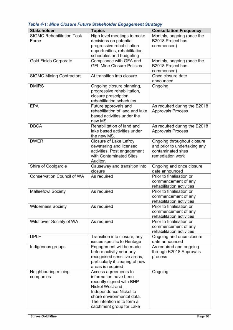
4.3 Future Stakeholder Engagement Strategy
As the mine reaches closure, stakeholders will be kept up to date with the closure planning process. Table 4-1 identifies stakeholder engagement to be undertaken during the course of the B2018 Project.
St Ives Gold Mine Page 10
Table 4-1: Mine Closure Future Stakeholder Engagement Strategy
Stakeholder Topics Consultation Frequency SIGMC Rehabilitation Task Force
High level meetings to make decisions on potential progressive rehabilitation opportunities, rehabilitation schedules and budgeting
Monthly, ongoing (once the B2018 Project has commenced)
Gold Fields Corporate Compliance with GFA and GFL Mine Closure Policies
Monthly, ongoing (once the B2018 Project has commenced)
SIGMC Mining Contractors At transition into closure Once closure date announced
DMIRS Ongoing closure planning, progressive rehabilitation, closure prescription, rehabilitation schedules
Ongoing
EPA Future approvals and rehabilitation of land and lake based activities under the new MS.
As required during the B2018 Approvals Process
DBCA Rehabilitation of land and lake based activities under the new MS.
As required during the B2018 Approvals Process
DWER Closure of Lake Lefroy dewatering and licensed activities. Post engagement with Contaminated Sites Auditor.
Ongoing throughout closure and prior to undertaking any contaminated sites remediation work
Shire of Coolgardie Causeway and transition into closure
Ongoing and once closure date announced
Conservation Council of WA As required Prior to finalisation or commencement of any rehabilitation activities
Malleefowl Society As required Prior to finalisation or commencement of any rehabilitation activities
Wilderness Society As required Prior to finalisation or commencement of any rehabilitation activities
Wildflower Society of WA As required Prior to finalisation or commencement of any rehabilitation activities
DPLH Transition into closure, any issues specific to Heritage
Ongoing and once closure date announced
Indigenous groups Engagement will be made before activity near any recognised sensitive areas, particularly if clearing of new areas is required
As required and ongoing through B2018 Approvals process
Neighbouring mining companies
Access agreements to information have been recently signed with BHP Nickel West and Independence Nickel to share environmental data. The intention is to form a catchment group for Lake
Ongoing

St Ives Gold Mine Page 11
Stakeholder Topics Consultation Frequency Lefroy to ensure a consolidated approach to monitoring and closure
ACH Nickel (JV) Proposed ACH Nickel operations and closure of operations
Ongoing
Community Interest Groups Ongoing access to land, feral animal control
During B2018 and as required
Other State Government Agencies
none identified to date If required
CME WA none identified to date Ongoing, quarterly meetings CCI WA none identified to date Ongoing, quarterly meetings Utility Groups Closure of access and
infrastructure As required and on closure
Pastoral Lands On closure of specific areas, particularly in regards to any requirements to leave infrastructure.
On closure of specific areas and close to final mine closure

St Ives Gold Mine Page 12
5 POST-MINING LAND USE AND CLOSURE OBJECTIVES
5.1 Post-Mining Land Use
Prior to mining, the majority of the land that the B2018 Project is located on, was either classified as ‘Pastoral Land’, or as ‘Common’ (17938), a type of ‘other crown reserve’ or ‘unmanaged reserve’. The Common was predominantly utilised by the Mt Monger Pastoral Station. No land use has been defined for Lake Lefroy with the exception of some of the islands (MWH 2016a).
SIGMC anticipates that the post mining land use for the majority of the Project will be pastoral; this is consistent with the current dominant land use in the Eastern Goldfields subregion, which is grazing. The proposed post mining land use has been discussed with key stakeholders as part of the preparation of the 2016 MCP and further consultation will take place as the Project progresses to ensure that pastoral use remains the most suitable post mining land use.
SIGMC is committed to the rehabilitation of all disturbed areas to the agreed final land use(s). Some known potential environmental legacies (including contaminated sites) may restrict final achievement of the post mining land use and activities. Any features that may be potentially classified as an area of ‘Potential Environmental Concern’ will be managed during the B2018 Project and addressed within the future implementation plans for the next revision of the MCP.
SIGMC commit to rehabilitation of all disturbed areas to the agreed final land use(s). Appropriate qualitative closure objectives and completion criteria for the post mining land use have been agreed to by the key stakeholders, including the palatability (‘desirability’) of plant species. Some of the features constructed as part of the Project such as WRLs, TSFs and pits will remain as permanent features after closure.
A closure team will be appointed to oversee progressive rehabilitation and closure of the Project. This team will focus on infrastructure decommissioning and removal, (or if appropriate, disposal on-site of plant and infrastructure), contaminated site identification, remediation and rehabilitation. Land use will be 'mine site rehabilitation' until the rehabilitated areas are demonstrated to be sufficiently resilient to handle grazing pressure, and the site is relinquished.
5.2 Closure Objectives
Due to the variance in the closure issues across the Project, closure objectives have been developed under the following five aspects:
compliance; landforms; rehabilitation function; key stakeholders; and mining infrastructure.
The closure objectives for the Project are detailed in Table 6-1 below along with the completion criteria and proposed monitoring to verify the progress towards closure.

St Ives Gold Mine Page 13
6 COMPLETION CRITERIA
A set of qualitative completion criteria and performance indicators have been developed to match the closure objectives. These are detailed in Table 6-1 below. SIGMC is committed to ensuring that the current completion criteria become more comprehensive and detailed in future revisions of the site wide MCP including this RMCP, through the inclusion of quantitative standard values as they are developed.
Appropriate detail on the monitoring framework to be implemented for each of the closure criteria is also presented in Table 6-1. SIGMC will continue to use recognised or acceptable monitoring methodologies and standards, and reference trends against expected or predicted performance based on the agreed closure criteria. The proposed post-closure monitoring program, including the type and frequency of monitoring against relevant completion criteria is presented in Section 10.
Preliminary quantitative rehabilitation completion criteria will be developed over the next few years of rehabilitation monitoring, for inclusion in the next revision of the MCP. These criteria are expected to be applicable for rehabilitation of B2018 Project features as well and will be reflected in the scope of the next MCP. It is proposed that the completion criteria will include consideration of erosion gullies, landscape function analysis (LFA) indices, and a range of vegetation parameters. Rehabilitation completion criteria will be measured against local target analogues, which will form the basis for the quantitative standard values. Target analogues, as presented in Table 6-1, also include rehabilitation areas within the Project that are considered acceptable by the DMIRS.
The first step towards developing quantitative completion criteria for rehabilitation was undertaken through the development of the SIGMC Analogue Site Review and Monitoring report (MWH 2016b). Through this review, an initial suite of analogue sites were selected to represent the natural environment surrounding the mine, and desirable outcomes for rehabilitation. These analogues were located on the Lefroy, Moriarty, Gumland and Graves land systems, as well as high-performing rehabilitation sites which represent desirable outcomes for other rehabilitation areas. The current suite of analogue sites will be further reviewed in the future, to ensure alignment with final approved rehabilitation objectives and to confirm they represent desirable outcomes for rehabilitation.
Given that the post mining land use for the Project will largely revert to pastoral land, the desirability of plant species will likely be considered when setting quantitative completion criteria for rehabilitation. The proportions of suitable plant species in an area are directly linked to the carrying capacity of the land for pastoralism (i.e. the stocking rate of an area). Data on species consistent with the identified final land use of pastoral, present carrying capacity (PCC) of the Kalgoorlie region, and stocking rates for different vegetation communities is available from the Western Australian Department of Agriculture and Food, DAFWA (or equivalent). This data will be used to inform any related completion criteria.

St Ives Gold Mine Page 14
Table 6-1: Completion Criteria and Closure Objectives for B2018 Project
Closure Objectives Completion Criteria Type of monitoring Performance Indicators
1. Compliance
1.1 All achievable conditions and commitments relevant to rehabilitation and closure will be met.
All achievable conditions and commitments relevant to rehabilitation and closure are met.
Auditing by SIGMC responsible person, or suitably qualified specialist.
All achievable closure related conditions and commitments identified in the current LOR are achieved.
1.2 To rehabilitate using current mine rehabilitation techniques suitable to the site conditions and the constraints of the post-mining environment.
Final landform designs and rehabilitation techniques incorporate consideration of the material characterisation, site conditions and the constraints of the post-mining environment. As-constructed reports and rehabilitation records are available for review.
Audit the outcome of the rehabilitation techniques used at SIGMC against the outcome of current mine rehabilitation techniques used in comparable environments by SIGMC responsible person, or suitably qualified specialist.
Evidence of successful historic rehabilitation, rehabilitation trials, and/or on other successful rehabilitation techniques used in the local region is available to support the use of the applied rehabilitation techniques. As constructed reports are provided as evidence of performance.
1.3 Topsoil or appropriate growth medium is applied to all areas where revegetation is planned.
B2018 Project areas identified as areas that will be rehabilitated have had topsoil or growth medium applied at the recommended depth.
Audit of areas planned for revegetation by SIGMC responsible person, or suitably qualified specialist.
As constructed reports indicate evidence of topsoil application, and volume applied.
1.4 Surface drainage patterns will be reinstated or managed where practicable to be consistent with the regional drainage function.
Surface drainage to downstream environments is retained, or reinstated where possible.
Review against relevant approvals documentation and/or appropriate management plan.
Evidence of a surface drainage assessment on a biennial basis for ten years (as per monitoring management plan). Confirmation of compliance with relevant approvals and/or appropriate management plan.
1.5 Surface water chemistry to reflect agreed post closure water chemistry as much as practicable.
Surface water chemistry not to exceed agreed levels.
Monitoring of surface water chemistry via an approved sampling plan.
Confirmation of compliance with agreed surface water chemistry levels post closure.

St Ives Gold Mine Page 15
Closure Objectives Completion Criteria Type of monitoring Performance Indicators
Review against relevant approvals documentation and/or appropriate management plan.
Evidence of surface water quality monitoring data on a biennial basis for ten years (as per monitoring management plan).
1.6 Groundwater levels to reflect agreed post-closure levels as much as practicable.
Groundwater levels not to exceed agreed levels.
Monitoring of groundwater levels via monitoring bores. Review against relevant approvals documentation and/or appropriate management plan. Continued development of a site wide groundwater model to assist with predicting levels.
Confirmation of compliance with agreed groundwater levels post closure. Evidence of annual monitoring over a ten year monitoring period (as per monitoring management plan).
1.7 The SIGMC Project is compliant with the requirements of the CS Act in order to achieve relinquishment.
Areas classified as ‘possibly contaminated - investigation required’ under the CS Act, which may restrict the post mining land use and activities have been identified. A Detailed Site Investigation (DSI) into the identified sites has been undertaken to determine the appropriate remediation requirements.
Evidence that the site investigations are current at the time of closure. Monitoring to be undertaken in accordance with the DSI findings and remediation requirements.
Confirmation of compliance with the CS Act. Evidence of a current site investigations at the time of closure. Evidence of monitoring in accordance with the site specific DSI and remediation requirements.
1.8 Develop a lake based post-closure monitoring plan, following completion of a comprehensive risk assessment for Lake Lefroy during dry and flooded conditions.
Implement the post-closure monitoring plan, to ascertain the changes in the Lake Lefroy ecosystem following cessation of dewatering discharge.
Biennial monitoring for a period of ten years post closure. Flood monitoring following a 1 in 20 year ARI rainfall event.
Evidence of reporting of changes in lake status biennially is available for review.

St Ives Gold Mine Page 16
Closure Objectives Completion Criteria Type of monitoring Performance Indicators
2. Landforms
2.1 Appropriately manage mine waste throughout the life of mine.
Mined waste materials with potential for adverse environmental impact have been identified and managed appropriately.
Confirmation by SIGMC responsible person, or suitably qualified specialist, that sufficient waste characterisation has been undertaken and material has been appropriately managed during construction and at completion of works.
Confirmation of compliance with placement and cover specifications in landform planning and engineering designs.
2.2 Establish safe, stable and non-polluting landforms.
Landform design incorporates water and drainage management measures to mitigate erosion of final surfaces and slopes. Final surfaces develop resistance to erosive forces and are non-polluting.
Monitoring of surface stability and erosion features on the landform using a combination of: permanent erosion
assessment transects; erosion pins; Digital Elevation Model (DEM)
assessment; or other suitable monitoring
methods that quantify stability and erosion.
Audit by SIGMC responsible person, or suitably qualified specialist, of constructed landform for compliance against the most recent approved design specifications.
Confirmation that the landform design complies with approved design specifications. Evidence of monitoring on a biennial basis for ten years (as per monitoring management plan). Erosion monitoring data demonstrates that erosion features are stable over multiple years, and erosion does not threaten the integrity of stored mine wastes nor impede post-closure management. The proposed rock armouring is sufficient to maintain the integrity of the landform long term post-closure.
2.3 Landforms in areas planned for revegetation, support a vegetation community that is similar to the target analogue
Vegetation viability through propagule development and seedling recruitment is evident on landforms planned for revegetation.
Landscape assessments are undertaken annually for three years using appropriate procedures following rehabilitation/ seeding against the
Evidence of monitoring in accordance with the monitoring management plan.

St Ives Gold Mine Page 17
Closure Objectives Completion Criteria Type of monitoring Performance Indicators
assigned target analogue, followed by biennial assessments for a following six years. Triennial monitoring can then commence. Analysis of growth mediums used for rehabilitation, where revegetation is planned.
Evidence that the vegetation community is trending towards the target analogue. A review of the properties of the growth mediums utilised is available as evidence that they are not limiting to native perennial vegetation establishment.
2.4 Compliance with appropriate TSF Guidelines and tenement conditions.
Compliance with relevant ANCOLD guidelines for TSF safety and stability. Compliance with TSF inspection, auditing and reporting requirements, as stipulated in the tenement conditions.
Compliance audit inspections of TSFs for a minimum of three years post deposition.
Submission of an annual audit to the DMIRS for three years post deposition ceasing into a TSF. Confirmation of compliance with regulatory guidelines and reporting requirements.
3. Rehabilitation Function
3.1 Vegetation attributes in rehabilitated areas will have values indicative of the target analogue, in areas planned for revegetation.
Vegetation is comprised of local provenance species.
Vegetation cover (%) and species composition is assessed utilising the SIGMC Rehabilitation Monitoring Procedure.
Evidence of values that are similar to those of the assigned target analogue in terms of plant cover and species composition.
Vegetation cover values are similar to that of the target analogue. Revegetation demonstrates viability through propagule development and seedling recruitment.
Visual inspection during rehabilitation monitoring.
Evidence of reproduction has been observed and recorded, for mature plants (e.g. fruit, seed or flowers) and native perennial seedlings (second generation) on rehabilitation, and is available for review.
3.2 Where possible, vegetation species consistent with the identified final land use of pastoral will be utilised in rehabilitation not conducted on landforms.
Proportions of suitable plant species used in rehabilitation seed mixes have been considered (along with the potential effects of grazing on the stability of rehabilitation areas). **
Rehabilitation reports include documented consideration of the seed mix and the proportions applied, in regard to plant palatability and potential
Documented seed lists, rates and proportions of each species are available for review, for each rehabilitation area; in addition to how the palatability of the species

St Ives Gold Mine Page 18
Closure Objectives Completion Criteria Type of monitoring Performance Indicators
disturbance pressures by grazing animals.**
was taken into account when choosing a seed mix.**
3.3 Weed (introduced) species do not dominate rehabilitated areas, whether rehabilitation areas are planned for revegetation or not.
Weed (introduced) species do not dominate any rehabilitated area. Appropriate management techniques (specific to the weed species) are implemented.
Weed surveys undertaken annually for three years post closure. The monitoring frequency will be critically reviewed after three years Vegetation cover (%) assessed utilising SIGMC Rehabilitation Monitoring Procedure on areas planned for revegetation, or visual assessment of areas not planned for revegetation.
Evidence of monitoring on an annual basis for three years post closure Confirmation that the cover (%) of weed (introduced) species does not exceed the total native perennial vegetation cover (%). Weed (introduced) species does not include seeded pastoral species.
3.4 The final landscape will have the ability to withstand post mining land use pressures.
Revegetated areas comprise a suitable proportion of ‘intermediate’ and ‘un-desirable’ plant species to provide resilience to grazing at surrounding and agreed stocking rates.** Revegetation demonstrates sustainability through propagule development and seedling recruitment.
Vegetation cover (%) is assessed utilising the SIGMC Rehabilitation Monitoring Procedure. **
Evidence of monitoring in accordance with the monitoring management plan. Evidence of development of plant density targets for ‘intermediate’ and ‘un-desirable’ plant species following monitoring surveys. Evidence of reproduction has been observed and recorded, for mature plants (e.g. fruit, seed or flowers) and native perennial seedlings (second generation) on rehabilitation, and is available for review.
4. Key Stakeholders
4.1 Actively engage key stakeholders on a regular basis including attaining agreement on the post-mining land use.
The project meets the agreed post mining land use that was accepted by key stakeholders
Confirmation by SIGMC responsible person of compliance with stakeholder agreements.
Confirmation of compliance with stakeholder agreements.

St Ives Gold Mine Page 19
Closure Objectives Completion Criteria Type of monitoring Performance Indicators
Biennial review of stakeholder consultation register and consultation strategy to ensure stakeholder agreements are being maintained and concerns addressed.
Evidence is available for review that demonstrates that key stakeholders have been informed on the Project status, and any proposed changes to the Project and closure. The revised MCPs demonstrate that priority outcomes of community and stakeholder consultation in relation to closure have been taken into consideration in the development and reviews of the MCP. A biennial update to the Stakeholder Consultation Register and Strategy that includes SIGMC’s responses to stakeholder comments and issues is available for review.
4.2 Infrastructure will be retained or removed in accordance with agreed post mining land use in consultation with relevant key stakeholders and with approval granted where required.
Retained infrastructure will be left in a safe condition and transferred via an appropriate asset transfer agreement to a legally responsible entity. Infrastructure and equipment that is not to be retained will be removed to allow rehabilitation to the approved post mining land use of the area. Liabilities of any infrastructure to be retained are defined, and approved
Inspections of retained features prior to handover by SIGMC responsible person. Signed asset transfer agreement in place prior to transfer of legal responsibility. Review against Decommissioning Plans by SIGMC responsible person.
Confirmation that all redundant surface infrastructure is removed. Confirmation that the transfer of retained infrastructure assets and liabilities is completed. Confirmation of compliance with MCP and relevant Decommissioning Plans

St Ives Gold Mine Page 20
Closure Objectives Completion Criteria Type of monitoring Performance Indicators
by relevant key stakeholders, prior to any asset transfer taking place.
5. Mining Infrastructure
5.1 Inadvertent public access to open pits will be prevented as far as is practicable.
Abandonment bunds are constructed around all open pits that exceed 5 m in depth, in accordance with current guidance.
Audit against the Department of Industry and Resources (DoIR) Safety Bund Walls Around Abandoned Open Pit Mines Guideline 1997 (or equivalent). Assessment to ensure that an adequate abandonment bund is in place.
Confirmation of compliance with regulatory guidelines and MCP.
5.2 Vertical openings to underground workings will be made safe.
Inadvertent access to underground workings that present a risk is prevented.
Audit by SIGMC responsible person, or suitably qualified specialist of all known underground workings that present a risk, prior to relinquishment.
Confirmation of compliance with regulatory guidelines and MCP. A risk assessment is available for review.
**Applies to rehabilitation works conducted from 2016 onwards only; plant species consistent with the identified final land use of pastoral are defined by the Western Australian Department of Agriculture and Food, DAFWA (or equivalent).

St Ives Gold Mine Page 21
7 COLLECTION AND ANALYSIS OF CLOSURE DATA
The following section provides a summary of details on the physical and biological environment including:
biogeographical context; land use; local climatic conditions; local physical conditions – geology, geomorphology, land systems, seismicity and
geotechnical data; local water resource details – topography, hydrology, hydrogeology, quality, quantity
and environmental values (ecological and beneficial use); soil and waste material characterisation; local and regional ecological information (flora, fauna, ecology, communities and
habitats); heritage; and other environmental data, including rehabilitation and seed mixes.
Further detail on the baseline environmental data is contained in the ERD.
7.1 Regional Setting
The Eastern Goldfields subregion totals 5,055,623.59 ha, with approximately 11.4% freehold and 88.4% crown land. The primary land uses comprise Unallocated Crown Land (UCL) (42.1%, 2,128,895.15 ha), other Crown Reserves (4.8%, 243,185.95 ha), Conservation and Natural Environments (62.5% 3,159,827.71 ha), Production from Native Environments (37.4%, 1,893,206.38 ha), and Production from Dryland Agriculture and Plantations (0.04%, 1,899.12 ha) (IBRA 2016).
Past and present land use within the Project include (MWH 2016a):
gold and nickel prospecting, exploration and mining activities since 1897; salt mining which was conducted at the southern end of Lake Lefroy near
Widgiemooltha during the 1940s. Lake Lefroy Salt Mining Pty Ltd harvested salt from evaporation ponds at the northern end of the Lefroy Peninsula between 1968 and 1982;
sand mining which was conducted periodically at the northern end of the Lake Lefroy Peninsula;
pastoral land is located throughout the region and is the main land use other than mining in the vicinity, with the Project located within or adjacent to the Woolibar, Madoonia Downs and Mt Monger Pastoral Stations. Sheep grazing is also noted to occur in UCL and other Crown Reserves in the local area;
Conservation, comprising the following: o C Class Kambalda Timber Reserve. The Caves Rocks development lies within
this reserve; and o C Class Kambalda Nature Reserve.The Caves Haul Road lies within this
reserve. Recreational activities are associated with the lake, including wildlife photography,
camping, walking and hiking, motorbike riding, and land yacht sailing.
7.2 Climate
The Eastern Goldfields bioregion is characterised by a semi-arid climate with hot summers and mild winters, often described as a Mediterranean climate. The mean maximum temperature for City of Kalgoorlie-Boulder (CKB) ranges between 33.6ºC in January to 16.7ºC in July, as recorded

St Ives Gold Mine Page 22
at the Bureau of Meteorology (BOM 2017) Kalgoorlie-Boulder Airport weather station (BOM Station 012038).
The region experiences a semi-arid climate, with 266.8 mm of rainfall received on average. In 2009, the SIGMC operations received 336.6 mm during the calendar year. The BOM 78-year rainfall record indicates that the highest daily rainfall recorded to-date is 177.8 mm (BOM 2017). February is the wettest month with 31.1mm on average received, however, rainfall patterns can be quite variable with the main rain falling during the summer months (Figure 7-1). Remnant tropical cyclones and thunderstorms associated with cyclonic activities in the North of the WA can occasionally bring heavy rains and result in flooding in the summer period. Annual evaporation rates of 2400 – 2800 mm/year exceed rainfall and are the highest during the summer months when humidity is the lowest. Heavy rains occasionally cause localised flooding but surface water bodies remain only for short periods of time after rainfall.
Figure 7-1: Mean Rainfall (1939-2017) (BOM, 2017)
The average wind speeds within CKB vary between 11.8 – 17.1 km/h in the morning, to 13.7 – 17.8 km/h in the afternoon. (BOM 2017). The dominant wind directions in spring and winter is from the west and northwest, and can exceed 30 km/hr in the afternoon (BOM 2017).
7.3 Physical Conditions
7.3.1 Geology
The Kambalda - St Ives area lies within the Norseman-Wiluna Belt of the Kalgoorlie Terrane. The Norseman-Wiluna greenstone belt forms the major part of the Eastern Goldfields province. It is flanked to the east by lithologically and structurally distinct greenstones of the Laverton sub-province and to the west (across a major post-tectonic granitoid zone) by the Southern Cross granite-greenstone terrain. In comparison to the other greenstone belts, the Norseman-Wiluna belt is very highly mineralised, particularly in nickel and gold (Connors et al. 2005).
Stratigraphic and structural complexity in the Norseman-Wiluna belt contrasts with the flanking greenstone belts to the east and west, which in turn have much in common and whose stratigraphies can be correlated at regional scales. The Norseman-Wiluna belt is characterised by a paucity of banded iron formation (BIF), but a corresponding abundance of sulphidic

St Ives Gold Mine Page 23
sedimentary units, albitic sedimentary units and chert; an abundance of komatiitic rocks; and a chain of discrete felsic volcanic centres. The main stratigraphic units in the Kambalda-Kalgoorlie region include the following (Connors et al. 2005):
Morgan‘s Island Sandstone; Newton Felsic Volcanics; Paringa Basalt; Kapai Slate; Devon Consols Basalt; Kambalda Komatiite; and Lunnon Basalt.
7.3.2 Geomorphology
Regional topography is gently undulating with occasional ranges of low hills. Regional geomorphology within and around the Project consists of salt lakes and fringing saline plains, sandy plains and dunes with halophytic shrub lands (Payne et al. 1998).
The Lake Lefroy area consists of erosional and depositional landforms with the flat bed of the lake occupying the lowest part of the landscape. The predominant landforms are broad, level or gently inclined plains with loamy surfaces, gently undulating plains with lateritic gravel mantles and occasional low hills and ridges on greenstone, basalt and (less frequently) granite (MWH 2016a).
7.3.3 Land Systems
The most common land systems within the Project are:
Lefroy (LEF) described as salt lakes and fringing saline plains, sandy plains and dunes with chenopod low shrublands;
Gumland (GML) described as extensive pedeplains supporting eucalypt woodlands with halophytic and non-halophytic shrub understoreys; and
Lakeside (LAS) described as sandplains with occasional sand dunes and prominent claypans, supporting mallee eucalypts and spinifex.
These land systems cover approximately 96% of the ERD Development Envelope (Phoenix 2017).
The dominant landform in the Project area is the Kambalda system which is characterised by stony plains with Acacia and halophytic shrublands, low hills with Acacia or eucalypt woodlands with halophytic understorey, or alluvial plains with eucalypt woodlands and halophytic understorey (Tille 2006).The dominant soil types are calcareous red earths and red loamy earths, with minor salt lake soils, red-brown shallow loams over hardpans and red sandy duplex soil. Soil salinity is common on the stony plains.
7.4 Soil and Waste Characteristics
7.4.1 Soil Characteristics
The regional soils of the Kalgoorlie Province are characterised by extensive areas of calcareous loamy earths with red loamy earths, red loamy duplexes, various hardpans and sandy duplex soils where deeper weathering profiles have developed (Tille 2006). Soils are generally thin, and poorly developed over topographical highs associated with greenstone and granite ridges, however, where present, the soil profile is characterised by calcium and magnesium rich sandy loams. Soil in and around drainage lines and salt lake areas are dominated by saline and sub-saline sandy duplex soils that are generally low in nutrients (Payne et. al. 1998).

St Ives Gold Mine Page 24
MWH was commissioned to conduct an investigation into the characteristics of soil, mine waste, tailings and landforms at SIGMC (MWH 2016b), as part of investigations associated with the 2016 MCP. Valuable information pertaining to the performance of the various soil and mine waste materials, and existing landform design / construction parameters was derived from site-based inspections and a sampling and analysis program, which was designed to confirm the observed characteristics of the soil, mine waste and tailings samples present.
The success of existing rehabilitation on site is variable and strongly influenced by the characteristics of the materials present and the constructed geometry (slope characteristics and surface water management) of the mine waste landforms. Generally speaking, surface erosion on constructed landforms is most pronounced where thick topsoil has been applied to slopes with insufficient rock armour, or where oxide and/or lake sediment waste is present at the surface. This is sometimes exacerbated by inappropriate landform design and concentration of surface water flow.
Based on the findings of the MWH (2016b) study, it was recommended that, where applicable, soil resources be used sparingly on constructed sloped surfaces and be combined with competent rock, to improve surface stability. Visual observations have highlighted that erosion of topsoil materials is most prevalent on slopes where there has been insufficient competent rock material incorporated into the surface. Soil strength, exchangeable cation capacity, water retention characteristics and plant-available nutrient concentrations of the majority of the topsoil across the site are considered to be suitable with respect to the establishment and growth of local vegetation. This was supported by the observations of vegetation growth on the majority of topsoil stockpiles across the site.
In accordance with the SIGMC site procedures, topsoil resources have been progressively stripped and stockpiled as part of land clearance activities prior to mining. For land-based mine areas, topsoil stockpile resources are located close to the mine and other infrastructure disturbance areas. This practice is proposed to continue for the B2018 Project operations. For lake-based mine areas, it is expected that very limited topsoil resources will be available for use in rehabilitation. Consequently the rehabilitation objectives for lake-based landforms are presented separately to the land-based landforms.
7.4.2 Mine Waste Characteristics
The sampling and analysis of mine waste materials for acid metalliferous drainage (AMD) characterisation has been undertaken at the Project since the late 1990’s. To date, over 3,000 samples have been collected and analysed to determine the potential for acid generation.
MWH was engaged to undertake a review and assessment of the AMD data collected at SIGMC as part of the preparation of the site wide MCP site in 2016 (MWH 2016c). Existing information on characterisation of mine waste and tailings materials with respect to AMD was reviewed as part of this study. The review focussed on AMD characterisation information relating to waste rock and tailings materials which are considered the major sources of AMD in St Ives.
An overall assessment of AMD risk was determined through examination of sample representation, pH, sulfide sulfur, Acid Base Accounting (ABA) results, acid drainage potential classification (with a reliability assessment of the classification results) and elevated metals potential. In general, waste rock located near the mineralised zone is likely to have a higher risk of generating acid independent of the lithology (MWH 2016b). This is due to the sulfide mineral distribution.
Specific lithologies that were identified as high risk include Kapai Slate and Cave Rocks Sediment. Lithologies that were identified as moderate risk are Cave Rocks Dolerite.
SIGMC undertakes waste rock characterisation studies and assessment of AMD on a regular basis, for specific projects/project approvals and any issues that may arise. This practice will continue throughout the B2018 Project. In accordance with the current site procedure, the waste

St Ives Gold Mine Page 25
rock is sampled regularly and in the event any Potentially Acid Forming (PAF) material is encountered it will be selectively segregated and contained below the water table level within open pits and capped with NAF material or encapsulated within the WRLs under a minimum of 2.0 m layer of competent rock.
The current management practices and procedures in place at SIGMC are considered to be at a standard that is consistent with current industry practice (at the time of writing), and appropriate for the management of the AMD risk at the site.
7.4.3 Rehabilitation Materials Inventory
The prioritised use of topsoil and competent waste rock resources available across the Project is considered to be an integral component of waste landform design, construction and rehabilitation.
Knowledge of the volumes and characteristics of potential rehabilitation materials available is an important consideration for efficient and successful material handling and placement, landform design and rehabilitation. Characterisation and inventory of available materials will therefore continue throughout the B2018 Project.
7.5 Hydrology
Lake Lefroy covers an area of 555 km2 and is located within the Lake Lefroy catchment, which is approximately 3,950 km2 in size (Clarke 1991). The lake is the major surface water body within the Development Envelope and is surrounded by numerous ephemeral drainage channels and creeklines. The lake appears to be a system in transition between an ephemeral lake and a salt pan, with increased build-up of salts occurring via natural processes (Clarke 1994a), as well as dewatering discharge. It is estimated that as much as 2.4 million tonnes (Mt) of salt is added to Lake Lefroy annually, as a result of dewatering activities by mines fringing the lake (Handley 2003; Vasey 2001). This volume is variable, as it is dependent on the extent of mining and associated dewatering. While the surface of Lake Lefroy varies in bathymetry over a large area, the playa is generally of low relief, at approximately 286 m above sea level (MWH 2016a).
Regional topography is low to gently undulating, with plains rising to in excess of 410 m at the catchment divide surrounding Lake Lefroy. Surrounding catchments drain via ephemeral gullies and drainage lines, trending towards Lake Lefroy. Channels are generally poorly defined, with runoff largely occurring as sheet flow.
High infiltration capacities of sediments, coupled with high monthly evaporation rates in excess of the average monthly rainfall, result in limited residency time for pooled surface water on the lake. The occurrence of freshwater in the landscape is highly infrequent, with the salinity of surface water on the lake ranging from 260,000 to 435,000 mg/L (TDS) (URS 2010). It is also unlikely that large freshwater influxes, due to tropical low pressure systems, would significantly reduce the salinity of surface water on Lake Lefroy, due to the thick salt crust on the playa surface. While the bathymetry of the lake is generally flat, there are two shallow water accumulation areas in the northeast and central southerly areas of the lake (MWH 2016a).
As the majority of inflow does not reach the lake due to rapid terrestrial infiltration, and runoff provides only minimal lake surface flows, Lake Lefroy is rarely subject to major flooding, particularly to any substantial depth (Handley 1991). In addition, the persistence of a thick and expansive salt crust (estimated at covering 65% of the lake’s surface) typically results in the extreme hypersalinity of any pooled surface water. However, the playa is capable of accommodating major inflows from cyclonic activity, in addition to dewatering discharge from SIGM, due to its expansive size (MWH 2016a).
Following major rainfall events, flooding occurs in Lake Lefroy relatively quickly and surface water has been documented as persisting in the lake for comparably long periods following major runoff events (CSIRO Land and Water 2003). This was demonstrated during extensive flooding resulting from ex-tropical Cyclone Vance (March 1999) (BoM 2016a) and Cyclone Steve (February to

St Ives Gold Mine Page 26
March 2000) (BoM 2016b), where Lake Lefroy held surface water for approximately nine months and a further five months following additional rainfall in February 2001. However, there is no evidence that delayed drainage to the lake occurs from the surrounding catchment for a prolonged period after these events (CSIRO Land and Water 2003).
The last significant flood event at Lake Lefroy occurred in 2014, more than 150 mm of rain was received over a three day period in late January (BoM 2017), as a result of local isolated storm activity. During flooding, fluctuations in water depth and movement are a dominant hydrological feature of the lake, due to its shallow nature and the action of prevailing winds (Clarke 1994b). In addition, due to the significant spatial variability in rainfall, the variable bathymetry of the lake surface and the location of existing mining infrastructure, the lake does not necessarily fill in its entirety (Clarke 1991; CSIRO Land and Water 2003).
The hydrology of Lake Lefroy has been substantially altered due to the construction of the primary causeway built in the late 1960s (SIGM 2010), which bisects the centre of the lake and is used for access, mining and exploration purposes. The causeway has particularly altered the flow regime during major floods (MWH 2016a).
7.6 Hydrogeology
The occurrence of groundwater is primarily controlled by topography and geology. The region is underlain by Archaean granitoids and greenstones intruded by Proterozoic mafic dykes. Much of the Archaean basement is weathered, with the depth of weathering being greatest over felsic and sedimentary rocks and least over mafic and ultramafic rocks, which therefore tend to form topographic lows and highs (Thorpe 2014).
Fractured rock aquifers occupy the greater part of the Kalgoorlie area, generally containing only minor groundwater supplies, which can be difficult to locate. Fresh groundwater does not occur in the Kalgoorlie region, but brackish groundwater exists in the upper reaches of some catchments (MWH 2016a).
The regional water table ranges from less than 1 m below the ground (beneath and adjacent to the playa), to more than 50 m below the ground in elevated areas. External recharge is restricted, occurring only during heavy rainfall in areas containing outcrops of bedrock. Recharge from the playa into the underlying lacustrine sediments occurs, some of which is assumed to enter the palaeodrainage aquifer; however, regional hydraulic gradients are low within the palaeodrainage. Natural groundwater discharge occurs from the playa via evaporation (Kern 1995).
The B2018 Project is located within the Lefroy-Dundas Sub Area of the Goldfields Groundwater Management Area as defined by the former Department of Environment (DoE) Groundwater Allocation Branch. Lake Lefroy forms the headwaters of the Lefroy Palaeodrainage, one of four main palaeodrainage systems in the area, (Timms 1992), which flows eastwards towards the Eucla Basin (Clarke 1994a). The majority of the B2018 Project is located in or along the margins of Lake Lefroy, within the Lefroy Palaeodrainage system. As a result, operations intersect variable thicknesses of Tertiary to recent alluvial, lacustrine and aeolian deposits, which overlay mineralised Archaean bedrock containing the gold deposits (Clarke 1991).
The most significant aquifer of the Lefroy Palaeodrainage in the Lake Lefroy area comprises a series of channelled, fine to coarse-grained sand horizons representing infilled palaeodrainage channels. At Lake Lefroy, the palaeodrainage channel sand unit is generally underlain by clay, silt and lignite of the Pidinga Formation, locally interfingering with spongolitic silt and fine sand of the Princess Royal Spongolite. The upper part of the sedimentary sequence comprises clay, with silt, sandstone and pebbly lenses of the Revenge Formation and calcareous mudstones of the Cowan Dolomite and Gamma Island Formation (Clarke 1991).
TDS concentrations in the area ranges from 50,000 to 300,000 mg/L. Groundwater salinity in the vicinity of Lake Lefroy ranges between 274,000 and 423,000 mg/L TDS. Dissolved metal concentrations are reflective of the mineralogy in the region. Groundwater typically occurs in
St Ives Gold Mine Page 27
limited quantities, at depth of between 15 to 30 m below ground level (mbgl), outside of the margins of Lake Lefroy (URS 2010). The natural (pre-mining) groundwater flow is towards the Lefroy Palaeodrainage (MWH 2016a).
7.7 Ecological Information
The Project lies within the IBRA Eastern Goldfields (COO3) subregion which is regarded for its high floristic species and ecosystem diversity, in particular, Eucalyptus spp., Acacia spp. and ephemeral flora communities (Cowan 2001).
Based on broad vegetation mapping by Shepherd et al. (2002), the most common vegetation association across the Project is Binneringe 125 (minimal concern conservation status) with almost 27,000 ha present and described as bare areas and salt lakes. Consequently, the majority of the vegetation in the Project represents widespread communities that are well represented at a regional level (Phoenix 2017).
Over time, the comprehensive body of work collected on the B2018 Project area and surrounds has identified numerous conservation significant flora, fauna and invertebrate species. This is supported by database searches, which also list a range of conservation significant species with the potential to occur in the region (MWH 2016a).
The development of gold mining leading to a major alteration to the vegetation cover occurred in the early part of the 20th century. Deforestation was extensive to provide fuel for condensers, mines, and pump stations and to support pits, potentially affecting geological stability of the subsoils and hydrological regime. Tramways, locally known as woodlines, extended throughout the area, and major cutting occurred as late as the 1950’s. The tree roots were left in place, and in many areas, regrowth can be seen from the original stumps (Commander et al. 1992).
Within the Project area, there are no vegetation communities of national environmental significance, Threatened Ecological Communities (TECs), Declared Rare Flora or Threatened Flora (Botanica Consulting 2014; DPaW 2015a). However, approximately 13,600 ha of tenements in the south-eastern extremity of the B2018 Project area is located within the 100 km buffer zone of a Priority Ecological Community (PEC) known as the Fraser Range Vegetation Complex. This PEC is the Priority 1 Fraser Range Vegetation Complex PEC. None of the vegetation types within the Development Envelope are floristically representative of this PEC.
The Coolgardie bioregion accommodates a rich species assemblage comprising a diverse range of vertebrate fauna (Biological Surveys Committee et al. 1984). Terrestrial vertebrate fauna within the bioregion have adapted to survive in harsh semi-arid and arid climatic regions of the bioregion. Several species of conservation significance are known to occur within the bioregion, particularly birds including the Malleefowl, Peregrine Falcon, Carnaby’s Black Cockatoo and some migratory shorebirds when water is retained in waterbodies following sufficient rainfall (Biological Surveys Committee et al. 1984; Burbidge 2012; Van Dyck & Strahan 2008). A number of conservation significant mammal species known to occur within the Coolgardie bioregion historically have declined in distribution and abundance since European settlement with some now considered regionally extinct, in particular the Chuditch (Dasyurus geoffroii), Numbat (Myrmecobius fasciatus) and Bilby (Macrotis lagotis) (Biological Surveys Committee et al. 1984; Burbidge 2012; Van Dyck & Strahan 2008). The Coolgardie bioregion is not known to support any endemic vertebrate species; however, further regional surveys and taxonomic studies may reveal regionally endemic species.
Two factors predominantly determine the presence of subterranean fauna, i.e. the vugginess (porosity) of the geology and presence and quality (in particular salinity) of groundwater. Habitats likely to support troglofauna are karstic limestone, channel iron deposits (CIDs) (in particular pisolite in inverted landscape geomorphology), groundwater calcretes above the water table, alluvium/colluvium in valley-fill settings, BIFs and weathered and fractured sandstone. Stygofauna are likely where there are groundwater voids present, for example in karst limestone, calcretes, alluvial formations and fractured rock (EPA 2013).

St Ives Gold Mine Page 28
Examples of where troglofauna are unlikely to occur include geologies without cavities, voids or cave such as sand and clay dominated substrates and areas that have been submerged during seal level rise in the Holocene. Stygofauna fauna are unlikely to occur include deep sands or clays (especially over solid rock) or hyper-saline (exceeding marine concentration, i.e. 35,000 mg/L TDS) groundwater (EPA 2013).
The diversity and productivity of algae and macrophytes within Lake Lefroy appears to be low (MWH 2016b), in comparison to the surrounding claypans (Curtin University of Technology 1999, Phoenix 2014), a trend considered typical of large inland salt lakes, attributed to lower salinity of surrounding wetlands. The majority of taxa recorded are considered widespread and are common in salt lakes and wetlands throughout the Goldfields region. However, while comprehensive studies have been undertaken over time, the dataset for algae and macrophytes is patchy, with discrepancies between methodology and results (MWH 2016c).
In comparison to other salt lakes in the Goldfields, the aquatic invertebrate assemblage of Lake Lefroy appears to be depauperate, although studies to date have been restricted to major flood events (Curtin University of Technology 1999, Dalcon 2010, and Phoenix 2014). Up to 56 taxa, predominantly crustaceans and insects, have been identified from the lake and surrounding claypans (MWH 2016c), with six taxa also hatched during re-wetting trials in the laboratory (Curtin 1999). Assessment of the dormant egg bank (resting stages) over time, has found up to eight invertebrates represented in the sediments. Due to the differing levels of taxonomic resolution employed in past studies, it is likely that taxa numbers have been over estimated.
7.8 Social Environment
7.8.1 Aboriginal Heritage
The B2018 Project lies across two Ngadju native title claims: WC1999/002 and WCD2014/00.
A search of the Department of Planning, Lands and Heritage (DPLH) Aboriginal Heritage Inquiry System (AHIS) – GIS database indicated that there are five Heritage Sites within the Development Envelope (DPLH 2017).
A number of Aboriginal ethnographic and archaeological site surveys have been completed over the Project since the early 1990s. Numerous archaeological sites have been identified over the course of these investigations, including scar trees, gnamma holes and small to medium-sized artefact scatters.
The most recent heritage survey undertaken over the part of the Project (Dortch & Cuthbert 2017) provided an assessment of likelihood of presence of subsurface sites/remains on Lake Lefroy. It was agreed that Lake Lefroy can be considered to have little archaeological importance but are still subject to ethnographic consultation.
7.8.2 European Heritage
Online searches were undertaken in 2017 on the following databases to identify any European Heritage Sites within the Project area.
Heritage Council of Western Australia and the State Heritage Office Australian Heritage Places Inventory; and National Trust Heritage Register WA Municipal Heritage Inventory
No sites are registered within the project but there are 10 European heritage places located within the region.

St Ives Gold Mine Page 29
7.9 Rehabilitation
Rehabilitation works have been conducted within the Project area since the 1980’s, however, a large percentage of the historic rehabilitation has since been covered over (as WRLs have been expanded), or has failed due to high erosion and poor plant recruitment. Most of the remaining (and more successful) rehabilitation works were conducted after 2000; however, information regarding the timing and rehabilitation methodology is often not complete.
MWH conducted a rehabilitation and exploration audit to provide information for the 2016 MCP (MWh 2016d). This included a desktop review, on-ground verification of rehabilitated landforms and other areas, and inspection of exploration drill sites. The site audit was undertaken over 21 WRLs, five TSFs and one heap leach facility. In addition to MWH work, Talis Consultants undertook a review of the historic landforms for verification of the Mining Rehabilitation Fund (MRF) category changes in April 2016 (Talis 2016). The site audit covered 15 landforms (14 WRLs and one TSF).
Due to the historical nature of many of these landforms, the standard of rehabilitation is different to the current requirements and standards. As a result, some landforms had erosion observed as a result of steep slope angles (more than 15 for terrestrial infrastructure or 11 degrees on Lake Lefroy), the dispersive nature of the materials, depth of topsoil applied and/or lack of rock armouring.
The site wide rehabilitation undertaken to date is summarised below in Table 7-1. Findings of the summary have been utilised to support the rehabilitation techniques presented in this RMCP.
7.9.1 Analogue Sites
SIGMC is committed to undertaking monitoring of the WRL rehabilitated areas over the next three years (2017-2019), and comparing this data against potential target analogues to establish an understanding of the rehabilitation performance in these areas, and the key rehabilitation species. An analysis of the monitoring data collected will be included in the next iteration of the MCP, and will be utilised in the ongoing development of the completion criteria.
Analogue sites provide representative values that are typical of the landscape surrounding the mine. Subsequent to consultation with DMIRS, the term ‘analogue’ will encompass transects on natural landforms, as well as transects on constructed WRLs. Analogues for the existing operations were selected with attributes such as slope angle, soil texture and vegetation communities most similar to anticipated final attributes of rehabilitation areas, as well as to provide representation of potential future rehabilitation areas (MWH 2016e).
Potential new sites were pre-selected in 2016 via a desktop assessment prior to field work, with final site selection made in the field. Site selection took into account the following considerations:
existing vegetation and landform mapping data; the floristic and structural variability or uniformity of vegetation; a range of soil texture types; a high proportion of plant species known to be good disturbance colonisers and/ or
salt tolerant; avoiding areas planned for future development; close proximity to existing tracks to allow suitable access; and for analogue installed on waste landforms, high stability and vegetation cover.
Based on the monitoring undertaken on pre-selected analogue sites, in total of 16 analogue sites were establish to assist in monitoring of the existing features. More analogue sites are likely to be established as part of the B2018 Project once the final footprints and design for proposed features have been decided.

St Ives Gold Mine Page 30
Table 7-1: Summary of Landform Rehabilitation Undertaken to Date
Landform Location (Land/ Lake)
Tenement 2017 MRF status
Rehabilitation works undertaken to date
Outcome of the rehabilitation (MWH 2016d)
Intrepide WRL
Lake M15/1518 Disturbance 48.31 ha
16.94 ha (35 %) of total footprint rehabilitated
rehabilitation conducted in 2001-2002 Eastern slopes battered down
(approx. 12 degrees) and ripped Western slope battered down (approx.
14 degrees) and ripped) top portion of the WRL still requires
rehabilitation possibly seeded in 2002.
bare of vegetation and erosion is likely to become an issue.
majority of WRL comprised of a blend of Lake sediment, oxide and competent rock in an as-dumped blend with competent rock making up majority of the waste rock
competent rock placed on outer surface has led to minimal erosion on the northern, western and southern batter slopes, however, some erosion of fine sediment onto the lake surface was observed
Redoubtable WRL
Lake M15/1517 Disturbance 10.89 ha
100% of total footprint area rehabilitated
re-shaped in 2001 to an angle of 11 degrees or less (slopes were approximately 8 degrees when measured in 2015)
topsoil replaced in 2001/2002 to a depth of 100 to 200 mm
profiling and seeding undertaken in 2002
lake sediments/gypsum soil rehabilitation trial established in 2002, ripped and seeded
upper surface: ripped, crusted with hard gypsum crystals
coarse rock material (comprising angular mafic rock, quartz and gypsum) incorporated into the upper surface and slopes
Irrigation trial infrastructure still present on the trial area, however plant distribution and health was not noticeably different from elsewhere on the WRL (vegetation poor over all WRL)
slopes profiled at low angles (generally between 5 and 10 degrees), however major erosion channels and gullies were observed
erosional deposition on the lake surface was present where lake sediments had been placed on WRL

St Ives Gold Mine Page 31
Landform Location (Land/ Lake)
Tenement 2017 MRF status
Rehabilitation works undertaken to date
Outcome of the rehabilitation (MWH 2016d)
rehabilitation considered to be poor and not currently successful in achieving landform stability or vegetation establishment
soil materials more stable in areas where competent rock incorporated
Santa Ana WRL
Lake M15/1701, M15/1703
Disturbance-34.93 ha
0% of total footprint area rehabilitated
rehabilitation undertaken in 2000 to June 2001 - south-western batter reshaped to a final angle of 17°
March 2002 - ripping and seeding of portion of south-western batter
review of aerial imagery reveals WRL has remained largely unchanged since March 2002.
Seeded 2002 Hauling of competent rock from
Invincible has commenced. Capping of the WRL commenced in June 2016
during a site visit in June 2015 it was observed that non-competent material was being deposited on WRL, while competent material being reclaimed for construction of causeways for Invincible Project. Following field visit in 2015, competent material from Invincible Pit was used to cover Santa Ana
only south-western corner had been rehabilitated (waste rock cover)
southern / south-western / south-eastern slopes profiled from 10 to 17 degrees, and ripped along contour.
no topsoil on re-shaped areas and only very sparse vegetation growth along those batters.
remainder is primarily ‘as-dumped’, with northern slopes at angle of repose.
severe erosion present where lake sediments exposed at surface of constructed slopes
Leviathan East WRL
Land M15/1542
M15/1630
Disturbance-99.37 ha
39.9 ha, (40.2%) of total
rehabilitation on northern tip of WRL in 1997; some rehabilitation may have also occurred in 1991.
majority of rehabilitation from 1990's buried during later mining campaigns.
slopes covered with thick layer of topsoil combined with oxide and competent rock
vegetation establishment generally very poor

St Ives Gold Mine Page 32
Landform Location (Land/ Lake)
Tenement 2017 MRF status
Rehabilitation works undertaken to date
Outcome of the rehabilitation (MWH 2016d)
footprint area rehabilitated
estimated by 2002 that over 50% of slopes rehabilitated and a further 14% of slopes had been shaped and/or topsoiled.
surface material; competent rock and topsoil placed to a depth of 150 mm.
seeded with local provenance native seeds.
expansion area on WRL was active between 2009 and 2011. Extent of rehabilitation works, including, reshaping, rock armouring, top soiling and seeding undertaken during this period is not known, however seed list and seed rates are available for 2009
moderate to major erosion (gullies and rills). North western corner slopes (facing Sirius and Britannia Open Pits) very unstable with major erosion. Overall, rehabilitated slopes not stable and erosion of fine sediment pronounced
western and south western batter slopes - competent rock at angle-of-repose
upper surface - paddock dumped oxide and competent rock, with sections flattened and blended
Leviathan South WRL
Land M15/1562
M15/1563
Disturbance-11.17ha
9.55 ha, (85.5%) of total footprint area rehabilitated
initial rehabilitation activities undertaken on Defiance WRL.
1991: trials established on Defiance WRL, including moonscaping of the batter slopes.
During 1993 / 1994 wet season a 1 in 100 year rainfall event (23 mm in 28 minutes) caused extensive rilling and erosion which lead to the abandonment of moonscaping
no further information is available regarding rehabilitation on this WRL
eastern batter slopes - oxide and competent rock, moderate to major erosion
south western facing batter slope - convex profile, moderate to major erosion
upper surface and north eastern facing slope - blend of competent rock and transitional and oxide waste rock
north eastern batter - erosion is pronounced. The south western and eastern batter slopes have moderate to major erosion
depth and density of gullying increasing with increasing slope angles
vegetation establishment poor in regards to health and species diversity, although

St Ives Gold Mine Page 33
Landform Location (Land/ Lake)
Tenement 2017 MRF status
Rehabilitation works undertaken to date
Outcome of the rehabilitation (MWH 2016d)
some established trees were present. Areas where erosion was more severe were mostly devoid of vegetation
Leviathan West WRL
Land M15/1541
M15/1562
M15/1634
Disturbance-74.16 ha
34.76 ha, (46.9%) of total footprint area rehabilitated
rehabilitation commenced 1991. topsoil depth 150 mm, seeded with
local provenance seed upper surface ripped and rock
mulched north-west aspect pre-1997
rehabilitation (possibly 1991?), ~15 degree slope
northern upper flats and north and north-east slopes rehabilitated 1997
approximately 19 ha of original 1990's rehabilitation present in 2015
western aspect slopes rehabilitated 2002 (topsoil, ripping, seeding)
eastern aspect also rehabilitated (year not known)
Seeded 2002
rehabilitation on north-western aspect was generally considered to be in good condition. Slopes stable, with vegetation mainly consisting of Triodia and tall Eucalyptus trees. Leviathan West was only WRL where cryptogams were observed, a sign that ecosystem was becoming mature. Some erosion present but generally appeared to be stable – more erosion on steeper slopes
rehabilitation on north-eastern aspect was generally poor, although north-eastern corner had good vegetation establishment, consisting of Triodia and Atriplex shrubs with some upper storey.
upper surface - blend of topsoil and competent rock with some oxide (lower percentage of oxide compared to Leviathan East WRL)
northern area of western batter was steeper (up to 18 degrees) but was constructed of competent rock and was densely vegetated with juvenile and established trees and shrubs, and was observed to be relatively stable
surface of rehabilitated areas comprise sandy topsoil with competent rock
isolated slopes on south eastern batter rehabilitated with a blend of topsoil and

St Ives Gold Mine Page 34
Landform Location (Land/ Lake)
Tenement 2017 MRF status
Rehabilitation works undertaken to date
Outcome of the rehabilitation (MWH 2016d)
competent rock, erosion was moderate to major
vegetation cover was sparse on some 1990's rehabilitation disturbed by over-dumping during extension of the upper surface of the WRL. Slope angles, coupled with overdumping of additional waste rock has made slopes in these areas largely unstable.
an area of dumped transitional and oxide materials locate along north eastern face of upper lift had visible signs of potential AMD generation.
Mars East WRL
Lake M15/1607
M15/1610
M15/1611
Disturbance-152.11 ha
82.5ha, (54%) of total footprint area rehabilitated
Rehabilitation in 2005: re-grading bottom lift on southern
extension. This extension was constructed on a 2 to 3 m depth coarse rock base to prevent capillary rise of salts; and
regrading of northwest face by building up material on backfilled Minotaur Pit back towards this landform.
Rehabilitation in 2006/2007: final placement of cap rock on
sediments in the south-east corner and hardstand of contractor laydown;
reshaping last outer slopes and placement of cap rock;
stripping dune sand from Delta Island during development of
northern slopes revegetated well approximately half of WRL has been
rehabilitated, with southern half and access and haul roads through centre requiring works.
vegetation cover generally higher on the side slopes of WRL than on top
western face - no bunding, little ground cover, gullies present with oxide clay possibly facilitating erosion, Eucalyptus and Acacia seedlings present
north western face - good vegetation cover, more eroded compared to other batter slopes
eastern and southern aspects - highly exposed to wind erosion
southern arm of WRL on lake surface and upper southern lift comprised as-dumped fresh rock

St Ives Gold Mine Page 35
Landform Location (Land/ Lake)
Tenement 2017 MRF status
Rehabilitation works undertaken to date
Outcome of the rehabilitation (MWH 2016d)
proposed Delta North open pit project and relocating this fresh sand to Mars-Minotaur WRL: and
topsoiled, ripped and seeded. March 2009 - western facing side
slope (approximately 9.5 ha) on northern section and an a ~1.1 ha area of north-west facing slope was re-ripped and seeded
an area of paddock dumped oxide present on northern side of upper lift, and on western end of southern batter
rehabilitated areas predominantly comprise relatively thick topsoil layer (300 to 400 mm), blended with competent rock
soil surface is generally of loose consistence, with low strength crusting evident on flatter areas
topsoil materials dominated by sand, with minimal coarse material content
Mars West WRL
Lake M15/1612
M15/1613
Disturbance-23.91 ha
100% of total footprint area rehabilitated
contour ripped in 2002 moonscaping and rock mulching has
also taken place majority of rehabilitation works
commenced in 2005 surface material is competent rock
and topsoil to a depth of 300 mm seeded with local provenance seeds ripped and seeded in March 2009 (an
area of approximately 9.5 ha) work in 2010 focused on areas that
had previously been rehabilitated (topsoiled, seeded). Some side slopes were re-ripped and furrows re-aligned across the slope to try and prevent re-occurrence of erosion.
western aspect - thick topsoil with deep ripping
WRL mostly devoid of vegetation with only a few Acacia seedlings present. Sparse vegetation along western and south western batter comprising juvenile shrubs and saltbush. Vegetation health and diversity higher around southern and south eastern slopes where WRL is more protected from prevailing weather
surface soil sandy gullies approx. 0.5 m deep are present
on lake-facing batters, becoming moderate to minor around more protected south-eastern corner and on north-eastern batters. Erosion gullies most prevalent where insufficient competent rock incorporated into topsoil materials
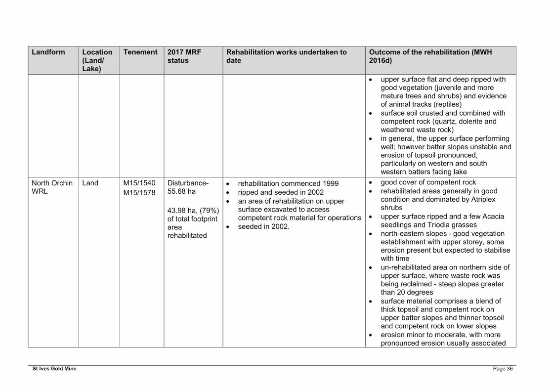
St Ives Gold Mine Page 36
Landform Location (Land/ Lake)
Tenement 2017 MRF status
Rehabilitation works undertaken to date
Outcome of the rehabilitation (MWH 2016d)
upper surface flat and deep ripped with good vegetation (juvenile and more mature trees and shrubs) and evidence of animal tracks (reptiles)
surface soil crusted and combined with competent rock (quartz, dolerite and weathered waste rock)
in general, the upper surface performing well; however batter slopes unstable and erosion of topsoil pronounced, particularly on western and south western batters facing lake
North Orchin WRL
Land M15/1540
M15/1578
Disturbance- 55.68 ha
43.98 ha, (79%) of total footprint area rehabilitated
rehabilitation commenced 1999 ripped and seeded in 2002 an area of rehabilitation on upper
surface excavated to access competent rock material for operations
seeded in 2002.
good cover of competent rock rehabilitated areas generally in good
condition and dominated by Atriplex shrubs
upper surface ripped and a few Acacia seedlings and Triodia grasses
north-eastern slopes - good vegetation establishment with upper storey, some erosion present but expected to stabilise with time
un-rehabilitated area on northern side of upper surface, where waste rock was being reclaimed - steep slopes greater than 20 degrees
surface material comprises a blend of thick topsoil and competent rock on upper batter slopes and thinner topsoil and competent rock on lower slopes
erosion minor to moderate, with more pronounced erosion usually associated

St Ives Gold Mine Page 37
Landform Location (Land/ Lake)
Tenement 2017 MRF status
Rehabilitation works undertaken to date
Outcome of the rehabilitation (MWH 2016d)
with thicker topsoil placement or steeper slopes (eastern batter slope)
overall slopes were stable and vegetation establishment was ‘good’, comprising shrubs, understory and established trees
Revenge WRL
Lake M15/1659
M15/1660
Disturbance-43.82 ha
40.24 ha, (91.8%) of total footprint area rehabilitated
new surfaces of 1989 were topsoiled and seeded
rehabilitation conducted progressively from 1991, final earthworks were completed in 2005 with pushing down top lift and shaping final slopes
final rehabilitation works: reshaping, topsoiling, ripping and seeding, completed in 2009
surface of WRL is oxidised rock and topsoil has been replaced to 200 mm
northern lower slopes devoid of topsoil and not considered rehabilitated
poor rehabilitation observed on north-eastern batters where material mostly transitional oxide - run-off into lake occurring
vegetation, which included Acacia shrubs and Eucalyptus seedlings, in good health
varying degrees of rehabilitation success present
erosion on lower western slopes - pronounced with densely spaced rills and deep gullies
erosion of sediment from the upper slope had breached the berm on north slope
surface and upper slope comprised topsoil (>300 mm in places) blended with competent rock
lower slope predominantly oxide with remnant topsoil
a thick deposit of fine sediment comprising topsoil and oxide waste rock was observed on lake surface
surfaces contour ripped poor vegetation establishment on lower
slopes - devoid of topsoil

St Ives Gold Mine Page 38
Landform Location (Land/ Lake)
Tenement 2017 MRF status
Rehabilitation works undertaken to date
Outcome of the rehabilitation (MWH 2016d)
South Delta WRL
Lake M15/1615
M15/1618
Disturbance-19.63 ha,
0% of total footprint area rehabilitated
constructed in 1995-2001 contour ripped and topsoiled to a
depth of 200 mm entire island reshaped, ripped and
seeded during the 2002/2003 rehabilitation season
test pitting indicated that lake sediment cap was not constructed to design (2 m thickness), and at some test pit locations sediment cover was essentially non-existent over transitional waste rock
Seeded 2002
rehabilitation not complete nor successful:
gullies and tunnel erosion; substantial erosion of fine sediment
onto surface of lake; and vegetation sparse and of poor health,
comprising samphire and scrubby salt bush. More dense vegetation in low area on south eastern lobe where evidence of ponding of water.
surface soil comprised oxide and lake sediment, with visible gypsum crystals
competent and non-competent rock incorporated into surface, however do not seem to be preventing erosion
in places gullies eroded through soil and competent rock (up to 2.5 metres)
exposed waste rock discoloured and several areas impacted by acid generation, with sulphurous salts and iron staining on outer surface of WRL
Argo North WRL
Land M15/1593
M15/1560
Disturbance- 68.73 ha
6.28 ha, (8.4%) of total footprint area rehabilitated
rehabilitation conducted 2002/2003 on southwest facing slopes - not seeded
surface material primarily competent rock, covered with topsoil to a depth of 200 mm
re-shaping, ripping and seeding yet to be undertaken on most of landform.
southwest slope only area classified as ‘Category E – Land under rehabilitation’
erosion rilling (features <0.3 m deep) over whole landform, and substantial gullying (features >0.3 m deep) shown on aerial imagery
surface composed of primary, transitional and oxide materials
high proportion of materials dispersive and salinised via capillary rise of salts to surface

St Ives Gold Mine Page 39
Landform Location (Land/ Lake)
Tenement 2017 MRF status
Rehabilitation works undertaken to date
Outcome of the rehabilitation (MWH 2016d)
slopes unstable with minor to major erosion. More pronounced erosion usually associated with the presence of topsoil and oxide blended into the rehabilitation surface
thick topsoil along the western batter slope, while the northern slope had minimal topsoil
eastern end of the northern slope dominated by oxide blended into the outer surface and erosion was more pronounced
eastern batter slope a blend of competent rock and oxide, constructed in three lifts
• southern batter slope construction occurring in two to three lifts
upper surface comprises a mix of competent rock (western area) and oxide and competent rock (eastern area)
majority of the upper surface is either trafficked to a flat surface or remains as paddock dumped waste rock
Argo South WRL
Land M15/884 Disturbance-30.47 ha
100% of total footprint area rehabilitated
rehabilitation commenced in 2004 and was completed by 2006.
2005: surface rock armoured with approximately one metre of primary waste rock and spread with topsoil (200 mm) that was then incorporated into the surface by ripping along contour.
seeded in 2006 and 2007.
entire surface rehabilitated with thick topsoil combined with competent rock; topsoil cover too thick in some areas, including on top of landform and northern slopes.
in some areas movement of sediment has steepened the mid and lower slope areas creating convex slope profiles

St Ives Gold Mine Page 40
Landform Location (Land/ Lake)
Tenement 2017 MRF status
Rehabilitation works undertaken to date
Outcome of the rehabilitation (MWH 2016d)
unclear whether the fertiliser and ameliorant applications recommended by Landloch (2005) were undertaken as part of the rehabilitation works.
rehabilitation trial established June 2006
(western, south western and north eastern batters)
competent rock and topsoil well mixed across the majority of slopes, with the exception of western and northern slopes, which had less rock cover
eastern aspect was considered to have adequate rock cover and to be in good condition
most slopes were stable, with minor erosion (rills and gullies) and established vegetation including juvenile trees and shrubs
northern batter and parts of north western batter had erosion
most erosion associated with thick topsoil application and minimal competent rock, coupled with movement of surface water from upper surface
an intermittent low crest bund present along south western edge of upper surface
hard soil crusts present on upper surface (north)
vegetation in good health weed Acetosa vesicaria (Ruby Dock) on
upper surface generally, vegetation cover on upper
surface was good, although some bare areas present

St Ives Gold Mine Page 41
Landform Location (Land/ Lake)
Tenement 2017 MRF status
Rehabilitation works undertaken to date
Outcome of the rehabilitation (MWH 2016d)
evidence of native fauna visitation (kangaroo scats) and cattle scats and rabbit burrows -minor grazing
Argo West WRL
Land M15/476 Disturbance-16.55 ha
5.57 ha, (25.2%) of total footprint area rehabilitated
rehabilitation commenced in 1995, including profiling, and sub-soil and topsoil placement (no seeding)
further works conducted on northern and eastern sections starting in 2003. Works halted in 2004 due to concerns over the properties of materials being used for rehabilitation
lower north, west and eastern faces of the WRL have been covered with topsoil
southern batter slope has not been rehabilitated. It comprises a lower area of paddock dumped competent rock and oxide with steeper upper slopes of competent rock
rehabilitated areas comprise thin topsoil and competent rock and erosion is minor to moderate
vegetation establishment ‘good’ with shrubs and juvenile trees
a large proportion of materials dispersive and salinised via capillary rise of salts to surface.
surface composed of primary, transitional and oxide materials
southern aspect - oxide material and not rehabilitated; comprised a lower batter of paddock dumped competent rock and oxide with steeper upper slopes of competent rock
upper lift - competent rock and generally flat on trafficked areas, as-dumped in other areas
northern batters characterised by good rock incorporation and vegetation
topsoil stockpile located on the eastern side of WRL
although erosion (gullies and rills) present, slopes are generally considered to be stable
several areas of landfill present on upper surface

St Ives Gold Mine Page 42
Landform Location (Land/ Lake)
Tenement 2017 MRF status
Rehabilitation works undertaken to date
Outcome of the rehabilitation (MWH 2016d)
abundance of rubbish on top of WRL in late 2015, including pipes, drums, steel mesh and metal sheets
Junction WRL
Land M15/1712
M15/1715
M15/1716
Disturbance-46.47 ha,
100% of total footprint area rehabilitated
rehabilitation commenced 1992, completed in 1993
majority of WRL not ripped, other than upper surface and southern batter
topsoil 150-200mm perimeter bund on crest and internal
cells on upper surface in place for erosion and water management
minor rectification works during 1999 to 2000
test holes dug in 2005 indicated rock mulch to a depth of between 600 and 1,200 mm
some remedial work occurred in early 2006; construction of a wire fence around the perimeter, ripping, seeding, addition of gypsum, and water management
rehabilitation of excavated footprint of 'low grade stockpile hardstand' and concrete pad not conducted
rehabilitation generally in good condition vegetation was in general good health
with exception of a few areas. Consisted of mainly perennials and dominated by Atriplex (Saltbush) and Maireana (Bluebush) shrubs
upper surface was especially well vegetated, and flat to gently undulating, with some moon-scaping
bunds and ripping - mostly maintained integrity, but water ponding observed on southern aspect. Ponding of water against crest bund and surface water control bunds resulting in soil instability and potential tunnel erosion on slope side of crest bund
slopes were convex in some areas deep oxide present on northern slope,
and wash outs present on top northern corner
slopes mostly constructed in a continuous slope, with exception of northern and north western batters, with a thin berm separating slope into two rises. Berm was not continuous and was eroded in places
waste rock used on slopes mainly comprised thick oxide waste rock and clay waste, with minor or no competent

St Ives Gold Mine Page 43
Landform Location (Land/ Lake)
Tenement 2017 MRF status
Rehabilitation works undertaken to date
Outcome of the rehabilitation (MWH 2016d)
rock. Thinner oxide and clay sediment waste, mixed with competent rock and topsoil present on eastern batter and north eastern batter
erosion of fine sediment at break of slope around batters. Erosion pronounced along western batter base and northern part of eastern batter
substantial erosion on south-western batter
an area on central western side of surface had thick topsoil; spread to edges of WRL and was eroding down western batter and dispersing along base of slope.
WRL fenced, although not all around and subsequently cattle tracks present
TSF 1 Land M15/1556
M15/1559
M15/1591
Disturbance 60.36 ha,
0% of total footprint area rehabilitated
None to date, some rock armouring of lower batters
upper embankment slopes constructed with crushed rock aggregate, and lower embankment slopes coarse blocky competent rock
vegetation present on northern embankment slope and comprised sparse shrubs -mainly concentrated on flat berms between upper and lower embankment slopes
no vegetation on lower embankment erosion minor (few gullies and rills were
present); however, fine sediment deposited on berm between upper and lower embankments

St Ives Gold Mine Page 44
Landform Location (Land/ Lake)
Tenement 2017 MRF status
Rehabilitation works undertaken to date
Outcome of the rehabilitation (MWH 2016d)
sediment capture toe drain constructed of unconsolidated sediment and some competent rock in place around perimeter.
reclaim areas excavated into tailings profile at varying depths exposing tailings to oxygen and water. Internal tailings divided into cells for reclaim. Some excavated walls and tailings stockpile areas are discoloured (orange iron staining) indicating potential oxidation of tailings.
TSF 2 Land M15/1559
M15/1594
M15/1561
Disturbance-111.18 ha
22.2 ha, (20%) of total footprint rehabilitated
starter embankment topsoiled mid lifts to south, east and west
topsoiled and rock armoured under topsoil
upper mid lift slopes at ~18degrees, topsoil over competent rock armouring
upper lifts - armoured slopes at ~22.5 degrees
slope outer surface of competent rock covered in thick topsoil (up to 300 mm thick in places)
lower three lifts covered in topsoil and vegetation comprising scrubby shrubs (of poor health), although some embankments with ‘good’ vegetation cover
upper two lifts - competent rock erosion of topsoil moderate to major,
with erosion more pronounced where topsoil thicker
small areas of tailings deposition present on embankment slope and at toe of north eastern corner - potentially associated with spills from tailings deposition lines rather than breach of tailings embankment
a sediment capture toe drain constructed of unconsolidated sediment and some

St Ives Gold Mine Page 45
Landform Location (Land/ Lake)
Tenement 2017 MRF status
Rehabilitation works undertaken to date
Outcome of the rehabilitation (MWH 2016d)
competent rock in place around perimeter
upper surface flat and gently inclined from outer edges towards decant tower
tailings crusted at surface with white precipitation of salts - dry surface cracked with platy tablets (30-50 cm wide), cracks are shallow and infilled with sand
no vegetation on surface
TSF 3 Land M15/1591
M15/1593
Disturbance-99.22 ha
0% of total footprint area rehabilitated
Details of rehabilitation not known, but has been conducted on some slopes
lower two thirds of embankments covered in thick topsoil (up to 500 mm thick in areas)
erosion of topsoil moderate to major in places, with erosion more pronounced where topsoil thicker
vegetation establishment generally ‘good’ on areas where topsoil present
upper third of TSF embankment competent rock and generally stable

St Ives Gold Mine Page 46
7.9.2 Rehabilitation Trials
Several rehabilitation trials to determine the best practice revegetation methods (i.e. topsoil depth, ripping depths, seed mixes and applications, addition of growth mediums etc.), particularly for land-based rehabilitation have been undertaken across the existing SIGMC operations
Some rehabilitation trials have been conducted for lake based rehabilitation, these include:
Lake Based Sediment Trials on Redoubtable WRL in 2002; Capping of the South Delta WRL in 2002; Intrepide and Mars batter slope erodibility study in 2006; Mulching trial at Mars West WRL in 2010; and Rock armouring of Santa Ana WRL in 2016.
The lake based sediment trial on the Redoubtable WRL and the capping of the South Delta WRL in 2002, were both established to meet the following commitment: ‘the proponent will investigate the suitability of using lake sediments to cap the overburden dumps to enhance their appearance and potentially provide a better growth medium’, that was presented in the B2010 PER (SIGM 2010). These trials were unsuccessful and greater detail on the outcomes is summarised in Table 7 17. The establishment of vegetation on lake based sediments to date has been unsuccessful and, as a consequence, SIGMC will not utilise this as a rehabilitation technique moving forward.
Due to the salinity of the lake based sediments used to construct the lake based landforms, and with consideration of the limited availability of material in the area deemed suitable as a growth medium and the poor rehabilitation success to date where application of lake based sediments has been trialled, the establishment of vegetation is not proposed as a closure objective for these features. These closure objectives were presented to the DMIRS prior to submission of the site wide 2016 MCP. In-principle agreement was attained with respect to this approach through a process of consultation.
Two examples of successful rehabilitation techniques utilised at SIGMC are also presented in Table 7-2. Although the extent of the trials undertaken to date is limited, the outcome of these trials has been utilised in developing achievable objectives for the lake based landforms. The Intrepide and Mars batter slope erodibility study (2006) indicates that the rehabilitation technique utilised on these WRLs is repeatable and successful; the findings of the Soils, Mine Waste, Tailings and Landform Study (MWH 2016b) also support the rehabilitation technique utilised. Consequently the application of competent NAF rock to armour the outer embankments of the landforms will be used as a rehabilitation technique to improve the surface stability of all permanent lake based landforms.
The outcomes of any additional trials and investigations will be captured in this section of the next iteration of the MCP and any subsequent revision.
7.10 Contaminated Sites
Suspected or known contaminated sites are deemed a closure issue as well as an operational issue. Consequently, SIGMC will manage and investigate the potential for contamination over the LoM so that the contamination can be removed, treated, contained or managed to meet the purposes of the agreed post-mining land use and where practicable and to maximise the beneficial use(s) of the land after mining. Any new contamination associated with B2018 will be dealt in accordance with the CS Act.

St Ives Gold Mine Page 47
Table 7-2: Rehabilitation Trial Details and Lessons Learnt from Rehabilitation to Date
Trial / Year Design / Assessment Outcome Rehabilitation Implications
Rehabilitation Trials
Redoubtable Lake Sediment Trial in 2002.
The Redoubtable WRL was covered in aeolian lake sediments (stripped from the West Revenge area in 2002), seeded and fertilised.
A section of the WRL that was covered in was irrigated with potable water; however, this area was not defined in the available literature, nor was the length of time that the irrigation occurred.
Opportunistic monitoring was undertaken in 2003 (SIGM 2004).
The vegetation and condition of the WRL was assessed by Botanica Consulting (2010).
No sustainable improvement in rehabilitation outcomes. The salinity of the sediments is beyond what could be realistically used for plant growth on landform rehabilitation, and the lake sediments are highly erodible,
Ultimately the use of lake based materials was not deemed economically viable due to the requirement of bringing in and incorporating gypsum to potentially make the materials suitable for use (no actual confirmation of response to gypsum).
Lake bed materials show great diversity, with differing mineralogy, gypsum and clay content and differences across qualities including leaching behaviour, soil strength and particle size distribution.
The use of lake sediments as a rehabilitation medium will not be considered in future rehabilitation works.
Irrigation with potable water is also not considered a viable option for future rehabilitation works.
Capping of the South Delta WRL in 2002
Investigation into use of gypsiferous lake sediments as a surface rehabilitation / growth medium.
The South Delta WRL was capped with lake sediments from the Agamemnon Open Pit to a ~depth of 1 to 2 m, ripped, and topsoiled to a depth of 200 mm.
Gypsiferous lake sediments are ineffective as a surface growth medium.
Competent and transitional rock has been incorporated into the surface in this area, however, it has been ineffective in preventing erosion.
Further analysis following capping in 2005 also found that the majority of the samples were PAF.
Test pitting in 2010 indicated that the lake sediment cap was not constructed to design (2 m thickness); and at some test pit locations the sediment cover was found to be essentially non-existent over transitional waste.
Gypsiferous lake sediments are not deemed suitable as a cover material.
Formal construction supervision required, with confirmation of completion to design (sign-off).
Due to the risk associated with PAF material, the South Delta WRL and waste of the same lithology requires adequate encapsulation.

St Ives Gold Mine Page 48
Trial / Year Design / Assessment Outcome Rehabilitation Implications
Rehabilitation Trials
Intrepide and Mars WRL batter slope erodibility study 2006 (Landloch 2006)
Field Rainfall Simulator and overflow study of batter slope erodibility at Intrepide and Mars WRL.
Computer modelling of erosion and runoff data collected from several other non-SIGMC land based WRLs were compared against the Intrepide and Mars lake based WRLs to assess the erosion potential of the WRL batter slopes and the potential impacts of vegetation and any other possible management practices on those erosion rates.
Modelling results were used to establish the basic properties of the WRLs constructed at SIGMC and the extent to which these can be modified.
The report concluded that the ‘main area of importance for constructing a stable landform is utilising materials with the required properties’.
The Mars WRL outer batter was expected to be extremely stable, providing the planned use of suitably competent and sized material was carried out.
The Intrepide WRL was unlikely to have vegetation establishment due to the saline waste material used. The potential for erosion on the lower batter slopes was likely to become a significant issue for rehabilitation. Placement of competent rock on the lower third batter of the slopes was recommended to enhance stability of this WRL.
WRL slopes require suitable competent material to reduce erosion.
Mulching Trial at Mars West WRL 2010
To determine if the incorporation of organic material will assist with the creation of structure within the soil.
The Mars West WRL has previously been ripped to a depth of 1 m. Seed waste material (organic matter) was spread over an area of approximately 2,500 m² which was then cross ripped to incorporate the organic matter/mulch into the soils.
Also, earlier investigation of the soils found them to be hard-setting and therefore a potential constraint to revegetation success. In response to this a mulching trial was established in June 2010 in which seed waste material (organic matter) was spread over an area of approximately 2,500 m² and was then cross
Observation in 2011 indicated some success in establishing plant growth. No further assessment of this trial has been made to date
The trial used seed waste material, which is not readily available. The most likely available mulch at SIGMC would be tree mulch, which is quite different to the seed mulch utilised.
The availability of topsoil and suitable mulch material on lake based WRLs is very limited.
SIGMC do not currently believe that this trial is repeatable, and hence do not propose to assess the work previously undertaken.

St Ives Gold Mine Page 49
Trial / Year Design / Assessment Outcome Rehabilitation Implications
Rehabilitation Trials
ripped to incorporate organic matter/mulch into the soils.
Rock armouring of Santa Ana in 2016
Rock armouring of the WRL to ascertain if a WRL constructed of lake sediments can be ‘safe, stable, and non-polluting’.
The erosion of lake sediments and associated movement of sediment onto the lake playa can potentially be mitigated using this rehabilitation technique.
To be assessed Confirmation that the approach presented in the 2016 MCP for lake based WRLs is successful and achievable.
Effective rehabilitation techniques
Argo South WRL The Argo South WRL was constructed in 2002/2003, rock armoured with approximately 1 m of competent rock, ~200 mm of topsoil was applied, and the WRL was ripped.
Rehabilitation monitoring has been conducted annually from 2007 to 2013 (seven years) using three EFA monitoring transects.
WRL successfully rehabilitated; this WRL has been accepted by the Regulators as a rehabilitation monitoring analogue.
Successful technique;
Topsoil should not be placed any thicker than 200 mm and should be incorporated into the competent rock beneath, or the surface will erode significantly.
Mars East and Mars West WRLs
Constructed in 2005/06, the Mars WRLs slopes were covered with 2 to 3 m of coarse competent waste rock from deeper sections of the Mars Open Pit, to prevent capillary rise of salts into the landform. Rehabilitation areas were then completed with additional competent fresh rock (to achieve 14 to 15° slopes) followed by sheeting of sand dune material (up to 200 mm) from the Delta North Open Pit, with contour ripping to 1 m depth.
A toe bund constructed of competent rock is present around the majority of the WRL on the lake surface.
Slopes which were armoured with competent rock, sheeted with dune sands, ripped and seeded were successfully rehabilitated.
The rehabilitation of the Mars East WRL was undertaken at a time when locally available sources of both competent rock and dune sands / topsoil (natural sandy soils) were available. These favourable circumstances led to the construction of a stable base on which to place free draining topsoil and encourage surface stability and establishment of vegetation over a six to nine year period.
There was no observation of sediment movement beyond the bund, and it was
Dune sands are a suitable rehabilitation growth medium / substitute for topsoil.
Topsoil was placed in thicker layers in south-western area of the WRL (up to 500 mm), and although both juvenile and mature tree species have established, moderate to major erosion was observed, due to the lack of competent rock incorporated into the topsoil material.

St Ives Gold Mine Page 50
Trial / Year Design / Assessment Outcome Rehabilitation Implications
Rehabilitation Trials
Rehabilitation monitoring has been conducted in 2008, 2009, 2011 and 2013.
observed to be effective at minimising sediment movement onto the lake playa.
SIGMC will construct a toe bund around all the WRLs to prevent sediment erosion.

St Ives Gold Mine Page 51
8 RISK ASSESSMENT APPROACH
8.1 Risk Assessment Process
A risk assessment was undertaken to identify and manage potential risks associated with closure and successful rehabilitation. This allows for proactive risk management strategies to be developed during the closure planning stage. SIGMC has a structured risk management process to identify, assess and manage the potential risks associated with closure. Two aspects of environmental risk have been considered in this assessment:
Likelihood - The likelihood of an impact on the surrounding environment or other receptors; and
Consequence - The scale or magnitude of the potential impact (i.e. severity/extent) if it were to occur.
The SIGMC risk matrix incorporates five classifications of consequence, ranging from insignificant to catastrophic, and five classifications of likelihood, ranging from rare to almost certain (Table 8-1), and combines the level of likelihood and consequence to determine the level of associated risk. A risk priority is assigned to each of the 25 possible outcomes. The following levels of risk are used and are based on a qualitative assessment.
Low indicating no discernible risk (green); Moderate presenting a limited level of risk, but should not require any substantive
measures to maintain this level of risk (yellow); Significant indicating the potential for impacts to the environment and may require
mitigation measures to be introduced (orange); and High signifies that there is potential for serious impacts and if confirmed would require
mitigation measures to be implemented (red).
The methodology described above was used to assign a consequence and likelihood rating to each identified unwanted event. Management measures for each identified risk is then included and the risk rating is re-categorised. This approach is based on the AS/NZS 4360:2004 standard for Risk Management.
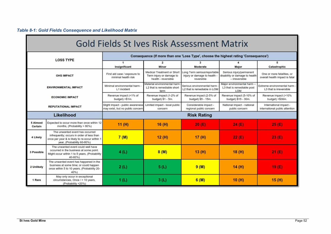
St Ives Gold Mine Page 52
Table 8-1: Gold Fields Consequence and Likelihood Matrix

St Ives Gold Mine Page 53
8.2 Risk Summary
The process of stakeholder consultation, site risk assessment and data review has identified potential high-level issues that should be addressed at closure. The risks identified in the risk assessment may impact on the ability to relinquish the site in accordance with the closure priorities of safe, non-contaminating, stable and self-sustaining ecological communities. Closure objectives have been addressed by SIGMC from risks identified and any inherent risk or outstanding areas to address have been highlighted as residual risk.
Residual high risks associated with closure were determined as part of the 2016 MCP. These risks have been reassessed against the proposed B2018 Project operations. In total of eight closure issues were identified to be applicable to B2018 Project (Table 8-2). Implementation of B2018 Project operations provides an opportunity for SIGMC to design features and plan rehabilitation and operational controls more effectively and to allow progressive rehabilitation. This reduces the risks associated with WRLs, TSFs, rehabilitation and contamination which were assessed to be lower than in 2016 MCP. These issues have been assigned appropriate controls and mitigation strategies and assigned to specific departments to close out in a given timeframe.
The risk assessment incorporates environmental, regulatory, social and economic risks, as well as the opportunities that need to be taken into account when planning for rehabilitation and closure.

St Ives Gold Mine Page 54
Table 8-2: B2018 Project Risk Assessment
No Unwanted Event Inherent Risk
Proposed Controls Residual Risk
Responsible Department
Landforms
1 Contaminated leachate from WRL (AMD, lake based sediments, metals, saline leachate etc.)
13 (H) AMD testing to identify PAF waste in deposit prior to mining.
Project Geologists notified to identify PAF waste during mining and record the location of the PAF in the WRL to document encapsulation.
Encapsulate all PAF and lake sediment waste identified
9 (M) Environment Department / Mining Department
Timeframe: 2019-2028
Tailings Storage Facilities
2 Capillary salt rise through the rehabilitated TSF cover profile, preventing / limiting the establishment of a vegetation community.
13 (H) Laboratory trials to be undertaken to understand potential for capillarity rise in different materials and cover depths.
Optimise TSF cover design, in terms of rehabilitation objective, available materials and rehabilitation budget.
Surface water management to consider risk of capillary rise on rehabilitation objectives
9 (M) Environment Department/ Processing Department
Timeframe: 2019 to 2028
Mining Infrastructure
3 Mine void water quality issues post closure. Impact to local or regional aquifers; Increase in closure liability
14 (H) Develop a regional aquifer model.
Refine the assumptions in the post closure pit lake model with actual data.
Where feasible backfill open pits.
10 (H) Environment Department
Timeframe: 2019-2028
Site Wide
4 Progressive rehabilitation activities not aligned with LOM plan.
18 (H) Update MCP as mine continues to develop.
Continue to Integrate and align waste movement with final landform design.
Develop clear planning and communication between mine planning and environmental teams to integrate closure works to operations wherever feasible.
14 (H) Senior Leadership Team / Rehabilitation Task Force
Timeframe: Ongoing

St Ives Gold Mine Page 55
No Unwanted Event Inherent Risk
Proposed Controls Residual Risk
Responsible Department
5 Insufficient consideration of closure requirements during design of new landforms.
Loss of opportunity to identify and undertake progressive rehabilitation across the Project area
13 (H) Landform closure designs developed and constructed to comply with commitments and closure objectives.
Waste characterised, scheduled, and placed correctly.
Ensure LoM is aligned with closure objectives and opportunities and current operations.
9 (M) Environment Department/Mining Department/Mine Technical Services Department
Timeframe: 2019-2028
6 Failure of rehabilitation - failure to meet agreed closure objectives and completion criteria
17 (H) Landform closure designs developed to comply with commitments and closure objectives.
Undertake research, investigative and progressive closure tasks set out during the operation of B2018 Project.
Application to regulator/s to re-set objectives to be achievable within constraints (environmental, financial, practical etc.).
9 (M) Environment Department
Timeframe: 2019 to 2028
7 Remediation required following contaminated site investigations (additional to closure budget)
13 (H) Manage the sites in accordance with the CS Act and Contaminated Sites Regulations (WA) 2006 (CS Regulations); and the DWER Assessment and Management of Contaminated Sites Guidelines (DER 2014).
Engage Contaminated Sites Auditor to inform CS program.
Commence progressive rehabilitation and Implement clean up accordingly.
9 (M) Environment Department
Timeframe: 2019 to 2028
8 Unauthorised Public Access and subsequent death / injury, due to inadequate access control / unsafe facilities / abandonment bunding non-compliant / delays in implementation / Collapse of mine voids post closure
19 (E) Maintain appropriate access control, fencing, and abandonment bunding.
Ensure abandonment bunding compliant.
15 (H) Environment Department/Mining Department/Mine Technical Services Department
Timeframe: 2019-2028
St Ives Gold Mine Page 56
9 CLOSURE IMPLEMENTATION
The final design for B2018 Project is to be developed as mining progresses. Consequently, details around specific features are not available at this stage and closure tasks have been provided at a domain level. Closure implementation is based on the current knowledge base of each domain developed during the preparation of 2016 MCP. The domains expected to be part of B2018 Project include:
Landforms including WRLs, TSF, ROM pads, stockpiles and hardstands; Industrial Infrastructure; Mining Infrastructure; Water Containment Infrastructure; Groundwater Infrastructure; Roads; and Exploration Disturbance.
A broad closure approach for each domain is presented below. Due to the size and complexity of the site, SIGMC has implemented a dedicated system for managing information and data relevant to closure. PRAC™ (a progressive rehabilitation and closure (PRAC) program) is an online, mine closure planning tool, which holds data in perpetuity, enables tasks to be tracked and addresses the need for systematic mine closure planning. Operations proposed as part of the B2018 Project will be added to the PRAC to allow scheduled planning of rehabilitation and closure.
9.1 Broad Closure Approach Applied to Each Domain
9.1.1 Landforms
The landforms likely to be constructed across the B2018 Project include WRLs, ROM Pads, ore Stockpiles, Hardstands, TSFs and topsoil stockpiles. SIGMC’s key objective is to ensure that all the landforms are safe, stable and non-polluting.
Three generic decommissioning tasks that are imperative in managing surface water off all the landforms that will remain post closure, and ensuring that these key closure objectives can be met are described below:
1. Construction of crest bunds and top surface cells
The crest bunds are to be constructed by the dozer pushing up excess material from the top of the WRL as the top is progressively shaped and dozed. The shaping requires sloping the surface away from the crests (at ~1-2% or steeper), which usually results in the required excess material. If there is sufficient competent material within the SIGMC landforms to undertake the required works, this will be utilised as a source. If the material is predominantly lake sediments, oxide or meta-sediment then competent material from another source location will be carted in. The crest bund needs to be approx. 1 m high, and the outer face aligned with the angle of the regraded slope.
The top surface cells are created in a similar way with the centre of each cell ending up as a low point. The size of the top surface cells on the WRL is discretionary based on the size of the landform and material type.
2. Installing surface drainage
The financial provisioning allowance for surface drainage on landforms includes costs for shaping drain lines, screening of fresh rock to obtain rip rap material to line the drain, and haulage and placement of the rock into the drains. This will be installed for drainage from berms and other flat surfaces down to the natural surface if required.

St Ives Gold Mine Page 57
3. Construction of sediment toe bunds
Where relevant, SIGMC will construct a perimeter bund, also known as a sediment toe bund, around the outer toe of the WRLs to not only retain any sediment runoff from the surface of the landform and prevent surface water pooling against the toe of the WRL, but to also prevent vehicular access to the slopes of the WRLs.
SIGMC will construct a sediment toe bund around all the lake based landforms; the methodology for construction of these bunds is:
Load, haul and dump waste to construct a causeway, up to a minimum of 25 m out from the toe of the WRL (at least 1 m above lake bed). Doze the inside of the causeway between toe of WRL and outer edge to create a vee notch shape pushing excess material onto outer edge to make bund minimum 1.5 m high, and 3.0 m wide on top.
9.1.1.1 Land-based WRLs
For land-based WRLs, the final rehabilitation design will be specified in the relevant approvals documentation (generally in Mining Proposal). However, the following basic approach will be followed:
the slopes are assumed to be maximum of 15 degrees, unless specified otherwise; the height of the WRLs is to be limited to 40 m; where suitable growth media and topsoil is available, these will be spread over the
landform to a maximum layer of 200 mm; where competent rock is available, landforms will be rock armoured to improve
stability. Topsoil will be incorporated into the competent rock beneath to prevent surface erosion; and
landforms will be revegetated using plant species consistent with the identified final land use of pastoral .
9.1.1.2 Lake based WRLs
Two key assumption relating to closure of the lake based WRLs are presented below:
The height of the WRLs is to be limited to 40 m; All landforms constructed from lake sediments are assumed to be sloped to 11
degrees, unless specified otherwise due to the poor quality of the material within the landforms. A number of the landforms within Lake Lefroy are to be rock armoured using fresh rock either sourced from current open pit mining operations or from more competent waste rock landforms.
The establishment of vegetation is not proposed on the lake based landforms due to the salinity of the lake based sediments and the limited availability of material in the area deemed suitable as a growth medium. SIGMC has presented this as a proposed closure approach to the DMIRS prior to submission of 2016 MCP and in-principal agreement was attained with respect to this approach. This approach is further supported by the findings around rehabilitation and trials undertaken to date. No topsoil addition or consequent revegetation will be undertaken.
9.1.2 Industrial infrastructure
A Fixed Plant and Infrastructure Decommissioning Study was prepared by Liberty Industrial (Liberty 2016). This report identified the work that is associated with the demolition and removal of the industrial infrastructure features associated with the Project including all plant, workshops and administration buildings, fuel facilities, and concrete and asphalt hardstands, services pipes, and powerlines. This study also identified the relevant Acts and guidance documents that will be adhered to during the proposed works.

St Ives Gold Mine Page 58
The following general tasks are proposed to be undertaken:
demolition of above ground infrastructure down to ground level; removal of hardstands and footings to a depth of 1.5 m; and general waste, brick and concrete will be disposed of in a designated area on site.
Infrastructure areas with the potential for contamination (e.g. hydrocarbon from workshops or refuelling facilities) will be assessed as per the DWER 2014 Assessment and Management of Contaminated Sites, Contaminated Sites Guidelines, and any contaminated material identified will be removed for treatment (on or off-site depending on status of on-site bioremediation areas).
With consideration of the closure objectives developed, all plant and infrastructure shall be removed, except where formal agreement for its retention has been reached after consultation with the appropriate stakeholders. With any infrastructure that is identified to remain post-closure, a detailed management plan will be developed once ongoing management costs and liability issues have been resolved. SIGMC will only proceed if they are confident that the subsequent land managers have capacity to take on the responsibility. Equipment and facilities that have not been selected to remain post closure will either be dismantled for re-use or re-sale or demolished, with the approach selected being based on economic conditions at the time of closure.
9.1.3 Mining infrastructure
The proposed B2018 Project operations contain both underground and open pit mining operations.
9.1.3.1 Underground workings
All underground openings, including access portals, declines and shafts will be closed in accordance with current industry best practice at the time of closure.
The underground mine shaft closure method includes the removal of all structures above the shafts, sealing the open shafts with appropriate steel plate covers (which are anchored to the surrounding ground), and installing fencing and signage. Prior to commencing works, the risk of collapse of the shaft surrounds at the surface will be assessed and the option of backfilling the shaft with suitably graded fill will be considered. It should be noted that this option will result in sterilisation of any future exploitation of residual and new resources within the underground workings.
The method for closure of underground access portals and declines (that will not be flooded by groundwater recharge), includes backfilling ~50 m of the decline with competent rock, up to the portal. A security gate is then placed across the portal, and signage is installed.
9.1.3.2 Backfilling of open pits
Where feasible, SIGMC will investigate the opportunity to backfill open voids. To date, the greatest number of open pits that have been backfilled are located on Lake Lefroy and it is anticipated that this practice will continue where appropriate and practicable.
9.1.3.3 Closure of open pit voids
SIGMC’s strategy for closure and abandonment of all open pits is based on the 1995 Mines Safety and Inspection Regulations (MSIR) of WA and the former Department of Industry and Resources (DoIR) Guideline (1997) ‘Safety Bund Walls around Open Pits’. The strategy is targeted at minimising the risk of inadvertent (vehicular) public access into any of the abandoned open pits through signage and the construction of a suitable barrier or abandonment bund wall around the perimeter of all abandoned open pit voids.

St Ives Gold Mine Page 59
The abandonment bunding centre line has been set at 15 m beyond the boundary of the zone of instability (ZOI) around each open pit. This distance allows for the bund construction to include a 5 m wide base for the bund and construction equipment activity on the pit side of the bund to minimise disturbance outside of the bund. Abandonment bunding will be in accordance with the former DoIR Safety Bund Walls around Abandoned Open Pit Mines Guideline 1997.
9.1.3.4 Open pit lakes
Completion of mining of B2018 Project is likely to leave a number of final voids, both land and lake based, which will remain as voids in perpetuity. The associated cones of groundwater depression, related to dewatering of the open pits and underground mining, will remain as influences on groundwater for many years after mining ceases.
To understand the site hydrogeological systems post closure and the long-term equilibrium water levels in the mining voids, SIGMC commissioned the development of a study titled St Ives Mining Voids - Assessment for Mine Closure’ (MWH 2016e). This report identifies that steady‐state water balance conditions in the pit lakes that will develop in the SIGMC tenure, between approximately five and 50 years following the cessation of mining activities. Once steady‐state pit lake levels have established, all the pit lakes will function as terminal sinks. The Lake-based open pits will, however, refill with water to levels that are closer to the original water level than the majority of land-based open pits. This is due to their location or proximity to Tertiary sediments, in particular palaeochannel sediments with higher permeability and groundwater. The predicted levels are only several metres below the groundwater baseline and this can be potentially rise during significant rainfall events of high intensity (MWH 2016e).
At SIGMC, evapo-concentration is the key driver of final pit lake water quality. As the open pits will in general act as groundwater sinks, the resulting pit lake quality already fed with hypersaline groundwater, will continue accumulating the salt loads and precipitating minerals due to oversaturation. Water quality in the pit lakes will further deteriorate over time as a result of evapo-concentration (MWH 2016e). Due to the hypersalinity of the water, it is unlikely that the formation of the pit lakes will result in an increase in visitation habits of humans and / or fauna.
9.1.4 Water containment infrastructure
The majority of mine dewatering discharge from operations associated with the B2018 Project will be ultimately discharged to Lake Lefroy. Dewatering is conducted in accordance with site management procedures and involves pumps, pipelines, sumps, sediment settlement, turkey’s nests and geotextile liner.
Closure implementation tasks for turkey’s nests, potable water lines etc. include but not limited to:
cut and remove geotextile liner in the pond; undertake additional contaminated sites investigations (if required) in accordance with the
CS Act and Regulations; push in embankments; load, haul and dump rock cover from within a 3 km haul distance, or re-shape the ponds; doze and shape rock cover material; remove above ground pipelines; doze and level to re-establish drainage across pipeline corridors (where applicable); spread topsoil stockpiled adjacent to the land based pipelines; and contour rip.

St Ives Gold Mine Page 60
9.1.5 Groundwater infrastructure
All groundwater infrastructure is to be removed apart from those bores required to monitor groundwater across the site, and where formal agreement for its retention has been reached after consultation with the appropriate stakeholders.
The following assumptions for closure of Groundwater Infrastructure have been made:
all pipeline corridors except salt lake based pipelines are to be rehabilitated including dozing and shaping to re-establish natural drainage, contour ripping, topsoiling and reseeding; and
for any infrastructure that is identified to remain post-closure, a detailed management plan will be developed once ongoing management costs and liability issues have been resolved.
9.1.6 Roads
Rehabilitation techniques for roads include removing built-up material to ensure that the surface is level with the adjoining landscape to promote the natural surface water drainage patterns and help re-instate sheet flow across these inhibitive structures.
Where roads will be retained for access around the site for monitoring purposes during the post closure period and for pastoral use, it has been assumed that ~50% of the existing road footprint will be rehabilitated.
The following rehabilitation process has assumed in developing the financial provisioning for closure of this domain:
removal of culverts and other road furnishings that are not required; decompaction and dozing of the road surfaces to establish natural drainage across the
road; reshaping all raised (above natural surface) sections of the roads; rock armouring the sloped road edges if required; and topsoiling and seeding of the rehabilitated road surfaces as required.
9.1.7 Exploration disturbance
Exploration disturbance is rehabilitated progressively as per tenement and other relevant approval conditions. Tasks specific to this domain include:
cut drill collars off at least 0.4 m below ground level, plugging appropriately and backfilling to ensure
groundwater does not pond locally; remove drill spoil and/or impacted soils; backfill open sumps and re-contour drill pads; re-spread stockpiled topsoil and/or vegetative material; lightly rip compacted areas; undertake audits of exploration areas to direct clean-up works; and maintain rehabilitation record database
9.2 Closure Works Programme
The SIGMC closure work program incorporates: planned closure and decommissioning, progressive rehabilitation, premature closure tasks, and the proposed research, investigation and trial tasks.

St Ives Gold Mine Page 61
9.2.1 Planned closure and decommissioning
Closure and rehabilitation works associated with B2018 will be added to the PRAC and scheduled to align with the other site-wide closure tasks.
Decommissioning is the process that begins with the cessation of production, where infrastructure, plant and equipment is isolated from services such as power and water. The term is commonly used to include the removal (deconstruction or demolition) of unwanted plant and equipment. Note that individual facilities may be decommissioned and removed if no longer required, while mining and processing operations continue.
9.2.2 Progressive rehabilitation
Progressive rehabilitation involves the staged treatment of disturbed areas during exploration, construction, development and mining operations as soon as these areas become available, rather than undertaking large scale rehabilitation works at the end of planned exploration and/or mining activities.
Areas of potential environmental contamination requiring investigation and subsequent management under the MCP will be addressed in a progressive manner by SIGMC, to ensure resources and materials required for remediation are available to undertake the required work. Progressive rehabilitation tasks are summarised in Table 9-1 below.
Table 9-1: Progressive Rehabilitation Tasks
Progressive Rehabilitation Tasks Responsible Department
Timeframe
All buildings and structures, no longer required, are to be dismantled and removed from site or buried.
Site Services Life of Mine
Plug bore holes no longer required. Site Services Life of Mine
Remove all dewatering discharge pipelines and associated infrastructure no longer required.
Site Services Life of Mine
Remove all turkeys nest infrastructure, including pond liners, discharge pipes, rock walls and associated infrastructure, no longer required.
Site Services Life of Mine
Remove loose debris, litter and other non-hazardous substances to landfill or off site recycling.
All Departments Life of Mine
If required, take validation samples below where impacted soils have been removed to prove no residual impact.
Environment Department
Life of Mine
If required, undertake additional contaminated sites investigations (if required) in accordance with the CS Act and Regulations.
Environment Department
Life of Mine
If required, remove all potentially contaminated soils (hydrocarbons) and dispose of appropriately in a designated active bioremediation facility.
Mining Department
Life of Mine
Identify areas where contaminated material can be disposed of for treatment (on or off-site depending on status of on-site bioremediation areas and other designated disposal facilities).
Environment Department
2019 to 2028
Identify and maintain all active bioremediation facilities on site that have the capacity to receive the contaminated material from the Project areas.
Environment Department / Mining Department
2019 to 2028

St Ives Gold Mine Page 62
Progressive Rehabilitation Tasks Responsible Department
Timeframe
Undertake seed viability testing on a representative sample of topsoil material.
Environment Department
Source local provenance seed (for the areas identified), clean and store appropriately.
Environment Department
2019 onwards
Verify placement and construct abandonment bunding as required, (in accordance with recommendations in (MWH 2016g).
Mining Department
Life of Mine
Backfill land based water containment features to natural surface level.
Mining Department
Life of Mine
9.2.3 Unplanned Closure
Premature closure (permanent or suspended operations under care and maintenance) may arise from economic, environmental, safety or other external pressures. In planning for these scenarios, SIGMC can confirm that appropriate materials are available on site and contingencies are provided to make landforms such as TSFs and WRLs secure and non-polluting/ non-contaminating in the event of premature closure.
In the event of Premature Closure, SIGMC will undertake the tasks as per the following table (Table 9-2) as a priority.
Table 9-2: Premature Closure Tasks
Premature Closure Tasks Responsible Department
Timeframe
Site Wide
Develop and implement a Care and Maintenance (C&M) Plan
Environment, Mining and Processing Department
Within two months of going into C&M.
Remove cyanide and stored reagents (including excess fuel) and the LPG tank
Processing Department
Within two months of going into C&M
All services:
isolate and purge all service lines (air / water / gas etc.);
physically disconnect the service as close to the proposed demolition site boundary as possible;
provide temporary service connection points at the proposed demolition site boundary if possible;
ensure that there are no services running through the site that feed other areas that need to remain live; and
attain written signoff for all disconnected services.
Site Services Within three months of going into C&M
All Vessels / Pumps / Motors (where applicable):
ensure all fuels and oils are removed from all storage vessels;
ensure all fuels and oils are purged from any service lines that run within the sites;
ensure all fuels and oils are purged from any pumps, motors or the like;
Site Services Within three months of going into C&M
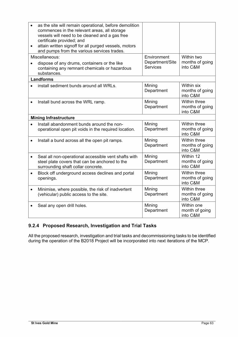
St Ives Gold Mine Page 63
as the site will remain operational, before demolition commences in the relevant areas, all storage vessels will need to be cleaned and a gas free certificate provided; and
attain written signoff for all purged vessels, motors and pumps from the various services trades.
Miscellaneous:
dispose of any drums, containers or the like containing any remnant chemicals or hazardous substances.
Environment Department/Site Services
Within two months of going into C&M
Landforms
install sediment bunds around all WRLs. Mining Department
Within six months of going into C&M
Install bund across the WRL ramp. Mining Department
Within three months of going into C&M
Mining Infrastructure
Install abandonment bunds around the non-operational open pit voids in the required location.
Mining Department
Within three months of going into C&M
Install a bund across all the open pit ramps. Mining Department
Within three months of going into C&M
Seal all non-operational accessible vent shafts with steel plate covers that can be anchored to the surrounding shaft collar concrete.
Mining Department
Within 12 months of going into C&M
Block off underground access declines and portal openings.
Mining Department
Within three months of going into C&M
Minimise, where possible, the risk of inadvertent (vehicular) public access to the site.
Mining Department
Within three months of going into C&M
Seal any open drill holes. Mining Department
Within one month of going into C&M
9.2.4 Proposed Research, Investigation and Trial Tasks
All the proposed research, investigation and trial tasks and decommissioning tasks to be identified during the operation of the B2018 Project will be incorporated into next iterations of the MCP.

St Ives Gold Mine Page 64
10 CLOSURE MONITORING AND MAINTENANCE
The proposed closure monitoring takes into account the wider receiving environments, receptors and exposure pathways. SIGMC will utilise appropriate procedures in sampling, analysis and reporting of results, and continue to reference the recorded trends against the expected or predicted performance.
In the event that monitoring demonstrates movement outside of the agreed parameters, SIGMC is committed to the development of remedial and intervention strategies and continuing post closure monitoring until the agreed completion criteria has been demonstrated to be met.
Other technologies will be explored for improved techniques for monitoring the performance of rehabilitation. Over time, better methods will become user friendly, affordable and proven. An example of an improved technique includes remote sensing to monitor performance of closure criteria and rehabilitation success over time.
Table 10-1 summarises the monitoring type and frequency proposed to be undertaken post closure.
Table 10-1: Post-closure Monitoring
Type of Monitoring Monitoring Frequency and Duration
Landscape Assessment:
species richness; evidence of secondary vegetation
growth; qualitative assessment of vegetation
health; visual monitoring – vegetation
condition; and fauna habitat.
monitor annually for the first three consecutive years, after which biennial monitoring can commence;
triennial monitoring can commence after the tenth year of monitoring, if required; and
continued monitoring may not be appropriate at sites with substantial issues; these issues may include, but are not limited to: lack of vegetation cover, instability of the soil surface, or erosion. Subsequently, further works may be required.
Erosion and surface drainage monitoring Undertaken biennially over ten year monitoring period
Visual assessment of the geotechnical stability of the open pits and TSFs.
Undertaken biennially over ten year monitoring period
TSF compliance audit inspection Undertaken over the first three years of post-closure monitoring
Groundwater monitoring Undertaken annually over ten year monitoring period
Surface water quality monitoring Undertaken biennially over ten year monitoring period
Contaminated Sites Monitoring and reporting to be undertaken in accordance with the DSI findings and remediation requirements.
Lake Lefroy monitoring Undertaken biennially over ten year monitoring period
Aquatic biota survey Undertaken after a 1 in 20 year rainfall event
Weed surveys Undertaken annually for three years. The monitoring frequency will be critically reviewed after three years.
Satellite imagery Undertaken biennially over ten year monitoring period
Auditing against completion criteria Annually until criteria are met

St Ives Gold Mine Page 65
In addition, annual post closure site audits will be undertaken until relinquishment to assist in defining rehabilitation maintenance programs for tasks as required. The following post closure maintenance for the Project is proposed:
monitor and maintain any required water diversions; monitor and maintain all open pit abandonment bunding; maintain all groundwater monitoring bores required; monitor and maintain any existing fencing that is required post-closure; and maintain access to areas required for rehabilitation monitoring, until relinquishment is
achieved, and these areas can be rehabilitated.

St Ives Gold Mine Page 66
11 FINANCIAL PROVISIONING
A closure cost estimate was prepared for SIGMC operations as part of the 2016 MCP. This cost estimate will be reviewed and updated regularly to incorporate any new features and closure tasks. Once the B2018 Project progresses, tasks associated with the project will be included and new closure costs and liability calculated.
GFA undertakes an annual closure cost review in accordance the Sarbanes-Oxley Act (SOX) Section 404 compliance requirements. Gold Fields also utilise the Committee of Sponsoring Organisations of the Treadway Commission (COSO) Internal Control—Integrated Framework to assess and then report on their internal controls.
Closure costings incorporate number of assumptions to allow closure estimates to be developed. The equipment that was considered appropriate for the closure works include a range of Caterpillar mining equipment and other relevant and typical equipment used in mine closure and rehabilitation activities by earthmoving and civil contractors. Unit costs and production schedules based on earthmoving first principles were developed and calibrated against actual rehabilitation and mining activities to ensure currency and consistency with expected contractor rates for the type of closure activities allowed for in the estimates (MWH 2016f).
Once developed, the key assumptions for the closure cost estimate for the B2018 Project include (MWH 2016f):
the closure schedule is as per the current Life of Mine plan with ore processing ceasing in 2028, rehabilitation and demolition works undertaken over an estimated 166 weeks and post closure monitoring and maintenance undertaken over a ten-year period prior to successful relinquishment;
demolition costs are based on the estimate undertaken by Liberty Industrial in 2015; third party equipment costs have been developed using a bottom up first principles basis; all rehabilitation activities will be based on the details determined within this RMCP and
subsequent revisions of the MCP; landforms and other disturbances that lie within the Lake Lefroy are assumed not to
require topsoil resources to be placed on the rehabilitated surfaces; a shortage of topsoil is expected and it is assumed that where topsoil is used it has been
costed to be placed in a 100 mm layer; demolition rubble collected during the decommissioning of the infrastructure across the
whole site is to be transported for burial within a designated location (e.g. process water pond);
scrap steel is to be removed from the site for scrap value; haulage distances assumed for transport of rehabilitation materials is assumed to average
3,000 m, and where distances are different the costs will be altered accordingly; all rehabilitation costs have been estimated on a first principles, bottom up, task and
activity basis; all closure works are assumed to be undertaken on a single (day) shift, twelve-hour, seven
days per week basis, with equipment efficiencies (availability and utilisation of available hours) based on operational experience;
project management of the closure works and post closure management, maintenance and monitoring is included as a part of the closure provision. Pre-closure works including technical studies required to inform the closure plans are assumed to be undertaken as a part of the operations, but have been included within the estimate. A sudden closure care and maintenance cost has also been included within the cost model; and
fuel prices used within the costs are based on the SIGMC price delivered to site ex the diesel fuel minus the rebate.
Financial provisioning will include the following components which will be undertaken throughout operations:

St Ives Gold Mine Page 67
Closure related technical studies; Social studies; and rehabilitation trials.
Provision has also been made for an adequate period of post-closure monitoring and maintenance, including provision for remedial work if monitoring shows completion criteria are not being met.

St Ives Gold Mine Page 68
12 MANAGEMENT OF INFORMATION AND DATA
This RMCP and the subsequent revisions of the MCP are intended to be live documents that are subject to changes during mine operations and mine closure. Operations associated with the B2018 Project will be incorporated into the next revisions of the site wide MCP. Closure planning is a complex process that commences at initial mine planning and evolves with the Project and improved knowledge. In accordance with s83AA of the Mining Act, SIGMC will implement a management strategy to review and update this plan every three years (or at such time as specified in writing) and submit to the DMIRS for review.
Integral to the execution of the closure tasks identified is the ability to track and manage them appropriately. Due to the size and complexity of the site, SIGMC is implementing PRAC™, an online, mine closure planning tool, which holds data in perpetuity, enables tasks to be tracked and addresses the need for systematic mine closure planning. Rehabilitation activities will be recorded and retained within PRAC. It is SIGMCs intention that the next iterations of the MCP will be presented to the DMIRS through the PRAC system.
SIGMC is also implementing a Rehabilitation Management System. This will provide guidance and procedures for scopes of work, and where required a tendering process for each feature. Both systems will sit within SIGMC’s Environmental Management System, which is ISO 14001 certified. Information and data will be managed on an ongoing basis according to the Environmental Management System (EMS) procedures consistent with an ISO14001 based system.
The update and review of the mine closure commitments and criteria will include a review of the financial provision, in addition to this, any significant closure outcomes will result in a review of the financial provisioning. Mine closure plans are a subset of the mining planning, and is integrated with the mine planning, scheduling and operation activities. It is intended that as much rehabilitation as possible will be undertaken progressively during the life of the mine. This will allow rehabilitation methods to be tested and refined to determine the most suitable and, successful method for final rehabilitation.
St Ives Gold Mine Page 69
13 REFERENCES
Biological Surveys Committee, Newbey, K. R., Dell, J., How, R. A. & Hnatiuk, R. J. 1984. The biological survey of the Eastern Goldfields of Western Australia. Part 2: Widgiemooltha - Zanthus study area. Records of the Western Australian Museum, Supplement 18.
Aboriginal Heritage Act 1972
ANZMEC/Minerals Council of Australia (2000). The Principles of the Strategic Framework for Mine Closure
Botanica Consulting (Botanica) (2010) Lake Based Rehabilitation Interim Status Report for St Ives Gold Mine. June 2010.
Botanica Consulting. (2014). Monitoring of Riparian Vegetation Fringing Lake Lefroy. Unpublished report for Gold Fields.
Burbidge D, Leonard M, Allen T, Collins C. and Volti T. (2012). The 2012 National Earthquake Hazard Map of Australia, Australian Earthquake Engineering Society 2012 Conference, Dec 7-9, Queensland. Geoscience Australia.
Bureau of Meteorology. (2016a). Severe Tropical Cyclone Vance. Available online at http://www.bom.gov.au/cyclone/history/vance.shtml. Accessed on 06/05/2016.
Bureau of Meteorology. (2016b). Tropical Cyclone Steve. Available online at http://www.bom.gov.au/cyclone/history/steve.shtml. Accessed on 06/05/2016
Bureau of Meteorology. (2017). Climate Data Online. Available online at http://www.bom.gov.au/climate/data/. Accessed on 23 September 2017.
Clarke, J. D. A. (1991). The hydrology, stratigraphy and history of Lake Lefroy. Unpublished report for Western Mining Corporation (Kambalda Nickel Operations).
Clarke, J. D. A. (1994a). Lake Lefroy, a palaeodrainage playa in Western Australia. Australian Journal of Earth Sciences 41: 417-427
Clarke, J. D. A. (1994b). Evolution of the Lefroy and Cowan palaeodrainage channels, Western Australia. Australian Journal of Earth Sciences 41: 55-68.
Commander, D. P., Kern, A. M., and Smith, R. A., 1992, Hydrogeology of the Tertiary palaeochannels in the Kalgoorlie Region (Roe Palaeodrainage): Western Australia Geological Survey, Record 1991/10, 56p.
Connors, K., Donaldson, J., Morrison, B., Davy's, C. & Neumeyer, P, 2005. St Ives Gold Mine Technical Note (No: TN SIG0329). The Stratigraphy of the Kambalda-St Ives District: Workshop Notes. 30 March 2005.
Contaminated Sites Act 2003
Cowan M. (2001). Coolgardie 3 (COO3 – Eastern Goldfields Subregion). In: A Biodiversity Audit of Western Australia’s 53 Biogeographical Subregions in 2002. Department of Conservation and Land Management, Kensington, W.A., pp 156-169.
CSIRO Land and Water. (2003). Extension of Lake Lefroy Hydrological Program. Unpublished report for St Ives Gold Mining Company Pty Limited.
Curtin University of Technology. (1999). Baseline Ecological Study of Lake Lefroy. School of Environmental Biology, Perth, Western Australia.

St Ives Gold Mine Page 70
Dalcon Environmental. (2010). Lake Lefroy Sediment Chemistry Survey. Unpublished report for Gold Fields– St Ives Gold Mine.
Dames & Moore Pty Limited. 1999. Public Environmental Review (EPA Assessment Number 1250): Gold Mining Developments on Lake Lefroy, for WMC Resources Limited (St Ives Gold).
Department of Industry, Innovation and Science (2016). The Mine Closure Handbook.
Department of Mines and Petroleum and Environmental Protection Authority (DMP and EPA) (2015). Guidelines for Preparing Mine Closure Plans.
Department of Parks and Wildlife (DPAW). (2015a). Flora Base - The Western Australian Flora. Available online at https://florabase.dpaw.wa.gov.au/. Accessed on October 2015.
Department of Planning, Lands and Heritage (DPLH) (2017). Aboriginal Heritage Inquiry System (AHIS). Accessed October 2017.
Dortch & Cuthbert Pty Ltd. 2017. Preliminary Advice of the Goldfields St Ives Gold Mine B2018 Site Avoidance Survey - Archaeological Survey Trip 1, July 2017
Environmental Protection Act 1986
EPA. 2013. Environmental assessment guideline for consideration of subterranean fauna in environmental impact assessment in Western Australia. Environmental Protection Authority, Perth, WA. Environmental Assessment Guideline No. 12. Available at: http://edit.epa.wa.gov.au/EPADocLib/EAG12 Subterranean fauna.pdf (accessed 28 July 2013).
Gresham, J.J. (1991). Kambalda, History of a Mining Town. Western Mining Corporation, Melbourne.
Handley, M. (1991). The biota of inland salt lakes of the Kambalda Region and coastal salt lakes of Esperance, Western Australia - a comparative study. Honours. Curtin University of Technology.
Handley, M. (2003). The distribution pattern of algal flora in saline lakes in Kambalda and Esperance, Western Australia. Master of Science. Curtin University of Technology.
IBRA, (2016). Interim Biogeographic Regionalisation for Australia (IBRA), Version 7 (Subregions)-States and Territories. Date Accessed [16/06/2016].
Kern, A. M. (1995). Hydrogeological series: [Western Australia, scale 1:250 000]. Sheet SH 51-9, Kalgoorlie Geological Survey of Western Australia (Explanatory notes). Geological Survey of Western Australia, Dept. of Minerals and Energy. Available online at https://www.water.wa.gov.au/__data/assets/pdf_file/0016/5218/72942.pdf.
Liberty (2016). St Ives Gold Mine – Fixed Plant and Infrastructure Decommissioning Study. Report prepared for Gold Fields Australia Pty Limited. May 2016.
Mine Safety and Inspection Regulations 1995
Mines Safety and Inspection Act 1994;
Mining Act 1978
MWH (2016a). St Ives Gold Mine 2016 Mine Closure Plan. Prepared for Gold Fields Pty Ltd. December 2016
MWH (2016b). Soils, Mine Waste, Tailings and Landform Study. Prepared for St Ives Gold Mining Company Pty Limited. September 2016.

St Ives Gold Mine Page 71
MWH (2016c). Closure of Lake-Based Dewatering Discharge outfalls: Desktop Assessment. Prepared for St Ives Gold Mining Company Pty Limited. September 2016.
MWH (2016d). Rehabilitation and Exploration Audit 2016. Prepared for St Ives Gold Mining Company Pty Limited. September 2016.
MWH (2016e) St Ives Gold Mine Analogue Site Review and Monitoring. Prepared for St Ives Gold Mining Company Pty Limited. September 2016.
MWH (2016f). Financial Assumptions Report. Prepared for St Ives Gold Mining Company Pty Limited. September 2016.
Payne, A. L., Mitchell, A. A. and Hennig, P. (1998). Land Systems of the Kambalda Area and Surrounds.
Phoenix Environmental Sciences (2017). Flora and vegetation survey for the St Ives Gold Mine Beyond 2018 Project. Prepared for St Ives Gold Mining Company Pty Ltd. March 2017. Final report.
Phoenix Environmental Sciences. (2014a). Aquatic biota survey of the St Ives Gold Mine following a 1 in 20 year ARI rainfall event in January 2014. Unpublished report for St Ives Gold Mining Company Pty Ltd.
Rights in Water and Irrigation Act 1914
St Ives Gold Mining Company Pty Ltd (SIGM) (2004) Annual Environmental Report 1 January 2003 to 31 December 2003. February 2004.
St Ives Gold Mining Company Pty Ltd (SIGM) (2010) Public Environmental Review Gold Mining Developments of Lake Lefroy Beyond 2010. 3rd December 2010.
Talis Consultants (2016). Review of Historic Landforms at St Ives Gold Mine. Justification for MRF Category Change. Prepared for Gold Fields St Ives Gold Mine. July 2016
Thorpe Ground water and Environmental Services Pty Ltd. 2014. St Ives Gold Mining Company 2011-2014 Groundwater Monitoring and Aquifer Review for Gold Fields Australia Limited. Report No. T143 Rep. 1. 29 August 2014.Groundwater Monitoring and Aquifer Review for Gold Fields Australia Limited. Report No. T143 Rep. 1. 29 August 2014.
Tille P (2006). Soil-landscapes of Western Australia’s Rangelands and Arid Interior. Resource Management Technical Report 313. Department of Agriculture and Food, Government of Western Australia.
Timms, B. V. (1992). Lake Geomorphology. Gleneagles Publishing, Adelaide.
URS Australia Pty Ltd. (2010). Lake Lefroy Surface Water Impact Study. Unpublished report for St Ives Gold Mining Company Pty Ltd.
Van Dyck, S. & Strahan, R. 2008. The mammals of Australia. New Holland Publishers, Sydney, NSW.
Vasey, A. (2001). Lake Lefroy environmental assessment. In Salt Lake Workshop. Bentley Technology Park. Centre for Land Rehabilitation, UWA, Perth, City