MK008PR OLD CHURCHROCK MINE - EMNRD
617
MK008PR OLD CHURCHROCK MINE
-
Upload
khangminh22 -
Category
Documents
-
view
0 -
download
0
Transcript of MK008PR OLD CHURCHROCK MINE - EMNRD

MK008PR
OLD CHURCHROCK MINE

Mr. Mark S. Pelizza Environmental Manager Hydro Resources, Inc. 12750 Merit Drive Suite 1210, LB 12 Dallas, TX 75251
September 29, 1995
RE: Prior Reclamation Status, Church Rock Mine, McKinley County, New Mexico
Dear Mr. Pelizza:
The Mining and Minerals Division (MMD) has completed the inspection of reclamation measures at the Hydro Resources, Inc. (HRI) Church Rock Mine.
Based on findings enclosed in the enclosed inspection report, reclamation measures at HRI's Church Rock Mine do not satisfy the requirements of the New Mexico Mining Act (NMMA) and the substantive requirements for reclamation pursuant to the NMMA Rules. Therefore, pursuant to NMMA Rule 5.10.B, HRI must submit a permit application and closeout plan for an existing mining operation within six months of receipt of this letter. The enclosed prior reclamation inspection report details the findings of the inspection but does not include the photos/slides contained in the MMD file copy.
It is our understanding that HRI is proposing to license this facility with the Nuclear Regulatory Agency (NRC), for the purpose of in-situ mining. Please inform the Division of the status of this license and what portions of the mine it will cover. It is possible that HRI may be exempt from any further requirements under the New Mexico Mining Act relative to the NRC license.
OFFICE O F T HE SE CRETA RY · P. 0 . BO X 6•l9 · SANTA H , NM 87505-6•)9 • (505) 8)7-5950 ADMI N ISTRATI VE SE RVICE S DIV ISIO N • P. 0 . BOX 64 l9 • SANTA H, NM 87505-6•)9 • (505) Bl7·59l 5
ENERGY CONSERVATION A N D MANAG EMENT DIVISI ON • P. 0 . BOX 64l9 • SANTA H , NM B7505-6•l9 · (505) Bl7·5900 FORESTRY AND RE SOURCES CONSERVATION DIVI SION • P. 0 . BOX 19•8 • SANTA FE. NM 8750• ·19•8 · (505) Bl7·58JO
M INI NG AND M IN ERALS DIVIS ION • P. 0 . BOX 6•l9 · SANTA fl , NM 87505-6<l9 • (505) Bl7·5970 O i l CONSERVATI ON DIVIS ION • P. 0 . BO X 6•l9 · SANTA fl, NM 87505-6<l9 • (505) Bl7-71J1
PARI< AND RECREATION DIVI SION • P. 0. BOX 11•7 · SANTA H. NM 8750• · 1147 • (505) Bl7-7•65

MMD appreciates HRI's efforts to comply with the NMMA and commends them for their safeguarding and reclamation efforts . If you have any questions please contact Holland Shepherd of the Mining Act Bureau, (505) 827-5971.
Sincerely,
~c ~ 0 --~-~ Dr. Kathleen A. Garland, Director Mining and Minerals Division
cc: Ms. Maxine Goad, New Mexico Environment Department Navajo Nation, Surface Owner
Enclosure

PRIOR RECLAMATION INSPECTION REPORT AND
RECOMMENDATION FOR RELEASE OR PERMIT REQUIREMENT
Hydro Resources, Inc. Church Rock Mine
Submitted in Partial Fulfillment of New Mexico Mining Act Section 69-36-7 U, Prior Reclamation
New Mexico Energy, Minerals and Natural Resources Department Mining and Minerals Division
Mining Act Reclamation Bureau
September 18, 1995

Introduction
The purpose of this study was to determine ifreclamation measures at the Hydro Resources, Inc. (HRI) Church Rock Mine satisfy the requirements of the New Mexico Mining Act and the substantive requirements for reclamation pursuant to the New Mexico Mining Act Rules.
The HRI Church Rock Mine prior reclamation site is located in Sections 8 and 17 Tl 6N Rl 6W in McKinley County approximately 6 miles north of the Town of Church Rock, New Mexico. Figure 1 is a map of the site. The disturbed area under consideration consists of approximately 5 acres. The portion of the mine in Section 8 consists of patented mining claims. The surface estate of the portion of the mine in Section 17 is owned by the Navajo Nation Tribal Trust and the mineral rights were leased from Santa Fe Pacific Gold (Pelizza, 1995).
The HRl Church Rock Mine was a conventional underground mining operation. It was worked intermittently, by several operators, from the 1950's through 1982. HRl acquired the property in 1991 from the most recent operator, United Nuclear Corporation, which first reclaimed the mine to the satisfaction of HRI. The reclamation consisted of grading and contouring the ore pad areas, removal of mining equipment, the head frame and all buildings except the Ion Exchange Building. All mine shafts were closed with welded plates and concrete pads. Natural vegetation has since reestablished itself on the ore pads and the area appears natural except the Ion Exchange building, the concrete slabs of the mine buildings that were removed and five large, dry ponds (HRI, 1994 ). The Ion Exchange Building falls under the jurisdiction of the Nuclear Regulatory Commission.
HR.I is offering to remove the concrete slabs, bury them and disk and reseed the area but chooses to keep the Ion Exchange Building and five ponds to facilitate future solution mining operations (Pelizza, 1995). The Nuclear Regulatory Commission is currently preparing an EIS on HRI's Church Rock property, as well as several other HR.I in-situ leach properties in the area, and following a finding of "No Significant Impact," HRI will be licensed by the NRC to conduct an in-situ leaching operation (HRI, 1994). HRI then plans to develop an in-situ leaching operation by the end of 1996 (Pelizza, 1995).
The HR.I Church Rock Mine prior reclamation site is adjacent to an unnamed tributary of the Puerco River. The Puerco River is an ephemeral stream and is located approximately one mile south of the site.

uro I t:.. U ::i i ~• c.::i
o EPARTMEMT or THE 1rlTERIOR GEOLOGICAL SURVEY
C••••., • • w\ ~I ,.. • Oi/ • Ou .. _ ............................. -·-···-· .... , _ .. , .. ... .. ... n,1 , .... ,~ .. ,., 1,u ~ .... - _ ... ,.... 1' J1 .. . , .. 4 ... , . .. . .. . , ....
1ot.oo_ ,.,. .... .,. _ .. ...... ..... ,-••• .. .. ... ~ -n•-• 1000 .-.. .. , y ... .. . ... , ....... .... ... . ... .... , .... .
, .................... .-....................... ..
Fi qure 1
SCAl.l I 14 000
CO*ICMJ • 1• lt h •41,. •O f((T .. ,,,.., .... u •C• •lU• I l'll " OO' co- ,0,,, •1 •• 1,0• • · '100(1,( '' "<•• .... ,., .. ~ ,.,.
H R
/ I · ,
I C ' h
CHURCH ROCK QU,1,QRANCLE 11Ew "l[XICO -l"ICKINlEY CO.
7 l Ml rlUTE SERIES (TOPOORAPHIC)
=:::;;;':,'~'°:::·•===========:;;;;;;;;;:== ~¥,~===~==a'::'~1· ';; .1r,o• ,':1•- -.:..7;;~ -.c.
.,,.., ..., -- l'C,_..., _ _ _
B

Inspection Procedures
Prior reclamation at the HRI Church Rock Mine was inspected August 29, 1995. Mr. Mark S. Pelizza, Environmental Manager and Mr. Salvador Chavez, Environmental Coordinator represented HRI, Inc. Dr. Robyn Tiemy, Reclamation Specialist and Mr. Robert Young, Environmental Engineer represented the New Mexico Mining and Minerals Division . Mary Ann Menetery and Dennis Slifer of the New Mexico Environment were present during the inspection. The inspection consisted of inspection of the general condition of the reclaimed mine site, discussion with the operator of mining and reclamation operations performed at site, line-intercept measurements and photo documentation of vegetative cover and diversity.
The mine site was visually inspected for erosion features and hydro logic stability. During a walkover of the site, all slopes, areas of water concentration (ponds, diversions and areas where disturbed areas enter undisturbed lands) were visually inspected for stability. Topsoil placement and distribution also was evaluated at each site. Sampling for topsoil depth consisted of randomly digging a series of holes to identify the depth of topsoil and the presence or absence of potentially toxic wasterock at rooting depth. Grading of all wasterock piles and borrow areas was visually inspected. Placement and closure of portals and vent shafts was verified in the field .
The establishment and relative percent cover of reseeded and native plant species were evaluated in randomly placed transects. Fifty foot transects were evaluated at each mine site using the line intercept method (Bonham 1989). These transects were used to estimate the relative percent cover of each plant species intercepted at 3' intervals along a transect. A total of 17 points per transect were recorded . In addition, a list of species present within a 50' X 6' belt transect adjacent to each transect was compiled. These sampling procedures, however, do not meet sample adequacy. Rather, these procedures were conducted to estimate the relative percent cover and to evaluate the diversity of species present at each of the eight mine sites. Additional resources would be needed to fully evaluate the vegetation of these prior reclamation sites to a level of sample adequacy and would require at least 24 additional man-hours of inspection time per site.

Results and Discussion
The areas appeared natural except the Ion Exchange building, concrete slabs where the mine buildings had been removed and five large, dry ponds. The ponds were mostly incised, approximately 15 feet deep, 100 feet long and 50 feet wide with 4 foot embankments. All structures, trash and junk had been removed from the site. There were no piles or accumulations of toxic or waste material on the site.
Trespass grazing has been a problem. As a result, vegetation is very sparse. The ore pads had been regraded to a topography that blended in well with the surrounding terrain and native vegetation had reestablished itself such that one could not tell that the area was ever disturbed. However, native species were very sparse in the areas of the concrete slabs and ponds. Essentially only a few annuals such as Kochia and Russian Thistle, were growing there. Vegetation cover ranged from 6 to 24 percent (Tierney, 1995). Measurements of vegetation are in Appendix B. Photos documenting vegetation and general condition of the site are in Appendix A
There were no signs of erosion.
Four mine shafts had been safeguarded with steel plates and concrete.

Conclusions and Recommendations
The Mining and Minerals Division commends Hydro Resources, Inc. for their efforts to comply with the New Mexico Mining Act. Further reclamation measures are not required in the ore pad areas at HRI's Church Rock Mine to satisfy the requirements of the New Mexico Mining Act. The Ion Exchange Building is under the jurisdiction of the Nuclear Regulatory Commission and, consequently, not under the jurisdiction of the New Mexico Mining Act. However, additional reclamation measures are required at the locale of the foundations and concrete slabs of the mining buildings and ponds including:
1. Removal and burial of all concrete slabs and foundations that can be safely removed without affecting the structural integrity of the mine shafts or their steel and concrete covers.
2. Regrading of embankments around each pond.
3. Discing and reseeding of barren and disturbed areas.
It is recommended that the Church Rock Mine prior reclamation site, operated by Hydro Resources, Inc., not be released from further requirements of the New Mexico Mining Act.

References
HRI 1994, Prior Reclamation Inspection Request, Hydro Resources, Inc.
Pelizza, Mark S. 1995, Environmental Manager, Hydro Resources, Inc. , Personal Communication
Young. Robert S. 1995, Environmental Engineer, Mining and Minerals Division, Field Notes.

Appendix A
Photo Documentation

Appendix B
Vegetation Measurements

Visual
Kochia scoparium
Carduus nutans
Grindelia squarosa
Agropyron smithii
Artemesia tridentata
Cleome serrulata
Bromus tectorum
Oryzopsis hymenoides
Brassica sp.
Lesquerella sp.
Bromus japonicus
Average Perennial Cover = 15% Litter Cover = 26%
BG=Bare Ground
Table 1. HRI Prior Reclamation Site ege a on easuremen s V tti M t
Transect #1 Transect #2 Section 17, South of Ponds Section 8, SW Corner
Litter BG
BG Gutierrezia sarothrae
BG BG
Litter BG
BG BG
Agropyron smithii BG
BG BG
Litter BG
Hilaria Jamesii Litter
BG BG
Brassica sp. BG
Litter Gutierrezia sarothrae
Litter Gutierrezia sarothrae
Litter Rock
BG Gutierrezia sarothrae
Litter BG
Litter BG

I •
HRI Church Rock Mine, Safeguarded Shaft and Concrete Foundations , August 29, 1995
HRI Church Rock Mine, Ponds, August 29 , 1995

NEW MEXICO ENERGY, MINERALS & NATURAL RESOURCES DEPARTMENT
Jennifer A. Salisbury CABINET SECRETARY
Mr. Mark Pelizza
April 6, 1999
Vice President Health, Safety and Environmental Affairs 12750 Merit Drive Suite 1020, LB 12 Dallas, TX 75251
MINING AND MINERALS DIVISION 2040 South Pacheco StrHt Santa Fe , New Mexico 87505 (505) 827-5970
Douglas M. Bland DIVISION DIRECTOR
Re: Status of HRI Church Rock Project Relative to State of New Mexico Regulations
Dear Mr. Pelizza;
Thank you for your letter dated March 26, 1999 and rapid follow-up to the request for information from Holland Shepherd, of my staff. Mr. Shepherd spoke to you on March 26, 1999 concerning the prior reclamation status of the HRI Church Rock site. Included with the letter was a copy of the January 5, 1998 NRC Source Materials License SUA-1508, For the Insitu Leach Uranium Mining Project at Crownpoint, New Mexico, and a copy of the August 15, 1997 Crown Point Uranium Project Consolidated Operations Plan.
The information you provided to us was in response to MMD's questions concerning the role of the Nuclear Regulatory Commission (NRC) in permitting and licensing the HRI Crownpoint Uranium Project, which includes the Church Rock site, located in Sections 8 and 17, Tl 6N, Rl 6W. HRI had previously identified the Church Rock site as a prior reclamation site under Section 510 of the New Mexico Mining Act Rules (Rules), in a letter dated June 28, 1994. MMD had inspected the site and provided HRI with a letter dated Sept. 29, 1995 stating the site could not be released under prior reclamation and that HRI needed to submit a permit for the site to meet the requirements of the New Mexico Mining Act (Act). The reason that the site could not be released under prior reclamation was because reclamation of the site, although having been initiated, was not complete. HRI eventually followed-up with a request for variance from the September 30, 1995 deadline to complete the prior reclamation determination. This request has been pending since April 15, 1997, during which time MMD and HRI have been discussing the completion ofreclamation at the site and the involvement ofNRC.
Based on further negotiations with HRI concerning the development of the Crownpoint Uranium Project and the involvement of the NRC in the that project, MMD concludes that the site in its entirety will fall under the regulatory authority of the NRC. Section 107 .X of the Rules, which defines "mining" states that "mining does not mean ... byproduct materials or wastes or other activities regulated by the federal Nuclear

. I ') . ~ HRl Church Rock Prior Reclamation April 6, 1999 Page2
Regulatory Commission." It is not always MMD's position to release a mine site from any obligation under the Act, if an NRC license is involved. However, in this case because the license does cover the entire site and the eventual reclamation of the site, MMD has determined that it is exempt from regulation under the Act. This decision is based in large degree on the information and commitments provided in the August 15, 1997 Crownpoint Uranium Project Consolidated Operations Plan. In Section 10 of the Plan a reclamation plan has been provided and will be followed once the project is developed.
MMD will not ask that HRI complete prior reclamation for the Church Rock site at this time, nor is a permit required under the Act. The recent information provided by HRI makes it clear that the NRC license addresses operation and reclamation of the entire site. However, MMD will require that HRI reinitiate the prior reclamation process if the NRC license is withdrawn and the current project is not initiated.
Thank you for your assistance in addressing this issue. Please contact me directly should you have any questions.
:;:µ Douglas M. Bland Director Mining and Minerals Division
cc: Kerrie E. Neet, Chief Regulatory Program Fernando R. Martinez, Program Manager, MARP
/ Karen Garcia, Prior Reclamation Lead, MARP

l
U.S. NUCLEAR REGULATORY COMMISSION
MATERIALS LICENSE
Pur~uant ll• the Atulll ic l::11t'1gy AL' L 11 f l'J 5-4 . a, ame nded. the Energy Reorgani zation Act o f 197-l {l,ubl1c La\\ 9.l --43~!. aJJd l lllc: 10, Cude pf F.:!<lcral Regulations. Chapter 1, Parts 30. 3 I . . '12. 33. J 4. 35. 36. :w. 40. and 70. and in re liance on sta teme nt:-, a nd representation,. hen:tofure made ~
by 1he lict:!nsee, a lice nse is hereby iss ued aurhori7.in g 1he li, ensee 11.1 rece ive. acquire . possess, and tran sfer hyprndun. sou rce. and speci,il nuc lear "' rm,tcrial designa ted be low; to use such material for thc purpu,c(s ) and at the place1 s) des ignated bel ow; to delivcr or transfer such mate ria l to per,ons authori;,:ed tu recei ve it in accordance with the regu lati o ns of the appl icable Pant s/. Th is licc:nse shall be dee med to c,,nrain the c,>nditi ons specified in Scc1jon l 83 of the Atomic Energy Act of 1954, as ame nded . and is subject to a ll applicable rules. regula1ion,;, and order;; of the Nuclear R.:gulatory Co mmi~s10 11 now or hereafter in eff.:ct and ll> any condi tion~ ~peci fi e tl below.
Licensee
Hydro Resources, Inc. I . 2929 Coors Blvd, NW
Suite 101 Albuquerque, NM 87120
2.
• 6. Byproduct. Source, and/or Special uclear Materi a l
Uranium
3. License Numb.:r
SUA-1580 Amendment No. 1
. ·--·---- -·-january5;200'3"•· ... 4. Expirati o n Date
5 . Docket or Reference No.
- ------- --~------------· ·- .. - -•--·-------·--- ~--7. Chemical and/or Ph ysica l
Form
Any
8. Max imum Amount that Licensee May Possess at Any One Time U nder This License
Unlimited
SECTION 9: ADMINISTRATIVE CONDITIONS
9.1 The authorized place of use shall be the licensee's Crownpoint Uranium Project which includes the Crownpoint, Unit 1, and Church Rock uranium recovery and processing facilities in McKinley County, New Mexico.
9.2 All written notices and reports required under this NRC license (with the exception of effluent monitoring reports required under License Condition (LC) 12.3 and 10 CFR Part 40.65, which shall also be submitted to Region IV) shall be addressed to the Chief, Uranium Recovery Branch, Division of Waste Management, Office of Nuclear Material Safety and Safeguards, U.S. Nuclear Regulatory Commission , Mail Stop T-7J9, Washington, DC 20555. Incidents and events that require telephone notification shall be made to the NRC Operations Center at (301) 816-5100.
9.3 The licensee shall conduct operations in accordance with all commitments, representations , and statements made in its license application submitted by cover letter dated April 25, 1988 (as supplemented by the licensee submittals listed in Attachment A) , and in the Crownpoint Uranium Project Consolidated Operations Plan (COP) , Rev . 2.0, dated August 15, 1997 -except where superseded by license conditions contained in this license. Whenever the licensee uses the words "will" or "shall" in the aforementioned licensee documents , it denotes an enforceable license requirement.
9.4 A) The licensee may, without prior NRC review or approval : (i) make changes in the Crownpoint Project's facilities or processes as described in the COP (Rev. 2.0); (ii) make changes in its standard operating procedures; and (iii) conduct tests or experiments, if the licensee ensures that the following conditions are met:
( 1) the change, test, or experiment does not conflict with any requ irement specifically ~ 1 stated in this license , or impair the licensee's ability to meet all applicable NRC
l regulations ;
1
r I .. ---· -----·· ·-··-· -· . . -·-·- ···------. . . - -·--·-- ----· ··--•-· --• ~ ., 1 u• 1• ~2• $+$..,l.!i,$.ID./!-l,$&~~~~4V!la&mmm,l!l.~.$.$.~$.&J!.\A.V~~
P,l'1t.:d \'ll r..:,:~\. iL·d p,1p-.·1

8)
9.5
MATERIALS LICENSE SUPPLEMENTARY SHEET
License Number SUA-1580 , Amendment No . 1
Docket or Reference Number 40-8968
PAGES
(2) there is no degradation in the safety or environmental commitments made in the Crownpoint Uranium Project Consolidated Operations Plan (COP), Revision 2.0, or in the approved reclamation plan for the Crownpoint Project; and
(3) the change, test, or experiment is consistent with NRC's findings in NUREG-1508, the Final Environmental Impact Statement (FEIS, dated February 1997) and the Safety Evaluation Report (SER, dated December 1997) for the Crownpoint Project.
If any of these conditions are not met for the change, test, or experiment under consideration, the licensee is requir~d to submit a license amendment application for NRC review and approval. The lic,ensee's determinations as to whether the above conditions are met will be made by a Sc:}fety and Environmental Review Panel (SERP). All such determinations shall 'be·documented, and the records kept until license termination . All such determinations shc:111 be reported annually to the NRC, pursuant to LC 12.8. The retained records shall include written safety and environmental evaluations, made by the SERP, that provide the bas,is for determining whether or not the cond itions are met.
The SERP shall consist ofa minimum of three individuals employed by the licensee, and one of these shall be designated the SERP chairman. One member of the SERP shall have expertise ir;i management and shall be responsible for managerial and.financial approval changes; one member shall have expertise in operations and/or construction and shall have responsibility for implementing any operational changes; and , one member shall be the Environmental Manager, with the responsibility of ensuring that changes conform to rad iation safety and environmental requirements. Additional members may be included in the SERP as appropriate, to address technical aspects such as health physics, groundwater hydrology, surface-water hydrology, specific earth sciences, and other technical disciplines. Temporary members or permanent members, other than the three above-specified individuals, may be consultants .
As a prerequisite to operating under this license, the licensee shall submit an NRC-approved surety arrangement to cover the estimated costs of decommissioning , reclamation , and groundwater restoration. Generally, these surety amounts shall be determined by the NRC based on cost estimates for a third party completing the work in case the licensee defaults. Surety for groundwater restoration of the initial well fie lds shall be based on 9 pore-volumes Surety shall be maintained at this level until the number of pore volumes required to restore the groundwater quality of a production-scale well field has been established by the restoration demonstration described in LC 10.28. If at any time it is found that well field restoration requires greater pore-volumes or higher restoration costs, the value of the surety will be adjusted upwards. Upon NRC approval , the licensee shall maintain the NRCapproved financial surety arrangement consistent with 10 CFR Part 40, Append ix A, Criterion 9.
Annual updates to the surety amount, required by 10 CFR Part 40, Appendix A, Criterion 9, shall be provided to the NRC at least 3 months prior to the anniversary date of the license issuance. If the NRC has not approved a proposed revis ion 30 days prior to the expiration date of the existing surety arrangement, the licensee shall extend the existing arrangement, prior to expiration , for 1 year. Along with each proposed revis ion or annual update of the surety the licensee shall submit supporting documentation showing a breakdown of the costs and the basis for the cost estimates with adjustments for inflation (i.e., using the approved Urban Consumer Price Index), maintenance of a minimum 15 percent contingency, changes in engineering plans , activities performed, and any other conditions

9.6
9.7
License Number SUA-1 580, Amendment No. 1
MATERIALS LICENSE SUPPLEMENTARY SHEET
Docket or Reference Number 40-8968
affecting estimated costs for site closure.
The licensee shall provide an NRG-approved updated surety before undertaking any planned expansion or operational change which has not been included in the annual surety update. This surety update shall be provided to the NRC at least 90 days prior to the commencement of the planned expansion or operational change.
The licensee shall also provide the NRC with copies of surety-related correspondence submitted to the State of New Mexico, a copy of the State's surety review, and the final approved surety arrangement. The licensee must also ensure that the surety, where authorized to be held by the State, identifies the NRC-related portion of the surety and covers the above-ground deconJmissjoning and decontamination, the cost of off-site disposal, soil and water S?mi;>l_§! ,analyses , and grouridwater restoration activities associated with the site. The basis foit the cost estimate is the NRG-approved site closure plan or the NRG-approved revisiofis:'to the plan. ,,.
.. The licensee sha!l .. dispose of 11 e.(2) byproduct material from tb.e grown point Project at a waste disposal site licensed by the NRC or an Agreement State to. receive 11e.(2) byproduct material. At e'ac h project site, the licensee shall maintain an are,f within the restricted area boundary fqr storing contarpinated materials prior to their disposal: The licensee's approved waste dispcfaal agreement_ must be maintained on-site. Should this agreement expire or be terminated, the licensee shal~ notify theNRC pu·rsuant to LC 12.6 . A Qew agreement shall be ratified within 90 days of expiration or termination of the previous. agreement, or the licensee will be prohibited from further lixiviant injection.
The licensee shall implement and maintain a training program for all site employees as described in Regulatory Guide 8.31 , and as detailed in the COP of the approved license application. All training materials shall incorporate the information from current versions of 10 CFR Part 19 and 10 CFR Part 20. Additionally, classroom training shall include the subjects described in Section 2.5 of Regulatory Guide 8.31 . All personnel shall attend annual refresher training, and the licensee shall conduct regular safety meetings on at least a bi-monthly basis, as described in Section 2.5 of Regulatory Guide 8.31
The Radiation Safety Officer (RSO) , or his designee, shall have the education , training and experience as specified in Regulatory Guide 8.31. A Rad iation Safety Technician (RST) shall have the qualifications specified in Regulatory Guide 8.31 . Any person newly hired as an RST shall have all work reviewed and approved by the RSO as part of a comprehensive training program until appropriate course training is completed, and at least for 6 months from the date of appointment.
9.8 Written standard operating procedures (SOPs) shall be established and followed for: (1) all operational activities involving radioactive materials that are handled, processed, stored, or transported by employees; (2) all non-operational activities involving radioactive materials including in-plant rad iation protection and environmental monitoring; and (3) emergency procedures for potential accident/unusual occurrences including significant equipment or facility damage, pipe breaks and spills, loss or theft of yellowcake or sealed sources, and significant fires . The SOPs shall include appropriate radiation safety practices to be followed in accordance with 10 CFR Part 20. SOPs for operational activities shall enumerate pertinent radiation safety practices to be followed. A copy of the current written procedures shall be kept in the area(s) of the production facility where they are utilized . All SOPs for activities described in the COP shall be reviewed and approved as presently described in the COP.

MATERIALS LICENSE SUPPLEMENTARY SHEET
PAGE 4 OF 12
License Number SUA-1580, Amendment No. 1
Docket or Reference Number 40-8968
PAGES
9. 9 Release of equipment, materials , or packages from the restricted area shall be in accordance with NRC staff pos ition, ''Guidelines for Decontamination of Facilities and Equipment Prior to Release for Unrestricted Use or Termination of Licenses for Byproduct or Source Materials," dated May 1987, or suitable alternative procedures approved by the NRC prior to any such release.
9.10 Any corporate organization changes affecting the assignments or reporting responsibilities of the radiation safety staff as described in the COP of the approved license application shall conform to Regulatory Guide 8.31 .
9. 11 The licensee is hereby exempted from the requirements of 10 CFR Section 20.1902(e) for areas within the process facil~ty, provided that all entrances to the facility are conspicuously posted in accordance witrl:Section 20.1902(e}, and with the. words , "ANY AREA WITHIN THIS FACILITY MAY CONTAIN RADIOACTIVE MATERIAL."
9.12 Before engaging in any construction activity not previously assessed by the NRC, the licensee shall conduct a cultural resource inventory. All disturbances associated with the proposed development will• be completed in compliance with the National Historic Preservation· Act of 1966, :as amended, and its implementing regulations (36 CFR Part 800), and the Archaeological Resources Protection Act of 1979, as amended , and its implementing regulations (43 CFR Part 7). '
In order to ensure that no unapproved disturbance of cu ltural resources occurs , any work resulting in the discovery of previously unknown cultural artifacts shall cease. The artifacts shall be inventoried and evaluated in accordance with 36 CFR Part 800 , and no disturbance shall occur until the licensee has received written authorization to proceed from the State and Navajo Nation Historic Preservation Offices.
9.13 Prior to injection of lixiviant, the licensee shall have all applicable Memoranda of Agreements (MOAs) between the licensee and local authorities, the fire department, medical facilities, and other emergency services, ratified and in effect. At a minimum, the MOAs shall identify individual party responsibilities , coordination requ irements , and reporting procedures for all emergency incident responses.
9.14 Prior to injection of lixiviant, the licensee shall obtain all necessary permits and licenses from the appropriate regu latory authorities .
SECTION 10: OPERATIONS, CONTROLS, LIMITS, AND RESTRICTIONS
10. 1 The licensee shall use a lixiviant composed of native ground water, carbon dioxide gas or sodium bicarbonate, and dissolved oxygen or air, as specified in the COP of the approved license application.
10.2 The processing plant flow rate at each site (Church Rock, Unit 1, or Crownpoint) shall not exceed 4000 gal/min (15, 140 Umin) , exclusive of restoration flow. Total yellowcake production from all three sites shall not exceed 3 million lbs (1 .36 mill ion kg) annually.
10.3 Injection well operating pressures shall be maintained at less than formation fracture pressures, and shall not exceed the well 's mechanical integrity test pressure.
10.4
10.5
10.6
10.7
10.8
10.9
10.10
10.11
10.12
MATERIALS LICENSE SUPPLEMENTARY SHEET
License Number SUA - 1580, Amendment No . 1
Docket or Reference Number 40-8968
Only steel or fiber glass well casing shall be used at the Unit 1 and Crownpoint sites for all wells completed into the Dakota Sandstone, Westwater Canyon, and Cow Springs aquifers.
A leak detection monitoring system shall be installed for all retention ponds. The licensee shall measure and document pond freeboard and fluid levels in the leak detection system daily, including weekends and holidays. If fluid levels greater than 6 in (15.2 cm) are detected in the leak detection sumps, the fluid in the sumps shall be sampled and analyzed for specific conductance and chloride. Elevated levels of these parameters shall confirm a retention pond liner leak, at which time the licensee shall take the following corrective actions: (a) analyze standpipe water quality samples for leak parameters once every 7 days during the leak period, and onc~,every ?,days for at least 14 days following repairs; and (b) locate and repair the ~_reaof liner damage. After a confirmed leak, the licensee shall also file a report pursuantto CC 12.2. At all times, sufficient reserve capacity shall be maintained in the retention pond system to enable transferring the contents of one pond to the other ponds. lr:( the event of a leak and subsequent transfer of liquid, the freeboard requirements may be suspended during the repair period .
At the Crownpoint site, from initial lixiviant injection through the completion of groundwater restoration activities, the· licensee shall at all times maintain sufficient emergency generator capacity to ,provide a 50 gal/min (189 Umin) bleed frorn the Westwater Canyon aquifer. The licensee shall-document all required uses of the emerge"ncy generator, pursuant to LC 11 .1.
Liquid oxygen tanks shall be located within the well fields . Other chemical storage tanks shall be located on the concrete pad near a waste retention pond. All yellowcake shall be stored inside the designated restricted area.
For all required types of surveys, the licensee shall, at a minimum, use the survey locations, frequencies , and lower limits of detection established in Table 2 of Regulatory Guide 8.30. Additionally, all radiation survey instruments shall be operationally checked in conformance with Regulatory Guide 8.30.
The licensee shall ensure that the manufacturer-recommended vacuum pressure is maintained in the drying chamber during all periods of yellowcake drying operations. This shall be accomplished by continuously monitoring differential pressure and installing instrumentation which will signal an audible alarm if the air pressure differential falls below the manufacturer's recommended levels. The alarm's operability shall be checked and documented daily. Add itionally , yellowcake drying operations shall be immediately suspended if any emission control equipment for the yellowcake drying or packaging areas is not operating within specifications for design performance.
All liquid effluents from process buildings and other process waste streams, with the exception of sanitary wastes, shall be disposed of in accordance with the requirements of 1 O CFR Part 20, Subpart K.
Within restricted areas , eating shall be allowed only in designated eating areas .
An excursion shall have occurred if. in any monitor well : (a) any two upper control limit parameters exceed their respective upper control limits; or (b) a single upper control limit parameter exceeds its upper control limit by 20 percent. A verification sample shall be taken within 24 hours after results of the first analyses are received. If the second sample shows that either of the excursion criteria in (a) or {b) are present, an excursion shall be confirmed. If the second sample does not show that the excursion criteria in (a) or {b) are present, a

10.13
10.14
10.15
10.16
10 17
10.18
10.19
MATERIALS LICENSE SUPPLEMENTARY SHEET
PAGE 6 OF 12
License Number SUA-1580, Amendment No. 1
Docket or Reference Number 40-8968
PAGES
third sample shall be taken within 48 hours after the second set of sampling data was acquired. If the third sample shows that either of the excursion criteria in (a) or (b) are present, an excursion shall be confirmed. If the third sample does not show that the excursion criteria in (a) or (b) are present, the first sample shall be considered to be an error.
If an excursion is not corrected within 60 days of confirmation , the licensee shall either: (a) terminate injection of lixiviant within the well field until aquifer cleanup is complete; or (b) increase the surety in an amount to cover the full third-party cost of correcting and cleaning up the excursion. The surety increase for horizontal and vertical excursions shall be calculated using the method described on page 4-22, Section 4.3.1 of the FEIS. The surety increase shall remain in force until the NRC has verified that the excursion has been corrected and cleaned up. TtJe written 60-day excursion report, filed pursuant to LC 12.1, shall identify which cours~ of;_action [(a) or (b) listed above] the licensee is taking .
~-·~-----'.
At the Unit 1 or Crown'r5ofnt sites, if a vertical excursion is confirmed in the Dakota Sandstone aquifer, 'the licensee shall complete and sample monitor wells to determine if the vertical excursion has impacted any other overlying aquifers that. could sustain yields greater than 150 gal/day (568 Uday) . The specific aquifers to be monitored shall be identified in the licensee's 60-day excursion report, filed pursuant to LC 12.1. · ·
At the Crownp~int site, f;orj, initial lixiv.i.a_nt injection through the completion of groundwater restoration activities, the licensee shall maintain a continuous bleed (pumping) until the groundwater-quality in the well fields has been determined by the NROto be fully restored to the required limits established pursuant to LC 10.21.
During groundwater restoration activities at production-scale well fields within either the Unit 1 or Crownpoint sites, the licensee shall reimburse the operators of the Crownpoint water supply wells for any increased pumping and well work-over costs associated with a drop in water levels due to groundwater restoration activities. This reimb.ursement requirement does not apply to restoration demonstrations of small-scale well fields .
Prior to injection of lixiviant in a well field , monitor wells shall be completed in the Westwater Canyon aquifer and shall encircle the well field at a distance of 400 ft (122 m) from the edge of the production or injection wells and 400 ft (122 m) between each monitor well. The angle formed by lines drawn from any production well to the two nearest monitor wells shall not exceed 75 degrees. At the Church Rock site, Westwater Canyon aquifer monitor wells shall be located by treating production mine workings as if they were injection or production wells . Sampling frequencies for all monitor wells completed in the Westwater Canyon aquifer shall be as stated in LC 11 .3.
Prior to injection of lixiviant in a well field at the Unit 1 or Crownpoint sites , monitor wells shall be completed in the Dakota Sandstone aquifer. Such wells shall be placed at a minimum density of one well per 4 acres (1 .62 ha) of well field . Sampling frequencies for these wells shall be as stated in LC 11 .3.
Prior to injection of lixiviant at the Unit 1 site , the licensee shall complete a minimum of three monitor wells in the overlying Dakota Sandstone aquifer between the well fields and the town of Crownpoint water supply wells, in addition to the wells required by LC 10.18. Groundwater restoration goals and upper control limits for these wells will be established pursuant to LCs 10.21 and 10.22, except that upper control limits shall be established for these wells on a well-by-well basis. Sampling frequencies for these wells shall be as stated in LC 11 .3.
Printed on rccyck-d paper

10.20
10.21
PAGE 7
License Number SUA-1580, Amendment No. 1
MATERIALS LICENSE SUPPLEMENTARY SHEET
Docket or Reference Number 40 -8968
Prior to injection of lixiviant in a well field at the Church Rock site, monitor wells shall be completed in: (a) the Brushy Basin "B" sand aquifer; and (b) the Dakota Sandstone aquifer. Monitor wells completed in the Brushy Basin "B" sand aquifer shall be placed at a minimum density of one well per 4 acres (1 .62 ha) of well field . Monitor wells completed in the Dakota sandstone aquifer shall be placed at a minimum density of one well per 8 acres (3.24 ha) of well field. Any openings of the existing mine workings into the Brushy Basin "B" sand, or Dakota Sandstone aquifers, shall be monitored by Brushy Basin "B" sand or Dakota Sandstone monitor wells placed within 40 ft (12 m) of the openings. These wells shall be placed down-gradient from the openings. Sampling frequencies for all monitor wells completed in the Brushy Basin and Dakota Sandstone aquifers shall be as stated in LC 11 .3.
,·
Lixiviant shall not be injes;ted into a well field before groundwater quality data is collected and analyzed to establish groundwater restoration goals for each monitored aquifer of the well field, as follow,s:-- ·
A) The licensee shall ~stablish groundwater restoration goals by analyzing three independently-collecled groundwater samples of formation water from: (1) each monitor well in the well field ; and (2) a minimum of one production/injection well per acre of well field . $8-mples .shal,I be ,collected a minimum of 14 days apart from each other. Groundwater restoration goals shall be established on a parameter-byparameter basis, with the primary restoration goal to return all° parameters to average pre-lixiviant injection conditions. If groundwater quality parameters cannot be returned to average pre-lixiviant injection levels, the secondary goal shall be to return groundwater quality to the maximum concentration limits as specified in the U.S. Environmental Protection Agency (EPA) secondary and primary drinking water regulations. The secondary restoration goal for barium and fluoride shall be set to the State of New Mexico primary drinking water standard . The secondary restoration goal for uranium shall be 0.44 mg/L (300 pCi/L) .
B) In establishing restoration goals , the following parameters shall be measured : alkalinity, ammonium, arsenic, barium, bicarbonate, boron, cadmium, calcium, carbonate , ch loride, chromium, copper, fluoride, electrical conductivity, iron, lead , magnesium, manganese, mercury, molybdenum, nickel, nitrate, pH , potassium, combined rad ium-226 and radium-228 , selenium, sodium, silver, sulfate, total dissolved solids , uranium, vanadium , zinc, gross Beta, and gross Alpha (excluding radon, uranium, and radium) . The restoration goal for each of these parameters sha ll be established by calculating the baseline mean of the data collected. Prior to calculating a groundwater restoration goal for a parameter, outliers shall be eliminated using methods consistent with those specified in EPA's 1989, "Statistical Analysis of Ground-Water Monitoring Data at RCRA (Resource Conservation and Recovery Act] Facilities, Interim Guidance." Parameter concentrations determined to be high or low outliers will not be used in establishing groundwater restoration goals.
10.22 Lixiviant shall not be injected into a well field before groundwater quality data is collected and analyzed to establish upper control limits for each monitored aquifer of the well field , as follows:
A) The licensee shall analyze three independently-collected groundwater samples of formation water from each monitor well in the well field . Samples shall be collected a minimum of 14 days apart from each other.

10.23
10.24
10.25
10.26
MATERIALS LICENSE SUPPLEMENTARY SHEET
PAGE 8 License Number
SUA-1580, Amendment No. 1
Docket or Reference Number 40-8968
B) The upper control limit parameters shall be chloride, bicarbonate, and electrical conductivity [corrected to a temperature of 25°C (77°F)]. The concentrations of these upper control limit parameters shall be established for each well field by calculating the baseline mean of the upper control limit parameter concentration, and adding 5 standard deviations. Prior to calculating upper control limits, outliers shall be eliminated using methods consistent with those specified in EPA's 1989, "Statistical Analysis of Ground-Water Monitoring Data at RCRA Facilities, Interim Guidance". Values determined to be high and low outliers will not be used in the calculation of upper control limits.
Prior to injection of lixiviant in a well field , groundwater pump tests shall be performed to determine if overlying aquitards are adequate confining layers, and to confirm that horizontal monitor wells for that ~elJ_ field are completed in the Westw~ter Canyon aquifer.
>;, •• )
The licensee shalLperform mechanical well integrity tests on each injection and production well : (a) before the well is first used for in situ leach uranium extraction; (b) after each time the well has been service.ct with equipment or otherwise subjected to procedures that could damage well casing; and (c) at least once every 5 years the well is in use. After a well has been completed and opened into the aquifer, a packer shall be set above the well screen and each well casing shall be filled with water. The well shall be pressurized with either air or water to ,1'25 psi (862 kPa) at the land surface, or 25 percent above the expected operating pressure, whichever is greater. A well shall have passed the test if a pressure drop of no more than 10 percent occurred over 30 minutes.
If it is determined that a vertical connection exists in a well field between the Westwater Canyon aquifer and the Cow Springs aquifer, monitor wells will be completed in the Cow Springs aquifer within that well field at a minimum density of one well per 4 acres (1.62 ha) of well field . Groundwater restoration goals and upper control limits will be established for these wells, pursuant to LCs 10.21 and 10.22. Sampling frequencies for all monitor wells completed in the Cow Springs aquifer shall be as stated in LC 11 .3.
Prior to injecting lixiviant at a site, or processing licensed material at the Crownpoint site, HRI shall provide and receive NRC acceptance - for that site - information, calculations, and analyses to document the adequacy of the design of waste retention ponds and their associated embankments (if appl icable) , liners, and hydrologic site characteristics. HRI shall demonstrate that the criteria described in the following documents have been met: 10 CFR Part 40, Appendix A, Criterion 5A regarding surface impoundment design; Regulatory Guide 3.11 , "Design, Construction, and Inspection of Embankment Retention Systems for Uranium Mills"; WM-8201 , "Hydrologic Design Criteria for Tailings Retention Systems,"; and Final Staff Technical Position, "Design of Erosion Protection Covers for Stabil ization of Uranium Mill Tailings Sites." As applicable, based on the designs selected , HRI shall provide information in the following areas:
A) maps and detailed drawings outlining drainage areas of principal water courses and drainage features at the site;
B) drainage basin characteristics , including soil types and characteristics , vegetative cover, local topography, flood plains , geomorphic characteristics, and surficial and bedrock geology;
C) maps and detailed drawings showing the location of site features , particularly the location of the retention ponds and diversion channels ;
License Number SUA- 1580, Amendment No. 1
MATERIALS LICENSE SUPPLEMENTARY SHEET
Docket or Reference Number 40-8968
D) analyses and calculations for peak flood flows, including the PMF, and documenting the methods and assumptions used to compute the floods ;
E) analyses and calculations for water surface profiles and velocities associated with the ability of the retention ponds or diversion channels to resist or limit erosion and flooding;
F) analyses and computations of riprap or erosion protection needed to protect the retention ponds;
G) specific details on the design, construction , maintenance, and operation of the waste retention ponds and embankments· (where applicable) ;
H) specific details on the design , construction, mai~tenance, and operation of the liners and leak detection·· system.
- . I) any other analyses and computations which demonstrate that applicable design
criteria have been met. · · · ...... ,
10.27 Prior to the \njection of lixiviant at the Crownpoint site, the licensee shall:
10.28
10.29
A) Replace the town of Crownpoint's water supply wells NTUA-1, NTUA-2, BIA-3, BIA-5, and BIA-6, construct the necessary water pipeline, and provide funds so the existing water supply systems of the Navajo Tribal Utility Authority (NTUA) and the Bureau of Indian Affairs (BIA) can be connected to the new wells . Any new wells , pumps , pipelines, and other changes to the existing water supply systems, made necessary by the replacement of the wells specified above, shall be made such that the systems can continue to provide at least the same quantity of water as the existing systems. The new wells shall be located so that the water quality at each individual well head does not exceed the EPA's primary and secondary drinking water standards, and does not exceed a concentration of 0.44 mg/L (300 pCi/L) uranium, as a result of in situ leach uranium extraction activities at the Unit 1 and Crownpoint sites . To determine the appropriate placement of the new wells, the licensee shall coordinate with the appropriate agencies and regulatory authori ties, including BIA, NTUA, the Navajo Nation Department of Water Development and Water Resources, and the Navajo Nation EPA.
B) Abandon and seal wells NTUA-1, NTUA-2, BIA-3, BIA-5, and BIA-6 in accordance with applicable requirements so these wells cannot become future pathways for the vertical movement of contaminants.
Prior to the injection of lixiviant at either the Unit 1 or Crownpoint site , the licensee shall submit NRC-approved results of a groundwater restoration demonstration conducted at the Church Rock site . The demonstration sha ll be conducted on a large enough scale, acceptable to the NRC, to determine the number of pore volumes that shall be requ ired to restore a production-scale well field .
Before starting uranium extraction operations beyond the first well field at the Church Rock site , the licensee sha ll submit an NRG-approved groundwater restoration plan for the entire project. At a minimum, this plan shall include: (a) a proposed restoration schedule; (b) a general description of the restoration methodology; and (c) a description of post-restoration groundwater monitoring.

10.30
10.31
10.32
U.S. NUCLEAR REGULATORY COMMISSION
MATERIALS LICENSE SUPPLEMENTARY SHEET
PAGE 10 OF 12 PAGES License Number
SUA-1580, Amendment No. 1
Docket or Reference Number 40· 8968
Prior to injecting lixiviant at any of the sites , the licensee shall submit an NRC-approved procedure-level , detailed effluent and environmental monitoring program. In addition, the licensee shall develop and administer its radiological effluent and environmental monitoring program consistent with Regulatory Guide 4.14. The licensee shall maintain, at a minimum, three airborne effluent monitoring stations at each site, at the locations described in COP (Rev.2.0) Table 9.5-1 .
Prior to the injection of lixiviant at the Church Rock site , the licensee shall conduct a Westwater Canyon aquifer step-rate injection (fracture) test within the Church Rock site boundaries, but outside future well field areas. One such test at the Unit 1 or Crownpoint site shall also be performed before lixjviant injection begins at either of these sites.
' . Prior to the injection of: lixivi-ant at any of the sites, the licensee shall: (a) collect sufficient water quality data to· gen·erally characterize the water quality of the Cow Springs aquifer beneath each of th·e project sites , by completing and sampling wells for the following water quality parameters: alkal inity, ammonium, arsenic, barium, bicarbonate , boron, cadmium , calcium, carbonate , chloride, chromium, copper, fluoride , electricaLconductivity, iron , lead , magnesium, ma nganese, mercury, molybdenum, nickel, nitrate, pH, potassium, combined radium-226 .and radium-22!3; selenium, sodium, silver, sulfate, total dissolved solids, uranium, vanadium, zinc, gross Beta and gross Alpha (excluding radon, uranium, and radium); and ., (b) conducfsufficient pumping tests to determine if the Cow Springs aquifer beneath each of the sites is hydraulically confined from the Westwater·Canyon aquifer.
SECTION 11: MONITORING, RECORDING AND BOOKING REQUIREMENTS
11.1 The results of the following activities, operations, or actions shall be documented: sampling; analyses; surveys or monitoring; survey/ monitoring equipment calibrations; reports on audits and inspections; emergency generator use and maintenance records ; all meetings and training courses required by this license; and any subsequent reviews , investigations, or corrective actions. Unless otherwise specified in a license condition or applicable NRC regulation, all documentation required by this license shall be maintained for a period of at least five (5) years by the licensee at its facility, and is subject to NRC review and inspection.
11 .2 Flow rates on each injection and production well , and injection manifold pressures on the entire system, shall be measured and recorded daily.
11 .3 Form ation water, from monitoring wells at well fields undergoing uranium extraction or groundwater restoration activities , shall be sampled for upper control limit parameters at least once every 14 days, and the results documented pursuant to LC 11 .1. During corrective action for a confirmed excursion, sample frequency shall be increased to once every seven days for the upper control limit parameters until the excursion is concluded. An excursion shall be considered corrected when all upper control limit parameters are reduced to their upper control limits.
11.4 Radiation Work Permits shall include, at a minimum, the information described in Section 2.2 of Regulatory Guide 8.31 .
11.5 Site inspections and reviews shall be completed and documented by the licensee as described in Section 2.3.1 and 2.3.2 of Regulatory Guide 8.31.

U.S. NUCLEAR REGULATORY COMMISSION
MATERIALS LICENSE SUPPLEMENTARY SHEET
PAGE 11 OF 12 PAGES License Number
SUA -1 580, Amendment No . 1
Docket or Reference Number 40 -8968
11.6 The licensee shall implement a comprehensive bioassay sampling program that conforms to Regulatory Guide 8.22.
11.7 Until license termination, the licensee shall maintain documentation on all spills of source or 11e.(2) byproduct materials, and all spills of process chemicals. Documented information shall include date, volume of spill, total activity, survey results, corrective actions, results of remediation surveys, and a map showing spill location and impacted area. After any spill the licensee shall also determine whether the NRC must be notified, pursuant to LC 12.4.
11 .8 Prior to land application of waste water, the lic~nsee shall submit and receive NRC acceptance of a plan outlining how tlie licensee will monitor constituent buildup in soils resulting from the land applim:1tion . The plan should identify the constituents resulting from land application th'at will be monitored, constituent threshold values for discontinuing land application anq j l;JStification for the values selected . · ·
SECTION 12: REPORTING REQUIREMENTS
12.1 The licensee i hall notify the NRC by telephone within 24 hrs of c~~firming a lixiviant excursion, and by letter within 7 days from the time the excursion is confirmed , pursuant to LC 10.12. A written report describing the excursion event, correctiv:e actions taken , and the corrective action results shall be submitted to NRC within 60 days of the excursion confirmation. If wells are still on excursion when the report is submitted, the report sha ll also contain a schedule for submitting additional reports to the NRC describing the excursion event, corrective actions taken, and results obtained. In the case of a confirmed vertical excursion, the report shall also contain a projected completion date for characterization of the extent of the vertical excursion.
12.2 The licensee shall notify the NRC by telephone within 48 hours of confirming a retention pond liner leak, pursuant to LC 10.5. A written report shall be submitted to the NRC within 30 days of the leak confirmation. Th is report shall include analytical data , describe the corrective action taken, and discuss the results of that action .
12.3 The licensee shall submit the required effluent reports in accordance with 10 CFR Part 40.65. The licensee shall submit the information specified in Section 7 of Regulatory Guide 4.14, in addition to the reports required by 10 CFR Part 40.65.
12.4 The licensee shall notify the NRC by telephone within 48 hours of any spil l of source or 11e.(2) byproduct materials, and all spills of process chemicals, that might have a radiological impact on the environment. The notification shall be followed , within 7 days, by submittal of a written report detailing the conditions leading to the spill , corrective actions taken, and results achieved. This shall be done in addition to meeting the requirements of 10 CFR Part 20 and 40.
12.5 In addition to reporting exposures of individuals to radioactive material in accordance with 10 CFR Part 20.2202, the licensee shall submit to the NRC a written report with in 30 days of such reportable incidents, detailing the cond itions leading to the incident, corrective actions taken, and results achieved.
12.6 In the event the licensee's approved waste disposal agreement expires or is terminated, the licensee shall notify the NRC in writing within 7 working days after the expiration date.
PAGE 12 • License Number
SUA-1580, Amendment No. 1
MATERIALS LICENSE SUPPLEMENTARY SHEET
Docket or Reference Number 40- 8968
12.7 As part of the licensee's decommissioning activities for a site, the licensee shall submit to the NRC for review and approval a detailed site reclamation plan. The plan shall be submitted at least 12 months prior to the planned final shutdown of uranium extraction operations at the site. If depressions appear at the land surface due to subsurface collapse from in situ leach uranium extraction activities, the licensee shall return the land surface to its general contour as part of the surface reclamation activities. Before release of any site to unrestricted use, the licensee shall provide information to the NRC verifying that radionuclide concentrations, due to licensed materials, meet radiation standards for unrestricted release.
12.8 The licensee shall provide in an .annual report to NRC, a description of all changes, tests, and experiments made or,conducted pursuant to LG ~.4, including a summary of the safety and environmental evqJuati<irf of each such action. As'·p~rt'of this annual report, the licensee shall include· ah'y COP pages revised pursuant to LC ·9.4.
FOR THE NUCLEAR REGULATORY COMMISSION
r ~ *!1 · Thomas H. Essig, Chief Uranium Recovery and Low-Level Waste Branch
Division of Waste Management Office of Nuclear Material Safety
and Safeguards
... . .,, -" ' ..,, -< ' ..,, "( •
f : .., , • . .,, -,,
Printed on recycled paper

ATTACHMENT A
The licensee shall conduct its operations in accordance with all commitments, representations, and statements made in the following submittals, which are hereby incorporated by reference, except where superseded by license conditions in this license:
May 8, 1989 (Crownpoint Facility Supplemental Environmental Report) July 13, 1989 (Crownpoint Cultural Resources Survey) January 6, 1992 (Unit 1 Allotted Lease Program Environmental Assessment (EA)) July 31, 1992 (Unit 1 and Crownpoint Project Environmental Reports) October 9, 1992 (Unit 1 Underground Injection Control (UIC) Application) October 30, 1992 (Cultural Resources-Environmental Assessment and Management Plan for Crownpoint, NM) March 16, 1993 (Churchrock Project Revised Environmental Report) March 16, 1993 (Section 9 Pilot Summary Report) April 5, 1993 (page changes) April 6, 1993 (page changes) July 26, 1993 (page changes) October 11, 1993 (page changes) October 18, 1993 (Analysis of Hydrodynamic Control at Crownpoint and Churchrock) October 19, 1993 (Churchrock Surface Hydrology Analysis) October 19, 1993 (Churchrock and Crownpoint Aquifer Modeling Supplement) November 11, 1993 (page changes) January 24, 1994 (page changes) November 20, 1993 (Response to NRC Request for Additional Information) February 23, 1994 (Description of Radon Emission Controls) January 6, 1995 (EA Allotted Lease Program Unit 1) October 9, 1995 (Unit 1 UIC Application) February 20, 1996 (Response to NRC Comments) April 10, 1996 (Response to NRC Comments) May 3, 1996 (Response to NRC Comments) June 18, 1996 (Unit 1 Water Quality Information) August 15, 1996 (Response to NRC Comments) August 16, 1996 (Response to NRC Comments) August 21, 1996 (page changes) August 30, 1996 (Response to NRC Comments) September 5, 1996 (Surface Water Drainage Analysis at Churchrock) September 6, 1996 (page changes) September 13, 1996 (Response to NRC Comments) September 27, 1996 (Response to NRC Comments) September 30, 1996 (Crownpoint Uranium Project COP, Rev. 0.0) October 15, 1996 (Response to NRC Comments) October 18, 1996 (Restoration Standards Commitment) October 20, 1996 (Response to NRC Comments) October 29, 1996 (Response to NRC Comments) November 18, 1996 (Response to NRC Comments) November 26, 1996 (Response to NRC Comments) December 20, 1996 (NRC Proposed Requirements and Recommendations) December 26, 1996 (HRI Acceptance Letter to NRC Proposed Requirements and Recommendations) April 1, 1997 (NRC Proposed Requirements) April 25, 1997 (HRI Acceptance Letter to NRC Proposed Requirements) May 15, 1997 (Crown point Uranium Project COP, Rev 1. 0) June 16, 1997 (Churchrock Design Specifications for Surface Water Diversion Channel) July 9, 1997 (HRI Electric Power Supply Commitment) August 18, 1997 (Response to NRC Comments) October 24, 1997 (HRI Commitment on Groundwater Baseline Sampling)

2929 Coors Road NW Suite 101
Albuquerque, N.M. 87120-2929 Telephone: (505) 833-1777
Fax: (505) 833-0777
March 26, 1999
Mr Holland Shepherd
HR/, INC. (A Subsidiary of Uranium Resources, Inc.)
12750 Merit Drive Suite 1020, LB 12
Dallas, Texas 75251 Telephone: (972) 387-7777
Fax: (972) 387-7779
New Mexico Energy, Minerals and Natural Resource Department Mining and Minerals Division 2040 South Pacheco Street Santa Fe, NM 87505
Re: HRI Churchrock
Dear Mr. Shepherd:
P.O. Box 777 Crownpoint, New Mexico 87313
Telephone: (505) 786-5845 Fax: (505) 786-5555
Pursuant to our telephone conversation today, please find attached one copy each of the Crownpoint Uranium Project Consolidated Operations Plan (COP) and HRI's approved NRC Materials License. The Churchrock property in included in the NRC license. As described below, these documents specify the reclamation requirements that will be required by NRC.
The NRC Materials License contains a number of license conditions (LC) that HRI is required to comply with. LC 9.3 binds HRI to commitments within the COP including Section 10 where the surface and subsurface reclamation plans that will be conducted at the project's close are described. These general plans will be supplemented by more detailed site reclamation plans as specified in LC 12.7. The surety required by LC 9.5 would guarantee reclamation.
Because the Churchrock ISL mine is licensed by the NRC, we believe that it is exempt from the provisions of the New Mexico Mining Act and propose that no further action is needed by your office. All reclamation will be performed by NRC requirements. HRl would be pleased to keep NMEMNRD current on the development progress of the Churchrock project so you can determine if there are future requirements under the Act.
Please apprise me of your determination in this matter. crelx k S. Pelizza
Vice President Health, Safety and Environmental Affairs
Cc: Richard Clement
1

' (
Prior Reclamation Study - Protection of Water Resources Homestake Mining Co., United Nuclear Corp.
and Kerr-McGee Corp.
Submitted in Partial Fulfillment of New Mexico Mining Act Section 69-36-7 U, Prior Reclamation
Protection of Water Resources
New Mexico Energy, Minerals, and Natural Resources Department Mining and Minerals Division
Mining Act Reclamation Bureau
\

Introduction
Purpose of Study
The purpose of this study is to determine if further measures are required to protect water resources from degradation following mining operations at Homestake Mining Company and United Nuclear Corporation Mines prior reclamation sites near Ambrosia Lake, New Mexico and Kerr-McGee Corporation sites near Church Rock, New Mexico. The sites are tabulated in Table I. These companies are applying for release from further obligations pursuant to Section 69-36-7 of the New Mexico Mining Act and Section 5.10 of the New Mexico Mining Act Rules.
According to Section 69-36-7 U of the New Mexico Mining Act and Section 5.10 of the New Mexico Mining Act Rules an operator may apply for release from further requirements of the Act if the director of the State of New Mexico Mining and Minerals Division determines that reclamation measures satisfy requirements of the Act and substantive requirements for reclamation pursuant to applicable regulatory standards. "Reclamation" is defined by the Act as "the employment during and after a mining operation of measures designed to mitigate disturbance of effected areas and permit areas and to the extent practicable, provide for the stabilization of a permit area following closure that will minimize future impacts to the environment from the mining operation and protect air and water resources."
Surface Water Resources
There are no perennial or intermittent streams in the area of Ambrosia Lake. All surface runoff drains to ephemeral water courses and eventually into the San Mateo Drainage (Homestake, 1994). While uranium mines were operating in the area the San Mateo Creek, a tributary of the Rio San Jose, gained flow as a response of mine discharge. This water seldom reached the Rio San Jose because of seepage into the alluvium. The San Mateo Creek is now directly recharged from ground water (Brod, 1979). Before uranium mining the Pureco River was also an ephemeral stream. During mining operations the Puerco River flowed at rates as high as 10 cu ft/sec . The Puerco River is now perennial principally because of municipal eflluent discharge (Stone et al., 1983). Water from mine dewatering operations contained elevated levels of radiochemicals and toxic metals. However, there are no lasting impacts on surface water resources because of mine water discharge (Kaufmann et al., 1976). The shallow alluvium in the Ambrosia Lake Area is separated from underlying sandstone units by the impermeable Mancos Shale (Stone, 1983).
Protection of surface water resources with respect to erosion and sediment was accomplished by regrading the area to a stable configuration and reestablishment of permanent vegetation. Post mining topography and vegetation were inspected by Mining and Minerals Division personnel July 13-14, 1995 and will be addressed in a separate report. There were no waste piles of radioactive material left on the surface with the potential to contaminate surface water.

• I
Table I Prior Reclamation Study Site
Operator Site Wet Mine
Homestake Mining Company Section 13 Mine Dry
II Section 15 Mine Wet
II Section 23 Mine Wet
II Section 25 Mine Wet (Solution Mined)
II Section 32 Mine Wet
United Nuclear Corporation Anna Lee Mine Mostly Dry
II John Bill Mine Wet
II Sandstone Mine Wet (Section 34 Mine)
Kerr-McGee Church Rock 1 Mine Wet
II Church Rock !East Mine Wet
II Church Rock 2 Mine Wet

Groundwater Resources
Regional Aquifer's
Figure 1 (Stone et al. , 1983) shows the geologic section in the Raton Basin . The City of Gallup derives most of its drinking water from the Gallup Sandstone. The San Andres Limestone and Glorieta Sandstone combine to form a significant aquifer along the southern margin of the San Juan Basin between Grants and Gallup. The Cities of Grants and Milan obtain water from this Aquifer. The Village of San Mateo relies primarily on the Point Lookout Sandstone for it's drinking water supply. The Morrison Formation, in which uranium mining took place, is the source of the public water supply for the Village of Crownpoint (Stone et al. , 1983).
Regional Groundwater Flow
The geology of the San Juan Basin is characterized by alternating strata of high and low hydraulic conductivities and, therefore, the major component of ground water flow in the San Juan Basin is through the higher conductivity units. The amount of vertical movement between aquifers is difficult to determine using available data. However, differences between vertically adjacent aquifers suggest that leakage rates through intervening shale beds are very low in most areas (Stone et al., 1983). The geologic section in Figure I shows the probable direction of flow through confining beds. Note that the flow direction of leakage from the Morrison Formation is downward.
Generally, ground water flow within aquifers is from topraphically high outcrop areas toward lower outcrop areas. Much of the recharge to aquifers in the basin occurs on the flanks of the Zuni, Chuska and Cebolleta Mountains. Also contributing to the regional flow systems is recharge from high areas along the northern and northeastern basin margins, including the San Juan Mountains in Colorado. The San Juan valley in the northwest part of the basin and tributaries of the Rio Grande such as the Rio Salado, Rio Puerco and Rio San Jose in the southeast parts of the basin are the main discharge areas for the basin. Less important in terms of volume of outflow is the Puerco River near Gallup. Ephemeral stream channels filled with alluvium are the principal sources of groundwater recharge at higher elevations and the principal locations of discharge at lower elevations. The alluvial cover usually conceals evidence of discharge. Occasionally, white salt or alkali deposits associated with small-yield springs reveal groundwater discharge. Most discharge to alluvial channels is lost by evapotranspiration. However, some also moves as subsurface flow (Stone et al., 1983).
The stratigraphic units of the prior reclamation sites in the vicinity of Ambrosia Lake are shown in Figure 2 (Kelly, 1963). This figure shows the Cretaceous system of the Mancos Shale and Dakota Sandstone overlying the Jurassic System of the Morrison Formation. Uranium ore was found in the "A" through "D" units of the Westwater Canyon member of the Morrison Formation (Homestake, 1994). Figure 2 shows that the Gallup Sandstone and Point lookout Sandstone Aquifers do not exist in the area of the Homestake and United Nuclear sites (except the northeast comer of United Nuclear's Section 28) and that the Mancos Shale Aquitard isolates the Morrison formation from overlying formations down dip.

.:: C 0
0 >
"' w
SW
10,000
8 ,000
6,000
4,000
2,000
Seo
Level
-2,000
Durango
-4,000 Col or ado
• -6.000
0
I.~ - 8.000 ~I~
OL N
-10.000
"' C 0
"' 'U C 0
(/)
"' -
Precambrian basemen!
New Mexico
___ J
0 5 10
!'I'''""' 1111 I I 0 5 10 20
20mi I
I 30km
vertical exaggerat ion : X 2 1
NE
Figure 1 - Generalized Hydrol ogi c Cross Section 0.f San Juari Basin showi ng ma j or aquife rs (s t ipped), con f ining confining beds (b lan k), and directions of groundwat~r flow (arrows). From Stone et al., 1983

SYSTEM STRATIGRAPHIC UNIT
. MANCOS SHALE
•(Jl :::, 0 w u <( f- DAKOTA SANDSTONE w er: u
BRUSHY BASIN MEMBER
..
-. z . . ,, 0 r- . . - . ' . . . , .... <( - .. . ,
· ' · ... .... 2 .. ·r·- '~ A"~·:: SANDSTONE 0::: .. . . -... -- 0 ·-lJ... u - z ·.a:: "K" SHALE U1 0 . w
U) ~ QJ
<( 0::: 2 . ' ··- -- · 0::: w · · · - . . ~ .
er: 0 2 "8'' :. SANDSTONE :::, 2 7 . z
0 " K 1 " SHALE >-z <( u "c" SANDSTONE 0::: w r-
"K 2 " SHALE <(
~ r-(11 w ~ I
' I
''D" SANDSTONE
RECAPTURE ~ MEMBER
.__l__/ --·-· 7 Figure 2 - Divisions of Morrison Formation in th~ vic i nity of Homes t ake
Min in si"Company prior recla inat i 6n sites . From Kel ly, 1963

Figure 3 (Stone et al., 1983) shows the potentiometric surface for the Westwater Canyon member of the Morrison Formation. The Morrison Formation is the formation in which mining for uranium took place. This figure shows that the Westwater is recharged from the Nacimento Mountains to the northeast and the Zuni Mountains to the southwest. Figure 4 (Stone et al., 1983) depicts transmissitivity within the Morrison Fonnation. From Figures 3 and 4 it is intuitive that groundwater within the Morrison Formation in the area of Ambrosia Lake flows primarily to the Rio Puerco discharge area in the southeast, away from Crownpoint. Groundwater within the Morrison Formation in the Church Rock Area flows north, away from Crownpoint, where it discharges into the San Juan River.
Figure 5 (Stone et al., 1983) delineates elevations of the top of the overlying Dakota Sandstone. Figures 3 and Figure 5, show that the potentiometric surface in the Ambrosia Lake and Church Rock areas is well below the top of the Dakota Sandstone. Potentially contaminated water from the Morrison Formation, therefore, lacks potential to migrate to aquifers above. Also, according to Bill Ganus (1995) water levels within the Morrison Formation appeared to be stabilizing at an elevation of approximately 6600 feet (below the top of the Dakota Sandstone) after the cessation of mining operations in the Church Rock Area. In addition, if one considers the thickness and impermeability of the Mancos Shale that overlies both the Morrison Fonnation and the Dakota Sandstone it becomes oblivious that water within the Morrison Formation is confined to the Morrison Formation.
Mining Impacts on Ground Water Quality
Regional impacts of uranium mining on groundwater were associated with mine discharge, tailings pond eflluent, solution mining and collapse of underground workings. Water quality was altered near mining operations because oxidation at the mine face makes some radionuclides soluble. As water levels in the mines return to their original levels it is expected that oxidation of uranium will cease and that water quality will return to pre-mining levels. The mines in which mining occurred in zones of saturated ground are indicated in Table I. All prior reclamation site vertical shafts were backfilled and capped with concrete to prevent contamination of groundwater by surface drainage. The Gallup Sandstone was sealed from the shaft at the Kerr-McGee sites near Church Rock (Ganus, 1995).
Mine discharge from mine dewatering operations was sometimes injected underground as well as discharged in surface drainages. Water pumped from mines often contained elevated levels of radiochemicals and toxic metals (Kaufinann et al., 1976). Although some water pumped from the mines was used for milling, much of the water was injected underground, used for other purposes, or discharged into arroyos. The quality of mine water discharged underground has been monitored by the U.S . Environmental Agency and the New Mexico Environment Department for impacts to groundwater resources since 1977. However, natural groundwater flowing into mine workings and which reenters the ground by gravity flow is exempt from WQCC discharge plan requirements.
Water discharged with mill tailings contained high levels of radioactive and other chemicals added or mobilized during the extraction process. The quality of discharged process water was monitored by the U .S. Environmental Protection Agency and the New Mexico Environment Department for adherence to National Pollutant Discharge Elimination System and the New Mexico Water Quality

109° 108°
D ·: 6,447(73t 6:458(74)
··._..r--/"\_ •
EXPLANATION
• .... ~ VY
Well
Spring
Outcrop of unit ( Dane and Bachman, 1965)
6,680 Water- level elevation (ft)
(63) Year measured
-~
-6,500....,,Approxi mate potentiometric- surface contour, pr ior to 1960( interval 500 ft ) datum is mean sea level
• 6500 E levat ion (ft) of outcrop at perennia 1-s trea m crossing
Com pi I ed by U.S,G .S., Water Resources Division, Albuquerque
107° * r---tl-r-- . f -/, 'I
J 8 c'.y ('.."
j
I ) \ )
'.../ ) (
0 5 10 15 20mi I r I I 'r 11 I
0 5 10 15 20km
;v
/
[ !
J I
t {
I
f j
i
Figure 3 - Water level altitudes and potentiometric surface for Westwater Canyon Member of Morrison Formation . From Stone, et al., 1983

~' .
'
109° COLORADO
EXPLANATION
• Well
C-:-1 Outcrop of unit ( Dane ~ and Bachman, 1965)
( .58) Specific capacily(gal/min/ft)
21 2 Transmissivity (ft2/d)
.,,--- Approximate boundary between t ransmissivity zones
108°
Co mp i l ed by U. S.G .S., Water Resources Div i sion, Albuquerque
107°
I
0 5 10 15 20rni I I I I I I 11
0 5 10 15 20km
Figure 4 - Transmissivity ans Specific Capacity of wells in Morrison Formation. Frone Stone, et al., 1983
I ' [ I i
r I

,-1
~
•
0
used in constructing this map
Location of other we lls used in geologic study
Ou tcrop of unit (Dane and Bachman, 1965)
,-,1.000...,-st ructure contou r (interval 500 ft); datum is mean sea level. Compiled by NMBM 8 MR
.-1 ,019
Figure 5 - Elevation of top of Dakota Sandstone structure. From Stone , et al., 1983
107° -~ -q__ ~'F"--:--r - r -:-r-- .
'-. , -..._ " ~1. 11 2
,,-1,300
•- 12~ , -1,293
- 1.24<1, -i045 • •-1,064
'-91
.} ~
61 .
83
,-499
0 5 10 15 20mi I I I I
I I I
0 5 10 15 20km
From Stone,
-N-
~

Control Commission discharge regulations after 1977. Water used in the milling process and discharged with the mill tailings either evaporated or infiltrated to recharge shallow aquifers. Kaufinan et al. (1976) said that about 30% of the tailings water in the Ambrosia Lake area infiltrated causing high levels of selenium in shallow groundwater near the tailings piles. Groundwater contamination associated with tailings dams is regulated by the Nuclear Regulatory Commission and is, therefore, beyond the scope of this study.
Collapse of underground workings has probably caused some deterioration of water quality in the Morrison Formation near Ambrosia Lake by providing a connection to the overlying Dakota Sandstone. In the Ambrosia Lake Area the Dakota Sandstone contains higher concentrations of dissolved solids than the Morrison (Cooper and John, 1968). There nothing mine operators can do to prevent further collapse of underground workings. However, sandstone has an especially high swell factor of 66 percent (Caterpillar, 1991). Consequently, it is unlikely that subsurface subsidence will extend to aquifers above the Dakota Sandstone.
At the Homestake Section 23 Mine uranium was extracted by in situ leaching. Although this method eliminated many water resource impacts associated with conventional mining, it caused some new ones, such as control of the leaching fluid and cleanup of the Morrison Aquifer after leaching ceased. Impacts on groundwater by solution mining are regulated via groundwater discharge plans by the New Mexico Environment Department.
Continental Oil Company personnel, after conducting a literature search on the mobility of radium in groundwater systems, concluded that dispersion, ion exchange, and radioactive decay prevents extensive migration of excessive radium concentrations that might persist in the immediate area of a mine (Jensen W.¥ ., 1978). These geochemical processes, by which uranium minerals were deposited in the first place, probably limit migration of uranium as well as other toxic substances.
Mining Impacts to Ground Water Quantity
During mining operations a large quantity of freshwater was pumped to keep the mines dewatered. Much of the water needed for uranium mining and milling was provided by mine water discharge. In addition water for milling was produced from wells completed in the Glorieta Sandstone - San Andres Limestone near Grants and wells tapping the Morrison Formation north of Laguna Dewatering caused large declines in water levels in the Morrison Formation (Lyford et al. , 1980). Pumpage of water for uranium exploration drilling also caused water-level declines in the Gallup Sandstone. It is expected, however, that water levels will return to prernining levels with the cessation of mining operations.

Summary and Conclusions
Protection of surface water resources with respect to erosion and sediment was accomplished by regrading the area to a stable configuration and reestablishment of permanent vegetation. Post mining topography and vegetation were inspected by Mining and Minerals Division personnel July 13-14, 1995 and will be addressed in a separate report. There are no waste piles of radioactive material left on the surface with the potential to contaminate surface water.
Uranium mining took place within the Morrison Formation and the Morrison Formation is the source of the public water supply for the Village of Crownpoint. However, water within the Morrison potentially contaminated by mining operations would most likely be confined to the Morrison Formation. The flow of groundwater within the Morrison Formation in the area of Ambrosia Lake is to the southeast and in the area of Church Rock to the north, away from the community of Crownpoint.
The quality of water discharged into surface arroyos has been regulated by the U.S . Environmental Protection Agency and the New Mexico Environment Department for adherence to National Pollutant Discharge Elimination System and the New Mexico Water Quality Control Commission discharge regulations after 1977. The quality of water discharged underground has been regulated since 1977 by the New Mexico Environment Department according to respective groundwater discharge plans. Mine dewatering has caused large declines in water levels in the Morrison Formation and the Gallup Sandstone. It is expected, however, that water levels will return to premining levels with the cessation of mining operations.
It is expected that oxidation of uranium minerals will cease and water will return to premining quality as groundwater recovers to premining levels. Geochemical processes such as dispersion, ion exchange, and radioactive decay may prevent extensive migration of excessive radium concentrations that might persist and limit migration of other toxic substances.
No further reclamation measures, that fall within the regulatory authority of the New Mexico Mining Act, are required to protect water resources from degradation following uranium mining at Homestake Mining Company and United Nuclear Corporation Mines prior reclamation sites near Ambrosia Lake, New Mexico and Kerr-McGee Corporation sites near Church Rock, New Mexico.

References
Brod, RC. 1979, Hydrogeology and Water Resources of the Ambrosia lake - San Mateo Area, McKinley and Valencia Counties, New Mexico: M.S. thesis, New Mexico Institute of Mining and Technology.
Caterpillar (Caterpillar Inc.) 1991, Caterpillar Performance Handbook, Caterpillar Inc., Peoria, Illinois.
Cooper, J.B. and John, E.C. 1968, Geology and Groundwater Occurrence in Southeastern McKinley County, New Mexico: New Mexico State Engineer, Technical Report 35.
Homestake (Homestake Mining Company of California) 1994, Reclamation Report, Section 23 Mine.
Jensen, W.M. 1978, Continental Oil Company, Personal Communication
Kaufman et al. (RF., Eadie G.G. and Russell, C.R. 1976, Effects of Uranium Mining and Milling on Ground Water in the Grants Mineral Belt, New Mexico and Colorado: New Mexico Geological Society, Guidebook 28th Field Conference.
Kelly Vincent C. 1963, Geology and Technology of the Grants Uranium Region, New Mexico Bureau of Mines and Mineral Resources, Memoir 15.
Ganus, B. 1995, Hydrologist, Kerr-McGee Corporation, Personnal Communication.
Lyford and Stone (Lyford, F.P. and Stone, W.J.) 1978, Groundwater Resources of Northwestern New Mexico, Geological Society of America, Abstracts with Programs, Volume 10, Number 5.
Stone et al. (Stone, W.J., Lyford, F.P., Frenzel, P .F., Mizell, N.H. and Padgett, E .T.) 1983, Hydrology and Water Resources of the San Juan Basin, New Mexico, New Mexico Bureau of Mines and Mineral Resources, Hydrologic Report 6.

State of New Mexico ENERGY,MINERALSandNATURALRESOURCESDEPARTMENT
Santa Fe, New Mexico 87505
BRUCE KING GOVERNOR
Mr. Edward M. Morales HAI Inc. P. 0 . Box 777
December 14, 1994
Crownpoint, New Mexico 87313
RE: Evaluation Guidelines for Prior Reclamation Sites.
Dear Mr. Morales:
N .. H~ II// DHUG FHEE tt. A~~H;..J./
//II ANITA LOCKWOOD CABINET SECRETARY
The Mining and Minerals Division (MMD) w ill be conducting inspections for t he purposes of prior reclamtion for the site(s) you have req uested release. Based on Section 69-36-5 E. of the New Mexico M ining Act, the MMD has developed inventory of it ems to determine whether the completed reclamation satisfies the requirements of the New Mexico Mining Act and the substantive requirements for reclamation pursuant to the applicable regulatory standards .
This checklist is included for your use t o determine if your site meets all of the ten criteria. Based on site-specific information, the MMD will be using this checklist to establish criterion based decisions to release the site from further responsibilities under the Act or not.
M MD w ill begin inspection of prior reclamtion sites in early 1995 and will make a determination by September 30, 1995. If you have any questions regarding the checklist or questions regarding the inspection of your reclamation sites, please contact me or Joe DeAguero at 505\827-5970.
Sincerely , · ~
~ _:. - .. ~ · ~ /
Holland SheE Bureau Chief M ine Act Reclamation Bureau M in ing and Minerals Division
VILLAGRA BUILDING · 408 Gall1teo
Forestry and Resou rces Conservation Division P.O. Box 1948 87504-1948
827-5830
Park and Recreation Division P.O. Box 1147 87504-1147
827-7465
2040 South Pacheco
Office of the Secretary 827·5950
Administrative Services 827-5925
Energy Conservation & Management 827·5900
Mining and Minerals 827-5970
LAND OFFICE BUILDING • 310 Old Santa Fe Trail
Oil Conservation Division P.O. Box 2088 87504-2088
. 827-5800
; I NEW MOE&~O ENJERGY, MllNERAl§ & NATI.m.Al RESOURCES DEPARrMlENT
Jennifer A. Salisbury CABINET SECRETARY
Mr. Mark S. Pelizza Environmental Manager Hydro Resources, Inc. 12750 Merit Drive Suite 1210, LB 12 Dallas, TX 75251
September 29, 1995
OFFICE OF THE SECRETARY 2040 South Pacheco StrHt Santa Fe, New Mexico 87505 (505) 827-5950
RE: Prior Reclamation Status, Church Rock Mine, McKinley County, New Mexico
Dear Mr. Pelizza:
The Mining and Minerals Division (MMD) has completed the inspection of reclamation measures at the Hydro Resources, Inc. (HRJ) Church Rock Mine.
Based on findings enclosed in the enclosed inspection report, reclamation measures at HRJ's Church Rock Mine do not satisfy the requirements of the New Mexico Mining Act (NMMA) and the substantive requirements for reclamation pursuant to the NMMA Rules. Therefore, pursuant to NMMA Rule 5 .10 .B, HRI must submit a permit application and closeout plan for an existing mining operation within six months of receipt of this letter. The enclosed prior reclamation inspection report details the findings of the inspection but does not include the photos/slides contained in the MMD file copy.
It is our understanding that HRl is proposing to license this facility with the Nuclear Regulatory Agency (NRC), for the purpose of in-situ mining. Please inform the Division of the status of this license and what portions of the mine it will cover. It is possible that HRl may be exempt from any further requirements under the New Mexico Mining Act relative to the NRC license.

NEW MDEk1vO ENERGY, :MDlNJERAl§ & NATimAJL RESOURCE§ DlEPARTMlENT
Jennifer A. Salisbury CABINET SECRETARY
OFFICE OF THE SECRETARY 2040 South Pacheco Street Santa Fe, New Mexico 87505 (SOS) 827-5950
MMD appreciates HR.I's efforts to comply with the NMMA and commends them for their safeguarding and reclamation efforts. If you have any questions please contact Holland Shepherd of the Mining Act Bureau, (505) 827-5971.
Sincerely,
Dr. Kathleen A. Garland, Director Mining and Minerals Division
cc : Ms. Maxine Goad, New Mexico Environment Department Navajo Nation, Surface Owner
Enclosure
f
ENERci. State of New Mexico
MINERALSandNATURALRESOURCES -~ARTMENT Santa Fe, New Mexico 87505
!k- 11"'4. II// DRUG FREE 11••7;~,
BRUCE KING GOVERNOR
ANITA LOCKWOOD CABINET SECRETARY
November 15, 1994
Mr . Juan Valasquez United Nuclear Corporation 6501 America's Parkway N.E., Suite 1040 Al buquerque, NM 87110
Re: Status of United Nuclear Sites Discussed in October 19, 1994 letter
Dear Mr. Velasquez:
Thank you for your letter of October 19, 1994. I will try to address the issues raised in the same order as in your letter.
Inactive, Abandoned Site s
We do not believe your analysis is correct in stating that mines that were inactive prior to the enactment of the law, but within the time frame to be classified as an existing mine, are excluded from the Mining Act. If that analysis were correct then there would have been no need to include the section on prior reclamation.
Mac #1 and Section 31 Mines
As you indicated in your letter and a letter sent to us from Homestake Mining Company, dated October 24, 1994, the Mac 1 site is exempt from the Act. Apparently, is does not meet the definition of an "existing mining operation", because it did not produce a marketable product, for a period of two years within the given time frame. As you indicated in your letter, the Section 31 mine is covered by Santa Fe Pacific Gold with a request for prior reclamation. MMD will be evaluating this request to ensure that it covers the entire mining di sturbance.
Anne Lee, John Bill and Sandstone Mines
Because United Nuclear, Inc. has addressed the Anne Lee, John Bill and the Sandstone mines under prior reclamation requests, these sites will be evaluated for prior reclamation. Since you have submitted a prior reclamation request, we wil l evaluate it on that basis and not, at this time, address your question concerning an exemption from the Act, based on the fact that a federal agency (DOE) is currently involved in reclamation of the site.
VILL.AGAA BUILDING · 408 Gall1too
Forestry and Resources Conservation Division P.O. Box 1948 87504-1948
827-5830
Park and Recreation Division P.O. Box 1147 87504-1 147
827-7-465
~ South Pacheco
Ottlce of the Secretary 827-5950
Adm inistrative Services 827-5925
Energy Conservation & Management 827-5900
' Mining and Minerals 827-5970
LAND OFFICE BUILDING • 310 Old Santa Fa Trell
Oil Conservation Division P.O. Box 2088 87504-2088
827-5800

r
United Nuclear Corp. November 15, 1994 page 2
Old Church Rock Mine
(
HRI submitted a prior reclamation request for this site. MMD will be evaluating their request to ensure that it covers the entire mining disturbance.
Northeast Church Rock, Section 27, and St. Anthony
Before making any determination on the Northeast Church Rock site, we would like to know if Section 35 and Section 3, of the site, have been reclaimed along with Section 34. You mentioned that the surface is owned by the Uni ted States in trust for the Navajo Nation and that the mineral estate is owned by Santa Fe Pacific Gold Corporation. Since, the mineral estate is not controlled by the Navajos, it may be necessary for UNC to address this site via permitting and reclamation.
As I mentioned above we do not believe your analysis is correct in designating mine sites abandoned, that became inactive and are no longer intended to be used, during the time frame designated by the definition of an "existing mining operation." Therefore, the Section 27 Mine and the Anthony Mine must now be permitted. Prior reclamation would not be an option, at this time.
Because it is oul~nterpretation that the Northeast Church Rock Mine, Section 27, and the Anthony Mines, fall under the requirements specified in the New Mexico Mining Act, you will be required to permit all three. The permit deadline is December 31, 1994.
Please contact me directly or Holland Shepherd of my staff, if you have further questions.
~~ ~iTTng Director
Mining and Minerals Division

UNITED STATES NUCLEAR REGULATORY COMMISSION
WASHINGTON , D.C. 20555--0001
June 01, 1997
Dr. Kathleen A. Garland, Director Energy, Minerals and Natural Resources Department Mining and Minerals Division Mining Act Reclamation Bureau 2040 South Pacheco Street Santa Fe, New Mexico 87505
SUBJECT: U.S. NUCLEAR REGULATORY COMMISSION AUTHORITY FOR IN SITU LEACH FACILITIES
Dear Dr. Garland:
By letter dated April 15, 1997, Hydro Resources, Inc. (HRI) requested that the U.S. Nuclear Regulatory Commission provide you with a statement concerning the scope of NRC regulation of in situ leach (ISL) facilities. The purpose of this letter is to provide you with that information.
Essentially, the NRC has responsibility for the regulation of both the uranium extraction and consolidation aspects of ISL facilities. This includes groundwater protection during mining operations, as well as restoration following mining activities. NRC is also responsible for the protection of public health and safety from radiological aspects of the uranium recovery operations at ISL surface facilities. In addition, it regulates the decommissioning of these facilities once they are removed from service.
The NRC regulatory authority over ISL operations comes from the long-exercised licensing jurisdiction granted NRC under the Atomic Energy Act (AEA) of 1954, as amended . Through the AEA, NRC was given responsibility at ISLs for: 1) byproduct material generated as part of uranium recovery operations; 2) potential contamination of groundwater; and 3) surface activities such as the consolidation of the extracted uranium, decommissioning of facilities, and reclamation of the site.
Under the National Environmental Policy Act the NRC is required to minimize, to the extent practical, adverse impacts from the operation of ISL facilities. Activities covered under this include such things as the environmental impacts from the construction of holding ponds, or the development and operation of wellfields. And finally, the NRC has jurisdiction over the non-radiological aspects of groundwater contamination from the ISL operation by virtue of the Uranium Mill Tailings Radiation Control Act (UMTRCA) of 1978. UMTRCA also reenforces NRC authority to regulate the groundwater aspects of ISL operations on the basis that the underground process wastes, excluding the mined ore body, are byproduct material subject to NRC regulation.

,.
K. Garland -2-
I hope this letter provides you with the information you need. If you have any questions, please feel free to contact the NRC Project Manager, Mr. Robert Carlson. Mr. Carlson can be reached at (301) 415-8165.
Sincerely,
~~~cf Uranium Recovery Branch Division of Waste Management Office of Nuclear Material Safety
and Safeguards
cc: R. Clement, HRI ""Holland Shepherd, NM Energy, Minerals, and
Natural Resources Department

UNITED STATES
NUCLEAR REGULATORY COMMISSION WASHINGTON, D.C. 20555-0001
June 01, 1997
Dr. Kathleen A. Garland , Director Energy, Minerals and Natural Resources Department Mining and Minerals Division Mining Act Reclamation Bureau 2040 South Pacheco Street Santa Fe, New Mexico 87505
SUBJECT: U.S. NUCLEAR REGULATORY COMMISSION AUTHORI TY FOR IN SITU LEACH FACILITIES
Dear Dr. Garland:
By letter dated April 15, 1997, Hydro Resources , Inc. (HRI) requested that the U.S. Nuclear Regulatory Commission provide you with a statement concerning the scope of NRC regulation of in situ leach (ISL) facilities. The purpose of this letter is t o provide you with that information.
Essentially, the NRC has responsibility for the regulation of both the uranium extraction and consolidation aspects of ISL facilities. This includes groundwater protection during mining operations, as well as restoration following mining activities. NRC is also responsible for the protection of public health and safety fr om radiological aspects of the uranium recovery operations at ISL surface facilities. In addition, it regulates the decommissioning of these facilities once they are removed from service.
The NRC regulatory authority over ISL operations comes from the long-exercised licensing jurisdiction granted NRC under the Atomic Energy Act (AEA) of 1954, as amended. Through the AEA, NRC was given responsibility at ISLs for: 1) byproduct material generated as part of uranium recovery operations; 2) potential contami nation of groundwater; and 3) surface activities such as the consolidation of the extracted uranium, decommissioning of facilities, and reclamati on of the site.
Under the National Environmental Policy Act the NRC is required to minimize, to the extent practical, adverse impacts from the operation of ISL facilities. Activities covered under this incl ude such things as the environmental impacts from the construction of holding ponds, or the development and operation of wellfields. And finally, the NRC has jurisdiction over the non-radiological aspects of groundwater contamination from the ISL operation by virtue of the Uranium Mill Tailings Radiation Control Act (UMTRCA) of 1978. UMTRCA also reenforces NRC authority to regulate the groundwater aspects of ISL operations on the basis that the underground process wastes, excluding the mined ore body, are byproduct material subject to NRC regulation.

. ,
' ~ >
.Y . K. Garland -2-
I hope this letter provides you with the information you need. If you have any questions, please feel free to contact the NRC Project Manager, Mr. Robert Carlson. Mr. Carlson can be reached at (301} 415-8165.
Sincerely,
~~~~£ Uranium Recovery Branch Division of Waste Management Office of Nuclear Material Safety
and Safeguards
cc: R. Clement, HRI ""1Holland Shepherd, NM Energy, Minerals, and
Natural Resources Department

HRI, Inc. 2929 Coors Road, NW - Suite 101 Albuquerque, NM 87120-2929
L.JRl , INC. JP 1• DA ! I/' ' '
505-833-1777 Voice 505-833-0777 Fax
To: Mark Pelizza File Ref erence: cmfR_htiv.lJt#Jc Cc:
From:
Date:
Dick Clement, Craiiart~~s, Salvador Chavez · , /!ll; ((;; ~S~\V/ _;,-E>½ DanW. McCam . 7r L.::.. I(. ~ ,,,.r-V
Wednesday, April 2 , 1997 tJtvl t, Subject: Prior Reclamation Meeting at Church Rock Site with State Officials
At 10:00AM on Tuesday, April 22, 1997, Salvador Chavez, Ben Griego (contractor), and I met with Holland Shepherd, NM Mining, Minerals, and Natural Resources Division, and with Mary Ann Monetrey, a Soil Scientist with the NM Environmental Department, to discuss the options for HR.I to complete all prior reclamation work at the Church Rock Mine. I provided him a copy of the request for variance and he said that he had no objections to processing the request.
The meeting was cordial and non-confrontational, and my feeling is that the State of New Mexico appreciates the overall issues involved. I presented a brief overview of roll-front ore deposits and the distribution of ore at the site including projected ore in the area of the ponds. I told them that HR.I would be eventually develop these areas which would involve drilling extraction & injection wells on 50-100 ft centers across the ore zones. After a 1 hour site walkaround:
• Holland commented that there were no important environmental issues left at the site;
• All safety issues had been dealt with effectively including the closing of shafts;
• He stated several times that we have two options: (a) Complete the prior reclamation work; or (b) Roll the reclamation work into the NRC license.
Although Holland clearly left us with two options, he stated that his preference would be to complete the Prior Reclamation work. I told him I would have a decision within the next few days. If HR.I decides to complete the Prior Reclamation work, he identified the following items:
• The ore pads would require 6 " of soil;
• The ponds would not need to be filled and graded, but rather bladed around the edges to reduce the angles. He considered this a safety issue related to future development;
• The north part of Pond # 1 was identified as the most likely place for constmctio11 debris and concrete;
• A11y remaining concrete should be covered by 2 feet of soil;
• The foundations for the head.frame & hoists should he completely covered by soil to a depth of 2 fee t;
• The old water tank should be scrapped;
• Leave ore waste in place (next to ponds), but to " knock it down " a little;
• No ore wast-? shc·,ld he placed in the ponds;
• Holland and Mary Ann recommended -I grasses and shmbs to be included in a seed ,,:.1vf11r ·· ,'11rfi(-, .. Rir ,, Gras:;; Crr!sted (or Russian) Wheat Grass; Rabbit Brush; and Sand I } /'( •• , 'i"c1eti . .,,, ), . - . .
-.:1 ,. ,i i~s th,:\t Salvador prepared for completing the reclamation work

Jennifer A. Salisbury CABINET SECRETARY
Mr. Mark Pelizza Vice President Health Safety and Environmental Affairs 5656 South Staples, Suite 250, LB 8 Corpus Cristi, Texas 78411
May 9, 1997
MINING J.NO ,'IIIN!!RAI.S OIVI.SION 204'0 3outn ?1.cneco Str••t 3~nc:a F9 , ,'tew ,..,.axtco 37~0~ ,,0,1 317 -6970
Kathb ... '"'D. A. Garland OMSION DIRECTOR
Re: Request of Variance, Churchrock Mine, McKinely County, NM ,T16N, R16W, Sections 8 and 17
Dear Mr. Pelizza:
We are in receipt of your request for variance for the mine identified above. We have received payment and we have evaluated your draft public notice. I relayed my comments over the phone regarding the draft p::blic notice to Mr. Dan IvfoCarn earlier this week.
Please move forward in regard to the requirements under Subpart 9 of the New Mexico Mining Act Rules regarding publication. Please review Subpart 9, Section 903 regarding your obligations under this section.
I have attached one. list of names and addresses of individuals and agencies that you will need to add to your mailing list.
Please contact me directly with any questions you may have, phone 505/827-5971.
Sincerely,
~c HOLLAND SHEPHERD, Bureau Chief Mining Act Reclamation Bureau Mining and Minerals Division
attachments

J(
, #
STATE AGENCIES
Dr. Glenna Dean Office of Cultural Affairs 228 E. Palace Ave. Santa Fe, NM 87503
Ms. Kerrie Neet, Mining Coordinator Environment Department Post Office Box 26110 Santa Fe, NM 87502
Mr. Andrew V. Sandoval, Chief Conservation Services Division Villagra Building Post Office Box 25112 Santa Fe, NM 87504
PERSONS REQUESTING NOTICE
Mr. Ernie Atencio Amigos Bravos Post Office Box 238 Taos, NM t7571
Ms. Maxine Goad Post Office Box 2502 Santa Fe, NM 87504
Mr. Doug Meiklejohn/Mr. Doug Wolf N.M. Environmental Law Center 103 Cienega St. Santa Fe, NM 87501
Mr. Paul Robinson Research Director Southwest Research & Info. Center Post Office Box 4524 Albuquerque, NM 87106
Mr. Toby Martinez, State Forester State Forestry Division Post Office Box 1948 Santa Fe, NM 87504-1948
Mr. Bob Rogers State Engineer's Office Post Office Box 844 Deming, NM 88031
Mr. Grove Burnett/Mr. Eric Ames Western Environmental Law Center Post Office Box 1507 Taos, NM 87571
Mr. Abe Jacobson 315 Villa Del Sol Los Alamos, NM 87544
Rio Grande Chapter of the Sierra Club 945 Camino De Chelly Santa Fe, NM 87501
Ms. Sally Smith 300 W. Yankee Silver City, NM 88061

. ... ... ,
2929 Coors Road NW Suite 101
Albuquerque, New Mexico 87121 -2929 Telephone: (505) 833-1777
Fax: (505) 833-0777
March 26, 1997
HR/, INC,, (A Subsidiary of Uranium Resources, Inc.)
12750 Merit Drive Suite 1020, LB 12
Dallas, Texas 75251 Telephone: ~ 387-7777
Fax: (21) )387-7779
1(,
P.O. Box777 Crownpoint, New Mexico 87313
Telephone: (505) 786-5845 Fax: (505) 786-5555
_RECEIVED
NAR 2 71997
Mr. Holland Shepherd Mining and Minerals Division New Mexico Energy, Minerals and
MINING & MINERALS-- ---.::D~N~/S~IO~N!L, _ _ _ ·•
Natural Resources Department 2040 South Pachaco Street Santa Fe, New Mexico 87505
Dear Mr. Shepherd:
Per the instructions of Mark Pelizza, I have enclosed the following :
• NRC Final Environmental Impact Statement (2 copies) • Letter (with enclosures) dated April 15, 1996 to NMEMNRD
Please let me know if you require additional information or if I can be of further assistance.
6;:;crL~ Diana L. Goodier Administrative Assistant
/dlg Encl. Via Federal Express

' •.
HR/, INC.
5656 South StaplN Suite 250, LB 8
Corpus Chrilti , Texas 78411 Telephone: (512) 99:>m1
Fax: (512)993-5744
(A Subaldiary of Uranium RNOUrON, Inc.)
12750 Merit OriYe
April 15, 1996
Dr. Kathleen A. Garland, Director Mining and Minerals Division
Suite 1020, LB 12 Dallas, Texas 75251
Telephone: (21•) '3!7-nn Fax: (214) '3!7-7779
New Mexico Energy, Minerals and Natural Resources Department P.O. Box 6429 Santa Fe, New Mexico 87505-6429
RE: Prior Reclamation Status - Churchrock Mine McKinley County, New Mexico
Dear Dr. Garland:
P.O. Box777 Crownpolnt, New Me>Cico 87313
Telephooe: (505) 78er5845 Fax: (505) 78&-5555
IVED
The following Amendment ofHRI's prior reclamation plan for the subject property is submitted pursuant to your letter dated September 29, 1995, and more recent telephone conversations with Mr. Holland Sheperd. Our intent is to perform the work in 1996.
You noted in your letter that HRI is proposing to license this facility with the Nuclear Regulatory Commission for in-situ mining. You are correct. We expect licensing to be complete at the end of this year. The entire area being considered for Prior Reclamation Improvement falls within the NRC license area and will be disturbed through in-situ wellfield development. If this results in an exemption from the New Mexico Mining Act, please notify me,as we would prefer to perform the dirtwork and revegetation portion of the attached plan only once, that is after in-situ mining development.
Thank you for your assistance in this matter.
Mark S. Pelizza Vice President Health, Safety and Environmental Affairs
cc: Salvador Chavez, HRI, lnc./Crownpoint, New Mexico

Proposed Improvements to Prior Reclamation HRI, Inc. Cburcbrock Site
Introduction
On September 29, 1995, New Mexico Energy Minerals and Natural Resources Department advised HR.I of three areas where additional remediation would be required at the Section 17 Churchrock Site, before "Prior Reclamation" status could be approved. These included the following:
1. Removal and burial of all concrete slabs and foundations that can be safely removed without affecting the structural integrity of the mine shafts or their steel and concret_e covers.
2. Regrading of embankments around each pond.
3. Discing and reseeding of barren and disturbed areas.
This report will detail HR.I's plan for each of the three items slated above.
Concrete Removal
The building and Hoist Foundation slabs will be broken up into small enough pieces to transport them to the No. 1 Pond for burial. This will be done by ripping with a dozer, lifting with a loader and cutting the reinforced steel with a torch. The anticipated quantity of material is tabulated below.
Buildings and Eguipment Slabs
(L) X {W) X {H) 30' x 24' x 1/2' = 360 Cu. ft . 20' X 16' X 1/2' = 160 42' X 95' X 1/2' = 1,995 12' X 12' X 1/2' = 72 7' X 9' X 1/2' = 32 8' X 10' X 1/2' = 40
40' X 24' X 1/2' = 480 10' X 8' X 1/2' = 40 3' X 3' X 1 /2' = 5 3' X 3' X 1/2' = 5
16' X 35' X 1/2' = 280 65' X 40' X 1/2' = 1,300
}40' X 35' X 1/2' = 2,450 10' X 20' X 1/2' = 100 5' X 20' X 1.2' = 50
16' X 20' X 1/2' = 160 10' X 12' X 1/2' = 60
7,589 = 280 Cu.yds.
Hoist Foundations
(L) X {W) X {H) 10' x 20' x 3' = 600 Cu. ft. 16' X 32' X 4' = 2,048 16' X 35' X 3' = 1,680
4,328 Cu. yds.

As built drawing for the Hoist Foundations have not been located. Excavation will be done to determine the actual thickness, time, effort and cost to remove these slabs. If the equipment made available for this job is not adequate to break up and remove these slabs, they will be left in place. Provisions for drilling and blasting or for spccializ.ed concrete breaking equipment have not been made for this job because, doing so may threaten the integrity of the shafts. Removal of slabs will be limited to what can be removed with the equipment specified in this report.
The concrete that obviously extends above the ground at the shafts will be broken down to the level of the collar slabs.
The quantity of material from headframe slabs at the escape shaft will be calculated below:
(L) X {W) X (L) 38' x 3' x 4 ' = 456 Cu. ft . 38' x 3' x 4' = 456 Cu. ft .
(L) X {W) X (L) 45 ' x 4 ' x 1/2' = 90 Cu.ft .
1,002 Cu. ft .= 37 Cu. yds.
The two slabs that comprise the shaft collars can not be removed without affecting the integrity of the two 10' diameter shafts and will be left intact. The quantity of concrete to be left in place is tabulated below.
Escape Shaft Main Shaft
68' X 42 ' X 2' = 97' X 55' X 2' =
Regrading Embankment of Five Existing Ponds
5,712 10,670 16,382 Cu. ft . = 607 Cu. yds.
The berms surrounding each of the five ponds will be pushed into the ponds. There is not enough soil in the pond berms to fill the ponds so the soil will be pushed toward the center of the ponds leaving a gradual downgrade toward the center. This work will be done with the use of a dozer and a loader. A total of 17,000 cubic yards will be moved for this purpose. (See tabulation in Attachments.)
The scrap metal that was removed when the cement seals were poured on the two main shafts, one vent shaft (42" diameter) and one gravel hole (12" diameter) will be buried in the No. 1 pond with the concrete. An old metal water tank and several metal manholes will also be removed and buried.
Final grading of the site will be so that runoff ends up in an existing catch pond on the south side of the property.

Reseeding and Revegetation
The areas in the vicinity of the shafts that have not supported vegetation will be covered with soil borrowed from a berm that surrounds the ponds. These areas total 3-3/4 acres and will be covered with 6" of soil. A total of 3,000 cubic yards of soil will be moved for this purpose. This will be done with the use ofloaders, belly dump trucks and a blade to spread the soil.
Reseeding of all disturbed areas will be done before the rainy season and will be done with a 50/50 mixture of Alkali sacation and western wheatgrass at the rate of 10# per acre.
The areas to be reseeded are:
Concrete Slab Removal Regrading of Ponds Areas covered with 6" of soil
The equipment that will be used will consist of:
One CAT 980 Loader 6 yard bucket Three Belly Dump Trucks 12-G Cat Blade TD25G- (D-8 Equivalent) Dozer
1/4 acre 12 acres
3-3/4 acres 16 acres
There will be a total of 20,000 cubic yards of dirt moved and 478 cubic yards of cement will be broken, moved and buried. The job is expected to take 20 working days.

Attachment
Various Maps and Drawings

,,, ~ 100'
X
X
X
X
X X
X
X
X
X
X
X
X
X
X
x~
:1, Pl)S\--\ ~N\J bf~"~~ INTO 5 V.lN u.:. .$ Lf\lr:L O\..)T. ( \l,000 eu 'i(\flps)
X
~ z. :~~o~~:./~~SF ~·t~i:~ ~
n AR~f\S. \..OIT~o 1.n \Jf6 (T{'-(,of\/
( N I ~ E \J IC I f\J 'i 11.\ o \'.= i. "'-, -SH AF r <; ( '3 ~~rs) Sf<P.f".\~ .so il N o t--f\v'f'C x
x i~ r.~ ~ ·1 n1 ,etc :,. ~fA~ Uf t>- ~l\6\)€ C6riCff-rf · sL~e-5 : f~M \Jt(, fJ ',i ~ OF SHl'F-r.S -t t1 NO f -:
Po"t o $' ro"{:)~ od. M~,N s~f'f1 Coll,v s X >s. N..(), T~ 8E 01 s--cu r bttd . - MO\/[ ~u ilJ ; IJ 1
SLAes ~ l-b1S"i fWN. Q+.-t '1 0t\( Slrle.s ,t:1,-.Jp_ -
'Sue s.rP.·noN st..~ 19.~ o~½, '
4 ~t-..i Off f'{f(f f~MO-.Jj d Bfl?U. T .; 8f UIIJ.)&16 t't\1cri @'{l;;~ 1J sJot ~or· 3'1.
~°I t ~01 -ro d.Jsido yiotc:i<~. 5 ~ r /V\.(J\JC: N\11....,~dl..~ l Bf-r~~~ %t-..ll)S
(_\J~vl B6'1.£~S 5' OH~ -48'' u..t'--i~ l~....,t~)
I (o t-1\ol.l[ Cu, V\' S.Cf'~r UEi(...Q. ~
lbN o -tj- 1 ( e'-1 s.~Arr )
I

{~~--,~,,1,- 9, .-.1\" ~ I I
,OE\
·-- t ~ s ~ ~ -- .-. ··-- ·'i'- -- >j --- .0,.. ___ b_,;I\ ___ I __ - I ~ ~, 'ti •I~. M
-_[~--~ - - --- - ·
--:t. '1-i, • l'f s / oz£ ,
t ,~-, ti - -- •- • ·--.. ·- • , _J,_
,f/,Z) . .t'-.~~~ .:- ·~~ ~~ ,,,,,,
- ~ 14-- , sz - >I \•,.. ;f,\ N
,oo, - . ·- -
,062 - .
'Z ~l ONOd
le -
/iv ---,-.......,_ . ·.: . . . - .7 - -
-• 'It.a"'- - ----5 I~ r< · fl ~ J..
---- ~\- ----- ------f--;;----.. ·-~· -~ ·-----, _J I
- 0~1 - . I -- · - 71 : 0 ' -t ' , 'S

·s zs - ,<.---t ~_ - · -- -.. -- -::::----./ i :
~ ~ - - ----·-·-
' '320
- - - ---·- ·· - ·
'N I . r-• ---- zoo'
}"'" 10·-i ~,~ ~,.:, · · -·-. ~ -r
31{
tJ
320 I
w ' ; _ ~=•-5-~ ~ ~-::_0' ~ ; ·-··
~4' ~- -- -~ -- _, __ _ - __L_ ___ --
--- \4-o'

:I ii I
I •,
I ,
I
. ' ' i
: ' : i . : I , ; I
I
11 ~ I
' . I •
I . I •.
I • i I ' • ; • • • I
I , i -t j -•
' !
. -· ----. ----------l' : ·, ..... ", ... ,. : . :
.. . ' '~-~ .·
I .... --~
I '..,O'-~ i ' I
. I I
I
J '
I. · I
. I . , : :
_,__ """'. g ~,, . ; : i~:. (}2 \. ~ OQ iJtS-_~ ... l ; .. · · ,~tJ\,..._. ~Li, · n·
, , -, , .... 11' ~ v x. o I •
I j , I
I •
: .
' I
.. '
. I .
I I I
I
j . I I '.
I .
i ' . '
;4 ~l 7, :: . ~,,~")(. t, "i -~. I . 't '. -• , ' ·-v , ~ ., t_' ,
. ~ '--i I I i' ,· -: ·,. : : . '. • I . ! , ' -. . • ' • • • • ' • • ' ' ' ' ' ' ' ' ' . • ' I I -, • , , . I I ' ' ' , i,
I I . I c 1 • ~' • -t ·
.~,~Ji!~~~-x~Ii:, ;lnv-:-~.r;•:_ L:_:· ;:
I •
--~--1: ;-J:J~ ~ ~t: : : ~! · j.;.; :ir~ I : ! t~:: · -4 :-.· · ~; ~~. : 11~ . : l ; · ! · · i~: . .:-~-: ·;·: ( -\-J) ~~ 1':)f :'tr Y.· L: ::~~ ··--:
: ! · . : : ~ ?c! ·) ~-i '"tf ~ . -17 ~ 11 :1 ~ . : 9t I . :. J t, X ££ ;I : .
I ;
I : •
: . I ,I! ' . .. jl I '
' i ! ' ] I : I ' I ' ' l ' I •
I • • : I ! I . • . ~ • . • • ; : I I '. 1
I --· . I -r-· , ---.. I I I ' ' i · I I : · I '
I , I
.l
• I
' ' '
I.,
' . . I
. i
I •
'·· .......
t-·•
I : •
' ;
I
I
.. I !
' t . I
: ! . !
I ' I
~. ~ ; i I ~ ! '. ' •
. ,--...____ ' . ., : : : . ; I • ; .•
· · "t..l ~;'L!. !~ :r.r~! ~.i:; :.b+ .. :JJ 1 '"·'.-.,, ; ! ti_°"" I ' .-4, ~ • •-• -• --:
I o •
i ' ! :
. . • . . --t-...
! ' . j I I 3
I ' I
i ' : ' ' I • !:_ . . ~-: .... : . . . ...... r-'-i
. . I . I ' • . ; ' I
i I ' ~ : ' ' I . I ! ' : I ' ' i .. : ' '. : ' : : ' ! : : ' :
'. /··• '·--,.j•-·_._,':: t 1·-:•,-,tl' ;~J·--,-:: ' • .;:r ... I ,-i-1 ! ,., ... , · _; ~-~ 1. 1-,,,-' . ,. ! l •.i...: : ·:o.; .. :....~+t:-. ; ' ' '-: "+ : ·. w
I l . .. ,.,...,..-t--+-'-+,t--' -~-• .1 •• , • . . . .,,. .... . .. ' ' .. . -· --~...,_.+--+----~---· ' I , I --·· · 1·· · •··· · --r -·-· · ·,
I ' . I : I ' : ! : : .... I .. i s I ' ' : : i '. I ; i ' ' l ' : . : ; I
: I ;
:;j . ! :. :!;l::l_ ~I· ; i : I : !
..._ I I ' ; I : ' . . ' ' I ; . ' '
-.. ~-r: t .,.. --r-r-. .. u-:----~ ·---+r-,-.....;--t-. ":rt: ~ -. I , ! ----.. . . . I I r· 1 ~ . : , ~ . : ' : I ?J\ -.....; . ·i'. ~ .· .-., ' I ' : • . ' I ; .0\ I
I ,_,:y '· .. , ' l . I' w • I \.-.::.. -----••• ---• ••--• •--,----
! 1,' ' I 1.J i
I i 1-~ I I
; . i I • I I ... : ' . -. ,. '·i I
I I
I
• i ' I • N

I ·~ ,.~ .. ~ -•-· t• t ·
t - t -
' I t
r··r . --r-,- ·
i I
I '
, ··1 17-! 1 -l- i
i +-~'. f ,- 1
1. ··ti: ; I 1· 1 I ~ · t ..i • 4 , ,
r-- .~ ~ - ---· t . t'·' : 1 ; I I i : · · , .. .
I ! I I I
i I • I : ~f ji i : • ' ; I I .
• I ' ' I ' ' . '. ~ ' r r : ~
l! • , .. I --~ i -: -~-
; ' l I ! ' '
• • I : t ' · I I I. '
! · :1 ; ; : t. -:· l ;.:1 ' : ·j 1 • •.·I·
I I; ··to :--- '
! I
I I , ,
j I
' I I I : i
! I I
I
f-OND- it 2
I
~
' : i !
I --------
--, ~ ' \ ·
I
I 32 ~ 2... : · "' G,4 ": e J'. z ~ l/,-. ~ l e > a. (o '/.. 2 .,.: ''2: ~ <. (D ..,,
I . . .. , . · : so~.r1 I .,, • j
' ~ 50)(:\'0(Y :: ~ 5DOP eu f.1 i I ; I
: . I
'4'1 'I.. 7 . l ::: . · J29 ! @ 17 ~ 7 ~ '/i -:: < · 59 ~ 8 u,~1,. v~-:~ 7Q~ .
~ : -~ · . : · · 200 1ft ry:- . · ~--.-----~:· r zoo:t-1-00 ;z~~~~r
i7'? -T2- -,,·; . :-~- , . ; -5-· i ·- ~~- -....-- ~::-~ i
I I
. I
. I
......
r.;> ~, ~ . i . ,r . . . . . .
A I ~ Y;- 2. '/3 )'j !(~. : ( 7 t . . e, 'I ~2·~3 ~ Y2. ~< e : I ' ' , .
' ' ! .. '. . : . ! . ,- : :.~ ~!i,f.J~ .. :.: . ~-7°'" ' .. - ...... -t 4
• •; .· . : • • , I i ·.. i' •
I I
·.· ·' · :.:39 ·~2q'C)'.?-; __ .::Q/ d9 '.::, i + - -..... · · , · I · · · · · : -t~ •f.t ·· -----r-----+-----.---,- - ---.--4--,,--~ ,, '
. u· :· f " ! :-1 '.
I ; I I , ' I ; I
I . :
I : ' I '
I
~ --- ' ' . ---~ -
I
I . I , ...J ___ J. __ ~ I
i : :-j I i I I I
I i • I • I I I
1 i I i
. . flO -~ 4 . : ~ · . I tD O I . :
. ~ ::4~:1~t:}Ji~ .. . : ; : 1 : ; : . . ID~ ~ rr; :
I '. :\ :, 1pti ~ c 2"1~ i ~,-~.I+:. '. J~J~ ~ - · .. •· •-· - - --·- · · ~-- ~ . -. . I -
' '
II ; ' ' ' ' I : :
' I I ' , ' : ' ' I I ; I
~:~- • ~-~~r4:~-;{tff, ~ • ~~- · :··i ~:t ~ .· : I ' I ' : l i·. ' ' ' . ' ' ' l I '
· I : • ~ ; ; . : . . . , .
I ; ! ' I ! . . ' : ! .
I

, .i ' I
• I • , j . .... ~- -: ·-r- • .
• I • I
t t: · ~ : ' ' . f ' , I
I ' f ' • · I ' I '
L.
I
I :
' I
. : l ; ; .
t ' " I :
I . . .. ' . ' .
~~r§~~~~
' I , ; j
. i I '
. . i
. i I
• I
I ' . • I
: i ' I
I • ' I
. i
. I
I
j .
.. ~ti; i ., I I i .
, ' I i ' : 1' ! ! , I
I ,
i : I
' i.
, • I
-----·-------------~~-+------+-----. I ! · I i ·
. I I I
. ' .
I ; t ' I • • : ' I I ~ , ! ; , , . , , . , I , . ,
::··; :r,-;t-1
:i · : '.·:i1.!1t\_b~,·, l7~ 4~1. _:c ·q:: ;_·Js_:· _:_·
I ' : : . : ' I I i . i ; I • . : i: · , · · ! • · : , i · · ! , , , I '
I ' ' I ' ' . , I I ' ! . : ' l • : ; I : • : I . ; l I

'
i ' ! I •• I
, . I . : • ' I
. . ! :
I - 1 .
I .
. ' i
. ' I •
. · I . '
-~ ··-
~ -· :·! ; I . i - - · • ..:. • I I ! : : ; : I . . . f 1 ;41·- - · ... ' . ~.. I - : · ·, , · . ,..,,..r:,.f:'rt b..' ;;: ~- ·~ • e,-. : : , .. . . . · ·. ' f~~- ·: ··_ :_ ::::-.-< . ' · r , . , , ' • · • , 1 • 1 · · '.:t-,.
. . l t- : 1 : : ; : l : : ; t : ; : ; • ' i : : : .
. · ll i j. . i I; . . . ! . i
,. ;· - ~~ : __ :_! ·_~_: _ : : : ; : :: · : : :. 1 , . • ~ • -- : · r• · · · r , • . ,
1 ; • ' t ' . t . • • i ·~ ---~ . . .
I ' ~ I .. t ' . . . I I . I • , 1 , I ! , ; I . . ; : ! . I 1 j · I , t •• I i I . , . : I I • I • I I I , . rh: ,o . . : ' . : : . . . , i ..
;_, r ~ •, '. .· 1
• ' ; ' :: • : I t ! ' '. i ; j l . . · f . ' ' I •
' • 1• ;- ; r i · · , j ' · i 1- i · 1 , .:. 1 ,+ : , , I ' I . ' t • t
, ··1 ' · -1 · · · •t-t ·i•-• ., ,~-t .. • : •· ' ' '-, • ' - ' I •
·. · ! [.j. : I· ' ' 1 : · I i-rt :,- -,-. I I I : I I I
I I ! ..
•
.. : . t
I • I
• I , .. I I
I • I
I I
I j
1 :' :·~s')t. 3~0 ;. , 2~.8oo' .: ~, 1 ✓; ---~~ . - .- -t - ~ -- . : .. . . . : . .. 3~~: 3 1/2 --! ... ~·· Ir+ "< -~ -·- "!
' ' : . I
i
' I • • I
• : • . ; T • ,,. . • • I
I , i ; i . i I I
. ' ,· ' ' . I ! . ; , ---- ' ,· • : i .
- 1 i ; ; ' ~ +-< I ' ;·
I ; '
' • I
' : ' ' j :
• I .
.. I . i . :
. i t
I I .. • 1--· •- · . .. . '
' ' . I • . . .
I
· 1 i . .,._ .· I ' . ~ . ' .,--~~---~'-~'...:._'_
•· I I
: : I . : I
A. 1~ ;f31,2f !f~ ·=L2(:) i· : .'
e, rp••t~ ")'1-!''t ~ (1]2 - . '. I '
. . I --- I I . . W,l'\.14 ·FT I . . · - · · I··- · - - I.. ·~ . . I r ' 1 · , . · · I - - •·-- ! ·~ • I I . . • ,· ' • · I . . . . . j :
'/-~ /?7·4f 2·U>·: ;:, :2~ ij80-. i.k~-r i ;-r· ; · ! - · . . I : · .. , : ·; , -: -. : · : . · : :
: - . : · I - . : . . :+
' ; : : 0: l i· --~ ; i . ; ~ H •• I I
: '. . 102~:<l,-~ zi · ~:~1Qr · 1,,•-~ ! , .4 , J . .v .~ C.U~4C I • • ' .) 1 .. I . •-· . . . 1·
I .· '. • • ·.( • . . • '. . .
. I · · : 'T ·- · •. I . : . ! . . ' • • I ·• 1--- • i
' I : • I . I
f . ' I ,
I : •, I •
; t .
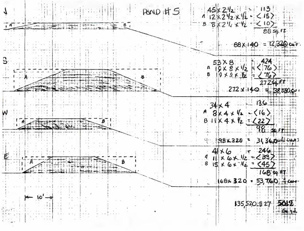
• I ,...___
I I : .. : . it '
I . . I .
•
' ' ! • ---·-
: ....... ...___ ---
. :s-_\:1:~ er~
: I
' .. I
I j '
' !
I
' •• I ! I I • • • • • • • • f
' i I . ' .
! ..
; I
J · ...... I
• ; . I . . ' . : 1·
...... ; . ·-
' ' ' I ' I • ' •• ' ' ' • • ; I • •
• I '
I •
I '
! i I \ •
.....
. . '-;
. . ~'
' ' I
. I '. . ! 1
.. I
I ' I
.:: M

..
r"~ )Qo'"\J11ms 01)(,B D cr~d J'~cl~~>J.1C1\$ b 'le, L • ~ ..
Zh
r---------,..,.--.J":. --~ ~ ---.
t ~ ~ +u'ffi~ ~ ._":: 0 ~ -· g, . I.I\ ('Jl\11.H . t.. . .
~ OJI
; . ,~ i--------·--+----~ ~-----H------~-1---,.··-· ,""".-:\~,l-.1<:.~ --~ ------_ 1,
(2-;;p_, ·io i,6-1-1:l
~~b ~ ·• _ ?I YJJ. \pxn'1J
----..-------1,fr --, s~ ~ 1-----------'----...;,..,;;..--~ -
.·;
. . t
'\ ' .. . . '-----· ..

V
-d (JV ~
~
. 't _i CJ ..._
· . •
·'-' ·:~
:~
. :@
:~
:~
I 't-.z , lb
)
~
:~
<::..J
I •
'
('() u. '()
~
~
\
•
C j; I I ,j I I I ' i I I I I
:a: .. r<l
i OJ I
. .

••
~ :j? £ b(i ;,o·J---Zl
/'C1Hrft>~
~1C~"1J L) "J3~
. S°"Sldtf> .1-1\J :3W,3J
,•
-~ ~
~ -
,--
~ QI
• ;z I
-·. --
,S
. -~ ..
.~£
' •
I
,ot, I ':
--. -
.. . ,
...
.
IO t-,
.
6' 0 ...
•

. - -. ~ .. ---
• ... . • .3, .
, 0
f
. . ;
I
/
(
'
287920.344
1683354 . 125
6820
IS) IS) IS) CD CD
+683000

. . ' : ' ' .
PRIOR RECLAMATION INSPECTION REPORT AND
RECOMMENDATION FOR RELEASE OR PERMIT REQUIREMENT
Hydro Resources, Inc. Church Rock Mine
Submitted in Partial Fulfillment of New Mexico Mining Act Section 69-36-7 U, Prior Reclamation
New Mexico Energy, Minerals and Natural Resources Department Mining and Minerals Division
Mining Act Reclamation Bureau
September 18, 1995

Introduction
The pw-pose of this study was to determine if reclamation measures at the Hydro Resources, Inc. (HRI) Church Rock Mine satisfy the requirements of the New Mexico Mining Act and the substantive requirements for reclamation pursuant to the New Mexico Mining Act Rules .
The HRI Church Rock Mine prior reclamation site is located in Sections 8 and 17 Tl 6N Rl 6W in McKinley County approximately 6 miles north of the Town of Church Rock, New Mexico. Figure l is a map of the site. The disturbed area under consideration consists of approximately 5 acres. The portion of the mine in Section 8 consists of patented mining claims. The surface estate of the portion of the mine in Section 17 is owned by the Navajo Nation Tribal Trust and the mineral rights were leased from Santa Fe Pacific Gold (Pelizza, 1995).
The HRI Church Rock Mine was a conventional underground mining operation. It was worked intermittently, by several operators, from the l 950's through 1982. HRI acquired the property in 1991 from the most recent operator, United Nuclear Corporation, which first reclaimed the mine to the satisfaction of HRI. The reclamation consisted of grading and contouring the ore pad areas, removal of mining equipment, the head frame and all buildings except the Ion Exchange Building. All mine shafts were closed with welded plates and concrete pads. Natural vegetation has since reestablished itself on the ore pads and the area appears natural except the Ion Exchange building, the concrete slabs of the mine buildings that were removed and five large, dry ponds (HRI, 1994 ). The Ion Exchange Building falls under the jurisdiction of the Nuclear Regulatory Commission.
HRI is offering to remove the concrete slabs, bury them and disk and reseed the area but chooses to keep the Ion Exchange Building and five ponds to facilitate future solution mining operations (Pelizza, 1995). The Nuclear Regulatory Commission is currently preparing an EIS on HRI's Church Rock property, as well as several other HRI in-situ leach properties in the area, and following a finding of "No Significant Impact," HRI will be licensed by the NRC to conduct an in-situ leaching operation (HRI, 1994). HRI then plans to develop an in-situ leaching operation by the end of 1996 (Pelizza, 1995).
The HRI Church Rock Mine prior reclamation site is adjacent to an unnamed tributary of the Puerco River. The Puerco River is an ephemeral stream and is located approximately one mile south of the site.
, . ... . 'J .

. . . l
Inspection Procedures
Prior reclamation at the HRI Church Rock Mine was inspected August 29, 1995. Mr. Mark S. Pelizza, Environmental Manager and Mr. Salvador Chavez, Environmental Coordinator represented HRI, Inc. Dr. Robyn Tierny, Reclamation Specialist and Mr. Robert Young, Environmental Engineer represented the New Mexico Mining and Minerals Division. Mary Ann Menetery and Dennis Slifer of the New Mexico Environment were present during the inspection. The inspection consisted of inspection of the general condition of the reclaimed mine site, discussion with the operator of mining and reclamation operations perfom1ed at site, line-intercept measurements and photo documentation of vegetative cover and diversity.
The mine site was visually inspected for erosion features and hydrologic stability. During a walkover of the site, all slopes, areas of water concentration (ponds, diversions and areas where disturbed areas enter undisturbed lands) were visually inspected for stability. Topsoil placement and distribution also was evaluated at each site. Sampling for topsoil depth consisted of randomly digging a series of holes to identify the depth of topsoil and the presence or absence of potentially toxic wasterock at rooting depth. Grading of all wasterock piles and borrow areas was visually inspected. Placement and closure of portals and vent shafts was verified in the field .
The establishment and relative percent cover of reseeded and native plant species were evaluated in randomly placed transects. Fifty foot transects were evaluated at each mine site using the line intercept method (Bonham 1989). These transects were used to estimate the relative percent cover of each plant species intercepted at 3' intervals along a transect. A total of 17 points per transect were recorded. In addition, a list of species present within a 50' X 6' belt transect adjacent to each transect was compiled. These sampling procedures, however, do not meet sample adequacy. Rather, these procedures were conducted to estimate the relative percent cover and to evaluate the diversity of species present at each of the eight mine sites. Additional resources would be needed to fully evaluate the vegetation of these prior reclamation sites to a level of sample adequacy and would require at least 24 additional man-hours of inspection time per site.

Results and Discussion
The areas appeared natural except the Ion Exchange building, concrete slabs where the mine buildings had been removed and fi ve large, dry ponds. The ponds were mostly incised, approximately 15 feet deep, 100 feet long and 50 feet wide with 4 foot embankments. All structures, trash and junk had been removed from the site. There were no piles or accumulations of toxic or waste material on the site.
Trespass grazing has been a problem. As a result, vegetation is very sparse. The ore pads had been regraded to a topography that blended in well with the surrounding terrain and native vegetation had reestablished itself such that one could not tell that the area was ever disturbed. However, native species were very sparse in the areas of the concrete slabs and ponds. Essentially only a few annuals such as Kochia and Russian Thistle, were growing there. Vegetation cover ranged from 6 to 24 percent (Tierney, 1995). Measurements of vegetation are in Appendix B. Photos documenting vegetation and general condition of the site are in Appendix A
There were no signs of erosion.
Four mine shafts had been safeguarded with steel plates and concrete.

.,.
Conclusions and Recommendations
The Mining and Minerals Division commends Hydro Resources, Inc. for their efforts to comply with the New Mexico Mining Act. Further reclamation measures are not required in the ore pad areas at HRI's Church Rock Mine to satisfy the requirements of the New Mexico Mining Act. The Ion Exchange Building is under the jurisdiction of the Nuclear Regulatory Commission and, consequently, not under the jurisdiction of the New Mexico Mining Act. However, additional reclamation measures are required at the locale of the foundations and concrete slabs of the mining buildings and ponds including:
1. Removal and burial of all concrete slabs and foundations that can be safely removed without affecting the structural integrity of the mine shafts or their steel and concrete covers.
2. Regrading of embankments around each pond.
3. Discing and reseeding of barren and disturbed areas.
It is recommended that the Church Rock Mine prior reclamation site, operated by Hydro Resources, Inc., not be released from further requirements of the New Mexico Mining Act.

References
HRI 1994, Prior Reclamation Inspection Request, Hydro Resources, Inc.
Pelizza, Mark S. 1995, Environmental Manager, Hydro Resources, Inc. , Personal Communication
Young. Robert S. 1995, Environmental Engineer, Mining and Minerals Division, Field Notes.
I •
I
. .. V •
. .
Appendix A
Photo Documentation
Appendix B

.,. .
Vegetation Measurements

Visual
Kochia scoparium
Carduus nutans
Grindelia squarosa
Agropyron smithii
Artemesia tridentata
Cleome serrulata
Bromus tectorum
Oryzopsis hymenoides
Brassica sp .
Lesquerella sp .
Bromus j aponicus
Average Perennial Cover = 15% Litter Cover = 26%
BG=Bare Ground
Table 1. HRI Prior Reclamation Site Veeetation Measurement
Transect #1 Section 17, South of Ponds
Litter
BG
BG
Litter
BG
Agropyron smithii
BG
Litter
Hilaria James ii
BG
Brassica sp.
Litter
Litter
Litter
BG
Litter
Litter
Transect #2 Section 8, SW Corner
BG
Gutierrezia sarothrae
BG
BG
BG
BG
BG
BG
Litter
BG
BG
Gutierrezia sarothrae
Gutierrezia sarothrae
Rock
Gutierrezia sarothrae
BG
BG
/
HR/, INC.
5656 South Staples Suite 250, LB 8
Corpus Christi , Texas 78411 Telephone: (512) 993-7731
Fax: (512) 993-5744
(A Subsidiary of Uranium Resources, Inc.)
12750 Merit Drive
April 15, 1996
Dr. Kathleen A. Garland, Director Mining and Minerals Division
Suite 1020, LB 12 Dallas, Texas 75251
Telephone: (214) 387-7777 Fax: (214) 387-7779
New Mexico Energy, Minerals and Natural Resources Department P.O. Box 6429 Santa Fe, New Mexico 87505-6429
RE: Prior Reclamation Status - Churchrock Mine McKinley County, New Mexico
Dear Dr. Garland:
P.O. Box777 Crownpoint, New Mexico 87313
Telephone: (505) 786-5845 Fax: (505) 786-5555
The following Amendment of HR.I's prior reclamation plan for the subject property is submitted pursuant to your letter dated September 29, 1995, and more recent telephone conversations with Mr. Holland Sheperd. Our intent is to perform the work in 1996.
You noted in your letter that HR.I is proposing to license this facility with the Nuclear Regulatory Commission for in-situ mining. You are correct. We expect licensing to be complete at the end of this year. The entire area being considered for Prior Reclamation Improvement falls within the NRC license area and will be disturbed through in-situ wellfield development. If this results in an exemption from the New Mexico Mining Act, please notify me,as we would prefer to perform the dirtwork and revegetation portion of the attached plan only once, that is after in-situ mining development.
Thank you for your assistance in this matter.
Vice President Health, Safety and Environmental Affairs
cc: Salvador Chavez, HR.I, Inc./Crownpoint, New Mexico

Proposed Improvements to Prior Reclamation HRI, Inc. Churchrock Site
Introduction
On September 29, 1995, New Mexico Energy Minerals and Natural Resources Department advised HRI of three areas where additional remediation would be required at the Section 17 Churchrock Site, before "Prior Reclamation" status could be approved. These included the following:
1. Removal and burial of all concrete slabs and foundations that can be safely removed without affecting the structural integrity of the mine shafts or their steel and concrete covers.
2. Regrading of embankments around each pond.
3. Discing and reseeding of barren and disturbed areas.
This report will detail HRI' s plan for each of the three items slated above.
Concrete Removal
The building and Hoist Foundation slabs will be broken up into small enough pieces to transport them to the No. 1 Pond for burial. This will be done by ripping with a dozer, lifting with a loader and cutting the reinforced steel with a torch. The anticipated quantity of material is tabulated below.
Buildings and Equipment Slabs
(L) X (W) X (H) 30' x 24' x 1/2' = 360 Cu. ft. 20' X 16' X 1/2' = 160 42' X 95' X 1/2' = 1,995 12' X 12' X 1/2' = 72 7' X 9' X 1/2' = 32 8' X 10' X 1/2' = 40
40' X 24' X 1/2' = 480 10' X 8' X 1/2' = 40 3' X 3' X 1/2' = 5 3' X 3' X 1/2' = 5
16' X 35' X 1/2' = 280 65' X 40' X 1/2' = 1,300
140' X 35' X 1/2' = 2,450 10' X 20' X 1/2' = 100
5' X20' X 1.2' = 50 16' X 20' X 1/2' = 160 10' X 12' X 1/2' = 60
7,589 = 280 Cu.yds.
Hoist Foundations
(L) X (W) X (H) 10' x 20' x 3' = 600 Cu. ft . 16' X 32' X 4' = 2,048 16' X 35' X 3' = 1,680
4,328 Cu. yds.

As built drawing for the Hoist Foundations have not been located. Excavation will be done to determine the actual thickness, time, effort and cost to remove these slabs. If the equipment made available for this job is not adequate to break up and remove these slabs, they will be left in place. Provisions for drilling and blasting or for specialized concrete breaking equipment have not been made for this job because, doing so may threaten the integrity of the shafts. Removal of slabs will be limited to what can be removed with the equipment specified in this report.
The concrete that obviously extends above the ground at the shafts will be broken down to the level of the collar slabs.
The quantity of material from headframe slabs at the escape shaft will be calculated below:
(L) X (W) X (L) 38' x 3' x 4' = 456 Cu. ft . 38' x 3' x 4' = 456 Cu. ft .
(L) X (W) X (L) 45 ' x 4' x 1/2' = 90 Cu.ft .
1,002 Cu. ft . = 37 Cu. yds.
The two slabs that comprise the shaft collars can not be removed without affecting the integrity of the two 1 0' diameter shafts and will be left intact. The quantity of concrete to be left in place is tabulated below.
Escape Shaft Main Shaft
68 ' X 42' X 2' = 97' X 55' X 2' =
Regrading Embankment of Five Existing Ponds
5,712 10,670 16,382 Cu. ft.= 607 Cu. yds.
The berms surrounding each of the five ponds will be pushed into the ponds. There is not enough soil in the pond berms to fill the ponds so the soil will be pushed toward the center of the ponds leaving a gradual downgrade toward the center. This work will be done with the use of a dozer and a loader. A total of 17,000 cubic yards will be moved for this purpose. (See tabulation in Attachments.)
The scrap metal that was removed when the cement seals were poured on the two main shafts, one vent shaft (42" diameter) and one gravel hole (12" diameter) will be buried in the No. 1 pond with the concrete. An old metal water tank and several metal manholes will also be removed and buried.
Final grading of the site will be so that runoff ends up in an existing catch pond on the south side of the property.

Reseeding and Revegetation
The areas in the vicinity of the shafts that have not supported vegetation will be covered with soil borrowed from a berm that surrounds the ponds. These areas total 3-3/4 acres and will be covered with 6" of soil. A total of 3,000 cubic yards of soil will be moved for this purpose. This will be done with the use of loaders, belly dump trucks and a blade to spread the soil.
Reseeding of all disturbed areas will be done before the rainy season and will be done with a 50/50 mixture of Alkali sacation and western wheatgrass at the rate of 10# per acre.
The areas to be reseeded are:
Concrete Slab Removal Regrading of Ponds Areas covered with 6" of soil
The equipment that will be used will consist of:
One CAT 980 Loader 6 yard bucket Three Belly Dump Trucks 12-G Cat Blade TD25G- (D-8 Equivalent) Dozer
1/4 acre 12 acres
3-3/4 acres 16 acres
There will be a total of 20,000 cubic yards of dirt moved and 478 cubic yards of cement will be broken, moved and buried. The job is expected to take 20 working days.

Attachment
Various Maps and Drawings

~--\\---I
- - 1~0 - - - . -->J
T ,~ 13 ~ I s ---.~-
4!/
T I< --- is·--- · --- --~-1 --no·
---.;__---''---r---·- -- --- -- -·- -- \~- - --- - _'±,,, ~
N POND it 2
't -- 12.' - - ·--·- \00'
N
!-< _'[____ 3 lO ' ~/ 12'
I 1-' ----- --\~ '3
w - ,- \ 30' ~ -~,i --
______ i --- -- - -

N
... . -~
... t
6~
~-I I
I '
- t .. w
0
I L
v
m -
m
~o
-
I 1(
--{P
-'),
'
~ ~ '
I I L
I
~ ~~
z N
i
~·
0 , 1 I
- 6:_ l '! ,~
if' t'
8 z 0 ~
1\-z t::,
U)
N
w -~
I'
\)
C)
D ~
0 '
-I (J
)

I •
•• 1 ;j
~Lm·-~
-~
-r-
! ..
·1
·-l
-~ . I
t .
It
·
+ ·-·1
t
,-..,-
--~
-----
-··
----
· --
----
---
---
---
;:
L
----
------
-~ r
-__
-_·
__ !
_
____
_ .,. __
_ .
o ..
.
. k
.. : .. j{i
·;
----:
-. --
t---·
~r--
:---
! i I -
7.
I •f
· I
-:/
-
. -
. --;:
----------
i -
-·
. .
. .
-.-.
J. ..
___ -i
-----·
-· ...
. • f"
•- .. L
. f
f
---~
-,-
. -,--
..
--l-
--
----
-·--
----
·-·-
----
-
.. --r~--
---=-·:
~-~-~-:-:-:
·-~=~--~~b
-'~-~-~
:-:-:-
~~-=
~·:.L
1
.. ' -
----,-
-•
i -
; -
j. ••
' --. --
~: _~;.I
: --~-~
~---~-:.
: ~ -
• -
/ 1
-•
...1
.. -
-
----
-__ -_~
r=--
-_-_
----
----
----
----
----
----
-+--
--H
-'---
----
---,-
-i,--
--.-
-~ -
--~ !
t-1
•
. ~-l-
------
1 -
-l--
----
,-,
I '
! I
.. ·-
.....
--·r-
-• --,
t ---. -
--. --
_---r
--r
---
____
.. ___
_ --
------
------
---
~-~
----
-~--
+--
----
-
--~
-.'
I -
-•--·-
-

-t .. -
. •-~
,._
..,...
. -·
.L
t ·-
_ _J_
I ;
i ·
::: __
:_:_
~--
~--:_:-
~~~:1
---
---,
~loo
..~
··-7
· 1
==t,-~
l ·-
,-... -
-.-!..
. _;_
. t
-·
-~ ...
. .
.
-------'-----------,-
------
.... --
..... --.------
..-.~
-------,-----''
ir'+-
'i-.;+
-1
----
'_ . ·
i ----
----
, •
1·
7··
----
---·
-~-
---;
-----
: r -
--. -
•----.
~
. ~
~:.
, ..
i I '
-~
--·
-~--
-n
..
0
_-o
• •
--
-•
• I
···-·•1
· ---
----
--···
-+
•
..
. -
-.
• •
f
-------
---1-----------
1
: t r,
I
• l
t~~
)(.~
X
..:;
J;..
.,J~
)(._,
<:
., Er
-a>~
---
-t->
'-~
)( --
. ·!_
'J ~ ~ .
In
')
(.
··
.v,
·•-
":f.-
--~
...::.
0
--
.. ---t'.
·--::--
---x
:---=
-~~
,,
,. --

t l •
' '
• I I
\ f • f
· I i • t i J. ""-..L; . I.
L: . i
I 'J • • ·! ! tr: -_, 1-· . ' I •
' ' ' t
I •
I I
' '
• t
i I I I i
; I
..... -...-
• i . l
i ' t
. ~ .I ; ; I l J I l ' ' I • ·_; ~ -1 H i l .,
: i •
i I I I I . I i-
I
'
' i I ' I
I i i '
'
i i 1 f
t-t ; T I t
! 1 ;_~-l
! I
.
l ' j I .
• I ,, . ' I
I •
l ' Al ! . r-,
I . I I I i 1' -~~.
. ' i
• I I ..
-!
i .. J • 1 j
I • I

l J1-~ Qaj tz1: ' ' h l ooz: l-.1 It¼ ., ' . ' -;" ' ' ; ' ', ' I ,, i ' , '' ' t I \ ' ' A\~/ , j ·I /, ! : l i t. t~ to' 1 : , t': ( i . 11 ; I . :· . I . ; . i:' I : 1' .
J.' ,'I)_... ___ '-' ___ )_I I ' ;I I
I ' : 7" / ! \:" l ' . ' ' I l? ,.,!"" ~: ' -:-~t _-~ ·~ ~ r~-:-.:2,,i, ~ 1~-"~·---!'~ ;·: ~ :-'. '..! . ·tr 1 : "(•-Zrlr'>!~ '/1 1"" Zfi12 ~iOI f · , • 1 •
00, . . , , 1 f ..J•'?'(" , .•
, . -, . r ,-iv c. I . -,· I ' : . I I I • ' I • I : I I I ' I
I
! i i : ! : t
' '
I I
!
I ' i ; ' ' ' ·-·
' . I
+-ll-
i I )-. 1 I
! I I
~-I I I .

-l
---·
·1·
~ . -
... .
. .
. --
t •
• j
-j
---
1 I--
-i
.. !
-• t
- •
__ t _
__ _
.
-.
-.
•• l
-ct
.U"\
...
--·:
•···
--tr
-,--
---
____
_,_,
..."'11C
ft...
...__
.
I ,
••
, I
-...
,-_:-
-· . -
: .
j --
---
• .
. --
-+--
!..
t-. ·-
.:J-·'--
---. ·
----·-
' 1..
I •• f
. ··1
-,
t;-i
,-1
,tt .
..,....1..
----·
· t-~
---··
··•
-if•H
?acH
HI-
·· ·
· ·-·
·
, •
-·-
--
-. -
l :i;
::.;H
.--
~----
-·-
t
I.
.
--· ---r
.
-----
-·--_-
,···-=t
·_. ·--
---
-l J
--·-. . -
-·t--·--
--, . -·· -
.. j· ---
----
--·-
----·
---
----
---
-· --
---• ·--
------
.
t-.
·• T
...
-
----
~ -r
-------
----
·---
----
----
----
--,-
---,
-r I !
I --
-_[
__ _
-----·---
+-----
-----· -
----1
t·
I ----!
; .
-· .:.. --~-
r-==-~=
---=-=
----!
·-. .
·-1-·-·
-
•---
· --
----
-•
---+
---
--1
--~-
-·-
-·-
~ tr
\ t
'~--

Zb
rvd ~1'1Jll(YI$ 01)(,B • (jl;?Q "~~~\D.1-1Ct\$ b ')(, L • ~ ._
Q-;(o_, ·b0 16-f--Zl
-... -~ "' 0 N .,... g
-i:r'Z
-· ~
.
t-O~G ~ . . . ' ?1)0)_ ~"~J -• 4 • .. • • ·-.-::: ··-·--
..
~----'------~\ t
... -----=--~-=-.=-=--=--------=:" 7,h ~, S~ ~
1-------'-----__;_---~ -
. .,.
~ Cl)J
.. ·---·

1f,
••
H,£ -S'
. 1-------1
•
-.. "' ..
. .

•
40'
'
... .
0 '9
5'
. . . . - - . ~-
.. . .
\ I "Kl' '
.. ~ -
I I
.
-- ·· ·-
35'
J ,_
~ °)I.
\r)
1--
, •
CeMf f\l, ~\Jpes · <;f c ~ c Ck~oL k
S~'J✓ lZ.-(-99,
p~ 3 6F'.= 3
.. , .

.. < ..
5656 South Staples Suite 250, LB 8
Corpus Christi , Texas 78411 Telephone: (512) 993-7731
Fax: (512)993-5744
Mark S. Pelizza Vice President Health, Safety and Environmental Affairs
April 15, 1997
HR/, INC. (A Subsidiary of Uranium Resources, Inc.)
12750 Merit Drive Suite 1020, LB 12
Dallas, Texas 75251 Telephone: (214) 387-7777
Fax: (214) 387-7779
Dr. Kathleen A. Garland, Director Energy, Minerals & Natural Resources Department Mining and Minerals Division Mining Act Reclamation Bureau 2040 South Pacheco Street Santa Fe, New Mexico 87505
,..-,a/''.\
e-:''\l ··v P.O. Box 777 f{~.Ct:J "'·
Crownpoint, New Mexico 87313 ,nql Telephone: (505) 786-~n \ ~ \7
Fax: (505) 786-5555 Al"'1'\ - •his D\\J,
(I .. •\Nc:.r,I""'-~\ ~\t~G o. "
1
RE: Request for Variance under 19 NMAC 10.2, Subpart 10, Churchrock Mine, McKinley County, New Mexico : T16N; Rl6W, Sections 8 and 17
Dear Dr. Garland :
HRI hereby requests a variance under 19 NMAC 10.2, Subpart 10, to extend the time for Prior Reclamation (Subpart 510 .B) to December 31, 1998 for the Church Rock Mine located in T 16N, R l6W, Sections 8 and 17.
HRI has been involved in a lengthy process licensing the Church Rock site for in situ leach uranium mining with the Nuclear Regulatory Commission (NRC). This process has taken a longer time than we expected. The Final Environmental Impact Statement (FEIS) was completed several weeks ago by the NRC which recommended issuance of a license. During the time HRI was active in completing the FEIS process, the final reclamation work was delayed because of some uncertainty of how the issuance of a new license from the NRC would interact with the Prior Reclamation requirements ofEMNRD.
HRI is requesting this variance because we believe that the final steps in reclaiming the old conventional mine can be completed under the Prior Reclamation provisions before any new

Letter to Dr. Kathleen A Garland, Director April 15, 1997 Page 2 of3
disturbance is created under the regulatory authority of NRC. Also, having to go through the permitting process would result in costs, that we believe, would not be commensurate with the minimal reclamation work which remains. Permitting the site under the Mining Act may also create duplicate and possibly contradictory jurisdiction over the site after NRC licensing. In other words, we would like to close the chapter on the old, underground mining activities at the site before we commence in situ mining activities. Please take note that HRI will also be responsible to NRC for a cash surety to reclaim both groundwater and all surface activities associated with ISL mining.
Your staff completed their inspection of the Church Rock Mine and a report was issued on September 29, 1995 in which they commended HRI's efforts to comply with the New Mexico Mining Act. To date, reclamation has involved grading and contouring the ore pads, removal of mining equipment, the head frame and all buildings except the Ion Exchange building. All mine shafts were closed with welded plates and concrete pads. Natural vegetation has since reestablished itself over most of the area.
The report identified three minor, additional reclamation measures associated with concrete slabs of the mining buildings and the ponds including:
1. Removal and burial of all concrete slabs and foundations that can be safely removed without affecting the structural integrity of the mine shafts or their steel and concrete covers;
2. Grading of embankments around each pond;
3. Disking and reseeding of barren and disturbed areas.
At the present time, and based on your staff's report, there exist no significant health, safety, or environmental problems at the site. The requested reclamation work constitutes only a minor fraction of the work that has already been conducted at the site and consists exclusively of aesthetic improvements of the landscape as requested by your staff
HRI staff met with Holland Shepherd and Robert Young on April 10, 1997 to discuss the best method for concluding the prior reclamation work at the site. HRI agreed to begin the remaining work immediately and agreed with your staff that the best answer for the remaining concrete will be to cover the exposed concrete with soil and reseed with the appropriate grass mixtures as defined in the FEIS . HRI anticipates that the earth work and reseeding will be completed during May, 1997.

,. - Letter to Dr. Kathleen A. Garland, Director ' April 15, 1997
Page 3 of3
HR.I would like to extend an invitation to your staff to observe the completion of the work at the site. We are concluding negotiations with the contractor at the present time, and anticipate that startup of activities will be as early as April 21, 1997. The earth work will be completed within 2 weeks of startup. We will inform your staff of the date of startup.
Enclosed is the fee for the variance application pursuant to Subpart 2, 201 .K, in the amount of $500 payable to the Mining and Minerals Division.
Very truly yours,
AJ)jg Mark S. Pelizza Vice President Health Safety and Environmental Affairs
Enclosure:
cc:
HR.I check for $500 variance request
Dick Clement, HR.I D.W. McCam, HR.I

ENERGY, State of New Mexico
~ERALSandNATURALRESOURCES Santa Fe, New Mexico 87505
1ARTMENT
BRUCE KING GOVERNOR
Mark S. Pelizza Environmental Manager HRI. Inc. 12750 Merit Drive Suite 1210, LB 12 Dallas, TX 75251
October 4, 1994
ANITA LOCKWOOD CABINET SECRETARY
Re: Status of the Church Rock Mine, T16N, R16W, Section 17
Dear Mr. Pelizza:
The Mining and Mineral Division received your letter dated September 6, 1994 stating the Church Rock mine, for which you received the site assessment letter, is the same site for which you have sent us a request for prior reclamation. We have made the change in our records,and thank you for helping us correct this discrepancy.
There has been a bit of confusion over the several Church Rock sites operated by Kerr McKee, UNC and HRI. However, we have had some help from UNC, recently, in sorting it all out.
We are still reviewing your application for prior reclamation, and will be contacting you shortly concerning any fur t her information we might need.
hri. ltr
VILLAGRA BUILDING - 408 Gall1teo
Forestry and Resources Conservation Division P.O. Box 1948 87504-1948
827-5830
Park and Recreation Division P.O. Box 1147 87504-1147
827-7465
. ,- y/J Holland Shepherd Bureau Chief Mining Ac t Reclamation Bureau
2040 South Pacheco
Oflice of the Secretary 827-5950
Administrative Services 827-5925
Energy Conservation & Management 827-5900
Mining and Minerals 827-5970
LAND OFFICE BUILDING - 310 Old Santa F Troll
Oil Conservation Division P .0 . Box 2088 87504-2088
827-5800

.. ,. I
September 28, 1994
To:
From:
Re:
Mining Act Reclamation Bureau File on United Nuclear Corporation
Holland Shepherd, Bureau Chief, Mining Act Reclamation Bureau ~WI Meeting with UNC Concerning Status of Mining Properties in New Mexico
Date of Meeting: Sept. 16, 1994 10:00 - 12:30 Time of Meeting:
Participants: Juan Valesquez and Dalva Moellenberg of United Nuclear Corporation; Holland Shepherd, Alan Jager and Fernando Martinez, MMD
This memo addresses a meeting the Bureau had with representatives of the United Nuclear Corporation. The meeting was held to discuss the status of several sites currently operated or once operated by UNC.
Sites Resolved During Meeting
1. The Mac #1 Mine was a Homestake/UNC venture which lasted about two years. Homestake bought all interest in the property in the late 70's. This site apparently does not meet the definition of mining so will not be permitted. Homestake is to send the letter indicating exclusion.
2. The Section 31 T13N, R9W Mine, according to UNC is not subject to the Act. However, Santa Fe Pacific has claimed under prior reclamation. This will exclude UNC from further obligations for the site, if the site is released under prior reclamation.
3. The Old Chur ch Rock Mine i s in Section 17 . This site incl udes t he Chur c h Roc k 1 and l E a ll now under the responsibility of Kerr McGee. The site is on Indian Lands, not Indian Trust Lands. Kerr McGee has claimed these sites under prior reclamation, the Church Rock 1, lE and 2.
The NE Church Rock Mine is the same as the Sect i on 35 Mine , and is the responsibility of UNC.
Another Old Church Rock was once owned by UNC, but now belongs to HRI, Sec. 17, T16N, R16W, which is claiming it as a prior reclamation site.
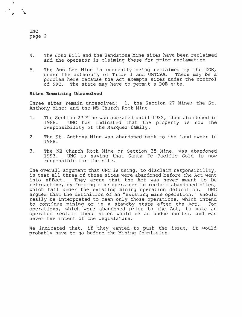
UNC page 2
4. The John Bill and the Sandstone Mine sites have been rec l aimed and the operator is claiming these for prior rec l amation
5. The Ann Lee Mine is currently being reclaimed by the DOE, under the authority of Title 1 and UMTCRA. There may be a problem here because the Act exempts sites under the control of NRC. The state may have to permit a DOE site.
Sites Remaining Unresolved
Three sites remain unresolved: 1. the Section 27 Mine; the St. Anthony Mine; and the NE Church Rock Mine.
1. The Section 27 Mine was operated until 1982, then abandoned in 1988. UNC has indicated that the property is now the responsibility of the Marquez family.
2. The St. Anthony Mine was abandoned back to the land owner in 1988.
3. The NE Church Rock Mine or Section 35 Mine, was abandoned 1993. UNC is saying that Santa Fe Pacific Gold is now responsible for the site.
The overall argument that UNC is using, to disclaim responsibility, is that all three of these sites were abandoned before the Act went into effect. They argue that the Act was never meant to be retroactive, by forcing mine operators to reclaim abandoned sites, which fall under the existing mining operation definition. UNC argues that the definition of an "existing mine operation," should really be interpreted to mean only those operations, which intend to continue mining or in a standby state after the Act. For operations, which were abandoned prior to the Act, to make an operator reclaim these sites would be an undue burden, and was never the intent of the legislature.
We indicated that, if they wanted to push the issue, it would probably have to go before the Mining Commission.

5656 South Staples Suite 250, LB 8
Corpus Christi , TX 78411 Telephone (512) 993-7731 Telecopy (512) 993-5744
VIA FEDERAL EXPRESS
HRI, INC. (A Subsidiary of Uranium Resources, Inc.)
12750 Merit Drive Suite 1210, LB 12
Dallas, Texas 75251 Telephone (214) 387-7777 Telecopy (214) 387-7779
TWX 910-867-4701
August 31 , 1994
Post Office Box 777 Crown Point, New Mexico 87313
Telephone (505) 786-5845
Mr. Holland Shepherd, Chief Mining Act Reclamation Bureau STATE OF NEW MEXICO
RECEIVED
Energy, Minerals and Natural Resources Department 2040 Pacheco Street Santa Fe, New Mexico 87505
Dear Mr. Shepherd:
SEP f
The following letter will be HRI, Inc. ' s response to your letter dated July 28, 1994, where you asked for additional information regarding the prior reclamation status at the Churchrock mine. Additionally, a check covering the $250.00 inspection fee is attached. I have formatted this response by first restating your question and then responding appropriately.
1. A map of 1:24000 or larger scale (1:12000) showing the limits of the reclaimed area and the location, and a descriJ>tion, of any waste units, im1>0undments, stockpiles, leach J>iles, OJ>en pits or adits that are within this area;
Response:
A copy of the U.S.G.S. Churchrock Quadrangle map is within Attachment A with HRI ' s Churchrock Mine Site (Lease) outlined.
2. A discussion of 1>ost-mining land use, for the site reclaimed;
Response:
Attachment B contains a Proposed Wellfield Site Layout which has been developed pursuant to the licensing activities with the U.S. Nuclear Regulatory Commission (NRC). The land area which was affected by previous conventional mining activity is delineated within the pink-shaded area and the location of future in-situ wellfields which will be regulated by NRC is illustrated.
As can be seen, with the exception of the location of ponds 1-5, the area that had previously been affected by conventional mining fall within in-situ wellfields. The pond embankments are being left in place in the event HRI needs to utilize them during in-situ mining. All sludge has been removed from these ponds. All these activities will be regulated by the NRC in the near future ..
3. A detailed description of the reclamation work performed, including types of reclamation conducted, amount of acres revegetated, the seed mix used, the current condition of the revegetation, etc., and how the reclamation project has been designed to achieve a self-sustaining ecosystem;
f

Response:
Reclamation has been performed by the previous operator, United Nuclear Corp. (UNC). UNC removed all remaining ore material, over-burdened stockpiles, buildings and other facilities from the site. As a result, the entire site is graded to approximately Lhe original topographic grade.
UNC, with HRI as Contractor, removed all of Lhe contaminated material form the five ponds which were used by UNC to treat mine water for Radium 226 removal by barium chloride treatment, prior to surface discharge. All of the contaminated material was disposal of offsile.
All that remains at this time is the old mine headframe, the ion exchange plant and the pond embankments. The headframe belongs to UNC and will remain in place indefinitely until removed by UNC. The ion exchange plant will be used during in-situ mining. The ponds will be left in place in the event they are used for in-situ mining.
The area affected by previous mining has not been reseeded. However, over time, a vegetation cover has re-established itself through wind-blown seed, and other natural processes. We feel that the vegetation cover is self-sustaining.
4. If 11art of the reclamation, a discussion of how the current reclamation of waste units, im11oundments, stockpiles, tailings 11iles open pits or adits, have been designed to ensure compliance with all applicable federal and state standards for air, surface and ground water protection, and to eliminate any future hazards to health and public safety.
Response:
As has been mentioned previously, the Section 17 location is currently being licensed for in-situ mining by the NRC. A Federal Environmental Impact Statement is being prepared. As a NRC licensed area, HRI will be required to comply with all the regulation of the NRC and the Atomic Energy Act (AEA). Additionally, in-situ mining requires permits from the New Mexico Envi ronment Department (NMED) and the Environmental Protection Agency (EPA). Therefore, environmental matters pertaining to air, surface or ground water will be thoroughly regulated during in-situ mining activities.
At this time, however, we seek prior reclamation status with EMNRD as required by the New Mexico Mining Act. Regardless of future environmental controls that will be implemented by other state and federal regulatory agencies, we feel that lhe Churchrock property now is in a state that one would consider a selfsustaining ecosystem. In fact, we hope the purpose of the inspection will be to determine and advise HRI if that status has been achieved.
I look forward lo meeting your inspector in lhe field . Please contact me with questions pertaining to this matter.
MSP/dlg Encl. (Check)
cc: Bill McKnight, Jr./URI, Inc./Corpus Christi , TX 78411

~ .
PAY
V•I
TO THE
ORDER OF
URI, INC.
DATE
URI. INC. 12377 MERIT DRIVE PH. 214-934-7777
SUITE 750, LB 14 DALLAS, TEXAS 75251
MERRILL LYNCH BANK ONE, COLUMBUS , N.A.
COLUMBUS, OHIO 43271
2 ,.i.': 1'"11 j"I f'• I ' ,, t! '" 'i1 11""11 (' 'I ' I'' 0) l..il 4,,11,.II .. ,) ... , ,,.,P 1.,- j ,.I
r •New Mexico Energy , Minerals &
Natural Resources Dept.
7 o s~·Ycr-9 4
2238
25-80/ 440
AMOUNT $250.00xxx
2040 South Pacheco WORKING CAPITAL MGMT. ACCT.
Santa Fe, NM 87505
DETACH AND R ETAIN TH IS STATEMENT THE ATTACHED CHECK IS IN PAYMENT OF ITEMS DESCRIBED BELOW, IF NOT CORRECT PLEASE NOTIFY US P ROMPTLY. NO RECEIPT DESIRED.
DELUXE - FORM TWCP-3 V-2
DESCRIPTION
Churchrock Permitting
VOID AFTER 60 DAYS
AMOUNT
250.00

State of New Mexico
ENERu,, MINERALS and NATURAL RESOURCES ..,_,>ARTMENT Santa Fe, New Mexico 87505
BRUCE KING GOVERNOR
ANITA LOCKWOOD CABINET SECRETARY
... ·.- ..
Mr. Juan R. Velasquez United Nuclear Corporation 1700 Louisiana N.E. Suite 230 Albuquerque, NM 87110
August 25 , 1994
Re: Response to Recision of New Mexico Mining Act Owner/Operator Information
Dear Mr. Velasquez:
This letter is in response to the United Nuclear Corporation (UNC) correspondence, dated June 21 and 29, 1994. The letters concerned the owner/operator status of several uranium properties, in which UNC had been involved . The owner/operator status and responsibilities, under the New Mexico Mining Act (the Act), relate directly to the requirements of Sections 69-36-5.D and 69-36-3 .E.
The letters referenced above indicate that UNC believes it does not have a responsibility for reclamation under the Act for the sites listed below: _-:~ .
1. St . Anthony Mining Operation
2. Section 27 Mine
3. Northeast Church Rock Mine
p.k{Church Rock Mine
5. Sandstone Mine
6. Anne Lee Mine
7. John Bill Mine
VILLAGRA BUILDING· 408 Galisteo 2040 South Pacheco LAND OFFICE BUILDING . 310 Old Santa Fe Trail
Oil Conservation Division Forestry and Resources Conservation Division
P.O. Box 1948 87504-1948 827-5830
Ottice of the Secretary 827-5950
Administrative Services 827-5925
P.O. Box 2088 87504-2088 827-5800
Park and Recreation Division P.O. Box 1147 87504-1147
827-7465 Energy Conservation & Management
827-5900
Mining and Minerals 827-5970

UNC Response August 25, 1994 page 2
Below please find MMD's response to UNC for each site referenced above:
1 . St. Anthony Mining Operation
2.
You have indicated that UNC terminated its lease for this site on November 1, 1988. However, Sections 69-36-3.E or 69-36-5.D do not indicate that once an operator's lease has been terminated that the operator is no longer responsible for the requirements stated in the Act. The language in the Act clearly indicates that an operator mining and producing within the specified time frame falls under the requirements of the Act.
UNC's letter, dated July 16, 1993, indicates that UNC did operate the St. Anthony Mine for a period of 2 years between January 1, 1970 and the effective date of the Act. If UNC operated the mine during the time frame stated under the definition of an Existing Mine, in Section 69-36-3.E, and produced for the given period, then the responsibility for reclamation or permitting remains whether or not the lease was terminated prior to the implementation of the Mining Act Rules.
It is MMD's opinion that the only way for an operator to be removed from the responsibilities of the requirements stated in the Act, is for MMD to approve in writing the transfer of responsibility for permiting and reclamation to another responsible party. If the Cebolleta Grant is willing to take over the full responsibility for the permitting and reclamation of this site, it may obtain the required permit.
Section 27 Mine
Please see explanation above, concerning the St. Anthony Mine. Again if Marquez family or Hecla Mining Co. is willing to take over the responsibility of permitting and reclaiming this site then either or both, jointly, may permit the site.
3. Northeast Church Rock Mine
Please see explanation above, concerning the St. Anthony Mine. For those portions of the site on Navajo trust lands (Sections 3 and 35, T17N, R 16W), MMD will need more information concerning the surface and mineral ownership. Also, we will need to know if any reclamation has already been performed in these areas and under whose authority.
4. Old Church Rock Mine
Hydro Resources Inc. may have assumed responsibility for this site. HRI has filed a request for prior reclamation regarding a Church Rock site. The legal description

.. , ..
UNC Response August 25, 1994 page 3
they provided for the site is Section 17, T1 6N, R 16W. If this is the same site as
UNC's Old Church Rock Mine, and the reclamation is satisfactory then no permit will be needed by any party.
5. Sandstone Mine
Please see explanation above, concerning the St. Anthony Mine.
6. Anne Lee Mine
Please see explanation above, concerning the St. Anthony Mine.
7. John Bill Mine
Please see explanation above, concerning the St. Anthony Mine.
Currently, MMD has no information from UNC concerning these sites other than the letters received on July 16, 1993, June 21 and 29, 1994. To come under compliance with the New Mexico Mining Act, it will be necessary to file a site assessment for these sites, provide written documentation from other parties which states an assumption of the responsibilities under the Act , or provide a request for prior reclamation. The deadline for filing a site assessment (June 30, 1994) has passed, but a site assessment is still needed. The deadline for filing a request for prior reclamation is August 31, 1994.
,.,: .. ,·Please contact us as soon as possible with your response to this letter.
Sincerely,
~~ ohn Lingo
Acting Director Mining and Minerals Division
JL/hs
UNC.ltr

T . . .. -HRI, INC. ...
(A Subsidiary of Uranium Resources, Inc.)
5656 South Staples 12750 Merit Drive Suite 1210, LB 12
Dallas, Texas 75251 Telephone: (214) 387-7777 Telecopy: (214) 387-7779
TWX: 910-867-4701
Post Office Box 777 Crown Point, New Mexico 87313
Telephone (505) 786-5845
Suite 250, LB 8 Corpus Christi. TX 784 11
Telephone (512} 993-7731 Telecopy (512) 993-5744
Mr. Holland Shepperd, Bureau Chief Hardrock Reclamation Bureau State of New Mexico
June 28, 1994
Energy, .Minerals and Natural Resources Department 2040 South Pacheco Santa Fe, New Mexico 87505
RE: Prior Reclamation Request HRI Churchrock Property Tl6N, R16W, NW 1/4 and SE 1/4 of the NW 1/4 of Section 17.
Dear Mr. Shepperd:
The purpose of this correspondence is to comply with Section 69-36-5 of the New Mexico Mining Act (NMMA) for the subject property. Specifically, HRI intends to file for previous prior reclamation status.
The subject property is the site of a conventional underground uranium mine that had been worked intermittently by a number of operators from the 1950's through 1982. HRI acquired the property in 1991 from the most recent operator, United Nuclear, Inc., for the purpose of development by in-situ leaching (ISL).
The Nuclear Regulatory Commission is currently conducting an EIS on HRl' s Churchrock property, as well as several other HRI in-situ leach properties in the area and, following a finding of "No Significant Impact", we will subsequently be licensed by the NRC for in-situ leach development. In other words, the subject property is under the jurisdiction and will ultimately be licensed by the NRC.
Prior to acquiring the Churchrock property, HRI carefully evaluated site environmental conditions to assure that there were no future reclamation liabilities. At that time, per our request, the previous operator conducted additional reclamation in the location of the process ponds, to HRI' s satisfaction. As a result, the entire mine site is now essentially reclaimed. The process ponds are free of contamination. We have, however, opted to leave the embankments in place for future use. The ore pad areas have been graded and contoured to essentially the original

'. i:.uer to Mr. H. She6. Bureau Chief June 28, 1994 Page 2 of2
-topographic contour, and natural vegetation has re-established itself. All mining equipment has been removed except for one building, which HR.I has purchased for future use, and the old Headframe, which may or may not be removed in the future . All mine shafts have been closed with welded steel plates. There has never been tailings at this location.
As specified in Section 69-36-5-E of the NMMA, HR.I hereby requests an inspection of the subject property to verify prior reclamation has been achieved. Based on our environmental evaluation of the site, we feel reclamation is complete.
Please contact me at your earliest convenience to schedule an inspection.
MSP/dlg
cc: Bill McKnight URI/Corpus Christi, Texas
);j(_~ly Mark S. Pelizza Environmental Manager

.. HRI, INC.
(A Subsidiary of Uranium Resources, Inc.)
5656 South Staples Suite 250, LB 8
Corpus Christ i, TX 78411 Telephone (512) 993-7731 Telecopy (512) 993-5744
12750 Merit Drive Suite 1210, LB 12
Dallas, Texas 75251 Telephone: (214) 387-7777 Telecopy: (214) 387-7779
TWX: 910-867-4701
Post Office Box 777 Crown Point , New Mexico 87313
Telephone: (505) 786-5845
Mr. Holland Shepherd, Chief Mining Act Reclamation Bureau STATE OF NEW MEXICO Energy, Minerals and Natural Resources Department 2040 Pacheco Street Santa Fe, New Mexico 87505
RE: HRI, Inc. Churchrock Mine T16N, R16W, Section 17
Dear Mr. Shepherd :
September 6, 1994
(/ 11/C
Pursuant to the August 31, 1994 letter from Mr. John Lingo, and our telephone conversation today, 1 wish to clarify the identification of our Churchrock mine. We refer to this mine as referenced above. This is the same prope11y that was the subject of my June 28, 1994 and August 31 , 1994 letters to you requesting prior reclamation status and then providing additional information for the same.
Please feel free to contact me with additional information pertaining to this matter.
\
Environmental Manager
MSP/dlg
./(/

. '
BRUCE KING GOVERNOR
State of New Mexico ENEf MINERALS and NATURAL RESOUAC _ _ .DEPARTMENT
Santa Fe, New Mexico 87505
Mr. Mark S. Pelizza Environmental Manager HRI, Inc. 12750 Merit Drive Suite 1210, LB12 Dallas, TX 75251
Dear Mr. Pelizza:
July 28, 1994
ANITA LOCKWOOD CABINET SECRETARY
It has recently come to my attention that we may had gotten some of the information mixed up on our July 22, letter and one we sent to ARCO. I apologize for the confusion. The following is the corrected text of that letter:
Thank you for your letter informing us of that you have completed reclamation at the HRI Churchrock mine, T16N, R16W, Sec. 33 & 34, in McKinley County, New Mexico. This letter is an acknowledgement you have provided us with this information instead of a Mining Operation Site Assessment and that your letter was post marked on or before the June 30, 1994, deadline prescribed by State law. We have noted for our records that you have complied with this requirement of the New Mexico Mining Act (NMSA 1987 Section 69-36-5(E)).
Section 5. 10 of the New Mexico Mining Commission Rule 94-1 , requires that we conduct an inspection of your mine to determine if the prior reclamation "satisfy the requirements of the Act and the substantive requirements for reclamation pursuant to ... " the rules. In this case the Director of the Mining and Minerals Division will make a determination on the adequacy of your reclamation by September 30, 1995.
An application for this inspection must be submitted to us by August 31 , 1994. The application must include a $250 inspection fee. In addition, please include the following:
VILLAGRA BUILDING • 40I Gallsteo 2040 South p~ LAND OFFICE BUILDING • 310 Old Santa Fa Trail
Oil Conservation Division Forestry and Resources Conaervatlon Division P.O. Box 1948 87504-1948
827-5830
Parle and Recreation Dlvi1lon P.O. Box 1147 87504-1147
827-7465
Office of lhe Secretary 827-5950
Administrative Services 827-5925
Energy Conservation & Management 827-5900
Mining and Minerals 827-5970
P.O. Box 2088 87504-2088 827-5800

,. , ., . ~
July 28, 1994 HRI, Inc. page 2
1. a map of 1 :24000 or larger scale (1 :12000) showing the limits of the reclaimed area and the location, and a description, of any waste units, impoundments, stockpiles, leach piles, open pits or adits that are within this area;
2. a discussion of post-mining land use, for the site reclaimed;
3. a detailed description of the reclamation work performed, including types of reclamation conducted, amount of acres revegetated, the seed mix used, the current condition of the revegetation, etc., and how the reclamation project has been designed to achieve a self-sustaining ecosystem; and,
4. if part of the reclamation, a discussion of how the current reclamation of waste units, impoundments, stockpiles, tailings piles open pits or adits, have been designed to ensure compliance with all applicable federal and state standards for air, surface and ground water protection and to eliminate any future hazards to health and public safety.
Please call me if you have any questions concerning the new regulations, the permit process or any other related issues.
Thank you for your timely submittal of your site assessment.
Sincerely,
¥ao Holland Shep,rd Chief, Mining Act Reclamation Bureau
HS
prior

nUCLEAR c.DR~~RATIDn
1700 Louis iana N.E. Su ite 230
July 16, 1993 UNC-93-179M
Ms. Anita Lockwood, Secretary
Al buquerque. New Mexico 87110 Telephone 505/ 262-1800 FAX 262·1809
Mew Mexico Energy, Mineral and Natural Resources Department Mining and Mineral Division 2040 South Pacheco Street Santa Fe, New Mexico 87505
Re: 1993 New Mexico Mining Act Owner/Operator Information Requirements
Dear Ms. Lockwood:
JUL 1993
ntrrn if~ ' • :"' . ,. ( l
.. , ' 1 ' I J i ~ 1\ '! 1 t ~ .j : ~ '' .,. ... l I ~ ,,
United Nuclear Corporation hereby submits the attached information for the following mining operations pursuant to Section 5D of the 1993 New Mexico Mining Act;
a. Northeast Church Rock Mine b. Old Church Rock Mine c. Sandstone Mine d. Anne Lee Mine e. Section 27 Mine f. John Bill Mine g. St. Anthony Mine
United Nuclear operated each of these mines for a period of at least two years between January 1, 1970 and the effective date of the Act. However, all of the properties except the Northeast and Old Church Rock mine properties have since been returned to their respective owners. Additionally, the Northeast and Old Church Rock properties were operated under the terms of mineral leases. As such, while United Nuclear Corporation currently holds an interest in the mineral estates in the properties it does not own the mineral estates at which these sites are located.
As indicated on the attached notice forms, ownership is as follows;
a. Northeast Church Rock Mine
Mineral owner - Santa Fe Pacific Minerals Corporation Surface owner - Navajo Tribe/federal government
, ' U I L
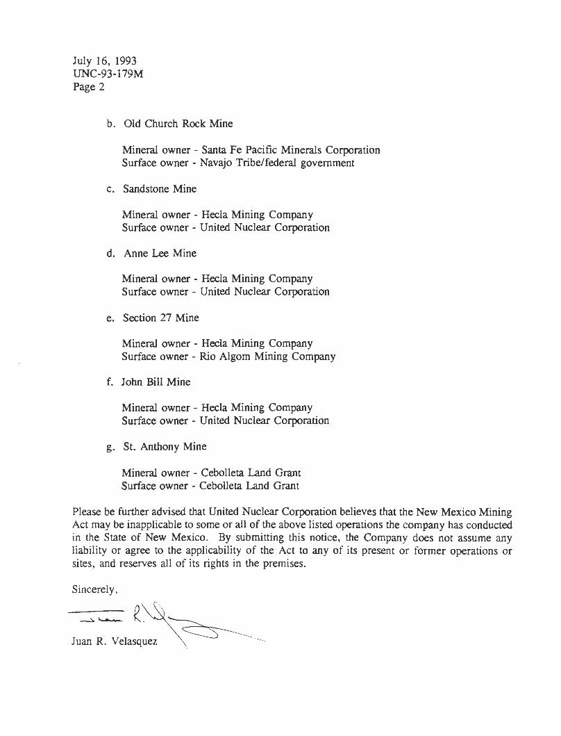
July 16, 1993 UNC-93-179M Page 2
b. Old Church Rock Mine
Mineral owner - Santa Fe Pacific Minerals Corporation Surface owner - Navajo Tribe/federal government
c. Sandstone Mine
Mineral owner - Hecla Mining Company Surface owner - United Nuclear Corporation
d. Anne Lee Mine
Mineral owner - Hecla Mining Company Surface owner - United Nuclear Corporation
e. Section 27 Mine
Mineral owner - Hecla Mining Company Surface owner - Rio Algom Mining Company
f. John Bill Mine
Mineral owner - Hecla Mining Company Surface owner - United Nuclear Corporation
g. St. Anthony Mine
Mineral owner - Cebolleta Land Grant Surface owner - Cebolleta Land Grant
Please be further advised that United Nuclear Corporation believes that the New Mexico Mining Act may be inapplicable to some or all of the above listed operations the company has conducted in the State of New Mexico. By submitting this notice, the Company does not assume any liability or agree to the applicability of the Act to any of its present or former operations or sites, and reserves all of its rights in the premises.
Sincerely, --c.~f,~ Juan R. Velasquez \ ·

~ SENDER: ~ ·;;; GI r! GI > !
• Complete items 1 and/or 2 for addit ional services. • Complete items 3, and 4a & b. • Print your name and address on the reverse of this form so that we can return this card to you. • Attach this form to the front of the mailpiece, or oo the back if space does not permit . - . b _ St J
I also w ish to receive the following services (for an extra fee):
1. 0 Addressee's Address
2. D Restricted Delivery _! • Write "Return Receipt Requested" on the mailpiece be ow the i I hu ber. ., • The Return Receipt will show to whom the article was delivered and the date c delivered. Consult ostmaster for fee. ~ 3. Article Addressed to: 4a. Article Number GI .. GI Q. E 0 u
Cl) Cl) w a: 0 0 <
Churchrock ISL SEC 17 P.O. Box 777 Crownpoint, NM 87313
. Z 062 024 046 4b. Service Type D Registered
W Certified
D Insured
0 COD D Return Receipt for
Merchandise f Delivery
Z -::--::-:-----:-:--:--:-----,--------iHi-HM-<o..c-Jl!:-:-if-iirt---:--:-c:-:----:-:::--:-c-:-:------, a: 5. Signature (Addressee) ::> I-~ c:------=--:------:--:-----:----::::---==--c----,---'1,--,:-1
* U.S.G.P.O. : 1992-307-530 DOMESTIC RETURN RECEIPT

t
State of New Mexico Mining and Minerals Division
2040 South Pacheco St. Santa Fe, NM 87505
Fax Cover Sheet
Date: /l/4 v 2, Jq 16
To: ~(// R(J h /,,., 56~ From: f?cberf y(P u ,.,_,:J
Company: Agency: Mining and Minerals Division
Telephone: Telephone: (505) 827-5970
Fax#: {5l))) 2 t '2 ~/8t4 Fax #: (505) 827-7195
Number of Pages: 3 (including cover sheet)
Message: /ls ;er l ov1 ,_ r~7ve1., / .' }
Folluw--/rn 1 ' Co// of ;VI /t1 D { , ~ t:7'-
r~ ftJ r I ' 1- e c /4 -">->1 (;f, It~ --i-. to on. / r/P r
C r/J t,,,.,,,"n / g 1 ~ t. Jf I Ca,,.._ I> e. 1-J RI -
"f a,,, l tv {Ae,- a s s 1 ,) I a. ,,,,,, , e f !~tt.5--t
ca// al g;;__ 7 -- II 78, "},-y7e
Original will be sent by mail _ yes ~

NEW :MlEJ O ENERGY, MKN1ER.Al§ & NAnm.AL RESOURCE§ DEPART:MlENT
Jennifer A. Salisbury CA81NET SECRETARY
Mr. Mark S. Pelizza Environmental Manager Hydro Resources, Inc. 12750 Merit Drive Suite 1210, LB 12 Dallas, TX 75251
September 29, 1995
OFF ICE OF THE SECRETARY 2040 South Pacheco Street Santa Fe, New Mexico 87505 (505) 827-5950
RE: Prior Reclamation Status, Church Rock Mine, McKinley County, New Mexico
Dear Mr. Pelizza:
The Mining and Minerals Division (MMD) has completed the inspection of reclamation measures at the Hydro Resources, Inc. (HRI) Church Rock Mine.
Based on findings enclosed in the enclosed inspection report, reclamation measures at HRI's Church Rock Mjne do not satisfy the requirements of the New Mexico Mirung Act (NMMA) and the substantive requirements for reclamation pursuant to the NMMA Rules. Therefore, pursuan to NMMA Rule 5 .1 0.B, HRI must submit a permit application and closeout plan for an existing mirung operation within six months of receipt of this letter. The enclosed prior reclamation inspection report details the findings of the inspection but does not include the photos/slides contained in the MMD file copy.
It is our understanding that HRI is proposing to license this facility with the Nuclear Regulatory Agency (NRC), for the purpose of in-situ mirung. Please inform the Division of the status of this license and what portions of the mine it will cover. It is possible that HRI may be exempt from any further requirements under the New Mexico Mining Act relative to the NRC license.

NEW l\1DEJ '.O ENERGY, M][NERAL§ & NAnmAL RE§OURCJE§ DlEl?AR.TI\IBNT
Jennifer A. Salisbury CABINET SECRETARY
OFFICE OF THE SECRETARY 2040 South Pacheco Street Santa Fe, Hew Mexico 87505 (505) 827-5950
MMD appreciates HRI's efforts to comply with the NMMA and commends them for their safeguarding and reclamation efforts. If you have any questions please contact Holland Shepherd of the Mining Act Bureau, (505) 827-5971.
Sincerely,
Dr. Kathleen A. Garland, Director Mining and Minerals Division
cc: Ms. Maxine Goad, New Mexico Environment Department Navajo Nation, Surface Owner
Enclosure

Robert Young
From: To: Subject: Date:
Robert ,
Holland Shepherd Robert Young Call Paluzza Wednesday, May 01, 1996 6:33AM
Please call Mark Paluzza of HRI to discuss his prior reclamation plans with him . He called Mon. and is waiting for me to call him back . Tell him you are looking at his stuff and still need to talk to me to work out the detail s. We need to give him a read on whether or not he must permit the place or ask for a var iance . His number= 214/387-7777.
Thanks
Holland
Page 1

uOVERNOR Gary E. Johnson
STATE OF NEW MEXICO
. .. '" I
DEPARTMENT OF GAME & FISH
DIRECTOR AND SECRETARY TO THE COMMISSION Gerald A. Maracchini
Maureen O' Shea Stone S.M. Stoller 5700 Flatiron Parkway Boulder, Colorado 80301
Re: Information Request
Dear Ms. Stone:
Vi llagra Building P. 0 . Box 25 11 2
Sama Fe. NM 87504
f'
April 30, 1996
STATE GAME CO:-JIMISSION
William H. Brininstool, Chairman Jal, N~
Jim Charlesworth Raton, NM
Gus Elgin Silver City, NM
Dr. William E.Schuler Albuquerque, NM
Steve Padilla Albuquerque, NM
Dr. Charles Mayer Albuquerque, NM
Gail J. Cramer Farmington. NM
Enclosed please find the Bison-M information you discussed with Rade Orell of my staff. The information reflects fish and wildlife species associations by land type for McKinley County. Also included is the species list of threatened and endangered species for McKinley County. The Department of Game and Fish (Department) hopes that this information assists you in your work on the proposed uranium in-situ mining operation near Crown Point, New Mexico.
During your conversation with Rade you also requested information concerning the Department' s preferred habitat classification system as described in Section 602.D, 13 .d. l of the New Mexico Mining Act. The Department does not specifically have a "preferred habitat classification system." You should include an evaluation of the vegetation types, topographic features, and aquatic areas, such as springs, seeps, and wetlands in your analysis. This information should then be used to evaluate the area with respect to fish and wildlife species.
You also requested information concerning collection and identification of threatened and endangered bat species. The Department does not recommend that S.M. Stoller pursue obtaining permits necessary for collection and identification of threatened and endangered bat species in New Mexico. Instead, the Department recommends that S.M. Stoller contact the University of New Mexico (UNM), Biology Department at 505-277-3411. The UNM Biology Department may be able to assist you in obtaining information about sensitive bat species that might inhabit the proposed mining area.

Ms. Maureen O'Shea Stone -2- April 30, 1996
If you require any additional assistance or wish to discuss this matter further, please contact Rade Orell at (505/827-1210).
Sincerely,
6 u,u/~, ~~f;;-:-uu, ,,
Andrew Sandoval, Division Ch ef Conservation Services Division
A VS/RHO/ksw
Enclosures
xc: <;Henna Dean (Office of Cultural Affairs, Historic Preservation Division) /John McKay (Permitting Coordinator, NMEMNR, MARB)
Maxine Goad (Surface Water Quality Bureau, Mining Coordinator, NMED) Jennifer Fowler-Propst (Ecological Services Supervisor, USFWS) Jerry Maracchini (Director, NMDGF) Dan Pursley (Northwest Area Operations Chief, NMDGF)
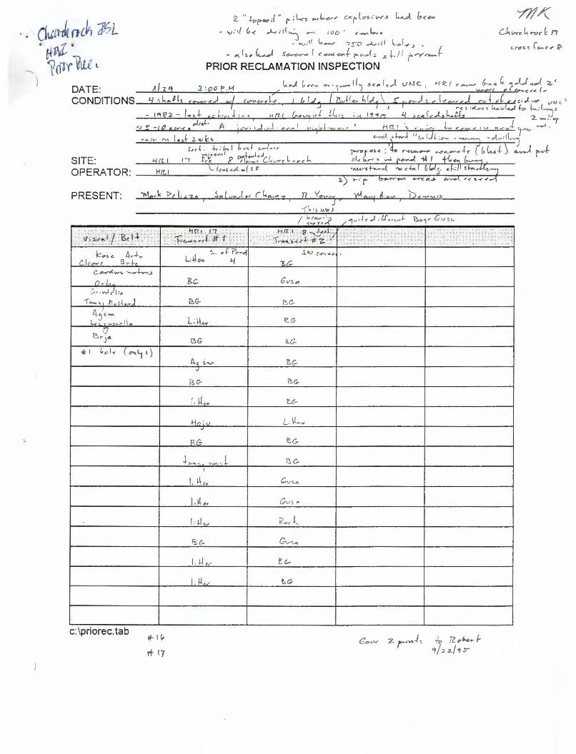
DATE: CONDITIONS
SITE: OPERATOR:
PRESENT:
e,.. ,w. )( :,
-r '-" Mvs~.,. J
0 ~ ... J ..
c: \priorec. tab It- ( (,,
rl- I 7
2 " ~ps,, ;{ ·· (> ;l..,..~ ..,l..e-, .- cx,-(.,~.-,,,......s W /.,c,;.«
- ..,,:,/ (,<- ..,L,- : d"'l ....... 100 · ,__..k,.,
- <-v:l l L.......,, 7:,o ,...J.., ;(( l ol-.,., _ - "1.(~, (,_.....,J r~~ ( ,,.__,_.,.,...(. /"""'-.J~ ,,.+. / / r.,..-r-.,-?
PRIOR RECLAMATION INSPECTION
S.,l,m,l.., cL..,.__,.. 7
e.G
i3G
J
/ , ~-N
or.. is(-
-L .. ,., .• , . .,,- l .
I.IL
"=-C-
IIL
.. ,.... .. i
n . '('"J•cc J >
---(~. , , w,, 5
Guv< z r ··.,._../ C Iv 7Z. ,,bbr l-"l/ 2-2./ 1:s-

PRESENT:
C~ .,..1)1,. -r...._ ... , Hus.\..,..)
c:\priorec. tab
2 "h,p,..,;(" (' ;l-<s ..,L...,,,, cx,-(,,,.,.,..,.s k...A l,,,.,..
- ..,.-,{ (.,_,, ..J--r:il~ ...,,. 100' ,_..Le...~ - 0v:l( L.....,,. '?ro ...t.,-11 1..,,(..,, ~ .
<>1. ls, (,___.l s~ ( .,._..__...+ ,- ... ...1,. .,, +./I r,y.-..... J PRIOR RECLAMATION INSPECTION
J
or..
+- -·---L.
Gv~ ..
I. 1.L.
I U

.. _ ..,,- ,f(,-t: ~L.-.-d~ - ~ ,oo· c.-1.... . j
_ i.,_,.•I l._ .....,,. ,:;-o _.1.,. 11 ~.,I .,,~ _ _ o1.I~ , l~.,.1 !~,. ( e.-.,_~..,_ f ,,--. ~I s sl, / 1 f"Y-'=?
DATE: CONDITIONS
PRIOR RECLAMATION INSPECTION
3 :oo P . 1-(
. .,. l
- l"H?2- l. ,L ,c/--y,1., , 11 {1/ ,,I.ts+•
'V 5 -, CJ &re:< , A ·)'t::r:, . d , c-i . .-..,. ~ 1
~k"" "" l .,J 2-<v~, ! ,, ~ . .j.,. , 1,... I i::v-. I ~.,.{.,,
SITE ~i,!-~"' pr(-... 1, ) I I
: 1'1 \'re cl~.~ • C~vrcl<n,c .<
OPERA TOR: _ __,;H~rz......,1 ____ 1...._ ,,_~s_,._.J._-_/_r_c __________ --,-____ .....:,L._~---J.-
PRESENT:
,:,. .. .,,1)1-.
-r-,._ /{ .. 5i,- J
c:\pnorec. tab
.<,,./ ,,~),._, r4,:,,.,..z
J
/, ~(N
+-ln . ,, V
-L .... _ .. ,,,~L I
L ~,.,
1: 1-1,,..
I. 1-L _,
isC-
J' 4'" ·~wa>
:i<'·., ........ ...... .. ...... ........... < : ..... ::,: · .. ·:-.: .. ?{ ........... .
.. . ..... .. .. ,/

' - I
STATE OF NEW MEXICO ENERGY, MINERALS AND NATURAL RESOURCES DEPARTMENT
Director Mining and Minerals Division
2040 South Pacheco St. Santa Fe, New Mexico 87505 Telephone: (505) 827-5970
MINING INSPECTION REPORT
Name of Operator: HRI Inc
Name of Mine: Church Rock Mine
Address:
Permit Number: No permit number, Prior Reclamation Site
Type of Mine: - SURFACE _x__ UNDERGROUND
Date of Inspection: April 22, 1997
Time of On-Site Inspection: 10:00 - 12:30
Weather Conditions: Warm, Sunny
Purpose of Inspection: Discuss reclamation of foundation and ponds still left at the site.
Inspector: Holland Shepherd Present During Inspection: Mary Ann Menetry, Environment Dept. ; Dan ·
Mccarn, Salvador Chavez, Ben Greigo, HRI
ENFORCEMENT ACTION TAKEN: NOTICE OF VIOLATION:# YES: NO: X -CESSATION ORDER: YES: NO: X
Time: On-Site: 2.5 Permit Review: 2 Travel: 4 Report Writing :_1
-
TOTAL INSPECTION TIME: 9.5 HOURS
NOTE:

tr
NARRATIVE:
INSPECTION April 22, 1997
HRI Church Rock Mine
This inspection was made at the request of the operator, to discuss reclamation approaches for the reclamation of remaining portions of the Church Rock site. The site had been reclaimed prior to the July of 1994, however MMD had not released the site completely under the prior reclamation requirements of the Mining Act. The operator had left the some of the foundations and ponds associated with the site. The operator had assumed that the site had been reclaimed since most of the safety and stability issues had been addressed by the earlier reclamation .
We recently sat down with Mark Pelizza and Dan Mccarn of HRI to discuss the future disposition of the site. The site is associated with the proposed insitu leaching project under the management of HRI. According to HRI, the NRC will be assuming full responsibility for reclamation of the remaining Church Rock disturbance and the future disturbance from insitu mining. However, HRI has elected to reclaim the remaining portions of the prior reclamation site to remove any further responsibilities for this portion of the Church Rock site under the Mining Act.
After walking the site with the operator we concluded the following :
1. The operator would place two feet of topsoil over all concrete slabs/foundations. The tops of the large concrete columns would be covered with at least 1 foot of topsoil.
2. The operator would attempt to break up any standing concrete walls or columns with a hydraulic jack prior to covering with topsoil.
3. The operator would look into to removing as much of the concrete foundations as possible to pond #1 prior to topsoil application.
4. Topsoil would be borrowed from the ponds which had been cleaned of all residues from the ion exchange process.
5. The pond embankments would be smoothed out and reclaimed in place. The operator will drill seed the ponds and the other areas still needing to be reseeeded.
6. I recommended that the operator use at least 3 grass species, 2 shrubs and 2 forbs for the seed mix to be applied to the site. We identified crested wheatgrass, indian rice grass, and sand dropseed already established at the site.

7. The operator will use at least 6 inches of topsoil over areas onsite that were used for ore and waste storage. Also , over areas where plants are not growing because of poor soil conditions.
8. The operator will place construction wastes ( concrete and metal) into pond # 1 and bury them. It was not determined at the time of inspection how much of the wastes would be placed in pond #1 .
We gave the operator, at the time of inspection, the option of placing the remaining unreclaimed disturbance under the NRC license or going ahead with the reclamation. I have since heard (April 25, 1997) that the operator wishes to proceed with the reclamation . The operator has submitted a variance request from the September 30, 1995 regulatory deadline to gain release from prior reclamation .
MAINTENANCE ITEMS:
complete reclamation of the site.
ENFORCEMENT ACTIONS TAKEN:
none
INSPECTOR'S SIGNATURE: ----------
,. '

. . ,
'(§)
~ ~
unlTF'l nUCLEAR CORP"RATIOn
6501 America 's Parkway N.E. Suite 1040
October 19, 1994
Mr. John Lingo Acting Director Mining and Minerals Division
Albuquerque, New Mexico 87110 Telephone 505/883-6901 FAX 883-0146
New Mexico Energy, Minerals and Natural Resources Department 2040 South Pacheco Street Santa Fe, New Mexico 87505
RE: Reply to August 25, & Various August 31, 1994 Letters
Dear Mr. Lingo:
{)L.. p Crtt/4/2CH (?o{__K:_
This letter is in reply to your August 25, 1994 letter regarding United Nuclear Corporation's (United Nuclear) position concerning the extent of it's obligations, if any, under the New Mexico Mining Act with respect to several mines . This also responds to the several letters dated August 31, 1994 regarding your notification that certain mining operations may require a site assessment.
We appreciated the opportunity to meet with your staff, Messrs. Shepherd, Jager, and Martinez, on September 16, 1994 to discuss these issues and clarify the circumstances, locations, and history of several of the mines. The following summarizes United Nuclear' s position with respect to the mining Act.
United Nuclear made a decision in 1984, several years·before ·the Act was passed, to discontinue it's mining operations, and has been and remains in the process of liquidating the remaining assets of it's former mining operations. As such, United Nuclear believes that all of the mine properties it operated are "abandoned" mines as contemplated by the Mining Act. United Nuclear currently holds no ownership or leasehold interest in these mines, and does not currently operate any of the mines.
United Nuclear believes that it has no obligation to comply with the permitting and other regulatory requirements of the New Mexico Act for these mines. The New Mexico Mining Act was never intended to cover the reclamation of abandoned mines, except to the extent that Section 19 of the Act creates the "inactive or abandoned non-coal mine reclamation fund" which was established "to conduct reclamation activities on abandoned or inactive non-coal mining areas." § 69-36-19 NMSA. Although it is apparent that an "existing mining operation" is defined in a manner that could include an inactive mining operation, there is no provision in the Act which establishes that a person who has no current ownership interest and is not currently an operator of an inactive mine is required by law to undertake the obligations of the Act. The Act refers to "the owner or operator" in the present tense, and makes no reference to any liability for former owners or operators. Absent any clear statutory provision stating that the Mining Act applies retroactively to cover an owner or operator of an abandoned mine, New Mexico case law is clear that the law will not be construed to apply retroactively . Psomas v Psomas, 661 P.2d 884, 887 (N.M. 1987). Federal laws containing similar language imposing regulatory liability

·'
October 19, 1994 Page 2
upon owners and operators have been construed to apply only to current, and not former, owners and operators. See Coburn v. Sun Chemical Corporation , 28 E .R.C . 1668 (E.D. Pa. 1988) (regulatory requirements of the federal hazardous waste management regulations apply only to current owners and operators , and past operators are not liable for current regulatory violations) .
The definition of "existing mining operations" serves an important purpose other than arguably subjecting inactive mines to reclamation requirements under the Mining Act. It establishes a cutoff regarding how recently an inactive mine must have been operated and in production to qualify as an "existing mining operation," rather than a "new mining operation" , if mining begins again. An inactive mine that does not meet the definition of "existing mining operation" does not qualify for the "grandfathered" authorization to operate before a permit is issued, and unless it was in operation when the Act was passed, would have to obtain a permit as a "new mining operation" before mining could be renewed. Therefore, this definition alone does not establish that persons who are not current "owners or operators" of inactive mining operations are subject to the regulatory requirements of the Mining Act and the rules .
In addition to the arguments presented above, parts or all of United Nuclear' s former uranium mines may be exempt from the Mining Act and the rules pursuant to the definitions of "mineral" and "mining" in the Act. While this letter focuses on certain arguments and provisions of the Act, United Nuclear does not intend to waive any other legal arguments it may have with respect to the New Mexico Mining Act's application to United Nuclear with respect to these mines. For example, we understand that MMD is still considering its position with respect to the application of the Act upon Indian lands .
Our position notwithstanding, the following is a discussion of each of the mines for which MMD had requested information.
Mac #1 and Section 31 Mines
At the September 16 meeting, we discussed with your staff the August 31 , 1994 notices received for the Mac#l Mine and the Section 31 Mine (Section 31 , Tl3N R9W). The Mac#l Mine , to the best of United Nuclear' s knowledge, is not an existing mining operation because it did not have at least two years of production after 1970. Furthermore, we understand that Homestake Mining Company, the successor to the UNHP Partnership, and to which Homestake is the successor in interest, has provided correspondence to MMD addressing this mine.
Regarding the Section 31 Mine, our information indicates that it was not operated by United Nuclear after 1970. Even so, at the meeting , MMD staff clarified that this mine is covered under an application submitted by Santa Fe Pacific Gold Corporation for inspection of the mine to evaluate prior reclamation.

October 19, 1994 Page 3
Anne Lee, John Bill and Sandstone Mines
As acknowledged during the meeting , United Nuclear has submitted applications dated August 26 , 1994 for inspection of "prior reclamation" for three mines in the Ambrosia Lake District, the Anne Lee Mine (Section 28, T14N, R9W), John Bill Mine (Section 34, Tl4N, R9W) , and Sandstone Mine (Section 34, T14N, R9W). These applications were submitted inasmuch as United Nuclear is the owner of the surface of these properties and the Mining Act is vague as to responsibility for such properties.
As discussed in the August 26 application and during the meeting, the Anne Lee Mine is located in the area determined to be a "Vicinity Property" by the U.S. Department of Energy (DOE) . DOE is in the process of cleaning up and reclaiming this property, pursuant to Title I of the Uranium Mill Tailings Radiation Control Act ("UMTRCA") as part of the cleanup, stabilization, and reclamation program being undertaken by the DOE for the Ambrosia Lake uranium mill and tailings facility. While our application requests a prior reclamation inspection for the Anne Lee Mine, United Nuclear asserts that this property should be determined to be subject to the exemption in the Act for facilities subject to regulation by the Nuclear Regulatory Commission. This exemption would clearly apply to facilities subject to NRC regulation under UMTRCA, the only difference being the agency that is administering the cleanup .
Old Church Rock Mine
As acknowledged during the meeting, United Nuclear understands that the current operator, Hydro Resources, Inc . (HRI) , has submitted a site assessment and prior reclamation application for the Old Church Rock Mine. This mine property is currently held by HRI, pursuant to a lease with Santa Fe Pacific Gold Corp . United Nuclear' s only remaining interest in this property is a . contractual royalty interest in any future production by HRI . United Nuclear understands that HRI is responsible to fulfill any and all obligations under the New Mexico Mining Act with respect to the Old Church Rock Mine.
Northeast Church Rock, Section 27, and St. Anthony Mines
United Nuclear leased the mineral estate for the Northeast Church Rock Mine (Section 35, T17N, R16W and Section 3, T16W, R16W) from what is now Santa Fe Pacific Gold Corporation, the current owner of the mineral estate. The surface of Sections 35 and 3 is owned by the United States in trust for the Navajo Tribe. United Nuclear owns a portion of the surface of Section 34, Tl 7N, R16W, by virtue of patented claims . Section 34 contains a small portion of the total NECR mine workings. All of the surface disturbance on Section 34 has been reclaimed.
United Nuclear ' s lease , expired as of December 31, 1993. As discussed at the September 16 meeting, United Nuclear and Santa Fe Pacific Gold Corporation have not yet resolved all issues regarding United Nuclear's remaining obligations, if any, under the lease.

October 19, 1994 Page 4
United Nuclear leased the mineral estate for the Section 27 Mine (Section 27, Tl4N, R9W) from what is now Hecla Mining Company, which, to the best of our knowledge, is the current owner of the mineral estate. To the best of our knowledge, the Marquez family owns the surface. United Nuclear's mineral lease for this property was released in March 1988, and United Nuclear has had no interest in this mine since then.
United Nuclear leased the mineral estate for the St. Anthony Mine (portions of Sections 19, 20, 29 and 30, TllN, R4W and Sections 23, 24, 25 and 26, TllN, R5W) from the Cebolletta Land Grant, which was and is the owner of both the surface and mineral estates. United Nuclear released this lease in November 1988, and United Nuclear has had no interest in this mine since then.
Once again, thank you for the opportunity to meet with your staff and to clarify United Nuclear's position on these matters. If you have any additional questions or comments regarding this letter or United Nuclear' s position, please feel free to contact us.
Sincerely,
Juan R. Velasquez

••
PRIOR RECLAMATION SITE SUMMARY
UNITED NUCLEAR CORP.
Contact: Juan Velasquez 1720 Louisiana NE 262-1800
The 3 UNC sites had a variance until the end of 1998. All that is said is that a determination will be made by MMD whether the release criteria are met.
Anna Lee Mine (T14N R9W 28): Total area addressed by Mining Act is 1/10 of an acre. Reseeded in fall , 1994. Inspected July 13, 1995. No perennials growing. Recommendations were to cover slab and reseed. Variance requested by UNC in June, 1997.
John Bill Mine and Sandstone Mine (T14N R9W 34): Total area is approximately 8 acres in two areas. Reseeded in fall , 1994. Inspected July 13, 1995. Vegetation was sparse. Steel scrap and buildings found at sites, presumably at request of leasee. Recomendations were to cover slab and submit a letter from leasee requesting that buildings and scrap be left on site. Variance requested by UNC in June, 1997.
Contact: Mark Pelizza 972-387-7777
Churchrock ISL SEC 17: Disturbed area is approximately 16 acres. HRI purchased property from UNC who did some reclamation work in 1990 or 1991 (removed head frames and most buildings, recontoured ore pads and covered shafts and vents). This is one of HRI's insitue leaching sites. Inspected on August 29, 1995. There were 5 ponds remaining up to this time. HRI agreed to reclaim these ponds in 1997.
NEWMONT GOLD (Santa Fe Pacific Gold)
Contact: Rick River Idarado Mining Co. P.O. Box 584 Ouray, CO 81427 (970) 325-4482 (970) 325-4853

...
Poison Canyon Mine (T13N R9W 19): The only SFPG prior rec site not released or that falls under the act. Site is 30 acres. MMD letter dated July 24, 1996 gives a 5 year variance from the 1995 date. The letter states that at the end of the 5 year variance "the Director will consider whether to extend this variance" . Originally reclaimed in 1987 with additional work in 1993 and 1994. Not released due to lack of diversity and poor establishment of grasses and forbes. SFPG purchased by Newmont (303-837-5069). Fence surrounds site. Topsoil depth presumably 4 inches.
QUIVIRA
MMD letter dated April 21, 1997 approving the variance request indicated only that sites will be inspected in the summer of 1997 and that those sites not released would be reinspected during the summer of 1998. MMD letter dated October 31, 1997 says that they must apply for another variance. Quivira response states that this was discussed with Holland and that the existing variance is good until end of 1998. No other corespondance on the matter was found.
Section 17 (Tl4N R9W): 22 acres Section 19 (Tl 4N R9W) 19 acres Section 22 (T14N RIOW): 37 acres Section 24 (T14N RlOW): 26 acres Section 30 (T14N R9W): 44 acres Section 30W (T14N R9W): 26 acres Section 33 (Tl 4N R9W): 28 acres
Inspected by MMD in 1995, 1997 and 1998.

- .., ' j -~ :hLB1_,1:;:i:_EPQUE
Fa '": ·11/e Cover S eet:
.Vo. ,.:
Date: /
T • !il &dl + s ff L
C mpany:
F x: S:+ 1 -i- /95 From:]) '7N {111 ~~
HR.I, Inc. . 2929 Coors Blvd. NW, Ste. 01 Albuquerque,NM 87120
Phone: (505)833-1777 Fax: (505)833-0777
·• (including this cover:) ~
!tlessa~1- • • o Comments:
c::·,~ -- - i;:--~~..-, c: 0' / (1-._,.•_,._) i::-...:1 . .) • .J ( ( I I . • .1. r'
HRI, Inc.

•
~
)
- --{ C) - --{ :o r-·o C5:J r,J
>
s1.or•r $5.61 •.
i $16.00 $0.00 ;\ -· - --- · - - . .:.·- ... I - ·l --- I ~-- I 0.00; .1.o.2 ... ·1 $32.00 I I - I $0.00
0.10 I o.<U I $50.oo 0.25
t ll,(U= ~~
lf-t2J's Su.'°-'"5 ff\,~ .. J)~lt.-o~~
I 90tt,t, °"'~ \
0.00 $8.03
$0.00 --·· $0.00 $91.01 $6.<U $1,548
$4.87 $6.81
$0.00 .11.sa $125.09 $8.29 $2,127
-- $4.32 $4.99 $3.49
Jtt?-§t !·- $11.31
d $3.60 $6.00
.•. $0.00
$0.00 $5.00 $7.00 . 0.00
$0.00
•. $11.31 '· $0.00
-1 $3,gg - $4.43
$1.60 $5.76 $8.98
$7.09 $2.22 $0.00 $0.0()
$0.00
$112.20 $101.32 $7.45 $6.74 $1,907 $1,722
::;
•·' u, i..n
I J.
J·, lJ"l
;{; ,_.
])
' to C [ I C rn :u 8 C rn
(..J, Cl (Jl
co w (.,-J
1":I -.) ~J ~J
·o GJ f\)
' ISl ~j

. ., !
! i
,__ _
r ~CEIVED RECEIVED , .,. /1•1R 2 91997 HRI, Inc. APR 291997
2929 Coors Road, NW - Suite 101 Albuquerque, NM 87120-2929 MINING & M~ERALS
u1v ,_, , ..
Monday April 28, 1997
Mr. Holland Shepherd
505-833-1777 Voice
Energy, Minerals and Natural Resources Department 2040 South Pacheco Street Santa Fe, NM 87505
Ref: Churchrock Mine Prior Reclamation
Dear Holland:
505-833-0777 Fax MINING & MINER.4t c: LIOV ••'"JN
Doc. No.: 970428A.DOC
Attached please find the proposed Public Notice for the Variance Request regarding the Churchrock Mine Prior Reclamation and the Variance Request. I would appreciate your comments and recommendations on the draft notice as well as the current list of persons requesting such notices from your office.
Mobilization for the additional work is scheduled for Monday, May 5, 1997. You and other members of your staff are welcome to visit during the work. We anticipate completion of the earthwork in about 10 working days. I appreciated your comments during the recent site visit on April 22, 1997, and am making arrangements to add the 3 grasses and 1 shrub that you recommended to the planting mix.
Yours sincerely,
Dan W. McCarn, Consulting Environmental Coordinator
Attachments: Proposed Public Notice Copy of Variance Request
cc: Richard Clement, President HRI Mark Pelizza, Vice President HRI - Environment Craig Bartels, Vice President HRI - Technology

' '
5•
D. McCarn
RULE 9 PUBLIC NOTICE FOR THE
HRI, INC. CHURCHROCK MINE NMMA VARIANCE APPLICATION
HRI, Inc. proposes to publish notice of the variance application as follows:
Mod #5
1. Notice provided by certified mail to owners of record, as shown by the most recent property tax schedule, of all properties within one-half mile of the permitted property on or before the newspaper publication date [Section 903 .A];
2. Notice provided by certified mail to all municipalities, counties, and tribal organizations within a I 0-mile radius of the permitted property on or before the newspaper publication date [Section 903 .B];
3. Notice published once in a newspaper of general circulation in McKinley County, the notice to appear in either the classified or legal advertisement sections of the newspaper, and at one other place in the newspaper calculated to give the general public the most effective notice, and shall be printed in both English and Spanish [Section 903.C];
4. Notice to be posted in at least four publicly accessible and conspicuous places on or before the newspaper publication date, including the entrance to the permitted property if it is publicly accessible and~ · uous [Se tion 903 .D];
5. Notice mailed 903 .E]
6. Notice mailetl to al rsons w ave madeJ itten, request to xhe Director for notice on or before the newspaper publication date [Section 903 .F] ; and
7. Notice mailed to the New Mexico Environment Department, the State Engineer, the New Mexico Department of Game and Fish, the New Mexico Forestry Division, and the State Historic Preservation Division [Section 903 .G].
HRI anticipates drafting the notice as follows on the attached page.
PUB NOT DOC 1 4/2819 7
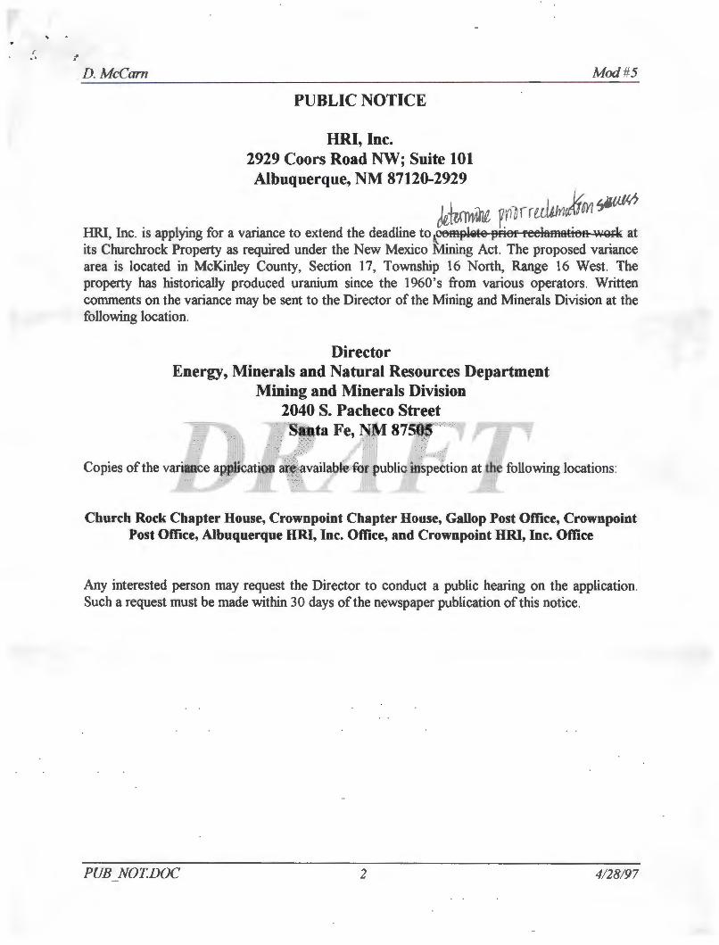
' .. .. ~· D. McCarn
PUBLIC NOTICE
HRI, Inc. 2929 Coors Road NW; Suite 101 Albuquerque, NM 87120-2929
Mod #5
k-\trmilii yri!rr~IYI 0 HR.I, Inc. is applying for a variance to extend the deadline to f6mplete 13rier reelamatit,R work at its Churchrock Property as required under the New Mexico Mining Act. The proposed variance area is located in McKinley County, Section 17, Township 16 North, Range 16 West. The property has historically produced uranium since the 1960's from various operators. Written comments on the variance may be sent to the Director of the Mining and Minerals Division at the following location.
Director Energy, Minerals and Natural Resources Department
Mining and Minerals Division 2040 S. Pacheco Street S'anta Fe, NM 8750 ,
' Copies of the variance application are available for public inspection at the following locations:
Church Rock Chapter House, Crownpoint Chapter House, Gallop Post Office, Crownpoint Post Office, Albuquerque HRI, Inc. Office, and Crownpoint HRI, Inc. Office
Any interested person may request the Director to conduct a public hearing on the application. Such a request must be made within 30 days of the newspaper publication ofthis notice.
PUB NOTDOC 2 4/28/97

:,
.. APR-21-1997 13:41 FROM URI/DALLAS TO ,.. • l::JJ.
HR/, INC. DDPL\C~1E
58!i6Soultl~ Sllile250, LBB
Cori,us Chr11ti, Teen 7&411 T~ie: (512)98'3-n31
Fw. (S12} Slm-5744
r.tcS.Pllzzl \'a Pl wldl,,t HlaDI, s.r.tyll'ICI ErMIOiii,MitllAffan
April 15, 1997
(A Sulleicfie,yofUranium Reaourcea, Inc.)
12750 Mertt Oliff Sulle1020,LB12
Dalles,Ten7S251 T~.e: (21•) 'JtfT-7777
Faa: (21-4) 'J17-7TT'iJ
Dr. Kathleen A. Garland, Director Energy. Minerals & Natural Resources Depanment Mining and Minerals Division Mining Act Reclamation Bureau 2040 South Pacheco Street Santa Fe, New Mexico 8750S
P.o ... m CNw,.pcaat. ,- fMldco ffl13
T...-,cue. (S05) 7a5645 Fer. (!D5} 75!i55S
RE: Request for Variance under 19 NMAC 10.2, Subpart 10, Churchrock Mine, McKinley County, New Mexico: TJ6N;R16W, Sections 8 and 17
Dear Dr. Garland:
HRI hereby requests a variance under 19 NMAC 10.2, Subpart 10, to extend the time for Prior Reclamation (Subpan 51 0.B) to December 3 J. 1998 for the Church Rock Mine located in Tl 6N, R16W, Sections 8 and 17.
HRI has been involved in a lengthy process licensing the Church Rock site for in situ leach unnium mining with the Nuclear Regulatory Commission (NRC}. This process has taken a longer time than we expected. The Final Environmental Impact Statement (FEIS) was completed several weeks ago by the NRC which recommended issuance of a license. During the time HRl was active in completing the FEIS process, the final reclamation work was delayed because of some uncertainty of how the issuance of a new license from the NRC would interact with the Prior Reclamation requirements ofEMNRD.
HRJ is requesting this variance because we believe that the .final steps in reclaiming the old conventional mine can be completed under the Prior Reclamation provisions before any new

r. 1 •• APR-21-1997 13:41 FROM URI/DALLAS
. fltl! to Dr. Dlhlttn A. (ial, ~~ Diroaor April IS, 1997 Page2 of3
TO r-.~,
disturbance is created under the regulatory authority of NRC. Also, having to go through the permitting process would result in costs, that we believe, would not be commensurate with the miPimal reclamation work which remains. Permitting the site under the Mining Act may also create duplicate and possibly contradictory jurisdiction over the site after NRC licensing. In other words, we would like to close the chapter on the old. underground mining activities at the site before we commence in situ mining activities. Please take note that HRI wilJ also be responSJole to NRC for a cash surety to reclaim both groundwater and all surface activities associated with ISL mining.
'lour staff completed their inspection of the Church Rock Mine and a repon was issued on September 29, 1995 in which they commended HRJ's effons to comply witli the New Mexico Mining Act. To date, reclamation has involved grading and contouring the ore pads, removal of mining equipment, the head frame and all buildings except the Ion Exchange building. All mine shafts were closed with welded plates and concrete pads. Natural vegetation has since reestablished itself over most of the area.
The report identified three minor, additional reclamation measures associated with concrete slabs of the mining buildings and the ponds including:
I. Removal and burial of all concrete slabs and foundations that can be safely removed without affecting the structural integrity of the mine shafts or their steel and concrete covers~
2. Grading of embankments around each pond;
3. Disking and reseeding ofbarren and disturbed areas.
At the present time, and based on your staffs repon, there exist no significant health, safety, or er.rvironmental problen-.s at tb~ site. The reques:cd r:'!cia.'!l~tio!1 work constitutes only a minor traction of the work that has already been conducted at the site and consists exclusively of aesthetic improvements of the landscape as requested by your staff
HR.I staff met with Holland Shepherd and Robert Young on April 10, 1997 to discuss the best method for concluding the prior reclamation work at the site. HRI agreed to begin the remaining work immediately and agreed with your staff that the best answer for the remaining concrete will be to cover the exposed concrete with soil and reseed with the appropriate grass mixtures as defined in the FElS. HR.I anticipates that the earth work and reseeding will be completed during May, 1997.

r .' 1 ~ . ~PR- 21-1997 1,j ;4~ t-t(Uf"l Ut(!/LJHLLH=i
. . ; ' '; fJ!I/D J)l. A 01I i DlirclOJ April 15, 1997 Pagel of3
I U r .t.1....,1
HRI would like to extend an invitation to your staff to observe the completion of the work at the site. We are concluding negotiations with the contractor at the present time, and anticipate that ltlltUp of activities will be u early as April 21, 1997. The earth work will be completed within 2 weeks of startup. We will inform your staff of the date of startup.
Enclosed is the fee for the variance application pursuant to Subpart 2, 201.K, in the amount of $500 payable to the Mining and Minerals Division.
V e:ry uuiy yours,
./111L i 1·
MarkS.Pelizz.a Vice President Health Safety and Environmental Affairs
Enclosure: HRl check for $500 variance request
cc: Dick Clement, HR.I D.W. McCam, HRJ

., . ·. 'J~ ~PR-21-1997 13:42 FROM URJ/DRLLRS TO r . t:1-.
I I .
. • l 7015
URI, INC. 1• rrr 12750 lllAn' DR.. SU~ 10120 LB 12
DAU.AS.TX 71Z11
N0U8TON, TX
PAY r-•
TO 'TliE
0ROER Of
Ufll. INC.
PH. CZ14) Sf•TTTT
.4/16/97 500.00 N•"• ENERGY, NINERALS & NATURAL RESOURCES DEPART"ENT 2040 South Pacheco Street Santa Fe, NM 87505
NAOUNT I - ClfflAL '"""· ACCT I
&o-...-(;,_~-----·----· --~ i --iaa--:sall;ll"'•.:E--~W?-=:a:••- --...... -m::a2: .. 11a:aa-t~
DETACH AHC M:T,_,N THIS lrTATEMENT "'-C afl'ac,...a C-«C"N •• .,. .,...,..,"""" Of"' "&.. osec-.so •c~ow. w NO" COlt•&C"'T' .._CAM ~ ue .-.o ... ~.. MO •cc•,.,. ac•••cc
DESCl'IPTION
Fee for the variance applicat i on/Churchrock mi ne/Sections 8 and 17 500.00
UNITED STATES
NUCLEAR REGULATORY COMMISSION WASHINGTON, D.C . 20555--0001
January 05, 1998
Mr. Richard F. Clement, Jr., President Hydro Resources, Inc. 2929 Coors Blvd., NW Suite 101 Albuquerque, NM 87120
SUBJECT: ISSUANCE OF SOURCE MATERIAL LICENSE SUA-1508, FOR THE IN SITU LEACH URANIUM MINING PROJECT AT CROWNPOINT, NEW MEXICO
Dear Mr. Clement:
The U.S. Nuclear Regulatory Commission staff has completed its review of Hydro Resources, lnc.'s (HRl 's) license application , dated April 25, 1988 (as supplemented by the licensee submittals listed in Attachment A of the enclosed source material license SUA-1508) , and the Crownpoint Uranium Project Consolidated Operations Plan (COP), Rev. 2.0, dated August 15, 1997 Based on its review of these documents as discussed below, the NRC staff hereby issues HRI a source material license SUA-1508 for its in situ leach uranium mining project at Crownpoint, NM, effective January 5, 1998.
The NRC staff determined, in accordance with 10 CFR 51 .20 and 10 CFR 51 .25, that preparation of an environmental impact statement (EIS) was necessary to document its review. The NRC staff issued a final EIS (FEIS) for the Crownpoint Project in February 1997 documenting its environmental review. Based on its review, the NRC staff concluded that HRl 's proposed Crownpoint Project was environmentally acceptable, and that potential impacts of the proposed project could be mitigated. These mitigative measures are enumerated as cond itions in the enclosed source material license.
In addition , the NRC staff conducted its safety review of the Crownpoint Project, and documented its analyses in the Safety Evaluation Report , dated December 4 , 1997. Based on its review, the NRC staff concluded that issuance of a source material license, with certain 1-:onditions specified in the enclosed license , would not be inimical to the common defense ar,d secu~:t:,; nr to the public's health and safety, and otherwise meets the appl icable requirement:- of ;o r:r-h . D;~ , ;~, 19, 20, 40, and 71, and the Atomic Energy Act of 1954, as amended .
. .. · ·. ~~-=: _.~~ . .-. ~he ,:'f:: !S provide the bases for the NRC's decision to issue a 10 CFH Part 40 .-,,·,, c·. rnater:..:1! license to HRI. As such , HRl 's source material license SUA-'150,9 is e •(.:, · ·: !', ' -· \_: 11id for [i,fi.: years from its effective date. HRI wiil be required to submit J lice: ·;e
••·-;: .ap,~licaflcn s:x months prior to the expiration date of January 5. 2003.

. ' -
R. Clement - 2 -
If you have any questions concerning this subject, please contact Mr. Robert Carlson of my staff at (301) 415-8165.
Enclosure: As stated
Docket No. 40-8968 License No. SUA-1508
Sincerely,
c=- .. ~:/cf✓ d✓ Joseph J. Holonich, Chief Uranium Recovery Branch Division of Waste Management Office of Nuclear Material Safety
and Safeguards

U.S. NUCLEAR REGULATORY COMMISSION
MATERIALS LICENSE
PAGE __ l_ oF __ 1_1 __
0 11rsuant to the Atomic Energy Act of 19.54. as amended. the Energy Reorpnization Act of 1974 (Public LI\\· 93-438 ). and Titl e 10. Code of !ral Regulations. Chapter I. Pans 30. 31 . 3'.! . 33. 34. 35. 36. 39. 40. and 70. and in reliance on statements and reprt'sentations heretofore made
tiy the licensee. a license is hereby issued authorizing the li censee to receive. acquire. possess. and transfer byproduct. source. and special nucl ear material designated below: to use such material for the purpose(s ) and at the place(s ) designated below ; to deliver or transfer such material to persons authorized to receive it in accordance with the regulati ons of the applicable Part(s). This license shall be deemed to n 1ntain the conditi ons specified in Section 183 of the Atomic Energy Act of 19.54, as amended . and is subj ect to all applicable rul es . regulations. and orders of th e Nuclear Regulatory Commission now or hereafter in effect and to an y conditi ons specified below.
SUA-1508 Hydro Resources, Jrlffnsee
. 2929 Coors Blvd, NW I. Suite 101 3. License Number
Albuquerque , NM 87120
2. January 5, 2003 4. Expiration Date
5. Docket or Reference No.
.qu-o:;oo
6. Byproduct. Source. and/or Special Nuclear Material
7. Chemical and/or Physical Form
8. Maximum Amount that Licensee May Possess at Any One Time Under Thi s Li\c1\se
Uranium Any Unl1m1ted
SECTION 9: ADMINISTRATIVE CONDITIONS
9.1
9.2
9.3
9.4 A)
The authorized place of use shall be the licensee's Crownpoint Uranium Project which includes the Crownpoint , Unit 1, and Church Rock uranium recovery and process ing facilities in McKinley County, New Mexico .
All written notices and reports required under this NRC license (with the exception of effluent monitoring reports required under License Condition (LC) 12.3 and 10 CFR Part 40.65 , which shall also be submitted to Region IV) shall be addressed to the Chief, Uranium Recovery Branch, Division of Waste Management, Office of Nuclear Material Safety and Safeguards, U.S. Nuclear Regulatory Commission , Mail Stop T-7 J9, Washington , DC 20555. Incidents and events that require telephone notification shall be made to the NRC Operations Center at (301) 816-5100.
The licensee shall conduct operations in accordance wi th all commitments , representations , and stateme 1ts made in :ts license application submitted by cover letter dated April 25 , 1988 (as supplemented by the licensee submitials listed in Attachment A) , and in the Crownpoint Uranium Project Consolidated Op~~ra:.in;1s !:,I an (COP) , Rev. 2 .0, dated August 15, 1997 -except where superseded by ii ccn_ 2 ,..:;,·:. !·.:fr:j._, n~; contained in this license . Whenever the licensee uses the words "will " or "sha ll" in the aforement ioned licensee documents , it denotes an enforceable license requiremc1 1t.
The licensee may, w ithou' (X ior l\ !RC ;·=>v iew ' ! approval: (i) make changes in the Crownpoint Projec t's facilities or pro ;;.;< -;:,::•:;; de ,·T:foed 1n the COP (Rev. 2 .0) ; (ii) make changes in its standc:irJ operalingy roc ·.J i s.: -,~n , i I ii\) ,·0rduC't tests or experiments , if the licensee ensures that the fo !!c;1,,•ing c.··,1~-,.' · .. •,.
(1) the cha ngP ··: -:; ! ,.y, , -1 1t1 iu with any requirement specifically stated :· I r ; ;·:1eet all applicable NRC regulat ions;
.. , .. , ~--~------- ·- · ·- · ·- · ·- - ·~·

illllIDIDWWWmmwwwwwwwwwwwwwwwwwwwwwwwwwwwwwwww-~~~~
j ,, NRC F~M 374A U.S. NUCLEAR REGULATORY COMMISSION , (7-94 ) . PAGE OF PAGES
B)
9.5
MATERIALS LICENSE SUPPLEMENTARY SHEET
L1ccns<· 'umtwr
SUA · 1508
Docke t or Reference r-.:umbcr
40 · 8968
(2) there is no degradation in the safety or environmental commitments made in the Crownpoint Uranium Project Consolidated Operations Plan (COP) , Revision 2.0, or in the approved reclamation plan for the Crownpoint Project ; and
(3) the change , test , or experiment is cons istent with NRC's findings in NUREG-1508, the Final Environmental Impact Statement (FEIS, dated February 1997) and the Safety Evaluation Report (SER, dated December 1997) for the Crownpoint Project.
If any of these conditions are not met for the change , test , or experiment under consideration , the licensee is required to submit a license amendment application for NRC review and approval. The licensee's determinations as to whether the above conditions are met will be made by a Safety and Environmental Review Panel (SERP) . All such determinat ions shall be documented, and the records kept until license termination. All such determinat ions shall be reported annually to the NRC, pursuant to LC 12.8. The reta ined records shall include written safety and environmenta l evaluations , made by the SERP, that prov ide the basis for determining whether or not the condit ions are met .
The SERP shall consist of a minimum of three individuals employed by the licensee , and one of these shall be designated the SERP chairman . One member of the SERP shall have expertise in management and shall be responsible for managerial and financial approval changes ; one member shall have expertise in operations and/or construction and shall have responsibility for implementing any operational changes ; and , one member shall be the Environmental Manager, with the responsibility of ensuring that changes conform to radiation safety and environmenta l requ irements . Add itional members may be included in the SERP as appropriate , to address technical aspects such as health physics , groundwater hydrology, surface-water hydrology, specific earth sciences , and other technical disciplines. Temporary members or permanent members , other than the three above-specified individuals, may be consultants.
As a prerequisite to operating under this license, the licensee shall submit an NRC-approved surety arrangement to cover the estimated costs of decommissioning , reclamation , and groundwater restoration . Generally, these surety amounts shall be determined by the NRC based on cost estimates for a third party completing the work in case the licensee defaults. Surety for groundwater restoration of the initial wel l fields sha ll be based on 9 pore-volumes. Surety shal l be ma intained at th is level until the number of pore volumes required to restore the groundwater quality of a product ion-scale well field has been establ ished by the restorat ion demonstrat ion described in LC 10.28 . If at any time it is found that we ll field restorat ion requ ires greater pore-volu_mes or higher restorat ion costs , the value of the surety will be adjusted upwards. Upon NRC approval, the licensee sha ll ma intain the NRC-approved financial surety arrangement consistent with 10 CFR Part 40 , Appendix A, Criterion 9.
Annual updates to the surety amount, required by 10 CFR Part 40, Appendix A, Criterion 9, shall be provided to the NRC at least 3 months prior to the anniversary date of the license issuance . If the NRC has not approved a proposed revision 30 days prior to the expiration date of the existing· surety arrangement, the licensee sha ll extend the existing arrangement, prior io P. '~pi r.itio 11 , fo, 1 year. ,,~-long with each proposed revision or annual update of the ';;urety the !icensee shall sub:nit support ing documentation showing a breakdown of the costs na !he bc:sis for the cost estimates with adjustments for inflation (i .e., using the approved
Urbun Consumer ~ri ce Index) , maintenance of a minimum 15 percent contingency, changes in '1nr,inccrir · p! .~~. ~;(.li•1 t: e::; '.,2rformed, and any othe r cond itions affecting estimated costs for .;.-.:~ ,::!t -. I
I it.>
.. '.A~M.\fh.:I_..Ull-A~-®.f!U!u~.m mm m rem m·m mm.mm rn l!\..'!:f.)~~ :~:¥J ~ P r r,1,.,: .-... , ,, I,,

~ ~ ~ ~ ~! ,;..1
~I ~, ~I .. ,
I
] ~, ) ':! ;:I ~;
' ,.
..: :
MATERIALS LICENSE SUPPLEMENTARY SHEET
Liccnsl' Number SUA -1 508
Docket or Re ference Numlx-r 40 - 8968
The licensee shall provide an NRC-approved updated surety before undertaking any planned expansion or operational change which has not been included in the annual surety update. This surety update shall be provided to the NRC at least 90 days prior to the commencement of the planned expansion or operational change.
The licensee shall also provide the NRC with copies of surety-related correspondence submitted to the State of New Mexico, a copy of the State's surety review, and the final approved surety arrangement. The licensee must also ensure that the surety, where authorized to be held by the State , identifies the NRC-related portion of the surety and covers the above-ground decommissioning and decontamination, the cost of off-site disposal , soil and water sample analyses, and groundwater restoration activities associated with the site. The basis for the cost estimate is the NRG-approved site closure plan or the NRC-approved revisions to the plan .
9.6 The licensee shall dispose of 11 e.(2) byprQduct material from the Crownpoint Project at a waste disposal site licensed by the NRC or an Agreement State to receive 11e.(2) byproduct material. At each project site , the licensee shall maintain an area within the restricted area boundary for storing contaminated materials prior to their disposal. The licensee's approved waste disposal agreement must be _maintained on-site. Should this agreement expire or be terminated , the licensee shall notify the NRC pursuant to LC 12.6. A new agreement shall be ratified within 90 days of expiration or termination of the previous agreement , or the licensee will be prohibited from further lixiviant injection .
9.7 The licensee shall implement and maintain a training program for all site employees as described in Regulatory Guide 8.31 , and as detailed in the COP of the approved license application . All training 'materials shall incorporate the information from current versions of
9.8
J
-,.: ·:.i.._;___
10 CFR Part 19 and 10 CFR Part 20 . Additionally, classroom training shal l include the subjects described in Section 2.5 of Regulatory Guide 8.31 . All personnel shall attend annual refresher training , and the licensee shall conduct regular safety meetings on at least a bimonthly basis , as described in Section 2.5 of Regulatory Guide 8.31
The Radiat ion Safety Officer (RSO) , or his designee, shall have the education , training and experience as specified in Regulatory Guide 8.31 . A Radiat ion Safety Technician (RST) shall have the qualifications specified in Regulatory Guide 8.31 . Any person newly hired as an RST shall have all work reviewed and approved by the RSO as part of a comprehensive tra ining program until appropriate course training is completed , and at least for 6 months from the date of appointment. ..
Written standard operating procedures (SOPs) _sha ll be estab lished and fo llowed fo r: (1) all operational activities involving rad ioact ive materials that are handled , processed , stored , or transported by employees ; (2) all non-operational act ivities involving radioactive materials including in-plant radiat ion protection and environmental monitoring ; and (3) emergency procedures for potential accident/unusual occurrences including significant equipment or facility damage , pipe breaks and spills , loss or theft of yellowcake or sealed sources , and significant fires . The SOPs shall include appropriate radiation safety practices to be followed in accordance with 10 CFR Part 2·0. SOPs for operat ionai activities sha ll enumerate pert inent ra diation safety practices to be followed. A copy of the cuffent written proced ure'"' shal be kept in the area(s) of the production fac ility w here they are utilized . All SOPs for activities described in the COP shall be-reviewed and _approved as presently desc:-:bed :n the COP
i~elease of equipment , materials, or packages from the res tricted area sha ll be in accordance wi th NRC staff position , "Guidelines for.Decontamin:1tion of F-1ci!:t: s and :=qu1pnier,t Prior 1c Relea e for Unrestricted u~e or Terminafo;rn of Licenses for ::3yprc11 .,~ or Sour--:c Materiais,"
J:J.--:; J : -
I~ , .
i~ '1
r, [! [! [! r,
~
MATERIALS LICENSE SUPPLEMENTARY SHEET
PAG E 4 OF 11 License· Numhcr
SUA· 1508
Dod:ct or Refert"nct' Number 40·8968
dated May 1987, or suitable alternative procedures approved by the NRC prior to any such release.
9.10 Any corporate organization changes affecting the assignments or reporting responsibilities of the radiat ion safety staff as described in the COP of the approved license application shall conform to Regulatory Guide 8.31 .
9.11 The licensee is hereby exempted from the requ irements of 10 CFR Section 20 .1902(e) for areas within the process facility , provided that all entrances to the facility are conspicuously posted in accordance with Section 20.1902(e}, and with the words , "ANY AREA WITHIN THIS FACILITY MAY CONTAIN RADIOACTIVE MATERIAL.".
9.12 Before engaging in any construction act ivity not previously assessed by the NRC, the licensee shall conduct a cultural resource inventory. All disturbances associated w ith the proposed development will be completed in compli e with the National Historic Preservation Act of 1966, as amended , and its implementing regulafions (36 CFR Part 800) , and the Archaeological Resources Protection Act of 1979, as amended , and its implementing regulat ions (43 CFR Part 7) .
In order to ensure that no unapproved disturbance of cultural resources occurs , any work resulting in the discovery of previously unknown cultural artifacts shall cease . The artifacts shall be inventoried and evaluated in accordance with 36 CFR Part 800, and no disturbance shall occur until the licensee has received written authorization to proceed from the State and Navajo Nation Historic Preservation Offices .
9.13 Prior to injection of lixiviant, the licensee shall have all applicable Memoranda of Agreements (MOAs) between the licensee and local authorities , the fire department , medical facilities , and other emergency services, ratified and in effect . At a minimum, the MOAs shall identify individual party responsib ilities , coord ination requirements , and report ing procedures for all emergency incident responses .
9.14 Prior to injection of lixiviant, the licensee shal l obtain all necessary permits and licenses from the appropriate regulatory authorities .
SECTION 10: OPERATIONS, CONTROLS, LIMITS, AND RESTRICTIONS
10.1 The licensee shall use a lixiviant composed of native ground water, carbon dioxide gas or sod ium bicarbonate , and dissolved oxygen or air, as specified In the COP of the approved license application .
10.2
10.3
10.4
The processing plant flow rate at each site (Church Rock, Unit 1, or Crownpoint) shal l not exceed 4000 gal/min (15 ,140 Umin) , exclusive of restoration flow. Total yel lowcake production from all three sites shall not exceed 3 mill ion lbs (1 :36 rnillion kg) ::i nually.
Injection well operating pressures shall be maintained at ~es~ 11 . ~~1 fo rmation f acture pressures , and shall not exceed the well 's rter.han;. :;il :n• .. k; 'i y •\}~.t pressure .
Or-ily steel or .fiber glass well c;:is ing sha!! be Jed at ~.-,.,i i l~i• ·: ,a \d Crovv11poj 1: t sites for all wells completed into the Dakota Sandstone, Westwater C:inyon. ~-11d Co Springs aquifers .
r, 10.5 A leak detection monitoring S";JSte :-- s:1 !:'- •~ in s;.j1: :1 • ·; _i, .. :1.:, Jr; µc.,n1js _ ,·he licensee ~ shall measure and document pond fn~ebo rd iid s:: :;: ,.· ··'" i·· :·.•. i ., .. • :""' "'tons, stem r, . daily, including weekends and ~1ol iday !f t\wi :- ·: · --, • . , •-• . .2 crri) are detected ~ .
15#.i m ro 11,;flin mm re m Zl!.. ro 21r 1111¥1. m mm m. zm. ~ . ]!I 1t1:m.1:,-·, -~ ..,_ ,_ •

10.6
10.7
10.8
10.9
10 10
10.11
10.12
MATERIALS LICENSE SUPPLEMENTARY SHEET
PAGE OF
License Number SUA - 1508
Docket or Reference Number
40 · 8968
in the leak detection sumps, the fluid in the sumps shall be sampled and analyzed for specific conductance and chloride. Elevated levels of these parameters shall confirm a retention pond liner leak, at which time the licensee shall take the following corrective act ions : (a) analyze standpipe water quality samples for leak parameters once every 7 days during the leak period , and once every 7 days for at least 14 days following repairs ; and (b) locate and repair the area of liner damage. After a confirmed leak, the licensee shall also file a report pursuant to LC 12.2. At all times , sufficient reserve capacity shall be maintained in the retent ion pond system to enable transferring the contents of one pond to the other ponds . In the event of a leak and subsequent transfer of liquid , the freeboard requirements may be suspended during the repair period .
At the Crownpoint site , from initial lixiviant injection through the completion of groundwater restoration activities, the licensee shall at all times maintain sufficient emergency generator capacity to provide a 50 gal/min (189 U min) bleed from the Westwater Canyon aquifer. The licensee shall document all requ ired use$ f the emergency generator, pursuant to LC 11 .1.
Liquid oxygen tanks shall be located w ithin the well fields. Other chemical storage tanks shall be located on the concrete pad near a waste retention pond . All yellowcake sha ll be stored inside the designated restricted area .
For all requ ired types of surveys , the licensee shall , at a minimum, use the survey locations, frequencies , and lower limits of detection established in Table 2 of Regu latory Guide 8.30. Additiona lly, all radiation survey instruments shall be operat ionally checked in conformance with Regu latory Guide 8.30.
The licensee shall ensure that the manufacturer-recommended vacuum pressure is maintained in the drying chamber during all periods of yellowcake drying operations . This shall be accomplished by continuously monitoring differential pressure and installing instrumentation which wil l signal an audible alarm if the air pressure differential falls below the manufacturer's recommended levels . The alarm's operability shall be checked and documented da ily. Additionally, yellowcake drying operations shall be immediately suspended if any emission control equipment for the yellowcake drying or packaging areas is not operating within specifications for design performance .
All liquid effluents from process build ings and other process waste streams, with the exception of sanitary wastes , shall be disposed of in accordance with the requ irements of 10 CFR Part 20, Subpart K.
Within restricted areas , eating sha ll be allowed only in designated eating areas .
· An excurs ion shall have occurred if, in any monitor well : (a ) any two upper control limit parameters exceed their respective upper control limits; or (b) a single upper contro l limit parameter exceeds its upper contra: lirn1· by 20 percent . A verification sample sha ll be taken within 24 hours after : ,suits of the first analyses are rece ived. If the second sample shows that either of the excurs ion criteria in (a) or (b) are present , an excursion shall be confirmed . If the second s;:1mple e:1.J<jf: ,~ot show 'L :1 :'lt the exr, '.: r~10 11 criteria in (a) or (b) are present, a th ird sample sha ll be taken w it11in 118 hours after the second set of sampling data was acquired. If the th ird samp!,. shc-v,'!'.: ~;·10 · -~i the of the ca-..curs1on criteria in (a) or (b) are present , an excursion sh I! :.ie G•:. fin ::ed. ;f tl'lc t. ird -am,:>le does not show that the excursion criteria in (a) or ( ) are pr sent the fir:/ ,·~mpl-" ' r.a il be considered to be an error.
~ : ~ ~ ~ i ~ ! ~
11
• NRC FORM 374A (7-94) · .
10.14
10.15
10.16
10.17
10.18
10.19
10.20
~vw~u
U.S. NUCLEAR REGULATORY COMMISSION
MATERIALS LICENSE SUPPLEMENTARY SHEET
PAGE
License Number
SUA-1508
Docket or Refere nce Number
OF PAGES
increase the surety in an amount to cover the full third-party cost of correct ing and cleaning up the excursion. The surety increase for horizontal and vertical excursions shall be calculated using the method described on page 4-22 , Section 4.3.1 of the FEIS. The surety increase shall remain in force until the NRC has verified that the excursion has been corrected and cleaned up. The written 60-day excurs ion report , filed pursuant to LC 12.1, shall identify which course of action [(a) or (b) listed above] the licensee is taking .
At the Unit 1 or Crownpoint sites , if a vertical excursion is confirmed in the Dakota Sandstone aquifer, the licensee shall complete and sample monitor wells to determine if the vertical excursion has impacted any other overlying aquifers that could sustain yields greater than 150 gal/day (568 Uday). The specific aquifers to be monitored shall be identified in the licensee's 60-day excursion report , filed pursuant to LC 12.1.
At the Crownpoint site , from initial lixiviant injection through the completion of groundwater restoration activities, the licensee shall maintain a continuous bleed (pumping) until the groundwater quality in the well fields has been determined by the NRC to be fully restored to the required limits established pursuant to LC 10.21 .
During groundwater restoration activities at production-scale well fields within either the Unit 1 or Crownpoint sites , the licensee shall reimburse the operators of the Crownpoint water supply wells for any increased pumping and well work-over costs associated with a drop in water levels due to groundwater restoration activities . This reimbursement requ irement does not apply to restoration demonstrations of small-scale well fields .
Prior to injection of lixiviant in a well field , monitor wells shal l be completed in the Westwater Canyon aquifer and shall encircle the well field at a distance of 400 ft (122 m) from the edge of the production or injection wells and 400 ft (122 m) between each monitor well . The angle formed by lines drawn from any production well to the two nearest monitor wells shall not exceed 75 degrees. At the Church Rock site , Westwater Canyon aquifer monitor wells shall be located by treat ing production mine workings as if they were injection or product ion we lls. Sampling frequencies for all monitor wells completed in the Westwater Canyon aquifer shall be as stated in LC 11 .3.
Prior to injection of lixiviant in a well field at the Unit 1 or Crownpoint sites , monitor wells shall be completed in the Dakota Sandstone aquifer. Such wells shall be placed at a minimum density of one well per 4 acres (1 .62 ha) of well field . Sampl ing frequencies for these we lls sha ll be as stated in LC 11 .3.
Prior to injection of lixiviant at the Unit 1 site , the licensee shall complete a minimum of three monitor wells in the overlying Dakota Sandstone aquifer between the wel l fields and the town of Crown point water supply wells, in addition to the wells required by LC ·10.1 s :· Groundwater restoration goals and upper control limits for these wells will be establ ished pursuant to LCs 10.21 and 10.22 , except that upper control limits shall be established for these wells on a well-by-well bas is . ampling freq uencies for these wells shall be as stated in LC 11 .3.
Prior to injecti on cf ii>::" iP.ni in a well field-at the Church Rock site ,: rnohitor well s shall be completed in : (a) the 3ru~hy Basin "B" sand aquifer; and (b) the Dakota Sandstone aquifer Monitor wells completed in the Brushy Basin "B" sand aquifer shall be placed at a minimum density of one wel l pei 4 acres (1 .62 ha) of we ll field . Monitor wells completed in the Dakota sandstone aquifer sha!! be placed at a minimum density of one well per:s acres (3. 24 ha) of . ell fie I . An , o, em1 :g5 of tile existing mine workings into the Brushy B'as in "B'' san• , or ) ;;kr.,ta - and t 11:: ,ilJ,uifers, shall be monitored by Brushy Basin "B" sand or Dako a
Sandst ne m ; itor wuiis placed with in 40 ft (12 m} of the openings. These wells shall be . )
:~ }.~ ..J.,WJJ mm ffi mm m re.mm mm m1!~.Z!Vru!v1u,w:-r~:i,g! ,~• 7- ·; , ... ~ . , ..
NRC FGRM 374A . (7-94) '
U.S. NUCLEAR REGULATORY COfJIMISSION
MATERIALS LICENSE SUPPLEMENTARY SHEET
PAGE OF PAGES
Liccns..- Number
SUA-1508
Docket or Reference Number
40-8968
placed down-gradient from the openings . Sampling frequencies for all monitor wells completed in the Brushy Basin and Dakota Sandstone aquifers shall be as stated in LC 11 .3.
10.21 Lixiviant shall not be injected into a well field before groundwater quality data is collected and analyzed to establish groundwater restoration goals for each monitored aquifer of the well field, as follows :
A) The licensee shall establish groundwater restoration goals by analyzing three independently-collected groundwater samples of formation water from : (1) each monitor we ll in the well field ; and (2) a minimum of one production/injection well per acre of well field . Samples shall be collected a minimum of 14 days apart from each other. Groundwater restoration goals shall be established on a parameter-by- parameter basis , with the primary restorat ion goal to return all parameters to average pre-lixiviant injection conditions. If groundwater qua lity parameters cannot be returned to average prelixiviant injection levels, the secondary goal shall be to return groundwater quality to the maximum concentration limits as specified in the U.S. Environmental Protection Agency (EPA) secondary and primary drinking water regulations . The secondary restorat ion goal for barium and fluoride shall be set to the State of New Mexico primary drinking water standard . The secondary restoration goal for uranium shall be 0.44 mg/L (300 pCi/L) .
B) In establishing restoration goals , the following parameters shall be measured : alkal inity, ammonium , arsenic, barium, bicarbonate , boron , cadmium , calcium , carbonate , chloride , chromium, copper, fluoride , electrical conductivity, iron, lead , magnesium, manganese , mercury, molybdenum, nickel , nitrate , pH , potassium , combined radium-226 and radium-228, selenium, sodium, silver, sulfate , total dissolved solids , uranium, vanadium , zinc, gross Beta , and gross Alpha (excluding radon , uranium, and rad ium). The restoration goal for each of these parameters shall be establ ished by ca lculating the baseline mean of the data collected . Prior to calculat ing a groundwater restorat ion goal for a parameter, outliers shall be eliminated using methods cons istent with those specified in EPA's 1989, "Statistical Analysis of Ground-Water Mon itoring Data at RCRA [Resource Conservation and Recovery Act] Facilities, Interim Guidance." Parameter concentrations determined to be high or low outliers will not be used in estab lishing groundwater restoration goals .
10.22 Lixiviant shall not be injected into a well field before groundwater quality data is collected and analyzed to establ ish upper control limits for each monitored aquifer of the well field , as follows :
A) The licensee shall analyze three independently-collected groundwater samples of formation water from each monitor well in the we ll field . Samples shall be collected ;:; minimum of 14 days apart from each other.
B) The upper control limit parameters sha ll be ch loride, bicarbonate , and electrical conductivity [corrected to a temperature of 25°C (77°F)]. The concentrations of these upper control limit parameters shal l be estab ished for each we ll fi ·..,y -: ;:,: ·:• ,iati, g ti1e baseline mean of the upper contro l limit parameter concentration, and :Jddi ,g 5 tand ;:; rci deviations . Prior to c~lculating upper control limits , o:.itliers sh II be Ii '1 ina t d u~i g methods consistent with those specified in EPA's 1989, "Sta istical • nalysis of Ground-Water Monitoring Data at RCR A Facilities , Interim Gui anr: " ·,,·_:.:, . .:>-; determined to be high and low outliers will net b:e used in the calcL.k ;: ,_;,, 1;: 't , limits .
-...
"NRC FO~M 374A _ (7-94) -
U.S. NUCLEAR REGULATORY COMMISSION
MATERIALS LICENSE SUPPLEMENTARY SHEET
PAGE OF PAGES
License Number
SUA · 1508
Docke1 or Reference Number
40-8968
SECTION 12: REPORTING REQUIREMENTS
12.1 The licensee shall notify the NRC by telephone within 24 hrs of confirming a lixiviant excursion, and by letter within 7 days from the time the excursion is confirmed, pursuant to LC 10.12. A written report describing the excursion event, corrective actions taken , and the corrective action resu lts shall be submitted to NRC within 60 days of the excursion confirmation . If wells are still on excursion when the report is submitted , the report shall also contain a schedule for submitting additional reports to the NRC describing the excursion event, corrective actions taken , and results obtained . In the case of a confirmed vertical excursion , the report shall also contain a projected completion date for characterization of the extent of the vertical excursion .
12.2 The licensee shall notify the NRC by telephone within 48 hours of confirming a retent ion pond liner leak, pursuant to LC 10.5. A written report shall be submitted to the NRC within 30 days of the leak confirmation. This report shall include analytical data, describe the corrective action taken , and discuss the results of that action .
12.3 The licensee shall submit the required effluent reports in accordance with 10 CFR Part 40.65. The licensee shall submit the information specified in Section 7 of Regulatory Guide 4.14, in addition to the reports required by 10 CFR Part 40.65 .
12.4 The licensee shall notify the NRC by telephone within 48 hours of any spill of source or 11e.(2) byproduct materials , and all spills of process chemicals, that might have a radiological impact on the environment. The notification shall be followed, within 7 days, by submittal of a written report detailing the conditions leading to the spill , corrective actions taken , and results achieved . This shall be done in addition to meeting the requirements of 10 CFR Part 20 and 40.
12.5 In addition to reporting exposures of individuals to radioactive material in accordance with 10 CFR Part 20.2202 , the licensee shall submit to the NRC a written report within 30 days of such reportable incidents , detailing the conditions leading to the incident, corrective actions taken , and results achieved .
12.6 In the event the licensee's approved waste disposal agreement expires or is terminated , the licensee shall notify the NRC in writing within 7 working days after the expiration date.
12.7
12.8
As part of the licensee's decommissioning activi ties for a site, the licensee shall submit to the NRC for review and approval a detailed site reclamation plan . The plan shall be submitted at least 12 months prior to the planned final shutdown of uranium extraction operations at the site . If depressions appear at the land surface due to subsurface collapse from in situ leach uranium extraction activities, the licensee sha ll return the land surface to its general contour as part of the surface reclamation activities . Before release of any site to unrestricted use, the licensee shall provide information to the NRC verifying that radionuclide concentrations , due to licensed materials, meet radiat ion standards for unrestricted release .
The licensee shall provide in an annual report to NRC, a description of all changes, tests , and experiments made or conducted pursuant to LC 9.4 , including a summary of t e safety and envi ronmental evaluation of each such act ion . As part of this annual report , the license shall include any COP pages revised pursuant to LC 9.4 .
! : ; s ij ii
· NRC F~RM 374A • (7-94) •
U.S. NUCLEAR REGULATORY COMMISSION
MATERIALS LICENSE SUPPLEMENTARY SHEET
PAGE OF
License Number
SUA·1508
Docket or Reference Number
40-8968
FOR THE NUCLEAR REGULATORY COMMISSION
Date: ~ ~ /9'1:5' Joseph J. Holonich, Chief Uranium Recovery Branch Division of Waste Management Office of Nuclear Material Safety
and Safeguards
\
<' -•.. ..
PAGES
• ~J!l.1'12'1llr1JJ.111ID~.,!J'!,~4~'l:!1.7J~\- •i\:~ ,..~_c;;--,.--;;.:z~•.1TI·~,~-;?,s;:-•_.75,;,~~,i-'-·,.;;;,· ;--;;;;~c-;:;;:;~~-l~liliJJ~]1i~~lJ~j~j~jtit i~iuiuiutu!J~

'--
' -
ATTACHMENT A
The licensee shall conduct its operations in accordance with all commitments, representations, and statements made in the following submittals, which are hereby incorporated by reference, except where superseded by license conditions in this license:
May 8, 1989 (Crownpoint Facility Supplemental Environmental Report) July 13, 1989 (Crownpoint Cultural Resources Survey) January 6, 1992 (Unit 1 Allotted Lease Program Environmental Assessment (EA)) July 31, 1992 (Unit 1 and Crownpoint Project Environmental Reports) October 9, 1992 (Unit 1 Underground Injection Control (UIC) Application) October 30, 1992 (Cultural Resources-Environmental Assessment and Management Plan for Crownpoint, NM) March 16, 1993 (Churchrock Project Revised Environmental Report) March 16, 1993 (Section 9 Pilot Summary Report)
-April 5, 1993 (page changes) April 6, 1993 (page changes) July 26, 1993 (page changes) October 11 , 1993 (page changes) October 18, 1993 (Analysis of Hydrodynamic Control at Crownpoint and Churchrock) October 19, 1993 (Churchrock Surface Hydrology Analysis) October 19, 1993 (Churchrock and Crownpoint Aquifer Modeling Supplement) November 11 , 1993 (page changes) January 24, 1994 (page changes) November 20, 1993 (Response to NRC Request for Additional Information) February 23, 1994 (Description of Radon Emission Controls) January 6, 1995 (EA Allotted Lea~e Program Unit 1) October 9, 1995 (Unit 1 UIC Application) February 20, 1996 (Response to NRC Comments) April 10, 1996 (Response to NRC Comments) May 3, 1996 (Response to NRC Comments) June· 18, 1996 (Unit 1 Water Quality Information) August 15, 1996 (Response to NRC Comments)
· August 16, 1996 (Response to NRC Comments) - __ August 21 , 1996 (page changes)
August 30, 1996 (Response to NRC Comments) September 5, 1996 (Surface Water Drainage Analysis at Churchrock) September 6, 1996 (page changes) September 13, 1996 (Response to NRC Comments) September 27 L.1996 (Response to NRC Comments) September 30, 1996 (Crownpoint Uranium Project COP, Rev. 0.0) October 1.5., 1996 (Response to NRC Comments) October 18, 1996 (Restoration Standards Commitment) October.20, 1996 (Response to NRC Comments) October 29', ·1996 (Response to NRC Comments) November 1 a, 1996 (Response to NRC Comments) November 26, 1 96 (Response to NRC Comments) December 20, 1996 (NRC Proposed Requirements and Recommendations) December 26, ·i996 (HRI Acceptance Letter to NRC Proposed Requirements and Recommendations) April 1, 1997 (NP"' Proposed Requirements) April 25, 1997 (HHl Ac;ceptancs L~tter to NRC Proposed Requirements)
fMa~· 15, 199? {Grownpoint Uranium Project COP, Rev 1.0) June 16, 1997 (Churc' ,rock D .sign Specifications for Surface Water Diversion Channel) J i__,i/ ,, ~997 (! RI _: .. ,,-,··:,-: ;"''::•p;er Supply Commitment) r, " gu . t .,. , ; "':',·(',7 , ,~. -- ... ,,, .,,. to NRC Comments) ,·u ... ~,, , ...:, i ..:, i.J ~ \ t ,1 ... ~.~.:_ ;U h. v I
Octob r :-,4, 1: ~-, (! Cl .~. , .... ':' ,1itment on Groundwater Baseline Sampling)

/
March 29, 1996
TO:
THRU:
FROM:
RE:
Jennifer Salisbwy, Secretary EMNRD
Kathleen Garland, Director MMD
Holland Shepherd, Bureau ChiefMARB tf Fax fro:n URI Concerning Meeting with the Governor on April 2, 1996
This memo is in response to your request for further information regarding the proposed in-situ leaching (ISL) operation to be conducted by Hydro Resources, Inc. (HRI) a subsidiary of Uranium Resources, Inc. (UR1) of Dallas, Texas.
Background Information
• The site is to involve an existing uranium facility, the Church Rock mine and a new facility, the Crownpoint Project. The whole project is entitled the Crownpoint Uranium Mining Project. The two sites are separated by about 15 miles.
• Located near Gallup, NM. About 30 miles West.
• The surface ownership is Indian. The site is located on Navajo Indian trust lands. The mineral ownership is federal. The uranium minerals are open to location under the 1872 Mining Law.
• A draft EIS has been developed jointly with the BIA, BLM and NRC. The DEIS addresses complete reclamation of tht. site.
How it Relates to MMD Permitting
• HRI made a prior reclamation request in June, 994, for the Church Rock site. The site was evaluated for prior reclamation and denied release September 29, 1995 (see attached letter from MMD). The letter informs HRI that a permit application will be required by mid April, 1996. A permit will be required unless HRI is able to convince MMD that the NRC license will address the whole site.
• In lieu of submitting a permit application, a variance from the prior reclamation deadline, finish the reclamation on the site and eventually gain release under prior reclamation.
• It is possible that in this case the NRC license covers the entire site. We won' t know until we sit down with the operator to discuss the details .
• The new ISL proposal will not involve address old portions of this site, such as old stopes.

•
. , .
I
page 2 URl
• HRI has not yet responded to our September 29, 1995 letter, which denied prior reclamation release.
Similar Operations
• Currently, we are under negotiations with another operator, Quivira Mining, regarding their Section 24 Mine, to permit an old stope leaching operation, which is also addressed, in part under an NRC licem:.! (see attached MMD letter dated March 15 , 1996). The BLM and BIA are not involved in this site, which is probably why no detailed reclamation plan exists for it when compared to the Crown point permit.
Issues
• What degree of involvement in this site will MMD have in this project?
• What are the environmental impacts of ISL? The memo from URI indicates that the process is environmentally benign. I disagree. The operator proposes to inject a solution containing high levels of dissolved oxygen and sodium bicarbonate. This solution will oxidize and mobilize uranium minerals and other minerals. The DEIS talks about removing contaminated groundwater and lixiviant from the ore zone, treating the water to concentrate the contaminants, and reinjecting the purified water. I have attached a table from the DEIS which show the chemical composition of the lixiviant water quality as it relates to natural back ground water quality.
• The processing plants identified in the DEIS will be operated at 4000 gpm.
• Obviously there will be some water quantity and quality · ssues related to this site.
• The operator will need to obtain an Underground Injection Control (UIC) permit from ED. This will probably take some time, because of the highly technical nature of the project and the possibility for groundwater contamination.

NRC FORM 313 U.S. NUCLEAR REGULATORY COMMISSION APPROVED BY 0MB: NO. 31~--01 20
(10-94) EXPIRES 6-30-96
ESTIMATED BURDEN PER RESPONSE TO COMPLY W ffi-1 THIS 10 CFR 30, 32. 33 INFORMATION COLLECTION REQUEST: 9 HOURS. SUBMITTAL OF THE 34. 35, 36, 39 and 40 APPLICATION IS NECESSARY TO DETERMINE THAT THE APPLICANT IS
QUALIFIED AND THAT ADEQUATE PROCEDURES EXIST TO PROTECT THE PUBLIC HEALTH AND SAFETY. FORWARD COMMENTS
APPLICATION FOR MATERIAL LICENSE REGARDING BURDEN ESTIMATE TO THE INFORMATION AND RECORDS MANAGEMENT BRANCH (T-6 F33), U.S. NUCLEAR REGULATORY COMMISSION, WASHINGTON, DC 20555-0001 , AND TO THE PAPERWORK REDUCTION PROJECT (315().()120), OFFICE OF MANAGEMENT AND BUDGET, WASHINGTON, DC 20503.
INSTRUCTIONS: SEE THE APPROPRIATE LICENSE APP LICATION GUIDE FOR DETAILED INSTRUCTIONS FOR COMPLETING APPLICATION. SEND TWO COPIES OF THE ENTIRE COMPLETED APP LICATION TO THE NRC OFFICE SPECIFIED BELOW.
APPLICATION FOR DISTRIBUTION OF EXEMPT PRODUCTS FILE APPLICATIONS WITH: IF YOU ARE LOCATED IN:
DIVISION OF INDUSTRIAL AND MEDICAL NUCLEAR SAFETY ILLINOIS, INDIANA. IOWA. MICHIGAN, MINNESOTA, MISSOURI, OHIO, OR WISCONSIN, OFFICE OF NUCLEAR MATERIALS SAFETY AND SAFEGUARDS SEND APPLICATIONS TO: U.S. NUCLEAR REGULATORY COMMISSION
WASHINGTON, DC 20555-0001 MATERIALS LICENSING SECTION
ALL OTHER PERSONS FILE APPLICATIONS AS FOLLOWS: U.S. NUCLEAR REGULATORY COMMISSION, REGION Il l
801 WARRENVILLE RD.
IF YOU ARE LOCATED IN: LISLE, IL 60532-4351
CONNECTICUT, DELAWARE, DISTRICT OF COLUMBIA, MAINE, MARYLAND, ALASKA, ARIZONA. ARKANSAS, CALIFORNIA, COLORADO, HAWAII , IDAHO, KANSAS,
MASSACHUSETTS, NEW HAMPSHIRE, NEW JERSEY, NEW YORK, PENNSYLVANIA, LOUISIANA, MONTANA. NEBRASKA, NEVADA, NEW MEXICO, NORTH DAKOTA,
RHODE ISLAND, OR VERMONT, SEND APPLICATIONS TO: OKLAHOMA, OREGON, PACIFIC TRUST TERRITORIES, SOUTH DAKOTA, TEXAS, UTAH, WASHINGTON , OR WYOMING, SEND APPLICATIONS TO:
LICENSING ASSISTANT SECTION NUCLEAR MATERIALS SAFETY BRANCH NUCLEAR MATERIALS LICENSING SECTION U.S. NUCLEAR REGULATORY COMMISSION, REGION I U.S. NUCLEAR REGULATORY COMMISSION, REGION IV 475 ALLENDALE ROAD 61 1 RYAN PLAZA DRIVE, SUITE 400 KING OF PRUSSIA, PA 19406-1415 ARLINGTON, TX 76011-6064
ALABAMA. FLORIDA. GEORGIN_KENTUCKY, MISSISSIPPI, NORTH CAROLINA, PUERTO RICO, SOUTH CAROLINA, TEN N'ess EE, VIRG!NIA, VIRGIN ISLA~,OS, OR WEST VIRGINIA,
SEND APPLICATIONS TO: :(· - .. ' NUCLEAR MATERIALS LICENSING SECTION
U.S. NUCLEAR REGULATORY'./;OMMISSl~Nj .REGION II , .
101 MARIETTA STREET, NW. s~_(!"E 2900 .. ATLANTA. GA 30323-0199 .,
' · PERSONS LOCATED IN AGREEMENT STATES SEND APPLICATIONS TO THE U.S. NUCLEAR REGULATORY COMMISSION ONLY IF THEY WISH TO POSSESS AN D USE LICENSED
MATERIAL IN STATES SUBJECT TO U.S.NUCLEAR REGULATORY COMMISSION JURISDICTIONS.
1. THIS IS AN APPLICATION FOR (Check appropriate item) 2. NAME AND MAILING ADDRESS OF APPLICANT (Include bp code)
NEW LICENSE ' §' B. AMENDMENT TO LICENSE·NUMBER i - · -C. RENEWAL OF LICENSE NUMBER ,,. -- ..
3. ADDRESS(ES) WHERE LICENSED MATERIAL W ILL BE USEObR POSSESSED 4 . . NAME OF PERSON TO BE c o m.e,CTED ABOUT THIS .. APPLICATION .,
TELEPHONE; NUMBER
SUBMIT ITEMS 5 THROUGH 11 ON 8-1/2 X 11" PAPER. THE TYPE AND SCOPE OF INFORMATION TO BE PROVIDED IS DESCRIBED IN THE LICENSE APPLICATION GUIDE.
5. RADIOACTIVE MATERIAL. a. Element and mass number, b. chemical and/or physical form; and c. maiximum amount
which wm be possessed at any one time. 6. PURPOSE(S) FOR WHICH LICENSED MATERIAL WILL BE USED.
7. INDIVIDUAL(S) RESPONSIBLE FOR RADIATION SAFETY PROGRAM AND THEIR
TRAINING EXPERIENCE. 6. TRAINING FOR INDIVIDUALS WORKING IN OR FREQUENTING RESTRICTED AREAS.
9. FACILm Es AND EQUIPMENT. 10. RADIATION SAFETY PROGRAM.
12. LICENSEE FEES (See 10 CFR 170 and Section 170.31) 11. WASTE MANAGEMENT. I AMOUNT
FEE CATEGORY ENCLOSED s 13. CERTIFICATION. (Must be completed by applicant) THE APPLICANT UNDERSTANDS THAT ALL STATEMENTS AND REPRESENTATIONS MADE IN THIS APPLICATION ARE BINDING
UPON THE APPLICANT.
THE APPLICANT AND ANY OFFICIAL EXECUTING THIS CERTIFICATION ON BEHALF OF THE APPLICANT, NAMED IN ITEM 2, CERTIFY THAT THIS APPLICATION IS PREPARED IN CONFORMITY Wffi-1 TITLE 10, CODE OF FEDERAL REGULATIONS, PARTS 30, 32, 33, 34, 35, 36, 39 AND 40, AND THAT ALL INFORMATION CONTAINED 0HEREIN IS TRUE AND CORRECT TO THE BEST OF THEIR KNOWLEDGE AND BELIEF.
WARNING: 18 U.S.C. SECTION 1001 ACT OFJUNE 25, 1948 62 STAT. 749 MAKES IT A CRIMINAL OFFENSE TO MAKE A WILLFULLY FALSE STATEMErirr.oR REPRESENTATION TO ANY DEPARTMENT OR AG ENCY OF THE UNITED STATES AS TO ANY MATTER WITI-IIN ITS JURISDICTION.
CERTIFYING OFFICER - TYPED/PRINTED NAME AND TITLE SIGNATIJRE I D~_TE
FOR NRC USE ONLY .: :-
TYPE OF FEE I FEE LOG I FEE CATEGORY I ;MOUNT RECEIVED CHECK NUMBER COMMENTS ,.
APPROVED BY DATE
NRC FORM 313 (10-94) PRINTED ON RECYCLED PAPER

l' NRC FORM 313 U.S. NUCLEAR REGULATORY COMMISSION APPROVED BY 0MB: NO. 31 50-0120
(10-94) EXPIRES&-30-96
10 CFR 30, 32, 33 ESTIMATED BURDEN PER RESPONSE TO COMPLY WITI-I THIS
34, JS, 36, 39 and 40 INFORMATION COLLECTION REQUEST: 9 HOURS. SUBMITTAL OF THE APPLICATION IS NECESSARY TO DETI:RMINE THAT THE APPLICANT IS QUALIFIED AND THAT ADEQUATE PROCEDURES EXIST TO PROTECT
APPLICATION FOR MATERIAL LICENSE THE PUBLIC HEALTH AND SAFETY. FORWARD COMMENTS REGARDING BURDEN ESTIMATE TO THE INFORMATION AND RECORDS MANAGEMENT BRANCH (T-6 F33}. U.S. NUCLEAR REGULATORY COMMISSION, WASHINGTON, DC 20555-0001 , AND TO THE PAPERWORK REDUCTION PROJECT (3150-0120), OFFICE OF MANAGEMENT AND BUDGET, WASHINGTON, DC 20503.
INSTRUCTIONS: SEE THE APPROPRIATE LICENSE APPLICATION GUIDE FOR DETAILED INSTRUCTIONS FOR COMPLETING APPLICATION. SEND T'NO COPIES OF THE ENTIRE COMPLETED APP LICATION TO THE NRC OFFICE SPECIFIED BELOW.
APPLICATION FOR DISTRIBUTION OF EXEMPT PRODUCTS FILE APPLICATIONS WITH: IF YOU ARE LOCATED IN:
DIVISION OF INDUSTRIAL AND MEDICAL NUCLEAR SAFETY ILLINOIS, INDIANA. IOWA, MICHIGAN, MINNESOTA. MISSOURI. OHIO, OR WISCONSIN, OFFICE OF NUCLEAR MATERIALS SAFETY AND SAFEGUARDS SEND APPLICATIONS TO: U.S. NUCLEAR REGULATORY COMMISSION W ASHINGTON, DC 20555-0001 MATERIALS LICENSING SECTION
ALL OTHER PERSONS FILE APPLICATIONS AS FOLLOWS: U.S. NUCLEAR REGULATORY COMMISSION, REGION Ill 801 WARRENVILLE RD.
IF YOU ARE LOCATED IN: LISLE, IL 80532-4351
CONNECTICUT, DELAWARE, DISTRICT OF COLUMBIA. MAINE, MARYLAND, ALASKA, ARIZONA, ARKANSAS, CALIFORNIA, COLORADO, HAWAII, IDAHO, KANSAS,
MASSACHUSETTS, NEW HAMPSHIRE, NEW JERSEY, NEW YORK, PENNSYLVANIA, LOUISIANA, MONTANA, NEBRASKA, NEVADA, NEW MEXICO, NORTH DAKOTA,
RHODE ISLAND, OR VERMONT, SEND APPLICATIONS TO: OKLAHOMA, OREGON, PACIFIC TRUST TERRITORIES, SOUTH DAKOTA, TEXAS, UTAH,
LICENSING ASSISTANT SECTION WASHINGTON, OR WYOMING, SEND APPLICATIONS TO:
NUCLEAR MATERIALS SAFETY BRANCH NUCLEAR MATERIALS LICENSING SECTION U.S. NUCLEAR REGULATORY COMMISSION, REGION I U.S. NUCLEAR REGULATORY COMMISSION, REGION IV 475 ALLENDALE ROAD 611 RYAN PLAZA DRIVE, SUITE 400 KING OF PRUSSIA, PA 19406-1415 ARLINGTON, TX 7601 1-6064
ALABAMA, FLORIDA, GEORGIA, KENTUCKY, MISSISSIPPI, NORTH CAROLINA, PUERTO RICO, SOUTH CAROLINA, TENNESSEE, VIRGINIA, VIRGIN ISLANDS, OR WEST VIRGINIA, SEND APPLICATIONS TO:
NUCLEAR MATERIALS LICENSING SECTION U.S. NUCLEAR REGULATORY COMMISSION, REGION II 101 MARIETTA STREET, t#v, SUITE 2900 ATLANTA, GA 30323-0199
PERSONS LOCATED IN AGREEMENT STATES SEND APPLICATIONS TO THE U.S. NUCLEAR REGULATORY COMMISSION ONLY IF THEY WISH TO POSSESS AND USE LICENSED
MATERIAL IN STATES SUBJECT TO U.S.NUCLEAR REGULATORY COMMISSION JURISDICTIONS.
1. THIS IS AN APPLICATION FOR (Check appropriate item) 2. NAME AND MAILING ADDRESS OF APPLICANT (Include lJp code)
§' NEW LICENSE
8. AMENDMENT TO LICENSE NUMBER
C. RENEWAL OF LICENSE NUMBER
3. ADDRESS(ES) WHERE LICENSED MATERIAL WILL BE USED OR POSSESSED 4. NAME OF PERSON TO BE CONT ACTED ABOUT THIS
APPLICATION
TELEPHONE NUMBER
SUBMIT ITEMS 5 THROUGH 11 ON 8-1/2 X 11 " PAPER. THE TYPE AND SCOPE OF INFORMATION TO BE PROVIDED IS DESCRIBED IN THE LICENSE APPLICATION GUIDE.
5. RADIOACTIVE MATERIAL. a. Element and mass number; b. chemical and/or physical form; and c. maiximum amount 6. PURPOSE(S} FOR WHICH LICENSED MATERIAL WILL BE USED.
which will be possessed at any one time.
7. INDIVIDUAL(S} RESPONSIBLE FOR RADIATION SAFETY PROGRAM AND THEIR
TRAINING EXPERIENCE. 6. TRAINING FOR INDIVIDUALS W ORKING IN OR FREQUENTING RESTRICTED AREAS.
9. FACILITIES AND EQUIPMENT. 10. RADIATION SAFETY PROGRAM.
12. LICENSEE FEES (See 10 CFR 170 and Section 170.31) 11 . WASTE MANAGEMENT. I AMOUNT
FEE CATEGORY ENCLOSED s 13. CERTIFICATION. (Must be completed by applicant) THE APPLICANT UNDERSTANDS THAT ALL STATEMENTS AND REPRESENT A TIO NS MADE IN THIS APPLICATION ARE BINDING
UPON THE APPLICANT.
THE APPLICANT AND ANY OFFICIAL EXECUTING THIS CERTIFICATION ON BEHALF OF THE APPLICANT, NAMED IN ITEM 2, CERTIFY THAT THIS APPLICATION IS PREPARED IN CONFORMITY WITI-I TTTI.E 10, CODE OF FEDERAL REGULATIONS, PARTS 30, 32, 33, 34, JS, 36, 39 AND 40, AND THAT ALL INFORMATION CONTAINED HEREIN IS TRUE AND CORRECT TO THE BEST OF THEIR KNOWLEDGE AND BELIEF.
WARNING: 16 U.S.C. SECTION 1001 ACT OFJUNE 25, 1946 62 STAT. 749 MAKES IT A CRIMINAL OFFENSE TO MAKE A W ILLFULLY FALSE STATEMENT OR REPRESENTATION TO ANY DEPARTMENT OR AGENCY OF THE UNITED STATES AS TO ANY MATTER W ITI-IIN ITS JURISDICTION.
CERTIFYING OFFICER •• TYPED/PRINTED NAME AND TTTI.E SIGNATURE I DATE
FOR NRC USE ONLY TYPE OF FEE I FEE LOG I FEE CATEGORY I ;MOUNT RECEIVED CHECK NUMBER COMMENTS
APPROVED BY DATE
NRG FORM 313 (10-94) PRINTED ON RECYCLED PAPER

NRC FORM 313 U.S. NUCLEAR REGULATORY COMMISSION APPROVED BY 0MB: NO. 31 :50-0120
(10-94) EXPIRESS-30-96
10 CFR 30, 32, 33 ESTIMATED BURDEN PER RESPONSE TO COMPLY WITH THIS
34, 35, 36, 39 and 40 INFORMATION COLLECTION REQUEST: 9 HOURS. SUBMITTAL OF THE APPLICATION IS NECESSARY TO DETERMINE THAT THE APPLICANT IS QUALIFIED AND THAT ADEQUATE PROCEDURES EXIST TO PROTECT
APPLICATION FOR MATERIAL LICENSE THE PUBLIC HEALTH AND SAFETY. FORWARD COMMENTS REGARDING BURDEN ESTIMATE TO THE INFORMATION AND RECORDS MANAGEMENT BRANCH (T-6 F33) , U.S. NUCLEAR REGULATORY COMMISSION, WASHINGTON, QC 20555-0001. ANO TO THE PAPERWORK REDUCTION PROJECT (3150-0120), OFFICE OF MANAGEMENT AND BUDGET, W ASHINGTON, OC 20503.
INSTRUCTIONS: SEE THE APPROPRIATE LICENSE APPLICATION GUIDE FOR DETAILED INSTRUCTIONS FOR COMPLETING APPLICATI ON. SEND TWO COPIES OF THE ENTIRE COMPLETED APPLICATION TO THE NRC OFFICE SPECIFIED BELOW.
APPLICATION FOR DISTRIBUTION OF EXEMPT PRODUCTS FILE APPLICATIONS WITH: IF YOU ARE LOCATED IN:
DIVISION OF INDUSTRIAL AND MEDICAL NUCLEAR SAFETY ILLINOIS. INDIANA, IOWA. MICHIGAN, MINNESOTA. MISSOURI. OHIO, OR WISCONSIN, OFFICE OF NUCLEAR MATERIALS SAFETY ANO SAFEGUARDS SEND APPLICATIONS TO: U.S. NUCLEAR REGULATORY COMMISSION WASHINGTON, OC 20555-0001 MATERIALS LICENSING SECTION
ALL OTHER PERSONS FILE APPLICATIONS AS FOLLOWS: U.S. NUCLEAR REGULATORY COMMISSION, REGION Ill
801 WARRENVILLE RD.
IF YOU ARE LOCATED IN: LISLE, IL 80532-4351
CONNECTICUT. DELAWARE. DISTRICT OF COLUMBIA, MAINE. MARYLAND, ALASKA. ARIZONA. ARKANSAS, CALIFORNIA. COLORADO. HAWAJI. IDAHO. KANSAS,
MASSACHUSETTS, NEW HAMPSHIRE, NEW JERSEY, NEW YORK, PENNSYLVANIA, LOUISIANA, MONTANA, NEBRASKA, NEVADA, NEW MEXICO, NORTH DAKOTA,
RHODE ISLAND, OR VERMONT, SEND APPLICATIONS TO: OKLAHOMA. OREGON, PACIFIC TRUST TERRITORIES, SOUTH DAKOTA. TEXAS, UTAH, WASHINGTON, OR WYOMING, SEND APPLICATIONS TO:
LICENSING ASSISTANT SECTION NUCLEAR MATERIALS SAFETY BRANCH NUCLEAR MATERIALS LICENSING SECTION U.S. NUCLEAR REGULATORY COMMISSION, REGION I U.S. NUCLEAR REGULATORY COMMISSION, REGION IV 475 ALLENDALE ROAO 611 RYAN PLAZA DRIVE, SUITE 400 KING OF PRUSSIA, PA 19406-1415 ARLINGTON , TX 76011-0064
ALABAMA, FLORIDA, GEORGIA, KENTUCKY, MISSISSIPPI, NORTH CAROLINA. PUERTO RICO, SOUTH CAROLINA. TENNESSEE, VIRGINIA, VIRGIN ISLANDS, OR WEST VIRGINIA, SEND APPLICATIONS TO:
NUCLEAR MATERIALS LICENSING SECTION U.S. NUCLEAR REGULATORY COMMISSION, REGION II 101 MARIETTA STREET, NW, SUITE 2900
ATLANTA, GA 303n0199
PERSONS LOCATED IN AGREEMENT STATES SEND APPLICATIONS TO THE U.S. NUCLEAR REGULATORY COMMISSION ONLY IF THEY WISH TO POSSESS AND USE LICENSED
MATERIAL IN STATES SUBJECT TO U.S.NUCLEAR REGULATORY COMMISSION JURISDICTIONS.
1. THIS IS AN APPLICATION FOR (Check appropriate item) 2. NAME AND MAILING ADDRESS OF APPLICANT (Include Zip code)
§' NEW LICENSE
B. AMENDMENT TO LICENSE NUMBER
C. RENEWAL OF LICENSE NUMBER
3. AODRESS(ES) WHERE LICENSED MATERIAL WILL BE USED OR POSSESSED 4. NAME OF PERSON TO BE CONT ACTED ABOUT THIS
APPLICATION
TELEPHONE NUMBER
SUBMIT ITEMS 5THROUGH11 ON 8-1/2X1 1" PAPER. THE TYPE AND SCOPE OF INFORMATION TO BE PROVIDED IS DESCRIBED IN THE LICENSE APPLICATION GUIDE.
5. RADIOACTIVE MATERIAL. a. Element and mass number, b. chemical and/or physical form; and c. maiximum amount 6. PURPOSE(S) FOR WHICH LICENSED MATERIAL WILL BE USED.
which will be possessed at any one time.
7. INOIVIOUAL(S) RESPONSIBLE FOR RADIATION SAFETY PROGRAM ANO THEIR
TRAINING EXPERIENCE. 6. TRAINING FOR INDIVIDUALS WORKING IN OR FREQUENTING RESTRICTED AREAS.
9. FACILmES AND EQUIPMENT. 10. RADIATION SAFETY PROGRAM.
12. LICENSEE FEES (Sae 10 CFR 170 and Section 170.31) 11 . WASTE MANAGEMENT. I AMOUNT
FEE CATEGORY ENCLOSED s 13. CERTIFICATION. (Must be completed by applicant) THE APPLICANT UNOERST ANOS THAT ALL ST A TEMENTS ANO REPRESENT A TIO NS MADE IN THIS APPLICATION ARE BINDING
UPON THE APPLICANT.
THE APPLICANT AND ANY OFFICIAL EXECUTING THIS CERTIFICATION ON BEHALF OF THE APPLICANT, NAMED IN ITEM 2, CERTIFY THAT THIS APPLICATION IS PREPARED IN CONFORMITY WITH TITLE 10, CODE OF FEDERAL REGULATIONS, PARTS 30, 32, 33, 34, 35, 36, 39 ANO 40, ANO THAT ALL INFORMATION CONTAINED HEREIN IS TRUE AND CORRECT TO THE BEST OF THEIR KNOWLEDGE AND BELIEF.
WARNING: 16 U.S.C. SECTION 1001 ACT OFJUNE 25, 1948 62 STAT. 749 MAKES IT A CRIMINAL OFFENSE TO MAKE A W ILLFULLY FALSE STATEMENT OR REPRESENTATION TO ANY DEPARTMENT OR AGENCY OF THE UNITED STATES AS TO ANY MATTER WITHIN ITS JURISDICTION.
CERTIFYING OFFICER - TYPED/PRINTED NAME ANO TITLE SIGNATURE I DATE
FOR NRC USE ONLY TYPE OF FEE I FEE LOG I FEE CATEGORY I ;MOUNT RECEIVED CHECK NUMBER COMMENTS
APPROVED BY DATE
NRC FORM 313 (1 0-94) PRINTED ON RECYCLED PAPER

NRC FORM 313 U.S. NUCLEAR REGULATORY COMMISSION APPROVED BY 0MB: NO. 3150~120
(10-94) EXPIRESS-30-96
10 CFR 30, 32, 33 ESTIMATED BURDEN PER RESPONSE TO COMPLY WITH THIS
34, 35, 36, 39 and 40 INFORMATION COLLECTION REQUEST: 9 HOURS. SUBMITTAL OF THE APPLICATION IS NECESSARY TO DETERMINE THAT THE APPLICANT IS QUALIFIED AND THAT ADEQUATE PROCEDURES EXIST TO PROTECT
APPLICATION FOR MATERIAL LICENSE THE PUBLIC HEALTH ANO SAFETY. FORWARD COMMENTS REGARDING BURDEN ESTIMATE TO THE INFORMATION AND RECORDS MANAGEMENT BRANCH (T-6 F33), U.S. NUCLEAR REGULATORY COMMISSION, WASHINGTON, DC 20555-0001, AND TO THE PAPERWORK REDUCTION PROJECT (3150-0120), OFFICE OF MANAGEMENT AND BUDGET, WASHINGTON, DC 20503.
INSTRUCTIONS: SEE THE APPROPRIATE LICENSE APPLICATION GUIDE FOR DETAILED INSTRUCTIONS FOR COMPLETING APPLICATION. SEND TWO COPIES OF THE ENTIRE COMPLETED APPLICATION TO THE NRC OFFICE SPECIFIED BELOW.
APPLICATION FOR DISTRIBUTION OF EXEMPT PRODUCTS FILE APPLICATIONS WITH: IF YOU ARE LOCATED IN:
DIVISION OF INDUSTRIAL AND MEDICAL NUCLEAR SAFETY ILLINOIS, INDIANA, IOWA. MICHIGAN, MINNESOTA, MISSOURI, OHIO, OR WISCONSIN, OFFICE OF NUCLEAR MATERIALS SAFETY AND SAFEGUARDS SEND APPLICATIONS TO: U.S. NUCLEAR REGULATORY COMMISSION WASHINGTON, DC 20555-0001 MATERIALS LICENSING SECTION
ALL OTHER PERSONS FILE APPLICATIONS AS FOLLOWS: U.S. NUCLEAR REGULATORY COMMISSION, REGION Ill 801 WARRENVILLE RD.
IF YOU ARE LOCATED IN: LISLE, IL 60532-4351
CONNECTICUT, DELAWARE, DISTRICT OF COLUMBIA, MAINE, MARYLAND, ALASKA, ARIZONA, ARKANSAS, CALIFORNIA, COLORADO, HAWAII, IDAHO, KANSAS,
MASSACHUSETTS, NEW HAMPSHIRE, NEW JERSEY, NEW YORK, PENNSYLVANIA, LOUISIANA, MONTANA, NEBRASKA, NEVADA, NEW MEXICO, NORTH DAKOTA,
RHODE ISLAND, OR VERMONT, SEND APPLICATIONS TO: OKLAHOMA, OREGON, PACIFIC TRUST TERRITORIES, SOUTH DAKOTA, TEXAS, UTAH,
LICENSING ASSISTANT SECTION WASHINGTON, OR WYOMING, SEND APPLICATIONS TO:
NUCLEAR MATERIALS SAFETY BRANCH NUCLEAR MATERIALS LICENSING SECTION U.S. NUCLEAR REGULATORY COMMISSION, REGION I U.S. NUCLEAR REGULATORY COMMISSION, REGION IV 475 ALLENDALE ROAD 611 RYAN PLAZA DRIVE, SUITE 400 KING OF PRUSSIA, PA 19406-1415 ARLINGTON, TX 76011-8064
ALABAMA, FLORIDA, GEORGIA, KENTUCKY, MISSISSIPPI, NORTH CAROLINA, PUERTO RICO, SOUTH CAROLINA, TEN NESSEE, VIRGINIA, VIRGIN ISLANDS, OR WEST VIRGINIA, SEND APPLICATIONS TO:
NUCLEAR MATERIALS LICENSING SECTION
U.S. NUCLEAR REGULATORY COMMISSION, REGION II 101 MARIETTA STREET, NW, SUITE 2900
ATLANTA, GA 30323-0199
PERSONS LOCATED IN AGREEMENT STATES SEND APPLICATIONS TO THE U.S. NUCLEAR REG ULATORY COMMISSION ONLY IF THEY WISH TO POSSESS AND USE LICENSED
MATERIAL IN STATES SUBJECT TO U.S.NUCLEAR REGULATORY COMMISSION JURISDICTIONS.
1. THIS IS AN APPLICATION FOR (Check appropriate item) 2. NAME ANO MAILING ADDRESS OF APPLICANT (Include Zip code)
§' NEW LICENSE
B. AMENDMENT TO LICENSE NUMBER
C. RENEWAL OF LICENSE NUMBER
3. ADDRESS(ES) WHERE LICENSED MATERIAL WILL BE USED OR POSSESSED 4. NAME OF PERSON TO BE CONTACTED ABOUT THIS
APPLICATION
TELEPHONE NUMBER
SUBMIT ITEMS 5 THROUGH 11 ON 8-1/2 X 11 " PAPER. THE TYPE AND SCOPE OF INFORMATION TO BE PROVIDED IS DESCRIBED IN THE LICENSE APPLICATION GUIDE.
5. RADIOACTIVE MATERIAL. a. Element and mass number; b. chemical and/or physical form; and c. maiximum amount 6. PURPOSE(S) FOR WHICH LICENSED MATERIAL WILL BE USED.
which will be possessed at any one time.
7. INDIVIDUAL(S) RESPONSIBLE FOR RADIATION SAFETY PROGRAM AND THEIR
TRAINING EXPERIENCE. 8. TRAINING FOR INDIVIDUALS WORKING IN OR FREQUENTING RESTRICTED AREAS.
9. FACILmES AND EQUIPMENT. 10. RADIATION SAFETY PROGRAM.
12. LICENSEE FEES /See 10 CFR 170 and Section 170.31) 11 . WASTE MANAGEMENT. , ·AMOUNT
FEE CATEGORY ENCLOSED S
13. CERTIFICATION. (Must be completed by applicant) THE APPLICANT UNDERSTANDS THAT ALL ST A TEMENTS AND REPRESENT A TIO NS MADE IN THIS APPLICATION ARE BINDING UPON THE APPLICANT.
THE APPLICANT AND ANY OFFICIAL EXECUTING THIS CERTIFICATION ON BEHALF OF THE APPLICANT, NAMED IN ITEM 2, CERTIFY THAT THIS APPLICATION IS PREPARED IN CONFORMITY WITH TITLE 10, CODE OF FEDERAL REGULATIONS, PARTS 30, 32, 33, 34, 35, 36, 39 AND 40, AND THAT ALL INFORMATION CONTAINED HEREIN IS TRUE AND CORRECT TO THE BEST OF THEIR KNOWLEDGE AND BELIEF.
WARNING: 18 U.S.C. SECTION 1001 ACT OFJUNE 25, 1948 62 STAT. 749 MAKES IT A CRIMINAL OFFENSE TO MAKE A WILLFULLY FALSE STATEMENT OR REPRESENTATION TO ANY DEPARTMENT OR AGENCY OF THE UNITED STATES AS TO ANY MATTER WITHIN ITS JURISDICTION.
CERTIFYING OFFICER - TYPED/PRINTED NAME AND TITLE SIGNATURE I DATE
FOR NRC USE ONLY TYPE OF FEE I FEE LOG I FEE CATEGORY I ;MOUNT RECEIVED CHECK NUMBER COMMENTS
APPROVED BY DATE
NRC FORM 313 (10-94) PRINTED ON RECYCLED PAPER
.. NRC FORM 313 U.S. NUCLEAR REGULATORY COMMISSION APPROVED BY 0MB: NO. 3150-0120
(10-94) EXPIRES6-30-96
10 CFR 30, 32, 33 ESTIMATED BURDEN PER RESPONSE TO COMPLY WITH THIS
34, 35, 36, 39 and 40 INFORMATION COLLECTION REQUEST: 9 HOURS. SUBMITTAL OF THE APPLICATION IS NECESSARY TO DETERMINE THAT THE APPLICANT IS QUALIFIED ANO THAT ADEQUATE PROCEDURES EXIST TO PROTECT
APPLICATION FOR MATERIAL LICENSE THE PUBLIC HEALTH AND SAFETY. FORWARD COMMENTS REGARDING BURDEN ESTIMATE TO THE INFORMATION AND RECORDS MANAGEMENT BRANCH (T-6 F33), U.S. NUCLEAR REGULATORY COMMISSION, WASHINGTON, DC 20555-0001, AND TO THE PAPERWORK REDUCTION PROJECT (3150-0120), OFFICE OF MANAGEMENT ANO BUDGET, WASHINGTON, DC 20503.
INSTRUCTIONS: SEE THE APPROPRIATE LICENSE APPLICATION GUIDE FOR DETAILED INSTRUCTIONS FOR COMPLETING APPLICATION. SEND TWO COPIES OF THE ENTIRE COMPLETED APPLICATION TO THE NRC OFFICE SPECIFIED BELOW.
APPLICATION FOR DISTRIBUTION OF EXEMPT PRODUCTS FILE APPLICATIONS WITH: IF YOU ARE LOCATED IN:
DIVISION OF INDUSTRIAL AND MEDICAL NUCLEAR SAFETY ILLINOIS, INOIANA, IOWA. MICHIGAN, MINNESOTA, MISSOURI, OHIO, OR WISCONSIN, OFFICE OF NUCLEAR MATERIALS SAFETY AND SAFEGUARDS SEND APPLICATIONS TO: U.S. NUCLEAR REGULATORY COMMISSION WASHINGTON, DC 20555-0001 MATERIALS LICENSING SECTION
ALL OTHER PERSONS FILE APPLICATIONS AS FOLLOWS: U.S. NUCLEAR REGULATORY COMMISSION, REGION 111 801 WARRENVILLE RO.
IF YOU ARE LOCATED IN: LISLE, IL 80532-4351
CONNECTICUT, DELAWARE, DISTRICT OF COLUMBIA, MAINE, MARYLAND, ALASKA, ARIZONA, ARKANSAS, CALIFORNIA. COLORADO, HAWAII, IDAHO, KANSAS,
MASSACHUSETTS, NEW HAMPSHIRE, NEW JERSEY, NEW YORK, PENNSYLVANIA, LOUISIANA, MONTANA, NEBRASKA. NEVADA. NEW MEXICO, NORTH DAKOTA,
RHODE ISLAND, OR VERMONT, SEND APPLICATIONS TO: OKLAHOMA, OREGON, PACIFIC TRUST TERRITORIES, SOUTH DAKOTA. TEXAS, UTAH,
LICENSING ASSISTANT SECTION WASHINGTON, OR WYOMING, SEND APPLICATIONS TO:
NUCLEAR MATERIALS SAFETY BRANCH NUCLEAR MATERIALS LICENSING SECTION U.S. NUCLEAR REGULATORY COMMISSION, REGION I U.S. NUCLEAR REGULATORY COMMISSION, REGION IV 475 ALLENDALE ROAD 611 RYAN PLAZA DRIVE, SUITE 400 KING OF PRUSSIA, PA 194()6..1415 ARLINGTON, TX 78011-8064
ALABAMA, FLORIDA, GEORGIA, KENTUCKY, MISSISSIPPI, NORTH CAROLINA, PUERTO RICO, SOUTH CAROLINA, TENNESSEE, VIRGINIA. VIRGIN ISLANDS, OR WEST VIRGINIA, SEND APPLICATIONS TO:
NUCLEAR MATERIALS LICENSING SECTION U.S. NUCLEAR REGULATORY COMMISSION, REGION II 101 MARIETTA STREET, NW, SUITE 2900 ATLANTA, GA 30323-0199
PERSONS LOCATED IN AGREEMENT STATES SEND APPLICATIONS TO THE U.S. NUCLEAR REGULATORY COMMISSION ONLY IF THEY WISH TO POSSESS AND USE LICENSED
MATERIAL IN STATES SUBJECT TO U.S.NUCLEAR REGULATORY COMMISSION JURISDICTIONS.
1. THIS IS AN APPLICATION FOR (Check appropriate item) 2. NAME AND MAILING ADDRESS OF APPLICANT (Include Zip code)
§' NEW LICENSE
8. AMENDMENT TO LICENSE NUMBER
C. RENEWAL OF LICENSE NUMBER
3. ADDRESS(ES) WHERE LICENSED MATERIAL WILL BE USED OR POSSESSED 4. NAME OF PERSON TO BE CONT ACTED ABOUT THIS
APPLICATION
TELEPHONE NUMBER
SUBMIT ITEMS 5 THROUGH 11 ON 8-1'2 X 11" PAPER. THE TYPE ANO SCOPE OF INFORMATION TO BE PROVIDED IS DESCRIBED IN THE LICENSE APPLICATION GUIDE.
5. RADIOACTIVE MATERIAL. a. Element and mass number, b. chemical and/or physical form; and c. maiximum amount
which will be possessed at any one time. 6. PURPOSE(S) FOR WHICH LICENSED MATERIAL WILL BE USED.
7. INOIVIOUAL(S) RESPONSIBLE FOR RADIATION SAFETY PROGRAM AND THEIR
TRAINING EXPERIENCE. 6. TRAINING FOR INDIVIDUALS WORKING IN OR FREQUENTING RESTRICTED AREAS.
9. FACILITTES AND EQUIPMENT. 10. RADIATION SAFETY PROGRAM.
12. LICENSEE FEES (See 10 CFR 170 and Section 170.31) 11 . WASTE MANAGEMENT. I AMOUNT
FEE CATEGORY ENCLOSED $
13. CERTIFICATION. (Must be completed by applicant) THE APPLICANT UNDERSTANDS THAT ALL STATEMENTS AND REPRESENTATIONS MADE IN THIS APPLICATION ARE BINDING UPON THE APPLICANT.
THE APPLICANT AND ANY OFFICIAL EXECUTING THIS CERTIFICATION ON BEHALF OF THE APPLICANT, NAMED IN ITEM 2, CERTIFY THAT THIS APPLICATION IS PREPARED IN CONFORMITY WITH TITLE 10, CODE OF FEDERAL REGULATIONS, PARTS 30, 32, 33, 34, 35, 36, 39 AND 40, AND THAT ALL INFORMATION CONTAINED HEREIN IS TRUE AND CORRECT TO THE BEST OF THEIR KNOWLEDGE AND BELIEF.
WARNING: 16 U.S.C. SECTION 1001 ACT OFJUNE 25, 1948 62 STAT. 749 MAKES IT A CRIMINAL OFFENSE TO MAKE A WILLFULLY FALSE STATEMENT OR REPRESENTATION TO ANY DEPARTMENT OR AGENCY OF THE UNITED STATES AS TO ANY MATTER WITHIN ITS JURISDICTION.
CERTIFYING OFFIC:C:R - TYPED/PRINTED NAME AND TITLE SIGNATURE I DATE
FOR NRC USE ONLY TYPE OF FEE I FEE LOG I FEE CATEGORY I ;MOUNT RECEIVED CHECK NUMBER COMMENTS
APPROVED BY DATE
NRC FORM 313 (10-94) PRINTED ON RECYCLED PAPER

I I PAY
TO THE
URI, INC. 12750 MERIT DR ., SUITE 1020 LB 12
DALLAS, TX 75251 PH. (214) 387-7777
i
*
NATIONSBANK OF TEXAS, N.A. HOUSTON, TX
6)0, IIJ"'jl I''' I" ' f'iJ' ·, , ,;·• 11 1, 11 11 ( '' l'I' ' .. ,1 , .. ,, •• ,, ..... , ,,.I ,,,.I , .. I ,. I
7
OFlDER
N.M. ENERGY, MINERALS & NATURAL RESOURC ES DEPARTMENT
OF 2040 South Pacheco Street Santa Fe, NM 87505
DATE
4/16/97
7015
35-266 1130
AMOUNT
500.00 WORKING CAPITAL MGMT. ACCT.
&~- --I I .
DETACH AND RETAIN T H IS STATEMENT
URI, INC. T HE ATTACHED CHECK I S IN PAYM E NT O F ITEMS DESCRIBED BELOW. IF NOT CORR E C T PLEASE N OTIFY US PRO MPTL Y . N O R ECEIPT D E S IRED.
DATE
V-2
DELUXE - FORM TWCP-3 V-2
DESCRIPTION
Fee for the variance appli ca tion/Churchrock mine/Sections 8 and 17
AMOUNT
500.00

MK008PR
OLD CHURCHROCK MINE

NUREG- 1508BLM NM-010-93-02BEA ENS-92-001
to Construct and Operate theCrownpoint Uranium Solution Mining Project,Crownpoint, New Mexico
Docket No. 40-8968Hydro Resources, Enc.
U.S. NMdlear Regtliatiry CommssR*Gm
OIce of Ndlemir Ma•erial Safety andl Safeguards
Ria Cooperaftlon Wfth
US Buireau of Land MimagememtAllbuqerque Mstrdcg
U.S. Buirea of indaan AffaIrsNavajo Area Office

AVAILABILiTY NOTICE
Availability of Reference Materials Cited in NRC Publications
Most documents cited in NRC publications will be available from one of the following sources:
1. The NRC Public Document Room, 2120 L Street, NW., Lower Level, Washington, DC20555-0001
2. The Superintendent of Documents, U.S. Government Printing Office, P. 0. Box 37082,Washington, DC 20402-9328
3. The National Technical Information Service, Springfield, VA 22161-0002
Although the listing that follows represents the majority of documents cited in NRC publica-tions, it is not intended to be exhaustive.
Referenced documents available for inspection and copying for a fee from the NRC PublicDocument Room include NRC correspondence and internal NRC memoranda; NRC bulletins,circulars, information notices, inspection and investigation notices; licensee event reports;vendor reports and correspondence; Commission papers; and applicant and licensee docu-ments and correspondence.
The following documents in the NUREG series are available for purchase from the GovernmentPrinting Office: formal NRC staff and contractor reports, NRC-sponsored conference pro-ceedings, international agreement reports, grantee reports, and NRC booklets and bro-chures. Also available are regulatory guides, NRC regulations in the Code of Federal Regula-tions, and Nuclear Regulatory Commission Issuances.
Documents available from the National Technical Information Service include NUREG-seriesreports and technical reports prepared by other Federal agencies and reports prepared by theAtomic Energy Commission, forerunner agency to the Nuclear Regulatory Commission.
Documents available from public and special technical libraries include all open literatureitems, such as books, journal articles, and transactions. Federal Register notices, Federaland State legislation, and congressional reports can usually be obtained from these libraries.
Documents such as theses, dissertations, foreign reports and translations, and non-NRC con-ference proceedings are available for purchase from the organization sponsoring the publica-tion cited.
Single copies of NRC draft reports are available free, to the extent of supply, upon writtenrequest to the Office of Administration, Distribution and Mail Services Section, U.S. NuclearRegulatory Commission, Washington DC 20555-0001.
Copies of industry codes and standards used in a substantive manner in the NRC regulatoryprocess are maintained at the NRC Library, Two White Flint North, 11545 Rockville Pike, Rock-ville, MD 20852-2738, for use by the public. Codes and standards are usually copyrightedand may be purchased from the originating organization or, if they are American NationalStandards, from the American National Standards Institute, 1430 Broadway, New York, NY10018-3308.
NUREG- 1508BLM NM-010-93-02BIA EIS-92-001
FinalEnvironmental Impactto Construct and Operate theCrownpoint Uranium SolutionCrownpoint, New Mexico
Docket No. 40-8968Hydro Resources, Inc.
Statement
Mining Project,
Manuscript Completed: February 1997Date Published: February 1997
Division of Waste ManagementOffice of Nuclear Material Safety and SafeguardsU.S. Nuclear Regulatory CommissionWashington, DC 20555-0001
in Cooperation With
Albuquerque DistrictU.S. Bureau of Land ManagementAlbuquerque, New Mexico 87107
Navajo Area OfficeU.S. Bureau of Indian AffairsGallup, New Mexico 83701


ABSTRACT
This Final Environmental Impact Statement (FEIS) addresses the proposed action of issuing acombined source and I1I e(2) byproduct material license and minerals operating leases for Federal andIndian lands to Hydro Resources, Inc. (HRI). This action would authorize HRI to conduct in-situ leachuranium mining in McKinley County, New Mexico. Such mining would involve drilling wells to accessthe ore bodies, then recirculating groundwater with added oxygen to mobilize uranium found in the ore.Uranium would then be removed from the solution using ion exchange technology in processing plantslocated at three separate sites. As proposed by HRI, a central plant would provide drying andpackaging equipment for the entire project.
The Draft Environmental Impact Statement (DEIS) for the proposed action was prepared by aninteragency review group comprising staff from the Nuclear Regulatory Commission, the Bureau ofIndian Affairs, and the Bureau of Land Management, and published in October 1994. After evaluatingthe environmental impacts of the proposed action in the DEIS, the reviewing agencies concluded thatthe appropriate action was to issue the requested license and proposed leases authorizing HRI toproceed with the project. This FEIS reevaluates the proposed licensing action on the basis of writtenand oral comments received on the DEIS and on additional information obtained in 1995 and 1996.The FEIS describes and evaluates (1) the purpose of and need for the proposed action, (2) alternativesto the proposed action, (3) the environmental resources that could be affected by the proposed actionand alternatives, (4) the potential environmental consequences of the proposed action and alternatives,and (5) the economic costs and benefits associated with the proposed action. Based on this assessment,the FEIS makes recommendations concerning the requested license and proposed leases.
III
NUREG-1508
H i NUREG-1508


CONTENTS
LIST OF FIGURES ....................................................... xiii
LIST OF TABLES ........................................................ xv
SUMMARY AND CONCLUSIONS .... ;....................................... xix
ACRONYMS AND ABBREVIATIONS........................................ xxiii
UNITS OF MEASURE AND METRIC CONVERSIONS ............................. xxv
1. PURPOSE OF AND NEED FOR THE PROPOSED ACTION ....................... 1-11.1 INTRODUCTION .................................................. 1-11.2 DESCRIPTION OF THE PROPOSED ACTION............................. 1-11.3 PURPOSE OF AND NEED FOR THE PROPOSED ACTION ................... 1-31.4 SCOPE OF THE EIS................................................. 1-31.5 SCOPING PROCESS .............................. 7................. 1-31.6 COOPERATING AGENCIES.......................................... 1-41.7 OTHER STATE AND FEDERAL AGENCIES.............................. 1-5
2. ALTERNATIVES INCLUDING THE PROPOSED ACTION ....................... 2-12.1 ALTERNATIVE 1 (THE PROPOSED ACTION) ............................ 2-1
2.1.1 Description of the Proposed ISL Process and Facilities .................... 2-22.1.1.1 Well Field Procedures and Equipment.......................... 2-22.1.1.2 Lixiviant Chemistry...................................... 2-52.1.1.3 Processing Plant Facilities ................................. 2-72.1.1.4 Uranium Recovery Process.................................. 2-92.1.1.5 Waste Retention Ponds................................... 2-122.1.1.6 Instrumentation........................................ 2-14
2.1.2 Description of the Proposed Waste Management and EffluentControl System............................................... 2-142.1.2.1 Gaseous Effluents and Airborne Particulates .................... 2-152.1.2.2 Liquid Effluents........................................ 2-162.1.2.3 Wastewater Treatment ................................... 2-162.1.2.4 Liquid Waste Disposal Options............................. 2-18
2.1.3 Restoration, Reclamation, and Decommissioning ....................... 2-192.1.3.1 Aquifer Restoration..................................... 2-202.1.3.2 Land Reclamation ........................... 2-202.1.3.3 Plant Decontamination and Decommissioning ................... 2-23
V
NUREG- 7508
v NUREG-1508

Contents
2.1.4 Description of the Proposed Sites .................................. 2-262.1.4.1 The Church Rock Site ..................................... 2-262.1.4.2 The Unit I Site ........................................... 2-262.1.4.3 The Crownpoint Site ...................................... 2-282.1.4.4 Site Development ......................................... 2-28
2.2 ALTERNATIVE 2 (MODIFIED ACTION) ................................. 2-282.2.1 Alternative Sites for ISL M ining ..................................... 2-312.2.2 Alternative Sites for Yellowcake Drying and Packaging ................... 2-312.2.3 Alternative Liquid Waste Disposal Methods ............................ 2-31
2.3 ALTERNATIVE 3 (THE NRC STAFF-RECOMMENDED ACTION) ............. 2-322.4 ALTERNATIVE 4 (NO ACTION) ........................................ 2-32
3. AFFECTED ENVIRONM ENT ............................................... 3-13.1 METEOROLOGY, AIR QUALITY, AND NOISE ......................... 3-1
3.1.1 M eteorology ........................................ .......... ... 3-13.1.2 A ir Q uality ...................................................... 3-33 .1.3 N oise .......... .......................... ... ....... ... .. .. .. .. . 3-6
3.2 GEOLOGY AND SOILS ................................................ 3-63.2.1 R egional .......................... * .............................. 3-63.2.2 C row npoint .................................................... 3-123 .2 .3 U nit 1 . . . . . . . . . . . . . . . . . . . . . . . . . . .. .. . . . . . . . . . . . . . . . . . . . . . . . . . . . 3-183.2.4 Church Rock ........................................... ........ 3-18
3.3 H YDROLOGY ............................... ... .................... 3-223.3.1 G roundw ater ................................................... 3-22
3.3.1.1 R egional ................................................ 3-223.3.1.2 C row npoint ............................................. 3-223.3.1.3 Unit 1 .............. ........... ...... 3-293.3.1.4 C hurch R ock ............................................ 3-31
3.3.2 Surface W ater .................................................. 3-403.3.2.1 Regional .... .................................... 3-403.3.2.2 Crownpoint ........................................ 3-403.3.2.3 Unit 1 .......... 3-413.3.2.4 Church Rock ............................................ 3-41
3.4 TRAN SPORTATION ................................................... 3-423.4.1 Regional Roads .. .... ........................................... 3-433.4.2 Truck Accident Data ............................................. 3-45
3.5 E C O L O G Y .......................................................... 3-463.5.1 R egional ....................................................... 3-46
3.5.1.1 Terrestrial Vegetation ...................................... 3-463.5.1.2 Terrestrial Fauna ................. .......... ............ 3-483.5.1.3 A quatic B iota ............................................ 3-493.5.1.4 Endangered, Threatened, and Other Special-Status Species .......... 3-49
NUREG-41508 vi

Contents
3.5.2 C row npoint ......................................3.5.2.1 Terrestrial Vegetation ........................3.5.2.2 Terrestrial Fauna ...........................
3 .5 .3 U n it I . . . . . . . . . . . . . . . . . . . . . . . . . . . . . . . . . . . . . . . . . . .3.5.3.1 Terrestrial Vegetation ........................3.5.3.2 Terrestrial Fauna ..........................
3.5.4 C hurch R ock .....................................3.5.4.1 Terrestrial Vegetation ........................3.5.3.2 Terrestrial Fauna ...........................
3.6 LAND USE ........................................3.6 .1 R egional .........................................3.6.2 C row npoint ......................................3 .6 .3 U n it 1 . . . . . . . . . . . . . . . . . . . . . . . . . . . . . . . . . . . . . . . . . . .3.6.4 Church R ock .....................................
3.7 SOCIOECONOM ICS ....................................3.7.1 D em ographics ....................................3.7 .2 Incom e ..........................................3.7.3 Earnings and Employment Structure ....................3.7.4 Housing and Public Infrastructure .....................
3.7.4.1 H ousing ..................................3.7.4.2 Water and Wastewater Services ................3.7.4.3 Police, Fire, and Emergency Protection ...........3.7.4.4 Education Resources ........................
3.7.5 Taxes and Local Finance ............................3.8 A E ST H ET IC S ..........................................
3.8.1 R egional .........................................3.8.2 C row npoint ......................................3 .8 .3 U n it l . . . . . . . . . . . . . . . . . . . . . . . . . . . . . . . . . . . . . . . . . . .3.8.4 C hurch R ock .....................................
3.9 CULTURAL RESOURCES ...............................3 .9 .1 R egional . .... ..... .......... ........ . ..... . ... . ..
3.9.1.1 Pre-contact (10,000 B.C. to 1540 A.D.) ..........3.9.1.2 Post-contact (1540 A.D. to Present) .............
3.9.2 Ongoing Cultural Resource Surveys and the National HistoricPreservation Act Review Process ......................
3.9.3 C row npoint ......................................3 .9 .4 U n it 1 . . . . . . . . . . . . . . . . . . . . . . . . . . . . . . . . . . . . . . . . . . .3.9.5 C hurch R ock .....................................
3.10 ENVIRONMENTAL JUSTICE ............................3.10.1 Background and Approach ...........................
...........
...........
...........
...........
...........
...........
...........
...........
...........
...........
...........
...........
...........
...........
...........
...........
...........
...........
...........
...........
...........
...........
...........
...........
...........
...........
...........
...........
...........
...........
...........
3-523-523-523-523-523-523-523-523-533-533-533-533-543-553-553-563-563-583-603-603-613-623-623-633-643-643-653-653-653-653-653-683-71
.... 3-73
.... 3-74
.... 3-76
.... 3-77
.... 3-78
.... 3-78
.... 3-78
.... 3-79
3.10.2 Minority and Low-Income Populations in the Area of Potential Effect3.10.3 Health Status of the Native American Population in the Area of
Potential E ffect .........................................
vii NUREG- 1508
Contents
3.10.4 Subsistence Consumption of Natural Resources by the Native AmericanPopulation in the Area of Potential Effect ............................ 3-85
3.10.5 Sensitivity of the Community to Potential Impacts of theProposed Project .......................................... 3-86
4. ENVIRONMENTAL CONSEQUENCES, MONITORING, AND MITIGATION ......... 4-14.1 AIR QUALITY AND NOISE ............................................. 4-1
4.1.1 Alternative I (The Proposed Action) ................................... 4-14.1.1.1 Construction Activities ...................................... 4-14.1.1.2 Processing Em issions ....................................... 4-24.1.1.3 Noise ................. .... 4-3
4.1.2 Alternative 2 (M odified Action) ...................................... 4-44.1.2.1 Alternative Sites for ISL Mining ........................... 4-44.1.2.2 Alternative Sites for Yellowcake Drying and Packaging ............. 4-4
4.1.3 Alternative 3 (The NRC Staff-recommended Action) ....................... 4-54.1.4 Alternative 4 (No Action) ........................................... 4-5
4.2 GEOLOGY AND SOILS ................................................ 4-64.2.1 Alternative 1 (The Proposed Action) ............................... 4-6
4.2.1.1 Crownpoint .................. 4-64.2.1.2 Unit 1 ............................... 4-104.2.1.3 Church Rock ....................................... 4-10
4.2.2 Alternative 2 (M odified Action) ..................................... 4-134.2.2.1 Alternative Sites for ISL Mining .......................... 4-134.2.2.2 Alternative Sites for Yellowcake Drying and Packaging ............ 4-13
4.2.3 Alternative 3 (The NRC Staff-recommended Action) ...................... 4-134.2.4 Alternative 4 (No Action) ..................................... 4-14
4.3 GROUNDW ATER .................................................... 4-154.3.1 Alternative 1 (The Proposed Action) .................................. 4-18
4.3.1.1 Crownpoint ........................................ 4-404 .3 .1.2 U nit 1 ......................... ......... .... . .... ... ... . 4 -504.3.1.3 Church Rock ................................... .... 4-53
4.3.2 Alternative 2 (M odified Action) ...................................... 4-584.3.2.1 Alternative Sites for ISL M ining .............................. 4-584.3.2.2 Alternative Sites for Yellowcake Drying and Packaging ............. 4-60
4.3.3 Alternative 3 (The NRC Staff-recommended Action) ...................... 4-604.3.4 Alternative 4 (No Action) .................................... 4-63
4.4 SURFACE WATER ............................................ 4-634.4.1 Alternative 1 (The Proposed Action) .................................. 4-63
4.4.1.1 C row npoint .............................................. 4-634 .4 .1.2 U nit 1 .................................................. 4-644.4.1.3 Church R ock ............................................ 4-64
4.4.2 Alternative 2 (Modified Action) ................................. 4-654.4.2.1 Alternative Sites for ISL M ining .............................. 4-654.4.2.2 Alternative Sites for Yellowcake Drying and Packaging ............ 4-66
NUREG-1508 vill

Contents
4.4.3 Alternative 3 (The NRC Staff-recommended Action) ....................... 4-664.4.4 Alternative 4 (No Action) .......................................... 4-66
4.5 TRANSPORTATION RISK ............................................. 4-674.5.1 Alternative 1 (The Proposed Action) .................................. 4-67
4.5.1.1 Shipments of Refined Yellowcake from Crownpoint to Illinois ....... 4-674.5.1.2 Shipments of Uranium Slurry from the Satellite Processing Facilities to the
M ain Processing Facility .............................. I ..... 4-694.5.1.3 Shipments of Chemicals to the Processing Facilities ............... 4-704.5.1.4 Shipments of 1 le(2) Byproduct Material for Disposal in Utah ........ 4-71
4.5.2 Alternative 2 (M odified Action) ..................................... 4-714.5.3 Alternative 3 (The NRC Staff-recommended Action) ...................... 4-714.5.4 Alternative 4 (No Action) .......................................... 4-72
4.6 HEALTH PHYSICS AND RADIOLOGICAL IMPACTS ....................... 4-724.6.1 Alternative 1 (The Proposed Action) .................................. 4-72
4.6.1.1 Crownpoint and Unit 1 ..................................... 4-734.6.1.2 Church Rock ........... ................................ 4-82
4.6.2 Alternative 2 (M odified Action) ..................................... 4-864.6.2.1 Alternative Sites for ISL Mining ............................... 4-864.6.2.2 Alternative Sites for Yellowcake Drying and Packaging ............ 4-864.6.2.3 Alternative Liquid Waste Disposal Methods ................... 4-86
4.6.3 Alternative 3 (The NRC Staff-recommended Action) ...................... 4-874.6.4 Alternative 4 (No Action) ......................................... 4-88
4.7 EC O LO G Y .......................................................... 4-884.7.1 Alternative 1 (The Proposed Action) .................................. 4-88
4.7.1.1 Crownpoint, Unit 1, and Church Rock ............ ............ 4-884.7.2 Alternative 2 (M odified Action) ..................................... 4-914.7.3 Alternative 3 (The NRC Staff-recommended Action) ...................... 4-914.7.4 Alternative 4 (No Action) ........................................... 4-92
4.8 LA N D U SE .......................................................... 4-924.8.1 Alternative I (The Proposed Action) .................................. 4-924.8.2 Alternative 2 (M odified Action) ..................................... 4-94
4.8.2.1 Alternative Sites for ISL Mining .............................. 4-944.8.2.2 Alternative Sites for Yellowcake Drying and Packaging ............ 4-944.8.2.3 Alternative Liquid Waste Disposal Methods .... ................ 4-95
4.8.3 Alternative 3 (The NRC staff-recommended Action) ...................... 4-954.8.4 Alternative 4 (No Action) .......................................... 4-96
4.9 SOCIOECON OM ICS ................................................... 4-964.9.1 Employment and Income ........................................... 4-964.9.2 Population ..................................................... 4-994 .9.3 H ousing ...................................................... 4-1004.9.4 Infrastructure, Schools, and Public Services ........................... 4-100
ix NUREG- 1508

Contents
4.9.5 Tax Collections and Distributions ................................. 4-10 14.9,5.1 McKinley County...................................... 4-1014.9.5.2 The Navajo Nation .................................... 4-1014.9.5.3 The State of New Mexico ................................ 4-103
4.9.6 Alternative 3 (The NRC Staff-recommended Action) .................... 4-1044.9.7 Alternative 4 (No Action)....................................... 4-105
4. 10 AESTHETICS................................................... 4-1054. 10. 1 Alternative 1 (the proposed action)................................. 4-106
4.10.1.1 Construction ......................................... 4-1064.10.1.2 Operations .......................................... 4-1074.10.1.3 Reclamation ......................................... 4-107
4.10.2 Alternative 2 (modified action) ................................... 4-1084.10.3 Alternative 3 (The NRC Staff-recommended Action) .................... 4-1084.10.4 Alternative 4 (no action)........................................ 4-109
4.11 CULTURAL RESOURCES.......................................... 4-1094. 11. 1 Alternative 1 (the proposed action) ................................ 4-1094.11.2 Alternative 2 (modified action) ................................... 4-110
4.11.2.1 Alternative Sites for ISL Mining............................ 4-1114.11.2.2 Alternative Sites for Yellowcake Drying and Packaging ........... 4-1114.11.2.3 Alternative Liquid Waste Disposal Methods ................... 4-111
4.11.3 Alternative 3 (The NRC Staff-recommended Action) .................... 4-1114.11.4 Alternative 4 (no action)........................................ 4-112
4.12 ENVIRONMENTAL JUSTICE....................................... 4-1124.12.1 Groundwater ............................................... 4-1134.12.2 Surface Water....................................... .... 4-1154.12.3 Transportation Risk..................................... 4-1164.12.4 Health Physics............................................... 4-1174.12.5 Ecology................................................... 4-1174.12.6 Land Use.................................................. 4-1184.12.7 Socioeconomics ............................................. 4-1184.12.8 Cultural Resources ........................................... 4-1184.12.9 Process Components of Environmental Justice ........................ 4-1194.12.10 Alternatives.......................................... 4-120
4.13 CUMULATIVE IMPACTS.......................................... 4-1204.13.1 Air Quality and Noise ......................................... 4-1214.13.2 Geology and Soils............................................ 4-1214.13.3 Groundwater ............................................... 4-1214.13.4 Surface Water .............................................. 4-1244.13.5 Transportation Risk .......................................... 4-1244.13.6 Health Physics and Radiological Impacts............................ 4-1244.13.7 Ecology................................................... 4-1254.13.8 Land Use.................................................. 4-1254.13.9 Socioeconomics ............................................. 4-1264.13.10 Aesthetics ...................... I.......................... 4-126
NUREG-1508 x

Contents
4.13. 11 Cultural Resources .......................................... 4-126
4.13.12 Environmental Justice........................................ 4-127
5. COSTS AND BENEFITS ASSOCIATED WITH THE PROPOSED PROJECT...........5-15.1 BENEFITS OF THE PROPOSED PROJECT ............................... 5-1
5. 1. 1 Potential Production ............................................ 5-25.1.2 Benefits from Employment and Royalty Income......................... 5-35.1.3 Benefits from Tax Revenues....................................... 5-4
5.2 COSTS OF THE PROPOSED PROJECT.................................. 5-6
6. CONSULTATION AND COORDINATION.................................... 6-1
7. REFERENCES......................................................... 7-1
8. LIST OF PREPARERS .................................................. 8-1
9. LIST OF AGENCIES, ORGANIZATIONS, AND INDIVIDUALS RECEIVING COPIES OFTHE FINAL ENVIRONMENTAL IMPACT STATEMENT........................ 9-i
APPENDIX A: NRC STAFF'S RESPONSES TO COMMENTS ON THE DEIS............A-i
APPENDIX B: NRC'S STAFF'S PROPOSED LICENSE CONDITIONS ANDADDITIONAL RECOMMENDATIONS...................................... B-i
APPENDIX C: SECTION 106 (NATIONAL HISTORIC PRESERVATIONACT) CONSULTATION................................................. C-i
APPENDIX D: SECTION 7 (ENDANGERED SPECIES ACT) CONSULTATION ........... D-1
APPENDIX E: COOPERATING AGENCIES CONCURRENCE LETTERS ............... E-I
xi NUREG-iSOB
xi NUREG- 1508


FIGURES
1.1. Regional index map of west-central New Mexico and the project site locations ......... 1-22.1. Schematic diagram of a well field showing injection/production well patterns, monitor
wells, manifold building, and pipelines ......................................... 2-32.2. Cross-section of a typical injection, production, or monitor well completed using the
under-ream ed m ethod ..................................................... 2-42.3. Layout of the main processing plant. Satellite ion exchange plants would be identical,
but without the dryer and yellowcake storage area......... 2-82.4. Schematic cross-section illustrating ore-zone geology and lixiviant migration from an
injection well to a production well . ......................................... 2-102.5. Schematic flow diagram of the ISL uranium recovery process ...................... 2-112.6. Haul routes for yellowcake slurry from satellite plants to the Crownpoint Plant ......... 2-132.7. Schematic flow diagram and approximate flow rates of restoration wastewater treatment
system s . .. ... ... ...... .......... .............. ...... ..... ... ... .... .. 2-222.8. Church Rock lease areas showing surface ownership above minerals ownership, if
diff erent . ............................................................. 2-252.9. Land and minerals status: in Unit 1 showing allotment numbers; in the Crownpoint leases
showing surface ownership above minerals ownership, if different .................. 2-272.10. Church Rock lease area, showing mine-unit and facility locations ................... 2-292.11. Unit 1 and Crownpoint lease areas, showing the ore zones, initial 5-year mine plan and
facility locations . ...................................................... 2-303.1. Wind rose for Gallup, New Mexico-average annual conditions, 1976-1980 .......... 3-43.2. Structural setting of the San Juan Basin ...................................... 3-93.3. Stratigraphic column of the Church Rock, New Mexico area ...................... 3-103.4. Simplified cross-section of roll-front uranium deposits formed by regional groundwater
m igration . ... .. ...... ....... ... ............ .. ..... ...... .... ... .. .. .. 3-133.5. Stratigraphic column of the Unit 1 and Crownpoint Sites ......................... 3-143.6. Surface locations of faults and ore zones in the Crownpoint area ................... 3-163.7. Stratigraphic column of the Church Rock Site ................ ................ 3-193.8. Generalized geologic map of the Church Rock Site area and the hypothetical Pipeline
F au lt . . . . . . . . . . . . . . . . . . . . . . . . . . . . . . . . . . . . . . . . . . . . . . . . . . . . . . . . . . . . . . . . 3 -2 03.9. Municipal water-supply wells completed in the Westwater Canyon Sandstone in the
C row npoint area ...................................... ................ 3-233.10. Modeled groundwater flow pathways for the Unit 1 and Crownpoint sites ............ 3-283.11. Potentiometric surface of the Westwater Canyon Sandstone at the Church Rock site .... 3-373.12. Roads in the vicinity of the three project sites ................................. 3-443.13. Distribution of the Native American population within 50 miles of the proposed
project sites .......................................................... 3-8 13.14. Distribution of the population within 50 miles of the proposed project sites by median
incom e . . . . . . . . . . . . . . . . . . . . . . . . . . . . . . . . . . . . . . . . . . . . . . . . . . . . . . . . . . . . . . 3-824.1. The Section 12 off-site land application area for the Crownpoint and Unit 1 sites ........ 4-84.2. Potential land application areas for the Church Rock site ......................... 4-124.3. Residences and boundary receptors in the Crownpoint and Unit 1 areas .............. 4-76
xiii NUREG-iSOB
xlni NUREG-1508

Figures/
4.4. Potential exposure pathways for Radon-222 and its daughters, escaping the uraniumrecovery process and treatment facilities ..................................... 4-77
4.5. Residences and boundary receptors in the Church Rock area ...................... 4-84
NUREG- 7508 xiv
NUREG- 150.8 X1V

TABLES
2.1. Anticipated concentrations of principal chemical species in HRI's pregnant lixiviantfrom the well fields for processing ........................................... 2-6
2.2. Principal chemical reactions taking place in the ore body during uranium oxidation ...... 2-62.3. HRI's data on barium chloride treatment for removing radium from wastewater (HRI
1988) ...................... ................................. 2-172.4. HRI's proposed list of chemical constituents to be analyzed in each monitoring
well for restoration purposes .............................................. 2-212.5. HRI's proposed seed application rates for reclaimed areas ........................ 2-243.1. Mean temperature in degrees Centigrade (Fahrenheit) for Crownpoint, New Mexico,
19 3 1- 19 6 0 . . . . . . . . . . . . . . . . . . . . . . . . . . . . . . . . . . . . . . . . . . . . . . . . . . . . . . . . . . . . 3 -23.2. Monthly and annual precipitation for Crownpoint, New Mexico, 1931-1960 ........... 3-23.3. Percent frequency distributions of Pasquill Stability Classes for Zuni, Farmington, and
A lbuquerque ........................................................... 3-53.4. National Ambient Air Quality Standards ................................. 3-53.5. Allowable increments for Prevention of Significant Deterioration of air quality
(allowable PSD increm ents ................................................ 3-73.6. EPA Class I Prevention of Significant Deterioration areas ......................... 3-83.7. Selected characteristics of the Lohmiller-San Mateo Soil Association in the Crownpoint
a rea . . . . . . . . . . . . . . . . . . . . . . . . . . . . . . . . . . . . . . . . . . . . . . . . . . . . . . . . . . . . . . . . 3 -153.8. Selected characteristics of the Hagerman soils in the Crownpoint area ............... 3-173.9. Selected characteristics of the Travessilla Soils in the Crownpoint area .............. 3-173.10. Selected characteristics of the El Rancho and Mikam Soil Series found in the Church
R ock lease area ........................................................ 3-2 13.11. Municipal water-supply wells in the Crownpoint area ........................ 3-243.12. Town of Crownpoint water quality data ...................................... 3-263.13. Crownpoint site water quality data, Westwater Canyon Aquifer ................. .3-273.14. Crownpoint site water quality data, Dakota Sandstone Aquifer ..................... 3-303.15. Crownpoint site hydrologic parameters ...................................... 3-313.16. Unit 1 site water quality data, Westwater Canyon Aquifer ...................... 3-323.17. Unit 1 site water quality data, Dakota Sandstone Aquifer ......................... 3-333.18. Unit 1 site hydrologic param eters .......................................... 3-343.19. Church Rock site water quality data, Westwater Canyon Aquifer ................... 3-363.20. Church Rock site water quality data, Brushy Basin "B" Sandstone Aquifer ........... 3-383.21. Church Rock site water quality data, Brushy Basin "B" Sandstone Aquifer ........... 3-393.22. Church Rock site hydrologic parameters ..................................... 3-403.23. Unit 1 site watershed characteristics ........................................ 3-413.24. Calculated peak runoff flow rates from the 25- and 100-year frequency storm
events at Church R ock .................................................. 3-423.25. Accident data for roads in the vicinity of the three project sites .................... 3-453.26. 1990 population and racial characteristics of the State of New Mexico, McKinley
County, Crownpoint, and Gallup .......................................... 3-573.27. McKinley County household income distribution by race . I ....................... 3-573.28. Comparison of income and poverty status in 1989 between McKinley County and the
State of N ew M exico ................................................... 3-58
XV NUREG- 1508

Tables
3.29. M ajor employers in Crownpoint .................................. ......... 3-603.30. Households, housing, and rent in McKinley County ............. ................. 3-613.31. Selected demographic characteristics of the population within 10 and 50 miles
of the Crownpoint and Church Rock sites .................................... 3-803.32. Life expectancy and infant mortality: Navajo and U.S. comparison . : .......... * ...... 3-803.33. Leading causes of death: Navajo, Native American and U.S.. comparison............. 3-833.34. Mortality rates by disease or cause: Navajo and U.S. comparison .................. 3-833.35. Leading causes of infant death; Navajo, Native American, and U.S. comparison ....... 3-844.1. Estimated vehicle requirements for well field construction, operations, and maintenance... 4-14.2. Estimated source terms for gaseous and particulate emissions from nominal,
209-horsepower diesel drilling equipment ............... ...................... 4-24.3. Estimated annual total releases and average air concentrations for gaseous and-
particulate emissions from well field activities .................................. 4-34.4. Projected water quality to be disposed of by land application .......... .... ...... 4-94.5. Average background concentrations of principal chemical species in. Westwater Canyon
groundwater near the Church Rock and Crownpoint sites and estimated lixiviant waterquality during proposed mining operations ..................................... 4-16
4.6. Primary and secondary restoration goals ................................. 4-284.7. Comparison of State of New Mexico and U.S. Environmental Protection Agency/
Navajo Nation Environmental Protection Agency water quality standards ............ 4-304.8. Results from two core leach tests conducted with ore samples from the Church Rock site . 4-324.9. Pore volumes to achieve baseline values by restoration studies ..................... 4-334.10. Pore volumes to achieve relevant Federal standards by restoration studies ............ 4-344.11. Results from the core leach test conducted with ore from the Crownpoint site .......... 4-354.12. Teton single-hole pilot study .............................................. 4-364.13. Concentration of selected chemical constituents in groundwater at the Mobil Pilot
Project ...................................................... 4-384.14. Comparison of proposed restoration standards dated 9-19-96 to State and Federal
Standards .............. ...................................... 4-464.15. Fractional probabilities of occurrence and corresponding package release fractions for
each of the release models for low specific activity (LSA) and Type A containersinvolved in truck accidents ............................................... 4-69
4.16. Bulk chemicals required at the project processing sites ........................... 4-704.17. Crownpoint and Unit 1 timeline ............................................ 4-734.18. Estimated TEDE doses from air effluent releases from the Crownpoint Project facilities
to various receptor locations .. : ........................................... 4-784.19. Airborne concentrations of radon and daughters at selected receptor locations near the
Crownpoint and Unit I facilities ................. ......................... 4-794.20. Estimated accumulation in land application soils ............................... 4-804.21. Estimated doses at the boundary of Section 12 due to land application of restoration
flu id s . . . . . . . . . . . . . . . . . . . . . . . . . . . . . . . . . . . . . . . . . . . . . . . . . . . . . . . . . . . . . . . 4 -8 14.22. Potential doses to residential farmers ........................................ 4-824.23. Church Rock tim eline ................................................... 4-82
NUREG-1508 xvi

Tables
4.24. Airborne concentrations of radon and daughters at selected receptor locations near theChurch Rock satellite facility .............................................. 4-85
4.25. Approximate areas of habitat types to be disturbed by construction at the three projectsites . . . . . . . . . . . . . . . . . . . . . . . . . . . . . . . . . . . . . . . . . . . . . . . . . . . . . . . . . . . . . . . . 4 -8 9
4.26. Seeding mixture proposed for revegetating sites with various soil characteristics ....... 4-934.27. Summary of projected annual project and community employment, earnings, and royalty
incom e . . .... . ..... .. ....... ......................... ...... .... ..... . 4-974.28. Potential employment and income effects on the Crownpoint Chapter ................ 4-984.29. McKinley County's annual property tax revenues compared to potential property tax
revenues from the proposed project .............. .......................... 4-1024.30. Distribution of McKinley County property tax revenues ........................ 4-1034.31. Potential Business Activities Tax payments to the Navajo Nation from the proposed
project ............................................................ . 4-1045.1. Average production costs per pound of yellowcake under alternative project designs ..... 5-25.2. Projected price of U30s ......... .......................................... 5-25.3. Summary of annual community earnings ...................................... 5-45.4. Annual project benefits ......................... .......................... 5-55.5. Project costs to the local community .......... ............................... 5-6
xvii NUREG-1508


SUMMARY AND CONCLUSIONS
This Final Environmental Impact Statement (FEIS) addresses the proposed action of issuing HydroResources, Inc. (HRI) a combined source and 1 le(2) by-product material license from the NuclearRegulatory Commission (NRC) and minerals operating leases for Federal and Indian lands from theBureau of Land Management (BLM) and the Bureau of Indian Affairs (BIA). The license and leaseswould allow HRI to conduct in-situ leach (ISL) uranium mining, also known as solution mining, inMcKinley County, New Mexico. By issuing the license and leases, NRC, BLM, and BIA would retainprogrammatic and regulatory oversight in administrative matters and would impose operatingrestrictions and specify-monitoring, recordkeeping, and reporting requirements as conditions of thelicense and leases.
As summarized below, this FEIS describes the evaluation conducted concerning (1) the purpose of andneed for the proposed action, (2) alternatives to the proposed action, (3) the environmental resourcesthat could be affected by the proposed action and alternatives, (4) the potential environmentalconsequences of the proposed action and alternatives, and (5) the economic costs and benefitsassociated with the proposed action. The evaluation is based on a comprehensive review of HRI'slicense application, environmental reports, related submittals, independent information sources, andwritten and oral comments on the draft EIS.
On April 25, 1988, HRI submitted an application to the NRC proposing to construct and operate ISLfacilities at its Church Rock site in McI rnley County, New Mexico. HRI subsequently amended itsproposal to address additional lease areas known as the Unit 1 and Crownpoint sites near Crownpoint,New Mexico, and to propose that central processing be conducted in a plant located at the Crownpointsite. At the Church Rock site, HRI's mirn-ral rights include 65 hectares (ha) (160 acres) of patentedmining claims in Section 8, T16N R16W, and 80 ha (200 acres) of private minerals operating leases inSection 17, T16N R16W. The Unit I site involves 512 ha (1280 acres) of allotted lands requiringminerals operating leases issued and held in trust for the Navajo allotees by the BIA. The Unit 1 site islocated in Sections 15, 16, 21, 22, and 23, T17N R13W. The Crownpoint site, which involves 365 ha(912 acres) of private leases and claims areas, is located in Sections 19, 24, and 25, T17N R13W, andSection 29, T17N R12W.
The proposed project would be designed to extract a total of 19 million kg (42 million lb) of uraniumreserves, at a maximum rate of approximately 1.5 million kg/year (3 million lb/year). HRI anticipatesthat uranium recovery activities at the Church Rock, Unit 1, and Crownpoint sites would lastapproximately 8, 17, and 19 years, respectively.
HRI proposes to construct well fields in areas of its claims and minerals operating leases selected fortheir economic ore reserves. Existing and new surface facilities at each site would be used asprocessing plants for extracting uranium from aqueous mining solutions. Groundwater in theWestwater Canyon Member of the Morrison Formation would be fortified with dissolved oxygen andsodium bicarbonate, then continuously recirculated to oxidize and dissolve uranium minerals. In theCrownpoint/Unit 1 area, the top of the Westwater Canyon is found at an average depth ofapproximately 560 m (1840 ft). In the Church Rock area, the top of the Westwater Canyon is found atdepths ranging from 140 to 230 m (460 to 760 ft). The proposed mining process would use a pattern of
xix NUREG- 1508

Summary and Conclusions
injection and production wells drilled into the ore zone. Each production well would be pumped atabout 95 L/min (Lpm) [25 gal/min (gpm)], and enough patterns would operate in each well field areato provide a maximum processing plant flow rate of 15,000 Lpm (4000 gpm). Before mining. couldoccur at either the Unit 1 or Crownpoint site, HRI would be required to conduct a groundwaterrestoration demonstration at the Church Rock site. The demonstration would be conducted at a largeenough scale to determine the number of pore volumes that would be required to restore a production-scale well field.
Uranium would be recovered from the mining solution in each processing plant by circulating itthrough ion exchange columns. The ion exchange columns would be alternately taken off line and theuranium stripped, precipitated, and concentrated. All uranium slurry produced would be dried using asingle dryer located in the central processing plant at Crownpoint. Uranium slurry would betransported by truck from the satellite Church Rock and Unit 1 facilities to Crownpoint for drying. TheCrownpoint processing plant would use an existing building constructed for earlier uranium mining.New satellite processing plants would be constructed at Church Rock and Unit 1. Approximately2.5 ha (6 acres) of land would be cleared to construct each satellite plant, including buildings, storageand parking areas, and retention ponds.
HRI proposes that groundwater restoration criteria be established on a parameter-by-parameter basis,and that the primary goal of restoration be to return all parameters to average pre-mining baselineconditions (HRI 1996e). In the event that water quality parameters cannot be returned to average pre-mining baseline levels, the secondary goal would be to return water quality to the maximumconcentration limits as specified in United States Environmental Protection Agency (EPA) secondaryand primary drinking water regulations (40 CFR § 141 and 143.3). For barium and fluoride, thesecondary restoration goal would be set to the State of New Mexico primary drinking water standard.For uranium, 300 pCi/mL (0.44 mg/L) would be used. This concentration was obtained from10 CFR Part 20 and is suitable for unrestricted release of natural uranium to water.
HRI proposes to employ a two-stage treatment system for all liquid effluents. Treated water that meetsgroundwater standards would be recirculated in the aquifer during restoration, and then eitherreinjected into the Westwater Canyon sandstone in a location isolated from mine units or applied to theland using ordinary irrigation equipment. Most solid wastes that would be generated by the miningprocess are defined as 1 e(2) byproduct material in the Atomic Energy Act of 1954, as amended, andwould require disposal at an off-site licensed disposal facility.
After HRI concluded the mining operation and demonstrated complete aquifer restoration, the wellswould be plugged and abandoned, processing facilities would be decontaminated or decommissioned,all contaminated materials would be removed to a licensed waste disposal site, and all disturbed areaswould be surveyed, decontaminated to acceptable levels, recontoured, revegetated, and released forunrestricted use.
This FEIS evaluates four alternatives. Under Alternative 1 (the proposed action), the NRC would issueHRI a license for the construction and operation of facilities for ISL uranium mining and processing atthe Church Rock, Unit 1, and Crownpoint sites as proposed by HRI in the license application and
NUREG-1508 xx

Summary and Conclusions
related submittals. Under Alternative 2 (modified action), the NRC would issue HRI a license for theconstruction and operation of facilities for ISL uranium mining and processing as proposed by HRI,but at alternative sites and/or using alternative liquid waste disposal methods. Under Alternative 3 (theNRC staff-recommended action), the NRC would issue HRI a license for the construction andoperation of facilities for ISL uranium mining and processing as proposed by HRI, but with additionalmeasures required and recommended by NRC staff to protect public health and safety and theenvironment. Under Alternative 4 (no action), the NRC would not issue HRI a license for theconstruction and operation of facilities for ISL uranium mining and processing at the Church Rock,Unit 1, or Crownpoint sites.
This FEIS evaluates the potential environmental impacts of the proposed action, modified action, NRCstaff-recommended action, and no action. The evaluation is based on the requirements of the NationalEnvironmental Policy Act (NEPA) of 1969 as amended, NRC's "Environmental ProtectionRegulations for Domestic Licensing and Related Regulatory Functions" (10 CFR Part 51), and BLM's"Surface Exploration, Mining, and Reclamation of Lands" (25 CFR Part 216) and "Solid MineralsExploration and Mining Operations" (43 CFR Part 3590).
On the basis of its independent review, the NRC staff concludes that the potential significant impactsof the proposed project can be mitigated, and that HRI should be issued a combined source and 1 le(2)by-product material license from NRC and minerals operating leases from BLM and BIA. However,the license and leases should be conditioned on the commitments made by HRI in its license applicationand related submittals (see Appendix B) and the various NRC staff mitigation requirements andrecommendations discussed in Section 4 and Appendix B.
xxi NUREG- 1508


ACRONYMS AND ABBREVIATIONS
AAI American Ag InternationalAIRFA American Indian Religious Freedom ActALARA as low as reasonably achievableASTM American Society for Testing and MaterialsASME American Society of Metallurgical EngineersBIA Bureau of Indian AffairsBLM Bureau of Land ManagementCEQ Council on Environmental QualityCFR Code of Federal RegulationsdB decibeldB(a) decibel (auditory)DEIS Draft Environmental Impact StatementEIS Environmental Impact StatementER Environmental ReportEMS emergency medical serviceEPA U.S. Environmental Protection AgencyHCI hydrochloric acidHDPE high-density polyethyleneHRI Hydro Resources, Inc.FWS U.S. Fish and Wildlife ServiceIHS Indian Health ServiceISL in-situ leachIX ion exchangeMSIA U.S. Mine Safety and Health AdministrationNAAQS National Ambient Air Quality StandardsNCRP National Council of Radiation ProtectionNEPA National Environmental Policy ActNMED State of New Mexico Environmental DepartmentNMSS NRC Office of Nuclear Material Safety and SafeguardsNNEPA Navajo Nation Environmental Protection AgencyNPDES National Pollution Discharge Elimination SystemNRC U.S. Nuclear Regulatory CommissionNRCS National Resource Conservation ServiceNTUA Navajo Tribal Utility AuthorityNWS National Weather ServicePM-10 particulates <10 microns in diameterPSD prevention of significant deteriorationPVC polyvinyl chlorideQA quality assuranceRCRA Resource Conservation and Recovery ActR#W Range # WestSCS U.S. Soil Conservation ServiceSDWA Safe Drinking Water Act
xxiii NUREG-1508

Acronyms and Abbreviations
TDS total dissolved solidsTEDE total effective dose equivalentTVA Tennessee Valley AuthorityT#N Township # NorthUCL upper control limitUIC underground injection controlUNC United Nuclear CorporationUSDW underground source of drinking waterWQA New Mexico Water Quality Act
NUREG-1508
xxiv
NUREG-1508 xxiv

UNITS OF MEASURE AND METRIC CONVERSIONS
acreacre-foot
Bq/g
centimetercubic footcubic meterC/kg (coulomb)
fg/m3
hectare (ha)
kilogramkilometer
literMBq
metermillisievert
pCi/lpCi/g
Sievert
tonne
43,560 ft2
43,560 ft3; 325,829 gal; 1.2 million L
2.7E-5 jXCi/g; 27.027 pCi/g
0.39 in.7.48 gal; 28.3 L35.3 ft3
2.58E-4 roentgen2.58E-10 giR
femtogram (E-15 g) per cubic meter10,000 M2; 2.47 acres
2.20 lb0.62 miles
0.26 gal2.7E-5 Ci2.7E7 pCi3.28 ft100 mrem
E-9 uiCi/mlE-6 gCi/g
100 rem
1,000 kg (2,200 lbs)
xxv NUREG- 7508
XXV NUREG-1508


1. PURPOSE OF AND NEED FOR THE PROPOSED ACTION
1.1 INTRODUCTION
Under the Atomic Energy Act of 1954 as amended, the Nuclear Regulatory Commission (NRC) hasstatutory responsibility for the protection of public health and safety and the environment related tosource nuclear material (defined as uranium and/or thorium in any form, or ores containing0.05 percent or more by weight of uranium and/or thorium). One portion of NRC's responsibility is toissue source material licenses to "receive title to, receive, possess, use, transfer, or deliver any sourcematerial after removal from its place of deposit in nature" (10 CFR § 40.1 and 40.3).
On April 25, 1988, Hydro Resources, Inc. (HRI), submitted an application to the NRC for a sourcematerial license to produce uranium commercially using in-situ leach (ISL) mining (also known assolution mining) at its Church Rock property in McKinley County, New Mexico (Figure 1.1). OnMay 8, 1989, HRI amended its application to include uranium recovery processing at an existing minefacility in Crownpoint, New Mexico (Figure 1.1). On April 23, 1992, HRI amended its application toinclude ISL mining on allotted lands known as Unit 1 west of the existing facility at Crownpoint(Figure 1.1). On July 31, 1992, HRI amended its application to include ISL mining on lands associatedwith the existing facility in Crownpoint (Figure 1.1). HRI's proposal to conduct ISL mining andprocessing at the Church Rock, Unit 1, and Crownpoint sites is referred to collectively as theCrownpoint Uranium Solution Mining Project.
Pursuant to 10 CFR Part 51, NRC's regulations for implementing the National Environmental PolicyAct of 1969 (Public Law 91-190) (NEPA), the NRC published the Draft Environmental ImpactStatement to Construct and Operate the Crownpoint Uranium Solution Mining Project, Crownpoint,New Mexico (NUREG-1508) in October 1994. The draft environmental impact statement (DEIS) wasprepared by an interagency review group consisting of the NRC and two Federal cooperating agencies,the Bureau of Land Management (BLM) and the Bureau of Indian Affairs (BIA).
1.2 DESCRIPTION OF THE PROPOSED ACTION
The proposed action by the NRC is to issue HRI a source material license for the construction andoperation of facilities for ISL uranium mining and processing at the Church Rock, Unit 1, andCrownpoint sites. The proposed action by the BLM and BIA is to grant HRI minerals operating rightsand leases on the Federal and Indian lands on which the proposed project would be located. Section 2.1of this FEIS contains a description of HRI's proposed facilities and operations at each site.
1-1 NUREG-1508

Z!0Z
Do
0
N
0
00
0
0.
000.0N
0
N0b0I.,00.
0
0
Figure 1.1. Regional index map of west-central New Mexico and the project site locations.

Purpose of and Need for the Proposed Action
1.3 PURPOSE OF AND NEED FOR THE PROPOSED ACTION
The purpose of the proposed action is to license and regulate HRI's proposal to construct and operatefacilities for ISL uranium mining and processing. The NRC's need for action is to fulfill its statutoryresponsibility to protect public health and safety and the environment in matters related to sourcenuclear material (Atomic Energy Act of 1954 as amended). The BLM and BIA's need for action is tofulfill their'statutory responsibilities to regulate mining activities on Federal and Indian lands (MiningLaw of 1872, Allotted Lands Mineral Leasing Act of 1909, Mineral Leasing Act of 1920, NationalHistoric Preservation Act of 1966, Endangered Species Act of 1973, Federal Land Policy andManagement Act of 1976).
1.4 SCOPE OF THE EIS
Under NEPA, Federal agencies must consider the effects of their actions on the environment.Section 102(1) of NEPA requires that the policies, regulations, and public laws of the United States beinterpreted and administered in accordance with the policies set forth in the Act. It is the intent ofNEPA to have Federal agencies incorporate consideration of environmental issues and allow publicinput into their decision-making processes.
NRC's regulations for implementing NEPAare contained in 10 CFR Part 51. To fulfill itsresponsibilities under NEPA, NRC published'the Draft Environmental Impact Statement to Constructand Operate the Crownpoint Uranium Solution Mining Project, CrOwnpoint, New Mexico (NUREG-1508) and conducted public comment meetings on the DEIS. This FEIS analyzes the environmentalimpacts and economic costs of the proposed action and of alternatives to the proposed action andincorporates revisions in response to public and agency comments on the DEIS. Appendix A of thisFEIS contains responses to the public and agency comments. The FEIS addresses potential impacts tothe following resources: air quality, geology and soils, hydrology (including groundwater and surfacewater), ecology, land use, socioeconomics, aesthetics, cultural resources, and environmental justice.The FEIS also evaluates transportation risk, health physics and radiological impacts, and includes acost/benefit analysis for the proposed action.
1.5 SCOPING PROCESS
The NRC, BLM, and BIA initiated a scoping process to identify significant issues to be addressed inthe DEIS in 1992. A Notice of Intent to prepare the DEIS was published in the Federal Register (57FR 39326) on August 28, 1992. Two public scoping meetings were held on September 24, 1992, inWindow Rock, Arizona, and Crownpoint, New Mexico. At these meetings, NRC, BLM, and BIAdescribed their review procedures and responsibilities, and HRI representatives described the proposedproject. State, local, and tribal government agency representatives and concerned local citizens alsomade statements and asked questions at the meetings:. :. ,
1-3 NUREG- 1508

Purpose of. and Need for the Proposed Action
The NRC received one letter commenting on the scope of the DEIS. The NRC, BLM, and BIAconsidered the oral and written comments in determining the scope of the DEIS.
The NRC conducted three public comment meetings to solicit oral and written comments on the DEIS.Two public comment meetings were held in Crownpoint, New Mexico, on February 22, 1995, and onewas held in Church Rock, New Mexico, on February.23, 1995. A total of 76 participants provided oralcomments at the meetings, and the NRC received 52 sets of written comments. Responses to writtencomments are provided in Appendix A of this FEIS, and revisions in response to both oral and writtencomments have been incorporated in the FEIS text as appropriate.
The NRC staff met Federal requirements for providing information and making the DEIS available,and in some cases exceeded the requirements by providing additional copies of the DEIS andtranslators at all meetings and extending the comment period to accommodate members of the public.The NRC acknowledges that the technical information contained in the DEIS is difficult to understand,especially for native speakers of languages other than English, and that language barriers may haveprevented some people from becoming informed about the proposed action and from commenting onthe DEIS. Nevertheless, many people did comment and those comments are addressed in Appendix Aand reflected in revisions made throughout this FEIS. In the context of environmental justice, addressedin a U.S. Presidential executive order and NRC guidelines, and because so many people have showntheir interest in the EIS process, additional reasonable efforts to facilitate communication between thepublic and the NRC are being made. These efforts include wider distribution of this FEIS, and, toprovide information to more local people, translating a summary of the FEIS into Navajo on video.
1.6 COOPERATING AGENCIES
The BLM and BIA are serving as cooperating agencies in the NEPA assessment and licensing/leasingprocess for the proposed project. These agencies are involved because they have jurisdiction over theminerals operating rights and leases on Federal and Indian lands that HRI would need for the proposedproject. As discussed in Section 1.3, the BLM and BIA's need for action is to fulfill their statutoryresponsibilities to regulate mining activities on Federal and Indian lands.
The authority of the BLM and BIA is described in 43 CFR Part 3590 and 25 CFR Part 216, whichaddress approving proposed minerals operating leases involving Indian trust and allotted lands.Additionally, the proposed project would involve land for which the surface is held in trust for theNavajo Nation, but the mineral rights are held by others. Under NEPA and as a Trustee of IndianLands, BIA must adequately analyze and disclose the environmental impacts of the proposed project todetermine whether mining leases should be approved. BLM's authority is limited to the Federal andIndian lands involved in this project.
NUREG- 1508
I A
NUREG-I1508 1-4
Purpose of and Need for the Proposed Action
1.7 OTHER STATE AND FEDERAL AGENCIES
The State of New Mexico Environmental Department (NMED) has authority under the Safe WaterDrinking Act (SWDA) that stems from a grant of primacy from EPA for administering undergroundinjection control (UIC) programs in New Mexico, excluding Indian country (40 CFR Part 147, SubpartGG). The State's authority under the SWDA does not extend to any parts of the proposed project thatwould be in Indian country, such as allotments, land held in trust for the Navajo Nation, and landwithin a dependent Indian community, where EPA retains authority over UIC permitting. EPA RegionIX administers the Federal UIC program for all Navajo Indian country. Currently, there are disputesover the jurisdictional status of some of the project area, and similar conflicts may arise, regarding otherproject areas.
For ISL uranium mining operations in Indian country (including Navajo Indian country) in NewMexico, HRI would have to obtain a Class III injection well permit and an aquifer exemption fromEPA requiring aquifer clean-up and monitoring that protects surrounding underground sources ofdrinking water (USDW), as specified by EPA. In addition, HRI would be required to implementmechanical integrity test procedures for all wells, to obtain surety bonds for groundwater restorationand closure of the mines, and to plug and abandon wells used in the project in accordance with anapproved plan.
For ISL uranium mining operations outside Indian country in New Mexico, HRI would have to obtaina Class III injection well permit and a temporary aquifer designation from the State (which must beapproved by EPA) requiring that groundwater quality be restored to background conditions aftermining is completed.
1-5 NUREG-1508


2. ALTERNATIVES INCLUDING THE PROPOSED ACTION
This FEIS evaluates four alternatives:
" Alternative 1 (the proposed action): issue HRI a license for the construction and operation offacilities for ISL uranium mining and processing at the Church Rock, Unit 1, and Crownpointsites as proposed in the license application and related submittals;
" Alternative 2 (modified action): issue HRI a license for the construction and operation of facilitiesfor ISL uranium mining and processing as proposed by HRI, but at alternative sites and/or usingalternative liquid waste disposal methods;
* Alternative 3 (the NRC staff-recommended action): issue HRI a license for the construction andoperation of facilities for ISL uranium mining and processing as proposed by HRI, but withadditional measures required and recommended by the NRC staff to protect public health andsafety and the environment; and
* Alternative 4 (no action): do not issue HRI a license for the construction and operation of facilitiesfor ISL uranium mining and processing at the Church Rock, Unit 1, or Crownpoint sites.
These alternatives are described in detail in Sections 2.1, 2.2, 2.3, and 2.4. The assessments describedin this FEIS were performed to evaluate a limited number of developmental and operational alternativesproposed by HRI for the purpose of evaluating potential environmental impacts. Other acceptabledevelopments or operational alternatives are not precluded, but have not been fully assessed inconnection with this licensing action. Requests for changes or additions beyond the alternativesevaluated in this FEIS would require additional assessment to determine their acceptability.
This FEIS does not evaluate alternative uranium mining methods. The DEIS determined that surfaceand open pit mining are not reasonable alternatives because the ore bodies at the proposed sites are toodeep to be extracted economically. Further, underground mining would have more significantenvironmental impacts than ISL mining, and the ore from underground mining would requireprocessing at a conventional uranium mill to produce the final product. Significant quantities of tailings(residual rock materials after uranium removal) would be produced by conventional milling, which arenormally disposed of on-site at the conclusion of the mill's operating life. NUREG-0706, FinalGeneric Environmental Impact Statement on Uranium Milling (NRC 1980a), provides a detailedevaluation of impacts associated with tailings disposal from conventional uranium milling. Theenvironmental impacts of underground mining and conventional milling would be more severe thanthose of ISL mining. Consequently, underground mining and conventional milling are not evaluated inthis FEIS.
2.1 ALTERNATIVE 1 (THE PROPOSED ACTION)
The proposed action for the NRC is to issue HRI a license to construct and operate facilities for ISLuranium mining and processing at the Church Rock, Unit 1, and Crownpoint sites (Figure 1.1). UnderHRI's proposal, the Church Rock and Unit 1 facilities would operate as satellite processing facilities,producing precipitated uranium slurry (also known as yellowcake slurry) for shipment by truck to the
2-1 NUREG-1508

Alternatives Including the Proposed Action
Crownpoint site. The Crownpoint facility would operate as the central processing facility for theproject, producing yellowcake slurry as well as drying and packaging the slurry from all three sites forfinal shipment. This section provides a summary of HRI's proposed project, including descriptions ofthe ISL process and facilities that would be used and the sites that would be developed.
2.1.1 Description of the Proposed ISL Process and Facilities
The ISL uranium recovery process proposed by HRI involves two primary operations. The first occursin the well fields, where barren mining solution (a mixture of groundwater, oxygen, and bicarbonateknown as lixiviant) would be injected through wells into an ore zone, and pregnant lixiviant (lixiviantthat contains uranium) would be withdrawn from production wells. The second operation occurs at theprocessing plants, where uranium would be extracted from the pregnant lixiviant.
2.1.1.1 Well Field Procedures and Equipment
Injection and production wells used for ISL mining would be drilled and constructed using standardmud-rotary drilling techniques for deep-water wells. In each well field, injection wells would bearranged near production wells as couplets or geometric patterns designed for optimal uraniumrecovery. Typical well fields exhibit a repeating five- or seVen-spot pattern, where each production wellis surrounded by four or six injection wells (Figure 2. 1). HRI would consider the geometry of the orebody and surface topography to determine the appropriate well field patterns.
Designing, constructing, testing, and operating injection wells would be subjected to regulationprimarily through the UIC program conducted by EPA and the State of New Mexico. The proposedprogram would require authorization from EPA and the State to use Class III injection wells. HRI'sproposed methods and materials to construct injection, production, and monitoring wells are in generalaccordance with EPA requirements for Class III injection wells found in 40 CFR Part 146. The designand configuration of all wells would be consistent to ensure that each complies with requirements forinjection.
At the Unit 1 and Crownpoint sites, injection and production well casings would be constructed usingfiberglass or steel casing (HRI 1996a; HRI 1996c). Plastic polyvinyl chloride (PVC) casing would onlybe used at the Church Rock site (HRI 1996a). HRI's proposed casing specifications are discussed inSection 4.3.1 of this EIS.
Casings in injection, production, and monitoring wells would use centering stabilizers to maintain thecasing in the center of the hole. Each well would be sealed against the rock formations by backfillingthe annular space using an NRC-approved cement grout with a bentonite gel additive. Cement wouldbe forced into the annulus from the bottom, and then forced to the surface to ensure a complete seal.HRI proposes to open each well by installing interval screens with casing, by under-reaming the casingand installing a telescoped screen, or by using perforated fiberglass casing (Figure 2.2).
NUREG-7 508
2-2
NUREG- 1508 2-2

Alternatives Including the Proposed Action
A A
Recovery Trunkline
A Building
A
AEdge of
Wellfield Area
A
A
a
0
Injection/Recovery Wells
Ore Zone Monitor Wells
Shallow Zone Monitor Wells(One Per 4 Acres)
A
Inset: 5-Spot Pattern
. ...... ... . .... . ......... ., ...... .
Groundwater Flow
Figure 2.1. Schematic diagram of a well field showing injection/production wellpatterns, monitor wells, manifold building, and pipelines.
2-3 NUREG-1508

Alternatives Including the Proposed Action
Well Completion Method
Cement Circulated ThroughCasing Back to Surface
Fiberglass or PVC Casing4" to 6" Dia.
Reamed Drill Hole7" to 10" Dia.
Overlying Clay
Casing Centralizers3 Required
-Retrievable Well ScreenLiner (Optional)
KCasing Point
-U nderream Zone(Optional)
5" Dia.Underlying Clay -"--- .
Figure 2.2. Cross-section of a typical injection, production, or monitor wellcompleted using the underreamed method.
NUREG-1508 2-4

Alternatives Including the Proposed Action
Each well would be tested for mechanical integrity before use. The purpose of the test is ensure that thewell does not allow hydraulic communication between one aquifer and another. The test is designed todetect imperfections in the casing sections and inadvertent damage from underreaming, and to ensurethat there are connections between sections and cement grout sealing the casing in place. HRI'sproposed test consists of pressurizing the casing and monitoring it for pressure loss. HRI's proposedtesting program would be required by NRC license condition.
Wells that do not pass integrity tests would be reworked and tested again. Wells repeatedly failing theintegrity test would not be considered operational. In order to ensure the public health and safety, HRIwould be required by license condition to plug and abandon all such holes in accordance with NewMexico State Engineer requirements.
HRI proposes to use high-density polyethylene (HDPE) for its well field distribution pipelines, whichwould lie mainly on the surface. This construction technique would expedite routine inspections, earlyleak detection, and repairs. At road crossings or other high-traffic areas, pipelines would be encased insteel culverts and buried. The proposed pipe material exhibits high chemical resistance and is suitablefor operating pressure up to 265 psi and operating temperature from below freezing to approximately80'C (180'F). Solution mining typically involves injection pressure of less than 100 psi and operatingtemperatures between 13 and 38oC (55 and 100lF). The operating temperature and processing flowrate would prevent freezing in the surface pipelines during winter.
All well field piping would be housed in containment buildings or buried at least 0.5 m (20 in.) belowthe surface. Typically, each well would be connected to the respective injection or production manifoldusing polyethylene or PVC pipe and fittings. Manifolds, located in small containment buildings, woulddirect solution between individual wells and pipelines to the recovery plant. Meters and control valvesin individual well lines would monitor and control flow rates and pressures for each well. Additionally,the entire injection and production system would be metered on the trunk lines for continuousmonitoring in the processing plant. This system would be pressure-tested for mechanical integrity in afashion similar to the wells.
2.1.1.2 Lixiviant Chemistry
Uranium, present in the aquifer in. a reduced insoluble form, would be oxidized and dissolved by thelixiviant solution injected into the ore zone. Once uranium is oxidized, it easily complexes withbicarbonate anions in the groundwater and becomes mobile. Table 2.1 shows the anticipatedconcentrations of the principal chemical species in HRI's pregnant lixiviant from the well fields forprocessing.
HRI proposes to use a lixiviant solution composed of bicarbonate ion complexing agents and addeddissolved oxygen. Uranium compounds contained in mineralized grain coatings would first becomeoxidized (Table 2.2, reaction 1). The oxidized uranium would react with the lixiviant to form either asoluble uranyl tricarbonate complex, shown in reaction 2a, or a bicarbonate complex, shown inreaction 2b.
2-5 NUREG- 1508

Alternatives Including the Proposed Action
Table 2.1. Anticipated concentrations of principal chemical species inHRI's pregnant lixiviant from the well fields for processing
[Data are from HRI 1993a, test data, and operational licensing experience.]
Chemical species Concentration (mg/k)
Calcium 100-350Magnesium 10-50Sodium 500-1600Potassium 25-250Carbonate 0-500Bicarbonate 800-1500Sulfate 100-1200Chloride 250-1800Nitrate <0.01-0.2Fluoride 0.05-1Silica 25-50Total dissolved solids 1500-5500Uranium 50-250Radium-226 (pCi/L) 1000
Other parameters
Conductivity (Amhos/cm) 2500-7500pH (standard units) 7.0-9.0
Table 2.2. Principal chemical reactions taking place inthe ore body during uranium oxidation
(1) 2U0 2 + 0 2 -- > 2UO3(2a) U0 3 + Na2CO3 + 2NaHCO3 - - > U0 2(CO 3)3
4 + 4Na÷ H20(2b) U0 3 + 2NaHCO3 - - > U0 2 (CO3 )22- + 2Na÷ + H20
HRI would pump uranium-enriched pregnant solution from production wells to the processing plantsfor uranium extraction by ion exchange. The resulting barren lixiviant would then be chemicallyrefortified and reinjected into the well field to repeat the leaching cycle.
HRI anticipates using production flow rates of 9500 to 11,500 Lpm (2500 to 3000 gpm) at each ionexchange plant. Potential emissions at each plant were conservatively modeled assuming a maximumflow rate of 15,000 Lpm (4000 gpm), and HRI would be restricted from exceeding this rate by licensecondition. Maximum injection pressures to be used in each of the mine areas would be determinedwhen the operating wells are completed. The approximate values of allowable surface (well head)pressures for each area are 2075 kPa (301 psi) at the Crownpoint and Unit 1 sites and 807 kPa(117 psi) at the Church Rock site (HRI 1996a). During normal operations, production rates would be
NUREG- 1508 2-6

Alternatives Including the Proposed Action
controlled to approximately 1 percent of the production fluid stream. The production bleed wouldreduce the hydraulic pressure within the mine-unit aquifer and prevent mining solutions from migratingoutward.
2.1.1.3 Processing Plant Facilities
At each of the three sites, HRI proposes both to build new facilities and/or to convert existing surfacefacilities from former underground mines into ISL processing plants. Uranium recovery would requirecolumns containing ion exchange resin, vessels to store various solutions, piping, and pumps. Theproposed process flow involves pumping lixiviant through the ion exchange columns and then returningit to the injection circuit. The ion exchange system would be operated in a closed system under lowpressure. When uranium is removed from the resins, the concentrated uranium solution would be storedin precipitation tanks. The yellowcake slurry that would be produced in the precipitation tanks (andtrucked from the Church Rock and Unit 1 facilities to the Crownpoint facility) would then enter adrying and packaging process at the Crownpoint facility. In the drying and packaging process, theyellowcake slurry would be dewatered, washed, dried, and packaged for storage and final shipment.
HRI's processing facilities would include the following major structures:
* a processing plant, in which uranium extraction and precipitation equipment would be located;* at the Crownpoint facility, a dryer building that would house the yellowcake dryer and drum
packing unit;* waste retention ponds;* wastewater treatment facilities; and* administrative offices, laboratories, and workshops.
The satellite processing facilities at Church Rock and Unit 1 would produce only yellowcake slurry,but the Crownpoint plant would also include drying and packaging equipment (Figure 2.3). Under anNRC license condition, all yellowcake would be stored inside the restricted area. Liquid oxygen tankswould be located in the well fields. Other chemical storage tanks would be located on the concrete padnear a waste retention pond.
The main (Crownpoint) and satellite (Church Rock and Unit 1) processing plants would containvarious vessels to hold and process liquid solutions. The principal vessels would include ion exchangecolumns, elution columns, and yellowcake precipitation tanks. Other surge tanks would hold barrenlixiviant before its injection in the well fields, barren eluant, and yellowcake slurry. HRI's proposalincludes general specifications for all vessels and piping. The specifications cite applicable AmericanSociety for Testing and Materials (ASTM) standards for plastic and fiberglass components, andAmerican Society of Metallurgical Engineers (ASME) guides for all steel vessels that would beoperated under pressure.
2-7 NUREG- 7508
2-7 NUREG-1508

(Z 1-r
000 Final Filters Elution3. 5 Diameter Gl
rn (bSump
Y w r YellowcakeCleaner Storage•
c0Tanks 2OUi Yeflowcake Drum
P l atf. o r m Q J
NaHO RO Wae
eos Columns Slurries
Figure 2.3. Layout of the main processing plant. Satellite ion exchange plants would be identical,but without the dryer and yellowcake storage area.

Alternatives Including the Proposed Action
The processing plants would be constructed on concrete pads 20 cm (8 in.) thick with curbs 15 cm(6 in.) high. HRI designed the foundation to retain the fluid contents of the largest vessel on the pad.According to that design, the foundation would be constructed with sumps and drains to catch andretain potential spills inside the plant. Thicker footings would be provided where heavy processingequipment and vessels would be located. The curb would be designed to confine and hold potentialspills in the plant, so they could be pumped into storage tanks or retention ponds.
2.1.1.4 Uranium Recovery Process
During the solution mining process, HRI would add oxygen to groundwater. Combined with naturallyoccurring and added bicarbonate ions in the groundwater, this solution, known as lixiviant, would bepumped down injection wells into the mineralized zones where it would dissolve uranium from thesandstone formation (Figure 2.4). The uranium-bearing solution would migrate through the pore spacesfound in the sandstone, and would be recovered from production wells. The uranium would then beextracted in the processing plant, and the leaching solution would be recharged and reused.
Uranium solution would be transferred from mining units to ion exchange equipment in the processingplants. The process, schematically illustrated in Figure 2.5, would involve an ion exchange circuit, anelution circuit, and precipitation and drying.
During mining, the well field water would be enriched with uranium and other minerals associated withthe ore. Earlier licensing experience indicates that concentrations of trace metals such as arsenic,selenium, vanadium, iron, manganese, and radium may become elevated during the leaching process.Uranium concentration in the pregnant lixiviant from individual production wells could exceed100 mg/L. The nominal concentration in lixiviant would be 60 mg/L. Once the solution reaches theplant, it would be processed through the three circuits discussed above.
In the ion exchange circuit, the solution would be stored in a surge tank or pumped directly into a seriesof ion exchange columns. The uranium would be absorbed by ion exchange onto resin beads. Theresulting barren solution exiting the ion exchange columns would be recharged with sodiumbicarbonate if needed, distributed back to the well fields, and injected with oxygen for further uraniumrecovery.
As resins in an ion exchange column become saturated with uranium, the column would be takenoff-stream for the elution circuit. In the processing plants, resin could either be eluted in its ionexchange column or transferred to an elution tank. During elution, the uranium would be stripped byflushing the resin beads with concentrated brine solution. The resin beads, then virtually free ofuranium, would be replaced in an ion exchange column for reuse. The resulting pregnant eluant, whichwould contain the uranium stripped from the resin beads, would be discharged into a holding tank. Theconcentration of uranium in the pregnant eluant would be approximately 20,000 mg/L. When asufficient volume of pregnant eluant is held in storage, the final precipitation and drying circuit wouldbegin,
2-9 NUREG- 7508
2-9 NUREG-1508

C:
01
0'
Injection Well -*" -* Production Well
-a
C'
-a
C'
a
C'-aC'
Potentiometric Surface (Exaggerated)
- - - - - - - - - - - - - - - -- -- - - ---- - - - - - - - - - - - - - - - - - - - - --7: - - - - - - - - - - - - - - - - - - - "I
Less Permeable Strata-------------------------------------------------------------------------------------------------------------
- - - - - - - - - - - --- - - - - - - - - - -- - - - - - - - - - - -
0000
000 10
- - Less Permeable -Strata
Figure 2.4. Schematic cross-section illustrating ore-zone geology and lixiviant migration from aninjection well to a production well.
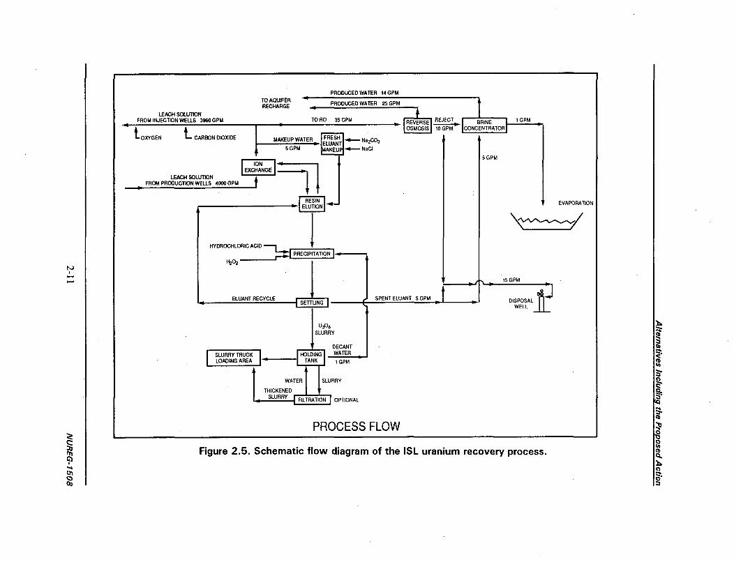
PRODUCED WATER 14 GPM
EVAPORATION
SLURRY L "
DECANT
SLURRY TRUCK HOLDING _WATERLOADING AREA TANK 1 GPM
WATER SLURRY
THICKENED
SLURRY FILT TION OPTIONAL
PROCESS FLOW00r

Alternatives Including the Proposed Action
Pregnant eluant would be acidified using hydrochloric acid (HCI) to destroy the uranyl carbonatecomplex. Hydrogen peroxide would then be added to the solution to precipitate the uranium. Theprecipitated uranyl peroxide (U0 4 or yellowcake) slurry might require pH adjustment, and then wouldbe all6owed to settle. The now-barren eluant would be recycled, and the yellowcake slurry would betransported by truck to the Crownpoint facility. At the Crownpoint facility, yellowcake would befurther dewatered and washed using a filter press and then dried. Water left over from dewatering anddrying would either be reused in the elution circuit or directed to a wastewater retention pond. HRI'sproposed operations would result in a maximum yearly production rate of 3 million lb of yellowcake.
At the satellite ion exchange plants, the resins would be eluted and the uranium precipitated andfiltered. The resulting yellowcake slurry would be transported by truck to the main Crownpoint facilityfor drying (Figure 2.6). HRI's proposal indicates yellowcake would be transported to the Crownpointprocessing plant in sole-use semitrailer tankers designed and placarded for this purpose, in accordancewith U.S. Department of Transportation requirements.
2.1.1.5 Waste Retention Ponds
The purpose of retention ponds is to store wastewater until treatment, promote evaporative loss ofwater which cannot be discharged to the environment, and maintain control of source and 1 le(2)by-product material found in the liquid effluents from solution mining. HRI proposes to use three wasteretention ponds at each processing site. These ponds, which would occupy approximately 2.5 ha(6 acres) each, would be constructed below ground level to maintain all processing solutions belowgrade. HRI commits to designing and constructing its pond embankments to meet specifications inNRC Regulatory Guide 3.11, Design, Construction, and Inspection of Embankment RetentionSystems for Uranium Mills (NRC 1977a), in the event that pond operating levels above grade arerequired. HRI would be required by license condition to perform and document inspections of the pondembankments, fences, and liners, as well as measurements of pond freeboard and checks of the leakdetection system.
The ponds would have double synthetic liners and an intervening layer up to 18 cm (6 in.) thickcontaining sand and perforated piping forming an underdrain leak detection system. An acceptabledesign alternative would eliminate the intervening sand blanket, replacing it with synthetic grid.material.
If increased waste storage and evaporation pond capacity becomes necessary, HRI would be requiredeither to provide additional pond area, or to construct the ponds with above-grade embankments andstorage levels. Therefore, HRI would be required by license condition to maintain fluid levels belowgrade, or to construct its ponds in accordance with NRC Regulatory Guide 3.11, Design,Construction, and Inspection of Embankment Retention Systems for Uranium Mills (NRC 1977a), orother acceptable design criteria.
NUREG- 1508 2-12

Alternatives Including the Proposed Action
Figure 2.6. Haul routes for yellowcake slurry from satellite plants to the Crownpointplant.
2-13 NUREG- 1508

Alternatives Including the Proposed Action
2.1.1.6 Instrumentation
HRI would monitor its production system in both the well fields and the processing plants. Themetering system would permit continuous pressure monitoring on both the injection and productionpipeline systems, and would provide audible alarms for plant operators in the event of leaks orruptures. Formal visual inspections would be conducted and documented twice during each 12-hr shift.Additionally, mining company personnel who would conduct routine construction and maintenance inthe well field areas would provide well field surveillance. HRI would provide its plants with sumps andpump equipment to prevent any potential spills from escaping the processing pad.
In the yellowcake drying area at the Crownpoint facility, HRI would periodically inspect the entiredryer system and check the integrity and efficiency of the vacuum system, fabric bag filter unit, andheating system. An NRC license condition would require that HRI suspend yellowcake dryingoperations if emission control equipment is not operating within specifications for design performance.Additionally, HRI would be required to maintain manufacturer-recommended pressure in the dryingchamber by (1) performing and documenting checks of air pressure differential during operation, or(2) installing instrumentation that would provide an alarm if the air pressure differential falls below themanufacturer's recommended levels.
Routine environmental monitoring would be conducted independently of operational monitoring. HRI'sproposed environmental monitoring systems are based on an outline provided in NRC's RegulatoryGuide 4.14, Radiological Effluent and Environmental Monitoring at Uranium Mills (NRC 1980b).
HRI's proposed environmental and plant monitoring and documentation system (including associatedroutine and nonroutine reporting procedures) would be required by NRC license conditions. In-plantradiation monitoring and occupational safety programs would be reviewed and approved by the NRC.
2.1.2 Description of the Proposed Waste Management and Effluent ControlSystem
Solution mining produces two principal types of effluents that could be released to the environment:(1) the gaseous emissions and airborne particulates resulting from lixiviant circulation and yellowcakedrying, and (2) wastewater from well field processing and aquifer restoration. Other contaminatedmaterials, produced largely during site decommissioning, would also require appropriate disposal. HRIdid not request approval to dispose of 1 le(2) by-product material or other wastes at any of theproposed project sites. On-site disposal of 1 le(2) by-product material by HRI would not be authorizedas a licensed activity. Other NRC-licensed ISL extraction facilities are required to have an agreementfor the disposal of 1 e(2) by-product material with a facility licensed to accept such material.Currently, 1 le(2) by-product material disposal capacity includes four NRC-licensed uranium milltailings sites, two mill tailings sites licensed by NRC Agreement States, and one NRC-licensedcommercial disposal facility. In the event the agreement expires or is terminated, the licensee mustattain a new agreement within a specified time period or stop further lixiviant injection. This is astandard requirement at all NRC-licensed ISL extraction facilities.
NUREG- 1508 2-14

Alternatives Including the Proposed Action
2.1.2.1 Gaseous Effluents and Airborne Particulates
Uranium recovery operations may release radon gas at various stages of the processing system, anduranium and other particulates from the yellowcake dryer. These substances are naturally occurring inthe ore body, and are circulated to the surface in the groundwater during the mining process.
HRI would minimize radon releases by employing a closed pressurized well field and ion exchangesystem. Radon gas dissolved in circulating lixiviant would be kept in solution by maintaining pressureon the system. Excess vapor pressure, mainly from dissolution of carbon dioxide or oxygen in thecirculating lixiviant, along with some radon, would then be vented by relief valves. These relief valveswould be installed at numerous outdoor locations on the trunk pipelines to disperse radon emissionsand prevent accumulation in any one area. The ion exchange vessels would provide a closed system,and vents would not be installed.
Radon release from the plants would occur when individual ion exchange columns are opened for resintransfer or elution. At this stage of the process the'contents of one ion exchange column would betransferred to open eluant or precipitation vessels. Radon releases here would be limited to the quantityof radon dissolved in the water contained in one ion exchange column. Radon escaping from thesolution would be vented from the vessels through the ventilation system of processing buildings. Alleffluent releases would be subject to release limits specified in 10 CFR Part 20, as well as occupationaland environmental programs.
The largest potential source of radon emissions from the proposed facilities is wastewater. Combinedwith turbulence caused by the pond discharge outlet, radon gas in wastewater would come out ofsolution and escape to the atmosphere. HRI proposes to minimize this radon source by removing radonin intermediate holding tanks using a vacuum pump, compressing the gas, and dissolving it in thelixiviant injection system. Radon would then be recirculated in the mining solution. In the process,carbon dioxide removed with the radon would be put to use by augmenting the carbonate content of thelixiviant.
HRI proposes to use vacuum dryer technology in its yellowcake drying and packaging system at theCrownpoint facility. In a vacuum dryer, the heating source is contained in a separate, isolated systemso that no radioactive materials are entrained in the heating system or the exhaust it generates. Thedrying chamber containing yellowcake slurry would be subjected to strong vacuum pressure. Moisturein the yellowcake would be the only source of vapor remaining in the system. Any potential leak wouldresult in outside air flowing into the drying chamber.
Emissions from the drying chamber would be treated in two phases. First, all water vapor would bedrawn through a bag filter to remove yellowcake particulates with an efficiency exceeding 99 percent.Captured particulates would be returned to the drying chamber. Second, using a condenser all watervapor from the drying chamber would be cooled and condensed. The vapor would be drawn through awater jacket and condensate, thereby capturing virtually all particulates escaping the bag filter. Thecondensate would then be returned to the uranium precipitation circuit in the plant. This technologywould result in zero emissions, and require no ventilation from the drying chamber to the atmosphere.
2-15 NUREG-1508

Alternatives Including the Proposed Action
2.1.2.2 Liquid Effluents
Operations. Both the satellite and the main processing facilities would generate liquid and solidwastes. The largest total waste stream at each plant would occur as production bleed during uraniumrecovery. HRI estimates that its production bleed rate at each plant would amount to 1 percent of theflow rate. Operating at full licensed capacity, each lease area would produce wastewater at a rate of40 gpm.
HRI proposes to treat production bleed to remove radium (Section 2.1.2.1), and then conductadditional treatment to purify the bulk of the wastewater while concentrating other contaminants in asmall volume of wastewater. Purified water would be used in the plant to supply process water, and theremainder would be discharged using an NRC-approved disposal method.
Intermittent liquid waste streams from production would include periodic flushing of depleted eluant toreduce accumulated impurities. Another waste stream would result from uranium precipitation andfilter washing; the stream would likely be contaminated with dilute HCL. These wastes would becollected, retained, and treated in a brine concentrator (Figure 2.5).
Aquifer Restoration. During aquifer restoration, HRI proposes to produce degraded groundwater atrates between 570 and 950 Lpm (150 to 250 gpm). Restoration would be accomplished by combininggroundwater sweep and permeate injection.
Groundwater sweep is accomplished by pumping the depleted well field without injecting fluids. Barrenprocess water treated by reverse osmosis would be injected at a later phase to enhance groundwaterrestoration. All water drawn from the aquifer during groundwater sweep would be processed to removeuranium, then treated with barium chloride (BaCl) to remove radium. HRI proposes to then conductadditional treatment to purify the bulk of the wastewater, and concentrate remaining contaminants in asmall volume. Purified water would then be used to continue aquifer flushing, or could be releasedaccording to an NRC-approved discharge plan.
2.1.2.3 Wastewater Treatment
Radium Removal. HRI would remove radium from wastewater by using barium chloride treatment.Barium and radium would form an insoluble salt with sulfate already found in the processing solution.Additional flocculent may be added to enhance precipitation and settling. This process would beperformed in retention ponds or in holding vessels inside the processing plants. HRI has documentedradium-removal tests conducted on sample mine water from the project area; these tests indicate thatmore than 99 percent of radium in solution would be removed using the tested techniques (Table 2.3).The treatment results in radium concentrations below 1 percent of Federal limits for releases towaterways. The effectiveness of this treatment would be monitored by daily water sampling.
Radium-contaminated sludge in ponds resulting from water treatment would require disposal as solid1 le(2) by-product material. These waste materials would be collected in barrels or as bulk slurry, and
NUREG- 1508 2-16

Alternatives Including the Proposed Action
transported to a site licensed for disposal of 1 le(2) by-product material. No permanent by-productradioactive waste disposal would be authorized at any of the three project sites.
Reverse Osmosis. Reverse osmosis is a water treatment technique that splits a wastewater stream,purifying one portion of the stream, and concentrating contaminants in the other. The process works bypumping wastewater under high pressure through low-permeability membranes. Water molecules canpass through the membrane, while most dissolved and suspended chemicals cannot. The treated waterpassing through the membrane is called permeate. Depending on how the process is performed, thepermeate can become essentially deionized. The chemical constituents become concentrated in theportion of the water that does not pass through the membranes. The result is a volume of clean water,and a reduced volume of more concentrated briny water.
Table 2.3. HRI's data on barium chloride treatment forremoving radium from wastewater (HRI 1988)
BaCl concentration Final radium(mg/L) concentration (pCi/L)
Test 1 0.0 (waste stream) 74.010.5 0.2114.0 0.2417.5 0.24
Test 2 0.0 (waste stream) 73.410.5 0.6614.0 0.2817.5 0.40
Test 3 0.0 (waste stream) 73.414.0 0.2017.5 0.64
Reverse osmosis typically concentrates contaminants in approximately one-third of a water stream,while purifying the remaining two-thirds. HRI proposes to retain the reverse osmosis brine for furthertreatment and concentration of contaminants, as described in the next section. The clean permeatewould be released as described in Section 2.1.2.4.
Brine Concentration. Brine resulting from reverse osmosis water treatment would be processedagain through a brine concentrator. The brine concentrator works by heating and-evaporating the waterin the brine, then condensing the water vapor as pure water. The highly concentrated brine wouldlargely consist of precipitated solids in the form of common salts.
Together, reverse osmosis water treatment and brine concentration would produce approximately1 part of briny slurry and salt solids from each 300 parts of wastewater. The brine sludge would beheld in a lined retention pond and kept moist enough that solids would not become suspended in the air.
2-17 NUREG- 1508

Alternatives Including the Proposed Action
The remaining larger volume of purified wastewater can then be released according to an approveddischarge plan.
2.1.2.4 Liquid Waste Disposal Options
The solution mining industry has used. various disposal methods for liquid waste streams, includingevaporation ponds, deep-well injection, land application, and surface discharge under a NationalPollution Discharge Elimination System (NPDES) permit. Each of these disposal methods is used tovarying degrees in the industry for defined waste streams.
HRI's Proposal. HRI proposes to treat all wastewater resulting from both well field production andaquifer restoration. Uranium would be removed using ion exchange. Radium would be removed insettling ponds or closed vessels using BaCl treatment (Table 2.3). Other chemical constituents founddissolved in the wastewater would become concentrated in a relatively small quantity of briny sludge,using a combination of reverse osmosis treatment and brine concentration. Using this combination, 4 L(1 gal) of brine sludge would remain for every 1200 L (300 gal) or so of treated wastewater. HRIwould retain the radium wastes as 1 le(2) by-product material, requiring disposal at an NRC-licensedfacility.
The proposed project would use evaporation ponds. If other wastewater disposal methods were used inthe future, they would have to be proposed by HRI under a license amendment and would be subject toadditional environmental review. HRI would be required to demonstrate that any disposal methodselected meets NRC's release limits for radionuclides (10 CFR Part 20) as well as standards from anyother required permits. Authorization to use surface discharge or deep-well disposal would requireseparate permits, and is not requested in HRI's proposal.
Evaporation from ponds, the most commonly used wastewater disposal technique at solution mines, istypically used for all waste streams. HRI estimates that 40 ha (100 acres) of evaporation ponds wouldbe required at each project site. All of this land would be significantly disturbed by construction, andcould require decontamination during decommissioning. This disposal technique requires lined pondsequipped with leak detection systems and concentrates and maintains all 1 e(2) by-product materials ina sludge that is then disposed of in a licensed disposal site.
During groundwater restoration, the capacity of the evaporation ponds may be exceeded by thequantity of wastewater produced. In this situation, HRI could dispose of excess wastewater by deep-well injection, land application, or surface discharge subject to prior NRC approval.
Deep-well injection is a popular disposal method among mining companies. This method uses speciallydrilled wells to dispose of liquid wastes. These wells typically extend deeper than 1525 m (5000 ft), arewell below any usable aquifer, and are commonly completed in a horizon where groundwater is notsuitable for drinking. An acceptable stratigraphic unit for deep-well disposal would contain a deep,confined aquifer with water quality degraded by more than 10,000 mg/L total dissolved solids. HRIconsiders that the Abo or Yeso Formations, underlying the sites approximately 1570 to 1645 m (5150to 5400 ft) deep, most likely meet these criteria. At other solution mines, reverse osmosis brine is often
NUREG-1508 2-18

Alternatives Including the Proposed Action
injected into these wells. Disposal by deep-well injection would require an injection well permit grantedby the EPA or other appropriate agencies. Use of a deep injection well would require an NRC licenseamendment after the injection well permit was granted.
Land application is a disposal technique that uses agricultural irrigation equipment to broadcastwastewater on a relatively large area of land. Land application is currently authorized at severalsolution mines. Water released in this fashion would require uranium and radium removal as describedabove. At each site, irrigation would be restricted to the lease areas held by HRI, and would beregulated by irrigation standards or water use standards adopted by the appropriate regulatoryauthority (State of New Mexico Environmental Department or U.S. EPA), generally using a zero-release NPDES permit. NRC would require HRI to decontaminate areas if radionuclide accumulationexceeds decommissioning standards. HRI's application specifies that on-site land application couldoccur on 22 ha (54 acres) in the southeastern portion of the Church Rock lease area, and on two tractsof land totaling 35 ha (85 acres) in its Unit 1 and Crownpoint lease areas. Off-site land application forthe Church Rock site could occur on 256 ha (640 acres) in Section 16, T16N R16W east of the ChurchRock site. Off-site land application for the Crownpoint and Unit 1 sites could occur on 256 ha(640 acres) in Section 12, T17N R13W north of the Crownpoint and Unit 1 sites.
Another disposal method utilized by the solution mining industry is surface discharge, requiringauthorization by the EPA or other appropriate agencies. This disposal method has been used only fordischarging treated water, but has been considered by licensees for other waste streams. Generally,radionuclides in wastewater authorized for this method of disposal are subject to release limits found inNRC regulations. Surface discharge is most likely to be used as a disposal method at the Church Rocksite (HRI 1996a). Should surface discharge be implemented, HRI would have to obtain the appropriateState and Federal permits.
2.1.3 Restoration, Reclamation, and Decommissioning
Following uranium recovery in each mine unit, HRI would be required by NRC license to restoregroundwater quality. At the conclusion of the project, all contaminated materials, soil, and structureswould be removed from the sites. The facilities would then be decommissioned, and the well field andprocessing plant sites would be reclaimed. The following sections provide details regarding standardswhich would be met, and the procedures used to meet them.
Detailed restoration, reclamation, and decommissioning plans, related cost estimates, and anappropriate surety would be required by the NRC before HRI could begin uranium recoveryoperations. NRC regulations require that the licensee maintain an adequate financial surety in the formof surety bonds, cash, certificates of deposit, deposits of government securities, or irrevocable letters ofcredit tocover the costs for decommissioning, reclamation of the disturbed areas, waste disposal, andgroundwater restoration. The amount of the surety is based on cost estimates for completing theapproved reclamation plan by a third party in the event the licensee defaults. The surety is reviewedannually by NRC and adjusted to reflect expansions in operations, changes in engineering design, andinflation.
2-19 NUREG- 1508

Alternatives Including the Proposed Action
2.1.3.1 Aquifer Restoration
Consistent with current ISL restoration practices, HRI proposes (HRI 1996e) that restoration criteriabe established on a parameter-by-parameter basis, and that the primary goal of restoration be to returnall parameters to average prd-mining baseline conditions. In the event water quality parameters cannotbe returned to average pre-mining baseline levels through reasonable restoration efforts, the secondarygoal would be to return water quality to the maximum concentration limits specified in EPA regulationsin 40 CFR Part 141 and § 143.3, secondary and primary drinking water regulations. For barium andfluoride, the secondary restoration goal would be set to the State of New Mexico primary drinkingwater standards. For uranium, 300 pCi/mL (0.44 mg/L) would be used. This concentration wasobtained from 10 CFR Part 20 and is suitable for unrestricted release of natural uranium to water.
Table 2.4 presents the list of constituents for which HRI proposes to monitor restoration success.Before mining, HRI proposes to establish baseline groundwater quality in selected wells in theproduction zone, perimeter monitor wells, and monitor wells in overlying aquifers. Approvedprocedures for baseline determination would be specified in an NRC license condition. All baselinegroundwater data will be subject to review by an HRI Safety Evaluation Review Panel. In addition,HRI would be required to use baseline conditions as the primary restoration target for all constituents.The HRI groundwater baseline conditions and well field restoration would be subject to NRCinspection.
HRI proposes to restore the aquifers using techniques called groundwater sweep and permeate injection(Figure 2.7). Groundwater sweep involves flushing the aquifer with naturally occurring groundwaterand decontaminated water to remove any remaining lixiviant and degraded groundwater. Affectedwater in each mine unit being restored would be withdrawn at flow rates of 570 to 950 Lpm (150 to250 gpm), processed through ion exchange to remove uranium, then treated to remove radium and totaldissolved solids. This treated water, known as permeate, would then be reinjected to further flush theaquifer. Groundwater sweep and permeate injection would be balanced so that a cone of depressionwould be maintained, causing groundwater to flow into the mining unit. Thus, natural groundwaterwould be drawn into the mining unit's center.
2.1.3.2 Land Reclamation
When the project is fully operational, only certain portions of the proposed mine area would be inproduction. Therefore, reclamation would occur in interim steps to minimize environmental impactsduring and after mining takes place, and would restore disturbed land to its pre-mining use. A licensecondition would require HRI to submit a final decommissioning plan for NRC review and approval atleast 12 months prior to license termination.
NUREG-1508
2-20
NUREG-7508 2-20

Alternatives Including the Proposed Action
Table 2.4. HRI's proposed list of chemicalconstituents to be analyzed in each monitoring well
for restoration purposes
A. Common constituents
AmmoniaBicarbonateCalciumCarbonateChlorideFluoride
MagnesiumPotassiumSodiumSulfateNitrate
B. Trace and minor elements
ArsenicBariumBoronCadmiumChromiumCopperIronLeadRadium-226
ManganeseMercuryMolybdenumNickelSeleniumSilverUraniumVanadiumZinc
C. Physical parameters
Total dissolved solidsAlkalinitySpecific conductivitypH
Topsoil Handling. Topsoil from existing mine facilities is already stockpiled. Topsoil from pondareas and other areas requiring significant grading or surface disturbance would be removed, stockpiledand stabilized. Well fields as a whole would not be cleared of vegetation or topsoil. Where concentrateddisturbance occurs, such as drilling sites, topsoil would be bladed to one side and then respread overthe area as soon as construction was completed.
Well Fields. After restoring groundwater in the mined aquifers, HRI would decommission each wellfield, and remove all well field lines and pipelines. In addition, HRI would plug and abandon injection,production, and monitor wells according to applicable regulatory requirements, Navajo Water Code,and BLM requirements for wells permitted on Navajo lands in addition to New Mexico State Engineerrequirements for wells permitted under State authority. After removing pumps and tubing, HRI would
2-21 NUREG-1508
2-21 NUREG- 1508

,•l BRINE CONCENTRATORPRODUCED WATER 48GPM
TO RECHAR RO PRODUCED WATER 150GPM
TO RO 200GPM REVERSE REJECT BRN 2GPMOSMOSIS50GPM N R
MAKEUP WATER IMRES"U....-.- NaIR0 3
MINE WATERFROM PRODUCTION WELLS 200 GPM ION
EXIIANGE l
_EVAPORATION tl
ELUITION
50 GPM
025 GPM (360 GPOD)TO CENTRAL PLANT ASSUMPTION #3
RETENTION
DISPOSALWELL
ASSUMPTION #2
LAND APPLICATION
ASSUMPTION #1RESTORATION FLOW
Figure 2.7. Schematic flow diagram and approximate flow rates of restoration wastewatertreatment systems.

Alternatives Including the Proposed Action
backfill each well with an approved cement slurry, and cut the casing 1 m (3 ft) below the surface. HRIwould then backfill the wellhead area and would reclaim the surface according to the approved plan.
Pad Reclamation. The plant and pond areas would be reclaimed in a manner similar to that used forwell field areas, and the reclamation would be subject to approval by land owners and/or lessors. First,HRI would remove all contaminated material and pond liners, and return excess soil in pondembankments to the ponds as fill. Next, HRI would reestablish land surface contours and replacetopsoil on disturbed areas. A period of several years would be required to establish a viable vegetativecover.
Radiation Surveys. Any equipment or buildings that could be decontaminated to levels acceptablefor unrestricted use might be sold and left to be used for other purposes. All other equipment,buildings, foundations, piping, and associated support facilities would be removed, and appropriateradiation surveys would be conducted over the associated areas. In the well fields, where gammasurveys correlate well with actual radiation concentrations in soil, gamma surveys would be conductedas each mining unit is decommissioned. Gamma survey results would be compared with backgroundvalues,and soil samples would be obtained from locations that exhibit elevated gamma readings. Areasexhibiting elevated uranium and radium-226 levels would be decontaminated in accordance withrelease limits specified in NRC's regulations. Contaminated soil would be disposed of in the samemanner as other radioactively contaminated material. All survey results would be subject to verificationby the NRC.
Recontouring. After completing decommissioning and decontamination, HRI would recontour theland surface and provide a terrain consistent with the post-mining land use. In addition, HRI wouldreplace topsoil stockpiles over areas from which they were removed.
Revegetation. HRI proposes to reseed all disturbed areas using plant mixtures selected from eightnative plant species, depending on the soil type encountered in various areas. The species include thenative grasses and shrubs listed in Table 2.5. Mulch would be used in any area where water retention,soil temperature, or soil crusting prevent suitable seed germination and growth.
2.1.3.3 Plant Decontamination and Decommissioning
Solid wastes generated at the site during operations would consist of spent resin, empty chemicalcontainers, miscellaneous pipes and fittings, contaminated sludge in ponds, and domestic trash. Thesewastes would be classified as contaminated or noncontaminated waste, according to their radiologicalsurvey results. Noncontaminated waste could be disposed of as ordinary trash.
Any contaminated material accumulating at the site during operations or reclamation may be disposedof as 1 le(2) by-product material. Alternatively, contaminated equipment could be sold or transferred toanother source material licensee. This method would involve minimal decontamination, and allshipments would be subject to U.S. Department of Transportation requirements. No permanent by-product radioactive waste disposal would be authorized at any of the three project sites.
2-23 NUREG- 1508

Alternatives Including the Proposed Action
Table 2.5. HRI's proposed seed application rates for reclaimed areasAll values given in kilograms per hectare (pounds per acre)
Clay soil Loamy soil Sandy soil
Arriba western wheatgrass 7.2 (6.4) 5.4 (4.8) 7.2 (6.4)
Alkali sacaton 0.9(0.8) 0.8(0.7) 0.6(0.5)
Vaughn sideoats grama -2.3(2.0) 1.8(1.6)
Paloma Indian ricegrass 2.7 (2.4)
Bandera Rocky Mountain penstemon 0.3 (0.3)
Pastura little bluestem 0.3 (0.3)
Loveington blue grama 0.3 (0.3) 0.7 (0.6)
Fourwing saltbush 1.4 (1.2)
Total 9.8 (8.7) 9.2 (8.1) 12.9 (11.5)
Contaminated material having no salvage value would be stored in a restricted area until it could beshipped to a licensed waste disposal facility. The project would not generate any "hazardous waste," asdefined by the Federal Resources Conservation and Recovery Act (RCRA).
After the project was completed, equipment from the processing plants would be handled in one ofthree ways:
* Contaminated equipment might be dismantled and sold or transferred to another licensed facility.Alternatively, equipment decontaminated in accordance with NRC guidance might be sold forreuse, salvage or scrap.
* Decontaminated materials having no resale value, such as building foundations, might be removedfor disposal elsewhere or buried on-site.
* Waste materials that could not be decontaminated would be disposed of in an NRC-licensedfacility.
After all liquid in ponds was eliminated as approved in the license, residues and the pond liners wouldbe removed and disposed of in a licensed facility. Pond liners typically cannot be economically cleanedfor unrestricted use. Pond areas would then be reclaimed along with other disturbed areas.
NUREG- 1508 2-24
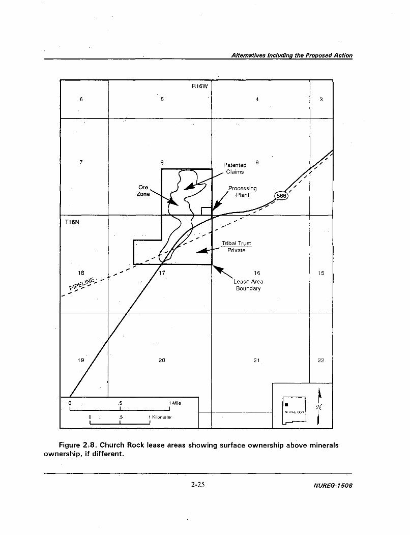
Alternatives Including the Proposed Action
:j
Figure 2.8. Church Rock lease areas showing surface ownership above mineralsownership, if different.
2-25 NUREG- 1508

Alternatives Including the Proposed Action
2.1.4 Description of the Proposed Sites
2.1.4.1 The Church Rock Site
The Church Rock mining units and satellite processing facility would be located in Sections 8 and 17,T16N R16W (Figure 2.8), approximately 10 km (6 miles) north of the town of Church Rock. Thesatellite processing facility would be located in Section 8. HRI's mineral rights include 65 ha(160 acres) of patented mining claims in Section 8, and 80 ha (200 acres) of leases in Section 17. HRIanticipates that uranium recovery activities at the Church Rock site would occur over approximately 8years.
The Church Rock site covers 145 ha (360 acres), of which approximately 90 percent [130 ha(324 acres)] would be disturbed during project construction and operation. The estimate of 130 ha(324 acres) includes areas that have been previously disturbed as well as those that would be newlydisturbed. The satellite processing facility's buildings, plant areas, parking lots, and settling pondswould occupy approximately 2.5 ha (6 acres). Well fields would occupy approximately 32 ha(80 acres). Additional acreage would be required for access roads, on-site wastewater land applicationareas, and evaporation ponds. If HRI disposes of wastewater using off-site land application (i.e., inSection 16, T16N R16W), an additional area of up to 256 ha (640 acres) could be disturbed. Thus, thetotal land area that would be disturbed at the Church Rock site ranges from 130 ha (324 acres) (on-siteland application) to 386 ha (964 acres) (off-site land application in Section 16).
2.1.4.2 The Unit 1 Site
The Unit I mining units and satellite processing facility would be located in Sections 15, 16, 21, 22,and 23, T 17N R 13W (Figure 2.9), approximately 3.2 km (2 miles) west of the town of Crownpoint.The satellite processing plant, retention ponds, and support facilities would be located in Section 21.The mine plan would initially affect reserves in Sections 21 and 22. HRI anticipates that uraniumrecovery activities at the Unit I site would occur over approximately 17 years.
The Unit 1 site covers 512 ha (1280 acres), of which approximately 70 percent [358 ha (896 acres)]would be disturbed during project construction and operation. The estimate of 358 ha (896 acres)includes areas that have been previously disturbed as well as those that would be newly disturbed. Thesatellite processing facility's buildings, plant areas, parking lots, and settling ponds would occupyapproximately 2.5 ha (6 acres). Well fields would occupy approximately 280 ha (700 acres).Additional acreage would be required for access roads, on-site wastewater land application areas, andevaporation ponds. If HRI disposed of wastewater using off-site land application.(i.e., in Section 12,T17N RI3W), an additional area of up to 256 ha (640 acres) could be disturbed. Thus, the total landarea that would be disturbed at the Unit 1 site ranges from 358 ha (896 acres) (on-site land application)to 614 ha (1536 acres) (off-site land application in Section 12).
NUREG- 1508 2-26

28 27 26 25 28°sitnpeoint rlaTus
0 .5 1 Mile . P
0 .5 1 KilometerN35 36 31
NEW MEXICO IUrbanSDevelopment caJ-
CID
Z!s
Figure 2.9. Land and minerals status: in Unit 1 showing allotment numbers; in the Crownpoint (1leases showing surface ownership above minerals ownership, if different.
o0

Alternatives Including the Proposed Action
2.1.4.3 The Crownpoint Site
The Crownpoint mining units and central processing facility would be located in Sections 19, 24, and25, T17N R13W, and Section 29, T17N R12W (Figure 2.9). The Crownpoint portion of the projectwould use existing facilities for the central processing plant, located on the west edge of the town ofCrownpoint in Section 24. HRI anticipates that uranium recovery activities at the Crownpoint sitewould occur over approximately 19 years.
The Crownpoint site covers 365 ha (912 acres), of which approximately 70,percent [255 ha(638 acres)] would be disturbed during project construction and operation. The estimate of 255 ha(638 acres) includes areas that have been previously disturbed as well as those that would be newlydisturbed. Existing processing facilities and settling ponds, which occupy approximately 5.5 ha(14 acres) in the southeastern quarter of Section 24, would be used. Well fields would occupyapproximately 205 ha (510 acres). Additional acreage would be required for access roads, on-sitewastewater land application areas, and evaporation ponds. If HRI disposed of wastewater using off-siteland application, it would occur in Section 12, T17N R13W. Because Section 12 would also be usedfor land application for the Unit 1 site under this scenario, its256 ha (640 acres) are included above inthe land disturbance calculations for Unit 1. Thus, the total land area that would be disturbed at theCrownpoint site would be approximately 255 ha (638 acres).
2.1.4.4 Site Development
Initially, HRI proposes to operate well fields only at the Church Rock site (Figure 2.10), and totransport yellowcake slurry by truck to the Crownpoint facility for drying and packaging. Miningwould begin at the Unit 1 and Crownpoint sites in the late 1990s (Figure 2.11).
During initial production, HRI proposes to conduct demonstration projects, at each site, producinguranium from an initial well field and then immediately'iestoring the well field. These demonstrationswould be intended to confirm reclamation cost data for bonding purposes. Before mining could occur ateither the Unit 1 or the Crownpoint site, HRI would have to conduct a groundwater restorationdemonstration at the Church Rock site. The demonstration would be conducted at a large enough scalethat production-scale groundwater restoration was demonstrated. If restoration to preestablishedgroundwater quality standards could not be achieved, mining at the Church Rock site would cease andno mining would be allowed at either the Unit 1 or the Crownpoint site.
2.2 ALTERNATIVE 2 (MODIFIED ACTION)
Under Alternative 2, the NRC would issue HRI a license for the construction and operation of amodified version of the proposed project. The modified project could consist of alternatives to theproposed project in three primary areas: sites for ISL mining, sites for yellowcake drying andpackaging, and liquid waste disposal methods.
NUREG- 1508
2-28
NUREG- 1508 2-28

Alternatives Including the Proposed Action
Figure 2.10. Church Rock lease area, showing mine-unit and facility locations.
2-29 NUREG- 1508

-Z *-
R13W R12W
3 1
16 15 14 13 18 17 1
9
::"A: Fuut 9
I Y"M velor
21 22 236um 24 1 0 20 21
Watwae Site T,
Iri ato .5 ........e17
0= Prcssn 1-- KilomterUni I ieln
28 27 26 3553 30 329 28
Developmentt
Site
20 21 il
enCrownpoint
and facility locations.

Alternatives Including the Proposed Action
2.2.1 Alternative Sites for ISL Mining
HRI proposes to conduct ISL mining at the Church Rock, Unit 1, and Crownpoint sites. However,potential impacts to public health and safety or the environment might indicate that ISL mining shouldnot be conducted at all three sites. Alternative sites for ISL mining include
* the Church Rock site only,* the Unit 1 site only,* the Crownpoint site only,* the Church Rock and Unit I sites only,* the Church Rock and Crownpoint sites only, or* the Unit 1 and Crownpoint sites only.
The primary difference between these alternatives and the proposed project is that ISL mining wouldoccur at only one or two of the proposed sites. Thus, the potential environmental impacts of mining atthe sites listed above will be addressed as subunits of the proposed project in the FEIS.
2.2.2 Alternative Sites for Yellowcake Drying and Packaging
HRI proposes to dry and package all yellowcake produced by the project at the central processingfacility at Crownpoint. Alternative sites that could be selected for yellowcake drying and packaginginclude
" the proposed Church Rock processing facility," the proposed Unit 1 processing facility,* HRI's existing ISL facility at Kingsville, Texas, and0 the Ambrosia Lake uranium mill, located north of Milan, New Mexico (Figure 1.1).
The primary difference between these alternatives and the proposed project is that yellowcake slurrywould be transported by truck to a location other than the Crownpoint processing facility. The FEISexamines the potential environmental impacts of these alternatives for drying and packaging.
2.2.3 Alternative Liquid Waste Disposal Methods
HRI's proposal for disposing of liquid wastes generated by the project is described in Section 2.1.2.4.Generally, HRI proposes to dispose of liquid wastes through a combination of evaporation ponds,aquifer reinjection, land application, and reinjection into the Westwater Canyon sandstone outside themining area. The FEIS examines the impacts of HRI's proposal and alternative liquid waste disposalmethods, including various combinations of evaporation ponds, deep-well injection, land application,and surface discharge.
2-31 NUREG- 7508
2-31 NUREG- 1508

Alternatives Including the Proposed Action
2.3 ALTERNATIVE 3 (THE NRC STAFF-RECOMMENDED ACTION)
Under Alternative 3, the NRC would issue HRI a license for the construction and operation of theproposed project, but with additional measures required and recommended by NRC staff to protectpublic health and safety and the environment. These additional measures are discussed for eachresource area in Sections 4.1 through 4.12 and listed for the entire project in Appendix B.
2.4 ALTERNATIVE 4 (NO ACTION)
No action means that "the proposed activity would not take place, and the resulting environmentaleffects from taking no action would be compared with the effects of permitting the proposed activity oran alternative activity to go forward" (Federal Register 46, 18026). Thus, the no-action alternative forNRC is not to issue HRI a license for the construction and operation of facilities for ISL uraniummining and processing at the Church Rock, Unit 1, or Crownpoint sites. The no-action alternative forthe BLM and BIA is not to approve HRI's application for minerals operating rights and leases on theFederal and Indian lands involved in the proposed project.
NUREG- 7508
2-32
NUREG- 1508 2-32

Affected Environment
3. AFFECTED ENVIRONMENT
3.1, METEOROLOGY, AIR QUALITY, AND NOISE
This section describes meteorology, air quality, and noise in the region in which the three project sitesare located. The description is not site-specific because the available data are collected on a regionalbasis and because the project sites have similar characteristics.
3.1.1 Meteorology
The project sites are located on the Northwestern Plateau climatological subdivision of New Mexico.Due to the relatively weak synoptic, scale, meteorological influence in the project area is largelyinfluenced by local topography. The region is semiarid continental, with the mean annual precipitationaveraging 26 cm (10.2 in.) (TVA 1979). Precipitation typically is concentrated during summer andearly fall, occurring as thundershowers of short duration. Approximately 50 percent of the precipitationfalls in July through October. The mean monthly rainfall during the remainder of the year totals only1.4 cm (0.5 in.).
Temperatures in the region are represented by data from the nearby Crownpoint station, measured overa 42-year period. Table 3.1 presents mean monthly and annual normal temperatures for Crownpoint.Because of the relatively high elevation of the project area, temperatures greater than 32 °C (90 7F)occur infrequently, only 12 times per year on average. The extreme maximum temperature recorded atCrownpoint is 36°C (97 °F). Because of the high elevation and relatively infrequent cloud cover in theproject area, radiant cooling is substantial and results in an average of 143 days of the year withtemperatures below freezing. Extremely low temperatures are rare, with the lowest on record being-27°C (- 17°F).
The mean annual temperature is 10.6°C (51 °F). The coldest monthly mean of - 1VC (30°F) occurs inJanuary, and the highest monthly mean of 22.2°C (72 °F) occurs in July. The frost-free growing seasonlasts 140 days, extending from early May to early October. The mean freeze-free period lasts about22 days longer than the growing season. However, large variations in the freeze dates occur from yearto year.
Maximum precipitation occurs during the summer thunderstorm season. Table 3.2 presents normalmonthly and annual precipitation for Crownpoint. The data indicate that approximately one-half of theannual precipitation total falls during July, August, and September. Most of the winter precipitationoccurs as snow. Based on mean snowfall estimates for nearby locations, including Crownpoint, and onactual 1975 snowfall amounts for Gallup and Chaco Canyon National Monument, the estimated yearlyaverage snowfall for the project area is 66 cm (26 in.).
Average annual relative humidity is estimated to range from a maximum of near 65 percent aboutsunrise to near 30 percent in mid-afternoon. Afternoon humidity in the warmer months, however, is
3-1 NUREG- 1508

Affected Environment
Table 3.1. Mean temperature in degrees Centigrade (Fahrenheit) forCrownpoint, New Mexico, 1931-1960
Month Mean Mean maximum Mean minimum
January -1.1 (30) 5.0(41) -7.8(18)February 2.2 (36) 8.3 (47) -4.4 (24)March 5.0(41) 12.2 (54) -2.2(28)April 9.4 (49) 17.2 (63) 1.7 (35)May 14,4 (58) 22.2 (72) 6.7 (44)
June 20.0 (68) 27.8 (82) 12.2 (54)July 22,2 (72) 29.4 (85) 15.0 (59)August 21.1 (70) 28.3 (83) 13.9 (57)September 17.8 (64) 25.0 (77) 10.0 (50)October 11.7(53) 18.9(66) 4.4(40)November 4.4(40 11.7 (53) -2.2(28)December 0.0(32) 6.7(44) -6.1 (21)
Annual 10.6 (51) 17.8 (64) 3.3 (38)
Source: TVA 1979.
Table 3.2. Monthly and annual precipitation forCrownpoint, New Mexico, 1931-1960
Month Millimeters Inches
January 14.7 0.58February 14.5 0.57March 11.9 0.47April 12.7 0.50
May 16.8 .0.66June 17.3 0.68July 43.7 1.72August 53.6 2.11September 27.9 1.10October 20.8 0.82November 12.2 0.48December 13.5 0.53
Annual 259.6 10.22
Source: TVA 1979.
NUREG- 7508 3-2
NUREG- 1508 3-2

Affected Environment
commonly below 20 percent. The mean annual relative humidity for Gallup is 50 percent. The grossannual lake evaporation in the project area is approximately 218 cm (86 in.).
Little comprehensive wind observation data are available for the immediate project area. The nearestNational Weather Service (NWS) station with available wind data is Gallup (TVA 1979), locatedapproximately 19 km (12 miles) and 56 km (35 miles) west-southwest of Church Rock andCrownpoint, respectively. Five-year wind data for Gallup (U.S. Department of Commerce 1981)indicate a prevailing wind with southwest and west-southwest components (Figure 3.1). A windyseason occurs during the spring months, averaging 19 km/hr (12 mph), and summer wind averages13 km/hr (8 mph). Winds are generally calm 10 percent of any 24-hr period and exceed 38 km/hr (24mph) 5 percent of the time.
Based on the input parameters of solar altitude, cloud cover, ceiling height, and wind speed,atmospheric stability can be classified into several categories (TVA 1979). The closest weather stationswith available long-term atmospheric records from which stability conditions can be estimated areZuni, Farmington, and Albuquerque, New Mexico, about 90 km (57 miles) southwest, 115 km(72 miles) north, and 150 km (93 miles) southeast of the Crownpoint site, respectively. The frequenciesof the various stability conditions for these three locations are presented in Table 3.3. The data indicatethat stability conditions contributing to good dispersion conditions (Pasquill Classes A through D)occur more than 55 percent of the time at all three stations.
Thunderstorms are relatively frequent during the summer months in northwestern New Mexico andoccur on about 50 days per year in the project area. Tornadoes are occasionally reported in NewMexico, most frequently during afternoon thunderstorms from May through August, and typically inthe eastern part of the State. Only one tornado was reported in the one-degree square includingCrownpoint during the period from 1955 to 1967. The resulting calculated probability of a tornadostriking the site in any year is 0.00006, or once in each 16,700 years.
Maximum short-duration rainfalls in this area are generally caused by thunderstorms, while maximumprecipitation of longer duration results from the infrequent invasion of a tropical cyclone from the Gulfof Mexico or the Gulf of California. Occasionally, brief, high-intensity showers may cause flash floodsin the normally dry arroyos. Information regarding potential flooding is discussed in Section 3.3.2.
3.1.2 Air Quality
National Ambient Air Quality Standards (NAAQS) exist for sulfur dioxide (SO 2), nitrogen dioxide(NO2), carbon monoxide (CO), ozone (03), lead (Pb), and particulate matter small enough to moveeasily into the lower respiratory tract (particles less than 10 ym in aerodynamic diameter, designatedPM-10). The NAAQS are expressed as pollutant concentrations that are not to be exceeded in theambient air, that is, in the outdoor air to which the general public has access [40 CFR § 50. 1(e)].Primary NAAQS are designated to protect human health; secondary NAAQS are designated to protecthuman welfare by safeguarding environmental resources (such as soils, water, plants, and animals) andmanufactured materials. Primary and secondary NAAQS are presented in Table 3.4. New Mexico hasadopted the NAAQS as the air quality standards for the State.
3-3 NUREG-1508

Affected Environment
-E
VS
Explanation
OI I I I I 1'2 3 45 6781 1 I ) I I
I I I k9 10 11 12I I I I
Percentage of Winds in Direction
0-0
Wind Speed Group, in Knots
(U.S. Dept. of Commerce, 1981)
Figure 3.1. Wind rose for Gallup, New Mexico-average annual conditions,1976-1980. Source: U.S. Department of Commerce 1981.
NUREG-1508 3-4

Affected Environment
Table 3.3. Percent frequency distributions of Pasquill Stability Classes forZuni, Farmington, and Albuquerque
Zuni Farmington Albuquerque
Stability class (1967-1971) (1960-1968) (1960-1964)
A (extremely unstable) 2.4 4.8 2.4
B (unstable) 7.0 10.6 13.5
C (slightly unstable) 14.2 12.4 12.8
D (neutral) 35.1 27.8 30.0
E (slightly unstable) 17.8 10.7 13.8
F (stable) 23.5 34.4 27.5
Source: TVA 1979.
Table
Pollutant
Carbon monoxide (CO)
Nitrogen dioxide (NO 2)
Ozone (03)
3.4. National Ambient Air Quality Standards'
NAAQS (fg/m 3)
Primary Secondary M
10,000 8-hr avera,40,000 1-hr avera,
100 100 Annual ari
235 235 1-hr avera
Lea
Partdian
Sulf
d (Pb) 1.5 1.5
iculates <10 microns in 50 50neter (PM-IO) 150 150
fir dioxide (S0 2) 80 1300365
'Where no value is listed, there is no corresponding standard.bNot to be exceeded more than once per year.
'Not to be exceeded on more than 1 day/year on the average over 3 years.'Calendar quarter.
Source: EPA 1996.
Quarterly
Annual ari24-hr aver
Annual ari24-hr aver
easurement
gebgeb
.thmetic mean
gec
averaged
thmetic meanagec
thmetic meanageb
3-5 NUREG- 1508
3-5 NUREG- 1508

Affected Environment
The air quality in the project region is good. The area is sparsely populated and is not heavilydeveloped with industrial sources of air pollution. The area is designated as being in attainment of theall the individual NAAQS (EPA 1996).
In addition to ambient air quality standards, which represent an upper bound on allowable pollutantconcentrations, there are national standards for the prevention of significant deterioration (PSD) of airquality (40 CFR § 51.166). The PSD standards differ from the NAAQS in that the NAAQS providemaximum allowable concentrations of pollutants, while PSD requirements provide maximum allowableincreases in concentrations of pollutants for areas already in compliance with the NAAQS. PSDstandards are therefore expressed as allowable increments in the atmospheric concentrations of specificpollutants. Allowable PSD increments currently exist for three pollutants: NO2, SO 2, and PM-10. PSDincrements are particularly relevant when a major proposed action (involving either a new source or amajor modification to an existing source) may degrade air quality without exceeding the NAAQS, aswould be the case, for example, in an area where the ambient air is very clean. One set of allowableincrements exists for Class II areas, which cover most of the United States, and a much more stringentset of allowable increments exists for Class I areas, which are specifically designated areas where thedegradation of ambient air quality is to be severely restricted. Class I areas include certain nationalparks and monuments, wilderness areas, and other areas as described in 40 CFR § 51.166(e) and40 CFR Part 81:400-437. Maximum allowable PSD increments for Class I and Class II areas aregiven in Table 3.5. Class I areas in the Four Comers region include Mesa Verde National Park andArches National Park. A list of Class I areas in Arizona, Colorado, New Mexico, and Utah ispresented in Table 3.6.
3.1.3 Noise
Background noise around the three project sites is mostly from light automobile and truck traffic andwould be comparable to noise levels in a quiet residential area. This is about 50 decibels in the normal(A-scale) auditory frequency band [dB(A)]. Residents (i.e., potentially sensitive receptors) are adjacentto or within close proximity of (less than 1 kin) all three project sites.
3.2 GEOLOGY AND SOILS
3.2.1 Regional
Topographic relief in the vicinity of the project sites is approximately 600 m (2000 ft), from anelevation of 2000 m (6500 ft) to 2600 m (8500 ft). The region is characterized by mesas that dip gentlyto the north and by broad valleys with intermittent streams. Locally, arroyos have incised the mesas byheadward erosion, forming steep-sided canyons.
The project sites are located northeast of the Zuni Uplift on the Chaco Slope structural subdivision ofthe San Juan Basin (Figure 3.2). The San Juan Basin is a structural depression occupying a majorportion of the southeastern Colorado Plateau physiographic province (Hunt 1974). The plateauencompasses much of western Colorado, eastern Utah, northeastern Arizona, and northwestern New
NUREG- 1508 3-6

Affected Environment
Table 3.5. Allowable increments for prevention of significant deteriorationof air quality (allowable PSD increments)a
Allowable PSD increments (fg/m 3)
Pollutant Class I Class II Measurement
Carbon monoxide (CO)
Nitrogen dioxide (NO2) 2.5 25 Annual average
Ozone (03)
Lead (Pb)
PM- 10 b 4 17 Annual average8 30 24-hrc
Sulfur dioxide (SO 2) 2 20 Annual average5 91 24-hrd
25 512 3-hrd
'Where no value is listed, there is no corresponding standard. Class I areas are specifically designated areas inwhich degradation of air quality is severely restricted (e.g., many national parks); Class II areas (all areas in the UnitedStates not designated as Class I) have a less stringent set of allowable PSD increments.
'Particulate matter less than 10 ,m in diameter.'Not to be exceeded on more than 1 day/year on the average over 3 years."Not to be exceeded more than once per year.
Mexico. The San Juan Basin is underlain by up to 3000 m (10,000 ft) of sedimentary strata, whichgenerally dip gently from the margins toward the center of the basin. The margins of the basin arecharacterized by relatively small elongate domes, uplifts, and synclinal depressions.
The stratigraphic sequence in the San Juan Basin is composed of units ranging from Precambrian to theHolocene age. Stratigraphic descriptions presented here are limited to formations that would beinvolved in the proposed mining operation or formations that may have environmental significance,such as important aquifers found above and below the mine zone. A generalized stratigraphic column isshown in Figure 3.3.
The Morrison Formation is composed of the Recapture, Westwater Canyon, and Brushy BasinMembers and is the host formation for major uranium deposits in the area. In addition, the WestwaterCanyon is an important regional aquifer. The following regional descriptions are derived from reportsby Green and Pierson (1977), Hilpert (1963, 1969), TVA (1979), Chenoweth and Learned (1980), andHRI (1993).
3-7 NUREG- 1508
3-7 NUREG- 1508

Affected Environment
Table 3.6. EPA Class I prevention of significant deterioration areas
Utah Colorado
Arches National ParkBryce Canyon National ParkCanyonlands National ParkCapitol Reef National ParkZion National Park
Arizona
Chiricahua National Monument WildernessChiricahua WildernessGaliuro WildernessGrand Canyon National ParkMazatzal WildernessMount Baldy WildernessPetrified Forest National ParkPine Mountain WildernessSaguaro WildernessSierra Ancha WildernessSuperstition WildernessSycamore Canyon Wilderness
Black Canyon of the Gunnison WildernessEagles Nest WildernessFlat Tops Wilderness *Great Sand Dunes WildernessLa Garita WildernessMaroon Bells-Snowmass WildernessMesa Verde National ParkMount Zirkel WildernessRawah WildernessRocky Mountain National ParkWeminuche WildernessWest Elk Wilderness
New Mexico
Bandelier WildernessBosque del Apache WildernessCarlsbad Caverns National ParkGila WildernessPecos WildernessSalt Creek WildernessSan Pedro Parks WildernessWheeler Peak WildernessWhite Mountain Wilderness
Source: EPA 1994.
The Recapture Member is the bottommost member of the Morrison Formation. It is as thick as 150 m(500 ft) northwest of Gallup but thins considerably and, in outcrops near Gallup and eastward, is only45 to 90 m (150 to 300 ft) thick. The Recapture is regarded as one of the most variable stratigraphicunits in the area. It occurs in the Gallup mining district as a sequence of interbedded siltstone,mudstone, and sandstone strata. Individual strata range from centimeters to meters in thickness.Sandstone beds are generally less than 5 m (15 ft) thick (Hilpert 1969). The Recapture is widelybelieved to interfinger with the underlying Cow Springs Sandstone, and several authors have combinedthe two units as one. No significant uranium deposits occur in the Recapture Member.
The Westwater Canyon Member of the Morrison Formation consists of interbedded fluvial red, tan,and light gray arkosic sandstone, claystone, and mudstone. It is the major water-bearing member of theMorrison. The unit's thickness in outcrop from Gallup to the continental divide ranges between 53 and85 mn (175 and 275 ft) (Hilpert 1969) and is known to be considerably thicker locally. In most
NUREG- 1508 3-8

Affected Environment
109, 108" 107P
- - - _371"ARIZONA NEW MEXICO
IFarmington
•,<,/ iCentralSAN Basin
JUAN0 •36-
Chaco Zl.U
BASIN zSlope D
.Gallup Church Ro k CronpinIG Site
Grants ATaylor $%O ACOMASAGlbuquerque -3 5'0
O 0•O• ( McCartys C)
___I
Figure 3.2. Structural setting of the San Juan Basin. Source: Kelley 1963; Kelley andClinton 1960.
3-9 NUREG- 7508
3-9 NUREG- 1508

Affected Environment
THICKNESS
-I.-, I.
AGE
0o
a-C.)CL
3ROUF FORMATION MEMBER LITHOLOGY METERS FEET
Menefee Formation >245 >800 Interbedded sandstone, siltstone shale, coal
Point Lodout Sandstone 0-45 0-150 Massive sandstone
oI beo Coa Mener 30-90 100-300 Interbedded sandstone, siltstone, coal
ewoon Baren Marwe 0-50 0-160 Sandstone, siltstone, shale, coalCrevase Carol soCanyon M..W 40-45 130-150 Fine-grained sandstone
FormationMesa. Mulatno To•ge 13-30 45-100 Gray shale with thin sandstone beds
CoN 35-55 120-180 Interbedded sandstone, siltstone shale and coal
Gallup Man Beody 20-60 65-200 Yellowish-brown to white crossbedded sandstone
Sandstone .. .. .."..Low.. e. •0-18 0-60 Yellowish-brown sandstone tongues
Main BodyMancosShale .......... ......
... ............................. ... .. ................ .....
..... ..... 11 ............
150-215 500-700 Dark gray shale, indistinct silty sandstone beds
X ISand TsoWOII S TO'oneN
Dakota "w"twe 'M.OSandstone So Tongue (Manoo',€OLOw.,
CreTaww~as Llý _ýR'02201'40-105 130-340 Yellowish-brown sandstone and conglomerate.
Dark gray shale and coal
J
B's-y Boll 0-30 0-100 Green & purple siltstone and clay stone withMorrison wtae '')'''.,•' lerticular sandstone
Formation Canyonw"j 30-75 100-250 Light red to white coarse-grained crossbeddedFrai C. .; '0-150 sandstone, lerticular siltstone
Ro".pr:.w - '-- "'- ," 0-45 0-150 Reddish-brown siltstone and white sandstone
Cow Springs 90-150 300-500 Greenish-gray crossbedded massive sandstonecc Sandstone
L_ so Wanaah BSwbiaOFW "I" Formation T Malow 6-40 20-130 Reddish-brown to white silty sandstone
1- -732-30 Gray.sandy limestone
Entond 95-140 315-455 Reddish massive sandstone and siltstoneSandstone
"w Purplish-white to gray cherty limestone and siltstone
ChinleU) Poorsa~ Foreso"ar "+''"
I•= PeeForest Purplish-gray and reddish gray siltstone and.•,..,,__.__,. 425-600 1400-2000 claystone with several coarse-grained sandstone
S Formation beds and conglomerate
Mwn.. .rere..Low,,
Mle. Sarnarumo
?)T i Mowwenol{) ,.0 'r,''. 0-15 0-50 Varigated mudstone. sandstone. conglomeratePenlan San AnO,&.L.Isa,,ow 0-45 10-145 Gray limestone with lower sandstone
Figure 3.3. Stratigraphic column of the Church Rock, New Mexico area. Source:adapted from Chenoweth and Learned 1980; revised by staff.
NUREG- 1508 3-10

Affected Environment
places, the Westwater displays one or more mudstone units that range from thin partings to units up to6 m (20 ft) thick. These mudstones have limited lateral continuity, and only the thicker ones areextensive. This member is host for the major uranium deposits in the region. The uranium occurs incoarse-grained, poorly sorted sandstone units and is closely associated with the carbonaceous materialthat coats the sand grains.
The Brushy Basin Member overlies the Westwater Canyon and ranges from 12 to 40 m (40 to 125 ft)thick in the Gallup region. It is mainly composed of light greenish gray and varicolored claystone,interbedded with sandstone lenses having similar lithology and appearance to sandstones found in theWestwater Canyon Member (Ristorcelli 1980). The mudstones are largely derived from volcanic ashfalls (Peterson 1980) and contain considerable amounts of bentonite. Its contact with the WestwaterCanyon is gradational and interfingering.
The Dakota Sandstone is the basal formation of the Cretaceous System and unconformably overlies theMorrison Formation. The Dakota is a gray-brown quartz sandstone with some interbeddedconglomerate, shale, carbonaceous shale, and coal. It is a marine sandstone and is considered torepresent the earliest transgression of late Cretaceous seas. The Dakota crops out around the marginsof the San Juan Basin and thickens towards the center of the basin to about 60 m (200 ft) regionally.
The Mancos Shale overlies the Dakota Sandstone and is a thick, mostly uniform gray marine shalecontaining thin lenses of fine-grained sandstone. It varies in thickness up to 600 m (2000 ft) regionally.The Mancos has two upper sandy tongues, the Mulatto and Satan, that intertongue with the MesaverdeGroup and merge with the main body of the Mancos to the east. The unit's lower shale tonguesinterfinger with the underlying Dakota. The Mancos forms the foundation bedrock at the Church Rocksite.
The Mesaverde Group overlies the Mancos Shale and is composed of several formations that aredescribed as follows in ascending order:
I. The Gallup Sandstone forms the basal unit of the Mesaverde Group. It is a gray-white orpink-to-tan, medium- to fine-grained, moderately well-sorted, calcareous, cross-bedded sandstone.Unlike the main body of the Gallup Sandstone, the Torrivio Sandstone Member, whichintertongues with the Crevasse Canyon Formation, is very coarse- to medium-grained, poorlysorted, cross-bedded fluvial sandstone. The thickness of the Gallup varies regionally from 0 tomore than 70 m (230 ft) and is about 25 m (80 ft) thick near Crownpoint.
2. The Crevasse Canyon Formation overlies the Gallup Sandstone and varies in thickness from150 to more than 230 m (490 to 750 ft). It consists of an upper and lower member composed ofinterbedded lenticular sandstones, claystones, and thin discontinuous coal beds separated by asheetlike body of fine-grained, well-sorted calcareous marine sandstone. In ascending order, theDilco Coal Member, the Dalton Sandstone Member, and the Gibson Coal Member make up theCrevasse Canyon Formation.
3. The Point Lookout Sandstone overlies the Crevasse Canyon Formation and is split into two parts,the lower Hosta Tongue and the upper main body, by the Satan Tongue of the Mancos Shale. The
3-11 NUREG-1508

Affected Environment
Point Lookout is a fine- to medium-grained, grayish brown to white sandstone. The Satan Tongueof the Mancos Shale consists of interbedded shale, mudstone, and thin calcarious sandstone beds.
Thick colluvium deposits are commonly found forming a mantle on steep slopes surrounding sandstonemesas and cuestas. By contrast, Quaternary alluvium is found on the valley floors of the region. Thesedeposits consist of fine sand, silt, and clay derived from the weathering of sandstone, siltstone, andmudstone exposed at the surface. Alluvial deposits generally are thin but are known to exceed athickness of 10 m (30 ft) in larger valleys.
The Grants Uranium Belt is one of the largest producers of uranium in the world. From 1950 through1978, ore containing 123,000 metric tons of uranium oxide were extracted (Chenoweth and Holen1980). This represented 40 percent of the U.S. production. Most uranium mineralization in the regionoccurs as pore fillings or coatings in sandstone of the Morrison Formation and, less importantly, in theDakota Sandstone and Todilto Limestone (Hilpert 1963). The ore bodies occur as elongated masses orroll-front deposits. Generally, the deposits are a few feet thick and several hundred to a thousand feetlong and may be stacked, usually parallel to the strike of the host rock. The major mineral is coffinite,with minor amounts of uraninite, andersonite, bayleyite, uranophane, tyuyamunite, and carnotitepresent.
Uranium first migrated into sandstone relatively soon after its deposition in tuffaceous sediment andother rocks of volcanic origin. The uranium was dissolved and transported by migrating groundwateruntil it was precipitated as coatings on sandstone grains. Ore deposits are associated withwell-developed channel sandstones in the upper three-fourths of the Westwater Canyon Member. Orezones are irregular in configuration and are elongated parallel to depositional features (N35 °W).Varying rates of groundwater flow controlled by sedimentary facies in each stratigraphic zone in theWestwater Canyon produced stacked ore deposits near one another but not necessarily above andbelow one another (Peterson 1980). The deposits are found as irregular pods or as the classic c-shaperoll fronts (Figure 3.4).
Site-specific information for this FEIS was derived by interpreting geophysical log informationsubmitted by HRI, and to the extent practical, by verifying the information with independentlypublished accounts.
3.2.2 Crownpoint
Figure 3.5 contains a stratigraphic column for the Unit 1 and Crownpoint sites. HRI's submittals showthat the Recapture mudstone unit underlying the Crownpoint site is generally about 75 m (250 ft) thick.Wentworth and others (1980) verify that the Recapture Member underlying the east side of Crownpointis about 80 m (260 ft) thick below the Section 29 uranium deposits. In the Crownpoint area, the top ofthe Westwater Canyon is found at an average approximate elevation of 1525 m (5000 ft) or a depth of560 m (1840 ft). HRI's log data indicate that the Westwatcr Canyon Member thickens from about72 m (236 ft) in the western part of Unit .1, to 90 m (295 ft) in Section 24, to over 105 m (345 ft) in
NUREG- 1508 3-12

Infiltration
Water TableApprox. 0.05-0.25%
Uranium Ore
Confining Mudstone
UnalteredSandstone
Confining Mudstone
9-a0~
Figure 3.4. Simplified cross-section of roll-front uranium deposits formed by regionalmigration.groundwater
09

Affected Environment
SYSTEM I ROCK UNIT
PointLookoutSandstone
"main body" :Y
Seton Tongue of Mancos Shale
Heste Tonque )
MesaverdeGroup
Gibson Coal Member - - -
Crevasse Dalton Sandstone MemberCanyon
FormationMuletto Tongue of Mancos Shale
"stray sandstone" _""_._:,_,._:
Dilco Coal
Member Terrivia Ss Mbr Gallup Sa .
Cretaceous Gallup Sandstone .1 i:ii!ii::•4)7
Lower Gallup Sandstone
Mancos Shale
Juana Lopez Member
Greenhorn Limestone
*- A -
† † † † † † † † † † † † † † † † † † † † † † †
1T7 ~7'
I Two Wells Tonoue of Dakota Ss. . . I
Whitewater Arroyo Tongue
4 -
Dakota Sandstone
Brushy Basin Member - - -
"Poison Canyon sandstone"
MorrisonUpper Formation Westwater Canyon Member
Jurassic
Cowsprings Recapture i -
Membe, Member
Figure 3.5. Stratigraphic column of the Unit 1 and Crownpoint sites.
NUREG- 7508 3-14
NUREG- 1508 3-14

Affected Environment
Section 19 north of Crownpoint. Wentworth and others (1980) report a similar variationin thicknesseast of Crownpoint in Section 29, ranging from 76 to 107 m (250 to 350 ft). The Westwater Canyonconsists of a series of gray to light red, fine- to medium-grained arkosic sandstones with a number ofwell-defined mudstone layers. The mudstone units are pale green or varicolored and range from a fewcentimeters to 9 m (30 ft) thick.
HRI's data indicate that the Brushy Basin Member averages 20 to 35 m (67 to 112 ft) thick nearCrownpoint. These values agree with data from the Section 29 ore deposits (Wentworth and others1980). The Brushy Basin Member contains shale with a few thin and discontinuous sandy lenses.
Rocks in the Crownpoint area dip approximately 1 to 2 degrees north-northeast. Wentworth and others(1980) report that northeast-trending faults are known in the Crownpoint area but have limiteddisplacement. Robertson (1986) maps two east-trending faults crossing the town (Figure 3.6). Fieldobservation indicates that one of the faults is well exposed on the mesa slopes in the southwest quarterof Section 19. The fault is observed in outcrops where sandstone and coal strata in the northern blockare offset relatively downward by approximately 7 m (23 ft). Robertson's (1986) interpretation revealsthat the fault steepens in the subsurface, passing through the ore zone. Associated cross-sectionsindicate that the offset of this fault is minor compared to strata thickness and that differing sandstoneunits are not juxtaposed.
Uranium deposits at the Crownpoint site average nearly 4 m (11 ft) thick in each zone (USGS 1982).The stacked ore zones have a combined thickness of about 37 m (120 ft). The combined dimensions ofthe Unit 1 and Crownpoint ore bodies exceed 8 km (5 miles) long, and their width varies from 290 to760 m (950 to 2500 ft).
Major soil associations in the Crownpoint area are the Lohmniller-San Mateo, Hagerman-Travessilla,and Rock Land-Travessilla (TVA 1979). The Lohmiller-San Mateo association occupies the lowesttopographic position in the area (Table 3.7). It occurs on flood plains, terraces, and gently slopingplains along ephemeral streams. Because the association is formed on alluvium derived from sandstoneand shale, the soils are 15 to 25 cm (6 to 10 in) thick, light brownish-gray to pale brown, calcareousclay loam to loam. They form a surface layer overlying 152 cm (60 in.) or more of stratified,fine-textured alluvium.
Table 3.7. Selected characteristics of the Lohmiller-San Mateosoil association in the Crownpoint area
Property Description
Topographic position Flood plains and low terraces
Texture Loam or clay loam
Slope 0 to 3 percent
Shrink-swell potential Moderate to high
Permeability 0.2-0.6 in./hr
Source: TVA 1979.
3-15 NUREG-1508

tr~9-a01
0~'
(b
Ill
m
Figure 3.6. Surface locations of faults and ore zones in the Crownpoint area.

Affected Environment
The dominant Hagerman and Travessilla soils of the Hagerman-Travessilla association are not asclosely related as the two major soil types of the Lohmiller-San Mateo association. Hagerman soil(Table 3.8), a noncalcareous, fine sandy loam to loam, is confined to the mesa and ridge tops, whereasthe thinner Travessilla soil (Table 3.9) occurs on steeper slopes of the mesas, ridges, and breaks. Thesurface layer has a fine sandy loam texture and is slightly calcareous. Small angular sandstonefragments are characteristic of the surface layer and increase in number with depth. Both soils aregenerally light brown in color.
Table 3.8. Selected characteristics of the Hagerman
soils in the Crownpoint area
Property Description
Topographic position Mesa and ridge tops
Texture Fine sandy loam to loam
Slope 1 to 5 percent
Shrink-swell potential Low to moderate
Permeability 0.6-2.0 in./hr
Source: TVA 1979.
Table 3.9. Selected characteristics of the Travessilla
soils in the Crownpoint area
Property Description
Topographic position Steep slopes
Texture Fine sandy loam with rock fragments
Slope 3 to 25 percent
Shrink-swell potential Low
Permeability 2-6 in./hr
Source: TVA .1979.
The Rock Land-Travessilla soil association occurs in rough, broken topography with considerablevariation in local relief. Outcrops of sandstone and shale are common on the steep canyon walls andescarpments, with thin deposits of gravelly alluvium occurring on' the breaks adjacent to largerdrainages. This association dominantly consists of a complex of shallow soils and outcrops ofsandstone and other sedimentary rocks. However, small isolated pockets of moderately deep soils dooccur where topography permits.
3-17 NUREG- 1508

Affected Environment
3.2.3 Unit 1
HRI's submittals show that the Unit 1 site's geologic units and soils are very similar to the Crownpointsite's, with the exception that the Recapture mudstone unit underlying the Unit 1 and Crownpoint sitesis generally about 75 m (250 ft) thick and the Brushy Basin Member averages 47 m (153 ft) thick. Thissimilarity between the two sites is to be expected since their site boundaries are about 0.5 mile fromeach other.
3.2.4 Church Rock
Figure 3.7 contains a stratigraphic column of the Church Rock site. HRI indicates that the RecaptureMember is at least 45 m (150 fit) thick in the mine area and overlies the Cow Springs Sandstone. Thisgenerally agrees with regional isopach data of Morrison strata (Saucier 1967), indicating that theRecapture is 60 m (200 ft) thick in this area. Hilpert (1969) provides cross-sections through the oldChurch Rock mine, based on Phillips Petroleum Company drilling logs, which indicate that a tongue ofCow Springs Sandstone closely underlies the Westwater Canyon. This sandstone, however, coincideswith a sandstone interpreted by HRI in the lowermost part of the Westwater and appears to beunderlain by Recapture Member Shale. In Section 13, west of HRI's Church Rock site, Peterson(1980) indicates that the Recapture Member does not occur and that the Westwater Canyon Memberlies directly on the Cow Springs Sandstone.
The top of the Westwater Canyon is found at depths ranging from 140 to 230 m (460 to 760 ft),dipping north-northeastward beneath the Church Rock site (HRI 1988). HRI's drilling logs fromChurch Rock indicate that the Westwater Canyon Member averages 80 m (263 ft) thick in Section 17and that the Westwater is not fully penetrated by wells in Section 8. Peterson (1980) reports thatWestwater thickness ranges from 67 to 82 m (220 to 270 ft) 3.5 km (2 miles) west of the Church Rocksite. HRI's logs from exploration drill holes and water wells indicate a relatively uniform thicknessacross the proposed mining area.
HRI's data indicate that the Brushy Basin Member (above the Westwater) is composed of two separatemudstone beds with an intervening sandstone layer. Data in the Environmental Report (HRI 1988)from wells along the ore body indicate that the total thickness of the unit averages 19 m (63 ft). Thethickness of the lower mudstone (B clay) is 5 to 10 m (16 to 32 ft), while the sandstone (B sand) is 4 to9 m (13 to 28 ft), and the upper mudstone (B clay) is 5 to 10 m (16 to 33 fit). Mine-zone cross-sectionsfigured by Hilpert (1969) agree with these interpretations.
Strata in the Church Rock area display a northward dip of approximately 3 degrees. Some of thesandstone units in the area are known to exhibit jointing and fracturing in the subsurface. An accountby Read and Werts (1967) indicates that the old Church Rock mine experienced excessive waterseepage owing to fracture zones in the Westwater Canyon Sandstone. Northeast of the mine site,Pipeline Canyon is thought to coincide with a fault. The location of the fault is approximated byChapman, Wood, and Griswold (1974) (Figure 3.8), trending southwestward into Section 17 (HRI'sproposed permit area) and within 100 m (325 ft) of HRI's monitor well ring. The amount of potentialfault displacement is not estimated.
NUREG-1508 3-18

Cfl 00 )
RECAPTURE WESTWATER CANYON BRUSHY BASINCOW SPRING SHALE MEMBER MEMBER ISANDSTONE MORRISON FORMATION
JURASSIC
rFigure 3.7. Stratigraphic column of the Church Rock site.
C9

Affected Environment
Menefee,Crevassee Canyon,
7 Point Lookout,7 Gallup formations
MancosT16N
18 16-
-
Va ,COO
e
20 21
0 1/2 1 mile,I
1a-1
0 - .5 , 1 kilometer F [Lr-''LFigure 3.8. Generalized geologic map of the Church Rock site area and the
hypothetical Pipeline fault. Sources: Kirk and Zech 1987; Chapman, Wood, and Griswold1974.
NUREG- 1508 3-20
NUREG-1508 3-20

Affected Environment
According to Peterson (1980), the Pipeline fault extends southwestward and occurs approximately1.5 km (1 mile) southeast of the Section 17 mining property area. This interpretation places the faultoutside HRI's proposed permit area. A more recent detailed geologic map (Kirk and Zech 1987)indicates that the fault does not occur at all. This geologic map indicates no offset structural contoursin the area. This interpretation is repeated by several regional geological studies including Sears andothers (1936), O'Sullivan and Beaumont (1957), and Cooley and others (1969). No evidence for thefault is found in any of the site drilling data, and HRI indicates that if it exists, it is probably foundsome distance to the east.
The Church Rock site contains mineralization in the Cretaceous Dakota Sandstone and the WestwaterCanyon Member of the Jurassic Morrison Formation (USGS 1975). The proposed operations wouldoccur in sandstone in the upper Westwater. HRI has designated the production zone within theWestwater Canyon as the "A" sand.
Mineral resources present at the Church Rock site are contained in roll fronts and elongated tabulardeposits (USGS 1975). Mineralization varies in thickness but averages 3 m (9 ft) thick in each zone.Because the ore bodies are stacked, it has a combined thickness of about 24 m (80 ft). Overalldimensions of the ore body are 1600 m (5300 ft) long and up to 300 m (1000 ft) wide.
The Church Rock lease area exhibits a complex mixture of soil associations. The well field andpotential irrigation areas are underlain by two soil series, the El Rancho and Mikam (Table 3.10).
Table 3.10. Selected characteristics of the El Rancho and MikamSoil Series found in the Church Rock lease area
Property Mikam El Rancho
Topographic position Alluvial fans and toe slopes Terraces and valleybottoms
Texture Fine loam Clay loam to sandy clayloam
Slope 0 to 15 percent 0 to 15 percent
Shrink-swell potential Low to moderate Low to moderate
Permeability Moderate, well drained Moderate, well drained
Source: IRI 1988.
3-21 NUREG- 1508
3-21 NUREG- 1508
Affected Environment
3.3 HYDROLOGY
3.3.1 Groundwater
3.3.1.1 Regional
Regional aquifers in northwestern New Mexico are grouped into multiple aquifer systems based onhydrologic relationships. At Church Rock, only the Dakota Sandstone and Morrison Formation presenthydrologic concerns. At Crownpoint, additional shallower aquifers are found in the Mesaverde Group.The Dakota Sandstone is mostly unused as a water supply in McKinley County because of its generallypoorer water quality.
The Westwater Canyon provides two valuable resources: uranium ore and high-quality groundwater.The Westwater Canyon is a classic example of an artesian aquifer. It is recharged from surface waterinfiltrating the rock in and around the Zuni and Defiance uplifts and moves in a down-dip directiontoward the deeper parts of the San Juan Basin (Kelly 1977). The topographically higher recharge areascreate a hydraulic head, causing groundwater to rise in wells in the basin, some of which flow at thesurface.
3.3.1.2 Crownpoint
With the exception of HRI-owned wells, there are no wells within the Crownpoint site boundary.Operating private wells in the area are widely dispersed. The nearest operating private well is locatedjust outside the southwest boundary of the western half of the site. This is a private well drilled into theGallup Sandstone of the Mesaverde Group. The next nearest operating private well is more than0.5 miles'distant from the site boundary. The nearest public water supply wells are located in the townof Crownpoint, with wells located within 0.4 km (0.25 miles) of both the eastern and western siteboundaries.
The town of Crownpoint derives its water supply from six wells completed in the Westwater CanyonSandstone of the Morrison Formation. The water-supply network is owned and operated by the BIAand the NTUA. Five of the wells (BIA-5, BIA-3, BIA-6, NTUA-1, and NTUA-2) are found near theHRI's Crownpoint site, as shown in Figure 3.9. Each water-supply well has up to 150 m (500 ft) ofscreened interval within the Westwater Canyon Member (Table 3.11), thus exposing a relatively thickzone of saturated rock. Three of the town of Crownpoint's water wells (BIA-5, BIA-3, and BIA-6) arecompleted in the Dakota Sandstone as well as the Westwater Canyon Member. In addition, well BIA-5is also completed into the Cow Springs aquifer. HRI monitored water levels and pumping rates in thesewells over several months (HRI 1992a) and found that each well is used sporadically and provides flowrates of 190 to 450 Lpm (50 to 120 gpm).
The town of Crownpoint water supply fits the definition of a "public water system," and the WestWater Canyon Member and the Dakota Sandstone fit the definition of "underground sources of
NUREG- 1508 3-22

Affected Environment
Figure 3.9. Municipal water-supply wells completed in the Westwater CanyonSandstone in the Crownpoint area.
3-23 NUREG- 1508

Affected Environment
Table 3.11. Municipal water-supply wells in theCrownpoint area
Producing interval
Name Total depth (m) (m)
NTUA-1 715 590-695
BIA-3 761 463-725
BIA-5 775 488-775
BIA-6 762 562-720
NTUA-2 725 654-715
Source: HR 1992a.
drinking water" in the EPA's National Primary Drinking Water Regulations. A public water system isa system for provision to the public of piped water for human consumption, if such has at least15 service connections or regularly serves an average of at least 25 individuals daily at least 60 daysout of the year (40 CFR § 141.2). Drinking water storage is provided both below and above groundwith a total capacity of 2.5 million L (675,000 gal). The BIA well capacities total 196,820 L/day(52,000 gpd), and NTUA well capacities total 870,187 L/day (229,904 gpd) (NRC 1994; Dalton1995). Census figures indicate that the population of Crownpoint was 2108 persons occupying673 total housing units in 1990 (NRC 1994). The Crownpoint water system also supplies water to theCrownpoint Boarding School, which has 568 students, and the Crownpoint Elementary and Highschools, which have 646 and 638 students, respectively (NRC 1994). Water is also supplied to theCrownpoint Indian Hospital, with 56 beds and a hospital staff of 74, and the Community HealthService, which has a staff of 30 (NRC 1994).
Groundwater from the Westwater Member near the town of Crownpoint has a total dissolved solidsconcentration that ranges from 281 to 3180 ppm and averages 773 ppm (HRI 1992b). Groundwater asmeasured in Dakota Sandstone well CP 10 has a total dissolved concentration that averages 683 ppm(HRI 1992b). Even though the town's water-supply wells are completed in sands that contain uraniumdeposits, radionuclide concentrations in the Crownpoint public water supply are low; uranium valuesrange from 4.7 to 7.4 pCi/L, radium-226 from 0.18 to 0.29 pCi/L,.and thorium-230 from 0.4 to .2.2 pCi/L (HRI 1995b). Water from the town of Crownpoint water-supply wells is of better qualitythan State of New Mexico drinking water quality standards.
An underground source of drinking water is an aquifer or its portion that (1) supplies any public watersystem or (2) contains a sufficient quantity of groundwater to supply a public water system and(a) currently supplies drinking water for human consumption, (b) contains fewer than 10,000 mg/Ltotal dissolved solids, and (c) is not an exempted aquifer (40 CFR § 144.3). Water near the town ofCrownpoint in the Westwater Canyon Member and the Dakota Sandstone currently meets all of thesecriteria.
NUREG-1508 3-24
Affected Environment
The first aquifer beneath the mine zone aquifer (Westwater Canyon) is the Cow Springs aquifer. Littleinformation is available on this aquifer. The limited water quality data available are incomplete butsuggest that the Cow Springs aquifer contains good quality water (HRI 1996c). Reportedtransmissivity values are low, in the 35 m2/day (374 gal/day/ft) range, for most of the San Juan Basin(HRI 1996c). Head data indicate that the Cow Springs aquifer has higher hydraulic heads than theMorrison, which implies upward vertical flow in the Cow Springs aquifer. Well BIA-5 is completedinto the Dakota Sandstone aquifer, the Westwater Canyon aquifer, and the Cow Springs aquifer (HRI1992b). In addition, a local well (Mobil Monument Windmill) located 0.5 miles east of the Crownpointsite in Section 28 appears to be completed into the Cow Springs aquifer as well as into the WestwaterCanyon and deeper units (HRI 1992b).
The Recapture Shale, which lies on top of the Cow Springs Formation and is considered to be anaquitard, is about 79 m (260 ft) thick at the Crownpoint site. A large number of drill holes have beendrilled into the Recapture Shale at each of the three project sites. Near the Crownpoint site, three drillholes have been identified that penetrate the total thickness of the Recapture Shale (HRI 1996a). Theseare drill holes 24-156c (located at the Crownpoint site), 238-132 [located 1.6 km (1 mile) east ofCrownpoint], and 16-224 [located 3.2 km (2 miles) west of Crownpoint]. Most of the drill holes in thearea only penetrated the upper 1.5 to 12.2 in (5 to 40 ft) of Recapture Shale. From an inspection of thematerials submitted by HRI, NRC staff have not found any instances where the Recapture Shale isabsent beneath the Crownpoint or Unit 1 sites.
Above the Recapture Shale is the Westwater Canyon aquifer, which is an artesian aquifer. Waterquality in the Westwater Canyon is good and usually meets New Mexico drinking water qualitystandards (Tables 3.12 and 3.13). The five town water wells and the windmill located in Section 28 arecompleted in the Westwater Canyon aquifer. In the Crownpoint area, the top of the Westwater Canyonis found at an elevation of approximately 1525 m (5000 ft), but water levels rise naturally in wellsapproximately 445 in (1460 ft) from the top of the Westwater aquifer to 75 in (240 ft) below thesurface (HRI 1992a). The natural potentiometric surface slopes north-northeastward but has beenaltered by pumping from drinking water supply wells in Crownpoint.
A potentiometric surface map of the Westwater aquifer for the Unit 1 and Crownpoint sites wasprepared using a calibrated flow model to match monitor well level data collected in the summer of1992 (Figure 3.10) (HRI 1996a). Summer water-level gradients were modeled because they tend to besteeper than winter gradients due to increased pumping from the town of Crownpoint water wells. Thismodel was then used to calculate groundwater gradients for those areas in and around the town ofCrownpoint that do not have monitor wells. The potentiometric map shows that in all directions, localgroundwater flow is toward the town of Crownpoint water wells. Calculated groundwater flowvelocities based on the piezometric surface map for the Crownpoint site ranged from 3.9 m/year(12.9 ft/year) in the east to 2.4 m/year (8 ft/year) at the west side of the site (HRI 1996a).
The Brushy Basin Shale overlies the mineralized zone and is considered an aquitard in the area (HRI1992b). At the Crownpoint site, the Brushy Basin Member does not contain any aquifers and consistsentirely of shale (HRI 1992b). From an inspection of the materials submitted by HRI, staff have notfound any instances where the Brushy Basin Shale is absent beneath the Crownpoint or Unit 1 sites.
3-25 NUREG- 1508

Affected Environment
Table 3.12. Town of Crownpoint water quality data"
EPA (and NNEPA)Well NTUA-1 Well NTUA-2 Wells BIA-5&6 Well BIA-6 drinking water
Parameter (mg/L) (mg/L) (mg/L) (mg/L) standards (mg/L)
Calcium 5.0 1.3 9.2 1.8
Magnesium 2.0 0.08 -4.5 0.14
Sodium 131.0 121.0 119.0 111.0
Potassium 4.9 1.2 2.3 1.7
Carbonate 17.0 20.0 1.0 8.0
Bicarbonate 234.0 221.0 249.0 223.0
Sulfate 82.0 52.0 98.0 49.0 250.0
Chloride 7.7 3.2 3.2 2.0 250.0
Nitrate 0.01 0.02 0.02 0.01 10.0
Fluoride 1.1 0.32 0.34 0.27 4.0 or 2.0
Silica 10.0 18.0 20.0 18.0
TDS 402.0 351.0 406.0 325.0 500.0
Conductivityb 625.0 529.0 603.0 484.0
Alkalinity 220.0 215.0 206.0 197.0
pHc 8.79 8.91 8.33 8.7 6.5-8.5
Arsenic <0.001 <0.001 <0.001 <0.001 0.05
Barium 0.02 0.05 0.05 0.06 2.0
Cadmium 0.0002 <0.0001 <0.0001 <0.001 0.01
Chromium <0.01 <0.01 <0.01 <0.01 0.05
Copper <0.01 <0.01 <0.01 <0.01 1.0
Iron 0.02 <0.01 0.01 <0.01 0.3
Lead <0.001 0.002 <0.001 <0.001 0.05
Manganese 0.01 0.01 <0.1 <0.01 0.05
Mercury <0.0001 <0.0001 <0.0001 <0.0001 0.002
Molybdenum <0.01 <0.01 <0.01 <0.01
Nickel <0.01 <0.01 <0.01 <0.01 0.1
Selenium <0.001 <0.001 <0.001 <0.001 0.05
Silver <0.01 <0.01 <0.01 <0.01 0.1
Uranium <0.001 <0.001 0.007 <0.00 1
Vanadium <0.01 <0.01 <0.01 <0.01
Zinc 0.01 0.01 <0.01 <0.01 5.0
Boron 0.05 0.06 0.07 0.05
Ammonia <0.01 <0.01 <0.01 <0.01
Radium-2264 0.6 0.3 0.6 0.3 5.0
'Data collected September 1990 (HRI 1996i).b )Umhos/cm.
'Units.dpCi/L.
NUREG- 1508 3-26

A ffnetAd EnvironmAnt
Table 3.13. Crownpoint site water quality data,* Westwater Canyon aquifer
EPA (and NNEPA)Maximum Minimum drinking water
Parameter Mean (mg/L) (mg/L) (mg/L) standard
CalciumMagnesiumSodiumPotassiumCarbonateBicarbonateSulfateChlorideNitrateFluorideSilicaTDSConductivity?AlkalinitypHcArsenicBarium
CadmiumChromiumCopperIronLeadManganeseMercuryMolybdenum
NickelSeleniumSilverUraniumVanadiumZincBoronAmmonia
2.680.44
120.3
10.5826.42
201.2254.910.90.050.35
16.2367.8700.5209.3
9.00.00.050.00.00.00.030.00.00.00.00.00.00.00.0010.00.00.060.03
7.82.5
184.056.0
127.0260.0177.054.0
0.260.5
20.0666.0
1040.0256.0
10.40.0011.00.00080.00.920.10.0130.0290.00.020.00.00.00.0210.00.030.110.31
0.070.0
97.01.5
0.054.019.0
1.80.00.23
1.0318.0463.0193.0
8.260.00.0
0.00.00.00.00.00.00.00.00.00.00.00.00.00.00.0
250.0
250.010.0
4.0 or 2.0
500.0
6.5-8.50.052.00.010.051.00.30.050.050.002
0.10.050.1
5.0
Radium-226a 65.85 806.0 0.1 5.0
*Values obtained from Wells CP-3, CP-5, CP-6, CP-7, CP-9, and well CP-2 (for parameters from arsenic to radium-226, (Source: HRI1992b).
bAjmhos/cm.
'Units.dpCi/L.
3-27 NUREG-1508

I.',
-aUl0
00
0a
iNL
' V\ 4 Section 29
Pathline Simulation Run for1,150,000 days (3,121 Years)
Assumptions:1. ANI withdrawals from Westwater.Scl(f.2. Formation Net Thickness 201 ft. Scale (ft.)3. Porosity 0.2514. Regional Groundwater Gradient 0 1r2 Mile 1.0 Mile
2.5 ft./r @ 70 degrees.
Pathways Indicate Withdrawal Area for Well Vs. TimeEach Line Represents 10 GPM
Withdrawals by CrownpointWater Wells:1. NTUA-1 27.7 gpm2. NTUA -2 58.7 gpm3. BIA #3 79.4 gpm4. BIA #5 6.2 gpm5. BIA #6 100.0 gpm6. Little Water 100.3 gpmAll Flowrates Average Summer
Values 1993.
Figure 3.10. Modeled groundwater flow pathways for the Unit 1 and Crownpoint sites.

Affected Environment
The Dakota Sandstone is an artesian aquifer that overlies the Brushy Basin Shale. Water quality in theDakota Sandstone aquifer is good and meets New Mexico drinking water quality standards(Table 3.14). Three of the town water-supply wells are completed into the Dakota Sandstone.Comparisons of water-level data between the Dakota Sandstone aquifer and the Westwater Canyonaquifer indicate that the vertical flow in the Dakota Sandstone is downward (HRI 1992b). Lateralgroundwater flow in the Dakota Sandstone at the Crownpoint site has not been accurately determinedbecause of insufficient numbers of monitoring wells (HRI 1996a). Natural groundwater flow in theDakota prior to Crownpoint water well pumping is projected to be toward the north. The hydraulicgradient in the Dakota Sandstone aquifer, in the Crownpoint area, is believed to be similar to theWestwater due to groundwater pumping by the town of Crownpoint. Given the lack of data on lateralflow in the Dakota sandstone, NRC staff have, conservatively assumed that groundwater in the DakotaSandstone beneath the Crownpoint property flows towards the town of Crownpoint wells.
Between 183 and 213 m (600 and 700 ft) of Mancos Shale lie above the Dakota Sandstone. TheMesaverde Group lies on top of the Mancos Shale. The Mesaverde Group contains a number of sands,the lowermost being the Gallup Sandstone. There are no other geologic units above the Mesaverde,since it forms the surficial unit at the sites. One well is drilled in the Gallup Sandstone in theMesaverde Group at the southwest comer of the Crownpoint site boundary in Section 25.
HRI has monitored water levels and conducted pump tests at the Crownpoint site. Pump tests wereconducted in the Westwater Canyon aquifer to determine the hydraulic properties of the ore-bearingsandstone and to determine the degree of vertical hydraulic confinement between the Dakota Sandstoneand the Westwater Canyon aquifer. The test was performed for 72 hours from April 17 throughApril 20, 1992, pumping from a Westwater Canyon well located near the Crownpoint site surfacefacilities. One monitor well was completed in the Dakota Sandstone, and five monitor wells werecompleted in the Westwater Canyon. Analysis of the pump test data was complicated by the pumpinginfluence from the town of Crownpoint water-supply wells, which occurred during the test. The resultsindicated that transmissivities range from 237 m2/day to 251 m2/day (2556 gal/day/ft to2698 gal/day/ft) (Table 3.15). No aquifer interconnection was detected by the test (i.e., no draw downwas detected by the Dakota Sandstone monitor wells).
3.3.1.3 Unit 1
No wells are located within the Unit 1 site boundary. Operating private wells in the area are widelydispersed. The nearest operating private well: is located 0.4 km (0.25 miles) west of the site boundary.This is a private well drilled into the aquifers in. the Mesaverde Group. The next nearest operatingprivate well is more than 0.8 km (0.5 miles) southeast of the site boundary and is completed in GallupSandstone of the Mesaverde Group. No other private wells occur within 3.2 km (2 miles) of the Unit Isite boundary. The nearest public water-supply wells are located 3.2 km (2 miles) away in the town ofCrownpoint.
The aquifer formations located beneath the Unit 1 site are the same as those beneath the Crownpointsite. One well is known to have penetrated the entire thickness of the Recapture Shale at the Unit 1 site.Mobil well TWW-1 was drilled to 2903 ft in Section 16, TI7N R13W, but has since been plugged in
3-29 NUREG-1508

Affected Environment
Table 3.14. Crownpoint site water quality data,8 Dakota Sandstone aquifer
EPA (and NNEPA)Maximum Minimum drinking water
Parameter Mean (mg/L) (mg/L) (mg/L) standard
CalciumMagnesiumSodiumPotassiumCarbonateBicarbonateSulfateChlorideNitrateFluorideSilicaTDSConductivitybAlkalinitypHcArsenicBariumCadmiumChromiumCopperIronLeadManganeseMercuryMolybdenumNickelSeleniumSilverUraniumVanadiumZincBoron
AmmoniaRadium-226'
2.00.1
225.32.5
38.5207.0244.8
6.00.10.6
13.0682.8991.3233.0
9.00.00.050.00.00.00.10.00.010.00.00.00.00.00.00.00.00.2
0.050.6
2.20.17
231.03.8
58.0243.0251.0
9.60.240.72
18.0693.0
1000.0251.0
9.310.00.050.00.00.00.130.0040.010.00.010.00.00.00.00.00.00.2
0.080.9
1.90.11
217.01.5
16.0161.0227.0
3.90.00.553.0
671.0981.0225.0
8.810.00.010.00.00.00.00.00.010.00.00.00.00.00.00.00.00.14
0.030.4
250.0250.0
10.04.0 or 2.0
500.0
6.5-8.5
0.052.00.010.051.00.30.050.050.002
0.10.050.1
5.0
5.00Source: MUJ 1992b.bpimhoa/cm.
'Unlits.d pC i/L.
NUREG- 1508 3-30

Affected Environment
Table 3.15. Crownpoint site hydrologic parameters
TransmissivityStorage coefficient
Geologic unit Well m2/d (gal/day/ft) (dimensionless)
Westwater Canyon CP-2 245 (2641) 9.OOE-5
Westwater Canyon CP-3 237 (2556) 7.80E-5
Westwater Canyon CP-6 274 (2953) 1.13E-4
Westwater Canyon CP-7 237 (2556) 1.39E-4
Westwater Canyon CP-8 251 (2698) 4.50E-5
Source: IRI 1992b.
accordance with New Mexico law (BLM 1996). As discussed in Section 3.3.1.2, water quality in theWestwater Canyon beneath the Crownpoint and Unit 1 sites is good and usually meets New Mexicodrinking water quality standards (Table 3.16).
Similarly, water quality in the Dakota Sandstone aquifer is good and meets New Mexico drinkingwater quality standards (Table 3.17).
A potentiometric surface map of the Westwater aquifer for the Unit 1 and Crownpoint sites wasprepared using a calibrated flow model to match monitor well level data collected in the summer of1992 (Figure 3.10). For the Unit 1 site, calculated groundwater flow velocities based on thepiezometric surface map averaged 1.5 m/year (5 ft/year) in the Westwater aquifer (HRI 1996a).
HRI's application provides water quality, water level, and pump test data collected by Mobil OilCompany at the Unit 1 site. (Further data collection by HRI will be required as discussed in this EIS.)Pump tests were conducted by Mobil in the Westwater Canyon aquifer to determine the hydraulicproperties of the ore-bearing sandstone and to determine the degree of vertical hydraulic confinementbetween the Dakota Sandstone and the Westwater Canyon aquifer (HRI 1996c; HRI 1995a; HRI1995b). The test was performed from August 16 through 18, 1982, with two wells completed in theDakota Sandstone and 27 wells completed in the Westwater Canyon Member. The results indicatedthat transmissivities ranged from 84 to 133 m2/day (905 to 1432 gal/day/ft) (Table 3.18). No aquiferinterconnection was detected by the test (i.e., no draw down was detected by the Dakota Sandstonemonitor wells).
3.3.1.4 Church Rock
With the exception of HRI-owned wells, there are no wells within the Church Rock site boundary. Thissite is far away from any towns, and any operating private wells in the area are widely dispersed. Thenearest operating private well is located just outside the southern boundary of the site and is completedin the Dakota Sandstone. There are no other wells within 1.6 km (1 mile) of the site.
3-31 NUREG-1508

Affected Environment
Table 3.16. Unit 1 site water quality data,aWestwater Canyon aquifer
EPA (and NNEPA)Maximum Minimum drinking water
Parameter Mean (mg/L) (mg/L) (mg/L) standard
Calcium
Magnesium
Sodium
Potassium
Carbonate
Bicarbonate
Sulfate
Chloride
Nitrate
Fluoride
Silica
TDS
Conductivity'
pHc
Arsenic
Barium
Cadmium
Chromium
Copper
Iron
Lead
Manganese
Mercury
Molybdenum
Nickel
Selenium
Silver
Uranium
Zinc
Boron
Radium-226'
Gross alpha'
Gross betad
Radond
'Source: MRI 1992b.b 9mhos/cm.
'Units.dpCi/L.
3.750.145
113.01.95
12.0206.0
35.55.50.030.1
18.5285.0402.5
8.75<0.005<0.2<0.005
0.0030.04050.040.00950.0035
<0.00010.0035
<0.02<0.005<0.005
2.00.0230.01
10.342.043.0
81699.0
18.09.2
1100.0
12.0
120.0
270.0
220.0
41:0
1.8
0.4
23.0
590.0
820.0
9.1
<0.005
0.4
<0.005
0.008
0.980
1.0
0.170
0.034
<0.00010.016
0.02
<0.006
<0.0052.7
0.800
0.5
200.0
610.0
510.0
1100000.0
1.10.0
82.00.70.0
89.020.0<3.0
<0.05<0.511.00.00.07.5
<0.005
<0.2<0.005<0.005<0.005<0.01<0.005<0.005<0.0001<0.005<0.02<0.005<0.005
0.68<0.005<0.1
0.00.00.0
22.0
250.0250.0
10.04.0 or 2.0
500.0
6.5-8.50.05
2.00.010.051.00.30.050.050.002
0.10.050.1
5.0
5.0
NUREG- 1508
3-32
NUREG- 1508 3-32

Affected Environment
Table 3.17. Unit 1 site water quality data,a Dakota Sandstone aquifer
EPA (and NNEPA)Maximum Minimum drinking water
Parameter Mean (mg/L) (mg/L) (mg/L) standard
Calcium 17.0 18.0 16.0Magnesium 8.53 9.2 7.5Sodium 163.0 170.0 150.0Potassium 3.3 3.6 2.9Carbonate 0.0 0.0 0.0Bicarbonate 263.0 270.0 250.0
Sulfate 209.0 220.0 187.0 250.0Chloride 4.0 6.0 <3.0 250.0Nitrate 0.02 0.07 <0.05 10.0Fluoride 0.1 0.5 <0.2 4.0 or 2.0Silica 18.0 21.0 15.0TDS 554.0 590.0 536.0 500.0Conductivityb 786.0 820.0 740.0pHc 7.6 7.7 7.5 6.5-8.5Arsenic <0.005 <0.005 <0.005 0.05Barium 0.1 0.4 <0.2 2.0Cadmium <0.005 <0.005 <0.005 0.01Copper 0.001 0.005 <0.005 1.0Iron 0.01 0.02 <0.01 0.3Lead <0.005 <0.005 <0.005 0.05Manganese 0.032 0.034 0.030 0.05Mercury <0.0001 <0.0001 <0.0001 0.002Molybdenum 0.002 0.008 <0.005Nickel <0.02 <0.02 <0.02 0.1
Selenium <0.005 <0.005 <0.005 0.05Silver <0.005 <0.005 <0.005 0.1Uranium 0.68 2.0 0.68Zinc 0.004 0.01 <0.005 5.0Boron <0. 1 0.2 <0.1Radium-226d 1.3 2.0 0.0 5.0
Gross alpha' 2.0 5.0 0.0Gross beta' 6.0 10.0 3.0Radon' 1175.0 4400.0 22.0
'Source: HRI 1996b.b amhos/cm.
'Units.dpCi/L.
3-33 NUREG- 1508

Affected Environment
Table 3.18. Unit 1 site hydrologic parameters
TransmissivityStorage coefficient
Geologic unit
Westwater Canyon
Westwater Canyon
Westwater Canyon
Westwater Canyon
Westwater Canyon
Westwater Canyon
Westwater Canyon
Westwater Canyon
Westwater Canyon
Westwater Canyon
Westwater Canyon
Westwater Canyon
Westwater Canyon
Westwater Canyon
Westwater Canyon
Westwater Canyon
Westwater Canyon
Westwater Canyon
Westwater Canyon
Westwater Canyon
Westwater Canyon
Westwater Canyon
Westwater Canyon
Westwater Canyon
Westwater Canyon
Westwater Canyon
Westwater Canyon
Source: HRI 1996a.
Well
15L5
15L7
15L17
15L17a
15L36
15L45
15L64
15L73
15M12
15M35
15M39
15M63
15M67
15M9215M94
16111
16123
16151
16181
16185
16Pll
16P37
16P65
16P80
16P94
16P96
16P 102
m2/day (gal/day/ft)
102 (1102)
114 (1228)
84 (905)
133 (1432)
84 (914)
109(1177)
114 (1228)
110 (1194)
133 (1432)
99 (1062)
100 (1074)
109 (1177)
114 (1228)
133 (1432)
131 (1409)
114 (1228)
119 (1283)
119 (1283)
114 (1228)
107 (1162)
113 (1211)
106 (1146)
117 (1264)
117(1264)
123 (1322)
131 (1409)
131 (1409)
• (dimensionless)
8.9E-5
7.OE-5
1.6E-4
5.4E-5
4.6E-5
9.4E-5
4.6E-5
9.1E-5
8.5E-5
6.9E-5
1.1E-4
6.OE-4
2.8E-4
6.7E-5
7.9E-5
6.6E-5
5.OE-5
4.9E-5
3.7E-5
1.1 E-4
6.4E-5
5.4E-5
5.5E-5
5.9E-5
6.5E-5
7.2E-5
.NUREG- 1508 3-34
Affected Environment
The aquifer formations located beneath the Church Rock site are similar to those beneath theCrownpoint and Unit 1 sites. The Recapture Shale at the Church Rock site is about 55 m (180 ft)thick. At the Church Rock site, drill hole 2.8/17/7 penetrated the total section of Recapture Shale. Mostof the holes drilled at the Church Rock site only penetrated the upper 1.5 to 12.2 m (5 to 40 ft) of theRecapture Shale. Water quality in the Westwater Canyon beneath the Church Rock site is good andusually meets New Mexico drinking water quality standards (Table 3.19).
A piezometric surface map of the Church Rock property was prepared by mapping water level datacollected in March 1993. The potentiometric surface slopes north-northeastward and is roughly parallelto the structural dip of the sedimentary rocks in the region. The potentiometric surface slopesapproximately 0.41 degrees from 2012 to 1995 m mean sea level (msl) (6600 to 6550 ft msl) inelevation (Figure 3.11). The calculated groundwater flow velocity is 2.7 m/year (8.7 ft/year) (Reed1993).
At the Church Rock site, the top of the Brushy Basin Shale contains the "B" sand. The "B" sand is anartesian aquifer that is 4 to 9 m (13 to 28 ft) thick, with 5 to 10 m (16 to 32 ft) of mudstone between itand the top of the Westwater Canyon aquifer and 5 to 10 m (16 to 33 ft) of mudstone between it andthe bottom of the Dakota Sandstone aquifer. Water quality in the Brushy Basin "B" sand is good(Table 3.20).
Similarly, water quality in the Dakota Sandstone aquifer at the Church Rock site is good and meetsNew Mexico drinking water quality standards (Table 3.21). Vertical flow in the Dakota Sandstone isbelieved to be downward because the Dakota Sandstone aquifer is over-pressured relative to theWestwater Canyon aquifer. HRI believes that the lateral direction of groundwater flow in the DakotaSandstone at the Church Rock site is northerly (HRI 1996a). However, lateral groundwater flow hasnot been determined accurately at this time due to the lack of sufficient monitoring wells (HRI 1996a).(Collection of additional groundwater data will be required of HRI.)
HRI has monitored water levels and conducted pump tests at the Church Rock site. In September andOctober 1988, pump tests were conducted in the Westwater Canyon aquifer to determine the hydraulicproperties of ore-bearing sandstone and to determine the degree of vertical hydraulic confinementbetween the Dakota Sandstone aquifer, the Brushy Basin "B" Sand aquifer, and the Westwater Canyonaquifer. Additional data from monitor wells were used to determine the degree of hydrauliccommunication that exists between the mineralized zone and perimeter monitoring points. Four wellswere completed in the Westwater Canyon aquifer, one was completed in the Brushy Basin "B" Sandaquifer, and one was completed in the Dakota Sandstone aquifer. The results indicated thattransmissivities ranged from 86 to 123 m2/day (926 to 1326 gal/day/ft) (Table 3.22). No aquiferinterconnection was detected by the test (i.e., no draw down was detected by the Dakota Sandstone orBrushy Basin "B" Sand monitor wells). To further verify the properties of the aquitards, HRIundertook a laboratory study. Through this study, HRI tested core samples of the aquitard materialsand found that they have sufficiently less vertical permeability than the Westwater Canyon aquifer.
The Church Rock site also contains another preexisting hydrologic feature. In Section 17 at thesouthern end of the site, large vertical mine workings are connected to tunnels constructed in the
3-35 NUREG- 1508

Affected Environment
Table 3.19. Church Rock site water quality data,aWestwater Canyon aquifer
EPA (and NNEPA)Maximum Minimum drinking water
Parameter Mean (mg/L) (mg/L) (mg/L) standard
Calcium 2.775 5.8 1.5Magnesium 0.235 0.81 0.07Sodium 129.75 148.0 114.0Potassium 2.46 6.6 0.85Carbonate 28.75 80.0 0.0Bicarbonate 246.25 331.0 185.0
Sulfate 37.0 46.0 32.0 250.0Chloride 6.15 12.0 2.8 250.0Nitrate 0.02 0.16 0.01 10.0Fluoride 1.628 22.0 0.21 4.0 or 2.0Silica 16.5 68.0 11.0TDS 369.75 435.0 322.0 500.0Conductivityb 556.25 651.0 485.0Alkalinity 256.0 491.0 218.0pHc 8.923 9.67 8.15 6.5-8.5Arsenic, 0.0025 0.012 0.001 0.05Barium 0.0675 0.12 0.02 2.0
Cadmium 0.00028 0.005 0.0001 0.01Chromium 0.0125 0.07 0.01 0.05Copper 0.0125 0.08 0.01 1.0Iron 0.0375 0.29 0.01 0.3Lead 0.001 0.003 0.001 0.05Manganese 0.01 0.01 0.01 0.05Mercury 0.0001 0.0001 0.0001 0.002
Molybdenum 0.01 0.04 0.01Nickel 0.01 0.01 0.01 0.1Selenium 0.00125 0.01 0.001 0.05Silver 0.01 0.01 0.01 0.1Uranium 1.8 10.9 0.002Zinc 0.01 0.03 0.01 5.0Boron 0.1 0.65 0.04Ammonia 0.0775 0.16 0.01Radium-226d 10.225 26.0 1.1 5.0
'Source: HRI 1996b.bumhos/cm.
'Units.dpCi/L.
NUREG-1508 3-36

Affected Environment
Figure 3.11. Potentiometric surface of the Westwater Canyon Sandstone at theChurch Rock site.
3-37 NUREG-1508

Affected Environment
Table 3.20. Church Rock site water quality data,a Brushy Basin "B" Sandstone aquifer
EPA (and NNEPA)Maximum Minimum drinking water
Parameter Mean (mg/L) (mg/L) (mg/L) standard
Calcium 7.5 32.0 1.9Magnesium 0.03 0.05 0.01Sodium 166.0 248.0 141.0Potassium 10.8 31.0 3.9Carbonate 92.0 146.0 27.0Bicarbonate 66.0 148.0 0.0Hydroxide 36.0 160.0 0.0Sulfate 77.0 96.0 71.0 250.0Chloride 3.8 6.1 1.6 250.0Nitrate 0.03 0.07 0.01 10.0Fluoride 0.66 0.79 0.57 4.0 or 2.0Silica 23.0 37.0 15.0TDS 480.0 658.0 415.0 500.0Conductivity' 1073.0 2520.0 391.0Alkalinity 319.0 560.0 249.0pHc 10.5 12.0 9.77 6.5-8.5
Arsenic 0.002 0.004 0.001 0.05Barium 0.03 0.16 0.01 2.0Cadmium 0.0002 0.001 0.0001 0.01Chromium 0.01 0.01 0.01 0.05Copper 0.03 0.14 0.01 1.0Iron 0.04 0.08 0.02 0.3Lead 0.019 0.121 0.001 0.05Manganese 0.01 0.01 0.01 0.05Mercury 0.0001 0.0001 0.0001 0.002Molybdenum 0.01 0.03 0.01Nickel 0.01 0.02 0.01 0.1Selenium 0.002 0.009 0.001 0.05Silver 0.01 0.01 0.01 0.1Uranium 0.005 0.013 0.001Vanadium 0.01 0.02 0.01Zinc 0.01 0.03 0.01 5.0Boron 0.21 0.72 0.1Ammonia 0.59 2.8 0.04Radium-226a 11 9ý6 0ý01 5.0
*Source: HRM 1996b.bjmhos/cm.
'Units.dpCi/L.
NUREG- 1508 3-38

Affected Environment
Table 3.21. Church Rock site water quality data," Dakota "B" Sandstone aquifer
EPA (and NNEPA)Maximum Minimum drinking water
Parameter Mean (mg/L) (mg/L) (mg/L) standard
Calcium 3.0 3.7 2.5Magnesium 0.43 0.66 0.29Sodium 300.0 317.0 285.0Potassium 2.1 4.4 1.3
Carbonate 23.0 67.0 5.0Bicarbonate 550.0 600.0 441.0.
Sulfate 126.0 130.0 120.0 250.0Chloride 35.0 43.0 31.0 250.0Nitrate 0.04 0.14 0.01 10.0Fluoride 4.7 5.1 4.3 4.0 or 2.0
Silica 14.0 19.0 11.0TDS 835.0 875.0 812.0 500.0
Conductivityb 1287.0 1360.0 1230.0
Alkalinity 491.0 514.0 474.0pHW 8.7 9.25 8.45 6.5-8.5
Arsenic 0.001 0.002 0.001 0.05Barium 0.04 0.11 0.01 2.0
Cadmium 0.0003 0.0015 0.0001 0.01Chromium 0.01 0.01 0.01 0.05
Copper 0.01 0.01 0.01 1.0Iron 0.06 0.18 0.01 0.3
Lead 0.006 0.022 0.001 0.05
Manganese 0.01 0.02 0.01 0.05
Mercury 0.0002 0.001 0.0001 0.002Molybdenum 0.01 0.03 0.01Nickel 0.01 0.01 0.01 0.1
Selenium 0.001 0.003 0.001 0.05Silver 0.01 0.01 0.01 0.1
Uranium 0.038 0.342 0.001Vanadium 0.01 0.01 0.01
Zinc 0.02 0.04 0.01 5.0
Boron 0.87 1.2 0.76Ammonia 0.14 0.25 0.05
Radium-226d 0.6 1.0 0.2 5.0
'Source: HRM 1996b.bZimhos/cm.
'Units.dpCi/L.
3-39 NUREG- 1508

Affected Environment
Table 3.22. Church Rock site hydrologic parameters
TransmissivityStorage
coefficientGeologic unit Well m2/day (gal/day/ft) (dimensionless)
Westwater Canyon CR-5 86 (926) 8.90E-5
Westwater Canyon CR-6 112 (1208) 4.13E-4
Westwater Canyon CR-8 123 (1326) 3.OOE-4
Source: HRI 1993a.
Westwater Canyon aquifer and the "B" Sand aquifer. HRI believes that most of the mine workings areintact and have not collapsed (HRI 1993a). However, it is likely that many of the workings havecollapsed because the type of underground mining employed at the site would have caused some of theworkings to collapse while the mine was still in operation (HRI 1996a). A review by HRI of the mineworkings maps indicates that no tunnels extend beyond the boundaries of the proposed solution miningareas (HRI 1993a).
3.3.2 Surface Water
3.3.2.1 Regional
Western New Mexico's semiarid climate gives the project area characteristically high surfaceevaporation rates. Significant runoff is rarely observed in the project sites because most of the runoffcollects, infiltrates the ground, or evaporates locally. The average annual pan evaporation rate forGallup is 190 cm (75 in.) (HRI 1988). Information on pond evaporation rates varies, but the average isapproximately 218 cm (86 in.) per year.
3.3.2.2 Crownpoint
Runoff from the Crownpoint area results from rainfall and snowmelt occurring on-site and in thesandstone highlands to the south. The surficial drainage network is poorly developed in the area andconsists mainly of numerous unnamed subparallel ephemeral washes originating in the highlands andcrossing the area. All the washes coalesce to the north and ultimately drain to the Chaco River 48 km(30 miles) north of Crownpoint.
Runoff occurs in the area mainly during peak periods of precipitation, typically during the wettest timeof year from July through October. Surface runoff is unlikely from October through June. Surficialdeposits commonly intercept and absorb much of the precipitation and snowmelt.
IVUREG-1508 3-40

Affected Environment
3.3.2.3 Unit 1
The Unit 1 site's general surface water characteristics are similar to those of the Crownpoint site. TVA(1979) analyzed several watersheds, including the Unit 1 area, and determined that calculated meanannual discharges from various drainage basins in the area would be 0.63 to 1.07 cm (0.25 to 0.42 in.).Table 3.23 describes a watershed heading in the highlands and encompassing most of Unit 1.
Table 3.23. Unit 1 site watershedcharacteristics
Drainage area 9.7 miles2
25.12 km2
Average slope
Mean annual discharge
Runoff
50-year flood peak discharge
0.040212 ft/miles40.16 m/km
0.28 cfsa7.93 L/second202 acre-ft0.249 hectare-meter
0.39 in.0.99 cm
1390 cfs39 cmsb
'Cfs = cubic feet per second.bcms= cubic meters per second.
Source: TVA 1979.
3.3.2.4 Church Rock
The Church Rock site is located near Pipeline Canyon, a tributary to the North Fork of the PuercoRiver. All of the water courses within the North Fork drainage are ephemeral washes. The ChurchRock site is crossed by a small unnamed arroyo draining a small watershed that heads in the sandstonehighlands to the north.
Downstream use of surface water is limited to occasional livestock watering. Shallow groundwater inthe alluvium in the North Fork is tapped by several shallow wells. This water is derived-from stormflows passing down the arroyos and is pumped for domestic and stock-watering use.
3-41 NUREG- 1508

Affected Environment
HRI has analyzed the Church Rock site's surface hydrology (HRI 1993d). The land surface in theChurch Rock lease area exhibits gentle slopes between 1 and 3 degrees toward the arroyo that traversessouthwesterly across the site. The unnamed arroyo is a tributary to the Puerco River and is incisedfrom 1 m (3 ft) at the downstream location to 5 m (17 ft) in the northernmost portion of the site. Thewatershed drained by this arroyo is approximately 10 km2 (3.9 miles2).
Surface hydrology and erosion potential in the channels were analyzed using U.S. Army Corps ofEngineers models HEC-1 and HEC-2. The arroyo's 100-year water level is found within the steepbanks formed by the arroyo walls throughout most of the site. Therefore, flow concentrations in the sitearea during a 100-year runoff event would be confined to the arroyo channel, except at the southernend of the site where flood water would spread onto a floodplain. The remainder of the site wouldexperience sheet runoff or insignificant flow concentrations. The predicted depth of channel scourduring runoff events of this magnitude is approximately 30 cm (1 ft). The results of runoff modelingare summarized in Table 3.24.
Table 3.24. Calculated peak runoff flow rates fromthe 25- and 100-year frequency storm
events at Church Rock
Peak runoff flow rates
Storm frequency ft 3/second m3/second
25-year
2-hour duration 1557 446-hour duration 1740 4924-hour duration 1953 55
100-year
2-hour duration 1959 556-hour duration 2389 6824-hour duration 2767 78
Source: HRI 1993d.
3.4 TRANSPORTATION
This section provides a description of the existing road network in the region surrounding the projectsites. The road network would be used for (1) shipments of yellowcake slurry or resin from the satelliteprocessing facilities to the main processing facility, (2) shipments of refined yellowcake from the mainprocessing facility to a uranium conversion facility in Illinois, (3) shipments of process
NUREG- 7508 3-42
NUREG- 1508 3-42

Affected Environment
chemicals from suppliers to the processing facilities, and (4) shipments of 1 le(2) by-product materialfor disposal in Utah. Only road transportation is proposed for this project. Truck accident rates forroads in the region are specified based on 1990-1994 State of New Mexico and/or Navajo Nation data.
3.4.1 Regional Roads
Roads of interest in the vicinity of the project sites are shown in Figure 3.12. The roads are maintainedby the Federal government (1-40 and U.S. 666), the State of New Mexico (NM 371 and 566), and theNavajo Nation (Navajo 9, 49, and 11). Primary access to the region is from 1-40, which is a majoreast-west transportation corridor that runs from Barstow, California to Greensboro, North Carolina.1-40 is generally a four-lane, divided highway constructed to full freeway standards with full accesscontrol.
Primary access to the Crownpaint site is from 1-40, north on NM 371, west on Navajo 9, andsouthwest on Church Road in Crownpoint. Primary access to the Unit 1 site is from 1-40, north onNM 371, west on Navajo 9, and southwest on Navajo 11 (also known as Picnic Road). Primary accessto the Church Rock site is from 1-40, north on NM 566.
As indicated in Figure 2.6, shipments from the Unit 1 site to the Crownpoint site would travel northeaston Picnic Road, east on Navajo 9, and southwest on Church Road. Shipments from the Church Rocksite to the Crownpoint site would travel north on NM 566, east on NM 11/49, north on NM 371, weston Navajo 9, and southwest on Church Road.
NM 371 is a two-lane, paved highway that extends north from 1-40 to Farmington, New Mexico. Itwould be the direct route for hauling chemicals and yellowcake between the Crownpoint site and 1-40.The posted speed limit on NM 371 is 55 miles per hour (mph) except in the town of Thoreau where itis 40 mph.
Navajo 9 is a two-lane, paved highway that extends east from U.S. 666 to Torreon, New Mexico. The2-mile segment between Church Road and NM 371 would be part of the direct route between theCrownpoint site and 1-40. The first mile of Navajo 9 west of NM 371 is multilane, and the postedspeed limit is 35 mph. The approximately 1.5-mile segment between Church Road and Picnic Road hasa posted speed limit of 55 mph.
NM 566 is a two-lane, paved road that extends north 12 miles from 1-40. The segment from 1-40 to theChurch Rock site is the primary access to the site from the south. The approximately 1-mile segmentbetween the proposed Church Rock facility on NM 566 and the junction with Navajo 49/11 would beused to transport yellowcake slurry to the Crownpoint site. The posted speed limit in this segment is55 mph.
Navajo 11/49 is a two-lane, paved road that extends east 12 miles from NM 566 to the junction ofNavajo 11 and 49 just west of Mariano Lake, New Mexico. Navajo 11 (Picnic Road), a two-lane,unpaved road, extends north from the junction to Navajo 9. Navajo 49 extends east from the junctionanother 12 miles to NM 371. The posted speed limit on NM 11/49 and 49 is 55 mph.
3-43 NUREG-1508

C:
00
-a.
'*11
Figure 3.12. Roads in the vicinity of the three project sites.

Affected Environment
Church Road connects the Crownpoint site with Navajo 9 to the north and provides access to the townof Crownpoint to the east. The east-west segment of Church Road is a two-lane, paved road.Shipments to and from the Crownpoint facility would be over 0.2 miles of paved and 0.5 miles ofunpaved segments of Church Road. The posted speed limit on Church Road is 30 mph.
3.4.2 Truck Accident Data
The truck accident data presented in this section will be used in Section 4 to determine truck accidentfrequencies. The total number of truck accidents for the 5-year period 1990-1994 is given inTable 3.25 for each road that HRI would use in the vicinity of the project sites.
Table 3.25. Accident data for roads in the vicinity of the three project sites
Truck Calculatedaccidents Trucks per truck Truck accidents/km
Route 1990-94 day accidents/km used in analysis
NM 371 11 420 3.5E-7 1.4E-6
NM 566 0 209 0 1.4E-6
Navajo 9 2 unknown unknown 1.4E-6
Navajo 11/49 0 unknown 0 1.4E-6
Church Road 0 unknown 0 1.4E-6
Source: State of New Mexico; Navajo Nation.
The New Mexico State Highway and Transportation Department defines an accident as involving all ofthe following:
1. involves at least one motor vehicle in motion;2. occurs on a roadway that is open to the public;3. does not occur on private property;4. involves a death, injury, or property damage over $500; and5. must be reported to the State Highway and Transportation Department on the State's Uniform
Accident Report form.
No truck accidents occurred in the 1990-1994 period for several of the routes listed in Table 3.25. Atruck accident rate of 1.4E-6/km (2.2E-6/miles) is a widely cited value for two-lane rural roads(Harwood and Russell 1990), and this value will be used both where data are lacking and to ensure aconservative analysis where a lower value is calculated.
The calculated accident rate per trip between the Unit 1 site and the Crownpoint site is 4.2E-6. Thedistance between the Church Rock site and the Crownpoint site is 1 mile on NM 566, 24 miles on
3-45 NUREG- 1508
Affected Environment
Navajo 49, 14 miles on NM 371, 2 miles on Navajo 9, and 1 mile on Church Road (a total of 42 milesper trip). The calculated accident rate per trip on this route is 5.9 E-5. Between the Crownpoint siteand 1-40 the calculated accident rate is 3.9E-5.
3.5 ECOLOGY
3.5.1 Regional
Ecological conditions at the three project sites were examined in detail during surveys related to earlieruranium mining developments. Site-specific surveys of the Crownpoint area were conducted for theTVA-Mobil joint venture and were published by TVA (1979) and Mobil (1980a).
3.5.1.1 Terrestrial Vegetation
The following discussion of vegetation describes regional conditions, but certain site-specificdifferences exist among the three project sites.
Within the region, vegetation patterns relate to topography. For example, a broad band of shrub- andherb-dominated vegetation occupies the floodplain that runs diagonally across State Highway 9,approximately 8 km (5 miles) northwest of Crownpoint. Widely scattered pinyon pines or junipersoccur on the escarpment just west of the floodplain. Dominant species on the uplands range fromannuals to perennial herbs to shrubs.
Grassland vegetation of the central San Juan Basin northeast of the project area grades intopygmy-conifer woodland along the southern edge of the basin. Grasslands predominate on the gently ormoderately sloping uplands, with mixed shrub-grass associations on the floodplains and widelyscattered pinon-juniper woodland on the escarpments.
Typical grassland sites in the region consist of rolling hills with a few sandstone outcrops. Thegrassland vegetation is a combination of mixed prairie, grama-galleta steppe, plains and Great Basingrassland, snakeweed grassland, and the alkali sacaton-saltbrush series of the Great Basin region. Themost obvious vegetation elements are grasses, shrubs, and introduced annuals, especially tumbleweedor Russian-thistle (Salsola iberica). Blue grama (Bouteloua gracllis), alkali sacaton (Sporobolusairoides), galleta (Hilariajamesii), squirreltail (Sitanion hystrix), and Indian ricegrass (Oryzopsishymenoides) are the most abundant grass species. Mixed with these are a number of subshrubs andshrubs including snakeweed, rabbitbrush, four-wing saltbush (Atriplex canescens), and pale wolfberryor desert-thorn (Lycium pallidum). Transitional pinyon pine (Pinus edulis) or one-seeded juniper(Juniperus monosperma) may be found on sandstone outcroppings. Vegetation in the arroyos isgenerally dominated by four-wing saltbush, pale wolfberry, western wheatgrass (Agropyron smithii),and alkali sacaton. A few arroyos also contain stands of greasewood (Sarcobatus vermiculatus).
The Crownpoint and Church Rock areas are utilized as grazing ranges by ranchers for cattle, sheep,and other domestic livestock. The characteristics defining a Range Site association include vegetation,
NUREG- 1508 3-46

Affected Environment
topography, soils, elevation, and climate. These characteristics have been developed and presented bythe American Ag International (AAI) range specialist (Mobil 1980a). Six of the seven range typesdefined by AAI are found in the project area and are described as follows.
The loam association is a grassland association found on gently rolling to rolling plains with moderateslopes that are located throughout the project area. Soils are normally deep and well drained with ahigh water-holding capacity. Characteristic plant species found in loam are galleta, blue grama, alkalisacaton, Indian ricegrass, and globe-mallow (Sphaeralcea sp.); shrubs and half-shrubs are scatteredthroughout. The average loam crown cover is 9.5 percent.
Rock outcrop is a grass/shrub association found on gently rolling plains interrupted by rather sharpdrop offs at the rock outcrops. Soils are shallow with little development and gravelly surfaces; wherevegetated, water permeability is good. Characteristic plant species found in rock outcrops are alkalisacaton, galleta, blue grama, Indian ricegrass, snakeweed, four-wing saltbush, winterfat (Ceratoideslanata), shadscale (Atriplex confertifolia), and big rabbitbrush (Chrysothamnus nauseosus). Theaverage rock outcrop crown cover is 8.5 percent.
Sand-bottomland association is a shrub/grass association of variable composition that is found on verygentle slopes at the base of gently rolling to rolling plains. This association is located on most of theeast half of Section 8, Section 15, and the southeast quarter of Section 16. Soils are relatively deep andcoarse with high permeability and a moderate to low water-holding capacity. As the vegetative coverdeclines, wind erosion tends to occur. Characteristic plant species found here are greasewood, four-wing saltbush, wolfberry,•galleta, Indian ricegrass, alkali sacaton, and squirreltail. Annuals occurseasonally in the sand-bottomland association. The average crown cover is 5.5 percent.
Sandy associations are grass/shrub complexes found on gently rolling or undulating plains of moderateslope (I to 10 percent). Soils are deep, coarse textured, and rapidly permeable and have a relativelymoderate to low water-holding capacity. When the vegetative cover is removed, severe wind erosioncan occur. Characteristic plant species found here are galleta, blue grama, Indian ricegrass, squirreltail,little rabbitbrush (C. viscidiflorus), snakeweed, greasewood, and big rabbitbrush. Curly dock (Rumexhymenosepulus) is a sandy perennial form. The average crown cover in this grass/shrub complex is16.9 percent.
Bottomland is characterized as grassland with shrubs or as shrubs with an understory of grasses. It isfound in relatively narrow drainages that are periodically covered with water and with slopes between1 and 3 percent. A tiny area is located at the west edge of Section 16. Soils are usually deep with amoderate to high water-holding capacity. Characteristic plant species in bottomland are greasewood,alkali sacaton, and galleta. The average crown cover there is 18.9 percent.
Shallow sandstone, scattered shrubs with an understory of grasses, is found on gently rolling to steephills, often with sandstone outcrops, exposed veins of coal, and occasional boulders. Soils are shallowwith a low water-holding capacity. Characteristic plant species found in this range type are juniper,Bigelow sagebrush (Artemisia bigelovii), buckwheat (Eriogonum sp.), pinyon, and galleta. Other
3-47 NUREG- 1508

Affected Environment
commonly occurring species include alkali sacaton, blue grama, four-wing saltbush, and rabbitbrush.The average crown cover is 17 percent.
3.5.1.2 Terrestrial Fauna
The following discussion of wildlife describes regional conditions, but certain site-specific differencesexist among the three project sites.
Mammals. Big game animals are not common in the region. Mule deer (Odocoileus hemionus) and.pronghorn (Antilocapra americana) occur in the project area, but the preferred habitat of both thesebig game species is lacking in the immediate vicinity of the project sites.
Mule deer prefer broken landscape and tree cover. The pinyon-juniper vegetation adjacent to theproject area is the nearest available mule deer habitat.
In northwestern New Mexico, pronghorns occur in grassland-desert shrub habitat wherever highdensities of food can be found. One herd occurs east of Farmington, about 100 km (60 miles) north ofthe project area, in San Juan County; another is located south of Grants. The State of New Mexico hasnot reported any pronghorn herds north of Grants in McKinley County. However, it is possible thatpronghorns could occasionally wander into the Crownpoint area from their preferred habitats to thenorth and south.
Mountain lions (Felis concolor) have been sighted west of the project area, and black bears (Ursusamericanus) have been recorded in the highlands south of Crownpoint. Preferred ground cover islacking in the project area, but because these predators range over large tracts of land, they mayoccasionally pass through the area.
Coyote (Canis latrans) and kit fox (Vulpes macrotis), both of which adapt well to arid conditions, mayoccur on or near the project sites. Scat similar to that of a coyote has been observed, and kit and redfoxes (V vulpes) have been sighted southeast of Section 12, T 17N R13W. Red fox sighted duringmine-area surveys were the first recorded in McKinley County. This species is generally found in moremesic conditions than those represented by the project sites, and its presence is considered accidental.Badgers (Taxidea taxus) have not been observed but may occur because the project sites are wellwithin their known range.
Desert cottontails (Sylvilagus auduboni) and black-tailed jackrabbits (Lepus californicus) are presentbut not abundant. These animals serve as a prey base for medium-sized and large mammaliancarnivores and large avian predators.
A Gunnison's prairie dog (Cynomys gunnisoni) town of approximately 50 burrows was identified inthe Mobil Crownpoint project area (TVA 1979), but no activity was observed in the town during asummer survey. One prairie dog was observed moving along a perimeter fence some distance from thecolony. This lack of activity is highly unusual for an active prairie dog colony, as the young are usuallyabove ground in late May and early June. There have been reports of prairie dog die-offs from bubonic
NUREG-1508 3-48

Affected Environment
plague in the Crownpoint area. This may explain the discrepancy .between an active colony appearingin 1976, but not in 1978.
Small rodents were snap-trapped near Crownpoint in September 1978 and live-trapped and marked inNovember 1978 and June 1979. The most abundant species were the silky pocket mouse (Perognathusflavus) and deer mouse (Peromyscus maniculatus)..
Avifauna. The most abundant bird in the region is the homed lark (Eremophila alpestris). Thisspecies is well adapted to areas with low, sparse cover. Songbird diversity, in general, is expected to bevery low because of the sparse nesting cover. Waterfowl and shorebirds may pass through the regionduring migration, and some may use small intermittent ponds or the sewage lagoon near Crownpoint.
Mourning doves (Zenaidura macroura) and scaled quail (Callipepla squamata) have been observedlocally and undoubtedly occur in the project area, although neither species was reported as abundant.Scaled quail are frequently found in arid grasslands, usually nesting on the ground under bushes.Mourning doves are more cosmopolitan but can also adapt to arid conditions.
The open grasslands of the region provide good hunting areas for raptors. The sandstone escarpmentwithin the project area may provide nesting or roosting sites, and the scattered pinyon pines andjunipers could provide refuge. Raptors were not included in the TVA (1979) study, but burrowing owls(Speotyto cunicularia) were sighted in Section 12, T17N R13W. The American kestrel (Falcosparverius) has been observed nearby and undoubtedly occurs in the project area. Other raptors mayalso occur in the project area; however, their presence is probably occasional, and their density isexpected to be low.
Reptiles and Amphibians. Six species of lizards were seen on or near Section 12, T17N R13W(HRI 1992a) and are very likely to occur in similar habitats elsewhere in the project area. Four snakespecies were also observed near the project area, including a western rattlesnake (Crotalus viridis).Additionally, HRI's (1 992a) analysis indicates the presence. of the Western spadefoot toad (Scaphiopushamondi). This species is usually found in the sandy soil area of arroyos or floodplains, and a fewshallow, incised arroyos are found in the project area.
3.5.1.3 Aquatic Biota
No permanent aquatic habitat exists in the project area that would provide stable conditions forsupporting aquatic life. All surface drainages traversing the project area are ephemeral. Similarly, allsurface runoff observed in the project area is derived from short, intense rainfall events and quicklypercolates into the soil. All stock ponds are temporary and normally dry out after a few weeks.
3.5.1.4 Endangered, Threatened, and Other Special-Status Species
The following description provides background information regarding plant and animal species thathave been afforded protected status by Federal law and are known to occur in the region or in habitatssimilar to those found in the project sites. The information on Federally listed threatened and
3-49 NUREG- 1508

Affected Environment
endangered species was provided by the U.S. Fish and Wildlife Service (FWS) (Fowler-Propst 1994).There is no designated critical habitat for Federally listed species in the project sites. Species ofconcern in the State of New Mexico that could occur on the project sites are also discussed briefly.
Federally Endangered Species. The black-footed ferret (Mustela nigripes) is usually found inassociation with prairie dog towns in grassland plains and surrounding mountain basins up to 3200 in(10,500 ft) in elevation. A survey for black-footed ferrets is required if a prairie dog town is presentand is larger than 32 ha (80 acres) with black-tailed prairie dogs or 80 ha (200 acres) with white-tailedand Gunnison's prairie dogs. If the prairie dog town is larger than 400 ha (1000 acres), the area shouldbe evaluated for possible reintroduction of black-footed ferrets.
There are no active prairie dog towns reported in the project area. The Gunnison's prairie dog townwith approximately 50 burrows in Unit 1 was reportedly unoccupied in 1978. A site visit in 1995confirmed the absence of activity. It is therefore unlikely that any black-footed ferrets occur in theproject area.
The Southwestern willow flycatcher (Empidonax trallil extimus) inhabits thickets, riparian woodlands,pastures, and brushy areas. The project area does not contain the preferred habitat for this species,which is not currently known to exist in or frequent the project sites.
The American peregrine falcon (Falco peregrinus anatum) prefers areas with steep (e.g., more than60 m) rocky cliffs near water. No such habitat is present in the project area, so the species is unlikelyto occur there.
Federally Threatened Species. The bald eagle (Haliaeetus leucocephalus) occupies New Mexicoprimarily as a winter resident but also occurs as a migrant with several nesting pairs in the State. Baldeagles roost in large trees, which may or may not be close to their feeding areas. Bald eagles are foundin riparian areas adjacent to rivers, reservoirs, and ponds. Rabbits, fish, and waterfowl are theirprimary prey. The lack of permanent water in the project area should preclude the presence of the baldeagle, and there had been no confirmed sightings of the bird in McKinley County as of 1978 (Hubbardet al. 1978).
The Mexican spotted owl (Strix occidentalis lucida) has a range that includes the project area. Arecovery plan for the species was released in 1995 (FWS 1995). The spotted owl is found in suitableforested habitat (e.g., closed canopy forest in canyons and riparian zones) in northern Mexico and thesouthwestern United States (Arizona, Colorado, New Mexico, Texas, and Utah). Because the spottedowl requires timbered habitat, none of which occurs within miles of the project area, it is highlyunlikely to occur in the project area.
The Zuni (rhizome) fleabane (Erigeron rhizomatous) is often found in close association with ChinleFormation and Baca Formation outcrops with elevations of 2225 to 2400 m (7300 to 8000 ft) in theZuni, Datil, and Sawtooth Mountains. The preferred habitat for this species consists of sandstoneslopes and clay banks. This species was not listed in HRI's analysis of plants noted for the project area(HRI 1988, 1989a, 1992a). The likelihood of this plant species being present is significantly reduced
NUREG-1508 3-50

Affected Environment
because the project area is below an elevation of 2100 rn (6900 ft) and neither the Chinle Formationnor the Baca Formation crops out in the project sites.
Federal Species of Concern (Formerly Category 2 Candidate Species). The followingSpecies of Concern are not likely to occur frequently or at all in the project area, primarily because theproject sites are at elevations too low to provide the species' preferred habitats.
The occult little brown bat (Myotis lucifugus occultus) is a montane dweller and roosts in naturalcaves, mine tunnels, hollow trees, or buildings. The spotted bat (Euderma maculatum) is found inseveral national forests in New Mexico. This species usually occurs in remote areas, selectingspecialized roosting sites near streams and cliffs or steep hillsides with loose rocks. The northerngoshawk (Accipiter gentilis) primarily uses moderately to highly canopied mature coniferous forestswith minimal understory. Nest sites are found in forest stands with a high density of large trees andclosed canopy. The ferruginous hawk (Buteo regalis) is found almost statewide during migration. Birdsseem to favor wide, open grasslands and prairies, especially for nesting. Although the ferruginous hawkcould pass through the region, the project sites contain neither high quality habitat nor sufficient gamespecies and land area essential for this hawk.
The Zuni Mountain sucker (Catostomus discobolus yarrowi) inhabits small streams, preferring a rockrubble substitute in New Mexico. Morphometric and biochemical methods demonstrate that the ZuniMountain sucker is the product of hybridization between the Colorado River mountain sucker and theRio Grande mountain sucker (Smith et al. 1983). It is found in Redosenit Creek, Dean Creek, RioNutrias, Rio Pescado, and Zuni River in McKinley County, New Mexico.
The Acoma fleabane (Erigeron acomanus) is a mat-forming perennial wildflower. It grows in sandysoils at the base of sandstone cliffs. Associated plant species include one-seeded juniper, pinyon pine,hairy golden aster (Chrysopsis villosa), and mountain mahogany (Cercocarpus montenus). TheSivinski fleabane (Erigeron sivinski) is a perennial with a thick taproot and numerous, short, uprightbranches. Known only in McKinley County (Zuni Mountains) at elevations from 2130 to 2450 m(7300 to 8000 ft), this species occurs in association with Chinle Shale outcrops in selenium-bearingsoils.
State-Listed Species. The New Mexico Heritage Program lists additional plant species fromMcKinley County that are considered sensitive. These are Astragalusfucatus, found on sand dunes;Penstemon lentus, associated with pinyon-juniper woodlands; Penstemon comarrhenus, which has notbeen collected since 1935; Mitella pentandra, collected 13 km (8 miles) southeast of Crownpoint at thehead of Long Canyon on the mesa rim; Clematis hirsutissima arizonica, found in the Zuni Mountainsalong the roadside; Carex elynoides, found 6.5 km (4 miles) north-northeast of Prewitt on gray shaleand powdery soil at 3750 m (6800 ft); and Aletes sessiliflorus, also found 6.5 km (4 miles) north-northeast of Prewitt on top of a sandstone bluff.
Most of these species are typical of the pinyon-juniper vegetation type and occur at elevations higherthan those found in the project area. Sparse pinyon-juniper vegetation is found only along the southernedges of the Unit 1 site. As a result, it is unlikely that any of these plant species would be found in the
3-51 NUREG- 1508

Affected Environment
proposed well field areas. S. mesae-verdae is found on barren mesas at lower elevations than theproject area and, as yet, has not been found as far south as McKinley County. M pentandra, C.elynoides, and A. sessiliflorus are found on bluffs and mesas. These plant species might occur onsandstone escarpments in the project area but not in the three project sites.
3.5.2 Crownpoint
3.5.2.1 Terrestrial Vegetation
The Crownpoint site exhibits vegetation communities similar to those discussed for the region(Section 3.5.1.1). Within the site, a variety of vegetation types exists, dependent on soil and moistureconditions.
3.5.2.2 Terrestrial Fauna
Wildlife characteristics of the Crownpoint site are similar to those discussed for the region(Sections 3.5.1.2, 3.5.1.3, and 3.5.1.4).
3.5.3 Unit 1
3.5.3.1 Terrestrial Vegetation
The Unit 1 site exhibits vegetation communities similar to those discussed for the region(Section 3.5.1.1). Within the site, a variety of vegetation types exists, dependent on soil and moistureconditions.
3.5.3.2 Terrestrial Fauna
Wildlife characteristics of the Unit 1 site are similar to those discussed for the region (Sections 3.5.1.2,3.5.1.3, and 3.5.1.4).
3.5.4 Church Rock
3.5.4.1 Terrestrial Vegetation
The Church Rock site exhibits vegetation communities similar to those discussed for the region(Section 3.5.1.1). Within the site, a Variety of vegetation types exists, dependent on soiland moistureconditions.
In the Church Rock area, sagebrush-grasslands predominate up to elevations of 2100 m (6900 ft).Vegetation patterns have been greatly, influenced by overgrazing, primarily by sheep. Cattle, goats, andhorses also graze the area. At most locations all palatable plant species have been cropped close to theground and completely eliminated in many areas. Large patches of bare ground are common, and manyareas are severely eroded. Conversely, unpalatable subshrubs and shrubs, principally snakewood
NUREG-1508 3-52

Affected Environment
(Gutierrezia spp.) and slenderleaf rabbitbrush (Chrysothamnus greenei var.filifolius), are abundant.The vegetative cover generally ranges from 2 to 20 percent, sporadically reaching 40 percent.
3.5.3.2 Terrestrial Fauna
Wildlife characteristics of the Church Rock site are similar to those discussed for the region(Sections 3.5.1.2, 3.5.1.3, and 3.5.1.4).
3.6 LAND USE
3.6.1 Regional
The three project sites are located in McKinley County, New Mexico, which is largely rural andconsists mostly of open range grazing land and areas used for timber and crop production. McKinleyCounty is the sixth largest county in the State, comprising approximately 14,000 km2 (5500 miles2) or1.4 million ha (3.5 million acres).
Of the nearly 1.4 million ha (3.5 million acres) in McKinley County, over 85 percent [1.2 million ha(3 million acres)] is used for agricultural purposes. Agricultural uses include livestock grazing (sheep,cattle, goats, and horses), forestry (timber production), and crop production. Livestock grazing is thepredominant agricultural land use with 1 million ha (2.7 million acres), while timber production issecond with 105,000 ha (260,000 acres). In contrast, irrigated and dry crop land occupies only 7100 ha(17,640 acres).
Extractive land uses, primarily coal and uranium mining, account for less than 1 percent of the totalland area in McKinley County. Although coal mining has been ongoing in the county since the 1880s,and uranium mining became widespread beginning in the 1950s, the relatively small land areasattributed to these extractive uses can be explained in part by the fact that many of the miningoperations involve underground activities that do not affect surface land areas.
Only 0.5 percent of McKinley County's total land area is used for urban land uses (i.e., characterizedby various kinds of concentrated residential areas with single- and multi-family dwellings and mobilehome parks, commercial districts, and municipal facilities). The county's population is concentrated inthe urban areas in and around Gallup.
3.6.2 Crownpoint
The Crownpoint site is located in Sections 24 and 25, T17N R13W, and Sections 19 and 29, T17NR12W, on the western and eastern edges of the town of Crownpoint. The site is composed of mixedprivate land owned by HRI and others and would be mined through private minerals operating leases orclaimed mineral rights. The Crownpoint lease areas include sections of the town of Crownpoint, andwell fields and monitor wells would be found in close proximity to residences. Additionally, several
3-53 NUREG- 1508

Affected Environment
churches serving the Crownpoint community are found along the road that would provide access to thecentral processing facility and overlying ore bodies.'
The Crownpoint site covers 365 ha (912 acres), of which approximately 70 percent [255 ha(638 acres)] would be disturbed during project construction and operation. The estimate of 255 ha(638 acres) includes areas that have been previously disturbed as well as those that would be newlydisturbed. Existing processing facilities and settling ponds, which occupy approximately 5.5 ha(14 acres) in the southeastern quarter of Section 24, would be used. Well fields would occupyapproximately 205 ha (510 acres). Additional acreage would be required for access roads, on-sitewastewater land application areas, and evaporation ponds. If HRI disposes of wastewater using off-siteland application, it would occur in Section 12, T17N Rl3W. Because Section 12 would also be usedfor land application for the Unit 1 site under this scenario, its 256 ha (640 acres) are included below inthe land disturbance calculations for Unit 1 (Section 3.6.3). Thus, the total land area that would bedisturbed at the Crownpoint site would be approximately 255 ha (638 acres).
3.6.3 Unit 1
The Unit 1 site is located in Sections 15, 16, 21, 22, and 23, T17N RO3W, approximately 3.2 km(2 miles) west of the town of Crownpoint. The site is composed of a block of allotted lands; the mineraland surface rights are owned by Navajo allottees, held in trust and administered by the BIA. The Unit 1site consists primarily of open range land, although some of the allotted land is occupied by a numberof scattered residences, including a traditional Navajo family group. The residences consist of small,wooden frame houses or mobile homes. Separate field interviews, conducted by HRI and the NRC inJuly 1993, indicated that there were seven residences occupied by 26 persons in the Unit 1 lease area.There were seven additional unoccupied residences owned by persons who live permanently inCrownpoint or elsewhere. The area is otherwise undeveloped and provides open range land suitableonly for livestock grazing.
Considerable mineral exploration has taken place within the boundaries of the Unit 1 site. Exploratorydrilling took place in the area before 1980 and was conducted on a grid of approximately60 m (200 ift). The drilled areas can still be delineated by observing aerial photographs and include theinhabited area of the site. Related mineral extraction took place in the early 1980s when Mobil OilCorporation (Mobil) conducted the Section 9 pilot project less than 1.6 km (1 mile) outside the Unit 1site.
All the persons living within the Unit 1 site boundaries are Navajo allottees (who own the surface andmineral rights) or their tenants. Leases for both the surface use and mineral rights on this land areadministered by the BIA. The BIA and allottees affected by the proposed project have each signedagreements with HRI authorizing mineral leases and surface use of the land for mining activities. Allthe residences are located outside the areas to be. used for uranium recovery during HRI's initial 5-yearmine plan.
The Unit 1 site covers 512 ha (1280 acres), of which approximately 70 percent [358 ha (896 acres)]would be disturbed during project construction and operation. The estimate of 358 ha (896 acres)
NUREG-1508 3-54
Affected Environment
includes areas that have been previously disturbed as well as those that would be newly disturbed. Thesatellite processing facility's buildings, plant areas, parking lots, and settling ponds would occupyapproximately 2.5 ha (6 acres). Well fields would occupy approximately 280 ha (700 acres).Additional acreage would be required for access roads, on-site wastewater land application areas, andevaporation ponds. If HRI disposes of wastewater using off-site land application (i.e., in Section 12,TlI7N R1I3W), an additional area of up to 256 ha (640 acres) could be disturbed. Thus, the total landarea that would be disturbed at the Unit I site ranges from 358 ha (896 acres) (on-site land application)to 614 ha (1536 acres) (off-site land application in Section 12).
3.6.4 Church Rock
The Church Rock site is located in Sections 8 and 17, T16N Rl6W, approximately 10 kmn (6 miles).north of the town of Church Rock. The site consists primarily of undeveloped range land. A portion ofthe site was previously developed with surface facilities for an underground uranium mine, and the sitehas been only partly restored. A few scattered residences are located within 3 kmi (2 miles) of the site,but only some of them are inhabited throughout the year.
The Church Rock site covers 145 ha (3 60 acres), of which approximately 90 percent [ 13 0 ha(324 acres)] would be disturbed during project construction and operation. The estimate of 130 ha(324 acres) includes areas that have been previously disturbed as well as those that would be newlydisturbed. The satellite processing facility's buildings, plant areas, parking lots, and settling pondswould occupy approximately 2.5 ha (6 acres). Well fields would occupy approximately 32 ha(80 acres). Additional acreage would be required for access roads, on-site wastewater land applicationareas, and evaporation ponds. If HRI disposes of wastewater using off-site land application (i.e., inSection 16, T1I6N R1I6W), an additional area of up to 25 6 ha (640 acres) could be disturbed. Thus, thetotal land area that would be disturbed at the Church Rock site ranges from 130 ha (324 acres) (on-siteland application) to 386 ha (964 acres) (off-site land application in Section 16).
3.7 SOCIOECONOMICS
The proposed project would be located in McKinley County in northwestern New Mexico. The localcommunities in the immediate vicinity of the project are located within the borders of the Crownpointand Church Rock chapters of the Navajo Nation. In the Navajo Nation governmental structure,chapters are the smallest jurisdictions. The Crownpoint and Church Rock chapters are part of theEastern Navajo Agency, which includes 31 chapters.
The Crownpoint Chapter includes 67,364 acres and had an estimated population of 2597 in 1993. TheChurch Rock Chapter includes 52,719 acres and had an estimated population of 1742 in 1993.Although the towns of Crownpoint and Church Rock are located outside the boundaries of the NavajoReservation, they are represented in the Navajo Nation, the governing body that provides local publicservices including water, sewer, social services, and police protection.
3-55 NUREG- 7508
3-55 NUREG- 1508

Affected Environment
The Crownpoint and Church Rock chapters are located in the area of McKinley County known as the"checkerboard" for its mixed private tribal and government property rights. Much of the area includesproperty that is under the Navajo Tribal Trust and individual Navajo allotments that are privately heldwith some BIA oversight.
3.7.1 Demographics
McKinley County had a population of 60,686 in 1990 and an estimated population of 65,006 in 1995.The county is projected to grow to 69,286 persons by 2000 and to 77,823 by 2010. McKinleyCounty's annual population growth rate between 1980 and 1995 was 0.9 percent and is projected to be1.2 percent between 1995 and 2010. This compares to the State of New Mexico's population growth of1.5 percent and 1.3 percent over the same periods (University of New Mexico 1994).
Recent population increases in McKinley County can be attributed to the increase in Native Americanpopulation. The Native American population increased by over 6,000 (+ 11.4 percent) from 1980 to1990, while the non-Native American population decreased by over 2,000 (- 13.0 percent). Thepercentage of the county's total population composed of Native Americans was 66 percent in 1980 and72 percent in 1990 (Table 3.26). Persons of Hispanic origin represented about 13 percent of McKinleyCounty's 1990 population. In 1990, over 70 percent of McKinley County's white population resided inGallup. Outside of Gallup, 85 percent of the population was Native American.
The town of Crownpoint has also experienced rapid population growth recently, doubling in size from1980 to 1993. Between 1980 and 1993, Crownpoint's population growth averaged 5.5 percentannually, compared to that of the Church Rock Chapter (0.6 percent annually from 1980 to 1993) andGallup (0.5 percent annually from 1980 to 1990). This rapid population growth in Crownpoint ispartially explained by improved access to the town with the completion of the fully paved StateHighway 371. Also, Crownpoint is the "agency" town for the Eastern Navajo Agency and, as such, is akey center for Navajo Nation social services for the surrounding area. Crownpoint's population growthin the 1980s can also be attributed, in part, to the addition of a new hospital, high school, and shoppingcenter. During this period of rapid growth, the Navajo Nation Governmental offices were expanded andan airport was built approximately 6 kin (3.7 miles) west of the community (Rodgers 1993).
3.7.2 Income
Tables 3.27 and 3.28 present income characteristics for the residents of McKinley County by race. Thetables indicate that McKinley County is relatively poor compared to the rest of the State. Although thecounty's per capita income increased from $6148 in 1984 to $9668 in 1990, the number of residentsliving in poverty also increased from 20,773 in 1979 to 26,118 in 1989 (U.S. Bureau of the Census1994). The number of residents below the poverty level in 1989 represented about 43.5 percent ofMcKinley County's population, compared to about 20.6 percent for the State (U.S. Bureau of theCensus 1994).
NUREG- 1508
3-56
NUREG-1508 3-56

Affected Environment
Table 3.26. 1990 population and racial characteristics of the State of New Mexico,McKinley County, Crownpoint, and Gallup
Total
1,515,069
V1,New Mexico
(percent of total)cMcKinley County 60,686
(percent of total)
Crownpoint (Census 2108designated place)
(percent of total)
Gallup. city 19,154
(percent of total)
McKinley County not 41,532including Gallup
(percent of total)'Other includes Asians and Pacific Islanders.
white146,028
75.6%13,295
21.9%
153
7.3%
9544
49.8%
3751
9.0%
Black
30,210
2.0%295
0.5%
12
0.6%
223
1.2%
72
NativeAmerican
134,097
8.9%43,570
71.8%
1,929
91.5%
6363
33.2%
37,207
Other"
204,734
13.5%
3526
5.8%
14
0.7%
3024
15.8%
502
1.2%
Hispanicoriginb
579,224
38.2%7764
12.8%
28
1.3%
4185
21.8%
3579
8.6%0.2% 89.6%
bHispanic origin can be any race and is calculated as a separate component of the total population (i.e., if added tothe other 3 racial cohorts the total will be more than 100 percent).
'Percentages do not add to 100 because of rounding and because "Hispanic origin" is not a racial category.
Source: U.S. Bureau of the Census 1990.
Table 3.27. McKinley County household income distribution by race
Income interval (51 White (%M Native American M%) Other race (%)
0 to 4999 2.2 16.4 0.5
5000 to 9999 2.3 10.1 1.1
10,000 to 14,999 2.9 8.1 0.9
15,000 to 24,999 6.1 11.8 1.6
25,000 to 34,999 6.1 7.0 1.2
35,000 to 49,999 6.2 4.4 1.1
50,000 to 74,999 4.1 1.9 0.475,000 to 99,999 1.3 0.8 0.3
Above 100,000 0.8 0.1 0.2Percentage of all households 32.0 60.6 7.4
Source: U.S. Bureau of the Census 1990.
3-57 NUREG- 1508
3-57 NUREG- 1508

A ffe cted En vironm en t
As Tables 3.27 and 3.28 indicate, McKinley County's Native American population makes up adisproportionate number of its poorest residents. The Native American poverty rate is about five timesthat of the white population in McKinley County. According to 1990 Census data, about 27 percent ofthe Native American households had incomes below $5000 and about 24 percent had incomes above$25,000. The comparable figures for white households in 1990 were 7 percent and 58 percent,respectively.
Table 3.28. Comparison of income and poverty status in 1989between McKinley County and the State of New Mexico_
New Mexico McKinley CountyPer capita income $11,246 $6628Median household income $24,087 $17,468
Per capita income by race
White $12,678 $13,780
Black $8579 $15,865
American Indian, Eskimo, or Aleut $5 141 $4094
Asian or Pacific Islander $10,655 $17,075
Other $7320 $9496
Percentage below poverty level-all 20.6% 43.5%persons
White 16% 11%
Black 26% 27%
American Indian, Eskimo, or Aleut 45% 54%
Asian or Pacific Islander 17%. 0%
Other 29% 34%Source: U.S. Bureau of the Census 1990.
3.7.3 Earnings and Employment Structure
McKinley County has a relatively high unemployment rate. In August 1995, McKinley County'sunemployment rate was 8.3 percent, compared to 6.4 percent for New Mexico and 5.6 percent for theUnited States By July 1996, McKinley County's unemployment rate had increased to 10.9 percent,compared to 7.5 percent for New Mexico and 5.1 percent for the United States. McKinley County'sJuly 1996 unemployment rate indicates a significant decline in the regional economy. The NativeAmerican labor force generally suffers from higher unemployment rates than the total labor force. Forexample, in 1990 the total unemployment rate for McKinley County was 13.6 percent, with NativeAmerican unemployment at 15.5 percent and non-Native American unemployment at only 6.7 percent.
Government employment is the single largest source of jobs (about 19 percent of wage and salaryemployment in 1994) and earnings (about 31 percent of total county earnings in 1990) in McKinley
NUREG- 1508 353-58

Affected Environment
County (U.S. Bureau of the Census 1994). Other types of employment that are important to McKinleyCounty's economy include the health care professions, coal mining, timber milling, jewelrymanufacturing and wholesaling, and elementary and secondary education (U.S. Bureau of the Census1995).
In 1990, the goods-related industry (including mining, manufacturing, and construction) represented ahigher proportion of total county earnings (20.5 percent) than it did for total State earnings(17.4 percent). However, manufacturing wages in McKinley County averaged only $13,000 per yearcompared to the New Mexico average of $25,000 per year.
Agriculture is another source of employment and earnings in McKinley County. In 1987, there were240 farms in the county with an average value of products sold of about $38,000. The farm populationin 1990 was 568, with farm earnings of about $5 million (about 1.2 percent of total county earnings).
These agricultural statistics do not, however, capture the economic significance of subsistenceagriculture in McKinley County, as common activities such as gardening and livestock grazing are notincluded under employment, earnings, or income. Conversely, the adverse effects of livestock grazingindicate the importance of subsistence agriculture in the Navajo areas of McKinley County. Accordingto the May 24, 1996, Gallup Independent, Navajo Nation President Albert Hale indicated thatovergrazing was one of the primary factors making existing drought conditions worse. Referring totemporary solutions such as emergency feed and water for livestock, he said:
They didn't get at the basic problem, which is overgrazing .... You only need to look at the landoutside the right-of-way fences to see how well vegetation can survive despite the drought.Inside the fences, the land needs to rest for years. .... Hopefully, the livestock owners willunderstand what we're trying to do when they see what is happening to the land .... There's justtoo much livestock on the land.
Tourism is also very important to McKinley County's economy. There are many attractions in andaround Gallup, including the Hubbell Trading Post National Historic Site, ceremonial Native Americandances, and retail outlets for jewelry and rugs. Crownpoint is well known for its periodic rug auctionsand is the last chance for food and fuel on the way to the Chaco Culture National Historic Park via I-40. The Chaco Culture National Historic Park includes displays of Chacoan trade goods, pottery,turquoise, and jewelry and has about 80,000 visitors annually (Van Dyke 1996a).
The town of Crownpoint's main economic activity is education, with three schools that had a totalcombined enrollment of over 1400 in 1992. These schools include a public elementary school with anenrollment of about 400, a public high school with an enrollment of about 600, and a BIA-operatedNative American boarding school with an enrollment of about 400. The two public schools are run bythe State of New Mexico and have both Native American and non-Native American enrollment. Thetown of Crownpoint also has several small parochial schools and the Crownpoint Institute ofTechnology. There are several retail and service businesses in Crownpoint, including conveniencestores, gas stations, a restaurant, two laundromats, a video store, a) super market, and a rug cooperativethat has periodic rug sales. Table 3.29 lists the largest employers in Crownpoint.
3-59 NUREG- 1508

Affected Environment
Table 3.29. Major employers in Crownpoint
Employer Number of employees
Navajo Nation 455
Bureau of Indian Affairs 350
Indian Health Services 248
Gallup-McKinley County Schools 200
Crownpoint Institute of Technology 75
Bashas (Supermarket) 35
Navajo Housing Authority 11
Thriftway 6
Crownpoint Country Store 4
Navajo Communications Company 3
Source: Rodgers 1993.
Because the Eastern Navajo Agency is headquartered in Crownpoint, several Navajo governmentalfunctions are located there, including a Native American hospital. However, despite the variousgovernmental activities, Crownpoint per unit housing value is only 25 percent of that in Gallup,reflecting the lower incomes of the predominantly Native American population. The relative lack ofretail businesses in Crownpoint given the town's population may reflect (1) policies of the NavajoNation that affect business development (Van Dyke 1996b) and/or (2) consumer preferences forshopping in larger cities and (3) relatively low expendable income.
Retail establishments in Church Rock include a gas station, two convenience stores, a restaurant, atrading post, and a laundromat. The major employers in Church Rock include local schools(57 employees), the Meridian Oil Company (39), Hamilton Construction Company (25), Indian Plaza(18), and the Red Rock State Park (17). There are also about40 to 50 family farms in the area.
3.7.4 Housing and Public Infrastructure
3.7.4.1 Housing
Table 3.30 presents a comparison of housing statistics for Crownpoint, Gallup, McKinley County, andthe State of New Mexico. There is a significant difference in the value of housing in Gallup comparedto the rest of McKinley County, reflecting the higher incomes of residents in Gallup.
Although the official vacancy rate in McKinley County is high (Table 3.30), local sources indicate thathousing availability is very limited (Van Dyke 1996b, 1996c). This inconsistency between Census data
NUREG- 1508 3-60

Affected Environment
Table 3.30. Households, housing, and rent in McKinley County
Gallup McKinley NewCrownpoint Division County Mexico
Total housing units 1911 7471 20,933 632,058
Median value owner-occupied housing $14,999 $67,300 $40,700 $70,100Median contract rent $158 $276 $221 $312Occupied housing units (households) 1339 6832 16,588 542,709Vacant housing units 572 1725 4345 89,349
Percent vacant 0 0 0 0For seasonal, recreational, or occasional 65 .926 940 21,862use
Owner occupied 864 4230 11,700 365,965Percent owner occupied 0 1 1 1
Renter occupied 475 2602 4888 176,744Percent renter occupied 0 0 0 0
Aggregate value of owner occupied $9,011,500 $201,167,000 $354,459,000housingAverage value of owner-occupied houses 10,430 47,557 .30,296
Average value of owner-occupied houses forMcKinley County outside Gallup-$20,521
Persons per occupied housing unit ?? ?? ?? ??Persons per occupied housing unit forMcKinley County outside Gallup-4.04
Source: Bureau of the Census 1990.
and individual assessments is probably due to the many vacant dwellings in the county that aresubstandard. In addition, private land for residential development is very limited in McKinley Countydue to extensive Federal and State land ownership. Some housing, including trailers, is available in theThoreau area just off 1-40 south of Crownpoint. Housing is also quite limited in other parts ofMcKinley County, including Gallup. Because of the county's lack of available housing, choice islimited and extended waiting periods for housing are not uncommon (Van Dyke 1996b, 1996c).
3.7.4.2 Water and Wastewater Services
Water and wastewater services for Crownpoint residents are provided by the NTUA. NTUA serves776 water customers and 575 wastewater customers. Three NTUA water-supply wells in Crownpointprovide 24,000 m3 (90.6 million gal) per year. Approximately 300,000 to 500,000 barrels per year arehauled to surrounding areas at a price of about $0.50 per barrel. NTUA could supply additionalcustomers with water, but wastewater service is limited because of the difficulty in attaining land for
3-61 NUREG-1508

Affected Environment
expanding treatment facilities. The alternative for new residential development is septic tanks (NTUA1996).
The Church Rock community has a water and wastewater system with adequate capacity forexpansion. The community's water-supply well is completed in a different formation than the town ofCrownpoint's and is located about 8 km (5 miles) south of the Church Rock site (NTUA 1996).
3.7.4.3 Police, Fire, and Emergency Protection
Police protection in the vicinity of the project area is provided by the Navajo Nation. According to theNorthwest New Mexico Council of Government Deputy Director, police protection in the Crownpointarea may be inadequate with a recent surge in juvenile crime (Van Dyke 1996b).
Fire protection in the area is provided by various volunteer fire departments. There are 20 fire districtsin McKinley County; the districts that cover the area of the proposed project are Crownpoint, WhiteCliffs, Pinedale, and Thoreau. The Crownpoint Volunteer Fire Department consists of 24 volunteers, isfunded by McKinley County, and has basic firefighting equipment (Van Dyke 1996d). The Pinedalefire district, which is responsible for the Church Rock area, has 15 members but no formal fire station.
Emergency medical service (EMS) in the project area is provided through a two-tier system. The firsttier is a voluntary rescue unit located in and responsible for a specific area. The second tier is aresponse-by-ambulance service provided through either McKinley County or the Navajo Nation EMS.The voluntary rescue unit includes medical equipment and extraction capabilities.
The Crownpoint Indian Health Care Facility is an ambulatory care hospital with 32 beds serving about26,000 Navajo in the Eastern Navajo Agency. The hospital provides general and obstetrics care (VanDyke 1996e).
3.7.4.4 Education Resources
There are a total of 15 public and private schools in the area surrounding the proposed project sites.These include Crownpoint (five schools with over 1600 students), Church Rock (five schools with over1000 students), Mariano Lake (two schools with approximately 245 students), and Smith Lake (twoschools with approximately 120 students). The schools in Crownpoint include a public elementaryschool with an enrollment of about 400, a public high school with an enrollment of about 600, and aBIA-operated Native American boarding school with an enrollment of over 400. The two publicschools are run by the State of New Mexico and have both Native American and non-Native Americanenrollment. The town of Crownpoint also has several small parochial schools and the CrownpointInstitute of Technology, which is an accredited post-secondary vocational institute with an enrollmentof about 300 (Van Dyke 19960. The Crownpoint Institute of Technology is an important educationalresource in providing Navajos with the training necessary to access the skilled labor market.
NUREG- 7508 342
NUREG- 1508 3-62

Affected Environment
3.7.5 Taxes and Local Finance
Sources of tax revenue for McKinley County include property and gross receipts taxes. The county'stax rate on real and personal property is $30.823 per $ 1000 of assessed value. Assessed value is set atone-third of fair market value. Therefore, the annual property tax on a house on private property with amarket value of $70,000 would be approximately $700. Business assets are also classified as personalproperty but for tax purposes can be depreciated at various schedules down to a floor of 12.5 percent.Therefore, a piece of equipment with a market value of $1 million when new would generateapproximately $60,000 in personal property taxes for the county over a 10-year period assuming aFederal tax depreciation schedule of 10 years.
The assessed value of uranium production for tax purposes is 50 percent of the sales price. Therefore,at the current property tax rate, McKinley County would collect $15,412 ($ 1,000,000 x 0. 5 x0.03 0823) for each million dollars of yellowcake produced and sold (Van-Dyke-1 996g).
McKinley County can collect property taxes on equipment and improvements for any non-Navajooperation outside the Navajo Reservation. The county can also tax any Navajo Reservation lands thathave been acquired as private property. Mining property is taxed at 50 percent of the sales value of theore. Therefore, if a mining operation sold $1 million of ore per year from privately owned property, theMcKinley County tax rate would be applied on $500,000 annually.
McKinley County receives a 0.25 percent gross receipts tax revenue as part of the gross receipts tax ongoods and services collected by the State. Although this tax is applied to businesses, it is passed on tocustomers and resembles a sales tax. With the gross receipts tax, for every $ 10,000 of purchases madein McKinley County, the county receives $25 from the State.
The Navajo Nation can levy taxes in an area outside the Navajo Reservation if the area is classified asbeing in "Indian country." Navajo taxes include a 5 percent business activities tax on business grossreceipts. Gross receipts are reduced by a 10 percent standard deduction plus deductions forcompensation paid to Navajo employees. This tax could be levied on uranium production off theNavajo Reservation if the production is determined to occur in "Indian country". The Navajo businessactivities tax on construction is a 3 percent tax on payments to contractors and subcontractors withoutdeductions for various construction activities including well drilling.
The State of New Mexico levies a 3.5 percent severance tax and a 0.75 percent natural resources taxon the sales price of uranium.
The town of Crownpoint receives public funding from the Federal government, the Navajo Nation, theState of New Mexico, an d McKinley County. For example, the Crownpoint Indian Health CareFacility is funded by the Federal government, water and wastewater services and police protection areprovided by the Navajo Nation, and public education is provided by the State of New Mexico andMcKinley County.
3-63 NUREG- 1508
3-63 NUREG- 1508

Affected Environment
3.8 AESTHETICS
The primary viewers of the proposed project would be Navajo residents living on and near the threeproject sites. Because they would be the primary observers, their notion of aesthetic resources asexpressed at the landscape scale is important. In general, Native American thought is "integrative andcomprehensive. It does not separate intellectual, moral, emotional, aesthetic, economic, and otheractivities, motivations, and functions" (Norwood and Monk 1987). The Navajo language oftencombines two or more of these categories:
The Navajo concept of beauty is expressed in the suffix -zho-. This is usually preceded by ni,meaning something specific, or ho, conditions in general. A beautiful rug is nizhoni and abeautiful place is hozhoni. Both these terms connote order, good, harmony, health, and happiness.For both the Navajo and Zuni, moral good tends to be equated with aesthetic good: that whichpromotes or represents human survival and human happiness tends to be experienced as"beautiful." The landscape is beautiful by definition because the Holy People designed it to be abeautiful, harmonious, happy, and healthy place (Norwood and Monk 1987).
The Navajo language does not contain the word "landscape." Navajos have not created an abstractcategory for unspecified vistas; the emphasis is on specific mountains, specific trees, and specificcolors of the soil rather than on the "Navajo landscape" (Norwood and Monk 1987). Thus, to Navajoreaders, references to the visual quality of the study areas may be more meaningful when in referenceto an identifiable place, not to generalized landscapes across the study areas. Navajo feel that becausethe landscape is the land that supports life for the Navajo, it is therefore beautiful.
3.8.1 Regional
Aesthetics features of the three project sites were evaluated during field reconnaissance in October1995. Natural and scenic attractions near the project sites are minimal. Regionally, the Chaco CultureNational Historic Park, El Malpais National Monument, El Morro National Monument, BistiWilderness, and the Red Rock State Park, among many other features, attract tourists for theiraesthetic features as well as for their historic and cultural prominence.
The three project sites are generally visible from the area roads. These roads are used mainly for localtravel. There are no regionally, or particularly locally, important or high-quality views associated withthe project sites.
Extant vegetation patterns relate to the topography quite closely. There are widely scattered pifion pinesalong the higher grounds and escarpment in the study area. Junipers are less plentiful. The three sitesare dominated by sparse grasslands, generally severely damaged by overgrazing by sheep and, lessfrequently, cattle, horses, and goats. Rolling hills also characterize the study area, often punctuated bysandstone outcrops. Lower floodplains have mixed shrub-grass associations, with the arroyos havingsaltbush and some greasewood (see Section 3.5).
NUREG-1508 3-64

Affected Environment
3.8.2 Crownpoint
The more urban character of the Crownpoint area dominates the aesthetic values at the Crownpointsite. The presence of the existing HRI facilities and the nearby churches, residences, and otherstructures reflect the area's small New Mexican town appearance. The evaporation ponds, chain linkfences, parking lots, and metal HRI buildings give a low-intensity industrial appearance to easternportions of the Crownpoint site. Because of overgrazing in many areas in the past, bare soil and erosionare commonplace. The sandstone outcrops, on the other hand, provide a most natural-looking characterto some of the area. Views to the west are the best on the site. These look out over rolling hills towardthe Unit 1 site, over an intervening arroyo, with distant mountains in the background.
3.8.3 Unit 1
Unit I is the most natural appearing of the three sites. The area is characterized by rolling grass-covered hills used for sheep grazing, small arroyos, and scattered pifion trees. Rock outcrops are few,and access by vehicle is on an unpaved road. Because of overgrazing in many areas in the past, largepatches of bare soil and erosion are commonplace. Grass is cropped closely to the ground. Vegetativecover for the project area ranges from only 2 to 8 percent, occasionally covering an extent of 10 to12 percent. Some evidence of past habitation (old foundations and potsherds) is visible. Views are bestto the south, with an immediate ridge providing some enclosure to the otherwise open, undistinguishedsite. The unpaved road to Route 49 provides some higher-elevation views back to the Unit 1 site as itascends an intervening saddle.
3.8.4 Church Rock
The Church Rock site has been overgrazed by cattle more than sheep. It is characterized by a large,shallow, grassland valley between two large sandstone bluffs. The area is entirely consistent with thegreater regional landscape and is well integrated into it. Evidence of past deep mining for uraniumexists, with a metal utility building in good condition on the west end of the site. There is a largeconcrete pad for the shaft for the old mine. Platforms for past exploratory drilling are visible but areonly slightly incongruous with the general landscape. Temporary drill-site markers (< 1 m tall)punctuate the potential mining areas. The best views are from the northern portion of the site where onecan look down-valley and out toward a distant mountain range. The views from the western bluffs arealso of higher quality as one looks toward the proposed mining areas in the valley to the southeast. Theviews from the road up the project site are of lower quality.
3.9 CULTURAL RESOURCES
3.9.1 Regional
This section discusses the history of human habitation in the region in which the three project sites arelocated. The information is the baseline against which the potential for impacts to cultural resources
3-65 NUREG-1508

Affected Environment
will be assessed. It also serves as background for the socioeconomic and environmental justiceassessments in this EIS.
Much of the American Southwest in general, and the Crownpoint region in particular, is distinctivebecause of the combination of ethnic groups that predominate in the area: Native American, Hispanic,and European-American. To understand the modem human environment, it is essential to understandthe role of these groups in the region. History and prehistory continue to have a very real influence onthe lives of these citizens even today. Native American culture and resources are emphasized in thissection because Native Americans have occupied the area longer and much of the land proposed foruranium mining, is held in trust for or allotted to Native Americans. Thus, cultural resourcesoverwhelmingly are from Native American cultures.
For purposes of this EIS, a widely accepted, National Park Service definition of "culture" will be used.It states:
[Culture] is understood to mean the traditions, beliefs,. practices, lifeways, arts, crafts, andsocial institutions of any community, be it Indian tribe, a local ethnic group, or the people ofthe nation as a whole (Parker and King 1992).
Cultural resources are objects, structures, locations, or natural features that reflect or have come tohave significant meaning in or importance to the culture of some group of humans. Such resources arepotentially eligible for inclusion on the National Register of Historic Places if.they meet criteria setforth in 36 CFR § 60.4 as follows:
The quality of significance in American history, architecture, archeology, engineering, andculture is present in districts, sites, buildings, structures, and objects that possess integrity oflocation, design, setting, materials, workmanship, feeling, and association, and that (a) areassociated with events that have made a significant contribution to the broad patterns of ourhistory; or (b) that are associated with the lives of persons significant in our past; or (c) thatembody the distinctive characteristics of a type, period, or method of construction, or thatrepresent the work of a master, or that possess high artistic values, or that represent asignificant distinguishable entity whose components may lack individual distinction; or(d) that have yielded or may be likely to yield information important in history or prehistory.
"Significance" as defined in the preceding quotation from the National Historic Preservation Act is notequivalent to "significant" impacts in the NEPA context. Varying degrees of Federal protection andappropriate management procedures are set forth in several U.S. statutes and their amendments,including the National Historic Preservation Act of 1966, as amended through 1992, 16 U.S. Code§ 470 and Public Laws 91-243, 93-243, 96-515, and 102-575; the Archeological and HistoricPreservation Act of 1974, 16 U.S.Code § 469; the Archaeological Resources Protection Act of 1979,16 U.S. Code §470; the American Indian Religious Freedom Act of 1978, 42 U.S. Code § 1966; andthe Native American Graves Protection and Repatriation Act of 1990, 25 U.S. Code §§ 3001-3013.
NUREG- 1508 3-66
A ffec ted Environment
Three categories of cultural resources are of interest in the NEPA process: archaeological, historical,and traditional cultural resources. Such resources are considered to be "cultural properties" when theirsignificance is deemed by professionals to make them eligible for inclusion in the National Register.Such eligibility or inclusion requires that any Federal agency contemplating some action consider thepotential for effects or adverse effects to such a cultural property. The three categories of culturalproperty are defined as follows.
An archaeological property is an archaeological resource that is eligible for inclusion in the NationalRegister as specified previously. An archaeological resource is defined in the Archaeological ResourcesProtection Act of 1979 and 16 U.S. Code §§ 470bb as
Any material remains of past human life or activities which are of archaeological interest, asdetermined under uniform regulations promulgated pursuant to this Act. Such regulationscontaining such determination shall include, but not be limited to: pottery, basketry, bottles,weapons, weapon projectiles, tools, structures or portions of structures, pit houses, rockpaintings, rock carvings, intaglios, graves, human skeletal materials, or any portion or pieceof any of the foregoing items. Nonfossilized and fossilized paleontological specimens, or anyportion or piece thereof, shall not be considered archaeological resources, under theregulations under this paragraph, unless found in an archaeological context. No item shall betreated as an archaeological resource under regulations under this paragraph unless such itemis at least 100 years of age.
The term "historic property" is defined as "any prehistoric or historic district, site, building, structure,or object included in, or eligible for inclusion in, the National Register." The term includes artifacts,records, and remains that are related to and located in such properties (Advisory Council on HistoricPreservation 1986).
A traditional cultural property can be defined as a property "that is eligible for inclusion in theNational Register because of its association with cultural practices or beliefs of a living communitythat (a) are rooted in that community's history, and (b) are important in maintaining the continuingcultural identity of the community" (Parker and King 1992). The authors of this definition, which is thebasis for the guidelines for evaluating such properties, recognize its vagueness in the definition andprovide the analyst with further assistance:
Traditional cultural properties are often hard to recognize, however. A traditional ceremoniallocation may look like merely a mountaintop, a lake, or a stretch of river; a culturallyimportant neighborhood may look like any other aggregation of houses, and an area whereculturally important economic or artistic activities have been carried out may look like anyother building, field of grass, or piece of forest in the area. As a result, such places may notnecessarily come to light through the conduct of archeological, historical, or architectural*surveys. The existence and significance of such locations often can be ascertained onlythrough interviews with knowledgeable users of the area, or through other forms ofethnographic research. The subtlety with which the significance of such locations may be
3-67 NUREG- 1508

Affected Environment
expressed makes it easy to ignore them; on the other hand it makes it difficult to distinguishbetween properties having real significance and those whose putative significance is spurious.
Because of the difficulty in distinguishing and evaluating traditional cultural properties, it is essentialto involve in the assessment both traditional practitioners, who make use of such resources, and trainedprofessionals, who can make an independent assessment of their importance.
It should be noted that simply because a property from any of these three categories is eligible for or ison the National Register does not mean it must be protected from destruction. Rather, Federal officialsmust consider the property in any Federal or Federally assisted or regulated action. If a public interestjustifies a property's destruction, it can be destroyed.
The following discussion is intended to provide a broad overview of human development in the projectregion. Few project-specific data exist, except for data produced from the cultural resources surveysconducted primarily in conjunction with this project. As a result, the prehistory and history of the threesites must be inferred to a great extent from the broader regional history. Such regional history may beas broad as the "Southwest" or as narrow as the "San Juan Basin" or the "Four Corners."
To facilitate discussion, the section is divided into two major time periods: 10,000 BC to 1540 AD and1540 AD to the present. In 1540, Franciso Coronado undertook an expedition in search of thelegendary Seven Cities of Cibola.. That year marks the beginning of contact between the region'sNative Americans and Europeans and of profound changes in its history and culture.
3.9.1.1 Precontact (10,000 BCto 1540 AD)
Paleo-Indian and Archaic Periods
The prevailing view among archaeologists is that humans are thought to have migrated into what isnow the American Southwest by 10,000 BC. This date must be viewed as establishing only a veryapproximate time frame, as what little physical evidence exists is hard to date. Human settlement in theSouthwest appears to have been influenced greatly by climatic conditions, with wetter periods generallybeing more conducive to increased populations. The sparse archaeological record for the older half ofthis period implies a dramatic ebbing and flowing of human populations, quite possibly in response toparallel changes in game populations (Woodbury 1979; Irwin-Williams 1979)..
The Paleo-Indian period was composed, successively, of the Clovis, Folsom, and Cody cultures, thelast of Which came to an end around 6000 BC. Human populations during this extensive period weremobile and followed the herds of large mammals, such as mammoth, horse, and camel, which providedthem with most of their subsistence (Irwin-Williams 1979). It is believed that these early populationsultimately left the Southwest entirely, perhaps as a result of changing climatic conditions.
The Archaic period succeeded the Paleo-Indian, lasting from around 6000 BC to about 400 BC. Withthe larger mammals extinct, humans of the Oshara culture, as it was called in the Southwest, huntedbison, deer, and smaller mammals and gathered seeds and plants for their subsistence: Gradually,
NUREG-1508 3-68

Affected Environment
human populations began to settle in more permanent locations, and there is evidence of attempts tocultivate corn and squash.
Archaeological surveys completed for the three project sites discovered no artifacts from the Paleo-Indian or Archaic periods. The lack of artifacts does not mean that humans from these periods did notlive in or traverse the Crownpoint area. Rather, it reflects the probability that sparse populations, themeagerness of human belongings, and the actions of the elements on rather fragile artifacts over manythousands of years minimized chances of finding artifacts from the Paleo-Indian and Archaic periodswithout archaeological excavation.
Basketmaker I1-111
The Basketmaker cultures followed the Oshara culture in the Four Comers region, enduring from about400 BC to about 700 to 750 AD. Human populations became much more sedentary than in previousperiods, living often in small settlements of semiburied pithouses under large rock overhangs. Theywove baskets, clothing, and many other personal goods out of fibers (from which their name isderived), grew much of their own food, and hunted game (Ferguson and Rohn 1987). Continuinghuman development led to the Basketmaker III culture beginning about 400 AD, which wascharacterized by "pithouse villages, ceramics, the bow and arrow replacing the atlatl and dart,domesticated turkeys, a developing agriculture, and some large structures that are the prototypes of thelater great kivas of the Anasazi" (Ferguson and Rohn 1987). A complex trade in marine shells andpottery with Mexico and the Pacific Coast appears to have existed.
Basketmaker III sites have been found at the Crownpoint and Unit 1 sites, and perhaps the ChurchRock site as well. Artifacts include pithouses, stone slab circles, hearths, several masonry rooms,potsherds, and lithic scatter. Detailed descriptions are found subsequently and in Marshall 1988, 1991,1992, and Klager 1979. Marshall (1991) believes there is evidence of the Basketmaker II culture in theform of a hearth and lithic scatter at the Unit 1 site. If so, this site would be the oldest site -identified atthe three project sites.
Anasazi'
The Anasazi culture is divided into three periods with the approximate dates of Pueblo I, 700-900;Pueblo II, 900-1100; and Pueblo III, 1100-1300 (Woodbury 1979). As a generalization, theAnasazisocial organization, architecture, irrigation, horticulture, pottery, trade, and communications developedwith each succeeding period. Settlements became larger, and residential quarters changed from thesemi-underground Basketmaker III structures to the aboveground, small units of the Pueblo I period,finally culminating in the large masonry structures called pueblos (after the Spanish word for village)in the Pueblo II and III periods.
1The name Anasazi originates from the Navajo; it today is popularly translated as "the ancient ones" but is moreaccurately translated as "ancient enemies" (Holt 1983). For their part, the Hopi and Zuni, who claim direct ancestry to theAnasazi, use the names Hisatsinon and Enote, respectively, for Anasazi (Frazier 1986).
3-69 NUREG-1508

Affected Environment
It is the surviving architectural monuments of the Pueblo II and III periods that have created so muchinterest in, and recognition of, Anasazi culture. Spruce Tree House and Cliff Palace in Mesa Verde andPueblo Bonito in Chaco Canyon are among the best known archeological sites in the United States. Thelarge, 3 to 4 story structures were constructed over several generations. They feature extraordinarymasonry, siting that takes advantage of natural heating and cooling regimes, often times uniquetopographic placement to maximize defensibility, and large circular structures called kivas for culturalactivities. The structures are true monuments to their builders, who possessed only stone tools, knewnothing of the wheel, and were illiterate (except for rock art) (Ferguson and Rohn 1987). In addition,the Anasazi built substantial irrigation systems that captured periodic storm runoff in side canyons fordiversion and use on farming sites on the main valley floors. An impressive network of roads, often12 m (30 ft) wide and running in straight lines in defiance of local topography, emanates from ChacoCanyon to numerous outlier sites. Two of these outliers are Kin Ya'a, approximately 1.6 km (1 mile)east of the Crownpoint site, and Muddy Water, which adjoins the Unit 1 site (Frazier 1986).
The Anasazi culture began a long period of decline between the mid- 1100s and 1300. Evidenceindicates that long periods of drought accompanied by human-induced environmental damage may havebrought an end to Anasazi culture. People gradually migrated out of the region encompassing theproject sites and left it virtually devoid of inhabitants. The Anasazi moved to the south and west, wherethey most probably mixed with local populations to create the Acoma, Zuni, and Hopi peoples oftoday-all of whom claim lineage to the Anasazi. The migration legends of the Zuni (Ferguson andHart 1990) and the Hopi (Courlander 1987) relate how their member clans migrated for many yearsthroughout the Anasazi region in their quests to find the final homes they believe their gods destinedthem to have.
Numerous Anasazi sites have been identified at all three project sites. Although the structures and otherartifacts are not as spectacular as those found at such well-known protected areas as Chaco Canyonand Mesa Verde, they are deemed worthy of preservation and scientific study (Marshall 1989, 1991,1992; Klager 1979; Ford and Dehoff 1977). See Sections 3.9.2, 3.9.3, and 3.9.4.
Pueblo IV
Pueblo IV defines the period between the end of the Anasazi culture and the entrance into theSouthwest from Mexico of Francisco Vasquez de Coronado, the first Spanish conquistador in 1540.Perhaps because of deteriorating environmental conditions, warfare, or other reasons, the regionalpopulation declined by as much as half over the Pueblo IV period (LeBlanc 1989). Local populationsin Acoma and Zuni left many smaller pueblos and congregated in larger ones of hundreds of rooms(Cordell and Gumerman 1989).
It was during this period that the Navajo likely migrated into what is now northwestern New Mexico.The Navajo entered the area perhaps as early as 1000 or as late as 1525. It is reasonably certain thatthe Navajos, members of the Apachean tribes, who in turn were associated with the Athapaskanculture, were at least on the northern periphery of the Anasazi region around 1300. This dating,minimally, would put the Navajo in contact with the declining Anasazi culture. However, "it is stilluncertain whether they [the Navajo] had any influence on the Puebloan abandonment of vast regions
NUREG- 1508 3-70

Affected Environment
about this time" (Brugge 1983). Locke argues that it is unreasonable to presume that wandering bandsof hunters and seed gatherers with a distinctly poorer culture could have been able to do much realdamage to the more advanced Anasazi (Locke 1992).
The Navajo apparently migrated along the Rocky Mountains from much farther north; they may havebeen joined by smaller numbers of their kinsman from what is now California. This migration couldhave begun a thousand years ago and involved a lengthy process in which small bands were on themove, eventually settling throughout much of the Southwest (Locke 1992; Brugge 1983). Uponreaching the Four Corners region, they stopped their migration and took up a nomadic lifestyle withinthe region. They began borrowing various attributes of the Puebloans cultures. Little is known aboutthe Navajo during this time. Their nomadic lifestyle apparently brought them into conflict with thePuebloan cultures. Their legends tell of inhabiting abandoned Anasazi structures as the need arose(Locke 1992). Generally, Navajo and other Apachean tribes of this period can be viewed as relativenewcomers endeavoring to establish themselves in whatever niches they could.
To date, no artifacts from the Pueblo IV period have been identified at the three project sites.Permanent settlements may not have been established in the Crownpoint area following its generaldepopulation during the end of the Anasazi period; consequently, far fewer artifacts would be expectedto be found in the area.
3.9.1.2 Postcontact (1540 A.D. to Present)
Spanish Period
The Spanish conquistadores, who arrived in 1540 and returned intermittently until the end of thecentury, were catalysts of cultural change to Native American societies in the Southwest. Expeditionsbrought considerable death and destruction to the Puebloan tribes. The Spanish made their presencepermanent in northern New Mexico with the 1598 expedition of Juan de Onate, who brought400 soldiers, colonists, priests, and servants to colonize the upper Rio Grande Valley and convert theNative Americans to Christianity (Simmons 1979). Onate implemented harsh measures against thosetribes who opposed his attempt to establish Spanish dominion over the region.
In the ensuing century, the Spanish instituted their control over the region, engaging in ranching,trading with the Native Americans, missionary activities, and generally trying to settle the region. TheSpanish introduced sheep, cattle, and horses to the Southwest; Native Americans quickly tried tocapitalize on these resources even though they were prohibited from owning their own herds. Duringthis period, the Navajo changed from a nomadic culture based on agriculture, hunting, and gathering toa culture based on livestock herding (Locke 1992). The Puebloan, Navajo, and Apache peoples weresubject to continuous efforts by Spanish missionaries to destroy native religions and substitute RomanCatholicism, having profound effects on the Native Americans. In addition, almost all pueblos sufferedsubstantial population declines because of battles with the Spanish and with the Navajo, susceptibilityto European diseases, and famines (Simmons 1979). Mixing among the Native Americans tribes andbetween Native Americans and Spanish brought about significant change in the ethnic composition ofmany groups.
3-71 NUREG- 1508

Affected Environment
In response to: Spanish oppression, some Puebloans along the northern Rio Grande fled west to theAcoma, Zuni, Navajo, or Hopi tribes, where Spanish control was much reduced. The Hopi welcomed agroup of Tewa Native Americans as permanent residents in exchange for their help in fending off theSpanish and other interlopers. The Hopi also destroyed one of their own pueblos, Awatovi, in 1700because of anger that its people had become too close to, and subverted by, the Spanish (Courlander1987). Even today these western Pueblos, particularly the Hopi, are highly resistant to outsideinfluences. This point is critical today in understanding the potential for affecting Native Americanslands, artifacts, and traditional cultural properties. These modem day tribes are determined to preservetheir cultures.
In 1821, a newly independent Mexico assumed control of the Southwest from the Spanish. AlthoughNative Americans were granted equality of citizenship with other people and the status of the CatholicChurch continued to decline, the fate of the Native Americans continued as before (Simmons 1979).Unlike the other tribes, the Navajo continued to improve its conditions in terms of land and livestock.
No artifacts have been identified at any of the three project sites that can be assigned to the 300 yearsof Spanish and Mexican rule. The Navajo apparently did not enter the Crownpoint and Unit 1 area,except as transients, until about the late 1860s following the Bosque-Redondo imprisonment discussedsubsequently (Marshall 1991). The area could have been used for hunting and gathering by othertribes, but no physical evidence yet has been found to support such a presence.
American Period
The American period began in 1846 with the occupation of the Southwest by American military forcesand the establishment of American civil government. The traditional, agrarian society of the Spanishand, briefly, Mexicans was replaced by a far more commercial American culture committed to theprecepts of Manifest Destiny.
American officials initially pursued an even-handed policy toward all the region's inhabitants.However, after continued livestock raids, kidnaping, and depredations, the American authoritieseventually singled out the Navajo as the culprits. Several punitive expeditions were mounted againstthem which ultimately led to the imprisonment of as many as 10,000 Navajo at Bosque Redondobetween 1864 and 1868. The ordeal subjected them to starvation, disease, emotional trauma, murder,and pillaging from virtually all their army, settler, or other Native Americans antagonists (Locke 1992;Roessel 1983). After the imprisonment was ended in 1868, the Navajo returned to their land, which hadbeen reduced to one-tenth its original size (Roessel 1983). Reestablishing ownership and control oftheir former land became a continuing objective of the Navajo from that time onward.
All regional tribes suffered from Federal policies to "civilize" the Native Americans. Most tribesexperienced cultural threats from Christian missionaries; forced removal of children to distant boardingschools for "white education"; Federally imposed, wealth-threatening stock reduction programs; andcentralized forms of tribal governments. Some tribes continued to lose their land; the Zuni lost land aslate as 1939 (Ferguson and Hart 1990).
NUREG- 1508 3-72

A ffectedEnvironment
In the 1920s and 1930s, Federal policy shifted fromassimilation and neglect of tribal rights toassistance through protection of tribal lands, increased tribal self-government, and economicdevelopment. In recent decades, Federal policy has shifted toward protection, development, andreinvigoration of tribal culture.
Some Navajo artifacts from this period have been found at the project sites. These artifacts includehearths, corrals, trash piles, and hogans. These finds correspond to the prevailing viewpoint that theNavajo did not maintain a significant presence in the area until after 1868.
The cultural history documented here is important in understanding the present day culture of theregion in which HRI proposes to construct and operate its ISL project. The cultural history reveals thecomplex relationship among Native American peoples that evolved over thousands of years beforecontact with European civilization. The relative balance of power among Native American tribes wasupset by the arrival of the Spanish in the mid-sixteenth century. The result was the forced partialdisplacement and partial assimilation of the indigenous cultures by Spanish culture. This situationlasted for about three centuries until the American government asserted control over the region.
Today in the American Southwest, the dominant Anglo populat ion is influenced in localities withsizeable Native American or Hispanic populations. Such localities typically manifest a blend ofmultiple cultures. WVhereas past American government policy was to assimilate these cultures into theAmerican "melting pot," policy in recent decades has been to encourage preservation of minoritycultures, particularly Native American cultures. Such devices as increased tribal autonomy, an end toprograms intended to assimilate Native Americans into the Anglo culture, protection of NativeAmerican religion, preservation of traditional cultural properties, and repatriation of human remainsand important cultural artifacts to appropriate tribes have been established to help preserve NativeAmerican cultures. This NEPA analysis, partnered with the provisions of the National HistoricPreservation Act of 1966 (as amended), appropriately reflects the goal of avoiding adverse impactsupon Native American cultures. Because the proposed project would occur on Native American landrich in cultural artifacts, and because its operation would affect the everyday lives mostly of NativeAmericans, this cultural resource analysis attempts to establish the context into which the project andits potential impacts would be introduced.
3.9.2 Ongoing Cultural Resource Surveys and the National Historic PreservationAct Review Process
Section 106 of the National Historic Preservation Act of 1966 (as amended) requires Federal agenciesto take into account the effects of their undertakings on cultural resources (i.e., archaeological, historic,and traditional properties eligible for or listed in the National Register of Historic Places). The firststep in this process is the identification of cultural resources in the potentially affected area. To thisend, archaeological surveys of areas within the proposed project sites that have not previously beensurveyed are under way. Also under way is a detailed traditional culture property survey, which isbeing conducted by professional archaeologists and ethniographers with input from local NativeAmerican practitioners and residents and which builds on the preliminary traditional cultural propertyassessment work conducted for this EIS.
3-73 NUREG- 1508

Affected Environment
The results of these surveys will be reviewed by the New Mexico State Historic Preservation Officeand the Navajo National Historic Preservation Department (pursuant to the Navajo National CulturalResources Protection Act). Other parties invited to participate in the review are the Pueblo of Zuni, thePueblo of Acoma, the Pueblo of Laguna, the Hopi Tribe, and the All Indian Pueblo Council.
Once the survey work is complete, a determination of the potential for effects or adverse effects toproperties listed on or eligible for listing on the National Register will occur. The determination willincorporate HRI's plan for avoidance of all sites as described in Section 4.11 and the nature of the sitesidentified. Mitigation measures to minimize effects or adverse effects may include those identified inSection 4.11 and others designed specifically for the particular cultural properties. These mitigationmeasures, in accordance with the Section 106 process, will be developed in consultation with theparties named previously.
The following sections (3.9.3, 3.9.4, and 3.9.5) discuss the occurrence of cultural resources at eachproject site as can be determined without the additional surveys being conducted under the Section 106process.
3.9.3 Crownpoint
Most of the Crownpoint site has been surveyed for archaeological resources (Marshall 1989; Klager1979; Marshall 1992). No sites were identified that are presently on the National Register of HistoricPlaces. However, Marshall (1992) reports that
numerous cultural properties that qualify for nomination to the National Register areprobably present in the lease area. Other sites that qualify for preservation under theAmerican Indian Religious Freedom Act and the Navajo Nation Policy to Protect TraditionalCultural Properties are also likely to be present.
For all practical purposes, current knowledge about people living in the Crownpoint area begins withthe Anasazi since no records or artifacts for the area exist before the Anasazi period. Two protectedareas that are components of the Chaco Culture National Historical Park, Muddy Water, and Kin Ya'a(the latter of which is on the National Register) are located as close as 1.6 km (1 mile) to the northwestand east, respectively, of the Crownpoint site. The Anasazi people inhabited these communities from asearly as 400 to 1150 AD. These 750 years encompass the early Basketmaker III to early Pueblo IIIcultural periods.
Kin Ya'a is a so-called tower kiva approximately four stories tall. It is considered by the Navajo to bethe home of their Kii ya anii clan, one of the original four clans portrayed in the Navajo origin legend,and is associated with an important Navajo rite known as the Blessingway. Kin Ya'a is on the "GreatSouth Road" that connected outlying Anasazi communities with Chaco Canyon; an additional Anasaziroad may connect Kin Ya'a to Muddy Water.
Most of the 15 Anasazi sites that have been identified in the easterntwo-thirds of the Crownpoint siteare associated with the Kin Ya'a community. Based on a density of 50 to 100 sites per square mile,
NUREG- 1508 3-74

Affected Environment
Marshall (1992) estimates that an additional 20 Anasazi sites are present in this portion of theCrownpoint site.
Nine additional Anasazi sites encompassing Basketmaker III through Pueblo II eras have beenidentified in the western third of the Crownpoint site in separate surveys conducted by Marshall (1989)and Klager (1979). These sites are believed to be associated with the Muddy Water community. TwoChacoan road segments pass through the area from the southwest.
In the potential land application area (Section 12, Ti 7N RI 3W) north of Crownpoint, five Anasazisites were identified in an archaeological survey conducted about 20 years ago (Brooks n.d.). This is asurprisingly small number in view of the size of the area and its proximity to areas with far greaterdensities of sites. The Anasazi sites date from approximately thel 0th to 12th centuries AD and havebeen severely damaged by natural forces and livestock. They consist of small campsites, hearths,perhaps the remains of one or two small structures, and potsherds. These sites do not appear to be ofgreat consequence from an archaeological standpoint (Brooks n.d.).
The Anasazi sites in the Crownpoint site appear to be typical of those found throughout the San JuanBasin. They range from Basketmaker III sites composed mostly of potsherds, hearths, and pithouses tothe more elaborate, larger buildings and specialized structures associated with the Pueblo II and IIIeras.
The structures, which are collapsed to one or perhaps two stories and filled in with wind- and water-borne soil, are difficult for the untrained eye to identify. While some structures originally were fairlylarge roomblocks, none approaches the spectacular pueblos still standing in Chaco Canyon.Nevertheless, much can be learned about how Chacoan communities evolved over their lengthy history,how agriculture was practiced in such dry climates, how trade in exotic goods occurred, and whatfunctions were performed by the wide, straight Chacoan roads for a people without knowledge of thewheel or beasts of burden (Marshall 1992).
Ultimately, the Crownpoint area was repopulated by the seminomadic Navajo. No Navajo sites fromthe period have been identified at the Crownpoint site; indeed, virtually all sites discovered in thearchaeological surveys have been from the last 100 years (Marshall 1992). The earliest historicalrecords for Navajo habitation are the late 1860s after the tribe's resettlement following its 4-yearimprisonment at Bosque Redondo. Most settlement occurred after 1910 when the village of Crownpointwas established as the location of the BIA office for managing the eastern part of the reservation.
Navajo artifacts have been identified at eight locations in the eastern two-thirds of the Crownpoint site;more are expected to be found in a thorough survey. The artifacts are mostly the remains of hogans butalso include hearths and trash piles (Marshall 1992). Five Navajo sites identified in the western third ofthe Crownpoint site include remains of hogans, hearths, sheep pens, masonry walls, and trash piles.These sites also are believed to date from about the last century (Klager 1979; Marshall 1988).Although nine 20th-century Navajo ruins have been identified in the Section 12 parcel, they do notqualify as archaeological sites because of their recent age; they also are not considered to havehistorical significance. One burial site would require protection, however.
3-75 NUREG-1508

Affected Environment
A traditional cultural properties survey conducted by Navajo practitioners and a cultural resourcespecialist in the Crownpoint site did not identify any sacred sites (Becenti 1996; HRI 1996c).
3.9.4 Unit 1
Approximately half of the Unit 1 site has been surveyed by a qualified archaeologist (Marshall 1991).Unit 1 adjoins both segments of the Muddy Water Chaco Protection Site, which is a component of theChaco Culture National Historical Park as well as a New Mexico State Register archaeologicaldistrict. No National Register sites occur on Unit 1. The archaeology and history of Unit I are similarto the Crownpoint site, as the two sites are virtually contiguous. Artifacts identified date to theAnasazi. A total of 33 Anasazi sites associated with the Muddy Water community have been identified,and an estimated additional 40 sites are present in the lease area (Marshall 1991). Marshall estimatesthat the 650 to 750 year-old Muddy Water community consists of 750 sites in a ."halo of habitation"extending out 3 to 5 km (2 to 3 miles) from its center.
The Anasazi sites discovered so far can be dated as early as Basketmaker III. Nine of these sites showevidence of continuous use into the Pueblo I era. Among the artifacts discovered are pithouses, hearths,small masonry room blocks, lithic (chips of worked stone) and ceramic scatter and stone slabs used forvarious purposes (Marshall 1991). Seven sites jointly represent the Pueblo I-II years (700 to I 100 AD)and include masonry room blocks, middens (trash heaps), ceramic and lithic scatter, and a kiva. ThePueblo II period is represented by another 10 sites, including masonry roomblocks and artifact scatter.The Pueblo II-III era is represented jointly by five sites that comprise smaller masonry structures,scattered. artifacts and potsherds, and a midden. Two other sites have not been associated with aparticular cultural period.
In addition to these artifacts, one confirmed and one possible Anasazi road pass through the Unit 1 site.The confirmed road enters the Muddy Water community from the north and then splits in twobranches. One branch angles southwest where it crosses diagonally through Section 22 of the Unit 1site. It is very difficult to detect, and its ultimate destination is unknown. The second road is a possibleone that joins Muddy Water and Kin Ya'a. This road appears to date from the historical period, butconceivably a more recent road was superimposed on the path of an Anasazi road (Marshall 1991 and1992).
The post-Anasazi history of the Unit 1 site follows that of the Crownpoint site, as discussed inSection 3.9.3. Although Puebloan and perhaps nomadic tribes used the area for hunting and foodgathering, there is no evidence to indicate settlement by these groups. The Navajo eventually filled thevoid left by the departed Anasazi. Even though the Navajo are thought to have inhabited the LoboPlateau region since at least 1700, their settlement in the Unit 1 area appears to postdate theirimprisonment at Bosque Redondo, which ended in 1868. A total of 14 Navajo sites have been locatedin the Unit 1 lease area, consisting of hogans, hearths, trash piles, corrals, and other artifacts (Marshall1991).
From the partial survey of the Unit 1 site, it has been determined that the area is rich in very oldartifacts and that considerable research is required (Marshall 1991 and 1992). Marshall (1991 and
NUREG-1508 3-76

Affected Environment
1992), who assessed existing surveys, completed several of his own, and developed a management planfor further archaeological research in the lease area, argues that, "Numerous cultural properties thatqualify for nomination to the National Register are clearly present in the lease area."
A preliminary traditional cultural properties survey conducted by Navajo practitioners and a culturalresource specialist in the Unit I site did not identify any Navajo sites (Becenti 1996; HRI 1996c).
3.9.5 Church Rock
The Church Rock site has been surveyed by qualified archaeologists in two separate surveys (Ford andDehoff 1977; Hurley and Marshall 1988). None of the sites identified are on the National Register orprecede the Basketmaker III period. Four Anasazi archaeological sites, three of which appear toconstitute a single complex, have been identified south of a mesa and about 1.6 km (1 mile) north of theRio Puerco in the Church Rock site (Ford and Dehoff 1977). Whereas the far more numerousCrownpoint and Unit 1 archaeological sites are affiliated either with the Kin Ya'a or Muddy Warprotected areas, the Church Rock sites appear to be part of a rather extensive Anasazi complex knownto have existed in the Springstead area. Ford and Dehoff (1977) date the sites to the Pueblo II-IIIperiod, whereas Hurley and Marshall (1988) believe there is sufficient Basketmaker III evidence toargue for a 500 to 600 AD settlement period at those locations.
All four sites have moderately sized room blocks, in some cases up to 20 to 30 rooms, along withdetached small units and middens. Some sites have hearths and kivas. One has a roasting pit and two10-rn (33-ft) long check dams composed of stacked stones, apparently intended to reduce .the velocityof storm water runoff from the mesa (Hurley and Marshall 1988).
Although some looting of burial middens apparently has occurred and bulldozers have damagedstructures at two sites, archaeologists believe the sites warrant protection (Hurley and Marshall 1988).Little excavation by qualified professionals has been done at the sites. As with the Crownpoint andUnit I sites, the Church Rock sites are essentially collapsed structures that have been covered by wind-and water-borne soil.
Less post-Anasazi history is known about Church Rock than the other two project sites. The Anasaziprobably abandoned the Church Rock settlements and migrated to join other communities or to startnew ones.
It is uncertain when the Navajo migrated into the Church Rock area. Only one Navajo site, a latehistoric (within the last 100 years) 2-rn (7-ft) circle of unmortared sandstone rocks of unknownpurpose, has been located in the Church Rock site.
A traditional cultural properties survey conducted by a Navajo practitioner in the Church Rock site didnot identify any sacred Navajo sites (Becenti 1996). Important cultural resources generally wereconsidered by local Navajos to be located in the mountains I or more miles (1.6 or more kim) away andto be unaffected by HRI's proposed project (Becenti 1996; HRI 1996c).
3-77 NUREG- 1508

Affected Environment
3.10 ENVIRONMENTAL JUSTICE
3.10.1 Background and Approach
Environmental justice is
"the fair treatment and meaningful involvement of all people regardless of race, color, nationalorigin, or income with respect to the development, implementation, and enforcement ofenvironmental laws, regulations, and policies. Fair treatment means that no groups of people,including racial, ethnic, or socioeconomic groups, should bear a disproportionate share of thenegative environmental consequences resulting from industrial, municipal, and commercialoperations of the execution of Federal, State, local, and tribal programs and policies." (EPA 1995)
Executive Order 12898, issued February 1994, requires that Federal agencies consider environmentaljustice in their programs, policies, and actions.
The NRC Office of Nuclear Material Safety and Safeguards (NMSS) has developed interim guidancefor addressing environmental justice in EISs (NRC 1995). NMSS guidance is to be revised asappropriate based on guidance from the Council on Environmental Quality (CEQ). The CEQ issueddraft guidance in April 1996, which has not yet been incorporated formally into the NMSS guidance.Therefore, the approach outlined here and in Section 4.12 is in keeping with the NMSS guidance andthe general direction of the CEQ guidance.
Impacts that may have environmental justice implications are health, ecological (including waterquality and water availability), social, cultural, economic, and aesthetic. NMSS guidance identifies asignificant environmental justice impact as one that is high and adverse (i.e., significant, unacceptable,or above generally accepted norms) and disproportionately borne by minority or low-incomepopulations. CEQ guidance generally concurs, but states that an environmental impact that is notsignificant within the meaning of NEPA is not rendered significant if it disproportionately andadversely affects a low-income or minority population. However, CEQ indicates that the identificationof effects borne by a minority or low-income population should heighten agency attention to mitigationstrategies, consideration of alternatives, and preferences expressed by the affected population.
The following sections discuss the composition of the potentially affected community, public healthdata, the population's subsistence consumption of natural resources, and the sensitivity of thecommunity to the potential for impacts from the proposed project.
3.10.2 Minority and Low-Income Populations in the Area of Potential Effect
The proposed project would be located in the Navajo communities of Crownpoint and Church Rock.These communities and much of the area within 80 km (50 miles) of the project sites are in "Indian
NUREG- 1508
3-78
NUREG- 1508 3-78

Affected Environment
country" as defined in 18 U.S. Code 1151.2 The 80-km (50-mile) area of potential effect also includesalmost all of McKinley County, large parts of San' Juan and Cibola counties and the Navajo, RamahNavajo,. and Zuni reservations, and a small part of Sandoval County. By nearly any definition, theentire area of impact constitutes an "environmental justice population."
General demographic characteristics of the population, near the proposed project sites are found inSection 3.7. Native Americans comprise 8.9 percent of the population of New Mexico, 71.8 percent ofMcKinley County, and 91.5 percent of the Crownpoint census designated place. Hispanics are the nextlargest minority group in the area, comprising 11.4 percent of the population of McKinley County.3
In 1990, 43.5 percent of McKinley County's population was below the poverty level, up from36.8 percent in 1980. Median household income in McKinley County is $17,468, compared to $24,087for New Mexico. Section 3.7.1 indicates that the Native American population makes up adisproportionate number of those in poverty: 54 percent of Native Americans in McKinley Countywere below the poverty level in 1990.
Table 3.31 provides demographic information about the population within 16 and 80 km (10 and50 miles) of the Church Rock.and Crownpoint sites. Data for New Mexico are included as referencepoints. Figure 3.13 verifies that the population near the project is predominantly Native American.Figure 3.14 shows the distribution of the population within 80 km (50 miles) by median income. Gallupand Crownpoint are the two areas near the project sites having median incomes >75 percent of theState's median income.
3.10.3 Health Status of the Native American Population in the Area ofPotential Effect
The Indian Health Service (IHS) provides health care to and records mortality statistics of the NativeAmerican population in the United States. The IHS is organized into several area offices, one of whichserves only the Navajo and Hopi populations of New Mexico and Arizona. Therefore, some Navajo-specific information about current health exists (see Tables 3.32, 3.33, 3.34, and 3.35).
2Indian country is defined as: (a) All land within the limits of any Indian reservation under the jurisdiction of theUnited States government, notwithstanding the issuance of any patent, and, including rights-of-way running through thereservation; (b) All dependent Indian communities within the borders of the United State whether within the original orsubsequently acquired territory thereof, and whether within or without the limits of a State; and (c) All Indian allotments,the Indian titles to which have not been extinguished, including rights-of-way running through the same (18 U.S. Code1151).
3This percentage excludes persons who reported themselves as both American Indian and Hispanic.
3-79 NUREG- 1508
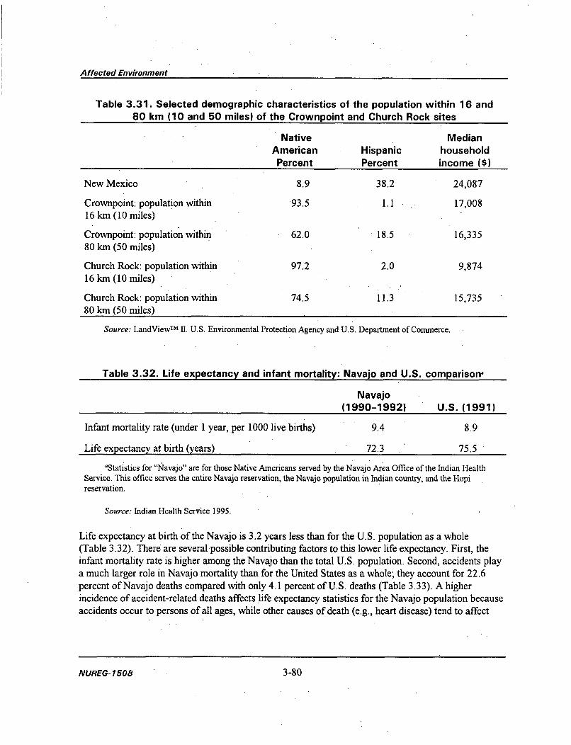
Affected Environment
Table 3.31. Selected demographic characteristics of the population within 16 and80 km (10 and 50 miles) of the Crownpoint and Church Rock sites
Native MedianAmerican Hispanic householdPercent Percent income ($)
New Mexico 8.9 38.2 24,087
Crownpoint: population within 93.5 1.1 17,00816 km (10 miles)
Crownpoint: population within 62.0 18.5 16,33580 km (50 miles)
Church Rock: population within 97.2 2.0 9,87416 km (10 miles)Church Rock: population within 74.5 11.3 15,735
80 km (50 miles)
Source: LandViewTM 11. U.S. Environmental Protection Agency and U.S. Department of Commerce.
Table 3.32. Life expectancy and infant mortality: Navajo and U.S. comparison-
Navajo(1990-1992) U.S. (1991)
Infant mortality rate (under 1 year, per 1000 live births) 9.4 8.9
Life expectancy at birth (years) 72.3 75.5
'Statistics for "Navajo" are for those Native Americans served by the Navajo Area Office of the Indian HealthService. This office serves the entire Navajo reservation, the Navajo population in Indian country, and the Hopireservation.
Source: Indian Health Service 1995.
Life expectancy at birth of the Navajo is 3.2 years less than for the U.S. population as a whole(Table 3.32). There are several possible contributing factors to this lower life expectancy. First, theinfant mortality rate is higher among the Navajo than the total U.S. population. Second, accidents playa much larger role in Navajo mortality than for the United States as a whole; they account for 22.6percent of Navajo deaths compared with only 4.1 percent of U.S. deaths (Table 3.33). A higherincidence of accident-related deaths affects life expectancy statistics for the Navajo population becauseaccidents occur to persons of all ages, while other causes of death (e.g., heart disease) tend to affect
NUREG- 1508 3-80

Affected Environment
1:1143043 102.00 bwj 99.91 miles
1 . .. .s, .ms. u..
E .. . . . . . . . . .
41 ' 7 ...
Figure 3.13. Distribution of the Native American population within 50 miles of theproposed project sites.
3-81 NUREG-1508

Affected Environment
1:1143844 102.00O Ib 99.81 •
• .,.,.......
:'............
Figure 3.14. Distribution of the population within 50 miles of the proposed projectsites by median income.
NUREG- 1508 3-82

Affected Environment
Table 3.33. Leading causes of death: Navajo, Native American, and total U.S.comparison'b
Causes of death (percentage of total deaths)
ChronicAccidents Cerebro- obstructive Pneumonia
Heart and adverse Malignant Diabetes vascular pulmonary andPopulation disease effects neoplasms mellitus diseases diseases influenza
Navajo 15.7 22.6 11.0 3.8 c c 5.7
NativeAmerican 21.9 15.1 15.0 4.5 4.4 c c
U.S. 33.2 4.1 23.7 c 6.6 4.2 c
' Statistics for "Navajo" are for those Native Americans served by the Navajo Area Office of the Indian HealthService. This office serves the entire Navajo reservation and Navajo population in Indian country and the Hopireservation. "Native Americans" here means those served by all area offices of the Indian Health Service.
'Data for the Navajo and Native American populations are for 1990-1992; data for the United States are for 1991.This cause of death is not among the five leading causes of death for this population. Data are reported only for
the five leading causes of death.
Source: Indian Health Service 1995.
Table 3.34. Mortality rates by disease or cause: Navajoand total U.S. comparison"
Navajo United StatesCause/disease (1990-1992) (1991)
Diseases of the heart 101.7 148.2
Malignant neoplasm 78.5 134.5
Cerebrovascular 18.7 26.8
Gastrointestinal diseases 1.7 1.3
Diabetes mellitus 29.0 11.8
Tuberculosis 4.1 0.5
Accidents 143.3 31.0
Alcoholismb 56.8 6.8
'Age adjusted; rates are per 100,000 population.bAlcoholism-related deaths include those occurring from diseases caused by
alcoholism (e.g., alcoholic liver disease) and those resulting from alcohol overdose andpsychoses.
Source: Indian Health Service 1995.
3-83 NUREG- 7508
3-83 NUREG- 1508

Affected Environment
Table 3.35. Leading causes of infant death: Navajo,Native American, and total U.S. comparisonagib
Causes of death (percentage of total deaths)
Disorders NewbornSudden related to short Accident affected by'infant gestation and Respiratory and maternaldeath Congenital low birth distress adverse completion of
Population syndrome anomalies weight syndrome effects pregnancy
Navajo 14.7 35.0 5.5 5.5 8.6
Native 24.3 23.7 3.5 3.8 6.3;Americans
U.S. 14.5 20.9 11.3 7.0 4.2
'Statistics for "Navajo" are for those Native Americans served by the Navajo Area Office of the Indian HealthService. This office serves the entire Navajo reservation, the Navajo population in Indian country, and the Hopireservation. "Native Americans" here means those served by all area offices of the Indian Health Service.
bData for the Navajo and Native American populations are from 1990-1992; data for the U.S. are for 199 1.This cause of death is not among the five leading causes of infant mortality for this population. Data are
reported only for the five leading causes of infant death.
Source: Indian Health Service 1995.
older persons. Both causes of death affect life expectancy, but a cause of death, such as accidents, thathappens to a younger population can have a larger effect on life expectancy.
Although leading cause of death figures are informative, they are not ideal for comparing Navajo healthstatus to that of the U.S. population. This limitation exists because the IHS reports causes of death asthe percentage of total deaths, and the high accident-related death rate among the Navajo makes othercauses of death pale by comparison. Mortality rates, on the other hand, provide a measure of deathsper population, which is a more informative measure for comparison. The mortality rates (by.cause-e.g., heart disease and alcoholism) reported in Table 3.34 conform to the patterns expected forpopulations with and without high accident-related death rates. Mortality rates resulting from heartdisease, cancer, and cerebrovascular disease are lower for Navajo than for the United States'. Mortalityrates resulting from alcoholism, diabetes, tuberculosis, and gastrointestinal diseases are higher amongthe Navajo than the U.S. population. Because of the high rate of death from alcoholism and accidents(most of which likely are related to alcohol use), Navajo may not be living as long as the rest of theU.S. population to experience diseases that are more prevalent in the elderly, such as cancer and heartdisease.
NLIREG- 1508
3-84
NUREG- 1508 3-84

Affected Environment
Perhaps the most informative comparisons between Navajo and U.S. populations-for the purpose ofidentifying overall health status-are the higher infant mortality rates occurring among the Navajo4 andthose diseases that can occur at any age. In this context, tuberculosis and diabetes are appropriate foci.Both diseases are more likely to be causes of death among Navajo than among the U.S. population.Possible reasons are that these diseases are more prevalent among the Navajo or that interventions forthese diseases are less likely to occur for Navajo or are less successful for Navajo than for the U.S.population.
Although congenital anomalies5 are the leading cause of infant death in the Navajo and U.S.populations alike, the percentage of deaths by congenital anomalies among Navajo infants is 15 pointshigher than for U.S. infants (Table 3.35). This difference is noteworthy because there is some evidenceto indicate that radiation exposure may be related to the incidence of congenital anomalies (Shieldset al. 1992). Researchers investigated the birth outcomes of Navajo infants born between 1964 and1981 at the IHS hospital in Shiprock. The research concluded that there were trends in occurrences ofadverse birth outcomes that lend limited support for the hypothesis that adverse genetic outcomes arerelated to radiation exposure. The associations were weak between unfavorable birth outcomes(including congenital anomalies and stillbirths) and radiation exposure of the parents. The onlystatistically significant association was identified when the mother lived near uranium mill tailings ormine waste sites. However, when placing these conclusions in context, the researchers state that giventhe extensive uranium mining operations that have gone on for decades, including radiation exposuresat levels greatly exceeding what would be allowed today, the lack of clear evidence for increased risk ofadverse birth outcomes should be reassuring (Shields et al. 1992).
3.10.4 Subsistence Consumption of Natural Resources by the Native-AmericanPopulation in the Area of Potential Effect
Subsistence is a regular pattern of eating fish or wildlife caught or hunted for oneself or one's family,and/or eating vegetation or livestock raised for oneself or one's family. Subsistence activities are
relevant in environmental justice analyses because the activities could introduce exposure pathways orpathway scenarios6 that potentially affect a population's exposure to-and health consequences of-contamination.
Although no detailed examination of the subsistence activities of either the modem Navajo, Zuni, orAcoma population exists, some Navajo and Pueblo Native Americans still practice traditional lifeways.
4The higher infant mortality rate among the Navajo may be affected by access to health care, which also is relevanthere because lack of access to health care can affect one's health. The high rate of accidental deaths among the Navajomay also be a contributing factor to infant mortality rates.
'Congenital anomalies are those defects that occur during the infant's development in the uterus and are notacquired by heredity.
"Exposure pathways are the physical means through which contaminants enter the human body (e.g., ingestion andcontact with skin); pathway scenarios are the activities in which people participate that might introduce an exposurepathway. An example of a pathway scenario is a child playing in contaminated dirt.
3-85 NUREG- 1508

Affected Environment
Some Navajo and pueblo Indians who do not have adequate or reliable wage work to provide forthemselves and their families rely heavily on their livestock and gardens (Aberle 1983). These lifewaysof the Navajo include herding sheep, goats, and cattle that graze on the land and that are watered fromshallow wells or the Rio Puerco. Diets of some Navajo and Pueblo Native Americans includesubsistence consumption of domestic plants (e.g., squash, corn, beans, and chiles). Both groups alsoharvest indigenous plants to eat and use for medicinal purposes.
3.10.5 Sensitivity of the Community to Potential Impacts of the ProposedProject
The community's sensitivity to potential adverse impacts of the proposed project is heightened by itsprevious experience with natural resource extraction activities, particularly uranium mining, andconcern that the Navajo Nation has not been involved sufficiently in mining oversight and regulation toprotect the interests of the Navajo people, particularly to safeguard their health and environment.Further, community sensitivity is heightened in the context of Navajo Nation struggles for greater self-determination and control of its resources and by the ongoing jurisdictional dispute regarding"checkerboard" lands.
Extraction of natural resources-timber and nonrenewable energy resources (coal, oil, gas, anduranium)-constitutes the primary economic development on the Navajo reservation and in nearbyIndian country (see Section 3.7.1; Aberle 1983). These industries, located in an arid environment, uselarge volumes of groundwater, a situation that by itself heightens sensitivity. Although these extractionindustries have employed Navajo people and provided royalties to the Nation,7 some Navajo perceivethis industrial development to have depleted Tribal resources while most of the economic benefitsaccrue to other people (scoping and public meeting comments; Tome 1983). This perception occurs, inpart, because much of the profit from these developments accrue to private corporations outside thereservation8 and because fixed royalty contracts were disadvantageous when prices rose. Also, there isa history, beginning with the livestock reduction of the 1930s, of compensation for negative effectsbeing provided to others than those primarily affected by the activity. Lastly, some of these industrialdevelopments have had adverse environmental consequences. For example, United NuclearCorporation's uranium mill tailings dam broke in 1979. This dam break contributed to thecontamination of the Rio Puerco. As a consequence, livestock that drink Rio Puerco water have highradionuclide levels (CDC 1980).
The Navajo Nation's history of not controlling or regulating resource developments on the reservationand in Indian country has influenced two pervasive beliefs among Navajo people. The first is thatNavajo interests, particularly protecting the people and the environment, were not adequately addressedin the planning, implementation, and regulation of many of the industrial developments (scoping
7In fact, royalties paid to the Navajo Nation have been more favorable than those paid to non-Native Americanowners of similar resources (Aberle 1983).
8While it is theoretically possible for the Navajo Nation to have spearheaded the developments, lack ofencouragement, expertise, and risk capital prevented them from doing so (Aberle 1983).
NUREG- 1508 3-86

Affected Environment
comments, Aberle 1983). Second, uranium developers are viewed as having been irresponsible(Robinson 1994). The 1979 dam break accident contributed greatly to this perception. This specificsituation occurs in the context of the Navajo Nation, like other Native American tribes, struggling forgreater self-determination and control of their resources and during the ongoing jurisdictional disputeregarding "checkerboard" lands.
Sensitivity is increased by concern about the health effects of uranium mining, specifically, andradiation exposure, in general. These concerns are the legacy of a period when uranium miners wereexposed to radiation levels greatly exceeding what would be allowed today and were poorly informed ofthe potential health effects of radon gas (Radiation Exposure Compensation Act).
The Navajo Nation's sensitivity to uranium mining activities that could adversely affect Navajo peopleand its desire to exercise control over its resources is so great that the moratorium it issued on uraniummining in 1983 was renewed by tribal executive order in 1992. The moratorium on all uranium miningactivity is to be effective on Navajo lands until such a time that the Navajo people are assured that thesafety and health hazards associated with uranium mining activity can be addressed and resolved.There are, however, conflicts between the Navajo Nation's position and that of the chapters andindividuals involved. Referenda held at the Church Rock and Crownpoint chapters, where the proposedproject would be located, supported the HRI proposal despite the moratorium. Also, many allotteeshave agreed to lease their land to HRI. Navajo organizations have arisen to support and to object to theproposed action. The community conflict that results from this difference in opinion also contributes toa heightened sensitivity to the proposed action.
3-87 NUREG- 1508
3-87 NUREG- 1508


4. ENVIRONMENTAL CONSEQUENCES,MONITORING, AND MITIGATION
4.1 AIR QUALITY AND NOISE
4.1 .1 Alternative 1 (The Proposed Action)
The environmental impacts of the proposed project on air quality in the local and regional area can bedivided into those caused by construction and those due to normal operations. During construction ofwell fields, the gaseous and particulate releases from drilling equipment would have a minor localimpact on air quality. During operations, air quality impacts would be largely limited to airborneeffluents generated from processing and dust suspension due to transportation. Local increases inbackground noise levels would be caused by the construction vehicles, trucks, and facility operations.
4.1 .1 .1 Construction Activities
During well field construction, principal emissions to the air would be suspended particulates andgaseous pollutants from vehicle and drill rig exhausts, dust from vehicular traffic on unpaved roads,and dust from disturbed and unprotected soil. HRI estimates that well fields at each project site wouldrequire drilling rigs and support vehicles as summarized in Table 4. 1. Estimated source terms forpollutants discharged by construction vehicles are displayed in Table 4.2.
Table 4.1. Estimated vehicle requirements for welloperations, and maintenance'a
field construction,
Church Rock Unit 1 Crownpoint
Drilling contractorsDrilling rigs, water trucks, support vehicles 7 6 4
Company supportPick-up trucks 8 8 8Forklift *I I IPortable air compressor 3 3 3Pump hoist trucks 2 2 2Coil tubing trucks 2 2 2Logging trucks 1 I 1Water trucks 2 2 2
'Principal vehicles during construction would be the drilling contractors, while company support would largelyoccur during operations.
4-1 4-1 NUREG- 7508

Environmental Consequences, Monitoring, and Mitigation
Table 4.2. Estimated source terms for gaseousand particulate emissions from nominal
209-horsepower diesel drilling equipmenta
Emission type Emission rate
Sulfur oxides (SOJ) 0.93
Nitrous oxides (NO,) 11.01
Hydrocarbons 1.41
Carbon monoxide 9.20
Particulates 1.44
Aldehydes 0.20
'All values are reported in grams per horsepower-hour.Source: EPA 1991.
Non-stationary sources of air pollutants would be diesel engines on the drill rigs and diesel-poweredwater trucks. Drilling would proceed through the mine units, with each drilling location requiring oneto two days of work. Most other equipment would experience only sporadic use, and its impact on airquality would be negligible. Other mobile vehicles would be gasoline-powered onroad cars and trucksequipped with required emission control devices.
During well field construction, it is estimated that each project site would average 100 vehicle-hoursper day annually (Pelizza 1996c). Based on the emission rates in Table 4.2, the annual total releasesand average air concentrations at each site from well field construction activities would be as shown inTable 4.3. The estimated annual average air concentration is based on the average wind speed[13 km/hr (8 mph)], land use [24 ha (60 acres)] and a mixing layer height of I km (0.62 mile). Theseestimated releases are small fractions of the allowable increments for prevention of significantdeterioration of air quality (see Section 3.1.6.2).
The potential for dust emissions from wind erosion would be minimized by promptly reclaimingdisturbed soil and establishing vegetative cover on soil stockpiles. Most of the work associated withwell field installation would take place with stationary equipment. Therefore, dust releases resultingfrom vehicle traffic in the well field should be small because of low traffic volume.
4.1.1.2 Processing Emissions
Air quality impacts related to operations would be largely limited to airborne effluents generated fromprocessing and fugitive dust generated by vehicle traffic on unpaved roads. Air pollution consisting ofdust suspended by vehicle traffic associated with routine well field maintenance would be minimal.Additionally, material shipments from the Unit 1 and Church Rock sites to the central processing plantin Crownpoint would be conducted mostly on paved roads.
NUREG- 1508 4-2

Environmental Consequences, Monitoring, and Mitigation
Table 4.3. Estimated annual total releases and average air concentrationsfor gaseous and particulate emissions from well field activities
Annual total Annual averageEmission type (tonnes) concentration (fg/m 3)
Sulfur dioxides (SO,) 7.1 0.18
Nitrous oxides (NO.) 84.0 2.1
Hydrocarbons 10.8 0.27
Carbon monoxide 70.2 1.8
Particulates 11.0 0.28
Aldehyde 1.5 0.04
Air quality in the well fields and near the processing buildings would be affected by airborne effluents.Dissolved radon gas would be present in the processing solutions, and would escape into theatmosphere at several locations. First, radon would be vented in the well fields either from individualwell vents or in the meter houses, or both. Also, the ion exchange system at each processing site wouldprovide a potential escape pathway for radon. However, HRI proposes to operate the ion exchangesystems using a pressurized down-flow design. Therefore, radon releases from the plants would occuronly when individual ion exchange columns were disconnected from the pressurized recirculationsystem and opened to remove or elute the resins (see Section 2.1). Finally, yellowcake dryers andpackaging areas could release airborne particulate emissions, including natural uranium and radondaughters, to the environment.
HRI modeled the radiological effects of these emissions upon the local population and surroundingarea. The analysis was completed using the MILDOS-AREA computer code that was developed byNRC for predicting radiological doses from uranium recovery facilities (ANL 1989). The results ofthese analyses are described as radiological effects in Section 4.6. The estimated releases would resultin very small fractions of the allowable dose limit for the general public.
Two sections of the standard transport routes between facilities would involve unpaved roads. A smallsection of Church Road and the access road to Unit 1 (Picnic Road) are currently unpaved, gravelroads. The additional vehicle traffic associated with the proposed project would cause adverse impactsfrom additional fugitive dust to residences and the churches in the immediate area of the road.
4.1.1.3 Noise
In general, operations at ISL mining facilities do not create important sources of noise to offsitereceptors except in two cases: construction/drilling in the well fields and truck traffic for the operation.No significant noise sources that would result in significant audible noises offsite would be in a wellfield for most of a well field's production and remediation lifetimes. In general, the only noise sourceswould be the necessary pumps and occasional truck traffic performing maintenance and inspections.Construction of the well fields and transportation of the slurry (or resins) and product would generally
4-3 NUREG-1508

Environmental Consequences, Monitoring, and Mitigation
result in audible noises in and around residences or multi-use facilities (e.g., churches) in the immediatevicinity of the project site. Generated noise levels would likely be annoying, but would be either short induration (construction) or intermittent (transportation). The following discussion details possible noiselevels during short-duration construction or from transportation of slurry (or resins) and product.
Drill rigs, construction vehicles, heavy trucks, and other equipment used to construct and operate thewell fields and production facilities would generate noise that would be audible above backgroundlevels of 50-60 decibels (dB) in the normal (A-scale) auditory frequency band [dB(A)] during the day.Noise resulting from the proposed project could occasionally be annoying to residents within 300 m(0.2 mile) of the noise sources. Noise levels (other than occasional instantaneous levels) resulting fromthe proposed project might reach or occasionally exceed 85 dB(A) at 16 m (50 ft) from the source.Because noise levels diminish by about 6 dB(A) for each doubling of distance from the source (Goldenet al. 1979), nearby residents or users of multi-use facilities (e.g., churches) might experience outdoornoise levels of slightly greater than 70 dB(A) during periods when construction equipment operated inthe general vicinity. Because well field construction would generally occur only during daytime hours,this noise would not be expectedto cause exceedances of the 24-hr average sound-energy guideline of70 dB(A) estimated by EPA (1978) to protect hearing with a margin of safety. However, outdoor noiselevels at the nearest residences during the day would be expected to appreciably exceed 55 dB(A), thelevel given by EPA (1978) as protective against activity interference and annoyance with a margin ofsafety. Indoor noise levels typically range from 15 to 25 dB(A) lower than outdoor levels, depending onwhether windows are open or closed. With windows open during construction hours, indoor noiselevels could be substantially greater than the 45 dB(A) level given by EPA (1978) as protective againstindoor interference and annoyance with a margin of safety. In summary, noise levels during well fieldconstruction and transportation of slurry and product are likely to be annoying to residences near thesources, but are not likely to be harmful.
4.1.2 Alternative 2 (Modified Action)
4.1.2.1 Alternative Sites for ISL Mining
One possible alternative to licensing the project as proposed by HRI is to limit the number of sites forISL mining. Additional air and noise pollution in the local area could be avoided by not developing oneor two of the three proposed sites. For example, developing only one of the satellite facilities wouldresult in fewer vehicles using the unpaved section of road near the Crownpoint processing facility,reducing fugitive dust in that area. Using the Crownpoint site for yellowcake drying and packagingonly (i.e., no wells at the Crownpoint site) would result in slightly smaller fugitive dust emissions thanthe proposed project, and would help avoid additional air and noise pollution because there would notbe well field construction.
4.1.2.2 Alternative Sites for Yellowcake Drying and Packaging
Using an alternative site for yellowcake drying and packaging would help avoid additional fugitive dustemissions around the Crownpoint facility but would not result in a complete absence of additional dustgeneration. If the area around the Crownpoint main facility were mined but the dryer were elsewhere,
NUREG-1508 4-4
Environmental Consequences, Monitoring, and Mitigation
for example, in south Texas, the Crownpoint facility (now effectively a satellite facility) would need toship slurry to the new dryer location.
Placement of the dryer in the Unit 1 or Church Rock sites would result in increased fugitive dustemissions similar to those described for the Crownpoint site in Section 4.1.1.2.
4.1.3 Alternative 3 (The NRC Staff-recommended Action)
This section provides a summary of additional NRC staff requirements and recommendations based onits evaluation of the proposed action. The following list supplements the commitments already made byHRI in its license application. Subsequently, HRI has formally agreed to these conditions as expressedin its letter to NRC dated December 26, 1996 (see Appendix B). The staff believe that the previouslyidentified impacts of this project can be mitigated through the measures discussed below.
If a license were issued for the proposed project, those items listed as requirements would beincorporated in the license either as separate license conditions or combined as one general licensecondition that references HRI's consolidated operations plan. For those items listed as NRC staffrecommendations, BIA, BLM, and other cognizant regulatory agencies will be responsible for ensuringthat HRI has complied with this guidance.
The proposed project would have only minor impacts in terms of air quality and noise (Section 4.1.1).However, to ensure that air quality impacts were minimized, if a license were issued for the proposedproject NRC staff would require the following license conditions:
" Yellowcake drying operations shall be immediately suspended if any emission controlequipment for the yellowcake drying or packaging areas is not operating within specificationsfor design performance.
* HRI shall, during all periods of yellowcake drying operations, ensure that the manufacturer-recommended vacuum pressure is maintained in the drying chamber. This shall beaccomplished by continuously monitoring differential pressure and installing instrumentationwhich will signal an audible alarm if air pressure differential falls below the manufacturer'srecommended levels.
In addition to these requirements, NRC staff recommends that HRI use dust suppression techniques toreduce fugitive dust emissions and associated impacts to residences and churches near the Crownpointand Unit 1 sites during project shipments on unpaved roads.
4.1.4 Alternative 4 (No Action)
Under the no-action alternative, air quality in the project area would remain as described in Section 3.1.
4-5 NUREG-7 508
4-5 NUREG-1508

Environmental Consequences, Monitoring, and Mitigation
4.2 GEOLOGY AND SOILS
4.2.1 Alternative 1 (The Proposed Action)
During construction of the proposed project, the principal impacts on soils would result from earthmoving associated with constructing wastewater retention ponds and clearing drilling sites. Duringproject operation and groundwater restoration activities, the principal impact on soils would be fromongoing drilling activities and land application of project wastewater. HRI has provided estimates ofpond sizes and land application areas for three groundwater restoration approaches: (1) 100 percentgroundwater sweep; (2) reverse osmosis treatment only; and (3) brine concentration. For the100 percent groundwater sweep option, restoration water would be disposed of by land application(HRI 1993b). For the reverse osmosis option, HRI would depend on deep well disposal for reverseosmosis reject water. Therefore, under this option evaporation ponds would not be constructed and landapplication areas would not be required. For the brine concentration option, a 0.8-ha (2-acre) pondwould be constructed at each project site.
Estimates of the amounts of land that would be disturbed during well field and plant construction areprovided in the following sections. These estimates also include areas for the construction of ponds forthe brine concentration approach, previously identified land application areas within the siteboundaries, and land that has already been disturbed by previous construction activities. Therefore, thearea estimates for construction impacts are anticipated to represent worst-case estimates.
4.2.1.1 Crownpoint
ISL mining activities would not result in the removal of rock matrix or structure, so unlikeunderground mining, they would not cause subsidence at the site from the collapse of overlying rockstrata in the mine zone. The principal impacts on the geologic environment during project constructionwould result from earth moving associated with constructing wastewater retention ponds and clearingdrilling sites. Most of the potential impacts of construction at the Crownpoint site have alreadyoccurred, because HRI purchased existing surface facilities at the site. However, the existing pondsmay not be adequate and might need regrading and synthetic liners capable of retaining the wastewater.Including both previously and newly disturbed areas, construction at the Crownpoint site would likelyinvolve about 258 ha (638 acres).
Topsoil would be preserved by adopting construction practices that prevent erosion. All areas wheresoil is temporarily scraped away would have the soil replaced and reseeded immediately afterconstruction (HRI 19960.
HRI has stated that the material in the Crownpoint site ponds presently consists of windblown sand,drill cuttings, and drill mud (bentonite) (HRI 1996o). Radionuclide analysis shows that the materialcontains very low concentrations of uranium, radium, thorium, and lead 210. HRI plans to dispose ofthis material in Section 12, 17N RI3W, located northwest of the Crownpoint site. HRI acquired thisland from Mobil Oil Corporation, which previously used the site for drill mud disposal. HRI plans todispose of the existing pond material by disking (blending) it with the native soil and then reseeding the
NUREG- 1508 4-6

Environmental Consequences, Monitoring, and Mitigation
area. HRI has also identified the Section 12 property as a potential area for the off-site land applicationof project wastewater.
Additional impacts on soils could result from spills from processing equipment. Soil contaminationcould result from pipeline leaks and ruptures, retention pond liner failures, or transportation accidentsresulting in yellowcake or ion exchange resin spills. If soil were contaminated by a spill, the soil wouldbe removed and disposed of in retention ponds. Ultimately, this material would be disposed of withother 1 e(2) by-product material at a licensed off-site disposal area in compliance with 10 CFR Part20. All decontamination procedures would be confirmed with radiation surveys, and would be requiredto meet NRC's regulations addressing radioactive materials in soils in areas released for unrestricteduse.
For the Crownpoint site, all of Section 12, 17N RO3W, (Figure 4.1) would be available forirrigation/land application. Section 12 is located 1 mile north of the Crownpoint site boundary andapproximately 1 mile northeast of the Unit 1 site boundary. Section 12 contains 259 ha (640 acres), butit is estimated that only 42 ha (104 acres) would be needed (HRI 1996a). However, since HRI statesthat all of Section 12 will be available for irrigation/land application, 259 ha (640 acres) is used in thisanalysis as a worst case estimate of environmental impact.
Before water would be disposed of using land application, radionuclide concentrations would bereduced to acceptable levels (Table 4.4). Radionuclide water quality would be monitored before waterwas disposed of by land application. Analyses submitted by HRI indicate that metal accumulation inthe soils, including selenium, molybdenum, uranium, or radium-226, is not expected to be a problem atthe land application site (HRI 1996a). Soil erosion estimates, based on a conservative use of theuniversal soil loss equation, show that soil losses would not contribute significantly to erosion. Soils atthe land application site are presently subject to wind erosion; HRI's proposed irrigation andestablishment of continuous ground cover would greatly reduce erosional losses due to wind. Withirrigation applied at a rate of 0.2 in./hr, no runoff would be expected. HRI proposes to meet thefollowing conditions (HRI 1996a):
1. No irrigation is to be carried out during a rainfall event.2. If heavy rains are forecast, no irrigation is to be carried out in the preceding 12 hr.3. No irrigation is to be allowed on saturated soils.4. No irrigation is to be allowed on steep slopes or soils shallower than 72 in.5. Close-order soil sampling of prospective irrigation plots will be conducted to exclude areas with
existing soil conductivity problems prior to irrigation.
The salinity of the proposed irrigation water would be tolerable for the irrigation of pasture grasses.However, the salinity of the irrigation water would cause permeability problems with clay soils in theirrigation plots. Based on calculations provided by HRI, it does not appear likely that these problemswould be sufficient to preclude irrigation, but monitoring of soil electrical conductivity would berequired on a regular basis (HRI 1996a). In addition, if soil electrical conductivity should rise to
4-7 NUREG-1508

(~1
00
Figure 4.1. The Section 12 off-site land application area for the Crownpoint and Unit 1 sites.

Environmental Consequences, Monitoring, and Mitigation
Table 4.4. Projected quality of water to be disposed of byland application (HRI 1996a)
Parameter Concentration (mg/L)
Calcium
Magnesium
Sodium
Potassium
Carbonate
Bicarbonate
Sulfate
Chloride
Nitrate
Fluoride
Silica
Total dissolved solids
Electric conductivity
Alkalinity
pH
Arsenic
Barium
Cadmium
Copper
Iron
Lead
Manganese
Mercury
Molybdenum
Nickel
Selenium
Silver
Uranium
Vanadium
Zinc
Boron
Ammonia
Radium-226Source: HRI 1996a.
56
4
461
39
26
566
260
328
0.26
0.76
27
1501
1522 (kinmhos)
494
8.5 (units)
0.028
0.16
0.0013
0.01
0.07
0.0019
0.76
0.0
0.01
0.01
0.013
0.01
1.0
0.67
0.05
0.14
0.11
1.0 (pCi/L)
4-9 NUREG- 7508
4-9 NUREG-1508

Environmental Consequences, Monitoring, and Mitigation
70 percent of the maximum level tolerated by the planted crop, the irrigation area would be moved toanother portion of the available land (HRI 1996a). HRI also proposes to maintain the soil sodiumabsorption ratio at 4 or below (HRI 1996a).
Total dissolved solids could present a problem for HRI's land application proposal. Total dissolvedsolids is a limiting condition for irrigation at 1500 mg/L (HRI 1996a), and the proposed irrigationwater shows total dissolved solids at 1501 mg/L. HRI also reports that the sodium absorption ratio ofthe irrigation water is considered limiting at 15 (non-adjusted), while the sodium absorption ratio of theproposed irrigation water is 49.6 (adjusted). According to HRI, the existing total dissolved solid leveland sodium absorption rate indicate that the proposed irrigation water would require close managementand that soil sodium absorption ratios would require frequent monitoring (HRI 1996a). However, givenHRI's proposed operating procedures, it is likely that soil impacts resulting from land applicationwould be low.
At present, uranium is the only economically recoverable mineral resource at the Crownpoint site.NRC staff believe that the proposed project would not preclude recovering other minerals that might bediscovered in economical quantities at the site in the future. Assuming that only 60 percent of theuranium ore reserves are recovered by the proposed project, an estimated 8.6 million kg (19 million lb)of uranium yellowcake would be produced from the Crownpoint site.
4.2.1.2 Unit 1
Unlike at the Crownpoint site, water storage ponds would have to be constructed at the Unit I site tohold processing bleed and aquifer restoration water from the satellite ion exchange plant. Includingboth previously and newly disturbed areas, construction at the Unit I site would likely involve about363 ha (896 acres).
For the Unit 1 site, all of Section 12, T17N R13W, (Figure 4.1) would be available for irrigation/landapplication. This is the same location proposed for the Crownpoint site, so the impacts of landapplication on soil resources should be the same as those described in Section 4.2.1.1.
At present, uranium is the only economically recoverable mineral resource at the Unit 1 site. NRC staffbelieve that the proposed project would not preclude recovering other minerals that might be discoveredin economical quantities at the site in the future. Assuming that only 60 percent of the uranium orereserves are recovered by the proposed project, an estimated 8.6 million kg (19 million lb) of uraniumyellowcake would be produced from the Unit 1 site.
4.2.1.3 Church Rock
ISL mining activities would not result in the removal of rock matrix or structure which could causesurface subsidence. Rather, subsidence at the Church Rock site would most likely result from thecollapse of existing mine workings. If ISL mining were to contribute to working collapse, it wouldlikely result from the varying water pressures and vibrations associated with an operating well field.NRC staff believe that any workings collapse that might occur during ISL mining would eventually
NUREG-1508 4-10
Environmental Consequences. Monitoring, and Mitigation
occur whether or not ISL mining activities were ever conducted at the site. However, if depressionsappeared at the land surface as a result of subsurface collapse, NRC staff would require HRI to returnthe land surface to its general contour as part of the project's surface reclamation activities.
Most of the potential impacts of construction at the Church Rock site have already occurred becauseHRI purchased existing surface facilities at the site. Including both previously and newly disturbedareas, construction at the Church Rock site would likely involve about 130 ha (324 acres).
Land application at the Church Rock site would probably take place on 32 ha (80 acres) in Section 17,T16N R16W (HRI 1993a; HRI 1996a). HRI has conducted land application soil studies for this parcelof land in Section 17 but is also considering other properties for land application (Figure 4.2)(HRI 1996c). These properties are
1. Flat mesa land consisting of 83 ha (206 acres) on patented Federal mining claims owned by HRIin Section 8, T16N R16W
2. Flat mesa land consisting of 109 ha (270 acres) on patented Federal mining claims owned by HRIin Section 12, T16N R17W
3. Pasture land consisting of 259 ha (640 acres) owned by the State of New Mexico in Section 16,T16N R16W
HRI has stated that of these three additional properties, the Section 16 parcel is the most preferablebecause it is the largest block of relatively flat property, it is close to the Crownpoint site, and it is atapproximately the same elevation as the Crownpoint site (HRI 1996c). HRI has stated that theSection 16 parcel would be the largest parcel that would be considered for land application, and thatthe maximum affected area (land potentially removed from grazing) would be 259 ha (640 acres)(HRI 1996c).
HRI proposes to file an application with NRC at the time irrigation plans for the Church Rock sitehave been finalized. The application would contain information about the environmental conditions ofthe parcel selected for land application (HRI 1996c). For purposes of evaluating potentialenvironmental impacts in this FEIS, NRC staff have assumed that land application could occur at anyof the four potential sites, but that no more than 259 ha (640 acres) would be affected. Landapplication associated with the Church Rock site would have impacts similar to those described for theCrownpoint site in Section 4.2.1.1.
At present, uranium is the only economically recoverable mineral resource at the Church Rock site.NRC staff believe that the proposed project would not preclude recovering other minerals that might bediscovered in economical quantities at the site in the future. Assuming that only 60 percent of theuranium ore reserves are recovered by the proposed project, an estimated 1.8 million kg (4 million lb)of uranium yellowcake would be produced from the Church Rock site.
4-11 NUREG- 1508
4-11 NUREG- 1508

hi9-4
0~002
Figure 4.2. Potential land application areas for the Church Rock site.

Environmental Consequences, Monitoring, and Mitidgation
4.2.2 Alternative 2 (Modified Action)
4.2.2.1 Alternative Sites for ISL Mining
The impacts of developing only one of the proposed project sites are described in Sections 4.2.1.1,4.2.1.2, and 4.2.1.3 for the Crownpoint, Unit 1, and Church Rock sites, respectively.
Developing only the Church Rock and Unit 1 sites could involve the disturbance of up to 493 ha(1220 acres) for project plants, well fields, and production ponds. Land application would result in thedisturbance of up to an additional 518 ha (1280 acres). It is projected that 10.4 million kg (23 millionlb) of uranium yellowcake would be produced if these two sites were developed.
Developing only the Church Rock and Crownpoint sites could involve the disturbance of up to 389 ha(962 acres) for project plants, well fields, and production ponds. Land application would result in thedisturbance of up to an additional 518 ha (1280 acres). It is projected that 10.4 million kg (23 millionlb) of uranium yellowcake would be produced if these two sites were developed.
Developing only the Unit 1 and Crownpoint sites could involve the disturbance of up to 620 ha(1534 acres) for project plants, well fields, and production ponds. Land application would result in thedisturbance of up to an additional 259 ha (640 acres). It is projected that 17.2 million kg (38 million lb)of uranium yellowcake would be produced if these two sites were developed.
4.2.2.2 Alternative Sites for Yellowcake Drying and Packaging
Impacts due to the construction of a dryer facility at either the Unit 1 or Church Rock site would belimited to a few acres. This land area would be cleared for construction of the dryer and the buildingsused to store yellowcake and dried uranium.
There would be no significant impact on geologic and soil resources from using the existing drying andpackaging facilities at HRI's Kingsville Dome site in Texas or at the Ambrosia Lake Uranium Millnorth of Milan, New Mexico.
4.2.3 Alternative 3 (The NRC Staff-recommended Action)
This section provides a summary of additional NRC staff requirements and recommendations based onits evaluation of the proposed action. The following list supplements the commitments already made byHR! in its license application. Subsequently, HRI has formally agreed to these conditions as expressedin its letter to NRC dated December 26, 1996 (see Appendix B). The staff believe that the previouslyidentified impacts of this project can be mitigated through the measures discussed below.
If a license is issued for the proposed project, those items listed as requirements would be incorporatedin the license either as separatelicense conditions or combined as one general license condition thatreferences HRI's consolidated operations plan. For those items listed as NRC staff recommendations,
4-13 NUREG-1508

Environmental Consequences, Monitoring, and Mitigation
BIA, BLM, and other cognizant regulatory agencies will be responsible for ensuring that HRI hascomplied with this guidance.
The proposed project would not have major impacts on geology and soils in the region (Section 4.2.1).However, to ensure that potential impacts to soils are minimized, if a license were issued for theproposed project, NRC staff would require the following license conditions:
HRI is prohibited from constructing wastewater retention ponds prior to NRC's review andapproval of an embankment engineering design. The design shall contain all specificationsrelated to embankment slope stability, liners, freeboard requirements, and leak detectionsystems. Any retention pond intended to retain degraded water above grade shall be designedin accordance with NRC Regulatory Guide 3.11, Design, Construction, and Inspection ofEmbankment Retention Systems for Uranium Mills. In addition, HRI shall demonstratethrough detailed engineering analyses that the ponds and diversion channels around the pondswould be stable under a probable maximum flood condition, in accordance with NRC StaffTechnical Position #WM-820 1, Hydrologic Design Criteria for Tailings Retention Systems.Accordingly, HRI shall provide detailed analyses to document the adequacy of the systemduring an occurrence of the probable maximum flood.
" HRI shall, at all times, maintain sufficient reserve capacity in the retention pond system toenable transferring the contents of a pond to the other ponds. In the event of a leak andsubsequent transfer of liquid, the freeboard requirements shall be suspended during the repairperiod.
" HRI shall submit a detailed site reclamation plan to the NRC for review and approval at least12 months prior to planned final shutdown of mining operations. If depressions appear at theland surface due to subsurface collapse, HRI shall return the land surface to its generalcontour as part of the project's surface reclamation activities. Before release of an area tounrestricted use, HRI shall provide information to the NRC verifying that radionuclideconcentrations meet applicable radiation standards. Currently, the soil cleanup criterion fornatural uranium not in equilibrium with its daughters is 1.1 Bq/g (30 pCi/g), and for radiumis 0.19 Bq/g (5 pCi/g) in the top 15 cm and 0.57 Bq/g (15 pCi/g) for other soils.
HRI shall maintain an adequate financial surety to cover the costs of reclaiming disturbedareas. The amount of the surety shall be determined by the NRC based on cost estimates forcompletion of the approved reclamation plan by a third party in the event HRI defaults. Thesurety shall be reviewed annually by the NRC and adjusted to reflect expansions inoperations, changes in engineering design, and inflation.
4.2.4 Alternative 4 (No Action)
There would be no impacts to geology or soils under the no-action alternative because no uraniumwould be produced. Conditions would remain as described in Section 3.2.
NUREG- 1508 4-14

Environmental Consequences, Monitoring, and Mitigation
4.3 GROUNDWATER
The potential groundwater impacts of ISL mining are related to the consumption of groundwater (i.e.,water is pumped from the aquifer but not returned to it) and short- and long-term changes togroundwater quality (i.e., the chemistry of the water). Perhaps the most significant environmentalimpact that can occur as a result of ISL mining is the degradation of water quality in the ore-bearingaquifer.
Local groundwater quality in the Westwater Canyon sandstone within the proposed mining units woulddeteriorate during HRI's proposed project. The Westwater Canyon aquifer is expected to be the onlyaquifer affected by the proposed mining operations under HRI's current submittals. Averagebackground characteristics of groundwater in the Westwater Canyon aquifer are summarized inTable 4.5.
Well field water quality and hydraulic data are collected before mining operations begin. The waterquality data are used to set the concentrations of parameters that will be used to determine whether thewell field is being operated safely. Water quality data are also used to establish the water qualitystandards to which the aquifer will be restored after mining. From an environmental standpoint, thehydraulic data are used to (1) determine whether the well field can be operated safely, (2) confirm thatmonitor wells have been located correctly, (3) design aquifer restoration activities, and (4) predict post-restoration impacts.
During ISL mining operations, water quality impacts are usually of greater concern than waterconsumption impacts because water consumption during mining is relatively small. Water consumptionbecomes a significant impact during groundwater restoration activities. Contamination of groundwaterfrom sodium-based alkaline lixiviant uranium leaching arises from (1) the addition of sodiumbicarbonate and oxygen (lixiviant) to the groundwater, (2) the addition of chloride to the groundwaterby the processing plant, and (3) the interaction of these chemicals with the mineral and chemicalconstituents of the aquifer being mined (most significantly uranium, potassium, sulfate, arsenic,selenium, molybdenum, and other trace metals) (Deutsch 1985). The result is that during mining, theconcentration of most of the naturally occurring dissolved constituents will be appreciably higher thantheir concentrations in the original groundwater (Table 4.5).
Water quality impacts from ISL mining activities are related to the identification, control, and clean-upof excursions. Excursions are unanticipated releases of mining solutions that move beyond the "wellfield area." The "well field" is where production and injection wells have been completed and solutionmining occurs. The "well field area" encompasses the well field and the larger area encircled by theperimeter monitor wells. During mining, mine solutions (groundwater altered by the injection oflixiviant) are not expected to move horizontally beyond the well field area. For the three proposed sites,the mine zone is the Westwater Canyon aquifer. Similarly, mine solutions are not expected to movevertically into aquifers above or below the mine zone. Where appropriate, wells would be placed in.aquifers above and below the mine zone to monitor for vertical excursions.
4-15 NUREG- 1508

Environmental Consequences, Monitoring, and Mitigation
Table 4.5. Average background concentrations of principal chemical species inWestwater Canyon groundwater near the Church Rock and Crownpoint sites and
estimated lixiviant water quality during proposed mining operationsa
Church Rock Crownpoint
Chemical species background background Lixiviant
Calcium 2.9 2.0. 100-350
Magnesium 0.3 0.1 10-50
Sodium 125 110 500-1600
Potassium 2 3 0-500
Carbonate 20 27 0-500
Bicarbonate 255 195 800-1500
Sulfate 35 35 100-1200
Chloride 6 3 250-1800
Nitrate 0.02 0.04 <0.01-2
Fluoride 0.3 0.3 0.05-1
Silica 15 17 25-50
TDS 360 320 1500-5500
Uranium 0.2 0.005 50-250
Radium-226 10 0.7 >100
Conductivity 540 415 2500-7500
pH (standard units) 8.8 9.0 7.0-6.9
'Values are in mg/L unless specified otherwise. Data are based on HRI's groundwater sampling and operatingexperience (HRI 1993a).
ISL monitoring programs are designed to ensure that any excursion is detected long before miningsolutions can seriously degrade groundwater quality outside the well field area. Early detection ofexcursions by a monitor well is influenced by several factors, such as the thickness of the aquifermonitored, the distance between the monitor wells and the well field, the distance between adjacentmonitor wells, how often monitor wells are sampled, the water quality parameters that are sampled, andthe concentrations of parameters that are used to determine whether an excursion has occurred.
Since it is very expensive and time-consuming to sample for every water quality parameter that couldbe mobilized during ISL mining, a select group of parameters (known as "upper control limit"parameters) is chosen to provide early warning that more serious contaminants are moving toward themonitor wells. An excursion is deemed to have occurred when the concentrations of the upper controllimit parameters in the water sampled exceed pre-determined concentrations calculated from baselinewater quality data. These pre-determined concentrations are unique for each well field.
NUREG-1508 4-16

Environmental Consequences, Monitoring, and Mitigation
Horizontal excursions generally occur when well field injection rates and pumping rates are notcorrectly balanced. If injection rates exceed pumping rates, mining solutions can move out from thewell field area. However, horizontal excursions are relatively easy to detect because the mine area issurrounded by monitor wells. When a horizontal excursion is detected, the maximum width of theexcursion (the distance between monitor wells) and the direction in which the excursion is traveling(horizontally from the well field) are known. In addition, horizontal excursions are relatively easy tocontrol because the wells located in the aquifer can pump the well field at an increased rate to pull backthe contaminants and correct the excursion. If a well field operator takes prompt action after ahorizontal excursion has been detected, the excursion should be easy to correct long before any seriouswater quality changes occur in the aquifer outside the well field area.
Vertical excursions occur when vertical pathways allow mining solutions to move up or down intooverlying or underlying aquifers. Vertical pathways are caused by (1) thin or missing confining units(geologic material with very low permeabilities); (2) open faults, fractures, and exploration boreholes;(3) broken casing from mining wells; and (4) injection wells operating at excessive pressures. Verticalexcursions tend to occur more frequently near injection wells where the hydraulic head (water level)exceeds the hydraulic head of any overlying or underlying aquifers. If there are no vertical pathwayspresent, vertical excursions generally do not occur. Therefore, if a well field operator carefullycharacterizes, constructs, and tests the well field, there is a low likelihood of occurrence.
The potential risk of vertical excursions is reduced by detailed geologic characterization during wellfield development, hydrogeologic testing, careful well construction, close monitoring of injectionpressures, and periodic mechanical integrity testing of installed wells. These measures make thelikelihood of vertical excursions low. Consequently, vertical monitor wells are not drilled so as toencircle the well field in the aquifer above or below. Once a vertical excursion has been detected, thevertical pathways must first be located and sealed. Then additional wells must be drilled into theoverlying or underlying aquifer to define the extent of the excursion and correct it. Thus, if a verticalexcursion occurs, water quality in the overlying or underlying aquifer is likely to take much longer tocorrect than with a horizontal excursion.
During groundwater restoration, water consumption and water quality impacts can be significant.When restoration activities begin, water consumption increases dramatically. The amount of increasedepends on the restoration techniques applied. Techniques that clean the aquifer by pumpingcontaminated water from the aquifer, removing the contaminants, and reinjecting the clean water intothe aquifer consume the least amount of water.
Final restoration water quality standards are determined using baseline water quality data. Restorationstandards are unique for each well field and usually consist of restoration on a parameter-by-parameterbasis to the average baseline concentration for the well field or an appropriate State or Federal waterquality standard. Therefore, after successful restoration, water quality in the aquifer will not beidentical to that which existed prior to mining. However, if average baseline conditions are achieved,general water quality should be close to its original condition. If water use standards are achieved,water quality should be such that water use is preserved.
4-17 NUREG- 1508

Environmental Consequences, Monitoring, and Mitigation
Post-restoration water quality stability monitoring is solely concerned with water quality impacts. Thisphase of the ISL mining process occurs after well field water quality has been successfully restored.Since the geochemical conditions just after restoration are not identical to pre-mining conditions,groundwater quality will be monitored for a specified period of time to ensure that aquifer water qualityis not being degraded as a result of the remobilization of chemical constituents (HRI 1992b; HRI1992d; HRI 1993a).
4.3.1 Alternative 1 (The Proposed Action)
The following text describes pre-mining, mining, and post-mining activities that are applicable to allthree project sites. Activities that would be unique at each site are described in Sections 4.3.1.1,4.3.1.2, and 4.3.1.3. Descriptions of potential impacts and mitigative measures proposed by HRI arealso included. Section 4.3.3 describes NRC staff requirements and recommendations to mitigatepotential groundwater impacts that were not proposed by HRI.
Pre-mining Activities
Baseline Monitoring and Testing. Groundwater would be monitored prior to, during, and after theproposed mining operations. Prior to lixiviant injection in a well field, data would be collected todetermine baseline water quality and define aquifer properties. Water quality data would be collected toestablish upper control limits and restoration criteria. Prior to lixiviant injection in each mining unit,HRI proposes that
1. Baseline water quality data would be established at (1) all mining unit perimeter monitor wells,(2) all upper and lower aquifer monitor wells, and (3) at least one production/injection well peracre in each well field.
2. Upper control limits and groundwater restoration criteria would be established (HRI. 1996b).
Baseline water quality and water level data would be collected from the wells within the well field andcompleted in the Westwater Canyon aquifer at a density of one well per acre of well field (HRI 1996e).Baseline water quality and water level data would be collected from the first overlying aquifer at adensity of one well per four acres of well field (HRI 1996b).
HRI would conduct additional pumping tests from production or injection wells to test the verticalconfinement of a well field. HRI has identified a data gap for determining the flow direction in theDakota Sandstone, but has committed to additional characterization or monitoring of the overlyingaquifers at the three project sites before operations commence (HRI 1996b). HRI would characterizethe groundwater flow direction in the overlying Dakota aquifers at the Church Rock, Unit 1, andCrownpoint properties before operations commence. HRI has committed to spacing monitor wells inthe first overlying aquifer at a density of one well per four acres of field production area (HRI 1996b).There would be 11 shallow monitor wells at the Church Rock site, 24 at the Unit 1 site, and 40 at theCrownpoint site (HRI 1996b). The number of wells in the overlying aquifer would provide an adequatepopulation of reference points to conduct contour analysis and determine flow direction, flow velocity,and water quality.
NUREG-1508 4-18

Environmental Consequences, Monitoring, and Mitidgation
Mining Activities
Location of Monitor Wells. Monitor wells completed in the Westwater Canyon Formation (minezone) would encircle each well field at a distance of 140 m (400 ft) from the edge of the production orinjection wells and 140 m (400 ft) between each monitor well (HRI 1992a; HRI 1993a; HRI 1992b).The angle formed by lines drawn from any production well to the two nearest monitor wells would notbe greater than 75 degrees (HRI 1996h). Monitor wells would be located in the first overlying aquiferat a density of one well per 1.6 ha (4 acres) of well field (HRI 1996b). Deep monitor wells below themining zone are completed within the boundaries of the well field at ISL uranium mining operations.Like production and injection wells, they are drilled through the zone of mining. Therefore, they have tobe carefully completed so that they do not become pathways that could create a vertical excursion intothe underlying aquifer.
HRI is concerned (HRI 1996a, Comment 63) that the primary risk to the Cow Springs aquifer wouldbe deep drilling through the Recapture Shale, which, if not properly abandoned, could provide aconduit for fluid migration. No monitoring would be conducted in the underlying Cow Springs aquifer(HRI 1996a), which is reported to be a poor producer of water. At each of the three sites, the CowSprings aquifer is separated from the Westwater Canyon aquifer by the Recapture Shale, which isestimated to be from 63 to 90 m (180 to 260 ft) thick [63 m (180 ft) at Church Rock and 90 m (260 ft)at Unit 1 and Crownpoint]. In view of the concern that the drilling of Cow Springs aquifer monitorwells could create vertical pathways for an excursion, and (1) the poor production rates of the CowSprings aquifer, (2) limited Cow Springs aquifer groundwater use, (3) the large thickness of theRecapture Shale, and (4) the few boreholes that have penetrated the Recapture Shale within the siteboundaries, the NRC staff concludes that the Cow Springs aquifer need not be monitored at any of thethree sites.
Operational Monitoring. Samples from monitor wells would be collected every 2 weeks. Sampleswould be obtained either with submersible pumps mounted on a coil tubing unit which can be movedfrom well to well or with permanent in-place pumps in each well. An individual well would be pumpedfor at least 15 min until three consecutive samples taken at 5-min intervals had consistent conductivitymeasurements. Thereafter, a sample would be obtained and preserved for laboratory analysis(HRI 1992d).
Upper Control Limits. Upper control limits are intended to provide early warning that miningsolutions are moving away from the well fields so that groundwater outside the monitor well ring is notsignificantly threatened. This is accomplished by choosing parameters that are strong indicators of theISL mining process and that do not greatly attenuate because of geochemical reactions in the aquifers.If possible, the parameters chosen should be easy to analyze, allowing timely data reporting. Theconcentration of the chosen indicator parameters should be set high enough that false positives (falsealarms due to natural fluctuations in water chemistry) are not a frequent problem, but not so high thatsignificant groundwater quality degradation occurs by the time an excursion is identified.
Chloride is considered a strong indicator parameter for use as an upper control limit parameter becauseit is directly attributed to the ISL mining process, it is not readily attenuated by geochemical
4-19 NUREG- 1508

Environmental Consequences, Monitoring, and Mitigation
interactions within the aquifer, and it is found at levels significantly higher in the ISL mining leachatethan in natural groundwater concentrations. Calcium, sodium, and bicarbonate are also projected to befound at significantly higher levels in ISL mining leachate than in natural groundwater concentrations.The transport of calcium and sodium would be affected by ion exchange reactions between the solutionand the sediment (Deutsch 1985). For that reason, bicarbonate is preferable as an excursion indicator.The use of bicarbonate inside the mineralized zone may give false alarms because of induced oxidationaround a monitor well (Staub 1986). Also, Deutsch (1985) and Staub (1986) note that there is asimilar concern with the use of sulfate as an excursion indicator. However, this should only be aproblem if upper control limit values are set too conservatively. Of these two parameters, bicarbonatewould be the preferable choice because it is mostly a direct result of the injection of the sodiumbicarbonate lixiviant and should reach a high concentration early in the mining of a well field.
Both Staub (1986) and Deutsch (1985) recommend the use of total dissolved solids (TDS) as anexcursion indicator, whether the mining site has relatively high TDS groundwater quality, as is oftenfound in Texas, or relatively low TDS groundwater quality, as is found in Wyoming and at the ChurchRock, Unit 1, and Crownpoint sites. TDS has advantages as an upper control limit because it would belittle affected by ion exchange reactions, it is considerably elevated in concentration by the leachsolution, and it is a general indicator of the chemical species elevated in the groundwater by ISLmining. In this case, TDS would be measured as changes in specific conductivity. Conductivity iseasily measured in the field and provides a good method to estimate the TDS concentration if, as is thecase with ISL uranium mining, large amounts of organic matter are not present (Minear 1982; Clesceri1990; Greenberg 1992).
In choosing the concentration for an upper control limit parameter, NRC staff guidance states that "inorder to account for the spatial and temporal variations in excursion indicator concentrations, uppercontrol limits should be determined on a statistical basis. One such statistical technique is thestudent 'T' distribution" (NRC 198 1b). NRC staff guidance also recommends that in some cases asimple percentage increase over baseline values may be used (a 20 percent increase over the establishedbaseline is suggested) (NRC 198 lb). NRC staff have decided that it is acceptable to set baselineconcentrations based on the mean plus a defined number of standard deviations. In areas of good waterquality, NRC has found the mean plus 5 standard deviations to be acceptable. However, in aquiferswith good water quality, chloride populations have been found to have such a narrow statisticaldistribution that the mean plus 5 standard deviations plus a defined concentration has been used.
For the proposed project, HRI would
1. Use chloride, alkalinity, and conductivity [corrected to a temperature of 25°C (771F), as describedin Cleseri (1990)] as upper control limit (UCL) parameters.
2. Set UCL concentrations for chloride, alkalinity, and conductivity for each well field by calculatingthe baseline mean and adding 5 standard deviations to sampled pre-mining mine area monitor wellwater quality data. Prior to calculating the baseline, mean outliers would be eliminated using astatistical method as described in the operating plan (HRI 1996b). Outlier elimination isacceptable to the NRC staff as long as it produces a regulatory conservative UCL.
NUREG-1508 4-20

Environmental Consequences, Monitoring, and Mitigation
HRI has provided an example of UCL value analysis based on data collected from the Unit 1 site(Mobil Operating Area # 1) without removal of outliers. Calculated UCLs were
Conductivity 620 /smhos/LChloride 56 mg/LBicarbonate 252 mg/L
HRI has proposed using uranium as an excursion indicator (HRI 1992d). However, one of theproblems with using uranium as an indicator is that while it is mobilized by ISL mining, it is notconsidered an early indicator that solutions are moving away from the well field and therefore is notconsidered a suitable parameter for an upper control limit. However, even though HRI no longer plansto monitor uranium as an excursion indicator, HRI would continue to monitor and record values foruranium during biweekly monitor well sampling. This is because monitoring for uranium is required byHRI's New Mexico Environmental Departmental Discharge Plan.
In addition to uranium concentrations, water levels would also be collected every 2 weeks from eachmonitor well (HRI 1996m). All monitoring data would be retained on site for review by appropriateregulatory agencies (HRI 1996m).
Excursions and Corrective Actions. Identification and confirmation of excursions at the proposedproject sites would involve the following steps:
1. An excursion would be deemed to have occurred if any two excursion indicators in any monitorwell exceeded their respective UCLs or a single excursion indicator exceeded its UCL by20 percent.
2. A verification sample would be taken within 24 hr after results of the first analyses were received.3. If the second sample did not indicate that UCLs were exceeded, a third sample would be taken
within 48 hr after the second set of sampling data was acquired.4. If neither the second nor the third sample indicated that UCLs were exceeded, the first sample
would be considered in error.5. If the second or third sample contained indicators above UCLs, an excursion would be confirmed
(HRI 1996a).
In the event of an excursion at any of the proposed project sites, the following corrective actionprograms would be applicable:
1. When excursion status was confirmed, corrective action would be required to return the waterquality to the applicable UCL. During corrective action, sample frequency would be increased toweekly for the excursion indicators until the excursion was concluded.
2. An excursion would be deemed to have been corrected when all control parameters were reducedto their UCLs or below (HRI 1996a).
When an excursion was confirmed-at any of the proposed project sites, the following procedures wouldbe applicable:
4-21 NUREG- 1508

Environmental Consequences, Monitoring, and Mitigation
1. In the event a lixiviant excursion were confirmed by groundwater monitoring, NRC would bealerted by telephone within 24 hr and by letter within 7 days from the time the excursion wasconfirmed.
2. A written report describing the excursion event, corrective actions taken, and the corrective actionresults would be submitted to NRC within 60 days of the excursion confirmation. If wells werestill on excursion when the report was submitted, the report would also contain a schedule forsubmittal of future reports to the NRC describing the excursion event, corrective actions taken,and results obtained. In the case of a vertical excursion, the report would also contain a projectedcompletion date when characterization of the extent of the vertical excursion would be completed.
3. In the event that an excursion were not corrected within 60 days of confirmation, HRI wouldterminate injection of lixiviant within the well field until aquifer cleanup was complete, or wouldprovide an increase to the reclamation surety in an amount that was agreeable to NRC and whichwould cover the full cost of correcting and cleaning up the excursion. The surety increase wouldremain in force until the excursion was corrected. The written 60-day excursion report would stateand justify which course of action would be followed (HRI 1996b; HRI 1996h).
If wells were still on excursion at the time the 60-day report was submitted to NRC and the suretyoption chosen, well field restoration surety would be adjusted upward. To calculate the increase insurety for horizontal excursions, it would be assumed that the entire thickness of the aquifer betweenthe well field and the monitor wells on excursion had been contaminated with lixiviant. It would also beassumed that the width of the excursion was the distance between the monitor wells on excursion plusone monitor well spacing distance on either side of the excursion. When the excursion was corrected,the additional surety requirements resulting from the excursion would be removed.
To calculate the increase in surety for vertical excursions, an initial estimate of the area contaminatedabove background would be made. All estimates would assume that the entire thickness of the upperaquifer had been contaminated. As characterization of the extent of contamination proceeded, suretymight be increased or decreased as appropriate. Once the extent of contamination had been determined,the area which had been contaminated above background would be the area used to calculate theincreased level of surety. When the vertical excursion had been cleaned up, the additional suretyrequirements resulting from the excursion would be removed.
In calculating the increase in bonding for horizontal and vertical excursions, the same formula used tocalculate the number of pore volumes required to restore a well field would be applied to the assumedareas of contamination. This approach is consistent with 10 CFR Part 40, Appendix A, Criteria 9.Increased surety provides assurance that cleanup would be accomplished in the event of licenseedefault and can be adjusted downward once cleanup is complete. In calculating the area impacted by anexcursion and the volume of water required to effect restoration, a conservative estimate is taken toensure that adequate funds are available to clean up the groundwater should the licensee fail to correctand clean up the excursion.
Well Casing Integrity Testing. If wells are not properly completed, lixiviant can flow throughcasing breaks and into overlying aquifers. Casing breaks can occur if the well is damaged during well
NUREG-1508 4-22

Environmental Consequences, Monitoring, and Mitigation
construction activities. Casing breaks can also occur if water injection pressures exceed the strength ofthe well materials.
To inspect for casing leaks after a well had been completed and opened to the aquifer, a packer wouldbe set above the well screen, and each well casing would be filled with water. At the surface, the wellwould then be pressurized up with either air or water to 862 kPa (125 psi) at the land surface, or 25percent above the expected operating pressure, whichever is greater (HRI 1996a). A well would beconsidered to have passed the test if a pressure drop of less than 10 percent occurred over 1 hr(HRI 1992a; HRI 1992d; HRI 1992b). Operating pressure would vary with the depth of the well andwould be less than formation fracture pressure. Ultimately, the pressure test performed after wellcompletion determines the acceptability of placing the well in service.
Steel casing is much stronger than fiberglass casing, which in turn is much stronger than plastic (PVC)casing. Plastic casing would not be used at the Unit 1 or Crownpoint sites (HRI 1996a; HRI 1996b).Instead, HRI proposes to use one or more of the following casing techniques:
1.. Single string of steel casing through the completion interval to be perforated.2. Single string of fiberglass casing through the completion interval to be underreamed or perforated.3. Dual size casing of either fiberglass or steel to accommodate large submersible pumps to pumping
depth and smaller diameter casing through the completion interval (to be underreamed orperforated).
4. Dual size steel casing (as above), except that a crossover is to be made to fiberglass through thecompletion interval to facilitate underreaming.
5. Single string (or dual size as above) set to the top of completion interval. Below the casing, thehole would be drilled out (underreaming is optional) and screen set below the casing across thecompletion zone. A packer would be set inside the casing at the top of the screen. Gravel packsand outside the screen would be optional (HRI 1996b).
Calculations by HRI and NRC staff were done to determine if the fiberglass casing could burst orcollapse under well field operating pressures anticipated to occur at the Church Rock and Crownpointsites (HRI 1996a; NRC 1996). Using projected maximum injection pressures, NRC staff calculated thefollowing burst safety factors for fiberglass casing at the Crownpoint and Church Rock sites:
Well head injection pressure 2075 kPa (301 psi)Depth to top of screen 549 m (1800 ft)Pressure at screen from full 5371 kPa (779 psi)
casing of water (9.8 kPa/m or 0.433 psi/ft)Total pressure at top of screen 7447 kPa (1,080 psi)Burst pressure 4-inch fiberglass casing 17,238 kPa (2,500 psi)Safety factor 131 percentBurst pressure cement contribution 9791 kPa (1420 psi)Burst pressure with cement 27,028 kPa (3920 psi)Safety factor with cement 262 percent
4-23 NUREG- 1508

Environmental Consequences, Monitoring, and Mitigation
This calculated safety factor (131 percent) should represent worst-case conditions because it wascalculated using the deepest holes, the weakest fiberglass casing, projected maximum operatingconditions; and it did not include the contribution by cement, which could raise the burst pressure by anadditional 19,582 kPa to 23,098 kPa (2840 psi to 3350 psi). Using one half of the minimum cementstrength of 19,582 kPa (2840 psi) in the calculation produces a safety factor of 262 percent.
NRC staff calculated collapse safety factors for fiberglass casing at the Crownpoint and Church Rocksites:
Depth to static water level 122 m (400 ft)Depth to top of screen 549 m (1800 ft)Pressure outside an 4178 kPa (606 psi)
empty casing (9.8 kPa/m or 0.433 psi/ft)Collapse pressure 4-in fiber
glass casing 2758 kPa (400 psi)Safety factor - 51.5 percentCollapse pressure with cement 12,549kPa (1820 psi)Safety factor with cement 200 percent
This calculated safety factor should represent worst-case conditions because it was calculated for thedeepest holes, used the weakest fiberglass casing, placed the pump at the greatest depth (totallydewatering the casing), and did not include the contribution of cement, which could raise the burstpressure by an additional 19,582 kPa to 23,098 kPa (2840 psi to 3350 psi). As a result, the calculationshows that under these conditions, the casing would collapse. However, using one half of the minimumcement strength of 19,582 kPa (2840 psi) in the calculation produces a safety factor of 200 percent.Thus, there is little likelihood that fiberglass (and, therefore, steel) casing would burst or collapse underthe well field operating pressures anticipated at the Church Rock, Unit 1, and Crownpoint sites.
Well Field Injection Pressures. The actual maximum injection pressures to be used in each of themine areas would be determined when the operating wells were completed. The approximate values ofallowable surface (well head) pressures for each area are 2075 kPa (301 psi) at the Crownpoint andUnit 1 sites and 807 kPa (117 psi) at the Church Rock site (HRI 1996a). HRI proposes that at the.Crownpoint and Unit 1 sites maximum operating pressure would not exceed 2069 kPa (300 psi)(HRI 1996a). In calculating the maximum operating pressures, HRI based its decision on projectedrupture pressures for the aquifer (i.e. the creation of vertical fractures). In calculating the rupturepressure, a conservative fracture gradient of 9.3 kPa/m (0.60 psi/ft) was used, as opposed to anexpected fracture gradient of 14.4 to 16 kPa/m (0.64 to 0.70 psi/ft) (HRI 1996a). NRC staff calculatedthat this would result in land surface operating pressures at the Unit 1 and Crownpoint sites of 496 to1234 kPa (72 psi to 179 psi) beneath expected rupture pressures, and at the Church Rock site of from193 to 483 kPa (28 psi to 70 psi) beneath expected rupture pressures. This demonstrates that forfiberglass and steel casing, maximum injection pressures would be well below the burst pressures forthe casing (HRI 1996a).
NUREG- 7508 4-24
NUREG-1508 4-24

Environmental Consequences, Monitoring, and Mitigation
Plastic (PVC) casing would only be used at the Church Rock site (HRI 1996a). Using informationsubmitted by HRI (HRI 1996a; HRI 1993a), NRC staff calculate the following numbers for theChurch Rock site (NRC 1996):
PVC casingdiameters Burst strength Deferential pressure'(inches) kPa (psi) kPa (psi)
Four 1207 (175) 2896 (420)
Five 1724 (250) 2896 (420)
Six 1724 (250) 2896 (420)
'Based on 214 m (700 R) depth and 807 kPa (117 psi) maximum injection pressure.
This means that the maximum surface injection pressures at the Church Rock site would exceed theburst strength of the PVC casing. However, this equation does not take into account the strength of thecement sheath outside the casing. The cement would protect the casing by providing additional burstand collapse pressure resistance. HRI reports a compressive cement strength of 19,581 kPa and23,098 kPa (2840 psi and 3350 psi) contributed by the cement. This additional burst and collapsepressure resistance would mean that at the Church Rock site, maximum projected injection pressurewould not exceed the combined cemented casing burst and collapse pressure of wells using PVCcasing. However, it does mean that maximum injection pressures could easily exceed a poorlycemented PVC-cased well. The BLM would require that wells be completed to meet the specificrequirements described in Section 4.3.2.
Well Field Operational Flow and Pressure Monitoring. Flow rates on each injection andrecovery well and injection manifold pressures on the entire system would be measured and recordeddaily (HRI 1996b). During well field operations, injection pressures would not exceed the integrity testpressure at the well heads (injection pressure can be monitored for all wells with one measurement atthe injection manifold) (HRI 1996b). No injection well would experience pressure significantly greaterthan that exhibited at the manifold.
Retention Pond Leak Detection Monitoring. HRI proposes to provide leak detection monitoringfor all retention ponds. Because small amounts of condensation can accumulate in leak detectionsumps, if water levels greater than 6 in. were detected, chemical assays for specific conductance andchloride would be used to confirm the source of the water. Elevated levels of these constituents wouldconfirm a liner leak and would be reported to the NRC within 48 hr. Corrective actions wouldcommence upon leak confirmation and would consist of transferring the solution to another pond soliner repairs could be made. All assay results would be reported in writing as soon as they wereavailable.
4-25 NUREG- 1508

Environmental Consequences, Monitoring, and Mitigation
To monitor for pond leaks, HRI would
I. Perform and document pond freeboard and checks of the leak detection system daily, includingweekends and holidays (HRI 1996a).
2. Propose the level or volume of fluid that, when exceeded in the leak detection system standpipes,would be analyzed for selected chemical constituents.
3. Propose action levels for the selected chemical constituents which, when they were exceeded,would confirm that the pond is leaking. The selected chemical constituents should be easy toanalyze and should be reflective of the ISL mining process. HRI would propose at least oneadditive parameter and at least one mobile ionic species. Likely additive parameters which reflectISL solutions are alkalinity or specific conductance, while appropriate ionic species would includechloride, sodium, and sulfate (HRI 1996b).
In the event that evaporation pond standpipe water analyses indicate that a pond is leaking:
I. The NRC would be notified by telephone within 48 hr of verification.2. Standpipe water quality samples would be analyzed for leak parameters once every 7 days during
the leak period and once every 7 days for at least 14 days following repairs.3. A written report would be filed with the NRC within 30 days of first notifying the NRC that a
leak existed. This report would include analytical data and describe the mitigative action and theresults of that action (HR/ 1996b).
HRI would maintain a log of all significant solution spills (HRI 1996b). The NRC would be notified bytelephone within 48 hr of any failure that might have a radiological impact on the environment. Thenotification would be followed, within 7 days, by submittal of a written report detailing the conditionsleading to the failure or potential failure, corrective actions taken, and results achieved. This would bedone in addition to the requirements of 10 CFR Part 20.
Post-Mining Activities
Groundwater Consumption. Consumed water is the volume of water that is not returned to theaquifer. During mining, well field production bleed is estimated to be 152 Lpm (40 gpm). However, theamount of water consumed as a result of production bleed would also vary with the aquifer restorationmethod used, since it would be handled just like the water produced by restoration activities. Mostgroundwater consumption would occur during groundwater restoration.
Groundwater Restoration. At least 90 days prior to the termination of uranium recovery in amining unit, HRI would submit to the NRC in the form of a license amendment a plan for groundwaterrestoration and post-restoration monitoring (HRI 1996b). HRI proposes to use three groundwaterrestoration alternatives at each project site: (1) 100 percent groundwater sweep (groundwater ispumped from the aquifer, but not returned to the aquifer), (2) reverse osmosis treatment with 3 partsproduct and I part reject, and (3) brine concentration and reverse osmosis reject with 99 parts productand I part reject. Under the 100 percent groundwater sweep option, wastewater would be disposed ofby land application or surface water discharge. Under the reverse osmosis option, wastewater would be
NUREG- 1508 4-26

Environmental Consequences, Monitoring, and Mitigation
injected back into the well field, into an off-site well, or both. HRI, would have to acquire an injectionpermit from the appropriate State or Federal agency before wastewater could be reinjected into aquifersoutside the well field and mine zone. If surface water discharge were the chosen option, appropriateState or Federal permits would have to be obtained.
HRI proposes that groundwater restoration criteria be established on a parameter-by-parameter basis,with the primary goal of restoration to return all parameters to average pre-mining baseline conditions(HRI 1996g, HRI 1996k). In the event that water quality parameters cannot be returned to average pre-mining baseline levels, the secondary goal would be to return water quality to the maximumconcentration limits as specified in EPA secondary and primary drinking water regulations (40 CFRPart 141 and § 143.3). The secondary restoration goal for barium and fluoride would be set to the Stateof New Mexico primary drinking water standard, which is lower than federal standards. A value of300 pCi/mL (0.44 mg/L) would be used for uranium. This concentration was obtained from 10 CFRPart 20; it is suitable for unrestricted release of natural uranium to water and is below the State of NewMexico primary drinking water standard for uranium.
Under the conditions discussed above, HRI's secondary restoration goal would be equal to or belowboth State of New Mexico and EPA primary and secondary drinking water standards. Table 4.6 liststhe primary and secondary restoration goals.
These restoration goals are consistent with the NRC Staff Technical Position Paper GroundwaterMonitoring at Uranium In Situ Solution Mines (NRC 1981 b). This document states that
The following are recommended restoration targets.
a. Restoration results in a return to baseline ground-water quality for all indicators in allaffected groundwaters and in all restoration water quality monitor wells.
b. Where the baseline concentration of a particular indicator is less than drinking waterstandards, the appropriate established State and Federal criteria may be used toestablish maximum permissible values for restoration purposes (NRC 198 lb).
HRI has stated that, consistent with relevant statutory and regulatory provisions and the provisions ofother NRC ISL licenses, if it found that it were impracticable to restore to primary or secondary goals,it might request a license amendment that would allow some change in restoration requirements on aparameter-by-parameter basis (HRI 1996g).
If a groundwater parameter could not be restored to its secondary goal, HRI would have to make ademonstration to NRC that leaving the parameter at the higher concentration would not be a threat topublic health and safety and that, on a parameter by parameter basis, water use would not besignificantly degraded. This situation might possibly arise with respect to the TDS parameter at theproposed project. TDS is a measure of the total sum of all dissolved constituents, but it is most affectedby the major constituents (sulfate, chloride, calcium, bicarbonate, carbonate, fluoride, sodium, andpotassium). However, not all the major constituents have a secondary or primary drinking water
4-27 NUREG- 1508

Environmental Consequences, Monitoring, and Mitigation
Table 4.6. Primary and secondary restoration goals
Parameter Primary goal (mg/L) Secondary goal (mg/L)"
AlkalinityAmmonium (as nitrate)Arsenic
BariumBicarbonateBoron
CadmiumCalcium
CarbonateChlorideChromiumCopperFluorideIronLeadMagnesiumManganeseMercuryMolybdenumNickelNitratePotassiumpHIRadium-226cSeleniumSilverSodiumSulfateTotal dissolved solids
UraniumVanadiumZinc
Well field averageWell field average
Well field averageWell field averageWell field average
Well field averageWell field averageWell field averageWell field averageWell field averageWell field average
Well field averageWell field averageWell field averageWell field averageWell field averageWell field averageWell field averageWell field averageWell field averageWell field averageWell field averageWell field averageWell field averageWell field averageWell field averageWell field averageWell field averageWell field averageWell field averageWell field averageWell field average
Well field average10.00.051.01
Well field average
Well field average0.01
Well field averageWell field average
250.00.051.0
2 .Ob
0.30.05,
Well field average0.05
0.002
Well field average
0.110.0
Well field average6.5-8.5
5.0
0.05Well field average
Well field average250.0500.00.44 d
Well field average5.0
'Numeric values are 40 CFR Part 141 or § 143.3 unless otherwise noted.'State of New Mexico Standards."pCi/L.dl 0 CFR Part 20, Appendix B, Table 2.
NUREG-1508 4-28

Environmental Consequences, Monitoring, and Mitigation
standard (for example bicarbonate, carbonate, calcium, magnesium, potassium). Consequently, it ispossible that after groundwater restoration, the TDS secondary goal might be achieved, but thesecondary goal for individual major ions that contribute to TDS might not be achieved. If such asituation occurred, HRI would have to make a demonstration to NRC that leaving a parameter athigher than secondary goal concentrations would not be a threat to public health and safety and thatwater use would not be significantly degraded. For groundwater with TDS concentrations less than thesecondary goal, NRC staff have assumed that worst-case groundwater restoration would return waterquality to the secondary goal, even though it cannot be achieved without leaving some of the majorparameters at higher than background concentrations (i.e., between primary and secondary goalconcentrations).
If groundwater restoration is successful, ISL uranium mining is not expected to affect the color of thegroundwater. Dissolved organic matter is a common cause of discoloration in groundwater. A fewuranium ISL mines have been known to cause discoloration in groundwater (Ford 1996a). In theseinstances, organic matter was dissolved in the groundwater by the oxidizing conditions created in theaquifer and/or induced microbiological activity. However, the dissolved organic matter caused foulingproblems with the resin used to extract the uranium from solution. As a result, ISL uranium miningusually takes place only in aquifers with little organic matter. Conversations with HRI staff in a publicmeeting on June 19, 1996, and with representatives of the Wyoming mining industry (Ford 1996c) andState of Wyoming mine regulators (Ford 1996b) confirm that groundwater color is rarely changed byISL uranium mining.
HRI states that restoration to average baseline or State of New Mexico drinking water standards ispossible in 4 pore volumes or less. Table 4.7 contains a comparison of applicable State of New Mexicoand EPA drinking water standards. A pore volume is an indirect measure of the volume of water thatmust be pumped or processed to restore the groundwater. It represents the water that fills the voidspace inside a certain volume of rock or sediment. Restoration costs are closely linked to the amount ofwater that must be processed to effect restoration. The pore volume parameter is used to represent howmany times the contaminated volume of water in the rock must be displaced or processed to restoregroundwater quality. It provides a means of comparing the level of effort required to restoregroundwater regardless of the scale of the test. In general, the more pore volumes of water it takes torestore groundwater quality, the more money it will cost to achieve restoration. In evaluating thenumber of pore volumes required to effect groundwater restoration, the NRC staff referenced datasubmitted by the applicant including HRI 1992b, HRI 1993a, HRI 1993b, and HRI 1993d.
The success of a groundwater restoration demonstration is determined by (1) success in returning thepre-mining water quality to acceptable conditions, (2) the stability of post-restoration water quality(i.e., did the water quality stay restored?), and (3) the amount of effort required to do the restoration.With the exception of a few core scale demonstrations, HRI has relied on demonstrations that wereconducted at other project locations.
In conducting the review for this FEIS, NRC staff have significant concerns about using a smallnumber of small-scale core tests to represent site-scale groundwater restoration demonstration. In
4-29 NUREG-1508

Environmental Consequences, Monitorng, and Mitigation
Table 4.7. Comparison of State of New Mexico and U.S.Environmental Protection Agency/Navajo Nation
Environmental Protection Agency (EPA/NNEPA) waterquality standards
New Mexico EPA/NNEPAParameter standards (mg/L) standards (mg/L)
Parameters with
Arsenic
Barium
Cadmium
Chromium
Fluoride
Lead
Mercury
Nickel
Nitrate
Radium-226'
Selenium
Uranium
primary standards
0.1
1.0
0.01
0.05
1.6
0.05
0.002
10.0
30.0
0.05
5.0
0.05
2.0
0.01
0.05
4.0
0.05
0.002
0.1
10.0
5.0
0.05
Parameters with
Sulfate
Chloride
Copper
Iron
Manganese
Total dissolved solids 1,
pHb
Parameters with
Boron
secondary standards
600.0 250.0
250.0 250.0
1.0 1.0
1.0 0.3
0.2 0.05
000.0 500.0
6-9 6.5-8.5
I irrigation standards
0.75
Molybdenum
=pCi/L.bUnits.
1.0
NUREG-1508 4-30

Environmental Consequences, Monitoring, and Mitigation
HRI's case, 2.4 m (7 ft) of core are being used to demonstrate the restoration potential ofapproximately 70 m (200 ft) of aquifer over an area of about 7.8 km2 (3 miles2), with one site locatedabout 52 km (20 miles) away. Although this does not provide representative demonstration NRC staffalso recognize that core restoration tests can provide useful insight into which water quality parametersare expected to be mobilized and which parameters may be problems for restoration.
Three rock core restoration studies were conducted on rock samples from the ore zone in the proposedmining areas. These were the Church Rock slow leach study, the Church Rock fast leach study, and theCrownpoint study. The samples were collected as cores from exploratory bore holes penetrating theWestwater Canyon sandstone. Groundwater from the ore zones was used to render laboratoryconditions as representative as possible. The water samples were fortified in the laboratory withsodium bicarbonate and hydrogen peroxide to simulate ISL mining lixiviant. Samples were prepared bycrushing the rock and then compacting the material into leaching columns. During the leaching phase,lixiviant was circulated through the material, simulating lixiviant recirculation in a mine unit. One ofthe tests of the Church Rock core was run at a rapid flow rate, while the other was run slowly to moreclosely imitate large-scale well field processing. Restoration was simulated by flushing the ore withbaseline water, diluted 20 percent with distilled water, to simulate water treated by reverse osmosis.
"Before" and "after" water quality data from the Church Rock core restoration #1 (slow leach) studyare shown in Table 4.8, which shows the restored values after 20 pore volumes are circulated throughthe core. As explained above, Church Rock core restoration study #2 (fast leach) was run at faster flowvelocities than would normally be expected in the field. Water quality data from this test are alsoreported in Table 4.8, which shows the restored values after 16 pore volumes were circulated throughthe core. Tables 4.9 and 4.10 show the number of pore volumes required for these tests to reachbaseline or relevant federal standards.
Water quality data from the Crownpoint core restoration study are reported in Tables 4.9, 4.10, and4.11, which show the restored values after 28 pore volumes were circulated through the core.
In addition to the core leach studies, HRI submitted a single-well pilot solution mine test, conducted inthe Westwater Canyon aquifer near the Church Rock site in June 1980 by United Nuclear Corporationand Teton Exploration Company. Groundwater samples were collected before, during, and after thetest to provide baseline water quality data, to monitor uranium recovery, and to evaluate aquiferrestoration. Data from this test are reported in Tables 4.9, 4.10, and 4.12, which show the restoredvalues after 3 pore volumes had been pumped from the aquifer. The Teton test was a larger-scale testthan HRI's core restoration studies. However, the test may not represent restoration of a full-scale wellfield because (1) considerable dilution from uncontaminated groundwater occurs during the clean-upphase; (2) one pore volume (at most) was leached, which is much less than in a commercial operation;(3) there was a relatively short contact time between the rock and lixiviant (5 days); and (4) freshlixiviant was not continuously injected into the formation as would occur in an operating ISL mine.
4-31 NUREG-7 508
4-31 NUREG- 1508

Environmental Consequences, Monitoring, and Mitigation
Table 4.8. Results from two core leach tests conducted withore samples from the Church Rock site
Slow leach test Fast leach test
Leach Pregnant Pregnantwater lixiviant Restored' lixiviant Restoredb
Ammonia 0.11 0.14 0.06 0.12 0.15
Bicarbonate 244 612 199 573 240
Calcium 4.9 28 3.7 14 3.9
Chloride 4 505 3.5 232 4.4
Fluoride 0.30 0.55 0.19 0.47 0.29
Iron 0.02 0.01 10.00 0.01 0.02
Nitrate 0.34 0.14 0.08 0.06 0.12
Sodium 98 515 110 341 93
Sulfate 18 8 87 4 18
TDS 289 1520 427 970 283
Arsenic 0.003 0.295 0.025 0.084 0.055
Barium 0.08 0.51 0.25 0.59 0.19
Boron 0.08 0.16 0.12 0.14 0.09
Cadmium <0.0001 <0.0001 <0.0001 <0.0001 <0.0001
Chromium <0.01 <0.01 <0.01 0.03 0.01
Copper 0.03 <0.01 0.001 <0.01 <0.01
Lead <0.001 <0.001 <0.001 <0.001 <0.001
Manganese <0.01 <0.01 0.10 <0.01 <0.01
Mercury <0.0001 <0.0001 <0.0001 <0.0001 <0.0001
Molybdenum <0.02 0.02 0.01 <0.01 <0.01
Nickel <0.01 0.01 <0.01 <0.01 <0.01
Selenium <0.001 0.001 0.001 <0.001 <0.001
Silver <0.01 <0.01 <0.01 <0.01 <0.01
Zinc 0.03 <0.01 0.02 <0.01 <0.01
Radium (pCi/L) 1.0 1010.0 1000.0 665.0 231.0
Uranium 0.04 19.20 5.08 40.90 10.60
Source: HRI 1988; HRI 1993a.'Water quality after 20 pore volumes.'Water quality after 16 pore volumes.
NUREG-1508 4-32

Environmental Consequences, Monitoring, and Mitigation
Table 4.9. Pore volumes to achieve baseline values by restoration studies"
Church Rock
Teton test Core slow Core fast CrownpointMobil Section 9 (single leach leach core
Parameter pilot (pilot plant) hole) (laboratory) (laboratory) laboratory
Arsenic >16.7 <3 >20 >16 >28
Barium >16.7 <3
Bicarbonate 9.7 >3 >20 12 17
Boron >3 >20 >16 >28
Cadmium 6 <3
Calcium >16.7 >3 3.5 3 5
Chloride >16.7 <3 13.3 >16 >28
Chromium 12 <3
Conductivity >3 14.0 9 15
Copper 1.8 <3
Fluoride <1 <3
Iron <1 <3 >20
Lead <1 <3
Magnesium 16 <3.
Manganese 16 <3 >20
Mercury >16.7 <3
Molybdenum > 16.7 <3 >28
Nickel 1.8 <3
Nitrate <1 >3 <3
Potassium <3
Radium-226 >16.7 >3 >20 >16 >28
Selenium 5 >3
Sodium > 16.7 >3 >20
Sulfate >16.7 <3 >20 9 4
Total >16.7 <3 >20
Uranium > 16.7 >3 >20 >16 >28
Vanadium <3
Zinc 7 <3
'Pore volumes only reported for measured data.
4-33 NUREG- 1508

Environmental Consequences, Monitoring, and Mitigation
Table 4.10. Pore volumes to achieve relevant Federal standards byrestoration studies ',,
Church Rock
Mobil Section Teton test Core slow Core fast Crownpoint9 pilot (pilot (single leach leach core
Parameter plant) hole) (laboratory) (laboratory) (laboratory)
Arsenic >16.7 <3 >16
Barium <1 <3
Cadmium <1 <3
Chloride 3.9 <3 2.09 <1 <1
Chromium <1 <3
Copper <1 <3
Fluoride <1 <3
Iron <1 <3
Lead <1 <3
Manganese 9.7 <3 >20
Mercury <1 <3
Nickel <1 <3
Nitrate <1 <3 <3
Radium-226 >16.7 >3 >20 >16 >28
Selenium 5 >3
Sulfate 9.7 <3 <1 <1 <1
TDS 9.7 <3 2.8
Uranium 12 >3 >20 >16 >28
Zinc <1 <3
'Pore volumes only reported for measured data.bCompliance with EPA primary and secondary drinking water standards and the NRC standard of 0.44 mg/L
uranium.
NUREG-1508 4-34

Environmental Consequences, Monitoring, and Mitigation
Table 4.11. Results from the core leach test conductedwith ore from the Crownpoint site
Leach Pregnant
water lixiviant Restoreda
Ammonia <0.01 0.29 0.03
Bicarbonate 233 1543 229
Calcium 1.4 9.6 2.4
Chloride 2.8 123 2.6
Fluoride 0.40 0.45 0.29
Iron 0.50 0.01 0.01
Nitrate 0.06 0.97 <0.01
Sodium 114 739 102
Sulfate 44 71 24
TDS 339 1950 293
Arsenic <0.001 0.077 0.003
Barium 0.04 0.18 0.06
Boron 0.07 0.08 0.05
Cadmium <0.0001 <0.0001 <0.0001
Chromium <0.01 0.01 <0.01
Copper <0.01 <0.01 <0.01
Lead <0.001 0.01 <0.001
Manganese <0.01 <0.01 <.01
Mercury <0.0001 <0.0001 <0.0001
Molybdenum <0.01 0.02 <0.01
Nickel <0.01 <0.01 <0.01
Selenium 0.001 0.078 0.010
Silver <0.01 <0.01 <0.01
Zinc 0.02 <0.01 <0.01
Radium (pCi/L) 0.9 433.0 57.0
Uranium 0.05 7.28 0.72
Source: HRI 1992b."Water quality after 28 pore volumes.
4-35 NUREG-1508

Environmental Consequences, Monitoring, and Mitigation
Table 4.12. Teton single-hole pilot study
Parameter Baseline (mg/L) Restored' (mg/L)
Arsenic
Barium
Bicarbonate
Boron
Cadmium
Calcium
Carbonate
Chloride
Chromium
Copper
Fluoride
Iron
Lead
Magnesium
Manganese
Mercury
Molybdenum
Nickel
Nitrate
Potassium
Radium-226b
Selenium
Sodium
Sulfate
TDS
Uranium
Vanadium
Zinc"Water quality after 3 pore volumes.bpCi/L
0.017
0.16
277.0
0.04
<0.01
0.6
41.0
27.0
<0.05
<0.05
0.35
10.9
<0.05
0.0
0.08
<0.001
<0.05
<0.05
0.74
2.5
3.9
<0.005
134.0
37.0,
442.0
0.12
<0.05
0 06
0.032
0.07
313.0
0.12
<0.01
1.1
56.0
6.0
<0.05
<0.05
0.30
0.67
<0.05
0.0
<0.05
<0.001
<0.05
<0.05
1.34
2.2
8.5
0.72
148.0
37.0
426.0
2.7
0.1
001
NUREG- 1508
4-36
NUREG- 1508 4-36

Environmental Consequences, Monitoring, and Mitigation
HRI also submitted data from another pilot project conducted by Mobil Oil Company in 1979 and1980 in conjunction with the Tennessee Valley Authority in Section 9, T 17N R12W. The test, knownas the Section 9 pilot project, was conducted approximately 1.5 km (1 mile) north of the Unit 1 site.Mobil used four five-spot injection well patterns to conduct the test, injecting and recirculating lixiviantfor 11 months. The test only removed approximately 15 percent of the ore's uranium content.Therefore, uranium was still highly concentrated in the groundwater when restoration was begun.Additionally, chloride levels became highly elevated in the groundwater (Table 4.13).
Data from the Mobil Section 9 pilot are reported in Tables 4.9, 4.10, and 4.13 which show restoredwater quality values after 16.7 pore volumes had been pumped from the aquifer. The Mobil Section 9pilot had difficulties in restoring molybdenum concentrations. However, HRI states that its core resultsindicate that molybdenum would not be present in the Unit I or Crownpoint sites (HR! 1996a). Theassertion that molybdenum concentrations are low in the Unit 1 or Crownpoint sites is supported byindependent U.S. Geological Survey data (Leventhal 1990).
After 16.7 pore volumes in the Mobil Section 9 pilot, radium had not been restored to the EPA drinkingwater quality standard of 5 pCi/L. HRI anticipates that the restored value for radium at the ChurchRock, Crownpoint, and Unit 1 sites would be baseline values (HRI 1996a). This is because HRIbelieves that average pre-mining well field radium concentrations would exceed the U.S. EPA and Stateof New Mexico drinking water standard for radium (HRI 1996a).
HRI's beliefs are supported by radium concentration values gathered from sampling groundwater in theWestwater Canyon aquifer at the Unit 1 and Crownpoint sites. For the Unit 1 site, a maximumradium-226 value of 200 pCi/L and an average value of 10.3 pCi/L is reported (HRI 1996b). Both ofthese values exceed the EPA maximum concentration limit for radium (HRI 1993b). At the Crownpointsite, a minimum radium concentration of 0.1 pCi/L and a maximum value of 806 pCi/L is reported.Using data from Crownpoint site wells CP-2, CP-3, CP-5, CP-6, CP-7, and CP-8, an average value of65 pCi/L is calculated (HRI 1992b). This exceeds the U.S. EPA and State of New Mexico drinkingwater standards.
HRI has provided restoration demonstration data for Wyoming and New Mexico from its Texasproduction-scale facilities (HRI 1996a). The NRC regulates ISL mining in Wyoming and New Mexico.Previously, the NRC has approved the restoration of several test patterns used to explore the feasibilityof ISL mining or demonstrate the feasibility of production-scale restoration. However, NRC has not yetapproved the successful restoration of a production-scale well field at any of its licensed sites.
The State of Texas has approved groundwater restoration of production-scale ISL facilities. However,NRC staff observe that the Texas restoration demonstrations were conducted in groundwater of lowerwater quality than that on the New Mexico properties. TDS in the Texas properties ranged from880 ppm to 2170 ppm and averaged 1652 ppm. This means that restoration of the Texas sites was notrestored to the same level of water use as anticipated at the Church Rock, Crownpoint, and Unit 1 sitesin the Westwater Canyon aquifer. Therefore, NRC staff does not consider the Texas data asrepresentative for demonstrating restoration at the New Mexico sites.
4-737 NUREG- 1508

Environmental Consequences, Monitoring, and Mitigation
Table 4.13. Concentration of selected chemical constituents ingroundwater at the Mobil Pilot Project'
Pregnant RestorationBaseline lixiviant Restoredb standard
Ammonia 0.47
Bicarbonate 228 1005 225
Calcium 5.8 320 46
Chloride 20.3 1800 54.5 250
Fluoride 0.39 0.3 <0.5 1.6
Iron 0.67 0.02 0.146 5.5
Nitrate 0.09 0.17 0.556 10.0
Sodium 114 1600 141
Sulfate 38 1176 47.6 600
TDS 357 5500 356 1000
Aluminum 0.02 0.808 5.0
Arsenic 0.004 0.054 0.14 0.1
Barium 0.1 0.1 0.277 1.0
Boron 0.1 0.2 0.238 0.75
Cadmium 0.006 0.01 0.006 0.036
Chromium 0.007 0.02 0.005 0.074
Cobalt <0.05 0.021 0.05
Cyanide 0.088 <0.005 0.780
Copper 0.010 0.04 0.008 1.0
Lead 0.003 0.005 0.016 0.063
Manganese 0.050 5.85 0.035 0.456
Mercury 0.00024 0 0.0003 0.002
Molybdenum 0.172 62 1.118 1.0
Nickel 0.02 0.09 0.022 0.2
Selenium 0.01 4.6 0.006 0.05
Silver <0.01 <0.005 0.05
Zinc 0.01 0.39 0.039 10.0
Radium (pCi/L) <14.1 150 59.9 97.2
Uranium 0.010 145 0.319 5.0
'Concentrations in mg/L unless noted. Data from Mobil (1980b), Mobil Mining and Minerals Company (1986), andMobil Alternative Energy Inc. (1986).
bWater quality after 16.7 pore volumes.
NUREG- 1508 4-38

Environmental Consequences, Monitoring, and Mitigation
A study sponsored by the NRC (Deutsch 1983) was conducted to investigate the ability of naturalgeochemical processes to restore water quality after ISL mining activities in an aquifer. Tests wereconducted to simulate lixiviant migrating down-gradient from a mined area into the area of an aquiferwhere reducing conditions occur naturally. The study indicated that major ion concentrations elevatedduring ISL mining, such as sodium, chloride, and sulfate, are affected very little when the lixiviantmigrates into the undisturbed reduced zone. As a result, concentrations tend to remain at the level towhich the water was restored for some distance from the area of former mining. Conversely, redox-(oxidation/reduction) sensitive ions such as uranium, arsenic, selenium, and molybdenum precipitatefrom solution if the restored water moves into a reducing zone. Therefore, after restoration activities, ifgroundwater moves into a reducing area, concentrations of these ions should rapidly decrease in thegroundwater.
This study also indicated that water quality in aquifers containing uranium deposits may be highlyvariable. Consequently, the NRC staff considers that groundwater restoration criteria for specificmining projects should be set taking into account site-specific conditions and spatial variation.Restoration criteria should be based on a statistical analysis of groundwater chemistry data from alarge set of wells sampled over a period of time.
In order to address concerns with the lack of a site-specific representative groundwater restorationdemonstration, HRI proposes to complete a concurrent restoration demonstration at each of the threeproposed project sites within 18 months of the date on which mining commences (HRI 1996b). Thedemonstration would include
1. An isolated restoration demonstration pattern, completed in a mine unit, constructed to the samebasic configuration as the proposed production well field pattern, and operated under the sameconditions as the proposed mining procedures.
2. Leaching of the pattern would be run for at least 3 months under commercial activity conditionsusing leaching agency concentrations equal to or greater than those expected to be required forproduction.
3. After the leaching phase, a complete chemical description of the produced fluid would be obtainedand a demonstration of a restoration would be initiated.
4. Sample analysis of fluids would be completed at least every week during the restorationdemonstration to allow observation of the concentration of various restoration parameters.Progress reports would be submitted to NRC every 6 months after the demonstration wasinitiated.
5. Restoration would continue until the groundwater was restored to levels consistent with baseline.6. With each progress report, the operator would calculate and submit the volume of groundwater
affected. Factors to be considered would include aerial extent, formation thickness, and porosity.Upon the completion of the restoration demonstration, HRI would submit the data, analysis, andconclusions in a final report.
7. Authorization for expansion of mining into additional mine units would be contingent upon theresults of the restoration demonstration within the 18-month period (HRI 1996b).
4-39 NUREG- 1508
4-39 NUREG-1508

Environmental Consequences, Monitoring, and Mitigation
The restoration tests conducted to date have shown that some parameters can be restored to averagepre-mining well field concentrations and that all the parameters can eventually be restored to water usestandards. Therefore, NRC staff conclude that achieving the restoration standards listed in Table 4.6would require significantly more than 4 pore volumes, as proposed by HRI.
Depending on the parameter and the test chosen, the pore volumes required to achieve the lower waterquality of the secondary restoration goal or background ranged from less than 1 pore volume to greaterthan 28 pore volumes. However, plots of TDS concentrations and specific conductivity values (anindirect measure of TDS) show little improvement with continued pumping after 8 to 10 pore volumes.The Mobil Section 9 pilot is the largest restoration demonstration conducted in the project area to date.During groundwater restoration activities in the Mobil demonstration, TDS concentrations were closeto the secondary restoration goal of 500 mg/L after 6.9 and 9.7 pore volumes. On the basis of the datasubmitted by HRI, the staff conclude that practical production-scale groundwater restoration activitieswould at most require a 9 pore volume restoration effort. Accordingly the staff have calculatedgroundwater impacts assuming the use of 9 pour volumes for groundwater restoration. Furthermore,surety should be maintained at this level until the number of pore volumes required to restore thegroundwater quality of a production-scale well field has been demonstrated by HRI.
After groundwater restoration activities were completed, post-restoration groundwater qualitymonitoring would be required of HRI. The objective of this water quality monitoring would be todetermine whether groundwater quality had been restored. This monitoring would continue until it hadbeen confirmed that groundwater quality had been successfully restored. Sealing of production andinjection wells would not occur until the NRC and other appropriate regulatory agencies agreed thatgroundwater quality had been restored.
4.3.1.1 Crownpoint
Groundwater Impacts of Land Application. Groundwater contamination is not expected to occurin the Section 12 land application area because radionuclide concentrations (radium, uranium, andthorium) in the restoration water would be reduced to levels that could be released to surface waterbodies and because the water table (groundwater) is at least 104 m (300 ft) below the surface.Groundwater impacts from the Crownpoint facility alone would be less than the combined effect ofdisposing of restoration water from both the Crownpoint and Unit 1 sites.
Groundwater Impacts of ISL Mining. Several potential groundwater impacts associated with ISLmining were identified for the Crownpoint site. The potentially significant impacts are
1. water quality impacts during mining,2. water quality impacts after successful restoration, and3. water consumption impacts during restoration.
Water quality impacts during mining are related to potential contamination from unanticipated releasesof mining fluids, which are referred to aý excursions. Groundwater consumption is minimal during the
NUREG- 1508 4-40

Environmental Consequences. Monitoring, and Mitidgation
mining phase and is not considered a significant impact. Concerns pertaining to water quality impactsduring the mining phase are discussed in the following paragraphs. Potential impacts associated withthe restoration phase and post-restoration phase are discussed under the Groundwater Restorationheading of this section.
For the purpose of this environmental impact assessment, NRC staff assume that the flow direction inthe Dakota Sandstone beneath the Unit 1 and Crownpoint sites is toward the town of Crownpoint. Thisassumption is based on the conservative view that the greatest potential for impact from the proposedproject would be at the location of greatest groundwater use and human population. The closeness ofthe Crownpoint site to the town's water supply wells indicates that a potential excursion couldultimately travel to the supply wells, since pumping supply wells causes groundwater flow under theCrownpoint site to converge at the wells.
For the Crownpoint site, NRC staff have concluded that the influence of active pumping from the townwater supply wells might make it more difficult to prevent excursions than at other sites that do nothave to compensate for the pumping influences of local wells. However, HRI's proposed well spacingis such that it is unlikely that a contaminant plume from a horizontal excursion would go undetectedover the period of time that mining occurred in a well field. Therefore, there should be adequate timefor corrective action if an excursion occurred.
To prevent horizontal excursions during mining, HRI proposes to maintain a continuous (pumping)bleed at the Crownpoint site until the well fields have been declared fully restored to the requiredpermit/regulatory limits (HRI 1996a and HRI 1996c). This is designed to prevent the movement ofwater from the well fields. Further, HRI proposes to maintain emergency generator capacity capable ofmaintaining a 190 Lpm (50 gpm) bleed from the mine zone throughout the mining and restoration lifeof the mine (HRI 1996b).
HRI conducted a groundwater flow modeling study for the Crownpoint site to show that solutionmining could be conducted under the influence of the town of Crownpoint wells without the threat ofhorizontal excursions. In the model (Reed 1993), HRI simulated well field operations during summerpumping by the town of Crownpoint (as opposed to less pumping during the winter months). Themodeled groundwater flow paths were contained within the well field areas. This model assumed aconstant flow field. However, Crownpoint site well CP-8 is located 1.6 km (1 mile) from the nearestCrownpoint water supply well, NTUA-1. Data provided by HRI (HRI 1996a) show that water levels inwell CP-8 could change by 7 m (20 ft) or more during a year.
In addition, information provided by HRI (1992b; 1996a) shows water level changes on the order of1.7 m (5 ft) occurring over a period of 5 to 6 days. Apparently, groundwater gradients could be alteredover the Crownpoint property in short periods of time by water supply well withdrawals. Also,groundwater flow modeling conducted by HRI indicates that changes in the pumping rate of wellNTUA-1 from 95 to 379 Lpm (25 to 100 gpm) could result in respective water level drawdowns of 1.4to 5.8 m (4.1 and 16.6 ft) at a distance of 522 m (1500 ft). This, in turn, produced modeled steady statevelocities of 1.3 and 5.2 m (3.7 and 14.8 ft) per year (HRI 1996n). Therefore, while local groundwaterflow direction and velocity may be continuously changing because of events that cannot be controlled
4-41 NUREG- 1508

Environmental Consequences, Monitoring, and Mitigation
by HRI (i.e, individual wells being turned on and off), the effects of those changes on groundwatervelocity should be very small. As a result, well field solutions should be kept in the well field withsufficient over-pumping of groundwater.
Vertical excursions are less likely than horizontal excursions at the Crownpoint site. Water level dataindicate that the Dakota Sandstone is confined from the Westwater Canyon in Section 24 at theCrownpoint site. The difference in water levels between the Westwater Canyon and the DakotaSandstone ranges from 28 to 35 m (80 to 100 ft) (HRI 1996a). In addition, leakage between the twoaquifers is not indicated, since there is not a corresponding reaction in Dakota Sandstone water levelsto water level changes in the Westwater Canyon that would suggest leakage. These observations aresupported by a plot of Westwater Canyon (well CP-8) and Dakota Sandstone (well CP-10) water leveldata collected from January 1992 through March 1996 (HRI 1996a). Data collected onOctober 4, 1979, in Section 28, T17N R12W 1.6 km (1 mile) east of the town of Crownpoint) showeda difference of 49 m (140 ft) in water levels between the Dakota Sandstone and the Westwater Canyon.
HRI has exploration drill hole survey locations for every exploration hole at the Crownpoint site (HRI1996a). Drilling at the site began in the late 1960s and early 1970s. Therefore, all plugging at the sitewas in compliance with the New Mexico State Engineers Regulation NMSA Section 69-3-6, whichwas promulgated in 1968. HRI has all the plugging records available for the Crownpoint site (HRI1996a). Knowing the surveyed locations of old exploration boreholes means that the holes would beeasy to locate if they need to be plugged for suspected leaks. Having the completion records for theseholes increases the confidence that the holes were sealed correctly and should not leak during ISLmining activities.
Mine shafts have been excavated from the surface into the Westwater Canyon aquifer at theCrownpoint site. The mine shafts are lined with steel and grouted to the surface. However, they werenever opened up to the Westwater unit. Therefore, they do not present an avenue for interformationtransfer of groundwater.
No significant displacement in the Westwater sands within the mining boundary (HRI 1996a) wasidentified by HRI after a detailed geologic evaluation of the Crownpoint site. HRI reports that there isno indication that a reported fault in Section 19 intersects the Westwater Canyon sands within the areato be mined. Available data indicate that none of the faults mapped in the vicinity of the Crownpointsite have a displacement that would significantly reduce the sand thickness and hydraulic continuity ofthe Westwater sands (HRI 1996a). The overlying confining unit consists of weakly indurated clay andshale, so that there is little potential for faults to act as vertical pathways (i.e., the faults are less likelyto be open) for groundwater migration to an overlying sand.
Given the projected thickness and rock type of the overlying confining units, there should be littlelikelihood that faults in the Crownpoint area would act as vertical pathways for groundwater migrationfrom the mining zone to an overlying aquifer. However, the potential for faults to act as verticalpathways is not non-existent. This is because stratigraphic observations cannot detect a fault if it hasminor stratigraphic displacement or determine if the fault is open to groundwater flow. Therefore, HRIwould conduct pre-mining tests to confirm aquifer confinement.
NUREG-1508 4-42

Environmental Consequences, Monitoring, and Mitigation
HRI has stated that after a mine area has been identified, monitor wells (both overlying and in theproduction zone) and baseline mining wells would be installed (HRI 1996b). A hydrologic test wouldthen be designed and conducted by pumping a single well relatively central to the proposed miningarea. This well would be pumped at a constant flow rate so that the pressure drawdown (cone-of-depression) caused by water production would stress the formation and any potential hydraulicboundaries or barriers, such as the overlying confining clays and possible non-sealing faults.
If the proposed mine area is sufficiently small, then the stress induced by pumping from a single wellwould test potential barriers. However, if it is determined that the observed maximum water leveldrawdowns across the proposed mine area are inadequate to test for confinement, a second pump testwould be conducted (HRI 1996b). This test would involve producing multiple wells concurrentlyacross the area, and observing the composite effect of the resulting pressure drawdown on the variousmonitor wells.
Plots of the water levels versus time of pumping would be made for the overlying monitor wells andevaluated for pressure responses to pumping from the mine zone. Maximum drawdowns would betabulated for each of the production zone monitor wells to ensure that adequate response was achievedfor those wells (HRI 1996b). A Mine Unit Hydrologic Test Document would be assembled andsubmitted to the New Mexico Environmental Department for review. In accordance with NRCrequirements, the Mine Unit Hydrologic Test Document would be reviewed by an HRI Safety andEnvironmental Review Panel to ensure that the results of the hydrologic testing and the planned miningactivities are consistent with technical requirements and do not conflict with any requirement stated inthe NRC license (HRI 1996b). After appropriate review of the Mine Unit Hydrologic Test Documentand subsequent authorization by the New Mexico Environmental Department and HRI's Safety andEnvironmental Review Panel, injection of lixiviant would begin in the new mining unit (there would beno field recirculation prior to adding oxygen). Water levels would be taken on all monitor wells prior toeach routine, bi-weekly water sampling and reviewed for unusual water level changes denoting anyhydraulic connection with the mining zone.
In the event of a vertical excursion, HRI proposes to proceed immediately to determine the cause of theleakage and reverse the trend (HRI 1996a). Should a vertical excursion occur, identifying andcorrecting the excursion is likely to be a much longer process than identifying and correcting horizontalexcursions.
The risk of a vertical excursion should be low, given the Crownpoint site geology, the previousborehole sealing procedures, and HRI's planned well integrity testing program. However, NRC staffalso consider that upper monitor wells may not detect an excursion if a strong groundwater gradient ispresent because the wells do not encircle the well field area, but are commonly located in the center ofwell fields. Should an excursion occur down-groundwater gradient of the Dakota Sandstone aquifermonitor wells, the excursion may move undetected toward the town water supply wells. This isimportant, because three of the town of Crownpoint's water wells (BIA-5, BIA-3, and BIA-6) arecompleted in the Dakota Sandstone as well as the Westwater Canyon Member. Pumping from the townwells could cause groundwater in the Dakota Sandstone underneath the Crownpoint site to flow towardthe town water supply wells. In addition, well BIA-5 is also completed in the Cow Springs aquifer.
4-43 NUREG-1508

Environmental Consequences, Monitoring, and Mitigation
This means that should a vertical excursion take place in the Dakota Sandstone or the Cow Springsaquifer, contamination could move toward the Crownpoint water supply wells. The risk of verticalexcursion in the Dakota Sandstone is greater than in the Cow Springs aquifer, because injection andproduction wells will be completed through the Dakota Sandstone and the explosion holes that havealready been drilled in the Dakota Sandstone.
Groundwater Monitoring. At the Crownpoint site, the Brushy Basin member does not contain anyaquifers and consists entirely of shale (HRI 1996a). Above the Dakota Sandstone is 209-244 m(600-700 ft) of Mancos Shale. From there to the surface, siltstone and shale units interbedded with anumber of sands form the Mesa Verde Group, the lowermost being the Gallup Sandstone. HRIproposes to monitor only the Dakota Sandstone with monitor wells spaced at a density of one per 1.6ha (4 acres) (HRI 1996b). HRI does not propose to place monitor wells at the Crownpoint site insaturated sands of the Mesa Verde Group because
1. These sands are separated from the production zone by the Dakota, which would be monitored.2. The massive Mancos shale which separates the Dakota from the Mesa Verde group makes
interformational transfer impossible.3. Mechanical integrity well testing would ensure that well casing does not leak into shallow sands of
the Mesa Verde group.4. The saturated sands of the Mesa Verde group are not substantial aquifers.
However, while HRI does not propose to place monitor wells in the deepest saturated sands of theMesa Verde Group, if a vertical excursion is confirmed in the Dakota Sandstone at the Unit 1 orCrownpoint sites, HRI would construct one or more exploration wells into the Mesa Verde (GallupSandstone) at the location where the excursion was identified (HRI 1996b).
NRC staff agree with HRI's determination that routine monitoring is warranted in the DakotaSandstone, but that routine monitoring of the shallower Mesa Verde Group is not necessary. NRC stafffind this approach acceptable because of the hydrologic separation between these two aquifers and thethick, laterally extensive Mancos shale separating the two systems, and because the aquifers above the.Dakota Sandstone at the Crownpoint site are not large producers of groundwater. The potential for avertical excursion into the overlying aquifers is primarily through inadvertent leakage from installedwells. Mechanical integrity tests of injection and pumping wells provide an additional measure ofsafety to prevent vertical migration of injected fluids.
As previously described in Section 4.3.1, no monitoring would be conducted in the underlying CowSprings aquifer (HRI 1996a) because of the thickness of the Recapture Shale separating the twoaquifers. HRJ concludes that the primary risk to any underlying water bearing sand would be deepdrilling through the Recapture Shale, which, if not properly abandoned, could provide a conduit forfluid migration. Near the Crownpoint site, three drill holes have been identified that penetrate the totalthickness of the Recapture Shale (HRI 1996a). These are drill holes 24-156C (located at theCrownpoint site), 28-132 [located 1.6 km (1 mile) east of the town of Crownpoint], and 16-224[located 3.2 km (2 miles) west of the town of Crownpoint]. Most of the drill holes in the area onlypenetrated the upper 1.7 to 14 m (5 to 40 ft) of Recapture Shale. Town of Crownpoint well BIA-5 is
NUREG- 1508 4-44

Environmental Consequences, Monitoring, and Mitigation
completed into the Dakota Sandstone aquifer, theWestwater Canyon aquifer, and the Cow Springsaquifer (HRI 1992b). In addition, a local well (Mobil Monument Windmill) located 1.3 km (0.5 mile)east of the Crownpoint site in Section 28 (T17N R12W) appears to be completed into the Cow Springsaquifer (HRI 1992b).
Groundwater Restoration. The primary groundwater restoration impact concern relates to potentialwater quality impacts after successful restoration of uranium depleted mining units. Groundwaterimpacts from excursions during restoration are unlikely and are not considered a significant impact.HRI proposes that worst case groundwater restoration targets be the higher of average pre-mininggroundwater quality background data or maximum permissible values. HRI proposes that maximumpermissible values be the lower of either State of New Mexico (NMWQCC 3-103.A and 3-103b) orEPA (40 CFR § 141 and 143.3) primary and secondary standards. For uranium, 300 pCi/mL(0.44 mg/L) would be used. This concentration was obtained from Table 2, Appendix B of 10 CFRPart 20 and is suitable for unrestricted release of natural uranium to water.
Pumping by the town of Crownpoint controls the direction of groundwater flow in the WestwaterCanyon aquifer underneath both the Crownpoint and Unit 1 sites. This means that groundwater in theWestwater Canyon aquifer beneath both properties is moving toward the town of Crownpoint wellswhere it would be pumped into the town water supply system. Therefore, if ISL uranium mining takesplace at either the Unit 1 or Crownpoint site and the town continues to pump from its existing watersupply wells as it has in the past, water which has gone through the ISL mining and restoration processwould eventually reach the town of Crownpoint water supply system after many years.
NRC staff evaluated three alternatives for the Unit 1 and Crownpoint sites to determine whethergroundwater degraded by ISL mining activities, after successful restoration at the Unit 1 and theCrownpoint sites, could threaten the town of Crownpoint water supply.
1. No restoration of the groundwater after mining2. Restoration to secondary restoration goal3. Restoration to primary restoration goal
Table 4.14 contains a projected list of water quality concentrations in a well field at the end of mining,but prior to restoration activities in either the Unit 1 or Crownpoint sites. This situation represents thealternative of no groundwater restoration after mining. Table 4.14 shows that radium-226, selenium,uranium, sulfate, chloride, manganese, total dissolved solids, and molybdenum greatly exceed bothState of New Mexico and EPA/NNEPA drinking water standards. Therefore, without restoration,water quality would be degraded to the point that the groundwater at the sites could not be used as a.source of drinking water without treatment.
The second alternative to be examined is groundwater restoration to secondary restoration goals. Forthose parameters with pre-mining baseline values below the EPA water quality standard, successfulrestoration would be in compliance with EPA water quality standards in the well fields and at the townwater supply wells. Health impacts analyses have been conducted for the EPA primary and secondarystandards and, therefore, the impact of restoring groundwater quality to these concentrations should
4-45 NUREG- 1508

Environmental Consequences, Monitoring, and Mitigation
Table 4.14. Comparison of proposed restoration standards dated 9-19-96to State and Federal Standards
Secondary goal Primary goalParameter No restoration alternative (mg/L) alternative (mg/L)
ArsenicBariumCadmiumChromiumFluorideLeadMercuryNickelNitrateRadium-226'Selenium
SulfateChlorideCopperIronManganeseTDSpHb
BoronMolybdenumAmmoniaCalciumMagnesiumSodiumPotassiumCarbonateBicarbonateUraniumVanadium
Parameters with primary standards
0.054 0.05
0.1 2.0
0.01 0.01
0.02 0.05
0.3 4.0
0.005 0.05
0.0 0.002
0.09 0.1
0.17 10.0
150.0 5.0
4.6 0.05
Parameters with secondary standards
1,176.0 250.0
317.0 250.0
0.04 1.0
0.02 0.3
5.85 0.05
5,500.0 500.0
7.2 6.5-8.5Parameters without EPA standards
0.2 BLO
62.0 BL
1.07 BL
320.0 BL
21.6 BL
1,600.0 BL
7.0 BL0.0 BL
1,005.0 BL
33.5 0.44d
0.48 BL
0.0
0.05
0.0
0.0
0.35
0.0
0.0
0.0
0.05
65.85
0.0
54.9
10.9
0.0
0.0
0.0
367.8
9.0
0.06
0.0
0.03
2.68
0.44
120.3
10.58
26.42
201.22
1.8
0.0.pCi/L.bUnits.
' BL = pre-mining baseline well field average. Same as average baseline alternative.dfrom NRC Appendix B 10 CFR Part 20.
NUREG- 1508 4-46

Environmental Consequences, Monitoring, and Mitigation
preserve the water use of the aquifer. The restoration of uranium to 0.44 mg/L should not be a threat topublic health. This concentration was derived from the concentration of 300 pCi/mL listed inAppendix B of 10 CFR Part 20, which identifies a concentration of 300 pCi/mL (0.44 mg/L) forunrestricted release of natural uranium to water.
The third alternative assumes that groundwater quality would be returned to the primary restorationgoal of pre-mining well field baseline averages. Table 4.14 contains average water qualityconcentrations for the Crownpoint site. With the exception of radium, all of these concentrations arebelow EPA primary and secondary standards. Therefore, restoring groundwater quality to theseconcentrations should preserve the water use of the aquifer.
However, the average baseline for radium at the Crownpoint site is calculated to be 65.85 pCi/L. Thisconcentration exceeds both State (30 pCi/L) and Federal standards (5 pCi/L). At the town ofCrownpoint wells, radium-226 baseline values range from 0.18 to 0.2 pCi/L (HRI 1995b). Therefore,NRC staff conducted a modeling analysis to determine if restoring radium to a concentration of65 pCi/L in the well fields could impact the town of Crownpoint wells.
The amount of dilution from groundwater flow (advection) and well head dilution was modeled. As afirst step, NRC staff reviewed the modeling results submitted by HRI (Reed 1993). The HRI modelcalculated that it would take 35.6 years for groundwater to flow from the boundary of the Crownpointsite in Section 29 (east of town) to well BIA-6, 90.4 years from the boundary of the Crownpointproperty in Section 19 (west of town) to well NTUA-I, and 1657.5 years from the easternmost Unit 1site boundary in Section 14 to the town wells.
NRC staff consider that calculated groundwater flow times of 35.6 and 90.4 years are time periodswithin which it is quite likely that the town of Crownpoint could still be using water from theWestwater Canyon aquifer in the present area of the town wells.
Dilution is possible at the well head if uncontaminated water flows into the well from other directions.In this case, the uncontaminated water would dilute (reduce the concentration) contaminates in thegroundwater. An analysis of the groundwater flow pathways for the Crownpoint site indicates that wellNTUA- 1 would receive only contaminated water and can take no dilution credit. However, well BIA-6may pull up to half of its water from an uncontaminated source. If mining only occurred at the Unit Iproperty, well NTUA- 1 might pull about 60 percent of its water from an uncontaminated source andBIA-6 might pull as much as 70 percent of its water from an uncontaminated source. The NRC staffanalysis used baseline water quality to dilute the predicted post-restoration concentration by the amountestimated at the well head. Well head dilution was calculated for three scenarios: (1) radium-226movement from the boundary of the Crownpoint property in Section 19 (west of town) to wellNTUA-1, (2) radium-226 movement from the boundary of the Crownpoint site in Section 29 (east oftown) to well BIA-6, and (3) radium-226 movement from the easternmost Unit 1 site boundary inSection 14 to well NTUA-1. The analysis showed that the combined effect of both the Unit 1 andCrownpoint sites on modeled well head concentrations were no worse than the modeled concentrationsat well NTUA- 1 from the Crownpoint site alone.
4-47 NUREG- 1508

Environmental Consequences, Monitoring, and Mitigation
Since no dilution was allowed in modeling the movement of radium from the Crownpoint site to wellNTUA-1, modeled radium concentrations remained at 65.85 pCi/L. The model of radium-226movement from the Crownpoint site to well BIA-6 allowed some dilution at the well head, whichresulted in predicted concentrations of 33 pCi/L. For the Unit 1 site alone, modeled well head dilutioneffects were similar to the analysis for the Crownpoint site and well BIA-6 and resulted in radium-226concentrations of 31 mg/L. Modeled concentrations of radium for all three scenarios of watermovement to the town of Crownpoint well exceeded both State of New Mexico and EPA/NNEPAdrinking water standards.
The preceding analysis assumes that dissolved constituents in the groundwater do not chemically reactwith solid material in the aquifer. For many water quality parameters this is unrealisticallyconservative. To investigate the role that geochemical interactions may have on modeled concentrationsof radium-226 at the well head, the geochemical process of adsorption was investigated. One of thecommon methods used to model geochemical absorption is through the use of the distributioncoefficient commonly known as Kd (Freeze 1979). The Kd approach attempts to predict the partitioningof solutes between the liquid and solid phases in a porous medium. A Kd reflective of reducingconditions was conservatively chosen for radium because radium is more mobile under reducingconditions. Current groundwater flow modeling indicates that groundwater from the Crownpoint orUnit I site could flow through either the reduced or oxidized side of the roll front, or both. Radium KdSfor oxidizing environments fall in the range of 500 mL/g (Sheppard 1990; Allard 1979; Krishnaswami1982; Serene 1982; Meijer 1995; Wescott 1995; Barney 1984). For reducing conditions in sandstonewith low organic matter, Barney (1984) determined a radium-226 Kd of 55 mL/g. It was this lower Kd
that was used to model the retardation of radium-226.
The modeled scenario of radium movement from the Crownpoint site to well NTUA-1 produced atravel time of 41,505 years. For the scenario of contaminant movement from the Crownpoint site towell BIA-6, radium had a travel time of 16,481 years. For the scenario of contaminant movement fromthe Unit 1 site to well NTUA-1, radium had a travel time of 758,535 years. Calculated travel times ofthese lengths indicate that for reasonable circumstances radium is immobile and would not reach thetown wells in sufficient concentrations to exceed either State of New Mexico or EPA drinking waterstandards.
Uranium concentrations in the groundwater beneath the Crownpoint site average 0.001 mg/L, and atthe town of Crownpoint wells range from 0.0006 mg/L to 0.003, mg/L (HRI 1995b). Theseconcentrations are well below both the NRC concentrations for uranium contained in 10 CFR Part 20and the EPA proposed maximum concentration limit for uranium. However, the calculated averageconcentration for uranium may be a function of the placement of the current wells relative to the orebody. At the Church Rock site, an average uranium concentration of 1.8 mg/L is calculated. Whenwells are located within the ore body it is possible that some well fields may have average uraniumbaseline values and, therefore, primary groundwater restoration goals that exceed 0.44 mg/L. NRCstaff conducted the same modeling exercise for uranium that was conducted for radium to evaluate thepotential for post-restoration uranium concentrations to migrate to the town of Crownpoint wells.
NUREG- 7508 4-48
NUREG- 1508 4-48

Environmental Consequences, Monitoring, and Mitigation
Uranium is least susceptible to chemical adsorption in oxidizing, high-bicarbonate environments; whichare the conditions produced by ISL uranium mining. Therefore, after ISL mining, the uranium wasconservatively assigned a Kd of zero in these transport calculations, since dissolved uranium should bein uranium's most mobile form for oxidizing environments. Since uranium could take either reducing oroxidizing pathways to the town water supply wells, for modeling purposes it was conservativelyassumed that oxidizing conditions existed all the way to the' town wells. Therefore, for the scenario ofuranium movement from the boundary of the Crownpoint site in Section 19 (west of town) to wellNTUA- 1, uranium concentrations at the well head would be above the 0.44 mg/L. For the other twoscenarios, a post-restoration uranium concentration that exceeded 0.93 mg/L at the Unit 1 andCrownpoint sites would exceed a concentration of 0.44 mg/L at the town wells. However, the Unit 1site calculation assumes that uranium would move entirely through oxidized rock.
The assumption that uranium would not encounter reducing conditions or other absorption mechanismswhile traveling from the Unit 1 site to the town of Crownpoint is unrealistically conservative, given themodeled groundwater flow paths from the Unit 1 site into the reduced side of the ore body, the 3.2-km(2-mile) distance to the town wells, and the average travel time of 1657 years. In reality, it isreasonably certain that uranium concentrations should be significantly reduced in concentration beforewater from the Unit 1 site reaches the Crownpoint wells.
In summary, post-groundwater restoration impacts were determined to be acceptable by the NRC staff,provided the water quality at the well field met either the primary (baseline) or secondary restorationgoal. Post-groundwater restoration impacts at the town of Crownpoint wells were judged to beacceptable if the water quality at the town wells did not exceed EPA's primary and secondary drinkingwater standards and the NRC standard of 0.44 mg/L for uranium. However, conservative analysis bythe NRC staff suggests there is a potential risk that restoration of groundwater to the primary goal atthe Crownpoint site may result in uranium concentrations at the town's drinking water wells thatexceed the NRC standard of 0.44 mg/L, but still fall within the New Mexico Drinking Water Standardof 5 mg/L. The staff would require HRI to relocate the town of Crownpoint drinking wells to analternate location with acceptable groundwater quality and quantity, prior to mining at the Crownpointsite, to ensure a continued source of high-quality water to the town of Crownpoint. This requirement isincluded as a mitigative measure in Section 4.3.3.
The second groundwater restoration impact concern relates to consumptive use during restoration. HRImodeled drawdown effects due to mining and restoration activities from the combined effect of theCrownpoint and Unit 1 sites (HRI 1996b). The model was developed to simulate a mine plan that usedthe maximum amount of groundwater removed for the 21-year period. Model runs were long enough sothat drawdown effects were changing very slowly with time. Therefore, HRI believes that the modelruns for the Crownpoint and Unit 1 sites represent the practical maximum drawdown effects that wouldoccur.
The cumulative drawdown at the end of 21 years of mining at both Unit 1 and Crownpoint is projectedas 17 m (55 ft) on well NTUA-1 or 15 to 17 m (49 to 55 ft) for the area of the town wells. Themaximum projected drawdown from the two sites is anticipated to occur after 17 years, and would
4-49 NUREG-1508

Environmental Consequences, Monitoring, and Mitigation
produce a drawdown effect of 24 m (80 fit) on well NTUA-1 or 21 to 24 m (70 to 80 ft) for the area ofthe town wells.
HRI observes that an adequate water column (HRI 1996e) exists in the Crownpoint area to ensure thatthe well yields of the town of Crownpoint wells would not be affected with even the worst casedrawdown (i.e., if the current water column were 457 m (1500 fit), then 433 m (1420 ft) would still beavailable). HRI concludes that the submersible pumps in the town wells would not need to be loweredas a result of the projected drop in well water levels. However, if additional pipe were needed to lowera submersible pump in a town well, HRI estimates a one-time cost of $5000 for this work. This cost isconservative, because the additional pipe would normally be added during routine well servicing at thenominal cost of the pipe.
A drop in fluid levels could also result in increased pumping costs. HRI generated worst-casecalculations (HRI 1996i) based on the well projected to be most affected by a drop in water levelduring groundwater restoration activities at the Unit 1 and Crownpoint sites. Based on the projectedimpact at this well, HRI provided calculations to show the increased pumping costs from the lowerprojected water levels at town of Crownpoint wells BIA-3, BIA-5, BIA-6, NTUA-1, and NTUA-2. Theadditional annual cost due to groundwater restoration activities at the Crownpoint site was calculatedto be $3023. The additional annual cost due to groundwater restoration activities at the Unit 1 site wascalculated to be $1443. Therefore, the additional annual cost due to groundwater restoration activitiesat the Crownpoint and Unit 1 sites was calculated to be $4466.
Based on these calculations, NRC staff conclude that water level drawdowns caused by restorationactivities at the Crownpoint and Unit I sites could result in a one-time cost of $5000 per well for atotal of $25,000. Worst-case pumping costs during groundwater restoration activities could range from$1443 per year to $4466 per year. Groundwater restoration activities at the Crownpoint site couldresult in a one-time cost of $25,000 and a pumping cost of $3023 per year. Groundwater restorationactivities at the Unit 1 and Crownpoint sites could result in a one time cost of $25,000 and a pumpingcost of $4466 per year.
4.3.1.2 Unit 1
Groundwater Impacts of Land Application. Groundwater contamination is not expected to occurin the Section 12 land application area because radionuclide concentrations (radium, uranium, andthorium) in the restoration water would be reduced to levels that could be released to surface waterbodies and because the water table (groundwater) is at least 104 m (300 ft) below the surface.Groundwater impacts from the Unit 1 facility alone would be less than the combined effect of disposingof restoration water from both the Crownpoint and Unit 1 sites.
Groundwater Impacts of ISL Mining. As with the Crownpoint site, several potential groundwaterimpacts associated with ISL mining were identified for the Unit 1 site. The potentially significantimpacts are
1. water quality impacts during mining
NUREG-1508 4-50

Environmental Consequences, Monitoring, and Mitigation
2. water quality impacts after successful restoration3. water consumption impacts during restoration
Water quality impacts during mining are related to potential contamination from excursions.Groundwater consumption is minimal during the mining phase and is not considered a significantimpact. Concerns pertaining to water quality impact during the mining phase are discussed in thefollowing paragraphs. Potential water quality impacts associated with successful restoration at theUnit 1 site were considered in conjunction with the Crownpoint site Groundwater Restorationevaluation in Section 4.3.1.1. Water consumption impacts associated with the restoration phase werealso considered in conjunction with the Crownpoint Groundwater Restoration evaluation inSection 4.3.1.1.
For the purpose of this environmental impact assessment, NRC staff have assumed that the flowdirection in the Dakota Sandstone beneath the Unit 1 site is toward the town of Crownpoint. Thisassumption is based on the conservative view that the greatest potential for impact from the proposedproject would be at the location of greatest groundwater use and human population.
As at the Crownpoint site, the potential to detect horizontal excursions at the Unit 1 site should be high.However, the potential for horizontal excursions from causes beyond HRI's control should be less atthe Unit 1 site because Unit 1 is located farther [3.2 km (2 miles)] from the town of Crownpoint waterwells. There should be little effect from variations in pumping rates on water levels at the Unit 1 site.The occurrence of horizontal excursions should be low with a properly balanced well field.
HRI has submitted data from the Unit 1 site collected in 1982, showing a difference of 66.86 m(192.13 ft) in water levels between the Dakota Sandstone and the Westwater Canyon. Mobil conducteda pump test of 24 hr duration in August 1982, in the Westwater Canyon aquifer in Sections 16 and 15,T17N R12W. Two wells were completed into the overlying Dakota Sandstone and showed nodrawdown response during the pump test. Further analysis showed that leakage through the overlyingBrushy Basin shale was not measurable (Prickett 1983; HRI 1996b). These data indicate that in thenortheast comer of the Unit 1 site, the Westwater Canyon aquifer is not hydraulically connected to theDakota Sandstone aquifer.
For the Unit I site, HRI purchased Mobil Oil Company's records which, to the best of HRI'sknowledge, contain all plugging reports (HRI 1996a). Drilling at the Unit 1 site began in the early1970s; therefore, all plugging at the site was in compliance with the New Mexico State EngineersRegulation NMSA, Section 69-3-6. Knowing the surveyed locations of old exploration boreholesmeans that the holes would be easy to locate and plugged should one be suspected of leaking. Havingthe completion records for these holes increases the confidence that the holes were sealed correctly andshould not leak during ISL mining activities.
Given the projected thickness and rock type of the overlying confining units, there should be littlelikelihood that any faults in the Unit 1 site would act as vertical pathways for groundwater migrationfrom the mining zone to an overlying aquifer. The overlying confining unit consists of weakly induratedclay and shale, so that there is little potential for faults to act as vertical pathways (i.e., the faults are
4-51 NUREG- 1508

Environmental Consequences, Monitoring, and Mitigation
less likely to be open) for groundwater migration to an overlying sand. However, the potential for faultsto act as vertical pathways is not non-existent. This is because stratigraphic observations cannot detecta fault if it has minor stratigraphic displacement or determine if the fault is open to groundwater flow.Therefore, HRI would conduct pre-mining tests to confirm aquifer confinement. Pre-mining tests for.confinement at the Unit 1 site would be the same as those described for the Crownpoint site.
The potential for vertical excursions at the Unit 1 site is very low because of the thick aquitards overand under the production zone, the quality of the plugged exploration holes, and the proposed integritytesting that would be applied to all wells (HRI 1996a). HRI proposes to monitor water levels and waterquality in the overlying aquifer to detect leakage. In addition to the construction of Dakota Sandstonemonitor wells above the mine zone, HRI proposes to drill three to five monitor wells in the overlyingDakota Sandstone aquifer between the well fields and the town of Crownpoint water supply wells (HRI1996k). Further, in the event of a vertical excursion, HRI proposes to proceed immediately todetermine the cause of the leakage and reverse the trend (HRI 1996a).
The risk of a vertical excursion occurring should be low given the site geology, the previous boreholesealing procedures, and HRI's planned well integrity testing program. Three of the town ofCrownpoint's water wells (BIA-5, BIA-3, and BIA-6) and a local well (Mobil Monument Windmill)located 0.8 km (0.5 mile) east of the Crownpoint site in Section 28 (Tl7N R12W) are completed in theDakota Sandstone. However, these wells are 3.2 km (2 miles) from the Unit 1 boundary and should notproduce a strong hydraulic gradient at that distance. This means that the advective and dispersiveforces from a potential point of leakage into the upper aquifer would not be strongly influenced by thelocal groundwater gradient. This in turn would allow the plume to widen and increase the likelihood ofdetecting a potential for vertical excursion. HRI determined a travel time of 1657 years for water toflow from the Unit 1 site at the town of Crownpoint in the Westwater Canyon aquifer. All five of thetown's water supply wells influence Westwater Canyon gradients, while only three of the wellsinfluence gradients and travel times in the Dakota aquifer. Therefore, the flow of groundwater in theDakota Sandstone aquifer toward the town of Crownpoint should take much longer than the modeledflow in the Westwater Canyon. Therefore, a potential vertical excursion to the Dakota Sandstoneaquifer should not adversely affect the town of Crownpoint water supply.
Groundwater Monitoring. At the Unit 1 site, the Brushy Basin member does not contain anyaquifers and consists entirely of shale (HRI 1996a). Above the Dakota Sandstone is 209-244 m(600-700 ft) of Mancos Shale. Thereafter to the surface, a number of sands form the Mesa VerdeGroup, the lowermost being the Gallup Sandstone. HRI proposes to monitor only the DakotaSandstone with monitor wells spaced at a density of one per four acres (HRI 1996b). In addition, at theUnit 1 site only, HRI proposes to drill three to five monitor wells in the overlying Dakota Sandstoneaquifer between the well fields and the town of Crownpoint water supply wells (HRI 1996k).
However, while HRI only proposes to place monitor wells in the deepest saturated sands of the MesaVerde Group, if a vertical excursion is confirmed in the Dakota Sandstone at the Unit 1 site, HRIwould construct one or more exploration wells into the Mesa Verde (Gallup Sandstone) at the locationwhere the excursion was identified (HRI 1996b).
NUREG-1508 4-52

Environmental Consequences, Monitoring, and Mitigation
NRC staff agree with HRI's determination that routine monitoring is warranted in the DakotaSandstone, but that routine monitoring of the shallower Mesa Verde Group is not necessary. NRC stafffind this approach acceptable because of the thick, laterally extensive Mancos shale separating the twosystems and because the aquifers above the Dakota Sandstone at the Unit 1 site are relatively poorproducers of groundwater. Therefore, the potential likelihood of a vertical excursion into the overlyingaquifers is primarily through inadvertent leakage from installed wells. Mechanical integrity tests ofinjection and pumping wells provide an additional measure of safety to prevent vertical migration ofinjected fluids from wells.
As previously described in Section 4.3.1, no monitoring would be conducted in the underlying CowSprings aquifer (HRI 1996a) because of the thickness of the Recapture Shale separating the twoaquifers at each of the sites. A large number of holes were drilled into the Recapture Shale at each ofthe three sites; however, most of these holes only penetrated the upper 1.5 m to 12 m (5 to 40 ft). Noneof the holes penetrated the entire thickness of the Recapture Shale (HRI 1996b). One well is known tohave penetrated the entire thickness of the Recapture Shale at the Unit 1 site. Mobil well TWW-1 wasdrilled to 1010 m (2903 ft) in Section 16, but has since been plugged (BLM 1996). After reviewing thematerials submitted in the license application, NRC staff have not found any instances where theRecapture Shale is absent beneath the site. There should be little risk of a vertical excursion into theCow Springs aquifer because of the thickness of the Recapture Shale and the low potential that drillholes within the site boundary have penetrated the unit.
In the unlikely event that a vertical excursion should enter the Cow Springs aquifer, the impact to thetown of Crownpoint's water supply would not be significant. The nearest wells completed in the CowSprings aquifer are town of Crownpoint well BIA-5 and a local well (Mobil Monument Windmill)located 0.8 km (0.5 mile) east of the Crownpoint site in Section 28 (T17N R12W). Five large publicwater supply wells influence water flow in the Westwater Canyon aquifer. HRI modeled that it wouldtake 1657 years for the water to flow from the Unit 1 site to the town of Crownpoint in the WestwaterCanyon aquifer. Pumping by the windmill east of town and by well BIA-5 should have only a smallinfluence on the rate of Cow Springs groundwater movement beneath the Unit 1 site. Therefore, shoulda vertical excursion occur in the Cow Springs aquifer, it would be small in size and any flow ofgroundwater toward the town of Crownpoint should take much longer than the rate of groundwaterflow in the Westwater Canyon aquifer.
Groundwater Restoration. Potential impacts due to decreases in water levels at the town ofCrownpoint wells from groundwater restoration activities at the Unit 1 site are described above in theGroundwater Restoration evaluation for the Crownpoint site in Section 4.3.1.1. Restoration activitiesat the Unit 1 site could result in a one-time cost of $25,000 and a pumping cost of $1443/year.
4.3.1.3 Church Rock
Groundwater Impacts of Land Application. HRI's potential land application areas for theChurch Rock site (Sections 17 and 16) are located on top of the Mancos shale. Therefore, landapplication should pose no threat to groundwater quality in the underlying aquifers. The two areas,
4-53 NUREG- 1508
Environmental Consequences, Monitoring, and Mitigation
which are located above the Church Rock site on flat mesa land, should pose no threat to any regionalaquifers and could, at most, influence small perched water bodies that might form within the mesa.
Groundwater Impacts of ISL Mining. Underground mine workings completed into the WestwaterCanyon aquifer exist in the southern end of the Church Rock site. HRI plans to conduct ISL miningoperations in the area of these Workings, most of which are believed to be intact and not collapsed (HRI1996a). Contrary to this opinion, NRC staff consider it likely that many of the workings havecollapsed, because the type of underground mining employed at the site would have caused some of theworkings to collapse while the mine was in operation (HRI 1996a). HRI has reviewed the mineworkings mapped by the previous operator and concluded that no workings extend beyond theboundaries of the planned well fields (HRI 1996a; HRI 1996b).
The potential to detect horizontal excursions at the Church Rock site should be high. Monitor wellswould encircle the well field and the mine workings to detect horizontal excursions should they everoccur. In addition, monitor wells would be located by treating production mine workings as if they wereinjection or production wells (HRI 1996k). Therefore, monitor wells would encircle each well field at adistance of 139 m (400 ft) from the edge of the production and injection wells and mine workings. Thewells would be spaced 139 m (400 ft) apart (HRI 1992a; HRI 1993a; HRI 1992b). The angle formedby lines drawn from any production or injection well or mine working to the two nearest monitor wellswould not be greater than 75 degrees (HRI 1996h; HRI 1996k). This means that the detection ofhorizontal excursions would not be degraded by the presence of the mine workings.
The potential for horizontal excursions should be low with a properly balanced well field. HRIprovided aquifer modeling results that demonstrate that the project could be conducted whilecontrolling lixiviant migration (HRI 1996b). The model used site data on the hydraulic characteristicsof the Westwater sandstone and HRI's projected operational data. The model results indicate that acone of depression would be formed during the project. A groundwater divide would develop betweeneach mine unit and locations down-gradient during the production and restoration phases of the project.Therefore, groundwater and lixiviant migration would be controlled by forcing water to flow into thewell fields.
However, HRI's model did not include the mine workings in its design. Since it cannot be guaranteedthat the mine workings do not extend beyond the injection and production wells of the well field, theworkings may form preferential pathways for lixiviant movement away from the well field. Therefore,the potential for horizontal excursions could be increased in areas of existing mine workings.Regardless, HRI's proposed monitoring program should detect any horizontal excursions and, thus,HRI would be required to correct excursions if they occurred.
In January 1988, HRI conducted a pump test in the Westwater Canyon at the northern end of theChurch Rock site (HRI 1993a). Observation wells were completed into the Brushy Basin "B" sand andthe Dakota Sandstone aquifers in addition to wells in the Westwater Canyon aquifer. Communicationbetween the Westwater Canyon aquifer and the overlying aquifers was not detected during a 72-hrpump test of the Westwater Canyon aquifer. These data indicate that the Westwater Canyon aquifer isnot hydraulically connected to either of the overlying aquifers in the area of the pump test.
NUREG-1508 4-54

Environmental Consequences, Monitoring, and Mitigation
HRI possesses the exploration drill hole survey locations for all exploration holes drilled at the ChurchRock site (HRI 1996a). The Church Rock site was drilled before 1968 New Mexico State engineerplugging requirements were promulgated. The holes were plugged with old drill mud and geologicmaterials that collapsed into some holes. The confining units at the Church Rock site contain clays andshales, and the plugging of boreholes from clays squeezing the boreholes shut was a consistent problemat the Church Rock site (HRI 1996a). However, should any boreholes be open, pre-mining hydrologictesting will be used to identify and locate them; and during mining, overlying monitor wells will be usedto identify and locate vertical excursions should they occur.
HRI does not propose to drill any wells through old mine workings. However, should HRI determinethat it is economically feasible to extract reserves under the workings, HRI would drill and completewells through the workings or directionally drill and complete wells from the workings. If wells aredrilled and completed through the workings, HRI would use two strings of casing through the mineworkings, one casing string inside the other. Surface casing would first be installed and would extendinto the sand/clay below any workings that the bore-hole intersects. This surface casing would be ofsufficient strength that it would support at least 150 percent of the expected maximum pressures thatmight be placed on it, either burst or collapse pressures. As with a normal well installation, this surfacecasing would be grouted to the surface, except across any open mine workings. Drilling would thencontinue until final depth is reached. The well casing normally used in well completions would then beinstalled inside the surface casing and grouted to the surface. There would be two strings of casing withtwo grout barriers throughout the well completion. The mine workings [approximately 3 m (9 ft) inheight] would have two casing strings and one grout barrier.
Given the projected thickness and rock type of the overlying confining units, there should be littlelikelihood that any faults in the Church Rock site would act as vertical pathways for groundwatermigration from the mining zone to an overlying aquifer. HRI has not discovered any faults within theChurch Rock site (HRI 1993a). The overlying confining unit consists of weakly indurated clay andshale, so that there is little potential for faults to act as vertical pathways (i.e., the faults are less likelyto be open) for groundwater migration to an overlying sand. However, the potential for faults to act asvertical pathways is not non-existent. This is because stratigraphic observations cannot detect a fault ifit has minor stratigraphic displacement or determine if the fault is open to groundwater flow.Therefore, HRI would conduct pre-mining tests to confirm aquifer confinement. Pre-mining tests forconfinement at the Church Rock site would be the same as those described for the Crownpoint site.
The risk of a vertical excursion occurring outside the area of former mining activities should be lowgiven the thick aquitards over and under the production zone, the planned well integrity testingprogram, and the potential for old boreholes to squeeze shut. HRI proposes to monitor water levels andwater quality in the overlying aquifer to detect leaks. Further, in the event of a vertical excursion, HRIproposes to proceed immediately to determine the cause of the leakage and reverse the trend(HRI 1996a). The potential for an upper aquifer excursion to go undetected should be small, asdiscussed for the Unit 1 site in Section 4.3.1.2.
ISL mining could increase the potential for old mine workings to collapse. Workings with walls near aninjection well would experience an increase in pressure; those that were near a production well would
4-55 NUREG-1508

Environmental Consequences, Monitoring, and Mitigation
experience a decrease in pressure. Thus, the workings as a whole might experience a range of varyingpressures as mining proceeded through a well field. Vertical pathways for groundwater flow could becaused by the collapsing workings. If a collapse occurred during mining, vertical pathways could becreated as the overlying rock layers collapsed into the workings or the collapse caused well casings tobreak. However, it should be possible to mine in the Westwater Canyon aquifer and not create avertical excursion. This can be accomplished by sealing off the shafts or structuring well fieldpressures so that in the area around the shafts they are less than overlying aquifer pressures. However,HRI has not specifically demonstrated how this would be accomplished. Nevertheless, as discussedlater under Groundwater Monitoring, HRI's commitment to perform monitoring near the old mineworkings should provide adequate detection of potential excursions associated with the old mine shafts.
The Cow Springs aquifer is separated from the Westwater Canyon aquifer at each of the three sites bythe Recapture Shale, which is estimated to be about 55 m (180 ft) thick at the Church Rock site.Because of the thickness of the Recapture Shale and the low potential that drill holes in the siteboundary have penetrated the Recapture Shale, there should be little risk of a vertical excursion into theCow Springs aquifer.
HRI modeled drawdown effects for the Church Rock site. The model was developed to simulate a mineplan that used the maximum amount of groundwater removed for the 21-year period. Model runs werelong enough so that drawdown effects were changing very slowly with time. Therefore, HRI believesthat the model runs for the Church Rock site represent the practical maximum drawdown effects thatwould occur. This model produced a decline in water levels at the most downgradient monitor well(MW-20) that ranged from approximately 4.2 to 12 m (12 to 34 ft) during the mining and restorationphases of the project (Reed 1993).
Groundwater Monitoring. At the Church Rock site, HRI proposes to monitor the Brushy Basin "B"sand as well as the Dakota Sandstone aquifer (HRI 1996a; HRI 1996b). Above the Dakota Sandstone,there are no additional aquifers because the Mancos Shale continues to the surface. Upper monitorwells completed in the Brushy Basin "B" sand would be located with, at a minimum, one well per1.6 ha (4 acres) of production area (HRI 1993a). In addition, monitor wells would be placed within14 m (40 ft) of any likely openings of the existing mine workings into either the overlying Dakota Sandor the Brush Basin "B" Sand. These wells would be placed downgradient from the suspected opensection in the direction of groundwater movement to ensure that any excursion would be detected (HRI1996k). HRI would develop a standard operating procedure to address monitoring at the Church Rocksite in the vicinity of the existing mine workings (HRI 1996k). Upper monitor wells completed in theDakota sandstone aquifer would be located with, at a minimum, one well per 3.2 ha (8 acres) ofproduction area (HRI 1993a). This monitoring plan should provide adequate detection of potentialvertical excursions.
As previously described, no monitoring would be conducted in the underlying Cow Springs aquifer(HRI 1996a). The Cow Springs aquifer is separated from the Westwater Canyon aquifer at each of thethree project sites by the Recapture Shale, which is estimated to be about 55 m (180 ft) thick at theChurch Rock site. There should be little risk of a vertical excursion into the Cow Springs aquifer
NUREG- 1508 4-56

Environmental Consequences, Monitoring, and Mitigation
because of the thickness of the Recapture Shale and the low potential that drill holes within the ChurchRock site boundary have penetrated the Recapture Shale.
Groundwater Restoration. HRI does not believe the existing mine workings would present asignificant problem for groundwater restoration. HRI has presented data on TDS to support its opinionthat water quality in the existing mine workings has been previously contaminated by conventionalunderground mining and, unlike native groundwater, does not meet primary drinking water standardsfor TDS (HRI 1996b). HRI concludes that if the mine workings are affected chemically by ISL mining,they should require less restoration effort than the native sandstone leached in other areas (HRI 1996b).This is because with a poor background water quality, restoration to background or a water qualitystandard would be easier.
In addition, HRI estimates that the mine workings contain 2.9 million ft3 or 22 million gal of water, andthat it would take only one pore volume to clean the groundwater in the workings (i.e. one displacementof the water contained in the workings) (HRI 1996b). HRI bases this opinion on the observation thatlixiviant interactions with the rock matrix in the mined sandstone should require additional flushingduring restoration, as compared to the empty mine workings. HRI has also presented calculations (HRI1996b) which show that a one pore volume restoration estimate for the workings is not materiallygreater than the amount of water that would have to be pumped through the rock to restore thegroundwater if the workings were not there. HRI also proposes that an adequate surety would beprovided for any projected increased groundwater restoration costs (HRI 1996b).
The existence of preferential flow paths and the water contained in the workings may create someunique restoration problems. For example, preferential pathways may mean less water flow through thematrix, inhibiting cleanup of the matrix. In addition, water in the workings may become contaminated.Since wells would not be directly monitoring the water quality in the workings, it is possible thatcontaminated water may be left behind in the workings. Restoring the workings to a lower waterquality than the water quality of the surrounding aquifer may make it difficult to restore the water inthe surrounding aquifer (i.e., water of lower quality would be constantly pulled from the workings).
If HRI proposes to restore water in the workings to a different quality from water in the surroundingrock, HRI would be required to adequately characterize the pre-mining quality of the shafts. Forpurposes of impact analysis and surety calculation, it is assumed that water quality in the workingswould be the same as the rest of the aquifer.
An active uranium ore body is one where reducing conditions exist on one side of the ore body andoxidizing conditions exist on the other side. Current research (Deutsch 1985; Deutsch 1983) indicatesthat for active ore bodies, the redox-sensitive ions (such as uranium) which have been mobilized byuranium solution mining would rapidly be adsorbed and removed from groundwater when theyencounter reducing conditions, in the rock. So if the post-mining groundwater flow direction is from theoxidized side of the ore body to the reduced side, these ions should be rapidly attenuated after solutionmining activities.
4-57 NUREG-1508
4-57 NUREG-1508

Environmental Consequences, Monitoring, and Mitigation
However, as recognized by HRI (1996a), the dewatering effects of the old mine workings havesubjected the Westwater Canyon Member to oxidizing conditions. The implication is that for somedistance around the old Church Rock mine working (i.e., into areas that were not mined by theunderground operation), dewatering may have significantly diminished or eliminated reducingconditions in the aquifer. Therefore, uranium may move a longer distance than would normally bepredicted before it encounters reducing conditions in the aquifer.
4.3.2 Alternative 2 (Modified Action)
As described in Section 2.2, this section contains the staff's evaluations of various reasonablealternatives to the proposed action.
4.3.2.1 Alternative Sites for ISL Mining
The Church Rock Site Only. For the Church Rock site only alternative, the volume of waterrestored to average background or less than Federal primary and secondary drinking water standards isestimated to be 1.0 million m3 (780 acre-ft). For 4 and 9 pore volume restoration efforts, the waterconsumed over the life of the project is estimated to be
Water consumed
4 pore volumes 9 pore volumes
Restoration alternatives Million m3 Acre-feet Million ml Acre-feet
Groundwater sweep 3.4 2792 7.7 6282
Reverse osmosis 0.9 698 2.0 1571
Brine concentration 0.009 7 0.02 16
The Unit 1 Site Only. For the Unit 1 site only alternative, the volume of water restored to averagebackground or less than Federal primary and secondary drinking water standards is estimated to be0.8 million m3 (644 acre-ft). For 4 and 9 pore volume restoration efforts, the water consumed over thelife of the project is estimated to be
Water consumed
4 pore volumes 9 pore volumes
Restoration alternatives Million m3 Acre-feet Million m3 Acre-feet
Groundwater sweep 4.5 3674 10.1 8267
Reverse osmosis 1.1 919 2.5 2068
Brine concentration 0.008 7 0.02 16
NUREG-1508 4-58
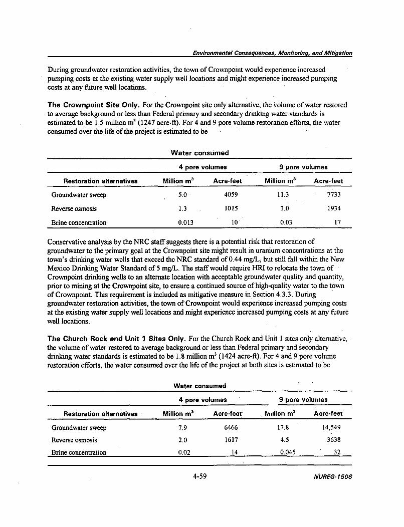
Environmental Consequences, Monitoring, and Mitidgation
During groundwater restoration activities, the town of Crownpoint would experience increasedpumping costs at the existing water supply well locations and might experience increased pumpingcosts at any future well locations.
The Crownpoint Site Only. For the Crownpoint site only alternative, the volume of water restoredto average background or less than Federal primary and secondary drinking water standards isestimated to be 1.5 million m3 (1247 acre-ft). For 4 and 9 pore volume restoration efforts, the waterconsumed over the life of the project is estimated to be
Water consumed
4 pore volumes 9 pore volumes
Restoration alternatives Million m3 Acre-feet Million m3 Acre-feet
Groundwater sweep 5.0 4059 11.3 7733
Reverse osmosis 1.3 1015 3.0 1934
Brine concentration 0.013 i0 0.03 17
Conservative analysis by the NRC staff suggests there is a potential risk that restoration ofgroundwater to the primary goal at the Crownpoint site might result in uranium concentrations at thetown's drinking water wells that exceed the NRC standard of 0.44 mg/L, but still fall within the NewMexico Drinking Water Standard of 5 mg/L. The staff would require HRI to relocate the town of "Crownpoint drinking wells to an alternate location with acceptable groundwater quality and quantity,prior to mining at the Crownpoint site, to ensure a continued source of high-quality water to the townof Crownpoint. This requirement is included as mitigative measure in Section 4.3.3. Duringgroundwater restoration activities, the town of Crownpoint would experience increased pumping costsat the existing water supply well locations and might experience increased pumping costs at any futurewell locations.
The Church Rock and Unit 1 Sites Only. For the Church Rock and Unit I sites only alternative,the volume of water restored to average background or less than Federal primary and secondarydrinking water standards is estimated to be 1.8 million m3 (1424 acre-ft). For 4 and 9 pore volumerestoration efforts, the water consumed over the life of the project at both sites is estimated to be
Water consumed
4 pore volumes 9 pore volumes
Restoration alternatives Million m 3 Acre-feet, Million m 3 Acre-feet
Groundwater sweep 7.9 6466 17.8 14,549
Reverse osmosis 2.0 1617 4.5 3638
Brine concentration 0.02 14 0.045 32
4-59 NUREG-17508

Environmental Consequences, Monitoring, and Mitigation
During groundwater restoration activities at the Unit 1 site, the town of Crownpoint would experienceincreased pumping costs at the existing water supply well locations and might experience increasedpumping costs at any future well locations.
The Unit 1 and Crownpoint Sites Only. For the Unit 1 and Crownpoint sites only alternative, thevolume of water restored to average background or less than Federal primary and secondary drinkingwater standards is estimated to be 2.3 million m3 (1891 acre-ft). For 4 and 9 pore volume restorationefforts, the water consumed over the life of the project at both sites is estimated to be
Water consumed
4 pore volumes 9 pore volumes
Restoration alternatives Million m3 Acre-feet Million m3 Acre-feet
Groundwater sweep 9.5 7733 21.4 17,400
Reverse osmosis 2.4 1934 5.4 4352
Brine concentration 0.021 17 0.05 38
Conservative analysis by the NRC staff suggests there is a potential risk that restoration ofgroundwater to the primary goal at the Crownpoint site might result in uranium concentrations at thetown's drinking water wells that exceed the NRC standard of 0.44 mg/L, but still fall within the NewMexico Drinking Water Standard of 5 mg/L. The staff would require HRI to relocate the town ofCrownpoint drinking wells to an alternate location with acceptable groundwater quality and quantity,prior to mining at the Crownpoint site, to ensure a continued source of high-quality water to the townof Crownpoint. This requirement is included as mitigative measure in Section 4.3.3. Duringgroundwater restoration activities, the town of Crownpoint would experience increased pumping costsat the existing water supply well locations.
4.3.2.2 Alternative Sites for Yellowcake Drying and Packaging
Impacts to groundwater quantity and quality would be the same regardless of the alternative siteselected for yellowcake drying and packaging.
4.3.3 Alternative 3 (The NRC Staff-recommended Action)
This section provides a summary of additional NRC staff requirements and recommendations based onits evaluation of the proposed action. The following list supplements the commitments already made byHRI in its license application. Subsequently, HRI has formally agreed to these conditions as expressedin its letter to NRC dated December 26, 1996 (see Appendix B). The staff believe that the previouslyidentified impacts of this project can be mitigated through the measures discussed below.
NUREG- 1508 4-60

Environmental Consequences, Monitoring, and Mitigation
If a license were issued for the proposed project, those items listed as requirements would beincorporated in the license either as separate license conditions or combined as one general licensecondition that references HRI's consolidated operations plan. For those items listed as NRC staffrecommendations, BIA, BLM, and other cognizant regulatory agencies will be responsible for ensuringthat HRI has complied with this guidance.
* HRI would be required to perform well integrity tests on each injection and production wellbefore the wells are utilized and on wells that have been serviced with equipment orprocedures that could damage well casing. Additionally, each well has to be retested at leastonce each 5 years it is in use.
" HRI would be required to return to the process circuit, maintain in wastewater retentionponds, or discharge as approved all liquid effluents from process buildings and other processwaste streams, with the exception of sanitary wastes. HRI would have to demonstrate thatany disposal method selected meets NRC's release limits for radionuclides (10 CFR Part 20)as well as standards from any other required permits. All changes to the liquid effluentdisposal plan would have to be approved by license amendment.
" HRI anticipates using production flow rates of 9500 to 11,500 Lpm (2500 to 3000 gpm) ateach ion exchange plant. HRI would be required not to exceed a maximum flow rate of15,000 Lpm (4000 gpm).
" HRI would be required to establish an effluent and environmental monitoring program ateach processing site in accordance with Table 4.4-1 of the submittal dated March 16, 1993.All effluent releases would be subject to release limits specified in 10 CFR Part 20. HRI isprohibited from injecting lixiviant prior to NRC's review and approval of a specificenvironmental monitoring plan. The plan shall indicate sampling methods and equipment,analytical procedures, and lower limits of detection. Additionally, the plan shall indicateproposed environmental monitoring locations, and provide the rationale for their selection.
" HRI would be required to establish baseline water quality data at the following points: (1) allmining zone perimeter monitor wells, (2) one monitor well per 1.6 ha (4 acres) of the miningunit in the first overlying aquifer, (3) one monitor well per 3.2 ha (8 acres) of mining unit ineach higher aquifer, and (4) one production/injection well per 1.6 ha (4 acres) in each wellfield. Baseline groundwater quality data shall be established by gathering three independentsamples from each well.
HRI's proposal not to monitor the Cow Springs aquifer is based on the belief that verticalexcursions to the aquifer would not occur. Prior to the injection of lixiviant at any of thethree project sites, HRI would be required to collect sufficient water quality data to generallycharacterize the water quality of the Cow Springs aquifer beneath the project sites, andwould conduct sufficient hydrologic confinement tests to determine if the Cow Springsaquifer beneath the sites is hydraulically confined from the Westwater Canyon aquifer.
4-61 NUREG-1508

Environmental Consequences, Monitoring, and Mitigation
Site-specific tests conducted by HRI have not demonstrated that the proposed groundwaterrestoration standards can be achieved at a production scale. Therefore, prior to the injectionof lixiviant at either the Unit 1 or Crownpoint site, HRI would be required to conduct anacceptable restoration demonstration at the Church Rock site. The demonstration would beconducted at a large enough scale to determine the number of pore volumes that would berequired to restore a production-scale well field. Based on a review of the data submitted byHRI, surety (bonding) for groundwater restoration of the initial well fields shall be based on9 pore-volumes. Surety shall be maintained at this level until HRI can demonstrate thenumber of pore volumes required to restore a production-scale well field.
" Prior to the injection of lixiviant at any of the three project sites, HRI would be required toconduct a Westwater Canyon aquifer step-rate injection (fracture) test within project siteboundaries but outside future well field areas. Since the Unit 1 and Crownpoint sites are inreasonably close proximity to each other, only one test at either site shall be required prior tothe injection of lixiviant at either site.
" Prior to the injection of lixiviant at the Crownpoint site, HRI would be required to replacetown of Crownpoint water supply wells NTUA-1, NTUA-2, BIA-3, BIA-5, and BIA-6. Thewells, pumps, pipelines, and any other necessary changes to the existing water supply systemshall be completed so the system can continue to provide the same quantity of water. Thenew wells shall be located so that the water quality at each individual well head would notexceed EPA primary and secondary drinking water standards and a concentration of0.44 mg/L uranium as a result of future ISL mining activities at the Unit I and Crownpointsites. HRI shall coordinate with the appropriate agencies and regulatory authorities, includingthe BIA, the Navajo Nation Department of Water Development and Water Resources and theNNEPA, and the NTUA, to determine the appropriate placement of the new wells. Further,the existing wells shall be abandoned and sealed so that they cannot become future pathwaysfor the vertical movement of contaminants.
" In the event of a vertical excursion, HRI would be required to explore any significant aquiferabove the Dakota sandstone aquifer for vertical excursions, as opposed to just the deepestsaturated sand of the Mesa Verde Group. The specific aquifers to be monitored in the eventof a vertical excursion shall be identified in HRI's 60-day excursion report.
* Prior to conducting mining operations beyond the first well field, HRI would be required todevelop an NRC-approved groundwater restoration plan for the entire project. At aminimum, this plan would include a proposed restoration schedule, and a general descriptionor methodology of restoration and post-restoration groundwater monitoring for the entireproject.
" During groundwater restoration activities at production-scale well fields at either the Unit Ior Crownpoint site, HRI would be required to reimburse the town operators of theCrownpoint water supply wells for increased pumping and well work-over costs. This
NUREG-1508 4-62

Environmental Consequences, Monitoring, and Mitidgation
reimbursement requirement would not apply to restoration demonstrations of small-scale wellfields.
HRI would be required to maintain an adequate financial surety to cover the costs ofgroundwater restoration. The amount of the surety shall be determined by the NRC based oncost estimates for completing the approved restoration plan by a third party in the event HRIdefaults. The surety shall be reviewed annually by the NRC and adjusted to reflectexpansions in operations, changes in engineering design, and inflation.
HRI would be required to complete wells to meet the following specifications:
1. Minimum design factors for tension (1.6 dry or 1.8 buoyant), collapse (1.125), and burst(1.0) that are incorporated into casing design.
2. Casing collars shall have a minimum clearance of 10.7239 mm (0.4222 in.) on all sides in thehole/casing annulus.
3. All waiting on cement times shall be adequate to achieve a minimum of 3500 kPa (500 psi)compressive strength at the casing shoe prior to drill out.
4. All casing shall be new or reconditioned and testedused casing that meets or exceeds APIstandards for new casing.
5. Casing shall be cemented back to the surface (150 percent calculated volume needed).6. Casing shall have centralizers on every fourth joint [about every 42 to 52 m (120 to 150 ft)]
of casing starting with the shoe joint and up to the bottom of the collar.7. Top plugs shall be used to reduce contamination of cement by displacement fluid. A bottom
plug, or other acceptable technique, shall be utilized to help isolate the cement fromcontamination by the mud fluid being displaced ahead of the cement slurry.
8. All casing strings shall be pressure tested to 1.5kPa (0.22 psi) per meter (foot) of casingstring length or 10,500 kPa (1500 psi), whichever is greater, but not to exceed 70 percent ofthe minimum internal yield (measured on surface usually using water and the rig pump). Ifpressure declines more than 10 percent in 30 min, corrective action shall be taken.
4.3.4 Alternative 4 (No Action)
Under the no-action alternative, there would be no impacts to groundwater quantity or quality.Groundwater quantity and quality would remain as described in Section 3.3.
4.4 SURFACE WATER
4.4.1 Alternative 1 (The Proposed Action)
4.4.1.1 Crownpoint
All drainage channels near and at the Crownpoint site are ephemeral washes, which only contain waterduring infrequent periods of precipitation or snow melt. The facility would not discharge to drainage
4-63 NUREG-1508

Environmental Consequences, Monitoring, and Mitigation
channels as a result of well field or plant operation. During periods of rainfall, well field constructionand reclamation activities at the site might contribute a small amount of sediment to on-site drainagechannels. After reclamation, the surface would be vegetated and contoured to prevent adverse effects tosurface water quality. Any effect on water quality during infrequent periods of runoff would beexpected to be small and temporary. Land application sites would be operated to minimize the potentialfor off-site runoff. Precautions taken would include these:
1. No irrigation during a rainfall event2. If heavy rains are forecast, no irrigation during the preceding 12 hr3. No irrigation on saturated soils4. No irrigation on steep slopes or soils shallower than 72 in.
In general, HRI has committed (HRI 1996b) to follow the guidance suggested in NRC Staff TechnicalPosition Design of Erosion Protection Covers for Stabilization of Uranium Mill Tailings Sites.However, HRI has not provided detailed information regarding specific and unique details of thediversion channels or the project impoundment system. HRI has provided general informationregarding the preliminary design layout of the facility and the potential for flooding of the site (HRI1996e). Detailed information of this type is needed before NRC staff can judge the acceptability of thefinal design. Environmental impacts of any such design would be evaluated as part of the detaileddesign review. Therefore, the impacts are expected to be minimized in that existing staff guidancewould address this issue.
Based on a review of the preliminary information provided by HRI (HRI 1996e), NRC staff believethat there are no unique design problems associated with the implementation and completion of thehydraulic design features of the Crownpoint site. NRC staff have visited the site area and haveconsiderable experience in reviewing diversion channel and hydraulic designs. Based on thatknowledge, NRC staff believe that an acceptable engineering design can be provided and contaminatedmaterial would not be released to drainage channels in the area as the result of impoundment failure.When that design is provided, NRC staff will evaluate its acceptability. Accordingly, a conditionrequiring submittal of revised hydraulic design information and review/approval by the NRC would beincorporated into the license.
4.4.1.2 Unit 1
Projected surface water impacts for the Unit 1 site are nearly identical to the impacts described for theCrownpoint site (Section 4.4.1.1).
4.4.1.3 Church Rock
All drainage channels near and at the Church Rock site are ephemeral washes, which only containwater during infrequent periods of precipitation or snow melt. Projected impacts for the Church Rocksite are nearly identical to the impacts described for the Crownpoint site (Section 4.4.1.1). The facilitywould not discharge to drainage channels as a result of well field or plant operation. However, thefacility might discharge restoration water into surface water streams (HRI 1996o). This discharge
NUREG- 1508 4-64

Environmental Consequences, Monitoring, and Mitigation
might occur if groundwater sweep is chosen as a groundwater restoration option and enough waterrights cannot be obtained to dispose of the water by land application. Should surface water dischargebe implemented, HRI would have to obtain any appropriate State or Federal permits.
Any effect on water quality during infrequent periods of runoff is expected to be small and temporary.Land application sites would be operated to minimize the potential for off-site runoff, as described forthe Crownpoint site (Section 4.4.1.1).
In general, HRI has committed (HRI 1996b) to follow the guidance suggested in NRC Staff TechnicalPosition Design of Erosion Protection Covers for Stabilization of Uranium Mill Tailings Sites.However, HRI has not provided detailed information regarding specific and unique details of thediversion channels or the project impoundment system. HRI has provided general informationregarding the preliminary design layout of the facility and the potential for flooding of the site (HRI1996e). Detailed information of this type is needed before NRC staff can judge the acceptability of thefinal design. Environmental impacts of any such design would be evaluated as part of the detaileddesign review. Therefore, the impacts are expected to be minimized in that existing staff guidancewould address this issue.
Based on a review of the preliminary information provided by HRI (HRI 1996e), NRC staff believethat there are no unique design problems associated with the implementation and completion of thehydraulic design features of the Church Rock site. NRC staff have visited the site area and haveconsiderable experience in reviewing diversion channel and hydraulic designs. Based on thatknowledge, NRC staff believe that an acceptable engineering design can be provided and contaminatedmaterial would not be released to drainage channels in the area as the result of impoundment failure.When that design is provided, NRC staff will evaluate its acceptability. Accordingly, a conditionrequiring submittal of revised hydraulic design information and review/approval by the NRC would beincorporated into the license.
4.4.2 Alternative 2 (Modified Action)
4.4.2.1 Alternative Sites for ISL Mining
Impacts for each of the alternative sites should be less than the impacts of the proposed project, whichare predicted to be of little significance. The alternatives considered are
1. The Church Rock site only2. The Unit 1 site only3. The Crownpoint site only4. The Church Rock and Unit 1 sites only5. The Church Rock and Crownpoint sites only6. The Unit 1 and Crownpoint sites only
4-65 NUREG-1508
4-65 NUREG-1508

Environmental Consequences, Monitoring, and Mitigation
4.4.2.2 Alternative Sites for Yellowcake Drying and Packaging
Construction, operation, and decommissioning of a processing facility at either the Church Rock orUnit I site should have little effect on the quality or quantity of surface water.
Use of HRI's existing ISL facility at Kingsville, Texas, or the Ambrosia Lake Uranium mill, located.north of Milan, New Mexico, should have no impact on the quality or quantity of surface water ateither of the two sites.
4.4.3 Alternative 3 (The NRC Staff-recommended Action)
This section provides a summary of additional NRC staff requirements and recommendations based onits evaluation of the proposed action. The following list supplements the commitments already made byHRI in its license application. Subsequently, HRI has formally agreed to these conditions as expressedin its letter to NRC dated December 26, 1996 (see Appendix B). The staff believe that the previouslyidentified impacts of this project can be mitigated through the measures discussed below.
If a license were issued for the proposed project, those 'items listed as requirements would beincorporated in the license either as separate license conditions or combined as one general licensecondition that references HRI's consolidated operations plan. For those items listed as NRC staffrecommendations, BIA, BLM, and other cognizant regulatory agencies will be responsible for ensuringthat HRI has complied with this guidance.
The proposed project would have only minor impacts on surface water (Section 4.4.1). However, toensure that impacts to surface water are minimized, if a license is issued for the proposed project NRCstaff would require the following license conditions:
HRI is prohibited from constructing wastewater retention ponds prior to NRC's review andapproval of an embankment engineering design. The design shall contain all specificationsrelated to embankment slope stability, liners, freeboard requirements, and leak detectionsystems. Any retention pond intended to retain degraded water above grade shall be designedin accordance with NRC Regulatory Guide 3.11, Design, Construction, and Inspection ofEmbankment Retention Systems for Uranium Mills. In addition, HRI shall demonstratethrough detailed engineering analyses that the ponds and diversion channels around 'the pondswould be stable under a probable maximum flood condition, in accordance with NRC StaffTechnical Position #WM-820 1, Hydrologic Design Criteria for Tailings Retention Systems.Accordingly, HRI shall provide for NRC review detailed analyses to document the adequacyof the system during an occurrence of the probable maximum flood.
4.4.4 Alternative 4 (No Action)
The no-action alternative would result in no impacts to either surface water quality or quantity in theproject area. Surface water quality and quantity would remain as described in Section 3.4.
NUREG- 1508 4-66

Environmental Consequences, Monitoring, and Mitidgation
4.5 TRANSPORTATION RISK
4.5.1 Alternative 1 (The Proposed Action)
Materials transportation to and from the three project sites can be classified into four categories:(1) shipments of refined yellowcake from the Crownpoint processing facility to a uranium conversionfacility in Illinois, (2) shipments of yellowcake slurry or resin from the Unit 1 and Church Rocksatellite facilities to the Crownpoint processing facility, (3) shipments of process chemicals fromsuppliers to the three sites, and (4) shipments of 1 le(2) by-product material for disposal at an NRC-licensed facility in Utah. NRC staff have conceptualized and analyzed a transportation accident in eachof these four categories and the results are given in the following subsections.
4.5.1.1 Shipments of Refined Yellowcake from Crownpoint to Illinois
Yellowcake shipments made from the proposed project would not differ from those made from aconventional mill. NRC evaluated transportation accidents associated with yellowcake shipments fromconventional mills and published the results in a generic environmental impact statement (NRC 1980b).The following analysis is based on that earlier study.
Refined yellowcake would be packed in 55-gallon, 18-gauge drums holding an average of 430 kg(950 lb) and classified by the U.S. Department of Transportation as Type A packaging (49 CFRPart 171-189 and 10 CFR Part 71). Yellowcake would be shipped by truck approximately 2400 km(1500 miles) to a conversion plant in Illinois, which would process the yellowcake in the first step ofmanufacturing reactor fuel. An average truck shipment contains approximately 40 drums, or 17 metrictons (19 tons) of yellowcake. Based on the projected maximum annual yellowcake production for theproposed project of 1360 metric tons (3 million lb), approximately 80 shipments of 40 drums eachwould be required annually when each of the three sites is producing at full capacity.
The average probability of a truck accident is 4.OE-7/km (6.4E-7/miles) on interstate highways in ruralareas, 1.4E-6/km (2.2E-6/miles) on interstate highways in urban areas, and 1.4E-6/km (2.2E-6/miles)on two-lane roads typical of those in the vicinity of the proposed project (Harwood and Russell 1990).Truck accident statistics for the Crownpoint vicinity are presented in Section 3.4. The route to theconversion facility in Illinois is approximately 1920 km (1193 miles) on rural interstate highways and480 km (1298 miles) on urban highways. Based on these statistics, the projected number of shipmentsper year, and the shipping distance, the likelihood of a truck from the proposed project being involvedin any accident during a 1-year period is approximately 1 chance in 10 on the interstate portion and5 chances in 1000 on New Mexico 371 and Navajo 9. Given a heavy truck accident, the probability ofan injury is 0.21 and the probability of a fatality is 0.01 on the interstate portion (DOT 1995). Theprobability of an injury or fatality from an accident involving a truck carrying yellowcake on NewMexico 371 and Navajo 9 is about 1 chance in 1000 (0.001) during a 1-year period.
In a generalized accident-risk evaluation, NRC classified accidents into eight categories, depending onthe combined stresses of impact, puncture, crush, and fire. On the basis of this classification scheme,
4-67 NUREG-1508

Environmental Consequences, Monitoring, and Mitigation
conditional accident probability was developed for eight severity levels. These fractional probabilitiesof occurrence for truck accidents are given in column 2 of Table 4.15.
To assess the risk of a transportation accident, the fraction of radioactive material released when anaccident of a given severity occurs must be known. For this analysis, two accident models areconsidered. Model I is hypothetical; complete loss of drum contents is assumed for all but the lowestaccident severity category. Model II is based on actual tests; partial loss of drum contents is assumed.The yellowcake packages are Type A drums containing low specific activity (LSA) material. Thefractional releases to the environment for each model are shown in columns 3 and 4 of Table 4.15.
Considering the fractional occurrence and the release fractions (loss) for Models I and II, the quantityof yellowcake released from the containers in the event of a truck accident is estimated to be 7700 kg(17,000 lb) for Model I and 520 kg (1140 lb) for Model II.
The previously stated probabilities of an accident can now be further defined: the probability of anaccident producing a Model I release (upper bound) is 0.05 per year on the interstate system and0.002 per year on New Mexico 371 and Navajo 9. The Model II accident probabilities (more realistic)are 0.004 per year on the interstate system and 0.0002 per year on New Mexico 371 and Navajo 9.
Most yellowcake released from the container would be deposited directly on the ground in theimmediate vicinity of the accident. However, some fraction of the released material would be dispersedto the atmosphere. Using expressions for material dispersal to the environment (Battelle NorthwestLaboratories 1975), the following empirical expression was derived for release from the container:
F = 0.001 + 4.6E-4 (l-e"0.lSut) u1 .78
whereF = the fractional airborne release,u = the wind speed at 15.2 m (50 ft) expressed in m/s,t = the duration of the release, in hours.
In this expression, the first term represents the initial "puff" that is immediately airborne when thecontainer fails in an accident. Assuming the wind speed is 5 m/s (10 mph) and the time available forrelease is 24 hours, the estimated environmental release fraction would be 9E-3. A recent summary ofdata by DOE (1994) shows this value to be conservative by a factor of nearly 6. For insolubleuranium, all particles in the respirable size range, and a typical population density of 61 persons/km2
(160 persons/ miles2) of the eastern United States, the 50-year dose commitments to the lungs of thegeneral public would be about 2 man-Sv (200 man-rem) and 0.14 man-Sv (14 man-rem) for Models Iand II, respectively. These values estimate the doses integrated over a 50-year time period followingexposure. Population density for the eastern United States was used because yellowcake shipmentswould be sent to Illinois. Integrated dose estimates for more sparsely populated areas would be lower.
In an accident that occurred in September 1977 (NRC 1980b), a commercial carrier hauling 50 drumsof uranium concentrate overturned and spilled an estimated 3200 kg (7000 lb) of yellowcake on theground and in the truck trailer. Within 3 hr, the material was covered with plastic sheeting to prevent
NUREG-1508 4-68
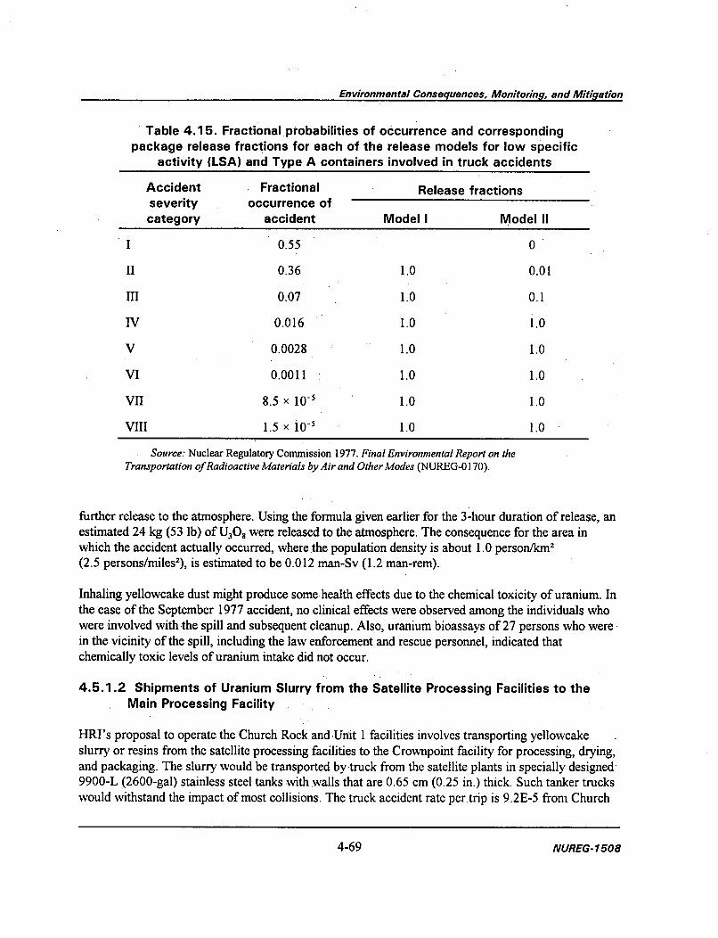
Environmental Consequences, Monitoring, and Mitigation
Table 4.15. Fractional probabilities of occurrence and correspondingpackage release fractions for each of the release models for low specific
activity (LSA) and Type A containers involved in truck accidents
Accident Fractional Release fractionsseverity occurrence ofcategory accident Model I Model II
I 0.55 0
II 0.36 1.0 0.01
III 0.07 1.0 0.1
IV 0.016 1.0 1.0
V 0.0028 1.0 1.0
VI 0.0011 1.0 1.0
VII 8.5 x 10' 1.0 1.0
VIII 1.5 x 10⁻⁵ 1.0 1.0
Source: Nuclear Regulatory Commission 1977. Final Environmental Report on theTransportation of Radioactive Materials by Air and Other Modes (NUREG-0 170).
further release to the atmosphere. Using the formula given earlier for the 3-hour duration of release, anestimated 24 kg (53 lb) of U308 were released to the atmosphere. The consequence for the area inwhich the accident actually occurred, where the population density is about 1.0 person/km2
(2.5 persons/miles2), is estimated to be 0.012 man-Sv (1.2 man-rem).
Inhaling yellowcake dust might produce some health effects due to the chemical toxicity of uranium. Inthe case of the September 1977 accident, no clinical effects were observed among the individuals whowere involved with the spill and subsequent cleanup. Also, uranium bioassays of 27 persons who werein the vicinity of the spill, including the law enforcement and rescue personnel, indicated thatchemically toxic levels of uranium intake did not occur.
4.5.1.2 Shipments of Uranium Slurry from the Satellite Processing Facilities to theMain Processing Facility
HRI's proposal to operate the Church Rock andUnit I facilities involves transporting yellowcakeslurry or resins from the satellite processing facilities to the Crownpoint facility for processing, drying,and packaging. The slurry would be transported by truck from the satellite plants in specially designed'9900-L (2600-gal) stainless steel tanks with walls that are 0.65 cm (0.25 in.) thick. Such tanker truckswould withstand the impact of most collisions. The truck accident rate per~trip is 9.2E-5 from Church
4-69 NUREG-1508

Environmental Consequences, Monitoring, and Mitigation
Rock and 6.6E-6 from Unit 1 (Section 3.4). The projected maximum annual yellowcake yield fromboth the Church Rock and Unit 1 facilities is 454 metric tons (1 million lb), and approximately100 tank truck shipments per year would be the maximum required from each satellite site. Based onaccident statistics and the projected number of annual shipments, the likelihood of a tank truck from theChurch Rock site being involved in an accident during a 1-year period is 0.009. The likelihood of afatality or injury from a uranium tank truck accident during a 1-year period is 0.002.
In the most severe conditions, an accident would result in a rupture of the tank and release of only aportion of the slurry. During such an accident, slurry would pour onto the ground and thicken as waterin the slurry soaked into the ground. Eventually, some slurry would dry, and yellowcake could bereleased to the atmosphere near the spill, depending on the time required to clean up the material.
The effects of accidents involving wet yellowcake would be considerably less than those involvingyellowcake dust as described in Section 4.5.1.1 because the material would be incapable of becomingairborne as dry dust. To prevent the spread of contamination, HRI would be responsible for cleaningup the slurry as rapidly as possible. Oversight would be provided on-site by an NRC inspector throughNRC's regional office and by the Incident Response Center and would be coordinated with State andlocal emergency assistance teams.
Sufficient statistical data are not available for a quantitative analysis of the consequences of such anaccident. However, the consequences would likely be considerably lower than those estimated for theshipment of dry concentrate.
4.5.1.3 Shipments of Chemicals to the Processing Facilities
Truck shipments of process chemicals, including small quantities of analytical reagents, to theCrownpoint facility and the satellite plants could result in local environmental impacts if the trucks areinvolved in an accident. Processing chemicals required at the project sites are exhibited in Table 4.16.All uranium recovery sites, including mills and solution mines, require similar processing chemicals.The potential for shipping accidents is similar at all sites as well.
Table 4.16. Bulk chemicals required at the project processing sites
Shipped as dry bulk solids Shipped as liquids and gases
Salt (NaCl) Hydrochloric acid (HCl)
Sodium bicarbonate (NaHCO 3) Hydrogen peroxide (H20 2)
Sodium carbonate (Na 2CO 3) Carbon dioxide (C0 2 )
Sodium hydroxide (NaOH) Oxygen (02)
Diesel oil
Bottled gases
Liquified petroleum gas (LPG)
NUREG-1508 4-70

Environmental Consequences, Monitoring, and Mitigation
4.5.1.4 Shipments of 1 le(2) By-product Material for Disposal in Utah
HRI would dispose of all 1 le(2) by-product material generated by the project at an off-site, NRC-licensed disposal facility (HRI 1996b). Currently, HRI is contracted with Energy Fuels Nuclear to usetheir disposal facility in Blanding, Utah (HRI 1996b). HRI has not provided information concerning theamount of 1 e(2) by-product material that would be generated by the project, the number of truckshipments that would be required to transport the material to the disposal facility, or the specific routethat would be used to transport the material from the project area to Blanding, Utah. However, the riskassociated with each shipment of 1 le(2) by-product material from the project to Utah would be lessthan that associated with each shipment of yellowcake from the project to Illinois (Section 4.5.1.1).This decreased risk is primarily due to the relative proximity of the disposal facility in Utah[approximately 404 km (250 miles) from Crownpoint, assuming transportation via Highway 666 northfrom New Mexico into Utah and Highway 191 south to Blanding] compared to the conversion facilityin Illinois [approximately 2400 km (1500 miles)].
4.5.2 Alternative 2 (Modified Action)
Several alternative sites could be selected for yellowcake drying and packaging. Use of either theChurch Rock or the Unit 1 facilities would not appreciably change the potential impacts discussed fortransporting processed yellowcake from the Crownpoint facility. The use of the Ambrosia Lake facilitynear Milan, New Mexico, would slightly increase the risk associated with transporting uranium slurry,which is small compared to that for yellowcake, and slightly decrease the risk of transportingyellowcake since Milan is about 50 miles closer to the yellowcake conversion plant in Illinois. The useof HRI's Kingsville, Texas, facility would significantly increase the risk of transporting uranium slurryand slightly increase the risk of transporting yellowcake.
4.5.3 Alternative 3 (The NRC Staff-recommended Action)
This section provides a summary of additional NRC staff requirements and recommendations based onits evaluation of the proposed action. The following list supplements the commitments already made byHRI in its license application. Subsequently, HRI has formally agreed to these conditions as expressedin its letter to NRC dated December 26, 1996 (see Appendix B). The staff believe that the previouslyidentified impacts of this project can be mitigated through the measures discussed below.
If a license is issued for the proposed project, those items. listed as requirements would be incorporatedin the license either as separate license conditions or combined as one general license condition thatreferences HRI's consolidated operations plan. For those items listed as NRC staff recommendations,BIA, BLM, and other cognizant regulatory agencies will be responsible for ensuring that HRI hascomplied with this guidance.
The transportation risk associated with shipments to and from the proposed project would be relativelysmall (Section 4.5.1). However, to further minimize transportation risk, if a license is issued for theproposed project, NRC staff would require the following license condition:
4-71 NUREG- 1508

Environmental Consequences, Monitoring, and Mitigation
Yellowcake and I1 e(2) by-product waste material, other than samples for research, shall notbe transferred from the site without specific prior approval of the NRC in the form of alicense amendment. HRI shall maintain permanent record of all transfers made under theprovisions of this condition. Transfers of samples for research shall comply with provisionsof 10 CFR § 40.22.
In addition to this license condition, NRC staff recommends the following measures to help minimizetransportation risk:
" all delivery trucks used to transport project materials (uranium slurry, yellowcake, andprocess chemicals) should carry the appropriate certifications of safety inspections; and
" all delivery truck drivers should hold appropriate licenses.
4.5.4 Alternative 4 (No Action)
There would be no transportation risk associated with the no-action alternative.
4.6 HEALTH PHYSICS AND RADIOLOGICAL IMPACTS
This section describes an analysis of estimated incremental radiological impacts to the environment andthe population that would be contributed from the proposed project. The primary radiological impact tothe environment in the vicinity of the project results from naturally occurring cosmic and terrestrialradiation and naturally occurring radon-222 and its daughters. The average whole-body dose rate to thepopulation in this part of New Mexico includes a dose of 1.5 mSv/year (150 mrem/year) from localnatural background radiation and 0.75 mSv/year (75 mrem/year) from medical procedures, based onnational average. Therefore, total background is estimated to be about 2.25 mSv/year (225 mrem/year).Dose estimates and airborne concentrations of radionuclides from the proposed project do not includenatural background and are incremental values.
This analysis examines three types of potential exposures to members of the public. During projectoperations, releases could occur in the form of air releases of particulate and gases. Additionally, HRIwould have to dispose of waste materials from the ISL process. After operations, HRI would have toreclaim well fields and facility grounds to allow unrestricted release in the future.
4.6.1 Alternative 1 (The Proposed Action)
Analysis of potential air releases is primarily based on estimated releases of radioactive materials,determined by HRI, using an NRC radiological dose assessment code known as MILDOS-AREA(ANL 1989). HRI ran separate MILDOS-AREA simulations for operations in the Crownpoint andChurch Rock areas. The Crownpoint area includes operations at both Unit 1 and Crownpoint facilities.The operations at each of the facilities are similar except that final drying and packaging of naturaluranium would take place only at the Crownpoint facility. Detailed analyses of the estimated
NUREG- 1508 4-72
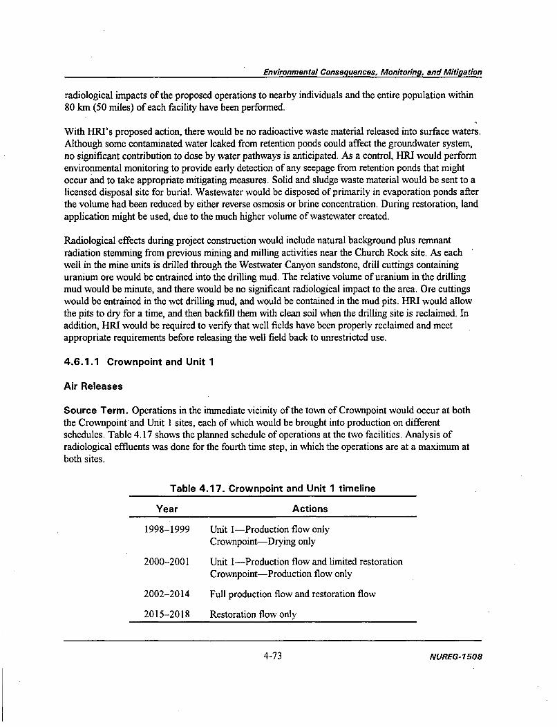
Environmental Consequences, Monitoring, and Mitigation
radiological impacts of the proposed operations to nearby individuals and the entire population within80 km (50 miles) of each facility have been performed.
With HRI's proposed action, there would be no radioactive waste material released into surface waters.Although some contaminated water leaked from retention ponds could affect the groundwater system,no significant contribution to dose by water pathways is anticipated. As a control, HRI would performenvironmental monitoring to provide early detection of any seepage from retention ponds that mightoccur and to take appropriate mitigating measures. Solid and sludge waste material would be sent to alicensed disposal site for burial. Wastewater would be disposed of primarily in evaporation ponds afterthe volume had been reduced by either reverse osmosis or brine concentration. During restoration, landapplication might be used, due to the much higher volume of wastewater created.
Radiological effects during project construction would include natural background plus remnantradiation stemming from previous mining and milling activities near the Church Rock site. As eachwell in the mine units is drilled through the Westwater Canyon sandstone, drill cuttings containinguranium ore would be entrained into the drilling mud. The relative volume of uranium in the drillingmud would be minute, and there would be no significant radiological impact to the area. Ore cuttingswould be entrained in the wet drilling mud, and would be contained in the mud pits. HRI would allowthe pits to dry for a time, and then backfill them with clean soil when the drilling site is reclaimed. Inaddition, HRI would be required to verify that well fields have been properly reclaimed and meetappropriate requirements before releasing the well field back to unrestricted use.
4.6.1.1 Crownpoint and Unit 1
Air Releases
Source Term. Operations in the immediate vicinity of the town of Crownpoint would occur at boththe Crownpoint and Unit 1 sites, each of which would be brought into production on differentschedules. Table 4.17 shows the planned schedule of operations at the two facilities. Analysis ofradiological effluents was done for the fourth time step, in which the operations are at a maximum atboth sites.
Table 4.17. Crownpoint and Unit 1 timeline
Year Actions
1998-1999 Unit I-Production flow onlyCrownpoint-Drying only
2000-2001 Unit 1-Production flow and limited restorationCrownpoint-Production flow only
2002-2014 Full production flow and restoration flow
2015-2018 Restoration flow only
4-73 NUREG- 1508

Environmental Consequences, Monitoring, and Mitigation
HRI has determined that the project would have controlled releases from three areas (source terms)within each operation. The source terms are: (1) the resin transfer/process circuit, (2) the processcircuit pressure vents, and (3) land application releases. Typical ISL uranium mines have additionalsource terms, but HRI has proposed various modifications to its operations to remove radon sourceterm locations. Engineering modifications were made to the production and restoration bleed stream toeliminate radon dispersion into the environment from wastewater. In both situations, process bleed andrestoration stream waters would be circulated through vented tanks. The off-gas would be captured,compressed, and injected into the lixiviant injection system for reintroduction into the ore zone. Theoff-gas from the bleed streams would largely consist of carbon dioxide, but would also containvirtually all radon gas dissolved in the lixiviant when it is pumped to the surface.
The release from the resin transfer/process circuit assumes that each ion exchange column wouldcontain 1.323 m3 (3500 gal) of process water and would be vented three times a day. This value isconservative because each column would actually contain a large volume of resin, and less water. It isfurther assumed that the water contains a dissolved radon concentration of 4.9 MBq/m3
(133,000 pCi/L) with a very conservative 100 percent radon evolution rate. This results in a calculatedradon release of 68 GBq (1.83 Ci) per year.
The process circuit pressure vents situated on trunk lines would discharge for 2 s every 5 min. With acarrying capacity of 0.25 m3/s (4000 gpm) for each trunk line and 20 total vents, the radon released bythis system would be approximately 110 GBq/year (2.96 Ci/year). This value is conservative because itassumes that all trunk lines are functioning continuously at the maximum proposed flow rate.
Restoration water would not be open to venting until it arrives at the land application area inSection 12. The source term for modeling was based on equal volumes of water from each of thefacilities being disposed of at the land application area. All of the releases are assumed to happen in thecenter of Section 12. Based on a dissolved radon concentration of 4.9 MBq/m3 (133,000 pCi/L) and aflow rate of 0.019 m3/s (300 gpm), the source term from each facility would be 2.9 TBq (79.35 Ci), ora total of 5.8 TBq (159 Ci), per year. It assumes 100 percent evolution of radon-222 and a high flowrate for restoration water.
Traditionally, open hearth dryers at uranium recovery facilities are a primary source of airborneparticulates. The vacuum dryer proposed by HRI is a state-of-the-art, zero-release unit that wouldresult in very minimal particulate emissions from the drying and packaging areas. The proposed dryingsystem would have no vent stack. Additionally, because the ISL production circuit is a wet process, noroutine radiological particulate emissions source terms are predicted from other portions of the processcircuit. The vacuum dryer is more fully described in Section 2.1.2.1. HRI performed a separateMILDOS-Area calculation of emissions from the drying and packaging areas (HRI 1994). Themodeled source term for the dryer at the main process facility was based on data gathered for U-23 8 atan ISL facility using a similar vacuum dryer in Texas. Using an assumption that the measured value ofthe lixiviant ratio between Ra-226 and U-238 was constant, the source terms resulted in the followingvalues: U-238, 9.0 kBq/yr (0.243 yuCi/yr); Th-230, Ra-226, Pb-210, each 58 Bq/yr (1.56 nCi/yr).
NUREG- 7508 4-74
NUREG-1508 4-74

Environmental Consequences, Monitoring, and Mitigation
Population Distribution. Population census data for 1980, updated to 1990 by projections and fieldverified, were used in the MILDOS-Area program. Population data for input into the program weredetermined for persons living within 5 km and 80 km (3 and 50 mi) of the Crownpoint site. HRIdetermined that approximately 3,600 persons live within 5 km of the Crownpoint process building, andthat 76,000 persons live within the 80 km radius. Residences found within lease areas, the nearestresidence downwind, and total populations were used in each modeling run to determine compliancewith regulatory dose restrictions.
Meteorological Parameters. Weather data used in the MILDOS-Area simulations were obtainedfrom U.S. Department of Commerce records maintained for Gallup, New Mexico. Gallup is locatedabout 16 km (10 mi) southwest of the Church Rock site, and 56 km (35 mi) from Crownpoint. Gallupis the nearest active weather station maintaining the complete weather information necessary to run theMILDOS program. More information on meteorology can be found in Section 3.1.1.
Individual Receptor Locations. HRI modeled 38 separate receptors for the Crownpoint operationalarea. The Crownpoint receptors are actual residences or multi-use locations (e.g., churches) near themain processing facility or in the Unit 1 lease area (Figure 4.3). These receptors include nearestresidences, nearest downwind residences, population concentrations, and hypothetical facility and wellfield boundary receptors. HRI would be required to implement a comprehensive environmentalmonitoring program to determine the annual doses to individuals in unrestricted areas.
Exposure Pathways. Potential environmental exposure pathways by which persons could beexposed to radioactive air effluents are presented schematically in Figure 4.4. Estimated dosecommitments to humans are based on the proposed facility design and actual characteristics of the siteenvironment. NRC's analysis considers both radioactive particulates and gaseous releases to theatmosphere.
Environmental exposure pathways of concern for airborne effluents from the project include inhalingradioactive materials in the air, particularly radon and its daughters. To a much lesser degree, externalexposure would occur from radioactive materials in the air or deposited on ground surfaces, andpossibly ingesting contaminated food products (vegetables, milk, and meat) raised locally.
Regulatory Limits on Exposure for Individuals. Permissible dosage limits found in 10 CFRPart 20 for individual members of the public are 1 mSv (100 mrem) total effective dose equivalent(TEDE), and 0.02 mSv/hr (2 mrem/hr) from any external sources. Compliance with the annual doselimit to the public (10 CFR § 20.1301) can be shown by calculating the dose to the individual atgreatest risk (nearest residence) or compliance with annual concentration levels (10 CFR Part 20,Appendix B) at the site boundary. Two EPA standards apply to this operation. EPA's establishedaverage annual dose limits, found in 40 CFR Part 190, Environmental Radiation Protection Standardsfor Nuclear Power Operations, are 0.25 mSv (25 mrem) whole body, 0.75 mSv (75 mrem) to thethyroid, and 0.25 mSv (25 mrem) to any other organ for a member of the public. The other EPAstandard, found in (currently suspended) 40 CFR Part 61, Subpart I, National Emissions Standard forHazardous Air Pollutants, is a 0.1 mSv (10 mrem) TEDE limit. The EPA standards exclude radon andits daughters.
4-75 NUREG-17508

Ul0
0J'
I1*~
S.Na
a(4
Lb
aLb
aS.
a
Lb
S.
Lb-a
I
Figure 4.3. Residences and boundary receptors in the Crownpoint and Unit 1 areas.

Environmental Consequences, Monitoring, and Mitigation
Figure 4.4. Potential exposure pathways for radon-222 and its daughters, escapingthe uranium recovery process and wastewater treatment facilities.
4-77 NUREG-1508
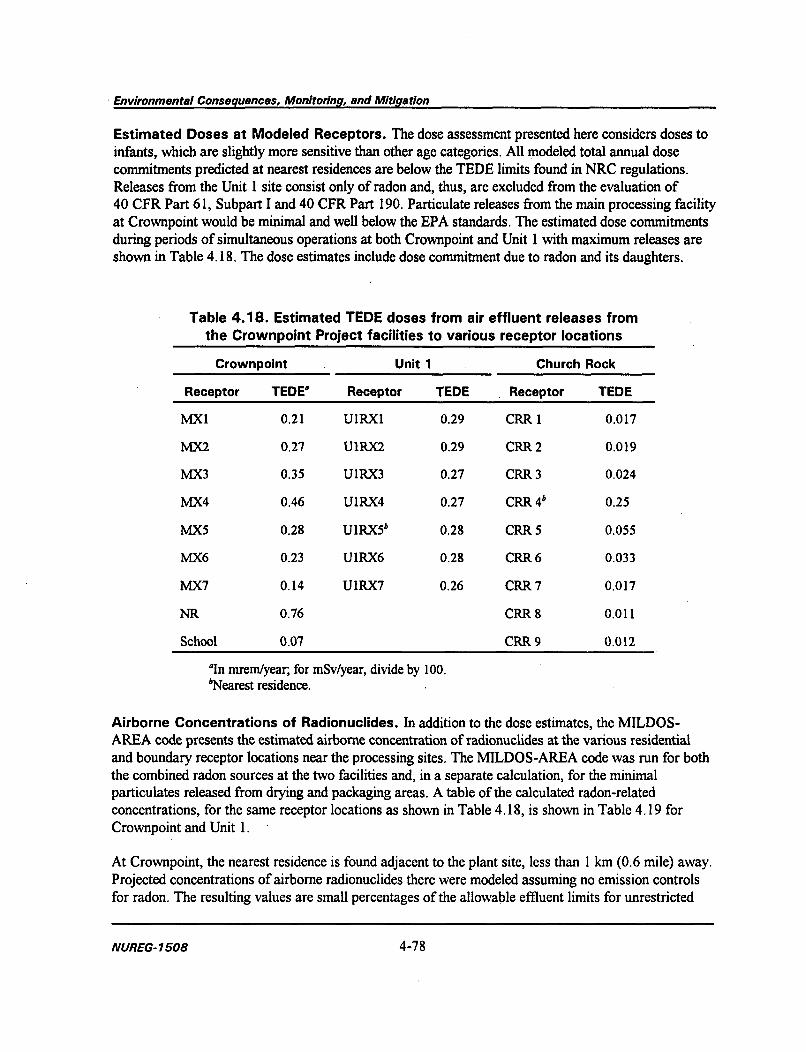
Environmental Consequences, Monitoring, and Mitigation
Estimated Doses at Modeled Receptors. The dose assessment presented here considers doses toinfants, which are slightly more sensitive than other age categories. All modeled total annual dosecommitments predicted at nearest residences are below the TEDE limits found in NRC regulations.Releases from the Unit 1 site consist only of radon and, thus, are excluded from the evaluation of40 CFR Part 61, Subpart I and 40 CFR Part 190. Particulate releases from the main processing facilityat Crownpoint would be minimal and well below the EPA standards. The estimated dose commitmentsduring periods of simultaneous operations at both Crownpoint and Unit 1 with maximum releases areshown in Table 4.18. The dose estimates include dose commitment due to radon and its daughters.
Table 4.18. Estimated TEDE doses from air effluent releases fromthe Crownpoint Project facilities to various receptor locations
Crownpoint Unit 1 Church Rock
Receptor TEDE° Receptor TEDE Receptor TEDE
MfX1 0.21 UIRXI 0.29 CRR 1 0.017
MX2 0.27 U1RX2 0.29 CRR 2 0.019
MX3 0.35 UIRX3 0.27 CRR 3 0.024
MX4 0.46 UIRX4 0.27 CRR 4b 0.25
MX5 0.28 UIRX51 0.28 CRR 5 0.055
MX6 0.23 UIRX6 0.28 CRR 6 0.033
MX7 0.14 UIRX7 0.26 CRR 7 0.017
NR 0.76 CRR 8 0.011
School 0.07 CRR 9 0.012
'In mreni/year; for mSv/year, divide by 100."Nearest residence.
Airborne Concentrations of Radionuclides. In addition to the dose estimates, the MILDOS-AREA code presents the estimated airborne concentration of radionuclides at the various residentialand boundary receptor locations near the processing sites. The MILDOS-AREA code was run for boththe combined radon sources at the two facilities and, in a separate calculation, for the minimalparticulates released from drying and packaging areas. A table of the calculated radon-relatedconcentrations, for the same receptor locations as shown in Table 4.18, is shown in Table 4.19 forCrownpoint and Unit 1.
At Crownpoint, the nearest residence is found adjacent to the plant site, less than 1 km (0.6 mile) away.Projected concentrations of airborne radionuclides there were modeled assuming no emission controlsfor radon. The resulting values are small percentages of the allowable effluent limits for unrestricted
NUREG-1508 4-78

Environmental Consequences, Monitoring, and Mitigation
Table 4.19. Airborne concentrations of radon and daughters at selected receptorlocations near the Crownpoint and Unit 1 facilities
Location Rn-222 (WL)° Pb-21Ob Bi-210" Po-21Ob
Crownpoint
MX1 1.55E-05 2.3E-18 5.4E-21 3.4E-25
MX2 1.55E-05 2.3E-18 5.5E-21 3.6E-25
MX3 1.55E-05 2.3E- 18 6.1E-21 4.4E-25
MX4 1.5E-05 2.2E- 18 6.OE-21 4.4E-25
MX5 1.3E-05 2.1E-18 5.9E-21 4.6E-25
MX6 1.2E-05 2.OE-18 5.7E-21 4.5E-25
MX7 9.8E-06 1.7E-18 4.8E-21 3.8E-25
NRW 1.6E-05 2.3E-18 6.4E-21 4.9E-25
School 5.8E-06 1.5E-18 4.9E-21 4.7E-25
Unit 1
UIRX1 2.5E-05 3.8E-15 8.OE-21 4.6E-25
U1RX2 2.4E-05 3.5E-18 7.OE-21 3.9E-25
U1RX3 2.3E-05 6.6E-18 2.3E-20 2.1E-24
U1RX4 2.3E-05 6.6E-18 2.2E-20 2.OE-24
UIRX5c 2.3E-05 6.6E-18 2.2E-20 2.OE-24
U1RX6 2.4E-05 6.5E-18 2.2E-20 2.OE-24
U1RX7 2.4E-05 6.8E-18 2.3E-20 2.1E-24
Limitsd 1.1E-3 4E-12 2E-10 7E-12
"Units of working levels, which accounts for levels of short half-lived daughter products.bUnits ofuCi/mL; for pCi/m3, multiply by 1012; for Bq/m3, multiply by 3.7 x 10¹⁰.
'Nearest residence downwind, assuming Gallup wind rose.dConcentration limits in 10 CFR Part 20, Appendix B. Continuous exposure to concentrations at the limit will
result in approximately 0.5 mSv (50 mrem) per year.
areas (Table 4.19, receptor NR). Predicted radon-222 values are 1.5 percent of the maximum limit.Each radon daughter modeled was several orders of magnitude less than the allowable limits. For othernearby residences, the projected concentrations of airborne radionuclides were similar to or lower thanthose at the nearest residence, and therefore, well below the maximum allowable concentrations forunrestricted areas.
4-79 NUREG- 1508

Environmental Consequences, Monitoring, and Mitigation
Evaluation of Radiological Impacts on the Public. Calculated annual individual dosecommitments are only small fractions of the NRC limits for radiation exposure in unrestricted areas, asspecified in 10 CFR Part 20, Standards for Protection Against Radiation. Calculated dosecommitments to actual receptor locations are also well below limits specified in EPA's standards(40 CFR Part 190 and 40 CFR Part 61, Subpart I). Verification that these regulatory criteria are notexceeded would be provided by the required environmental monitoring program.
Liquid Waste Disposal
HRI has proposed two possible ultimate waste disposal techniques for wastewater remaining aftervolume reduction has been completed: evaporation ponds and land application. The use of evaporationponds would result in minimal off-site releases under normal operations because of the proposedpressurized system's removing the radon from the circuit and future decontamination and disposal ofthe pond residues in licensed waste disposal facilities. Land application could result in exposures toindividuals, not only during operations but also in the far future, long after operations have ceased.HRI did not submit a detailed plan for land application and would need to submit a detailed licenseamendment in the future to use land application for wastewater. This evaluation is based on theassumptions and information presented by HRI in its general concepts on using land application. Anenvironmental assessment of the license amendment for land application would be completed as part ofthe licensing process.
The land application option would only be used for mine wastewater resulting from restorationactivities at each of the facilities. Each facility would have a separate irrigation plot of 21 ha (52 acres)on Section 12. Air releases of radon during irrigation were analyzed using MILDOS-AREA with thesource term as described above. The potential impacts to a future resident of Section 12 for groundcontamination are assessed using the RESRAD code (ANL 1995), which was developed by the U.S.Department of Energy to calculate the risks from residual amounts of radioactivity in the environment.
The treated wastewater would have average constituent values of 37 Bq/m3 (1 pCi/L) and 1 mg/L forradium and uranium, respectively. HRI estimates. that restoration would take 4 pore volumes. Based onthis volume flow and the individual irrigation plot area of 21 ha (52 acres), the estimated maximumradionuclide concentrations are shown in Table 4.20. Since the expected accumulation would besensitive to the amount of water needed for restoration, if the number of pore volumes neededincreased, radionuclide concentrations (and calculated doses) would increase similarly, unless HRIused larger irrigation plots to counter the increased volume of water. HRI has additional acreageavailable in Sections 12 and 17 for irrigation area.
Table 4.20. Estimated accumulation in land application soils
Parameter Unit 1 Crownpoint Church Rock
Ra-226 (pCi/g) 0.068 0.081 0.061
Uranium (ppm) 16.7 20.0 15.2
NUREG- 1508 4-80

Environmental Consequences, Monitoring, and Mitigation
Radon was assumed to be released from the restoration water immediately prior to land application, at.the center of Section 12 for both restoration flows. Receptor locations at the edges of Section 12 wereanalyzed, resulting in the estimated doses in Table 4.21.
Table 4.21. Estimated doses at the boundary ofSection 12 due to land application
of restoration fluids
Location TEDE (mrem/yr)
East (IBR 1) 0.31
North (IBR 2) 0.42
West (IBR 3) 0.28
South (IBR 4) 0.21
To calculate potential future exposure, the following conservative scenario is assumed. Immediatelyafter cessation of operations, it is assumed that an individual or family moves onto the irrigation plot,unaware of the residual radioactivity present. The individual, who is termed an inadvertent intruder,proceeds to spend 55 percent of the time indoors on site, 21 percent outdoors on site (5 hr per day for365 days) and 24 percent of the time away from the site. A garden grown in the contaminated area isassumed to supply 50 percent of the resident's vegetable, grain, and fruit diet. The resident maintains asmall group of cattle, which supply all of the resident's milk and 50 percent of the meat diet. Water fordrinking and other uses is assumed to come from off-site because of two site-specific conditions:(1) nearly the entire population surrounding Crownpoint receives water from the town water supplywells; and (2) uranium and radium are not expected to migrate from the ground surface to the usableaquifer in the next 1000 years. Additionally, no aquatic food sources are assumed to be contaminated.
An assessment is calculated for each section. For the intruder into Section 12, the ground concentrationfor the entire 104 acres of land application area is conservatively assumed equal to the higherconcentration estimated for the main facility. The highest exposures could occur immediately afterclosure, and the maximum calculated doses are shown in Table 4.22. The highest dose occurs inSection 12, which would have not only higher concentrations of radionuclides, but also a larger area ofresidual radioactivity. The calculated doses are within acceptable levels for waste disposal techniquesand potential exposures in unrestricted areas.
At each site, land application would be restricted to the lease areas held by HRI, and would beregulated by irrigation standards or water use standards adopted by the appropriate regulatoryauthority (State of New Mexico Environmental Department or U.S. EPA), generally using a zero-release NPDES permit.
4-81 l'JUREG- 1508
4-81 NUREG- 1508

Environmental Consequences, Monitoring, and Mitigation
Table 4.22. Potential doses to residential farmers
Section 12 Section 17Nuclide' mSv (mrem) mSv (mrem)
Ra-226 0.09(9) 0.07(7)
Uranium 0.025 (2.5) 0.02 (2)
Total 0.115 (11.5) 0.09(9)
'Includes all appropriate doses from daughter products.
Decontamination and Disposal
As discussed in Section 4.2.3, HRI would be required by license condition to submit a detaileddecommissioning plan to NRC 1 year prior to beginning closure of either the Crownpoint or Unit 1production facilities. Before release of an area to unrestricted use (i.e., well field, land application area,production facilities), HRI would be required to provide information to NRC to verify that radionuclideconcentrations meet applicable radiation standards. Currently, the soil cleanup criterion for naturaluranium not in equilibrium with its daughters is 1.1 Bq/g (30 pCi/g), and for radium is 0.19 Bq/g(5 pCi/g) in the top 15 cm and 0.57 Bq/g (15 pCi/g) for other soils.
4.6.1.2 Church Rock
Air Releases
Project operations at the Church Rock site would be similar in scope and function to those at the Unit 1site. The proposed time scale of operations is 8 years, as shown in Table 4.23. The only radiologicalair effluents during operations would be radon. To minimize releases, HRI proposes to use apressurized circuit.
Table 4.23. Church Rock timeline
Year Actions
I Production flow with limited restoration
2-3 Production flow only
4-6 Full production and restoration flow
7-8 Restoration flow only
Calculations for all the facilities were conducted on the radon released from two source terms: resintransfer and pressure vents. In the process circuit, consisting of circulating production water throughion exchange columns, the calculated radon release was 66 GBq (1.784 Ci) per year. This value
NUREG-1508 4-82

Environmental Consequences, Monitoring, and Mitigation
assumes that each ion exchange column would contain 1.323 m3 (13,230 L) of process water andwould be vented three times a day. This value is conservative because each column would actuallycontain a large volume of resin, and less water. It is further assumed that the water contains a dissolvedradon concentration of 4.8 kBq/L (129,610 pCi/L) with a very conservative 95 percent radon evolutionvalue. No particulate source terms exist for the Church Rock facility because the dryer would belocated at the Crownpoint main facility.
The process circuit pressure vents situated on trunk lines would discharge for 2 s every 5 min. With acarrying capacity of 0.25 m3/s (4000 gpm) for each trunk line and 20 total vents, the radon released bythis system would be approximately 10 GBq/yr (2.96 Ci/yr). This value is conservative because itassumes that all trunk lines are functioning continuously at the maximum proposed flow rate.
For the Church Rock site, 575 people live within 5 km (3.1 miles) and approximately 74,000 personslive within the 80-km (50-mile) radius. Residences found within lease areas, the nearest residencedownwind, and total populations were used in each modeling run to determine compliance withregulatory dose restrictions. Seventeen receptors were modeled near the Church Rock facility(Figure 4.5). Other modeling assumptions are similar to those made for the Unit 1 and Crownpointsites. The calculated exposures for the receptor locations are shown in Table 4.18. Calculated airborneconcentrations of radon and daughters at the site boundary and nearest downwind residence (based onGallup wind rose) are shown in Table 4.24.
For the Church Rock analysis, radon emission controls reduce the airborne concentration byapproximately a factor of 10 (see Table 4.24). The resulting values at the nearest residence areapproximately 0.5 percent and 7.6 percent of the limit, with and without the emissions controls,respectively. The calculated exposures and potential concentrations, with emission controls, are a smallfraction of the regulatory limits.
Liquid Waste Disposal
Similar to both the Crownpoint and Unit 1 facilities, the Church Rock facility may use land applicationto dispose of its restoration wastewater. This wastewater would be pre-treated to minimizecontaminants and volume. The wastewater would then be applied to a 21-ha (52-acre) site in Section17. Additional area in Section 17 is available, if needed.
Expected air concentrations due to land application would be similar to the analysis for theCrownpoint/ Unit 1 land application area. As indicated in Table 4.20, expected soil concentrations forthe Church Rock property are lower than concentrations expected from either Unit 1 or Crownpoint.The resulting peak exposure to the intruder is approximately 0.09 mSv/yr (9 mrem/yr), which wouldoccur in the first year after cessation of irrigation (Table 4.22). The calculated dose is withinacceptable levels for waste disposal techniques and potential exposures in unrestricted areas.
4-83 NUREG-1508

Environmental Consequences, Monitoring, and Mitigation
EXPLANATION 0 0.5 1I Residence I Mile
Re Source 0 0.5 1I I I Kilometerx Boundary receptor
Figure 4.5. Residences and boundary receptors in the Church Rock area.
NUREG-1508 4-84

Environmental Consequences, Monitoring, and Mitigation
Table 4.24. Airborne concentrations of radon and daughters at selectedreceptor locations near the Church Rock satellite facility
Location Rn-222 (WL) . Pb-210W Bi-21Ob Po-21Ob
Totals (pressurized system)
BR-I N 3.6E-06 3.3E-20 1.5E-23 1.9E-28
BR-2 NE 1.IE-06 8.5E-21 2.OE-24 1.4E-29
BR-3 E 8.1E-06 6.2E-21 1.4E-24 9.9E-30
BR-4 SE 3.5E-06 4.8E-21 1.1E-24 7.8E-30
BR-5 S 7.3E-07 9.2E-21 4.6E-24 6.7E-29
BR-6 SW 1.8E-06 1.8E-20 8.6E-24 1.2E-28
BR-7 6.7E-06 1.8E-20 5.8E-24 5.8E-29
BR-8 NW 2.2E-06 2.8E-20 1.4E-23 2.IE-28
CRR 4c 5.7E-06 2.5E-20 8.8E-24 9.6E-29
Totals (unpressurized system)
BR-i N 5.4E-05 4.3E-19 1.7E-22 2.OE-27
BR-2 NE 3.4E-05 1.8E-20 4.1 E-24 2.8E-29
BR-3 E 2.8E-05 1.3E-20 2.9E-24 2.OE-29
BR-4 SE 1.3E-05 1.OE-20 2.3E-24 1.6E-29
BR-5 S 7.3E-06 8.8E-20 4.4E-23 6.3E-28
BR-6 SW 1.4E-05 1.8E-19 8.9E-23 1.3E-27
BR-7 W 4.7E-05 2.6E-19 9.7E-23 1.OE-27
BR-8 NW 2.OE-05 3.2E-19 1.8E-22 2.8E-27
CRR 4 8.4E-05 1.6E-19 4.1E-23 3.3E-28
Limitsd 1.1E-03 4E-12 2E-10 7E-12
'Units of working levels, which accounts for levels of short half-lived daughter products.bUnits of /Ci/ml; for pCi/m3, multiply by 10"2; for Bq/m3, multiply by 3.7 x 10¹⁰.'Nearest residence downwind, assuming Gallup wind rose."Concentration limits in 10 CFR Part 20, Appendix B. Continuous exposure to concentrations at the limit will
result in approximately 0.5 mSv/yr (50 mrem/yr).
4-85 NUREG- 1508

Environmental Consequences, Monitoring, and Mitigation
Decontamination and Disposal
As discussed in Section 4.2.3, HRI would be required by license condition to submit adecommissioning plan to NRC 1 year prior to beginning closure of the Church Rock facility. Beforerelease of an area to unrestricted use (i.e., well field, land application area, production facilities), HRIwould be required to provide information to NRC to verify that radionuclide concentrations metapplicable radiation standards. Currently, the soil cleanup criterion for natural uranium not inequilibrium with its daughters is 1.1 Bq/g (30 pCi/g), and for radium is 0.19 Bq/g (5 pCi/g) in the top15 cm and 0.57 Bq/g (15 pCi/g) for other soils.
4.6.2 Alternative 2 (modified action)
4.6.2.1 Alternative Sites for ISL Mining
Reducing the number of sites would reduce the number of potential sources of radon. Estimatedenvironmental effects of the proposed project are small; removing sources would result in furtherreduction of the dose to both local and regional populations. The largest reductions would be related tothe land application of restoration water. Under the proposed action, most of the radiological exposuresare from the land application facilities. Each land application facility constructed and operated wouldresult in effluent of 2.9 TBq (79.35 Ci) 222Rn per year and 21 ha (52 acres) of land that would haveelevated levels of uranium and radium.
At the Church Rock site, areas of the site have greater concentrations of residual radioactivity presentthan would be allowed in decommissioning the site. Under the proposed action, these areas wouldgenerally be cleaned up as part of the well field decontamination. Under the alternative where theChurch Rock site is not mined, the residual radioactivity would remain in these areas and would notnecessarily be remediated.
4.6.2.2 Alternative Sites for Yellowcake Drying and Packaging
HRI proposes to use a vacuum dryer, which would result in nearly zero releases for the drying andpackaging of product, and the resulting environmental impacts of air emissions would be minimal.Therefore, selection of another site would result in a minimal change in the dose received by thepopulation surrounding Crownpoint. However, a very small impact would occur to the populationsurrounding whichever site is selected.
4.6.2.3 Alternative Liquid Waste Disposal Methods
HRI proposes to use wastewater volume reduction techniques, evaporation ponds, and land applicationto dispose of liquid radioactive wastes. Two other waste disposal techniques could be used: surfacewater discharge and deep well injection.
HRI would need to receive a NPDES permit from the appropriate authority (EPA or the State of NewMexico) to allow surface discharge of wastewater. Based on the expected water quality for the land
NUREG-1508 4-86

Environmental Consequences, Monitoring, and Mitigation
application information, the expected concentration of radium [37 Bq/m3 (I pCi/L)] would be belowapplicable standards for both process and restoration wastewater. The expected concentration ofuranium in wastewater (1 mg/L) would be below allowable standards for restoration wastewater, butprocess wastewater would exceed the allowable concentration average in 10 CFR Part 20, Appendix B(0.44 mg/L). Allowance to dispose of process water as surface water discharge, based on currentexpected uranium concentrations, would require HRI to submit information to NRC, as per 10 CFR§ 20.2002, to request an exemption to 10 CFR Part 20, Appendix B, for uranium, in addition to therequired NPDES:permit. Based on the conservative assumptions used in developing Appendix B of10 CFR Part 20, exposures to individuals who supply their annual drinking water from the surface-discharged process water at the expected uranium concentrations prior to full mixing in the streamcould result in an individual dose in excess of the 1 mSv (100 mrem) limit.
Disposal of wastes by deep well injection would reduce exposures to the public from waste disposaltechniques to nearly zero. The requirements and concepts behind deep well disposal would result in nocredible scenario in which members of the public could contact the waste, especially at initialconcentrations. HRI has indicated it might consider deep well disposal for the Crownpoint Project. Tobe allowed to conduct deep well disposal, HRI would be required to submit information to NRC in alicense amendment application, as per 10 CFR § 20.2002, detailing the operations and hazards of theproposed deep well.
4.6.3 Alternative 3 (The NRC Staff-recommended Action)
This section provides a summary of additional NRC staff requirements and recommendations based onits evaluation of the proposed action. The following list supplements the commitments already made byHRI in its license application. Subsequently, HRI has formally agreed to these conditions as expressedin its letter to NRC dated December 26, 1996 (see Appendix B). The staff believe that the previouslyidentified impacts of this project can be mitigated through the measures discussed below.
If a license were issued for the proposed project, those items listed as requirements would beincorporated in the license either as separate license conditions or combined as one general licensecondition that references HRI's consolidated operations plan. For those items listed as NRC staffrecommendations, BIA, BLM, and other cognizant regulatory agencies will be responsible for ensuringthat HIRI has complied with this guidance.
The proposed project would have negligible effects in terms of health physics and radiological impacts(Section 4.6.1). However, to further protect public health and safety, if a license is issued for theproposed project, NRC staff would require the following license conditions in addition to HRI'scommitments and the NRC license condition requiring an approved decommissioning plan(Appendix B):
HRI shall store all yellowcake inside the restricted area. Liquid oxygen tanks shall be locatedin the well fields. Other chemical storage tanks shall be located on the concrete pad near awaste retention pond.
4-87 NUREG-1508

Environmental Consequences, Monitoring, and Mitigation
HRI shall maintain an area within the restricted area boundary for storing contaminatedmaterials prior to their disposal. All contaminated pond residue and other waste shall bedisposed of at an NRC- or Agreement State-licensed radioactive waste disposal site. Prior tobeginning operations, HRI shall develop and maintain an agreement for the disposal of11 e(2) by-product material with a facility licensed by the NRC or an Agreement State toaccept such material.
4.6.4 Alternative 4 (No Action)
If no action is taken, no radiological exposures are estimated to the general public other than naturalbackground, medical-related exposures, and exposures from existing residual contamination. At theChurch Rock site, areas of the site have greater concentrations of residual radioactivity present thanwould be allowed in decommissioning the site. With the proposed project, these areas would generallybe cleaned up as part of the well field decontamination. Under the no-action alternative, the residualradioactivity would remain in these areas and would not necessarily be remediated.
4.7 ECOLOGY
4.7.1 Alternative 1 (the proposed action)
4.7.1.1 Crownpoint, Unit 1, and Church Rock
Construction and operation of the proposed project would damage and destroy flora and fauna inlimited areas at each of the three sites. Most of the impacts would occur during initial facilityconstruction, particularly at well and building sites. However, the proposed project is not likely toadversely affect sensitive plant or animal species because no Federally- or State-listed or proposedendangered or threatened species or proposed or designated critical habitats occur on project lands(Section 3.5.1.4). Similarly, the absence of permanent surface water on the project sites limits impactsto aquatic resources (Section 3.5.1.3). In contrast, the ecological effects of underground mining and theassociated uranium ore milling are, in general, considerably greater (FWS 1980).
Construction
Most impacts on ecological resources would result from land disturbance during well fieldconstruction. Construction of HRI's proposed project would include vegetation removal during clearingfor facilities (e.g., individual well sites, metering and processing buildings, roads, parking, storagepads, retention or evaporation ponds) and monitoring rings (i.e., monitoring wells surrounding a wellfield). Approximate land areas of various habitat types that would be disturbed for proposed facilities(excluding evaporation ponds) are listed in Table 4.25. Approximately 40 ha (100 acres) of additionalhabitat, probably grassland, would be destroyed at each site by clearing and excavation for evaporationponds.
NUREG- 1508
4-88
NUREG-1508 4-88

Environmental Consequences, Monitoring, and Mitigation
Table 4.25. Approximate areas of habitat types to be disturbed byconstruction at the three project sites
Habitat type disturbed in hectares(acres)
Previously Sagebrush- Juniper/Oak/disturbed Grassland grassland Pinyon Total
Site ha (acres) ha (acres) ha (acres) ha (acres) ha (acres)
Church Rock
Facilities 10 (25) 0 27 (66) 0 37 (91)
Well Ring 7 (17) 0 28 (70) 8 (19) 43 (106)
Crownpoint
Facilities 28 (70) 52 (129) 0 0 80 (199)
Well Ring 10(25) 52(129) 0 0 62(154)
Unit 1
Facilities 0 187 (462) 0 0 187 (462)
Well Ring 0 116(287) 0 0 116(287)
Totals 55 (137) 407 (1007) 55 (136) 8(19) 525 (1299)
The total land area disturbed would be about 743 ha (1858 acres), or 73 percent of the approximately1,022 ha (2,552 acres) comprising the three project sites. HRI has stated that after operations arecompleted, buildings would be removed and disturbed areas would be revegetated with native plants(Section 2.3.3 and Table 2.5). HRI would be required to submit an updated reclamation plan forapproval, following review by appropriate State and Federal agencies. HRI proposes to stockpiletopsoil removed during construction for subsequent use to reclaim disturbed areas. HRI proposes touse the seed mixtures listed in Table 2.6 for revegetation;
Project construction would displace or destroy smaller, less mobile wildlife species on each of the threesites. Small mammals and reptiles would be more subject to mortality from construction than othergroups, but impacts would be minor on a regional basis. Many of the affected species, especially smallmammals, have high reproductive potential, are common in surrounding habitats, and therefore wouldbe minimally impacted. Larger mammals, birds, and some reptiles would be able to avoid constructionareas temporarily and possibly return to remaining suitable habitat after construction is completed. Ingeneral, however, it can be assumed that loss of various animal populations would be proportional tothe amount of their habitat which is lost (Kroodsma 1985).
4-89 NUREG-1508

Environmental Consequences, Monitoring, and Mitigation
The off-site impacts of construction would be small. Construction activities would produce a minorincrease in vehicle traffic and, hence, in animals killed on the highway. Construction also wouldproduce a temporary increase in dust, some of which would be deposited on vegetation both on- andoff-site. However, vegetation in this naturally dusty, arid region is assumed to be adapted to moderatetemporary increases of this sort. Excessive dust production would be limited by water application inconstruction areas, according to standard regional construction practices.
Operations
Potential impacts associated with routine project operations would be minimal. Large mammalpopulations would be excluded from the facilities during operations by on-site fencing, but shouldreturn to these areas following restoration and reclamation.
No large fresh water bodies occur near the Crownpoint or Church Rock areas; thus, there are noregional sources from which waterfowl might be attracted to wastewater retention ponds or toevaporation ponds on a year-round basis. The area is, however, a flyway corridor for migratingwaterfowl, although not a high-concentration corridor (Bellrose 1978). Thus, ponds may provide astopover or resting spot for waterfowl during the spring and fall migration periods. The ponds are notexpected to pose significant risk to any migrating waterfowl using them because concentrations ofhazardous constituents would be negligible or small. The ponds would store water during the treatmentprocess, and would contain either purified water before it is released (evaporation ponds) or brackishwater and briny sludge (process wastewater retention ponds).
Th e degraded wastewater in the retention ponds would have elevated concentrations of dissolved solids,potentially elevated levels of trace metals, mildly alkaline pH values, and low concentrations ofradionuclides. If the chemical composition of this water were similar to that of the lixiviant (seeTable 2.2), the salinity would be in the brackish range (1500-5500 mg/L). This salt concentrationwould not be high enough to deter some species of waterfowl from using the ponds and might permitgrowth of salt-tolerant aquatic vegetation. If salinities were substantially higher, plant growth would beprevented and waterfowl use would be lessened. In any case, concentrations of potential harmfulsubstances 'in the wastewater retention ponds would not be high enough to harm any birds that mightchoose to use the ponds as a temporary stopover or resting place during migration. Birds using theevaporation ponds would not be exposed to hazardous substances because the water would have beentreated to remove most impurities.
Disposal of treated water by land application would not be likely to result in harmful accumulations ofsalts in soil and vegetation because the water would be relatively clean. FIRI would be required tosubmit, in the form of a license amendment application, an irrigation plan for approval beforeimplementing such a practice. The plan would address, among other things, application rates, waterchemistry, and predicted salt accumulations and their potential impacts.
Well field buildings and trunk pipelines would form intrusions in the habitat of small reptiles andmanmnals. Pipelines installed on the ground surface 'would partially block movements by smalleranimals. However, some movement would remain possible because each pipeline would be buried
NUREG-17508 494-90

Environmental Consequences, Monitoring, and Mitidgation
where it crosses local dirt roads. Long, continuous surface obstacles would be eliminated by providing
either earthen berms over or underpasses below short sections of pipeline at regular intervals.
The off-site impacts of project operation would be minor. Flora and fauna in the areas surrounding theproject sites are similar to those onsite and are common in the region. HRI would take steps tominimize erosion and sedimentation both on- and off-site by (1) not placing wells, roads, or other,facilities on steep, currently eroding slopes; (2) vegetating and stabilizing topsoil stored for subsequentuse; and (3) constructing drainage diversions where needed to limit flooding potential. Under normaloperation, the only routine release would be low concentrations of radon and particulate radionuclidesreleased to the airshed. Provided these concentrations are protective of human health, they would not beexpected to adversely affect native plants and animals (Barnthouse 1995).
Accidental spills are not a common occurrence in modem ISL mining operations, but if they occur theywould be cleaned up through implementation of HRI's standard operating procedure for spillresponses. As a result, spills would be unlikely to extend off-site. Materials likely to be spilled, such asretained wastewater, would not contain hazardous constituents in concentrations that would be harmful
to wildlife.
4.7.2 Alternative 2 (modified action)
Construction and operation of an ISL project under the modified action alternative would result inecological impacts similar to, though not identical to, those of the proposed project (Section 4.7.1). Thenature and extent of the differences would depend on the alternatives chosen. In general, limiting wellfield operations to no more than two of the three proposed sites would lessen the probable extent ofimpacts on biota by limiting the area involved.
Because none of HRI's proposed liquid waste disposal methods (i.e., reinjection, evaporation, and landapplication) is expected to harm biota significantly, selection of only one or two of these methods alsowould not result in significant impacts. Nonetheless, selection of only one or two methods wouldinfluence the level of potential impacts. In general, reinjection would pose the least risk to wildlife.Evaporation ponds would entail the greatest impacts because of the relatively large land areas requiredfor pond construction.
4.7.3 Alternative 3 (The NRC Staff-Recommended Action)
This section provides a summary of additional NRC staff requirements and recommendations based onits evaluation of the proposed action. The following list supplements the commitments already made byHRI in its license application. Subsequently, HRI has formally agreed to these conditions as expressedin its letter to NRC dated December 26, 1996 (see Appendix B). The staff believe that the previouslyidentified impacts of this project can be mitigated through the measures discussed below.
If a license were issued for the proposed project, those items listed as requirements would beincorporated in the license either as separate license conditions or combined as one general license
4-91 NUREG- 1508

Environmental Consequences, Monitoring, and Mitigation
condition that references HRI's consolidated operations plan. For those items listed as NRC staffrecommendations, BIA, BLM, and other cognizant regulatory agencies will be responsible for ensuringthat HRI has complied with this guidance.
The proposed project would not have significant impacts on ecological resources (Section 4.7.1).However, to further minimize potential impacts to ecological resources, staff recommend the followingmeasures in addition to HRI's commitments and the NRC license condition requiring an approved sitereclamation plan (Appendix B):
HRI should revegetate disturbed areas with the seed mixture listed in Table 4.26. Seeding ofPinyon/Juniper and Ponderosa Pine areas should occur between July 15 and August 15. Thistime period is just before the wettest part of the year, and would ensure that seeds get waterfor germination and growth (NNEPA 1996). Seeding of Northern Desert areas should occurbetween November 1 and December 15. Seeding during this period would ensure that seedsget moisture for germination and growth from winter precipitation (NNEPA 1996).
" HRJ should use a tractor with a mechanical grain drill to reseed areas, should plant seed intotopsoil, should use straw or woodchip mulch on the seeding, and should fence reseeded areasto protect plantings.
HRI should implement methods for discouraging waterfowl use of project retention orevaporation ponds. Possible methods include limiting bank vegetation, constructing pondswith steep banks, using visual and sound devices to frighten birds, and placing wire screensover the water surface.
4.7.4 Alternative 4 (No Action)
The no-action alternative would result in no change to existing ecological conditions at the threeproposed sites or in the region. Land disturbance would be avoided and the area would continue to,,provide low to moderate quality vegetation communities and wildlife habitat typical of the region.
4.8 LAND USE
4.8.1 Alternative 1 (the proposed action)
Construction and operation of the proposed project would have adverse impacts on existing land usesat the three project sites. Although these impacts would be temporary because of the sequential natureof the proposed mining operations and because of HRI's proposals for site restoration and reclamation,some of the impacts would require appropriate mitigation.
The most obvious land use impact would be on-site -disturbance and restrictions during projectconstruction and operations. Including previously disturbed areas, approximately. 70 percent [255 ha(638 acres)] of the Crownpoint site would be disturbed at some time during the project. If HRI
NUREG- 1508 4-92

Environmental Consequences, Monitoring, and Mitigation
Table 4.26. Seeding mixture recommended by NRC staff for revegetatingsites with various soil characteristics
Northern Desert Pinyon/Juniper and Ponderosa
Plant species sandy sites Pine clay and loamy sites
Western wheatgrass (Arriba) 3. 0a 3.0
Pubescent wheatgrass (Luna) 0.0 0.0
Fairway crested (Hycrest) 3.0 0.0
Fairway crested (Ephraim) 0.0 3.0
Slender wheatgrass (San Luis) 0.0 3.0
Alkali sacaton (Native Hachita) 2.0 0.0
Indian ricegrass (Paloma) 3.0 3.0
Galleta (Viva) 2.0 0.0
Sand dropseed (Native) 2.0 2.0
Blue grama (Lovington) 0.0 2.0
Sideoats grama 2.0 2.0
Fourwing saltbush 2.0 2.0
Scarlet globemallow (Native) 0.5 0.5
Lewis flax 0.0 0.5
Rocky mountain penstemon (Bandera) 0.5 0.0
Palmer penstemon (Cedar) 0.0 0.5
Total pounds per acre 20.0 21.5
"In pounds per acre.Name in parenthesis is the cultivar name.
disposed of wastewater from the Crownpoint and Unit 1 sites using off-site land application in Section12, T17N Ri3W, an additional 256 ha (640 acres) could be disturbed. Including previously disturbedareas, approximately 70 percent [358 ha (896 acres)] of the Unit 1 site, and approximately 90 percent[130 ha (324 acres)] of the Church Rock site, would be disturbed. If HRI disposed of wastewater fromthe Church Rock site using off-site land application in Section 16, T16N R16W, an additional 256 ha(640 acres) could be disturbed. However, the impacts of this land disturbance are expected to betemporary and insignificant because of the sequential nature of the project and HRI's proposals for siterestoration and reclamation. During construction, land use in each well field would be restricted in onlyabout 24 ha (60 acres) at a time. Previous licensing experience indicates that well fields can be placed
4-93 NUREG-1508

Environmental Consequences, Monitoring, and Mitigation
into production approximately 2 ha (5 acres) at a time. Therefore, drilling activities would beconcentrated in a small percentage of the proposed sites at any time.
A second land use impact of the proposed project would be the temporary disruption of livestockgrazing at project sites. Local residents have expressed concern that this disruption of grazing wouldadversely affect Navajo who have grazing permits for the land and rely on livestock as an importanteconomic resource. It is true that individuals who currently have grazing permits on project landswould temporarily lose those permits if mining occurs, HRI has secured mineral leases from theindividuals or organizations possessing legal titles or having allotments to the resources to bedeveloped. Under the Federal General Mining Law of 1872, mineral rights owners can interrupt surfacegrazing permits in order to remove minerals. Therefore, HRI's leases prohibit livestock grazing duringmining operations.
Another land use impact of the proposed project would be the potential relocation of residents withinthe Unit 1 site boundaries. Assuming a license were granted for the project, it would not be possible todetermine how many individuals or families might have to be relocated until well drilling began. Fieldinterviews conducted by HRI and NRC in July 1993 indicated that there were seven residencesoccupied by 26 persons in the Unit I lease area. These persons are Navajo allottees (who own thesurface and mineral rights) or their tenants. Leases for both the surface use and mineral rights on theseallotted lands are administered by the BIA. The BIA and the allottees who would be affected by theproposed project have signed agreements with HRI authorizing mineral leases and surface use of theland for mining activities. In most cases, the individuals and families who would be relocated or deniedaccess to their land were voluntary signatories to the leases negotiated by HRI. The need for relocationsand access restrictions, which would be temporary (i.e., for the duration of mining operations in thelease area and until the area has been released for public access), was explained to the signatories as acondition of the leases. However, there might be some instances where individuals or families who wereliving on allotted lands but who were not signatories to the leases would be required to relocate.
4.8.2 Alternative 2 (modified action)
4.8.2.1 Alternative Sites for ISL Mining
The land use impacts of developing alternative combinations of the three project sites would vary. Interms of land disturbance, developing only one or two of the project sites rather than three woulddecrease impacts proportionately. In terms of the temporary revocation of grazing permits, impactswould be reduced by not developing the Crownpoint and/or Unit 1 sites. The potential impacts ofresident relocation could be avoided altogether by not developing the Unit I site.
4.8.2.2 Alternative Sites for Yellowcake Drying and Packaging
Changing the location of the yellowcake drying and packaging facilities from Crownpoint to one of theother two sites or to an existing site elsewhere would not result in significant impacts to land use.Adding drying and packaging facilities to HRI's proposed facilities at either the Unit 1 or Church Rocksite would mean adding a yellowcake drum storage area, a dryer room, and an office and shower.
NUREG-1508 4-94

Environmental Consequences, Monitoring, and Mitigation
These minor additions would require a very small increment of land for the expanded plant. Using anexisting processing plant elsewhere in New Mexico or in Texas would create no additional land useimpacts.
4.8.2.3 Alternative Liquid Waste Disposal Methods
Different combinations of alternative liquid waste disposal methods would have very different land useimpacts. Generally, the more land required for a liquid waste disposal method, the greater the potentialfor land use impacts. Therefore, the most adverse impacts would likely result from methods that uselarge evaporation ponds or require more land area for surface discharge or land application.
4.8.3 Alternative 3 (The NRC Staff-recommended Action)
This section provides a summary of additional NRC staff requirements and recommendations based onits evaluation of the proposed action. The following list supplements the commitments already made byHRI in its license application. Subsequently, HRI has formally agreed to these conditions as expressedin its letter to NRC dated December 26, 1996 (see Appendix B). The staff believe that the previouslyidentified impacts of this project can be mitigated through the measures discussed below.
If a license were issued for the proposed project, those items listed as requirements would beincorporated in the license either as separate license conditions or combined as one general licensecondition that references HRI's consolidated operations plan. For those items listed as NRC staffrecommendations, BIA, BLM, and other cognizant regulatory agencies will be responsible for ensuringthat HRI has complied with this guidance.
The proposed project would not have significant land use impacts (Section 4.8.1). However, to helpmitigate the land use impacts that would occur, staff recommend the following measures:
HRI should compensate individuals who hold livestock grazing permits on project lands thatwould be interrupted during project construction and operation. HRI should compensatethese permitees directly (for private lands) or indirectly through the relevant tribal (for triballands) or Federal agency (BIA for allottee lands). Staff recommend that the Navajo Nationnegotiate compensation arrangements for lands where grazing permits are held in tribal trust,and that BIA negotiate compensation arrangements for lands where allottees have grazingpermits.
HRI should evaluate potential impacts on and provide direct compensation to any residents ofallotted lands who are not signatories to the leases negotiated by HRI but who may berequired to relocate during project construction and operation.
4-95 NUREG- 7508
4-95 NUREG- 1508
Environmental Consequences, Monitoring, and Mitigation
4.8.4 Alternative 4 (No Action)
The no-action alternative would result in no land use impacts. There would be no project-related landdisturbance, access restrictions, disturbance of grazing rights, or resident relocations at any of the threeproject sites.
4.9 SOCIOECONOMICS
4.9.1 Employment and Income
Assuming that ISL mining operations at Church Rock would begin in 1997, at Unit 1 in 1999, and atCrownpoint in 2001, Table 4.27 shows projected employment figures. As indicated in Table 4,27,long-term employment with the combined operation of Unit 1 and Crownpoint would be expected tooccur starting in about 2003. Operations would continue through 2016 under the initial licensingperiod.
The employment estimates listed in Table 4.27 reflect only those employees who would work directlyfor HRI. In addition, HRI would contract for drilling rigs which would include three operatingemployees per rig and one backhoe operator for every two rigs. The number of rigs required wouldvary from month to month. A conservative estimate of average contract employment for operating therigs would be 10 at Church Rock and a combined total of 30 for Unit 1 and Crownpoint. HRI hasprovided no information on whether the contractor would tend to hire local residents or bring in rigoperators from other areas.
Peak HRI employment is expected to be about 180, lasting for 2 years about 4 years after ChurchRock operations begin in 2001-2002. However, long-term HRI employment would be about 120starting in 2003. There could be an additional 30 contractor employees for drill-rig operation. Theseprojections are subject to uncertainty because employment and income from the proposed projectwould depend on the market price for yellowcake and the unit cost of the mining operation. A highmarket price and low per-unit production costs would tend to result in a project of greater productionand longer duration. Therefore, local employment and income resulting from the project could besubject to significant variation over time.
HRI estimates that about 10 to 15 workers would be brought in to the Crownpoint/Church Rock areafrom outside (Pelizza 1996a). The licensing period for mining would be through 2016. As mentionedabove, the long-term effect on the local economy would include wages for about 150 persons. HRI hasmade a commitment to hire from the local Navajo community as much as possible. Local hiringpreferences are also written into royalty agreements with owners of allotment land at the Unit 1 site.The first hiring priority for these agreements is for the lessor and members of the lessor's immediatefamily, followed by a general preference for hiring members of the Navajo Nation. The followinganalysis assumes that beyond the hiring commitment in these lease agreements, HRI would fulfill itsNavajo hiring commitment from members of the local communities within the Church Rock and
NUREG-1508 4-96

Environmental Consequences, Monitoring, and Mitigation
Table 4.27. Summary of projected annual project and communityemployment, earnings, and royalty income
Annual AnnualAnnual Annual Annual community community
Site and period of project community project employment royaltyoperations employment employment earnings' earningsb income'
Church Rock (1997-2003) 61 44 $1,708,000 $1,056,000Unit 1(1999-2016) 57 38 $1,596,000 $912,000 $1,099,000Crownpoint (2001-2016) 66 47 1,848,000 1,128,000
Peak employment(2001-2003) 214 144 $5,992,000 $3,456,000Long-term employment(includes drill-rig operators)(2003-2015) 153 100 $4,284,000 $2,400,000 $1,552,000
'Project earnings include all earnings for all employees that work on the project in McKinley County.bCommunity earnings are estimated for skills and expertise that are consistent with HRI's contractual and stated
intention for preferential hiring of qualified Navajo. Although they could potentially reside anywhere within drivingdistance, NRC staff expect most Navajo workers to reside within the Crownpoint and Church Rock chapters.
'Assumes annual production of 1 million pounds yellowcake at Unit 1 at $15.70 per pound.
Source: Project employment based on projections by HRI; community employment based on NRC staff's assessmentof job titles for which area Navajo residents would be qualified and available.
Crownpoint chapters. The focus of this analysis is mostly on potential effects within the CrownpointChapter because mining operations there (Unit 1 and Crownpoint) would occur from 2001 to 2016,while operations at Church Rock would occur from 1997 through 2003.
Employment of 150 persons would represent only about 0.5 percent of total existing employment inMcKinley County. However, if Navajo hirees are selected from within the Crownpoint area, theemployment would be a significant benefit for the Crownpoint Navajo Chapter. Based on a review ofjob descriptions, at least 85 of the 150 HRI long-term jobs could go to local residents. An additional15 jobs for drill-rig operations would result in approximately 100 potential jobs for local residents.This would represent about 11.9 percent of the estimated Crownpoint Chapter labor force. The NativeAmerican unemployment rate in McKinley County in 1990 was 15.5 percent.
Predicting the effect on community employment of HRI's commitment to Navajo hiring preferences isuncertain. Some jobs would probably go to Navajo living outside the Crownpoint Chapter, and somejobs might go to Crownpoint residents now employed outside of the Crownpoint Chapter. Therefore,Crownpoint Chapter unemployment might not be reduced on a one-to-one basis with respect topotential project employment. However, if HRI's employment effort is successful in hiring employeesfrom the Crownpoint Chapter, potential benefits to the local community would have a very significantpositive effect.
4-97 NUREG- 1508

Environmental Consequences, Monitoring, and Mitigation
Projected Navajo employment during operations at the Church Rock site is 44 (Table 4.27).-Based onthe Church Rock Chapter's 1993 estimated population and the 1990 Navajo average labor force I`participation rate for McKinley County, this would represent about 6.1 percent of the Church RockNavajo labor force. If this employment went to persons in the Church Rock community it could resultin a significant reduction in unemployment. Potential earnings from the Church Rock site would beabout 12 percent of estimated Navajo earnings in the Church Rock Chapter. Some of the employmentfor the Church Rock site could go to Navajo from the Crownpoint Chapter because of the advantage inretaining experienced employees for operations at Unit 1 and Crownpoint. Conversely, any employeeshired from the Church Rock community could continue employment for operations at Unit 1 andCrownpoint. It should be noted that operations at Church Rock are projected to last for only about*6 years, compared to 17 years at Unit 1 and 15 years at Crownpoint.
Estimated long-term earnings from the proposed project would represent an insignificant percentage ofMcKinley County income (approximately 0.9 percent). However, as indicated in Table 4.28, it couldbe a significant percentage of earnings within the local community. In addition to earnings fromemployment, allottment owners that have royalty agreements could make significant incomes dependingon the production and price of yellowcake. Although significant in terms of local community earnings,royalty income would tend to benefit a very small part of the community because it would beconcentrated on about nine allottees who own the property leased to HRI.
Table 4.28. Potential employment and income effects on the Crownpoint Chapter
Average project earnings for all workers $28,000
Average project earnings for existing residents $24,000
Project employment as a percentage of estimated total Crownpoint Chapter 11.9%employmentEstimated annual long-term earnings from project for local community members $2,400,000
Project income as a percentage of estimated total Crownpoint Chapter income 18.3%
Estimated annual royalty income to Crownpoint Chapter Residents (allotees for Unit $1,099,0001 properties; based on Unit 1 recovery of 1 million lbs. per year at $20 per lb).
Estimated annual royalty income to Crownpoint Chapter Residents as a percentage 8.4%of total Crownpoint Chapter incomeEstimated total earnings and royalty income from the project as apercentage of 26.7%estimated total Crownpoint Chapter income
Note: The estimates contained in this table are intended to provide perspective on the potential effects of theproposed project on local employment and income. The estimates are not certain projections of what will actually happen.Many factors could decrease actual project effects, including hiring from outside local communities and reduced operatinglevels.
Sources: Crownpoint Chapter total employment estimate based on Crownpoint Chapter estimated 1993 populationand average labor participation rates for McKinley County's Native American population reported in the 1990 U.S.Census. Crownpoint Chapter total income estimate based on Crownpoint Chapter estimated 1993 population and averageNative American per capita income for McKinley County. Potential employment and income assumes that 100 Navajoresidents of the Crownpoint Chapter would receive long-term employment.
NUREG- 1508 4-98

Environmental Consequences, Monitoring, and Mitigation
There would also be purchases associated with the proposed project. For example, major projectpurchases would include electricity and chemicals. However, the local community would receive onlyminor benefits from these purchases because it does not supply the types of inputs that would bepurchased. The proposed project would require some local overnight accommodations for personnelmaking site visits. At present, there are no hotel or motel accommodations in the Crownpoint area. Thiswould be an opportunity for developing and operating accommodations in the Crownpoint area andcould result in employment for Crownpoint residents.
There would be additional expenditures induced by project earnings. Those employed by the projectwould make purchases at businesses within the local community, resulting in a benefit to localbusinesses. For example, the local supermarket could receive a significant benefit from an increase inexpenditures. Such increases in local expenditures could result in some additional local employment,although this would probably be on the order of only one or two additional jobs. Much of the additionalexpenditure resulting from project eamings would result in purchases in larger towns such as Gallupand Grants. Within McKinley County, the additional expenditures would add several jobs; however,the resulting increase in employment and income would not be noticeable at the county level because itwould be a very small fraction of total employment and income in McKinley County.
4.9.2 Population
HRI estimates that it would be necessary for 10 to 15 employees to relocate from outside into theMcKinley County area for the proposed project. Those relocating from outside would likely bemanagers and professionals. This influx would result in an increase in McKinley County's populationof about 25 to 40 assuming an average household size of 2.5 persons per employee. This wouldrepresent less than 0.1 percent of McKinley County's 1990 population of 60,686. An influx of this sizeis far smaller than influxes that have characterized "boom town" effects. Historically, boom townshave resulted from large natural resource developments in isolated and sparsely populated areas. Suchdevelopments have resulted in sudden and relatively large changes in area populations. However, givenHRI's commitment to hire locally, it is clear that the proposed project would not result in this type oflarge population change.
Within McKinley County, project employees could choose to relocate to areas convenient to the projectsites. However, several factors suggest that relatively few employees would relocate into theCrownpoint or Church Rock areas. The limited number of employees that would come from outside thearea would probably have very limited opportunity or desire to move into Crownpoint because of thelimited housing, distance from urban services, and limited amenities. It is not unusual for Crownpointresidents to work in Gallup, or for Gallup residents to work in Crownpoint. For work at any of theproject sites, management and professional personnel moving in from outside McKinley County mighttend to settle in Gallup, trading the long commute to the Crownpoint area for access to the urbanamenities available in Gallup. For outsiders wishing to avoid the commute from Gallup, the Thoreaucommunity located about 38 km (24 miles) south of Crownpoint might be a viable alternative.
4-99 NUREG-1508

Environmental Consequences, Monitoring, and Mitigation
4.9.3 Housing
The number of in-migrating project employees that would require housing would be very limited(probably 10-15 persons). In general, housing is in chronically short supply in McKinley County. Thissituation would confront any project employees relocating from outside the area. However, theCrownpoint area is unlikely to experience in-migration because of the limited housing supply and thedistance to urban services and amenities. Any significant housing accommodation within theCrownpoint area would have to be arranged through the Navajo Nation. For employees coming in fromoutside the area or current residents choosing to upgrade their housing, relocation to areas such asThoreau, Gallup, and Grants could provide the required amount of additional housing although theavailable selection would be limited.
4.9.4 Infrastructure, Schools, and Public Services
Typically, most of the demand for public infrastructure associated with a proposed project would berelated to increases in population, housing demand, and transportation. As discussed above, increasesin population and housing demand associated with HRI's proposed project would not be significantrelative to the existing situation. Therefore, no significant or detrimental effects on schools, utilities, orother public services are expected to occur as a result of project-related population growth inCrownpoint or other communities in the project vicinity (Van Dyke 1996i).
Mitigation measures designed to protect the Westwater Canyon aquifer that supplies water to the localcommunity are outlined in Sections 4.3 and 4.12.1. Mitigation includes HRI paying for wellreplacement and reimbursing the community for operating costs that Would occur because of thedrawdown of the water table. Little or no adverse effect would occur to the community because themitigation provides a process to ensure that replacement wells are acceptable.
Because project-related population increases would be very limited, there would be only slight changesin demand for emergency, fire, and police protection: Althoughthe probability of accidents related tothe project's operation is very low, the radioactive aspect of the processed material would result in theneed for additional standby emergency services that currently are not required or available in theChurch Rock and Crownpoint area. It would be necessary to have contingency plans in case such anaccident occurred. HRI has provided a detailed contingency plan for uranium transportation accidents.Some additional equipment and training of local-hospital personnel would be required to deal withradioactive contamination. HRI has made a written commitment to provide the local hospital with theproper equipment, on-going training for hospital staff, and a separate room equipped fordecontamination (Pelizza 1996a). Similarly, HRI has made a written commitment to the CrownpointVolunteer Fire Department to provide appropriate training and equipment to respond to a slurry truckaccident (Pelizza 1996b). HRI has also proposed a memorandum of understanding that outlinesrespective responsibilities with regard to emergency medical response and training.
Traffic on roads near the three project sites would increaseas project employees commuted during thework week. Existing traffic on the roads accessing the project sites is Very light and the additionaltraffic associated with the project would not cause congestion or traffic problems. Average Annual
NUREG- 1508 4-100

Environmental Consequences, Monitoring, and Mitigation
Daily Traffic for New Mexico 371 was 3234 in 1994, and was 3490 for New Mexico 566 from 1990to 1994. This volume of traffic is consistent with a peak hour level of service (LOS) of C, which ischaracterized by stable traffic flows. Using the methodology in Highway Capacity Manual(Transportation Research Board 1985) for evaluating traffic flow on rural two-lane highways, at peakproject employment (assuming the addition of 100 vehicles at rush hour), the additional traffic wouldnot degrade the existing LOS.
4.9.5 Tax Collections and Distributions
4.9.5.1 McKinley County
The proposed project would generate local revenues for McKinley County through ad valorem taxes onthe assets of the project, including facilities, equipment, and the production value of the miningoperation. For McKinley County, real property, personal property, and improvements are all taxed atthe same rate of $30.45 per $1,000 of assessed value (where assessed value is one-third of marketvalue).
Table 4.29 provides estimates of the project's property tax payments to McKinley County for personaland real property. The personal property tax is based on the value of equipment at each of the proposedmining sites. The taxable value for mining operations is 50 percent of the market value of the minedcommodity. Table 4.29 acknowledges the uncertainty of annual tax collection estimates by showingvarious production and price combinations for yellowcake.
The potential tax contribution of the proposed project to McKinley County would be a significant partof local tax revenues. Based on the assumptions in Table 4.29, McKinley County could collect from1 to 7 percent of its existing property taxes outside Gallup from the project.
Table 4.30 indicates how McKinley County property taxes on the HRI project would be distributed.Most of the tax collections would go to the General County Operating Fund and to public schools.
4.9.5.2 The Navajo Nation
Potential tax collections by the Navajo Nation would be through the Navajo Business Activities Tax.(BAT) and the BAT Construction Tax. The Navajo BAT is a 5 percent tax on gross receipts afterdeductions, including a standard 10 percent deduction for compensation paid to Navajo employees. TheBAT Construction Tax is a 3 percent tax on payments to contractors and subcontractors withoutdeductions for various construction activities including drilling wells.
The Navajo BAT and BAT Construction Tax apply to activities on the Navajo Reservation and inareas outside the reservation if such areas meet the definition of "Indian country". The proposed projectwould not be located on the Navajo Reservation. However, the BAT could apply to the project's grossreceipts if it is determined that the project would be within Indian country. The definition of Indiancountry may be viewed by some as vague and may ultimately be determined through litigation.However, there is precedent that could apply to HRI's proposed project because the BAT is currently
4-101 NUREG-1508

Environmental Consequences, Monitoring, and Mitigation
Table 4.29. McKinley County's annual property tax revenues compared topotential property tax revenues from the proposed project
Percent ofannual
McKinleyCounty
Estimated property taxMarket value Taxable value annual tax outside Gallup
McKinley County taxable value outside Gallup
Equipment for Church Rock
Equipment for Crownpoint
Equipment for Unit 1
Production Value at $13/lb
Lb
500,000
1,000,000
2,000,000
3,000,000
Production value at$15.70/lb (October 1996 spotprice)
500,000
1,000,000
2,000,000
3,000,000
Production Value at $20/lb
500,000
1,000,000
2,000,000
3,000,000
$6,473,000
$5,340,000
$4,447,000
$6,500,000
$13,000,000
$26,000,000
$39,000,000
$7,850,000
$15,700,000
$31,400,000
$47,100,000
$10,000,000
$20,000,000
$40,000,000
$60,000,000
5,740,583
2,157,667
1,780,000
1,482,333
$3,250,000
$6,500,000
$13,000,000
$19,500,000
$3,925,000
$7,850,000
$15,700,000
$23,550,000
$5,000,000
$10,000,000
$20,000,000
$30,000,000
$23,979,057
$98,793,730
$36,680
$30,260
$25,200
$100,175
$200,350
$400,699
$601,049
$120,980
$241,961
$483,921
$725,882
$154,115
$308,230
$616,4,60
$924,690
0.60%
0.50%
0.41%
0.91%
1.81%
3.63%
5.44%
1.10%
2.19%
4.38%
6.57%
1.40%
2.79%
5.58%
8.37%
McKinley County residential taxable value
Gallup residential taxable value
Assume new housing forproject employees (15 at$100,000 per house) $1,500,000
'Based on a 10-year average for the undepreciated taxable value.
.... 000.. ?- -$15.412$500000 $15412I I
Source: Kevin Rudolph, Finance Director, McKinley County, tax year 1996. Estimated annual tax is based on the McKinley County taxrate applied to the estimated taxable value of the HRI equipment and production value.
NUREG-1508
4-102
NUREG- 1508 4-102

Environmental Consequences, Monitoring, and Mitidgation
Table 4.30. Distribution of McKinley County property tax revenues
Annual revenue from proposedTax rate for project assuming property
Distribution of property tax revenues 1996 value of $12 million
State debt service 0.001556 $18,672
County 0.013416 $160,992
School district 0.010851 $130,212Other (vocational education, local colleges,and the Rebohoth Christian Hospital) 0.005 $60,000
collected on a coal mining project which, like the proposed project, is located within the Eastern NavajoAgency but outside the Navajo Reservation (Van Dyke 1996j). The effective tax on the coal miningproject after various deductions has been about 3 percent of gross receipts (Van Dyke 1996j).Table 4.31 presents estimates of potential Navajo tax collections based on various assumptions aboutthe sale of yellowcake from the proposed project.
Tax revenues collected by the Navajo Nation would not be legally designated for the benefit of theCrownpoint or Church Rock Chapters or surrounding communities. All government funding to thechapters comes from the central Navajo Nation authority, but chapters where revenue-producingactivities occur are likely to receive a higher than proportional benefit from taxes collected on theactivities (Van Dyke 1996i). However, the Navajo Nation Tax Commission has indicated thatdistributions of tax collections to chapters is normally through capital improvement projects and thatany higher than normal distribution to Crownpoint would depend on the Navajo Nation's demand forresources (Van Dyke 1996j). Therefore, tax payments to the Navajo Nation could benefit the entireNavajo community in northwestern New Mexico and northeastern Arizona, which could indirectlybenefit the local communities because of their dependence on public services provided by the NavajoNation.
The potential contribution of the proposed project to the Navajo Nation would be a significant part ofNavajo Nation tax revenues. However, Navajo Nation tax revenues from the project could depend onunresolved legal issues related to taxing jurisdiction. Table 4.31 indicates that the Navajo Nation couldreceive significant revenues from the project if it has the legal jurisdiction to do so.
4.9.5.3 The State of New Mexico
The State of New Mexico would impose a 3.5 percent severance tax and a 0.75 percent naturalresources tax on the sales price of yellowcake from the proposed project. The severance tax wouldraise revenue at a rate about 17 percent higher than shown in Table 4.31. The natural resources taxwould raise 25 percent of the revenue shown in Table 4.31. Together, these taxes would raise$1.5 million annually on 2 million pounds of yellowcake at $20 per pound.
4-103 NUREG- 1508
Environmental Consequences, Monitoring, and Mitigation
Table 4.31. Potential business activities tax payments to theNavajo Nation from the proposed project
Estimated annual tax atProduction (Ib) Market value 3 percent effective rate
Annual gross receipts (production value$13/lb)
100,000 $1,300,000 $39,000
300,000 $3,900,000 $117,000
500,000 $6,500,000 $195,000
1,000,000 $13,000,000 $390,000
2,000,000 $26,000,000 $780,000
Annual gross receipts (production value =
$15.70/lb; October 1996 spot price)
100,000 $1,570,000 $47,100300,000 $4,710,000 $141,300
500,000 $7,850,000 $235,500
1,000,000 $15,700,000 $471,000
2,000,000 $31,400,000 $942,000Annual gross receipts (production value =
$20/1b)
100,000 $2,000,000 $60,000
300,000 $6,000,000 $180,000
500,000 $10,000,000 $300,000
1,000,000 $20,000,000 $600,000
2,000,000 $40,000,000 $1,200,000'The business activities tax is 5 percent after deductions. The average effective rate has been about 3 percent on the
pre-deduction valuation.
4.9.6 Alternative 3 (The NRC Staff-recommended Action)
This section provides a summary of additional NRC staff requirements and recommendations based onits evaluation of the proposed action. The following list supplements the commitments already made byHRI in its license application. Subsequently, HRI has formally agreed to these conditions as expressedin its letter to NRC dated December 26, 1996 (see Appendix B). The staff believe that the previouslyidentified impacts of this project can be mitigated through the measures discussed below.
If a license were issued for the proposed project, those items listed as requirements would beincorporated in the license either as separate license conditions or combined as one general licensecondition that references HRI's consolidated operations plan. For those items listed as NRC staff
NUREG- 1508 4-104

Environmental Consequences, Monitoring, and Mitidgation
recommendations, BIA, BLM, and other cognizant regulatory agencies will be responsible for ensuringthat HRI has complied with this guidance.
The proposed project would have positive socioeconomic impacts in the region (Sections 4.9.1 through4.9.5). To help ensure these positive effects, staff recommend the following measures:
* HRI should document its intention to hire local Navajo in a written project hiring plan. Theplan should provide the basis for hiring qualified workers from the six local Navajo Chaptersin the project area: Crownpoint, Church Rock, Nahodishgish, Standing Rock, Mariano Lake,and Pine Dale. The plan should be developed with input from and review by the BIA and thesix local Navajo Chapters.
" HRI should provide an annual report stating the number of project employees who areNavajo, the number who are non-Navajo, and the number of Navajo employed from eachChapter. The report should be submitted to the BIA and the six local Navajo Chapters.
" HRI should develop a memorandum of understanding with appropriate local officials tooutline respective responsibilities with regard to emergency medical response and training.
4.9.7 Alternative 4 (No Action)
Under the no-action alternative, socioeconomic conditions in the project area would be the same as theexisting conditions described in Section 3.7.
4.10 AESTHETICS
Construction and operation of the proposed project would disturb the vegetative communities andlandscapes where well field construction and development would occur. However, these lands shouldrecover under reclamation at the project's conclusion.
The landscape reflects hundreds of years of use by the local Native American population. The naturalaridity and soil conditions of the area, coupled with the grazing of livestock, especially sheep, haveresulted in overgrazed, rolling sparse grasslands interspersed with pifion pines or junipers. Navajoresidents have had mixed negative and positive experiences with past uranium mining. These feelingsabout uranium mining necessarily color their interpretation of the aesthetic impacts of the proposedproject, no matter how temporary those impacts may be.
4-105 NUREG- 1508

Environmental Consequences, Monitoring, and Mitigation
4.10.1 Alternative 1 (The Proposed Action)
4.10.1.1 Construction
Most impacts on aesthetic resources would result from well field construction. Building and facilitiesconstruction would generally be minor in scale and intrusion. Additional construction impacts wouldinclude noise and dust from clearing for parking, access roads, well sites, storage pads, retention orevaporation ponds, and monitoring rings. However, staff believe that the overall aesthetic impacts ofproject construction would not be significant.
Land areas totaling over 70 percent of the three project sites have been or would be disturbed byvehicular traffic and activities in the well fields, trunk lines, and storage areas. These disturbanceswould occur sequentially, over the life of the project. During construction, only about 24 ha (60 acres)would become restricted at any given time in each site. Smaller subsets of that area would then be onlysequentially disturbed. HRI's reclamation plans should restore these disturbed lands to originalconditions (i.e., reclaimed and revegetated, but most likely subject to the same intensive grazingpressures as the surrounding lands).
Drilling would be conducted 12 hr per day at the Church Rock site, but would be conducted 24 hr perday at the Crownpoint and Unit 1 sites because of the greater depth to the ore zone (HRI 1993; HRI1995b). This could create a nighttime aesthetic impact in that the drill rigs would be lighted and wouldgenerate some noise (standard diesel engine noises associated with conventional constructionactivities-about the same as that from water-drilling operations or from a large bulldozer). Lights ondrilling rigs would be most visible-and incongruous-from elevated areas.
HRI estimates that it would need four or more drilling rigs at each site. HRI experience indicates thatwell fields can be placed into production at about 2 ha (5 acres) at a time. This means the drillingactivity would be concentrated in only a small percentage of each project site at any one time. Actualboundaries of areas to be mined would not be known until final exploration prior to initial mining andahead of the evolving knowledge of the ore frontier. Precise locations of drilling sites would not beknown until the project commenced. Planned access roads, pipelines, and potential locations ofretention ponds would similarly be variable within each project site.
Construction of the process facilities at the Unit I site would be visible, but it would employ materialsand paint that would blend in with the surroundings (HRI 1995b). HRI has stated that the facilitieswould be removed upon completion of project operations.
HRI states that it would not disturb any juniper or pifion pines found in the upper elevations of theproject sites (HRI 1993a). Because these species are so slow-growing (1-2 cm in trunk circumferenceevery 10 years) and long-lived (300-400 years), avoidance would help maintain the pre-projectappearance of the landscape during mining and provide a strong visual foundation for restoration of theproject lands' aesthetic quality after mining.
NUREG- 1508 4-106
NUREG-1508 4-106
Environmental Consequences, Monitoring, and Mitigation
4.10.1.2 Operations
The network of pipes and cables associated with the proposed project would be most visible fromelevated locations. Because of the rolling topography of most potential well sites, project operationswould be variably visible, depending on observer position, intervening topography, distance, andlighting considerations. The network of pipes and wells would not be regular in pattern or appearance(i.e., not a grid), and some of the pipes would be buried for weather protection.
Only the processing plants would be a prominent feature of the landscape, and the largest proposedfacility-the main processing plant at Crownpoint-already exists. Because well fields would bephased into operation in conjunction with exploiting the ore front, there Would never be a large expanseof land undergoing the mining processes at one time.
Unit 1 and Crownpoint operations would be highly visible from many locations in and aroundCrownpoint. Church Rock operations would be readily visible only from Route 566. Later-stagedevelopment of the Crownpoint site along the eastern-most portions of the site would be easily visiblefrom Route 371, which carries some through traffic going to or from the Chaco Culture NationalHistoric Park.
What visibility of the proposed project might mean to local residents or visitors is speculative. Forthose opposed to uranium mining or believing that the rewards of mining are distributed unjustly or thatthe risks are too high, the network of pipes, wells, vehicles, and processing facilities could become areminder of the implications of the project. To the extent that the land might be seen as not supportingNavajo life, it might be seen as not beautiful (see Section 3.8). For other persons, the sight of increasedeconomic activity might not be displeasing. Other potential meanings (e.g., the potential for emigrationfrom the area or the potential for selective "non-inmigration" by those offended by the presence of themining operations) are possible. However, NRC staff believe that the overall aesthetic impacts ofproject operations would not be significant.
4.10.1.3 Reclamation
Once project operations are completed, all facilities would be removed. With time, the reclamationefforts should result in no permanent impacts to aesthetic resources.
As recommended by NRC staff in Section 4.7.3, species selected for reseeding should be adapted to theclimate and soil conditions extant on the project sites, using forage characteristics of palatability,tolerance to grazing, and availability of year-round use (Thames 1977). HRI has stated that it wouldnot disturb lands on steep slopes, so revegetation should not be necessary in these areas (HRI 1996a).In any event, prior to license termination, HRI would be required to submit an acceptable sitereclamation plan pursuant to 10 CFR Part 40..
The major limiting factor to establishing vegetation in the project area would be available moisture.Timing of seeding is critical in New Mexico, and should generally be synchronized with the highest
4-107 NUREG-1508

Environmental Consequences. Monitoring, and Mitigation
expected precipitation. Thus, coordinating revegetation efforts with the completion of various well fieldoperations would necessarily involve tradeoffs in terms of speed of revegetation.
4.10.2 Alternative 2 (Modified Action)
Construction and operation of an ISL uranium project under the modified action alternative wouldresult in aesthetic impacts similar to those of the proposed action. The nature and extent of thedifferences would depend on the alternatives chosen. Obviously, limiting well field construction andoperation to just two of the three proposed sites would lessen the likely extent of aesthetic impacts bylimiting the affected areas. Mining in the Church Rock area would have the least aesthetic impactbecause mining has already occurred in the area, it is remote, and ownership patterns are less likely toembitter viewers.
Because none of HRI's liquid waste disposal methods would be expected to cause substantial impactsto aesthetic resources, selection of only one or two methods would not likely result in changes inimpacts. Reinjection would cause the least negative aesthetic impacts, with evaporation ponds creatingthe most. Ponds would appear hard-lined and incongruous with the surrounding landscapes at each ofthe proposed sites. They are least objectionable at Crownpoint because of the light-industrial characterof the site and existing ponds. Reclamation of the ponds would take more time, but should be able to beaccomplished such that the resultant landscape could appear comparable to the pre-mining condition.
4.10.3 Alternative 3 (The NRC Staff-recommended Action)
This section provides a summary of additional NRC staff requirements and recommendations based onits evaluation of the proposed action. The following list supplements the commitments already made byFIRI in its license application. Subsequently, HRI has formally agreed to these conditions as expressedin its letter to NRC dated December 26, 1996 (see Appendix B). The staff believe that the previouslyidentified impacts of this project can be mitigated through the measures discussed below.
If a license were issued for the proposed project, those items listed as. requirements would beincorporated in the license either as separate license conditions or combined as one general licensecondition that references HRI's consolidated operations plan. For those items listed as NRC staffrecommendations, BIA, BLM, and other cognizant regulatory agencies will be responsible for ensuringthat HRI has complied with this guidance.
The proposed project would not have significant aesthetic impacts in the region (Section 4.10.1).However, to further minimize the potential for aesthetic impacts, if a license is issued for the proposedproject, staff would require as a license condition that HRI submit an acceptable site reclamation planas discussed in Section 4.10.1.3 and Appendix B.
NUREG- 7508
4-108
NUREG- 1508 4-108

Environmental Consequences, Monitoring, and-Mitigation
4.10.4 Alternative 4 (No Action)
The no-action alternative would result in no change to existing aesthetic resources at the three projectsites. No additional lands would be disturbed, and the areas would continue to provide low to moderatequality vegetation communities for grazing activities.
4.11 CULTURAL RESOURCES
4.11.1 Alternative 1 (the -proposed action),
Archaeological resources from the Anasazi culture (including Basketmaker) have been identified at allthree project sites. Other archaeological resources undoubtedly exist at the sites and are susceptible topotential impacts from ground disturbance during construction and operation of the proposed project.Cultural resource management plans produced for HRI indicate that archaeological resourcespotentially eligible for inclusion on the National Register of Historic Places are likely to be present inthe unsurveyed areas of the Unit 1 and Crownpoint sites (Marshall 199 1; Marshall 1992). Additionalarchaeological survey work is being conducted for the purposes of the National Historic PreservationAct Section 106 review (see Section 3.9).
Historic resources at all three sites include various Navajo artifacts, none of which is considered to beeligible for inclusion on the National Register. Some artifacts of European-American culture also havebeen identified, but they are not considered to be culturally important.
Traditional cultural properties, including sacred sites, sites associated with life-cycle rituals, prayeroffering places, plant gathering locations, and important landscape formations, were the subject ofpreliminary investigations conducted by a cultural resource specialist with traditional Navajopractitioners and local informants. This preliminary traditional cultural property survey identified nosuch resources at the three project sites. The nearest cultural resource sites, which are not necessarilyeligible for the National Register, are at least 0.6 km (I mile) away and out of view from the projectsites. No impact would occur to these off-site traditional cultural resources as a result of the proposedproject. Contacts between HRI's cultural resources consultant and Pueblo tribes in the area (Zuni,Acoma, Hopi, and Laguna) have not identified any traditional cultural properties in the project area.More detailed traditional cultural property survey work is being conducted for Section 106 review. Ifthat survey identifies traditional cultural properties on or near any of the three project sites, appropriatemeasures to eliminate or minimize potential impacts to such properties would be developed through theSection 106 consultation process, which involves potentially affected Native American groups.
Damage to cultural resources typically occurs through such human activities as removal of artifacts;destruction of walls of structures, plowing, mining, construction excavation, irrigation, and livestockherding. Damage can be incidental to other activities or intentional through looting or vandalism.Damage to the scientific understanding of such resources can occur simply by moving an artifact fromits original location. Such movement destroys the archaeological "context" in which the artifact mighthave been better understood as a component of the overall culture. Damage to cultural resources can
4-109 NUREG-1508

Environmental Consequences, Monitoring, and Mitigation
also occur through natural events, such as wind, rain, flooding, extreme heat or cold, burrowing byanimals, insect activity, and fire. Considerable damage from natural causes has occurred to culturalresources in the three project sites, to the extent that almost all pre-Navajo resources are not discernibleto the untrained observer. These resources typically are bare outlines of walls at ground level, erodedmounds of soil, or potsherds scattered about on the ground. Blowing soil and occasional floods havecovered up the sites over the centuries.
The primary potential threats to cultural resources from HRI's proposed project are earth moving,incidental pedestrian and vehicle traffic, and looting following site identification. Relatively littlelooting is believed to have occurred at the three sites to date because Navajo reside near or on the sites,thereby discouraging "pothunters" (Marshall 1991; Marshall 1992).
The potential for adverse impacts of the proposed project on cultural resources would be reduced oreliminated by the policy set forth in HRI's preliminary cultural resource management plans (Marshall1988; Marshall 1991; Marshall 1992). The principal objective of the policy is too avoid all culturalresources. The procedural outline of the policy calls for inventory of all project areas for culturalresources (a process currently under way), site demarcation, and development of specific avoidanceprocedures. Cultural resources identified in the lease areas would be recognized (and demarcated ifappropriate) as protection zones where human activity would be prohibited. This policy is regarded asfeasible because ISL mining allows considerable flexibility in the layout of facilities. Any constructionor drilling activity requiring subsurface disturbances (e.g., leveling for a well pad) would be precededby archaeological testing and an archaeological monitor would be present during construction andreclamation activities.
Even with these precautions, the possibility exists that subsurface artifacts or unmarked graves couldbe discovered. In the event that previously unidentified cultural resources were discovered duringproject activities, the archaeological monitor would halt work in the area and the artifacts or humanremains would be evaluated for their significance in accordance with applicable laws and regulationsincluding the Archaeological Resources Protection Act, National Historic Preservation Act, AmericanIndian Religious Freedom Act, Native American Graves Protection and Repatriation Act, NavajoNation Cultural Resources Protection Act, Navajo Nation Policy to Protect Traditional CulturalProperties, and the Navajo Nation Policy for the Protection of Jishchaa', Human Remains, and FuneryItems, as well as policies of Puebloan tribes claiming descent from the Anasazi culture in the eventAnasazi gravesites are discovered. /
4.11.2 Alternative 2 (Modified Action)
In the modified action scenario, one or two of the proposed project sites, but not all three, would bedeveloped. The location of the main processing facility could be changed from the Crownpoint site tothe Church Rock or Unit 1 sites or to a processing facility elsewhere out of the Crownpoint region.Finally, liquid waste disposal methods could be changed to various combinations of evaporation ponds,injection wells, land application, and surface discharge.
NUREG-1508 4-110

Environmental Consequences, Monitoring, and Mitigation
4.11.2.1 Alternative Sites for ISL Mining
Developing only one or two sites instead of three would be expected to reduce impacts to culturalresources proportionately. Less land would be subjected to surface disturbance and fewer culturalresources would be identified or inadvertently damaged by equipment, personnel, or even looting orvandalism. The density or concentration of surface disturbance would not increase-a factor thatotherwise would hinder HRI's plan to avoid disturbing cultural resources. Thus, it does not appear thatincreased risk would occur to resources in those sites that would be developed.
4.11.2.2 Alternative Sites for Yellowcake Drying and Packaging
Changing the location of the main processing plant from Crownpoint to one of the other two sites or toan existing site elsewhere would not affect cultural resources. The processing unit would add only asmall facility consisting of a yellowcake drum storage area, dryer room, office and shower to either ofthe satellite facilities at the other two sites selected for the processing facility. This minor additionwould require a very small increment of land for the expanded plant. Using an existing processing plantelsewhere in New Mexico or Texas would create no additional cultural resource impacts.
4.11.2.3 Alternative Liquid Waste Disposal Methods
Different combinations of evaporation ponds, deep-well injection, land application, and surfacedischarge could affect the level of impacts to cultural resources. Generally, the more land required for aliquid waste disposal method, the greater the potential risk to cultural resources. As noted inSection 3.9, cultural resources are prevalent from the Anasazi culture, and more resources are likely tobe found during ongoing cultural resources surveys, when archaeological testing is carried out, andduring earth-moving operations. With methods that use larger evaporation ponds or require more landarea for surface discharge or land application, the risk of coming in contact with more resources isincreased. In addition, the flexibility to move such locations around to reduce adverse impacts islessened because of size and configuration constraints. Thus, use of alternative liquid waste disposalmethods appears to pose the greatest risk of increasing adverse impacts of any of the three categories ofproject modifications.
4.11.3 Alternative 3 (The NRC Staff-recommended Action)
This section provides a summary of additional NRC staff requirements and recommendations based onits evaluation of the proposed action. The following list supplements the commitments already made byHRI in its license application. Subsequently, HRI has formally agreed to these conditions as expressedin its letter to NRC dated December 26, 1996 (see Appendix B). The staff believe that the previouslyidentified impacts of this project can be mitigated through the measures discussed below.
If a license were issued for the proposed project, those items listed as requirements would beincorporated in the license either as separate license conditions or combined as one general licensecondition that references HRI's consolidated operations plan. For those items listed as NRC staff
4-111 NUREG-1508

Environmental Consequences, Monitoring, and Mitigation
recommendations, BIA, BLM, and other cognizant regulatory agencies will be responsible for ensuringthat HRI has complied with this guidance.
Assuming HRI's successful implementation of the policy of avoidance outlined in its preliminarycultural resources management plans (Marshall 1988; Marshall 1991; Marshall 1992), the proposedproject has minimal potential to result in significant impacts on cultural resources (Section 4. 11. 1).Therefore, the NRC staff recommend that if a license is issued it be conditioned on the developmentand implementation of a final cultural resources management plan for all mineral operating lease areasand other land affected by licensed activities. The plan would be developed pursuant to the NationalHistoric Preservation Act Section 106 review and consultation process and would provide specificprocedures to implement HRI's policy of avoiding cultural resources. The plan would includearchaeological and traditional cultural property surveys of all lease areas; identification of protectionareas where human activity would be prohibited; archaeological testing (by an archaeologist contractedto HRI and holding appropriate permits from the Navajo Nation and the State of New Mexico) beforesubsurface disturbance occurs at a specific location; and archaeological monitoring during all grounddisturbing construction, drilling, operation, and reclamation activities. In the event that previouslyunidentified cultural resources or human remains are discovered during project activities, the activity inthe area would cease, appropriate protective action and consultation would be conducted, and, ifindicated, the artifacts or human remains would be evaluated for their significance.
4.11.4 Alternative 4 (No Action)
The no-action alternative would leave cultural resources in place at the three project sites andunaffected by any mining development. Thus, no adverse effects would be attributable to the proposedaction. Conversely, no new cultural resources would be discovered and identified that might assistarchaeologists in gaining new knowledge about ancient cultures. Although HRI proposes not to disturbsuch resources, their discovery and protection has consequences for descendants of the culturesrepresented by the resources and for scientific knowledge.
4.12 ENVIRONMENTAL JUSTICE
The approach used in this environmental justice analysis is based on interim guidance from the NRCand draft guidelines from the CEQ as outlined in Section 3. 10. A significant environmental justiceimpact is an impact to human health or the environment that is high and adverse and thatdisproportionately affects a minority or low-income population. Because the population near theproposed project sites is made up almost entirely of Navajo, many of them living in poverty, anysignificant adverse impact resulting from the project would be an environmental justice impact. Othereffects of the project that would be below significance levels in other locations may also haveenvironmental justice implications.
The following sections summarize the potential impacts of the proposed project and discuss therelevant mitigation measures intended to reduce their consequences. Additional mitigation measures areproposed to reduce the local communities' sensitivity to the project. Because impacts to air quality
NUREG-1508 4-112

7-
Environmental Consequences, Monitoring, and Mitigation
(Section 4.1) and geology and soils (Section 4.2) would be negligible and have caused little or noconcern among the local populations, they are not discussed in this section.
4.12.1 Groundwater
Significant adverse effects to groundwater quality would result if an excursion (either horizontal orvertical) occurs or if, after routine mining, water quality is not restored.
Successful restoration of a production-scale ISL well field has not previously occurred. Further, site-specific tests conducted by HRI have not demonstrated that the proposed restoration standards can beachieved at a production scale. To preserve the community's use of the Westwater Canyon aquifer as adrinking water source, NRC staff would require several mitigation measures of HRI. All groundwater-related mitigation measures are included in Section 4.3.3 and listed in Appendix B. Generally, themeasures include additional characterization, testing, and bonding above that proposed by HRI, forgroundwater restoration. A groundwater restoration demonstration would be required at Church Rockbefore lixiviant could be injected at Unit 1 or Crownpoint. Additionally, HRI would replaceCrownpoint's water supply wells before injecting lixiviant at Crownpoint, and placement of new wellswould be coordinated with the Navajo Nation Department of Water Development and Water Resourcesand the NNEPA, NTUA, and BIA, as appropriate.
The groundwater analysis in Section 4.3 concludes that water consumption impacts would besignificant during groundwater restoration activities. The maximum drawdown in the affected aquiferis 28 m (80 ft). This drawdown would not affect water availability to the community, but it wouldincrease the cost of pumping water from the aquifer.. Therefore, NRC staff would require that whengroundwater restoration activities begin at a production-scale well (excluding the smaller-scale ChurchRock demonstration), HRI would be required to reimburse operators of the Crownpoint community'swater wells for increased pumping and well work-over costs.
Section 4.3 discusses notifications that would be made to the NRC in the event that a lixiviantexcursion occurs, a retention pond leaks, or an embankment failure occurs. The NRC staff recommendthe following additional notifications.
* In the event a lixiviant excursion is confirmed by groundwater monitoring, staff recommend thatHRI notify the Navajo Nation (executive director, NNEPA, Shiprock Office), the BIA (branchchief, Minerals Section, Branch of Real Estate Services, BIA Navajo Area Office), and the BLM(minerals team leader, Albuquerque Field Office) by telephone within 24 hr, and by letter within7 days from the time the excursion is confirmed.
* Staff recommend that a written report be submitted to the Navajo Nation (executive director,NNEPA, Shiprock Office), the BIA (branch chief, Minerals Section, Branch of Real EstateServices, BIA Navajo Area Office), and the BLM (minerals team leader, Albuquerque FieldOffice) within 60 days of excursion confirmation. The report should contain the same informationas the report submitted to the NRC.
4-113 NUREG- 1508

Environmental Consequences, Monitoring, and Mitigation
" In the event that retention pond standpipe water analyses indicate that a pond is leaking, staffrecommend that HRI notify the Navajo Nation (executive director, NNEPA, Shiprock Office), theBIA (branch chief, Minerals Section, Branch of Real Estate Services, BIA Navajo Area Office),and the BLM (minerals team leader, Albuquerque Field Office) by telephone within 48 hours ofverification.
" Staff recommend that a written report be filed with the Navajo Nation (executive director,NNEPA, Shiprock Office), the BIA (branch chief, Minerals Section, Branch of Real EstateServices, BIA Navajo Area Office), and the BLM (minerals team leader, Albuquerque FieldOffice) within 30 days of first notifying the agencies that a pond leak exists. The report shouldcontain the same information as the report submitted to the NRC.
Staff recommend that HRI notify the Navajo Nation (executive director, NNEPA, ShiprockOffice), the BIA (branch chief, Minerals Section, Branch of Real Estate Services, BIA NavajoArea Office), and the BLM (minerals team leader, Albuquerque Field Office) by telephone within48 hr of any solution spill or embankment failure which may have a radiological impact on theenvironment. Staff recommend that such notification be followed, within 7 days, by submittal of awritten report to the agencies detailing the conditions leading to the failure or potential failure,corrective actions taken, and results achieved.
An injection well permit (or permits) under the SDWA would be required. Although permitting for theproposed action occurs separately from the EIS process, permitting issues have arisen in the NEPAcontext. Because these issues have heightened the community's sensitivity to the project, they areaddressed here.
The U.S. EPA has a direct implementation program for all "Indian country" as defined in 18 U.S.C.Section 1151 (see 40 CFR § 144.3), which includes allotted land, trust land, and land within adependent Indian community. The Navajo Nation has qualified for "treatment as a State" under theterms of the Federal SDWA and is developing its own UIC program, including policies regulating ISLmining. This program may supplant the U.S. EPA regulatory program within 4 years. The State'sauthority under the SDWA stems from a grant of primacy from U.S. EPA for administering the UICprogram in New Mexico, excluding Indian country.
Competing jurisdictional claims exist because the Navajo Nation asserts that all the project area is inIndian country and the State claims that some is not. It is not the function of this EIS process inparticular or the NRC in general to arbitrate among the competing jurisdictional claims. However, theNRC staff have identified certain issues to be considered in resolving this permitting jurisdiction issue.The first is the interest or preferences of the Navajo Nation. This issue is related to several other issues,namely the Navajo Nation's sovereignty, the Federal government's obligation to relate to the NavajoNation on a government-to government basis, and the need to ensure environmental justice. Based onthese considerations, and because the proposed action would occur in an area traditionally held andcurrently occupied mostly by Navajo people and some of the land is indisputably "Indian country," theNRC staff recommend the following:
NUREG- 1508 4-114

Environmental Consequences, Monitoring, and Mitigation
HRI work with the U.S. EPA and the State of Mexico to ensure that the Navajo Nation beinvolved in UIC permitting. Specifically, the Nation (particularly the NNEPA) should be a partyto all negotiations regarding UIC permitting, and its concerns should be reflected in the permittingdecisions and/or conditions. However, the outcome of such negotiations would affect only thepermitting of the proposed action and is not to be construed as having implications for otherjurisdictional disputes.
The conclusion of the water consumption analysis-that the proposed project would not significantlyaffect availability of water to the community-is contrary to perceptions of the project that have beenvoiced in the scoping process for this EIS. Throughout the western United States, water availabilityand possession of water rights is a contentious issue. The contention is worsened in this case because asecond issue is involved, that of jurisdiction in administering water rights, involving the State of NewMexico and the Navajo Nation.
A specific issue regarding water rights at the Church Rock site was mooted by the State's district courtwhen it ruled that the water rights HRI (through URI) sought to transfer were inadequate. Nevertheless,the issue of which sovereign-the Navajo Nation or the State of New Mexico-can administer theutilization of water rights remains. The Navajo Nation asserts that any claim of jurisdiction by theState engineer over water rights in tribal trust lands and Indian country interferes with tribalsovereignty. The Nation asserts its jurisdiction to administer water rights in Indian country through theNavajo Nation Water Code.
As in the case of UIC permitting, it is not the role of this EIS process in particular or the NRC ingeneral to arbitrate among the competing claims regarding administration of water rights.
However, the NRC as an agency of the Federal government has an obligation to recognize and protectthe tribal sovereignty of the Navajo Nation. In addition, the context and mandates of environmentaljustice suggest that the Navajo Nation (because Navajo people would potentially be affected) should beinvolved in the process to administer the utilization of water rights. To this end, the NRC staffrecommend the following:
HRI should facilitate negotiations between the State of New Mexico (i.e., the State engineer) andthe Navajo Nation (i.e., the Department of Water Development and Water Resources) that woulddevelop an approach and process through which HRI's applications for utilization of water rightswould be considered.
4.12.2 Surface Water
Minimal impacts to surface water are expected during well field construction and operation.
Discharge of wastewater to surface water bodies is a disposal option only at the Church Rock site(Section 4.4.1.3). The expected average uranium concentration of process wastewater would exceed theallowable concentration average in 10 CFR Part 20, Appendix B (see Section 4.6.2.3). To dischargeprocess wastewater into a surface water body, HRI would have to request an exemption to 10 CFR
4-115 NUREG- 1508

Environmental Consequences, Monitoring, and Mitigation
Part 20, Appendix B, for uranium, and get an NPDES permit. If surface water discharge were tooccur, exposures to individuals who drink the water prior to full mixing in the stream could result in anindividual dose that exceeds the 1 mSv (100 mrem) limit. Exceeding a regulatory limit is considered asignificant adverse effect. This alternative would, therefore, result in a significant environmental justiceimpact.
The conservative scenario that results in the individual dose is a highly unlikely occurrence becauseindividuals are not likely to drink from the river at the wastewater discharge site. However, the localpopulation is known to drink directly from the Rio Puerco and to water livestock there. The livestockprovide milk and meat for their owners. Because of these subsistence activities, it is possible thatindividual doses could be much higher to the Navajo population than they would be to anotherpopulation that did not participate in such subsistence activities. Further, this same stream has elevatedbackground levels of naturally occurring uranium and has been contaminated further by a mill tailingsdam break and mine dewatering effluent discharge (CDC 1980). Cumulative exposures to thepopulation using the water are an important consideration under NEPA. This alternative must be fullyanalyzed before receiving further consideration.
Staff recommend the following mitigation measure, which is intended to allow Navajo Nation concernsto be reflected in a land application permit if one is issued.
Should land application be planned for any land other than privately-owned or State land, HRIshould work with the U.S. EPA to ensure that the Navajo Nation is involved in land applicationpermitting.
4.12.3 Transportation Risk
The transportation risk analysis in Section 4.5 considered the high rate of accidents on highways nearthe project sites, a particular concern expressed by many commentorsin scoping and the DEIS publicmeetings. The analysis concludes that there is only a very slight chance of an accident involving trucksdelivering chemicals to the sites and transporting uranium slurry, 1 e(2) by-product material, andyellowcake from the sites. The likelihood that the accident would result in a materials spill is small; aneven smaller likelihood exists that a spill would affect human health. However small the chance,though, an accident could occur and could result in the deaths of those involved. It is probable that thevictims of a local accident would be Navajo community members. Therefore, the NRC staffrecommend the following measures to minimize these risks:
" All delivery trucks used to transport project materials [uranium slurry, yellowcake, processchemicals and 11 e(2) by-product material] should carry the appropriate certifications of safetyinspections.
" All delivery truck drivers should hold appropriate licenses.
NUREG-7 508 4-116
NUREG-1508 4-.116

Environmental Consequences, Monitoring, and Mitigation
4.12.4 Health Physics
No alternative-with the exception of process wastewater discharge into surface water bodies (seeSection 4.12.2)-would exceed allowable limits for radiation exposure to the public. Further, theincrease in TEDE equivalent is only slightly higher (well below a 1 percent increase) than the dosereceived from natural background radiation. This low TEDE would occur even if a family were to farmand herd animals on a land application site immediately after wastewater application ceased.
The model used to predict health physics impacts accounts for exposures possible from being outdoorsmuch of the time and for consuming vegetative matter and animals affected by the project. Also, thedose assessment considered doses to infants, because they are more sensitive than the adult population.
The proposed project may result in a positive environmental health effect at the Church Rock site. Thiseffect would occur because some areas of the site have higher concentrations of residual radioactivity(from previous mining activities) than would be allowed in decommissioning the site under theproposed action. Therefore, these areas may be cleaned up as part of the well field decontamination.
The analysis in Section 4.6.1.4 considers the cumulative effect of the long history of uranium mining inthe area and the large exposures to radon (and other radioactive elements that form as radon decays)that occurred primarily to miners and resulted in a high incidence of cancer among them. It concludesthat the proposed project would result in a negligible increase in existing impacts to the area due tomining and milling.
The NRC staff is aware that to some members of the local community, any increase in the cumulativeeffect or in radioactivity, brought to the surface by any uranium mining activity, would beunacceptable. This perception is likely to be most prevalent among those whose health has been, orwho have family members or friends whose health has been negatively affected by uranium miningactivity.
4.12.5 Ecology
Members of the Navajo Nation have expressed concern over the need to protect wildlife in the projectarea. No significant impacts to wildlife and vegetation in the area are expected, although somelocalized habitat disturbance may result from construction activities. It is possible that waterfowlwould use the retention ponds as stopovers during migration. The analysis in Section 4.7 concludes thatconcentrations of harmful substances in wastewater retention ponds would not be high enough to harmany birds that use the ponds.
Although information about the local population's subsistence consumption of migrating birds isunavailable, it is highly possible that some birds would be consumed. To minimize any potential healthconsequences of the consumption of birds and to protect the birds themselves, the NRC staffrecommend the following mitigation be implemented as soon as possible if birds begin to use the ponds:
4-117 NUREG- 1508

Environmental Consequences, Monitoring, and Mitigation
* Bank vegetation that would provide cover for the birds should be removed, and visual or sounddevices should be installed to ward off birds. If these measures fail to keep birds from the ponds,wire screens should be placed over the ivater's surface.
4.12.6 Land Use
The analysis in Section 4.8 concludes that, without mitigation, the proposed project has the potential,for short-term adverse effects to land use. This constitutes an environmental justice impact. Mitigationmeasures recommended in Section 4.8 include compensating grazing rights permitees for the temporaryloss of their permits and residents who are not signatories to leases but who would be required torelocate.
Concerns were expressed during scoping about a lack of access to lands used for traditional activities(e.g., gathering plants) and ceremonies. The preliminary traditional cultural properties survey (Becenti1996; HRI 1996c) indicates that the lands are not used for such activities. Therefore, no additionalimpact is anticipated.
4.12.7 Socioeconomics
The analysis of socioeconomic impacts in Section 4.9 indicates that the proposed project would have apositive effect on the local economy due primarily to the jobs that would be available to local Navajo.To ensure that local Navajo are provided job opportunities, the NRC staff recommend the followingmitigation measures:
HRI, with input from and review by the BIA and officials of the six local chapters (see Section4.9), should develop a hiring plan that outlines how members of local chapters would be informedof job opportunities in a timely manner.
HRI should provide an annual report to the BIA and the six local chapters indicating the numberof employees who are Navajo, their chapter affiliation, and the number of non-Navajo employees.
HRI has made commitments, and the NRC staff recommend that the commitments be adhered to, forequipment and training to be provided to the local hospital and fire department so that they areprepared and equipped to respond should an accident occur and so that the hospital's future delivery ofservice would not be affected by handling a decontamination case. These commitments are outlined inSection 4.9.
4.12.8 Cultural Resources
The cultural resources analysis (Section 4.11) concludes that, given the available information andHRI's plan of "total avoidance," no significant impacts to cultural resources are likely. Other, morespecific mechanisms to prevent impacts to cultural resources may be developed during the NationalHistoric Preservation Act Section 106 consultation process.
NUREG-1508 4-118

Environmental Consequences, Monitoring, and Mitigation
Some Native Americans hold spiritual or religious beliefs that any mining activity upsets the balanceamong nature, people, and their creator. It is difficult to determine the significance of such an impact,either in terms of cultural resources or environmental justice. The NRC staff recommend the followingmitigation to help minimize such concerns:
HRI's cultural resources specialist should consult with traditional practitioners of both theCrownpoint and Church Rock chapters to ascertain whether specific ceremonies or blessings arein order. Based on these consultations, the cultural resource specialist should identify thoseceremonies that must be facilitated by HRI (e.g., by HRI's granting access to the site or supplyingresources required for the ceremony).
4.12.9 Process Components of Environmental Justice
Involvement of Native American tribes in a manner consistent with the cooperative government-to-government relationship between the United States and Native American tribes helps to ensureenvironmental justice. A primary mechanism affording such involvement in NEPA is the role of thecooperating agency. The Navajo Nation declined to participate in this EIS as a cooperating agency.'However, the Nation and the chapters have provided a considerable amount of informationincorporated into the analyses of impacts. Also, the Navajo Nation and the Hopi Tribe participated inthe scoping and public meeting processes, and their comments have been both addressed in thecomment responses appended to this FEIS and considered in the analyses conducted for the FEIS.
To fulfill the U.S. government's trust obligation to the Navajo people, and to operate in a mannerconsistent with the government-to-government relationship maintained between the United States andNative American tribes, the NRC staff have recommended mitigation measures (see preceding sections)that take into account the concerns of the Navajo Nation.
Native American groups that have ties to the project areas, in addition to the Navajo, are the Pueblos ofAcoma, Laguna, and Zuni, and the Hopi Tribe. Interest in or concerns about the project that theseNative American groups have expressed have focused on the potential for cultural resource impacts.The National Historic Preservation Act Section 106 review process provides opportunity for theseconcerns to be addressed and for participation of the concerned parties. Each of these groups, alongwith the Navajo Nation, is involved in the ongoing Section 106 consultations.
The Navajo Nation's moratorium on all uranium mining activity is to be effective on Navajo lands untilsuch a time that the Navajo people are assured that the safety and health hazards associated withuranium mining activity can be addressed and resolved. However, the Church Rock and CrownpointChapters where the proposed project would be located held referenda indicating their support for HRI'sproposal despite the moratorium. Also, given that many allottees have agreed to lease their land toHRI, the applicability of the moratorium to allotted lands is not clear. At issue is whether the Nation's
'The NNEPA petitioned NRC for cooperating agency status in October 1996, after such status was declined by theNavajo Nation in 1993. Because the petition was made when the NEPA assessment process was coming to a close, thepetition was denied by NRC.
4-119 NUREG- 1508

Environmental Consequences, Monitoring, and Mitigation
moratorium overrides the individuals' decisions about their land. Given these conflicts, the NRC hasproceeded with the EIS process and with a Safety Evaluation Report to determine what impacts,including human health and safety, would result from HRI's proposed project and the alternatives. Thelicensing decision-which will be based on the FEIS, the Safety Evaluation Report, and the hearingrecord and decision of the presiding officer if an adjudicatory hearing is held-and which willincorporate all license conditions, will be the NRC staff's determination of whether the localcommunity's safety and health can be ensured.
The NRC staff acknowledge that the technical information contained in this FEIS can be a challenge tonative speakers of languages other than English. The NRC has tried to facilitate communication duringthe scoping and public meeting process by providing translators. To facilitate local communitymembers' understanding of the conclusions drawn in this FEIS, a summary will be translated intoNavajo using video. The Navajo-language summary video will be available within 30 days of the noticeof availability of the FEIS (published in the Federal Register). Copies of the Navajo-language videowill be provided to the Church Rock and Crownpoint Chapter Houses, and notices (in English andNavajo) posted at chapter houses will announce the availability of this FEIS.
4.12.10 Alternatives
The discussion in the preceding environmental justice sections applies broadly to the proposed actionand all alternatives, except the no-action alternative. To the extent that the impact analyses of eachresource (e.g., groundwater, cultural resources) have concluded that lesser impacts would result frommining at one or two sites, but not all three, environmental justice impacts would also be reduced. Theno-action alternative would not result in any adverse impacts to the community. However, the primarybenefit of the proposed action-the economic gain resulting from employment of local Navajos-wouldnot occur.
4.13 CUMULATIVE IMPACTS
The CEQ regulations for implementing NEPA define cumulative impact as "the impact on theenvironment which results from the action when added to other past, present, and reasonablyforeseeable future actions regardless of what agency (federal or non-federal) or person undertakes suchother actions" (40 CFR 1508.7). The regulations further explain that cumulative impacts "can resultfrom individually minor but collectively significant actions taking place over a period of time." Thus,the proposed project could contribute to cumulative impacts when its impacts overlap with those ofother past, present, or reasonably foreseeable future actions. For this FEIS, other past, present, andfuture actions in the project area include (but are not limited to) underground and ISL uranium mining;road construction and maintenance; irrigation, farming, and livestock grazing; urban and residentialdevelopment; and State, Federal, and Tribal management of land, water, and wildlife.
NUREG- 1508 4-120

Environmental Consequences, Monitoring, and Mitigato
4.13.1 Air Quality and Noise
The development of the proposed project would not make a significant contribution to cumulativeimpact s on air quality and noise in the region. Existing air quality in the project vicinity is good, theimpacts of the project on air quality are expected to be small (Section 4. 1), and there are no reasonablyforeseeable future actions that would combine with the project to significantly affect air quality. Theproposed project would generate some impacts associated with additional noise in the immediatevicinity (Section 4. 1). However, the combination of existing background noise, noise from the project,and noise from reasonably foreseeable future actions is not expected to represent a significantcumulative impact.
4.13.2 Geology and Soils
The proposed project would contribute to impacts on geology and soils in the region (Section 4.2), butthe cumulative impacts of this contribution combined with other past, present, and future actions arenot expected to be significant. The region's geology has been affected, and could be affected in thefuture, by underground uranium mining. The southern end of the Church Rock site was developed asan underground mine, and drilling and groundwater flow associated with the proposed project couldcombine with existing mine workings to affect geology. However, NRC staff do not believe that thiscombination would create a significant cumulative impact.
The region's soils have also been affected by underground uranium mining, and could be affected in thefuiture by both underground and ISL mining. At Church Rock, the site topography was changed byunderground mining as a result of pond and shaft construction. Soils at the Church Rock site also mayhave been affected radiologically by underground mining, but the site has been decommissioned toremove any radioactive materials left behind in surface soils or previous pond areas. Undergroundmining at the Church Rock site also resulted in off-site impacts to soils as a result of the creation of auranium mill and tailings pile north of the site. The mill has been dismantled and decommissioned, andthe tailings pile is being stabilized and reclaimed.
The proposed project would involve disturbing up to 75 2 ha (185 8 acres) for buildings, well fields, andproduction ponds, and land application could affect an additional 518 ha (1280 acres). If landapplication is used, total soil disturbance for the project could be as much as 1270 ha (3 13 8 acres).However, the contribution of this disturbance to past, present, and fuiture impacts on soils in the regionis not expected to create a significant cumulative impact because HRI would be required todecommission and reclaim each of the project sites. As has been demonstrated by the reclamation of asmall ISL well field, constructed at the Unit I site, the proposed project's contribution to cumulativeimpacts on soils is likely to be small and temporary.
4.13.3 Groundwater
As proposed by HRI, the project would make a significant contribution to cumulative impacts ongroundwater in the region (Section 4.3). However, the license conditions that would be required by
4-121 NUREG- 1508

Environmental Consequences, Monitoring, and Mitigation
NRC staff (see below) would mitigate these potential impacts. Assuming successful groundwaterrestoration, some water quality parameters would be returned to background and some would be higherthan background, but less than Federal primary and secondary drinking water standards. The totalvolume of groundwater that would be chemically affected by ISL mining is estimated to be 3.3 millionm3 (2671 acre-ft). This volume was calculated from pore volume and restoration volume datasubmitted by HRI (HRI 1996a). In calculating this value, the following assumptions were made:
1. Final constituent concentrations, on a well field average, would comply with the restoration goalsestablished in the license.
2. No lateral or vertical excursions would occur during operations.3. The total amount of pore space within the mined portion of the aquifer at the well field represents
the water available for consumption after restoration.4. The porosity is 0.28 and the combined horizontal and vertical dispersion factors are 1.95.
It is estimated that practical production-scale groundwater restoration activities would at most requirea 9 pore volume restoration effort. For 4 and 9 pore volume restoration efforts, the estimated waterconsumption over the life of the project at all three sites is shown in the following table.
Water consumed
4 pore volumes 9 pore volumes
Restoration alternatives Million ml Acre-feet Million m 3 Acre-feet
Groundwater sweep 12.9 10,525 29.0 23,681
Reverse osmosis 3.3 2632 7.4 5922
Brine concentration 0.03 24 0.07 54
Potentially significant impacts on groundwater quality would be mitigated by the NRC staffrequirement that HRI move the existing town of Crownpoint water supply wells. During groundwaterrestoration activities, the town of Crownpoint would experience increased pumping costs at the existingwater supply well locations. This impact would be mitigated by the NRC staff requirement that HRIreimburse the town of Crownpoint for any additional costs due to increased pumping.
After the town of Crownpoint water supply wells are moved, groundwater at the new wells may bedegraded by ISL mining activities at the Unit I and Crownpoint sites. However, groundwater qualitywould not be degraded below EPA primary and secondary standards and the NRC standard of0.44 mg/L for uranium.
If the town of Crownpoint water supply wells were moved to another location in the Westwater Canyonaquifer, any groundwater quality changes that could occur as a result of ISL mining activities at theUnit I and Crownpoint sites would happen after a very long time period. If the wells were moved
NUREG-1508 4-122

Environmental Consequences, Monitoring, and Mitidgation
farther from the project sites than their present location, the time period required for water movement
from the sites would increase greatly.
Past actions that have contributed to cumulative impacts on groundwater in the region includeunderground uranium mining at the Church Rock site, which would have dewatered the WestwaterCanyon aquifer and the Brushy Basin "B" Sand aquifer in the area of the existing workings and mayhave had some dewatering effects on the Dakota Sandstone aquifer. Dewatering effects would havelowered water levels in these aquifers for some distance around the workings and may have oxidizedsome of the rock around the workings by exposing it to the atmosphere. When mining stopped, theworkings flooded, and after several years groundwater levels returned to pre-mining levels. Waterquality in the workings was probably degraded, but groundwater quality outside the mine workingsdoes not appear to have been affected.
Future actions that could contribute to cumulative impacts on groundwater in the region includecontinued uranium mining. The depth of the uranium deposits in the project area means that any futuremining activities would probably use underground or ISL mining techniques. A uranium depositextends from the Church Rock site to east-southeast of the Crownpoint site. Other deposits are found inthe area both north and south of the town of Crownpoint. All these deposits are found in the WestwaterCanyon aquifer. Therefore, in the future, uranium mining might occur close to any of the proposedproject sites or the town of Crownpoint. Since all of these deposits are in the Westwater Canyonaquifer, it is reasonable to assume that this is the aquifer that would be most affected by future miningactivities. If, as in the past, the town of Crownpoint continues to grow and obtain its drinking waterfrom the Westwater Canyon aquifer, the town wells would have increased influence on the direction ofgroundwater flow, water levels, and groundwater velocities in the Westwater Canyon aquifer.
ISL mining at the Church Rock, Unit 1, and Crownpoint sites would geochemically change thechemistry of the groundwater in the Westwater Canyon aquifer, but not so much as to degrade its use.Some temporary impacts on groundwater level would occur, but at the Church Rock site these impactswould be less than the effect of past underground mining activities on water levels. If the town ofCrownpoint water supply wells are moved a significant distance away from the Crownpoint and Unit 1sites, increased pumping of water by the town wells is not likely to significantly affect water flowvelocities beneath the Unit 1 and Crownpoint sites. As a result, projected impacts on water qualitywould not be changed. If the town of Crownpoint wells are located in an aquifer other than theWestwater Canyon aquifer, increased pumping by town wells would not have any effect on the velocityof groundwater beneath the Unit 1 and Crownpoint sites. Future mining in the area could affectgroundwater flow velocities, water levels, flow direction, and water quality. At this time, the NRC staffis unaware of any other operations that have been licensed to conduct uranium mining or processing inthe area. Therefore, should mining occur at other locations in the future, the impact of those operationson existing operations, on planned operations with licenses to operate, on the environment, and on thehealth and safety of the local community would be considered at that time.
4-123 NUREG-1508

Environmental Consequences, Monitoring, and Mitigation
4.13.4 Surface Water
The proposed project would not make a significant contribution to cumulative impacts on surface waterin the region. Because of the ephemeral nature of the surface water bodies in the area and the relativelylow level of surface disturbance associated with the project, impacts on surface water quality andquantity are not expected to be significant (Section 4.5). In addition, there are no reasonablyforeseeable future actions that would combine with the project to significantly affect surface waterquality or quantity.
4.13.5 Transportation Risk
Shipments associated with the proposed project would contribute to transportation risk on roads in theregion (Section 4.5), but the project's contribution to the cumulative impacts of other past, present, andfuture actions is not expected to be significant. Although some roads in the project vicinity have hadrelatively high accident rates in the past, increased traffic due to project shipments is not likely tosignificantly increase transportation risk. In addition, there are no reasonably foreseeable future actionsthat would combine with the project to significantly increase local transportation risk.
4.13.6 Health Physics and Radiological Impacts
The proposed project would make a minor contribution to cumulative impacts in terms of healthphysics and radiological impacts (Section 4.6). Annual doses to the population within 80 km (50 mi)of the project from air releases have been estimated as part of the MILDOS-AREA calculations. Thetotal annual population dose was estimated for the period in time of greatest releases from all threeproject sites. Two population dose estimates were calculated: one for the Crownpoint/Unit 1 sites andone for the Church Rock site. As the area of impact is similar for both calculations, the results werecombined with a total population dose less than 0.01 man-Sv/year (1 man-rem/year). The populationwithin the 80 km (50 mi) radius of the entire project is approximately 76,500 persons. Population dosecommitments resulting from facility operations represent less than 1 percent of the dose from naturalbackground sources. The population dose from natural background would be approximately170 man Sv/year (17,000 man-rem/year).
Northwest New Mexico has a long history of uranium mining and milling. Effects of previous miningand milling operations in the area are considered here as they relate to the proposed licensing action.The Church Rock facility as proposed would mine an area previously mined by underground mining tosupply ore to the Church Rock mill site. Uranium mining was a large employer in the area and manyindividuals worked in the mining and milling operations. Early mines and mills operated under muchless stringent standards than exist today, and this resulted in large exposures to radioactive materials,especially radon and its daughters. The exposures were large enough to result in a high incidence ofcancer among workers, and information gathered on these workers resulted in development of riskfactors. on, radon.
NUREG- 1508 4-124

Environmental Consequences, Monitoring, and Mitigato
In addition, the methods used to mine and mill the uranium (i.e., "conventional" mining) resulted invery large amounts of radioactively and chemically contaminated sands and slines, also known astailings. In 1978, the U.S. Congress passed the Uranium Mill Tailing Radiation Control Act, whichrequired standards to be developed to control exposures from tailings and clean up past sites ofuranium milling. In 1979, the tailings pond dam at the Church Rock site failed and approximately3.56 x 10 in'm (94 million gal) of tailings liquid and 1100 tons of tailings solids were released into theRio Puerco River (NRC 198 1la). The area contaminated by the spill was surveyed and cleaned tostandards developed by the New Mexico Environmental lImprovement Division.
The proposed project would result in a ne gligible increase in cumulative impacts in the area due touranium mining and milling. HRI has proposed an ISL process which, by its nature, does not result inlarge amounts of tailings or environmental releases of radioactive particulate material. Additionally,HRI has proposed to use a vacuum dryer, which reduces the total releases of radioactive particulates tonearly zero, and a pressurized process circuit with a feedback system to retumn radon to the mine zone,which reduces environmental radon releases. The expected exposures from the remaining possiblesources of radon are a very small fraction of the allowable limits for exposure of the public. Theamount of generated tailings is very small, in the tens of cubic meters per year, and would be disposedof at an off-site licensed facility. In addition, the facility and related well fields would be required to bedecontaminated and decommissioned to the appropriate State and Federal standards.
4.13.7 Ecology
The prop osed project would contribute to ecological impacts in the region (Section 4.7), but thecumulative impacts of this contribution combined with other past, present, and future actions is notexpected to be significant. Much of the project area and the region already has been affected by pastactions including livestock grazing and uranium mining and milling. However, the amount of land thatwould be temporarily disturbed by the project (land disturbance would be the primary source of anyadverse impacts to ecological resources) is small relative to the amount of similar wildlife habitatavailable in the region. Also, the land disturbed by the project would be reclaimed and revegetated uponproject completion. Compared to past uranium mining and milling operations in the area, the proposedproject would limit negative impacts by avoiding the ecologically damaging consequences of pit miningand/or ore tailings production. In addition, there are no reasonably foreseeable future actions thatwould combine with the project to create significant cumulative impacts on ecological resources.
4.13.8 Land Use
The. proposed project would not make a significant contribution to cumulative land use impacts in theregion. Although construction and operation of the project would have adverse impacts on land use ateach of the three sites (Section 4.8), most of the impacts would be temporary because of the sequentialnature of the mining operations, and to HRI's proposals for site restoration and reclamation. Includingpreviously disturbed areas, a total of approximately 743 ha (185 8 acres) would be disturbed at varioustimes during project construction and operation at the three sites. If HRI disposes of wastewater using
4-125 NUREG-1508

Environmental Consequences, Monitoring, and Mitigation
off-site land application in Section 12, T17N R13W, and Section 16, T16N R16W, an additional 512ha (1280 acres) could be disturbed. This disturbance would contribute to the impacts of other past andpresent land uses in the area, including uranium mining, livestock grazing, road construction, andurban and residential development. However, because of the nature of ISL mining operations and ofHRI's proposals for site restoration and reclamation, the combination of existing land disturbance, newdisturbance related to the project, and disturbance from reasonably foreseeable future actions is notexpected to represent a significant cumulative impact.
4.13.9 Socioeconomics
The proposed project would make a positive contribution to cumulative socioeconomic impacts in theregion. The project would provide the long-term benefits of employment, wages, and tax revenueswithout major adverse impacts to housing or the local infrastructure (Section 4.9). Impacts that wouldoccur to the local infrastructure (e.g., the need to replace BIA and NTUA water supply wells inCrownpoint) would be mitigated by NRC license conditions requiring HRI to replace these wells. Interms of present and future actions, NRC staff are not aware of any other large projects ordevelopments in the region that could combine with the proposed project to create adversesocioeconomic impacts. It is likely that additional uranium mining operations will be developed in theproject area in the future because the region is relatively rich in uranium ore. If additional uraniummining occurs, it is likely that the positive socioeconomic effects described in Section 4.9 would beaccentuated.
4.13.10 Aesthetics
The proposed project would contribute to aesthetic impacts in the region (Section 4.10), but thecumulative impacts of this contribution combined with other past, present, and future actions are notexpected to be significant. The project area's landscape reflects hundreds of years of use by the localNative American population. The natural aridity and soil conditions of the area, coupled with thegrazing of livestock, especially sheep, have resulted in overgrazed, rolling sparse grasslandsinterspersed with pifion pines or junipers. Other actions, including uranium mining, road construction,and urban and residential development, have also had aesthetic impacts in the area. NRC staff are notaware of any other large projects or developments in the region that could combine with the proposedproject to create significant cumulative impacts to aesthetic resources. However, it is likely that thelivestock grazing, uranium mining, road construction, and urban and residential development that haveaffected the area in the past will continue.
4.13.11 Cultural Resources
Because cultural resource sites at the project sites would be protected zones where no activity would beallowed, significant effects to cultural resources are not likely to result from the project under the staff-recommended action (Section 4.11). HRI's leases would preclude other activities at the project sites, so
NUREG-1508 4-126

Environmental Consequences, Monitoring, and Mitigation
no cumulative effects would occur to cultural resources. Also, HRI's proposed activities would notcontribute to effects on archaeological resources outside the project sites or traditional culturalproperties located beyond the immediate vicinity of the project.
4.13.12 Environmental Justice
The environmental justice analysis described in this HEIS is, to a great extent, a cumulative analysis inthat it considers the local community's previous experience with natural resource developmentactivities, particularly uranium mining. Although the FEIS concludes that impacts to groundwaterquality and consumption would be significant, the NRC staff requirements and recommendations wouldreduce the severity and likelihood of impacts. No cumulative impacts to groundwater or other resourcesare projected. Therefore, no cumulative environmental justice impacts are anticipated.
4-127 NUREG- 1508
4-127 NUREG- 1508

5. COSTS AND BENEFITS ASSOCIATED WITHTHE PROPOSED PROJECT
HRI's proposed project would be a private venture and, as such, would not have a direct publicpurpose. However, because the project would provide a domestic source of uranium that wouldeventually be used in nuclear reactors to generate electricity, it would have a public benefit. Existingstatutes oblige the U.S. Secretary of Energy to have a "continuing resp onsibility" for the domesticuranium mining industry "to encourage use of domestic uranium" (42 USC §§ 2201lb and 2296b-3).The NRC recognizes that the viability of the industry is a Federal concern and that there is a publicinterest in the uranium supply. Between 1985 and 1994, annual domestic uranium productiondecreased by 75 percent, while annual imports of uranium increased by 300 percent (DOE 1994b). In1994, domestic uranium production was less than 5 million lb, while uranium imports totaled morethan 35 million lb (DOE 1994b). The proposed project, which would produce about 1 million poundsof uranium per year at each of the three project sites, would have the beneficial effect of helping theUnited States offset this deficit in domestic production.
From HRI's perspective, the benefits of the project would be the revenues that would be generatedfrom the sale of processed uranium. The costs would be the expenses, including the cost of land, labor,and capital, required to mine and process the uranium. Also, there would be costs to meet regulatorystandards, including environmental protection and restoration. The amount of revenue that the projectwould ultimately generate is subject to the uncertainty inherent in the uranium market. The benefits andcosts that are internal to HRI are not subject to government regulation and, therefore, are not assessedin this FEIS.
In economics terminology, "benefit-cost analysis" can be defined as a decision-making technique forevaluating the advantages and disadvantages of a government action. In this vein, this section describesthe benefits and costs of the project for members of the local communities, local governments, and theState of New Mexico. These effects would include those that are brought about by HRI's proposedoperation, including the expansion of tax bases related to the mining and processing operation, and anyadditional demands on the infrastructure and public services that would be imposed by the project.They also would include the beneficial effects of project employment.
5.1 OTHER BENEFITS OF THE PROPOSED PROJECT
The major potential benefits to the local community include employment income, royalty income, andtax revenues that would be generated by the mining operation. The project would develop little in theway of infrastructure, such as roads or buildings, that would be usefull to the surrounding communitiesonce the project is completed. It could provide some improvement to over-grazed lands by closing offgrazing for a period of time while well fields are developed and operated. However, this would be avery small benefit because the land affected has only a very small value for grazing.
5-1 NUREG- 1508
5-1 NUREG-1508

Costs and Benefits Associated with the Proposed Action
5.1.1 Potential Production
Both the employment generated and the taxes paid by HRI would depend on the production ofyellowcake. The amount of yellowcake produced would depend on the market price and the cost ofproduction. Table 5.1 shows HRI's projected costs of producing yellowcake for the alternativeoperations. Table 5.2 provides the current price of U30 8 and the latest government projection of pricethrough 2010. It should be noted that the spot-market price in October 1996 was $3 higher than theprojected price for the same year. Over the last 10 years, the spot-market price has been very volatile,fluctuating from a high of over $16 in 1987 to a low of less than $8 in 1991. As late as 1995, the pricewas less than $10 per pound.
Table 5.1. Average production costs per pound of yellowcakeunder alternative project designs
Alternative configurations Church Rock Unit 1 CrownpointHaul loaded resin to other site for processing and $11.36 $10.46 $9.46drying
Ship yellowcake slurry to dryer at other site for $11.32 $10.48 $9.40dryingShip yellowcake slurry to Texas for drying $11.83 $11.05 $9.87
Stand-alone-all processing done at each site $11.30 $10.51 $9.38Source: HRI, Response to Request for Additional Information, Issue 92: Cost/Benefit Analysis
Table 5.2. Projected price of U30 8
Latest DOE/EIA spot market projection (adjusted toYear 1996$)
Current price on spot market $15.70(10/21/96)
1996 $12.72
1997 $12.74
1998 $12.62
1999 $13.00
2000 $13.31
2005 $14.86
2010 $17.38
Source: Uranium Industry Annual 1995 [DOE/EIA-0478(95)]. Energy Information Administration, Office ofCoal, Nuclear, Electric and Alternate Fuels, U.S. Department of Energy, May 1996.
NUREG-1508 5-2

Costs and Benefits Associated with the Proposed Action
With additions for taxes and royalties, HRI's costs could be 5 to 15 percent higher than projected inTable 5.1. This suggests that the Church Rock operation could become marginal if the price of U3O0falls back to the projected prices shown in Table 5.2. The important point-relevant to assessing theproject's potential benefits to the local community is that the benefits depend on HRI's costs beinglower than the future price of U308, which has been quite volatile. If the price of U30 8 is less than thecosts of operation, then operations may be discontinued. If this happens, there would be no economicbenefits to the local community.
Table 5.1 points out several alternative production configurations for HRI. HRI's proposal is to shipyellowcake slurry from the Church Rock and Unit 1 sites to the Crownpoint site for drying andprocessing. The alternative of shipping yellowcake slurry to Texas for drying would have the lowestpotential benefit to local communities in New Mexico because it would require less employment forprocessing. Also, this alternative would have the highest potential cost because of the cumulativeincrease in risk of a slurry spill to local communities along the transportation route. The "stand-alone"alternative would have slightly less risk of a spill on public roads used to transport yellowcake slurry,including Navajo 49 and New Mexico 371 and roads through parts of the town on Crownpoint, thanHRI's proposal.
5.1.2 Benefits from Employment and Royalty Income
The most important local benefit from the proposed project would be opportunities for employment andearnings. The degree to which the local communities benefit would depend on the available supply ofqualified labor and HRI's hiring policies. NRC staff review indicates that about 100 long-term jobsmay be available that would not require highly specialized experience or skills. It appears that membersof the local communities could fill most, if not all, of these jobs. If trends similar to the rest ofMcKinley County are representative of the Navajo communities surrounding the proposed project,47 percent of the population above 25 years of age have a high school degree or more, and about7 percent have an associate, bachelor's, or graduate degree (Rodgers 1992). Presently, there are sevenstudents from the Church Rock Chapter and 72 students from the Crownpoint Chapter enrolled in theCrownpoint Institute of Technology (CIT) (Van Dyke 1996k). Enrollment at CIT is important becauseit demonstrates that local community members desire and receive training such as office administrationand building trade skills that are relevant to employment opportunities with the proposed project.
It also appears that members of the local community would have the economic incentive to fill all theavailable jobs. In 1989, about 76 percent of Navajo households in McKinley County had incomesbelow $30,700 (adjusted to 1996 dollars), and 57 percent were below $18,400 (adjusted to 1996dollars) (U.S. Bureau of the Census 1990). This indicates that the HRI jobs, which would averageabout $24,000 per year, would be very attractive to members of the local community. Based on theskill levels required and attractive wages relative to existing opportunities, the NRC staff believes thatup to 100 jobs could be filled by members of the local community depending on how well HRI executesits stated intention to hire local Navajo.
Table 5.3 indicates that Navajo earnings from the project could be up to about $2.4 million annually atthe long-term operation level suggested by HRI. This level of operation is consistent with the
5-3 NUREG-1508
Costs and Benefits Associated with the Proposed Action
Table 5.3. Summary of annual community earnings
Potential Navajo Potential Navajoemployment earnings
Church Rock (1997-2003) 44 $1,053,000
Unit 1 (1999-2016) 38 $905,500
Crownpoint (2001-2016) 47 $1,124,700
Peak 129 $3,083,200
Long Term (2003-2016) 100a $2,400,000
Average total project earnings per HRI job: $28,000
Average local community earnings per HRI job: $24,000
Source: See Section 4.9 of this FEIS.
'ancl udes 85 direct jobs for Unit 1 and Crownpoint from HRI and 15 jobs for drill rigcontractor.
production of about 1 million pounds of yellowcake annually from the Unit 1 site and 1 million poundsof yellowcake annually from the Crownpoint site. Table 5.4 presents a summary of the estimatedbenefits.
There could be about $1.1 million in annual royalty income going to holders of leases negotiated withHRI, depending on production from Unit 1 and the price of U30O. However, this income would beconcentrated (about nine lease holders), and would probably not have a widespread effect.
5.1.3 Benefits from Tax Revenues
As indicated in Table 5.4, significant tax revenues would be collected by McKinley County andpossibly the Navajo Nation. Although not shown in Table 5.4, the State of New Mexico could alsocollect about $1.5 million annually from severance and natural resource taxes, The Navajo BusinessActivities Tax and Construction Tax apply to activities that occur on the Navajo Reservation and inareas outside the Navajo Reservation that meet the definition of "Indian country." The proposed projectwould not be located on the Navajo Reservation; however, the gross receipts of the project may betaxed by the Navajo Nation if it is determined that the project is located within "Indian country." Thelocal communities, such as the town of Crownpoint or the Crownpoint Navajo Chapter, do not haveany taxing authority.
There is no direct connection between the various taxes that may be collected and the localcommunities. The best chance for local communities to benefit from tax collection would be throughthe Navajo Nation, which funds local community capital improvement projects and public services.
NUREG- 1508 5-4

Costs and Benefits Associated with the Proposed Action
Table 5.4. Annual project benefits
McKinleyCounty/
Non-NavaioBenefit Navajo Nation
Employment NA
Local Navaio communitiesOf 100 long-term jobs that wouldnot require highly specialized skills,local communities could get up to100, depending on how well HRIexecutes its intention to hire localNavajo
Total, estimatedlong-term jobs lessthose going toNavajo (about 40 ifNavajo get 100)
Average annualearnings formanagement/technical positionsof about $36,000
Earnings NA Average annual earnings for localemployees of about $24,000
Royalties None $1,099,000 annually distributedamong 9 lessors of Unit 1properties'
None; no taxing authority
None
Taxes $942,000 annuallyfor BusinessActivities Tax;b$15,000 forconstruction taxc
$484,000 annuallyfor real propertytax;d $55,000 forpersonal property(based on value ofassets at Unit 1 andCrownpoint)
Several jobs relatedto expenditures inthe local community;or incidentalservices required bythe project
Other benefits NA Several jobs related to incomeexpenditure in local community orincidental services required by theproject
Source: See Section 4.9 of this FEIS.'Assumes 1 million lb of yellowcake produced annually from allotment leases at $15.70/lb.bAssumes 2 million lb of yellowcake at $1,5.70/lb and contingent on legal authority to tax.'Assumes $500.00 in drill rig contracts.'Assumes 2 million lb of yellowcake at $15.70/lb.
5-5 NURG- 150
5-5 NUREG- 1508

Costs and Benefits Associated with the Proposed Action
However, there is no legal requirement for the Navajo Nation to fund projects in a specific area basedon tax collections from that area. Crownpoint would indirectly benefit from Navajo Nation taxcollections because these revenues enhance the Nation's ability to provide services and Crownpoint isthe center for providing many of these services within the Eastern Navajo Agency (see Section 3. 9).
5.2 COSTS OF THE PROPOSED PROJECT
Table 5.5 presents the potential costs of the proposed project to the local communities. Infrastructurecosts related to population changes would be insignificant because population change would be small.
Table 5.5. Project costs to the local community
Navajo McKinleyCosts Crownpoint Church Rock Nation County
Infrastructure related to No significant No significant No Nopopulation increases costs costs significant significantinduced by employment costs costs
Fire and emergency Additional training to Covered by Covered by Covered byrelated to potential deal with potential Crownpoint Crownpoint Crownpointaccidents on public transport accidents; HRI emergency emergency emergencyroads would supply or pay for services services services
emergency responsetraining and any costsfor health care facility
Risk of contaminating Replacement wells and No risk to water No risk to No risk toand/or degrading public distribution system, to be supplies water waterwater supply paid for by HRI, along supplies supplies
with the additionalannual costs of systemoperation andmaintenance
Source: NRC staff.
The local communities would require increased emergency response and medical treatment capabilitiesbecause of the small risk of a slurry truck transport accident on public highways. HRI is committed toprovide training and/or cover the costs of training for the Crownpoint health clinic (Section 3.9).Similarly, HRI has made a written commitment to the Crownpoint Volunteer Fire Department toprovide appropriate training and equipment to respond to a slurry truck accident (Section 3.9).Therefore, these requirements should not result in additional costs to the local community.
NUREG-1508 5-6

Costs and Benefits Associated with the Proposed Action
The most significant risk of the proposed project to the local community is the potential forcontamination or degradation of the local water supply due to ISL mining operations. However, NRCstaff would require that HRI replace the town of Crownpoint water supply wells before mining at theCrownpoint site (Section 4.3.1.1). Thus, the community would not have to bear the costs of replacingthese wells.
After HRI replaces the existing water supply wells and water delivery system, there would be increasedannual costs of operating and maintaining the wells. There would also be an additional annual cost dueto lowered water tables if mining occurs at Unit I or Crownpoint. The NRC staff's groundwatermitigation actions (Section 4.3.3 and Appendix B) would require HRI to take appropriate mitigationmeasures.
.5-7 NUREG- 1508
.5-7 NUREG- 1508

6. CONSULTATION AND COORDINATION
As discussed in Section 1.6, the BLM and BIA are serving as cooperating agencies in the NEPAassessment and licensing/leasing process for the proposed project. These two agencies are involvedbecause they have jurisdiction over the mineral operating rights and leases on Federal and Indian landsthat HRI would need for the proposed project. The BLM and BIA's need for action is to fulfill theirstatutory responsibilities to regulate mining activities on Federal and Indian lands (see Section 1.3).
The Navajo Nation was invited to be a cooperating agency during preparation of the DEIS. The Nationdeclined this original invitation, but petitioned the NRC for cooperating agency status in October 1996.Because the petition was made when the NEPA assessment process was coming to a close, the petitionwas denied.
Despite not being a cooperating agency, the Navajo Nation has provided a considerable amount ofinformation for the analyses contained in this FEIS. In addition, several of the staff-recommendedmeasures identified in Section 4 involve consultation and coordination among HRI, the Navajo Nation,and the Federal and State regulatory agencies involved in the proposed project.
Native American groups that have ties to the project areas, in addition to the Navajo, are the Pueblos ofAcoma, Laguna, and Zuni, and the Hopi Tribe. Each of these groups, along with the Navajo Nation, isbeing consulted by NRC under Section 106 of the National Historic Preservation Act (seeAppendix C).
The U.S. EPA and the State of New Mexico Environmental Department have been consulted and haveprovided information related to the proposed project. The responsibilities of these two agencies aredescribed in Section 1.7. NRC is also consulting with the U.S. Fish and Wildlife Service and the NewMexico Department of Fish and Game under Section 7 of the Endangered Species Act (seeAppendix D).
6-1 NUREG- 7508
6-1 NUREG- 1508


References
7. REFERENCES
Aberle, D. F. 1983. "Navajo Economic Development." In Handbook of the North American Indians,Volume 10, Southwest. Edited by Alfonso Ortiz. Smithsonian Institution, Washington, D.C. pp.641-658.
Acatos, S. and M. Bruggmann 1990. Pueblos: Prehistoric Indian Cultures of the Southwest. Facts onFile, Inc. New York, New York.
Advisory Council on Historic Preservation 1986. Section 106, Step-by-Step. Washington, D.C.
Allard, B., et al. 1979. "Disposal of Radioactive Waste in Granitic Rock." In Radioactive Waste inGeologic Storage. American Chemical Society, September 11-15, 1978, Miami Beach, Florida,pp. 47-73.
ANL (Argonne National Laboratory) 1989. MILDOS-AREA (Computer Code), Calculation ofRadiation Dose from Uranium Recovery Operations for Large-Area Sources. Argonne, Illinois.
ANL 1995. RESRAD Computer Code, Version 5.61. Argonne, Illinois.
Barney, G. S. 1984. "Radionuclide Sorption and Desorption Reactions with Interbed Materials fromthe Columbia River Basalt Formation." In Geochemical Behavior of Disposed Radioactive Waste.American Chemical Society, March 20-25, 1983, Seattle, Washington, pp. 3-23.
Barnthouse, L. W. 1995. Effects of Ionizing Radiation on Terrestrial Plants and Animals: AWorkshop Report. Oak Ridge National Laboratory, Oak Ridge, Tennessee. ORNL/TM- 13141.
Battelle Northwest Laboratories 1975. An Assessment of Risk Transporting Plutonium Oxide andLiquid Plutonium Nitrate by Truck. Report BNWL- 1846. August.
Becenti, E. C., Sr. 1996. Report on Sacred and Traditional Places for Hydro Resources, Inc. ChurchRock, New Mexico.
Bellrose, F. C. 1978. Ducks, Geese and Swans of North America. Stackpole Books, Harrisburg,Pennsylvania.
BLM (U.S. Bureau of Land Management) 1986. Final Environmental Impact Statement, Jackpile-Paguate Uranium Mine Reclamation Project. Document No. BLM-NM-ES-86-018-4134, FES 86-43,October.
BLM (U.S. Bureau of Land Management) 1996. Data sheets containing well completion data on Mobilwell TWW-1 (16U581). November 15.
7-1 NUREG-1508

References
Brew, J. 0. 1979. "Hopi Prehistory and History to 1850." In Handbook of North American Indians:Southwest. Edited by Alfonzo Ortiz. Volume 9, pp. 524-532. Smithsonian Institution, Washington,D.C.
Brooks, C. D., n.d. Mobile Property Reconnaissance T1 7 North R13 West Section 12 Crownpoint,McKinley County, New Mexico.
Brugge, D. M. 1983. "Navajo Prehistory and History to 1850." Handbook of North AmericanIndians: Southwest. Edited by Alfonzo Ortiz. Volume 10, pp. 489-501. Smithsonian Institution,Washington, D.C.
CDC (Centers for Disease Control) 1980. Biological Assessment after Uranium Mill Tailings Spill,Church Rock, New Mexico. Public Health Service, Chronic Diseases Division, Bureau ofEpidemiology, Washington, D.C. EPA-79-94-2.
Chapman, Wood, and Griswold, Inc. 1974. Geologic Map of the Grants Uranium Region. NewMexico Bureau of Mines and Mineral Resources, Geologic Map 31.
Chenoweth, W. L. and H. K. Holen 1980. "Exploration in Grants Uranium Region Since 1963." InGeology and Mineral Technology of the Grants Uranium Region 1979. Edited by C. A. Rautman.New Mexico Bureau of Mines and Mineral Resources, Memoir 38, pp. 17-2 1.
Chenoweth, W. L. and E. A. Learned 1980. "Stratigraphic Section, Church Rock Area, McKinleyCounty, New Mexico." In Geology and Mineral Technology of the Grants Uranium Region 1979.Edited by C. A. Rautman. New Mexico Bureau of Mines and Mineral Resources, Memoir 38, p. 401.
Clesceri, L. S., et al. 1990. Standard Methods for the Examination of Water and Wastewater.American Public Health Association, American Water Works Association, and Water EnvironmentFederation. 17th Edition.
Cooley, M. E. et al. 1969. Regional Hydrogeology of the Navajo and Hopi Indian Reservations,Arizona, New Mexico, and Utah. U.S. Geological Survey Professional Paper 521-A.
Cordell, L. S. and G. J. Gumerman 1989. "Cultural Interaction in the Prehistoric Southwest." InDynamics of Southwest Prehistory. Edited by Linda S. Cordell and George J. Gumerman. SmithsonianInstitution, Washington, D.C.
Courlander, H. 1987. The Fourth World of the Hopis: The Epic Story of the Hopi Indians asPreserved in Their Legends and Traditions. University of New Mexico Press, Albuquerque.
de Marsily, G. 1986. Quantitative Hydrogeology, Groundwater Hydrology for Engineers. AcademicPress Inc.
NUREG- 7508
7-2NUREG-1508 7-2

References
Deutsch, W. J., et al. 1983. Aquifer Restoration at In-Situ Leach Uranium Mines: Evidence forNatural Restoration Processes. NUREG/CR-3136.
Deutsch, W. J., et al. 1985. Method ofMinimizing Ground-Water Contamination From In Situ LeachUranium Mining. Prepared for the Nuclear Regulatory Commission by Pacific Northwest Laboratory,NUREG/CR-3709.
DOE (U.S. Department of Energy) 1994a. DOE Handbook: Airborne Release Fractions/Rates andRespirable Fractions for Nonreactor Nuclear Facilities. DOE-HDBK-30 10-YR.
DOE 1994b. Uranium Industry Annual.
DOT (U.S. Department of Transportation) 1995. Traffic Safety Facts 1994: A Compilation ofMotorVehicle Crash Data from the Fatal Accident Reporting System and the General Estimates System.DOT-HS-808-292. National Highway Traffic Safety Administration.
Dockstader, F. J. 1979. "Hopi History, 1850-1940." In Handbook of North American Indians:Southwest. Edited by Alfonzo Ortiz. Volume 9, pp. 524-532, Smithsonian Institution, Washington,D.C.
EPA (U.S. Environmental Protection Agency) 1972. Water Quality Criteria 1972. National Academyof Sciences.
EPA 1978. Protective Noise Levels, Condensed Version of EPA Levels Document. EPA-550/9-79-100. Office of Noise Abatement and Control, Washington, D.C.
EPA 1991. Nonroad Engine and Vehicle Emission Study-Report. EPA/460/3-91/02. Office of MobileSources, Ann Arbor, Michigan.
EPA 1994. Title 40, Code of Federal Regulations. U.S. Government Printing Office, Washington,D.C.
EPA 1995. Office of Environmental Justice Grants, Programs, Application Guidance, Fiscal Year(FY) 1996. Washington, D.C.
EPA 1996. Aerometric Information Retrieval System. World Wide Web,http://www.epa.gov/airs/airs.html. February.
Ferguson, T. J. and E. R. Hart 1990. A Zuni Atlas. University of Oklahoma Press, Norman,Oklahoma.
Ferguson, W. M. and A. H. Rohn 1987. Anasazi Ruins of the Southwest in Color. University of NewMexico Press, Albuquerque.
7-3 NUREG-1508
References
Ford, D. and S. DeHoff 1977. An Intensive Archaeological Clearance Survey of Four Sections ofIndian Allotment Land Conducted for United Nuclear Corporation. University of New Mexico, SanJuan, New Mexico.
Ford, W. H. 1996a. Telephone conversation between W. H. Ford (NRC) and Bait Conroy (ResourceTechnologies Group, Inc.), June 18.
Ford, W. H. 1996b. Telephone conversation between W. H. Ford (NRC) and Steve Ingle (WyomingDepartment of Environmental Quality, Land Quality Division), July 8.
Ford, W. H. 1996c. Telephone conversation between W. H. Ford (NRC) and Donna Witchers(Wyoming Mining Association), July 8.
Fowler-Propst, J. 1994. Letter from Jennifer Fowler-Propst, U.S. Fish and Wildlife Service, to R. Hall,NRC. February 16.
Frazier, K. 1986. People of Chaco: A Canyon and its Culture. W. W. Norton & Co., Inc. New York,
New York.
Freeze, A. R, and J. A. Cherry 1979. Groundwater. Prentice-Hall, Inc.
FWS (U.S. Fish and Wildlife Service) 1980. Impacts of Uranium Mining and Milling upon the Fishand Wildlife Resources of the New Mexico San Juan Basin. Albuquerque, New Mexico.
FWS (U.S. Fish and Wildlife Service) 1995. Recovery Plan for the Mexican Spotted Owl: Volume I.Albuquerque, New Mexico.
Galloway, W. E. 1980. "Deposition and Early Hydrologic Evolution of Westwater Canyon WetAlluvial-Fan System." In Geology and Mineral Technology of the Grants Uranium Region 1979.Edited by C. A. Rautman. New Mexico Bureau of Mines and Mineral Resources, Memoir 38,pp. 59-69.
Garcia-Mason, V. 1979. "Acoma Pueblo." In Handbook of North American Indians: Southwest.
Edited by Alfonzo Ortiz. Volume 9, pp. 450-466. Smithsonian Institution, Washington, D.C..
Golden, J., R. P. Ouellette, S. Saari, and P. N. Cheremisinoff, 1979. Environmental Impact DataBook. Ann Arbor Science Publishers, Inc., Ann Arbor, Michigan. -
Green, W. G. and C. T. Pierson 1977. "A Summary of the Stratigraphy and DepositionalEnvironments of Jurassic and Related Rocks in the San Juan Basin." In San Juan Basin III, NewMexico Geological Society Guidebook, 28th Field Conference. Edited by J. E. Fasset, pp. 147-152.
NUREG-1508 7-4

References
Greenberg, A. E., et al. 1992. Standard Methods For the Examination of Water and Waster Water.American Public Health Association, American Water Works Association, and Water EnvironmentFederation. 18th Edition.
Hammond, D. E., et al. 1988. "The Kinetics of Radioisotope Exchange Between Brine and Rock in aGeothermal System." Journal of Geophysical Research. Volume 93, pp. 13175-13186.
Harwood, D. W. and E. R. Russell. 1990. Present Practices of Highway Transportation of HazardousMaterials. FHWA-RD-89-013. U.S. Department of Transportation.
Hem, J. D. 1970.,Study and Interpretation of the Chemical Characteristics of Natural Water. U.S.Geological Survey Water-Supply Paper 1473.
Hilpert, L. S. 1963. "Regional and Local Stratigraphy of Uranium-Bearing Rocks." In Geology andTechnology of the Grants Uranium Region. Edited by V. C. Kelley. New Mexico Bureau of Minesand Mineral Resources, Memoir 15, pp. 6-18.
Hilpert, L. S. 1969. Uranium Resources of Northwestern New Mexico. U.S. Geological SurveyProfessional Paper 603.
Holt, H. B. 1983. "A Cultural Resource Management Dilemma: Anasazi Ruins and the Navajos."American Antiquity. Volume 48 Number 3, pp. 594-599.
HRI (Hydro Resources, Inc.) 1988. Church Rock Project Environmental Report. April 13.
HRI 1989a. Supplementary Environmental Report. May 8.
HRI 1989b. URI Crownpoint Cultural Resources Survey. July 13.
HRI 1992a. Environmental Assessment, HRI, Inc., Unit I Allotted Lease Program, Eastern NavajoDistrict, New Mexico, Hydro Resources, Inc. January 6.
HRI 1992b. Crownpoint Project In-Situ Mining Technical Report, Hydro Resources, Inc. July 31.
HRI 1992c. A Cultural Resources-Environmental Assessment and Management Plan for theProposed Hydro Resources, Inc., Crownpoint Lease in the Eastern Navajo District, New Mexico.October 30.
HRI 1992d. Unit 1 U.I.C. Application and Technical Report, October 9, 1992.
HRI 1993a. Church Rock Project Revised Environmental Report. March 16.
HRI 1993b. Section 9 Pilot Summary Report. March 16.
7-5 NUREG-1508

References
HRI 1993c. Analysis of Hydrodynamic Control, HRI, Inc., Crownpoint and Church Rock NewMexico Uranium Mines. October 18.HRI 1993d. Surface- Water Drainage Analysis for Proposed HR1, Inc., Church Rock ISL Project.
October 19.
HRI 1993e. Letter from Mark S. Pelizza (HRI) to Joel Grimm (NRC). November 20.
HRI 1994. Church Rock, Unit 1, and Crownpoint MILDOS Addenda. February 23.
HRI 1995a. Unit I UL C. Application and Technical Report: Analysis of South Trend DevelopmentArea Pumping Test, August 16-18, 1982. October 9.
HRI 1995b. Environmental Assessment Allotted Lease Program Unit 1: Analysis of South TrendDevelopment Area Pumping Test, August 16-18, 1982. January 6.
HRI 1995c. Unit I Project, UL C. Application and Technical Report. Submitted to the U.S.Environmental Protection Agency, Region 9, San Francisco, California. October 16.
HRI 1996a. Request for Additional Information Questions 49-91, *Water Resources Protection andCost/Benefit Analysis, Safety Analysis Review and Environmental Review for Hydro Resources, Inc.April 1 and 5.
HRI 1996b. Response to Request for Further Clarification and Additional Information of Responses;Safety Analysis Review and Environmental Review for the Hydro Resources, Inc., Uranium SolutionMining License Application, Crownpoint, New Mexico. August 15.
HRI 1996c. Clarification and Additional Information Request (Question 24) Hydro Resources, Inc.In-situ Leach Mine, Crownpoint, New Mexico. August.
HRI 1996d. Unit I Water Quality Information. Included as an attachment in HRI's summary of theJune 19 and 20, 1996, public meetings held at U.S. Nuclear Regulatory Commission Headquarters,June 18.
HRI 1996e. Transmittal from Mark Pelizza (HRI) to Daniel Gillen (NRC) providing responses torequests made during August 29, 1996, telephone conversation. August 30.
HRI 1996f. Surface Water Drainage Conditions for the Unit I Uranium Mining Site Near
Crownpoint, New Mexico. Prepared by Espey, Huston and Associates, Inc. September 5.
HRI 1996g. Facsimilie from Mark Pelizza (HRI) to Bob Carlson and Bill Ford (NRC). September 18.
NUREG-1508
7-6
NUREG-1508 7-6
References
HRI 1996h. Response to Additional Comments Dated September 16, 1996, on the LicenseApplication for an In-Situ Mining Facility at Crownpoint, New Mexico, Q3/57, Q3/95 and Q3/96.September 27.
HRI 1996i. Letter from Craig S. Bartels (HRI) to Jim Van Dyke (Oak Ridge National Laboratory)regarding additional costs associated with operating town of Crownpoint water wells due to HRI's insitu mining operations. October 15.
HRI 1996j. Letter from Craig Bartels (HRI) to Robert D. Carlson (NRC) regarding response to severalinquiries for additional information concerning HRI's proposed New Mexico ISL operations.October 20.
HRI 1996k. Transmittal from Richard Clement (HRI) to Joe Holonich (NRC). October 18.
HRI 19961. Transmittal from Richard Clement (HRI) to Joe Holonich (NRC). November 6.
HRI 1996m. Crownpoint Uranium Project Consolidated Operations Plan. September 30.
HRI 1996n. Transmittal from Craig Bartels (HRI) to William Ford (NRC) regarding comments ongroundwater velocity calculations. November 18.
HRI 1996o. Response to Request for Additional Information Questions 1-48. February 20.
Hunt, C. B. 1974. Natural Regions of the United States and Canada. W. H. Freeman and Company,San Francisco.
Hubbard, J. P. et al. 1978. Handbook of Species Endangered in New Mexico. New MexicoDepartment of Game and Fish.
Hurley, D. and M. P. Marshall 1988. The URI Archaeological Protection Program for the ChurchRock Mine-Survey and Preservation of the Archaeological Antiquities. Cibola ResearchConsultants.
Indian Health Service 1995. Regional Differences in Indian Health 1995. Office of Planning,Evaluation, and Legislation, Division of Program Statistics.
Irwin-Williams, C. 1979. "Post Pleistocene Archeology, 7000-2000 B.C." In Handbook of NorthAmerican Indians: Southwest. Edited by Alfonzo Ortiz. Volume 9, pp. 31-42. Smithsonian Institution,Washington, D.C.
Kelly, T. E. 1977. "Geohydrology of the Westwater Canyon Member, Morrison Formation, of theSouthern San Juan Basin, New Mexico." In San Juan Basin 111, New Mexico Geological SocietyGuidebook, 28' Field Conference. Edited by J. E. Fasset, pp. 285-290.
7-7 NUREG-1508

References
Kelly, T. E., L. L. Link, and M. R. Schipper 1980. "Effects of Uranium Mining on Ground Water inAmbrosia Lake Airea, New Mexico." In Geology and Mineral Technology of the Grants UraniumRegion 1979. Edited by C. A. Rautman. New Mexico Bureau of Mines and Mineral Resources,Memoir 38, pp. 313-319.
Judge, W. J. 1989. "Chaco Canyon-San Juan Basin." In Dynamics of Southwest Prehistory. Edited byLinda S. Cordell and George J. Gumerman. Smithsonian Institution, Washington, D.C.
Kelley, V. C. and N. J. Clinton 1960. Fracture Systems and Tectonic Elements of the ColoradoPlateau. New Mexico University Geology Publication No. 4.
Kelley, V. C. 1963. "Tectonic Setting of the Grants Uranium Region." In Geology and Technology ofthe Grants Uranium Region. Edited by V. C. Kelley. New Mexico Bureau of Mines and MineralResources, Memoir 15, p. 19.
Kelley, V. C. 1967. 'Tectonic Map of the Zuni-Defiance Region, New Mexico and Arizona." InGuidebook of the Defiance-Zuni-Mt. Taylor Region, Arizona and New Mexico. Edited by F. D.Trauger. New Mexico Geological Society, 18th Field Conference.
Kirk, A. R. and R. S. Zech 1987. Geologic Map of the Hard Ground Flat Quadrangle, McKinleyCounty, New Mexico. U.S. Geological Survey Geologic Quadrangle Map GQ-1592.
Klager, Karol J. 1979. An Archaeological Survey of 160 Acres of Land in the Crownpoint, NewMexico, Area for the Continental Oil Company. University of New Mexico.
Krishnaswami, S., et al. 1982. "Radium, Thorium and Radioactive Lead Isotopes in Groundwaters:Application to the in situ Determination of Adsorption-Desorption Rate Constants and RetardationFactors." Water Resources Research. Volume 18, pp. 1633-1675.
Kroodsma, R. L. 1985. "Assessing the Loss of Wildlife Habitat in Environmental Impact Statements."Wildlife Society Bulletin. Volume 13, pp. 82-87.
LandViewTM II. Disc 8. U.S. Environmental Protection Agency and U.S. Department of Commerce.
Langmuir, D. and J. S. Herman 1980. "The Mobility of Thorium in Natural Waters at LowTemperatures." Geochimica et Cosmochimica Acta. Volume 44, pp. 1753-1766.
LeBlanc, S. A. 1989. "Cibola: Shifting Cultural Boundaries." In Dynamics of Southwest Prehistory.Edited by Linda S. Cordell and George J. Gumerman. Smithsonian Institution, Washington, D.C.
Leslie, B. W. 1991. Decay-Series Disequilibria Applied to the Study of Rock-Water Interaction in theCoso and the Salton Sea Geothermal Systems. University of Southern California, Los Angeles,California, Ph.D. Dissertation. December.
NUREG- 1508 7-8

References
Leventhal, J. S. 1980. "Organic Geochemistry and Uranium in Grants Mineral Belt." In Geology andMineral Technology of the Grants Uranium Region 1979. Edited by C. A. Rautman. New MexicoBureau of Mines and Mineral Resources, Memoir 38, pp. 75-85.
Leventhal, J. S. 1990. Geochemistry of the Mariano Lake Valley Cores, McKinley County, NewMexico. U.S. Geological Survey Bulletin 1808-I.
Locke, Raymond Friday 1992. The Book of the Navajo. Mankind Publishing Co., Los Angeles,California.
Lohrman, S. W. 1972. Ground-Water Hydraulics. U.S. Geological Survey Professional Paper 708.
Lyford, F. P., P. F. Frenzel, and W. J. Stone 1980. "Preliminary Estimates of Effects of Uranium-MineDewatering on Water Levels, San Juan Basin." In Geology and Mineral Technology of the GrantsUranium Region 1979. Edited by C. A. Rautman. New Mexico Bureau of Mines and MineralResources, Memoir 38, pp. 320-333.
Marshall, M. P. 1988. The URP Crownpoint Cultural Resources Survey: A Class IIISurvey. Cibola,Research Consultants.
Marshall, M. P. 1991. A Cultural Resources-Environmental Assessment and Management Plan forthe Proposed Hydro Resources, Inc., Unit No. 1 Lease in the Crownpoint Area of the Eastern NavajoDistrict, New Mexico. Cibola Research Consultants.
Marshall, M. P. 1992. A Cultural Resources-Environmental Assessment and Management Plan forthe Proposed Hydro Resources, lnc., Crownpoint Lease in the Eastern Navajo District, New Mexico.Cibola Research Consultants.
Meijer, A. 1995. Memorandum to S. D. Sevougian. June 7.
Minear, R. A. and L. H. Keith 1982. Water Analysis, Volume 1, Inorganic Species, Part 1. AcademicPress.
Mobil Alternative Energy Inc. 1986. Restoration Progress Report, Crownpoint Section 9 Pilot In SituLeach Plant. Submitted by J. Cullen, Mobil Alternative Energy Inc., to F. Miera, New MexicoEnvironmental Improvement Division. January 22.
Mobil Mining and Minerals Company 1986. Mobil Pilot In Situ Leach Restoration Results. Submitted,by J. Cullen, Mobil Mining and Minerals Company, to G. Konwinski, NRC. November 14..
Mobil (Mobil Oil Corporation) 1 980a. Radioactive Materials License Application, In Situ UraniumProject, Crownpoint South Trend Development Area. November.
7-9 NUREG- 1508
7-9 NUREG- 1508

References
Mobil (Mobil Oil Corporation) 1980b. Pilot In Situ Test, Crownpoint Section 9 Discharge PlanDP-26 Baseline and Restoration Data. Submitted by G. Cresswell, Mobil Oil Corporation, to M.Goad, New Mexico Water Pollution Control Bureau. November 10.
NCRP (National Council of Radiation Protection) 1987. Exposures of the Population of the UnitedStates and Canada from Natural Background Radiation. National Council of Radiation Protectionand Measurements, Report 94, Bethesda, Maryland.
New Mexico Department of Labor 1996. Table B Labor Information Series-Nonagricultural Wageand Salary Employment (Jobs) 1994-1995. Economic Research and Analysis. February 29.
New Mexico Environmental Improvement Agency 1980. New Mexico Air Quality Bureau AnnualReport.
NNEPA (Navajo Nation Environmental Protection Agency) 1996. Letter submitting information onrevegetation practices from Bennie Cohoe, NNEPA, to Robert Carlson, NRC.'November 25.
Norwood, V. and J. Monk, eds., 1987. The Desert Is No Lady: Southwestern Landscapes in Women'sWriting and Art. Yale University Press, New Haven.
NRC (U.S, Nuclear Regulatory Commission) 1977a. Design, Construction, and Inspection ofEmbankment Retention Systems for Uranium Mills. Regulatory Guide 3.11, Revision 2, December.
NRC 1977b. Final Environmental Report on the Transportation of Radioactive Materials by Air andOther Modes. NUREG-0 170. Washington, D.C.
NRC 1978. Final Environmental Impact Statement Related to Operation of Highland UraniumSolution Mining Project, Exxon Minerals Company, U S.A. Docket No. 40-8102.
NRC 1979. Final Environmental Statement Related to the Operation of the White Mesa UraniumProject. NUREG-0556. Washington, D.C. May.
NRC 1980a. Final Generic Environmental Impact Statement on Uranium Milling, Project M-25.NUREG-0706. September.
NRC 1980b. Radiological Effluent and Environmental Monitoring at Uranium Mills. RegulatoryGuide 4.14, Revision 1, April.
NRC 1980c. Final Environmental Statement Related to the Operation of the Gas Hills UraniumProject. NUREG-0702. Washington, D.C. July.
NRC 198 la. Survey of Radionuclide Distributions Resulting from the Church Rock, New Mexico,Uranium Mill Tailings Pond Dam Failure. NUREG/CR-2449. December. ,
NUREG- 1508 7-10

References
NRC 1981 b. Groundwater Monitoring at Uranium In Situ Solution Mines. Staff Technical PositionPaper No. WM-8102.
NRC 1983. Aquifer Restoration at In-Situ Leach Uranium Mines: Evidence For Natural RestorationProcesses. NUREG-/CR-3136. Washington, D.C. April.
NRC 1988. Environmental Assessment in Consideration of the Release of Source Material LicenseSUA-1 479 for Mobil Oil Corporation, Crownpoint Section 9 In Situ Test Project. NRC UraniumRecovery Field Office, Denver, Colorado. February 4.
NRC 1994. Draft Environmental Impact Statement to Construct and Operate the CrownpointUranium Solution Mining Project, Crownpoint, New Mexico. NUREG-1508, October.
NRC 1995. Environmental Justice in NEPA Documents. NMSS Policy and Procedures Letter 1-50,Revision 1. April.
NRC 1996. Letter from Daniel Gillen, (NRC) to Mark Pelizza (HRI) on Request for FurtherClarification of Additional Information of Responses; Safety Analysis Review and EnvironmentalReview for the Hydro Resources, Inc., Uranium Solution Mining License application, Crownpoint,New Mexico, July 15, 1996.
NTUA (Navajo Tribal Utility Authority) 1996. Information provided by Ken Craig to J. W. Van Dyke,Oak Ridge National Laboratory. August 27, September 4, and October 25.
O'Sullivan, R. B. and E. C. Beaumont 1957. Preliminary Geologic Map of Western San Juan Basin,San Juan and McKinley Counties, New Mexico. U.S. Geological Survey Oil and Gas InvestigationsMap OM-190.
Pabalan, R. T., D. R. Turner, F. P. Bertetti, and J. D. Prikryl 1996. "Uranium (VI) Sorption OntoSelected Mineral Surfaces: Key Geochemical Parameters." Metal Sorption by Earth Materials. Editedby E. Jenne. New York, New York: Academic Press.
Parker, P. L. and T. E. King, 1992. National Register Bulletin 38: Guidelines for Evaluating andDocumenting Traditional Cultural Properties. (Revised) U.S. Department of the Interior, NationalPark Service, Washington, D.C.
Pelizza, M. S. 1996a. Letter from Mark S. Pelizza, HRI, to Ron Begay, Administrator, CrownpointHealth Care Facility. February 9.
Pelizza, M. S. 1996b. Letter from Mark S. Pelizza, HRI, to Jimmie Tuledo, Jr., Fire Chief,Crownpoint Volunteer Fire Department. February 19.
Pelizza, M. S. 1996c. Telephone conversation between Christepher McKenney, NRC and MarkPelizza, HRI, on construction of wellfields, August 21, 1996.
7-11 NUREG-1508

References
Peterson, R. J. 1980. "Geology of Pre-Dakota Uranium Geochemical Cell, Section 13, T16N, R17W,Church Rock Area, McKinley County." In Geology and Mineral Technology of the Grants UraniumRegion 1979. Edited by C. A. Rautman. New Mexico Bureau of Mines and Mineral Resources,Memoir 38, pp. 131-138.Prickett, T. A. 1983. "Analysis of South Trend Development Area Pumping Test, August 16-18, 1982,
Crownpoint McKinley County, New Mexico," May.
Radiation Exposure Compensation Act. 1990. PL 101-426. jo It Congress.
Read, C. B. and L. L. Werts 1967. "Road Log From Thoreau to Gallup via Pinedale." In Guidebookof the Defiance-Zuni-Mt. Taylor Region, Arizona and New Mexico. Edited by F. D. Trauger. NewMexico Geological Society, 18th Field Conference, pp. 99-118.
Reed, S. 1993. Analysis of Hydrodynamic Control, HRI, Inc., Crownpoint and Church Rock NewMexico Uranium Mines. Geraghty & Miller, Inc. October 7.
Ristorcelli, S.1J. 1980. "Geology of Eastern Smith Lake Ore Trend, Grants Mineral Belt." In Geologyand Mineral Technology of the Grants Uranium Region 1979. Edited by C. A. Rautman. NewMexico Bureau of Mines and Mineral Resources, Memoir 38, pp. 145-152.
Robertson, J, F. 1986. Geologic Map of the Crownpoint Quadrangle, New Mexico. U.S. GeologicalSurvey Geologic Quadrangle Map GQ-1596.
Robinson, W. P. 1994. "Uranium Production and its Effects on Navajo Communities Along the RioPuerco in Western New Mexico." In Race and the Incidence of Environmental Hazards: A Time forDiscourse. Edited by Bunyan Bryant and Paul Mohai. Westview Press, Boulder, Colorado.
Roessel, R. A., Jr. 1983. "Navajo History, 1850-1923." In Handbook of North American Indians:Southwest. Edited by Alfonzo Ortiz. Volume 10, pp. 506-523. Smithsonian Institution, Washington,D.C.
Rodgers, L. 1993. Chapter Images: 1992 Edition. The Navajo Nation, Division of CommunityDevelopment, Window Rock, Arizona.
Sando, J. S. 1979. "The Pueblo Revolt." In Handbook of North American Indians: Southwest. Editedby Alfonzo Ortiz. Volume 9, pp. 194-197.. Smithsonian Institution, Washington, D.C.
Saucier, A. E. 1967. "The Jurassic Morrison Formation in the Gallup Area." In Guidebook of theDefiance-Zuni-Mt. Taylor Region, Arizona and New Mexico. Edited by F. D. Trauger. New MexicoGeological Society, 18th Field Conference, pp. 138-144.
Sears, J. D., C. B. Hunt, and C. H. Dane 1936. Geology and Fuel Resources of the Southern Part ofthe San Juan Basin, New Mexico. U.S. Geological Survey Bulletin 860.
NUREG- 1508 7-12

References
Serene, R. J. and J. F. Relyea 1982. The Status ofRadionuclide Sorption-Desorption StudiesPerformed by the WRIT Program. Pacific Northwest Laboratory, Richland, Washington. PNL-3997.
Sheppard, M. I., and D. H. Thibault 1990. "Default Soil Solid/Liquid Partition Coefficients, Kds, ForFour Major Soil Types: A Compendium." Health Physics. Volume 59, Number 4, p. 472.
Shields, L. M., W. H. Wiese, B. J. Skipper, B. Charles, and L. Benally 1992. "Navajo Birth Outcomesin the Shiprock Uranium Mining Area. Health Physics. Volume 63, number 5, pp. 542-551.
Simmons, M. 1979. "History of Pueblo-Spanish Relations to 1821." In Handbook of North AmericanIndians: Southwest. Edited by Alfonso Ortiz. Volume 9, pp. 178-193. Smithsonian Institution,Washington, D.C.
Smith et al. 1983. G. R. Smith, J. G. Hall, R. K. Koehn, and D. J. Innes. "Taxonomic Relationships ofthe Zuni Mountain Sucker (Catostomus discobolus yarrowi)." Copeia, Volume 1, pp. 37-48.
Stanislawski, Michael B. 1979. "Hopi-Tewa." In Handbook of North American Indians: Southwest.Edited by Alfonzo Ortiz. Volume 9, pp. 587-602. Smithsonian Institution, Washington, D.C.
Staub, W. P., et al. 1986. An Analysis of Excursions at Selected In Situ Uranium Mines in Wyomingand Texas. NUREG/CR-3967. Prepared for the Nuclear Regulatory Commission by Oak RidgeNational Laboratory.
Thames, J. L., ed. 1977. Reclamation and Use of Disturbed Land in the Southwest. University ofArizona Press, Tucson.
Tome, M. 1983. "The Navajo Nation Today." In Handbook of the North American Indians, Volume10, Southwest. Edited by Alfonso Ortiz. Smithsonian Institution, Washington, D.C. pp. 679-683.
Transportation Research Board 1985. Highway Capacity Manual. Special Report 209, NationalResearch Council, Washington, D.C.
TVA (Tennessee Valley Authority) 1979. Final Environmental Impact Statement, CrownpointUranium Mine. Knoxville, Tennessee. December.
UNC (United Nuclear Corporation) 1978. Mining and Reclamation Plan, Canyon Uranium Mine.Submitted to the U.S. Geological Survey, Conservation Division. August,
University of New Mexico 1994. Population Projections for the State of New Mexico by Age and Sex1990-2020. The Bureau of Business and Economic Research. May.
U.S. Bureau of the Census 1990. "1990 Census Lookup." 1990 Census Summary Tape File I (STF1).World Wide Web: http://parep2.lbl.gov/cdrom/lookup.
7-13 NUREG- 1508

References
U.S. Bureau of the Census 1994. County and City Data Book: 1994. Washington, D.C.
U.S. Bureau of the Census 1995. County Business Patterns, 1993, New Mexico.
U.S. Bureau of Mines 1979. Environmental Assessment of In Situ Mining. U.S. Bureau of Mines,Open-File Report 101-80. December.
U.S. Department of Agriculture 1982. A Review of Uranium Spoil and Mill Tailings Revegetation inthe Western United States. General Technical Report RM-92.
U.S. Department of Commerce 1981. Monthly and Annual Wind Distribution by Pasquill Stability,Classes, Star Program, Station 23081-Gallup, New Mexico, Period of Record January1976-December 1980. National Oceanographic and Atmospheric Administration, National ClimaticCenter, Asheville, North Carolina.
U.S. Department of the Interior 1980. Uranium Development in the San Juan Basin Region, FinalReport. Bureau of Indian Affairs. Albuquerque, New Mexico. Fall.
USGS (U.S. Geological Survey) 1975. Environmental Impact Analysis, Proposed Plan ofMining andReclamation, Church Rock No. 2 Underground Mine. Conservation Division. December.
USGS (U.S. Geological Survey) 1978. Environmental Analysis, Proposed Pilot Testing of In SituUranium Leaching, Crownpoint Project. Conservation Division. October.
USGS (U.S. Geological Survey) 1982. Environmental Assessment, Mining and Reclamation Plan forthe South Trend Development Area. Conservation Division. September.
U.S. Soil, Conservation Service 1978. Potential Natural Vegetation of New Mexico. U.S. Departmentof Interior, New Mexico Interagency Range Committee Report No. 11.
Van Dyke, J. W. 1996a. Telephone conversation between J. W. Van Dyke, Oak Ridge NationalLaboratory, and Chaco Culture National Historic Park personnel. August 28.
Van Dyke, J. W. 1996b. Telephone conversation between J. W. Van Dyke, Oak Ridge NationalLaboratory, and Jeff Kiely, North Western New Mexico Council of Governments. September 5.
Van Dyke, J. W. 1996c. Telephone conversation between J. W. Van Dyke, Oak Ridge NationalLaboratory, and Christen Davenport, Managing Editor, Gallup Independent. September 5.
Van Dyke, J. W. 1996d. Telephone conversation between J. W. Van Dyke, Oak Ridge NationalLaboratory, and August Martin, McKinley County Fire Marshall. September 5.
Van Dyke, J. W. 1996e. Telephone conversation between J. W. Van Dyke, Oak Ridge NationalLaboratory, and Ron Begay, Crownpoint Indian Health Care Facility. September 18.
NUREG-1508 7-14

References
Van Dyke, J. W. 1996f. Telephone conversation between J. W. Van Dyke, Oak Ridge NationalLaboratory, and Crownpoint Institute of Technology personnel. September 5.
Van Dyke, J. W. 1996g. Telephone conversation between J. W. Van Dyke, Oak Ridge NationalLaboratory, and Sam Sandoval, Chief Appraiser, McKinley County. September 12.
Van Dyke, J. W. 1996h. Telephone conversation between J. W. Van Dyke, Oak Ridge NationalLaboratory, and Richard Martinez, Corporation Assessor for mineral extraction, State of New Mexico.September 12.
Van Dyke, J. W. 1996i. Telephone conversation between J. W. Van Dyke, Oak Ridge NationalLaboratory, and Charles Long, Crownpoint Chapter President. September 17.
Van Dyke, J. W. 1996j. Telephone conversation between J. W. Van Dyke, Oak Ridge NationalLaboratory, and Amy Alderman, Navajo Nation Tax Commission. October 11.
Van Dyke, J. W. 1996k. Telephone conversation between J. W. Van Dyke, Oak Ridge NationalLaboratory, and Mattie Tso, Crownpoint Institute of Technology. October 30.
Walton, W. C. 1984. Handbook of Analytical Ground Water Models. International Ground WaterModeling Center, GWMI 84-06/1.
Wentworth, D. W., D. A. Porter, and H. N. Jensen 1980. "Geology of Crownpoint Section 29 UraniumDeposit, McKinley County." In Geology and Mineral Technology of the Grants Uranium Region1979. Edited by C. A. Rautman. New Mexico Bureau of Mines and Mineral Resources, Memoir 38,.pp. 139-144.
Westcott, R. G., et al. 1995. NRC Iterative Performance Assessment Phase 2: Development ofCapabilities for Review of a Performance Assessment for a High-Level Waste Repository. U.S.Nuclear Regulatory Commission. NUREG-1464. October.
Woodbury, R. B. 1979. "Prehistory: Introduction." In Handbook of North American Indians:Southwest. Edited by Alfonzo Ortiz. Volume 9, pp. 22-30. Smithsonian Institution, Washington, D.C.
7-15 NUREG- 1508
7-15 NUREG-1508


List of Preparers
8. LIST OF PREPARERS
Robert B. Braid (Oak Ridge National Laboratory). Cultural Resources. B.S. Political Science,Lamburth College; M.S. Political Science, University of Tennessee; Ph.D. Political Science,University of Tennessee.
Robert D. Carlson (Nuclear Regulatory Commission). NRC Project Manager. B.S. CivilEngineering, United States Military Academy, West Point; M.S. Engineering Management,University of Missouri.
George R. Farris (Bureau of Indian Affairs). B.S. English and Chemistry, Atlantic Christian College.
William H. Ford (Nuclear Regulatory Commission). Geology and Soils; Hydrology. B.A. Geology,University of South Florida; M.S. Geology, Northern Illinois University.
Terry L. Johnson (Nuclear Regulatory Commission). Surface Water. B.S. Civil Engineering,University of West Virginia.
Michael C. Layton (Nuclear Regulatory Commission). Hydrology. B.S. Natural Sciences, Universityof Pittsburgh; M.S. Geology, University of South Florida.
Lance N. McCold (Oak Ridge National Laboratory). ORNL Program Manager. B.S. Physics, OregonState University; M.S. Mechanical Engineering, Oregon State University.
Christepher A. McKenney (Nuclear Regulatory Commission). Health Physics and RadiologicalImpacts. B.S. Nuclear Engineering, Oregon State University.
Carl H. Petrich (Oak Ridge National Laboratory). Land Use and Aesthetics. B.S. Botany, DukeUniversity; M.S. Landscape Architecture, University of Michigan.
William Rhyne (H & R Technical Associates). Transportation Risk Analysis. B.S. NuclearEngineering, University of Tennessee; M.S. Nuclear Engineering, University of Virginia; D.Sc.University of Virginia.
Leonard Robbins (Bureau of Indian Affairs). B.S. Wildlife Sciences, Utah State University.
Bo Saulsbury (Oak Ridge National Laboratory). ORNL Project Manager. B.A. History, University ofTennessee; M.S. Planning, University of Tennessee.
Susan Schexnayder (University of Tennessee). Environmental Justice and Cultural Resources. B.A.English and Education, Nicholls State University; M.A. Anthropology, Louisiana State University.
David Sitzler (Bureau of Land Management). B.S. Geological Engineering, University of Arizona.
&-1 NUREG-1508

List of Preparers
James Van Dyke (Oak Ridge National Laboratory). Socioeconomics and Benefit/Cost Analysis. B.S.Economics, Purdue University; M.S. Economics, Colorado State University.
Warren Webb (Oak Ridge National Laboratory). Ecology. B.A. Zoology, University of Texas; Ph.D.Ecology, Rhodes University, South Africa.
NUREG-1508
8-2
NUREG- 1508 8-2

Agencies, Organizations, and Individuals
9. LIST OF AGENCIES, ORGANIZATIONS, AND INDIVIDUALSRECEIVING COPIES OF THE FINAL ENVIRONMENTAL
IMPACT STATEMENT
Mary C. Abeita
Tori Adams, The Gallup Independent
Albuquerque Archaeological Society
Dorothy J. Arviso
Wayne Arviso, Sr.
George Austin, New Mexico Bureau of Mines and Mineral Resources
Jim Baca, Commission of Public Lands Office, New Mexico
Patrick Baca, New Mexico Labor Department
Fred Barrett
Robert Bayless
BDM Corporation
Edna Becenti
Minnie Becenti
Ned E. Becenti, Sr.
Tonie Becenti
Richard Becker, Albuquerque Wildlife Federation
Elsie C. Begay
J. Irvin Begay, Smith Lake Chapter
Marie M. Begay
9,1 NUREG- 1508

Agencies, Organizations, and Individuals
Sadie B. Begay (Ivie)
Al Johnson Benally
Ben Benally
Benson Benally
Frank Benally
Herbert Benally, White Rock Chapter, Lake Valley.School
Johnson Benally, Jr.
Loretta C. Benally
Nora M. Benally
Angela Berger
Barbara Bergstrom
Watson E. Billie, Dalton Pass Chapter
Etta C. Billy
Judith S. Bishop
Carol M. Borgstrom, U.S. Department of Energy, Office of NEPA Oversight
Jon Bowman, New Mexico Magazine
Richard Bowman, McKinley County
Brad Boyce, Bowen Edwards & Associates
Ruth N. P. Bridgeman
Katherine Bueler, Lighthawk
Bureau of Indian Affairs, Navajo Area Office, Subsurface Leasing Section
Bureau of Indian Affairs, Eastern Navajo Agency, Superintendent
NUREG-1508 9-2

Agencies, Organizations, and Individuals
Bureau of Reclamation
Michael Burkhart, New Mexico Health Department
George Byers, Cerrillos Land Company
Lynne Cabral
Charles Calhoun, U.S. Bureau of Reclamation
Doug Campbell, Public Service Company of New Mexico
Mitchell Capitan, Eastern Navajo Dineh Against Uranium Mining (ENDAUM)
Gary Carlson, New Mexico State Land Office
Karen Cathey, U.S. Fish & Wildlife Service
Center for Environmental Research
Troy Chang
Dan Charleston
Carol Ann Charley
Francine Charley
James Charley
Jones Charley
Stella Blindy Charley
Danny Charley
Ervin Chavez, Huerfano Chapter
Wendell Chino
Flora B. Christensen
Aaron Clark, Pic Technologies, Inc.
9-3 NUREG- 1508
9-3 NUREG-1508

Agencies, Organizations, and Individuals
Richard Clement, Jr., Vice President, Hydro Resources, Incorporated
K. Clifford/Leftwic, Crownpoint Institute of Technology
William Cochran, Intermountain Field Operations Center, Bureau of Mines
College of Santa Fe
Carol J. Condrat, Quivira Research Center
Charles Condrat, Dames & Moore
New Mexico Convention and Visitors Bureau
Cynthia Corbett
Milfred Cosen
The Council on Environmental Quality, Office of Federal Affairs
Elsie Cowboy
Leandrea Cowboy
Leo Cowboy
Leonona Mae Cowboy
Lorenzo Cowboy
Rita J. Cowboy
Sadie Cowboy
Tom Cowboy
Tommy Cowboy
Jan Cummings
Judith Dain, Sandia Mountain Wildlife Association
Jeanine A. Darby, U.S. Forest Service
NUREG-1508 9-4

Agencies, Organizations, and Individuals
Hubert Davis, Sierra Club, Albuquerque Group
Jonathan P. Deason, U.S. Department of Interior, Office of Environmental Affairs
Marie L. Dempsey
Stanley Dempsey, Environmental Strategies
Tahdesbah Etta L. Devore
John J. Dimas
Diana J. Dolgarite
Byron Donaldson, State of New Mexico
Doug Doran, Citizens for Alternatives to Radioactive Dumping
Mary Lou Drywater, U.S. Bureau of Indian Affairs
Ben Duboise, Chi-Chil-Tah Chapter
Frank Dubois, New Mexico Department of Agriculture
Dr. Charles T. Dumars, University of New Mexico
William W. Dunmire
Harry D. Early, Laguna Pueblo
Charles Easton
Bennie Enrico, Little Water Chapter
Elsie Enrico
Judith M. Espinosa, New Mexico Environmental Department
Christine Etsitty
Martha Etsitty
Farmington Public Library
9-5 NUREG- 1508

Agencies, Organizations, and Individuals
George Farris, U.S. Bureau of Indian Affairs
Jim Fish, Public Lands Action Network
Larry Foote
Jennifer Fowler-Propst, U.S. Fish & Wildlife Service
Nora Frank
Paul Frank, State Representative
Randy Freeman, Sierra Club
Gallup Public Library
Martha Garcia, Ramah Navajo Chapter
Pete Garcia
William E. Garcia, New Mexico Economic Development Department
Geohydrology Associates
Geoscience Consultants, Limited
P. R. Geotechnical & Associates
Jennifer Gieselbrach, U.S. Environmental Protection Agency (Region IX)
Frank Glonazine
Mary Glonezine
Dave Glowka, Sierra Club
Meg Golberg, DNA Legal Services
Alice Grande
Joel Green
Ben Grey
NUREG- 1508 9-6

Agencies, Organizations, and Individuals
Eugene Grey
Gerald Grimm
George Grossman, New Mexico Wilderness Study Commission
Durinda Jean Gruber
Gloria Gruber
Albert Hale
Ramon Hall
Don Hancock, Southwest Research & Information Center
Melinda L. Harris
Samuel C. Harrison, Nageezi Chapter, Lybrook Mercantile
Erik Hauge, National Park Service
John Hawley, Bureau of Mines & Mineral Resources
Edward Hawkins
James Hazen, Jerome P. Mchugh and Associates
Frank Hayes, Chaco Culture National Historical Park q
Ron Heck, U.S. Bureau of Indian Affairs, Indian Minerals Office
Dave Henderson, Randal Davey Audubon Center
Sarah C. Henry
Violet J. Henry
Woody Herrera, Counselor Chapter
Dave Herman, Earth First!
George Herrera, Ojo Encino Chapter
9-7 NUREG-1508

Agencies, Organizations, and Individuals
Hixon Development Company
Alice W. Holyan
Clifford Holyan
Jennifer Holyan
Alice House
Benjamin A. House, Mariano Lake Center
Gloria Howes, State Senator
Irene Hoycott
Mark Hughes, Sierra Club Legal Defense Fund
Barbara Hussey, Central New Mexico Audubon Society
B. W. Jackson, Friends of Paleontology
Cornel Tom James
Rose James
Anne C. Jeff
Jicarilla Apache Tribe
Mary Francis Joe
Fannie John
A. Stephen Johnson, Daggett & Chenault Incorporated
Albert Johnson
Billy Johnson, Hydro Resources, Incorporated
Delbert Johnson
Elbert Johnson
NUREO- 1508 9-8

Agencies, Organizations, and Individuals
Eric Johnson, Mariah Associates, Inc.
Herman Johnson
Irene Johnson
Lilly Julian Johnson
Mike Johnson, Navajo Nation, Water Resources Protection Division
Laura Jolly
Dale Jones, Albuquerque Wildlife Federation
David K. Jones, Woodward-Clyde Consultants
Anne Julian
Irma Julian
Mattie Julian-Kiro
Stan Kano, Center for Holistic Residential Management
Rick Kilbury
KONM-FM, Onate Hall, University of New Mexico
Marvin Krotenberg, U. S. Department of Housing and Urban Development
Marjorie B. Lantana
Bessie Largo
Mary Largo
Henry Largo, Littlewater Chapter
Hoskie Largo, Baca Chapter
Bob Larson, Daggett & Chenault, Inc.
Arthur N. Lee, Coalition of AZ/NM Countries
9-9 NUREG- 1508

Agencies, Organizations, and Individuals
Anita B. Leivo, U.S. Department of Energy
Jim Lewis, Jr.
Jimmy Lewis
Katherine Lewis
Marie M. Lewis
Laura Lindley, Poulson, Odell and Peterson
Sadie L. Livingston
Anita Lockwood, New Mexico Energy, Minerals and Natural Resources Department
Austin Long
Bob (Buck) Long
Charles Long, Crownpoint Chapter
Charley Long, Sr., Thoreau Chapter
Chester Long
Elsie Long
Ernest (Tom) Long, Jr.
Nelson Long, Jr.
Thomas Long
Russell Lummus, Bureau of Land Management-Las Cruces District
E. D. Machin
Dean Manger, U.S. Army Corps of Engineers
Woody Manuelito
Etta Jean Martin
NUREG- 1508 9-10

Agencies, Organizations, and Individuals
George Martin
Herbert Martin
Jack Martin
Juanita J. Martinez
Mary R. Martin
Missy Martin
Raphael Martin, Pinedale Chapter
Rita K. Martin
Warren Mathers, Village of Milan
Dominique G. W. Mazeaud
Brenda McBride
Helen L. McCabe
Alice B. McCauley
Elizabeth McCauley
Tom H. McGraw
Ronald L. Mead, Horizon Consulting, Incorporate
Louis J. Medrano, New Mexico Highway and Transportation Department
Thomas Merlan, Office of Cultural Affairs
Thomas Metcalf
Paul Michaud
James V. Miles, Bureau of Indian Affairs
Jones Miller
9-11 NUREG- 1508
9-11 NUREG- 1508

Agencies, Organizations, and Individuals
Nora Miller
Willie Miller
Walt Mills, Bureau of Indian Affairs
Dick Minizner, New Mexico Taxation and Revenue Department
Professor Paul Mohai, University of Michigan
Herbert Morgan
Lawrence Morgan, Pinedale Chapter
Lynda Morgan, State Representative
Navajo Nation Department of Justice, Natural Resources Unit
Mae J. Nez
New Mexico State Land Office
New Mexico Stockman
New Mexico Wildlife Federation
Chester Nez, Manuelito Chapter
Nordhaus, Haltom, Taylor
Robert Nordstrum, New Mexico Wildlife Federation
Mickey O'Hare, National Cooperation Reference Association
Richard Ohrbom, State of New Mexico, New Mexico Environment Department, Water and WasteManagement Division
Harold Olson
Jim Olson, Bureau of Land Management
Don Owen, Navajo Tribal Utility Authority
Mrs. Holland Page
NUREG- 1508 9-12

Agencies, Organizations, and Individuals
Tom Pauling, U.S. Environmental Protection Agency, Division of Air and Toxic Management
Wilsie Yazzie Patterson
David R. Pederson, State Representative
Mark Pelizza, Hydro Resources, Incorporated
Christine E. Perry
Janice C. Perry
John Perry, Jr., Crownpoint Chapter
Levi Pesata, Jicarilla Apache Tribe
Dr. Richard Peterson, Santa Fe Wildlife Association
Roger Peterson, New Mexico Natural History Institute, St. John's College Campus
John Pinro, State Senator
Peter Platero, Canoncito Chapter House
Stanley Pollack, Navajo Nation Department of Justice
Pueblo Pintado Chapter
Quivira Mining Company
Mary Burton Risely
Leonard Robbins, U.S. Bureau of Indian Affairs, Navajo Area Office
Gilbert Roger, Standing Rock Chapter
John Rosenberger
Garry Rowe, U.S. Bureau of Reclamation
Charles E. Roybal, New Mexico Mining Association
Lilly Salcido
9-13 NUREG- 1508
Agencies, Organizations, and Individuals
Dutch Salmon, New Mexico BLM Wilderness Coalition
Elsie J. Sam
Santa Fe Public Library
Fred Schmidt, Colorado State University
Allan Schneberger, New Mexico Cattle Growers Association
William C. Scott, Modrail, Sperling, et al.
Tony Secatero, Canoncito Navajo Community
Glenn Sekavec, U.S. Department of Interior
Leroy Self
Jo Lynne Seufer
Chris Shuey, Southwest Research and Information Center
David Sitzler, U.S. Bureau of Land Management
Wilson Skeet
Arthur Smiley
Dempsey Smiley
Harriet Smiley
James Smiley
Joe Lee Smiley
Lilly Smiley
Mattie Smiley
Robert Smiley
Sandra S. Smiley
NUREG-1508 9-14

Agencies, Organizations, and Individuals
Spencer Smiley
Tommy (Tommie) Smiley
Johnny Slim
Dorothea J. Smith
Landon Smith, New Mexico Archeological Council
Rob Smith, Sierra Club (Phoenix Area)
Tom Snyder
Henry Spencer, Tsayatoh Chapter
Sammy E. Spencer, Red Rock Chapter
Joe Sphar, New Mexico Arizona Land Company
L. Leigh Sprague, Geologic Resources, Inc.
State of New Mexico
Jameson Stevenson, Lake Valley Chapter
M. Stodalski, U.S. Bureau of Reclamation
Nellie B.Succo
Mike Taylor, Office of Environmental Health and Engineering, Indian Health Service
Nelson V. Thompson, Ramah Chapter
George H. Tolth, Casamero Lake Chapter
Fred Tragillo, Counselor Chapter
Daniel E. Tso, Torreon Chapter
Leonard Tsosie, State Senator
Lloyd Tsosie
9-15 NUREG- 1508

Agencies, Organizations, and Individuals
U.S. Department of Commerce, Assistant Secretary for Legislative and Intergovernmental Affairs
U.S. Department of Defense, Environmental Planning
U.S. Department of Health and Human Services, Director of Environmental Affairs
U.S. Department of the Interior, Director, Office of Environmental Affairs
U.S. Department of Transportation, Assistant Secretary for Policy and Internal Affairs
U.S. Environmental Protection Agency, Office of Federal Activities
U.S. Environmental Protection Agency, Office of Radiation Programs, Las Vegas Facility
U.S. Environmental Protection Agency, Regional Administrator, Region VI
U.S. Environmental Protection Agency, Regional Administrator, Region IX
U.S. Fish & Wildlife Service, Regional Director
U.S. Office of Management and Budget, Budget Examiner
Johanna Wald, Natural Resources Defense Council
William Waldman, The Nature Conservancy
Jim Walker, U.S. Environmental Protection Agency, Region IX
Dana Ward
Clarence L. Warner
David C. Warner
Leo C. Watchman, State Representative
Lisa Welch, Pic Technologies, Inc.
White Rock Chapter
Barbara B. Whitehair
Neil H. Whitehead, New Mexico Bureau of Mines
NUREG- 1508 9-16

Agencies, Organizations, and Individuals
Nancy Whittaker, Animal Protection Institute of America
Frank Chee Willeto, Pueblo Pintado Chapter
Gene Wilson, & Associates
Richard Wilson, United Nuclear
Walter Wolf, Jr.
Lawrence R. Wolfe, U.S. Department of Agriculture
Thomas D. Wolsko, Argonne National Laboratory, Environmental Association and SciencesInformation
Bonnie B. Yazzie
Cecelia S. Yazzie
Gladys Julian Yazzie
Paul David Yazzie
Peterson Zah, Navajo Nation
9-17 NUREG- 1508


Appendix A
APPENDIX A
NRC STAFF'S RESPONSES TO WRITTEN COMMENTS ON THE DEIS
A-1 NUREG-1508


Appendix A
A.1 INTRODUCTION
This appendix contains the NRC staff s responses to written comments on the Draft EnvironmentalImpact Statement to Construct and Operate the Crownpoint Uranium Solution Mining Project,Crownpoint, New Mexico (NUREG-1508). The comments, which were submitted by agencies,organizations, and individuals during the public comment period in 1994, have been grouped by topicand summarized in the following sections. For each group of comments, this appendix provides thenames of the commenters, a summary of the issues raised in the comments, and the NRC staffdiscussion of and response to the comments. The complete text of the written comments is available inthe project docket file.
A.2. PREVIOUS MINING AND MILLING ACTIVITIES
A.2.1 Cleanup and Impacts
A.2.1.1 Church Rock Uranium Mill Tailings
CommentersMervyn Tilden
Summary of Issues. One commenter referenced the 1979 embankment failure at the United NuclearMill Tailings Impoundment, which released tailings into the Puerco River. The commenter also statedthat the tailings are still on the surface generating radon gas and exposed to wind and rain.
Discussion and Response to Comments. Comment noted. The commenter's reference to the 1979United Nuclear Corporation (UNC) Church Rock embankment failure is correct but has littlerelationship to the proposed action. The UNC Church Rock facility operated as a conventional uraniummill in which large volumes of tailings were produced and remained on-site. The proposed action is anin-situ extraction method and does not involve the construction of a large tailings impoundment orencompass the same safety and environmental impacts as conventional milling.
Evaporation impoundments and other facilities constructed for the proposed project would bedecommissioned and removed at the conclusion of operations. A financial surety to coverdecommissioning and closure costs would be provided by HRI before operations commence to ensurethat site closure can proceed if HRI becomes financially insolvent in the future.
The UNC Church Rock facility is under license by the NRC and is pursuing reclamation and closure inaccordance with license requirements. Detailed descriptions of the UNC Church Rock reclamation arebeyond the scope this action. The 1979 embankment failure at the UNC Church Rock facility wasconsidered in the cumulative impacts section and referenced in the environmental justice evaluation ofthe FEIS.
A-3 NUREG- 1508
A-3 NUREG- 1508

Crownpoint FEIS
A.2.1.2 Abandoned Mines Cleanup
CommentersBernadine MartinM. K. Clark
Summary of Issues. One commenter described the Navajo Nation's Abandoned Mine LandsReclamation Program, the Uranium Mill Tailings Remedial Action Program, the reparations programfor former Navajo uranium miners, prior uranium mining, UMTRA mill tailings, natural flushing forcleanup, and care of Navajo uranium miners. Another commenter said that past activities have causedhealth effects in former mine workers and their families and that they deserve compensation from theFederal government.
Discussion and Response to Comments. Comments noted. Section 3.10 of the FEIS describes theprevious impacts from uranium mining and milling and the potential perceptions and sensitivities of theNavajo people. Potential cumulative impacts from HRI's proposed action have been evaluated as a partof the FEIS. The FEIS concludes that there is no potential for additional significant impacts on theNavajo people above the cumulative impacts imparted from past uranium mining and milling activities.
Although a requirement to provide compensation to past uranium miners and mill workers is not alicense condition that could be imposed on HRI for the proposed project, the health and environmentalimpacts from past uranium mining activities are considered in the discussions of cumulative impacts inSections 4.1 through 4.12 of the FEIS.
A.3. OTHER APPLICABLE REQUIREMENTS AND JURISDICTIONS
A.3.1 Safe Drinking Water Act
CommentersMary Lou Jones, Zuni Mountain Coalition
Summary ofIssues. One commenter stated that the proposed project is contrary to the Safe DrinkingWater Act because it endangers drinking water sources and would cause closure of well NTUA- 1.
Discussion and Response to Comments. Determining the conformance of the proposed project withthe Safe Drinking Water Act is beyond the NRC's statutory authority. Other Federal and State agenciesare authorized to issue permits and enforce the provisions of the Safe Drinking Water Act as they applyto the proposed action. These reviews and issuances of appropriate permits must be completed beforeHRI can operate the proposed facilities.
NUREG- 1508 A-4
NUREG- 1508 A-4

Appendix A
A.3.2 Operational Permits
CommentersW. Peter Balleau
Summary of Issues. One commenter stated that jurisdiction over the land application permittingprocess was uncertain.
Discussion and Response to Comments. Comment noted. The NRC does not have the statutoryauthority for permitting injection wells, granting aquifer exemptions, permitting surface waterdischarges, permitting the land application of treated wastewater, or other land use permits. Theseauthorities reside with other Federal, State, and Navajo agencies which claim authority and jurisdictionover these matters.
The jurisdictional authority of an agency has a strong bearing on the issuance of necessary permits andthe operation of HRI's proposed project, but the jurisdictional question has little bearing on theidentification and evaluation of environmental impacts and mitigative measures in the FEIS.
NRC licensing is the lead Federal action for the HRI's proposal, but not the only action. NRC'slicensing authority does not preempt the authority of other agencies in this action. Before operationscommence, HRI must comply with all. applicable requirements from other agencies once the jurisdictionquestion has been resolved.
A.4. HEALTH AND SAFETY IMPACTS
A.4.1 Safety Impacts and Relationship of Safety Evaluation Report (SER) to EIS
CommentersMary Lou Jones, Zuni Mountain CoalitionAnne Reitz, M.D., IHS-Crownpoint Health Care FacilityDon SchraderValarie V. MurphyChris Shuey, Southwest Research and Information CenterLalare CharlesHerbert EnricoFrank Chee WilletoAnna Frazier, Dineh Citizens Against Ruining our Environment (Dineh CARE)Johnny Henry
Summary of Issues. Several commenters questioned why safety issues were not addressed in the DEISand stated that safety should be evaluated. Some of these issues included an epidemiological study ofthe region related to uranium mining and milling, remediation activities and exposures related to the1979 Church Rock dam break, emergency readiness plans, worker protection programs, and other
A-5 NUREG-1508

Crownpoint FEIS
operational protocols. One commenter indicated the understanding that the NRC would develop aSafety Evaluation Report (SER) to address safety issues, but asked why the SER was lagging behindthe NEPA [EIS] process. One commenter asked how the EIS can be used as a decision-makingdocument without a safety evaluation. One commenter asked for the highest safety standards to beapplied if the project is approved.
Discussion and Response to Comments. Some of the issues identified by the commenters are beyondthe scope of the EIS, but are reviewed as part of the findings for the SER. The SER documents theNRC staffs safety review process, which is conducted in parallel with the NEPA process. The issuesidentified by the commenters that will be evaluated in the SER include emergency response plans,worker protection programs, and other operational protocols. Some details on emergency responseplans are included in the EIS, as necessary, in evaluation of the response to accidents and possiblemitigation.
The remediation of the Church Rock dam break and epidemiological studies are beyond the scope ofthis EIS and the SER. Many studies have been completed on uranium mining, especially related toradon and exposure to radiation. Some of these studies have focused on Navajo workers andindividuals living near uranium mines and mills. Information on the remediation of the Church Rockdam break has been previously published by the NRC (NRC 198 la). As part of this EIS, a shortdiscussion has been included on previous impacts on the environment as part of the section oncumulative effects in Section 4.6.
Both the EIS and the SER document the environmental and safety reviews of HRI's proposals and arecomponents of the NRC's licensing action. The environmental review, as documented in the FEIS, isan analysis of the environmental impacts of the proposed action. The safety review, as documented inthe SER, is an analysis of whether the proposed action complies with applicable NRC regulations. TheSER documents the staff's basis for its determination on the licensing action. Appeal of the licensingaction can be requested through an adjudicatory hearing, as provided in 10 CFR Part 2, Subpart L.The NRC's licensing action is a decision to either license the proposed action or deny the application.The DEIS provided a preliminary assessment which supported licensing the proposed action. The finallicensing decision will be made after the staff has completed the SER and after any decisions frompotential adjudicatory hearings requested by several petitioners.
A.4.2 DEIS Inadequately Addresses Health and Safety
A.4.2.1 Radiation Risks and Dose Limits
CommentersGedi Cebas, New Mexico Environmental DepartmentMary Lou Jones, Zuni Mountain CoalitionStephanie WeigelJeannette Vice, Eastern Navajo Health BoardAnn Reitz, M.D., IHS-Crownpoint Health Care FacilityJoan Klonowski, M.D.
NUREG- 1508 A-6

Appendix A
Glojean B. TodacheeneE. Ann Hosmer, M.D.LaJuanna DayeJana Gunnell, M.D., New Mexico Department of HealthEmma J. BegayGeorge BrodieLalare CharlesJohnny HenryM. K. ClarkMitchell CapitanBernadine MartinHarrison Martin
Summary of Issues. Several commenters expressed varied concerns on the effects of operationalreleases from the facilities. These included general effects on public health, possible toxic effects ofuranium, basis for regulations, carcinogenic effects, and possible intergenerational effects. Concernsabout thorium-230 and radium-226; alpha, beta, and gamma radiation; and uranium radiation alsowere expressed. One commenter requested that epidemiological surveys of the health effects due touranium mining be performed and published in the EIS. Another indicated that the local population wasalready exposed to significant radiation levels and that the DEIS did not mention any studies related tolong-term exposure of additional radiation or describe a system to monitor the health of the populationunder these conditions. Additionally, commenters were concerned with the proximity of individuals tothe site. One commenter felt that there was an attempt to "exterminate" him.
Discussion and Response to Comments. The annual public radiation dose limit is 1 mSv (100 mrem)to the highest exposed individual. This limit is supported by national and internationalrecommendations on radiation dose limits., Another important part of the regulations is that licenseesmust reduce exposures to both workers and public individuals to as low as reasonably achievable(ALARA).
NRC regulations and limits are based on the linear dose hypothesis, in which every unit of dosereceived increases the chance of stochastic effects. Limiting the potential for stochastic effects, such ascancer and intergenerational effects, due to radioactive materials has been taken into consideration indeveloping the public and worker dose limits. Although no published human studies of radiationexposure have shown strong evidence for intergenerational effects, emphasis is placed on protecting thepublic from potential genetic effects in future generations, as can be seen in the weighting factors fororgan doses. Doses to the sex organs are weighted the most (0.25 vs 0.12 for the lung, the next highestweighted organ system) when calculating dose equivalent to the whole body. The purpose of theweighting factors is to account for the radiosensitivity, either known or suspected, of each organsystem.
At the relatively low concentration levels allowed by the public dose limit, uranium's hazard is thepossibility of stochastic effects occurring, because possible daily intakes are small. At much higherconcentrations, far above the allowable limits, ingestion of large amounts soluble uranium are possible
A-7 NUREG-1508
.,Crownpoint FEIS
and will result in toxic effects such as kidney failure from heavy metal poisoning. Public dose limitsand allowable concentrations of uranium in both water and air are designed to limit dose and its effectsand completely prevent toxic effects.
In addition, HRI's proposed project includes minimization of possible releases to the environment withequipment and processes such as the vacuum dryer and the pressurized system to remove radon fromwastewater. As a result of these actions and the ISL mining process, expected doses to the maximallyexposed individual are a small fraction of the public dose limit. To calculate the maximally exposedindividual, the proximity of housing is taken into consideration in this licensing action. The modeling ofpotential air releases accounts for the location on the nearest individuals to the facilities. Additionally,to protect the public from accidental exposures, well fields would be required to be fenced duringmining and restoration, and spills in the well fields would be required to be cleaned up to theappropriate standard.
In the event of an accidental airborne release of material, the release would be short-lived and wouldnot result in an exceedance of the annual dose. limit because of the license conditions and the amount ofradioactivity involved. In the assessment of operational radiological releases, 95 percent of the radon ina source is assumed to be released into the air if it does not have a emission control device or process.Therefore, for the sources which do not have emission control devices, nearly all of the radioactivitythat could become airborne is considered to be released routinely. In the case of sources that are to bemitigated by the emission controls or the dryer, license conditions would require the controls to beactive during operations and for operations to cease if the emission controls are not available. Inaddition, Section 4.6 of the FEIS contains a table depicting potential impacts if the radon emissioncontrols are not operating for the Church Rock satellite facility.
Under the Atomic Energy Act of 1954, as amended, the NRC has statutory responsibility for theprotection of public health and safety and the environment related to source and by-product nuclearmaterial. Thus, NRC's role as a regulatory agency is to protect, not endanger, public health and safety.
A.4.2.2 Long-Term Effects of Trace Metals
CommentersMary Lou Jones, Zuni Mountain CoalitionMervyn TildenDavid J. Farrel, USEPA Region 9
Summary of Issues. Three commenters stated that the DEIS was not clear or did not address theeffects and fate of trace (heavy) metals that would be mobilized by the solution mining.
Discussion and Response to Comments. Effects and fate of nonradiological trace metals were notindividually evaluated as a part of the EIS. The primary pathway of exposure for these constituents isby direct ingestion of drinking water. The proposed project would be required to monitorconcentrations of heavy metals beyond the mining zone and maintain levels within the preminingbaseline concentrations. Potential excursions from these levels outside the mining zone are not
NUREG- 1508 A-8

Appendix A
expected, but if they occur they would be limited in extent and short term. Restoration of the miningzone after mining would be performed to reduce the heavy metal concentrations to the preminingbaseline or within the premining water use concentrations limits established be the appropriate State orFederal agency. Long-term impacts from trace metals are not expected after successful well fieldrestoration.
A.4.2.3 Health Effects from Plutonium, Polonium, Neptunium, and Fluorine Gas
CommentersMervyn Tilden
Summary of Issues. One commenter stated that the DEIS does not mention plutonium-230, polonium,neptunium-237, or fluorine gas as mining by-products.
Discussion and Response to Comments. The proposed project would not generate, use, or otherwisehandle plutonium-230, neptunium-237, or fluorine gas. Plutonium and neptunium are not naturallyoccurring radionuclides and are not associated with any uranium milling or in situ extraction operation.Fluorine gas is not used in any uranium milling or in situ extraction process. Polonium is a daughterproduct of the decay of radon gas. The expected air concentrations and doses associated with poloniumare included in Section 4.6 of the FEIS.
A.4.3 Air Quality and Noise
A.4.3.1 Air Releases
CommentersGedi Cebas, New Mexico Environmental DepartmentGlojean B. TodacheeneDavid J. Farrel, USEPA Region 9Herbert EnricoMitchell Capitan
Summary of Issues. Several commenters requested that additional information be provided on airreleases and effects on existing air quality. Commenters requested additional information onconstituents in the National Emissions Standards for Hazardous Air Pollutants. Total annual tonnageestimates were requested by one commenter.
Discussion and Response to Comments. The FEIS discusses potential air emissions (radioactive,chemical, and dust) in Sections 4.1 and 4.5. Adherence to existing NRC and EPA regulations wouldensure that existing air quality is maintained. Information on the National Emissions Standards forHazardous Air Pollutants has been added to Sections 3.1 and 4.1 to detail both the current compliancelevels and the potential impacts related to the proposed project. The EPA has rescinded Subpart I of 40CFR Part 61 as it applies to NRC licensees (Federal Register, December 30, 1996). The EPA hasmade a finding that the NRC program provides an ample margin of safety contingent upon the NRC
A-9 NUREG- 1508

Crownpoint FEIS
adding a 0.1 -mSv (1 0-mrem) total effective dose equivalent (TEDE) (except radon) constraint limit toits regulations. The NRC is undertaking rulemaking at the present time to satisfy the condition. A shortdiscussion of 40 CFR Part 61, Subpart I, has been added in Section 4.6, but it only focuses oncompliance with the 0. 1-mSv (I 0-mrem) standard. Additional information regarding nonradioactive airemissions for other subparts of 40 CFR Part 61 has been added to Sections 3.1 and 4.1. Also, textabout estimated source terms for gaseous and particulate releases for materials other than radioactivematerials has been revised to estimate total annual project emissions and average annualconcentrations.
A.4.3.2 Measurement Locations
Commenter:Richard Brostrom, M.D.
Summary of Issues. One commenter requested that a radon/particulate monitoring station be located atthe local hospital.
Discussion and Response to Comments. HRI's proposed monitoring plan does not include amonitoring location at the hospital. NRC staff reviewed HRI's monitoring plan and concluded that it issatisfactory for compliance with the regulations based on the level of radiological hazards. Additionallocations, such as the hospital, may be monitored at HRI's discretion.
A.4.3.3 Receptors Modeled
CommentersJon Martin, Bureau of Indian Affairs
Summary of Issues. One commenter asked if the boundary receptors discussed in the DEIS would bepermitted under a irrevocable use permit.
Discussion and Response to Comments. The receptors identified in the DEIS represent existing orhypothetical locations near each of the proposed facilities where an exposure potential exists for thepurpose of dose modeling with the MILDOS computer code. The boundary receptors are hypotheticalfacility and well field boundary locations used to simulate the nearest point a potential receptor couldreceive a potential dose from the proposed operations.
A.4.3.4 Noise
CommentersRay Morton
Summary of Issues. One commenter was concerned that project activities, such as increases in trucktraffic, would increase noise levels significantly.
NUREG- 1508 A-10

Appendix A
Discussion and Response to Comments. Additional noise from increased traffic would be comparableto noise from typical construction activities at worst and, under normal conditions, to typicalcommercial activities. Noise associated with ISL drilling activities would be comparable to that ofdrilling for water wells (i.e., the sound of standard diesel engines encountered in traditionalconstruction activities).
A.4.4 Errors in DEIS,
CommentersRichard Brostrom, M.D.Patrick Antonio, Navajo Nation EPAJulie Curtiss, Navajo Nation EPA
Summary of Issues. Commenters identified errors in the DEIS text and graphics. These includedFigure 4.4 and Table 4.9 of the DEIS.
Discussion and Response to Comments. HRI used wind data from Gallup, New Mexico, for itsmodeling of potential air releases from the proposed project. These data have a predominate prevailingwind direction from the southwest. The assumed prevailing wind direction based on the Gallup winddata will be added to the figure in the FEIS.
Table 4.9 in the DEIS has been revised into two tables in the FEIS: one for Crownpoint and Unit 1 andthe other for Church Rock. Additionally, data on the expected concentrations, if HRI did not use theradon removal equipment, are only compared for the Church Rock site to reduce the potential forconfusion. The DEIS table was confusing because receptors for all three sites were mixed.
A.5. WASTE GENERATION AND HANDLING
A.5.1 Amount, Composition, Storage, and Disposal
A.5.1.1 Volume, Type, and Composition of Wastes
CommentersAnne Reitz, M.D., IHS-Crownpoint Health Care FacilityMervyn Tilden
Summary of Issues. Commenters asked what the predicted composition and volume of waste (total andannually) would be from the proposed project.
Discussion and Response to Comments. The volume of liquid waste that might be consumed over thelife of the project is contained in the response to comment A.5.3. The chemical composition ofwastewater could vary from the concentrated waste streams produced by the reverse osmosis and brineconcentration groundwater restoration options to better than original aquifer water quality.
A-11I NUREG-1508

Crownpoint FEIS
A.5.1.2 Waste Storage
CommentersAnne Reitz, M.D., IHS-Crownpoint Health Care FacilityMultiple signatures on written commentsJon Martin, Bureau of Indian AffairsLaJuanna DayeMervyn Tilden
Summary of Issues. Several commenters inquired about how mill tailings from this project would behandled, where wastes would be stored, what storage time limits would be, and where the interimstorage of yellowcake and wastes would occur.
Discussion and Response to Comments. Storage of dried yellowcake contained in metal drums wouldoccur on platforms and in buildings at the Crownpoint processing facility. ISL mining does notgenerate mill tailings. Small amounts of solid radioactive waste, such as small volumes of soils,contaminated used equipment, and laboratory samples, would be produced each year, and radioactivematerials would be accumulated as solid material in ponds at the processing sites. As part of operationsand decommissioning activities, radioactive waste would be shipped by truck to an NRC-licensed wastedisposal site for burial.
There are no prescriptive restrictions on the volume or time limit HRI could store 1 le(2)by-productmaterial on-site before shipment to an off-site disposal facility. ISL facilities typically generate smallvolumes of 1 e(2) by-product material. HRI would be required by the NRC license condition tomaintain an arrangement at a licensed facility for the disposal of I1 e(2) by-product material or ceaselixiviant injection. The timing of waste shipments would be determined by HRI and is generallydictated by the economies of transportation and the need to keep worker exposure as low as reasonablyachievable.
A.5.1.3 Waste Disposal
CommentersGedi Cebas, New Mexico Environmental DepartmentMary Lou Jones, Zuni Mountain CoalitionAnn Reitz, M.D., IHS-Crownpoint Health Care FacilityJon Martin, Bureau of Indian AffairsLaJuanna DayeDavid J. Farrel, USEPA Region 9Mike Johnson, Department of Water Resource Management, Navajo NationChris Shuey, Southwest Research and Information CenterPaul Robinson, Southwest Research and Information CenterMervyn Tilden
NUREG- 1508 A-12
NUREG- 1508 A-12

Appendix A
Lester Sharpton, M.D., Crownpoint HospitalAnna Frazier, Dineh Citizens Against Ruining our Environment (Dineh CARE)Mr. Largo
Summary of Issues. Commenters expressed a general concern with waste disposal and the lack ofdiscussion in the DEIS pertaining to the final waste disposal location. Several commenters areconcerned that wastes would be disposed of on-site because the DEIS did not identify the final disposalsite for wastes. One commenter questioned whether an off-site disposal facility would be available overthe next 20 years (the projected life of the proposed action). Two commenters requested that the FEISdiscuss the current and anticipated capacities of licensed disposal sites. Two commenters asked aboutthe disposition of evaporation pond sludges. One commenter inquired about the transportation methodsand routes for transporting sludges.
Discussion and Response to Comments. On-site disposal of 1 le(2) by-product material from ISLextraction operations is largely prohibited to avoid the proliferation of small waste disposal sites and toreduce the perpetual surveillance obligations. NRC regulations (10 CFR 40, Appendix A, Criterion 2)specify that 11 e(2)by-product material from ISL extraction operations must be disposed of at anexisting large mill tailings disposal site, except if such disposal is impracticable or the advantage of on-site burial clearly outweighs the benefits of reducing the perpetual surveillance obligations.
Any future request by HRI to dispose of 1 le(2) byproduct material on site would require a separateEnvironmental Assessment to comply with NRC's NEPA requirements in 10 CFR Part 51.
HRI has not requested approval to dispose of I le(2) by-product material or other wastes at any of theproposed project sites. On-site disposal of 1 le(2) by-product material would not be authorized underthis licensing action. Any future request by HRI to dispose of 1 le(2) byproduct material on site wouldrequire a separate Environmental Assessment to comply with NRC's NEPA requirements in 10 CFRPart 51.
Other NRC-licensed ISL extraction facilities are required to have an agreement for the disposal of1 le(2) by-product material with a facility licensed to accept such material. Currently, 1 le(2) by-product material disposal capacity includes four NRC-licensed uranium mill tailings sites, two milltailings sites licensed by NRC Agreement States, and one NRC-licensed commercial disposal facility.In the event its disposal agreement expires or is terminated, HRI would have to attain a new agreementwithin a specified time period or stop lixiviant injection. This is a standard requirement for all NRC-licensed ISL extraction facilities.
A.5.2 Evaporation Ponds
A.5.2.1 Health Impacts from Evaporation Ponds
CommentersEmma J. Begay
A-13 NUREG-1508

Crownpoint FE/S
Summary of Issues. One commenter stated that the health effects of the evaporation ponds and theircontents need to be examined.
Discussion and Response to Comments. The primary health effect associated with the evaporationponds during operations would be radon emission to the atmosphere. The impacts associated with theseemissions are described in Section 4.6.. HRI proposes to reduce radon emissions from other portions ofits operations by using the pressurized system described in Section 2. The contents, components, andany contaminated soil associated with the evaporation ponds would be removed at the end of operationsand transported to a licensed waste disposal facility.
A.5.2.2 Operation, Design, and Monitoring of Evaporation Ponds
Comment ersPatrick Antonio, Navajo Nation EPAFrank Chee Willeto
Summary of Issues. Commenters expressed concern about the design, operation, and monitoring of theproposed evaporation ponds (impoundments) at each proposed project site. One commenter stated thatthe impoundments needed PVC liners, two berms to protect against spills, and monitoring equipment todetect leaks. The commenter also stated that the evaporation ponds should be designed above grade, inaccordance with NRC guidelines. The second commenter expressed concern with the compatibility ofthe liner material with the proposed wastes from the drying circuit and the process bleed. A secondconcern was expressed regarding whether the ponds would be built with piping below the liner for leakdetection and to drain potential seepage before migrating into the-underlying soils. The commenterrecommended that uranium, radium, and pH be used as indicators of pond leakage.
Discussion and Response to Comments. Impoundments constructed to contain wastewater from theproposed project would be constructed with synthetic liners, which would be inert to the wastewater,and leak detection systems beneath the liners. Section 4.3 describes the leak detection system thatwould be employed at all retention ponds. The leak detection system typically includes drainage pipesand sumps within an engineered sand bedding layer beneath the liner. The piping is designed tointercept any water that may inadvertently pass through the liner, and route that water to the sumps.Water quality samples would be collected from a sump if measured water levels exceed 6 inches in thosump. This limit is necessary because small amounts of water can condense from the air in the pipes,which in turn would signal a false alarm that the system is leaking. Chemical assays for specificconductance and chloride would be used to determine if water in the sumps are from the ponds. Theseconstituents provide a relatively rapid confirmation of leakage, and would not require off-sitelaboratory analysis as would other constituents. Elevated levels of these constituents would confirm aliner leak, and would be reported to the NRC within 48 hours. Corrective actions would commenceupon leak confirmation and would consist of transferring the solution to another pond so liner repairscould be made. HRI would performn and document pond freeboard and checks of the leak detectionsystem daily, including weekends and holidays.
NUREG- 1508 A1A- 14
Appendix A
HRI proposes to construct impoundments below grade and maintain operational fluid levels (freeboard)below the ground surface. This design greatly reduces the risk of releasing wastewater from theimpoundment due to embankment failure. HRI would be required to apply the criteria of NRCRegulatory Guide 3.11, Design, Construction, and Inspection of Embankment Retention Systems forUranium Mills. In addition, staff would require that HRI show through detailed engineering analysesthat the impoundments and diversion channels around the impoundments would be stable under aprobable maximum flood condition, in accordance with NRC Staff Technical Position #WM-820 1,Hydrologic Design Criteria for Tailings Retention Systems.
A.5.2.3 Evaporation Pond Failure and Impacts
CommentersGedi Cebas, New Mexico Environmental DepartmentJon Martin, Bureau of Indian AffairsFrank Chee WilletoRichard Brostrom, M.D.David J. Farrel, USEPA Region 9
Summary of Issues. Commenters expressed concerns about the potential impacts of impoundmentfailure. One commenter discussed a potential contamination of the Puerco River from impoundmentspills and excessive irrigation of wastewater. One commenter was concerned about failure of anearthen impoundment embankment. One commenter stated that the DEIS did not consider the potentialflooding of evaporation ponds. One commenter recommended that the FEIS clarify how the evaporationponds would be restricted to protect humans and wildlife. One commenter recommend that the BIAspecify the fencing to be placed around the impoundments.
Discussion and Response to Comments. Section 4.4 estimates the potential for pond failure. TheNRC staff would require HRI to apply the criteria of U.S. Regulatory Guide 3.11, Design,Construction, and Inspection of Embankment Retention Systems for Uranium Mills. In addition, staffwould require that HRI show through detailed engineering analyses that the impoundments anddiversion channels around the impoundments would be stable under a probable maximum floodcondition, in accordance with NRC Staff Technical Position #WM-8201, Hydrologic Design Criteriafor Tailings Retention Systems. Accordingly, HRI would be required to provide detailed analyses todocument the adequacy of the system during an occurrence of the probable maximum flood. Analysesand hydraulic design computations would be reviewed by NRC staff for peak flows, peak velocities,and water surface profiles. In general, HRI has committed to follow the guidance suggested in NRCStaff Technical Position Design of Erosion Protection Covers for Stabilization of Uranium MillTailings Sites.
HRI proposes to construct fences around the impoundments to restrict wildlife and livestock access tothe area. Specific configurations and fencing designs may be specified in the BIA permits that would beissued for this action.
A-15 NUREG- 1508

Crownpoint FEIS
A.5.3 Wastewater Storage and Disposal
CommentersDavid J. Farrel, USEPA Region 9Frank Chee WilletoEmma J. Begay,
Summary of Issues. Commenters expressed concerns about wastewater disposal and storage. Onecommenter asked where wastewater would be disposed of. One commenter stated an understanding thateach project site would produce 21 million gallons of wastewater annually that would be stored inevaporation ponds covering 300 acres. One commenter recommended that the FEIS specify thecomposition, amounts, and disposition of the liquid wastes from the proposed project.
Discussion and Response to Comments. Water would be disposed of by evaporation, landapplication, deep well injection, or, at the Church Rock site, surface water discharge. Il is estimatedthat practical production scale groundwater restoration activities will at most require a iine porevolume restoration effort. For a four and nine pore volume restoration effort, the water consumed overthe life of the project at all three sites is estimated to be:
Water consumed
4 pore volumes 9 pore volumes
Restoration alternatives (million m3) (acre-feet) (million m3) (acre-feet)
Groundwater sweep 12.9 10,525 29.0 23,681Reverse osmosis 3.3 2,671 7.4 5,922Brine concentration 0.03 24 0.07 54
The chemical composition of wastewater could vary from the concentrated waste streams produced by
the reverse osmosis and brine concentration options to better than original aquifer water quality.
A.5.4 Land Application of Wastewater
A.5.4.1 Sampling, Quality, and Transportation of Wastewater for Land Application
CommentersDavid J. Farrel, USEPA Region 9Stephen Hoffman, USEPA HQ
Summary of Issues. Commenters indicated that the DEIS did not describe the quality of wastewaterthat would be used for land application or the sampling requirements prior to disposal. One commenter
NUREG- 1508 A-16

Appendix A
indicated that the DEIS did not describe the method of wastewater transport from the processingfacilities to the land application sites.
Discussion and Response to Comments. Water would be transported to the land application areas bypipeline. Before water would be disposed of at a land application site, radionuclide concentrationswould be reduced to acceptable levels. From the Crownpoint site application, it is estimated that theaverage radium-226 concentration would be approximately 1 pCi/L and about 0.3 mg/L for uranium. Itis estimated that the water disposed of at the land application sites would contain an averageconcentration of 21.7 mg/L calcium, 244 mg/L sodium, 1.2 mg/L magnesium, 30 mg/L carbonate, and740 mg/L bicarbonate.
A.5.4.2 Soil Impacts from Land Application
CommentersAnn Reitz, M.D., IHS-Crownpoint Health Care FacilityGlenn B. Sekavec, US DOIDavid J. Farrel, USEPA Region 9W. Peter BalleauStephen Hoffman, USEPA HQ
Summary of Issues. Commenters expressed concern about potential soil impacts resulting from landapplication of treated wastewater. One commenter expressed a general concern about land and aircontamination. One commenter questioned how soils with low Sodium Adsorption Ratios (SAR) wouldnot promote salt accumulation. One commenter indicated that soil salinity should be monitored andcorrected during land application. One commenter stated that the FEIS should provide the New Mexicostandards for land application. Two commenters asked what effect land application of wastewaterwould have on the Westwater Canyon aquifer.
Discussion and Response to Comments. Before water is disposed of at a land application site,radionuclide concentrations would be reduced to acceptable levels. Metal accumulation in the soils,including selenium, molybdenum, uranium, or radium-226, is not expected to be a problem at the landapplication sites. The salinity of the proposed irrigation water would be tolerable for the irrigation ofpasture grasses. However, the salinity of the proposed irrigation water would cause permeabilityproblems with clay soils in the irrigation plots. It is expected that problems would not be sufficient topreclude irrigation, but monitoring of soil electrical conductivity would be required on a regular basis.Land application is not expected to have any impact on groundwater in the Westwater Canyonformation because of the relatively small application rate of the treated wastewater and the depth to theWestwater Canyon formation.
HRI must secure a permit for land application of treated wastewater from the appropriate permittingauthority before commencing land application activities. Specific operational parameters such asapplication rate, slopes, and confirmation soil sampling would be evaluated as a part of the permitreview. An amendment to the NRC license would also be required before commencement of land
A-17 NUREG-1508

Crownpoint FEIS
application activities. Impacts on soils in proposed land application areas are described in Section 4.2'of the FEIS.
A.5.5 Disposal of Wastewater
CommentersBernadine Martin
Summary of Issues. One commenter stated that the term "treated'! water for the purpose of reinjectionwas not clear in the DEIS. The commenter further asked how the term "treated" is defined.
Discussion and Response to Comments. Treated wastewater refers to water used in the ISL extractionprocess that has been chemically or physically treated to remove contaminants that have beenintroduced as a result of the process. Water treatment processes such as barium chloride treatment,reverse osmosis, or brine concentration would be used to treat raw process wastewaters.Section 2.1.2.3 of the FEIS discusses wastewater treatment processes.
A.6. WATER RESOURCE IMPACTS
A.6.1 Consumptive Use and Water Quality Degradation
•A.6.1.1 Water Resource Consumption and Impacts
CommentersSally BuellMary Lou Jones, Zuni Mountain CoalitionMultiple signatures on written commentsFrances H. Harwood, Rio Grande Bioregional ProjectFrank Chee WilletoAnn Reitz, M.D. IHS-Crownpoint Health Care FacilityLaJuanna DayeDavid J. Farrel, USEPA Region 9W. Peter BalleauMike Johnson, Department of Water Resource Management, Navajo NationEmma J. BegayJim Lewis, Jr.Bob BecentiBilly MartinFrank Chee WilletoPeter JordanVera Murphy
NUREG-1508
A-18NUREG- 1508 A-18

Appendix A
Lester Sharptoi( M.D., Crownpoint HospitalHarris6n MartinRay Morton
Summary of Issues. Several commenters expressed general concerns about the potential consumptionand depletion of groundwater over the life span of the proposed project. Several commenters indicatedthat the DEIS did not adequately address the consumptive impacts on neighboring industries, stockwatering, domestic supplies, surface water, and public supplies. The particular concern expressed bymany commenters centered on excessive drawdown from the proposed project causing wells to go dry,including shall6wer wells in the Morrison Formation. Two commenters inquired about what wouldhappen to/thie water once it was pumped from the aquifer, and one commenter asked what percentageof pumpned water would be returned to the aquifer. One commenter stated that the DEIS did not clearlypre~sent the cumulative effects of mining and restoration in conjunction with the drawdown from the(C'ownpoint water supply wells. Three commenters indicted that the consumptive use analysispresented in the DEIS was inadequate and unclear. One commenter recommended mapping (inventory)the domestic, stock, and public water'supply wells within a 2-mile radius of the proposed project sites.
Discussion and Response to Comments. HRI must secure adequate water rights for consumptive andnonconsumptive groundwater use to support its proposed mining and restoration operations. HRI has
indicated in responses to NRC questions that it possesses adequate water rights for the productionphase at all three sites. HRI has indicated that additional consumptive water rights must be secured forthe use of wastewater land application at the Church Rock site. HRI has indicated that it possessessufficient water rights for any proposed wastewater alternative at the Unit 1 and Crownpointproperties.
After successful groundwater restoration, some of the water quality parameters in the groundwater inmining areas will have been returned to background and some to higher than background but lowerthan Federal primary and secondary drinking water standards. The volume of this water is estimated tobe 3.3 million m3 (2,671 acre-ft). It is estimated that practical production-scale groundwater restorationactivities will at most require a nine pore volume restoration effort. For a four and nine pore volumerestoration effort, the water consumed over the life of the project at all three sites is estimated to be:
Water consumed
4 pore volumes 9 pore volumes
Restoration alternatives (million m3) (acre-feet) (million m3 ) (acre-feet)
Groundwater sweep 12.9 10,525 29.0 23,681Reverse osmosis 3.3 2,671 7.4 5,922Brine concentration 0.03 24 0.07 54
A-19 NUREG- 1508
A-19 NUREG- 1508

Crownpoint FEIS
These estimates are based on four and nine pore volume efforts to restore groundwater quality. If morepore volumes are needed, restoration water consumption would increase accordingly.
The cumulative drawdown at the end of 21 years of mining at both Unit 1 and Crownpoint sites isprojected to 15 to 17 m (49 to 55 ft) for the area of the town of Crownpoint water supply wells. Themaximum projected drawdown from the two sites is anticipated to range from 21 to 24 m (70 to 80 fIt)for the area of the town wells. Therefore, when groundwater restoration activities begin at aproduction-scale well field at either the Unit I or Crownpoint site, HRI would be required to reimbursethe town of Crownpoint for increased pumping and well work over- costs. This requirement does notinclude smaller restoration demonstration well fields.
A.6.1.2 Water Quality Impacts
CommentersJeanette Vice, Eastern Navajo Health BoardAnn Reitz, M.D. IHS-Crownpoint Health Care FacilityJoan Klonowski, M.D.Glojean B. TodacheeneE. Ann Hosmer, M.D.David J. Farrel, USEPA Region 9Mark Pelizza, HRI, Inc.W. Peter BalleauPaul Robinson, Southwest Research and Information CenterMervyn TildenLalare CharlesBob BecentiHerbert EnricoTony JohnsonBilly MartinFrank Chee WilletoCelia NezAlice HolganLillian BecentiLester Sharpton, M.D., Crownpoint Hospital
Summary of Issues. Several commenters expressed general concerns about the potential impacts of theproposed project on water quality. Concerns primarily focused on short-term and long-termdegradation of water quality and impacts to drinking water and livestock. Four commenters asked forunspecified restrictions on the proposed project and assurances that groundwater would not becontaminated. One commenter asked what impacts the proposed project would have on water color,taste, and odor. One commenter stated that the proposed project was too close to domestic water wellsand residences. One commenter recommended that the FEIS assess potential irretrievable commitmentof the aquifer, which may not be suitable in the future for domestic, stock, and public-supply uses.
NUREG- 1508 A-20
Appendix A
Two commenters stated that they did not believe the mining would affect water and that there are nocases of public water wells being affected by ISL extraction operations.
Discussion and Response to Comments. Two potential impacts to water quality are conceivable as aresult of the proposed project. During mining operations, mining fluids could be chemically detected inthe perimeter monitoring well network at a well field. This detection would be considered an excursionand would compel HRI to initiate corrective action to control and remedy the condition causing theexcursion. HRI would then take measures to clean up any groundwater impacted by the excursion.Excursions represent a localized and short-term impact to groundwater quality.
The second impact could result during groundwater restoration for a well field after mining has beencompleted. Restoration criteria would be established on a parameter-by-parameter basis. The primarygoal of restoration would be to return all parameters to average premining baseline conditions. In theevent that water quality parameters cannot be returned to average premining baseline levels, thesecondary goal would be to return water quality to the maximum concentration limits as specified inEPA 40 CFR § 141 and 143.3, secondary and primary drinking water regulations. The secondaryrestoration goal for barium and fluoride would be the State of New Mexico primary drinking waterstandard. For uranium the secondary goal would be 300 pCi/mL (0.44 mg/L). This concentration wasobtained from 10 CFR § 20 (Appendix B, Table 2) and is suitable for unrestricted release of naturaluranium to water. This means that the secondary restoration goal would be equal to or below bothState of New Mexico and EPA primary and secondary drinking water standards.
ISL uranium solution mining is not expected to affect the taste of the groundwater. If groundwaterrestoration is successful, the proposed secondary standards would be equal to or below both Federaland State of New Mexico secondary standards. These standards set concentrations for chloride, copper,iron, manganese, phenols, sulfate, total dissolved solids, zinc, and pH. Of these parameters, zinc,copper, iron, manganese, and chloride (at high concentrations), can affect taste (Hem 1970). Thepossibility does exist that ISL mining could affect the taste and smell of groundwater near the end ofthe restoration phase. Hydrogen sulfide would be injected into the well field at the end of restoration toreestablish reducing conditions in the aquifer. This could impart a slight rotten 'egg odor and a sulfurtaste to the groundwater. The impact from this procedure is expected to be short in duration due to thesmall amount of hydrogen sulfide used in relation to the amount of groundwater involved and the sizeof the aquifer matrix.
A.6.1.3 Radius of Impact
CommentersValarie V. MurphyChris Shuey, Southwest Research and Information CenterMervyn TildenEmma J. BegayLynda Lovejoy, Leo Watchman, Wallace Charley, John Pinto,
Leonard Tsosie, Navajo members of the New Mexico State LegislatureFrank Chee Willeto
A-21 NUREG- 1508

Crownpoint FEIS
Peter JordonAnna Frazier, Dineh Citizens Against Ruining our Environment (Dineh CARE)Herman Devare
Summary of Issues. Several coimnenters expressed concern that the proposed project would affect alarger area and population than was considered in the DEIS because of the disperse distribution of thepopulation. Several commenters stated that some people travel as far as 90 to 100 miles to use theCrownpoint water supply wells. Other commenters stated that the proposed project would affect waterquality for a 50- to 150-mile radius from the sites.
Discussion and Response to Comments. Potential impacts of the proposed project on the town ofCrownpoint water supply wells have been evaluated, and mitigative measures are described in theFEIS. Section 4.3.3 and Appendix B describe the mitigative measures that would be required by NRCstaff to protect the community's water supply. One requirement is that before mining can occur at theCrownpoint site, HRI must relocate the BIA and NTUA wells to provide a water supply of equivalentquality and quantity as supplied by the existing system. This mitigative measure would protect accessto the water supply for individuals currently plumbed to the water system and to those beyond thecommunity system who travel significant distances to haul water.
A.6.2 Crownpoint Drinking Water Supply
A.6.2.1 Mining in Public Water Supply
CommentersDon SchraderMultiple signatures on written commentsDavid J. Farrel, USEPA Region 9Jana Gunnell, M.D., New Mexico Department of Health
Summary of Issues. Commenters expressed concerns about ISL mining in a public water supply.Comments generally opposed the proposed action and questioned the feasibility of uranium mining in adomestic water supply. One commenter stated that HRI must perform and submit results of a study todetermine the potential effects of mining on Crownpoint drinking water supply wells.
Discussion and Response to Comments. Many of the aquifers in which ISL mining occurs are used assources of drinking water. However, the Crownpoint project is unique in that it would be located near apublic water supply. To address this issue, contaminant transport modeling was conducted to evaluatepotential impacts to groundwater quality in the town of Crownpoint water supply wells (Section 4.3)from mining activities at the Unit 1 and Crownpoint sites. The NRC staff would require that before theinjection of lixiviant at the Crownpoint site, HRI must replace the town water wells, construct newpipeline, and connect the water supply systems. The wells would be located so that the town ofCrownpoint would continue to have a water supply system of equal quantity and a quality that can bemaintained below EPA primary and secondary drinking water standards and the NRC 0.44 mg/Lstandard for uranium. Although the magnitude of potential impacts to the town of Crownpoint wells is
NUREG- 1508 A-22

Appendix A
not definitive, the NRC staffs requirement to move the wells before mining can occur at theCrownpoint site is consistent with the conservative licensing approach used by the NRC to mitigatepotential risk and ensure the protection of public health.
A.6.2.2 Contaminating Municipal Water Supply
CommentersAnn Reitz, M.D., IHS-Crownpoint Health Care FacilityMatthew DixonLila Bird, Water Information NetworkJim Walker, Navajo Nation EPAMervyn TildenAlfred ChavezVera MurphyMitchell CapitanThelma NakaiDorothy Smith
Summary of Issues. Commenters expressed concern that the proposed project would contaminate thesurrounding water supply. One commenter stated that HRI has not provided satisfactory proof thatcontaminants would not migrate to existing municipal water supply wells. Another commenter said theDEIS does not sufficiently address protection of public water supplies from mining contamination. Onecommenter stated that the older water supply wells provide potential conduits for migration ofcontaminants into overlying aquifers.
Discussion and Response to Comments. Contaminants transport modeling was conducted to evaluatepotential impacts to groundwater quality in the town of Crownpoint water supply wells from ISLmining activities at the Crownpoint and Unit 1 sites (Section 4.3). In conducting this analysis, the NRCstaff decided that water quality in the town of Crownpoint wells could be degraded, but not to the pointthat Federal drinking water standards and the uranium concentration limit from 10 CFR § 20(Appendix B, Table 2) would be exceeded. In Section 4.3 of the FEIS the potential for excursions fromthe Unit 1 and Crownpoint sites to influence water quality in the town of Crownpoint wells isdiscussed. These evaluations resulted in the staff recommendations described in Section 4.3.3 andAppendix B of this FEIS.
A.6.2.3 Suspension of Pumping the Public Water Supply
CommentersMike Johnson, Department of Water Resource Management, Navajo NationChris Shuey, Southwest Research and Information Center
Summary of Issues. Commenters objected to the statement in DEIS Section 4.1.3 that "Pumping fromthe domestic water supply wells completed in the Westwater Canyon must be suspended if they arecapable of altering lixiviant migration." Commenters stated that the proposed project is of secondary
A-23 NUREG-1508

Crownpoint FEIS
importance to the public water supply, and that the interest of the mining operation should not beplaced above that of the public water supply.
Discussion and Response to Comments. Comments noted. The discussion in FEIS Section 4.3concerning the potential impacts of the proposed project on the public water supply wells near the townof Crownpoint has been expanded to clarify the NRC's position. The Crownpoint site is the only sitewhere pumping by the existing town of Crownpoint wells could significantly influence lixiviantmigration during mining activities. As a result, the NRC staff would require that prior to the injectionof lixiviant at the Crownpoint site, HRI must replace the town water wells, construct new pipeline, andconnect the water supply. The wells must be located so that the town of Crownpoint continues to havea water supply system of at least equal quantity and a quality that can be maintained below EPAprimary and secondary drinking water standards and 0.44 mg/L of uranium. HRI would be required,by NRC license condition, to provide a suitable alternative public water supply through the appropriatelocal utility authority before mining can commence near the town of Crownpoint wells.
A.6.2.4 Relocation of Well NTUA-1, BIA wells
CommentersJon Martin, Bureau of Indian AffairsMalcolm P. Dalton, Navajo Tribal Utility Authority,Patrick Antonio, Navajo Nation EPAStephen Hoffmnan, EPA HQFrank Chee Willeto
Summary of Issues. One commenter noted that the BIA owns water wells in the project area and askedif these wells are managed by [BIA] Facility Management. Four commenters provided comments on thepotential impacts to Well NTUA-1, which supplies most of the drinking water for the town ofCrownpoint. One commenter stated that the DEIS inaccurately stated that HRI had reached anagreement or understanding with the Navajo Tribal Utility Authority for relocating the public waterwell.
Discussion and Response to Comments. The BIA manages the BIA wells in and around Crownpoint.When the DEIS was published, well NTUA- 1 was within the Crownpoint site boundary. HRI has sincerevised the proposed site boundary such that the well is outside the site boundary. HRI would berequired to restore groundwater quality in the well field to the primary restoration goal of preminingbaseline water quality or the appropriate water use standard on a parameter-by-parameter basis.However, as an added conservatism, the NRC staff has concluded that the potential risk is too great forgroundwater to be degraded below EPA primary and secondary drinking water standards and the NRC0.44 mg/L of uranium standard. As a result, the NRC staff would require HRI to replace the townwater wells, construct new pipeline, and connect the new wells to the existing water supply systembefore lixiviant injection is started at the Crownpoint site. The new wells must be located to provide acontinued water supply of equivalent quality and quantity as provided by the existing system to thetown of Crownpoint.
NUREG- 1508 A-24

Appendix A
A.7. ISL EXTRACTION FACILITY OPERATIONS
A.7.1 Process Circuit Operations
A.7.1.1 Thorium Mobilization
CommentersMary Lou Jones, Zuni Mountain CoalitionMervyn Tilden
Summary of Issues. Commenters stated that the DEIS did not mention the mobilization and hazards ofthorium-230 due to ISL mining. The commenters recommended that the FEIS thoroughly address allpotential problems related to thorium-230 and radium-226.
Discussion and Response to Comments. Comment noted. Thorium-230 is a daughter product fromthe decay of uranium-238. Studies have shown that thorium-230 is mobilized (dissolved in thegroundwater) by bicarbonate leach based in situ mines (NRC 1978). However, studies have also shownthat thorium-230 is restored by the groundwater restoration phase of ISL mining operations (NRC1978). After restoration, it is expected that thorium in the groundwater would not remain in solutionbecause the chemistry of thorium causes the element to precipitate and chemically react with the rockmatrix (HEM 1970; Langmuir and Herman 1980). Therefore, because of low solubility in naturalwaters, thorium is found in ultra-trace concentrations. Chemical tests for thorium are expensive and arenot commonly included in water analyses at ISL mines. Radium-226 and radon-222 are daughterproducts from the decay of thorium-230. After restoration, radium-226 and radon-222 would continueto form from the decay of thorium. However, they would not form at any greater rate than they didprior to mining. Section 4.3 of the FEIS has been expanded to include discussions of radium-226mobility and potential water quality impacts on the town of Crownpoint water supply.
REFERENCES:
Hem, J. D. 1970 Study and Interpretation of the Chemical Characteristics of Natural Water. U.S.Geological Survey Water-Supply Paper 1473.
Langmuir, D., and Herman, J. S. 1980. "The Mobility of Thorium in Natural Waters at LowTemperatures." Geochimica et Cosmochimica Acta. Vol 44, pp. 1753 to 1766.
NRC 1978. Final Environmental Statement, Related to Operation of the Highland Uranium SolutionMining Project, Exxon Minerals Company, U.S.A, Docket No. 40-8102.
A.7.1.2 Recovering Uranium and Extracting Radium and Trace Metals
CommentersDavid J. Farrel, USEPA Region 9Julie Curtiss, Navajo Nation EPA
A-25 NUREG-1508

Crownpoint FEIS
Lalare Charles
Summary of Issues. Commenters expressed concerns that all the mobilized species of uranium mightnot be recovered in ion exchange columns and asked how radium and other trace metals would beremoved from the groundwater.
Discussion and Response to Comments. All the uranium isotopes would be equally removed from thegroundwater by the resin in the ion exchange columns. Radium and other chemical species would notbe removed by the ion exchange columns but would be removed by groundwater restoration activities.HRI has proposed three restoration alternatives: (1) 100 percent groundwater sweep (groundwater ispumped from the aquifer but not returned to the aquifer); (2) reverse osmosis treatment with 3 partstreated water (permeate) and 1 part reject (brine); and (3) brine concentration and reverse osmosisreject with 99 parts treated water (distillate) and 1 part reject (brine). Any of these three alternativeswould remove uranium, radium, and other trace metals from the groundwater.
A.7.1.3 Spill Containment and Pipeline Ruptures
CommentersDavid J. Farrel, USEPA Region 9Ann Reitz, M.D. IHS-Crownpoint Health Care FacilityJoan Klonowski, M.D.Jon Martin, Bureau of Indian AffairsMark Pelizza, HRI, Inc.Julie Curtiss, Navajo Nation EPA
Summary of Issues. Commenters expressed concerns and raised questions relating to spills andpipeline breaks. One commenter stated that the worst-case pipeline spill described in DEIS is greatlyoverstated and that a one-time spill would not elevate soil concentrations above cleanup standards. Onecommenter asked what constituted a significant pipe break. Other commenters recommended secondarycontainment, leak detection, instrumentation, automatic shut-offs, and automatic alert systems tomitigate any potential spill or pipeline break. One commenter expressed concern that expertise tocontrol a spill or leak would not be available because of site accessibility difficulties. One commenterstated that wild animals and flash floods could disrupt surface/near-surface piping. One commenterasked if the pipelines crossing roads would be encased in a culvert.
Discussion and Response to Comments. HRI proposes to use high-density polyethylene to constructits well field distribution pipelines. The proposed pipe material exhibits high chemical resistance and issuitable for operating pressure up to 265 psi and operating temperatures from below freezing toapproximately 80 °C (180 * F). ISL mines in Wyoming routinely operate in high summer temperaturesand below-freezing winter temperatures. Therefore, if pipelines are properly designed and installed,well field pipeline leaks should not be a routine problem.
Flow rates on each injection and production well, and injection manifold pressures on the entire system,would be measured and recorded daily. In addition, meters would monitor pressures for each well, and
NUREG- 1508 A-26

Appendix A
the entire injection and production system would be metered on the trunk lines for continuousmonitoring in the processing plant. As a result, any large pipeline breaks should be detected quickly.Because piping is a large part of an ISL mining operation, HRI would maintain expertise and readilyavailable equipment on-site to repair any pipe breaks. At road crossings and other high-traffic areas,pipelines would be encased in a steel culvert and buried. Reporting requirements and action levels forsignificant releases of licensed material are described in 10 CFR § 40.60.
A.7.1.4 Process Flow Diagram
CommentersW. Peter BalleauJulie Curtiss, Navajo Nation EPA
Summary of Issues. Commenters noted inconsistencies with tables and descriptions of restorationbleed, brine production, and wastewater flow in the DEIS.
Discussion and Response to Comments. Comment Noted. Figure 2.9 in the DEIS is incorrect. A756 L/m (200 gpm) reverse osmosis feed is projected to produce 567 L/m (150 gpm) permeate and189 L/m (50 gpm) brine. DEIS Figure 2.9 has been removed from the text, and a new figure has beenadded to the FEIS.
A.7.1.5 Emergency Power
Commenter:Ann Reitz, M.D., IHS-Crownpoint Health Care Facility
Summary of Issues. One commenter requested information on the ability of HRI to maintain control ofprocess equipment during a power outage.
Discussion and Response to Comments. HRI would be required to maintain emergency dieselgenerating capacity to maintain well field bleed and emergency lighting in the event of power outage.
A.7.2 Well Field Operations
A.7.2.1 Background [Baseline] Water Quality
CommentersMary Lou Jones, Zuni Mountain CoalitionJon Martin, Bureau of Indian AffairsMatthew DixonPatrick Antonio, Navajo Nation EPA
Summary of Issues. Commenters asked general questions about determining baseline water qualitybefore mining operations commence. One commenter asked where the baseline data were being
A-27 NUREG-1508

Crownpoint FEIS
collected, and another commenter was concerned that the submitted data did not accurately reflectwater quality. One commenter stated that the baseline groundwater molybdenum and seleniumconcentrations did not support HRI's claim that selenium would not be a problem for groundwaterrestoration.
Discussion and Response to Comments. Well field baseline or premining water quality is determinedfor the mining zone and the overlying aquifer prior to mining because water quality typically variesbetween different aquifers and from location to location within an aquifer. Baseline water quality dataare used to determine if the well field is being operated safely and whether groundwater restoration hasbeen successfully completed. Premining groundwater quality data are presented for each site in FEISSection 3.3. However, detailed baseline water quality data for each well field would be collected ineach well field by HRI prior to lixiviant injection and would be available for inspection by the NRC.
Molybdenum and selenium water quality data are presented in FEIS Section 3.3 and show that theseparameters occur in very low concentrations in the groundwater. HRI's claim that molybdenum can berestored to restoration goals is based on its observation that the concentration of molybdenum asdetermined from core samples is much less at the Church Rock, Unit 1, and Crownpoint sites than theconcentrations found in the core at the Mobil test site. Therefore, HRI's contention is not based onmeasured baseline water quality data but on the analysis of solid material from the uranium ore body.HRI's contention that selenium and molybdenum would not be significantly elevated during mining isbased on its core leach studies. Section 4.3 of the FEIS discusses the success of core tests in achievingrestoration goals.
A.7.2.2 Well Completions and Well Patterns
CommentersGlenn B. Sekavec, U.S. DOIPatrick Antonio, Navajo Nation EPAJulie Curtiss, Navajo Nation EPAJim Walker, Navajo Nation EPA
Summary of Issues. Commenters provided comments pertaining to various aspects of well completion,well testing, and demonstrating the mechanical integrity of a well after installation. One commenterwas specifically concerned about using PVC (polyvinyl chloride) pipe for completing deep wells.Another commenter suggested that HRI be required to sample and analyze for mercury, selenium, andpolycyclic aromatic hydrocarbons during drilling. One commenter requested an explanation of a "linedrive pattern" as referenced in the DEIS.
Discussion and Response to Comments. If wells are not properly completed, lixiviant can flowthrough casing breaks and into overlying aquifers. Casing breaks can occur if a well is damaged duringwell construction activities. Casing breaks can also occur if water injection pressures exceed thestrength of the well materials. To inspect for casing leaks after well completion activities, each wellcasing would be filled with water. The well would then be pressurized with either air or water to862 kPa (125 psi) or 25 percent above the expected operating pressure, whichever is greater
NUREG- 1508 A-28

Appendix A
(HR-I 1996a). A well would have passed the test if a pressure drop of less than 10% occurs over 1 hour(HRI 1992a; HRI 1992d; HRI 1992b). Operating pressure would vary with the depth of the well andwould be less than formation fracture pressure.
Fiberglass or steel casing would be used at all three project sites. PVC pipe would only be used at theChurch Rock site. Section 4.3 of the FEIS describes well field casing integrity testing and provides ananalysis of the use of PVC at the Church Rock site.
The need to specifically sample for mercury, selenium, and polycyclic aromatic hydrocarbons duringdrilling has not been demonstrated and would not be required.
A "line drive" pattern is a type of injection well/production well pattern where injection and productionwells are alternately located in a near-liner arrangement. Line drive patterns are often used to optimizeuranium recovery when the ore zone is narrow.
A.7.2.3 Pumping Tests and Modeling
CommentersMatthew DixonDavid J. Farrel, USEPA Region 9W. Peter BalleauPatrick Antonio, Navajo Nation EPAStephen Hoffman, EPA HQJulie Curtiss, Navajo Nation EPAJim Walker, Navajo Nation EPAMike Johnson, Department of Water Resource Management, Navajo Nation
Summary of Issues. Commenters expressed concerns about pumping tests and modeling :of HRI'sproposed action. Comments focused on concerns that the pumping tests presented in the DEIS wereinadequate, insufficient, or inconclusive, and commenters recommended additional and more extensivepumping tests. Comments expressed various concerns that the modeling results presented in the DEISwere based on inaccurate assumptions and insufficient data, which call into question the validity of themodeling.
Discussion and Response to Comments. One purpose of pumping tests is to evaluate the'potential forvertical connection between the mining horizon and shallower aquifers at the sites. Pumping tests wereconducted at the Church Rock, Unit 1, and Crownpoint sites using monitor wells completed into theoverlying aquifer. The NRC asked HRI many questions about these pumping tests. At best, each of thetests could only test a small area of each site for vertical confinement. The NRC staff concluded thatwith the exception of the Church Rock site, the Brushy Basin shale would provide vertical confinement.This conclusion is based on site geology, previous borehole sealing procedures, and HRI's planned wellintegrity testing program. Section 4.3 of the FEIS describes premining hydrologic tests that would beconducted in each well field prior to the injection of lixiviant to evaluate vertical confinement of thewell field. "
A-29 NUREG-1508

Crownpoint FEIS
Values for transmissivity and storage coefficient were determined from each of HRI's pumping tests.Values derived from the Church Rock and Unit 1 tests appear to be the least questionable because theCrownpoint pumping test was complicated by the influence of the town of Crownpoint wells.Section 3.3 of the FEIS contains hydraulic parameter values derived from each of the three sites. Ananalysis of the storage coefficient for the Westwater Canyon shows that storage coefficients are in the10-4 to 10-i range, which is in agreement with typical values and ranges for a confined aquifer. It isalso important to note that groundwater flow and drawdown model output usually show little sensitivityto this range of storage coefficients.
Transmissivity values for the Westwater Canyon aquifer at the Crownpoint site are in the 232 m2/day(2,500 gpd) range, while at the other two sites they tend to cluster in the 92.9 m2/day to 130 m2/day(1,000 gpd to 1,400 gpd) range. These values are within an order of magnitude of each other, whichadds confidence that the values calculated by the Crownpoint tests fall within the expected range ofvalues. Pumping test data that cover an entire site are not usually submitted as part of an ISL mineapplication. Therefore, pumping tests are conducted prior to well field operation to further define thehydraulic parameters and to aid in well field design and potential excursion evaluation.
The FEIS references three uses of groundwater flow models: (1) to evaluate horizontal excursionpotential; (2) to determine potential water level declines; and (3) to determine groundwater flowdirection and velocity. Westwater Canyon aquifer hydrologic parameters from the Crownpoint andChurch Rock sites were used in models for each respective site. The models of horizontal excursionpotential show that it is possible to design well fields under constant head gradients using values thatare within the range of expected conditions. For both sites, sensitivity analyses were conducted usingmaximum and minimum transmissivity values calculated for each site (Reed 1993). Therefore, thehydraulic parameters appear to be adequate for the purpose of the model.
For the Church Rock site, Westwater Canyon aquifer water level declines were modeled based on theaverage transmissivity value of 107 m2/day (1154 gal/day/ft). At the Church Rock site, there are nolocal water wells to influence water level drawdowns in the Westwater Canyon. This is probablybecause extensive dewatering during previous underground mine operations at the site have hadextensive impacts on the Westwater Canyon aquifer in the area of the Church Rock site.
Modeled drawdowns for the Unit 1 and Crownpoint sites were based on the higher transmissivityvalues of the Crownpoint site. However, the pumping rate from an indivdual well has a bigger effect onthe modeled drawdowns than the exact transmissivity value chosen for the simulation. In this case, asimulated mine plan was modeled using the maximum estimated pumping volume. Therefore, ifsomewhat lower or higher transmissivity values were used, it is doubtful that the conclusions of themodel would be significantly changed.
Groundwater direction and flow were modeled at all three sites. At the Church Rock site, averagetransmissivity values were used. At the Unit 1 and Crownpoint sites, the higher transmissivity values ofthe Crownpoint site were used. The range of transmissivity values projected for the three sites shouldnot have a large effect on calculated flow directions. Velocity flow data were used to reach conclusionsabout the speed with which contaminants could move from the site and affect local wells in the
NUREG-1508 A-30

Appendix A
Westwater Canyon aquifer. At the Church Rock site, there are no local wells in the Westwater Canyonaquifer. At the Unit 1 and Crownpoint sites, groundwater velocities and flow times to the town ofCrownpoint wells were modeled by HRI using average transmissivity values. Given the close proximityof the Crownpoint site to the town of Crownpoint wells relative to the Unit 1 site, it is doubtful that thedecisions made with regard to the length of the flow time would significantly change if somewhat largeror smaller transmissivity values were used.
A.7.2.4 Lixiviant Injection and Control of Fluids
CommentersDavid J. Farrel, USEPA Region 9Stephen Hoffmnan, EPA HQJim Walker, Navajo Nation EPAMervyn TildenChris Shuey, Southwest Research and Information CenterRay MortonGeorge BrodieGlen Huling
Summary of Issues. Commenters expressed concerns about lixiviant injection and control of miningfluid. Comments generally identified concerns about HRI's ability to control lixiviant. Threecommenters were concerned about the potential for lixiviant injection pressures to cause fracturing inthe formation. One commenter expressed a belief that HRI would use sulfuric acid as a lixiviant andnot carbonated water.
Discussion and Response to Comments. HRI has proposed and would be required by licensecondition to use only oxygen and bicarbonate as chemical lixiviants in the proposed mining operation.Mining solutions at ISL extraction operations are controlled by maintaining greater pumping rates thaninjecting rates through continuously removing a minimum volume of water from the process circuit.This removal volume, referred to as "process bleed," creates a net positive pumping balance in the wellfield. Rates on individual pumping and injection wells are also manually balanced to maintain the netpositive pumping balance among individual well patterns within the well field. If the well field isproperly balanced, mining solutions will remain within the well field area outlined by the perimetermonitoring wells. Section 4.3 of the FEIS contains a discussion of injection and fracture pressures.Injection pressures at the three sites would be maintained below casing rupture and aquifer fracturepressures.
A.7.2.5 Excursion Detection and Monitoring
CommentersMary Lou Jones, Zuni Mountain CoalitionAnn Reitz, M.D., IHS-Crownpoint Health Care FacilityE. Ann Hosmer, M.D.Glenn B. Sekavec, U.S. DOI
A-31 NUREG-1508

Crownpoint FEIS
Matthew DixonDavid J. Farrel, USEPA Region 9W. Peter BalleauPatrick Antonio, Navajo Nation EPAJulie Curtiss, Navajo Nation EPAJim Walker, Navajo Nation EPAMike Johnson, Department of Water Resource Management, Navajo NationMervyn TildenRita Capitan
Summary of Issues. Commenters expressed concerns about excursion detection and monitoring.Several commenters stated that monitoring should be performed more frequently than every two weeksand at more locations than proposed. Several commenters also recommended including additionalconstituents and parameters for monitoring, including total uranium, mercury, selenium, polycyclicaromatic hydrocarbons, and water level, and conducting bioassays. Other commenters identifiedinadequacies in the DEIS descriptions of excursions and corrective actions. Two commentersrecommended monitoring in the deeper aquifer beneath the Westwater Canyon aquifer.
Discussion and Response to Comments. Monitor wells would encircle the well field and would beplaced in the upper aquifer above the zone of mining. At the Church Rock site, monitor wells wouldalso be placed in the second overlying aquifer. Upper control limits would provide early warning ifmining solutions are moving away from the well fields so that groundwater outside the monitor wellring would not be significantly threatened. This would be accomplished by choosing parameters thatare strong indicators of the ISL mining process and that do not greatly attenuate due to geochemicalreactions in the aquifers. If possible, the chosen parameters should be easy to analyze, allowing timelydata reporting. The concentration of the chosen indicator parameters should be set high enough thatfalse positives (false alarms due to natural fluctuations in water chemistry) are not a frequent problembut not so high that significant groundwater quality degradation occurs by the time an excursion isidentified.
The applicant would:
1. Use chloride, alkalinity, and conductivity (corrected to a'temperature of 25 °C, as described inClesceri et al. 1990) as upper control limit parameters.
2. Set upper control limit concentrations for chloride, bicarbonate, and conductivity for each wellfield by calculating the baseline mean and adding five standard deviations to samplingpremining mine area well (monitor) water quality data. Prior to calculating the baseline, meanoutliers would be eliminated using a statistical method described in HRI's operating plan.
HRI proposed uranium as an excursion indicator (HRI 1992d). However, one of the problems withusing uranium as an indicator is that while it is mobilized by ISL mining, it is not considered an earlyindicator that solutions are moving away from the well field and therefore is not considered a suitableparameter to use as an upper control limit. However, even though HRI no longer plans to monitor
NUREG- 1508 A-32

Appendix A
uranium as an excursion indicator, HRI would continue to monitor and record values for uraniumduring biweekly monitor well sampling.
An excursion would be declared if any two excursion indicators in any monitor well exceed theirrespective upper control limits or if a single excursion indicator exceeds its upper control limit by20 percent
A.7.2.6 Impacts of Previous Conventional Mining and Exploration Borings
CommentersDavid J. Farrel, USEPA Region 9Jim Walker, Navajo Nation EPAChris Shuey, Southwest Research and Information CenterPaul Robinson, Southwest Research and Information Center
Summary of Issues. Commenters expressed concerns pertaining to contaminant migration from ISLmining in the area of abandoned mine shafts and tunnels at the Church Rock site and from improperlysealed exploration bore holes. Commenters indicated that the DIES did not provide an adequatediscussion of the potential impacts of these existing features.
Discussion and Response to Comments. HRI has logs of the holes drilled at each project site. Froman inspection of these records, HRI has concluded that few of the holes were drilled any significantdistance into the Recapture Shale, which lies beneath the Westwater Canyon aquifer. Therefore, theprimary concern for old drill holes is their potential to act as pathways for contaminant movement toupper pathways.
The drill hole records also indicate that drill holes at the Crownpoint and Unit 1 sites were plugged incompliance with the New Mexico State Engineer's Regulation NMSA Section 69-3-6. Holes at theChurch Rock site were drilled before the plugging requirements of the New Mexico State engineer werepromulgated (1968), and therefore the holes are plugged with drilling mud and geologic materials thathave collapsed into the hole. The confining units at the Church Rock site contain clays and shales. HRIdoes not believe open bore holes would be a problem at the Church Rock site because drillingexperience at the Church Rock site indicated that the clays of the shales units over the WestwaterCanyon aquifer tended to squeeze the boreholes shut after a few days. HRI possesses the surveyed drillhole locations for each site. This would make it easy to locate a drill hole should vertical monitoringindicate that there is a problem with leakage.
At the Crownpoint site, mine shafts have been excavated from the surface into the Westwater Canyonaquifer. The Crownpoint mine shafts are lined with steel and grouted to the surface. In addition, theywere never cut into the Westwater unit. They do not present an avenue for interformation transfer ofgroundwater.
The southern end of the Church Rock site (Section 17) contains shafts and tunnels from a previousunderground mining operation. HRI has reviewed maps of these mine workings and determined that the
A-33 NUREG- 1508

Crownpoint FEIS
shafts are open to the Westwater Canyon aquifer, the Brushy Basin "B," and may be open 1 or 2 ft tothe bottom of the Dakota Sandstone aquifer. Therefore, in the area of the shaft and workings, thepotential for vertical excursions to occur is greater. However, it should be possible to mine in theWestwater Canyon aquifer and not create a vertical excursion. This can be accomplished by sealing offthe shafts or structuring well field pressures so that in the area around the shafts they are less thanoverlying aquifer pressures.
In recognition of the increased potential for vertical excursion's to occur, HRI proposes to placemonitor wells within 40 ft of any likely openings of the mine workings into either the overlying DakotaSandstone or the Brushy Basin "B" Sand. These monitor wells would be placed downgradient of thesuspected open section, in the direction of groundwater movement, to ensure that any excursions wouldbe detected (HRI 1996k).
The potential to detect horizontal excursions at the Church Rock site should be high. Monitor wellswould encircle the well field and the mine workings to detect horizontal excursion should they everoccur. In addition, monitor wells would be located by treating production mine workings as if they wereinjection or production wells (HRI 1996k). Therefore, monitor wells would encircle each well field at adistance of 400 ft from the edge of the production and injection wells and mine workings and would belocated 400 ft apart (HRI 1992a; HRI 1993a; HRI 1992b). The angle formed by lines drawn from anyproduction or injection well or mine working to the two nearest monitor wells would not be greater than75 degrees (HRI 1996f, HRI 1996k). This means that the detection of horizontal excursions would notbe degraded by the presence of the mine workings.
Since it cannot be guaranteed that the mine workings do not extend beyond the injection and productionwells of the well field, the potential for horizontal excursions could be increased in areas of existingmine workings. However, HRI's proposed monitoring program should detect any horizontal excursionsand, thus, HRI would be required to correct them if they occur.
A.7.2.7 Hydrogeologic Characterization and Impacts of Geologic Structures
CommentersAnn Reitz, M.D. IHS-Crownpoint Health Care FacilityMatthew DixonPatrick Antonio, Navajo Nation EPAStephen Hoffman, EPA HQJulie Curtiss, Navajo Nation EPAJim Walker, Navajo Nation EPAMike Johnson, Department of Water Resource Management, Navajo NationChris Shuey, Southwest Research and Information Center
Summary of Issues. Commenters provided comments about the degree of geologic characterizationperformed at the sites and questioned the ability of HRI to control lixiviant and mining fluids.Commenters identified joints, fractures, and faults as geologic features of particular concern in theoverlying and underlying confining layers for evaluating whether mining fluid could be controlled.
NUREG- 1508 A-34

Ap~pendix A
Discussion and Response to Comments. Given the projected thickness and rock type of the overlyingconfining units, there is little likelihood that faults and fractures at the Crownpoint, Church Rock, andUnit 1 sites would act as vertical pathways for groundwater migration from the mining zone to anoverlying aquifer. However small, though, the potential for faults to act as vertical pathways doesexist. Therefore, hydrologic tests for vertical confinement would be conducted prior to mining in a wellfield. After a mine area has been identified, monitor wells (both overlying and in the production zone)and baseline mining wells would be installed. A single well. relatively central to the proposed miningarea would be pumped at a constant flow rate so that the pressure drawdown (cone-of-depression)caused by water production would stress the formation and any potential hydraulic boundaries orbarriers, such as the overlying confining clays and possible nonsealing faults (additional information isprovided in Section 4.3). Therefore, prior to the injection of lixiviant, any geologic features that couldact as vertical pathways should be identified. With the exception of the mine workings at the ChurchRock site, no significant large-scale structures have been identified that could act as horizontalpathways for contaminant movement from the well field.
A.7.2.8 Recommended Additional or Changed License Conditions
CommentersW. Peter BalleauJon Martin, Bureau of Indian Affairs
Summary of Issues. Commenters provided the following suggested license conditions:
1. Monitor well, production well, and injection well hydraulic head shall be reported quarterlywith computer-generated contours indicating hydraulic head gradients to determine excursioncontrol. Eight or more monitor wells (at least two per quadrant) at a 200-ft distance outside theprimary monitor perimeter shall be installed for the purpose of monitoring gradients onhydraulic head across the perimeter.
2. Groundwater restoration criteria for each mining unit shall be proposed based upon the wellfield average for each monitored parameter in DEIS Table 2.4.
3. The initial mining unit (Church Rock mining unit 1) of about 25 acres shall, serve todemonstrate the achievable degree of aquifer restoration. Injection at the remaining 1,265 acresof mining units will succeed the Church Rock mining unit I field restoration.
4. In the event that groundwater restoration criteria are not achieved in the Church Rock miningunit 1 field demonstration, the license may be reconditioned with relaxed goals for restorationwith the consent of property owners and permitting agencies.
5. At least three months prior to injecting lixiviant in a mining unit, the licensee shall submit aplan for groundwater restoration and postrestoration monitoring. The goal of restoration andthe duration of postrestoration monitoring shall be in accordance with preceding conditions 2and 4.
A-35 NUREG-1508

Crownpoint FEIS
6. The licensee shall not inject or dispose of saline or elution brine in the lixiviant solution.
7. The soil salinity in any area of land application for water or salt disposal shall be monitoredand corrected to meet upper control limits established for that purpose.
A second commenter stated that well integrity testing should be increased from every 5 to every3 years, since the life cycle of the Church Rock facility would only be 9 years.
Discussion and Response to Comments. While water level data would not be treated as excursionparameters, they would be collected by HRI and would be available to NRC inspectors. Water leveldata can be very helpful in defining excursions; however, they are prone to many more false alarmsthan are chemical parameters.
Groundwater restoration goals would be based on well field averages calculated for each individualparameter.
HRI proposes to complete a concurrent groundwater restoration demonstration at each of the three siteswithin 18 months of the date on which mining commences. The NRC staff would require that prior tothe injection of lixiviant (i.e., prior to the extraction of uranium) at either the Unit 1 or Crownpoint site,a restoration demonstration be conducted at the Church Rock site. The demonstration should beconducted on a large enough scale to determine the number of pore volumes that would be required torestore a production-scale well field.
Primary and secondary groundwater restoration goals have been established. If a groundwaterparameter cannot be returned to the secondary goal, HRI would have to make a demonstration to theNRC that leaving the parameter at the higher concentration would not be a threat to public health andsafety and, on a parameter-by-parameter basis, that water use would not be significantly degraded.
The mechanical integrity of all wells would be determined after completion, before the well is placed inservice, and at least once every 5 years it is in use. This duration covers mining and restorationoperations.
A.7.3 Groundwater Restoration
A.7.3.1 Core Leach Tests and Restoration of Previous Mining Studies
CommentersMary Lou Jones, Zuni Mountain CoalitionMatthew DixonW. Peter BalleauPatrick Antonio, Navajo Nation EPAJulie Curtiss, Navajo Nation EPAJim Walker, Navajo Nation EPA
NUREG- 1508 A-36

Appendix A
Mike Johnson, Department of Water Resource Management, Navajo NationChris Shuey, Southwest Research and Information Center
Summary of Issues. Commenters expressed various concerns about the appropriateness of using coreleaching studies to demonstrate the feasibility of groundwater restoration after mining. Specificcomments identified concerns about a laboratory-scale procedure representing a field-scale condition.Commenters questioned the applicability and validity of the pilot restoration demonstrations provided -
by HRI and presented in the DEIS. Several commenters stated that the information presented for theMobil pilot project indicated that full restoration was not achieved.
Discussion and Response to Comments. Comments noted. The NRC staff had strong reservationsabout using a small number of small-scale core tests to demonstrate site-scale groundwater restoration.In this case, 7 ft of core are being used to demonstrate the restoration potential of approximately 200 ftof aquifer over about 3 miles2, with one site located about 20 miles away. However, the staff alsorecognized that core restoration tests can provide useful information about which water qualityparameters are expected to be mobilized and which parameters may be problems for restoration.
The NRC staffs review of core and larger scale tests (Section 4.3) concluded that some parameterscan be restored to average premining well field concentrations and that all the parameters can berestored to water use standards. However, the data presented do not strongly indicate that restoration toaverage baseline or water use standards is likely to be achieved for all groundwater quality parameterswithin 4 pore volumes. Therefore, the NRC staff would require that surety (bonding) for groundwaterrestoration of the initial well fields be based on 9 pore volumes unless HRI demonstrates that someother pore volume is appropriate. The 9 pore volume estimate is based on an inspection of the datasubmitted by HRI. Depending on the parameter and the test chosen, the pore volumes required toachieve the lower water quality of the secondary restoration goal or background ranged from less thanI pore volume to greater than 28 pore volumes. However, plots of total dissolved solids concentrationsand specific conductivity values (an indirect measure of total dissolved solids) show little improvementwith continued pumping after 8 to 10 pore volumes. The Mobil test site is the largest restorationdemonstration conducted in the project area to date. During groundwater restoration activities after 6.9and 9.7 pore volumes, total dissolved solids concentrations were close to the total dissolved solidssecondary restoration goal of 500 mg/L. Therefore, it is estimated that practical production-scalegroundwater restoration activities would at most require a 9 pore volume restoration effort.Furthermore, NRC staff would require that surety be maintained at this level until HRI candemonstrate the number of pore volumes required to restore a production-scale well field.
A.7.3.2 Groundwater Restoration and Restoration Demonstration
CommentersMary Lou Jones, Zuni Mountain CoalitionAnn Reitz, M.D., IHS-Crownpoint Health Care FacilityJoan Klonowski, M.D.Glenn B. Sekavec, U.S. DOIDavid J. Farrel, USEPA Region 9
A-37 NUREG-1508

Crownpoint FEIS
Mark Pelizza, HRI, Inc.Lila Bird, Water Information NetworkW. Peter BalleauPatrick Antonio, Navajo Nation EPAJulie Curtiss, Navajo Nation EPAW. Peter BalleauPatrick Antonio, Navajo Nation EPAJulie Curtiss, Navajo Nation EPAMike Johnson, Department of Water Resources Management, Navajo NationPaul Robinson, Southwest Research and Information CenterMervyn TildenChris Shuey, Southwest Research and Information CenterLester Sharpton, M.D., Crownpoint Hospital
Summary of Issues. Commenters expressed concern about groundwater restoration for the proposedproject. A majority of the commenters expressed concern about whether restoration to premining waterquality could be achieved since HRI had not conducted a large-scale restoration demonstration. Threecommenters stated that the descriptions of restoration standards and restoration demonstrations in theDEIS were not clear. Four commenters recommended that HRI be required to demonstrate its ability torestore groundwater before mining could proceed.
Discussion and Response to Comments. At the end of groundwater restoration activities,postrestoration or stability monitoring of the groundwater is conducted. This period of monitoring isdone to confirm that the water quality is stable and that groundwater contaminants are not beingremobilized. Postrestoration monitoring is commonly conducted for a period of 6 to 9 months. At theCrownpoint site, pumping of the groundwater would continue in restored well fields throughout thepostrestoration monitoring period. This would assure that groundwater contaminants would not migratefrom the well field due to the pumping influence of the town of Crownpoint water wells. If the town ofCrownpoint wells are moved a significant distance away, continuous pumping may not be required. Atthe Church Rock and Unit 1 sites, groundwater pumping would not be continued in restored well fieldsduring the postrestoration monitoring period because the rate of groundwater flow should assure thatwater would not move out of the well field area during the postrestoration monitoring period.
Restoration monitoring data cannot guarantee that some pockets of water containing higherconcentrations than groundwater restoration goals do not remain in the rock. However, it is unlikelythat any pockets would be very large because restoration monitoring data would be collected from thesame wells used to establish baseline water quality parameters and because HRI has proposed that atleast one production/injection well per acre in each well field would be sampled for baseline.
NUREG- 1508 A-38
NUREG- 1508 A-38

Appendix A
A.7.4 Facility Decommissioning
A.7.4.1 Contamination and Cleanup
CommentersAnn Reitz, M.D., IHS-Crownpoint Health Care FacilityDavid J. Farrel, USEPA Region 9Julie Curtiss, Navajo Nation EPAAnna Frazier, Dineh Citizens Against Ruining our Environment (Dineh CARE),
Summary of Issues. Commenters requested information on the standards that would be applicableduring site decommissioning and cleanup of accidental spills or releases.
Discussion and Response to Comments. Potential contamination of the air and land could occurthrough two pathways: routine operational events (air effluents) and accidents/spills. The potentialhealth effects associated with possible contamination of both the air and land from routine air effluentsare analyzed in Section 4.6 of the FEIS as part of the MILDOS-AREA modeling.
The potential for accidents at an ISL facility to contaminate large areas of land, such as occurred withthe Church Rock dam break in 1979, is not significant, since ISL operations create small volumes ofwaste, especially when compared to conventional mill processing. Few of the uranium daughterproducts are brought to the accessible environment by the ISL process, thereby reducing the hazard.The potential for accidental release from evaporation ponds during storm events has also been includedin the analysis of the proposed project.
Currently, there are no codified Federal standards for soil contamination by radionuclides other thanfor radium. Spills requiring cleanup/decontamination in either project areas or off-site would need to becleaned to the applicable standards. The NRC is undertaking a rulemaking to codify cleanup standardsfor all radioactive materials and, currently, has staff guidance on approved concentration levels [forexample, 1.1 Bq/g (30 pCi/g) for uranium] for cleanup and decommissioning. HRI's accident responseprotocol has included an action level for cleanup of 1. 1 Bq/g (30 pCi/g). Hazardous material wouldneed to be cleaned up to the applicable levels (either EPA or State, as appropriate).
A.7.4.2 Soil Sampling
CommentersJulie Curtiss, Navajo Nation EPA
Summary of Issues. One commenter asked if the soil below pond liners would be sampled duringdecommissioning since leak detection systems are not foolproof. The commenter indicated that this wasimportant considering the site would eventually be released to unrestricted use.
Discussion and Response to Comments. A decommissioning plan would be submitted to the NRCprior to decommissioning activities. HRI has agreed to submit a detailed decommissioning plan to the
A-39 NUREG- 1508

Crownpoint FEIS
NRC for review and approval at least 12 months prior to planned final shutdown of mining operations.Sampling locations that contained radioactive materials is a common procedure in decommissioningactivities. Therefore, staff would expect that sampling below the location of former ponds would beincluded in any decommissioning plan.
A.7.4.3 Existing Structures
CommentersJon Martin, Bureau of Indian Affairs
Summary of Issues. One commenter asked if HRI would assume liability for the existing structures atthe sites and whether unwanted structures would be removed at the end of the mining.
Discussion and Response to Comments. HRI currently owns the existing structures at the ChurchRock and Crownpoint sites. Existing structures and those constructed in the future as part of theproposed project would be removed or decontaminated for unrestricted use at the end of site operations.NRC regulations require that the dismantling, disposal, decommissioning, and decontamination of allstructures and components of the proposed operations must be included in the financial surety fundedby HRI.
A.8. SURFACE WATER
A.8.1 Surface Water Impacts
A.8.1.1 Runoff Containment
CommentersPatrick Antonio, Navajo Nation EPA
Summary of Issues. One commenter stated that the DEIS did not clearly describe whether surfacewater runoff would be contained at each site to prevent potential contamination off-site.
Discussion and Response to Comments. The potential for surface water discharge from each site isaddressed in Section 4.4 of the FEIS. All drainage channels near and at the sites are ephemeral washesthat contain water only during infrequent periods of precipitation or snowmelt. The facilities would notdischarge to drainage channels as result of well field or plant operations. However, at the Church Rocksite the facility may discharge restoration water into surface water streams if groundwater sweep ischosen as the restoration option and sufficient water rights cannot be obtained to dispose of water byland application. Should surface water discharge be implemented, HRI would have to obtain anyappropriate State or Federal permits.
NUREG- 1508 A-40
NUREG- 1508 A-40
Appendix A
A.8.1.2 Surface Water Contamination
CommentersDavid J. Farrel, USEPA Region 9
Summary of Issues. One commenter recommended that the FEIS indicat& whether springs, seeps, orephemeral streams would be affected by the project.
Discussion and Response to Comments. Section 4.4 of the FEIS contains a description of expectedenvironmental impacts on surface water bodies. This section concludes that any effect on water qualityduring infrequent periods of runoff is likely to be small and temporary. There are no known springs inany of the plant or Well field areas at any of the sites. It is possible that ephemeral seeps may occur atdifferent times of the year around the mesa areas of the Church Rock site. However, these areas wouldbe higher in elevation than the well field and plant areas and, therefore, could not be affected by them.
At the Church Rock site, two properties being considered for land application are located above the siteon flat mesa land. If these properties are used as land application areas, they might influence or createsmall perched water bodies in the mesa that could, in turn, form temporary seeps around the mesa cliffface. However, should these seeps form, they should not have any significant effect on surface water orgroundwater.
A.8.1.3 Drainage Modeling
CommentersPatrick Antonio, Navajo Nation EPA
Summary of Issues. One commenter asked if the drainage near the Crownpoint site had been modeledhydrologically.
Discussion and Response to Comments. HRI provided some information related to potential floodingat the Crownpoint site. Flood magnitudes were estimated, and preliminary information was providedregarding designs and impoundment locations to minimize erosion associated with floods.
All drainage channels near and at the three project sites are ephemeral washes that contain water onlyduring infrequent periods of precipitation or snowmelt. The Crownpoint site would not discharge todrainage channels as a result of well field or plant operations (Section 4.4). HRI has not provideddetailed information regarding specific and unique details of the diversion channels or impoundmentsystem. HRI has provided general information regarding the preliminary design layout of the facilityand the potential for flooding of the site. HRI has committed to follow the guidance in NRC StaffTechnical Position Design of Erosion Protection Covers for Stabilization of Uranium Mill TailingsSites.
Based on a review of the preliminary information provided by HRI, the NRC staff is not aware thatthere are any particularly unique design problems associated with the implementation and completion
A-41 NUREG-1508

Crownpoint FEIS
of the hydraulic design features of the site. Based on that knowledge, the staff considers that HRI candevelop an acceptable engineering design. When that design is provided, the staff would evaluate itsacceptability. Accordingly, the staff has recommended that a license condition requiring HRI to submitrevised hydraulic design information and review/approval by the NRC be incorporated into the license.
A.9. TRANSPORTATION RISK
A.9.1 Local Accident Rates
CommentersLila Bird, Water Information NetworkWallace Charley, State Representative, New MexicoLaJuanna DayeJoan Klonowski, M.D.Lynda M. Lovejoy, State Representative, New MexicoRay MortonJohn Pinto, State Senator, New MexicoAnn Reitz, M.D., IHS-Crownpoint Health Care FacilityLester Sharpton, M.D., Crownpoint HospitalCharles Shucy, Southwest Research and Information CenterLeonard Tsosie, State Senator, New MexicoLeo C. Watchman, Jr., State Representative, New Mexico
Summary of Issues. Commenters raised the issue of highway safety in connection with HRI's plans to,transport yellowcake slurry and dried yellowcake produced by the project on local roads. Concernswere expressed that the accident rate in McKinley County is already high compared to other countiesand that the addition of trucks hauling yellowcake to and from the Crownpoint processing facilitywould aggravate an already serious situation. Commenters identified specific hazards about driving inthe area and asked whether the traffic model used in the DEIS considered such hazards.
Discussion and Response to Comments. Accident statistics for local roads in the vicinity of theproposed project were obtained and are reported in Section 3.4 of the FEIS. To ensure a conservativeanalysis, the accident rate used in the transportation risk assessment in Section 4.5 of the FEIS is muchhigher than the accident rates of the local roads. The FEIS transportation risk analysis is based on themethodology in NRC's Final Generic Environmental Impact Statement on Uranium Milling.
A.9.2 Local Road Conditions
CommentersHerbert EnricoDavid J. Farrel, U.S. Environmental Protection AgencyMr. LargoValarie V. MurphyFrank Chee Willeto
NUREG- 1508 A-42

Appendix A
Summary of Issues. Commenters expressed concern about the poor condition of local roads.Commenters asserted that large trucks carrying yellowcake would likely be traveling at speeds thatwould be excessive for conditions on local roads and that accidents likely would occur.
Discussion and Response to Comments. The transportation routes proposed for the project andanalyzed in the FEIS are the most direct routes possible and are on all-weather roads except the Route9 bypass of the town of Crownpoint. To bypass Crownpoint, a 0.5-mile section of unpaved road wouldbe used. The proposed routes are the ones with the lowest transportation risks in the area.
A.9.3 Number of Trucks Involved In Transporting Yellowcake
CommentersLila Bird, Water Information NetworkChris Shuey, Southwest Research and Information CenterFrank Chee Willeto
Summary of Issues. Commenters asked about the number of trucks that would be used to transportyellowcake slurry from the Church Rock and Unit 1 sites to the Crownpoint processing facility. Thesequestions were associated with concerns expressed about traffic safety on local roads.
Discussion and Response to Comments. The projected number of truck shipments is reported inSection 4.5 of the FEIS.
A.10. ECOLOGY
A.10.1 Off-Site Impacts to Ecological Resources
Commenter
Glenn B. Sekavec, U.S. Department of the Interior
Summary of Issues. One commenter stated that discussions regarding potential impacts to ecologicalresources should be revised to include an assessment of potential off-site impacts.
Discussion and Response to Comments. FEIS Section 4.7 has been revised to include a discussion ofpotential impacts to off-site ecological resources.
A.10.2 Impact of Retention Ponds on Migratory Waterfowl
Commenter
Glenn B. Sekavec, U.S. Department of the Interior
A-43 NUREG- 1508
A-43 NUREG- 1508

Crownpoint FEIS
Summary of Issues. One commenter stated that migratory waterfowl could be attracted to theproposed project's retention ponds and that the ponds should be designed in such a Way as to excludeavian wildlife. The commenter recommends that bioassays be conducted on a periodic basis at allretention ponds to ensure that these areas are not toxic to fish and wildlife.
Discussion and Response to Comments. Although the ponds would be fenced to exclude largemammals, it is not practical to completely exclude waterfowl. However, the project area is not knownfor large concentrations of waterfowl, although it is possible that a project pondcould be visited bywaterfowl. It is expected that the water quality in the ponds would not be detrimental to wildlife.Nevertheless, the proposed license conditions require that pond design be reviewed and approved priorto construction. The review process would include provisions for stipulating water quality and forsubsequent monitoring. Although bioassays may not be practical or necessary, methods of monitoringwater and sludge quantity in the ponds and for controlling waterfowl access are stipulated in theproposed license conditions. NRC staff also recommend several physical measures to discouragewaterfowl use of the ponds in the proposed license conditions.
A.10.3 Land Area Disturbance
Commenter
Glenn B. Sekavec, U.S. Department of the Interior
Summary of Issues. One commenter stated that the DEIS does not provide a concise description of theland areas, particularly the types and quantities of wildlife habitat, that would be disturbed by theproposed project. The commenter stated that descriptions of drilling sites, access roads, pipeline routes,and locations of retention ponds are necessary for an evaluation of project impacts.
Discussion and Response to Comments. The actual areas to be mined within each project site wouldnot be known until final exploration prior to initial drilling. Similarly, the precise location of accessroads, pipelines, and evaporation ponds would be variable within the project sites. However, Section2.1.4 of the FEIS has been revised to provide estimates of the land areas that would be disturbed withineach project site. The FEIS addresses the potential disturbance of wildlife habitat in Section 4.7. 1.
A.11. LAND USE
A. 11.1 Residents Within Project Site Boundaries
CommentersLarry KingValarie V. MurphyAnn Reitz, M.D., IHS-Crownpoint Health Care FacilityDorothy SmithJeanette Vice, Eastern Navajo Health Board
NUREG- 1508 A-44

Appendix A
Summary of Issues. Commenters asked what would happen to people who reside on land within theproject sites and expressed concerns about the effects of the proposed project on land use.
Discussion and Response to Comments. In most cases, the individuals and families who would berelocated or denied access to their land would be voluntary signatories to the leases negotiated by HRI.The need for relocations and access restrictions, which would be temporary (i.e., for the duration ofmining operations in the lease area and until the area has been released for public access), wasexplained to the signatories as a condition of the leases.
There may be some instances where individuals or families who are living on allotted lands but who arenot signatories to the leases would be required to relocate. Funds to cover such relocations are theresponsibility of the allottees who signed the leases and presumably have been set aside as a conditionof the negotiated lease. However, NRC staff have recommended that HRI compensate those residentswho would be relocated but who are not signatories to the leases negotiated by HRI (Appendix B).
A.12. SOCIOECONOMICS
A.12.1 General
CommentersPaul Robinson, Southwest Research and Information CenterChris Shuey, Southwest Research and Information CenterMervyn Tilden
Summary of Issues. Commenters noted that some DEIS descriptions of socioeconomic resources in thevicinity of the proposed project were outdated or incorrect. Commenters maintained that an assessmentof socioeconomic impacts based on such data would be inaccurate.
Discussion and Response to Comments. Relevant sections of the DEIS have been revised in responseto these concerns. These revisions are contained in Sections 3.8.1, 3.9.1, 4.8.1, 4.9.1, 4.10.1, 4.11.1,and 4.12.1 of the FEIS.
A.12.2 Local Emergency Response Capabilities
CommentersMitchell CapitanRita CapitanLaJuanna DayeE. Ann Hosmer, M.D.Joan Klonowski, M.D.Bernadine MartinValarie V. MurphyAnn Reitz, M.D., IHS-Crownpoint Health Care Facility
A-45 NUREG- 1508

Crownpoint FEIS
Alex SandvalLester Sharpton, M.D., Crownpoint HospitalChris Shuey, Southwest Research and Information CenterFrank Chee Willeto
Summary of Issues. Commenters stated that the emergency response capabilities of the Navajo Nationand the town of Crownpoint are inadequate and that this situation was not addressed in the DEIS.Police, fire, hazardous material, medical, and air evacuation functions were described as substandardby commenters who said these services are not prepared to handle the major accidents that could occurat the HRI facilities. Commenters also stated that emergency response plans for such contingencies donot exist.
Discussion and Response to Comments. Text has been added to Section 4.9.1 of the FEIS to addressthe emergency response capabilities and plans of HRI, the Navajo Nation, and the local community.
A.12.3 Local Socioeconomic Benefits
CommentersAnnie JulianLincoln Perry, Sr.Mervyn TildenGladys Yazzie
Summary of Issues. Commenters stated that they hope the proposed project will bring improvementsto the Crownpoint area. Road and water system improvements and job opportunities were mentioned aspossible benefits associated with the project. One commenter was concerned that local economicdevelopment would be controlled by HRI rather than the affected members of the local community.
Discussion and Response to Comments. The FEIS addresses the potential local benefits of theproposed project in Section 4.9.1. FEIS Section 5 summarizes anticipated costs and benefits associatedwith the proposed project. As with all the NRC licensing actions, local citizens and communities havethe opportunity to provide information that could influence the licensing decision through NRC'shearing process. If a license is granted, other opportunities for public input may also be available whenpublic comments are solicited in the Federal Register for significant license amendments. Although theproject would be a private venture, the NRC license would stipulate that it be constructed and operatedin accordance with applicable State, Federal, and Tribal laws and regulations.
A. 12.4 Negative Perceptions of the Local Community
Commenter
Ann Reitz, M.D., IHS-Crownpoint Health Care FacilityMervyn Tilden
NUREG- 1508 A-46

Appendix A
Summary of Issues. Commenters stated that the proposed project would have a negative effect onperceptions of the Crownpoint community and that these negative perceptions could, in turn, affect thedesirability of the community as a place to live. Another concern was the potential for adverse effectson the local economy if (1) tourists and visitors believe local water supplies are contaminated or(2) accidental spills occur on the project site.
Discussion and Response to Comments. The desirability of a community as a place to live is*dependent on many factors. Proximity to the proposed project could have both negative and positiveinfluences on desirability, depending on how the project is perceived by residents and prospectiveresidents. For example, perceptions of health and safety risks associated with the project could be anegative factor in some individual decisionmaking. Conversely, perceptions of employmentopportunities associated with the project could be a positive factor. It would be speculative to estimatewhat perceptions of the proposed project and its effects might be. To some degree, perceptions woulddepend on the performance-real and perceived-of HRI's local operation if the project is licensed.The past and ongoing performance records of other ISL facilities, particularly HRI's in Texas, couldalso influence perceptions in New Mexico.
The FEIS addresses the potential health impacts of the proposed project in Section 4.6. 1. Whetherthere would be perceptions of local public water supplies being undrinkable or dangerous to drink isunknowable at this time. Potential effects on tourism or on the monthly rug auctions are alsounknowable at this time. Under any set of circumstances, existing regulations would be enforced tomaintain safe public water supplies throughout the proposed project's duration.
Any spills would be cleaned up according to appropriate State and Federal regulations, and anyaffected areas would be certified as safe before they would be opened to the public. Whether potentialvisitors or tourists to the region might perceive the affected areas as "unsafe" or "contaminated" isunknowable at this time. Similarly, the potential effect of such perceptions on the tourist economy isunknowable at this time.
A.13. CULTURAL RESOURCES
A.13.1 General
Comment ersKenneth CodyLeigh Jenkins, Hopi Tribe Cultural Preservation OfficeMervyn Tilden
Summary of Issue&. Commenters criticized the DEIS for its inadequate treatment of and disregard forpotential impacts to Native American culture. Commenters maintained that the DEIS relied on faulty,biased information and demonstrated a general lack of knowledge about Native American culture.
A-47 NUREG- 1508
A-47 NUREG- 1508

Crownpoint FEIS
Discussion and Response to Comments. In preparing the FEIS and in developing and monitoringHRI's compliance with the proposed license conditions, the NRC will ensure that HRI follows allrequirements of the National Historic Preservation Act, the Native American Graves Protection andRepatriation Act, the American Indian Religious Freedom Act, and the Navajo Nation Policies andProcedures Concerning the Protection of Cemeteries, Gravesites, and Human Remains. NativeAmerican tribes having members who currently occupy the project area or who have cultural affiliationwith groups that have historically occupied or used the area will be provided the opportunity to helpidentify and protect human, funerary, and sacred objects recovered during construction and operationof the proposed project.
Section 4.13 of the FEIS and the proposed license conditions (Appendix B) detail the monitoringprogram HRI must implement to protect cultural resources. Although a qualified archaeologist wouldbe on site during all periods of road building, facility construction, and well development, noarchaeologist typically would be present during periods of project operation. Several measures wouldbe implemented during project operations. The cultural resources management plan described inSection 4.13 would govern activities that have the potential for adversely affecting cultural resources.All cultural resources would be flagged and avoided by all personnel. All personnel admitted to the site,including HRI, subcontractor, and vendor personnel, must be trained on required protective measurestoward cultural resources. Initial discussions with appropriate officials indicate that the NationalHistoric Preservation Act Section 106 process will require annual cultural resources monitoring reportssubmitted by the project archaeologist. Unscheduled inspections would be made by the archaeologist inconjunction with this monitoring report.
HRI contracted with a consultant permitted by both the New Mexico State Historic Preservation Officeand the Navajo Nation Historic Preservation Division to conduct surveys to determine whetherculturally significant resources [often called traditional cultural properties (TCP)I are located in or nearthe three proposed project sites. The consultant worked with all interested Native American tribes toidentify TCPs at all three sites. Representatives of each tribe were asked to identify any TCPs,including plants used medicinally or ceremonially; rock art; rock formations; viewsheds; etc., that theirtribes or clans considered sacred or culturally important. The results of these surveys are included inSections 3.9, 4.11, and 4.13 of the FEIS and in documents developed as part of NRC's compliancewith Section 106 of the National Historic Preservation Act.
A.13.2 Consultation Under Section 106 of the National Historic PreservationAct and All Other Applicable Federal and/or Navajo Nation Laws
CommentersLeigh Jenkins, Hopi Tribe Cultural Preservation OfficePeter Noyes, Navajo Nation Historic Preservation Department
Summary of Issues. Commenters representing Native American tribes requested that the tribes beincluded as interested parties in the Section 106 process and that they be consulted in accordance withall other applicable Federal and/or Navajo Nation laws. Commenters also noted inconsistencies in theDEIS regarding cultural resource survey findings. In addition, commenters requested that the cultural
NUREG-1508 A-48

Appendix A
resource management plan discuss impacts on properties located outside the boundaries of the leasedareas.
Discussion and Response to Comments. Native American tribes having members who currentlyoccupy the project area or who have cultural affiliation with groups that have historically occupied orused the area have been invited to participate as interested parties in the Section 106 consultationprocess pursuant to requirements of the National Historic Preservation Act of 1966 (as amended).
In addition, FEIS Section 4. 11. 1 states that cultural resources will be treated in accordance with theNavajo Cultural Resources Protection Act (CMY-19-8 8). The proposed license conditions specify thatthe cultural resources management plan that HRI would develop prior, to any project construction musttreat the Navajo Nation as a consulting party (Appendix B).
The Hopi tribe has been invited to participate as an interested party in the Section 106 consultationprocess. The Hopi tribe could also become a party to the cultural resources management plan (FEISSection 4,13).
Inconsistent statements regarding cultural resource surveys have been corrected. Also, HRI's culturalresource management plan will address traditional cultural properties identified in the TCP survey,including those located outside the bounds of the HRI lease area that may be potentially affected by theproposed project.I
A. 13.3 Consultation Under the Native American Graves Protection andRepatriation Act and/or Other Federal and Navajo Nation Laws andRegulations
Comment ersLeigh Jenkins, Hopi Tribe Cultural Preservation OfficePeter Noyes, Navajo Nation Historic Preservation Department
Summary of Issues. Commenters representing Native American tribes requested that the tribes beconsulted under the Native American Graves Protection and Repatriation Act and/or other Federal andNavajo Nation laws and regulations.
Discussion and Response to Comments. Necessary consultation pursuant to the Native AmericanGraves Protection and Repatriation Act will be coordinated with consultation required to develop thememorandum of agreement for Section 106 (see response to issue A. 13.2). Native American tribeshaving members who currently occupy the project area or who have cultural affiliation with groupsthat have historically occupied or used the area have been invited to participate.
A-49 NUREG- 7508
A-49 NUREG- 1508

Crownpoint FEIS
A.13.4 Respect for Navajo Religious Beliefs
CommentersKenneth CodyLaJuanna DayeValarie V. MurphyMervyn Tilden
Summary of Issues. Commenters noted that the DEIS did not consider impacts to "Mother Earth," theNavajo religious belief that the earth and its resources are sacred and should not be abused.Commenters believe that drilling project wells would constitute such abuse and would be in oppositionto their religious beliefs.
Discussion and Response to Comments. The monitoring and mitigation requirements specified in theproposed license conditions (Appendix B) are designed to meet Federal, State, and Tribal regulations.The NRC recognizes that, for some Navajo people, any alteration or pollution of the earth that iscaused by humans can be interpreted as damaging to Mother Earth and associated religious values. TheNRC has endeavored to reduce any such damages to a minimum, consistent with its responsibilitiesunder the law.
A.13.5 Respect for Navajo Traditional Cultural Values
CommentersArt ArvisoLalare CharlesValarie V. MurphyPeter Noyes, Navajo Nation Historic Preservation DepartmentPaul Robinson, Southwest Research and Information CenterMervyn Tilden
Summary of Issues. Commenters expressed general concerns about the proposed project interferingwith Navajo traditional cultural values associated with the natural environment. Commenters statedthat the DEIS ignored or misrepresented such values, which are central to the Navajo way of life. Onecommenter suggested that HRI's interest in making a profit was responsible for a lack of sensitivity toNative American cultural values. Another commenter felt that the proposed project was being imposedon a populace that had previously been living peacefully in the area.
Discussion and Response to Comments. The proposed license conditions (Appendix B) stipulate thatHRI must comply with numerous Federal, State, and Navajo tribal regulations intended to protectpublic health and safety. The NRC recognizes that the potential for emotional distress caused bydisruption of lifestyles and livelihoods does exist and has required HRI to identify and protectculturally sensitive resources at the three sites proposed for development.
NUREG- 1508
A-50
NUREG- 1508 A-50

Appendix A.
Revised text describing Navajo traditional cultural values and resources has been added to Sections3.2, 3.6, 3.9, 4.8, 4.11, and 4.13 of the FEIS. The traditional cultural resources surveys conducted byHRI in 1996 have provided additional information concerning the presence or absence of importantplants and other cultural resources in the project area.
The NRC's responsibility under the Atomic Energy Act of 1954, as amended, is to protect publichealth and safety and the environment related to source and by-product nuclear material. As part of thisresponsibility, the NRC must ensure through license conditions that HRI would comply with allapplicable laws and regulations that would affect its operations, including those designed to protect thepractice of traditional culture. These laws include the Navajo Nation Policy to Protect TraditionalCultural Properties; the Navajo Nation Polices and Procedures Concerning the Protection ofCemeteries, Gravesites and Human Remains; the National Historic Preservation Act of 1966, asamended; the Native American Graves Repatriation Act; and the American Indian Religious FreedomAct.
The decision of whether to issue a license for the proposed project is the NRC's and will not representthe imposition of a single company's will on a local populace. The licensing decision will be made bythe NRC after conducting independent environmental and safety analyses of the proposed project. Thewritten comments received by NRC and the transcripts of the oral comments received at the threepublic meetings held in Crownpoint and Church Rock have been included as part of the input for theanalyses.
A. 13.6 Destruction of Culturally Important Plants
CommentersKenneth CodyLeigh Jenkins, Hopi Tribe Cultural Preservation OfficeMr. LargoPeter Noyes, Navajo Nation Historic Preservation DepartmentChris Shuey, Southwest Research and Information Center
Summary of Issues. Commenters expressed concern that construction and operation of the proposedproject would destroy culturally important plants and herbs and the environment in which they grow.Commenters were concerned that surveys of the project sites would not identify all such plants becausethe individuals conducting the surveys might not be knowledgeable about culturally important plantsand herbs.
Discussion and Response to Comments. HRI contracted with a consultant permitted by both the NewMexico State Historic Preservation Office and the Navajo Nation Historic Preservation Division toconduct surveys to determine whether culturally significant resources [often called traditional culturalproperties (TCP)] are located in or near the three proposed project sites. The consultant worked withall interested Native American tribes to identify TCPs at all three sites. Representatives of each tribewere asked to identify any TCPs, including plants used medicinally or ceremonially; rock art; rockformations; viewsheds; etc., that their tribes or clans considered sacred or culturally important. The
A-51 NUREG-1508
Crownpoint FEIS
results of these surveys are included in Sections 4.11 and 4.13 of the FEIS and in documents developedas part of NRC's compliance with Section 106 of the National Historic Preservation Act (as amended).
A. 14. ENVIRONMENTAL JUSTICE
A. 14.1 Treatment of Environmental Justice in the DEIS
CommentersWallace Charley, State Representative, New MexicoNeville Davis, M.D.LaJuanna DayeJana Gunnell, M.D., State of New Mexico Department of HealthLynda M. Lovejoy, State Representative, New MexicoBernadine MartinJohn Pinto, State Senator, New MexicoAnn Reitz, M.D., IHS-Crownpoint Health Care FacilityChris Shuey, Southwest Research and Information CenterMervyn TildenLeonard Tsosie, State Senator, New MexicoLeo C. Watchman, Jr., State Representative, New Mexico
Summary of Issues. Commenters criticized the DEIS for its failure to discuss Executive Order 12898on Environmental Justice. The executive order requires that the lead Federal agency consider potentialadverse impacts on poor and minority populations to determine if those groups might sufferdisproportionately while others benefit if the proposed action is implemented. Commenters maintainedthat the limited availability of the DEIS and the difficulties many Navajos had in understanding it wereindicative of the NRC's attitude about environmental justice.
Discussion and Response to Comments. The NRC has met Federal requirements for providinginformation and making the DEIS available and in some cases exceeded the requirements by providingadditional copies of the DEIS and translators at all meetings. The NRC also acknowledges that thetechnical information contained in the DEIS is difficult to understand, especially for native speakers oflanguages other than English, and that language barriers may have prevented some people frombecoming informed about the proposed action and from commenting on the DEIS. Nevertheless, manypeople did comment and those comments are addressed in this appendix and reflected in revisions madethroughout the FEIS. In the context of environmental justice, particularly the U.S. Presidentialexecutive order and NRC guidelines, and because so many people have shown their interest in the EISprocess, additional reasonable efforts to facilitate communication between the public and the NRC arebeing made. These efforts include wider distribution of the FEIS and development of a video summaryof the FEIS in Navajo.
NUREG-1508
A-52
NUREG- 1508 A-52

Appendix A
A.-14.2 Treatment of Navajo People Under Executive Order 12898
CommentersLaJuanna DayeJana Gunnell, M.D., State of New Mexico Department of HealthMr. LargoBernadine MartinPeg Rogers, Navajo Nation DOJChris Shuey, Southwest Research and Information CenterMervyn Tilden
Summary of Issues. Commenters criticized the DEIS for its failure to assess impacts to Navajo peoplein the context of environmental justice as required under Executive Order 12898. Commenters maintainthat the Navajo fall under the executive order because they are an ethnic, minority, and poorpopulation.
Discussion and Response to Comments. Because the DEIS did not specifically determine whetherimpacts to the Navajo population would be "disproportionately high and adverse," it did not complywith the requirements of Federal Executive Order 12898 on environmental justice. Since thepublication of the DEIS, the NRC has developed guidance for considering environmental justice inEISs. This guidance has been implemented, the staff has conducted additional analysis, and sections onenvironmental justice have been added to the FEIS (Sections 3.10 and 4.12).
A.14.3 Navajo Tribal Sovereignty
A.14.3.1 General
CommentersJulie Curtiss, Navajo Nation EPAPeg Rogers, Navajo Nation DOJChris Shuey, Southwest Research and Information Center
Summary of Issues. Commenters criticized the DEIS and the Federal agencies that prepared it forfocusing a disproportionate amount of the Federal government's trust responsibilities on allottees ratherthan the Navajo Nation. Commenters also criticized the DEIS for its failure to discuss or acknowledgethe authority of the.Navajo Nation in various jurisdictional issues.
Discussion and Response to Comments. The NRC, BIA, and BLM have endeavored to fulfill theirtrust obligations to the Navajo Nation and people and to acknowledge Navajo Nation sovereignty onvarious issues through substantial revisions and additions to the DEIS. These include new sections onenvironmental justice (FEIS Sections 3. 10 and 4.12) and a revised section on regulatory andjurisdictional issues (FEIS Sections 1.6 and 1.7). Further, the FEIS identifies additional mitigation andmonitoring measures that reflect changes to the DEIS and that will be implemented through licenseconditions to protect the health and welfare of the Navajo people near the proposed project.
A-53 NUREG-1508

Crownpoint FEIS
A.14.3.2 Navajo Nation's Moratorium on Uranium Mining
CommentersPatrick Antonio, Navajo Nation EPAMatthew DixonBarbara GrahamJana Gunnell, M.D., State of New Mexico Department of HealthMary Lou Jones, Zuni Mountain CoalitionBernadine MartinPeg Rogers, Navajo Nation DOJChris Shuey, Southwest Research and Information CenterMervyn Tilden
Summary ofIssues. Commenters criticized the DEIS for failing to acknowledge the Navajo Nation'smoratorium on uranium mining until human and animal health issues are resolved in a manner that isconducive to maintaining safe health standards. The commenters argued that failing to acknowledge themoratorium indicates the NRC's lack of concern about Navajo tribal sovereignty.
Discussion and Response to Comments. The NRC is aware of the Navajo Nation's moratorium onuranium mining, first issued in 1983 and renewed by tribal executive order in 1992 (a discussion of themoratorium has been added to Section 4.12.9 of the FEIS). The moratorium is to be effective onNavajo lands until the Navajo people are assured that the safety and health hazards associated withuranium mining activity can be addressed and resolved.
There are, however, conflicts between the Navajo Nation's position and that of the Navajo chaptersand individuals involved with the proposed project. The NRC acknowledges the Navajo Nation's claimto jurisdiction over trust lands, Navajo fee lands, and tribal allotted lands in accordance with thedefinition of Indian Country in 18 U.S.Code § 1151 (see 40 CFR §144.3). However, the Church Rockand Crownpoint chapters, where the proposed project would be located, held referenda indicating theirsupport for the HRI proposal despite the moratorium. Also, given that many allottees have agreed tolease their land to HRI, the applicability of the moratorium to allotted lands is not clear. At issue iswhether the Nation's moratorium overrides the individuals' decisions about their land. Abiding by themoratorium also conflicts with the Federal Mining Law of 1872. Given these conflicts, the NRC willproceed in its determination of whether the condition contained in the moratorium can be met (i.e., thatthe safety and health hazards associated with the mining activity can be addressed and resolved) bypreparing a safety evaluation report and an FEIS for the proposed project.
A. 14.3.3 Sovereignty Over Water Rights
CommentersEmma J. BegayMalcolm P. Dalton, Navajo Tribal Utility AuthorityJana Gunnell, M.D., State of New Mexico Department of HealthAlice W. Hoylan
NUREG- 1508 A-54

Appendix A
Mike Johnson, Navajo Nation Department of Water Resources ManagementMary Lou Jones, Zuni Mountain CoalitionBernadine MartinJanice PerryAnn Reitz, M.D., IHS-Crownpoint Health Care FacilityPeg Rogers, Navajo Nation DOJChris Shuey, Southwest Research and Information CenterMervyn TildenJim Walker, Navajo Nation EPA
Summary of Issues. Commenters raised the issue of which government has authority over water rightsin the area in which HRI proposes to withdraw groundwater. Some of these comments were stated interms that included all natural resources. Commenters generally asserted that the water, as well asother resources, is the property of the Navajo:Nation and could not be regulated by the NRC or.appropriated by HRI.
Discussion and Response to Comments. Arbitrating disputes about jurisdiction over water rights isnot the function of this FEIS in particular or the NRC in general. However, as an agency of the Federalgovernment, the NRC has an obligation to recognize and protect the tribal sovereignty of the NavajoNation. In addition, the context and mandates of environmental justice suggest that the Navajo Nation(because Navajo people would be potentially affected) should be involved in regulatory processes. Tothat end, NRC staff have revised the DEIS text and recommended that the Navajo Nation play a role indeveloping an approach and process through which HRI's applications for water rights would beconsidered. See Section 4.12.1 and Appendix B of the FEIS.
A.14.3.4 Sovereignty Over Underground Injection Permits
CommentersPatrick Antonio, Navajo Nation EPADavid J. Farrel, U.S. Environmental Protection AgencyFrances H. Harwood, Rio Grande Bioregional ProjectMary Lou Jones, Zuni Mountain CoalitionJohn Martin, Bureau of Indian AffairsAnn Reitz, M.D., IHS-Crownpoint Health Care FacilityPeg Rogers, Navajo Nation DOJ',Chris Shuey, Southwest Research and Information CenterJim Walker, Navajo Nation EPA
Summary of Issues. Commenters questioned how the DEIS could specify which governmental agencyhas jurisdiction over underground injection control (UIC) permitting when the matter is still in dispute.Other commenters questioned which agency standards would be used to resolve groundwater issues.
Discussion and Response to Comments. UIC permitting for the proposed action would occurseparately from the EIS process. Further, it is not a function of this FEIS in particular or the NRC in
A-55 NUREG- 1508

Crownpoint FEIS
general to arbitrate among the competing jurisdictional claims over UIC permitting. However, the NRChas determined that certain issues must be considered in resolving this jurisdictional dispute. Theseissues are the requirements of 40 CFR § 144.2, tribal sovereignty, and the need to ensureenvironmental justice. Because the proposed action would occur in an area traditionally held andcurrently occupied mostly by Navajo people and some of the land is indisputably "Indian Country," itis the NRC staff's position that the Navajo Nation should be involved in UIC permitting and regulationof HRI facilities (see Section 4.12.1 and Appendix B of the FEIS).
A. 14.3.5 Sovereignty Over Project Reclamation Plans
CommentersJulie Curtiss, Navajo Nation EPAJana Gunnell, M.D., State of New Mexico Department of HealthBernadine MartinAnn Reitz, M.D., IHS-Crownpoint Health Care FacilityPeg Rogers, Navajo Nation DOJChris Shuey, Southwest Research and Information CenterMervyn TildenJim Walker, Navajo Nation EPA
Summary of Issues. Commenters questioned the DEIS treatment of general jurisdictional issues aswell as ones that were specific to project reclamation plans. Commenters argued that Navajo tribalauthority was being ignored by the DEIS.
Discussion and Response to Comments. The development and review of the project reclamation planwould occur separately from the EIS process (see Appendix B). However, various agencies (includingthe BIA, BLM, and EPA) and sovereigns (the State of New Mexico and the Navajo Nation), dependingon the section of land involved, would have responsibility to review and approve the reclamation plan.
On private lands, HRI would be responsible for protection and restoration in accordance with the NRClicense and the negotiated lease. On public lands, such oversight would be the responsibility of theadministrative agency with jurisdiction over the land in question. On tribal lands or tribal trust lands,the Navajo Nation would generally have oversight responsibility. On allottee lands, the BIA wouldhave oversight responsibility.
A.14.4 Navajo Nation Boundaries
CommentersJulie Curtiss, Navajo Nation EPABernadine MartinMervyn Tilden
Summary of Issues. Commenters noted that the maps used in the DEIS showed incorrect boundariesfor the Navajo Nation by omitting the "checkerboard" area, which put the town of Crownpoint and
NUREG- 1508 A-56

Appendix A
some other potentially affected communities outside the reservation. Commenters expressed concernover the potential loss of Navajo sovereignty and subsequent lack of jurisdiction over mining activitiesproposed by HRI.
Discussion and Response to Comments. FEIS Figures 1. 1 and 2.6 reflect the relationship betweenNavajo Reservation lands and the checkerboard lands, which historically have been largely related toNavajo occupation. DEIS Figures 3.1 and 3.2 have been redrawn as FEIS Figures 2.8 and 2.9 torecognize the checkerboard lands. The FEIS addresses jurisdictional issues among the Various Federal,State, and Tribal agencies involved in Sections 1.6 and 1.7..
A. 14.5 Project Benefits to Navajos
CommentersRichard Brostrom, M.D.Anna Frazier, Dineh Citizens Against Ruining our EnvironmentRita Rose FreelandAnn Reitz, M.D., IHS-Crownpoint Health Care FacilityPeg Rogers, Navajo Nation DOJMarilyn SamMervyn Tilden
Summary of Issues. Commenters asked why HRI's project has been proposed for an area with a lowincome, minority population. Commenters asked who would benefit from HRI's proposedproject-Navajo individuals, the Navajo Nation, the community, HRI? Commenters asked how manyNavajos would be employed by the project as opposed to skilled people who may be brought in fromother parts of the country.
Discussion and Response to Comments. FEIS Section 4.9 contains new text that addresses thepotential local benefits of the proposed project. FEIS Section 5 summarizes anticipated costs andbenefits associated with the proposed project. The environmental justice sections (3. 10 and 4.12) of theFEIS discuss potential effects (including cumulative effects) specific to the Navajo people. In addition,NRC staff have recommended several measures to help ensure that members of the local communitybenefit from the proposed project (Appendix B).
A.14.6 Project Impacts on Navajo Livestock Grazing
CommentersLila Bird, Water Information NetworkValarie V. MurphyChris Shuey, Southwest Research and information CenterMervyn Tilden
Summary of Issues. Commenters expressed concern about how the proposed project would affectNavajos who graze their livestock on project lands. The importance of livestock as an economic
A-57 NUREG-1508

Crownpoint FEIS
resource is substantial to these individuals, and commenters fear that the Navajo will not becompensated.
Discussion and Response to Comments. HRI has secured rinmeral leases from the individuals ororganizations possessing legal titles or having allotments to the resources to be developed. Pursuant tothe Federal General Mining Law of 1872, mineral rights owners can interrupt surface grazing permitsin order to remove minerals. Therefore, HRI's leases prohibit livestock grazing during miningoperations. NRC recognizes that individuals who currently have grazing permits will lose those permitswhen mining occurs, as discussed in Section 4.9.1 of the FEIS.
While grazing permits would be revoked during the proposed mining operations, the NRC staff hasrecommended that permitees be compensated directly by HRI (for private lands) or indirectly by HRIthrough the relevant tribal (for tribal lands) or Federal agency (BIA for allottee lands) for thetemporary loss of grazing rights. The staff has recommended that the BIA approve compensationarrangements for lands where allottees have permits, and that the Navajo Nation approve compensationarrangements for lands where permits are held in tribal trust. These staff recommendations arecontained in Section 4.8.3 and Appendix B of the FEIS.
NUREG- 1508 A-5 8

Appendix B
APPENDIX B
NRC STAFF'S PROPOSED LICENSE CONDITIONS ANDADDITIONAL RECOMMENDATIONS
B-1 NUREG-1508


Appendix B
B.1 INTRODUCTION
This appendix contains the NRC staffs proposed license conditions and additional recommendationsfor the proposed project. These requirements and recommendations were developed as a result of theenvironmental analyses described in Section 4 of this FEIS.
The NRC staff requirements and recommendations are in addition to the commitments contained inHRI's license application and Environmental Report (ER) submitted by cover letter dated April 25,1988, superseded by supplements and page changes as follows:
May 8, 1989July 31, 1992April 5, 1993April 6, 1993July 26, 1993October 11, 1993October 19, 1993October 19, 1993November 11, 1993January 24, 1994
Crownpoint Facility supplemental ERUnit 1 and Crownpoint project ERspage changespage changespage changespage changesChurch Rock surface hydrology analysisChurch Rock and Crownpoint aquifer modeling supplementpage changespage changes
In addition, HRI shall conduct its activities in accordance with the provisions and commitments in thefollowing submittals and in any other HRI-submitted material referenced in this FEIS:
February 23, 1994September 30, 1996
Description of radon emission controlsCrownpoint Uranium Project Consolidated Operations Plan
Notwithstanding the above, the conditions listed in the attached December 20, 1996, letter from theNRC to HRI shall override any conflicting statements contained in HRI's application and othersubmittals. The NRC staff has subsequently dropped recommendation B5 since HRI has agreed tobetter placement of vertical and horizontal excursion monitor wells. In addition, HRI would develop anoperating plan procedure for monitoring in the area of previous mining at the Church Rock site.
B-3 NUREG- 1508
B-3 NUREG- 1508


AtREG&
UNITED STATES01 NUCLEAR REGULATORY COMMISSION
WASHINGTON, D.C. 20555-0O01
December 20, 1996
Mr. Richard F. Clement, Jr., PresidentHydro Resources, Inc.2929 Coors Blvd, NWSuite 101Albuquerque, NM 87120
SUBJECT: PROPOSED REQUIREMENTS AND RECOMMENDATIONS FOR THE CROWNPOINT, NMURANIUM SOLUTION MINING PROJECT
Dear Mr. Clement:
The purpose of this letter is to transmit the enclosed list of proposedrequirements and recommendations by the U.S. Nuclear Regulatory Commissionstaff for licensing the Crownpoint, NM uranium solution mining project. Thislist is comprised of additional requirements and recommendations beyond thosealready committed to by Hydro Resources, Inc. (HRI) in is license applicationsubmittal.
The NRC staff has determined that the requirements contained herein are ofsignificant health, safety, and/or environmental importance, and requests thatHRI respond in writing by December 27, 1996 to its acceptance of theseconditions. Additionally, the recommendations in the list have beenidentified as items of importance to the NRC staff, and HRI should plan toimplement these objectives.
If you have any questions concerning this subject, please contact Mr. RobertCarlson of my staff at (301) 415-3165.
Sincerely,
Joseph J. Holonich, ChiefUranium Recovery BranchDivision of Waste ManagementOffice of Nuclear Material Safety
and Safeguards
Enclosure: As stated
cc: B. Saulsbury, ORNL


ADDITIONALLY PROPOSED NRC REQUIREMENTS AND RECOMMENDATIONS FORLICENSING THE CROWNPOINT, NM URANIUM SOLUTION MINING PROJECT
A. REQUIREMENTS
1. Prior to the injection of lixiviant at any of the three project sites,Hydro Resources, Inc. (HRI) shall collect sufficient water quality datato generally characterize the water quality of the Cow Springs aquiferbeneath the project sites, and shall conduct sufficient hydrologicconfinement tests to determine if the Cow Springs aquifer beneath thesites is hydraulically confined from the Westwater Canyon aquifer.
2. It is the decision of the NRC staff that surety (bonding) forground-water restoration of the initial well fields should be based onnine pore-volume estimates unless the applicant demonstrates that someother pore volume is appropriate. The nine pore volume estimate isbased on an inspection of the submitted data. Depending on theparameter and the test chosen, the pore'volumes required to achieve thelesser water quality of the secondary restoration goal or background,ranged from less than one pore volume to greater than 28 pore volumes.However, plots of total dissolved solids (TDS) concentrations andspecific conductivity values (an indirect measure of TDS) show littleimprovement with continued pumping after eight to ten pore volumes. TheMobil ground-water demonstration is the largest restorationdemonstration conducted in the local area to date. During ground-waterrestoration activities, after 6.9 and 9.7 pore volumes, TDSconcentrations were close to the TDS secondary restoration goal of500 mg/l. Therefore, it is estimated that practical production scaleground-water restoration activities will at most implement a nine porevolume restoration effort. Furthermore, surety should be maintained atthis level until the number of pore-volumes required to restore thegroundwater quality of a production scale well field has beendemonstrated by the applicant.
3. Prior to the injection of lixiviant at either the Unit I or Crownpointsite, HRI shall conduct an acceptable restoration demonstration at theChurch Rock site. The demonstration shall be conducted at a large enoughscale to determine the number of pore volumes that would be required torestore a production-scale well field. Surety (bonding) for groundwaterrestoration of these initial well fields shall be based on nine pore-volumes. Surety shall be maintained at this level until HRI candemonstrate the number of pore volumes required to restore a production-scale well field.
4. Prior to the injection of lixiviant at either the Unit I or Crownpointsites, HRI shall conduct a Westwater Canyon aquifer step-rate injectiontest (fracture test) within project site boundaries, but outside futurewell field areas. Since the Unit 1 and Crownpoint sites are inreasonably close proximity to each other, only one test at either siteshall be required prior to the injection of lixiviant at either site.
5. Prior to the injection of lixiviant at the Crownpoint site, HRI shallreplace the town of Crownpoint water supply wells NTUA-1, NTUA-2, BIA-3,

-2-
BIA-5, and BIA-6. In addition, HRI shall construct a water systempipeline and provide funds so that the Navajo Tribal Utility Athority(NTUA) and Bureau of Indian Affairs (BIA) water supply systems can beconnected. The wells, pumps, pipelines, and any other necessary changesto the existing water supply, system shall be made so the system cancontinue to provide the same quantity of water. The new wells shall belocated so that the water quality at, each individual well head would notexceed EPA primary and secondary drinking waterstandards and aconcentration of 0.44 mg/l uranium as a result of.future in situ leachmining activities at the Unit I and Crownpoint sites. HRI shallcoordinate with the appropriate agencies and regulatory authorities,including the BIA, the Navajo Nation Division of Water Resources and theNavajo Nation Environmental Protection Agency (NNEPA), and the NTUA, todetermine the appropriate placement, of the new wells. Further, theexisting wells shall be abandoned and sealed in accordance withapplicable guidelines so that they.cannot become future pathways for thevertical movement of contaminants..
6. In the event of a vertical excursion, HRI .shall explore any significantaquifer above the Dakota sandstone aquifer for vertical excursions, asopposed to just the deepest saturated sand of the Mesa Verde Group. Thespecific aquifers to be monitored in the event of a vertical excursionshall be identified in HRI's 60-day excursion report..
7. When ground water restoration activities .begin at a production scalewell field-at either the Unit 1 or the Crownpoint sites, the applicantwill be require to reimburse the Town of Crownpoint for increasedpumping and well work-over costs. This requirement does not include..smaller restoration demonstration well fields.
8. The applicant will be required to periodically retest' the integrity ofinjection and production wells.' It is recommended that integritytesting be conducted every five years.
9. Until the applicant can demonstrate otherwise, the applicant will berequired to collect three independent baseline water quality samplesfrom each well.
10. The Bureau of Land Management .(BLM) will require that wells be completedto meet the following specifications:
a) Minimum design factors for tension (1.6 dry or 1.8 buoyant),collapse (1.125), and burst (1.0) that are incorporated into casingdesign.
b) Casing collars shall 'have a minimum clearance of,0.4222 inches onall sides in the hole/casing annulus.
c) All waiting on cement times shall be adequate to achieve a minimumof 500 psi compressive strength at the casing shoe prior to drillout.
-3-
d) All casing shall be new and reconditioned and tested used casingthat meets or exceeds API standards for new casing.
e) Casing'shall be cemented back to the'surface (150% calculated volumeneeded will be available on-site during cementing operations).
f) *Casing shall have centralizers on-every fourth joint (about every120 to 150 feet) of casing, starting with the shoe joint and up tothe bottom of the collar,.,
g) Top plugs shall be used to reduce contamination of cement bydisplacement fluid. A bottom plug of other acceptable techniqueshall be utilized to help isolate the cement from contamination bythe mud fluid being displaced ahead.of the cement slurry.
h) All casing strings shall be pressure tested to 125% of actualwellfield operating pressure, not to exceed 70 percent of theminimum burst strength (measured on surface usually using water andthe rig pump). If pressure declines more than 10 percent in '30minutes, corrective.action shall be taken.
B. RECOMMENDATIONS
I.. Staff recommends that HRI use dust suppression technique~s to reducefugitive dust emissions during project shipments on non"paved roads.
2. Staff recommends that prior to the injection of reverse osmosisprocessed water into the aquifer, HRI determine if iron and manganesewould be a problem during production-scale groundwater restorationactivities. This recommendation does not apply to restorationdemonstration activities, which could supply valuable information toaddress this question.
3. Staff recommends that HRI work with the U.S. Environmental ProtectionAgency (EPA) and the State of Mexico to ensure that the Navajo Nation beinvolved in the Underground Injection Control (UIC) permitting.Specifically, the Navajo Nation should be a party to all. negotiationsregarding UIC permitting and its concerns should be reflected in thepermitting decision or conditions.
4. Staff recommends that HRI facilitate negotiations between the State ofNew Mexico (i.e., the State engineer) and the Navajo Nation (i.e., theDivision of Water Resources) that would develop an approach and processthrough which HRI's applications for utilization of water rights wouldbe considered.
5. Staff recommends that prior to mining in the area of existing mineworkings at the Church Rock site, HRI provide, a report explaining howthe upper aquifer monitor well locations would provide adequate coveragefor the well field, as well as the area around the vertical workings.

-4-
6. In the event a lixiviant excursion is confirmed by groundwatermonitoring, staff recommends that HRI notify the Navajo Nation(Executive Director, NNEPA, Shiprock Office), the BIA (Branch Chief,Minerals Section, Branch of Real Estate Services, BIA Navajo AreaOffice), and the BLM (Minerals Team Leader, Albuquerque Field Office) bytelephone within 24 hours, and by letter within 7 days from the time theexcursion is confirmed.
7. Staff recommends that a written report be submitted to the Navajo Nation(Executive Director, NNEPA, Shiprock Office), the BIA (Branch Chief,Minerals Section, Branch of Real Estate Services, BIA Navajo AreaOffice), and the BLM (Minerals Team Leader, Albuquerque Field Office)within 60 days of excursion confirmation. The report should contain thesame information as the report submitted to the NRC.
8. In the event that retention pond standpipe water analyses indicate thata pond is leaking, staff recommends that HRI notify the Navajo Nation(Executive Director, NNEPA, Shiprock Office), the BIA (Branch Chief,Minerals Section, Branch of Real Estate Services, BIA Navajo AreaOffice), and the BLM (Minerals Team Leader, Albuquerque Field Office) bytelephone within 48 hours of verification.
9. Staff recommends that a written report be filed with the Navajo Nation(Executive Director, NNEPA, Shiprock Office), the BIA (Branch Chief,Minerals Section, Branch of Real Estate Services, BIA Navajo AreaOffice), and the BLM (Minerals Team Leader, Albuquerque Field Office)within 30 days of first notifying the agencies that a leak exists. Thereport should contain the same information as the report submitted tothe NRC.
10. Staff recommends that HRI notify the Navajo Nation (Executive Director,NNEPA, Shiprock Office), the BIA (Branch Chief, Minerals Section, Branchof Real Estate Services, BIA Navajo Area Office), and the BLM (MineralsTeam Leader, Albuquerque Field Office) by telephone within 48 hours ofany solution spill or embankment failure which may have a radiologicalimpact on the environment. Staff recommends that such notification befollowed, within seven days, by submittal of a written report to theagencies detailing the conditions leading to the failure or potentialfailure, corrective actions taken, and results achieved.

-5-
11. Staff recommends that HRI revegetate disturbed areas with the seedmixture listed in the following table:
Seeding mixture recommended by NRC staff for revegetatingsites with various soil characteristics
Pinyon/Juniper andNorthern Desert Ponderosa Pine clay and
Plant species sandy sitesa loamy sites-
Western wheatgrass (Arriba) 3.0 3.0
Pubescent wheatgrass (Luna) 0.0 0.0
Fairway crested (Hycrest) 3.0 0.0
Fairway crested (Ephraim) 0.0 3.0
Slender wheatgrass (San Luis) 0.0 3.0
Alkali sacaton (Native Hachita) 2.0 0.0
Indian ricegrass (Paloma) 3.0 3.0
Galleta (Viva) 2.0 0.0
Sand dropseed (Native) 2.0 2.0
Blue grama (Lovington) 0.0 2.0
Sideoats grama 2.0 2.0
Fourwing saltbush 2.0 2.0
Scarlet globemallow (Native) 0.5 0.5
Lewis flax 0.0 0.5
Rocky mountain penstemon (Bandera) 0.5 0.0
Palmer penstemon (Cedar) 0.0 0.5
Total pounds per acre 20.0 21.5
"In pounds per acre.Name in parenthesis () is the cultivar name.
12. Staff recommends that HRI seed Pinyon/Juniper and Ponderosa Pine areasbetween July 15 and August 15, and Northern Desert areas betweenNovember 1 and December 15. Staff further recommends that a tractor witha mechanical grain drill be used to seed areas, that seed be plantedinto topsoil, that straw or woodchip mulch be used on seeding, and thatseeded areas be fenced to protect plantings.
13. Staff recommends that methods for discouraging waterfowl use of projectretention or evaporation ponds be implemented. Possible methods includelimiting bank vegetation, constructing ponds with steep banks, using

-6-
visual and sound devices to frighten birds, and placing wire screensover the water surface.
14. Staff recommends that HRI compensate individuals who hold livestockgrazing permits on project lands that would be interrupted duringproject construction and operation. Compensation to these permiteesshould be directly (for private lands) or indirectly through therelevant tribal (for tribal lands) or Federal agency (BIA for alloteelands). HRI and the Navajo Nation should negotiate compensationarrangements for lands where grazing permits are held in a tribal trust,and HRI and BIA should negotiate compensation arrangements for landswhere allotees have grazing permits.
15. Staff recommends that HRI evaluate potential impacts on, and providedirect compensation to, any residents of allotted lands who are notsignatories to the leases negotiated by HRI, but who may be required torelocate during project construction and operation.
16. Staff recommends that HRI's preference for hiring local Navajo be madeexplicit in a written project hiring plan. The plan should provide thebasis for hiring qualified Navajo from the six local Navajo Chaptersidentified in Section 4.9.1 of the Final Environmental Impact Statement(FEIS). The plan should be developed with input from, and reviewed by,the BIA and presidents of the six local Navajo Chapters.
17. Staff recommends that HRI provide an annual report stating the number ofproject employees who are Navajo, the number who are non-Navajo, and thenumber of Navajo employed from each Chapter. The report should besubmitted to the BIA and the six local Navajo Chapters identified inSection 4.9.1 of the FEIS.
18. Staff recommends that HRI develop a memorandum of understanding withappropriate local officials to outline respective responsibilities withregard to emergency medical response and training.
19. Should land application be planned for any land other than privately-owned or State land, staff recommends that HRI work with the EPA toensure that the Navajo Nation is involved in land applicationpermitting.
20. Staff recommends that all delivery trucks used to transport projectmaterials (uranium slurry, yellowcake, and process chemicals) carry theappropriate certifications of safety inspections, and that all deliverytruck drivers hold appropriate licenses.
21. Staff recommends that HRI's cultural resources specialist consult withtraditional practitioners of both the Crownpoint and Church Rockchapters to ascertain whether specific ceremonies or blessings are inorder. Based on these consultations, the cultural resource specialistshould identify ceremonies that must be facilitated (through funding andaccess to the site) by HRI.

-7-
22. HRI shall develop and implement a final cultural resources managementplan for all mineral operating lease areas and other land affected bylicensed activities, pursuant to the National Historic Preservation ActSection 106 review and consultation process. The plan will providespecific procedures to implement HRI's policy of avoiding culturalresources. The plan shall include archaeological and traditionalcultural property surveys of all lease areas, identification ofprotection areas where human activity will-be prohibited, archaeologicaltesting (by an archaeologist contracted to HRI and holding appropriatepermits from the Navajo Nation and the State of New Mexico) beforesubsurface disturbance occurs at a specific location, and archaeologicalmonitoring during all ground disturbing construction, drilling, andoperation activities. In the event that previously unidentifiedcultural resources or human remains are discovered during projectactivities, the activity in the area will cease, appropriate protectiveaction and consultation shall be conducted, and, if indicated, theartifacts or human remains will be evaluated for their significance.


HRI, Inc.2929 Coors Road, NW - Suite 101 Albuquerque, NM 87120-2929
505-833-1777 Voice 505-833-0777 Fax
26 December 1996
Mr. Joseph J. HolonichHigh Level Waste & UraniumRecovery Projects BranchDivision of Waste Management
NMSS (T-7-J9)Nuclear Regulatory Commission11545 Rockville PikeRockville, MD 20850
Dear Mr. Holonich
This letter is written in response to your letter of December 20, 1996, whereby you requested ourconcurrence on several points of requirements and recommendations determined to be important by theNRC staff for licensing our Churchrock and Crownpoint projects.
With this letter, Hydro Resources, Inc., (HRI) accepts these requirements and conditions. Additionally,to the extent possible, HRI will plan on implementing these objectives outlined in the NRC staffrecommendations in its operating plan.
Sincerely,
Pittman, Potts & Trowbridge


Appendix C
APPENDIX C
SECTION 106 (NATIONAL HISTORIC PRESERVATIONACT) CONSULTATION
C-1 NUREG-1508


Appendix C
C.1 INTRODUCTION
This appendix contains copies of the letters the NRC staff sent to the New Mexico State HistoricPreservation Officer, the Navajo Nation Historic Preservation Division, and Federal agencies andinterested parties in compliance with provisions requiring consultation under Section 106 of theNational Historic Preservation Act (the attachments to the letters are available in the HRI projectdocument file located in the NRC Public Document Room, Washington, D.C.). As discussed in theletters and in Section 3.9 of this FEIS, the Section 106 review process would continue throughout thelife of the proposed project.
C-3 NUREG- 1508


UNITED STATES
, w oNUCLEAR REGULATORY COMMISSIONWASHINGTON, D.C. 20555-0001
October 2, 1996
Dr. Phillip ShelleyNew Mexico State Historic Preservation OfficerHistoric Preservation Division (ATTN: Lynne Sebastian)228 E Palace AvenueSanta Fe, New Mexico 87501
SUBJECT: NATIONAL HISTORIC PRESERVATION ACT (SECTION 106) SUPPORT REQUESTFOR HYDRO RESOURCES, INC. CROWNPOINT, NM PROJECT
Dear Dr. Shelley:
The purpose of this letter is to request the assistance of the New MexicoState Historic Preservation Office (NMSHPO) in determining whether theproposed Hydro Resources, Inc. (HRI) in situ leach (ISL) mining project wouldaffect properties eligible for, or listed on the National Register of HistoricPlaces, pursuant to Section 106 of the National Historic Preservation Act(NHPA) of 1966 (as amended through 1992).
The U.S. Nuclear Regulatory Commission (NRC) staff is reviewing a licenseapplication submitted by HRI to construct and operate ISL facilities formining uranium in the vicinity of Crownpoint, NM. Three specific sites wouldbe mined - Church Rock, Unit 1, and Crownpoint (see Attachment A). Initialuranium production would occur at satellite processing facilities which HRIproposes to construct at the Church Rock and Unit 1 sites. Uranium slurrywould then be shipped by truck from these satellite facilities to HRI'sexisting central processing facility at Crownpoint. This proposed activity isdescribed in detail in Attachment B to this letter.
In consultation with Ms. Lynne Sebastian of your staff, NRC is providinginformation in Attachments C and D that will encompass the first five years ofHRI's license term. The proposed overall project includes a large area ofland and phased development over a 20-year period. NMSHPO has expressed apreference for evaluating this project incrementally. The development areaand buffer zones, which include monitoring wells and peripheral disturbanceareas, are hereafter referred to as the five-year project area.
The first step in the NHPA Section 106 process is determining whether theproject area contains any sites, structures, or properties listed on orpotentially eligible for listing on the National Register. HRI has takeninitial steps to identify any of these locations in the five-year projectarea. A cultural resources consultant to HRI has drafted cultural resourcemanagement plans for the Crownpoint (see Attachment E), Unit I (see AttachmentF), and Church Rock sites (see Attachment G). These plans identify areaswithin the project area that have previously been subjected to archaeologicalsurvey, and archaeological sites that were identified in the course ofsurveying. A complete bibliography of known archaeological survey reports andmanagement reports is included as Attachment H. However, two shortcomingsexist. First, not all of the area has been surveyed for archaeological

Shelley, P. -2-
resources (see Attachments C and D, which compare the five-year project areato the areas surveyed for archaeological resources). Second, no previoussurvey work in the project area has attempted to identify traditional culturalproperties that are potentially eligible for the National Register.
To remedy the first shortcoming, HRI has committed in its cultural resourcemanagement plans to survey all property within its lease area, includingverification of previously identified sites. An archaeological research firm,licensed by the state and the Navajo Nation, and who is under contract to HRI,will conduct a Phase I (or Class 111, in BLM terms) archaeological survey ofthose parts of the five-year area that have not previously been surveyed. Thesurvey of Section 12 T17N R13W and the 1977 survey of the Church Rock area(Ford and DeHoff 1977) are suspected to be inadequate. Therefore, thecontractor will resurvey these areas with the exception of the southeasternquarter of Section 8 at the Church Rock site, which already has beenresurveyed. The contractor also will verify and define the boundaries ofsites that were identified in the resurvey of this quarter section, and allother areas within the five-year project area that have been previouslysurveyed. Attachments C and D indicate the areas that will be surveyed,resurveyed, and those that will be verified. Results of these surveys will bereviewed by the NRC and provided to your office. HRI has also committed, inits cultural resource management plans and in subsequent communications, to a"total avoidance" plan (i.e., all activities would be lncated so as to avoidany archaeological site).
Steps to remedy the second shortcoming, the absence of information abouttraditional cultural properties, are currently underway. As the NationalEnvironmental Policy Act (NEPA) review process is proceeding ahead of the NHPASection 106 process, HRI's cultural resource consultant has sought preliminaryinformation about traditional cultural properties from local tribes andpueblos, which are: the Navajo, the Hopi, the Zuni, the Laguna, the Acoma,and the All Indian Pueblo Council. A letter report summarizing thepreliminary information received from these parties will be submitted to youroffice when it is completed. A thorough follow-up of the preliminaryinformation will be conducted by experienced, local ethnographers inconjunction with the archaeological survey work. Cultural resourcespecialists of some of the aforementioned tribes and pueblos have indicatedthat the additional archaeological surveys may provide information abouttraditional cultural properties in the area. Therefore, the final informationand report about traditional cultural properties will depend on, and likely bedone in conjunction with, the archaeological resources report.
HRI's proposed policy of total avoidance of archaeological resources shouldpreclude the disturbance of human remains. Nevertheless, there is a slightpossibility that human remains would be encountered during ground-breaking orground-disturbing activities. Such finds will be handled on a case-by-casebasis through the implementation procedures of the appropriate law, either thefederal Native American Graves Protection and Repatriation Act on Indian landsor the New Mexico state law protecting human burials on other lands.

Shelley, P. -3-
Through the NEPA public scoping process and subsequent cultural resourceinformation collection efforts, some groups already have expressed a desire tobe involved as interested parties in the NHPA Section 106 review process..These groups are the Navajo Nation, the Hopi Tribe, and the Pueblo of Zuni.In addition, the Pueblos of Acoma and Laguna, the All Indian Pueblo Council,the Bureau of Land Management, the Bureau of Indian Affairs, and the NavajoCrownpoint and Church Rock Chapter Houses will be notified of the initiationof this review process.
NRC would appreciate a response to this letter from NMSHPO that would include,as necessary, any direction or advice about advancing the review process, andcomments about the planned or on-going survey work. If you have any questionsconcerning this subject, please contact Mr. Robert Carlson of my staff at(301) 415-8165.
Sincerely,
Daniel M. Gillen, Acting ChiefUranium Recovery BranchDivision of Waste ManagementOffice of Nuclear Material Safety
and Safeguards
Attachments: As stated
cc: M. Pelizza, HRI (w/o attach. E,F,G)


UNITED STATESo NUCLEAR REGULATORY COMMISSION
WASHINGTON, D.C. 20555-00
October 2, 1996
Federal Agencies and Interested Partieson the Enclosed List
SUBJECT: NATIONAL HISTORIC PRESERVATION ACT (SECTION 106) SUPPORT REQUEST FOR
HYDRO RESOURCES, INC. CROWNPOINT, NM PROJECT
Dear Ladies and Gentlemen:
The U.S. Nuclear Regulatory Commission (NRC) is reviewing a license applicationsubmitted by Hydro Resources, Inc. (HRI) to construct and operate facilities forin situ leach uranium mining in the vicinity of Crownpoint, NM. You have eitherexpressed interest, or the NRC has determined that you may have an interest inthe, consultations being conducted for the Section 106 review process of theNational Historic Preservation Act of 1966, as amended. Please see the enclosedletter to the New Mexico State Historic Preservation Officer initiating theSection 106 review process.
Thank you for your interest. We will keep you informed as the review processproceeds. If you have any questions concerning this subject, please contact Mr.Robert Carlson of my staff at (301) 415-8165.
Sincerely,
Daniel M. Gillen, Acting ChiefUranium Recovery BranchDivision of Waste ManagementOffice of Nuclear Material Safety
and Safeguards
Enclosures: As stated


Interested Parties
Allen DownerNavajo Nation Historic Preservation DepartmentP.O. Box 4950Window Rock, AZ 86515
(ATTN: Peter Noyes)
Roger Anyon, DirectorPueblo of Zuni Heritage and Historic Preservation OfficeP.O. Box 339Zuni, NM 87327
Leigh Jenkins, DirectorHopi Cultural Preservatiun OfficeP.O. Box 123Kykotsmovi, AZ 86039
Ron Shutiva, GovernorPueblo of AcomaP.O. Box 309Acoma, NM 87304
Roland Johnson, Governo-Pueblo of LagunaP.O. Box 194Laguna Pueblo, NM 87026
Roy Bernal, ChairmanAll Pueblo Indian Council3939 San Pedro NEAlbuquerque, NM 87190
(ATTN: Terrell Muller)
Joe Incarding, ChiefLands and MineralsBureau of Land Management435 Montano, NEAlbuquerque, NM 87107
Enclosure 1

Jenni Denetsone, Area Realty OfficerBureau of Indian AffairsNavajo Area OfficeReal Estate ServicesP.O. Box 1060Gallup, NM 87305-1060
Charles Long, PresidentCrownpoint Chapter, Navajo NationP.O. Box 336Crownpoint, NM 87313
Ernest Becenti, PresidentChurchrock Chapter, Navajo NationP.O. Box 549Churchrock, NM 87311
2

c?-ý R EC ',~
UNITED STATES, f.' ) ' o ~NUCLEAR REGULATORY COMMISSION
WASHINGTON, D.C. 20555-0001
' January 31, 1997
Dr. Alan S. DownerNavajo Nation Historic Preservation
Department (ATTN: Peter Noyes)Box 4950Window Rock, Arizona 86515
SUBJECT: HYDRO RESOURCES, INC. SOLUTION MINING PROJECT AT CROWNPOINT, NM
Dear Dr. Downer:
The U.S. Nuclear Regulatory Commission (NRC) is reviewing a licenseapplication submitted by Hydro Resources, Incorporated (HRI) to construct andoperate an in situ leach uranium mining facility near Crownpoint, New Mexico.Three separate sites, Church Rock, Unit 1, and Crownpoint, would be minedunder this license. Initial uranium processing would occur at satelliteprocessing facilities HRI proposes to construct at the Church Rock and Unit Isites. Uranium slurry would be shipped by truck from these satellitefacilities to HRI's existing central processing facility in Crownpoint. Muchof the proposed project area is Tribal trust land and allotted land. Theproposed activity is described in detail in Attachments A and B to thisletter.
You were previously notified of this proposed activity, and of NRC'sconsultation with the New Mexico State Historic Preservation Office (SHPO)regarding the proposed activity. With that notification, you received adetailed project description, maps, and a bibliography. Pursuant to Section106 of the National Historic Preser'.'ation Act (NHPA) of 1966 (as amendedthrough 1992), the Navajo Nation Cultural Resources Protection Act, and toyour role as contract agent for the Bureau of Indian Affairs, the NRC requestsconsultation with the Navajo Nation Historic Preservation Department. It isour understanding that Navajo Nation Tribal Code (specifically, the NavajoNation Cultural Resources Protection Act) requires approval by the NavajoNation Preservation Officer of activities occurring on Navajo Tribal lands.
Also, through preliminary consultation with your staff, we have been informedthat you are in possession of a letter of approval from the U.S. National ParkService allowing you to act as the SHPO for Navajo lands. Therefore, we areaware of the possibility that you could assume SHPO activities sometime duringthe Section 106 consultation process. It is our understanding that becauseconsultation under Tribal code would be consistent with Section 106consultation, no additional consultation (for Section 106 purposes) would berequired in the event that you assume SHPO activities before the project'simplementation. Because the NRC is the lead agency for this project, we willcontinue consultation with the New Mexico SHPO during the interim period.
The license term for the proposed activity would be 20 years. Because theproject is to be developed incrementally, the project's potential area ofdisturbance is vast, and the research methodologies and interpretations could

Downer, A. S. -2-
change during the proposed license term, the NRC proposes that this review belimited to the area proposed for development in the first five years of HRI'slicense term. The development area, including the buffer area added formonitoring wells and peripheral disturbance, is hereafter referred to as thefive-year project area (please see Attachments C and D of your initial project,otification letter).
Because the first step in this review process is determining whether theproject area contains any sites, structures, or properties listed on orpotentially eligible for listing on the National Register of Historic Placesand the Navajo Nation Register of Cultural Properties and Cultural Landmarks,NRC and HRI have taken initial steps in identifying resources in the projectarea. A cultural resources consultant: to HRI has drafted cultural resourcemanagement plans for the Crownpoint, Unit 1, and Church Rock sites (SeeAttachments E, F, and G). These plans identify areas within the project areathat have previously been subjected to archaeological survey, andarchaeological sites that were identified in the course of surveying.However, two shortcomings exist. First, not all of the area has been surveyedfor archaeological resources. Second, no previous survey work in the projectarea has attempted to identify traditional cultural properties that arepotentially eligible for the Register.
To remedy the first shortcoming, HRI has committed in its cultural resourcemanagement plans to survey all property within its lease area, includingverification of previously identified sites. An archaeological research firm,licensed by the state and the Navajo Nation and under contract to HRI, willconduct a Phase I (or Class III, in BLM terms) archaeological survey of thoseparts of the five-year area that have not been previously surveyed. Thesurvey of Section 12 T17N R13W and the 1977 survey of the Church Rock area(Ford and DeHoff 1977) are suspected to be inadequate. Therefore, thecontractor will resurvey these areas , with the exception of the SE 1/4 ofSection 8 at the Church Rock site, which already has been re-surveyed. Also,the contractor will verify and define the boundaries of sites that wereidentified in the re-survey of this 1/4 section and all other areas within thefive-year project area that have been previously surveyed. Attachments C and Dindicate the areas that will be surveyed, those that will be resurveyed, andthose that will be verified. Results of these surveys will be reviewed by theNRC and provided to your office. HRI has also committed, in its culturalresource management plans and in subsequent communications, to a "totalavoidance" plan (i.e;, all activities would be located so as to avoid anyarchaeological site).
Steps to remedy the second shortcoming - the absence of information abouttraditional cultural properties - are currently underway. As the NationalEnvironmental Policy Act (NEPA) review process is proceeding ahead of the NHPASection 106 process, HRI's cultural resource consultant has sought preliminaryinformation about traditional cultural properties from the following localtribes and pueblos: the Navajo, the Hopi, the Zuni, the Laguna, the Acoma, andthe All Indian Pueblo Council. A letter report summarizing the preliminaryinformation received from these parties will be submitted to your office whenit is completed. A thorough follow-up of the preliminary information will be

Downer, A. S. -3-
conducted by experienced, local ethnographers in conjunction with thearchaeological survey work. Cultural resource specialists of some of theaforementioned tribes and pueblos have indicated that the additionalarchaeological surveys may provide information about traditional culturalproperties in the area. Therefore, the final information and report abouttraditional cultural properties will depend on and likely be done inconjunction with the archaeological resources report.
HRI's proposed policy of total avoidance of archaeological resources shouldpreclude the disturbance of human remains. Nevertheless, there is a slightpossibility that human remains would be encountered during ground-breaking orground-disturbing activities. Such finds will be handled on a case-by-casebasis through the implementation procedures of the appropriate law, either thefederal Native American Graves Protection and Repatriation Act and the NavajoNation Policies and Procedures Concerning the Protection of Cemeteries,Gravesites and Human Remains on Indian lands, or the New Mexico state lawprotecting human burials on other lands.
As noted above, the NHPA Section 106 review process already is underway withthe New Mexico SHPO. Parties, in addition to the Navajo Nation, that havebeen informed of the initiation of the Section 106 process are the Hopi Tribe,the Pueblo of Zuni, the Pueblo of Acoma, the Pueblo of Laguna, the All IndianPueblo Council, the Bureau of Land Management, the Bureau of Indian Affairs,and the Navajo Crownpoint and Church Rock Chapter Houses.
NRC would ,appreciate a response to this letter from your office that wouldinclude, as necessary, any direction )r advice about advancing the reviewprocess and comments about the intended or ongoing survey work.
If you have any questions concerning this subject, please contact Mr. RobertCarlson of my starf at (301) 415-8165.
Sincerely,
Joseph J. Holonich, ChiefUranium Recovery BranchDivision of Waste ManagementOffice of Nuclear Material Safety
and Safeguards
Enclosures: As stated
cc: See attached list (w/o encl.)


List of Addressees:
Mark PelizzaHydro Resources, Inc.2929 Coors Blvd., NWSuite 101Albuquerque, NM 87120
Roger Anyon, DirectorPueblo of Zuni Heritage and Historic Preservation OfficeP.O. Box 339Zuni, NM 87327
Leigh Jenkins, DirectorHopi Cultural Preservation OfficeP.O. Box 123Kykotsmovi, AZ 86039
Ron Shutiva, GovernorPueblo of AcomaP.O. Bo; 309Acoma, NM 87304
Roland Johnson, GovernorPueblo of LagunaP.O. Box 194Laguna Pueblo, NM 87026
Roy Bernal, ChairmanAll Pueblo Indian Council (ATTN: Terrell Muijer)3939 San Pedro NEAlbuquerque, NM 87190
Joe Incarding, ChiefLands and MineralsBureau of Land Management435 Montano, NEAlbuquerque, NM 87107
Jenni Denetsone, Area Realty OfficerBureau of Indian AffairsNavajo Area OfficeReal Estate ServicesP.O. Box 1060Gallup, NM 87305-1060

-2-
Charles Long, PresidentCrownpoint Chapter, Navajo NationP.O. Bx 336Crownpoint, NM 87313
Ernest Becenti, PresidentChurchrock Chapter, Navajo NationP.O. Box 549Churchrock, NM 87311
C,,

E THE
' "NAVAJO -
~Ii'NATION
ALBERT A. HALE THOMAS'E. ATCITTYPRESIDENT A VICE PRESIDENT
October 31, 1996
Daniel M. Gillen, Acting ChiefUranium Recovery Branch, Division of Waste ManagementOffice of Nuclear Material Safety and SafeguardsV1S. Nuclear Regulatory CommissionWashington, D.C. 20555-0001
Attention: Robert Carlson
RE: NItPA § 106 Process for Hydro Resources, Inc. In Situ Leach Mining Project in Crownpointand Church Rock, McKinley County, New Mexico (HPD-91-633. 1).
Dear Mr. Gillen:
The Cultural Resource Compliance Section (CRCS) of the Navajo Nation Historic PreservationDepartment (NNHPD) has received and reviewed a copy of a letter from the Nuclear RegulatoryCommission (NRC) to the New: Mexico State Historic Preservation Officer regarding the NationalHistoric Preservation Act (NHPA) § 106 process for the Hydro Resources, Inc. (HRI). HRI's proposedundertaking involves construction and operation of facilities for an in situ uranium leaching in the vicinityof Crownpoint and Church Rock, McKinley County, New Mexico. The proposed overall project includesa large area of land and phased development would occur over a 20-year period. We understand thatNRC will serve as lead federal agency for compliance with § 106 and that NRC proposes to conduct thatcompliance based on anticipated activities included in 5-year development plans. We have received andreviewed the first 5-year area plan. We agree that incremental review of accurate five-year plans isappropriate.
NNHPD's approved plan.for assumption of State Historic Preservation Officer functions pursuantto 16 U.S.C. 470 § 101 (d)(2) et seq. is in the Navajo Nation's SAS process for review and approval.NNHPD will be flexible about the SHPO's role for consultation purposes. However, undertakingsoccurring on Navajo Tribal lands (Trust, Allotment, and Tribal Fee) shall comply with and be authorizedto proceed by written approval pursuant to the Navajo Nation Cultural Resources Protection Act (19N.N.C. 1001 et seq.).
We agree that not all areasiof the proposed undertaking have been surveyed for cultural resourcesor traditional cultural properties or places. NHPA states that "[piroperties of traditional religious andcultural importance to an Indian Tribes or Native Hawaiian organization may be determined to be eligiblefor inclusion on the National Register" [16 U.S.C. 470 § 101(d)(6)(A)I. We note that some progress onTCP identification efforts have taken place and CRCS will review the report on Navajo TCPs when itarrives. As outlined in the Navaio Nation Policy to Protect Traditional Cultural Properties, these stepsinvolve 1) consulting the available literature, 2) contacting representatives of the Navajo Nation chaptersmost likely to be concerned aboutý the project (normally in those in which the project is located, or, if the

Ltr. to D. M. Gilen Page 2October 31, 1996
project is outside any chapter area, those that are nearest, 3) interviewing Navajo residents and land usersin or near your project area, and 4) interviewing other knowledgeable people as recommended by chapterofficials and local residents or land users. Further, 5) interviews must also take place with Navajtraditional practitioners in an attempt to identify those areas of concern to the Navajo people.
NNHPD agrees that a cultural resources inventory is necessary for all the property within HRI'slease area, including verification and updating previously identified historic properties or archaeologicalsites that may have been inadequately documented. Additionally, the "Area of Potential Effect" (APE)may include areas outside HRI's lease area, since the proposed undertaking may have effects that maydiminish the integrity of the property's location, setting, feeling or association by introducing visual,audible, or atmospheric elements that are out of character and/or altering the setting of the propertylocated outside the lease area. As the Lead Agency, all determination of effects on historic propertiesidentified will be made by the Nuclear Regulatory Commission (NRC) in consultation with this office.The identification efforts will be conducted by HRI's archaeological contractor and will be conductedwithin the 5-year lease area.
Finally, if human remains are discovered during the course of project implementation or grounddisturbing activities, all operafions within the vicinity of the discovery shall cease and NNHPD shall benotified. We agree that when human remains are discovered, such finds will be handled on a case-by-case basis and the appropriate law will be implemented (Native American Graves Protection andRepatriation Act on Federal aqd Indian lands; N.M.S.A. § 18-6-11.2 on private or state lands). If humanremains found on Navajo Nation lands, the "Navaio Nation Policy for the Protection of Jishchaa'. HumanRemains, and Funerary Items" will be followed. In all cases, NNHPD shall be consulted on theappropriate treatment and disposition of human remains discovered. If you have any questions regardingthis matter, please call Rolf J. Nabahe or Peter T. Noyes at (520) 871-7132.
Downer, Director;avajo Nation Historic Preservation DepartmentP.O. Box 4950Window Rock, Arizona 86515
xc: Susan Schexnayder-Oak Rlidge National LaboratoryMark S. Pelizza-Hydro Resources, Inc.Lorraine Heartfield-Stratigraphic Services. S.A.Lynne Sebastian-NMSHPO ICharles Long, President-Crownpoint Chapter'Ernest Bencenti, President-Church Rock Chapterfiledesk
I!

Appendix D
APPENDIX D
SECTION 7 (ENDANGERED SPECIES ACT) CONSULTATION
D-1 NUREG-1508

Appendix D
D.1 INTRODUCTION
This appendix contains copies of the letters the NRC staff sent to the U.S. Fish and Wildlife Serviceand the New Mexico Department of Game and Fish in compliance with provisions requiringconsultation under Section 7 of the Endangered Species Act (the enclosures that accompanied theletters are available in the HRI project document file located in the NRC Public Document Room,Washington, D.C.). This appendix also contains preliminary responses from both the U.S. Fish andWildlife Service and the New Mexico Department of Game and Fish.
D-3 NUREG-7 508
D-3 NUREG-1508


, . UNITED STATESNUCLEAR REGULATORY COMMISSION
WASHINGTON, D.C. 2555.-0001
October 24, 1996
Ms. Jennifer Fowler-Propst, Field SupervisorU.S. Fish and Wildlife ServiceNew Mexico Ecological Field Services Office2105 Osuna NEAlbuquerque, NM 87113
SUBJECT: INFORMATION REQUEST ON PROTECTED PLANT AND ANIMAL SPECIES
Dear Ms. Fowler-Propst:
The U.S. Nuclear Regulatory Commission (NRC) is preparing an environmentalimpact statement (EIS) on Hydro Resources, Inc.'s (HRI) license application toconduct solution mining for uranium at the proposed Crownpoint, NM projectsite. The EIS is scheduled to be complete in December 1996. As part of theenvironmental assessment being conducted on this project, the NRC staff isrequesting any information regarding listed, proposed, and candidateendangered or threatened species.
The Crownpoint project consists of three separate sites. These individualsites are Church Rock, Unit 1, and Crownpoint. The locations of the proposedsites are shown on the enclosed map.
Also enclosed is an NRC ronducted plant and animal literature assessment ofthe project area. This was performed as a supplement to HRI's plant andanimal site survey of the project area. Based on this information, the NRCstaff currently has no reason to expect any such plant or animal species to beadversely affected on or near the site. However, the NRC would appreciate anyinformation or concerns you might have regarding effects of this plannedmining project on listed, proposed, or candidate endangered and threatenedspecies, as well as any other sensitive-species concerns.
If you have any questions concerning this subject, please contact Mr. RobertCarlson of my staff at (301) 415-8165. Thank you for your prompt assistance,on this matter.
Sincerely,
Daniel M. Gillen, Assistant ChiefUranium Recovery Projects BranchDivision of Waste ManagementOffice of Nuclear Material Safety
and Safeguards
Enclosures: As stated


UNITED STATESoNUCLEAR REGULATORY COMMISSION
WASHINGTON, D.C. 2055-0001
October 24, 1996
Mr. Jerry Maracchini, DirectorNew Mexico Department of Game and FishVillagra BuildingSante Fe, NM 87504
SUBJECT: INFORMATION REQUEST ON PROTECTED PLANT AND ANIMAL SPECIES
Dear Mr. Maracchini:
The U.S. Nuclear Regulatory Commission (NRC) is preparing an environmentalimpact statement (EIS) on Hydro Resources, Inc.'s (HRI) license application toconduct solution mining for uranium at the proposed Crownpoint, NM projectsite. The EIS is scheduled to be complete in December 1996. As part of theenvironmental assessment being conducted on this project, the NRC staff isrequesting any information regarding listed, proposed, and candidateendangered or threatened species.
The Crownpoint project consists of three separate sites. These individualsites are Church Rock, Unit 1, and Crownpoint. The locations of the proposedsites are shown on the enclosed map.
Also enclosed is an NRC conducted plant and animal literature assessment ofthe project area. This was performed as a supplement to HRI's plant andanimal site survey of the project area. Based on this information, the NR•Cstaff currently has no reason to expect any such plant or animal species to beadversely affected on or near the site. However, the NRC would appreciate anyinformation or concerns you might have regarding effects of this plannedmining project on listed, proposed, or candidate endangered and threatenedspecies, as well as any other sensitive-species concerns.
If you have any questions concerning this subject, please contact Mr. RobertCarlson of my staff at (301) 415-8165. Thank you for your prompt assistanceon this matter.
Sincerely,
Daniel M. Gillen, Assistant ChiefUranium Recovery Projects BranchDivision of Waste ManagementOffice of Nuclear Material Safety
and Safeguards
Enclosures: As stated


GOVERNOR STATE GAME COMMISSIONGary E. Johnson STATE OF NEW MEXICO William H Brininstool, Chairman
Jal, NM
DEPARTMENT OF GAME & FISH Gus ElginDE OSilver City, NM
Dr. William E. SchulerVillagra Building Albuquerque, NMP.O. Box 25112Santa Fe, NM 87504 Steve Padilla
Albuquerque, NM
Dr Charles Mayer
DIRECTOR AND SECRETARY Albuquerque. NM
TO THE COMMISSION Visit our Web Site home page at http://gmfsh.state.nm.us Gail J. CramerGerald A. Maracchini For basic information or to order free publications: 1-800-862-9310 Farmington, NM
George A. Ortega
Santa Fe. NM
November 26, 1996
Mr. Daniel M. Gillen, Assistant ChiefUranium Recovery Projects BranchOffice of Nuclear Material Safety and SafeguardsU.S. Nuclear Regulatory CommissionWashington, D.C. 20555-0001
Dear Mr. Gillen:
The New Mexico Department of Game and Fish responded on November 7 to your letter ofOctober 24, 1996. Your letter described the preparation of an EIS to address uraniummining at three sites in McKinley County, New Mexico. Mr. Robert Carlson, of youragency, called yesterday, informing me that our response had not been received. This is anew response to your request.
Although, we do not disagree with the provided list of special status species, due to stafflimitations, site specific surveys of project areas to obtain base-line data are theresponsibility of proponent agencies. The Zuni bluehead (mountain) sucker, Catostomusdiscobolus yarrowi, occurs in the Zuni River watershed, however, it is not expected onyour project area. We are enclosing a list of endangered, threatened, and candidate speciesthat may occur in McKinley County. We hope this information is useful to you.
Based upon the provided information, we can make no further evaluation of the potentialfor impacts from this project upon wildlife resources. We look forward to the opportunityto review the DEIS. If you have any questions, please call Bob Wilson of my staff at(505) 827-7827.
Sincerely,
Andrew V. Sandoval, ChiefConservation Services Division
AVS/BW/ia

Mr. Daniel M. Gillen -2- November 26, 1996
xc: Jennifer Fowler-Propst (Ecological Services Supr., USFWS)Dan Pursley (Northwest Area Operations Chief, NMGF)Jim Bailey (Asst. Cons. Sl, ices Division Chief, NMGF)Bob Wilson (Habitat Specialist, NMGF)
i .

NEW MEXICAN WILDLIFEof
SPECIAL CONCERN
* BY COUNTY *
October 29, 1996
INCLUDE. SPECIES THAT ARE:STATE THREATENED & ENDANGERED t
FEDERAL THREATENED, FNDANGFRFn & CANDIDATEEXTIRPATED IN EACH COUNTY
FEDERAL END.FED. THREAT.PROP. CAND.
Prey. CP
STATE END.5iALt I H~lU•.
Federal EndangeredFederal ThreatenedFederal Proposed Endange'ed (PE)& Federal Candidate (C)previously federal candidate category 2(Of concern but.lprovides no legal standing)State EndangeredState Threatened
t Note: The New Mexico list of threatened and endangered species has not been modified with newinformation since 1990. This list my contain species extirpated from the state, species non-native to the statc, and species whose classification as threatened or endangered, maybe outdated.In addition the list does not include some species that are rare In New Mexico.
* The Prey. Cd category is no longer an official fede.ral catogngy. Thtc information it provided to alertusers that the status of these species is uncertain and justifies concern and caution.
Biota Information System Of New Mexico (BISON-M) Oct 29. 1996 Dept. of Same & Fish. Conservation Services Div.1

COMPLETE SPECIES ACCOUNTS
Information pertaining to taxonomy, status, distribution, habitat,environmental association, food habits and management practices for anyvertebrate or high profile invertebrate in New Mexico is available from:
Internet / World Wide Web
htt://www. fw.vt.edu.fishex/states/nm. htm
or
Jon KlIngelConservation Servi ces Di vision
New Mexico Department of Game & FishP.O. Box 25112
Santa Fe, New Mexico 87504
voice:505-827-9912fax:505-827-9956
e-mail :[email protected]
biota normation vystem Lt mew Mexico (BISON-M) Oct 29, 1996 Dept. of Game & Fsh. Conservation Services Div.2

ThEATEN4ED ENDANGERED, PROPOSED & CADIDATE WILDLIFE: McKi nl ey County, New Mexi co
Cowaon Name ............................. SCIENTIFIC NAME ................................... FEDERAL FED.... PROP. Prey.. STATE STATE..END. THREAT. CAND. C2... END, THREAT.
ZunI B1 uehead Sucker
White-faced IbisBald EagleNorthern GoshawkFerruginous HawkAmerican Peregrine ralconArctic Peregrine FalconBlack TernBurrowing OwlMexican Spotted OwlSouthwestern Willow FlycatcherGray Virec
Occult Little Brn. Myotis BatLong-eared Myatis BatFringed Myotis BatLong. legged Myotis BatWestern Small-footed Nyotis Bat
Catastomus discobolus jarrovi
Plegadis chihiHal liaetus leucocephalusAccipiter gentilisButeo regalisFalco Peregrinus anatumFalco peregrinus tundriusChlidoniac nigerSpectyto cunicul ar a hypugasaStrlr ur~rldentnlls lririrfrEmpidonax tral] lii extimusVireo vicinlor
X X
x
x
X
- xX
xX.
X
x
S Xx
X
MyotisNyotisNyotis
Nyotis
lucifugus occultusevotisthysanodesVol anslliaolabriu
XXX
X
- . . X
NATIVE WILLDLIFE APPARENTLY NO LONGER OCCURRING IN MCKINLEY COUNTY
Roundtail ChubBonytail ChubGolden Shiner
Gila rabustaGila elegansNotemigonus crysol aucas
(federal endangered; NM threatened)(extirpated from NM: federal endangered)
Grizzly BearGray WolfBlack-fo*ted Ferret
Ursus arctosCanis lupusMustela nigripes
(extirpated from NN: federalLextirpated rtom Km: tederal(extirpated from RH: federal
threatened)endangered)endangered)
Biota Information System Of New Mexico (BISON-H) Oct 29. 1996 - Dept. of Game & Fish, Conservation Services Div.23

L~

United States Department of the Interior
FISH AND WILDLIFE SERVICENew Mexico Ecological Services Field Office
2105 Osuna NEAlbuquerque, New Mexico 87113
Phone: (505) 761-4525 Fax: (505) 761-4542
January 7, 1997
Cons. #2-22-94-1-126Cons. #2-22-96-1-028
Daniel M. Gillen, Assistant ChiefUranium Recovery Projects BranchDivision of Waste ManagementOffice of Nuclear Material Safety and SafeguardsU.S. Nuclear Regulatory CommissionWashington, D.C. 20555-0001
Dear Mr. Gillen:
This responds to your October 24, 1996, letter requesting concurrence that theproposed Crown Point Project will not adversely affect any federally listed endangered orthreatened species, or their designated critical habitat, in the project area. The projectproposes to conduct solution mining for uranium at the Crown Point project sites inMcKinley County, New Mexico. This letter also reflects the discussions of ourteleconference on this date with Messrs. Alan Eggleston and Mark Paliz~a concerning theinformation provided in the October 24, 1996, transmittal.
Comments generated by this office on the October 1994 Draft EIS were included in theJanuary 30, 1995, letter of comment from the Department of the Interior's RegionalEnvironmental Officer to the Nuclear Regulatory Commission. The Preliminary Draft FinalEIS did not contain responses to those comments. Therefore, this letter will addressonly the review of the information on protected plant and animal species provided inyour October 24, 1996, letter and not the EIS. As we discussed during today'steleconference, the background information furnished on October 24, 1996, does notprovide sufficient data upon which the Service can concur with the conclusions reachedin that letter.
Some of the information included appears dated, i.e. "...no confirmed sightings of thebird [bald eagle] in McKinley County as of 1 978"; and an unoccupied prairie dog townwas reported in 1978. Although the specific prairie dog town observed in 1978 wasvisited and still unoccupied in 1995, no information is provided to explain if a surveywas conducted as part of die site visit or if any other portions of the proposed projectarea have been surveyed since 1978. For a more complete record upon which to base adecision, we recommend that information on protected species (some of which is almost20 years old) be updated. Also, some information appears incomplete, i.e. "The spottedowl [Mexican) is found in suitable forested habitat (e.g., closed canopy forest in canyons

Daniel M. Gillen, Assistant Chief2 2
a~nd riparian zones) .." While this statement is true, the owl also occupies rocky, opencanyons with mixed, sparse vegetation, such as pinon and juniper, which do occur in ornear the proposed project sites. .We also recommend that any surveys conducted beinclusive of the area of project impacts. Such impacts may extend beyond theboundaries of the immediate action area.
An updated list of endangered, threatened, and candidate species, and species ofconcern that may be found in the county where the proposed project is located isenclosed. Under the Endangered Species Act (Act), it is the responsibility of the Federalaction agency or its designated representative to determine whether the proposed action".may affect" any listed or proposed species.
Candidates are those species for which the Service has sufficient information on theirbiological status and threats to propose them as endangered or threatened, but forwhich issuance of a proposed rule is precluded by work on higher priority species.Species of concern include those for which further biological research and field study areneeded to resolve their conservation status. Candidate species and, species of concernhave no legal protection under the Act and are included in this document for planningpurposes only. However, the Service is concerned and would appreciate receiving anystatus information that is available or gathered on these species.
The Service recognizes that there are few legal requirements to apply conservationmeasures towards species of concern. However, the western burrowing owl is a speciesof concern that may occur in or near your project area. These small owls areopportunists when it comes to locating roosting or nesting burrows. Western burrowingowls are generally found in open habitats, particularly in association with burrowingmammals, and often in proximity to human activity. Biological as well as constructionpersonnel should be alerted to the potential presence of this species, since conservationmeasures may be taken to prevent harm to the individual burrowing owls, as well aspreventing delays to projects. Proactive conservation for the western burrowing owlmay help prevent the need for future listing.
We appreciate the opportunity to provide input to the planning of this proposal. Withrespect to further discussions on the types of data needed to fully address assessmentof impacts on protected species and their habitats, we look forward to continuingworking with you.
We suggest you contact the Navajo Nation Fish and Wildlife Department, New MexicoDepartment of Game and Fish and the New Mexico Energy, Minerals, and NaturalResources Department, Forestry and Resources Conservation Division for informationconcerning fish, wildlife, and plants of Tribal or State concern.

Daniel M. Gillen, Assistant Chief 3
If we can be of further assistance, please contact this office at (505) 761-4525.
Sincerely,
Enclosure
cc: (wo/enc)Director, New.Mexico, Department of Game and Fish, Santa Fe, New MexicoDirector, Navajo Nation Fish and Wildlife Department, Window Rock, Arizona.Director, New Mexico Energy, Minerals, and Natural Resources Department, Forestry
and Resources Conservation Division, Santa Fe, New Mexico


Threatened, Endangered, and Candidate Species, and Species of ConcernMcKinley County, New Mexico
January 7, 1997
McKinley
Black-footed ferret, Mustela nl:i., EFringed myotis, My~o~t tbysanoQdes, SCLong-eared myotis, M)yIoti evotis, SCLong-legged myotis, Mjy.is volans, SCOccult little brown bat, AyoQes lu.,fugus o SCSmall-footed myotis, Myo0is ciolabrum, SCSpotted bat, Euderma maculatum, SCAmerican peregrine falcon, Fal1o l anatum, EArctic peregrine falcon, Ealco pregdnus tundrius, T (S/A)Bald eagle, ttiliaeetdicocephalus, TBlack tern, Chfidonias gD=, SCFerruginous hawk, Buteo regali, SCLoggerhead shrike, Lanius Ludo.anu., SCMexican spotted owl, jtrX odentais lucida, T w/CHNorthern goshawk, Accopiter glenelti, SCSouthwestern willow flycatcher, Empnd ax trai extinmus, E w/PCHWestern burrowing owl, Athene un*ularia hy.nuigea, SCWhite-faced ibis, Peghadi h Jbi, SCZuni bluehead sucker, CatostomUs dizckbIus yArrowe, SCAcoma fleabane, Erigern acomanus, SCArizona leatherflower, Clemates bjruisiJima var. arizonica, CGoodding's onion, Allium go.ddJmgu, CParish's alkali grass, Pucoinell'a .ar*.Sh±, PESivinski's fleabane, Er.gern s~oinsk*, SCZuni (= rhizome) fleabane, Erogerwn rhizomatus, T
E = EndangeredPE = Proposed EndangeredPE w/CH = Proposed Endangered with critical habitatT = Threatened1 PT = Proposed ThreatenedPT w/CH = Proposed Threatened with critical habitatPCH = Proposed critical habitatC = Candidate SpeciesSC - Species of ConcernS/A = Similarity of Appearance
= Introduced population


Appendix E
APPENDIX E
COOPERATING AGENCY CONCURRENCE LETTERS
E_-1 NUREG- 1508


United States Department of the InteriorBUREAU OF LAND MANAGEMENT
Rio Puerco Resource Area435 Montano N.E.
Albuquerque, New Mexico 87107IN REPLY REFER TO:NM-010-93-02 (017)
NOV 2 7 1996
Mr. Robert D. Carlson, Project ManagerUranium Recovery BranchDivision of Waste ManagementOffice of Nuclear Material Safety and SafeguardsU.S. Nuclear Regulatory CommissionWashington, D.C. 20555-0001
Dear Mr. Carlson:
We have reviewed the Preliminary Draft Final Environmental Impact Statement (PDFEIS) for"The Crownpoint Uranium Solution Mining Project, Crownpoint, New Mexico" proposed byHydro Resources Inc. This PDFEIS was prepared by the Office of Nuclear Material Safetyand Safeguards, U.S. Nuclear Regulatory Commission with the Navajo Area Office, Bureau ofIndian Affairs and the Albuquerque District Office, Bureau of Land Management, asCooperating Agencies.
As a Cooperating Agency, we concur in the printing of the FEIS with Alternative #3, the
Specialist Recommended Alternative, as the preferred alternative.
If you have any questions concerning this, please contact David Sitzler at (505) 761-8919.
Sincerely,
Michael R. FordDistrict Manager


United States Department of the Interior
IN REPI
BTJREAU OF INPIAN oAftFIRSNavajo Area -,ce
P. O. Box 1060 -Gallup, New Mexico 87305
Y REFER TO:
500/Environmental Services DEC 1 2 1996
Joseph J. Holonich, ChiefUranium Recovery BranchDivision of Waste Management, ONMS&SU.S. Nuclear Regulatory Commission MS T-7J9Washington, D.C. 20555-0001
Dear Mr. Holonich:
As cooperating agencies, the U.S. Nuclear Regulatory Commission(NRC), Office of Nuclear Material Safety and Safeguards, the Bureauof Land Management (BLM), Branch of Lands and Minerals, and theNavajo Area Office (NAO), Bureau of Indian Affairs, have reviewedthe Crownpoint Uranium Solution Mining Project Preliminary DraftFinal Environmental Impact Statement (PDFEIS), as proposed by HydroResources Incorporated. The Final Environmental Impact Statementprovides a basis for a Federal decision for issuing the requestedlicense and proposed leases that would authorize HRI to proceedwith the in-situ leach uranium mining operation. The NAO, afterassessing the environmental, technical, and potential economicbenefits, concurs with the PDFEIS. The Navajo Nation participatedin the review of the EIS as an observing agency.
The NAO proposes to further address the Navajo concerns regardingleasing provisions and understands the NRC will be' preparing aSafety Evaluation Report (SER) for the proposed project and willfurther conduct public hearings regarding the project and SER. TheBLM Branch of Land and Minerals will also develop an in-situ leachmining plan for the Crownpoint Uranium Solution Mining Project.Based on the environmental and economic assessment contained in thePDFEIS, the NAO makes recommendation to proceed with publication ofthe final HIS and NRC "licensing decision", normally designated asthe "record of decision" in the National Environmental Policy Act.
Should you require additional information on the subject matter,please contact me at (505)863-8314.
Sincerely,
Area Director, Navajo'


NRC FORM 336 U.S. NUCLEAR REGULATORY COMMISSION 1. REPORT NUMBER(2-89) (Assigned by NRC, Add Vol., Supp., Rev.,NRCM 1102, and Addendum Numbers, If any.)3201, 3202 BIBLIOGRAPHIC DATA SHEET
(See nsb,,€ons on the reverse) NUREG-1508
2. TITLE AND SUBTITLE BLM NM-010-93-02BIA EIS-92-001
Final Environmental Impact Statement to Construct and Operate the Crownpoint UraniumSolution Mining Project, Crownpoint, New Mexico 3. DATE REPORT PUBLISHED
MONTH YEAR
February 19974. FIN OR GRANT NUMBER
5. AUTHOR(S) 6. TYPE OF REPORT
See Section 8- List of Preparers Final
7. PERIOD COVERED (Inclusive Dates)
April 1988 - January 19978. PERFORMING ORGANIZATION - NAME AND ADDRESS (If NRC. provide Division. Oftice or Region, U.S. NucleA Regulatory Commission. and mailing address; ifconiractor,
provide name end mailing address.)
9. SPONSORING ORGANIZATION - NAME AND ADDRESS (If NRC, type "Sameoas above', if conracto, provide NRC Division, Office or Region, U.S. Nuclear Regulatory Commission,
and mailing address.)
Division of Waste ManagementOffice of Nuclear Materials Safety and SafegaurdsU.S. Nuclear Regulatory CommmissionWashington, D.C. 20555-0001
10. SUPPLEMENTARY NOTES
Co-authored by U.S. Bureau of Land Management and U.S. Bureau of Indian Affairs11. ABSTRACT (200 words or less)
This Final Environmental Impact Statement (FEIS) addresses issuing a combined source and 11 e(2) byproduct material licenseand minerals operating leases for Federal and Indian lands to Hydro Resources, Inc. (HRI). This action would authorize thecompany to conduct in situ leach uranium mining in McKinley County, New Mexico. Such mining would involve drilling wells to theore bodies, then recirculating ground water fortified with dissolved oxygen and sodium bicarbonate to mobilize uranium mineralsfound in the rock. Uranium would then be removed from the aqueous mining solutions using ion exchange technology inprocessing plants located in three separate project areas. A central plant would provide drying and packaging equipment foryellow-cake production for the entire project.
The FEIS was prepared by a joint interagency review group, including the U.S. Nuclear Regulatory Commission (NRC), the U.S.Bureau of Land Management (BLM) and the U.S. Bureau of Indian Affairs (BIA). This FEIS describes the staffs analysesconcerning the evaluation of: (1) the purpose of and need for the proposed action; (2) alternatives to the proposed action; (3) theenvironmental resources that could be affected by the proposed action and alternatives; (4) the potential environmentalconsequences of the proposed action and alternatives; and (5) the economic costs and benefits associated with the proposedaction. The evaluation is based on a comprehensive review of HRI's license application, environmental reports, related submittals,independent information sources, and written and oral comments received on the Draft Environmental Impact Statement. On thebasis of its independent review, the staff concludes that the potential significant impacts of the proposed project can be mitigated,and that HRI should be issued a combined source and 11e(2) byproduct material license from NRC, and minerals operating leasesfrom BLM and BIA.
12. KEY WORDS/DESCRIPTORS (List words or phrases that will assist researchers in locating the report.) 13. AVAILABILITY STATEMENT
ISL; in situ leach; solution mine; uranium; Crownpoint; New Mexico; McKinley County; Church Rock; Unit unlimited
1; Navajo Nation 14. SECURITY CLASSIFICATION
(This Page)
unclassified(This Report)
unclassified15. NUMBER OF PAGES
16. PRICE
NRC FORM 335 (2-89)This form was electronically produced by Elite Federal Forms, Inc.

Federal Recycling Program


UNITED STATESNUCLEAR REGULATORY COMMISSIONWASHINGTON, DC 2o555-M1
OFFICIAL BUSINESSPENALTY FOR PRIVATE USE, M30
SPECIAL STANDARD MAILPOSTAGE AND FEES PAIDUSNRC
PERMIT NO. G-67