Fluvial style variations in the Late Triassic-Early Jurassic Elliot Formation, main Karoo Basin,...
18
Fluvial style variations in the Late Triassic–Early Jurassic Elliot formation, main Karoo Basin, South Africa Emese M. Bordy * , P. John Hancox, Bruce S. Rubidge School of Geosciences, University of the Witwatersrand, Johannesburg, Private Bag 3, Wits 2050, South Africa Received 2 April 2003; accepted 10 February 2004 Available online 10 May 2004 Abstract Architectural element analysis of the Late Triassic–Early Jurassic Elliot Formation (South Africa) reveals two contrasting sandstone body geometries resulting from different fluvial depositional styles. In the lower part of the formation, the sandstones are multi-storey, asymmetrical channel-fills. They are interpreted as deposits of perennial, moderately meandering fluvial systems characterised by trough and planar cross-stratification, massive beds and less commonly low-angle cross-stratification. In the upper part of the formation, the mostly tabular, multi-storey sheet sandstones are internally structured by massive beds, horizontal lam- ination, ripple cross-lamination, and rare trough cross-stratification. These sandstone bodies are interpreted to have been deposited by ephemeral fluvial processes. The change in fluvial style is accompanied by changes in sandstone petrography and palaeocurrent patterns, suggesting that this shift in the depositional style is predominantly controlled by tectonism rather than climate. Ó 2004 Elsevier Ltd. All rights reserved. Keywords: Meandering and ephemeral fluvial systems; Late Triassic–Early Jurassic; Elliot Formation; Main Karoo Basin 1. Introduction The Elliot Formation (Karoo Supergroup) of South Africa comprises continental red beds of fluvial, lacus- trine and aeolian origin, and represents the Late Triassic to Early Jurassic (Lucas and Hancox, 2001) fill of the main Karoo foreland basin (sensu Catuneanu et al., 1998) (Fig. 1). Although there are some excellent Elliot Formation outcrops, to date only a few field-based sed- imentological investigations have been undertaken. Previous workers agree that the Elliot Formation com- prises red beds indicative of laterally continuous flood- plain mudstones and associated fluvial sandstones (e.g., Johnson, 1976; Visser and Botha, 1980; Smith et al., 1993; Johnson et al., 1996; Johnson et al., 1997), however the overall palaeoenvironmental reconstructions and the general stratigraphic profile (Visser and Botha, 1980) have been extrapolated from data collected at very few, relatively localized study areas. For instance, in-depth examinations are available only for the north-eastern outcrop area (Eriksson, 1985) and for a few localities in the north-western (Kitching and Raath, 1984; Smith and Kitching, 1997) and southernmost (Botha, 1968; Visser and Botha, 1980) regions. Other areas (e.g., the south- eastern, south-western and western outcrop regions and western Lesotho) were only briefly examined by Stockley (1947) and Visser (1984). The only basin-wide study of the Elliot Formation was undertaken by Le Roux (1974) who provided a general description and several vertical log profiles. His work, which was undertaken some 28 years ago, is unfortunately of little help in modern facies analysis, because it lacks information on alluvial stack- ing patterns (architecture). The aim of this paper is therefore to provide a de- tailed description and interpretation of the internal fa- cies associations and architecture of the sandstone bodies in the Elliot Formation, with a view to docu- menting the palaeoenvironmental changes that took place during the deposition of the formation. This paper however concentrates only on the details of the fluvial architecture, as other sedimentological aspects of the Elliot Formation (colour, thickness variations, grain size variations, petrographic and palaeocurrent data, etc.) and their implications for basin development are elaborated on in Bordy et al. (in press a, in press b). In * Corresponding author. Address: Department of Geology, Rhodes University, Grahamstown 6140, South Africa. Tel.: +27-46-603-8313; fax: +27-46-622-9715. E-mail address: [email protected] (E.M. Bordy). 0899-5362/$ - see front matter Ó 2004 Elsevier Ltd. All rights reserved. doi:10.1016/j.jafrearsci.2004.02.004 Journal of African Earth Sciences 38 (2004) 383–400 www.elsevier.com/locate/jafrearsci
Transcript of Fluvial style variations in the Late Triassic-Early Jurassic Elliot Formation, main Karoo Basin,...

Journal of African Earth Sciences 38 (2004) 383–400
www.elsevier.com/locate/jafrearsci
Fluvial style variations in the Late Triassic–Early JurassicElliot formation, main Karoo Basin, South Africa
Emese M. Bordy *, P. John Hancox, Bruce S. Rubidge
School of Geosciences, University of the Witwatersrand, Johannesburg, Private Bag 3, Wits 2050, South Africa
Received 2 April 2003; accepted 10 February 2004
Available online 10 May 2004
Abstract
Architectural element analysis of the Late Triassic–Early Jurassic Elliot Formation (South Africa) reveals two contrasting
sandstone body geometries resulting from different fluvial depositional styles. In the lower part of the formation, the sandstones are
multi-storey, asymmetrical channel-fills. They are interpreted as deposits of perennial, moderately meandering fluvial systems
characterised by trough and planar cross-stratification, massive beds and less commonly low-angle cross-stratification. In the upper
part of the formation, the mostly tabular, multi-storey sheet sandstones are internally structured by massive beds, horizontal lam-
ination, ripple cross-lamination, and rare trough cross-stratification. These sandstone bodies are interpreted to have been deposited
by ephemeral fluvial processes. The change in fluvial style is accompanied by changes in sandstone petrography and palaeocurrent
patterns, suggesting that this shift in the depositional style is predominantly controlled by tectonism rather than climate.
� 2004 Elsevier Ltd. All rights reserved.
Keywords: Meandering and ephemeral fluvial systems; Late Triassic–Early Jurassic; Elliot Formation; Main Karoo Basin
1. Introduction
The Elliot Formation (Karoo Supergroup) of South
Africa comprises continental red beds of fluvial, lacus-
trine and aeolian origin, and represents the Late Triassic
to Early Jurassic (Lucas and Hancox, 2001) fill of themain Karoo foreland basin (sensu Catuneanu et al.,
1998) (Fig. 1). Although there are some excellent Elliot
Formation outcrops, to date only a few field-based sed-
imentological investigations have been undertaken.
Previous workers agree that the Elliot Formation com-
prises red beds indicative of laterally continuous flood-
plain mudstones and associated fluvial sandstones (e.g.,
Johnson, 1976; Visser and Botha, 1980; Smith et al.,1993; Johnson et al., 1996; Johnson et al., 1997), however
the overall palaeoenvironmental reconstructions and the
general stratigraphic profile (Visser and Botha, 1980)
have been extrapolated from data collected at very few,
relatively localized study areas. For instance, in-depth
examinations are available only for the north-eastern
* Corresponding author. Address: Department of Geology, Rhodes
University, Grahamstown 6140, South Africa. Tel.: +27-46-603-8313;
fax: +27-46-622-9715.
E-mail address: [email protected] (E.M. Bordy).
0899-5362/$ - see front matter � 2004 Elsevier Ltd. All rights reserved.
doi:10.1016/j.jafrearsci.2004.02.004
outcrop area (Eriksson, 1985) and for a few localities in
the north-western (Kitching and Raath, 1984; Smith and
Kitching, 1997) and southernmost (Botha, 1968; Visser
and Botha, 1980) regions. Other areas (e.g., the south-
eastern, south-western and western outcrop regions and
western Lesotho) were only briefly examined by Stockley(1947) and Visser (1984). The only basin-wide study of
the Elliot Formation was undertaken by Le Roux (1974)
who provided a general description and several vertical
log profiles. His work, which was undertaken some 28
years ago, is unfortunately of little help in modern facies
analysis, because it lacks information on alluvial stack-
ing patterns (architecture).
The aim of this paper is therefore to provide a de-tailed description and interpretation of the internal fa-
cies associations and architecture of the sandstone
bodies in the Elliot Formation, with a view to docu-
menting the palaeoenvironmental changes that took
place during the deposition of the formation. This paper
however concentrates only on the details of the fluvial
architecture, as other sedimentological aspects of the
Elliot Formation (colour, thickness variations, grainsize variations, petrographic and palaeocurrent data,
etc.) and their implications for basin development are
elaborated on in Bordy et al. (in press a, in press b). In

Fig. 1. Geological map of the Elliot Formation in the Republic of South Africa and Lesotho, modified after the 1:1000000 geological map of South
Africa, Swaziland and Lesotho, Geological Survey, 1984, showing the geographic localities of the sedimentary logs measured in the Elliot Formation.
The thickness figures are selected from a few localities. Palaeocurrents: 1 and 2––regional vector mean directions in the Elliot Formation based on
recent measurements; 3––local vector direction based on Le Roux (1985); 4––regional vector mean directions based on Eriksson (1985). For details
on thickness relations, and palaeocurrent as well as provenance data the reader is referred to Bordy et al. (in press a, in press b), and for data east of
29 degree longitude to Eriksson (1983, 1985). Inserts A and B: summary palaeocurrent rose diagrams for the Lower and Upper Elliot Formation.
Insert C: ternary diagram of mineral composition of sandstones in the Elliot Formation. LEF––Lower Elliot Formation; UEF––Upper Elliot
Formation. Qm:FP:RF (monocrystalline quartz: feldspar: rock fragments). Dashed line indicates the stratigraphic logs shown in Fig. 2.
384 E.M. Bordy et al. / Journal of African Earth Sciences 38 (2004) 383–400
conjunction with the results of Bordy et al. (in press a, in
press b), the present paper also discusses the controls of
autogenic (e.g., avulsion; lateral migration) and allo-
genic (e.g., climate; tectonic activity) processes on allu-

E.M. Bordy et al. / Journal of African Earth Sciences 38 (2004) 383–400 385
vial architecture during the deposition of the ElliotFormation.
2. Geological background
The red beds of the Elliot Formation, together with
the underlying and overlying Molteno and Clarens for-
mations (i.e., the informal ‘‘Stormberg Group’’), have
been considered to have formed in the distal sector of
the Karoo Basin during the final unloading phase of the
Cape Fold Belt (Catuneanu et al., 1998). Recent basinal
investigations by the present authors (Bordy et al., in
press a, in press b) have shown that the relative abun-dance and geometry of the preserved sandstone bodies,
and their sedimentary structures, palaeocurrent indica-
tors (Fig. 1A and B), petrographic composition (Fig.
1C) and local and regional relationships are different in
the lower and upper parts of the formation. Based on
these differences, the lower part can be separated from
the upper part of the formation, and these units are
referred here to as the Lower Elliot Formation (LEF)and Upper Elliot Formation (UEF), respectively. These
informal lithostratigraphic units show reasonable cor-
respondence with the biostratigraphic units defined by
Kitching and Raath (1984) as the Euskelosaurus and
Fig. 2. Stratigraphic logs measured in the southwestern (4), central (9, 10) an
Fig. 1 for locations of sections, an Table 1 for the applied lithofacies codes.
Massospondylus range zones, respectively. The informallithostratigraphic units (Lower, Middle and Upper El-
liot formations) defined by Kitching and Raath (1984)
could not be traced on a basin-wide scale, because the
tripartite subdivision of the Elliot Formation is not
apparent in the southern and central outcrop areas. It
seems, however, that the newly defined Lower Elliot
Formation correlates with Lower Elliot Formation of
Kitching and Raath (1984), and the new Upper ElliotFormation incorporates both the Middle and Upper
Elliot formations of these authors.
The Elliot Formation has a relatively sharp, regionally
traceable lower contact with theMolteno Formation and
a mostly gradational upper contact with the Clarens
Formation. The total thickness of the formation de-
creases from a maximum of 460 m in the south, to less
than 70 m in the north. This change in thickness isgradual from south to north, however an abrupt change
takes places in the area between Lady Grey and Zastron,
where the thicknesses are extremely variable (Figs. 1 and
2B) (Bordy et al., in press a). This major change occurs
only in the Lower Elliot Formation, with the rest of
the formation displaying a smaller and more constant
thickness decrease from south to north (Bordy et al., in
press a). Similarly, the grain-size trends are different inthe lower and upper parts of the formation in that the
d northern (14, 18, 19, 24) outcrop areas of the Elliot Formation. See

386 E.M. Bordy et al. / Journal of African Earth Sciences 38 (2004) 383–400
basinal, south to north grain-size decrease in the LEF isnot present in the UEF, and the slight vertical grain-size
increase in the upper part is not present in the LEF (Fig.
2B, C and E) (Bordy et al., in press b). In addition, the
coarse- vs. fine-grained sediment ratio in the sandier
Lower Elliot Formation decreases sharply from south to
north, a trend which is absent in the overall siltier Upper
Elliot Formation (Fig. 2A vs. D–G; Bordy et al., in press
a, in press b). These observations are in contrast withprevious interpretations which viewed the Elliot For-
mation (especially the lower part) as a distal facies
equivalent of the alluvial braidplains of the Molteno
Formation (e.g., Turner, 1986; Smith et al., 1993;
Anderson et al., 1998). According to these authors, the
progressive denudation of the source area caused the
Elliot Formation to totally backstep over the Molteno
Formation, implying that younging direction and grain-size reduction in the red beds are from north to south.
Palaeoenvironmental reconstructions (Visser and
Botha, 1980; Eriksson, 1985) depict an increasingly arid
fluvial environment where aeolian influences became
progressively dominant through time. The reconstructed
fluvial styles, based on one outcrop section in the south
Fig. 2 (cont
(Visser and Botha, 1980) and eleven sedimentary logs inthe north-east (Eriksson, 1985), are meandering in the
lower parts and ephemeral in the upper part. The change
in fluvial regimes are explained in general terms by the
above-mentioned aridification. Lines of evidence indic-
ative of progressive aridification during deposition of
the Elliot Formation include (1) palaeomagnetic data
showing that southern Africa was positioned in humid
temperate to dry subtropical climate zones during theLate Triassic and Early Jurassic (Parrish, 1990; Scotese
et al., 1999); (2) gradually increasing aeolian influence of
the uppermost part of the Elliot Formation (e.g., Botha,
1968; Le Roux, 1974; Visser and Botha, 1980; Eriksson,
1983, 1985; Smith and Kitching, 1997) and (3) sub-
stantial thickness of the overlying aeolian sandstones
(Clarens Formation) (Beukes, 1970, Eriksson, 1986).
In this study, we show the details and regional extentof the architectural element differences’ between the
Lower and Upper Elliot formations, and in addition, by
incorporating data from Bordy et al. (in press a, in press
b), that the shift in architectural stacking patterns is
related not only to climatic factors, but to foreland basin
tectonism as well.
inued)

E.M. Bordy et al. / Journal of African Earth Sciences 38 (2004) 383–400 387
3. Methods
The regional distributions of coarse- vs. fine-grained
units, as well as the architecture of the Elliot Formation
were examined in natural exposures and road cuts
Table 1
Applied lithofacies (modified after Miall, 1978, 1985, 1996)
Gmcm S
Mud-pebble conglomerates: massive, clast-
supported
Granule- to pebble-grade clasts: mudstone o
bone fragments � quartz pebbles
Common in facies I and II, rare in facies III
Gravel bars from eroded floodplain fines and/or
in-channel fines (abandoned watercourses)
L
M
R
I
H
Gcm, Gh, Gp, Gt
S
Pedogenic glaebule conglomerates: massive,
clast-supported (Gcm); horizontally stratified
(Gh); planar (Gp) and trough (Gt) cross-bedded
Granule- to pebble-grade clasts: glaebules o
sandstone; bone and teeth fragments � quartz
pebbles
Exclusive to facies II and UEF mudstone units
Gravel bars from eroded overbank paleosols and
other sediments
H
O
d
M
R
i
P
r
Gmm
S
Intraformational sandstone-clast breccias:
massive, matrix-supported
Granule- to pebble-grade clasts: red sandy
siltstone and mudstone
Exclusive to facies VII, rare in facies II
Hyperconcentrated flood flow deposits
R
F
V
f
R
Sc
F
Clast-rich fine sandstones
Granule- to pebble-grade clasts: red sandy
siltstone and mudstone
Exclusive to facies VII, rare in facies II
Hyperconcentrated flood flow deposits
M
F
v
P
c
C
m
O
s
St F
Trough cross-bedded sandstone
Medium to fine-grained sand
Common in facies I, common in facies III,
virtually absent in facies II
Sinuous-crested (3D) dunes
H
F
v
M
u
O
s
Sp
Planar cross-bedded sandstone
Medium to fine-grained sand
Common in facies I, rare in facies II and III
Straight-crested (2D) dunes
Sm
Massive sandstone
Medium- to very fine-grained sand
Common in facies I–VI
Deposition from hyperconcentrated flows and/or destruction
of primary structures by bioturbation, liquefaction, etc.
throughout the exposure area in the main Karoo Basinin South Africa. Firstly, small-scale lithofacies units
were defined (Table 1), and combined into larger-scale
facies associations (architectural elements) (Table 2).
The field data, in the form of 25 sedimentary logs
low-angle cross-bedded sandstone
edium to very fine-grained
are in facies I and III, fairly common in facies
I
umpback or washed-out dunes, antidunes
h
orizontally laminated sandstone
ften associated with parting lineations and
ebris-filled flutes
edium to very fine-grained sand
are in facies I, dominant in facies II, common
n facies II and V
lane-bed from fast, shallow flow (upper flow
egime)
r
ipple cross-laminated sandstone
ine to very fine-grained
irtually non-existent in facies I, dominant in
acies II, common in facies II and V
ipples (lower flow regime)
sm
assive mudstones
ine silt and clay grain-size classes, very rare
ery coarse silty or sandy mudstones
edogenically altered (very rarely in LEF, but
ommonly in UEF mudstone units)
ommon in facies IV and VI and in all
udstone units, rare in facies I
verbank and/or waning flow deposits in
tanding waterbodies or abandoned watercourses
l
orizontally laminated mudstones
ine silt and clay grain-size classes, very rare
ery coarse silty or sandy mudstones
ore common in UEF than in LEF mudstone
nits, present in facies VI, rare in facies II
verbank and/or waning flow deposits in
tanding waterbodies or abandoned watercourses

Table 2
Facies associations and identified architectural elements of the Elliot Formation (modified after Miall (1985, 1996))
Facies type Major lithofacies Other sedimentary fea-
tures
Geometry Occurrence Architectural element
A. Lower Elliot Formation
Facies Ia St, Sp, Sm and Sm with
minor Gmcm, Sl, Sh and
Fsm
Parting lineations and
debris-filled flutes; very
rare (virtually non-exis-
tent) soft sediment
deformation, ripple
cross-lamination, bio-
turbation
Asymmetrical channel-
shaped units with steep
cutbanks on one side;
few tens of metres wide
(max. 100–150 m), few
metres (max. 20–25 m)
high; wedge out later-
ally against erosive,
concave-up basal
bounding surfaces;
multi-storey; isolated in
mudstone units; sharp
lower and fairly sharp
upper bounding sur-
faces
Throughout the LEF Channels (element CH)
St, Sp and Sm with
minor Gmcm, Sl, Sh and
Fsm
Very rare (virtually
non-existent) soft sedi-
ment deformation, rip-
ple cross-lamination,
bioturbation
Separated by lateral
accretion surfaces
Within element CH
throughout the LEF
Lateral Accretion Mac-
roforms (element LA)
Mainly St and Sp Bound by semi-hori-
zontal, concave-up sur-
faces
Within element CH
throughout the LEF
Sandy Bedforms (ele-
ment SB)
Facies IIa Fsm and rare Fl Rare pedogenic altera-
tions (irregular mottles,
few desiccation cracks
and rare calcareous
glaebules)
Average 20–30 m thick;
laterally fairly persistent
Throughout the LEF Flood Plain Fines (ele-
ment FF)
Facies IIb Sr, Sm and Fl, Fsm Small, asymmetrical
channel-shaped units
with laterally accreted
layers
Very rare, through-
out the LEF
Small Channels of
Flood Plain Area (ele-
ment CHS)
Facies IIc Sm, Sh, Sr Tabular sandstones and
siltstones; sharply-
bound straight lower
and uneven upper sur-
faces; thinning upward
successions
Always close proxim-
ity to major chan-
nelized sand bodies;
throughout the LEF
Crevasse Splays (ele-
ment CS)
Facies IId Sm and Fsm/Fl Rhythmically-bedded
units of thin sandstones
and mudstones
Immediate vicinity of
the major LEF chan-
nel sand bodies; only
in the LEF
Levees (element LV)
B. Upper Elliot Formation
Facies Ib Sm, Sh, Sr and Sl with
minor Gmcm, Gcm, Gh,
Gp, Gt, Fl and Fsm,
very rare Sp, St
Flaser and wavy bed-
ding, mud-draped sur-
faces, parting lineations,
small-scale soft sedi-
ment deformations
(water escape struc-
tures, load casts), desic-
cation cracks and
bioturbations
Sheet sand bodies; sev-
eral tens of metres
(>100 m) wide,
maximum 5–6 m high;
multi-storey; laterally
continuous; sharp
bounding
surfaces
Throughout the UEF Laminated Sand Sheets
(element LS)
Facies Ic St or combination of
Sh/Sl and Sr
Very rare mud-draped
surfaces
Simple, lenticular-
shaped sand bodies with
laterally
extensive wings
Only upper part of
the UEF
Channels (element CH)
388 E.M. Bordy et al. / Journal of African Earth Sciences 38 (2004) 383–400
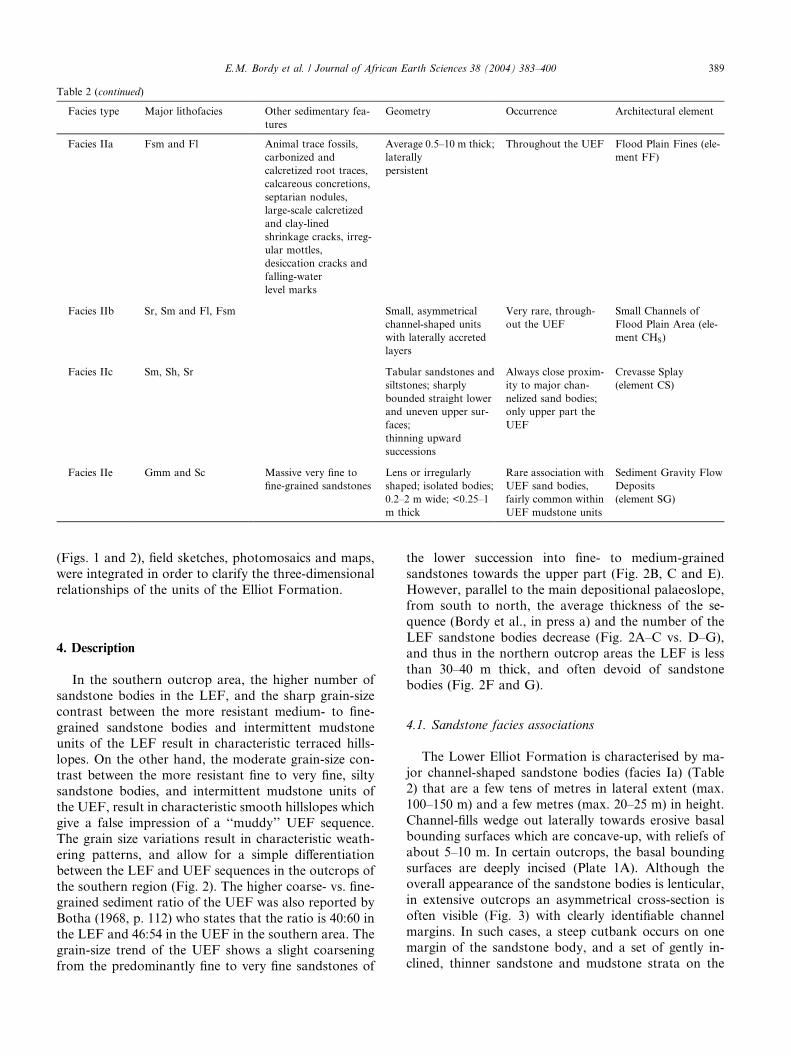
Table 2 (continued)
Facies type Major lithofacies Other sedimentary fea-
tures
Geometry Occurrence Architectural element
Facies IIa Fsm and Fl Animal trace fossils,
carbonized and
calcretized root traces,
calcareous concretions,
septarian nodules,
large-scale calcretized
and clay-lined
shrinkage cracks, irreg-
ular mottles,
desiccation cracks and
falling-water
level marks
Average 0.5–10 m thick;
laterally
persistent
Throughout the UEF Flood Plain Fines (ele-
ment FF)
Facies IIb Sr, Sm and Fl, Fsm Small, asymmetrical
channel-shaped units
with laterally accreted
layers
Very rare, through-
out the UEF
Small Channels of
Flood Plain Area (ele-
ment CHS)
Facies IIc Sm, Sh, Sr Tabular sandstones and
siltstones; sharply
bounded straight lower
and uneven upper sur-
faces;
thinning upward
successions
Always close proxim-
ity to major chan-
nelized sand bodies;
only upper part the
UEF
Crevasse Splay
(element CS)
Facies IIe Gmm and Sc Massive very fine to
fine-grained sandstones
Lens or irregularly
shaped; isolated bodies;
0.2–2 m wide; <0.25–1
m thick
Rare association with
UEF sand bodies,
fairly common within
UEF mudstone units
Sediment Gravity Flow
Deposits
(element SG)
E.M. Bordy et al. / Journal of African Earth Sciences 38 (2004) 383–400 389
(Figs. 1 and 2), field sketches, photomosaics and maps,
were integrated in order to clarify the three-dimensional
relationships of the units of the Elliot Formation.
4. Description
In the southern outcrop area, the higher number of
sandstone bodies in the LEF, and the sharp grain-size
contrast between the more resistant medium- to fine-
grained sandstone bodies and intermittent mudstone
units of the LEF result in characteristic terraced hills-
lopes. On the other hand, the moderate grain-size con-trast between the more resistant fine to very fine, silty
sandstone bodies, and intermittent mudstone units of
the UEF, result in characteristic smooth hillslopes which
give a false impression of a ‘‘muddy’’ UEF sequence.
The grain size variations result in characteristic weath-
ering patterns, and allow for a simple differentiation
between the LEF and UEF sequences in the outcrops of
the southern region (Fig. 2). The higher coarse- vs. fine-grained sediment ratio of the UEF was also reported by
Botha (1968, p. 112) who states that the ratio is 40:60 in
the LEF and 46:54 in the UEF in the southern area. The
grain-size trend of the UEF shows a slight coarsening
from the predominantly fine to very fine sandstones of
the lower succession into fine- to medium-grained
sandstones towards the upper part (Fig. 2B, C and E).
However, parallel to the main depositional palaeoslope,
from south to north, the average thickness of the se-
quence (Bordy et al., in press a) and the number of the
LEF sandstone bodies decrease (Fig. 2A–C vs. D–G),
and thus in the northern outcrop areas the LEF is less
than 30–40 m thick, and often devoid of sandstonebodies (Fig. 2F and G).
4.1. Sandstone facies associations
The Lower Elliot Formation is characterised by ma-
jor channel-shaped sandstone bodies (facies Ia) (Table
2) that are a few tens of metres in lateral extent (max.
100–150 m) and a few metres (max. 20–25 m) in height.
Channel-fills wedge out laterally towards erosive basal
bounding surfaces which are concave-up, with reliefs of
about 5–10 m. In certain outcrops, the basal bounding
surfaces are deeply incised (Plate 1A). Although theoverall appearance of the sandstone bodies is lenticular,
in extensive outcrops an asymmetrical cross-section is
often visible (Fig. 3) with clearly identifiable channel
margins. In such cases, a steep cutbank occurs on one
margin of the sandstone body, and a set of gently in-
clined, thinner sandstone and mudstone strata on the

Plate 1. (A) Deeply incised scour hollows (element HO) at the base of a major channel-shaped sandstone body (facies Ia) in the Lower Elliot
Formation. Note the fairly sharp upper bounding surfaces of the major sandstone body (Barkly Pass, north of Elliot). Person for scale (1.92 m). (B)
Mud-pebble conglomerate (lithofacies Gmcm), and carbonized wood fragment-filled gutter cast on lower bedding plane of medium-grained, massive
sandstone (lithofacies Sm) in the Lower Elliot Formation (Vegkop farm, east of Zastron). See Table 1 for lithofacies description and interpretation.
Lens cap for scale (5.8 cm). (C) Sheet sand bodies and interbedded mudstones of the Upper Elliot Formation (facies Ib) in a roadcut on the R392
road (Ono farm, SE of Lady Grey). Vehicle for scale (�2 m). (D) Virtually flat internal erosion surfaces within horizontally laminated (lithofacies Sh)sheet sand bodies (facies Ib) in a roadcut on the R56 road (Withoogte farm, south of Lady Grey). See Table 1 for lithofacies description and
interpretation. Hammer for scale (28 cm). (E) Amalgamated lenses of sandstones in the uppermost part of the Upper Elliot Formation (facies Ic)
along the slopes of the Aasvoelkrans hill (Mooifontein farm, north of Zastron). Hill is capped by Clarens Formation cliffs. Total height of hillslopes
�250 m. (F) Wavy bedding and mud-draped surfaces associated with ripple cross-laminated sandstones (facies Ib) (Withoogte farm, south of Lady
Grey). Tape measure for scale (50 cm).
390 E.M. Bordy et al. / Journal of African Earth Sciences 38 (2004) 383–400
other side that grade laterally into pure mudstone. The
major sandstone bodies comprise multiple sandstone
beds separated by numerous laterally non-persistent
internal erosion surfaces with a relief of �1 m, giving
them a multi-storey appearance. Some of the internal
erosion surfaces are gently inclined towards the thickest
part of the sandstone bodies (Fig. 4). Other surfacesare semi-horizontal or slightly concave-up. Within the
sandstone units, well-developed upward-fining units
(Fig. 5), commencing with mud-pebble conglomerate
lags (Plate 1B), are rarely capped by extensive mud-
stones. The upper bounding surfaces of the major
sandstone bodies are horizontal and fairly sharp (Plate
1A), rarely showing gradational contacts with the
overlying mudstone units.
The sedimentary structures within these majorchannel-shaped sandstones of the LEF (facies Ia) are
predominantly trough (St) and planar (Sp) cross-strati-

Fig. 3. Cross-section of an asymmetrical channel fill with steep cutbank on the right (facies Ia) in the Lower Elliot Formation (Baffels Fontein farm,
south of Jamestown, east of the junction of N6 and R56 roads). Person indicated by an arrow for scale (1.92 m).
Fig. 4. Channel-shaped, multi-storey sand bodies (facies Ia) with numerous laterally non-persistent, gently inclined internal erosion surfaces are
typical of the Lower Elliot Formation. Some well-developed point bar successions are present (east of the junction of N6 and R56 roads, Palmiet
Fontein farm). Person for scale (1.92 m).
E.M. Bordy et al. / Journal of African Earth Sciences 38 (2004) 383–400 391
fication, massive beds (Sm) and less commonly low-an-gle cross-stratification (Sl) and horizontal lamination
(Sh) (Table 1). Deposits bound by semi-horizontal or
slightly concave-up surfaces are dominated by lithofa-
cies St and Sp. Stringers and beds less than 0.2 m thick
of mud-pebble conglomerates (Gmcm) (Plate 1B) are
common, but pedogenic glaebule conglomerates are
absent. Parting lineations (Plate 1C) and gutter casts
filled with mudstone clasts and wood-fragments (Plate1D) are present. Soft sediment deformation structures,
ripple cross-lamination and bioturbation are a rare
occurrence.
The sheet sandstones of the Upper Elliot Formation
are different to these of the LEF; however, a few len-
ticular-shaped sandstone bodies are present, especially
in its uppermost part (see below described as facies Ic).
The most abundant sandstone bodies have a sheet-likegeometry several tens of metres wide (average >100 m),
and a maximum 5–6 m high (facies Ib) with individual
sandstone bed thicknesses of 0.2–1 m (Plate 1E). Both
basal and upper bounding surfaces are laterally persis-
tent, sharp and parallel to each other, lacking topo-
graphic irregularities larger than a few tens of
centimetres. Laterally, the margins of these tabular sheet
sandstone bodies are difficult to identify. Internally, theycontain virtually flat internal erosion surfaces which are
similar in geometry to the basal bounding surface and
give the units a multi-storey appearance (Plate 1E and
F). Interbedded mudstones are finely laminated or
massive and seldom exceed 0.5 m in thickness (Plate 1E
and F). Locally, the frequency of these intercalated
mudstone layers is so high that it becomes difficult to
define the individual sheet sandstone bodies.Channelized sandstone bodies (facies Ic) in the UEF
are exclusive to the uppermost part of the sequence (Fig.
5), and form simple, lenticular-shaped features with
laterally extensive, 0.5–1 m thick wings which taper
away from the <8 m thick medial parts of the fine- to
medium-grained sandstone bodies. Locally, facies Ic
may display amalgamated lenses of sandstones (Plate
1G) with total thickness up to 15 m. Lateral accretionsurfaces have not been documented, and the internal
erosion surfaces are semi-horizontal (Fig. 6). The dis-
tribution of facies Ic is limited to the southern outcrop
areas with its northernmost occurrences in the region
between Lady Grey and Zastron.
The sheet sandstone bodies of the UEF (facies Ib) are
characterised structured by the following sedimentary

Fig. 5. Channelized sand bodies (facies Ic) are found only in the uppermost part of the Upper Elliot Formation. Filled by medium-grained sand-
stones, the simple, lenticular-shaped features have wings which taper away from the thicker medial parts (Withoogte farm, south of Lady Grey).
392 E.M. Bordy et al. / Journal of African Earth Sciences 38 (2004) 383–400
structures: massive beds (Sm); horizontal lamination
(Sh) (Plate 1F and H); ripple cross-lamination (Sr)
(Plate 1H) and low-angle cross-stratification (Sl).Trough cross-stratification is virtually absent, except in
lenticular-shaped sandstone bodies (facies Ic) that oc-
cur at the top of the UEF. The most common lithof-
acies combination in both sheet and lenticular
sandstone bodies is the association of horizontal-lami-
nation and ripple cross-lamination. Other sedimentary
structures observed in facies Ib are parting lineation,
flaser and wavy bedding and mud-draped surfaces(Plate 1H), small-scale soft sediment deformations (e.g.,
water-escape structures, load casts) (Plate 2A), desic-
cation cracks (Plate 2B) and bioturbation (both within
beds and on mud-draped upper bedding planes) (Plate
2C). Mud-pebble conglomerates (Gmcm) commonly
form stringers at the base of thicker sandstones, but
Fig. 6. Virtually flat internal erosion surfaces within a channelized sand bo
(Withoogte farm, south of Lady Grey). Person for scale (1.92 m).
thicker (up to 0.5 m) beds were occasionally encoun-
tered. Locally, these rip-up mudstone clasts exhibit
imbrication, and contain very rarely single, ±1 cmdiameter, rounded quartz pebbles (Fig. 7). In the
channel lags of the UEF sandstones, pedogenic glae-
bule conglomerates are quite common, especially in the
northern outcrop areas. They consist of granule- to
pebble-sized, white, well-rounded carbonate nodules,
septarian nodules, white to reddish, subangular to
subrounded mudstone clasts, red, subangular to sub-
rounded sandstone clasts, reddish, subangular to sub-rounded isolated, broken and abraded fossil bone and
teeth fragments, and very rare red to white, sub-
rounded to rounded quartz pebbles. Most conglomer-
ates lack stratification (Gcm) (Plate 2D), though some
display slight horizontal layering (Gh) or cross-strati-
fication (Gp, Gt).
dies (facies Ic) in the uppermost part of the Upper Elliot Formation

Plate 2. (A) Small-scale soft sediment deformation: load casts in the Upper Elliot Formation (facies Ib) sandstones (Fraaiuitsig farm, north–
northeast of Clocolan). Lens cap for scale (5.8 cm). (B) Massive, clast-supported pedogenic glaebule conglomerates (lithofacies Gcm). Other beds
display slight horizontal layering (Gh) or cross-bedding (Gp, Gt) (Leliekloof farm, east of Jamestown). See Table 1 for lithofacies description and
interpretation. Lens cap for scale (5.8 cm). (C) Calcretized root traces in the Upper Elliot Formation mudstone (Beatrix farm, northeast of Clocolan).
Hammer for scale (28 cm). (D) Calcareous concretions in the Upper Elliot Formation mudstone (La Roche farm, west of Ladybrand). Small tree for
scale in the foreground (1.70 m). (E) Large-scale calcretized shrinkage cracks (often clay-lined) in the Upper Elliot Formation mudstone (Aurora
farm, northeast of Ladybrand). Lens cap for scale (5.8 cm). (F) Red intraformational sandstone clast breccias (lithofacies Gmm) in the Upper Elliot
Formation mudstone (Damplaats farm, southeast of Ladybrand). Together with clast-rich sandstones (lithofacies Sc), this lithofacies forms lenticular
or irregularly shaped, narrow, isolated bodies (facies II). See Table 1 for lithofacies description and interpretation. Lens cap for scale (5.8 cm).
E.M. Bordy et al. / Journal of African Earth Sciences 38 (2004) 383–400 393
4.2. Mudstone facies associations
The sandstone bodies of the Lower Elliot Formationare separated by laterally persistent mudstone intervals
(facies IIa) on average 20–30 m thick. Sedimentary
structures are rare, and most of the mudstones are
massive (Fsm), or very rarely horizontally laminated
(Fl). The grain sizes are predominantly in the fine silt
and clay grain-size classes (very coarse silt or sand grains
are very rare). Pedogenic alteration is rare in the south,
and even in the north, it remains restricted to irregularmottles, a few desiccation cracks, and rare calcareous
glaebules. Small, asymmetrical channel-shaped succes-
sions (Fig. 8), with the contained mudstone (Fl, Fsm)
and very fine-grained sandstone (Sr, Sm) beds (facies
IIb) that dip towards the thickest part of the channels,
are rarely encountered in the LEF mudstone units bothin the south (e.g., Kraamberg, northwest of Jamestown)
and north (e.g., Fraaiuitsig farm, north–northeast of
Clocolan). Bioturbation is almost absent, with very few
unlined, tube-like burrows (Planolites isg.). Occasion-
ally, within the thick mudstone units, 0.2–1.2 m thick,
tabular layers of medium- to very fine-grained sandstone
and siltstone are also found (facies IIc) (Fig. 9). These
strata, which are laterally continuous for several tens ofmetres, have sharp contacts, but while their basal con-
tacts are straight, their upper contacts are often irregu-
lar. The thickness of the succeeding beds gradually

Fig. 7. Single, <1.5 cm diameter, rounded quartz pebbles (marked
with arrow) are occasionally found in both mud-pebble and pedogenic
glaebule conglomerates in the Upper Elliot Formation. Note reworked
bone fragment (circled) and pedogenic glaebules (Dam Plaatz farm,
southeast of Ladybrand). Lens cap for scale (5.8 cm).
394 E.M. Bordy et al. / Journal of African Earth Sciences 38 (2004) 383–400
decreases, forming thinning upward successions. FaciesIIc is internally structured by the following lithofacies:
massive (Sm), horizontal laminated (Sh) and ripple
cross-laminated (Sr) sandstone. In a few localities (e.g.,
Barkly Pass––north of Elliot, Baffels Fontein farm––
south of Jamestown), in the immediate vicinity of the
major channel-shaped sandstone bodies, the mudstones
contain <1.2 m thick, rhythmically bedded units of thin
(<0.3 m) medium to fine, massive sandstones (Sm) andlaminated to massive (Fl/Fsm) mudstones (facies IId).
Fig. 8. Small, asymmetrical channel-shaped successions (facies IIb). The con
side). Such small channels are found engulfed in overbank mudstones in the L
Person for scale (1.8 m).
Fig. 9. Tabular beds forming upward thickening successions (facies IIc) in m
Vehicle for scale.
In contrast to the sandstones of the LEF, the sand-stone sheets of the UEF are separated from each other by
mudstone units 0.5–10 m thick (facies IIa). In composi-
tion, the mudstones range from pure mudstone to muddy
fine sandstone or siltstones. Most of the beds are massive
(Fsm), but horizontal lamination (Fl) is more common
than in the LEF mudstones. Although more reduced in
vertical dimension, trace fossils, carbonized and cal-
cretized (Plate 2E) root traces, calcareous concretions(Plate 2F), septarian nodules, large-scale calcretized and
clay-lined shrinkage cracks (Plate 2G), irregular mottles,
small-scale and sandstone-filled desiccation cracks, and
falling-water level marks are more abundant in the UEF
mudstones than the LEF mudstone. Small, asymmetrical
channel-shaped successions (facies IIb) are similarly rare
features in the UEF as they are in the LEF mudstones
(Fig. 10). The laterally continuous, tabular sandstoneintercalations (facies IIc) described above are virtually
absent from the lower part of UEF mudstone units, but
they are quite common in the upper part, especially in
association with coarser grained, more channelized
sandstone units with lenticular geometries (facies Ic).
Locally, smaller (max. 1.5 m thick) coarsening-upward
units are present which commence with fine-grained,
ripple cross-laminated sandstones and terminate in ma-trix-supported mud-pebble conglomerates.
Red intraformational sandstone clast breccias (Gmm)
(Plate 2H) and clast-rich sandstones (Sc) (facies IIe), are
tained layers dip towards the thickest part of the channels (right hand
ower Elliot Formation (Fraaiuitsig farm, north–northeast of Clocolan).
udstones of the Lower Elliot Formation (Barkly Pass, north of Elliot).

Fig. 10. Small, asymmetrical channel filled by laterally accreted, thin layers of clay- and siltstone (facies IIb) in the Upper Elliot Formation (Barkly
Pass, north of Elliot). Hammer for scale (28 cm).
E.M. Bordy et al. / Journal of African Earth Sciences 38 (2004) 383–400 395
associated with massive very fine to fine-grained sand-
stones (Sm), and occur only in the UEF. These litho-facies are rarely found in UEF sandstone bodies, and
fairly often within UEF mudstone units. Lithofacies
Gmm and Sc form lenticular or irregularly shaped,
narrow (0.2–2 m), isolated, <0.25 to 1 m thick bodies,
and consist of red sandy siltstone and mudstone clasts,
but lack carbonate glaebules. These granule- to medium
pebble-sized particles are angular, have a red clay-film
coat and are set randomly in the mud-rich matrixforming mostly matrix- and rarely clast-supported fab-
rics. Petrographic studies (Bordy et al., in press b) of the
associated massive very fine to fine-grained sandstones
(Sm) showed that the lithofacies contains variable
amounts of wedge-shaped, silt-sized quartz grains.
5. Interpretation
The subdivision of the sandstones of the Elliot For-
mation presented here is comparable with that of Visser
and Botha (1980) and Eriksson (1985). The majorasymmetrical channel-shaped LEF sandstones (facies
Ia), with their medium- to fine-grained sandstones, are
analogous to Visser and Botha’s (1980) Type A and B
sandstones, and to Eriksson’s (1985) Facies 2. On the
other hand, the sheet-like UEF sandstones (facies Ib)
with their fine- to very fine-grained beds, are similar to
Visser and Botha’s (1980) Type C1 and C2, and Eriks-
son’s (1985) Facies 3. The stacked, lenticular-shapedsandstone bodies (facies Ic) in the upper part of the UEF
are similar to those classified as Type D sandstones by
Visser and Botha (1980). On the other hand, the above
subdivision of the mudstones of the Elliot Formation is
only partially comparable with the facies classification
of previous researchers, as Visser and Botha (1980) do
not define their mudstone facies, and Eriksson (1985)
groups all the muddy units in his Facies 3. Nevertheless,the laterally extensive sandstones (facies IIc) seem to fit
Visser and Botha’s (1980, Fig. 6) Type C2 facies
description (C2 has ‘‘definite, sharp to slightly transi-
tional upper contact’’ as opposed to facies IIc which
shows sharp, uneven upper contact). The very rare,small coarsening-upward units of the UEF are compa-
rable with Visser and Botha’s (1980) facies Type C3.
The sandstone units of the Lower Elliot Formation
are interpreted as deposits of moderately meandering
channels with various subenvironments in the overbank
area where mudstones were accumulated. In the Upper
Elliot Formation the laterally persistent sheet sandstone
bodies are interpreted as distal sheetflood deposits (sensuHogg, 1982), while the more channelized facies at the
top of the UEF are interpreted as predominantly
straight, single-thread, incised channels produced by
successive streamfloods (sensu Hogg, 1982). The mud-
stone units of the UEF are interpreted as distal flood-
plain deposits.
Using the method of architectural element analysis
(Miall, 1985, 1996), several three-dimensional buildingblocks were identified in the alluvial suite of the Elliot
Formation. The individual lithofacies and architectural
element interpretations, based on Miall’s (1978, 1996)
letter coding system, are summarized in Tables 1 and 2.
5.1. Meandering channel deposits
The major asymmetrical channel-shaped sandstone
bodies (facies Ia) in the LEF represent element CH
(channels) and contain further components such as
lateral accretion elements (LA) bound by lateral
accretion surfaces, as well as rare sandy bedform ele-ments (SB) which are bound by semi-horizontal, con-
cave-up surfaces. The asymmetrical channels, and the
contained architectural elements, are likely to represent
lateral accretion of pointbars, and vertical aggradation
of 2D and 3D dune fields in a mixed-load, meandering
system (e.g., Alien, 1965; Miall, 1985, 1996). The steep
cutbanks indicate that the channels were incised into
resistant mudstone units which were probably stabi-lized by riparian vegetation (Bridge, 1985) as evi-
denced, for example, by the fossil wood found in these
units. The cohesive nature of the mudstones is also

396 E.M. Bordy et al. / Journal of African Earth Sciences 38 (2004) 383–400
shown by the presence of rip-up mud-pebble con-glomerates (Gmcm). The large irregularities at the base
of larger channels might be interpreted as sites of
channel/tributary confluences where significant scour
took place. Similar features were observed by the first
author at confluences of active meandering rivers in
Hungary (Tisza River and its tributaries). Miall (1996)
named identical features as element Hollow (HO), and
explained them in similar fashion (Best, 1987, in Miall,1996: Fig. 6.45).
5.2. Sheetflood deposits
The laterally continuous, sheet sandstone bodies (fa-
cies Ib) of the UEF are identified as laminated sand sheetelements (LS) and interpreted as vertically stacked
products of high-energy, but rare and short-lived depo-
sitional events, in an otherwise low-energy environment
probably characterised by gentle depositional surfaces.
The individual sandstone sheets within the larger sand-
stone bodies formed in unconfined sheetfloods (sensu
Hogg, 1982) in either single events with multiple peaks,
or during several short-lived flood events separated byperiods of non-deposition and desiccation. These periods
of desiccation are also evidenced by the rip-up mud-
pebble conglomerates (Gmcm), with the mud-pebbles
thought to have survived the rigour of the short trans-
portation processes due to their desiccated, compacted
nature (Stear, 1985). The reworked, carbonate glaebules
found as lag conglomerates in the UEF sheet sandstone
bodies are very early diagenetic in origin (Bown andKraus, 1981 and references therein) and are a clear
demonstration of the fact that calcrete-bearing paleosols
were indeed more abundant during UEF than LEF
times, and that the sedimentation styles (striping/skim-
ming of floodplain by channels in UEF vs. more fixed
channels in LEF) were different.
5.3. Low sinuosity stream flood deposits
The lenticular sandstone bodies with laterally exten-
sive wings (facies Ic) in the uppermost part of the UEF
are identified as simple channels (CH). Their sedimen-
tary structures (either St or Sh/Sr combination) and the
lack of inclined internal erosion surfaces suggest that
they are vertically stacked products of confined, high-energy streamfloods (sensu Hogg, 1982) with relatively
straight courses.
5.4. Floodplain deposits
The mudstones units with contained sandy depositsare identified as various architectural elements of the
overbank environment. The mudstones of both the LEF
and UEF are regarded as floodplain fines (FF) formed
in standing water bodies or abandoned watercourses.The vertical and lateral distribution of the pedogenically
overprinted mudstone units and their significance are
explained later.
5.5. Triburary/distributary channels
Small, asymmetrical channel-shaped deposits (faciesIIb), with laterally accreted beds, found both in LEF and
UEF mudstones, are identified as small, secondary, sin-
uous channels of the overbank areas (element CHS). Due
to their small sizes, which are not comparable to the
major channels, and isolated nature, they are unlike
products of chute or neck cutoffs (element CH(FF) of
Miall, 1996). Small reticulate channels have been re-
ported by Knighton and Nanson (1997) from the back-swamps of the Channel Country (Australia), but their
sedimentology was not accounted for and the modern
analogue of facies IIb channels in the Elliot Formation
thus remains enigmatic. The mudstone fills of the UEF
small channels (e.g., Fig. 10) are thought to have been
deposited as sand-sized mud aggregates, an apparently
common mode of deposition in the modern dryland
fluvial systems of Australia (Rust and Nanson, 1989).
5.6. Crevasse splay deposits
The sharply bounded, tabular sandstones and silt-
stones (facies IIc) with uneven upper surfaces are
interpreted as crevasse splay deposits (element CS)
based on their geometries, internal sedimentary struc-tures and close proximity to major channelized sand-
stone bodies, both in the LEF and upper parts of the
UEF. The uneven upper boundaries are thought to
represent scouring by minor overbank sheetfloods in
which the flow conditions diminished at such fast rates
that bedforms could not develop. Similar uneven upper
boundaries of crevasse splay deposits are reported by
Stear (1983, Fig. 12) and are explained as products ofscouring by ‘‘anastomosing rivulets that flowed across
the splays’’.
5.7. Levee deposits
Rhythmically bedded units of sandstones and mud-
stones (facies IId) in the immediate vicinity of the majorLEF channel sandstone bodies are identified as rare le-
vees (element LV) which formed along the banks of the
major, temporarily fixed channels, that were probably
abandoned fairly rapidly (Brierley et al., 1997).
5.8. Colluvial mass movement deposits and associated
reworked aeolianites
The association of matrix-supported intraformational
sandstone breccias (Gmm) and clast-rich sandstones

E.M. Bordy et al. / Journal of African Earth Sciences 38 (2004) 383–400 397
(Sc) (facies IIe) of the UEF are interpreted as probablepassive colluvial fills of smaller, rainstorm-eroded gullies
and other irregular depression of the floodplain area
(element SG: sediment gravity flow deposits). Similar
lithofacies associated with semi-arid alluvial environ-
ments were described by Steel (1974) and Hartley (1993,
Facies association A) and interpreted as deposits of
hyperconcentrated flood flow, an intermediate between
normal stream and debris flows. The massive very fine tofine-grained sandstones are interpreted as reworked
aeolian deposits based on their petrographic properties.
Similar petrographic observations and the presence of
reworked aeolian (loess) deposits in the Elliot Forma-
tion in the north-eastern outcrop area (Fig. 1) were
documented by Eriksson (1983, 1985) as well.
6. Fluvial style variations
The narrow, moderately meandering channels of the
LEF were relatively stable rather than rapidly migrating(laterally). The limited lateral extent, stacked appear-
ance, fairly defined upper boundaries, poorly developed
levee deposits, and their total envelopment in floodplain
fines, are collectively taken as being indicative of rela-
tively rapid channel abandonment and relocation due to
avulsion (Leeder, 1978; Brierley et al., 1997). The low
frequency of the crevasse splay deposits might be due to
protective riparian vegetation, which prevented breach-ing of the river banks, and promoted the confinement of
the channels (Bridge, 1985; Brierley et al., 1997). The
presence of lateral accretion surfaces, and unimodal
palaeocurrents in the adjacent sandstone units (Bordy et
al., in press b), show that the meandering rivers were
only moderately sinuous. The relatively constant dis-
charge of the perennial, moderately sinuous rivers of the
LEF is indicated by the presence of small pointbars(gradual decrease of flow strength), and the absence of
pulsating discharge indicators such as upper flow regime
horizontal lamination coupled with ripple cross-lami-
nation (McKee et al., 1967; Stear, 1985; Langford and
Bracken, 1987; etc.), flaser bedding (Martin, 2000) and
desiccated mud-drapes, and rare pedogenic overprint-
ing. The depositional environment of the LEF maybe
summarized with some modification by the classicalarchitectural model of meandering rivers as presented in
Miall (1996, Fig. 8.34). One of the differences between
the sand-bed meandering stream model of Miall (1996)
and the LEF environment is that the latter streams were
less sinuous with less lateral migration.
Vertical accretion in a flood-dominated, low-sinuos-
ity fluvial system with wide, shallow and flat-based
watercourses and highly variable, pulsatory discharges,is envisaged during the deposition of the UEF. This
scenario is interpreted from the virtually flat external
and internal erosion surfaces, lateral continuity of
depositional units, dominance of couplets of upper andlower flow regime sedimentary structures (no interme-
diate flow structures like Sp or St), consistent palaeo-
currents (Bordy et al., in press b) within and in the
succeeding sheet sandstone bodies as well as lack of
pointbars, lateral or downstream accretion surfaces,
channel margins and crevasse splays. In addition, some
channelized sandstone bodies with largely similar
lithofacies associations (Sh/Sr) (e.g., the southern out-crops of the uppermost UEF) show that channel inci-
sion took place in the proximal parts of the depositional
slope.
A semi-arid environment is suggested by the presence
of calcrete-rich soil profiles (e.g., in situ and reworked
pedogenic carbonate glaebules and rhizoliths), desicca-
tion cracks, rubification in the mudstones (due to oxi-
dation of iron compounds above ground water level),intraformational conglomerates/breccias and the well
documented aeolian interbeds (e.g., Botha, 1968; Le
Roux, 1974; Visser and Botha, 1980; Eriksson, 1983,
1985; Smith and Kitching, 1997) in the uppermost UEF.
These soil profiles were often partially removed by
subsequent floods, incorporating the reworked, resistant
remnants into the bases of laterally extensive sand
sheets. The above interpretations are in line with mod-ern hydrological and geomorphological observations of
semi-arid fluvial systems (McKee et al., 1967; Stear,
1985; Langford and Bracken, 1987; Knighton and
Nanson, 1997; Reid and Frostick, 1997). In present
times, such systems are typical in regions with low an-
nual precipitation, especially in subtropical areas (e.g.,
North Africa), continental interiors (e.g., North Amer-
ica), along the western coasts of continents (e.g.,southern Africa, Australia, South America), and in rain
shadow areas, behind topographic barriers (e.g., South
America) (Nanson et al., 2002).
The stratigraphic distribution of facies Ib (unconfined
sheetflood deposits) and facies Ic (confined streamflood
deposits) within the UEF is suggestive of a flood-driven
ephemeral system, with a northward-prograding ten-
dency. With facies Ib as the distal and facies Icas the proximal part of this ephemeral system, the
contemporaneous orogenic unloading of the Cape Fold
Belt resulted in progressively steeper depositional slopes
(Bordy et al., in press a), which in turn caused the
overstepping of the distal facies Ib by the proximal facies
Ic.
In contrast to sandy meandering rivers (e.g., Jackson,
1978; Bridge, 1985; Miall, 1985, 1996), depositionalmodels of ephemeral fluvial systems of dry-land envi-
ronments (Fielding, 1999) are not well established. The
imbalance in knowledge between the existing models is
mainly due to the fact that semi-arid fluvial systems are
less accessible, and more unpredictable, than their
perennial counterparts, thus the monitoring of such
systems is challenging (Tooth and Nanson, 1995;

398 E.M. Bordy et al. / Journal of African Earth Sciences 38 (2004) 383–400
Knighton and Nanson, 1997). Although recent advancesin hydrological and geomorphological studies of dry-
land river systems, especially in Australia (e.g., Tooth
and Nanson, 1995; Thomas, 1997; Knighton and Nan-
son, 1997; Reid and Frostick, 1997), provide adequate
data for integration into depositional models, sedimen-
tological modelling of such systems is still in its infancy
due to the lack of empirical data on the preserved sed-
imentary structures and of the architecture of theseephemeral fluvial deposits. The sedimentary structures
and architectures of the Upper Elliot Formation have
much in common with those described from similar
studies of ancient ephemeral stream deposits (e.g.,
McKee et al., 1967; Steel, 1974; Alien and Williams,
1979; Turner, 1981; Sneh, 1983; Stear, 1983, 1985;
Tunbridge, 1984; Flint, 1985; Langford and Bracken,
1987; Dreyer, 1993; Luttrell, 1993; Olsen and Larsen,1993; Miall, 1996; Martin, 2000). Unfortunately, the
depositional models tend to be simplistic, and more
importantly, these models are, without exception, based
on examples that are areally restricted, and thus are not
really applicable for vast areas like major foreland ba-
sins. For instance, the depositional models of sandy
ephemeral streams and clay playa complexes (Tun-
bridge, 1984), distal and flashy, ephemeral sheetfloodrivers (Miall, 1996), terminal fans or fluvial distributary
systems (Friend, 1978; Parkash et al., 1983; Sneh, 1983;
Kelly and Olsen, 1993, among others), alluvial fans
(Hartley, 1993) and floodouts (Tooth, 1999) all illustrate
areas that are much smaller than the c. 87500 km3 ero-
sional remnant of the Upper Elliot Formation. A com-
prehensive depositional model for the Upper Elliot
Formation is therefore not justified at this stage. Suchmodelling shall have to await more sophisticated and
flexible models, which incorporate empirical data from
studies of large modern systems.
7. Conclusions
A regional facies analysis of the Late Triassic–Early
Jurassic Elliot Formation has shown that these conti-
nental red beds can be subdivided into two informal
units, which have distinct lithologies, and are traceable
throughout the basin. The two units are the products oftwo different sedimentological regimes. The lower part
of the formation (Lower Elliot Formation) with its
asymmetrical, isolated channel sandstones and thick
mudstones is reconstructed as a perennial meandering
fluvial system. The upper part (Upper Elliot Formation)
with its sheet-like, laterally continuous sandstones and
interbedded mudstones is interpreted as an ephemeral,
flash flood-dominated fluvial system. Because of theirdistinct lithologies and stratigraphic relations, we sug-
gest that the above bipartite lithostratigraphic scheme of
the Elliot Formation be utilized as a basis for formal
member classification by the South African Committeefor Stratigraphy.
Apart from the above practical application of the
facies analysis of the Elliot Formation, the contrasting
characteristics of the sandstone bodies and associated
mudstones are also instrumental in the estimation of the
relative rates of subsidence that took place during the
deposition of the Elliot Formation (Bordy et al., in press
a). The LEF with incised sandstone bodies engulfed bythick floodplain deposits (avulsion and abandonment of
channels) and lack of pedogenic overprinting, suggests a
higher rate of subsidence. In contrast to this, the pres-
ence of wide, shallow scours, the lack of significant
down-cutting and extensive pedogenic modification of
the UEF mudstones suggest that the floodwaters pro-
ceeded in unconfined, shallow sheets rather than chan-
nels, evoking a picture of a low rate of subsidence whichenabled more significant pedogenic alterations of the
floodplain areas.
In contrast to previous concepts, it is proposed that
the fluvial style change that took place during the
deposition of the Elliot Formation was caused not only
by climatic, but also tectonic factors as well (Bordy
et al., in press a). The tectonic control is evidenced,
among others, by the fact that the units of the ElliotFormation have different palaeocurrent trends and
petrography (denudation patterns and provenance)
(Fig. 1A–C) as demonstrated by Bordy et al. (in press b).
We also suggest that the previously described climatic
change across the proposed Triassic–Jurassic boundary
promoted the preservation of finer grained sediments,
and reduced the amount of fluvial input, which again
contributed to the change in the alluvial architecture.
Acknowledgements
The manuscript was prepared while EMB was a Na-
tional Research Found (South Africa) post-doctoral re-
search fellow at the School of Geosciences, University of
the Witwatersrand. EMB would like to thank her hus-
band, Mamadou Diop, for his enthusiastic field assis-
tance and companionship. The authors wish to thank the
late Prof J.W. Kitching and Dr M.A. Raath for intro-ducing them to numerous fossil sites, and for the
countless and stimulating discussions regarding the pal-
aeoenvironmental conditions of the Elliot Formation.
We thank reviewers Drs C. Heubeck, M. Johnson and
R.M.H. Smith for their thoughtful comments on the
original manuscript. Also, special thanks to Prof P.G.
Eriksson for his exceptional editorial support.
References
Alien, J.R.L., 1965. A review of the origin and characteristics of recent
alluvial sediments. Sedimentology 5, 89–191.

E.M. Bordy et al. / Journal of African Earth Sciences 38 (2004) 383–400 399
Alien, J.R.L., Williams, B.P.J., 1979. Interfluvial drainage on Siluro-
Devonian alluvial plains in Wales and the Welsh Borders. Journal
of Geological Society of London 136, 361–366.
Anderson, J.M., Anderson, H.M., Cruickshank, A.R.I., 1998. Late
Triassic ecosystems of the Molteno/Lower Elliot biome of South-
ern Africa. Palaeontology 41, 387–421.
Beukes, N.J., 1970. Stratigraphy and sedimentology of the Cave
Sandstone Stage, Karoo System. In: Haughton, S.H. (Ed.),
Proceedings of the 2nd IUGS Symposium on Gondwana Strati-
graphy and Palaeontology. CSIR, Pretoria, pp. 321–341.
Bordy, E.M., Hancox, P.J., Rubidge, B.S., in press a. Basin develop-
ment during the deposition of the Elliot Formation (Late Triassic–
Early Jurassic), Karoo Supergroup, South Africa. South African
Journal of Geology.
Bordy, E.M., Hancox, P.J., Rubidge, B.S., in press b. Provenance
study of the Late Triassic–Early Jurassic Elliot Formation, main
Karoo Basin, South Africa. South African Journal of Geology.
Botha, B.J.V., 1968. The stratigraphy of the Red Beds Stage, Karoo
System, at Elliot, C.P. Transactions Geological Society of South
Africa 71, 101–113.
Bown, T.M., Kraus, M.J., 1981. Lower Eocene Alluvial Paleosols
(Willwood Formation, Northwest Wyoming, USA): and their
significance for paleoecology, paleoclimatology, and basin analysis.
Palaeogeography, Palaeoclimatology, Palaeoecology 34, 1–30.
Bridge, J.S., 1985. Paleochannel patterns inferred from alluvial
deposits: a critical evaluation. Journal of Sedimentary Petrology
55, 579–589.
Brierley, G.J., Ferguson, R., Woolfe, K., 1997. What is a fluvial levee?
Sedimentary Geology 114, 1–9.
Catuneanu, O., Hancox, P.J., Rubidge, B.S., 1998. Reciprocal flexural
behaviour and contrasting stratigraphies: a new basin development
model for the Karoo retroarc foreland system, South Africa. Basin
Research 10, 417–439.
Dreyer, T., 1993. Quantified fluvial architecture in ephemeral stream
deposits of the Esplugafreda Formation (Palaeocene), Tremp-
Graus Basin, northern Spain. Special Publications International
Association of Sedimentologists 17, 337–362.
Eriksson, P.G., 1983. Palaeoenvironmental Study of the Molteno,
Elliot and Clarens Formations in the Natal Drakensberg and
Northeastern Orange Free State. Ph.D. Thesis, University of Natal,
South Africa, 209pp.
Eriksson, P.G., 1985. The depositional environment of the Elliot
Formation in the Natal Drakensberg and north-east Orange Free
State. Transactions Geological Society of South Africa 88, 19–26.
Eriksson, P.G., 1986. Aeolian dune and alluvial fan deposits in the
Clarens Formation of the Natal Drakensberg. Transactions Geo-
logical Society of South Africa 80, 389–393.
Fielding, C.F., 1999. Varieties of Fluvial Form: the relevance to
geologists of an expanded reality. In: Miller, A.J., Gupta, A. (Eds.),
Varieties of Fluvial Form. John Wiley and Sons Ltd., Chichester,
pp. 497–504.
Flint, S., 1985. Alluvial fan and playa sedimentation in an Andean arid
closed basin: the Pacencia group, Antofagasta province, Chile.
Journal of the Geological Society 142 (3), 533–546.
Friend, P.F., 1978. Distinctive features of some ancient river systems.
In: Miall, A.D. (Ed.), Fluvial Sedimentology. Canadian Society of
Petroleum Geologists, Memoir 5, pp. 531–543.
Hartley, A.J., 1993. Sedimentological response of an alluvial system to
source area tectonism: the Seilao Member of the Late Cretaceous
to Eocene Purilactis Formation of northern Chile, Spain. Special
Publications International Association of Sedimentologists 17,
489–500.
Hogg, S.E., 1982. Sheetfloods, sheetwash, sheetflow or. . .? Earth-
Science Reviews 18, 59–76.
Jackson, R.G., 1978. Preliminary evaluation of lithofacies models for
meandering alluvial streams. In: Miall, A.D. (Ed.), Fluvial Sedi-
mentology. Canadian Society of Petroleum Geologists, Memoir 5,
pp. 543–576.
Johnson, M.R., 1976. Stratigraphy and sedimentology of the Cape and
Karoo sequences in the Eastern Cape Province. Ph.D. Thesis,
Rhodes University, South Africa, 366pp.
Johnson, M.R., Van Vuuren, C.J., Hegenberger, W.F., Key, R.,
Shoko, U., 1996. Stratigraphy of the Karoo Supergroup in
southern Africa: an overview. Journal of African Earth Sciences
23 (1), 3–15.
Johnson, M.R., Van Vuuren, C.J., Visser, J.N.J., Cole, D.I., deWic-
kens, H.V., Christie, A.D.M., Roberts, D.L., 1997. The Foreland
Karoo Basin, South Africa. In: African BasinsSelly, R.C. (Ed.),
Sedimentary Basins of the World, vol. 3. Elsevier Science BV,
Amsterdam, pp. 269–317.
Kelly, S.B., Olsen, H., 1993. Terminal fans––a review with references
to Devonian examples. Sedimentary Geology 85, 339–374.
Kitching, J.W., Raath, M.A., 1984. Fossils from the Elliot and Clarens
Formations (Karoo Sequence) of the northeastern Cape, Orange
Free State and Lesotho, and a suggested biozonation based on
tetrapods. Palaeontologia Africana 25, 111–125.
Knighton, D., Nanson, G., 1997. Distinctiveness, diversity and unique-
ness in arid zone river systems. In: Thomas, D.S.G. (Ed.), Arid Zone
Geomorphology: Process, Form andChange inDrylands, second ed.
John Wiley and Sons Ltd., Chichester, pp. 185–203.
Langford, R.P., Bracken, B., 1987. Medano Creek, Colorado, a model
for upper-low-regime fluvial deposition. Journal of Sedimentary
Petrology 57, 863–870.
Leeder, M.R., 1978. A quantitative stratigraphic model for allu-
vium with special reference to channels deposits density and
interconnectedness. In: Miall, A.D. (Ed.), Fluvial Sedimentology.
Canadian Society of Petroleum Geologists, Memoir 5, pp. 587–
596.
Le Roux, J.S., 1974. Palaeogeologiese en palaeogeografiese aspekte
van die Etage Rooilae van die Sisteem Karoo. Ph.D. Thesis,
University Orange Free State, Bloemfontein, 295pp.
Le Roux, J.P., 1985. Palaeochannels and Uranium mineralisation in
the Main Karoo Basin of South Africa. Ph.D. Thesis, vol. 1 and 2,
University of Port Elizabeth, South Africa, 266pp.
Lucas, S.J., Hancox, P.J., 2001. Tetrapod-based correlation of
the nonmarine Upper Triassic of southern Africa. Albertiana 25,
5–9.
Luttrell, P.R., 1993. Basinwide sedimentation and the continuum of
paleoflow in an ancient river system: Kayenta Formation (Lower
Jurassic), central portion Colorado Plateau. Sedimentary Geology
85, 411–434.
Martin, A.J., 2000. Flaser and wavy bedding in ephemeral streams: a
modern and ancient example. Sedimentary Geology 136, 1–5.
McKee, E.D., Crosby, E.J., Berryhill Jr., H.L., 1967. Flood deposits,
Bijou Creek, Colorado, June 1965. Journal of Sedimentary
Petrology 37, 829–851.
Miall, A.D., 1978. Lithofacies types and vertical profile models in
braided river deposits: a summary. In: Miall, A.D. (Ed.), Fluvial
Sedimentology. Canadian Society of Petroleum Geologists, Mem-
oir 5, pp. 597–604.
Miall, A.D., 1985. Architectural-element analysis: a new method of
facies analysis applied to fluvial deposits. Earth-Science Reviews
22, 261–308.
Miall, A.D., 1996. The Geology of Fluvial Deposits. Blackwell
Scientific Publications, Oxford. p. 582.
Nanson, G., Tooth, S., Knighton, D., 2002. A global perspective on
dryland rivers: perceptions, misconceptions and distinctions. In:
Bull, L.J., Kirkby, M.J. (Eds.), Dryland Rivers: Hydrology and
Geomorphology of Semi-Arid Channels. John Wiley and Sons
Ltd., Chichester, pp. 17–54.
Olsen, H., Larsen, P.H., 1993. Structural and climatic controls on
fluvial depositional systems: Devonian, north-east Greenland.

400 E.M. Bordy et al. / Journal of African Earth Sciences 38 (2004) 383–400
Special Publications International Association of Sedimentologists
17, 401–423.
Parkash, B., Awasthi, A.K., Gohain, K., 1983. Lithofacies of the
Markanda terminal fan, Kurukshetra district, Haryana, India. In:
Collinson, J.D., Lewin, J. (Eds.), Modern and Ancient Fluvial
Systems. Special Publications International Association of Sedi-
mentologists 6, 337–344.
Parrish, J.T., 1990. Godwanan Paleogeography and Paleoclimatology.
In: Taylor, T.N., Taylor, E.L. (Eds.), Antarctic Paleobiology: Its
Role in the Reconstruction of Gondwana. Springer Verlag, New
York, pp. 15–26.
Reid, I., Frostick, L.E., 1997. Channel form, flows and sediments in
desert. In: Thomas, D.S.G. (Ed.), Arid Zone Geomorphology:
Process, Form and Change in Drylands, second ed. John Wiley and
Sons Ltd., Chichester, pp. 205–229.
Rust, B.R., Nanson, G.C., 1989. Bedload transport of mud as
pedogenic aggregates in modern and ancient rivers. Sedimentology
36, 291–306.
Scotese, C.R., Boucot, A.J., McKerrow, W.S., 1999. Gondwanan
paleogeography and paleoclimatology. Journal of African Earth
Sciences 28, 99–114.
Smith, R.M.H., Kitching, J., 1997. Sedimentology and vertebrate
taphonomy of the Tritylodon Acme Zone: a reworked palæosol in
the Lower Jurassic Elliot Formation, Karoo Supergroup, South
Africa. Palaeogeography, Palaeoclimatology, Palaeoecology 131,
29–50.
Smith, R.H.M., Eriksson, P.G., Botha, W.J., 1993. A review of the
stratigraphy and sedimentary environments of the Karoo-aged
basins of Southern Africa. Journal of African Earth Sciences 16,
143–169.
Sneh, A., 1983. Desert stream sequences in the Sinai Peninsula. Journal
of Sedimentary Petrology 53, 1271–1279.
Stear, W.M., 1983. Morphological characteristics of ephemeral stream
channel and overbank splay sandstone bodies in the Permian
Lower Beaufort Group, Karoo Basin, South Africa. In: Collinson,
J.D., Lewin, J. (Eds.), Modern and Ancient Fluvial Systems.
Special Publications International Association of Sedimentologists
6, 405–420.
Stear, W.M., 1985. Comparison of bedform distribution and dynamics
of modern and ancient sandy ephemeral flood deposits in the
southwestern Karoo region, South Africa. Sedimentary Geology 45,
209–230.
Steel, R.J., 1974. New Red Sandstone floodplain and piedmont
sedimentation in the Hebridean Province, Scotland. Journal of
Sedimentary Petrology 44, 336–357.
Stockley, G.M., 1947. Report on the geology of Basutoland. Govern-
ment Report (Lesotho), Maseru, 114pp.
Thomas, D.S.G., 1997. Reconstructing ancient arid environments. In:
Thomas, D.S.G. (Ed.), Arid Zone Geomorphology: Process, Form
and Change in Drylands, second ed. John Wiley and Sons Ltd.,
Chichester, pp. 577–605.
Tooth, S., 1999. Downstream changes in floodplain character on
the Northern Plains of arid central Australia. In: Smith, N.D.,
Rodgers, J. (Eds.), Fluvial Sedimentology IV. Special Publica-
tion of the International Association of Sedimentologists 28, 93–
112.
Tooth, S., Nanson, G.C., 1995. The geomorphology of Australia’s
fluvial systems: retrospect, perspect, and prospect. Progress in
Physical Geography 19, 35–60.
Tunbridge, I.P., 1984. Facies model for a sandy ephemeral stream and
clay playa complex; the Middle Devonian Trentishoe Formation of
North Devon, UK. Sedimentology 31, 697–715.
Turner, B.R., 1981. The occurrence and stratigraphic significance of
bone-bearing mudstone pellet conglomerates from the Beaufort
Group in the Jansenville District, Cape Province, South Africa.
Palaeontologia Africana 24, 63–73.
Turner, B.R., 1986. Tectonic and climatic controls on continental
depositional facies in the Karoo Basin of northern Natal, South
Africa. Sedimentary Geology 46, 231–257.
Visser, J.N.J, 1984. A review of the ‘‘Stormberg’’ Group and
Drakensberg Volcanics in Southern Africa. Palaeontologia Afri-
cana 25, 5–27.
Visser, J.N.J., Botha, B.J.V., 1980. Meander belt, point bar, crevasse
splay and aeolian deposits from the Elliot Formation in Barkly
Pass, northeastern Cape. Transactions Geological Society of South
Africa 83, 55–62.