Fluvial erosion of inscriptions and petroglyphs at Siega Verde, Spain
9
Fluvial erosion of inscriptions and petroglyphs at Siega Verde, Spain Robert G. Bednarik * International Federation of Rock Art Organizations (IFRAO), P.O. Box 216, Caulfield South, VIC 3162, Australia article info Article history: Received 10 October 2008 Received in revised form 8 May 2009 Accepted 23 June 2009 Keywords: Schist Weathering Fluvial erosion Inscription Dating Petroglyph Siega Verde Spain abstract Low-grade metamorphics such as slates and schists tend to be subjected to relatively rapid surface deterioration by both weathering and fluvial wear. If the rate at which such processes are effective on these relatively soft rocks could be calibrated through their effects on surfaces of known ages, this would provide a possibility of estimating the age of petroglyphs on similar facies and in similar environments. An attempt of quantifying these processes is presented, using the petroglyph site of Siega Verde in western Spain as an example. A series of dated inscriptions occurring at a site of zoomorphic petroglyphs provide the data to plot rock surface deterioration against time. The involvement of numerous variables prevents this method from providing much precision, but it is adequate to offer indications of order of magnitude of age. The zoomorphs at Siega Verde have been attributed to the Upper Palaeolithic, but this method suggests that most of the site’s anthropic markings are under 200 years old. This finding is supported by several other factors, such as the degree of repatination of the supposedly Pleistocene petroglyphs, and the presence of a recent terrace predating these. Ó 2009 Elsevier Ltd. All rights reserved. 1. Introduction Siega Verde is a petroglyph site north-west of Ciudad Rodrigo, western Spain, extending some 1300 m along the left bank of the Rı ´o Agueda (Fig. 1). The site is located just west of the small town of Castillejo de Martin Viejo and about 50 km from the Co ˆ a petroglyph sites in Portugal (Bahn, 1995; Clottes, 1995; Bednarik, 1995). Like the Co ˆa, the Agueda is a southern tributary of the Douro River, and like the Co ˆa, it commences in the granite, gneiss and Silurian quartzite facies to the south, but then traverses low-grade metamorphics (Cambrian slates, schists and phyllites) before it drains into the Douro. The lower courses of both rivers were therefore scoured deeply into the topography, as the quartz cobbles and boulders of the uplands were rafted through soft-rock lower valleys. The need to cross the deeply cut Agueda valley for access to several village communities to the west has led to the successive construction of bridges near Castillejo de Martin Viejo, which have fallen victim to the torrents of past major river floods. Superficially, the steep-sided Agueda valley in the vicinity of the Siega Verde site may appear relatively pristine, but numerous traces of structures bear witness to great investments of labour in the vicinity of the petroglyph site. Apart from the bridge (Fig. 2) in the site’s centre and impressive ruins of a mill, there are remnants of former bridge supports close to it. Several hundred metres upstream, a series of four massive dry-stone piers of a former bridge survive, as well as systems of substantial stonewalls. The remains of various structures can also be found downstream of the present bridge. Clearly, this section of the Agueda valley, although not actually settled, has seen considerable human activity over recent centuries, and it is evident that rock markings coincide spatially with such centres of economic activitydas they do in the Co ˆa valley. The rock art corpus comprises several hundred figures (report- edly about 560), of which only in the order of sixty are clearly discernible. It occurs on soft schist blocks and outcrops that have been, and continue to be, sculptured by the coarse angular quartz grains of the river sand. The river floods frequently to a depth of 6–8 m, and all petroglyphs are located within this flood zone. As in the Co ˆa valley, the petroglyphs were known to residents for as long as they have existed, and villagers from Castillejo de Martin Viejo have reported that the rock art was ‘made by shepherds whiling away the time’; they ‘had a good laugh when archaeologists told them the art was Palaeolithic’ (Hansen, 1997), after archaeologists ‘discovered’ in 1988 what had always been known to the villagers (de Balbı ´n et al., 1991; de Balbı ´n and Alcolea, 1994; Bahn and Vertut, 1997: 130). Besides the mostly pounded animal images, none of which resembles Franco-Cantabrian rock or portable art of the Palaeolithic (which is generally incised), there are also numerous inscriptions at the site, many of them with dates. A brief visit by the * Tel./fax: þ61 3 9523 0549. E-mail address: [email protected] Contents lists available at ScienceDirect Journal of Archaeological Science journal homepage: http://www.elsevier.com/locate/jas 0305-4403/$ – see front matter Ó 2009 Elsevier Ltd. All rights reserved. doi:10.1016/j.jas.2009.06.019 Journal of Archaeological Science 36 (2009) 2365–2373
Transcript of Fluvial erosion of inscriptions and petroglyphs at Siega Verde, Spain

lable at ScienceDirect
Journal of Archaeological Science 36 (2009) 2365–2373
Contents lists avai
Journal of Archaeological Science
journal homepage: ht tp: / /www.elsevier .com/locate/ jas
Fluvial erosion of inscriptions and petroglyphs at Siega Verde, Spain
Robert G. Bednarik*
International Federation of Rock Art Organizations (IFRAO), P.O. Box 216, Caulfield South, VIC 3162, Australia
a r t i c l e i n f o
Article history:Received 10 October 2008Received in revised form8 May 2009Accepted 23 June 2009
Keywords:SchistWeatheringFluvial erosionInscriptionDatingPetroglyphSiega VerdeSpain
* Tel./fax: þ61 3 9523 0549.E-mail address: [email protected]
0305-4403/$ – see front matter � 2009 Elsevier Ltd.doi:10.1016/j.jas.2009.06.019
a b s t r a c t
Low-grade metamorphics such as slates and schists tend to be subjected to relatively rapid surfacedeterioration by both weathering and fluvial wear. If the rate at which such processes are effective onthese relatively soft rocks could be calibrated through their effects on surfaces of known ages, this wouldprovide a possibility of estimating the age of petroglyphs on similar facies and in similar environments.An attempt of quantifying these processes is presented, using the petroglyph site of Siega Verde inwestern Spain as an example. A series of dated inscriptions occurring at a site of zoomorphic petroglyphsprovide the data to plot rock surface deterioration against time. The involvement of numerous variablesprevents this method from providing much precision, but it is adequate to offer indications of order ofmagnitude of age. The zoomorphs at Siega Verde have been attributed to the Upper Palaeolithic, but thismethod suggests that most of the site’s anthropic markings are under 200 years old. This finding issupported by several other factors, such as the degree of repatination of the supposedly Pleistocenepetroglyphs, and the presence of a recent terrace predating these.
� 2009 Elsevier Ltd. All rights reserved.
1. Introduction
Siega Verde is a petroglyph site north-west of Ciudad Rodrigo,western Spain, extending some 1300 m along the left bank of the RıoAgueda (Fig. 1). The site is located just west of the small town ofCastillejo de Martin Viejo and about 50 km from the Coa petroglyphsites in Portugal (Bahn,1995; Clottes,1995; Bednarik,1995). Like theCoa, the Agueda is a southern tributary of the Douro River, and likethe Coa, it commences in the granite, gneiss and Silurian quartzitefacies to the south, but then traverses low-grade metamorphics(Cambrian slates, schists and phyllites) before it drains into theDouro. The lower courses of both rivers were therefore scoureddeeply into the topography, as the quartz cobbles and boulders ofthe uplands were rafted through soft-rock lower valleys.
The need to cross the deeply cut Agueda valley for access toseveral village communities to the west has led to the successiveconstruction of bridges near Castillejo de Martin Viejo, which havefallen victim to the torrents of past major river floods. Superficially,the steep-sided Agueda valley in the vicinity of the Siega Verde sitemay appear relatively pristine, but numerous traces of structuresbear witness to great investments of labour in the vicinity of thepetroglyph site. Apart from the bridge (Fig. 2) in the site’s centre
All rights reserved.
and impressive ruins of a mill, there are remnants of former bridgesupports close to it. Several hundred metres upstream, a series offour massive dry-stone piers of a former bridge survive, as well assystems of substantial stonewalls. The remains of various structurescan also be found downstream of the present bridge. Clearly, thissection of the Agueda valley, although not actually settled, has seenconsiderable human activity over recent centuries, and it is evidentthat rock markings coincide spatially with such centres of economicactivitydas they do in the Coa valley.
The rock art corpus comprises several hundred figures (report-edly about 560), of which only in the order of sixty are clearlydiscernible. It occurs on soft schist blocks and outcrops that havebeen, and continue to be, sculptured by the coarse angular quartzgrains of the river sand. The river floods frequently to a depth of6–8 m, and all petroglyphs are located within this flood zone. As inthe Coa valley, the petroglyphs were known to residents for as longas they have existed, and villagers from Castillejo de Martin Viejohave reported that the rock art was ‘made by shepherds whilingaway the time’; they ‘had a good laugh when archaeologists toldthem the art was Palaeolithic’ (Hansen, 1997), after archaeologists‘discovered’ in 1988 what had always been known to the villagers(de Balbın et al., 1991; de Balbın and Alcolea, 1994; Bahn and Vertut,1997: 130). Besides the mostly pounded animal images, none ofwhich resembles Franco-Cantabrian rock or portable art of thePalaeolithic (which is generally incised), there are also numerousinscriptions at the site, many of them with dates. A brief visit by the

Fig. 1. Map of the Siega Verde site near Ciudad Rodrigo, western Spain; contour intervals at 1 m.
R.G. Bednarik / Journal of Archaeological Science 36 (2009) 2365–23732366
author in September 1998 provided three clues to the age of therock art:
1. One of the central piers of the bridge had been erected so thatits base partly conceals a petroglyph. This proves conclusivelythat at least some of the site’s petroglyphs must predate thetime when the structure was erected, in 1925.
2. The base of the same support pier, about 2.5 m above thenormal water level, had been built of the same grey schist itstands on. It had since 1925 been subjected to bombardment by
Fig. 2. The Siega Verde bridge, looking north, with some dated inscriptions.
coarse and sharp-grained quartz sand every time the riverflooded. In the course of 72 years, this had resulted in a surfaceretreat of up to 30 mm in the lowest structural blocks, indi-cating the schist’s susceptibility to fluvial abrasion.
3. Crevices and recesses at the site provide ample evidence of theformer presence of an extensive alluvial terrace of very coarse-grained composition (mostly cobble to boulder clasts), in theform of many firmly lodged, small remnants at elevations up to7–8 m above the river.
The significance of the last-mentioned factor is that this formerterrace deposit must predate any of the rock art. Both its accumu-lation and eventual degradation would have had dramatic effectson the valley’s topography, and would have erased any surfacefeatures within the flood zone. All of the rocks now bearingpetroglyphs were submerged by this terrace deposit, therefore itprovides a secure terminus post quem for the Siega Verde petro-glyphs. At a location about 5 m above the river, 60–70 m upstreamof the bridge, the author recovered from one of these small terraceresidues in a deep recess a 10-cm-large pottery shard in 1998. Itoccurred just above some petroglyphs and is from a vessel madewith a pottery wheel. Probably of the Roman period (M. Simoes deAbreu, pers. comm.), it is water-worn and had been transportedwith sediment for some distance; so there can be no doubt that theformer terrace deposit must be well under 2000 years old. Itfollows that all of the site’s petroglyphs must be more recent again.
2. Methods
This narrows down the possible age range of the rock art, buta better and perhaps more generically applicable chronologicalresolution appeared feasible by focusing on the fluvial erosion of

Fig. 4. Dated inscriptions plotted by age against Degree of Erasure, indicating theapparent zone of distribution. Elevation in m above low water level is indicated.
R.G. Bednarik / Journal of Archaeological Science 36 (2009) 2365–2373 2367
the schist and its repatination patterns. In September 2006 the sitewas subjected to detailed examination involving three especiallyadapted microscopes.
There are over a thousand inscriptions within a kilometre or soof the site’s centre and nearly all of them occur in the flood zonealso occupied by the petroglyphs. Inscribed dates show similardegrees of wear by suspended particles. Plotting of the degree ofwear evident in these inscriptions against their age demanded theidentification and determination of key variables expressing theprogressive deterioration of the grooves. It begins with weathering(‘fading’, first 10%), followed by blunting of edges (next 10%), thenthe gradual obliteration of impact pits, leading to progressiveasymmetry in groove section, development of micro-fluting (anadvanced form of asymmetry), reduction of groove depth (indica-tive of over 70% wear), and finally the obliteration of the groove(100%), at which point any remaining surface depressions would nolonger be identifiable as anthropic. If these factors are to bea function of time, it is essential that progressive linear equivalencebe attempted. Groove asymmetry, determined by direction of waterflow, is perhaps the most important of them, and it is also the mostreadily quantified. It was also apparent that this Degree of Erasureneeded to be correlated with other variables, particularly theelevation above the thalweg or the river’s low water level; theorientation relative to water flow; the depth of grooves; andthe elevation above the nearest channel bed (there are numeroussubsidiary channels, most only active during flooding, and thesemay be up to several metres above the valley’s true thalweg) and itsgeometry.
Because of the inherent strata of the Siega Verde schist, flatpanels are frequently of identical orientation, which effectivelycontrols for one variable, and their relative exposure to sandblasting is then essentially a function of the remaining variables.Nearly all inscriptions (and petroglyphs) were made by directpercussion with hammerstones, and as the schist is homogenous,there is little variation in groove depths; they fall mostly between 3and 6 mm. Since all variables, including age of some of theinscriptions, are empirically available, such a framework couldpredict the approximate antiquity of any undated inscriptiondorfor that matter, any petroglyphdat this site.
Elevation of datable inscriptions above the nearest riverbed wasplotted against Degree of Erasure, as determined by field micros-copy (Fig. 3). The desired calibration curve was then established byplotting Degree of Erasure against known ages (Fig. 4). No specificpatterning is obvious in Fig. 3, but Fig. 4 provides a useful calibra-tion curve for realistic age range. The granulometric characteristics
Fig. 3. The elevation of dated inscriptions plotted against their Degree of Erasure.
of the river sand were also determined, as were details of accre-tionary mineral skins and rock weathering characteristics of theschist.
3. Observations
The rapid surface weathering (‘fading’) is readily apparent froma group of four dates from 2000 to 2006, possibly engraved by thesame person to commemorate repeated visits, occurring as analigned group roughly opposite petroglyph panel 14 (Figs 2 and 5).
Fig. 5. Series of engraved dates, possibly the work of one person, showing the rapiddarkening or ‘patination’ inherent in the rock (photograph taken September 2006,scale in cm).

Fig. 7. Siega Verde inscription showing fluted erosion patterns; scale in cm.
R.G. Bednarik / Journal of Archaeological Science 36 (2009) 2365–23732368
At the pool immediately upstream of the mill-ruin occur severalconcentrations of inscriptions, one of which, just 1 m above thenormal water level, includes the date of 1954. This date shows20–25% wear. Together with other inscriptions this group occurs ona large exfoliation scar, the result of the removal of a thin tabularpanel, which is weakly patinated and contrasts with the blackishpatinated earlier surface, still covering much of the panel (Fig. 6).The most prominent words on the exfoliation surface are ‘JAVIERSIERRO MUNOZ PA’. This probably cohesive composition is signif-icantly older than the 1954 inscription below it. Based on theroughly 40–50% abrasion it might well date from about 1925, i.e.the time of the bridge’s construction. Individual percussion pitsremain visible but only on the upstream side, where they areemphasized by black accretionary deposits. On the downstreamside of every vertical stroke (which has been subjected to moreintensive sand bombardment), pits are no longer visible due to thestronger effects of the fluvial erosion by the sand. Fig. 7 illustratesalso that this sand scouring has resulted in the development ofhorizontal fluting in the micro-topography of the surfaces mostaffected. This pattern of fluvial wear is particularly evident on thevertical strokes of some inscriptions and has resulted in a typicalgroove profile: on the right margin of the grooves, which is thedirection from which the water flow approaches, the original edgeof the groove and individual impact marks remain recognizable,but, as shown on the microphotograph (Fig. 8), the left groovemargins have become entirely erased.
Among the several other panels with pounded inscriptions inthe vicinity, special attention was given to one located 6 m upslope,at an elevation of 2.5–3.7 m above the normal water level (Fig. 9).The upper inscriptions are poorly decipherable, but there isa distinctive ‘MB’ at its base, and to the right of these letters occursan abraded ‘M’. This is one of the few engraved inscriptions of theentire site; percussion produced nearly all others (Fig. 10). It isclearly much more recent than the pounded ‘MB’ inscription ona similar level and nearby; it is shallower and shows limited fluvialwear by suspended particles, and it is free of microflora. Its age isunknown, but can safely be assumed to be only a few decades.Nevertheless, it has experienced considerable microscopic surfacemodification and almost complete obliteration of tool striations.
A nearby inscription ‘MA’ (Fig. 11), at nearly 3 m above the river,includes no date, but is traversed by four protruding quartz veinspermitting microerosion analysis (Bednarik, 1992). Where the veins
Fig. 6. Concentration of several Siega Verde inscriptions being subjected to digitalmicroscopy.
have been fractured, micro-wane widths were obtained (mostlyfrom the left stroke of the ‘A’), suggesting an age of about 80 years(applying the Vila Real calibration curve from northern Portugal,which was obtained from Roman bridges and an inscription; Bed-narik, 2003). This inscription occurs on a near-vertical panelexposed to moderate sand flow and shows about 20% wear.Another, similarly exposed inscription nearby, reading ‘JOR’-‘GE’ isof 30% wear (Fig. 12).
One of the largest concentrations of inscriptions occurs at thebridge, where most of them can be spatially related to the bridgeconstruction. Significant quantities of schist have been quarriednear the bridge piers, either as building material or to facilitate theplacement of scaffolding and other equipment. This work hasresulted in the creation of large flat panels, exposed around thetime of the building of the imposing structure. Therefore it can beassumed that these inscriptions either date from 1925 or are morerecent. The older specimens are very likely the work of bridgeconstruction crewmembers, others were clearly added later.
In plotting the inscriptions of known, or approximately knownages (Fig. 4) it is evident that height above base of subsidiary
Fig. 8. Microphotograph of a groove, the right vertical stroke of the U in the inscription‘MUNOZ’, showing the heavy modification from being bombarded by quartz sandduring floods; the water flow is from right to left. Note the microflora on the lee side.The section, on top, indicates the progressive erasure of the inscription. Scale in mm.

Fig. 9. Near-vertical panel with inscriptions, note abraded ‘M’ above scale, and ‘MB’ tothe left of it; scale in cm.
Fig. 11. ‘MA’ inscriptions with four protruding quartz veins that provided microerosiondata; scale in cm.
R.G. Bednarik / Journal of Archaeological Science 36 (2009) 2365–2373 2369
channel bed is of greater effect than absolute elevation above theriver. Values appear rather scattered because of predictable irreg-ularities in local conditions (orientation, rock topography, riverbedgeometry, elevation relative to base of nearest subsidiary bedchannel), which is in part due to recorded elevations referring tothe river rather than nearest channel floor, Nevertheless, a trend isevident which shows that after 150–200 years of exposure toerosion, an inscription of up to 5 mm depth would become unin-telligible or erased in any location subjected to this process.Markings close to the base of a ‘subsidiary thalweg’ might onlysurvive for a few decades, and should be regarded as lying outsidethe detectable range in this exercise (i.e. be above the shaded areain Fig. 4).
4. Fluvial abrasion
It is important to distinguish between the erosive function ofsuspended sediment, which is related to elevation above the
Fig. 10. Microphotograph of part of the abraded ‘M’ inscription, showing degree ofwear and faintness of tool striations; scale in mm.
nearest channel bed and has limited effect higher than 5–6 m abovethe river; and the inherited fluvial wear from the time the mostrecent terrace was mobilized, perhaps a few centuries ago. Thelatter is indiscriminate and can be found at heights of up to 8 m,whereas recent sand abrasion is most developed at lower eleva-tions, although it can be active throughout the water column.
The remnants of the terrace(s) are dominated by cobbles,especially well-rounded quartz detritus, even of boulder fraction upto a metre in size. Where they have survived best, in shelteredcrevices and bedrock joints, its components appear tightly packedand well consolidated (Fig. 13). The effect of the transport of thismass on the bedrock is illustrated at locations that experiencedhigh kinetic impact: the diagonally orientated schist plates havebeen battered to stumps, plucking occurred and outcrops have beenfluted extensively by suspended particles (Fig. 14). Cavitation bypothole formation is also found in the zone affected, which extendsup to about 5 m from the low water level, with greatest effectsobserved in its lower half. It is impossible for petroglyphs to survivefor any great time span on such soft rock in this environment, and itis entirely futile to expect to find any of an age greater than thetime of the terrace deposition, or of its removal, at any elevation of<6–8 m above the river. The terrace (or the terraces, if there wereseveral successive deposits, or cut-in-terraces or nested terraces;Easterbrook, 1999: 172–178) appears to have been a fill terrace
Fig. 12. Inscription showing Degree of Erasure of about 30%.

Fig. 13. Eroding remnant of very late Holocene terrace deposit at the Siega Verde rockart site; note the deeply scoured bedrock.
Fig. 14. Schist bedrock sculpted by the transport of quartz detritus of most grain sizesat the Siega Verde petroglyph site, looking south; note the pothole in the foreground.
R.G. Bednarik / Journal of Archaeological Science 36 (2009) 2365–23732370
rather than a strath terrace (Montgomery, 2004), although this isnot certain in view of the small size of most remnants, the lack ofdating and the inherently stochastic nature of the formationprocesses (Snyder et al., 2003).
While bedrock channel incision may occur relatively rapidly(Whipple et al., 2000a; Hartshorn et al., 2002; Stock et al., 2005;Reusser et al., 2006), it is not a primary concern in clarifying thechronology of the Siege Verde features. Of greater importance thanplucking or bedload abrasion is the impact of suspended-loadabrasion (Alexander, 1932; Foley, 1980; cf. Sklar and Dietrich, 1998;Snyder et al., 2000). The inscriptions are progressively worn byabrasion processes that operate at a sub-millimetre scale, andabrasion by suspended particles is therefore highly likely at the site.The sand at Siega Verde ranges from 5 mm (‘small pebble’ fraction)down, but the component of <0.63 mm is small and fine fractionsare almost absent. The sand consists largely of ‘coarse sand’ gran-ulometric fraction, and relatively angular quartz grains predomi-nate. In some locations, for instance among the petroglyphs justbelow the bridge, recent sand deposits are very well sorted, con-sisting almost entirely of very coarse quartz sand (Figs 15 and 16).A typical sample comprises (numerically) 86.3% quartz grains(ranging from well rounded to highly angular), 4.7% feldspar andthe remaining 9.0% are made up by numerous minerals (includingmica, staurolite, tourmaline, haematite and greywacke).
Hartshorn et al. (2002) have shown that small grains of diameterd� 2 mm can travel in significant numbers up to a flow depth of4–6 m in turbulent suspension and be responsible for significantbedrock abrasion (Hartshorn et al., 2002: Fig. 3A), in particular ifa soft lithology is exposed. Schist has been shown to be up to 2orders of magnitude more erodible than quartzite or granite (Attaland Lave, 2006: 156, 159). The largest grains in suspension haveconsiderable inertia and preferentially strike obstructions on theupstream side, whereas intermediate size particles may followgently curved streamlines upstream of obstructions, but impact ontheir lee side where shedding vortices produce sharply curvedstreamlines (Whipple et al., 2000b). The smallest particles tend tofollow streamlines faithfully and have negligible impact on the rocksurface. Consequently, the abundant coarse sand to small pebblefraction transported during floods at Siega Verde certainly causesdegradation on both upstream and downstream surfaces ofobstructions.
In considering the abrasive action of a single saltating quartzgrain, the precise kinetic conditions of the process are relevant. Thecontact area of an angular grain with the surface that it impacts issmaller than the contact area of a similar rounded grain with
a similar surface, causing greater damage. Each quartz grain, ofhardness 7 on Mohs Scale, scores the very soft rock surface of theschist (hardness 3)dwhich is undergoing rapid weathering byhydrationdunder hydraulic pressure (water column up to 8 m) andvelocity (Graf, 1977; Anderson et al., 1994). Angular particlesimpacting softer ductile material can potentially scratch it, witha maximum material removal for impact angles of 30 degrees(Finnie, 1980). The abrasive effectiveness of the coarse angular,mostly quartzitic sand in this dynamic environment is thereforevery high: the soft schist is correspondingly sculptured andcumulative wear becomes readily visible macroscopically. This isvery evident not only at the base of the bridge piers, but also onsome of the perhaps earliest remaining inscriptions.
5. Petroglyphs
The surviving petroglyphs at Siega Verde are of considerabletechnological and stylistic diversity. The majority are pounded(rather than pecked), while the engraved motifs tend to be smalland hard to see. Only one of the relatively large animal figures ismade by abrasion, the southernmost on the tourist circuit (onpetroglyph panel 14). A number of smaller figures are incised,including one very tiny ‘goat head’ which was made with a metalimplement but is patinated fully. Finally, there are a small numberof non-iconographic incised motifs of the ‘filiform’ type (bundles ofsub-parallel shallow and fine incisions). It is particularly importantthat some of the large pounded animal motifs are clearly super-imposed over such filiform motifs, and while the former are onlylightly repatinated, the latter are completely covered by the verydark deposits and are much older than the zoomorphs (Fig. 17).

Fig. 15. Typical grainsize distribution of the river sand at Siega Verde, showing a predominance of coarse sand; 82.87% is >0.63 mm.
R.G. Bednarik / Journal of Archaeological Science 36 (2009) 2365–2373 2371
That alone suffices to refute the Upper Palaeolithic antiquity of thezoomorphs. The filiforms occur at elevations of 6–7 m above theriver and have therefore experienced negligible if any abrasion bysuspended particles. They appear to have been produced by metalpoints, but this has not been conclusively established because oftheir deep weathering and accretions. Similar filiform patternsoccur at other sites in the region where they are attributed to theIron Age (e.g. Vermelhosa; de Abreu et al., 2000). Comparativecolorimetry (Bednarik, 2009) suggests that the filiform patterns arein the order of twenty times older than the superimposedzoomorphs.
However, the principal indicators of the age of this assemblageof petroglyphs relate to context and geology. The age of a fewimages next to the central western bridge pier is determined by theage of the bridge, because these are either partly concealed by thestructure, or access to them is so limited that they could notpossibly have been executed after the construction of the bridge.These were created on the prepared rock platform of the pier, andtherefore have to date from the construction period. This
Fig. 16. River sand among Siega Verde petroglyphs, comprised mostly of angularquartz grains; scale in mm.
establishes unambiguously that at least some of the site’s zoomorphpetroglyphs were produced around 1925.
The large abraded figure of panel 14, occurring between 2.5 and3.0 m above the normal water level, was microscopically examinedto estimate the level of subsequent erosion. The groove is generallyU-shaped and averages around 5 mm width. Striations have barelysurvived, but some remain visible and they suggest that thezoomorph was created with a stone tool. However, they also indi-cate that the figure, exposed as it was to significant fluvial wear,cannot be older than the inscriptions of the early 20th century (cf.similar condition of inscription ‘M’ above, at similar elevation). Inthe absence of direct dating evidence from most of the animalfigures, the level of fluvial erosion is perhaps the safest indicator ofrelative antiquity.
A petroglyph depicting a bovid head is located on a verticalpanel upstream of the bridge, between 1 m and 2 m above thepresent normal river level. It is fully exposed to the oncoming waterflow during inundation episodes and shows typical erosion wear.The degree of this wear is slightly greater in the lower part of theimage, but overall ranges from 20% to 30% at the most, using thesame empirical criteria as previously applied to the inscriptions(Fig. 18). Taking into consideration the exposure and relative loca-tion of the panel, this implies an age of the petroglyph roughlycorresponding to the inscription ‘1954’ mentioned above. On thebasis of Fig. 4 the petroglyph could be between 25 and 100 yearsold, but the level of exposure would point to the lower part of thatrange. Yet some archaeologists have attributed this figure to theUpper Palaeolithic, on the basis that it is claimed to depict anaurochs and that it is executed in a ‘Palaeolithic style’. The samekind of reasoning has been applied in the nearby Coa valley, and yetthe bovid images clearly resemble the cattle of the region morethan aurochs. That species may not even have occurred in theregion during the final Pleistocene stadial; it is more typical ofa Holocene fauna and probably occurred up to historical times.
Indeed, some archaeologists apparently consider all zoomorphsat the Siega Verde site as being of the Late Pleistocene, despite theobvious lack of significant repatination or fluvial wear in most ofthem. Moreover, there is not a single depiction of a species thatdid not exist in the region during recent centuries, and this appliesalso to the thousands of other Iberian petroglyphs at open-airschist sites that have been attributed to the Upper Palaeolithic
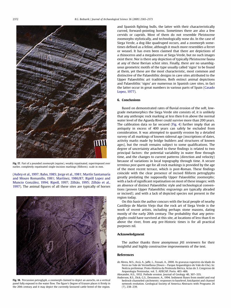
Fig. 17. Part of a pounded zoomorph (equine), weakly repatinated, superimposed overearlier, completely repatinated single-incision markings (filiform); scale in mm.
R.G. Bednarik / Journal of Archaeological Science 36 (2009) 2365–23732372
(Aubry et al., 1997; Bahn, 1985; Jorge et al., 1981; Martın Santamarıaand Moure Romanillo, 1981; Martınez, 1986/87; Ripoll Lopez andMuncio Gonzalez, 1994; Ripoll, 1997; Zilhao, 1995; Zilhao et al.,1997). The animal figures of all these sites are typically of horses
Fig. 18. Percussion petroglyph, a zoomorph claimed to depict an aurochs, on a verticalpanel fully exposed to the water flow. The figure’s Degree of Erasure places it firmly inthe 20th century and it may depict the currently favoured cattle breed of the region.
and Spanish fighting bulls, the latter with their characteristicallycurved, forward-pointing horns. Sometimes there are also a fewcervids or caprids. Most of them do not resemble Pleistocenezoomorphs stylistically, and technologically none do. In the case ofSiega Verde, a dog-like quadruped occurs, and a zoomorph some-times defined as a feline, although it much more resembles a ferretor weasel. It has even been claimed that there are depictions ofa rhinoceros and a megaloceros at Siega Verde, but no such imagesexist there. Nor is there any depiction of typically Pleistocene faunaat any of these Iberian schist sites. Finally, there are no unambig-uous geometric motifs of the type usually called ‘signs’ to be foundat them, yet these are the most characteristic, most common anddistinctive of the Palaeolithic designs in cave sites attributed to theUpper Palaeolithic art traditions. Both extinct animal depictionsand Palaeolithic ‘signs’ are numerous in Spanish cave sites, in factthe latter occur in great numbers in various parts of Spain (CasadoLopez, 1977).
6. Conclusions
Based on demonstrated rates of fluvial erosion of the soft, low-grade metamorphics the Siega Verde site consists of, it is unlikelythat any anthropic rock marking at less then 6 m above the normalwater level of the Agueda River could survive more than 200 years.The calibration data so far secured (Fig. 4) further imply that anantiquity in excess of 400 years can safely be excluded fromconsideration. It was attempted to quantify erosion by a detailedsurvey of all markings of known sidereal age (inscriptions of dates,activity marks made by bridge builders and structures of knownages), but the result remains subject to some qualifications. Thedegree of uncertainty attached to these findings is related to twoprincipal factors: the potential variability in water flow throughtime, and the changes to current patterns (direction and velocity)because of variations in local topography through time. A secureterminus post quem age for all rock markings is provided by the ageof the most recent terrace, which is post-Roman. These findingscoincide with the clear presence of incised filiform petroglyphsgreatly predating the supposedly Upper Palaeolithic zoomorphs;with a lack of significant repatination on most of these images; withan absence of distinct Palaeolithic style and technological conven-tions (proven Upper Palaeolithic engravings are typically abradedor incised); and with a lack of depicted species not present in theregion today.
On this basis the author concurs with the local people of nearbyCastillejo de Martin Viejo that the rock art of Siega Verde is thework of recent artists, including perhaps stone masons, datingmostly of the early 20th century. The probability that any petro-glyphs could have survived at this site, at locations of less than 6 mabove the river, from any pre-Historic times is for all practicalpurposes nil.
Acknowledgment
The author thanks three anonymous JAS reviewers for theirinsightful and highly constructive improvements of the text.
References
de Abreu, M.S., Arca, A., Jaffe, L., Fossati, A., 2000. As gravuras rupestres da Idade doFerro no Vale de Vermelhosa (Douro – Parque Arqueologico do Vale do Coa). In:Notıcia preliminar. Proto-Historia da Penınsula Iberica, Actas do 3. Congresso deArqueologia Peninsular, vol. 5. ADECAP, Porto. 403–406.
Alexander, H.S., 1932. Pothole erosion. Journal of Geology 40, 307–335.Anderson, R.S., Dick, G.S., Densmore, A., 1994. Sediment fluxes from model and real
bedrock-channeled catchments: responses to baselevel, knickpoint and channelnetwork evolution. Geological Society of America Abstracts with Programs 26(7), 238–239.

R.G. Bednarik / Journal of Archaeological Science 36 (2009) 2365–2373 2373
Attal, M., Lave, J., 2006. Changes of bedload characteristics along the MarsyandiRiver. In: Willett, S.D., Hovius, N., Brandon, M.T., Fisher, D.M. (Eds.), Tectonics,Climate, and Landscape Evolution. Special Paper 398. The Geological Society ofAmerica, pp. 151–171.
Aubry, T., Carvalho, A.F., Zilhao, J., 1997. Arqueologia: Salto do Boi – Cardina I. Arterupestre e pre-historia do Vale do Coa (trabalhos de 1995–96). Relatorio cien-tıfico ao Governo da Republica Portuguesa, Lisbon, pp. 1–23.
Bahn, P.G., 1985. Ice Age drawings on open rock faces in the Pyrenees. Nature 313,530–531.
Bahn, P.G., 1995. Cave art without the caves. Antiquity 69, 231–237.Bahn, P.G., Vertut, J., 1997. Journey Through the Ice Age. Weidenfeld and Nicolson,
London.de Balbın Behrmann, R., Alcolea Gonzalez, J.J., 1994. Arte paleolıtico de la meseta
espanola. Complutum 5, 97–138.de Balbın Behrmann, R., Alcolea Gonzalez, J., Santonja, M., Perez Martin, R., 1991.
Siega Verde (Salamanca). Yacimiento artıstico paleolıtico al aire libre. Delpaleolıtico a la historia. Museo de Salamanca, Salamanca. 33–48.
Bednarik, R.G., 1992. A new method to date petroglyphs. Archaeometry 34,279–291.
Bednarik, R.G., 1995. The age of the Coa valley petroglyphs in Portugal. Rock ArtResearch 12, 86–103.
Bednarik, R.G., 2003. First microerosion calibration curve for Iberia. ARKEOS –Perspectivas em Dialogo 14, 73–90.
Bednarik, R.G., 2009. Experimental colorimetric analysis of petroglyphs. Rock ArtResearch 26, 55–64.
Casado Lopez, M.P., 1977. Los signos en el arte Paleolıtico de la Penınsula Iberica. In:Monografıas Arqueologicas 20 Zaragoza.
Clottes, J., 1995. Palaeolithic petroglyphs at Foz Coa, Portugal. International News-letter on Rock Art 10, 2.
Easterbrook, D.J., 1999. Surface Processes and Landforms, second ed. Prentice Hall,Upper Saddle River, NJ.
Finnie, I., 1980. The mechanisms of erosive wear in ductile metals, corrosion–erosion behavior of materials. In: Natesan, K. (Ed.), Special Volume, Metallur-gical Society of AIME, pp. 118–126.
Foley, M.G., 1980. Bed-rock incision by streams. Geological Society of AmericaBulletin, Part II 91, 2189–2213.
Graf, W.H., 1977. Hydraulics of Sediment Transport. McGraw-Hill, New York.Hartshorn, K., Hovius, N., Dade, W.B., Slingerland, R.L., 2002. Climate-driven
bedrock incision in an active mountain belt. Science 297, 2036–2038.Hansen, B.S., 1997. From hell to inferno. Rock Art Research 14, 51–53.Jorge, S.O., Jorge, V.O., de Almeida, C.A.F., Sanches, M.J., Soeiro, M.T., 1981. Gravuras
rupestres de Mazouco (Freixo de Espada a Cinta). Arqueologıa 3, 3–12.
Martın Santamarıa, E., Moure Romanillo, J.A., 1981. Un grabado de estilo paleolıticode Domingo Garcia (Segovia). Trabajos de Prehistoria 38, 97–105.
Martınez, J., 1986/87. Un grabado paleolıtico al aire libre en Piedras Blancas(Escullar, Almerıa). Ars Praehistorica 5/6, 49–58.
Montgomery, D.R., 2004. Observations on the role of lithology in strath terraceformation and bedrock channel width. American Journal of Science 304, 454–476.
Ripoll Lopez, S., Muncio Gonzalez, L.J., 1994. Un grand ensemble d’art rupestrepaleolithique de plein air dans la Meseta espagnole. International Newsletter onRock Art 7, 2–5.
Ripoll, S., 1997. Comment on R.G. Bednarik, ‘Rock art as reflection of conditionalvisual perception’. Cambridge Archaeological Journal 7, 261.
Reusser, L., Bierman, P., Pavich, M., Larsen, J., Finkel, R., 2006. An episode of rapidbedrock channel incision during the last glacial cycle, measured with 10Be.American Journal of Science 306, 69–102.
Sklar, L., Dietrich, W.E., 1998. River longitudinal profiles and bedrock incisionmodels: stream power and the influence of sediment supply. In: Tinkler, K.J.,Wohl, E.E. (Eds.), Rivers over Rock: Fluvial Processes in Bedrock Channels.Geophysical Monograph 107. American Geophysical Union, Washington, D.C.,pp. 237–260.
Snyder, N.P., Whipple, K.X., Tucker, G.E., Merritts, D.J., 2000. Landscape response totectonic forcing: digital elevation model analysis of stream profiles in theMendocino triple junction region, northern California. Geological Society ofAmerica Bulletin 112 (8), 1250–1263.
Snyder, N.P., Whipple, K.X., Tucker, G.E., Merritts, D.J., 2003. Importance ofa stochastic distribution of floods and erosion thresholds in the bedrock riverincision problem. Journal of Geophysical Research 108 (B2), 2117.
Stock, J.D., Montgomery, D.R., Collins, B.D., Dietrich, W.E., Sklar, L., 2005. Fieldmeasurements of incision rates following bedrock exposure: implications forprocess controls on the long profiles of valleys cut by rivers and debris flows.Geological Society of America Bulletin 117 (1–2), 174–194.
Whipple, K.X., Snyder, N.P., Dollenmayer, K., 2000a. Rates and processes of bedrockincision by the Upper Ukak River since the 1912 Novarupta ash flow in theValley of Ten Thousand Smokes, Alaska. Geology 28 (9), 835–838.
Whipple, K.X., Hancock, G.S., Anderson, R.S., 2000b. River incision into bedrock:mechanics and relative efficacy of plucking, abrasion, and cavitation. GeologicalSociety of America Bulletin 112 (3), 490–503.
Zilhao, J., 1995. The age of the Coa valley (Portugal) rock-art: validation of archae-ological dating to the Palaeolithic and refutation of ‘scientific’ dating to historicor proto-historic times. Antiquity 69, 883–901.
Zilhao, J., Aubry, T., Carvalho, A.F., Baptista, A.M., Gomes, M.V., Meireles, J., 1997. Therock art of the Coa valley (Portugal) and its archaeological context: first resultsof current research. Journal of European Archaeology 5, 7–49.