FIELD TRIP 8 GEOLOGY OF THE PRE-CRETACEOUS ...
137
FIELD TRIP 8 Saturday, May 21 GEOLOGY OF THE PRE-CRETACEOUS WEATHERING PROFILE AND CRETACEOUS STRATA OF THE MINNESOTA AND COTTONWOOD RIVER VALLEYS Leaders Larry Zanko and John Heine, Natural Resources Research Institute Dale Setterholm, Minnesota Geological Survey INTRODUCTION E\p(}sul"es cfe,1ied by the Minnesota River Valley ,lnd mining in that Mea prm'ide opportunities to view products lIf the intense pre-Cret,lceous chemical \\"l'dthefing episode, and the Upper Cretaceous rocks th,lt immedi,Hely overlie them. The intense weathering that predated the of the Cretaceous strata acted on this part uf the NUfth American craton and produced a pCl1epl,lill mostly covered by chemically mature I"l'"icillum. The little relid that femained was mostly tlw rc,<ult of uneLjual resistance to weathering related ttl p.Jrent flll.:k composition or hydfologic properties. The fcl,ltive fesistance of minerals to chemical wl'dtllL'ring is dllCUI1lL'ntcci by the Goldich Mineral St,lbilitv Sl'quellce (Goldich, 1938). Quartz is most fesist,lnt. The feldspars, some of which weather easily, bredk dll\\'n and form kaolin clay. The resistant Ljll,HtZ, and the \\'e,lthering product kaolin, dominate the minef,]lll';)" of the Cretaceous strata that overlie the \\'l',1 tl1l'rL'd Sli rface. fhe Crct,lceous strata that occur here were ted llll thL' eastern, shallow side of a foreland b,hin uccupied by the Westl'rn Interior Seaway. The st,lble n,\lllre of the craton ,lffords little accommodation fur ()\'L'rlving sL'diment, ,md the strata we see likely represent ,] lllinUf fractiun of the sediment that was dep'hited ,\IlL! then mostly eroded by fluctuating sea It'\l'b and migrating shorelines. The Cretaceous str,lta rq)rCSL'nt intcrdistributary, distributary, and 1,1c'1I':>trillL' ,HId frcshwdter en\'ironments of ,1 flll\i,llh'-cillmin,lted dclt,] plain and contain many fllck .llld fll""i! tvpes in " sm,lll area. fill' \\,L',ltlwring prl)dllcts and the sedimentary rucb Ml' mined Il)r lbC in brick-making and cement. l\\'ll of thl' cla\' milll':" lie will \'isit represent the only n(lll-clggrq';.ltl' dllel 11l1n-irun-ore mines developed in since' JLJLl;. 14i In the vicinity of New Ulm and Courtland it is possible to see exposures that span over 2.7 billion years of geologic time. They include: 1. Minnesota's sou theasternmost outcrops of Archean rock (granite), 2. Proterozoic (approximately 1.5 billion years) Sioux Quartzite, 3. Cambrian rocks (the Eau Claire Formation), 4. Cretaceous sediments, and 5. Quaternary outwash and till. Note to participants: Our field trip stops will require walking along (or in) creeks and muddy locations (clay mines), so a good pair of water-resistant boots is recommended. Because three of our stops are mining operations, please be aware of your surroundings and use caution. Steep walls, water-filled pits, falling rocks, and loose, easily dislodged materials are potential hazards to you and others around you. Uneven ground and thick undergrowth will be encountered a t the other stops, not to mention walking impediments such as domestic livestock and their output. FIELD TRIP STOPS DIRECTIONS: The mine entrance for Stop 8-1 is located about 0.5 mile east of Brown County Road 8 on Brown County Road 10. STOP 8-1 Frohip Clay Mine (Northern Con-Agg Company)-an exposure of chemical weathering products of the Archean Morton Gneiss (Fig. 8.1) Location: T. 112 N., R. 33 W., sec. 33, SW, NE Morgan NE quadrangle Description: The Frohip Mine exposes the products of intense chemical weathering of the Archean Morton Gneiss. The Morton Gneiss is a complex and severely deformed gneiss with four major components:
-
Upload
khangminh22 -
Category
Documents
-
view
0 -
download
0
Transcript of FIELD TRIP 8 GEOLOGY OF THE PRE-CRETACEOUS ...

FIELD TRIP 8
Saturday, May 21
GEOLOGY OF THE PRE-CRETACEOUS WEATHERING PROFILE AND CRETACEOUS STRATA OF THE MINNESOTA AND COTTONWOOD RIVER
VALLEYS
Leaders
Larry Zanko and John Heine, Natural Resources Research Institute
Dale Setterholm, Minnesota Geological Survey
INTRODUCTION
E\p(}sul"es cfe,1ied by the Minnesota River Valley ,lnd mining in that Mea prm'ide opportunities to view products lIf the intense pre-Cret,lceous chemical \\"l'dthefing episode, and the Upper Cretaceous rocks th,lt immedi,Hely overlie them.
The intense weathering that predated the depo~iti()n of the Cretaceous strata acted on this part uf the NUfth American craton and produced a pCl1epl,lill mostly covered by chemically mature I"l'"icillum. The little relid that femained was mostly tlw rc,<ult of uneLjual resistance to weathering related ttl p.Jrent flll.:k composition or hydfologic properties. The fcl,ltive fesistance of minerals to chemical wl'dtllL'ring is dllCUI1lL'ntcci by the Goldich Mineral St,lbilitv Sl'quellce (Goldich, 1938). Quartz is most fesist,lnt. The feldspars, some of which weather easily, bredk dll\\'n and form kaolin clay. The resistant Ljll,HtZ, and the \\'e,lthering product kaolin, dominate the minef,]lll';)" of the Cretaceous strata that overlie the \\'l',1 tl1l'rL'd Sli rface.
fhe Crct,lceous strata that occur here were depLl~i ted llll thL' eastern, shallow side of a foreland b,hin uccupied by the Westl'rn Interior Seaway. The st,lble n,\lllre of the craton ,lffords little accommodation fur ()\'L'rlving sL'diment, ,md the strata we see likely represent ,] lllinUf fractiun of the sediment that was dep'hited ,\IlL! then mostly eroded by fluctuating sea It'\l'b and migrating shorelines. The Cretaceous str,lta rq)rCSL'nt intcrdistributary, distributary, and 1,1c'1I':>trillL' br"cki~h ,HId frcshwdter en\'ironments of ,1 flll\i,llh'-cillmin,lted dclt,] plain and contain many fllck .llld fll""i! tvpes in " sm,lll area.
fill' \\,L',ltlwring prl)dllcts and the sedimentary rucb Ml' mined Il)r lbC in brick-making and cement. l\\'ll of thl' cla\' milll':" lie will \'isit represent the only n(lll-clggrq';.ltl' dllel 11l1n-irun-ore mines developed in ~linnL'S(ltcl since' JLJLl;.
14i
In the vicinity of New Ulm and Courtland it is possible to see exposures that span over 2.7 billion years of geologic time. They include: 1. Minnesota's sou theasternmost outcrops of Archean rock (granite), 2. Proterozoic (approximately 1.5 billion years) Sioux Quartzite, 3. Cambrian rocks (the Eau Claire Formation), 4. Cretaceous sediments, and 5. Quaternary outwash and till.
Note to participants: Our field trip stops will require walking along (or in) creeks and muddy locations (clay mines), so a good pair of water-resistant boots is recommended. Because three of our stops are mining operations, please be aware of your surroundings and use caution. Steep walls, water-filled pits, falling rocks, and loose, easily dislodged materials are potential hazards to you and others around you. Uneven ground and thick undergrowth will be encountered a t the other stops, not to mention walking impediments such as domestic livestock and their output.
FIELD TRIP STOPS
DIRECTIONS: The mine entrance for Stop 8-1 is located about 0.5 mile east of Brown County Road 8 on Brown County Road 10.
STOP 8-1
Frohip Clay Mine (Northern Con-Agg Company)-an exposure of chemical weathering products of the Archean Morton Gneiss (Fig. 8.1)
Location: T. 112 N., R. 33 W., sec. 33, SW, NE
Morgan NE quadrangle
Description: The Frohip Mine exposes the products of intense chemical weathering of the Archean Morton Gneiss. The Morton Gneiss is a complex and severely deformed gneiss with four major components:

l. Gray tona lite tha t dates as o ld a 3,600 m .y.
2. Blocks and lenses of amp hibo lite (p rev io us ly dike)
3. Pink p egmatitic gneiss emp laced be fore major deformation (3,050 m .y.)
4. Pink granite, re lative ly und efo rme d (2,600 m .y.)
Rock in this co mplex wea the rs unevenl y and produces a res iduum of mixed compos ition. Re lict gneissic tex tures can be seen in th res iduum, and in the no rthwe t corne r of the pit a large, d ark, amphibolite raf t (wea thered to ch lorite-rich c lay) can be seen (F ig. 8.2). A na tural gamma log of a well across the road from the pi t s ugge t tha t th weathering ma y ex tend as d ep a 190 feet.
Mo t of the primary kaolin remov d from thi s mine is low-grade, and is hipped to [owa t ma ke portland cement. The clay i attractive for c m nt making because its low a lkali con tent minimize til generation of highly alkaline wa te produc t .
N EXT: The min ab ut 0.25 mile a County Road 10.
STOP 8-2
lin .
-2 i I ca t d on Br wn
Highway 4 lay Min (Minn ota Vall y Min ral ompany)- an f w th ring r iduum
and overl ying tra ta
Loca tion : T. 111 ., R. 2 W., c. 17, W,
py W qu drangl
145

th cla
h m nuf
u d In Brie and d
146
C mpany in Springfield . Some o f the clay is a lso u ed for ar twork.
NE T: The mine en tra nce for Stop -3 is loca ted ab ut 1.25 miles south of U.s . Highway 14 and 1.5 mile we t of the ci ty of Springfield .
STOP 8-3 Springfi ld Mine (Och Brick and Tile Company)-an e p ur f interdi tributa ry deposits (Fig. 8.4)
Location : T. 109 ., R. 35 w. , ec. 26, SE, E
anborn E quadrangle
De cription: Earl in e tigations of clays mined ch Brick and Tile Company at a mine in
ld were performed b Grout and oper (1 1). ub equent in e tigation of the mine e are i iting t day b loan (1964) and Hauck and oth r (1990) focu ed on the geolog of this deposit. Th d po it, fir t de loped for cla production in th 19-10 and 19 0-, con tain marine and non-marine Lat Cretaceou hal , ilt tone, and andstone. The cia fr m thi and other depo it in the

w Z w U o r-(f)
W -l 0..
Glacial and =:-:post-glacial
:<: deposits (0 to 150 ft)
8P
HWY 4 (BROICH) PROPERTY GENERALIZED STRATIGRAPHIC
NOMENCLATURE
UNIT DESCRIPTION APPROX. THICK.
,., vo 83-3 Dork groy/block plastic shole 2-5 ft .so ~ ........ o~ Organic
sediments (10 to 20 ft)
83-2 Groy silt/shale + /- Fe-staining 2-5 ft 83~--~~---4~~~~~--~------~~~
:2 LL
~ « o f-t3 0 ~ ~ w « 5 0
E ~ I ........ c'O O C ZO en
1 aen =:0
'~ g « 0
en :0 o v o o c v .{
Secondary kaolinitic sediments
(20 to 30 ft) 82
Light groy silt and very fine sand; 83-1 con have a th in. very organic/lignitic bose.
______ ~2.=-_3~2 ___ .jj.-CI~~~~h-~a~~n~~-s~~:.i~:.e~~I~~:...~~-=.!: 82-3 1 I
? -J,
82-2
82- 1
81-1
Si lty light gray/ mauve shale (blocky white)
Cross-bedded clays/silts/ond sands (channel sequences) w/ abundant lignitic "trosh"; channel bases lignitic/organic.
Arenaceous > Argillaceous
Sandy sediments. w/ cloy clast rip-ups. coorse quartz fragments scattered throughout. and some Fe staining. 8asal secondary unit; arenaceous.
Upper primary; well-weathered. Faint gneissic textures; > 20% cloy-sized. low alk.
5-10 ft.
2-5 ft.
2-5 ft.
6-10 ft.
6-9 ft.
15 ft . (J) (J)
w z C)
w r-::J
~ ~
Primary kaolin
_';. (> 75 ft in
81-2 Gneissic textures more prominent; < 20% 10 ft. 81 ~ ________ ~~c=la~y_-~si~ze=d~.~A~lk=a~li_c=a~n~te=n~t~j~u~m~p~s_(~>~l~%~) __ +-__ --4
0.. <{ (f) - -, - -
DH 8RS96-04)
I t- ~~~~~-r- Z I----l-:..~ ......... ...-(..j----------
Z 0 L5 fI cr:: U 0 ~ :2
::.:: u o a:: o w ill
Crystalline bedrock 80
81-3 J,
etc.
n/a
Coarsening w/ depth. gneissic textures increa sing ly prominent; feldspars fresher. Overall color darkening (greenish gray) .
50+ ft.
Figu re 8.3. Stratigraphic nom ncla ture for the Highway 4 Clay Min.
Springfield area have been used by Ochs sine they were discovered by Adolph Casimir Ochs along the Cottonwood River in 1891 (Ochs Brick Company, 2005) .
The Springfield Mine exposes up to 60 feet of sandstone, siltstone, and mud tone (Fig. 8.5). These sediments are common ly found in coarse ningupward seque nces a few meter thick topp d by a thin ands tone. Sideritic iron tone nodul and thin sideri te-cemented beds are common. Brac ki h and fre hwater fauna and abundant plant debri are prese nt. This fa cie i thought t repre e nt depo ition in a normally quie t interdis tributary bay environment where flooding and dime ntati n caused by overbank and crevas - play ev nt ar al a common (Fig. 8.6). The coar ening diment
is relat d to avul ion f the hann l up tr am. with mo t Cr tace u s trata in Minn ta, r ion and rewo rking are imp rta nt mp n nt th depo itional hi try.
Th upp rmo t tra t th hark tee th and fi h v rt bra a nd m y
tran g re ion of mar in c nditi n int th ar a.
Och i Minn
lay ta
Y 4
ize is as ociated with chann l mi grati n t ward th ma ny archit clur I n t an a ti fy
ite, and the abrupt return to finer-grain d dim n t
147

Highwa 1
~\
C tt
P -4
f th brick. plant ha ' b n arrang d , and w db lunch.
ut 0.25 n tate
trata po d al ng the tributari
diment, uggesting that the bluish sediments are a re iduum f weathered Paleozoic rock . The pisolitic inte rval repre ents d velopment of a paleosol at the t p of the reworked residuum. Most of the kaolin in ~he ed im nt wa likely derived from weathering of Igneous and metamorphic rock (probably to the north and west), rather than the siliciclastic and carbonate Pal .o~~ic ro~ks . The e light-colored econdary kaolinitic edlmen t uggest that this portion of the
ottonwood River all y host clay and ediments that are lder than man of the late Cretaceous
diment w a\- posed further to the west near pringfield, and are part f a pale charmel y tem that
carri d a grea ter proportion of organic-poor material d riv d from the d e el ping kaolinitic saprolith.
edim ntar feature, including cro s bedding and fore e t b d (inclined la er of a cross-bedded unit p cificall n th frontal lope f a delta), within th~ tratigraphicall lower econdar kaolinitic sediments uta gen ral \- t to ea t depo i tiona I direction,
\- h r a th eel ing Cretaceou edimen t near \- Ulm indicate an rail ea t t e t de po itional
dir cti n (Zanko and th r , 199 ).

w z w UNIT DESCRIPTIONS u 0 Glacial f- PLEISTOCENE '!2 till . . Variable . Glacial till (P) -w p . . . --' CL ... .
Al A 3.5' T CRETACEOUS
A2 18' 70' Hardpan (A 1 H)-
A3 1.7' -+ 61 - o~' 0.5'04' B3~= 2 1' Brown shale (A 1 ,A3) -06'
I C1S _ 08'
Cl 5.8' White silty shale (A2)-
C2 5.2' Lignite or lignitic black shale (B l ,01 ,06)-32.9'
C3S 1.7'
(f) 60.5' :::J C3 5.2' Brown lignitic sandstone (B2)-0 w U Gray underclay (B3)-« C4 6.2' f-W a: Sandstone (B4,Cl S,C3S,07)-U
C5 59' l '
C5 2.0' Interbedded sandstone and shale (05)-
Dl 07' D2 0.9'
Interbedded si ltstone and shale (Cl ,C3,CS,03)-D3 68'
14.6'
~ Gray shale (C2,C4,0 2,04)-
04 2.5'
05 2.3' Bentonite (CSB)-06 ""::"6' 08'
El 39' 3.9' Foreset beds (El)-....L
Figure 8.5. Stratigraphic column for the Springfield Mine expo ur .
In this deeply cut valley of the Cottonw od River, the sandstone and claystone are well expo ed a long tributary creeks. Note the yell w sulfur staining. [f the weather condi tions and sunlight are right, gypsum crystals can be seen within the sediments, indicative of a non-fre hwater environment of deposition, or of post-depositional incursion of marine wat rs a socia ted with ri ing sea levels .
EXT: From downtown Courtland go 0.5 mile ea t on Highway 14, then southeast on ic llet ounty Road 25 approximately 0.45 mile, then south 0.55 mile and southea t slightly more than 2.0 mil on the unnamed dirt road to the creek cro ing.
STOP 8-5 Courtland, Minne ta -Virg il Brun pr p rt : Cretaceo u and tone, tra nd r M mb r f th Windrow Formati n
Location : T. 109 ., R. 2 W., c. 14, , W
Cambria quadrang l
D e crip tion : t p, II f th ar be t ur trand r Windrow F rmati n (Fig. . ) i acc c ut tr am gully and tributary t Minn ta River. The upp rmo t p rti n i w Il -c m nt d, congl m ritic, and c ntain ' highl p Ii h d quartz, chert p bbl ,and ka lin aggr g t indicativ f c
ch mically w ath r d urc ar . Th I w r p rti n
149

OISII IOuldry
ch nnels -..
I IA IG ~TURE
InlerdlSlllbulary I es . marshes and swamps
1 ..; -a ~
o --a ('r)
_--......_.
FLUYIAL·DOMINATED DELTA FACIES
A dlslnbu ary channel sequences B crevasse channel sequences C. Interd lsl rl bulary bay fac ies
QUATERNARY
CRETACEOUS
'4 ' 10 m Ihlck coarsenlng·upwards sequences 'mudstones,slltstones depoSited Irom suspenSion dunng liver Iloods 'plant debris and brackish or freshwater launa 'sometlmes "nely banded or varved 'nodules or th in beds of sidentic Ironstone (precompactlon diagenesIS) 'commonl Nrnln<l P In " Ihln <;iln(i<.lonl' ml'mh",
UPPER SANDSTONE
LOWER SANDSTONE
J _ ----.-_._-KAOLINITIC SEDIMENTS
Figure 8 . 6 . Depositional environment, edimentary features, and na tura l gamma expression of the interd istr ibu tary bay facie of a fluvial -dominated del ta y tem.
ur .. T 'piCJl ure f r tac trata in th e~ Ulm ar a.
1 0

Figure 8.8. The conglom ra te facies of the Os trander Me mber of the Wind row Formation.
is sandstone and con tains exce llent examples of largesca le foreset beds, cross-bedding, and Lies gang banding. These s tra ta are illustrative of a hig he r energy depos itional environme nt than we h ave seen thus far and the s ize of the bedforms sugg s ts a distributary channel environment. The bedforms and the presence of chert indica te an east- to-west flow direction.
NEXT: From Co urtland, go west 2.45 miles on Highway 14, and then so uth 0.5 mile on the mine road.
STOP 8-6 (op tional)
Courtland Clay Mine (Minneso ta Valley Min rals Company)-exposures of Cretaceous lac u trine and fluvial deposit
Location: T. 109 N ., R. 30 w., sec. 1, E, SW
ew Ulm quadrangle
De cription: Terrace depo it of glacial River Warren overlie clay-rich Cretaceo us strata and weathering residuum developed on Cambrian rock. The materials mined here are an excellent compon nt for
151
brick- making at ch a nd they ar al u d a art clays for ceramics. Th ear fre h-wat r edim nt , deposited in a lacu trin n ironm nt. Th lack f roots s ugge t a large lake, rather th an an b w type. The Sioux Quar tzi t form a t pographi high within a mil f th is s ite and diff r ntial w ath ring of the Siou Qua rtzi t a nd the ambri n r ck th t und erlie th Cr taceou trata rna b r p n ibl for crea ting the ba in in whi ch the rock w r d e posi t d . Leaf fo il are abundant, furth r sugge ting a low nergy nvir nm nt f d piti n. Importantly, fo il evidenc from f th a rli angio perm (ft wering plant) ha b n fund at thi loca tion by Dr. David Dilch r f th FI rida Mu um of Natural Hi tory. t th ba f th sec tion i a thin, andy h riz n quartz fragm nt and aggr gat
m th
Blow th
au rmati n. Th d

in th> urr undin) area in tr am va lle th (CK2 nd K1 ) unit are thinnest, and vice ver a . It app ar t occur a a depositionally distinct unit rathe r than being tran itional into CK2 and CKl. The KO unit i commonly underlain by a thin «2 centimete r ) layer of lignitic "tra h" and / or a thin « c ntimeter ) conglomeritic layer that contains 0.5 to l.0 centimeter quartz fragments upended in a ma tri of light gray sand and clay. The base of the conglome ra te layer mark the Cretaceous boundary a t the Courtland property.
n rthw u th f th \ n th th
impr I
C ntain
Elev ( ) 930 -
920
9 10
900
890
880
70
860
850
o
.30
8 0
8 10
REFERENCES
Goldi c h, S.s., 193 , A study in rock weathering:
KO i comp d a nd and that and . F il fl ra
Journal of Ge logy, v. 46, p. 17-5 .
Grout, F.F. , and Soper, E.K., 1919, Clays and sha le of Minnesota : U.s . Geological Survey Bulletin 678, 25 p.
CP
Generalized Stratig raphy Co rt land Property
Pleistocene: glacial and post-glacial deposits. i. e., outwash sands and grovels, till. 40-50 (ee hick. gene ally
=-==-:t-__ Cre oceous cloy (C 2 and CK I)
cs
0-25 teet th ic
Cretaceous inte bedded cloy and sand (eKO) 0 - .30 tee th icK
P e-Cretoceous (?) sandj"cloysond" 10-20 ee h'ck
Red a nd green carbona e-beoring sit, one and sha le ( Paleozoic Eou Claire Formation ?) ; con inues to an un nooltn depth
152
Figure 8.9. Gen ralized stratigraphy for the Courtland property.

.. .. .... ... ... ... ... ... .. .... .. ... " .. ... .. .. .. .. .. .. .. ..
I ... .. .... ..
Hajek, E.A., 2002, Comparati\"(o' sedimentologv of two Late Cretaceous localities near New Ulm, Minnesota: St. Paul, Minn., Macalester College, honors thesis, 83 p .
Hauck, S.A., Heine, J., Zanko, L.M., Power, B., Geerts, S., Oreskovich, J., and Reichoff, J., 1990, LCMR clay project, NRRI summary report: Natural Resources Research Institute, Technical Report NRRI/GMIN-TR-89-12A, 201 p.
Ochs Brick Company, 2005, About Ochs: Springfield, Minn., <http://www.ochsbrick.com/ ABOUT%200CHS.htm> .
Sloan, R.E., 196"]', The Cretaceous system in Minnesota: Minnesota Geological Survey Report of Investigations 5, 64 p .
Thomas, R.G., Smith, D.G., Wood, J.M., Visser, J., Calverley-Range, E.A., and Koster, E.H., 1987, Inclined heterolithic stratification-terminology, descriptions, interpretation and Significance: Sedimentary Geology, v. 53, p. 123-179 .
Toth, T.A., 1996, Stratigraphy, mineralogy, and geochemistry of upper Cretaceous deposits from the Minnesota and Cottonwood River valleys, southwestern Minnesota: Purdue, Ind., Purdue University, Ph.D. dissertation, 199 p.
Zanko, L.M., Oreskovich, J.A., Heine, J.J., Grant, J.A., Setterholm, D.R., and Hauck, S.A., 1998, Mapping industrial clay potential in the Minnesota River Valley: Natural Resources Research Institute, Report of Investigations NRRI/RI-98/03, 53 p .
15"l

FIELD TRIP 9
Saturday, May 21 - Sunday, May 22
ARCHITECTURE OF AN ARCHEAN GREENSTONE BELT: STRATIGRAPHY, STRUCTURE, AND MINERALIZATION
Leaders
Dean M. Peterson, Natural Resources Research Institute Mark A. Jirsa, Minnesota Geological Survey
George J. Hudak, University of Wisconsin Oshkosh
INTRODUCTION
Archl',m greenstone belts are one of the world's premier geologic settings for hosting a variety of econllmiolly important mineral-deposit types. These deposits include high-grade iron ore, lode gold, \'o\c,mogenic massive sulfide, komatiite associated nickel, magnesite, clnd a number of others. The origin of these deposits is intrinsically linked to the Mchitecture l)f the greenstone belt, namely the interrelationships between stratigraphy, structural setting, and multiple generations of hydrothermal fluids.
The Vermilion district of northeastern Minnesota cont,)ins nne of the c\,lssic granite-greenstone terranes in the United States. This district comprises the southcentral part of the Wawa subprovince of the Superior Pro\'ince of the Canadian Shield, and has been broadly correlakd with the Saganagons Assemblage of the WdW,) subprovince in northwestern Ontario (Peterson dnd other~, 2001; Peterson and Patelke, 2003). In C,mad,), the vV,)\\"a subprovince hosts numerous lode gold (for e,ample the Hemlo and Renabie districts) and \'o\canic-hosted massive sulfide ore bodies (for e\,lInple tilL' Winston Lake, Willroy, Big Nama Creek, Willecho, and Gecn deposits; Fyon and others, 1992). The Vermilion district is well known for its numerous, prL'\'iously mined, massive hematitic iron-ore depllsi ts. These iron deposi ts were discovered in the e,uly lH1'I(ls, ,lnd Virtually all subsequent exploration efforts in the region were targeted on similar ironformation hosted hematite deposits, However, the disco\'ery l)f \\"orld-cl,1ss ore deposits in Ontario (the Kidd Creck \'llicanic-hllsted massiye sulfide deposit in 19h-l ,wd the Hemlt) gold deposit in 1980) led to Shl)(·t pl~rillds of blHh base metal and gold mineral e\plllr.ltion in the Vermilion district. To date, no lode gpld and/or \'oil"anic-hnstl'd massive sulfide ore bodies h,1\'(;' been discovered in the Vermilion district, ,)Ithough abundant evidence exists that
154
future exploration may result in the discovery of economically important deposits.
GREENSTONE BELTS
A strong debate continues on the ongtn, development, and architecture of Archean greenstone belts, particularly with regard to the roles of subduction, plume magmatism, rifting, diapirism, and autochthonous vs. allochthonous development (for example De Wit, 1998; Hamilton, 2003). Studies in the Superior and Slave Provinces of Canada indicate that strongly contrasting tectonic styles may have been in operation at the same time. For example, at circa (ca.) 2.7 Ca, large diapiric batholiths and synclinal greenstone keels may suggest that diapirism was an important tectonic process in the Slave Province (Bleeker, 2002). Stott (1997) proposed that the linear distribution of belts suggests that accretionary tectonics (such as plate tectonics) may have dominated in the Superior Province. Neither theory precludes the other, and in developing models for Archean tectonic evolution, no one model will be equally applicable to all areas. Hoffman (1990) presented a model of greenstone-belt formation via arc-trench progradation as an application of the principle of lateral and temporal equivalence, also known to sedimentologists as "Walther's Law." In this model (Fig. 9.1), accretion of the overriding plate in a subduction zone involves scraping of material off the downgoing plate and arc magmatism. The off-scraped material consists of sediment and the tops of igneous bathymetric highs (such as island arcs, remnant arcs, seamounts, oceanic island chains, submarine plateaus, fracture zones, and microcontinents).
We hope to portray our present understanding of the Vermilion district in the context of its geologic architecture-highlighting the interrelationships between stratigraphy, structure, and mineralization.
.. .. .. .. .. .. .. • .. .. .. .. .. • .. .. .. .. • .. .. • .. ~ .. .., .. ~ .. .. .J ...-r .. .. -.-..

Kilometers Granite-greenstone terranes 10 I
(schematic present erosion level)
I
1?0 2°:1 1
I vertical exaggeration = 3.3 I
Progradation
to t, 12 TR
~u '. ..10' .. ·'J.I!t!".!.tt.!.."~'~"~I~'~I'.!!"II".!"!! !J' ,
I :'W~~{3~~~;'~i¥~@J~'~{fHfMff : Deep sea fan ~~:~-::~.c::..y:-:
Figure 9.1. Prograding arc- trench model for the gen ra tion of g ranite-g reens tone t rran . nth left is an id ea li zed cro - ec tion of a n a rc-trench sys tem: AS, astheno pher ; CUP, cumu late underplating; LM, lithosp heric mantle; MA, mag ma tic a rc; MM , mag ma melting and mixing; PM , zone of partial melting; TR , subduc tion trench. Fore-arc accre ti on is ac hieved by scraping ediment and topographic high off of the d wngoing p la te. Examp les of ba thymetric hig hs tha t could be scraped off and ev ntuall form g reen tone belts are depicted on the right; mod ified from Hoffman (1990) .
The trip wi ll revisi t ou tcrops on which many his torica l di cu ions, a few of the m hea ted, pertaining to the regional geo logic se tting of the Arc hea n occurr d . Many of the s top desc riptions in this field trip have been modified from the Fie ld Trip Guid book of the 50th Annua l Mee ting of the Institute on Lake Sup rior Geology in 2004 . In particu lar, volcano logy and hydrothermal a lte rati on wi thin the Lower member of the Ely G reens tone w as de c ribed in d e tai l by Hudak and others (2004), go ld minera li za tion north of the Mud Creek shea r zone was de cribed in deta il by Pe terson and Patelke (2004b) , and classic outcrops in northeastern Minneso ta were desc rib d by Jirsa and others (2004). Readers of this guidebook should review these documents for de ta iled desc riptions.
REGIONAL GEOLOGICAL SETTING
Supracru tal rocks in the Vermilion di trict consi of volcanic-dominated s trat ig rapQic sequences of the Wawa subprovince of the Superior Province of the Canadian Shield. Rocks of th e Wawa subprovince in northern Minnesota are divided on the ba i of stratigraphic and struc tural setting into the Soudan belt to the sou th, and the Newton belt to the n rth (Jirsa and others, 1992; Southwick and other, 1998). The boundary between these con tra ting tructural panel can be traced geophysically acr the width
155
of Minneso ta, a nd was de ignated informall a th L ch La ke s tru ctura l di con tinuity (Jir a and thers, 1992) . In th r g ion we t and north of th oudan Mine, the Leech Lak structura l di co ntinuit ccur a long the Mud Creek hear z n (Hu dl t nand o thers, 19 8), s mall segment of th V rmi li nand Wolf Lake fau lt (Sims and outh wick,19 5), and th Bear River fault (Jirsa and th r ,1 2). Th udan belt conta ins large, broad fo ld involving c Ic-a lkalic and tholeii tic volcanic trata 0 erlain b , nd I ally interdigitated with, turbiditic rock . In contra t, the New to n be lt c nit f I ngat , n rtll a ttrending, a nd mo tly n rthward-y unging v Ica ni c and volcanicla tic qu nce . V lcanic r k of th Newton b It differ from tho e of th oudan b It in co ntain ing loca ll y abundant komatiitic fl wand perid titic s ill . The tw b It ar fault-bound d, nd the relationship b twe n tratigraphic unit within each b It i larg Iy c nformabl , although f ult ob cure contac t I cally. [n it a tern the S uda n belt i c ntinu u wi th th
Intru reenwat r and Burch r ck in b th b It var ic nd f I ic

ur .2 .
fr
r la t d t Icani 01 , t ni ca ll . Both
in
p zoic: _1aIy1 S
STRUCTURAL GEOLOGY P riod of generally north- outh directed
compre ion re ult d in three major regional d formati n event in the oarchean terranes of n rthern Minn ota . The earlie t deformation event (0,) produced broad, locally recumbent folds within th udan belt and major fault zone throughout the regi n. In th ewton belt, 0, wa accommodated by thru t imbrication of large crustal block, resultmg in mainly northward stratigraphic facing . Field relation hips indicate that uplift, faulting, and the depo ition of Timi kaming-type cla tic sedimentary
quence in local fault-bounded basin occurred late in ° deformation Uirsa, 2000). A large, map-scale , tructur r lated to 0, deformation in the western
Vermilion district is the Tower-Soudan anticline, which i a wes t-plunging anticline within which the axi and plunge change orientation along trik from nearly vertica l in ba alt, to hallow
nor thea t-p lunging in the we tern edimentary rock . A ia l-planar cleavage associated with this arly fold typica lly is lacking, a lthough Hooper and jakanga (1971), Hudles t n (1976), Bauer (1985),
and Jir a and other (1992) have de cribed early cleavage (5,) loca lly .
., 10
'\ , " " ; '\ : ~ " Granitoid InlrustOns
Wawa S
Vermilion
NEWTON BELT
SOUDAN BELT
1·lll·rll ~ Timlskam lng·type congk>merahc sequences
rovinee
Shebandowan
GREENWATERIBURCHELL ASSEMBLAGE
SAGANAGONS ASSEMBLAGE
Implifi d c rr lat l n map n .lnd th r , _ 1) In t ill u tra t
a rch n a e mblag acr maj r ubpr vince f th
the U .. -Canada border (modified uthwe tern uperior Pro ince.
15

..
Table 9.1. Lithllstr,ltigraphic units within the western Vermilion district (fwm
Peterson and Jirsa, 1999).
Intrusive rocks
Late intrusions
Vermilion Granitic Complex
Giants Range batholith
Plutons and stocks of syenite, monzonite, diorite, and lamprophyre
Granite, schist, amphibolite, and schist-rich migmatite
Granite, granodiorite, monzodiorite, and schist-rich migmatite
Supracrustal rocks
Newton belt
Newton Lake Formation
Bass Lake sequence
Soudan belt
Tholeiitic and komatiitic basalt flows, intrusions, and clastiC strata
Tholeiitic basalt lava flows, iron-formation, and felsic porphyries
Knife Lake Group
Lake Vermilion Formation
Gafvert Lake sequence
Britt sequence
Graywacke, slate, conglomerate, and sheared equivalents
Graywacke, slate, dacitic tuff, and minor conglomerate
Oacitic to trachyandesitic lava flows, tuffs, and intrusions
Tholeiitic basalt lava flows
Upper Ely Greenstone Tholeiitic basalt lava flows and iron-formation
Soudan iron-formation
Lower Ely Greenstone
Layered cherty iron-formation, epiclastic rocks, and tuff
Calc-alkalic and tholeiitic basalt-rhyolite lava flows, tuffs, epiclastic
rocks, and minor iron-formations
A second deformation event (02 ) associated with synchronous regional metamorphism resulted in foliation development and structures having largely dextral asymmetry. O 2 is constrained in the Vermilion district to the time period 2,674 to 2,685 Ma (Boerboom and Zartman, 1993), and between about 2,680 and 2,685 Ma in the Shebandowan district (Corfu and Stott, 1998). Because O 2 deformation affected all of the supracrustal rocks in the area and is reasonably constrained by geochronology, the regional foliation (S) can be used in the field to temporally relate other structural. intrusive, and deformation events. The relationship between S2 fabric and shear structures indicates that most shearing occurred relatively late in the O2 event. Major shearing that produced the Mud Creek and related shear zones is attributed to the late stages of O 2 dextral transpression.
Structures related to the third deformation event (03) include abundant northeast- and northwesttrending faults that dissect the stratigraphic assemblages. Named structures related to 0] include the northeast-trending Waasa and Camp Rivard faults east of the Soudan Mine area, and the west-north west-trendi ng, crusta I-sea Ie Verm ilion and related faults that form the Wawa-Quetico subprovince boundary.
ECONOMIC GEOLOGY
Sin c e the mid - 18!ills, n u mer () u s min e r.l I exploration progr,lms have been conducted in thL' Vermilion district. Most of these explora tion progr.l ms focused on identifying minable deposits of I1l.lssive hema ti tic iron-ores, such as thosL' III i ned between 1883 and 1962 in the Soud,ln iron-forI1l,ltion ,lt till' Soudan Mine. During the lYHils ,lIld e,HI y I')')ils, subeconomic lode-gold mineraliz,ltiLlIl W,b discovered in close proximity to the east-west-trenLiing MlHrdY shear zone, which dissects the Lower Ely member, ,lI1d is in close proximity to the Mud CrL'ek shl~,lI' zone, which separates the Soud,1I1 belt from the Newton belt to the north. Four vo\c"nic-iloskd m,l~.sivL'
sulfide prospects occur vvithin the L'n\'L'I' IllL'mlwr of the Ely Greenstone, and occur in close pr(l\imity up-section from a semiconfol'lllclbk' lju,Htz-epidok alteration zone that extend~ for ,lt fl',I"t ]LJ kilonll'tL'rs along strike in the north limb of till' TLlwL'r-Sllud,lll anticline (Peterson, 200] J. TilL'sL' vo\(,)lli(-I",,,tl'd massive sulfide prospects include the SkL'icltlll L,lkL' prospect (drilled by Ex\on, ILJ72), tilt' I:,lgll'" NL'';[ prospect (drilled by Ne\VnHlllt, 19S5), till' Fi\'L'lllik Lake prospect (drilled by TeLk, Il)l!..j). ,1Ild till' Pun'i., Road prnspcct (drilled by Rendr,l).!" I'll)')). [<L'll"nt studies of these tilrL'e tYF'L'S (If lllinl'r.llliL'po.,ih ill till' Vermilion district link str,ltigrdphy dl1L! ..,trudur(.', ,lllli thus help unr,lvel the .lrchilel'ture of thL' grl'l.'lbtone belt. I3rief descriptions of hl'l1l,llitL', vo\c,lIli('·ilo."ll'd
157

massive sulfide, and lode-gold mineralization in the field trip area are presented below.
Origin of massive hematite from algomatype iron-formation
Most iron ores mined today comprise the iron oxide minerals magnetite, Fe~O~ (72 percent iron); hematite, Fe,O, (70 percent iron)' goethite Fe ° .. " :! }(s)
• H20, (63 percent iron); and limonite, a mixture of hydrated iron oxides (up to 60 percent iron). The world's most important iron-ore resources occur in iron-rich sedimentary rocks (20 to 40 percent iron) known as banded iron-formations, which occur on all continents and are almost exclusively of Precambrian age. In many iron-mining districts, such as the Mesabi range of northern Minnesota, the banded iron-formations are mined as iron ore with the iron content concentrated into pellets (-65 percent iron) in large on-site facilities. In other districts, such as the historic Vermilion range of the Soudan Mine area ,1I1d the Hamersley district, western Australia, the bdnded iron-formations are the source rocks for large. natural high-grade concentrations of iron that typiC,l11y occur as bodies of massive hematite and/or hematite-goethite with less than 60 percent iron.
The origin of these important natural concentrations of iron minerals remains highly deb,lted. The iron atoms in hematite are all FeJ+, where,ls in magnetite they are comprised of two FeJ+ and one fe 2 • atoms. Therefore, the transformations of magnetite to hematite. or hematite to magnetite, in Fe-conservative systems is always a redox reaction, with the Fe2• atoms in magnetite oxidized to Fe3+ atoms, or the Fe" atoms in hematite reduced to Fez+ atoms. by reactions such as:
2Fe,O"Pnll + 1/2°21 ,;1 -- 3FeZOJ(hml
dnd
(1)
3Fe/"\hon, + H21g1 -- 2FeJ041mtl + H 20 (2)
In the past, the study of the transformation of m,lgnetite to hematite (1) and conversely hematite to m,lgnetite (2) in natural systems has largely focll~ed on these reactions, which require either an oxidizing or reducing agent and an occurrence undl'r specific redox environments. Because virtually ,111 of the known concentrations of high-grade iron ores Me hematite-dominant, the exploration for such depo:-;its h,lS concentrated on supergene enrichment of m,lgnetite-rich banded iron-formations. In this model, n1<lgndi k-rich banded iflln-formations are uplifted dnd subjected to we,}thering under oxygenated Clll1dition.; tl) form glJethitt'-rich ores, and are SUbsL''luently buril'd ill1d metamorphosed to hematite-
rich ores (Morris, 1985). Problems with this model have recently been discussed by Ohmoto (2003) for the Tom Price Mine of the Hamersley district, and are applicable to the origin of the massive hematite ores of the Soudan Mine. Ohmoto (2003) has proposed an alternative mechanism for the transformation of magnetite-rich iron-formations to massive hematite ores by the acid-base reaction:
Fe30 4(mt) + 2H+ -- Fe20 3(hm) + Fe2+ + HzO (3)
Similar to most acid-base reactions, reaction (3) would be most efficient at high temperatures, and such hydrothermal fluids are capable of leaching silica as well as Fez+ from magnetite. In addition, the conversion of magnetite to hematite by reaction (3) produces a volume decrease of 32 percent, greatly increasing permeability of the rocks, which would facilitate further water-rock reactions and enhance conversion of banded chert-magnetite to massive hematite.
Volcanic-hosted massive sulfide-associated volcanic and hydrothermal alteration
processes in the Lower member of the Ely Greenstone
Geologic mapping by Peterson (2001) has indicated the presence of a regional, semiconformable, quartz-epidote alteration zone extending for at least 19 kilometers along strike within the Lower Ely member along the north limb of the Tower-Soudan anticline. This type of alteration is a common feature in many Archean volcanic-hosted massive sulfide camps (such as the Noranda [Gibson, 1989] and Snow Lake [Skirrow and Franklin, 1994]), and is attributed to silica- and calcium-dumping that occurs in the deep, sub-seafloor as downwelling hydrothermal fluids are heated to temperatures in excess of 3500
C (Franklin, 1986, 1993). Semiconformable alteration zones associated with volcanic-hosted massive sulfide systems are generally much larger in area than their associated mineralization, and therefore provide exploration geologists regional areas in which to concentrate more detailed, follow-up field mapping, geochemical studies, and geophysical surveys for identifying volcanic-hosted massive sulfide targets.
The composition and distribution of hydrothermal alteration mineral assemblages in the Lower Ely member are similar to that described in major lavaflow dominated volcanic-hosted massive sulfide mining districts worldwide (such as the Noranda Camp in Quebec; Morton and Franklin, 1987; Franklin, 1996; Gibson and others, 1999; Hudak and Morton, 1999; Peterson, 2001; Hudak and others, 2002a, b).
158
.. • • • • • • • • • • • • • • • • • • • • • • • • • • • • • • • • • • • • • • • • • •

:= == +-.. =
Results of recent studies in the Vermilion district indicated that not only are the compositions and geometries of the regional alteration mineral assemblages identical to those present in many lava-flow dominated massive sulfide mining districts, but also that detailed alteration mineral chemistries (Hocker and others, 2003) are consistent vvith those associa ted with the volcanic-hosted massi ve sulfide ore deposits in these mining camps. These two observations suggest that the processes that formed the alteration mineral assemblages in the Lower Ely member were similar to those that formed equivalent alteration zones in \vell-established volcanic-hosted massive sulfide mining camps.
A general genetic model for the formation of volcanic-hosted massive sulfide deposits and associated hydrothermal alteration zones, as presented by Franklin and others (1998), requires convective metalliferous hydrothermal fluid generation in the sub-seafloor environment via heating of down-welling seawater and leaching of metals from the enclosing volcanic and sedimentary strata (Fig. 9.3). The size of a convective hydrothermal system is a function of the abundance of heat in the upper two kilometers of the sub-seafloor crust (Franklin, 1996; Franklin and others, 1998). The intrusion of hypabyssal synvolcanic dikes and/or sills into the shallow sub-seafloor may vigorously enhance the dynamics of convective hydrothermal cells (Campbell and others, 1981). On reaching a critical reaction temperature of -350° C, sustained acid pH in the hydrothermal fluid (evolved fluid) is achieved, and metals are leached from the rocks into the evolved fluid via primary mineral breakdown by calcium metasomatism, silicification, and hydrolysis reactions (Seyfried and others, 1999). In basalt-dominated systems (such as that in the Lower Ely member), leaching-related alteration of mafic "source" zones (lower semi-conformable alteration) forms a mineral assemblage composed of albite-epido te-zoisi te / clinozoisi te-actino Ii tequartz. These zones are variably metal-depleted, and are characterized by patchy silicification and epidotization associated with areas metasomatically enriched in silica and calcium.
In lava-flow dominated stratigraphic sequences, regionally confined discordant "pipe-like," and more regionally extensive "semiconformable" alteration zones are present (Morton and Franklin, 1987). The "pipe-like" semi-conformable alteration zones are closely associa ted wi th zones of cross-stra tal permeability (for example synvolcanic fault zones), and are characterized by well-defined, vertically extensive alteration zones containing anomalous abundances of sericite, chlorite (both Fe- and Mg-
rich varieties), ,lctinolite/ferl'll,lctinolite, qUdrtz, py-rite, dnd locall\', ch,llcopyritL' ,lnd/or pyrrhotite. Semiconformable alterdtion zones e:dend for several kilometers tn tens of kilometers in the rocks stratigraphic,ll1 y bene,l th ,lnd ddjacen t to volc,lI1 ichosted massive sulfide miner,llized hlHizOllS (Santaguida and others, 2002a, b). In mdfic-Liomin,lted volcanic environments, such c1lter,ltion typically is associated with regional zones of spilitiJ:dtion (.In alteration c1ssemblclge composed of ,llbite + qU,Htz + Mg-rich chlorite ± sericite), silicific,ltion (quMtz ± albite), and epidote-quartz alteration (epidote + quartz ± actinolite ± carbonate; Morton and Franklin, 1987; Gibson and others, 1999; Santaguida ,111d others, 2002a, b). Regional semiconformdble alter,ltion zones in felsic rocks in volcanic-hosted massive sulfide producing camps such as Noranda (Quebec) or Sturgeon Lake (Ontario) typically comprise e,tensive zones of spilitization, silicification, and sericitization (sericite + quartz ± Mg-rich chlorite; Morton and Franklin, 1987; Gibson and others, 1(99).
Both discordant and semiconformdble alter,ltion zones have been discovered in the Vermilion district (Table 9.1), and have been described by Hudclk and Morton (1999), Odette and others (2001b), Peterson (2001), and Hudak and others (2002.b). Semiconformable alteration zones in the Lower Ely member are dominated by mineral assembl,lges containing various proportions of quartz, epidote, zoisite/c1inozoisite, Fe-chlorite, Mg-chlorite, actinolite, ferroactinolite, sericite/pyrophyllite, and albite. Odette and others (2()Ola, b) and Hud,]k dnd others (2002b) have shown via m,lSS bdl,lIlCL' ,1Il,1Iysis that semiconformable quartz + epidote ± actinolite ± albite ± chlorite alteratioll mineral ,1sseIllbl,lgl's in the Fivemile Lake area are ml'tasom,ltic,llly enriched in calcium and silica, and depleted in b,lse mct,]1s (copper and zinc) by 50 to 90 percent. Pipe-likt" northeast-trending, disconformable ,llter,]tion ZOIll'~ in the Lower Ely member are IMgcly cOl1lpo~ed of iron-rich chlorite, sericite/pyrophyllite, ,]ctillolik and/or ferroactinolite. Pipe-lih' ,llll'ration ZOlles that have been mapped up-section \1,]Vl' to d,lte not led to the discovery of ecOnOmic.lll), ~igniiic,ltlt volcan ic-hosted Ill.1ssive suI fide dl'po'ii b, bu t \1,] Vl' been instrument,ll in loc,lting potenti,ll b,]se-rlll't,lI sulfide-bearing stratigr,lphic horizlIn.., ,lnd loc,]liJ:L'd chemical exhalites.
Lode-gold ore deposit model and gold in the Vermilion district
15lJ
The brief de~cription of ;\rclll',]n lodL'-gold deposits th,lt follows is prl'~entl'd .l~ both ,] b,hic reference and also to highlight the import,]nt il'dture..,

Sea water
I I 300 0 C I
--~----------\-- ______ ---- ~~-----------~L--/ /
/ / Recharge zone \,
, --/
Alteration/stringer zone / - ///
- -Si H20 I Rock »1
pH = 6 \ FaulVfracture zone
. IjlatiOfl __ -/ N Seawat~_~\~c_---- - a
--
.... ---- -
~ - -- ------- -Ca
Impermeable ~ / - ...... ............... / / + \ ..............
---
_-- / I ~\ \ ...... _--- / / I \ ............
------ / / Magmatic water " ,/ I ' " ...... -Fe
Reservoir zone // /1 , ,_
o C _ / / \ +Si .. _ ---
~og_-- " +Ca
160
as reduced ulfur comp lexes . The ore fluids are generated during lower crus ta l me tamorphism from d hydration reac tion . Regio nal structures provide the main control on d istribu tion of lode-gold depo it and mining camp. In many terrane, first-order faul ts or shear zon app ar to have controlled regional fluid flow, with gr atest ore-fluid flu es in and adjacent to ubsidiary fault, shear zones, and / or large folds . High l comp tent and / or chemically reactive rocks are th mo t common hosts to the larger depo its .
old depo ition occur la te during the evolutionary hi tory of the ho t terranes, normally within 0 ) or 04 in a 0 1 to 0 4 deformation equence . Absolute ag f min ralization upport their late-kinemati c timing, and in general, sugge t that depo its formed diachr nou I toward the end of the evolutionary hi t r f ho ting orogen .
The lat timing of lode-go ld depo it i critical e I g -ba ed e ploration me thod , and hence
mine ral p t ntial e aluation for these depo its . The late timing i important because of the present
truc tural metr of the depo it , the mining

Porphyries
Accretionary wedge
+ + +
Lode-gold deposits
Figure 9.4. Generalized tec tonic mod el for the formation of m o therma l gold d po its, af t r Groves and others (2000).
camps, a nd the fact tha t th e e nclos ing geo log iC terranes a re essenti a ll y a ll s imilar to the s tructura l geo me try during go ld mine ra li za tion. The r fo r , the interpretation of bedroc k geo logic maps a nd cross-sec ti o ns ca n be us d to di ce rn the phys ica l conditions that ex is ted at the time of ore deposition. Exploration for meso the rma l lod -go ld depos its s ho uld in co rporate various aspects of the ore depos it model into criter ia that ca n vector into the most favorable areas for hos ting such min ra liza tion. The mo t fundamenta l charac t ri tic of this class of deposi t is the spa ti a l assoc iation of the deposits to regional s tructures. Zones o f widespread ca rbona te altera tion (adjacent to reg ional s tructur s) should be identified and used to focus subsequent exp loration. Within carbona te a lte ra tion zones, go ld is typica lly only in areas containing quartz vein, s ilicification, and /o r ser icite a ltera tion (with or without su lfides) . Two gene ral s tructural controls on the orientation of lode-gold ore ve ins include deflections and curvature of shear zones, and where high- train zones intersec t favorable geolog iC elements (Poulsen a nd Rob rt , 1989).
A widespread area of go ld minera li za tion occur in numerous pro pects eas t of Lake Vermilion, within the Vermilion greens tone belt of no rthea t Minneso ta. The mineralization occurs in rocks of the Neoarchean (-2.7 Ga) Bass Lake sequence (Pe terson and Jir a, 1999) of the Wawa ubprovince of the Canadian Shield. Thi zone of abundan t go ld min ralization is bounded to the sou th by the Mud Creek hear zon and to the north by the Vermilion fa ult. The main access to these prospec ts is a long Mud Creek Road (S t. Louis County Road 38). A bri f period of min ral exploration for lode-gold deposits in thi immediate area of the Vermilion district occurred in the mid
161
1980 t ea rl y 1990 . The e prog ra m t pica ll cons i ted of grid-based geologiC mapping, bed rock ampling, ground geophy ic , a nd the co mpl ti n f
soil geochemica l sur vey . onver a ti n with man of the peop le involved in gold p i ration pr gram in the imm dia te fi e ld trip area (c nter don T. 2 N., R. 14 w. , sec. 6), and compi lation of a ll pi ration data fr m the district as a wh Ie (data fr m th termina ted lease file of th Minne ta D partm nt of Natura l R so urce ), ha led t the c n lu i n that int rpre ta tion f lin ar s tructura l I m nt po d in outcrops w r not used in d igning p I ra tor dri lling plans . The r for, many f th pro p discove red as a result of th e e p I rati n pr gram remain unt s ted by drilling.
FI ELD TRIP STO PS (Fig .. 5)
ar
DIR ECTIONS: Fr m Minn apo li , to the Vermili n di tri c t will via Int
P loc ti n
Highway 33, U.S. Highway 5 ,and tat Highwa 169 to the junction with tat Highwa west s ide of th town f Tower. Fr m th jun ti n of 169 /135, drive a t appr imat I .s mil t l.
Loui County Road 12 . Turn right and c ntinu appro imately l.6 mil t an utcr p n th t side of th roadway.
STOP 9-1
Silicifi d Fiv mil ak qu nc pill w lava / r gion I mic nf rmabl a lt rati n

f th
Grand Mara.s
• Stop
20 0 20 40 Miles ----
CRETACEOUS ~o:';' Coleraine Formation MESOPROTEROZOIC
Duluth Complex & related rocks ilD!I1 Logan intrusions PALEOPROTEROZOIC + Animikie Group
_ Biwabik Iron Formation
NEOARCHEAN _ Post-tectonic intrusions
... Saganaga Tonalite - ~;' Syn to pre-tectonic granitoids C_ ':\l Granite-rich migmatite Wgj Paragneiss & migmatite :-=J Metagraywacke
_ Mixed meta volcanics _ Iron-formation _ Mafic metavolcanic rocks
n raliz d map d picting the majo r road , field trip s top , and simplified reg ional geology i n f n rthea t rn Minn ota .
4
IC map f th fi Id trip t P in th
162
.. Late intrusions
l- ;.:, Giants Range batholith
" Vermil ion Granitic Complex
Soudan belt
Knife Lake Group
:'~:~:: Lake Vermilion Formation
:~. Gafvert Lake sequence
HI Britt sequence
Ely Greenstone, Upper member
_ Ely Greenstone, Soudan member
_ Ely Greenstone, Lower member
Newton belt ;j~f'g~ Bass Lake sequence
Field trip stop
/'V Major shear zone
/"V Subsidiary shear zone
/' " /' State highway
/" ", County highway
Other roads
ermili n di tri ct. Geology modified from

Location: T. 62 ., R. 14 w.,
Description : t this location we can ob rv part of the regiona ll y ex tens ive quartz-epidote a ltera tion zone. The ou tcrop contains relatively und eformed bun- and mattre s- haped pi llows. Int rpi ll ow hyaloclastite zones are general ly pale to dark green in color, and are chlorite a nd / or ac tinolite-rich . Minor red-brown stain ing locally ccurs in the e zon ,and is indicative of the pre ence of trace amounts of pyrite and/or chalcopyri te. Pillow se lvedges comm nly contain up to 10 percent round to ova l, pipe-like quartz-epidote and/or actino lite chl orit amygdules. The cores of the pillows are typically pale green-gray in color due to nearly who lesa le replacement of the original igneous minerals by quartz and epido te . This quartz-epidote a lteration is typica l for much of the Lower member of the Ely Greenston , and is one of the most important co mponents of po ible volcanic-hosted massive s ulfide exploration in the district (leaching of copper and zinc) out of a large volume of rock due to hydrothermal alteration.
NEXT: Continue on County Ro ad 128 so u thea t for approximately 2.2 miles to the Purvi Forest Management Road . Turn left and continue about 0.4 mile to a logging road on the right ide ( outh). Follow the logging road approximately 0.15 mile to a series of outcrop
STOP 9-2
Xenolithic hornblende diorite, Purvi pluton
Location: T. 62 ., R. 13 W., ec. 30, N , W
Eagles e t quadrangle; UTM: 571, 05 /5,296 5
Description : The Purvi plut n is an a t-w ttrending, moderate-sized (-3 cubic kilomet r), illlike multipha e dioritic to t nalitic intru i n with a s trike length of 5.7 kilometer and a thickn that ranges from 100 to 1,200 meter (P t ron, 2001). Thi intrus ion occurs in the lower stratigraphic ection of th e north li mb of the Tower- udan anticlin (Pet r on and Jirsa, 1999; Jir a and oth r , 2001) . Recent work by Dr I rand oth r (2004) indic ted that th intru ion has several pha e 1. Xeno lithic hornbl nde diorit , 2 . hornblende tonalite, . Xenolithic leuc t nalit ,4. Leucotonalite and trondhjemit ,and 5. L uc t nalit dikes .
Detailed fie ld mapping by Hovi (2001), P ter n (2001), and Drex ler and other (2004) ugg st d th t the Purvi pluton is a ynvolcanic intru ion ba ed on th following characteri tic : 1. It lack a c nta t metamorphic aureole, 2. It upp rm t c ntact i proximally associa ted with int n , emic nf rmabl quartz + epidotealterati nz n , . , d f rmati n fabric occur in b th th intru i nand thO s urr unding country rock, and 4. Earl n lith ic di rit ph are cros -cut by thin, c mmonl 2-def rmed dik of young r tonalit and tr ndhjemit pha It (2002, 2003) indicated that the charac t risti key f atur f yn lcanic intru i n t mp rally a ociated with th gene i f man Pr ca mbrian volcanic-ho ted ma iv ul fid d pit . P t r n (2001) ha ugge t d that th Pur I plut n m y have b n th heat hydr th rmal yst m t and Purvis
Road v lcanic-h ted ma pro p c t .
Thi I cal off r an pp rlunity t inv - tigat th n lithic h rnbl nd di rit ph of th
163

Pun'j plut n , Th) pr domina t I 1
in diam't r,
nt in outcrop m ir n-f rmation uthwe t f Purvi
rich ma ive ulfide (recent logging in this area has po ed num rou angular boulder of ma si e
ulfid in the ba al till) .
E T: Return to Highway 169, turn left (west) and tra I approximat Iy 4.4 mile to the junction with Murray fore t Management Road . Turn left ( outh) and travel appro imately 0.2 mile to the outh-curving bend in the road . Walk a long the old logging road t th we t.
STOP 9-3
hallow-water volcanic rocks of the Fivemile Lake equence: ande ite, rhyo lite, and scoria
Location : T. 62 ., R. 15 W., ec. 25, SW, E
udan quadrangle; UTM: 560,980E/5,297,025
Description : At this top we'll be e amining a erie n the of outcrop that di play the varied geology of the
hallow-water Fivemile Lake sequence (Peterson and Patelke, 2003) . The hort tra er e will include outcrop f highly ve icular / amygdaloidal basaltic and ite, rhy lite lava f10v and breccia, and a unit of ande itic coria . Rock of imilar te ture occur throughout th central core of the Lower member
f the El Green tone .
T: ontinu outh along Murray Fore t Managem nt Road for appr imately 0.6 mile to th junc tion with th old OM & IR rail line. Walk w tal ng th rail line for 50 m ter to the outcrops
n th north and uth ide of the rail line.
P 9-4
ld pr pec t along th urra hear zone
Locati n : T. 62 ., R. 14 ., ec. 0, , W
udan quadrangl ; UTM: 61,490E / 5,296,205

Description: This is one of the few go ld prospects in the Lower m mb r of the Ely Greens tone. Sou th of the old rail line, intense shear ing as ocia ted with th north edge of the Murray shear zone culminated with the formation of chlorite-ankeri te-sericite schists . In the mid-1980s, Newmont Exp lora ti on di c vered lode-gold minera lization a long the northern margin of the Murray hear zone. Go ld mineralization in this area, named the Murray prospec t by Newmont, is associated wi th quar tz-ca rbonate-pyrit -galena-tetrahedrite veins in s trong ly sheared and carbonatized rocks. Newmont reported va lues up to 12.5 parts per million go ld during the co urse of their exp loration.
An estimate of the amount of displacemen t within the panel of rocks bounded by the Murray shear zone is given in Tabl 9.2 (P ter on and Pa telke, 2003). These value were calcu lated geometrica ll y by us ing the average plunge of measured lin ations (71 0 ) and two measured lin s of pos ible correlative stratigraphy offset by the bounding shear z ne . The calcu lated total displacement value (net lip) are quite large (up to 13.8 kilometers, or 42,000 f et of net slip), but the displaced rock would till fall within the range of depth gen rally associated with green chist facies metamorphi m.
Table 9.2. Calculated displacement along th Murray shear zone, in kilometers.
Lineation Strike slip plunge
71 · 4.5
71 · 3 .0
Dip slip
13.1
8.7
Net slip
13.8
9.2
E T: R turn t High a 1 urra Fore ' t Mana m nt Road . Turn right hwa 1 and tra I appro imat I 0.7 mil to th jun tion of a I gging/gra el r ad n the outh ide of the highwa Walk up th r ad t the uthw -t t the er lar outcr p on th top f th hi II.
STOP 9-5 Central Ba alt sequen t fl w , pill w la a ' , and perlitic h al cia tit
Location: T. 62 ., R. 14 W., c. 1, E,
Soudan quadrangle; UTM: 562,000 /5,2
De cription: The entra l Ba alt equenc (P t r on and Patelke, 2003) compri eat epl north-dipping (750 to vertica l), north-facing qu nce f par I amygda loidal pi llow d and ma i lava fl w f ba alt composi ti nthatareb Ii d t b c rr lativ with the th leii ti c Arm trong Lake lcanic qu n mapp d in th Eagle Ne t quadrangl (Jir a and others, 2001). Relativ t ma iv and pillow db sa lt and ande ite flow in th Fiv mil Lak Central Ba alt equ nc la a fl w r n amygdaloidal and lack multiple pill w rind tructur . In addition, the ntral Ba alt quenc lac th thi k sequences of coriaceou ba alt-and ite I pilIi tuff that are commonly int r tratifi d with lava fl w in the Fiv mil Lak qu nc . Th charact ri tic of th qu nce indicat rupti nand de po iti n in ad p r ubmarin n ir nm nt than th tratigraphica llyold r Fi mil Lak and ugg t v rail incr a ing water d th temporal d v I pm nt f th w r
165

Th utc ro p c mprt uth a t-trikin ma iv ba It fl w to from at I a t
5 t m t r In thlckn , that ar parat db a 10-
:197 I)
529n95
Well pre Ned peril c cr c n9
M pped by Gear e Hud
pill ~ .. . and pill w uth rn part f th dark gr en, faintl 1 millimet r I ths), t fl w that I call
k}}~:] Hornblende feldspar porphyry dike
~ B s It hyaloclaslile breCCia
h ibit to rto i e- he ll j inting formed in re pon e to c n trac ti n during c o ling. The uppermo t 10 to-10 centime te r of the cohe rent pa rt of Flow 1 i gene rally
ilicified and epido ti zed . Pe trog raphic obser ation ind ica te tha t thi ec tion of the fl ow a l a conta in up to 70 p rcent <0. 1 centime te r round pherulite . An irregula r contac t occur be tween the cohe rent basalt fl wand an overly ing 1- to 2-me te r-thick unit of d a rk
'" C> 0
'" 0 ~ ~ ~ -.,
~ Pillow basalt lava flow
D Massive basalt lava flow
2 J
METEns
5~17110
t fl " , pill w la a , h aloc1a tite, and as ocia ted" If- p p rite. "
166

green, e ceptionall w II-pre rved perlitic in itu hyaloclastite and as ociate se lf-p per it (Bati za and White, 2000). The hyalocla tite formed from none plo ive fracturing of the ba alt g lass d vel p d on the flow top du to quenching b water, wh rea the perlite formed following d po iti n by h dration f
o lcanic gla . n irregular c ntac t occur between the hya loclas tite and Flow 2, which is compo ed of north-facing mattress- to bun-shaped pillow la a and pillow lobes with numerous "neck and knob" structures. Indi idual pillows have well d veloped periitic hyaloclastite margins that range from 1 to 4 cen timeters in width. Pillow buds indicate propagation from eas t to wes t, s ugge ting the volcanic vent was located east of this location. The coherent pillows and Jobes a re overlain by up to 2.5 meter of hyaloclastite breccia that c ntain 20 to 40 percent subround to subangu lar pale gray-green basalt lapilli in a jigsaw puzzle-fit dark green perlitic hyaloclasti te ma tri x.
The upper contac t of Flow 2 and the overlying basalt sheet flow (F low 3) is irregular, and is marked by thin (1 to 8 cen time ters thick), s hee tlike basalt fragments that are up to l.6 meters in le ngth. These fragmen t loca lly appear to be isoclinally fold ed about an eas t-west-trend ing fold hinge . Al though the genesis of this structure is currently not well under tood, it may be due to yn ruptive deforma tion of ei ther thin slabs of hot, basa l flow margin crus t from the overlying flow, or thin injections of basalt magma into the hyaloclas tite from either the underlying pillows or the overlying sheet flow. Flow 3 comprises an at lea t lO-mete r-thick, pale green-gray, s ligh tl y feld spar-phyric, parsely amygdaloidal sheet flow. Steep, north- northeas ttrending, west-dipping 0 3 joints are we ll dev loped in this unit, as are lens-shaped p uedo-pillows that are up to 50 centimeters in diame ter.
NEXT: Return to Highway 169, turn right and trave l approximately 3.1 miles to the junction of Mud Creek Road (S t. Louis County Road 38). Turn left (north) on 38 and trave l approximately l.5 mil es to a s ries of low-lying outcrops on the east ide of th road.
STOP 9-6
Description: The inf rmally named af rt Lak sequence (P te r on and Jir a, 1999) i int rpr t d t represent an rchea n s tra to olcano of and itic t dacitic composition tha t tratigrap hica lly rli rocks of the Ely re n tone. The comp le in lude lava flows, fra g m ntal rock (tuff, lapi lli tuff, tuff brecc ia, debri fl w d e po it ) and p rph ritic intru s ions . The wide pread nature f dacitic ~ragmental rocks of afver t Lake qu n e affinity In the Vermilion district indicat th at r p at d episodes of plosive v lcani m ( rater Lak - t p ca ldera formation) ccurred in the area . app ing th centra l portion of the afvert Lak qu near a number of thick, ma sive pyrite h riz n that ha metal ignature associat d with volca ni c-h t d ma s ive s ulfide, ep itherma l, and bi I gic affini ty (Peter on, 2001). We wi ll e amin a ri f outcr p of fragmenta l dacitic d po it loca t d nth ea tide of Mud Creek R ad .
NEXT: Continu n rthw t on for appr imat 2.1 mile to the b a t landing parking area a l ng Mud Creek. Walk appro im tely 100 m t r n rth a l ng the road to th outcrop along the a t id f th roadway.
STOP 9-7
Mud reek h r z n
l.ocation: T. 62 ., R. 14 w., u tcr p Fragmental rocks of the Gafvert Lake sequence
l.ocation: T. 62 N., R. 14 W., sec. 10, E, SW
Eagles Ne t quadrangle; UTM: 567,000EI 5,301,490
just northw t f Mud k n ar th r ad
had Lake quadrangl ; UTM : 564,2 0 I , 2, N
167

ppr th r
ri\' n rth\\') imat,I ' 1.1 mil d.
TOP 9-8 hear d quartz-f Id p a r p rphyry, ba al till , and
detailed mapping inte rpretation
Location : T. 62 ., R. 14 w., ec. 5, SW, W
had Lake quadrangle; UTM: 563,190E/5,303,615
Descri ption : Ea t of Lake Vermilion, the geology of th Bas Lak equence is dominated by si basic rock type that include : 1. Tholeiitic pillowed ba alt flows interpreted to have formed in a deepwat r tting ba ed on volcanic te tur s, 2. Gabbro ills interpret d as synvolcanic in age due to their tratigraphic con tinu ity and imilar deformation a
th ndo ing pillowed basalts, 3. Fe l ic porphyries (feld par porphyry and quartz-feldspar porphyry) int rpreted to have intruded during late stage of D2 deformati n ba ed on field re la tionships and geochronology (quar tz-fe ld par porphyry from the Pac Man Pond prospect returned a 207Pb / 206Pb age of 26 3.0 ± 1.4 Ma; Peter on and others, 2001) , 4. Igoma-type iron-formation, 5. Thinly-bedded argillite and i1t tone, and 6. Sheared rocks, which ar d minated by chlorite-rich schi t, phyllite, and ph 11 ni t . In addition, localized area of fragmental fel ic olcanic rock occur tratigraphically below di tinct ir n-formation horizons.
In th la t twenty ear, numerou gold prospect ha e been di cered in the ea tern portion of the
quence. The pro pect genera II fall into one f three ca tegori : 1. uriferou quartz-carbonate
p rite in and ulfidized zone in iron-formation, 2. urif r u quartz- ericit -ankerite-pyrite schi t ,
r . F I ic intru ive-ho t d a uriferou quartz ein and t cb 11 of the pro pect are found within ar a t tr ng iron-carbonate alteration,

with the best min ralization comm nl found within erici tic altera tion zone . umerou equigranular and
porph ritic fel ic intrusion occur within the area of a lteration and go ld mineralization, and are a good guide for loca ting mineraliz d tructure . The gold mineralization is genera ll related to deformation in subsidiary structu res a ocia ted with movement a long the O2 Mud Creek hear zone.
Widening of the roadbed of County Road 38 in 2003 exposed a number of new outcrops and cuts into the ba a l till in this area. Detai led geo logic mapping of go ld prospects north of the Mud Creek shear zone by Peter on and Patelke (2004a) included mapping the e new exposures of the Ba sLake equence. For thi stop, we will trave rse a long County Road 38 and look a t these new expos ures.
NEXT: Continue northwes t along County Road 38 appro imately 0.55 mile to a ma ll, ye llowish outcrop on the ea t side of the road .
STOP 9-9
Description: The Kerr McGee gold prospect is ho ted within an extensive zone of highly strained rock, interpreted to be a subsidiary structure associated with the Mud Creek shear zone. Moderate- to highgrade gold mineralization at the Kerr McG e pro pect occurs within multiple thin (0 .2 to 2.0 meter) zone of quartz- ericite-ankerite-pyrite ± gre n mica ±
tourmaline schist hosted by an extens ive zone of es entially gold-barren, chlorite-rich chi t. Thin and probably boudined iron-formation horizon
169
cur 1 call in the chi rit -rich - hi -t, and I all ar trongl min ralized in thi ar a . Mineraliz d zone I call c ntain e. t n -i foliation and hear parallel quartz, ankerite, and / or quartz-ank rit vein, and ma iden in zone f iii ification . The t Ie of g ld min ralizati n e\.po - d Kerr Mc ee pro pect i imilar t both th
ut (-0.5 mil w t) and Railr ad Zon (l. east) pro pect . In fact, the eri itic zon th min ralizati n ma ha e continuit the e o ther pro pect .
Three-dimen iona l vi ualization (Fig. 9. ) the detailed lithological and tructural mapping by Peter o n and Patelke (2004a) within the err McGee pr pect a r a reveal d important inf rmati n tha t ca n be used to de ign drilling plan that ig nifica ntly increase the cha nce of inter e ting go ld
minera li zation e posed in ou tcrop a t th urfac . For e amp le, drill hole R - , whic h i locat d 100 meters ea t of the main gold howing on th ea t rn s id e of thi knob, was drilled du north (at a dip of 45°) a nd ta rge ted to inter ect th min ra li zati n e po ed in o utcrop a t th Kerr McG h wing . Chevron Resource drilled thi h I in 1987, at the western boundary of their lea pr p rt (th pro pect was th n held by K rr Mc ). 0 t il d s truc tura l mapping in th e outcrop rev al d that the rocks within the min ralized z n have m drat to s trong e longa ti on and inter ecti n (f liation and shea r planes) lineation tr nding 60u and dipping no rth ast a t 72°. The b tint rpretati n f th down-dip ori ntation of th minera li z d zone i this linea tion trend and plunge, and dril l hoi R -3 never inter cted the mineraliz d zone.
NEXT: R turn to Highway 169 via ounty Road 38. Turn right (west) and trav I appr im t ly 7. miles to th junction f Jasper R ad in th town f Soudan. Turn right on Ja p r Road and foil wit t the T-junction (-0.5 mi l ). Turn right, g up th hill , park a t the mine building, and walk ab ut 150 f e t north and uphill to an outcr p n th right.
STOP 9-10
No iJamll1 er illg please!
Archean oudan ir n-formation m mb r of th Ely reen ton
Location : T. 62 ., R. 1 w., c. 27, " N ' ; udan Undergr und Min tat Park
udan quadr ngl ; UTM : 557,120 /5,2 6, 60

2nd Order shear Mineralized zone
Looking down 5° at an azimuth 01 West 5° South
Kerr McGee-------=. showing
Sheared rOCkS/
.....
Down plunge Interpretation 01 mineralized zone
-.
.... / TO. 795 It.
2nd Order shear
Vermilion comPlex/
Gold Assays (ppb) 5,000 - 10,000 ~ 500 -1 ,000
4,000 - 5,000 250 - 500
3,000 - 4,000 .. 100 - 250
2,000 - 3,000 • 25 - 100
1,000 - 2,000 . 10 - 25
Lineation direction <10
. Thr -dim n i n I i w of th r lation hip b tween s tructural boundaries, the mineralized zone nth urfa c at th K rr c e pro pect, and drill ho le R -3. Upward e tensio n to the surfac
th > tv an mal U ' zon (g re ter th n 1,000 part per billi n go ld) inte rsec ted in hole RC-3 wou ld pl ace th z n > In th black pruc and c dar wamp loca ted outh- utheas t of th pro pect.
170
of tigh t folding in de licate lamina of chert (crea my white), cher t-he ma tite ja per (red) , and magne titecher t (b lack to ilver-colored ). The second generation of fold (F z) i tec tonic in origin, hav ing ubver tica l a ial urface that trend a t, and s teep ly plunging ax s . Mo t display Z-asymmetry. The ea rlie r folds (F(}' I) appear to have been sharp ly refo lded to produce c mple interference patterns. Lund y (19 5) s tudied folding a t thi loca lit and concl uded that some of the apparent interference s tructure are the product of earl -form d shea th fold tha t did no t involve ref lding by Dz. The FI tructures are predominantly intrafolia l and e hibit a g reat variety of s ty le and
rientation, impl ing they formed by layer-parallel, oft- ediment lumping.
It i interesting to ob er e the rhythmic micr lamina (1 millimeter or so thick) in arious chert b deposed here and speculate abou t the pal oenvir nm nt- that i , whether the e repre ent d il h atin I e oling, tidal , climatic, annual, or
ther r p titi e influence in the depo itional n ir nment. hat i knov n about unit of iron-
f rmati n in the EI Green tone, of which ther are man , i - that de po iti n ccurred during peri d of

relati e volcanic and tectonic quie cence b the Im,v s ubaq ueous "rain" of chemica l prec ipita te
The deep e ' cava tions in thi area a r the arl workings of the Souda n fr on Mine, the fir t in Minnesota . The mine produced abou t 16 me tri c tons of hi gh-gra d e he matite ore (60 to 63 pe rcent iron con tent ) from 1 84 until 1962, when the land wa deeded to the ta te of Minneso ta a nd con e rted to a s tate pa rk. Mos t of the prod uction ca me from underground workings tha t began he re in 1900, and which now can be visi ted on guided tours. The mine also houses an undergro und physics research faci lity a t 2,340 feet below the s urface. massive expan ion of that faci lity is unde r cons id era tion to c rea te a na ti ona I underground labora tor y a t co ns id erably grea ter depths (Pe te rson and Pate lke, 2003) .
NEXT: Re turn to Hi g hwa y 169 and turn right . Follow 169 throug h the town of Tower to th large o utcrops immed iately wes t of town (ap proximately 3.1 miles).
STOP 9-11
n 31 j-1(
,,~
o
Description : This outcrop co ns is ts of fragmental, variably rew o rked volcanic cong lomerat and tuffaceou rocks of the Gafvert Lake equence of the Lake Vermilion Formation. The rock i c mp ed of about 85 to 95 percent dacitic detritu , 3 t 5 percent gray clas ts of graywacke, s late, and ba altic ande ite, a nd a sma ll percentage of magn tic a nd ulfid ic fragments . Fragment rang in iz from
a f" millimeter ' to 2 c>ntim tce. Th g n ra ll po r1 , de I p d rting and b dding, tog ther \ ith varied cla , t compo ition, impli - a debri -fl w rigin.
ompare the ' r ck with th -e f t p 9-6.
E T: ontinue w t n High" a 16 appr ,imat I 1.5 mile to a road cut.
STOP 9-12
r c ll ea n d ac iti c tuff / Pal pr teroz ic or Me oprot rozoic diaba e dike
Location: T. 61 ., R. 16 W , ec. 1, W, NE; Hig hw 169 road cut
Towe r quadrang l ; UTM: 551,160 -/5,2
Desc ription : Th of w hite, da ci ti c,
P k, n .
n w r pr nt d
171
The n rth at- tr nding, t ply dipping, 7-m t r-wid diaba e dik that cu t tuffac u r ck ha b n til urc f c n id r bl d bat . [t p trographi c ( Ii in -b arin) nd g ch mical ( ilica und r aturat d) c mp iti n i imilar t

n'
07 mil 52 .
z ic d ik hm itz, 1 \\ ith, th u h a t f the
n rc.l- be t a ma di
imat I unt Ro d
172
TOP 9-14 rchean graywacke at Pike Ri er Dam
Loca tion : T. 61 ., R. 16 w., ec.3, W, SW; west side of unt Road 77, on the north ide of the river
te that Fortune Bay Ca ino-the overnight hotellie to th north off of County Road 77.
Tower quadrangle; UTM: 547,300E/5,293,340
De cription: One of the truly clas ic ou tcrops of gra wack of the Lake Vermilion Formation is beautifully expo ed at this top . Prior to about the 1950s, no depositional mechan ism cou ld ati factorily explain the coincidence in graywacke
of: 1. Coarse-grained sand derived from a urce man kilometers distant and having an altered clayey matri ,2. In terbedded black slate, and 3. The lack of
idence for reworking in shallow water (indicative of depo ition be l w wave base). Thi wa changed when the concept of turbidity currents was introduced to the geologic profes ion by Kuenen and Migliorini (1950) . Despit wide pread publication on turbidites in mor modern geologic ettings through the 1950s and 1960 , the faci model was not refined and appli d to rchean and Proter zoic strata in the Lake uperior region until somewhat later (Morey, 1965; jakanga , 1966).
EN D OF D Y 1
turn to Highwa 169 and turn we t ( outh) . Tra I outh on Highwa 169 appro imatel 2 mile to th juncti n with Highwa 5 ; follow 53 outh a ppr ima t I 0.7 mil to the Laurentian Di ide wa id re t top (Fig. .9) .

41 3700· PALEOPROTEROZOIC
Anlmlkle Group
D Vlrglnl~ Formation
D Biwabik Iron Formallon
D Pokr.g~l1la QUnrll ll r.
- - - - - uaconlomlllY' - - - .
NEOARCHEAN
o 1 ! I
"
5 mi I
Giants Range batholith
D Pike Mountain monZOOIOlite
D Lookout Mountain tonu ille
o 5 km
~ FIELD TRIP STOP
Midway sequence
~;:;.~~ TrachyandcsllC flows r.s::::;j and conglOmf!fatc
ullconfornllty - - - - - - - - - - - - - - - - - - -
Mlnlltac sequence 0; c
'" a.
~ <: g z
0; c II ~ .c :; 0 Vl
Mud Lake sequence
D Graywacke and Slatc
§ TI,olcilUC dike> and Si lls
1=::: : 1 n 'lOICllt iC flows
F el~lc ulkes D Schist of graywacke prOlohth
§ Schist of mafic II,truslve protollth
D SchiSt of mafic volcanic prolollth
D Schist of calc·alkalic protol,th [-: . _ ~ :1 Calc·alkallc flows an(1 volcanlcla<tlC rock<
STOP 9-15
Archean Giants Range batho lith at "Confusion Hill," Laurentian Divide
Location: T. 59 N ., R. 17 w., c. 19, SE, SE; way ide off Highway 53
Virginia quadrangle; UTM: 534,337E/5,269,458N
D esc ription : Expo ed nea r thi way id e and in road cuts on both s ides of the hig hway i a n array of variably layered intru ion having both tonalitic (white) and dioritic (black) compo iti n . A cursory look shows intrusive re la tion hip th at
173
Figu re 9.9 . ne rali z d g ologic m a p of th e Virginia h rn area (m difi d fr m Iir a and oth r , 1 ) howin g detail of field trip top
- 9-15 to -19.

c n lu i\'ely d m n trat tha t di \'\'a mplac d int
bath
a n d
cut n ~a t id
.... I th quadran ~I ,UT 1.
in f t nalite
ck of
qu nce in th T w r- udan
rr la tion be tw n the
Turn right ut 0.4 mil road.
la te, intrud d b
c. 21, in R ad
; road
,311 E/S,2 0,6 9
17
De cription : utcrops along thi ide of the road e po e quartzofeld pathic porphyry intruded into variably d f rm d graywacke, siltstone, and slate of th Mud Lake sequence. The sedimentary rock here ar mod rately d formed , but much of that d formation i inferred to predate the main cleavageforming event 0 Z' and om may be oft- diment in origin . The quartzofeld pathic porphyry is large and continuous to the east, but at this locality it appear t b gm nted into a zone of multiple dikes. B th graywack and quartzofeldspathic porphyry are inten el altered to some combination of ironcarbonat minerals (ankerit , ferr an dolomite) and sericite . R gionally, thi tyle of alteration i commonly, though not always associated with quartzofeld pathic porphyry intrUSions-presumably b cau e the quartzofeldspathic porphyry remained mor tructurally rigid than the enclosing sedimentary rocks during the hear-related deformation e ent that accompanied alteration late in 0 2' Mo t gold mineralization in the area i closely allied to thi alteration, et thi outcrop is urpri ingly barren.
ne of th earlie t gold di co eries in Minnesota wa mad b J.w. Gruner (Grout, 1937) in a railroad cut not far from top 9-16. The cut expo es graY" acke intrud ed b quartzofeld pathic porph ry, having v i ibl g ld as ociated with mall quartz veins. D pite eral epi d of mineral e plorati n in thi a rea (m t notabl the ewmont Exploration in the 1 0), n econ mic gold depo it have been d i co e r d .

NE T: Folio Bourgin Road to the ou th and t to a fron tage road on the ea t sid of Hig h. a 53. Turn north (ri g ht) on the frontage road a nd tra ve l about 0.2 mile to the fi r t road to th ri g ht, turn uphill and con tinue to #7 Mesabi Lan
STOP 9-17
Private property! Permissio ll must be ob tai ll ed befo re en tering!
Archean conglomerate
Loca tion: T. 58 ., R. 17 w., sec. 20, SW, SE, 7 Mesabi Lane; town of Midway
Eveleth quadrangle; UTM: 535,713E/5,259,459N
D es cripti o n : Archean co ng lomerate and lithi c sa nds tone tha t form the driveway ar part of the northeast-trending Midway sequenc , which contains the e s tra ta types loca ll y interbedded with s ubaerially deposited, calc-alka lic (trachyandesitic) volcanic rocks. The sequence is inferred to have formed afte r earlie t deformation (0 1) of the enclos ing graywacke and
a nd a apr im.a l turb idit dep itionall tran iti nal
nic
N EXT: Return to Highwa 13 . Turn right and foIl w 135 appro imate ly 2.4 mile t ar id ntial tre t on the northwe t ide of the town of ilbert. right and g 5 block and park b High School.
STOP 9-18 tone
ba a ltic rocks of the Mud Lake sequence, but b fore Desc rip tio n: Thi utcrop the cleavage-forming D2 defo rma tion tha t a ffec ted bo th sequences. The cong lomera te con ta ins cla ts of basa lt, graywacke, por phy riti c trac hya nde ite, and quartzofeldspathic porphyry. This provenance indica tes tha t the o lde r Archean rocks of the Mud Lake sequence were intruded by quartzofeldspathic porphyry, deformed, and uplifted to provide detritu to what was probably a successor or "pull-apart" basin developed along a major s tructure now occupied by the Pike River fau lt zone.
Midway sequence conglom rate ha previou ly been in terpreted as a basal sediment (Sutton, 1963)
175
n.
eq u nc , Pil l w
lh
N T : Foil w r idential r ad t tal Highway 37 in th c nt r of ilb rt. urn ri ht and trav I n

7 ppr imat I ' . mile to th nl ff ra mp nto H i h\\ a T 3.
P -1 Pal pr t'r z IC P kama u a rt zi t ( ) a nd BIwabik Ir n r rmati n (B)
., R. 17 , and
r influ nc d m rine
REFERENCES Bati za, R., and Whit, J.D.L., 2000, Submarine lavas
and hyalocla tit ,;11 Sigurd son, H ., Encyclopedia
17b
f volcanoe : an Diego, Academic Press, p. 361-3 1.
Bau r, R.L., 19 5, Correlation of early recumbent and younger upright folding acros the boundary between an rchean gneiss belt and green tone terran ,northea tern Minnesota: Ge logy, v. 13, p . 657-660.
B rger, B.R., 19 6a, D criptive model of Homestake Au, ;11 Co , D.P., and Singer, D.A., ed ., Mineral d po it mod Is : U .. Geological Survey Bulletin 1693, p. 245-247.
---19 6b, Descriptive model of low-sulphide AuQuartz vein, ill Cox, D.P., and Singer, D.A., ed ., Mineral depo it model : U.s . Geological Survey Bulletin 169 , p . 239-243 .
Bleeker, W, 2002, Archaean tectonics-a review, with illustrations from the Slave craton: Geological
ci ty of London pecial Publication 199, p . 151-1 1.
Boerbo m, T.J ., and Zartman, R.E., 1993, Geology, g ochemi try, and geochronology of the central
iants Range batholith, north astern Minne ota: anadian J urnal of Earth Science, v. 30, p .
2510-2522.
B hlk ,J.K. , and Ki tier, R.W, 1986, Rb-Sr, K-Ar and table isotope evidenc for the ages and source
of fluid components of gold-bearing quartz veins in the Northern Sierra Nevada Foothills M tamorphic Belt: Economic Geology, v. 81, p. 296-422 .
ampbell, I.H. , Franklin, J.M., Gorton, M.P., Hart, T.R., and Scott, S.D., 1981, The role of synvolcanic ill in the generation of massive sulfide deposits:
Ec nomic Geology, v. 87, p . 511-541.
orfu , F. , and Stott, G .M ., 1998, Shebandowan gr n tone belt, we tern Superior Province: UPb age , tectonic implication, and correlations: G ological Society of America Bulletin, 110, p. 1467-14 4.
De it, M.J., 199, n rchean granites, green tones, crat nand t ctonics: Doe the evidence demand a rdict? : Precambrian Re earch, . 91, p . 181-22 .
Dr le r, H ., Hudak, G.J., and Peter on, D.M., 2004, fi ld and laborator tud to e aluate the
genetic relation hip be tween the Purvi pluton a nd lcani c r ck and olcanic-a s ociated m ine rali zation in the ermilion di trict of E Minn ta: In titute n Lake uperior Geology,

50th Annual Meeting, Duluth, Minn., Proceedings and Abstracts, v. 50, pt. 1, p. 53-5-l.
Franklin, J.M., 1986, Volcanic associated massi\·e sulfide deposits-an update, ill Andrew, CJ., Crowe, R.W.A., Finlay, S., Pennell, W.M., and Pyne, J.F, eds., Geology and genesis of mineral deposits in Ireland: Irish Association for Economic Geology, p. -l9-69.
---1993, Volcanic-associa ted massi ve sulfide deposits, ill Kirkham, R.Y., Sinclair, W.O., and Thorpe, R.I., eds., Mineral deposit modelling: Geological Association of Canada Special Paper 40, p. 315-334.
---1996, Volcanic-associated massive sulfide base metals, ill Eckstrand, O.R., Sinclair, W.O., and Thorpe, R.I., eds., Geology of Canadian mineral deposit types: Geological Survey of Canada, no. 8, p. 158-183.
Franklin, J.M., Hannington, M.D., Jonasson, LR., and Barrie, CT., 1998, Arc-related volcanogenic massive sulphide deposits, ill Metallogeny of volcanic arcs: British Columbia Geological Survey Short Course Notes, Open File 1998-8, Section N.
Fripp, R.E.P., 1976, Stratabound gold deposits in Archean banded iron-formation, Rhodesia: Economic Geology, v. 71, p. 58-75.
Fyon, J.A., Breaks, FW., Heather, K.B., Jackson, S.L., Muir, T.L., Stott, G.M., and Thurston, P.W., 1992, Metallogeny of metallic mineral deposits in the Superior Province of Ontario, ill Thurston, P.C, Williams, H.R., Sutcliffe, R.H., and Stott, G.M., eds., Geology of Ontario: Ontario Geological Survey Special Volume 4, pt. 2, p. 1091-1176.
Galley, A., 2002, Characteristics of composite subvolcanic intrusive complexes associated with Precambrian VMS districts, ill Galley, A., Bailes, A., Hannington, M., Holk, G., Katsube, J., Parquette, F, Paradis, S., Santaguida, F, and Taylor, B., 2002, CAMIRO project 94E07: Interrelationships between subvolcanic intrusions, large-scale alteration zones, and VMS deposits: Geologic Survey of Canada Open-File Report 94E07, p. 1-40.
---2003, Composite synvolcanic intrusions associated with Precambrian VMS-related hydrothermal systems: Mineralium Deposita, v. 38, p. 443-473.
Gibson, H.L., 1989, The Mine Sequence of the Central Noranda Volcanic Complex: Geology, alteration, massive sulfide deposits, and volcanological reconstruction: Ottawa, Ontario, Carleton University, Ph.D. dissertation, 800 p.
177
Gibson, H.L., Morton, R.L., and Hud,lk, C.I., lLJL)l), Submarine \'Olc,lnic p["()cesses, deposits ,lnd environments f,H'orable for the 10C,ltion llf VOlc,lllic-dssociated J1l,lssi\·e sulphide dl'pllsits: Re\·iews in EC0l1llmic Ceology, v. I{, p. 13-51.
Grout, EE, 1937, Petrographic study llf gold Pl"llSPI'CtS of Minnesllta: ECOI1llmic Gelllog)" v. 37, p. 56-68.
Groves, 0.1., Goldfarb, R.I., Knox-Robinson, C.M., Ojala, J., Gardoll, S., Yun, G.Y, ,lnd Hlllyl.1I1d, P., 2000, Late-kinematic timing of lode-gold deposits and significance for computer-based explordtion techniques with emphasis on the Yilg.Hn Block, western Australia: Ore Geology Reviews, v. 17, no. 1-2, p. 1-38.
Hamilton, W.B., 2003, An alternative eMth: GSA Today, v. 13, p. 4-12.
Hocker, S.M., Hudak, G.J., and Heinl', J., 21111J, Electron microprobe analysis of alter.ltion miner.llogy .It the Archean Fivemile Lake volc,lnic-.lssllci.lted massive sulfide mineral prospect in the Vermilion district of northe,lStern Minnesllt.l: Natural Resources Research Institute, Report of Investigations NRRI/RI-2003/l7, -l') p.
Hodgson, CJ., 1993, Mesotherm,lliode-goid deposits, ill Kirkham, R.Y., Sinclair, W.o., Thorpe, R.I., ,md Duke, J.M., eds., Mineral deposit modL'ling: Geological Survey of Canad,l Speci.ll P,lper ~(), p.635-678.
Hoffman, P.F., 1990, On accretion of granitL'greenstone terranes, ill Robert, F., ShL',lh,ln, P.A., and Green, S.B., eds., Nuna Conk'rencc on greenstone gold and crustal evolution: Proceedings of a workshop, V,ll d'Or, QUd1L'C, May 24-27, Geological Associ,ltion of Clneld,l, Mineral Deposits Division, p. 32-~,).
Hooper, P., and Ojakangas, R., 1')71. MlIltipiL' deform,ltion in the Vermilion district, Minnl'~ot,l: Canadi.ln Journal of EMth Sciences, v. X, p. ~21-434.
Hovis, S.T., 20Lll, Physic.l1 VOIC,lIllllogy .1Illl hydrothermal alteration of the Arclll',lI1 vok,lnic rocks at the EagiL's Nest \"ok.lTllIgenic Ill,l~ ... i\'l· sulfide prospect, northern Mi nne~llt,l: Du I LI th, Minn., University of Minnl'Sot.l Duluth, M.s. thesis, 117 p.
Hudak, C.J., Heinl', J., Hocker, S.M., ,lnd 1f,IIlCk, S., 2()()2a, Gcologic,ll Ill,lpping of thL' Nl'l'dll'bov Llke-SixmiiL' Lake Me,l, nllrtlll',htL'rIl MiIlnL",ot,;: A s LI III III a r y () f \" 0 Ie ,1 Ill) g l' Il i C III d ~ ... i v l' "1I1 fi d l' potenti,li: N.ltur,ll R" ... llllrcL· ... Rl· ... C'M(h IIl~titutl·,
Report of Investig.ltion ... NRRI/RI-2()()2/ J 4, J C;
p.

Hudak, G.)., Heine, J., Jirsa, M.A., and Peterson, D.M., 200 .. 1" Volcanic stratigraphy, hydrothermal alteration, and VMS potential of the Lo\ver Ely Greenstone, Fivemile Lake to Sixmile Lake area: Institute on Lake Superior Geology, 50th Annual Mel'ting, Duluth, Minn., Field Trip Guidebook, \'. SO, pt. 2, p. 1--15.
Hudak, G.J., Heine, J., Newkirk, T., Odette, J., and Hauck,S., 20mb, Comparative geology, stratigraphy, and lithogeochemistry of the Fivemile Lake, Quartz Hill, and Skeleton Lake VMS occurrences, Vermilion district, NE Minnesllta: A report to the Minerals Coordinating Cnmmittee, DNR, Minerals Division, State of ivlinnesota: Natural Resources Research Institute, Technical Report NRRI/TR-2002/03, 390 p.
Hud.lk, C.J., and Morton, R.L., 1999, Mineral potential study, bedrock and glacial drift mapping for VMS and 'Iode gold alteration in the Vermilion-Big Fork Gfl!~nstone Belt, Part A: Discussion of lithlliogy, alteration, and geochemistry at the Fin'mile Lake, Eagles Nest, and Quartz Hill prospects: Minnesota Department of Natural Re'>ourccs, Division of Minerals Project 326 Report, 136 p.
I'!udlcstoll, P.)., 1'176, Early deformational history of Arclw.ln rocks in the Vermilion district, northea-.;tern Minnesota: Canadian Journal of Earth Sciences, v. 13, p. 579-592.
Hudleston, P.)., Bauer, R.I.., Southwick, D.L., SchultzEI.1, D.O., .lnd Bidwell. M.E., 1987, Structural geology of the boundary between Archean terranes of low-grade and high-grade rocks, northern Minnesota, ill Balilban, N.H., ed., Field trip guidebook for selected areas in Precambrian gel1Il1!:;)' of northeastern Minnesotil, Geological 50cietv of America north-central section meeting, St. P.l;tl, Minnesota: tvlinnesota Geological Survey GuiLiebllllk 17, p. 1--12.
Hudkstllll, P . ./.. Schultz-Ela, D.D., and Southwick, D.l.., 1988, Transpression in an Archean grecnstnl1e belt, northern Minnesota: Canadian Journal of Earth Sciences, v. 25, p. 1060-1068.
) i r " ", 1\ 1 . A ., 2IHlO, The Mid \\' a y seq u e n c e: A Timiskaming-type pull-apart basin deposit in the wcstern \Vawd subpw\'inct', Minnesota: Canadian /lHHn.llllf LHth Sciences, \'. 37, p. 1-15.
Jirsa, 1\1.:\., BllL'rbullln, T.J., Green, J.e., rvJille[' J.D., Jr., rvJurL'\', C.B., Ojdkang.b, R.\V., and Peterson, D.M., 2111I-l,·CI.lSSic nutcrllp" of northeastern Minnesota: [nstitutL, nil Llke Supcrior Gcology, 50th Annual Meeting. Duluth, Minn., Field Trip Guidebook, \'. :;ll, p. 12lJ-j(itJ.
Jirsa, M.A., Boerboom, T.J .. , and Morey, G.B., 1998, Bedrock geologic map of the Virginia horn, Mesabi Iron Range, St. Louis County, Minnesota: Minnesota Geological Survey Miscellaneous Map M-85, scale 1:48,000.
Jirsa, M .. A., Boerboom, T.J., and Peterson, D.M., 2001, Bedrock geologic map of the Eagles Nest Quadrangle, St. Louis County, Minnesota: Minnesota Geological Survey Miscellaneous Map M-1l4, scale 1:24,000.
Jirsa, M.A., Southwick, D.L., and Boerboom, T.J., 1992, Structural evolution of Archean rocks in the western Wawa subprovince, Minnesota: Refolding of pre-cleavage nappes during D2 transpression: Canadian Journal of Earth Sciences, v. 29, p. 2146-2155.
Kerswill, J.A., 1993, Models for iron-formation-hosted gold deposits, in Kirkham, R.v., Sinclair, W.D., Thorpe, R.I., and Duke, J.M., eds., Mineral deposit modeling: Geological Association of Canada Special Paper 40, p. 171-200.
Kuenen, P.H., and Migliorini, e., 1950, Turbidity currents as a cause of graded bedding: Journal of Geology, v. 58, p. 91-127.
Levy, E.R., 1991, The geology and sedimentology of the Archean metasedimentary rocks of the Virginia horn area, northeastern Minnesota: Duluth, Minn., University of Minnesota Duluth, M.s. thesis, 199 p.
Lundy, J.R., 1985, Clues to structural history in the minor folds of the Soudan Iron Formation, northeastern Minnesota: Minneapolis, University of Minnesota, M.s. thesis, 144 p.
McMillan, R.H., 1996, Iron formation-hosted Au, in Lefebure, D.V., and Hoy, T., eds., Selected British Columbia mineral deposit profiles, volume 2-metallic deposits: British Columbia Ministry of Employment and Investment, Open File 1996-13, p. 63-66.
Morey, G.B., 1965, The sedimentology of the Precambrian Rove Formation in northeastern Minnesota [abs.]: Institute on Lake Superior Geology, 11 th Ann ual Meeting, St. Paul, Minn., Proceedings, p. 25-26.
Morris, R.e., 1985, Genesis of iron-ore in banded iron-formation by supergene and supergenemetamorphic processes-a conceptual model, in Wolf, K.H., ed., Handbook of strata-bound and stratiform ore deposits: Amsterdam, Elsevier, v. 13, p. 73-235.
Morton, R.L., and Franklin, J.M., 1987, Two-fold classification of Archean volcanic-associated
178
.. .. .. .. .. .. .. .. .. .. .. .. .. .. .. .. .. .. .. • •

t: ... ... .. .. .. ... .... .. lie .. .. ... .. ~
massi\'e sulphide deposits: Economic Geology, v. 82, p. 1057-1063.
Odette, J.D., Hudak, G.J., Suszek, T, and Hauck, S.A., 2001a, Preliminary evaluation of hydrothermal alteration mineral assemblages and their relationship to VMS-style mineralization in the Fivemile Lake area of the Archean Vermilion Greenstone Belt, NE Minnesota: Institute on Lake Superior Geology, 47th Annuc11 Meeting, Proceedings, v. 47, pt. 1, Program and Abstracts, p. 75-76.
---2001b, Preliminary evaluation of hydrothermal alteration mineral assemblages and their relationship to VMS-style mineralization in the Fivemile Lake area of the Archean Vermilion Greenstone Belt, NE Minnesota: Geological Society of America Abstracts and Programs, v. 33, no. 6, p. A-420.
Ohmoto, H., 2003, Nonredox transformations of magnetite-hematite in hydrothermal systems: Economic Geology, v. 98, p. 157-166.
Ojakangas, R.W., 1966, Precambrian stratigraphy and structure of the Tower, Minnesota quadrangle labs]: Institute on Lake Superior Geology, 12th Annual Meeting, Sault Ste. Marie, Mich., Proceedings, p. 17.
---1993, Pokegama Quartzite: Institute on Lake Superior Geology, 39th Annual Meeting, Eveleth, Minn., Proceedings, v. 39, pt. 2, p. 19-21 and 46-48.
Peterson, D.M., 2001, Development of Archean lodegold and massive sulfide deposit exploration models using geographic information system applications: Targeting mineral exploration in northeastern Minnesota from analysis of analog Canadian mining camps: Duluth, Minn., University of Minnesota Duluth, Ph.D. dissertation, 503 p.
Peterson, D.M., Gallup, C, Jirsa, M.A., and Davis, D.W., 2001, Correlation of Archean assemblages across the U.S.-Canadian border: Phase I geochronology: Institute on Lake Superior Geology, 47th Annual Meeting, Proceedings, v. 47, pt. 1, Programs and Abstracts, p. 77-78.
Peterson, D.M., and Jirsa, M.A., 1999, Bedrock geologic map and mineral exploration data, western Vermilion district, St. Louis and Lake Counties, northeastern Minnesota: Minnesota Geological Survey Miscellaneous Map M-98, scale 1:48,000.
Peterson, D.M., and Patelke, R.L., 2003, National Underground Science and Engineering Laboratory (NUSEL): Geological site investigation for the
Soud.m Mine, nortlw.lskrn iVlilllll'SOtcl: N.ltllr,ll Resources Research InstitlltL', Technic.ll Report NRRI/TR-211LD/2Li, 88 p.
---2004.1. Bedwck ge,)lpgy and I,)de gold PI'llSt'l'Ct data map of the Mud Creek ROcld .1[e.l, nortllL'rIl St. Louis County, Minnesot.l: Natur.ll Rl'SOlHCl'S Research Institute, Map NRRI/I'vIAP-2()(l-l-U1.
---2ll0-lb, Economic geology of gold occurrences in the Vermilion district, northeast of SouLi,lIl, Minnesota: Institute on Lake Superior Ceolllg\', 50th Annual Meeting, Duluth, Minn., Field Trip Guidebook, v. 50, p. 200-226.
Poulsen, K.H., and Robert, F, lLiSLJ, She.H zOlles and gold: Practical examples frolll the southern Canadian Shield, ill Bursn,lll, J.T, ed., Mineralization and shear zones: Geological Association of Canada Short Course Notes, \'. 6, p. 239-266.
Robert, F, Sheahan, P.A., and Gre~'n, S.I3 .. l'ds., lLJ9 I, Greenstone gold and crustal evolution: NUNA Conference Volume, Geologic'll Associ,ltioll uf Canada, Mineral Deposits Division, 252 p.
Rye, D.M., and Rye, R.O., 197-1, HOlllest.lke C;,)ld Mine, South Dakota: I. Stabll' Isotope Stud ies: Economic Geology, v. 69, p, 293-:117.
Santaguida, F, Gibson, H.L., H.lllningtoll, M.D" and Watkinson, D.H., 20U2.1, PMt II: Sc,liL'd metasomatic changes associated with epiLiutl'quartz hydrothermal alterclti,lIl in thl' Nur.lI1d,l Volcanic Complex, Quebec, ill C,lllc)" A., Bailes, A" Hanningtoll, M., Holk, C., K.lhulw, J., Paquette, F, Par,ldis, S., Sc1llt.lguid.l, F, clild Taylor, B., eds., Database for CAMIRO project 94E07: Interrelationships betweell slIln'ok.lIli,· in t r u s ion s, I a r g e -s calc a Iter ,1 t i un, ,1 n d VMS Deposits: Geological Survey of Ccln,lLi.l 0pl'nFile Report 4431, p. 181-2-11.
Santaguida, F, Gibson, /--Lt., Watkillsull. i).H., .1Ild Hannington, M,D., 2()02b, I'.lrt I: Sl'micul1furilldbll' epidote-quartz hyLirotlwrm.ll .1lkLltioll in the central Noranda Compic" C,lIl,ldd: Rl'l,ltion"hi p to volcanic activity .lrld VI'vIS Illinl'rdli/,.ltion, ill
Galley, A., Bailes, A., f-{.lIlningt()n, M., 11011-:, C., Kabube, J., Paquette, F, l'.Hcldis, S., S.lIltclgllid..l, F, and Taylor, B., eds., i),lLlb,l"l' for CA['vllf\() project 94E07: Interrl'l.lti(\n"hip" bl'tw,Til
subvolcanic intrusiolls, l.ugl'-"c.lle .1Itl'r.lti()ll. and VMS depoo-its: Cel>l()gical SUI"I'l'\' ()f C.lIl,ld.l Open-File Report -1-111, p 1l'I-IKI)
Schmitz, M.D., 199-1, Origill .lIld pl'trog,.'lwsis oj the E<lrly Protl'rozoic Kl'n()r.l-K,lbdug,llll..l Ill,llie dike swarm: St. F.1UI, Milln., M.ll·,Jle"tvr College, sl'nior thesis, llil p.
17'1

Seyfried, W.E., Jr., Ding, K., Berndt, M.E., and Chen, X., 1999, Experimental and theoretical controls on the composition of mid-ocean ridge hydrothermal fluids: Reviews in Economic Geology, v. 8, p. 181-200.
Sims, P.K., dnd Southwick, D.L., 1985, Geologic map of Archean rocks, western Vermilion district, northern Minncsota: U.s. Geological Survey Miscellaneous Investigations Map I-1527, scale 1 :48,UOO.
Skirrow, R.G., and Franklin, J.M., 1994, Silicification and metal leaching in semiconformable alteration bencath the Chisel Lake massive sulfide deposit, Snow Lake, Manitoba: Economic Geology, v. 89, p.31-S0.
Southwick, D.L., comp., 1993, Bedrock geologic map of the Soudan-Bigfork area, northern Minnesota: Minnesota Geological Survey Miscellaneous Map M-7Y, scale 1:100,000.
Southwick, D.L., Boerboom, T.J., and Jirsa, M.A., 1998, Gcologic setting and descriptive geochemistry of Archcdn supracrustal and hypabyssal rocks, Soudan-Bigfork area, northern Minnesota: Implications for metallic mineral exploration: rvlinnesota Geological Survey Report of [n\'e~tigations 51, 69 p.
Stott, C.M., 1':197, The Superior Province, Canada, ill De Wit, M.J., and Ashwal, L.D., eds., Greenstone belts: Oxford, Clarendon Press, p. 480-507.
Sutton, T.e., 1963, Geology of the Virginia horn MCd: Minncapolis, University of Minnesota, MS thesis, 97 p.
Thorpe, R.I., and Franklin, ].M., 1984, Chemicalsediment-hosted gold, ill Eckstrand, O.R., ed., Can,ldian mineral deposit types: A geological synopsis: Geological Survey of Canada Economic Geology Report 36, p. 29.
Vielreichcr, R.M., Groves, D.l., Ridley, J.R., and McNaughton, N.J., 1994, A replacement origin for the BIF-hosted gold deposit at Mt. Morgans, Yilgarn Block, \VA: Ore Geology Reviews, v. 9, p.32S-347.
H,Ll
• • • • • • • • • • • • • • • • • • • • • • .. .. .. .. .. • til .. .. .. .--

.. .. .... .. .. .. .. ... = =
FIELD TRIP 10
Saturday, May 21 - Sunday, May 22
THE WESTERN MARGIN OF THE KEWEENAWAN MIDCONTIN ENT RIFT SYSTEM: GEOLOGIC HIGHLIGHTS OF ARCHEAN, PALEOPROTEROZOIC,
MESOPROTEROZOIC, AND PALEOZOIC BEDROCK IN EASTERN MINNESOTA AND NORTHWESTERN WISCONSIN
Leaders Terry Boerboom, Minnesota Geological Survey
Daniel Holm, Kent State University Laurel Woodruff and Bill Cannon, U.S. Geological Survey
Karl Wirth, Macalester College
INTRODUCTION
This field trip will span a wide variety of rock types and ages, ranging from Neoarchean granitic
gneiss to Paleozoic sandstone, that occur adjacent to, within, or on top of the Mesoproterozoic Midcontinent rift system. Unconformities beneath rock units of
Paleoproterozoic, Mesoproterozoic, and Paleozoic age will be examined. Trip localities include a mixture of places rarely visited as well as some popular field trip destinations.
The first day we will visit progressively younger rocks, beginning in Archean gneiss, continue through Paleoproterozoic metasedimentary and metavolcanic rocks, and end with the Mesoproterozoic
sedimentary, volcanic, and intrusive rocks of the Keweenawan Supergroup. The second day will
focus on sedimentary and volcanic rocks of the Keweenawan Supergroup, basal Paleozoic strata, and end by examining Quaternary scour features
formed in Mesoproterozoic bedrock. The following discussion gives a brief summary of the geologic
setting of the area in and adjacent to the Midcontinent rift system.
CONTINENTAL CRUST WEST OF THE MIDCONTINENT RIFT SYSTEM
SOUTH OF LAKE SUPERIOR
Tectonic elements Continental crust adjacent to the western margin
of this portion of the Midcontinent rift system is dominated by the geon 18 (1,800 to 1,900 Ma)
Penokean orogen, a major curvilinee1r o~ogenic belt
that spans an area in Minnesota from the Mesabi
Iron Range to as far south as the Iowa border (Fig.
1~1
10.lA). Southwick and others (19SS) initi,)llv divided
the orogen into two main components: the Animikic basin to the north (extern,)l forcdcc~l), ,md the foldand-thrust belt to the south. Within the fold-,1J)d
thrust belt, they recognized ,) str,)tigra~lhic)lIv ,1I)d
structurally complex northern terr,ll1l' ()f low to moderate metamorphic grade, and a southern terr,lIll'
of high metamorphic grade chcHdcterized by gnci"s domes and voluminous gr,)nitic intrusillns. Our
research now shows thM the southern LOI1l' consist;; of metamorphic rocks (gneisses ,mel schists), \.vhich were pervasively intruded, n1l'umllrphllsed, ,)nd
then rapidly exhumed during gelln 17 cllIL)pe-l' of
the Penokean orogen (Fig. 10.113; Holm and llthers, 2005; also see Field Trip 4).
Animikie basin foredeep The Animikie basin is conceptu,llizcd ,)5 ,)
foreland basin that develo~lCd in front of (north of)
the fold-and-thrust belt (Fig. W.2). It includl'S till' main depositional basin ,)S \.vell ,)5 lwo (lutliel"s thelt probably represent erosilll1,)I rCIl1Il,lI1h ()f ,1 l.lrgl'r,
formerly continuous Illass. ThL' Animikil' b,le-in formed after initial dcform,ltion of till' f"ld-.lnd-thru.-'l
belt, but in part synchrunou,., with thru"t st,)cking of
the fold-and-thru::,t belt onto thl' ;\rl'i1l',111 SlI~wrillr craton. Strata of the Animikie b,bin UI1(lnl(lrnlclblv
overlie both Archean crust ,)nd ddol'Il11'd rock" of the Penokean orogen fold-,1I1d-thru"l bl'lt. !'Ill' strat,) at the northl'rn l'dgl' of tl1l' ;\nimikiL' [l,hin
Me essenti,)lly undeforn1l'd, with ,) gl'lltll' suuth dip,
where,lS at thl' southern m,Hgin llwy .lrl' foldl'd inlo a seril's of gl'T1l'rally upright .)Ild (l[)l'll, l'.lst-,wl'-.l
trend i ng fold,., (Stop [()-I)). SI.l ty l k',l\' .lgl' ,hs(}(': i,lIl'd
with folding first appe,Hs .lbllut I I) kilonll'lL'r" ""lith
of the Mesabi Iron f\,lIlgl', .1Ild inlrC.lSl'" ill "trl'llgth

A.
B.
------------------------------------------------------
4530
PALEOPROTEROZOIC
D S'oux Ouartzlte
PENOKEAN OROGEN D Anlmlkle basin
D Fold-and-thrust belt (medial and external zones)
D Plutonic terrane (Internal zone)
D IntrusIVe and metamorphic rocks, undivided.
"'" Tear, scissors, and thrust faults
ARCHEAN 8 Late Archean greenstone belt lithic association and granitoid Intrusions
D Late to Mlddte Archean quartzofeldspathlc gneiss and granitOid intrusions
/ Block-bounding shear zones In Minnesota River Valley subprovince
"=:::;~ ~=~-= -= -= -= -=::: -=::: -=::: -=-= ---= -= -=:::-= -= -= -= -= -= -= ---= -= -= -=::: -= -= -= -=-=
2
Stop 10-3
P 10-2 Stop 10-1
, 10 miles
/Fault
PALEOPROTEROZOIC
ARCHEAN TO PALEOPROTEROZOIC
Sartel Gneiss
f777I ~
Archean McGrath Gneiss
P"-l .. L.:...J
D
D Archean supracrustal and intrusive roc s • GranitIC gneiss and schist
PENOKEAN OROGEN Foreland basin
Anlmlkie basin (Virginia and Thomson Formation and equivalents)
Fold-and-Ihrust belt (external and medial zones)
External zone-Cuyuna north range
Medial zone-Cuyuna south range. Mille Lacs Group, miscellaneous supracrustal rocks
Gneiss dome-Plutonic terrane (internal zone, fold-and-Ihrust belt)
East-central Minnesota batholith Supracrustal rocks-includes Denham Formation Hillman tonalite
Mille Lacs granite
Bradbury Creek Granodiorite
Miscellaneous supracrustal rocks
Rocks Inferred to be correlailve With Wisconsin magmailc terranes

southward in conjunction with progr ivel tight r fold ( o uthv ick and o the r , 199 ).
The northern margin of the nimiki e bas in i marked by a thin basal qua rt z ite (the Pokega ma Quartzite) tha t on lap circa (ca.) 2,700 Ma rchean g rani te-greens tone te rrane to the nor th (Fig. 10.2). The Pokegama Quar tz ite is 0 e rl a in by the Biwabik Iron Formation, which in turn is overla in by the Virginia Formation in stra tigraphic continuity. On a regional ca le, the Virginia Formation becomes thicker and more coa rse-g ra ined to the ou th, and merges into the Thomson Formation (S top 10-5). The Animikie Group unconformably overli s dikes of the Kenora-Kabetogama dike warm (Southwick and Da y, 1983), which have been dated at - 2,120 to 2,067 Ma (Schmitz and others, 1995; Schmi tz, unpub. d a ta ).
Fold-and-thrus t b elt The fold-and-thru s t be lt (F ig . 10.2) s how s
de c reas ingly low er me ta morphi c g rad es and s tructura l comple ity (indica ting decrea ing depth of tec tonic buria l) from so u th to north . It conta ins a co mplex asse mbla ge of thru s t-s ta cked , fo ld ed a nd fault d me ta sedime ntary and me tavolcani c rocks tha t include associated hypabyssa l mafic s ills, which overa ll a re of low to modera te metamorphic grade. The media l zon (Fig. 10.1) includ s the South range of the Cuyuna dis tric t and a broad a rea tha t ex tends from the Moose Lake area southwes t as far a Todd County, including the Mi lle Lacs Group (Mo rey, 1978). Iron-forma tions in the media l zone
~NC')
s 666 ll)
6
are cl se l a ' cia ted v ith ma fi 01 an ic ro k ' < nd eu inic ha l . Th ,terna l zon , \ hich f rm ' th northwe ternm t panel and in Iud ' th di tri c t N rth rang (Fig. 10.1), i mp folded and weakl metam. rph d trata c mpo ed domin a ntl f edi m ntar rock inc luding the Mahnom n, Tromma ld, and Rabbit Lake F rmation . Iron-formations in the ete rn a l zo n (mai nl th e Trommald Iron Formation) are a ' iat d with finegrained argi ll aceo u rocks. romag net ic d ta and geophysica l mod I clear! indica te that tig htl fo lded s tra ta of the Cuyuna orth range di tri t c ntinu to th east b nea th unconf rmably overl ing s tr a ta of the Animikie Group . Thi r lation hip ha be n verified by geop hy ica l model ( a rt on, 19 ).
Gneiss dome-pl u to n ic terra ne Thi s r g ion (the so uth e rn interna l z n
Southwick and o th r , 19 ) con tain r la ti hig h-grade chis to e rock ( uch a the Littl Fa ll s Forma tio n and Denham Formation; top 1O-2B nd 1O-2C) but i dominated by a e ri es of ov rlapp ing g ranitoid intrusions recentl y te rmed the as t-c ntra l Minneso ta batholith (F ig. 10.1; see Fi ld Trip 4 in this volume; for e amp le Holm and o ther, 2005; Chandle r a nd o thers, in pre ). The int m al z ne a l includes the Neoa rchea n Mc rath nei (top 10- lA), a moderate ly foliated, me tamorpho d, porphyritic g rani te tha t y i ld a U-Pb zirc nag f 2,557 ± 15 Ma (Ho lm and other , 2005) . I though or ig ina ll y deformed and meta morpho d during th
N
-+I-t-- Animikie/foreland basin --- --"
+ + + +
Minnesota batholith
Thomson Fm.
Figu re 10.2. Schematic north-so uth cro - ec ti n acros th ea tern edg of th Minn ta se?men t of the Penokea n orogen. Relative loca tions of field trip top ar indicated b numb r With arrows.
Figure 10.1. A. Geologic location map of Minn ta o
B. General geo logic map of ea t-central Minne ta h wing the m jor Star designate approximate location of fi e ld trip t p in north as t rn Minne
f th P n k a n r g n.
1 3

Penokeiln orogeny, this area was strongly overprinted by geon 17 plutonism and metamorphism prior to its e,humation,
Malmo structural discontinuity The gneiss dome-plutonic terrane is separated
frum the Penokean fold-and-thrust belt bv the t'vlalmo structural discontinuity (originally te'rmed the Malm() thrust), inferred to be a major, southdipping bult (Wunderman and Young, 1987). The ivlalmu structural discontinuity (Figs. 10.1, 10.2) sepMc1tes relatively low-grade metamorphic rocks to the north from relclti\'ely high-grade metamorphic and igneous rocks to the south. To the west, the ivl,limo structural discontinuity is clearly marked by the shMp truncatiOJl of linear aeromagnetic anomalies associated with thin iron-formations in the Cuyuna South range dnd surrounding area, indicating that the "internal" zone cnntaining the Little Falls panel was thrust west-northwest over lower-grade rocks of the medic11 zone. West of Mille Lacs Lake, the Malmo strLlcturill discontinuity juxtaposes post-Penokean plutllns to the south against older metamorphic rocks to the il()rth. Also, recent metamorphic geochronology indicates that the ages of metamorphism differ across the western Malmo structural discontinuity (geon 18 to the north dnd geon 17 to the south), These data ,111 imply that the Malmo structural discontinuity is ,1 post-Pennkcan geon 17 structure along which the gnei~s dOl1le-plutonic terrane (or the Penokean llwgen internal zone) was uplifted and subsequently L'\hll l1led.
East of ivli1le LlCS Lake, the location of the Malmo structural discontinuitv is morc obscure due to the lack of cUlltrast ill gL'ophvsical data, Historically, the e,lStern L'nd of the Malmo structural discontinuity has bL'L'1l placed at the northern margin of the ivllCr,lth Cneiss, However, more recent mapping Unr l.'\,ll11pll.' Bnerboom and others, 1999) indicated that tilL' rvlalmLl structural discontinuity may lie a consicil.'r,lble dist,lIlcc north of the McGrath Gneiss, The graV\vackl.' unit (Stop 10-3), which overlies the Denh,1rll h)rm,1tioll (Stop 10-2), contains many of the S,HllL' fe,lturl's dO. thl' Little Falls Formation, including simil.H metamorphic grade and abundant calcareous C()JlcrL'ti()lls, and if this correlation is correct, the r\Llll11l> structur,ll discontinuity must lie north of thL' DCllham F(lfl1lcltioll. An alternative explanation m,1\' be th,lt \L'rtic,]1 displdCl.'ment along the Malmo strllctur,ll dis«()ntinuit\' is less in the east than in the wl'st, II'here ('\I1Um,ltioll \\',15 greater, This c\pl,lnation is ~upp()rtL'd h' thl' (,lCt thJt gCl)n 17 metamorphism is not recorded ill mL'lc1seciiml'ntan' rocks north of the t\kCrath CIlL'iss dome (tvkKenzie, 200-1). On'ralL
when the east-central Minnesota batholith intruded, the region east of Mille Lacs Lake was likely at a shallower crustal level than the region west of Mille Lacs Lake. Differential vertical exhumation along the Malmo structural discontinuity (greatest in the west and less in the east) might explain both the different geophysical nature of the Malmo structural discontinuity and the different metamorphiC age pattern across it from west to east.
LITHOLOGIC UNITS
McGrath Gneiss
The Neoarchean McGrath Gneiss is exposed in several localities between the Denham area and Mille Lacs Lake to the west. Although this unit locall y con tains layered gneissic structure, it is best characterized as a metamorphically foliated porphyritic granite. The 2,557 Ma McGrath Gneiss is only slightly younger than the undeformed 2,600 Ma Sacred Heart Granite of the Minnesota River Valley in southwestern Minnesota (Doe and Delevaux, 1991). The strong sub-solidus fabric that exists in the McGrath Gneiss is absent in the nearby 2,009 Ma Mille Lacs Granite (Holm and others, 2005). This suggests that the fabric of the McGrath Gneiss was developed prior to the Penokean orogeny, perhaps during continental rifting, which began about 2,100 Ma and ultimately led to the formation of a southfacing continental margin in this region during Paleoproterozoic time (Roscoe and Card, 1993). The discrete shear bands and recrystallization present in the Mille Lacs Grani te (Boerboom and others, 1999) and the steep folding of the McGrath Gneissic fabric around sub-vertical, east-west-oriented axial planes are almost certainly the result of Penokean deformation (Holm and others, 1988). Holm and Lux (1996) interpreted the basement-cover contact of the McGrath Gneiss dome to be a detachment fault because of an apparent 50 m.)'- cooling age difference between basement and cover rocks. However, more recent detailed argon ion laser data show that the basement and cover rocks have essentially the same lower temperature thermal history (Fig. 10.3; McKenzie, 2004). Also, as discussed under Stop 10-1, field and petrographic evidence (Boerboom and others, 1999) indicates that the McGrath Gneiss had a saprolite developed on it at the time of deposition of the overlying Denham Formation. Together, these data indicate that the boundary is simply a domed, nonconformable contact.
• • • • • • • • • • • • • • • • • • • • • • • • • • • • • • • • .-.. .. .. • • • .. .. .. ..

A. B.
e 1730
e 1762
--I ,
1961 1677
- 1776
e
- SOOpm
Tg = 1,740 Ma
1647 e
e 1773
e
Figu re 10.3. Spo t age d a ta (in Ma) of muscov ite gra ins from argon ion la r d a ta (McKenzi , 2004).
A. McG rath Gneiss base ment nea r Stop 1O-l.
B. Metapeli te cover roc ks a t Stop 10-3.
Denham Formation
The Denham Formation (Morey, 1978) is composed of a he terogeneo us mixture of in te rbedded pe litic to arenitic a rko ic sedimen ta ry roc ks, ca lc -a lkali ne p ill ow basa lt, do los tone, and frag mental vo lca nic rocks. This sequence unco nformably overlies the Archea n McGra th Gne iss (S top 10-1), and has been subjected to amphibolite- fac ies metamorp hism. Dri ll holes (co res and cuttings) from north and eas t of the Denham locality (Stop 10-2) how tha t the Denha m Formation is transitional upward in to g raywacke (for example Stop 10-3), wi th the transition marked by a 1-meter-thick zone of graphi tic arg ill ite. Ae romagnetic da ta ind ica te tha t the Denha m Fo rma tion ex tends wes tward along the north dge of the McGrath Gneiss to Mille Lacs Lake. Inco mplete drill ing reco rd and cor robora ting aeromagne tic anomalie ind ica te tha t remnants of the Denham Forma tion are pr sent within the McGra th Gneiss as in fo lded remnant .
The age of the Denham For ma tion is c n trained by the unde rly ing McGrath Gnei s (2,557 ± 15 Ma; Holm and others, 2005) . The Denha m Formation and overlying peli tic chi t and metagraywacke (S top 10-3) are par t of the Mille Lacs Group (Morey, 1978), which is cu t by a g rani te s tock that yie ld a U-Pb zircon age of 2,009 Ma (Holm and o thers, 2005). Volcanic rock in the Denham Fo rma tion have provided a Sm-Nd isochron age of 2,197 :l: 39 Ma (Beck, 198 ). Thu , the age of the Denham Formation is con train d to b somewhere between 2,550 to 2,009 Ma. Metamorphic monazi te from pe litic chis t at Stop 10-3 yields age
domains (from 85 spo t ana ly e ) at 1, 40 and 1, 00 Ma (McKenzie, 2004).
Rock of the Denham Forma ti n ha e und rg n reg ional a mp hibo lit -g rade metam rphis m and at leas t two per iod of d eformation at tri but d t the Penokea n orog ny. Th fi r t de formation v nt wa ynchr nou with me tamorp hi m to th ga rn t z n
o f the amphibo lite fac i (H 1m, 19 6). It prod uc d an ea rly SI folia tion that is typica lly b dding-paral l I, and a loca lly tro ng, ha ll w I p lunging, tr th ing linea tion (F ig. 10.4A). SI fo liation and 0 b dding we re s ubse qu n t ly f ld d a l ng te p i dippin g ax s (Fig. 10.4 B), co ncu rren t with r f II w d b pea k me ta morp hi m tha t pr duc d taur lit . In the Denh a m va lley (S top 10-2), th tra ti g ra phic s quence d ip variab ly t til. no rth, hav ing I a l 2
fo ld w ith over tu rn d limb . rth f th va ll (S top 10-3),b ddingand l in g ra yw<ck ar n crt horizontal, a nd are d f rm dint p n F2 f Id with local crenula tion f atur . arth r n rth th b >dding dip u th, defining a broad , regiona l- ca l , upri ght F2 yncl ine.
Despi te deformati n a nd m ta m rphi m, til. tratigraphy f th D nham F rma ti n f rm a
coh r nt p ac kag tha t i h wn 'ch ma tica ll y in Figur 10.5 and 10.6. mitting th pr fi "m ta" for clarity, th ba e f th nha m F rma ti n c nit of inte rb dd d ilt t n and cr - tra tifi d p bblc cong lom rat . Thi i ov r l in by c r -gra in d and loca lly cong lom ra ti c rk that a pp r ntl y pinche out la t ra ll y. Th primary cla tic g ra in in
1 5

A. B. 0
+
• lineations (n = 31)
00 0
0
000:> ~
Oo>~
~ i
J 0 ~~
o S, foliation (n = 60) + S2 foliation (n = 4)
qual r a, I r h mi ph r projections tructural elements of the Denham Formation m tagr wack unit t th n rth .
ur d lin ati n .
a ur d f liati n . p n diam nd r pr en t the ma in, ea rly foliation, which has been c nd d f rmati n that pr duc d only a weak north-dipping fo lia tio n (cro ses) .
are w II pr er ed owing t th mit in th matri, which ab rb d
dd d
vein . Drill co re how tha t the dolomitic marble is , t lea t 500 feet thick, a nd is ove rlain by graywacke that i e po d di con tinu o us ly to the north for om distance (for e amp le Stop 10-3). A thin layer f graphi tic arg illite marks the con tac t between the
d lomite a nd ove rlying g ra ywacke.
Field and petrographic ob erva ti ons impl y tha t cia tic detritu in the Denham Formation was deri ed in large part from a wea thering residuum on the ubja c nt McGrath Gneiss . Near the contact with the Denham Forma tion, the McGrath Gneiss grad abruptly from gran ite gneiss con taining quartz, orthoclase, plagioclase, and biotite, to s trongly foliated, quartz- and ericite-rich chi t tha t contain
rthocla e, but no plagiocla e. The arkosic parts of the D nham Formation imilarly lack plagioclase, and are compo ed of quartz and orthocla grains, together with mall cia t of grani t ic gneiss.
tudie of aprolite de el ped b nea th Cretaceou dim ntar rock n Precambrian cr talline
rock in outhw t rn Minne ota may provide an anal g ( etterh 1m and other, 19 9). These
v r ' pur d pt ''>mJticall f Id
tudie demon trated that plagiocla e i one of the fir t min ral to alter to kaolinitic cla during the w athering pr c , and that orthocla e and quartz ar th m t r i tant to weathering. The ba al

STRATIGRAPHIC COLUMN , DENHAM TYPE LOCALITY
Stop 10-3
Fig ure 10.5. ch matic trati raphi ti n f th Denham Formati n, h wing r lati I cati n f field trip t p .
A . ( ou th rnmo t) . ra bi tit chi tint rpreted a m tam rph ed ilt t ne (unit I?pds n Fig. 10. ), 0 rlain b browni h- tan w ath r d d I miti ark (unit I?pda) .
Little Falls Formation (?) . Graywacke
B. Pi ll ow ba alt flow (unit I?pdb) . la ic ba ' alt fl w seq uence, wi th ma i e ba that grad upward (north) int am gdaloidal pi ll ow ba alt, which in turn rad to
_____ ~ ..... ___ ...... __ '"'+- Graphitic argill ite
u '0 N
2 Q)
e Q.
o Q)
ni a..
Dolomitic coar ely fragmenta l or blocky fl w t P . Th fragm nta l
I I--:,......,.."....,,..,.,..,~~ marble and am gda loidal character of the fl w indi at rupti n V"d d"q'b.~~.D ~.V"'d" Fragme ntal mafic in t a sha llow-water environm nt. Two di tin t fl w ar d"q'b.~~q-".~·v~d" volcanic rocks present in the va ll y, bu t in hi ll to the ea t wh re the u nit
N . ' ' . ' In terbedded dolomitic th icken, a many a fo u r fl w equ nc w re id ntifi d . o . : .'::::':. ':~ .. : ':.::;':.: arkose and dolomite trong s tr tching lineat ion e ident in fragm nta l p rti n f
B Pillowed basalt flows
the fl ow is accen tua ted by diff r ntia l w athering b tw n clas ts a nd ma trix.
O utcro p gap is infe rred to repre ent gam t- taur lit -m ica schi t tha t is xpo d both ea t and we t of thi gap; un it I?pdg.
C. Dolom itic arkose (uni t I?pda). Weather d r ddi h-tan I r is d ue to abu ndan t d lomite in the matri . ar - and- iz d d e tr ita l gra ins of or thocla e and quartz, and rar c bbles identica l to th Mc ra th n iss are pre ent. Th riginal clas tic grains in the ark ic rock ar w II preser ed d pit me tamorp hi m, large ly becau e s train ha b n pa rt iti n d into the co m parativ ly m re ductil d I miti c matri . d isc ussed a t the Mc rath t p (10-1), th rk ic r contai n a lmos t no p lagiocla e, pr umabl du t dim nt d er iva tion from a w a ther d Mc rath
D. Fragmen ta l volcan ic rocks (unit I?pd v) . Dark green a m p h ibo litic cla t and catt red cia t ma teria l are s trong ly fl a ttened and li nea ted. O n a ma p v i w, this fragmenta l unit n arl m wi th the unde rly ing pill ow ba a lt, p o ibly indica ting a co m mon volcanic ource locat d to th Keweenawan Fo nd du Lac Forma ti on.
E. Dolomi tic ma rble (uni t I?pdm). Tan w here wea th red, dark gray wher fr h. Drill h Ie ( re to the eas t intercep t as m uch as 500 fee t of mas ive do lo m ite and show that th marb l chang
nd cutting) fr m gra t
whi te wi th dep th.
Cretaceous strata locally consist of reworked aprolite, including beds of cro s-stra tified sands ton and nearly pure kaolinitic shale. Expo ures of basal Cretaceou sedimentary rocks locally contain detrita l or thocla e and quartz derived by s ligh t reworking of weath red granite grus, set in a carbonate matrix. We infer that similar processes occurred in Pa leoproterozoic time by erosion and reworking of weathered McGrath Gnei s into beds of calcareous arko e and kaolinitic hale . These were subsequently metamorpho ed to produce recry tallized dolomitic arkose and s taur lite-garnetsericite schist. Slight weathering of orthocla e may have liberated pota s ium for tbe inferr d conve r i n of kaolinite to sericite during metamorphi m.
Th Denham Formation i int rpr t d to r pr nt a rif t-margin as emblag d po ited durin th Pa leopro terozoic era th t i g n ti ca ll imilar t , and p rhap temp rally quival nt t , th h la Group in Michigan . In thi ' tting, th Mc ralh Gnei wa part of the c ntin ntal m rgin the twa weathered and rod d t pr vid d tritu t an ev lving rift ba in und rg ing acti ,ha ll w-wat r volcani m. Int rb dd d ark and d I mit high r in the s tratigraphic ecti n r pr nt fund ring f the h If and d p ning wat r, p ibly by ub id nc of I cal ized grab n . Th paucity f cl tic me t rial in th upp r, d I mit -dominat d part of th qu n indicat that d p iti n f c ar -grain d d tritu
1 7
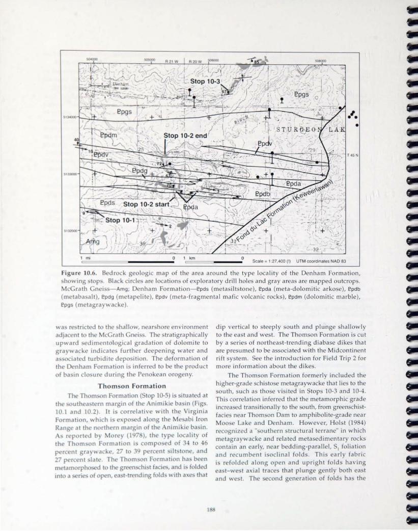
f ba in cl u r
Th Th Ill!>
tnt a
R21 W R 20 W 506000 506000
•
T45 N
Scale = 1.27,400 (!) UTM coordinates NAD 83
area around th typ I ca lity of the D nham Formation, f e plora tory drill holes and gray areas are mapped outcrop .
nha m F rmati n- epds (m ta ilt t ne), epda (m ta-do lomitic arkose), epdb lit ), epdv (m ta-fragmenta l mafic volca nic rocks), epdm (do lomitic marble),
rmation
ituat d at in (Fig .
tha t
dip rtical to s teep ly sou th and plunge shallowly to th ea t and we t. The Thorn on Formation is cu t b a rie of northeast-trending diabase dikes that are pre umed to be a oc iated with the Midcontinent rift y tern. See the in troduction for Field Trip 2 for more information about the dike .
The Thomson Formati n formerly included the higher-grade chist e metagraywacke that lie to the
uth, uch as those vi ited in Stop 10-3 and 10-4. Thi c rr lation inferred that the metamorphic grade increa ed transiti nall to the south, from greenschistfacie near Thorn on Dam to amphiboli te-grade near Moo e Lake and D nham. Howe er, Hoi t (19 4) rec gnized a " outhern tructural t rrane" in v hich m tag ra " acke and related meta edimentar rock contain an earl , near b dding-parallel, SI foliation a nd rec umbent i dinal fold . Thi arly fabric i r f Ided al ng op n and upright fold ha ing a t-~ t a ial trace that plunge gently both ea t
and " t. Th ec nd generation of fold has the

same style cHId orientation as those to the north in the Thomson Formation proper. In the Thomson Formation, folding has produced slaty cled\'c1ge, and in the southern terrane, folding has crenul,lted
the 51 clea\'age to produce an 52 cleavage. Based on this work, and subsequent mapping (for example Southwick and others, 1988; Boerboom and Chandler, 2001), the "southern structural terrane" is now interpreted to be part of the Penokean fold-andthrust belt, unconformably overlain by the Thomson Formation. Furthermore, aeromagnetic data and lithologic attributes imply that the amphibolite-grade graywacke association to the south may be correlative with the Little Falls Formation to the southvvest.
MIDCONTINENT RIFT SYSTEM
Overview The Midcontinent rift system is a 2,500-kilometer
long belt of volcanic and sedimentary rocks that form a curvilinear feature extending northeastward from Kansas to the Lake Superior region, and continuing southeastward across lower Michigan (Fig. lO.7). Rocks in the rift system are well exposed in the Lake Superior region and their continuation to the southeast and southwest beneath Paleozoic cover rocks is clearly defined by gravity, magnetic, seismic, and drilling information. The rift and its exceptionally thick sequence of flood basalts formed at about 1,100 Ma during a period of lithospheric extension and copious basalt generation interpreted to have been caused by arrival of a new mantle plume at the base of the lithosphere (Hutchinson and others, 1990; Nicholson and Shirey, 1990; Cannon and Hinze, 1992; Nicholson and others, 1997). Nearly complete crustal separation in the Lake Superior region generated as much as 2 million cubic kilometers of basalt and possibly an equal volume of intrusive rocks in a relatively short period of 15 million years (Hutchinson and others, 1990; Nicholson and Shirey, 1990; Cannon and Hinze, 1992; Allen and others, 1995). Thermal su bsidence following volcanism resulted in deposition of up to 10 kilometers of sediments in many parts of the central rift graben. The Midcontinent rift system transects a variety of older rocks that range from Archean to Paleoproterozoic in age (for example Stops 10-1 through 10-5). South of Lake Superior, the Midcontinent rift system is covered by Paleozoic sedimentary rucks (for example Stop 10-12; Fig. 10.7). Exposed rocks in western Lake Superiol" contain a remarkably complete record of igneous intrusiOll:-', flood basalt volcanism, and cl,lstic sedimentatioll, and the evolution of the rift is well cOllstrained by chemical and isotopic analyses, high precision U-Pb zircon dates, and comprehensive seismic
im,)gi ng, both lll\- [,llld ,1 nd bl'nl',) th L1 ke Su pl'riur.
Comprehensi\'e ~tudiC's llf tltL' 1\lidClllltinL'l\t rift
svstem hel\'e been publislwd ll\'er the ,'e,lrS, including vVold ,md Hinze (1L)S2), ()j,lLlllg,l~ elnd utllL'rs (1'.JL)7),
a SpeCiell \'ulul1w of the C,lncldi,)n Juurne)l uf LHth Sciences (v. 3-1, 19L)7), and ,1 number llf guidl'buub, including Miller ,llld uthers (199:;,), b) ,llld Wirth ,llld
others (l99S).
St. Croix horst Early C"densillnal faults thelt formed the
margins of subsiding, volcanic-filled grabens in the Midcontinent rift system were reacti\'ated intll reVL'rSl' faults by ldte-stage compressiulldl stresse~ th,lt m,)y
have been the far-field pruducts of conveq.!,L'nce within the Grenville Province to the e,)st (C,lnIllln, 1994). This reversed displ,Kement cre,lted ,) system of uplifted horsts along much of the length of the rift. In Wisconsin the centr,ll portion of the Midcontinent rift system was uplifted along el system of p,)irl'd, reVl'rSl' listric f,lUitS to produce the 5t. Croix horst, bllunLiL'd on the west by the Douglas ellld Pine f,wlts, ellld tu the east by the Hastings-Atkins Lake ,llld Cottagl' Grove-Lake Owen faults (Fig. 1ll.7). Origin,llly, thl' horst melY have been cHI aSyIllI11L'tric gl"clben, or h,llf graben. The Lake Owen fault W,IS a 111,1jur growth fault on the southeast side of the gr,lbl'n ,wd the volcanic fill thickens to'A'Md ,lnd tl'rmin,)ks ,)g,)inst
the fault as indicated by seismic ,llld gr,l\'ity daLI. The Douglas f,nilt on the nort[l\vest meHgin i~ not clearly a growth feature ,llld Ill'l)! be ,) thru~t fllrIlll'd during rift inversioll (Nicholson ,llld C,lllnoll, 2()(l.1). Gravity and seismic d,lta indic,lte thelt thl' St. Cnli,
horst contains a 10- to 20-kilometer-thich: SL'ljuL'ncl' of volcanic and sedimentcHY rock~ (Ch,wd[er ,lI1d others, 1989; Allen and others, 1 L)lJ7); thi.s contr,lsh
with the more than 31l-kilonwll'r sL'ction of b,]s,llh ellld sediments imaged bene,lth Llkl' SLl~)l'riur (("lImon and others, 19HY) c1nd indicltes ,) gree)lL'r dq.;rl'l' III uplift and erusionllf the St. ('rui, hur~t t[ulll'lsl'Witl'f"l' in the rift. The mct,'I1lorphic gr,lliv uf vuk-,mil' roch:~ in the St. Croix hurst, p,Hticul.Hly grl'l'lhchi . ..,t t.1Cil's assemblages in vlllc,lnic ruch:s lll',H the (,1,1111 1'.11[..,Tay[ors El[Is regiun (Fig. ]().7; Wirth ,md utlll'r~, 1L)')7),
is higher th,m th,)t tvpic'llly' nuted Ill'.lr [.,lkl' Sll~)l'I'IUI',
and cllnc.istent with lllurl' uplift ,wei l'\f)"~lll'l' of nlch:" that once Wl're deeply buril'd.
1 Kel
Outcrop.., vvithin thl' St. Croix lwr·',t ,lrl' ~f)drSl', hllt deLlilcd ge"chel1lic,l[ ,mel gl'u~)Il\'sic,lllLltcl ddilll' ,ll least t\\'{l volcmic Uilib withill till' Cl'lltr.ll gr.lhl'll. Ihl' older roch:.., clI'l' till' (Jll'llgW,lteln,) \'uic,1I1il's, ClHllf)OSl.'d of bdSe)[t, millor ,llldl'~itl', ,mel 1',Hl' rhyo[itl' t[ows (Fig.
I(U·)). Flo\\' thich:lll'~..,es rdngl' frulll' tu 11)() 1lll'lL'r~
thich:. At leclst h illterflll\v lOllglollwr,ltL' unit<, h,lvl'

46
45
93"
r magnetic an maly map of th St. Croi hors t reg ion in i c n in, howing ubdivi ions of the t. Croi hors t volcanic h ngwatana and Minong Volcanic . General s top loca tion
r indica t db t r . In et map how the genera l ex tent of th Midcontinent rift t m, nd th I cati n of the larger figure . Modified from Cannon and
th r (2001).
b and othe r , 1997), may indicate the presence of a fI I ca li z d magmatic center. The intru ive mnicon
omp lex, loca ted on the western side f the hor t, ma repre en t a econd magma ti c center that was coe al with the Duluth Comple to the nor thwe t and the Mellen Comple to the outheas t.
olcanic rocks in the central hor tare 0 erlain by qu nce f cia tic dimentar r ck of the ronto Group. ani
1 0
th I wermo t unit, the Copper Harbor Formation, i pre er ed 'v ithin the hor t where a much a 2 kil m t r f and t ne and conglomerate lie along
f the s ncline . long the margin of th lcanic rock ar ju tap d wi th clas tic
dim nt of the Ba field Gr up and equivalent and ton . Flanking ba in on either ide of the
hor t c ntain me 4 t kilometer of edimentar

a. ~ e
<.9 0 C 0
0
a. ~
e <.9 x "e 0
U5
Northwest Wiscons in and eastern Minnesota
Copper Harbor Conglomerate
Minong Volcanics
1,094.6 Ma
----~ ~
Chengwatana 1,099 Ma Volcanics
1,102 Ma I 1,101.6 Ma
Amnicon Complex I ~
Bayfield Basin
Upper Mich igan and north-central Wiscons in
Copper Harbor Conglomerate
c~ Lake Shore 1 093.8 Ma Traps '
Porcupine Volcanics --1,094.0 Ma
Portage Lake Volcanics
1,096.2 Ma
1,099.0 Ma 1,101 .5 Ma
Kallander Mellen Complex Creek 1,102.1 Ma Volcanics
Upper - - - -- - - - -1,107.3 Ma Lower
Siemens Creek Upp~ Volcanics -- - Lower -
Bessemer Quartzite
00 aa C :J
"5 I---
CD III
<D D> :J a. 0 a C
"
-0 0 ~ a. ~
~ 0 a C
"
Fig u re 10 . K weenaw n hore of w
from ichol on and ichol on; e ich
for ourc of dat
St. Croix horst -------i Emerald Basin
nand
Figu re 10.9. Schema ti c cross-sec ti on model of the Midcontinent rift y t m perp ndicular t th t. Croix horst, across the sou thern tip of the Ash land Syncline. Ba al t flow are designat d b da h Modified from Cannon and others (2001).
fill (Fig. 10.9). The Bayfield basin, which includ s the Fond du Lac Formation and Hinckl y Sand tone in Minne ota and the Orienta, Devil' I land , and Chequamegon Sand tone of the Bayfield Group in Wisconsin, follow the western margin of the h r t, and the Emerald Basin (Allen and other, 1997) lie along the eastern margin of the hor t. Aeromagnetic and drilling data show that the outh rn part f the Chengwatana volcanic group between th Pine and
191
D ugla fault (Fig. 10.7) i rlain b c
thick vestig f min ralogicall immatur im r ck f unc rtain c rrelati n that pr -dat the r fa ul ts.
CAMBRIA w
During th lat p rt f th ou thea t rn Minn wa
RATA
ambrian p ri d, dbyanincuri n

brachi
und >rtal.. n.
Th vari J
,GEOC RO OL(X;IC
ERA PERIO~EPOt:H
I
U z 0 <{
N - w 0
a:: ~ II) <l: W :E ...J
-' <{ « u
ntin ntal f
' d ont
n
Dougla fault, v lcanic rock in the Chengwatana and lam Falls Volcanic, and the basal portion of the ronto Group. The la t two stop will e amine a ba alt-cla t conglomerate at the ba e of the Paleozoic
ction, and pothole cut into the Keweenawan basalt b Plei tocene po t-glacial meltwater flood
FIELD TRIP STOPS
The general geologic setting and location of stop in Minnesota (day 1) are shown on Figure 10.1. Th general geo logic set ting and locations of top in Wi consin (day 2) are shown on Figure 10.7. A detai led location map is included wi th each top d cription, with a base made at scale from a
p rtion of the appropriate 7.5 ' quadrangle map. The regional etti ng of the variou rock units i given in the introduc tion, and only facts p rtinent to each
ld trip will focu on t. r I h r t, including the
p cific top are given be low.
CHRO OSTRATIGRAPHIC
SYSTEM SERIES STAGE z ... :3:z «g
~~ ~~ ...- "
z ~ z 0 u
z z z <{ <l: <l:
cr - - lJ.... a:: 0 II) cr :E u <{ u ~
U)
Z <l:
I u <l: lD U) W cr 0
LI THOSTRATIGRAPHIC DOMI NANT LITHOLOGY
GROUP FORMATION MEMBER
JORDAN COON VALLEY ~:-''''' . : .' •• : '2\." :
VAN OSER . .. ' . ' . . . . ..
NORWALK '~ . . : . . : •. . S>. LOD I
ST LAWRENCE
APPROXIMATE MAXIMUM
THICKNESS IN FEET
H5 90
40
62 95
65 .... ,
H5 .. , HO
ur 10.1 . tr tp'raphic c lumn f I' surr undin' b >dr ck hi h ar
pp r ambn an r ck un i h wn b b lac k d t .
in inne ta (from Mo ler, 19 7). Conglomeratic
1 2

DAY 1
DIRECTIONS: From Minneapoli dri e n rth on Inter tate 35W, which m rges into 1-35, to th Will w Ri er ex it (no . 205, a di tance of approximatel 105 miles ). Go west to Willo" Ri r, turn north on Pine County Road 61 for mile to th inter ec tion with Pine Count Road 52. Go w e t on 52 for approxima t ly 6.2 miles (road change from pa em nt to gravel). The road makes a right angle turn to th north toward the town of Denham, but instead turn outh and walk or drive on the sma ll dirt path to
a ga te . Proceed past the ga te into an open pas ture until the road eros es a gen tle ri e and th we t end of an ou tcrop (S top 10-2 ). Outcrop is 0.65 mile south of 52.
lterna te directions a re to go to the town of Denham, dri e 0.7 mile so uth on Pine County Road
193
2,andc ntinu uthonadirttra kaft r 2ma k. s a 90° bend t the e -to
STOP 10-1
Priva te property! Permi sio ll IIIII - t be obtaill ed
before ell t erillg!
McG rath n and contac t with ve ri ing D nham Formati n
Location: T. 45 ., R. 21 W., ec.
Denham quadrangle; UTM:

m tam th) ba (epds)
n: t P 10-1,10-2, and 10-
and
194
T: Dri e ea t 0.75 mile on County Road 52 to a mall gated trail to the outh. Walk outh down the
trail for appro imately 0.5 mile, following the edge of a ra ine to the outhernmo t outcrop on west ide of the ravine ( ee location map). Thi stop will
tra ve r e fr mouth to north over outcrops located along the we t edge f the ravine . There are also outcrops on the ea t side of the ravine tha t show part of the tratigraphy no t expo ed on the western valley traverse.
STOP 10-2
Priv ate property! Permiss ion mus t be obta ined befo re en tering!
o nham Formati n
Location : T. 45 N., R. 21 w., sec. 25, SE
Denham quadrangle; UTM Start: 505,406E/5,132,575N; UTM End: 505,208E/5,133,330N
Highlights: Interbedded bio tite sch i t ( il ts tone), pil low ba a lt, dolomitic arkose, and dolomitic marble (Fig . 10.5)
De cription : From bottom to top, the Denham Formation con i t of fine-grained metamorphosed ilt ton (epds), do lomite-cemented arkosic arenite
with rare cobbles of McGrath Gneiss (epda), pillowed ba alt flow (amphibolite; epdb), shale (staurolitegarnet-mica chi t; epdg) , interbedded dolomitic arko e and dolo tone (epda), fragmental ba altic olcanic rock (amphibolite; epdv), and at the top
of the ection, pur dolostone (marble; epdm). See Figure 10.5 for the tratigraphic ection of the Denham F rmation.
T: Dri ea t appr imatel 0.75 mile n County R ad 2 to a "T" inter ction with a gra el road to th n rth. north on the gra el road 0.65 mile to a juncti n \ ith th Line Trail-a former railroad

grade now ut ilized as an T traiL Park at the trail junction and walk north a t on th trail about 500 feet to outcrop and low road cu t .
STOP 10-3 Me tagra wacke and a rg illite
Location : T. 45 N. , R. 20 w., sec. 19, 5E
Denham quadrangle; UTM: 506,343E/5,134,441
': '
Highlights: Graded b e d s, m e t a morphi c assemblage
Desc ription: The ra ilroad cuts a nd fl a t o utcrop co nsis t of me tagraywacke with pelitic beds. Pelitic units a re micaceo u and co ntain ma ll ga rne t and s ta uro lite c rys ta ls, a lthoug h the la tt e r a re more abundan t further to the no rtheas t.
Abundant I-millime te r-dia me te r ga m t are synkinema tic with res pec t to 51' and have a we lldeveloped internal sc his tos ity defined by qu a rtz and ilmeni te inclusions. At thi s loca lity, inclusionrich cores a re su rrounded by ha loes of inclusionfree garnet, and s taurolite has overgrown both the schis tosi ty and the crenula tion cleavage. Garnet rim analyses give final equi libra tion tempera tures of 520 to 5900 C and a pres ure of ca. 6 kbar. Chemica lly homogeneous monazite g rains a t this loca lity giv a prominent metamorphic age domain of ca. 1,800 Ma, and a less prominent age domain of 1,840 Ma (McKenzie, 2004) .
In the serie of ou tcrops to the north a t of thi stop, bedding and 51 cleavage are gently folded along a serie of hallow, ea t-plunging, north ast-striking, F fold axe simi lar in orientation to tho c in th
2
Denham Formation. A seri of 10- to 30-centimeter-thick graded beds and scoured cro bedding giv a sense of younging to the north.
Drill cores from approximately 1 mile outhea t of this top show that thi graywacke c nformably
erli the marbl to th ' outh. Th tran ' iti n b teen th gr ck and marbl i mark db , a thin (1 m t r) int r al f arb na e u argi ll ite .
NEXT: Tak unt Road 2 ba k ea , t to unt Road 1. Tu rn I ft (north) nun t Road 61 and dri
appro\.imate l 7. mil t the jun tion \ ith tat Highwa 27 at a t p light in M s Lak . T~rn I ft (west) on Highwa 27 and f llow it a hort dl tan to the 00 Lin trail; ju t b f r the trail , turn I ft and park in th parking lot. Walk north a long th 500 Line trail for appro imate l 0.2 mi le to utcr p a long the traiL
STOP 10-4 Schis t a t Moose Lake
Location: T. 46 ., R. 19 W., ec. 20,
Moo Lake quadrangle; UTM tart : 517, 1 / 5,144,635N; UTM End: 518,205E/5,145,20 N
Highlight : Garnet-grad m tagraywack and p litic schi t; folded bedding and 1 f li ati n
Desc ription : Thi p Ii ti c chis t i part f th m belt f rock as the la t t p, but h r it i n rth of the s taurolit i ograd (Mc wigg n, 1 7). A well-d veloped, bedding-parall I, m d rat I outh-dipping 51 foliati n i fold d b t epl
mod ra t ly outh-dipping 2 fold, nd an ial p lanar crenulati n cleavag ha d ve l pdp r, II I to th F2 fold a e .
Interna l inclu i n trail in m II (O.5-mil/jm t ' rd ia m t r) gam t h w a much a 1 00 f r ta ti n . Th gam t gi e final quilibrali n t mp ratur of 440 to 5000 • Th ag f m tam rphi m h r I '
ca. 1, 30 Ma ba d n monazil btain d fr m a imilar grad r ck outh f thi cality.
nat- north a t-tr nding diaba ' dik pre u m d M P r t r z i c g m y b vii b I
195

t ward th n rth nd f th l t f utcr p , but the e p ur h b)c m quite \t rgr w n.
\, ... ad.e f th Th m n Forma ti n; dik
., R. 16 c., W
UT ta rt : 54 6, 612 /
di m n ta r truc tur , fo ld ,
irg inia / Tho m on r a br ad a r a (th nimikie ba in) uth fr m th a bi I r n Range
esc'r 1.Joir
to a fe w mile so uth o f thi loca lity (Fi g . l O.lA). D for ma ti on f the Animikie trata increases to the outh, in close r proximity to the Peno kea n fold-and
thru t be lt. He re a t the outh edge o f the Animikie bas in, th tra ta a re fo lded into a se ries of gently a t- and we t-plung ing, op n ymmetric to loca lly
a ymm tri c, lig h tly ove r turned fold s with nea rver ti ca l a ia l-p la nar cleavage.
Seve ra l nor theas t-tre nding di aba e dikes of Me p ro terozo ic age cut the Tho mso n Fo rma tio n. T he d ike a re pa rt o f the a rlto n C u n ty dike war m, w hich i one o f a number of di ke wa rms

that flank the Midcontinent rift tern. The dike here were emplaced along northea t- trending joints in the gra \ acke, and th e e ' hibit wellde eloped, subhorizontal, co lumnar cooling joint and ha e chilled margin . The appro imatel 2-meter-wide dike ju t below the parking area i revers ly polarized, and like mo t of the dike in the Carlton Count swarm, has a compo ition of high Fe-Ti continental tholeiit (Green and others, 19 7). Overall , dikes of the Carlton swarm range from a few centimeters to greater than 60 m ter in width. arrow contact metamorphic albite-epidote hornfels is found adjacent to the contacts of only the thicker dike. Green and others (1987) summarized the geologic, geochemica l, and pa leomagnetic data on the dikes and demonstrated that these swarm are most like ly Mesoproterozoic in age.
See Stop 2-19 of Field Trip 2 for a more thorough de cription of thi stop.
N EXT: Return to Carlton; in Carl ton turn north on State Highway 45 to 1-35 . Go ea t (north toward Duluth) on I-35 approximate ly 7 mi les to Midway Road (St. Louis County Road 13) . Tu rn north on Midway Road and con tinue 0.8 mi le to a road to the east. Turn right on this road and t ravel approximately 0.2 mi le, park and wa lk east to the base of the bluff.
STOP 10-6
Nopeming Sandstone and basa l Keweenawan basa lt flows (unconformity between Mesopro t rozoic and Paleoproterozoic rocks)
Loca tion : T. 49 N., R. 15 w., sec. 17, SE, SW
Esko quadrangle; UTM Start: 555,580E/5,174,380N
De cr ip t ion : Thi ill' a h \ th un nf rmabl r lati n hip b t\ n the Pal opr t r z i Th m n F rmation and rl ing M ' pr t roz i
dimentar and I anic r k f the K w ena an up rgr up. utcr p - f te pi dipping Thorn 11
F rmation r ck ar pr ' nt in the I \ er flat w of th harp kn b. t a higher e le ati 11 at th b of the bluff t the ea tar utcrop f ' entia ll undeformed, g ntl ea t-dipping K w enawan
dim ntary and v Icanic r ks. Ithoug h th actua l Paleoproter zo ic/ Me opr t rozoic unc nf rmit i not e po ed, it ca n be inferred that thi i an angular unconformity repre en ting a time gap f ab ut 00 mi llion yea r . The g 01 gic c ntact h wn n the inse t map ab v are from Kilburg a nd M r (1977).
The Keweenawan ec tion here co n i t of th Nopeming formation (unit ns ) over lain b th Ely' P ak ba a lt . Th Nop ming formati n i approximately 0 feet thick, and is c mp - d mainl f interbedded quar tz-rich conglomerat and quartzit , with some bed of si lt tone near th top h \ ing oft ediment deformation tructures. The ov rl ing I '
Peak ba alts-the lowe t volcanic r ck in th rth Shore Volcanic roup--are reversely p lariz d, and contain vague pillow struc ture that indicate olcanic eruption into a ubaqu ou environment.
S eStop 2-1 of Field Trip 2 for more inf rmati n about this s top .
N EXT: Dri ve back south on unt Continue ov r 1-35 to the ju ncti n with County Road . Turn left ( uth a ' t) n unt Road 3 and go appro imatel 0.5 mil and turn I ft (east) onto kyline Parkway. Follow k lin Parkwa for 2.4 miles to a parking ar a and walk d wnhill to railroad track and pr ed w t n the tra k to outcrop .
STOP 10-7
Bardon P ak
Loca t io n: T. 49 N ., R. 15 W., c. 4, W , and c. 33, E
H ighl igh t : Paleo/Mesoproterozic unc nf rmity, quartzite, pillowed ba alt flows
197
E k quadrangle; UTM tart: 55,5 /5, 17-1, ON

ati n m p m-maPlnal abbr; g-gabbr ; trl-Iow r troctolit ;
tru-upp r tr ct lit; Irm- main tr ctolit .
.11
.11 c ntact and I w r troct lit zon mpl
ba f th Duluth of the tran ition
c ntact can b th we t ad track th t r below th parking
19
area for thi top . Beneath the Duluth Comple are hallow-dipping (150 ea t) flow f Ely ' Peak ba alt, bred at the previous top . Here the ba alt is
recr tallized to hornfel .
The lower part of the Duluth la ered erie con i ts of interlayered gabbro and troctolite that are cr cut by peridotitic bodie (Ro s,19 5; Miller and
ther , 1993). Gabbroic and troctolitic rocks display a variety of types and scales of layering, ranging from macrolayering (m ter scale) of rock type to centim ter- ca le isomodallayering. Mineral analyse reveal cryptic compo itional differences in olivine b tween melatroctolite-dunite and gabbro. Some layer pinch ut along strike and may record trough layering. Th lay r d rocks near the basal contact of th Duluth layered erie are cross-cut by small bodies of coar e-grain d, biotitic oxide dunite to p ridotite.
ombined, the e features are interpreted to record the early cry tallization history of the Duluth layered
rie chamber, including proces es of turbulent convection, magma reinjection, and volatile flu xing from the footwa II (Miller and other, 1995b).
To th s uth i a view of the drowned estuary of the St. Loui River. During Late Wi con in glaciation, water levels in glacial Lake Duluth rose to m re than 165 m ter ab e current lake level when eastward drainage were dammed by retreating ice. During thi time (approximately 12,000 year ago), glacial meltwat r drained outhward through the Brule and t. roix Rivers (Stops 10-12 and 10-13). After retreat of the glaciers, an eastward drainage was e tablished through the Strait of Mackinac. Uplift in
Road map showing stop locations in the mnicon Fall area; northern leg of da 2.

the northeast, due to glacial rebound , i cau ing Lake Superior to tilt to the outh, re ulting in drowning of the mouth of the t. Loui River. Wate r I el in this part of the lake are s timated to be rising at a rate of 15 cent ime ter per century (Ojakanga and Matsch, 1982).
END OF DAY 1
OVERNIGHT IN DULUTH
DAY 2
NEXT: From Canal Park Inn in Duluth, get on Inters tate 35 and head sou th approximate ly 3 miles to U.s. Highway 53 south, via exit 255B (left e it) . Follow Hi g hwa y 53 / U.5 . Highwa y 2 for approximately 13 mile, then sp lit off east on Highway 2 (Highway 53 veers sou th a t th is point) . Proceed eas t on Highway 2 for approx ima te ly 0.8 mile, turn left (north) on Douglas County Road U. The entrance to Amnicon Falls State Park is a short di tance north on the left (wes t) s ide of Co unty Road U.
STOP 10-8
No hammering or co llec ting please!
Douglas fault , Ch ngwatana Volcanics, and Orienta Sands tone of the Bayfield Group
Location : T. 48 N., R. 12 w., sec. 29
South Range quadrangle ; UTM : 584,890E/ 5,162,537N
Highlig hts: D ugla fault, Chengwatana Volcanics (Ycv), Orienta Sandstone (Ybo)
De cription : Thi t P re ai ' o ne of the I ~ t maj r tectonic nts r la ted to the idcontinent rift. [n thi area of north en Wi n ' in, the central par t f th rift con i t of fault-b unded blo k f lcani r k , chiefl basa lt with min r a nd e it and rh a lit " flanked b half-gra b n ba in fill d with ung r cla tic edim nt ( handl rand th r , 19 9). Th rift-bounding fault , including th D ug la fa ult n the north rn limb of the rift, and the Lake w e n fault a long the ou thern limb f th rift ( ig . 10.1), arest ep lydipping, re er e fau lt with ba a lt n the upthrown s ide. The Lake w n fault wa a maj r grow th fault on the outhea t id of the g ra b n during th e ten ion a l pha e f th e rift , which las ted from about 1,100 Ma t about 1,0 4 Ma. compressional even t d a ted a t appro imately 1,0 0 Ma (Cannon, 1994) rev r ed the n of m ti n long the Lake Owen fault, r ulting in th developm nt f a centra l hor t. The Dougla fault on the n rthw t s ide of the horst is not clearly a g row th featur and may be simply a thru t f rmed during rift inver ion (Nicholson and Cannon, 2003) . Thru t di plac m nt on the Doug las fa u l t mu t be 20 ki 10m ter r m r beca use it juxtaposes the ba e of a thick vo l nic seq uence, the Ch ngwata na Volcanic, r th younger Orienta Sandstone of th Bayfi Id
The Bayfi ld roup i divid The lowe t member is the ark ic overlain by th quartzo Dev il Is land and t ne, and th uppermost unit, the feld pathic h q uameg n Sandstone. These thr e unit repr ' en t waning sedimen tation during the la t tage f thermal sub idence in the r gio n of the Midc n tin nt ri ft. All three m e mbe rs of th e Bayfi ld depo i.ted in fluvi a l or lacu trin nvir nm nt . Orienta and Chequameg n m mb r w r d p by northea s tward -fl wing braid d tr am . middl unit, the De il I la nd and tn, repr depo ition acro and fl a t that w r int rmitt covered by shallow p nd d wat r. Each pr ceding unit may have pr vid d mat rial for ucc unit , resulting in nea rly pur quartz and t n
The Doug la fault i po d at thre p rat wat rfa ll within th park. Th fall d v I P d wh r the Amnicon Riv r p ur 0 r ma lV, e ro i nre i tan t ba a lt, f rming plung p in ft r and tn . Th b t P ur f th F, ult i at th
baseof th Upp rF II , ju tw t fth parking I t, wh re ba a lt of th h ngwatana V Icanic ,dipping be tw en 00 and 400 uth a t, ov rli th Y ung r
rienta and tn . Th fault plan i d fin d by 3-met r-thick z n of fault g ug and c m nt d br ccia . Th ri nta and t nine rly v rtical n ar th fault, but th dip d c r a away from th fault, b c ming
1 9

1,1
pMk, and walk
P 10-
a r a are a lt with
lit flow. f ab ut
Prj ate pr pertl! Penn; ;Olf 111L1 t be obtai/red befo re elf ter;/lg!
[lj hli hi m Ie nlC (Ycv), ba
tart : 1,741E/
mineral in heng~ atana tur and al l rati n
uth fac f a
par e rind matri
, c mm nl all r d t
200
ec ndary ch lorite and pidote. Epidotization of br ccia ted flow tops impart a di tinc tly greenish co lor in con tra t to black, les a ltered flow interior . Flow tops have a comp lex seq uence of amygdule mineralization that include the presence of copper ulfide , dominantly chalcopy rit , with minor bornite,
and pyrrhoti teo
Copper mineralization in the Midcontinent rift is dominated by native copper in basalts and interflow edim nt in the P rtag Lake Volcanics in Michigan, or by copp r su lfides in reduced facie of the None uch Formation at the White Pine d po it, Michigan. Copper su lfides in basalt of the Midcontinent rift are rare ; the only other notable
ccurr nce is minor chalcoci te mineralization re tricted to a mall area of the Keweenaw Peninsula, Michigan . The presence of copper sulfides in amygdu le in thi quarry as well as everal other quarri s in the area may hav important implication for regional metallogeny of the rift . The sty le of mineralizati n in the e ba alt quarries i analogou t nati e copper mineralization in Michigan in that it i a cia ted with alt ration of permeable regions in the flow top , but it i mineralogically distinct. Th ccurre nce of chalcopyrite rather than native c pper or chalcocite r quire high ulfur acti ity in the mineralizing fluid ; an anomalous feature for the t picall ulfur-p or, ubaerial erupted ba alt
f the Midcontinent rift. ulfur i otope alue for chalcop rite are near zer, ugge ting an igneou ource for ulfur.
rn thi quarr, a w II in ther ba alt quarries in th regi n, copp r ulfide occur with other mineral

in a m gdules, v hich are par e in flov interior and more ab unda nt in fl w top . ther am gda loidal minerals include calci te, ch lori t ,epidote, h matite, microcli ne, pr IU1ite, and quartz. e er I g n ra tion of quartz can be fo und including whit or clear quartz, blue quartz, and tan to pink aga te (Cordua, 19 9). Chalcop rite appea r to be mo t abu nd an t in the lower parts of a lte r d fl ow tops, where epid t alteration is les severe, rather than in the more thoroughl a lte red rock of th upp er flow tops. This relationship ca n b seen e pecially well near the eas t face of th qua rry, whe re a mass of trong ly epidotized rock contains little or no sulfide minerals, but is surrounded by a ha lo f minera liza tion about one meter wide.
NEXT: Re turn to Hig hwa y 53 and hea d so uth ap proxima tely 29 miles, pas t Solon Springs, to the junction with Doug las County Road T. Go wes t on County Road T for about 16 mile. Two miles af ter cro ing the St. Croix River, turn so uth on Rocky Brook Trail. Follow the road south and west for 4 mile to the junction with Schoen Road, which leads to Schoen Park and a public access s ite on the St. Croix River. Proceed so uth on Schoen Road for 0.7 mil e (0.3 mile from the end a t the river) to a small pull -off on the south s ide of the road. Walk so uth about 50 meters to the north bank of Rock Creek, and foil w the creek bed toward the St. Croix Ri ver.
STOP 10-10
Copp r Harbor Formation
Location: T. 43 N ., R. 14 w., sec. 33, NE
Scovils Lake quadrangl ; UTM Start : 567,742E / 5,113,243N
201
Highlights: Cong lomerat (Yoe), and Minong Volcanic (Yml)
and the po ure ar near the ba pp r Harbor Forma tion. The opper Harbor Formati n i the olde t member of the r nto r up, whi hal includ es the N n uch and th r da rm ti n - . Rock of the Oronto roup ar a v Icanic-c la tic sequenc d po it d during the tran - iti n fr m an ear lier xt nsiona l rift ba in t a ucc or th rma l
f---r-<-'->f Roa d ma p h wing th I ca ti n f to p 10-10; c ntral I g fda 2.

ub idence ba in tha t \, a e n ra il c nt re d on th It! r rift b" in bu t w a m uch br ad r. In the r
b, In mar In .
w t rnmo t utcrop th> d
trati'raphi c t i n, c n,1 merat and fi n r-g ra in e d
202
ilt t n in which bedding unit are typicall about a m e t r thick . The finer-grained ediment plit into thin bedding lab . Mo t of the Copper Harbor Formation in th shland syncline is composed of finer-grained cla tic rock.
EXT: Return up Schoen Road to Rock Brook Trail. Turn left (we t) on Rocky Brook Trail and follow it we t and outh around a serie of curve to tate Highway 35 ( ee map on page 201). Turn left ( uth on Highway 35) and tay on Highway 35 for appro imately 60 mi les until it inter ect U.S. Highway . Turn right (we t) on Highway and go appro imate ly 4 mi les and turn south back onto Highway 35, to the entrance of Wiscon in Interstate
tate Park on the right. Drive into the park, check in at the park office, and obtain a park map . Acces to
top 10-11 (Eagle Peak) is from a hiking trail leading we t from the Pine group camp, on th Eagle Peak tra il.
STOP 10-11
o hammering or co llec t ing please!
Eagle' Peak Basalts
Loca tio n: T. 34 N ., R. 19 w. , sec. 36, SE
t. roi Dalles , WI-MN quadrangle; UTM Start: 526,622E / 5,026,004N

Hig hl ig ht s: Mesoproterozoic (Keweenawan) plagioclase porphyritic lava flow (Chengwatana Volcanics in the Clam Falls area), scenic overview of Cambrian pa leotopography, and Qu a ternary glacial features
Description: At this loca lity, a p lagioclase porphyritic volcanic flow can be observed. This flow is near the southern limit of the St. Croix hors t and is among the southe rnmo t surface expo ures of Keweenawan volcanic rocks . An exce llent view of the "s tair- tep" topography that is characteristic of the Midcontinent rift can be observed from the summit of Eagle Peak. The west s lope of Eagle Peak is a dip s lope that dips gently (-15°) to the w s t a nd is sub-paralle l with the top of a plagioclase porphyr itic basa lt flow. The teeper ea t side exposes a cross-section of the flow.
Also visible from Eagle Peak is the distribution of Cambrian sedimentary rocks. The scenic dalles of the St. Croix River record final downcutting of the river into basalt after excavation of the softer overlying sediments. Ero ional remnants of Cambrian sediment are exposed along many of the s teep ba altic hill lopes in the area (for example Stop 10-12). An ero iona l scarp formed of Cambrian sediment is visible to the east and north of Eagle Peak. Other features re lated to the Quaternary his tory of the dalles on the St. Croix are also visible from Eagle Peak, including a possible plunge pool or whirlpool (Lake of the Daile ), glacial stria tions, and cha ttermarks.
In the Taylors Falls region, the Eagle Peak fl w (Cordua, 1989) form a distinctive marker unit that consists of at least three flows wi th a composi te thickne s up to 60 meter . Only one flow i po ed a t Eagle Peak. Thi flow i charac teriz d by larg (Ie s than 6 centimeter long) plagiocla ph nocry t in a fine-grained matrix consi ting of epidote, chlorite, actinolite, and albite . Amygdule filling
con i t f quartz .. epid t , p ta ium f Id P r, and chlorit . The pr ur nd t mp ratur ndition ' of m tamorphi m, a c n trained b min ral ration ' and the odium ontent f actinolite, ar time t d to b appro imately 0.25 Pa (- 7.5 kil m ter d pth) and 350° ,c n i ten t with tima t ' ofth uplift f the St. roi hor t from g ph i a l id nc ( lien and other, 1997).
Th ag f volcanic flow in the Ta I r Fall region ar relativel p orl con train d . Zircon from a thick flow e p ed in a nearb (approximately 4 kil m t rat agl Peak) yielded a U-Pb age of 1,0 9 ± 2 Ma (M. chmitz, unpub. data) . This age i c nit nt with th la rg I normal magne tic polariti of th rock in thi r gion (Kean and other, 1997). In compari n, zirc n fr m two rhyolite flows near Clam Fall ielded ag f 1,102 ± 5 Ma (Wirth and G hr 1 , 1998) . The relations ugge t that th e h ngwatana V Icani (Cannon and oth r ,2001) in the Taylor Fall - lam Falls region likely correlate with th upp r K Iland r Cr ek Volcanics or low r Portage Lake V Icani f northwestern Wi con in (Fig . 10. ; Nichol nand o ther, 1997).
Volcanic flows of the Taylor Fall r gi n ar almo t with ut exc ption hi gh-a lumina and h ighiron tholeiitic basalt . Rare rhy lit fl ware p d n ar Clam Falls (appro imately 40 kil m t r north of this t p) , but ar not ob erved in the Ta lor Fa ll region. Mos t flow in th outh rn t. roi horst are moderately volved (Mg# = O. 7 to o. and are variably nrich din th inc mpatibl tra c elem nt (for e ampl LR · , th rium). II of th flows are characterized by pr nounced d pi ti n ' of tantalum and niobium, r I tiv to th rium nd lanthanum. Initial p il n n dymium lu f th ba alt and rhyolit typicall rang from -1.5 t - .0. Toge ther, the geochemical data ugg t that th fI w are the re ult of variable cr tal fracti contamination f plume-deriv d m It other, 1997).
NEXT: Return to the parking ar a at th gr up campground . Continu uth a tal ng il rbr k Trail for appro imat Iy 400 m t r . Ent r th I w ravine on the uth id f th tr il.
STOP 10-12
No hammering or co llecting plea e!
Paleozoic c ngl m rat
Location: T. 34 ., R. 1 W., c.
St . r i Dall , WI-M qua dran I ; U M tart : 527,02 / 5,025,776
203

b tw n Upper Cambrian n with M opro terozoic
e ripti n : low mar hy area, k lin Trail nt r w f the Trap Rock Alley
unit ( rdua, 1 fl or of the ravin marks th appr imat c ntact betw n M oproterozoic
Ic nic r ck and Upp r ambrian conglomerat nd nd t ne. Th c ngl merate and and tone
p dIng th uth wall of the ra ine were d p ' it d again t te ply I ping urface f th lcanic and ar tentati I a signed to the
rmati n f the Tunn I City roup mb r of th Franconia F rmation
I r, 1 7). Th ba alt boulder tr t c nglomerate of Berk y,
rtically and h riz ntally into pebble and and t ne. The ba al t cia ts ar
t r z ic unconf rmit h w up tOm ter c ar - rain d b ulder
conglomera te record deposition in high-energy horeline environment during the Upper Cambrian.
The interclast quartz sands likely originated from di tant source
EXT: Return to Highway 8. Turn left (we t) and cros the St. Croix River mto Minnesota. Immediately af ter crossing the bridge, turn left at the traffic light into the Minne ota Interstate State Park .
STOP 10-13
No hammering or collec t ing please!
Potholes in Interstate Park
Loca tio n: T. 34 N., R. 18 W., sec. 30, SW
St. Croix Dalles, WI-MN quadrangle; UTM Start: 527,323E/5,027,344N
Hi ghli ghts: Potholes formed in the Clam Falls Volcanic
Description: This stop provides an opportunity to examine spectacular potholes formed in flows of the Dre ser and Trap Rock Alley units (Clam Falls Volcanics) . The base of the Trap Rock Alley Flow is exposed along th west side of Trap Rock Alley; the Dresser Flows are exposed to the east. The top of the Dre er Flow contain many amygdules and is e tensi elyepidotized. The flows dip 15° west.
More than 80 pothole are present in this area of the park (Glacial Gardens) . The pothole range from decimeter depre ions to giant "kettles" that are up t 20 meter deep and 6 meters in diameter. The potholes along the trail are 7.5 to 18 meters above the current ri er Ie el; oth r ha e been found as much a 34 meter ab e ri er level. Today, many of the larger potholes are part! filled with ilt, mud, peat, and grind tone .
20 ..

... ... ... == ... ... .... .. ... .. .. .. .. .. .. .. .. .. .. .. .. .. .. .. .. .. .. .. .. .. .. .. .. ..
The potholes at this loc"lity flHmed during a period of high discharge near the end of the Wisconsin glaciation (Ojakangas and Matsch, 1982). Lake levels in glacial Lake Duluth overflowed to the south through the Brule and St. Croix Rivers when ice dammed the Straits of Mackinac. The "Dalles of the St. Croix" mark a nickpoint where floodwaters flowed from basalt onto less resistant Cambrian sandstone and shale. Fast-moving currents and a steep gradient in this region likely contributed to the formation of the many potholes.
NEXT: To return to the Twin Cities follow Highway 8 west to Interstate 35, a distance of approximately 20 miles. Go south on Interstate 35. After the town of Forest Lake the freeway splits into I-35E and I-35W. Take I-35W to go to Minneapolis and the hotel, or I-35E to go to St. Paul.
END OF TRIP
REFERENCES
Allen, D.J., Braile, L.W., Hinze, W.J., and Mariano, J., 1995, The Midcontinent rift system, USA.-a major Proterozoic continental rift, ill Olsen, K.H., ed., Continental rifts-evolution, structure, tectonics: Developments in Geotectonics, v. 25, p. 375-407
Allen, D.J., Hinze, w.J., Dickas, A.B., and Mudrey, M.G., Jr., 1997, Integrated geophysical modeling of the North American Midcontinent rift system: New interpretations for western Lake Superior, northwestern Wisconsin, and eastern Minnesota, ill Ojakangas, R.W., Dickas, A.B., and Green, I.e., eds., Middle Proterozoic to Cambrian rifting, central North America: Geological Society of America Special Paper 312, p. 47-72.
Beck, J.W., 1988, Implications for Early Proterozoic tectonics and the origin of continental flood basalts, based on combined trace element and neodymium/strontium isotopic studies of mafic igneous rocks of the Penokean Lake Superior belt, Minnesota, Wisconsin, and Michigan: Minneapolis, University of Minnesota, Ph.D. dissertation, 273 p .
Berkey, e.P., 1897, Geology of the St. Croix Dalles: American Geologist, v. 20, p. 345-3H3.
---1898, A guide to the Dalles of the St. Croix: Minneapolis, Uni'fersity of Minnesot,l, 40 p.
Boerboom, T.J., and Chandler, V.W., 2001, Supplemental data on bedrock geology and geophysics, inset map C of Plate 3, ill Boerboom,
T.J., project Illcln,lge[', Geologic ,1tl,lS of ['ine County,l'vlinnesllta: rvlinllL'Sllt,l Cellillgic,ll SurH'V County AtlclS C-13, pt. A, sCclle I, 12,Ll!lD.
Boerbollm, T.J., Southwick, D.L., ,1l1d Se\'l'rslln, 1'v1.I·, 1999, Bedrock geolllg)' llf the Milk L1CS Lah' 3D x 60 minute qu"drangle, east-centr,11 I'vlinnesllt,l: Minnesota Geologic"l Survev tvlisccll,lnellu5 M"p M-lOO, scale l:lO0,000.
Cannon, W.F., 1994, Closing of the l'vlidcllntil1l'nt rift-a far-field effect llf Grem'illi,lI1 compressilln: Geology, v. 22, p. ISS-ISH.
Cannon, W.F., Green, A.G., Hutchinson, D.R., Lee, M., Milkereit, B., Behrendt, J.e., H,ll1s, H.e., Green, J.e., Dickas, A.B., Morey, G.B, Sutcliffe, R., clnd Spencer, c., and 1989, The North American Midcontinent rift beneath Llke Superior fwm GLIMPCE seismic reflection profiling: Tectonics, v. 8, p. 305-332.
Cannon, W.F., Daniels, D.M., Nicholson, S.W., Phillips, J., Woodruff, L.G., Chandler, V.w., Morey, C.B., Boerboom, Wirth, K.R., and Mudrey, rv!.c., Jr., 2001, New map reveals origin ,lllel gl'lliogy of North American mid-continent rift: Eos, v. 112, no. 8, p. 97-101.
Cannon, W.F., and Hinze, W.J., 1992, Speculatiolls un the origin of the North A meriC,lll M idcoll ti Ilell t rift: Tectonophysics, v. 213, p. 49-:1:1.
Carlson, K.E., 1985, A combined ,1I1alysis of gr,1\'itv and magnetic anomalies in e,lst-centr,,1 l'vlinlll'Sot.1: Minneapolis, University of MinnesoU, MS thesis, 138 p .
Cavaleri, M.E., Mossier, J.H., ,wd Webers, C.F., 1987, The geology of the St. Croix River v"lIey, ill Balaban, N.H., ed., Field trip guidebouk fllr the upper Mississippi v"lky, Minne~ot", [OW,l, and Wisconsin: Minllesot" eeolugic,ll Survey Guidebook Series 15, p. 23-43 .
Chandler, V.W., Jirsa, M.A., and 13lll'rblHll1l, '1'.1., in press, A gravity and magnetic illvestig,ltilll1 ot east-central Minnesota: In~ighh intll the ~lructurl' and evolution of the P"iL'llprlltl'w/.llic ['L'llllkl',111 orogen: Minnesllta Ceulogic,ll Sur\'ey Rl'port llf Investiga tions.
Chandler, V.W., McSwiggen, 1'.[., Morn, ell., Ilill/C', W.J., and Anderson, R.R., IlJW!, IIltcrpreL1til>ll of seismic reflection, gr,l\'ity, alld I1lclgllL'tic data clcnlSS l1liddil' l'rlltl'rll/l,ic mid-cOlllilll'llt rift system; north\vl'stl'rn \Ni~c(lll.~ill, l',hkrll Minnl'sllta, and celltrdl I()W,1: /\I1ll'riC,l11 Association of Petrokum Cl'"I"gi~h Ilulil'lill, v. 73, p. 2()1-27'i.
CorLiuel, W.s., 19W), A summdrY of till' bedrock gl'lliogy of the Drec,sL'f-St. Croi>- L11i~ ,Hl',), Polk C()Ullty,

\Visconsin and Chisago County, Minnesota: 53rd Annual Tri-State Field Conference Guidebook, Ri ver Falls, Wis., p. 25-51.
---1990, South Range quarry, Douglas County, Wisconsin: Rocks and Minerals, v. 65, p. 412-415.
Daniels, P.A., 1982, Upper Precambrian sedimentary rocks: Onlnto Group, Michigan-Wisconsin, in Wold, R.J., and Hinze, W.J., Geology and tectonics of the Lake Superior Basin: Geological Society of America Memoir 156, p. 107-133.
Dol', B.R., and Delevaux, M.H., 1991, Lead-isotope investigations in the Minnesota River Valleylate-tectonic and posttectonic granites, in Morey, G.B., and Hanson, G.N., eds., Selected studies of Archean gneisses and Lower Proterozoic rocks, southern Canadian Shield: Geological Society of America Special Paper, v. 182, p. 105-ll2.
Green, r.c., Bornhorst, T.J., Chandler, V.W., Mudrey, tvtG., Jr., Myers, P.E., Pesonen, L.J., and Wilband, J .T., 1987, Keweenawan dykes of the Lake Superior region: Evidence for evolution of the Middle Proterozoic midcontinent rift system of North America, ill Halls, H.C., and Fahrig, W.F., Mafic dyke swarms: Geological Association of Can,1da Special Paper, v. 34, p. 289-302.
I-Iolm, D.K., 1986, A structural investigation and tectonic interpretation of the Penokean orogeny: East-central Minnesota: Duluth, Minn., University of tvlinnesota Duluth, M.5. thesis, 105 p.
Holm, D.K., Holst, T.B., and Ellis, M.A., 1988, Oblique subductillll, footwall deformation and imbrication: A model for the Penokean orogeny, Minnesota: Geological Society of America Bulletin, v. 100, p.1811-1818.
Holm, O.K., and Lux, D., 1996, Core complex model proposed for gneiss dome development during cllllapse llf the Paleoproterozoic Penokean orogen, ~finnesotLl: Geology, v. 24, p. 343-346.
Hlllrn, O.K., Van Schmus, W.R., MacNeill, L.e., \3oerboom, T.J., Sch'vvei tzer, D., and Schneider, D., 20ll5, U-Pb zircon geochronology of PL1\coproternzoic plutons from the northern midcontinent, USA: Evidence for subduction flip and continued convergence after geon 18 Penllkl'an 'Jrogenesis: Geological Society of Americ" Bulletin, v. 117, no. 3, p. 259-275.
Hll\';t, LB., I'JH4, E,'idence for nappe development during the Early Proterozoic Penokean orogeny, i\linl1l'sllta: Cel1lllgy, ,'. 12, p. 135-138.
HutchinsPl1, D.R., White, R.S., Cannnll, W.F., and Schulz, K.J., 1'J90, Keweenawan hot spot:
20ti
Geophysical evidence for a 1.1 Ga mantle plume beneath the Midcontinent rift system: Journal of Geophysical Research, v. 95, p. 10869-10884.
Kean, W.E, Williams, 1., Chan, L., and Feeney, J., 1997, Magnetism of the Keweenawan age Chengwatana lava flows, northwest Wisconsin: Geophysical Research Letters, v. 24, p. 1523-1526.
Kilburg, J.A., and Morey, G.B., 1977, Reconnaissance geologic map of Esko Quadrangle, St. Louis and Carlton Counties, Minnesota: Minnesota Geological Survey Miscellaneous Map M-25, scale 1:24,000.
McKenzie, M.A., 2004, Age pattern and nature of Late Paleoproterozoic metamorphism of the Penokean crust, east-central Minnesota: Kent, Ohio, Kent State University, M.s. thesis, 105 p.
McSwiggen, FL., 1987, Geology and geophYSics of the Denham-Mahtowa area, east-central Minnesota: Minnesota Geological Survey Miscellaneous Map M-63, scale 1:48,000.
Miller, J.D., Jr., Green, J.e., and Chandler, v.w., 1993, Preliminary geologic map of the Duluth area, St. Louis County, Minnesota: Minnesota Geological Survey Open-File Report 93-2, scale 1:48,000.
Miller, J.D., Jr., Nicholson, S.W., and Cannon, W.E, 1995a, The Midcontinent rift in the Lake Superior region, in Miller, J.D., Jr., ed., Field trip guidebook for the geology and ore deposits of the Midcontinent rift in the Lake Superior region: Minnesota Geological Survey Guidebook 20, p. 1-23.
Miller, J.D., Jr., Smyk, M., Sage, R.P., and Green, J.e., 1995b, Geology, petrology, and metallogeny of intrusive igneous rocks of the Midcontinent rift system, in Miller, J.D., Jr. ed., Field trip guidebook for the geology and ore deposits of the Midcontinent rift in the Lake Superior region: Minnesota Geological Survey Guidebook 20, p. 121-148.
Morey, G.B., 1978, Lower and Middle Precambrian stratigraphic nomenclature for east-central Minnesota: Miru1esota Geological Survey Report of Investigations 21,52 p.
Mossier, J.H., 1987, Paleozoic lithostratigraphic nomenclature for Minnesota: Minnesota Geological Survey Report of Investigations 36, 36 p.
Nicholson, S.W., Boerboom, T.J., Cannon, W.F., and Wirth, K.R., 2001, A new look at the 1.1 Ga Chengwatana Volcanics in the St. Croix horst, Minnesota and Wisconsin: Institute on Lake Superior Geology, 47th Annual Meeting,
.. .. .. .. ..

Madison, Wis., Proceedings v . .J,7, pt. 1, Program and Abstracts, p. 71-n.
Nicholson, S.W., and Cannon, W.F., 2003, Stratigraphy and structure of Keweenawan rocks of the St. Croix horst, northwestern Wisconsin [abs.]: Institute on Lake Superior Geology, .J,9th Annual Meeting, Iron Mountain, Mich., Proceedings, v. .J,9, pt. 1, p. 59-6ll
Nicholson, S.W., Cannon, W.F., Woodruff, L.G., and Dicken, CL., 200.J" Bedrock geologic map of the Port Wing, Solon Springs, and parts of the Duluth and Sandstone 30' X 60' quadrangles, Wisconsin: U.s. Geological Survey Open-File Report 2004-1303, <http://pubs.usgs.gov /0f/2004/1303/>.
Nicholson, S.W., and Shirey, S.B., 1990, Evidence for a Precambrian mantle plume: A Sr, Nd, and Pb isotopic study of the Midcontinent rift system in the Lake Superior region: Journal of Geophysical Research, v. 95, p. 10851-10868.
Nicholson, S.W., Shirey, S.B., Schulz, K.J., and Green, J.C, 1997, Evolution of l.1 Ga Midcontinent rift basalts: Rift-wide correlation and interaction of multiple mantle sources during rift development: Canadian Journal of Earth Sciences, v. 34, p. 504-520.
Ojakangas, R.W., Dickas, A.B., and Green, J.C, eds., 1997, Middle Proterozoic to Cambrian rifting, central North America: Geological Society of America Special Paper 312, 322 p.
Ojakangas, R.W., and Matsch, C, 1982, Minnesota's geology: Minneapolis, University of Minnesota Press, 225 p.
Roscoe, S.M., and Card, K.D., 1993, The reappearance of the Huronian in Wyoming: Rifting and drifting of ancient continents: Canadian Journal of Earth Sciences, v. 30, p. 2475-2480.
Ross, B.A., 1985, A petrologic study of the Bardon Peak peridotite, Duluth Complex: Minneapolis, University of Minnesota, M.s. thesis, 140 p.
Schmitz, M.D., Wirth, K.R., and Craddock, J.P., 1995, Major and trace element geochemistry of early Proterozoic mafic dykes of northern Minnesota and southwestern Ontario, in Baer, G., and Heimann, A., eds., Physics and chemistry of dykes: Selected papers presented at the 3rd International Dyke Conference, Jerusalem: Rotterdam, A.A. Balkema, p. 219-236.
Setterholm, D.R., Morey, G.B., Boerboom, T.J., and Lamons, R.C, 1989, Minnesota kaolin clay deposits-a subsurface study in selected areas of southwestern and east-central Minnesota: Minnesota Geological Survey Information Circular 27, 99 P
Southwick, D.L., ,1lld D,1\", W.c.. 1 LJS3. Cel1llltS ,1nd petrology of Protewl:llic 1l1,lfic dikes, north-centr,ll Mi nnesllt,l ,1 nd westl'rn On LHio: C ,1 Il.1 d ia n Journaillf LHth Sciences. \'. 20. p. h22-63H.
Southwick, D.L., More\,. G. S., ,1nd McSwiggeIl, P.L., 19S5. Geoll1gic m,lp (scale l:2511,llOll) of the Penoke,ln orogen, centr,ll ,1lld eastern Minnesl1t,1, and accompanying text: Minlll:'sot,l CL'lllogic.11 Survey Report of Investigations 37.25 p.
Webers, G., 1972, Paleoecology of the Cambrian and Ordovician strata of Minnesot,l, ill Sims, P.K., and Morey, G.B., cds., Geology of Minnesot,l: A centennial volume: Minnesota Geological Survey, p . .J,7.J,-.J,S.J,.
Wirth, K.R., Cordua. W.s., Kean, W.F., Middleton, M., and Naiman, Z.J., 199H, Field trip 2: Field guide to the geology of the southeastern portion of the Midcontinent rift system, eastern Minnesot,l and western Wisconsin: Institute on L1ke Superior Geology, .J,4th Annual Meeting, Minneapolis, Proceedings, v. H, pt. 2, Field Trip Guidebook, p.33-75.
Wirth, K.R., and Gehrets. G.E., 199H, Precise UPb zircon ages of midcontinent rift rhyolite (Chengwatana Volcanics). Clam Falls. WI: Institute on Lake Superior Geology, .J,-Hh Annu,ll Meeting, Minneapolis, Proceedings, v . .J,.J" pt. 1, Programs and Abstracts, p. 12.J,-125.
Wirth, K.R., Vervoort, J.D., clnd Naiman, Z . .I .. 1997, Petrography and geochemistry of southernmost volcanic rocks exposed in the MidcontinL'nt rift: Canadian Journal of Earth SciL'nces, v. J.J" no . .J" p.536-548.
Wold, R.J., and Hinze, W.J., 19H2, Introduction, ill Wold, R.J., and Hinze, W.I., cds., Geology and tectonics of the Lake Superior b,lsin: Geologic,li Society of America Memoi r 156, p. I -.J,.
Wunderman, R.L., and Young, CT., 19H7, EvidenCl' for widespread basement decolienwllt structu re'-> and related crustal asymmetry ,ls.-;ociated with the western limb of the Midcontinellt rift [,lbs.]: Institute on Lake Superilll' ecology, :nrd Anllu,ll Meeting, Wawa, Ontario. ProcL'eding~. v . .1.1, pt. 1, Program and Ab.,tracts. p. X:;-Sf>.
Za rtmel n, R. E., N icholsoll, S. W., C,lIlIlOIl, W. F, and Morey, G.B., 1<::1<::17, U-Th-Pb l:irClln age~ of .,lIme Keween,l\\',ln Supergroup rll(k~ frlllll thL' '->outh shore of Lake Superior: Call,ldian jOlJrlldi of Earth SciencL'~, v. J.J" p. :;.J,l}-')h I.

FIELD TRIP 11
Saturday, May 21 - Sunday, May 22
GEOLOGY AND SEDIMENTOLOGY OF THE PALEOPROTEROZOIC ANIMIKIE GROUP: THE POKEGAMA FORMATION, THE BIWABIK IRON FORMATION,
AND VIRGINIA FORMATION OF THE EASTERN MESABI IRON RANGE, AND THE THOMSON FORMATION NEAR DULUTH, NORTHEASTERN MINNESOTA
Leaders
Richard W. Ojakangas, Professor Emeritus, University of Minnesota Duluth Mark J. Severson, Natural Resources Research Institute, Peter K. Jongewaard, United Taconite Mining Company
John L. Arola, Ispat Inland Mining Company Joel Thomas Evers, Retired-LTV Mining Company
Douglas G. Halverson, Northshore Mining G.B. Morey, Chief Geologist Emeritus, Minnesota Geological Survey
T.B. Holst, University of Minnesota Duluth
INTRODUCTION
Iron-formation was described as early as 1866 by Henry E.H11L's on what was to become the Mesabi Iron Ran~e. Several attempts were made by individuals to find orc on the Mesabi range on their way north to the iron mines of the Vermilion range (Soudan to Elv, Minnesota); ho\\'e\'er, it was not until November 16', lKYO that the first rich iron ore on the Mesabi r"n~e was discovered by the Merritt brothers near wh,;t is now Mountain Iron, Minnesota. In 1892, the first shipment from this mine was 4,245 tons of ore (White, 195-1-). Exploration for iron ore ensued and within the next few years, most of the productive P,1[ts of thc ~ .... lesabi range were discovered.
The Mesabi Iron Range is the largest iron range in the U ni ted St,Hes .:lIld is one of the largest in the world. It is 0.25 to J.ll miles wide and 120 miles long (Fig. 11.1). The Biwabik [ron Formation, as thick as 750 feet, in gencral dips gently to the southeast at an angle of abllut 7' to 15'. The iron-formation, called taconite, tVpiC,'lly contains JD to·W percent iron and 40 to 50 p('rccnt Sil\, plus other components (Morey, 1992). In numerous pldces ,1Il)(1g the length of the range, silica \\'.1;' lc,lChed out, therdw enriching the iron content tll 1l\L'r':;5 pl'['cL'nt. Thesc pockets became the highgr.lde n,ltur,11 ore mines; there were more than 500 indi\'idu,,1 minL's prinr to merging into larger mines ,1S thL' ore bL'l\\'L'en adjacent properties was remo\'ed. These \\,crL' \'ery import,1I1t in making the United
20S
States an industrial giant, and were instrumental in providing raw material for World Wars I and II. As the high-grade ore was depleted, the taconite process was developed. In 1967, taconite production exceeded natural ore production. Currently, six taconite plants are in production (Fig. 11.2).
The name of Biwabik Iron Formation was chosen by Van Hise and Leith (1901, p. 356), " ... because the word Biwabik is the Chippewa word for a piece or fragment of iron." The word taconite is also used in discussions pertaining to hard, unoxidized portions of the iron-formation. HV Winchell (1882, p. 135) originally called portions of the Biwabik Iron Formation "taconyte" because he thought the rocks correlated with lower Cambrian rocks in the Taconic Mountains in northern New England. Since that time, many geologists have used taconite in their descriptions of the iron-formation and it has thus become firmly established. Perhaps a more proper definition for taconite is an economic term for ironformation from which iron can be profitably extracted after fine-grinding, followed by magnetic separation and pelletizing (Morey, 1993).
REGIONAL GEOLOGY
The peneplaned Archean craton in the Lake Superior region formed a platform upon which a Paleoproterozoic continental margin assemblage was deposited in Minnesota, Michigan, and Wisconsin.
.. .. .. eI -

SCALE o 5
I 10 15 20 MILES +
I I I ! + o
I 10 ~o I do I Jo KILOMETERS +
Location map
- .. _--, , I
ITAS .ACO
I
c , I
CA ' S CO
~--------------------! I , 1
AIT KI CO. -- - ----
I
Virginia horn
ST. LOll i '; CO
Duluth
+ \ + + + +
+ + 1+ + +~ +
+ ! + +
+ + +
+ ;+ ...... + ~ + v
+ a. ;+::;i _ E +, ..:
+ 8- !+-I + :£ +! +
+ .g+ !+ + a +! +
+ + !+ + +
+ + +
~ - - --A-I{-Cl:-ON co~ ----------!
Figu re 11.1. Genera lized map of th Mesa bi Iron Ra nge (cros -ha tched). Duluth Complex on th eas t s ide.
te the
Extension res ulted in loca lized rifts tha t rece ived thicker accumu lations of sed iment and volcanic rocks than did adjacent par t of the platform. Seas tran gre sed onto the continent one o r more times and a n ocean ba sin opened so uth of pres nt-da y La ke Superior. Is land arcs that formed durin g so uthward s ubduc tio n co llid ed with the c raton ma rgin to the north as the ocean ba sin do ed . A r mna nt o f this ocea nic crus t is poorly prese rved as a dis membered ophiolite equence in Wisco ns in (Schulz, 1987, 2003) . The arc vo lcanics are pr erved as the Wisconsin magmatic te rranes . The co llis ion resulted in a fold -a nd -thrus t be lt known a the Penokean orogen. To the north of the fold -a nd-thrust belt, a no rth wa rd-migra ting fore la nd basi n- the Animikie basin-developed as the s tack d thrus ts weighed dow n the crus t (Fig. 11.3). Thick turbidite s uccess io ns were d epos ited a lo ng the basi n ax i , a nd terrige no u cla ti c and Lake Superior- type iron-formation were deposited o n the helf a lo ng the nor thern margin (the for la nd or peripheral bulge) of the basin. See Ojakanga and o th r (2001) a nd Severson and o th ers (2003) for mor detailed ummaries on Paleoproterozoic ba in d v Jopm nt
in the Lake Superior region.
20
The developm nt of the Midc ntinent Rift a t 1.1 Ga ev red th ba in into northwe t rn nd so uthea tern egm nt (F ig. 11. ). If th Midc ntin ' nt Rift Sys te m ro k ar rem ved fr m the g 0 10 >i m ap, the different porti n f til nimiki ba in beco me co nti g uo u a nd th f [d - nd -tbru t b It rock of Minn e o ta, Wi con in , and Michigan b co ntinuo u (Fig. 11 .4) .
Figure 11.5 i an int rpre tiv ro -th e Animikie ba in during it f wi th s dim nt deriv d fr m th r h an b m nt to the no rth and fr m th f ld-a nd-thru t b It to th o uth.
Th Pal
nd nit n rlifi i I

'" o
o 6 12 18 24 MILES I ,
600, 1600
B. Looking north 8
' ___ 3 ~4,~s~6\7f~9~O'" IS\'~\'l T~ \ ~ I ~1 \y~ge ~ .......--
~ ~ Upper cnert)' I I J -------",0<" coo'" ~ U"',,?------, 12
I a~
l~" ,,,? _______ ~ ~ U"""eh,"> ! I Mined lacollite Intervals
400 400
200 200
o o
.. erc Lo •• , I I I """" l~."",
~ "1_ Low",Cherty I I ---' / lo."C'·ffi
.. ,,' , - . -------------- ----------'''''''''' ' " / 192000E 197600E I Generali zed sl ra ligraph ' Vlr~inia horn area
202000E I IC sec lions 207000E I 212000E • 217000E I 222000E I 227000E I ·400
·200 ·200
232000E
Figure 11.2. Genera li zed map of the Mesa bi Iron Ra nge.
A. Aeria l dis tri bution of taconite pi ts (black) a nd cities.
B. A long itudina l sec tion of th e Biwa bik I.ron Formation showing mined taconite intervals as bl ack co lumns adjacent to sec tions (co mpiled by H . Djerlev, 1993; mod i fied from Morey, 2003).

EX PLANATION
litldlc I'rulcrftl;uk Archl':1II
,-. ;---:-. -I VolcanIc, ~1e(JI(n entmy. nnd plutonic rocks 01 ...:.... __ Midt.."Ofllinonl rift syslom (approx. 1, 100 Ma) I I ' OC"' " ","""~oo·"O"""""""" (Supenor pr ovlllce)
Rocks of gnel S lerrane
--====-- Tr:Jn<;currcnl fal,ll-Stlowinq mI.JII'V(t ~ hori700lnl movp,mpnt
E:lrly 1' rc.lh:. rOI.ilK
~ Thrustl,HlIt-Sawlneth on Ov rIl1ft,"\ "'{Jock
Trar.a of Grail ! Ln.kpll t9c tonlf~ lone ( I rtl
Conl"ct Trend 01 magnetic nOINJly ~
Turbldltos overlYing sholf deposits (Anlmrkio basin)
• • • • •• I Plutonic nnd volcanic rocks Hlgh·angle lault
.';~%". -:_ Complex contl florltal-marOln sequences .' .'. ~ _:-, (Anlmrkle basin)
Figure 11.3. Genera lized geologic map show ing the dis tribution o f Precambr ian rock and tructural e lements of the Lake Supe rior region; modified from Ojakanga (1994).
Animikie Group
The Animikie Group unconformab ly overlies the Mille Lacs and North Range Groups to the so uth and the Archean basement to the north (see Fig. 11.6; Southwick and Morey, 1991). Magne tic data show
or th Range s tructures are present benea th Animikie s trata to the eas t of the expos d North Range Group (Chandle r, 1993) .
The group consis ts of three conformab l major formation on both the Mesabi and Gunflint rang s . The respective units on the tw ranges are th e Pokegama Formation and the Kakabeka Quartzite (the lowes t units), the Biwabik and Gunflint Iron For ma tions ( the middl e unit ) and the Virginia and Rove Formations (the upper units, compo ed of graywacke and hale) . The Thom on Formati n in the nor the rn part of east-centra l Minnesota is
211
co rr lative with the Virginia nd R v F rma tion The Biwabik a nd unflint [r n F rm ti n n
trik wi th each other and w r pr babl c ntinuou prior to the intru i n f th Duluth mpl tab ut 1,100 Ma .
nt d h r ,th Animiki r up unflint
rang Wi con in on th in the Animiki compri ed f ilicicla ti c Archean be m nt, and the were d p it d in a hallow (the p riph ral bulg r f r migrating Animiki ba in (f 1 94) . Additi na l d tail a r ecti n ti tl roup ."
abiand
ition, Animiki

/
I
I 8
47
4
\
I , I ANIMIKIE ")
';
) ' . .
/ 0 50 100 I
1SOkm I I . i i
0 - L-
i i I
I 50
I 100m,
EXPLAN T I O F.lrl Prulcrowi l" Contact
= Turbidite overlYing shel l depOSi ts
•••• + . ' Plutonic nd volcanic rocks
~ Comple conhnental·margln sequences
....-----r~.r Thrust lault-Sawteeth on overthrust block
High -angle fault
Sedimentary transport direction
\1-chcal1 GLTZ Great Lakes tectonic zone
L_J RR s of greenstone-granite terrane (Superior province) Outline of present Upper
Peninsuta of Michigan D s olgn Isst rra e
iz d pa leogeograph at the time of sedimentation of th nimikie Group h If d P it in th nimiki ba in . The rocks of the 1,100 Ma Midcontinent Rift
n r m d fr m the ma p, and Michigan and Wi consin are thus positioned 60 miles closer ta and ntario than th w re aft r th formation of the Midcontinent Rift y tem. Arrows
n rallz d tran p rtati n dir cti n ' f ediment fr m major ource area. Compare with Figure fr m jat-.an a (19 -1 ).
n- rmati n unit are e of n rth en ichigan uartzit and Irom ood
f north en
unflint rang (the Kakab ka rmati n), and
tcati'raphic qui\'ill nt . Th ' pr babl
212
w re co ntinuou from outh to north prior to d ve lopment of the Midcontine nt Rift System in
pc t roz ic time. co n eq uence of this m del i that the are diachronou , v ith the unit in ichigan and i con in (loca ted about 60 miles t the outh f the Me abi range during deposition) thu om what older than tho e in Minne ota and
The thicke t a nd uppermo t units in the in, entiall lith tra tigr aphic correlatives

SOUTH
PENOKEAN
FOLD-AND-THRUST
BELT
FORELAND BASIN mlgraling to north
NORTH
PERIPHERAL BULGE
~ ///~~~~~~~::: _ _ _ v-v ¥ _ Turbidites _ ¥ v
~ v V V V V V V V V v V v V
_ ¥ _ - ¥ ¥ ¥ - _ ¥ V V V V ¥ V V -v V V V V V V V v Volcanics v
~ __ :_=v:v:_=v=v:_=v=v:v:v:v:_=v=v:v:v:v:v:v:v v v v v v V V ¥ ¥ V - _ ¥ V V v ¥ v v v V v ¥ v v v -¥ V ¥ ¥ Archean con tinental ¥ -
~=~=~:~~~~ v
o I o
10 I
I 10
20 I
30 km I
I 20ml
Figure 11-5. Schema tic cross-section depicting deposition of the Animiki Group turbidite that overli s h If deposits in the Animikie basin, with sed imen t derived from both the north and outh. Th outh rn ar a , the fo ld-and-thru t belt, comprises a comp lex assemb lage including: 1. Accreted Paleoproterozoic lcanic and plutonic rocks and volcanic rocks of the Wisconsin magmatic terran ; 2. ccr t d rchean miniplate terranes; 3. Older Paleoproterozoic passive-margin sedimentary rock and volcanic rock pr duc d during initial rifting of the con tinental margin, both scraped off the outhward-subducting rch an up ri r cra t n; and 4. Recycled initial foredeep depo its, pos ibly including ba al shallow-water sand tone d posited in the transgressing sea of the northward-migrating foreland basin . The peripheral bulge compri - a ur c-rock as emblage of Archean granitic rocks and Archean volcanic-sedimentary (gre n tone) b It . a l i approximate. Compare wi th Figure 11.4; modified from Ojakangas (1994).
but probab ly differing somew ha t in age, are the Michigamme, Tyler, and Copps Formations of the southeastern segmen t and the Thomson, Virginia , and Rove Formations of the northwestern segment. The e are typical turbidite- hale (flysch) sequ nces, with graded beds and intercalated muddy "rain-out" sediment (Fig. 11 .6).
Ages
Along the Mesabi range, the Pokegama Formation rests unconformably on diaba e dikes of the KenoraKabetogama dike swarm that give a Rb-Sr is chron age of 2,125 ± 45 Ma (Southwick and Day, 1983; Beck, 1988), and this provides a maximum age for de po ition of the Pokegama Formation. A minimum age of 1,930 ± 25 Ma (Pb/Pb) for the Pokegama Formation was obtained by Hemming and other (1990) from quartz veins that cut the Pokegama Formation. A U/Pb age on euhedral zircons from an a h layer in the lower Gunflint Iron Formation of Ontario i 1, 7 ±
2 Ma (Fralick and Kissin, 1998; Fralick and oth r , 2002). A similar age of 1, 74 ± 9 Ma wa btained on zircon from rhyolite in the Hemlock Formation that is adjacent to (and is po sibly interlayered with) the
Negaunee Iron Formation in th Marqu tt Rang Supergroup of Mi ch igan ( chn id rand oth r , 2002). A zircon age fr m an a h la er n ar th ba of the Virginia Formation i 1, 50 Ma (H mming nd others, 1996) , and an age f 1, 21 ± 16 Ma ha b ' n ob tained from an a h layer in th Rove rmation about 70 met r above the unflint Ir n F rmati n (Kis in and other, 2003). ral of th ag ar hown on Figure 11.6.
Pokegama Formation
Thi f rmation ha long b n call d th P k gama Quartzite, but b cau it contain appr ciabl argillit and silt tone, the nam P k gama F rmalion i m r appropriate. It has b n tudi db ral w rk r
ince it was nam d by Winch 11(1 ) f r xp ure:.
213
at th e w tern end of th M abi Ir n Rang . Much of th pr i u work ha b n ummariz d by M r (1 72, 1973, 200 ).
Few natural drift gen rail c v cut, and min cut ccur at a f length f th range, but m ur

~ ....
Gunllint range Mesabi range
J ~ ~ gRove Fm g Virginia Fm g
t5 t5 t5 Q) ;: E I -C ~ '--';;";"';"''';''';;''---4
!!?
2125· 1930 Ma deposllion ocellrred
sOmetime dunng this penod
Emily DistrICt ----I
Virginia Fm
Pokegama Fm
~
e C) Q)
Si § c ~
~
Thomson Fm
j g.1 Mille Lacs Grou
~~ (G~n Township) ~ (Denham Fm)
Gogebic range
Tyler Fm
Ironwood IF
Palms Fm unconlonroty
Emperor Voles
BIJlkl lF
Mlchlgaml Fm LO'Wef Member
"' c. Ol ::> "'0
~a c. ::> 0 c;, c. Q; ::> c. e ::> C!) en ., ., ., Ol c c E '" a: 0
~ c .,
Qi ::; ::> C" :0 ::;
~n 0 ::> ge .cC!) U
Michigamme Fm Iron RlvertCrystal Falls , I
Marquel1e District
Goodrich CUlle unconl",",,1V IJIlCO(domo/y """""'''''"'IY
Q) Negaunee IF Fence Alver IF Vulcan IF ., !:a. E=> Sl8mo Siale Hemlock Volc I Hemlock Volc 00 c~ Ole!)
~ AJlblk CUlle
Wewe Siale Unconl(XTTfjly 1874 Ma
>-.!!! a. o => Kona Dolomite ge .ce!) Mesnard CUlte u
Fern Cleek Fm
Marquene range Menominee range Iron A lver/Cry~lIs
Mlchlgaml Fm Fonune Lake Slato
Mlchlgaml Fm Stambaugh Fm
Goodrich Ouanzlte c. 5 Hiawatha Grywack a unconrormlly Am~s< Q; Iron· 1m
"~ >
Iron·lm Hemlock Vulcan Iron-1m Ii Alvenon Iron-1m C
Volcs iij
1874 Ma 0.
~ Siamo Slate Felch Fm
Ajlblk Ouanzite Badwater Grnstn uncon orrmty unconformity detachmenl surface
Aandville Dolomite Kona Dolomite
Sturgeon Ouanzlte Mesnard Ouanzile
Enchantment L, Fm Fern Creek Fm
igure 11.6. Genera li zed corre la tio n chart of Paleopro te rozoic s tra ta in the Lake Superior region (a fte r Morey and South w ick, 1995) , No te tha t recent ly b ta ined age da tes a re shown for the Gunflint Iro n Forma tion, Mahnomen Forma tion, H eml ock Volca nics, and the Rove a nd Virg inia Forma ti ons, A lso
incl uded is a co rre la ti o n chart (lower ri g ht co rner) of s tra ta in Menom inee, Iro n River- Crys ta l Fa ll s and surro unding te rra nes (La Be rge and o th e rs, 2003- includ es cha nges to prev ious usage no t ye t off icia ll y ad opted by the U.5.G.5.) , Iron-forma tions a re shaded; modifi ed from Seve rson a nd o th ers (2003),

central portion of the rang . fe" drill hoi ha e pen trated the ntir formati n. ne i loca ted ju t south of E eleth (T. 57 ., R. 17 w., ec. 5, E, E) and another is southwe t f Mountain Iron (T. 5 R. 18 V ., c. 8, SE, SE); the thicknes es are 167 feet and 85 fe t, re pectivel (Fig. 11 .7). th r drill c re , some recently redi covered and some recently drilled, have not yet been studied in detail. Numerou drill hole ha e penetrated only the upper few fe t of the formation, as the drilling wa generally undertaken in relation to iron ore exploration and de elopment. The Pokegama Formation is thin a t the a tern end of the range and thickens to the we tern end where it may be more than 300 f et thick .
The formation is compos d of three main ro k type -argillite, sil tstone, and quartzite. The quartzite is generally silica-cemented quartz andstone, and is ther fore an orthoquartzite rather than a m taquartzite.
EXPLANATION
Si ltstone
Mor (20 ) d t rmined that mineralogi a l chan in the Pok ama F rmation nd th Biwabik Ir n Formation are th r ' ult f diagene -i rath r than metam rphi m, e 'c pt at th a ' t rn end f th rang adjacent t th Duluth mple . The e thre r k t pe make up thr e grad ti nal memb ['- lower, middle, and upper-re pecti el , a h n in Figure 11.7. Min r thin c ng l m rat ur at the b e of the formation, and m to r pre nt a w th red re iduum on the urfa of rch an r k , P rhap reworked b flu ial pr ce e .
Th e Pok ga m a Formation unc nf rmabl ov r1i rchean m tavo lcanic, meta diment r , and plutonic rock . There ma be a much a 100 feet of relief on the Archean s urface ( r ut a nd Br deri k, 1919), bu t th urface wa , n rthele, e a pene plain. S me rchean "knob" w r when the Pokegama Formation wa bing d
EVELETH
M - ---------
50 D • Shale
Sandstone
/ /
/
Sandstone, fine- to medium-grained , shale minor
M 30-MOUNTAIN
IRON /
/ /
/ /
/
/
40
/ / /
Biwabik / /
Sandstone, fine-grained
shale minor
Sandstone, fine-grained
Siltstone, shale
Upper member
Iron Formatior / / / / 30 -!~~~ rr:o~~~~~~~~og~og~o~~og~~--- / Sandstones, thin
'00000000000 0 0 0 Sandstone, coarse-grained / ',.0 ,.0 .. 0 .. 0 ... 0,,0,..0
r.;!:"'!:!;;;:!""ll·"":ll;.i;:!:;S!:!~:!"":1r-::,-sa-n-d-s-tone~ine-grained ~ / 20 20
Siltstone , shale Siltstone,
shale
10 Sandstones, thin 10
Shale , si ltstone siltstone, minor
Conglomerate o 0°0°0°0°0°0° ogo~~o~~
I Archean
Figure 11.7. Measured section from two drill h Ie that p n trat the ntir P kegama -shading represents shale, thin blank unit repre ent ilt ton, th lant d patt rn repr nl siltstone, and the dotted pattern r pre nt and tn . M difi d from jakanga (19 3).
215
Middle member
Lower member
rmati n . rk and t nand

.md an.' present in the wooded areas between Eveleth and Vif);inia where they have been re-exhumed. The Pokegama Formation-Bi\vabik Iron Formation Ctlnt<lct is grad<ltional, with some chertv horizons in the upper Pllkegama Formation and ~ome sand gr,lin-; of quartz in the lowest bed of the Biwabik [rlll1 Form<ltion. Various geologists have placed the contact at different stratigraphic levels.
Biwabik Iron Formation This is one of the world's major iron-formations,
and the largest in the United Stiltes. The formation is ~()() to 7S0 feet thick and consists of four divisions as defined by Wolff (1917). These lithostratigraphic units, no\\' informal members, are from the bottom up, the Lower Cherty, the Lower Slaty, the Upper Cherty, and the Upper Slaty (these are miners' terms, and do not indicate metamorphism; Fig. 1l.2), The cherty rllemlwrs Me dominantly granular (sand-textured), thick-bedded (several inches to a few feet), and are largely composed of chert and iron oxides. The slaty lllembers .In.' dominantly fine-grained (mud-textured), thin-bedded (less than 1 inch), and composed mostly llf iron ~i1ic.He and iron carbonate with local chert beds. However, these hvo rock types are interbedded un all scak.., and are generally gradational. They contain about the same high quantities of silica, 42 to -! 7 percell t (l\lorey, 1992). The Lower Sla ty member is nut present ,1t the far western end of the range.
There are Sllllle diagnostic marker units within the formatilln. T\ ... 'o stromatolite-bearing intervals sl'n'ral feet thick are present, one at the base of the Lower Cherty member and the other in the middle of the Upper Cherty member. The black "lntermedi.1te Slate" at the base of the Lower Slaty Illember is reportedly an ash-fall tuff containing about -! to ::;.::; percent aluminum oxide (Morey, 1992). At the top of the Upper Slaty member are several feet of liIllL'stone .ll1d dolomite. Most of these marker units, which Me prominent in the eastern and central p,Hh of the range, pinch out to zero in the vicinity of N.,-;h\\'<lUk, about -to miles from the west end of the r,lllge (;-"[orL'Y, 199~).
Virginia Formation Tlll're Me rare exposures of the Virginia Formation
in mine .... 1t the e.1st end of the Mesabi range where it h.1S beL'1l met.lIllllrph(lsed by the Illafic intrusions of the :vll'sllproterllzll ic Duluth Complex. Several holes drilled south of the range to study the underlying ifllll-fllrm.1tion h,l\'l' been drilled through the Plei ... ttlcl'llL' ClH'er <md h.1\·e intersected as much as I,H.1 feL'! of the prL'~L'n'ed lower part of the formatioll (Lucente .1Ild t\'lorey, lYS.1).
21h
The lower portion of the formation in the drill holes is dominantly black shale. The upper portion of the drill core, while still dominantly shale, contains beds of siltstone and fine-grained feldspathic graywacke comprising thickening- and coarseningupward turbidite sequences. Ash-fall tuff, cherty sideritic iron-formation, chert, and limestone are minor rock types low in the formation. The contact with the underlying Biwabik Iron Formation is gradational. The clastic rocks were largely derived from the Archean rocks to the north, with some contributions from lower Proterozoic rocks to the south (Lucente and Morey, 1983).
The Virginia Formation is correlated with the Thomson Formation (Morey and Ojakangas, 1970) that is exposed 60 miles to the south in the vicinity of Carlton and Cloquet, and also with the Rove Formation in northeast Minnesota and adjacent Ontario (Morey, 1967).
ENVIRONMENTS OF DEPOSITION, ANIMIKIE GROUP
The Pokegama Formation is interpreted to have been deposited in a tidally influenced shallow marine setting near the shoreline, having received clastics from the Archean basement to the north (Ojakangas, 1983). In this model of a transgressing sea, the lower (argillaceous) member was deposited at the shoreline in the upper tidal fiat, the middle member of intercalated argillaceous and silty sediment was deposited seaward in the middle tidal flat, and the upper member of quartz sand was deposited still further seaward in a lower tidal flat/subtidal environment. This is illustrated in Figure 11.8. Walther's Law is applicable here, with the vertical facies showing the relationships of the lateral facies.
The lowermost Pokegama Formation contains siltstone beds that contain alternating thicker and thinner laminae that have been interpreted as evidence of the diurnal inequality, and are being investigated further for possible clues to the Paleoproterozoic lunar orbit (Ojakangas, 1996).
The Biwabik Iron Formation is interpreted to have been deposited seaward of the Pokegama Formation on a shallow marine, tidally dominated shelf (Fig. 11.8). Precipitation of iron minerals including iron carbonate, iron silicate, chert, and perhaps some hematite, occurred on the outer shelf in waters below wave base, giving rise to the mud-textured (slaty) iron-formation. These minerals were likely related to upwelling waters from the deeper part of the basin.
.. : ell ..

Sand ironformation
"Slaty" ironformation
Pelagic mud, turbidites
Shoal or Barriers Shallower Deeper
SLOPE TIDAL FLAT SUBTIDAL SHELF
Figure 11.8. Sedimentation mode l showing lateral r la ti on l:ip ~f th ilicicla ti.c tida l facie of the Pok ga ma Formation, the two main facies of the Blwab lk [r n F rmahon, and. ~he Virg ini a Formation (on the s lop ?). Thicknes es a nd g ograp hy ar a not to ca l ; modlfl d from Ojakangas (1983).
The two and-tex tured me mbers (Lower Che rty and Upper Cherty) formed in a ha ll ow-wa ter, hig henergy nvironment, as indica ted by s tromatolites, cros -bedding, and rounded (loca lly oolitic) g rain of iro n minera ls a nd chert . Shoreward-moving tidal currents (flood tides) and / or s torms may have disrupted the mud-tex tured diment (prec ipita te) and transported sa nd-s ized aggregate into shallower wa ter where they were a ltered by sea floor processes and ea rly diagenetic proces e . Thus th se gran ules a re interpreted as "intracla t " der i v d from within the basin.
Shall ow channe ls up to a mile wide and tens of feet deep were cut into the Lowe r Sla ty member and filled with sand-tex tured g rain of iron min ra ls and cher t in the Virginia horn ar a. The grains apparen tly were derived from ha llow water and carried seaward into the deeper water environment in which the iron mineral were precipitating . Ebbflow tidal curren ts are interpr ted a th erosion and transporta tion agent.
A plot of 102 cross-bed mea urement in the Minorca Mine on the northea t edg of the Virginia horn (Fig. 11 .2) shows 90 perce nt of the reading making a very prominent mode to the north- north a t and a minor, broader mode to the outh (Fig. 11.9) . This distribution i interpret d a the product of a
trong flood tide to ard the paleogeogra phica lly
217
de termi ned n rth rn shore line and a much weak r ebb tid .
s tud y of th ori ntation f tr mat lit mound in til tromatolite h rizon within th Upp r Ch rty m mber was c nducted b B r t (1 9). Hi map is pre ent d in Figure 11.10. A pal curr nt pi t of m und longa ti n (Fig. 11 .10) i int rpr t d a til r u lt of h r -normal ti da l curr nt and h r -para ll e l long hore curl' nt in ha ll w wat r.
The repetition f the ch rtyand lat m mb r ha long b n interpr t d a th r ult and r gression (Whi te, 1954).
w r
MI L y
Th d tail d origin f th xc dingl c mpl and ar b
ward
!canic rming iti n. ls th h th

A. N B.
102
c.
N
3 cJ 0)
50
8 {?:::) 0 70
90 LL
110
130
150 20 0 20 40 60 80 100
F I
ur m und
m ' m r m und
.. C>
0 G
120 140
in th J a t
2l
c0
G
0
160 180
Figure 11.9. A. Paleocurrent ro e diagram o f 102 cro s-bed meas urement from the Low r Cher ty member in the Minorca Mine.
B. Photo of cro -b dding in the Minorca Mine.
C. Pho to of herringbo ne cross-beds in the Minorca Mine.
50
70
90
110
130
150
r (I ubmember) in the Upper Cherty f th m und , wi th eac h elonga te
).

introduction. In brief. Eh and pH are major controls on the stability of the various iron minerals in both the depositional and diagenetic environments, and in the easternmost Mesabi range, in the metamorphic environment as well. Recrystallization and replacement of the granules during diagenesis has been extensive, and probably consisted of a number of discrete events.
Earlier work on the oxidized taconites of the western Mesabi range was accomplished by Bleifuss (l96-l). He showed that late hematite was developed by the oxidation and pseudomorphic replacement of magnetite octahedra, that layers of goethite were precipitated from solutions likely derived from the oxidation of siderite, and that some goethite formed by the oxidation of acicular iron silicate minerals. Additional work was done by Ojakangas in Zanko and others (2003).
All of the magnetite grains are euhedral and are interpreted as late diagenetic in origin. Some of the hematite inclusions and crystals in magnetite are similar to those illustrated by Han (1982). He proposed that much of the magnetite formed by the replacement of, and overgrowth on, pre-existing hematite that served as nuclei. Han further suggested that ionic diffusion of ferrous iron was a key process in the formation of the magnetite. Organic carbon may have acted as a reductant in this process.
The nature of the major hydrologic events that removed 40 to 60 percent of the silica and oxidized the iron minerals, thus forming the high-grade (natural) ore bodies, has long been debated. Were they descending, cool, meteoric waters or ascending hydrothermal waters related to igneous activity? Did this occur during the Cretaceolls (the age of conglomerates composed of clasts of high-grade hematite), or prior to that time? Morey (1999) provided an excellent review of the arguments. He then proposed that a large-scale, topography-driven, hydrothermal ground-water system moved waters northward through the sands of the underlying Pokegama Formation, from the vicinity of the regional Penokean orogenic uplift in northern Wisconsin and east-central Minnesota, 40 to 80 miles to the south.
PRODUCTION FIGURES-IRON ORE AND TACONITE
The annual amounts of direct-shipped ore and taconite produced from the Mesabi Iron Range are shown in Figure 11.11. Production and shipping of direct ore started in 1892 and rose steadily until 195J when a maximum 76 million tons were produced in one year (note the precipitous drop in direct ore
productillIl cllITespondin~ to the Cre,lt Dl'pressilln). At around ILlSS, there \\",15 ,1 dr,lm,ltic dl'Cre,15l' in the amount of direct ore ,15 the \·.u-ious mines beC,lnll' depleted. This also corresponds to the initi,ll startup of taconite mining, using ,1 concentr,)ting and pelletizing method de\'ell1ped bv E.W. D,l\'is llf the Uni\'ersit~! of Minnesota. Rese('n.' Mining llpl'ned the first t:lConite opl'ratiOl1s in 19S5 (Peter I'vlitclll'11 Mine) and \'"as shortly followed b\' Erie Mining in 1957 (the old LTV site). Six more taconite operations were added in the 1960s, and by 1967, annual t.lConik' production exceeded direct ore production. The mid-1980s marked a serious depression in the irlln ore and steel industry that resulted in the cll)sure of one operation (Butler Taconite) and the bankruptciL's of two other taconite producers. More recentlv, LTV Steel and Eveleth Taconite have closed; Evtac h,lS since reopened as United Taconite.
WHAT'S IN A NAME? (THOSE CONFUSING IRON-FORMATION
SUBMEMBERS!)
The four-fold stratigraphy of Lower and UppL'1' Cherty and Lower and Upper Slaty members (Wolff, 1917) is still used dt each of currently oper,lting (,md inactive) taconite mines on the Mes,lbi [ron R,1l1ge. However, each of the mining cOll1p,lnies further subdivides the Biwabik Iron Form,ltilln into sever,ll sub members based on bedding types (Fig. 11.12) and mineral assemblages. It is at this pnint that the Biwabik Iron Formation str'ltigraphy becomes vl'ry complicated and at times confusing. This i~ m,)inly due to the following rcasons:
2JY
There are localized 1,1tcral facies ch,lI1gl'~ betwL'l'n mines (and even within ,1 single mine). SOllle mines reconcile these differences by splitting out numerous submembers k,lCh with ,) di..;tinct bedding type, textu re, (lre gr,)de, ,1nd / or III inL'r,)I assemblage), whereas other mines lump many of these same differences within .1 "inglL' submember.
There are signific,lIlt I,Her,)1 f,Kil· ... dl,lI1gL':-' (lver several miles betweL'n minL· .... Fur e'\,)mpk, ,) particular horizon rn,lY be m,)s:-,ive-bedded ,1t one location but is rl'guIM-Iwdded ,) fl'w Illill'''' a\ovay. This is particularly tl'uublesonlL' within the Upper Cherty member in the \\,e ... tern twu thirds of the Mes,)hi r,lngt'.
Not ,)11 mines u"e till' ... .1IllL· numhl'ring ... y ... tvm some use ,lbbrevi,)tions (for e,\.ll11plc LC --i.ower Cherty nlL'IllLwr) followed by,) numher (,) ... in LC-5 .It the tup of the Lower Cherty member). HOWe\'L'r, other m i nl'S u ... e ,)n ,11 ph'l Lwt "'YStl'fll,

80,000,000 .-- - - - - - - ------------ ------- ___ _
70,000,000 J-----
60.000,000
0 w
50,000,000
0 ::J 0 0 a: 0,000,000 ll.. en z 0 f-
30,000,000
20,000,000
10,000,000 I---Jf--
- --
-- -
YEAR
I- TACONITE
1- DIRECT ORE I
n fi g ur for direct ore (include a ll form of direct ore) and taconite for m th M abi Ir n Range. Data and g rap h from James Sellner, Minne ota
urc , Oi i ion of Land and Min ral , Hibbing, Minnesota .
d \,1
mIne r f r t th numb r 1 Unit and
r ubdi ide t the to p
r a it int ig ht f the L w r
lab I d wn~ ard in thei r numb r ing th r min lab I up " a rd in
m.
Th ubm 'mb ' r n m nclature th t i u d a t each f th min ) i ummariz din Fi ur 11.1 . It
' n n thi char t tha t a n partJcul.1r ubm mb 'r n m chan ~ fr m n min ' t th ne t. Thi i b f ~ ~\ ~ d marker h riz n within th r- rm ti n, nd \' ' n th
220
facie changes or pinch-and-swell relationships to each other. A few of the potential marker horizons within the Biwabik Iron Formation are presented below.
Top contact of the Biwabik Iron Formation with th e Virginia Formation-In the ea tern half of th Me abi Iron Range a carbonate horizon i pre e nt at the very top of the Upper Slaty membe r and the contact between the Biwabik Iron Formation and Virginia Formation is easily r cognized (Gruner, 1924) . However, to the we t of Hibbing, the carbonate la er is absent and I n e of thin-b dd d iron carbonate ironformati n ar pre nt in the Virginia Formation, and the top of the Biwabik Ir n Formation i not
a il di ce rned .
ublllelllber II 19a 1lillit- thin unit containing a lga l tr m a tolite and jasper-bearing intr fo rmational congl merate i pre ent near

Textures associated with granular rocks
. }\ ·.·.·u .... . .. ··0··.· ,.
~ , r. ....
" "
", . ~ , " . ,' ~ . . '." ' . Ii .
.::?~~! .... , ',,'t> .' ' .... ~.
. . ~ ' . ~~;;.,,' J ~' .. :' . '. ::- :. i,;',
.., .. J' "
Disseminated DiHuse Granules Mottled Patches
Textures associated with laminated rocks
Regular, Sharp
Wavy/Irregular, Sharp
' . .. : . • ~ . r " ...
Regular, DiHuse
Wavy/Irregular , DiHuse
Shaly Thin-bedded
Fig ure 11.12. Textural characteristic of the Biwabik Iron Formati n (from a classification cherne developed by geologists of the Hanna Mining ompany; modified from Pfle ider and o thers, 1968) .
the top of the Upper Cherty membe r. This submember is easil y recogniz d bu t is not present west of Hibbing.
Lower Slaty member- The Lower Slaty me mber has a very well-defined "Intermediat Slate" (also refer red to as the Q sub member or Paint Rock in Figure 11 .13) at its base tha t is charac terized by a black, ca rbon-rich, thin-bedded, sla ty unit that commonly contains pyrite. Thi un it is readily evident at all of the mines on the Me abi range. Howeve r, the upper contac t of the Lower Sla ty member "". is indefinite and a g radual change to other sla ty phases takes place." This "". ma ke the dividing line between the two [Upper Cherty and Lower Slaty member] somew ha t arbitrary." (Gruner, 1924, p . 20). The upp r con tac t of the Lower Slaty member is particularly troublesom in the Virginia horn a rea . Gruner (1946, p. 45) included lenses of cherty and wavy-bedded tacon ite (referred to as the Interbedded Cher tmc uni t a t Minntac; Fig. 1 L 13) in the Low r Sla ty member, w hereas White (1954) included these same units in the overlying Upp r Cherty member.
Bas e of th e Biwabik I ron Formatio/1 - Th ba e of the Lower Cherty member i generally characterized by thin-bedded iron-formati n (al 0
221
ca lled the "r d ba a l unit") with I ca li z d a lga l s troma t lite and basa l co nglom ra te h riz n . How eve r, a t many I ca li ti th ba e of th Biwabik Iron Formati n e hibit a gradati n I contac t with th und rlying P k gama F rmati n. In the Virginia horn area, the ba of th Biwabik Iron F rmati n contains an ir nob aring and t n (White, 1954) tha t om min include with th ir n-f rma ti on, wh rather lu mp thi typ of material with th P kegama F rmati n.
C learly, much dditional work n t b done t und r tand h w ubm mb r t n min r at an dja c nt
itably b gr< d e , and
m th

United T c --- (T-Blrd 0.)
"Eastern" Mesabi Iron Range
I LTV (Cliffs-Erie) I A · limestone B - vague-bdd e - th ln-bdd
I 0 - thIn & wavy-bdd E - mass-bdd F - th ln-bdd
I Northshore I A - chert & marble B - chert & dlopslde e - Ihln-bdd o - thIn & wavy-bdd E - mass-bdd F - Ih,n & wavy-bdd G - mass-bdd
-wavy-I - al aJ/congl J - Ihlck-bdd K- wavy-bdd L - wavy-bdd M - Ihlnlreg-bdd N - ?-bdd
-bdd 0 - ?-bdd - thlck-bdd
a -caroonaceous IF a - rapn ar IF - Ie · - -bdd
T - ?-bdd U - reg-bdd?
- w cong
Upper Slaty
Upper Cherty
Lower Slaty
Lower Cherty
... .;Cla------------- Virg ... ,. hom-------------l[>:;..
"Western" Mesabi Irion Range I Minntac I Dolomite Upper Sialy - Ihln-bdd
- Irre In-
~gg~: :~~:~:~~~~=n~gl --------==== ue- I 3 Ihln-bdd ue- I 2 congl w/algal frags
Upper SI ty -=------?~."..--...,....,..,-,..
Ue-Il sla
Upper Cherty
Lower Cherty
- I ur 11.1 _ rr la ti n cha rt f ubm mb r at each f the mine / area wi thin the Biwabik Iron Formation, as d clph red fr m publi h d d cript i n a nd mine handout (modified from Zanko and o thers, 2003). All co lumns
nth ba f th L \ r la t m mbe r ("Intermediat late")_ It i impor tan t to note tha t th i summary It ha n t b n fi Id -ch cked _ cale i impli d and the true thicknes of each submember Bar th I ft o f th indica te mined taconit ore zon o te that there are evera l
mb r \\ ithll1 th L w m mbe r a oppo ed to few latera ll per is tent submembers rt . memb r_
pr nt r . Th
222
vari u dim ntological te ture in the Biwabik Ir n Formation c uld ultimately lead to an increased abilit t b tter predict change in ore grade a th y r la te t fac ie change .

FIELD TRIP STOPS ote tha t man of the e de cri ption , and th
te tab ve, are modified from jaka nga and oth r , (2004; Fig. 11 .14).
DAYl
DIRECTIONS: On U.s. Highwa 53 in Eveleth, th re is a s top light a t Grant / Indus tria l Avenue. Jus t nor th of this intersection there are some low road cut of Archean metagraywacke and s la te; note tha t both bedding and cleavage a re su bv er ti ca l. Proc d northward past the s top lig ht for about 0.4 mile to a ga tation. Turn right and immediately turn left on the fron tage road (Midway Drive). Drive pas t a church and past the first s tree t on the right (Mesabi Lane) . Watch for a small, low outcrop in the trees on the right, ju t a few feet off the road .
STOP 11-1A
No hammering please!
Pokegama / Archean unconformity
Location: T. 58 N ., R. 17 w., sec. 20, NW, SW, SE
Eve le th quadrangle; UTM: 535,445E/5,259,520N
T. 59 N
T. 58 N.
T. 57 N.
R. law. R. 17W R 16W
and have a ubh riz ntal ri ntati n .
NEXT: Fr m top 11-1 ,dri e a I ng bl k northward t Merritt Dri e. Turn right. b ut 100 fe t f rth r, turn right on M abi Drive. bout a n ther 100 f farther, th ria fork in the tre t. Take th I ft fork to th fir t driveway on the left (#7 M abi Lan ). At th is loca ti on i a broad , fl a t, r c k ur n the dri vewa y.
STOP 11-18
Priv ate property! Permiss ion lI1u st be obtai/l ed befo re ell terillg!
No hall1l/1ering please!
Ja pillite on Archean m tac nglo m rat
Location: T. 58 N., R. 17 w., c.20, W, (7 M abi Lane)
Eveleth quadrangle: UTM: 5 5,610 / ,2 ,4 ON
R 15W R 14W
Figure ~1.14. Location of top that will b vi it don th field trip . Formation for the eastern half of the Me abi [ron Rang, and Duluth to ob erve Stop 11-1, 11-2, and 11-3 in tratigraphic rder, w will b
n ralized c mple ar h wn. rd r back-tracking f r h rt di tanc .
223

Description: This is an excellent exposure of jaspillite resting unconformably on subvertical Archean volc,mogenic metaconglomerate and metasandstone. The outcrop is 3D to 40 feet topographically higher than Stop ii-iA, and presumably was that much highcr vvhen the jaspillite was deposited. Is it an erosional remnant of basal Biwabik Iron Formation or is it a local chemical precipitate at the base of the Pokegama Formation? The Archean conglomerate MId lithic sandstone that form the driveway here are part of the northeast-trending Midway sequence, containing these strata types locally interbedded with subderially deposited, calc-alkalic (trachyandesitic) volcanic rocks (Jirsa and others, 2004). The sequence is inferred to have formed after earliest deformation (0 1 ) of the enclosing graywacke and basaltic rocks of the Mud Lake sequence, but before the cleavageforming D, deformation that affected both sequences. The congll;merate contains clasts of basalt, graywacke, porphyritic trachyandesite, and quartzofeldspathic porphyry. This provenance indicates that the older ArchedI1 rocks of the Mud Lake sequence were intruded by quartzofeldspathic porphyry, deformed, ,111(\ uplifted, to provide detritus to what was probably d su(cessor or "pull-apart" basin developed along a Il1djor structure now occupied by the Pike River fault /.one Oirs,l, 20(0).
NEXT: Continue driving down Mesabi Lane to the fnmtage road (Midway Drive). Turn right and drive past Stop 11-1 A to the second stop sign and turn left to the intersection with Highway 53. Cross the northbound lane dnd turn left. Drive several hundred feL'! south to the middle of a long road cut on the right (west) side of the highway.
STOP ll-IC Argill,1CcllllS lower member and silty middle member of till' Pokeg,lmd Forma tion
Location: T. 58 N., R. 17 W., sec. 20, NW, SW, SE
Eveleth quadrangle; UTM: 535,380E/5,259,555N
Description: This road cut is about 500 feet long ,1I1d 5 to III fed high, and is the only exposure of the /tlll'cr Il"gi/lllC(,()II~ 1I1CIIl/lcr. It consists largely of shale ,1lld siltstone with minor fine-grained sandstone. It h,lS been interpreted as having been deposited in a luw-elwrgy upper tidal fl,lt ('In-ironment in a sea that tr,ln~gressed onto the peneplaned surface of Archean r(l(ks (Ojakang,\S, 1983). [v1inor channeling is common ilt the bdSL'S llf the thicker Sillldstone beds, and at one Split, (tS IllL'tL'r (If se(tilln has been eroded. Small-scale (fLls-;-bedding is present in SlllllL' siltstone beds, and ell1 llg,lted SIlIL' Ill.uk;; are visible on the bottoms of
some sandstone and siltstone beds. A total of 57 of these paleocurrent indicators show that the currents were generally oriented in a north-south direction, parallel to the presumed paleoshoreline that was located immediately to the east. A few concretions as large as 6 inches in diameter are present, as is softsediment deformation. Hemming and others (1991) illustrated the soft-sediment folding and interpreted it as evidence that the Animikie basin was tectonically active during deposition of the Pokegama Formation and the Biwabik Iron Formation. Alternatively, it is interpreted herein as soft-sediment slumping into tidal channels. Fine laminations and sequences of laminations in the sandstone beds have been interpreted as tidal rhythmites (Ojakangas, 1996).
Above this road cut, in the brush and trees on the hillside, the middle silty member is exposed in artificial cuts along an ATV trail. A short walk to the south provides easy access to the trail (rather than clambering uphill through the brush). Blocks of the more massive upper sandy member are present higher on the hillside above the trail.
Note: The middle silty member of the Pokegama Formation was once poorly exposed in the flat area across the highway from the U.S. Hockey Hall of Fame. However, the best part of the poor exposure has since been covered by a frontage road.
NEXT: Drive south past the Grant/Industrial Avenue stoplight, past the U.s. Hockey Hall of Fame on the right, and stop along the highway near the Rustic Rock Inn. You are now opposite a large road cut on the east side of the four-lane highway and parked adjacent to a small road cut on the west side of the highway. If you walk across the highway, do so VERY CAREFULLY!
STOP 11-2
Upper sandy member of the Pokegama Formation
Location: T. 58 N., R. 17 w., sec. 32, E 1/2, SE
Eveleth quadrangle; UTM: 536,055E/5,256,775N
Description: This is the upper sandy member of the Pokegama Formation, composed of silicacemented quartz sandstone. It is the rock type found immediately beneath the Biwabik Iron Formation; it was penetrated by countless drill holes during mining and exploration, and resulted in the formation being originally named the Pokegama Quartzite. Note the massive beds separated by thin beds of shale or siltstone. Silica cementation likely obscured some original cross-bedding. This member was interpreted by Ojakangas (1983) as having been deposited in a high-energy, lower tidal or subtidal environment.
• • • • • • .. • • • • • • • • • • • • • • • • • • • • • • • • • • • • • • • • • • • •

EXT: Proceed outh on Highwa 53 frO . mile (pa ing an 0 erpa and a long r ad cut of ironformation n the right) to a left-turn lane. Mak a Uturn and proceed north n the highwa f r about 0.2 mile to a road cut on the off-ramp for tat Highwa 37 (right ide of highway) .
STOP 11-3
Lower Cherty member, Biwabik Iron Forma tion
Location: T. 57 ., R. 17 w., sec. 5, E 1/2, NE, NE
E eleth quadra ng le; UTM: 536,230E/5,256,285N
Description: Note tha t this member of the Biwabik Iron Formation overlies the sandy member of the Pokegama Formation of the las t s top, and tha t both units dip gently to the southeas t. Observe the thick wavy bedding, the trough cross-bedd ing, and the andy te ture of the iron minera ls and cher t gra ins.
The cross-beds are best ob e rved in thi a tern road cut, but are also present a t both e nds of the lo nger cut on the other s ide of the highway. Cr ss-bedding measurements (Fig. 11.15), a lthough no t definitive, a re suggestive of a tidall y-i nfluenced marine environment (a lso see Figure 11 .9). This, coup led with Walther's law of succession of sedi m ntary facie (the facies ob erved vertica lly are al 0 s imil arly related latera lly), places the deposition of the iron-formation seaward
f the Pokegama Formation.
NEXT: From Stop 11-3, proceed north a long Highway 53 past Stop 11-2 to the s top light a t Gran t / Industria l Avenue. Turn left on Gran t Avenue a nd fo llow the road past a cemetery to the en trance road to United
N
Figure 11.15. Rose diagram of 2 cro -bedded mea urements, mo tly from the road cut f Stop 11-3, with a few from nearby xpo ure .
225
Taconite (U-TilC). t p ' 11-4 and 11-4B are at th Thunderbird rth Min f Unit d Ta nit (f rmer!
I th Taconite, or E t ). implifi d trati raphi ubmember f th ir n-f rm ti n, a cording t
terminol g u ed bEt ,ar p rtra d in th two I ft-hand co lumn f Figure 11.1 .
STOP 11-4A Subm mb r L -3 near the ba e of th Lower memb r; United Taconite ' Thund rbird Mine
h rt rth
Location: T. 58 N ., R. 17 W., ec. 20; north a t nd of the Thund rbird North Mine
Eve le th quadrang le; UTM: 53 ,2 OE/5,2 0,255N
Descripti o n : The LC-3 ubmemb r (new U-Ta termino logy or "fo twall ore" in th old vtac termino logy) i cha ra cterized by regular-b dd d and wavy-bedded cherty taconite wh r in m t of the magnetite i co ntain d within dark-c lor d wavy (irregular) bed that loca ll h w g d pinchand- we ll relation hip . Thi i th I w t unit mined a t the Thunderbird or th Mine and c ntain appr ximately 20 to 23 p rc nt mag-F and 2 per nt Davis tube silica .
The Auburn fault can a lso b v i w d at thi loca lity. The fau lt zone con i t fa 20-foot-wid zone of broken-up and highly 0 idized ugg I' k. To th northwes t i the Auburn Mine that wa orig ina lly d v lop d a a n Lind rgr und mine b th Minneso ta Iron Company b tw n 1 94 and 1 02. It was reopened a an pen pit by th Ii Mining Company (a ub idiary f Unit d tat Corporation) in 1951 and wa e entia lly cl d in the 19605; cram operati n continued intermitt ntl until 1999. The mined ore wa I cat d a l ng main ore trough tha t coinc id e with th n rthw st-trending Auburn fault . Mined material wa btained fr m the Upper h rty and Lower laty memb r , and locally from the Lower h rty m mber. Jim mall f Edward Kramer and n (unpub. data) r p rted that he wa unable to find an id nc f the uburn fault anywh re nth newly- crap d fl r f th min during the final cramming p ri d pri r to all wing the pit to fill with wat r. Unit d T c nit i c urr nt! filling th mine with wa t r ck nd Highw 5 may eventually b r I cat d t pa v r thi fill d it , to allow tac nit mining to the n rth a t f th
Auburn Mine.
TOP 11-4B
ubm mb r L -2 thr ugh L - f th Ch rty m mb rand th c ntact wi th lh Slaty m mber
w r L w r

United Taconite
EVTAC Thu_rd
South
~ FormaloOn
Ispat Inland Laurentian
Pit
~ (Algal untl 0> present .c but not ~ 0 Q; deSCribed)
~ a. a. ::J
UC-2 Aeg~hln
BOD
uc·, Mon. reg BOO """91 . ....
lJO'
LS
Thin BOD .. lIcale IF
>-1: 0> rb clasts .c 65 0
:v LC-4 ~ Wavy BOD a
...J
45' LC-3 $lfa.ghl Bo wI 4-5" chert
bods LC-2
ThnBoo .. ~cale IF
10' LC-l
CliHs-Erie Site
(old LTV)
.. SO[ ~= ii ~ 25 22-.. > 0
Virg inia
Formation
Upper
Slaty
Upper
Cherty
Lower
Slaty
Lower Cherty
ur lLl . ubm mb r n m ncl tur f r th Biwabik Iron Formation a u ed a t the a rious taconite man' LInd .dt d min Ite that v ill b vi ited on thi fi Id trip . Modi fied from Plate II in Zanko and
th r (~003) . l in d h nz n J[ h wn b a bar n the id of the col umn. t that th nomenclature d h r i pr liminar in n tur and futur corr I tion of the ariou ubmember u ed at the
will n' fi Id eh eking and m difieation.
226

Location: T. 58 N., R. 17 W., sec. 19; north-centr.ll side of the Thunderbird North Mine
Eveleth quadrangle; UTM: 533,915E/5,259,5-l0N
Description: Abou t 150 vertical feet, or most of the Lower Cherty member can be viewed at this site. Most of the units are thick-bedded and constitute taconite ore. Toward the bottom of the vertical section is the LC--l submember that exemplifies typical wavy-bedded taconite characteristic of much of the taconite ore of the Mesabi range. Within the LC-4 submember the magnetite is in: 1. The wavy beds, 2. Disseminated throughout the cherty bands, and 3. Within mottles that are generally less than 1 centimeter in diameter and cored by iron-carbonate (siderite). The LC-4 submember is 40- to 45-feetthick and contains 20 to 27 percent mag-Fe and 1 to 2 percent Davis tube silica. The LC-4 submember is easily recognized in drill core due to the wavy beds and a salt-and-pepper texture that is defined by disseminated magnetite. Waste materials in the vertical section include the LC-3 submember (referred to as slaty waste) and the LC-8 submember (used as aggregate and referred to as "Mesabi Select"). The upper contact of the Lower Cherty member with thin-bedded and iron-poor rocks of the Lower Slaty member can also be seen at this site.
NEXT: From United Taconite, drive back to Highway 53. Turn left (north) and follow Highway 53 for about 1.5 miles to just beyond the point where State Highway 135 merges from the right. A large sign marks the turnoff to Mineview in the Sky Overlook. Follow the small road to its end on top of a waste rock dump.
STOP 11-5 Mineview in the Sky Overlook
Location: T. 58 N., R. 17 W., sec. 17, NE, NW, SE
Eveleth quadrangle; UTM: 535,71OE/5,261,650N
Description: The open pit below the overlook is the Rouchleau Mine that connects northward with a dozen additional mines. Ore was mined from this composite pit from 1893 until 1997. More than 300 million tons of iron ore and 250 million tons of waste material (lean rock plus glacial overburden) were removed from this manmade canyon that is as deep as 450 feet. Most of the high-grade ore formed along a 4-mile-long, north-north west-trending fault, along which silica was removed by ground water (meteoric or hydrothermal?), leaving the low-grade iron-formation (about 30 percent iron) enriched to 50 to 55 percent iron. The Rouchleau Mine produced 52 million tons of this high-grade "'natural ore" from 1920 to 1976 (Fig. 11.17).
This are,1 is located llll the "Virgini,l Illlrn,"' ,1 large, Z-shaped bend in the lltherwise str,ligilt e,lstnortheast-trending Mesabi r,lllge (Figure 11.1-l). The town of Virginia is visible to the north-nlll·thwest. Si, miles to the northwest 011 the hlll"izon is United St,lks Steel's Minntac taconite llper,ltion. Ste,lI11 visible to the northeast is from the Ispat Inland taCllllite pl'lllt. To the west is United Taconite's Thunderbird North Mine.
NEXT: From the Mineview Overlook we will pwceed to the Laurentian Mine of Ispat Inl,1l1d by driving south on Highway 53 (less than 0.5 mile), and then taking Highway 135 east about 3 miles to the town of Gilbert. At the junction of Highway 135 ,1Ild 37, turn left and proceed north to the gated entrdnce of the Laurentian Mine. The stratigr,lphic terminology of submembers in the Laurentian Mine is portr,lyed on Figure 11.16.
STOP 11-6A Lower Slaty member and the "Intermedi,lte SI,lte"' ,It the base of the Lower Slaty Illember, IsP,lt Inl,mel's (Mittal Steel Company) Laurenti,lll Mine
Location: T. 58 N., R. 17 w., sec. 24, NW, Sr:, NE; Laurentian Mine
Gilbert quadrangle; UTM: 5-l2,315E/5,2hO,7110N to 5,424,85E/5,260,8-l0N
Description: The entire stratigr,lphic sl'ction of the Lower Slaty member (130-feet-thick) can be viewed at this impressive face within the LlLlrenti,1I1 Mine. The "Intermediate Slate," at the base of the Lower Slaty member, is characterized by thin-bedded, bl,lck, organic-rich slate that locally exhibits bright, shilly graphitic surfaces with bedding-par'lllel slickL'll~ides. Pyrite is common to this submember ,llld is preSl'llt ,]S
both disseminated fine- to ml'dium-gr,lined cubes ,1Ild
as thin disks (marcasite?) along bedding pl'lIll'~. All of the Lower Slaty member constitutes w,]stL' rock.
Note that the name "'slatl'" h,]s been dpplied to all thin-bedded rocks in the Biw,]bik Iron Form.Jtion, but this term is a misnoIller, because thl'~l' rucks ,lI"l'
essentially unmetamorphosed ,lnd do not h,l\'l' the cleavage of a true slate but Illl'rl'ly ,1 pMtillg pM,ll1el to bedding (White, 19~4). Mllrl'y (1 ':/lJ2, IlJ'n) reported that the "Jntermediate Slate" pussibly CUllt,lill,> ,In ,lshfall component. It has till' highest I\I.() C()lltl'nt of ,lIlV
analyzed sample of the Biw,lbik [r;,ll 'Fllrlll,ltillll. ~
STOP 11-68
UC-l sublllember at the b,1'>l' uf the Upper Ci1l'rty member
Location: T. 5H N., R. 17 W., 'icc. 24, SI:, NI':, NJ:; Laurl'ntian Mine
227

ilb rt qu dran I ; UT : 42,545 /5,2 0,7 0
ripti n : Th U -1 ubmember i a r gular-b dd >d (1 t 2 in h traight / n b d ) g ra nula r
h rt unit that c ntam magn tit -rich band, pink n t m ttl , and I cal cr -b dding. Thi
mat rial c n tltut r in that it contain 16 to 40 p rc nt ma -r ( the mag-Fe i tr m I variabl in thi unit) and 2 t 4 P rc nt Da i tub ilica. L aliz d pdf v r Ir n-rich tac nite (up to 40 p'rc nt ma -f ).. r pr - nt but ha e b nrc ntl min d ut.
min
c ntinu rt.
R I RI R RT
22
Fig u re 11.17. General distribution of natural-ore zone (da rk haded ) along a ser ie of northwe t-trending faults in the Rouchlea u Mine a nd adjacent mines (from Meineke and other, 1999) .
DAY 2
NEXT: Return outh to Highway 135 and proceed eas t about 2 miles, where 135 heads north (left turn ). Go ab ut 6 mile to north (ga ted ) entrance to of the CliffsErie ite (o ld LTV mine) . Continue down a priva te dri e to th g uard hack near the office buildings
f the liffs- rie si te . After receiv ing permi sion to enter the property, go traight and follow thi road about 3.5 miles to a T-intersection with Dunka Road (pri ate compan road) . Follow Dunka Road to Stop 11-7. The tratigraphic nom nclature for the CliffsErie ite i pre en ted in Figure 11 .16.
TO P 11-7 Ig I ubm mbe r (I ubm mber) near the top of the
Upper Chert m e mbe r, Cliffs-Erie ite
ocation: T. 5 ., R. 14 ., ec. 23, 1 / 2, W; liff -Eri ite (o ld LT Pit 2). cces to thi ite is ia Dunka Road, which i a pri ate mining company
road .

... .. ... ... ... ... ... ... ... Allen quadrangle; UTM: 568,2D2E/5,2706,25N
Description: Algal structures were first described by Leith (1903) as "contorted bedding." Grout and Broderick (1919) were the first who assigned an organic origin to them. The algal submember within the Upper Cherty member consists of mounds of fossilized algal colonies that are separated by jasper-bearing intraformational conglomerate; the thickness is 2 to 20 feet. This horizon occurs only in the eastern half of the range (not present \·vest of Hibbing) and is only sporadically present between Hibbing and Chisholm.
This locality is an excellent place to view a nearly horizontal portion of the iron-formation that contains abundant individual mounds of algal stromatolites. Stripping of glacial overburden in this area once revealed a dip slope the size of a football field that contained stromatolite mounds (Graber, 1993). Figure 11.10 illustrates a large portion of that exposure that has since been mined. The present stop is at an area located several hundred teet west of that site. Internally, the mounds are characterized by many individual, columnar, finger-like structures that are convex upward. The mounds protrude up through a thin veneer of the overlying thin- to wavy-bedded H sub member. Measurements on a nearby mine face in this horizon showed that all the columnar stromatolites were inclined at 30° to the vertical; unfortunately, that site has also been removed by mining.
Stromatolite samples may be collected at the extreme eastern edge of this exposure. Also at this locality, the J and H submembers rarely contain anthraxolite, which is an organic bitumen containing 95 percent or more carbon that is black with a vitreous luster and conchoidal fracture and resembles obsidian (Morey, 1994). Morey (1994) reported that anthraxolite is present throughout the iron-formation but is most common beneath the carbon-rich "Intermediate Slate." Furthermore, he suggested it formed via a mechanism of concentrating carbon from a mass-kill phenomenon, followed by later migration of a carbon-rich liquid to form the anthraxolite.
NEXT: Proceed eastward about 14 miles down Dunka Road (through a locked gate) to the Peter Mitchell Mine operated by Northshore Mining. The stratigraphie nomenclature of submembers in the Peter Mitchell Mine is portrayed on Figure 11.16.
STOP 11-8
Submembers C, 0, F, and G (Upper Slaty member), H and I (Upper Cherty member) at Northshore Mining's Peter Mitchell Mine
Location: T. 60 N., R. 13 W., sec. 26, S 1/2, NE; se\'er,ll subunits of the Upper Cherty member C,lll be viewed within short walking dist,Hlces ,lt this stop
Babbitt quadrangle
Descri ption:
SU/JII/('lIl/JcrS C (wauy-bcddcd taconite ore), H (U't11'Y
/Jcddcd tacollite ore), alld r (strtlllll1tofile-/ I('IIrillg 1//lit! at
UTM: 578,533/5,278,41-1N
The I submember is present ,lt the base of the exposure and is overlain by the wavy-bedded H submember. At the top of H is a 0.5- to 1.0-foot-thick intrdformdtion,ll conglomerate that separates the Hand C subunits (the G submember is actually present within the Lower Slaty member according to Gundersen clnd Schwartz, 1962). Note that both Hand C subunits constitute taconite are and both are char,lcterized by wavy bedding.
Su/JI1IC11I/Jcr F with small scptaria-Iike structures at UTM: 578,8S7E/S,278,440N
The F submember is thin- to w'lVy-bedded and locally contains small septaria-like structurL'S that consist of whitish quartz-filled subvertical fr,lCtures in the granular cherty layers. Even though the F submember contains appreciable n1.lgnetite, it is classed as waste material bec,luse the magnetite is too fine to be economically concentr,lted.
Sll/Jl1lc11lbel' F with sl1la/f septaria-like strllctllres alld sll/Jl1lcmbcr C with lIlillor garnets (OptiOIl/lf! /11 UTIV"!: 578,841/S,278,SU3N
Sll/JI1lC111bcr C (with KC1l'CCIlt1(('tl/J ::il/) 1I11d ~II/I/I/('II"II'I' D (optional) at UTM: 578,73IJE/S,278,2()6N
Both the C and 0 submembers Me thin-bL'dded units of the Upper Slaty member; ho\vL'ver, thL' D submember is different in that it cont,lins slightly thicker beds and lenses of chert. The "cont,lct" between the C and 0 submL'mlwl's is e'posed on this bench. A 20-foot-thick KeWl'L'n,lWdn sill is also present at this stop (sl'e below flH geologic description) and is positioned 'lppro\im'llL'ly in the middle of the C submembel'.
STOP 11-9 Sub members A, B, and C within the UPl)L'r Sldty member, partially-melkd Virgini,l Ft,rm,.ltioll, two Keweenawan sills, ,lrld b,l..,l' of tIll' Duluth Complex
Location: T. 6n N., R. 12 W, sec. 1(', W 1/2, SW; Peter Mitchell Milll'. Sever,ll subunit... tlf tIll' Upper Slaty member, the Virgini,l FurIll,llion, ,1Ilel threl' Keweenavvan (I,lOU M,l) intrusivl''' eln be viL'wed within short \valking dist,lncL'S ,lt thi" ..,top (st'c descriptillns and 10c,ltion<, li..,lL'd lwlllw).
22':1

Babbitt quadrangle
Desc ri ption:
E\.cWt'l'llIliUall Sill (nBlFSil/n) withill the C :'>1I/lIIzcm/.Jcr at un,;/: 58..J-JI51/5,2S0,958N
A 2- to 18-fnot-thick sill is present in the middle of the C -;ubmember at the Peter Mitchell and Dunka Pit aredS, and within the J sub member in the LTV 2E pit. The sill is generally fine- to medium-grained with locally very coarse-grained plagioclase phenocrysts dnd vertical columnar jointing. A granoblastic texture is evident in thin-section, indicating that the sill was emplaced in the early Keweenawan and W,lS later metamorphosed by intrusion of the Duluth Complex. Hauck and others (1997) noted that this sill is chcmically similar to the Logan sills to the northeast in the Rove Formation, and have informally called this sill a "Logan-type" sill.
C ';ltlJ/1/t'l/Iba at UTM: 5S·U 29£/5,281,033N
Thc C subI11cmber is dominated by well-laminated, thin-bedded, slaty iron-formation containing magnetite, fayalitc, ferrohypersthene, and chert.
Slllllll/'lIll>cr.; A, B, alld C at UTM: 584,193£1 5,28,11.f2N
At the very top of the Biwabik Iron Formation is a 2- to h-foot-thid. chert and marble unit (A sub member) that corresponds to the carbona te horizon that is present in only the e,lstcrn half of the Mesabi range. This unit is It1cally absent in some areas (non-depositional ul1((lJ1forll1ityl and extremely thick in other areas. The B subl11cmber is characterized by alternating chert and diopside bands up to one foot thick; marble layers arc Iucally prcsent. In some areas at this stop, pink granophyric \'eins I()()lly cut the B submember. These vcin.; exhibit pinch-,1l1d-swell relationships in that the \'cins thicken within the diopside bands and pinch in the chert bands.
E\.,'il't't'Il<lU'tlll Sill (" VI RGSil"lat the base of the Virginia FOnlillfit11l Llf UTA/: 3!:l4,226E/5,281,159N
At the \'er\, b,lse of the Virginia Formation is a 2- to lllll-iutlt-ti,ick .;ill that consists of a fine-grained, gr,1I1ubl,lstic wck with varying amounts of plagioclase, cI i nopyrtlxene. orthopyroxene, hornblende, oli vine, ,wei biotite. The informal term of "Cr-bearing sill" was first u.;ed b\' t-l.ltlck and others (1997) to highlight the rL'Llti\'l'I\' h'igh chrtlmiul1l contents (AOO to 1,200 parts pt'r mill'joI1) th,lt are characteristic of this sill. This silll.',hibits two \'drietil's: 1. A fine-grained, massive, gr,l\'-col\lrl'll unit (this e'posure) that is extremely diHicult til distinguish fr\)m tht' hornfelsed Virginia h,rl11dtiun, ,1nd 2. /\ medium- to coarsl'-grained unit th,lt is Illi\'il1l'- ,mel/or hornblende-rich and is easily fecognizl'd.
Partially-melted Virginia Formation in close proximity to the Duluth Complex at UTM: 584,261EI5,280,908N
In close proximity to the Duluth Complex, the well-bedded sediments of the Virginia Formation are typically transformed into a rock that at first appearance looks like an intrusive rock due to the presence of randomly oriented biotite. This rock is informally referred to as the "recrystallized unit," but is more properly classed as a diatexite (Sawyer, 1999). During emplacement of the Duluth Complex, the sediments of the Virginia Formation were heated, generating 20 to 40 percent pervasive partial melts, that enabled these rocks to literally flow in response to stresses that were applied during emplacement. All bedding planes are obliterated and what remains is a medium-grained recrystallized rock that contains plagioclase, cordierite, orthopyroxene, and randomly oriented biotite. Within this recrystallized matrix are blockslboudins of more structurally competent siltstone and calc-silicate hornfels (originally limey layers).
Basal contact of the Duluth Complex at UTM: 584,266£1 5,280,874N
At this locality the basal contact of the South Kawishiwi intrusion is irregular with localized "fingers" of the footwall Virginia Formation protruding upward into the intrusive rocks. Rocks of the South Kawishiwi intrusion consist of weakly to moderately mineralized, fine- to medium-grained, ophitic augite troctolite to olivine gabbro. Coppernickel values are unknown for this exposure.
NEXT: Leave the Peter Mitchell Mine and drive west on Dunka Road back toward the general vicinity of Stop 11-7. The next stop is located immediately east of the Siphon fault.
STOP 11-10
No hammering please!
Virginia Formation near Siphon fault, Cliffs-Erie Site Location: T. 59 N., R. 14 W, sec. 26, SE, SE, NE
Allen quadrangle; UTM: 569,505E/5,271,610N
Description: This is the only natural exposure of the Virginia Formation on the Mesabi Iron Range. Unfortunately, it is only a few feet thick. A total of 1,443 feet of the formation is present in drill cores from holes drilled south of the range. Note the graded beds, mud chips, concretions, and loading at the bases of these beds. The bedding is near vertical in this location due to proximity to the north-trending Siphon fault-an inferred growth fault (Graber, 1993)
230
.. .. .. •

wherein the iron-formation decreases in thickness to the east (across the fault) by about lLlO feet.
NEXT: Drive west to Gilbert via Dunka Road and Highway 135. From the main street in Gilbert, drive north (uphill) for a few blocks on Wisconsin Avenue to the north side of the athletic field behind the EvelethGilbert Junior High School.
STOP 11-11 Archean pillowed greenstone, Gilbert
Location: T. 58 N., R. 17 W, sec. 23, NW, SE, SW
Gilbert quadrangle; UTM: 539,820E/5,259,750N
Description: This exposure of pillowed and massive metabasalt is part of the Archean Mud Lake sequence, metamorphosed to low greenschist grade. Pillow shapes indicate stratigraphic tops to the northeast, which places this outcrop on the south side of a major D, structure known as the Mud Lake syncline (Jirsa and others, 1998; Jirsa and Boerboom, 2003). Note also the presence of a few local fractures filled with red jasper, likely deposited in depressions on the rock surface by overstepping of the Paleoproterozoic sea during deposition of the Biwabik Iron Formation. There is no Pokegama Formation at this locality.
NEXT: Drive to Eveleth on Highway 37 and then to Cloquet via Highway 53 and State Highway 33. Follow Highway 33 through Cloquet to Interstate 35. Head south for about 2 miles to exit 235. Turn left (east) on State Highway 210 and follow it for about 3 miles to the stop sign in Carlton. Continue straight on Highway 210 for 1 mile to a bridge over the St. Louis River. Cross the bridge and park in the lot on the left.
STOP 11-12 Thomson Formation, equivalent of the Virginia Formation, at Thomson Dam
Location: T. 48 N., R. 16 W., sec. 5, SW, SW
Cloquet quadrangle; UTM: 545,61OE/5,168,100N
Description: The Virginia and Thomson Formations (and the Rove Formation to the northeast in Minnesota and Ontario and the Michigamme Formation in Wisconsin and Michigan) were deposited in the Animikie basin. See Figures 11.4 and 11.5 for the regional perspective of deposition in a foreland basin to the north of the Penokean fold-and-thrust bel t. See Morey and Ojakangas (1970) for details on the sedimentology of the Thomson Formation.
The Thomson Formation is best exposed at this type locality in the valley of the St. Louis River (Fig.
211
l1.1H). J.1Y Cooke Stat!.' P.uk enC\)fnp.1SSl'S most of the exposures .llong H miles of the rin'f \'.,lley. The rapids clnd gorges m.1kL' this., world-class k.lyaking locality. Nati\'e Americans and I.ltl'r the Vllvdgl'urs knew this stretch of river well, for it necessitated ,1 7-mile portage ("The Gr,llld Port,'ge of the St. Louis") that took 3 days if the travelers were laden with furs and supplies,
The original grdywdcke, siltstone, and mudstone beds were metamorphosed under lower greenschist conditions and deformed into brodd and open folds (Fig. 11.18) \vith subverticdl cleavage and subhorizontallineations during the Penokean orogeny (circa 1,850 Ma?) as described by Holst (198-l) <1nd others. Sedimentary structures, including sm"llscale cross bedding, loading features (soft-sediment deformation), and sole marks, are chMacteristic of deposition by turbidity currents. Also present are abundant diagenetic concretions rotated into the plane of cleavage.
The cross bedding in siltstone beds and in the upper parts of graded graywacke beds indicates flow toward the south. This is interpreted dS the result of paleocurrent flow down a sllutherly sloping paleoslope. In contrast, the sole marks indicate .1 dominant east-west trend of longitudinal flow, perhaps along the axis of the b,lsin (M\lrl'V ,1Ild Ojakangas, 1970). '
The mafic dikes visible here Me pMt of a 1ll.1jor swarm of northeast-trending dikes th.lt were feeders to overlying Keweenawan lava flows (pdrt of the 1,100 Ma North Shore Volcanic Group) that have long since been eroded away (Green, 1972). The nl'Mest flows today are present about H miles to the l',lst of this locality. A vertical dike about ]() fed wide on the east bank of the channel north of the bridge forms a slight topographic low. Excellent hori;:ont.ll cooling columns are present in this dike. At 1m,\,water stage, a dike 1 to 2 feet wide with excellent chilled glassy margins is present .1bout midwdV between the highway bridge .lnd thl' dam Oil th:' highest rock exposures,
When the water level is IOIV, excelk'lll L·xpo ... ure ... of the graywacke, siltstonL', and mudstolle hl,lk) Ml' also found between thL' bridge ,llld the d.Hll, Noll' that layers of aliglled concretions give the oriellt.lti()1l of the bedding in the rather Illdssiv\' sl ,ltL' , i\ few sui\'
marks are present in the Mtifici,ll t:h.lllnL'I th.lt ([\1 ...... \ ....
the Illain exposure between the bridge .lnd the d.11ll. At high-water stage, the b\'st dV.lil,lblL· exposure is the high road cut just west of the bridg\', i\ thick quartz pod is prl'SL'llt ju ... t Ilorth of lhl~ bridge on its we"terrl end,

':- ',: ':/ : K m ' ' ' ' ' ' /0
, : , I : 1
/~' __ ~:,1.. ,-' :_,-'-':-,-'._ -,-: ,-:-:_, _: '-',-: ,-/-"-,-' ---l "
,':E- - - --3 :'/,--- ' ,', -: --,' ,'/: " - / '" " ' ' I '
" ,: KEWEENAWAN " ,':' '- " , ', ' : /. '" ',' : AGE D[I~ES "',"'- -- ' '. ',': ' . '
:,', ',:-. :';' ,~: ; '::'; ~:~ :' ':'.:: :-:-': '~ " ~ .>:', ,<.' "': : ' -:-)~:::;::::-;;;;:;~:::::';;::~;':':~~sd;:;;=~E:::;~-:::::-? ~ :'.:, ~.:: :>'-: :?~~~:~;
eti nd
f th
232
of th a m thick mafic dike tha t is exposed north of the bridge,
NEXT: Return from Stop 11-12 to Carlt n on Highway 210 and continu wes t almost to In ters ta te 35, A few hund r d feet before the 1-35 overpass, turn south
n Car lton County Road 61. Follow this for about 2, mile, turn left on Gillogly Road, and follow it for 0,6 mile to a low ou tcrop on the left ( a t) side of th road ,
STOP 11-13 Multiple deformation in graded graywacke beds of the Mille Lacs Group, indicating the exi tence of n rthward-dir ct d nappe during the Penokean orogen Loca ti o n: T. 4 , R, 17 W" c. 21 , SW, W
r n quadrang le; UTM: 537,370£ / 5,16-1 ,070
De crip tion: Thi loca tion i a f w mile ou th of th Thorn on Formation of the pre iou top , The Th m n Forma tion i itua t d in the "northern
tructura l te rra ne" that di pia foliation evidence for nl one p riod of folding , Thi locality is

Figure 11.19. An ticline a t Thom on Dam s ite. Drawn by Wendell Wil on, 19
in the "so uthern tructu ra l terrane" and displays evidence for two periods of folding and foliation development.
Holst (1984) arg ued that the earli r pe riod of folding in the so uthern terra ne a lso invo lved the emplacement of nappes. The vidence he ci ted for northward-directed nappes in the sou th rn terrane included lithologi c differe nces between the two terranes, with higher metamorphic grades to the sou th toward the main fold-and-thrus t belt; a l 0
see Morey and Southwick (1984) and So uthwick a nd others (1988) . Other evidence includes the pervasive nature of the S1 foliation, a shown in thi expo ure. Facing direc ti ns of F2 folds also indicate that a very large area of the southern terrane is on th upper limb of an F1 fold (Fig. 11 .20). The refraction pattern of the S1 foliation pattern in the reg ion that include this outcrop also ugges t th xistence of northward-direc ted nappes in the outhern terrane, as explained below.
Several graded beds a t this loca lity trike ea twest and dip to the north. In the fine-grained top of these beds, a cleavage (S1) can be ob rved. It i
very gent ly fold ed, with horizonta l a tr nding east-w t. If the clea vage i tr ac d wa rd th bottom of a bed , it is e n to change it o ri ntati n marked ly, and it b come a pac d cI avag that dip moderately toward th uth. cr nulation cl avag (S2)' vertical or very s t ep ly dipping to the uth, can b s en in the upp r p rtion f th b d . lin drawing of th e relation hip i 11 .21. Thi S2 cleavage ha th am the cleavag in the Thom on · rmati n t th north, and i interpret d a an quival nt cl avag f rm d during the late r tag f th Pen k an r g ny.
NEXT: Backtrack t Highway 210 and [- riv south on I-35 t Minn apo li .
233
FTRI P
Beck, ] .W., 19 ,Implicati t ctonic and the rigin f contin nt I fI ba alt ,ba d n c mbin d trac n dymium/ trontium i t pi ign u r ck of th P n k an

81
8
,-I .... - ,
I I , ....... I I , . .....
I I • I 1//---.... I I ,/ ,, - -> ...... ..:....--....... \ ." ,'- _ /
,--I
i ur 11.20 . Illu trati n f facing direc tion of Fz fold (after Borradaile, 1976). The dashed-dot 1m I th lal pi n fan FI f ld . F lia tion hown diagrammatically i S axial planar crenula tion
mall arr \ indicat tratigraphic top, large arrows indica~e facing directions of F mdicat int rpret d po ition of outcr p at Stop 11-13. z
and ichi ga n : inn ta , Ph .D.
idized taconite ' it inf lu e nce on
f IME,
r.
21-1
Figure 11 . 21 . Line drawing (modifi d from Holst , 1992) of geometrica l relation of bedding (So), early foliation ( I)' and crenu la ti on cleavage (S ,) a t the Gillogly Road outcrop (S top 11-13). Hammer handle is 40 centime ters long.
Chandler, V.W., 1993, Geophy ica l characteristics, in Sims , P.K., ed., The Lake Superior region and Tr an -Hud on Orogen, Precambrian : Conterminous US: Geologic Society of America: The Geology of North America , v. C-2, p . 81-
9.
Fralick, P.W , Dav i , D.W, and Ki s in, S.A., 2002, The age of the Gunflint Formation, Ontario,
anada : ingle zi rcon U-Pb age de termination from reworked vo lcanic ash: Canadian Journal of Earth Science, .39, p. 10 9-109l.
Fralick, P.W , a nd Ki in , S .. , 199 , The age and pro enance of the Gunflint lapi lli tuff [abs. ]: Institute on Lake uperior Geology, 44th nnual
ting, Minn apoli , Minn., Proceeding , v. 44, pt. 1, p. 66-67.
rab r, R . . , 1993, Field trip guidebook (Trip l)-LT te lining Compan : In titute on

... ;: t .. ~ .. .. lie .. lie .. .. .. .. .. .. .. .. • .. .. .. ..
Lake Superior Geology, 39th Annual Meeting, Eveleth, Minn., Proceedings, v. 39, pt. 2, p. 3Y-12 and 52-59.
Green J.e., 1972, North Shore Volcanic Group, ill
Sims, P.K., and Morey, G.B., eds., Geology of Minnesota: A centennial volume: Minnesota Geological Survey, p. 294-332-
Grout, EE, and Broderick, T.M., 1919, The magnetite deposits of the eastern Mesabi Range, Minnesota: Minnesota Geological Survey Bulletin 44, 58 p.
Gruner, J.W., 1924, Contributions to the geology of the Mesabi range: With special reference to the magnetites of the iron-bearing formation west of Mesaba: Minnesota Geological Survey Bulletin 19,71 p.
---1946, The mineralogy and geology of the taconites and iron ores of the Mesabi range, Minnesota: Office of the Commissioner Iron Range Resources and Rehabilitation, St. Paul, in cooperation with the Minnesota Geological Survey, 127 p.
Gundersen, J.N., and Schwartz, G.M., 1962, The geology of the metamorphosed Biwabik Iron Formation, eastern Mesabi district, Minnesota: Minnesota Geological Survey Bulletin 43, 139 p.
Han, T.M., 1982, Iron formations of Precambrian age: Hematite-magnetite relationships in some Proterozoic iron deposits-microscopic observations, in Amstutz, G.e., El Goresy, A., Frenzel, G., Kluth, e., Moh, G., Wausehkuhn, A., and Zimmerman, R.A., eds., Ore genesis: The state of the art: New York, Springer-Verlag, p.451-459.
Hauck, S.A., Severson, M.J., Zanko, L.M., Barnes, S.-J., Morton, P., Alminas, H., Foord, E.E., and Dahlberg, E.H., 1997, All. overview of the geology and oxide, sulfide, and platinum-group element mineralization along the western and northern contacts of the Duluth Complex, ill Ojakangas, R.W., Dickas, A.B., and Green, I.e., cds., Middle Proterozoic to Cambrian rifting, central North America: Geological Society of America Special Paper 312, p. 137-185.
Hemming, S.R., Hanson, G.N., McLennan, S.M., and Sharp, W.O., 1991, Isoclinal slump-folds in the lower Pokegama Quartzite: Evidence for seismicity and slope instability during deposition of the Animikie Group [abs]: Institute on Lake Superior Geology, 37th Annual Meeting, Eau Claire, Wis., Proceedings, v. 37, pt. 1, p. 56-58.
Hem mi ng, S. R., ['vtc Len n.1 n, S. lvI., .1I1ei H.1nS(ln, G.N., 1996, Ceoclwmic.11 Sllurce ch.H.1cteristics and diagenetic trends of the Virgini.1 Form.1tion, Mes.1bi Iron R,lIlge, Minnesllt.1 [.lbs]: Institute of Lake Superil1r Geology, 42nd Annu.11 Meeting, Cable, Wis., Proceedings. v. 42, pt. 1, p. 13.
Hemming, S.R., McLennan, S.M., Hanslll1, C.N., .md Krogstad, K.M., 1990, Pb iSlltllpe systemd tics in quartz [abs]: Eos, \'.71, no. 17, p. 654-655.
Holst, T.B., 1984, Evidence for nappe deveillpment during the early Proterozoic Penokl'dn orogeny, Minnesota: Geology, v. 12, p. 135-13H.
---1992, Archean dnd Early Proterozoic rocks, northeastern Minnesota: Vermilion greenstllne granite belt, Animikie Basin, dnd Penokean orogeny, ill Green, re., Ojakangas, R.W., ,1l1d Holst, T.B., eds, lOth International Basement Tectonics Conference Field Trip Guidebllllk, August 1-2, 49 p.
Jirsa, M.A., 2000, The Midway sequence: i\ Timiskaming-type, pull-apart b,lsin deposit in the western Wawa subprovince, Minnesotd: Canadian Journal of Edrth Sciences, \'. 37, p. 1-15.
Jirsa, M.A., and Boerboom, T.J., 2003, Geology and mineralization of Archean bedrock in the Virgini'l horn, ill Jirsa, M.A., and Morey, C.B., cds., Contributions to the geology of the Virginia horn area, St. Louis County, Minnesota: Minnl'sot,) Geological Survey Report of Investig.ltions '):\, p.74-102.
Jirsa, M.A., Boerboom, T.J., Green, J.e., Miller, J.D., Jr., Morey, G.B., Ojakangas, R.W., dnd Peterson, D.M., 20(14, Field Trip 5-Classic outcrllpS of northeastern Minnesota: Institute on L.lke Superior Geology, 50th i\nnu.ll Meeting, Duluth, Minn., Proceedings, pt. 2, Field Trip Guidebook. p.129-169.
Jirsa, M.A., Boerboom, T.J., and More\', G.B., 1991), Bedrock geologic map of the Virgini'l hol'l1, Mesabi Iron Range, St. Louis County, Minnesot.1: Minnesota Geological Survev Mi::.cell.l11l'ous M.1p M-85, scale 1:4H,DOO .
Kissin, S.A., Vallini, D.A., Addison, W.D., .lnd Brumpton, G.R., 201U, New ;:ircon .1gC·'" fnll1l
the Gunflint ,1I1d Rllve Form,ltion ... , nortl1\\'l" .. ll'rn Ontario [abs.]: Institute on Llkl' Supl'rior Geology, 49th Annu,ll Ml'eting, Iron Muunt,lin, Mich., Proceedings, v. 4l), pt. I, p. 41-4~ .
LaBerge, C.L., C1nnon, W.F., Schul;:, K.J., KLhl1l'r, J.s., ,md OJ.1k.lI1g,ls, R.W., 2Il111, I'all'oprotew/,oic str'ltigr'lphy and tectonics ,1long thl' Ni,lgar.)

suture zone, rVlichigan and Wisconsin: Institute un Lake Superior Geology, -19th Annual Meeting, [run tvIountain, Mich., Proceedings, v. -19, pt. 2, Field Trip Guidebook, p 1-32.
Leith, C.K., 1903, The Mesabi iron-bearing district of MinnL'sota: U.S. Geological Survey i\'lonograph .+3, 316 p.
LucL'nte, M. E., dnd l'vlorL'Y, G.8., 1983, Stratigraphy dnd sL'dimentology uf thL' Lower Proterozoic Virginia Formation, northL'rn Minnesota: Minnesota Geoll)gical Surn'y RL'port of Investigations 28, 2ti p.
lvkilwkL', D.G., Buchheit, R.L., Dahlberg, E.H., Morey, C.B., and WMrL'n, L.E., comps., 1999, Geologic mdp of the Mesdbi Iron Range, Minnesota (2nd L'ci.): I-Jibbing, Minn., ML'sabi Range Geological Society, scale 1:62,500.
f'VIO[l'Y, C.B., 1967, Stratigraphy and sedimentology of thL' Middle PrL'cambrian Rove formation in northwL'slern MinnL'sota: Journal of Sedimentary Petrology, v. 37, no. -1, p. 1154-1162.
---1972, ML'sabi rangL', in Sims, P.K., and Morey, C.B., L'ds., Geology of Minnesota: A centennial \'olllmL': MinnL'sota Geological Survey, p. 204-217.
---197.3, Stratigraphic framework of Middle PrL'Cdmbrian rocks in Minnesota, ill Young, G.M., L'd., J--iumnic1n stratigraphy and sedimentation: CL'olngic.ll Association of Canada Special Paper 12, p. 211-2-19
---- J 9Y2, Chemical composition of the eastern Biw.]bik Iron Formation (Early Proterozoic), Mesabi range, Minnesota: Economic Geology, v. R7, p. 16-19-1658.
---1 YLJ3, GL'ology of the Mesabi range: Field trip guidL'book (Trip 1): Institute on Lake Superior Cl'nlngy, 3CJth Annual ML'eting, Eveleth, Minn., Proceeding.;, \'. 39, pt. 2, p. 1-18.
---19Q-i, Anthraxolite in the Early Proterozoic Biwabik Iron F(Hmation, Mesabi range, Ilorthern I'vlinllL'sota, ill Southwick, D.L., ed., Short cuntributiuns to the geology of Minnesota, 199-i: MinnL'Sl)t.l Celliogical Survey Report of Irl\L'~tigations -13, p. 39--17.
---1 q9Y, High-grade iron ore deposits of the Mesabi r,lIlge, Mi!1llL'sot,]-prodllct of a continental-scale I'rllknlZllic ground-waler flow system: Economic Cl'lllog\', \. LJ-1, p. 133-1-12.
---200}, !',]kllprotL'fuzoic AnimikiL' Group, related rocke;, and a~slll:i,ltC'd iwn-OfL' dL'posits in the Virginid IWrIl, in Jir~,l, M.A., and Morey, G.B., cds., CUl1tributiollS tel thL' geolpg\' llf the Virginia horn
area, SI. Louis County, Minnesota: Minnesota Geological Survey Report of Investigations 53, p.74-102.
Morey, G.B., and Ojakangas, R.W., 1970, Sedimentology of the Middle Precambrian Thomson Formation, east-central Minnesota: Minnesota Geological Survey Report of Investigations 13,32 p.
Morey, G.B., and Southwick, D.L., 1984, Early Proterozoic geology of east-central Minnesota-a review and reappraisal labs]: Institute on Lake Superior Geology, 30th Annual Meeting, Wausau, Wis., Proceedings, v. 30, pt. 1, p. 35-36.
---1995, Allostratigraphic relationships of Early Proterozoic iron-formations in the Lake Superior region: U.s. Geological Survey Professional Paper 1241,30 p.
Ojakangas, G. w., 1996, Cyclic tidal laminations in the Early Proterozoic Pokegama Formation: Digital image analysis and computer modeling [abs.]: Institute on Lake Superior Geology, 42nd Annual Meeting, Proceedings, v. 42, pt. 1, p. 44-45.
Ojakangas, R.W., 1983, Tidal deposits in the early Proterozoic basin of the Lake Superior region-the Palms and the Pokegama Formations: Evidence for subtidal-shelf deposition of Superior-type banded iron-formation, in Medaris, L.D., Jr., ed., Early Proterozoic geology of the Great Lakes region: Geological Society of America Memoir 160, p. 49-66.
---1994, Sedimentology and provenance of the Early Proterozoic Michigamme Formation and the Goodrich Quartzite, northern Michigan: Regional stratigraphic implications and suggested correlations: U.S. Geological Survey Bulletin 1904,31 p.
Ojakangas, R.W" Morey, G.B., and Southwick, D.L., 2001, Paleoproterozoic basin development and sedimentation in the Lake Superior region, North America: Elsevier Science, Sedimentary Geology, p.319-341.
Ojakangas, R.W., Severson, M.J., Jongewaard, P.K., Arola, J.L., Evers, J.T., and Halverson, D.G., 2004, Geology of the eastern Mesabi Iron Range, northeastern Minnesota: Institute on Lake Superior Geology, 50th Annual Meeting, Duluth, Minn., Proceedings, pt. 2, Field Trip Guidebook, p.99-128.
Pfleider, E.e., Morey, G.B., and Bleifuss, R.L, 1968, Mesabi deep drilling project: Progress report no. 1, ill Mining Symposium, 29th Annual, and American Institute of Mining and Metallurgical Engineers, Minnesota Section, 41st Annual Meeting, Duluth, [Proceedings]: University of Minnesota, p. 52-92.
• • • • • .. • • • • • • • • .. .. .. .. .. .. .. .. • • • .. .. .. .. • • .. .. ... .. .. .. .. .. .. .. ..

.. .. .. = .... .. .. .. .. .. .. ... ...
Sawyer, E.W., 1999, Criteria for the recognition llf partial melting: Physics and Chemistry llf the Earth, v. 24, no. 3, p. 269-279.
Schneider, D.A., Bickford, M.E., Cannon, W.F., Schulz, K.J., and Hamilton, M.A., 2002, Age of volcanic rocks and syndepositional iron form,1tions, Marquette Range Supergroup: Implications for tectonic setting of Paleoproterozoic iron formations of the Lake Superior Region: Canadian Journal of Earth Sciences, v. 39, p. 999-1012.
Schulz, K.J., 1987, An Early Proterozoic ophiolite in the Penokean orogen labs]: Geologic Association of Canada Program Abstracts 12, p. 87.
---2003, A Paleoproterozoic suprasubduction zone ophiolite-island arc complex in northeastern Wisconsin labs]: Institute on Lake Superior Geology, 49th Annual Meeting, Iron Mountain, Mich., Proceedings, v. 49, pt. 1, p. 71-72.
Severson, M.J., Zanko, L.M., Hauck, S.A., and Oreskovich, J.A., 2003, Geology and SEDEX p0tential of Early Proterozoic rocks, east-central Minnesota: Natural Resources Research Institute, Technical Report NRRIITR-2003/35, 160 p.
Southwick, D.L., and Day, W.C, 1983, Geology and petrology of Proterozoic mafic dikes, north-central Minnesota and western Ontario: Canadian Journal of Earth Sciences, v. 20, p. 622-638.
Southwick, D.L., and Morey, G.B., 1991, Tectonic imbrication and foredeep development of the Penokean orogen, east-central Minnesota-an interpretation based on regional geophysics and the results of test-drilling: U.s. Geological Survey Bulletin 1904,17 p.
Southwick, D. L., Morey, G. B., and McSwiggen, P.L., 1988, Geologic map (scale 1:250,000) of the Penokean orogen, central and eastern Minnesota, and accompanying text: Minnesota Geological Survey Report of Investigations 37, 25 p .
Van Hise, CR., and Leith, CK., 1901, The Mesabi district: U.s. Geological Survey Annual Report, v. 21, pt. 3, p. 351-370.
White, D.A., 1954, The stratigraphy and structure of the Mesabi range, Minnesota: Minnesota Geological Survey Bulletin 38, 92 p .
Winchell, N.H., 1882, The Potsdam sandstone: Minnesota Geological and Natural History Survey Annual Report, v. 10, p. 123-136 .
---1893, Twentieth annual report for the year 1891: Minnesota Geological and Natural History Survey, 344 p .
217
Wolff, I.F., ]c)17, Rt.'ccnt geologic dL'n'lllpments on thc Mesabi [ron R,lIlgc, Minnesota: All1cric,1Il Institute of l'vlining ,1l1d Met,11Iurgic,11 EngineL'rs, Transactions, \'. 56, p. 22Ll-2S7.
Wright, H.E., Jr., M,lttson, L.A., ,1I1d Thom,ls, J.A., 1970, Geology of the Cloqul't qu,ldr,mgle, C"rltOl1 County, Minnesllta: Minnesot,l CcoiLlgical Surn'y Geologic Map GM-3, .Ill p., 1 pI.
Zanko, L.M., Severson, M.I., Oreskovich, I.A., Heinl', J.H., Hauck, S.A., and OJ.1Llng.lS, R.W., 2003, Oxidized taconite geological resources for ,1 portion of the western Mes,lbi Rdl1ge (west half of the Arcturus Mine to the e,lst half of the Canisteo Mine), Itasca Countv, I'vlinl1esotd-,l CISbased resource analysis for 1,1nLi-use pl'lIlning: Natural Resources Research Institute, Technic,11 Report NRRI/TR-200l/4ll, 85 p.

FIELD TRIP 12
Saturday, May 21 - Sunday, May 22
PRE-WISCONSINAN AND WISCONSINAN GLACIAL STRATIGRAPHY, HISTORY, AND LANDSCAPE EVOLUTION, WESTERN WISCONSIN
Leaders
Kent M. Syverson, University of Wisconsin-Eau Claire
Robert W. Baker, University of Wisconsin-River Falls
Steven Kostka, University of Wisconsin-Madison
Mark D. Johnson, Goteborg University, Sweden
INTRODUCTION
Evidence for sl'veral glaciations and different stvles of landform development is observed in w~stern Wisconsin. Eroded and weathered till outcrops provide clues to glacial activity prior to the Wisconsinan gldciation. Relatively unmodified till slwets and I,mdforms document events that occurred during the Wisconsinan glaciation. During the past thi rtv vears, 111 uch research has been cond ucted on the gld'ci'll stratigraphy and geomorphic evolution of westcrn Wisconsin, The goal of this field trip is to rt.?\'isit gl,l(iallithostratigraphic units that have long been recognizcd in western Wisconsin (Mickelson ,1I1d others, 198-l; Attig and others, 1988) and rec\'alu,lte them in the light of more recent discoveries. [n addition, changes in landform assemblages will bL' lIscd to evaluate different processes that were operating ,l[ thc southern margin of the Laurentide Ice Shl'et.
BEDROCK GEOLOGY OF WESTERN WISCONSIN
Pleistllcene sediments in western Wisconsin co\'er ,1 deeply incised bedrock surface with more than ISO meters of relief in places. The oldest Pr('cambri,)!1 rock units are exposed in the Chippewa Ri\'l'f \',llle\', These rock units include 1,850-millionvCM-old g'neiss, schist, amphibolite, and breccia ihat havl' 'been deformed and intruded by granitic dikes (1\1\'ers ,1nd lHhcrs, 1980; Holm and others, leNS.:l). These Ml' uncllnfllrm.:1bly overlain by the Flambeau clnd B.uwn Quartzites that form resistant highl.mcis in Chippewa, B.uwn, and Rusk Counties. fhesl' highl,1I1ds influenced Pleistocene ice flow and glaci,11 1,1l1dfllrm devclopment. The Flambeau and B.1rwn QUMtzi lL's were dep(lsi ted in a sha Ilow sea
or in braided streams during the "Baraboo Interval" between 1,750 and 1,630 Ma (Holm and others, 1998b; Medaris and Dott, 2001) and metamorphosed between 1,650 and 1,630 Ma (Holm and others, 1998b; Romano and others, 2000). The Midcontinent rift system formed approximately 1,100 Ma, and much basalt was extruded along the rift axis that roughly coincides with the St. Croix River valley along the Minnesota-Wisconsin border (Van Schmus and others, 1982).
Precambrian rock units in western Wisconsin are unconformably overlain by Paleozoic rock. These Paleozoic rock units represent multiple fluctuations in sea level on the North American continent during the earliest part of the Paleozoic era. Sandstone and shaly sandstone dominate the Cambrian strata (for example the Mt. Simon, Eau Claire, Wonewoc, and Jordan Formations; Havholm, 1998), and to the west, these are overlain by dolomitic Ordovician rock units (for example the Ancel and Prairie du Chien Groups; Mudrey and others, 1987; Brown, 1988). Dendritic stream valleys deeply dissect the entire Paleozoic section.
PLEISTOCENE GEOLOGY
Large continental glaciers advanced across western Wisconsin numerous times during the Pleistocene epoch, and perhaps as early as the latest Pliocene (Attig and Muldoon, 1989). Although Wisconsin lies well north of the maximum extent of Quaternary glaCiation, the Driftless Area of southwestern Wisconsin remained unglaciated even though areas to the south were glaCiated several times (Fig, 12.1; Chamberlin and Salisbury, 1885; Hobbs, 1999; Cutler and others, 2001). The oldest glaciations occurred more than 130,000 years ago, long before
• • • • • • • • • • • • • • • • • • • • • • • • • • • • • • • • • • • • .. • .. • • • •
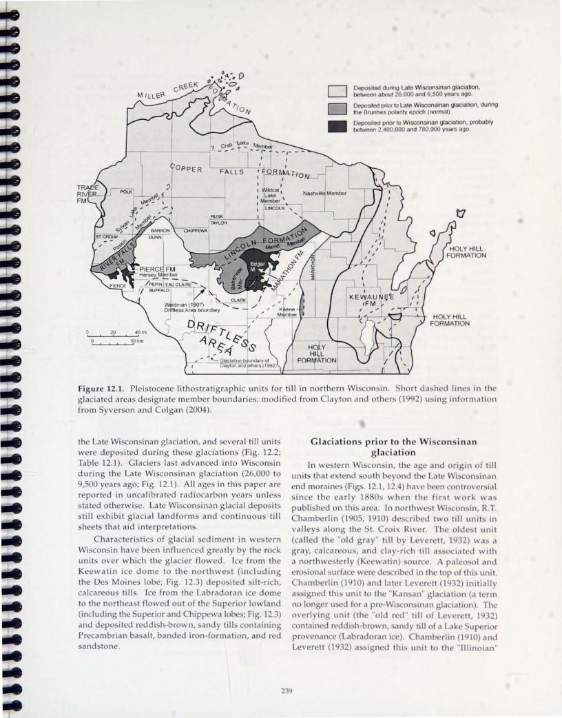
D D
• Deposited dunng Late Wisconsinan glaciation. between about 26 000 and 9.500 years ago
DepoSIted pnor to Late Wisconsinan glaCiation. during the Brunhes polanty epoch (normal)
DepoSIted pnor to Wisconsinan glaciation. probably between 2,400.000 and 780.000 years go
t7
HOLY HILL FORMATION
figure 12.1. Pleistocene lithos tra tig raphic units for till in northern Wi con in. Sh rt da hed lin in th g lacia ted areas designate member boundaries; modified from Clayton and th r (1992) u ing inf rmation from Syverson and Colgan (2004) .
the Late Wi consinan glaC ia tion, and severa l till unit were deposited during these g lacia ti ons (Fig. 12.2; Table 12.1). Glaciers las t adva nced into Wisconsin during the Late Wisconsinan g lacia ti on (26,000 to 9,500 years ago; Fig. 12.1) . All ages in this paper are reported in uncalibrated radiocarbon years unl e s sta ted otherwi e. Late Wisconsinan glacia l deposits still exhibi t g lacia l landforms and continuou till shee ts that aid interpretations.
Characteristics of g lacia l sedim nt in western Wisconsin have been influenced greatly by the rock units over which the glacier flowed . Ice from th Keewatin ice dome to the northwest (including the De Moines lobe; Fig. 12.3) deposited ilt-r ich, calcareous tills. Ice from the Labradoran ice dome to the northea t flowed out of the Sup rior lowland (including the Superior and Chippewa lob s; Fig. 12.3) and deposited reddish-brown, sandy till containing Precambrian basalt, banded iron-formation, and r d sandstone.
23
Glaciation prior to the Wi con inan glaciation
In western Wiscon in, th ag and origin f till units that xt nd outll b yond til t Wi con in n end moraines (Figs. 12.1, 12.4) have b en c ntr v rial
ince th e early 1880 when th fir t work w published on thi ar a. In northw t Wis on in, R.T. Chamb rlin (1905,1910) d crib d tw till unit in va ll eys a long th t. roi Riv r. Th Id l unit (called th " ld gray" till by L v r tt, 19 2) wa a gray, calcareous, and clay-rich till a iat d with a northw terly (Ke watin) urc . A pal I and ero ional urfac w r d crib din th t P of thi unit. Chamberlin (1910) and lat r L v r tt (1 2) initially a ign d thi unit t th "K nan" glaciati n (a t rm no longer u ed for a pr -Wi con inan glaciati n) . The overlying unit (th " ld r d " till of r ll, 1 32) contained r ddi h-br wn, and till fLak up ri r pr v nanc (L brad ran ic) . h mb rlin (1910) and L ver tt (19 2) a ' ign d thi unit to th "Illin ian"

abl 12.1.
and
f till charac t ri tic in ~
th r (2 ). II adi n uaternar
-t rn and n rth-c ntral Wi c n in. Clay mineralogy data are and magn tic u ceptibility analy e were performed at the I g Lab rator . odified fr m Treague and Syver on (2002)
u thostrallgraphlc Sand Silt Clay Magnetic Clay V:K ratio Munsell color Unit percent suscepllbility
(number) SI units (number)
Trade River 49 31 :20 2.0 x 10 3
Form lion (34) (34) Copper F lis 68 23 .9 2.9 x 10 3
Form lion (485) (446) Lmcoln Formallon 55 31 '14 2.3 x 10 3
ernll ember (1 51 ) (135) River Falls 67:21 12 1.5 x 10 3
Form lion (88) (7s) rathon 40:41 ' 19 1.5 x 10 '
Form lion (3s9) (352) Pierce 39 .3724 1.1 x 10 1
Form lion (41 ) (38)
mineralogy' K:I:S V ~o (number)
6:43:39:12 (4)
6:38:35.21 (11 )
6:31 :38'25 (13)
17:29:36:18 (27)
8:21 :54:17 (9)
23:25:40: 12 (13)
±std dev (number)
2.0",1 .0 (4)
s .1±3.2 (11 )
4.7:1.9 (13)
1.3",1 .1 (27)
2.3",1 .0 (9)
0.5",0.1 (13)
Dark brown to yellow-brown (7.sYR 4/4 to 10YR 4-5/4)
Reddish-brown to brown (sYR 4/4 to 7.sYR 4/4)
Reddish-brown to strong brown (sYR 4 /3 to 7.sYR 4/6 )
Reddish-brown to yellow-red (sYR 4/4-6)
Yellow-brown to gray (1 OYR 5/6 to 2.sy 5/1) and reddishbrown (sYR 4/4)
Dark gray to yellow-brown (10YR 4/1 to 10YR 5/4)
'CI y minerals K = kaolinite, I = Illite, S = smectite , and V = vermiculite, from Thornburg and others (2000)
C u ;~o
J~CD , .... .. '" :.::ct
o 0
'.0
O • . o · O· 0
Western Wisconsin
Proposed Correlations
North-Central Wisconsin
Till of the Copper Falls Fm YelloWIsh red , 68 23 9 Contains several n med members nd displays w II-developed pnm ry g laCIal lopography Up to 20 m thICk
Till of the River Faits Fm YellOWish red to dark brown 67 '21 12
ormal mag nebSm , does not d isplay primary gl Ilopogr phy Up 10 10 m thick
Till of the Hersey Mbr of the Pierce Fm G y 10 ohve III C 42 3325 C lcareous, rev rsed magn 115m Up 10 10 m Ihlck.
/
/
Loess (S ill , Windblown)
Till of the Copper Falls Fm YellOWish red , 68:23:9. Contams several named members and displays well -developed pnmary glaCial lopography. Up 10 20 m Ihlck.
Tilt of the Memll Mbr. of the Lmcoln Fm. Oark reddish brown. 62:28: 1 O. Displays pnmary glaCial lopography Gen < 10m thick.
Till of the Bakerv"'e Mbr. of the Lincoln Fm. Reddish brown. 62:25 13. Does not d,splay pnmary glaCial topography. Gen. < 10 m Ihlck.
Till of the Edgar Mbr of the Marathon Fm YellOWish brown to reddish brown, 33:43:24. Calcareous Gen < 10 m Ihlck.
Till of the Medford Mbr of the Marathon Fm. Very dark gray 10 gray, 33:47:20. Calcareous, reversed magnellsm. Gen 4-7 m Ihlck o ' 0 o
I-----(.....f-- pe 1 - - - - - - 1 - - - -- - 1 -/ TiltoftheWausauMbroftheMarathonFm O · ~ Til 01 the Woodvilte Mbr of the Pierce Fm / Brown, 43.34 23 Many clasls highly o Gray to d gray, 45 31 24, I r ous / weathered Gen < 10 m thick.
O Up 10 10m Ihe. L-__ ~ __ ~ __ L-~ ______________________ /
10 meters rn we thenng zone D reddish-brown sediment
2-tO
o . .. . . .. . 0 O. o ·0
· .. ·0 ... . o . O'
.. .. '.0 O' 0
'.0 . . .. ' .. .
0.° '0
~ O· • ' . . . 6 . . • . 0 O . ° ..

Driftless Area
~
LA U RENTIDE IC[ SH EET
glaciation ba ed on the erosiona l surface be low it and a simi lar degree of weathering on the "old red" till and other "Illinoian" tills in Iowa. Disputes abo ut the history represented by the d iff r nt u ni ts ha ve a risen becaus mo t g lacia l landforms have been re moved, and weathering a nd erosion hav xte n ive lya ltered the surficial express io n of the resulting till unit . These till units will b exam ined on day 1 of the field tr ip and are s ummar iz d below.
Deposition of the Pierce Formation Till of the Pierce Formation is the oldest g lacia l
unit in we tern Wisconsin (Fig. 12.1, 12.2; Baker and others, 1983; Mickelson and oth rs, 1984; Johnson, 1986; Attig and others, 1988). Pierce Forma tion tills probably represent ice advances from a K ewa tin source during at least two phases of g laciation (Baker and others, 1983; Mickel on and o th rs, 1984; Johnson, 1986; Attig and others, 1988). This ice crossed Cretaceous shale and deeply weather d crystalline rock, both sources f the clay mineral kaolinite (Morey and Setterholm, 1997), as well a Paleozoic limestone. Thus, till of the Pierce Formation
Figure 12.3 . Ice lobe ' f th h t at the ma imum flow
Late Wi consinan glaciati n . dir cti n of ice fl w; m difi (2000).
aur ntid lc t nt during ttl rr w indicat
d fr m John ' on
is gray to brown, calcareou (where unlea ch d), ilt , and has an e leva ted kaolinite p rc ntag (Tabl 12.1; Baker and oth r ,19 ; Th rnburg and th r , 2000) . Hinke (2003) reported laboratory h d ra u I ic cond ucti vity va lues for Pierce Formation till in t. Croix County ranging from 10-6 to lO-8 c ntim t r p r
condo Pierce Formation till i de pi w a th red, yellowish br wn (lOYR 5/ 4) wher idiz d , with il profile up to 2.9 meter thick and I aching d pth f 3.5 meter (Mick I on and th r ,1 4) . Ti II of th Woodville M mber of th Pi rce Formati n mark th first ice advance recogniz d (Fig. 12.2) . Lake dim nt of th Eau Galle Member of th Pierce F rma ti n i present below the Wo dvill till , and peat and w d are found above the Wood ille till at th t pe ecti n (A ttig and other, 19 ,p. , 11) .
Keewatin ice flowed uth a ' t a c r Mississippi Riv r during th lat r R e depo ited till of the H r y M mb r f th Pi rc Formation above th Woodvill e till in w Wi con in, and damm d the maj r flowing tributarie of th Mi i a the hipp wa and R d ed a r Ri
Figure 12.2. Glac ial lithostratigraphy in w e tern and north-ce ntra l Wi c n approximate, and mean grain s ize is reported a and:silt:clay p rc ntag . following lobes (or from the following r gion ): Ch , hippe w a I b ; DML, ; Ke wa tin , derived from the Kee watin ice dome to th northwe t; La, La ng lad e lob ; Sup, up rio r I b ; WV, Wi · o n in Valley lobe. Propo ed ages and correlation for glacial unit are a l h wn. g f r Wi c n ina n unit are in HC yr B.P., and age from earlier eve nt ar in cal e ndar y ar . M difi d fr m y Igan (2004) .
241

47"
46·
L_-....:j::=-, 4S·
92· 91 ·
0 20 40 60mi I !
i I
I I
I i
0 40 80 km
f Late icon inan ice margin of the Superior lobe in Wisconsin hipp wa lb . The da h d line repre ent the former pa th of the inan glaciati n. The tippled area i an outcrop of ba a lt hills in
B ). Th ma imum ic i pen train d (t
b th ice m r in r tr at d \.\' tword fr mit ma imum p iti n, th r ulting I " :, I n'th n d and f rm d an int rc nn ctin
2t:!
t. Modified
netw rk that co ered more th an 6,000 quare il m ter and e tended a t lea t ten of kilometer
ea t f the modern Mi i ippi Ri er aile. More than 10m t f th inl laminated glaciolacu tr ine
innickinnic Member of the Pierce

• La Crosse
WISCONSIN
C· Wa usau
MARATHON COUNTY
Fig ure 12.5. Ie -margin positions (hachured lin s), ic -flow dir cti n from pebbl fabric (a rrows), and ice-d a mm d lakes (s tipp I d a reas) assoc ia ted with Ke watin ic fl wing from the nor thwes t during the Reeve Pha (m.odified fr m Baker and other, 19 and Johnson, 2000) . The Kinnickinnic Me mber of the Pierc Forma tion wa dep si t d in the ice-dammed la kes. Pebbl e- fabri c a nd la ke-di tributi on data ar fr m B k rand others (1983); ice margin A is from Baker a nd o ther (19 3) a nd John n (1 ). Ie margin B may represent the approxima te locati n of the ic margin when much of th Kinnickinnic Member was depo ited (Baker and o ther, 19 3). Pri r to d p iti n f the Kinnickinnic Member, this ice may have ex tend d a far a t a Marath n (Baker and others, 1987; Syverson and Colga n, 2004) .
Forma tion, accumulated in the e lakes in pl aces (Fig. 12.2) . In Chipp wa County the Kinnickinnic Member is up to 35 meters thick. The Kinnickinnic Memb r contains thinly lamina ted, calca re u , dark gray (lOYR 4 /1) s ilt and clay (mean sand: ilt:clay percentage 14:66:20) with oil profile development genera ll y less than 2 meters thick (Baker a nd other , 19 3).
Kinnickinnic M mb r lak ed imen t int rfing r with and al th H reM mb r. Ba d on counting arv ,Bak r (1 4) timat d th t the lak i t d f r m re than 1,2 0 Y ar . hi s low-hydraulic-c nducti ity mat ria l in w l rn Wi con in i an imp rtant aquitard nd ha b n a ourc of clay y mat ri I f r brick and landfill lin r
( und r nand 4) .
243

Bal-. rand tat d that till
F rmati nand la th m
Pha ) , r
N
o ~ooo
o
Pierce Fm. Hersey Mbr.
(Till)
N
o
Marathon Fm. Medford Mbr.
(Till)
) and Bak r (1 -lb ) mb r f th Pi rc
o c;g o
~o Pierce Fm.
Kinnickinnic Mbr. (Lacustrine sediment)
N
River Falls Fm. (Till)
Th till unit are imilar to the magnetically r ed Her ey ember of the Pierce Formation
(Fig. 12.2; Tabl 12.1; Baker and others, 19 3), and Bak r and other (19 7) propo ed that markedly e panded Keewatin ice depo ited the Medford and Her ey till at th ame time. They cited evidence
uch a b ulder train, imilar grain ize, similar tratigraphic po ition, and carbonate and black hale ource to the northwest. [n addition, Baker
and other (19 7) fir t reported that the Medford till aloha rver d remanent magnetization (Fig . 12.6) . [f the till member are time correlative, then all f we t rn Wi consin must have b en covered by glacier ice during the Stet onville Pha e (and pr bably during the Milan Pha as well). If 0, much of thi till in we tern Wiscon in mu t have been removed compl tely by ro ion (Syver on and Colgan, 2004;
yver on, in pre ).
Thornburg and others (2000) reported that the Marathon till contains much less kaolinite than the Pierce Formation till (Table 12.1) . Syverson
Figure 12.6. Paleomagnetic remanent dir ctions for the H r ey and Kinnickinnic Member of the Pierce Formation, the Medford Member of the Marathon Formation, and the River Fall Formation. Projection i equal area. Solid dots repre nt lower hemi phere projections (normal magnetic polarity) and the open dots represent upper hemisphere projections (re ersed polarity). Her ey and Medford Member tills di play rever ed polarity, and Kinnickinnic Member lake ediment contains a re er ed to normal magnetic sequence; modified from Baker and other (1983).

TILL UNITS
Copper Falls Fm. till
MARINE 180 STAGES (%0)
2 o -2
~~~= 9
River Falls Fm. till ? ~-========:l~ .~4-_---I""-
Pierce Fm. till ?----------..... ..-"I 22=----!.---=:r
Marathon Fm. till -.... >-E ;; 1.0 (!) ~
1.5
PALEO· MAGNETISM
(J) wz IO zo::: ::JI o:::u co
B/M (0.78 myr)
Jaramillo Subchron
Olduvai Subchron
~-----'~-59
62~-=-_
MIG (2.5 myr)
2.0
figure 12.7. Oxygen isotope curve howing tag a cia ted with glaciali n ( v n numb r, had d), interglacials (odd numb r ), and the a ciat d paleomagn ti c chr n . Pi rc and Marath n rmali n tills have rever ed polarity and pr bably were d p it d m tim pri r t tag 2 . Th Ri v r F II Formation till could have been depo ited during any numb r f glaciati n during the Brunh hr n (normal polarity); modified from Rutter (1992) .
245

nd J hn ! df rd
mil n tl
tt r under tand r d remanent
f tIt River Falls Formation
pr -La t
e r Fall ).
i con inan urficial unit in we temmo t Wi consin (Fig. 12.1), and it contain reddi h-brown (SYR 4/ 4) and loam t andy clay (Table 12.1), with a mean
field and laboratory hydraulic conductivity value of 6.5 10') centimeters per second (Hinke, 2003) . The reddi h-brown color and abundant clasts of ba alt, gabbr , and red and tone indicate deposition by the up ri r and Chippewa lobe flowing southward
ut f the uperior lowland during the Baldwin, Dalla, and Fo ter Pha e (John on, 19 6, 2000; yver n, in press). The River Fall till urface i
e tensively eroded and doe not di play original glacial topography (Baker and other, 1983; Johnson, 19 6; Syv r on, in press). Soil profile development e tend to depth of 2. meters in the till. Pro imally d po ited, meltwater stream sediment of the River Fall Formation is common in w tern Wiscon in and i e tremely weathered. Soil-derived clay sometime e t nd to depth of 5 meter and cements the tream ediment (Fig. 12. ; Stop 12-6; Syverson, in pres ).
It ha been propo ed that the River Falls Formation wa depo ited during the "Illinoian" glaciation (300,000 to 130,000 years ago) ba ed on its tratigraphic positi n, normal remanent magn tization, and thick weathering profiles (Baker and other, 1983; John on, 1986; Syverson and Colgan,
rma ti n tream ediment in the oil B horizon
246

2004). However, marine o"ygen isotope reclOrds indicate two glaciations during that time interval (stages 6 and 8; Fig. 12.7) and se\'eral others during the rest of the most recent normal nugnetic polMity epoch, the Brunhes (even-numbered stages between 10 and 20; Fig. 12.7; Shackleton and Opdyke, 1973; Lowe and Walker, 1997). The thick wea thering profiles seen on this field trip argue strongly for deposition prior to the Wisconsinan glaciation. However, based on the oxygen isotope curve, it is not possible to assign a more specific age to the River Falls Formation sediments with confidence (Syverson, in press). Johnson (1986) and Syverson and Colgan (2004) suggested that till of the River Falls Formation is correlative with till of the Bakerville Member of the Lincoln Formation in Marathon and Clark Counties to the east (Figs. 12.1, 12.2).
Wisconsinan glaciation
Depositioll of the Merrill Member of the Lillcolll Formatiol1
The final glacial advance prior to the Late Wisconsinan glaciation occurred as ice flowed from the north out of the Superior region and deposi ted till of the Merrill Member of the Lincoln Formation (Figs. 12.1, 12.2). In eastern Chippewa County, the Merrill Member typically overlies the Cambrian bedrock surface beyond the Late Wisconsinan maximum ice-margin position. The Merrill Member contains reddish-brown (5YR 4/4), noncalcareous sandy loam till (Table 12.1). The till surface has little to moderate stream incision, lacks well-developed surficial weathering horizons, and displays some streamlined glacial landforms and lowrelief, hummocky topography. The mean hydraulic conductivity value for the till is 2.2 x 10'· centimeters per second (Muldoon and others, 1988).
The Merrill Member was deposited during the Hamburg Phase (Fig. 12.4; Attig and Muldoon, 1989). The presence of original glacial topography and the lack of extensive weathering suggest that the till was deposited during the Wisconsinan glaciation. Stewart and Mickelson (1976) presented clay mineral evidence for grea ter wea thering of Merrill Member till than the Late Wisconsinan Copper Falls Formation till, but Thornburg and others (2000) could not reproduce this trend to the west. Stewart and Mickelson (1976) reported an age greater than 40,80()'·C yr B.P. for organic material overlying till of the Merrill Member. Based on these considerations, it has been proposed that the Merrill Member was deposited during the early part of the Wisconsinan gl,1(iation (Ham and Attig, 1997; Syverson and Colgan, 20:J4; Syverson, in press).
Late Wisconsinan glaciation In western and north-centr,ll vVisclll)sin, vVooslL'r
(1882) and Weidm,)]) (19117) described vllunger gLKial deposits that were assllciated with hUl11illl1d .. y end moraines. Two young glaci,)1 tilb were identified: a red sandy till with ,)bund,)Jlt cl,)st-; trllln the L)ke Superior basin (Labracil)[,ln ice dllllle), overl,)in by a gray, calcareous till deposilL'd by a glacier flowing from the west (the Keewatin icc dllllW; Chamberlin, 1905, 1910; Leverett, 1932). These units h,we been studied in detail by numerous scil'ntists tll verify the conclusions of the early geologists (for eX'lmpiL' Clayton, 1984; Mickelson and others, 1 '.184; Johnson, 1986,2000; Attig and others, 1988; Attig, F J93; Ham and Attig, 1997). Detailed field mapping has identified numerous glacial phases indic,lted by Late Wisconsinan end moraines ,lnd other icemarginal landforms (Fig. 12.4). The remainder of this overview summarizes the currcn t know ledge of Late Wisconsinan glacial stratigraphy, gellmorphlliogy, and chronology in western Wisconsin.
Depositiol1 of the Copper Falls Forll1lltioll duril1g the Emerald alld Early Chippewa
Phases
After the period of erosion and weathering mentioned above, the Superior and Chippew,) lobl's advanced from the north approximately 26,()()() YCMS
ago at the start of the L.1le Wiscollsin,ln gl,lCi,)tion (Fig. 12.3; Black, 1976). Sediment from this adv,mcl' is included in the Copper Falls ~orm<1lillll ,1Ild consists of till, outwash, and lacustrinc scdinlL'llt. The till is reddish-brown, sandy loam, alld cllnt,lins ,1bundant "black and red" lithologies-Keweenawdn s,)[ldstonL', rhyolite, and Keweenawan bas,)lt as well ,1S gr,)llitL' and gneiss (Table 12.1). In eastern I3Mron Cuullty, south of the Blue Hills, red qUMtzitL' is common in the till (Mickelson and others, ]LIK4; Johnson, I LJoh,
2000; Attig and others, 1900). Hillh' (2{)()1) rl'F'ortl'd a mean field and laboratory hydr,wlic conductivity value for this till in St. Croix Cllllilty of ,1pprllXil1l'lkly 10' centimeters per second.
The St. Croix and Chip~1L'W'l 1l1llr,)incs of \vl''.krn Wisconsin do not represent till' m,1\irnull1 iCl'-I11Mgin position during the L1te Wi'.cullsin,lll gl,lCi,)lion. II is clear based on geomurpholog)" l11il1('r,ll(1g)" ,md stratigraphy that these two lulw" ,1lh',1Iln'd II) to Ie:; kilometers farther south prior tll ,1 I'dre,lt tll till' mort' prominent moraines. Thi" I11l)rl~ extl'I) ... il'l' p""itioI1, first rccognized by M,lthil'sl'n (1C)·ill), W,b rt',)cllL'd during the Emer,)ld alld EMI)' Chif)f)l'W,l I'h,1'.l· ... "f the Superior and Chippl'\\'.l lobl'''. At lhi" til11L', ill' extended to a puint south Df Lldrrol1 ,1I)d l'l)lk C()ulltil''> (Figs. 12.4,12':1). Thie. more l'xtcn"i\'l' .1cl\',lIlCl' m,)\,
2-l7

unpltt outwa h pi In
pit utw h plain
pit
mar h
collap d vall
humm
0 till with I W magn II u ptlblloty
+ till with hl~h magn tIC u ptlbllty
~ dr Inag
raon
r - - ----
I 1 __ I ~AS;1~~ __ _
I 8,""
I
• St. Cro. Falls
t. Croi ice margin
Ll ,/'?M M •• . j~ .. . o 0 -it • .;..
Joo.~ 0
) . <,;. ~-. . ... - ;. .-::. - -:- .~
r.: : ... o
Emerald ice m rgin
Menomonie
st CI'\OI~ I •
I L __ _ I
I PIERCE'
.' __ .. _a_ ...... I ,
Late Chippewa
K
• I CLAIRE.
Eau Claire
WISCONSIN
ur 1 . _ Ie -mar 10 p iti n (hachur d line ), geom rphic fea ture , and magnetic u ceptibility value for till iilt >d \ ith th m raId Pha f the up rior lb . G omorphic features interpreted from topographic maps uth rn P I\" unt ,we t rn Pie rce Count, northern Dunn County, and Dakota Count,
b r pr nt d th tanl ' Pha
\ er
a ina (1 7) . Hig h magn tic u ceptibility till in Barron County (Johnson, 19 6) rater than .0 (arbitrar magn tic u c ptibility unit ); high magnetic susceptibility
untie ar th g re ter than 2.0 10-) (51 unit ).
unt b (Fig. 12.4;
uth f th
24
m re-weath red till to the outh, and till to the north that ha imilar weathering characteri tic to the till in th morain (Fig. 12.9; John on, 19 6; Thornburg and th r ,2000). J hn n (19 6) concluded that the ma imum Late i consinan ice-margin po ItlOn wa
uth of the prominent end mora ine ba ed on the e diff r nc in lith I g (a cribed to weathering) and
morph log (mo t n tabl pitted out~ a h plains

.. that grade to the St. Croix and Chippewa moraines; Fig. 12.9).
The landforms from the Emerald Phase of the Superior lobe and Early Chippewa Phase of the Chippewa lobe are distinct from those formed during the St. Croix and later phases. Hummocks, ice-walledlake plains, tunnel channels, eskers, and outwash plains dominate the landscape formed during the later St. Croix and Late Chippewa Phases, but are absent or rare in the landscape formed during the Emerald and Early Chippewa Phases. Johnson (2000) suggested that the Superior lobe changed from a cold, non-surging glacier during the Emerald Phase, to a warmer, surging glacier during the St. Croix Phase. The landforms of the Emerald Phase, the thin to patchy cover of the Poskin Member till (Copper Falls Formation till deposited during the Emerald Phase), and the presence of well developed permafrost features suggest that the climate was colder during the Emerald Phase than during the St. Croix Phase. The absence of tunnel channels indicates that less subglacial meltwater was present during this phase, perhaps because cold conditions prevented meltwater from draining through the glacier to the bed. Meltwater mainly formed supraglacially, flowed for the most part over clean ice, and had a low sediment load. Ice flowed into pre-Emerald Phase valleys that later became collapse depressions when warming allowed buried ice to melt. Following retreat of the ice margin, permafrost conditions enhanced rapid development of a dendritic drainage network, and it is likely that much till was eroded.
The age of the Emerald and Early Chippewa Phases is not known, but it is certainly Late Wisconsinan, probably between 20,000 and 25,000 "c yr B.P. Ice during the Late Wisconsinan glaciation crossed the drainage divide south of Lake Superior by 26,000 HC yr B.P. This is based on spruce wood in western Wisconsin buried by 60 meters of glacial stream sediment (26,060 ± 800 HC yr B.P.; Black,
1976; Attig ,mel others, 19K5). H(l\\'l'H'r, age control in \Nisconsin is poor bec,luse organic materi,ll is uncommon fwm 13,000 to 26,LlOO lie yr B. P. Clay ton and others (200l) ,lttributed this l,lck of org,lllic materi,ll to the presence of perm,lfwst in \Nisconsin, vet many MedS not subjected to permafrost also suffer from a l'ack of radiocarbon datL's from this peri\ld.
Depositioll of the Copper Falls Formatioll dllring the St. Croix lInd Late Chippewa
Phases Till in the St. Croix' and Chippew'l moraines
is included in several members of the Copper F,llls Formation (Attig and others, 1988). These members are almost identical to the members of the Copper Falls Formation that were deposited during the Emerald and Early Chippewa Ph,lses. However, as noted above, the geomorphic char,lcter ch'lnges markedly, dnd Johnson (2000) suggested th,lt this difference was caused by changes in ice behd\"ior. During the St. Croix Phase, large-scale subglacial drainage of the Superior lobe beg<ln dnd formed tunnel channels and eskers (Wright, 1973). Much of the meltwater-stredm sediment in the outwash plains of Polk, Barron, Dunn, and Chippewa Counties Cdn be traced to tunnel-channel mouths (Fig. 12.10). A broad, extensive outwash plain, the Wissota tL'rr,lce, heads at the Chippewa moraine clnd C,ln be tr,lced along the Chippewa River to the Mississippi River (Andrews, 1965; Syverson, in press). Additi(lIl,llly, the Spooner Hills (Fig. 12.1D) are thought to bl' thc result of erosion by subglacial mcltvvater (J(lhnstlll, 1999).
The increase in subglacial meltwMer fcatures is accompanied by the presence of widespre,ld stagll.lllt ice features including broad belts of hummocks dotted with ice-walled-lake plains. Johnson ,1I1d other~ (I Yl('i) stated that although hummocks clearly seem to be collapse features, in wcstern Wisconsin they Me nftt'll composed of uniform till bearing .1 strong pebble
1The use of the name "St. Croix" in association with glaci,ll features in western Wi~consill W,l<; origin.llly applied to a band of hummocky topography running north-south immediately eclst (If the town of Sl. Crlli.\ Falls in Polk County. This was called the ··St. Croix moraine" by Berkey (lHY7). R.T. Ch'lmberlill (IYIJ')) used the term "St. Croix moraine" in the same sense as Berkey and recognized sever,ll other fe,lturl';' in I'llik County that he called moraines, including the "Alden moraine." The nclllle W,l~ fir~t <lpplied to 1,1Ildforl1l<; farther to the southeast by Leverett (1932), and it is this hUllllllocky region th,lt geologist<. gener.llly rder til as the "St. Croix moraine." Although Leverett recognized Chamberlin's other mor,lille~ (such ,1-. the Akkll), he did not recognize the ·'St. Croix moraine" in the sense defined by Berkey (lHlJ7) clnd lh('d by Ch,lI11bL'rlin (1905). Leverett gave no explanation for the name change. Wright (lY73) referred to til(' ice ;ldv.llll'l' tb.lt made this landscape the "St. Croix Phase." The ice-margin position thaI \-\,.1-. reprl',>('nkd by Ikrkl'y";, ,11lL!
Chamberlin's original "St. Croix moraine" WdS called the Centuri,l PhdSl' by John-.on (20IHJ).

0 ..... _ ....... --"? .... o
8 o
1.-
0
~ 0 --.... ..............
-o <::>Q~ ---
-
o o o
/
1020$ 0 ..
o ~' 05O , - '0-
.......... .,..,....... I'.
o
----------------P.2 . J )1 N"" I (ItWI( V.
EXPL TION OF MAP SYMBOLS
Dlstnbutlon of buned red and brown ..........---.- Ice-margin position laminated lake sediment of Helgesen and Lindholm (1977) O~c:J Spooner Hills
E tent of glacial Lake Lind 0 Outcrop of glacial Lake Grantsburg
E tent of glacial Lake Grantsburg varved clay
Ice· flow directIOn of Gran tsburg @ Outcrop of glacial Lake Grantsburg varved clay exposed beneath
sublobe Inferred from till fabric Trade River till
Low-rehef Grantsburg sublobe • Outcrop of glacial Lake Lind moraines varved clay
Kettle River and St CroIx channel <> Outcrop of glacial Lake Lind
With bars on the Chengwatana near-shore sediment surface
1050 Location and etevation of glacial Tunnel channel $ Lake Grantsburg wave-washed gravel
Boundary between pitted and non- 1490 Selected spot elevations p'tted topography 0
.. Outcrop of silty Copper Falls till Dominant meltwater dramage route
R Red Cedar River • Town H Hay River w Willow River s flows to the soulhwest
250
!:: I~ F I

fa b ric. The concluded tha t th is ti ll i like l meltout ti ll , too and and w ll -drained to fl w d ur ing co llap e fo llowing melting of th und rl ing ice.
Clay ton and o thers (l 5) ugg ted tha t many lobes of the Lauren tide Ice he t u rg d d uring the La te Wiscon ina n glac ia tion, and John n a nd Sa ina (19 7) agreed tha t the landfo rm of the Superior lobe uppo rt thi s idea . Increa ed ubg lacia l d ischarge
of me ltwa ter is as ocia ted with s urg in g (Kamb and o thers, 1985), a nd s urgi ng ca n p rod uce la rge trac t f s tag nant ice tha t melt to form hummocks (Wrig ht, 1980). C lap perton (1975) s ugge ted tha t large a mo un ts of debr is are froze n to the bas of the g lacier d u ring a urge. A thick, basa l, debrisr ich layer in a mass of s tag nant ice co u ld produce h igh-re lief hummocks li ke tho e in Polk, Ba rron, St. Croix, and Chippewa Counties.
imilar ur in m chani m i - implied b the landf rm of the _hippewa lb . Th hipp wa lob flowed uth ted during th P rkin t n P ha e but th n fl w d uthw - t rl (a cha ng of 90°) during the Late hippew Pha t bui ld the h igh-r Ii f humm ck hipp w M rain in northwe tern hippewa unt ( ig. 12.11; Waggon r and other, 2001; y er n, in pr -). Ham and ttig (1997) de crib d th e ent in th hipp wa and Wi con in Va lle lob in Wi n in and pr p d that they repr n t glacier urge that c ntributed to mora ine forma ti on by carrying m uch d bri to theglacier u rface( ee top 12-lOf rm red tail d di scus ion).
The cenario ou tl ined ab ve for th t. r i\. and Late Chippewa Pha ugg t that the m rain d no t repr s n t long periods of climatic equilibrium,
Wisconsin Valley lobe
southern limit of diamicton of the Merrill Member
Langlade lobe
Figu re 12.11. Ice-flow di rec tions and mora ines of the Wi consinan glaCiation. The high-r lief, hu mmocky (HRH ) Chippewa and Harriso n mora in for med af ter the hipp wa and Wi con in Va lley lobes unde rwen t major change in ice-flow direc tion. The e maj r chang of fl w direction are tho ught to repre ent ice-s urg ing eve nts that contributed to the d v I pm nt f the high- re lief moraines. LRH = low-re lief, hu mmocky moraine; FR=Flamb au Ridg . Modifi d from Attig and others (1998) and Waggoner and o thers (2001).
Figu re 12.10. Part of no rthwes tern Wisconsin and adj ining Minn s ta h wing f tur 5 a ciat d with the mos t recen t g lacia l events. Spot e leva tion (in feet) ar includ d t h w that I ati n incr a fr m central Burnett County to the St. Croix ice margin. Emerald, St. r i , arly hipp waf and at hipp w ice margin are from John on (1986) . The Pine City ice margin in Minne ta i fr m per (1 5) and Hobb and Goebel (1982). Location of glacia l Lake Grantsburg and glacial Lak Lind v r d cl y in Minnesota are from Chris Hem tad, M.D. John n, and Gary Meyer (unpub . data). nly lunn I chann I in Wisconsin are hown. The extent of glacial Lake Grant burg in Minn ta i in part fr m oop ' r (193 ). Till fabric measurements in Minne ota are from hernicoff (19 3) . Modified fr m J hns n (20 ). CS (in eastern Minnesota) = location of Camp Sumi e. L = Lind, Wi con in.
251

but merely the outer boundary of short-lived surge events. In fact, th\., St. Croix ice-margin position actually consists of several penecontemporaneous ice-mMgin positions (Fig. 12.1L1), suggesting that the bands of hummocks in the St. Croix moraine may be the products of several surge events. The ,1ge of these advances is not known, but Johnson (200D) suggested they occurred between 15,000 and IH,500 I'C yr B.P.
The history of the Superior lobe after the St. Croix and Late Chippewa Phases is a sequence of overall retreat punctuated vvith numerous readvances. This is abo true for the Chippewa lobe, but to a lesser extent. These re.ldvances left several landforms that indicate distinct icc-margin positions in western Wisconsin (Figs. 12.-i, 12.10). Numerous ice margins are marked by outwash beads, bands of hummocks, and tunnelchannel mouths. These discrete landforms are often difficult to connect laterally in order to identify cnntinuous, isochronous ice-margin positions, but johnson and Mooers (1998) attempted to produce a map showing continuous ice-margin positions (Fig. 12..l).
As the Superior lobe retreated, meltwater paths chdnged from southeasterly (along the Red Cedar and ~VillllW Rivers) to southwesterly (along the St. Croix Ri\'er). Apparently, stagnant ice and a change in drainage caused the former valley of the St. Croix River (shown as a dashed line in Fig. 12.4) to be blocked, and the retreat of the Superior lobe aIlO\\'\.'d the expansion of glacial Lake Lind in eastern ~vliIllWS(lt,l and western Wisconsin (Fig. 12.10; Johnson dnd others, 19<,)9). Glacial Lake Lind sediment consists of reddish-brown, varved sand, silt, and clay up to 30 meters thick and represents more than 1,000 years of sed imentation. Johnson and others (1999) used varve corre\.ltions to show tha t the Superior lobe retreated ,)t .) rate of 150 to 200 meters per year during the I.lke·s l',ist(;'ncc. Johnson (2000) has included this sediment in the Sunrise Member of the Copper Falls Forrn,lti()(l. The age uf glacial Lake Lind is unknown, but it likelv e,isted between l-t,000 and 18,000 "C yr B.P. Claci:ll Llke Lind gradually filled with deltaic sL'dirnl'nt derivcd from the retreating Superior lobe, ,1I1d it \\".15 completely fillcd with sediment prior to the advance of the Grantsburg sublobe and prior to the retreat llf the Superior lobe into the Lake Superior bdsil1.
Depositioll of tile Trade River Formation The Crantsburg sublobe of the Des Moines lobe
,1dLll1ced frpm the wcst-southwest into western WiScllllsin during the Pine City Phase and deposited ti II of the Trade Ri \·er Formatinll (Figs. 12.3, 12.10;
252
Wright, 1972; Wright and others, 1973; Chernicoff, 1983; Johnson, 2000). This ice occupied an area previously covered by the Superior lobe, including much of the filled-in glacial Lake Lind basin. Trade River Formation till is gray, loamy, and calcareous, similar to the tills of the pre-Wisconsinan Pierce and Marathon Formations, but Trade River Formation till exhibits a low degree of weathering and erosional modification (Table 12.1; Johnson, 2000). The Pine City Phase ice margin dammed the St. Croix River drainage along the Minnesota and Wisconsin border and glacial Lake Grantsburg formed (Fig. 12.10). Varve counts imply that the ice advanced into glacial Lake Grantsburg at rates of 5 to 7 kilometers per year. Varves deposited during the main phase of glacial Lake Grantsburg suggest that this lake lasted only about 100 years Uohnson and Hemstad, 1998; Johnson, 2000). A fiat, poorly drained lake plain marks the area once covered by glacial Lake Grantsburg, but this surface is best thought of as the delta-filling surface of glacial Lake Lind with only a thin cap of glacial Lake Grantsburg sediment. Johnson (2000) estimated that the Pine City Phase occurred at approximately 14,000 HC yr B.P. based on correlation to the welldated advance of the Des Moines lobe to the Bemis margin in central Iowa.
Lake Superior diversion As the ice margins wasted north across the
Superior drainage divide, proglacial lakes formed within the deep Superior basin (Clayton, 1984). Modern outlets toward the east were blocked by ice, so the lakes drained to the south via the St. Croix River (for example glacial Lakes Nemadji and Duluth). Initially, glacial Lake Duluth had a surface elevation of 327 to 330 meters (approximately the level of Skyline Drive in Duluth, Minnesota; Clayton, 1984; Farrand and Drexler, 1985). Glacial Lake Duluth drained into the 5t. Croix River system through an outlet near Moose Lake, Minnesota. A later, slightly lower outlet near Brule, Wisconsin supplied water to the headwaters of the St. Croix River. Water may have occupied both outlets when the level of glacial Lake Duluth was at its highest (Farrand and Drexler, 1985).
The large volume of water diverted into the St. Croix River system incised the deep gorge of the St. Croix River that serves as the boundary between Minnesota and Wisconsin. This event also formed large potholes in the Precambrian basalt well above the modern river level at Interstate State Park in Wisconsin and Minnesota (Black, 1974; Clayton, 198.,1; Johnson, 2000). Johnson (2000) suggested that this valley incision occurred approximately 9,000 to 12,000 HC yr B.P.
• • • .. • • • .. • • • • .. • .. .. • • • • • • • • • • • • .. .. • • • • .. .. .. .. • .. .. .. ..

Fine-grained diment wa depo it d in the lake within the uperior ba in. The last g lacia l advanc into northwe tern Wi co n in (the Lak iel Pha e of Clayton, 19 4) r ded the si lt- a nd cl -rich lake sedimen t and d po ited tone-po r till units that con tain 70 to 90 percent ilt and clay (Miller reek Formation in northern Wiscon in; Mickel on and o thers , 19 -1 ). Bl ack (1976) reported wood d a tes from red , cla -rich till of thi s eve nt in northe rn Wisconsin (9,730 ± 1-10 I~C yr B.P. and 10,100 ± 100 I4C yr B.P.). Clayton (19 4) co rrelated thi 9,900 I~C yr B.P. advance with the Marquette Phase in the Upper Peninsula of Michigan and es timated that the glacier margin wasted out of Wisconsi n for th last time by 9,500 I·C yr B.P.
FIELD TRIP STOPS (Fig. 12.12)
DIRECTIONS: Cross the St. Croix River at Sti ll wate r, Minneso ta on to Highway 35 / 64. Vee r right on to St. Croix County Road E. The route w ill c ross Sta te Highway 35 in the town of Houlton approximately 0.2
mile a ' t f the bridg . Pro E for an additional 3.1 mil Valle Vie Trail and foil Bas Lake
nto mile " t th
kn band h.ettl 1._
wher th road turns right and b com cnu . Continue a l ng 150th Av nue f r 0.2 mil . Th r ad then turns to the I ft (nor th) and b me 6 rd tr t. Proceed a long 6 rd Stre t f r 1 mile and turn left onto St. Croix County Road I. Follow unt R ad I north for 2.1 mile to the inter ecti n wi th tate Highways 35 / 64 in the town of Som r t. Turn right (east) onto Highway 35 / 64. F llow Highway / 64 for 0.1 mi le and turn left (north) on to tate Highwa 35 . Continue on Hi g hway 35 for 6.9 mile and turn right (eas t) onto 10th venue. Driv ea t for .7 mil Stop 12-1 i a ma ll exposure on the I ft (n rth) id
253

f th r ad . Thl t P I I cated appr ima t I 0.1 mil a t f the farm at 22 7 10th v nu .
P 12-1
d r a IC -wall d-Iak plain
T. 2 ., R. 1 c. 2
rth quadrangle; UT
call d an un tabl -en ironment ice-walled-lake plain (Fig. 12.14). The Cedar Lake ice-walled-lake plain ha a well-defined rim 10 meter higher than th plain ' center. t thi top we ee clearly that th rim i comp ed of or ted and and gravel in w II d fined fore et (Fig. 12.15). The pre ence of thi c ar e-grained, water- or ted ediment and the orientati n of the for et trongly uggest tha t the
:!5-1
dim nt ource wa the adjacent tagnant-ice urface. trea m ystem mu t ha ve developed on the thick
upraglacial ediment, and the e treams tran ported ediment to the ice-walled lake.
Figure 12.13 . Part f New Richmond North, Nye, 0 ceo la , and omerset orth quadrangle, Wi con in and Minneso ta howing the Cedar Lake ice-walledlak e p lain line s urround ed b y hummocky topography. Contour interval i 10 fee t, excep t in the southwestern part, where it i 20 feet. Hummock in this region co ntain Copper Falls Formation till , gravity-flow deposits, outwa h, and lake ed iment. DH = loca tion
f drill hole mentioned in the te t. The topograp hic profile in Figure 12.16 trend ea t- west through this drill hole .

A. Unstable depositional environment
lake
basal till
lake plain
basal ti ll
B. Stable depositional environment
high-relief moraine
lake
basal till
perched lake plain
medium-relief moraine
, "
" C,'! ~;:h;; >:, ~~~;: {y~ i !toNf j; no; ;; ;~~i:::jt:II:~o;;w!8; 0,'! h; ;J.~;:~~l: Fig ure 12.14. The formation of ice-wa lled-lake p lains (modified from
A . Unstable-environment ice-walled- lake p lain. Sediment is thin on th ic melt rapid ly and produces a lot of water that carrie large quantiti f edim grained sediment is depo ited near the hore in deltas, and s ilt a nd c ia a r d p conditions nea r the center of the lake. After the ice melt and the lak drain , gra around the outer parts of the ice-walled -lake plain.
7).
ic ar
it din mor qui t-wa l I rim ridg may r main
B. Stable-environment ice-walled- lake p lain. Thick sedim nt on th ic pr v nt · th ic c nfining th 1< k from me lting quick ly. Little meltwa te r i produced, 0 littl e cars -grain d dim nt i tran p rt dint the lake. Rather, silt and clay are depo ited in th long- liv d lake. Wh n the urrountling ic me lt , th former lake plain remains perched high in the land cape.
255

T h
piltt 'en) i \. II
nd urr
i nilnt ic V.Oil
in the rim of the C dar Lake ice-wa lled-lake plain. Fore et the cent r f th la ke pl ain. Vertica l ca l appro lmately
ice- w a ll d-lake p lain i f br wn itt and 0 erlie 10 in J hn - n, 2000) . Th
ff h r ited
256
permafro t m lted, an idea pre nted by Ham and ttig (19 6a) . This also indicates that the formation f hummock took place after sedimenta tion in the
ice-walled lakes .
Mo t ice-walled-lake plains have lake sediment thinn r or equal to the landfo rm re li ef (Fig. 12.17A, B) . However, sediment in the Cedar Lake ice-walledlake plain i much thicker than the relief (Fig. 12.17C). Thi is a ignificant ob erva tion with regards to a curr nt con trover about hummock gene is. Some author (Eyle and other , 1999; Boone and Eyles, 2001) ugge ted that most hummock, a nd even tho e fea ture ca lled ice-walled-lake plains, are the re ult of ubglacial queezing under the s tagnan t ice
f a glacier that ha urged . They would argue, for a mple, that the t p of ice-walled- lake plain seen
in Figure 12.17 i a product of upward squeezing f oft till into an ice-\; ailed lake and onl a small
am unt flak ediment would accumula te on top f thi - qu z d diment; imilar stratigraphy could
al b achie db an ice-walled lake initiall filling

1100 West East
IWLP 325
--. 1050 ¢::
1-- ~I ..--.. E ---- c
c 0 0 +-' ('\j
>
+-' ('\j
> Q)
Q) Q) Q) 1000
300
0' .. 0
950 .. .. 0
Fig ure 12.16. Topograp hic profile across the sou thern end of the Cedar Lake ice-wall d-Iak plain showing bordering h ummocks and d ri ll hole information. Loca ti n runs eas t-w t through the drill ho le (marked DH ) in Figure 12.13 (but the cross sec tion line is not shown on tha t figure). N te that the ice-wa lled-lake p lain rims are imi lar in levation to urr unding hummock, a nd a l tha t the thickness of the offshore sediment (da hed pa ttern) is much great r than the r li ef f th icwalled- lake p lain. Compare with Figu re 12.17.
A
B
c
Lake sediment
.. ' .0 .. . 0 " ... 0: 0.· . .. o. . . .. . 0
. ·; .. .. 0··0· 0·" '.' '0'... . .· ... ·0 . . .. : · ~ ·O .. ·O ... .. . · ~ ·o: ,, :O .. 0 " o. o ~ .." O·· .C: ·. ' .. 0: . .. G . .. TII!~ . 0 0' . .. G'.: ' .. C? . 0' . .. G' ·' . 0 . .' 0' . .. '0 . .. Till~ . 0 .. C? . b .·0 ... 0 .. 0 .' "·0.. 0 · .. . .'. .. 0 • . .. . "·0.. 0·. 0 . ' . 0 ". ' • . o · '. C?
Lake sediment
.. 0 . . .0 . . .. .. . . · • · .. 0 . 0 0 ' . 0 . . . .. .. : . '0 . '0 .. • .. '0. · ... 0 " . · 0 .. '0 .. 0 .
. • " Till· . ' o · . • . 0.0' · .0 · · ' .' . '0 o· .. . ' .. '. ... • · • . ·· · 0·· 0·.0 . ' . 0 ' . • 0 .'
Lake sediment
o .. . .0 .. 0. . . ~.~ 0 .. < ·6 _______ _ _____ _ __ 0." .~? 0 . b ~ 0 : '. '0 : .' '0' . .. '0 Ti II' • . .' .' . • - - - - - - - - - - - - - - - - - ' . . Ti II· . ' o · 0 . • . .. .. :0 .. · • .. 00 · ---------- --- - --- 0· · . 0 · · ' .' .' 0 ·0· . 0·.0" ··0 - - - -------- ------- · 0·.0 ,' .0 . . • . 0 . '
Fi g ure 12.17. Ice-walled-lake plain with varying th ickn are quite common and have been reported wid ly in Wi c n in, th ak ta, uth rn and Europe 00hnson and Clayton, 2003). The Cedar Lake ic -wa ll d-Iak plain i an type C. See text for explana tion.
257

with flo\\' till, followed by a more stable period when lake sediment accumulated. HO\\'ever, the uther types (Figs. 12.176, C) are more difficult, if nut impossible, to explain by subglacial squeezing. This in turn Slippurts the notion that there must have been significant amounts of supraglacial debris on the iCL', and that squeezing was not the main process in ice-walled-lake plain or hummock formation.
NEXT: Tu rn left (east) ou t of the parking area onto lUth Avenue. The eastern edge of the lake plain is crussed in dpproximately 0.9 mile, and then the tupugraphy becomes quite hummocky. Continue ().:; mile to 21Uth Street dnd turn right (south). Continue suuth 1.7 miles to St. Croix County Road H and turn left. Follow County Road H for 3.2 miles to Star Prairie River Island Park. The park is llil the left side of County Road H jllst after the Star Pr,liril' Trullt Farm and just before the intersection of County Ruad H and State Highway 65. We will have a sn,)ck stop here. /\fter our break, turn left (east) out uf thl' parking lot onto County Road H. This road iollow" Highway 65 for slightly less than 0.1 mile before County Road H splits (left) from Highway h:;. Conti nul' l'ast on County Road H for 2.5 miles to 5t. Croix County Road CC and turn left (north). Dri\'L' nurth on County Road CC for 1.8 miles. There is ,1 U.s. Fish and Wildlife Service parking area on the right sidL' (east) of thL' highway just north of the sm,lll lake on thl' edst side of the rodd.
STOP 12-2 County Ru,ld CC esker and tunnel channel
Location: T. 32 N., R. 17 W., sec. 33, NW, NE
DL'cr Park qu,)drclngle; UTM: 541,OOOE/5,007,600N
Description: This stop is at a scenic esker associated with the 51. Croix Phase. The esker is about 6 kilometers 10l1g (Fig. 12.18), dnd numerous collapsepit-; su),!;gl'st th,)t the esker lies within a tunnel channeL Elsewhere ,lion),!; the St. Croix Phase margin in Polk ,md 5t. Cruh Counties, tunnel channels are more ciL'cHh' defined thdl1 this one, mainly because they ML' e,:udL'd intn till (Fig. 12.10). At this stop, the regillil -;urrounding the esker is a pitted outwash ~'Llin, ,wei this implies that the tunnel channel, esker, ,lnd st,)gl1c1llt icl' that existed here were buried by uut\\",bh during retreat. Whell buried ice melted and thi" (lutw,bh cull'lpsed, the tunnel channel was not dearl\ l"preo;sed. This SL'ems to be the origin of the 111,1n\' l'ill!1g,llL' lakes ,lr strings of lakes surrounded by lH,tI~',):;h in tllesl' counties (tllr e,ampie \Vapagasett LIke. BUill' Lake, LlHlg Lakl', ,)nd Deer Lake in 1\)lk C(Hlnt\'). lntcre,;tinglv, tunnel channels are COIl1Ill<lIl ill 'the ,He,l (o\'l'red bv the Superior lobe,
but rather uncommon in the area covered by the Late Wisconsinan Chippewa lobe (to be seen on day 2 of this trip; Clayton and others, 1999).
The County Road CC esker starts near the Apple River and ends just northeast of Oak Ridge Lake. Many eskers and tunnel channels with eskers along the St. Croix Phase ice-margin position are fronted by large outwash fans at theirs mouths, such as at nearby Clear Lake (see Fig. 18 in Johnson, 2000). The esker at this stop lacks a clear fan. It also does not end at the St. Croix margin, but at a point several kilometers behind the St. Croix margin at a slightly younger ice margin. In general, the edge of the Superior lobe during this time is marked by several discontinuous ice-margin positions (Fig. 12.10) suggesting, according to one of the authors (Johnson), repeated readvances by surging during overall retreat (see Late Wisconsinan overview),
NEXT: Turn left (south) out of the parking area onto County Road Cc, return to County Road H, and turn left (east). Follow County Road H for 6.2 miles to State Highway 46 in the town of Deer Park and turn right (south). Drive south 3.9 miles on Highway 46 to State Highway 64 and turn left (east). Proceed east on Highway 64 for 6 miles to the town of Forest, turn right (south) on St. Croix County Road D. Drive south on County Road D for 1 mile. Turn left (east) onto St. Croix County Road S (180th Avenue) and follow it for 1.4 miles to Milestone Materials gravel pit. The pit is on the left (north) side of the highway and the entrance is marked by a gravel drive and a yellow gate.
STOP 12-3
Hard hats are required
Po skin Member of the Copper Falls Formation and the Emerald Phase ice margin
Location: T 31 N., R. 15 W., sec. 33, SE, SW
Glenwood City quadrangle; UTM: 560,310E/ 4,997,060N
Description: The sequence of glacial units exposed within the Milestone Materials pit consists of several meters of cross-bedded sand and gravel near the base of the pit overlain by approximately 0.5 meter of a gray, compact till (Fig. 12.19). These units represent the Hersey Member of the Pierce Formation, deposited prior to the Wisconsinan glaciation based on reversed remanent magnetism (Figs. 12.2, 12.6). Hersey Member till is unconformably overlain by a horizontally bedded sand unit of the River Falls Formation and approximately 4 meters of massive Ri ver Falls till a t the surface (Fig. 12.19). The goal
• .. • .. .. • .. • .. .. • .. .. • • • • • • • • • • • • • • • • • • • • • .. .. .. .. .. ., IJ ., .,

''7 j -"'_._-,..
II Fig ure 12.18. Topogra phic map of th County R ker (crest indicat sy mbols) and tunnel channel taken from the Dee r Park quadrangl , Wi c n in . Thi esker a t Stop 12-2 i about 6 ki lometers long, and it lies within a tunnel charm I that is ob cured by collapsed outwash.
of thi s s top is to compa re the Superior-derived River Falls Formation (p re- Wiscons inan, consider d Illinoian by worker such as Baker and o th r ,1983; Syverson and Colgan, 2004) and the Superior-derived Poskin Member of the Copper Falls Formation (La te Wisconsinan). In eas tern St. Croix County, till of the Poskin Member i a reddi h-brown andy loam that average 69 percent sand, 22 percent si lt, and 9 percent clay, and till of the River Fall Formation is a lso a andy loam that average 65 percent and, 23 percent sil t, and 12 percent clay.
259
tUI" and co l r, it fi Id . Lab rat

Fi g u re 12 .19. E po ure along the _, .. _.,. ... ""_ .. ~ northea tern wall of the pit at Stop 12-3.
~~~~~~~~~~~:it!~~~~"~~~~~~-E-~~~··~-:~~·~~~~~ Her ey Member of the Pierce F rmation outwa h and till i unconformably overlain b outwa h sand and till of th River Fall Formation. Vertical cale
f th ) i > in thi I \\' r il i -dilmm d lilk
260
approximately 10 meters .
EXT: Turn right (west) out of Mile tone Mat rial and driv 6 mi le t the town of Cylon. Lunch at the town park. After lunch, proc ed 0.3 mile west on ounty Road S (10th Avenue) to 220th Street and turn I ft (south) . Drive 8.0 miles to the intersection with t. roix County Road E. Cross Coun ty Road E-th ntrance to the Ku ilek gravel q uarry is on the right (west) side of 220th Street approxima tely 0.1 mile pa t un ty Road E. The s u th wa ll of the pit is an e posure of the River Fa lls Formation.
STOP 12-4 River Fa ll Formation type locality; the Joseph Kusilek gra el quarry
Loca tion : T. 29 ., R. 16 W., sec. 18, SE, NE, E
Em raid quadrangle; UTM: 550,350E / 4,983,550
De cription : Thi stop, the type locali ty for the River Fall Formation (Mickel on and others, 1984), ha b nan acti e gravel operation for a t least 30 years .
Ithough the e posure has changed considerably during this time, the geo logy has remained both comple and intriguing. The north-facing quarry wall e pose a compl x a sortment of loess, till , and deformed and and gra el of the River Falls Formation 0 erlying tratified sand and gravel of the Pierce Formation.
Mo t f the till of the River Falls Formation i rather ma i e ba al (lodgement) till. H we er, the upper portion of th unit in part of St. Croi C unt i weakl tratified, c ntains di continuou I n e of d f rmed and and gra el, and i probably upraglacial in rig in . The color of the Ri er Falls
till a ri ertica ll within the weathering profile fr m e ll wi h-red (5 R 4/ 6) in the argillic horizon t r ddi h-br n (5 R 4/ 4) in the C horizon. The Ri r Fa ll F rmation i d epl weathered with olum thickn e up to 2. meter . The unweathered till

matri is and cla loam a eraging 0 perc nt and, 15 percent ilt, and 25 perc nt cla . Pebble lithologi average 64 percent igneou , 11 percent metamorphic, and 25 percent ed imen tar r ck t p .
In the ea tern por tion f the po ure a t thi t p, appro imatel 1 to me ter of massi e till 0 e rlie abou t 1 meter of weakl bedded sediment, po ibl basal melt-out till o r a le ns of ice-co n tact- tra tifi ed ediment (Fig . 12.20) . Farther to the west, the Ri ver
Fa ll s Formation till ove rlie about 2 to 3 me ters of Ri ver Falls Formation s trea m ediment cut by faults (Fig. 12.21 ). long the western portion of the expo ure, thin Ri ver Fall Formation till overlies up to 5 meters
figure 12 .21. Defo rmed River Falls Formation sa nd and gravel, approxima te l y 2 .5 met e rs thi c k , underlying Ri ve r Fall Formation till at St p 12-4.
261
f Pi rce Formati n and and ravel (outwa -h) . Pi r orm ti n utwa h i - di tingui hed fr m the -and
and gra el f th Ri r Fa ll F rmati non th ba -i f c I rand cla t lith I gi -. Pi r c orm~tion -tr am diment c lor i light r (li g ht gra , 2. Y 7/ 1 t 10 R
7/ 1) than the redder Ri er Fa ll and nd fa I (pink to reddi h- Ilov , 5 R 7/ -6) and nt3in - abundant limestone, s hale, and ir n t ne con r tion -, and th Ri v r Fall ediment i rich in ba -alt, gabbr , and rhyolite (Fig. 12.22; Jen e ma, 1 7).
S veral que tion to b an wer dare wh th r th deformati n tructur e n a t thi - t p are the re ult of co llap e from the m lting of und rl ing buri dice
figure 12 . 20 . Len f Ri e r Fall Formation and a nd grav I (app roximat Iy 1 m t r thi c k) within Ri ver Falls Forma ti on till that i d a t Stop 12-4.

Entrance ia a pri ate driv
P 12-
IItrall e i - via privat property! Pen11 i iOIl 1111l t be obtailled before IItering!
'v il
minat d r anic
2 2
Fig ure 12.22. Pierce Formation sand and gravel underlying 1 to 4 meter of Ri er Falls till at Stop 12-4. ee top description for po sible origin of the faulting.
Fig ure 12.23. Portion of the outh wall at Stop 12- h wing ab ut 5 meter f both 0 idized and un idiz d till of the Her e Member of the Pierc Formation.

Sand traction, clav mineralogy, and pebblefabric data all suggest that the Hersey Member was deposited by an ice advance from a northwestern (Keewatin) source (Fig. 12.5; Baker and others, 1983). This was an extensive advance that reached north-central Wisconsin and where the correlative till of the Pierce Formation, the Medford Member of the Marathon Formation, was deposited (Fig. 12.2; Baker and others, 1987; Syverson and Colgan, 200-!). Paleomagnetic analyses of the Hersey and Medford tills show that they are reversely lnagnetized and that the Kinnickinnic glaciolacustrine sediments were deposited during a period of time that spanned a transition from reversed to normal polarity (Fig. 12.6; Baker and others, 1982, 1983, 1987). It is not clear whether the magnetic transition represented by the glaciolacustrine sediments is the Matuyama-Brunhes transition, which has been redated at 780 ka (Izett and Obradovich, 199-!; Singer and others, 1999), or the Matuyama-Reunion transition dated at 2.1 Ma (Baker and others, 1987). For comparison, the till of the River Falls Formation was deposited during the Brunhes normal-polarity epoch and is therefore younger than 780 ka (Figs. 12.6,12.7).
NEXT: Exit the drive to the left (east) following Highway 12 for 1.5 miles to State Highway 128 and turn right (south). Follow Highway 128 south for 1.5 miles and turn left (east) onto Interstate 94. Continue approximately 6 miles east on 1-94 and begin the steep descent into the Red Cedar River drainage basin. This steep scarp marks the easternmost edge of the Ordovician carbonate rocks in this area. Continue east on 1-94 for 24 miles to the Highway 12/124 exit and travel east. Continue east and south for approximately 7 miles on Highway 12/124, Highway 12, and Truax Boulevard (Business Route for Highway 12) to the Ramada Inn Convention Center, downtown Eau Claire, 205 S. Barstow Street.
END OF DAY 1
OVERNIGHT IN EAU CLAIRE
NEXT: Return to the intersection of Highway 12 (Clairemont Avenue) with Highway 124 on the northwest side of Eau Claire. Continue straight (directly north) across the 12/124 intersection and the road becomes Eau Claire County Road T. Drive 3.5 miles and turn left (west) onto 30th Avenue in Chippewa County. Drive 0.25 mile west on 30th Avenue and turn left (south) into the building center parking lot. We will drive 0.5 mile beyond the gate into the Menard pit operated by American Materials.
STOP 12-6
Hard /rats tire reqllired
Weathered Ri\·er F,llis Formation stre,lll1 sediment, Menard pit
Location: T. 2K N., R. 10 W, SL'c. 26, SW, NE
AlbertvillL' quadrangk UTI'vI: 61-!,ll111E/-!,Y711,3(1()N
Description: Outcrops of stratified s,lndy gr,lvel and sand up to 12 meters thick h,l\"L' been exposed continuously in this pit for the L,st ten years. In the northern part of the pit, -! to 6 meters llf yellllwish-red (5YR 4/6) sandy gravel is exposed. The uppermost 3 to 5 meters contain massive clayey sandy gravel with clay concentrations up to 21' percL'nt. The sediment is cemented in placL's by clay that Syverson (in press) interpreted as weathering-derivL'd (Fig. 12.K). Clne section of the northern face exposes 1 metL'r llf sil ty sand with contorted bedding. Although the silty sediment looks similar to Hersey Member till, gr"\"L'1 lithologies throughout the entire sL'ction Me Superimlobe lithologies (Kevvcenawan basalt, gabbw, rhvolitl', and Lake Superior agates). Gec,lUSL' the silty sclnd is above Superior lithologiL's, this matL'ri,11 is interpreted as River Falls Formation lake sediment th'lt h,lS beL'1l cryoturbated. Ice-wedge casts indic,lti\'e of permdfrost are quite common in WL'stL'rn \Nisconsin (13lclck, ILj()S; Johnson, 1986; Holmes and Syverslln, iLJCJ7; CI,lyton and others, 2001). In the past, iCL'-weclgL' C,lSts h,lve been observed in the southern l'XpOSLHL' of the pit, but no good examples WL're visibk when this guidcbook was written.
Soil-derived clay neM the surface reduces the permeability of the stream sL'dimcnt ,md makes the resulting soils seL'm till-like. Jakel ,mel Dahl (ILJI-\lJ)
mapped some soil series in \vestern ChippL'\v,l County that were interpreted as forming in "till" parent material. However, most of thesL' soils developed in River Falls Forillation stredI1l c>edillwnt and grade downward into highly perIlle,lbk stre,lll1 sediment. ThL' thickness of the weclthering horiLon is variable and SL'L'ms to be cl fUllctil\Il of the ,lmount of erosion, but ill northern Chippl'\\·d Coulltv these upland stre,lm sediment units ,1ppeM les" \ve,l·thL·rl·d. TIll' RivL'r Falls Fllrmdtion might repl·L'sL'1l1 sever,] I differL'nt glaciatiolls.
The claY-L'nriched sedin1L'llt ,It tilL' surf,lel' grcldc, downw,Hd into huriz(lnt']llv bedded, perllll',lbll' sandy gravel dnd s,lnd that Cllllt,lilb rocks up to SO
centimeters in di,lllll'ter. SOllle "f the boulLkro. clrt'
shaly, fine-grained sanLbtolll' th,lt could Ilot survive' long tr,lnsport dio.t,lIlCL'o.. [hi, sUggL·S[>.. thelt F,llI ClairL' Furrn,ltiun beciwck is prec,L'nt rL'I,llivL'ly cluo.L' to the surfclCl' necH this pit. This str(',llll sl'~lil11ellt

is up tu J::; meters thick in the southwestern part of Chippe\\'cl County (Albertville area), but in many Meas this unit is discontinuous and only 3 to 5 meters thick abuve the Cambrian bedrock. This material is an important source of aggregate in the region, but clay accumulations make it less useful (higher plasticity) than younger glacial stream sediment in Chippewa County.
River Fcliis Formation stream sediment is e,lsily distinguished from stream sediment of the Copper Falls Formation by its thick clay-enriched zone, yellowish-red, oxidized color, and a higher cnncentration of cubbies than distal Copper Falls Formation stream sediment. In addition, the l.mdsc,lpe underlain by River Falls stream sediment is more eroded and does not preserve the original outwash plain surface.
The extensi\'e weathering zone and the eroded land ,>urf.1ce suggest that the outwash was deposited prillr tLl the Wisconsinan glaciation. Syverson (2004, in pre",,) mapped this outwash as part of the River F.1IIs Furmation. The presence of agates in this pw'\ill1.l\ outwash suggests a strong Superior lobe contributiun tLl this stream sediment. as opposed to a Chippe\\,.l lobe influence (Syverson, 2004). If so, ice of the Superior lobe must have covered most of Dunn Cllunt\', and the adjc1cent Chippewa lobe reached c1S fM south as the Foster Mea in southern Eau Claire CLlunty (Ikment and Syverson, 1995; Syverson, 2004, in press). S)'\erson (2(104, in press) proposed that the L''\tel1~i\'e Ri\'er Falls Formation stream sediment m.1\' h,1\(' been d!.'~)()sited in an interlobate junction or ,1 reentr.1llt between the Superior and Chippewa Illbeo: during retreat from their maximum ice-margin pus i tions.
NEXT: Dri\'e U.'i mill' north on the pit access road to 30th I\\(:nul' ,ll1d turn right (east). Drive 0.25 mile on JOth i\\'l'llue and turn lett (north) on County Road T. Fullo\\' Cllunt\· RO.ld T for 1 mile and turn right lHl St.lte 1-"ligh\\'c1\' 29 (please note-this is the old tWl)-\.1I1e highw'l\', nut the four-lane highway that is under (lll1structilln). Continue east on Highway 29 for L:; milL'S ,1I1d turn left (north) on Chippewa County [\l).lli F; fllllu\\' it fOf 45 miles and turn right (east) 011 Chip~)e\\'.l County Ruad S. Travel ec1st on County Rl).ld S fur 11"7 miles and turn left (north) on State Higi1\\'.1\' 124; Cl.ntinuL' [wrth for 9.9 miles and turn right ()l1tu ,] pit .1(Cl'SS flldd (Bischel pit, Milestone i\!,lkri.lis). Dri\e intl) the pit and park.
STOP 12-7
Hard IllltS IIrc required
Proximal Copper Falls Formation stream sediment, Bischel pit
Location: T. 30 N., R. 8 W., sec. 5, NW, SW
Bloomer quadrangle; UTM: 627,050E/4,996,200N
Description: This pit displays up to 10 meters of proximal Copper Falls Formation glaCial outwash deposited during the Late Wisconsinan glaCiation (15,000 to 20,000 years ago). The Chippewa lobe initially extended approximately 400 meters to the west of the Chippewa moraine during Late Wisconsinan time, and then wasted back to the eastern margin of this pit. Hummocky stream and glacial sediment within the Chippewa moraine is located directly east of this pit. Thus, here the prominent Chippewa moraine, formed during the Late Chippewa Phase, coincides with the maximum extent of the Chippewa lobe during the Late Wisconsinan glaciation. This is unlike the area seen yesterday in St. Croix County, where ice extended tens of kilometers beyond the outermost well developed Late Wisconsinan moraine, The large bedrock highland to the southeast (T. 30 N., R. 8 W, secs. 32,33,34) might have controlled the maximum extent of the ice, or potentially the ice surged beyond previous ice-margin positions during the Late Chippewa Phase.
Sediment in this pit is typical for proximal glacial outwash of the Copper Falls Formation. In the northeasternmost part of the pit, brown (7.5YR hues), clast-supported gravel and sandy gravel up to 10 meters thick are exposed (Fig" 12.24), Cobbles and boulders up to 40 centimeters in diameter are abundant, and the sand was largely removed in the high-energy fluvial environment. In fact, so much sand was transported away by stream action that the gravel operator at this site initially had to import sand to obtain the proper rock-to-sand proportions for the hot mix facility! A fining-upward sequence in the uppermost 1.5 meters of the northern pit face (Fig. 12.24) represents waning water-flow conditions when most buried ice had melted in the Chippewa moraine region, perhaps thousands of years after the active glacier margin had wasted toward the north and the permafrost conditions ended (Florin and Wright, 1969; Ham and Attig, 199621). Evidence for ice-contact sedimentation was visible in the easternmost wall of the pit (collapsed beds filled with horizontally bedded to massive sandy gravel), but this area is now slumped.
Newer parts of the pit to the west are changing rapidly at this time. Generally, 4 to 7 meters of clast-supported cobble gravel and sandy gravel are interbedded with gravelly sand and sand. The outwash rapidly fines away from the former ice
• til
• • • • • .. • • • • .. • • • • • • • • i. • • • • • • • • • • • • • • • • • .. .. ., •

margin, so ice-contac t faces h ave be n maj r g rav I e plora tio n targe ts a long this sec tio n of Hig hway 124.
The brown color and lack of pedogenic clay in thi Copper Fa ll s Forma tion outwash is a marked contras t to the ye llow ish-red, ex tr mely w a the red ou twas h of the Rive r Fa lls Formation observed at Stop 12-6. The Copper Fa lls Formation ou twa h here marks the s tar t of the Wisso ta terrace, the hig hes t o utwash te rrace tha t ex tend a ll the way from the Chippewa moraine to the Mississippi Riv r (Andr ws, 1965). The Wissota te rrace is a prominent feature in Chippewa County. The Chippewa River and its tributaries aggraded a the a m o unt of sedime nt upplied to the ys tem increased during the La te
Wiscon inan g lacia ti on. Syverson (in press) reported that even tributary va lleys tha t s tar t in ung lac ia t d drainage basins are graded to the Wis o ta terrace level, and the e ung laciated va ll eys do not conta in evidence for backflooding . Syverso n (in press) proposed that enhanced erosion rates a ocia ted with permafrost condi ti ons (Clay ton and o thers, 2001) might have a llowed the ung lacia ted drainage basins to aggrade at rapid ra tes and remain grad d to the Wis ota s ur face.
NEXT: Return to Highway 124 and turn right (north); follow 124 for 0.7 mile, cross the Late Wiscons inan ice maximum po ition, and turn right (ea t) n Sta te Highway 64. Trave l ea t through the Chipp wa moraine on Highway 64 for 3.3 mile to a point 0.5 mile we t of the intersection with Chippewa ounty Road E. We will stop on the shoulder and per on wi hing to photograph the ice-walled-lake plain rim ridge must cross to the north ide of Highway 64 v ry carefully-this is a bu y road . The best ph tograph
265
Figure 12.24. ars -grain d pr imal tream dim nt of th pper Fall
F rmati nat t p 12-7. Th gra I nd and gra e l fin upward and w re
depo it d wi thin 100 meter of the Chipp wa mor ine b wat r flowing fr m right t I ft . Thi gra e l-rich edim nt i' an ideal ourc of commercial aggregat . Shovel and clipb ard at ba of utcrop for ca le (arrow). Fr m erson (in pr ).
opportunity is toward the northea t wh r a barn ca n be used for ca le (Fig. 12.25).
STOP 12-8
Ice-wa lled- lake plain rim ridg (brief ph to t p)
Location : T. 31 N ., R. w., c. 5, E, NW
Bob Lake quadrangle; UTM: 631, 00 /4,9
Desc ription: The relati ely flat urfac a t thi p i an uns tab le-e nvironme nt ice-wa ll ed-Iak plain (C layton and herry, 1967). Th f rmer ice-wall d la ke was s urround d by tagnant ice v rlain b r lati ve ly thin diment (Fig . 12.14) . Ice ben ath the thin sed iment m It d quickly becau it wa ' poor ly in ul ated. In additi n, H am and tti (1996a, 1997) propo ed that un tabl -envir nm nt ice-wa ll d- Iake plain formed aft r th nd f permafrost (appro im t Iy 13,000 ar ag ) when the ice could m It mor rapidly. The rapidl m Itin ice crea ted an un tabl ,dynamic n ironm nt wh r the ice-walled-lake plains and urr unding hummo form d low in the land cape. Th m Iting pr duc d numerou s treams and gra ity fl w that tranport d much coar e- and fine-grain d dim nl int th lake . Coar e-grained dim nt wa dep it d in deltas ar und th ut r margin f th lak ( ig . 12.14) . The e d Ita are c mm nl part r rim ridge ob erv d around the ut r lak -p lain mar in ' following lake drainage.
Thi phot graph t p high Ii ht apr min 'n t ic'wall d-Iake plain rim ridg t th north (Fig. 12.2 ). It w uld be difficult t maintain uch a t pip if th dim nt w lumping r fl wing into th lake. Thu ,thi harp-cr t d ic -wa ll d-Iak pi in rim ridg probabl f rm d ft r th I k drain d,

nd \\ ff th
rt d dim nt that lid
ntinue r ad a It ma a 0 ' turn t the we t (ca ll d 20 th
nu) nd n th r 0 turn t the n rth (175th t l B bLake R ad) . ft r tra ling 2.2 mile
, turn I ft (\I e t) nt a g ra el d imm diat I ~\ t f B b La k .
Ie -\\all d-Ia dim
o
nd t and
266
(Fig. 12.26). The low rmo t 2 meters contain sand and andy gravel foreset bed that dip at a 1600
azimuth. These foreset beds display Type A rippledrift cross lamination. Thi is overlain by horizontal top et bed 3.5 meters thick that coarsen upward into p bble to cobble gravel. Clasts up to 25 centimeters in diameter are pre ent. Farther to the northwest along th outhern fa ce of the pit, the sediment is dominated b fine- to medium-grained sand interbedded with andy ilt layers 1 to 3 centimeter thick. Cut-and
fill tructure and draped lamination are commonly ob er ed in thi material. This i overlain by sandy pebble gra el. Thi sediment sequence repre ents a d Ita prograding into the ice-walled lake (Sy erson, in pre ).
The n rthern part of the pit e hibits an - to 10-meter-high ertical "po ure f reddi h-brown (5YR 4 / 4), and loam till of the C pp r Fall Formation. Th diamicton i quite unif rm and t pical of the
pper Fall F rmation till that co er much of n rth~ e t i con in (Table 12.1) . The till contain abundant banded iron-formation and volcanic rock

Figure 12.26. Delta ic forese t bedding in the Bob La ke ice-walled- la ke plain a t top 12- . For dip outhwa rd into the former ice-wa ll d la ke . Field no teboo k a nd shovel indi cated for ca le (see arrow).
from the Midcontinent rift reg ion, but La ke Superi or aga tes a re no t as a bund a nt as in th Ri ve r Fa ll s Fo rma tion sediment in Chippewa Co unty. The till is a lso ve ry s imil a r to sediment found in humm cks w ithin we tern Wisconsin.
The to p og ra phic rev r a l process has bee n proposed as a mec ha nis m to fo rm hummoc ks as sediment is transpo rted la te ra lly fro m hig h a reas on the ice surface into adjac nt low-lying areas n the ice surface (C lay ton, 1967; Johnson and Clay ton, 2003) . Sup rag lac ia l p rocesse such as debris fl ow , s tream flow, and water ponding should cause bedding and gra in-s ize varia tions ve rtica ll y and la tera ll y, as well as co lor d ifferences w ithin hummocks (Clay ton a nd Cherry, 1967; Benn, 1992) . Many hummocks in wes tern Wisconsin d o contai n ex treme ly variab le sedimen t assemblages . However, Ham and Att ig (1993, 1996b, 1997) and Johnson and others (1995) have found surprisingly unifo rm ediment in ver tica l b re holes through h ummocks in Wi consin. Johnson and others (1995) also ob erved s trong pebble orienta tions in d iamic ton wi thin hummocks in Polk and Barron Countie (we tern Wiscon in), a characteri tic more typ ica lly associa ted with depo iti n direct ly from g lacier ice.
Johnso n a nd o ther (1995) pr po d th t th unifo rm till in hummock i uprag laci c I m It u t till fo rmed be nea th a thi c k in u la ting la er of s uprag lacia l edim nt. Jo hns nand th r (19 5) s ta ted tha t the thick layer f uprag lacia l edim nt
low d ic abla tion to a point wh r littl wat r wa p roduced, 0 th up raglacia l dim nt contain d I wa ter a nd wa m re re i tant to ma m v m nt . Thu , d iment lowly melting ou t at the ic urfac inheri ted mas ive, unif rm dim nt charact ri tic and pebble fabric typica l of dim ntati n dir c tly by g lac ier ice.
NEXT: R turn to 175th Stre
After c ro ing th cre k, w tart tr the pitted outwa h pi in nd formed a t th ame tim a th hipp wa m ra in . C ntinu w t n 225 th Av nu f r 1.0 mil a nd
267

turn right (north) on Chippewa County Road AA. Follow Countv Road AA around numerous turns for 2.5 miles and make a 90' turn to the left (west). At this point there is an old gravel pit south of the road and a mme recent gravel pit to the north of the road. These pits mined glacial outwash of the Cupper Falls Formation deposited adjacent to the Chippewa moraine. Continue west on County Road AA for 05 mile and observe the low-relief, hummocky Chippewa moraine to the north (wooded, trends to the northwest away from the road) and the outwash plain (farm fields) that slope away from the moraine. The outwash plain gradient increases toward the mor.line. Turn right (north) on State Highway 40. Follow Highway 40 for 1.7 miles. The highway follows the outermost margin of the Chippewa moraine (right side) and the outwash plain (left side). Turn right (east) on Chippewa County Road tv!. Follow County Road M for 1.8 miles through the hummocky Chippewa moraine. Turn left (north) at the sign for the Chippewa Moraine Ice Age National Scientific Reserve Visitor's Center. Follow the road to the visitor's center for 0.2 mile to the crest of the hill ,1I1d park.
STOP 12-10 Ft,rmation of the high-relief Chippewa moraine
Location: T. 32 N., R. 8 W., sec. 30, SW, SW
MMsh-Miller Lake quadrangle; UTM: 624,500E/ S,llOH,7H()N
Description: The Chippewa moraine is a prominent landform in Barron, Rusk, and Chippewa Counties, PMts of which wcre described by Mathiesen (1940), who calkd it the '"Inner Morainic System;" Black (lLJ74), \-\'ho called it the "Bloomer moraine;" and ClhllW (1976), Johnson (1986), and Syverson (1998a, b; in press). The view south from the Chippewa Mor.line Visitor's Center overlooks a kettle lake (South Sh,lttuck Lake) ill1d high-relief hummocks within the Chippe\\"l moraine. High hills underlain by Cambrian rock are \'isible on the horizon to the southwest.
The Chippew'l moraine is dominated by a 1()-killllllL'ter-\\"ide, triangular tract of high-relief hummocks dnd irregularly shaped lakes located Sllllth\\"L'st of Flambeau Ridge (Fig. 12.27). The hummllCKs are circular to elongate, 15 to 30 meters high, lllll to Jon meters in diameter, and spaced 200 tn JOn I1wtL'rs apart. The most prominent hills in the Chippc\\,<l ml1faine (such as Baldy Mountain .1I1d thL' Chippewa f','loraine Visitor's Center hill) are circul.H to 0\",11, 7UI) to U100 mL'ters in diameter, 40 to 511metL'rs high, <md ,HC underlain by lake sediment (sce map in S~'\"crs(ln .md others, 19LJS). The well for
26H
the Chippewa Moraine Visitor's Center penetrated 86 meters of sediment, much of it fine-grained and not useful for supplying water, and it did not encounter bedrock (see Fig. C-6 in Syverson, 1998b). The visitor's center hill is a stable-environment icewalled-lake plain that has two crests (Syverson and others, 1995; Syverson, in press). This suggests that two ice-walled lakes coalesced as the ice walls confining the lakes slowly melted back, and then more lacustrine sediment was deposited at lower levels within the new ice-walled lake. Attig (1993, p. 14) observed coalesced ice-walled-lake plains in Taylor County.
The Stanley and Perkins town moraines in eastern Chippewa County are slightly older and lower relief than the Chippewa moraine (Fig. 12.4; Syverson, in press). The Perkinstown moraine, named by Attig (1993, p. 20) in Taylor County, extends westward from Taylor County toward Cornell. It is a low- to moderate-relief (8 to 20 meters) hummocky zone that is up to 9 kilometers wide in a north-south direction. The southerly to southwesterly flowing Chippewa lobe formed the Perkins town moraine during the Perkins town Phase (Syverson, in press). This was followed by the Late Chippewa Phase when the Chippewa lobe flow direction changed markedly toward the southwest, truncated older morphologic features associated with the Perkins town Phase to the east, and formed the high-relief Chippewa moraine.
The difference in morphology between the older, low- to moderate-relief (8 to 20 meters) Perkins town moraine and the younger, high-relief (15 to 30 meters) Chippewa moraine is striking. Such hummocky moraines are thought to require thick sediment on the ice surface (Gravenor and Kupsch, 1959; Clayton, 1967; Mickelson and others, 1983; Lagerback, 1988; Sollid and Sorbel, 1988; Johnson and others, 1995; Ham and Attig, 1996a, 1997; Colgan and others, 2003; Johnson and Clayton, 2003). If the relief of a hummocky moraine is similar to the original sediment thickness (Clayton, 1967, p. 38), then supraglacial sediment at the Late Chippewa ice margin was generally two to three times thicker than supraglacial sediment at the Perkins town ice margin.
Several mechanisms have been proposed for the accumulation of thick supraglacial sediment in midcontinental areas, as summarized by Johnson and Clayton (2003). These include compression near the ice margin as thinning ice slows (Fig. 12.28; Paterson, 1994, p. 253), compressive ice flow caused by a glacier flowing over permafrost (Attig and others, 1989; Clayton and others, 2001; Johnson and Clayton,
• • • • • • • .. • • • • • • • • • • • • • • • • • • • • • • • • • • • • • • • II
• " •

Figure 12.27. Shaded-relief digital e leva tion map of C hipp wa County. Th high t-r Ii f P f th Chippewa moraine (eM) is directly downflow ( o uthwe t) of th Flamb au Ridg (FR), th high quar tzite knob. The Perkins town moraine (PM ) is indicated, and the incised Pa l ozoic bedrock urface i cl rl i ib l in the western part of the county; modified from Syv rson (in pre ).
2003), and enhanced compression at the marg in of a urging glacier (Hambrey and o the rs, 1996). Th Perkins town and Chippewa moraine formed at approximately the same latitude during permafrost conditions, although a t diffe rent times, so it seem likely that many of these processe co uld have b e n a t work in both areas.
Th e widest, hi g h e t-relief portion of th e Chippewa moraine is loca ted outhwe t (d irect ly downflow) from Flambeau Ridge, a l SD-met r-high Precambrian quartzite rid ge (Fig. 12.27; Syver on, in pre s). Thi area a l 0 coincide with the thick t glacial ediment in the county (grea ter than 60 met r ; Lippelt, 1988) and a reentrant in the outermo t part
26
( ah w, 1 76; Y
iv ic fl w (Pat r ' n, p rtati n f dim nt
ult d in thi ck r- tha n-
- c, 1 r in thi ck

A
hlpp ~ and iat d with maj r, lat
direction of the Chippewa and Wisconsin Valle ta nant I b , re pecti ely (Fig. 12.11). According to ttig
and other (199 ), the Chippewa lobe urged rapidly toward the uthwe to er permafrost during the Late
hippewa Pha e. The ice froze to the bed near the margin and liding stopped. This would have quickly reduc dice elocity, strengthened the compre ive fI w regime, nhanced upward ice flow and erosion, and pr duced thick sediment accumulations on th ic urface (John on and others, 1995; Clayton and other, 2001). The sharp, rather linear ea tern boundary of the Chippewa moraine ugge ts that tagnant, debri -covered ice from the Perkinstown
Pha might have pr vented ice from flowing into the area east of the Chippewa River during the Late
hippewa Pha ,a ugge ted by Attig (1993) and yv r n (in pre ).
NEXT: Retrace our path to County Road M and turn I ft ( a t) on M. Continue eas t for 2.7 miles to the inter ection with 152nd Street. This inter ction is on a circular, un tab le-environment ice-walled-lake plain wi th rim ridges on the western and nor thea tern dg . ntinue eas t on County Road M for 1.6 mile
and turn right ( uth) n 167th Street. Continue south on 167th tree t fo r 0.9 mile and turn rig ht (wes t) on 260th v nue. Dri ve west on 260th Avenue for 0.8 mile. As the road a cends a tee p hill a nd cu rv toward th left, we are cl imbing the ice-contac t face for the Plummer Lake ice-walled-lake plain. At the fl a t cr t of the hill , a grassy parking lo t for the Ice
Southwest figure 12.28. Formation of the Chippewa moraine; modified from Ham and Attig (1997).
A. The Chippewa lobe ma rgin remains in the _______________ c::::::::,...;supraglaclal
sedlmenl I outwash
fan
arne po ition for a period of time. Compressive ic flow occur as ice s lows at the margin. This ca rrie ediment from the base of the glacier into th ice where the sediment later melts out at the ice
Chippewa lobe
B
ChlPP w lobe
c
//x I
supraglaclal sedlmenl Ice-walled lake
outwash fan
\ /
Chippewa Moraine hummocky topography
I
Ice-walled-la e plain outwash
/ fan /'...~ ..... -"''""' /
270
urface. Meltwater deposits sand and gravel in the utwash plain sloping away from the ice margin.
B. D bris-cover d ice melt lowly, stagnate, and eventuall separa te from the active ice of the
hippewa lob . Low area fill with water (icewalled lake) or ediment. Ham and Attig (1997) propo ed that thi occurred during permafrost condi tion .
C. tagnant ice melt, perhap 0 er a period of era l thousand ear, after permafro t condition
end. M ltwater tream ediment is depo ited in utwa h plain loping away from the moraine in
all direction. Humm ck topography and icewall d-lake plain mark the moraine.

ge ational cenic Trail is 10 ated n th right (north) ide of the road. The ntran e i n rr w and obscured b den e bru h on either ide.
STOP 12-11 Ice-walled-lake plain sedimentolog and morpho log , Plummer Lake
Location : T. 32 ., R. S W., sec. 27, Sw, W
Bob Lake quadrangle; UTM: 629,300E / 5,00S,500N
Description: Thi s top examine the geomorphology and sedimentology of a cia sic unstabl - nvironment ice-walled-lake plain (Figs. 12.14A, 12.29; Clayton and Cherry, 1967). The fla t, e leva ted nature of the Plummer Lake ice-walled-Iake plain is visible from the southwe t shore of Dumke Lake. The oval plain is approxima tely 1.1 kilometers long, O.S kilometer wide, and rises appro imately 24 to 31 meter (SO to 100 feet) above the surro unding kettle lakes (Fig. 12.29) . The ice-walled-lake plain contains sediment of the Copper Falls Formation. Hand borings around the ou tside of this ice-walled- lake plain reveal poorly sorted, s ilty, gravelly sand interbedded with si lty fine-grained sand . This sed iment was deposited in a nearshore lac us trine environment with fluctuating energy leve ls. A drill hole near the center of the plain penetrated 23 meters of laminated ilt and si lt loam (Fig. 12.29, 12.30, 12.31; Syverson, 2000, in pres ). This drill hole, as well as dome ti c w 11-log in Chippewa County, sugges t that ice-wa lledlake plain sedimen t is approximate ly as thick as the
Figure 12 .29. Part of th e Bob Lake quadrangle showing the Plummer Lake unstable- nvironment ice-wal led- lake plain. The outermost edge of the ice-walled-lake plain i shown by dots . Stop 12-11 coincides with a drill hole location (marked by the tar) where drilling penetrated 23 meters of lak ediment over grav ity-flow sediment (see
sediment log in Figure 12.30) . The dashed line marks several sinuous, dry s tream channels that head a t the top of a steep ice-contact face. These channels formed as meltwater flowed directly off g lacier ice onto the lake plain soon after lake drainage. Arrowheads northeast of the ice-walled-lake plain indicate the tart of a lin ar zone of hummocky sandy gravel (stream ediment) that may mark an outlet for the former icewalled lake . Contour interval 10 feet (3 meters), original scale 1:24,000.
271
lake plain i high (Fig. 12.17B). Th lin ar z n f hummock and gra e l ( tream - dim nt) t th n rthea t f th i -wall d -la\...e plain ma mark an nglacia I uti t f r th f rm r i -w Iled lak (Fig.
12.29;
Th Plummer Lake i -w Iled - lak plain i inci ed b inuou , - to 6-m t r-d p , - haped tream valle s that h ad at th t p f the ice
contact face overlo king Dumke and Plumme r Lake (Cahow, 1976; ). ra l un t bl -nvironment ic -walled-Iak plain in hipp v a
County are incis db imilar chann I ( ah w, 1 7 , Fig. 25, pI. 1; Sy er on, in pr ). The e f rm don after the ice-walled lake drain d and wate r fl wed directly from the surrounding ice ma - ont the expo ed ice-wall d-lake-plain edim nt and rapidl eroded th material.
NEXT: Turn right and continu w ton 260th v nu for O.S mile to the int r cti n wi th 10th tre t. nice view of the high, flat, Plummer Lak ice-wall d lak plain i visible north a t of Dumk Lake. Turn left on 255th Avenu . Dri e uthwe t for 2. mil through the hummocky Chippewa morain . Turn I ft (south) on 137thStreet. ontinu O. mil uth n 137th Str et and turn right (w t) on 24 th nu . Drive west for 0.75 mil to ounty R ad a nd continue traight (west) on ount R ad Thi bring u back to the hippewa m rain b undar that we saw pr viou ly and we will bri fl our route. Continue we t n unt Road miles and turn I ft (south) on unty R
o 0 5mlle E+""3
o 0 5 k,lomel r E3 E3 E3

Om-r--~
Sm
10m
15m
28612
Yell sh-brown (10YR5I4) laminated Ill. fin to medlum
gratned sand along parting planes
o rk ray (N4f) 5111 and d yey laminated silt, fin&- to medlurTlilramed sand long p rtlng pi nes
Brown (7. SYR5I2) silty medlum- to coarsegrained sand
igure 12. O. ff h~r diment log for the Plummer Lake ice-walled-lak plain, hipp wa oraine tee ge ational Scientific Reserve,
nsin ( e Fig. 12.2 for location). Sand: ilt:clay ratio are indicated at th appr priate ample d pths. The laminated silt and clay ettled from u p n ion in th ice-walled lake, and the two lower unit may r pr en t gravity-fl w ediment. The ice-walled-lake plain ri e 25 to
4 meter ab e urrounding kettle, so the lake ediment is nearly a thick a the landform i high; from Syverson (in pre s).
Brown (7 .SYR4/2) Silty 60 40 0 gravelly sand
n (in pre ).
ilt 1 am nment, plain,
ational pth 10 fe t
f r 1 cati n).
.0 ... ~ ,
10.5+-+
272

.. .. .. .. .. .. .. .. := ...
t i ... .. ... .... lie .. .. .. .. .. .. .. .. .. .. ..
highland has thin (3 to -1, meters) Ri\'l.'r Fellls FUI"I11dtil)n till o\'er Cambrian sandstone. Continue sl)Llth on County Road F for 6.1 miles to the intersection with State Highways -1,0 and 6-1,. Dri\'e straight across the intersection (south) onto Highwav -1,(l. Follow Highway -1,0 for 2.0 miles through the city of Bloomer and cross U.s. Highway 53. Continue west and south on Highway -1,0 for 26 miles through Colfax to the intersection with 1-9-1, east of Menomonie. Take 1-9-1, west to the Twin Cities.
END OF TRIP
ACKNOWLEDGMENT
The authors gratefully acknowledge the help of Gene Leisz with figure preparation.
REFERENCES
Andrews, G,W., 1965, Late Quaternary geologic history of the lower Chippewa Valley, Wisconsin: Geological Society of America Bulletin, v. 76, p. 113-12-1,.
Attig, J.w., 1993, Pleistocene geology of Taylor County, Wisconsin: Wisconsin Geological and Natural History Survey Bulletin 90, 25 p.
Attig, J. w., Clayton, L, and Mickelson, D.M., 1985, Correlation of Late Wisconsin glacial phases in the western Great Lakes area: Geological SOCiety of America Bulletin, v. 96, p. 1585-1593.
---eds" 1988, Pleistocene stratigraphic units of Wisconsin 1984-87: Wisconsin Geologica I and Natural History Survey Information Circular 62,61 p.
Attig, J. W., and Ham, N.R., 1997, Pattern and sequence of ice advance and wastage near the margin of the Wisconsin Valley and Chippewa lobes: Geological Society of America Abstracts with Programs, v. 29, no. 4, p. 2.
Attig, J.W., Ham, N.R., and Mickelson, D,M., 1998, Environments and processes along the margin of the Laurentide Ice Sheet in north-central Wisconsin: Wisconsin Geological and Natural History Survey Open-File Report 1998-01,62 p.
Attig, J.W., Mickelson, D.M., and Clayton, L, 1989, Late Wisconsin landform distribution and glacierbed conditions in Wisconsin: Sedimentary Geology, v, 62, p. 399-405.
Attig, J,W., and Muldoon, M.A., 1989, Pleistocene geology of Marathon County, Wisconsin: Wisconsin Geological and Natural History Survey Information Circular 65, 27 p,
Baker, R.W., 198-1,,1, Kinnickinnic 1\1embl'r of tilL' Pierce Form,ltion, /11 Mickebon, D.M" CI,l\'ton, L, Baker, R.W., J'vlode, W,N., ,llld Schneider, A.F., eds., Pleistocene str,ltigr,lphic units of WiSCllnsin: Wisconsin Ceologic,ll and N,ltllr,ll Histo!'\' Sur\"L'Y Miscellaneous l\lper 1'1-1,-1, p, A-1,-o;.
---ILJK-1,b, Pleistocene history of west-cL'ntr,ll Wisconsin: Wisconsin Ceologic,ll ,lnd N,ltur,ll History Survcy Field Trip Cuidebouk 11, 7h p.
Baker, R.W., Attig, J.W., Mude, W.N., Jnhnslln, rvI.D., and Clayton, L., 1987, A m,ljor ,ld\'ance of the pre-Illinoian Des Moines lobe: Geologic,li Sucil'tv of Americcl Abstracts with Progr,lllls, v. 19, nu. 4, p. 187,
Baker, R.W" Diehl, I.F, Beske-Diehl, S., Simpsl)n, T.W., and Zelazny, LW., 1982, Pc1leom,lgnl'tic and pedogenic reexamination of the "Rocki,lll Substage" in \vestCril Wisconsin: Geologic,ll Society of America Abstracts with Pwgr,lllls, v. 14, no, 4, p, 25-1"
Baker, R,W" Diehl, J.F, Simpson, T.W., Zel.l--:ny, L.W., and Beske-Diehl, S., 1983, Prc-Wisconsin,lIl gl,lCi,ll stratigrilphy, chronology, and p,llelHn,lgnl'tics of west-centrell Wisconsin: Geologic'll Society of America Bulletin, v. 9-1" p, 1-1,-1,2-IH9.
Bement, P,L and Syverson, K.M., 199:;, Evidencl' flH il pre-L~te Wisconsin ice-m,Hgin Pl)Sitilln ill till' northern "Driftless Are,l," Eau CI,lire Clluntv, Wisconsin: Geologica I Socidy 0 f A III L' ri C,l Abstr,lcts with Progr,lIns, v. 27, 110. j, p. 38.
Benn, D,I., lYLJ2, The genesis ,lnd signific,lncl' of "hummocky lllor,line": Evidence from the /sIL' uf Skyc, Scotland: QuaternMY Science RL'\,iL'ws, v. 11, p. 781-799.
Berkey, c.P, 1897, Geology of the St. Croi\. D,lIIL's: American Geologist, v. 20, p. 3-1,0;-.18.1.
Black, R.E, 1965, Ice-wedge CclSt., uf Wic,L'(lnc,in: Wisconsin ACclliemy of Science,"" ;\rts, ,mel Ldkrs Transactions, v. 5-1" p. 187-222.
---197-1" Geology of Ice Age N,ltional Scientific Reserve of Wi,consin: N,lli!lIldl ['.Hk Sl'l'\'ill' Scientific MOllllgr,~ph Series 2, 21-1, p .
---1976, QlI,ltern,HY gl'olugy of Wi"C(lllc,in ,lnd contiguous upper rvlichig,ln, III IYLlildlll'Y, W.II, ed., Quaternary stratigr,lphv of North ;\llll'l'icd: Penn., Dowden, Hutchins(lll dnd I<osc" p, YI-117 .
Bucllstorff, J., 1978, Chr"nol"gv "f s! 1I111' I,lll' Cl'll(l/.()ic depusits frum thl' centrcll United S[,llL's ,1Ilel till' lee Agcs: Tr,lIl'>,lCli!lnc, "I' till' Nl'br,hk,l Al'cldl'IllV llf Sciencl',"" \'. (~, p. 3')--1,9 .

Boone, S.J., and Eyles, N., 2001, Geotechnical model for Great Plains hummocky moraine formed by till deformation below stagnant ice: Geomorphology, v. 38, p. 109-124.
Brown, B.A., lYH8, Bedrock geology of Wisconsin: \Vest-central sheet: Wisconsin Geological and Natural History Map 88-7, scale 1:250,000.
Cahll\\', A.C., 1976, Glacial geomorphology of the slluthwest segment of the Chippewa lobe moraine complex, Wisconsin: East Lansing, Mich., Michigan State University, Ph.D. dissertation, 217 p.
Chamberlin, R.T., 1905, The glacial features of the St. Croix Dalles region: Journal of Geology, v. 13, p. 238-256.
---IY1O, Older drifts in the St. Croix region: Journal of Geology, v. 18, p. 542-548.
Chamberlin, T.C., and Salisbury, R.D., 1885, PreliminMY paper on the Driftless Area of the Upper tvtississippi Valley: u.s. Geological Survey hth Annual Report, p. 199-322.
Chcrnicnff, S.E., 1983, Glacial characteristics of a Pleistoccne ice lobe in east-central Minnesota: Geological Society of America Bulletin, v. 94, p. I·WI-1414.
Clappcrto[1, CM., 1975, The debris content of surging glaciers in Svalbard and Iceland: Journal of Clacillll1gy, v. 14, p. 395-406.
Clayton, L., 1%7, Stagnant-glacier features of the Misslluri Coteau in North Dakota, ill Clayton, L., and Freers, T.F., eds., Glacial geology of the Missouri Cotcau and adjacent areas: North D.lkota Geological Survey Miscellaneous Series 10, p. 25-46.
---1 <..)84, Pleistocene geology of the Superior rq;illl1, VVisconsin: Wisconsin Geological and Natural History Survey Information Circular 46, 4U p.
CI.H'tlln, L., Attig, I.W., Mickelson, D.M., 1999, Tunnel channL'ls formed in Wisconsin during the 1,1St glaciation, ill Mickelson, D.M., and Attig, r.W., cds., Glacial processes past and present: Geological Society of America Special Paper 337, p. 69-82.
----20lll, Effects of la te Pleistocene permafrost on the 1,1I1dscape of Wisconsin, USA: Boreas, v. 30, nll. 3, p. 17.1-188.
Cla\'tl)l1, L., Attig, J.\V., Mickelson, D.M., and Johnson, 1\1.D" jlJY2 (re\'ised), Glaciation of Wisconsin: Wisconsin eel,logical ,md Natural History Survey Educ.ltilln.li Series 36, 4 p.
27-1
Clayton, L., and Cherry, J.A., 1967, Pleistocene superglacial and ice-walled lakes of west-central North America, in Clayton, L., and Freers, T.F., eds., Glacial geology of the Missouri Coteau and adjacent areas: North Dakota Geological Survey Miscellaneous Series 30, p. 47-52.
Clayton, L., Teller, JT, and Attig, J.w., 1985, Surging of the southwestern part of the Laurentide Ice Sheet: Boreas, v. 14, p. 235-241.
Colgan, P.M., Mickelson, D.M, and Cutler, P.M., 2003, Ice-marginal terrestrial landsystems: Southern Laurentide Ice Sheet margin, in Evans, D.J.A., ed., Glacial landsystems: London, Arnold Publishing, p. 111-142.
Cooper, W.S., 1935, The history of the upper Mississippi River in Late Wisconsin and postglacial time: Minnesota Geological Survey Bulletin 26, 116 p.
Cutler, P.M., Mickelson, D.M., Colgan, P.M., MacAyeal, D.R., and Parizek, B.R., 2001, Influence of the Great Lakes on the dynamics of the southern Laurentide Ice Sheet: Numerical experiments: Geology, v. 29, p. 1039-1042.
Eyles, N., Boyce, J.I., and Barendregt, R.W., 1999, Hummocky moraine: Sedimentary record of stagnant Laurentide Ice Sheet lobes resting on soft beds: Sedimentary Geology, v. 123, p. 163-174.
Farrand, W.R., and Drexler, C.W., 1985, Late Wisconsinan and Holocene history of the Lake Superior Basin, in Karrow, P.F., and Calkin, P.E., Quaternary evolution of the Great Lakes: Geological Association of Canada Special Paper 30, p. 17-32.
Florin, M., and Wright, H.E., Jr., 1969, Diatom evidence for the persistence of stagnant glacial ice in Minnesota: Geological Society of America Bulletin, v. 80, p. 695-704.
Gravenor, c.P., and Kupsch, W.O., 1959, IcediSintegration features in western Canada: Journal of Geology, v. 67, p. 48-64.
Gunderson, K.L., and Syverson, K.M., 1994, Icemarginal lake sediment in Eau Claire County, Wisconsin: Wisconsin Academy of Sciences, Arts, and Letters, Program for Annual Meeting, p.12.
Ham, N.R., and Attig, J.w., 1993, Thoughts on the origin of uniform sediment in hummocky glacial topography in parts of north-central Wisconsin, in Aber, J.5., ed., Glaciotectonics and mapping glacial deposits: Proceedings of the INQUA Commission on Formation and Properties of
• .. • • • • • .. .. .. .. .. .. • • • • • • • • • • • • • • • • • • • • • .. • .. .. .. • • • •

... ...
Glacial Deposits, Uni\'ersitv llt Regina, p. 267-273.
---1996a, Ice IV astage and landsc,l pe evolu tion along the southern margin of the L1l1rentidc Ice Sheet, north-central Wisconsin: Boreas, v. 25, p. 171-186.
---1996b, Unstable flow of the Chippewa and Wisconsin Valley lobes during the last pMt of the Wisconsin glaciation (20-15 ka): American Quaternary Association Program and Abstracts of the 14th Biennial Meeting, p. 165.
---1997, Pleistocene geology of Lincoln County, Wisconsin: Wisconsin Geological and Natural History Survey Bulletin 93, 31 p.
Hambrey, M.J., Dowdeswell, J.A., Murray, T., and Porter, P.R., 1996, Thrusting and debris entrainment in a surging glacier: Bakaninbreen, Svalbard: Annals of Glaciology, v. 22, p. 241-2-l8.
Havholm, K.G., 1998, Pre-Quaternary geologic history of western Wisconsin, with an emphasis on the Cambrian sandstones, ill Syverson, K.M., and Havholm, K.G., eds., Geology of western Wisconsin: Guidebook for 61st Annual Tri-State Geological Field Conference and University of Wisconsin System Geological Field Conference, p.3-14.
Helgesen, rO., and Lindholm, G.P., 1977, Geology and water-supply potential of the Anoka sand-plain aquifer, Minnesota: Minnesota Department of Natural Resources, Division of Waters Technical Paper 6,17 p.
Hinke, H.I., 2003, Quaternary geology of western St. Croix County, Wisconsin: Madison, University of Wisconsin, M5. thesis, 105 p.
Hobbs, H.C., 1999, Origin of the Driftless Area by subglacial drainage-a new hypothesis, ill
Mickelson, D.M., and Attig, J.W., eds., Glacial processes past and present: Geological Society of America Special Paper 337, p. 93-102.
Hobbs, H.C., and Goebel, J.E., 1982, Geologic map of Minnesota, Quaternary geology: Minnesota Geological Survey Sta te Map S-l, 1 :500,000.
Holm, O.K., Darrah, K.S., and Lux, D.R., 1998a, Evidence for widespread -1760 Mol metamorphism and rapid crustal stabilization of the Early Proterozoic (1870-1820 Mol) Penokean Orogen, Minnesota: American Journal of Science, v. 298, no. 1, p, 60-81.
Holm, O.K., Schneider, D., and Coath, CD., 1998b, Age and deformation uf Early Proterozoic quartzites in the southern Lake Supcrior region:
lmplic,ltions fur c'\lcnt llf torL'I,llld ddurm,ltioll during final assembly of LlUrenti,l: Cel1logv, v. 26, no, 10, p. LJ117-9111.
Holmes, M.A., and Syverson, KJv!., jl)l)7, Pcrlll,lfrost history of Eau CI,lire dnd Chippe\\"l Counties, Wisconsin, as indicated bv ice-\\'L'dgL' C,l::>(:-;: ThL' Comp,lss, \'. 73, no. 3, p. Ll[-L)h.
Izett, G.C., and Obradovich, J.D., 19 l )-l, lIIAr/ ""Ar ,1gL' constraints for the Jaramillo Illlrm,ll subchl'lln ,llld the Matuyama-Brunhes geoll1,lgnL'tic bound,HI': Journal of Geophysical Rese,Hch, v, lJlJ, p, 2925-293-l.
Jakel, D.E., and Dahl, R.A., 1 L)tjL), Soil sUl'\'eY' of Chippewa County, Wisconsin: U.s. Dep,lrtlllent of Agricul ture, Soil Conservation Serv icc, 2Hll p.
Jensema, S.J., 1987, The River Falls ,lnd PincL' Formations in the \Voodvilk r,lilrll,ld cut: 19th Annual WSU Geology Field ClllltcrenCL' Guidebook, p. 12-17.
Johnson, M.D., 1986, Pleistoccllc gelllllgy llf B,HI'UI1
County, Wisconsin: Wisconsin eeologicll ,lllel Natural History Survey Infurlll,ltiun Circul,lr 55, -l2 p.
---1999, Spooner Hills, northwest Wiscunsin: High-relief hills carved by subgl,lCicll Illeltw,ltcr of the Superior lobe, ill l'vlickelsull, I). IVI. , ,llld Attig, J.W., eds., Glacial prucL',>ses P,lst ,1J1d present: Geological SOCiety of AllWI'ic,l S~WCi,ll Paper 337, p, 83-92.
---2000, PleistocenL' geology pf Plllk Cpuntv, Wisconsin: Wisconsin Ceologicll ,llld Ncltur,ll History Survey Bulletin s/2, 7U p.
Johnson, M.D., Addis, K.L., Fcrber, L.R., f-jel1lst,ld, c., Meyer, G.N., dnd Kom,li, L,T, I L)l)l) , CI,lCi,ll Lake Lind, Wisconsin ,lnd MiIlIlL'SPt.l, USA: Geologic,ll Society of Anwric,l Bulll'tin, I', III, p. 1371-1386.
Johnson, M.D., and Clayton, L., 2(1113, Supr,'glclcj,li land systems in lowland tL'rr,lin, ill T:v,lIl'>, D.J,A, e d ., G I a cia I I and s y s t e III s: L () n d ,I ll, ;\ 1'llO I d Publishing, p. 228-258.
Johnson, M.D" and I-IelllsLlLi, C" [9l)8, CI.,ci,lI Lake Grantsburg: A sllllrt-li\'L'li 1,1kL' rL'l'urdillg the advance ,lnd rL'treclt uf the Crcl11hburg sublobe, ill Patterson, c.j" ,1Ild WI-ight, I1T" Jr., eds., ContributillllS tu (~lIc1tl'rn,1ry ... tudil's ill Millllec,()t,l: Minnec",t,l Cl'ldugil,l] ,"urn'v I\\'fl()rt of ltwec,tigatiuns -lL), p. -l')-f)(l.
Johnsoll, M.D" l'v!icke\slln, [)Jvl., C],lytlll1, I .. , cllld Attig, J.W" 19S/5, CUIllI'()sitl()ll ,]Ilci gl'lll'sis ,,f
glacial humm()cks, wcstern WiscllllsiI1, US;\: Boreas, v. 2-l, p. 97-11 h .
275

Johnson, M.D., and Mooers, H.D., 1998, Ice-margin positions of the Superior lobe during Late Wisconsinan deglaciation, ill Patterson, c.J., and Wright, H.E., Jr., eds., Contributions to Quaternary studies in Minnesota: Minnesota Geological Survey Report of Investigations 49, p.7-14.
Johnson, M.D., and Savina, M., 1987, The southern margin of the Superior lobe during the latter PcHt of the Wisconsin glacia tion exceeded the St. Croix moraine by 10 to 15 kilometers: Geological Society of America Abstracts with Programs, v. 19, p. 2.0n.
Kamb, [3., Raymond, c.F., Harrison, W.D., Engelhardt, H., Echelmeyer, K.A., Humphrey, N., Brugman, tvUvl., and Pfeffer, T., 1985, Glacier surge mechanism: 1982.-1983 surge of Variegated Glacier, Alaska: Science, v. 227, p. 469-479.
Lagerb~ick, R., 1988, The Veiki moraines in northern Sweden-widespread evidence of an Early Weichselian deglaciation: Boreas, v. 17, p. 469-48n.
LeH'rett, F., 1932, Quaternary geology of Minnesota and PcHts of adjacent states: u.s. Geological Survey Professional Paper 161, 149 p.
Lippelt, I.D., 1988, Depth to bedrock of Chippewa County, Wisconsin: Wisconsin Geological and Natural History Survey Miscellaneous Map 88-3, scale 1: Illll,OOO.
Lowe, J.J., and Walker, M.J.C., 1997, Reconstructing QuaterndrY environments (2nd ed.): Essex, Engldlld, Longman, 446 p.
Ma thiesen, J .T., 1940, The Pleistocene of part of 11llrthwestern Wisconsin: Wisconsin Academy of Sciences, Arts, and Letters Transactions, v. .12., p. 251-272..
Medaris, L.G., Jr., and Dott, R.H., Jr., 2001, Sedimentologic, tectonic and metamorphic historv of the BMaboo Interval: New evidence fr~)m 'investiga tions in the Baraboo Range, Wisconsin: Institute on Lake Superior Geology, 47th Annual tvleeting, Madison, Wis., Proceedings, \.47, pt. 2, p. 1-2l.
MickL'\;.ol1, D.~I.. Clayton, L., Baker, R.W., Mode, \Y. N., ,1nd Schneider, A.F., 1984, Pleistocene stratigrdphic units of Wisconsin: Wisconsin CL'ological and N,ltural History Survey t-.liscl'llallePLIs Paper 84-1, 15 p.
t\lick(·lsl)ll, D.M., Clavton, L., Fullerton, DS, and Borns, H.W., Jr., lYS], ThL' Late Wisconsin glacial rccl)rd of the Laurentide Icc Sheet in the United StatL'~, ill Wright, H.E., Jr., cd., Late-Quaternary
environments of the United States, v. 1, of Porter, S.c., ed., The Late Pleistocene: University of Minnesota Press, p. 3-37.
Mickelson, D.M., and Syverson, K.M., 1997, Quaternary geology of Ozaukee and Washington Counties, Wisconsin: Wisconsin Geological and Natural History Survey Bulletin 91, 56 p.
Miller, J.W., 2000, Glacial stratigraphy and chronology of central southern Wisconsin, west of the Rock River: Madison, Wis., University of Wisconsin, Ph.D. dissertation, 148 p.
Morey, G.B., and Setterholm, D.R., 1997, Rare earth elements in weathering profiles and sediments of Minnesota: Implications for provenance studies: Journal of Sedimentary Research, v. 67, no. 1, p. 105-115.
Mudrey, M.G., Jr., LaBerge, G.L., Myers, P.E., and Cordua, W.s., 1987, Bedrock geology of Wisconsin: Northwest sheet: Wisconsin Geological and Natural History Map 87-11, scale 1:250,000.
Muldoon, M.A., Bradbury, K.R., Mickelson, D.M., and Attig, J.w., 1988, Hydrogeologic and geotechnical properties of Pleistocene materials in northcentral Wisconsin: Wisconsin Water Resources Center Technical Report 88-03, 58 p.
Myers, P.E., Cummings, M.L., and Wurdinger, S.R., eds., 1980, Precambrian geology of the Chippewa Valley: Institute on Lake Superior Geology, 26th Annual Meeting, Eau Claire, Wis., v. 26, Field Trip 1, 123 p.
Paterson, W.S.B., 1994, The physics of glaciers (3rd ed.): New York, Pergamon Press, 480 p.
Romano, D., Holm, D.K., and Foland, K.A., 2000, Determining the extent and nature of Mazatzalrelated overprinting of the Penokean orogenic belt in the southern Lake Superior region, northcentral USA: Precambrian Research, v. 104, p. 25-46.
Rovey, C.W., and Kean, W.P., 1996, Pre-Illinoian glacial stratigraphy in north-central Missouri: Quaternary Research, v. 45, p. 17-29.
---2001, Palaeomagnetism of the Moberly formation, northern Missouri, confirms a regional magnetic datum within the pre-Illinoian glacial sequence of the midcontinental USA: Boreas, v. 30, p. 53-60.
Rutter, N., 1992, Presidential address, XIII INQUA Congress 1991, Chinese loess and global change: Quaternary Science Reviews, v. 11, no. 3, p. 275-281.
Shackleton, N.J., and Opdyke, N.D., 1973, Oxygen isotope and palaeomagnetic stratigraphy of
276
• .. • • .. • .. .. .. .. .. • • eI .. • • • • • • • • • • • • • .. • • .. .. .. .. • .. .. fJ fIJ .. fIJ fIJ

equatorial Pacific core V28-238: Oxygen isotope tempera tures and ice \'0 I umes on a 10' yea r and 10" year scale: Quaternary ReseMch, v. 3, p.39-55.
Singer, B.s., Hoffman, K.A., Chauvin, A., COl', KS., and Pringle, M.s., 1999, Dating transitionally magnetized lavas of the late Matuyama Chron: Toward a new <OAr r4Ar timescale of reversals and events: Journal of Geophysical Research, v. 104, no. Bl, p. 679-693.
Sollid, J.L., and Sorbe!, L., 1988, Influence of temperature conditions in formation of end moraines in Fennoscandia and Svalbard: Boreas, v. 17, p. 553-558.
Stewart, M.T., and Mickelson, D.M., 1976, Clay mineralogy and relative age of tills in northcentral Wisconsin: Journal of Sedimentary Petrology, v. 46, p. 200-205.
Syverson, K.M., 1998a, Glacial history of western Wisconsin, in Syverson, K.M., and Havholm, K.G., eds., Geology of western Wisconsin: Guidebook for 61st Annual Tri-State Geological Field Conference and University of Wisconsin System Geological Field Conference, p. 15-28.
---1998b, Glacial geology of the Chippewa Moraine Ice Age National Scientific Reserve Unit, Chippewa County, Wisconsin, ill Syverson, K.M., and Havholm, K.G., eds., Geology of western Wisconsin: Guidebook for 61st Annual Tri-State Geological Field Conference and University of Wisconsin System Geological Field Conference, p. 57-65.
---2000, Morphology and sedimentology of icewalled-lake plains in the Chippewa Moraine, western Wisconsin: Geological Society of America Abstracts with Programs, v. 32, no. 4, p. A63-A64.
---2004, Extent of the Superior lobe in westcentral Wisconsin during the Illinoian glaciation: Geological Society of America Abstracts with Programs, v. 36, no. 3, p. 15-16.
---in press, Pleistocene geology of Chippewa County, Wisconsin: Wisconsin Geological and Natural History Survey Bulletin 103.
Syverson, K.M., Bement, P., Boh!, H., Hogue, T., Johnson, K., Koepp-Yarrington, M., Michael, G., Schmidt, C, Toshner, S., and Wieland, E., 1995, Hiking field trip guide for glacia I landforms in the Chippewa Moraine Ice Age National Scientific Reserve, Wisconsin: Field guide available through the Wisconsin Geological and Natural History Survey and the Chippewa Moraine Visitor's Center, 2 p.
Syverson, K.M., and COlg.Hl, P.M., 20114, The Quaternary of vVisconsin: t\ rC\'icw llf stratigl"clphv and glaciation history, ill Ehlers, .I., ,1I1d Cibb,ud, P.L., cds., Quaternary gl,lCi,ltilHlS-L'"\tent ilnd chronology, Part II: North Atl1eric,l: Atllstl'rd,Hll, Elsevier Publishing, p. 295-.111.
Syverson, K.M., and Johnslln, M.D., 200L Origin of the calcareous, pre-VViscllnsinan Pierce and Marathon Formations, Wisconsin: Ceoillgical Society of America Abstracts with Pwgr,ltllS, v. 33, no. 4, p, A18.
Thornburg, K.L., Syverson, K.M., and HOllpcr, R.L., 2000, Clay mineralogy of till units in western Wisconsin: Geological Sllciety of America Abstracts with Programs, v. 32, no. 7, p. A270.
Treague, J.J., and Syverson, K.M., 2002, GIS analysis of northern Wisconsin glaci,ll ti II uni ts: Ccologic,ll Society of America Abstracts with Progr,lms, v. 34, no. 6, paper 221-9.
Van Schmus, W.R., Green, J.C, and Halls, H.C, I L)82, Geochronology of Keween,lW,ll1 rocks of thc Llkc Superior region, ill Wold, R.J., and HinLL', W.J., eds., Geology and tectonics of thL' LakL' Supcrillr basin: Geological Society of Anwric,l ML'tllllir 156, p. 165-171.
Waggoner, M.T., Syverson, K.M., and Hanson, K.L., 2001, Origin of the high-relief ChippL'W'l Mllr,lillc, western Chippewa County, Wiscllnsin: Ccologic,ll Society of America Abstracts with Prllgr,ltllS, v. 33, no. 4, p. A4.
Weidman, S., 1907, The geology of north cl'lltr,]1 Wisconsin: Wisconsin Gcological alld N,ltur,ll History Survey Bulletin 16,697 p.
Wooster, L.C, 1882, Geology llf thL' lower St. Croix District, ill Chamberlin, T.C, ed., Ceology of Wisconsin: Wisconsin Geologic'll dnd N,ltllr,ll History Survey, v. 4, p. 101-15Y.
Wright, H.E., Jr., 1972, Quaternary hi~hlry of Minnesota, ill Sims, P.K., ,lnd Morey, C. n, cds., Geology of Mintlesotd: A cL'lltL'nni,]1 volllnlL': Minnesota Ceologicdl Survcy, p. 51::;-::;47.
---1973, Tunnel valleys, gl,lCi,ll surges ,llld subglacial hydrology of the Superior lobe, Minnesota, ill Bi,lCk, R.F., Coldthw,lit, R.I'., ,lnd Willmdn, H.B., The Wiscon"ill,lIl -.tlge: ecoiogicli SOCiety of Americd MCllloir Uh, p. ~r.;1-27h.
---19tlO, SurgL' lllor,linL's (If the KILI!I,.11l Clcl(il'f", Yukoll Tcrritllry, Can,ld,l ,llld "ppli(,ltioll to thl' Late Glacial of MinllL's(lt,l: Qu,ltcrnMY [{e'>ecll"ch, v. 14, p. 2-17.
Wright, H.E., Jr., Mdtsch, CL., ,lnd Cu,>hing, E.)., 1973, Supcrior and Dc~ MoillL'~ iob(·s, ill lll,l(k,
277

R.E, Goldthwait, R.P., and Willman, H.B., eds., The Wisconsinan stage: Geological Society of America Memoir 136, p. 153-185.
27M
• • • • • • • • • • • • • • • • • • • • • • • • • • • • .. • • .. • • • .. • .. .. .. I}
" fA

... ... -Ie
t ... ... .... ... ... ... ... .. .. ... :r

~ • • • • • • • • • • • • • • • • • • • • • • • • • • .. .. .. .. .. .. .. .. .. .. .. .. .. .. ..