Geology of Southern Palawan
46
Geology of Southern Palawan A geologic field report submitted to the Faculty of National Institute of Geological Sciences, University of the Philippines, Diliman, Quezon City In partial fulfillment of the requirements for Geology 170 (Field Geology) Submitted by: Jessica Emil B. Compuesto November 28, 2014
-
Upload
up-diliman -
Category
Documents
-
view
0 -
download
0
Transcript of Geology of Southern Palawan

Geology of Southern Palawan
A geologic field report submitted to the
Faculty of National Institute of Geological Sciences,
University of the Philippines,
Diliman, Quezon City
In partial fulfillment of the requirements for Geology 170
(Field Geology)
Submitted by:
Jessica Emil B. Compuesto
November 28, 2014

i
ABSTRACT
The geology of southern Palawan is composed of imbricated units of Cretaceous ophiolite,
Paleogene Panas Formation and Pandian Formation, Neogene Ransang Limestone and Quaternary
Alluvium. The incomplete Palawan Ophiolite Complex is composed of Beaufort Ultramafic Complex and
Espina Formation. The incomplete Cretaceous ophiolite is found to have patches of Sheeted Diabase Dike
Unit and is intruded by a Monzogranite Intrusive Unit due to an arc magmatism after the Early Oligocene
emplacement. The Eocene clastic sequences composed of Pandian Formation and Early Miocene Ransang
Limestone are mildly metamorphosed. The ophiolite is emplaced over the syn-rift Eocene clastic
sequences, the Panas Formation. An Eocene compressive event due to the northwest dipping subduction
beneath South China Sea, caused the deformation of the clastic sequences together with the Cretaceous
ophiolites. This suggest that Eocene clastic sequences and ophiolite belong to the North Palawan Block
and in the pre-Middle Miocene collision. They were already deformed before the onset of South China Sea
rifting. The onset of Palawan ophiolite emplacement at the end of Eocene is controlled by a thrust-related
metamorphism of the Pandian Formation. The collision of detached North Palawan Block and Philippine
Mobile Belt in the Middle Miocene caused the localized post-kinematic extension affecting the thrust-fold
structures of Eocene clastic sequences and Pandian Formation. This suggests that a continuous convergent
margin affected the southeast margin of the South China Sea between the ends of Eocene to Middle
Miocene. These carbonates, turbidites and shallow marine clastic within thrust fold belts suggest potential
for hydrocarbon generation. With the detailed geologic and structural map generated, new extent for
possible Ni laterite mining is determined.

ii
TABLE OF CONTENTS
ABSTRACT i
LIST OF FIGURES iii
ACKNOWLEDGEMENT v
INTRODUCTION 1
LOCATION AND ACCESSIBILITY 1
SCOPE AND LIMITATION 2
CLIMATE 4
TOPOGRAPHY AND LAND USE 5
REVIEW OF RELATED LITERATURE 5
REGIONAL GEOLOGY AND TECTONICS 10
METHODOLOGY 13
LOCAL GEOLOGY 16
GEOLOGIC HISTORY 33
DISCUSSIONS 36
CONCLUSIONS AND RECOMMENDATIONS 38
BIBLIOGRAPHY 40
APPENDICES 42

iii
LIST OF FIGURES
Fig. 1 Location map of Palawan 2
Fig. 2 Location map of study area 3
Fig. 3 Climate map of the Philippines 4
Fig. 4 DEM map of the study area 5
Fig. 5 Geologic map of study area 16
Fig. 6 Cross sections for the transect lines delineated in the geologic map 17
Fig. 7 Beaufort Ultramafic Complex representative outcrop 18
Fig. 8 Beaufort Ultramafic Complex representative hand sample and thin section 19
Fig. 9 Monzogranite Intrusive Unit representative outcrop 20
Fig. 10 Monzogranite Intrusive Unit representative hand sample and thin section 21
Fig. 11 Sheeted Diabase Unit representative outcrop 22
Fig. 12 Sheeted Diabase Unit representative hand sample and thin section 22
Fig. 13 Contact of Espina Formation and Sheeted Diabase Unit 23
Fig. 14 Basalt representative hand sample and thin section 24
Fig. 15 Chert representative hand sample and thin section 24
Fig. 16 Contact between pillow basalt and massive basalt 25
Fig. 17 Panas Formation representative outcrop 26
Fig. 18 Representative hand sample and thin section of Panas Formation 27
Fig. 19 Contact of Panas Formation and Cretaceous Ophiolite 28
Fig. 20 Pandian Formation representative outcrop 29
Fig. 21 Representative hand sample and thin section of Pandian Formation 30
Fig. 22. Stratigraphic Column of the study area 31

iv
ACKNOWLEDGMENT
I would like to thank the University of the Philippines National Institute of Geological Sciences
for making this Geology 170 2014 fieldwork possible. Thank you to our two great professors, Dr.Carlo
Arcilla and Dr. Mario Aurelio for showcasing us their knowldege and expertise on the field. To our
instructors who helped us in our fieldwork Lea Bron-Sikat, Likha Minimo, Rich Ybanez, Paolo Benavides,
Jace Refran, Dominick Guballa, Sofia Frias, John Dale Dianala, Jasmine Urquico, John Paul Mendoza and
Russel Ong. Thank you Rio Tuba Mining Corporation for graciously funding our fieldwork and
accomodating us with warmest welcome. Thank you to the hospital doctors of the said mining company
for taking care of me when my health was not at its best during the fieldwork. Thank you to the NIGS
drivers who patiently waited after our fieldwork and delievered us safely to our destinations. Thank you to
the staff of NIGS who took care of us providing their services to ease our work. Thank you to the speakers
who gave time to nourish our minds before fieldwork, Prof. Noelyn Ramos and Ms. Betchaida Payot, and
to the UPM doctors and physicians from the University of the Philippines Diliman Health Center. Thank
you to my friend JK Remolador, Lara Hidalgo and Moira Sarmiento for helping me finish this paper.
Thank you to my family, my mother, father, and sisters who helped me prepare financially and
emotionally. To my batchmates who were with me through the midst of fieldwork. Thank you to the
Almighty God for giving us guidance and blessing us safety in our fieldwork.

1
INTRODUCTION
The Geology 170 class of 2014 from the University of the Philippines National Institute of
Geological Sciences (UP NIGS) conducted a detailed field mapping of southern Palawan and a
reconnaissance geological survey at northern Palawan from May 2-17, 2014. The field mapping was headed
by Dr. Carlo Arcilla and Dr. Mario Aurelio, professors from UP NIGS. The said activity was also
accompanied by several instructors of institute.
Location and Accessibility
The province of Palawan is situated in the western area of the Philippines with coordinates ranging
from N 8° to 12° and E 117° to 121° as shown in figure 1.
Figure 1 shows the map of Palawan and an inset showing its location in the Philippines. It is 846
kilometers away from Manila, the capital of the country and lies in the southwest of it (Arana, 1949). Its
relief ranges from 100 meters to 1240 meters above sea level (Rollan, 1970). The study area is found in
Figure 1 shows the location of Palawan province in the country belonging to Luzon province. It trends N30°E. It is 100 kilometers long and 50 kilometers width. It is surrounded by Sulu Sea to the east and South China Sea to the west. This map has a scale of 1:20,000.

2
the southwest of south Palawan. It is S 60°W and 100 kilometers from Puerto Princesa (straight distance),
the capital of Palawan (Roxas, 1970). It lies within N 8°40” to N8°30” and E 117°15” to E117°15” which
is approximate 682.07 square kilometers as shown in figure 2. This map shows the Canipan quadrangle and
Tagbita quadrangle stitched together. As shown in figure 2, the barangays bounding the study area are
Culasan, Panalingaam Taburi, Latud, Ganipaan, Tagolango, Sumbiling, Taratak, Rio Tuba, Ocayan, Iwahig,
Sandoval and Culandanum.
The study area is accessible by a 1-2 hour plane ride from Manila to Puerto Princesa and a vehicle
ride that lasts for about 6-7 hours to the town of Bataraza. Another way to go to the area is by interisland
boat from Manila to Puerto Princesa which takes about 28 hours. The outcrops in the study area are mainly
accessible by hiking as most of the areas surveyed were mountainous especially in Mt. Bulanjao which can
take about 3-4 hours to hike. The roads established in the municipality of Bataraza and the side areas of the
study were easily accessed by vehicle.
Scope and Limitation
The scope of this area is shown in figure 2. The objectives of this study were to construct a lithologic and
structural map of the area and provide a brief geological history of the tectonic events involved in the
formation of the area. The lithologic maps were constructed with aid of the petrographic analysis that was
used for identification of the sample rocks collected during the fieldwork. The majority of the outcrops
were found in the central region of the study area. The collected samples were gathered mainly in the
barangay of Rio Tuba, Sumbiling, Canipan, Latud, Iwahig Range, Panalingaan and Tarusan. There were no
samples collected in the area of Sapa and Ocayan due to its inaccessibility. There were also samples collected
along the roads in the southwest region of the study area.
The geologic history was constructed with the aid of the stratigraphic column that was also
produced from this study. All the data gathered were used to interpret and recommend possible location
of laterite deposits as requested by the sponsor company, Rio Tuba Nickel Mining Corporation.

3
Figure 2 shows the location of the study area in Palawan province. It is located in the southwestern portion of the South Palawan. It is bounded by the Sulu Sea to the east and South China Sea to the west. This map has a scale of 1:10,000.

4
Climate
The climate of the study area is classified in the scheme used by Philippine Atmospheric,
Geophysical and Astronomical Services Administration (PAG-ASA). Topography plays a major role in
altering the prevailing climate feature of the region (Roxas, 1970). The province is divided into two types
of climate in the Philippines. The west side part is Type 1 which has two pronounced seasons. It experiences
dry season from November to April, and wet during the rest of the year. The maximum rain period is from
June to September. Type III characterized the type of climate in the east part of the southern Palawan. It
is characterized by having no pronounced minimum rain period with a dry season lasting only from one to
three months either during the period from December to February or from March to May. The mean
annual temperature in Palawan is 27-88 degrees Celsius.
Figure 3 Climate map of the Philippines with a close-up view of the Palawan province

5
Topography, Surface Drainage and Land Use
The topography of the southern Palawan varies from different places due to the different rock
units (Cabrera, 1986). It consists of high rugged mountain masses with narrow intervening valleys as seen
in figure 4 (Arana, 1949). Slopes have wide summit convexity downslope into concave valleys. The land
surfaces are dissected by small gently sloping gullies. The Canipan area is composed of a terrain with low
ridges that trend in the northeast direction. The ridge line that formed the valley divides the trends of
northeast, north-south, and east-west. The hill and valley topography are distinctly prominent due to the
hogbacks that were formed by steeply dipping resistant rock strata and caused by differential erosion of the
tightly folded sandstone that underlies these ridges (Cabrera, 1985).
Figure 4 DEM of the study area showing its topography
The south eastern portion of Bulanjao ridge has an altitude that ranges from 10 to 100 meters
above sea level. To the northwest the topography rises in relief to a maximum of more than 700 meters
above sea level (Batista, 1970). Areas lying within the rivers of Ilog and Malambunga, show a fairly
rugged topography. A sharp peak with an altitude of 899 meters is the most obvious landmark. Ridges that
trend north-northeast and at altitudes that vary between 400 to 1000 meters contain a very distinctive mantle
of dark brownish soil (Roxas, 1970). The largest stream in southern Palawan is the Iwahig River which is
about 16 kilometers wide. Other large streams are Sumbiling, Rio Tuba, Marangas and Canipaan. All of
these streams except for Canipaan are along the east coast and they originate from the central core of the
ridge. The west coast is composed of short streams. All the streams flow southwestward until they reach
the narrow coastal plains and change direction westward as they go into the South China Sea. The streams

6
are used for power supply, natural storage of water, and irrigation for agricultural purposes (Arana, 1949).
The study area is also known for producing crops in the country such as corn, coconut and rice. The study
area is also known for their mineral resources which include nickel, copper, manganese and chromite
(Arana, 1949).
PREVIOUS WORKS
Study on Tectonics
One of the studies about Palawan’s origin is the study conducted by Holloway in 1982 entitled
“The North Palawan Block, Philippines: Its relation to Asian Mainland and role in evolution of South China Sea.” The
North Palawan Block situated in an island arc setting is composed of the Mindoro Island and the northern
part of Palawan Island. The North Palawan Block and the rest of the Palawan Island have two different
origins. The North Palawan Block has been formed back in the Late Paleozoic to the Mid Mesozoic while
the rest of the Palawan archipelago was formed during the Late Mesozoic to Paleozoic. The North Palawan
Block came from mainland Asia that moved southeast and was then attached to the South China Plate. The
Philippine archipelago with the rest of the Palawan Island is believed to have been initiated on the east-
northeast trend to the east of Borneo following a Late Cretaceous readjustment of plate boundaries
(Holloway, 1982).
The rocks found in North Palawan Block are Cretaceous which was an evidence of the Mid
Oligocene break up. After this, there was a substantial sea-floor spreading of the South China Sea that
generated oceanic crust. The sea-floor spreading was terminated leading to the cessation of the subduction
of Palawan Trench. After forming the North Palawan Block, a compressional tectonic event in the Late
Eocene formed the South and Central Palawan. This is formed by a diachronous impingement of crust
against the dipping of northwest Borneo Palawan subduction system. After the opening, the North Palawan
Block and Philippine Mobile Belt collided (Holloway, 1982). This study was supported by two other studies
regarding the tectonic events that involved the Palawan Island. One of these studies is the 2008 study of
Yumul entitled “On Land Signatures of the Palawan Micro-Continental Block and the Philippine Mobile Belt.” This
study supports the idea that there was a collision between the North Palawan Block and Philippine Mobile

7
Belt in the early Miocene-Late Miocene after the opening of the South China Sea. More evidences were
presented to support that the North Palawan Block did come from the mainland Asia. This study added
that after the formation of the North Palawan Block, there was volcanism involved and a rifting and drifting
of Palawan southward. South China Sea opened up during the Late Eocene to Early Miocene. The
southward migrating Palawan micro-continental block ultimately collided with the northwestward moving
Philippine mobile belt. It is concluded that the Palawan Ophiolite Complex, a supra-subduction zone
ophiolite, has undergone a relatively high degree of partial melting. They attributed its formation to a post-
rifting, non-collisional setting with the magmatism possibly related to the heating of the Palawan lithosphere
(Yumul, 2008).
The idea of ancient subduction events that Palawan had experienced even before it collided with
the Philippine Mobile Belt is supported by the emplacement of the Palawan Ophiolite Complex in the
Oligocene. The accretion happened in the Middle Jurassic to Early Cretaceous accretionary complex
deposits along the southern margin of mainland Asia. The final event which is expected from arc-continent
collision events was a crustal growth and crustal thickening (Yumul, 2008; Dimalanta, 2008). This collision,
through accretion and crustal thickening, has contributed to the crustal growth of the Philippine archipelago
as well as the geological evolution of the Philippines.
Some of the manifestations of collision are cusping of the overriding plate, forming of volcanic arc
gap, emplacing of ophiolite, incipient back-arc rifting, island rotation and tilting, raising of coastal terraces,
metamorphism, intrusion of igneous rocks and steepening of subducted slab as seen in focal mechanism
solutions. However, the collage of terranes exposed in this part of the Philippines with varying origin
resulted from multiple collisions involving several fragments (Yumul, 2008).
The second study supporting the study is by Dr. Mario Aurelio entitled “Middle to Late Cenozoic
tectonics event in the South and Central Palawan.” Aurelio suggested that the emplacement of the ophiolite
complex over turbidites must have taken place between Late Oligocene and Early Miocene. Aurelio added
that at present, collision is expressed in the form of numerous earthquakes in the western Mindoro Panay
and north Palawan area (Aurelio, 2013). There were other significant studies regarding the formation of
Palawan Island, but overall they suggest that ophiolite emplacement occurred due to tectonic event,

8
followed by the sea floor spreading of South China Sea and then followed by the collision of North Palawan
Block to Philippine Mobile Belt.
Study on Metallic Deposits
The Palawan Ophiolitic Complex forms most of the southern and central blocks. It is composed
of thin metamorphic sole of serpentinized amphibolite at the bottom. A thick pile of ultramafic rocks,
which are mostly peridotites, are then found. In this layer, serpentinized gabbros are also found. The next
layer is composed of crustal mafic rocks or diabase rocks. This layer may have intrusions of ultramafic and
felsic crystalline rocks. This is followed by deposition of oceanic sediments, basaltic seamount, and coral
reefs that were accompanied in the obduction. The whole ophiolite complex was down warped and was
then followed by a shallow marine layer of sediments (Mitchell, 1985; Baillie, 2000).
In 2001, a study by Baillie entitled “Soils and Land Use on Lithologically diverse Ophiolitic Alluvia on the
plain of Palawan, Philippines” focused on the ophiolite sequence with the use of soil profiles. Baillie concluded
that the mixtures of soil are from the ultramafic rocks of the extensive ophiolite sequences. He concluded
that the ultramafic clays support only stunted vegetation and are poor agricultural soils.
Their infertility is due to locally variable combinations of drought, susceptibility to fire, imbalances
in the cationic nutrients, heavy metal toxicities, and phosphorus fixation. However, these components have
been separately identified only in the northern part of the study area. It was recommended to further study
the Palawan ophiolitic soil in the rest of the island. Baillie concluded that in the section that has been
geologically mapped, there are small outcrops of highly serpentinized amphibolite. The most extensive
outcrops are of ultramafic rocks, especially peridotites. There are also mafic and felsic crystalline rocks, and
patches of sedimentary rocks (Baillie, 2001).
These ultramafic rocks found in Palawan developed as a lateritic regolith. They contain
economically significant concentrations of Ni (nickel) in one or more horizons, and these units are
commercially known as the “Ni laterite.” (Butt and Clutzel, 2013) Nickel enrichment in the laterite profile
is largely derived from olivine or serpentine of ultramafic rocks, which are mostly peridotites. The peridotite
bedrock under climatic and topographic conditions that favor the ultimate removal of all the least soluble
elements (Fe, Al, Cr, and Ti) developed the nickeliferous laterite deposits. The ultramafic parent bedrocks

9
of Palawan that developed nickeliferous laterite soils are very different in comparison to other laterite soils
because the process of weathering plus the conditions in the country is also extreme (Golightly, 1981).
The Ni laterite profiles have two ore types, an oxide component and either a hydrous silicate or a
clay silicate component. These two types of laterite profiles have different processing requirements which
s why mining companies tend to achieve only one style of mineralization (Butt and Clutzel, 2013). Nickel
laterite ores account for 60% of global nickel supply. Saprolite, the layer with the most content of Ni in a
laterite profile, comprised 80% of the total thickness of a profile. These profiles have developed under
intensive weathering with humid tropical to sub-tropical conditions, under present and or past climatic
regimes (Butt and Clutzel, 2013) like the Philippines. Nickel laterites occur in strongly weathered regions.
These conditions are typical of laterite processes on cratons and less active accretionary terranes (Butt and
Clutzel, 2013) like Palawan Island.
In 1970, a study conducted by Roxas under the Mines and Geoscience Bureau determines the
economic value of the nickeliferous laterite, copper, garnierite, and chromite prospects in Southern
Palawan. They concluded that garnierite’s are better grades of nickel and about a grade of 1.533% found in
the nickeliferous laterites. In the same year, another study was conducted by Bautista under the request of
Rio Tuba Nickel Mining Corporation and reported that the area in Bulanjao is about 1.31% nickel and 37%
iron from the weighted average of the laterite and saprolite layers combined. However, the area was also
found to have garnierite floats with 5.25% nickel. This laterite soil is derived from a serpentinized rock
(Bautista, 1970). In 1971, another study was conducted by Bautista with Apelo and found that there are
also nickel laterite deposits in Aborlan Palawan with a range of 0.70%-0.84% nickel and 17.70%-23.20%
iron.
In 1949, a reconnaissance geological survey under the Bureau of Mines and Geosciences by Arana
was conducted leading to the conclusion of other minerals present in Palawan like chromite, zinc, iron, and
especially a significant percent of guano and phosphate. This is also supported by another study in 1984 by
Cabrera who also found sites with high values of guano and phosphate. Sulfide however is not massively
widespread as concluded by John in his exploration in 1963.
In 1976, a team was sent by the Bureau of Mines and Geosciences to the Palawan province to
conduct a reconnaissance geological survey of all the mineral resources found in the province. It was

10
concluded that there are many nickeliferous laterite deposits in the area especially in the municipality of Rio
Tuba. Rio Tuba has nickel laterite reserves consisting of 19.9 million tons of 2.15% nickel. Iron reserves
are also found to have 27.8 million tons. There were also large amount of laterite deposits in Narra Palawan.
The study also concluded that the province is rich in deposit of silica sand, marble and limestone. As well
as iron, copper, and manganese minerals.
In 1967, Santiago’s study on the mercury Deposit in Puerto Princesa. He found out that mercury
there have reached a value that is economically useful. In 2001, another study was conducted by Baillie
about the soil involving the ophiolitic alluvia. The soil’s data confirm that the Palawan southeastern coastal
plain is lithologically heterogeneous. For each catchment, the soil pattern can be interpreted as a sequence
of increasing weathering and leaching with present elevation, age, distance of transport, and reworking of
different types of alluvium. The degree of reworking and types of soil are related to the landforms, thus soil
survey is less problematic than in the ophiolitic uplands (Baillie et al., 2000). This implies that area are not
favorable to cultivation are left unoccupied. Substantial properties and consideration to their different
combinations of soil limitations will be needed to develop them in a sustainable way (Baillie et al, 2000).
With the Palawan tectonic setting, its hydrocarbon potential is also introduced by Aurelio (2013).
Palawan has many potential for metalliferous minerals, nickeliferous laterite soil and hydrocarbon
generation.
REGIONAL GEOLOGY AND TECTONICS
In between the western margin of the Philippine plate and the southeastern portion of the Eurasian
plate is where the whole Philippine archipelago is situated. The Philippine plate and Eurasian plate
subducted under the Philippine archipelago westward and eastward respectively. It is in a trapped zone in
between two active subducting systems (Aurelio, 2013). The main Palawan Island is northeast–southwest
trending and is made up of two blocks: the northern Palawan block made up of continent-derived
sedimentary and metamorphic rocks and the southern Palawan block made up of oceanic-derived rock
formations, as exemplified by the Palawan Ophiolite Complex (Yumul, 2008). Palawan Island is located in
the southwestern region of the Philippine archipelago. It is also situated at the south-eastern margin of the
South China Sea (Willies, 1950). It is composed of ranges, shelves, ridges and offshore basin (MGB, 1986).

11
Palawan is an old mountain range that is arched by compression until now. It is also generally more
seismotectonically stable as compared to the other islands in the Philippines (Aurelio, 2013). Palawan, with
the Zambales range of Luzon, and the islands of Lubang, made the outline of the South China Sea basin
(Willies, 1950).
North Palawan Block
The North Palawan Block trending northeast is separated from the island of Mindoro by Mindoro
strait. This is comprised mainly of the sedimentary and metasedimentary of Paleozoic and Mesozoic rocks
of continental affinity that is also comprising the Calamian Island, Cuyo Island ot the east, western Mindoro,
and northwest tip of Panay. North Palawan Block is made up of Reed Bank, the Spratley Island and the
shallow part of South China Sea. It is believed that this was once a piece of East Asia mainland that drifted
away from southeast Asia in the Early Tertiary (Holloway 1981).
Central and South Palawan
This is believed to be a tectonic melange comprising of peridotite and gabbro with an extension of
ultrabasic rocks along with the Paleogene clastic sediments. An accretionary wedge lie adjacent to Palawan
with thrust verging northwest. The wedge is underlain, beneath a southeast dipping thrust by Lower
Miocene Carbonate and beneath this, are the Lower Cretaceous sediments. Middle and Upper Miocene
sediments blanket the accreted wedge and extends through the Reed Banks, Spratley Island and various
shoals comprising the southern part of South China Sea (Holloway 1981). There are unconfimities in this
region due to the rifting of the North Palawan block from mainland East Asia. The Upper Oligocene to
Lower Miocene Carbonate platform are found to be extending in central and south Palawan. In this area
also lies the projected axis of Palawan Balabac Island ridge (Mitchel, 1985).
Palawan Trough
The northwest Palawan shelf extends 60 to 80 kilometers offshore Palawan. This characterizes that
the Palawan trench is inactive since the Mid Miocene which lies northwest of the shelf and extends to the
southwest. This is also called the Palawan trough (Holloway, 1981). The Palawan trough is believed to

12
cause the subduction of proto South China Sea in Paleogene. However, since it terminates in the Luconia
Shoals in Northwest Borneo Trough, it makes the interpretation questionable (Aurelio, 2013).
Offshore Northwest Palawan
The offshore Northwest Palawan is made up of Upper Jurassic or Lower Cretaceous limestone,
tuffs, volcanic rocks and sandstone overlain in angular unconfomity by nearly Upper Eocene fine grained
sandstone, siltstone, claystones with minor tuffs and a local conglomerate. In this area, the Nido Limestone
is found. The Nido Limestone is made up of Oligocene to Lower Miocene but with Upper Eocene
carbonates. The Nido Limestone lies unconformably over Eocene and Upper Jurassic. It is overlain
conformably by a succession of calcareous slate, siltstone, sandstone, micritic limestone and local igneous
class conglomerate of Early Middle Miocene Pagasa Formation. The Matinloc formation above a Mid
Miocene unconformity, consists of a conglomeratic sandstone with siltsone and claystone of Late Middle
to upper Miocene. The Ulugan Bay fault as a major boundary between continental rocks and ophiolites
with melange as a sinistral strike slope fault formed during collision of Palawan and Palawan Trough mid
Tertiary (Holloway 1982).
South China Sea
The eastern part of South China sea is underlain by a sediment mantled oceanic type crust created
along an easterly trending spreading center between Mid Oligocene and Early Miocene. The western part
of South China Sea basin is overlain by a thinned continental crust. This is believed to be due to the breakup
of Asia on North Palawan Block from Oligocene. This is followed by the Cretaceous rifting (Mitchel, 1985).
Northwest Borneo
A geological strike controls the pattern of the collision between the North Palawan Block and the
Palawan trough. The Bacungan lowlands are composed of gabbros and its default system of the Bacungan
and Irataga tectonic windows. The St. Paul limestones have a trend of northeast. Its highest elvation is 1028
m and this is situated within the Babuyan Island. The karst topography has an internal drainage system. In
Saban, an underground river is found. The limestones are from Upper Permian. In the east of Babuyan
lowland, the highest elevation is the Cleopatra’s needle with an elevation of 1063 m. The coast is trending

13
southeast-northwest and the watershed is trending northwards. The eastern margin of Rizal river is trending
northward and is composed of quartzite ridges that rise abruptly from alluvial deposit (Hamilton, 1977).
Sulu Sea
The Sulu Sea basin is a Paleogene fore arc basin subsequently titled with post subduction sediment.
This is believed to be a represented passive margin sedimentary deposited in the southeast margin of North
Palawan Block. The southeast of Sulu Sea is where the Cagayan Ridge is found. The Cagayan Ridge with
an elevation of 150-200 kilometers is cut by the Negros Trench in the north. The southeast of Sulu Sea is
made up of Mid-Tertiary oceanic crust. It subducts in the southeast-east in Sulu and Negros trench during
the Miocene. The northwest of Sulu is composed of a thick subhorizontal succession of Upper Miocene to
Recent Sedimentary. Found below this is an angular unconformity of Upper Mesozoic to Lower Miocene
sedimentary rocks (Hamilton,1977).
METHODOLOGY
There were a total of five fieldwork days: May 5- 6, May 10-11 and May 14. Each fieldwork day required
the 18 groups to accomplish a daily traverse map on their designated area. On field, if a group finds it
difficult to produce a compass tape or compass pace traverse due to steep slope, the group needs to locate
themselves using the GPS coordinates. In flat area, compass tape traverse was most likely used. The traverse
data were directly plotted on the 1:5000 maps. Along the traverse, if an outcrop was found, the outcrop
locations are highlighted in the maps. It was scrutinized and was then given an outcrop description. The
outcrop description included the outcrop features from afar, its dimension, its direction, GPS coordinates,
and its appearance. If beds were identified, the strike and dip measurements and other structure
measurements were gathered. Sampling was done by locating where the fresh part of the outcrop is exposed.
With the use of hard pick, fresh fist-sized samples were then collected. At least three samples per outcrop
were collected. The samples were described with the help of hand lens. A field identification and sample
number were given to the sample rock before leaving the outcrop. The sample name format include the
region of the area, the map grid based on the topographic map given by the Mapping Committee, peg’s
name, day of the fieldwork, outcrop number and sample number. In the sample naming, SP stands for
southern Palawan. The peg’s name in the sample format was only composed of their first three letter for

14
easy recall. After the traverse of the designated area was done, each group reported what they have observed
to the class. The class plotted the data into the Lithologic Map, Structural Map and Geologic Map to
overview the accomplishments for the day. From that, the class planned out the next designation of each
group. With a total of five days, the class finished the mapping of Canipan quadrangle. The majority of
the outcrops were found in the central region of the study area specifically in Mt. Bulanjao Range and
barangay Sandoval. Most of the outcrops are widely exposed in the mentioned areas.
The lithologic maps created, used the data from petrographic analysis. Petrographic analyses were done
with the use of a polarizing microscope. There were a total of 117 rock samples collected. The sample rocks
were cut into thin sections and using a microscope with plane polarized light and cross polarized light
feature, the rock thin sections were identified based on their transmitted light properties. With the maps
generated and the data gathered, a geologic history was created to confirm or debunk some of the previous
work on the geology of southern Palawan.
With all the information, the class was required to submit an aerial geologic research paper about
the entire fieldwork. This was the main objective of the study which was to report the data and produce
interpretation. Construction of this data and interpretation need the consensus of the class.
LOCAL GEOLOGY
The areas mapped are within the combined quadrangles of Canipan and Bulaloc. These are
pertaining to the area from N 8°31” to 8°46” and E 117°19” to 117° 30”. In the north of the study area in
Taburi, the interbedded sandstones comprising Panas Formation are located. It extend to the northeast of
the study area in barangays of Panalingaan and Culandanum. The Panas Formation is also found in Brgy.
Sandoval in the east and Brgy. Latud in the west of the study area. Barangays in the south area namely Sapa,
Sumbiling, Canipaan, and Ocayan also belong to the Panas Formation. The massive sandstones in the
northeast in Brgy. Tarusan composed the Pandian Formation. The limestone in Brgy. Iwahig in the east
composed the Ransang Limestone. The ultramafic rocks of Beaufort Ultramafic Complex, basalt and chert
of Espina Formation, Monzogranite Intrusive Unit and Sheeted Diabase Unit were found in the old mining
site in Brgy. Rio Tuba in the center of the study area near Brgy. Taratak. The study area covered a total of
seven (7) formations and rock units with eight (8) different rock types as shown in the geologic map.

15
The oldest rock unit in the study area is the Palawan Ophiolite Sequence. It is composed of the
Beaufort Ultramafic Complex, and Espina Formation emplaced in the Cretaceous. This is accompanied by
the Monzogranite Intrusive Unit and Sheeted Diabase Unit. In the Early to Late Eocene, the Panas and
Pandian formations are emplaced. This is overlain by the Ransang Limestone in the Late Oligocene to Early
Miocene Age. The rest of the study area is composed of Quaternary Alluvium

16
Figure 5 Geologic map of southern Palawan
17
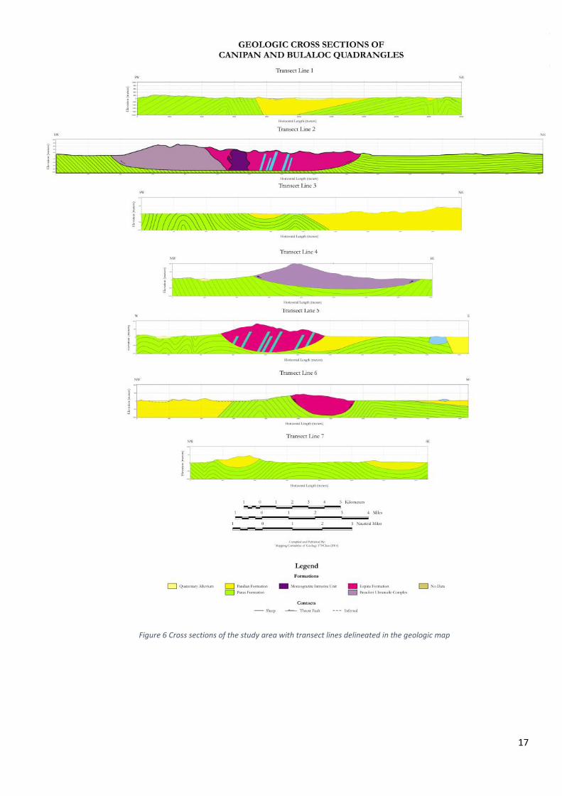
Figure 6 Cross sections of the study area with transect lines delineated in the geologic map

18
EARLY CRETACEOUS
PALAWAN OPHIOLITE SEQUENCE
The Palawan Ophiolite Sequence is emplaced in a volcanic arc-continent fragement setting as
nappes in the Early Cretaceous (Aurelio, 2013). Palawan Ophiolite Sequence includes the Beaufort
Ultramafic Complex, and Espina Formation. The Palawan Ophiolite Sequence ranges about 300 kilometers
along the trend of the island and has a maximum width of 30 kilometers (Pena, 2008). Included in the
Palawan Ophiolite Sequence are the Monzogranite Intrusive Unit and patches of the Sheeted Diabase Unit.
BEAUFORT ULTRAMAFIC COMPLEX
DISTRIBUTION
The Beaufort Ultramafic Complex is widely exposed in the ridge of Mt. Bulanjao and Brgy. Rio
Tuba. These are high rugged areas located in the middle of southern Palawan. The total area bounded by
this formation is about 10 kilometers thick and 12 kilometers wide.
The Beaufort Ultramafic Complex is also distributed near the Okayan River and near the streams in area
of Taratak. Small area of the east in Latud also comprised the Beaufort Ultramafic Complex. The
distribution of this formation and the other formations are also presented in the lithologic and sample map
located in the appendix. Shown in figure 7 is a representative outcrop of Beaufort Ultramafic Complex
found in the upper region of Mt. Bulanjao. The outcrops under this formation are massive and extensive.
Figure 7. Located in N 8°33”'52’ E 117°22”43.59’ in Mt. Bulanjao, Rio Tuba. An outcrop showing limonite layer on top, underlain by a saprolite layer and serpentinized peridotite. The outcrop is jointed with strike and dip readings of N80W, 27NE and N10W and 70NE

19
They are brown to dark red in color. The outcrops are highly vegetated and highly weathered. The outcrops
are comprised of peridotite bedrock at the bottom, overlain by a saprolite layer. On top, the limonite layer
is found.
PETROLOGY AND PETROGRAPHY
The Beaufort Ultramafic Complex is composed of four lithologies namely pyroxenite, dunite,
harzburgite and peridotite which are highly serpentinized (Pena, 2008). Serpentinized basalt, arkosic wacke,
serpentine, chalcedony and claystone are also found in some part of this area. Most of the rocks are
serpentinized and there are rocks found to be chloritized. It is not determined which rock is the most
abundant of all.
This is a hand sample (figure 8) from an outcrop near the representative outcrop previously
mentioned. This is identified serpentinized dunite. The hand sample is orange to green in color with black
splotches and it is very weathered. The hand sample is medium-grained and have equiangular grains. Shown
in in the right of the image is the thin section of the sample. Its textures are holocrystalline and
microcrystalline. The serpentine exhibited mesh texture. It is mainly comprised of serpentinized olivine.
Other component are too small to identify.
FIELD RELATIONS
The Beaufort Ultramafic Complex is overlain by the Espina Formation. The rock found to be in
contact with the Espina Formation are serpentinized peridotites. The contact is located in the northeast of
Latud and northwest of barangay Rio Tuba. This can be seen in the cross section of transect line 5.
Figure 8 Sample Number 91 Hand sample and thin section in 4.4 mm field of view. Located in N 8°33”46’ E 117°22”39’. Identified to be a serpentinized dunite.

20
STRUCTURES AND LOCAL DEFORMATION
The rocks are prone to chemical weathering due to the climate. The soil derivatives of this
formation formed the laterite deposits in the Mt. Bulanjao. Structures found in the Beaufort Ultramafic
Complex are extreme joint patterns, fractures in the outcrops, fault gouge and mineral veins signifying that
Beaufort Ultramafic Complex is deformed. The joints strike direction is northwest and dip northeast. The
joints are extensive in the outcrops. These structures are post-depositional structures that have affected all
the member lithologies of the ophiolite sequence. Even though there is the presence of arkosic wacke, there
were no sedimentary structures found.
AGE AND CORRELATION
This is correlated to the Paly Serpentine in northern Palawan and Smooth Hill Ultramafics in
Balabac Island. This is dated Early Cretaceous using the Osmium-Rhenium dating method by Santos in
1997 and similar to the age determined by MMJA-JICA in 1988 (Pena, 2008; Aurelio, 2013).
MONZOGRANITE INTRUSIVE UNIT
There are no studies yet reporting the existence of this identified granite intrusion in the study area
thus establishment of this unit is proposed in this study. The name is Monzogranite Intrusive Unit because
it is suggested that this unit intruded the diabase unit.
DISTRIBUTION AND STRUCTURES
These monzogranite rocks are found in the southwest of Brgy. Sandoval, near the Umawi River
and in the northeast of Rio Tuba. This unit extend about 3 kilometers long and 2 kilometers wide. The
monzogranite rocks are also found in the path of the Umawi River. The extent of this unit is then inferred
from the river path. The topography of the area is high and rugged. The representative outcrop is massive
Figure 9 Massive and extensive outcrop of the Monzogranite Intrusive Unit located in Brgy. Sandoval with coordinates N 8°37.76” E 117° 24.806”

21
and extensive. It is highly weathered and highly vegetated. It is located near the Umawi River. It is about 8
meters high and 36 meters width. This outcrop shown in figure 9 is reported to have conjugate joints. Veins
or dikes of light green rocks are also found in the outcrop. It was concluded that granite intruded the
diabase rock. Evidence of cooling was found in the granite and might be an evidence that the granite is
younger than the diabase.
PETROLOGY AND PETROGRAPHY
This is the monzogranite identified to be present the outcrop shown in figure 9. The hand sample
is fine-grained and light grey in color. There is also a secondary growth of chlorite. It is diamagnetic. The
thin section shows the three major components of this rock. It is composed of plagioclase, alkali feldspar
and quartz. Both plagioclase and quartz have grains that are about 1mm size and composed 80% of the
rock. The plagioclase possessed a myrmekitic texture. It can also be distinguished by its lath-liked shaped.
The alkali feldspar composed the rock about 20%. It is granophyric and the size of its grains is about
0.7mm. Other minerals found in small amount are chlorite and opaque minerals. The quartz and alkali
feldspar have obscure shape as shown in the thin section. It has a holocrystalline texture and inequigranular.
FIELD RELATIONS, AND AGE
It is unconformably overlying the basalt of Espina formation. This is shown in cross section of
transect line 5. The structures found in the outcrop are fractures, conjugate joints and mineral veins. Age
of this unit is not yet determined but since it is presented to be an intrusive unit of the Cretaceous ophiolite,
it is not later than Late Oligocene.
Figure 10 Hand sample and thin section of the monzogranite sample number 115 located in N 8°37.76” E 117° 24.806” in Brgy. Sandoval. The thin section is under 4.4mm field of view.

22
SHEETED DIABASE UNIT
DISTRIBUTION AND STRUCTURES
The sheeted diabase are located in the east portion of barangay Sandoval near the quaternary
alluvium. It is not mappable to be presented as a new formation. It is also not too small to be ignored thus
this is presented as patches in the basalt of Espina Formation.
The diabase outcrops are found in the river of Sandoval. It is color black from afar and it is highly
jointed. The outcrops are highly vegetated. They are also highly weathered and highly jointed. Its attitude
is N50E, 40SE.
PETROLOGY, PETROGRAPHY, FIELD RELATION AND AGE
The rock types of this unit are composed of andesite and diabase. Shown in figure 11 is the contact
between the andesite dike and diabase dike. The andesite is unconformably overlying the diabase. The
andesite is light grey in color. The hand sample of one of the outcrops belonging to the Sheeted Diabase
Figure 11. Shown in the left is the diabase outcrop in Sandoval with coordinates N8°36.326” and E 117° 24.116” ’ and on the right is the andesite dike and diabase dike located in N8°37.120” E117° 24.458”
Figure 12 Hand sample and thin section of sample number 11 located in E117°23.981” and N 8°37.727”. The thin section is under 4.4 mm field of view.

23
Unit is shown in figure 12. It is dark green to gray in color. It is fine-grained and chloritized. The diabase
representative sample is composed of 40% plagioclase, 35% clinopyroxene, 10% quartz, and 10% opaque
minerals. It is identified to be a highly chloritized diabase. The plagioclase are the lath shaped minerals and
the quartz are the anhedral grains. The age of this unit is not yet determined but it is not later than Late
Oligocene.
ESPINA FORMATION
DISTRIBUTION
The Espina Formation of Late Cretaceous is the last member of the Palawan Ophiolite Sequence.
Espina Formation was first named by Basco in 1964 due to its locality (Pena, 2008). The Espina Formation
is distributed in the area of Brgy. Sandoval and in the ridge of Mt. Bulanjao. It is about 1000 meters thick.
It is found in high rugged areas and along the river. The outcrops belonging to Espina Formation are highly
weathered and highly vegetated. They are black to dark green in color. They are massive and extensive.
They are highly jointed. Shown in figure 13 is the contact between basalt and diabase. As seen in the cross
section number 5, the Espina Formation is overlain by the sheeted diabase unit.
Figure 13. The contact between basalt and diabase unit located in Brgy. Sandoval with coordinates N 8°37.76” and E 117°24.806”

24
PETROLOGY AND PETROGRAPHY
The Espina Formation is composed of spilitic basalt with intercalated sandstone and chert. Figure 14
shows one of the basalt located in the ridge. The hand sample is black in color. Its texture is aphanitic and
it is identified to be basalt in the field. The thin section on the right confirms it is a basalt. The thin section
shows the major component of basalt is plagioclase.
It is hypocrystalline, inequigranular, aphanoporphyritic, and amygdaloidal in texture. The plagioclase
composed 46.72% of the rock have lath-shaped, euhedral, idiomorphic grains. Pyroxene is about 1.37%
and the grains are subhedral to anhedral that is xenomorphic. The opaque minerals is about 6.57%. It is
anhedral, xenomorphic with size of about 0.06mm. Larger compared to the other minerals in 0.1mm. The
glass is about 15.03% which appear as dark brown in color. Quartz is 24.32% and occurred as amygdules.
The chlorite found is about 4.37% surrounded by the quartz grain. It is euhedral, idiomorphic and about
0.6mm. The remaining 1.64% goes to the calcite that occurred as veins. In figure 15, a representative sample
chert is shown.
Figure 14. Hand sample and thin section of basalt sample 93 located in Mt. Bulanjao with coordinates E117°24.22” N 8°37.5” The thin section is under 4.4mm field of view
Figure 15. Hand sample and thin section of sample 2 in Brgy. Sandoval with coordinates N8° 38'6.4” E117° 25' 44.2”. This is identified to be a metachert. The thin section is under 4.4 mm field of view

25
The cherts found in the Espina Formation are reddish to brownish in color in the hand sample. It did
not effervesce in the field. It is composed of 20% megaquartz, 75% microquarts and 5% chalcedonic quartz.
The sample is reported to have veins of megaquartz and chalcedonic quarts exhibiting a microfolds.
FIELD RELATIONS AND STRUCTURES
Shown figure 16 (left image) is the contact between pillow basalt and massive basalt. On the right
image is the contact between chert and basalt. The pillow basalt is also unconformably lyng on the massive
basalt. The chert is unconformably lyng in the basalt. The structures found in this unit are joints and mineral
veins signifying a post depositional structures. There were no sedimentary structures found in the
sedimentary rock under this unit.
AGE AND CORRELATION
Espina Formation is correlated to the Boayan Formation in northern Palawan and Irahuan
Metavolcanics in central Palawan (De los Santos, 1959). It is unconformably underlain by the Panas
Formation and the Ransang Limestone (Pena, 2008). This can be seen in the cross section 4 and 5. The age
is determined using the radiolarians found in one of their chert sample by MGB in 2004 (Pena, 2008). There
were no fossils found in the collected samples of chert.
Figure 14. On the left is the contact between the pillow basalt and massive basalt. Located in N8°36.346” E 117°24.084” and on the right is the contact between chert and basalt located in N8°38”53.3’, E117°25”45’’

26
PANAS FORMATION
DISTRIBUTION
Panas Formation was first named by Casasola in 1965 due to its locality in Panas Creek near Iwahig
River (Pena, 2008). In the study area as seen in the geologic map, it extend from southwest-west-northeast.
It is found in Panalingaan, but the west of Panalingaan is made up of Pandian Formation. It is also located
in Iwahig River, Tagbita, Latud, Taburi, Culandanum, Sandoval, Ocayan, Sumbiling and Canpinaan. It is
also found in Mt. Bulanjao in the west part of the Beaufort Ultramafic Complex and Espina Formation.
These are high rugged areas. It is about 1500 meters thick.
This is a representative outcrop of Panas Formation. It appears to be part of a folded sequence. Red
rocks are effervescent that are identified to be calcareous mudstone. Alternating colors of the fold are
possibly due to change of oxidizing conditions. Limb of a possible fold of cherty mudstone is seen.
Figure 17 this is the representative outcrop of Panas Formation located in Culandanum River at N8° 38.404” E117° 25.424”

27
PETROLOGY AND PETROGRAPHY
Panas Formation is composed of sandstone, mudstone, siltstone, shale and conglomerate. The
interbeds are composed of highly indurated and sparsely fossiliferous sandstone and shale. Shown in figure
18 is a hand sample of a Panas Formation outcrop identified to be a quartz sandstone.
The hand sample is yellowish in color. It is fine to medium-grained and the grains are angular. This is
composed of 42.6% quartz, 42.6% feldspar, 12.7% matrix and 2% opaque minerals. The final identification
for this is arkosic sandstone. The sandstones found in the Panas Formation generally have high content of
quartz and feldspar.
FIELD RELATIONS
Panas Formation is unconformably lying over the Espina Formation and intertoungues with Ransang
Limestone. This can be seen in the cross section 1, 3, 5, 6 and 7. Shown in Figure 19 is the contact between
Panas Formation and the laterite deposit of the Palawan Ophiolite Sequence. Found on the left side is the
mudstone which have quartz vein. The lateritic soil is found on the right side. Below is the contact between
interbedded sandstone of Panas Formation and peridotite of Beaufort Ultramafic Complex. This shows
that the Cretaceous ophiolite was emplaced over the Eocene turbidites (Panas Formation).
STRUCTURES
There was a bedding plane observed in a sandstone outcrop in Culandanum. It has a strike and dip of N60E
and 57SE respectively. Few faults were measured. These faults seem to have a direct relationship with the
faults found in the ophiolite sequence.
Figure 18 Hand sample and thin section of sample 14 found in Brgy. Sandoval with coordinates E117° 23.043 “ N 8°36.136”. The thin section is under 4.4 mm field of view.

28
Figure 19 shows the contact between the mudstone and laterite with coordinates N 8° 33.184” E 117° 21.546” in Brgy. Sumbiling. The outcrop is generally weathered, and highly vegetated. It has roots on top of it. Below image is the contact of the sandstone and peridotite. This contact is located in N 8° 33.221” E117° 21.530” in Brgy Sumbiling.

29
AGE AND CORRELATION
The outcrops (as shown in figure 19) are generally weathered and vegetated. It exhibit folding
and tilting of beds. Its age was determined by BMG using the foraminifera Globorotalia velascoensis (Cushman)
and Globigerina gravelli Bronnimann, indicative of Paleocene to Early Eocene age (Pena, 2008). This is
supported by the sandstone that were dated (sample 55) and shows that it contains coccolithophores that
are dated Eocene of age (see appendix for reference).
PANDIAN FORMATION
DISTRIBUTION
The Pandian formation is found in the west of the study area, the Balansungan peak extending
southwest near Taburi. It passes the Tagbita River, Nipa River and Colby River. In the east, it occupies the
Matalingajan Rage up to the north in Brgy. Tarusan. It is also seen in the eastern flank of Bulanjao, Tarusan,
Labog, Marirong-Tagusao, Punang, Lamican, Malinao and Mariquit Island. It is about 1500-200 meters
thick. It was named by Casasola in 1956. Shown in figure 18 is the representative outcrop of Pandian
Formation. This outcrop from afar is brownish in color.
Figure 20 Seen in this outcrop are the yellow lines showing the tilting of beds of the outcrop. This is located in Tagbita area with coordinates N8° 45”58.2’, E117° 26” representing the Pandian Formation.

30
The outcrop shows 2 major layers. The top layer is lighter in color compared to bottom layer. The
outcrops under Pandian Formation are generally massive. The outcrops are highly weathered, highly
vegetated and exhibit tectonic deformation like tilting of beds and folding.
PETROLOGY AND PETROGRAPHY
Pandian Formation is composed of massive sandstone, shale and conglomerate. This is mainly composed
of the massive sandstone that is arkosic in nature and porous. They are accompanied by indurated dark
gray mudstone and silty shale interbeds.
The sandstone is mostly made up of quartz and feldspar. The arkosic sandstones are primarily made up of
quartz making it light in color. The alkali feldspar in large percent comprised the sandstone too. They are
also made up of matrix, cement and lithic fragments. Some contain fossils. The black minerals are the lithic
fragments. This is identified to be a fault breccia. It is cream in color. It effervesce with hydrochloric acid.
The minerals are mostly calcareous in nature. It is identified to be a limestone breccia on the field. The thin
section shows that it is mainly composed of quartz which are sub-angular and the rest are cement. The
cement has more sparite than the micrite. There are no feldspars, no lithics, and no matrix in this sample.
FIELD RELATIONS, STRUCTURES, AGE AND CORRELATION
The Pandian Formation is unconformably overlying the Panas Formation. This can be seen in the
cross sections provided especially in cross section 1. It is found to have folding and faulting. The early
study determined this formation to be Middle to Late Miocene by Casasola. Later studies that include
Casasola (1956), Martin (1972) and BMG (1981) determined in with Oligocene age. MMAJ-JICA (1990)
Figure 21 shows hand sample and thin section of the fault breccia located in Tagbita with coordinates N 8° 38”5' E117° 28”24.5' Sample number 31. The thin section is under 4.4 mm field of view.

31
determined to be in Early Oligocene. But in 1977 Gamboa, found an Eocene foraminera from the shale
they collected. Pandian is dtermined to be Eocene of age.
RANSANG LIMESTONE
DISTRIBUTION
The Ransang Limestone was named by Martin in 1972 for the carbonate exposures in Barrio
Ransang, Quezon. This limestone rock unit is located in Iwahig. It is in the east portion of southern Palawan
along with other formations like Panas and Pandian. However there were no contacts found in this area.
PETROLOGY AND PETROGRAPHY
The Ransang Limestone formation are composed almost of micritic limestone.
This sample has a light grey color due to the felsic minerals composing it. The grains are medium-sized
grains. Since it effervesce in cold HCL this sample is identified to be a calcareous medium-grained sandstone
in the field. The thin section clearly present the thin section composing only of micrite thus this is further
identified to be a calcilutite limestone.
FIELD RELATIONS, AGE AND CORRELATION
Ransang Limestone is conformable overlying the Pandian formation. This is presented in cross
section number 5. It is determined to be Early Miocene (Pena, 2008). Studies before by Maac and Agadier
(1988) found foraminifera test classified as Spiroclypeus and Lepidocyclina species that suggest an Early
Figure 22 Hand sample and thin section of sample 69 located in Iwahig. It is under 4.4 mm field of view.

32
Miocene age. The Ransang is correlative to the St. Paul Limestone onshore and Nido Limestone in offshore
northern Palawan (Pena, 2008).
SUMMARY OF STRUCTURES
The structures found within the study area are generally fractures in outcrops. Joints and faults
were grouped based on their lithologies of their respective rock units. There were folds and faults found in
the sedimentary units. Fractures and mineral veins were dominant in the non-sedimentary rock unit.
Deformation occurred more than once in the study area. There were major rifting and convergence that
happened causing the bedding planes to have their present attitudes. A table of structures is found in the
appendix.
GEOLOGIC HISTORY
CONTINENTAL RIFTING
Tectonics in southeast margin of South China Sea (Late Cretaceous)
The mainland Asia moved southeast and attached to the South China Sea margin (Holloway, 1982).
In the South China margin, an oceanic basin was formed due to the attenuation of crust. In the south of
this oceanic basin is where the small paleo-Palawan is placed (Aurelio, 2012). This small paleo-Palawan is
an accretionary prism composed of chert-limestone-clastic as part of mainland Asia (Yumul, 2009). The
Upper Paleozoic to Jurassic sedimentary succession composing the paleo-Palawan is also called Jurassic
olistostrome (Aurelio, 2012). Before the opening of South China Sea, the depocenters responsible for the
Upper Cretaceous to Eocene sedimentary successions were located in the continental margin of southern
China. This continental margin is inactive as the sedimentary succession is still being deposited. These two,
the oceanic basin and continental margin are in thrust contact (Suzuki, 2000). Thus the South China Sea
continental margin is composed of the Cretaceous ophiolite, oceanic and arc rocks. The North Palawan
Block which is still part of mainland Asia (Yumul, 2008) is composed of Eocene oceanic crust. Palawan
therefore is continentally derived unit that includes clastic, carbonate and igneous from mainland Asia
(Aurelio, 2012). The Cretaceous ophiolite involved the Beaufort Ultramafic Complex and the Espina
Formation. The Eocene turbidites is the Panas Formation.

33
Formation of Rift Structures
The south-eastern edge of the South China Sea, North Palawan Block and proto-South China were
subjected to continuous convergent tectonics. This was induced by the continuous south-eastward
movement travel of these rifted blocks and their approach to Philippine Mobile Belt (Aurelio, 2013). The
margins then rifted that produced fault bounded tilted basins. These resulted to the asymmetric basin
deposition. When the Upper Cretaceous ophiolite and Eocene succession in the continental margin became
active, it drifted from the South China continental margin when the South China Sea opened (Suzuki, 2000;
Zamora, 2009; Aurelio, 2013). This resulted to the collision between converging masses of similar densities
(North Palawan Block and Philippine Mobile Belt arc in the north), and to the subduction and obduction
where crustal densities differ (proto-South China and Philippine Mobile arc) (Yumul, 2008). This caused
the deformation in the Beaufort Ultramafic Complex, Espina Formation and Panas Formation.
Subduction in Palawan Trench (Late Eocene)
The Upper Cretaceous Palawan Ophiolite and Eocene turbidites subducted in the paleo-Palawan
Trench in the Late Eocene to Early Oligocene (Suzuki, 2000). This subduction event formed the east-
northeast-southwest trending fold axis and south dipping axial plane, the D1 deformation (Suzuki, 2000,
Hall 2013).
Emplacement of ophiolite in south of mainland Asia (Early Oligocene)
Subduction and obduction happened emplacing the Cretaceous ophiolite thrust from the collision
of south Palawan southward over the turbidite oceanic fragment derived filled with syn rift clastic sequence
(Aurelio, 2012; Yumul, 2009). This caused the Beaufort Ultramafic Complex and Espina Formation to be
found in the Panas Formation.
OCEANIC SPREADING AND MULTIPLE EPISODE OF SUBDUCTION
Opening of South China Sea (Mid Oligocene)
The opening of the South China Sea happened in the Mid Oligocene to Early Miocene about 32
to 12 million years ago (Holloway, 1982; Aurelio 2013). Opening of South China Sea basin was triggered
by approach of hot region responsible for the spreading in West of Philippine Basin (Honka, 2002).

34
Subduction in Palawan trough (Late Oligocene)
After opening, subduction along Palawan trough occurred (Hall, 2013). In the Late Oligocene,
there was heating and rifting of continental crust in East of South China Sea (Pineda, 1992). Partial melting
occurred and this served as an evidence of the supra subduction zone of ophiolite (Yumul, 2008). When
the subduction stopped, intrusion of granite happened cutting the D1 deformation structure due to rifting
(Suzuki, 2010). During collision of Cagayan Arc, the Pre Mezosoic granite was intercalated with Mesozoic
sedimentary rocks (Hall, 2013). Margin rifting ceased and mild metamorphism happened causing the
indurated sandstone and siltstone known as the Pandian Formation. This cannot be older than Early
Oligocene (Aurelio, 2013). This caused the granite and diabase to be found in the Cretaceous Ophiolite.
The diabase was formed first before the granite rocks.
Subduction in Palawan Trough stopped (Early Miocene-Middle Miocene)
Extensive shallow marine area persisted followed by deposition of platform carbonic sequence
topped in places by shelfal reefs. General subsidence ensued after erosional event causing the Palawan to
remain shallow and allow deposition of carbonate. Deep marine clastics accumulated in this basin and
formed the turbiditic sequence. Then carbonate buildup occurred (Aurelio, 2013). This serve as the mark
of the final approach towards subduction zone (Zamora, 2009). Palawan trough is covered by Middle
Miocene to Recent deposits suggesting that subduction along Palawan Trough ended before Middle
Miocene (Suzuki, 2000). However other studies suggest that it ended in Early Miocene (Hall, 2013).
CONTINENTAL ARC COLLISION
Palawan North Block moved to Philippine Mobile Belt (Middle Miocene)
After the subduction in Palawan trough, the Palawan North Block collided with Philippine Mobile
Belt. This resulted to more rift sedimentary successions (Aurelio, 2012). This also caused more collision
and thrusting (Hall, 2013). The Palawan Ridge as a part of North Palawan Block rifted east and south from
South China Sea (Pineda, 1992). The Philippine island arc together with Manila trench drifted westward as
seen from the occurrence of north-northwest-south-southeast trending folded structures.

35
The collision between North Palawan Block and Philippine Mobile Belt is seen in the Miocene
south Palawan sandstone which were derived from North Palawan metasedimentary and metamorphic
basement rocks (Suggate, 2013). Paleo-Palawan arc begun to subduct into the Manila trench (Suzuki, 2000).
In the Late Miocene, the deposition of collision-sealing carbonates occurred. In the Pliocene,
general subsidence ensured after erosional event (Aurelio, 2013). Palawan remained shallow that allowed
deposition of carbonate. In present time, tectonic regime remains convergent at northeast margin of
Palawan towards Mindoro and Panay (Aurelio, 2013).
DISCUSSIONS
EVIDENCES OF EACH FORMATION
The Cenozoic tectonic events that led to the formation of south Palawan can be summarized into
the following: before, during and after the opening of South China Sea margin. Before the opening of South
China Sea, the Cretaceous ophiolite sequence was emplaced over the Eocene turbidites.
This can be seen in their contacts shown in the cross sections. Based from the seen deformations
of the Cretaceous ophiolite and Panas Formation, these two had undergone more than one deformation.
One of the deformations these two had undergone took place before the rifting of the South China Sea.
This can be seen in the major folds in the outcrops seen in Panas Formation. There was an Eocene
compressive event in Mid Cretaceous to Late Paleogene due to the northwest dipping convergent margin
of southeast of South China Sea. Another evidence is the presence of chert in the Espina Formation. The
cherts are due to the localized thrust slope during the rifting (Pineda, 1992; Honka, 2002). The syn rift
structures in the Mezosoic basement rocks filled with syn rift basins are all evidence of the rifting (Aurelio,
2013). Thus Cretaceous ophiolite and Eocene turbidites were already deformed even before the opening.
The syn rift basins were then filled with deep marine clastics that formed the turbiditic sequence. Carbonate
buildup occurred then. This is an evidence of deep water basinal environment (Aurelio, 2013). This
environment is the probable reason for the serpentinization and chloritzation of the Beaufort Ultramafic
Complex and some of the basalt in Espina Formation. These are also evidence of potential hydrothermal
ore deposits. When the South China Sea opened, an arc magmatism occurred that metamorphosed the
Pandian Formation in the Early Oligocene. The arc magmatism can also be the reason for the presence of

36
the granite and diabase. The boundary between the Cretaceous ophiolite and clastic in Late Oligocene are
general thrust features due to the sea floor spreading and not controlled by transform faulting (Pineda,
1992). This can be seen in Pandian and Cretaceous outcrops. After the opening of the South China Sea,
the collision of North Palawan Block and Philippine mobile belt occurred. This further enhanced the
deformation that happened. These are exhibited in the micro fold in the outcrops. There was an
obliqueness of collision between north-south of North Palawan Block and northwest southeast Asia margin
in the compressive event in Miocene that makes the north very distinct from south Palawan. This is
enhanced by the movement of the Philippine Mobile Belt to its present location. This produced thrusting
in Palawan. Thus the Ultramafic Beaufort Complex represents the true boundary of north Palawan to south
Palawan (Pineda, 1992). The collision of North Palawan Block and Philippine Mobile Belt also caused
localized extension. Evidence of Palawan North Block to Philippine Mobile Belt is the emplacement of
Sibuyan ophiolite complex (Dimalanta, 2008). With the compressive event in Eocene and extensional in
Miocene, Palawan is a site of superposed tectonic and not a simple accretionary model (Pineda, 1992). It
involves both extensional and compressional event.
Figure 21 shows the stratigraphic column of the study area. The Palawan Ophiolite composed of
Beaufort Ultramafic Complex, Monzogranite Intrusive Unit, Sheeted Diabase Unit and Espina Formation
served as the basement rocks. The Panas Formation and Pandian Formation intertoungues one another
with Pandian on top of Panas. This is followed by Ransang Limestone and Quaternary Alluvium on top.

37
MINERAL RESOURCES
The laterite soil found in Southern Palawan has been studied to have a high grade percent of nickel
as well as iron specifically the Beaufort Ultramafic Complex. This could be supported that the saprolite and
limonite layers found in the ridge of Mt. Bulanjao have very strong colors. The limonite has very brownish
color and the saprolite exhibits very reddish brown color. This soil color is a possible correlation to its
grade. Thus the soil are of great value due to its metal content. They are of high grade due to the fact that
their plates where these outcrops belong have undergone a lot of tectonic events. From the emplacement
up to their current position, these events contributed to how much weathered these soil are. Adding up to
these tectonic events is the current condition in the Philippines making these soil into higher grade. The
constant change of climate and abundance of vegetation. Another evidence for their high grade are the
highly serpentinized rocks abundant in this area. This is related to how much these rocks have undergone
Figure 21 shows the stratigraphic unit of the study area.

38
intense weathering. This study then suggests that the whole extent of Beaufort Ultramafic Complex is a
good source for laterite mining.
CONCLUSIONS
This study concludes the tectonic events that happened in the Middle to Later Cenozoic that
formed the rock units in the study area. (1) The continental rifting of south Palawan happened wherein the
ophiolite was emplaced over the turbidites even before the opening of the South China Sea (Aurelio, 2013)
as seen in the cross section of the study area as same to the other previous work claiming it. (2) The rock
units of Beaufort Ultramafic Complex, Panas Formation and Pandian Formation are therefore part of the
North Palawan Block. They were already deformed even before the onset of the opening due to the
continental rifting. (3) The Monzogranite Intrusive Unit on the Espina formation was formed not later than
Late Oligocene. This is due to an arc magmatism that occurred when the South China Sea started opening.
(4) The sheeted diabase rock unit found in the Espina Formation is an evidence of crustal extension that
occurred during the rifting. When South China Sea oceanic margin opened in Late Oligocene, it caused
more folding and thrusting of the ophiolite and clastic sequence. The Eocene turbidites were then mildly
metamorphosed forming the Pandian. (5) After that the Palawan Continental Block moved toward
Philippine Mobile Belt as continental arc collision. This caused localized extension. The deformations are
not only due to regional compression but also of extensional (Hall, 2013). (6) Emplacement of Limestone
happened due to the basin formed by the over thrusting of ophiolite to the Eocene turbidites. Overall the
tectonic setting that formed southern Palawan makes it a good source of hydrocarbon (Aurelio, 2013). This
study concludes that the whole extent mapped as Beaufort Ultramafic Complex is a good source for Ni
laterite mining. There are of high grade based from the evidence found such as abundance of garnierite and
serpentinized rocks in the area of Mt. Bulanjao. There are also joints and other structures found in the
Eocene turbiditic sequence thus a possible source for hydrocarbon. The Eocene sedimentary sequence
might be the possible entrapment of the hydrocarbon.

39
RECOMMENDATIONS
This study recommends to determine the extent of granite and sheeted diabase. The units should be
further investigated to determine other information such as its age, and contact between other rock units.
This study also recommends to conduct geophysical survey such as magnetics and gravity survey to
delineate fault in the Panas Formation and Pandian Formation. Other geophysical surveys such as electrical
resistivity, ground penetrating radar and induced polarization is highly recommended as well. The
determination of the grade of laterite on the top of Mt. Bulanjao ridge is also highly recommended of this
study.

40
Bibliography Antonio, L. (1976). Geology and Mineral Resources of Palawan Province. Manila: Bureau of Mines.
Arana, M. (1949). Reconnaissance Geological Survey of Southern Palawan. Manila City: Bureau of
Mines and Geosciences.
Aurelio, M. (1998). Mechanism of Ophiolite. Manila: Mines and Geosciences Bureau.
Aurelio, M., Forbes , M. T., Taguibao, K., Savella, R., Bacud, K., Franke, D., . . . Dimitri, S. (2013).
Middle to Late Cenozoic tectonic events in south and central Palawan and their implications
to the evolution of the southeastern margin of South China Sea: Evidence from onshore
structural data and offshore seismic data. Elsevier Marine and Petroelum Geology, 1-16.
Baillie , I., Evangelista, P., & Inciong, N. (2000). Differentiation of upland soils on the Palawan
ophioltic complex, Philippines. Quezon City: Elsevier.
Baillie, I. (2001). Soils and Land Use on Lithologically Diverse Ophiolitic Alluvia on the Coastal Plain of
Palawan, Philippines . Quezon City: Bureau of Soil and Management.
Bautista. (1971). . Geologic Investigation of 54 Placer Claims in Aborlan, Palawan for Navarro and
Cunanan Surveying . Manila: Bureau of Mines.
Bautista, N. (1970). Mineral Verification of One Hundred and Ten Lode Claims in Rio Tuba, Bataraza,
Palawan Applied for Lease by the Rio Tuba Nickel Mining Corp. Manila: Bureau of Mines and
Geosciences.
Butt, C. R., & Cluzel, D. (2013). Nickel Laterite Ore Deposits: Weathered Serpentinite. Elements, 123-
128.
Cabrera. (1984). Report on the Geological Appraisal and Assessment of Guano and Phosphate Rock
Deposits in Southern Palawan. Quezon City: Bureau of Mines and Geosciences.
Cabrera, R. (1985). Geology of Bulaloc,Canipan, Candian Point, Tarusan, Sapa and Katipunan
Quadrangle. Manila City: Bureau of Mines and Geosciences.
Holloway, N. (1982). North Palawan Block, Philippines-Its Relation to Asian Mainland and Role in
Evolution of South China Sea. The Association of Petroleum Geology, 139-149.
Holloway, N. (1999). The Stratigraphic and Tectonic Relationship of Reed Bank, North Palawan and
Mindoro to the Asian Mainland and its significance in the Evolution of the South China Sea.
Far East, Singapore: Philips Petroelum Company.
Islands, P. (2014, May 29). Palawan. Retrieved from Philippine Island.Ph: http://www.philippine-
islands.ph/en/palawan-philippines.html
John. (1963). Geology and Mineral Deposits of East-Central Balabac Island, Palawan Province,
Philippines. Quezon City: Institute of Applied Geology, University of the Philippines.
Mitchell, A. (1984). Geology ofCentral Palawan. Quezon City: Bureau of Mines and Geosciences.

41
PAG-ASA. (2014, May 29). Climate in the Philippines. Retrieved from pagasa.dost.gov.ph:
www.kidlat.pagasa.dost.gov.ph/cab/climate.htm
Philippine Atmospheric, G. a. (n.d.). Climate in the Philippines. Manila.
Quiazon, H., Cipiriano , L., Jagolino, R., & Velasquez, C. (1977). Geology and Mineral Resources of the
Philippines: Mineral resources. Bureau of Mines and Geo-Sciences, Ministry of Natural
Resources. Quezon City: Bureau of Mines and Geosciences.
Roxas, R. (1970). Report on the Geology of the Garnierite Nickeliferous and Copper Prospects in
Southwestern Palawn. Manila City: Bureau of Mines and Geosciences.
Santiago, A., & Peralta, N. (1986). Geochemical Profiles in Latertites, Near Baheli, Central Palawan.
Manila: Bureau of Mines and Geosciences.
Santiago, J. (1967). ). Geologic Investigation of Sugnayao Hg Deposit Tagburos, Puerto Princesa,
Palawan. Quezon City: Bureau of Mines and Geosciences.
W., H. (1979). Tectonics of Indonesian region. US Geological Survey.
Weather, H. (2014, May 29). Average Climate of Palawan. Retrieved from Holiday Weather:
www.holiday-weather.com/palawan/averages
Yumul, G. (2008). ). Onland signatures of the Palawan microcontinental block and Philippine mobile .
Elsevier, 610-623.
Yumul, G., & Dimalanta, C. (2009). Onland signatures of the Palawan microcontinental block and
Philippine mobile belt collision and crustal growth process: A review. Elsevier, 610-623.
Yumul, G., Dimalanta, C., & Bituin, R. (1997). Distribution, Geochemistry and Mineralization
Potentials of Philippine Ophiolite and Ophiolitic Sequences. Ofioliti, 47-56.
Yumul, G., Dimalanta, C., & Tamayo, R. (2005). Indenter-Tectonics in the Philippines Example from
the Palawan Microcontinental Block-Philippine Mobile Belt Collision. Resource Geology, 189-
198.