Geology and structure of a portion of the Orocopia Mountains, southern California
18
Geology and structure of a portion of the Orocopia Mountains, southern California Amber Johnson-Carroll California State University Northridge, Northridge, CA 91325 INTRODUCTION The purpose of my study was to make a geologic map and cross sections of part of the Orocopia Mountains and to interpret the geologic events history. My study area is located northwest of the Salton Sea. The dates of my field work were six days in March 2009. I was accompanied on this study by my Field III class from California State University Northridge. The data we collected included photos, drawings, strikes, dips, observations of outcrop features, bearings, and mineralogy. The methods we used to collect our data included using a Brunton compass and recording data on our maps (Pl. 1) and in our field notebooks. I collected 78 bedding attitudes (Pl. 4) from my study area. GEOLOGIC SETTING
Transcript of Geology and structure of a portion of the Orocopia Mountains, southern California

Geology and structure of a portion of the
Orocopia Mountains, southern California
Amber Johnson-CarrollCalifornia State University Northridge, Northridge, CA 91325
INTRODUCTION
The purpose of my study was to make a geologic map and
cross sections of part of the Orocopia Mountains and to
interpret the geologic events history. My study area is
located northwest of the Salton Sea. The dates of my field
work were six days in March 2009. I was accompanied on this
study by my Field III class from California State University
Northridge. The data we collected included photos,
drawings, strikes, dips, observations of outcrop features,
bearings, and mineralogy. The methods we used to collect
our data included using a Brunton compass and recording data
on our maps (Pl. 1) and in our field notebooks. I collected
78 bedding attitudes (Pl. 4) from my study area.
GEOLOGIC SETTING
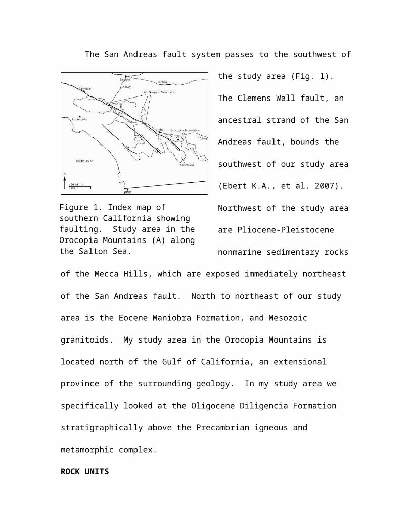
The San Andreas fault system passes to the southwest of
the study area (Fig. 1).
The Clemens Wall fault, an
ancestral strand of the San
Andreas fault, bounds the
southwest of our study area
(Ebert K.A., et al. 2007).
Northwest of the study area
are Pliocene-Pleistocene
nonmarine sedimentary rocks
of the Mecca Hills, which are exposed immediately northeast
of the San Andreas fault. North to northeast of our study
area is the Eocene Maniobra Formation, and Mesozoic
granitoids. My study area in the Orocopia Mountains is
located north of the Gulf of California, an extensional
province of the surrounding geology. In my study area we
specifically looked at the Oligocene Diligencia Formation
stratigraphically above the Precambrian igneous and
metamorphic complex.
ROCK UNITS
Figure 1. Index map of southern California showing faulting. Study area in the Orocopia Mountains (A) along the Salton Sea.

Igneous and Metamorphic complex
The structurally lowest unit observed in the study area
is the Precambrian igneous and metamorphic complex, or the
quartzo feldspathic gneiss. This gneiss has a sedimentary
protolith, so is a paragneiss. The composition of the
paragneiss is quartz, feldspar, biotite, and also has a
large percentage of mica. This unit also has a tourmaline
dike. The strength of this unit is friable, and the nature
of the unit exposures is resistant. They create a
noticeable difference in elevation change when the contact
is crossed from this unit to the next observed.
There are metamorphic foliations noticed in this
igneous and metamorphic complex. These foliations are
observed along the mica and biotite compositional banding.
This probably means this high-grade paragneiss went through
plastic deformation with high temperatures and pressures.
In our study area the length of this unit is the west
to east length of the southern most part of our study area.
The contact between this unit and the stratigraphically
upper unit is a fault plane that consistently dips at an

angle of 65° to the south in our study area. This fault
seems to be a reverse fault because it is higher in
elevation than the younger units.
Red Sandstone
The next structurally upper rock type observed in the
study area is the Red Sandstone Conglomerate Unit. This
rock type looks to be a paleosol outcrop which was nonmarine
and fluvial. It contains metamorphic and granitic clasts,
and is matrix supported. It ranges from fine grained, 4.0
to 3.5 phi to cobble-rich (largest cobbles = 3 cm). The
color is grayish red 10R 4/2, to moderate reddish brown 10R
4/6 on fresh and broken surfaces. The strength is weak and
non-friable. The exposures are not very resistant, and
create an elevation change from the stratigraphically lower
igneous and metamorphic complex.
The extent of this unit is half of the east-west length
in the southeast part of the study area. The observed
outcrop has an angular unconformity with the lower rock

unit, the igneous and metamorphic complex. The contact of
these two units is a reverse fault.
Vari-Colored Sandstone
The next oldest rock unit found in the study area is
the vari-Colored sandstone
unit. The composition of
this sandstone is quartz,
plagioclase, and potassium
feldspar. The upper units
are coarser grained and
have clasts ranging from 1
cm to 5 cm. The lower
units have grain size ranging -1.0 to 0.5 phi. The color of
a fresh surface is grayish orange pink 5YR 7/2, and the
weathered surface is pale yellowish brown 10YR 6/2. The
strength is moderately strong, and the exposures were
moderately resistant.
There are ripple marks on the surface of these
sandstone beds which are symmetric and asymmetric (Fig. 2).
These ripple casts are on more than one outcrop and tend to
Figure 2. Ripple marks on the stratigraphically up side of the vari-Colored sandstone. This is in the eastern part of the study area.

have a wavelength of 3.5-4.5 cm on some outcrops, and 20 cm
in others. This indicates a change in water level in the
formation of this unit over time. The smaller wavelengths
correspond with shallower water, and the longer wavelengths
with deeper water.
The extent of this unit was across the east-west
length, and in the southern part of the study area. The bed
thickness is lenticular and is ~1-1.5 m. There are angular
unconformities and truncations observed with various faults
running through this unit in the eastern part of our study
area.
Basalt
The basalt unit is found stratigraphically above the
vari-Colored sandstone unit. The basalt was found to have
amygdules filled in with
sandstone sediment.
Abundant epidote alteration
and veins suggests that
hydrothermal fluids have
altered the basalt. This Figure 3. The sandstone marker unit in the basalt unit. This exposure is in the northeast of the study area.

unit has a marker unit of sandstone within it (Fig. 3). The
color of this marker unit is pale purple 5P 6/2. The
resistance is moderately strong to strong, which means the
outcrops are a bit more pronounced than the surrounding
sandstones. However the marker unit within the basalt is
very resistant which is probably due to the nearby basalt
source.
The basalt and the marker unit within the basalt have
northeast-southwest trending faults truncating them in the
eastern and northeastern parts of the study area which has
caused the basalt and marker unit to have surface outcrops
in the northern part of the study area (Pl. 1). The marker
unit has tabular bedding and is ~6 m thick. The basalt
reaches the western part of the study area, but the marker
unit eventually pinches out in the west, but before the end
of our study area.
Gray Sandstone
The unit which overlies the basalt is a gray-yellow
sandstone. There is gypsum and anhydrite layering in this
unit. This sandstone has occasional pebbly layers, and

occasional layers of siltstone and shale, but the average
grain size is 2.0 to 1.5 phi. These layers of siltstone
have the color light olive gray 5Y 5/2. The color of the
sandstone is yellowish gray 5Y 7/2. The portions of the
sandstone that contain layers of siltstone have joints and
are well sorted with cross-laminations.
This sandstone is also truncated by the same northeast-
southwest trending faults that truncated the basalt. The
gray sandstone extends to the western perimeter of the study
area.
Mudstone

The next oldest unit in our study area is the mudstone
unit. The underlying unit is
the gray sandstone unit which
overlies the basalt. The
grain size on this mudstone
is 3.5 to 4.0 phi and
smaller. There is a volcanic
tuff unit (Fig. 4) in the middle of this mudstone unit, and
so is bounded by mudstone. The color of the mudstone is
grayish orange 10YR 7/2 to pale yellowish brown 10YR 6/2.
The Tuff is pale yellowish green 10 GY 7/2. Because of this
marker tuff the mudstone under the tuff has been deformed to
form tiny folds (Fig. 4), and the color of the Mudstone
stratigraphically above the Tuff is altered to a darker
color. The color of this stratigraphically higher mudstone
is greenish gray 5GY 6/1.
This rock type reacted with HCl. This marker tuff is a
thick unit with no laminations. It has
intermittent beds of orange and greenish
gray mudstone. The contact between the
Figure 4. Folded Mudstone overlain by Volcanic Tuff. This outcrop is in the northeast of the study area.

base of the tuff and the mudstone is abrupt, and has an
orientation of N15E, 19 NW. The outcrops of the mudstone
with the tuff are in the northwest part of the study area.
Many faults and folds, anticlines and synclines, have
truncated and folded the units in this part of the study
area.
STRUCTURE
I mapped 9 longer major faults that continue across
most of the map area, and 4
less continuous faults in
my study area (Pl. 1). The
faults generally trended in
a northeast-southwest
fashion (Fig 6). These
faults may be genetically
related to the Orocopia Mountains detachment fault (Ebert
K.A., et al. 2007). I also observed many anticlines and
synclines in my study area which trended east-west. I
observed and recorded data for two anticlines and two
synclines (Fig. 5). All of the folds in our study area
Figure 5. A syncline fold that was observed in the study area.

range from open to isoclinal. One of these major synclines
is projected into one of my cross-sections, A-A’ (Pl. 1).
Our whole study area however is a syncline (Fig. 7). The
folds in the area have been categorized into two separate
events (Ebert K.A., et al. 2007). The earlier folds are
potentially related to underthrusting, and the younger
structures have been attributed to exhumation. The earlier
fold axes trend northeast-southwest, and the younger ones
are oriented northwest-southeast to north-south.
There are a few foliation data points that I recorded
for the igneous and metamorphic complex. These foliations
all have strikes close to east-west, and dip towards the
south. The dips range from 14°-50°.
GEOMORPHOLOGY
There are three landforms in the study area. The first
type is alluvium which occurs atop ridgelines and upland
areas. This alluvium consists of cemented gravels, and
indicates deposition of a broad alluvial plane, and later
erosion of older sediments. A second type in our study area
is the terrace-forming alluvium above the current streams.

This indicates erosion of sediments younger than the
erosional events of the ridgelines. The third type of
geomorphology in our study area is the drainage system and
streams that have cut through the lower elevations. These
streams show a branching pattern in and around our study
area.
GEOLOGIC HISTORY
Through dynamothermal metamorphism there was a high-
grade paragneiss formed from a sedimentary protolith in the
Precambrian is what is today known as the Orocopia
Mountains. There was gneissic layering, metamorphic
foliations, and compositional banding formed with mica and
biotite. This means that plastic deformation had to have
happened with high temperatures and pressures. This
paragneiss also had igneous influences, such as tourmaline
dikes, and granites intruded into it.
This igneous and metamorphic complex then either had no
deposition on top of it until the Oligocene, or any
deposition was eroded away before the red sandstones were
first deposited. More likely some sediments were deposited,

but most were eroded away, which is the origin of the ridge
alluvium. The fault which is the contact between the
igneous and metamorphic complex and the red sandstones may
also have truncated units deposited between those two.
In the Oligocene the red sandstones were deposited.
Since this unit does have metamorphic clasts, the water
source depositing the sandstones was probably close to a
metamorphic source, possibly the igneous and metamorphic
complex identified in our study area.
The next unit deposited in the Oligocene in the study
area was the vari-Colored sandstones on top of the red
sandstones. This unit has smaller grains which have a
different color and composition. The water source
depositing this sandstone was probably transporting material
from a father distance and source because of these factors.
The next unit in the stratigraphic sequence is the
basalt. After the sandstones were deposited there were
igneous volcanic flows which covered and compacted the
materials below. It seems the basaltic flows were
intermittent because of the sandstone marker unit present in

the middle of the basalt. This sandstone marker unit was
probably deposited from the same water source as the
previous sandstones. The basalt flows then started again,
which covered the sandstone marker unit.
After the basaltic flows stopped, a gray sandstone was
then deposited on top. This also was finer grained so the
source from this sandstone was probably farther away. This
unit also had siltstones and shales present so I would say
this area was under more water than the previously described
units. But since there are also gypsum and anhydrite
layering the environment had to have gone dry often enough
to have evaporates present in the rock record.
The next deposited unit was the mudstone. This is
similar in grain size to the gray sandstone, but was a bit
smaller. This must have been a time in the Oligocene when
water was getting deeper and deeper in the area. But there
is a volcanic tuff unit within the mudstone. This evidence
points to another volcanic eruption nearby. There seems to
be more ash deposits than basaltic flow. This was either a
volcanic source farther away than the source which deposited

the earlier basalt, or the eruption was not as big so as to
cause basaltic flows to cover the area. After the tuff was
initially deposited, mudstone began to form again, but with
some differences. The volcanic tuff caused the mudstone to
turn a black color. This color was due to the carbon which
resulted from living animals and plants dying in mass
numbers due to the volcanic ash. The next process was the
terrace alluvium. This may have been an ancient river bed
where sediments were being eroded from these units
described.
The next event that happened in our study area was the
folding and faulting. The folds in the Orocopias have been
categorized into two separate events (Ebert K.A., et al.
2007). The earlier folds are potentially related to
underthrusting, which has been agreed to have been from
east-dipping low-angle subduction. The younger structures
are from exhumation. Since the fault trends are generally
in the same direction they probably happened in the same
event. The folds were probably also formed together because
of the same general fold axis direction. Since the faults

cut through the folds, (Pl. 1), I assume the folds were part
of the first event. The faults were then part of the second
event in the Orocopia Mountains. The structural stresses
that caused these two events was probably caused by
subduction along the Pacific coast.
The last process that occurred in our study area was
the modern day river channels that seem to have used the old
channels which caused the terrace alluvium.
REFERENCES
Ebert K.A., Grove M., Jacobson C.E., Pedrick J.N., Vucic A.,
2007, Exhumation of the Orocopia Schist and associated
rocks of southeastern California: Relative roles of
erosion, synsubduction tectonic denudation, and middle
Cenozoic extension: Geological Society of America,
special paper 419, p. 1-31.
Intro
-Statement of purpose
-Location of study
-Dates of field work
Geological Setting
-Regional structures nearby
Rock Units
-Orthosgneiss/Paragneiss and Granitoid unit (oldest, first to appear)
-Red S.S. Conglomerate unit
-Vari-colored S.S. unit
-Basalt unit (S.S. marker unit within it)
-Grey/yellowish S.S. unit (overlaying basalt)
-Mudstone unit (youngest)
-Volcanic Tuff unit (last to appear)
Structure

-Faults
-Folds
Geomorphology
-Levels of surface remnants
Geologic History