examples from China and Russia inform models for Voisey's Bay
61
Structural controls on nickel sulfide deposits: examples from China and Russia inform models for Voisey’s Bay Peter C. Lightfoot, PhD, PGeo Hutchinson Visiting Industry Professor, University of Western Ontario
-
Upload
khangminh22 -
Category
Documents
-
view
8 -
download
0
Transcript of examples from China and Russia inform models for Voisey's Bay
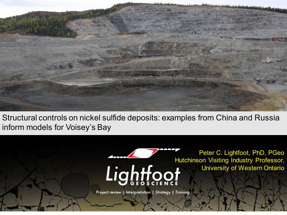
Structural controls on nickel sulfide deposits: examples from China and Russia inform models for Voisey’s Bay
Peter C. Lightfoot, PhD, PGeoHutchinson Visiting Industry Professor,
University of Western Ontario

Richard W Hutchinson (1928-2016)
• BSc (Western, 1950), MSc and PhD (Univ Wisconsin, 1951, 1954)
• Three decades in academia (Western and Colorado School of Mines)
• Inducted to Canadian Mining Hall of Fame 2006• Numerous awards (including the Barlow, Duncan Derry,
Penrose Gold and SEG Silver medals)
Field observationsProcess-based models for ore deposits Tectonic controls on metallogenyApplication to exploration• Syngenetic models for VMS – New Brunswick and Cyprus,
(e.g. Econ. Geol., 1973)• Precambrian gold metallogeny – Abitibi and Witwatersrand
(e.g. OGR, 1993; Econ Geol, 1997)• Rare metals in pegmatites – NWT and Mozambique (e.g.
Econ Geol, 1959)• Evaporites and potash (e.g. GSA, 1968)Training, mentoring, and inspiring students with practical geoscience skills• “An army of geological disciples now spread around the
globe” (Poul Emsbo, 2005) A complete bibliography of Dick’s papers will be available from: WWW.LIGHTFOOTGEOSCIENCE.CA
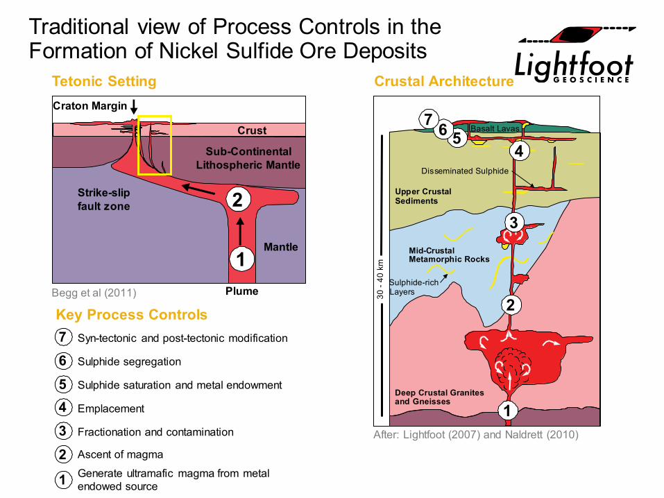
Traditional view of Process Controls in the Formation of Nickel Sulfide Ore Deposits
Craton Margin
Crust
Plume
Mantle
Strike-slipfault zone
2 Sub-ContinentalLithospheric Mantle
30 -
40km
Basalt Lavas
Disseminated Sulphide
Sulphide-richLayers
Mid-CrustalMetamorphic Rocks
Deep Crustal Granitesand Gneisses
Upper CrustalSediments
Generate ultramafic magma from metalendowed source
Ascent of magma
Fractionation and contamination
Emplacement
Sulphide saturation and metal endowment
Sulphide segregation
Syn-tectonic and post-tectonic modification
Key Process Controls
Tetonic Setting Crustal Architecture
1
2
3
4567
1
2
1
765432
After: Lightfoot (2007) and Naldrett (2010)
Begg et al (2011)
PLAN B - Dyke Configuration
PLAN A - Pipe Configuration
PLAN C - Chamber
extensionalbend
contractionalbend
obliquethrust
obliquenormal fault
right-stepping left-stepping
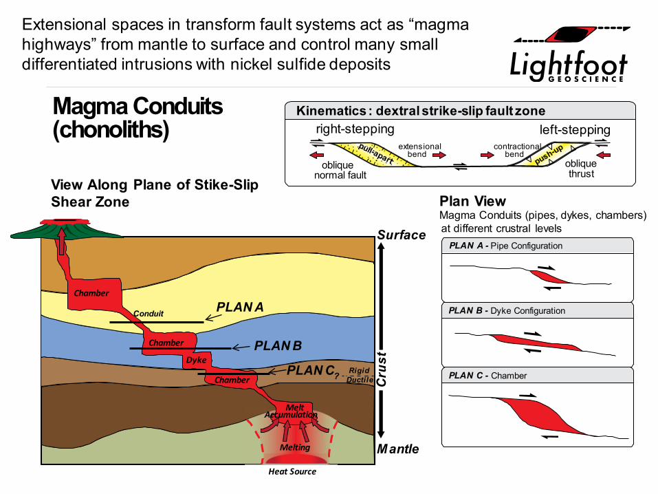
View Along Plane of Stike-SlipShear Zone Plan View
Magma Conduits (pipes, dykes, chambers)at different crustral levels
Kinematics : dextral strike-slip fault zone
Mantle
Chamber
Conduit
Chamber
Chamber
PLAN A
PLAN B
PLAN C
MeltAccumulation
RigidDuctile?
Melting
Heat Source
Cru
st
Surface
Dyke
Magma Conduits(chonoliths)
Extensional spaces in transform fault systems act as “magma highways” from mantle to surface and control many small differentiated intrusions with nickel sulfide deposits
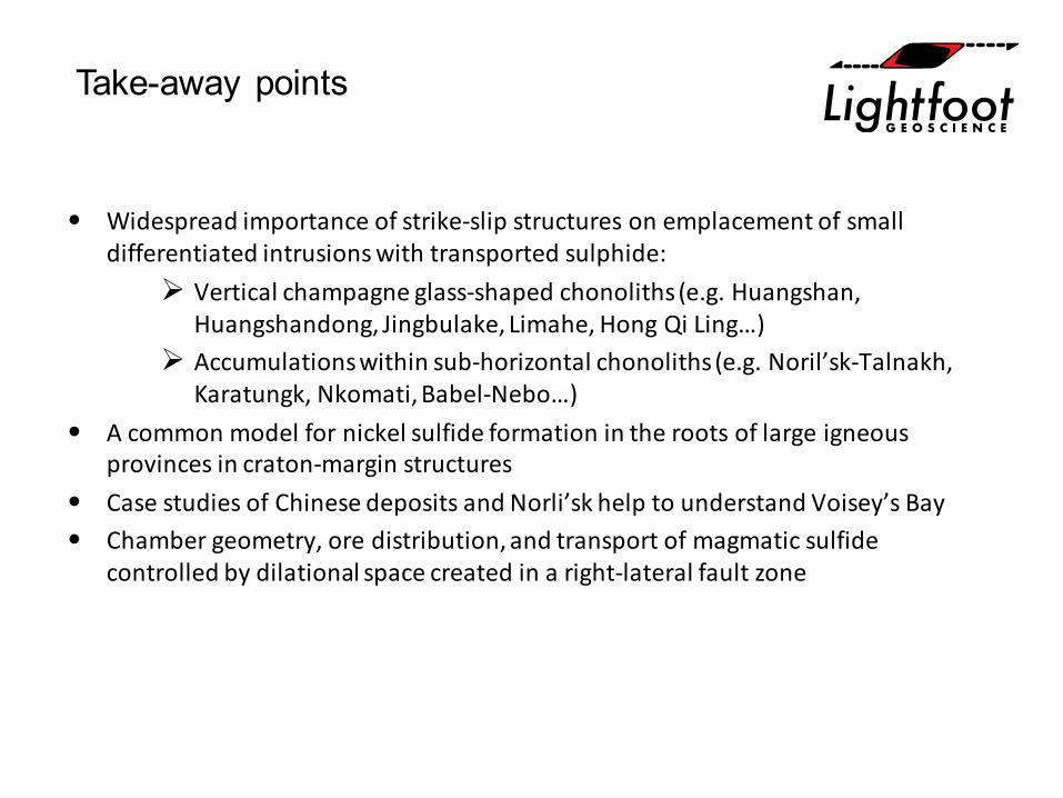
Take-away points
• Widespread importance of strike-slip structures on emplacement of small differentiated intrusions with transported sulphide: Vertical champagne glass-shaped chonoliths (e.g. Huangshan,
Huangshandong, Jingbulake, Limahe, Hong Qi Ling…) Accumulations within sub-horizontal chonoliths (e.g. Noril’sk-Talnakh,
Karatungk, Nkomati, Babel-Nebo…)• A common model for nickel sulfide formation in the roots of large igneous
provinces in craton-margin structures• Case studies of Chinese deposits and Norli’sk help to understand Voisey’s Bay • Chamber geometry, ore distribution, and transport of magmatic sulfide
controlled by dilational space created in a right-lateral fault zone
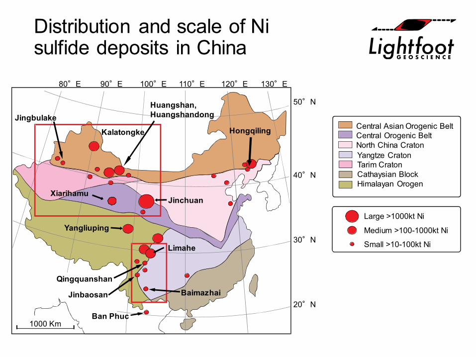
Distribution and scale of Ni sulfide deposits in China
1000 Km
80°E 90°E 100°E 110°E 120°E 130°E
Hongqiling
Huangshan,Huangshandong
40°N
50°N
30°N
20°N
Jinchuan
Kalatongke
Jingbulake
Limahe
Qingquanshan
Large >1000kt Ni
Medium >100-1000kt Ni
Small >10-100kt Ni
Central Asian Orogenic BeltCentral Orogenic BeltNorth China CratonYangtze CratonTarim CratonCathaysian BlockHimalayan Orogen
Jinbaosan
Ban Phuc
Baimazhai
Yangliuping
Xiarihamu
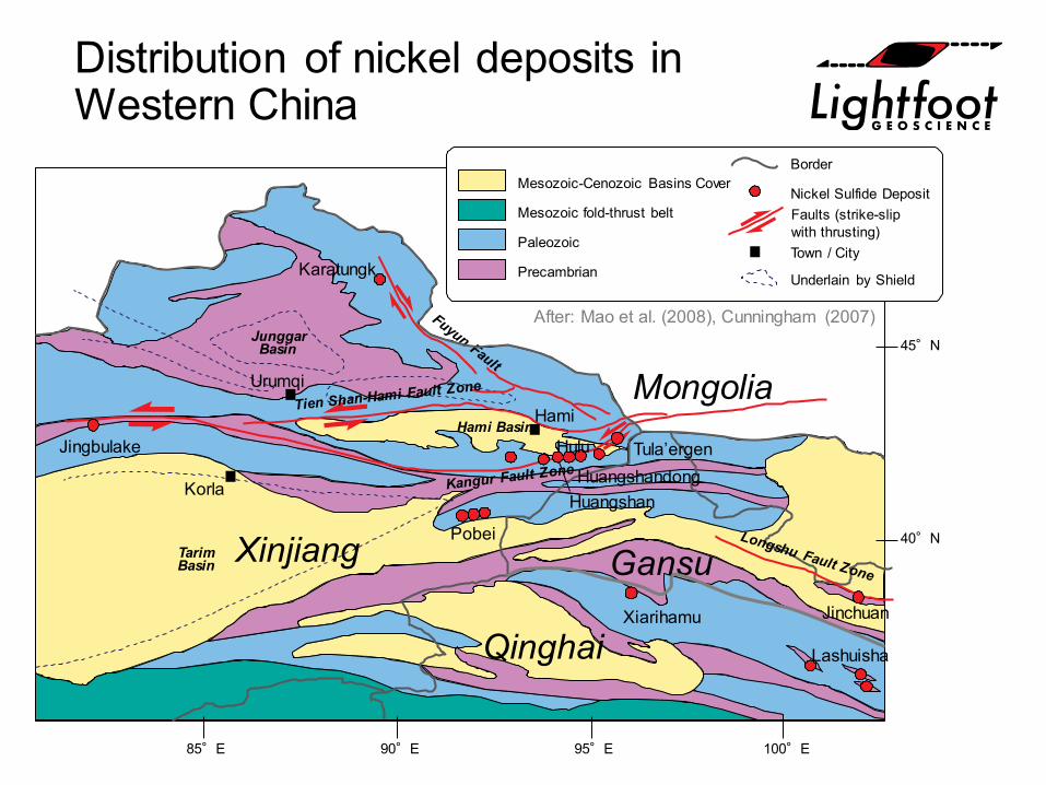
Distribution of nickel deposits in Western China
40°N
45°N
Pobei
Korla
Jingbulake
Urumqi
Karatungk
Hami
Hulu Tula’ergenHuangshandong
Huangshan
Jinchuan
Lashuisha
JunggarBasin
TarimBasin
Hami Basin
90°E85°E 95°E 100°E
Mesozoic-Cenozoic Basins Cover
Mesozoic fold-thrust belt
Paleozoic
Precambrian
Border
Nickel Sulfide DepositFaults (strike-slip with thrusting)Town / City
Underlain by Shield
After: Mao et al. (2008), Cunningham (2007)
Xinjiang Gansu
Qinghai
Mongolia
Xiarihamu
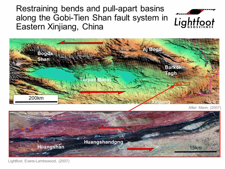
Restraining bends and pull-apart basins along the Gobi-Tien Shan fault system in Eastern Xinjiang, China
HuangshanHuangshandong
200km
15km
BogdaShan
Aj Bogd
Barkol Tagh
Turpan Basin
XinjiangAfter: Mann, (2007)
Lightfoot, Evans-Lambswood, (2007)
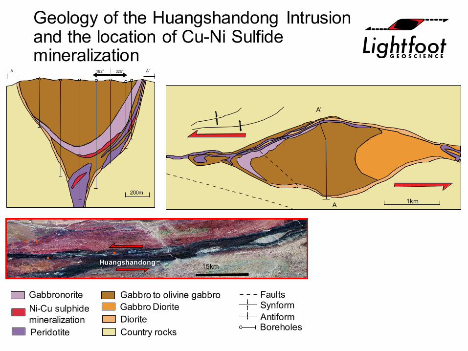
Geology of the Huangshandong Intrusion and the location of Cu-Ni Sulfide mineralization
A’
A 1km
A’162° 325°A
200m
Gabbro DioriteDiorite
Gabbronorite
Peridotite Country rocks
Ni-Cu sulphidemineralization
FaultsSynformAntiformBoreholes
Gabbro to olivine gabbro
Huangshandong 15km
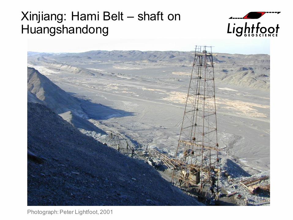
Xinjiang: Hami Belt – shaft on Huangshandong
Photograph: Peter Lightfoot, 2001
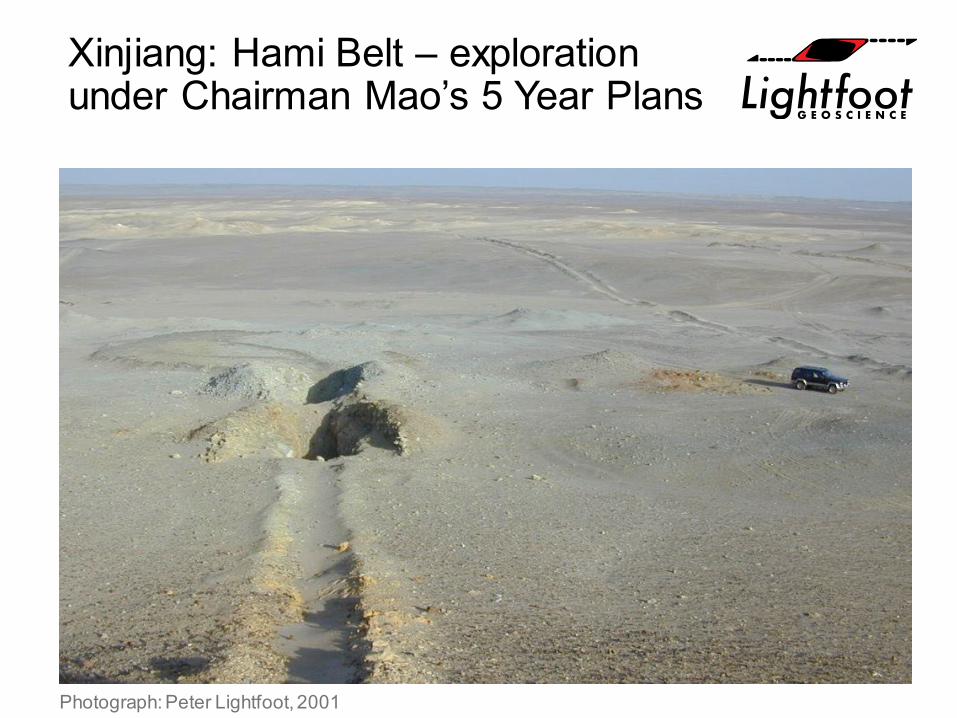
Xinjiang: Hami Belt – exploration under Chairman Mao’s 5 Year Plans
Photograph: Peter Lightfoot, 2001
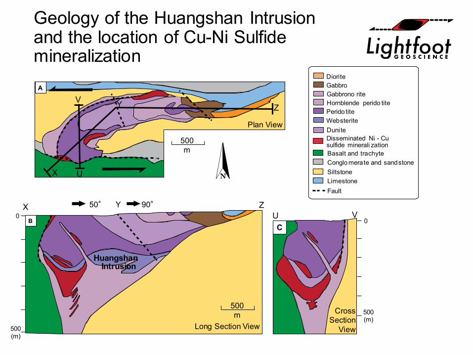
Geology of the Huangshan Intrusion and the location of Cu-Ni Sulfide mineralization
X U
V Y Z
500m
500m
500(m)
0U V
ZYX 50° 90°
0
500(m)
Fault
Basalt and trachyteConglo merate and sandstoneSiltstoneLimestone
Hornblende perido tite
Dunite
Perido titeWebsterite
GabbroDiorite
Gabbrono rite
Disseminated Ni - Cusulfide minerali zation
A
BC
Plan View
Long Section View
CrossSection
View
HuangshanIntrusion
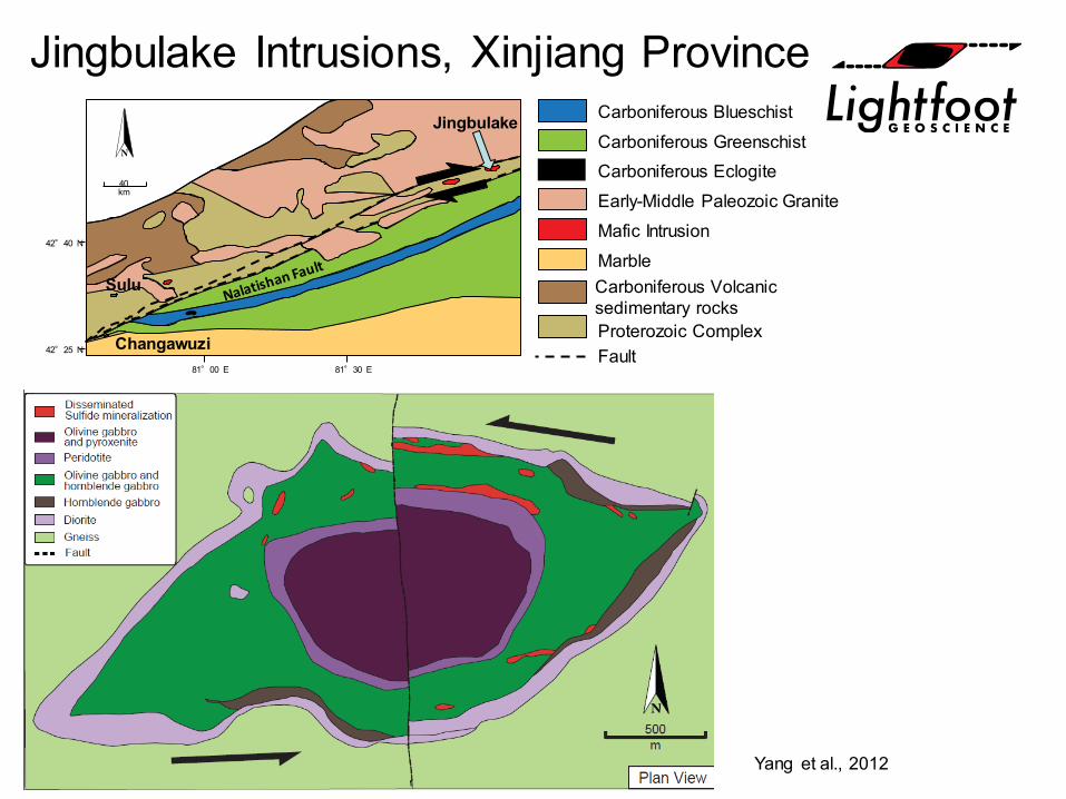
Jingbulake Intrusions, Xinjiang Province
Yang et al., 2012
Sulu
Changawuzi
Jingbulake
81°00 E 81°30 E
42°25 N
42°40 N
40km
Carboniferous BlueschistCarboniferous GreenschistCarboniferous EclogiteEarly-Middle Paleozoic GraniteMafic IntrusionMarbleCarboniferous Volcanicsedimentary rocksProterozoic ComplexFault

Western Xinjiang: the wild west of China
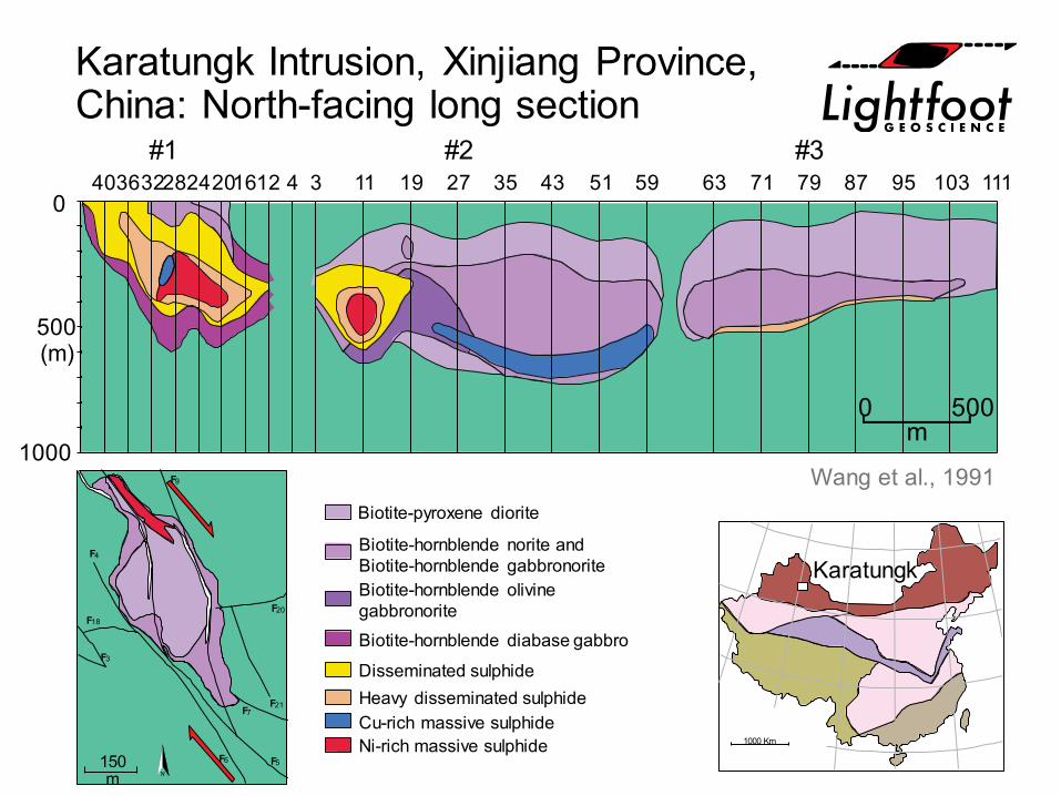
Karatungk Intrusion, Xinjiang Province, China: North-facing long section
1000
500(m)
040 111103958779716359514335271911312162024283236 4
0 500m
#1 #2 #3
Wang et al., 1991
1000 Km
F3
F18
F4
F6 F5
F7F21
F20
F9
150m
Biotite-pyroxene diorite
Biotite-hornblende norite andBiotite-hornblende gabbronoriteBiotite-hornblende olivinegabbronoriteBiotite-hornblende diabase gabbro
Disseminated sulphideHeavy disseminated sulphideCu-rich massive sulphideNi-rich massive sulphide
Karatungk
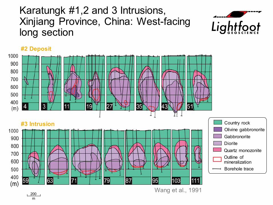
Karatungk #1,2 and 3 Intrusions, Xinjiang Province, China: West-facing long section#2 Deposit
#3 Intrusion Country rockOlivine gabbronoriteGabbronoriteDioriteQuartz monozoniteOutline ofmineralizationBorehole trace
200m
Wang et al., 1991
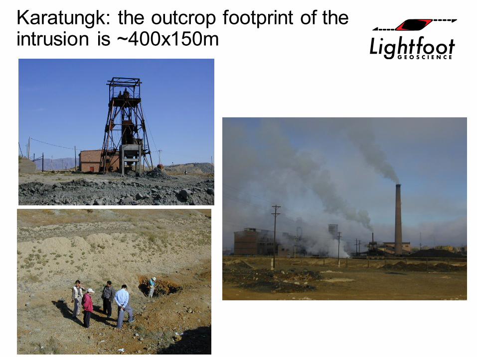
Karatungk: the outcrop footprint of the intrusion is ~400x150m
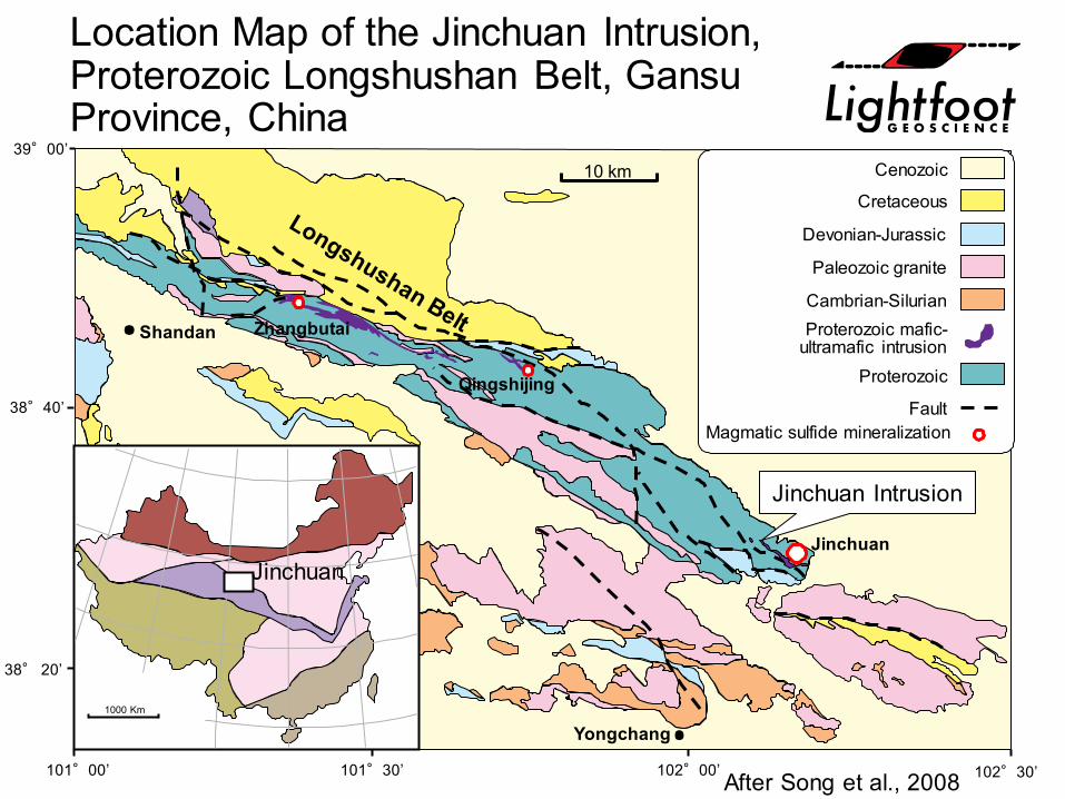
Location Map of the Jinchuan Intrusion, Proterozoic Longshushan Belt, Gansu Province, China
Yongchang
Jinchuan
Qingshijing
ZhangbutaiShandan
1000 Km
39°00’
38°40’
38° 20’
101°00’ 101°30’ 102°00’ 102°30’
10 km Cenozoic
Cretaceous
Devonian-Jurassic
Cambrian-Silurian
Proterozoic
Paleozoic granite
Proterozoic mafic-ultramafic intrusion
FaultMagmatic sulfide mineralization
After Song et al., 2008
Jinchuan Intrusion
Jinchuan
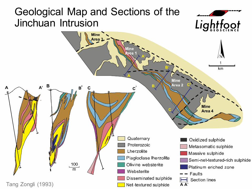
Geological Map and Sections of the Jinchuan Intrusion
Tang Zongli (1993)
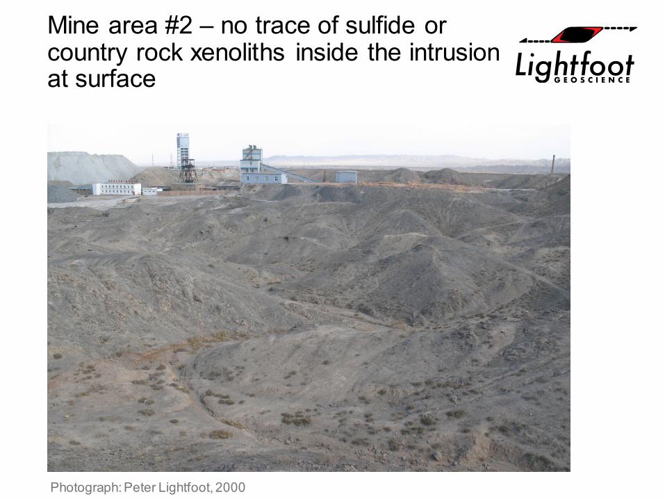
Mine area #2 – no trace of sulfide or country rock xenoliths inside the intrusion at surface
Photograph: Peter Lightfoot, 2000
Jinchuan Model
Sequential Emplacement of Sulfide-bearing silicate melts
Hongqiling – Geology, Structure and Mineral Occurrences
1000 Km
Hulan Group Gneiss (older)Hulan Group Gneiss (younger)
Granitoid rocksMafic-ultramafic Intrusions
Mesozoic sedimentary rocks
Fault
0 5
km
Hongqiling
Jilin #1Deposit
Jilin #7Deposit
After Zhou et al., 2000
Hongqiling
Hongqiling: Jilin Province
A’
100m100m
200
100
-100
-200(m)
0
A A’
Number 7Deposit
A
C D
Othopyroxenite andhybrid zone
Massive sulphideConglomerate
Disseminated and massiveSulphide in orthopyroxenite
SchistMarbleGneissOutline of open pit
UnconformityFaults and shear zones
WesternIntrusion
200
-200
-400
-600
0
Shaft
EasternIntrusion
250m 150m
A GabbroPyroxeniteOlivine PyroxeniteDisseminated sulfidein olivine pyroxeniteWeakly mineralizedperidotiteAmphiboliteGneissFaultPit outline
B
Plan View
Plan View Section View
Section View
Number 7Deposit
EasternIntrusion
WesternIntrusion(projected toSurface)
Intrusions controlled by structures beneath the ~260 Ma Emeishan Flood Basalt, SW China
1000km
200km
Chengdu
SICHUAN
YUNN AN
Kunming
Yangliuping
Qingquan shan
Limahe
Pan
xi“R
ift”
Baimazhai
Jinbaosan
Yangtze craton
Himalayan orogen
Emeishan flood basalt
Underlain by manysmall intrusions
Fault zone
Nickel and PGE sulphidedeposits
Provincial boundary
A
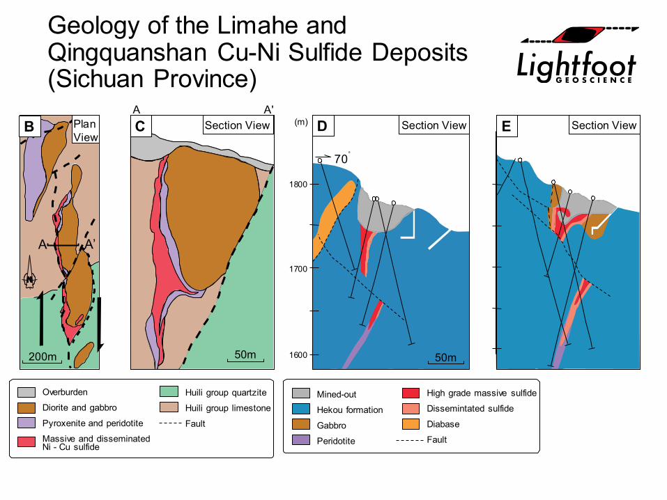
Geology of the Limahe and Qingquanshan Cu-Ni Sulfide Deposits (Sichuan Province)
50m
A'A
200m
A A’
50m
1700
1800
(m)
1600
70o
B C D E
Mined-out
Hekou formation
Gabbro
Peridotite
Overburden
Diorite and gabbro
Pyroxenite and peridotite
Massive and disseminatedNi - Cu sulfide
Section View Section ViewSection ViewPlanView
Huili group quartzite
Huili group limestone
Fault
High grade massive sulfide
Dissemintated sulfide
Diabase
Fault
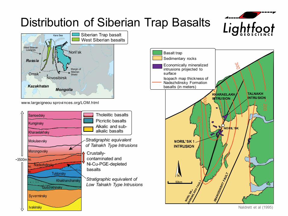
Distribution of Siberian Trap Basalts
Crustally-contaminated andNi-Cu-PGE-depletedbasalts
Stratigraphic equivalent ofLow Talnakh Type Intrusions
Stratigraphic equivalentof Talnakh Type Intrusions
~3500m
Ivakinsky
Syverminsky
Gudchikhinsky
Khakhanchansky
Tuklonsky
NadezhdinskyNd3
Nd2
Nd1
Morongovsky
Mokulaevsky
Kharaelakhsky
Kumginsky
Samoedsky Tholeiitic basaltsPicrictic basaltsAlkalic and sub-alkalic basalts
KHARAELAKHINTRUSION
TALNAKHINTRUSION
50km
Basalt trapSedimentary rocks
Isopach map thickness ofNadezhdinsky Formationbasalts (in meters)
Economically mineralizedintrusions projected tosurface
Naldrett et al (1995)
OmskNovosibirsk
Kara Sea
MongoliaKazakhstan
Russia
Noril’sk
Margin ofSiberianShield
West SiberianLowlands
Siberian Trap basaltWest Siberian basalts
www.largeigneou sprovi nces.org/LOM.html

Noril’sk
Panoramic view from Bear’s Brook towards north
Photograph: Peter Lightfoot, 2002
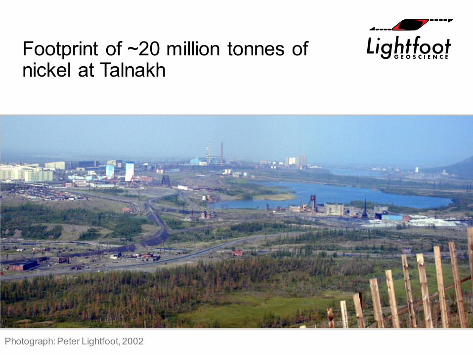
Footprint of ~20 million tonnes of nickel at Talnakh
Photograph: Peter Lightfoot, 2002
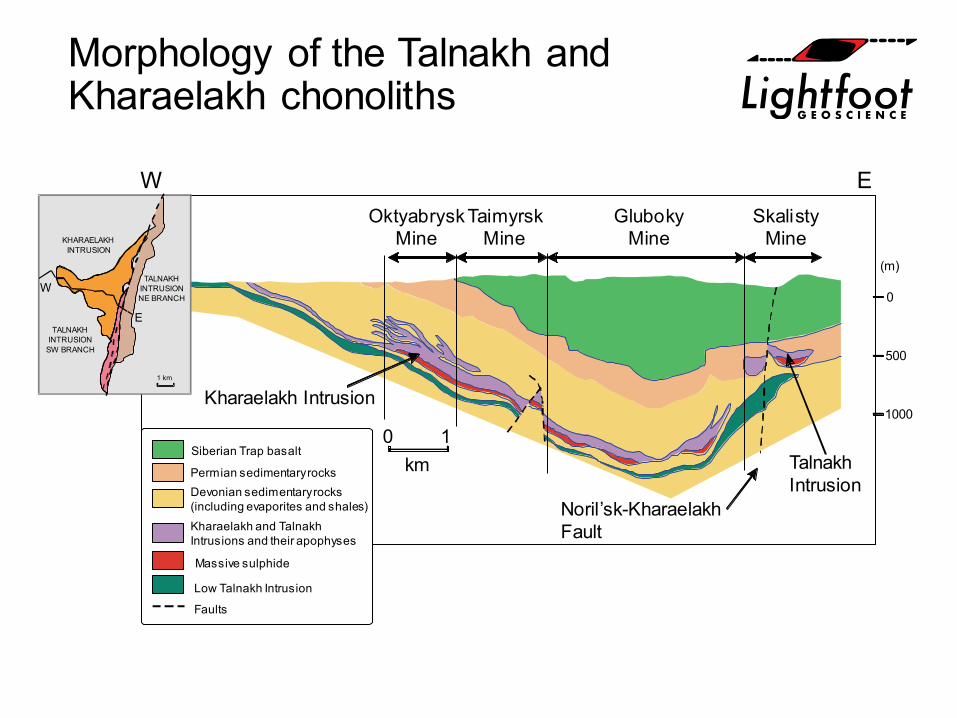
Morphology of the Talnakh and Kharaelakh chonoliths
1000
500
0
(m)
0 1km
SkalistyMine
GlubokyMine
TaimyrskMine
OktyabryskMine
EW
Kharaelakh Intrusion
Noril’sk-KharaelakhFault
TalnakhIntrusion
Siberian Trap basalt
Permian sedimentary rocksDevonian sedimentary rocks(including evaporites and shales)Kharaelakh and TalnakhIntrusions and their apophyses
Massive sulphide
Low Talnakh Intrusion
Faults
1 km
E
W
KHARAELAKHINTRUSION
TALNAKHINTRUSIONNE BRANCH
TALNAKHINTRUSION
SW BRANCH

Skalisty and Gluboky Mines, Talnakh and Kharaelakh Intrusion: North-facing Section
Intrusion
Noril’skKharaelakhFault zone
GlubokyDeposit
KharaelakhIntrusion
Surface
SkalistyDeposit1500 m
0 m
250m
Talnakh
West East
Siberian Trap basaltCarboniferous and Permiansedimentary rocksDevonian sedimentary rocksIntrusionsNi-rich sulphideFault zone
Lightfoot and Evans-Lamswood (2014)
TalnakhIntrusion
NE Branch
KharaelakhIntrusion
SectionLine
TalnakhIntrusion
SW Branch1
km
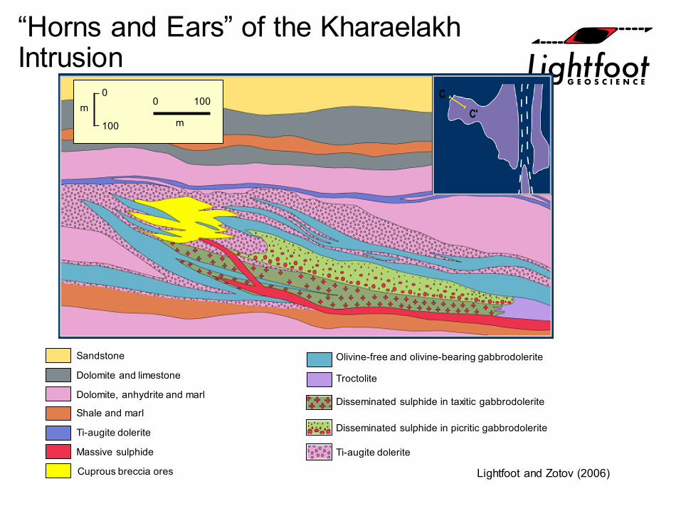
“Horns and Ears” of the KharaelakhIntrusion
Lightfoot and Zotov (2006)
Sandstone
C'C
Dolomite and limestone
Dolomite, anhydrite and marl
Shale and marl
Ti-augite dolerite
Massive sulphide
Cuprous breccia ores
Olivine-free and olivine-bearing gabbrodolerite
Disseminated sulphide in taxitic gabbrodolerite
Ti-augite dolerite
Troctolite
Disseminated sulphide in picritic gabbrodolerite
0
100
m 0 100
m
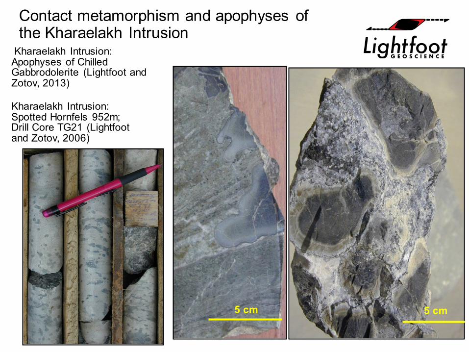
Contact metamorphism and apophyses of the Kharaelakh Intrusion
Kharaelakh Intrusion: Spotted Hornfels 952m; Drill Core TG21 (Lightfoot and Zotov, 2006)
5 cm5 cm
Kharaelakh Intrusion: Apophyses of Chilled Gabbrodolerite (Lightfoot and Zotov, 2013)
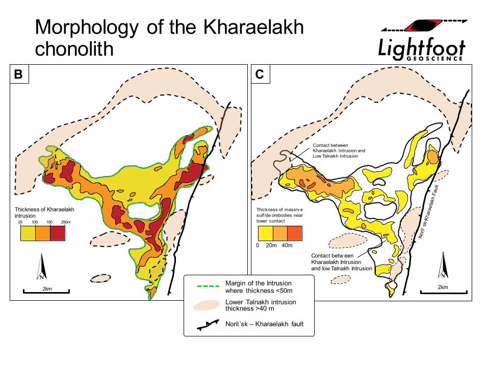
Morphology of the Kharaelakhchonolith
2km
25 100 150 250m
Contact betweenKharaelakh Intrusion andLow Talnakh Intrusion
2km
Thickness of massiv esulf ide orebodies nearlower contact
0 20m 40m
Contact betw eenKharaelakh Intrusionand low Talnakh Intrusion
B C
Thickness of Kharaelakhintrusion
Lower Talnakh intrusionthickness >40 m
Margin of the Intrusionwhere thickness <50m
Noril ’sk – Kharaelakh fault
A B
C D
1000 um
1 cm 1 cm
2 cm
Ligh
tfoot
, 201
6
334g/t Pd; 72 g/t Pt
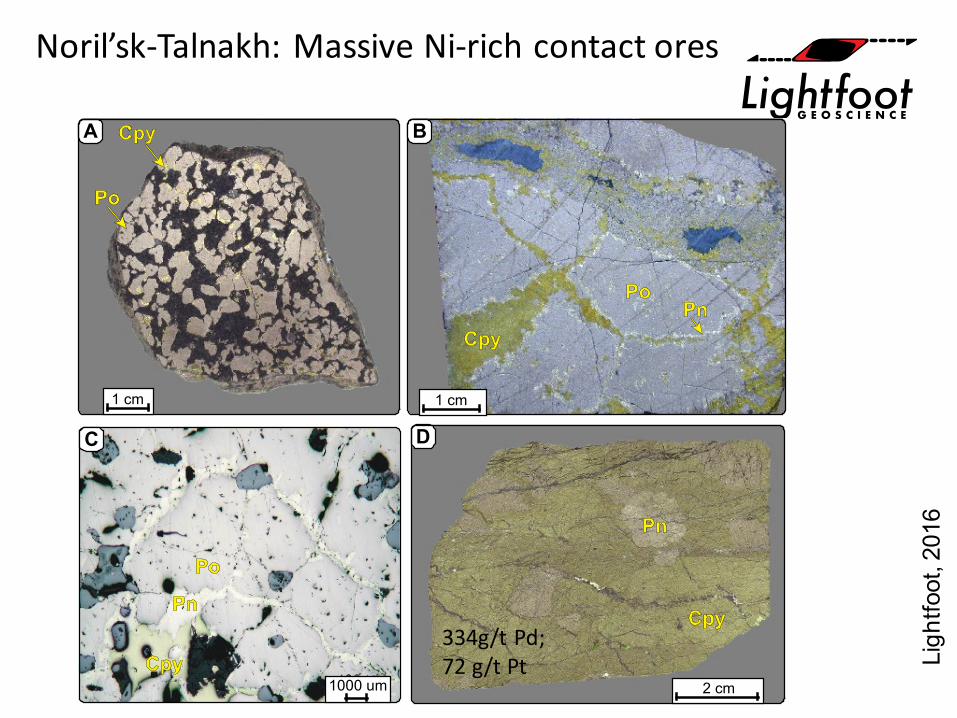
Noril’sk-Talnakh: Massive Ni-rich contact ores
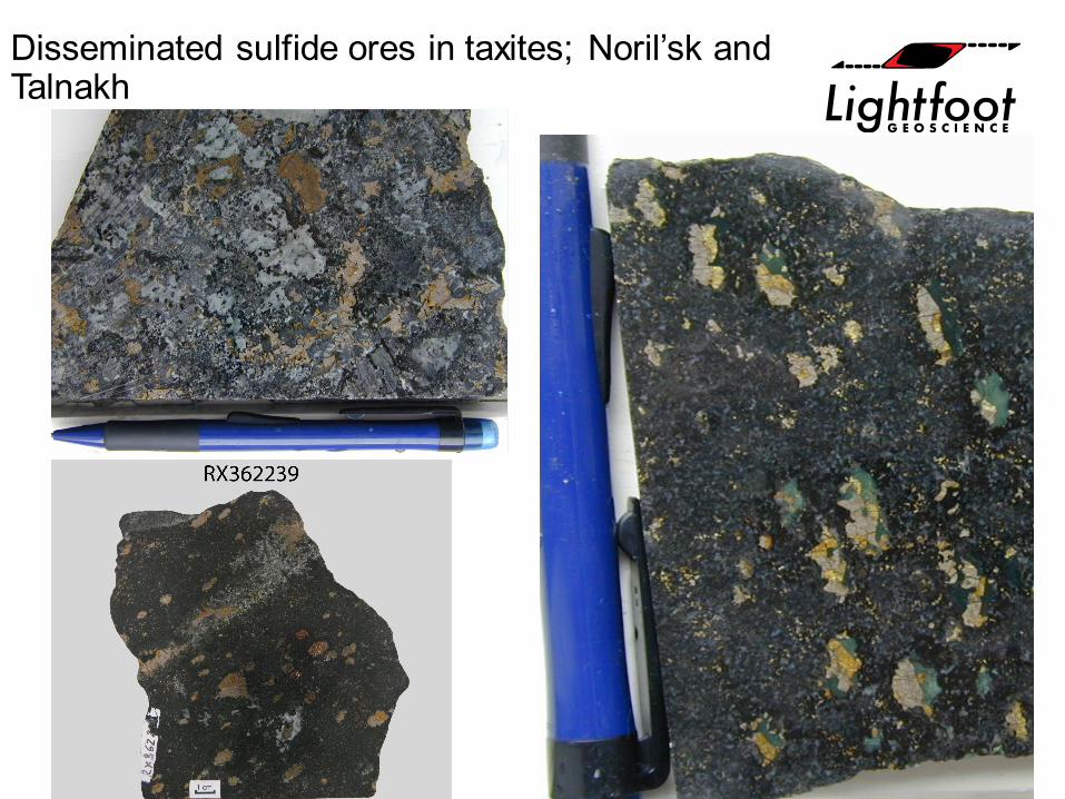
Disseminated sulfide ores in taxites; Noril’sk and Talnakh
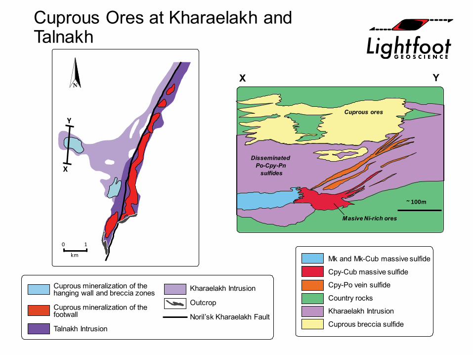
Cuprous Ores at Kharaelakh and Talnakh
0 1
km Mk and Mk-Cub massive sulfide
Cpy-Cub massive sulfide
Cpy-Po vein sulfide
Country rocks
Kharaelakh Intrusion
Cuprous breccia sulfide
X Y
~ 100m
Masive Ni-rich ores
DisseminatedPo-Cpy-Pn
sulfides
Cuprous ores
X
Y
Cuprous mineralization of thehanging wall and breccia zones
Cuprous mineralization of thefootwall
Talnakh Intrusion
Kharaelakh Intrusion
Outcrop
Noril’sk Kharaelakh Fault
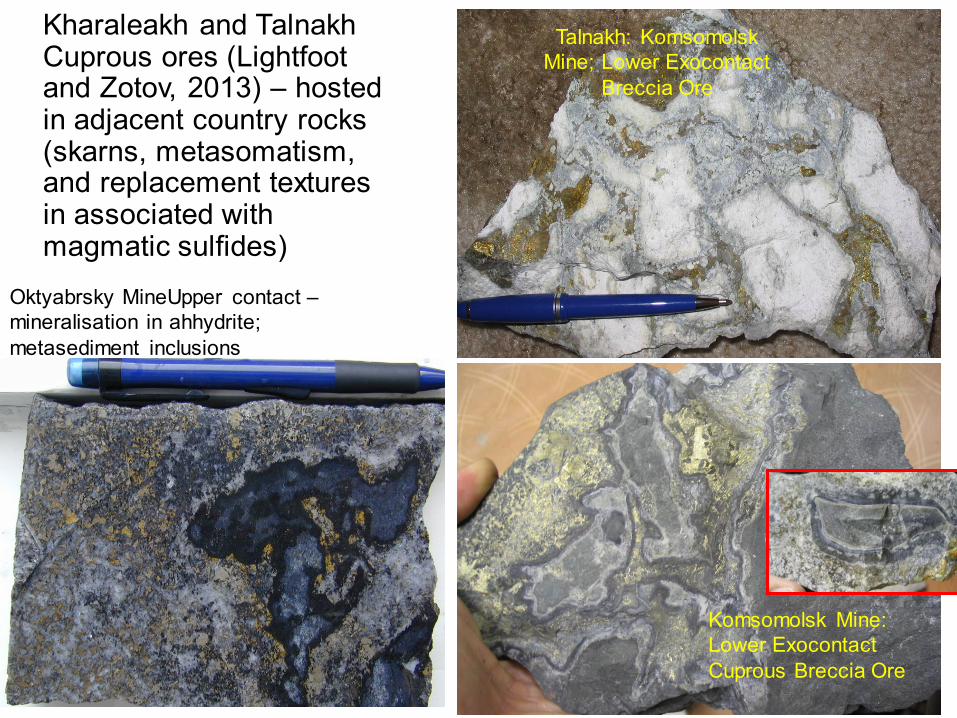
Kharaleakh and TalnakhCuprous ores (Lightfoot and Zotov, 2013) – hosted in adjacent country rocks (skarns, metasomatism, and replacement textures in associated with magmatic sulfides)
Talnakh: Komsomolsk Mine; Lower Exocontact
Breccia Ore
Komsomolsk Mine: Lower Exocontact Cuprous Breccia Ore
Oktyabrsky MineUpper contact –mineralisation in ahhydrite; metasediment inclusions
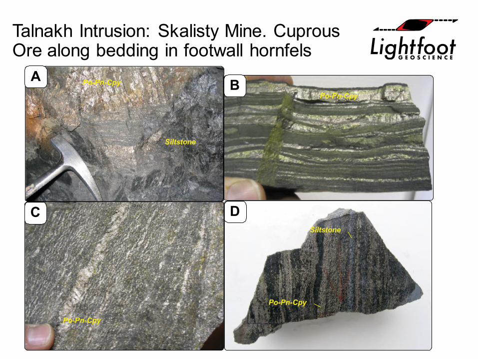
Talnakh Intrusion: Skalisty Mine. Cuprous Ore along bedding in footwall hornfels
A B
C DSiltstone
Po-Pn-Cpy
Po-Pn-Cpy
Po-Pn-Cpy
Po-Pn-Cpy
Siltstone
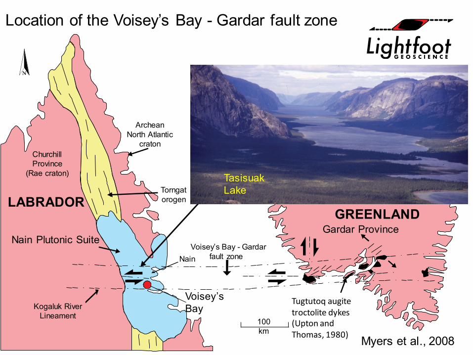
ChurchillProvince
(Rae craton)
Nain Plutonic Suite
Kogaluk RiverLineament
Nain
100km
Gardar Province
Torngatorogen
ArcheanNorth Atlantic
craton
Voisey’s Bay - Gardarfault zone
GREENLANDLABRADOR
Myers et al., 2008
Location of the Voisey’s Bay - Gardar fault zone
Voisey’s Bay
TasisuakLake
Tugtutoq augite troctolite dykes (Upton and Thomas, 1980)
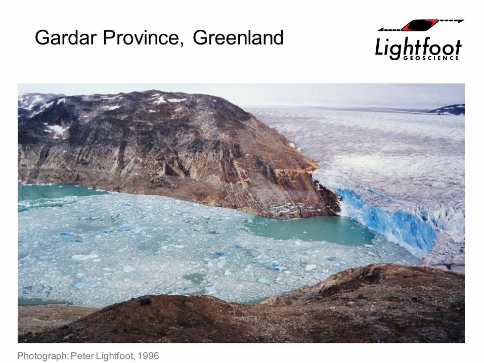
Gardar Province, Greenland
Photograph: Peter Lightfoot, 1996
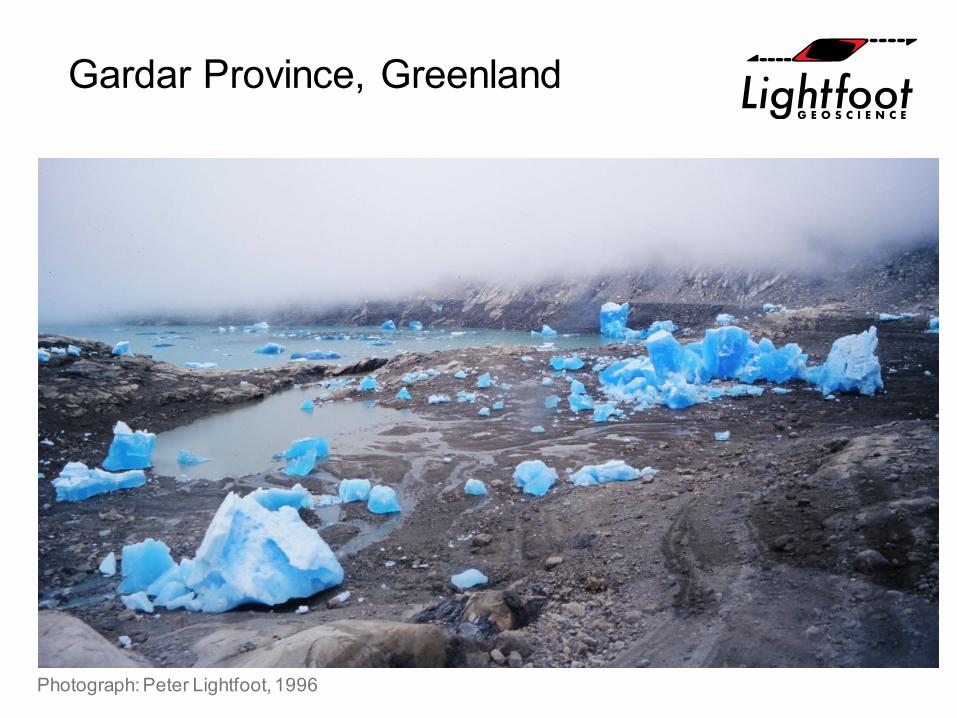
Gardar Province, Greenland
Photograph: Peter Lightfoot, 1996
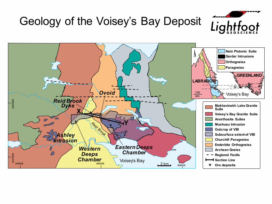
Geology of the Voisey’s Bay Deposit
Voisey’s Bay2 km
AshleyIntrusion
WesternDeeps
Chamber
Reid BrookDyke
Eastern DeepsChamber
Ovoid
568000E556000E544000E
6237
000N
6245
000N
Makhavinekh Lake GraniteSuiteVoisey’s Bay Granite SuiteAnorthosite SuitesMushuau IntrusionOutcrop of VBISubsurface extent of VBIChurchill ParagneissEnderbite OrthogneissArchean GneissRegional FaultsSection LineOre deposits
Y
X
100km
GREENLANDLABRADOR
Voisey’s Bay
Nain Plutonic SuiteGardar IntrusionsOrthogneissParagneiss
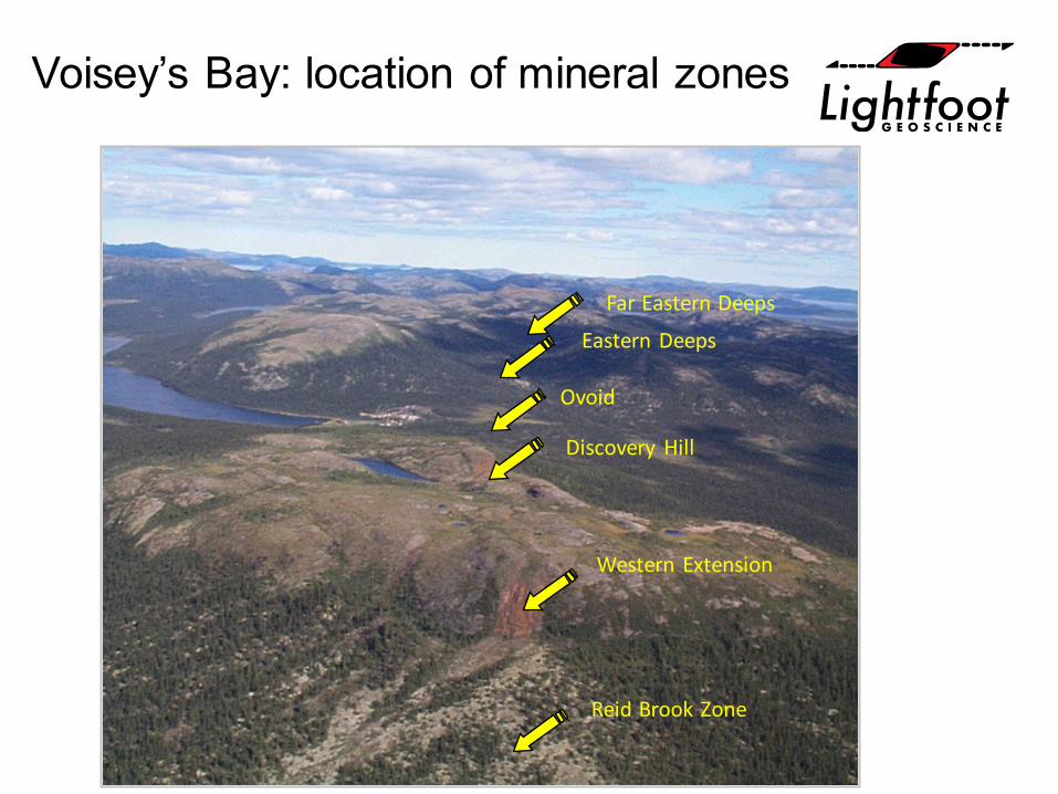
Voisey’s Bay: location of mineral zones
Eastern Deeps
Ovoid
Far Eastern Deeps
Discovery Hill
Western Extension
Reid Brook Zone
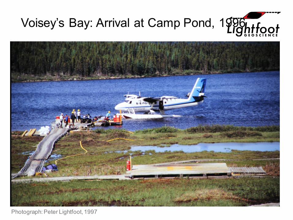
Voisey’s Bay: Arrival at Camp Pond, 1996
Photograph: Peter Lightfoot, 1997
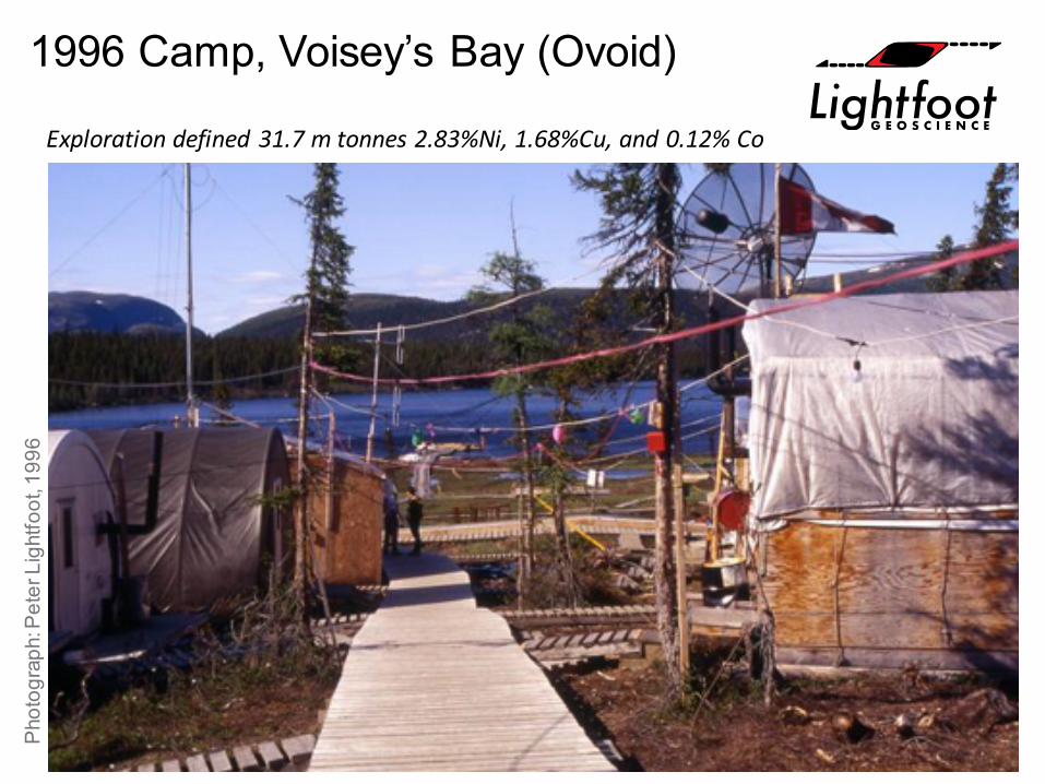
1996 Camp, Voisey’s Bay (Ovoid)
Exploration defined 31.7 m tonnes 2.83%Ni, 1.68%Cu, and 0.12% Co
Pho
togr
aph:
Pet
er L
ight
foot
, 199
6
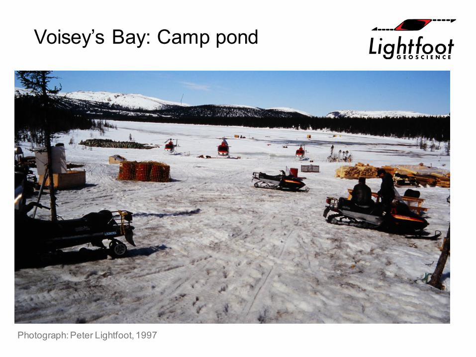
Voisey’s Bay: Camp pond
Photograph: Peter Lightfoot, 1997
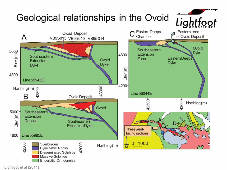
Geological relationships in the OvoidC
Northing(m)
Ovoid Deposit
Line55985E
SoutheasternExtensionDeposit Southeastern
ExtensionDyke
Ovoid
5000
4800
VB95-010 VB95-014
Northing(m)
Ovoid DepositVB95-013
Line55945E
OvoidDyke
SoutheasternExtensionDyke
4800
4200
Northing(m)
SoutheasternExtensionZone
EasternDeepsChamber
Eastern endof Ovoid Deposit
OvoidDyke
Line56044E
EasternDeepsDyke
Elev
(m)
4250
0
4300
0
4280
0
4330
0
Elev
(m)
5000
4800
Elev
(m)
4250
0
4300
0
A
B
Lightfoot et al (2011)
0 1000
Threewest-facing sections
ABCD
Massive SulphideEnderbitic Orthogneiss
OverburdenDyke Mafic RocksDisseminated Sulphide
Ovoid Deposit
Pho
togr
aph:
Pet
er L
ight
foot
, 200
7
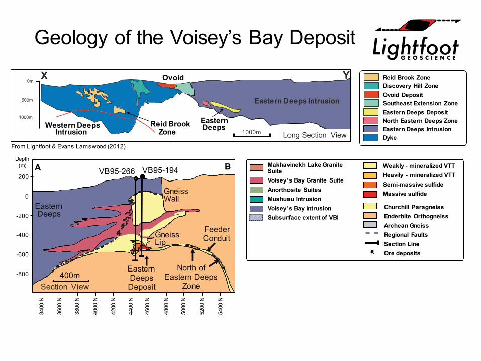
Geology of the Voisey’s Bay Deposit
Makhavinekh Lake GraniteSuiteVoisey’s Bay Granite SuiteAnorthosite SuitesMushuau IntrusionVoisey’s Bay IntrusionSubsurface extent of VBI
400m
200
0
-200
-400
-600
-800
3400
N
3600
N
3800
N
4000
N
4200
N
4400
N
4600
N
4800
N
5000
N
5200
N
5400
N
North ofEastern Deeps
Zone
EasternDeepsDeposit
FeederConduitGneiss
Lip
Depth(m)
VB95-266 VB95-194 Weakly - mineralized VTTHeavily - mineralized VTTSemi-massive sulfideMassive sulfide
A B
Section View
GneissWall
EasternDeeps
Churchill ParagneissEnderbite OrthogneissArchean GneissRegional FaultsSection LineOre deposits
Y
Eastern Deeps Intrusion
Western DeepsIntrusion
0m
500m
1000m
1000m
X
Reid BrookZone
EasternDeeps
Ovoid
Southeast Extension ZoneOvoid DepositDiscovery Hill ZoneReid Brook Zone
DykeEastern Deeps IntrusionNorth Eastern Deeps ZoneEastern Deeps Deposit
Long Section ViewFrom Lightfoot & Evans Lamswood (2012)
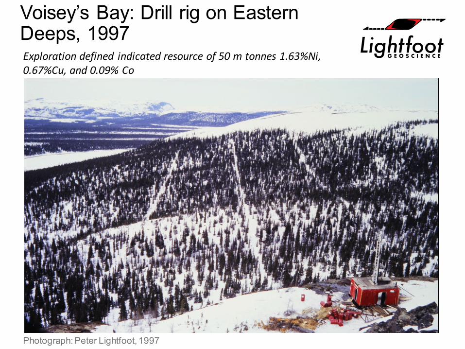
Voisey’s Bay: Drill rig on Eastern Deeps, 1997
Photograph: Peter Lightfoot, 1997
Exploration defined indicated resource of 50 m tonnes 1.63%Ni, 0.67%Cu, and 0.09% Co
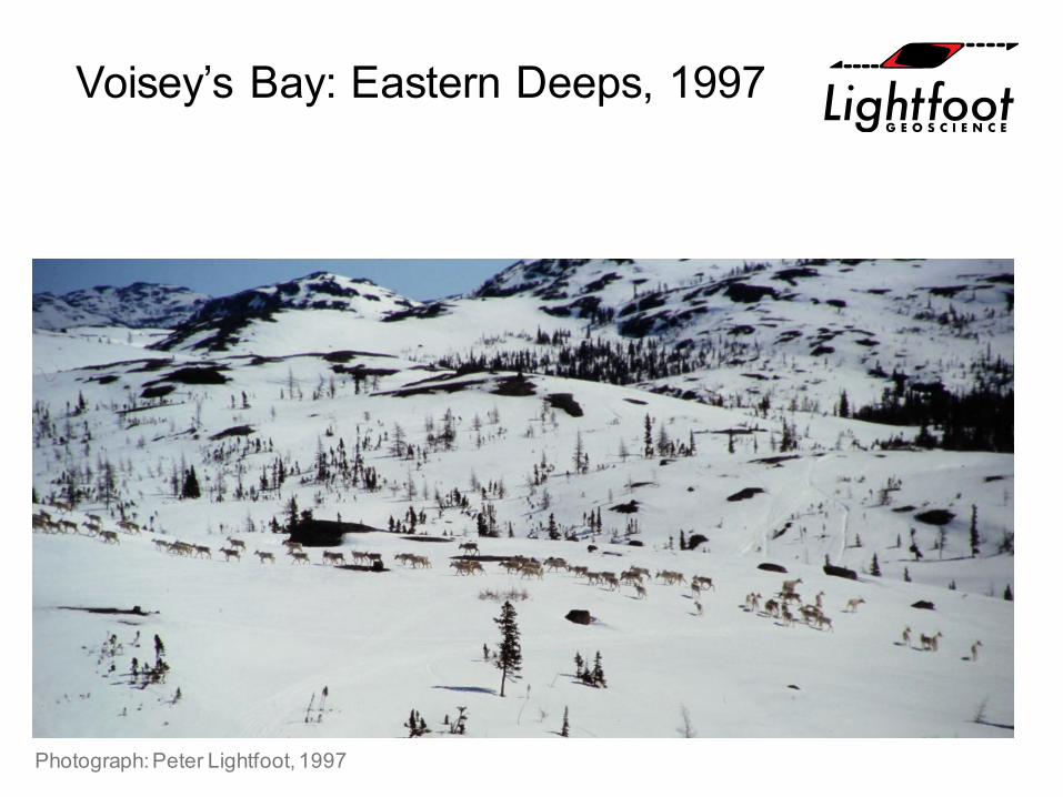
Voisey’s Bay: Eastern Deeps, 1997
Photograph: Peter Lightfoot, 1997
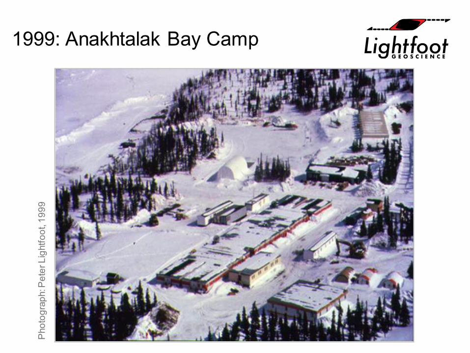
1999: Anakhtalak Bay CampP
hoto
grap
h: P
eter
Lig
htfo
ot, 1
999
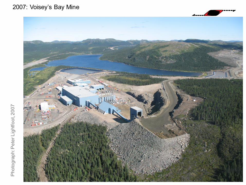
2007: Voisey’s Bay Mine P
hoto
grap
h: P
eter
Lig
htfo
ot, 2
007
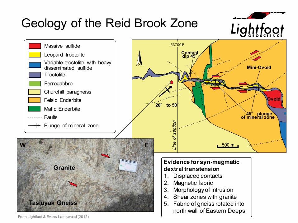
Geology of the Reid Brook Zone
Contactdip 45°
20° to 50°
45° plungeof mineral zone
Mini-Ovoid
Ovoid
Mafic EnderbiteFelsic EnderbiteChurchill paragneiss
Leopard troctoliteMassive sulfide
Troctolite
Variable troctolite with heavydisseminated sulfide
FaultsPlunge of mineral zone
Ferrogabbro
500 m
Granite
Tasiuyak Gneiss
W E
Evidence for syn-magmaticdextral transtension1. Displaced contacts2. Magnetic fabric3. Morphology of intrusion4. Shear zones with granite5. Fabric of gneiss rotated into
north wall of Eastern DeepsFrom Lightfoot & Evans Lamswood (2012)
53700 E
Line
of s
ectio
n
Reid Brook Zone: 53700E Section –Looking West
2.43, 1.1933
VB-12-941B
Western DeepsIntrusion
VB-05-653VB-07-8272.64, 1.11
35 2.76, 1.0626
0 m
100 m
200 m
300 m
400 m
500 m
600 m
700 m
Rapakivi Granite
Massive SulphideSulphide
Troctolite
Host Rock
Overburden
Garnetiferous ParagneissParagneiss / Quartz Paragneiss
FaultHistoric Drilling
Troctolite
Amphibolite
Breccia
Mineralized Troctolite
Granite / Pegmatitic
Leopard Textured Troctolite
Troctolite Chamber
% Ni, % Cucore meters
Reid BrookDyke
Section prepared byDanny Mulrooneyand Sheldon Pittman
100 m
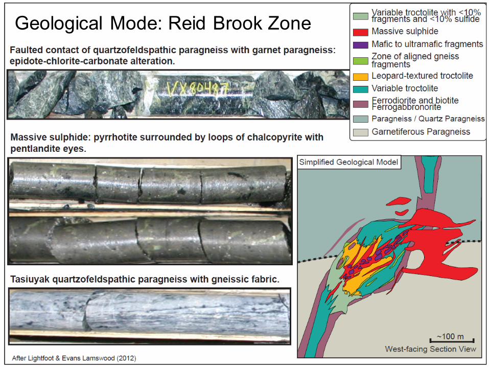
Geological Mode: Reid Brook Zone
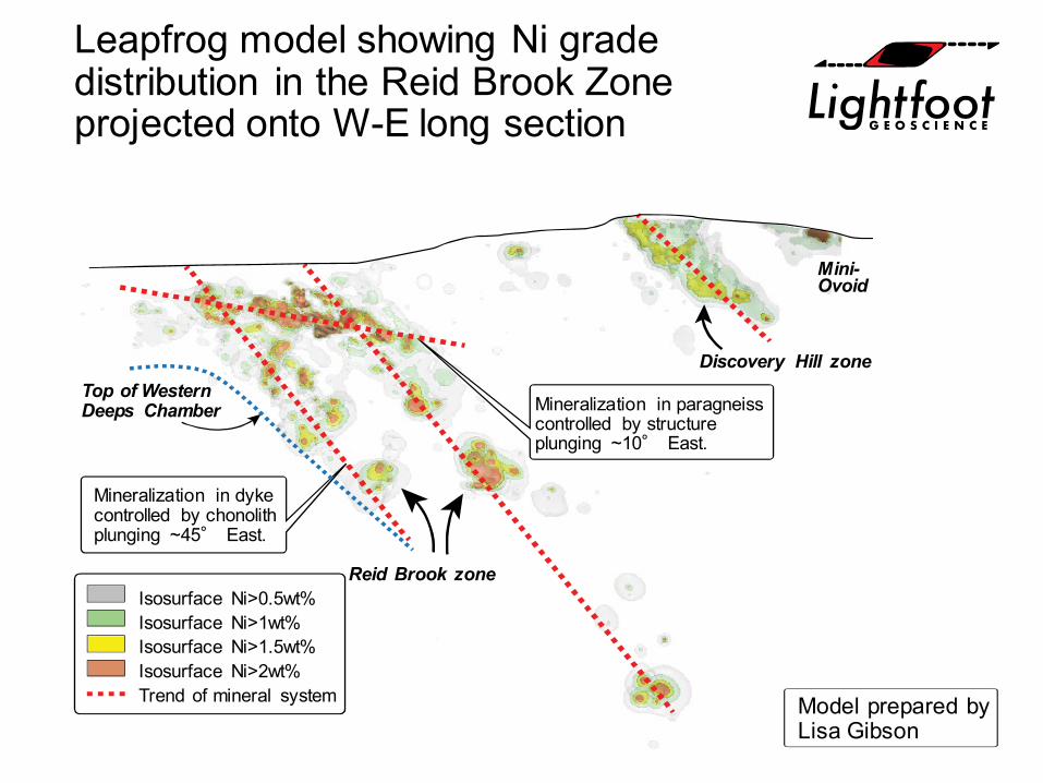
Leapfrog model showing Ni grade distribution in the Reid Brook Zone projected onto W-E long section
Model prepared byLisa Gibson
Discovery Hill zone
Mini-Ovoid
Reid Brook zone
Mineralization in paragneisscontrolled by structureplunging ~10° East.
Mineralization in dykecontrolled by chonolithplunging ~45° East.
Top of WesternDeeps Chamber
Isosurface Ni>0.5wt%Isosurface Ni>1wt%Isosurface Ni>1.5wt%Isosurface Ni>2wt%Trend of mineral system
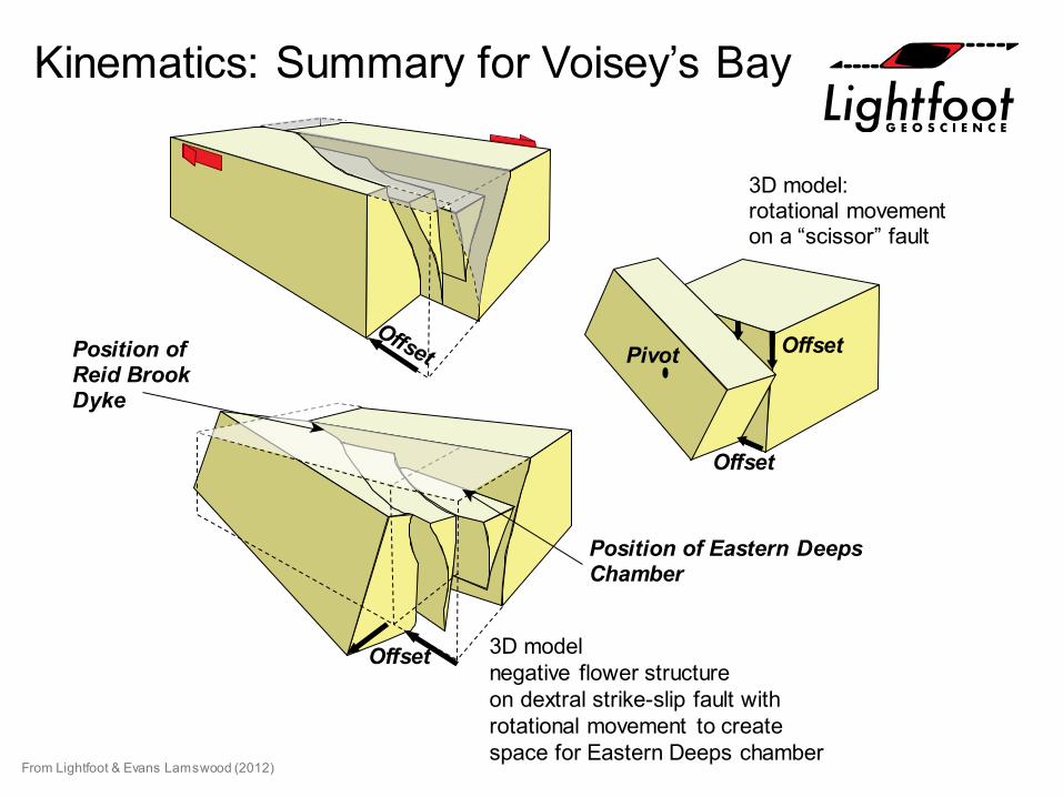
Kinematics: Summary for Voisey’s Bay
From Lightfoot & Evans Lamswood (2012)
3D model:rotational movementon a “scissor” fault
3D modelnegative flower structureon dextral strike-slip fault withrotational movement to createspace for Eastern Deeps chamber
Offset
Offset
Pivot OffsetPosition ofReid BrookDyke
Position of Eastern DeepsChamber
Summary
• Magmatic Ni-Cu-(PGE) sulphide ore bodies: often not the product of simple in-situ gravity settling within a magma chamber.
• Sulphide-laden magma ascended through a sub-vertical conduit system in a structural zone from a parental source/chamber at depth.
• Common theme now recognised in a spectrum of Ni sulphide ore deposits that underpin process models for their formation
– Funnel-shaped intrusions– Chonoliths– Dykes
• Conduit morphology is controlled through the intersection of regional structures that create space, and are localized by dilations and traps created by transtension in strike-slip fault zones:
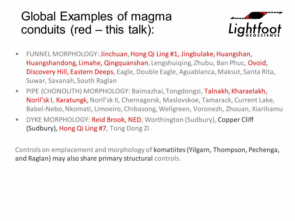
Global Examples of magma conduits (red – this talk):
• FUNNEL MORPHOLOGY: Jinchuan, Hong Qi Ling #1, Jingbulake, Huangshan, Huangshandong, Limahe, Qingquanshan, Lengshuiqing, Zhubu, Ban Phuc, Ovoid, Discovery Hill, Eastern Deeps, Eagle, Double Eagle, Aguablanca, Maksut, Santa Rita, Suwar, Savanah, South Raglan
• PIPE (CHONOLITH) MORPHOLOGY: Baimazhai, Tongdongzi, Talnakh, Kharaelakh, Noril’sk I, Karatungk, Noril’sk II, Chernagorsk, Maslovskoe, Tamarack, Current Lake, Babel-Nebo, Nkomati, Limoeiro, Chibasong, Wellgreen, Voronezh, Zhouan, Xiarihamu
• DYKE MORPHOLOGY: Reid Brook, NED, Worthington (Sudbury), Copper Cliff (Sudbury), Hong Qi Ling #7, Tong Dong Zi
Controls on emplacement and morphology of komatiites (Yilgarn, Thompson, Pechenga, and Raglan) may also share primary structural controls.
Thank You: Vale
Graphic design: Alex Gagnon
Dawn-Evans LamswoodRogerio MonteiroIan FieldhouseLisa Gibson
Danny MulrooneySheldon PittmanVivian FengIgor Zotov
Photograph: Peter Lightfoot, 2007