
Environmental Assessment - CORE
406
United States Department of Agriculture Forest Service March 2008 Environmental Assessment Snow Fuels Reduction Project Bend/Ft. Rock Ranger District, Deschutes National Forest Deschutes County, Oregon For further information contact: Pete Powers Bend – Ft. Rock Ranger District (541) 383-4774
-
Upload
khangminh22 -
Category
Documents
-
view
0 -
download
0
Transcript of Environmental Assessment - CORE

United States Department of Agriculture Forest Service March 2008
Environmental Assessment
Snow Fuels Reduction Project Bend/Ft. Rock Ranger District, Deschutes National Forest Deschutes County, Oregon
For further information contact: Pete Powers Bend – Ft. Rock Ranger District (541) 383-4774

Snow Environmental Assessment ♦ Page 2
The U.S. Department of Agriculture (USDA) prohibits discrimination in all its programs and activities on the basis of race, color, national origin, age, disability, and where applicable, sex, marital status, familial status, parental status, religion, sexual orientation, genetic information, political beliefs, reprisal, or because all or part of an individual’s income is derived from any public assistance program. (Not all prohibited bases apply to all programs.) Persons with disabilities who require alternative means for communication of program information (Braille, large print, audiotape, etc.) should contact USDA’s TARGET Center at (202) 720-2600 (voice and TDD). To file a complaint of discrimination, write to USDA, Director, Office of Civil Rights, 1400 Independence Avenue, S.W., Washington, D.C. 20250-9410, or call (800) 759-3272 (voice) or (202) 720-6382 (TDD). USDA is an equal opportunity provider and employer.

Tables
Snow Environmental Assessment ♦ Page 3
Table of Contents DOCUMENT ORGANIZATION ........................................................................................................... 9 CHAPTER 1 – PURPOSE AND NEED ............................................................................................... 12
INTRODUCTION .............................................................................................................................................12 DESIRED CONDITION ...................................................................................................................................14 EXISTING CONDITION..................................................................................................................................15 PURPOSE AND NEED FOR ACTION............................................................................................................17 PROPOSED ACTION.......................................................................................................................................18 SCOPING AND PUBLIC INVOLVEMENT....................................................................................................19 IDENTIFICATION OF ISSUES .......................................................................................................................20 PLANNING FRAMEWORK ............................................................................................................................22 PROJECT RECORD .........................................................................................................................................27 SCOPE OF PROJECT AND DECISION FRAMEWORK ...............................................................................27
CHAPTER 2 – ALTERNATIVES ........................................................................................................ 31 INTRODUCTION .............................................................................................................................................31 Description of Activities ....................................................................................................................................31 ALTERNATIVE DESCRIPTIONS...................................................................................................................35 Alternative 1 (No Action) ..................................................................................................................................35 Alternative 2 (Proposed Action) ........................................................................................................................35 Alternative 3 ......................................................................................................................................................43 Connected Actions Common to Alternative 2 (Proposed Action) and Alternative 3.........................................56 MITIGATION MEASURES COMMON TO BOTH ACTION ALTERNATIVES .........................................57 COMPARISON OF THE ALTERNATIVES....................................................................................................64 COMPARISON OF SUMMARY OF EFFECTS ..............................................................................................65 MONITORING..................................................................................................................................................66 Sale Area Improvements....................................................................................................................................66 ALTERNATIVES CONSIDERED BUT NOT ANALYZED IN DETAIL ......................................................67
CHAPTER 3 – AFFECTED ENVIRONMENT AND ENVIRONMENTAL CONSEQUENCES ...... 71 INTRODUCTION .............................................................................................................................................71 FIRE AND FUELS............................................................................................................................................74 WILDLIFE.......................................................................................................................................................130 Threatened and Endangered Species Considered Under a Biological Evaluation (BE) .................................136 Regional Forester’s Sensitive Species Considered Under a Biological Evaluation (BE)................................150 Management Indicator Species ........................................................................................................................165 Landbird Focal Species ...................................................................................................................................208 Birds of Conservation Concern (BCC) ............................................................................................................222 Dead Wood (Snags, Logs, and the Provision for Future Snags and Logs – Green Tree Replacements).........225 FOREST VEGETATION and FOREST HEALTH...........................................................................................93 SOILS ..............................................................................................................................................................237 HYDROLOGY AND FISH.............................................................................................................................265 Hydrology ........................................................................................................................................................273 Fisheries...........................................................................................................................................................278 RECREATION ................................................................................................................................................306
Tables
Snow Environmental Assessment ♦ Page 4
BOTANY – SENSITIVE SPECIES ................................................................................................................310 BOTANY - INVASIVE SPECIES ..................................................................................................................319 INVENTORIED ROADLESS AREA AND UNROADED AREAS ..............................................................325 FOREST ROADS ............................................................................................................................................332 SCENIC VALUES...........................................................................................................................................334 CULTURAL RESOURCES ............................................................................................................................337 ECONOMIC AND SOCIAL ...........................................................................................................................340 CIVIL RIGHTS AND ENVIRONMENTAL JUSTICE..................................................................................343 FOREST PLAN AMENDMENT ....................................................................................................................344 OTHER DISCLOSURES ................................................................................................................................345 SHORT-TERM USES AND LONG-TERM PRODUCTIVITY ..........................................................................345 UNAVOIDABLE ADVERSE EFFECTS ...........................................................................................................345 IRREVERSIBLE AND IRRETRIEVABLE COMMITMENT OF RESOURCES................................................346 PRIME LANDS ................................................................................................................................................346 HUMAN HEALTH AND SAFETY....................................................................................................................347 CONSISTENCY..............................................................................................................................................348 LITERATURE CONSIDERED FROM SCOPING COMMENTS.................................................................349
CHAPTER 4 – Coordination and Consultation................................................................................... 355 LITERATURE CITED........................................................................................................................ 357 APPENDIX A...................................................................................................................................... 371
ALTERNATIVE 2 (PROPOSED ACTION) – UNIT SUMMARIES.............................................................371 ALTERNATIVE 3 – UNIT SUMMARIES.....................................................................................................374 PRESCRIPTIONS ...........................................................................................................................................379 COMPARISON OF HARVEST METHODS IN RELATION TO ALLOCATION OBJECTIVES ..............383
APPENDIX B...................................................................................................................................... 389 DecAID DATA USED FOR ANALYSIS .......................................................................................................389
APPENDIX C...................................................................................................................................... 392 APPLICABLE LAWS.....................................................................................................................................392
APPENDIX D...................................................................................................................................... 396 ESTIMATES OF DETRIMENTAL SOIL CONDITIONS – ALTERNATIVE 2 (PROPOSED ACTION)...396 ESTIMATES OF DETRIMENTAL SOIL CONDITIONS – ALTERNATIVE 3...........................................401
Table of Tables Table 1: Legal Description of Snow Project ..........................................................................................................12 Table 2: NWFP and LRMP and Relationships ......................................................................................................12 Table 3: National Fire Plan – Local Communities of Interest at Risk from Wildfire ............................................23 Table 4: Alternative 2 (Proposed Action) - Summary of Silviculture Treatments.................................................36 Table 5: Alternative 2 (Proposed Action) – Proposed Slash Treatment - Net Acres ............................................36 Table 6: Alternative 2 (Proposed Action) – Net Treatment Acres by Management Allocation ............................36 Table 7: Alternative 2 (Proposed Action) - Proposed Activities...........................................................................37 Table 8: Alternative 3 - Summary of Silviculture Treatment ................................................................................44 Table 9: Alternative 3 – Proposed Slash Treatment - Net Acres ..........................................................................44 Table 10: Alternative 3 – Net Treatment Acres by Management Allocation.........................................................44 Table 11: Alternative 3 - Proposed Prescriptions by Unit......................................................................................45

Tables
Snow Environmental Assessment ♦ Page 5
Table 12: Road Reconstruction Activities - Milepost Location and Total miles per Road Segment.....................56 Table 13: Summary of Wildlife Mitigations - Operating Seasons .........................................................................59 Table 14: Comparison of Silviculture Treatment by Alternative...........................................................................64 Table 15: Comparison of Treatment Acres by Management Allocation ..............................................................64 Table 16: Comparison of Alternatives to Purpose and Need and Key Issues (Chapter 3 Summary) ....................65 Table 17: Ongoing and Reasonably Foreseeable Projects for Cummulative Effects Analysis for the Snow Project
Area................................................................................................................................................................71 Table 18: Communities at Risk and Local Communities of Interest .....................................................................75 Table 19: Existing Fuel Model Acres and Behavior ..............................................................................................75 Table 20: Existing Condition of Fuels in the Snow Area ......................................................................................78 Table 21: Averaged fuel moisture - Round Mountain weather station for the past 10 years. ................................79 Table 22: Averaged wind speed - Round Mountain weather station for the past 10 years. ...................................79 Table 23: Desired Condition Post Treatment.........................................................................................................79 Table 24: Description of Fire Behavior Ratings ....................................................................................................88 Table 25: Fire Behavior Comparison by Alternative .............................................................................................88 Table 26: Spotting Distances by Fuel Model .........................................................................................................89 Table 27: Comparison of Alternatives ...................................................................................................................89 Table 28: Estimated Smoke Emissions in Tons of Particulate Matter (PM) 2.5....................................................90 Table 29: Fuel Treatment Acres (Gross)................................................................................................................90 Table 30: Comparison of Alternatives - Fuels .......................................................................................................91 Table 31: Elevation and Annual Precipitation within Treatment Areas Summarized by Plant Association Group
(PAG).............................................................................................................................................................94 Table 32: Relative Tolerance and Susceptibility of Conifers to Environmental and Disease Stress Factors.........94 Table 33: Plant Association Groups (PAGs) within Crane Prairie Watershed ......................................................98 Table 34: Historic Range of Variability (HRV) within Crane Prairie Watershed................................................100 Table 35: Existing Proportion of Size Structure Classes and Relation to HRV in Crane Prairie Watershed.......101 Table 36: Effects of Alternative 2 on the Proportion of Size Structure Classes in the Crane Prairie Watershed.107 Table 37: Effects of Alternative 3 on the Proportion of Size Structure Classes in the Crane Prairie Watershed.108 Table 38: Summary of Conclusions for Species Considered Under the Biological Evaluation for the Snow
Project Area .................................................................................................................................................130 Table 39: Ongoing and Reasonably Foreseeable Projects for Cummulative Effects Analysis for the Snow Project
Area..............................................................................................................................................................134 Table 40: Alternative 2 (Proposed Action) - Proposed Activities........................................................................135 Table 41: Threatened and Endangered Wildlife Species Considered - Those in Bold Receive Further
Consideration ...............................................................................................................................................137 Table 42: Alternative 2 (Proposed Action) - Summary of Effects to Spotted Owl Dispersal Habitat in the Snow
project Area..................................................................................................................................................143 Table 43: Alternative 3 - Summary of Effects to Dispersal Habitat in the Snow Project Area ...........................144 Table 44: Regional Forester's Sensitive Species Considered - Those in Bold Receive Further Consideration ...150 Table 45: Summary of Bald Eagle Activity in BEMAs with Proposed Actions..................................................153 Table 46: Alternative 2 - Summary of proposed actions and effects to habitat within BEMAs ..........................155 Table 47: Alternative 3 - Summary of proposed actions and effects within BEMAs ..........................................157 Table 48: Management Indicator Species (MIS) Considered - Those in Bold Receive a More Detailed Analysis
.....................................................................................................................................................................165 Table 49: Effects of Alternative 2 (Proposed Action) to Key Elk Habitat...........................................................185 Table 50: Effects of Alternative 3 to Key Elk Habitat .........................................................................................186

Tables
Snow Environmental Assessment ♦ Page 6
Table 51: Summary of Alternative 2 (Proposed Action) Effects to Marten Habitat ............................................188 Table 52: Summary of Alternative 3 Effects to Marten Habitat ..........................................................................190 Table 53: Landbird Focal Species Considered - Those in Bold Receive Further Consideration .........................208 Table 54: Summary of Effects to Hermit Thrush Habitat ....................................................................................219 Table 55: Birds of Conservation Concern Considered - Those in Bold Receive Further Consideration .............222 Table 56: Acres of Wildlife Habitat and Structural Types in the Crane Prairie Watershed. Figures in Parentheses
Show the Percentage within a Proposed Treatment Area and the Relative Potential for Dead Wood Influenced by Fire Regime and Topographic Position.................................................................................226
Table 57: DecAID Tolerance Levels Relative to the Appropriate Management Allocation................................226 Table 58: Results of Snag Transects for the Proposed Action Area ....................................................................227 Table 59: Summary of Aerial Insect and Disease Maps for the Crane Prairie Watershed...................................228 Table 60: Comparison of Existing CWM and Directed Levels. Estimates of Percent Cover are Given in Order to
Compare with Information in DecAID Advisor ..........................................................................................230 Table 61; Estimated GTRs (trees per acre) Required to Meet Current Direction ................................................233 Table 62: Current Road Density ..........................................................................................................................234 Table 63: Summary of Net Change in Detrimental Soil Conditions following Mechanical Harvest and Soil
Restoration (Subsoiling) Treatments (Refer to EA Appendix D) Proposed for Alternative 2 (Proposed Action) and Alternative 3.............................................................................................................................253
Table 64: Proposed Units and Acres for Mechanical Vegetation Treatments on Landtypes that Contain Sensitive Soils within the Project Area .......................................................................................................................259
Table 65: Region 6 Sensitive Aquatic Fish Species in the Snow Project Area....................................................265 Table 66: Sub-watersheds within the Crane Prairie 5th Field Watershed............................................................266 Table 67: Summary of Stream Attributes ............................................................................................................273 Table 68: Summary of Lake Attributes................................................................................................................273 Table 69: Acres of Riparian Reserve Associated with Various Water Bodies ....................................................276 Table 70: Comparison Table of Treatments within the Snow Project Riparian Reserves ...................................282 Table 71: Riparian Reserve Coarse Woody Debris Plots ....................................................................................292 Table 72: Equivalent Clearcut Area Calculation for On-going Vegetation Management Projects......................296 Table 73: Alternative 2 (Proposed Action) Equivalent Clearcut Acres Calculation ............................................297 Table 74: Alternative 3 Equivalent Clearcut Area Calculation............................................................................297 Table 75: Total Use for High Lakes Developed Campgrounds from 2000 through 2004 ..................................307 Table 76: Occupancy Rates for High Lakes Developed Campgrounds from 2000 through 2004 ......................307 Table 77: Region 6 Sensitive Plant Species Documented or Suspected on the Deschutes National Forest.........311 Table 78: Other Rare or Uncommon, Potentially Survey-Requiring Botanical Taxa Documented or Suspected on
the Deschutes National Forest......................................................................................................................315 Table 79: Summary of Determinations of Short Term Effects for Sensitive Plant Species.................................317 Table 80: Invasive Plant Species Documented to Occur on Deschutes National Forest......................................320 Table 81: Invasive Plant Species Present Within or Closely Adjacent to the Snow Project Boundary ..............321 Table 82: New Invasive Plant Occurrences Detected During 2006 Project Surveys ..........................................321 Table 83: Road Resurfacing.................................................................................................................................332 Table 84: Danger Tree Removal ..........................................................................................................................333 Table 85: Forest Compliance with Scenic Views (MA9) Standards and Guidelines...........................................336 Table 86: Summary of the Snow Project Economic Efficiency Analysis...........................................................341 Table 87: Appendix A - Alternative 2 (Proposed Action) - Unit Summaries ......................................................371 Table 88: Appendix A - Alternative 3 - Unit Summarries ...................................................................................374 Table 89: Appendix A - Comparison of Harvest Methods in Relation to Allocation Objectives ........................384

Tables
Snow Environmental Assessment ♦ Page 7
Table 90: Appendix B - DecAID Data used for Analysis ....................................................................................389 Table 91: Appendix B - Downed Log Densities for Wildlife Species at 30, 50, and 80 Percent Tolerance Levels
for Logs Based on Wildlife Data in DecAID (Table References Included).................................................390 Table 92: Appendix D - Alternative 2 (Proposed Action) - Estimates of Detrimental Soil Conditions followint
Mechanical Harvest and Soil Restoration Treatments by Activitiy Areas ...................................................396 Table 93: Appendix D - Altenative 3 - Estimates of Detrimental Soil Coditions following Mechanical Harvest
and Soil Restoration Treatments by Activity Areas.....................................................................................401
Table of Figures Figure 1: Snow Fuels Reduction Project Locator Map ..........................................................................................13 Figure 2: Lodgepole Pine Stand that has had Mountain Pine Beetle Associated Mortality...................................16 Figure 3: Deschutes Forest Plan (LRMP) Management Areas .............................................................................28 Figure 4: Northwest Forest Plan ...........................................................................................................................29 Figure 5: Zones for Riparian Reserve Treatments .................................................................................................34 Figure 6: Alternative 2 (Proposed Action) - Snow Treatment Units (North Half)................................................40 Figure 7: Alternative 2 (Proposed Action) - Snow Treatment Units (South One-Half)........................................41 Figure 8: Snow Project Alternative 2 (Proposed Action) - Temporary Roads.......................................................42 Figure 9: Photograph in Current Old Growth Area - Snow Project .......................................................................49 Figure 10: Photograph in Proposed Old Growth Replacement Area - Snow Project.............................................50 Figure 11: Current Old Growth Management Area ...............................................................................................51 Figure 12: Proposed Old Growth Area - For Forest Plan Amendment ..................................................................52 Figure 13: Alternative 3 - Snow Treatment Units (North One Half) .....................................................................53 Figure 14: Alternative 3 - Snow Treatment Units (South One Half) .....................................................................54 Figure 15: Snow Project Alternative 3 Temporary Roads .....................................................................................55 Figure 16: Snow Planning Area – Existing Fuel Models.......................................................................................76 Figure 17: Alternative 2 (Proposed Action) - Fuel Models Following Implementation ........................................84 Figure 18: Alternative 3 - Fuel Models Following Implementation ......................................................................85 Figure 19: Higher Elevation Nesting, Roosting, and Foraging (NRF) Habitat - Mt. Hemlock, Douglas Fir, White
Fir.................................................................................................................................................................139 Figure 20: An Example of Lower Elevation Nesting, Roosting, and Foraging Habitat - Ponderosa Pine, Douglas
Fir, White Fir ...............................................................................................................................................139 Figure 21: Example of Dispersal Habitat within the Project Area – Proposed Treatment Area. (Note Lodgepole
Pine Association and small tree diameters) .................................................................................................140 Figure 22: Example of Dispersal Habitat within the Project Area – Proposed Treatment Area. (Note Lodgpeole
Pine Association and dead lodgepole) .........................................................................................................141 Figure 23: Example of Mixed Conifer Dispersal Habitat within Project Area – Not Within a Proposed Treatment
Area. (Note: Mixed Conifer Association, larger diameters) ........................................................................141 Figure 24: Example of Typical Riparian Reserve in the Snow Project Area .......................................................147 Figure 25: Example of Riparian Reserve Proposed for Treatment in the Snow Project Area .............................148 Figure 26: Example of Riparian Reserve Proposed for Treatment in the Snow Project Area .............................148 Figure 27: Crane Prairie NE Bald Eagle Management Area (BEMA) ................................................................154 Figure 28: Crane Prairie E Bald Eagle Management Area (BEMA) ...................................................................155 Figure 29: Current Old Growth Management Area (OGMA) .............................................................................173 Figure 30: Proposed Replacement Old Growth Management Area (OGMA) .....................................................173 Figure 31: Great Blue Heron Rookery.................................................................................................................178 Figure 32: Riparian Reserve Downed Logs Serving as Elk Hiding Cover ..........................................................184

Tables
Snow Environmental Assessment ♦ Page 8
Figure 33: Composite Aerial Insect and Disease Mortality Map (1996-2004) for the Crane Prairie Watershed.229 Figure 34: Fuels Accumulation in a Previously Treated Lodgepole Pine Stand....................................................96 Figure 35: Late Susccessional Conditions in Lodgepole Pine Community Type ................................................103 Figure 36: Height to age relationship measured in lodgepole pine greater than or equal to 9 inches dbh ...........104 Figure 37: Height to Age Relationship Measured in White Fir (All Diameters) within the Crane Prairie
Watershed ....................................................................................................................................................105 Figure 38: Implementation Unit Boundaries........................................................................................................111 Figure 39: Alternative 3 Regeneration Harvest Treatments in Implementation Unit 15 Resulting in Contiguous
Acres with Essentially Uniform Structural Conditions in Excess of 100 Acres ..........................................113 Figure 40: Mountain Pine Beetle Outbreak Pattern in South-Central Oregon Described by Dolph (1981) ........115 Figure 41: Mountain Pine Beetle Outbreak Pattern in Central Oregon Described by Mitchell (undated) ...........115 Figure 42: Lodgepole Pine Advanced Regeneration that has established Since 1995 .........................................127 Figure 43: Alternative 2 (Proposed action) Mechanical Harvest Areas that Overlap Landtypes with Sensitive
Soils in Localized Areas of the Project Area ...............................................................................................257 Figure 44: Alternative 3 Mechanical Harvest Areas that Overlap Landtypes with Sensitive Soils in Loacalized
Areas of the Project Area .............................................................................................................................258 Figure 45: Miles of Stream within the Snow Project Area ..................................................................................271 Figure 46: Acres of Riparian Reserve within the Snow Project Area ..................................................................272 Figure 47: An example of fuel loading within Riparian Reserves (Unit 143, photo taken June, 2007)..............280 Figure 48: An example of the transition between wetland vegetation and Riparian Reserve upland vegetation
dominated by lodgepole pine and flat to gentle slopes (Unit 118, photo taken June, 2007). .......................281 Figure 49: Typical Riparian Reserve (Unit 133, 6/2/07) near streams with flat to gentle slopes that would be
treated. .........................................................................................................................................................282 Figure 50: Example of streambank erosion following high intensity wildfire.....................................................286 Figure 51: Example of streambank erosion following high intensity wildfire.....................................................286 Figure 52. Inventoried Roadless Areas and Wilderness with Alternative 2 Units ..............................................327 Figure 53: "Unroaded Areas" displayed for Alternative 2 ...................................................................................331

Tables
Snow Environmental Assessment ♦ Page 9
DOCUMENT ORGANIZATION The Forest Service has prepared this Environmental Assessment in compliance with the National Environmental Policy Act (NEPA) and other relevant federal and state laws and regulations. This Environmental Assessment discloses the direct, indirect, and cumulative environmental impacts that would result from the proposed action and other alternatives. The document is organized into four chapters and appendices: Chapter 1. Purpose and Need for Action: The chapter includes information on the history of the project proposal, the purpose of and need for the project, a summary of the agency’s proposal for achieving that purpose and need, the public process that was involved and the key issues that were identified and around which the third alternative was developed, the planning framework, and the scope of the project and decision framework. Chapter 2. Alternatives: This chapter provides a more detailed description of the agency’s proposed action as well as alternative methods for achieving the stated purpose. These alternatives were developed based on significant issues raised by the public and other agencies. This discussion also includes mitigation measures. Finally, this section provides a summary table of the proposed activities associated with each alternative. Chapter 3. Affected Environment and Environmental Consequences: This chapter describes the affected environment, the current conditions of the resources involved, and the environmental effects of implementing the proposed action and other alternatives. This analysis is organized by individual resource specialties. Chapter 4. List of Preparers: This chapter provides a list of preparers and agencies consulted during the development of the Environmental Assessment. This section includes both literature that was used for the analysis and literature that was provided during scoping and was considered. Appendices (A through D): The appendices provide more detailed information to support the analyses presented in the environmental impact statement. Additional documentation, including more detailed analyses of project-area resources, may be found in the Project Record located at the Bend-Fort Rock Ranger District. Precision of Information and Adjustments Quantifiable measurements, such as acres and miles, and mapped unit boundaries that are used to describe the alternatives and effects are based on the best available information. The analysis presented in this EA is based on consideration of the full extent of the acres, miles, and other quantities depicted in the alternatives. Information used in designing the alternatives was generated from a mix of field reconnaissance, use of aerial photos, use of global positioning system (GPS) technology, and various resource-specific databases.

Chapter 1 – Purpose and Need
Snow Environmental Assessment ♦ Page 10
CHAPTER 1
PURPOSE AND NEED

Chapter 1 – Purpose and Need
Snow Environmental Assessment ♦ Page 11

Chapter 1 – Purpose and Need
Snow Environmental Assessment ♦ Page 12
CHAPTER 1 – PURPOSE AND NEED
INTRODUCTION The Bend-Ft. Rock Ranger District of the Deschutes National Forest has prepared this environmental assessment (EA) to analyze what effects proposed hazardous fuels reduction activities would present to the environment. Treatments are proposed within an area located in Deshutes County, Oregon approximately 25 miles west of Bend (Figure 1, page 13). Proposed treatments are located mostly east of Cascade Lakes Highway (Highway 46), from Elk Lake at the north to Crane Prairie at the south, and bounded mostly by Forest roads to the east (Refer to Table 1 for the legal description). Elevations range from 4,450 to 5,400 feet.
Table 1: Legal Description of Snow Project
Legal Location – Deschutes County, Oregon – Willamette Meridian • Township 18 South, Range 8 East, Section 31 • Township 19 South, Range 8 East, Sections 4, 5, 8, 9, 16, 21-23, 26-28, 33, 34 • Township 20 South, Range 8 East, Sections 1-4, 9-12, 14-16, 20-23, 26-30, 33-35 • Township 21 South, Range 8 East, Sections 4, 8, 9
The project is located completely within the Northwest Forest Plan (NWFP) boundary and includes Matrix, Administratively Withdrawn areas, and Riparian Reserves. Refer to Figure 4. The project is bordered by Late Successional Reserves (LSRs), the West and South Bachelor Inventoried Roadless Area (IRA), and the Three Sisters Wilderness. The NWFP amended the Deschutes National Forest Land and Resource Management Plan (LRMP). Table 2 displays the relationship between NWFP and LRMP management allocatiolns. The project is within the boundary of the East and West Deschutes County Community Wildfire Protection Plan (CWPP). The LRMP management areas that include or are adjacent to treatment areas include Special Interest, Bald Eagle, Osprey, General Forest, Scenic Views, Intensive Recreation, and Old Growth. The Crane Prairie Key Elk Area also has proposed treatment areas. Refer to Figure 3 for the various management areas. The portion of the Deschutes River running through the analysis areas is not included in the Wild and Scenic River corridor.
Table 2: NWFP and LRMP and Relationships Northwest Forest Plan Allocations (NWFP)
Matrix Administratively Withdrawn
Riparian Reserve
Deschutes National Forest Land and Resource Management Plan (LRMP)
General Forest Scenic Views Osprey Management Bald Eagle Management
Old Growth Intensive Recreation Special Interest Areas
All Indicated Land Allocations

Chapter 1 – Purpose and Need
Snow Environmental Assessment ♦ Page 13
Figure 1: Snow Fuels Reduction Project Locator Map

Chapter 1 – Purpose and Need
Snow Environmental Assessment ♦ Page 14
The project is within the Crane Prairie 5th field watershed, which is within the 4th field Upper Deschutes River basin. The watershed is located on the eastern slope of the Cascade Mountain Range and is a critical headwaters area of the Deschutes Province. The watershed is a critical recharge area which provides an important part of the surface and ground water which people from Bend to Madras depend upon. The Upper Deschutes River basin is primarily a groundwater driven system due to high infiltration rates of volcanic soils. The porous soils, composed of ash and pumice overlain on glacial till, glacial outwash, and basaltic lava, absorb and transfer precipitation subsurface (snow melt and rainwater) providing for the extensive groundwater exchange. Groundwater constitutes virtually the entire flow of Cultus River and Snow Creek, and is a major contributor to the Deschutes River. Slopes generally range from 0 to 30 percent. Steeper side-slopes (25 to 80 percent) are associated with cinder cones, buttes, and the rough edges of lava flows. Surface erosion by water is generally not a concern due to gentle slopes and low-to-moderate erosion hazard ratings associated with the dominant land types in the planning area. The Snow area of analysis and much of the surrounding National Forest System lands host numerous recreational activities including use of lakes and streams, sightseeing along the Cascade Lakes Scenic Byway, mountain biking and hiking, and winter sports. Resorts provide overnight comforts and associated recreational amenities, such as swimming, boating, and fishing. Both Lava Lake and Crane Prairie resorts have long provided opportunities for visitors to the Cascade Lakes area. While treatments are proposed to lessen the risk of wildfire to communities or sites of interest that were identified under the authority and auspices of the Healthy Forest Restoration Act (HFRA), this project does not propose to use the provisions of the act to expedite hazardous fuel reduction. Habitat for the Threatened northern spotted owl (Strix occidentalis caurina) and the Oregon spotted frog (Rana pretiosa), a Federal Candidate species, is adjacent to analysis units. Within the analysis area are cultural resource sites, rare plant habitat, and populations of noxious weeds.
DESIRED CONDITION The LRMP (USDA 1990a) as amended by the Northwest Forest Plan Standards and Guidelines (USDA 1994), the Cascade Lakes Watershed Analysis (1995) and its update the Snow Lakes Watershed Assessment, provide the basis for describing the desired condition of the landscape in which the Snow project is proposed. Forest ecosystems are resilient to insect, disease, and large scale fire disturbance, providing connectivity among the Browns Mountain, Cultus and Sheridan LSRs, and contributing to the area’s scenic quality and recreation experience. Across the landscape there is a diversity of vegetation conditions, including a mosaic of forest size and structural conditions. Vegetation conditions contribute to a diversity of wildlife habitat. Forest conditions enhance and support the optimal forage, long-term cover, and calving habitat required in the Key Elk Area. Along the Cascade Lake Scenic Byway, there are views to distant peaks, unique rock forms, unusual vegetation, or other features of interest. Undesirable impacts from forest insects and disease, particularly dwarf mistletoe and mountain pine beetle, are greatly reduced. There is a reduced risk of catastrophic wildfire to people, communities, and natural resources. Fuel conditions on the landscape are such that when wildland fires occur they are generally of low

Chapter 1 – Purpose and Need
Snow Environmental Assessment ♦ Page 15
intensity. Fuel conditions that would support high intensity wildland fires are discontinuous across the landscape. Forest fuels are arranged in a manner that wildfire intensity and rate of spread would: 1) allow safe public exit and wildland firefighter access, and 2) provide opportunities for effective wildfire suppression action. Stands in matrix and General Forest land use areas, provide for timber and other commodity production and perform an important role in maintaining biodiversity by providing old-growth system components such as large green trees, snags and down logs, and depending on site and forest type, a diversity of species. Lodgepole pine stands decimated by the mountain pine beetle have been regenerated, replacing many of the older, dying stands with younger, vigorous stands of trees. Large ponderosa pine and Douglas fir are present within mixed conifer and ponderosa pine plant association groups, providing for scenic quality and wildlife values. Small openings (1/4 to 2 acres) are present, increasing the diversity of early seral species (ponderosa pine, western white pine, and Douglas fir).
EXISTING CONDITION The Snow Project is within a landscape described in the Snow Lakes Watershed Assessment (Deschutes National Forest 2005) as being comprised primarily of lodgepole pine, ponderosa pine, and mixed conifer forest communities. At higher elevations, colder forest types dominated by mountain hemlock plant associations provide a striking contrast to the warmer and drier forest types associated with the pines and mixed conifers. Wildfire, insects, and pathogens have all shaped the historic and current conditions of these plant communities. Lodgepole pine can be found in all these forest communities. Mixed conifer communities can include ponderosa pine, Douglas fir and white/grand fir. The assessment indicates remnants of late-successional forest are present within the area but their numbers and distribution have been compromised by mountain pine beetle epidemics and harvest fragmentation. The assessment states wildfire, insects, and pathogens have all shaped the historic and current conditions of the plant communities. Tolerance to these stress factors varies by the individual conifer species. These stress factors have created gaps in tree canopy cover, leading to an accumulation of dead wood and multi-story stand structures. Insects and diseases that can act as disturbance agents include bark beetles, dwarf mistletoe, and root diseases. Bark beetles can be present across all vegetation types, with the most common ones being mountain pine beetle (Dendroctonus ponderosae) in the pines and fir engraver beetle (Scolytus ventralis) in white/grand fir. Within the Crane Prairie watershed the most recent mountain pine beetle outbreak began about 18 years ago (Deschutes National Forest 2005). Dwarf mistletoe is also an important disturbance agent in lodgepole pine (Deschutes National Forest 1995).
Past treatments and mortality from mountain pine beetle, separately or in combination, have created gaps in tree canopy cover. Dead wood is accumulating in gaps created by mountain pine beetle. Gaps have or are in the process of regenerating primarily with lodgepole pine and, in mixed conifer stands, with true fir. As a consequence, many areas have at least two crown canopy layers of trees present. Gaps have also regenerated with shrubs. Greenleaf manzanita and snowbrush are most commonly found in the mixed conifer and ponderosa pine plant association groups. Highest density of bitterbrush is generally associated with the lodgepole pine dry plant association group. Residual older lodgepole pine in the middle or upper canopy layers can have relatively small crowns and a

Chapter 1 – Purpose and Need
Snow Environmental Assessment ♦ Page 16
deteriorating appearance. Dwarf mistletoe can be found in lodgepole pine in the middle to upper canopy layers and in some cases in the lower canopy layers as well. Tree mortality resulting from mountain pine beetle infestations has left many standing, dead trees and heavy fuels accumulations on the ground, including within the Riparian Reserves of Snow Creek and the Deschutes River upstream of Crane Prairie to the headwaters at Little Lava Lake (Deschutes National Forest 2005). The associated photo (Figure 2) displays an example of a lodgepole pine stand with standing and down fuels, mostly a result of insect mortality. Tree mortality in lodgepole pine stands has caused a loss of canopy cover, decreasing stream shading. The decrease in stream shading along the Deschutes River (303d stream list for temperature) may be a factor contributing to it sometimes exceeding the state water quality standard for maximum temperature.
Figure 2: Lodgepole Pine Stand that has had Mountain Pine Beetle Associated Mortality
Fuels conditions indicate that wildfire would be difficult to control and could cover large portions of the project area because of these dead standing and downed fuels, and dense stands of live trees. A wildfire both within and adjacent to this area would burn in surface and ground fuels with great intensity. With high-intensity wildfire, associated crowning, spotting and torching would be frequent, leading to potential fire control difficulties. The existing fuel situation is capable of causing extreme fire behavior under summer conditions. Presently, 68% of the analysis area has been determined to have a high or extreme fire potential. Roads currently allow access to most areas for fire suppression. Fuel conditions along the primary

Chapter 1 – Purpose and Need
Snow Environmental Assessment ♦ Page 17
road system would not, however, provide defensible space (both fuel breaks and safety corridors) for suppression forces or the public during high intensity wild fire. Secondary roads would not provide a safe escape route for suppression forces or the public. Wildfire in this area could quickly threaten adjacent recreational developments, put recreational users at risk, and exceed 1,000 acres in one 24-hour burning period. Within the Riparian Reserves, a high intensity wildfire burning the heavy accumulation of down fuels would likely adversely affect stream and channel stability and morphology, including: increases in water temperature with a decrease in shade, loss of stream bank stability, loss of future large wood recruitment, and an increase in sedimentation. Recent wildfires have shown that high-intensity, stand replacement wildfires are common for similar existing vegetative and fuel conditions. Since 1996, from the northern portion of the Deschutes National Forest to the southern portion of the Forest below Davis Lake, approximately 161,000 acres have burned from eight wildfires greater than 3,500 acres, the largest being approximately 90,700 acres. Natural regeneration in combination with residual live trees has or is creating stands with relatively high stocking levels. Tree density currently is, or is trending towards levels, high enough to limit the potential for developing future large tree structure. Within mixed conifer stands, stocking of true fir and lodgepole pine can be limiting growth of the relatively few ponderosa pine and Douglas fir present within the stands. Similarly, where treatments are proposed in ponderosa pine plant association, stocking of lodgepole pine can be high enough to limit growth of ponderosa pine. In many cases, stocking levels within mixed conifer and ponderosa pine stands is high enough to put larger diameter trees at risk to bark beetle attack. Currently, scenic views from the Cascade Lakes Scenic Byway are minimal. Views to Elk Lake are blocked by thickets of lodgepole pine. Views along the highway could be described as a tunnel-effect with potential opportunities for opening views to the surrounding mountain peaks.
PURPOSE AND NEED FOR ACTION Within the Snow project area, large contiguous blocks of hazardous fuels increase the risk of high intensity wildfire. In light of the fuels conditions, there is a need to:
• Provide for public and firefighter safety, • Protect wildlife habitat and other forest values, • Protect riparian reserves, and • Provide forest products consistent with management area goals and objectives.
The area is very popular for recreation. There is a need to provide travel corridors that are safe for the public and provide wildland firefighter access during a wildfire event. The access routes include the Cascade Lakes Highway, routes into Lava Lake and Crane Prairie resorts and campgrounds, Cow Meadow, Deschutes Bridge and Hosmer Lake. The Sheridan and Browns Mounain Late Successional Reserves (LSRs) are located east of and adjacent to the project area. The prevailing weather pattern would move a wildfire from the northwest to the southeast, potentially destroying late successional habitat in the LSRs. Fuel conditions are also high in the lodgepole-dominated Riparian Reserves. The Snow Lakes Watershed Assessment (Deschutes National Forest 2005) identified an increased risk of large, stand-replacing wildfire that could impact water quality and stream channel morphology. Within Riparian Reserves, a high intensity wildfire would likely result in increases in water temperature with a further decrease in

Chapter 1 – Purpose and Need
Snow Environmental Assessment ♦ Page 18
shade, loss of streambank stability, loss of long-term large wood recruitment, and an increase in sedimentation. Removal of forest fuels can result in making timber and other wood fiber products available to local and regional economies. Commercial harvest can also offset the cost of the unprofitable but necessary work of removing smaller trees. Harvest of merchantable logs would reduce the net cost of implementing the project by increasing revenues produced by selling the material. An additional benefit would be to provide jobs and income for the local and regional economy. In response to these needs, the purpose of this project is to: 1) reduce forest fuels and make them discontinuous in order to lessen the intensity and resistance to control of wildfire and 2) provide commercial timber products to the local and regional economies. Landscape fuel patterns should include areas with low-hazard fuels strategically placed such that: 1) travel corridors are safe for the public and firefighters during a wildfire, 2) firefighters can safely and effectively manage wildfires, with an emphasis on protecting recreation areas, eagle and osprey habitat, Sheridan and Browns Late Successional Reserves and the West and South Bachelor Roadless Area, and 3) in the event of a wildfire within riparian reserves, vegetation can continue to maintain stability and integrity of water temperature, stream channel, and long-term large woody recruitment.
PROPOSED ACTION Approximately 5,790 acres are proposed for treatment. Treatments are proposed to lessen wildfire intensity, reduce resistance to control, and provide more safe access for both firefighters and the public. Treatment units are strategically located on the landscape so that firefighters can safely and effectively manage wildfires, with an emphasis on protecting recreation areas, eagle and osprey habitat, Riparian Reserves, the Sheridan and Browns Late Successional Reserves, and the West and South Bachelor Roadless Area. Proposed activity areas and treatment types and activity summaries are displayed in Chapter 2. None of the areas being considered for fuels treatment are in IRAs, Special Interest Management Areas, Old Growth Management Areas, spotted owl nesting, roosting, and foraging (NRF) habitat, or LSRs. No treatments are proposed within a Tier 2 watershed. No treatments are proposed within the West and South Bachelor Roadless Area or the Three Sisters Wilderness. Project activities would include: 1) reducing heavy fuel loading in areas of standing and down dead wood, 2) thinning dense stands of live trees, 3) burning forest debris, and 4) using machinery to pile and burn slash and mow brush. Wood fiber that is removed from units would be hauled offsite and utilized for: wood products; energy production; habitat improvements; or firewood. Fiber that remains, and is above the amount that is determined necessary for soil nutrients and wildlife objectives, would be piled and burned. In lodgepole pine stands, two different treatments would salvage dead trees (standing and down) in combination with either thinning or ladder fuels reduction (LFR): • The first treatment following salvage would thin and reduce ladder fuels by cutting live trees less
than 4 inches diameter breast height. • The second treatment would occur in older clearcuts from the 1960s and in even aged immature
lodgepole pine stands. In these areas, dead trees would be salvaged and the stand thinned to reduce fire susceptibility and increase residual tree growth. There would be no diameter limit for dead trees. Live trees would have a maximum limit of 16 inches diameter at breast height (dbh).
Chapter 1 – Purpose and Need
Snow Environmental Assessment ♦ Page 19
In mixed conifer and ponderosa pine stands, treatments are proposed to reduce the risk of surface fires moving into the upper canopy level and initiating crown fires or torching of individual trees. Live trees in the lower and middle layers would be targeted for removal. Variable density thinning would preferentially leave fire resistant species. Additional reductions in stocking level would be achieved by thinning from below, targeting trees in the lower and middle layers for removal. Relatively high densities would be retained where trees exhibit older tree characteristics. Dead lodgepole pine that is excess to wildlife habitat standard and guides would be salvaged. In areas with slopes greater than 30 percent, treatments would be limited to removing snags and live lodgepole pine which could fall and make contact with power lines. Ladder fuels treatments would cut trees less than 4 inches diameter. Machinery would be kept to roads to prevent soil displacement. Treatments within Riparian Reserves are planned to meet the Northwest Forest Plan Aquatic Conservation Strategy objectives to maintain and restore the physical integrity of the aquatic system, including shorelines, banks, and bottom configurations. Treatments would protect areas of the Riparian Reserves from high intensity wildfire. The planned treatments would be divided into three zones to reduce the surface impacts closer to the wetland vegetation and streams. No treatments would be planned in wetland vegetation. Mechanical treatments within Riparian Reserves would occur only on slopes of less than 10 percent, with more than 90 percent of treatments occurring on slopes less than 5 percent. No permanent, system roads would be created. Road reconstruction and road maintenance would be required to maintain acceptable conditions for hauling forest products. Temporary roads would be needed to access treatment areas and then would then be obliterated and rehabilitated following treatments. More detailed information pertaining to Alternative 2 (Proposed Action) is found in Chapter 2. The project would be implemented through a combination of service contracts, stewardship contracts or agreements, force account crews, timber sales and partnerships.
SCOPING AND PUBLIC INVOLVEMENT The scoping for the Snow Project included phone calls, scoping letter, article in the Bend Bulletin and field visits with governmental and organization personnel. The Snow project first appeared in the Schedule of Projects for the Deschutes and Ochoco National Forests and Prineville District of the BLM on April 1, 2007. The Warm Springs, Burns Paiute, and Klamath Tribes were initially contacted by phone to inform them of the project and then were sent copies of the scoping letter. A letter describing the project, dated March 23, 2007, was mailed to 325 individuals, organizations, agencies and the Tribes. The Letter described the purpose and need as well as three Forest Service internal issues which included: 1) Leaving green overstory lodgepole pine in salvage only units; 2) the Old Growth area between Snow Creek and Deschutes River which is a fuel hazard, and 3) the low economic efficiency with salvage only prescriptions. The scoping letter also noted that a Forest Plan Amendment would be required to re-designate the Old Growth MA. The letter was followed by an article in The Bulletin newspaper on March 29, 2007. Four field trips were conducted: the first field trip was with Tim Lillebo of Oregon Wild on May 14

Chapter 1 – Purpose and Need
Snow Environmental Assessment ♦ Page 20
2007. A second field trip on June 20, 2007 was with USFWS personnel Jim Thrailkill and Jennifer O’Reilly, Glen Ardt of ODFW and Forest Service personnel Kim Mellen-Mclean, Elaine Rybak and Lauri Turner (Wildlife specialists). The third field trip occurred on August 20, 2007 with Marilyn Miller and Fred Tanis of the Sierra Club. The last field trip was October 24, 2007 with Marilyn Miller, Fred Tanis, and Asante Riverwind of the Sierra Club. The Forest Service received seven phone calls asking for more information or giving opinions of the project. All of the phone calls were in support of the project. Eleven letters and e-mails were also received in response to scoping. While all commenters were supportive of fuels reduction, the scoping results revealed some clear differences of opinion among members of the public. Some are concerned that the Forest Service is not doing enough to manage the fuels and realize timber volume; while others expressly object to going beyond removing only the smallest trees, and oppose entering riparian and unroaded areas or Old Growth Management Areas. Many of the comments were requests to see impacts from the activities analyzed and displayed in the EA. Many comments, especially from people who viewed the area on a tour, were favorable towards reducing fuels in the Riparian Reserves where fire would not so severely impact wetland vegetation and also for moving the Old Growth MA to an area that could more effectively meet wildlife needs. Some comments were positive towards providing wood fiber including firewood for local area producers (including firewood cutters, house logs, and fiber for fuels and bedding). Similarly, commenters did not favor salvage only in lodgepole pine and felt that full stand treatments would look and function better.
IDENTIFICATION OF ISSUES Issues are points of discussion, debate, or dispute about environmental effects that may occur as a result of a proposed action. Issues provide focus and may influence alternative development, including development of mitigation measures to address potential environmental effects, particularly potential negative effects. Issues are also used to display differing effects between the proposed action and the alternatives regarding a specific resource element. Many of the public comments have been used to focus the analysis in areas where the public desired a specific resource to be addressed. All comments have been assessed as to their relevance to each of the resources being addressed within the Snow project area. Some comments were used to formulate issues and to design alternative activities and mitigations. Many comments that did not change the alternatives and were noted to be important have been addressed in the Proposed Action, alternative development, and analysis of the effects of actions. Internal Forest Service comments were also used in the development of alternatives and subsequent analysis. Some comments were used to explore alternatives that were not further developed. Comments were placed into categories to help track issues and responses. The issues are categorized as follows: Key issues: Key issues represent a point of debate or concern that cannot be resolved without consideration of the trade-offs involved. These issues are the basis for the design of alternatives to the proposed action that provide a different path to achieve project objectives. Trade-offs can be more clearly understood by displaying the relative impacts of the alternatives weighed against the proposed action. Key Issues provide the primary focus for alternative development and comparison.
Chapter 1 – Purpose and Need
Snow Environmental Assessment ♦ Page 21
Analysis issues: In addition to the key issues, other environmental components are considered in the analysis in Chapter 3, though they did not result in differing design elements between alternatives. These issues are important for providing the Responsible Official with complete information about the effects of the project. Key Issues The action alternatives respond to the following key issues identified during initial project scoping, both public and internal. Attributes and measures for each issue will help to provide a comparison between alternatives. A summary comparison table is provided in Chapter 2. Key Issue #1: The Proposed Action (Alternative 2) could go further to address fuels and Forest
Plan objectives for management of lodgepole pine. Issue Statement: In lodgepole stands with heavy mortality, the proposed action includes only salvage. In General Forest, Scenic, and Intensive Recreation, the desired condition for lodgepole pine is a mosaic of even-aged stands (as described in the LRMP: General Forest, General Theme and Objectives; Scenic Views, Standard and Guideline M9-51; and Intensive Recreation, Standards and Guidelines M11-24 and M11-26). Opportunities for reducing stand density through green tree overstory treatments have been identified, in addition to salvage only, in the lodgepole pine dominated stands to meet management area objectives, fuels objectives, and to provide additional timber and wood fiber products.
Unit of Measure: Acres in even-aged structure in lodgepole pine following treatments. Key Issue #2: The Proposed Action (Alternative 2) landscape fuels strategy was designed to limit
the potential for spotting from the west into heavy fuels accumulations. There remain strategic areas with heavy fuels accumulations within spotting distance of a fire burning out of the west. Specific areas include north of the confluence of Snow Creek and Deschutes River and west of the
Inventoried Roadless Area.. Issue Statement: The Proposed Action leaves locations where fuels are heavy and within spotting distance to the west boundary of the project. Fire moving or spotting from the west into the project area would be difficult to control in remaining heavy fuels areas. This would likely cause substantial damage to the riparian systems and move through the planning area. Fire in heavy fuels in the area would cause further high intensity fire and more spotting into the surrounding area including the Sheridan LSR and West South Bachelor Roadless Area. The present OGMA is located between the Deschutes River and Snow Creek. Within the Old Growth Management Area (OGMA) there is a heavy component of dead, down logs, creating a hazardous fuels condition that would allow high intensity wildfire to occur. The fuels could be salvaged if the OGMA designation was changed and another area that could provide the desired habitat characteristics was designated as an OGMA.
Unit of Measure: Distance of ¼ to ½ mile from the west project boundary where spotting could occur in fuels where fire fighters would be able to safely and effectively fight fire.
Analysis Issues Other issues that did not result in different alternatives or design elements were considered during the analysis process and are discussed in the various sections of Chapter 3. These issues: 1) are generally less focused on the elements of Purpose and Need, than are the Key Issues and 2) reflect the discussions of the effects of the proposed activities.

Chapter 1 – Purpose and Need
Snow Environmental Assessment ♦ Page 22
Wildlife: The following items were analyzed and compared by alternative:
• Threatened, Endangered, Candidate and Sensitive Species • Management Indicator Species • Late and Old Structure Forest Habitat • Late and Old Structure Connectivity • Snags, Coarse Woody Material, and Green Tree Snag Replacements
Water Quality and Fish Habitat: The Deschutes River, Snow Creek, Cultus River, Little Lava Lake, and Crane Prairie Reservoir provide habitat for the redband trout (Oncorhyncus mykiss gairdneri), listed on the Regional Foresters Sensitive Species List and by the State of Oregon. The analysis area is located approximately 110 miles upstream from bull trout populations, a federally Threatened species. Salvage and thinning activities near streams or within riparian areas have the potential to impact water quality and fish habitat. It is proposed to salvage and thin within riparian reserves.
Recreation: Developed recreation sites are adjacent to proposed units. Proposed activities would provide for public safety for those utilizing developed and dispersed areas of the project area. The EA considers potential impacts to the recreational use. Botany and Invasive Plants: Potential effects to Proposed, Endangered, Threatened, and Sensitive (PETS) plant species were considered and no PETS plants were found in the project area. Proposed management activities have the potential to spread invasive plants or create disturbed ground that could allow the introduction or invasive plants. Scenery: Foreground views from Highway 46 and Forest roads 40 (South Century Drive) and 4270, and other visually sensitive areas, such as recreation sites, would have proposed vegetative activities. The activities would emphasize distant views, mosaic of stand age classes, and depth of views. Cultural Resources: Proposed activities may have an effect on cultural resources. Portions of the analysis area have been identified with cultural resource sites. Proposed ground-disturbing activities such as salvage and thinning activities, slash piling and burning, and mechanical mowing have been designed to avoid sites. Unroaded Areas: Unroaded areas, as identified by the Roadless FEIS, are separate from Inventoried Roadless Areas (IRAs). No new permanent roads are proposed in this project area. Inventoried Roadless Areas: There are units adjacent to inventoried roadless and wilderness areas. There are no Inventoried Roadless or wilderness Areas within the project. Economic and Social Analysis: Consideration must be given to the financial efficiency of the proposed action and alternatives. Economic and social analysis focuses on the communities of Central Oregon and their ties to forest management through employment, income, and recreation.
PLANNING FRAMEWORK Current Laws and Regulations Development of this Environmental Assessment follows implementing regulations of the National Forest Management Act (NFMA); Title 36, Code of Federal Regulations, Part 219 (36 CFR 219); Council of Environmental Quality, Title 40; CFR, Parts 1500-1508, National Environmental Policy

Chapter 1 – Purpose and Need
Snow Environmental Assessment ♦ Page 23
Act (NEPA). Many federal and state laws, including the Forest and Rangeland Renewable Resources Act (RPA), Endangered Species Act, Clean Air Act, and Clean Water Act also guide this analysis. A list and brief explanation of applicable laws may be found in Appendix C of this EA. National Fire Plan The National Fire Plan (2000) was developed with the intent of actively responding to severe wildland fires and their impacts to communities while ensuring sufficient firefighting capacity for the future. The National Fire Plan addresses five key points: 1) firefighting, 2) rehabilitation, 3) hazardous fuels reduction, 4) community assistance, and 5) accountability. Among other things, the Fire Plan established an intensive, long-term hazardous fuels reduction program. Hazardous fuels reduction treatments are designed to reduce the risks of catastrophic wildland fire to people, communities, and natural resources while restoring forest and rangeland ecosystems to closely match their historical structure, function, diversity and dynamics. Such treatments accomplish these goals by removing or modifying wildland fuels to reduce the potential for severe wildland fire behavior, lessen the post-fire damage, and limit the rapid spread of invasive species and diseases. The National Fire Plan identified communities at risk, publishing a comprehensive listing of the entire United States in the Federal Register. Included was Elk Lake Resort, although this lies just north of the area of proposed projects. Table 3 displays other areas of interest that were identified within the National Fire Plan. With prevailing winds from the northwest and the heavy amounts of forest fuels, these areas are all at risk to damage or complete loss from wildfire. The East and West Deschutes County Community Wildfire Protection Plan (CWPP) and the Snow project were developed concurrently. The Snow project is within this CWPP boundary which, unlike other CWPP plans, does not classify all area within the CWPPas wildland urban interface. Discussions and interactions occurred during the development of these projects. Objectives identified in the CWPP are also objectives within the Snow project and include treatments 1) which reduce flame length to less than four feet adjacent to evacuation routes and 2) around areas identified as Wildland/Urban Interface, including Crane Prairie Reservoir, Lava, Hosmer and Elk Lakes.
Table 3: National Fire Plan – Local Communities of Interest at Risk from Wildfire Name of Area Type of Community Lava Lake Resort Recreational Crane Prairie Resort Recreational Deschutes Bridge Camp Ground Recreational Deschutes Bridge Guard Station. Historical Site Snow Creek Guard Station Dwelling for Firefighters Additional areas of concern are undeveloped, dispersed camping areas along the Deschutes River and Crane Prairie Reservoir and rare plant habitat. Dispersed camping sites that are used for hunting and have the potential for other dispersed uses are also located throughout the area. In August 2001, the Secretaries of Agriculture and the Interior joined the Western Governors’ Association of State Foresters, National Association of Counties, and the Intertribal Timber Council to endorse A Collaborative Approach for Reducing Wildland Fire Risks to Communities and the Environment: A 10-Year Comprehensive Strategy Implementation Plan (May, 2002). The 10-year Comprehensive Strategy, from Congressional direction (Public Law 106-291) outlines a comprehensive approach to the management of wildland fire, hazardous fuels, and ecosystem restoration and rehabilitation. The primary goals of the 10-Year Comprehensive Strategy are: 1) Improve prevention and suppression, 2) reduce hazardous fuels, 3) restore fire adapted ecosystems,
Chapter 1 – Purpose and Need
Snow Environmental Assessment ♦ Page 24
and 4) promote community assistance. The Comprehensive Strategy identified the following guiding principles for reducing hazardous fuels and restoring fire adapted ecosystems:
• Hazardous Fuel Reduction: Prioritize hazardous fuels reduction where the negative impacts of wildland fire are the greatest,
• Restoration: Restore healthy, diverse, and resilient ecological systems to minimize uncharacteristically severe fires on a priority watershed basis through long-term restoration.
The Comprehensive Strategy identified a number of actions for each goal and include, in part, the following:
• Reduce the total number of acres at risk to severe wildland fire, • Develop strategies to address fire-prone ecosystem problems that augment fire risk or threaten
sustainability of these areas, • Assure maintenance of areas improved by fuels treatment by managing activities permitted on
restored land to maintain their resiliency, and • Ensure local environmental conditions are factored into hazardous fuels treatment planning.
The Implementation Plan (2002) for the 10-Year Comprehensive Strategy and the Guidance on Consistency with the 10-Year Comprehensive Strategy Implementation Plan’s Framework for Collaboration (2004) provides tools to deliver national goals at the local level in an ecologically, socially, and economically appropriate manner. Parties at the local (appropriate people, partners, governments, and other interested parties), State, regional, and Tribal levels that endorsed the implementation plan agreed that to reduce the threat of wildland fire to people, communities, and ecosystems will require a number of actions, some of which include:
• Management activities, both in the wildland-urban interface and in at-risk areas across the broader landscape,
• Active forest and rangeland management, including thinning that produces commercial or pre-commercial products, biomass removal and utilization, prescribed fire and other fuels reduction tools to simultaneously meet long-term ecological, economic, and community objectives.
Forest Plan Direction Deschutes National Forest Land and Resource Management Plan (1990) Guidance for management activities is provided by the LRMP as amended by the Standards and Guidelines for the Management of Habitat for Late Successional and Old-Growth Related Species within the Range of the Northern Spotted Owl (USDA 1994). The LRMP establishes goals, objectives, standards, and guidelines (S&Gs) for each specific management area of the Forest, as well as Forest-wide S&Gs. Alternatives discussed in Chapter 2 have been designed to be in compliance with management area direction. Management Areas and associated S&Gs are described in Chapter 4 of the LRMP. Management Areas within the project area that would be affected by proposed activities include the following (Figure 3, page 28): Bald Eagle (MA 3 – 940 acres): The goal of Bald Eagle MAs is to manage habitat to enhance the carrying capacity of bald eagles (LRMP, page 4-94). Nesting habitat and foraging areas will be protected and enhanced. Suitable nesting sites will be provided on a continuing basis. Old growth stands with large trees will be emphasized.
Osprey (MA 5 – 1,675 acres): Osprey MAs are to manage habitat to enhance the carrying capacity of osprey (LRMP, page 4-100). Nesting areas and foraging areas will be protected and enhanced.

Chapter 1 – Purpose and Need
Snow Environmental Assessment ♦ Page 25
Osprey habitat will contain numerous trees and snags suitable for nesting. Stands will be managed so that suitable nesting sites are available on a continuing basis and spaced to minimize territorial competition.
General Forest (MA 8 – 5,063 acres): Within the General Forest MA, timber production is to be emphasized while providing forage production, visual quality, wildlife habitat, and recreational opportunities for public use and enjoyment. The objective is to continue to convert unmanaged stands to managed stands with the aim of having stands in a variety of age classes with all stands utilizing the site growth potential. This is achieved through stand treatments which include (but are not limited to) controlling stocking levels; maintaining satisfactory growth rates; protecting stands from insects, disease, and damage; controlling species composition; and regenerating stands that are no longer capable of optimum growth performance. (LRMP, page 4-117) Scenic Views (MA 9 – 3,273 acres): The project area contains foreground and midground scenic views. The goal of scenic views management areas is to provide high quality scenery representing the natural character of central Oregon. The general theme and objectives of scenic views is for landscapes seen from selected travel routes and use areas are to be managed to maintain or enhance their appearance. To the casual observer, results of activities either will not be evident, or will be visually subordinate to the natural landscape. Timber harvest is permitted, but only to protect and improve the visual quality of the stands both now and in the future. For species other than ponderosa pine, the desired condition requires obtaining visual variety through either spatial distribution of age classes and species mixes, through density manipulation, or through a mixture of age classes within a stand. (LRMP, page 4-121)
Intensive Recreation (MA 11 – 3,143 acres): Intensive Recreation areas are to provide a wide variety of quality outdoor recreation opportunities within a Forest environment where the localized settings may be modified to accommodate large numbers of visitors. Undeveloped recreation opportunities may occur within this management area (LRMP, page 4-135).
This Management Area will provide a wide variety of recreation opportunities including, but not limited to, activities dependent on various intensities of development. Old Growth (MA 15 – 906 acres): Old Growth Management areas are intended to provide naturally-evolved old growth forest ecosystems for (1) habitat for plant and animal species associated with old growth forest ecosystems, (2) representations of landscape ecology, (3) public enjoyment of large, old tree environments, and (4) the needs of the public from an aesthetic spiritual sense. They will also contribute to the biodiversity of the Forest (LRMP, page 4-149). Other Management Direction Crane Prairie Key Elk Area: Elk are found in certain key habitat areas and management will provide conditions needed to support certain numbers of summering and wintering elk. The Crane Prairie Key Elk Area (5,617 acres) is adjacent to the northwest shoreline of Crane Prairie Reservoir and north along the east side of Highway 46 for this project. It overlaps other management allocations. S&Gs address recreation, road, and vegetation management (LRMP, page 4-55 and 56). Northwest Forest Plan In 1994, the Record of Decision for Amendments to the Forest Service and Bureau of Land Management Planning Documents within the Range of the Northern Spotted Owl (USDA 1994) amended the LRMP (Figure 4). Standards and Guidelines from the Deschutes LRMP (USDA 1990)

Chapter 1 – Purpose and Need
Snow Environmental Assessment ♦ Page 26
apply where they are more restrictive or provide greater benefits to late-successional forest related species than other provisions of the NWFP S&Gs (NWFP, page C-2). The following NWFP Land Allocations occur within the project area: Administratively Withdrawn (4,086 acres): Administratively Withdrawn areas are identified in current Forest Plans and include recreation and certain visual retention and riparian areas, and other areas where management emphasis precludes scheduled timber harvest and which are not included in calculations of allowable sale quantity (NWFP C-19). In the Snow project area, Old Growth and Intensive Recreation MAs are Administratively Withdrawn. Matrix (10,948 acres): The matrix consists of federal lands outside the categories listed above. Most timber harvest and other silvicultural activities would be conducted in that portion of the matrix with suitable forest lands, according to standards and guidelines (NWFP C-39). Fire and fuels management in the matrix can reduce the risk of fire and other large-scale disturbances that would jeopardize the reserves (NWFP B-8). Production of timber and other commodities is an important objective for the matrix. However, forests in the matrix function as connectivity between Late-Successional Reserves and provide habitat for a variety of organisms associated with both late-successional and younger forests. S&Gs for the matrix are designed to provide for important ecological functions such as dispersal of organisms, carryover of some species from one stand to the next, and maintenance of ecologically valuable structural components such as down logs, snags, and large trees. The matrix will also add ecological diversity by providing early successional habitat (NWFP, B-1 and B-2). Riparian Reserves (1,367 acres): As part of the Northwest Forest Plan’s Aquatic Conservation Strategy, Riparian Reserves are lands along streams and unstable and potentially unstable areas where special standards and guidelines direct land use. The objective is to restore and maintain the health of watersheds and the aquatic ecosystems they contain. As a general rule, S&Gs for Riparian Reserves prohibit or regulate activities in Riparian Reserves that retard or prevent attainment of the Aquatic Conservation Strategy objectives (NWFP, C-31). Timber harvest is allowed where needed to attain Aquatic Conservation Strategy objectives and where Aquatic Conservation Strategy objectives are not adversely affected (NWFP C-33 and C-34). Riparian Reserves overlap the Management Allocations listed above.
Watershed Analysis The Snow Lakes Watershed Assessment (Deschutes National Forest 2005) updated two prior watershed assessments: the Cascade Lakes Watershed Analysis (Deschutes National Forest 1995) and the Browns/Wickiup Watershed Analysis (Deschutes National Forest 1997). The Cascade Lakes Watershed Analysis addressed conditions within an area essentially equivalent to the fifth field watershed now named “Crane Prairie”. The Snow Lakes Watershed Assessment documents changes that have occurred since the completion of the previous watershed analyses of 1995 and 1997. The updated assessment is not intended to replace the initial analyses. All areas proposed for treatment are within the Crane Prairie fifth field watershed. The Snow Lakes Watershed Assessment and the Cascades Watershed Analysis, together, help describe the existing condition and the processes at work. Key trends were identified within the watershed from the most recent watershed analysis and the purpose for initiating this project is rooted in some of these trends. The Cascades Watershed Analysis and the Snow Lakes Watershed Assessment are available at the Bend-Ft. Rock Ranger District and can

Chapter 1 – Purpose and Need
Snow Environmental Assessment ♦ Page 27
also be found on the Forest Service website; http://www.fs.fed.us/r6/centraloregon/projects/planning/major-plans/index.shtml
PROJECT RECORD This EA hereby incorporates by reference the Project Record (40 CFR 1502.21). The Project Record contains Specialist Reports and other technical documentation used to support the analysis and conclusions in this EA. Chapter 3 provides a summary of the Specialist Reports in adequate detail to support the decision rationale; appendices provide other supporting documentation. Incorporating these Specialist Reports and the Project Record help implement the Council on Environmental Quality (CEQ) Regulations provision that agencies should reduce NEPA paperwork (40 CFR 1500.4), and that documents shall be “analytic rather than encyclopedic” (40 CFR 1500.4(b)), documents “shall be concise, clear, and to the point” (40 CFR 1500.2(b)). The objective is to furnish adequate site-specific information to demonstrate a reasoned consideration of the environment impacts of the alternative and how these impacts can be mitigated, without repeating detailed analysis and background information available elsewhere. The Project Record is available for review at the Bend-Fort Rock District Office, 1230 NE Third Street, Suite A-242, Bend, Oregon, Monday through Friday, 7:45 a.m. to 4:30 p.m.
SCOPE OF PROJECT AND DECISION FRAMEWORK The scope of the project and the decision to make are limited to: the proposed locations for project activities, fuels reduction, non-commercial thinning, commercial thinning, mitigation, and monitoring. Chapter 2 provides details of these proposed actions. The project is limited to the identified National Forest System lands. Connected actions to be included in the decision include: road reconstruction and temporary road development with subsequent closing and rehabilitation. The Responsible Official for this proposal is the Forest Supervisor of the Deschutes National Forest. Based on response to initial public scoping comments and the analysis disclosed in this Preliminary EA, the Responsible Official will make a decision and document it in a Decision Notice and Finding of No Significant Impact (DN and FONSI). The Responsible Official can decide to:
• Select Alternative 2 (Proposed Action) or Alternative 3 that have been considered in detail, or • Modify an action alternative, or • Select the no-action alternative, and • Identify what mitigation measures and required monitoring would apply.
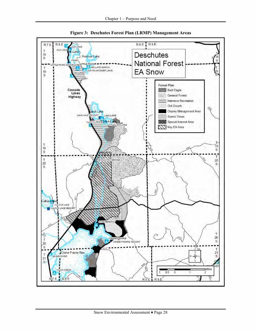
Chapter 1 – Purpose and Need
Snow Environmental Assessment ♦ Page 28
Figure 3: Deschutes Forest Plan (LRMP) Management Areas

Chapter 1 – Purpose and Need
Snow Environmental Assessment ♦ Page 29
Figure 4: Northwest Forest Plan

Chapter 2 ♦ Alternatives
Snow Environmental Assessment ♦ Page 30
CHAPTER 2
ALTERNATIVES Alternative 1 (No Action)
Alternative 2 (Proposed Action) Alternative 3

Chapter 2 ♦ Alternatives
Snow Environmental Assessment ♦ Page 31
CHAPTER 2 – ALTERNATIVES
INTRODUCTION This chapter describes and compares the developed alternatives. A description of each of the actions, or design elements of those actions is provided. Maps of each action alternative are also included. Alternatives are presented in comparative form, defining the differences between each alternative and providing a clear basis for choice among options to the decision maker and the public. The information used to compare the alternatives is based upon the design of the alternative (such as unit location and treatment differences). Precision of Information and Adjustments Quantifiable measurements, such as acres and miles, and mapped unit boundaries used to describe the alternatives and effects are based on the best available information. The analysis presented in this document is based on consideration of the full extent of the acres, miles, and other quantities depicted in the alternatives. Information used in designing the alternatives was generated from a mix of field reconnaissance, use of aerial photos, satellite remote sensing, use of global positioning system (GPS) technology, Geographical Information Systems (GIS), and various resource-specific databases.
Description of Activities The following are general descriptions of activities involved in the action alternatives. For more detailed description of activities, refer to Prescriptions in EA Appendix A. • Mechanical Shrub Treatment (MST): Use of mechanized equipment to mow, cut, chop, grind
or otherwise reduce shrub or ground fuel vertical structure. Equipment and attachments would be chosen based on soils (compaction and displacement potential), terrain, other resource concerns, and cost and availability. Reducing shrub density would reduce the continuity of shrub fuels, wild and prescribed fire intensity, tree scorch heights, and spotting potential (airborne dispersal of burning embers) during wildfire. Within Riparian Reserves, no ground-based equipment would be allowed within 75 feet of wetland vegetation.
• Cutting of Trees: Trees would be cut using intermediate and regeneration cutting methods.
Trees cut with commercial value would be sold and removed from the site. Actions connected with commercial harvest include road reconstruction, temporary road development, and hazard tree removal. Trees without commercial value would be retained on site and disposed of using a variety of slash treatment methods. Incidental live trees could be harvested in the development of logging facilities (skid trails, landings, and temporary roads). Within Riparian Reserves, no ground-based equipment would be allowed within 75 feet of wetland vegetation.
Intermediate Treatments
• Low Thin (Thin from Below): The smallest diameter trees and or the shortest trees would generally be priority for removal. Where removal of trees from the lower crown class will not reduce stocking to desired levels, remove trees from the dominant and codominant crown classes, retaining the best trees of those same crown classes.

Chapter 2 ♦ Alternatives
Snow Environmental Assessment ♦ Page 32
• Salvage: The removal of dead standing and down firm lodgepole pine that is in excess to wildlife and soils objectives. Logging facilities (skid trails, landings, and temporary roads) associated with salvage treatment may result in the necessary removal of live trees.
• Variable Density Thinning: Thinning from below combined with salvage and one or more
other thinning techniques (selection thinning or crown thinning). Thinning technique would vary depending on existing stand conditions. Thinning would preferentially leave fire resistant species by removing lodgepole pine and white fir from around ponderosa pine, western white pine, or Douglas fir (selection thinning). Additional reductions in stocking level would be achieved by thinning from below. Where tree density exceeds desired stocking levels, smallest diameter trees and/or the shortest trees in the stand would generally be priority for removal. Where removal of trees from the lower crown class would not reduce stocking to desired level, trees from the dominant and co-dominant crown classes would be removed to favor the best trees of those same crown classes (crown thinning). Relatively high stocking levels would be retained where ponderosa pine, Douglas fir or white fir exhibit older trees characteristics. In lodgepole pine stands where upper canopy level trees are diseased or low vigor, selection thinning could also include removing lodgepole pine from the upper canopy levels to favor lodgepole pine in lower crown levels. In some cases, small openings (less than 5 acres on less than 10 percent of treatment area) may be created where lodgepole pine in middle to upper canopy levels have poor crowns, deteriorating appearance, or dwarf mistletoe infection.
Regeneration Treatments
• Regeneration Cutting: Cutting in lodgepole pine stands to make regeneration possible or to assist regeneration already present. Even-aged regeneration methods proposed for use include seed tree, shelterwood, and overstory removal.
Seed Tree: All live lodgepole pine would be cut except for a relatively small number of widely dispersed trees retained for seed production and to produce a new age class. Shelterwood: Most live lodgepole pine would be cut leaving those needed to produce a new age class of trees in an environment where canopy cover helps moderate cold temperatures. More trees would be retained with the shelterwood cutting method compared to the seed tree method. Overstory Removal: Live lodgepole pine overstory, excess wildlife green tree retention objectives, would be cut to release regeneration already present. Priority for removal would be overstory trees infected with dwarf mistletoe or poor live crown ratios.
To provide green tree replacement in aggregates of moderate to larger size (0.5 to 2.5 acres or more), retain 10 percent of treatment area (gross acres) in patches which should include the largest, oldest live trees, decadent or leaning trees, and hard snags occurring in the unit. No treatment would occur within the patches, which should be retained indefinitely. Overstory trees retained outside of these clumps will provide dispersed structures (individual trees, and possibly smaller clumps less than 0.5 acres).
• Slash Treatment: Slash generated by cutting trees would be treated by a combination of
treatments. Treatments would include whole tree yarding, hand piling, and machine piling. Refer to Appendix A for details. These treatments would occur within scenic and safety corridors,

Chapter 2 ♦ Alternatives
Snow Environmental Assessment ♦ Page 33
around recreation sites, and within riparian reserves. Grapple piling and hand piling would be used, separately or in combination, to reduce small diameter thinning slash and natural fuels that are excess to fuel, soil, and wildlife management objectives. Grapple piles would generally be placed on skid trails or landings. Piles would be utilized if a market exists, otherwise burned. Excess slash and natural fuels within 50 feet of wetland vegetation would be removed and hand piled and burned outside of this 50 foot zone. Burning would occur within one to two years following treatments.
• Riparian Reserve Treatments: Fuels and vegetation treatments are planned in Riparian
Reserves under Alternatives 2 and 3. In accordance with interim standard width direction in the NWFP and the Snow Lakes Watershed Assessment, fish-bearing streams and wetlands greater than 1 acre would have Riparian Reserve widths of 300 and 150 feet, respectively. For implementation of this project, Riparian Reserves are divided into four zones (Figure 5 with descriptions), to reduce fuels while minimizing surface impacts close to wetland vegetation and streams.
Zone 1 (Wetland Vegetation): There would be no treatment within this zone. Wetland vegetation would be identified through the utilization of several characteristics: (1) ground cover of 50-75 percent dominated with the presence of rhizomatous graminoids typical of riparian areas; (2) presence of shrub layer of riparian species typical for the basin; and (3) identification of topographical change (slope break) that results in a transition to upland vegetation with reduced vegetative ground cover. Zone 2: Between 0-50 feet of wetland vegetation, no surface logging machinery would be allowed and only dead and downed trees would be removed (no snag removal). Downed trees extending into water or wetland vegetation (Zone 1) would not be removed. Dead and downed material may be removed by methods other than logging machinery (such as commercial firewood cutting) but again, no trees extending into water or wetland vegetation would be harvested. Alternative harvest methods would be restricted to non-motorized equipment. Zone 3: Between 50 and 75 feet of wetland vegetation, no surface logging machinery would be allowed and only dead and downed trees would be removed (no snag removal). Logging machinery would be able to utilize a boom to harvest downed trees between 50-75 feet while remaining outside of this zone (within Zone 4). Downed trees extending into water or wetland vegetation (Zone 1) would not be removed. Zone 4: In the fourth zone, further than 75 feet from the wetland vegetation, treatments using logging machinery would remove dead downed and standing trees, thin commercial and non-commercial trees, and pile slash. Machine piles would be 100 feet or greater from wetland vegetation. All landings, temporary roads, and landing piles would be located outside of Riparian Reserves. Mechanical treatments within Riparian Reserves adjacent to stream systems would occur almost exclusively on slopes of less than 5 percent.
Non-commercial thinning would occur in Zones 2 through 4 (Figure 5).

Chapter 2 ♦ Alternatives
Snow Environmental Assessment ♦ Page 34
Figure 5: Zones for Riparian Reserve Treatments

Chapter 2 ♦ Alternatives
Snow Environmental Assessment ♦ Page 35
ALTERNATIVE DESCRIPTIONS Alternatives were developed to address the Purpose and Need and key issues that were brought forward through public and internal comment. Three alternatives are analyzed in detail. Action alternatives meet the purpose and need for action in varying degrees.
Alternative 1 (No Action) Alternative 1 is the No Action alternative. This alternative is required by law and serves as a baseline for comparison of the effects of all of the alternatives. Under Alternative 1, current management plans would continue to guide management. There would be no change in the level of ongoing management activities within the project area. All custodial activities such as road maintenance, law enforcement, and response to emergencies, including wildfire, would continue. No additional treatment would be implemented to acccomplish project goals. Mountain pine beetle killed trees would continue to fall and add to the already heavy accumulations of dead, down hazardous fuels. These areas would continue to accumulate both dead and live vegetation, particularly lodgepole pine. High-density stands would continue to present an elevated risk of high intensity wildfire. These high-density stands would also continue to be at high risk for additional insect outbreaks that have caused much of the tree mortality that is widespread in the project area. Continuity of hazardous fuels would remain across large areas, both within and adjacent to the project area. Safety for both wildland firefighters and the public would continue to be at elevated risk for travel and suppression activities along travel corridors where high intensity wildfire would likely be unstoppable. The risk of wildfire spreading into areas that are heavily used by recreationists would continue. Limited habitat for the marten and black-backed woodpecker would remain in the OGMA. No economic returns would occur because salvage and thinning opportunities would not take place. Wood fiber, either for power or wood products, would not be made available for the project area. The opportunity to provide small diameter trees and salvaged dead trees for firewood would not occur. Stands adjacent to visual corridors would continue to primarily have views that are limited, of heavy dead standing and down trees, and of a heavy component of alive trees that have unhealthy crowns.
Alternative 2 (Proposed Action) With predominant winds in the area during the fire season from the Northwest to the Southeast, fuels treatments are strategically placed to intercept and slow a fire. The effectiveness of the treatments can be maximized to minimize potential fire spread, limit the source of new embers, and retard the growth of eventual spot fires. The size of treatments has been designed to mitigate over flight of embers into untreated areas. Longer separation distances between treatment units allow wider head fires to develop between those treatment units. An extensive landscape pattern of treatments were designed to intercept spot fires which breach units. Units were also identified to allow for safe access to many of the main roads and roads accessing recreation sites within the area. Strategically placed units upwind from recreation sites were also developed to reduce fire effects and hazard in high use areas. Changes Between Scoping and Environmental Assessment The scoping period provided public feedback. Based on public comments and additional field review, minor modifications were made to the proposed action. The following highlights the changes from the

Chapter 2 ♦ Alternatives
Snow Environmental Assessment ♦ Page 36
original proposed action and were found to not impact the overall fuels objectives for the Snow project. • Units were dropped from treatment or unit boundaries modified in Englemann spruce dominated
stands. Units dropped are 24-26, 28, 47 and 51. Modified boundaries include units 46, 50 and 52. • Units were identified with the primary fuels problem of brush and lodgepole pine regeneration.
The prescription was changed to precommercial thin and mechanical shrub treatment. This change includes units 96, 97, 98, 76, and 78.
• Units 36, 42, 54, 55 and 64 included slopes which are steeper than desired to treat with respect to water or riparian areas. The boundaries of these units were modified to exclude steep areas.
• Units were dropped from the Proposed Action because they were identified as not meeting the overall fuels reduction strategy. Units dropped include 94, 95 and 147
Alternative 2 (Proposed Action) Table 4 through Table 7 and Table 12 and Figure 6 through Figure 8 display treatments proposed in Alternative 2. Approximately 5,790 acres are proposed for treatment. Figure 6 and Figure 7 identify proposed units and treatment type. Total fiber volume from vegetative treatments is estimated to be 30.6 CCF (15.5 MMBF). All commercial harvest would use ground based logging methods. For unit specific information, refer to Appendix A.
Table 4: Alternative 2 (Proposed Action) - Summary of Silviculture Treatments
Vegetation Type and Prescription Riparian Reserves Total Net Acres
Lodgepole Pine • Intermediate Treatment
o Salvage and ladder fuels reduction (Rx 1) 212 2,275 o Salvage and precommercial thin (Rx 2) 35 2,068 o Low Thin (Rx 4 and 5) 13 194 o Precommercial thin (Rx 9) 57
Mixed Conifer, Ponderosa Pine, and Mountain Hemlock • Intermediate Treatment
o Hazard reduction and ladder fuels reduction on steep slopes (Rx 3) 3 o Variable Density Thin (Rx 6 and 7) 6 888 o Precommercial thin and mechanical shrub treatment (Rx 8) 305
Total Net Acres 266 5,790
Table 5: Alternative 2 (Proposed Action) – Proposed Slash Treatment - Net Acres Proposed Treatments Net Acres
Whole Tree Yarding 5,428 Grapple/Hand Piling 365 Hand Piling 68 Grapple Piling 4,871 Mechanical Shrub Treatment 305 Grapple Piling/Mechanical Shrub Treatment 181
Table 6: Alternative 2 (Proposed Action) – Net Treatment Acres by Management Allocation Allocation Net Acres Percent of Total Percent of Matrix
Matrix • Eagle 161 3 4

Chapter 2 ♦ Alternatives
Snow Environmental Assessment ♦ Page 37
Allocation Net Acres Percent of Total Percent of Matrix • Osprey 374 6 8 • General Forest 2,528 44 57 • Scenic Views
o Partial Retention Foreground 1,283 22 29 o Partial Retention Middleground 105 2 2
Scenic Views Subtotal 1,388 24 31 Matrix Subtotal 4,451 77 100
Administratively Withdrawn • Intensive Recreation 1,073 19 N/A
Riparian Reserves • Riparian Reserve 266 4 N/A
Total Treatment 5,790 Acres 100% -----
Table 7: Alternative 2 (Proposed Action) - Proposed Activities Prescription
Label Prescription Treatment1 Unit and Total Acreage
Prescription 1 Salvage and ladder fuels reduction in lodgepole pine plant associations.
1) Remove utilizable dead lodgepole pine firm wood, standing and down, excess to fuels, wildlife, and soils objectives. 2) Cut live lodgepole pine less than 4” dbh in the lower canopy levels that pose a hazard of igniting trees in upper canopy levels that could cause long distance spotting. 3) Pile and burn slash.
3-23, 29-34, 40, 48, 49, 53, 54, 58, 62, 63, 67, 70, 71, 75, 82, 84, 103-106, 113-115, 117-119, 125, 126, 128-130, 132, 133, 135, 137, 139, 142, 143, 145, 148, 158, 160, 161, 163-166, 168, 169, 171, 173, 180-182, 195, 206, 207 (2,275 acres)
Prescription 2 Salvage and precommercial thin in lodgepole pine plant associations where managable understory is present.
1) Remove utilizable dead lodgepole pine firm wood, standing and down, excess to fuels, wildlife, and soils objectives. 2) Cut live lodgepole pine less than 4” dbh excess to desired stocking levels, generally retaining no more than 302-436 trees per acre (tpa). Vary spacing to retain best tree. 3) Pile and burn slash.
37-39, 41, 43, 45, 59, 65, 66, 68, 69, 72-74, 81, 83, 85-89, 107-112, 116, 120-124, 127, 131, 134, 136, 138, 140, 141, 144, 146, 156, 157, 159, 162, 167, 170, 172, 174-179, 183-194, 196, 197 (2,068 acres)
Prescription 3 Hazard and ladder fuel reduction on steep slope (>30 percent).
1) Remove dead standing and down lodgepole pine and live lodgepole pine which could fall and make contact with the power lines. 2) Cut live lodgepole pine less than 4” dbh in the lower canopy levels that pose a hazard of igniting trees in the upper canopy levels 3) Hand pile and burn slash.
2 (3 acres)
Prescription 4 Low thin (thin from below) within scenic views and key elk area.
1) Remove utilizable dead lodgepole pine firm wood, standing and down, excess to fuels, wildlife, and soils objectives. 2) Cut live lodgepole pine less than 16” dbh, reducing stocking to the lower management zone appropriate for the site. Retain no more than 170 tpa. Vary spacing to retain best,
149-155 (134 acres)
1 Refer to EA, Appendix A for more detail.

Chapter 2 ♦ Alternatives
Snow Environmental Assessment ♦ Page 38
Prescription Label Prescription Treatment1 Unit and Total
Acreage most dominant tree 3) Pile and burn slash.
Prescription 5 Low thin (thin from below) in osprey and bald eagle management areas.
1) Remove utilizable dead lodgepole pine firm wood, standing and down, excess to fuels, wildlife, and soils objectives. 2) Cut live lodgepole pine less than 16” dbh, reducing stocking to the lower management zone appropriate for the site. Retain no more than 170 tpa. Vary spacing to retain best, most dominant tree and reduce stocking around manageable ponderosa pine. 3) Pile and burn slash.
198-202 (60 acres)
Prescription 6 Variable density thin in mixed conifer and ponderosa plant associations.
1)Remove utilizable dead lodgepole pine firm wood, standing and down, excess to fuels, wildlife, and soils objectives. 2) Vary thinning treatment depending on existing stand conditions. Remove lodgepole pine or immature white/grand fir (<100 years), in any canopy layer, within 25’ of manageble ponderosa pine or Douglas fir. Thin remaining trees from below, reducing stocking to levels that are appropriate for the site. Acceptable to retain true fir aggregations at upper stocking level where middle to upper canopy layers are dominated by mature trees (>100 years). 3) Pile and burn slash.
35, 36, 42, 46, 50, 52, 56, 57, 60, 61, 64, 64.1, 77, 79,80, 90-93, 99-102, 203-205 (880 acres)
Prescription 7 Variable density thin in mountain hemlock plant association.
1) Remove utilizable dead lodgepole pine firm wood, standing and down, excess to fuels, wildlife, and soils objectives. 2) Vary thinning treatment depending on existing stand conditions. Remove lodgepole pine or immature white/grand fir (<100 years), in any canopy layer, within 25’ of manageble western white pine or Douglas fir. Thin remaining trees from below, removing trees in the lower and middle canopy layers that provide ladders for fire to move into upper canopy layers. Retain stocking between upper and lower management zones. 3) Hand pile and burn slash
1 (8 acres)
Prescription 8 Precommercial thin and mechanical shrub treatment (mow) in mixed conifer or ponderosa pine plant associations.
1) Cut trees less than 4”dbh excess to desired levels, generally retaining no more than 200-260 tpa. Vary spacing to retain best tree. Generally favor ponderosa pine for retention, followed by Douglas fir, lodgepole pine, and true fir (in order of preference). 2) Mechanical shrub treatment throughout stand.
76, 78, 96-98 (305 acres)
Prescription 9 Precommercial thin in lodgepole pine
1) Cut live lodgepole pine less than 4” dbh excess to desired stocking levels. Generally
44 (57 acres)

Chapter 2 ♦ Alternatives
Snow Environmental Assessment ♦ Page 39
Prescription Label Prescription Treatment1 Unit and Total
Acreage plant association. reatain no more than 302-436 tpa. Vary
spacing to retain the best tree. 2) Hand pile and burn slash.

Chapter 2 ♦ Alternatives
Snow Environmental Assessment ♦ Page 40
Figure 6: Alternative 2 (Proposed Action) - Snow Treatment Units (North Half)

Chapter 2 ♦ Alternatives
Snow Environmental Assessment ♦ Page 41
Figure 7: Alternative 2 (Proposed Action) - Snow Treatment Units (South One-Half)

Chapter 2 ♦ Alternatives
Snow Environmental Assessment ♦ Page 42
Figure 8: Snow Project Alternative 2 (Proposed Action) - Temporary Roads

Chapter 2 ♦ Alternatives
Snow Environmental Assessment ♦ Page 43
Alternative 3 Alternative 3 was developed to address the Key Issues as discussed in Chapter 1: Key Issue #1: The Proposed Action (Alternative 2) could further address fuels and Forest Plan objectives for management of lodgepole pine. Key Issue #2: The Proposed Action (Alternative 2) landscape fuels strategy was designed to limit the potential for spotting from the west into heavy fuels accumulations. Strategic areas with heavy fuels accumulations remain within spotting distance of a fire burning to the west. Specific areas include north of the confluence of Snow Creek and Deschutes River and west of the Inventoried Roadless Area. Alternative 3 was designed to increase protection of recreation sites, administrative sites and access roads. These increases include treatments around Cow Camp and Deschutes Bridge campgrounds and Snow Creek Work Center. Additional fuels reduction is proposed along roads 4270, 40, 4000-970 and 4525, travel corridors for public and wildland firefighters during a wildfire event. This alternative was also designed to increase the likelihood of limiting the spread of fire from west of the area to the east thus increasing protection of the LSRs and the West and South Bachelor Roadless Area. The Inventoried Roadless Area limited options to widen treatments along the Cascade Lakes Highway between Hosmer Lake and Lava Lake. Wetlands limited the ability to place treatments around Cow Camp Recreation site. Alternative 3 proposes to increase net treatment acres to 6,099. This alternative includes most of the strategic locations proposed for treatment in Alternative 2 and proposes additional strategic locations for treatment. One addition is the Old Growth Management Area situated between Snow Creek and the Deschutes River. To treat in this strategic location, this alternative includes a proposal to amend the Deschutes LRMP by relocating the Old Growth Management Area and changing the former allocation to General Forest and Scenic (Partial Retention – Foreground). Table 10 summarizes treatment by management allocation, assuming the Forest Plan is amended as proposed. Units in Alternative 2 which were in the new Old Growth Management Area were eliminated and an area just along the main roads (Unit 303, 39 acres) was developed. It is a narrow unit adjacent to Forest Road 4270 and treatment would be limited to salvage and ladder fuels reduction. Additional areas proposed for treatment with this alternative would be within lodgepole pine, increasing the proportion of treatments in the lodgepole pine vegetation type to approximately 80 percent (Table 8). In addition to increasing treatment acres, different live tree treatments are proposed within lodgepole pine stands. Treatments in lodgepole pine stands unique to this alternative (Table 8) would include variable density thinning (an intermediate treatment) and regeneration harvest methods including seed tree, shelterwood, and overstory removal. In contrast to Alternative 2, few acres would have treatments that would limit cutting of live trees to less than 4 inches dbh (Prescriptions 1 and 2). Treatments within mixed conifer, ponderosa and hemlock stands would remain as proposed in Alternative 2. Table 8 through Table 12 and Figure 13 through Figure 15 display the activities proposed in Alternative 3. Approximately 6,099 acres are proposed for treatment. Total fiber volume from vegetative treatments is estimated to be 49.0 CCF (24.8 MMBF). All commercial harvest would use ground based logging methods. For unit-specific information refer to Appendix A. Figure 13 and Figure 14 display the treatment units proposed in Alternative 3.

Chapter 2 ♦ Alternatives
Snow Environmental Assessment ♦ Page 44
Table 8: Alternative 3 - Summary of Silviculture Treatment
Vegetation Type and Rx Riparian Reserve Net Acres
Total Net Acres
Lodgepole pine • Intermediate Treatment
o Salvage and ladder fuels reduction (Rx 1) 296 355 o Salvage and precommercial thin (Rx 2) 19 o Low Thin (Rx 4 and 5) 33 346 o Variable Density Thin (Rx 13) 13 2,187
• Even-aged Regeneration Harvest Method o Seed Tree (Rx 10) 392 o Shelterwood (Rx 11) 204 o Overstory Removal (Rx 12) 8 1,389
Mixed Conifer, Ponderosa pine, and Mountain Hemlock • Intermediate Treatment
o Hazard reduction and ladder fuels reduction on steep slopes (Rx 3) 3 o Variable Density Thin (Rx 6 and 7) 1 899 o Precommercial thin and mechanical shrub treatment (Rx 8) 305
Total Acres 351 6,099
Table 9: Alternative 3 – Proposed Slash Treatment - Net Acres Proposed Treatments Acres
Whole Tree Yarding and Salvage 5,794 Grapple/Hand Piling 445 Hand Piling 11 Grapple Piling 5,128 Mechanical Shrub Treatment 305 Grapple Piling/Mechanical Shrub Treatment 210
Table 10: Alternative 3 – Net Treatment Acres by Management Allocation Allocation Net Acres Percent of Total Percent of Matrix Matrix • Eagle 156 3% 3% • Osprey 371 6% 8% • General Forest 2,469 40% 53% • Scenic Views
o Partial Retention Foreground 1,474 24% 32% o Partial Retention Middleground 186 3% 4%
Scenic Views Subtotal 1,660 27% 36% Matrix Subtotal 4,656 76% 100%
Administratively Withdrawn • Intensive Recreation 1,053 17% --- • Old Growth (after plan
amendment) 39 1%
Riparian Reserve 351 6% --- Total Treatment 6,099 100% ---
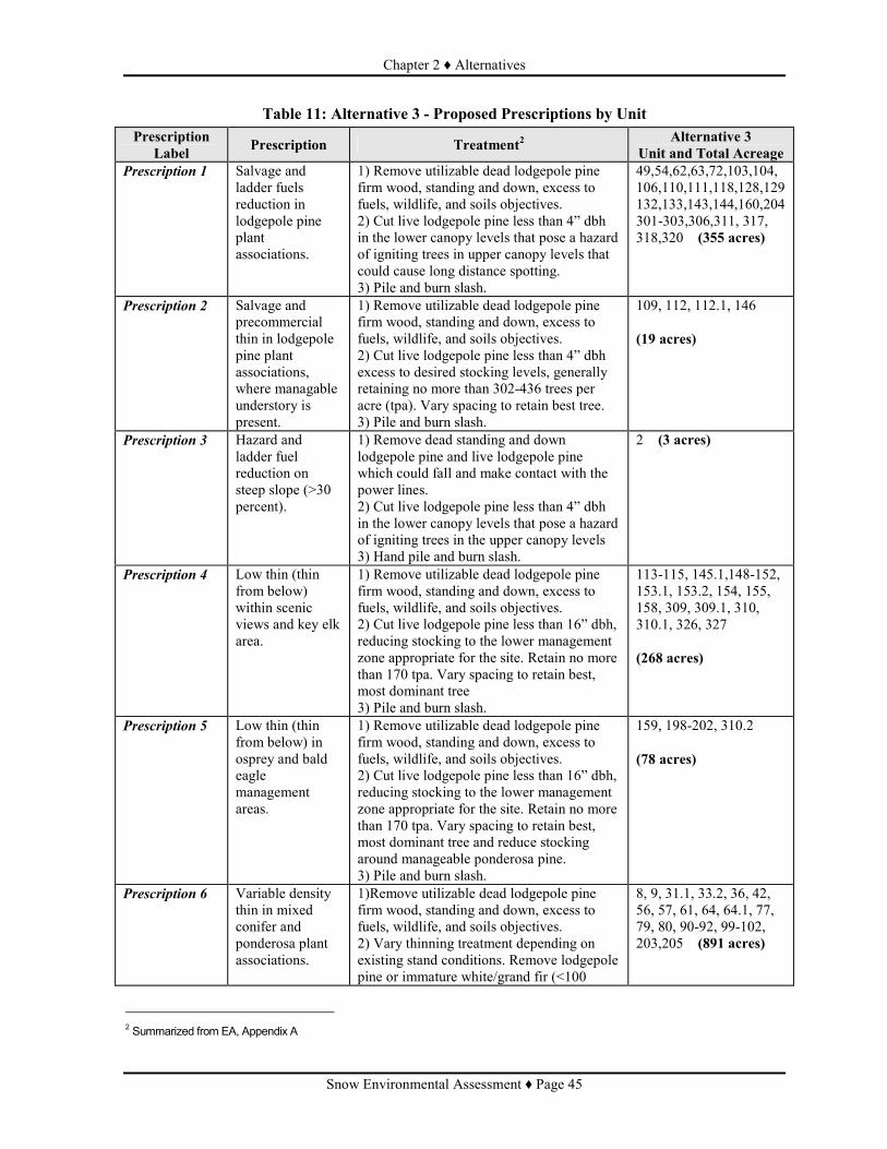
Chapter 2 ♦ Alternatives
Snow Environmental Assessment ♦ Page 45
Table 11: Alternative 3 - Proposed Prescriptions by Unit Prescription
Label Prescription Treatment2 Alternative 3 Unit and Total Acreage
Prescription 1 Salvage and ladder fuels reduction in lodgepole pine plant associations.
1) Remove utilizable dead lodgepole pine firm wood, standing and down, excess to fuels, wildlife, and soils objectives. 2) Cut live lodgepole pine less than 4” dbh in the lower canopy levels that pose a hazard of igniting trees in upper canopy levels that could cause long distance spotting. 3) Pile and burn slash.
49,54,62,63,72,103,104, 106,110,111,118,128,129 132,133,143,144,160,204301-303,306,311, 317, 318,320 (355 acres)
Prescription 2 Salvage and precommercial thin in lodgepole pine plant associations, where managable understory is present.
1) Remove utilizable dead lodgepole pine firm wood, standing and down, excess to fuels, wildlife, and soils objectives. 2) Cut live lodgepole pine less than 4” dbh excess to desired stocking levels, generally retaining no more than 302-436 trees per acre (tpa). Vary spacing to retain best tree. 3) Pile and burn slash.
109, 112, 112.1, 146 (19 acres)
Prescription 3 Hazard and ladder fuel reduction on steep slope (>30 percent).
1) Remove dead standing and down lodgepole pine and live lodgepole pine which could fall and make contact with the power lines. 2) Cut live lodgepole pine less than 4” dbh in the lower canopy levels that pose a hazard of igniting trees in the upper canopy levels 3) Hand pile and burn slash.
2 (3 acres)
Prescription 4 Low thin (thin from below) within scenic views and key elk area.
1) Remove utilizable dead lodgepole pine firm wood, standing and down, excess to fuels, wildlife, and soils objectives. 2) Cut live lodgepole pine less than 16” dbh, reducing stocking to the lower management zone appropriate for the site. Retain no more than 170 tpa. Vary spacing to retain best, most dominant tree 3) Pile and burn slash.
113-115, 145.1,148-152, 153.1, 153.2, 154, 155, 158, 309, 309.1, 310, 310.1, 326, 327 (268 acres)
Prescription 5 Low thin (thin from below) in osprey and bald eagle management areas.
1) Remove utilizable dead lodgepole pine firm wood, standing and down, excess to fuels, wildlife, and soils objectives. 2) Cut live lodgepole pine less than 16” dbh, reducing stocking to the lower management zone appropriate for the site. Retain no more than 170 tpa. Vary spacing to retain best, most dominant tree and reduce stocking around manageable ponderosa pine. 3) Pile and burn slash.
159, 198-202, 310.2 (78 acres)
Prescription 6 Variable density thin in mixed conifer and ponderosa plant associations.
1)Remove utilizable dead lodgepole pine firm wood, standing and down, excess to fuels, wildlife, and soils objectives. 2) Vary thinning treatment depending on existing stand conditions. Remove lodgepole pine or immature white/grand fir (<100
8, 9, 31.1, 33.2, 36, 42, 56, 57, 61, 64, 64.1, 77, 79, 80, 90-92, 99-102, 203,205 (891 acres)
2 Summarized from EA, Appendix A

Chapter 2 ♦ Alternatives
Snow Environmental Assessment ♦ Page 46
Prescription Label Prescription Treatment2 Alternative 3
Unit and Total Acreage years), in any canopy layer, within 25’ of manageble ponderosa pine or Douglas fir. Thin remaining trees from below, reducing stocking to levels that are appropriate for the site. Acceptable to retain true fir aggregations at upper stocking level where middle to upper canopy layers are dominated by mature trees (>100 years). 3) Pile and burn slash
Prescription 7 Variable density thin in mountain hemlock plant association.
1) Remove utilizable dead lodgepole pine firm wood, standing and down, excess to fuels, wildlife, and soils objectives. 2) Vary thinning treatment depending on existing stand conditions. Remove lodgepole pine or immature white/grand fir (<100 years), in any canopy layer, within 25’ of manageble western white pine or Douglas fir. Thin remaining trees from below, removing trees in the lower and middle canopy layers that provide ladders for fire to move into upper canopy layers. Retain stocking between upper and lower management zones. 3) Hand pile and burn slash
1 (8 acres)
Prescription 8 Precommercial thin and mechanical shrub treatment (mow) in mixed conifer or ponderosa pine plant associations.
1) Cut trees less than 4”dbh excess to desired levels, generally retaining no more than 200-260 tpa. Vary spacing to retain best tree. Generally favor ponderosa pine for retention, followed by Douglas fir, lodgepole pine, and true fir (in order of preference). 2) Mechanical shrub treatment throughout stand.
76, 78, 96-98 (305 acres)
Prescription 10 Seed tree regeneration method in lodgepole pine plant associations.
1) Retain 10% of gross area in untreated paches to provide moderate to larger size aggregates of green tree replacements. Outside of retention clumps: 2) Remove dead lodgepole pine firmwood, standing and down, excess to fuels, wildlife, and soils objectives 3) Cut all but about 17 lodgepole pine trees per acre, retained for seed production and dispersed green tree replacements. 4) Pile and burn slash.
18-21, 40, 58, 59, 70, 71, 75, 81, 82, 84, 117, 135, 137, 139, 180, 181.1 (392 acres)
Prescription 11 Shelterwood regeneration method in lodgepole pine plant associations.
1) Retain 10% of gross area in untreated paches to provide moderate to larger size aggregates of green tree replacements. Outside of retention clumps: 2) Remove dead lodgepole pine firmwood, standing and down, excess to fuels, wildlife, and soils objectives 3) Cut all but about 50 lodgepole pine trees per acre, retained for seed production, site amelioration, and dispersed green tree
30, 31, 31.2, 31.3, 32, 33, 33.1, 34 (204 acres)

Chapter 2 ♦ Alternatives
Snow Environmental Assessment ♦ Page 47
Prescription Label Prescription Treatment2 Alternative 3
Unit and Total Acreage replacements. 4) Pile and burn slash.
Prescription 12 Overstory removal regeneration method in lodgepole pine plant associations.
1) Retain 10% of gross area in untreated paches to provide moderate to larger size aggregates of green tree replacements. Outside of retention clumps: 2) Remove dead lodgepole pine firm wood, standing and down, excess to fuels, wildlife, and soils objectives. 3) Remove lodgepole pine overstory excess to that needed to provide wildlife green tree replacement. This would generally retain 9-14 tpa. Retention level may be lower, depending on residual diameters, level of dwarf mistletoe, and live crown ratio. 4) Pile and burn slash.
22,23,29,37-39,41,43,44, 53,65,87,88,93,105,107, 119.1,122-124,126.3, 127, 127.1,130,131,134, 134.1, 136,138,140, 140.1, 142, 161,172, 173, 174,176-178,181,182, 183, 300,300.3,304, 305.2-305.4,312, 13.1, 314,319,319.1,321,322, 325,328,329 (1,389 acres)
Prescription 13 Variable density thin lodgepole pine plant associations.
1) Remove dead lodgepole pine firm wood, standing and down, excess to fuels, wildlife, and soils objectives. 2) Vary thinning treatment depending on existing stand conditions. Removal generally limited to lodgepole pine. Where density of upper canopy level is less than lower management zone, remove trees from upper canopy level to favor those in lower canopy levels. Acceptable to create small openings (<5 acres on <10% of treatment area) where lodgepole pine in middle to upper canopy levels have poor crowns, deteriorating appearance, or dwarf mistletoe infection. Thin remaining trees from below, reducing stocking to the lower management zone appropriate for site conditions. 3) Pile and burn slash.
3-7,10-17,45,48,66,67, 69.1,74,83,85,86,89,108, 116,119,119.2, 120, 121, 125, 126,140.2,141,145, 156, 157,170,175,179, 184-197,206,207,305, 305.1, 305.8, 313 (2,187 acres)
Proposed Forest Plan Amendment – Old Growth Management Area (OGMA) Relocation Alternative 3 includes a non-significant amendment to relocate an OGMA (394 acres) to another location within the Snow project area. The new location (403 acres) would be established with larger and more widespread live trees and would provide wildlife habitat. The old OGMA area would then be treated to reduce hazardous fuels and to allow fire fighters to more safely, efficiently, and effectively fight wildfire. Units that would be treated are 300, 300.1, 300.2, 300.3, 300.4, 301, 301.1, 301.2, 301.3, 301.4, 302. The proposed change would affect the balance of Scenic and General Forest, Management Areas. The replacement Old Growth area is currently General Forest (336 acres) and Scenic, Partial Retention Foreground (67 acres). The current Old Growth area would be reclassified as Scenic Partial Retention Foreground (205 acres) and General Forest (189 acres). There would be a loss of 147 acres from General Forest.

Chapter 2 ♦ Alternatives
Snow Environmental Assessment ♦ Page 48
Northwest Forest Plan management areas are Administratively Withdrawn, Matrix and Riparian Reserve. The current old Growth area has Riparian Reserves along the east and west edges for both Deschutes River and Snow Creek. There would be no riparian reserves within the proposed Old Growth Area. The current Old Growth area woudl become Matrix and would still retain Riparian Reserves. Reason for Amendment The goal of the Old Growth Management Area (MA-15) is to provide naturally-evolved old growth forest ecosystems for 1) habitat for plant and animal species associated with old growth forest ecosystems, 2) representations of landscape ecology, 3) public enjoyment of large, old-tree environments, and 4) the needs of the public from an aesthetic spiritual sense (Forest Plan, page 4-149). Objectives include managing vegetation to provide large trees, abundant standing and downed dead trees, and vertical structure except in lodgepole pine types where a single canopy level is common.
Standard and Guide M15-5 states: If the structure of an old growth area is significantly altered through a catastrophic event such as a fire, windstorm, or insect epidemic, another stand would be substituted that meets the minimum requirements for the indicator species. The original area could then be salvaged and reforested. An old growth area will be considered significantly altered if it no longer meets the minimum habitat needs for the indicator species (Forest Plan, page 4-150). The existing OGMA is located between the Deschutes River and Snow Creek. Beetles have caused high mortality in the larger diameter lodgepole pine leaving mostly small diameter lodgepole pine with small crowns scattered through the area with a heavy component of dead, down logs. Retention of hazardous fuels in this area may provide an uninterrupted flow for wildfire to move east and southeast from Benchmark Butte and the Cultus Late Successional Reserve into the OGMA and across Snow Creek. This OGMA is not meeting its desired condition and it is not meeting the needs of the focal wildlife species, black-backed and three-toed woodpeckers and western pine marten. While the beetles were active in the area, the lodgepole pine provided woodpecker foraging habitat. The beetles have moved on and most of the dead trees have fallen, no longer providing desirable foraging or nesting habitat for woodpecker populations. The remaining canopy is greatly diminished and no longer provides habitat for the pine marten (personal communication, Kim Mellen-Mclean).

Chapter 2 ♦ Alternatives
Snow Environmental Assessment ♦ Page 49
Figure 9: Photograph in Current Old Growth Area - Snow Project

Chapter 2 ♦ Alternatives
Snow Environmental Assessment ♦ Page 50
Figure 10: Photograph in Proposed Old Growth Replacement Area - Snow Project

Chapter 2 ♦ Alternatives
Snow Environmental Assessment ♦ Page 51
Figure 11: Current Old Growth Management Area

Chapter 2 ♦ Alternatives
Snow Environmental Assessment ♦ Page 52
Figure 12: Proposed Old Growth Area - For Forest Plan Amendment

Chapter 2 ♦ Alternatives
Snow Environmental Assessment ♦ Page 53
Figure 13: Alternative 3 - Snow Treatment Units (North One Half)
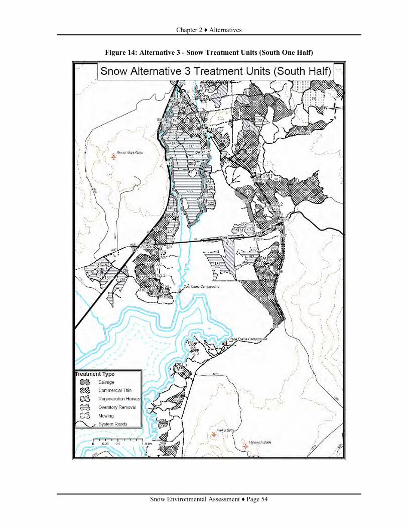
Chapter 2 ♦ Alternatives
Snow Environmental Assessment ♦ Page 54
Figure 14: Alternative 3 - Snow Treatment Units (South One Half)

Chapter 2 ♦ Alternatives
Snow Environmental Assessment ♦ Page 55
Figure 15: Snow Project Alternative 3 Temporary Roads

Chapter 2 ♦ Alternatives
Snow Environmental Assessment ♦ Page 56
Connected Actions Common to Alternative 2 (Proposed Action) and Alternative 3 Connected actions are actions associated with other proposed activities. These activities would not occur unless the activities proposed in Alternative 2 (Proposed Action) or Alternative 3 occur. Road reconstruction and temporary road development would not occur unless commercial harvest activities would occur. • Danger Tree Removal: Federal and State of Oregon safety regulations require that danger trees
along project area travel routes be felled prior to activities taking place. Roadside danger trees will be felled along these travel routes and where activity units border the road system and removed.
• Road Reconstruction:. Road reconstruction activities would include the restoration of drainage
features, slope stabilization, guardrail replacement, applying spot surfacing, a multi-layer bituminous surface treatment, or resurfaced with crushed aggregate prior to hauling products from commercial harvest activities on identified roads.
Table 12: Road Reconstruction Activities - Milepost Location and Total miles per Road Segment
Road Number Beginning Mile Post Ending Mile Post) Total Miles 4270000 7.64 11.30 3.66
• Road Maintenance: In addition to road reconstruction work, other roads that would be used for
timber haul would require maintenance, primarily blading and shaping of the roadbed and brush removal. Road 4600542 would require more extensive maintenance using engineering methods to protect natural resources. All activities would remain within the road prism and all affected areas would be restored upon project completion.
Road 4600542 would access Unit 29, proposed under both action alternatives and Units 29.1, 311, 311.1, and 318 under Alternative 3. A temporary improved crossing would occur, at an old crossing, over an intermittent seep near the Deschutes River. During high water table conditions in the early summer, this seep exhibits surface water that drains to a wetland. By late summer no surface water is evident and soil conditions are relatively dry. The temporary crossing would occur over an area approximately 25 feet wide during late summer when soil moisture is reduced. Geotextile cloth with temporary fill material would be used within the crossing, and would be removed after salvage operations are completed and before soil conditions gain moisture. Rehabilitation of the site, if needed, would occur immediately after removal of the crossing.
• Temporary Road Development: Commercial harvest operations are expected to require the use
of temporary roads, roads built to facilitate ground-based harvest systems for the singular purpose of removing forest products from a treated stand. These roads would usually be short, averaging less than 0.2 miles. Temporary roads would be built to low specifications that would allow equipment access to landings sites. These roads would be built on slopes less than 10 percent and would be constructed to the lowest possible standard capable of supporting log haul in order to minimize ground disturbance. Where possible, temporary roads would be used to access multiple units.
Where previous logging activities have occurred, the existing road prism would be used, necessitating the removal of down, dead trees and tree seedlings/saplings and shrubs that have established since the roads were closed. Following treatments, these roads would again be closed.

Chapter 2 ♦ Alternatives
Snow Environmental Assessment ♦ Page 57
Following project activities, temporary roads would be rehabilitated through subsoiling (tilling soil). No temporary roads or landings are planned within Riparian Reserves. The amount of temporary roads varies by alternative. Actual temporary road locations are determined through agreement by the Forest Service during timber sale contract administration.
In Alternative 2 there are approximately 10 miles of temporary road that are expected to be needed to access units (Figure 8). The average length of temporary roads expected is 0.2 mile, with the range of length from less than 0.1 mile to 0.5 mile. In alternative 3 approximately 10.5 miles of temporary road is expected (Figure 15). The average length of temporary roads in alternative 3 is 0.2 mile, with the range of lengths is from less than 0.1 mile to less than 1.0 mile.
MITIGATION MEASURES COMMON TO BOTH ACTION ALTERNATIVES Mitigation measures3 are an integral part of each of the action alternatives. The following would be applied to implementation of both action alternatives to reduce potential adverse impacts that could occur from proposed activities. The effectiveness of each measure is rated at high, moderate, or low to show how effective we expect they will be for preventing or reducing impacts on resources. These mitigation measures are considered in the effects discussions of Chapter 3. Effectiveness ratings are based on the following criteria: a) Literature and Research, b) Administrative Studies (local or within similar ecosystem), c) Experience (judgment of qualified personnel by education and/or experience, and d) Fact (obvious by reasoned, logical response).
• High: Practice is highly effective (greater than 90 percent), meets one or more of the rating criteria, and documentation is available.
• Moderate: Documentation shows that practice is 75 to 90 percent effective; or Logic indicates that practice is highly effective, but there is little or no documentation. The practice will be modified if necessary to achieve the mitigation objective.
• Low: Effectiveness is unknown or unverified, and there is little or no documentation; or applied logic is uncertain and practice is estimated to be less than 60 percent effective. This practice is speculative and needs both effectiveness and validation monitoring.
Fire and Fuels The Forest Service (USFS)) is required by law to follow the directions of the Forester for the protection of air quality in conducting burning operations. They are to follow smoke management weather forecasts and instructions, as provided by the Oregon Smoke Management Plan and the Operational Guidance for the Oregon Smoke Management Program, (Directive 1-4-1-601). 1. All pile burning would be conducted under the State of Oregon Smoke Management System to
track smoke produced and would be coordinated through Oregon Department of Forestry (Effectiveness: High).
3 Mitigation Measures include: Mitigation Measures, Project Design Criteria, Best Management Practices, and Management
Requirements. Each of these have been developed to reduce or eliminate potential adverse effects to the various resources, as
described in this section.

Chapter 2 ♦ Alternatives
Snow Environmental Assessment ♦ Page 58
2. Pile burning would be conducted under favorable smoke dispersal conditions, to avoid impacts to urban areas and Class I airsheds (Clean Air Act discussion below). Inversion conditions, which would increase the potential for smoke pooling in valleys and drainages, would be avoided during burning operations (Effectiveness: High).
3. The City of Bend is an area where air quality is of interest and is closely monitored for smoke intrusion and effects from burning operations (Effectiveness: High).
Wildlife Spotted Owl
1. One-quarter mile seasonal restriction around nest site or activity center. Affects Units 129, 130, 133, 140, 300, 310. March 1 through September 30 (Effectiveness: Moderate).
2. Burning of piles that are within 0.25 mile of mapped Nesting, Roosting, and Foraging (NRF) habitat will occur outside of the spotted owl breeding season (March 1 – September 30) (Effectiveness: High).
Bald eagle 1. One-quarter mile seasonal restriction for project activities (1/2 mile line-of-sight) around nest.
Potentially affects Units 29, 30, 31,129, 130, 133, 138, 203, 204, 205, 300, 301, and 318. January 1st through August 31st (Effectiveness: Moderate).
2. In order to minimize smoke from entering suitable habitat (including BEMAs and stands with large diameter ponderosa pine or Douglas fir associated with water), burning of piles will be conducted outside of the bald eagle breeding season (January 1 – August 31) (Effectiveness: High).
3. No piles will be located within 330 feet of any existing bald eagle nest, including alternate nest sites to prevent nest tree mortality as a result of wildfire (Effectiveness: High).
4. Avoid removal of overstory trees (excluding lodgepole pine) within 330 feet of any nest (Effectiveness: High).
5. Minimize potentially disruptive activities and development in the eagle’s direct flight path between nest and roost sites and important foraging areas. Potentially affect Units 129, 133, 143, 199, 200, 201, 202, and 301. January 1st through August 31st (Effectiveness: Moderate).
6. Protect and preserve potential roost and nest sites by retaining mature trees, particularly within one-half mile from water (Effectiveness: High)
7. Maintain gates and screening around gates so as not compromise road closure in BEMAs (Effectiveness: High).
Oregon Spotted Frog 1. Changes in hydrology of stream, spring, lake, or wetland should be for restoration purposes
only. Remove temporary crossing improvement on Forest Road 4600542 when project is completed. Affects Unit 29 (Alternative 2) and Units 29.1, 311, 311.1, and 318 (Alternative 3) March through July (Effectiveness: High).
2. Limit activities within streamside Riparian Reserve units channel migration zone or 100-year floodplain to those that have either a neutral or beneficial effect on floodplain function. Timing of those activities will be outside egg/laying hatching for that area. If not known then March 1 – May 31 (Effectiveness: High).

Chapter 2 ♦ Alternatives
Snow Environmental Assessment ♦ Page 59
Great Gray Owl 1. Potential habitat in the vicinity of Proposed Units (Alt 2 + 3): 29-31; 34, 36, 46-49, 62, 64, 66,
68, 70, 198-202, 204-207 will be surveyed in the spring of 2008. If no owls are located no restrictions would be implemented (Effectiveness: Moderate).
2. Active Great Gray owl nests will get a 30 acre no treatment buffer and a ¼ mile seasonal restriction from March 1st to June 30th (Effectiveness: Moderate).
Other Mitigation: 1. Remove merchantable down woody debris (DWD) that do not have root wads in touch with
ground. Remove all lodgepole pine DWD less than 15 inches dbh (Effectiveness: Moderate). 2. Restrict project activities around osprey nest from April 1st through August 31st in units 33 and
198-207 (Effectiveness: High). 3. Songbirds: To avoid negative effects to birds, including: nest destruction, loss of broods, and
direct mortality of adults, do not conduct mechanical shrub treatments during the period of April 15 – July 31. Units 76 and 78. (Effectiveness: Moderate)
4. Snag and CWM: Do not salvage any snags or coarse woody material from units 99, 100, and 101. Retain all snags greater than 15 inches dbh in unit 36. (Effectiveness: High)
Table 13: Summary of Operating Season Mitigation O = Open Season X = Closed Season Mitigation
J F M A M J J A S O N D High water Season – Operate only in open season: Units 142 & 154 (soils)
O O
Spotted Owl – no operation within ¼ mi of nest: Units 129, 130, 133, 140, 300, 310
X X X X X X X
Bald Eagle – if present: Units 29-31, 129, 130, 133, 138, 203-205, 300, 301, 318
X X X X X X X X
Spotted Frog Riparian Reserve Units 100 year flood plain Migration and Channel dispersal
X X X
Spotted Frog Egg laying at crossings. Units 29, 311, 318
X X X X X
Osprey Nest area: Units 33, 198-207 X X X X X Great Grey Owl Possible habitat could drop restrictions if no owls located in 2008 survey: Units 29-31, 34, 36, 46-49, 62, 64, 66, 68, 70, 198-202, 204-207
X X X X X X X
Great Grey Owls if found ¼ mile no distrbance X X X X Song Birds – no mowing: Units 76, 78 15 X X X Eagle dispersal flying between nest and rooost sites Units 129, 133, 143, 199-202, 301
X X X X X X X X
Soils Management Requirements Apply appropriate Best Management Practices (BMPs) to all ground-disturbing management activities, as described in General Water Quality Best Management Practices (Pacific Northwest Region, 1988). Specific BMPs commonly used to minimize the effects of road systems fuels and timber management activities on the soil resource are briefly described for this project proposal.

Chapter 2 ♦ Alternatives
Snow Environmental Assessment ♦ Page 60
1. Use old landings and skidding networks whenever possible. Assure that water control structures are installed and maintained on skid trails that have gradients of 10 percent or more. Ensure erosion control structures are stabilized and working effectively (LRMP SL-1; Timber Management BMP T-16, T-18) (Effectiveness: High).
2. In all proposed activity areas, locations for new yarding and transportation systems would be designated prior to the logging operations. This includes temporary roads, spur roads, log landings, and primary (main) skid trail networks. (LRMP SL-1 & SL-3; Timber Management BMP T-11, T-14 & T-16) (Effectiveness: Moderate).
3. Surface Drainage on Temporary Roads – minimize the erosive effects of concentrated water and degradation of water quality through the proper design and construction of temporary roads (Road BMP R-7) (Effectiveness: Moderate).
4. Road Maintenance – conduct regular preventive maintenance to avoid deterioration of the road surface and minimize the effects of erosion and sedimentation (Road BMP R-18, R-19) (Effectiveness: Moderate to high).
5. Coarse Woody Debris/Down Wood - Retain adequate supplies of coarse woody debris (greater than 3-inches in diameter) to provide organic matter reservoirs for nutrient cycling following the completion of all project activities (LRMP SL-1). It is recommended that a minimum of 5 to 10 tons per acre of CWD be retained on Ponderosa Pine sites, and 10 to 15 tons of CWD per acre should be retained on mixed conifer and lodgepole pine sites to help maintain long-term site productivity. These amounts are less than the recommended levels to be left for wildlife habitat objectives (Effectiveness: Moderate).
6. Maintain duff layer – Strive to maintain fine organic matter (organic materials less than 3-inches in diameter; commonly referred to as the duff layer) over at least 65 percent of an activity area (pertains to both harvesting and post-harvest operations). If the potential natural plant community (i.e., site) is not capable of producing fine organic matter over 65 percent of the area, adjust minimum amounts to reflect potential vegetation site capabilities (LRMP SL-6; Fuels Management BMP F-2; Timber Management BMP T-13). (Effectiveness: Moderate).
Project Design Criteria and Mitigation Measures Mitigation measures are specific actions that could be taken to minimize, avoid or eliminate potentially significant impacts on the resources that would be affected by the alternatives, or rectifying the impact by restoring the affected environment (40 CFR 1508.02). The following implementation guidelines are designed to avoid or minimize potentially adverse impacts to soils by controlling equipment operations to locations and conditions that are less susceptible to resource damage. This type of mitigation is built into the action alternatives as part of the project design.
Project Design Criteria Minimize the extent of new soil disturbance from mechanical treatments by implementing appropriate design elements for avoiding or reducing detrimental soil impacts from project activities. Options include using some or all of the following: Objective: Reduce displacement and compaction damage to soils by limiting the amount of surface area covered by logging facilities, and limiting equipment operations to specified areas and ground conditions.

Chapter 2 ♦ Alternatives
Snow Environmental Assessment ♦ Page 61
1) Use existing log landings and skid trail networks (whenever possible) or designate locations for new skid trails and landings.
2) Maintain spacing of 100 to 150 feet for all primary (main) skid trail routes, except where converging at landings. Closer spacing due to complex terrain must be approved in advance by the Timber Sale Administrator. Main skid trails spaced 100 feet apart limit soil impacts to 11 percent of the unit area. For the larger activity areas (greater than 40 acres) that can accommodate wider spacing distances, it is recommended that distance between main skid trials be increased to 150 feet to reduce the amount of detrimentally disturbed soil to 7 percent of the unit area (Froehlich, 1981, Garland, 1983). This would reduce the amount of surface area where restoration treatments, such as subsoiling, would be required to mitigate impacts to achieve soil management objectives.
3) Restrict grapple skidders to designated areas (i.e., roads, landings, designated skid trails) at all times, and limit the amount of traffic from other specialized equipment off designated areas. The use of harvester machines will be authorized to make no more than two equipment passes on any site-specific area to accumulate materials.
4) Avoid equipment operations during times of the year when soils are extremely dry and subject to excessive soil displacement.
5) Avoid equipment operations during periods of high soil moisture, as evidenced by equipment tracks that sink deeper than during dry or frozen conditions.
6) Operate equipment over frozen ground or a sufficient amount of compacted snow to protect mineral soil. Equipment operations should be discontinued when frozen ground begins to thaw or when there is too little compacted snow and equipment begins to cause soil puddling damage (rutting).
7) Prevent additional soil impacts in random locations of activity areas, between skid trails and away from landings, by machine piling and burning logging slash on existing log landings and skid trails that already have detrimental soil conditions.
Mitigation Measure: 1. Restrict mechanical disturbance in potentially wet areas that contain seasonally-high water tables.
Locate designated skid trails and log landings on well-drained sites, upslope from potentially wet areas. Restrict grapple skidding equipment to roads and designated skid trails at all times. Mechanical harvesters would only be allowed to make no more than two equipment passes on any site-specific area between main skid trails or away from log landings. Conduct mechanized harvest and salvage activities during the drier portion of the summer/fall (August and September) operating season. Limit the depth of subsoiling treatments to the minimum necessary to loosen compacted soils on main skid trails and log landings. Exceptions would be subject to Forest Service approval (Effectiveness: High). Portions of the following EA units contain sensitive soils with seasonally-high water tables. Alternative 2 Units: 142 and 154. Alternative 2 Units: 142, 154, and 301. Objective: Protect or maintain the quality of soil properties and shallow rooted vegetation by controlling equipment operations to locations and conditions that are less susceptible to soil puddling and compaction damage. Confine equipment impacts to designated areas that can be mitigated following harvest and post-harvest activities (Effectiveness: High). Basis: Forest Plan Standards and Guidelines for Soil, Water and Riparian Resources (SL-1 and SL-3); General Water Quality Best Management Practices (Pacific Northwest Region, 1988), Timber Management BMPs T-2, T-4, T-11 and T-12, Fuels Management BMP F-2; Forest Service Soil and Water Conservation Practices Handbook (FSH 2509.22); Froelich et al 1981; Clayton, 1990; Experience

Chapter 2 ♦ Alternatives
Snow Environmental Assessment ♦ Page 62
2. Reclaim all temporary roads, and some log landings and primary (main) skid trails by applying appropriate rehabilitation treatments in activity areas where detrimental soil conditions are expected to exceed the Regional Policy guidelines following mechanical treatments proposed with this project. Decommission (obliterate) logging facilities that will not be needed for future management. Options for mitigating the effects of project activities include the use of subsoiling equipment to loosen compacted soils on temporary roads and logging facilities, redistributing humus-enriched topsoil in areas of soil displacement damage, and pulling available slash and woody materials over the treated surface to establish effective ground cover protection (Effectiveness: High). Alternative 2 EA Units: 37, 41, 45, 54, 56, 59, 61, 63, 66, 68, 69, 72, 73, 74, 77, 79, 80, 81, 83, 85 – 93, 99 – 102, 111, 112, 136, 141, 149 – 155, 159, 162, 170, 175 – 179, 184 – 190, 196, and 198. Alternative 3 EA Units: 18 – 23, 29, 37 – 41, 43 – 45, 53 – 56, 58 – 61, 63, 65, 66, 69.1, 70 – 72, 74, 75, 77, 79- 93, 99 – 102, 105, 111, 112, 112.1, 117, 119.1, 122 – 124, 126.3, 127, 127.1, 130, 131, 134, 134.1, 135 – 140, 140.1, 140.2, 141, 142, 149 – 152, 153.1, 153.2, 154, 155, 159, 161, 170, 172 – 181, 181.1, 182 – 190, 196, 197, 300, 300.3, 304, 305, 305.1, 305.2, 305.3, 305.4, 305.8, 310, 310.1, 310.2, 312, 313, 313.1, 314, 319, 319.1, 319.2, 320 – 322, 325, 328, and 329. Objectives: Reduce the extent of detrimentally disturbed soil to meet management objectives. Restore and stabilize detrimentally disturbed soils prior to seasonal runoff events. Basis: Forest Plan Standards and Guidelines for Soil, Water and Riparian Resources (SL-1 and SL-4); Watershed Management BMP W-1; Cafferata, 1983; Garland, 1983; Experience, Logic.
Ongoing Research 1. Ongoing research plots will be excluded from treatment areas either through revision of the unit
boundary or flagging sites for avoidance. An appropriate buffer will be established by coordinating with the contact person for the study. (Effectiveness: High).
The following units, by alternative, include plots associated with the active study titled “Levels of Lodgepole Pine Growing Stock”. The initial researcher was Walter G. Dahms.
Alternative 2: Units 167, 168, 169, and 170. Alternative 3: Units 170 and 303.
Fish and Hydrology Units 104, 106, 110, 111, and 113 are within Riparian Reserves of Snow Creek and the Deschutes River, and have localized areas of slope greater than 5 percent but predominantly less than 10%. During layout of these units for implementation, a fisheries biologist, hydrologist, or soil scientist would be on-site to determine if excluding the use of logging equipment (including commercial firewood trucks) would be required to prevent overland flow of sediments to the streams. Areas excluded to logging equipment operation would be treated with non-mechanized methods, such as hand crews, that limit disturbance to the soil organic layer and ground cover (Effectiveness: High).
Botany – Invasive Plants Project Design Criteria: Project Design Features for the Snow Project are taken from the Guide to Invasive plant Prevention Practices and from the Deschutes National Forest Integrated Weed Management Plan. When considering the use of a weed prevention practice, the efficacy of the weed prevention practice, its feasibility to implement in the specific situation, and its cost-effectiveness are evaluated. A determination of cost-effectiveness may consider the probability and cost of weed control if a weed prevention practice is not used and the relative contribution of the project or activity to the overall weed risk at the site. The Project Design Features listed below have been evaluated and

Chapter 2 ♦ Alternatives
Snow Environmental Assessment ♦ Page 63
have been determined to be effective, feasible, and cost-effective. 1. Before ground-disturbing activities begin, prioritize and manually treat weed infestations in
project operating areas and along access routes. (Effectiveness: Moderate).
2. Use clean-equipment contract clauses (local and regional) to minimize the introduction and spread of noxious weeds by contractors (Effectiveness: Moderate).
3. Conduct operations in uninfested areas before operating in infested areas (Effectiveness: Moderate).
4. Known weed sites will be shown on the Sale Area Map. Landings and skid trails will not be allowed within these sites (Effectiveness: Moderate).
5. Minimize soil disturbance and retain native vegetation, in and around project activity areas, to the extent possible consistent with project objectives (Effectiveness: Moderate).
Scenic 1. Design fuel and vegetation units to minimize ground disturbance and damage to vegetation in
foreground treatment areas (First 300 feet – Highway 46, Road 40) (Effectiveness: High).
2. Minimize the amount of marking paint that is visible from Highway 46, Road 40, and recreation sites (Effectiveness: High).
3. Locate skid trails and landings at least 300 feet away from Highway 46, Road 40, and recreation sites (Effectiveness: High).
4. Flush cut stumps to less than 6 inches in height within the first 300 feet from Highway 46, Road 40, and recreation sites (Effectiveness: High).
5. Clean-up activities in foreground treatment areas, including landings, skid trails, and slash piles, should be completed within two years post-treatment (Effectiveness: High).
6. Locate slash piles for burning in areas that will minimize scorching within foreground treatment areas. Severely damaged or burned trees (more than two-thirds live crown scorch) shall be removed as part of post-treatment activities within two years. Locate grapple piles on logging facilities (Effectiveness: High).
7. Remove visible flagging when unit activities are completed (Effectiveness: High).
Cultural Resources 1. Seven eligible or unevaluated cultural resource sites will be excluded from treatment areas either
through revision of the unit boundary or flagging sites for avoidance. An appropriate buffer will be established for the latter method of avoidance by coordinating with the responsible individual(s) to identify and mark areas requiring protection (Effectiveness: High)
2. In the event that previously unknown sites or artifacts are found during project implementation, they will be flagged and operations in the area avoided until an archaeologist is consulted (Effectiveness: High).
Recreation 1. Traditional informal campsites, hunter camps, or areas where concentrated recreation use occurs
will be recognized as being significant in producing and utilizing dispersed recreation opportunities. Prescriptions for harvesting, cleanup, site preparation, and thinning will consider the environmental setting that contributes to the attraction of these sites for recreation purposes.

Chapter 2 ♦ Alternatives
Snow Environmental Assessment ♦ Page 64
The attempt will be made to retain this attractive character during and after treatments (LRMP S&G M8-2, page 4-117). (Effectiveness: High).
2. Locate landings at a minimum 200 feet from trails and trailheads. 3. Only allow trail crossings by skidders and skid trails greater than 200 feet apart. 4. Yard/locate bundles of trees as far from trails as possible. Do not allow log decks to occur on the
trail.
COMPARISON OF THE ALTERNATIVES The total number of acres proposed for treatment would increase from approximately 5,790 acres in Alternative 2 to approximately 6,099 acres in Alternative 3. Approximate commercial volume would be 30.6 CCF in Alternative 2 and 49.0 CCF in Alternative 3. the expression of volume is in CCF or hundred cubic feet. This is used instead of MBF or thousand board feet because of the low amount of fiber to be removed as sawtimber. In Alternative 2, 18% of the fiber volume is expected to be sawtimber and in Alternative 3, 47% of the volume is expected to be sawtimber. Table 14 provides an overall comparison of Alternative 2 (Proposed Action) and Alternative 3 in relation to the proposed activities.
Table 14: Comparison of Silviculture Treatment by Alternative
Vegetation Type and Rx Alternative 2 Net Acres
Alternative 3 Net Acres
Lodgepole pine Intermediate Treatment o Salvage and ladder fuels reduction (Rx 1) 2,275 355 o Salvage and precommercial thin (Rx 2) 2,068 19 o Low Thin (Rx 4 and 5) 194 346 o Variable density Thin (Rx 13) 0 2,187 o Precommercial thin (Rx 9) 57 0
Even-aged Regeneration Harvest Method o Seed Tree (Rx 10) 0 392 o Shelterwood (Rx 11) 0 204 o Overstory Removal (Rx 12) 0 1,389
Mixed Conifer, Ponderosa pine, and Mountain Hemlock Intermediate Treatment o Hazard reduction and ladder fuels reduction on steep slopes (Rx 3) 3 3 o Variable Density Thin (Rx 6 and 7) 888 899 o Precommercial thin and mechanical shrub treatment (Rx 8) 305 305
Total Acres 5,790 6,099 Table 15 provides an overall comparison of Alternative 2 (Proposed Action) and Alternative 3 in relation to proposed treatment acreage by management allocation.
Table 15: Comparison of Treatment Acres by Management Allocation
Allocation Alternative 2 Net Acres
Alternative 3 Net Acres
Matrix

Chapter 2 ♦ Alternatives
Snow Environmental Assessment ♦ Page 65
Allocation Alternative 2 Net Acres
Alternative 3 Net Acres
• Eagle 161 156 • Osprey 374 371 • General Forest 2,528 2,469 • Scenic Views o Partial Retention Foreground 1,283 1,474 o Partial Retention Middleground 105 186
Scenic Views Subtotal 1,388 1,660 Matrix Subtotal 4,451 4,656
Administratively Withdrawn • Intensive Recreation 1,073 1,053 • Old Growth 0 39 Riparian Reserve 266 351 Total Treatment Acres 5,790 6,099
SUMMARY OF COMPARISON OF ALTERNATIVES Table 16: Comparison of Alternatives to Purpose and Need and Key Issues (Chapter 3
Summary) Purpose & Need Alternative 1 Alternative 2 Alternative 3
Safe Escape / Access routes
Limited: Road 4270 South of Crane Prairie Resort 2.3 miles
Good: Covers 20.7 miles of main access roads including Cascade lakes highway and forest road 40.
Best: Covers 24.7 miles of main access roads including Cascade lakes highway and forest road 40.
Resource/ Values Protection
Low Moderate High
Recreation & administrative sites
Low: Only Lava Lake and Crane Prairie Resorts with reduced fuels approaching sites.
Moderate: Total of 4 sites with areas up wind treated.
High: Total of 6 sites with areas up wind treated.
West and South Bachelor Roadless Area
Low: Only highway interrupting fuels to the west.
Low: Surface and ladder fuels lower along Cascade Lakes Highway though buffer not wide enough to stop a large or spotting fire. Treatments limited to outside wilderness and roadless area.
Low+: Surface, ladder and canopy fuels lower along Cascade Lakes Highway though buffer not wide enough to stop a large spotting fire. Crown fire interruption possible with reduced crown densities Treatments limited to outside wilderness and roadless area.
Sheridan LSR Low: Little chance of containing larger fires in basin.
Moderate: Good chance of containing fire in basin.
High: Low chance of crown fire and high possibility of containing fire in basin.
Riparian Reserves
Low: Heavy fuels adjacent and within most riparian reserve areas.
Moderate: Fuels adjacent and within riparian reserves reduced along 10.5 miles of stream (37-
Moderate: Fuels adjacent and within riparian reserves reduced along 12.2 miles of stream (46-

Chapter 2 ♦ Alternatives
Snow Environmental Assessment ♦ Page 66
Purpose & Need Alternative 1 Alternative 2 Alternative 3 38%) and 266 acres riparian reserve treated.
49%) and 351 acres riparian reserve treated
Provide Forest Products Low: No wood fiber Moderate: 30.6 CCF wood fiber.
High: 49.0 CCF wood fiber.
Key Issues Lodgepole pine even-aged structure
No treatments Low 194 acres High 4,318 acres
Area within ½ mile of western boundary where embers could land causing spot fires in Fuel Models 2,5,8 and 9.
0 miles: No large area treatments on west side of area.
7.3 miles: Limited by areas limited by Land allocations including Old Growth and Inventoried Roadless
10.6 miles: Mostly limited by Land allocation limiting management Inventoried Roadless .
MONITORING Wildlife
Monitoring during implementation to meet protocol for Spotted Owl. Monitor Gate closure effectiveness on roads leading into BEMAs.
Soils Project monitoring focuses primarily on implementation monitoring to ensure the selected alternative, including mitigation measures, are properly implemented on the ground as designed and achieve the desired results. Soil Quality Objective: To determine if post-project subsoiling mitigation was effectively accomplished and reduced the extent of detrimentally compacted soil in a representative sample of EA Units. Monitoring Elements: Surface area treated on temporary roads and primary logging facilities. Area of Consideration: Individual activity areas (EA Units). Suggested Methodology: Combination of visual survey and shovel probing.
Botany Conduct post-activity monitoring and control of noxious weeds within and adjacent to the sale area and along haul routes for at least three growing seasons following completion of the project.
Scenic Monitoring is to be completed by a Landscape Architect within two years following completion of treatment and mitigation activities.
Cultural Resources Monitoring will occur during and following completion of project activities to determine compliance.
Sale Area Improvements Stocking Surveys in regeneration units.

Chapter 2 ♦ Alternatives
Snow Environmental Assessment ♦ Page 67
Whip felling. Subsoiling. Weed Surveys on Subsoiled acres. Weed Surveys of weed sites in units. Monitor Gate Closures. Rehabilitation of impacted trailhead. Rehabilitation of trails impacted by logging. Precommercial thinning. Precommercial thinning slash piling Raking fuels accumulations from around nest trees in BEMA units. Flagging Removal in Scenic Corridors.
ALTERNATIVES CONSIDERED BUT NOT ANALYZED IN DETAIL Use smaller diameter limits for harvesting live trees in mixed conifer and treat surface and
ladder fuels only During scoping, members of the public requested that the Forest Service limit thinning fuels activities in the mixed conifer stands to removing only the small diameter (4 to 12” dbh) trees, and pruning limbs of larger trees. The purpose for this diameter limit would be to leave the oldest structure and most fire resistant trees in the thinned areas. This was considered, in the context for the purpose and need described in Chapter 1. Such a diameter limit would not 1) provide the necessary long-term benefits of reducing hazardous fuel loading and continuity or 2) allow selection of fire-resistant trees. The smaller diameter limits would also not meet the need of producing wood fiber for the economy. Within the mixed conifer stands, resistance to mortality from fire is achieved by more than one mode. Not only reducing fuels, both live and dead, is important, but selecting trees which are resistant to fire is also important. Within the mixed conifer stands this can be achieved through the selection of tree species which are resistant to fire, such as ponderosa pine and Douglas fir (Table 32). This can also be achieved by selecting trees that are less fire resistant species but which were established prior to fire exclusion (approximately 100 years ago) and have possibly survived one or more visits by fire (Brown 2004). Fire resistant species are preferred to be left because they live longer and can usually survive more fire events than species that are less fire resistant. Fire resistant, early seral ponderosa pine and Douglas fir trees are not currently well represented on the landscape, as discussed in the Snow Lakes Watershed Assessment. Developing and maintaining a component of these species that are large diameter trees, or can more likely become large diameter, is needed. In many stands, Douglas fir and ponderosa pine are few in number and many have smaller diameters than younger white fir or lodgepole pine. Ponderosa pine and Douglas fir are not tolerant of competition, from the side or being overtopped, and their release from competition is needed to improve growth and vigor. Release would also reduce the susceptibility to torching or crown fire, particularly when trees become larger. Thinning with diameter limits would randomize the tree species selected to retain. White fir can be more fire resistant after a century or so (Thomas 1986). White fir trees which are older and were established before fire exclusion have fire resistant indicators, such as few lower level

Chapter 2 ♦ Alternatives
Snow Environmental Assessment ♦ Page 68
branches, thick bark, domed tops and fire scars. The age of these trees is not closely tied to the diameter and surveys through the Snow area showed a wide range of diameters in relation to ages. Older trees in many places are smaller diameter than fast growing younger trees. Throughout the mixed conifer stands the character is highly variable with respect to species, diameter distribution and stocking. Inconsistent reduction of fuels would be achieved with diameter caps. This is similar to other research (Abella et al, 2006 & Mason et al. 2003) which simulated or modeled fuels reduction projects comparing thinning with diameter caps and thinning from below without diameter caps. It is recognized that there is a need to retain trees in mixed conifer stands that 1) have fire resistant characteristics and 2) are older. Planned variable density thinning (EA, Appendix A) for both action alternatives has been designed to meet the desire of retaining fire resistant species and white fir trees that were established prior to effective fire exclusion. Variable density thinning would preferentially leave fire resistant spacing by removing lodgepole pine and white fir from around ponderosa pine and Douglas fir. Additional reductions to stocking levels would be achieved by thinning from below. Relatively high densities would be retained where ponderosa pine, Douglas fir, or white fir exhibit older tree charactieristics (Project Record, Silviculture Report, Appendix C) . By limiting treatment in mixed conifer stands to ladder fuels and small diameter thinning, the purpose and need of the project would not be met. Reduce the area treated by treating only stands along access roads Public comments also suggested limiting treatments specifically to areas associated with roads. This alternative was not considered in detail because treatments along roads only, though good for the safety of public visitors to the forest and firefighters, would not meet the needs of the project. Embers causing fires has recently been the main cause of large fire growth in the Deschutes National Forest. The most recent example of this was the GW fire on the Sisters Ranger District. This fire, with wide fire lines, continually grew during its duration, specifically because of spotting across lines and subsequent fire ignition in heavy fuel accumulations. Similar characteristics are present in the Snow project area showing the lack of suitability of this approach. Fuels reduction at strategic locations across the project area are intended to modify fire behavior so that important forest values can be protected, such as the LSRs, roadless areas, recreation sites etc. No mechanical fuels treatment in large unroaded areas. One comment from scoping asked that fuels in large unroaded areas be treated without the use of mechanical means. The areas identified as unroaded that have proposed treatments are dominated by lodgepole pine, which has experienced a bark beetle outbreak. These areas were identified to provide part of the strategy of fuels modification that would allow safe fire suppression. Treating these areas could keep large fires from entering the West and South Bachelor Roadless Area and the area adjacent to Crane Prairie reservoir. If the fuels are not treated in these areas, the purpose and need would not be met. Using non mechanized treatments in these areas would be limited to prescribed fire and hand piling. The level of large diameter fuels and the plant type do not lend themselves to treatment by prescribed fire or hand. Prescribed fire would cause mortality to the live trees which are lodgepole pine. Using prescribed fire at the times when fuels will burn, but not get out of control and burn into other areas, is

Chapter 2 ♦ Alternatives
Snow Environmental Assessment ♦ Page 69
not considered possible. Hand fuels treatments, which would include hand cutting and piling, would not be possible with the level of fuels present in the areas in need of fuels treatment. Removal of a majority of the fuels that are present is needed to meet the fuels strategy and the purpose and need.

Chapter 3 ♦ Snow Environmental Assessment
Snow Environmental Assessment ♦ Page 70
CHAPTER 3
AFFECTED ENVIRONMENT and
ENVIRONMENTAL CONSEQUENCES
Chapter 3 ♦ Snow Environmental Assessment
Snow Environmental Assessment ♦ Page 71
CHAPTER 3 – AFFECTED ENVIRONMENT AND ENVIRONMENTAL CONSEQUENCES
INTRODUCTION The Affected Environment refers to the existing biological, physical, and social conditions of an area that are subject to change, directly, indirectly, or cumulatively as a result of a proposed human action. Information on the affected environment is found in each resource section under “Existing Condition.” The effects may be direct, indirect, or cumulative. The Affected Environment (existing condition) and Environmental Consequences (Effects) section provides the scientific and analytical basis for alternative comparison. This chapter summarizes the various environments of the project area and the anticipated effects of implementing each alternative on that environment. Probable effects are discussed in terms of environmental changes from the existing condition and include qualitative as well as assessments of direct, indirect, and cumulative effects. Direct effects: Effects that occur at the same time and in the same general location as the activity causing the effects. Indirect effects: Effects that occur at a different time or different location than the activity to which the effects are related. Cumulative effects: –Effects that result from the incremental impact of the action when added to other past, present, and reasonably foreseeable future actions. Consideration of past actions follow guidance provided by the Council of Environmental Quality (June 24, 2005 Memorandum from James L. Connaughton, Project Record.) The following is a list of ongoing and reasonably foreseeable activities which may have some cumulative effects for different resources. Effects are bound in time and space. For most resource analysis finished activities are considered in the existing condition and so are already considered in the effects. The space within which most activities have cumulative effects are at the watershed scale or at the scale of individual activity units, this may vary by resource. The following table identifies activities, their actions and whether they are in the Crane Prairie watershed or have any activities which overlap proposed units in the Snow project.
Table 17: Ongoing and Reasonably Foreseeable Projects for Cummulative Effects Analysis for the Snow Project Area
Project Description Within Crane Prairie Watershed
Within Unit
Boundaries Ongoing Actions
Midstate Electric Powerline Maintenance
Hazard trees, pole changes, mowing, access roads already established yes yes
ODFW Cabin site maintenance 1.5 acres all year use for fish and wildlife monitoring, hazard tree falling
yes no
Lava Lakes Resort Maintenance
Hazard tree falling yes no
Crane Prairie Resort Maintenance
Hazard tree falling yes no
Irrigation District Adjusting water level; Hazard tree yes no

Chapter 3 ♦ Snow Environmental Assessment
Snow Environmental Assessment ♦ Page 72
Project Description Within Crane Prairie Watershed
Within Unit
Boundaries Improvements and Reservoir level maintenance
falling
County roads Right of way maintenance
Grading, hazard tree removal and snow removal yes yes
Inmate camp at Deschutes Bridge
Use and Hazard tree removal yes no
Gauging station with Oregon Water Resources Department
2- near Cow Meadow (1- Deschutes River & 1-Cultus River) yes no
Developed recreation site Maintenance Lava Lake Campground Cow Meadow Campground Crane Prairie Campground Fawn Campground Point Picnic area Deschutes Bridge Campground and correction crew abode Lucky Lake Trailhead Summer hiking and horse trails Winter snow mobile trails
Hazard tree removal, clean up
yes
no no no no no no no no yes no
Charlie Brown EA1 Fire wood, burning, thinning, mowing,, Lo, Snoop timber sales still operating, all sales post-harvest work left (meadow work done)
yes no
Landing & Red Plague EAs 1996
Red Plague sale some post harvest activities left yes no
Correction Crew Camp Relocation Project
Relocation done, on-going occupancy yes no
Cascade Lakes Restoration EA 1997
Recreation and Scenic activities not completed Red Elk Timber Sale completed thinning and hand piling left
yes no
Hosmer Project & Hosmer Revision Project 2001
Recreation camp sites and ramps & cutting hazard trees yes no
4 Corners Thinning and Release CE 1999 & 2001
4 corners fire some done. One unit w/in project (NW end of fire) yes no
Elk Lake Fuels Reduction CE 1998
80 acres dead removal around houses yes no
Reasonably Foreseeable Actions Cultus CE Safe fire access to campground and
lake yes no
Sparky Hazard Tree removal Remove live and dead hazard trees along Cascade Lakes Highway yes no
Weed EIS Spray & control weed sites yes yes (177) Highway 42 Reconstruction Widen and straighten no no
1 Lo and Snoop units within watershed: Lo Units 1 and 2 = 64 acres; Snoop Units 2-12, 22-26 = 1097 acres. Total = 1161 Reports have been summarized for each resource, and hereby incorporated, in the following discussions. For more detailed and supporting documentation, and to incorporate by reference, refer to the specialist reports in the Project Record located at the Bend-Fort Rock District Office. Other

Chapter 3 ♦ Snow Environmental Assessment
Snow Environmental Assessment ♦ Page 73
supplemental and supporting documentation found in the Appendices of this EA, as listed in the Table of Contents. • Fire and Fuels • Forest Vegetation and Forest Health • Wildlife Biological Evaluation and Wildlife Report • Soils • Hydrology and Fisheries • Botany Biological Evaluation and Botany Invasive Plant Report • Other Resource Reports in the Project Record: Recreation, Forest Roads, Scenic Resources,
Cultural, Economic and Social Analysis. Best available science was considered and used in analyzing the effects of proposed treatments. Scientific information relied on is incorporated and cited in the discussion of effects.

Chapter 3 ♦ Fire and Fuels
Snow Environmental Assessment ♦ Page 74
FIRE AND FUELS EXISTING CONDITION At one time, fire was the major disturbance in shaping the forest of Central Oregon. It was an important determinant of stand structure, size, density arrangement, patch size, down woody debris and other organic matter (USDA 1994a). Historically, stand replacing wildfires generally occurred 60 to 80 years in the lodgepole pine on the Deschutes National Forest, ranging from 50 to 1,000 acres in size. Fire suppression has resulted in large areas of dense mature and over mature stands of lodgepole pine plant associations that are susceptible to insect infestations. This is evidenced by mountain pine beetle attack that has caused heavy tree mortality within and adjacent to the planning area. The existing fuels provide conditions that could allow extreme fire behavior under summer conditions and could exceed 1,000 acres in one burning period. This condition puts adjacent private property and recreational users at risk in the event of a high intensity wildfire. Within the mixed conifer and ponderosa pine stands, post settlement human influences that have allowed the conversion of these forest types from resistant to non-fire resistant stands. This is due to changes in stand structure, shrub densities, and ground fuel accumulations. These influences include: • fire suppression; • inactive fuels management (prescribed burning and mechanical fuels treatment); • timber harvest activities that left other species as a component of the ponderosa pine stands. The Snow Watershed Assessment (Deschutes National Forest 2005) describes this area as being a high fire occurrence area averaging over 36 fire starts per year; 98% of these are suppressed during initial attack at less than ¼ of an acre. A rapid accumulation of fuels has occurred from tree mortality as a result of insect infestation. Fire suppression operations have allowed the accumulations of hazardous fuels, developing conditions that are conducive to large high intensity, stand replacing wildfire and reducing the ability of firefighters to successfully control a wildfire during initial attack. Since 1994, three large fires have occurred in the Cascade Lakes Watershed totaling 6,875 acres. • Four Corners Fire (1994, 1,523 acres), lighting caused; • Charlton Fire (1996, 4,343 acres - 1,009 acres in Cascade Lakes Watershed), lightning, burned
primarily in the Three Sisters Wilderness Area; • Elk Lake Fire (1998, 251 acres), lightning, threatened recreational developments and burned three
recreation residents. Since 1995, two large fires have burned in the Browns Wickiup portion of the assessment area totaling approximately 6,461 acres. • Crane Complex (2001, 713 acres), lightning in a mature stand of dead and down lodgepole pine; • Davis Fire (2003, 21,112 acres - 5,748 acres in the Browns Wickiup portion of the assessment
area), human caused Roads currently allow access to most areas for fire suppression. Because of fuel conditions adjacent to the primary road system, areas of adequate and safe defensible space (fuel breaks/ safety corridors) are not available for suppression forces or the public during high intensity wildfire. Secondary roads do not provide a safe escape route for suppression forces or the public.

Chapter 3 ♦ Fire and Fuels
Snow Environmental Assessment ♦ Page 75
In 2000, the National Fire Plan identified communities at risk, publishing a comprehensive listing of the entire United States in the Federal Register. Elk Lake Resort was identified as a community at risk. Table 18 displays communities at risk and local communities of interest identified in the National Fire Plan. In addition, other local campgrounds and communities of interest and/or concern (Table 18) within the assessment area include undeveloped camping areas along the Deschutes River and Crane Prairie.
Table 18: Communities at Risk and Local Communities of Interest Name of Area Type of Community Federal Register/Local Interest Lava Lake Resort Recreational Local Interest Deschutes Bridge Camp Ground Recreational Local Interest Deschutes Bridge Guard Station. Historical Site Local Interest Snow Creek Guard Station Dwelling for Firefighters Local Interest On December 18, 2007, the East and West Deschutes County Community Wildfire Protection Plan (CWPP) was signed. This document expanded upon and provided more detail than the HFRA and identified Lava Lake and Crane Prairie as Communities at Risk. The lands that were covered in this portion of the CWPP have been signifitcantly altered due to fire prevention efforts, modern suppression activities and a general lack of large scale fires. Recreational use is expected to continue due to more people recreating on the national forest. The CWPP mentions that transient populations up to 40,000 people can occur. This could result in more human caused fires, placing more public at risk during a fire and presenting challenges for fire suppression and public evacuation during times of wildfire. The current condition of fuels in the Snow analyses area, Table 19 can best be described in terms of fuel model, fire behavior, and resistance to control. The 13 fire behavior fuel models (Rothermel 1979, Albini 1976) and their arrangement across the landscape interpret fire behavior potential. Fuel models 2 (short grass in open pine stands), 6 (dormant shrubs), 9 (long needle litter), 10 (heavy dead down woody) and fuel model 11 (medium slash) are the predominant fuel models in the area. Fuel model 8 (compact conifer litter layer with little or no undergrowth) is also present. High and extreme fire potential, 10,420 acres, 68% of the project area (Table 19) are accounted for in Fuel models 6, 10, and 11. These areas are found in large blocks through out the project area. This is the result of the lack of an aggressive fuels treatment program in the mountain pine beetle infestation areas and the aggressive fire suppression program that initial attack has been successful in suppressing 98% of fire starts in the watershed. The fire current fire behavior potential is displayed in Figure 16.
Table 19: Existing Fuel Model Acres and Behavior Fuel Model Acres Fire Behavior Potential
6 2,808 Extreme 11 595 Extreme 10 7,017 High 2 755 Moderate 9 613 Moderate 8 2,842 Low
Non-Vegetation (98, 99)1 687 None Total Acres 15,317 -----
1 Water and Rock

Chapter 3 ♦ Fire and Fuels
Snow Environmental Assessment ♦ Page 76
Figure 16: Snow Planning Area – Existing Fuel Models

Chapter 3 ♦ Fire and Fuels
Snow Environmental Assessment ♦ Page 77
EXPECTED FIRE BEHAVIOR BY FUEL MODEL The following are descriptions of the fire behavior that can be expected within each fuel model assuming average summer conditions (June through September) of an 85 degree Fahrenheit day with humidity between 12 and 15% and fuel moistures of 3 to 4% 1 hour, 5 to 6% 10 hour and 6 to 7% in the 100 hour fuels with mid flame winds of 4 to 6 mph. The rate of spread would increase on slopes. The following examples are for flat terrain. Table 20, displays the present stand conditions in relation to Fuel Models 8 through 11. • Fuel Model 6; Extreme – 2,808 acres (dormant shrubs): A wildfire could burn approximately
100 acres per hour (65 feet per minute). Fireline intensity would be high, prohibiting direct attack when flame lengths are greater than 4 feet. A 6 MPH mid-flame wind would create 8-foot flame lengths. Spotting could occur up to 1 mile with the probability of ignition from embers of 80 to 90%. Tree mortality would be high from the heat intensity and scorch of live foliage 60 to 80 feet from the ground. Heavy needle accumulations in shrubs can add to the flammability. This fuel model, with a ponderosa pine overstory, would have a more intense fire behavior than described above. With heavy needle accumulations this fuel model is extremely flammable even when the shrubs are not dormant. Safety zones in the blackened area are available after a moderate amount of time after the flame front. Retardant is effective in a pure fuel model 6 but is less effective when timber is added to the scenario.
• Fuel Model 11; Extreme – 595 acres: Fire behavior in the extreme category with a high
resistance to control. Fireline production rates of less than 66 feet per hour per person. Spotting distance of up to a mile. Fire spreads rapidly and is sustained until a fuel break or a change in fuels is encountered. Flame lengths can be expected to be 8 feet or higher with scorch heights of 50 feet causing 90% to 100% mortality in all timber types. Suppression tactics are limited to indirect hand line and dozer line due to flame lengths, spotting and rates of spread of 13 chains per hr. and the lack of safety zones. Fire retardant is ineffective in stopping the fire and its use is limited around riparian areas, wet meadows, and bodies of water, but can be effective in reinforcing fuel breaks, supporting burn out operations and slowing the forward rate of spread.
• Fuel Model 10; High – 7,017 acres (dead and down woody fuels): Fire behavior is high with a
high resistance to control. Heavy accumulations of dead down fuels. Flame lengths would be greater than 6 feet with a 6 MPH mid-flame wind speed with a scorch height of 26 or more feet. Rate of spread nearly one-fifth of a mile per hour. Suppression tactics are limited due to flame lengths over 4 feet. Spotting over one quarter mile. High intensity wildfires with torching and crowning would occur in moderate to high-density stands. A closed timber canopy keeps retardant from reaching the ground. These fires are stand-replacing fires with extreme temperatures that can damage soils.
• Fuel Model 2; Moderate – 755 acres (short grasses in open pine stands): Rapid rate of spread
similar to fuel model 6 but with less intensity. Fireline intensity would limit direct attack, flame lengths reaching 7-feet with 6 miles per hour (MPH) wind. Low resistance to control due to line construction rates of 3 chains per hour per person. Spotting could occur up to 1/3 of a mile from the main fire. Retardant is usually very effective due to the open or sparse timber and light ground fuels. Ponderosa pine mortality can occur, primarily in trees under 60 to 70 feet tall. Large open grown ponderosa pine should survive.

Chapter 3 ♦ Fire and Fuels
Snow Environmental Assessment ♦ Page 78
• Fuel Model 9; Moderate – 613 acres (long-needle litter): Moderate fire behavior under the described conditions, scorching as high as 8 feet or higher. Mortality would be low in fire tolerant species like ponderosa pine and high in non-fire tolerant species like lodgepole pine and white fir. Flame lengths would be greater than 4 feet with a 6-mile an hour mid-flame wind speed with a one-fifth mile per hour spread. Spotting could occur up to 1/2 mile and further with torching and crowning.
• Fuel Model 8; Low – 2,842 acres (compact conifer litter layer with little to no undergrowth):
This fuel model has low fire behavior characteristics. With a 6 MPH mid-flame wind speed the flame length would be 2 feet, allowing direct attack with ground forces. Scorch height would be less than 4 feet. Low resistance to control due to line construction rates of 3 chains per hour per person. Little mortality would occur in ponderosa pine and other less fire tolerant species. Spotting distances would be short range.
Table 20: Existing Condition of Fuels in the Snow Area Vegetation Type1
Stand Description2 Fuel Model
LP Untreated Lodgepole stands over 9” dbh, beetle kill standing and down (Chapter 1, Figure 2).
FM-10 FM-11
LP Previously treated Landing Units
LP salvaged while beetles were attacking, fuels not totally removed. Advanced regeneration present adding to the complexity of the fuel bed
FM-9
LP Other salvages Seedtree and Shelterwood
Fuels gone, some overstory trees remaining. Mostly advanced regeneration, adding to the complexity of the fuel bed.
FM-8
LP Old Clearcuts Light surface fuels however stocking and height to crown less than in photo series grass component and low crowns adds ladder fuel hazard.
FM-8
LP PCT before 1994 Beetles killed trees adding to fuel loading. FM-9 LP PCT after 1994 Stands healthy closed overstory Thinning fuels on the
ground and compact. In dryer areas there is a brush component which will increase fire behavior.
FM-8
PP MC
Treated Tun and Red Plague
Crowns open large trees little to no understory or surface fuels.
FM-8
PP MC
Open stands Crowns open or closed but surface to crown is high Saplings are scattered and surface fuels are light. Brush component can scorch crowns and cause mortality in mature trees.
FM-9
PP MC
Closed stands Crowns are close to the surface with WF and LP with pockets of mortality mixed with WF and PP overstory. Brush, ladder and surface fuels can move a surface fire in to the crowns.
FM-10
1 LP = Lodgepole pine; PP = Ponderosa pine; MC = Mixed conifer; WF = White fir. 2 Previously treated Landing units (Landing/Red Plague EA, 1996); Previously treated Tun (Charlie Brown EA, 2001) and Red Plague (Landing/Red Plague EA, 1996) units.
SNOW TREATMENT SELECTION AND DESIGN Typically, most fires in this region have a similar orientation produced by the wind flow of a weather system, Northwest to Southeast that repeatedly contributes to the escape and rapid growth of fires. The West and South Bachelor Roadless Area, Sheridan Mountain LSR (Figure 4, page 29), an Old Growth management area, and a Key Elk Area just north of Crane Prairie Reservoir, could be at risk to substantial loss from fire starting Northwest of, or in the Snow analysis areas. The weather used for modeling and
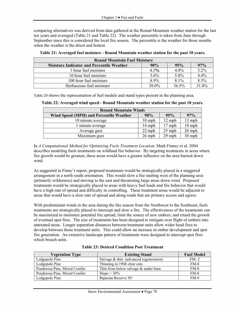
Chapter 3 ♦ Fire and Fuels
Snow Environmental Assessment ♦ Page 79
comparing alternatives was derived from data gathered at the Round Mountain weather station for the last ten years and averaged (Table 21 and Table 22). The weather percentile is taken from June through September since this is considered the local fire season. The percentile is the weather for those months when the weather is the driest and hottest.
Table 21: Averaged fuel moisture - Round Mountain weather station for the past 10 years.
Round Mountain Fuel Moisture Moisture Indicator and Percentile Weather 90% 95% 97%
1 hour fuel moisture 4.3% 4.0% 3.2% 10 hour fuel moisture 5.6% 5.0% 4.4% 100 hour fuel moisture 8.9% 8.1% 8.3%
Herbaceous fuel moisture 38.0% 36.5% 31.8% Table 20 shows the representation of fuel models and stand types present in the planning area.
Table 22: Averaged wind speed - Round Mountain weather station for the past 10 years.
Round Mountain Winds Wind Speed (MPH) and Percentile Weather 90% 95% 97%
10 minute average 10 mph 12 mph 13 mph 1 minute average 14 mph 17 mph 18 mph Average gust 22 mph 25 mph 26 mph Maximum gust 26 mph 29 mph 30 mph
In A Computational Method for Optimizing Fuels Treatment Location, Mark Finney et al. 2004 describes modeling fuels treatments on wildland fire behavior. By targeting treatments in areas where fire growth would be greatest, these areas would have a greater influence on the area burned down wind. As suggested in Finny’s report, proposed treatments would be strategically placed in a staggered arrangement in a north south orientation. This would slow a fire starting west of the planning area (primarily wilderness) and moving to the east and threatening large areas down wind. Proposed treatments would be strategically placed in areas with heavy fuel loads and fire behavior that would have a high rate of spread and difficulty in controlling. These treatment areas would be adjacent to areas that would have a slow rate of spread and along roads that are primary access and egress. With predominant winds in the area during the fire season from the Northwest to the Southeast, fuels treatments are strategically placed to intercept and slow a fire. The effectiveness of the treatments can be maximized to minimize potential fire spread, limit the source of new embers, and retard the growth of eventual spot fires. The size of treatments has been designed to mitigate over flight of embers into untreated areas. Longer separation distances between treatment units allow wider head fires to develop between those treatment units. This could allow an increase in ember development and spot fire generation. An extensive landscape pattern of treatments were designed to intercept spot fires which breach units.
Table 23: Desired Condition Post Treatment
Vegetation Type Existing Stand Fuel Model Lodgepole Pine Salvage & thin (advanced regeneration) FM- 2 Lodgepole Pine Thinning in 1968 clear cuts FM-8 Ponderosa Pine, Mixed Conifer Thin from below salvage & under burn FM-8 Ponderosa Pine, Mixed Conifer Slope > 30% FM-8 Lodgepole Pine Riparian Reserve 50’ FM-9

Chapter 3 ♦ Fire and Fuels
Snow Environmental Assessment ♦ Page 80
Vegetation Type Existing Stand Fuel Model Lodgepole Pine Riparian Reserve 50-75’ FM-9
FUEL REDUCTION/LARGE FIRE RISK REDUCTION STRATEGIES The following strategies were used to move towards desired conditions. They were considered when developing the alternatives. These were instrumental in the design of the project locations and types of treatments to address existing conditions. • Defensible Space (fuel break/safety corridor; see Large Block Treatment)
The use of major roads in a defensible space (fuel break/safety corridor) strategy was used, especially near areas where public safety is of high concern. Road systems that provide defensible space allow ground suppression forces to access wildfires and provide safe escape routes for fire fighters and the public. Use of major roads in a defensible space strategy is incorporated, especially near rural areas where public safety is of high concern. During recent wildfires, rural fire engines have also responded to aid in suppression efforts. These engines, with low ground clearance and width, have trouble on primitive roads and use the major roads. By reducing heavy dead ground fuels, crown densities, and reduction of ladder fuels, wildfires would be less intense and burn primarily through light ground fuels. This would allow suppression forces the ability to safely fight and more likely control a wildfire. When fuel conditions allow ground fire to get into the canopies of the trees (ladder fuels) and intense torching and crowning of these canopies occurs, then direct attack of the fire is impossible. Crown fires also contribute to long range embers spotting and spot fires. Wildfires under these conditions will cross any system road with such intensity that suppression forces have little chance of containing the fire at the road. Snags should not be retained near roads (one tree length) and down logs or slash piles should not be retained within 200 feet of roads or boundaries of untreated areas. Roads provide a good area for retardant to be utilized by suppression forces in a timely manner. Suppression forces need to quickly utilize the effect of the retardant to contain a wildfire. Retardant by itself will only slow a wildfire for a short period of time. To be effective, these areas need to be at least 300 to 500 feet wide on the prevailing wind direction (westerly) side of roads and 200 to 500 feet on the down wind side. By thinning dense stands, the forest canopy is opened and retardant becomes more effective by reaching ground fuels. • Managing dead and down material and fuels associated with harvest activities by creating blocks of discontinuous ground fuels.
Areas with existing heavy dead down material, dense shrubs, or slash from harvest or woodcutting can create extreme hazardous fuel conditions with the opportunity for a high intensity, stand replacement wildfire to occur. When these conditions exist over a large area, wildfire is difficult to control. This type of wildfire would burn until it reaches an area where fuels are lighter and control tactics are more likely to be achieved. For example, the Davis Fire reached areas that had been previously thinned, providing areas for firefighters to safely implement fire fighting strategies. The portion of the 18 Fire (2003) that burned in the Fuzzy planning area slowed in the rate of fire spread and lowered in intensity when reaching a previously thinned area. Through thinning, mechanical shrub treatments, and slash piling and burning, the continuity of these large areas of heavy fuels accumulations can be fragmented. Treatments were placed to fragment areas of heavy fuels. Untreated areas in times of high and extreme fire danger would continue to be at

Chapter 3 ♦ Fire and Fuels
Snow Environmental Assessment ♦ Page 81
risk from long range ember spotting and spot fires for up to one-half mile. Under less extreme conditions, fragmentation areas can provide suppression forces an opportunity to control wildfire. These fragmented areas may also provide escape routes and safety zones during wildfires, depending on their size and condition. • Large Block Treatment
Natural fuel treatments (thinning, mechanical shrub treatment) are usually not effective in helping contain wildfire spread unless the treated area is large enough to: 1) Not allow wildfire to wrap around treatment areas or allow spotting to occur over the treated area into an untreated area under moderate to near extreme conditions; 2) Slow wildfire spread rates to allow time for suppression forces to get into the area to safely take effective action. The treatment areas are best utilized if the boundaries are incorporated into barriers such as roads. Size of treatment varies in different fuel conditions. • Thinning to reduce crown fire susceptibility and long range spotting.
Crown fires are considered to be some of the most intense wildfires. They usually produce long range spotting that hampers control efforts. Dense stands of timber support independent crown fires, allowing fires to burn through the canopy of the trees independent of the ground fire. Torching and crowning in conjunction with the ground fire is a common problem during wildfires in dense stands of timber. Fragmenting the connectivity of the timber canopy through thinning greatly decreases the opportunity for an independent crown fire. Thinning also reduces the amount of torching and crowning that can occur with ground fire, reducing long range spotting potential. The fire behavior potential is primarily based on surface fuels, crown base height (ladder fuels), canopy density, and tree species. A reduction in the fire behavior potential is primarily based on adjustments to these fuels characteristics. Whitehead et al.(2006) concludes that by removing approximately one-half of the basal area of lodgepole pine (Southeast British Columbia) by thinning from below to a uniform 13 feet meter inter tree spacing would result in decreased canopy interception of rainfall and increased solar radiation, wind speed, and near surface air temperature. Moisture content of needle litter and of fuel moisture sticks were most different in thinned and unthinned stands following rainfall, but these differences decreased rapidly as fuels dried. Under moderate to extreme fire conditions, differences in the effect of fuel moisture are not noticeable but crown fire potential would remain higher in denser stands. Proposed thinning and ladder fuels reduction in the project areas would reduce crown fire potential.
THE CLEAN AIR ACT Smoke Management is regulated by the Department of Ecology and The Oregon Department of Forestry according to the Oregon Smoke Management Plan Oregon Revised Statutes 477.013. The policy of the plan is to improve the management of prescribed burning as a forest management and protection practice; and to minimize emissions from prescribed burning consistent with the air quality objective of the Interim Air Quality Policy on Wildland and Prescribed Fires, Federal Clean Air Act, and the State of Oregon Clean Air Act Implementation Plan developed by the Department of Environmental Quality under ORS 468A.035 [1989 c.920 s.2]. A Class 1 airshed designation does not allow human-caused activities outside the wilderness to adversely affect air quality within the wilderness. The Class 1 airshed, Three Sisters Wilderness, is located adjacent and to the northwest of the project area.

Chapter 3 ♦ Fire and Fuels
Snow Environmental Assessment ♦ Page 82
ENVIRONMENTAL CONSEQUENCES Alternative 1 (No Action) Direct and Indirect Effects: No additional management activities would occur. Forest succession would continue transitioning more acres toward undesirable heavy fuel loadings. Associated with heavy fuel loadings are increased fire intensities and rates of spread. • Lodgepole pine (68% of the project area)
Fuels have accumulated though over maturity and resulting pine beetle infestation at higher levels than historically, due to fire suppression. Mountain pine beetle outbreaks kill the larger lodgepole pine in dense mature stands, adding down fuel to the forest floor. These outbreaks have caused the majority of lodgepole pine mortality and the associated increase of hazardous fuels. Beetles continue to cause widespread mortality both within and adjacent to the project area. The open crowns of lodgepole pine have allowed an increase in understory vegetation consisting primarily of lodgepole pine regeneration and brush growth. These ladder fuels with heavy down fuels create continuous fuels from the surface into crowns, increasing crown fire potential and fire intensity. Lightning and human caused fire starts will persist in the area, although Forest Service fire prevention efforts will continue to attempt to reduce human caused fires. If a wildfire occurs with low relative humidity and low fuel moistures, it would be an intense stand-replacing event and control strategies would be difficult to achieve. Suppression actions would continue to be extremely hazardous for fire fighters and some suppression options could be eliminated due to lack of escape routes and safety zones. The effectiveness of aerially delivered retardants would be limited due to high fire intensity and long range spotting. Dozer line construction would be required verses handline due to fireline intensity, long range spotting and limited safe access. Public’s safety would be compromised due to limited safe evacuation routes. Air quality would be impacted by higher quantities of particulate matter when wildfire occurs. This can be attributed to the fact that forest conditions are usually windy, hotter and drier under summer conditions and consume a greater amount of down woody material, as well as litter, duff and foliage components. • Ponderosa pine – mixed conifer (19% of the project area) and Ponderosa pine (6% of the project area)
Fuels (tree needle and limb cast, bark slough, ground vegetation, over stocked tree stands and dead trees) would continue to accumulate with time and fire exclusion. This material is believed to have been historically kept at low levels in areas with frequent fire return intervals of 8 to 15 years (Agee 1994). When this material builds up at the base of ponderosa pine trees for many years, new fire starts can burn with such intensity at the base of trees that root systems are damaged and cambium is destroyed thus girdling the tree. This girdling can cause mortality in ponderosa pine during less intense wildfires that might not have killed them otherwise. Fuels reduction would only occur during wildfires and these would likely be large, very intense events similar to the Crane, Look Out Mountain, and Elk Lake wildfires. Stands of second growth ponderosa pine and plantations have been lost in recent wildfires. The existing stands and plantations would remain at high risk to loss from wildfire.

Chapter 3 ♦ Fire and Fuels
Snow Environmental Assessment ♦ Page 83
A few large structure stands of ponderosa pine, with mixed conifer understory, are scattered within the project area. If these stands are lost to wildfire, replacement stands of mixed conifer would unlikely survive wildfire effects through time, meaning few stands would survive wildfires for 200 to 300 years for ponderosa pine to reach maturity. Continued change to an infrequent and intense fire regime would take place in fire dependent ecosystems that historically had frequent low intensity fire regimes. In areas that historically were infrequent high intensity fire regimes, fire starts that escape initial suppression action would cycle a large portion of the landscape to an early structural stage. This potential exists in areas of high recreational use and wildlife habitats (such as LOS/Old Growth). In areas that are considered ponderosa pine and mixed conifer, where crown gaps and openings have occurred, lodgepole pine, white fir, and brush have become established in the understory. This understory provides ladder fuels and in a wildfire situation can scorch overstory crowns, causing mortality or initiate and promote crown fires. Post treatment fire behavior potential for Alternative 2 is displayed in Figure 17 and Figure 18 displays the post treatment fire behavior potential for Alternative 3.
Chapter 3 ♦ Fire and Fuels
Snow Environmental Assessment ♦ Page 84
Figure 17: Alternative 2 (Proposed Action) - Fuel Models Following Implementation

Chapter 3 ♦ Fire and Fuels
Snow Environmental Assessment ♦ Page 85
Figure 18: Alternative 3 - Fuel Models Following Implementation

Chapter 3 ♦ Fire and Fuels
Snow Environmental Assessment ♦ Page 86
Effects Common to Alternative 2 (Proposed Action) and Alternative 3 Direct and Indirect Effects: Utilizing more than one fuel treatment strategy to move toward desired conditions would include removal of dead standing and/or down trees, thinning trees (stand density reduction), whole tree yarding, ladder fuel reduction, mechanical and hand piling of slash, pile burning, lop and scatter small diameter thinning slash, and mechanical shrub treatments. More than one of these fuel treatments may be used in a given unit to move towards the desired condition, such as salvage of dead standing and down material, mechanically piling of slash, and burning piles. Treatments would reduce the risk of large acreage losses due to wildfire by disconnecting or fragmenting the continuous high risk ground fuels and dense stand structures, reducing untreated block size. Along with previous treatments, larger blocks of reduced fuel loads and acceptable fuel arrangements would allow suppression forces more opportunity to anchor fire line safely and increase chances for control of wildfire. Under extreme fire behavior, untreated dense stands and areas of high fuel loading would burn intensely and long range spotting would likely occur, with less intensity and spotting from treated units than areas that are not treated. Past and proposed fuel treatments would limit potential wildfire size under average conditions. Only under extreme conditions would wildfire burn through treated areas. Within treatment areas, the intensity of wildfire under extreme conditions would be reduced and allow suppression forces an opportunity to control a wildfire. During June through September weather patterns, prevailing winds are generally northwest and westerly. This provides the potential for intense, fast moving, stand replacing wildfires to move from the Three Sisters Wilderness and Benchmark Butte areas with high fuel loads, located west of the planning area, into and across the project area. The risk of a large acreage wildfire (100 acres or greater) occurring and moving east and down wind of the snow planning area into the Sheridan Mountain and Browns Mountain LSRs would be reduced. The proposed treatments would help to change approximately 2,540 acres (Alternative 2) and 2,725 acres (Alternative 3) to low or moderate (Table 24 and Table 25) fire behavior (fuel models 2, 5, 8 and 9), reducing the potential for large-intense wildfires. This would improve safety for both wildland firefighters and the public during wildfire. Hazardous fuels would be treated within 200 to 500 feet on both sides of roads, creating approximately 19 miles of defensible space along major roads 46, 40, 4670, 4525 and 4278 for Alternative 2. Alternative 3 would treat hazardous fuels along 23 miles of the same roads. Roads that provide defensible space would also provide safe escape routes from wildfire for firefighters and the public. Public safety would be improve into and out of Elk Lake Lodge and campground, Lava Lake Lodge and campgrounds on Forest roads 500 and 520, Deschutes Bridge campground on Forest road 4670, Cow Camp campground on Forest road 635 and the Blue Lagoon day use area on Forest road 544. Along the upper Deschutes River and Snow Creek, treatments of heavy dead fuels adjacent to the riparian areas would increase the safety of forest users. Fuels treatments in these areas would also reduce the negative impacts to soils along the riparian area in the event of a fire. Both alternatives would treat 7.3 miles adjacent to power lines to minimize the risk of trees or snags falling across them and causing a fire through shorting to the ground. As shrubs or tree reproduction grow back over time, treatment benefits would be gradually reduced. Depending on shrub and other vegetative growth, wildfire risk reduction treatments could become less effective in as little as 5 to 10 years and ineffective in 15 to 20 years in some areas.
Chapter 3 ♦ Fire and Fuels
Snow Environmental Assessment ♦ Page 87
Suppression action in non treated areas would continue to be extremely hazardous for firefighters. Some suppression options could be eliminated due to lack of escape routes and safety zones. The effectiveness of aerial delivered retardants would be limited due to high fire intensity and fires created from long range ember spotting. Due to fireline intensity, long range spotting, and limited safe access, dozer line construction would be required rather than hand line construction. Timber harvest is expected to occur prior to other fuels treatments. Effects Unique to Alternative 3 Direct and Indirect Effects: This alternative would increase protection of structures at Deschutes Bridge guard station, Deschutes Bridge work center, and Elk Lake lodge through treatment placement, compared to the other alternatives. Defensible space would be improved along Forest roads 40 and 4070, allowing safe public and wildland firefighter ingress and egress in the event of wildfire. The present Old Growth area also would be treated following a change of management area designation and with the designation of replacement area for old growth management east of Snow Creek. Treatment would focus on 324 acres of heavy dead down fuels. This proposed treatment area is strategically located on the west side of the planning area, east of Forest road 46 and north of Forest road 40. This area is 0.6 miles wide (east to west) and 1.6 miles long (north to south). Under most burning conditions spotting is less than 0.5 miles. Spot fires as a result of embers dropping into the treatment area would be minimized, if not completely eliminated, under most burning conditions. The large treatment block strategy would be enhanced, reducing the probability of a fire moving from the Three Sisters Wilderness or Benchmark Butte LSR into and across the planning area. Green tree thinning treatments in dense stands would reduce crown fire probability by increasing crown spacing. In conjunction with ground fuel treatments, crown fire potential in those stands where thinning treatments are implemented would be reduced. This would improve fire suppression effectiveness due to spotting distance being reduced, aerial delivered retardants would be able to reach the ground surface more effectively, the need for dozer line would be reduced, and hand line would be more likely to be successful due to the lower fire intensities. Firefighter and public escape routes and safety zones would be improved.
Cumulative Effects Common to Alternative 2 (Proposed Action) and Alternative 3: Refer to Table 17 at the beginning of Chapter 3. Projects with ongoing actions that have hazard tree falling or removal will change fuels arrangement but will not substantially affect the fuel model or the expected fire behavior within the Crane Prairie Watershed or within project units: • Midstate Electric power line maintenance: Hazard tree removal, pole changes, mowing • ODFW Cabin site maintenance: 1.5 acres hazard tree falling • Lava Lakes Resort: maintenance hazard tree falling • Crane Prairie Resort: maintenance hazard tree falling • Irrigation District improvements and reservoir level maintenance, adjusting water level; hazard tree
falling • Developed recreation site Maintenance, Lava Lake Campground, Cow Meadow Campground,
Crane Prairie Campground, Fawn Campground, Point Picnic area, Deschutes Bridge Campground • Lucky Lake Trailhead, Summer hiking and horse trails, Winter snow mobile trails, Hazard tree
removal, clean up, Inmate camp at Deschutes Bridge, Use and Hazard tree removal Projects that have been completed and ongoing fuels treatments that have or will change fuel models and expected fire behavior within the Crane Prairie Watershed but not within project units.
Chapter 3 ♦ Fire and Fuels
Snow Environmental Assessment ♦ Page 88
• Landing & Red Plague EAs 1996: Red Plague has some post harvest activities left • Recreation and Scenic activities not completed • Red Elk Timber Sale: Completed thinning, hand piling remains. • Hosmer Project and Hosmer Revision Project 2001 • Recreation camp sites and ramps and cutting hazard trees, • Elk Lake Fuels Reduction CE 1998: 80 acres to remove dead trees around houses • Cultus fuels reduction: safe fire access to campground and lake • Sparky Hazard Tree removal: Remove live and dead hazard trees along Cascade Lakes Highway Comparison of Alternatives Comparisons of the alternatives were made using 2004 remote sensing satellite imagery. This imagery was calibrated to measure stand conditions, including canopy, species, and fuels conditions. The resulting stand condition information was processed using the Flammap mode (Finney, 2004) to calculate expected fire conditions. The Flammap model utilized the weather conditions that represent the 97th percentile for summer conditions, as shown in Table 21 and Table 22 and summarized in Table 24.
Table 24: Description of Fire Behavior Ratings
Indicator Low Rating Moderate Rating High Rating Fire Type Surface Surface,
Crown Torching Passive Crowning Active Crown Fire
Flame Length 0 to 4 feet 4 to 8 feet 10 feet or greater Rate of Spread (chains per hour)1 2 to 8 8 to 14 14 to 104 Spotting Distance 0.2 mile 0.3 mile 0.5 mile Fire line Intensity (BTU/feet/second) 0 - 100 100 - 500 500+ Fuel Model 98, 99, 1, 2, 8 5, 9 6, 10, 1 Chain = 66 feet; The results of the Flammap model for each alternative are presented in Table 25. The various fire indicators, such as flame length and rate of spread are shown to be low, moderate, or high (extreme is included in high), depending on the stand conditions and treatments applied.
Table 25: Fire Behavior Comparison by Alternative
Alternative 1 (No Action) Acres
Alternative 2 (Proposed Action) - Acres
Alternative 3 Acres Fire Indicator
Low Moderate High Low Moderate High Low Moderate High Flame Length 3,877 1,442 9,071 5,680 495 8,295 5,600 448 8,390 Rate of Spread 0 3,877 10,513 396 5,285 8,753 416 5,184 8,893 Fire line Intensity 3,877 951 9,562 5,680 226 8,527 5,600 222 8617 Fuel Model 5,973 3,234 5,825 7,516 4239 3,285 7,336 4,598 3,102 Table 25 displays the effectiveness of fuels treatments in reducing expected fire behavior (flame length, rate of spread, and spotting distance). The comparison between Alternative 1 (No Action) and Alternative 2 (Proposed Action) shows the largest effect on the landscape. The addition of units in Alternative 3 would create additional defensible space along the major Forest roads 40, 46, 4670, and 4525. Units 306, 305, 305.4, 305.6, 305.8 would increase protection for the Snow Creek and Deschutes Bridge Guard Stations. The addition of units 309, 309.1, 310, 310.1, and 310.2 would improve public safety access associated with Cow Camp Campground. The addition of units 300, 300.3 and 300.4 in Alternative 3 would add strategically placed treatments west and down wind of Benchmark Butte. Fuel loadings in and adjacent to these units would exhibit

Chapter 3 ♦ Fire and Fuels
Snow Environmental Assessment ♦ Page 89
extreme fire behavior and high resistance to control during a wildfire event, with fire easily moving into and through the proposed units if left untreated. Treatment would provide suppression forces opportunities to safely engage a fire with increased chances of success. Alternative 3 would increase the effectiveness of the overall goal of fire protection in the planning area by strategically placing treatments in areas of concern and would improve the safety of the public and fire suppression forces during a fire event. This is displayed in Table 27. Alternative 1 shows the most acres remaining in High fire behavior. For example, flame lengths would be greater than 10 feet across the majority of the project area. Alternative 2 would create conditions where flame lengths are 0-4 feet in over one-third of the project area, very similar to Alternative 3. In the event of a wildfire, the fire type following implementation of either Alternative 2 or Alternative 3 would be surface over a majority of the area. Spotting distance, Table 26, was calculated using Behave Plus (Andrews et al., 1986) under extreme weather conditions (97th percentile) and stand data from 2004 satellite imagery. Fuel models 1, 2, 5, and 6 are grass and brush models and do not show a spotting distance because spotting is calculated on tree torching. In these fuel models short range spotting would be expected but is not modeled in the Behave Plus program.
Table 26: Spotting Distances by Fuel Model
Fuel Model Calculated Spotting Distance Down Wind FM 1,2 0 mi FM 5 0 mi FM 6 0 mi FM 8 0.3 mi FM 9 0.5 mi Fm 10 0.7 mi
Table 27: Comparison of Alternatives
Measures Alternative 1 Alternative 2 Alternative 3 North/south miles within ½ mile of the western boundary where embers could land causing spot fires in Fuel Models 2, 5, 8, 9 (Low-moderate fire intensity)
0 7.3 10.6
Miles of road With Defensible space 0 19 23 Miles of riparian Reserve with Fuels model 2, 5, 8 and 9.
0 10.5 12.2
Air Quality The critical pollutants thought to affect human health include particulate matter emitted in smoke that is less than 10 microns in diameter (PM10). Particulates less than 10 microns are able to traverse the nose and mouth (known as the “extra thoracic airway”) and enter the upper airways starting with the trachea. Due to their very small size and weight (the average human hair is 70 microns in diameter), PM10 can remain airborne for weeks. Over 90 percent of smoke particles are less than 10 microns. Wood smoke has been documented to be mutagenic, though no direct studies have proven it is carcinogenic to humans. Mutagenic compounds cause changes to the structure of a cell in ways that can be transmitted during cellular division. This is of primary concern because mutations can be precursors for cancer. Exposure to PM10’s aggravates chronic respiratory diseases such as asthma, bronchitis and emphysema.

Chapter 3 ♦ Fire and Fuels
Snow Environmental Assessment ♦ Page 90
Burning debris releases carbon dioxide and water (making up about 90 percent of the total mass emitted from the combustion process), criteria pollutants (those pollutants regulated by the EPA under the clean air act), including carbon monoxide and sulphur/nitrogen oxide, and hazardous air pollutants (also known as (“air toxins”). Air toxins include several hundred known substances including the class of compounds known as aldehydes (formaldehyde's, acetaldehyde and acrolin) and polynuclear aromatic hydrocarbons (PAHs), several of which are known to be carcinogenic. Research to date has yet to determine if levels/durations of exposure to these pollutants from prescribed fire operations are significantly affecting human health. However according to sources at the EPA, particulate matter that exceeds human health standards have been measured up to three miles downwind of prescribed burns. During a high intensity wildfire, calculated at the 97th % fire weather, and using the fuel loading represented by fuel models found in Aids to Determining Fuel Models For Fire Behavior (Anderson 1982), smoke emission particulate matter of 2.5 microns (PM 2.5) and less in size, calculated by First Order Fire Effects Model (PM 2.5), could range from 102 pounds per acre to 1,721 pounds or more per acre. Where down fuels have accumulated and/or stands are dense the PM 2.5 production could exceed these estimates. PM 2.5 is small particles that could enter the human respiratory system. Surrounding communities could be impacted by smoke from wildfires and associated PM 2.5. Smoke emissions are calculated by estimating the amount of non merchantable debris that would be piled and burned per acre then running the First Order Fire Effect Model to determine the particulate matter production. This is an estimate for alternative comparison purposes, Table 28. During implementation of the project, actual fuel loads and particulate matter would be calculated and reported to Oregon Department of Forestry Smoke Management Program.
Table 28: Estimated Smoke Emissions in Tons of Particulate Matter (PM) 2.5 Slash Pile Type Alternative 1
(wildfire) Alternative 2 Alternative 3
Landing Piles 64 Tons PM 2.5 79 Tons PM 2.5 Machine and Hand Piles 952 Tons PM 2.5 991 Tons PM 2.5
Total Tons PM 2.5 0.5 tons PM 2.5 / acre 1,016 Tons PM 2.5 1,070 Tons PM 2.5
Table 29: Fuel Treatment Acres (Gross)
Activity Alternative 2 (Proposed Action) Acres
Alternative 3 Acres
Grapple Pile 4,871 Acres 5,128 Acres Grapple Pile/Hand Pile 365 Acres 445 Acres
Grapple Pile/Mow 181 Acres 210 Acres Hand Pile 68 Acres 11 Acres Mow 305 Acres 305 Acres
Total Acres 5,7920 Acres 6,102099 Acres Photos used to determine optimum fuel loading are provided in Tables 13 through 16, pages 19 through 21, of the fuels report located in the project record. These photos are found in “Photo Series for Quantifying Residues” (Maxwell and Ward, 1980). Comparison of the Alternatives for the Fuels Resource Table 30 displays the various expected outcomes with implementation of the different alternatives.

Chapter 3 ♦ Fire and Fuels
Snow Environmental Assessment ♦ Page 91
Table 30: Comparison of Alternatives - Fuels Issue Alternative 1 Alternative 2 Alternative 3
Suppression actions
Hazardous due to lack of safety zones and safe access
Improved but still hazardous in untreated areas
Improved but still hazardous in untreated area
Suppression options
Limited because of landscape fuels condition
Improved through landscape treatment Critical untreated areas occur (Old growth area and wetland areas)
Improved over Alternative 1 & 2. Few untreated critical areas (still wetland areas not treated)
Line construction options
Indirect attack and use of Equipment needed
More direct attack by hand crews possible. Fewer areas needing equipment.
More direct attack by hand crews possible. Fewer areas needing equipment
Fireline Intensity High to extreme over 5,825 acres of area
High to extreme over 3,285 acres
High to extreme over 3,102 acres
Potential fire size Very large. Treatments are very fragmented. Little chance of maintaining fires in basin under moderate to high fire conditions.
Large. Treatments on landscape more extensive though large fires possible in untreated areas specifically in old growth area and wetlands north of Crane Prairie Reservoir
Large. Treatments on landscape more extensive though large fires possible in untreated areas specifically wetlands north of Crane Prairie Reservoir
Crown fire probability
High. Closed canopy stands and stands with canopies and heavy surface and ladder fuels.
Mod – High except for areas of mixed conifer thinning and lodgepole pine with thinning or open canopies (from mortality)
Low. Landscape level open canopies and reduced ladder and surface fuels.
Effectiveness of aerial attack
Low. Heavy fuels and close canopies dominate landscape.
Moderate. Fuels low on landscape, closed canopies common.
High. Fuels and closed canopies fragmented on landscape.
Expected Initial attack effectiveness
poor good best
Safe anchor points to attack fire
poor good best
Firefighter safety poor good best
Safe Escape Access Routes Escape/Access Routes
Limited to Road 4270 South of Crane Prairie Resort 1.7 miles
Good - Covers 20.7 miles of main access roads. Includes Cascade lakes highway and Forest road 40.
Best - Covers 24.7 miles of main access roads. Includes Cascade lakes highway and Forest road 40.
Hosmer Lake Campground
Access road 4625 untreated
Access road 4625 treated. Access road 4625 treated.
Lava Lake .6 miles treated previously. Previous treatments and rest of road .8 miles.
Previous treatments and rest of road .8 miles.
Deschutes Bridge Access road 4270 and Cascade lakes highway untreated.
Access road 4270 partially treated to 40 road. Cascade lakes highway treated.
Access road 4270 treated almost totally to 40 road. Cascade lakes highway treated.
Cow Camp No treatment along access roads.
Access road partially treated, wetlands not treated.
Access road partially treated, wetlands not treated.
Crane Prairie Resort &
Limited to previous treatment along Road 4270
Treatments along Road 4270 (including previous
Treatments along Road 4270 (including previous

Chapter 3 ♦ Fire and Fuels
Snow Environmental Assessment ♦ Page 92
Issue Alternative 1 Alternative 2 Alternative 3 Campground South of Crane Prairie
Resort 1.7 miles. treatments) to the north and south 4 miles total.
treatments) to the north and south 4 miles total.
Resource/Values Protection Hosmer Lake Campground
Low. Little existing fuels reduction
Moderate. Surface fuels reduced to west of area.
Moderate+. Surface fuels and canopy reduction to west of area.
Lava Lake Moderate. Previous treatments around area
High all areas up wind treated All areas upwind treated.
Deschutes Bridge Low. No existing low fuels areas
Low. little treatment in area Moderate. Area treated limited.
Cow Camp Low. No existing treated areas
Low. Some treatments but gaps remain
Moderate. Area treated limited to that not classified as wetlands.
Crane Prairie Resort & Campground
Moderate. Existing treatments present
Moderate. Existing treatments present
Moderate. Existing treatments present
Powerlines Low. Heavy fuels present to edge of right of way.
Moderate. Surface and ladder fuels treated adjacent to powerline on 7 miles
Moderate. Surface, ladder and canopy fuels treated adjacent to powerline on 7 miles
West and South Bachelor Roadless Area
Low. Highway only interrupted fuels
Low. Fuels lower along Cascade Lakes Highway though buffer not wide enough to stop a large or spotting fire. Treatments limited to outside wilderness and roadless area.
Low+. Fuels lower along Cascade Lakes Highway though buffer not wide enough to stop a large or spotting fire. Crown fire interruption possible with reduced crown densities. Treatments limited to outside wilderness and roadless area.
Sheridan LSR Low. Little chance of containing larger fires in basin.
Moderate. Good chance of containing fire in basin.
High . Low chance of crown fire and high possibility of containing fire in basin.
Bald Eagle Management Areas
Low. Ladder fuels high in BEMAs.
High. Stand stocking and ladder fuels reduced in BEMAs. 161 acres treated.
High. Stand stocking and ladder fuels reduced in BEMAs. 156 acres treated.
Osprey areas Low. Ladder fuels high. High. Stand stocking and ladder fuels reduced. 374 acres treated
High. Stand stocking and ladder fuels reduced. 371 acres treated.
Riparian Reserves
Low. Heavy fuels adjacent and within most riparian reserve areas.
Moderate. Fuels adjacent and within riparian reserves reduced along 10.5 miles of stream (37-38%) and 266 acres riparian reserve treated.
Moderate. Fuels adjacent and within riparian reserves reduced along 12.2 miles of stream (46-49%) and 351 acres riparian reserve treated
Custodial activities such as wildfire suppression occur regardless of which alternative is selected. Although human-caused impacts are of consequence to wilderness values (Forest Plan, Appendix 4-19), implementation of Alternative 1 (No Action) would have the greatest likelihood for impacting the Three Sisters Wilderness airshed because of the overall risk of an uncontrolled release of particulate matter resulting from wildfire. Adverse impacts to the wilderness would be unlikely, as the prevailing winds do not generally occur from the southeast. Because of measures designed to disperse smoke during favorable conditions, implementation of action alternatives are expected to protect air quality related values and have no visible impact to the wilderness area.

Chapter 3 ♦ Forest Vegetaion and Forest Health
Snow Environmental Assessment ♦ Page 93
FOREST VEGETATION and FOREST HEALTH MANAGEMENT DIRECTION Northwest Forest Plan (NWFP) Standards and Guidelines Provide for retention of old-growth fragments in watersheds where little remains. Landscape areas where little late-successional forest persists should be managed to retain late-successional patches. This S&G will be applied in fifth field watersheds (20 to 200 square miles) in which federal forest lands area currently comprised of 15 percent or less late-successional forest. This assessment should include all allocations in the watershed. Within such an area, all remaining late-successional stands should be protected. Protection of these stands could be modified in the future, when other portions of the watershed have recovered to the point where they could replace the ecological roles of these stands. (NWFP, Pages C-44 and C-45) Deschutes LRMP - Forest Wide Standards and Guidelines Forest Health Goal: To maintain and enhance the vigor of the forest ecosystem through the control of forest pests. FH-3: Management strategies should emphasize prevention of forest pests rather than suppression activities. Timber Management Goal: To manage the timber resources of the Forest in a way that is consistent with other resource objectives, environmental constraints, and economic efficiency. • Horizontal Diversity (harvest unit size) TM-58: Forest openings created by even-aged silviculture should not exceed 40 acres in ponderosa pine, mixed conifer, and mountain hemlock. Created openings can exceed 40 acres in lodgepole pine to treat the catastrophic situation created by the mountain pine beetle epidemic. Units will be shaped to blend with the natural terrain. TM-61: Timber management activities that create essentially uniform structural conditions should generally not exceed 100 contiguous acres on greater than 95% of each implementation unit. Harvest units larger than 100 acres, however, may be prescribed on less than 5% of each implementation unit. EXISTING CONDITION Precipitation within the Snow Lakes watershed assessment area varies widely, ranging from approximately 125 inches annually in the higher elevations to approximately 20 inches at the lowest elevations (Deschutes National Forest 2005). Annual precipitation within proposed treatment areas ranges from approximately 40 to 80 inches (Table 31). Elevations of treatment areas range from approximately 4,500 feet to 5,100 feet (Table 31).

Chapter 3 ♦ Forest Vegetaion and Forest Health
Snow Environmental Assessment ♦ Page 94
Table 31: Elevation and Annual Precipitation within Treatment Areas Summarized by Plant Association Group (PAG)
Plant Association Group (PAG) Elevation Range (Feet) Annual Precipitation Range (Inches)1 Lodgepole pine dry (LPD) 4560 - 5000 39 - 77 Lodgepole pine wet (LPW) 4560 - 4960 39 - 77 Mixed conifer dry (MCD) 4600 - 5080 43 - 57 Mixed conifer wet (MCW) 4640 - 4800 47 - 61 Mountain hemlock dry (MHD) 4920 - 5040 77 - 79 Ponderosa pine dry (PPD) 4480 - 4680 39 - 53 1 Average annual precipitation according to a model using point precipitation and elevation data for the 30-year period of 1961-1990 (USDA/NRCS – National Cartography and Geospatial Center. 2007). Insects and diseases that can act as disturbance agents include bark beetles, dwarf mistletoe, and root diseases. Bark beetles can be present across all vegetation types, with the most common ones being mountain pine beetle (Dendroctonus ponderosae) in the pines and fir engraver beetle (Scolytus ventralis) in white/grand fir. Within the Crane Prairie watershed the most recent mountain pine beetle outbreak began about 18 years ago (Deschutes National Forest 2005). Damage from the Balsam woolly adelgid (Adelges picease), a widely established non-native insect, has been observed in true firs in the area (A. Eglitis, personal communication, July 9, 2007). Chronic feeding by this insect progressively weakens trees, reduces cone production, and causes deformity and mortality (Goheen and Whillhite 2006). Dwarf mistletoe is an important disturbance agent in lodgepole pine (Deschutes National Forest 1995). Root diseases that could be found within mixed conifer and hemlock stands include laminated root rot (Phellinus weirii), Armillaria root disease (Armillaria ostoyae), and Annosus root disease (Heterobasidion annosum). Given the relatively high elevation of proposed treatment areas, spread of Annosus root rot to freshly cut pine stumps would generally not be a concern in stumps smaller than approximately 16 to 18 inches in diameter (H. Maffei, personal communication, July 9, 2007). Table 32 summarizes relative tolerance of conifer species to environmental stress factors such as shade, drought, and fire. It also summarizes the relative susceptibility to root diseases that may be found in the area.
Table 32: Relative Tolerance and Susceptibility of Conifers to Environmental and Disease Stress Factors
Stress Factor Ponderosa pine
Lodgepole pine Douglas Fir White/Grand Fir Mountain
Hemlock Environmental1 • Shade 5 4 2 1 1 • Drought 1 2 2 3 5 • Frost 2 1 3 3 1 • Fire 1 5 2 4 4 • Pests (combines damage
from insects, disease, and animals)
3 3 4 5 5
Root disease2
• Laminated root rot Seldom damaged
Seldom damaged
Severely damaged
Severely damaged
Severely damaged
• Armillaria root disease Moderately damaged
Moderately damaged
Severely damaged
Severely damaged
Moderately damaged
• Annosus root disease Moderately damaged
Moderately damaged
Seldom damaged
Severely damaged
Severely damaged
1 Environmental stress factors and associated tolerances are from Emmingham et al. (2005). Rating of 1 indicates high tolerance; rating of 5 indicates low tolerance. 2 Associated susceptibility is from Goheen and Whillhite (2006).

Chapter 3 ♦ Forest Vegetaion and Forest Health
Snow Environmental Assessment ♦ Page 95
Areas proposed for treatment in Alternatives 2 and 3 are located within lodgepole pine, mixed conifer, ponderosa pine, and mountain hemlock plant association groups (Project Record, Silviculture Report, Table 7). Treatment within the mountain hemlock PAG is limited to a relatively small area west of Elk Lake. Prior treatments have occurred extensively within areas proposed for treatment in the lodgepole pine, mixed conifer and ponderosa pine PAGs (Project Record, Silviculture Report, Table 7). No prior treatment has occurred within the area proposed for treatment in the hemlock PAG. Within the lodgepole pine dry plant association group, some treatments are proposed within the lodgepole pine/bitterbrush/needlegrass plant association. Volland (1985) describes regeneration potential in the plant association as being dependent on elevation. Below 5000 feet, potential for natural regeneration is fair to poor. Above this elevation, potential is good. Proposed treatment areas within this PAG are located at elevations less than 5000 feet (Table 31). Within areas of mixed conifer proposed for treatment, annual precipitation is estimated to range from 43 to 61 inches (Table 31). At these precipitation levels, there should be adequate moisture to maintain a component of white fir within treatment areas. A levels-of-growing-stock study in central Oregon by Cochran (1998) raised doubts about growing white fir stands on sites with mean annual precipitation rates below 32 inches, even if stand densities are kept very low. Results of the study were influenced by a general drought that prevailed over the study areas from the late 1970’s to mid 1990’s. Cochran (1998) referenced a system for rating risk of mortality from the fir engraver beetle based on annual precipitation. According to this risk rating system, areas with mean annual precipitation amounts of 40 inches or more would have a low risk of mortality resulting from the fir engraver beetle. Of the treatments proposed within lodgepole pine PAGs, approximately 35 to 60 percent have been previously treated (Project Record, Silviculture Report, Table 7). These past harvest or precommercial thinning treatments occurred between 1966 and 1998 (Project Record, Silviculture Report, Appendix E). Approximately 5 to 25 percent of the lodgepole pine acres have been harvested since the mountain pine outbreak began in 1990 (Project Record, Silviculture Report, Table 7). While recent treatments in lodgepole pine stands removed much of the larger diameter fuel loading, scattered and concentrated small diameter fuels remain throughout these stands (Figure 19). In some of these stands, continuing mortality from mountain pine beetle after harvest has added larger dead down wood to the fuels profile. Unique among the lodgepole pine areas proposed for treatment are approximately 130 acres of primarily single story lodgepole pole pine stands that were clearcut in 1966. To date, little beetle associated mortality has occurred within these stands due to relatively small tree diameters. In these stands, tree densities are high, limiting growth of understory vegetation, causing tree crowns to recede, and reducing rate of tree diameter growth. Of the acres proposed for treatment in the mixed conifer and ponderosa pine PAGs, approximately 75 to 95 percent have been previously treated (Project Record, Silviculture Report, Table 7). Treatments occurred between 1975 and 1989 (Project Record, Silviculture Report, Appendix E), with no treatments occurring since the recent mountain pine beetle outbreak. Few of the past treatments included stocking level control throughout all size classes (Appendix E, HSH, SPC, or any harvest combined with SPC). Natural regeneration in combination with residual live trees has or is creating stands with relatively high stocking levels. Tree density currently is, or is trending towards levels, high enough to limit the potential for developing future large tree structure. Within mixed conifer stands, stocking of true fir and lodgepole pine can be limiting growth of the

Chapter 3 ♦ Forest Vegetaion and Forest Health
Snow Environmental Assessment ♦ Page 96
relatively few ponderosa pine and Douglas fir present within the stands. Similarly, where treatments are proposed in ponderosa pine plant associations, stocking of lodgepole pine can be high enough to limit growth of ponderosa pine. In many cases, stocking levels within mixed conifer and ponderosa pine stands is high enough to put larger diameter trees at risk to bark beetle attack. Lodgepole pine is a component of all stands proposed for treatment. Older lodgepole pine in the middle or upper canopy layers of these stands can have relatively small crowns and a deteriorating appearance. Dwarf mistletoe can be found in lodgepole pine in the middle to upper canopy layers and in some cases in the lower canopy layers as well.
Figure 19: Fuels Accumulation in a Previously Treated Lodgepole Pine Stand
Photo of Snow Unit 131. Previously salvaged in 1998. Bottom 1/3rd of photo shows skid trail which is regenerating with lodgepole pine. Photo shows accumulation of fuels not treated with prior harvest. Across skid trail is a snag that has fallen since harvest. (Photo by B. Schroeder 10/2007). ENVIRONMENTAL CONSEQUENCES
Introduction Analysis focuses on assessing consistency with the following management direction: a) Retention of old-growth forest fragments (Forest Vegetation Measure #1), b) Creation of openings (Forest Vegetation Measure #2), and

Chapter 3 ♦ Forest Vegetaion and Forest Health
Snow Environmental Assessment ♦ Page 97
c) Prevention of insect and disease problems (Forest Health Measures #1 and #2). Best available science was considered and used in analyzing the effects of proposed treatments. Scientific information relied on is incorporated and cited in the discussion of effects. A listing of the science can be found in the section of this report titled “Liturature Cited”. Responsible opposing views are briefly referenced. Opposing views and the rational for not relying on them in the analysis are documented in the section titled “Literature Considered From Scoping Comments”. Forest Vegetation Measure #1 – Size and Structure Class Introduction Hemstrom et al. (1998) describe the following forest structure classes for mapping land based on existing forest vegetation condition: potentially forested, seedling and sapling, small single-storied, medium and large single-storied, medium and large multistoried, and large multistoried. According to Hemstrom et al. (1998), with the exception of the potentially forested category, these categories parallel those in the final supplemental environmental impact (FEIS) statement for the Northwest Forest Plan (USDA FS and USDI BLM 1994). These classes are based on the average diameter of the dominant and codominant trees and on canopy layering. Hemstrom et al. (1998) assigned each of these forested land classes into one of three categories: conifer dominated (hardwood canopy cover tree less than 20 percent of total tree cover), deciduous dominated (conifer canopy tree cover less than 20 percent of total tree cover), and mixed (conifer and hardwood canopy tree cover are both more than 20 percent of total tree cover). According to Hemstrom et al. (1998), these classes are in addition to those specified by the Northwest Forest Plan FSEIS. In a recent assessment of the status and trend of late-successional and old-growth forest in the Northwest Forest Plan Area, Moeur et al. (2005) modify the vegetation classes described by Hemstrom et al. (1998) to include a small multi-storied class and a large single-storied class. Moeur et al. (2005) use these modified vegetation classes as the basis for defining “older forest”. They use the term “older forest” interchangeably with the term “late-successional and old-growth forest”. Moeur et al. (2005) use three definitions of older forest that correspond to three points along a continuum of older forest definitions. The definitions assume total tree canopy cover is greater than or equal to ten percent. The definitions are based on the quadratic mean diameter of dominant and codominant trees and on canopy layering. The following summarizes the three definitions used in this recent assessment: 1) Older forest with medium and large trees and single- or multistoried canopies.
Minimum average tree size of 20 inches for any forest type, regardless of canopy layering or location in the environment.
2) Older forest with large trees and multistoried canopies. Minimum average tree size of 30 inches, with multistoried canopies, regardless of location in the environment.
3) Older Forest with medium and large trees defined by potential natural vegetation. Minimum average tree size varies by potential natural vegetation zone. For the lodgepole pine vegetation zone, the minimum average tree size is defined as 12 inches. For grand fir, Douglas-fir, interior ponderosa pine, mountain hemlock, western white pine, and white fir vegetation zones, minimum average tree size is 21 inches dbh. In comparison to the first two definitions, Moeur et al. (2005) indicate this definition “...predicts more area of older forest in community types where trees grow slowly or seldom reach 20 inches in diameter by imposing a diameter threshold less than 20 inches (for example, some pine types east of the Cascade divide, or some high-elevation types)”.

Chapter 3 ♦ Forest Vegetaion and Forest Health
Snow Environmental Assessment ♦ Page 98
Scope and Scale of Analysis The scale of analysis is forest capable land within the Crane Prairie fifth field watershed. This follows the Northwest Forest Plan standard and guideline that directs provisions for retaining old-growth fragments where little remains be applied in fifth field watersheds (20 to 200 square miles). The Snow Project is located entirely within the Crane Prairie fifth field watershed. This watershed is approximately 258 square miles (164,902 acres) in size. Moeur et al. (2005) recognized not all federal land is potentially capable of supporting older forest. Similarly, the Crane Prairie fifth field watershed includes lands that are not capable of supporting forest and consequently are not capable of supporting older forest. These lands were identified using the plant association group GIS layer for the Deschutes National Forest. Plant association groups (PAGs) considered not forest-capable are displayed in Table 33. These non-forest plant association groups include cinder, lava, rock, meadows, and water. Approximately 12 percent of the watershed is not capable of supporting forest.
Table 33: Plant Association Groups (PAGs) within Crane Prairie Watershed Crane Prairie Watershed Plant Association Group (PAG)
Acres Percent of Total Forest-capable
Lodgepole pine dry (LPD) 21,301 13% Lodgepole pine wet (LPW) 16,874 10%
Lodgepole pine subtotal 38,175 23% Mixed conifer dry (MCD) 40,164 24% Mixed conifer wet (MCW) 4,368 3%
Mixed conifer subtotal 44,532 27% Mountain hemlock dry (MHD) 60,130 37% Ponderosa pine dry (PPD) 1,869 1% White Bark Pine Dry (WBPD) 14 <1%
FOREST-CAPABLE SUBTOTAL 144,720 88% Not Forest-capable
Alpine dry (ALPD) 93 <1% Alpine shrub (ALSH) 126 <1% Alpine meadow (AMDW) 2,602 2% Cinder, Lava, Rock 5,543 3% Glacier 228 <1% Meadow (MDW) 1,443 1% Mesic shrub (MSHB) 894 1% Riparian (RIP) 297 <1% Water 8,468 5%
NOT FOREST-CAPABLE SUBTOTAL 19,694 12% WATERSHED TOTAL 164,4141 100%
1 Approximately 487 acres (0.3% of the watershed) are not classified on this GIS layer (164,901 – 164,414 = 487 acres). Measures Size and structure is measured in terms of the percent of the watershed in the forest size and structure classes described by Moeur et al. (2005) with a few modifications. Due to the lack of hardwood tree canopy cover within the Crane Prairie watershed, assignment into the conifer, deciduous, or mixed categories is not done. Vegetation classes instead are assigned one of two categories: lodgepole pine PAGs (lodgepole pine wet and dry) and “other conifer” PAGs (mixed conifer wet and dry, ponderosa

Chapter 3 ♦ Forest Vegetaion and Forest Health
Snow Environmental Assessment ♦ Page 99
pine dry, and mountain hemlock dry). Plant association groups within these two groupings have the same minimum diameters used to define older forests using potential vegetation definitions (Moeur et al. 2005), the definitions used for estimating the percent of the watershed in older forest. The potential natural vegetation definitions are considered most appropriate for the Crane Prairie watershed given: 1) the watershed is located east of the Cascade crest and 2) the presence of lodgepole pine plant association groups which have limited potential for trees to grow 20 inches dbh. For the lodgepole pine group, the “small” size class (10 to 19.9 inches dbh) defined by Moeur et al. (2005) most closely corresponds to the minimum size for lodgepole pine older forest (12 inches dbh). For the other conifer group, the “medium and large” size class (20 to 29.9 inches dbh) defined by Moeur et al. (2005) most closely corresponds to the minimum size for older forest (21 inches dbh). Methods To classify existing vegetation, size/structure and canopy cover values classified from remotely sensed satellite imagery (2004) was used in combination with plant association groups mapped for the Deschutes National Forest. Vegetation was classified into the size and structure classes described by Moeur et al. (2005) with several modifications. A qualitative assessment of the accuracy of size and structure classification and mapping was done. No quantitative assessment of accuracy was done. Overall map accuracies commonly reported for mapping forest structure attributes from satellite data range from 60 to 80 percent (Moeur et al. 2005). Projections were made as to how proposed treatments would change size/structure and canopy cover values. Projected changes varied depending on silviculture prescription (EA, Appendix A). It was generally assumed thinnings would move stands from multi-story stand structure to single-story stand structure. Canopy cover following proposed treatments was projected using estimated residual stocking (trees per acre) and size (diameter). Refer to Project record, Silviculture Report, Appendix G for additional documentation of methods and assumptions used to classify existing vegetation and project changes resulting from treatments. Reference Condition The following section summarizes historic (1850-1910) vegetation patterns and disturbance processes described in the Cascade Lakes Watershed Analysis (Deschutes National Forest 1995). Within all forested plant association groups, the dominant disturbance factors were fire, insects and diseases. Lodgepole pine areas were a mix of open land recently disturbed by fire, areas of regenerating lodgepole, areas of pole sized and mature trees, as well as areas of susceptible stands undergoing mountain pine beetle attack. Most stands within the mixed conifer dry plant association groups were open in appearance (canopy cover of 40 percent or less) and were dominated by ponderosa pine and only reached a true mixed conifer composition on higher elevation buttes and north facing slopes receiving more precipitation. Within the mixed conifer wet plant association group, while mature stands were primarily composed of early seral species of ponderosa pine, they were also mixed with climax species of fir and spruce. Within the lodgepole pine dry plant association group, fire was a high severity disturbance event. Stand replacing fires varied in size. While small fires occurred, large fires occurred at 20 to 30 year intervals and affected 50 to 1,000 acres. These fires usually affected greater than 70 percent of the basal area.

Chapter 3 ♦ Forest Vegetaion and Forest Health
Snow Environmental Assessment ♦ Page 100
Within the lodgepole pine wet plant association group, fire was a moderate severity disturbance regime, with a 30 to 40 year fire return interval with removal of approximately 30 percent of the stand. Fires created small or large patches depending on the vegetation and weather conditions. Under severe weather conditions fires created large patches (250 to 500 acres) on the landscape. Intermediate and low intensity fires often occurred in between stand replacement fires and divided up the large patches into smaller patches. Within the mixed conifer dry plant association group, frequent, low intensity fires kept the forest open so that it was less likely to burn intensely even under severe weather (Agee 1993). As the low intensity fires burned they removed understory ladder fuels and consumed debris on the forest floor. Fires that occurred after an extended fire-free period would generally have been more intense and consumed more trees and forest floor debris (fuels) while creating patches or openings where 70 to 80 percent of the overstory trees were killed by the fire. These openings would vary in size based on weather, fuel and vegetation at the time of the fire. Average disturbance patch size was 20 to 300 acres in size. Historic fire regimes within the mixed conifer wet plant association group were fairly complex and included both low and high intensity fires. The usual disturbance scenario involved approximately 30 percent of the stand being removed every 60 years either by fire or insects. Fires created small or large patches depending on the vegetation and weather conditions. Under severe weather conditions, fires created large patches (250 to 500 acres) on the landscape. Intermediate and low intensity fires separated the stand replacing ones, dividing the large patches into smaller patches, and thinning according to tree density. This tended to result in a clumpy, uneven-aged structure. Table 34 summarizes from the Cascade Lakes Watershed Analysis (Deschutes National Forest 1995) the proportion of size and structure classes historically present within the Crane Prairie Watershed. The Cascade Lakes Watershed Analysis described a “grass/forb/shrub” size/structure class for all the forest vegetation types. This size/structure class is considered to be equivalent to the “potentially forested but presently non-stocked” size/structure class used by Moeur et al. (2005) and the Snow project analysis. The Cascade Lakes Watershed Analysis categorized size/structure groups into three seral stages: 1) pioneer, 2) mixed, and 3) climax. These seral stages have been combined for display purposes in Table 34. The Cascade Lakes Watershed Analysis did not distinguish between single-story and multi-story structures in the “small” and “medium and larger” size classes as done by Moeur et al. (2005) and the Snow project analysis.
Table 34: Historic Range of Variability (HRV) within Crane Prairie Watershed Historic Range of Variability (from Deschutes National Forest 2005)
Lodgepole Pine Mixed Conifer and Mountain Hemlock Size and Structure Class LPD LPW Combin
ed MCD MCW MH Combined Watershed
Grass/forb/shrub (Potentially forested but presently non-stocked)
0 – 60% 0 – 60% 0 – 60% 1-7% --- 0 – 5% 0 - 5% 0 – 19%
Seed/Sapling/Pole (0-8.9”dbh) 10–100% 10–100% 10–100% 10-61% 8-10% 0 – 53% 4 – 58% 5 – 69%
Small single and multi-story (9-20.9”dbh)
10 – 60% 10 – 60% 10 – 60% 18-70% 10-43% 5 – 53% 9 – 58% 10 -58%

Chapter 3 ♦ Forest Vegetaion and Forest Health
Snow Environmental Assessment ♦ Page 101
Historic Range of Variability (from Deschutes National Forest 2005)
Lodgepole Pine Mixed Conifer and Mountain Hemlock Size and Structure Class LPD LPW Combin
ed MCD MCW MH Combined Watershed
Medium/Large single and multi-story (21+” dbh)
0+% 0+% 0+% 20-70% 8-39% 5 – 21% 10 – 38% 7 – 28%
Existing Condition A diversity of size and structure classes is currently present within the watershed (Table 35). The small multi-story size structure class is the most common, with approximately 60 percent of the watershed in this size structure class. Approximately 20 percent of the watershed is in the medium and larger size classes, most of this being in the mixed conifer, ponderosa pine, and mountain hemlock plant association groups. Most of the larger aggregations of this size class are found within areas designated as wilderness, roadless, and late successional reserves. These designated areas make up approximately 70 percent of the watershed. Approximately 5 percent of the watershed is classified as potentially forested but presently non-stocked (<10 percent canopy cover). The larger aggregations of this classification are found where wildfires have burned within the past 13 years, including the Four Corners fire (1994), the Charlton Fire (1996), the Elk Fire (1998), and the Crane Complex (2001). Single story stand structure in the small and medium/large size classes is relatively uncommon.
Table 35: Existing Proportion of Size Structure Classes and Relation to HRV in Crane Prairie Watershed
Lodgepole pine PAGs
Mixed conifer, ponderosa pine, and Mountain Hemlock
PAGs
Total of Forest-Capable PAGs in Watershed Size and Structure Class
Acres % of Total
Relation to HRV Acres % of
Total Relation to HRV Acres % of
Total Relation to HRV
Potentially forested but presently non-stocked (less than 10% canopy cover)
2,800 7% Within 4,499 4% Within 7,299 5% Within
Seedling and Sapling (less than 9" dbh) 9,605 25% Within 7,800 7% Within 17,405 12% Within
Small single-story (9-20.9" dbh) 673 2% 4,119 4% 4,792 3%
Small multi-story (9-20.9" dbh) 23,287 61%
Above 61,447 58%
Above 84,734 59%
Above
Medium and larger single-story (>=21" dbh) 34 0% 278 0% 312 <1%
Medium and larger multi-story (>=21" dbh) 1,757 5%
Within 28,355 27%
Within 30,112 21%
Within
Total 38,156 100% --- 106,498 100% --- 144,654 100% --- Total Older Forest 25,751 67% --- 28,633 27% --- 54,384 38% ---
Approximately 40 percent of the watershed is in size and structure classes that approximate older forest conditions (late-successional and old-growth conditions) as defined by potential vegetation (Moeur et al. 2005). This includes lodgepole pine PAGs in the small and medium/larger size classes (25,751 acres) and other conifer PAGs in the medium/larger size class (28,633 acres). Areas with these size/structure classifications have dominant and codominant trees with slowing rates of height growth, understory trees forming multiple canopy layers, and accumulating coarse woody debris.

Chapter 3 ♦ Forest Vegetaion and Forest Health
Snow Environmental Assessment ♦ Page 102
These processes are among those described as embodying the late-successional and old-growth conditions that are the focus of the standards and guidelines for the Northwest Forest Plan (USDA FS and USDI BLM 1994). With 40 percent of the watershed in late-successional conditions, the minimum level (15 percent) requiring protection of all remaining late-successional stands is exceeded. The Cascade Lakes Watershed Analysis (Deschutes National Forest 1995) indicated vegetation patterns within the lodgepole pine plant association groups were probably not outside of the range of historic variation. While beetle mortality in the intervening years has reduced lodgepole pine large tree stocking, vegetation patterns within the lodgepole pine plant association groups remain within the historic range of variability (Table 35). Reductions in stand density (a result of beetle induced mortality, timber harvest, or a combination of the two) has resulted in an abundance of lodgepole pine seedlings and saplings in many areas and consequently an abundance of small multi-story structure (Table 35). The Cascade Lakes Watershed Analysis (Deschutes National Forest 1995) describes within the dry mixed conifer PAG a pronounced shift in forest structure, density, and species composition from the relatively open, contiguous, large tree dominated forest which historically existed. The analysis identifies the historic, relatively stable and fire resistant forest has or is being replaced by dense, multi-storied forest structures of smaller trees. In addition to forest density and structural changes, species composition has shifted from being dominated by fire climax species like ponderosa pine, to predominantly shade tolerant species such as the true firs. This shift has caused an increase in overall canopy cover over what occurred historically. This shift has led to an overall lowering of forest health and increased activity of, and overall susceptibility to, various insect and disease agents which attack trees of all sizes. The Cascade Lakes Watershed Analysis (Deschutes National Forest 1995) describes conditions within the mixed conifer wet plant association group as being similar to that described for the mixed conifer dry. It indicates moister soil conditions of this PAG have probably allowed the vegetation to remain in a healthier condition than surrounding areas and thus be more resilient to withstanding insect and disease problems. Fire exclusion has allowed non-fire resistant species such as lodgepole pine and true firs to become established. Lodgepole Pine Late Successional and Old-Growth Approximately 68 percent of the lodgepole pine grouping is in the “small” or “medium and larger” classification (Table 35). The majority of this is multi-story structure. Due to mortality caused by mountain pine beetle since the 1990’s, standing and down dead wood is accumulating extensively and to relatively high levels in many areas with this classification. While the average diameter of dominant and codominant trees in this size class are likely smaller than the threshold value Moeur et al. (2005) used to define older forest indexed to vegetation zone (12 inches dbh), field sampling indicates ecological processes associated with late-successional and old-growth conditions are functioning within this size grouping (Figure 20). These processes include the growth and maturation of trees in the upper canopy level, the development of multiple canopy layers, and the accumulation of dead wood (USDA FS and USDI BLM 1994a).

Chapter 3 ♦ Forest Vegetaion and Forest Health
Snow Environmental Assessment ♦ Page 103
Figure 20: Late Susccessional Conditions in Lodgepole Pine Community Type
Late successional conditions in Snow Unit 300 (Alternative 3), including maturing trees, developing understory, and accumulating dead wood. Flagged tree is 10.2 inches dbh, the largest tree on the plot. (Photo by B. Schroeder 10/2007). Based on field sampling, density of lodgepole pine greater than or equal to 9 inches dbh ranges from 25 to 110 trees per acre within areas classified as small multi-story. Density of lodgepole pine greater than or equal to 12 inches dbh ranges from 0 to 40 trees per acre. Relationship between breast height age and total tree height was analyzed for lodgepole pine greater than or equal to 9 inches dbh growing within the watershed (Figure 21). Trees range in age (breast height) from 30 to 280 years, with the median age being between 96 and 97 years. Total age would be approximately 40 to 290 years. Heights range from 40 to 110 feet. Limiting the analysis to trees 9 to 11.9 inches dbh (trees smaller than threshold value Moeur et al. (2005) used to define older forest indexed to vegetation zone), breast height age ranges from 30 to 190 years, with the median age being 89 years (total age approximately 100 years). The two oldest trees (Figure C, 278 and 282 years) are the outliers of lodgepole pine sampled in the watershed. These trees were measured on plots located in the mountain hemlock PAG. They are older than the oldest lodgepole pine (226 years at breast height) measured on ecology plots located on national forests in central Oregon (Hopkins 1992). Lodgepole pine (Pinus contorta var. murrayana) is relatively short lived in this area (Hopkins 1992). Hopkins (1992) states out of 187 vegetation plots only 24 plots exhibited stands 120 old and only 3 plots out of 24 supported stands greater than 170 years in age.
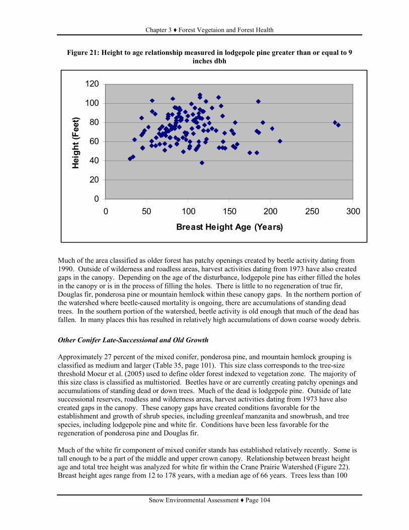
Chapter 3 ♦ Forest Vegetaion and Forest Health
Snow Environmental Assessment ♦ Page 104
Figure 21: Height to age relationship measured in lodgepole pine greater than or equal to 9 inches dbh
0
20
40
60
80
100
120
0 50 100 150 200 250 300
Breast Height Age (Years)
Height (Feet)
Much of the area classified as older forest has patchy openings created by beetle activity dating from 1990. Outside of wilderness and roadless areas, harvest activities dating from 1973 have also created gaps in the canopy. Depending on the age of the disturbance, lodgepole pine has either filled the holes in the canopy or is in the process of filling the holes. There is little to no regeneration of true fir, Douglas fir, ponderosa pine or mountain hemlock within these canopy gaps. In the northern portion of the watershed where beetle-caused mortality is ongoing, there are accumulations of standing dead trees. In the southern portion of the watershed, beetle activity is old enough that much of the dead has fallen. In many places this has resulted in relatively high accumulations of down coarse woody debris.
Other Conifer Late-Successional and Old Growth Approximately 27 percent of the mixed conifer, ponderosa pine, and mountain hemlock grouping is classified as medium and larger (Table 35, page 101). This size class corresponds to the tree-size threshold Moeur et al. (2005) used to define older forest indexed to vegetation zone. The majority of this size class is classified as multistoried. Beetles have or are currently creating patchy openings and accumulations of standing dead or down trees. Much of the dead is lodgepole pine. Outside of late successional reserves, roadless and wilderness areas, harvest activities dating from 1973 have also created gaps in the canopy. These canopy gaps have created conditions favorable for the establishment and growth of shrub species, including greenleaf manzanita and snowbrush, and tree species, including lodgepole pine and white fir. Conditions have been less favorable for the regeneration of ponderosa pine and Douglas fir. Much of the white fir component of mixed conifer stands has established relatively recently. Some is tall enough to be a part of the middle and upper crown canopy. Relationship between breast height age and total tree height was analyzed for white fir within the Crane Prairie Watershed (Figure 22). Breast height ages range from 12 to 178 years, with a median age of 66 years. Trees less than 100
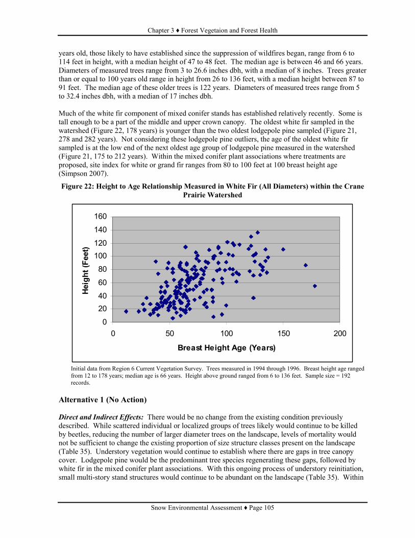
Chapter 3 ♦ Forest Vegetaion and Forest Health
Snow Environmental Assessment ♦ Page 105
years old, those likely to have established since the suppression of wildfires began, range from 6 to 114 feet in height, with a median height of 47 to 48 feet. The median age is between 46 and 66 years. Diameters of measured trees range from 3 to 26.6 inches dbh, with a median of 8 inches. Trees greater than or equal to 100 years old range in height from 26 to 136 feet, with a median height between 87 to 91 feet. The median age of these older trees is 122 years. Diameters of measured trees range from 5 to 32.4 inches dbh, with a median of 17 inches dbh. Much of the white fir component of mixed conifer stands has established relatively recently. Some is tall enough to be a part of the middle and upper crown canopy. The oldest white fir sampled in the watershed (Figure 22, 178 years) is younger than the two oldest lodgepole pine sampled (Figure 21, 278 and 282 years). Not considering these lodgepole pine outliers, the age of the oldest white fir sampled is at the low end of the next oldest age group of lodgepole pine measured in the watershed (Figure 21, 175 to 212 years). Within the mixed conifer plant associations where treatments are proposed, site index for white or grand fir ranges from 80 to 100 feet at 100 breast height age (Simpson 2007).
Figure 22: Height to Age Relationship Measured in White Fir (All Diameters) within the Crane Prairie Watershed
0
20
40
60
80
100
120
140
160
0 50 100 150 200
Breast Height Age (Years)
Height (Feet)
Initial data from Region 6 Current Vegetation Survey. Trees measured in 1994 through 1996. Breast height age ranged from 12 to 178 years; median age is 66 years. Height above ground ranged from 6 to 136 feet. Sample size = 192 records.
Alternative 1 (No Action) Direct and Indirect Effects: There would be no change from the existing condition previously described. While scattered individual or localized groups of trees likely would continue to be killed by beetles, reducing the number of larger diameter trees on the landscape, levels of mortality would not be sufficient to change the existing proportion of size structure classes present on the landscape (Table 35). Understory vegetation would continue to establish where there are gaps in tree canopy cover. Lodgepole pine would be the predominant tree species regenerating these gaps, followed by white fir in the mixed conifer plant associations. With this ongoing process of understory reinitiation, small multi-story stand structures would continue to be abundant on the landscape (Table 35). Within

Chapter 3 ♦ Forest Vegetaion and Forest Health
Snow Environmental Assessment ♦ Page 106
areas being analyzed for treatment, tree density currently is, or is trending towards levels, high enough to reduce tree vigor. Potential for retaining existing large tree structure and developing future large tree structure would be reduced. Within mixed conifer and ponderosa pine stands being analyzed for treatment, the dense, multi-storied forest structures of small trees would continue to be a departure from the relatively open, large-tree dominated forest which historically existed. In mixed conifer stands, there would continue to be a shift away from the more fire resistant species such as ponderosa pine and Douglas fir. Stocking of true fir and lodgepole pine would continue to be high enough in some areas to cause reductions in the vigor and growth of the relatively few ponderosa pine and Douglas fir that are present. Cumulative Effects: Since there are no actions associated with this alternative, there would be no cumulative effects on the existing proportion of size and structure classes within the Crane Prairie watershed. Alternative 2 (Proposed Action) Direct and Indirect Effects: At the watershed scale, proposed treatments would slightly reduce (-1%) small multistory stand structure and would correspondingly increase (+1%) the amount of area classified as small single story (Table 36). The majority of this change would be associated with the thinning proposed within the mixed conifer and ponderosa pine plant association groups (EA Appendix A, Prescription 6). With 62 percent of the watershed remaining the small size structure (Table 36), this structure would continue to be present at levels higher than the historic range of variability (Table 34). There would be no change in the proportion of the watershed in size and structure classes that approximate older forest conditions (late-successional and old-growth conditions) as defined by potential vegetation (Moeur et al. 2005). This would be due both to the types of treatments proposed and the small proportion of the watershed (3.5%) proposed for treatment. Within all treatment areas, components associated with late-successional and old-growth forest ecosystems, including maturing trees, snags, and down logs, would be retained, albeit at reduced levels. Salvage treatments (EA Appendix A, Prescriptions 1 and 2) would not change existing size and structure classifications. Cutting live trees less than 4 inches dbh, a treatment proposed following salvage, would reduce tree density in the lower canopy level, but would have minimal to no affect on density in the middle and upper canopy levels. Thinning within lodgepole pine (EA Appendix A, Prescriptions 4 and 5) and mixed conifer stands (EA Appendix A, Prescription 6) would generally move stand structures from multistory to single story stand structures. Thinning would favor retaining dominant and codominant trees in the upper canopy levels of the stand and would increase the average diameter of dominant and codominant trees. Exceptions to this would be in mixed conifer stands where ponderosa pine or Douglas fir in lower canopy levels would be favored for retention over lodgepole pine or white fir in the upper canopy levels. While thinning would retain relatively high levels of residual stocking, additional gaps in the canopy would be created, increasing the mosaic of canopy conditions. Given lodgepole pine’s observed capacity in the area for regenerating canopy gaps, the existing trend towards multi-story structures will continue. Cumulative Effects: There would be no cumulative effects. Ongoing and reasonably foreseeable future actions within the Crane Prairie watershed (Table 17) would not be intensive or extensive enough to add to the change in size/structure classifications associated with Alternative 2 (Table 36). Ongoing and reasonably foreseeable actions considered include those actions that would remove trees (Table 17). Many of the foreseeable actions include the removal of hazard trees. Most hazard trees

Chapter 3 ♦ Forest Vegetaion and Forest Health
Snow Environmental Assessment ♦ Page 107
would be scattered, individual trees and their removal would not change the existing size/structure classification. Where more concentrated removal of hazard trees could occur (Elk-Hosmer CE and Sparky Hazard Tree Removal), majority of hazard trees to be removed would likely be dead lodgepole pine. This action would not affect the size/structure classification. Timber sale units with postsale work still to be completed (Red Plague and Red Elk) were harvested prior to 2004. Effect of harvest on size and structure classification is reflected in the existing condition. Ongoing postsale work would have no additional affect on size structure classification. Harvest of the Lo and Snoop Timber Sales is ongoing. Lo Timber Sale units are within areas classified as small and large multi-story mixed conifer stands (64 acres). Harvest and postsale activities would change the structure classification from multi-story to single-story. There would be no change in size. Given the small area affected, there would be no change in the proportion of the watershed in these size/structure classifications. Most of the Snoop Timber Sale units (1,002 acres) are within lodgepole pine areas classified as “potentially forested but presently non-stocked” and “seedling and sapling”. Actions in these units consist primarily of the removal of overstory trees. These actions would not change the existing size/structure classification. The remaining Snoop units (95 acres) are within areas classified as small multi-story stand structure. Of this area, seedtree harvest in one unit (33 acres) would change size/structure classification to “potentially forested but presently non-stocked”. This would be too small of a change to be reflected at the watershed scale.
Table 36: Effects of Alternative 2 on the Proportion of Size Structure Classes in the Crane Prairie Watershed
Lodgepole pine PAGs Other Conifer PAGs Watershed % of Total % of Total % of Total
Size and Structure Class Acres
% Change from
Existing
Acres %
Change from
Existing
Acres %
Change from
Existing Grass/forb/shrub (<10% Canopy cover) 2,800 7% None 4,499 4% None 7,299 5% None
Seedling and Sapling (<9" dbh) 9,515 25% None 7,669 7% None 17,184 12% None
Small single-story (9-20" dbh) 867 2% None 4,832 5% +1% 5,699 4% +1%
Small multi-story (9-20" dbh) 23,183 61% None 60,865 57% -1% 84,048 58% -1%
Medium and Larger single-story (>21" dbh) 37 0% None 278 0% None 315 0% None
Medium and Larger multi-story (>21" dbh) 1,754 5% None 28,355 27% None 30,109 21% None
Total 38,156 100% --- 106,498 100% 144,654 100% Total Older Forest 25,841 68% +1% 28,633 27% None 54,474 38% None
Alternative 3 Direct and Indirect Effects: Treatments unique to Alternative 3 in the lodgepole pine vegetation type, including variable density thinning and even-aged regeneration harvest methods, would decrease (7%) the amount of small multi-story structure (Table 37). There would be a corresponding increase in small single-story (+5%), seedling and sapling (+1%), grass/forb/shrub (+1%) size structure classes. The increase in small single-story would result from low thinning done either as a separate treatment or in the context of variable density thinning. The increase in the seedling and sapling size/structure, a type of early successional habitat, would result from the removal of overstory trees from an establishing understory. The increase in the grass/forb/shrub size structure class, another type of early

Chapter 3 ♦ Forest Vegetaion and Forest Health
Snow Environmental Assessment ♦ Page 108
successional habitat, would result from the use of the seed tree harvest method. With this treatment, tree canopy cover would be reduced to less than 10 percent. The increase in early successional habitat would be relatively small. In the context of the watershed, the increase would not be great enough to change the percent of size/structure classes representative of this habitat (Table 37). With the reductions in the lodgepole pine small multi-story size structure, together with the reductions in the other conifer vegetation types, the amount of small structure (single and multistory) in the watershed would total 61 percent (Table 35). This would be approximately one percent less than the existing condition, but would still be above the historic range of variability for this size class (Table 34). Given lodgepole pine pine’s observed capacity in the area for regenerating canopy gaps, the existing trend for multi-story stand structures to develop will continue. Cumulative Effects: There would be no cumulative effects. Similar to Alternative 2, ongoing or reasonably foreseeable future actions within the Crane Prairie watershed (Table 17) would not be intensive or extensive enough to add to the change in size/structure classifications associated with Alternative 3 (Table 37).
Table 37: Effects of Alternative 3 on the Proportion of Size Structure Classes in the Crane Prairie Watershed
Lodgepole pine PAGs Other Conifer PAGs Watershed Total % of Total % of Total % of Total
Size and Structure Class Acres
% Change from
Existing
Acres %
Change from
Existing
Acres %
Change from
Existing Grass/forb/shrub (<10% Canopy cover) 3,214 8% +1% 4,499 4% None 7,620 5% None
Seedling and Sapling (<9" dbh) 9,980 26% +1% 7,712 7% None 17,686 12% None
Small single-story (9-20" dbh) 2,607 7% +5% 4,823 5% +1% 7,415 5% +2%
Small multi-story (9-20" dbh) 20,564 54% -7 % 60,831 57% -1% 81,509 56% -3%
Medium and Larger single-story (>21" dbh) 40 0% None 278 0% None 318 0% None
Medium and Larger multi-story (>21" dbh) 1,751 5% None 28,355 27% None 30,106 21% None
Total 38,156 100% --- 106,498 100% --- 144,654 99% --- Total Older Forest 25,061 66% -1% 28,633 27% None 53,694 37% -1%
Forest Vegetation Measure #2 – Horizontal Diversity Deschutes LRMP Standards and Guidelines TM-58 and TM-61 provide management direction for horizontal diversity, specifically addressing harvest unit size. TM-58 provides direction for created openings by vegetation type. Created openings can exceed 40 acres in lodgepole pine to treat the “catastrophic situation” created by the mountain pine beetle epidemic. Units are to be shaped to blend with the natural terrain. TM-61 provides direction for creating essentially uniform structural conditions with timber management activities. This standard and guideline applies to even-aged regeneration harvest units with regeneration less than 4.5 feet tall (J.Booser, personal communication, October 16, 2007).

Chapter 3 ♦ Forest Vegetaion and Forest Health
Snow Environmental Assessment ♦ Page 109
Uniform conditions resulting from fires are not to be included in assessing whether implementation unit meet this standard and guideline (J.Booser, personal communication, October 16, 2007). Scope and Scale of Analysis The spatial scale of analysis for created openings (TM-58) is the harvest unit. For identifying the spatial scale of analysis for a number of LRMP standards and guidelines, the Forest was partitioned, often times along roads, into smaller geographic areas called implementation units. The spatial scale of analysis for uniform structural conditions (TM-61) is the implementation unit. Proposed treatments overlay six implementation units (7, 8, 9, 14, 15 and 19), which range in size from approximately 7,000 acres to 39,000 acres (Figure 23). The temporal scale of analysis is the next 10 years. It is during this timeframe proposed treatments with potential to create uniform structural conditions would be implemented. Measures Size of created opening (LRMP S&G TM-58) is reported for each treatment unit where the seed tree regeneration harvest method is proposed. Size is expressed in terms of net treatment acres. Uniform structural conditions is measured in terms of percent of each implementation unit where timber management activities have or will created essentially uniform structural conditions in excess of 100 continuous acres (LRMP S&G TM-61). Methods The following even-aged regeneration harvest methods are the timber management activities considered to create uniform structural conditions: clearcut, seed tree harvest, shelterwood at final removal, and overstory removal (Standard and Guideline TM-61). To determine existing condition, GIS data layers were queried to map where these harvest methods have been completed within the past 10 years (since and including 1997). Based on local observations in the area of lodgepole pine regenerating these types of harvests, it was assumed areas harvested prior to 1997 have regeneration greater than 4.5 feet tall. Harvest areas were merged to determine contiguous acres of uniform structure. To determine how the action alternatives would change the existing condition, areas proposed for these even-aged regeneration harvest methods were mapped. Portions of units proposed for overstory removal were not considered to contribute towards the uniform structure calculations if following harvest treatment areas would be at least minimally stocked (100 trees per acre) with trees greater than or equal to 4.5 feet. Acres of uniform structure, existing or proposed, were grouped into single blocks. Areas greater than 100 acres in size with contiguous uniform structure are mapped. Percent of each affected implementation unit in these identified blocks of uniform structure was calculated. Existing Condition Presently none of the implementation units have contiguous areas in excess of 100 acres where past timber management has created essentially uniform structural conditions. Since 1997, the majority of harvest done within the affected implementation units has been salvage or commercial thinning. The majority of even-aged regeneration harvest within these implementation units occurred between 1964

Chapter 3 ♦ Forest Vegetaion and Forest Health
Snow Environmental Assessment ♦ Page 110
and 1993. What even-aged regeneration harvest has occurred within the past 10 years has affected areas less than 100 contiguous acres. Alternative 1 (No Action) and Alternative 2 (Proposed Action) Direct, Indirect and Cumulative Effects: No forest openings would be created with Alternatives 1 and 2. Neither alternative proposes the use of even-aged silviculture that would create openings. Alternatives 1 and 2 would have no direct, indirect, or cumulative effects on the existing proportion of the implementation units with essentially uniform structural conditions resulting from timber management activities. With Alternative 1, no timber management activities would occur. Alternative 2 proposes the use of intermediate harvest methods (Table 4), which would not create uniform structural conditions addressed by Standard and Guideline TM-61.

Chapter 3 ♦ Forest Vegetaion and Forest Health
Snow Environmental Assessment ♦ Page 111
Figure 23: Implementation Unit Boundaries

Chapter 3 ♦ Forest Vegetaion and Forest Health
Snow Environmental Assessment ♦ Page 112
Alternative 3 Direct, Indirect and Cumulative Effects: Alternative 3 proposes the use of seed tree regeneration harvest, a form of even-aged management that would create openings in the forest. This harvest method is proposed within lodgepole pine wet and dry plant association groups. Size of created openings would range from 4 to 91 acres, with the median size of created opening being 18 acres. Three treatment areas (Unit 71, 84, and 181.1) exceed 40 acres, which is allowed in lodgepole pine to treat conditions created by the mountain pine beetle (S&G TM-58). The Snow Watershed assessment (Deschutes National Forest 2005) describes the widespread nature of the beetle outbreak and the associated detrimental effects to the environment. Beetle caused mortality within these larger treatment areas, as mapped in the watershed assessment (Deschutes National Forest 2005), is generally moderate to high, with some areas of lower mortality. Only within Implementation Unit (IU) 15 would treatments create uniform structural conditions in excess of 100 acres. This would occur within two blocks of contiguous seed tree and overstory removal units (Figure 23). Area with essentially uniform structural conditions greater than 100 acres would increase to approximately 5 percent. This estimate is at the threshold for the standard and guide TM-61. This estimate is sensitive to the amount of regeneration assumed to be present following treatment. The standard and guideline for uniform structure could be exceeded if approximately 20 percent less regeneration is present than estimated. It is unlikely regeneration would be 46 percent less than estimated, which would result in approximately 7 percent uniform structure. Units 181 and 181.1 (Figure 23) are bordered to the south by the Four Corners Fire. The fire was not used in determining contiguous acres of uniform structure since regeneration in the fire exceeds 4.5 feet and fires are not included in assessing conformance with TM-61. There would be no cumulative effects. There are no reasonably foreseeable future actions within the implementation units that would increase the amount of uniform structure.
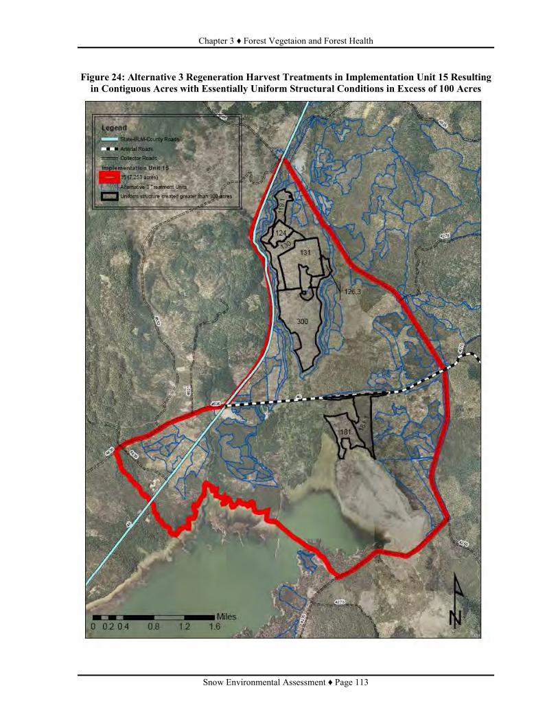
Chapter 3 ♦ Forest Vegetaion and Forest Health
Snow Environmental Assessment ♦ Page 113
Figure 24: Alternative 3 Regeneration Harvest Treatments in Implementation Unit 15 Resulting in Contiguous Acres with Essentially Uniform Structural Conditions in Excess of 100 Acres

Chapter 3 ♦ Forest Vegetaion and Forest Health
Snow Environmental Assessment ♦ Page 114
Forest Health Measure #1 – Stand Susceptibility to Bark Beetles The Snow Watershed Assessment (Deschutes National Forest 2005) indicates mountain pine beetle started attacking lodgepole pine forests, as well as the lodgepole pine component of mixed conifer forests, beginning around the year 1990. Mapping of aerial survey data (Deschutes National Forest 2005) showed expanding and intensifying levels of mortality from 1990 to 2004. Bark beetles can act as agents of change, affecting ecosystems directly and indirectly. These changes are summarized by Samman and Logan (2000) as follows. Direct effects include individual tree death, changes in forest stand densities, changes in coarse woody debris, changes in forest floor litter, and changes in the amount of light reaching the forest floor. Indirect effects include timing, scale, and intensity of fire, changes in water quality and quantity, changes in wildlife use of the forest, changes in species composition, age, and size of remaining trees, and changes in commodity and/or amenity values. According to Cochran et al. (1994), observations suggest tree mortality due to mountain pine beetle remains at a low level until a critical stand density is reached. This critical density can differ by species and plant association. Cochran et al. (1994) describe procedures for identifying stand densities above which mortality from bark beetle could be expected. This rating system, which uses stand density index, has been described as being based on the published risk and hazard rating systems which are most applicable to eastern Oregon (USDA Forest Service 1996c). Unmanaged lodgepole pine stands in the Cascade Lakes area are considered to be vulnerable to mountain pine beetle attack if they have trees older than 100 years and have 90 to 110 trees per acre that are 9 inches dbh or larger (A. Eglitis, personal communication, February 19, 2008). For managed lodgepole pine stands, a measure of vulnerability comes from Cochran et al. (1994). According to Cochran et al. (1994), two levels-of-growing-stock studies in central Oregon indicate a stand density index of 170 (equivalent to approximately 200 trees per acre, 9 inches dbh)diameter trees per acre) is a threshold above which mortality due to mountain pine beetle becomes serious for lodgepole pine. During a beetle outbreak, vulnerable stands on a given landscape are not all affected at one time (A. Eglitis, personal communication, February 19, 2008). Similarly, not all susceptible and suitable trees within a stand are attacked during an outbreak. This mortality pattern on the landscape is validated by the observations of Dolph (1981) and Mitchell (undated). Dolph (1981) documents historical patterns of mountain pine beetle in lodgepole pine and second-growth ponderosa pine in south-central Oregon (Figure 25). He describes the first recorded mountain pine beetle outbreak in south-central Oregon, which occurred in 1912. When the outbreak collapsed in 1914, an area of about 138,000 acres (slightly smaller than the Crane Prairie Watershed) had been infested. In 1956, mountain pine beetle reappeared in the same general area and eventually encompassed the same broadscale landscape as reported in 1914. Beetle populations in the area peaked in 1969. During the 1970’s, the outbreak ebbed only to resurge again in 1980. Dolph indicates similar outbreak patterns have occurred elsewhere in the lodgepole pine stands in south-central Oregon.

Chapter 3 ♦ Forest Vegetaion and Forest Health
Snow Environmental Assessment ♦ Page 115
Figure 25: Mountain Pine Beetle Outbreak Pattern in South-Central Oregon Described by Dolph (1981)
║ ← 2 years → ║ ← 42 years → ║ ← 13 years → ║ ← 11 years → ║
1912 (Outbreak)
1914 (Outbreak Collapse)
1956 (Reappearance)
1969 (Peaked)
1970’s (Ebbed)
1980 (Resurged)
According to Mitchell (Undated), a beetle outbreak follows a pattern dictated by complicated interactions among several factors: stand vigor, distribution of tree sizes, distance between trees, the reservoir of trees available for attack, and the size of the beetle population. These interactions are further complicated because the significance of the various factors can change in the course of the outbreak. Tree vigor, for example, is important early in an outbreak but progressively loses currency as the beetle population grows and the reservoir of weakened trees is reduced by beetle-kill. Mitchell (Undated) describes the anatomy of a mountain pine beetle outbreak in Central Oregon (Figure 26). The pattern Mitchell describes is similar to that described by Dolph (1981). The outbreak occurred from 1970 to 1987 on the east side of the Bend-Fort Rock Ranger District in mixed stands of lodgepole and ponderosa pine. It covered an area of approximately 620,000 acres. The lodgepole pine in the area had last experienced a severe mountain pine beetle outbreak in the early 1920s. Mitchell indicates because outbreaks tend to endure for 15 to 20 years, and tree-killing is rather patchy and variable in intensity, recovering stands show considerable variability in age and structure. This affects the impact of the beetle in the stands during the next outbreak. As an example, Mitchell states stands that suffered light damage during the prior outbreak (1920s) would have a lot of large, old trees for the next outbreak (1980s), and would likely be hit very hard.
Figure 26: Mountain Pine Beetle Outbreak Pattern in Central Oregon Described by Mitchell (undated)
║ ← 50 years → ║ ← 10 years → ║ ← 10 years → ║
Early 1920’s (Outbreak)
(Period between outbreaks)
1970 (Reappearance)
(Early outbreak
phase)
1980
(Spectacular period
of outbreak)
1987
As described by Mitchell (Undated), between outbreaks bark beetle population stay at very low levels, being maintained in scattered, individual trees that are weakened by injury, disease, lightning strikes, and so forth. The trees killed by the beetle are scattered randomly throughout the forest because the distribution of susceptible trees is essentially random. Scattered, localized outbreaks may develop now and then, because beetles occasionally find a few stands that escaped the last outbreak or stands that grew into susceptibility shortly after the last outbreak collapsed. The beetle population will fluctuate somewhat from year to year, but remains at endemic levels because most trees released by the last outbreak are too vigorous to colonize, and because there are too few big trees to generate the critical mass needed to initiate an outbreak. At the local stand level, there is little to no likelihood of an outbreak when there are fewer than 20 trees per acre 9 inches dbh or larger (Mitchell undated). He describes the “quiet” period between outbreaks as gradually coming to an end 30 to 40 years after the end of the last outbreak when two features of the forest begin to converge. First, tree crowns start to merge and the first signs of competition stress begin to appear. Second, trees with diameters exceeding 9 inches dbh become numerous. Mitchell states it is a time for concern when a sizable portion of the forest have stands of poor vigor and a sizable number of trees exceeding 9 inches dbh. Once the forest is ready (when hazard is high), then it is just a matter of time before the beetle begins to exploit the food supply.
Chapter 3 ♦ Forest Vegetaion and Forest Health
Snow Environmental Assessment ♦ Page 116
As described by Mitchell (undated), the early outbreak phase (1970 – 1980) is characterized by a gradual, arithmetic increase in the number of trees killed and in beetle numbers. Usually the increase in beetle numbers starts so slowly, it’s hard to say just when an outbreak does begin. Mitchell indicates the last 8 years of a beetle outbreak (1980 – 1987) is the spectacular period, a time when everyone, including the general public, knows there is an outbreak. It is characterized by 4 to 5 years of exponential increase in beetle population and tree-killing, followed by a sharp decline in both the hazard and population indices when it becomes increasingly difficult for the beetles to find trees available for attack. By the sixth year, Mitchell indicates the outbreak begins a downward trajectory. Beetles remain abundant but suitable host trees become hard to find. At this period in the outbreak, the associated, less susceptible and less suitable host trees begin to be attacked and killed in noticeable numbers. Large, high vigor lodgepole pine in thinnings and shelterwoods may also suffer some mortality. In the seventh year, the beetle population has declined but is still sizable, much greater than the remaining pool of susceptible trees can absorb. The beetles attack the few isolated stands that were missed the first time, and also come back to pick up individual trees in stands attacked a few years previously. If the population is extremely high, the larger trees in the thinnings and shelterwoods can also suffer significant mortality. In the eighth and final year, Mitchell indicates the beetle population finds very few trees to colonize, and the collapse of the outbreak is complete. He indicates the beetle hazard and population will remain low for about 30 years. Mitchell (undated) indicates there always seem to be trees that survive a mountain pine beetle outbreak. According to Mitchell, it’s a form of resistance, and it shows up as trees that: 1) were avoided by the beetle, 2) pitched out the attacking population, 3) permitted the construction of adult galleries but failed to develop blue stain or permit larval survival, and 4) were strip-killed. Mitchell states these types of trees are far more common in managed stands than in unmanaged. Fettig et al. (2007) reviewed tree and stand factors associated with bark beetle infestations in western coniferous forests and analyzed the effectiveness of vegetation management practices for mitigating the negative impacts of bark beetles on forest ecosystems. Their review drew from 498 scientific publications. In summarizing factors influencing the susceptibility of lodgepole pine forests to mountain pine beetle attack, Fettig et al. (2007) state tree diameter and stand age, among other factors, were positively correlated with likelihood of mountain pine beetle attack. In describing bark beetle-tree interactions and forest health, Fettig et al. (2007) indicate as growing space diminishes, a tree’s photosynthates are allocated to different uses in an order of priorities. They indicate that while the hierarchy is not absolute, photosynthates are allocated lastly to insect and disease resistance mechanisms. They summarize that production of insect resistance mechanisms may be compromised when growing space becomes limited by one or more factors. Thinning has been identified as a practical means of lowering the probability of serious mortality from mountain pine beetle and perhaps western pine beetle (Cochran et al. 1994). For lodgepole pine forests, Fettig et al. (2007) indicate spaced thinnings that optimize the effects of micro-climate, inter-tree spacing and tree vigor are currently proposed as a method to “beetle-proof” stands. As summarized by Fettig et al. (2007) this requires thinning from below (low thinning) and wide residual inter-tree spacing to create stand conditions that are detrimental to beetle survival. While thinning is recommended for maturing lodgepole pine stands, the studies summarized by Fettig et al. (2007) found variable effectiveness in reducing the amount of beetle-caused tree mortality. One study conducted during increasing mountain pine beetle populations found the amount of mountain pine beetle-caused tree mortality was significantly reduced. In two other studies, data strongly suggested thinning mature lodgepole pine stands from below to a uniform residual tree spacing of at least 4 meters (13 feet) is an effective tool for preventing mountain pine beetle infestations. Other studies, however, summarized by Fettig et al. (2007) found the protection gained from thinning was

Chapter 3 ♦ Forest Vegetaion and Forest Health
Snow Environmental Assessment ♦ Page 117
overwhelmed by large numbers of beetles. One study found thinned plots were initially unattractive to beetles, but when large numbers of attacks occurred, colonization rates were similar to those in unthinned plots. Another study that looked at the effects of spacing and diameter distributions found that tree mortaility was reduced as basal area was lowered, but if the stand was in the path of an ongoing mountain pine beetle epidemic, spacing and density had little effect. Scope and Scale of Analysis The spatial scale of analysis is the combined area of Alternatives 2 and 3 being analyzed for treatment (6,590 gross acres). Beyond treatment area boundaries, the effects of the treatments on beetle susceptibility are generally not considered to be qualitatively meaningful. The temporal scale of analysis is the next 10 years (short term) and 30 years (long term). Treatments reducing stand density would likely be implemented within 5 to 10 years of the decision. Within the watershed, median breast height age of lodgepole pine greater than 9 inches dbh is between 96 and 97 years (Figure 21). Median breast height age of lodgepole pine 6 to 9 inches dbh (trees likely to grow to at least 9 inches dbh within 30 years) is approximately 80 years (based on initial data from Region 6 Current Vegetation Survey and limited sampling within areas being considered for treatment). Within 30 years, residual lodgepole pine trees surviving the most recent mountain pine outbreak likely will have grown to a size (greater than 9 inches dbh) and an age (100 years) that could provide suitable habitat to mountain pine beetle. Measure Stand susceptibility to bark beetles (hazard) is measured qualitatively in terms of abundance and distribution of conditions favorable for bark beetle attack (trees of a suitable age, size and density). The four classifications used in this analysis are: 1) Absent/Infrequent: a) Trees of a suitable age and size are lacking or infrequent (ie. fires or
clearcuts), or b) trees of a suitable size may be present, but age and/or densities are below thresholds for vulnerability to beetle attack.
2) Absent/Clumped: Trees of suitable age, size, and density found in widely spaced clumps. Trees of suitable size and age may be present outside of clumps, but are too widely spaced and associated densities are too low to provide suitable conditions for bark beetle attack (ie. regeneration harvest units, including seedtree, shelterwood, and overstory removal, where clumps remain to provide green-tree and snag retention areas).
3) Clumped/Scattered: Trees of suitable age and size are found in close to moderately spaced clumps and as individual, scattered trees. Stand density is variable. In scattered locations, tree age, size and density combine to create conditions favorable for bark beetle attack.
4) Extensive: Trees of suitable age and size are found in close to moderately spaced clumps and as individual, scattered trees. High stand densities are common. Clumps and individual trees of suitable age, size, and density are in close proximity and are extensively present.
Methods Classification of existing distribution of bark beetle hazard is based on past disturbance history and underlying plant association group. To project classification change through time, it was assumed no additional treatments, other than those proposed in this project, would occur. Professional judgment was used to project classification changes over time, with and without treatment. Factors considered included average tree density, diameter, and diameter growth. Classifications and projected changes are considered sufficiently consistent to be useful in estimating relative changes between the no action

Chapter 3 ♦ Forest Vegetaion and Forest Health
Snow Environmental Assessment ♦ Page 118
and the action alternatives. Refer to Project record, Silviculture Report for additional documentation for methods and assumptions. Existing Condition Based on historic outbreak patterns, it could be at least 30 years before a new outbreak reoccurs at the landscape scale. While the recent beetle outbreak has reduced the level of hazard at the landscape scale, smaller areas that escaped the outbreak remain at risk to beetle attack. Within some of the lodgepole pine stands proposed for treatment, aggregations of trees susceptible to bark beetles remain. Factors contributing to this hazard include relatively dense stocking that is decreasing tree vigor and presence of trees approximately 100 years old greater than 9 inches dbh. Mixed conifer and ponderosa pine stands proposed for thinning are generally stocked at levels above which mortality from bark beetles could be expected (Booser and White, Undated). Depending on the plant association, the greatest proportion of excess stocking tends to be lodgepole pine and white fir, separately or in combination. The existing presence of hazardous conditions is reflected in the continuing localized outbreaks of mountain pine beetle. South of Lava Lake, the 2006 Aerial Survey (USDA Forest Service 2007a) mapped relatively small patches (2 to 170 acres in size) of beetle induced mortality within and adjacent to some units proposed for treatment. The primary mortality agent identified was mountain pine beetle (Dendroctonus ponderosae Hopkins) in lodgepole pine. Areas mapped with beetle activity had mortality levels ranging from less than 1 tree per acre to 8 trees per acre. North of Lava Lake, the survey mapped larger patches (2 to 640 acres in size), many aggregated together, with mortality levels ranging from less than 1 tree per acre to 15 trees per acre. The 2007 Aerial Survey (USDA Forest Service 2007b) mapped similar patterns of mortality. North of Lava Lake, larger areas mapped approach 1600 acres in size with mortality level estimated at 1 tree per acre. It has been approximately seventeen years since the onset of the most recent mountain pine beetle outbreak began in the area. South of Lava Lake, the outbreak appears to be in the later stages of the outbreak. Beetles are attacking isolated stands missed the first time as well as individual trees or groups of trees in stands attacked in prior years. North of Lava Lake, given the widespread nature of mapped mortality, the outbreak appears to be in the earlier stages of the outbreak. Lodgepole pine host material still appears to be widely available. The existing distribution of beetle hazard within areas being analyzed for treatment is displayed in Figure 27. Most of the area with the hazard classification of “absent/infrequent” was recently (within last 40 years) either burned in wildfires or harvested using the clearcut or shelterwood regeneration methods. High density mixed conifer or ponderosa pine stands make up the majority of the area classified as having hazardous conditions extensively distributed. Mixed conifer and ponderosa pine stands proposed for thinning are generally stocked at levels above which mortality from bark beetles could be expected (Booser and White, Undated). Depending on the plant association, the greatest proportion of excess stocking tends to be lodgepole pine and white fir, separately or in combination. Lodgepole pine stands make up the majority of the area classified as having hazardous conditions clumped or scattered. Factors contributing to this hazard include clumps of relatively dense stocking that is decreasing tree vigor and presence of trees approximately 100 years old greater than 9 inches dbh. The existing presence of hazardous conditions is reflected in the continuing localized outbreaks of mountain pine beetle.

Chapter 3 ♦ Forest Vegetaion and Forest Health
Snow Environmental Assessment ♦ Page 119
Figure 27: Existing Distribution of Beetle Hazard
Existing Condition - Year 2008
Clumped/
Scattered
75%
Absent/
Infrequent
11%
Extensive
14%
Percentages based on 6,590 gross acres being analyzed for treatment.
Alternative 1 (No Action) Direct and Indirect Effects: Within the next 10 years (2018), the distribution pattern of beetle hazard would be primarily clumped and/or scattered (Figure 28). Conditions favorable for beetle attack would continue to be most extensive within dense mixed conifer and ponderosa pine stands. Within 30 years (2038), with increases in tree diameter and stand density in lodgepole pine stands, conditions favorable for beetle attack would likely be extensive throughout the areas being analyzed (Figure 28). In the short term, varying levels of beetle-caused mortality would continue to occur in lodgepole pine. South of Lava Lake, where beetles have reduced the supply of suitable habitat, the pattern of ongoing mortality would likely be scattered and relatively small scale. Mortality would generally be limited to weakened individual trees, patches of suitable habitat that escaped the recent outbreak, or patches that grew into susceptibility since the onset of the recent outbreak. North of Lava Lake, the pattern could include larger patches with relatively high levels of mortality. By the end to this 10 year period, the pattern north of Lava Lake would likely change to being scattered and small scale as host material becomes less abundant. Within the mixed conifer and ponderosa pine stands, stocking level and age-size structure would continue to favor the occurrence of bark beetles, thus maintaining the likelihood large, maturing trees of any species could be attacked by bark beetles. Mortality from beetles could occur in periods of both normal and below normal precipitation, with accelerated tree mortality rates possible during periods of low precipitation. During this period, greatest risk of accelerated tree mortality would be within the mixed conifer and ponderosa pine stands. In the long-term, relative stand densities will increase as trees grow in diameter and new trees establish where gaps exist in the tree canopy. The age-size structure and density within many of the lodgepole pine stands would likely have developed into conditions favorable to mountain pine beetle. Trees of a size and age suitable for bark beetles would be relatively common and would likely be in sufficient numbers to generate the critical mass needed to initiate another outbreak of bark beetles. Absent a stand disturbing event, suppression related mortality within mixed conifer and ponderosa pine stands would not be sufficient to reduce stand stocking. Hazard in the mixed conifer and ponderosa pine stands would remain. By the end of this period, there would be risk of accelerated tree mortality within most of the lodgepole pine stands being considered for treatment and all the mixed conifer and ponderosa pine stands. Cumulative Effects: There would be no cumulative effects since there are no actions associated with this alternative.

Chapter 3 ♦ Forest Vegetaion and Forest Health
Snow Environmental Assessment ♦ Page 120
Alternative 2 (Proposed Action) Direct and Indirect Effects: Within the next 10 years (2018), there would be a reduction in area classified as having extensive beetle hazard and an increase in area where hazard is absent or infrequent (Figure 28). The dominant distribution pattern of beetle hazard would remain clumped/scattered (Figure 28). Variable density thinning in mixed conifer and ponderosa pine stands (Table 4) would contribute to the decrease in area characterized as having extensive hazard. Low thinning in lodgepole pine stands (Table 4) would increase area where beetle hazard is characterized as being absent or infrequent. Proposed salvage treatments in lodgepole pine stands (Table 4) would have no effect on the distribution of beetle hazard. Similar to Alternative 1, within 30 years (2038) tree growth will likely create conditions extensively throughout the area being analyzed (Figure 28). Proposed thinning in stands of lodgepole pine (EA Appendix A, Prescriptions 4 and 5) and stands of mixed conifer or ponderosa pine (EA Appendix A, Prescription 6) would increase tree vigor and create stand conditions that could be detrimental to beetle survival. Assuming a continuing decline in beetle populations, changes in tree vigor and stand condition would reduce, but not eliminate, the potential for future scattered, localized outbreaks of bark beetle to occur in these stands. Thinning would maintain or improve the vigor of residual trees, making more of a tree’s photosynthates available for production of insect resistance mechanisms (Fettig et al. 2007). Thinning would also change the physical environment within the stands, potentially resulting in increased temperatures and windspeeds. Increased temperatures and windspeeds may accelerate the development of certain bark beetle species and force them to overwinter in stages that are more susceptible to freezing (Fettig et al. 2007). Lower stand densities could result in unstable layers of air and multi-directional movement of air. As described by Fettig et al. (2007), this type of air movement dilutes pheromone concentrations and could result in reductions in beetle aggregation. Fettig et al. (2007) indicate a significant number of pioneer beetles are required to overcome host defenses and a lack of beetle recruitment often results in unsuccessful attacks. Effects of these thinning treatments would be expected to last for approximately 20 years, at which time tree crowns would start to merge and signs of competition stress would begin to be expressed in terms of reduced diameter growth. The number of trees greater than 9 inches dbh would have increased. By this time, conditions within the stands likely would be favorable for bark beetles. Ladder fuels reduction and understory thinning proposed in association with salvage treatments in lodgepole pine stands (EA Appendix A, Prescription 1 and 2) would be least likely to reduce hazardous conditions. Within denser aggregations, much of the middle canopy level stocking is in trees 4 to 8 inches dbh. With a cut diameter limit of 4 inches, majority of trees being removed would be in the lower canopy layer. Reductions in density may be insufficient in some areas to improve tree vigor or increase temperature and windspeed and thus affect beetle development and beetle aggregation. Cumulative Effects: There would be no cumulative effects. While a few ongoing and reasonably foreseeable actions overlap areas being analyzed (Table 17), these actions consist primarily of removing scattered, individual hazard trees and the spraying and control of weed sites. These actions would not combine with the proposed action to change the distribution of beetle hazard. Alternative 3 Direct and Indirect Effects: Within the next 10 years (2018), conditions favoring beetle attack would be much reduced from current levels. On a substantial proportion of the area (74%), beetle hazard

Chapter 3 ♦ Forest Vegetaion and Forest Health
Snow Environmental Assessment ♦ Page 121
would be absent or, if present, would be infrequent or in clumps (Figure 28). The presence of these conditions (absent/infrequent and absent/clumped) would result from the use of regeneration harvests and variable density thinning in lodgepole pine stands (Table 8). These treatments would decrease the amount of area with a clumped or scattered distribution of hazard. Variable density thinning in mixed conifer and ponderosa pine stands (Table 8) would contribute to the decrease in area characterized as having extensive hazard. The combination of treatments proposed with Alternative 3 (Table 8) would contribute to a varied distribution of beetle hazard in both the short and long term (Figure 28). While within 30 years (2038) there would be an increased abundance of conditions favorable to beetles, these conditions would be discontinuous on two-thirds of the area being analyzed (Figure 28). Treatments proposed in lodgepole pine (EA Appendix A, Prescriptions 10, 11, 12, and 13) as alternatives to salvage treatments (EA Appendix A, Prescriptions 1 and 2) would better reduce potential for future scattered, localized outbreaks of bark beetle. While these treatments would retain trees of a size suitable for bark beetles, the more open stand conditions and associated micro-site effects would be least favorable for bark beetles. On a limited portion of these areas (10 percent of gross treatment area), conditions would be favorable for beetle attack within clumps retained to provide green-tree and snag retention areas. Greatest reductions in susceptibility would be realized with the seedtree (Prescription 10) and overstory removal (Prescription 12) treatments. With fewer than 20 overstory trees per acre being retained, there would be little to no potential for beetle-caused mortality in stands where these treatments occur. Reduced susceptibility would be relatively long lasting (up to 80 years), with stands becoming vulnerable when understory trees approach the age of 100 years. Similar to the thinning effects described for Alternative 2, variable density thinning in lodgepole pine (EA Appendix A, Prescription 13) would reduce stand susceptibility by maintaining or improving the vigor of residual trees and creating stand conditions that could be detrimental to beetle survival. While small, discontinuous groups of lodgepole pine of a size and age vulnerable to beetle attack would likely remain, density would generally be less than the thresholds above which mortality due to mountain pine beetle becomes serious for lodgepole pine (Cochran et al. 1994). With declining in beetle populations, changes in tree vigor and stand condition would reduce, but not eliminate, the potential for future scattered, localized outbreaks of bark beetle to occur in these stands. Thinning effects would last for 15 to 20 years. At the watershed scale, thinning and regeneration treatments would decrease small multi-story stand structure by approximately 3 percent (Table 37). Within the lodgepole pine plant association groups, regeneration harvest treatments would increase at the watershed scale the amount of lodgepole pine early seral conditions by 2 percent (Table 37, Grass/Forb/Shrub and Seedling/Sapling). Fettig et al. (2007) indicate a heterogeneous landscape is thought to be more resistant to insect caused disturbances. It is unknown whether these relatively small changes in structural diversity would be sufficient to increase resistance and resiliency to insects at the landscape scale. Cumulative Effects: There would be no cumulative effects. While some ongoing and reasonably foreseeable actions overlap areas being analyzed (Table 17), these actions consist primarily of removing scattered, individual hazard trees and the spraying and control of weed sites. These actions would not combine with the proposed action to change the distribution of beetle hazard.

Chapter 3 ♦ Forest Vegetaion and Forest Health
Snow Environmental Assessment ♦ Page 122
Figure 28: Distribution of Beetle Hazard - Short (2018) and Long (2038) term – All Alternatives
Alternative 1 - Year 2018
Clumped/
Scattered
79%
Absent/
Infrequent
5%
Extensive
16%
Alternative 1 - Year 2038
Extensive
99%
Absent/
Infrequent
1%
Clumped/
Scattered
<1%
Alternative 2 - Year 2018
Clumped/
Scattered
88%
Absent/
Infrequent
10%
Extensive
2%
Alternative 2 - Year 2038
Extensive
99%
Absent/
Infrequent
1%
Clumped/
Scattered
<1%
Alternative 3 - Year 2018
Absent/
Infrequent
41%
Extensive
1%
Absent/
Clumped
33%
Clumped/
Scattered
25%
Alternative 3 - Year 2038
Absent/
Clumped
33%
Extensive
33%
Absent/
Infrequent
1%
Clumped/
Scattered
33%
Percentages based on 6,590 gross acres being analyzed for treatment.

Chapter 3 ♦ Forest Vegetaion and Forest Health
Snow Environmental Assessment ♦ Page 123
Forest Health Measure #2 – Dwarf Mistletoe Spread and Intensification Dwarf mistletoe is a parasitic plant that affects the health, vigor, and growth of infected trees. It spreads fastest from infected overstory trees to understory trees. Understory trees greater than three feet in height (or more than 10 years old) and generally within 30 feet of an infected overstory tree are at the greatest risk of infection. Dwarf mistletoe reduces diameter and height growth and can kill or predispose the tree to attack by insects or other diseases. The extent to which mistletoe affects the host tree depends largely upon the age when the tree is initially infected. Trees that are older and larger when first infected initially experience little or no obvious effects whereas younger and smaller trees can experience significant reduction in height and diameter growth. Seedlings and saplings are severely damaged by infection with even a few mistletoe plants (Geils et al. 2002). Effects dwarf mistletoes have on their hosts include: 1) reduced height and diameter growth, 2) increased mortality, 3) reduced seed production and reduced seed viability, 4) reduced wood strength and increased knot size, 5) increased susceptibility to attack be insects, particularly bark beetles, and 6) increased flammability (Hawksworth 1978). Effects dwarf mistletoes can have on stands are varied. Heavy mistletoe infection in a stand can adversely impact some wildlife species through a decrease in cover, tree regeneration and growth, and cone/seed output (Bull et al. 1997). Hawksworth and Wiens (1996) describe stand effects as follows. By inducing formation of witches’ brooms and causing topkill and mortality of host trees, dwarf mistletoes affect the species composition, vertical crown structure, and spacing of trees within infected stands. These direct effects, in turn, have numerous consequences on the physical structure and functioning of the ecosystem. For example, the brooms provide forage, nesting, and cover for birds and mammals, but also increase the likelihood of ground fires becoming crown fires. Canopy gaps caused by mistletoe–induced mortality increase within-stand diversity but also reduce the interior-forest area. Koonce and Roth (1980) describe effects mistletoe has on the flammability of ponderosa pine stands as follows. Mistletoe may influence the frequency of fire by making stands more flammable. Mistletoe infected branches are often laden with resinous spindles and brooms which form fuel ladders leading to crowning fires. Fallen brooms persist in slash, increasing the amount of large, resinous, partially rotten, highly flammable material. In decadent stands, dwarf mistletoe increases the amount of dry, dead aerial fuel. Depending on management objectives and priorities, the effects of dwarf mistletoe are interpreted as positive, negative, or usually of mixed consequence (Geils et al. 2002). According to Geils et al. (2002), the primary means by which a regenerated stand becomes infected with dwarf mistletoe is through infected residual trees left on the site. Other means by which mistletoe can spread, in decreasing order of importance are: infected advanced regeneration, spread from adjacent stands, and long-distance animal vectoring (Geils et al. 2002). Within single-story stand structures, mistletoe has been found to intensity at a rate of approximately one dwarf mistletoe rating class every 14 to 18 years (Parmeter 1978 and Hawksworth and Johnson 1989). At this rate it would take approximately 40 to 55 years for dwarf mistletoe infection levels to reach a mistletoe rating of three (DMR 3). As a rule, the threshold level for growth reduction seems to be class 3, or when about on-half of the crown becomes infected (Hawksworth and Johnson 1989). In multi-story conditions, the upper crowns of understory trees rarely remain free of increasing mistletoe populations, and reduction in tree growth with further increase in mistletoe infection is almost certain (Parmeter 1978). Rate of mistletoe intensification in an understory growing beneath an

Chapter 3 ♦ Forest Vegetaion and Forest Health
Snow Environmental Assessment ♦ Page 124
infected overstory has not been quantified in studies on mistletoe. It would be expected, however, within 30 to 60 feet of infected overstory, intensification of mistletoe in understory trees would be faster than rates observed in single-story stands. Hawksworth and Wiens (1996) indicate removing infected overstory trees before regeneration is 1 meter tall (approximately 3 feet tall) or 10 years old is a strategy that reduces the likelihood of dwarf mistletoe spreading to the understory. Geils et al. (2002) also present this as a strategy for preventing spread of mistletoe into cut blocks. A prevention method they also list is to avoid leaving single trees or small clumps of residual infected trees throughout the harvest area. Scattered overstory trees are a significant inoculum source for young, understory regeneration. Scope and Scale of Analysis The scale of analysis is the area proposed for treatment and the area immediately adjacent (within 30 feet). Beyond this area, the effects of treatments on mistletoe spread are not considered to be qualitatively meaningful. Measures Dwarf mistletoe spread and intensification will be expressed in qualitative terms. Spread is the increase in the number of trees infected with dwarf mistletoe. Intensification is the increase in the number of mistletoe plants on infected trees. Existing Condition According to the FEIS for the Deschutes LRMP (USDA Forest Service 1990b), dwarf mistletoe is widely distributed on the Deschutes National Forest. It is the group of pathogens most impacting the Forest (USDA Forest Service 1990b). Based on the 1985 Vegetative Resource Survey, dwarf mistletoe was present on an estimated 34 percent of the inventoried acres of ponderosa pine type, 73 percent of the mixed conifer type, and 66 percent of the lodgepole pine type (USDA Forest Service 1990b). Lodgepole pine dwarf mistletoe (Arceuthobium americanum) and ponderosa pine dwarf mistletoe (Arceuthobium campylopodum) is present within some of the areas proposed for treatment. Lodgepole pine dwarf mistletoe is most commonly present. Within multi-story stands with mistletoe infection, the crowns of shorter trees are being exposed to mistletoe seeds from taller trees. Without treatment or a high intensity wildfire, this cycle of infection will likely continue indefinitely, causing increased reductions in stand growth and increased mortality rates. There is reduced potential for trees in the understory to: a) utilize site growth potential and b) develop into relatively large green trees, one of the ecologically valuable components of late successional forests. Alternative 1 (No Action) Direct, Indirect and Cumulative Effects: This alternative would have no direct, indirect, or cumulative effects on the current rate of dwarf mistletoe spread and intensification.

Chapter 3 ♦ Forest Vegetaion and Forest Health
Snow Environmental Assessment ♦ Page 125
Alternative 2 (Proposed Action) Direct and Indirect Effects: Treatments focused primarily on the salvage of dead lodgepole pine and the thinning of understory trees (EA Appendix A, Prescriptions 1, 2, and 3) would have no effect on the current rate of dwarf mistletoe spread and intensification. Live overstory trees infected with dwarf mistletoe would remain following treatments. Mistletoe would continue to spread and intensify in understory trees. Treatments that would remove live trees from all canopy layers (EA Appendix A, Prescriptions 4, 5, 6, and 7) have the best potential to reduce the current rate of dwarf mistletoe spread and intensification. Treatments would favor retaining trees with the least amount of dwarf mistletoe infection. This would reduce, but not eliminate, dwarf mistletoe from within treatment units. Low thinning that would occur with these treatments would simplify canopy structure and reduce stand density. Simplified canopy structure and reduced stand density associated with thinning would reduce the probability of mistletoe seed dispersal to susceptible understory hosts and lateral spread among host trees (Hessburg et al. 1994). Cumulative Effects: None of the actions that could contribute to cumulative effects overlap areas proposed for treatment. There would be no cumulative effects. Alternative 3 Direct and Indirect Effects: Treatments proposed in lodgepole pine (EA Appendix A, Prescriptions 10, 11, 12, and 13) as alternatives to salvage treatments (EA Appendix A, Prescriptions 1 and 2) would better reduce potential for spread and intensification of mistletoe. Similar to the thinning effects described for Alternative 2, variable density thinning in lodgepole pine (EA Appendix A, Prescription 13) would simplify canopy structure and reduce stand density, reducing the probability for lateral spread of mistletoe. Similarly, proposed regeneration harvest treatments (EA Appendix A, Prescriptions 10, 11, and 12) would reduce potential for mistletoe spread. These treatments would reduce, but not eliminate, dwarf mistletoe in overstory trees. With fewer infected overstory trees, the rate at which mistletoe spreads and intensifies in understory trees would be reduced. Potential for the understory to utilize site growth potential and provide future large diameter trees would be increased. Overstory removal (EA Appendix A, Prescription 12) and variable density thinning (EA Appendix A, Prescription 13) treatments would remove mistletoe infected overstory story trees. With a reduced overstory source of mistletoe, fewer understory trees would have their upper crowns exposed to mistletoe seed. There would be greater potential for these understory trees to outgrow or at least stay even with the vertical spread of mistletoe. Intensification of mistletoe in the understory would be more comparable to rates of intensification in even-aged stands. Alternative treatments in lodgepole pine would reduce, but not eliminate, the spread of mistletoe to understory trees. A portion of the live trees retained to provide future snag habitat would likely be infected with dwarf mistletoe. Mistletoe spread to understory trees would occur along the edge of stands where adjacent stands are infected with mistletoe. Stands larger than 20 acres would have the least proportion of their area influenced by the edge (Hawksworth and Johnson 1989). Birds and mammals would continue to spread minor amounts of mistletoe seed into the interior the treatment units. Thinning of understory would reduce, but not eliminate, mistletoe that may currently be present in the understory. Infected understory trees less than 6 feet tall pose little threat of the spread of mistletoe to

Chapter 3 ♦ Forest Vegetaion and Forest Health
Snow Environmental Assessment ♦ Page 126
adjacent understory trees; infections are generally located in the lower half of the crown and dwarf mistletoe spread is minimal (Hawksworth and Wiens 1996). Cumulative Effects: None of the actions that could contribute to cumulative effects overlap areas proposed for treatment. There would be no cumulative effects. CONSISTENCY
National Forest Management Act (NFMA) Adequately Restocking Lands following Final Regeneration Harvest Of the action alternatives, only Alternative 3 proposes the use of final regeneration harvest methods, which include seed tree and final removal. Based on observations of abundant lodgepole pine natural regeneration within the vicinity of proposed treatment, there is assurance that lands harvested using these methods can be adequately restocked within five years of harvest. Areas proposed for final removal of shelterwood (Project File, Silviculture Report, Appendix F, Table F-2) were most recently harvested between 1973 and 1995. Since these harvests, lodgepole pine has naturally regenerated to levels that have more than adequately restocked these lands (Figure 29: Lodgepole Pine Advanced Regeneration that has established Since 1995). While removal of overstory will result in the loss or damage of some of the existing advanced regeneration, these lands should be adequately stocked immediately following harvest. There is a greater than 80 percent probability lands will be adequately stocked within 5 years of harvest. This is based on estimates in the plant association guide (Volland, 1985) and field observations in the project area (Project File Silvicuture Report).

Chapter 3 ♦ Forest Vegetaion and Forest Health
Snow Environmental Assessment ♦ Page 127
Figure 29: Lodgepole Pine Advanced Regeneration that has established Since 1995
Example of lodgepole pine advanced regeneration that has established in Snow Unit 300.3 (Alternative 3). Lodgepole pine overstory tree flagged at 4.5 feet above ground level. (Photo by B. Schroeder 10/2007). Harvesting Systems Harvesting systems would meet a variety of management objectives other than dollar return or the unit output of timber. Alternative 2 proposes to use harvesting systems that will meet the purpose and need for action and will meet, to varying degrees, other management objectives and requirements (EA, Appendix A). With the predominant use of salvage harvest in the lodgepole pine vegetation type, Alternative 2 maximizes the retention of large green (live) trees. Retention of large green trees is one objective in matrix lands for retaining moderate levels of ecologically valuable old growth components (EA, Appendix A). Management objectives not addressed by the salvage treatment include the following (EA, Appendix A): 1) A forest health objective of preventing forest pest problems, specifically dwarf mistletoe spreading
from lodgepole pine overstory to understory trees and mountain pine beetle causing additional mortality in lodgepole pine.
2) A Matrix objective of increasing ecological diversity by providing early successional habitat. 3) A General Forest objective of regenerating stands no long capable of optimum growth.

Chapter 3 ♦ Forest Vegetaion and Forest Health
Snow Environmental Assessment ♦ Page 128
4) A Scenic Views objective of managing healthy, full crowned, young trees rather than older lodgepole pine with relatively small crowns and deteriorating appearance.
5) An Intensive Recreation objective of managing lodgepole pine to provide a mosaic of even-aged stands with natural-appearing size openings of varying sizes.
To better meet management objectives not addressed by the salvage harvest treatment, Alternative 3 proposes to use different types of harvesting systems in lodgepole pine stands, including variable density thinning and even-aged regeneration harvest methods. These treatments would meet the purpose and need for action while better meeting other management objectives (EA, Appendix A). While live lodgepole pine trees from the mid to upper canopy layers would be harvested, varying levels of large green trees would be retained within treatment units (EA, Appendix A). Residual levels of large green trees would be sufficient to meet the objective in matrix lands for retaining moderate levels of ecologically valuable old growth components (EA, Appendix A). Appropriateness of seed tree and shelterwood harvest methods Regeneration harvest methods proposed with Alternative 3 are appropriate for meeting the objectives and requirements of the management areas (EA, Appendix A). Of the action alternatives, only Alternative 3 proposes the use of seed tree and shelterwood to regenerate an even-aged stand of lodgepole pine. Seed tree harvest is proposed within Osprey, General Forest, Scenic Views, and Intensive Recreation management areas (Project File, Silviculture Report, Table 4). Shelterwood harvest is proposed within Eagle, General Forest, and Intensive Recreation management areas (Project File, Silviculture Report, Table 4). These harvest methods are appropriate to meet the objectives and requirements of the management areas (EA, Appendix A). Shape of seed tree and shelterwood harvest methods Alternative 3 units proposed for seed tree or shelterwood harvest would be shaped and blended to the extent practicable with the natural terrain (Deschutes LRMP S&G TM-58). Treatments are proposed on relatively flat to rolling ground and are generally irregularly shaped. Maximum size of seed tree and shelterwood harvest methods Regeneration harvest proposed with Alternative 3 meets the maximum size limit requirements. Alternative 3 proposes the use of seed tree and shelterwood harvest methods in the lodgepole pine vegetation type to regenerate even-aged stands. Harvest unit size would be consistent with the maximum size limit requirements for created openings set forth by Deschutes LRMP Standard and Guideline TM-58, which allows for created openings to exceed 40 acres in lodgepole pine to treat catastrophic situations created by mountain pine beetle epidemics. Proposed seed tree harvest units range in size from 4 to 91 acres (net), with the median size being 18 acres. Three seed tree harvest areas (Units 71, 84, and 181.1) would exceed 40 acres. Shelterwood harvest units range in size from 10 to 58 acres (net), with the median size being between 17 and 18 acres. One shelterwood unit (Unit 33.1) would exceed 40 acres. Created openings, as defined by the Deschutes LRMP, would be created by the seed tree harvest method. Shelterwood cutting would not result in a created opening until the final removal of the

Chapter 3 ♦ Forest Vegetaion and Forest Health
Snow Environmental Assessment ♦ Page 129
shelterwood. For additional discussion on created openings, refer to the effects analysis section addressing horizontal diversity (Forest Vegetation Measure #2). Culmination of Mean Annual Increment Growth has culminated, as defined by Forest Service Manual direction, in stands of trees proposed for regeneration harvest in Alternative 3. For unmanaged lodgepole pine stands in south-central Oregon, net total cubic foot volume mean annual increments have been found to culminate at 70 years (total age) (Cochran and Dahms 2000 and Dahms 1964). Volume increment was found to culminate at this age regardless of site index (Dahms 1964). Using Dahms’ (1964) mean annual increments as a basis, unmanaged lodgepole pine stands achieve at least 95 percent of the cubic foot volume at culmination between ages 40 and 50 years (total age). Equivalent breast height ages would be 30 to 40 years. To regenerate even-aged stands of lodgepole pine, Alternative 3 proposes the use of seed tree and shelterwood harvest methods in currently unmanaged stands of lodgepole pine. Stands proposed for these harvest methods have reached culmination of mean annual increment, defined as the age at which the stand achieves at least 95 percent of the cubic foot volume at culmination (FSM 1900, Chapter 1920, Section 1921.12f). Total age of dominant and codominant trees within stands proposed for these treatments is at least 60 years (Project File, Silviculture Report, Figure C), with the mean estimated to be between 70 to 90 years.

Chapter 3 ♦ Wildlife ♦ Environmental Consequences
WILDLIFE SUMMARY OF EFFECTS The Wildlife biological evaluation (BE) summarized the determinations for each alternative in Table 38. It was determined that implementation of all of the proposed activities may either have no effect, or may affect but would not adversely affect threatened, endangered, proposed, or candidate species; and would either have no impact or would impact individuals but would note likely cause a trend towards federal listing of any sensitive wildlife species or associated habitat. Table 38: Summary of Conclusions for Species Considered Under the Biological Evaluation for
the Snow Project Area
Species Alternative 1 (No Action)
Alternative 2 (Proposed Action)
Alternative 3 -
Northern Bald Eagle No Impact May impact individuals but not likely to cause a trend towards federal listing
May impact individuals but not likely to cause a trend towards federal listing
Northern Spotted Owl No Effect May Affect Not Likely to Adversely Affect*
May Affect Not Likely to Adversely Affect*. Possible benefit from Plan Amendment to relocate an Old Growth Management Area
Oregon Spotted Frog No Effect May Affect Not Likely to Adversely Affect*
May Affect Not Likely to Adversely Affect*
Crater Lake Tightcoil No impact May impact individuals but not likely to cause a trend towards federal listing
May impact individuals but not likely to cause a trend towards federal listing
Bufflehead No impact No impact No impact Horned grebe No impact No impact No impact Red-necked grebe No impact No impact No impact Yellow rail No impact No impact No impact
Pacific fisher No Effect May Affect, Not likely to Adversely Affect
May Affect, Not Likely to Adversely Affect
California wolverine No impact No impact No impact * All Project Design Criteria (PDCs) in the 2006-2009 Programmatic BA are met. Formal consultation is not necessary. Informal consultation has been ongoing with project compliance with Programmatic BA PDCs, and field trips with officials from the US Fish and Wildlife Service (USFWS).
INTRODUCTION
Guidance and Direction The following report meets the direction provided by the (Forest Service Manual FSM 2600), the Deschutes National Forest Land and Resource Plan (LRMP)[1990] as amended by the Record of Decision for Amendments to Forest Service and Bureau of Land Management Planning Documents Within the Range of the Northern Spotted Owl (Northwest Forest Plan) [1994]. It specifically addresses the project’s effects upon federally proposed or listed candidate, threatened, or endangered species, and forest-wide sensitive species, and the components of these species’ habitats. Projects proposed in occupied or potential habitat of any federal candidate, threatened, or endangered species on the Forest must be consistent with the Project Design Criteria (PDC) for the Joint Aquatic and Terrestrial Programmatic Biological Assessment (BA) for Fiscal Years 2006-09 (USDA et. al 2006),

Chapter 3 ♦ Wildlife
Snow Environmental Assessment ♦ Page 131
hereafter referred to as the Programmatic BA, in order to require no further consultation. Projects that affect the species addressed by the document, and do not meet the applicable PDCs, must initiate the appropriate level of consultation with the U. S. Fish and Wildlife Service. PDCs for proposed species may be included in the BA but are optional for the management agencies. This report has considered and applied the best science available; including papers, reports, literature reviews, review citations, peer reviews, science consistency reviews, and results of ground-based observations or surveys. The best available science was used to determine species or habitat presence and effects. A complete list of the science used can be found within the species discussions and in the Literature Cited section of this document. On page 109 of the BE/BA and Wildlife Report in the Project Record is an accounting of any other scientific literature brought to attention during the public scoping process. Generally three documents, in addition to the Endangered Species Act, provide guidance or species lists for consideration in the management of federal lands. Management actions should minimize negative impacts, promote habitat development or provide habitat protection to some degree for those species that occur within the habitats on federally managed land. The three documents and associated species lists include the Deschutes National Forest – Management Indicator Species, the US Fish and Wildlife Service Birds of Conservation Concern and 2004 High Priority Shorebirds, and a Conservation Strategy for Landbirds of the East-Slope of the Cascade Mountains in Oregon and Washington. Species listed in these documents overlap with each other, as well as the federal threatened, endangered and sensitive species lists. In 1994, the Northwest Forest Plan developed a system of reserves, the Aquatic Conservation Strategy, and various standards and guidelines for the protection of old growth related species. Mitigation measures were included for species that were rare, or thought to be rare due to a lack of available information. On January 31, 2008 the Regional Forester released an updated version of the Sensitive Species List. The letter contains the following paragraph on the updated Sensitive Species list: “The updated RFSS list included in Enclosure 1 will apply to all projects initiated on or after the date of this letter. Projects initiated prior to the date of this letter may use the updated RFSS list transmitted in this letter or the RFSS list that was in effect when the project was initiated (emphasis added). For the purpose of this letter, “initiated” means that a signed, dated document such as a project initiation letter, scoping letter, or Federal Register Notice for the project exists.” (USDA 2008). The public scoping letter for the SnowProject was signed on March 23, 2007. The Snow Project used the Regional Forester’s Sensitive Species list that was in effect when the project was initiated. Given this new direction, the new Sensitive Species list does not apply to the Snow Project. Neotropical migratory birds have become species of interest recently, due to the downward trend of landbirds in the western United States. The decline of these populations are a result of many complex issues, but factors believed to be responsible include; loss, fragmentation, and alteration of historic vegetation communities. Other probable causes to the decline include predation from feral species, nest parasitism, and use of pesticides associated with agriculture areas. There is currently an Executive Order (13186) that provides for enhanced cooperation between the Forest Service and USFWS in regards to addressing impacts to neotropical migratory birds in conjunction with the Migratory Bird Treaty Act. Specific activities are identified where cooperation between the parties will substantially contribute to conservation and management of migratory birds, their habitat, and associated values, and thereby advances many of the purposes of the Executive Order. In response to this Executive Order and subsequent compliance with the Migratory Bird Treaty Act, the Deschutes National Forest is currently following guidelines from the “Conservation Strategy for

Chapter 3 ♦ Wildlife
Snow Environmental Assessment ♦ Page 132
Landbirds of the East-Slope of the Cascade Mountains in Oregon and Washington” (Altman 2000). This conservation strategy addresses key habitat types as well as biological objectives and conservation strategies for these habitat types found in the East Slope of the Cascades, and the focal species associated with these habitats. The conservation strategy lists priority habitats: 1) Ponderosa Pine 2) Mixed Conifer (Late Successional) 3) Oak-Pine Woodland 4) Unique Habitats (Lodgepole Pine, White Bark Pine, Meadows, Aspen, and Subalpine Fir). There is no Oak-Pine Woodland, White Bark Pine, or Meadow habitat within the proposed treatment areas. There are, however, meadows and white bark pine habitats within the same watershed as the proposed treatment areas. Another publication became available in 2002 from the U.S. Fish and Wildlife Service entitled “Birds of Conservation Concern 2002” (BCC) which identifies species, subspecies, and populations of all migratory nongame birds that, without additional conservation actions, are likely to become candidates for listing under the Endangered Species Act (ESA) of 1973. Bird species considered for inclusion on lists in this report include nongame birds, gamebirds without hunting seasons, subsistence-hunted nongame species in Alaska, and Endangered Species Act candidate, proposed endangered or threatened, and recently delisted species. While all of the bird species included in BCC 2002 are priorities for conservation action, the list makes no finding with regard to whether they warrant consideration for ESA listing. The goal is to prevent or remove the need for additional ESA bird listings by implementing proactive management and conservations actions (USFWS 2002). From this publication, Bird Conservation Regions (BCRs) were developed based on similar geographic parameters. One BCR encompasses the Bend/Ft.Rock Ranger District –BCR 9, Great Basin. See “Landbird” discussion for a list of the bird species of concern for each area, the preferred habitat for each species, and whether there is potential habitat for each species within the proposed treatment areas. Species on these lists are discussed within this document if they were known to or potentially could occur within the proposed treatment areas. In 2004, a publication called “High Priority Shorebirds – 2004 became available, also by the U.S. Fish and Wildlife Service. This publication identifies U.S. and Canadian shorebird populations that are considered highly imperiled or of high conservation concern by the U.S. Shorebird Conservation Plan as of August 2004. ENVIRONMENTAL CONSEQUENCES Table 41 (page 137), Table 44 (page 150), Table 48 (page 165), Table 53 (page 208), and Table 55 (page 222) contain the name, status, a brief habitat description, and the presence of habitat relative to this project of each of the wildlife species considered in this document. Following these tables is a brief review of the rationale for the “No habitat within or adjacent to proposed treatment areas” conclusion for each of the species for which this was made, and no further analysis will be completed. Those species with any other conclusion are further analyzed in this document. Habitat manipulation affects species differently. An action that may increase habitat for one species may decrease habitat for another species. This list also shows the connection between the species and its different habitat components analyzed, particularly those components seen as being limiting factors for the species. Analysis Methodology for Species Receiving Further Consideration Field reviews

Chapter 3 ♦ Wildlife
Snow Environmental Assessment ♦ Page 133
Protocol surveys to determine presence and nesting status were conducted for the bald eagle, goshawk, great gray owl, and northern spotted owl. Specific timing and methodology of the survey can be found under the species discussion. Field reconnaissance was conducted in the spring, summer, and fall of 2006 and 2007 for habitat suitability specific to elk and cavity-nesters (following Bate et. al 1999), as well as field visits for general habitat classification and verification. Approximately 500 days (a majority by wildlife biologists and biological technicians) have been spent gathering habitat and species information specific to this project proposal. This does not include historical and past information gathered for other projects in the vicinity, or the days spent recreating by different wildlife staff members in which noting wildlife species observed or habitat variables is habitual. Often during the surveys for the species listed above, other species of concern were observed. Other sources of a species’ documented presence come from local knowledge (birdwatchers, Oregon Department of Fish and Wildlife records, past District records, and casual observations from other field-going District personnel). It is noted in the discussion for the particular species where there is recent field verification of the presence of a species, or if presence is determined by historic records. Assumptions In some cases, in the absence of scientifically rigorous species surveys to determine population numbers and exact locations for each of the species that have known or potential habitat within the general area, habitat and habitat components, in conjunction with anecdotal individual sightings were used for the analysis. The assumption is that if appropriate habitat is available for a species, then that species occupies or could occupy the habitat. In other words, in the absence of protocol and scientifically rigorous surveys for all species listed within the different tables, a species was presumed present unless proven absent. Examples of specific habitat components analyzed include: snag/coarse woody material (CWM) habitat, green tree replacements (GTRs), late/old structural habitat (LOS). Conclusions as to the whether the proposed action would or would not cause a trend trend towards federal listing were determined by assessing how the alternatives impact the structure and function of the vegetation (i.e. habitat) relative to the current and historic habitat availability in conjunction with state conservation status information and ranking for the species in the Natureserve (2007) database (http://www.natureserve.org/explorer). In addition to field reconnaissance information, current analysis tools, best available science, and Geographical Information System databases provided additional information. Some wildlife habitats required a more detailed analysis and discussion. Level of analysis depended on the existing habitat conditions (i.e. limited habitat availability versus widespread habitat availability), the magnitude and intensity of the effects of the proposed actions (i.e. would the proposed actions cause a loss, no change, or increase in habitat), the risk to the resources (sustainability and availability of the habitat), and the issues identified. These factors were used to form conclusions as to how the information in regards to the effects would be useful and relevant in the process of making an informed decision. Methodology for Cumulative Effects including Bounding For a majority of species in this report, potential cumulative effects were bounded by the Crane Prairie 5th field watershed (164,902 acres). The proposed activities would occur on 5,909 (Alternative 2) and 6,484 acres (Alternative 3), approximately 4% of the watershed. This scale was chosen as the initial bound because it sets a logical ecological boundary (the watershed follows the Cascade crest to the west, to Green Lakes to the north, Crane Prairie Reservoir to the south, and roughly the western slopes of a string of mountains and buttes (Lookout Mt., Siah Butte, Sheridan Mt., and Mt. Bachelor) on the

Chapter 3 ♦ Wildlife
Snow Environmental Assessment ♦ Page 134
east. This boundary takes in multiple territories of a majority of wildlife species and gives a landscape perspective in regards to management and human uses. Treatment areas were selected on the basis of their strategic location in increasing the odds of being able to fight a fire while also protecting human life and valued habitat such as roadless areas and LSRs (particularly the West and South Bachelor roadless area and Sheridan Mt LSR). For bounding in time, generally 20 years is considered because it not only can represent multiple generations of a species, but also tree growth can alter the classification of habitat structure in this timeframe, and often new management policies are in place. For analysis of cumulative effects and other actions, the following present and reasonably foreseeable actions are considered Table 39: Any effects of past actions are indistinguishable from each other and combined have been considered as part of the existing condition and the suitability or quality of the habitat.
Table 39: Ongoing and Reasonably Foreseeable Projects for Cummulative Effects Analysis for the Snow Project Area
Project Description Potential Cumulative Effect
Ongoing Actions Midstate Electric Powerline Maintenance
Hazard trees, pole changes, mowing, access roads already established
Loss of individual trees and snags, maintenance of open habitat, access to recreating public
ODFW Cabin site maintenance 1.5 acres all year use for fish and wildlife monitoring, hazard tree falling
Loss of individual trees and snags an logs
Lava Lakes Resort Maintenance Hazard tree falling Loss of individual trees and snags, and logs
Crane Prairie Resort Maintenance Hazard tree falling Loss of individual trees and snags and logs
Irrigation District Improvements and Reservoir level maintenance
Adjusting water level; Hazard tree falling
Fluctuating water levels – wetting or drying of shoreline habitat ; disturbance. loss of trees due ti hazard tree removal
County roads Right of way maintenance
Grading, hazard tree removal and snow removal
Loss of individual trees and snags; disturbance
Inmate camp at Deschutes Bridge Use and Hazard tree removal Loss of individual trees and snags and logs
Gauging station with Oregon Water Resources Department
2- near Cow Meadow (1- Deschutes River & 1-Cultus River)
No effects anticipated
Developed recreation site Maintenance Lava Lake Campground Cow Meadow Campground Crane Prairie Campground Fawn Campground Point Picnic area Deschutes Bridge Campground and correction crew abode Lucky Lake Trailhead Summer hiking and horse trails Winter snow mobile trails
Hazard tree removal, clean up Loss of individual trees and snags and logs; ongoing disturbance

Chapter 3 ♦ Wildlife
Snow Environmental Assessment ♦ Page 135
Project Description Potential Cumulative Effect
Ongoing Actions Charlie Brown EA Fire wood, burning, thinning, mowing,,
Lo, Snoop timber sales still operating, all sales post-harvest work left (meadow work done)
Loss of trees and snags, thermal cover, and hiding cover
Landing & Red Plague EAs 1996 Red Plague sale some post harvest activities left
Some hiding cover reduction
Correction Crew Camp Relocation Project
Relocation done, on-going occupancy Human and noise disturbance
Cascade Lakes Restoration EA 1997
Recreation and Scenic activities not completed Red Elk Timber Sale completed thinning and hand piling left
Hiding Cover reduced
Hosmer Project & Hosmer Revision Project 2001
Recreation camp sites and ramps & cutting hazard trees
Loss of individual trees and snags
4 Corners Thinning and Release CE 1999 & 2001
4 corners fire some done one unit w/in project (NW end of fire)
Loss of some hiding cover
Elk Lake Fuels Reduction CE 1998
80 acres dead removal around houses Loss of individual trees and snags
Reasonably Foreseeable Actions Cultus CE safe fire access Loss of individual trees and
snags Elk-Hosmer CE Hazard tree removal around the lakes Loss of individual trees and
snags Sparky EA Hazard tree removal along Cascade
Lakes Highway Loss of individual snags and trees
Weed EIS spray all weeds Loss of forage; beneficial effects to some native species
Hwy 42 Reconstruction Widen and Straighten sections Loss of individual trees and snags; Increased disturbance from motor vehicles
Summary of Proposed Actions and Anticipated Effects Table 40 summarizes the proposed action and the anticipated effect to forest structure. These anticipated effects were used to help analyze the amount of a species’ habitat before and after the proposed action. Refer to the individual species analysis for details. All commercial harvest would use ground based logging methods. Refer to Table 4, page 14 of the Wildlife BE and BA in the project record for a complete summary with units and project description.
Table 40: Alternative 2 (Proposed Action) - Proposed Activities Prescription Anticipated Effects 1: HSV/LFR - Salvage and ladder fuels reduction in lodgepole pine plant associations.
No change in average stand diameter; reduction of dead wood density
2: HSV/PCT - Salvage and precommercial thin in lodgepole pine plant associations.
No change in average stand diameter; reduction of dead wood density
3: HAZ/LFR - Hazard fuels reduction and ladder fuel reduction on steep slope (>30 percent).
No change in average stand diameter; reduction of dead wood density
4: LP_CT - Low thin (thin from below) within scenic views and key elk area.
Reduction of canopy closure; multi-layer stands to single layer; reduction of dead wood density
5: LP_CT - Low thin (thin from below) in osprey and Reduction of canopy closure; multi-layer stands to

Chapter 3 ♦ Wildlife
Snow Environmental Assessment ♦ Page 136
Prescription Anticipated Effects bald eagle management areas. single layer; reduction of dead wood density 6: MC - Variable density thin in mixed conifer and ponderosa plant associations.
Reduction of canopy closure
7: MC - Variable density thin in mountain hemlock plant association.
Reduction of canopy closure
8: SPC/Mow - Precommercial thin and mechanical shrub treatment (mow) in mixed conifer or ponderosa pine plant associations.
No change to mature forest habitat; reduction of cover in understory
9: SPC_LP - Precommercial thin in lodgepole pine plant association.
No change to mature forest habitat; reduction of cover in understory
Alternative 3 - Proposed Activities
Prescription Anticipated Effects
1 HSV_LFR: Salvage and ladder fuels reduction in lodgepole pine plant associations.
No change in average structure class; reduction of dead wood density
2 HSV_PCT: Salvage and precommercial thin in lodgepole pine plant associations.
No change in average structure class; reduction of dead wood density
3 HAZ_LFR:Hazard fuels reduction and ladder fuel reduction on steep slope (>30 percent).
No change in average structure class; reduction of dead wood density
4 LP_CT: Low thin (thin from below) within scenic views and key elk area.
Reduction of canopy closure; multi-layer stands to single layer; reduction of dead wood density
5 LP_CT Low thin (thin from below) in osprey and bald eagle management areas.
Reduction of canopy closure; multi-layer stands to single layer; reduction of dead wood density
6 MC: Variable density thin in mixed conifer and ponderosa plant associations.
Reduction of canopy closure
7 MC: Variable density thin in mountain hemlock plant association.
Reduction of canopy closure
8 SPC_Mow: Precommercial thin and mechanical shrub treatment (mow) in mixed conifer or ponderosa pine plant associations.
No change to mature forest habitat; reduction of cover in understory
10 HCR_LP:Seed tree regeneration method in lodgepole pine plant associations.
Reduction of canopy closure and large structure; reduction of dead wood densities
11 HSH_LP:Shelterwood regeneration method in lodgepole pine plant associations.
Reduction of canopy closure and large structure; reduction of dead wood densities
12 HOR_LP: Overstory removal regeneration method in lodgepole pine plant associations.
Reduction of canopy closure and large structure; reduction of dead wood densities.
13 Var_thin_LP: Variable density thin lodgepole pine plant associations.
Reduction of canopy in smaller sized stands; more simplified stand structure
Threatened and Endangered Species Considered Under a Biological
Evaluation (BE)

Chapter 3 ♦ Wildlife
Snow Environmental Assessment ♦ Page 137
Table 41: Threatened and Endangered Wildlife Species Considered - Those in Bold Receive Further Consideration
Species Status* Habitat Presence Canada lynx Federal Threatened Subalpine fir with
lodgepole pine No Habitat within or adjacent to proposed treatment areas
Northern Spotted Owl
Federal Threatened, MIS
Old growth mixed conifer forests
Documented in watershed; dispersal habitat and nesting, roosting, foraging (NRF) habitat in general project area; no NRF within proposed units.
Oregon Spotted Frog
Federal Candidate, Regional Forester Sensitive
Stream, marsh Documented within general project area.
*Federally listed and Regional Forester Sensitive species come from the Region 6 Threatened, Endangered, and Sensitive species list for the Deschutes National Forest; Rationale for Species not Considered in Detail Lynx: In a letter to all District Wildlife Biologists on the Deschutes an Ochoco National Forest[s] and the Crooked River National Grassland (File code 2670; June 18, 2003) from Shane Jeffries and Dave Zalunardo, Forest Wildlife Biologists for the Deschutes and Ochoco National Forest (respectively), a determination was made that no lynx habitat or self-maintaining populations are present on these three administrative units. The rationale included using the best available science and guidance, and field surveys conducted on these units in 1999, 2000, and 2001. The authors of the letter relied upon the Lynx Biology Team’s definitions of habitat and definitions that are part of the Lynx Conservation Assessment and Strategy. The US Fish and Wildlife Service was an integral part of both the Biology Team and the Conservation Assessment and Strategy. Due to lack of habitat, any actions or no action within the proposed treatment areas would have no effect to this species. The full letter documenting the rationale can be found in Appendix A of the Wildlife BE/BA in the Project Record located at the Bend-Ft. Rock Ranger District. Species Receiving Further Consideration
Northern Spotted Owl (Strix occidentalis caurina) S3 Vulnerable Existing Condition – Nesting, Roosting, Foraging (NRF) Habitat/ Critical Habitat Unit/ Home Ranges Suitable nesting habitat on the Deschutes National Forest includes stands of mixed conifer, ponderosa pine with white fir understories, and mountain hemlock with subalpine fir; exclusive of high-elevation subalpine forests and low-elevation lodgepole pine/ponderosa pine forests. Suitable habitat is naturally fragmented by intrusions of lava and other forest types. It is not found in large patches but as inclusions of other stands (2006-2009 Programmatic BA). A map showing NRF habitat was generated for the Forest using existing models and databases. According to the NRF map, there are 16,372 acres of NRF habitat within the Crane Prairie watershed. A majority of the mapped NRF proximate (within 1.2 miles) of a proposed unit was verified to be NRF habitat. No proposed unit contained NRF habitat, so only mapped NRF proximate to a proposed unit was field verified According to the mapped NRF, the largest, most-contiguous patches of NRF habitat are found within the LSR and roadless areas; these patches, however, were not all field verified. These two allocations make up approximately 68% of the watershed.

Chapter 3 ♦ Wildlife
Snow Environmental Assessment ♦ Page 138
Spotted owl Critical Habitat Unit (CHU) OR-6 lies within the Crane Prairie watershed. This CHU lies entirely within the Cultus Mountain LSR. As detailed in the Programmatic BA, this CHU is central to ensuring a range-wide distribution of spotted owl occupied plant associations along the owl’s existing eastern limits. That is to say, this CHU provides a linkage along the eastern edge of the species range. The Programmatic BA details that this CHU has experienced considerable insect and disease mortality and it may currently provide more dispersal habitat than nesting, roosting, and foraging habitat. This CHU provides linkage to the other CHUs along the eastern slopes of the Cascade Mts, specifically those on the Crescent and Sisters Ranger Districts. Although there are five designated home ranges within the Crane Prairie watershed, there are no designated spotted owl home ranges within the proposed project area. Based on studies cited in the 2006-2009 Programmatic BA, prey species for spotted owls in this portion (i.e. drier portion) of their range likely include a mix of arboreal and terrestrial rodents such as northern flying squirrels, woodrats, and deer mice. The proposed units would provide habitat for woodrats and deer mice make up the majority of prey species present within proposed units because they can utilize a wider variety of forest structure and openings. Higher quality habitat for the northern flying squirrel (i.e. large trees and snags with cavities) exists outside of the proposed units. In Jonathon Thompson’s February 2006 article about J. F. Lehmkuhl’s studies on northern flying squirrels, he mentions that thresholds for flying squirrel habitat are mixed conifer stands with at least 55% canopy closure. Based on this definition, there is northern flying squirrel habitat within proposed units. R6 Protocol surveys for nesting spotted owls were conducted in 2006 and 2007. The surveys covered proposed units and areas outside of proposed units. In 2006, a spotted owl responded along the eastern survey route in the vicinity of the Mt Bachelor Roadless Area and Sheridan Mt. LSR along the eastern boundary of the Snow project Area. Follow-up surveys to relocate the owl and determine any nesting attempt proved inconclusive as the owl did not respond again. There was no response from any spotted owl in this area in 2007. In the 2007 survey effort, a spotted owl nest tree was found and reproduction inferred but number of young not determined. Surveyors witnessed prey delivery to an adult in the nest but no actual young were ever seen. This nest is in the western portion of the watershed within a designated LSR and CHU and outside of any proposed action area. This nest is located within the 1.2 mile radius of a known home range (#1003). If one were to draw a new 1.2 mile radius around this 2007 observed nest site, the circle would include some of the project area. The portion of this new circle that overlaps the project area does not include any nesting, roosting, foraging habitat; it is all lodgepole pine plant associations. Figure 30 and Figure 31 are examples of NRF habitat in watershed; note the structural similarities with the difference being tree species and dominance of fir and hemlock.

Chapter 3 ♦ Wildlife
Snow Environmental Assessment ♦ Page 139
Figure 30: Higher Elevation Nesting, Roosting, and Foraging (NRF) Habitat - Mt. Hemlock, Douglas Fir, White Fir
Figure 31: An Example of Lower Elevation Nesting, Roosting, and Foraging Habitat - Ponderosa Pine, Douglas Fir, White Fir
Existing Condition – Dispersal Habitat Dispersal habitat is important for spotted owl young to be able to move from one territory to another, away from natal areas or adults. Spotted owl dispersal habitat, as well as nesting, roosting, foraging habitat, can also act as de facto corridors or movement habitat for a variety of other wildlife species

Chapter 3 ♦ Wildlife
Snow Environmental Assessment ♦ Page 140
that utilize mature forests. Using the 2006-2009 BA definition for dispersal habitat (a minimum of 30% canopy closure regardless of plant association, and a minimum average diameter of 7 inch dbh for lodgepole pine stands, and 11 inch dbh for mountain hemlock, ponderosa pine and mixed conifer stands), the 2004 Satellite Imagery Layer was queried with these definitions. The 7-11” dbh used for defining dispersal habitat was equivalent to the Pole (5-9” dbh) and Small tree (9 to 15” dbh) categories. Approximately 70% (115,090 ac) of the watershed is dispersal habitat: 69% (79,412 ac) of the dispersal habitat is made up of Mt. Hemlock, Ponderosa Pine, mixed conifer stands and 31% (35,678 ac) of the dispersal habitat is made up of lodgepole pine stands. As shown on the map on page 25, the proposed units or project area are within forested stands between the Cultus Mt. LSR (which is also a Critical Habitat Unit) and the Three Sisters Wilderness area to the west and the Sheridan Mt LSR and Mt. Bachelor Roadless Area to the east. The proposed units are within a polygon (project area) that is approximately 3 miles at its widest point and no more than 15 miles long. On a field visit to the area in June 2007; Jim Thrailkill, Wildlife Biologist, of the US Fish and Wildlife Service, and Elaine Rybak, Wildlife Biologist with the US Forest Service Region 6, remarked that 3 miles is not an unattainable distance for spotted owls to disperse. Dispersal habitat within the project area represents approximately 9% (10,358 ac) of the dispersal habitat in the watershed. A majority of this dispersal habitat within the project are is in the lodgepole pine association (78%). Figure 32, Figure 33, and Figure 34 illustrate the condition and look of dispersal habitat within the project area polygon. Note that not all dispersal habitat, especially mixed conifer (Douglas-fir, white fir associations) falls within a proposed treatment area, and the average size and condition of the lodpepole pine in the dispersal habitat that overlaps a unit.
Figure 32: Example of Dispersal Habitat within the Project Area – Proposed Treatment Area. (Note Lodgepole Pine Association and small tree diameters)

Chapter 3 ♦ Wildlife
Snow Environmental Assessment ♦ Page 141
Figure 33: Example of Dispersal Habitat within the Project Area – Proposed Treatment Area. (Note Lodgpeole Pine Association and dead lodgepole)
Figure 34: Example of Mixed Conifer Dispersal Habitat within Project Area – Not Within a Proposed Treatment Area. (Note: Mixed Conifer Association, larger diameters)

Chapter 3 ♦ Wildlife
Snow Environmental Assessment ♦ Page 142
Alternative 1 (No Action) Direct and Indirect Effects: No effects to spotted owls would occur as a result of this alternative. Given current stand conditions in proposed treatment areas, the visible, known results of recent wildfires in similar habitats across the Deschutes National Forest, and the popularity of recreation (the number of developed and undeveloped recreation sites, potential fire starts, and need for human safety resulting in loss of trees for hazard reasons), particularly in this part of the District, the sustainability of quality spotted owl habitat may be tenuous. By taking no action, the Sheridan Mt LSR and Mt Bachelor Roadless Area would remain vulnerable to stand-replacing wildfire due to the anticipated direction of fire spread and fuel loading within and adjacent to these areas. The Sheridan Mt LSR is valuable to not only spotted owls, but other late-successional species, because it represents one of the easternmost LSRs in the regional network and is on the eastern fringe of the spotted owl’s range. This is important from the standpoint of genetic variation because in considering population ecology sometimes the most genetically diverse individuals are found on the fringes of the species’ range and/or prevent the development of metapopulations (McCullough, 1996). A wildfire in this LSR and roadless area would greatly diminish the quality of habitat for a variety of late-successional species, including the northern spotted owl. A reduction in the quality and amount of nesting, roosting and foraging habitat would be a result of a large wildfire occurring in the watershed. Also, dispersal habitat would be greatly diminished in the event of a large wildfire within the watershed. Reduction in dispersal habitat may disrupt connectivity not only between the CHUs on the Deschutes National Forest but also connectivity between the LSRs in the watershed (Cultus Mt. and Sheridan Mt.). A disruption of connectivity can lead to isolation of individual pairs of owls or small populations. This then can increase the vulnerability of these populations to disease and mortality, thereby impacting the species population. Effects Common to Alternative 2 (Proposed Action) and Alternative 3 Summary of Effects: Because there will be no effect to NRF habitat, a reduction in dispersal habitat, and there are mitigation measures to restrict operational noise during the breeding season, it is prudent to determine this alternative may affect but is not likely to adversely affect the northern spotted owl or their habitat. The action alternatives would have no adverse effect to CHU-OR 6 or any othe CHU because there are no proposed actions within the CHU. Reduction of wildfire intensity or rate of spread as a result of the proposed actions may benefit the CHUs by maintaining connectivity between them. Direct and Indirect Effects: There would be no direct effects to NRF habitat or spotted owl home ranges (designated or the one associated with the 2007 observed nest) as a result of the alternatives because there are no proposed actions within NRF habitat. No NRF habitat would be degraded or removed. The indirect effect to the known spotted owl nest is potential disturbance if operations associated with the proposed action in Units 129, 130, 133, and 140 (Alternative 2) and Units 129, 130, 133, 140, 300, 300.1, and 310 (Alternative 3), occur during the nesting period (March 1 through September 30). Damiami et al (2007) have suggested that noise disturbance during the breeding season may not affect spotted owl reproduction in the short-term (<10 years) but could have impacts in the long-term (>10 years). The potential disturbance effect to the known home range is mitigated by a seasonal restriction on activities associated with the proposed actions during the nesting season (EA, Chapter 2 Mitigations). Additionally, if a new nest is discovered between the time of this proposal and

Chapter 3 ♦ Wildlife
Snow Environmental Assessment ♦ Page 143
completed operations associated with the proposed actions, a seasonal restriction on operations would be in place. This mitigation measure would eliminate any cumulative, additive or incremental effects of noise disturbance as a result of the proposed actions in conjunction with any of the ongoing projects, reasonably foreseeable projects, or ongoing recreational disturbance. Alternative 2 proposes actions within 3,848 acres of dispersal habitat in the lodgepole pine habitat type, and 702 acres of dispersal habitat in the mixed conifer habitat types. Alternative 3 proposes actions within 4,835 acres of dispersal habitat in the lodgepole pine habitat type, and 1,242 acres of dispersal habitat in the mixed conifer habitat types. For this analysis, the habitat types followed those used in the 2006-2009 Biological Assessment, and combined into two groups: lodgepole pine and mixed conifer (ponderosa pine types are not often used by spotted owls, and not managed for or promoted as spotted owl habitat). This helps to better differentiate the effects and coincides with noticeable differences in spotted owl use. Intermediate treatments (e.g. commercial thinning) and even-aged treatments within live, mature stands were determined to have an effect on dispersal habitat. Salvage, mechanical shrub treatment, grapple piling, whole-tree yarding, hand piling, and pre-commercial thinning were not considered to affect dispersal habitat because live-crown cover would not be affected. An action degraded dispersal habitat if the projected post-harvest canopy closure was lower than the current canopy closure and reduced the complexity or number of layers within the stand, but still met the definition (greater than or equal to 30%). An action eliminated dispersal habitat if the projected post-harvest canopy closure was less than 30%. Based on prey habitat descriptions within the 2006-2009 Programmatic BA, and the literature cited therein, thinning of green trees and salvage of snags in dispersal habitat are estimated to reduce northern flying squirrel habitat by 194 and 192 acres for Alternative 2 and 3 respectively. This amounts to approximately 0.4% of the flying squirrel habitat within the watershed being degraded by the proposed actions (by the reduction of canopy closure). Thompson (2006) quotes J. F. Lehmkuhl “If you’re going to treat a small percentage of the landscape, then perhaps it is not such a big deal [balancing fuel reduction with flying squirrel habitat needs]; there will always be some close-canopied forest. But if you’re treating, say, 50% or more, then it’s important to be thinking about mitigation.”Actions (commercial silvilcutural treatments and fuels treatments) are proposed within 3-4% of the total area of the watershed. Salvage of logs and piling and burning of slash may reduce vole and woodrat habitat. Because neither dispersal habitat or log habitat is limited within the watershed, the higher quality mixed conifer habitat is a small part of the proposed units, a small percentage of the total watershed is proposed for treatment, and mitigation/design to retain key features of habitat (large trees, snag and log densities), adverse effects to spotted owl prey species, and subsequently spotted owls, are minimal. We should include a map of the dispersal habitat to support our conclusions. Pete had created one for me but I did not save it in my files.
Table 42: Alternative 2 (Proposed Action) - Summary of Effects to Spotted Owl Dispersal Habitat in the Snow project Area
Net effect to dispersal Habitat Type Dispersal Habitat in Watershed (includes
all allocations)
Dispersal Habitat associated with proposed actions
Degraded (reduction in
canopy closure)
Eliminated (no longer meets
definition) Lodgepole Pine 37,056 acres 3,848 acres 77 acres 5 acres
Mixed Conifer 103,452 acres 702 acres 0 2 acres Total 140,508 acres 4,550 acres 77 acres 7 acres

Chapter 3 ♦ Wildlife
Snow Environmental Assessment ♦ Page 144
Table 43: Alternative 3 - Summary of Effects to Dispersal Habitat in the Snow Project Area
Net effect to dispersal Habitat Type Dispersal Habitat in Watershed (includes
all allocations)
Dispersal Habitat associated with proposed actions
Degraded (reduction in
canopy closure)
Eliminated (no longer meets
definition) LP 37,056 acres 4,835 acres 776 acres 1,067 acres
Mixed Conifer
103,452 acres 1,242 acres 16 acres 48 acres
Total 140,508 acres 6,077 acres 792 acres 1,115 acres As seen in Table 42 and Table 43, for the watershed, the percentage of dispersal habitat affected is less than 0.1% and 1% for Alternatives 2 and 3, respectively. Alternative 3 results in more dispersal habitat being eliminated because the even-aged harvest systems (e.g. seed tree, shelterwood) proposed within lodgepole pine stand types would reduce canopy closure well below 30% threshold used to define dispersal habitat.. Linkage across the project area (between the LSRs) will remain through the mixed conifer habitat not treated, the nesting, roosting and foraging habitat not-treated, and because the Snow Project area is a relatively narrow band between the LSRs. Research by Miller et. al (1997) supports this conclusion when they report in the Management Implications section of their paper that “maintaining some older forest in the matrix surrounding the patches occupied by breeding adults will provide colonization areas for subadults during years before their recruitment into the breeding population, and potential travel corridors for both juvenile and displaced adult owls during transient dispersal” (page 148). The non-treated, mixed conifer areas in proximity to the proposed actions provide some of this matrix. Because there are untreated areas interspersed throughout the collective treated areas that can act as “stepping stones” across the landscape north/south dispersal of owls between the CHUS would still be provided. Although there is dispersal habitat affected by the proposed treatments, connectivity to habitat to the east and west would still be provided. The width of the Snow Project Area in relation to the LSRs is not a barrier to movement, especially when one considers that there are untreated areas next to and within the treated areas (retention patches within units and areas of dispersal habitat not treated; E. Rybak and J. Thrailkill, pers. commun.). Cumulatively, the additive or incremental effect of the degradation or loss of 0.1-1% of the total dispersal habitat available in the watershed as a result of the proposed actions is minimal. There would be no cumulative effects from any private, tribal, or state lands because these types of lands are not present in the watershed. Action Unique to Alternative 3 Summary The relocation and redesignation of the Old Growth Management Area would have beneficial effects to spotted owls and their habitat by increasing the amount of dispersal habitat retained through time across the watershed. Direct and Indirect and Cumulative Effects: This alternative proposes an amendment to relocate an existing Old Growth Management Area (OGMA) within a lodgepole pine association to another area in the same plant association. This action would benefit spotted owls. The current OGMA is a largely open area where mountain pine beetle has killed the overstory and the trees have since fallen over. It

Chapter 3 ♦ Wildlife
Snow Environmental Assessment ♦ Page 145
presently does not serve as old growth habitat for any species. The replacement area has received some thinning in the past but still contains an overstory as well as snags and downed logs. This area could serve as dispersal habitat for spotted owls. Cumulatively, this action would add to the existing level of dispersal habitat, and off-set any further loss of dispersal habitat within lodgepole associations due to other ongoing or foreseeable projects, or continue beetle morality in the watershed. There would be no cumulative effects from any private, tribal, or state lands because these types of lands are not present in the watershed. Oregon Spotted Frog (Rana pretiosa ) S2 Imperiled Summary The action alternatives may affect but is not likely to adversely affect spotted frogs or their habitat due to the quality of the habitat affected, the ephemeral nature of the road crossing, and the availability of high quality habitat outside of any proposed action area. The action alternatives would reduce the likelihood of a high intensity wildfire burning within the Riparian Reserve. Proposed actions avoid high quality spotted frog habitat, instead providing the reduction of fuel loading in areas adjacent to habitat. Existing Condition The Oregon spotted frog inhabits the margins of lakes, marshes, and pools in streams where there is an abundant growth of vegetation (Csuti et. al 2001). Literature cited in the Conservation Assessment (Cushman and Pearl, 2007) describes spotted frog breeding habitat as moderate to large wetlands with extensive emergent marsh coverage that warms substantially during seasons when Oregon spotted frogs are active on the surface (February to May). Sites always include some permanent water juxtaposed to seasonally inundated habitat. In literature cited within USFWS Species Assessment and Listing Priority Assignment Form (October, 2005), the Oregon spotted frog is inhabits emergent wetland habitats in forested landscapes, although it is not typically found under the forest canopy. Spotted frogs are present within the watershed. There are 2,763 acres of Riparian Reserve associated with streams, lakes, and wetlands in the watershed. There are no standards and guidelines specific to Oregon spotted frogs. There are “Project Design Criteria (PDCs)” incorporated into the 2006-2009 Programmatic BA that, when met, reduce or eliminate any potential effect to this species. They include: • Do not fragment wetland habitat to upland habitat…if possible restore wetlands; • Do not degrade wetland habitat or water quality; • Changes in hydrology of stream, spring, lake, or wetland should be for restoration purposes only, allow maintenance or development of shallow water habitat with emergent vegetation through July to provide egg-laying and development;
• Limit activities within channel migration zone or 100-year floodplain to those that have either a neutral or beneficial effect on floodplain function, timing of those activities will be outside egg/laying hatching for that area. If not known then March 1 through May 31;
• Connectivity is maintained through properly functioning streams, marsh, in stream, floodplain vegetation.
Alternative 1 (No Action)

Chapter 3 ♦ Wildlife
Snow Environmental Assessment ♦ Page 146
Direct and Indirect Effects: Because there is no action proposed under this alternative, there are no direct, indirect or cumulative effects to the spotted frog or its habitat. In the event of a wildfire burning through the Riparian Reserves, and more specifically spotted frog habitat, there could be ramifications to (i.e. the unlikelihood of achieving) the PDCs that state: do not fragment wetland habitat to upland habitat…if possible restore wetlands; do not degrade wetland habitat or water quality; and maintain connectivity though properly functioning streams, marsh, in stream, floodplain vegetation. A high intensity wildfire burning through known spotted frog occupied habitat would have negative effects to the species due to the loss of vegetative cover and subsequent increase in sedimentation within the water. Effects Common to Alternative 2 (Proposed Action) and Alternative 3 Direct and Indirect Effects: Alternative 2 proposes to treat 266 acres, units ranging in size from 1 to 30 acres, within the 300 foot designation of Riparian Reserves according to the NWFP (10% of all Riparian reserve acres in the project area). Alternative 3 proposes to treat 351 acres within Riparian Reserves (13% of total Riparian Reserve acres in the collective proposed action areas) in units ranging in size from 2 to 40 acres. Within this reserve there would be a “feathering” of treatments from restrictive to most restrictive as the unit boundary approaches the actual stream channel. For example, there are no treatments proposed within the wet vegetation zone of the riparian reserve. This is determined by the presence of wetland species obligates such as Carix aquatilis (see Figure 35 for an example of a riparian reserve). For the next 50 feet there would be no logging machinery, and only logs that are sound, and do not extend into the wetland vegetation zone would be considered for removal. From 50 to 75 feet from the wetland vegetation, snags and logs that would not or do not extend into the wetland vegetation zone would be considered for removal. In all cases, removal of logs or snags would be those in excess of the current direction provided by the NWFP. In the 75 to 150 or 300 foot zone of the Riparian Reserve (75 feet from the edge of the wetland vegetation) removal of dead wood, and thinning of green trees less than 4” dbh would occur, using logging machinery. The riparian areas proposed for treatment are unique in that the surrounding land is flat, and often there can be upland vegetation types up to the water boundary (Figure 35,

Chapter 3 ♦ Wildlife
Snow Environmental Assessment ♦ Page 147
Figure 36, and Figure 37). Units 29, 31, 31.3 (Alt 3 only), 46 (Alt. 2 only), 48, 49, and 50 (Alt. 2 only) are proposed adjacent to known habitat, with most treatment areas staying out of spotted frog habitat. By designing the treatments to limit the amount of activity actually within wetland or stream habitat (not-entering wet vegetation areas, and limited activities within 75 feet of the wet vegetation zone – the areas most apt to have any frog activity) no effects are anticipated to the spotted frog. There may be long-term beneficial effects by reducing the likelihood of a high severity fire within spotted frog habitat. By reducing the fuel loading within the Riparian Reserves (through salvage and thinning) there would be a less likely chance that a high intensity wildfire would burn through the Riparian Reserve and spotted frog habitat rendering the area devoid of vegetation and killing microbes and other living matter within the soil. The proposed actions are consistent with the Management Considerations listed in “A Conservation Assessment for the Oregon Spotted Frog (Rana pretiosa)” by Cushman and Pearl (2007), specifically: “restore or maintain hydrological regimes where Oregon spotted frogs may be detrimentally affected; protect and restore ephemeral and permanent wetlands near existing Oregon spotted frog sites; and restore or maintain open water and early seral vegetation communities.” Oregon spotted frogs may be detrimentally affected by the loss habitat due to a high intensity wildfire. The proposed actions reduce the fuel loading that would contribute to a high intensity wildfire, thereby being consistent with the Conservation Assessment. One of the goals of the Conservation Assessment is to offer considerations that help agency personnel manage populations and habitats. This alternative meets the PDC’s stated earlier. Part of the proposed actions within the Riparian Reserves is to “feather” the intensity of the activities so as to maximize the protection of the stream and streamside habitat while also achieving the goal of reduced fuel loading within the entire Riparian Reserve. This “feathering” protects spotted frogs and their habitat from the indirect, unintended risk of damage due to machinery or the activity.
Figure 35: Example of Typical Riparian Reserve in the Snow Project Area

Chapter 3 ♦ Wildlife
Snow Environmental Assessment ♦ Page 148
Figure 36: Example of Riparian Reserve Proposed for Treatment in the Snow Project Area
Figure 37: Example of Riparian Reserve Proposed for Treatment in the Snow Project Area
This alternative has a connected action to cross a wet area to access Units 29 and 31. An old system road crosses an ephemeral wet area and would be needed to access Unit 31. The crossing is part of the district’s road system, and has not been used for many years. Access to the unit could potentially affect spotted frogs. No spotted frogs are known to occur at this location, and because of its ephemeral nature it would not be considered breeding habitat but could be used for dispersal. Use of the crossing for proposed activities during the time that a spotted frog is dispersing could cause

Chapter 3 ♦ Wildlife
Snow Environmental Assessment ♦ Page 149
mortality of the frog or severely deteriorated conditions (vegetation and moisture) needed for dispersing. There is much higher quality breeding habitat further (over 500-1,000 feet) from this area with no proposed treatments. Spotted frogs could migrate or disperse through this area. Design of this crossing minimizes the impact to the habitat, with complete removal of materials (Geotextile fabric, and the rock and drainage on top of it) used for the crossing. The fabric would help provide cover for dispersing frogs and the rock for drainage would help maintain habitat quality immediately adjacent to the crossing. The crossing would amount to approximately 0.01 to 0.02 acres of potential habitat impacted. Most of the 2,763 acres of wet vegetation habitat are of higher quality because they are not part of an existing road bed. Design measures have been adopted in these units to allow the crossing while mitigating effects to the wet habitat and potential spotted frog habitat. The proposed actions are consistent with the Management Considerations listed in Cushman and Pearl (2007) and the PDC’s stated earlier. Cumulative Effects: Because there are limited direct or indirect effects (potenital detrimental impacts to 0.01-0.02 acres of habitat) anticipated to spotted frogs and their habitat, there would be minimal cumulative effects associated with this alternative in conjunction with any ongoing, or reasonably foreseeable project. There are no ongoing or reasonably foreseeable projects within spotted frog habitat with the exception of hazard tree removal associated with existing recreational facilities (including campgrounds). These cumulative impacts would be minimal, because of the low quality of the habitat impacted, the scope of the impact (less than one tenth of an acre), and mitigation measures that limit work to outside times with highest potential of frog use. Any potential beneficial effects may be neutralized by potential increases in recreational use of spotted frog habitat (dispersed camping, vehicle access).

Chapter 3 ♦ Wildlife
Snow Environmental Assessment ♦ Page 150
Regional Forester’s Sensitive Species Considered Under a
Biological Evaluation (BE)
Table 44: Regional Forester's Sensitive Species Considered - Those in Bold Receive Further Consideration
Species Status* Habitat Presence Harlequin Duck Regional Forester
Sensitive, MIS Rapid streams, large trees
No Habitat within or adjacent to proposed treatment areas
Tricolored blackbird
Regional Forester Sensitive, BCC
Lakeside, bullrush No Habitat within or adjacent to proposed treatment areas
Greater sage grouse
Regional Forester Sensitive, BCC
Sagebrush flats No Habitat within or adjacent to proposed treatment areas
American peregrine falcon
Regional Forester Sensitive, BCC
Riparian, cliffs No nesting habitat within or adjacent to proposed treatment areas.
Pygmy rabbit Regional Forester Sensitive
Sagebrush flats No Habitat within or adjacent to proposed treatment areas
Crater Lake Tightcoil
Regional ForesterSensitive
Wet vegetation zone Documented within general project area.
Northern Bald Eagle
Regional Forester Sensitive, MIS
Lakeside or riverside with large trees
Documented within general project area; no nesting within proposed units
Pacific fisher Regional Forester Sensitive
Mixed conifer forest, complex forest structure
Historical documentation and unconfirmed reporting near the general project area. Potential habitat within some of the proposed units.
Bufflehead Regional Forester Sensitive, MIS
Lakes, snags Documented within the general project area.
Horned grebe Regional Forester Sensitive, MIS
Lakes Documented on Wickiup Reservoir. Potential habitat on lakes within the general project area
Red-necked grebe
Regional Forester Sensitive, MIS
Lakes Potential habitat on lakes within the general project area. No Habitat within or adjacent to proposed treatment areas
Yellow rail Regional Forester Sensitive, BCC
Marsh Potential habitat on lakes within the general project area. No Habitat within or adjacent to proposed treatment areas
California wolverine
Regional Forester Sensitive
Mixed conifer habitat, high elevation
Historical documentation near the general project area. Potential habitat within some of the proposed units
*Federally listed and Regional Forester Sensitive species come from the Region 6 Threatened, Endangered, and Sensitive species list for the Deschutes National Forest; MIS = Management Indicator Species come from the Deschutes National Forest Land and Resource Plan (LRMP)[1990]; BCC = Birds of Conservation Concern come from the US Fish and Wildlife Service Birds of Conservation Concern – BCR 9 (Great Basin) [2002]; Rationale for Species not Considered in Detail Harlequin Duck: Breeding mostly occurs west of the Cascades along third to fifth order streams with simple channels and abundant in-stream rocks for “loaf sites” (Marshall et. al 2003). Although there are proposed actions within the 300 ft. Riparian Reserve allocation, the Upper Deschutes River, Snow Creek, and Cultus River along the stretch closest to any proposed treatment unit, does not meet habitat descriptions for harlequin duck (e.g. lack of “abundant stream rocks”). A lack of habitat assumes a lack of presence and therefore any actions or no action within the proposed treatment areas would have no impact to this species. Tri-colored Blackbird: In Oregon, is restricted to breeding in southern Oregon. This blackbird prefers to breed in freshwater marshes with emergent vegetation (cattails) or in thickets of willows or

Chapter 3 ♦ Wildlife
Snow Environmental Assessment ♦ Page 151
other shrubs (Csuti et. al 2001). Other sources emphasize marshes in or near croplands and grasslands as being habitat for this species (Erlich, et. al 1988, Natureserve 2006). There is not this type of wetland/riparian habitat within the vicinity of the proposed action. Although there are proposed treatments within the 300 feet Riparian Reserve allocation, there will be no actions within any wetland/riparian vegetation, and limited ground disturbing actions ( no machine or hand piling, no snag cutting, and no removal of downed wood extending into the wetland/riparian vegetation) within 50 feet of the wetland/riparian vegetation. The proposed actions will not impact the willow or riparian habitat. Therefore any actions or no action within the proposed treatment areas would have no impact to this species.
Greater sage grouse: Require and are found on sagebrush-dominated areas east of the Cascades (Aldrich 1963). They rely on sagebrush for food and cover throughout the year (Jenny K. Barnett in Marshall et. al 2003). There are no sagebrush-dominated areas within the proposed treatment areas. A lack of habitat assumes a lack of presence and therefore any actions or no action within the proposed treatment areas would have no impact to this species. American Peregrine Falcon: Nests on cliffs ranging in height from a 75-foot escarpment at a reclaimed quarry to monolithic 1,500-foot high cliffs, as well as structural features of bridges (Joel E. Pagel in, Marshall et. al 2003). There are no high escarpments, cliffs or tall bridges within the proposed treatment areas. A lack of habitat assumes a lack of presence and therefore any actions or no action within the proposed treatment areas would have no impact to this species. Pygmy Rabbit: Is closely associated with areas supporting tall, dense clumps of Great Basin or big sagebrush (Artemisia tridentata) (Csuti et. al 2001). The proposed treatment areas do not provide areas of tall, dense clumps of sagebrush. This species is also restricted to the northern parts of the Great Basin, and are thus not found in this area of the Bend-Ft. Rock District. A lack of habitat assumes a lack of presence and therefore any actions or no action within the proposed treatment areas would have no impact to this species. Species Receiving Further Consideration Crater Lake Tightcoil: S1 Critically Imperiled Summary The project may impact individuals, but would not likely contribute towards a trend to further listing for similar reasons/rationale as detailed for spotted fogs. Both species inhabit wet habitat. The small amount of habitat within and adjacent to habitat in conjunction with project design protections, and mitigations may impact habitat used by individuals. Existing Condition This subspecies of mollusk (snail) is present in the watershed and assumed to be present in suitable habitat within the Riparian Reserves associated with the proposed units. It is a species dependent on wet or moist areas associated with riparian habitats. Gowan and Burke (1999) describe habitat in the eastern Cascades as perennially moist situations in mature conifer forests and among rushes, mosses, and other surface vegetation and woody debris within 10 meters (33 feet) of open water in wetland springs, seeps, and riparian areas generally in areas which remain under snow longer periods in the winter. Xeric areas and permanent water bodies are barriers to movement (Natureserve, 2007).

Chapter 3 ♦ Wildlife
Snow Environmental Assessment ♦ Page 152
Alternative 1 (No Action) Direct and Indirect Effects: Similar to the effects to spotted frogs, there would be no effects to this mollusk except indirectly by increased risk or likelihood of high intensity wildfire. Effects Common to Alternative 2 (Proposed Action) and Alternative 3 Direct and Indirect Effects: Because of this species dependence on wet areas, the analysis of potential effects as a result of the proposed actions would be similar to those for the spotted frog. There are no activities proposed within wetland habitat, i.e. Crater Lake tightcoil habitat, except the connected action of improving a road crossing. The improvements are to minimize the effects to the wet area it crosses and will impact approximately 0.01-0.02 acres. Use of this crossing may result in individuals being run over by machinery, or the trampling of vegetation the species uses for habitat. These effects would be very localized to the acreage of the actual crossing. Suitable and higher quality habitat can be found outside of any proposed unit, and effects to individuals in this localized area would be considered effects to isolated populations within the range of the species. That is to say theses direct and indirect effects may impact individuals but would not cause a trend towards federal listing. Effects to the Crater Lake tightcoil, as a result of the crossing discussed for the spotted frog, are expected to be minimal because of the small amount of area affected in relation to available, higher quality habitat (i.e. habitat that is not comprised of an old road bed), and because the area is not perennially moist but dry during late July, August and September. Adoption of the project design criteria to not enter the wet vegetation areas, nor remove material that falls within this area, will help to avoid adverse impacts to this species, and is consistent with management recommendations in the Conservation Assessment (Gowan and Burke 1999). The degradation of 0.01-0.02 acres of potential yet low quality habitat due to the proposed connected action of improving the existing road crossing is anticipated to to have minimal cumulative effects to this species and its habitat within the watershed. Cumulative impacts are also expected to be minimal because there are no ongoing or reasonably foreseeable projects within suitable tightcoil habitat other than hazard tree removal associated with recreational facilities and campgrounds. Bald Eagle (Haliaeetus leucocephalus) S4 Apparently Secure Summary Alternatives 2 and 3 may impact individual eagles but will not likely cause a trend towards once-again federally listing this species. In the long-term there may be beneficial impacts through the increased growth and recruitment of future nest trees. Disturbance effects either from proposed activity or using the gated roads, has been mitigated. The additive effect that the proposed treatments have on eagle nesting habitat is minimal because of mitigation measures that largely eliminate the effect. The recommendations for timber and forestry practices detailed in the U.S Fish and Wildlife Service National Bald Eagle Guidelines (USDI 2007) have been met. These recommendations focus on limiting disturbance to active nests through seasonal restrictions and maintenance of buffers or screening of nests. The connected action to rake around potential nest trees to reduce the fuel loading at the base of the tree also meets the intent of the recommendations. Existing Condition

Chapter 3 ♦ Wildlife
Snow Environmental Assessment ♦ Page 153
According to literature cited within the 2006-2009 Programmatic BA, bald eagle nesting territories are normally associated with lakes, reservoirs, or rivers. Nests are usually located in large conifers in uneven-aged, multi-storied stands with old-growth components. Factors such as tree height, diameter, tree species, position on landscape, distance from water, and distance from disturbance also appear to influence nest selection. Bald eagles often construct several nests within a territory and alternate between them year to year. Snags, trees with exposed lateral branches, or trees with dead tops are often present in existing territories and are used for perching. There are three Bald Eagle Management Areas (BEMAs) with proposed units within them. In the watershed there are a total seven BEMAs. A BEMA is a management allocation usually associated with a known nesting territory, but often the eagles themselves may build alternate nests in other locations outside the BEMA. Based on 2007 surveys, there are 2 active nests within proximity (less than 0.2 miles) to proposed units (Table 45); one of these nests is within a BEMA, the other is not. Another 10 nests are known in the watershed; of these 9 were active in 2007. All of the nests known within the watershed are within large diameter ponderosa pine. The stands associated with these nests fit the description in the Programmatic BA, however, the old-growth component is supplied by very large diameter ponderosa pine. For the active nests near or adjacent to units, the stands have an old ponderosa pine overstory with a young, multi-story character consisting predominantly of either lodgepole, white fir or both.
Table 45: Summary of Bald Eagle Activity in BEMAs with Proposed Actions
Territory Name Year First Active No. Yrs Successful/ Last year successful
Relation to proposed actions
Elk/Hosmer 1971 22; 2006 In watershed; closest action is over 1 mile away
Lava Lake
1987 8; 2006 BEMA contains proposed actions; active nest is not located in BEMA but 0.1-0.2 miles from units 31 and 29 respectively.
Benchmark Butte 1971 14: 2007 In watershed; closest action is within 0.25 miles
Cultus River 1999 7; 2007 In watershed; closest action is within 0.25 miles
Crane Prairie NE 1971 Not active since 1998; 1994
BEMA contains proposed actions; Canada Goose has used nest since 1998
Crane Prairie W 1974 21; 2006 In watershed; closest action is over 2 miles away
Quinn/Lemish 1972 7; 2001 In watershed; not active since 2003; closest action is over 2 miles away
Wuksi 1994 12; 2007 Suspect this pair incorporates the Crane Prairie NE BEMA into its territory (F. Isaacs, pers. commun. 2007); closest action is 0.5 mile away
Crane Prairie E 1971 12; 2007 BEMA contains proposed actions; nest is adjacent to Unit 203, and 0.5 miles from Units204 and 205
Crane Prairie S 1971 18; 2007 In watershed; closest action is over 1.5 miles away
Crane Prairie SW 1992 8; 2007 In watershed closest action is over 1.5 miles away
Browns Mt. 1974 18; 2007 In watershed closest action is over 1.5 miles away
The Management Plans for the three BEMAs containing proposed units were updated in 2007 as part of this project and prior to any specific proposed actions occurring within them. Currently, the BEMAs are comprised predominantly of small, dead trees and logs (largely lodgepole pine), or dense conifer stands competing with the ponderosa pine, or both (Figure 38 and Figure 39). Nests are within

Chapter 3 ♦ Wildlife
Snow Environmental Assessment ♦ Page 154
large diameter (greater than 30 inches dbh) ponderosa pine. The Crane Prairie E BEMA has road closures, which are effective in reducing disturbance from motor vehicles and dispersed campers. Figure 38 and Figure 39 also show the stands which are proposed for treatment. Only one of the 3 BEMAs has been active within the last 5 years (Crane Prairie E). The Lava Lake nest is not within a proposed unit and is approximately 300 feet away from the closest unit. The Crane Prairie NE BEMA does not have an eagle nest associated with it anymore. Personal communication, spring 2007, with Frank Isaacs, Biologist with the Oregon Cooperative Wildlife Research Unit at OSU, suspects this BEMA was incorporated into another pair’s territory to access the reservoir.
Figure 38: Crane Prairie NE Bald Eagle Management Area (BEMA)

Chapter 3 ♦ Wildlife
Snow Environmental Assessment ♦ Page 155
Figure 39: Crane Prairie E Bald Eagle Management Area (BEMA)
Alternative 1 (No Action) Direct and Indirect Effects: No effects to bald eagles would occur. Given current stand conditions in proposed treatment areas (as pictured above), the visible, known results of recent wildfires in similar habitats across the Deschutes National Forest, and the popularity of recreation, particularly in the BEMAs, the sustainability of the bald eagle habitat may be tenuous. This alternative would not address any of the recommendations made within the updated BEMA plans. Alternative 2 (Proposed Action) Direct and Indirect Effects: Alternative 2 proposes to treat 161 acres within the BEMA allocations (Table 46). None of the units has an historic or current nest within it. Table 46: Alternative 2 - Summary of proposed actions and effects to habitat within BEMAs
BEMA Name
Unit #
Acres Current Habitat & Structure Type*
Proposed Action Post Action Habitat & Structure Type
Lava Lake 31 34 35 36
55 13 1 24
LP Multi-story Various size trees LP Multi-story Various size trees PPDF Multi-story Small/ Seedling Sap. LP/EMC/PPDF Multi-story Various size
Salvage LP/Ladder Fuel Reduction <4” dbh material /Grapple Pile (Units 31 & 34) Variable thin/ Precommercial thin/Grapple pile Variable thin/ Precommercial thin/Grapple pile
Same; reduced fuel laoding Same; reduced fuel loading PPDF Single story small /seed. sap. Fuel loading reduced; conditions created for increased growth of ponderosa pine and Douglas-fir Same; reduced fuel load
Crane 199 13 LP Small Multi-story LP thin/ hand or grapple LP Small single-story; reduced fuel

Chapter 3 ♦ Wildlife
Snow Environmental Assessment ♦ Page 156
BEMA Name
Unit #
Acres Current Habitat & Structure Type*
Proposed Action Post Action Habitat & Structure Type
Prairie NE 200
3
LP Seed/Sap/Small Multi-story
pile LP thin/ hand or grapple pile
load LP Small single-story; reduced fuel load
Crane Prairie E
203 205
44 8
PPDF Multi-story various size PPDF Multi-story various size
Variable thin/ Precommercial thin/Grapple pile Variable thin/ Precommercial thin/Grapple pile
Small/Large single-story; Reduced fuel load and nest site protection; promoted health and growth of ponderosa pine and Douglas-fir Small/Large single-story Fuel loading reduced; conditions created for increased growth of ponderosa pine and Douglas-fir
* LP = lodgepole pine association; PPDF = mixed conifer with a predominance of ponderosa pine; EMC = eastside mixed conifer with predominance of firs Designated Osprey Areas often are found adjacent to the BEMAs; this is relevant because the two species will often share habitat, and are often limited by the similar lack of certain habitat features (e.g. large diameter trees in which to nest). This alternative proposes to treat 374 acres within the Osprey Management Allocation. The 11 units range in size from 1 to 147 acres, and are within the lodgepole pine habitat type. The proposed treatments range from lodgepole salvage and ladder fuel reduction or pre-commercial thinning of material less than 4 inches dbh (334 acres total) to commercial thinning of lodgepole pine (40 acres). There are 48 acres of mowing associated with two salvage units. There would be no direct effects to these nests or other nests within the watershed. Two other nests within the watershed are within 0.25 mile of a proposed unit. Although the eagles nesting within the watershed illustrate a certain tolerance to background disturbance from the various recreational activities, it has been personally observed that human presence and/or loud noises in close proximity (a few hundred to several hundred feet) to nesting eagles elicits responses and assumingly, stress. A seasonal restriction will be placed on those units within the watershed that are within 0.25 mile of a nest (see Mitigation). The proposed actions may decrease the complexity or layering of the stands near and adjacent to the nests in the short-term but this effect may be neutralized by the benefit of reducing fuel loading and creating conditioning whereby new nest trees can develop. Decreased complexity can reduce the screening of a nest tree and make it easier for disturbance agents (i.e. human recreationists) to access an area used by eagles. This disturbance can increase the stress on the eagle or alter its use of the territory. All proposed actions (commercial thinning, salvage, hand or grapple piling) within the BEMAs would retain trees that could be used as nest trees (greater than 20 inch dbh ponderosa pine with large limbs). Most of the proposed actions, with the exception of variable thinning within mixed conifer stands, focus on the lodgepole pine and small diameter components of the stands. Thus, the proposed actions would not affect current nest trees, and also would reduce competition within the stand for tree species that would most likely grow to become new nest trees. Ponderosa pine appears to be a favorite nest tree species of eagles using the project area. Thinning of lodgepole pine and variable thinning of white fir and other understory species within mixed conifer stands help to encourage the development and growth of existing ponderosa pines in the stands while also helping to reduce the fuel loading so as not to lose the existing large and mature ponderosa pines that are either already nest trees or can be in the near future.
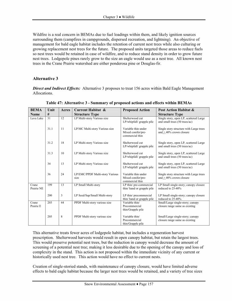
Chapter 3 ♦ Wildlife
Snow Environmental Assessment ♦ Page 157
Wildfire is a real concern in BEMAs due to fuel loadings within them, and likely ignition sources surrounding them (campfires in campgrounds, dispersed recreation, and lightning). An objective of management for bald eagle habitat includes the retention of current nest trees while also culturing or growing replacement nest trees for the future. The proposed units targeted those areas to reduce fuels so nest trees would be retained in case of wildfire, and to reduce stand density in order to grow future nest trees. Lodgepole pines rarely grow to the size an eagle would use as a nest tree. All known nest trees in the Crane Prairie watershed are either ponderosa pine or Douglas-fir. Alternative 3 Direct and Indirect Effects: Alternative 3 proposes to treat 156 acres within Bald Eagle Management Allocations.
Table 47: Alternative 3 - Summary of proposed actions and effects within BEMAs
BEMA Name
Unit #
Acres Current Habitat & Structure Type
Proposed Action Post Action Habitat & Structure Type
Lava Lake 31 31.1 31.2 31.3 34 36
12 11 18 10 13 24
LP Multi-story Various size LP/MC Multi-story Various size LP Multi-story Various size LP Multi-story Various size LP Multi-story Various size LP/EMC/PPDF Multi-story Various size
Shelterwood cut LP/whipfall/ grapple pile Variable thin under Mixed conifer/pre-commercial thin Shelterwood cut LP/whipfall/ grapple pile Shelterwood cut LP/whipfall/ grapple pile Shelterwood cut LP/whipfall/ grapple pile Variable thin under Mixed conifer/pre-commercial thin
Single story, open LP, scattered Large and small trees (50 trees/ac) Single story structure with Large trees and > 40% crown closure Single story, open LP, scattered Large and small trees (50 trees/ac) Single story, open LP, scattered Large and small trees (50 trees/ac) Single story, open LP, scattered Large and small trees (50 trees/ac) Single story structure with Large trees and > 40% crown closure
Crane Prairie NE
199 200
13 3
LP Small Multi-story LP Seed/Sap/Small Multi-story
LP thin/ pre-commercial thin/ hand or grapple pile LP thin/ precommercial thin/ hand or grapple pile
LP Small single-story; canopy closure reduced to 25-40% LP Small single-story; canopy closure reduced to 25-40%
Crane Prairie E
203 205
44 8
PPDF Multi-story various size PPDF Multi-story various size
Variable thin/ Precommercial thin/Grapple pile Variable thin/ Precommercial thin/Grapple pile
Small/Large single-story; canopy closure range same as existing Small/Large single-story; canopy closure range same as existing
This alternative treats fewer acres of lodgepole habitat, but includes a regeneration harvest prescription. Shelterwood harvests would result in open canopy habitat, but retain the largest trees. This would preserve potential nest trees, but the reduction in canopy would decrease the amount of screening of a potential nest tree; making it less desirable due to the opening of the canopy and loss of complexity in the stand. This action is not proposed within the immediate vicinity of any current or historically used nest tree. This action would have no effect to current nests. Creation of single-storied stands, with maintenance of canopy closure, would have limited adverse effects to bald eagle habitat because the larger nest trees would be retained, and a variety of tree sizes

Chapter 3 ♦ Wildlife
Snow Environmental Assessment ♦ Page 158
(9” to 30” or greater dbh) would remain to provide some screening. Adverse effects are neutralized by the creation of growing conditions that favor ponderosa pine and Douglas-fir. Ponderosa pine appears to be the tree of choice for nesting within the watershed. Effects Common to Alternative 2 and Alternative 3 Direct and Indirect Effects: All of the actions proposed under this alternative address the recommendation within the BEMA plans dealing with the reduction of wildfire risk and promotion of tree species that can become future nest trees. However, actions within the alternatives will have to be monitored to ensure that as an indirect effect of the reduction of fuel loading and the activities needed to accomplish this (e.g. use of roads), that the BEMA is not more accessible to recreationists which would then provide a new level of disturbance to bald eagles nesting in the area. There are existing gates that effectively block access to sensitive eagle areas. Mitigation would maintain the integrity of these gates by maintaining the natural screening and blockage around them, and aid in maintaining effective closure. Cumulative Effects: Many of the projects listed in Table 39 (page 134) focus on hazard tree removal in developed recreation areas or along roads. Much of the eagle activity is away from roads and developed recreation areas. Some timber cutting activity is ongoing in the Charlie Brown project area in and adjacent to the southern portion of the project area. This project, according to its analysis, did not have significant effects to bald eagles. The action alternatives may add disturbance effects to Charlie Brown BEMAs. Ongoing monitoring of the nests affected by these projects has shown continued nest site fidelity and successful fledging of young. Monitoring will be ongoing. Bufflehead (Bucephala albeola) S2 Imperiled Summary Because lodgepole pine is the species of snags proposed for salvage and it would not provide quality nesting habitat for this species, and because there are buffers and restrictions on riparian treatments, there would be no effects anticipated to buffleheads resulting from implementation of either Alternative 2 (Proposed Action) or Alternative 3. Existing Condition Buffleheads spend most of their time on bodies of water (lakes, reservoirs, and slow-moving areas of streams and rivers). Buffleheads are migratory, generally arriving on breeding territories in May (Natureserve, 2007). Habitat includes coniferous forests because it nests within cavities (e.g. old flicker holes) of trees near water. Buffleheads are approximately 13” long, and lay multiple eggs (clutch size 8 to 10 eggs); thereby suggesting requirements of a relatively large cavity. Buffleheads have been observed on Crane Prairie Reservoir, small ponds associated with this reservoir, Hosmer Lake, Elk Lake, and Wickiup Reservoir. There is historical evidence of bufflehead nesting within nestboxes placed along Crane Prairie Reservoir. Nest boxes used by some buffleheads at Crane Prairie Reservoir were of the larger, wood duck variety (8 by 8 inches to 10 by 18 inches floor). Alternative 1 (No Action) Direct and Indirect Effects: No effects to buffleheads would occur. Given current stand conditions in proposed treatment areas (dense, small diameter stands), the visible, known results of recent

Chapter 3 ♦ Wildlife
Snow Environmental Assessment ♦ Page 159
wildfires in similar habitats across the Deschutes National Forest, and the popularity of recreation, particularly in and around bufflehead habitat, there is a threat to habitat. High intensity wildfire within riparian areas damage or destroy bufflehead nesting habitat. Effects Common to Alternative 2 (Proposed Action) and Alternative 3 Direct and Indirect Effects: This species utilizes the Riparian Reserves. Alternative 2 proposes action within 266 acres of riparian reserves. Alternative 3 proposes action within 351 acres of riparian reserves. Included in the proposed actions is the removal of snags. Snag removal would be limited to lodgepole pine, and very few lodgepole pine grow to the diameter that could be used as a nest tree. Lodgepole pine would not provide quality nest sites for this species. There is no snag removal proposed around the lakes and reservoirs where this species is known to occur. No effects to species are anticipated because: • Where buffleheads are known to occur there would be no snag removal. No snag removal is proposed within 75 feet of wetland vegetation.
• The size of the lodgepole snags proposed for removal would not be large enough for a bufflehead nest. Snags would still be retained throughout the whole riparian reserve at levels that meet NWFP direction (see Dead Wood Discussion).
Cumulative Effects: This alternative is not additive or cumulative to other projects ongoing or reasonably foreseeable in the watershed because there are no direct or indirect effects from this proposal. Because the action alternatives do not propose snag removal in suitable bufflehead habitat, these alternatives are not additive to any other ongoing or reasonably foreseeable project that may remove potential habitat (e.g. hazard tree removal in recreational areas next to wetland habitat and water bodies).
Horned Grebe (Podiceps auritus) S2 Imperiled Summary There would be no impacts to horned grebes as a result of any of the alternatives. Existing Condition The horned grebe is a rare breeder east of the Cascades, they favor semi-permanent ponds (Marshall et. al 2003). According to Natureserve (2007) this species breeds in Canada, but migrates to wintering habitat in October. This species was observed on Wickiup Reservoir in October 2006, and a 1966 field guide to species on the Deschutes National Forest documents horned grebes being sighted on Wickiup and Crane Prairie Reservoir (Deibert et. al 1970s). Confirmed breeding has never been documented on the Deschutes National Forest. Alternative 1 (No Action) Direct and Indirect Effects: Because there are no proposed actions associated with this alternative, there would be no effects as a result of this alternative. Effects Common to Alternative 2 (Proposed Action) and Alternative 3

Chapter 3 ♦ Wildlife
Snow Environmental Assessment ♦ Page 160
Direct, Indirect, and Cumulative Effects: Based on the information in the Existing Condition, this species is most likely a migrant through the watershed. The proposed actions would have no effect to reservoirs this species uses. In the rare instance this species may actually breed in the watershed, the proposed actions would not affect the species because their nesting habitat (marsh, floating platforms of vegetation in shallow water; Ehrlich et. al 1988) would not be affected due to buffers on wet vegetation. Because there are no direct or indirect effects, due to no actions proposed in habitat, there would be no additive or cumulative effects to this species. Red-necked Grebe (Podiceps grisegena) S1 Critically Imperiled Existing Condition Red-necked grebe breeding habitat consists of extensive clear, deep-water marshy lakes and ponds in timbered regions (Johnsgard 1987, Watkins 1988). Marshall, et. al (2003) lists an observance of a pair with one young on Lava Lake in 1998. There was a report of an immature red-necked grebe on Wickiup Reservoir in October 2007. This species more commonly nests in Canada, and along the vegetative shorelines of lakes (Marshall et. al 2003; Natureserve 2007). Nesting habitat structure is similar to that described for the horned grebe. Alternative 1 (No Action) Direct and Indirect Effects: Because there are no proposed actions associated with this alternative, there would be no effects as a result of this alternative. Effects Common to Alternative 2 (Proposed Action) and Alternative 3 Direct, Indirect, and Cumulative Effects: The proposed actions would have no effect to the reservoir this species uses. In consideration this species may actually breed in the watershed, based on the 1998 sighting, the proposed actions would still not affect the species. Nesting habitat (marsh, floating platforms of vegetation in shallow water; Ehrlich et. al 1988) would not be affected due to buffers on wet vegetation, and there are no units immediately adjacent to Lava Lake or any of the lakes in the watershed. Yellow Rail (Coturnicops noveboracensis) S1Critically Imperiled Summary There would be no impacts to yellow rails as a result of any of the alternatives. Existing Condition The yellow rail inhabits freshwater marshes and wet meadows with a growth of sedges, and often with standing water up to a foot deep during the breeding season (Csuti et. al 2001). There have been no sightings of yellow rails on the Bend –Ft. Rock Ranger District of the Deschutes National Forest, and sporadic sightings of yellow rails in Oregon (Marshall et. al 2003). Potential habitat does exist around some of the lakes and reservoirs in the watershed. Alternative 1 (No Action)

Chapter 3 ♦ Wildlife
Snow Environmental Assessment ♦ Page 161
Direct and Indirect Effects: Because there are no proposed actions associated with this alternative, there would be no effects as a result of this alternative. Effects Common to Alternative 2 (Proposed Action) and Alternative 3 Direct, Indirect, and Cumulative Effects: Due to buffers along wet vegetation areas, the proposed actions will have no effect to the wetland habitats this species uses. In the rare instance that this species may actually breed in the watershed, the proposed actions would not affect the species because their nesting habitat (dry soil areas of wet meadows and marshes with vegetation tall enough to hide nest; Ehrlich et. al 1988) would not be affected due to buffers on wet vegetation and seasonal restrictions for other species known or more apt to occur in the project area. Because there are no direct or indirect effects, due to no actions proposed in habitat, there would be no additive or cumulative effects to this species. Pacific Fisher (Martes pennanti) S2 Imperiled Summary Alternative 2 (Proposed Action) and Alternative 3 may impact individuals but would not likely cause a trend towards federal listing for the Pacific fisher. Existing Condition The Pacific fisher primarily uses mature, closed-canopy coniferous forests with some deciduous component, frequently along riparian corridors (Csuti et. al 2001). In Ruggiero, et. al (1994), it is suggested fishers prefer closed-canopy (greater than 60%), late-successional forests with large physical structures (live trees, snags, and logs), especially if associated with riparian areas. A 2004 Species Assessment by the US Fish and Wildlife Service documents key aspects of fisher habitat are those also associated with late-successional forests (i.e. high canopy closure, large trees and snags, large logs, hardwoods, and multiple canopy layers). Distribution of fishers is limited by elevation and snow depth (Krohn et. al 1997 in US Fish and Wildlife Service Species Assessment). Fishers generally avoid areas of high human disturbance, primarily high road density or recreational developments. Fishers are fairly large, weighing 3 to 13 lbs and 29 to 47 inches long. This may suggest a need of larger log sizes for dens than other animals with similar needs (e.g. marten). Aubry and Raley (2006) found in southwestern Oregon, fishers were found denning and resting at least 4,000 feet elevation, more than 80% canopy closure, and more than 16 snags and 67 logs at least 20” dbh per acre; supporting the suggestion that this species utilizes large to very large structure. Denning and resting sites were also observed in large live trees (mostly Douglas-fir) with mistletoe brooms, limb clumping, rodent nests, or some other deformity. They also found fishers were preying upon woodpeckers, jays, grouse, quail, squirrels, hare, porcupine, and skunks. Most of these prey species can be found in the watershed. Fishers have been historically documented in the watershed, although always rare, in the Three Sisters area, Mt Bachelor, Elk and Hosmer Lakes, and west of little Cultus Lake (Deibert et. al 1970s). More recently (2005) an unconfirmed sighting of an immature fisher was reported in the Wickiup Reservoir area. Based on habitat descriptions in the literature and using the 2004 Satellite Imagery data, there is approximately 4,201 acres of quality habitat (greater than 20” average stand dbh; and greater than 55% canopy closure) in the watershed. Another 12,392 acres of potential lower quality habitat exists if one

Chapter 3 ♦ Wildlife
Snow Environmental Assessment ♦ Page 162
considers multi-storied, high canopy closure (greater than 55%) stands with at least 15” average dbh. Fishers generally have large territories (a minimum of 10 square km or 2,500 acres). In regards to other habitat attributes, there is a wide range of log densities present throughout the watershed. In a sampling within the general proposed action polygon, there was a range of 0 to 71 logs per acre. Most logs were lodgepole pine larger than 8” dbh, which may be on the smaller end for fisher utilization. There was an average of 8.5 snags per acre (+ 2.7) greater than 10” dbh, with an average of more than one snag larger than 20” dbh. Most snags were lodgepole pine, but there were large ponderosa pine and fir snags sampled. Not recorded as part of this sampling effort but noted, was the prevalence of trees larger than 20” dbh that were not dead, but mostly dead or with decay and/or defects. Species such as the fisher, or its prey, could utilize these for habitat. In the DecAID advisor, information on fisher use of dead wood is provided in the montane mixed conifer habitat type. In studies cited in this tool, 50% of the areas with a fisher population had 5.6 % downed wood cover and 13 snags per acre larger than 10” dbh. Over 60% of the watershed is LSR, wilderness, or roadless area; that is to say, in allocations with no scheduled timber harvest. These are areas where it may be more prudent to manage for high dead wood levels. Of these areas over 14,800 acres are within habitat types used by fishers, (90% of the potential habitat in the watershed) although it has not been determined how much quality or potential habitat is within each allocation. Approximately 85% (3,559 acres) of the total quality habitat (as defined in an earlier paragraph) in the watershed in found within these allocations. Approximately, 642 acres in the Snow Project Area (15% of all quality habitat within the watershed) meets the definition of quality fisher habitat. Alternative 1 (No Action) Direct and Indirect Effects: This alternative does not propose any actions and would not have any direct effects. There would be adverse affects to fishers in the event a high severity fire. Fisher habitat is defined as that within an area that tends to burn less frequently (moist mixed conifer associations) but is often stand-replacing (Mellen et. al 2006: dead wood potential table). A stand-replacing fire, in conjunction with the high recreation use in the watershed, could substantially limit fisher habitat. Alternative 2 (Proposed Action) Direct and Indirect Effects: Alternative 2 proposes actions within 261 acres of potential fisher habitat, 39 acres within quality habitat, but there would be no change in large stand structure (i.e. the average stand diameters would remain the same) and not all of the treatments would result in fisher habitat being removed or degraded.. Four acres (1.5 % of the habitat) would be eliminated due to the reduction in canopy closure (parts of Units 149, 155, 198, 199, and 202) below 55%. Of the 261 acres of fisher habitat proposed to be treated, there are 107 acres of salvage (12 acres within quality habitat) that focuses on the lodgepole pine component. Salvage would reduce the amount of downed logs and future recruitment of logs in the form of snags. This may reduce habitat for some of the fisher’s prey species but would not reduce potential denning habitat because the salvage focuses on lodgepole pine which does not often grow to the size to accommodate a fisher den. Variable density thinning, and other green treatments, would not only reduce canopy closure in potential fisher habitat, but also remove some of the mistletoe and deformed tree components that Aubry and Raley (2006) suggested could be used as dens for fishers. Aubry and Raley (2006) specifically noted Douglas-fir for these mistletoe brooms and deformities, and the proposed thinning would largely focus on retaining the Douglas-fir components, instead removing some of the lodgepole pine and white fir.

Chapter 3 ♦ Wildlife
Snow Environmental Assessment ♦ Page 163
This alternative may impact individuals but would not likely cause a trend towards federal listing for the Pacific fisher. The proposed actions would degrade or remove 111 acres of fisher habitat, representing approximately 1% of the habitat in the watershed (4 acres removed due to the reduction in canopy closure and 107 acres degraded due to salvage). The road density level and degree of human use of the Snow Project Area, limit not only the quality of the habitat but also the appropriate level of dead wood that should be managed for in this portion of the landscape. Alternative 3 Direct and Indirect Effects: Alternative 3 proposes actions within 272 acres of fisher habitat, 39 acres of quality habitat. However, not all of the 272 acres of various treatments will result in eliminated or degraded fisher habitat. One hundred (100) acres of the potential lower quality habitat would no longer be considered habitat because proposed treatments would reduce canopy closure to less than 55%, even though it retains large structure. These 100 acres occur in units that propose thinning or regeneration harvest in lodgepole pine, and represent 1% of the entire potential habitat in the watershed. This alternative also proposes to salvage lodgepole pine snags and logs within 8 acres of potential, lower quality fisher habitat. The effects of this on fishers is similar to those described under Alternative 2 (i.e. loss of potential denning and prey habitat), however the scale of the effect is slightly larger under this Alternative because 100 acres are removed whereas only 4 are removed under Alternative 2. This alternative may impact individuals but would not likely cause a trend towards federal listing for the Pacific fisher. The proposed actions would degrade or remove 108 acres of fisher habitat, representing approximately 1% of the habitat in the watershed (100 acres removed due to the reduction in canopy closure and 8 acres degraded due to salvage). The road density level and degree of human use of the Snow Project Area, limit not only the quality of the habitat but also the appropriate level of dead wood that should be managed for in this portion of the landscape. Effects Common to Alternative 2 (Proposed Action) and Alternative 3 Direct and Indirect Effects: Although current dead wood levels do not necessarily achieve levels to those that the fisher information within DecAID tool suggests meets fisher habitat, the proposed treatment areas would provide some dead wood (directed levels). There are areas in the watershed with restrictions on management actions and it is in these allocations dead wood levels would be expected to exceed fisher habitat levels. Dead wood structure would be provided in the future due to the presence of large trees (larger than 20” dbh) that are not considered for thinning or removal, currently have decay agents, and will likely become snags or logs within a decade or sooner. These types of trees were often observed in the mixed conifer stands during the snag surveys conducted within the project area. As discussed in the analyses for each alternative, it is because this species utilizes dead wood for denning that there is the potential for degrading the habitat, although lodgepole pine does not get to a size utilized by fishers. Logs in contact with the ground (Mitigations, Chapter 2) will remain because of mitigation measures and often these logs have more advanced decay and are not salvageable. Thus there will be logs available for denning opportunities beneath the root wad or log. The salvage component of the treatments may indirectly affect fishers by altering habitat for their prey species, potentially degrading it. However, it may not be appropriate to manage dead wood for fisher habitat in areas with high human use and infrastructure due to the risks associated with wildfire.

Chapter 3 ♦ Wildlife
Snow Environmental Assessment ♦ Page 164
Cumulative Effects: Alternative 2 and Alternative 3 have incremental and additive impacts with other ongoing and reasonably foreseeable actions within the watershed. The fact that many of the ongoing and reasonably foreseeable projects in the watershed have to do with hazard tree removal for recreationists and recreational infrastructure reinforces the suggestion that the management for dead wood to maximize quality fisher habitat may not be attainable in the allocations treated under these alternatives. Because this project would degrade or remove an estimated 1% of all fisher habitat in the watershed, and there would still be habitat and denning opportunities in the Snow project area, the additive effect is determined to be minimal.
Wolverine (Gulo gulo luteus) S1? Critically Imperiled?(question marks are as reported
in the Natureserve 2007 listing) Existing Condition The wolverine is the largest member of the weasel family (weasels, martens and fishers), and is known to be a solitary and wide-ranging species. Wolverines utilize downed logs and rock crevices or talus for denning. Prey is not a limiting factor for wolverines because they are opportunistic carnivores that also eat a variety of berries and roots (Natureserve 2007). They utilize high elevation (7,000 to 9,000 feet), alpine habitat where snow coverage remains well into the denning season (spring) with only slight variations in habitat use between summer and winter (Copeland et. al 2007; Aubry et. al 2007). They have a large home range, averaging 422 square km (104,000 acres) and, even with the best habitat, are found in low densities. Wolverines tend to avoid areas of high human population or road densities (Krebs et. al 2007). It has been suggested timber harvesting, backcountry skiing, snowmobiling, roads and other forms of human disturbance can have a negative association with wolverine occurrence in research cited by Ruggiero et. al (2007). Diebert et. al (1970s) recorded wolverine observations in the area of Three-Fingered Jack (1965), Broken Top (1969), Many Lakes Basin (1972), and Willamette Pass (1973). More recently, wolverine tracks were found in the Deschutes Bridge area during winter track surveys by the Oregon Dept. Fish and Wildlife (ODFW; Glen Ardt, personal communication, 4/20/2007). Aubry et. al (2007) shows the last verifiable and documented wolverine sighting in Oregon was in 1992. This paper also shows that in breakdowns of decades going back to 1900, there have been 0 to 2 records of sightings per decade for Oregon. For this project analysis it was assumed the Montane Mixed Conifer and alpine non-forest types adequately represent potential wolverine habitat (this representation would encompass the cirqur basins that are most often described as habitat), there are 53,156 acres of potential wolverine habitat in the watershed. Nearly all of these acres (89%) are within the Three Sisters Wilderness, Cultus Mt and Sheridan Mt LSRs, and Mt. Bachelor Roadless Area. Although these areas still receive a high degree of recreation use due to the presence of trails (hiking and snowmobile); there is still relatively less human disturbance than in the proposed action areas which are often bounded by roads, within proximity to developed recreation sites, or heavily used by a variety of recreationists not limited by physical fitness or equipment. Alternative 1 (No Action) Direct and Indirect Effects: Because there are no actions associated with this alternative there would be no effects. Wolverines are wide-ranging animals with extremely large territories. A large wildfire may not preclude wolverine use of the watershed.

Chapter 3 ♦ Wildlife
Snow Environmental Assessment ♦ Page 165
Effects Common to Alternative 2 (Proposed Action) and Alternative 3 Direct, Indirect, and Cumulative Effects: The analysis of potential effects of the proposed actions under each of these alternatives on wolverines is combined because the proposed actions between the alternatives are so similar such that there is not a discernable difference in any anticipated effect. Alternative 2 treats 109 acres in Montane Mixed Conifer and Alternative 3 treats 111 acres in this habitat type. This is less than 1% of the potential habitat for this species. The action alternatives would not have discernable effects to potential wolverines in the area. Aubry et. al (2007) suggests a low likelihood there would be wolverines present in the watershed because their research has suggested that populations in the Cascades may have always been disjunct and the current fragmented nature of suitable habitat, partially due to urban and agricultural development, may limit migration rates between mountain ranges. Because of the small amount of potential wolverine habitat affected (less than 1% of wolverine habitat in the watershed) and because the units are within areas of high human use (poor wolverine habitat), the cumulative or additive effects of these actions are minimal to the other ongoing and reasonably foreseeable projects in the area. What may be larger issues for wolverines is the level and type of recreation use within potential habitat (e.g. high elevations in roadless areas, wilderness) because a large part of the potential habitat is outside of allocation with scheduled timber harvest.
Management Indicator Species
Table 48: Management Indicator Species (MIS) Considered - Those in Bold Receive a More Detailed Analysis
Species Status* Habitat Presence Golden eagle MIS, BCC Large open areas with
cliffs and rock outcrops No Habitat within proposed treatment areas; potential habitat adjacent to proposed treatment areas
Great gray owl MIS Mature and old growth forests associated with openings and meadows
Documented in the general project area. Potential habitat in proposed units.
Northern goshawk
MIS Mature and old-growth forests; especially high canopy closure and large trees
Documentation in the general project area. Potential habitat in proposed units
Cooper’s hawk MIS Similar to goshawk, can also use mature forests with high canopy closure/tree density
Potential habitat in proposed units.
Sharp-shinned hawk
MIS Similar to goshawk in addition to young, dense, even-aged stands
Potential habitat in proposed units.
Great blue heron
MIS Riparian edge habitats including lakes, streams, marshes and estuaries
Documented in the general project area.
Red-tailed hawk MIS Large snags, open country interspersed with forests
Documented in the general project area. Potential habitat in proposed units.
Osprey MIS Large snags associated with fish bearing water bodies
Documented in general project area. No nesting within proposed units.

Chapter 3 ♦ Wildlife
Snow Environmental Assessment ♦ Page 166
Species Status* Habitat Presence Townsend’s big-eared bat
MIS Caves and old dwellings
No Habitat within proposed treatment areas; potential habitat adjacent to proposed treatment areas
Elk MIS Mixed habitats Documented in general project area. Potential habitat within proposed units
American marten
MIS Mixed conifer or high elevation late-successional forests with abundant down woody material
Documented in the general project area. Potential habitat in some of the proposed units.
Mule deer MIS Mixed habitats Habitat in proposed treatment areas
Snags and Downed Wood associated species and habitat
MIS Snags and down woody material
Habitat in proposed treatment areas
Waterfowl Species:
Common loon MIS Edges of remote freshwater ponds and lakes
Documented on Wickiup Reservoir. Potential habitat on lakes within the general project area
Pied-billed grebe
MIS Edge of open water in freshwater lakes, ponds, sluggish rivers and marshes
Documented on Wickiup Reservoir. Potential habitat on lakes within the general project area
Eared grebe MIS Open water with emergent vegetation
Documented on Wickiup Reservoir. Potential habitat on lakes within the general project area
Western grebe MIS Marshes with open water and lakes and reservoirs with emergent vegetation
Documented on Crane Prairie Reservoir. Documented on Wickiup Reservoir. Potential habitat on lakes within the general project area
Canada goose MIS Variety of habitat: shores of lakes, rivers, and reservoirs especially with cattails and bulrushes
Documented in general project area. Potential habitat in some of the proposed units.
Wood duck MIS Cavity nester Documented in general project area. Potential habitat in some of the proposed units.
Gadwall MIS Concealed clumps of grasses in meadows and tall grasslands
Documented on Wickiup Reservoir. Potential habitat on lakes within the general project area
American widgeon
MIS Clumps of grasses in meadows or tall grasslands
Documented in general project area. Potential habitat in some of the proposed units.
Mallard MIS Open water with emergent vegetation
Documented in general project area. Potential habitat in some of the proposed units.
Blue-winged teal MIS Marshes, lakes, ponds, slow-moving streams
Potential habitat on lakes within the general project area. No Habitat within or adjacent to proposed treatment areas
Cinnamon teal MIS Cover of vegetation near shoreline
Documented in general project area. Potential habitat in some of the proposed units.
Northern shoveler
MIS Grassy areas near water Potential habitat on lakes within the general project area. No Habitat within or adjacent to proposed treatment areas
Northern pintail MIS Open areas near water Documented on Wickiup Reservoir. Potential habitat on lakes within the general project area
Green-winged teal
MIS Freshwater marshes with emergent
Documented on Wickiup Reservoir. Potential habitat on lakes within the general project area

Chapter 3 ♦ Wildlife
Snow Environmental Assessment ♦ Page 167
Species Status* Habitat Presence vegetation
Canvasback MIS Emergent vegetation Potential habitat in general project area: specifically lakes.
Redhead MIS Freshwater marshes and lakes concealed in vegetation
Potential habitat in general project area: specifically lakes.
Ring-necked duck
MIS Thick emergent vegetation on shorelines
Potential habitat in general project area: specifically lakes.
Lesser scaup MIS Dry grassy areas near lakes at least 10 ft. deep
Documented on Wickiup Reservoir. Potential habitat on lakes within the general project area
Common goldeneye
MIS Cavity nester Documented in general project area. Potential habitat in some of the proposed units.
Barrow’s goldeneye
MIS Cavity nester Documented in general project area. Potential habitat in some of the proposed units.
Hooded merganser
MIS Cavity nester Documented in general project area. Potential habitat in some of the proposed units.
Common merganser
MIS Cavity nester Documented in general project area. Potential habitat in some of the proposed units.
Ruddy duck MIS Freshwater marshes, lakes, ponds in dense vegetation
Potential habitat on lakes within the general project area. No Habitat within or adjacent to proposed treatment areas
Woodpecker Species
Red-naped sapsucker
MIS Riparian hardwood forests
No Habitat within or adjacent to proposed treatment areas
Downy woodpecker
MIS Riparian hardwood forest
No Habitat within or adjacent to proposed treatment areas
Lewis’ woodpecker
MIS, Landbird focal species, BCC
Ponderosa pine forests, burned forests
Documented in general project area. Potential habitat in some of the proposed units.
Williamson’s sapsucker
MIS, Landbird Focal species, BCC
Mature or old growth conifer forests with open canopy cover; weak excavator
Documented in general project area. Potential habitat in some of the proposed units.
Hairy woodpecker
MIS Mixed conifer and ponderosa pine forests
Documented in general project area. Potential habitat in some of the proposed units.
White-headed woodpecker
MIS, Landbird focal species, BCC
Mature ponderosa pine forests; weak excavator
Potential habitat in proposed treatment areas
Three-toed woodpecker
MIS High elevation and lodgepole pine forests
Potential habitat in proposed treatment areas
Black-backed woodpecker
MIS, Landbird focal species
Lodgepole pine forests, burned forests
Documented in general project area. Potential habitat in some of the proposed units.
Northern flicker MIS Variety of forest types but more associated with forest edges
Documented in general project area. Potential habitat in some of the proposed units.
Pileated woodpecker
MIS Mature to old-growth mixed conifer forests
Documented in general project area. Potential habitat in some of the proposed units.
*Federally listed and Regional Forester Sensitive species come from the Region 6 Threatened, Endangered, and Sensitive species list for the Deschutes National Forest; Landbird focal species come from the Conservation Strategy for Landbirds of the East-Slope of the Cascade Mountains in Oregon and Washington (Altman 2000); MIS = Management Indicator Species come from the Deschutes National Forest Land and Resource Plan (LRMP)[1990]; BCC = Birds of Conservation Concern come from the US Fish and Wildlife Service Birds of Conservation Concern – BCR 9 (Great Basin) [2002]; and Shorebirds come from the 2004 US Fish and Wildlife Service U. S. Shorebird Conservation Plan.
Rationale for Species not Considered in Detail The Northern Bald eagle was discussed under the Region Forester’s Sensitive Species List.

Chapter 3 ♦ Wildlife
Snow Environmental Assessment ♦ Page 168
Golden Eagle: Generally occur in grass-shrub, shrub-sapling, and young woodland growth stages of forested areas, or in forest with open lands nearby for hunting. Essentially, it needs only a favorable nest site, usually a large tree or cliff, a dependable food supply, mainly of medium to large mammals and birds, and broad expanses of open country for foraging. It especially favors hilly or mountain country, where take off and soaring are facilitated by updrafts; deeply cut canyons rising to open sparsely treed mountain slopes and crags represent ideal habitat (Johnsgard 1990). The proposed treatment areas do not provide any cliffs for potential nest sites, or broad expanses of open country for foraging. A lack of habitat assumes a lack of presence and therefore any actions or no action within the proposed treatment areas would have no impact and therefore not contribute to a trend towards federal listing to this species. Red-naped Sapsucker: Inhabits a variety of coniferous forest communities within which there are stands of quaking aspen. In mountains, it also uses riparian woodlands of willow and other deciduous trees (Csuti et. al 2001). The proposed treatment areas do not contain sizeable stands of quaking aspen (outside of isolated pockets) or riparian woodland habitat. The proposed action areas within the 300 ft. Riparian Reserve allocation do not contain riparian/deciduous woodland that characterizes this species’ habitat. There are occasionally willow shrubs adjacent to the water, however due to project design, there are no proposed actions within the riparian/wetland vegetation zone, and then for another 50 feet, limited ground disturbance. In considering project design and a lack of suitable habitat there would be no impact and therefore not contribute to a trend towards federal listing to this species. Downy Woodpeckers: Are often associated with deciduous and mixed deciduous-coniferous forests or riparian areas (Marshall et. al 2003, Csuti et. al 2001). The proposed action areas within the 300 ft. Riparian Reserve allocation do not contain riparian/deciduous woodland that characterizes this species’ habitat. There are occasionally willow shrubs adjacent to the water, however due to project design, there are no proposed actions within the riparian/wetland vegetation zone, and then for another 50 feet, limited ground disturbance. Similar to the red-naped sapsucker, when considering project design and a lack of suitable habitat there would be no impact and therefore not contribute to a trend towards federal listing to this species.
Species Receiving Further Consideration Great Gray Owl S3 Vulnerable Summary and Plan Consistency There would be minimal negative effects to great gray owls. If a nest is found during implementation then a seasonal restriction on all activities would be in effect around the new nest (mitigation, page 47). This would meet the LRMP standard to protect known nest sites with a ¼ mile buffer zone. Considerations for great gray owl habitat have been incorporated (identification of habitat and surveys, design for forested areas around wet meadows) and mitigations incorporated to protect any known or new nests (mitigation, page 47). As a Management Indicator Species under the LRMP, the standards and guidelines are met through the analysis of available habitat and the provision for seasonal restrictions.
Existing Condition Nest stands vary in stand type from mixed stands of ponderosa pine and lodgepole pine to mixed conifer. Within these stands, for optimum nesting habitat, canopy cover ranges from 50-70%. Nest stands are generally associated with open forest containing canopy closure ranging from 11-59%

Chapter 3 ♦ Wildlife
Snow Environmental Assessment ♦ Page 169
dominated with grasses, open grassy habitat, including bogs, selective and clear-cut logged areas, and natural meadows (Bull and Henjum 1990 in Marshall et. al 2003). The Deschutes LRMP defines this owl’s habitat as being: lodgepole pine dominated overstory, overstory tree density of 67 trees per acre for trees greater than 12 inches diameter at breast height, canopy cover of 60% (50-70%), and distance to nearest meadow 440 (63-1,070ft.) feet (LRMP WL-31). The NWFP states “the great gray owl, within the range of the northern spotted owl, is most common in lodgepole pine forests adjacent to meadows. However, it is also found in other coniferous forest types…Specific mitigation measures for the great gray owl, within the range of the northern spotted owl, include the following: provide a no-harvest buffer of 300 ft. around meadows and natural openings and establish ¼ mile protection zones around known nest sites.” (page C-21). Surveys for great gray owls were conducted within the watershed in 1998, 1999, 2006, and 2007; the latter years specific to this project proposal. The method used was the broadcast call method similar to the spotted owl regional protocol for the 1998 and 1999 surveys. The 2006 and 2007 surveys used the method outlined in Quintana-Coyer, et. al (2004) “Survey Protocol for the Great Gray Owl within the Range of the Northern Spotted Owl”. The 2006 survey effort was short one visit to meet full protocol due to a late start (accessibility and safety issues due to snow level that year), but the 2007 effort met protocol. A third year (2008) of surveys of potential nesting habitat is planned. Any decisions on a proposed treatment area in proximity (¼ mile radius) to identified potential habitat will be delayed until after this survey effort. A great gray owl was heard during the 2006 effort in the same area on 3 separate visits. All follow-up visits were inconclusive because the owl did not respond. On one of these initial visits, the surveyor thought the response was from juvenile owl. Follow-up visits did not find a nest or the owl. There were no responses during the 2007 survey effort. There was another visit added to specifically search the area where an owl had been heard in 2006, no nest structure or owl was found. Potential habitat for great gray owls was identified using the 2004 protocol (e.g. > 45% canopy closure, average tree diameter >16” and within 200m of a meadow). Other survey efforts on the Deschutes National Forest would also include open, regeneration areas. In this particular area, this additional forest type was not surveyed because: 1) the presence of quality wet and dry meadow habitat, and 2) many of the “open” areas were actually grown in with young lodgepole pine of size and density to preclude the prey density (e.g. pocket gophers; based on habitat descriptions in Csuti, et. al 2001) and hunting efficiency (seedlings that are tall and at a density that restrict access to the ground). Great gray owls have a home range size of approximately 1,000-2,000 acres (Natureserve, 2007). There are approximately 4,216 acres of great gray owl habitat in the watershed. This suggests there is habitat for approximately 3 to 4 pairs of great gray owls. Alternative 1 (No Action) Direct and Indirect Effects: Because there are no actions associated with this alternative, there would be no effects from this alternative. A widespread, high severity wildfire through the area could reduce great gray owl nesting habitat and displace any owls from the area due to a lack of habitat and degree of human disturbance. Alternative 2 (Proposed Action) Direct, Indirect, and Cumulative Effects: This alternative proposes to commercially thin lodgepole pine within 56 acres of potential great gray owl nesting habitat and salvage dead wood and reduce ladder fuels (thin green trees less than 4” dbh) within 10 acres of potential great gray owl habitat for a total of 66 acres being impacted by the proposed actions.

Chapter 3 ♦ Wildlife
Snow Environmental Assessment ♦ Page 170
Commercial thinning would remove potential nest trees and reduce canopy closure, therefore likely eliminating the potential for nesting. The commercial thin acres represent 1% of the total potential habitat in the watershed. The 56 acres are spread over 4 different units. Three of the units are within a similar area and loss of some of the potential nesting habitat could preclude great gray owls from nesting there. However these acres are also within Osprey and Bald Eagle Management Allocations. Management for these species’ habitats takes precedence and on these particular acres managing for great gray owl habitat conflicts with the management for osprey and bald eagle habitat. Salvage of dead wood and ladder fuels reduction is expected to degrade potential habitat because it would remove some cover and structure that protects the nestling owls before they are completely ready to fly and disperse. This is proposed for only 10 acres and would not encompass a complete nest site or territory. It is expected that owls could still successfully fledge some young in the area. A beneficial effect of the proposed actions (thinning, mowing, grapple and hand piling) is more of the forest floor may be opened up to allow for the large great gray owl to hunt as well as more prey species exposed. This may be a short-term effect in the snow-free months in the lodgepole pine associations because seedlings quickly establish themselves. Alternative 3 Direct, Indirect, and Cumulative Effects: Alternative 3 would likely eliminate potential nesting habitat within the same 66 acres as Alternative 2. Under this alternative, instead of having a salvage component in the 10 acres, it proposes to variable thin all of the lodgepole pine, likely reducing the overall canopy closure below that which owls will use. This amounts to approximately 1% of the great gray owl habitat in the watershed. Effects Common to Alternative 2 (Proposed Action) and Alternative 3 There are another 217 acres (Alternative 2) and 199 acres (Alternative 3) of commercial thinning within 0.25 mile of potential habitat but not considered habitat themselves. Actions within these units may disrupt nesting if conducted during the breeding season. This effect is mitigated by seasonal restrictions on proposed activities (machinery) to protect nesting owls from March 1st to May 31st or fledging whichever is latest (see Mitigations Chapter 2 EA) The additive or cumulative effects of the action alternatives with ongoing or reasonably foreseeable projects are minimal because the proposed actions would affect 1% of the great gray owl habitat in the watershed and disturbance effects are mitigated. The effects would not cause a decreasing trend in populations. Although these alternatives may not cause an increasing trend in great gray owl populations, they would not cause a decreasing trend in populations. Some of the actions may help in the retention of habitat when a wildfire burns through the area.
Northern Goshawk S3 Vulnerable Summary and Plan Consistency There would be minimal adverse effects to goshawks, and under Alternative 3 there would be some beneficial effects. If a nest is found during implementation then a seasonal restriction on all activities

Chapter 3 ♦ Wildlife
Snow Environmental Assessment ♦ Page 171
would be in effect around the new nest (mitigation). The NWFP does not specify standards and guidelines for goshawks. As a Management Indicator Species under the LRMP, the standards and guidelines are met through the analysis of available habitat and the provision for seasonal restrictions. Existing Condition In Oregon, goshawks tend to select mature or old-growth stands of conifers for nesting, typically those having a multi-layered canopy with vegetation extending from a few meters above ground to more than 40 meters high. Generally nesting sites are chosen near a source of water and are on moderate slope, usually having northerly aspects. This habitat type is quite similar to that used by the Cooper’s hawk, but the trees tend to be older and taller and have a better-developed understory of coniferous vegetation (Reynolds, Meslow, and Wight, 1982 in Marshall et. al, 2003). Foraging generally occurs within these mature stands where small openings occur. These birds forage on passerines (e.g. songbirds), but often utilize small mammals such as rodents as well as the occasional snowshoe hare. Some gallinaceous bird species are also preyed upon such as blue and ruffed grouse. Species and abundance of gallinaceous prey varies in the range of the goshawk depending on elevation and latitude. Using the 2004 Satellite Imagery and querying areas that have >20” dbh average stand diameters and >40-60% canopy closure, there are approximately 4,201-5,743 ac of potential goshawk nesting habitat in the watershed, and 428 acres of nesting habitat within 0.25 mile of a proposed unit. The Deschutes LRMP defines goshawk habitat as stands with a mean canopy cover of 60% or greater, tree density of at least 195 trees per acre, and a stand age of 100 years or more (LRMP WL-9). This definition is incorporated into the query of the satellite imagery data. Based on current levels of nesting habitat and that a pair of goshawks would require (3) 30 acre patches of nesting habitat and 420 acres post-fledging within their territory (Natureserve, 2007), there is currently habitat for approximately 8 pairs of goshawks in the watershed. Past mountain pine beetle mortality and harvest has reduced the amount of habitat within land allocations scheduled for harvest (i.e. Matrix). There is considerably more foraging habitat for goshawks within the watershed. In addition to the nesting habitat, which can also be used for foraging, there are an additional 42,768 acres (areas of greater than 9” average dbh and greater than 25% canopy closure) of foraging habitat in the watershed and 8,725 acres of foraging habitat in proximity to any proposed action area.
Surveys for goshawks were conducted in 2006 and 2007 using the Region 6 1993 protocol based in Woodbridge et. al (1993) that establish stations along a given route. This survey method is referred to in the more recent Woodbridge and Hargis (2006) inventory and monitoring guide. No goshawk nests were found. In 2007 an Intensive Survey or grid method detailed in Woodbridge and Hargis (2006) was conducted in an area of an historical nest site. No goshawks or a nest structure was located. Goshawks have been recently seen (2006) in the watershed, but have not been observed nesting within or near any of the proposed action areas (i.e. no nests or nesting behavior observed). Alternative 1 (No Action) Direct, Indirect, and Cumulative Effects: Although there would be no effects to goshawks as a result of this alternative because there are no actions that would cause a change and effect from the existing condition, taking no action could have consequences to goshawk habitat. Fuel loadings are known to be high within parts of the watershed, and there is little doubt that a wildfire in the watershed would result in many acres of high severity burns. This type of situation would reduce goshawk habitat. Effects Common to Alternative 2 (Proposed Action) and Alternative 3

Chapter 3 ♦ Wildlife
Snow Environmental Assessment ♦ Page 172
Direct, Indirect, and Cumulative Effects: Treatments are proposed within potential goshawk nesting habitat, Alternative 2 (128 acres) and Alternative 3 (129 acres). The proposed actions are to salvage dead lodgepole pine and selectively remove some of the understory less than 4” in diameter. These treatments would collectively reduce potential nesting habitat by 2 acres for Alternative 2 and 3 acres for Alternative 3. There would likely be some effect to goshawk foraging habitat due to the proposed actions, however, the Satellite Imagery database is not a good tool to accurately reflect what the effect is. This is because goshawks prey on a number of different bird species and can forage or hunt within a variety of different stand types. The Satellite Imagery measures stand characteristics (canopy closure, average tree diameter, dominant species) thus for a species that can forage in a variety of habitats to query the Imagery database would result in nearly the entire area. Goshawks prey on a number of bird species also contained within this analysis (e.g. hairy woodpecker), and also small mammals. Negative effects of the proposed actions on these species or their habitat (e.g. mowing or removal of dead wood for small mammals) would indirectly have some negative effects to goshawk foraging. Because these are very indirect effects (i.e., prey habitat to prey to goshawk), and goshawk can prey upon a variety of species, it is anticipated that the effects on prey and foraging goshawks are low. Removal of nesting habitat and effects to foraging opportunities would have cumulative or additive effects in the watershed in conjunction with some of the post-sale work for Red Plague, Snoop, Lo, and Cascade Lakes Restoration. The additive effect of 2 or 3 acres is minimal in regards to goshawk habitat within the watershed. Effects Unique to Alternative 3 Direct, Indirect, and Cumulative Effects: This alternative includes an amendment that “moves” an Old Growth Management Area (OGMA) from a stand with little canopy to a stand that is presently more stable with substantially more canopy (Figure 40 and Figure 41). This may benefit goshawks by designating an area that can serve as foraging habitat currently, and retaining it to provide post-fledging habitat within 10 to 20 years.

Chapter 3 ♦ Wildlife
Snow Environmental Assessment ♦ Page 173
Figure 40: Current Old Growth Management Area (OGMA)
Figure 41: Proposed Replacement Old Growth Management Area (OGMA)

Chapter 3 ♦ Wildlife
Snow Environmental Assessment ♦ Page 174
Cooper’s Hawk S4 Apparently Secure Summary and Plan Consistency There would be minimal negative effects to Cooper’s hawks. If a nest is found during implementation then a seasonal restriction on all activities would be in effect around the new nest. As a Management Indicator Species under the LRMP, the standards and guidelines are met through the analysis of available habitat and the provision for seasonal restrictions. Existing Condition The Cooper’s hawk prefers coniferous, mixed and deciduous forests, as well as riparian, juniper, and oak woodlands. Vegetative profiles around nests are trees 30 to 60 and 50 to 70 years old in northwest and eastern Oregon, respectively with tree densities of 265/ac. and 469/acre. Cooper’s hawks commonly nest in deformed trees infected with mistletoe (Henny, C. J. in Marshall et. al 2003). There are no known Cooper’s hawks nests within or adjacent to the proposed treatment areas. Surveys for goshawks, often can disclose Cooper’s hawk territories, and any Cooper’s hawk responses were noted during goshawk surveys. During the 2006/2007 survey for goshawks, no Cooper’s hawks were found. Immature Cooper’s hawks have been observed in the watershed as recently as August 2007. The observations, however, were of fledged, immature Cooper’s hawks and the location of the observation is not a reliable prediction of where they nested. The observations do illustrate that nesting does occur within the watershed. Using the 2004 Satellite Imagery and using the query that all forested habitat >9” average dbh and > 40-60% canopy closure could be Cooper’s hawk habitat there is currently 17,820-23,775 acres of nesting and foraging habitat within the watershed. The Deschutes LRMP defines Cooper’s hawk habitat as a stand with a “mean canopy cover of 60% or greater, tree density of at least 365 trees per acre, and a stand age of 50-80 years (LRMP WL-17). The query of satellite data incorporates this level. A Cooper’s hawk territory can be 200-1700 ac in size. This information would suggest that the watershed may have up to 10-14 pairs of Cooper’s hawks when using the larger territory size. Alternative 1 (No Action) Direct, Indirect, and Cumulative Effects: Although there would be no effects to Cooper’s hawks as a result of this alternative because there are no actions that would cause a change and effect from the existing condition, taking no action could have consequences to Cooper’s hawk habitat. Fuel loadings are known to be high within parts of the watershed, and there is little doubt that a wildfire in the watershed would result in many acres of high severity burns. This type of situation would reduce Cooper’s hawk habitat. Alternative 2 (Proposed Action) Direct, Indirect, and Cumulative Effects: Although Alternative 2 proposes treatments within 1599 acres (approximately 9%) of potential Cooper’s hawk nesting habitat, not all nesting habitat would be reduced. The proposed actions within some of these acres are to salvage dead lodgepole pine and selectively remove some of the understory less than 4” in diameter; and in other areas there will be commercial thinning in lodgepole and mixed conifer habitat types. These treatments would collectively reduce potential nesting habitat by 40 acres. The commercial thinning within the

Chapter 3 ♦ Wildlife
Snow Environmental Assessment ♦ Page 175
lodgepole pine habitat type would have the most pronounced impact on Cooper’s hawk nesting habitat by reducing the canopy closure below 40%.
There would likely be some effect to Cooper’s hawk foraging habitat due to the proposed actions, but for reasons similar to those described for the goshawk, the Satellite Imagery database is not a good tool to accurately reflect what the effect on foraging habitat is. Cooper’s hawks prey on a number of bird species also contained within this analysis (e.g. hairy woodpecker), and also small mammals. Negative effects of the proposed actions on these species or their habitat (e.g. mowing or removal of dead wood for small mammals) would indirectly have some negative effects to Cooper’s hawk foraging. Because these are very indirect effects (i.e., prey habitat to prey to Cooper’s hawk), and Cooper’s hawk can prey upon a variety of species, it is anticipated that the effects on prey and foraging are low. Removal of nesting habitat and effects to foraging opportunities would have cumulative or additive effects to Cooper’s hawk habitat in the watershed in conjunction with some of the post-sale work for Red Plague, Snoop, Lo, and Cascade Lakes Restoration. Because the additive effect is 40 acres (<1% of the habitat in the watershed), and the trend for Cooper’s hawk populations are such that they are relatively secure (Natureserve 2007), cumulative effects are minimal in regards to Cooper’s hawk habitat within the watershed. Alternative 3 Direct, Indirect, and Cumulative Effects: Alternative 3 proposes treatments within 1654 acres (approximately 10%) of potential Cooper’s hawk nesting habitat. The proposed actions within these acres are to thin the lodgepole pine and selectively remove some of the understory that is less than 4” in diameter. These treatments would collectively reduce potential nesting habitat by 1001 acres (approximately 6% of the habitat in the watershed). This alternative more aggressively treats the lodgepole pine habitat by not only commercially thinning it, but also proposing regeneration harvest. Commercial thinning reduces the canopy closure of the stand, but some canopy still remains and it is possible Cooper’s hawks will use the area for foraging. Regeneration harvests, however, tend to remove both nesting and foraging habitat. It would take 20 or more years for the area to become habitat again. Effects from variable thinning or commercial thinning within mixed conifer habitat and some of the lodgepole pine habitat are not expected to appear as severe as the regeneration harvest. This type of thinning will occur over 24 acres and be variable resulting in a clumpy and patchy appearance which would still be utilized by Cooper’s hawks. Similar to Alternative 2, there would likely be some effect to Cooper’s hawk foraging habitat due to the proposed actions. Cooper’s hawks prey on a number of bird species also contained within this analysis (e.g. hairy woodpecker), and also small mammals. Negative effects of the proposed actions on these species or their habitat (e.g. mowing or removal of dead wood for small mammals) would indirectly have some negative effects to Cooper’s hawk foraging. Because these are very indirect effects (i.e., prey habitat to prey to Cooper’s hawk), and Cooper’s hawk can prey upon a variety of species, it is anticipated that the effects on prey and foraging are low. This alternative includes an amendment that “moves” an Old Growth Management Area (OGMA) from a stand with little canopy to one with some (see Figures 11 and 12). This may benefit Cooper’s hawks by designating an area that can serve as foraging, fledging, and low quality nesting habitat currently. In 10-20 years it would likely provide high quality nesting habitat. Removal of nesting habitat and effects to foraging opportunities would have cumulative or additive effects to Cooper’s hawk habitat in the watershed in conjunction with some of the post-sale work for

Chapter 3 ♦ Wildlife
Snow Environmental Assessment ♦ Page 176
Red Plague, Snoop, Lo, and Cascade Lakes Restoration. The acres of potential habitat removed are not contiguous and would not likely displace a pair a of Cooper’s hawks. Because the additive effects may result in negative impacts to less than one pair’s territory and the species is considered apparently secure (Natureserve 2007) and considering the benefit of the OGMA replacement area, this effects are minimal in regards to Cooper’s hawk habitat within the watershed. Sharp-shinned Hawk S4 Apparently Secure Summary and Plan Consistency There would be minimal adverse effects to sharp-shinned hawks as a result of the alternatives. If a nest is found during implementation then a seasonal restriction on all activities will be in effect around the new nest. As a Management Indicator Species under the LRMP, the standards and guidelines are met through the analysis of available habitat and the provision for seasonal restrictions. Existing Condition Sharp-shinned hawks, in Oregon, breed in a variety of forest types that have a wide range of tree species, though most are dominated by conifers. Nests have been located at elevations that range from roughly 300 to 6000 feet. Vegetative characteristics found at nest sites include high tree density and high canopy cover which produce cool, shady conditions. Nest stands preferred by sharp-shinned hawks are younger than those preferred by Cooper’s and goshawks, usually 25-50 yr old, even-aged stands. In eastern Oregon all nest sites found by Reynolds et. al (1982) were in even-aged stand of white fir, Douglas-fir, ponderosa pine, or aspen, with ground vegetation limited to grasses and creeping barberry (Marshall et. al 2003). Natureserve reports the sharp-shinned hawk has a ranking of “apparently secure” in Oregon. The Deschutes LRMP defines sharp-shinned hawk habitat as stands with a mean canopy cover of 65% or greater, tree density of at least 475 trees per acre, and a stand age of 40-60 years (LRMP WL-25). Using the 2004 satellite imagery database, there are approximately 31,644-37,599 acres of habitat. Sharp-shinned hawks have similar home range sizes to Cooper’s hawks (i.e. 1700 acres; Natureserve 2007). There is habitat for up to 20 sharp-shinned hawks. Alternative 1 (No Action) Direct, Indirect, and Cumulative Effects: Although there would be no effects to Sharp-shinned hawks as a result of this alternative because there are no actions that would cause a change and effect from the existing condition, taking no action could have consequences to sharp-shinned hawk habitat. Fuel loadings are known to be high within parts of the watershed, and there is little doubt that a wildfire in the watershed would result in many acres of high severity burns. This type of situation would reduce Sharp-shinned hawk habitat. Alternative 2 (Proposed Action) Direct, Indirect, and Cumulative Effects: Alternative 2 proposes treatments within 1599 acres (approximately 5%) of potential Sharp-shinned hawk nesting habitat. The proposed actions within some of these acres are to salvage dead lodgepole pine and selectively remove some of the understory less than 4” in diameter; and in other areas there will be commercial thinning in lodgepole and mixed conifer habitat types. These treatments would collectively reduce potential nesting habitat by 40 acres. The commercial thinning within the lodgepole pine habitat type would have the most pronounced impact on Sharp-shinned hawk nesting habitat by reducing the canopy closure below 40%.

Chapter 3 ♦ Wildlife
Snow Environmental Assessment ♦ Page 177
There would likely be some effect to Sharp-shinned hawk foraging habitat due to the proposed actions, although sharp-shinned hawks can hunt in a variety of habitats. Sharp-shinned hawks prey on a number of bird species also contained within this analysis (e.g. pygmy nuthatch or chipping sparrow), and small mammals. Negative effects of the proposed actions on these species or their habitat (e.g. mowing or removal of dead wood for small mammals) would indirectly have some negative effects to sharp-shinned hawk foraging. Because these are very indirect effects (i.e., prey habitat to prey to sharp-shinned hawk), and sharp-shinned hawk can prey upon a variety of species, it is anticipated that the effects on prey and foraging are low. Removal of nesting habitat and effects to foraging opportunities would have cumulative or additive effects to in the watershed in conjunction with some of the post-sale work for Red Plague, Snoop, Lo, and Cascade Lakes Restoration. However, because the additive effect is 40 acres, and the trend for Sharp-shinned hawk populations are such that they are relatively secure (Natureserve 2007), cumulative effects are minimal in regards to Sharp-shinned hawk habitat within the watershed. Alternative 3 Direct, Indirect, and Cumulative Effects: Alternative 3 proposes treatments within 1654 acres (approximately 5%) of potential Sharp-shinned hawk nesting habitat. The proposed actions within these acres are to thin the lodgepole pine and selectively remove some of the understory less than 4” in diameter. These treatments would collectively reduce potential nesting habitat by 1001 acres (approximately 6% of the habitat in the watershed). This alternative more aggressively treats the lodgepole pine habitat by not only commercially thinning it, but also proposing regeneration harvests. Commercial thinning reduces the canopy closure of the stand, but some canopy still remains and it is possible Sharp-shinned hawks will use the area for foraging. Regeneration harvests, however, tend to remove both nesting and foraging habitat. It would take 20 or more years for the area to become habitat again. Effects of variable thinning and commercial thinning within mixed conifer habitat and some of the lodgepole pine habitat are not expected to appear as severe as the regeneration harvest. This type of thinning will occur over 24 acres and be variable resulting in a clumpy and patchy appearance which would still be utilized by Sharp-shinned hawks. Similar to Alternative 2, there will likely be some effect to Sharp-shinned hawk foraging habitat due to the proposed actions even though the Satellite Imagery database is not a good tool to accurately reflect what the effect is. Sharp-shinned hawks prey on a number of bird species also contained within this analysis (e.g. hairy woodpecker), and also small mammals. Negative effects of the proposed actions on these species or their habitat (e.g. mowing or removal of dead wood for small mammals) would indirectly have some negative effects to Sharp-shinned hawk foraging. Because these are very indirect effects (i.e., prey habitat to prey to sharp-shinned hawk), and sharp-shinned hawk can prey upon a variety of species, it is anticipated that the effects on prey and foraging are low. This alternative includes an amendment that “moves” an Old Growth Management Area (OGMA) from a stand with little canopy to one with some (see Figures 11 and 12). This may benefit Sharp-shinned hawks by designating area that can serve as foraging, fledging, and low quality nesting habitat currently. In 10-20 years it would likely provide high quality nesting habitat. Removal of nesting habitat and effects to foraging opportunities would have cumulative or additive effects to in the watershed in conjunction with some of the post-sale work for Red Plague, Snoop, Lo, and Cascade Lakes Restoration. The acres of potential habitat removed are not contiguous and would not likely displace a pair a of Sharp-shinned hawks. Because the additive effects may result in negative impacts to less than one pair’s territory and the species is considered apparently secure

Chapter 3 ♦ Wildlife
Snow Environmental Assessment ♦ Page 178
(Natureserve 2007) and considering the benefit of the OGMA replacement area, these effects are minimal in regards to Sharp-shinned hawk habitat within the watershed. Great Blue Heron S4 Apparently Secure Summary and Plan Consistency Because the proposed actions do not come within 0.25 mile of the known rookery, the standards and guidelines within the LRMP will be met (WL-35 and WL-36). These standard guidelines speak to preventing disturbance to a known rookery during the breeding season, and maintaining the vegetative character of the rookery and focusing management for new rookeries on favoring ponderosa pine. Existing Condition The great blue heron can be found in nearly any meadow, grassland, marsh, riparian thicket, lake, river, or pond within every habitat type, including agriculture, pasture, and urban areas. Nests are commonly located in coniferous or deciduous trees, but also can be found on cliff ledges or even on the ground in thick marsh vegetation (Csuti et. al 2001). Great blue herons have been commonly seen on the edges of Snow Creek, Upper Deschutes River, Lava, Little Lava, Elk, and Hosmer Lakes, and Crane Prairie Reservoir. In 2006 a rookery (i.e. collection of active nests) was found in the watershed; in a clump of lodgepole pine (live), more than 2 air miles from any proposed treatment area (see Figure 28).
Figure 42: Great Blue Heron Rookery
Alternative 1 (No Action)

Chapter 3 ♦ Wildlife
Snow Environmental Assessment ♦ Page 179
Direct, Indirect, and Cumulative Effects: Because there are no actions associated with this alternative, there would be no changes from the existing conditions and therefore no effects to great blue heron. Alternative 2 (Proposed Action) Direct, Indirect, and Cumulative Effects: Although this alternative would not affect the known rookery, actions proposed within the riparian reserves may have effects on other great blue herons. Proposed actions that may alter potential nesting habitat include commercial thinning and variable thinning of commercial-sized trees. There are 18 acres of this type of action proposed within the riparian reserves. Alteration of habitat may preclude herons from nesting in the stand. It is assumed that 18 acres of altered potential habitat in 1 to 4 acres sized patches would not set great blue herons on a downward population trend in the watershed; especially when also considering the project design within the riparian reserves would retain all tress that would fall into the water or wet vegetation area, and that great blue heron utilize more wetland habitat (which is not part of any proposed unit). Because the direct and indirect effects to great blue heron are none to minimal, and that heron seem to prefer more quiet undisturbed areas of lakes, reservoirs and streams, there would be minimal cumulative effects to herons within the watershed. A majority of the ongoing and foreseeable projects within the watershed are concentrated around areas of high human use (e.g. campgrounds) for most of the snow free season. These are areas where it is not likely herons would spend a great deal of time nor would a rookery be tolerated. Alternative 3 Direct, Indirect, and Cumulative Effects: Effects of the actions proposed under this alternative are similar to those described for Alternative 2. Alternative 3 proposes more treatments that could alter potential heron habitat within the riparian reserves (41 acres in 1 to 7 acre patches). This increase in the number of acres treated would not be expected to substantially add to the effects detailed under Alternative 2 because it is a difference of <1% of the riparian reserve acres in the watershed. Additive effects of this 41 acres of altered habitat are expected to be minimal because a majority of the ongoing and foreseeable projects within the watershed are concentrated around areas of high human use (e.g. campgrounds) for most of the snow free season. These are areas where it is not likely herons would spend a great deal of time nor would a rookery be tolerated.
Red-tailed Hawk S5 Secure Summary and Plan Consistency Neither alternative is expected to contribute to a downward trend in red-tailed hawk populations. Standards and guidelines in the LRMP focus on limiting disturbance to known nests (WL-2, 3, 4, and 5). These Standard and Guidelines are met, especially through the mitigation to protect any new nests found during implementation. Existing Condition Red-tailed hawks have an extremely wide tolerance for habitat variation. Red-tails are largely perch hunters. Habitat types that provide suitable perches (trees, utility poles, outcrops, etc.) and are open

Chapter 3 ♦ Wildlife
Snow Environmental Assessment ♦ Page 180
enough to permit the detection of ground-dwelling prey will typically support red-tailed hawks. Red-tails frequent woodland, agricultural land, clearcuts, grasslands, sagebrush plains, alpine environments, and urban areas. They construct nests in a variety of situations including trees, utility poles, cliffs, and place there nests higher than other broad-winged hawks (Marshal et. al 2003). Red-tailed hawk habitat is not considered limited in the watershed, because a majority of the watershed is forested, contains mature trees for perching, and openings that provide prey habitat. Alternative 1 (No Action) Direct, Indirect, and Cumulative Effects: Because there are no actions associated with this alternative, there would be no changes from the existing conditions and therefore no effects to red-tailed hawks. Effects Common to Alternative 2 (Proposed Action) and Alternative 3 Direct, Indirect, and Cumulative Effects: Because of the red-tailed hawk’s tolerance for a wide variety of habitats, the fact that there are tens of thousands of acres of potential habitat within the watershed, and the proposed actions under each alternative are similar in the change in habitat that would result, these alternatives are analyzed together. Removal of commercial sized trees (those trees that contribute to the upper canopy) removes potential nest habitat for red-tailed hawks. Red-tailed hawks, however, can use a variety of habitats and often hunt over more open areas. This habitat would still be available in the watershed. It is unlikely that the proposed actions under either alternative would have effects to red-tail hawk populations within the watershed. Similarly, it is unlikely the proposed actions would have additive effects to the ongoing and reasonably foreseeable actions because of the limited direct and indirect effects to red-tailed hawks. Osprey S4 Apparently Secure Summary and Plan Consistency Standards and Guidelines within the LRMP for osprey and the Osprey Allocation (MA-5) focus on the maintenance and development of large trees for nesting and minimizing disturbance to nesting osprey. The action alternatives meet the standards and guidelines. The action alternatives would not contribute towards a loss of viability for the species because of the amount of habitat impacted and the species is considered apparently secure in Oregon. Existing Condition Osprey historically nested only in forested regions of Oregon because of its selection for large live trees (broken top) or dead trees (snags) for nest sites. Nests in Oregon are usually located within 2 mi of water with an accessible fish population. Nest sites on utility poles are common due to land clearing for agriculture and lack of suitable habitat for nesting. They will also use nest platforms developed for Canada Geese, which was noted to occur at wildlife refuges (Marshall et. al 2003).

Chapter 3 ♦ Wildlife
Snow Environmental Assessment ♦ Page 181
There are designated Osprey Management Areas (6,974 acres) within the watershed that largely surround or are within the vicinity of Crane Prairie reservoir. Osprey are known to nest near Crane Prairie reservoir, Lava Lake, and Hosmer Lake. Little Lava Lake and Elk Lake are potential habitat for osprey. Known osprey nests have been in both large dead trees and artificial platforms. The Osprey Management Allocation focuses on providing long-term habitat for the species which includes large trees and snags and limited human disturbance. Timber harvesting should provide for future nest sites and trees (M5-4). Alternative 1 (No Action) Direct, Indirect, and Cumulative Effects: No action would have no effects to osprey. However, given current stand conditions in proposed treatment areas, the visible, known results of recent wildfires in similar habitats across the Deschutes National Forest, and the popularity of recreation particularly in the BEMAs and Osprey Management Areas adjacent to them, high quality nesting habitat may become limited. Because there is no proposed action under this alternative that would add incrementally to the ongoing or reasonably foreseeable actions, there would be no cumulative effects. Alternative 2 (Proposed Action) Direct, Indirect, and Cumulative Effects: This alternative proposes treatments to 374 acres (11 units) within the Osprey Management Allocation, and another 149 acres (1 unit) in the vicinity of a nest discovered in 2006 within the Matrix/General Forest Allocation. The actions associated with these acres include salvage of dead lodgepole pine logs and snags with thinning of the understory less than 4” dbh (334 acres), or commercial thinning of live lodgepole pine (40 acres). Salvage of snags may remove some potential nest structure for osprey, as would commercial thinning. Thinning of understory is not expected to have any adverse effect to osprey; and may have beneficial effects to long-term nesting habitat by reducing the fuel loading and favoring tree species that grow to the size used for osprey nesting. Therefore, approximately 5% of the osprey habitat management allocation would be degraded. The trees removed are relatively small (less than 20” dbh) when considering the large nests that osprey make. The proposed actions, in the long-term, may help create better nesting habitat especially in the mixed conifer habitats but reducing competition from other trees, and helping reduce the risk of wildfire that would degrade wider expanses of habitat. Activities conducted during the nesting season would disrupt breeding. Mitigation to restrict activities seasonally around known nest sites would eliminate this impact. The actions proposed under this alternative would have additive effects to ongoing recreational uses of the area. However, because these actions amount to approximately 5-7% of the osprey habitat in the watershed, the additive effects are considered minimal. Disturbance during the breeding season from recreational uses may have greater impacts. Alternative 3 Direct, Indirect, and Cumulative Effects: This alternative proposes treatments to 371 acres (12 units) within the Osprey Management Allocation, and another 42 acres (1 unit) in the vicinity of a nest discovered in 2006 within the Matrix/General Forest Allocation.
Chapter 3 ♦ Wildlife
Snow Environmental Assessment ♦ Page 182
Actions proposed within the 371 acres include variable density thinning of lodgepole pine within lodgepole pine stands and mixed conifer stands (321 acres) and regeneration harvest (50 ac) within 2 units of lodgepole pine. Precommercial thinning of trees <4” is also part of these proposed actions, however this type of action is not expected to have adverse effects to osprey, but may have beneficial effects in the long-term by favoring species that grow to a size used by osprey for nesting. Thinning and regeneration harvest is expected to degrade 5-6% of the habitat within the watershed in the short-term by reducing the screening of the understory within the stands. Similar to pre-commercial thinning there may be long-term benefits to thinning by reducing the fuel loading and tree competition within the nest stands. Activities conducted during the nesting season would disrupt breeding. Mitigation to restrict activities seasonally around known nest sites would eliminate this impact. The actions proposed under this alternative would have additive effects to ongoing recreational uses of the area. However, because these actions amount to approximately 5% of the osprey habitat in the watershed, the additive effects are considered minimal. Disturbance during the breeding season from recreational uses may have greater impacts. Townsend Big-eared Bat S2 Imperiled Summary and Plan consistency The alternatives are consistent with LRMP standards and guidelines for Townsend’s big-eared bats and consistent with the NWFP standard and guideline for caves.
Existing Condition Occurrence of Townsend’s big-eared bats is documented on the Deschutes NF. This species of bat depends on caves for hibernation, for raising their young, and for day and night roosting. They forage in a broad range of forested conditions, from open savanna to fully stocked conifer stands. Prey species are strongly associated with bitterbrush, ceanothus, and other shrub species. Most foraging is suspected to occur within five miles of their day roosts. Past studies have shown that foraging along forest edges occurred most often, apparently related to availability of prey species (moths) and protective habitat for predation. They utilize open water to meet moisture requirements. Large winter hibernating populations of these bats occur in a few caves on the Bend-Ft. Rock Ranger District. The population is estimated to be 600 individuals in central Oregon (including the Deschutes National Forest and immediately adjacent areas). There are about 2,500 in Oregon. As of 2003, population trends for central Oregon, based on winter counts in hibernacula, have indicated a decline of about 25% since 1986. The decline is probably related to disturbance of hibernating bats, disturbance to the maternity roosts, and effects of wildfires. There are no known hibernaculums in the watershed. There are known caves, of various sizes, within the watershed (D. Glasby and K. Siegrist, personal communication 2007) and these have not been determined for bat use or the particular species of bat use, if there was use determined. There are no known cave openings within 0.25 miles of a proposed treatment area. According to the NWFP, a 250 ft no treatment buffer would be placed around known cave entrances. Alternative 1 (No Action)

Chapter 3 ♦ Wildlife
Snow Environmental Assessment ♦ Page 183
Direct and Indirect Effects: Because there are no proposed actions with this alternative, there would no change from the existing condition and therefore no effects resulting from this alternative. Stand-replacing wildfire has been implicated as one factor that can reduce bat populations. A wildfire through this area would have the potential to have serious effects to bat populations within the watershed. Effects Common to Alternative 2 (Proposed Action) and Alternative 3 Direct, Indirect, and Cumulative Effects: There are no known cave openings within 0.25 mile of any proposed unit. It is likely that bats would forage over many of the proposed action areas because of the presence of shrubs and/or water sources (e.g. riparian reserve units). Due to the lack of roosting habitat for Townsend’s big-eared bat within or near any of the proposed action areas, there would be no impact to this habitat feature. Proposed treatments may alter some prey habitat, but it would not likely do so at a scale that would cause a downward trend in populations. Actions are proposed in strategic locations to make it easier to control a wildfire and try to keep wildfire from running through important allocations such as roadless areas and LSRs. Sheridan Mt is one of those LSRs and it adjoins the Mt Bachelor Roadless Area. There are known caves in these areas. Proposed treatments under either alternative may aid in reducing the likelihood that a wildfire would be severe enough to render these areas would become inhospitable to Townsend’s big-eared bats. Because there are no direct or indirect effects, there would be no change from the existing condition, and therefore no additive or cumulative effects. Elk S5 Secure Summary and Plan Consistency This alternative would be consistent with the standard and guidelines for KEA thermal cover and hiding cover. Open road density, however, does not meet the standard and guideline. The LRMP states that when this is the case, a further evaluation is conducted to address the issue (WL-46). This further evaluation can be found towards the end of Chapter 3 of this EA. Existing Condition A herd of elk are known to inhabit the Snow Creek drainage. This herd is unique in that they utilize the watershed all year. The banks of Snow Creek and the Deschutes River are known calving areas as well as wintering areas. The Deschutes LRMP recognized this herd when it designated the Crane Prairie Key Elk Area (8,829 acres). The Key Elk Area (KEA) designation entails more restrictive standards and guidelines than the overlapping NWFP allocations, therefore the KEA standards are the management direction to follow. Hiding cover in this KEA, as directed in the LRMP, should occur on at least 30% of the area. That is to say, 30% of the whole KEA should provide hiding cover for elk (hide 90% of an individual at 100 ft. distance). This habitat component is best determined through field visits because there are stand attributes that may actually function as hiding cover but difficult to query through aerial or satellite imagery databases (e.g. tall shrub cover). Representative field surveys were conducted to determine

Chapter 3 ♦ Wildlife
Snow Environmental Assessment ♦ Page 184
hiding cover levels. In the KEA, there are currently 7,231 acres of hiding cover or 82% of the area. The KEA currently meets hiding cover guidelines. The standard and guideline for thermal cover in this KEA is 20% of the area. Thermal cover is defined as stands having 40% canopy closure. Using 2004 satellite imagery and field verification, there are currently 2,913 ac of thermal cover or 33% of the area. The KEA currently meets thermal cover guidelines. Open road density within the KEA is directed to be 0.5 to 1.5 mile per square mile. This does not include trails or closed roads. Currently, the open road density in the KEA is 3.12 miles per square mile. Compliance with the LRMP thresholds is based on roads not trails, but it is acknowledged within this analysis that trails provide a vector of human disturbance to mule deer because of the popularity of the area to recreationists and the myriad uses of the trails. A further evaluation for roads was conducted as part of this analysis. Details can be found starting on page 95 of the Wildlife Report, Project Record. Alternative 1 (No Action) Direct, Indirect, Cumulative Effects: Because there would be no change from current condition, there would be no short-term effects to elk habitat. Recent wildfires on the Deschutes National Forest have illustrated the results of high intensity wildfire on elk hiding and thermal cover. Some of the current hiding cover, especially in the Riparian Reserve, is actually due to the amount of downed logs, “jackstrawed” high enough to be classified as cover (Figure 43).
Figure 43: Riparian Reserve Downed Logs Serving as Elk Hiding Cover
The risk of taking no action is a wildfire burning through the Key Elk Area and reducing thermal and hiding cover. The risk is especially high in the Riparian Reserves due to existing downed log densities, and that these areas are quality calving areas. Reduction of cover in calving areas exposes young elk to humans and predators, jeopardizing the successful rearing of young. Road densities would remain the same.

Chapter 3 ♦ Wildlife
Snow Environmental Assessment ♦ Page 185
Because there are no actions associated with this alternative, there are no additive or cumulative effects as a result of this alternative. Alternative 2 (Proposed Action) Direct, Indirect, Cumulative Effects: This alternative proposes actions within 2,403 acres of the KEA and elk habitat. The riparian and meadow areas associated with the Deschutes River and Snow Creek provide elk calving areas. There are proposed actions within 25 acres of this type of habitat, mainly towards the headwaters. Table 49 shows the different types of actions proposed and the expected effect on elk habitat.
Table 49: Effects of Alternative 2 (Proposed Action) to Key Elk Habitat Action Description Acres Habitat Effects Degree of Change LP_LFR Salvage & removal of
ladder fuels around targeted trees (trees <4” dbh to 302-436 trees per acre)
1,121 Degradation of hiding cover largely due to removal of smaller material and logs that comprise the cover. 17 acres within potential calving habitat.
15% hiding cover degraded
MC Variable density thinning
8 Within potential calving habitat. No loss of habitat expected; some disturbance from implementation possible.
No change
LP_SPC Salvage & thinning of trees <4” dbh to 302-436 trees per acre
1,103 Degradation of hiding cover from removal of smaller sized trees and salvage of logs.
15% hiding cover degraded
LP_CT Commercial thin lodgepole pine to <170 8” dbh trees per acre
171 Loss of hiding and thermal cover -2% hiding cover -6% thermal cover
Totals 2,403 25 acres of calving habitat affected;
2403 acres of hiding cover affected; 171 acres of thermal cover affected
-2% hiding cover -6% thermal cover
Actions associated with this alternative are expected to reduce hiding cover by 2% within the KEA; resulting in 80% of the KEA in hiding cover. This reduction is largely due to the removal of commercial sized trees at a density that effectively hide the elk. Loss of hiding cover may make elk more prone to disturbance from the heavy recreation use of the area. In the case of the calving areas, the degradation of some hiding cover may make calves more vulnerable to predators in addition to the disturbance impacts from humans. The amount of reduced hiding cover anticipated is based on information in Smith and Long (1987) that suggests in lodgepole pine stands the density retained of trees less than 4” dbh would still provide hiding cover, yet reduction in the number of trees in the 8” dbh range (commercial thinning) would effectively eliminate the hiding cover value. Thermal cover within the KEA is generally clumped in large patches in the southern and western portions. The 171 acres are largely within lodgepole pine stands that were clearcut in 1966. The dense stands that are now present serve as thermal and hiding cover. Thinning these stands would reduce the effectiveness of both the hiding cover and thermal cover. It is expected elk may shift some of their use from these stands to thermal cover stands outside of the units (but in the KEA). As a result of the proposed actions, thermal cover would be reduced to 27% of the KEA. Because most of the actions are proposed in lodgepole pine stands, and it is shown within this KEA that within 40 years of clearcutting stands can become hiding and thermal cover for elk, effects from

Chapter 3 ♦ Wildlife
Snow Environmental Assessment ♦ Page 186
the proposed treatments are expected to be short-term. Lodgepole pine can colonize openings rapidly and after approximately 10 years provide some hiding cover. Data from ODFW show herd numbers appear to be declining. The Management Objective (MO) for the Upper Deschutes Unit (the herd that uses the KEA) is set at 2200 animals. This target has not been met since 1987 and current estimates place the population at 45% of the MO. There are various contributing factors to the decline including but not limited to harsh winters (1992-93), management activities (although these have been limited since 1994), and increases in recreational uses and numbers of users. Cumulative or additive effects from these proposed actions with ongoing and reasonably foreseeable actions within the KEA will be minimal because of the duration (short-term) and scale (less than one-third of the KEA) of the anticipated effects. Additive effects are further diluted when considered on the watershed scale (less than 1% of the watershed impacted). Indirect benefits will be achieved by the proposed actions on elk habitat, by treating strategic stands to control a wildfire. Despite the fact that a majority of the stand types within the KEA would naturally produce a stand-replacing fire, such a fire in this area would have serious consequences to elk cover and calving habitat, especially when considering human disturbance issues as well as cover and forage. Alternative 3 Direct, Indirect, Cumulative Effects: The layout of proposed units under this alternative, in relation to the KEA, is similar to those for Alternative 2 (Table 49, page 185).
Table 50: Effects of Alternative 3 to Key Elk Habitat Action Description Acres Habitat Effects Degree of Change LP_LFR Salvage & removal of
ladder fuels around targeted trees (trees <4” dbh to 302-436 trees per acre)
1,013 Degradation of hiding cover largely due to removal of smaller material and logs that comprise the cover. 17 acres within potential calving habitat.
14% hiding cover degraded
MC Variable density thinning
8 Within potential calving habitat. No loss of habitat expected; some disturbance from implementation possible.
No change
LP_SPC Salvage & thinning of trees <4” dbh to 302-436 trees per acre
1,025 Degradation of hiding cover from removal of smaller sized trees and salvage of logs.
-4% hiding cover
LP_CT Commercial thin lodgepole pine to <170 8” dbh trees per acre
171 Loss of hiding and thermal cover -2% hiding cover -6% thermal cover
Totals 2,217 25 acres of calving habitat affected;
2217 acres of hiding cover affected; 171 acres of thermal cover affected
-2% hiding cover -6% thermal cover
As shown in Table 50, the effects of the actions associated with Alternative 3 are nearly the same as those for Alternative 2 in size and type of habitat affected. Alternative 3 treats slightly fewer acres than Alternative 2, but this is likely to have little consequence to the expected change in elk use of the habitat detailed in the discussion for Alternative 2.

Chapter 3 ♦ Wildlife
Snow Environmental Assessment ♦ Page 187
One large difference between alternatives is that Alternative 3 includes the action to re-designate an OGMA to a different area. This will likely have little effect to elk, except that by moving the OGMA will allow this alternative to reduce fuel loadings in the prior OGMA that sat closer to the riparian area. Reducing fuel loadings in this area will ultimately benefit elk by helping to protect it from a stand-replacing event. Cumulative or additive effects of the actions proposed under this alternative are similar to those described under Alternative 2. Marten S3 Vulnerable Summary and Plan Consistency The Deschutes LRMP contains standards and guidelines for the marten. Standard and Guideline WL-62 lists management allocations where marten habitat will be available. This list does not include General Forest, Scenic View, or Intensive Recreation which is where a majority of proposed actions are located. The Osprey and Bald Eagle management allocations are incorporated in this list, and marten habitat is incorporated. Standard and Guideline WL-63 states that in the preferred forest types (lodgepole pine, mixed conifer, and mountain hemlock), concentration of downed woody debris (cull logs, slash, fallen trees) will be retained at an average of approximately 1 per acre. This standard will be met within the watershed and the project areas through the retention of areas not treated (e.g. LSRs, wilderness where the bulk of the mountain hemlock is located) and in retention areas in and amongst the treatment units (see discussion under “dead wood”). The action alternatives would not cause a downward trend in marten populations. Existing Condition There have been sightings of marten within the watershed. American martens occupy a narrow range of habitat types, living in or near coniferous forest (Allen 1987). More specifically, they associate closely with late-successional stands of mesic (moist or wet) conifers, especially those with complex physical structure near the ground (Buskirk and Powell 1994 in Ruggiero et. al 1994). The information synopsis in Natureserve (2006) states fallen logs and debris are special habitat features, and that an average territory size is approximately 10 sq. km (4 square miles or 2,560 acres) with densities as high as 1-2 per sq. kilometer (approximately 250 to 500 acres) in the fall. Others have estimated an average territory size of 2 sq. mi. or 1280 acres (Martin, 1989; Marshall et. al, 1992). Complex physical structure addresses important life needs. It provides protection from predators, access to the subnivean (below snow) space where most prey are captured in winter, and provides protective thermal microenvironments (Buskirk and Powell 1994). In the western U.S. in winter, most prey are captured beneath the snow surface. In these areas, structure near the ground is important in providing access to subnivean spaces (Corn and Raphael 1992 in Ruggiero et. al 1994). Desirable forest types of the marten are large, somewhat dense, stands of lodgepole pine, mixed conifer, and mountain hemlock. Abundant coarse woody material in these stands is important to support a rodent prey base (LRMP WL-61). It has been determined marten tend to use forest cover with at least 40% canopy closure and upwards of 70 to 80% canopy closure (Spencer et. al 1983; Jones 1990, and Marshall et. al 1992). Natureserve (2006) ranks this species as being “vulnerable” in Oregon. Old Growth Management Areas were designated under the original LRMP within the lodgepole pine associations with marten being one of the target species for such a designation.

Chapter 3 ♦ Wildlife
Snow Environmental Assessment ♦ Page 188
Based on the types of habitats used by marten described in the literature, there are approximately 4,201 ac of high quality habitat (average stand tree diameter greater than 20” dbh with greater than 55% canopy closure). Because of the large proportion of lodgepole pine within the watershed, and lodgepole pine is a stand type used by martens, the amount of actual habitat is likely higher. There is a total of 18,135 acres of habitat (average stand tree diameter greater than 9” dbh with greater than 55% canopy closure; or greater than 20” average dbh and greater than 40% canopy closure). This would account for the naturally smaller diameters of lodgepole pine. Total potential habitat for the marten (i.e. >9” average stand tree diameter and >40% canopy closure) is 23,775 acres. This may provide habitat for 18 to 19 separate marten territories. Alternative 1 (No Action) Direct and Indirect Effects: Because there are no proposed actions with this alternative, there would not be any change from the existing condition and therefore no effects resulting from this alternative. However, a wildfire through the area would have the potential to have serious effects to marten habitat. Alternative 2 (Proposed Action) Direct, Indirect, Cumulative Effects: Alternative 2 proposes actions within 1,599 acres of marten habitat. Because there are different qualities of habitat within the watershed, the changes and effects of the proposed actions were analyzed for these different qualities (Table 51). Variable thinning and pre-commercial thinning in high quality habitat is not expected to change marten habitat because the designation of high quality habitat focuses on the large trees and high canopy closure. These characteristics are not expected to change over the stand; canopy closure is expected to remain above 40%. Because marten utilize downed logs and snags, salvage or removal of these components will alter habitat. Salvage will occur only on some of the lodgepole pine snag and logs. Other species, especially larger ones (greater than 15” dbh) will remain. Commercial thinning will remove habitat because it will reduce the stand canopy closure below 40%. Marten utilize stands that have both a high canopy closure characteristic (>40%) and downed logs. There are no units that would propose both salvage and commercial thinning. The proposed action would affect either the downed log component (e.g. salvage) or the canopy cover (e.g. commercial thinning).
Table 51: Summary of Alternative 2 (Proposed Action) Effects to Marten Habitat Marten
Habitat Type Acres of habitat
Proposed Action Acres* Effect
High Quality 39 Salvage Lodgepole snags & logs Variable thin in mixed conifer stands Pre-commercial thin lodgepole stands
5 30 9
Degradation of habitat No change No change
Quality 311 Salvage Lodgepole snags & logs Variable thin in mixed conifer stands Commercial thin lodgepole stands Pre-commercial thin lodgepole stands
148 139
8 166
Degradation of habitat No change Eliminate habitat No change
Potential 1,249 Salvage Lodgepole snags & logs Variable thin in mixed conifer stands Commercial thin lodgepole stands Pre-commercial thin lodgepole stands
873 303 34
912
Degradation of habitat No change Eliminate habitat No change
Total 1,599 1,026 531 42
Degradation of habitat No change Eliminate habitat

Chapter 3 ♦ Wildlife
Snow Environmental Assessment ♦ Page 189
* Proposed action acres do not necessarily equal the acres of habitat because some units have more than one proposed action (ex. Salvage and precommercial thinning) Alternative 2 would result in the degradation and elimination of 1,068 acres of marten habitat. Only 5 acres of high quality habitat will be altered by the actions under this alternative; whereas a majority of the habitat altered is potential habitat (907 ac). Actions that would eliminate habitat (42 acres) would have long-term affects to marten populations because it is expected a stand would not meet habitat definitions for more than 20 years which would be at least one generation of martens. However the amount of habitat affected this way represents 0.2% of the available habitat in the watershed, and would not encompass a complete home range of one marten (17% of even smallest estimated home range of one marten). Degradation of habitat (1,026 acres) is expected to be a short-term effect because: 1) there will be downed logs and snags available even within the treated areas as directed by the forest plans; 2) during dead wood transects within a portion of the action areas, it was noted there are trees that are not completely dead or fallen but soon will be because the degree of decay; these will provide new structure in the short term; and 3) canopy closures would generally not be reduced by more than 20% and it is expected the canopy, especially within the thinning areas, would recover to 40% within 10 to 15 years. The acres of degraded habitat represent 4% of the total habitat available within the watershed with 0.7% of the high quality and quality habitat degraded within the watershed. Although the proposed actions would be additive to the ongoing, and reasonably foreseeable actions (e.g. removal of trees and dead wood around recreation sites and along roads), the cumulative effects would be minimal. This is because of the small amount of habitat actually affected by the proposed actions (4%) and because a majority of the actions are proposed within potential habitat as opposed to quality or high quality habitat. Alternative 3 Direct, Indirect, Cumulative Effects: Alternative 3 proposes actions within 1,654 acres of marten habitat. Because there are different qualities of habitat within the watershed, the changes and effects of the proposed actions were analyzed for these different qualities (Table 52). Variable thinning and pre-commercial thinning in high quality habitat is not expected to change marten habitat because the designation of high quality habitat focuses on the large trees and high canopy closure. These characteristics are not expected to change over the stands. Because marten utilize downed logs and snags, salvage or removal of these components will alter habitat. Salvage will occur only on some of the lodgepole pine snag and logs. Other species, especially larger ones (greater than 15” dbh) will remain. Similar to Alternative 2, this alternative does not propose salvage and commercial thinning within the same stand. Marten habitat is defined as having a downed log component and high canopy closure; therefore the proposed actions within a stand or unit may have effects on different components of marten habitat but not all of the components. Within quality habitat, defined as stands that either meet the target canopy closure (greater than 55%) and have mature trees (greater than 9” dbh) or have large structure (greater than 20” dbh) and close to the target canopy closure (greater than 40%), a variety of actions are proposed. Commercial thinning, regeneration harvest, and variable thinning within smaller sized (less than 20” average dbh) mixed conifer stands will remove habitat because it will reduce the stand canopy closure below 40%. Similar actions are proposed in potential habitat which is defined as stands with a smaller average diameter (greater than 9” dbh) and at least 40% canopy cover.

Chapter 3 ♦ Wildlife
Snow Environmental Assessment ♦ Page 190
Table 52: Summary of Alternative 3 Effects to Marten Habitat Marten Habitat Type
Acres of habitat
Proposed Action
Acres* Effect
High Quality 39 Salvage Lodgepole snags & logs Variable thin in mixed conifer stands Pre-commercial thin lodgepole stands
1 34 5
Degradation of habitat No change No change
Quality 323
Salvage Lodgepole snags & logs Variable thin in mixed conifer stands Variable thin small size mixed conifer** Commercial thin lodgepole stands Pre-commercial thin lodgepole stands Regeneration harvest in lodgepole stands
16 181 54 16 72 38
Degradation of habitat No change Eliminate habitat Eliminate habitat No change Eliminate habitat
Potential 1292
Salvage Lodgepole snags & logs Variable thin in mixed conifer stands Variable thin small size mixed conifer Commercial thin lodgepole stands Pre-commercial thin lodgepole stands Regeneration harvest in lodgepole stands
45 311 616 85 280 197
Degradation of habitat No change Eliminate habitat Eliminate habitat No change Eliminate habitat
Total 1654 62
586 1,006
Degradation of habitat No change Eliminate habitat
* Proposed action acres do not necessarily equal the acres of habitat because some units have more than one proposed action (ex. Salvage and precommercial thinning) ** Variable thinning in mixed conifers stands with smaller average diameters would drop the average canopy closure below 40% thereby eliminating habitat
In regards to short and long-term effects, Alternative 3 assumptions would be the same as Alternative 2. Alternative 3, however, eliminates more habitat thereby having more long-term affects to marten populations. There is more habitat removed because this alternative proposes regeneration harvest methods within some lodgepole pine stands which would reduce canopy closures more than a commercial thinning prescription. Actions proposed under Alternative 3 impact 4% of the available marten habitat (0.3% degraded; 4% eliminated). A majority of this effect is within potential habitat, with only 0.5% of quality habitat removed and no high quality habitat being removed. None of the habitat removed would in patch sized large enough to constitute a home range of a marten, and similar to Alternative 2, there would still be provisions for dead wood and the recruitment of structure and recovery of canopy closure. Alternative 3 contains a clear beneficial action to marten by relocating/re-designating an OGMA. The current OGMA does not provide marten habitat because there is a substantial lack of canopy closure. The canopy closure that does exist is scattered in the northern end in small patches less than an acre in size. As stated earlier, high canopy closure appears to be a key component of marten habitat. The new OGMA has continuous canopy closure, multi-layers, and downed woody debris, and better provides the habitat for the marten which is one species a lodgepole pine OGMA is intended to serve. This alternative would have more additive effects when considering other ongoing and reasonably foreseeable projects (e.g. hazard tree removal and post-sale work in ongoing Red Plague and Charlie Brown units) because of the increased amount of potential and quality habitat removed. The additive effects, although minimal (4% of the habitat in the watershed), would be longer lasting as the stands mature and restore a high canopy closure. The additive effects are also limited because no high quality habitat is being removed and the designated OGMA is being relocated relocation to a stand that currently provides marten habitat.

Chapter 3 ♦ Wildlife
Snow Environmental Assessment ♦ Page 191
Mule Deer S5 Secure Summary and Plan Consistency Standards and guidelines for mule deer summer range cover have been met under this alternative. Travel corridors are provided for in the areas for dispersal habitat for spotted owls and riparian areas not treated; there are hiding areas dispersed throughout the watershed and even within untreated portions in units, and hiding cover is still well over 30% of the area. Road density is evaluated by the implementation unit according to the LRMP. As stated earlier, the road density within the watershed is slightly above the target threshold when trails are included. Compliance with the LRMP thresholds is based on roads not trails, but it is acknowledged within this analysis that trails provide a vector of human disturbance to mule deer because of the popularity of the area to recreationists and the myriad uses of the trails. A further evaluation for roads was conducted as part of this analysis. Details can be found starting on page 95 of the Wildlife Report, Project Record.. Existing Condition Mule deer are known to be found within the watershed, and because of their ability to use a variety of habitats, mule deer habitat is not seen as limiting. The Deschutes LRMP contains a number of standards and guidelines for mule deer habitat management. The watershed is summer range for mule deer. Fawning likely occurs in areas similar to where elk calving occurs, but not necessarily the two species at the same time. Relevant standards and guidelines for mule deer include: a target road density of 2.5 miles per square mile (over this amount triggers a further evaluation: WL-53, on page 169 of this EA), hiding cover over 30% of an implementation unit (WL-54), hiding areas dispersed throughout the implementation unit (WL-55), and travel corridors provided (WL-56). There are 13 different implementation units that overlap the watershed; only 3 are completely within the watershed. The watershed makes a more logical scale by which to analyze deer habitat rather than addressing 13 separate entities because a watershed is a geographic, physical boundary. It is assumed the watershed will adequately represent conditions and issues in regards to deer habitat rather than 13 different entities. It is currently estimated 81% of the watershed provides hiding cover for deer. Hiding cover was defined as an area with an average stand diameter of greater than 5” using the 2004 Satellite Imagery. This correlates with field observations and the findings under the Elk section of this analysis. Road density within the watershed, not including closed or decommissioned roads, is estimated to be 1.85 miles per square mile; 2.62 miles per square mile with trails included (trail density in the watershed is estimated to be 1.10 mile/sq. mile). Because this watershed receives a high degree of recreation use, the trail density can be relevant in determining the scale of disturbance effects; that is to say human use of trails (in conjunction with their pets, horses; mountain biking, or hiking) can cause disturbance reactions to big game. Alternative 1 (No Action) Direct and Indirect Effects: With no change from current conditions, there would be no short-term effects to deer habitat. Recent wildfires on the Deschutes National Forest have illustrated the results of high intensity wildfire on hiding cover; it is removed with a slow recovery of shrubs before any

Chapter 3 ♦ Wildlife
Snow Environmental Assessment ♦ Page 192
trees grow to the size of cover. Some of the current hiding cover, especially in the Riparian Reserve, is actually due to the amount of downed logs, “jackstrawed” high enough to be classified as cover. The risk of taking no action is a wildfire burning through the area and reducing hiding cover. The risk is especially high in the Riparian Reserves due to existing downed log densities, and that these areas are quality fawning areas. Reduction of cover in fawning areas exposes fawns to humans and predators, jeopardizing the successful rearing of young. Because there are no actions associated with this alternative, there are no additive or cumulative effects as a result of this alternative. Effects Common to Alternative 2 (Proposed Action) and Alternative 3 Direct, Indirect, and Cumulative Effects: In regards to the loss of hiding cover, effects to deer would be similar to those described for elk with the exception of scale. Whereas elk habitat effects focused on the Key Elk Area, all of the watershed can be considered mule deer summer range. Similar to the elk habitat analysis, pre-commercial and commercial thinning, and ladder fuel reductions are expected to reduce hiding cover for deer. Variable density thinning is not expected to reduce hiding cover because the stands would look “groupy and patchy” and would continue to help hide deer. Proposed actions would reduce hiding cover in the area by 3%. Alternative 3 would result in an approximately 2% decrease in hiding cover. Alternative 3 proposes regeneration harvest in some lodgepole pine stands. It is expected this type of action would not result in much different effects than commercial and pre-commercial thinning, especially within lodgepole pine stands and in relation to hiding cover. Lodgepole pine can grow quickly and reach heights tall enough to hide a deer within approximately 10 years. Because most of the ongoing and foreseeable actions are focused in areas of high recreation use and the proposed action areas are also focused within intensive recreation and matrix allocations, reduction of hiding cover in these areas, because of the high human use, would displace deer to areas with more solitude (wilderness, LSRs, areas of gated or closed roads). The proposed actions would add minimally to this potential change in behavior, therefore cumulative or additive impacts of the proposed actions with other ongoing or reasonably foreseeable actions will be negligible. Hiding cover will still be prevalent on the landscape. Waterfowl Summary and plan consistency Waterfowl are an MIS species under the Deschutes LRMP. The NWFP does address waterfowl specifically, but does indirectly address waterfowl habitat through the Aquatic Conservation Strategy (ACS) Objectives. Both alternatives meet the NWFP standard and guidelines for riparian reserves and the ACS objectives, particularly objective #9 (Page 264) that is specific to riparian-dependent species. The LRMP standards and guideline (WL-39) speaks to waterfowl and states waterfowl production will be increased where possible with appropriate habitat enhancement, and continued maintenance of waterfowl nesting boxes and platforms. The proposed actions neither support nor detract from this standard and guideline. Existing Condition

Chapter 3 ♦ Wildlife
Snow Environmental Assessment ♦ Page 193
The following waterfowl species have either a ranking of S5 Secure or S4 Apparently Secure, are dependent on freshwater lakes or reservoirs, and nest/use marsh, emergent vegetation, or grassy areas near water: Pied-billed Grebe, Eared Grebe, Canada Goose, Gadwall, American Widgeon, Mallard, Blue-Winged Teal, Cinnamon Teal, Northern Shoveler, Northern Pintail, Green-winged Teal, Canvasback, Redhead, and the Ruddy Duck. The following waterfowl species have similar habitat requirements as those listed above, but have different rankings: Common Loon (SH – Possibly Extirpated), Western Grebe (S3 Vulnerable), Ring-necked Duck (S3 Vulnerable), and Lesser Scaup (S3 Vulnerable). This next set of waterfowl utilize cavities in dead trees or the portions of trees that are dead in order to nest: Wood Duck (S4 Apparently Secure), Common Goldeneye (S4 Apparently Secure), Barrow’s Goldeneye (S3 Vulnerable), Hooded Merganser (S4 Apparently Secure), and Common Merganser (S4 Apparently Secure). As shown in Table 48 (page 165) many of species have been documented on the reservoirs in vicinity of the proposed action areas. Crane Prairie Reservoir, Elk Lake, Lava Lake, Little Lava Lake, and the Blue Lagoon area on the Upper Deschutes River are water bodies with vegetation and/or forest stands adjacent to them that serve as habitat. These areas provide habitat for the various waterfowl species, although in the past 20 years there has a marked increase in recreation use as the population centers of Central Oregon have grown. Generally, during the winter (November through March) recreation use is much curtailed, but even then there is a large number of snowmobile and ski use. Winter, however, is not the time of year these species use the area. All sorts of recreation use occurs in and around these areas outside of the winter season: camping within and outside of designated campgrounds, hiking, hunting, fishing, biking, sailing, kayaking, and canoeing. Each of these activities have affects to habitat quality for these waterfowl species either directly (e.g. disturbance) or indirectly (collection of firewood for campfires, erosion/compaction on trails). Alternative 1 (No Action) Direct and Indirect Effects: Because there are no proposed actions with this alternative, there would be no change from the existing condition and therefore no effects resulting from this alternative. There is no action that contributes cumulatively, that is incrementally, to the ongoing and reasonably foreseeable projects in the area. Effects Common to Alternative 2 (Proposed Action) and Alternative 3 Direct, Indirect, and Cumulative Effects: There are no actions proposed under either alternative that would have direct effects to waterfowl habitat. Even treatments within riparian reserves would not affect habitat especially those that use lakes or reservoirs because there are no actions proposed directly next to this kind of habitat. Even the riparian reserve units near streams and rivers buffer the wet vegetation as well as the water, thereby preventing negative effects to waterfowl species that use the shorelines. Some of the waterfowl listed do use cavities in trees next to the water for nesting. According to project design, snags and trees that have the potential to enter the wet vegetation zone of the riparian

Chapter 3 ♦ Wildlife
Snow Environmental Assessment ♦ Page 194
reserve will be retained. These would be the trees most likely used by wood ducks, goldeneyes, and mergansers. This project design would limit the impact of the proposed actions to these species. As discussed for the spotted frog (pages 26 through 28), the proposed actions would take place in approximately 10 to 13% of the riparian reserve habitat available. Because of this small percentage in combination with project design buffers and limitations in riparian reserves, effects to waterfowl species that use cavities will be minimal. Further discussion as to the effects of snags can be found on pages 83 through 92. Because direct and indirect effects are minimal to non-existent, cumulative effects from the proposed actions with other ongoing or reasonably foreseeable actions would be minimal. Resident, non-resident and migratory waterfowl and shorebirds would still have habitat. Lewis’ Woodpecker S2 Imperiled Summary and Plan consistency Snag guidelines within the NWFP and LRMP will be met within the proposed units. The proposed actions will help attain some of the conservation strategies (as stated in Altman, 2000) for this species. The proposed actions are not expected to contribute to a downward trend in populations of this species. Existing Condition This species utilizes dead wood (large snags) in open forests (ponderosa pine and in some cases riparian) that may have been logged or burned (Winkler, et. al 1995; Natureserve, 2006; Saab et. al 2002). Marshall, et. al (2003) reports this species is associated with open woodland habitat near water. It primarily breeds in Oregon white oak, ponderosa pine, and riparian cottonwood communities. Important components of breeding habitat include an open woodland canopy and large-diameter dead or dying trees. It is a unique woodpecker species because it feeds on flying insects and will often “hawk”, or fly from a perch, to hunt. This species has been observed within an adjacent watershed with similar habitat diversity. Potential habitat, as described in the literature, is found within the watershed, and may be found within some of the proposed units within the mixed conifer associations. In order to determine the amount of potential habitat for this species the 2004 Satellite Imagery data was queried for plant associations with a ponderosa pine component, riparian reserve areas, and large trees. There is approximately 4,100 acres of potential Lewis’ woodpecker habitat. Mellen et. al (2006) show that for this species the 30% tolerance level is 24 snags greater than 10” dbh per acre and the 80% level is 63 snags greater than 10” dbh per acre and 16 snags greater than 20” dbh per acre (Figure PPDF_PF.sp20; Lewis’ woodpecker-specific data within Mellen et. al 2006 was only available in the post-fire type). Current snag densities estimated within and adjacent to the proposed units does not meet the snag densities at the 30% tolerance level. This means that current snag densities are not at the level where up to 30% of the nests were found in research cited by Mellen et. al (2006; see Dead Wood Analysis or Appendix B for definition of tolerance levels using wildlife data). Because these densities were taken from research in a post-fire landscape and there has not been a major wildfire within the ponderosa pine habitat in the watershed, habitat is naturally limited in the watershed. According to Altman (2000), this species is a focal species for patches of burned old ponderosa pine forest and conservation issues for this species relevant to the proposed actions include: fire

Chapter 3 ♦ Wildlife
Snow Environmental Assessment ♦ Page 195
suppression; salvage logging of burned ponderosa pine trees; alteration of old ponderosa pine forest to young forest due to logging or fire suppression; increased competition with European starlings for nest sites; and lack of advanced decayed snags or ones with cavities already present. Conservation strategies suggested in Altman (2000) and relevant to the proposed actions include: increase levels of acceptable opportunities to allow wildfires to burn; use prescribed burning and understory thinning to maintain existing old forest ponderosa pine stands and accelerate development of mid-successional stages to old forest; prohibit or limit salvage logging to retain both hard and soft snags in clumps; close roads where large ponderosa pine snags are present; retain standing dead or diseased trees where they occur; promote a shrubby understory; thin young pines in dense stands ; and retain large living and dead trees.
Alternative 1 (No Action) Direct and Indirect Effects: Because there are no proposed actions with this alternative, there would be no change from the existing condition and therefore no effects resulting from this alternative. Effects Common to Alternative 2 (Proposed Action) and Alternative 3 Direct, Indirect, and Cumulative Effects: Actions are proposed within 205 and 206 acres (5%) of potential Lewis woodpecker habitat under Alternatives 2 and 3 respectively. Thinning and regeneration harvest (only a component under Alternative 3) are not expected to impact potential Lewis’ woodpecker habitat because this species can utilize open habitats, thinning would not target large (>20” dbh) trees (especially ponderosa pine – a favored tree species of this woodpecker), and regeneration cutting is focused in lodgepole pine stands that are not potential habitat for this species. Salvage of snags could potentially impact foraging woodpeckers, however this impact would be minimal because this species is unique in that it can use a “hawking” technique to foraging (i.e. fly from a perch to capture insects).
The action alternatives may negatively impact this species by helping to limit the extent and severity of a wildfire in the ponderosa pine habitat within the watershed. The action alternatives do not address the conservation issues associated with this species, but they do address the conservation strategies. Management of the BEMAs would also benefit the Lewis’ woodpecker by encouraging the dominance and development of large ponderosa pine. Road closures maintained through mitigation measures, and management to create and protect large diameter pine benefits both species. The Lewis’ woodpecker generally utilizes snags that are not firm or desirable for salvage, thus for the short-term there would be no effect from salvage. By taking snags before they can become decayed would have impacts to this species in the long-term. As described in the dead wood analysis, the allocations in which the actions are proposed may not be the most appropriate for managing for Lewis woodpecker habitat at the 80% tolerance level (i.e. providing the conditions or snag densities where the research cited in the DecAID tool found 80% of the nests). The LSRs and roadless areas to the east of the proposed units may provide for this level of habitat. Because of the limited extent of any effects to Lewis’ woodpecker (5% of potential habitat in the watershed), minimal cumulative effects are expected. Effects are limited due to the amount of potential habitat affected, the types of habitat this species utilize relative to its presence in the watershed and in proposed units, and the amount of area within the watershed with outside of the allocations with scheduled timber harvest. Williamson’s Sapsucker S4 Apparently Secure

Chapter 3 ♦ Wildlife
Snow Environmental Assessment ♦ Page 196
Summary and Plan consistency Although the actions proposed do not address the conservation issues very well, they do address the relevant conservation strategies. As discussed for dead wood, the Williamson sapsucker utilizes areas with high densities of dead wood which may not be appropriate to manage for within the proposed units. Snag levels will meet current direction but likely only provide for the 30% tolerance level for this species. Habitat for this species is of the higher quality in the LSRs and roadless areas. Snag guidelines within the NWFP and LRMP will be met within the proposed units. The proposed actions will help attain some of the conservation strategies (as stated in Altman 2000) for this species. The proposed actions are not expected to contribute to a downward trend in populations of this species. Existing Condition Williamson’s sapsuckers are a focal species for large snags in mixed conifer habitat. They will often utilize ponderosa pine habitat, specifically dead and live trees for foraging and select for large (greater than 20”dbh) snags for nesting (Bull et. al 1986). Williamson’s sapsuckers have been observed within the watershed and in proximity to some proposed treatment areas. Although not confirmed, nesting was inferred due to the observation of territorial drumming and, later in the season, fledged young. To determine potential habitat, the 2004 satellite Imagery data was queried for areas with some ponderosa pine and large tree components and greater than 40% canopy closure. There are 26,398 acres of potential habitat for Williamson’s sapsuckers. Similar to the discussion for brown creepers, there are at least 8-10 snags/acre greater than 10” dbh with at least one of these being greater than 20” dbh. Mellen et. al (2006) show this species utilizes large diameter snags at high densities (nesting in snags 20 to 34” dbh). The 30% tolerance level for this species is 14 snags 10” dbh per acre and 3 snags greater than 20” per acre; and at the 80% tolerance level 50 snags greater than 10” dbh per acre and 17 snags greater than 20” dbh per acre (PPDF_S/L.sp17). Although there is snag habitat at the 80% level within the watershed; the proposed action areas generally meet the 30% tolerance level. According to Altman (2000), conservation issues for this species relevant to the proposed actions include: loss of large diameter snags to logging; snag management policies on managed lands are often deficient in large snags required by this species unless recruitment snags are maintained through the rotation; and fire suppression has resulted in closed understories which inhibit growth of large trees. Conservation strategies include: extend rotation ages to retain snags; retain largest live trees, particularly dying or defective trees in harvest units, retain known or suitable nesting and roosting snags and restrict access from fuelwood cutters. Alternative 1 (No Action) Direct and Indirect Effects: Because there are no proposed actions with this alternative, there would be no change from the existing condition and therefore no effects resulting from this alternative. Effects Common to Alternative 2 (Proposed Action) and Alternative 3
Chapter 3 ♦ Wildlife
Snow Environmental Assessment ♦ Page 197
Direct, Indirect, and Cumulative Effects: Both action alternatives will impact 84 acres (less than 1%) of potential Williamson’s sapsucker habitat. Both action alternatives propose thinning, salvage, and piling and burning of slash. Thinning within the mixed conifer habitat type will largely be variable density, creating small openings and pockets of more dense trees. Thinning does have the potential to reduce canopy closure. There are no acres of potential habitat where the resulting canopy closure would be below 40%. Salvage would reduce snag numbers and foraging habitat for this species. Pile and burning of slash is not expected to have impacts to this species. The action alternatives may benefit Williamson’s sapsuckers by reducing the risk of areas that do provide snag habitat at or near the 80% tolerance level (see Dead Wood analysis). The action alternatives do not directly address the conservation issues associated with this species. Large diameter snags will be retained in the area because salvage is focused on lodgepole pine which does not often grow to the size Williamson’s sapsuckers utilize for nesting. The issue of recruitment of large snags is partially addressed through the thinning within mixed conifer stands, however without diameter limits on thinning of green trees some dying large trees could be lost to the detriment of Williamson sapsucker habitat. The action alternatives meet many of the conservation strategies by limiting the type of snags salvaged and retaining the largest trees which are largely part of the overstory and are often the species and sizes desired to keep. Some green defective or dying trees, particularly white fir, may be lost in the mixed conifer stands. This may remove some immediate nesting and roosting trees. This effect is expected to be minimal, and is incorporated into the total number of acres of potential habitat affected. Road closures in the watershed to protect other species also benefit this species. The proposed actions within 84 acres of potential Williamson’s sapsucker habitat are cumulative to other ongoing and reasonably foreseeable actions in the watershed; particularly fuelwood cutting and hazard tree removal. These activities are generally within the lodgepole pine association which is not sapsucker habitat. Because of this, and that the amount of habitat affected is small, cumulative effects are minimal. Hairy Woodpecker S4 Apparently Secure Summary and Plan Consistency This species is considered apparently secure over its range, and because of the limited effects, the proposed actions would not contribute towards a downward trend in hairy woodpecker populations. Forest Plan directed snag levels will be retained in the proposed units. Existing Condition Bull et. al (1986) reported hairy woodpeckers using both lodgepole and ponderosa pine and mixed conifer habitats and a variety of snags sizes. This species is found in mature stands and utilizes (i.e. nest and forage) snags greater than 10” dbh. Hairy woodpeckers have been observed within the watershed and in proximity to some of the proposed treatment areas. Because of its wide use of plant associations, in general, habitat is not limited for this species within the watershed (65,283 acres). There are at least 8 to 10 snags per acre within the scheduled timber harvest allocations; based on dead wood surveys in 2007. In addition, there are likely just as high or higher densities of snags within other allocations based on the information on more recent Insect and Disease maps and field

Chapter 3 ♦ Wildlife
Snow Environmental Assessment ♦ Page 198
observations. This supports the assumption that hairy woodpecker habitat is not limiting in the watershed. Alternative 1 (No Action) Direct and Indirect Effects: Because there are no proposed actions with this alternative, there would be no change from the existing condition and therefore no effects resulting from this alternative. Effects Common to Alternative 2 (Proposed Action) and Alternative 3 Direct, Indirect, and Cumulative Effects: Because of its ability to use a variety of habitats and snag sizes, it is likely the action that would have effects to this species is salvage. Both action alternatives propose salvage of lodgepole pine snags. Alternative 2 proposes 4,500 acres (7% of the total habitat) and Alternative 3 proposes 2,703 acres (4% of the total habitat). Some snags considered for salvage are of the size that can be used by hairy woodpeckers for nesting. Although there will still be snags retained at LRMP-directed levels within the proposed units, hairy woodpeckers would likely avoid the salvaged acres. Because mountain pine beetles continue to create new snags within the watershed, and the relatively small amount of hairy woodpecker habitat affected by the proposed actions, the action alternatives would have minimal cumulative effects to hairy woodpecker in consideration with the other ongoing and reasonably foreseeable projects within the watershed.
White-headed Woodpecker S2 Imperiled Summary and Plan consistency
The action alternatives will retain the Forest Plan-directed level of snags which will provide for habitat at the lower tolerance levels for this species (30 to 50%); see Appendix B for densities and description of tolerance levels. The proposed actions address the conservation issues and strategies for this species. Habitat will continue to be recruited within the watershed. The proposed actions would not contribute towards a downward trend in white-headed woodpecker populations. Existing Condition White-headed woodpeckers utilize both live and dead ponderosa pines. They will forage on both live and dead pines often selecting the large diameter pines because they have more seeds and make more suitable nesting habitat. Having large ponderosa pine does not assure this species’ presence. Indications have been made that a well-developed understory of trees and shrubs may encourage mammalian predation on nests (Marshall, 1997). White-headed woodpeckers are absent from early seral ponderosa pine stands. These woodpeckers are poor excavators and generally select for a more moderately decayed or softer snag in which to nest (Dixon 1995). Habitat for white-headed woodpeckers is limited within the watershed and more dramatically within the proposed treatment areas due to the lack of climax ponderosa pine associations. There are large
Chapter 3 ♦ Wildlife
Snow Environmental Assessment ♦ Page 199
ponderosa pines (live and dead) in the watershed so potential habitat is present (approximately 6,603 acres). There have been no known observations of white-headed woodpeckers in the watershed. According to Altman (2000), this is a focal species of large patches of old ponderosa pine forest with large snags. Conservation issues for this species include: loss of large diameter ponderosa pine trees to logging; lack of recruitment of young ponderosa pine due to fire suppression that has allowed understory encroachment of firs; increased fuel loads that predisposes ponderosa pine stands to stand-replacement fires; loss of snags and downed wood; and fragmented habitat increases energy expenditure and risk of predation to individual woodpeckers. Conservation strategies stated in Altman (2000) relevant to the proposed actions include: 1) inventory to identify stands meeting desired conditions (i.e. high quality white-headed woodpecker habitat) and stands that can be managed to meet desired conditions; 2) conduct thinning, partial cuts, group selection cuts, shelterwood, planting, snag creation, or prescribed burning as appropriate to meet desired conditions but not clear cuts or overstory removal; 3) manage for large diameter trees through wider tree spacing and longer rotation periods; and 4) retain all snags and high cut stumps greater than 10” dbh, soft snags, broken-topped snags, leaning logs, high stumps, downed logs, and all ponderosa pine trees greater than 17” dbh. Alternative 1 (No Action) Direct and Indirect Effects: Because there are no proposed actions with this alternative, there would be no change from the existing condition and therefore no effects resulting from this alternative. Effects Common to Alternative 2 (Proposed Action) and Alternative 3 Direct, Indirect, and Cumulative Effects: Both action alternatives propose treatments within approximately 205 acres (3%) of potential white-headed woodpecker habitat. The actions proposed are mostly variable commercial and precommercial thinnings and ladder fuel reductions to protect overstory ponderosa pine. The proposed actions address the conservation issues and strategies associated with this species. Variable thinning and precommercial thinning within stands with ponderosa pine will favor the rentention of ponderosa pine and decrease its competition with lodgepole pine and white fir. Slash piling and no underburning in these areas will also help retain the existing large ponderosa pine overstory that this species can use for nesting and foraging because current conditions show a heavy duff build up at the base of many of these trees that make them vulnerable to a fire scorching their roots and base. Efforts to manage for and protect bald eagle and osprey nesting habitat will also benefit this species. Current snag densities suggest habitat is being provided at the 30 to 50% tolerance level for this species within the Snow Project Area (see Appendix B for snag densities and discussion of tolerance levels). This is unlikely to change much, and higher densities will be found outside of the units and in the LSRs and roadless areas to the east where there is more ponderosa pine. This species is expected to largely benefit from the proposed actions within potential habitat. The action alternatives would not have cumulative effects with other ongoing or reasonably foreseeable projects because of this management for habitat characteristics that favor this species. Other foreseeable projects include hazard tree removal that may remove snags that could be used for nesting by this species. This proposal does not add to this effect because the large diameter ponderosa pine snags this species utilizes would not be removed.

Chapter 3 ♦ Wildlife
Snow Environmental Assessment ♦ Page 200
Three-toed Woodpecker S3 Vulnerable Summary and Plan consistency Forest Plan-directed levels for dead wood will be retained albeit these levels represent the lower tolerance level for this species (see Dead Wood discussion and Appendix B for a description of tolerance levels and species-specific snag densities). A majority of the habitat for this species is within allocations restricting harvest and salvage, and active infestations within the watershed continue to supply habitat in these allocations. Because of the relatively small amount of habitat affected, the proposed actions would not likely lead to a downward trend in populations of this species ranked as vulnerable in the state. The amount of habitat affected represents habitat for approximately 4 pairs out of habitat availability for an estimated 80 to 90 pairs (based on the recommended size of area dedicated as one territory for this species given in Goggans et. al 1988) currently existing within the whole watershed. The amount of habitat affected is not contiguous on the landscape, that is to say the 2,267 acres (Alternative 2) and 3,862 acres (Alternative 3) is made up of scattered parcels of less than 100 acres. Therefore the estimate of the number of woodpecker pairs affected is conservative, and the actual affect of the altered habitat is diluted by the scattered nature of the units. Alternative 3 has the beneficial effect of a new OGMA that serves as functioning woodpecker habitat. Existing Condition Three-toed woodpeckers use higher elevation (greater than 4500 feet) habitats of mature lodgepole pine stands or stands with a lodgepole component (Goggans et. al, 1988; Bull et. al 1986). The three-toed woodpecker is often associated with the black-backed woodpecker. Both species utilize smaller diameter snags for foraging and nesting (10 to 15”dbh for nesting, Mellen et. al 2006; lower limit 8” dbh Goggans et. al 1988). One way this woodpecker competes with other woodpecker species, specifically the black-backed woodpecker, is by utilizing higher elevation habitat (Bull et. al 1986). When using Goggans et. al (1988) to compare this species’ habitat with the black-backed woodpecker, it appears that the three-toed woodpecker does not generally occupy a wide range of habitat conditions. Therefore, areas considered as marginal black-backed woodpecker habitat, would not likely be three-toed woodpecker habitat. Goggans et. al (1988) study was conducted on the Bend/Ft Rock RD, and their Upper Study Area was in the Crane Prairie Watershed. Their Lower Study Area was outside of the watershed and three-toed woodpeckers were not observed there. This study stressed the selection of high elevation habitats (lodgepole, spruce, hemlock) by this species. Three-toed woodpeckers have been consistently observed within the watershed since 1988, in habitats that correlate to the study. In the research conducted on this district, the management recommendations for three-toed woodpeckers suggested lodgepole pine dominated areas of at least 528 acres and above 4,500 foot elevation be exempt from commercial or salvage harvest. In areas where the mountain pine beetle has run its course, a larger area is recommended. Because this research focuses on exempt areas, rather than a snag density figure, and that Mellen et. al (2006) does not have snag density information for this species, but rather log density, analysis of effects focuses on habitat availability in acres as opposed to snag density (as it would for other woodpecker species). Using the habitat descriptions in the Goggans et. al (1988), montane mixed conifer and lodgepole pine associations with mature trees and greater than 25% canopy closure, there are approximately 48,697 acres of potential habitat. This species may only be limited in the watershed due to the relatively short standing time of a lodgepole pine snag (average 8 years) and the removal of hazard trees.
Chapter 3 ♦ Wildlife
Snow Environmental Assessment ♦ Page 201
Alternative 1 (No Action) Direct and Indirect Effects: Because there are no proposed actions with this alternative, there would be no change from the existing condition and therefore no effects resulting from this alternative. Alternative 2 (Proposed Action) Direct, Indirect, and Cumulative Effects: This alternative proposes actions within 2,267 acres (5%) of three-toed woodpecker habitat. The proposed actions (thinning and salvage) would degrade the woodpecker habitat. Three-toed woodpeckers appear to “key in” on stands currently undergoing mountain pine beetle infestations, and will either nest in these areas or in areas adjacent where the infestation has already moved through but plentiful snags exist. Improving the health and growth of the stand through thinning, or removal of snags would both negatively impact this species by removing a forage base (unhealthy pines) and nest structure (snags). The watershed does meet the suggested management recommendation for leaving areas exempt from commercial or salvage harvesting. Over half of the acres of plant association types used by three-toed woodpeckers (i.e. lodgepole and montane mixed conifer) are within allocations where commercial or salvage harvest is not allowed or restricted (e.g. wilderness, roadless, and LSR). Over the entire watershed in habitat types used by this species, a majority of habitat would not be impacted by the proposed actions (see Dead Wood discussion). Most recent aerial insect and disease maps for the watershed show active infestations and newer mortality (i.e. three-toed woodpecker foraging and nesting habitat) moving outside of the proposed action areas. Mellen et. al (2006) show studies that report this species using areas with high log densities; a range of 6.5 to 32% cover of logs greater than 5” diameter at the large end. However, Mellen et. al (2006) also illustrate that from the inventory data of unharvested plots in the habitat types used by three-toed woodpeckers, 18 to 28% (less than one third) of the plots had these levels even at the 6.5% cover level. This suggests that this species may opportunistically utilize areas with high log densities, that is to say, utilize them more than they are available. Therefore managing to supply this kind of habitat in the long-term may be difficult to achieve when considering other uses, other species’ habitat needs, and societal values especially in allocations represented by the Snow Project area with its high recreational use and infrastructure. The proposed actions would have negative effects to three-toed woodpeckers utilizing those stands. Salvage of snags and logs, and thinning would remove elements of this species nesting and foraging habitat. It is apparent from the research and Mellen et. al (2006) that three-toed woodpeckers favor areas with abundant dead wood. As discussed under the Dead Wood analysis (beginning on page 160), the allocations whereby the proposed units are located may not be appropriate areas to manage for high densities of dead wood. Although the proposed actions are additive to hazard tree removal projects within the watershed, the cumulative effect from this proposal is minimal because the proposed actions involve 5% of the habitat available and in allocations with scheduled timber harvest and/or recreational opportunity goals, whereas a majority of the habitat is within allocations with either restricted salvage or commercial harvest. The areas where this project does have additive effects with hazard tree removal, accentuates the observation that it may not be appropriate to manage for high levels of dead wood in areas of high human use.

Chapter 3 ♦ Wildlife
Snow Environmental Assessment ♦ Page 202
Three-toed woodpecker habitat would remain within watershed and adjacent to the proposed units. Forest Plan-directed levels for snags and logs would be retained within units, as well as no treatment areas interspersed with the units. Alternative 3 Direct, Indirect, and Cumulative Effects: This alternative proposes actions within 3,862 acres (8%) of three-toed woodpecker habitat. Approximately 1,057 (2%) acres of habitat would be removed or eliminated because the remaining canopy closure would be below 25 to 30% as opposed to salvage areas where the existing canopy closure would remain relatively untouched. These acres are all associated with the regeneration harvests proposed within lodgepole pine stands. The other acres are associated with salvage and thinning similar to actions described in Alternative 2. The effects of the actions proposed under this alternative are similar to those described for Alternative 2 except at a greater scale. Under this alternative, more acres of habitat are affected (8% of the available three-toed woodpecker habitat). Approximately 7 woodpecker territories are affected by the proposed actions based on the numbers of acres affected divided by the recommended area size reported in Goggans et. al 1988. Two of these territories would be considered eliminated because of the number of acres of lodgepole proposed for regeneration harvest. This alternative however, also proposes establishment of a new Old-growth area within the lodgepole pine habitat that would benefit this species in the long-term. The present OGMA was hit by beetles earlier in the 90s and currently there is little canopy, some standing snags, but an abundance of downed logs. Because of the lack of canopy closure, this OGMA does not function as three-toed woodpecker habitat; ideally an OGMA for three-toed woodpecker habitat would have some green canopy, and relatively high snag and log density. The proposed replacement OGMA has green canopy closure and dead wood (snags and logs), and would function as three-toed woodpecker habitat. Because this is newly allocated area with restrictive guidelines for harvest, the benefit to woodpeckers would be long-term with a mature green canopy that will serve as snag recruitment in the future. Cumulative effects would be similar to those described under Alternative 2. The effects would be expected to be minimal because of the amount of available habitat affected (8%) and the approximate number of territories affected (7 of an approximate 80 to 90 territories based on available habitat) in the watershed. Black-backed Woodpecker S3 Vulnerable Summary and Plan consistency Alternative 2 (Proposed Action): Forest Plan-directed levels for dead wood would be retained albeit these levels represent the lower tolerance level for this species (see Appendix B for species –specific densities and description of tolerance levels). Because of the relatively small amount of habitat affected, the proposed actions would not likely lead to a downward trend in populations. The amount of habitat affected represents approximately 3 pairs’ territories out of available habitat for an estimated 90 pairs (based on the recommended size of exempt area given in Goggans et. al 1988). The amount of habitat affected is not contiguous on the landscape, that is to say the 2,806 acres is made up of scattered parcels of less than 100 acres. Therefore the estimated number of woodpecker pairs affected is conservative, and the actual affect of the altered habitat is diluted by the scattered nature of the units.

Chapter 3 ♦ Wildlife
Snow Environmental Assessment ♦ Page 203
Alternative 3: Habitat for black-backed woodpeckers would remain within the watershed. There would be large areas providing high quality habitat as well as large areas providing lower quality habitat. Management allocations where proposed actions are located would be those areas with low quality habitat, although standards and guidelines would be met. There will be benefits to black-backed woodpeckers through the re-designation of an OGMA area that currently does not provide habitat for this species to one that does. Cumulative effects of this alternative would not contribute to a downward trend in black-backed woodpecker populations because of the small amount of habitat and possible territories affected (3% of the habitat and 3 pairs of an estimated 90 pairs in which habitat is available). The amount of habitat affected is not contiguous on the landscape; the 2,947 acres is made up of scattered parcels of less than 100 acres. The estimated number of woodpecker pairs affected is conservative, and the actual affect of the altered habitat is diluted by the scattered nature of the units. In summary, the additive effects of this proposal are minimal with the other ongoing and reasonably foreseeable project, specifically hazard tree removal, in light of the above rationale. Existing Condition According to Goggans (1988) and Bull et. al (1986), the black-backed woodpecker uses mature ponderosa pine and lodgepole pine habitat types at relatively low elevations (less than 4,500 feet), but can be found at higher elevations. Altman (2000) designates black-backed woodpeckers as a focal species for old-growth lodgepole pine. The black-backed woodpecker will use smaller snags for nesting as well as foraging. Bull et. al (1986) suggested the use of smaller diameter snags for nesting is a way of competing with other woodpecker species in the same habitat (e.g. white-headed woodpecker, northern flickers, etc.). The planning area and adjacent areas have snags of this size class that can serve as potential habitat. Saab and Dudley (1998) found black-backed woodpeckers selecting for clumps of snags and unlogged control plots in their study on fire and salvage logging. As mentioned under the discussion for three-toed woodpeckers, Goggans et. al 1988 study was conducted on the Bend/Ft. Rock RD with one of the study areas for black-backed woodpeckers being within the Crane Prairie Watershed. Black-backed woodpeckers have continued to be observed within the watershed since this 1988 study. Similar to the three-toed woodpecker, the black-backed woodpecker “key in” on stands currently undergoing mountain pine beetle infestations, and will either nest in these areas or in areas adjacent to where the infestation has already moved through but snags exist. The black-backed woodpecker co-exists with the three-toed woodpecker by being able to utilize habitats at lower elevations. Habitat for black-backed woodpeckers is more extensive in the watershed than habitat for three-toed woodpeckers because they can use a wider range of habitat types and elevations. There are approximately 88,801 acres of potential black-backed woodpecker habitat within the watershed. Similar to the three-toed woodpecker, this species may only be limited by the number of standing snags, although this species has been observed utilizing other species of snags than just lodgepole pine. Mellen et. al (2006) reports that snag densities for species range from 2.5 to 29 snags greater than 10” dbh per acre for the 30 to 80 tolerance levels, and 0 to 6 snags greater than 20” dbh per acre for the 30 to 80% tolerance level. Current snags levels within the proposed action areas appear to meeting the 30 to 50% tolerance level for this species (8 snags greater than 10” dbh per acre and 1 snag greater than 20” dbh per acre). Downed log densities were 4 to 25% cover of logs greater than 5” diameter at the large end. Current direction provides log densities at less than the 30% tolerance level as does estimates of current log densities averaged over the proposed action areas. Based on these figures and using the inventory data for unharvested plots (Mellen et. al 2006), most of the plots could provide habitat at the 80% tolerance level for snags, while 11 to 28% of the plots had log densities at

Chapter 3 ♦ Wildlife
Snow Environmental Assessment ♦ Page 204
the 50 to -80% tolerance levels. It is uncertain whether the presence of high densities of logs is indicative of a foraging source for black-backed woodpeckers or a result of a beetle infestation and subsequent availability of snags. Goggans et. al (1988) reported the percent cover of downed logs at black-backed and three-toed woodpecker nest sites solely as a site characteristic. Therefore, the downed log density may not be a critical component of black-backed woodpeckers. According to Altman (2000), conservation issues for this species include: reduction in mature and old-growth lodgepole pine trees due to logging, insect outbreaks, fire suppression, overstocked stands; and salvage logging. Conservation strategies detailed in Altman (2000) include: in burns and bug-killed forest, leave unsalvaged or if salvaging, maintain greater than 40% as unsalvaged; exempt areas from commercial or salvage timber management, and manage these areas to retain late-successional characteristics as long as possible. These conservation strategies mirror the recommendations set forth in Goggans et. al (1988) to exempt areas (956 acres in size) from salvage and commercial logging Using the recommended exempt acreage size to reflect one pair of black-backed woodpeckers, there is habitat available for an estimated 90 pairs of woodpeckers within the watershed. Alternative 1 (No Action) Direct and Indirect Effects: Because there are no proposed actions with this alternative, there would be no change from the existing condition and therefore no effects resulting from this alternative. Alternative 2 (Proposed Action) Direct, Indirect, and Cumulative Effects: This alternative proposes actions within 2,806 acres (3%) of black-backed woodpecker habitat within the watershed. This represents territories of approximately 3 pairs of woodpeckers. Actions include salvage of the dead lodgepole component (snags and logs); commercial and precommercial thinning; and piling and burning of slash. None of these proposed actions is expected to drop the current canopy closure below 25%, therefore it is anticipated that some use by black-backed woodpeckers could still occur. The proposed actions would degrade black-backed woodpecker habitat. The proposed actions would retain snags and logs at the directed level within units, and current dead wood densities would remain outside of units. The currently directed levels represent the 30% tolerance level for this species. As a result of the proposed actions, habitat for black-backed woodpeckers would be of low quality and most use would occur outside of the units, especially in areas of no treatment and high mortality. It is expected in the long-term, the area would remain low quality habitat due to the maintenance of low densities of snags and logs relative to what this species utilizes. The best habitat for this species will be in areas where salvage and commercial harvest are more restrictive and where there is less need for hazard tree removal due to human recreational presence (e.g. roadless, LSR and wilderness). It may not be appropriate to manage dead wood at the 80% tolerance level for this species within the proposed action areas. Although the proposed actions contribute to some of the conservation issues detailed in Altman (2000) by salvage logging, the conservation strategies are also addressed within the watershed through areas of no treatment either by allocation, no need to reduce hazard to humans, or non-strategic location for fighting a wildfire. Over the entire watershed in habitat types used by this species, a majority of it will not be impacted by the proposed actions (see Dead Wood discussion).

Chapter 3 ♦ Wildlife
Snow Environmental Assessment ♦ Page 205
The proposed actions are additive to other projects in the watershed that remove dead wood (e.g. hazard trees and firewood cutting). The proposed actions are located within allocations allowing scheduled timber harvest, as are a majority of the ongoing and reasonably foreseeable hazard tree cutting and firewood cutting. There would still be snags and logs within and adjacent to the proposed units, and approximately 68% of the watershed is within areas where removal of dead wood is discouraged or restricted (wilderness, LSR, roadless). These allocations contain habitat for this species. The additive effect of the proposed actions are expected to be minimal because of the small amount of habitat affected (3%), the amount of habitat still available and the recruitment of habitat through ongoing insect mortality, and the estimated low number of territories affected. Alternative 3 Direct, Indirect, and Cumulative Effects: This alternative proposes actions within 2,947 acres (3%) of black-backed woodpecker habitat within the watershed. This represents territories of approximately 3 pairs of woodpeckers in which habitat would be degraded or removed. Actions include salvage of dead lodgepole component (snags and logs); commercial and precommercial thinning; regeneration harvest of 1,004 acres, and piling and burning of slash. The 1,004 acres of regeneration harvest is expected to drop the current canopy closure below 25%, therefore it is anticipated that black-backed woodpeckers would no longer use these areas. This is approximately the size of the territory for 1 pair that would be removed. This alternative addresses or contributes to the conservation issues and strategies in the same way as discussed under Alternative 2. This alternative includes the proposal to re-designate an Old Growth Management Area. The current OGMA does not function as black-backed habitat largely because of the lack of canopy closure due to insect mortality and the subsequent falling over of snags. The proposed OGMA meets the definition of habitat for this species, and the allocation will restrict salvage and harvest activities within it for the long-term. Snags and logs will be retained at the directed levels within units, although according to the figures in Mellen et. al (2006) they would be at the 30% tolerance level (see Appendix B for species-specific dead densities and description of tolerance levels). In areas of high human use where many of the ongoing and reasonably foreseeable hazard tree projects are, there would low quality habitat for this species. The proposed actions would increase the amount of area with low quality habitat, however because of the recurrent issue of hazard trees in relation to high human use areas, and the large amounts of dead wood that defines high quality habitat for this species it may not be appropriate to manage for high levels of dead wood in these allocations. Over 68% of the watershed is in an allocation whereby scheduled timber harvest does not occur, and human use is lower due to the restrictions on motorized use (e.g. roadless and wilderness). It is within these areas that are also receiving insect mortality, where high quality black-backed woodpecker habitat would occur. Similar to Alternative 2, this alternative is additive to the other ongoing and reasonably foreseeable projects affecting lodgepole habitat (hazard tree removal and firewood cutting). The additive effects under this alternative are more long-term because of the removal of habitat due to regeneration harvest. Under this alternative more black-backed woodpecker habitat would be removed and degraded than under Alternative 2. The additive effects to black-backed habitat as a result of proposed actions under Alternative 3 are still expected to be minimal because the amount of the habitat affected by this alternative is equivalent to habitat for 4 pairs of woodpeckers out of a habitat availability for 90 pairs; the habitat affected is discontinuous and untreated habitat still remains in and amongst the Snow Project area.

Chapter 3 ♦ Wildlife
Snow Environmental Assessment ♦ Page 206
Northern Flicker S5 Secure Summary and Plan consistency Effects to northern flickers are expected to be minimal. Areas of no treatment interspersed with proposed units, the fact that the snags and logs proposed for salvage are lodgepole and generally do not get to the size utilized for nesting by flickers, and this species is ranked “secure” and can utilize a myriad habitat types all support the conclusion that the proposed actions would not cause a downward trend in populations of this species. Existing Condition Northern flickers are perhaps the most common woodpecker resident in Oregon. They can be found in a range of terrestrial habitat but are generally abundant in open forests and forest edges adjacent to open country (Marshall et. al 2003). Being a large cavity nester (12.5” long according to Sibley, 2005); they require large snags or large trees with decay in order to build their nests. Northern flickers have been observed within the watershed and within proximity to proposed treatment areas. Potential habitat for this species is considered any plant association with large trees. Using this as a definition for habitat, there are approximately 30,272 acres of habitat. Alternative 1 (No Action) Direct, Indirect, and Cumulative Effects: Because there are no proposed actions with this alternative, there would be no change from the existing condition and therefore no effects (direct, indirect or cumulative) resulting from this alternative. Effects Common to Alternative 2 (Proposed Action) and Alternative 3 Direct, Indirect, and Cumulative Effects: The northern flicker is a relatively common species that can utilize a variety of habitat types from wilderness to back yards. Marshall et. al (2003) report that flickers require open space, therefore with habitat within the project area and the watershed in general, is not lacking. It is a relatively large bird, thereby requiring large snags in which to nest. The requirement of large snags may limit flicker populations. Mellen et. al (2006) recorded data for this species in the mixed conifer types utilizing snags from 17-29” dbh. Post wildfire data referenced in DecAID show the 30 to 80% tolerance levels for flickers being 27 to 84 snags greater than 10: dbh per acre and 2 to 40 snags greater than 20” dbh per acre. This does not reflect current conditions in the Crane Prairie watershed because a large wildfire has not occurred within the watershed for many years. The alternatives will impact 294 and 300 acres (1% of the total habitat available in the watershed for each alternative), respectively, of potential flicker habitat. Generally lodgepole pine do not get to the size to be used by flickers for nesting. Flickers may use these snags for foraging, and thinning activities may create a healthier stand that in the long-term may increase the size of the trees but also may curtail the amount of decay in larger older trees that is currently being observed. Hazard tree removal as a part of other projects within the watershed would act additively with the proposed actions in the removal of snags for foraging. These additive effects resulting from the proposed actions would be minimal because of the small amount that the proposed actions add (1% of available habitat), and the ability of this species to use a variety of habitats.

Chapter 3 ♦ Wildlife
Snow Environmental Assessment ♦ Page 207
Pileated Woodpecker S4 Apparently Secure Summary and Plan consistency Dead wood densities would be retained within the proposed units at the Forest Plan-directed levels. Higher levels of dead wood would be found outside of the proposed units and within the Bachelor Roadless area and LSRs. The proposed actions affect a small amount of pileated habitat and the species is “apparently secure” in Oregon, therefore the proposed actions would not likely cause a downward trend in pileated woodpecker populations. Existing Condition The pileated woodpecker is associated with forest habitats that have large trees, especially snags, for nesting and foraging. It is most common in old-growth ponderosa pine/mixed conifer forests in eastern Oregon (Csuti et. al 2001). Although there is a lack of observations of the actual bird, there are observations of pileated foraging on some of the white fir and Douglas-fir within proposed units and in adjacent no treatment areas revealing their presence within the watershed. Using habitat information in Bull and Holthausen (1993) and the 2004 satellite imagery data, there are approximately 9,667 acres of potential habitat. Mellen et. al (2006) report that for this species, that snags densities for the 30 to 80% tolerance level would be 15 to 49 snags greater than 10” dbh per acre and 3.5 to 18 snags greater than 20” dbh per acre; pileated woodpeckers nest in trees 26 to 37” dbh. Current snags estimates in proximity to the proposed action acres suggest that current dead wood levels are less than the 30% tolerance level for this species. Areas outside of the proposed units provide higher quality habitat (habitat at the higher tolerance levels) within the watershed based on aerial insect and disease maps. Alternative 1 (No Action) Direct, Indirect, and Cumulative Effects: Because there are no proposed actions with this alternative, there would be no change from the existing condition and therefore no effects resulting from this alternative. A high severity wildfire burning through the area would reduce the canopy closure, simplify the stand structure, and remove large dead and decaying trees from the watershed. This would remove pileated woodpecker habitat.
Effects Common to Alternative 2 (Proposed Action) and Alternative 3 Direct, Indirect, and Cumulative Effects: Alternatives 2 and 3 propose actions within 162 and 159 acres of potential pileated woodpecker habitat. The affected habitat is found in clumps or units of less than 65 acres, and represents less than 2% of the available habitat in the watershed. Actions include commercial and pre-commercial thinning, salvage of some of the dead lodgepole pine, and piling and burning of slash. These proposed actions will degrade the habitat by reducing canopy closure on 1-14 acres (Alternative 2 and 3 respectively) of the total amount of habitat within a proposed unit below the levels described by Bull and Holthausen (1993) as being used by pileated woodpeckers. Because the

Chapter 3 ♦ Wildlife
Snow Environmental Assessment ♦ Page 208
actions are in mixed conifer stands and the tree species favored to be retained (often Douglas-fir and ponderosa pine) are known nest tree species of pileated woodpeckers, the effect to pileated woodpecker populations will be minimal. Thinning within the mixed conifer stands and favoring ponderosa pine and Douglas-fir, will increase diameter growth of these species, and the crown cover increasing. With thinning that will encourage larger trees, and the salvage of only lodgepole pine snags, which are not generally used by pileated woodpeckers, higher quality habitat for pileated woodpeckers will develop that may achieve snag and log levels at the 50 to 80% level. The densities and sizes of dead wood utilized by pileated woodpeckers may be difficult to manage for in areas where human safety and strategic fuel breaks are a priority. An objective of the proposed actions is to reduce the risk of a high severity fire within the eastern half of the watershed. This is also where some of the best pileated habitat is. Achievement of this objective would benefit pileated woodpeckers. The proposed actions would be additive to other actions in the watershed that remove snags. Hazard trees within the watershed are generally too small to be used by pileateds for nesting because they are largely lodgepole pine snags, but they may be used for foraging. Snags of foraging size for woodpeckers are not seen as lacking within the watershed. This, in addition to the small amount of pileated nesting habitat being affected by the proposed actions would make the cumulative effects minimal.
Landbird Focal Species
Table 53: Landbird Focal Species Considered - Those in Bold Receive Further Consideration Species Status* Habitat Presence
Lewis’ woodpecker
Landbird focal species, MIS, BCC
Ponderosa pine forests, burned forests
Documented in general project area. Potential habitat in some of the proposed units.
Williamson’s sapsucker
Landbird focal species, MIS, BCC
Mature or old growth conifer forests with open canopy cover; weak excavator
Documented in general project area. Potential habitat in some of the proposed units.
White-headed woodpecker
Landbird focal species, MIS, BCC
Mature ponderosa pine forests; weak excavator
Potential habitat in proposed treatment areas
Black-backed woodpecker
Landbird focal species, MIS, BCC
Lodgepole pine forests, burned forests
Documented in general project area. Potential habitat in some of the proposed units.
Clark’s nutcracker
Landbird focal species Mature/old-growth Whitebark pine
Documented in general project area. No habitat in proposed units
Sandhill Crane Landbird focal species Montane meadows Documented in general project area. No habitat in proposed units
Blue grouse Landbird focal species Subalpine fir Documented in watershed. Potential habitat in some of the proposed units.
Pygmy nuthatch Landbird focal species, Mature ponderosa pine forests and snags
Habitat in proposed treatment areas
Chipping sparrow Landbird focal species Open understory ponderosa pine forests with regeneration
Habitat in proposed treatment areas
Brown creeper Landbird focal species Large trees in mixed conifer forests
Habitat in proposed treatment areas
Flammulated owl Landbird focal species, BCC
Interspersed grassy openings and dense thickets in mixed conifer forests
Documented in general project area. Potential habitat in some of the proposed units.
Hermit thrush Landbird focal species Multi-layered/dense canopy in mixed conifer forests
Documented in general project area. Potential habitat in some of the proposed units.

Chapter 3 ♦ Wildlife
Snow Environmental Assessment ♦ Page 209
Species Status* Habitat Presence Olive-sided flycatcher
Landbird focal species Edges and openings created by wildfire in mixed conifer forests
Documented in general project area. Potential habitat in some of the proposed units.
Landbird focal species come from the Conservation Strategy for Landbirds of the East-Slope of the Cascade Mountains in Oregon and Washington (Altman 2000); MIS = Management Indicator Species come from the Deschutes National Forest Land and Resource Plan (LRMP)[1990]; BCC = Birds of Conservation Concern come from the US Fish and Wildlife Service Birds of Conservation Concern – BCR 9 (Great Basin) [2002]; Rationale for Species not Considered in Detail The Williamson’s sapsucker, and Lewis’, white headed, and black backed woodpeckers are discussed under MIS. Species Receiving Further Consideration Clark’s Nutcracker S4 Apparently Secure Summary and Plan Consistency Clark’s nutcrackers are addressed under the Executive Order to address project effects to landbirds. Under Altman’s (2000) Conservation Strategy for Landbirds on the East Slope of the Cascade Mts. of Oregon and Washington, The Clark’s nutcracker is a focal species for whitebark pine habitat, and the conservation strategy for whitebark pine is to “eliminate or restrict human access and livestock grazing in whitebark pine habitats, especially those that have already been degraded” (page 58). None of the alternatives propose actions that would meet or detract from this strategy. Existing Condition Clark’s nutcrackers are a focal species for whitebark pine plant associations (Altman, 2000). They breed in open coniferous subalpine forests of pine, spruce, fir, and adjacent Douglas-fir above 4,000 ft. during summer (Marshall et. al 2003). Clark’s nutcrackers are known to occur within the Crane Prairie watershed often at the higher elevations, and can be seen in other plant associations than whitebark pine. Within the watershed, there are 42,538 acres (26% of the watershed) of habitat for this species. There are only 14 acres of the whitebark pine plant association in the watershed. All of these 14 acres are within wilderness. Alternative 1 (No Action) Direct, Indirect, and Cumulative Effects: Because there are no proposed actions with this alternative, there would no change from the existing condition and therefore no effects resulting from this alternative. Effects Common to Alternative 2 (Proposed Action) and Alternative 3 Direct, Indirect, and Cumulative Effects: Alternatives 2 and 3 propose actions within 110 and 111 acres, respectively, of potential Clark’s nutcracker habitat. A majority of the proposed actions are to salvage or variable thin lodgepole pine within either lodgepole pine associations or mixed conifer

Chapter 3 ♦ Wildlife
Snow Environmental Assessment ♦ Page 210
associations. Under Alternative 3 there are an additional 2 acres of regeneration harvest prescriptions in the lodgepole pine association. The proposed actions will have minimal effects to Clark’s nutcracker habitat. Actions are proposed in less than 1% of the potential habitat, only 2 acres of this would likely result in Clark’s nutcrackers from using the area (i.e. remove habitat), and none of the whitebark pine stands are included in any proposed unit. Because the direct and indirect effects to habitat would be minimal, additive effects of the proposed actions with ongoing and reasonably foreseeable projects would also be minimal. Sandhill Crane S3 Vulnerable Summary and Plan Consistency Sandhill cranes are addressed under the Executive Order to address project effects to landbirds. Under Altman’s (2000) Conservation Strategy for Landbirds on the East Slope of the Cascade Mts. of Oregon and Washington, as a focal species for wet and dry meadows. The conservation strategy for wet/dry meadows is to “eliminate or restrict human access and livestock grazing in wet/dry meadows… especially those that have already been degraded” (page 62). This strategy lists some of the conservation issues for sandhill cranes being: requiring large areas for a nesting pair, conifer invasion at edge of meadows, and human disturbance from active and passive recreation near nest sites. None of the alternatives propose actions that would meet or detract from this strategy or would contribute to the conservation issues. Existing Condition These are a focal species for wet/dry meadows (Altman, 2000). Marshall et. al (2003) supports this label by indicating cranes nesting in wet meadows and foraging in the wet meadows, dry meadows, or grain fields. They are known to occur within the watershed. They have been observed in the larger meadows associated with Crane Prairie Reservoir. Although there are no reports of cranes using some of the meadows in the northern portion of the watershed, it is possible that individuals would use these areas.
Alternative 1 (No Action) Direct, Indirect, and Cumulative Effects: Because there are no proposed actions with this alternative, there would be no change from the existing condition and therefore no effects resulting from this alternative.
Effects Common to Alternative 2 (Proposed Action) and Alternative 3 Direct, Indirect, and Cumulative Effects: Because sandhill cranes are strongly tied to open meadows and that the proposed actions are all entirely within forested habitats there are no impacts anticipated to crane habitat. Suitable meadows large enough for nesting cranes are not close enough (within ¼ mile) to a proposed unit such that disturbance would be a concern. With a lack of direct and indirect effects, there would be no cumulative effects of the proposed actions to sandhill crane populations.

Chapter 3 ♦ Wildlife
Snow Environmental Assessment ♦ Page 211
Blue Grouse S4 Apparently Secure Summary and Plan Consistency Blue grouse are addressed under the Executive Order to address project effects to landbirds as a focal species for subalpine forest. Under Altman’s (2000) Conservation Strategy for Landbirds on the East Slope of the Cascade Mts. of Oregon and Washington, the conservation strategy for subalpine forest is to “eliminate or restrict livestock grazing that inhibits growth and recruitment of understory vegetation; and restrict or prohibit road building in high quality blue grouse habitat.” (page 65). This strategy lists some of the conservation issues for blue grouse and relevant to this project proposal being: fire reduces or eliminates habitat, and winter recreation increases likelihood of [stress] to wintering birds. None of the alternatives propose actions that would meet or detract from this strategy or contribute to the conservation issues. Existing Condition Blue grouse are a focal species for subalpine forest. Marshall et. al (2003) report this species will use a wide variety of habitat in spring and summer, and mainly fir-associated forests in the winter, including subalpine fir and dwarf mistletoe brooms in firs for cover (thermal and hiding). Considering the mature montane conifer habitat types as blue grouse habitat, there are 40,350 acres of habitat within the watershed.
Alternative 1 (No Action) Direct, Indirect, and Cumulative Effects: Because there are no proposed actions with this alternative, there would be no change from the existing condition and therefore no effects resulting from this alternative.
Effects Common to Alternative 2 (Proposed Action) and Alternative 3 Direct, Indirect, and Cumulative Effects: Both Alternatives treat 101 acres of habitat (0.2% of the available habitat in the watershed). Blue grouse can use a variety of stand structures. The proposed activities within potential blue grouse habitat would not alter the overall stand structure such that blue grouse would not use it; therefore, the proposed actions would not affect blue grouse populations. Because there are no direct or indirect effects to blue grouse populations, there would be no cumulative or additive effects to blue grouse populations in the watershed. The Conservation Strategy lists fires, winter recreation, grazing, and roads as conservation issues for the blue grouse. The proposed actions may have cumulative benefits to populations in increasing the ability to fight fires in the watershed. These benefits may be off-set however, by winter recreation use in the watershed.
Pygmy Nuthatch S4 Apparently Secure Summary and Plan Consistency A majority of the habitat available for this species is outside of the proposed units. The Conservation Strategies include managing for large trees and snags and retaining snags greater than 10” dbh and live ponderosa pine greater than 17” dbh. The alternatives can generally meet these strategies although the salvage efforts will likely remove lodgepole pine snags that are more than 10” dbh. The proposed actions, especially within the Bald eagle and Osprey allocations will address some of the conservation

Chapter 3 ♦ Wildlife
Snow Environmental Assessment ♦ Page 212
issues involving this species as well as the strategies to manage for larger ponderosa pine trees and snags. This species is considered apparently secure over its range, and the alternatives would not contribute towards a declining trend in populations of this species. Existing Condition Pygmy nuthatches are a focal species for large trees in the ponderosa pine stand types. They are a cavity nester. It is likely that they can be found in the proposed treatments; specifically in those within the Bald Eagle Management Areas. Although there may be a general lack of pure ponderosa pine stands in the proposed treatment areas and the watershed, pygmy nuthatches may be found where ponderosa pines are a part of the overstory (eastern portion of the watershed). Pygmy nuthatches have been observed in adjacent watersheds with similar habitat diversity. In determining the amount of potential habitat for pygmy nuthatches within the watershed, only those areas that contained ponderosa pine as part of their overstory were considered. According to information in Mellen et. al (2006) pygmy nuthatches will use snags greater than 10” dbh in a range of stand structural classes so long as there are larger trees for nesting (LOS, small/medium). Areas containing snags 17 to 32” dbh (DecAID Table PPDF_S/L.sp-17) and snag densities of 1 to 12 per acre greater than 10” dbh and 0 to 4 per acre greater than 20” (see Table 20 on page 104) would provide habitat for pygmy nuthatches. Within the watershed, using the 2004 Satellite Imagery data, there are approximately 22,254 acres of potential habitat. There is estimated to be at least 8 snags per acre greater than 10” dbh within this type of habitat, with at least 1 of these being greater than 20” dbh. The larger sized snags tended to be ponderosa pine, while the others were largely lodgepole pine. Snag density estimates are based on the pilot survey conducted in 2006-2007 that focused on a polygon around the proposed treatment areas. It is assumed that densities represent the low end of a range of snags because the survey area took in a large portion of the allocations of scheduled timber harvest (e.g. matrix) and not the adjacent LSRs and roadless areas. According to this information the proposed units are currently providing habitat at the moderate to lower quality (30 to 50% tolerance level). Based on aerial insect and disease maps, there likely is habitat being provided at the 80% level in the LSR and roadless areas. According to Altman (2000), conservation issues for this species include: loss of large diameter ponderosa pine trees to logging; lack of recruitment of young ponderosa pine due to fire suppression that has allowed understory encroachment of firs; increased fuel loads that predisposes ponderosa pine stands to stand-replacement fires; and fragmented habitat increases energy expenditure and risk of predation to individual nuthatches. Conservation strategies listed in Altman (2000) and relevant to the watershed and the proposed actions include: managing for large diameter trees through wider tree spacing and longer rotation periods; and retaining all snags greater than 10” dbh and all ponderosa pine trees greater than 17” dbh. Alternative 1 (No Action) Direct, Indirect, and Cumulative Effects: Because there are no proposed actions with this alternative, there would be no change from the existing condition and therefore no effects resulting from this alternative.
Alternative 2 (Proposed Action)

Chapter 3 ♦ Wildlife
Snow Environmental Assessment ♦ Page 213
Direct, Indirect, and Cumulative Effects: This alternative proposes treatments within 1,053 acres (5%) of potential nuthatch habitat. Actions include salvage of lodgepole snags and logs, thinning of small trees (less than 4” dbh), thin to varying densities mature ponderosa pine and Douglas-fir, piling slash and burning it. None of these proposed actions are expected to reduce pygmy nuthatch habitat because the tree species used by nuthatches are the ones favored for retention. Salvage is focused on the lodgepole pine component. Thinning is also focused on the lodgepole pine and white fir component of stands. Thinning may remove some of the dying trees within potential habitat that pygmy nuthatches may use for foraging. Snags will be retained at Forest Plan- directed levels which is equivalent to the 30 to 50% tolerance levels for this species. Pygmy nuthatches may benefit from the proposed actions because of theobjective to limit the severity and spread of a wildfire into the Bachelor Roadless area and Sheridan Mt LSR. These areas contain more ponderosa pine habitat, and have a higher density of snags than the proposed action areas; thus have more pygmy nuthatch habitat. Because this alternative has limited effects to potential pygmy nuthatch habitat (e.g. no reductions in habitat and limited habitat within units), any additive effects with ongoing or reasonably foreseeable actions are minimal. Alternative 3 Direct, Indirect, and Cumulative Effects: This alternative proposes treatments within 1,274 acres (6%) of potential nuthatch habitat. Actions include salvage, thinning of small (less than 4” dbh) and larger trees, variable density thinning, and regeneration harvest with slash piling and burning. Generally the most intensive treatments (e.g. regeneration harvest and salvage) are focused on the lodgepole pine components (209 acres), and would not directly impact pygmy nuthatch habitat. Snags will be retained at the NWFP directed levels which is equivalent to the 30 to 50% tolerance levels for this species. The proposed thinning in some of the mixed conifer stands would likely favor pygmy nuthatch habitat in the long term because it favors ponderosa pine. Also, pygmy nuthatches may benefit from the proposed actions from their objective to limit the severity and spread of a wildfire into the Bachelor Roadless area and Sheridan Mt LSR. These areas contain more ponderosa pine habitat, and have a higher density of snags than the proposed action areas. The thinning may reduce the number of dying trees in the stand that would reduce nesting and foraging habitat in the short term. Because this alternative has limited effects to potential pygmy nuthatch habitat (e.g. no reductions in habitat and limited habitat or effects within treatment areas), any additive effects with ongoing or reasonably foreseeable actions are minimal. Chipping Sparrow S4 Apparently Secure Summary and Plan Consistency In Altman (2000), the list of conservation issues for the chipping sparrow’s habitat includes understory removal because of fire hazard or as part of restoration activities. The proposed mechanical shrub treatments and precommercial thinning do not intend restoration, but do intend to reduce fire hazard;

Chapter 3 ♦ Wildlife
Snow Environmental Assessment ♦ Page 214
therefore the proposed actions would contribute to the conservation issue, however it is noted that at issue are activities in the ponderosa pine associations, and it has already been discussed that a majority of the proposed actions are in the lodgepole pine associations. For Conservation Strategies (as detailed in Altman, 2000), this alternatives address two out of the three (the other strategy deals with restoration). One strategy is to conduct understory removal outside of the nesting period (April 15-July 15). This strategy would be partially met by the recommendation to conduct mowing outside of these times. Some of the other thinning areas fall inside units seasonally restricted for sensitive or threatened species; or other species-specific seasonal restrictions. The other conservation strategy is to conduct thinning and/or overstory removal to provide suitable open conditions. Alternative 3 meets this strategy best by actually proposing overstory removal; however in the discussion it was noted that this type of treatment in lodgepole pine would have similar results as the thinning. Proposed actions under the alternatives are not likely to contribute towards a declining trend in chipping sparrow populations. Existing Condition Chipping sparrows are a focal species of more open ponderosa pine stands with active regeneration. They are a species that will nest relatively close to the ground in young pine trees (e.g. 4 to 8 feet tall). This kind of habitat can be found in small pockets within some of the proposed treatment areas. Chipping sparrows have been observed within the watershed using lodgepole regeneration with a ponderosa pine overstory. Potential habitat for this species may be characterized by the smaller size class and low canopy cover stands within the watershed. Using the 2004 Satellite Imagery data, in the lodgepole pine and ponderosa pine types there is approximately 26,175 acres of chipping sparrow habitat within the watershed. Alternative 1 (No Action) Direct, Indirect, and Cumulative Effects: Because there are no proposed actions with this alternative, there would no change from the existing condition and therefore no effects resulting from this alternative. Alternative 2 (Proposed Action) Direct, Indirect, and Cumulative Effects: Pre-commercial thinning, mowing, understory thinning, and ladder fuel reduction activities would all likely reduce chipping sparrow habitat because they remove the type of tree used for nesting. Commercial thinning is not expected to affect habitat because these proposed units do not have well-developed understories the chipping sparrow utilizes for nesting. Commercial thinning in lodgepole pine habitat may aid in the development of an understory. Conversely, an estimated 5,588 acres of chipping sparrow habitat will be negatively affected (degraded or removed) by pre-commercial thinning, mowing, understory thinning and ladder fuels reduction under this alternative. The decrease in chipping sparrow nesting habitat is predicted to be a short-term effect because new trees will grow in their place relatively quickly (less than 15 to 20 years). This is particularly evident in the lodgepole pine association. Lodgepole pine regeneration readily colonizes an area. Approximately 78% of the treatments that would negatively affect chipping sparrow habitat are in lodgepole pine associations.

Chapter 3 ♦ Wildlife
Snow Environmental Assessment ♦ Page 215
Approximately 1,288 acres of understory or precommercial thinning is proposed in plant associations other than lodgepole. In these areas, the reduction in habitat would be expected to be a longer term impact than in lodgepole associations. In these mixed conifer and ponderosa pine associations there are elements of lodgepole pine. The 1,288 acres represents 5% of the estimated total chipping sparrow habitat available within the watershed. These proposed actions would be additive to the Charlie Brown and Red Plaque sale units that are still under contract to receive post-harvest treatments (often thinning of material <4” dbh). However, considering the amount of habitat impacted and the duration of the impact, the cumulative effect of these acres is expected to minimal. Alternative 3 Direct, Indirect, and Cumulative Effects: Alternative 3 is similar to Alternative 2 in the types of treatments proposed that would negatively affect chipping sparrow habitat (i.e. pre-commercial thinning, mowing, understory thinning and ladder fuels reduction). Alternative 3 proposes 5,745 acres of these types of treatments. In considering the amount of treatments in mixed conifer and ponderosa pine associations, there are 1,199 acres being treated or 5% of the estimated available chipping sparrow habitat in the watershed. Alternative 3 does propose different mature tree prescriptions (e.g. regeneration harvesting). This is expected to impact chipping sparrow similar to the other understory treatments (i.e. short-term nesting habitat reduction) because it is proposed within lodgepole pine associations that quickly recolonize an opening. These proposed treatments are accounted for in the estimates of habitat acres impacted with the other treatments. These proposed actions would be additive to the Charlie Brown and Red Plaque sale units that are still under contract to receive post-harvest treatments (often thinning of material less than 4” dbh). However, considering the amount of habitat impacted and the duration of the impact, the cumulative effect of these acres is expected to minimal. Because this species utilizes more open, younger forested habitat, the proposal for a LRMP Amendment to move the OGMA is not expected to impact chipping sparrows. Brown Creeper S4 Apparently Secure Summary and Plan Consistency The conservation strategy for brown creepers that speaks to designating areas of late-successional habitat is addressed on the watershed scale through the network of LSRs. The strategies to clump retention trees and protect Douglas-fir are addressed in the variable thinning proposals within mixed conifer stands. Variable thinning will meet the strategy of clumping, and Douglas-fir is a desirable tree species to keep in the units. The proposed actions would maintain brown creeper populations within the watershed. Existing Condition
Chapter 3 ♦ Wildlife
Snow Environmental Assessment ♦ Page 216
Brown creepers are a focal species for large trees within mixed conifer (i.e. white or Douglas-fir) plant association. Brown creepers have been observed an adjacent watershed with similar habitat diversity. Marshall et. al (2003) cites literature that suggests creeper numbers are reduced by clear cutting and thinning, but will utilize closed canopied stands. To determine potential habitat, white or Douglas-fir associations with some larger trees (greater than 15” dbh) and at least 40% canopy closure were considered. Information in Mellen et. al (2006) suggests that brown creepers will utilize snags 9 to 20” dbh (Figure EMC_L.sp17), but there was no information in regards to densities. There are approximately 26,398 acres of potential habitat in the watershed. According to snag survey data in the scheduled timber harvest allocations, there are at least 8 to 10 snags/acre greater than 10” dbh with at least one of these being greater than 20” dbh. This would fit habitat descriptions for brown creepers. According to Altman (2000), conservation issues for this species include: loss of large diameter trees (especially Douglas-fir) to logging; and indications that it may be a forest interior species (i.e. avoids edges to openings). Conservation strategies discussed in Altman (2000) include: maintaining stands in largest tracts possible to reduce the amount of edge and fragmentation; designate areas of unmanaged late-successional forest likely to provide the most suitable nesting habitat; managing for large diameter trees through longer rotation periods; and in harvest units retained trees should be clumped rather than dispersed and should be primarily Douglas-fir. Alternative 1 (No Action) Direct, Indirect, and Cumulative Effects: Because there are no proposed actions with this alternative, there would be no change from the existing condition and therefore no effects resulting from this alternative.
Alternative 2 (Proposed Action) Direct, Indirect, and Cumulative Effects: This alternative proposes actions within 629 acres (2%) of potential brown creeper habitat in the watershed. Actions include thinning, salvage, thinning of small diameter trees (less than 4”), and piling and burning of slash. Brown creepers appear to be closely associated with close-canopied, mature mixed conifer stands. Therefore, salvage of lodgepole pine component would not likely have effects to this species. Thinning of lodgepole components and variable density thinning of mixed conifer stands could reduce canopy closure to warrant the stand unsuitable for brown creepers. This would occur on 4 acres of brown creeper habitat within the watershed. This alternative has minimal effects to brown creepers. Thinning would reduce some habitat in the short-term, but as crowns close in, and Douglas-fir would grow bigger, habitat would return. This alternative addresses the conservation issue of protecting larger trees however it does not address the issue of fragmentation of habitat directly. Indirectly, this alternative could aid in providing continuous habitat by reducing the risk of a wildfire moving into the LSR and roadless areas to the east. The reduction of 4 acres of habitat will have minimal cumulative effects with other ongoing or reasonably foreseeable projects. The cumulative effects are considered minimal because they represent less than 1% of the habitat in the watershed. Alternative 3

Chapter 3 ♦ Wildlife
Snow Environmental Assessment ♦ Page 217
Direct, Indirect, and Cumulative Effects: This alternative proposes actions within 630 acres (2%) of potential brown creeper habitat. Actions include thinning, salvage, thinning of small diameter trees (less than 4” dbh), regeneration harvest, and piling and burning of slash. Brown creepers appear to be closely associated with close-canopied, mature mixed conifer stands. Therefore, salvage of lodgepole pine component would not likely have effects to this species. Regeneration harvest within predominantly lodgepole pine stands include pockets of mixed conifer amounting to 59 acres. Thinning and /or regeneration harvest of lodgepole components and variable density thinning of mixed conifer stands could reduce canopy closure to warrant the stand unsuitable for brown creepers. This would occur on 159 acres (0.6%) of brown creeper habitat within the watershed. This alternative has more effect on brown creepers than Alternative 2, but the effects are still minimal. More acres of habitat would be removed for the long-term. However, because this alternative treats more acres, the benefits in regards to controlling a wildfire and reducing the risk of it spreading to continuous habitat in the roadless area and LSR would also be greater. This alternative addresses the conservation issues similarly to the way Alternative 2 did. Land allocations within the watershed address the continuity and protection of late-successional habitat, while the proposed actions favor the retention of Douglas-fir. Flammulated Owl S3 Vulnerable Summary and Plan Consistency The alternatives do not address the conservation strategies associated with flammulated owls discussed in Altman (2000). The proposed actions would retain snags at the Forest Plan-directed levels, especially large diameter snags (ponderosa pine and Douglas-fir) that this species uses. Although the alternatives remove or degrade habitat, it is at such a relatively small proportion to what is potentially available in the watershed that the actions would not likely contribute to a downward trend in flammulated owl populations. Existing Condition Flammulated owls are a focal species of grassy openings and dense thickets within late-successional mixed conifer plant associations. Flammulated owls were heard in the watershed and on the boundary of the project area during surveys for other owl species. There was no confirmed nesting, although it is suspected because observations were made during the breeding season and consistent from particular area(s). None of the observations came from within proposed units. There is an estimated 40,162 acres of potential habitat (as defined as ponderosa pine component, large to medium sized trees, and at least 10% canopy closure to represent openings). Snag densities within this habitat type are the same as those detailed under the Brown Creeper. According to Altman (2000), conservation issues for this species include: loss of mature and old-growth trees and snags for nest and roost sites; loss of open understory because of invasion of exotics and fire intolerant species; requires small patches of dense thickets for roosting; creation of large areas of even-aged stands is detrimental; fuelwood collection reduces the densities of snags. Some of the conservation strategies relevant to the proposed actions include: target conservation efforts near grassland or dry meadow openings; leave patches of dense sapling thickets to function as
Chapter 3 ♦ Wildlife
Snow Environmental Assessment ♦ Page 218
roost sites; retain large snags (greater than 12 “ dbh); create snags or use nest boxes as a short-term supplement; and maintain grassy openings. Alternative 1 (No Action) Direct, Indirect, and Cumulative Effects: Because there are no proposed actions with this alternative, there would be no change from the existing condition and therefore no effects resulting from this alternative.
Alternative 2 (Proposed Action) Direct, Indirect, and Cumulative Effects: This alternative proposes actions within 1,192 acres (3%) of potential flammulated owl habitat in the watershed. Actions include salvage of lodgepole pine snags and logs, thinning of small diameter green trees (less than 4” dbh), and thinning of mature trees. In predominantly mixed conifer stands, the thinning will result in varying density of trees with patches of more dense trees interspersed with openings. Slash will be piled and burned. Activities that have the potential to indirectly affect flammulated owls by degrading or removing habitat include: thinning (even-spaced thinning and small diameter thinning would reduce the thickets that these owls utilize); and salvage of snags that this species could use for nesting. This species appears to be highly associated with mixed conifer stands. Thinning small and large trees within these associations would degrade the habitat by reducing the canopy closure and simplifying the stand structure. Each of the proposed actions within potential flammulated owl habitat will likely degrade that habitat. However, in these stands there would be small openings created that would benefit flammulated owls. Habitat will still be available in the non-treated areas adjacent to the proposed units and in adjacent LSR and roadless area management allocations. This alternative does not address many of the conservation issues associated with this species. Proposed actions would not target large and old-growth trees and snags, but would contribute to creation of even-aged stands, and likely remove some small thickets. Similarly this alternative does not address many of the conservation strategies, although some thickets will remain and in general grassy openings will be retained (the grassy opening in the project area are largely wet meadows). A majority of the habitat will be retained in the watershed. Observations of flammulated owls have been concentrated along the eastern edge of the project area near the boundary of the Sheridan LSR and Mt Bachelor roadless areas. These areas will not be entered. Although flammulated owl habitat may be reduced in the proposed units, the objective of the project to reduce the risk of wildfire entering the roadless area and LSR will benefit this species. The anticipated effects are cumulative to the ongoing fuelwood cutting and hazard tree removal within the watershed, however these additive effects are minimal (an added 3%). Alternative 3 Direct, Indirect, and Cumulative Effects: This alternative proposes treatments within 1,193 acres (3%) of potential flammulated owl habitat. This alternative proposes similar actions as those described in Alternative 2 with the addition of some regeneration harvest cuts (143 acres) of small lodgepole pine stands interspersed with mixed conifer stands. This alternative would accentuate the effects described under Alternative 2 by creation of more even-aged stand. This may also provide more benefit to flammulated owls that use the LSR and roadless areas, because the even-aged stands would have less understory and crown cover that could carry a fire into these allocations. The trade-

Chapter 3 ♦ Wildlife
Snow Environmental Assessment ♦ Page 219
off is that habitat within the proposed units will be removed or degraded, but the habitat outside of the units may be better protected. Similar to Alternative 2 the actions proposed under Alternative 3 do not address the conservation strategies and contribute, in a small part, to the conservation issues. The amount of habitat affected is relatively small compared to what is estimated to be available in the watershed. Cumulative effects would be the same as those described for Alternative 2. Hermit Thrush S4 Apparently Secure Summary and Plan Consistency Alternative 2 treats more acres of hermit thrush habitat than Alternative 3 but has fewer long-term effects as evidenced by the small amount of habitat considered eliminated (Table 54).
Table 54: Summary of Effects to Hermit Thrush Habitat Alternative Acres Degraded Acres Eliminated Total Acres of Habitat Treated 2 428 4 677 3 469 134 616 Both alternatives address the Altman (2000) Conservation Strategy for this species on the watershed level through management allocations, and through the non-treated areas within the units and the non-treated mixed conifer stands adjacent to units. Neither alternative would contribute towards a downward trend in hermit thrush populations. Existing Condition Hermit thrushes are a focal species of multi-layered, dense mixed conifer stands. Hermit thrushes have been observed within the watershed and within some of the proposed action areas. No nesting was confirmed but it is assumed because of the presence of suitable habitat and the observations of adults in suitable habitat during the breeding season.. Potential habitat for this species was defined as multi-layered habitat in montane, eastside, and ponderosa pine/Douglas-fir mixed conifer stands. Only areas in these associations with greater than 40% canopy closure and medium to large sized trees were considered in order to fully account for a multi-layered stand. Using this definition, there are 54,732 acres of potential habitat in the watershed. Alternative 1 (No Action) Direct, Indirect, and Cumulative Effects: Because there are no proposed actions with this alternative, there would no change from the existing condition and therefore no effects resulting from this alternative.
Alternative 2 (Proposed Action) Direct, Indirect, and Cumulative Effects: This alternative proposes actions within 677 acres of hermit thrush habitat. The proposed actions include salvage of lodgepole pine snags and logs (245 acres), variable thinning of mature canopy component (379 acres), and pre-commercial thinning and mowing (53 acres). Salvage of snags and logs is not expected to have impacts to hermit thrush habitat because this species uses closed canopied forests and nests within live trees. Thinning, both of the

Chapter 3 ♦ Wildlife
Snow Environmental Assessment ♦ Page 220
mature and young or pre-commercial component of the stand, is expected to reduce the canopy closure and reduce stand layering. In certain stands the canopy closure may not be reduced below which could be utilized by hermit thrushes (in this analysis defined as below 40% canopy closure). In these instances, the habitat would be degraded but not eliminated. Reduction of stand layering in the mixed conifer habitats would result in a more “groupy or patchy” appearance, although hermit thrush may still use these areas, the habitat would be degraded. Table 54 summarizes the different degrees of effects by alternative. The effects are expected to be short term (less than 20 years) as the remaining trees respond with increased growth, or new regeneration appears. Conservation issues associated with this species include the loss or alteration of habitats (loss of understory and structural complexity) from fire, grazing, and winter recreational activities. The proposed actions would help address the conservation issue as it relates to fire. One of the objectives of the treatments is to reduce fuel loadings in order to make fire fighting safer and more effective (i.e. reduce the extent of a large, high severity fire). Although winter recreational activities are popular within the watershed, the proposed actions do not address this issue. The conservation strategy listed to address the issues for this species is to retain tracts of forest as unmanaged or lightly managed to ensure structural diversity. This strategy is achieved on the landscape by evidence that approximately two-thirds of the watershed is wilderness, LSR, or roadless area. There are also areas of non-treatment within proposed units and interspersed amongst the proposed units. Mitigation to reduce to disturbance to other species that utilize mixed conifer habitat (e.g. spotted owl and bald eagle) will also reduce disturbance to hermit thrushes. The 4 acres of habitat eliminated and the 428 acres of habitat degraded are negative effects that are additive to the ongoing activities, specifically recreational activities, within the watershed. These cumulative effects are minimal, because they represent 0 to 1% of the total hermit thrush habitat available in the watershed, and that a majority of the watershed is meets the conservation strategy. Alternative 3 Direct, Indirect, and Cumulative Effects: This alternative proposes actions within 616 acres of hermit thrush habitat. Similar to Alternative 2 the proposed actions include salvage of some lodgepole pine snags and logs (12 ac), variable thinning of mature canopy component (551 acres), and precommercial thinning and mowing (53 acres). Salvage of snags and logs is not expected to have impacts to hermit thrush habitat because this species uses closed canopied forests and nests within live trees. Thinning, both of the mature and young or precommercial component of the stand, is expected to reduce the canopy closure and reduce stand layering. In certain stands the canopy closure may not be reduced below that which could be utilized by hermit thrushes (in this analysis defined as below 40% canopy closure). In these instances, the habitat would be degraded but not eliminated. Reduction of stand layering in the mixed conifer habitats would result in a more “groupy or patchy” appearance, although hermit thrush may still use these areas, the habitat would be degraded. Table 54 summarizes the different degrees of effects by alternative. The effects are expected to be short term (less than 20 years) as the remaining trees respond with increased growth, or new regeneration appears. This alternative would impact more habitat because it thins more mixed conifer stands that would result in the canopy closure being below 40%. Some of the thinning proposed would simplify stand structure and habitat for hermit thrush may not return for the long-term. This alternative impacts slightly more habitat in the watershed (1.1%). Cumulative impacts and addressing conservation strategies/issues would be similar to those described under Alternative 2.

Chapter 3 ♦ Wildlife
Snow Environmental Assessment ♦ Page 221
Mitigation to reduce to disturbance to other species that utilize mixed conifer habitat (e.g. spotted owl and bald eagle) will also reduce disturbance to hermit thrushes. Olive-sided Flycatcher S3 Vulnerable Summary and Plan Consistency
Olive-sided flycatchers are a focal species of edges and openings created by wildfires (Altman, 2000). In Altman (2000), the list of conservation issues for the olive-sided flycatcher’s habitat includes reduced amount of edge between early and late seral forest; and brush control that limits understory growth that provides insect productivity. The proposed activities are planned to reduce the size of a high severity and create smaller patches of openings; therefore the proposed actions would not contribute to the conservation issue. Mowing of 305 acres is proposed and this would contribute to the conservation issue of brush removal. This is likely a short-term effect, because the brush will grow back, and there are non-treated areas that provide this kind of habitat. For conservation strategies stated in Altman (2000) to address the issues, this proposal meets one out of the nine (creating more edge habitat through patchiness). Some of the other strategies did not apply (e.g. prohibit salvage logging in post-fire habitat; minimize pesticide spraying) or were not appropriate for the area (e.g. allowing fires to burn; using prescribed fire). The strategy to minimize brush cutting was not met by the proposed actions, but the negative effects may be minimized by seasonal restrictions and the short-term nature of mowing brush. Proposed actions under these alternatives are not likely to contribute to towards a downward trend in olive-sided flycatcher populations. Existing Condition This species will perch and hunt from dead trees within an open area and usually nest within the forest surrounding the opening (Natureserve, 2007). There are areas within the watershed that have been burned recently (e.g. Elk Lake Fire 2005), and there are open areas created by beetle-killed trees that have fallen over. Olive-sided flycatchers have been observed within the watershed and within some of the proposed treatment areas. Habitat is not seen as limited within the watershed due to the amount of old beetle-kill (trees died and fallen over), and more recent small-scale wildfires. Alternative 1 (No Action) Direct, Indirect, and Cumulative Effects: Because there are no proposed actions with this alternative, there would be no change from the existing condition and therefore no effects resulting from this alternative.
Effects Common to Alternative 2 (Proposed Action) and Alternative 3 Direct, Indirect, and Cumulative Effects: Proposed actions under either alternative are expected to have minimal negative effects to olive-sided flycatchers. The proposed actions will not prevent fires or beetle kill from occurring within the watershed or the proposed units. The actions are proposed in order to allow better defense and forest-firefighting ability when a fire does occur. Therefore, habitat for olive-sided flycatchers will continue to be recruited into the area.
Chapter 3 ♦ Wildlife
Snow Environmental Assessment ♦ Page 222
Olive-sided flycatchers do use snags for perching while hunting/foraging. Salvage of standing lodgepole snags may have localized impacts to individual olive-sided flycatchers but as stated earlier, the open habitat used by this species will continue to be recruited as well as some snags being retained. Conservation issues associated with this species include: changes in fire regimes that have resulted in fewer but larger fires that reduce amount of edge between early and late seral forest; and brush control limits understory growth that provides insect productivity. The proposed actions may create more edge in lodgepole pine stands and mixed conifer stands in which variable thinning would result in a more groupy or patchy appearance. The proposed treatments may also result in a fire burning at more variable intensities because of the altered fuel loading rather than the predicted large, high severity fire. Mowing would reduce brush, however this proposed on 305 acres of an over 164,000 acres watershed. Some of the Conservation Strategies in Altman (2000) for this focal species and relevant to the proposed actions include: 1) using prescribed fire with manual understory clearing where appropriate to create a patchy mosaic of burned forest; 2) increase the level of acceptable opportunities to allow wildfires to burn or ignite fires when conditions and opportunities exist; 3) where possible, prohibit salvage logging to occur in post-fire habitat; 4) for protection of snags, close roads or restrict fuelwood permits in areas where large snags are present; 5) retain standing dead or diseased trees where they occur; 6) If snags are limiting, create suitable snags through girdling, topping, etc.;7) minimize brush control; 8) selective logging can be used to increase suitability of habitat as long as sufficient large living and dead trees are retained; and 9) eliminate or minimize pesticide spraying near nesting pairs which may reduce insect prey base. The proposed actions will contribute towards the strategies that encourage a patchy mosaic and retain large trees and snags through proposals to variable thin and pre-commercial thin. The proposed actions would partially contribute towards the meeting of the strategy to minimize brush control because of the limited number of acres that mowing is proposed. By proposing salvage, the alternatives would not contribute towards meeting the strategies for snag retention or prohibition of salvage logging, although over the watershed, including the proposed action areas, there are areas that will limit the degree of salvage logging, and snags will be retained on the landscape. The strategy to allow fires to burn is not appropriate for the proposed action areas because they are interspersed with highly used recreation areas and human safety becomes an issue. The proposed actions may have additive affects to the fuelwood cutting within the watershed; however the area of fuelwood cutting is within lodgepole pine and does not include large snags. The recommendation to seasonally restrict mowing and seasonal restrictions to protect other nesting species will help limit the disturbance to nesting olive-sided flycatchers. The proposed actions would have additive effects to the ongoing and reasonably foreseeable actions that reduce snags numbers (fuelwood cutting, hazard tree removal). For olive-sided flycatcher habitat these additive effects would be negligible because: 1) this species utilizes open habitat with snags; these will continue to be available within the proposed units as well as areas intermingled with proposed units that would continue to provide habitat for this species, and 2) a majority of the watershed will not be treated.
Birds of Conservation Concern (BCC)
Table 55: Birds of Conservation Concern Considered - Those in Bold Receive Further Consideration
Species Status* Habitat Presence

Chapter 3 ♦ Wildlife
Snow Environmental Assessment ♦ Page 223
Species Status* Habitat Presence Tricolored blackbird
Regional Forester Sensitive, BCC
Lakeside, bullrush No Habitat within or adjacent to proposed treatment areas
Yellow rail Regional Forester Sensitive, BCC
Marsh Potential habitat on lakes within the general project area. No Habitat within or adjacent to proposed treatment areas
American peregrine falcon
Regional Forester Sensitive, BCC
Riparian, cliffs No nesting habitat within or adjacent to proposed treatment areas.
Golden eagle MIS, BCC Large open areas with cliffs and rock outcrops
No Habitat within proposed treatment areas; potential habitat adjacent to proposed treatment areas
Flammulated owl
Landbird focal species, BCC
Interspersed grassy openings and dense thickets in mixed conifer forests
Documented in general project area. Potential habitat in some of the proposed units.
Lewis’ woodpecker
MIS, Landbird focal species, BCC
Ponderosa pine forests, burned forests
Documented in general project area. Potential habitat in some of the proposed units.
Williamson’s sapsucker
MIS, Landbird Focal species, BCC
Mature or old growth conifer forests with open canopy cover; weak excavator
Documented in general project area. Potential habitat in some of the proposed units.
White-headed woodpecker
MIS, Landbird focal species, BCC
Mature ponderosa pine forests; weak excavator
Potential habitat in proposed treatment areas
Swainson’s hawk BCC Open country No Habitat within or adjacent to proposed treatment areas
Ferruginous hawk
BCC Open sagebrush flats; open country
No Habitat within or adjacent to proposed treatment areas
Prairie falcon BCC Rimrock, cliffs in open country
No Habitat within or adjacent to proposed treatment areas
Greater sage grouse
BCC Sagebrush flats No Habitat within or adjacent to proposed treatment areas
American golden plover
BCC, Shorebird Upland tundra, rare in OR in dry mudflats, fields and pastures
No Habitat within or adjacent to proposed treatment areas
Snowy plover BCC, Shorebird Sandy beaches No Habitat within or adjacent to proposed treatment areas
American avocet BCC Shallow water No Habitat within or adjacent to proposed treatment areas
Solitary sandpiper
BCC, Shorebird Small, freshwater mudflats
No Habitat within or adjacent to proposed treatment areas
Whimbrel BCC, Shorebirds Grassy marshes and tidal flats
No Habitat within or adjacent to proposed treatment areas
Long-billed curlew
BCC, Shorebird Dry grasslands No Habitat within or adjacent to proposed treatment areas
Marbled godwit BCC, Shorebird Expansive mudflats and sandflats on beaches
No Habitat within or adjacent to proposed treatment areas
Sanderling BCC, Shorebird Sandy beaches with wave action
No Habitat within or adjacent to proposed treatment areas
Wilson’s phalarope
BCC, Shorebird Shallow ponds within grassy marshes
Documented on Wickiup Reservoir. Potential habitat on lakes within the general project area
Yellow-billed cuckoo
BCC Riparian hardwoods No Habitat within or adjacent to proposed treatment areas
Burrowing owl BCC Open grassland or agricultural land
No Habitat within or adjacent to proposed treatment areas
Black swift BCC Damp coastal cliffs No Habitat within or adjacent to proposed treatment areas
Loggerhead shrike
BCC Open habitat with scattered trees and shrubs
No Habitat within or adjacent to proposed treatment areas

Chapter 3 ♦ Wildlife
Snow Environmental Assessment ♦ Page 224
Species Status* Habitat Presence Gray vireo BCC Rocky, dry hillsides
with scattered trees No Habitat within or adjacent to proposed treatment areas
Virginia’s warbler
BCC Mountain mahoghany No Habitat within or adjacent to proposed treatment areas
Brewer’s sparrow BCC Sagebrush habitats No Habitat within or adjacent to proposed treatment areas
Sage sparrow BCC Sagebrush habitats No Habitat within or adjacent to proposed treatment areas
*Federally listed and Regional Forester Sensitive species come from the Region 6 Threatened, Endangered, and Sensitive species list for the Deschutes National Forest; Landbird focal species come from the Conservation Strategy for Landbirds of the East-Slope of the Cascade Mountains in Oregon and Washington (Altman 2000); MIS = Management Indicator Species come from the Deschutes National Forest Land and Resource Plan (LRMP)[1990]; BCC = Birds of Conservation Concern come from the US Fish and Wildlife Service Birds of Conservation Concern – BCR 9 (Great Basin) [2002]; and Shorebirds come from the 2004 US Fish and Wildlife Service U. S. Shorebird Conservation Plan. Rationale for Species not Considered in Detail The yellow rail is discussed under the Regional Forester’s Sensitive Species. The White-headed woodpecker, Lewis’ woodpecker, and Williamson’s sapsucker are discussed under MIS. The golden eagle is discussed under MIS as not considered in detail. All other species not further considered are discussed on pages 14 through 16 of the Wildlife report, contained in the project record. Species Receiving Further Consideration Wilson’s Phalarope S4 Apparently Secure Summary and Plan Consistency Wilson’s phalaropes are addressed as part of the US Dept. Fish & Wildlife concerns for shorebirds. None of the alternatives propose actions that would contribute to the decline of populations of this species. Existing Condition Wilson’s phalarope nests are placed in bulrushes or dense grass in wet meadows, croplands, and grazed or idle pastures in the vicinity of lakes or ponds, on islands, marshes, sloughs, or even roadside ditches. It also utilizes seasonal, semi-permanent and permanent wetlands (Marshall et. al 2003). A Wilson’s phalarope was observed in the spring at Wickiup Reservoir, which is adjacent to the watershed boundary. Based on this observation, there is potential habitat within the watershed for this species in some of the larger wet meadow areas. Alternative 1 (No Action) Direct, Indirect, and Cumulative Effects: Because there are no proposed actions with this alternative, there would be no change from the existing condition and therefore no effects (direct, indirect, or cumulative) resulting from this alternative. Effects Common to Alternative 2 (proposed Action) and Alternative 3

Chapter 3 ♦ Wildlife
Snow Environmental Assessment ♦ Page 225
Direct, Indirect, and Cumulative Effects: Because Wilson’s phalaropes are strongly tied to meadows and wetlands, and that the proposed actions are all entirely within forested habitats there are no impacts anticipated to phalarope habitat. Most of the meadows that could be used by nesting phalaropes are not close enough (within 0.25 mile) to a proposed unit such that disturbance would be a concern. With a lack of direct and indirect effects, there would be no cumulative effects of the proposed actions to Wilson’s phalarope populations.
Specific Habitat Features at Issue: It was determined that certain wildlife habitat features would be more appropriately analyzed as a whole category since they tend to develop as an issue in and of themselves apart from the species that utilize them. To be sure, where there are species specific effects, these have been analyzed under the appropriate species. The analysis in this section is a more broad approach.
Dead Wood (Snags, Logs, and the Provision for Future Snags and
Logs – Green Tree Replacements)
Snags Summary and Consistency with Direction The proposed action areas will meet the current snag guidelines as directed in the NWFP and LRMP. Habitat for cavity nesters may be provided, generally, at the 30 to 50% tolerance levels. This suggests that proposed units would not provide as high of quality of habitat as other management allocations. Existing Condition Numerous species of animals use snags and coarse woody material (CWM) for foraging, nesting, denning, roosting and resting. A snag is defined as a dead tree that is over 10 inches dbh and taller than 10 feet. Coarse woody material is considered to be dead and down material that is greater than 5 inches in diameter (Ohmann and Waddell, 2002; Mellen et. al 2006). The most notable species using snags and CWM are the primary cavity nesters (e.g. woodpeckers and nuthatches) that excavate nest cavities in decayed wood in standing trees, marten and bats. Vacated cavities are subsequently used by many other birds and small mammals (i.e. secondary cavity users). Selected wildlife species known or suspected to occur in the proposed action areas that utilize these habitats are listed in the various Tables and can be found in the earlier discussions under each species (e.g. hairy woodpecker, three-toed woodpecker, flammulated owl, etc.). Snag and CWM habitat conditions were analyzed and compared using current direction and newer research, including the DecAID Advisory tool. The DecAID Advisor is a planning tool intended to help specialists manage snag and log levels best suited for their management area’s habitat types and associated wildlife species. This tool uses the best available science and most recent research for species dependent on snags and coarse woody material. Densities are given in the form of wildlife species tolerance levels at the 30%, 50%, and 80% levels. For example, assuming normally distributed data, if 20% of a species’ nests were in areas with greater than 18 snags per acre, then 80% of the nests were found in areas with 0 to 18 snags per acre, and 18 snags per acre is the 80% tolerance

Chapter 3 ♦ Wildlife
Snow Environmental Assessment ♦ Page 226
level. Information in regards to existing snag and log densities and sizes were gathered through field sampling and aerial insect and disease maps.
Table 56 details the proportions of the different plant association groups and structural stages within the watershed (the scale appropriate for DecAID comparisons and the collective-proposed project areas:
Table 56: Acres of Wildlife Habitat and Structural Types in the Crane Prairie Watershed. Figures in Parentheses Show the Percentage within a Proposed Treatment Area and the Relative
Potential for Dead Wood Influenced by Fire Regime and Topographic Position Structural Type Habitat Type Potential Dead
Wood Levels Large Small/Medium Open Lodgepole (LP) High N/A 8,045 (16-20%) 9,048 (32-41%) Ponderosa Pine/Douglas-fir (PPDF)
Moderate-High 2,655 (11-13%) 19,599 (1%) 3,734 (0%)
Eastside Mixed Conifer – East Cascades Blue Mts (EMC_EB)
Moderate 1,445 (19%) 16,453 (3%) 1,225 (0%)
Montane Mixed Conifer (MMC) High 4,693 (<1%) 36,116 (<1%) 1,729 (0%) *Types are those categories used in the DecAid Advisor; acres come from 2004 Satellite Imagery data; Potential Dead Levels come from the DecAID Implementation Guide, with the exception of the LP type which is an assumption The wildlife and inventory data within the specific habitat types displayed in DecAID were used to analyze the current condition within the planning area in its relation to providing habitat for the various species. In characterizing the landscape, several links within the DecAID advisor were used including “Relative potential for dead wood within wildlife habitat types as influenced by fire regime, sub-series, and topographic position” found in the DecAID Implementation Guide; and the Aerial Insect and Disease Survey maps. Similar to the entire watershed, the proposed units are within the habitat types with a moderate to high frequency fire regime. Topography is generally flat to moderate slopes. This suggests that the relative potential levels of dead wood would be moderate to high. However, because of the high level of recreation and human use and management allocations within the watershed, there are areas where management for high levels of dead wood may not be attainable due to the need to provide for human safety and reduce risk to infrastructure. As shown in Table 57, a majority of the proposed actions are within allocations with scheduled timber harvest and/or concentrations of human activity. The tolerance level marked reflects that level that may be appropriate for the allocation based on forest-level management objectives. These proposed actions reflect 3 to 4% of the watershed. Table 57 also illustrates the relative percentage of the watershed represented by the various allocations. One can see that despite the matrix/general forest and scenic view allocations (16%) retaining dead wood at the 30% tolerance level, a vast majority of the watershed would be appropriate to retain higher levels of dead wood (68% at the highest level).
Table 57: DecAID Tolerance Levels Relative to the Appropriate Management Allocation Allocation (NWFP or LRMP whichever is more restrictive)
Proportion of Allocation in Crane Prairie Watershed*
Proportion of Proposed Treatment in Allocation Alt 2/Alt 3
30% Tolerance Level
50% Tolerance Level
80% Tolerance Level
Matrix/General Forest
10% 44/40 X X
Bald Eagle 1% 3/3 X Old Growth 1% 0/1 X Osprey 4% 6/6 X

Chapter 3 ♦ Wildlife
Snow Environmental Assessment ♦ Page 227
Riparian Reserve (not including the water surface area)
12% 4/6 X
LSR 16% 0/0 X Wilderness 33% 0/0 X Intensive Recreation 8% 19/17 X
Scenic View 6% 24/27 X X
Inventoried Roadless 18% 0/0 X *Does not add up to 100% because some NWFP and LRMP allocations overlap. Table 58 portrays the results of the pilot snag survey. The survey area focused around the proposed units and was stratified into three broad categories: lodgepole pine (LP), ponderosa pine (PP), and mixed conifer (MC). The habitat types in DecAID were represented as follows: lodgepole pine (LP); ponderosa pine (PPDF); and mixed conifer (EMC_EB and MMC).
Table 58: Results of Snag Transects for the Proposed Action Area Category Average snags/acre >10” dbh Average snags/acre >20” dbh
LP 5 to 12 0-0.5 PP 6 to 10 1 MC 4 to 15 0-2
Results of the snag survey, in comparison with the wildlife data in DecAID (see Appendix B), show that in the Snow Project Area current snag densities are providing snags for white-headed woodpeckers at the 80% tolerance level, for pygmy nuthatches at the 50% tolerance level, for black-backed woodpeckers at the 30% tolerance level, and less than the 30% tolerance level for pileated woodpeckers, Williamson’s sapsuckers, fishers, and marten. The results also show that the current levels of snags exceed the NWFP directed levels. In order to estimate the snags and log levels within the watershed the USFS and Oregon Dept of Forestry Aerial Insect and Disease Detection Survey Maps were used; specifically the USGS LaPine and Bend Quads for years 1995 through 2007. The years were selected based on the following rationale: a majority of the lodgepole pine and ponderosa pine snags generally do not stand longer than 8-10 years (Mitchell and Preisler, 1998; Farris and Zack, 2005; and Dahms, 1949) therefore the mortality shown on the maps for the years 1995 through 1999, especially in lodgepole, illustrates current log densities. Mortality of ponderosa pine, western white pine, or true firs during these years may still be standing if they were large diameters. The maps do not provide information on the size of the trees, although since the information is taken from an airplane, one could assume the tree needed to be of mature size. The mortality shown in years 2000 through 2007 would represent current snag densities or soon-to-be recruitment of logs. The years were also selected to represent newer management direction. In 1994 the NWFP was adopted. Therefore, in 1995 the mortality in LSRs, wilderness, and roadless areas would still be present because these areas were largely removed from scheduled timber harvest. Additionally, there has not been a major wildfire in the proposed action area since 1994 (Four Corners Fire) and within high recreational use areas (Hosmer, Elk, and Lava Lakes, and Crane Prairie Reservoir) only individual hazard tree removal has been done. A majority of the proposed action areas are within the Matrix Allocation. From 1995-2001 there have been three different timber sales in this area (Red Elk, Red Plague, Cascade Lakes Restoration). Only the maps from 2001-2007 were used for the proposed action areas in order to account for the past timber sale units. Table 59 summarizes the information from the aerial maps. Figure 44,, illustrates similar information using the insect and disease information from 1996 through 2004.

Chapter 3 ♦ Wildlife
Snow Environmental Assessment ♦ Page 228
Table 59: Summary of Aerial Insect and Disease Maps for the Crane Prairie Watershed Area Yrs with Mortality Mortality Agent and Species of
Tree Estimated Dead Wood Density*
Sheridan LSR/ Bachelor Roadless
2000-2007 Mountain pine beetle Lodgepole and Ponderosa pines
0.25-10 snags/ac 5-20 snags and logs/ac
Cultus Mt LSR
1995-2007 Mountain pine beetle in lodgepole, ponderosa & western white pines Fir engraver in true firs
3-20 snags/ac 2-15 logs and snags/ac 1-20 logs/ac
Hosmer, Elk, Lava Lakes
1996-2007 Mountain pine beetle in lodgepole, ponderosa & western white pines
10-35 snags/ac 1-5 snags and logs/ac 1-16 logs/ac
Crane Prairie Reservoir and Vicinity
1999-2007 Mountain pine beetle Lodgepole
8-35 snags/ac
Three Sisters Wilderness
1998-2007 Mountain pine beetle Lodgepole
1-50 snags/ac 10 logs/ac
Snow Project Matrix Allocation
2001-2007 (2001 year of highest mortality)
Mountain pine beetle Lodgepole
0.25-150 snags/ac
*the estimated dead wood density was considered all snags when within 5 years (2002-2007), especially if species other than lodgepole; snags and logs were considered when within 1996-2001 for species other than lodgepole and 1999-2001 for lodgepole; and all mortality was considered logs when it was lodgepole older than 1999. Based on the information in Table 57 and Table 59, there are areas within the watershed, and more importantly within areas outside of the scheduled timber harvest allocations, where dead wood levels are likely providing habitat for species at the 80% tolerance levels. However, a majority of the snags appear to be lodgepole pine which would not necessarily provide nesting/denning habitat for all cavity-dependent species at the 80% tolerance level. All of these data also reflect the assumptions made as to the appropriate level of downed wood attained by management allocation. Using the wildlife data in DecAID and the aerial mortality maps, it is estimated that as of 2004 over 5% (8,942 acres) of the watershed meet the 80% tolerance level for the species in which information was available. Mortality has continued to occur. Of these 8,942 acres, over 81% (7,243 ac) are within wilderness, roadless, or LSR areas. In considering the entire snag information available (DecAID inventory and wildlife data; aerial insect and disease map; snag surveys) current snag densities are not outside of what may be expected in the given habitat types. The mortality levels experienced in the watershed over the last 12 years generally reflect the inventory information within DecAID (see EA Appendix B) and meet wildlife species needs at the 50 to 80% level.

Chapter 3 ♦ Wildlife
Snow Environmental Assessment ♦ Page 229
Figure 44: Composite Aerial Insect and Disease Mortality Map (1996-2004) for the Crane Prairie Watershed

Chapter 3 ♦ Wildlife
Snow Environmental Assessment ♦ Page 230
Coarse Woody Materials (CWM) In order to analyze downed log habitat (CWM), a variety of information sources were used. Intensive field sampling within riparian reserves and a more general survey effort in the combined project area (in conjunction with the snag transects) was conducted to get a local estimate of downed log densities, particularly within areas likely to be treated. Aerial Insect and disease maps were used to estimate log densities within the watershed but outside of the sampled areas; assumptions made with these maps were based on research addressing snag fall rates. The DecAID tool was used to determine a normal distribution of downed log densities across different habitat types. Research by Brown et. al (2003) suggests that the optimum quantity of coarse woody debris for fuel loading and wildlife habitat needs is 5 to 10 tons per acre for warm, dry ponderosa pine and Douglas-fir types (PPDF); 10 to 20 tons per acre for cool Douglas-fir types (EMC_EB); and 8-24 tons/ac for cool lodgepole pine and lower subalpine fir types (LP and MMC). It is estimated the Snow project Area has 7 tons per acre for the PPDF habitat type, 8 tons per acre for the EMC_EB habitat type, and 5 to 11 tons per acre for the LP and MMC habitat types. These are estimates because the information was not gathered in a uniform manner, and conversion of differing units of measure can limit the precision.
Table 60: Comparison of Existing CWM and Directed Levels. Estimates of Percent Cover are Given in Order to Compare with Information in DecAID Advisor
Habitat Type
Existing Level (% Cover)
Existing (feet/acre)
Existing (pieces/ac) Logs >8” diameter large end
DecAID Wildlife Level
(% cover)*
DecAID Inventory (% cover)
Logs >5” diameter large end
LP 0.6-0.7 84 11 4.2-32% : black-backed & three-toed woodpeckers
0-2% cover on 34-44% of area 2-6% cover on 39-41% of area >6% cover on 18-24% of area
PP (PPDF)
0.4-0.5 75 10 0.8-5%: golden-mantled ground squirrel
0-2% cover on 87-91% of area 2-5% cover on 8-11% of area >5% cover on 1-2% of area
MC (including EMC_EB and MMC)
0.3-0.5 67 8 4-32%: black-backed, pileated & three-toed woodpeckers; marten & fisher
Riparian Reserve
3-4%
1901-3490 ft/ac (>8” diameter and 8’ long)
100-115
EMC_EB 0-2% cover on 50-58% of area 2-5% cover on 31-33% of area >5% cover on 11-18% of area MMC 0-2% cover on 32-35% of area 2-6% cover on 38-41% of area >6% cover on 27-28% of area
Current Direction
120 16” diameter and 16 ft long
LP = 0.8-0.9% PPDF, EMC_EB, MMC=0.5%
*The information for % cover levels from DecAID was taken from the wildlife and inventory data. The wildlife data source either had limited sources (PPDF – one species); or source was from within a active beetle outbreak (LP). The ranges given reflect the 30-80% tolerance levels for all the structural stages. There is a wide range of downed log densities within the watershed; and it is difficult to establish an accurate measurement of log density that can be easily related to various disciplines (wildlife habitat is measured in % cover or pieces/ac; fuels are measured in tons/ac; and silviculture is measured in cubic feet/acre). Aerial Insect and Disease information, riparian reserve log surveys, and snag surveys suggest that there are high concentrations of downed logs, and areas with few logs. This is most apparent in the Snow project Area (including riparian reserves) whereby downed wood densities can range from 0 to 115 pieces per acre. Similar patterns are seen over the watershed when considering the insect and disease maps and estimating fallen snags (ranges of 1 to 20 logs per acre over the watershed with pockets of higher densities and an expected influx of 50 to 150 per acre from more recent snags falling over: see Table 59). It is assumed the log densities over the watershed are similar

Chapter 3 ♦ Wildlife
Snow Environmental Assessment ♦ Page 231
to those exhibited in the DecAID inventory data because the observed and estimated densities from the maps, surveys, and Brown et. al (2003) all show similar ranges. A majority of the proposed units occur within the LP habitat type, whereas most of the EMC_EB and MMC habitat types are within roadless, LSR, and wilderness management allocations. Alternative 1 (No Action) Direct, Indirect, and Cumulative Effects: Because there are no proposed actions associated with this alternative there would be no change from the existing conditions, and therefore no direct, indirect or cumulative effects. Insect mortality would continue to occur, ensuring steady recruitment of new snags and logs. A wildfire that will eventually burn through the area would create more dead wood as well as consume the existing dead wood. More large snags would likely be available as the large green trees are killed by a fire throughout the watershed. Alternative 2 (Proposed Action) Direct, Indirect, and Cumulative Effects: This alternative proposes to remove (salavage) some of the snags or logs over 4,500 acres, all within the lodgepole (LP) habitat type. For the past 12 years, mountain pine beetles have been creating lodgepole pine snags throughout the watershed. Of all the lodgepole pine habitat within the watershed, the 4,500 acres proposed for salvage represents 26% of it. The units are proposed within allocations allowing scheduled timber harvest and determined to be strategic in the ability to fight a wildfire that will eventually burn through the area. The strategic placement of units involved protection of either a valuable habitat feature (e.g. riparian and wetland areas or LSRs) or recreational feature (e.g. campground, evacuation roads). Removal of lodgepole snags and logs will remove potential nesting, roosting, and prey habitat for a variety of cavity nesters, woodpeckers, and mammals. Many of these species affected also use habitat types other than lodgepole pine. Reduction in the fuel loading and the strategic placement may benefit species dependent on roadless and/or late-seral habitat (LSRs) by aiding in the ability to control and reduce the severity or extent of the fire. Approximately 96 to 97% of the watershed would not be salvaged. Insects will continue to create a mosaic of snags densities in a variety of habitat types. Snags will still be present within the proposed action areas. Not all of the existing dead wood is utilizable or firm wood, and currently directed levels of snags and logs will remain. The effects of the proposed salvage (i.e, removal of dead wood habitat) are additive to the other projects in the area that also remove snag habitat (e.g. hazard tree removal). The cumulative effects are focused on the high human use areas and along road corridors which generally do not provide ideal habitat for many wildlife species. Alternative 3 Direct, Indirect, and Cumulative Effects: This alternative proposes to salvage dead wood (snags and logs) from 2,708 acres of lodgepole pine habitat, representing 16% of the lodgepole pine habitat within the watershed. This alternative also proposes the strategic placement of units to protect riparian, LSR, and roadless habitat. The effects of this alternative would be similar to those descried under Alternative 2, except their extent would less because of the fewer acres proposed for salvage.

Chapter 3 ♦ Wildlife
Snow Environmental Assessment ♦ Page 232
This alternative includes the re-designation of an OGMA. By moving the old growth area, it allows the previous OGMA to be included in the treatment acres. This would help achieve the objectives to protect habitat, while also maintaining a similar sized OGMA in the watershed. Effects Common to Alternative 2 (Proposed Action) and Alternative 3 Direct, Indirect, and Cumulative Effects: Because of the small amount of area actually proposed for salvage as compared to the entire watershed; the relatively small amount of LP habitat proposed for salvage; and the continuity of snags being created in all habitat types across the watershed due to ongoing insect mortality, additive or cumulative effects of the proposed actions with other ongoing or reasonably foreseeable projects that remove snags are likely minimal. This conclusion also takes into consideration that the proposed units are within allocations where it may not be appropriate or attainable to manage for snags at high densities. The actions are proposed in areas where they meet the objectives of the allocation and are located strategically to either protect high human use areas or valued habitat (riparian reserves LSRs and roadless areas). Wildfire will likely still occur in these areas, but the severity or extent may be reduced. Green Tree Replacements (GTRs) Summary and Consistency with Direction Alternative 2 (Proposed Action) and Alternative 3 will meet the current guidelines for GTRs as directed in the LRMP, and WLTL strategy.
Existing Condition Green tree replacements are trees retained, or managed through time, to provide snag or CWM habitat at some point in the future. The treatment unit is the area of accountability for meeting GTR objectives (Deschutes National Forest Wildlife Tree and Log Implementation Strategy [WLTL], 1994). The objective for treatment units is to provide patches of habitat, or GTRs in a distribution pattern suitable for home range needs of primary cavity excavators (WLTL 1994). According to the WLTL, green tree replacements do not need to be provided on every acre in the forested ecosystem. A mosaic distribution across the landscape maintaining viable populations and ecological functions is the desired condition. The desired condition is based on the assumptions that: 1) deficits or surpluses, whether natural or related to past management activities, will continue to be part of the landscape; 2) treatment units will be designed to meet WLTL objectives each entry or treatment; and 3) that some treatment units will not provide WLTLs due to preference given to other resource issues. In the NWFP, green-tree and snag retention in the Matrix allocation emphasizes retention in a mosaic of clumps and well-distributed individuals. Specific standard and guidelines for green tree and snag retention are to retain at least 15% of each unit indefinitely. In order to meet the guidelines for GTRs, it was necessary to calculate approximately how many snags per acres were required and then using the WLTL guide determine the number of green trees at a particular size class to retain. GTRs are a concern or issue in areas proposed for regeneration harvest and areas of high beetle mortality for the remaining mature green trees will then supply future snag and log habitat. In areas of thinning (commercial or variable) it is assumed that enough green trees will be present to meet GTR guidelines.

Chapter 3 ♦ Wildlife
Snow Environmental Assessment ♦ Page 233
The following methodology was used to determine GTRs. Proposed units where GTRs are a concern or issue (i.e. mature green trees may be limited) are all within the lodgepole pine habitat type. In consideration of the wildlife data within the DecAID tool, there was only snag information listed for the marten. Marten are known to require canopy closure as well as dead wood, and the areas of GTR concern generally have less than 20% canopy closure and not suitable marten habitat. Therefore, the wildlife data in DecAID was not used. In considering the inventory data for lodgepole within the DecAID tool, the 30% and 50% tolerance levels was considered. The 30% tolerance level represented those management allocations where managing for high levels of dead wood may not be appropriate (e.g. Matrix/General Forest, strategic Scenic Areas) because of fuel loading risks and hazard tree risks due to societal/recreational use and/or acceptance. The 50% tolerance level was applied to management allocations from the LRMP (Intensive Recreation, Osprey, Bald Eagle) that were more restrictive than the overlying NWFP allocation because there is not a timber production emphasis in these allocations, and in the case of Osprey and Eagle, there is the objective to protect large trees and recruit new ones. Table 61 illustrates the number of GTRs per acre that would be needed to meet current direction assuming the average diameter of the stands post-commercial treatment is at least 8 inches (the minimum size at which wildlife species utilize lodgepole for nesting or denning).
Table 61; Estimated GTRs (trees per acre) Required to Meet Current Direction Allocation
General Forest/Matrix and Scenic View Intensive Recreation, Osprey, and Bald Eagle 15 22
Alternative 1 (No Action) Direct, Indirect, and Cumulative Effects: Because there are no proposed actions associated with this alternative there would be no change from the existing conditions, and therefore no direct, indirect or cumulative effects. Insect mortality would continue to occur to green trees, ensuring steady recruitment of new snags and logs. A wildfire that will eventually burn through the area would create more dead wood as it consumes the existing dead wood. More large snags would likely be available as the large green trees are killed by the fire throughout the watershed. A high severity wildfire would reduce the number of green tree replacements, and result in very different habitat conditions than what currently exists. That is to say, the recruitment of new snags would delayed for a very long time because of the extent of high severity fire, more so than what is currently being achieved. Alternative 2 (Proposed Action) Direct, Indirect, and Cumulative Effects: This alternative does not propose any regeneration harvest prescriptions. It proposes salvage and thinning which have been determined to not warrant GTR concerns. Salvage would not remove green trees, and thinnings (commercial and variable-density) would retain more GTRs than what the WLTL directs. Alternative 3 Direct, Indirect, and Cumulative Effects: This alternative proposes to regeneration harvest (shelterwood, seed-tree, overstory removal) 1,985 acres in lodgepole pine habitat. This represents 11% of the lodgepole pine habitat. These treatments are mostly within mature lodgepole pine stands with less than 40% canopy closure. The resulting stand would be open with canopy closures less than 25%. The effect of these treatments on wildlife habitat is that it reduces the amount of LP habitat with small/medium or large trees and creates more open LP habitat. This reduces the habitat available for

Chapter 3 ♦ Wildlife
Snow Environmental Assessment ♦ Page 234
species that use mature LP habitat with more canopy closure. The amount of mature LP habitat with canopy closures in the ranges that will likely be used by species such as marten and three-toed woodpeckers (i.e. greater than 40%) will be reduced by 306 acres. This is not all in one chunk, but dispersed throughout many units which would dilute the effect to the species. The open habitat created would not likely be continuous enough to cause a barrier to movement or envelope an entire home territory. The GTRs would help off-set this effect by only a minimal amount because the density of GTR to be retained would not significantly contribute to the canopy closure of the stand. The effects of the regeneration harvest is additive to the effects of other treatments within LP habitat that are either part of this proposed project or other ongoing or reasonable foreseeable projects (e.g. firewood cutting, hazard tree removal). The 306 acres of predicted habitat change from mature to open stands is a relatively small amount of the mature LP habitat available in the watershed (306 acres represents 4% of the mature LP habitat). The retention of GTRs in clumps and distributed as directed by the NWFP helps to offset the duration and magnitude of this reduction in habitat. The cumulative effects are minimal in relation to the watershed. OPEN ROAD DENSITY According to the LRMP, when post-project road densities exceed the target given in the standards and guidelines, a further evaluation by the project biologist is required to determine the effects of this circumstance, with the intent being that the target is not a “hard” target, and in some instances it may be desirable to exceed it (TS-14). Further guidance was issued from Shane Jeffries, then the Forest Wildlife Biologist, in an email to J. Lowrie, J. Kittrell, and L. Turner, Wildlife Biologists dated Feb. 17, 2005 that suggested that “if the further evaluation concludes that a net effect of the project [with or without mitigation] is compatible with LRMP [sic] or will significantly enhance conformance of the implementation unit with wildlife objectives then the project is considered compatible with Forest Plan Direction. No plan amendment needed. In some cases a net decrease in road density or other mit[igation] measures tied to a project may result in this kind of call.” The current road density, Table 62, for the Crane Prairie Watershed is 1.85 mile per square mile which is below the target density of 2.5 mile per square mile stated in WL-53. For roads and trails the density is at 2.62 mile per square mile which is slightly above the target density. The Key Elk Area has a separate target road density within the LRMP: 0.5 to 1.5 mile per square mile (WL-46). For the standard and guideline WL-46, it states that in areas of high recreation use the road density should tend toward the lower density. Currently the road density in the Crane Prairie Key Elk Area is 3.12 mile per square mile. Table 62 summarizes the estimated road density by implementation unit that contains proposed actions. These implementation units may also fall outside of the watershed, and there are implementation units that overlap the watershed but do not contain proposed actions. the densities displayed for the individual implementation units cannot simply be added to get at the watershed total.
Table 62: Current Road Density Area Square Miles Open Road Miles Road Density
(miles/sq. mile) LRMP Threshold (miles/sq. mile)
Key Elk Area 13.8 43 3.12 0.5-1.5 Implementation
Unit # 7 61.18 42.44 0.69
Implementation Unit # 13
24.13 66.65 2.76
Implementation 12.1 60.36 4.99
2.5

Chapter 3 ♦ Wildlife
Snow Environmental Assessment ♦ Page 235
Area Square Miles Open Road Miles Road Density (miles/sq. mile)
LRMP Threshold (miles/sq. mile)
Unit # 17 Implementation
Unit # 19 11.33 38.61 3.41
Implementation Unit # 26
46.28 96.34 2.08
Crane Prairie 5th field Watershed
257.8 Roads: 477.29 Trails: 283.16
Roads and Trails: 676.59*
Roads: 1.85 Trails: 1.10
Roads and Trails: 2.62*
N/A
*Some trails are located on road beds. Road densities act synergistically with cover and forage when affecting habitat quality. Roads provide access to people (increasing disturbance and harassment) and vectors for weed invasion (affecting forage). Trail density can also have this effect, especially when considering the myriad use of trails within the watershed (hiking, mountain biking, horseback riding, dirt bike or ATV use) and that trail users can often be accompanied by their pets or in larger groups. These effects are expected to increase as human population within Central Oregon grows. Ultimately, animal health declines, less young are produced, populations decrease, and hunting opportunities decrease (if there is a season for the species being affected). Additional road closures beyond the closing of temporary roads used during implementation of this project are not proposed. Road densities and their indirect effect of being a vector for disturbance (recreating humans) and weeds will continue to have synergistic effects with the temporary removal of habitat. As shown in the above discussion, some areas are above the target density, others are below. The Implementation Unit with the lowest road density is the one that has overlap with the Three Sisters Wilderness. The Crane Prairie KEA overlaps the Implementation Units with the highest densities. Efforts have been made in the past to reduce the densities by gating some of the roads. It is unlikely that these Implementation Units will achieve the target density for the KEA because many of the road miles within them are larger collector roads (Highway 46; Forest road 4270 that connects the Forest roads 46 and 40). Other roads act as collectors to other roads that access valued recreation sites (e.g. Cow Camp) or infrastructure (e.g. powerline road servicing the resorts). These roads are not likely to be closed or decommissioned because of their recreation value and/or value for egress and ingress in case of emergencies. Because the proposed project would not add to the road density (any temporary roads will be closed), there are mitigation measures to support or retain the integrity of the existing closures and gates, the overall density for watershed is close to the threshold (assuming that trails are included; if not, then the watershed is below the threshold) and because of the existing human use of the land in regards to the need of the proposed actions, it is my conclusion that this project is compatible with the LRMP direction. According to TS-14: "The biologist's evaluation would be used by the [IDT] and line officer in deciding on a plan which best satisfies multiresource needs...The line officer may select an open road density that exceeds the biologist's evaluation. Selection ...which the further evaluation finds are not compatible with Forest Plan wildlife objectives or will not significantly enhance conformance ....will require an amendment of the Plan." From a habitat quality standpoint, any road or trail has impacts to wildlife. Closures of more roads in the area will likely be controversial due to the amount of recreational use. The project area is a good example of area where the foreseeable and more comprehensive access and travel management

Chapter 3 ♦ Wildlife
Snow Environmental Assessment ♦ Page 236
planning effort is needed in order to address recreational, societal, land management, and wildlife habitat needs.

Chapter 3 ♦ Soils ♦ Environmental Consequences
SOILS INTRODUCTION The long-term sustainability of forest ecosystems depends on the productivity and hydrologic functioning of soils. Ground-disturbing management activities directly affect soil properties, which may adversely change the natural capability of soils and their potential responses to use and management. A detrimental soil condition often occurs where heavy equipment or logs displace surface organic layers or reduce soil porosity through compaction. Detrimental disturbances reduce the soils ability to supply nutrients, moisture, and air that support soil microorganisms and the growth of vegetation. The biological productivity of soils relates to the amount of surface organic matter and coarse woody debris retained or removed from affected sites. An evaluation of the potential effects on soil productivity is essential for integrated management of forest resources. Plans for projects must include provisions for mitigation of ground disturbances where activities are expected to cause resource damage that exceeds Regional and LRMP standards and guidelines. SOIL PRODUCTIVITY MEASURES The proposed use of ground-based equipment can potentially increase the amount and distribution of detrimental soil conditions within the individual activity areas proposed for mechanical treatments. The removal of trees from activity areas can potentially cause adverse changes in organic matter levels. Soil productivity measures are: • Change in extent of detrimental soil conditions following proposed harvest and mitigation
treatments within the individual activity areas proposed for mechanical treatments. • The amount of coarse woody debris (CWD) and surface organic matter to be retained to protect
mineral soil from erosion and provide both short and long-term nutrient supplies for maintaining soil productivity on treated sites.
SCOPE OF THE ANALYSIS The soil resource may be directly, indirectly, and cumulatively affected within each of the activity areas proposed within the project area. An activity area is defined as “the total area of ground impacted activity, and is a feasible unit for sampling and evaluating” (FSM 2520 and Forest Plan, page 4-71). For this project proposal, activity area boundaries are considered to be the smallest identified area where the potential effects of different management practices would occur. The discussion of soil effects and soil quality standards will be focused on proposed units (approximately 1 to 238 acres). Quantitative analyses and professional judgment were used to evaluate and compare existing conditions to anticipated conditions following project implementation. The temporal scope of the analysis is defined as 1) short-term effects: changes to soil properties that would generally revert to pre-existing conditions within 5 years or less, and 2) long-term effects: substantial effects that would remain for 5 years or longer. The effectiveness and probable success of implementing management requirements, mitigation measures, and Best Management Practices (BMPs) designed to avoid, minimize or reduce potentially adverse impacts to soil productivity are also considered.

Chapter 3 ♦ Soils
Snow Environmental Assessment ♦ Page 238
AFFECTED ENVIRONMENT Landscape Characteristics The project area is located on the eastern flanks of the Cascade Range, where essentially all landforms, rocks, and soil are products of volcanism and glaciation events. Approximately 4,828 acres comprise gentle to uneven lava plains, ridges and cinder cones that rise above glacial outwash plains. Valley bottomland comprises about 9,420 acres of the area. Surface water associated with Lava Lake and Little Lava Lake occupies the remaining area. Slopes generally range from 0 to 30 percent. Steeper side-slopes (25 to 80 percent) are associated with cinder cones, buttes, and the rough edges of lava flows. Mean annual precipitation averages between 25 to 35 inches. Cold air drainages influence cooler soil temperatures, reflecting differences in vegetation. Dominant overlaying sand-sized soil particles are derived from airfall pumice and volcanic ash. These deposits range from about 10 inches thick in the north to around 30 inches in the southern portion of the planning area. Erosion has redistributed much of the volcanic ash materials of some slopes and draws. This has resulted in localized areas of exposed bedrock and relatively thin layers of volcanic ash, while other areas have deep deposits of these volcanic parent materials. Glaciated portions of the planning area have been influenced by glacial outwash flooding from the melting of historic glaciers. Glacial outwash plains contain glacial till as the major underlying parent material, consisting of mostly sands and gravels. Older glacial material dominates water transport and plant growth in these areas. Most of the water yielded from these lands is delivered to streams as deep seepage and subsurface flows. The high permeability and porosity of the dominant soils allows precipitation to readily infiltrate the surface and percolate downward to replenish a large ground-water flow system. This ground water emerges from a host of springs that feed several streams and some lakes. The Deschutes River and other streams represent only a small portion of the precipitation that falls within the planning area (see Hydrology/Fisheries section). The project area contains 23 landtype units based on similarities in landforms, geology, and climatic conditions that influence defined patterns of soil and vegetation (Larsen, 1976). Dominant soils on upland sites are considered to be well-to-excessively drained and the sandy textures account for low amounts of overland flow. The glacial outwash plains have poorly to somewhat poorly drained soils in localized areas of the dominant landform, such as swales and depressions that are generally too small to delineate on maps. A seasonally high water table is typically present within a depth of two (2) to five (5) feet from the surface in the sensitive portions of these landtypes (Soil Resource Inventory (SRI) mapping units 43 and WF). Wet soil conditions are generally of short duration following snowmelt in early spring and the sandy-textured soils do dry out for at least a portion of the year. These sites generally do not support wetland vegetation species. Soils on terraces above floodplains generally have better drainage and the water table is typically five (5) feet or deeper from the surface (SRI mapping unit XH). Approximately 274 acres of non-forested wet meadows and swampy areas (SRI mapping unit 5) are generally wet all or most of the year. Soils formed in wetlands and riparian areas are extremely variable in texture, depth, degree of wetness, and rock fragment content. Sensitive areas with potentially wet soils need to be protected from mechanical disturbance.
Chapter 3 ♦ Soils
Snow Environmental Assessment ♦ Page 239
Dominant soils are deep (greater than 40 inches) with a moderately thick layer of volcanic ash-influenced soils that overlay glacial till and outwash materials. Surface soils are pumiceous loamy sands and sands, and buried soils consist of gravelly, cobbly or stony loamy sands and sandy loams that range in depth from 18 to over 50 inches. These landtypes generally have moderate productivity potential for the growth of vegetation. Soils that overlay lava flows are moderately deep (20 to 40 inches) to deep (greater than 40 inches) with loamy sand textures and moderate productivity potential. Low productivity landtypes are less extensive, and these sites are mainly influenced by harsh climatic conditions such as frost pockets and cold air drainages that limit regeneration success. Less than 2 percent of the planning area is comprised of landtypes that contain shallow soils (less than 20 inches) and areas of barren lava flows which are unsuited for timber management. Soils derived from volcanic ash and pumice deposits tend to be non-cohesive (loose) and they have very little structural development due to the young geologic age of the volcanic parent materials. These soil types have naturally low bulk densities and low compaction potential. Mechanical disturbances can still reduce soil porosity to levels that limit vegetative growth, especially where there is a lack of woody debris and surface organic matter to help cushion the weight distribution of ground-based equipment. The sandy-textured surface layers are also easily displaced by equipment operations, especially during dry moisture conditions. The maneuvering of equipment is most likely to cause soil displacement damage on the steeper landforms. Less than one percent of the planning area contains landtypes with steep slopes. The dominant sandy-textured soils within the planning area are not susceptible to soil puddling damage due to their lack of plasticity and cohesion. On undisturbed sites with gentle slopes, natural rates of surface erosion occuring are low because soils are protected by vegetation and organic litter layers. Currently, soils in the planning area are adequately protected to maintain erosion rates within acceptable limits. Surface erosion by water is generally not a concern due to gentle slopes and low-to-moderate erosion hazard ratings associated with the dominant landtypes in the planning area. Accelerated rates of surface erosion are usually associated with disturbances or events that reduce vegetative cover, displace organic surface layers, or reduce soil porosity through compaction. Due to the lack of structural development, soils derived from volcanic ash are easily eroded where water becomes channeled on disturbed sites such as road surfaces, recreation trails, and logging facilities. These ash-influenced soils are well suited for tillage treatments (subsoiling) due to the absence of rock fragments on the surface and within soil profiles. These soil restoration treatments loosen compacted soil layers and improve the soils ability to supply nutrients, moisture, and air that support vegetative growth and biotic habitat for soil organisms. Land Suitability and Inherent Soil Productivity The suitable lands database for the Deschutes National Forest LRMP identifies areas of land which are considered to be suitable for timber production using criteria affecting reforestation potential (FSH 2409.13). Lands that do not meet these criteria are considered unsuitable or partially suitable for timber harvest due to regeneration difficulties or the potential for irreversible damage to resource values from management activities. Dominant landtypes within the planning area generally have moderate productivity ratings. All activity areas proposed for commercial salvage or harvest and non-commercial thinning treatments meet criteria for land suitability that would allow them to be regenerated or resist irreversible resource damage. The locations of the proposed activity areas exclude barren lava flows, non-vegetated cinder
Chapter 3 ♦ Soils
Snow Environmental Assessment ♦ Page 240
cones and other miscellaneous landtypes with site conditions and soil properties which are too variable for classifying a suitability rating. Sensitive Soil Types Based on criteria for identifying sensitive soils to management (Deschutes LRMP, Appendix 14, Objective 5), sensitive soils within the Snow planning area include: • Soils on slopes greater than 30 percent (slopes range from 25 to 80 percent): escarpments/side
slopes and forested cinder cones; • Soils with variable depths on rocky lava flows: 211 acres of rough lava flows and low density
timber and 5 acres of barren lava flows; • Potentially wet soils with seasonally high water tables: 274 acres of wet meadows and
depressions, 720 acres of glacial outwash plains and bottomlands, and 1,617 acres of glacial outwash plains;
• Soils associated with frost pockets in cold air drainages and basins: 1,373 acres of lodgepole pine basins and glacial uplands.
It should be emphasized that only portions of these total landtype acres actually contain sensitive soils that meet the above listed criteria. Areas with sensitive soils are typically confined to specific segments of the dominant landform and they are generally too small to delineate on maps. Landtype delineations with seasonally high water tables in drainage bottoms, swales, and depressions only during certain months of the year, only contain localized areas. There are no landtypes that contain sensitive soils with high or severe ratings for surface erosion. EXISTING CONDITION OF THE SOIL RESOURCE Natural Events There is currently no evidence of detrimental soil conditions from natural disturbance events within the planning area. Natural disturbances are not included as existing sources of detrimental soil conditions within any of the activity areas proposed for this project for the following reasons. Fire history data indicates that approximately 566 acres of the 1994 Four Corners Fire and all of the 1910 Snow Creek Fire (192 acres) occurred within the planning area. Fire-killed trees were salvage harvested and tree seedlings were planted to re-establish forest conditions within approximately 50 acres of the Four Corners Fire. No activity areas are proposed within the burned portion of the Four Corners Fire. Approximately 117 acres of one activity area (EA Unit 27) occur within the Snow Creek fire area. The Snow Creek Fire likely caused high mortality of overstory trees. Enough time has passed that the recovery of native vegetation and forest litter are currently providing adequate sources of ground cover to protect mineral soil from water and wind erosion. There is currently no evidence of severely burned soils and/or accelerated surface erosion within affected areas. Fire exclusion has resulted in undesirable vegetation conditions and excessive fuel loadings in portions of the planning area that classify as high or extreme for fire behavior (see Fire/Fuels Section).

Chapter 3 ♦ Soils
Snow Environmental Assessment ♦ Page 241
There are no natural or management-related landslides within the planning area. Dominant landtypes do not meet criteria for landslide prone terrain and the high permeability of the ash-influenced soil materials generally precludes the buildup of hydraulic pressures that could trigger landslides. Management-Related Disturbances The current condition of soils is directly related to soil porosity and the quantity and quality of surface organic matter within the project area. Ground-disturbing management activities and associated facilities (i.e., roads, log landings, skid trails, OHV trails, and recreation sites) have caused some adverse changes to soil quality. This occurs in some locations where mechanical disturbances removed vegetative cover, displaced organic surface layers, or detrimentally compacted the soil. The existing condition of the soil resource has mainly been influenced by the transportation system and ground-based logging facilities which were used between 1966 and 2002. There are no livestock water developments, special use facilities, or other land uses that have committed the soil resource to a non-productive condition. EA Appendix D displays quantitative, unit-specific information that shows the predicted amounts of detrimental soil conditions before and following completion of project activities. The extent of existing soil impacts associated with roads, logging facilities, and developed system trails is included in the estimated acres and percentages shown in EA, Appendix D Column 3 of Tables A-1 and A-2. Timber Management Research studies and local soil monitoring have shown that soil compaction and soil displacement account for the majority of detrimental soil conditions resulting from ground-based logging operations (Page-Dumroese, 1993; Geist, 1989; Powers, 1999; Deschutes Soil Monitoring Reports). Previous silvicultural activities included approximately 2,000 acres of commercial thinning and salvage treatments, 2,200 acres of intermediate (partial removal) harvest, and 2,600 acres of regeneration harvest. Ground-based logging equipment disturbed soils on portions of 85 of the 190 units proposed for mechanical harvest under Alternative 2, and 114 of the 227 EA units proposed under Alternative 3. There was no overlap of previously harvested areas within the remaining EA units proposed under either of the action alternatives. The primary sources of detrimental soil conditions are associated with the transportation system and existing logging facilities which were used for timber harvest and yarding activities. Temporary roads, log landings, and primary skid trails were constructed and used to access individual harvest units of past timber sales. Most project-related impacts to soils occurred on and adjacent to these heavy-use areas where mechanical disturbances removed vegetative cover, displaced organic surface layers, or compacted soil surface layers. Much of the random disturbance between main skid trails and away from landings has decreased naturally over time. The extent of detrimentally disturbed soil is dependent on a number of variables including the types of silvicultural prescriptions, the intensity of equipment use with each entry, and the spacing distances between main skid trails. Local knowledge and experience with past and current harvest practices, research references, local monitoring reports, and field investigations were used to estimate detrimental soil conditions within each of the activity areas planned for this project. Soil monitoring results for local landtypes and similar soils have shown that 15 to 30 percent of the unit area can be

Chapter 3 ♦ Soils
Snow Environmental Assessment ♦ Page 242
detrimentally disturbed by ground-based harvest systems depending on harvest prescriptions and soil conditions at the time of harvest (Deschutes Soil Monitoring Reports, 1995, 1996, 1997, and 1999). Soil condition assessments were conducted for a representative sample of past harvest treatments that included commercial thinning, intermediate (partial removal) and regeneration harvest prescriptions. Qualitative assessments of soil surface conditions were made by establishing line transects and recording visual evidence of soil disturbance at 5 foot intervals. Detrimental soil compaction was the primary disturbance category observed where equipment operations were intensive. Shovel probing was used to assess compaction using resistance to penetration as a measure. Soil displacement, as defined by FSM 2521.03, was more difficult to distinguish due to the establishment of native vegetation and the accumulation of forest litter. Observations suggested that equipment turns or movement generally caused more mixing of soil and organic matter than actual removal from a site. Results showed that the average amount of soil impacts was actually less than results from previous assessments for thinning and intermediate harvest treatments. Results for regeneration harvest varied in some activity areas due to different prescriptions, but the average extent of soil disturbance was generally consistent with previous findings. Based on the proportionate extent of overlap of sampled areas with the proposed activity areas, these field assessment results are included in the percentages of existing detrimental soil conditions displayed in EA Appendix D, Tables A-1 and A-2. Since multiple entries have been made in some past harvest areas and most soil disturbances occurred prior to LRMP direction (1990), conservative estimates were used to predict how much surface area is currently impacted by existing roads and logging facilities within each of the activity areas proposed for this entry. The majority of past harvest treatments were intermediate (partial removal) and regeneration harvest prescriptions that typically cause more soil disturbance than thinning prescriptions because equipment use is more intensive throughout activity areas (Deschutes Soil Monitoring Reports 1996, 1997, and 1999). Activity areas which were managed with intermediate harvest prescriptions generally have about 23 percent detrimental soil conditions associated with existing roads and logging facilities and regeneration treatments (e.g., shelterwood, seed tree harvest, final removal, and overstory removal) generally have about 29 percent detrimental soil conditions. Commercial thinning treatments result in about 17 percent detrimental soil conditions. Based on the proportionate extent of overlap of past treatments with the proposed activity areas, these percentages were used to calculate existing amounts of detrimental soil conditions within the activity areas planned for this project. Much of the random disturbance between main skid trails and away from landings has decreased naturally over time. Research has shown that the detrimental effects of soil compaction generally require more than three to five equipment passes over the same piece of ground (McNabb, Froehlich, 1983). Where logs were skidded with only one or two equipment passes, soil compaction was shallow (2 to 4 inches) and the bulk density increases did not qualify as a detrimental soil condition. Frost heaving and freeze-thaw cycles have gradually restored soil porosity in areas with slight to moderately compacted layers near the ground surface. Other factors that have helped the recovery process include root penetration, rodent activity, wetting and drying cycles, and surface organic matter. The establishment of vegetative ground cover and the accumulation of litter and organic matter has also been improving areas of past soil displacement. There is no evidence that mechanical site preparation and/or brush removal treatments caused any long-term, detrimental soil displacement within any of the activity areas proposed for this project. There is no evidence that post-harvest, broadcast burn treatments caused any severely burned soil in random locations off designated logging facilities in previously managed areas. Based on field experience of the district firewood coordinator, there is little or no evidence of illegal firewood cutting
Chapter 3 ♦ Soils
Snow Environmental Assessment ♦ Page 243
within this planning area (DeMello, personal communication) and woodcutting activities are not included as existing sources of detrimental soil conditions within any of the proposed activity areas. Subsoiling treatments have rehabilitated detrimentally compacted soil on all temporary roads, main skid trails and log landings in portions of 39 past harvest areas (Summers, personal communication). Soil restoration treatments were conducted in 23 of the activity areas proposed under Alternative 2, and 32 activity areas which are now scheduled for re-entry under Alternative 3. Disturbed area estimates for these activity areas are balanced because subsoiled areas are expected to reach full recovery through natural processes within the short-term. These soil restoration acres were deducted in the calculated estimates of existing detrimental soil conditions (EA Appendix D, Tables A-1 and A-2). Soils committed to existing logging facilities in other portions of the project area will remain in a detrimental condition until reclamation activities are implemented to improve the hydrologic function and productivity on disturbed sites with compacted soils. Based on the best available information regarding past harvest and soil restoration activities, the overall extent of soil impacts associated with existing logging facilities is estimated to be approximately 475 acres under Alternative 2, and 542 acres under Alternative 3. It was concluded that 54 of the 190 proposed activity areas (Alternative 2) and 71 of the 227 activity areas (Alternative 3) currently have detrimental soil conditions that exceed 20 percent of the unit area. Roads and Rock Borrow Pits Roads detrimentally disturb soil properties and convert the soil resource to a non-productive condition. The planning area contains approximately 114 miles of classified system roads that have removed an estimated 188 acres of soil from production. Existing roads associated with maintaining the Midstate Electric power line are included in this estimate. Segments of these existing roads, ranging from less than 0.1 to 1.1 miles (0.2 to 1.7 acres), that cross through portions of 81 activity areas (Alternative 2) and 96 activity areas (Alternative 3) are included in the estimated amounts of existing detrimental soil conditions in Table 63, (page 253)and the unit-specific information in EA Appendix D. Road surveys would be conducted to identify where improvements may be necessary to correct drainage problems on existing system roads that would be used as haul routes for this project. The project area contains portions of seven cinder or rock borrow pits that range in size 1 to 18 acres. This equates to approximately 37 acres or 0.2 percent of the planning area. None of these disturbed sites are located within any of the activity areas proposed for mechanical harvest treatments under the action alternatives. Recreation Activities Developed recreation facilities preclude other uses of the soil for as long as they remain in use. Short segments of system trail (0.1 to 0.3 miles) cross through portions of three activity areas (Alternative 2) and four activity areas (Alternative 3) proposed for mechanical harvest. Based on a disturbed width of 6 feet, the extent of disturbed soil associated with developed recreational trails is approximately 0.7 acres per mile of trail. The amount of disturbed soil dedicated to recreation trails within proposed EA units is included in acres and percentages of existing soil impacts displayed in EA Appendix D, Tables A-1 and A-2 and the summarized information in Table 63, page 253. The number of dispersed campsites within proposed EA Units is unknown. Due to the average size of the proposed activity areas, the minor extent of soil disturbances from dispersed camping and other

Chapter 3 ♦ Soils
Snow Environmental Assessment ♦ Page 244
incidental uses by hikers and mountain bikers would not be expected to increase the percentages of existing detrimental soil conditions. There is no accurate inventory of the number or miles of user-created roads and OHV trails within the planning area. User-created trails typically occur where vegetation has been cleared on or adjacent to old skid trail networks of past harvest areas. Compacted soils committed to existing logging facilities continue to remain in a detrimental condition. Recreation use on snowmobile trails occurs over a compacted snow base that effectively prevents detrimental soil compaction. These are not included as existing sources of detrimental soil conditions. Conservative estimates were used to account for soil disturbances from existing roads and logging facilities; the extent of recreation-related disturbances from these activities is likely included in the estimates of existing detrimental soil conditions (EA Appendix D, Tables A-1 and A-2). The minor extent of detrimental soil conditions from dispersed recreation use is not expected to have a measurable effect on site productivity within the individual activity areas proposed for this project. The project area also contains an administrative site (guard station) which is excluded from all planned activity areas. Coarse Woody Debris (CWD) and Surface Organic Matter Decaying wood on the forest floor is critical for maintaining the soils ability to retain moisture and provide both short and long-term nutrient supplies and biotic habitat for microorganism populations. Mycorrhizal fungi and other soil organisms depend upon the continuing input of woody debris and fine organic matter. A balance between fuel management objectives and ensuring adequate amounts of CWD is an important goal for maintaining long-term soil productivity. Using mycorrhizal fungi as a bio-indicator of productive forest soils, research studies were used to develop conservative recommendations for leaving sufficient CWD following management activities (Graham et al. 1994, Brown et al. 2003). A minimum of 5 to 10 tons per acre of coarse woody debris (greater than 3 inches in diameter) should be retained on dry, ponderosa pine sites and 10 to 15 tons of CWD per acre on mixed conifer and lodgepole pine sites to maintain soil productivity. A sufficient number of standing dead snags and/or live trees should also be retained for future recruitment of organic matter. Conserving surface litter (i.e., organic materials such as leaves, twigs and branches less than 3 inches in diameter) is also important for protecting mineral soil from erosion, buffering the effects of soil compaction, and supplying nutrients that support the growth of vegetation and native populations of soil organisms. Surface litter also provides on-site moisture retention. Current levels of CWD and surface organic matter are unknown for site-specific locations throughout the planning area. It is expected that adequate amounts of each currently exist to protect mineral soil from erosion and provide nutrients for maintaining soil productivity within the majority of previously managed areas. There are some older activity areas, prior to LRMP direction (1990), where management activities likely resulted in less than desired amounts of CWD on the ground. In other portions of the planning area, fire suppression has resulted in vegetation conditions that have fuel loadings in excess of historic pre-settlement conditions. Levels of CWD and surface litter in forested areas have been improving towards optimum conditions as additional woody materials have accumulated through natural mortality, windfall, and recruitment of fallen snags over time. Annual leaf/needle fall, small diameter branches, twigs and other forest litter have increased organic matter levels for short-term nutrient cycling and humus development in the mineral soil.

Chapter 3 ♦ Soils
Snow Environmental Assessment ♦ Page 245
MANAGEMENT DIRECTION The Pacific Northwest Region developed soil quality standards and guidelines that limit detrimental soil disturbances associated with management activities (FSM 2520, R-6 Supplement No. 2500-98-1). This Regional guidance supplements the LRMP standards and guidelines and provides policy for planning and implementing management practices which maintain or improve soil quality. It is consistent with LRMP interpretations for standards and guidelines SL-3 and SL-4 that limit the extent of detrimental soil conditions within activity areas. Standard and Guideline (SL-4) directs the use of rehabilitation measures when the cumulative impacts of management activities are expected to cause damage exceeding soil quality standards and guidelines on more than 20 percent of an activity area. Standard and Guideline (SL-5) limits the use of mechanical equipment in sensitive soil areas. Management direction requires that when initiating new activities;
1. Design new activities that do not exceed detrimental soil conditions on more than 20 percent of an activity area, including the permanent transportation system;
2. In activity areas where less than 20 percent detrimental soil impacts exist from prior activities, the cumulative amount of detrimentally disturbed soil must not exceed the 20 percent limit following project implementation and restoration; and
3. In activity areas where more than 20 percent detrimental soil conditions exist from prior activities, the cumulative detrimental effects from project implementation and restoration must, at a minimum, not exceed the conditions prior to the planned activity and should move conditions toward a net improvement in soil quality.
Detrimental soil conditions are those that meet the following criteria: • Detrimental Compaction in volcanic ash/pumice soils is an increase in soil bulk density of 20
percent, or more, over the undisturbed level. • Detrimental Puddling occurs when the depth of ruts or imprints is six inches or more. • Detrimental Displacement is the removal of more than 50 percent of the A horizon from an area
greater than 100 square feet, which is at least 5 feet in width. • Severely Burned soils are considered to be detrimentally disturbed when the mineral soil surface
has been significantly changed in color, oxidized to a reddish color, and the next one-half inch blackened from organic matter charring by heat conducted through the top layer on an area 100 square feet or greater with a width of at least five feet.
TARGET LANDSCAPE CONDITION The primary goal for managing the soil resource is to maintain or enhance soil conditions at acceptable levels without impairment of the productivity of the land. The extent of detrimental soil disturbances is minimized through the application of project design elements, management requirements and mitigation measures designed to minimize, avoid or eliminate potentially significant impacts, or rectifying impacts in site-specific areas by restoring the affected environment. The land effectively takes in and distributes water, and erosion rates are controlled to near-natural levels. The biological productivity of soils is ensured by management prescriptions that retain adequate supplies of surface organic matter and coarse woody debris without compromising fuel management objectives and the risk of soil damage from large-scale stand replacement wildfire. ENVIRONMENTAL CONSEQUENCES

Chapter 3 ♦ Soils
Snow Environmental Assessment ♦ Page 246
The magnitude and duration of potential effects, both physical and biological changes in soil productivity, depend on the intensity of site disturbance, the timing and location of activities, and the inherent properties of the volcanic ash-influenced soils within affected activity areas. Direct effects occur at essentially the same time and place as the actions that cause soil disturbance, such as soil displacement and compaction from equipment operations. Indirect effects occur sometime after or some distance away from the initial disturbance, such as increased runoff and surface erosion from previously compacted areas. Cumulative effects include all past, present, and reasonably foreseeable actions that cause soil disturbance within the same activity areas proposed with this project. The potential for detrimental changes to soil physical properties was quantitatively analyzed by the extent (surface area) of temporary roads, log landings, and designated skid-trail systems that would likely be used to facilitate yarding activities within each of the proposed activity areas. Professional judgment was used to evaluate changes in the amount and composition of coarse woody debris and surface organic matter. This analysis also considered the effectiveness and probable success of implementing the soil mitigation and resource protection measures which are designed to avoid, minimize or reduce potentially adverse impacts to soil productivity. Alternative 1 (No Action) Direct and Indirect Effects • Detrimental Soil Disturbance The extent of detrimental soil conditions would not increase above existing levels because no additional land would be removed from production to build roads or other management facilities. The existing amount of detrimentally disturbed soil associated with roads, logging facilities, and developed recreation trails is included in the unit-specific information in EA Appendix D and the summarized estimates in Table 63, page 253. Although disturbed soils would continue to recover naturally from the effects of past management, the current percentages of detrimental soil conditions would likely remain unchanged for an extended period of time. This alternative would defer opportunities for soil restoration treatments that reduce existing impacts that would help move conditions toward a net improvement in soil quality. Soil productivity would not change appreciably unless stand-replacing wildfire causes intense ground-level heating resulting in severely burned soils. Detrimental changes to soil properties typically result from extreme surface temperatures of long duration, such as the consumption of stumps and large diameter logs on the forest floor. Although hazardous fuels have been reduced in some previously managed areas, fire exclusion has resulted in undesirable vegetation conditions and excessive fuel loadings in other portions of the planning area (see Fire/Fuels Section). Alternative 1 would defer fuel reduction opportunities at this time. If a large amount of fuel is present during a future wildfire, soil temperatures can remain high for an extended period of time and excessive soil heating would be expected to produce detrimental changes in soil chemical, physical, and biological properties. Severe burning may cause soils to repel water, thereby increasing surface runoff and subsequent erosion. The loss of protective ground cover would also increase the risk for accelerated wind erosion on the loose, sandy textured soils which are widespread throughout the planning area. • Coarse Woody Debris (CWD) and Surface Organic Matter

Chapter 3 ♦ Soils
Snow Environmental Assessment ♦ Page 247
In the short term, the amount of coarse woody debris and surface litter would gradually increase or remain the same. In forested areas, coarse woody materials would continue to increase through natural mortality, windfall, and recruitment of fallen trees and snags over time. Short-term nutrient sources would also increase through the accumulation of small woody material from shrub and tree branches, annual leaf and needle fall, and decomposition of grass and forb plant materials. In the long term, fuel loadings would continue to increase, increasing the potential for an uncharacteristic, high intensity wildfire. Existing and projected high fuel loadings would be expected to support a future wildfire that is capable of killing and/or consuming large areas of vegetation, coarse woody material, and surface organic matter. Intense ground-level fire would likely create areas of severely burned soil and increase the potential for accelerated wind and water erosion. The loss of surface organic matter would adversely affect ground cover conditions and the nutrient supply of affected sites. Over time, at least some of the CWD losses in timber stands would be replaced as fire killed trees are recruited to the forest floor. Effects Common to Alternative 2 (Proposed Action) and Alternative 3 - (Important Interactions) The action alternatives are similar because the same types and locations of soil disturbance would occur on the same landtypes and existing soil conditions. Alternative 2 would authorize commercial harvest treatments within portions of 190 activity areas totaling 5,428 acres and Alternative 3 proposes to treat approximately 5,794 acres within 227 activity areas. The effects to the soil resource are similar for project activities that use ground-based equipment to accomplish management objectives. After project implementation, including subsoiling mitigation, Alternative 2 is expected to result in approximately 202 acres more detrimental soil conditions than Alternative 3 because more logging facilities (319 acres) would be subsoiled following the regeneration harvest treatments proposed under Alternative 3. The development and use of temporary roads, log landings, and skid trail systems are the primary sources of physical disturbance that would result in adverse changes to soil productivity. Soil condition assessments for similar soils and the same types of ground-based harvest systems, research references, local monitoring reports (including the effectiveness of subsoiling treatments), Snow field investigations, and personal communications with local, sale administration personnel were used to predict the potential extent of detrimental soil disturbance within activity areas. For the commercial harvest prescriptions proposed for this entry, conservative estimates were used to predict how much surface area would likely be impacted by logging facilities that would be needed to accommodate the harvest and yarding activities. No new roads would be constructed and retained as part of the transportation system. Some currently closed roads may be opened to provide necessary access, but these roads would be re-closed following harvest activities. No additional road closures or road decommissioning treatments are proposed under either action alternative. Under Alternative 2, approximately 9.8 miles (total) of temporary roads would be established or re-established to allow access to 54 activity areas proposed for commercial harvest. Under Alternative 3, about 10.5 miles of temporary road would be required to allow access to 53 of the proposed activity areas. Some of these spur roads would consist of reopening short segments (less than 0.1 to 0.8 miles) of old access roads from previous entries. The re-use of existing road prisms would not cause additional soil impacts because machinery access would occur on previously disturbed sites. Temporary roads are built to low specification with the amount of surface area limited to the minimum

Chapter 3 ♦ Soils
Snow Environmental Assessment ♦ Page 248
necessary to get equipment into log landing areas. The magnitude of soil disturbance associated with temporary roads for this project would be essentially the same as the disturbed widths of primary skid trails. None of the temporary road locations would require excavation of cut-and-fill slopes because they are located on nearly level to gentle slopes. All temporary road segments would be subsoiled (obliterated) following their use, so disturbed area estimates are balanced by restoration treatments which are designed to improve soil quality by reclaiming and stabilizing compacted road surfaces. Commercial harvest would likely be accomplished using a tractor-mounted feller buncher equipped with a felling head (harvester shear). Mechanically harvested trees would be whole-tree yarded to main skid trail networks and rubber-tired grapple machines would then transport the bunched trees to landings for processing and loading. The grapple skidding equipment would be restricted to designated skid trails at all times. It is estimated that skid trails would have an average disturbed width of 12 feet and the average spacing distance between main trails would be approximately 100 feet. On moderately flat ground with small timber, research found that skid trail spacings of 100 feet would account for approximately 11 percent of the unit area (Froehlich, 1981, Garland, 1983). The primary skid trails are not constructed trails when the terrain is gentle to moderately sloping as in the Snow planning area, so surface organic layers would not be scraped away by equipment blades or removed off site. These organic materials are either retained near the top of the skid trail, or through operations fluffed to the edges of the trail. It is not mixed deeper into the soil profile, and these organic materials are easily redistributed onto the skid trails during rehabilitation treatments. Based on personal communications with timber sale administrators, the Forest average for log landings is one landing (100 feet by 100 feet) for 10 acres of harvest (approximately 2 percent of the unit area). Disturbed area calculations for log landings are added to the acreage estimates for main skid trails to determine the overall soil disturbance. The majority of soil impacts would consist of soil compaction on heavy use areas (i.e., roads, log landings, and main skid trails) in known locations that can be reclaimed when these facilities are no longer needed for future management. In unmanaged portions of the proposed activity areas, the development and use of new logging facilities would result in approximately 13 percent of the harvest unit areas (11 percent in skid trails plus 2 percent in log landings). This amount was used to analyze the proportionate extent of detrimental soil conditions which are expected to occur in unmanaged portions of activity areas proposed for commercial harvest. Machine traffic off designated logging facilities would be limited in extent. Mechanical harvesters would only be allowed to make no more than two equipment passes on any site-specific area between main skid trails or away from log landings. Physical impacts to the soil resource incurred by off-trail machine traffic are generally considered to be detrimental where multiple passes are made by heavy equipment. Research has shown that the detrimental effects of soil compaction generally require more than 3 to 5 equipment passes over the same piece of ground (McNabb and Froehlich, 1983). The effects of only two passes are not expected to qualify as a detrimental soil condition. On gentle to moderately sloping terrain, the maneuvering of equipment generally does not remove soil surface layers in areas that are at least 5 feet in width to qualify as detrimental soil displacement (FSM 2520, R-6 Supplement). Smaller areas of displacement or the mixing of soil and organic matter does not constitute a detrimental soil condition. Past monitoring information was used to predict the extent of new soil disturbance in activity areas that overlap with previously managed areas. The estimates of detrimental soil conditions account for the expected amount of volume removal, the type of logging equipment, the spacing of skid trails, the number of log landings that would be needed to deck accumulated materials, and the fact that not all

Chapter 3 ♦ Soils
Snow Environmental Assessment ♦ Page 249
existing logging facilities can be reutilized due to their orientation within units. For the mechanical harvest prescriptions proposed for this entry, conservative estimates were used to predict how much surface area would likely be impacted by additional logging facilities that would be needed to accommodate the yarding of commercial material. Although existing skid trail networks and log landings would be used wherever possible, soil condition assessments have shown that the extent of detrimental soil conditions can be expected to increase by 5 to 10 percent with each successive entry into a stand (Craigg, 2000). An average increase of 7 percent detrimental soil conditions associated with additional logging facilities was used to analyze the proportionate extent of overlap for previously managed areas that occur within activity areas proposed for commercial thinning and regeneration harvest prescriptions (e.g., final removal, seed tree harvest, final removal, overstory removal, and shelterwood treatments). It is expected that activity areas proposed for salvage removal would result in slightly less soil disturbance due to the ability to reuse previously established skid trails and log landings. An average increase of 5 percent detrimental soil conditions was used to analyze the overlap portions of previous harvest entries within activity areas proposed for salvage harvest treatments. EA Appendix D, Tables A-1 and A-2 display acres and percentages of detrimental soil conditions for existing conditions and the predicted effects from project implementation, including soil restoration treatments, for each of the activity areas proposed for commercial harvest. Pre-commercial thinning on approximately 3,512 acres under Alternative 2 and 5,145 acres under Alternative 3 would be accomplished by hand felling small-diameter trees with chainsaws following commercial harvest treatments. Manual thinning treatments would not cause cumulative increases in detrimental soil conditions because machinery would not be used for yarding these non-commercial materials. Mitigation and resource protection measures would not be necessary for these non-mechanical treatments. Some of these trees would remain on the ground to provide surface cover and a source of nutrients as these organic materials gradually decompose. This would have beneficial effects to site productivity by improving the soils ability to resist surface erosion and providing fine organic matter for humus development in mineral soil. • Fuel Reduction Activities Under both action alternatives, a combination of various fuel reduction treatments would be implemented to reduce the potential for intense wildfires and their rates of spread. Fuel treatments include salvage removal and thinning trees, grapple machine and hand piling and burning slash materials, and mechanical shrub/slash treatments (mowing). Neither of the action alternatives propose prescribed underburning treatments. Most of the slash generated from commercial harvest would be machine piled and burned on log landings and/or main skid trails. Burning large concentrations of machine-piled logging slash would cause severely burned soil because heat is concentrated in a localized area. However, this slash disposal method would not result in a net increase in detrimental soil conditions because burning would occur on previously disturbed sites. Therefore, there would be no cumulative increase from the predicted amount of detrimentally disturbed soil associated with the mechanical harvest and yarding activities. Machine piling from designated logging facilities is proposed in portions of 190 activity areas that total approximately 5,417 acres under Alternative 2 and approximately 5,783 acres in 227 activity areas under Alternative 3. Approximately 10 percent of these treatment acres would consist of a combination of grapple/hand piling or grapple piling and mowing. Machine piling on temporary roads or main skid trails would have no effect on the extent of detrimentally disturbed soil because equipment would operate off the same logging facilities used during yarding operations. The same designated skid trail systems would be used as primary travel routes. The use of specialized
Chapter 3 ♦ Soils
Snow Environmental Assessment ♦ Page 250
equipment such as tracked excavators and small backhoes with grapple arms are capable of accumulating woody materials without moving appreciable amounts of topsoil into slash piles. This fuel reduction method would not cause additional soil impacts because the piling and burning would occur on previously disturbed sites that already have detrimental soil conditions. The proposed management activities include hand treatments for reducing fuel accumulations in portions of 3 activity areas that total approximately 68 acres under Alternative 2 and 2 activity areas that total approximately 11 acres under Alternative 3. The hand pile and burn method would be used to burn small concentrations of woody materials that are well-distributed within these activity areas. This non-mechanical fuels treatment does not cause soil displacement or compaction damage. Due to the relatively small size of hand piles, ground-level heating is usually not elevated long enough to detrimentally alter soil properties that affect long-term site productivity. These activities are conducted at times and under conditions that reduce the risk of resource damage, including impacts to soils and understory vegetation. Soil heating is reduced when the soil surface layer is moist, so piles are typically burned following periods of precipitation. Nutrient releases may actually benefit site productivity in these small localized areas. Conservative estimates were used to account for the cumulative amount of surface area that could be potentially impacted from harvest and yarding activities. The cumulative effects to soils from this activity would be relatively minor in comparison. The overall extent of detrimental soil conditions is not expected to increase above the predicted levels in any of the activity areas proposed for this post-harvest treatment. Specialized machinery with attachments for mowing would be used to reduce the height of tall shrubs and small trees to within four to six inches of the ground. These activities are proposed in portions of 15 activity areas that total approximately 486 acres under Alternative 2 and 18 activity areas that total approximately 515 acres under Alternative 3. Only brush and light fuels would be mowed leaving any large-diameter downed logs in place. Brush mowing activities would not cause detrimental soil displacement and increases in soil bulk density would be inconsequential. The primary factors that would limit soil compaction are the low ground pressure of the tractor and mowing heads, the limited amount of traffic (one equipment pass), and the cushioning effect of surface organic matter. These activities have been monitored in the past, and results show that increases in soil displacement and compaction do not meet the criteria for detrimental soil conditions (Soil Monitoring Report, 1997). • Soil Restoration Treatments on Temporary Roads and Logging Facilities Soil restoration treatments would be applied with a self-drafting winged subsoiler to reduce the cumulative amount of detrimentally compacted soil within 60 activity areas proposed under Alternative 2 and 135 activity areas proposed under Alternative 3 to comply with management direction. This would include subsoiling all temporary roads and some of the primary skid trails and log landings following post-harvest activities. The majority of existing and new soil impacts would be confined to known locations in heavy use areas which facilitates where subsoiling treatments would need to be implemented on compacted sites. Tables A-1 and A-2 in EA Appendix D (Column 5) display the acres within each harvest unit that would be subsoiled and the percentage of detrimental soil conditions that would remain upon completion of the subsoiling treatment. Soil restoration treatments have previously been conducted in 23 of the activity areas proposed under Alternative 2 and 27 activity areas under Alternative 3. Subsoiled logging facilities within previously managed areas would be avoided, as much as possible, to protect established vegetation. Some of these reclaimed sites may need to be re-used to facilitate yarding activities, depending upon their orientation within activity areas. Since disturbed or undisturbed soils both lack structural development, it is expected that subsequent subsoiling on these sites would have similar effects as

Chapter 3 ♦ Soils
Snow Environmental Assessment ♦ Page 251
described below. The primary effects would be a temporary reduction in existing ground-cover vegetation. Subsoiling treatments are designed to promote maintenance or enhancement of soil quality. Subsoiling directly fractures compacted soil layers, thereby reducing soil strength and increasing macro pore space with the soil profile. This contributes to increased water infiltration, enhanced vegetative root development, and improves the soils ability to supply nutrients, moisture, and air that support vegetative growth and biotic habitat for soil organisms. Additional treatment options for improving soil quality on disturbed sites include redistributing topsoil in areas of exposed mineral soil and pulling available logging slash and woody materials over the treated surface. These conservation practices comply with Regional policy and LRMP interpretations for Forest-wide standards and guidelines SL-3 and SL-4 that limit the extent of detrimental soil conditions. As previously described under Affected Environment, extensive areas of the planning area have been covered by loose, non-cohesive ash and pumice deposits that consist mostly of sand-sized soil particles. These coarse-textured soils have little or no structural development within the principal root development zone (4 to 12 inches in depth) where changes in soil compaction (bulk density) are assessed according to Regional direction (FSM 2521.03). Dominant soils are well suited for tillage treatments due to their naturally low bulk densities, low compaction potential, and absence of rock fragments on the surface and within soil profiles. These are the soil properties which are typically affected by mechanical forces that either reduce or improve soil porosity in the compaction zone. Although equipment traffic during harvest operations can decrease soil porosity on these soil materials, compacted sites can be mitigated physically by tillage with a winged subsoiler (Powers, 1999). Monitoring of past subsoiling activities on the Deschutes National Forest has shown that these treatments are highly effective in restoring detrimentally compacted soils. The winged subsoiling equipment used locally has been shown to lift and shatter compacted soil layers in greater than 90 percent of the compacted zone with one equipment pass (Craigg, 2000). Field observations have shown that bulk densities return to natural levels after a year or two of physical settling and moisture percolation through the soil profile (Deschutes Soil Monitoring, 1995). Most of the surface organic matter remains in place because the equipment is designed to allow adequate clearance between the tool bar and the surface of the ground for allowing smaller logging slash to pass through without building up. Any mixing of soil and organic matter does not cause detrimental soil displacement because these materials are not removed off site. Since the winged subsoiler produces nearly complete loosening of compacted soil layers without causing substantial displacement, subsoiled areas on this forest are expected to reach full recovery within the short-term (less than 5 years) through natural recovery processes. Although the biological significance of subsoiling is less certain, these restoration treatments likely improve subsurface habitat by restoring the soils ability to supply nutrients, moisture, and air that support soil microorganisms. Research studies on the Deschutes National Forest have shown that the composition and distributions of soil biota populations rebound back toward pre-impact conditions following subsoiling treatments on compacted skid trails and log landings (Moldenke et al., 2000). The subsoiling specialist and trained crew members work with the equipment operator to identify locations of detrimentally compacted soil. Implementation and effectiveness monitoring is then conducted on treatment areas to assure that soil resoration objectives have been met. • Effects of Implementing Sale Area Improvement Activities
Chapter 3 ♦ Soils
Snow Environmental Assessment ♦ Page 252
Sale area improvement opportunities include weed monitoring, stocking surveys, flagging removal, and non-commercial thinning. Manual thinning treatments are not mechanical and would not require resource protection measures. None of these project activities would cause additional adverse impacts that would increase the extent of detrimental soil conditions within any of the proposed activity areas. Alternative 2 (Proposed Action) and Alternative 3 Direct and Indirect Effects • Detrimental Soil Disturbance The nature of the effects to the soil resource was previously described under Effects Common to Alternatives 2 and 3 (Important Interactions). The use of ground-based equipment for commercial harvest activities would increase the amount and distribution of soil impacts within the proposed activity areas (Table 63, page 253, and EA Appendix D). The development and use of temporary roads, log landings, and skid trail systems would be the primary sources of new soil disturbance, resulting in adverse changes to soil productivity. Most soil impacts would occur on and adjacent to these heavy-use areas where multiple equipment passes typically cause detrimental soil compaction. Mitigation and resource protection measures (Chapter 2, pages 48 through 50) would be applied to avoid or minimize the extent of soil disturbance in random locations between main skid trails and away from log landings. Non-commercial thinning by hand felling small-diameter trees with chainsaws would not cause additional soil impacts because machinery would not be used for yarding activities. The amount of surface area committed to temporary roads and new logging facilities would be limited to the minimum necessary to achieve management objectives. Although existing facilities would be used to the extent possible, temporary roads and some additional skid trails and log landings would be needed to accommodate harvest and yarding activities in most activity areas. A total of approximately 9.8 miles (14.7 acres) of temporary road would be established or re-established to allow access to 54 activity areas proposed for commercial salvage and harvest under Alternative 2 and about 10.5 miles (15.8 acres) of temporary road would be required to allow access to 53 activity areas proposed under Alternative 3. Many of these spur roads would consist of reopening short segments (less than 0.1 to 0.8 miles) of old access roads from previous entries. The magnitude of soil disturbance associated with new temporary roads would be essentially the same as the disturbed widths of primary skid trails. None of the temporary road locations would require excavation of cut-and-fill slopes because they are located on nearly level to gentle slopes (less than 5 percent gradient). All temporary road segments would be subsoiled (obliterated) following their use, so the disturbed area estimates are balanced by restoration treatments which are designed to improve soil quality by reclaiming and stabilizing compacted road surfaces. Conservative estimates indicate that a total of approximately 564 acres of soil would be removed from production to establish designated skid trail systems and log landings within portions of the 190 activity areas proposed under Alternative 2. Approximately 610 acres in 227 activity areas would be disturbed by logging facilities under Alternative 3. EA Appendix D (Tables A-1 and A-2) display existing and predicted amounts of detrimental soil conditions in acres and percentages for each of the individual activity areas following mechanical harvest and subsoiling mitigation treatments.

Chapter 3 ♦ Soils
Snow Environmental Assessment ♦ Page 253
Cumulative effects to soils from post-harvest fuel reduction treatments would be relatively minor in comparison to commercial harvest and yarding activities. Pre-commercial thinning by hand felling small-diameter trees with chainsaws would not cause additional soil impacts because machinery would not be used for yarding non-commercial materials. Brush mowing activities have been monitored in the past, and results show that increases in soil displacement and compaction do not meet the criteria for detrimental soil conditions (Soil Monitoring Report, 1997). Machine piling of slash on temporary roads or designated skid trails would have no effect on the extent of detrimentally disturbed soil because the piling and burning would occur on previously disturbed sites that already have detrimental soil conditions. Hand piling and burning small concentrations of slash does not cause soil displacement or compaction damage, and soil heating is usually not elevated long enough to detrimentally alter long-term site productivity. Conservative estimates were used to account for the cumulative amount of surface area that could be potentially impacted from harvest and yarding activities. Therefore, the overall extent of detrimental soil conditions from these post-harvest activities is not expected to increase above the predicted levels following commercial harvest for any of the proposed activity areas. Under both action alternatives, soil restoration treatments would be applied with a self-drafting winged subsoiler to reduce the cumulative amount of detrimentally compacted soil within proposed activity areas which are expected to exceed the Regional guidance provided in FSM 2520, R-6 Supplement No. 2500-98-1. Surface area calculations (acres) of designated areas such as roads, main skid trails, and log landings determine how much area needs to be reclaimed within individual activity areas of known size. Under Alternative 2, portions of 60 activity areas would receive subsoiling treatments to rehabilitate approximately 186 acres of compacted soil on all temporary roads and some of the primary skid trails and log landings. This includes 59 activity areas which are expected to exceed the LRMP standard following harvest activities. Since commercial thinning and light salvage treatments are proposed under Alternative 2, the transportation system (including main skid trails and log landings) is typically left in place so these facilities can be reused for future entries. Under Alternative 3, it is predicted that approximately 505 acres of compacted soil would be subsoiled within portions of 135 activity areas. It is predicted that 78 of these activity areas would require soil restoration treatments to comply with management direction. For regeneration harvest prescriptions proposed under Alternative 3, all or most of the logging facilities are typically subsoiled due to a much longer time period before the next return entry. Activity areas that would receive soil restoration treatments are identified by unit number in a site-specific mitigation measure (EA, Chapter 2). Following soil restoration treatments (subsoiling), the analysis indicates that the extent of detrimental soil conditions relative to existing conditions would either: 1) remain the same, 2) increase, but remain within the LRMP standard of 20 percent, or 3) decrease levels below existing conditions. Table 63 summarizes current, post-harvest, and post-rehabilitation soil conditions within the proposed vegetation treatment units under both Alternatives 2 and 3. This summarized information from Appendix D reflects the net change in detrimental soil conditions for the total area of soil impacts for the combined number of activity areas (EA units) proposed with the action alternatives. Table 63: Summary of Net Change in Detrimental Soil Conditions following Mechanical Harvest
and Soil Restoration (Subsoiling) Treatments (Refer to EA Appendix D) Proposed for Alternative 2 (Proposed Action) and Alternative 3
Alternative 2 Alternative 3 Detrimental Soil Conditions Detrimental Soil Conditions
Net Change in Detrimental Soil Conditions from Existing
Condition <=20% >20% Total <=20% >20% Total

Chapter 3 ♦ Soils
Snow Environmental Assessment ♦ Page 254
Existing Condition 136 units 36 acres
54 units 487 acres
190 units 523 acres
156 units 47 acres
71 units 547 acres
227 units 594 acres
Following Harvest 131 units 478 acres
59 units 609 acres
190 units 1,087 acres
149 units 500 acres
78 units 704 acres
227 units 1,204 acres
Post-Project Condition Following Subsoiling
170 units 728 acres
20 units 173 acres
190 units 901 acres
213 units 563 acres
14 units 136 acres
227 units 699 acres
The following conclusions summarize the potential increases in detrimental soil conditions associated with additional logging facilities that would be needed to accommodate commercial harvest and yarding operations. Under Alternative 2, it is anticipated that ground-based logging equipment would be used in portions of 190 activity areas that total approximately 5,428 acres. An estimated total of approximately 523 acres of soil are currently impacted by existing roads, system recreation trails, log landings, and skid trail systems within 112 of the 190 activity areas. The analysis indicates that 54 of these activity areas have pre-harvest detrimental soil conditions in excess of 20 percent of the unit area. It is predicted that the direct effects of the proposed harvest and yarding activities would result in a total increase of approximately 564 acres of additional soil impacts associated with skid trail systems and log landings. Soil compaction would account for the majority of these impacts and the total amount of detrimental soil conditions would be approximately 1,087 acres prior to soil restoration activities. Portions of 60 activity areas would receive subsoiling treatments to rehabilitate approximately 186 acres of detrimentally compacted soil on all temporary roads and some of the primary logging facilities. This would include 59 activity areas which are expected to exceed the LRMP standard following mechanical harvest activities. Following subsoiling mitigation, the total amount of detrimentally disturbed soil associated with management facilities is predicted to be approximately 901 acres. The analysis concludes that after project implementation, including subsoiling mitigation, 170 activity areas will have percentages of detrimental soil conditions that are less than or equal to 20 percent of the unit area. It is estimated that 130 activity areas would increase levels above existing conditions by approximately 5 to 13 percent but detrimental soil conditions would remain within the LRMP standard. Sixty activity areas would result in a 1 to 30 percent net improvement in soil quality (less than existing conditions) following soil restoration treatments: Forty of these EA Units would be at or below the 20 percent standard. Twenty EA units would maintain percentages of detrimental soil conditions above the LRMP standard, but they would not exceed existing conditions following subsoiling mitigation (Table 63 and EA Appendix D, Tables A-1 and A-2). Under Alternative 3, it is anticipated that ground-based logging equipment would be used in portions of 227 activity areas that total approximately 5,794 acres. An estimated total of approximately 594 acres of soil are currently impacted by existing roads, system recreation trails, log landings, and skid trail systems within 143 of the 227 activity areas. The analysis indicates that 71 of these activity areas have pre-harvest detrimental soil conditions in excess of 20 percent of the unit area. It is predicted that the direct effects of the proposed harvest and yarding activities would result in a total increase of approximately 610 acres of additional soil impacts associated with skid trail systems and log landings. Soil compaction would account for the majority of these impacts and the total amount of detrimental soil conditions would be approximately 1,204 acres prior to soil restoration activities. Portions of 135 activity areas would receive subsoiling treatments to rehabilitate approximately 505 acres of detrimentally compacted soil on all temporary roads and some of the primary logging facilities. This would include 78 activity areas which are expected to exceed the LRMP standard following mechanical harvest activities. Following subsoiling mitigation, the total amount of detrimentally disturbed soil associated with management facilities is predicted to be approximately 699 acres.

Chapter 3 ♦ Soils
Snow Environmental Assessment ♦ Page 255
The analysis concludes that after project implementation, including subsoiling mitigation, 213 activity areas will have percentages of detrimental soil conditions that are less than or equal to 20 percent of the unit area. It is estimated that 92 activity areas would increase levels above existing conditions by approximately 3 to 13 percent but detrimental soil conditions would remain within the LRMP standard. Seventy nine activity areas would result in a 2 to 30 percent net improvement in soil quality (less than existing conditions) following soil restoration treatments: Sixty five of these EA Units would be at or below the 20 percent standard. It is estimated that 56 of these 65 activity areas would have percentages of detrimental soil disturbance that maintain existing conditions. Fourteen EA units would maintain percentages of detrimental soil conditions above the LRMP standard, but they would not exceed existing conditions following subsoiling mitigation (Table 63 and EA Appendix D, Table A-2). After project implementation, including subsoiling mitigation, the total number of acres with detrimental soil conditions is predicted to be approximately 901 acres under Alternative 2 and 699 acres under Alternative 3 or a difference of 202 acres. Implementation of Alternative 3 would result in a greater extent of detrimental soil conditions (approximately 117 acres) than Alternative 2 following harvest activities due to more activity areas and treatment acres. Following subsoiling mitigation, however, the total amount of detrimentally disturbed soil associated with Alternative 2 is expected to be greater than Alternative 3 because more logging facilities (approximately 319 acres) would be subsoiled following the regeneration harvest treatments proposed under Alternative 3. Compacted soils on main skid trails and log landings would be reclaimed back to a productive status because subsoiled areas are expected to reach full recovery within the short-term. Although a few activity areas (20 EA units in Alternative 2 and 14 EA units in Alternative 3) would continue to exceed the 20 percent standard following project implementation, the intent for this project is to move toward, where existing conditions exceed, and eventually meet the 20 percent standard over time. Since thinning and light salvage treatments are proposed for these EA units, the transportation system (including main skid trails and log landings) is typically left in place so these facilities can be reused for future entries. The harvest and restoration treatments (subsoiling) proposed in both action alternatives are consistent with Regional policy (FSM 2520, R-6 Supplement) and LRMP interpretations for Forest-wide standards and guidelines SL-3 and SL-4 that limit the extent of detrimental soil conditions (Final Interpretations, Document 96-01, Soil Productivity, 1996). In harvest units where less than 20 percent detrimental impacts exist from prior activities, the cumulative amount detrimentally disturbed soil would not exceed the 20 percent limit following project implementation and restoration activities. In harvest units where more than 20 percent detrimental impacts currently exist from prior activities, the cumulative detrimental effects would not exceed conditions prior to the planned activity and some units would result in a net improvement in soil quality. Both action alternatives balance the goal of maintaining and/or improving soil quality following project implementation and soil restoration activities. • Sensitive Soils Both Alternatives 2 and 3 propose mechanical harvest treatments on landtypes that contain sensitive soils. Table 63, page 253, and Table 64, page 259, show locations where portions of proposed activity areas overlap potentially wet areas with seasonally high water tables and low productivity sites where rocky lava flows (SRI Soil Codes LB and LC) or climatic factors limit regeneration potential (SRI Soil Codes 70, 73, and GA).

Chapter 3 ♦ Soils
Snow Environmental Assessment ♦ Page 256
Most activity areas proposed for mechanical vegetation treatments do not occur on landtypes that contain sensitive soils. Under Alternative 2, approximately 649 acres (12 percent) of the 5,425 total acres proposed for commercial harvest and salvage treatments are located on landtypes that contain sensitive soils in localized areas. Under Alternative 3, approximately 656 acres (11 percent) of the 5,795 total acres of proposed activity areas occur on landtypes that contain sensitive soils. As previously discussed under Affected Environment, areas with sensitive soils are typically confined to specific segments of the dominant landform and they are generally too small to delineate on maps. Only portions of these total landtype acres contain localized areas with sensitive soils. The majority of overlap occurs on low productivity sites where the potential for successful regeneration is limited by frost heaving, low fertility and climatic factors. None of the proposed activity areas overlap landtypes that contain steep slopes greater than 30 percent or sensitive soils with a high hazard for surface erosion that would require special mitigation.

Chapter 3 ♦ Soils
Snow Environmental Assessment ♦ Page 257
Figure 45: Alternative 2 (Proposed action) Mechanical Harvest Areas that Overlap Landtypes with Sensitive Soils in Localized Areas of the Project Area

Chapter 3 ♦ Soils
Snow Environmental Assessment ♦ Page 258
Figure 46: Alternative 3 Mechanical Harvest Areas that Overlap Landtypes with Sensitive Soils in Loacalized Areas of the Project Area

Chapter 3 ♦ Soils
Snow Environmental Assessment ♦ Page 259
Total affected landtype acres and proposed units that contain sensitive soils are displayed by concern category in Table 64. Activity areas proposed for mechanical treatments on landtypes that contain sensitive soils are identified by unit number in project design criteria (EA, Chapter 2). Limitations for equipment use would be enforced to avoid and/or minimize potentially adverse effects in activity areas that contain potentially wet soils with seasonally high water tables.
Table 64: Proposed Units and Acres for Mechanical Vegetation Treatments on Landtypes that Contain Sensitive Soils within the Project Area
Sensitive Soil Category Alternative 2 Units and Acres
Alternative 3 Units and Acres
Potentially wet soils with seasonally high water tables
7 acres (total) Units: 142, 154
14 acres (total) Units: 142, 154, 301
Low productivity sites limited by frost heaving, low fertility and
climatic factors
568 acres (total) Units: 6, 8, 10, 12, 14, 16, 31, 32, 33, 34, 35, 36, 85, 89, 99, 192, 195,
198, 199, 200, 202
568 acres (total) Units: 6, 8, 10, 12, 14, 16, 31, 31.1, 31.2, 31.3, 32, 33, 33.1, 33.2, 34, 36, 85, 89, 99, 192, 195, 198, 199,
200, 202 Soils with variable depths in areas
of rocky lava flows 74 acres (total) Units: 4, 7, 80
74 acres (total) Units: 4, 7, 80
The potential for soil puddling (rutting) and compaction damage is minimized by avoiding equipment operations in localized areas such as drainage bottoms, swales and depressions that contain potentially wet soils. Temporary roads and logging facilities would be located on well-drained sites, upslope from areas with concave shapes that likely contain high water tables during certain times of the year. Appropriate buffers would be applied to ensure protection of wetlands and riparian areas (Refer to Hydrology and Fisheries Section). Activity areas that contain potentially wet soils with seasonally high water tables are identified by unit number in a site-specific mitigation measure (Chapter 2). The potential for successful tree seedling regeneration is limited by properties such as soil depth, soil fertility, and temperature extremes in low productivity sites such as frost pockets, cold air drainages, and areas of rocky lava flows. Under both action alternatives, all activity areas proposed for commercial timber harvest and non-commercial thinning treatments have adequate stocking levels and meet criteria for land suitability that would allow them to be regenerated or resist irreversible resource damage. This indicates that management concerns associated with these sites were successfully addressed by past silvicultural practices. Dominant soils generally have moderate productivity ratings and actual treatment areas would exclude areas of barren lava and other site conditions which are considered to be unsuitable for timber production. With the thinning and salvage prescriptions proposed for these activity areas, reforestation objectives would not be a primary concern. Subsoiling treatments would occur on a small portion (0.5 acres) of one activity area (EA Unit 80) that occurs on a landtype with localized areas of rocky lava flows and soils with variable depths. Subsoiling would not be required in areas of exposed bedrock. Although rock fragments on the surface and within soil profiles can limit subsoiling opportunities, hydraulic tripping mechanisms on winged subsoiling equipment helps reduce the amount of subsurface rock that could potentially be brought to the surface by other tillage implements. Most of the surface organic matter and smaller logging slash would remain in place because the equipment is designed to allow adequate clearance between the tool bar and the surface of the ground. • Coarse Woody Debris (CWD) and Surface Organic Matter CWD and surface organic matter were evaluated qualitatively based on the probable success of implementing appropriate Best Management Practices and recommended guidelines that address

Chapter 3 ♦ Soils
Snow Environmental Assessment ♦ Page 260
adequate retention to meet soil productivity and wildlife habitat objectives (see Wildlife Section and Chapter 2 Mitigation). A minimum amount of 5 to 10 tons per acre of CWD on ponderosa pine sites and 10 to 15 tons per acre on mixed conifer or lodgepole pine sites is recommended to ensure desirable biological benefits for maintaining soil productivity without creating an unacceptable fire hazard (Brown et al., 2003, Graham et al. 1994). Based on guidelines for estimating tons per acre of CWD (Brown, 1974 and Maxwell and Ward, 1980), the levels of CWD retention to meet wildlife habitat objectives (Eastside Screen direction) would also meet objectives for maintaining soil productivity. The proposed harvest activities would reduce potential sources of future CWD, especially where mechanized whole-tree yarding is used in activity areas. Both action alternatives would likely retain sufficient amounts of CWD following post-harvest activities to meet recommended guidelines. Existing down woody debris would be protected from disturbance and retained on site to the extent possible. Harvest activities would recruit CWD to the forest floor through breakage of limbs and tops during felling and skidding operations. Understory trees, damaged during harvest operations, would also contribute woody materials that provide ground cover protection and a source of nutrients on treated sites. It is expected that enough broken branches, unusable small-diameter trees, and other woody materials would likely be available after harvest activities to provide ground cover protection and a source of nutrients for maintaining soil productivity on treated sites. Fuel reduction treatments would also reduce CWD by burning logging slash at the log landings. Some of logging slash generated from commercial harvest may also be machine piled and burned on temporary roads, main skid trails or other previously disturbed sites. Prescribed underburning would not be used as a post-harvest treatment within any of the proposed activity areas. Burning small concentrations of logging slash by the hand-pile-and-burn method would have only a minor effect on the overall amount of CWD and surface organic matter within the proposed activity areas. Project Design Criteria and Mitigation Under both action alternatives, project implementation includes the application of management requirements, project design elements, and mitigation measures to avoid, minimize, or rectify potentally adverse impacts to the soil resource (EA, Chapter 2). Various references and Forest Service Manual direction were used as guidance to determine project design and mitigation needs for the Snow Fuels Reduction project. These information sources are based on the best available technical data, past monitoring of similar activities on representative soils, Forest Plan direction, and nationally and regionally approved soil quality standards and guidelines. Operational guidelines for equipment use provide options for limiting the amount of surface area covered by logging facilities and controlling equipment operations to minimize the potential for soil impacts in random locations of harvest units. Existing logging facilities would be reutilized to the extent possible. Grapple skidders would only be allowed to operate on designated skid trails spaced apart on average of 100 feet (11 percent of the unit area). Machine traffic off designated logging facilities would be limited in extent. Mechanical harvesters would only be allowed to make no more than two equipment passes on any site-specific area between main skid trails or away from log landings. The short-term effects of only two equipment passes are not expected to qualify as a detrimental soil condition. Natural processes, such as frost heaving and freeze-thaw cycles, can generally offset soil compaction near the soil surface. Project design, within harvest unit locations, exclude areas that contain sensitive soils on steep slopes over 30 percent. Other requirements include avoiding equipment operations during periods of high soil moisture, avoiding potentially wet soils with seasonally high water tables, and operating equipment over frozen ground or a sufficient amount of compacted snow. The successful application of these management practices would help lower the

Chapter 3 ♦ Soils
Snow Environmental Assessment ♦ Page 261
estimated percentages of detrimental soil conditions displayed in (Table 63, page 253, and EA Appendix D, Tables A-1 and A-2). The direct and indirect effects to soils would be greatly reduced or eliminated by skidding over frozen ground or compacted snow. Best results are achieved by skidding over frozen ground (at least 6 inches in depth) or on a compacted snow base (at least 12 inches in depth) if the soil is not frozen. Skidding over shallower snow packs should only be considered during snow accumulation periods and not during melt periods. If the compacted snow base begins to melt due to warmer temperatures or rain-on-snow events, skidding operations would be discontinued until freezing temperatures and/or additional snowfall allows operations to continue. There is no potential for soil puddling damage because the dominant coarse-textured soils lack plasticity and cohesion. If project implementation includes the use of winter logging operations, it is anticipated that there would be very little or no visual evidence of soil compaction, rutting, displacement, or loss of protective plant and litter cover. All reasonable Best Management Practices (BMPs) would be applied to minimize the effects of road systems and timber management activities on the soil resource. A variety of BMPs are available to control erosion on roads and logging facilities. The BMPs are tiered to the Soil and Water Conservation Practices Handbook (FSH 2509.22), which contains conservation practices that have proven effective in protecting and maintaining soil and water resource values. The Oregon Department of Forestry evaluated more than 3,000 individual practices and determined a 98 percent compliance rate for BMP implementation, with 5 percent of these practices exceeding forest practice rules (National Council for Air and Stream Improvement, 1999). Soil restoration treatments (subsoiling) would be applied with a self-drafting winged subsoiler to rectify impacts by reclaiming and stabilizing detrimentally disturbed soils committed to roads, log landings, and main skid trails. The majority of existing and new soil impacts would be confined to known locations in these heavy use areas which facilitates where soil restoration treatments need to be implemented on compacted sites. The predicted amount of detrimental soil conditions was evaluated for each activity area proposed for commercial harvest. Individual activity areas that would receive subsoiling treatments are identified by unit number for mitigation (EA, Chapter 2, Mitigations). Cumulative Effects - Detrimental Soil Disturbance: Alternatives 2 and 3 would both cause some new soil disturbances where ground-based equipment is used for mechanical harvest and yarding activities during this entry. The primary sources of detrimental soil conditions from past management are associated with existing roads and ground-based logging facilities which were used for harvest activities between 1966 and 2002. Likewise, the majority of project-related soil impacts from this entry would also be confined to known locations in heavy use areas (such as roads, log landings, and main skid trails) that can be reclaimed through subsoiling treatments. Appendix D displays acres and percentages of detrimental soil conditions for existing conditions and the predicted effects from project implementation, including soil restoration treatments, for each of the activity areas proposed for commercial harvest under the action alternatives. The net change in detrimental soil conditions is associated with additional logging facilities that would be retained following post-harvest soil restoration treatments. Under Alternative 2, an estimated total of approximately 523 acres of soil is currently impacted by existing roads, system recreation trails, log landings, and skid trail systems within 112 of the 190 activity areas proposed for mechanical harvest and salvage activities. The analysis indicates that 54 of these activity areas have pre-harvest detrimental soil conditions in excess of 20 percent of the unit area. Based on disturbed area estimates after project implementation, including subsoiling mitigation, the total amount of detrimentally disturbed soil associated with management facilities is predicted to

Chapter 3 ♦ Soils
Snow Environmental Assessment ♦ Page 262
be approximately 901 acres (Table 3-1). Twenty (20) EA units would maintain percentages of detrimental soil conditions above the LRMP standard, but they would not exceed existing conditions following subsoiling mitigation. Under Alternative 3, an estimated total of approximately 594 acres of soil is currently impacted by existing roads, system recreation trails, log landings, and skid trail systems within 143 of 227 proposed activity areas. The analysis indicates that 71 of these activity areas have pre-harvest detrimental soil conditions in excess of 20 percent of the unit area. Based on disturbed area estimates after project implementation, including subsoiling mitigation, the total amount of detrimentally disturbed soil associated with management facilities is predicted to be approximately 699 acres. Fourteen (14) EA units would maintain percentages of detrimental soil conditions above the LRMP standard, but they would not exceed existing conditions following subsoiling mitigation. As previously described for the direct and indirect effects, the combined effects of slash disposal and other fuel reduction treatments are not expected to cause cumulative increases in detrimental soil conditions beyond the predicted levels displayed for each of the proposed activity areas in Appendix A (Tables A-1 and A-2). There are no violations of Regional policy (FSM 2520, R-6 Supplement) or LRMP Standards and Guidelines SL-3 and SL-4 under either action alternative because the project will not cause an activity area to move from a detrimental soil condition less than 20 percent to one that is greater than 20 percent; nor will the project increase detrimental soil conditions in activity areas that currently exceed 20 percent of the unit area. Coarse Woody Debris (CWD) and Surface Organic Matter Under Alternative 1, the amount of coarse woody debris and surface organic matter will gradually increase over time. In the long term, the accumulation of CWD and forest litter would increase the risk for wild land fires. As previously described for the direct and indirect effects, it is expected that Alternatives 2 and 3 would both comply with the recommended management guidelines that ensure adequate retention of snags, coarse woody debris, and fine organic matter for surface cover, biological activity, and nutrient supplies for maintaining soil productivity on treated sites. Foreseeable Actions Common to All Alternatives Future management activities are assumed to occur as planned in the schedule of projects for the Deschutes National Forest. No outyear timber sales or other ground-disturbing management activities are currently scheduled in areas that would overlap with any of the activity areas proposed with the Snow project area. None of the remaining post-harvest, fuel reduction activities associated with the Red Plague timber sale overlap with any of the activity areas proposed with this project. Consequently, there would be no cumulative increase in the extent of detrimental soil conditions beyond the predicted levels displayed for each of the proposed activity areas in Appendix A (Tables A-1 and A-2). The successful implementation of these treatments would likely result in some beneficial effects to soils in different locations of the project area by reducing fuel loadings and increasing nutrient availability in treatment areas. The Noxious Weed Control EIS would likely implement various treatments to control invasive plants in site-specific areas within the project area. These future activities are not expected to cause any detrimental changes in soil properties. Small areas of soil displacement or the mixing of soil and

Chapter 3 ♦ Soils
Snow Environmental Assessment ♦ Page 263
organic matter would not meet criteria considered detrimental to soil productivity. It is also unlikely that herbicide treatments would cause any adverse direct or indirect effects to soil productivity (Sussman, 2005). Other foreseeable future activities include continued recreation use and standard road maintenance. The effects of recreation use would be similar to those described for Existing Condition of the Soil Resource. Future soil disturbances would be confined mainly to small concentration areas that would have a relatively minor effect on overall site productivity. Except for short segments of non-motorized system trails (0.1 to 0.3 miles) in three or four EA Units, developed recreation facilities are excluded from the proposed activity areas. Impacts from dispersed recreation activities are usually found along existing roads and trails where vegetation has been cleared on or adjacent to old logging facilities. Future impacts from dispersed camping and incidental use by hikers and mountain bikers are expected to occur in similar locations. Soil disturbances from future recreation use are not expected to have a measurable effect on site productivity within the individual activity areas proposed for this project. There are no major soil-related concerns associated with the combined effects of these future activities. Road maintenance activities would reduce accelerated erosion rates where improvements are necessary to correct drainage problems on specific segments of existing road. Surface erosion can usually be controlled by implementing appropriate Best Management Practices (BMPs) that reduce the potential for indirect effects to soils in areas adjacent to roadways. There are no major soil-related concerns associated with the combined effects of these future activities. There are no measurable cumulative effects expected on the amount or presence of CWD and surface organic matter associated with any reasonable and foreseeable actions. These future activities would occur on gentle to moderately sloping terrain where ground disturbances typically do not remove soil surface layers in large enough areas to qualify as a detrimental soil condition. Under Alternatives 2 and 3, the cumulative effects from the proposed actions combined with all past, present, and reasonably foreseeable management activities comply with Regional policy (FSM 2520, R-6 Supplement) and LRMP direction for planning and implementing management practices in previously managed areas. LRMP (FOREST PLAN) CONSISTENCY LRMP Management Areas MA-1, MA-3, MA-5, MA-8, MA-9, MA-11, MA-15 and Northwest Forest Plan allocations do not contain specific standards and guidelines for the soil resource in this area. The Forest-wide standards and guidelines apply to this project proposal. Under the action alternatives, equipment operations would cause some new soil disturbances in portions of previously managed areas where ground-based logging is proposed for this entry. As previously discussed under direct and indirect effects, the project design elements, management requirements, and Best Management Practices (BMPs) built into this alternative are all designed to avoid or minimize potentially adverse impacts to the soil resource. The amount of disturbed soil associated with temporary roads and logging facilities would be limited to the minimum necessary to achieve management objectives. Compliance with LRMP standard and guideline SL-5 is addressed by avoiding or controlling the use of mechanical equipment in areas with sensitive soils. None of the proposed activity areas contain sensitive soils on steep slopes (greater than 30 percent) or sensitive soils with high or severe ratings for surface erosion that would require site-specific mitigation measures. Appropriate buffers would be applied to ensure protection of wetlands and riparian areas.

Chapter 3 ♦ Soils
Snow Environmental Assessment ♦ Page 264
Activity areas that contain potentially wet soils with seasonally high water tables are identified by unit number in a site-specific mitigation measure (Chapter 2). All reasonable Best Management Practices for Timber Management and Road Systems would be applied to protect the soil surface and control erosion on and adjacent to roads and logging facilities that would be used during project implementation. These conservation practices are to be implemented during and following project activities to meet the stated objectives for protecting and maintaining soil productivity. Soil restoration treatments would be applied to rectify impacts by reducing the amount of detrimentally compacted soil dedicated to temporary roads and some of the primary logging facilities within specific activity areas. Restoration treatments, such as subsoiling, are designed to promote maintenance or enhancement of soil quality. These conservation practices comply with LRMP interpretations of Forest-wide standards and guidelines SL-3 and SL-4. Subsoiling mitigation is also supported by the Forest Service Manual and Regional direction for planning and implementing management activities (FSM 2520, R-6 Supplement No. 2500-98-1). A few activity areas (20 EA units in Alternative 2 and 14 EA units in Alternative 3) would still have detrimental soil conditions that exceed the 20 percent standard. However, there are no violations of Regional policy (FSM 2520, R-6 Supplement) or LRMP Standards and Guidelines SL-3 and SL-4 because the project will not cause an activity area to move from a detrimental soil condition less than 20 percent to one that is greater than 20 percent; nor will the project increase detrimental soil conditions in activity areas that currently exceed 20 percent of the unit area. Both action alternatives balance the goal of maintaining and/or improving soil quality following project implementation and soil restoration activities. The proposed actions are also expected to comply with recommended guidelines for snags and coarse woody debris retention following both harvest and fuel reduction treatments. Under all alternatives, the combined effects of all past, present, and reasonably foreseeable management activities would be within allowable limits set by Regional direction and LRMP standards and guidelines for protecting and maintaining soil productivity within each of the proposed activity areas.
SHORT-TERM USES OF THE HUMAN ENVIRONMENT AND THE MAINTENANCE OF LONG-TERM PRODUCTIVITY Project design, LRMP management requirements and mitigation measures built into the action alternatives ensure that long-term productiviy will not be impaired by the application of short-term management practices. The action alternatives would improve soil productivity in specific areas where soil restoration treatments (subsoiling) are implemented on soils committed to roads and logging facilities.

Chapter 3 ♦ Hydrology and Fish ♦ Environmental Consequences
HYDROLOGY AND FISH
SUMMARY The Snow Project would help maintain and restore wetland vegetation and aquatic conditions within the Crane Prairie 5th field watershed by reducing hazardous fuel loadings. Proposed treatments would help prevent negative effects to Aquatic Conservation Strategy objectives in the event of wildfire. Alternatives include design criteria and mitigation measures, including Best Management Practices, to limit potential adverse effects to aquatic resources during implementation. Because terrestrial vegetation and aquatic components and processes are tightly inter-connected, meeting the Desired Future Condition for the terrestrial landscape would also contribute to abundant, well dispersed, high quality habitat for aquatic riparian-dependent species. Alternative 3 proposed more treatments across the landscape than Alternative 2, both within and outside of Riparian Reserves, and would provide the greatest hazardous fuels reduction and benefit to the growth and vigor of the terrestrial vegetation component.
SUMMARY OF FINDINGS FOR PROPOSED, THREATENED, ENDANGERED, AND SENSITIVE SPECIES Redband Trout Alternative 1 (No Action): MII - May Impact Individuals Alternative 2 (Proposed Action): NI – No Impact Alternative 3: NI – No Impact Table 65 displays the species considered in the analysis of the Snow Fuels Reduction Project. There are no threatened or endangered aquatic species or habitat present within the project area. There are no other Region 6 sensitive aquatic species or habitat present in the project area.
Table 65: Region 6 Sensitive Aquatic Fish Species in the Snow Project Area
Species Scientific Name Status 1 Occurrence 2 Effects Determination 3
Columbia Basin Redband Trout
Oncorhynchus mykiss gairdneri S HD, D Alternative 1 – MII Alternative 2 – NI Alternative 3 - NI
1 S = Sensitive species from Regional Forester’s list 2 HD = Habitat Documented or suspected within the project area or near enough to be impacted by project activities; D = Species Documented in general vicinity of project activities 3 NI = No Impact; MII = May Impact Individuals, but Will Not Likely Contribute to a Trend Towards Federal Listing
Essential Fish Habitat There would be no effects to Essential Fish Habitat from any alternative. The Upper Deschutes 4th field watershed (17070301) is mapped by the National Marine Fisheries Service as Essential Fish Habitat for Chinook salmon. There are no present or historical records of chinook populations above Big Falls on the Deschutes River, more than 100 miles downriver from the project area.

Chapter 3 ♦ Hydrology and Fish
Snow Environmental Assessment ♦ Page 266
INTRODUCTION The project area is within the 164,902 acre Crane Prairie 5th field watershed, which is within the 4th field Upper Deschutes River basin encompassing 1,759 square miles, measured at Benham Falls near Bend, Oregon (river mile 181.6). Crane Prairie 5th field watershed is located on the eastern slope of the Cascade Mountain Range. This 5th field watershed is sub-divided into nine 6th field sub-watersheds (Table 66). The Snow Project area lies within 5 of these 6th field sub-watersheds; Crane Prairie, Cultus River, Elk Lake, Quinn Creek, and Lava Lakes.
Table 66: Sub-watersheds within the Crane Prairie 5th Field Watershed
6th Field Sub-watershed Acres in Sub-Watershed Acres within Project Area Crane Prairie 25,286 7,071 Lava Lakes 26,876 6,280 Cultus River 13,290 1,214 Elk Lake 9,651 476
Quinn Creek1 13,258 7 Soda Creek 23,334 0 Cultus Creek 22,653 0 Deer Creek 11,613 0
Charlton Creek 18,941 0 Totals Acres 164,902 15,048
1 No treatments are proposed within the Quinn Creek 6th field sub-watershed. The Crane Prairie 5th field watershed is a critical headwaters area of the Deschutes Province. A great deal of ground water flows from the Cascade Range and is expressed as springs which are a vital source of water throughout the Deschutes River Basin. This is a critical recharge area which provides an important part of the surface and ground water which people from Bend to Madras depend upon. The surface water that flows out of the watershed via the Deschutes River represents only a small portion of the precipitation that falls within the watershed (Deschutes National Forest, 2005). The large volume of the aquifers and long residence time is evidenced by the nearly constant temperatures discharged at the springs (Manga, 1999). The Upper Deschutes River basin is primarily a groundwater driven system due to high infiltration rates of volcanic soils. The porous soils, composed of ash and pumice overlain on glacial till, glacial outwash, and basaltic lava, absorbs and transfers precipitation subsurface (snow melt and rainwater) providing for the extensive groundwater exchange. Landtypes within the project area are dominated by Water Yield Class I; defined as soils with a high detention storage capacity and low rate of runoff. Little water is yielded to peak flows until detention storage capacity is exceeded or unless the soils are initially saturated or frozen (Larsen, 1976). Groundwater constitutes virtually the entire flow of Cultus River and Snow Creek, and is a major contributor to the Deschutes River (Refer to Project Record, Fisheries/Hydrology Report, Hydrograph Appendices). The source of the groundwater discharge is thought to be from snowmelt that originates from the Cascade Range to the west and northeast (Gannett, et al 2001). Groundwater flow direction in the Upper Deschutes basin is influenced by complex, underlying geology, and is not closely associated with the surface topography in some areas. Generally, groundwater flow direction in the project area is in an eastern to southeastern direction from the Cascade Range and in a southwest direction from Mt. Bachelor (Lite, 2002). Aquifers in the Cascade Range consist primarily of quatenary basaltic andesites, and are probably composed of many interbedded flows (Manga, 1999). A comparison of the groundwater discharge variations in the Cascade Range with precipitation levels

Chapter 3 ♦ Hydrology and Fish
Snow Environmental Assessment ♦ Page 267
at Crater Lake (over 100 miles south of the project area) showed that periods of high groundwater discharge generally corresponds with periods of high precipitation (Gannett, 2001). Apparently, there is a north to south groundwater gradient during the summer, evidenced by the course of rising lake elevations, culminating in maximum lake elevations in Little Lava Lake in late summer, discharging into the Deschutes River and accounting for increased flows observed at this time. The Deschutes River exhibits peak flow in late summer or early fall. A typical surface water-driven stream would exhibit peak flows either during the spring snow melt period or during winter storm events. Approximately two-thirds of the annual precipitation falls between October and March. Winter storms result in heavy snowfalls and large snowpack accumulations. In May and June, a second peak of precipitation typically occurs that is associated with thunderstorms and upper level low pressure systems. Precipitation, particularly from the higher elevations, contributes to stream flow or becomes groundwater that descends towards the spring-fed streams and eventually Crane Prairie Reservoir. The Deschutes River and its tributaries have not been greatly affected by floods throughout history. The high degree of permeability in the volcanic rock in the watershed allows rain and melting snow to quickly sink into the ground and recharge the water table. This makes flooding less common than in other less stable and less permeable systems (Deschutes National Forest, 2005). Little Lava Lake, elevation 4,739 feet, is the headwaters of the Deschutes River. Both Lava and Little Lava lakes were formed from stream channels dammed by lava. These lakes are fed by groundwater. Lava Lake is also supplied by springs on the north end. In extremely wet years, there is a surface connection between Little Lava and Lava Lake through an open channel (ODFW 1996). The source of recharge into the lakes is primarily from upslope groundwater. The groundwater originates in the snowfields of Mt. Bachelor and the Three Sisters mountains (Deschutes National Forest, 2005). Elk Lake is fed by numerous small springs and groundwater flows and was formed similar to the Lava lakes. Crane Prairie was created in 1922 with the completion of the dam, resulting in a surface area of nearly 5,000 acres and a volume of more than 55,000 acre-feet at maximum pool.
MANAGEMENT DIRECTION It is Forest Service policy to avoid all adverse impacts to threatened and endangered species and their habitats, except when it is possible to compensate adverse effects through alternatives identified in a biological opinion rendered by the U.S. Fish and Wildlife Service. Measures are to be identified and prescribed to prevent adverse modification or destruction of critical habitat and other habitats essential for the conservation of endangered, threatened, and proposed species (FSM 2670.31). Through the biological evaluation process (FSM 2672.4), actions and programs authorized, funded, or carried out by the Forest Service are to be reviewed to determine their potential for effects on threatened and endangered species and species proposed for listing (FSM 2670.31). Species classified as sensitive by the Forest Service are to be considered in the National Environmental Policy Act process by conducting biological evaluations to determine their potential effect of all programs and activities on these species (FSM 2670.32). Management direction regarding sensitive species is that actions would benefit, have no impact, or minimize impacts so that there is no loss of population viability or creation of a significant trend toward federal listing. The findings of biological evaluations are to be documented in a decision notice, or if applicable, in official files.
Chapter 3 ♦ Hydrology and Fish
Snow Environmental Assessment ♦ Page 268
Forest Plan Forest-wide Standards and Guidelines (S & Gs) from the Forest Plan are included by reference and are found in Chapter 4, pages 61 through 63, and 67. They include RP-1 through RP-8, RP-10 through RP-16, RP-33, 34, 47, FI-5, and WT-1 and 2. In general, they provide for maintenance or enhancement of floodplains, riparian areas and riparian-dependent resources, water quality, fish habitat, and future large woody recruitment to riparian areas. General Water Quality Best Management Practices was developed by the Pacific Northwest Region of the Forest Service. This is to be used as a guide in conducting land management activities. It is tiered to the Soil and Water Conservation Practices Handbook (Forest Service Handbook 2509.22), which contains conservation practices that have proven effective in protecting soil and water resource values. Refer to Mitigation Measures, Chapter 2 for applicable BMPs.
Northwest Forest Plan TM-1 (NWFP Record of Decision pages C-31, 32): Prohibit timber harvest, including fuelwood cutting, in Riparian Reserves, except as described below. Riparian Reserve acres shall not be included in calculations of the timber base. • Where catastrophic events such as fire flooding, volcanic, wind, or insect damage result in
degraded riparian conditions, allow salvage and fuelwood cutting if required to attain Aquatic Conservation Strategy Objectives.
• Salvage trees only when watershed analysis determines that present and future coarse woody debris needs are met and other Aquatic Conservation Strategy Objectives are not adversely affected.
• Apply Silvicultural practices for Riparian Reserves to control stocking, reestablish and manage stands, and acquire desired vegetation characteristics needed to attain Aquatic Conservation Strategy objectives.
FM-1 (NWFP Record of Decision page C-35): Design fuel treatment and fire suppression strategies, practices, and activities to meet Aquatic Conservation Strategy objectives, and to minimize disturbance of riparian ground cover and vegetation. Strategies should recognize the role of fire in ecosystem function and identify those instances where fire suppression or fuels management activities could be damaging to long-term ecosystem function. Clean Water Act
The objective of the Clean Water Act (CWA) of 1972 is to restore and maintain the chemical, physical, and biological integrity of all waters. Under Section 319 of the 1987 CWA Amendments, states are required to determine those waters that will not meet the goals of the CWA, determine those non-point source activities that are contributing pollution, and develop a process on how to reduce such pollution to the “maximum extent practicable”. Section 303(d) of the CWA requires that a list be developed of all impaired or threatened waters within each state. The Oregon Department of Environmental Quality (ODEQ) is responsible for compiling the 303(d) list, assessing data, and submitting the 303(d) list to the Environmental Protection Agency (EPA) for federal approval. Management direction for federal land management agencies regarding 303(d) listed waterbodies is that project activities should protect and not further degrade the parameters for which it is listed. In addition, Water Quality Restoration Plans (WQRP) are to be developed that address impaired waters (USFS, BLM, 1999). A draft WQRP has been developed for the Upper Deschutes 4th field watershed.

Chapter 3 ♦ Hydrology and Fish
Snow Environmental Assessment ♦ Page 269
Beneficial uses are documented according to criteria developed by the Oregon Department of Environmental Quality, (ODEQ, 1998a). A beneficial use is a resource or activity that would be directly affected by a change in water quality or quantity. Water quality standards are established to protect the beneficial uses of the State’s waters. Beneficial uses are designated by basin. The beneficial uses for the basin above Bend include public domestic water supply, private domestic water supply, industrial water supply, irrigation, livestock watering, fish and aquatic life, wildlife and hunting, fishing, boating, water contact recreation, and aesthetic quality (ODEQ, 2007a). Water quality for beneficial uses is maintained and protected through the implementation of the Deschutes National Forest Plan (1990a) Standards and Guidelines including Best Management Practices (BMPs), and the Northwest Forest Plan (1994a) Standards and Guidelines and the Aquatic Conservation Strategy Objectives.
ENVIRONMENTAL COMPONENTS TO BE MEASURED Public concerns regarding hydrology and fisheries were identified from scoping. These concerns focus on protection of fisheries habitat, riparian areas, streams, and water quality. Project Design Criteria and Mitigation Measures were developed to reduce/minimize potential project impacts (Refer to Mitigation Measures, EA Chapter 2). The following hydrology and fisheries measures were developed in response to these public concerns and are the basis for the analysis. Hydrology/Fisheries Measure #1: Timing, Duration, and Volume of Peak/Base Flows and Water Yield Salvage and vegetation management activities have the potential to cause changes in the timing, duration, and volume of peak flows in a stream, which influences changes in bank erosion and channel forming processes within the stream. Hydrology/Fisheries Measure #2: Water Quality and ODEQ 303(d) Parameters Salvage and vegetation management activities have the potential to modify stream processes by mass movements of sediment, bank destabilization from vegetation removal, and loss of instream large wood from direct removal or debris torrents. Effects from vegetation management activities are influenced by the proximity of treatments to streams and slope. Changes in water quality (suspended sediment, temperature, dissolved oxygen, nutrients) have potential to be affected by vegetation management activities. Refer to Aquatic Conservation Strategy objective 3 for discussion of intermittent stream crossing. Hydrology/Fisheries Measure #3: Fish Habitat and Populations Hydrologic, stream morphology, and water quality changes from vegetation management ultimately influence fish habitat and fish populations. Salvage and vegetation management have the potential to adversely affect fish habitat and populations in the short and long term.

Chapter 3 ♦ Hydrology and Fish
Snow Environmental Assessment ♦ Page 270
DESIRED CONDITION Water quality standards for streams and lakes are met or exceeded. Stream channels would adjust naturally across the floodplain and maintain a stable pattern, profile, and dimension. The large woody material and the wetland vegetation would function to maintain channel stability, balanced sediment transport, water quality, stream shading, large woody material recruitment, floodplain function, wetlands, and fish and wildlife habitat, including for redband trout. Fuel loading would be reduced within Riparian Reserves to low to moderate levels to prevent excessive heating of soils during wildfire events. The Aquatic Conservation Strategy objectives would be attained or not retarded. No streams or lakes would be included on the Oregon Department of Environmental Quality 303(d) list. The 303(d) list is a list of water quality impaired streams and lakes.

Chapter 3 ♦ Hydrology and Fish
Snow Environmental Assessment ♦ Page 271
Figure 47: Miles of Stream within the Snow Project Area

Chapter 3 ♦ Hydrology and Fish
Snow Environmental Assessment ♦ Page 272
Figure 48: Acres of Riparian Reserve within the Snow Project Area

Chapter 3 ♦ Hydrology and Fish ♦ Environmental Consequences
SCOPE OF ANALYSIS The Deschutes River, Snow Creek, and Cultus River are the perennial streams within the project area, accounting for 14.4 miles of channel. Lakes within the project area are Lava Lake and Little Lava Lake. Elk Lake and Crane Prairie Reservoir are immediately adjacent to some of the proposed treatment units. These water bodies are the focus of the hydrologic and fisheries analyses. Changes in fisheries management such as fish stocking and angling regulations and the effects they may have on the fisheries resource is beyond the scope of this analysis. Refer to Table 67 and Table 68 for a list of streams and lakes and their associated descriptive attributes.
Table 67: Summary of Stream Attributes Stream Name1
StreamSurvey Date
Miles Surveyed
Flow Min/ Max (cfs)
% Channel Gradient
% Pool Habitat
Ave. bankfull width
Bankfull W/D Ratio
Total Pieces Wood/mi
Bank Stability
ODEQ 303(d) list and parameter
Cultus River
6/97 1.6 26/ 177 0.5 26 92 69.1 402 100 N/A
Deschutes above CP (Reach 1)
6/98 4.2 40/ 480 0.5 14.2 36 23.2 160 98.3 Temperature
year-round
Deschutes above CP (Reach 2)
6/98 2.8 1.0 1 53 32.5 160 99.7 Temperature year-round
Deschutes aboveCP (Reach 3)
6/98 1.5 1.6 5.5 69 57.6 216 99.7 Temperature year-round
Snow Creek (Reach 1)
7/2003 4.2 21-44 0.5 30 34 17.8 167 99.8 N/A
Snow Creek (Reach 2)
7/2003 1.4 1.1 30 34 24 221 99.7 N/A
1 – CP = Crane Prairie Reservoir
Table 68: Summary of Lake Attributes
Lake Name Surface Area Maximum Depth ODEQ 303(d) list and parameter
Lava Lake 368 34 Dissolved Oxygen - Summer Little Lava Lake 138 18 N/A
Elk Lake* 405 62 N/A Crane Prairie* Reservoir 4167 20 N/A
Quantitative analyses and professional judgment were used to evaluate the issue measures by comparing existing conditions to the anticipated conditions from the three alternatives. This analysis also considered the effectiveness and probable success of implementing the mitigation measures, management requirements, project design criteria, and Best Management Practices (BMPs). These were designed to avoid, minimize or reduce potentially adverse impacts to water quantity and quality.
Hydrology A large proportion of the precipitation in the Upper Deschutes Basin falls in the Cascade Range along the western fringe of the basin, making it the principal groundwater recharge area. East of the Cascade Range, there is little or no recharge from precipitation within the basin (Gannett, 2001). Annual

Chapter 3 ♦ Hydrology and Fish
Snow Environmental Assessment ♦ Page 274
precipitation in the Snow Project area is approximately 25 to 40 inches. Annual precipitation in the Cascade Range recharge area may exceed 200 inches in localized areas. Groundwater level fluctuations in the basin are driven primarily by decadal climatic cycles (Gannett, 2001).
Methodology The Equivalent Clearcut Area (ECA) methodology is a tool used to determine if cumulative watershed effects might occur at the 5th field watershed scale. A watershed index value is generated. Research by Troendle and Olson (1993), Troendle and King (1985, 1987), and Troendle (1983) found that there is no one specific threshold as to how much a watershed can be clearcut before a change in peak flow can be documented. ECA thresholds, in relation to changes in peak flow, have been documented as low as 25 percent and as high as 40 percent. The threshold is highly dependent upon the physical characteristics of the watershed. Past, Present, and Reasonably Foreseeable Actions are considered in the ECA analysis. Past actions typically include vegetation and fuels management activities, road construction, and fires. A value for the existing conditions for the watershed is generated from the past activities. Present and Reasonably Foreseeable activities are then accounted for by assigning ECA values to those activities. ECA use is limited for the Upper Deschutes River basin because of its groundwater-driven nature. Activities on this landscape are likely to reflect minimal changes in hydrologic characteristics, such as timing and volume of peak flow, and water yield. An ECA value for the existing conditions for the Snow Project was not generated but likely falls below a threshold where hydrologic effects have resulted. This is because of the groundwater-driven nature of the watershed and nearly two-thirds of the watershed is wilderness (54,232 acres, 33%), designated inventoried roadless areas (37,522 acres, 23%), or water and wetlands (12,881 acres, 8%) where ground-disturbing management activity has been non-existent or minimal in the past several decades. In addition, there has been little disturbance from wildfires within the watershed in the past 50 years (less than 4,000 acres total). Hydrologic disturbance from existing roads is low because of low density. Even if all live vegetation was cleared on the remaining 1/3 of the watershed that is not wilderness, roadless, water, or wetlands, the maximum ECA value for the watershed would be 33%. Even at 33% ECA, the threshold where measurable changes in peak flow, timing, and duration occur would likely not be exceeded because of the groundwater-driven nature of the watershed. Considering most of the remaining 1/3 of the watershed is actually forested and past treated areas have achieved varying degrees of hydrologic recovery from vegetative growth and re-establishment, the existing ECA is estimated to be considerable less than 33% Most of the proposed activities (greater than 75%) in the two action alternatives are salvage of dead trees which has little effect on the ECA value. Pre-commercial and commercial thinning (a significant portion of the live tree treatments in both alternatives) also have limited effect on ECA values. A substantial portion of live tree treatments would occur in the Crane Prairie 6th field sub-watershed which has no perennial surface streams, thus not affecting stream flows.
Introduction Vegetation management, and associated activities, has potential to influence hydrological processes in a watershed. The pathways by which water moves to stream channels is affected by vegetation management through its influences on snow accumulation and melt rates, influences on evapotranspiration and soil water, and influences on soil structure that affect infiltration and water transmission rates (Meehan, 1991). This can lead to changes in the timing, duration, and volume of

Chapter 3 ♦ Hydrology and Fish
Snow Environmental Assessment ♦ Page 275
peak flows in a stream, which influences changes in bank erosion and channel forming processes within the stream. Vegetation management also has the potential to modify stream processes by mass movements of sediment, bank destabilization from vegetation removal, and loss of instream large wood from direct removal or debris torrents. Effects from vegetation management activities are influenced by the proximity of treatments to streams and slope. Changes in water quality (suspended sediment, temperature, dissolved oxygen, nutrients) have potential to be affected by vegetation management activities (Meehan, 1991). Hydrologic and stream morphology changes ultimately influence fish habitat and fish populations. Mowing of underbrush generally has minor hydrologic effects to a watershed, as ground cover is retained. Some soil compaction occurs during these operations. Evapo-transpiration of groundwater is rare in the basin. Reducing net evapotranspiration by harvest of vegetation, in areas with soils that have high infiltrations rates, can also lead to increased water yield in ground water systems (Manga, 1997). The increased yield in groundwater generally takes days to months to “surface” in springs or stream systems. Water yield increase due to groundwater flow generally is not a concern as some water is either or both stored and redistributed subsurface (Manga, 1997). Hydrological effects from vegetation management activities do not typically occur in the Upper Deschutes River basin. Runoff is a relatively small component of the total water budget in the basin due to the high infiltration rates of the highly permeable volcanic soils (Gannett, 2001). Surface water drainages are uncommon in the basin, and are primarily spring-driven. Groundwater that has moved through the highly permeable Cascade Range comes in contact with the low permeability sedimentary deposits of the La Pine sub-basin, forcing discharge to the surface (Gannett, 2001). Affected Environment Past impacts to the landscape have occurred from road construction, timber harvest, recreational activities, river impoundment, and wildfire. Most of the past vegetation management has occurred within the south and southeast portions of the watershed (Charlton Creek and Crane Prairie 6th field sub-watersheds). There is no evidence of past mass wasting or debris flows within the watershed other than a flood on Soda Creek associated with failure of a high elevation lake moraine. Much of the recreational activity is centered near Century Drive and the associated streams and lakes. Wetland vegetation conditions along the streams, lakes, and wetlands within and adjacent to the project area are generally in good condition, although the lodgepole pine overstory has and is experiencing high mortality from mountain pine beetle infestation. Some riparian areas have a high degree of conifer encroachment and there are localized areas of compaction from recreational use. During the summer months, algae blooms that form in Crane Prairie Reservoir are then passed downriver. Riparian Reserves Riparian Reserves (Refer to Figure 44) are one component of the Aquatic Conservation Strategy as described on page B-12 of the Record of Decision and Standards and Guidelines for the Northwest Forest Plan (1994). They are portions of watersheds where riparian-dependent resources receive primary emphasis and where special standards and guidelines apply to direct land use. Standards and guidelines prohibit and regulate activities in Riparian Reserves that retard or prevent attainment of the Aquatic Conservation Strategy objectives. Interim widths for Riparian Reserves (Deschutes National

Chapter 3 ♦ Hydrology and Fish
Snow Environmental Assessment ♦ Page 276
Forest 2005) necessary to meet Aquatic Conservation Strategy objectives will be adopted for the Snow Project and are listed below (from Page C-30, 31 Standards and Guidelines - NWFP): • Fish bearing streams: Riparian Reserves consist of the stream and the area on each side of the
stream extending from the edges of the active stream channel to the top of the inner gorge, or to the outer edges of the 100 year floodplain, or to the outer edges of wetland vegetation, or to a distance equal to the height of two site potential trees, or 300 feet slope distance (600 feet total, including both sides of the stream channel), whichever is greatest.
• Permanently flowing non-fish bearing streams: Riparian Reserves consist of the stream and the area on each side of the stream extending from the edges of the active stream channel to the top of the inner gorge, or to the outer edges of the 100 year floodplain, or to the outer edges of wetland vegetation, or to a distance equal to the height of one site potential tree, or 150 feet slope distance (300 feet total, including both sides of the stream channel), whichever is greatest.
• Constructed ponds and reservoirs, and wetlands greater than 1 acre: Riparian Reserves consist of the body of water or wetland and: the area to the outer edges or wetland vegetation, or to the extent of seasonally saturated soil, or to the extent of unstable and potentially unstable areas, or to a distance equal to the height of one site-potential tree, or 150 feet slope distance from the edge of the wetland greater than 1 acre or the maximum pool elevation of constructed ponds and reservoirs, whichever is greatest.
• Lakes and natural ponds: Riparian Reserve consist of the body of water and: the area to the outer edges or wetland vegetation, or to the extent of seasonally saturated soil, or to the extent of unstable and potentially unstable areas, or to a distance equal to the height of two site-potential trees, or 300 feet slope distance, whichever is greatest.
• Seasonally flowing or intermittent streams, wetlands less than 1 acre, and unstable and potentially unstable areas: This category applies to streams with high variability in size and site-specific characteristics. At a minimum, the Riparian Reserve must include: o The extent of unstable and potentially unstable areas (including earthflows), and the stream
channel and extend to the top of the gorge, and the stream channel or wetland and the area from the edges of the stream channel, or wetland to the outer edges of the wetland vegetation, and extension from the edges of the stream channel to a distance equal to the height of one site-potential tree, or 100 feet slope distance, whichever is greatest.
Table 69: Acres of Riparian Reserve Associated with Various Water Bodies Type of Water Body Riparian Reserve Acres
Perennial fish bearing and non-fish bearing streams 605 Intermittent stream channels 45 Natural Lake (593 acres) 473 Wetlands greater than one acre (1,396 acres) 244 There are six road crossings of perennial streams and one of an intermittent stream, all using bridges. Open road density within Riparian Reserves is approximately 3.43 miles per square mile. Approximately 40% of the open road density withing Riparian Reserves is associated with roads within the 150 to 300 foot Riparian Reserves of lakes and Crane Prairie Reservoir. The road network has had minimal effects on increasing the drainage network within the project area. Water Quality Streams Water quality within the spring-dominated streams is generally good, with summer maximum temperatures rarely exceeding 50º Fahrenheit (F) in Cultus River and 55º F in Snow Creek. Because

Chapter 3 ♦ Hydrology and Fish
Snow Environmental Assessment ♦ Page 277
of the influence of the warmer surface water influence of Little Lava Lake and the warming that occurs as the river passes through 3 smaller unnamed lakes prior to its confluence with Crane Prairie Reservoir, the Deschutes River exhibits higher maximum temperatures than the other two streams and sometimes exceeds the state water quality standard. The Deschutes River above Crane Prairie was added to the 2004-2006 Oregon Department of Environmental Quality (ODEQ) list of water quality impaired water bodies (303(d) list). The parameter within this reach for which the standard is not met is temperature, season of year around. The listing criteria are for bull trout spawning and rearing. ODEQ data collected from 7/7/2001 to 10/29/2001 revealed 16 days with 7 day average maximum> than the standard of 12º C. Presently, bull trout do not occupy the watershed, but a historic population did occur.
Erosional processes, both historic and current, within the watershed are primarily surface in origin. Rain on snow events and high intensity summer thunderstorms are the primary mechanisms for sediment transport in the watershed. They can produce sediment transport despite the rapid infiltration rates of the surface mineral soil component. Infiltration rates are offset in part by the low cohesion properties of the ash and pumice mineral soil. Soil particles are readily detached by raindrop impact and overland flow energies, especially in areas where bare mineral soil is exposed and slopes and impervious litter layers contribute to overland flow accumulations and rates. Natural erosion rates have been accelerated in the managed portion of the watershed through such activities as road construction, timber harvesting, and motorized and non-motorized dispersed recreation (Deschutes National Forest, 2005). Slopes adjacent to streams within the project area are flat to very gentle (predominantly less than 5%), reducing the potential for overland flow of sediment from erosional processes. The landtype prevalent near streams where Riparian Reserve treatments would occur (46) has a low surface erosion potential and a low sedimentation yield potential (Larsen, 1976). The trend of increasing recreational use and facilities in the project area subwatersheds has resulted in localized impacts to wetland vegetation and soil compaction, which can lead to overland flow of sediments to waterbodies and an increase in the stream network. These impacts are considered to be minimal at the present time. There are no grazing allotments within the watershed or project area. Overall, wetland vegetation is in good condition. User created fishermen trails that are adjacent to the Deschutes River are generally less than two feet wide and have minimally impacted wetland vegetation and compacted soils. Lakes The biological productivity of a lake can be measured by its trophic status. Lakes of low productivity are classified as oligotrophic, those of moderate are classified as mesotrophic, and of high productivity eutrophic. The trophic status of Elk, Lava, Little Lava, and Crane Prairie Reservoir are mesotrophic, mesotrophic, mesotrophic, and eutrophic, respectively. Significant numbers of potentially toxic cyanobacteria (blue-green algae) were discovered in Lava Lake and Crane Prairie Reservoir during the summer of 2003. The discovery of these blue-green algae resulted in an intensive monitoring program on several lakes on the Deschutes National Forest during the summer of 2004. Lava Lake and Crane Prairie Reservoirs have experienced significant algal blooms since monitoring began to warrant the posting of public use advisories.

Chapter 3 ♦ Hydrology and Fish
Snow Environmental Assessment ♦ Page 278
Fisheries
Introduction The long-term sustainability of fisheries populations depend largely on habitat conditions and water quality, both of which are influenced by activities that occur instream, on the floodplain, and within the uplands of the watershed. Land use activities, such as vegetation management, has potential to adversely affect fish populations and fish habitat by reducing shade, overhead cover, and future instream recruitment of large woody material, introducing fine sediments, pollutants, and nutrients, and altering the timing and volume of streamflows. Historic fish populations in the Deschutes River within the project area included Columbia River Basin redband trout (Oncorhynchus mykiss gairdneri), bull trout (Salvelinus confluentus), mountain whitefish (Prosopium williamsoni), and sculpin (Cottus sp.). There are no records of anadromous species in the project area, as upriver migratory fish passage is considered to be restricted to below Big Falls on the Deschutes River downriver of Bend (ODFW, 1996). The present fish distribution and species make-up is much different than historic conditions. The bull trout was extirpated from the watershed in the 1950’s (ODFW, 1996), and the genetic status of redband trout within the watershed and the project area has been only slightly compromised after decades of planting with various hatchery rainbow stocks by state agencies. On November 29, 2002, the U. S. Fish and Wildlife Service, under direction of the Endangered Species Act, published the court-ordered proposed critical habitat designation for the Klamath River and Columbia River populations of bull trout, which included many areas of the Upper Deschutes River. Within the 5th field Crane Prairie watershed, this proposal included Lava Lake, Little Lava Lake, Crane Prairie Reservoir, Cultus River, Snow Creek, and the Deschutes River up to Little Lava Lake. The Final Rule for Critical Habitat was published in the Federal Register on October 6, 2004 and became effective on November 6, 2004. The Upper Deschutes River basin was not designated as critical bull trout habitat. However, the U.S. Fish and Wildlife Service has expressed interest in conducting a feasibility study for reintroduction of bull trout into its historic range within the watershed. The redband trout, a Region 6 sensitive species, has habitat requirements similar to other salmonids. There are resident, fluvial (all life stages of fish within river environment) and adfluvial (adult life stage spent in lake but spawning and portion of rearing within stream or river environment) populations. They typically occupy habitats with temperatures in the 50 to 65º Fahrenheit range, but some populations have adapted to survive temporary exposure up to 85º Fahrenheit. In the stream environment, they seek cover provided by large woody material, undercut banks, boulders, depth, and turbulence. They can be found in desert stream environs as well as those with forested canopies. They require clean gravels for spawning, preferably in the 0.25" to 2.0" range. Redband trout are found within the Deschutes River, Snow Creek, Cultus River, Crane Prairie Reservoir, and Little Lava Lake. Populations are dominated by adfluvial life histories because of the presence of Crane Prairie Reservoir, but fluvial populations also exist. The most abundant populations exist within Crane Prairie Reservoir and the Deschutes River up to Little Lava Lake, and are highly sought after by anglers. There are no redband trout populations within the watershed north of Little Lava Lake. Hybridization has occurred between the hatchery stocks and the native redband trout, diluting the genetic purity of the redband trout populations. Genetic testing on two sites within the 5th field Crane Prairie watershed in 1996 revealed hatchery genetic contributions of 22.2% and 4%

Chapter 3 ♦ Hydrology and Fish
Snow Environmental Assessment ♦ Page 279
(ODFW rainbow strain 72) from Deer Creek and Winopee Creek, respectively (Phelps, et al 1996). The genetic status of redband trout within the Deschutes River and Crane Prairie Reservoir would likely closely resemble the results observed from Deer Creek (Marx, et al 1997). However, the evidence from a genetics study on Crane Prairie Reservoir redbands in 2006 suggests that the long history of out-of-basin hatchery stocking in Crane Prairie Reservoir since 1985 and potentially back as far as 1955 has had little genetic impact on the native redband trout population (Matala, et al 2007). The redband trout fishery within Crane Prairie Reservoir is supplemented with an annual stocking with hatchery fish, which are primarily products of an annual ODFW egg take conducted on the Deschutes River above Crane Prairie Reservoir. These fish are known as “Cranebows”. The development of this hatchery brood stock is an attempt to utilize locally adapted stock to improve survival and growth to meet fishery objectives and is consistent with the Native Fish Conservation Strategy, which dictates protection and enhancement of wild stocks (Marx, personal communication 2006). Additional hatchery rainbows not of Crane Prairie Reservoir descent are also stocked (Lot 053). Recreational fishing is a very popular activity in the watershed. An active fish stocking program initiated by Oregon state fisheries management agencies early in the 20th century, along with several illegal introductions by unknown parties, has greatly increased the distribution, species composition, and angling opportunity. Today, nearly every lake and perennial stream within the watershed is inhabited with salmonid fish (over 60 lakes within the watershed currently stocked). Native redband trout have been adversely affected by these introductions, both legal and illegal, primarily by increased competition for food and cover, hybridization, and increased predation. Increased interspecific competition may have been a contributing factor to the extirpation of the bull trout. Under current management, the Oregon Department of Fish and Wildlife (ODFW) augments or maintains most fish populations through stocking under a Memorandum of Understanding with the Forest Service. Releases of fingerling salmonid species makes up the bulk of the program but some waterbodies are stocked with legal-sized fish for “put-and-take” fisheries. Fish species stocked by ODFW in the past within the project area include rainbow trout (Oncorhynchus mykiss), eastern brook trout (Salvelinus fontinalis), and kokanee salmon (Oncorhynchus nerka kennerlyi). Within Crane Prairie Reservoir, illegal fish introductions within the past 20 years have included largemouth bass (Micropterus salmoides), black crappie (Pomoxis nigromaculatus), bluegill (Lepomis macrochirus), tui chub (Gila bicolor), and three-spined stickleback (Gasterosteus aculeatus). These illegal introductions have had serious effects on native and stocked salmonid game species, as they compete for food resources and cover. Illegally introduced populations of tui chub have existed for many years at Lava and Little Lava Lake. Annual netting programs at both lakes have limited the growth of these populations. Non-native fish are now important prey base for several wildlife species including bald eagles, osprey, cormorants, kingfishers, otters, and others. “Cranebow” populations within Crane Prairie Reservoir have been depressed in recent years, likely due to interspecific competition with non-native species, primarily sticklebacks. In response, ODFW changed their stocking strategy in 2004 to larger individuals (6” length). This has resulted in greater survival of stocked fish to enter the sport fishery. The presence of planktivorous fish, such as chubs, sticklebacks, and kokanee salmon, may be tied to the formation of cyanobacteria (blue-green algae) blooms in Crane Prairie Reservoir. (Refer to EA, Hydrology, Water Quality). Summer algae blooms reduce foraging ability of redband trout by reducing visibility. Blooms also result in increases in pH (greater than 9.0) and when blooms die – off , decreases in dissolved oxygen and increases in ammonia, factors which can cause stress or even death to fish (World Health

Chapter 3 ♦ Hydrology and Fish
Snow Environmental Assessment ♦ Page 280
Oorganiztion, 1999), including redband trout. No large fish kills have been noted within the watershed despite robust blue-green algae blooms in recent years. Affected Environment High mortality of lodgepole pine has occurred within the Riparian Reserves of Snow Creek, Cultus River, Deschutes River, and adjacent to meadows. Abundant dead trees have fallen into the stream channels, providing additional bank roughness, bank stability, fish hiding cover, pool habitat, and aquatic invertebrate habitat. Fuel loads within Riparian Reserves are very high. An example of fuel loading within Riparian Reserves is illustrated in Figure 49: Figure 49: An example of fuel loading within Riparian Reserves (Unit 143, photo taken June,
2007)
The high fuel loads could result in a large-scale fire of high severity and intensity that could lead to adverse effects to wetland vegetation, streamside soils, water quality, channel stability and morphology, fish populations and habitat. The Deschutes River is more susceptible to bank and channel instability than Snow Creek because of higher stream velocities. Stream shading has decreased with the loss of canopy in the lodgepole pine stands, and may be a factor in exceeding the water quality standard. These stands are currently regenerating with trees 10 to 25 feet tall. Streambank stability is high, greater than 98% in all stream reaches, (refer to Fisheries and Hydrology report, Project Record, Table 3, page 21) and wetland vegetation is in good condition. Wetland vegetation is composed of various sedges, rushes, mountain alder, bog birch, huckleberry, Douglas spiraea, and willows. The zone of wetland vegetation adjacent to streams is predominantly less than 30 feet wide, and frequently less than 15 feet, quickly transforming into upland species away

Chapter 3 ♦ Hydrology and Fish
Snow Environmental Assessment ♦ Page 281
from the water’s edge. Figure 50 illustrates an example of the transition between riparian and upland vegetation The photograph of the Deschutes River, Figure 49, illustrates the strip of wetland vegetation, transitioning into Riparian Reserve upland vegetation community dominated by lodgepole pine and flat to gentle slopes.
Figure 50: An example of the transition between wetland vegetation and Riparian Reserve upland vegetation dominated by lodgepole pine and flat to gentle slopes (Unit 118, photo taken
June, 2007).
Instream large woody material (LWM) is very abundant, forming pools and providing hiding cover for fish, including redband trout. Stream surveys of Deschutes River (1998), Cultus River (1997), and Snow Creek (2003) documented 180, 402, and 194, pieces of wood/mile, respectively. The majority of wood pieces counted in the surveys were in the small diameter category (less than 12 inches large end), a tribute to the surrounding lodgepole pine stands that seldom reach larger diameters. These numbers have likely increased significantly in the 4 to 10 years since surveys were completed, due to increased deadfall. Habitat conditions within the 3 stream channels are considered good for spawning and rearing. The Deschutes River maintains an abundant population of resident eastern brook trout and redband trout that supports a popular sport fishery, but Snow Creek and Cultus River have limited resident adult fish, likely owing to the cool water temperatures for most of the year (less than 50º F).

Chapter 3 ♦ Hydrology and Fish
Snow Environmental Assessment ♦ Page 282
Refer to Upper Deschutes Resource Assessment (USDA, FS, 1994), the Snow Lakes Watershed Assessment (USDA, FS, 2005) and the Upper Deschutes River Sub-basin Plan (ODFW, 1996) for additional information on the fisheries resource. ENVIRONMENTAL CONSEQUENCES Table 70provides a comparison of treatment acres within the Riparian Reserves within the Snow project area.
Table 70: Comparison Table of Treatments within the Snow Project Riparian Reserves Alternative Project Riparian ReserveDescription Summary
Alternative 1 Alternative 2 Alternative 3 the Crane Prairie 5th Field Watershed RR Acres (includes water) 28,331 28,331 28,331
Project Area RR Acres (includes water) 3,357 3,357 3,357 Acres of Fuels Reduction in the RR 0 266 351 RR Acres of Fuels Reduction near Deschutes River and Snow Creek 0 225 291
% RR Acres Fuels Reduction near Deschutes River and Snow Creek 0 24% 32%
Miles1 and % of RR Fuels Reduction treatments near streambanks of Deschutes River 0 5.2/37% 7.0/49%
Miles1 and % of RR Fuels Reduction treatments near streambanks of Snow Creek 0 4.3/38% 5.2/46%
1 – Miles of stream bank = both sides of treams. Percent = percent of total (both sides) of stream to be treated. The project design, management requirements, and mitigation measures were structured to minimize cumulative effects. The design of Alternatives 2 and 3 includes riparian buffers and slope limitations within Riparian Reserves (Figure 51) to limit potential adverse impacts to wetland vegetation, water quality, and fisheries populations and habitat, including that of redband trout. No new system or temporary roads are planned in Riparian Reserves. Figure 51: Typical Riparian Reserve (Unit 133, 6/2/07) near streams with flat to gentle slopes
that would be treated.

Chapter 3 ♦ Hydrology and Fish
Snow Environmental Assessment ♦ Page 283
Alternative 1 (No Action) Direct and Indirect Effects Hydrology/Fisheries Measure #1: Timing, Duration, and Volume of Peak/Base Flows and Water Yield.
Any changes in peak flows and water yield would be the result of natural climatic variations or other natural causes, including wildfire. A high intensity, stand-replacing wildfire could potentially change peak/base flows and water yield because of decreased soil infiltration rates. Because of the groundwater dominated nature of the landscape and gentle slopes that result in restricted surface runoff, changes would be limited and may be immeasurable. Changes in flow would depend on variables such as size, timing, location, and severity of fire, and post-fire climatic conditions. Severe heating of soils could form a water repellant layer (hydrophobic) that restricts infiltration and percolation, resulting in increased surface runoff. Reduced evapo-transpiration and interception by the tree canopy could compound runoff (Ice, 2003). Hydrology/Fisheries Measure #2: Water Quality and ODEQ 303(d) Parameters There would be no direct effects to the 303(d) parameters, but there is potential for effects from wildfire. Fires of high severity in the Riparian Reserves could potentially lead to decreased streambank and channel stability, overland flow of sediments into streams, and wind erosion.

Chapter 3 ♦ Hydrology and Fish
Snow Environmental Assessment ♦ Page 284
Fisk et al. (2003) summarized that riparian areas have been observed to burn less hot than upslope areas, although the burn values were positively related to upslope burn values. Higher order stream riparian areas burned less similar to upslope areas than small order streams. Streams in the project area are low order but have higher flows than expected for small order streams because of the large groundwater influence. Other research has indicated that riparian areas can burn as frequently as upslope fires (Dwire and Kauffman, 2003). Because fire behavior is influenced by fuel characteristics, the variation in wetland vegetation likely contributes to the tendency for many fires to burn in a patchy manner through riparian areas (Dwire and Kauffman, 2003). Wildfire would reduce wetland vegetation, standing timber, protective ground vegetation, and the organic duff layer. These features provide shade and riverbank stability, and reduce overland flow of sediments, metals, and nutrients. Wildfire, in the short term, could decrease pH and increase water temperatures, overland flow of sediments and organic debris. This could then affect turbidity, sedimentation, and dissolved oxygen and chlorophyll a concentrations. Adverse effects would continue until vegetation recovers. Tumalo Creek, in a watershed adjacent to the Snow Project area, experienced a substantial increase in streambank and channel instability following a 1979 wildfire which burned through the riparian area. This area was subsequently salvage logged, including large wood within the stream and on the streambanks. • Stream Sedimentation and Turbidity Riparian area fires could affect channel geomorphology by increasing sediment flux and large wood movement, leading to changes in channel shape and flow patterns (Pettitt and Naiman 2007). During a riparian fire the likelihood of bank erosion would increase as vegetation with its soil binding roots is consumed. Highly permeable soils and flat to gentle slopes within much of the Riparian Reserves would limit the volume of sediments introduced into the streams from overland flow. During fire, turbidity could increase from toppling of trees that are growing on the riverbank, introducing sediment as they fall. This action would likely to result in minimal increases in turbidity and may be immeasurable in the streams. Rashin et al. (2006) found that windthrow trees were a minor contributor to the total extent of chronic (long term small inputs) sediment delivery from harvest sites. A weather storm that resulted in heavy precipitation soon after a fire could introduce overland flow of sediments within the Riparian Reserves into the streams that would measurably increase turbidity. Chronic inputs of sediment from Riparian Reserves that increase turbidity could continue for several years until vegetation groundcover is re-established. Chronic sediment inputs would likely be immeasurable in the river due to limitations of equipment and techniques of sampling. Fine sediment volumes within substrates of streams may show a measurable increase after several years. Consumption of riverbank vegetation by wildfire could lead to decreased riverbank stability, increasing bank erosion and sediment introduction that could increase turbidity until riverbank vegetation and stability recover. Overland erosion would likely increase and soil infiltration rates decrease, increasing surface run-off (Shakesby and Doerr 2006). Infiltration rates are decreased if vegetation is removed and the fire severe enough to create a hard crust on the soil that is hydrophobic. If combined with the loss of ground cover, gully or sheet erosion could occur (Shakesby and Doerr 2006). This could lead to increased sediment loading and degradation of water quality. Substantial areas within the project area exhibit a narrow zone of wetland vegetation adjacent to streams (frequently less than 15 to 25 feet). These areas may experience fire behavior similar to

Chapter 3 ♦ Hydrology and Fish
Snow Environmental Assessment ♦ Page 285
upland conditions. In other areas, the wetland vegetation zone is 50 feet or more in width, and may experience fires of lower severity. Accumulations of large dead woody fuel, especially containing larger diameter decayed pieces, can hold smoldering fire on site for extended periods (Brown, et al 2003). A fire in the lodgepole pine dominated stands would most likely be a surface fire, with a long duration due to the high fuel loads, increasing the potential for severely burned soils and loss of the organic matter. Excessive soil heating is likely at approximately 40 tons per acre and greater of fuels down to 2 centimeters soil depth (Brown, et al 2003). Fuel loading plots were established within a lodgepole pine stand typical of the Snow Project area (Unit 145). Two of the three plots exceeded 40 tons/acre (54.7 and 55.6 tons/acre) of dead and downed material. These conditions are typical of Riparian Reserves in the project area. Wildfire could damage soils adjacent to streams and revegetation could be slow, and leading to streambank instability along the Deschutes River, and to a lesser extent along Snow Creek. Excessive soil heating is particularly concentrated in the vicinity of large woody fuel pieces that intersect (Brown, et al 2003). Intersections of large woody fuel pieces are common in the project area. Soil cohesiveness is reduced when soils are severely burned, increasing the potential for erosion (Ice, 2003). Severely burned soils may become hydrophobic, increasing run-off of water and sediment into streams. Fine sediment input from post-fire episodic events would be limited due to generally gentle slopes and permeable surface soils within the Riparian Reserves. Streambanks that are severely burned may become unstable, and increase sediment inputs to streams. The soil moisture in the riparian areas may prevent the combustion of soil organic matter and protect belowground tissues, increasing the survival of shrubs. Alder and willow, present in low to moderate abundance within the project area, have the ability to sprout from belowground tissues after fire (Dwire and Kauffman 2003). Figure 52 and Figure 53 show the potential effects of bank erosion and sedimentation after a high intensity wildfire within a riparian zone along a stream. The stream in these photos is not located on the Deschutes National Forest.

Chapter 3 ♦ Hydrology and Fish
Snow Environmental Assessment ♦ Page 286
Figure 52: Example of streambank erosion following high intensity wildfire.
Figure 53: Example of streambank erosion following high intensity wildfire.
• Stream Water Temperature During the course of a wildfire within the Riparian Reserve, water temperature would be increased from the heat of the fire itself. The increase in temperature would depend on the intensity of the fire,

Chapter 3 ♦ Hydrology and Fish
Snow Environmental Assessment ♦ Page 287
size of the fire, proximity to the stream, discharge at the time of the fire, and duration of the fire. A prescribed burn after a clearcut in the Oregon Coast Range resulted in an immediate increase in water temperatures from 13º C to 28º (Ice, 2003). Stand-replacing wildfires would also largely consume the 15 to 20 year old tree stands within Riparian Reserves that presently provide some shade and would provide increased shade in the long term (next 50 to 60 years). Decreased shade would likely increase water temperatures in streams in the short term. Vegetative recovery would be slowed in areas of severely burned soils, which would affect regeneration of trees to provide shade. Post-fire, shade would be reduced on the Deschutes River, allowing increased solar radiation and increased water temperatures in the summer and decreased winter temperatures due to the loss of buffering capacity. Currently, lodgepole pine stands are regenerating after the heavy mortality of mature trees in the past 15 to 20 years, and are generally 10 to 25 feet tall. Albin, 1979, found that water temperatures increased an average of 1.5° C in a burned watershed 35 years after the fire. This research was conducted on small 1st and 2nd order streams (Gresswell, 1999). The Deschutes River, Cultus River, and Snow Creek are 1st and 2nd order streams but have greater stream flow than typically observed due to the groundwater driven nature of the streams. Summer maximum water temperatures have been shown to remain significantly elevated for at least a decade following wildfire (Dunham, et al. 2003). A study (Ice, 2003) revealed water temperatures were elevated in the first year after the prescribed fire and harvest activities due to loss of shade. Prior to treatments, the maximum water temperatures had never exceeded 16.1º C, but rose to 26.1º C post treatments. Any increase in the water temperature attributed to a wildfire would be limited in the streams within the project area by the cool groundwater influence. • 303(d) Dissolved Oxygen (Lava Lake) During the course of a fire dissolved oxygen would be decreased as water temperatures increase. Post-fire, dissolved oxygen would be decreased as water temperatures increase from the lack of shade until vegetation recovers to heights capable of shading. Full shade recovery could take several decades. Oxygen could also be depleted from metabolism of increased runoff of organic matter, until ground cover becomes re-established to limit runoff. An intense, stand replacing wildfire could add nutrients (primarily nitrogen and phosphorus) through ash fall directly into Lava Lake, and other surrounding lakes. Spencer and others (in press) have detected an increase of phosphorus and nitrogen in water of 5 to 60 times background levels resulting from smoke and ash. Increased nutrients could trigger increased summer algae blooms, which would eventually die-off and decompose. Decomposition requires oxygen and could reduce dissolved oxygen within the lake. • Stream Chlorophyll During the fire, ash and smoke could introduce nutrients (nitrogen and phosphorus) to the streams. Following the fire, increased overland flow could introduce additional nutrients (nitrogen, phosphorus, organic carbon). The nutrients would increase primary production, primarily by algae, which would increase the concentration of chlorophyll a. Once ground cover is re-established, overland flow would be reduced. As mentioned previously, the potential for overland flow within the Riparian Reserves of the streams is limited by lack of slope and highly permeable soils.

Chapter 3 ♦ Hydrology and Fish
Snow Environmental Assessment ♦ Page 288
• Other Potential Effects In the event of wildfire, there is also the risk of fire retardant reaching aquatic systems during fire suppression operations, adversely affecting water quality. Other fire suppression efforts, such as dozer line construction, could also lead to overland flow of sediments or foaming agents. Hydrology/Fisheries Measure #3 – Fish Habitat and Populations
Any impact would be due to natural causes or climatic change. Without disturbance there would be No Impact to redband trout habitat or populations. Because of the potential for adverse indirect effects, this alternative May Impact Individuals (MII) of redband trout, but would not lead to a loss of population viability or create a significant trend toward federal listing. Fish habitat and populations are largely influenced by water quality and water quantity. Effects to habitat or populations would be from natural causes or fish management actions and other human causes. A stand-replacing wildfire that burns with high severity could have adverse effects to fish populations and habitat. Research has shown that fire can result in direct mortality to fish (Gresswell, 1999). Responses of fish populations to fire and fire-related disturbance have been documented in a limited number of studies, mostly for salmonid fishes. The influence of fire to persistence of native salmonid populations is highly variable. In some cases, local extinctions have been observed in response to fire, particularly in areas where populations of fishes have been isolated in small headwater streams. In larger interconnected systems, fish populations appear to be more resilient to the effects of fire (Dunham, 2003). Large fires within the project area are highly unlikely to result in local extinctions due to the refugia that Crane Prairie Reservoir and other lakes offer. Stand replacing wildfires that burn with high severity within Riparian Reserves could affect fish habitat and populations, including redband trout. These effects are primarily tied to water quality, effects on which were discussed above. Increased water temperatures and decreased dissolved oxygen can affect fish by increasing mortality, promoting disease, decreasing growth, and decreasing embryo survival. Suspended sediment can be abrasive to fish gills and reduce foraging ability. Fine sediments accumulated in riverbed substrates can limit survival of developing fish embryos and limit aquatic macroinvertebrates, which provide forage for fish (Bjornn and Reiser, 1991, in Meehan, 1991). Fine sediments in the streambed were shown to impair growth and survival of steelhead juveniles (Suttle, 2004). A decrease in bank stability and wetland vegetation would decrease overhead cover for fish. There would be a benefit to fish habitat from an increase in large woody material from fire-toppled trees and increased windfalls for several years after the fire. Instream large wood provides hiding cover for fish, reduces velocities to provide microhabitats, and provides habitat and a food source for aquatic macroinvertebrates. There would be a reduction in future recruitment of large woody material until stands recover to maturity. An increase in primary productivity as a result of fire-introduced nutrients could increase the abundance of macroinvertebrates, thus increasing the food base for fish. Increases in macroinvertebrate abundance and diversity would likely be short term. Minshall (2003) studied small order streams and summarized changes in macroinvertebrate communities are generally restricted to the first 5 to 10 years. Large fires within the Snow Project area could lead to increased methyl mercury levels within fish tissues. Recent research indicates that fishes from lakes in partially burned drainages contain greater

Chapter 3 ♦ Hydrology and Fish
Snow Environmental Assessment ♦ Page 289
mercury concentrations than fishes from reference drainages (Kelly, et al 2006). The authors found a 5 fold increase in methyl mercury concentration in the tissues of rainbow trout after a forest fire. The increase was from a large short-term release of mercury to streams and lakes and from restructuring of the food web. Fire retardant can persist in soils and produce toxic effects for weeks, especially in sandy soils (Luce, 2005). Surface soils along Snow Creek and the Deschutes River are dominated by pumiceous loamy sands and sands (Landtype 46 – Deschutes National Forest Soil Resource Inventory). A large fish kill was observed in nearby Fall River, estimated at 21,000 fish, when fire retardant was inadvertently dropped into the river in 2002. Aquatic invertebrates were also adversely affected. Recovery of the fish population was anticipated by ODFW to take up to 9 years. • Essential Fish Habitat There would be no effects to Essential Fish Habitat from this alternative. Although the Upper Deschutes 4th field watershed (17070301) is mapped by the National Marine Fisheries Service as Essential Fish Habitat for chinook salmon, there are no present or historical records of chinook populations above Big Falls on the Deschutes River, over 100 miles downriver from the project area. Effects Common to Alternative 2 (Proposed Action) and Alternative 3 Alternative 2 (Proposed Action) proposes to removal dead lodgepole pine on approximately 5,400 acres, including 266 acres within Riparian Reserves, 225 of which are located along the Deschutes River and Snow Creek(300 foot width both banks). The treated acreage would represent 24 % of the Riparian Reserves of the two streams. These activities would occur linearly along 5.2 miles of the Deschutes River and 4.3 miles of Snow Creek, representing 37% and 38% of the total streambanks, respectively (both sides of stream). The remaining 41 acres of Riparian Reserve would treat land adjacent to wetlands and an intermittent stream that feeds Elk Lake (150 to 300 feet widths). Vegetation treatments that would include commercial size trees would occur on approximately 1,100 acres, including 19 acres within Riparian Reserves. More than one treatment may occur on units, for example removal of dead lodgepole and thinning of live trees. Alternative 3 is slightly different and would remove dead lodgepole pine on approximately 5,800 acres, including 351 acres within Riparian Reserves, 291 of which are within the Riparian Reserves of the Deschutes River and Snow Creek. The treated acreage represents 32% of the Riparian Reserves of the two streams. The remaining 60 acres of Riparian Reserve targeted for treatment are adjacent to wetlands and the intermittent stream that drains into Elk Lake. As with Alternative 2, vegetation treatments, including removal of some trees of commercial size, would occur on approximately 5,400 acres, including 55 acres within Riparian Reserves. More than one treatment may occur within units. The Riparian Reserve stands are dominated by the lodgepole pine. No removal of wood or salvage operations would occur within wetland vegetation. Thinning of small diameter live trees would also occur within most units, including within Riparian Reserves. No temporary or permanent roads would be constructed within Riparian Reserves, and all skid trails would be obliterated.

Chapter 3 ♦ Hydrology and Fish
Snow Environmental Assessment ♦ Page 290
Hydrology/Fisheries Measure #1: Timing, Duration, and Volume of Peak/Base Flows and Water Yield. Direct and Indirect Effects: Operation of ground-based equipment, including within Riparian Reserves, has potential to increase soil compaction that could increase overland runoff to streams. Harvest of live trees reduces evapotranspiration which can increase available water to streams. Based on the character of the soils and hydrogeology of the Upper Deschutes Basin and project design criteria, mitigation measures, and proposed management activities, there would be no measurable direct and indirect effects to the timing, duration, or volume of peak and base flows, and water yield ̧nor in any other way measurably alter the flow regimes of any perennial or intermittent streams in the project area. Because soil types are dominated by excessively well drained soils, permeability would be very rapid in the surface and rapid to very rapid in the buried soils (Larsen, 1976). Infiltration of precipitation may be decreased in localized areas where soils become compacted, such as at landings which would be located outside of Riparian Reserves. Puddling of water is unlikely because of the sandy-textured soils. Compacted areas at landings would not add to an increase in the stream drainage network as they would occur on flat to gentle ground. Post-project sub-soiling would mitigate soil compaction from project activities. Alternative 3 would remove more live vegetation than Alternative 2, reducing evapotranspiration of soil moisture. Pre-commercial thinning and ladder fuels treatments would have little effect to evapotranspiration. The acreage targeted for live tree removal that includes commercial wood is only 3% of the 5th field watershed. The potential for severity of fire effects (hydrophobic soils, decreased ground cover, severely burned soils) is decreased under Alternative 3 over that of the other alternatives because more acres would be treated to remove fuels. The growth and vigor of remaining residual trees would likely improve. With decreased effects of wildfire, the changes in peak/base flows or water yield as a result of wildfires would decrease under Alternative 3. Effects would be expected to be very similar for both action alternatives. Based on the character of the soils and hydrogeology of the Upper Deschutes Basin and the design of the proposed activities including project design criteria and mitigation measures proposed under the action alternatives, there would be no measurable direct or indirect effects to the stream systems water quantity (timing, duration, water yield) as a result of implementing either alternative: • Ground-based logging equipment would avoid operating in sensitive soil types with high water tables, which have potential for increasing the stream network. Soils are primarily rated as Class I for Water Yield. Primary management actions are thinning of small diameter live trees, which has little affect on evapotranspiration, and salvage. Nearly 50% of the live tree treatments would occur on the east side of the project area which has no perennial streams. • Source of discharge in the Upper Deschutes River basin is primarily from the Cascades Range recharge area. There is limited precipitation and recharge to groundwater from the eastern portion of the project area (Crane 6th field subwatershed).

Chapter 3 ♦ Hydrology and Fish
Snow Environmental Assessment ♦ Page 291
• There is a lack of runoff and stream surface water in the project area, even in areas of moderate slopes. There is rapid infiltration of precipitation and snowmelt, resulting in a lack of drainage development (Lite and Gannett, 2002). Stream systems are dominated by groundwater flow. • Past management in the project area and adjacent lands has only minimally increased the stream drainage network, therefore not measurably increasing surface flows to stream systems. There are six stream crossings of perennial streams and one of an intermittent channel in the project area. High infiltration rates limit volume of precipitation that can be evapotranspired as it moves through the soil to the groundwater. • Changes in flows in the Upper Deschutes basin have been shown to correlate to changes in climate cycles, rather than management activities. • Subsoiling temporary roads and landings would restore water infiltration into the ground. Design of project activities, management requirements, and mitigation measures is to protect soil and water resources and prevent overland flow and an increase in the stream network. The potential for severity of fire effects (hydrophobic soils, decreased ground cover, and severely burned soils) is decreased over that of the No Action alternative, decreasing the potential for changes in peak/base flows or water yield as a result of stand replacing wildfires. Hydrology/Fisheries Measure #2: Water Quality and ODEQ 303(d) Parameters Direct and Indirect Effects: Alternative 3 would treat 85 more acres within Riparian Reserves than Alternative 2, including 66 more acres adjacent to Snow Creek and the Deschutes River. The effects would be expected to be similar for both action alternatives. The potential for severity of fire effects (hydrophobic soils, decreased ground cover, severely burned soils, bank instability) would be decreased with Alternative 3 because more acres would be treated within the Riparian Reserves. Logging operations near streams has potential to disturb ground cover and soils, facilitating overland flow of sediments to streams. Overland flow of sediment to streams can affect water quality by increasing turbidity and fine sediment volumes of stream substrates, which in turn can affect fish and other aquatic life habitat. Rashin et al. (2006) studied effects of timber harvesting on sedimentation of streams. Sediment routing surveys found that 19 of 22 sites had no sediment delivery by the 2nd year following harvest by heavy equipment when a stream buffer was used. Three sites that exhibited any chronic sediment input were where streams were crossed by timber yarding practices. This would not occur under any proposed alternative. The stream buffers in the study had one-sided widths ranging from 23 to 216 feet, with an average width of 82 feet, and 75% between 33 and 115 feet. Near-stream slopes ranged between 4 and 75%, with half of the sites greater than 36% slope. The authors concluded from their study that a 33 foot setback of ground disturbance from streams prevented sediment delivery to streams from about 95% of harvest related erosion features. The buffers were thought to be effective in limiting sediment delivery in that they keep the active erosion sites away from the immediate streamside area and that they intercept and filter sediment from upslope erosion sites, as long as drainage is not concentrated in gullies, channels, or equipment skid trails. Sediment delivery to streams as a result of management actions would be none to negligible while still allowing for removal of excessive fuel loading within Riparian Reserves. This is because of the project design criteria, flat to gentle slopes near streams, high infiltration rates and low erosion

Chapter 3 ♦ Hydrology and Fish
Snow Environmental Assessment ♦ Page 292
potential of soils. Wetland vegetation and ground cover would be protected to provide filtering capacity and streambank stability. Near-stream slopes within treatment units under the action alternatives are nearly all less than 5%. The heavy equipment setback from wetland vegetation of 75 feet combined with the width of the wetland vegetation results in a total width of 85 to 90 feet, or further, from the edge of water on all units. Although coarse woody debris would be removed inside of the 75 foot restriction by heavy equipment via using a boom, those pieces in contact with the ground would usually be left undisturbed because of decay, minimizing disturbance to ground cover. In addition, pieces of wood to be removed would be partially or totally suspended by the equipment during removal, reducing ground disturbance. Additional removal of coarse woody debris inside of the 75 foot setback by hand crews would result in minor disturbance to ground cover and surface soils. Two plots (Table 71) were established to measure the amount of coarse woody debris for existing conditions and what would likely remain near stream after harvest, including removal of wood by hand crews.
Table 71: Riparian Reserve Coarse Woody Debris Plots
Plot1 Unit CWD2 existing conditions (feet/acre)
CWD post salvage (feet/acre)
% Reduction of CWD
1 49 3,957 1,993 50% 2 128 2,156 837 61%
Average 3,057 1,415 54% 1 Plots were from edge of stream to 75 feet from wetland vegetation, total width 85 feet. 2 CWD = coarse woody debris. A piece of CWD had minimum requirements of 8” diameter and 8 feet length to be counted. This amount of coarse woody debris exceeds the minimum leave standard for NWFP matrix lands of 120 lineal feet per acre. Sufficient CWD would remain to reduce overland flow of sediment, provide ground cover, microhabitats for invertebrates and other animals, and provide future soil nutrients for vegetation within Riparian Reserves. Wildfire is expected to eventually enter the Snow Project area, including the Riparian Reserves and riparian areas. The proposed treatments would break up the continuous fuels, lowering fire behavior from high and extreme to low to moderate ratings and allow more efficient fire suppression efforts. By increasing the effectiveness of fire suppression and reducing the spread of wildfire, both alternatives also reduce the risk of toxic fire retardant reaching aquatic systems during fire-fighting operations. This would also reduce potential associated adverse effects to soils, riparian areas, and water quality as a result of wildfire. Treatments are proposed adjacent to the Riparian Reserves of Cultus River. Because of the very low flow velocities in this wide, shallow spring-fed stream, bank erosion and potential channel morphology changes would be expected to be minimal even in the case of a severe wildfire burning through the Riparian Reserve. Other effects, such as short term water temperature, turbidity, and large woody material increases would be similar to the No Action Alternative for Cultus River. More acres would be treated along Cultus River under Alternative 3. These acres would increase the effectiveness of fire suppression efforts and reduce the likelihood of fires of high intensity and severity from entering the Riparian Reserve of Cultus River. The management requirements, mitigation measures, and project design criteria prescribed under both action alternatives are designed to avoid, minimize, or rectify potentially adverse effects to water quality, including the 303(d) list parameters. The potential for indirect effects as a result of wildfire would be reduced because more acres and more fuels are treated under this alternative.

Chapter 3 ♦ Hydrology and Fish
Snow Environmental Assessment ♦ Page 293
• Stream Water Temperatures Effective stream shade would be maintained to not adversely affect water temperature. Effective stream shade is defined as the total solar radiation blocked over a twenty-four hour period (USFS, BLM 2005). Stream shading is broken down into two zones, primary (nearest the stream) and secondary. For slopes less than 30% and tree heights of 60 to 75 feet, typical of the lodgepole dominated Riparian Reserves, the primary shade distance is a minimum 28 to 50 feet from the stream edge (Table 3 USFS, BLM 2005). The period of greatest solar radiation occurs between 10:00 am and 2:00 pm (USFS and BLM 2005). Trees located in the primary shade zone provide shade all day and are the only trees providing shade during this critical 4 hour period. The Deschutes River and Snow Creek have a north-south orientation. During the summer months, trees adjacent to the stream would have limited benefit to shade during this period of greatest solar radiation due to the stream orientation. Trees in the secondary shading zone (beyond the primary zone) can provide some shading when the sun is lower in its arc. The amount of shading in the secondary zone depends on stand density. Within this zone, there is no added benefit to shade from over stocked stands because of the “tree behind a tree” concept, where one tree can cancel any shade benefit from another tree (USFS and BLM 2005). Pre-commercial thinning and ladder fuels reduction would occur within the primary shading zone. There would be no effect to shade from pre-commercial or ladder fuels reduction of trees less than 4 inches dbh. This is due to the project design criteria with height-based cutting restrictions (trees less than 20 feet in height with a 12 foot setback and greater than 20 feet in height with a 28 foot setback – (USFS and BLM 2005, Table 3). Effects to shading in the secondary shading zone would be none to negligible as there would still be an overstory present and the “tree behind a tree” concept. The proposed salvage of standing dead trees would only occur 75 feet or more from the edge of wetland vegetation, frequently 85 feet or more from streams because of the added width of wetland vegetation. At this distance there would be no affect to the primary shading zone and none to negligible to the secondary shading zone. • Dissolved Oxygen There would be no direct effects to dissolved oxygen concentrations in Lava Lake. These alternatives reduces the potential for increased nutrient loading that would result from a wildfire. An increase in water temperatures directly reduces dissolved oxygen, and biological metabolism of organic debris also depletes dissolved oxygen. Water temperatures would be maintained and organic debris loading to streams would not increase. No adverse effects to dissolved oxygen would occur. • Stream Turbidity and Sedimentation Fuels treatments within Riparian Reserves would be generally on flat to gently sloped terrain (less than 5% slope), which, along with permeable soils and abundant ground cover, limits surface run-off as a result of management activities. Heavy equipment would be restricted within 75 feet of wetland vegetation. There would be none to negligible effects to overland flow of sediments with no short or long term measurable increase in turbidity. Wetland vegetation would be left intact to filter potential surface run-off and overland flow of sediments.
Chapter 3 ♦ Hydrology and Fish
Snow Environmental Assessment ♦ Page 294
• Stream Chlorophyll There would be no measurable increase in nutrient loading as a result of sediment input to streams as a result of the proposed vegetative and associated activities, and no increase in solar radiation. There would be no effect to primary production and chlorophyll a concentrations. • Other Effects Riparian Reserve treatments adjacent to wetlands would not affect to water quality. These treatments would be located away from streams and would not affect stream shade. Wetlands would filter sediments prior to sediments reaching any stream channels. Riparian Reserve treatments adjacent to Crane Prairie Reservoir and Elk Lake would unlikely result in overland flow of sediments due to gentle slopes and permeable soils. If overland flow would occur, most of the sediments would be expected to immediately settle to the lake bottom, not affecting water quality or fisheries populations or habitat. Hydrology/Fisheries Measure #3: Fish Habitat and Populations Effects from implementing Alternative 3 would be similar to but more beneficial to fish habitat and populations than Alternative 2. Benefits may be immeasurable with and between Alternatives 2 and 3. Alternative 3 treats 66 more acres in Riparian Reserves along Snow Creek and the Deschutes River, including 2.7 more miles adjacent to streambanks. These additional treatments provide increased short term and long term benefits to fish habitat and populations in the event of wildfire, while limiting potential adverse effects such as sedimentation and increases in water temperature. Heavy fuel loading would be reduced and suppression effectiveness increased, reducing the potential for fires of high intensity and severity to adversely affect riparian areas and stream channels. Riverbank stability, shade, future long term large wood recruitment to channels, and spawning gravels would be maintained along large areas of the Deschutes River and Snow Creek. The potential for short term gain in large wood recruitment from a high intensity wildfire would be reduced. Reducing stand stocking levels would also decrease the risk of insect and disease infestations and increase growth rates and vigor of trees that would provide shade and future large wood recruitment. Large woody material is and would remain very abundant in all stream systems. Because water quality and water quantity would be maintained, habitat of redband trout would be maintained. Any effects to habitat or populations would be from natural causes, fish management actions, or other causes. There would be no measurable effects to water quantity, water quality, or redband trout habitat. The action alternatives would have No Impact to redband trout. • Essential Fish Habitat Because there would be no measurable effects to water quantity, water quality, or habitat, these alternatives would have No Impact to redband trout and No Effect to downriver bull trout populations. Effects to Essential Fish Habitat (EFH) would be identical between alternatives. Although the Upper Deschutes 4th field watershed (17070301) is mapped by the National Marine Fisheries Service as Essential Fish Habitat for chinook salmon, there are no present or historical records of chinook populations above Big Falls on the Deschutes River, over 100 miles downriver from the project area.

Chapter 3 ♦ Hydrology and Fish
Snow Environmental Assessment ♦ Page 295
Cumulative Effects: Cumulative Effects for hydrologic and fisheries resources are bound in space by the 5th field Crane Prairie watershed and in time by a 50 year hydrologic recovery period. Much of the past activity within the Crane Prairie watershed has focused on lodgepole pine salvage and thinning. Relatively recent vegetation projects have included Charlie Brown EA (2002) and Landing/Red Plague EA (1996). A substantial portion of the activities within the Charlie Brown Project occurred outside of the Crane Prairie 5th field watershed. Minor vegetation management projects have included Red Elk Timber Sale, Four Corners Thinning and Release, Blue Lagoon Meadow Restoration, and Elk Lake Fuels Reduction Hazard tree removals have occurred within numerous campgrounds over the past several decades. These projects have had little effect on hydrologic recovery Major wildfires in the past 50 years have burned less than 4,000 acres within the Crane Prairie watershed. Numerous campgrounds adjacent to waterbodies, dispersed camping, non-system roads, and system and non-system trails result in compaction of soils in localized areas, but contribute only minimally to an increase in the stream network. These areas are also minor contributors to overland flow of sediments and nutrients to waterbodies. For Present (on-going) and Reasonably foreseeable activities that would be adjacent to or could affect water in the Snow project area, refer to Table 17. The Equivalent Clearcut Area (ECA) methodology is a tool used to determine where cumulative watershed effects might occur at the 5th field scale. This methodology is defined as a watershed index of snowmelt and evapotranspiration rates relative to baseline condition where tree stands are considered fully canopied. ECA was designed as a planning tool to aid the Forest Service in assessing the cumulative effects of land management activities (Bettinger et al. 1998). The ECA methodology was not used for existing conditions and Alternative 1 (No Action), but was calculated for the two action alternatives. The influential factor in computing ECA is the amount of area altered by land management activities or other factors, such as wildfires. The amount of area that can be described as a clearcut is defined in terms of the density of residual vegetation. Each particular land use area is assigned a “clearcut equivalent factor” (CEF), which is multiplied by the area disturbed to arrive at an ECA value (Bettinger et al., 1998). For example, clearcuts and roads are generally given a CEF value of 1.0, and partial cuts are given a CEF from 0.0 to 1.0, depending on the density of residual vegetation. The more open the unit is, the more it emulates the snowmelt and evapotranspiration rates of a similar stand that is clearcut. A recovery rate factor, derived from local recovery rates, is included to achieve the final ECA determination. Recovery rates range from 27 to 120 years, depending on site-specific factors such as soil productivity and climate regime. A 50-year recovery rate was used after consultation with specialists from the Deschutes National Forest, reported recovery rates in literature, and through personal communication with Troendle in 1999. Research by Troendle and Olson (1993), Troendle and King (1985, 1987), and Troendle (1983) found that there is no one specific threshold as to how much a watershed can be clearcut before a change in peak flow can be documented. ECA thresholds, in relation to changes in peak flow, have been documented as low as 25 percent and as high as 40 percent. However, this threshold is highly dependent upon the physical characteristics of the watershed. Upon field visits to the Snow Project area, riverbank degradation was not observed and stream surveys have shown bank stability to be 98% or greater.

Chapter 3 ♦ Hydrology and Fish
Snow Environmental Assessment ♦ Page 296
Despite ground disturbing activities conducted in the past several decades within the watershed, there has likely been no measurable hydrologic effect to the Deschutes River and other stream channels. There is little correlation between activity on the surface and hydrologic effects, because of the highly permeable volcanic landscape providing for groundwater dominated hydrology as described previously. ECA calculations were derived for the on-going vegetation management activities within the 5th field Crane Prairie watershed and are summarized in Table 72:
Table 72: Equivalent Clearcut Area Calculation for On-going Vegetation Management Projects Sale Name1 Unit # Prescription Unit Acres ECA Coefficient Total ECA Acres
Snoop 4 HSA 57 0.5 28.5 Snoop 5 HOR 62 0.6 37.2 Snoop 6 HOR 7 0.6 4.2 Snoop 7 HOR 27 0.6 16.2 Snoop 8 HOR 42 0.6 25.2 Snoop 9 HOR 147 0.6 88.2 Snoop 10 HSV 48 0.02 0.96 Snoop 11 HSV 25 0.02 0.5 Snoop 12 HCR 22 0.9 19.8 Snoop 22 HOR 129 0.6 77.4 Snoop 23 HOR 87 0.6 52.2 Snoop 24 HOR 31 0.6 18.6 Snoop 25 HTH 48 0.3 14.4 Snoop 26 HOR 158 0.6 94.8 Lo 1 HSP 27 0.5 13.5
Total 917 492 1 Snoop and Lo are timber sales are part of the Charlie Brown Project that are within the Crane Prairie 5th field watershed. 492 acres/164,902 acres = .3% From Table 72, on-going vegetation management activities would add only 0.3% to the existing condition ECA value for the watershed. The other on-going activities that require hazard tree removal involve primarily dead or dying trees. Since most of these trees are already dead, there is essentially no effect to evapotranspiration of soil moisture and the ECA value. On-going post-harvest activities that involve non-commercial thinning of small diameter trees would have negligible effects to the ECA calculation. Other on-going projects listed in the Table 17 which do not involve vegetation removal would have no effect on hydrologic values or the ECA calculation. Reasonably Foreseeable Actions listed in Table 17 that treat vegetation for fuels reduction or hazards would primarily involve removal of dead trees having negligible effects to hydrologic resources and the ECA value. The Invasive Weed EIS project does not involve removal of trees or alter hydrologic processes and the ECA value. Hydrology/Fisheries Measure #1: Timing, Duration, and Volume of Peak/Base Flows and Water
Yield. There would be no measurable cumulative effects from either action alternative because of the project design, lack of surface water, low to moderate precipitation within the project area, highly permeable volcanic soils, and the groundwater driven nature of the watershed. The potential for wildfire to severely burn soils within Riparian Reserves that may become hydrophobic and increase water run-off

Chapter 3 ♦ Hydrology and Fish
Snow Environmental Assessment ♦ Page 297
would be reduced. The project design and mitigation measures would limit overland flow of water to streams, limiting the effect to stream flows and water yield. The calculated ECA value for the Crane Prairie 5th field watershed would increase only 0.25% above existing conditions under Alternative 2 and 1.44% under Alternative 3. Combined with the on-going activities ECA value of 0.3% and the negligible effects anticipated from the reasonably foreseeable activities, the ECA value would increase less than 1% under Alternative 2 and less than 2% under Alternative 3. Temporary road construction required under the action alternative would have negligible effects to the ECA value, as only approximately 14 acres would be disturbed. The small increases in the ECA would not result in exceeding a threshold that would result in changes in the flow regime or water yield. Table 73 and Table 74 summarize the ECA calculations for the two action alternatives.
Table 73: Alternative 2 (Proposed Action) Equivalent Clearcut Acres Calculation Silvicultural Prescription # Units Acres ECA
Coefficient Total ECA Acres1
1
3-23, 29-34, 40, 48, 49, 53, 54, 58, 62, 63, 67, 70, 71, 75, 82, 84, 103-106, 113-115, 117-119, 125, 126, 128-130, 132, 133, 135, 137, 139, 142, 143, 145, 148, 158, 160, 161, 163-166, 168, 169, 171, 173, 180-182, 195, 206, 207
2275 .02 45.50
2
37-39, 41, 43, 45, 59, 65, 66, 68, 69, 72-74, 81, 83, 85-89, 107-112, 116, 120-124, 127, 131, 134, 136, 138, 140, 141, 144, 146, 156, 157, 159, 162, 167, 170, 172, 174-179, 183-194, 196, 197
2068 .02 41.36
3 2 3 .02 .06 4 149-155 134 0.3 40.20 5 198-202 60 0.3 18.00
6 35, 36, 42, 46, 50, 52, 56, 57, 60, 61, 64, 64.1, 77, 79, 80, 90-93, 99-102, 203-205 880 0.3 264.00
7 1 8 .3 2.40 8 76, 78, 96-98 305 .02 6.10 9 44 57 .02 1.14
Total 5790 418.76 1 - ECA Calculation - Alternative #2: 418.76 acres/164,902 acres in watershed = 0.25 %. Prescription activities are described in Chapter 2 of EA.
Table 74: Alternative 3 Equivalent Clearcut Area Calculation Silvicultural Prescription
Units Acres ECA Coefficient
Total ECA Acres1
1 49, 54, 62, 63, 72, 103, 104, 106, 110, 111, 118, 128, 129, 132, 133, 143, 144, 160, 204, 301-303, 306, 311, 317, 318, 320
355 .02 7.1
2 109, 112, 112.1, 146 19 .02 .38 3 2 3 .02 .06
4 113-115, 145.1, 148-152, 153.1, 153.2, 154, 155, 158, 309, 309.1, 310, 310.1, 326, 327
268 0.3 80.40
5 159, 198-202, 310.2 78 0.3 23.40
6 8, 9, 31.1, 33.2, 36, 42, 56, 57, 61, 64, 64.1,77, 79, ,80, ,90-92, 99-102, 203, 205
891 0.3 267.30
7 1 8 .3 2.40 8 76, 78, 96-98 305 .02 6.10
10 18-21, 40, 58, 59, 70, 71, 75, 81, 82, 84, 117, 135, 137, 139, 180, 181.1
392 .9 352.80
11 30, 31, 31.2, 31.3, 32, 33, 33.1, 34 204 0.7 142.80 12 22, 23, 29, 37-39, 41, 44, 53, 65, 87, 88, 93, 105, 1,389 .6 833.40

Chapter 3 ♦ Hydrology and Fish
Snow Environmental Assessment ♦ Page 298
Silvicultural Prescription
Units Acres ECA Coefficient
Total ECA Acres1
107, 119.1, 122-124, 126.3, 127, 127.1, 130, 131, 134, 134.1, 136, 138, 140, 140.1, 142, 161, 172, 173, 174, 176-8, 181, 182, 183, 300, 300.3, 304, 305.2, 305.3, 305.4, 312, 313.1, 314, 319, 319.1, 321, 322, 325, 328, 329
13
3-7, 10-17, 45, 48, 66, 67, 69.1, 74, 83, 85, 86, 89, 108, 116, 119, 119.2, 120, 121, 125, 126, 140.2, 141, 145, 156, 157, 170, 175, 179, 184-97, 206, 207, 305, 305.1, 305.8, 313
2,187 0.3 656.10
Total 6,099 2,372.24 1 - ECA Calculation Alternative #3. 2372.24 acres/164,902 acres in watershed = 1.44%
Hydrology/Fisheries Measure #2: Water Quality and ODEQ 303(d) Parameters There would be no measurable cumulative effects to water quality and the 303(d) parameters because the hydrogeology is a groundwater driven system and because of the built-in project design criteria and mitigation measures. No additional measurable sediments would be introduced to the streams and no measurable decrease in shade or increase in water temperatures of streams would result from proposed activities. The alternatives reduce the potential for wildfire to severely burn within Riparian Reserves with resultant short and long term adverse effects to water quality. Hydrology/Fisheries Measure #3: Fish Habitat and Populations There would be no measurable cumulative effects to fish habitat and fish populations, including redband trout, because water quality and quantity would have no measurable effects. The alternatives reduce the potential for wildfire to severely burn within Riparian Reserves that could have short and long term adverse effects to overhead cover, streambank and channel stability, spawning gravel quality, and large wood recruitment. Consistency with Direction: Alternative 2 (Proposed Action) and Alternative 3 Deschutes National Forest Land and Resource Management Plan The project is consistent with the following LRMP Standards and Guidelines, pages 4-61 through 70.: • RP 1-5: riparian areas would be maintained, protected, and enhanced in the long term. • RP 6, 7: no adverse effects to water temperature would occur and actions proposed would provide
long term benefits to shade and thus water temperatures. • RP 8: cumulative effects to water quantity, water quality, stream channel conditions, and fish
habitat were evaluated. • RP 10: woody debris and wetland vegetation would be managed to maintain stream channel and
bank structure and provide structural habitat for resident fish. • RP 11-16: there would be no scheduled timber harvest in riparian zones, within 100 feet of
streams, ground cover disturbance is minimized, channel conditions and water quality would be protected through project design criteria and mitigation measures, and future large woody debris inputs to streams, shade, and streambanks would be maintained. Scheduled timber harvest is described as what meets the criteria of allowable sale quantity (ASQ). ASQ was calculated for the Forest Plan over the entire forest but only certain management areas were considered for
Chapter 3 ♦ Hydrology and Fish
Snow Environmental Assessment ♦ Page 299
scheduled harvest. These calculations did not include timber within riparian zones or 100 feet of streams.
• RP-33, 34: only hand piling of burn piles would occur near riparian areas and residual live trees larger than 5 inches would be left intact to provide for streambank stability, shading, and fish and wildlife habitat.
• RP-47: natural floodplain characteristics would be maintained. • FI-5: site-specific prescriptions are proposed within Riparian Reserves that enhance the
recruitment of large woody debris to streams. • WT-1, 2: Water Quality Best Management Practices would be implemented and monitored. Executive Order 11988 (Floodplains) and Executive Order 11990 (Wetlands) Neither new or temporary road construction, nor any vegetation treatments or salvage units are proposed within floodplains or wetlands. Project design criteria, management requirements, and mitigation measures would provide protection to floodplains and wetlands. There would be no adverse effects to floodplains or wetlands from implementing either alternative. Floodplains: Executive Order 11988 provides direction to avoid adverse impacts associated with the occupancy and modification of floodplains. Floodplains are defined by this order as, “. . . the lowland and relatively flat areas adjoining inland and coastal waters including flood prone areas of offshore islands, including at a minimum, that area subject to a one percent [100-year recurrence] or greater chance of flooding in any one year.” Wetlands: Executive Order 11990 is to avoid adverse impacts associated with destruction or modification of wetlands. Wetlands are defined by this order as, “. . . areas inundated by surface or ground water with a frequency sufficient to support and under normal circumstances does or would support a prevalence of vegetative or aquatic life that requires saturated or seasonally saturated soil conditions for growth and reproduction. Wetlands generally include swamps, marshes, bogs, and similar areas such as sloughs, potholes, wet meadows, river overflows, mud flats, and natural ponds.” Northwest Forest Plan The project is consistent with the following Standards and Guidelines: • Standard & Guideline TM-1 - insect damage has resulted in degraded conditions within Riparian
Reserves and removal of excess fuels through salvage and application of Silvicultural practices would help attain Aquatic Conservation Strategy objectives.
• Standard and Guideline FM-1 - fuel treatments have been designed to attain or not retard Aquatic Conservation Strategy objectives and minimize disturbance of riparian ground cover and vegetation through implementation of project design and mitigation measures.
An analysis of consistency with these Standards and Guidelines is described below: AQUATIC CONSERVATION STRATEGY (ACS) OBJECTIVES Information on historic and current conditions and historic range of variability for vegetation, physical characteristics of aquatic systems, water quality, instream flows, wetlands, riparian plant communities, and riparian-dependent species can be found in the Snow Lakes (2005) and Cascade Lakes (1995) Watershed Analyses, the Browns/Wickiup Watershed Analysis and Browns/Round Mountain Late Successional Reserve Assessment (1997) and the Cultus Mountain – Sheridan Mountain Late

Chapter 3 ♦ Hydrology and Fish
Snow Environmental Assessment ♦ Page 300
Successional Reserve Assessment (1996). Refer to the Description of Activities section in Chapter 2, Figure 5, for a visual display of Riparian Reserve zones and a description of project limitations within these areas. ACS Objective 1: Maintain and restore the distribution, diversity, and complexity of watershed and landscape-scale features to ensure protection of the aquatic systems to which species, populations and communities are uniquely adapted. The action alternatives contribute to a restorative effect on Objective 1 by reducing and changing the arrangement of fuel loadings across broad areas of the landscape, including areas within and adjacent to Riparian Reserves. Additionally, treatments would increase stand structural diversity, moving closer towards conditions historically present on the landscape. Treatments would occur within four 6th field subwatersheds. Outside of Riparian Reserves, treatments would be in stands dominated by lodgepole pine and in mixed conifer stands with a component of ponderosa pine and Douglas fir. Treatments within Riparian Reserves would be primarily within lodgepole pine stands that may have an occasional Engelmann spruce. The action alternatives would increase fire suppression safety and control and reduce the severity of adverse effects to forest resources including aquatic systems. Treatments would reduce the risk of large acreage wildfires by disconnecting and fragmenting the continuous ground fuels and dense stand structures. Treatments would provide benefits to the Sheridan Mountain and Round Mountain Late-Successional Reserves and the roadless area by reducing the potential for wildfire to enter. The patch sizes being treated under both action alternatives are similar to historic wildfires that reduced and influenced the arrangement of fuels across the landscape. Unique to Alternative 3, treatments would occur between the Deschutes River and Snow Creek north of their confluence and road 40 (Units 300, 300.3, 301, 302 – 365 total acres). These treatments would reduce, disconnect, and fragment large accumulations of fuels, providing added protection to these aquatic systems. The action alternatives would increase the diversity of stand structure present on the landscape. Thinning treatments would generally move stand structures from multi-story structures to the single-story stand structures that were more common with historic disturbance regimes. Similar increases in mixed conifer small single-story stand structures would be realized with both action alternatives. Alternative 3 would provide for the greatest increase in lodgepole pine small single-story stand structure. This reflects the proposed thinning treatments in Alternative 3 that would control stocking levels in all size classes. Alternative 2, in contrast, would limit thinning in most lodgepole pine stands to live trees less than 4 inches dbh. Alternative 3 would also provide for the greatest increase in lodgepole pine early seral stand structures (grass/forb/shrub and seedling/sapling). These structure classes are currently at the low end of the range historically present. This increase in diversity reflects the use of silvicultural practices that would reestablish and manage stands using regeneration harvest treatments. Treatments proposed in Riparian Reserves are consistent with the Northwest Forest Plan standard and guideline for timber management in these areas (TM-1, pages C-31 and C-32). Alternative 3 proposes approximately 32 percent more acres of treatment within Riparian Reserves than Alternative 2. With both action alternatives, the predominant form of management includes a combination of salvaging dead lodgepole pine to reduce fuel loading and thinning live trees to control stocking and acquire desired vegetation characteristics. Treatments are designed primarily to maintain existing structural and compositional diversity while increasing resiliency to disturbance events such as fire. Watershed analysis has determined present coarse woody debris within the Riparian Reserves is excess to habitat needs. Stocking level control would help maintain or improve the vigor of residual trees, which would be expressed in the rate of height and diameter growth and the retention of live crown. Maturing

Chapter 3 ♦ Hydrology and Fish
Snow Environmental Assessment ♦ Page 301
stands, with moderate to high tree stocking and a component of large, full-crowned trees, would provide improved shading to streams and provide future large diameter wood instream for aquatic species habitat. Project design criteria and mitigations were developed to retain desirable habitat components in the treated stands, such as retention of wood within riparian vegetation and near riparian vegetation, and retention of Engelmann spruce. Project design criteria and mitigation measures are described previously in this EA. Historic and current conditions of vegetative and aquatic systems are found in the EA under the Forest Vegetation and Hydrology sections. ACS Objective 2: Maintain and restore spatial and temporal connectivity within and between watersheds. Lateral, longitudinal, and drainage network connections include flood plains, wetlands,
upsweep areas, headwater tributaries, and intact refugia. These network connections must provide chemically and physically unobstructed routes to areas critical for fulfilling life history
requirements of aquatic and riparian-dependent species. These two alternatives would help maintain lateral, longitudinal and drainage network connections both within each watershed and between the 4 subwatersheds. At the landscape scale these alternatives were designed to develop a landscape scale pattern of more complex and diverse stands, with increased tree vigor and growth. Riparian Reserve treatments would include riparian buffers along all streamcourses to maintain a high level of connectivity along streamcourses, and would include untreated gaps between units to provide a diversity of habitats for riparian dependent species. Riparian Reserve treatment would maintain floodplains, tributary streams, and other wetlands through riparian buffers and other project design criteria and mitigation measures. ACS Objective 3: Maintain and restore the physical integrity of the aquatic system, including shorelines, banks, and bottom configurations. Both action alternatives would meet Objective 3. The equipment restriction buffer of 75 feet from wetland vegetation, hand piling only near wetland vegetation and other project design criteria and mitigation measures would maintain and protect wetland vegetation, streambanks, shorelines, and bottom configurations. No new roads would be constructed and temporary roads would be rehabilitated. None of the temporary road construction would occur within Riparian Reserves or involve stream crossings. No skid trails would cross streams. Based on tree height, no-cut buffers for non-commercial thinning activities have been applied near streams to maintain shade and also streambank stability. Commercial thinning would occur 75 feet or more from wetland vegetation, preventing disturbance to wetland vegetation and the physical integrity of aquatic systems. By reducing excessive fuel loadings the action alternatives would reduce the potential damage to the physical integrity of aquatic systems by wildfire. Fires of high intensity and severity are likely under existing conditions, which could damage streambank vegetation and soils, potentially leading to long-term streambank instability. Alternative 3 reduces fuels on more acres within Riparian Reserves. Near unit 29 proposed under both action alternatives, a temporary crossing would occur over an intermittent seep to access heavy fuels accumulations near the Deschutes River. The crossing is an old crossing and part of a Forest system road. During high water table conditions in the early summer, this seep exhibits surface water that drains to a wetland. By late summer no surface water is evident and soil conditions are relatively dry. The temporary crossing would occur over an area approximately 25 feet wide during late summer when soil moisture is reduced. Geotextile cloth with

Chapter 3 ♦ Hydrology and Fish
Snow Environmental Assessment ♦ Page 302
temporary fill material would be used within the crossing, and would be removed after salvage operations are completed and before soil conditions gain moisture. Rehabilitation of the site, if needed, would occur immediately after removal of the crossing. There would be no long term effects to the physical integrity of the aquatic system. ACS Objective 4: Maintain and restore water quality necessary to support healthy riparian, aquatic, and wetland ecosystems. Water quality must remain within the range that maintains the
biological, physical, and chemical integrity of the system and benefits survival, growth, reproduction, and migration of individuals composing aquatic and riparian communities.
Water quality varies but is considered high in most cases. The source of discharge in streams is primarily from coldwater springs. The Deschutes River above Crane Prairie was added to the 2004-2006 Oregon Department of Environmental Quality 303(d) list of water quality impaired waterbodies for temperature. The water temperature for the Deschutes River is likely within the range of natural variability as it is influenced by surface water discharge from Little Lava Lake. Lava Lake is also included on the 2004-2006 303(d) list for the parameter of dissolved oxygen. Recently obtained data suggests that dissolved oxygen concentrations are within the natural range of variability and will be de-listed in the near future (B.Lamb, personal communication, 2007). Effects to water quality were discussed in detail for the action alternatives under Hydrology Issue Measure #2 earlier in this EA. The action alternatives would contribute to maintaining the current high water quality conditions at both the local and watershed scale. Ground disturbance that could lead to overland flow of sediments to streams is limited by the designation of no equipment within 75 feet of wetland vegetation, and the inherent flat to gentle slopes near streams. Nearly all fuels treatments adjacent to streams are less than 5% slope (none on slopes greater than 10%). There would be no measurable effects to turbidity or sedimentation as a result of proposed management activities under both alternatives. Shade along streams, including the ODEQ 303(d) listed Deschutes River (temperature) would be maintained in accordance with direction prescribed in the Northwest Forest Plan Temperature TMDL Implementation Strategy (USFS and BLM, 2005). None of the temporary road construction involves stream crossings. Water quality would also be maintained by implementing best management practices, project design criteria, and required mitigation measures. ACS Objective 5: Maintain and restore the sediment regime under which aquatic ecosystems evolved. Elements of the sediment regime include the timing, volume, rate, and character of
sediment input, storage, and transport. The action alternatives would minimize sediment input to streams through project design criteria, best management practices, and mitigation measures relative to harvest and associated activities (see above under Objective 4 and within the EA under Issue Measure #2 for discussion on water quality). The sediment regime would remain within the natural range of variability considering the groundwater nature of the watershed and the relatively undisturbed conditions in much of the watershed (two thirds of watershed is wilderness, roadless, water, or wetlands). At the project scale, based on observations of past Deschutes National Forest vegetation management projects with similar prescriptions, riparian buffers (no equipment within 100 feet of high water mark of streams on past projects), and soils, there is no evidence that the action alternatives would alter the sediment regime. Resurfacing and stabilization of Forest road 4270 would reduce overland flow of sediments to Snow Creek at the road crossing. Over the long term, the stands receiving thinning are expected to produce more vigorous stand conditions that would promote slope and streambank stability. At the watershed scale, changes in the overall sediment rates would not be detectable given the high variability in natural rates of sediment input.

Chapter 3 ♦ Hydrology and Fish
Snow Environmental Assessment ♦ Page 303
ACS Objective 6: Maintain and restore in-stream flows sufficient to create and restore riparian,
aquatic, and wetland habitats and to retain patterns of sediment, nutrient, and wood routing. The timing, magnitude, duration and spatial distribution of peak, high, and low flows must be protected. The action alternatives would maintain the current instream flow conditions at both the project and the watershed scales as previously described under Issue Measure #1 for Hydrology. The action alternatives would not measurably affect peak and base flows, or the total water yield because of the hydrogeology of the volcanic-influenced watershed. Tree removal could result in reduced evapo-transpiration rates, allowing more water in the soils for runoff. This would be a temporary effect (less than 10 years) until crown expansion and ground vegetation response offsets short-term reduction. Over time, the accelerated growth response of the residual trees as well as the development of under story vegetation would increase evapo-transpiration rates. Alternatives 2 and 3 would increase the Equivalent Clearcut Area approximately 0.25% and 1.4% above existing conditions, respectively. A substantial portion of the proposed activities for both alternatives occur in the Crane Prairie 6th field subwatershed that has no surface streams. Flow regimes at the local and watershed scale would remain within the range of natural variability. ACS Objective 7: Maintain and restore timing, variability, and duration of flood plain inundation
and water table elevation in meadows and wetlands. The action alternatives would maintain the current floodplain inundation and water table conditions at both the project and the watershed scales due to the project design criteria and mitigation measures that would be implemented along all stream channels, waterbodies, and wetlands, and the minimal effect to evapotranspiration and the Equivalent Clearcut Area (ECA). The proposed activities within the two alternatives would not affect flow regimes as described above under Objective 6. Refer to Hydrology Issue Measure #1. At the project scale, floodplains are protected with riparian buffers, exclusion of road construction, minimal impact logging systems, project design criteria, and mitigation measures. The proposed removal of vegetation proposed under both action alternatives, including within Riparian Reserves, would not affect the floodplain or water table elevations in any of the 4 project area watersheds. ACS Objective 8: Maintain and restore the species composition and structural diversity of plant
communities in riparian areas and wetlands to provide adequate summer and winter thermal regulation, nutrient filtering, appropriate rates of surface erosion, bank erosion, and channel
migration and to supply amounts and distribution of coarse woody debris sufficient to sustain physical complexity and stability. The two action alternatives would maintain the composition and structural diversity of wetland vegetation within the natural range of variability at the project and watershed scale. The two alternatives require no-treatment buffers along all riparian corridors and wetlands. Snags adjacent to riparian areas would also be maintained. The riparian buffers encompass diverse plant communities, protect current shading levels for thermal regulation, protect stream banks from operational disturbances and ensure that soil disturbance does not get routed to streams or wetlands. Designated no-treatment buffers along units in the planning area would also protect channel migration processes. No new roads would be constructed and temporary roads would be rehabilitated. None of the temporary road construction would occur within Riparian Reserves or involve stream crossings. No skid trails would cross streams.

Chapter 3 ♦ Hydrology and Fish
Snow Environmental Assessment ♦ Page 304
Green tree treatments to improve vigor and growth of residual trees in Riparian Reserves would improve long-term structural diversity, shading for thermal regulation, and coarse woody debris recruitment. Retention of snags would also provide coarse woody debris recruitment as they eventually fall over time. Alternative 3 proposes more green-tree improvements so takes more action than Alternative 2 to promote structural diversity. Nutrient filtering, surface erosion, bank erosion, and channel migration would remain within the natural range of variability through protection of wetland vegetation. Both action alternatives promote the reduction of fuels across the landscape both outside and within Riparian Reserves. Treating heavy fuels accumulations would reduce the potential for wildfire to severely effect wetland vegetation and soils that could lead to adverse effects to the components of this objective. More information on potential adverse effects to riparian areas from severe wildfire is discussed previously under the No Action alternative, Hydrology Issue Measure #2. Untreated stand conditions across the landscape and within Riparian Reserves would provide different stocking levels and species composition. These gaps in treatments also would allow diversity in snag numbers and coarse woody debris loadings. ACS Objective 9: Maintain and restore habitat to support well-distributed populations of native
plant, invertebrate, and vertebrate riparian-dependent species. The action alternatives would maintain wetland vegetation and wetlands through no-treatment buffers and prohibition of stream crossings. Native vegetation, invertebrates, and vertebrate riparian-dependent species habitat would be maintained. The effects at the watershed scale are diminished because of the small acreage treated in relation to the 164,902 acre watershed, with treatments within Riparian Reserves proposed across four 6th field subwatersheds. Downed woody debris within wetland vegetation and snags within 75 feet of wetland vegetation would be restricted from harvest, providing an important habitat component for invertebrates and riparian-dependent wildlife. Snags are available for additional coarse woody debris. Protection of wetland vegetation would maintain the existing microclimates which are especially important for species that are sensitive to changes in temperature and humidity, such as amphibians and certain types of vegetation. A study conducted by Rykken et al. (2007) evaluated forest floor invertebrates in and near riparian areas with a recommendation for a riparian buffer associated with forest activities of approximately 30 meters to allow invertebrate refugia and dispersal corridors. The action alternatives are consistent with this recommendation, as the combined width of the wetland vegetation and the 75 foot heavy equipment restriction buffer approximates or exceeds 30 meters. Some disturbance to invertebrate habitat within the buffer would occur from removal of downed wood by equipment using a boom or by hand crews. Generally, the material would not be in contact with the ground. Gaps in the Riparian Reserve treatments would allow diversity in invertebrate habitat. These areas are also important for those birds and mammals that use the riparian areas as travel corridors or young-rearing habitat. The units under both action alternatives were selected and designed in order to maintain connectivity through the Riparian Reserves and to adjacent areas. Non-treated areas within Riparian Reserves are interspersed with treated areas. This variety of stand conditions would create a diverse range of habitats that would support a variety of species within the riparian areas and across the landscape, as well as provide corridors for movement of a diversity of wildlife species. Green tree thinning is prescribed and would protect wetland vegetation. Treatments would reduce fuel loadings and promote vigor and growth in residual live trees while maintaining and helping to protect habitat for wildlife species that utilize riparian forested habitat.

Chapter 3 ♦ Hydrology and Fish
Snow Environmental Assessment ♦ Page 305
A specific Riparian Reserve issue for spotted owls is to provide dispersal habitat (ROD B-13). The Riparian Reserves affected by the proposed alternatives, are used for spotted owl dispersal within the 5th field watershed, because two thirds of the watershed is wilderness, LSR, roadless, and multiple connections exist. Additionally, untreated areas would remain both within Riparian Reserves and distributed between the proposed units. Dispersal habitat for northern spotted owls would not be limiting within this watershed. Native vegetation would be protected from infestations of invasive weeds through mitigation measures. Both alternatives provide improved firefighter safety to suppress wildfire and help prevent the negative effects a high severity fire can have on the riparian habitat (loss of cover, nesting, foraging and calving habitat). Severely burned soils may result in delayed re-growth of some wetland vegetation species.

Chapter 3 ♦ Recreation
Snow Environmental Assessment ♦ Page 306
RECREATION
INRODUCTION The following report addresses the effects of the proposed Snow Project to the existing social character and condition (setting), as well as to recreation opportunities and experiences within the project area. EXISTING CONDITION The Deschutes River, the High Lakes, and the north end of Crane Prairie Reservoir are high use recreation areas in the Snow Project area. Recreation use along all points of the Cascade Lakes Byway has been on the increase since the early-1980s, when Bend and Central Oregon became destination points for a variety of year-round outdoor pursuits. With abundant water, and the Cascade Mountains creating a spectacular backdrop, the Cascade Lakes area provides opportunities for camping (developed and dispersed), motorized and non-motorized boating, angling, and wildlife viewing. These are only a handful of the more popular activities that thousands of people come to experience and enjoy every year. Use of developed recreation facilities in the area has increased dramatically over the last two decades. Deschutes National Forest data collected from monitoring has indicated a forest-wide increase of 35% from 1982 through 1995. This equates to an increase of 35,000 Recreational Visitor Days (RVDs). Use increased, on average, in the developed campgrounds within the project area 44% from 1995 through 1998.
Developed Recreation The area has heavy visitation during the summer camping months. During the spring, the lakes also receive heavy use for a few weeks for the opening of fishing season, when snow conditions permit. The campgrounds are set mostly in a mixed conifer setting. There are 5 developed overnight campgrounds, 3-day use areas (not associated with a campground) and 3 trailheads in the project area. The camping season is approximately 165 days. Table 75 and Table 76 display use levels and occupancy rates at the developed campgrounds within the project area. Figures are derived from payment stubs collected by the campground concessionaire who operates and manages the sites under permit from the Deschutes National Forest. There are 6 developed campgrounds, providing a total of 225 individual overnight campsites, and 5-day use areas (not associated with a campground) in the project area. PAOTs (persons at one time) are used to determine campground capacities. The maximum PAOT capacity of a campground is determined by the number of sites available multiplied by 5 (average people per site). Therefore, the maximum capacity of the developed campgrounds is 1,125 (148 times 5). This can then be multiplied by the number of days in the season to determine maximum seasonal capacity. The camping season for the Snow area is approximately 150 days. Therefore, the maximum PAOT capacity for the developed campgrounds for the season is 168,750 (435 times 5 times 150).

Chapter 3 ♦ Recreation
Snow Environmental Assessment ♦ Page 307
Table 75: Total Use for High Lakes Developed Campgrounds from 2000 through 2004
Campground Maximum Seasonal PAOT Capacity
2000 2001 2002 2003 2004
Crane Prairie 109,500 24,873 20,178 18,195 12,870 15,650 Cow Camp 14,250 1,677 2,475 1,899 1,736 2,205 Little Fawn 15,000 3,366 1,641 1,158 1,482 2,540 Little Fawn Group 7,700 1,899 1,548 2,301 2,301 0 Little Lava Lake 11,250 5,616 5,610 5,145 5,310 7,035 Lava Lake 32,250 14,265 14,073 13,551 11,508 12,925 Total PAOT 189,950 51,696 47,526 42,249 37,2107 42,3595
Percent PAOT Use from Previous Year 88% 93% 83% 115% Table 76: Occupancy Rates for High Lakes Developed Campgrounds from 2000 through 2004
Campground 2000 2001 2002 2003 2004 Crane Prairie 23% 18% 17% 12% 14% Cow Camp 12% 17% 13% 12% 15% Little Fawn 22% 11% 8% 10% 17% Little Fawn Group 25% 20% 30% 30% 0% Little Lava Lake 50% 50% 46% 47% 63% Lava Lake 44% 44% 42% 36% 40% Average Occupancy 29% 27% 26% 24% 25% Percent Occupancy from Previous year 97% 97% 100% 113%
Dispersed Recreation Dispersed camping is limited in the project area because the terrain and topography limit access and camping. Sites are generally small, located primarily within lodgepole pine stands, with some in mixed conifer and wetland vegetation. Limited, boat-in dispersed camping occurs at Lava Lake. Over the years, the popularity dispersed camping and day use has increased. Roads within the project area also provide access for a variety of activities, including driving for pleasure, 4-wheel driving, big game hunting, forest product gathering, and wildlife viewing. Areas of impacts are primarily associated with dispersed campsites, user trails, and boat launching and pull out areas. Sites located in the recreation/riparian interface have experienced: • A loss or degradation of vegetation, soil compaction that contributes to overland flow of water in
concentrated recreation sites/areas, and with the development of user-created roads and trails, • Use of vegetation for firewood and other camp use (such as construction of furniture, lean-tos), • Sanitation problems (such as litter, water pollutants), • A change in site character (such as sprawling campsites, crowding, scenic quality). • The solitude and quiet character of lesser-used areas of the lakes is also at risk with the increase in
dispersed use.
Boating Activities Water based activities are very popular in the project area. Fishing and motorized boating are the most popular. Boat ramps and associated facilities (parking area, toilets) provide the access point for day use and overnight use at the lakes. Currently, there are two day use boating facilities within the project area, Little Fawn Campground and Crane Prairie Campground. A third private boat launch
Chapter 3 ♦ Recreation
Snow Environmental Assessment ♦ Page 308
facility is at Crane Prairie Resort. Use is high at Crane Prairie Campground and Crane Prairie Resort. Often parking is full on many summer weekends and especially holiday weekends. Trails A variety trails provide a range of opportunities for non-motorized summer use and non-motorized and motorized winter use. Opportunities range from moderate to challenging mountain bike trails, short day use hikes, longer horse rides, crow country skiing, and snowmobile trails that access more remote or lesser traveled areas during the winter season. ENVIRONMENTAL CONSEQUENCES Alternative 1 (No Action) This alternative would continue current management practices and policies. Recreation opportunities would remain relatively unchanged in the short-term. The elevated level of risk of hazards to the visiting public from wildfires and falling dead trees, as a result of the existing forest health conditions, would continue. Continued heavy removal of hazard trees would continue in all the developed sites. If a large fire were to occur in the area, it is likely that some developed recreation facilities in the project area would be adversely affected or destroyed. A reduction in recreation opportunities, due to loss of sites from wildfire, would result in many visitors to plan their trips elsewhere. Loss of recreation facilities would not only reduce the opportunity for the public to partake in these activities at destroyed sites, it would also affect the income for the private resort owner and campground concessionaire. Revenue of other permittees, such as outfitter/guides who utilize some of the developed facilities for their operations, (e.g. boat ramps) could also be substantially affected. Dispersed camping areas would remain at their current number of sites. Because of the current forest health conditions, some sites would be more desirable than others. Effects Comon to Alternative 2 (Proposed Action) and Alternative 3 Developed Recreation Direct and Indirect Effects: Thinning of stands in the project area would have no effect on the camping experience in the developed campgrounds or dispersed campsites. Machine yarding of trees, piling and burning slash associated with the harvest operations, and mitigation measures (Mitigations, Chapter 2) would deter disturbance to campers and travelers in the area. Campers, including those in hunting camps, would not be directly affected by the proposed treatments. Treatment of stands in the area would increase visitor safety by reducing the risk of wildfire spread into developed recreation facilities. If a large wildfire were to occur following either action alternative treatments, the treated areas would be expected to slow the pace and reduce the intensity of a fire. This would allow a longer amount of time for recreationists to evacuate the area. It is also more likely that recreation facilities would less likely be affected by wildfire. Implementation of these alternatives would likely be most noticeable and affect visitation of those who recreate during the primary summer months. Dependent upon the timing, dust and noise from harvest operations would be evident to the casual visitor, especially around the Elk Lake area where recreation

Chapter 3 ♦ Recreation
Snow Environmental Assessment ♦ Page 309
is the greatest. Evidence of harvest operations would be noticeable for up to three summers, once implementation begins. For those who enjoy wandering outside of the developed setting, hazards that would be present from falling snags in the next decade would still be present, but to a lesser degree. Localized, limited access during harvest operations could occur. For safety, many lesser roads could be temporarily closed while harvest operations are being implemented. Alternate access during the summertime months would be provided, causing a delay for some in reaching their destination. Effects discussed for summertime recreation would also apply to those who recreate other times in the area, such as winter enthusiasts, hunting, fishing, and mushroom harvest seasons. Dispersed Recreation and Boating Activities Direct, Indirect, and Cumulative Effects: Proposed activities would reduce the risk for loss to Forest facilities from wildfire. Proposed activities would also reduce the potential decrease of visitor use following wildfire. There would be no direct effect to boating activities. Thinning activities would affect two trails within the planning area. The Blue Lagoon Trailhead would be affected by activities that occur in units 23, 29, 325 and 318 and would be utilized to access units 23 and 29. The Lava Lake Trail would be affected by activities that occur in units 22 and 317. Effects from thinning operations would result in damage to the trail tread where skid trails and the skidding of trees would damage and/or destroy the trail. Activities at the Blue Lagoon Trailhead, could result in damage to trailhead facilities consisting of barrier posts and sign boards. If thinning operations occur during the visitor use seasons, the trails would need to be closed for the safety of the visitors. The least disruption to public use would be in the spring or autumn seasons. The most disruptive time for trail use would be during the summer, the busiest time of use for these trails. See the mitigations to see how these effects are dealt with.

Chapter 3 ♦ Botany: Survey and Manage
Snow Environmental Assessment ♦ Page 310
BOTANY – SENSITIVE SPECIES SUMMARY No adverse impacts to Threatened, Endangered, or Sensitive (TES) or other rare and uncommon species, or to their potential habitat, are anticipated due to the implementation of this project. INTRODUCTION Direction to conserve plant species on Deschutes National Forest is found in several sources. Direction for the conservation of Threatened, Endangered and Sensitive (TES) plant species is found in the Forest Service Manual (FSM Sections 2670.5 and 2672.4), the Endangered Species Act of 1973 Subpart B; 402.12, Section 7, Consultation), and the Deschutes National Forest Land and Resource Management Plan (4-60 and 4-61). The FSM states that habitats for all existing native and desired non-native plants, fish and wildlife should be managed, at minimum, to maintain viable populations for each species. The FSM and the LRMP each direct that habitat for sensitive plant and animal species be managed to ensure that these species not trend toward being listed as federal Endangered and Threatened species. This project complies with the USDA/USDI Record of Decision and Standards and Guidelines for Amendments to the Survey and Manage, Protection Buffer, and other Mitigation Measures Standards and Guidelines (2001). DESIRED FUTURE CONDITION Habitat for late seral, rare, and uncommon plant species, and special habitat (such as wetlands) is well distributed and of high quality. For local late seral, rare, and uncommon plant species, connectivity of habitat and availability of vectors for spores, pollen, seed or vegetative propagules would allow genetic exchange between populations, and/or establishment of new populations, both within and beyond the borders of the project area. Local populations would be sufficiently robust and resilient to permit loss of some individuals or habitat, and natural disturbances would not threaten persistence of the species at other than a local scale within the project area. EXISTING CONDITION The general vegetational features of the project area are described elsewhere in this document. Of particular botanical interest are special habitats (generally occupying a small percentage of total area within a larger forested project area) which can account for a disproportionately large percentage of biodiversity within larger project areas. Special habitats within the Snow project area include forest openings and edges, moist and wet meadows, pond and lake edges, fens, seeps, springs, intermittent and perennial streams, and large rock outcrops. Threatened, Endangered or Sensitive (TES) Species The R6 Regional Forester's Sensitive Species List (RFSSL) was officially updated on January 31, 2008. Because the initiation of the Snow Vegetation and Fuels Management Project predates the releases of the RFSSL, the 2004 RFSSL has been utilized for botanical effects analysis for this project (USFS, 2008). There are no federally listed Threatened or Endangered plant species known to exist within the project area. Currently, the Deschutes National Forest Sensitive Plant List includes 31 taxa,
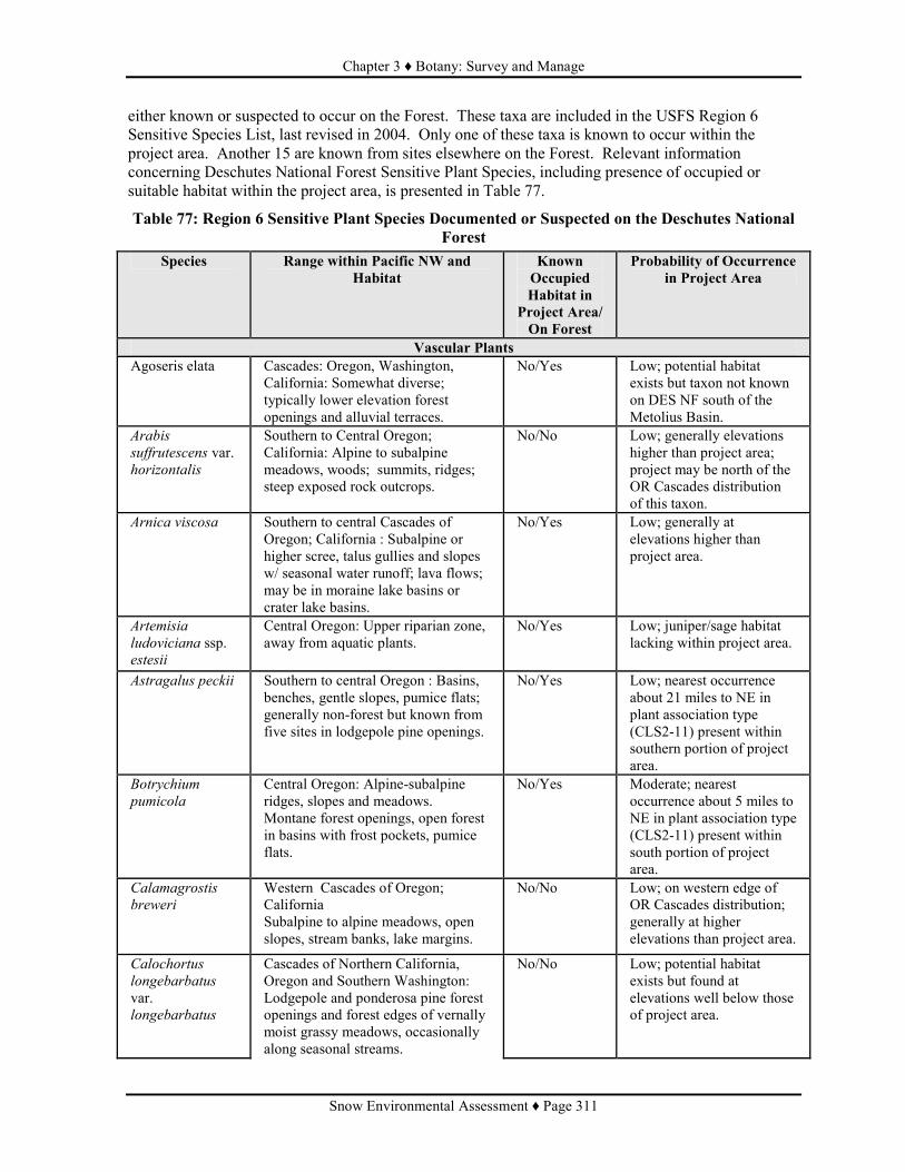
Chapter 3 ♦ Botany: Survey and Manage
Snow Environmental Assessment ♦ Page 311
either known or suspected to occur on the Forest. These taxa are included in the USFS Region 6 Sensitive Species List, last revised in 2004. Only one of these taxa is known to occur within the project area. Another 15 are known from sites elsewhere on the Forest. Relevant information concerning Deschutes National Forest Sensitive Plant Species, including presence of occupied or suitable habitat within the project area, is presented in Table 77.
Table 77: Region 6 Sensitive Plant Species Documented or Suspected on the Deschutes National Forest
Species Range within Pacific NW and Habitat
Known Occupied Habitat in
Project Area/ On Forest
Probability of Occurrence in Project Area
Vascular Plants Agoseris elata Cascades: Oregon, Washington,
California: Somewhat diverse; typically lower elevation forest openings and alluvial terraces.
No/Yes Low; potential habitat exists but taxon not known on DES NF south of the Metolius Basin.
Arabis
suffrutescens var. horizontalis
Southern to Central Oregon; California: Alpine to subalpine meadows, woods; summits, ridges; steep exposed rock outcrops.
No/No Low; generally elevations higher than project area; project may be north of the OR Cascades distribution of this taxon.
Arnica viscosa Southern to central Cascades of Oregon; California : Subalpine or higher scree, talus gullies and slopes w/ seasonal water runoff; lava flows; may be in moraine lake basins or crater lake basins.
No/Yes Low; generally at elevations higher than project area.
Artemisia
ludoviciana ssp. estesii
Central Oregon: Upper riparian zone, away from aquatic plants.
No/Yes Low; juniper/sage habitat lacking within project area.
Astragalus peckii Southern to central Oregon : Basins, benches, gentle slopes, pumice flats; generally non-forest but known from five sites in lodgepole pine openings.
No/Yes Low; nearest occurrence about 21 miles to NE in plant association type (CLS2-11) present within southern portion of project area.
Botrychium
pumicola Central Oregon: Alpine-subalpine ridges, slopes and meadows. Montane forest openings, open forest in basins with frost pockets, pumice flats.
No/Yes Moderate; nearest occurrence about 5 miles to NE in plant association type (CLS2-11) present within south portion of project area.
Calamagrostis
breweri Western Cascades of Oregon; California Subalpine to alpine meadows, open slopes, stream banks, lake margins.
No/No Low; on western edge of OR Cascades distribution; generally at higher elevations than project area.
Calochortus
longebarbatus
var. longebarbatus
Cascades of Northern California, Oregon and Southern Washington: Lodgepole and ponderosa pine forest openings and forest edges of vernally moist grassy meadows, occasionally along seasonal streams.
No/No Low; potential habitat exists but found at elevations well below those of project area.

Chapter 3 ♦ Botany: Survey and Manage
Snow Environmental Assessment ♦ Page 312
Species Range within Pacific NW and Habitat
Known Occupied Habitat in
Project Area/ On Forest
Probability of Occurrence in Project Area
Carex hystericina Oregon, Idaho, Washington and California : Mid-elevations in wet to moist conditions in riparian zones; in or along ditches/canals in prairies and wetlands.
No/Yes Low; potential habitat within project area is largely above the elevational range for this taxon.
Carex livida Oregon, Idaho, Washington and California: All forest types; peatlands, wet meadows with still or channeled water.
No/No Low; potential habitat present but project may be outside the OR Cascades distribution of this taxon.
Castilleja
chlorotica Central Oregon: Ponderosa pine, lodgepole pine and mixed conifer forest openings; PP at lower, LP at middle to upper, mixed conifer at highest elevations.
No/Yes Moderate; nearest occurrence about 7 miles east in plant association type (CLS2-11) present within southern portion of project area.
Cicuta bulbifera Eastern Cascades of Oregon and Washington; California: Shoreline marshes.
No/No Low; potential habitat may exist but taxon may no longer be extant in OR.
Collomia
mazama Southern to central Cascades, Oregon: Mid- to high elevations,; meadows, stream banks and bars, lakeshores and vernal pool margins, forest edges and openings.
No/No Low; potential habitat present but project may be north of the OR Cascades distribution of this taxon.
Eucephalus
gormanii Western Cascades, Oregon: Rocky ridges, outcrops, or rocky slopes in alpine or subalpine mixed conifer forest.
No/Yes Low; limited potential habitat within the elevational range of this taxon.
Gentiana
newberryi Eastern and western Cascades of Oregon; California: Alpine to subalpine mixed conifer openings, wet to dry montane meadows, sometimes adjacent to springs, streams, or lakes.
No/Yes Low; nearest occurrence about 7 miles to northeast, but limited potential habitat within the elevational range of this taxon.
Lobelia
dortmanna Eastern Cascades, Oregon; Washington: In water of lake, pond, slow river or stream, or wet meadow.
No/Yes Low; potential habitat likely higher than elevational range of this species.
Lycopodiella
inundata Oregon, Idaho, Washington, California: Deflation areas in coastal back-dunes; montane bogs, less often, wet meadows.
No/Yes Moderate; several occurrences of peatland habitat within project area.
Lycopodium
complanatum Oregon, Idaho, Washington: Middle elevations; edge of wet meadow; dry, forested midslope.
No/No Low; potential habitat present but may be outside of OR Cascades distribution of this taxon.
Ophioglossum
pusillum Oregon, Washington, California: Low to mid-elevations in dune deflation planes, marsh edges, vernal ponds and stream terraces in moist meadows.
No/No Low; potential habitat likely above the elevational range of this species.

Chapter 3 ♦ Botany: Survey and Manage
Snow Environmental Assessment ♦ Page 313
Species Range within Pacific NW and Habitat
Known Occupied Habitat in
Project Area/ On Forest
Probability of Occurrence in Project Area
Penstemon peckii Central Oregon: Ponderosa pine or mixed conifer with ponderosa pine, in openings or in relatively open stands; on recovering fluvial terraces and shallow intermittent drainages.
No/Yes Low; small amount potential habitat (plant association type CWS1-13) present, but taxon not expected either at this elevation or latitude.
Pilularia
americana Oregon, California: Alkali and other shallow vernal pools; not recently used stock ponds; reservoir shores.
No/No Low; associated plant community not known within or near project area.
Rorippa
columbiae Oregon, Washington, California: Low to mid-elevations; wet to vernally moist sites; meadows, fields, playas, lakeshores, intermittent stream beds, banks of perennial streams, along irrigation ditches, river bars and deltas.
No/No Low; associated plant community not known within or near project area.
Scheuchzeria
palustris ssp. americana
Washington, Oregon, Idaho, California: Mid-elevations; open-canopied bogs, fens, and other wetlands where often in shallow water.
No/Yes Moderate; several occurrences of peatland habitat within project area; known site adjacent to project area in Many Lakes RNA.
Schoenoplectus
subterminalis) Washington, Oregon, Idaho, California: Generally submerged to emergent in quiet water 2-8 decimeters deep, in peatlands, sedge fens, creeks, ditches, ponds and lakes.
No/Yes Moderate; potential habitat present; known site on Crescent RD at Big Marsh.
Thelypodium
howellii) East of Cascade crest in Oregon; Washington, California: Marshes at mid-elevations in ponderosa pine and fir forests.
No/No Low; project area elevations largely above those expected for this taxon; suitable habitat may be present but central Oregon sites are historic; no recent collections.
Bryophyte Rhizomnium
nudum Oregon and Washington Cascades: Mid-elevation forests on humus or mineral soil in seepages, seasonally wet depressions or intermittently wet, low gradient channels.
No/Yes Low; potential habitat present but largely below elevations at which taxon known to occur on DES NF.
Schistostega
pennata Oregon, Idaho, Washington: Usually on mineral soil in crevices on lower and more sheltered parts of root wads of fallen trees. Often near streams or other wet areas. High local humidity essential.
No/Yes Low; limited potential habitat within project area.

Chapter 3 ♦ Botany: Survey and Manage
Snow Environmental Assessment ♦ Page 314
Species Range within Pacific NW and Habitat
Known Occupied Habitat in
Project Area/ On Forest
Probability of Occurrence in Project Area
Scouleria
marginata Oregon, Washington, California: Often forming dark mats on exposed to shaded rocks in perennial streams; seasonally submerged or emergent.
No/No Moderate; potential habitat in Upper Deschutes River, Snow Creek and Cultus River.
Lichen Dermatocarpon
luridum Oregon, Washington: On rocks or bedrock in streams or seeps; usually submerged or inundated for most of the year.
Yes High; taxon documented at Snow Creek.
Leptogium
cyanescens Oregon, Washington: Generally riparian but recently documented in upland settings on vine maple, big leaf maple and intermixed with moss on white oak.
No/No Low; potential habitat may be present but project area marginally within taxon's elevational range and may be outside its OR Cascades distribution.
Fungi Ramaria
amyloidea Oregon, Washington, California: Associated with fir species, Douglas fir, and western hemlock; on humus or soil; fruits in fall.
No/Yes Low; may be strongly associated with wet mixed conifer plant association group in Eastern Cascades Physiographic Province; this PAG is poorly represented in the project area.
Prefield review indicated that only one Sensitive botanical species, the lichen Dermatocarpon luridum, is known to occur within the project area. It occurs on rocks either in or beside streams where it is subject to at least seasonal submersion. It's recently been determined (Glavich and Geiser, 2004) that Dermatocarpon luridum has been misidentified in the Pacific Northwest, and that this taxon should be referred to as Dermatocarpon meiophyllizum. No other TES taxa are considered to have a high probability of occurrence within the project area. Six taxa, the vascular plants Botrychium pumicola, Castilleja chlorotica, Lycopodium inundatum, Scheuchzeria palustris ssp. americana, Schoenoplectus subterminalis and the moss Scouleria marginata, are considered moderately likely to occur within the project area. Botrychium pumicola and Castilleja chlorotica are both upland species known to occur in the lodgepole/bitterbrush/needlegrass-pumice plant association which occurs within the project area. Lycopodium inundatum, Scheuchzeria palustris ssp. Americana occur in wetlands, and Scouleria marginata is restricted to streams. Project surveys were conducted in 2006 and 2007. These surveys included visits to all areas proposed for treatment, as well as visits to wetlands adjacent to Lava and Little Lava Lakes, a dry meadow immediately south of Elk Lake, and multiple points along Snow Creek. Four Oregon Natural Heritage Information Center List 2 species were detected in the course of project surveys. The insectivorous vascular plant, Utricularia minor, was detected at a fen in the Lava Lake area. The diminutive vascular plant Cyperus acuminata was documented at the edge of a pool adjacent to the eastern shore of Crane Prairie Reservoir. The mosses Helodium blandowii and Tomenthypnum nitens were each detected at fens in the Lava Lake area.
Other Rare and Uncommon Species
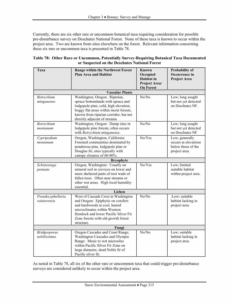
Chapter 3 ♦ Botany: Survey and Manage
Snow Environmental Assessment ♦ Page 315
Currently, there are six other rare or uncommon botanical taxa requiring consideration for possible pre-disturbance survey on Deschutes National Forest. None of these taxa is known to occur within the project area. Two are known from sites elsewhere on the forest. Relevant information concerning these six rare or uncommon taxa is presented in Table 78. Table 78: Other Rare or Uncommon, Potentially Survey-Requiring Botanical Taxa Documented
or Suspected on the Deschutes National Forest
Taxa Range within the Northwest Forest Plan Area and Habitat
Known Occupied Habitat in Project Area/ On Forest
Probability of Occurrence in Project Area
Vascular Plants Botrychium
minganense Washington, Oregon: Riparian, spruce bottomlands with spruce and lodgepole pine; cold, high elevation, boggy flat areas within moist forests; known from riparian corridor, but not directly adjacent of streams
No/No Low; long sought but not yet detected on Deschutes NF.
Botrychium
montanum Washington, Oregon: Damp sites in lodgepole pine forests; often occurs with Botrychium minganense.
No/No Low; long sought but not yet detected on Deschutes NF
Cypripedium
montanum Oregon, Washington, California: Forested communities dominated by ponderosa pine, lodgepole pine or Douglas fir; sites typically with canopy closures of 60-80%.
No/Yes Low; generally occurs at elevations below those of the project area.
Bryophyte Schistostega
pennata Oregon, Washington: Usually on mineral soil in crevices on lower and more sheltered parts of root wads of fallen trees. Often near streams or other wet areas. High local humidity essential.
No/Yes Low; limited suitable habitat within project area.
Lichen Pseudocyphellaria
rainierensis West of Cascade Crest in Washington and Oregon: Epiphytic on conifers and hardwoods in cool, humid microclimates within Western Hemlock and lower Pacific Silver Fir Zone forests with old growth forest structure.
No/No .Low; suitable habitat lacking in project area.
Fungi Bridgeoporus
nobilissimus Oregon Cascades and Coast Range; Washington Cascades and Olympic Range: Mesic to wet microsites within Pacific Silver Fir Zone on large diameter, dead Noble fir of Pacific silver fir.
No/No Low; suitable habitat lacking in project area.
As noted in Table 78, all six of the other rare or umcommon taxa that could trigger pre-disturbance surveys are considered unlikely to occur within the project area.

Chapter 3 ♦ Botany: Survey and Manage
Snow Environmental Assessment ♦ Page 316
The bryophyte Tritomaria exsectiformis, which does not require consideration for predisturbance surveys, is the only rare, non-Sensitive species documented to occur within the project area. It is restricted to wetland and other riparian settings. No other sites of rare or uncommon non-Sensitive species were detected during the 2006-2007 botanical surveys for this project. ENVIRONMENTAL CONSEQUENCES Alternative 1 (No Action) Direct and Indirect Effects: No direct adverse or beneficial effects to TES/S&M plants are anticipated under the No Action Alternative. It is anticipated that this project will reduce the scale and intensity of near-future wildfire within the project area. However, in the absence of the fuels reduction treatments proposed under the two Action Alternatives, it is predicted that the Tritomaria exsectiformis site on Snow Creek will be at increased risk of extirpation due to wildfire in the near future (0 to 20 years). Effects Common to Alternative 2 (Proposed Action) and Alternative 3 Direct and Indirect Effects: No direct adverse or beneficial effects to Sensitive or other rare or uncommon plant species are anticipated under either Alternative 2 (the Proposed Action) or Alternative 3. This is because 1) no sites of Sensitive or other rare or uncommon plant species occur within treatment units proposed in either Alternative and 2) it is anticipated that project-related activities in adjacent project units will have no detrimental effect on any Sensitive or other rare or uncommon plant species or their habitat. One Sensitive species site and five other rare species sites exist within or closely adjacent to the project boundary. To the extent that this project is successful in reducing the scale and intensity of near-future wildfire within the project area, there is opportunity for indirect benefit to the site of the rare bryophyte Tritomaria exsectiformis on Snow Creek, and to the locally uncommon (on Deschutes NF) plant community associated with this site. This forested community in a deep, steep-sloped draw, would likely be very slow to recover from an intense burn, with some included plant species likely being lost from the community for the foreseeable future. Occurrences of the Sensitive lichen, Dermatocarpon luridum (= D. meiophyllizum) or the other rare plant species (Cyperus acuminatus, Utricularia minor, Helodium blandowii and Tomentypnum nitens) and their potential habitats within the project area are either associated with non-forested fens or shorelines, or are aquatic. It appears likely that these sites and habitat would experience relative mild, if any, adverse impact due to wildfire in adjacent forested stands, and in turn, would be little effected by the fuels reductions associated with either Action Alternative. Cumulative Effects: No significant cumulative effects are anticipated regarding any of the Sensitive or rare plant sites, or their habitat, known to occur within the project area. This is because for all species sites and associated habitats, 1) project-related activities adjacent to these sites, and their associated habitats, are anticipated to have no deleterious effect on sites or habitat and 2) there is little evidence of past or reasonably foreseeable future deleterious influences (see Table X at beginning of Chapter 3). A summary of anticipated effects is presented in Table 79. The Sensitive lichen species, Dermatocarpon luridum occurs submerged or emergent on rocks near the headwaters of the Deschutes River. This habitat appears, in the past, or in the near-future (0-20 years), to be little influenced by human activities or natural events. The rare bryophyte species,

Chapter 3 ♦ Botany: Survey and Manage
Snow Environmental Assessment ♦ Page 317
Tritomaria exsectiformis, occurs in a forested riparian setting. In Oregon, this species is only found in association with perennial, low volume, slow-moving water in undisturbed, late-seral plant communities. This particular site has attracted little recreational use, and perhaps, due to local topography, has apparently experienced no recent commercial or non-commercial thinning. The site, and its associated plant community, appear to owe their presence and current condition to the absence of any recent (0-80 years) high intensity fire. The fens in which the sites of the rare plant species Utricularia minor, Helodium blandowii and Tomentypnum nitens occur appear to have attracted very little recreational use and only minor management activity (a single thinning of young, "encroaching" lodgepole pine and spruce) in the past several decades. Likewise, the non-forested, near-shoreline habitat in which the Cyperus acuminatus site occurs is well-removed from popular recreational access points around the periphery of Crane Prairie and in a zone where little agency management has occurred. There is little reason to anticipate that this pattern of use/management will change in the near future (0-20 years). It is likely that a slowly spreading infestation by several invasive plant species is occurring within the riparian and wetland plant communities within the project area. Zero to minimal project-related activity within riparian and wetland communities, and the included invasive species prevention mitigations, should allow this project to proceed without furthering risk or spread of weeds within these general habitat types.
Table 79: Summary of Determinations of Short Term Effects for Sensitive Plant Species
Species Alternative 1 Alternative 2 Alternative 3 Vascular Plants
Agoseris elata NI NI NI Arabis suffrutescens var. horizontalis NI NI NI Arnica viscosa NI NI NI Artemisia ludoviciana ssp. estesii) NI NI NI Astragalus peckii NI NI NI Botrychium pumicola NI NI NI Calamagrostis breweri NI NI NI Calochortus longebarbatus var. longebarbatus NI NI NI Carex hystericina NI NI NI Carex livida NI NI NI Castilleja chlorotica NI NI NI Cicuta bulbifera NI NI NI Collomia mazama NI NI NI Eucephalus gormanii NI NI NI Gentiana newberryi NI NI NI Lobelia dortmanna NI NI NI Lycopodiella inundata NI NI NI Lycopodium complanatum NI NI NI Ophioglossum pusillum NI NI NI Penstemon peckii NI NI NI Pilularia americana NI NI NI Rorippa columbiae NI NI NI Scheuchzeria palustris ssp. americana NI NI NI Schoenoplectus subterminalis NI NI NI Thelypodium howellii NI NI NI
Bryophytes Rhizomnium nudum NI NI NI Schistostega pennata NI NI NI Scouleria marginata NI NI NI

Chapter 3 ♦ Botany: Survey and Manage
Snow Environmental Assessment ♦ Page 318
Species Alternative 1 Alternative 2 Alternative 3 Lichen
Dermatocarpon luridum NI NI NI Leptogium cyanescens NI NI NI
Fungus Ramaria amyloidea NI NI NI
NI = No Impact; MIIH = May Impact Individuals or Habitat, but will not likely contribute to a trend towards federal listing or loss of viability to the population or species.

Chapter 3 ♦ Botany: Invasive Species
Snow Environmental Assessment ♦ Page 319
BOTANY - INVASIVE SPECIES
SUMMARY This project has a HIGH risk ranking for the introduction and spread of invasive plant species. Included mitigations will reduce, but not eliminate, the invasive plant species risk associated with this project. The difficulty of assessing the net weed risk associated with the Action Alternatives (direct effect risk elevation vs. indirect effect risk reduction) is discussed
INTRODUCTION Aggressive, non-native, invasive plant species can displace native plant communities causing long-lasting management problems. In displacing native vegetation, invasive plant species can increase fire hazards, reduce the quality of recreational experiences, poison livestock, and replace wildlife forage. By simplifying complex plant communities, weeds reduce biological diversity and threaten rare habitats. It should be noted that the terms "noxious weed" and "invasive plant species" are not, in current use, synonymous. The former term is used by the Oregon Department of Agriculture (ODA) and in many older USDA/USFS documents. Not all non-native plants that are causing economic and/or ecological damage in the state of Oregon are listed in the ODA "Noxious Weed Index". Examples of damaging, non-native, plant species not listed by the ODA include cheatgrass (Bromus tectorum) and ventenata grass (Ventenata dubia). The term "invasive plant species" is currently widely used to include all non-native plant species currently causing, or capable of causing, local economic and/or ecological damage, regardless of their status on any particular state list. National Direction Sources of national direction for noxious weed management include the Noxious Weed Management Act (1974) and an Executive Order on Invasive Species (1999). The Forest Service Manual (FSM) requires that Noxious Weed Risk Assessments be prepared for any project that includes ground-disturbing activities. For projects anticipated to have a moderate to high risk of introducing or spreading noxious weeds, decision documents must identify noxious weed management measures that will be undertaken during project implementation (FSM 2081.03, November 1995). A Guide to Noxious Weed Prevention Practices (USDA 2001) presents a large number of desirable weed prevention actions that should be evaluated for efficacy, and compatibility with project objectives, during the process of project planning. The USDA Forest Service National Strategy and Implementation Plan for Invasive Species Management (USDA Forest Service, 2004) consists of four basic elements (prevention, early detection and early response, control and management, rehabilitation and restoration) with an emphasis on partnerships and collaboration, communication and education, good science and organization. Regional Direction A USFS Region 6 Invasive Plant Program Record of Decision was signed in 2005. This ROD has forest-level significance as noted below. Forest Direction The Deschutes National Forest Land and Resource Management Plan (1990) includes limited general and specific directives regarding noxious weed management. The 1998 Deschutes National Forest

Chapter 3 ♦ Botany: Invasive Species
Snow Environmental Assessment ♦ Page 320
Noxious Weed Control Environmental Assessment (EA) includes a Noxious Weed List, a supplemental Integrated Weed Management Plan (IWMP), and direction and authority for management of noxious weeds This EA and IWMP identify and promote specific actions to be associated the general weed management practices of prevention, early treatment, maintenance, and education. Associated products of this EA and IWMP included a formalized weed risk analysis process to be utilized during project planning, and a cooperative agreement with the Oregon Department of Agriculture for the application of herbicides at selected sites on Deschutes National Forest. Part 1 (Watersheds Where There is No Effect to Listed Fish Species) of a USFS Record of Decision for Invasive Plant Treatments on Deschutes and Ochco National Forests and Crooked River National Grassland was signed in late 2007. This ROD, which is tiered to the 2005 Region 6 Invasive Plant Program ROD, will increase the number of treatment options for noxious weeds within the Snow Vegetation and Fuels Reduction Project area, relative to those previously available.
DESIRED FUTURE CONDITION The extent of non-native, invasive plant species would be in decline. Direction within the existing Deschutes and Ochoco National Forests and Crooked River National Grassland Invasive Plant Treatments EIS would allow effective treatment of existing sites and prompt treatment of newly discovered sites. Forest staff, contractors and recreationists would be aware of the primary importance of prevention as a means of limiting the spread of invasive plant species. EXISTING CONDITION Twenty-seven taxa of invasive plant species are currently known to occur on Deschutes National Forest. These are listed in Table 80.
Table 80: Invasive Plant Species Documented to Occur on Deschutes National Forest. Scientific Name Common Name
Bromus tectorum Cheatgrass Cardaria draba Whitetop Cardaria pubescens Hairy Whitetop Centaurea biebersteinii Spotted knapweed Centaurea diffusa Diffuse knapweed Centaurea solstitialis Yellow starthistle Cirsium arvense Canada thistle Cirsium vulgare Bull thistle Convolvulus arvensis Field bindweed Cynoglossum officinale Common houndstongue Cytisus scoparius Scotch broom Elymus repens Quackgrass Euphorbia esula Leafy spurge Hypericum perforatum St. Johns wort Isatis tinctoria Dyer's woad Kochia scoparia Kochia Linaria dalmatica Dalmatian toadflax Linaria vulgaris Butter and eggs Onopordum acanthium Scotch thistle Phalaris arundinacea Reed canarygrass Phalaris arundinacea var. picta Ribbongrass Salvia aethiopis Mediterranean sage Salsola kali Russian thistle Senecio jacobaea Tansy ragwort

Chapter 3 ♦ Botany: Invasive Species
Snow Environmental Assessment ♦ Page 321
Scientific Name Common Name Taeniatherum caput-medusae Medusahead Tanacetum parthenium Feverfew Verbascum thapsis Common mullein
Review of a 02/2006 Forest invasive plants GIS layer indicated the presence of six invasive plant species (Table 81) within the project area. Senecio jacobaea is not found within project area but occurs less than 300 meters outside of the project boundary.
Table 81: Invasive Plant Species Present Within or Closely Adjacent to the Snow Project Boundary
Scientific Name Common Name Gross Acres of Infestation Net Acres of Infestation Bromus tectorum Cheat grass 23.0 21.5 Centaurea biebersteinii Spotted knapweed 25.5 3.6 Cirsium arvense Canada thistle 1.3 0.5 Cirsium vulgare Bull thistle 26.3 3.4 Hypericum perforatum St. Johnswort 23.1 1.0 Phalaris arundinacea Reed canarygrass 83.6 4.2 Senecio jacobaea Tansy ragwort 24.0 0.5
Total Acres of Infestation 206.8 34.7 Project surveys were also conducted in 2006 and 2007. These surveys included visits to all areas proposed for treatment, as well as visits to wetlands adjacent to Lava and Little Lava Lakes, a dry meadow immediately south of Elk Lake, and multiple points along Snow Creek. New occurrences of five invasive species already documented within the project area were detected. A brief description of these new sites is provided in Table 82.
Table 82: New Invasive Plant Occurrences Detected During 2006 Project Surveys
Invasive Species Location Centaurea biebersteinii, 2 sites Along road 46, south of 500 road. Cirsium arvense, 4 sites East edge Crane Prairie Reservoir. Hypericum perforatum Along road 46 near south end Elk Lake. Hypericum perforatum Along road 46, south of 500 road. Phalaris arundinacea East edge of Crane Prairie Reservoir. The following provides brief descriptions for each of the invasive taxa listed in Table 81. Bromus tectorum: Cheat grass is a species of concern on the Forest, but is not included on the official Forest invasive plant species list. It is widely distributed on the Forest and is generally not tracked in databases or in GIS. This grass is widely known for being a highly aggressive competitor with native herbs and even shrubs, and for the broad range of native plant communities which it infests. Centaurea biebersteinii: Spotted knapweed and its close relative, diffuse knapweed (C. diffusa) are understood to be among the most abundant and aggressive invasive plants, in upland settings, on Deschutes National Forest. It is common, particularly on private land adjacent to the Forest, to see sites where communities composed of a mix of native and introduced plants have been displaced by near-monocultures of knapweed. Spotted knapweed lives for multiple years, dying back to a basal rosette of leaves each winter, and producing a more profuse and taller array of flowering branches with each successive year. Although tap-rooted, plants can be very resistant to hand-pulling, and plants recover well from incomplete removal of the tap root. Sites occupied for several years by large numbers of plants can have seed beds that will produce many new plants annually, for a decade or more, even if annual mechanical treatments prevent further fruit set at those sites.

Chapter 3 ♦ Botany: Invasive Species
Snow Environmental Assessment ♦ Page 322
Cirsium arvense: Canada thistle is of particular concern at sites with high soil moisture levels during much of the growing season. The plant is commonly found in riparian zones, damp meadows and in or adjacent to wetlands of various types. Its spiny habit makes it difficult to treat manually, and its deep, creeping roots allow plants to persist even when the above ground shoots have be pulled or cut. Rates of local spread and length of persistence at individual sites is not well documented. Cirsium vulgare: Local observations over the past decade have led to the understanding that bull thistle is not long persistent at specific sites. Although this tap-rooted, biennial species may be quick to establish itself in very recently disturbed settings, it seems to be rather soon displaced by herbaceous natives. Occurrences of this species in the proximity of Sensitive plant species, or in high-use recreational areas are of concern, but occurrences elsewhere are not consistently recorded. Hypericum perforatum: St. Johnswort is regarded as an emerging threat, at least on some portions of Deschutes National Forest. This rhizomatous species is causing local concern due to its apparent high rate of spread, and its resistance to manual, chemical and biological controls. Phalaris arundinacea: Reed canarygrass is a robust, deeply rhizomatous grass that appears to be highly aggressive in riparian/wetland settings. Where it is well established, it may be virtually impossible to eradicate by standard mechanical means. Where it is well established, it commonly occurs as a virtual monoculture, evidently having displaced all other local sedges, grasses and other native species. This plant is particularly troublesome in the risk it poses to certain wetland communities that are among the most uncommon and biodiverse plant communities on Deschutes National Forest. Senecio jacobaea: Tansy ragwort has been known from a low number of sites on the District and Forest for many years. This short-lived perennial is toxic to stock and has been historically very troublesome west of the Cascades. The species does not appear to be very competitive on Deschutes National Forest, but continuing treatment and monitoring are advisable. ENVIRONMENTAL CONSEQUENCES Risk Assessment: Forest Service Manual direction requires that Noxious Weed Risk Assessments be prepared for all projects involving ground-disturbing activities. For projects that have a moderate to high risk of introducing or spreading noxious weeds, Forest Service policy requires that decision documents must identify noxious weed control measure that will be undertaken during project implementation (FSM 2081.03.29; November 1995). Risk Ranking: Deschutes National Forest has developed a standardized noxious weed risk assessment process to be conducted as a part of the project planning process. Risk rankings are based on the following sets of criteria. High Risk:
1. Known weeds in or adjacent to project area. 2. Any of vector #s 1-8 in project area. 3. Project operations in or adjacent to weed sites.
Moderate Risk: 1. Any of vector #s 1-5 are present in project area.
Low Risk: 1. Any of vector #s 6-8 present in project area,
OR

Chapter 3 ♦ Botany: Invasive Species
Snow Environmental Assessment ♦ Page 323
2. Known weeds present in or adjacent to project area, even if vectors lacking. Vectors ranked in order of weed introduction/spread risk:
1. Heavy equipment (implied ground disturbance). 2. Importing soil/cinders/gravel. 3. Use by OHVs. 4. Grazing (long-term disturbance). 5. Pack animals (short-term disturbance) 6. Plant restoration. 7. Use by recreationists. 8. Presence of USFS project vehicles.
Discussion of Ranking: This project has been given a HIGH risk ranking for the introduction and spread of noxious weeds because noxious weed sites exist adjacent to and within proposed treatment units in both action alternatives, and project operations will include the use of heavy equipment. At issue in assessing the effects of the Action Alternatives is the need to predict the extent to which the directly elevated weed risk associated with fuels management activities (soil disturbance, vectors for introduction and spread) is offset by the indirectly reduced weed risk associated with those same fuels management activities (reduced wildfire-induced soil disturbance and loss of competing native vegetation). This resultant net risk estimate could then be compared to the weed risk estimate associated with near-future wildfire in a landscape with unreduced and ever-building fuels levels (the No Action Alternative). Unfortunately, it's not possible to quantify, or even reliably estimate the level of weed risk associated with these two scenarios. Alternative 1 (No Action) Direct and Indirect Effects: Under this Alternative, no actions would be taken that would directly promote the spread of noxious weeds. Given current high fuels loadings in the project area, it is reasonable to anticipate a potentially large scale, high intensity wildfire within or including some portion of the project area in the near future (0-20 years). As noted earlier, wildfire is associated with its own set of actions and consequences that has the potential to promote the introduction and spread of noxious weeds. Observations by Deschutes NF botanists have found that with the presence of pre-existing weed populations, wildfire tends to promote the spread of noxious weeds. At this time, it is assumed that weed risk increases in a direct relationship with burn intensity. The relationship between burn intensity and risk of introduction and/or spread of noxious weeds is not clearly documented on the Forest. While there may be a direct relationship between burn intensity and weed seed survivorship, it is currently assumed that this possible risk-lowering factor is more than offset by the increasing level of disturbance associated with increasing levels of burn intensity. As burn intensities increase, survivorship/cover of existing native vegetation declines, reducing, in turn, the effectiveness of local native plant species in their competition with invasive weed species. Effects Common to Alternative 2 (Proposed Action) and Alternative 3 Direct and Indirect Effects: Fuels management activities proposed in this Alternative would result in soil disturbance and a reduction in vegetative cover and litter. These habitat alterations would likely promote establishment of invasive plant species. The heavy equipment used in affecting these habitat alterations would, locally at least, cause a high risk of inadvertent dispersal of existing weed propagules within the project area. To the extent that the proposed fuels management activities

Chapter 3 ♦ Botany: Invasive Species
Snow Environmental Assessment ♦ Page 324
succeed in reducing the scale and intensity of any near-future wildfires, these activities may reduce the risks of post-wildfire weed infestation in the near future. Approximately 300 more treatment acres are proposed in Alternative 3 than Alternative 2. Correspondingly, Alternative 3 likely poses a slightly greater risk of weed introduction and spread relative to Alternative 2. Mitigations would reduce, but not eliminate weed risks associated with this project. Cumulative Effects: Weed infestation within the project area can generally be described as light, and occurring principally along roads (spotted knapweed) and in riparian zones associated with creeks, lakes and spring-fed wetlands (Canada thistle and reed canarygrass). It is difficult to defensibly speculate about the timing and vectors associated with introduction and spread of the riparian weeds. While relatively few USFS projects have occurred in these riparian zones, the lakes and streams have a very high level of recreational use. Because riparian areas are excluded from the activity units proposed in Snow Vegetation and Fuels Management Project, this project should be a negligible influence in the ongoing dynamic of the riparian weed populations. Prior project activities within the Snow Project area do not appear to have contributed significantly to the distribution of weeds currently documented within Snow Project units (see Table X at beginning of Chapter 3). In contrast, it appears likely that heavy equipment involved in road and powerline maintenance, and vehicular traffic, particularly, recreational traffic, have been important and ongoing vectors in the introduction and dispersal vectors for roadside weeds within the project area. Vehicular traffic, perhaps particularly the haul trucks directly associated with this project, will be additive to the roadside weed dispersal vectors already in place. Prevention Practices for Alternative 2 (Proposed Action) and Alternative 3 Efforts toward preventing the introduction and spread of noxious weeds are an extremely important part of any weed management plan. Prevention practices have the potential to be the most cost-effective component of such plans. Wildfire, Burn Intensity and Weed Risk It is reasonable to predict an increased risk of spread of invasive plants species within burned areas due to 1) ground disturbance and loss/reduction of competitive native vegetation, 2) introduction or spread of weed seed from within or outside of the burned area, by vectors associated with fire suppression efforts and 3) introduction or spread of weed seed from within or outside of the project area, by project and non-project-related vectors for several years immediately subsequent to the fire.

Chapter 3 ♦ IRA and Unroaded Areas
Snow Environmental Assessment ♦ Page 325
INVENTORIED ROADLESS AREA AND UNROADED AREAS INTRODUCTION Unroaded areas are defined in the FEIS for the Roadless Area Conservation Final Rule as “any area, without the presence of a classified road, of a size and configuration sufficient to protect the inherent characteristics associated with its roadless condition. Unroaded areas do not overlap with the inventoried roadless areas.” (USFS 2000, page G-12). Unroaded areas have typically not been inventoried and are, therefore, separate from inventoried roadless areas. This document uses the term “unroaded area” to differentiate these areas from inventoried roadless areas. There are no Forest-wide or Management Area standards specific to unroaded areas in the Deschutes Forest Plan. INVENTORIED ROADLESS AREA (IRA) Affected Environment IRAs are National Forest System lands typically exceeding 5,000 acres that meet the minimum criteria for wilderness consideration under the Wilderness Act of 1964. These IRAs are mapped in the Final Environmental Impact Statement for the Roadless Area Conservation Final Rule and can be found at http://roadless.fs.fed.us/states/or/desc.pdf. As discussed in other sections of this EA (Chapter 1, Purpose and Need and Chapter 3, Fire and Fuels), the project area is essentially a corridor for recreation and traffic, which lies just to the east of large unmanaged forests; typical fire patterns for the area would send a wildfire from the west through the project area. This would put forest visitors, firefighters, recreation facilities, and surrounding forest (including the Late Successional Reserve to the east) in danger of catastrophic wildfire. Several IRAs occur near the Snow project area (Three Sisters, Waldo, and West-South Bachelor) and the Three Sisters Wilderness lies to the west of the project area (see Figure 51). These IRAs overlap portions of the Cultus Mtn. and Sheridan Mtn. Late Successional Reserves. No activities are proposed within IRAs or Wilderness; however, treatment units are located adjacent to IRAs and Wilderness.
Environmental Consequences Alternative 1 (No Action) Direct, Indirect, and Cumulative Effects: Under No Action, no activities would take place near the IRAs or Wilderness so there would be direct, indirect, or cumulative effects to the roadless or wilderness values. Alternative 2 (Proposed Action) and Alternative 3 Direct, Indirect, and Cumulative Effects: There would be no direct effects from any alternative to the IRAs or Three Sisters Wilderness area. No activities would take place that would have any direct effect on the roadless or wilderness character of these areas. Indirect effects are possible when units lie directly adjacent to these areas. Between Lava Lake and Cultus Lake, several units are located along the Cascade Lakes Highway. A powerline runs parallel to the highway between the highway and the Wilderness. The surveyed Wilderness boundary is 100 feet
Chapter 3 ♦ IRA and Unroaded Areas
Snow Environmental Assessment ♦ Page 326
to the west of the center of the powerline right-of-way. These areas have previously had salvage and seed tree treatments in much of the lodgepole pine type. The mixed conifer stands tend to not have been treated except for hazard tree removal along the highway and powerline. All stands have had lodgepole pine mortality. A Special Interest Area and riparian reserves are adjacent to the highway corridor. No project units are located in the Special Interest Area. The powerline road is a local native surface road. Units are planned in both action alternatives within this area. Proposed units 1, 2, 3, 11, 12, 13 (Alternatives 2 and 3) are adjacent to the west side of Cascade Lakes Highway and the Powerline right of way. Activities proposed for these units include thinning, salvage, hand and grapple piling (Appendix A). These actions are intended to remove fuels and provide a safer corridor along the Cascade Lakes Highway for firefighters and the public. People recreating in adjacent Wilderness or the West-South Bachelor IRA could experience the noise and dust of operations; these would be short-term temporary impacts. Also, smoke during pile burning could be evident from these areas, but smoke management is regulated according to the Oregon Smoke Management Plan Oregon Revised Statutes 477.013. Three Sisters Wilderness area is a Type I airshed and smoke form operations is not permitted when weather conditions would affect this area. Longer term, the impacts of activities such as visible stumps or more open areas would be visible to people near the Wilderness or IRA boundaries.4 Because the Cascade Lakes Highway, the powerline, and developed recreation sites exist near this Wilderness boundary, there is already a lot of human activity that is seen and heard; therefore, the change in experience for people within the Wilderness would be relatively minor.
4 The Wilderness is apportioned into Wilderness Resource Spectrum Zones because different areas within Wilderness can and should
provide different opportunities and experiences (LRMP P. 4-103). The portion of Wilderness that is adjacent to the Cascade Lakes
Highway is a semi-primitive zone where concentration of users is low, but there often evidence of other users.
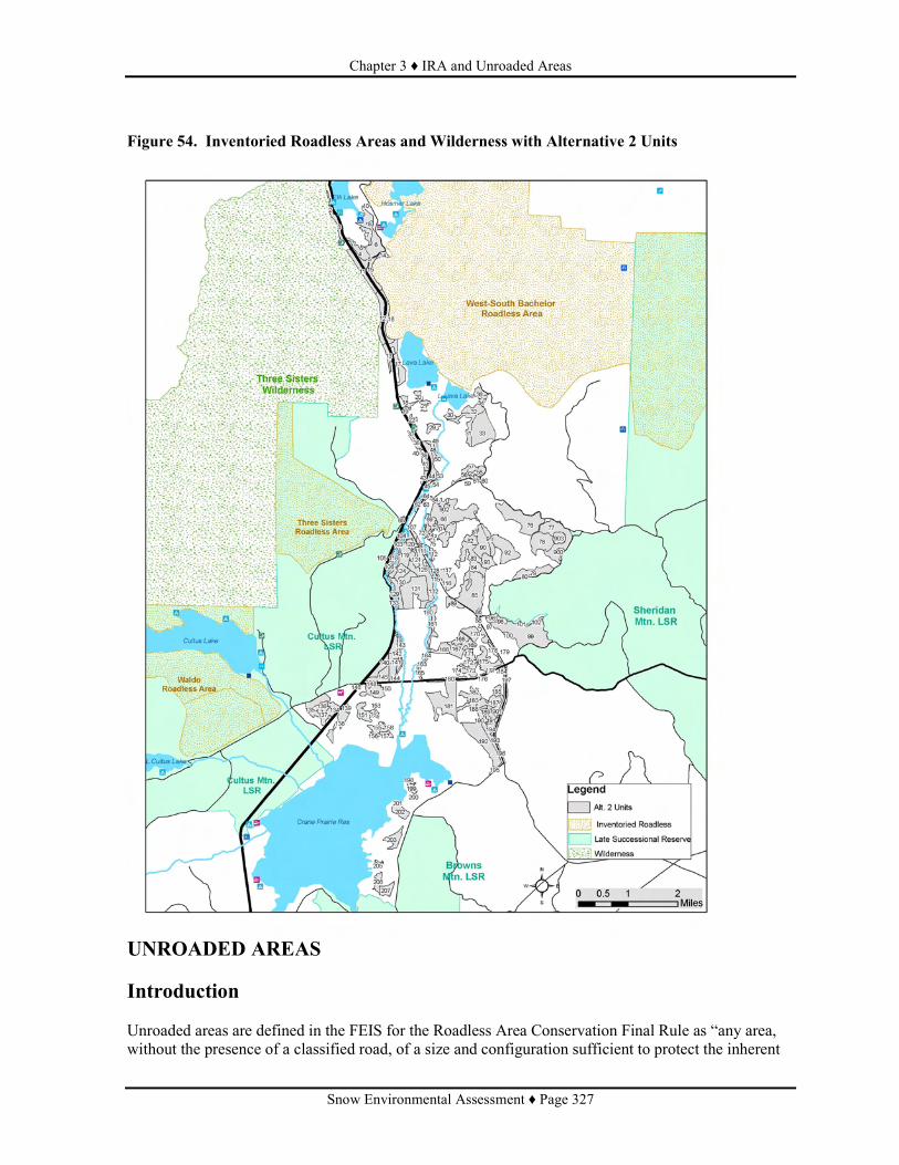
Chapter 3 ♦ IRA and Unroaded Areas
Snow Environmental Assessment ♦ Page 327
Figure 54. Inventoried Roadless Areas and Wilderness with Alternative 2 Units
UNROADED AREAS Introduction Unroaded areas are defined in the FEIS for the Roadless Area Conservation Final Rule as “any area, without the presence of a classified road, of a size and configuration sufficient to protect the inherent

Chapter 3 ♦ IRA and Unroaded Areas
Snow Environmental Assessment ♦ Page 328
characteristics associated with its roadless condition. Unroaded areas do not overlap with the inventoried roadless areas.” (USFS 2000, page G-12). Unroaded areas have typically not been inventoried and are, therefore, separate from inventoried roadless areas. This document uses the term “unroaded area” to differentiate these areas from inventoried roadless areas which are discussed in the previous section. There are no Forest-wide or Management Area standards specific to unroaded areas in the Deschutes Forest Plan. Oregon Wild submitted a map of unroaded areas within and adjacent to the project area. Oregon Wild requested that the Forest Service consider the impacts to the roadless values that these unroaded areas may have. Oregon Wild also stated that the Forest Service should avoid salvage logging and road building in these areas. Oregon Wild did not specify any particular values related to roadless character that they believe these areas provide. Affected Environment The unroaded areas identified in the comments overlap the following designated areas: Three Sisters Roadless Area, Waldo Roadless Area, and West-South Bachelor Roadless Area (Figure 54). No activities are planned within those designated areas, and effects are considered in the previous section on Inventoried Roadless Areas and Wilderness. This discussion will focus on the rest of the unroaded areas: 1) adjacent to Highway 46 and Wilderness, 2) an area surrounding Little Lava Lake and extending to the east side of Road 4528, and 3) an area at the north end of Crane Prairie Reservoir. The areas adjacent to the Cascade Lakes Scenic Byway (Highway 46) are areas which were identified as boundaries for Wilderness and Inventoried Roadless. A powerline runs parallel to the highway between the highway and the Wilderness. The surveyed Wilderness boundary is 100 feet to the west of the center of the powerline right-of-way. These areas have previously had salvage and seed tree treatments in much of the lodgepole pine type. The mixed conifer stands tend to not have been treated except for hazard tree removal along the highway and powerline. All stands have had lodgepole pine mortality. A Special Interest Area and riparian reserves are adjacent to the highway corridor. No project units are located in the Special Interest Area. The powerline road is a local native surface road. Units are planned in both action alternatives within this area. Proposed units 1, 2, 3, 11, 12, 13 (Alternatives 2 and 3) are adjacent to the west side of Cascade Lakes Highway and the Powerline right of way. Proposed units 14, 15, 16, 17 (Alternatives 2 and 3) are adjacent to the east side of Cascade lakes Highway. The area adjacent to Little Lava Lake was identified as unroaded in the comments and is mostly lodgepole pine with some mixed conifer stands. This area has had at least 180 acres of seed tree harvest in three units from the Red Plague Timber Sale in the last decade. The lodgepole stands in this area have high to moderate mortality from bark beetles. The ground is undulating with some lava outcrops. The Little Lava Lake area is connected to the West-South Bachelor Roadless Area by a narrow neck between a road (4529700) and Little Lava Lake. The unroaded area is bounded by: 1) the 4529 road on the East and South; 2) the 700 road on the north east; and 3) the 4525950 & 4525960 roads define part of the southern boundary of the unroaded area. The unroaded area goes around the 960 road. The roads in the area are identified as long term service with the 700, 950, and 960 roads as high clearance vehicle local native surface road. These roads are sometimes closed with logs and not opened unless activities are planned in the area. The 4529 is a graveled surface road and maintained open. Proposed units 30, 31, 32, 33 (Alternatives 2 and 3) are in the Little Lava Lake area.

Chapter 3 ♦ IRA and Unroaded Areas
Snow Environmental Assessment ♦ Page 329
The unroaded area north east of Crane Prairie reservoir (1,539 acres) is a mostly lodgepole pine flat area. Some spruce is in the moister area associated with the Deschutes River entering Crane Prairie Reservoir. The 4270500 road almost bisects the area and is in intermittent use status with native surface. The 4270510 road is a service road for the powerline and is the east boundary of this area. The south boundary is Crane Prairie Reservoir and the west boundary is a system of roads which accessed harvest units in the 1960s, though many have not been used since and are mostly unusable because of the growth of vegetation. The majority of the area is an old growth area that burned in a wildfire in 1998 and is now a young stand of lodgepole pine. More than 95% of the dead lodgepole pine has fallen. The 60 year old lodgepole stands outside of this old growth area are typically unmanaged with the largest diameters of 8 inches at dbh, although some of these unmanaged areas have some overstory lodgepole pine. These stands have 50 to 70% mortality, especially the larger diameter trees and have heavy loadings of down logs. Proposed units 181, 192, 195 (Alternatives 2 and 3) are located on the edge of the Crane Prairie area. Environmental Consequences Alternative 1 (No Action) Direct and Indirect Effects: There would be no direct effects from the No Action alternative to the Oregon Wild unroaded areas. No activities would take place that would have any direct, indirect, or cumulative effects on the roadless character of the areas. Effects Common to Alternative 2 (Proposed Action) and Alternative 3 Direct and Indirect Effects: Under Alternatives 2 and 3, salvage harvest and associated temporary road construction would occur in these areas. Temporary roads will be needed in areas that Oregon Wild considered unroaded in order to access the following units: 15, 16, 17, 30, 31, 32, 33, and 181. Temporary roads would be subsoiled to restore soil productivity. Short term affects would be signs of logging activity and a reduction in abundance of dead trees and logs. Temporary roads would be evident until subsoiled and vegetation re-growth. Long term (20-30 years), lodgepole pine regeneration would occur throughout the treatment areas, including the subsoiled temporary roads. The same units are accessed in each alternative, but with Alternative 3, proposed activities also include removal of some of the remaining green lodgepole pine overstory and possibly more skid trails evident. The changes caused by salvage or thinning operations would not be permanent and would not detract from the long term ability of the areas to be classified as roadless.
Particular values that may be provided by undeveloped or unroaded areas are identified in the Roadless Conservation Rule (Federal Register, Vol. 66, No. 9): • High quality Soil, water, and air: These would continue to be provided. Impacts to the soil
resource is limited to the area of activity and are described in the soils section. Soil productivity is maintained and enhanced through subsoiling and other project design features. Water and air will not be adversely affected.
• Sources of public drinking water: These areas are not sources of public drinking water.
• Diversity of plant and animal communities: The diversity of plant and animal communities are not unique for the area. Diversity of vegetation is at risk of loss due to high mortality and risk of catastrophic wildfire. Habitat impacts are discussed in the wildlife and botany sections.
• Habitat for threatened, endangered, proposed, candidate, and sensitive species, and for those species dependent on large, undisturbed areas of land: these areas are not habitat for threatened,

Chapter 3 ♦ IRA and Unroaded Areas
Snow Environmental Assessment ♦ Page 330
endangered, proposed, candidate and sensitive species or for species dependent on large, undisturbed areas of land. No adverse effects to federally-listed or Forest Service sensitive species are expected from either alternative.
• Primitive, semi-Primitive Non-Motorized, and Semi-Primitive Motorized classes of recreation opportunities: The recreation opportunities would remain the same. The area supports developed and dispersed recreation that would not be impacted by the project activities. Recreation sites and facilities will be better protected under either alternative, but these are primarily located outside of the “unroaded” areas.
• Reference landscapes: These areas are located in a large landscape of similar characteristics of lodgepole flats, plant associates, and soils. The Snow Lakes Watershed Analysis
• Landscape character and scenic integrity: The landscape character will be similar following treatments. Landscape level disturbance has already occurred and is still occurring with the mountain pine beetle outbreak. Tree mortality is evident from the high points and open canopies though snag fall down is apparent. The thinning and salvage will be similar in characteristics to landscape actions currently underway. Activities will create more ground disturbance, however.
• Traditional cultural properties and sacred sites: There are no known cultural properties or sacred sites within the unroaded areas. If found during operations, they would be avoided (Chapter 2, page 63).
• Other locally identified unique characteristics: The Snow Lakes Watershed Analysis did not identify any locally unique characteristics to the unroaded areas in the Snow planning area. The landscape within which these unroaded areas are is dominated by lakes and volcanic mountains.
Cumulative Effects: The Sparky project proposes to remove hazard trees from along the Cascade Lakes Highway from Elk Lake to Meissner Snopark, including from developed recreation sites. Treatments from this project in addition to the Sparky Hazard Tree Reduction project would reduce the risk of wildfire spreading into the wilderness and Oregon Wild identified roadless areas. The proposed activities would not reduce the risk of fire starts within those areas. With present indication of heavy mountain pine beetle infestation and subsequent high mortality and fuel loading, these projects would help in reducing wildfire spread into these areas.

Chapter 3 ♦ IRA and Unroaded Areas
Snow Environmental Assessment ♦ Page 331
Figure 55: "Unroaded Areas" displayed for Alternative 2

Chapter 3 ♦ Forest Roads
Snow Environmental Assessment ♦ Page 332
FOREST ROADS SUMMARY The Snow EA area encompasses several previous and recent planning areas. The road system within the Snow planning area is at the minimum necessary to meet Forest objectives. The total “open road” density for this planning area is 1.81 miles per square mile. Roads categorized as maintenance level 1, (Roads blocked to all traffic) would be utilized as necessary to support project needs. Danger tree reduction would be in accordance to FSM (Forest Service Manual) 7733. Upon project completion these roads will be returned to level 1 status and condition for future needs. There are no road closures or decommissioning proposed within this project area. SNOW ROAD CONDITIONS AND RECOMMENDATIONS • Forest Service (FS) Highway Safety Act (HSA)System Arterial and Other Agency
Roads There are 19.97 miles FS HSA roads and 12.410 miles of Deschutes County jurisdiction roads within the Snow project planning area. These roads were analyzed in the Forest wide road analysis. All of the HSA roads with the exception of 3.66 miles of 4270 road are paved or have a multi-lift O-11 mat. At this time most surfaced roads are in fair condition and should not have any significant surfacing requirements to support this project. The aggregate portion of road 4270 from is in need of being resurfaced. Road work related items along these routes shall consist of typical maintenance activities such as; roadside brushing, ditch cleaning, reclaiming of clearing limits for site distance, felling of Danger trees along traveled routes bordering and within this project boundary. Danger trees which are felled shall be removed to avoid significant fuel loading and help reduce the potential of intensifying fire effects, in addition to providing defensible space along these main travel corridors. Danger tree reduction shall be in accordance to FSM (Forest Service Manual) 7733. It is highly recommended that prior to haul, 3.66 miles of FS road 4270 be resurfaced. In addition to resurfacing it is recommend that this road be stabilized to improve air and water quality in addition to reducing sedimentation of nearby streams. Stabilization also is a significant process that helps to reduce the long term maintenance cost. There are several alternatives to accomplish this objective. Stabilization can be achieved by several methods. Methods for consideration are, blending bentonite clay with aggregate, blending chlorides with aggregate or the preferred alternative of placing a BST2 (Bituminous Surface Treatment).
Table 83: Road Resurfacing Road Resurfacing
Road Number Begin Mile Point End Mile Point Total Resurface Miles 4270000 7.64 11.30 3.66
The 4270000 is presently unsuitable for haul. There is insufficient surfacing and resurfacing is needed before haul can be accommodated. Resurfacing would occur with 4" compacted grading "E" and Stabilized.

Chapter 3 ♦ Forest Roads
Snow Environmental Assessment ♦ Page 333
• Forest Service Collector System Roads In this project area there are 11.055 miles of Forest Service Collector Roads. These roads were also analyzed in the Forest Wide Roads Analysis. The condition of the Collector road system has diminished significantly over the past several years. Aggregate or Cinder type surfacing on these roads are becoming un-maintainable and need to be resurfaced. The recent decline in the road maintenance budget is causing the FS to look for alternatives to reduce maintenance cost. Stabilizing the road surfacing is one alternative which reduces the amount of annual maintenance needed to keep these roads maintained to a suitable condition. Stabilization can be achieved by several methods. Methods for consideration are, blending bentonite clay with aggregate (preferred for these types of roads), blending chlorides with aggregate or placing a BST2 (Bituminous Surface Treatment). Since these roads do not receive the same attention as the HSA roads, the need and degree of general maintenance to accommodate use is more extensive. Most of these roads will be in need of more routine maintenance. Road work related maintenance items along these routes shall consist of; roadside brushing, ditch cleaning, reclaiming of clearing limits for site distance, felling of Danger trees along traveled routes bordering and within this project boundary. Danger trees which are felled shall be removed to avoid significant fuel loading and help reduce the potential of intensifying fire effects, in addition to providing defensible space along these main travel corridors. Danger tree reduction (Table 84) shall be in accordance to FSM (Forest Service Manual) 7733.
Table 84: Danger Tree Removal Road Number Begin Mile Point End Mile Point
4630000 0.000 0.600 4529000 0.000 2.800 4525000 2.160 3.850 4278000 0.000 3.315 4273000 0.000 0.030 4070000 0.000 0.460
Total Road Miles 8.895 • Forest Service Local Roads Local roads are, in general, routes that are mostly native surfaced and receive limited maintenance. Within this project there are 42.094 miles of this type of road. This type of road would receive a very limited amount of additional work to support this project. Maintenance items shall consist of that necessary to sustain this road during the life of the project. As this project nears completion it is highly recommended that these roads receive the adequate amount of maintenance to achieve a state to be self-maintaining. Construction and restoration of drainage and drainage structures (Rolling Dips, Waterbars and leadouts) are a critical element to achieve the desired effect. Other associated maintenance on these road types would include limited brushing, pre and post haul blade and shaping of roadway. Danger tree reduction would be in accordance to FSM (Forest Service Manual) 7733. Road 4600542 would require more extensive maintenance and construction to protect natural resources. All activities would remain within the road prism and all affected areas would be restored upon project completion.

Chapter 3 ♦ Scenic Values
Snow Environmental Assessment ♦ Page 334
SCENIC VALUES INTRODUCTION The 15,000 acre project area for the Snow Vegetation and Fuels Management EA is located approximately 25 miles west of Bend on the Bend/Fort Rock Ranger District of the Deschutes National Forest. Areas of concern for scenic views are along the designated Cascade Lakes National Scenic Byway (Highway 46) between Elk Lake and Crane Prairie Reservoir and along Forest road 4270. At least 1,660 acres are within the Scenic Views Management Area and this includes Visual Quality Objectives (VQOs) of mostly Partial Retention Foreground and Middleground classifications (Medium Integrity for Scenery Management System objectives).
EXISTING CONDITION The project area is located within the high intensity recreation activity areas of the Cascade Lakes Recreation Area which includes Elk and Hosmer Lakes, Lava and Little Lava Lakes, the north and east shores of Crane Prairie Reservoir, and the Upper Deschutes River. There are numerous trails and trailheads, campgrounds, resorts, day-use picnic sites, and fishing spots. The Cascade Lakes National Scenic Byway is the scenic travel corridor that is used to access this area. The intrinsic values to be protected along the scenic byway are natural, scenic, and recreational qualities. There are potential scenic views from Forest road 4270 to the surrounding Cascade Range. Summer recreation activities attracting visitors to this area include wildlife-viewing, native plants, mountain biking and hiking, boating, kayaking, canoeing, and fishing. Currently, scenic views from this portion of the Cascade Lakes Scenic Byway are minimal. Views to Elk Lake are blocked by thickets of lodgepole pine. Views along the highway could be described as a tunnel-effect with potential opportunities for opening views to the surrounding mountain peaks. Potential view opportunities also exist along Forest road 4270. Scenic Values Scenic values are often based upon local knowledge of an area’s unique characteristics and how people relate to a particular landscape or setting. Measuring these values is often subjective and communicated through the overall quality of the visitor experience. The key to realizing these values is to understand the traditions and connections visitors have developed over time with a certain place. Visitors often have definite expectations of scenic views and other sensory experiences. These expectations are mainly based upon aesthetics and can be expressed through reactions to changes in the landscape or to patterns of land use. Visible and perceptible changes in noise levels, intensity of illumination, new building structures or lighted signs, surface changes such as paving or concrete, cut and fill grade changes, and removal of native vegetation are especially noticeable in developed areas surrounded by a forest setting. Recent population changes and growth of development in Bend and Sunriver have brought more pressure and greater potential for disturbance to scenic quality and negative impacts to visitor recreation experiences in semi-primitive and primitive settings. Light pollution from adjacent urban areas, dust, noise, and erosion problems from increased traffic on Forest Roads, and higher density recreation activities have all occurred in recent years to impact the visitor’s recreation experience in other areas on the Forest. Associated with this growth is a greater risk from fire due to higher numbers of residents and visitors to the project area’s recreation sites and trails.

Chapter 3 ♦ Scenic Values
Snow Environmental Assessment ♦ Page 335
Scenic values along Highway 46 are considered high. Visitors have expectations of seeing stunning mountain views, incredible lava formations, several unique lakes, peaceful meadows, and forested and wetland vegetation areas alongside lakes, rivers, and creeks, SCENERY MANAGEMENT OBJECTIVES EA page 25 provides a discussion of the LRMP Goal and the General Theme and Objectives for Scenic Views. Visual Quality Objectives are defined in terms which describe existing conditions and whether the landscape is visually perceived to be “complete” or not. The most complete, or highest rating for Scenic Integrity Levels, means having little or no deviation from the landscape character that makes it appealing and attractive to visitors and local residents. In addition to describing existing conditions, Scenic Integrity Levels also describe the level of development allowed and ways to mitigate deviations from the area’s landscape character. Usually the most effective way to meet Scenic Integrity Levels is to repeat visual form, line, color, texture, pattern, and scale common to the scenic values of the landscape character being viewed. For example, in natural and natural appearing landscapes, deviations such as created openings can sometimes be visually enhanced through repetition of size, shape, spacing, surface color, edge effect, and pattern of natural openings common to the existing landscape character. When repetition is designed to be accurate and well placed, the deviation may blend so well that change is not evident. DESIRED FUTURE CONDITION The desired future condition is to enhance scenic views through treatments that result in a more open landscape characteristic of historic old growth forests with larger diameter trees that are visible. The removal of smaller trees and the reduction of fuels would insure long-term survival rates by providing open space areas around large diameter trees. Safety conditions would be improved through the reduction of hazardous fuels and visibility along roads designated for evacuation or firefighter access in recreation and resort areas. Enhanced views would be less of a tunnel effect along the Cascade Lakes Highway and the opening of views through the forest or to the surrounding Cascade Range. ENVIRONMENTAL CONSEQUENCES Alternative 1 (No Action) Direct and Indirect Effects: Scenic views would remain minimal, with foreground and middleground views blocked by dense stands of lodgepole pine, including those views to Elk Lake. The basic tunnel-effect would remain, without views to the surrounding mountain peaks. Along Forest road 4270, views would primarily be dense stands of lodgepole pine and dead standing and down trees. Hazardous fuels would continue to accumulate which could result in high intensity wildfires substantially changing the scenic views to the surrounding landscape. Changes could also result from insect mortality which could be visible from scenic travel corridors. Alternative 2 (Proposed Action) and Alternative 3

Chapter 3 ♦ Scenic Values
Snow Environmental Assessment ♦ Page 336
Direct and Indirect Effects: Short-term effects may be noticeable to the viewer, such as opening up stands through burning, mowing, and piles of thinning slash. Implementing mitigation measures such as removal of slash piles and locating landings and skid trails away from main travel corridors would make these treatments less visible to the viewer especially when clean-up would be completed within two years. Long-term effects from proposed treatments would become less noticeable due to natural changes in the landscape over time such as vegetation growth. This alternative meets the goal of M-9 (Scenic Views) of providing high quality scenery that represents the natural character of Central Oregon. Landscapes seen from selected travel routes and use areas will be managed to maintain or enhance their appearance. Cumulative Effects: The Sparky project would remove hazard trees for approximately 200 feet on either side of Highway 46, opening the foreground views into the forest. In conjunction with proposed treatments within the scenic views portion of the Snow project along the Cascade Lakes National Scenic Byway, safety and scenic views would be improved. PROJECT COMPLIANCE Vegetation management activities are in compliance with LRMP Standards and Guides (LRMP pages 4-121 through 4-131. Desired visual conditions for both lodgepole pine foreground (SV2) and middleground (SV4) would be met. Thinning and regeneration harvest would provide 1) healthy, full crowned trees; 2) a mosaic of even-aged stands; 3) in some areas provide natural appearing openings; and 4) provide a mosaic of relatively uniform textures. Salvage would control forest debris in scenic views. Refer to Table 85 for a description of the Scenic Views Standards amd Guidelines compliance.
Table 85: Forest Compliance with Scenic Views (MA9) Standards and Guidelines
Intermediate Harvest Methods Even-aged
Regeneration Harvest Methods for Lodgepole pine stands Management Direction describing
timber harvest objectives Salvage Low Thin Variable
Density Thin Seed Tree Overstory Removal
Scenic Views (MA 9)
• Lodgepole pine foregrounds (SV2) To provide desired visual conditions (S&G M9-51): o Manage healthy, full crowned, young trees rather than older lodgepole pine with relatively small crowns and deteriorating appearance.
o Provide a mosaic of even-aged stands with additional visual diversity provided by occasional groups of other tree and shrub species
o Create natural appearing openings of varying sizes.
Natural forest debris is controlled (S&G M9-56).
No
No
No
Yes
Yes
Yes
No
Yes
Yes
Yes+
Yes
Yes
Yes
Yes
No
Yes
Yes+
Yes
Yes
Yes
Lodgepole pine middlegrounds (SV4) To provide desired visual conditions, provide a mosaic of relatively uniform textures by maintaining canopy closure and healthy crowns (S&G M9-64).
No
Yes+
Yes

Chapter 3 ♦ Cultural Resources
Snow Environmental Assessment ♦ Page 337
CULTURAL RESOURCES INTRODUCTION Management direction for cultural resources is found in the Deschutes National Forest Resource Management Plan, in the Forest Service Manual section 2360, in Federal Regulations 36 CFR 64 and 36 CFR 800 (amended May 1999), and in various federal laws including the National Historic Preservation Act (NHPA) of 1966 (as amended), the National Environmental Policy Act, and the National Forest Management Act. In general, the existing management direction asks the Forest to consider the effects on cultural resources when considering projects that fall within the Forest's jurisdiction. Further direction indicates that the Forest will determine what cultural resources ate present on the forest, evaluate each resource for eligibility to the National Register of Historic Places (National Register), and protect or mitigate effects to resources that are eligible or unevaluated. Specific Standards and Guides that are relevant for this project can be found in Chapter 1, Management Direction. DESIRED CONDITION The desired condition is not clearly stated in the Forest Plan but can be derived from the implied goals of the Standards and Guides and the Monitoring Plan. It would be desired to know the location and extent of all cultural resources, have evaluated each one for eligibility to the National Register, and have developed management plans for all eligible properties that would provide protection or mitigate effects that would occur to the resources. EXISTING CONDITION Previous cultural resource inventory surveys have covered approximately 55% (8,277 acres) of the proposed approximately 15,039 acre project area. During the 2006 field season, approximately 122 acres of additional inventory survey was completed in June based on a draft proposed action. When that proposed action changed, further analysis revealed a few additional areas of high (51 acres) and medium (14 acres) probability that needed new inventory surveys. The purpose of this additional inventory was to examine approximately 65 acres of high and medium probability where proposed activities are planned and where there had been no previous survey or visibility conditions had changed. The survey was accomplished in July 2007; one new cultural resource site was identified. The combined previous and new cultural resource surveys total 8,464 acres. This equates to slightly more than a 56% sample of the entire Snow Project of 15,039 acres. Presently, there are 30 previously documented cultural resource sites identified within the project area. Nineteen of the sites have been evaluated for eligibility to the National Register and of these, 17 were found eligible while two were determined not eligible. The remaining 11 sites have not been evaluated for eligibility. In addition to the known cultural resource sites, three additional sites were recorded during the new survey. All three are from the historic period. Determinations of Eligibility were completed for these new sites. Two were found not eligible and one was found eligible to the National Register. Prehistoric site types in this project are representative of many sites on the district and include lithic scatters with and without flaked and ground stone tools. One of the lithic scatter sites also has an

Chapter 3 ♦ Cultural Resources
Snow Environmental Assessment ♦ Page 338
unidentified rock feature. Historic era sites represent early public and Forest Service administrative use. They include refuse dumps and scatters, trails, a stock driveway, loading chutes and corrals, and a Forest Service Administrative site. The existing condition of each of these 33 cultural resource sites is difficult to address while retaining anonymity of site contents and location. In general, many of the sites are in some state of decay, either from natural or artificial (human) processes. In sites where there are artifacts or components made of perishable materials (wood, fiber, and metal, for example), natural processes have an effect of their preservation integrity. Abandonment of a site includes lack of maintenance that, by default, begins the process of deterioration from exposure to the elements. While the natural processes can not be altered, they can be recognized and planned for accordingly, depending on the specific site involved. At many sites, integrity of the soils containing cultural materials has been compromised by recreation development, dispersed recreation activity, roads, trails, previous vegetation and or fuels treatments, and fires and fire suppression activities. Loss of surface context, however, does not always completely destroy potential site significance. The occurrence of some damage is from activities conducted prior to the passage of legislation aimed at identification, evaluation, and protection of cultural resources. There may be some instances where inadvertent damage of a site has occurred since the implementation of applicable laws and regulations, especially when the presence of a site was not previously visible or recognized. Details pertaining to site specificity will be retained in the Cultural Resource Program files upon completion, including results of consultation with the Oregon State Historic Preservation Office, interested parties, and American Indian Tribes. ENVIRONMENTAL CONSEQUENCES In accordance with stipulations in the 2003 Regional Programmatic Agreement among USDA-Forest Service, the Advisory Council on Historic Preservation, and the Oregon State Historic Preservation Office, a finding of No Historic Properties Affected has been determined for this project. This finding is based on the knowledge that avoidance is the desired option. The protection of eligible or potentially eligible sites from project effects leads to this finding as described in 36CFR800.16(i) (Federal Register Vol. 65, No. 239; Tuesday, December 12, 2000; page 77738). Alternative 1 (No Action) Direct and Indirect Effects: Sites would remain undisturbed or would not have further disturbance from management activities. Unknown sites would continue to be covered and hidden from view. The risk of a high intensity wildfire would continue. Wildfire could both reveal new cultural resource sites and damage new and previously recorded sites. Artifact hunters could potentially loot any revealed sites. Alternative 2 (Proposed Action) and Alternative 3 Direct and Indirect Effects: Heavy equipment, log skidding, activity at landings, and pile burning can all adversely affect an historic property. Machine piling of slash can break and redistribute artifacts. Intense heat associated with pile burning can shatter lithic artifacts, disrupting dating analysis opportunities. Ground disturbing fire suppression activities, using hand tools or mechanical devices, can also impact prehistoric sites by breakage or redistribution of artifacts. Historic sites are vulnerable

Chapter 3 ♦ Cultural Resources
Snow Environmental Assessment ♦ Page 339
to glass and tin artifact damage in debris dumps or scatters using mechanical treatments. There is potential for damage to remains of historic structures, corrals, fence lines, and other historic artifacts of concern. Underburning can cause similar impacts as mechanical treatments to historic sites that contain perishable materials. Hand thinning with chainsaws and no pile burning would not affect lithic scatter sites. Mechanical shrub treatment (mowing) has similar light impacts as hand thinning. Lithic scatter sites would not be adversely affected. Potential adverse effects can be avoided through on the site monitoring and modification of implementation if sites are found during operations. Proposed treatment unit boundaries have been adjusted to avoid known sites that are adjacent to units. With sites that are less than two acres and within a treatment unit, the sites would be avoided and used as wildlife retention areas. Mitigations and monitoring project activities would provide assurance of protection by avoidance through all phases of project implementation and subsequent management activities. Factors that are considered important to monitor over time for the “health” of cultural resources include integrity of the soils in which artifacts are distributed, integrity of the artifacts and other material remains, and integrity of site context (contents and location). Examination of sites following nearby treatments that increase surface visibility may help with identifying larger site boundaries that were otherwise not visible, even though there may be some loss of surface integrity following those treatments.
Chapter 3 ♦ Economic and Social
Snow Environmental Assessment ♦ Page 340
ECONOMIC AND SOCIAL INTRODUCTION Forest Service Handbooks 1909.17 and 2409.18 direct the evaluation of Economic Efficiency for proposed projects. To assess economic efficiency of Alternatives 2 and 3, the anticipated timber volumes and costs were entered into TEA.ECON, a spreadsheet developed by the Forest Service to assess economic efficiency. The analysis can be used to compare alternatives, not to give an absolute number for the outputs. Numbers useful for comparing alternatives include a benefit/cost ratio, discounted benefits, discounted costs, and present net value. Effects on the local economy include estimated number of jobs created or maintained. This analysis does not place a value on indirect benefits which may occur (such as increased future yields resulting from reduced stocking and reduced risk of stand replacing wildfire). Other amenity values, such as dispersed recreation or wildlife habitat, were included in the discussion, though the actual values were not developed. Table 86 summarizes this analysis. ENVIRONMENTAL CONSEQUENCES Alternative 1 (No Action) Direct and Indirect Effects: No commercial forest products would be provided to the economy. There would be no net sale value, and no additional jobs would be created or maintained. There would be no benefits to the local economy. The economic effects of no fuels treatments in the Snow project area are dependent on the risk and probability of a wildfire under high and extreme weather conditions. There would be continued recreational use of the area. There would likely be a high risk of loss to recreation facilities and a loss of recreation activity due to a change in the sense of place if a large wildfire, similar to the Davis, GW, or the B&B fires, occurred in the area. Levels of recreation use changed in areas within the Davis Fire area, primarily where the fire affected camp grounds. This type of loss may not reduce the overall recreational use of the Deschutes Forest, it would impact those dependent on recreation in the area including the two resorts and outfitters who use the area. This would be similar to the findings following the Hayman fire. The economic benefits or losses from fire in riparian reserves, adjacent to Snow Creek or the Deschutes River, are difficult to calculate. These two water sources, if negatively affected by high intensity fire could disrupt the fisheries along the length not only of these reaches but further downstream. This loss of fisheries habitat could impact recreation fishing until habitat recovery. Although Alternative 1 would generate no current revenues to returns, there is a cost resulting from the expenditure of planning monies. The discounted cost displayed did not discount the costs. Since there are no revenues predicted it is not possible to calculate a benefit/cost ratio. Effects Common to Alternative 2 (Proposed Action) and Alternative 3 Direct and Indirect Effects: Factors contributing to differences in the benefit/cost ratio and the present net value for Alternatives 2 and 3 are: 1) the amount of fiber/saw timber proposed for removal, 2) sale preparation costs, 3) precommercial thinning, 4) fuels treatments including grapple piling, hand piling and mowing, and 4) cost of soil restoration and associated noxious weed monitoring. The Present Net Value is the value of benefits minus costs. Benefits and costs in the future are discounted to equate to values today using 4% as the discount rate. The discount rate is not

Chapter 3 ♦ Economic and Social
Snow Environmental Assessment ♦ Page 341
the expected rate of inflation but the price of money today discounted to the future. The economics theory is that there is a higher value for money today than in the future. The prices of all products in the economy with relation to each other will be relatively the same in the future thus the lack of use of inflation for the calculation. Included in the analysis is an estimate of the value of the logs. This value is affected by the logging cost and hauling costs. For example, if fuel prices rise, the price paid for timber would likely decrease. The value of timber is constantly changing dependent on local, regional and international supplies and demands. The value of fiber in both alternatives would pay for itself. The present net value (Table 86) is negative for both alternatives. This is due to the planned activities associated with the project including subsoiling, thinning, weed monitoring, and enhancement of nest trees in units which are within bald eagle management areas. The costs associated with the timber sale in alternative 2 is lower than in Alternative 3, mostly due to the desire to subsoil more acres in Alternative 3. Subsoiling is twice as much in alternative 3 because, in regeneration harvest areas, all logging facilities, such as skid trails, would not be needed for 30 to 50 years and more acres would be restored. Fuels treatments added to the costs decrease the overall benefit cost ratio and decrease the present net value even further. This was expected, though to treat the fuels without a timber sale would decrease the amount which could be accomplished and would be difficult to accomplish within this decade. Alternative 2 would provide approximately 40 percent less commercial forest products than Alternative 3. As displayed in Table 86, the economic efficiency as measured by benefit cost ratio of Alternative 3 is greater than Alternative 2 by about 20 percent. This would be expected to be better if sale administration and sale preparation costs were calculated on a per acre basis rather than by volume. The area is similar though the increase in volume increases the Forest Service estimate of conducting a timber sale contract. There is nearly $200 per acre difference in discounted benefits per acre between Alternative 2 and Alternative 3. There is only $100 difference in discounted costs between Alternative 2 and Alternative 3. This makes Alternative 3 more economically efficient.
Table 86: Summary of the Snow Project Economic Efficiency Analysis
Economic Measure Alternative 1 Alternative 2 Alternative 3 Benefits
Acres of Commercial Harvest 0 5,428 acres 5,794 acres Volume Hundred Cubic Feet (CCF) 0 52,834 CCF 50,598 CCF Total Discounted Benefits 1 0 $1,284,947 $2,679,949
Costs Environmental Analysis $250,000 $250,000 $250,000 Sale Preparation $19.00/ccf $19.00/ccf Sale Administration $10.01/ccf $10.01/ccf Sale Area Projects
Subsoiling $69,192 $187,860 Noxious Weed Monitoring $2,767 $7,514 Pre-commercial thinning $522,585 $765,576 Nest Tree Enhancement $5,077 $5,077
Discounted Timber Sale and Sale area
Improvement Costs
$2,186,163 $3,354,556
Natural Fuels Treatments Mechanical Shrub Treatment $63,277 $63,277 Ladder Fuel Reduction $211,854 $211,854 Hand piling $22,766 $22,766 Grapple piling $2,518,905 $2,518,905

Chapter 3 ♦ Economic and Social
Snow Environmental Assessment ♦ Page 342
Economic Measure Alternative 1 Alternative 2 Alternative 3 Pile Burning $306,063 $306,063
Discounted Natural Fuels Costs $2,511,827 $2,511,827
Total Discounted Costs 1 $250,000 $4,697,990 $5,866,383
Summary Benefit/Cost Ratio 1 without fuels treatments 0.63 0.80 Benefit/Cost Ratio 1 with fuels treatments 0.29 0.46 Present Net Value 1 without fuels treatment ($801,216) ($674,607) Present Net Value 1 ($292,464) ($3,313,043) ($3,186,434) per acre costs (discounted) $867 $962 per acre benefits (discounted) $256 $439
Difference --- $611 $523
Jobs maintained or created 2 0 153 245 Estimated Employee Income 3 0 $4,867,000 $7,794,000
1 Assumes 4% discount rate. 2 Calculated using figures for the Deschutes National Forest from Appendix B-5 of the FY 1997 Timber Sale Program Annual Report. Excluding firewood from the volume harvested on the Deschutes National Forest, an estimated 9.6 jobs per million board feet were maintained or created. 3 Derived by multiplying (a) the number of jobs maintained or created by (b) $31,811, the average 1999 salary in Central Oregon for lumber and wood products jobs. Source of salary information: Oregon Covered Employment & Payrolls by County and Industry, Oregon Employment Department, and US Bureau of Labor Statistics. Although the past decade has seen a substantial reduction in employment within the lumber and wood products industry, this industry is still an important contributor to local economies. In 1999 in Crook County 1,510 people were employed in the lumber and wood products industry and in Deschutes County 4,770 peoplei. Over the last 10 years, an annual average of approximately 68.2 MMBF of timber has been sold from the Deschutes National Forest. In the near future, the amount of timber offered for sale is expected to be near this annual average. The Deschutes National Forest is expected to continue offering timber for sale and is expected to continue making contributions to the local economy as a result of timber harvest activities. Timber proposed for harvest with Alternatives 2 would be approximately 23 percent of the Forest’s annual average timber sale program. Alternative 3 would be approximately 37 percent of the Forest’s annual average timber sale program. This is expected to be sold in the course of more than one year. The economic effects of the fuels treatments beyond the scope of the timber sold are dependent on the risk and probability of wildfire. There will be continued recreational use of the area. If a wildfire starts in the area or approaches the area from the wilderness to the west there is a low risk of loss to recreation facilities or loss of recreation activity because of people’s sense of place. Wildfire has occurred in other areas where control has occurred with little change of recreation use of the area. The economic benefits or losses resulting from wildfire in the riparian reserves of either Snow Creek or the Deschutes River or both, is difficult to calculate. These two water sources, if affected by high intensity fire where fuels are not treated, could disrupt the fisheries. This value of avoidance is difficult to valuate with probabilities of extensive wildfire risk.

Chapter 3 ♦ Civil Rights and Environmental Justice
Snow Environmental Assessment ♦ Page 343
CIVIL RIGHTS AND ENVIRONMENTAL JUSTICE Civil Rights legislation and Executive Order 12898 (Environmental Justice) direct an analysis of the proposed alternatives as they relate to specific subsets of the American population. The subsets of the general population include ethnic minorities, disabled people, and low-income groups. Environmental Justice is defined as the pursuit of equal justice and protection under the law for all environmental statutes and regulations, without discrimination based on race, ethnicity, or socioeconomic status. Minority and low-income populations groups, living in counties that surround the project area, work in diverse occupations. Some minorities, low-income residents, and Native Americans may rely on forest products or related forest activities for their livelihood. This is especially true for those individuals that most likely reside in the rural communities adjacent to National Forest Lands. Alternative 1 (No Action) Direct and Indirect Effects: This alternative would continue the local economic situation as described under the heading “Social Impact Analysis.” Effects Common to Alternative 2 (Proposed Action) and Alternative 3 Opportunities for employment of minority and low-income workers may occur through the various activities, such as thinning and hand piling of small diameter material and planting group openings. The action alternatives developed for this project have the potential to bring in workers from the outside to perform thinning, reforestation, and related activities. The primary services needed by the workers would be food and shelter. Local businesses that can supply food (grocery stores and restaurants) and other services would capture most of the money being spent by the workers in the area. It is not likely that businesses would need to increase their employment, either by temporarily adding employees, or giving present employees more hours.

Chapter 3 ♦ Forest Plan Amendment
Snow Environmental Assessment ♦ Page 344
FOREST PLAN AMENDMENT Finding of Non-Significance The proposed change in locations of the Old Growth Area would not significantly change the forest-wide impacts disclosed in the Deschutes National Forest Plan Environmental Impact Statement, based on the following factors: Timing: The timing of this Forest Plan amendment would be permanent or until another area with better characteristics grows into habitat. The long term effectiveness of the replacement Old Growth area as old growth is uncertain. It has not had heavy beetle mortality but may succumb in the future. When this may occur is very uncertain and depends upon the natural cycles of beetle populations, outbreaks and stand conditions. The Snow Project EA Decision is expected to be signed May 2008. There would be a need at that time for approval of the Forest Plan Amendment. Location and size: The locations are within adjacent sections and within the Snow Project area. Currently the Old Growth area is 395 acres and the replacement Old Growth Area would be 403 acres. Goals, Objectives and Outputs: In the long term, with lodgepole pine foreground scenic standards and guidelines, there is not expected to be a reduction in available timber volume. The stands which are currently in the Old Growth area are mostly dead and the volume available is dead and down with some standing green lodgepole pine. The stands which are proposed for replacement Old Growth are large diameter (average. 14 inches dbh) lodgepole pine and the majority are alive. The Goal of having a naturally evolved old growth ecosystem is missing from the replacement Old Growth. This is due to precommercial thinning in the 1960’s which gives the stands the appearance of having been managed. The replacement area does have the largest diameter live lodgepole pine stand in the area, meets the minimum standards for lodgepole pine old growth, and meets the requirements for habitat for the indicator species. There are no other stands of contiguous acres of lodgepole pine which do not have high mortality from the mountain pine beetle. Management Prescriptions: The proposed change would affect the balance of Scenic and General Forest, Management Areas. The replacement Old Growth area is currently General Forest (336 acres) and Scenic, Partial Retention Foreground (67 acres). The current Old Growth area would be reclassified as Scenic Partial Retention Foreground (205 acres) and General Forest (189 acres). There would be a loss of 147 acres from General Forest. The Scenic Area in lodgepole pine would not have timber harvest abdicated. Both areas are within the Crane Prairie Key Elk area. Northwest Forest Plan management areas are Administratively Withdrawn, Matrix and Riparian Reserve. The current old Growth area has Riparian Reserves along the east and west edges for both Deschutes River and Snow Creek. There would be no riparian reserves within the proposed Old Growth Area. The desired future condition of the Old Growth area would be met through this plan amendment. Habitat for the black backed woodpecker and marten would be provided. The proposed replacement Old Growth Area would likely provide habitat for one to several decades. It is also likely that beetles would return to this area and cause heavy tree mortality in the future.

Chapter 3 ♦ Other Disclosures
Snow Environmental Assessment ♦ Page 345
OTHER DISCLOSURES SHORT-TERM USES AND LONG-TERM PRODUCTIVITY NEPA requires consideration of the relationship between short-term uses of man’s environment and the maintenance and enhancement of long-term productivity (40 CFR 1502.16). As declared by Congress, this includes using all practicable means and measures to foster and promote the general welfare, to create and maintain conditions under which man and nature can exist in productive harmony, and fulfill the social, economic, and other requirements of present and future generations of Americans (NEPA Section 101). Maintaining the productivity of the land is a complex, long-term objective. The action alternatives meet the purpose and need to protect the long-term objective of the project area through the use of specific Forest plan Standards and Guidelines, mitigation measures, and BMPs. Long-term productivity could change as a result of the various management activities proposed in the alternatives. Timber management activities would have a direct, indirect, and cumulative effect on the economic, social, and biological environment. Those effects are disclosed in Chapter 3 of this analysis. Soil and water are two key factors in ecosystem productivity, and these resources would be protected in all alternatives to avoid damage that could take many decades to rectify. Sustained growth of trees, wildlife habitat, and other renewable resources all rely on maintaining long-term soil productivity. No long-term effects to the quality and quantity of water resources would be expected to occur as a result of management tree thinning activities. All alternatives would provide wildlife habitat that is necessary to contribute to the maintenance of viable, well-distributed populations of existing native and non-native vertebrate species. The abundance and diversity of wildlife species depends on the quality, quantity, and distribution of habitat, whether for breeding, feeding, or resting. Management Indicator Species are used to represent the habitat requirements of all fish and wildlife species found within the project area. By managing habitat of indicator species, the other species associated with the same habitat would also benefit. The alternatives vary in risk presented in both fish and wildlife habitat capability. The no action alternative would likely continue to provide slower tree growth rates, affecting the long-term productivity, for both resources, such as wildlife, and economics, of timber resources. The action alternatives would likely provide an environment that would protect trees and enhance associated growth rates, attaining late and old structure more quickly and providing structural diversity for wildlife. Although the length of time and success rates could vary and be dependent upon natural processes, trees would be regenerated to provide more desirable wildlife habitat. UNAVOIDABLE ADVERSE EFFECTS Several expected adverse effects, including some that are minimal and/or short term, were identified during the analysis. Resource protection measures or mitigations were identified and considered for each of these as a means to lessen or eliminate such effects on specific resources. See mitigation measures in Chapter 2 and Appendix A, Implementation Guidelines. Resources that have been determined to have potential adverse effects (resulting from any of the alternatives) are documented within the appropriate Environmental Consequences sections of each resource in Chapter 3.

Chapter 3 ♦ Other Disclosures
Snow Environmental Assessment ♦ Page 346
IRREVERSIBLE AND IRRETRIEVABLE COMMITMENT OF RESOURCES NEPA requires that environmental analysis include identification of “. . . any irreversible and irretrievable commitments of resources which would be involved in the proposed action should it be implemented.” Irreversible and irretrievable resource commitments are related to the use of nonrenewable resources and the effects that the use of these resources have on future generations. No significant irreversible or irretrievable commitment of resources would occur under Alternative 2 (Proposed Action) or Alternative 3. Irreversible: Those resources that have been lost forever, such as the extinction of a species or the removal of mined ore. The proposed activities would result in a commitment of rock for road reconstruction. Irretrievable: Those resources lost for a period of time, such as the temporary loss of timber productivity in forested areas that are kept clear for use as a power line rights-of-way or road. The proposed activities would result in few direct and indirect commitments of resources; these would be related primarily to thinning operations. A temporary, short-term loss of the shrub component would also be lost There would be an irretrievable loss of firm wood fiber over the long-term under Alternative 1 (No Action), as existing dead lodgepole pine deteriorates in value and is unable to be utilized for commercial firm wood fiber. The action alternatives are not expected to create impacts that would cause irreversible damage to soil productivity. There is low risk for mechanical disturbances to cause soil mass failures (landslides) due to the inherent stability of dominant landtypes and the lack of seasonally wet soils on steep slopes. Careful planning and the application of Best Management Practices and project design elements would be used to prevent irreversible losses of the soil resource. The development and use of temporary roads and logging facilities is considered an irretrievable loss of soil productivity until their functions have been served and disturbed sites are returned back to a productive capacity. Both action alternatives include soil restoration activities (subsoiling) that would improve the hydrologic function and productivity on detrimentally disturbed soils. There would be no irretrievable losses of soil productivity associated with reclamation treatments that reduce the amount of detrimentally compacted soil committed to temporary roads, log landings, and primary skid trails. PRIME LANDS The Secretary of Agriculture issued memorandum 1827 which is intended to protect prime farm lands and rangelands. The project area does not contain any prime farmlands or rangelands. Prime forestland is not applicable to lands within the National Forest System. National Forest System lands would be managed with consideration of the impacts on adjacent private lands. Prime forestlands on adjacent private lands would benefit indirectly from a decreased risk of impacts from wildfire. There would be no direct, indirect, or cumulative adverse effects to these resources and thus are in compliance with the Farmland Protection Act and Departmental Regulation 9500-3, “Land Use Policy”.

Chapter 3 ♦ Other Disclosures
Snow Environmental Assessment ♦ Page 347
HUMAN HEALTH AND SAFETY No significant adverse effects to public health or safety have been identified. The effects of implementation of the alternatives are well known, not highly controversial, and do not involve any unique or unknown risks. Effects meet or exceed state water and air quality standards. Thinning And Burning An elevated wildfire risk would remain a concern along public escape routes. Fine airborne particulate matter could increase the incidence of respiratory problems during wildfires. Proposed activities would improve public health and safety by: 1) the reduction of the risk of entrapment from wildfire and 2) the reduction of the risk of increased airborne particulates from wildfire.
Chapter 3 ♦ Consistency
Snow Environmental Assessment ♦ Page 348
CONSISTENCY EXECUTIVE ORDERS 11988 (FLOODPLAIN MANAGEMENT) AND 11990 (PROTECTION OF WETLANDS) Executive Orders 11988 and 11990 direct Federal agencies to avoid, to the extent possible, both short-term and long-term adverse impacts associated with the modifications of floodplains and wetlands. All alternatives have no specific actions that adversely affect wetlands and floodplains. Proposed activities are compliant with the orders and USDA Departmental Regulation 9500-3. Refer to discussions related to this topic in the soils, fisheries, and hydrology resource sections in Chapter 3 for more information. COMPATIBILITY WITH STATE AND LOCAL LAWS Implementation of all alternatives would be consistent with State and local laws, land use, and environmental policies. Action alternatives follow State of Oregon requirements in accordance with the Clean Water Act for protection of waters. Application of Best Management Practices (BMPs) are selected and designed on site-specific conditions for waters potentially impacted in the Snow project area. Applicable BMP water quality objectives in the design of alternatives and their mitigation measures have been incorporated. Standards and Guidelines for the Inland Native Fish Strategy were developed (in part) to maintain and restore aquatic ecosystems for dependent species. These standards and guidelines afford the same or greater protection of stream courses as direction found in the 1988 USDA publication “General Water Quality – Best Management Practices”. Protection of water quality is also provided by incorporation of BMPs in timber sale contract provisions and direction for road maintenance and reconstruction.

Chapter 3 ♦ Literature Considered From Scoping
Snow Environmental Assessment ♦ Page 349
LITERATURE CONSIDERED FROM SCOPING COMMENTS
Fire and Fuels Brian Nowicki, The Community Protection Zone: Defending Houses and Communities from the Threat of Forest Fire. Center for Biological Diversity. August 2002. This was not used. Wildland-Urban Fire Research Publications. http://www.firelab.org/fbp/fbresearch/wui/pubs.htm This publication deals with the flammability of structures and was not used since individual structure protection is not a function of the project but larger landscape and area effects. Jack D. Cohen. Wildland-Urban Fire - A different approach. Missoula Fire Sciences Laboratory This research is on the protecting structures and treating the immediate surrounding area (100 to 200 feet ) and preparing the structure for a fire event. The Snow planning area is not a project focused on structure protection. C. Larry Mason, Kevin Ceder, Heather Rogers, Thomas Bloxton, Jeffrey Comnick, Bruce Lippke, James McCarter, Kevin Zobrist, Investigation of Alternative Strategies for Design, Layout and Administration of Fuel Removal Projects; Rural Technology Initiative; July 2003; http://www.ruraltech.org/pubs/reports/fuel_removal/ See especially Appendix pages B-13, 14 This paper is the result from modeling four thinning treatments for fire mortality reduction. The four treatments were : Thin removing all trees less than 9” dbh; thin from below removing half of the basal area; Thin from below selecting fire resistant larch, ponderosa pine and Douglas fir and leaving 45 square feet basal area; and cutting all trees 12” dbh and larger. The results for fuels reduction and fire resilience rated in order of effectiveness , thin to 45 square feet basal area, thin half the basal area, thin only trees less than 9 inches dbh and last cut trees over 12 inches dbh. In this modeling only the 9 inch and 20 inch diameters were limiting diameters cut. For all parameters the thin from below to 45 square feet basal area had the best and longest response. This paper though promoting treatments similar to those proposed in the action alternatives was not used to direct the methods used for the Snow project. The parallels are similar to the proposed treatments in mixed conifer stands. 1) leave fire resistant species 2) thin from below. 3) thin to a sustainable stocking level not limited by diameter limits. 4) plan on return treatments 10 -15 year intervals 5) highest risk stands represent the most critical opportunity for fire risk reduction.
Wildlife 1. Rose, C. L., B. G. Marcot, T. K. Mellen, J. L. Ohmann, K.L. Waddell, D. L. Lindley, and B. Schreiber. 2001. Decaying wood in the Pacific Northwest forests: concepts and tools for habitat management. Pp 580-623 in D.H. Johnson and T. A. O’Neil, editors. Wildlife-habitat relationships in Oregon and Washington. Oregon State University Press, Corvallis, OR. This reference was incorporated into the analysis (see Literature Cited section) 2. Carey, A. 2004. Relationship of prey and forest management. Appendix 5 pp 3-24 3-25 in Courtney, S. P J.A. Blakesley. 2004. Scientific Evaluation of the Status of the Northern Spotted Owl.

Chapter 3 ♦ Literature Considered From Scoping
Snow Environmental Assessment ♦ Page 350
This reference was not cited directly but it was incorporated into USDI Fish and Wildlife Service 2007 Federal Register document, which was cited in this analysis.
3. Noss Reed . The Ecological Effects of Roads or The Road to Destruction. This paper chronicles the effects of all road types. The information is gleaned from numerous reports ranging across many different habitats and types of fauna. For effects on animal habitats, references range from African Elephants, Mohave rodents, and wolf responses to roads. The areas include Florida, Africa, Michigan and many more states. Road types causing effects include interstate highways through dirt roads. The Mitigations presented are focused mostly on highways though they include roads found on public land. On public lands closing roads are recommended especially for temporary roads and landings used for timber sales. Seasonal restrictions were also identified as a method desired to reduce road disturbance if road closures could not occur. This paper makes recommendations in road use and closure. This is similar to processes in place with management activities with temporary roads and landings being subsoiled and roads which are excess being closed. 4. Oregon Conservation Strategy. ODFW This reference was not specifically cited, but the list of species on page 175 were either specifically
addressed in this analysis or habitat components on which the species listed depend have been included in this analysis.
Silviculture The Understory Response Model (http:/forest.moscofsl.wsu.edu/fuels/) The Understory Response Model was developed by Steve Sutherland (USDA Forest Service) and Melanie Miller (USDI Bureau of Land Management) at the Fire Sciences Laboratory in Missoula, Montana. It is a species-specific computer model that qualitatively predicts change in total species biomass for grasses, forbs, and shrubs after thinning, prescribed fire, or wildfire. The model examines the effect of fuels management on plant survivorship (the survival, growth, and colonial growth of plants present at the site before treatment) and reproduction (establishment and growth of plants from seeds and onsite and offsite colonization). The intended use of the model is to predict the effect of alternative fuel treatments on understory plant survivorship and reproduction at 1, 5 and 10 years post treatment. Consideration: Not used. Within the analysis area, the greatest increase in ladder fuels resulting from reduced tree canopy cover is projected to come from the regeneration of lodgepole pine and, within portions of the area, from greenleaf manzanita and snowbrush. Support for this vegetation response is readily observable within the analysis area. The usefulness of this model in analyzing treatment effects on future development of ladder fuels is limited by its inability to predict response of tree biomass in combination with shrub biomass. Hunter, M. G. 2001. Management in young forests. Communique No. 3. Cascade Center for Ecosystem Management. Blue River Ranger District. Willamette National Forest. 28p. http://www.fsl.orst.edu/ccem/pdf/Comque3.pdf

Chapter 3 ♦ Literature Considered From Scoping
Snow Environmental Assessment ♦ Page 351
Hunter highlights developments in young stand management and research that have occurred since 1993. The focus of highlighted research is young stands in the Douglas-fir region. The communiqué includes a summary of 31 current studies addressing the topic of young stand management. The communiqué includes a section describing the “Willamette National Forest Young Stand Thinning and Diversity Study: Three Years Post-Treatment”. This study was in young stands dominated by Douglas-fir. The primary interest of the study was to see if different thinning, underplanting, and snag creation treatments could accelerate development of old-growth characteristics in young managed forests, and to promote more biologically diverse young forests. This study included the following four treatments: 1) No treatment, 2) light Thin, 3) light thin with gaps, and 4) heavy thin. In the treatment with gaps, 20 percent of the thinned area was retained in one-half acre openings with conifer plantings. Vegetation cover and growth (tree, shrubs, herbs, bryophytes) are among the components being studied. Post-treatment tree densities, in terms of trees per acre and basal area per acre, are briefly presented. Study results to date pertaining to bryophytes, herb cover, and shrubs are also briefly presented. In a section of the communiqué titled “The Path Ahead”, Hunter attempts to “raise pertinent questions and to provide jump-off points for further discussion”. In a subsection titled “Encouraging diversity in young stands”, Hunter indicates numerous methods for encouraging diversity in young stands have been implemented throughout western Oregon and Washington. These methods include variable-spacing thinning, hardwood retention, snag creation, plantings, and underburnings. Hunter indicates studies of the impacts of these actions to birds, mammals, and overall vertebrate diversity have generally shown positive effects for some species and negative effects to others. Hunter describes a demonstration project where a type of thinning called “site-adapted, structure-based thinning” is being studied. With this approach, the species contributing the most to stand density is the one targeted for thinning, and less common species and some structurally imperfect trees are retained. A hypothesis of the study is that evenly spaced trees generally develop symmetrical crowns and trees growing within a few feet of each other often develop asymmetrical crowns. The hypothesis is that the presence of lop-sided crowns may increase the likelihood of top breakage from snow or ice accumulation, thus increasing natural snag habitat and/or unusual top structures. Consideration: Not used. This paper offers no specific recommendations in terms of variable density management. Studies highlighted are focused on the management of young stands in the Douglas-fir region. The applicability of these studies to eastside lodgepole pine and mixed conifer stands is limited. Carey, A.B.; Thysell, D.R.; Brodie, A.W. 1999. The Forest Ecosystem Study; background, rationale, implementation, baseline, conditions, and silvicultural assessment. USDA Forest Service. Gen. Tech. Rep. PNW-GTR-457. __ p
In 1991, scientists with the Forest Ecosystem Study (FES) applied experimental, variable-density thinning to even-aged Douglas-fir forest on the Fort Lewis Military Reservation in western Washington. This paper describes the study background, rationale, baseline conditions, and selected preliminary responses, as well as a silvicultural assessment of the variable-density thinning. The study’s variable-density thinning was designed to simulate processes that could have resulted in the spatial heterogeneity observed in natural old forests. Processes identified as influencing spatial heterogeneity included: suppression of subordinate trees in densely stocked stands; gap formation resulting from the breakage of trees with top rot infestation or death of trees from senescence, windthrow, lightning strikes, disease, insects, or other causes; and gaps resulting from locally intense, laminated root rot infestations or small-scale catastrophic disturbances (fire, windthrow). With the
Chapter 3 ♦ Literature Considered From Scoping
Snow Environmental Assessment ♦ Page 352
variable-density thinning, light thinning was to simulate suppression mortality; heavy thinning was to simulate gap formation as a result of individual tree breakage or death; and the root rot treatment, contributing to, but not essential to their goals of creating spatial herogeneity, was to mimic small-scale catastrophic disturbance (e.g., root rot, fire, windthrow). Carey et.al. state natural or management-induced canopy openings can produce a vertical array of vegetation – a column of vegetation from the forest floor to the canopy. They indicate low understory shrubs provide food and cover for spotted owl prey; tall shrubs, saplings, understory trees, midstory trees, and overstory trees provide the array of foraging perches owls use to exploit the prey base. The column of vegetation and perches provides protected roost sites for owls. They state undesirable structure includes large vertical gaps between the lower crown and understory vegetation, an absence of understory vegetation, and a continuous, dense cover of low shrubs. In developing the variable-density thinning prescription, the desired future structure was described as consisting of the spatial arrangement of vegetation with spatial scale also being important. Areas of high vertical diversity of vegetation should alternate with areas of sparse understory. Carey et. al. indicate sparse understory allows owls to spot, track, and attack prey; a column of vegetation provides a vertical array of perches from which owls can pounce or fly short distances to prey. Based on collected data, suggested patterning in the overstory should be on a scale of 80 meters (approximately 260 feet) with areas of sparse and variable understory twice as abundant as areas of dense understory. Carey et.al. suggest relative density (Curtis 1982) ranges for 50- to 60- year-old, even-aged Douglas-fir stands indicative of particular forest conditions. These stocking levels area representative of: 1) Larger gaps in the forest canopy, such as could have been formed under natural conditions by
multiple tree blowdown, small fires, localized insect outbreaks, or root rot pockets. In these areas, there is little intertree competition, and abundant insolation is available to understory vegetation.
2) Areas where intertree competition increases rapidly. Subcanopy insolation is reduced, thereby resulting in less understory development.
3) Areas where the canopy is increasingly closed, with little direct light reaching the forest floor. Intertree canopy competition increases, resulting in near-suppression mortality conditions at the upper end of this range. Understory vegetation is typically sparse and poorly developed.
4) Areas where forest stands enter a state of suppression where severe crowding results in reduction of tree growth and significant tree mortality. Individual trees are under extreme intertree competition, crown development is restricted, and understory vegetation is typically sparse.
Carey et.al. indicate in designing prescriptions for accelerating forest development in second-growth stands, management history and existing site conditions must be taken into account. Factors such as tree vigor (e.g., as determined by the ratio of live crown to total tree height), risk of high winds, and degree of wind resistance, presence of disease (e.g., root rot or insect infestations), and site productivity, especially as is influences understory development and potential natural vegetation, must be considered. In applying the variable-density prescription, emphasis was placed on development of patchy understory. The overall goal was to create a mosaic of variably stocked areas while retaining wind firmness. Consideration: Not used. Specific relative densities suggested by Carrey et. al. for west-side Douglas-fir stands are not applicable to east-side lodgepole pine and mixed conifer stands. The desired future structure used by Carrey et.al. for developing the variable density thinning prescription, specifically the suggested patterning and scale, is likely not applicable to east-side lodgepole pine and

Chapter 3 ♦ Literature Considered From Scoping
Snow Environmental Assessment ♦ Page 353
mixed conifer stands. The disturbance regimes and associated patch sizes for eastside lodgepole pine and mixed conifer vegetation types found in the Snow project (Deschutes National Forest 2005) are likely quite different from those operating in the west-side Douglas-fir vegetation types being studied by Carrey et.al.. Spatial arrangement of vegetation and the spatial scale in east-side old forests are likely quite different from those considered by Carrey et.al.. Carey, A.B. 2004. Relationship of prey and forest management. In: Courtney, S.P.; Blakesley, J.A.; Bigley, R.E.; Cody, M.L.; Dumbacher, J.P.; Fleischer, R.C.; Franklin, A.B.; Franklin, J.F.; Gutierrez, R.J.; Marzluff, J.M.; Sztukowski, L. 2004. Scientific evaluation of the status of the Northern Spotted Owl Appendices. Sustainable Ecosystems Institute. Appendix 5. Pages 3-22 to 3-26.
Not used. Carey indicates spotted owl use diverse prey, ranging from insects to arboreal mammals. He briefly summarizes some of the complex relationships between spotted owl, their prey, and the associated habitat conditions. He asks the question, “given all this complexity, the question is what do we know about the effects of forest management (positive and negative) on the diversity and biomass of prey available to the spotted owl?” He states timber harvest (clearcutting, partial cutting, and variable retention harvest systems) is a “catastrophic disturbance with both short- and long-term effects on prey”. He indicates, however, that “many forest-floor small mammals respond positively to clearcutting in the short-term”. Carey states site preparation following harvest often destroys resources, such as cone- and seed-laden branches that can come to the forest floor and be exploited by diverse small mammals. He states the degree to which legacies are retained during timber harvests is an important determinant of recolonization of the site by all life forms, including the fungi that are the mainstay of the flying squirrel and California red-backed vole diets. These legacies include fungal mycelia (intact forest floor microbial communities in patches of intact forest floor), coarse woody debris, intact vascular plants, and fungal and plant propagules.

Chapter 4 ♦ Coordination and Consultation
Snow Environmental Assessment ♦ Page 354
CHAPTER 4
COORDINATION AND
CONSULTATION
Chapter 4 – Coordination and Consultation
Snow Environmental Assessment ♦ Page 355
CHAPTER 4 – COORDINATION AND CONSULTATION
COORDINATION This section identifies the Forest Service personnel (Interdisciplinary Team) who participated in the analysis and the preparation of the EA. Peter Powers Team Leader Kelly Bahr Geographical Information Systems Tim Bisby Fire/Fuels Specialist Barbara Webb Wildlife Biologist Tom Walker District Fisheries Biologist/Hydrology Barbara Schroeder Silviculturist Rod Jorgensen Soil Scientist Rick Dewey Botanist Les Moscoso Recreational Planner Robin Gyorgyfalvy Landscape Architect Leslie Hickerson Archaeologist Steve Bigby District Road Manager David Frantz Writer/Editor
CONSULTATION This section identifies those agencies that have been contacted during the process of this project. The Confederated Tribes of Warm Springs, Burns Paiute Tribe, and the Klamath Tribe have received notification of this project through the scoping process. This has included telephone calls aand the scoping letter for the project. The U.S. Fish and Wildlife Service (USFWS) and the Oregon Department of Fish and Wildlife Service (ODFW) have been involved in Informal discussions at various times throughout the analysis process. The USFWS was represented by Jim Thrailkill and the ODFW was represented by Glen Ardt on a field trip on July 7, 2007. The focus of this field trip was discussion of proposed activities within Riparian Reserves, access to units by a Forest road that would cross an area with a high water table during the spring that dries up during the late summer, older structured stands, and the relocation of the OGMA.

Literature Cited
Snow Environmental Assessment ♦ Page 356
LITERATURE CITED

Literature Cited
Snow Environmental Assessment ♦ Page 357
LITERATURE CITED Abella, Scott R. Peter Z. Fule, W.Wallace Covington 2006 Diameter Caps for Thinning Southwestern Ponderosa Pine Forests: Viewpoints, Effects, and Tradeoffs: Journal of Forestry Dec. pp 407-414.
Agee, J.K. 1993. Fire ecology of Pacific Northwest forests. Island Press. Washington, D.C. 493p. Agee, J.K. 1994. Fire and weather disturbances in terrestrial ecosystems of the eastern. Cascades. Gen. Tech. Report PNW-GTR-320. Portland, OR: Pacific Northwest. Research Station, Forest Service, U.S. Department of Agriculture Agee, J.K. 1996. The influence of forest structure on fire behavior. Presented at the 17th Annual Forest Vegetation Management Conference. Redding, CA. January 16-18, 1996. 17p. Albin, D.P. 1979. Fire and Stream Ecology in Some Yellowstone Tributaries. California Fish and Game 65:216-238. Albini, Frank A. 1976. Estimating wildfire behavior and effects. USDA, Forest. Service. GTR-INT-30. Aldrich, J. W. 1963. Geographic orientation of American Tetraonidae. In Birds of Oregon: A General Reference, Marshall, M. G. Hunter, and A. L. Contreras. Eds. 2003. Oregon State University Press, Corvallis, OR. 768 pp. Alexander, R.R.; Tackle, D.; Dahms, W.G. 1967. Site indexes for lodgepole pine, with corrections for stand density: Methodology. USDA Forest Service. Research Paper RM-29. Rocky Mountain Forest and Range Experiment Station. 18p. Allen, A. W. 1987. The relationship between habitat and furbearers. In: Novak, M.; Baker, J.A; Obbard, M.E. comps. eds. Wild furbearer management and conservation in North America. North Bay, Ontario: Ontario Trappers Association: 164-179. Altman, B. 2000. Conservation Strategy For Landbirds Of The East-Slope Of The Cascade Mountains In Oregon And Washington. Oregon-Washington Partners In Flight. Anderson, Hal. 1992. Aids to Determining Fuel Models For Fire Behavior. USDA, Forest Service. GTR-INT-122. Andrews, Patrica L, Collin D Bevens, Robert C Seli, 1986. "BEHAVE: Fire behavior prediction and fuel modeling system--BURN subsystem Part 1", INT-GTR-194. Aubry, K. and C. Raley. 2006. Update to the study Ecological Characteristics of Fishers (Martes pennanti) in the Southern Oregon Cascade Range. USDA Forest Service, Pacific Northwest Res. Sta. Olympia , WA. 30 pages. Aubry, K. B., K. S. McKelvey, and J. P. Copeland. 2007. Distribution and broadscale habitat relations of the wolverine in the contiguous United States. J. Wildl. Manage. 71(7): 2147-2158. Bate, L. J.; E. O. Garton, M. J. Wisdom. 1999. Estimating snag and large tree densities and distributions on a landscape for wildlife management. Gen. Tech. Rep. PNW-GTR-425. Portland, OR: U. S. Department of Agriculture, Forest Service, Pacific Northwest Research Station. 76 p. Bend-Fort Rock District Project Surveys and Wildlife Sightings Records.

Literature Cited
Snow Environmental Assessment ♦ Page 358
Bettinger, P., Johnson K. N., and Sessions J. 1998. Evaluating the Association Among Alternative Measures of Cumulative Watershed Effects on a Forested Watershed in Eastern Oregon. Journal of Applied Forestry, 13, (1): pp. 15-22. Booser, J. and White, J. Undated. Calculating maximum stand density indexed (SDI) for Deschutes National Forest plant associations. 9 p. Brown, J. K.; E. D. Reinhardt; K. A. Kramer. 2003. Coarse woody debris: managing benefits and fire hazard in the recovering forest. Gen. Tech. Rep. RMRS-GTR-105. Ogden UT: U. S. Dept. of Agriculture, Forest Service, Rocky Mountain Research Station. 16 p. Brown, James K. 1974. Handbook for Inventorying Downed Woody Material. USDA Forest Service General Technical Report INT-16. Brown, James K., E.D. Reinhardt, K.A. Kramer; 2003. Coarse Woody Debris: Managing Benefits in the Recovering Forest. USDA Forest Service General Technical Report RMRS-GTR-105. Brown, Richard T., James K. Agee, Jerry F Franklin., 2004. Forest Restoration and Fire: Principles in the context
of Place. Conservation Biology Vol. 18 no 4 pgs 903-912 Bull, E. L.; S. R. Peterson, and J. W. Thomas. 1986. Resource partitioning among woodpeckers in Northeastern Oregon. Research Note PNW-444. U. S. Dept. of Agriculture, Forest Service, Pacific Northwest Research Station. La Grande, OR. 17 p. Bull, E.L., and M.G. Henjum. 1990. Ecology of the Great Gray Owl. In Birds of Oregon: A General Reference, Marshall, M. G. Hunter, and A. L. Contreras. Eds. 2003. Oregon State University Press, Corvallis, OR. 768 pp. Bull, E. L. and R. S. Holthausen. 1993. Habitat Use and Management of Pileated Woodpeckers Northeastern Oregon. J. Wildl. Manage. 57(2):335-345. Bull, E.L.; Parks, C.G.; Torgerson, T.R. 1997. Trees and logs important to wildlife in the interior Columbia River basin. UDSA Forest Service Gen. Tech. Rep. PNW-GTR-39. 55p. Buskirk, S.W., and R.A. Powell. 1994. Habitat Ecology of Fishers and American Martens. In: Buskirk, S.W., A.S. Harestad, M.G. Raphael, comps. eds. Martens, Sables, and Fishers: Biology and Conservation. Cornell University Press, Ithaca, NY. p283-296. Cafferata, Peter H. 1983. The Effects of Compaction on the Hydrologic Properties of Forest Soils in the Sierra Nevada. USDA Forest Service, Pacific Southwest Region Watershed Management Staff; Earth Resources Monograph 7. Carmichael, W. 2004. Personal communication. Wright State University. Chitwood, L. 2005. Personal communication. Deschutes National Forest. Cochran, P.H.; Geist, J.M.; Clemens, D.L.; Clausnitzer, R.R.; Powell, D.C. 1994. Suggested stocking levels for forest stands in northeastern Oregon and southeastern Washington. USDA Forest Service PNW-RN-513. 21p. Cochran, P.H. 1998. Examples of mortality and reduced annual increments of white fir induced by drought, insects, and disease at different stand densities. USDA Forest Service. Res. Note PNW-RN-525. 19 p. Cochran, P.H. and Dahms, W.G. 2000. Growth of lodgepole pine thinned to various densities on two sites with differing productivities in central Oregon. USDA Forest Service Res. Pap. PNW-RP-520. 59 p.
Literature Cited
Snow Environmental Assessment ♦ Page 359
Copeland, J. P., J. M. Peek, C. R. Groves, W. E. Melquist, K. S. McKelvey, G. W. McDaniel, C. D. Long, and C. E. Harris. 2007. Seasonal habitat associations of the wolverine in central Idaho. J. Wildl. Manage. 71(7):2201-2212. Cottrell, M. J. 1981. Resource partitioning and reproductive success of three species of hawks (Buteo spp.) in an Oregon prairie. In Birds of Oregon: A General Reference, Marshall, M. G. Hunter, and A. L. Contreras. Eds. 2003. Oregon State University Press, Corvallis, OR. 768 pp. Craigg, T.L., 2000. Subsoiling to restore compacted soils. In: “Proceedings, Twenty-first Annual Forest Vegetation Management Conference”, January 2000; Redding, CA. Forest Vegetation Management Conference, Redding, CA. Csuti Blair, Oneil T.A., Shaughnessy M.M., Gaines E.P., Hak J.C. 2001. Atlas of Oregon Wildlife Distribution, Habitat, and Natural History. Oregon State University, Corvallis Oregon. 525 pp. Cushman, K. A. and C. A. Pearl. 2007. A Conservation Assessment for the Oregon Spotted Frog (Rana pretiosa). USDA Forest Service Region 6 and USDI Bureau of Land Management, Oregon and Washington. 46 pages. Dachtler, N. 2005. Deschutes River Survey. Deschutes National Forest, Bend Oregon. Dahms, W. G. 1949. How long do ponderosa pine snags stand? Research Note No. 57. USDA Forest Service Pacific Northwest Forest and Range Experiment Station. Portland, OR. 3 p. Dahms, W. G. 1964. Gross and net yield tables for lodgepole pine. USDA Forest Service. Res. Pap. PNW-8. 14p. Damiami, C., D. C. Lee, and S. L. Jacobson. 2007. Effects of noise disturbance on northern spotted owl reproductive success. USDA Forest Service, Pacific Southwest Research Station, Redwood Sciences Lab, Arcata, CA; USDA Forest Service, Eastern forest Environmental Threat Assessment Center, Asheville, NC. 16 pages. Deibert, W. J., M. J. Griffith, and K. Zahl. 1970s. Fieldbook of Selected Wildlife. USDA Forest Service Pacific Northwest Region. 97pp. Dixon, Rita Dianne. 1995. Ecology of white-headed woodpeckers in the central Oregon Cascades. Moscow, ID: University of Idaho. 148pp. M.S. thesis. Dolph, R.E. 1981. A review of mountain pine beetle activity in lodgepole and second-growth ponderosa pine stands in south-central Oregon. In: Deschutes National Forest mountain pine beetle integrated pest management plan technical report. 89-132. Dunham, J.B., M.K. Young, R.E.Gresswell and B.E. Rieman. 2003. Effects of Fire on Fish Populations: Landscape Perspectives on Persistence of Native Fishes and Nonnative Fish Invasions. In Forest Ecology and Management, Volume 178, Issues 1-2. USDA, Boise, Idaho. Dwire, K.A. and J.B. Kauffman. 2003. Fire and Riparian Ecosystems in Landscapes of the Western USA. In Press, Forest Ecology and Management. Deschutes County. 2007. East and West Deschutes County Community Wildfire Protection Plan. projectwildfire.org. December 18, 2007. Ehrlich, P. R., D. S. Dobkin, and Darryl Wheye. 1988. The Birder’s Handbook: A Field Guide to the Natural History of North American Birds. Simon and Schuster Inc. New York, New York. 785 pp. Eilers, J. 2003. Personal communication. Bend, Oregon.
Literature Cited
Snow Environmental Assessment ♦ Page 360
Emmingham, W.H.; Oester, P.T.; Fitzgerald, S.A., Filip, G.M.; Edge, W.D. 2005. Ecology and management of eastern Oregon forests. A comprehensive manual for forest managers. Oregon State University Extension Service. Manual 12. 208 p. Farris, K. L. and S. Zack. 2005. Woodpecker-snag interactions: an overview of current knowledge in ponderosa pine systems. Gen. Tech. Rep. PSW-GTR-198. USDA Forest Service. pp.183-195. Fettig, C.J., Klepzig, K.D., Billings, R.F., Munson, A.S., Nebeker, T.E., Jose F.N., Nowak, J.T. 2007. The effectiveness of vegetation management practices for prevention and control of bark beetle infestations in coniferous forests of the western and southern United States. Forest Ecology and Management. 238. 24-53. Finney, Mark (USFS), project lead & program design; Stuart Britten (SEM), program development; Rob Seli, (USFS) program testing & online help system. 2004a. Flam Map. Finney, Mark . 2006. A Computational Method for Optimizing Fuels Treatment Location. USDA, Forest Service Proceedings RMRS-P-41 Fisk, H., L. Decker and K. Megown. 2003. Riparian Area Burn Analysis: Process and Applications. USDA, Forest Service-Engineering, Remote Sensing Applications Center, Salt Lake, Utah. Franklin, J.F.; Emmingham, W.; Jaszkowski R. 1983. True Fir – Hemlock. pp. 13-15 In: Burns, R.M. (Technical Compiler). Silvicultural systems for the major forest types of the United States. USDA Forest Service. Ag.Hndk. 445. 191 p. Froehlich, H.A., D.E. Aulerich, R. Curtis, 1981. Designing Skid Trail Systems to Reduce Soil Impacts from Tractive Logging Machines, Research Paper 44, Forest Research Laboratory, Corvailis, Oregon. 13 pages. Gabrielson, I. N., and S. G. Jewett. 1940. Birds of Oregon. In Birds of Oregon: A General Reference, Marshall, M. G. Hunter, and A. L. Contreras. Eds. 2003. Oregon State University Press, Corvallis, OR. 768 pp. Gannett, M.W., K.E. Lite, Jr., D.S. Morgan, and C.A. Collins. 2001. Ground-Water Hydrology of the Upper Deschutes Basin, Oregon. Water-Resources Investigations Report 00-4162. U.S. Geological Survey. Garland, John J. 1983. Designated Skidtrails to Minimize Soil Compaction. Geils, B.W.; Tovar, J.C.; Moody, B. (Tech. Coords.). 2002. Mistletoes of North American conifers. USDA Forest Service Gen. Tech. Rep. RMRS-GTR-98. 123p. Geist, Michael J., J.W. Hazard, and K.W. Seidel; 1989. Assessing Physical Conditions of Some Pacific Northwest Volcanic Ash Soils After Forest Harvest. 5 pages. Gilligan, J., M. Smith, D. Rogers, and A. Contreras. 1994. Birds of Oregon: status and distribution. In Birds of Oregon: A General Reference, Marshall, M. G. Hunter, and A. L. Contreras. Eds. 2003. Oregon State University Press, Corvallis, OR. 768 pp. Glavich, D. and L. Geiser. 2004. Dermatocarpon meiophyllizum Vainio in the U.S. Pacific Northwest. Evansia 21: 137-140. Goggans, R., R.D. Dixon, and L.C. Seminara. 1988. Habitat use by three-toed and black-backed woodpeckers, Deschutes National Forest, Oregon. Nongame Project # 87-3-02, Oregon Dept. Fish and Wildlife, Bend, OR. 84pp. Goheen, E.M. and E.A. Willhite. 2006. Field guide to common diseases and insect pests of Oregon and Washington conifers. R6-NR-FID-PR-01-06. Portland, OR: USDA Forest Service, Pacific Northwest Region. 327 p.

Literature Cited
Snow Environmental Assessment ♦ Page 361
Gowan, D. and T. E. Burke. 1999. Management Recommendations for Pristiloma arcticum crateris Crater Lake Tightcoil. reconfigured 2004 by N. Duncan. Conservation Assessment for Pristiloma arcticum crateris Crater Lake Tightcoil. USDA Forest Service Region 6 and USDI Bureau of Land Management, Oregon and Washington. 17 pages. Graham, Russel T., Alan E. Harvey, Martin F. Jurgensen, Theresa B. Jain, Jonalea R. Tonn, Deborah S. Page-Dumroese. 1994. Managing Coarse Woody Debris in Forests of the Rocky Mountains. USDA Forest Service Research Paper INT-RP-477. Pages 1-13. Graham, Russell T., Technical Editor. 2003. Hayman Fire Case Study. RMRS-GTR-114. Ogden, UT: USDA, Forest Service, Rock Mountain Research Station. Gresswell, R.E. 1999. Fire and Aquatic Ecosystems in Forested Biomes of North America. Transactions of the American Fisheries Society, Volume 128, pp. 193-221. Hawksworth, F.G. 1978. Biological factors of dwarf mistletoe in relation to control. In: Proceedings of the symposium on dwarf mistletoe control through forest management. USDA Forest Service Gen. Tech. Rep. PSW-31. 5-15. Hawksworth, F.G. and Johnson, D.W. 1989. Biology and management of dwarf mistletoe in lodgepole pine in the Rocky Mountains. USDA Forest Service. Gen. Tech. Rep. RM-169. 38p. Hawksworth F.G. and Wiens, D. 1996. Dwarf mistletoes: biology, pathology, and systematics. USDA Forest Service. Ag. Hndbk. 709. 410 p. Hayman Fire Case Study, Rocky Mountain Research Station, General Technical Report RMRS-GTR-114, 2003 Helms, J.A. (Editor). 1998. The dictionary of forestry. The Society of American Foresters. 210p. Hemstrom, M.; Spies, T.; Palmer, C.; Kiester, R.; Teply, J.; McDonald, P.; Warbington, R. 1998. Late-successional and old-growth forest effectiveness monitoring plan for the Northwest Forest Plan. USDA Forest Service. Gen. Tech. Rep. PNW-GTR-438. 37p. Henny, C. J. 2003. Cooper’s Hawk. Birds of Oregon: A General Reference. D. B. Marshall, M. G. Hunter, and A. L. Contreras, Eds. Oregon State University Press, Corvallis, OR. Pp 149-150. Hessburg, P.F.; Mitchell, R.G.; and Filip, G.M. 1994. Historical and current roles of insects and pathogens in Eastern Oregon and Washington forested landscapes. PNW Gen. Tech. Rep. 327. 72p. Holmes, A. L. and G. R. Geupel. 1998. Avian population studies at naval weapons systems training facility Boardman, Oregon. In Birds of Oregon: A General Reference, Marshall, M. G. Hunter, and A. L. Contreras. Eds. 2003. Oregon State University Press, Corvallis, OR. 768 pp. Hopkins, B. 1992. Region 6 interim old growth definition for lodgepole pine series. In: Region 6 interim old growth definition for Douglas-fir series, grand fir/white fir series, interior Douglas fir, lodgepole pine, pacific silver fir, ponderosa pine, port-orford-cedar and tanok (redwood), subalpine fir, and western hemlock series. 1993. USDA Forest Service. Pacific Northwest Region. Ice, G.G. 2003. Effects of Wildfire on Soils and Watershed Processes. Conference on Post-Fire Restoration and Salvage Harvesting: Applying Our Knowledge and Experience. Bend, Oregon, October 21-23, 2003. Isaacs, F. B. and R. G. Anthony. 2006. Bald eagle nest locations and history of use in Oregon and the Washington portion of the Columbia River Recovery Zone, 1971 through 2006. Oregon Cooperative Fish and Wildlife Research Unit, Oregon State University, Corvallis, Oregon, USA.

Literature Cited
Snow Environmental Assessment ♦ Page 362
Janes S. W. 1985a. Behavioral interactions and habitat relations among grassland and shrub steppe raptors. In Birds of Oregon: A General Reference, Marshall, M.G. Hunter, and A.L. Contreras. Eds. 2003. Oregon State University Press, Corvallis, OR. 768 pp. Janes S. W. 1985b. Habitat selection in raptorial birds. In Birds of Oregon: A General Reference, Marshall, M. G. Hunter, and A. L. Contreras. Eds. 2003. Oregon State University Press, Corvallis, OR. 768 pp. Jeffries, S. Deschutes Forest Biologist and D. Zalunardo, Ochoco Forest Biologist Letter dated June 19, 2003 to File Code: 2670; Subject: Canada lynx (Lynx canadensis) habitat mapping; To: District Wildlife Biologists, Deschutes and Ochoco National Forest and the Crooked River National Grassland). Johnsgard, P. A. 1987. Diving birds of North America. In Birds of Oregon: A General Reference, Marshall, M. G. Hunter, and A. L. Contreras. Eds. 2003. Oregon State University Press, Corvallis, OR. 768 pp. Johnsgard , Paul A. 1990. Hawks, Eagles, and Falcons of North America. Smithsonian Institution Press, Washington D.C. pp. 164-182. Jones, L. 1990. Ecology and Management of Marten in Fragmented Habitats of the Pacific Northwest. Pacific Northwest Research Station, Olympia, Washington. Koonce, A.L. and Roth, L.F. 1980. The effects of prescribed burning on dwarf mistletoe in ponderosa pine. In: Proceedings, 6th conference on fire and forest meteorology, April 22-24, 1980. Seattle, WA. Washington , DC; Society of American Foresters: 197-203. Krebs, J; E. C. Lofroth, and I. Parfitt. 2007. Multi-scale habitat use by wolverine in British Columbia Canada. J. Wildl. Manage. 71(7):2180-2192. Lamb, B. 2005. Personal communication. Oregon Department of Environmental Quality. Bend, Oregon. Larsen, D.M. 1976. Soil resource inventory. Deschutes National Forest. Pacific Northwest Region. 381p. Lite, K.E., Jr. and M.W. Gannett. 2002. Geologic Framework of the Regional Ground-Water Flow System in the Upper Deschutes Basin, Oregon. Water-Resources Investigations Report 02-4015. U.S. Geological Survey. Littlefield, C. D. 1990. Birds of Malheur National Wildlife Refuge, Oregon. In Birds of Oregon: A General Reference, Marshall, M. G. Hunter, and A. L. Contreras. Eds. 2003. Oregon State University Press, Corvallis, OR. 768 pp. Luce, C. 2005. Fuels Management Planning Considering Spatial Cumulative Watershed Effects. Presentation to course “Advanced Concepts in Aquatic Ecosystem Analysis”. Utah State University, May 2005. Lundsten, J. 1996. Solitary Sandpiper nesting in Marion County, Oregon? In Birds of Oregon: A General Reference, Marshall, M. G. Hunter, and A. L. Contreras. Eds. 2003. Oregon State University Press, Corvallis, OR. 768 pp. McNabb, D.H., Froehlich, H.A., 1983. Conceptual Model for Predicting Forest Productivity Losses from Soil Compaction. Manga, Michael, 1997. A model for discharge in spring-dominated streams and the implications for the transmissivity and recharge of quaternary volcanics in the Oregon Cascades
Manga, M. 1999. On the Timescales Characterizing Groundwater Discharge at Springs. Journal of Hydrology, Volume 219, pgs. 56-69. Marshall, D. 1992. Sensitive Vertebrates of Oregon. Oregon Department of Fish and Wildlife, Portland, Oregon.

Literature Cited
Snow Environmental Assessment ♦ Page 363
Marshall, D. B. 1997. Status of the white-headed woodpecker in Oregon and Washington. Audubon Society of Portland, Portland. 30 pages and appendices. Marshall, D. B., M. G. Hunter, and A. L. Contreras, Eds. 2003. Birds of Oregon: A General Reference. Oregon State University Press, Corvallis, OR. 768 pp. Martin, S. 1989. Report on Ecology and Habitat Requirements of Marten. Marx, S. and T. Fies. 1997. Crane Prairie Reservoir Rainbow Trout- Biological Data Collection and Hatchery Feasibility. Oregon Department of Fish and Wildlife, Bend Oregon. Marx, S. 2006. Personal communication. Bend, Oregon. Mason C. Larry, Kevin Ceder, Heather Rogers, Thomas Bloxton, Jeffrey Comnick, Bruce Lippke, James McCarter, Kevin Zobrist, 2003 Investigation of Alternative Strategies for Design, Layout and Administration of Fuel Removal Projects; Rural Technology Initiative Matala, A., T. Wise, S. Marx, W. Ardren. 2007. Evaluating population genetic structure and introgression between native redband trout (Oncorhynchus mykiss gairdneri) and out-of-basinhatchery-origin rainbow trout
(O. m. irideus) in Crane Prairie Reservoir, Oregon. U.S. Fish & Wildlife Service, Abernathy Fish Technology Center, Conservation Genetics Program, Longview, WA. Maxwell, Wayne G, Franklin R Ward. 1976. Photo Series For Quantifying Natural Forest Residues in The Ponderosa Pine Type; Ponderosa Pine and Associated Species Type; and Lodepole Pine Type. USDA Forest Service General Technical Report P.N.W 52. Maxwell, Wayne G, Franklin R Ward. 1979. Photo Series For Quantifying Natural Forest Residues in The Sierra Mixed Conifer Types; and Sierra True Fir Types. USDA Forest Service General Technical Report PNW 95. Maxwell, Wayne G, Franklin R Ward. 1980. Photo Series For Quantifying Natural Forest Residues in The Common Vegetation of The Pacific Northwest. USDA Forest Service General Technical Report. PNW 105. Meehan, W.R. 1991. USDA Forest Service. Influences of Forest and Rangeland Management on Salmonid Fishes and Their Habitat. American Fisheries Society Special Publication 19.
Mellen, K., B. G. Marcot, J. L. Ohmann, K. L. Waddell, S. A. Livingston, E. A. Willhite, B. B. Hostetler, C. Ogden, and T. Dreisbach. 2006. DecAID, the decayed wood advisor for managing snags, partially dead trees, and down wood for biodiversity in forests of Washington and Oregon. Version 1.10. USDA Forest Service, Pacific Northwest Region and Pacific Northwest Research Station; USDI Fish and Wildlife Service, Oregon State Office; Portland, Oregon. http//wwwnotes.fs.fed.us:81/pnw/DecAID/DecAID.nsf Miller, G. S.; R. J. Small, and E. C. Meslow. 1997. Habitat selection by spotted owls during natal dispersal in western Oregon. J. Wildl. Manage. 61(1): 140-150.
Minshall, G.W. 2003. Responses of Stream Benthic Macroinvertebrates to Fire. Forest Ecology and Management Volume 178, pp. 155-161. Mitchell, R.G. Undated. Anatomy of a mountain pine beetle outbreak in central Oregon. Silviculture Laboratory. Bend, Oregon. 11p. Mitchell, R. G. and H. K. Preisler. 1998. Fall rates of lodgepole pine killed by mountain pine beetle in Central Oregon. Western Journal of Applied Forestry 13(1):23-26.

Literature Cited
Snow Environmental Assessment ♦ Page 364
Moeur, M.; Spies, T.A.; Hemstrom, M.; Martin, J.R.; Alegria, J.; Browning, J.; Cissel, J.; Cohen, W.B.; Demeo, T.E.; Healey, S.; Warbington, R. 2005. Northwest Forest Plan – The first 10 years (1994-2003): status and trend of late-successional and old-growth forest. USDA Forest Service. Gen. Tech. Rep. PNW-GTR-646. 142p. Moldenke, Andrew, Pajutee, M., Ingham, E. 2000. The Functional Roles of Forest Soil Arthropods: The Soil Is a Lively Place. USDA Forest Service General Technical Report PSW-GTR-178. 16 Pages. National Council for Air and Stream Improvement. 1999. Silviculture and Water Quality: A Quarter Century of Clean Water Act Progress. Special Report No. 99-06. Natureserve. 2006. Natureserve Explorer: An online encyclopedia of life [web application]. Version 4.7 Natureserve, Arlington, VA. Available at http:www.natureserve.org/explorer Natureserve. 2007. Natureserve Explorer: An online encyclopedia of life [web application]. Natureserve, Arlington, VA. Available at http:www.natureserve.org/explorer Ohmann, J. L. and K. L. Waddell. 2002. Regional patterns of dead wood in forested habitats of Oregon and Washington. USDA Forest Service Gen. Tech. Rep. PSW-GTR-181. pp. 535-560. Oregon Department of Environmental Quality, 1998a. Oregon Administrative Rules 1998 Compilation, Water pollution, Division 41, State-Wide Water Quality Management Plan; Beneficial Uses, Policies, Standards, and Treatment Criteria For Oregon 340-041 Oregon Department of Environmental Quality, 2002. Database of Waterbodies considered for 303(d) Listing in Oregon.
Oregon Department of Fish and Wildlife. 1996. Upper Deschutes River Sub-basin Fish Management Plan. Bend, Oregon. Oregon Employment Department; US Bureau of Labor Statistics. Pacific Meridian Resources. 1992. Classification scheme for eastern Oregon (Rev. 4.28.92). 15p. Page-Dumroese, D.S. 1993. Susceptibility of Volcanic Ash-Influenced Soil in Northern Idaho to Mechanical Compaction. USDA Forest Service Research Note INT-409, Ogden, Utah. 5 pages. Pampush, G. J. 1981. Breeding chronology, habitat utilization, and nest site selection of the Long-billed Curlew in north central Oregon. In Birds of Oregon: A General Reference, Marshall, M. G. Hunter, and A. L. Contreras. Eds. 2003. Oregon State University Press, Corvallis, OR. 768 pp. Parmeter, J.R. 1978. Forest stand dynamics and ecological factors in relation to dwarf mistletoe spread, impact, and control. In: Proceedings of the symposium on dwarf mistletoe control through forest management. USDA Forest Service Gen. Tech. Rep. PSW-31. 190p. Perlmeter, S. 1996. The 1996 Bat Project: Final Report. Deschutes National Forest, Oregon. Peterson, D.L.; Johnson, M.C.; Agee, J.K.; Jain, T.B.; McKenzie, D.; Reinhardt, E.D. 2005. Forest structure and fire hazard in dry forests of the western United States. USDA Forest Service. Gen. Tech. Rep. PNW-GTR-628. 30p. Pettit. N.E. and R.J. Naiman. 2007. Fire in the Riparian Zone: Characteristics and Ecological Consequences. Ecosystems 10:673-687.

Literature Cited
Snow Environmental Assessment ♦ Page 365
Phelps, S.R., S. Cierebiej and B.Baker, 1996. Genetic Relationships and Estimation of Hatchery Introgression in 28 Collections of Redband trout from the upper Deschutes River, Crooked River, Malheur Lake Basin and
Goose Lake Basin, Oregon. Washington Dept. of Fish and Wildlife, Olympia , Washington. Powers, R.F., T.M Alves, T.H. Spear. 1999. Soil Compaction: Can it be Mitigated? Reporting a Work in Progress. Proceedings, Twentieth Annual Forest Vegetation Management Conference, Redding, CA. Quintana-Coyer, D.; R. P. Gerhardt, M. D. Broyles, J. A. Dillon, C. A. Friesen, S. A. Godwin, S. D. Kamrath. 2004. Survey protocol gor the Great Gray Owl within the range of the Northwest Forest Plan. Version 3.0. U. S. Bureau of Land Management and U.S. Dept. Agri. Forest Service. 46 p.
Rashin, E.B., C. Clishe, A.T. Loch, and J.M. Bell, 2006. Effectiveness of Timber Harvest Practices for Controlling Sediment Related Water Quality Impacts. Journal of the American Water Resources Association (JAWRA) 42(5):1307-1327. Reineke, L.H. 1933. Perfecting a stand density index for even-aged forests. Journal of Agricultural Research 46(7):627-638. Reinhardt, Elizabeth, Bob Keen, Jim Brown, Larry Gangi. 2004. First Order Fire Effects Model 5.5 Reynolds, Meslow, and Wright, 1982 in Marshall et al., 2003. Robinson, J. A., L. W. Oring, J. P. Skorupa, and R. Boettcher. 1997. American Avocet (Recurvirostra Americana). In The birds of North America, No. 275 (A. Poole and F. Gill, eds.). In Birds of Oregon: A General Reference, Marshall, M. G. Hunter, and A. L. Contreras. Eds. 2003. Oregon State University Press, Corvallis, OR. 768 pp. Rose, C. L., B. G. Marcot, T. K. Mellen, J. L. Ohmann, K.L. Waddell, D. L. Lindley, and B. Schreiber. 2001. Decaying wood in the Pacific Northwest forests: concepts and tools for habitat management. Pp 580-623 in D.H. Johnson and T. A. O’Neil, editors. 2001.Wildlife-habitat relationships in Oregon and Washington. Oregon State University Press, Corvallis, OR. Rosgen, D. 1998. The Reference Reach Field Book. DLR Wildland Hydrology. Rothermel, Richard C. 1979. A. mathematical model for fire spread predictions in wildland fuels. USDA Forest Service. Res. Pap. INT-115. Ruggiero, L.F., K.B. Aubry, S.W. Buskirk, J.L. Lyon, and W.L. Zielinski, tech eds. 1994. American marten, fisher, lynx, and wolverine in the western United States. USDA Forest Service, Gen. Tech. Rep. RM-254. 184pp. Ruggiero, L. F., K. S. McKelvey, K. B. Aubry, J. P. Copeland, D. H. Pletscher, and M. G. Hornocker. 2007. Wolverine conservation and management. J. Wildl. Manage. 71(7): 2145-2146. Rykken, J.J., A.R. Moldenke, and D.H. Olson. 2007. Headwater Riparian-Floor Invertebrate Communities Associated with Alternative Forest Management Practices. Ecological Applications 17(4), pgs. 1168-1183. Saab, V. A. and J. G. Dudley. 1998. Responses of cavity-nesting birds to stand-replacement fire andsalvage logging in ponderosa pine/Douglas-fir forests of southwestern Idaho. Res. Pap. RMRS-RP-11. Ogden, UT; USDA Forest Service, Rocky Mountain Research Station. 17 p. Saab, V., R. Brannon, J. Dudley, L. Donohoo, D. Vanderzanden, V. Johnson, and H. Lachowski. 2002. Selection of fire-created snags at two spatial scales by cavity-nesting birds. In: Laudenslayer, William F., Jr.; Valentine, Brad; Weatherspoon, C. Philip; Lisle, Thomas E., technical coordinators. Proceedings of the symposium on the ecology and management of dead wood in western forests. 1999 November 2-4; Reno, NV. Gen. Tech. Rep.

Literature Cited
Snow Environmental Assessment ♦ Page 366
PSW-GTR-181. Albany, CA: Pacific Southwest Research Station, Forest Service, U.S. Department of Agriculture. http://www.fs.fed.us/psw/publications/documents/gtr-181/062_Saab.pdf Sammon, S. and Logan, J., Tech. Eds. 2000. Assessment and response to bark beetle outbreaks in the Rocky Mountain area. Report to Congress from Forest Health Protection , Washington Office, Forest Service, U.S. Department of Agriculture. Gen. Tech. Rep. RMRS-GTR-62. 46p. Sawyer, M. 1981. Solitary Sandpiper: probable nesting in Oregon. In Birds of Oregon: A General Reference, Marshall, M. G. Hunter, and A. L. Contreras. Eds. 2003. Oregon State University Press, Corvallis, OR. 768 pp. Shakesby, R.A. and S.H. Doerr 2006. Wildfire as a Hydrological and Geomorphological Agent. Earth-Science Reviews 74:3-4, pgs. 269-307. Sibley, D. A. 2005. The Sibley Field Guide to Birds of Western North America. Alfred A. Knopf, Inc. New York. 474 p. Simpson, M. L. 2007. Forested plant associations of the Oregon East Cascades. April 30, 2007. Review Draft. [CDROM]. Smith, F. W. and J. N. Long. 1987. Elk hiding and thermal cover guidelines in the context of lodgepole pine stand density. West. J. Appl. For. 2:6-10.
Spencer, C.N., K.O. Gabel, and F.R. Hauer. 2003. Wildfire Effects on Stream Food Webs and Nutrient Dynamics in Glacier National Park, USA. Forest Ecology and Management. Spencer, W., R. Barrett, and W. Zielinski. 1983. Marten Habitat Preferences in the Northern Sierra Nevada. Journal of Wildlife Management. 47(4):1983. Sussmann P. 2005. 18 Fire Herbicide Treatment Environmental Assessment, Soil Specialist Report, Deschutes National Forest, Pacific Northwest Region. Suttle, K.B., M.E. Power, J.M. Levine, and C. McNeely, 2004. How Fine Sediment in Riverbeds Impairs Growth and Survival of Juvenile Salmonids. Ecological Applications, 14(4), pp. 969-974.
Thomas Terri T. James K. Agee, 1986 Prescribed fire effects on mixed conifer forest structure at Crater Lake, Oregon. Canadian Journal of Forest Research; vol 16 pgs 1082-1087 Troendle, C.A.; and Olsen, W. K. 1993. Potential Effects of Timber Harvest and Water Management on Streamflow Dynamics and Sediment Transport. In: Sustainable Ecological Systems: Implementing an Ecological Approach to Land Management, July 12-15, 1993, Flagstaff, Arizona, pp. 34-41. USDA Forest Service, Rocky Mountain Forest and Range Experiment Station, General Technical Report RM-247. Troendle, C. A.; King, R. M. 1987. The Effect of Partial and Clearcutting On Streamflow At Deadhorse Creek, Colorado. Journal of Hydrology. 90 (1987): 145-157. Troendle, C. A.; King, R. M. 1985. The Fool Creek Watershed—thirty years later. Water Resources Research. 21 (12): 1915-1922. Troendle, C. A. 1983. The potential for water yield augmentation from forest management in the Rocky Mountains. Water Resource Bulletin. 19 (3): 359-373. USDA, Forest Service. 1990a. Deschutes National Forest. Land and Resource Management Plan. Pacific Northwest Region. USDA, Forest Service. 1990b. Deschutes National Forest. Final Environmental Impact Statement. Land and Resource Management Plan. Pacific Northwest Region.

Literature Cited
Snow Environmental Assessment ♦ Page 367
USDA Forest Service. 1994. Deschutes National Forest. Upper Deschutes River Resource Assessment. 48 pp. USDA, Forest Service. 1994a. Deschutes National Forest Watershed Evaluation and Analysis for Viable Ecosystems (WEAVE). Version 1.12. USDA, Forest Service. 1994b. Deschutes National Forest. Wildlife Tree and Log Implementation Strategy. Table 2b. 52 p. USDA, Forest Service. 1995. Deschutes National Forest. Cascade Lakes Watershed Assessment. Bend/Fort Rock Ranger District. USDA, Forest Service. 1995. Inland Native Fish Strategy, Decision Notice and Finding of No Significant Impact. Interim Environmental Assessment. USDA, Forest Service. Deschutes National Forest. 1995, 1996, 1997 and 1999. Soil Monitoring Reports. Pacific Northwest Region. USDA, Forest Service. 1996a. Deschutes National Forest. Upper Deschutes Wild and Scenic River Record of Decision and Final Environmental Impact Statement. USDA Forest Service. 1996b. Deschutes National Forest. Upper Deschutes Wild and Scenic River and State Scenic Waterway Comprehensive Management Plan. USDA Forest Service. 1996c. Definition and procedures for classifying stands as imminently susceptible to insect attack and wildfire. In: Deschutes National Forest integrated natural fuels management strategy. Volume II. Appendix J. 8p. USDA, Forest Service, 1997a. Deschutes National Forest. Browns/Wickiup watershed analysis and Browns/Round Mountain late-successional reserve assessment. December 1997. USDA, Forest Service. 1997b. Deschutes National Forest. Large tree stand vegetation (Veg_lgtree) GIS data layer. USDA, Forest Service. 1998. Deschutes National Forest. Noxious Weed Control Environmental Assessment. Bend, Oregon. USDA, Forest Service. 2000. Protecting People and Sustaining Resources in Fire-Adapted ecosystems - A Cohesive Strategy. The Forest Service Management Response to the General Accounting Office Report GAO/RCED-99-65, April 13, 2000. USDA, Forest Service. 2001. Guide to Noxious Weed Prevention Practices.Washington, D.C. USDA, Forest Service. 2004. National Strategy and Implementation Plan for Invasive Species Management. FS-805. October 2004. USDA, Forest Service. 2004b. Fireline Handbook, NWCG Handbook 3, PMS 410-1, NFES 0065. USDA, Forest Service. 2005. Deschutes National Forest. Snow Lakes watershed assessment. Bend/Fort Rock Ranger District. 101 p. September 7, 2006. http://www.fs.fed.us/r6/centraloregon/projects /planning/ major-plans/wa-snow_lakes_8-09-06.pdf USDA, Forest Service. 2006. Deschutes and Ochoco National Forest. Joint Aquatic and Terrestrial Programmatic Biological Assessment April 2006 – April 2009.

Literature Cited
Snow Environmental Assessment ♦ Page 368
USDA, Forest Service. 2006. Deschutes and Ochoco National Forests and Crooked River National Grassland Invasive Plant Prevention Practices. USDA, Forest Service. 2007a. Insect and disease survey data on all forested lands in Oregon and Washington – 2006. r6id2006. December 14, 2007. http://www.fs.fed.us/r6/nr/fid/as/index.shtml. USDA, Forest Service. 2007b. Insect and disease survey data on all forested lands in Oregon and Washington – 2007. r6id2007. December 14, 2007. http://www.fs.fed.us/r6/nr/fid/as/index.shtml. USDA, Forest Service. 2007. Record of Decision for Invasive Plant Treatments, Part 1 (Watersheds Where There is No Effect to Listed Fish Species), for Deschutes and Ochoco National Forests and Crooked River National Grassland. USDA, Forest Service. 2007. Record of Decision To Remove the Survey and Manage Mitigation Measure Standards and Guidelines from Forest Service Land and Resource Management Plans Within the Range of the Northern Spotted Owl. 46 pages. USDA, Forest Service. 2008. Update of the Regional Forester's Sensitive Species Lists and Transmittal of Strategic Species List. Memorandum (File Code 2670) from Regional Forester, Linda Goodman, to Region 6 Forest Supervisors on January 31, 2008. USDA, Forest Service. Pacific Northwest Region. 1988. General Water Quality Best Management Practices. USDA, Forest Service and USDI, Bureau of Land Management. 1994a. Standards and guidelines for management of habitat for late-successional and old-growth forest related species within the range of the northern spotted owl. USDA, Forest Service and USDI, Bureau of Land Management. 1994b. Final supplemental environmental impact statement on management of habitat for late –successional and old-growth forest related species within the range of the northern spotted owl. USDA, Forest Service and USDI, Bureau of Land Management, 1999. Protocol for Addressing Clean Water Act Section 303(d) Listed Waters. USDA Forest Service and USDI, Bureau of Land Management 2000. Interior Columbia Basin Draft Environmental Impact Statement. USDA Forest Service and USDI, Bureau of Land Management. 2001. Record of Decision and Standards and Guidelines for Amendments to the Survey and Manage, Protection Buffer, and other Mitigation measures Standards and Guidelines. USDA, Forest Service and USDI, Bureau of Land Management 2004. Sufficiency Analysis for Stream Temperature. USDA, Forest Service, and USDI, Bureau of Land Management, 2005. Northwest Forest Plan Temperature TMDL Implementation Strategies.
USDA, NRCS – National Cartography and Geospatial Center. 2007. Processed annual precipitation. Deschutes County, Oregon. October 5, 2007. http://datagateway.nrcs.usda.gov USDI, Fish and Wildlife Service. 2004. Species Assessment and Listing Priority Assignment Form: Martes pennanti. USDI Fish and Wildlife Service. 2005. Species Assessment and Listing Priority Assignment Form: Rana pretiosa.
Literature Cited
Snow Environmental Assessment ♦ Page 369
USDI, Fish and Wildlife Service. 2007. National Bald Eagle Management Guidelines. 23 pages. USDI, Fish and Wildlife Service. Federal register June, 2007. 50 CFR Part 17. Endangered and Threatened Wildlife and Plants; Proposed Revised Designation of Critical Habitat for the Northern Spotted Owl (Strix occidentalis caurina); Proposed Rule. pp 32450-32516. USFWS and ODFW. 2000. Conservation Agreement for the Oregon Spotted Frog Mink Lake Basin Population. 17 pp. Volland, Leonard A. 1985. Plant associations of the central Oregon pumice zone. USDA Forest Service. Pacific Northwest Region. R6-ECOL-104-1985. 138p. Watkins, W. 1988. Population density and habitat use by Red-necked Grebes on Upper Klamath Lake, Klamath County, Oregon. In Birds of Oregon: A General Reference, Marshall, M. G. Hunter, and A. L. Contreras. Eds. 2003. Oregon State University Press, Corvallis, OR. 768 pp. Werner, L. 2003. Crown cover from 1993 to 1996 Deschutes CVS Plots by species. 2 p. Whitehead, R. J, G.L. Russo, B.C. Hawkins S.W. Taylor, B.N. Brown, H.J. Barclay, and R.A. Benton. 2006. Effects of a Spaced Thinning in Mature Lodgepole Pine on Within-Stand Microclimate and Fuel Moisture Content. Wiens, J. A., and J. T. Rotenberry. 1981. Habitat associations and community structure of birds in shrub-steppe environments. In Birds of Oregon: A General Reference, Marshall, M. G. Hunter, and A. L. Contreras. Eds. 2003. Oregon State University Press, Corvallis, OR. 768 pp. Winkler, H., D. A. Christie, and D. Nurney. 1995. Woodpeckers: An identification guide to the woodpeckers of the world. Houghton Mifflin Co., New York, New York. 406 pp. Woodbridge, B., G. Silovsky, and K. Austin. 1993. Survey procedure for northern goshawk on National Forest Lands in the Pacific Northwest. 12 pp. Woodbridge, B. and C. D. Hargis (Vojta). 2006. Northern Goshawk Inventory and Monitoring Technical Guide. USDA Forest Service, Washington Office, Ecosystem Management Coordination Staff, Wildlife Fish Watershed Air Staff. pp 31-53.
World Health Organization. 1999. Toxic Cyanobacteria in Water: A Guide to Their Public Health Consequences, Monitoring, and Management.

Appendix A Unit Summaries, Prescriptions, Harvest Methods/Allocation Objectives
Snow Environmental Assessment ♦ Page 370
APPENDIX A ALTERNATIVE 2 (PROPOSED ACTION) AND ALTERNATIVE 3 - UNIT SUMMARIES PRESCRIPTIONS COMPARISON OF HARVEST METHODS IN RELATION TO ALLOCATION OBJECTIVES

Appendix A Unit Summaries, Prescriptions, Harvest Methods/Alocation Objectives
APPENDIX A ALTERNATIVE 2 (PROPOSED ACTION) – UNIT SUMMARIES
Table 87: Appendix A - Alternative 2 (Proposed Action) - Unit Summaries Treatments Acres Alternative
2 Unit Harvest Silviculture Prescription
Post Harvest Fuels Gross Net Riparian
Reserve 1 HTH 7 SPC HAND 8 8 1 2 HAZ_LFR 3 LFR HAND PILE 3 3 3 HSV 1 LFR GRAPPLE/HAND 37 37 11 4 HSV 1 LFR GRAPPLE/HAND 43 43 1 5 HSV 1 LFR GRAPPLE/HAND 29 29 1 6 HSV 1 LFR GRAPPLE 114 114 7 HSV 1 LFR GRAPPLE 27 27 8 HSV 1 LFR GRAPPLE 5 5 9 HSV 1 LFR GRAPPLE 2 2 10 HSV 1 LFR GRAPPLE 2 2 11 HSV 1 LFR GRAPPLE 63 63 12 HSV 1 LFR GRAPPLE 66 66 13 HSV 1 LFR GRAPPLE 30 30 14 HSV 1 LFR GRAPPLE 11 11 15 HSV 1 LFR GRAPPLE 34 34 16 HSV 1 LFR GRAPPLE 45 45 17 HSV 1 LFR GRAPPLE 63 63 18 HSV 1 LFR GRAPPLE 20 20 19 HSV 1 LFR GRAPPLE 3 3 20 HSV 1 LFR GRAPPLE 16 16 21 HSV 1 LFR GRAPPLE 19 19 22 HSV 1 LFR GRAPPLE 10 10 23 HSV 1 LFR GRAPPLE 6 6 29 HSV 1 LFR GRAPPLE 21 21 30 HSV 1 LFR GRAPPLE 19 19 31 HSV 1 LFR GRAPPLE 55 55 32 HSV 1 LFR GRAPPLE 40 40 33 HSV 1 LFR GRAPPLE 150 150 34 HSV 1 LFR GRAPPLE 13 13 35 HTH 6 SPC GRAPPLE 1 1 36 HTH 6 SPC GRAPPLE 24 24 37 HSV 2 SPC GRAPPLE 22 22 38 HSV 2 SPC GRAPPLE 12 12 39 HSV 2 SPC GRAPPLE 13 13 40 HSV 1 LFR GRAPPLE 6 6 41 HSV 2 SPC GRAPPLE 11 11 42 HTH 6 SPC GRAPPLE 5 5 43 HSV 2 SPC GRAPPLE 13 13 44 NONE 9 SPC HAND 57 57 45 HSV 2 SPC GRAPPLE 7 7 46 HTH 6 SPC GRAPPLE/HAND 1 1 1 48 HSV 1 LFR GRAPPLE 18 18 49 HSV 1 LFR GRAPPLE/HAND 10 10 10 50 HTH 6 SPC GRAPPLE 3 3 52 HTH 6 SPC GRAPPLE/HAND 1 1 1 53 HSV 1 LFR GRAPPLE 5 5 54 HSV 1 LFR GRAPPLE/HAND 6 6 6 56 HTH 6 SPC GRAPPLE 30 30 57 HTH 6 SPC GRAPPLE 13 13 58 HSV 1 LFR GRAPPLE 25 25
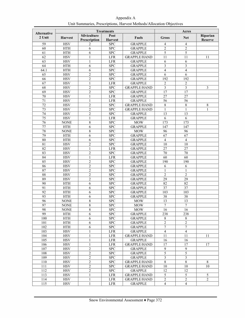
Appendix A Unit Summaries, Prescriptions, Harvest Methods/Allocation Objectives
Snow Environmental Assessment ♦ Page 372
Treatments Acres Alternative 2 Unit Harvest Silviculture
Prescription Post
Harvest Fuels Gross Net Riparian Reserve
59 HSV 2 SPC GRAPPLE 4 4 60 HTH 6 SPC GRAPPLE 2 2 61 HTH 6 SPC GRAPPLE 5 5 62 HSV 1 LFR GRAPPLE/HAND 11 11 11 63 HSV 1 LFR GRAPPLE 6 6 64 HTH 6 SPC GRAPPLE 3 3 64.1 HTH 6 SPC GRAPPLE 4 4 65 HSV 2 SPC GRAPPLE 6 6 66 HSV 2 SPC GRAPPLE 192 192 67 HSV 1 LFR GRAPPLE 2 2 68 HSV 2 SPC GRAPPLE/HAND 3 3 3 69 HSV 2 SPC GRAPPLE 17 17 70 HSV 1 LFR GRAPPLE 27 27 71 HSV 1 LFR GRAPPLE 56 56 72 HSV 2 SPC GRAPPLE/HAND 8 8 8 73 HSV 2 SPC GRAPPLE/HAND 1 1 1 74 HSV 2 SPC GRAPPLE 13 13 75 HSV 1 LFR GRAPPLE 6 6 76 NONE 8 SPC MOW 173 173 77 HTH 6 SPC GRAPPLE 147 147 78 NONE 8 SPC MOW 96 96 79 HTH 6 SPC GRAPPLE 67 67 80 HTH 6 SPC GRAPPLE 4 4 81 HSV 2 SPC GRAPPLE 10 10 82 HSV 1 LFR GRAPPLE 27 27 83 HSV 2 SPC GRAPPLE 70 70 84 HSV 1 LFR GRAPPLE 60 60 85 HSV 2 SPC GRAPPLE 190 190 86 HSV 2 SPC GRAPPLE 6 6 87 HSV 2 SPC GRAPPLE 1 1 88 HSV 2 SPC GRAPPLE 2 2 89 HSV 2 SPC GRAPPLE 29 29 90 HTH 6 SPC GRAPPLE 82 82 91 HTH 6 SPC GRAPPLE 37 37 92 HTH 6 SPC GRAPPLE 103 103 93 HTH 6 SPC GRAPPLE 38 38 96 NONE 8 SPC MOW 13 13 97 NONE 8 SPC MOW 7 7 98 NONE 8 SPC MOW 16 16 99 HTH 6 SPC GRAPPLE 238 238 100 HTH 6 SPC GRAPPLE 8 8 101 HTH 6 SPC GRAPPLE 2 2 102 HTH 6 SPC GRAPPLE 7 7 103 HSV 1 LFR GRAPPLE 4 4 104 HSV 1 LFR GRAPPLE/HAND 11 11 11 105 HSV 1 LFR GRAPPLE 16 16 106 HSV 1 LFR GRAPPLE/HAND 17 17 17 107 HSV 2 SPC GRAPPLE 9 9 108 HSV 2 SPC GRAPPLE 5 5 109 HSV 2 SPC GRAPPLE 3 3 110 HSV 2 SPC GRAPPLE/HAND 8 8 8 111 HSV 2 SPC GRAPPLE/HAND 10 10 10 112 HSV 2 SPC GRAPPLE 12 12 113 HSV 1 LFR GRAPPLE/HAND 5 5 5 114 HSV 1 LFR GRAPPLE/HAND 2 2 2 115 HSV 1 LFR GRAPPLE 4 4

Appendix A Unit Summaries, Prescriptions, Harvest Methods/Allocation Objectives
Snow Environmental Assessment ♦ Page 373
Treatments Acres Alternative 2 Unit Harvest Silviculture
Prescription Post
Harvest Fuels Gross Net Riparian Reserve
116 HSV 2 SPC GRAPPLE 59 59 117 HSV 1 LFR GRAPPLE 5 5 118 HSV 1 LFR GRAPPLE/HAND 24 24 24 119 HSV 1 LFR GRAPPLE 85 85 120 HSV 2 SPC GRAPPLE 13 13 121 HSV 2 SPC GRAPPLE 20 20 122 HSV 2 SPC GRAPPLE 3 3 123 HSV 2 SPC GRAPPLE 5 5 124 HSV 2 SPC GRAPPLE 37 37 125 HSV 1 LFR GRAPPLE 9 9 126 HSV 1 LFR GRAPPLE 122 122 127 HSV 2 SPC GRAPPLE/HAND 5 5 1 128 HSV 1 LFR GRAPPLE/HAND 8 8 8 129 HSV 1 LFR GRAPPLE/HAND 18 18 18 130 HSV 1 LFR GRAPPLE 74 74 131 HSV 2 SPC GRAPPLE 160 160 132 HSV 1 LFR GRAPPLE/HAND 20 20 20 133 HSV 1 LFR GRAPPLE/HAND 4 4 4 134 HSV 2 SPC GRAPPLE 109 109 135 HSV 1 LFR GRAPPLE 12 12 136 HSV 2 SPC GRAPPLE 21 21 137 HSV 1 LFR GRAPPLE 8 8 138 HSV 2 SPC GRAPPLE 54 54 139 HSV 1 LFR GRAPPLE 11 11 140 HSV 2 SPC GRAPPLE 117 117 141 HSV 2 SPC GRAPPLE 17 17 142 HSV 1 LFR GRAPPLE 28 28 143 HSV 1 LFR GRAPPLE/HAND 16 16 16 144 HSV 2 SPC GRAPPLE/HAND 3 3 3 145 HSV 1 LFR GRAPPLE 52 52 146 HSV 2 SPC GRAPPLE 6 6 148 HSV 1 LFR GRAPPLE/MOW 10 10 149 HTH 4 SPC GRAPPLE 52 52 150 HTH 4 SPC GRAPPLE/HAND 1 1 1 151 HTH 4 SPC GRAPPLE 45 45 152 HTH 4 SPC GRAPPLE 9 9 153 HTH 4 SPC GRAPPLE/HAND 4 4 4 154 HTH 4 SPC GRAPPLE/HAND 4 4 4 155 HTH 4 SPC GRAPPLE 19 19 156 HSV 2 SPC GRAPPLE 11 11 157 HSV 2 SPC GRAPPLE 13 13 158 HSV 1 LFR GRAPPLE 6 6 159 HSV 2 SPC GRAPPLE 6 6 160 HSV 1 LFR GRAPPLE/HAND 30 30 30 161 HSV 1 LFR GRAPPLE 39 39 162 HSV 2 SPC GRAPPLE/HAND 1 1 1 163 HSV 1 LFR GRAPPLE/HAND 17 17 17 164 HSV 1 LFR GRAPPLE 4 4 165 HSV 1 LFR GRAPPLE 4 4 166 HSV 1 LFR GRAPPLE 36 36 167 HSV 2 SPC GRAPPLE 60 60 168 HSV 1 LFR GRAPPLE 28 28 169 HSV 1 LFR GRAPPLE 6 6 170 HSV 2 SPC GRAPPLE 66 66 171 HSV 1 LFR GRAPPLE 19 19 172 HSV 2 SPC GRAPPLE 20 20

Appendix A Unit Summaries, Prescriptions, Harvest Methods/Allocation Objectives
Snow Environmental Assessment ♦ Page 374
Treatments Acres Alternative 2 Unit Harvest Silviculture
Prescription Post
Harvest Fuels Gross Net Riparian Reserve
173 HSV 1 LFR GRAPPLE 40 40 174 HSV 2 SPC GRAPPLE 7 7 175 HSV 2 SPC GRAPPLE 70 70 176 HSV 2 SPC GRAPPLE/MOW 1 1 177 HSV 2 SPC GRAPPLE/MOW 13 13 178 HSV 2 SPC GRAPPLE 11 11 179 HSV 2 SPC GRAPPLE 8 8 180 HSV 1 LFR GRAPPLE/MOW 15 15 181 HSV 1 LFR GRAPPLE 183 183 182 HSV 1 LFR GRAPPLE 9 9 183 HSV 2 SPC GRAPPLE 57 57 184 HSV 2 SPC GRAPPLE/MOW 26 26 185 HSV 2 SPC GRAPPLE 34 34 186 HSV 2 SPC GRAPPLE 2 2 187 HSV 2 SPC GRAPPLE 48 48 188 HSV 2 SPC GRAPPLE 6 6 189 HSV 2 SPC GRAPPLE 33 33 190 HSV 2 SPC GRAPPLE 6 6 191 HSV 2 SPC GRAPPLE/MOW 15 15 192 HSV 2 SPC GRAPPLE 147 147 193 HSV 2 SPC GRAPPLE/MOW 48 48 194 HSV 2 SPC GRAPPLE/MOW 15 15 195 HSV 1 LFR GRAPPLE 8 8 196 HSV 2 SPC GRAPPLE/MOW 28 28 197 HSV 2 SPC GRAPPLE/MOW 10 10 198 HTH 5 SPC GRAPPLE/HAND 3 3 3 199 HTH 5 SPC GRAPPLE 13 13 200 HTH 5 SPC GRAPPLE 3 3 201 HTH 5 SPC GRAPPLE/HAND 1 1 1 202 HTH 5 SPC GRAPPLE 40 40 203 HTH 6 SPC GRAPPLE 44 44 204 HTH 6 SPC GRAPPLE/HAND 3 3 3 205 HTH 6 SPC GRAPPLE 8 8 206 HSV 1 LFR GRAPPLE 25 25 207 HSV 1 LFR GRAPPLE 33 33 Total ----- ----- ----- ----- 5,790 5,790 266
ALTERNATIVE 3 – UNIT SUMMARIES
Table 88: Appendix A - Alternative 3 - Unit Summarries Treatments Acres Alternative
3 Unit Harvest Silviculture Prescription
Post Harvest Fuels Gross Net Riparian
Reserve 1 HTH 7 SPC HAND 8 8 1 2 HAZ_LFR 3 LFR HAND 3 3 3 HTH 13 SPC GRAPPLE/HAND 37 37 11 4 HTH 13 SPC GRAPPLE/HAND 43 43 1 5 HTH 13 SPC GRAPPLE/HAND 29 29 1 6 HTH 13 SPC GRAPPLE 114 114 7 HTH 13 SPC GRAPPLE 27 27 8 HTH 6 SPC GRAPPLE 5 5 9 HTH 6 SPC GRAPPLE 2 2 10 HTH 13 SPC GRAPPLE 2 2 11 HTH 13 SPC GRAPPLE 63 63

Appendix A Unit Summaries, Prescriptions, Harvest Methods/Allocation Objectives
Snow Environmental Assessment ♦ Page 375
Treatments Acres Alternative 3 Unit Harvest Silviculture
Prescription Post
Harvest Fuels Gross Net Riparian Reserve
12 HTH 13 SPC GRAPPLE 66 66 13 HTH 13 SPC GRAPPLE 30 30 14 HTH 13 SPC GRAPPLE 11 11 15 HTH 13 SPC GRAPPLE 34 34 16 HTH 13 SPC GRAPPLE 45 45 17 HTH 13 SPC GRAPPLE 66 66 18 HCR 10 WHIP FELL GRAPPLE 20 18 19 HCR 10 WHIP FELL GRAPPLE 3 3 20 HCR 10 WHIP FELL GRAPPLE 16 14 21 HCR 10 WHIP FELL GRAPPLE 19 17 22 HOR 12 SPC GRAPPLE 10 9 23 HOR 12 SPC GRAPPLE 6 5 29 HOR 12 SPC GRAPPLE 21 19 30 HSH 11 WHIP FELL GRAPPLE 19 17 31 HSH 11 WHIP FELL GRAPPLE 13 12 31.1 HTH 6 SPC GRAPPLE 11 11 31.2 HSH 11 WHIP FELL GRAPPLE 20 18 31.3 HSH 11 WHIP FELL GRAPPLE 11 10 32 HSH 11 WHIP FELL GRAPPLE 40 36 33 HSH 11 WHIP FELL GRAPPLE 45 40 33.1 HSH 11 WHIP FELL GRAPPLE 64 58 33.2 HTH 6 SPC GRAPPLE 42 42 34 HSH 11 WHIP FELL GRAPPLE 14 13 36 HTH 6 SPC GRAPPLE 24 24 37 HFR 12 SPC GRAPPLE 22 20 38 HOR 12 SPC GRAPPLE 12 11 39 HOR 12 SPC GRAPPLE 13 12 40 HCR 10 WHIP FELL GRAPPLE 6 5 41 HFR 12 SPC GRAPPLE 11 10 42 HTH 6 SPC GRAPPLE 5 5 43 HOR 12 SPC GRAPPLE 12 12 44 HOR 12 SPC GRAPPLE 58 52 45 HTH 13 SPC GRAPPLE 7 7 48 HTH 13 SPC GRAPPLE 21 21 49 HSV 1 LFR GRAPPLE/HAND 13 13 13 53 HOR 12 SPC GRAPPLE 5 4 54 HSV 1 LFR GRAPPLE/HAND 9 9 9 56 HTH 6 SPC GRAPPLE 30 30 57 HTH 6 SPC GRAPPLE 13 13 58 HCR 10 WHIP FELL GRAPPLE 26 23 59 HCR 10 WHIP FELL GRAPPLE 4 4 61 HTH 6 SPC GRAPPLE 5 5 62 HSV 1 LFR GRAPPLE/HAND 11 11 11 63 HSV 1 LFR GRAPPLE 6 6 64 HTH 6 SPC GRAPPLE 3 3 64.1 HTH 6 SPC GRAPPLE 4 4 65 HOR 12 SPC GRAPPLE 6 5 66 HTH 13 SPC GRAPPLE 192 192 67 HTH 13 SPC GRAPPLE 2 2 69.1 HTH 13 SPC GRAPPLE 4 4 70 HCR 10 WHIP FELL GRAPPLE 27 24 71 HCR 10 WHIP FELL GRAPPLE 56 50 72 HSV 1 LFR GRAPPLE/HAND 8 8 8 74 HTH 13 SPC GRAPPLE 13 13 75 HCR 10 WHIP FELL GRAPPLE 6 5 76 NONE 8 SPC MOW 173 173

Appendix A Unit Summaries, Prescriptions, Harvest Methods/Allocation Objectives
Snow Environmental Assessment ♦ Page 376
Treatments Acres Alternative 3 Unit Harvest Silviculture
Prescription Post
Harvest Fuels Gross Net Riparian Reserve
77 HTH 6 SPC GRAPPLE 147 147 78 NONE 8 SPC MOW 96 96 79 HTH 6 SPC GRAPPLE 67 67 80 HTH 6 SPC GRAPPLE 4 4 81 HCR 10 WHIP FELL GRAPPLE 10 9 82 HCR 10 WHIP FELL GRAPPLE 27 24 83 HTH 13 SPC GRAPPLE 70 70 84 HCR 10 WHIP FELL GRAPPLE 60 54 85 HTH 13 SPC GRAPPLE 190 190 86 HTH 13 SPC GRAPPLE 6 6 87 HFR 12 SPC GRAPPLE 1 1 88 HFR 12 SPC GRAPPLE 2 2 89 HTH 13 SPC GRAPPLE 28 28 90 HTH 6 SPC GRAPPLE 82 82 91 HTH 6 SPC GRAPPLE 37 37 92 HTH 6 SPC GRAPPLE 103 103 93 HFR 12 SPC GRAPPLE 38 34 96 NONE 8 SPC MOW 13 13 97 NONE 8 SPC MOW 7 7 98 NONE 8 SPC MOW 16 16 99 HTH 6 SPC GRAPPLE 238 238 100 HTH 6 SPC GRAPPLE 8 8 101 HTH 6 SPC GRAPPLE 2 2 102 HTH 6 SPC GRAPPLE 7 7 103 HSV 1 LFR GRAPPLE 4 4 104 HSV 1 LFR GRAPPLE/HAND 11 11 11 105 HOR 12 SPC GRAPPLE 16 14 106 HSV 1 LFR GRAPPLE/HAND 17 17 17 107 HOR 12 SPC GRAPPLE 9 8 108 HTH 13 SPC GRAPPLE 5 5 109 HSV 2 SPC GRAPPLE 3 3 110 HSV 1 LFR GRAPPLE/HAND 8 8 8 111 HSV 1 LFR GRAPPLE/HAND 8 8 8 112 HSV 2 SPC GRAPPLE 8 8 112.1 HSV 2 SPC GRAPPLE 2 2 113 HTH 4 SPC GRAPPLE/HAND 5 5 5 114 HTH 4 SPC GRAPPLE/HAND 2 2 2 115 HTH 4 SPC GRAPPLE 4 4 116 HTH 13 SPC GRAPPLE 59 59 117 HCR 10 WHIP FELL GRAPPLE 5 4 118 HSV 1 LFR GRAPPLE/HAND 24 24 24 119 HTH 13 SPC GRAPPLE 18 18 119.1 HOR 12 SPC GRAPPLE 51 46 119.2 HTH 13 SPC GRAPPLE 16 16 120 HTH 13 SPC GRAPPLE 13 13 121 HTH 13 SPC GRAPPLE 20 20 122 HFR 12 SPC GRAPPLE 3 3 123 HFR 12 SPC GRAPPLE 5 4 124 HOR 12 SPC GRAPPLE 37 33 125 HTH 13 SPC GRAPPLE 9 9 126 HTH 13 SPC GRAPPLE 95 95 126.3 HOR 12 SPC GRAPPLE 27 24 127 HFR 12 SPC GRAPPLE 5 4 127.1 HFR_RR 12 SPC GRAPPLE/HAND 1 1 1 128 HSV 1 LFR GRAPPLE/HAND 8 8 8 129 HSV 1 LFR GRAPPLE/HAND 17 17 17

Appendix A Unit Summaries, Prescriptions, Harvest Methods/Allocation Objectives
Snow Environmental Assessment ♦ Page 377
Treatments Acres Alternative 3 Unit Harvest Silviculture
Prescription Post
Harvest Fuels Gross Net Riparian Reserve
130 HOR 12 SPC GRAPPLE 74 67 131 HOR 12 SPC GRAPPLE 160 144 132 HSV 1 LFR GRAPPLE/HAND 20 20 20 133 HSV 1 LFR GRAPPLE/HAND 4 4 4 134 HOR 12 SPC GRAPPLE 48 43 134.1 HOR 12 SPC GRAPPLE 61 55 135 HCR 10 WHIP FELL GRAPPLE 12 11 136 HFR 12 SPC GRAPPLE 21 19 137 HCR 10 WHIP FELL GRAPPLE 8 7 138 HOR 12 SPC GRAPPLE 54 49 139 HCR 10 WHIP FELL GRAPPLE 11 10 140 HOR 12 SPC GRAPPLE 34 31 140.1 HOR 12 SPC GRAPPLE 39 35 140.2 HTH 13 SPC GRAPPLE 45 45 141 HTH 13 SPC GRAPPLE 17 17 142 HOR 12 SPC GRAPPLE 28 25 143 HSV 1 LFR GRAPPLE/HAND 16 16 16 144 HSV 1 LFR GRAPPLE/HAND 3 3 3 145 HTH 13 SPC GRAPPLE 40 40 145.1 HTH 4 SPC GRAPPLE 12 12 146 HSV 2 SPC GRAPPLE 6 6 148 HTH 4 SPC GRAPPLE/MOW 10 10 149 HTH 4 SPC GRAPPLE 44 44 150 HTH 4 SPC GRAPPLE/HAND 1 1 1 151 HTH 4 SPC GRAPPLE 46 46 152 HTH 4 SPC GRAPPLE 9 9 153.1 HTH 4 SPC GRAPPLE/HAND 1 1 1 153.2 HTH 4 SPC GRAPPLE/HAND 4 4 4 154 HTH 4 SPC GRAPPLE/HAND 4 4 4 155 HTH 4 SPC GRAPPLE 19 19 156 HTH 13 SPC GRAPPLE 11 11 157 HTH 13 SPC GRAPPLE 13 13 158 HTH 4 SPC GRAPPLE 6 6 159 HTH 5 SPC GRAPPLE 6 6 160 HSV 1 LFR GRAPPLE/HAND 31 31 31 161 HOR 12 SPC GRAPPLE 39 35 170 HTH 13 SPC GRAPPLE 66 66 172 HOR 12 SPC GRAPPLE 3 3 173 HOR 12 SPC GRAPPLE 40 36 174 HOR 12 SPC GRAPPLE 7 6 175 HTH 13 SPC GRAPPLE 70 70 176 HOR 12 SPC GRAPPLE/MOW 1 1 177 HOR 12 SPC GRAPPLE/MOW 13 12 178 HFR 12 SPC GRAPPLE 11 10 179 HTH 13 SPC GRAPPLE 8 8 180 HCR 10 WHIP FELL GRAPPLE/MOW 21 19 181 HOR 12 SPC GRAPPLE 82 74 181.1 HCR 10 WHIP FELL GRAPPLE 101 91 182 HOR 12 SPC GRAPPLE 5 5 183 HOR 12 SPC GRAPPLE 57 54 184 HTH 13 SPC GRAPPLE/MOW 26 26 185 HTH 13 SPC GRAPPLE 34 34 186 HTH 13 SPC GRAPPLE 2 2 187 HTH 13 SPC GRAPPLE 48 48 188 HTH 13 SPC GRAPPLE 6 6 189 HTH 13 SPC GRAPPLE 33 33

Appendix A Unit Summaries, Prescriptions, Harvest Methods/Allocation Objectives
Snow Environmental Assessment ♦ Page 378
Treatments Acres Alternative 3 Unit Harvest Silviculture
Prescription Post
Harvest Fuels Gross Net Riparian Reserve
190 HTH 13 SPC GRAPPLE 6 6 191 HTH 13 SPC GRAPPLE/MOW 15 15 192 HTH 13 SPC GRAPPLE 147 147 193 HTH 13 SPC GRAPPLE/MOW 48 48 194 HTH 13 SPC GRAPPLE/MOW 15 15 195 HTH 13 SPC GRAPPLE 8 8 196 HTH 13 SPC GRAPPLE/MOW 28 28 197 HTH 13 SPC GRAPPLE/MOW 10 10 198 HTH 5 SPC GRAPPLE/HAND 3 3 3 199 HTH 5 SPC GRAPPLE 13 13 200 HTH 5 SPC GRAPPLE 3 3 201 HTH 5 SPC GRAPPLE/HAND 1 1 1 202 HTH 5 SPC GRAPPLE 40 40 203 HTH 6 SPC GRAPPLE 44 44 204 HSV 1 LFR GRAPPLE/HAND 3 3 3 205 HTH 6 SPC GRAPPLE 8 8 206 HTH 13 SPC GRAPPLE 25 25 207 HTH 13 SPC GRAPPLE 33 33 300 HOR 12 SPC GRAPPLE 241 238 300.3 HFR 12 SPC GRAPPLE 25 22 301 HSV 1 LFR GRAPPLE/HAND 24 24 24 302 HSV 1 LFR GRAPPLE/HAND 40 40 40 303 HSV 1 LFR GRAPPLE 41 41 304 HFR 12 SPC GRAPPLE 13 12 305 HTH 13 SPC GRAPPLE 58 58 305.1 HTH 13 SPC GRAPPLE 13 13 305.2 HFR 12 SPC GRAPPLE 9 8 305.3 HFR 12 SPC GRAPPLE 1 1 305.4 HFR 12 SPC GRAPPLE 2 2 305.8 HTH 13 SPC GRAPPLE 10 10 306 HSV 1 LFR GRAPPLE/HAND 11 11 10 309 HTH 4 SPC GRAPPLE 63 63 309.1 HTH 4 SPC GRAPPLE 3 3 3 310 HTH 4 SPC GRAPPLE 2 2 2 310.1 HTH 4 SPC GRAPPLE 24 24 310.2 HTH 5 SPC GRAPPLE 12 12 311 HSV 1 LFR GRAPPLE/HAND 3 3 3 312 HFR 12 SPC GRAPPLE/MOW 8 7 313 HTH 13 SPC GRAPPLE/MOW 17 17 313.1 HFR 12 SPC GRAPPLE/MOW 2 2 314 HFR 12 SPC GRAPPLE 4 4 317 HSV 1 LFR GRAPPLE/HAND 8 8 8 318 HSV 1 LFR GRAPPLE/HAND 3 3 319 HOR 12 SPC GRAPPLE 5 4 319.1 HOR 12 SPC GRAPPLE/HAND 3 3 3 320 HSV 1 LFR GRAPPLE 4 4 321 HFR 12 SPC GRAPPLE 18 16 322 HFR 12 SPC GRAPPLE 28 25 325 HOR 12 SPC GRAPPLE 3 3 326 HTH 4 SPC GRAPPLE 2 2 327 HTH 4 SPC GRAPPLE/HAND 7 7 7 328 HOR 12 SPC GRAPPLE/HAND 4 4 4 329 HOR 12 SPC GRAPPLE 1 1
TOTAL ----- ----- ----- ----- 6,293 6,099 351
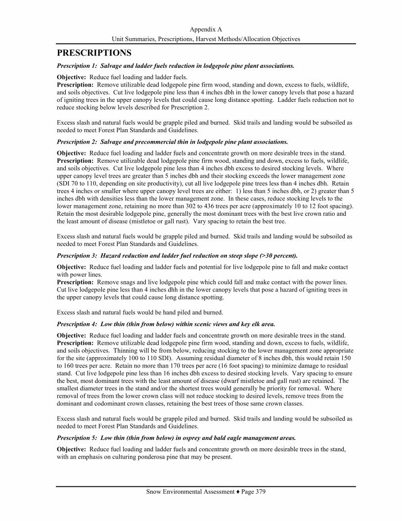
Appendix A Unit Summaries, Prescriptions, Harvest Methods/Allocation Objectives
Snow Environmental Assessment ♦ Page 379
PRESCRIPTIONS Prescription 1: Salvage and ladder fuels reduction in lodgepole pine plant associations.
Objective: Reduce fuel loading and ladder fuels. Prescription: Remove utilizable dead lodgepole pine firm wood, standing and down, excess to fuels, wildlife, and soils objectives. Cut live lodgepole pine less than 4 inches dbh in the lower canopy levels that pose a hazard of igniting trees in the upper canopy levels that could cause long distance spotting. Ladder fuels reduction not to reduce stocking below levels described for Prescription 2. Excess slash and natural fuels would be grapple piled and burned. Skid trails and landing would be subsoiled as needed to meet Forest Plan Standards and Guidelines.
Prescription 2: Salvage and precommercial thin in lodgepole pine plant associations.
Objective: Reduce fuel loading and ladder fuels and concentrate growth on more desirable trees in the stand. Prescription: Remove utilizable dead lodgepole pine firm wood, standing and down, excess to fuels, wildlife, and soils objectives. Cut live lodgepole pine less than 4 inches dbh excess to desired stocking levels. Where upper canopy level trees are greater than 5 inches dbh and their stocking exceeds the lower management zone (SDI 70 to 110, depending on site productivity), cut all live lodgepole pine trees less than 4 inches dbh. Retain trees 4 inches or smaller where upper canopy level trees are either: 1) less than 5 inches dbh, or 2) greater than 5 inches dbh with densities less than the lower management zone. In these cases, reduce stocking levels to the lower management zone, retaining no more than 302 to 436 trees per acre (approximately 10 to 12 foot spacing). Retain the most desirable lodgepole pine, generally the most dominant trees with the best live crown ratio and the least amount of disease (mistletoe or gall rust). Vary spacing to retain the best tree. Excess slash and natural fuels would be grapple piled and burned. Skid trails and landing would be subsoiled as needed to meet Forest Plan Standards and Guidelines.
Prescription 3: Hazard reduction and ladder fuel reduction on steep slope (>30 percent).
Objective: Reduce fuel loading and ladder fuels and potential for live lodgepole pine to fall and make contact with power lines. Prescription: Remove snags and live lodgepole pine which could fall and make contact with the power lines. Cut live lodgepole pine less than 4 inches dhh in the lower canopy levels that pose a hazard of igniting trees in the upper canopy levels that could cause long distance spotting. Excess slash and natural fuels would be hand piled and burned.
Prescription 4: Low thin (thin from below) within scenic views and key elk area.
Objective: Reduce fuel loading and ladder fuels and concentrate growth on more desirable trees in the stand. Prescription: Remove utilizable dead lodgepole pine firm wood, standing and down, excess to fuels, wildlife, and soils objectives. Thinning will be from below, reducing stocking to the lower management zone appropriate for the site (approximately 100 to 110 SDI). Assuming residual diameter of 8 inches dbh, this would retain 150 to 160 trees per acre. Retain no more than 170 trees per acre (16 foot spacing) to minimize damage to residual stand. Cut live lodgepole pine less than 16 inches dbh excess to desired stocking levels. Vary spacing to ensure the best, most dominant trees with the least amount of disease (dwarf mistletoe and gall rust) are retained. The smallest diameter trees in the stand and/or the shortest trees would generally be priority for removal. Where removal of trees from the lower crown class will not reduce stocking to desired levels, remove trees from the dominant and codominant crown classes, retaining the best trees of those same crown classes. Excess slash and natural fuels would be grapple piled and burned. Skid trails and landing would be subsoiled as needed to meet Forest Plan Standards and Guidelines.
Prescription 5: Low thin (thin from below) in osprey and bald eagle management areas.
Objective: Reduce fuel loading and ladder fuels and concentrate growth on more desirable trees in the stand, with an emphasis on culturing ponderosa pine that may be present.

Appendix A Unit Summaries, Prescriptions, Harvest Methods/Allocation Objectives
Snow Environmental Assessment ♦ Page 380
Prescription: Remove utilizable dead lodgepole pine firm wood, standing and down, excess to fuels, wildlife, and soils objectives. Reduce lodgepole pine stocking around manageable ponderosa pine to approximately 60 square feet of basal area per acre. Thinning will be from below, reducing stocking to the lower management zone appropriate for the site (approximately 100 to 110 SDI). Assuming residual diameter of 8 inches dbh, this would retain 150 to 160 trees per acre. Retain no more than 170 trees per acre (16 foot spacing) to minimize damage to residual stand. Cut live lodgepole pine less than 16 inches dbh excess to desired stocking levels. Vary spacing to ensure the best, most dominant trees with the least amount of disease (dwarf mistletoe and gall rust) are retained. The smallest diameter trees in the stand and/or the shortest trees would generally be priority for removal. Where removal of trees from the lower crown class will not reduce stocking to desired levels, remove trees from the dominant and codominant crown classes, retaining the best trees of those same crown classes. Excess slash and natural fuels would be grapple piled and burned. Skid trails and landing would be subsoiled as needed to meet Forest Plan Standards and Guidelines.
Prescription 6: Variable density thin in mixed conifer and ponderosa plant associations.
Objective: 1) Reduce fuel loading and ladder fuels, 2) reduce crown bulk density to below the critical bulk density (0.074 to 0.125 kg m3) associated with independent crown fire at low to moderate rates of spread (Agee 1996), 3) concentrate growth on manageable ponderosa pine or Douglas fir that may be present, and 4) in ponderosa pine plant associations, reduce risk of mountain pine beetle outbreak. Prescription: Remove utilizable dead lodgepole pine firm wood, standing and down, excess to fuels, wildlife, and soils objectives. Remove live trees excess to stocking needs. No thinning diameter limits are proposed. Priority for live tree removal is lodgepole pine or immature white/grand fir, in any canopy level, competing with manageable ponderosa pine or Douglas fir. Remove lodgepole pine (no limitations) or immature white/grand fir within approximately 25 feet of manageable ponderosa pine or Douglas fir. Manageable ponderosa pine or Douglas fir: Consider ponderosa pine or Douglas fir to be manageable if trees have potential for future growth. Characteristics of manageable trees include: 1) heights of at least 4.5 feet, 2) live crown ratios greater than or equal to 30 percent, and 3) height to diameter ratios such that there’s a good likelihood trees will not bend over when upper canopy level removed. Immature white/grand fir: Trees established during the last 100 years, a time period during which fire suppression has altered historic fire regimes. Trees identified by the following characteristics: 1) live or dead branches within 10 to 15 feet of the ground and 2) heights generally less than 80 to 100 feet (Simpson 2007).
If stocking around ponderosa pine or Douglas fir remains above the upper stocking level, thin from below to reduce stocking to lower stocking level. Favor ponderosa pine and Douglas fir for retention over lodgepole pine or true fir. Remove ponderosa pine or Douglas fir if needed to meet stocking level objective. Acceptable to retain ponderosa pine or Douglas fir at upper management levels where middle to upper canopy levels are dominated by mature trees (greater than 100 years old). Where stocking is composed of only lodgepole pine and/or true fir and stocking is above the upper stocking level, remove lodgepole pine and true fir in the lower and middle canopy layers that provide ladders for fire to move into the upper canopy layers. Thin from below, reducing stocking to the lower stocking level . Acceptable to retain higher stocking of true fir (Table C-5) where middle to upper canopy levels are dominated by mature trees (greater than 100 years old). Where pine (ponderosa and lodgepole) and fir (Douglas fir and white/grand fir) would be retained following thinning, select the stocking-level recommendations associated with the pine species. The pine species have the most restrictive (lowest) stocking requirements. When thinning from below, vary spacing to ensure the best, most dominant trees with the least amount of disease (i.e. dwarf mistletoe) are retained. Generally favor manageable ponderosa pine for retention followed by Douglas fir, lodgepole pine and white fir (listed in order of preference). Clumping of trees (3 to 5 trees per clump) is preferred if more than 170 trees per acre needed to meet desired stocking levels. Clumps or individual trees should be at least 16 feet apart to minimize damage during harvest. The smallest diameter trees and/or the
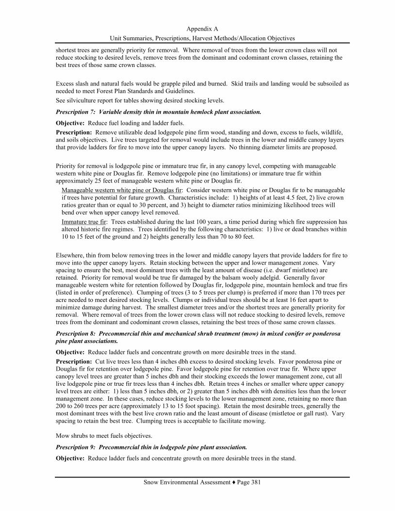
Appendix A Unit Summaries, Prescriptions, Harvest Methods/Allocation Objectives
Snow Environmental Assessment ♦ Page 381
shortest trees are generally priority for removal. Where removal of trees from the lower crown class will not reduce stocking to desired levels, remove trees from the dominant and codominant crown classes, retaining the best trees of those same crown classes. Excess slash and natural fuels would be grapple piled and burned. Skid trails and landing would be subsoiled as needed to meet Forest Plan Standards and Guidelines. See silviculture report for tables showing desired stocking levels.
Prescription 7: Variable density thin in mountain hemlock plant association.
Objective: Reduce fuel loading and ladder fuels. Prescription: Remove utilizable dead lodgepole pine firm wood, standing and down, excess to fuels, wildlife, and soils objectives. Live trees targeted for removal would include trees in the lower and middle canopy layers that provide ladders for fire to move into the upper canopy layers. No thinning diameter limits are proposed. Priority for removal is lodgepole pine or immature true fir, in any canopy level, competing with manageable western white pine or Douglas fir. Remove lodgepole pine (no limitations) or immature true fir within approximately 25 feet of manageable western white pine or Douglas fir. Manageable western white pine or Douglas fir: Consider western white pine or Douglas fir to be manageable if trees have potential for future growth. Characteristics include: 1) heights of at least 4.5 feet, 2) live crown ratios greater than or equal to 30 percent, and 3) height to diameter ratios minimizing likelihood trees will bend over when upper canopy level removed. Immature true fir: Trees established during the last 100 years, a time period during which fire suppression has altered historic fire regimes. Trees identified by the following characteristics: 1) live or dead branches within 10 to 15 feet of the ground and 2) heights generally less than 70 to 80 feet.
Elsewhere, thin from below removing trees in the lower and middle canopy layers that provide ladders for fire to move into the upper canopy layers. Retain stocking between the upper and lower management zones. Vary spacing to ensure the best, most dominant trees with the least amount of disease (i.e. dwarf mistletoe) are retained. Priority for removal would be true fir damaged by the balsam wooly adelgid. Generally favor manageable western white for retention followed by Douglas fir, lodgepole pine, mountain hemlock and true firs (listed in order of preference). Clumping of trees (3 to 5 trees per clump) is preferred if more than 170 trees per acre needed to meet desired stocking levels. Clumps or individual trees should be at least 16 feet apart to minimize damage during harvest. The smallest diameter trees and/or the shortest trees are generally priority for removal. Where removal of trees from the lower crown class will not reduce stocking to desired levels, remove trees from the dominant and codominant crown classes, retaining the best trees of those same crown classes.
Prescription 8: Precommercial thin and mechanical shrub treatment (mow) in mixed conifer or ponderosa
pine plant associations.
Objective: Reduce ladder fuels and concentrate growth on more desirable trees in the stand. Prescription: Cut live trees less than 4 inches dbh excess to desired stocking levels. Favor ponderosa pine or Douglas fir for retention over lodgepole pine. Favor lodgepole pine for retention over true fir. Where upper canopy level trees are greater than 5 inches dbh and their stocking exceeds the lower management zone, cut all live lodgepole pine or true fir trees less than 4 inches dbh. Retain trees 4 inches or smaller where upper canopy level trees are either: 1) less than 5 inches dbh, or 2) greater than 5 inches dbh with densities less than the lower management zone. In these cases, reduce stocking levels to the lower management zone, retaining no more than 200 to 260 trees per acre (approximately 13 to 15 foot spacing). Retain the most desirable trees, generally the most dominant trees with the best live crown ratio and the least amount of disease (mistletoe or gall rust). Vary spacing to retain the best tree. Clumping trees is acceptable to facilitate mowing. Mow shrubs to meet fuels objectives.
Prescription 9: Precommercial thin in lodgepole pine plant association.
Objective: Reduce ladder fuels and concentrate growth on more desirable trees in the stand.

Appendix A Unit Summaries, Prescriptions, Harvest Methods/Allocation Objectives
Snow Environmental Assessment ♦ Page 382
Prescription: Cut live lodgepole pine less than 4 inches dbh excess to desired stocking levels. Where upper canopy level trees are greater than 5 inches dbh and their stocking exceeds the lower management zone (SDI 70 to 110, depending on site productivity), cut all live lodgepole pine trees less than 4 inches dbh. Retain trees 4 inches or smaller where upper canopy level trees are either: 1) less than 5 inches dbh, or 2) greater than 5 inches dbh with densities less than the lower management zone. In these cases, reduce stocking levels to the lower management zone, retaining no more than 302 to 436 trees per acre (approximately 10 to 12 foot spacing). Retain the most desirable lodgepole pine, generally the most dominant trees with the best live crown ratio and the least amount of disease (mistletoe or gall rust). Vary spacing to retain the best tree.
Prescription 10: Seed tree regeneration method in lodgepole pine plant associations.
Objective: 1) Reduce fuel loading and ladder fuels and 2) regenerate stands no longer capable of optimum growth. Prescription: Remove live lodgepole pine excess to seed tree needs. Remove dead lodgepole pine firm wood, standing and down, excess to fuels, wildlife, and soils objectives. Retain approximately 17 lodgepole pine per acre (approximately 50 foot spacing) to provide for seed production, to produce a new age class of trees, and to provide dispersed wildlife green tree replacements at 40 percent MPP level (USDA Forest Service 1994). To provide for adequate seed dispersal, seed trees should be relatively evenly distribute across the stand, although retention of small aggregates (< 0.5 acres) of trees is acceptable to provide for future dispersed wildlife trees. Lodgepole pine retained for seed preferably should be: 1) dominant or codominant trees, 2) have a history of cone production, 3) be windfirm, 4) be free of dwarf mistletoe infection, 5) have live crown ratios greater than or equal to 30 percent, and 6) have good form (no forks, crooks, poor branching characteristics, twisted boles or bole cankers). Retain trees of species other than lodgepole pine that may be present within the unit. To provide green tree replacement in aggregates of moderate to larger size (0.5 to 2.5 acres or more), retain 10 percent of treatment area in patches which should include the largest, oldest live trees, decadent or leaning trees, and hard snags occurring in the unit. Patches should be retained indefinitely. Seed trees will provide dispersed structures (individual trees, and possibly smaller clumps less than 0.5 acres). Site preparation for natural regeneration would include the felling of undesirable whips. Excess slash and natural fuels would be grapple piled and burned. Skid trails and landing would be subsoiled as needed to meet Forest Plan Standards and Guidelines. Some or all of the seed trees would be retained after regeneration has become established to contribute towards providing wildlife green tree replacements at the 40 percent of potential population levels (USDA Forest Service 1994).
Prescription 11: Shelterwood regeneration method in lodgepole pine plant associations.
Objective: 1) Reduce fuel loading and ladder fuels and 2) regenerate stands no longer capable of optimum growth. Prescription: Remove dead lodgepole pine firm wood, standing and down, excess to fuels, wildlife, and soils objectives. Remove live lodgepole pine excess to shelterwood needs. Retain approximately 50 lodgepole pine per acre (approximately 30 foot spacing) to produce a new age class of trees and provide canopy cover to help moderate cold temperatures. To provide for adequate seed dispersal, seed trees should be relatively evenly distribute across the stand, although retention of small aggregates (< 0.5 acres) of trees is acceptable to provide for future dispersed wildlife trees. Lodgepole pine retained for seed and shelter preferably should be: 1) dominant or codominant trees, 2) have a history of cone production, 3) be windfirm, 4) be free of dwarf mistletoe infection, 5) have live crown ratios greater than or equal to 30 percent, and 6) have good form (no forks, crooks, poor branching characteristics, twisted boles or bole cankers). Retain trees of species other than lodgepole pine that may be present within the unit. To provide green tree replacement in aggregates of moderate to larger size (0.5 to 2.5 acres or more), retain 10 percent of treatment area in patches which should include the largest, oldest live trees, decadent or leaning trees, and hard snags occurring in the unit. Patches should be retained indefinitely. Trees retained for seed and site amelioration will provide dispersed structures (individual trees, and possibly smaller clumps less than 0.5 acres).

Appendix A Unit Summaries, Prescriptions, Harvest Methods/Allocation Objectives
Snow Environmental Assessment ♦ Page 383
Site preparation for natural regeneration would include the felling of undesirable whips. Excess slash and natural fuels would be grapple piled and burned. Skid trails and landing would be subsoiled as needed to meet Forest Plan Standards and Guidelines. Once regeneration has become established, shelterwood trees excess to wildlife green tree replacement needs would likely be removed. Some would be retained to contribute towards providing wildlife green tree replacements at the 40 percent of potential population levels (USDA Forest Service 1994).
Prescription 12: Overstory removal regeneration method in lodgepole pine plant associations.
Objective: 1) Reduce fuel loading and ladder fuels and 2) regenerate stands no longer capable of optimum growth. Prescription: Remove dead lodgepole pine firm wood, standing and down, excess to fuels, wildlife, and soils objectives. Remove live lodgepole pine overstory trees excess to that needed to provide wildlife green tree replacements at 40 percent of potential population levels (USDA Forest Service 1994). Number of overstory trees to be retained would vary depending on the diameter of the residual understory trees. Assuming average diameters range from 3 to 6 inches dbh, up to 9 to 14 trees per acre greater than 8 to 10 inches dbh would be retained to provide dispersed wildlife green tree replacement habitat. This number could be lower depending on density of overstory trees infected with dwarf mistletoe or those with poor live crown ratios are priority for removal. Retain trees of species other than lodgepole pine that may be present within the unit. To provide green tree replacement in aggregates of moderate to larger size (0.5 to 2.5 acres or more), retain 10 percent of treatment area in patches which should include the largest, oldest live trees, decadent or leaning trees, and hard snags occurring in the unit. Patches should be retained indefinitely. Overstory trees will provide dispersed structures (individual trees, and possibly smaller clumps less than 0.5 acres).
Prescription 13: Variable density thin lodgepole pine plant associations.
Objective: 1) Reduce fuel loading and ladder fuels, 2) concentrate growth on most desirable trees, and 3) reduce risk of mountain pine beetle outbreak. Prescription: Remove utilizable dead lodgepole pine firm wood, standing and down, excess to fuels, wildlife, and soils objectives. Thinning would combine thinning from below with selection thinning. Thinning would generally be limited to lodgepole pine. No thinning diameter limits are proposed. Thin from below, reducing stocking to the lower management zone appropriate for site conditions. The smallest diameter trees and/or the shortest trees in the stand are generally priority for removal. Where removal of trees from the lower crown class would not reduce stocking to desired levels, trees from the dominant and codominant crown classes would be removed to favor the best trees of those same crown classes. Vary spacing to ensure the best, most dominant trees with the least amount of disease (i.e. dwarf mistletoe) are retained. Where density of trees in the upper canopy levels is less than lower management zone and an understory is developing, remove trees from upper canopy levels to favor trees in the lower crown classes. Priority for removal in these cases would be upper canopy level trees infected with dwarf mistletoe or poor live crown ratios. Acceptable to create small openings (less than 5 acres in size on less than 10 percent of the treatment area) where lodgepole pine in the middle to upper canopy levels have relatively small crowns (less than 30 percent), a deteriorating appearance, and/or dwarf mistletoe infection.
COMPARISON OF HARVEST METHODS IN RELATION TO ALLOCATION OBJECTIVES The following table compares the relative degree to which harvest methods proposed with Alternatives 2 and 3 would meet the goals, objectives, and requirements of the Deschutes LRMP as amended by the Northwest Forest Plan. This comparison includes direction considered to best articulate stand management objectives that could be met with timber harvest. Forest wide direction is listed first and is followed by the Northwest Forest Plan Aquatic Conservation Strategy (ACS) objectives. ACS objectives have been grouped into those that apply at the watershed scale and those specific to the riparian areas. Treatments are then compared as to how they meet

Appendix A Unit Summaries, Prescriptions, Harvest Methods/Allocation Objectives
Snow Environmental Assessment ♦ Page 384
objectives associated with the following management areas: matrix, eagle, osprey, general forest, scenic views, and administratively withdrawn areas, including intensive recreation and old growth. Objectives for some management areas have been further grouped by lodgepole pine (LP) or mixed conifer (MC). Rankings of harvest methods are as follows: Yes: Treatment meets objectives: Where treatments differ in degree to which an objective would be met, pluses identify those better (+) or best (++) meeting objective. No: Treatment does not meet objectives. NA: Objective not applicable where treatment proposed due to vegetation or stand condition.
Table 89: Appendix A - Comparison of Harvest Methods in Relation to Allocation Objectives
Intermediate Harvest Methods Even-aged
Regeneration Harvest Methods for Lodgepole pine stands Objectives or Standards and Guidelines
Salvage Low Thin Variable Density Thin
Seed Tree Shelterwood Overstory
Removal Forest Health (Forest Wide) The goal is to maintain and enhance the vigor of the forest ecosystem through the control of forest pests. • Management strategies should emphasize prevention of pest problems rather than suppression (S&G FH-3).
No
Yes+
LP, Yes+ MC, Yes
Yes+
Yes+
Yes+
Timber Management (Forest Wide) The goal is to manage the timber resources of the Forest in a way that is consistent with other resource objectives, environmental constraints, and economic efficiency. • The silvicultural prescription will consider integrated pest management. Pests include insects, diseases, animals, and vegetation. Where conditions are such that unacceptable damage or reduction in tree growth can be predicted, protection measures may be warranted prior to the actual damage occurring. (S&G TM-10)
No
Yes
Yes
Yes
Yes
Yes
Aquatic Conservation Strategy Watershed Scale • Maintain and restore the distribution, diversity, and complexity of watershed and landscape-scale features (ACS #1).
• Maintain and restore spatial and temporal connectivity within and between watersheds (ACS #2).
Yes Yes
Yes
Yes
Yes+
Yes
Yes++
Yes
Yes++
Yes
Yes++
Yes
Riparian Areas • Maintain and restore the species composition and structural diversity of plant communities in riparian areas to provide adequate summer and winter thermal regulation, and to supply amounts and distributions of coarse woody debris sufficient to sustain physical complexity and stability (ACS #8).
Yes
Yes
Yes
Yes

Appendix A Unit Summaries, Prescriptions, Harvest Methods/Allocation Objectives
Snow Environmental Assessment ♦ Page 385
Intermediate Harvest Methods Even-aged
Regeneration Harvest Methods for Lodgepole pine stands Objectives or Standards and Guidelines
Salvage Low Thin Variable Density Thin
Seed Tree Shelterwood Overstory
Removal • Maintain and restore habitat to support well-distributed populations of native plant, invertebrate, and vertebrate riparian-dependent species (ACS #9).
Yes
Yes
Yes
Yes
Matrix • Produce commercial yields of wood Yes Yes+ Yes+ Yes++ Yes++ Yes++ • Retain moderate levels of ecologically valuable old growth components. o Down/Standing Dead Wood o Large Green Trees.
Yes Yes++
Yes Yes++
Yes Yes++
Yes Yes
Yes Yes+
Yes Yes
• Increase ecological diversity by providing early successional habitat
No No LP, Yes MC, No Yes+ Yes+ Yes
Eagle (MA 3) Mixed conifer or ponderosa pine vegetation types • Maintain forest stands dominated by ponderosa pine and/or Douglas fir (S&G M3-5).
• Provide suitable nesting sites on continuing basis. Provide large overmature trees that are potentially useable as nest sites and perch trees (S&G M3-11). Suitable nest and perch trees should exceed 110 feet in height and be greater than or equal to 40 inches dbh. Preferred trees have an open, flat-topped form of large limbs, and are usually ponderosa pine or Douglas fir (S&G M3-12).
Yes
Yes
Lodgepole Pine Vegetation Type • Keep fuel loading at a level or arrangement that minimizes the chances of large catastrophic fire (S&G M3-34)
Yes Yes Yes
Osprey (MA 5)
• Provide suitable nesting sites on continuing basis. o Maintain a forest with relatively open overstory and fully-stocked understory. Single-aged stands are acceptable in lodgepole pine forest. (S&G M5-9) Note: Only lodgepole pine stands proposed for treatment.
Yes
Yes+
Yes+
Yes+
Yes
• Keep fuel loading at a level or arrangement that minimizes the chances of large catastrophic fire (S&G M5-28)
Yes Yes Yes Yes Yes
General Forest (MA 8)
• Convert unmanaged stands to managed stands. A managed forest has stands in

Appendix A Unit Summaries, Prescriptions, Harvest Methods/Allocation Objectives
Snow Environmental Assessment ♦ Page 386
Intermediate Harvest Methods Even-aged
Regeneration Harvest Methods for Lodgepole pine stands Objectives or Standards and Guidelines
Salvage Low Thin Variable Density Thin
Seed Tree Shelterwood Overstory
Removal a variety of age classes with all stands utilizing the site growth potential. o Control stocking levels. o Protect stands from insects and disease.
o Regenerate stands no longer capable of optimum growth.
Yes No
No
Yes++ Yes
N/A
Yes++ Yes
N/A
Yes+ Yes
Yes
Yes+ Yes
Yes
Yes++ Yes
N/A
• Treat slash to reduce chances of fire starts and reduce rates of spread to acceptable levels (S&G M8-27)
Yes Yes Yes Yes Yes Yes
Scenic Views (MA 9)
• Lodgepole pine foregrounds (SV2) To provide desired visual conditions (S&G M9-51): o Manage healthy, full crowned, young trees rather than older lodgepole pine with relatively small crowns and deteriorating appearance.
o Provide a mosaic of even-aged stands with additional visual diversity provided by occasional groups of other tree and shrub species.
o Create natural appearing openings of varying sizes.
Natural forest debris is controlled (S&G M9-56).
No
No
No
Yes
Yes
Yes
No
Yes
Yes
Yes+
Yes
Yes
Yes
Yes
No
Yes
Yes+
Yes
Yes
Yes
Lodgepole pine middlegrounds (SV4) To provide desired visual conditions, provide a mosaic of relatively uniform textures by maintaining canopy closure and healthy crowns (S&G M9-64).
No
Yes+
Yes
Administratively Withdrawn Intensive Recreation (MA 11)
• Mixed Conifers o Manage stands to perpetuate or enhance the characteristic (or natural) landscape, which normally contains stands that are visually dense, though not necessarily continuous (S&G M11-21).
o Small, natural appearing openings are desirable, and are an important visual element (S&G M11-22).
Yes
No
Yes+
Yes
• Lodgepole Pine o Manage to provide a mosaic of even-aged stands with additional visual diversity provided by occasional groups of other tree and shrub species (S&G M11-24).
No
Yes+
Yes
Yes
Yes

Appendix A Unit Summaries, Prescriptions, Harvest Methods/Allocation Objectives
Snow Environmental Assessment ♦ Page 387
Intermediate Harvest Methods Even-aged
Regeneration Harvest Methods for Lodgepole pine stands Objectives or Standards and Guidelines
Salvage Low Thin Variable Density Thin
Seed Tree Shelterwood Overstory
Removal o Natural-appearing size openings of varying sizes are desirable (S&G M11-24).
o The forest floor should be open and park-like with ground litter, shrubs and grasses providing additional variety (S&G M11-25).
No
Yes
Yes+
Yes
Yes
Yes
Yes
Yes
Yes
Yes
Administratively Withdrawn Old Growth (MA 15)
In lodgepole pine, provide large trees and abundant standing and downed dead trees. Single canopy level is common. • Vegetative manipulation including removal may occur to perpetuate or enhance old growth characteristics. (S&G M15-4)
• Dead, down trees managed to maximize biological diversity (S&G M 15-9)
Note: The one stand proposed for treatment is lodgepole pine.
Yes No

Appendix B – DecAID Analysis Data
Snow Environmental Assessment ♦ Page 388
APPENDIX B
DecAID ANALYSIS DATA

Appendix B – DecAID Analysis Data
Snow Environmental Assessment ♦ Page 389
APPENDIX B DecAID DATA USED FOR ANALYSIS Appendix B, Table 1: Snag densities for wildlife species at 30, 50, 80 percent tolerance level for snags > 10”dbh based on wildlife data in DecAID (Table references included).
Table 90: Appendix B - DecAID Data used for Analysis
1 Current Direction (LRMP & NWFP) is provided by habitat type and densities >10” and >20”. It is not broken down into tolerance levels but rather represents a biological potential which has been determined to be a flawed technique (Rose et al 2001 in Johnson and O’ Neil 2001) Snags >20” were not incorporated because the proposed actions will NOT remove snags of this size. Effects to snag densities and the species that utilize them will be in the 10-19.9” range.
30% Tolerance level (#snags/acre)
50% Tolerance level (#snags/acre)
80% Tolerance level (#snags/acre)
>10”dbh >10”dbh >10”dbh LP_S/L (reference Table LP_S/L.sp-22)
AMMA 12 13 14 Current Direction for LP 1.9-2.4
N/A
PPDF_S/L (reference Table PPDF_S/L.sp-22)
Black-backed woodpecker (BBWO) 2.5 14 29 Cavity-Nesting Birds (CNB) 1 5 10 Pileated Woodpecker (PIWO) 15 30 49 Pygmy Nuthatch (PYNU) 1 6 12 White-headed woodpecker (WHWO)
0.3 2 4
Williamson’s Sapsucker (WISA) 14 28 50 Current Direction for the Ponderosa
Pine1
3.4-4.2
EMC_ECB_S/L (reference Table EMC_ECB_S/L.sp.22)
Black-backed woodpecker (BBWO) 2.5 14 29 Pileated Woodpecker (PIWO) 15 30 49 Pygmy Nuthatch (PYNU) 1 6 12 White-headed woodpecker (WHWO)
0.3 2 4
Williamson’s Sapsucker (WISA) 14 28 50 American Marten (AMMA) 12 13 14 Current Direction for Mixed Conifer 3.5-4.3 MMC_S/L (reference Table MMC_S/L.sp-22)
American Marten (AMMA) 12 13 14 Pacific Fisher (FISH) ? 13 ? Current Direction for Mixed Conifer 3.5-4.3

Appendix B – DecAID Analysis Data
Snow Environmental Assessment ♦ Page 390
Table 91: Appendix B - Downed Log Densities for Wildlife Species at 30, 50, and 80 Percent Tolerance Levels for Logs Based on Wildlife Data in DecAID (Table References Included)
30% Tolerance level (% cover)
50% Tolerance level (% cover)
80% Tolerance level (% cover)
LP_S/L (reference Table LP_S/L.sp-24)
Logs >6” diameter at large end
Black-backed Woodpecker (BBWO)
4.7 13 25
Three-toed Woodpecker (TTWO) 6.5 17 32 Current Direction for LP 0.8-0.9
PPDF_S/L (reference Table PPDF_S/L.sp-24)
Logs >5” diameter at large end
Golden-mantled ground squirrel (GMGS))
0.8 5 5
Current Direction for the Ponderosa
Pine1
0.5
EMC_ECB_S/L (reference Tables EMC_ECB_S.sp.24; EMC_ECB_L.sp.24)
Logs >6” diameter at large end
Black-backed woodpecker (BBWO) 4-5 13 25 Pileated Woodpecker (PIWO) 4 4.5 5-5.1 Three-toed woodpecker (TTWO) 6.5 17 22-32 Current Direction for Mixed Conifer 0.5
MMC_S/L (reference Tables MMC_S.sp-24; MMC_L.sp-24)
Logs >6” diameter at large end
American Marten (AMMA) ? 8 ? Pacific Fisher (FISH) ? 5.6 ? Three-toed Woodpecker 6.5 17 32 Current Direction for Mixed Conifer 0.5

Appendix C – Applicable Laws
Snow Environmental Assessment ♦ Page 391
APPENDIX C
APPLICABLE LAWS
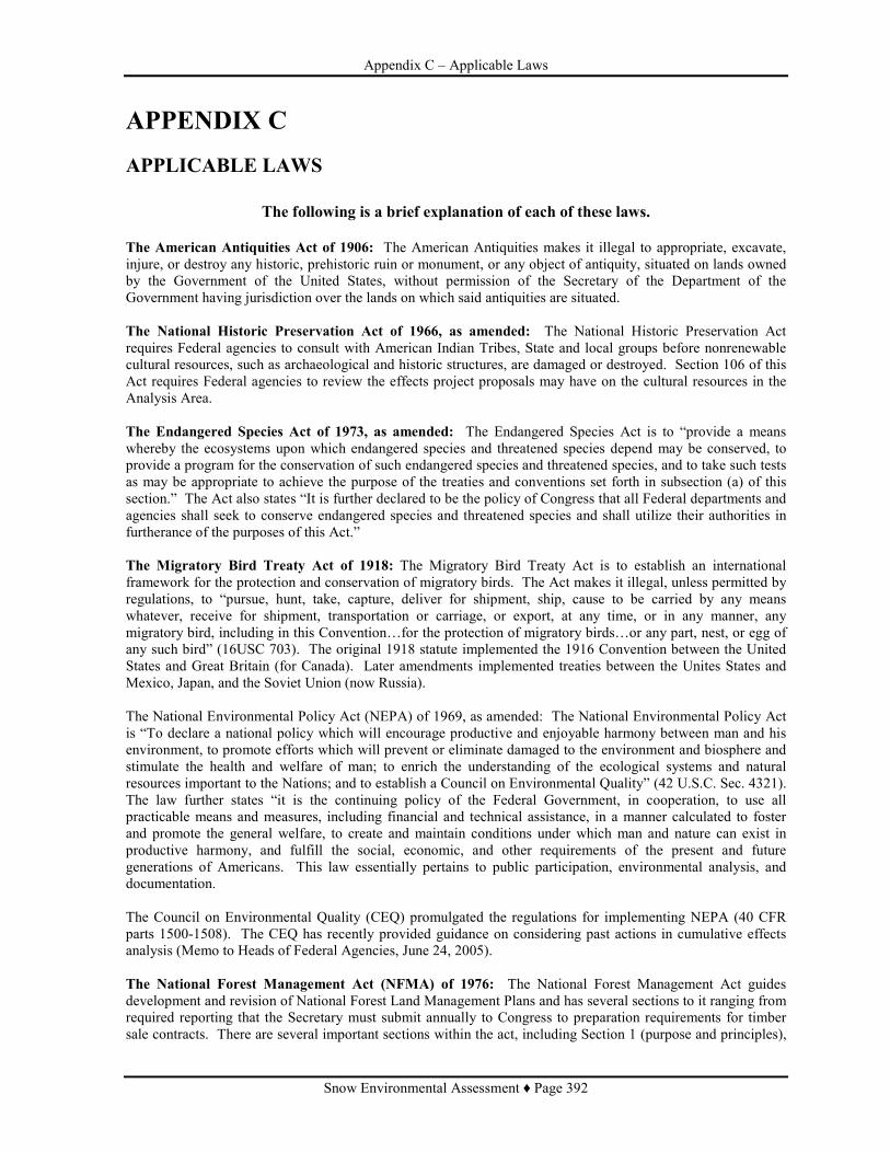
Appendix C – Applicable Laws
Snow Environmental Assessment ♦ Page 392
APPENDIX C APPLICABLE LAWS
The following is a brief explanation of each of these laws.
The American Antiquities Act of 1906: The American Antiquities makes it illegal to appropriate, excavate, injure, or destroy any historic, prehistoric ruin or monument, or any object of antiquity, situated on lands owned by the Government of the United States, without permission of the Secretary of the Department of the Government having jurisdiction over the lands on which said antiquities are situated. The National Historic Preservation Act of 1966, as amended: The National Historic Preservation Act requires Federal agencies to consult with American Indian Tribes, State and local groups before nonrenewable cultural resources, such as archaeological and historic structures, are damaged or destroyed. Section 106 of this Act requires Federal agencies to review the effects project proposals may have on the cultural resources in the Analysis Area. The Endangered Species Act of 1973, as amended: The Endangered Species Act is to “provide a means whereby the ecosystems upon which endangered species and threatened species depend may be conserved, to provide a program for the conservation of such endangered species and threatened species, and to take such tests as may be appropriate to achieve the purpose of the treaties and conventions set forth in subsection (a) of this section.” The Act also states “It is further declared to be the policy of Congress that all Federal departments and agencies shall seek to conserve endangered species and threatened species and shall utilize their authorities in furtherance of the purposes of this Act.” The Migratory Bird Treaty Act of 1918: The Migratory Bird Treaty Act is to establish an international framework for the protection and conservation of migratory birds. The Act makes it illegal, unless permitted by regulations, to “pursue, hunt, take, capture, deliver for shipment, ship, cause to be carried by any means whatever, receive for shipment, transportation or carriage, or export, at any time, or in any manner, any migratory bird, including in this Convention…for the protection of migratory birds…or any part, nest, or egg of any such bird” (16USC 703). The original 1918 statute implemented the 1916 Convention between the United States and Great Britain (for Canada). Later amendments implemented treaties between the Unites States and Mexico, Japan, and the Soviet Union (now Russia). The National Environmental Policy Act (NEPA) of 1969, as amended: The National Environmental Policy Act is “To declare a national policy which will encourage productive and enjoyable harmony between man and his environment, to promote efforts which will prevent or eliminate damaged to the environment and biosphere and stimulate the health and welfare of man; to enrich the understanding of the ecological systems and natural resources important to the Nations; and to establish a Council on Environmental Quality” (42 U.S.C. Sec. 4321). The law further states “it is the continuing policy of the Federal Government, in cooperation, to use all practicable means and measures, including financial and technical assistance, in a manner calculated to foster and promote the general welfare, to create and maintain conditions under which man and nature can exist in productive harmony, and fulfill the social, economic, and other requirements of the present and future generations of Americans. This law essentially pertains to public participation, environmental analysis, and documentation. The Council on Environmental Quality (CEQ) promulgated the regulations for implementing NEPA (40 CFR parts 1500-1508). The CEQ has recently provided guidance on considering past actions in cumulative effects analysis (Memo to Heads of Federal Agencies, June 24, 2005). The National Forest Management Act (NFMA) of 1976: The National Forest Management Act guides development and revision of National Forest Land Management Plans and has several sections to it ranging from required reporting that the Secretary must submit annually to Congress to preparation requirements for timber sale contracts. There are several important sections within the act, including Section 1 (purpose and principles),

Appendix C – Applicable Laws
Snow Environmental Assessment ♦ Page 393
Section 19 (fish and wildlife resources), Section 23 (water and soil resources), and Section 27 (management requirements). The following timber management requirements from the National Forest Management Act are set forth in Forest Service Manual 1900, Chapter 1920, Section 1921.12a (2006). Under 16 U.S.C. 1604(6)(3)(E), a Responsible Official may authorize site-specific projects and activities to harvest timber only where: 1. Soil, slope, or other watershed conditions will not be irreversibly damaged. 2. There is assurance that the lands can be adequately restocked within five years after final regeneration
harvest (FSM 1921.12g). 3. Streams, streambanks, shorelines, lakes, wetlands, and other bodies of water are protected from detrimental
changes in water temperatures, blockages of water courses, and deposits of sediment, where harvests are likely to seriously and adversely affect water conditions or fish habitat.
4. The harvesting system to be used is not selected primarily because it will give the greatest dollar return or the greatest unit output of timber.
A Responsible Official may authorize project and activities using cutting methods, such as clearcutting, seed tree cutting, shelterwood cutting, and other cuts designed to regenerate an even-aged stand of timber, only where: 1) For clearcutting, it is the optimum method; or where seed tree, shelterwood, and other cuts are determined
to be appropriate to meeting the objectives and requirements of the relevant plan (16 USC 1604(g)(3)(F)(i)).
2) The interdisciplinary review has been completed and the potential environmental, biological, aesthetic, engineering, and economic impacts have been assessed on each advertised sale area and the cutting methods are consistent with the multiple use of the general area (16 USC 1604(g)(3)(F)(ii)).
3) Cut blocks, patches, or strips are shaped and blended to the extent practicable with the natural terrain (16 USC 1604(g)(3)(F)(iii)).
4) Cuts are carried out according to the maximum size limit requirements for areas to be cut during one harvest operation (FSM 1921.12e).
5) Timber cuts are carried out in manner consistent with the protection of soil, watershed, fish, wildlife, recreation, esthetic resources, cultural and historic resources, and the regeneration of timber resources.
6) Stands of trees are harvested according to requirements for culmination of mean annual increment of growth (16 U.S.C. 1604(m); FSM1921.12f; FSH 1909.12, ch. 60).
The Clean Water Act, as amended in 1977 and 1982: The primary objective of The Clean Water Act is to restore and maintain the integrity of the Nation’s waters. This objective translates into two fundamental national goals: 1. Eliminate the discharge of pollutants into the nation’s waters; and 2. Achieve clean water quality levels for fishing and swimming. Under Section 303(d) of the Clean Water Act, the State has identified water quality-limited water bodies in Oregon. The Deschutes River and Lava lake are the only water bodies in the project area that are on the 303(d) list. The following executive orders are included within the Clean Water Act: • Executive Order 11988: requires agencies to avoid adverse impacts associated with the occupancy and
modification of floodplains. • Executive Order 11990: requires agencies to avoid adverse impacts associated with the destruction or
modification of wetlands. • Executive Order 12088: requires Federal compliance with pollution control standards (such as the Clean
Water Act). The Clean Air Act, as amended in 1990: The purposes of The Clean Air Act are “to protect and enhance the quality of the Nation’s air resources so as to promote the public health and welfare and the productive capacity of its population; to initiate and accelerate a national research and development program to achieve the prevention and control of air pollution; to provide technical and financial assistance to state and local governments in connection with the development and execution of their air pollution prevention and control programs; and to encourage and assist the development and operation of regional air pollution prevention and control programs.”

Appendix C – Applicable Laws
Snow Environmental Assessment ♦ Page 394
Multiple-Use Sustained-Yield Act of 1960: The Multiple Use – Sustained Yield Act of 1960 requires the Forest Service to manage National Forest System lands for multiple uses (including timber, recreation, fish and wildlife, range, and watershed). All renewable resources are to be managed in such a way that they are available for future generations. The harvesting and use of standing timber can be considered a short-term use of a renewable resource. As a renewable resource, trees can be re-established and grown in again if the productivity of the land is not impaired. Migratory Bird E.O. 13186: On January 10, 2001, President Clinton signed an Executive Order (E.O. 13186) titled “Responsibilities of Federal Agencies to Protect Migratory Birds.” This E.O. requires the “environmental analysis of Federal actions, required by NEPA or other established environmental review processes, evaluates
the effects of actions and agency plans on migratory birds, with emphasis on species of concern.”
Forest Order 12962 (aquatic systems and recreational fisheries): This 1995 order’s purpose is to conserve, restore, and enhance aquatic systems to provide for increased recreational fishing opportunities nationwide. It requires federal agencies to evaluate the effects of federally funded actions on aquatic systems and document those effects relative to the purpose of this order. Executive Order 13112 (invasive species): This 1999 order requires Federal agencies whose actions may affect the status of invasive species to identify those actions and within budgetary limits, “(i) prevent the introduction of invasive species; (ii) detect and respond rapidly to and control populations of such species… (iii) monitor invasive species populations… (iv) provide for restoration of native species and habitat conditions in ecosystems that have been invaded;…(vi) promote public education on invasive species… and (3) not authorize, fund, or carry out actions that it believes are likely to cause or promote the introduction or spread of invasive species… unless, pursuant to guidelines that it has prescribed, the agency had determined and made public… that the benefits of such actions clearly outweigh the potential harm caused by invasive species; and that all feasible and prudent measures to minimize risk of harm will be taken in conjunction with the actions.” 2005 Pacific Northwest Preventing and Managing Invasive Plants Record of Decision: The 2005 Pacific Northwest Preventing and Managing Invasive Plants Record of Decision provides Goals, Objectives, and Management Direction (Standards) for prevention and treatment of invasive plant species on National Forest Lands in Region 6. The Deschutes National Forest Land and Resource Management Plan (LRMP), 1990, as amended by the Northwest Forest Plan (NWFP, on Management of Habitat for Late-Successional and Old-Growth Forest Related Species Within the Range of the Northern Spotted Owl), 1994: Established broad direction for the Forest. The analysis conducted for this project tiers to the LRMP and its supporting documentation. The LRMP establishes goals, objectives, standards, and guidelines for each specific management area of the Forest, as well as Forest-wide standards and guidelines. Management Areas and associated standards and guidelines are described in Chapter 4 of the LRMP.

Appendix D - Soils
Snow Environmental Assessment ♦ Page 395
APPENDIX D
SOILS
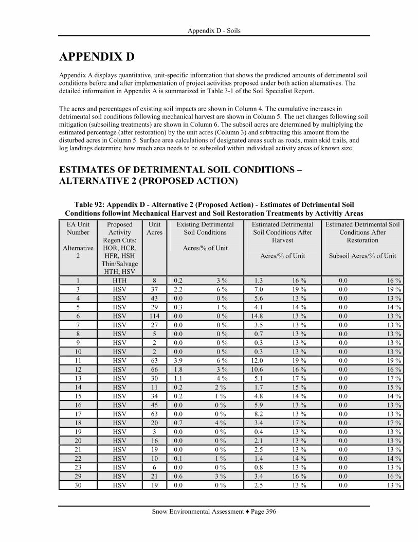
Appendix D - Soils
Snow Environmental Assessment ♦ Page 396
APPENDIX D Appendix A displays quantitative, unit-specific information that shows the predicted amounts of detrimental soil conditions before and after implementation of project activities proposed under both action alternatives. The detailed information in Appendix A is summarized in Table 3-1 of the Soil Specialist Report. The acres and percentages of existing soil impacts are shown in Column 4. The cumulative increases in detrimental soil conditions following mechanical harvest are shown in Column 5. The net changes following soil mitigation (subsoiling treatments) are shown in Column 6. The subsoil acres are determined by multiplying the estimated percentage (after restoration) by the unit acres (Column 3) and subtracting this amount from the disturbed acres in Column 5. Surface area calculations of designated areas such as roads, main skid trails, and log landings determine how much area needs to be subsoiled within individual activity areas of known size.
ESTIMATES OF DETRIMENTAL SOIL CONDITIONS – ALTERNATIVE 2 (PROPOSED ACTION)
Table 92: Appendix D - Alternative 2 (Proposed Action) - Estimates of Detrimental Soil Conditions followint Mechanical Harvest and Soil Restoration Treatments by Activitiy Areas EA Unit Number
Alternative
2
Proposed Activity
Regen Cuts: HOR, HCR, HFR, HSH Thin/Salvage HTH, HSV
Unit Acres
Existing Detrimental Soil Conditions
Acres/% of Unit
Estimated Detrimental Soil Conditions After
Harvest
Acres/% of Unit
Estimated Detrimental Soil Conditions After
Restoration
Subsoil Acres/% of Unit
1 HTH 8 0.2 3 % 1.3 16 % 0.0 16 % 3 HSV 37 2.2 6 % 7.0 19 % 0.0 19 % 4 HSV 43 0.0 0 % 5.6 13 % 0.0 13 % 5 HSV 29 0.3 1 % 4.1 14 % 0.0 14 % 6 HSV 114 0.0 0 % 14.8 13 % 0.0 13 % 7 HSV 27 0.0 0 % 3.5 13 % 0.0 13 % 8 HSV 5 0.0 0 % 0.7 13 % 0.0 13 % 9 HSV 2 0.0 0 % 0.3 13 % 0.0 13 % 10 HSV 2 0.0 0 % 0.3 13 % 0.0 13 % 11 HSV 63 3.9 6 % 12.0 19 % 0.0 19 % 12 HSV 66 1.8 3 % 10.6 16 % 0.0 16 % 13 HSV 30 1.1 4 % 5.1 17 % 0.0 17 % 14 HSV 11 0.2 2 % 1.7 15 % 0.0 15 % 15 HSV 34 0.2 1 % 4.8 14 % 0.0 14 % 16 HSV 45 0.0 0 % 5.9 13 % 0.0 13 % 17 HSV 63 0.0 0 % 8.2 13 % 0.0 13 % 18 HSV 20 0.7 4 % 3.4 17 % 0.0 17 % 19 HSV 3 0.0 0 % 0.4 13 % 0.0 13 % 20 HSV 16 0.0 0 % 2.1 13 % 0.0 13 % 21 HSV 19 0.0 0 % 2.5 13 % 0.0 13 % 22 HSV 10 0.1 1 % 1.4 14 % 0.0 14 % 23 HSV 6 0.0 0 % 0.8 13 % 0.0 13 % 29 HSV 21 0.6 3 % 3.4 16 % 0.0 16 % 30 HSV 19 0.0 0 % 2.5 13 % 0.0 13 %

Appendix D - Soils
Snow Environmental Assessment ♦ Page 397
EA Unit Number
Alternative
2
Proposed Activity
Regen Cuts: HOR, HCR, HFR, HSH Thin/Salvage HTH, HSV
Unit Acres
Existing Detrimental Soil Conditions
Acres/% of Unit
Estimated Detrimental Soil Conditions After
Harvest
Acres/% of Unit
Estimated Detrimental Soil Conditions After
Restoration
Subsoil Acres/% of Unit
31 HSV 55 0.0 0 % 7.2 13 % 0.0 13 % 32 HSV 40 0.0 0 % 5.2 13 % 0.0 13 % 33 HSV 150 0.0 0 % 19.5 13 % 0.0 13 % 34 HSV 13 0.0 0 % 1.7 13 % 0.0 13 % 35 HTH 1 0.0 0 % 0.1 10 % 0.0 10 % 36 HTH 24 0.0 0 % 3.1 13 % 0.0 13 % 37 HSV 22 7.4 34 % 8.6 39 % 2.0 30 % 38 HSV 12 0.5 4 % 2.0 17 % 0.0 17 % 39 HSV 13 0.7 5 % 2.3 18 % 0.0 18 % 40 HSV 6 0.3 5 % 1.1 18 % 0.0 18 % 41 HSV 11 3.6 33 % 4.2 38 % 1.0 29 % 42 HTH 5 0.2 4 % 0.8 16 % 0.0 16 % 43 HSV 13 0.0 0 % 1.7 13 % 0.0 13 % 45 HSV 7 2.2 31 % 2.5 36 % 0.5 29 % 46 HTH 1 0.0 0 % 0.1 10 % 0.0 10 % 48 HSV 18 0.3 2 % 2.7 15 % 0.0 15 % 49 HSV 10 0.3 3 % 1.2 12 % 0.0 12 % 50 HTH 3 0.0 0 % 0.4 13 % 0.0 13 % 52 HTH 1 0.0 0 % 0.1 10 % 0.0 10 % 53 HSV 5 0.0 0 % 0.7 13 % 0.0 13 % 54 HSV 6 1.2 20 % 1.4 23 % 0.5 15 % 56 HTH 30 6.9 23 % 9.0 30 % 3.0 20 % 57 HTH 13 0.0 0 % 1.7 13 % 0.0 13 % 58 HSV 25 0.2 1 % 3.5 14 % 0.0 14 % 59 HSV 4 0.9 23 % 1.1 28 % 0.3 20 % 60 HTH 2 0.0 0 % 0.3 13 % 0.0 13 % 61 HTH 5 1.1 22 % 1.5 29 % 0.5 20 % 62 HSV 11 0.2 2 % 1.1 10 % 0.0 10 % 63 HSV 6 0.5 8 % 1.3 21 % 0.5 13 % 64 HTH 3 0.0 0 % 0.4 13 % 0.0 13 % 64.1 HTH 4 0.0 0 % 0.5 13 % 0.0 13 % 65 HSV 6 0.0 0 % 0.8 13 % 0.0 13 % 66 HSV 192 45.5 24 % 55.7 29 % 17.0 20 % 67 HSV 2 0.0 0 % 0.3 13 % 0.0 13 % 68 HSV 3 0.9 30 % 1.0 33 % 1.0 0 % 69 HSV 17 4.6 27 % 5.4 32 % 1.0 26 % 70 HSV 27 0.2 1 % 3.8 14 % 0.0 14 % 71 HSV 56 0.5 1 % 7.8 14 % 0.0 14 % 72 HSV 8 1.8 23 % 2.4 30 % 0.8 20 % 73 HSV 1 0.3 30 % 0.3 33 % 0.3 0 % 74 HSV 13 2.8 22 % 3.5 27 % 1.0 19 % 75 HSV 6 0.2 3 % 1.0 16 % 0.0 16 % 77 HTH 147 41.3 28 % 51.5 35 % 14.5 25 %

Appendix D - Soils
Snow Environmental Assessment ♦ Page 398
EA Unit Number
Alternative
2
Proposed Activity
Regen Cuts: HOR, HCR, HFR, HSH Thin/Salvage HTH, HSV
Unit Acres
Existing Detrimental Soil Conditions
Acres/% of Unit
Estimated Detrimental Soil Conditions After
Harvest
Acres/% of Unit
Estimated Detrimental Soil Conditions After
Restoration
Subsoil Acres/% of Unit
79 HTH 67 18.8 28 % 23.5 35 % 6.5 25 % 80 HTH 4 0.6 15 % 0.9 22 % 0.5 10 % 81 HSV 10 2.3 23 % 2.8 28 % 0.8 20 % 82 HSV 27 0.2 1 % 3.8 14 % 0.0 14 % 83 HSV 70 17.3 25 % 21.0 30 % 7.0 20 % 84 HSV 60 0.0 0 % 7.8 13 % 0.0 13 % 85 HSV 190 45.2 24 % 55.1 29 % 17.1 20 % 86 HSV 6 1.6 27 % 1.9 32 % 0.4 25 % 87 HSV 1 0.3 30 % 0.4 35 % 0.4 0 % 88 HSV 2 0.6 30 % 0.7 35 % 0.7 0 % 89 HSV 29 7.2 25 % 8.7 30 % 3.0 20 % 90 HTH 82 18.6 23 % 24.6 30 % 8.0 20 % 91 HTH 37 11.9 32 % 14.4 39 % 4.0 28 % 92 HTH 103 30.4 30 % 38.1 37 % 9.0 28 % 93 HTH 38 11.3 30 % 14.1 37 % 3.5 28 % 99 HTH 238 55.9 23 % 71.4 30 % 24.0 20 % 100 HTH 8 1.8 23 % 2.4 30 % 1.0 18 % 101 HTH 2 0.5 25 % 0.6 32 % 0.6 0 % 102 HTH 7 1.6 23 % 2.1 30 % 1.0 16 % 103 HSV 4 0.0 0 % 0.5 13 % 0.0 13 % 104 HSV 11 0.0 0 % 1.0 9 % 0.0 9 % 105 HSV 16 1.0 6 % 3.0 19 % 0.0 19 % 106 HSV 17 0.0 0 % 1.5 9 % 0.0 9 % 107 HSV 9 0.0 0 % 1.2 13 % 0.0 13 % 108 HSV 5 0.0 0 % 0.7 13 % 0.0 13 % 109 HSV 3 0.0 0 % 0.4 13 % 0.0 13 % 110 HSV 8 0.3 4 % 1.0 13 % 0.0 13 % 111 HSV 10 2.9 29 % 3.2 32 % 1.2 20 % 112 HSV 12 3.5 29 % 4.1 34 % 1.5 22 % 113 HSV 5 0.0 0 % 0.7 13 % 0.0 13 % 114 HSV 2 0.0 0 % 0.1 7 % 0.0 7 % 115 HSV 4 0.0 0 % 0.5 13 % 0.0 13 % 116 HSV 59 0.3 1 % 8.3 14 % 0.0 14 % 117 HSV 5 0.0 0 % 0.7 13 % 0.0 13 % 118 HSV 24 0.0 0 % 2.2 9 % 0.0 9 % 119 HSV 85 1.1 1 % 11.9 14 % 0.0 14 % 120 HSV 13 0.2 2 % 2.0 15 % 0.0 15 % 121 HSV 20 0.0 0 % 2.6 13 % 0.0 13 % 122 HSV 3 0.0 0 % 0.4 13 % 0.0 13 % 123 HSV 5 0.2 4 % 0.7 13 % 0.0 13 % 124 HSV 37 0.3 1 % 4.8 13 % 0.0 13 % 125 HSV 9 0.0 0 % 1.2 13 % 0.0 13 % 126 HSV 122 0.3 0 % 15.9 13 % 0.0 13 %

Appendix D - Soils
Snow Environmental Assessment ♦ Page 399
EA Unit Number
Alternative
2
Proposed Activity
Regen Cuts: HOR, HCR, HFR, HSH Thin/Salvage HTH, HSV
Unit Acres
Existing Detrimental Soil Conditions
Acres/% of Unit
Estimated Detrimental Soil Conditions After
Harvest
Acres/% of Unit
Estimated Detrimental Soil Conditions After
Restoration
Subsoil Acres/% of Unit
127 HSV 5 0.0 0 % 0.7 13 % 0.0 13 % 128 HSV 8 0.2 3 % 0.8 10 % 0.0 10 % 129 HSV 18 0.0 0 % 1.6 9 % 0.0 9 % 130 HSV 74 0.3 0 % 9.6 13 % 0.0 13 % 131 HSV 160 0.8 1 % 20.8 13 % 0.0 13 % 132 HSV 20 0.0 0 % 1.6 8 % 0.0 8 % 133 HSV 4 0.0 0 % 0.4 10 % 0.0 10 % 134 HSV 109 1.1 1 % 15.3 14 % 0.0 14 % 135 HSV 12 0.0 0 % 1.6 13 % 0.0 13 % 136 HSV 21 6.3 30 % 7.4 35 % 2.0 26 % 137 HSV 8 0.3 4 % 1.4 17 % 0.0 17 % 138 HSV 54 0.6 1 % 7.6 14 % 0.0 14 % 139 HSV 11 0.3 3 % 1.8 16 % 0.0 16 % 140 HSV 117 1.9 2 % 17.6 15 % 0.0 15 % 141 HSV 17 5.2 31 % 6.1 36 % 2.0 24 % 142 HSV 28 0.2 1 % 3.9 14 % 0.0 14 % 143 HSV 16 0.2 1 % 1.6 10 % 0.0 10 % 144 HSV 3 0.0 0 % 0.4 13 % 0.0 13 % 145 HSV 52 0.6 1 % 7.3 14 % 0.0 14 % 146 HSV 6 0.0 0 % 0.8 13 % 0.0 13 % 148 HSV 10 0.0 0 % 1.3 13 % 0.0 13 % 149 HTH 52 15.4 30 % 19.2 37 % 6.0 25 % 150 HTH 1 0.3 30 % 0.4 37 % 0.2 20 % 151 HTH 45 13.4 30 % 16.7 37 % 5.0 26 % 152 HTH 9 2.8 31 % 3.4 38 % 1.5 21 % 153 HTH 4 1.4 35 % 1.7 42 % 1.0 18 % 154 HTH 4 1.4 35 % 1.7 42 % 1.0 18 % 155 HTH 19 6.0 32 % 7.4 39 % 2.5 26 % 156 HSV 11 0.2 2 % 1.7 15 % 0.0 15 % 157 HSV 13 0.6 5 % 2.3 18 % 0.0 18 % 158 HSV 6 0.0 0 % 0.8 13 % 0.0 13 % 159 HSV 6 1.6 27 % 2.5 36 % 0.5 29 % 160 HSV 30 0.0 0 % 2.7 9 % 0.0 9 % 161 HSV 39 0.2 1 % 5.5 14 % 0.0 14 % 162 HSV 1 0.0 0 % 0.1 10 % 0.1 0 % 163 HSV 17 0.0 0 % 1.4 8 % 0.0 8 % 164 HSV 4 0.0 0 % 0.5 13 % 0.0 13 % 165 HSV 4 0.0 0 % 0.5 13 % 0.0 13 % 166 HSV 36 0.0 0 % 4.7 13 % 0.0 13 % 167 HSV 60 0.0 0 % 7.8 13 % 0.0 13 % 168 HSV 28 0.0 0 % 3.6 13 % 0.0 13 % 169 HSV 6 0.0 0 % 0.8 13 % 0.0 13 % 170 HSV 66 15.1 23 % 18.5 28 % 5.0 20 %

Appendix D - Soils
Snow Environmental Assessment ♦ Page 400
EA Unit Number
Alternative
2
Proposed Activity
Regen Cuts: HOR, HCR, HFR, HSH Thin/Salvage HTH, HSV
Unit Acres
Existing Detrimental Soil Conditions
Acres/% of Unit
Estimated Detrimental Soil Conditions After
Harvest
Acres/% of Unit
Estimated Detrimental Soil Conditions After
Restoration
Subsoil Acres/% of Unit
171 HSV 19 0.0 0 % 2.5 13 % 0.0 13 % 172 HSV 20 0.0 0 % 2.6 13 % 0.0 13 % 173 HSV 40 0.0 0 % 5.2 13 % 0.0 13 % 174 HSV 7 0.0 0 % 0.9 13 % 0.0 13 % 175 HSV 70 16.8 24 % 20.3 29 % 6.5 20 % 176 HSV 1 0.2 20 % 0.3 25 % 0.3 0 % 177 HSV 13 3.0 23 % 3.6 28 % 1.0 20 % 178 HSV 11 3.2 29 % 3.7 34 % 1.0 25 % 179 HSV 8 1.8 23 % 2.2 28 % 1.0 15 % 180 HSV 15 0.0 0 % 2.0 13 % 0.0 13 % 181 HSV 183 0.0 0 % 23.8 13 % 0.0 13 % 182 HSV 9 0.0 0 % 1.2 13 % 0.0 13 % 183 HSV 57 0.0 0 % 7.4 13 % 0.0 13 % 184 HSV 26 5.7 22 % 7.0 27 % 2.0 19 % 185 HSV 34 7.4 22 % 9.2 27 % 2.5 20 % 186 HSV 2 0.5 25 % 0.6 30 % 0.6 0 % 187 HSV 48 11.6 24 % 13.9 29 % 4.5 20 % 188 HSV 6 1.4 23 % 1.7 28 % 0.5 20 % 189 HSV 33 7.7 23 % 9.2 28 % 3.0 19 % 190 HSV 6 1.4 23 % 1.7 28% 0.5 20 % 191 HSV 15 0.2 1 % 2.1 14 % 0.0 14 % 192 HSV 147 1.2 1 % 20.6 14 % 0.0 14 % 193 HSV 48 1.2 3 % 7.7 16 % 0.0 16 % 194 HSV 15 0.0 0 % 2.0 13 % 0.0 13 % 195 HSV 8 0.2 3 % 1.3 16 % 0.0 16 % 196 HSV 28 6.7 24 % 8.1 29 % 2.5 20 % 197 HSV 10 2.9 29 % 3.4 34 % 1.0 24 % 198 HTH 3 0.2 7 % 0.6 20 % 0.0 20 % 199 HTH 13 0.2 2 % 2.0 15 % 0.0 15 % 200 HTH 3 0.0 0 % 0.4 13 % 0.0 13 % 201 HTH 1 0.0 0 % 0.1 13 % 0.0 13 % 202 HTH 40 0.0 0 % 5.2 13 % 0.0 13 % 203 HTH 44 0.5 1 % 6.2 14 % 0.0 14 % 204 HTH 3 0.2 7 % 0.6 20 % 0.0 20 % 205 HTH 8 0.0 0 % 1.0 13 % 0.0 13 % 206 HSV 25 0.3 1 % 3.5 14 % 0.0 14 % 207 HSV 33 0.2 1 % 4.6 14 % 0.0 14 %

Appendix D - Soils
Snow Environmental Assessment ♦ Page 401
ESTIMATES OF DETRIMENTAL SOIL CONDITIONS – ALTERNATIVE 3
Table 93: Appendix D - Altenative 3 - Estimates of Detrimental Soil Coditions following Mechanical Harvest and Soil Restoration Treatments by Activity Areas
EA Unit Number
Alternative
3
Proposed Activity
Regen Cuts: HOR, HCR, HFR, HSH Thin/Salvage HTH, HSV
Unit Acres
Existing Detrimental Soil Conditions
Acres/% of Unit
Estimated Detrimental Soil Conditions After
Harvest
Acres/% of Unit
Estimated Detrimental Soil Conditions After
Restoration
Subsoil Acres/% of Unit
1 HTH 8 0.2 3 % 1.3 16 % 0.0 16 % 3 HTH 37 2.2 6 % 7.0 19 % 0.0 19 % 4 HTH 43 0.0 0 % 5.6 13 % 0.0 13 % 5 HTH 29 0.3 1 % 4.1 14 % 0.0 14 % 6 HTH 114 0.0 0 % 14.8 13 % 0.0 13 % 7 HTH 27 0.0 0 % 3.5 13 % 0.0 13 % 8 HTH 5 0.0 0 % 0.7 13 % 0.0 13 % 9 HTH 2 0.0 0 % 0.3 13 % 0.0 13 % 10 HTH 2 0.0 0 % 0.3 13 % 0.0 13 % 11 HTH 63 3.9 6 % 12.0 19 % 0.0 19 % 12 HTH 66 1.8 3 % 10.6 16 % 0.0 16 % 13 HTH 30 1.1 4 % 5.1 17 % 0.0 17 % 14 HTH 11 0.2 2 % 1.7 15 % 0.0 15 % 15 HTH 34 0.2 1 % 4.8 14 % 0.0 14 % 16 HTH 45 0.0 0 % 5.9 13 % 0.0 13 % 17 HTH 66 0.0 0 % 8.6 13 % 0.0 13 % 18 HCR 18 0.5 3 % 2.9 16 % 2.4 3 % 19 HCR 3 0.0 0 % 0.4 13 % 0.4 0 % 20 HCR 14 0.0 0 % 1.8 13 % 1.8 0 % 21 HCR 17 0.0 0 % 2.2 13 % 2.2 0 % 22 HOR 9 0.1 1 % 1.3 14 % 1.2 1 % 23 HOR 5 0.0 0 % 0.7 13 % 0.7 0 % 29 HOR 19 0.6 3 % 3.0 16 % 2.4 3 % 30 HSH 17 0.0 0 % 2.2 13 % 0.0 13 % 31 HSH 12 0.0 0 % 1.6 13 % 0.0 13 % 31.1 HTH 11 0.0 0 % 1.4 13 % 0.0 13 % 31.2 HSH 18 0.0 0 % 2.3 13 % 0.0 13 % 31.3 HSH 10 0.0 0 % 1.3 13 % 0.0 13 % 32 HSH 36 0.0 0 % 4.7 13 % 0.0 13 % 33 HSH 40 0.0 0 % 5.2 13 % 0.0 13 % 33.1 HSH 58 0.0 0 % 7.5 13 % 0.0 13 % 33.2 HTH 42 0.0 0 % 5.5 13 % 0.0 13 % 34 HSH 13 0.0 0 % 1.7 13 % 0.0 13 % 36 HTH 24 0.0 0 % 3.1 13 % 0.0 13 % 37 HFR 20 6.8 34 % 8.2 41 % 7.2 5 % 38 HOR 11 0.5 5 % 1.3 12 % 0.8 5 %

Appendix D - Soils
Snow Environmental Assessment ♦ Page 402
EA Unit Number
Alternative
3
Proposed Activity
Regen Cuts: HOR, HCR, HFR, HSH Thin/Salvage HTH, HSV
Unit Acres
Existing Detrimental Soil Conditions
Acres/% of Unit
Estimated Detrimental Soil Conditions After
Harvest
Acres/% of Unit
Estimated Detrimental Soil Conditions After
Restoration
Subsoil Acres/% of Unit
39 HOR 12 0.7 6 % 1.6 13 % 0.9 6 % 40 HCR 5 0.3 6 % 1.0 19 % 0.7 6 % 41 HFR 10 3.5 35 % 4.2 42 % 3.6 6 % 42 HTH 5 0.2 4 % 0.8 16 % 0.0 16 % 43 HOR 12 0.0 0 % 1.6 13 % 1.6 0 % 44 HOR 52 0.8 2 % 7.8 15 % 7.0 2 % 45 HTH 7 2.2 31 % 2.5 38 % 2.3 3 % 48 HTH 21 0.3 1 % 2.9 14 % 0.0 14 % 49 HSV 13 0.3 2 % 1.5 12 % 0.0 12 % 53 HOR 4 0.0 0 % 0.5 13 % 0.5 0 % 54 HSV 9 1.7 19 % 2.0 22 % 1.0 11 % 56 HTH 30 6.9 23 % 9.0 30 % 3.0 20 % 57 HTH 13 0.0 0 % 1.7 13 % 0.0 13 % 58 HCR 23 0.2 1 % 3.2 14 % 3.0 1 % 59 HCR 4 0.9 23 % 1.2 30 % 1.2 0 % 61 HTH 5 1.1 22 % 1.5 29 % 0.5 20 % 62 HSV 11 0.2 2 % 1.1 10 % 0.0 10 % 63 HSV 6 0.5 8 % 1.3 21 % 0.5 13 % 64 HTH 3 0.0 0 % 0.4 13 % 0.0 13 % 64.1 HTH 4 0.0 0 % 0.5 13 % 0.0 13 % 65 HOR 5 0.0 0 % 0.7 13 % 0.7 0 % 66 HTH 192 45.5 24 % 59.5 31 % 21.0 20 % 67 HTH 2 0.0 0 % 0.3 13 % 0.0 13 % 69.1 HTH 4 1.2 30 % 1.5 37 % 0.7 20 % 70 HCR 24 0.2 1 % 3.4 14 % 3.2 1 % 71 HCR 50 0.5 1 % 7.0 14 % 6.5 1 % 72 HSV 8 1.8 23 % 2.4 30 % 0.8 20 % 74 HTH 13 3.0 23 % 3.9 30 % 1.3 20 % 75 HCR 5 0.2 4 % 0.9 17 % 0.7 4 % 77 HTH 147 41.3 28 % 51.5 35 % 14.5 25 % 79 HTH 67 18.8 28 % 23.5 35 % 6.5 25 % 80 HTH 4 0.6 15 % 0.9 22 % 0.5 10 % 81 HCR 9 2.1 23 % 2.7 30 % 2.7 0 % 82 HCR 24 0.2 1 % 3.4 14 % 3.2 1 % 83 HTH 70 17.3 25 % 22.4 32 % 9.0 19 % 84 HCR 54 0.0 0 % 7.0 13 % 7.0 0 % 85 HTH 190 45.2 24 % 58.9 31 % 21.0 20 % 86 HTH 6 1.6 27 % 2.0 34 % 0.8 20 % 87 HFR 1 0.3 30 % 0.4 37 % 0.4 0 % 88 HFR 2 0.6 30 % 0.7 37 % 0.7 0 % 89 HTH 28 6.9 25 % 9.0 32 % 3.5 20 % 90 HTH 82 18.6 23 % 24.6 30 % 8.0 20 % 91 HTH 37 11.9 32 % 14.4 39 % 4.0 28 %
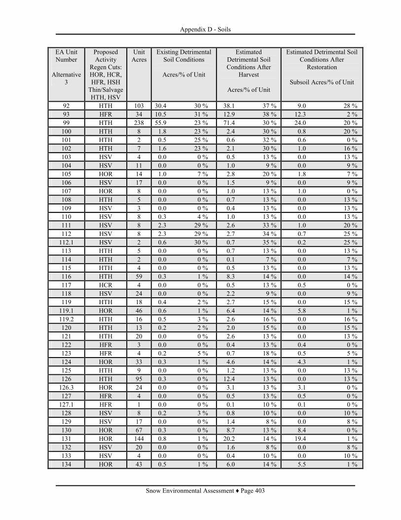
Appendix D - Soils
Snow Environmental Assessment ♦ Page 403
EA Unit Number
Alternative
3
Proposed Activity
Regen Cuts: HOR, HCR, HFR, HSH Thin/Salvage HTH, HSV
Unit Acres
Existing Detrimental Soil Conditions
Acres/% of Unit
Estimated Detrimental Soil Conditions After
Harvest
Acres/% of Unit
Estimated Detrimental Soil Conditions After
Restoration
Subsoil Acres/% of Unit
92 HTH 103 30.4 30 % 38.1 37 % 9.0 28 % 93 HFR 34 10.5 31 % 12.9 38 % 12.3 2 % 99 HTH 238 55.9 23 % 71.4 30 % 24.0 20 % 100 HTH 8 1.8 23 % 2.4 30 % 0.8 20 % 101 HTH 2 0.5 25 % 0.6 32 % 0.6 0 % 102 HTH 7 1.6 23 % 2.1 30 % 1.0 16 % 103 HSV 4 0.0 0 % 0.5 13 % 0.0 13 % 104 HSV 11 0.0 0 % 1.0 9 % 0.0 9 % 105 HOR 14 1.0 7 % 2.8 20 % 1.8 7 % 106 HSV 17 0.0 0 % 1.5 9 % 0.0 9 % 107 HOR 8 0.0 0 % 1.0 13 % 1.0 0 % 108 HTH 5 0.0 0 % 0.7 13 % 0.0 13 % 109 HSV 3 0.0 0 % 0.4 13 % 0.0 13 % 110 HSV 8 0.3 4 % 1.0 13 % 0.0 13 % 111 HSV 8 2.3 29 % 2.6 33 % 1.0 20 % 112 HSV 8 2.3 29 % 2.7 34 % 0.7 25 % 112.1 HSV 2 0.6 30 % 0.7 35 % 0.2 25 % 113 HTH 5 0.0 0 % 0.7 13 % 0.0 13 % 114 HTH 2 0.0 0 % 0.1 7 % 0.0 7 % 115 HTH 4 0.0 0 % 0.5 13 % 0.0 13 % 116 HTH 59 0.3 1 % 8.3 14 % 0.0 14 % 117 HCR 4 0.0 0 % 0.5 13 % 0.5 0 % 118 HSV 24 0.0 0 % 2.2 9 % 0.0 9 % 119 HTH 18 0.4 2 % 2.7 15 % 0.0 15 % 119.1 HOR 46 0.6 1 % 6.4 14 % 5.8 1 % 119.2 HTH 16 0.5 3 % 2.6 16 % 0.0 16 % 120 HTH 13 0.2 2 % 2.0 15 % 0.0 15 % 121 HTH 20 0.0 0 % 2.6 13 % 0.0 13 % 122 HFR 3 0.0 0 % 0.4 13 % 0.4 0 % 123 HFR 4 0.2 5 % 0.7 18 % 0.5 5 % 124 HOR 33 0.3 1 % 4.6 14 % 4.3 1 % 125 HTH 9 0.0 0 % 1.2 13 % 0.0 13 % 126 HTH 95 0.3 0 % 12.4 13 % 0.0 13 % 126.3 HOR 24 0.0 0 % 3.1 13 % 3.1 0 % 127 HFR 4 0.0 0 % 0.5 13 % 0.5 0 % 127.1 HFR 1 0.0 0 % 0.1 10 % 0.1 0 % 128 HSV 8 0.2 3 % 0.8 10 % 0.0 10 % 129 HSV 17 0.0 0 % 1.4 8 % 0.0 8 % 130 HOR 67 0.3 0 % 8.7 13 % 8.4 0 % 131 HOR 144 0.8 1 % 20.2 14 % 19.4 1 % 132 HSV 20 0.0 0 % 1.6 8 % 0.0 8 % 133 HSV 4 0.0 0 % 0.4 10 % 0.0 10 % 134 HOR 43 0.5 1 % 6.0 14 % 5.5 1 %

Appendix D - Soils
Snow Environmental Assessment ♦ Page 404
EA Unit Number
Alternative
3
Proposed Activity
Regen Cuts: HOR, HCR, HFR, HSH Thin/Salvage HTH, HSV
Unit Acres
Existing Detrimental Soil Conditions
Acres/% of Unit
Estimated Detrimental Soil Conditions After
Harvest
Acres/% of Unit
Estimated Detrimental Soil Conditions After
Restoration
Subsoil Acres/% of Unit
134.1 HOR 55 16.5 30 % 20.4 37 % 19.9 1 % 135 HCR 11 0.0 0 % 1.4 13 % 1.4 0 % 136 HFR 19 5.7 30 % 7.0 37 % 6.8 1 % 137 HCR 7 0.3 4 % 1.2 17 % 0.9 4 % 138 HOR 49 0.6 1 % 6.9 14 % 6.3 1 % 139 HCR 10 0.3 3 % 1.6 16 % 1.3 3 % 140 HOR 31 1.0 3 % 5.0 16 % 4.0 3 % 140.1 HOR 35 0.0 0 % 4.6 13 % 4.6 0 % 140.2 HTH 45 0.7 2 % 6.8 15 % 6.1 2 % 141 HTH 17 5.2 31 % 6.5 38 % 2.0 26 % 142 HOR 25 0.2 1 % 2.0 8 % 1.8 1 % 143 HSV 16 0.2 1 % 1.6 10 % 0.0 10 % 144 HSV 3 0.0 0 % 0.4 13 % 0.0 13 % 145 HTH 40 0.6 2 % 6.0 15 % 0.0 15 % 145.1 HTH 12 0.0 0 % 1.6 13 % 0.0 13 % 146 HSV 6 0.0 0 % 0.8 13 % 0.0 13 % 148 HTH 10 0.0 0 % 1.3 13 % 0.0 13 % 149 HTH 44 13.6 31 % 16.7 38 % 5.7 25 % 150 HTH 1 0.3 30 % 0.4 37 % 0.2 20 % 151 HTH 46 13.4 29 % 16.6 36 % 5.0 25 % 152 HTH 9 2.8 31 % 3.4 38 % 1.5 21 % 153.1 HTH 1 0.3 30 % 0.4 37 % 0.2 20 % 153.2 HTH 4 1.4 35 % 1.7 42 % 1.0 18 % 154 HTH 4 1.4 35 % 1.7 42 % 1.0 18 % 155 HTH 19 6.0 32 % 7.4 39 % 3.5 21 % 156 HTH 11 0.2 2 % 1.7 15 % 0.0 15 % 157 HTH 13 0.6 5 % 2.3 18 % 0.0 18 % 158 HTH 6 0.0 0 % 0.8 13 % 0.0 13 % 159 HTH 6 1.6 27 % 2.0 34 % 0.5 25 % 160 HSV 31 0.0 0 % 2.8 9 % 0.0 9 % 161 HOR 35 0.2 1 % 4.9 14 % 4.7 1 % 170 HTH 66 15.1 23 % 19.8 30 % 7.0 19 % 172 HOR 3 0.0 0 % 0.4 13 % 0.4 0 % 173 HOR 36 0.0 0 % 4.7 13 % 4.7 0 % 174 HOR 6 0.0 0 % 0.8 13 % 0.8 0 % 175 HTH 70 16.8 24 % 21.7 31 % 8.0 20 % 176 HOR 1 0.2 20 % 0.3 27 % 0.3 0 % 177 HOR 12 2.8 23 % 3.6 30 % 3.6 0 % 178 HFR 10 2.9 29 % 3.6 36 % 3.6 0 % 179 HTH 8 1.8 23 % 2.4 30 % 0.8 20 % 180 HCR 19 0.0 0 % 2.5 13 % 2.5 0 % 181 HOR 74 0.0 0 % 9.6 13 % 9.6 0 % 181.1 HCR 91 0.0 0 % 11.8 13 % 11.8 0 %

Appendix D - Soils
Snow Environmental Assessment ♦ Page 405
EA Unit Number
Alternative
3
Proposed Activity
Regen Cuts: HOR, HCR, HFR, HSH Thin/Salvage HTH, HSV
Unit Acres
Existing Detrimental Soil Conditions
Acres/% of Unit
Estimated Detrimental Soil Conditions After
Harvest
Acres/% of Unit
Estimated Detrimental Soil Conditions After
Restoration
Subsoil Acres/% of Unit
182 HOR 5 0.0 0 % 0.7 13 % 0.7 0 % 183 HOR 54 0.0 0 % 7.0 13 % 7.0 0 % 184 HTH 26 5.7 22 % 7.5 29 % 2.5 19 % 185 HTH 34 7.4 22 % 9.9 29 % 3.0 20 % 186 HTH 2 0.5 25 % 0.6 32 % 0.2 20 % 187 HTH 48 11.6 24 % 14.9 31 % 5.5 20 % 188 HTH 6 1.4 23 % 1.8 30 % 0.6 20 % 189 HTH 33 7.7 23 % 9.9 30 % 3.5 19 % 190 HTH 6 1.4 23 % 1.8 30 % 0.6 20 % 191 HTH 15 0.2 1 % 2.1 14 % 0.0 14 % 192 HTH 147 1.2 1 % 20.6 14 % 0.0 14 % 193 HTH 48 1.2 3 % 7.7 16 % 0.0 16 % 194 HTH 15 0.0 0 % 2.0 13 % 0.0 13 % 195 HTH 8 0.2 3 % 1.3 16 % 0.0 16 % 196 HTH 28 6.7 24 % 8.7 31 % 3.5 19 % 197 HTH 10 2.9 29 % 3.6 36 % 1.0 26 % 198 HTH 3 0.2 7 % 0.6 20 % 0.0 20 % 199 HTH 13 0.2 2 % 2.0 15 % 0.0 15 % 200 HTH 3 0.0 0 % 0.4 13 % 0.0 13 % 201 HTH 1 0.0 0 % 0.1 13 % 0.0 13 % 202 HTH 40 0.0 0 % 5.2 13 % 0.0 13 % 203 HTH 44 0.5 1 % 6.2 14 % 0.0 14 % 204 HSV 3 0.2 7 % 0.5 17 % 0.0 17 % 205 HTH 8 0.0 0 % 1.0 13 % 0.0 13 % 206 HTH 25 0.3 1 % 3.5 14 % 0.0 14 % 207 HTH 33 0.2 1 % 4.6 14 % 0.0 14 % 300 HOR 238 7.2 3 % 35.7 15 % 35.7 0 % 300.3 HFR 22 6.4 29 % 7.9 36 % 7.9 0 % 301 HSV 24 0.0 0 % 2.1 9 % 0.0 9 % 302 HSV 40 0.0 0 % 3.6 9 % 0.0 9 % 303 HSV 41 0.9 2 % 5.3 13 % 0.0 13 % 304 HFR 12 3.5 29 % 4.3 36 % 4.3 0 % 305 HTH 58 14.8 26 % 19.1 33 % 7.5 20 % 305.1 HTH 13 3.0 23 % 3.9 30 % 1.5 18 % 305.2 HFR 8 2.3 29 % 2.9 36 % 2.9 0 % 305.3 HFR 1 0.3 30 % 0.4 37 % 0.4 0 % 305.4 HFR 2 0.6 30 % 0.7 37 % 0.7 0 % 305.8 HTH 10 3.2 32 % 3.9 39 % 1.5 24 % 306 HSV 11 0.2 2 % 1.1 10 % 0.0 10 % 309 HTH 63 0.6 1 % 8.8 14 % 0.0 14 % 309.1 HTH 3 0.3 10 % 0.4 13 % 0.0 13 % 310 HTH 2 0.5 25 % 0.6 30 % 0.2 20 % 310.1 HTH 24 5.8 24 % 7.4 31 % 3.0 18 %
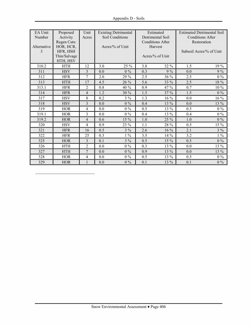
Appendix D - Soils
Snow Environmental Assessment ♦ Page 406
EA Unit Number
Alternative
3
Proposed Activity
Regen Cuts: HOR, HCR, HFR, HSH Thin/Salvage HTH, HSV
Unit Acres
Existing Detrimental Soil Conditions
Acres/% of Unit
Estimated Detrimental Soil Conditions After
Harvest
Acres/% of Unit
Estimated Detrimental Soil Conditions After
Restoration
Subsoil Acres/% of Unit
310.2 HTH 12 3.0 25 % 3.8 32 % 1.5 19 % 311 HSV 3 0.0 0 % 0.3 9 % 0.0 9 % 312 HFR 7 2.0 29 % 2.5 36 % 2.5 0 % 313 HTH 17 4.5 26 % 5.6 33 % 2.5 18 % 313.1 HFR 2 0.8 40 % 0.9 47 % 0.7 10 % 314 HFR 4 1.2 30 % 1.5 37 % 1.5 0 % 317 HSV 8 0.2 3 % 1.3 16 % 0.0 16 % 318 HSV 3 0.0 0 % 0.4 13 % 0.0 13 % 319 HOR 4 0.0 0 % 0.5 13 % 0.5 0 % 319.1 HOR 3 0.0 0 % 0.4 13 % 0.4 0 % 319.2 HOR 4 0.6 15 % 1.0 25 % 1.0 0 % 320 HSV 4 0.9 23 % 1.1 28 % 0.5 15 % 321 HFR 16 0.5 3 % 2.6 16 % 2.1 3 % 322 HFR 25 0.3 1 % 3.5 14 % 3.2 1 % 325 HOR 3 0.1 3 % 0.5 15 % 0.5 0 % 326 HTH 2 0.0 0 % 0.3 13 % 0.0 13 % 327 HTH 7 0.0 0 % 0.9 13 % 0.0 13 % 328 HOR 4 0.0 0 % 0.5 13 % 0.5 0 % 329 HOR 1 0.0 0 % 0.1 13 % 0.1 0 %