Environmental and Social Impact Assessment (Draft) - Asian ...
448
Environmental and Social Impact Assessment (Draft) Project Number: 47929 September 2013 PAK: Gulpur Hydropower Project Prepared by Mira Power Limited The environment and social compliance audit report is a document of the borrower. The views expressed herein do not necessarily represent those of ADB's Board of Directors, Management, or staff, and may be preliminary in nature. Your attention is directed to the “Term of Use” section of this website.
-
Upload
khangminh22 -
Category
Documents
-
view
0 -
download
0
Transcript of Environmental and Social Impact Assessment (Draft) - Asian ...
Environmental and Social Impact Assessment (Draft) Project Number: 47929 September 2013
PAK: Gulpur Hydropower Project Prepared by Mira Power Limited
The environment and social compliance audit report is a document of the borrower. The views expressed herein do not necessarily represent those of ADB's Board of Directors, Management, or staff, and may be preliminary in nature. Your attention is directed to the “Term of Use” section of this website.
ESIA of 100MW Gulpur Hydropower Project (GHPP) Kotli, Azad Jammu and Kashmir
| P a g e
September 20, 2013
Kotli, Azad Jammu and Kashmir - Pakistan
Environmental and Social
Impact Assessment (ESIA)
and
Environmental and Social
Management and
Monitoring Plan (ESMMP)
100MW Gulpur Hydropower Project
Ref: D3V01ESIA
ESIA of 100MW Gulpur Hydropower Project (GHPP) Kotli, Azad Jammu and Kashmir
Environmental and Social Impact Assessment (ESIA) and
Environmental and Social Management and
Monitoring Plan (ESMMP)
of
100MW Gulpur Hydropower Project
Kotli, Azad Jammu and Kashmir, Pakistan
September, 2013
ESIA of 100MW Gulpur Hydropower Project (GHPP) Kotli, Azad Jammu and Kashmir
Environmental and
Social Impact
Assessment (ESIA)
Volume 1
100MW Gulpur Hydropower Project
Kotli, Azad Jammu and Kashmir - Pakistan
ESIA of 100MW Gulpur Hydropower Project (GHPP) Kotli, Azad Jammu and Kashmir
Environmental and Social Impact Assessment (ESIA)
of
100MW Gulpur Hydropower Project
Kotli, Azad Jammu and Kashmir, Pakistan
Volume 1
September, 2013
ESIA of 100MW Gulpur Hydropower Project (GHPP) Kotli, Azad Jammu and Kashmir
i
LIST OF ACRONYMS
ADB Asian Development Bank
AJK Azad Jammu & Kashmir
AJK-EPA Azad Jammu & Kashmir Environmental Protection Agency
AJK-EPC Azad Jammu & Kashmir Environmental Protection Council
AJK-HEB Azad Jammu & Kashmir Hydro Electric Board
BACT Best Available Control Technology
BOD Biochemical Oxygen Demand
BOOT Build, Own, Operate and Transfer
BP Bank Procedures
BPEO Best Environmental Practicable Option
CBD Convention on Biological Diversity
CCGT Combined Cycle Gas Turbine
CDM Clean Development Mechanism
CEMP Construction Environmental Management Plan
CEO Chief Executive Officer
CFC Chlorofluorocarbon
cfu Colony Forming Unit
CITES Convention on International Trade in Endangered Species
CMP construction management plan
CMS Conservation of Migratory Species
COD Chemical oxygen demand
COO Chief Operating Officer
CSC Construction Supervision Contractor
CSR Corporate social responsibility
Cumecs Cubic Meter per Second
DHQ District Headquarter
EHS Environment, Health and Safety
EIA Environmental Impact Assessment
El. Elevation
EMMP Environmental Management and Monitoring Plan
EOS Earth Observing System
EOSDIS Earth Observing System Data and Information System
EPA Environmental Protection Agency
EPC Environmental Protection Council
EPC Engineering, Procurement and Construction
EPRRP Emergency Preparedness, Response and Recovery Plan
ER Encounter Rate
ESIA Environmental and Social Impact Assessment
ESMMP Environmental and Social Management and Monitoring Plan
FAP First Aid Post
FCCC Framework Convention on Climate Change
ESIA of 100MW Gulpur Hydropower Project (GHPP) Kotli, Azad Jammu and Kashmir
ii
FGDs Focused Group Discussions
GCP Ground Control Points
GHG Green House Gas
GHPP Gulpur Hydropower Project
GIIP Good International Industry Practice
GIS Geo Information System
GoP Government of Pakistan
GWh Gigawatt Hour
HCFC Hydro Chlorofluorocarbon
HSE Health Safety Equipment/ Health, Safety and Environment
IDC Indirect Costs
IEE Initial Environment Examination
IFC International Finance Cooperation
IP Indigenous Peoples
IPP Independent Power Producer
IR Involuntary Resettlement
IUCN International Union for Conservation of Nature
KDA Kotli Development Authority
KOSEP Korea South East Power Company
LAA Land Acquisition Act
LAC Land Acquisition Collector
LARP Land Acquisition and Resettlement Plan
LDL Lowest Detection Limit
LOI Letter of Interest
LOS Letter of Service
LPDAAC Land Processes Distributed Active Archive Center
LPG Liquid Petroleum Gas
M&E Maintenance and Engineering
MAF Million Acre-Foot
MCH Mother Child Health Care
MCM Million Cubic Meters
MPL Mira Power Limited
MSDS Material Safety Data Sheet
MW Megawatt
NASA National Aeronautics and Space Administration’s
NCS National Conservation Strategy
NDVI normalized difference vegetation index
NEQS National Environmental Quality Standards
NESPAK National Engineering Services Pakistan
NOC No Objection Certificate
NOL Normal Operation Level
OM Operations Manual
OP Operational Policy
PIC Prior Informed Consent
ESIA of 100MW Gulpur Hydropower Project (GHPP) Kotli, Azad Jammu and Kashmir
iii
PM Particulate Matter/Project Manager
PPE Personal Protective Equipment
PPIB Private Power & Infrastructure Board
PS Performance Standard
PWD Population Welfare Department
RCC Reinforced Cement Concrete
SCP Spill Contingency Plan
SPA Share Purchase Agreement
SPS Safeguard Policy Statement
SR Safeguards Requirement
SSC Species Survival Commission
TBT Tool Box Talks
TDS Total Dissolved Solids
TNTC Too Numerous to Count
USBR United States Bureau of Reclamation
WAPDA Water and Power Development Authority
WCMC World Conservation and Monitoring Centre
WWF World Wildlife Fund
ESIA of 100MW Gulpur Hydropower Project (GHPP) Kotli, Azad Jammu and Kashmir
iv
EXECUTIVE SUMMARY
Today Pakistan is facing multifarious problems and challenges. These challenges are not a product of
sudden incident; rather it is a cumulative outcome of lack of planning and misplaced priorities of the
state. Among these challenges, energy crises is the acute one as it is energy that derives the engine
of economy and overall functions of modern economic order. The power sector in Pakistan has been
facing shortages of electricity generating capacity due to low pace of development of new power
plants to meet the growing demand for electricity. This has been aggravated by the rising price of oil,
shortage of natural gas and lesser focus on hydropower development. The effect of the large gap
between demand and supply of electric power has led to massive load shedding in Pakistan and in
Azad Jammu and Kashmir. Due to the widening of this gap, all walks of life from industry to domestic
are being adversely affected.
The primary cause for this worse energy crisis among others is the expensive energy mix which is
predominantly fossil fuel based resulting heavy dependency on expensive oil imports and depleting
natural gas reserves. For the long term energy security of the country and to ensure sustainable
development of the country, hydropower development is considered as the most feasible option,
which is in abundance in Pakistan. Development of hydropower is also considered as attractive to
help improving the management of the national water resources which supports one of the largest
irrigation systems in the world, upon which agriculture of the country is heavily dependent. Given
the gravity of situation in energy sector and opportunities it provides for private sector to invest, a
100 MW Hydropower Project in Gulpur on the Poonch River is proposed by the Private Power &
Infrastructure Board (PPIB).
This study assesses the environmental and social impacts associated with the construction and
operation of the Gulpur Hydropower Project. The Environmental Social Impact Assessment (ESIA)
was performed in four main phases of scoping, baseline data collection, impact assessment and
documentation. Scoping phase entails project data compilations, review of published literature,
legislative review and identification of potential impacts. While preparing the report great attention
is paid to ensure that the ESIA process and results are prepared according to the relevant guidelines
set by the Environmental Protection Agency (EPA), ADB and IFC.
Policy, Legal and Administrative Framework
Any development initiative specially related to hydropower has to take into consideration the legal
responsibilities of the proponent in the context of the environment and sustainable development,
and the requirements of the institutions that may influence the environmental management of the
proposed project. The Pakistan National Conservation Strategy (NCS) that was approved by the
federal cabinet in March 1992 is the principal policy document on environmental issues in the
country as well as AJK (EUAD/IUCN, 1992). The core areas that are relevant in the context of the
proposed project are pollution prevention and abatement, restoration of rangelands, increasing
energy efficiency, conserving biodiversity, supporting forestry and plantations, and the preservation
of cultural heritage. The Government of Pakistan promulgated “Pakistan Environmental Protection
Act” in 1997. The same was adopted by the Government of AJK. However, this act was adapted to
meet the state’s requirements and notified in 2000 as Azad Jammu and Kashmir Environmental
ESIA of 100MW Gulpur Hydropower Project (GHPP) Kotli, Azad Jammu and Kashmir
v
Protection Act, 2000. Environmental Protection Agency headed by a Director General has the
responsibility for establishing Biodiversity Action Plan at a country level.
Under Section 11 of the 2000 Act, a project falling under any category (qualifying IEE or EIA) requires
the proponent to file IEE or EIA with the AJK-EPA. In the absence of AJK-EPA guidelines for
environmental assessment, those laid down by Pak- EPA have been followed. The Pak-EPA has
published a set of environmental guidelines for conducting environmental assessments and the
environmental management of different types of development projects. Other important policy
documents and legal requirements of the project are: National Environmental Quality Standards
(NEQS), National Resettlement Policy and Ordinance, The Land Acquisition Act, 1894, The Forest Act,
1927 and the Forest (Amendment) Act 2010, The Jammu and Kashmir Forest Regulations, 1930, The
AJK Wildlife (Protection, Preservation, Conservation and Management) Act, 1975, Azad Jammu and
Kashmir, Wildlife (Protection, Preservation, Conservation and Management) Ordinance, 2012, The
Antiquities Act, 1975, The Motor Vehicles Ordinance, 1965, and Rules, 1969, The Factories Act, 1934,
The Pakistan Penal Code, 1860, The Explosives Act, 1884
Owing to its magnitude the proposed project involves various stakeholders and institutions.
Therefore, it is indispensable to interaction with different agencies. This engagement will ensure
that the project complies with the laws and regulations controlling the environmental concerns of
dam construction and operation, and that all pre- construction requisites, such as permits and
clearances are met. Besides providing overview of Policy, Legal and Administrative Framework, the
section 2 also adumbrates guidelines of Asian Development Bank and requirements of IFC related to
the Project.
Project Description
The Gulpur Hydropower Project site is administratively located in Kotli District of Azad Jammu and
Kashmir. It is located at latitude 33°27’ and longitude 73°51’, which is about 5 km South of Kotli
Town. The site is approximately 167 km from Islamabad and 285 km from Lahore, and is accessible
directly from Islamabad and Lahore by a two-lane (and partially paved) mountainous road. The
proposed Gulpur Hydropower Project will exploit the water resources of the Poonch River for power
generation. It will comprise four main components, viz., Weir, Intake Structure, Power Tunnel and
Power House. The Weir will be located near Aghar Colony on the Poonch River at about 5 km
downstream of Kotli Town and about 250 m downstream of the confluence of Ban Nullah with the
river. The Intake Structure and intake portal of the Power Tunnel will be located on Ban Nullah about
2 km upstream of its confluence with the Poonch River. The Power House and outlet portal of the
Power Tunnel will be located on Poonch River about 6.5 km downstream of the Weir structure.
Land Acquisition requirements of the Project are directly related to the consideration of design
alternative to construct the earthen Dyke in the submerged area. The proponent has carried out
detailed analysis of land requirements and resettlement requirement under following the two
options. Under Option 1 an earthen Dyke shall be constructed in the submerged area to curtail the
land acquisition and land resettlement while under Option 2 “No Dyke” was proposed. Under the
selected Option 2 Under “No Dyke” option the project will consume 13% (113 Acres) of the total
area for building structures, reservoir, colony, and camp and approach roads. About 87 percent (804
Acres) of the land required for the proposed project will be utilized for the reservoir. In total the
ESIA of 100MW Gulpur Hydropower Project (GHPP) Kotli, Azad Jammu and Kashmir
vi
proposed project will required 920 Acres of land; major portion (74 percent) of this land is owned by
the Government while only 26 percent land in privately owned.
A 2-stage river diversion plan has been proposed for the construction of the Weir. The diversion will
be manipulated within the river section by constructing coffer dams. It is anticipated that the Project
would take about 45 months for its completion and commissioning.
It has been estimated that the project will employ about 700 skilled, semi-skilled and unskilled
workforces for its construction and commissioning. Majority of unskilled and to some extent semi-
skilled and skilled workforce will be employed from the local area. However, the contractor will
engage specialized workforce including engineers, geologists and construction management staff
from the outside area. The project falls in a terrain that is constituted of high hills having steep
slopes with narrow valleys in between. The contractor would need to develop access roads for all
the sites. The section on project description provides plan of alternative and access roads. The
Project will deploy various types of machineries for construction purposes. These will include
bulldozers, excavators, shovels, tunneling machine, dumpers, batching plant, tankers, trucks, etc.
The project cost will be approximately US$ 340.00 million.
Description of the Physical Environment
Baseline data on physical environment within the area of project influence has been compiled to
cover these areas: land, climate and meteorology, water (water resources, water quality, source of
pollution and hydrology and air Quality and Noise (noise levels). Some of these areas are directly
affected while others may be influenced indirectly. This section highlights the areas of most
concerns. Most of the potentially affected areas, except the ones related with the quarries, would
fall within a strip of about 4 km wide (on the average 2 km on either side of the Poonch River) and
about 10 km in length covering the river stretch from Kotli up to the Power House site.
The study area is a part of land formations developed at the foothills of Himalayan Ranges through
tectonic events subsequent to those that caused building of Himalaya. The Project area contains
middle Siwalik formations developed from the sedimentary deposits contributed by a number of
drainage channels from the uprising Himalayan Mountain Ranges. The rock formations include
extremely folded beds, having almost vertical dips, of various types of sandstones, clay-stones and
siltstones. Mostly the mountains are covered with primary soils, except along the river and nullahs
where the beds are almost devoid of soil material.
Major geological formations in the project area are; Pleistocene and Recent Deposits Overburden,
Secree, Talus and Vegetation, Classification of Rocks, Sandstone, and Clay stone/Siltstone. The
project area lies very close to the Riasi Thrust which is a branch of the Main Boundary Thrust (MBT).
Virtually, the former almost passes through or near to the course of the Poonch River, while the
latter bounds the Project area at a distance of about 5 km towards east. Consequently, the proposed
Project will be located in active seismic region that has experienced few large earthquakes with
magnitude greater than 7.
The towns of Poonch, Sehra, Tatta Pani and Kotli are situated on the banks of this river. It has two
major tributaries in Pakistan, Batar and Mendher. The Poonch River originates at an elevation of
more than 3500 m and traverses about 110 km from east to west up to the proposed weir site and

ESIA of 100MW Gulpur Hydropower Project (GHPP) Kotli, Azad Jammu and Kashmir
vii
fed by many big and small streams on both the banks. Most of the tributaries join the river on its
right bank. The relief in the catchment area of Poonch River varies from 200 m to 4500 m. This
elevation range was divided into 9 elevation bands with 500 m interval.
The texture of the primary soils varies from moderately fine to moderately coarse depending upon
the rock type from which these have developed. However, the secondary soils are mostly
moderately coarse textured. The soils of the raised terraces in floodplains are generally devoid of the
stony material. The soils of lower terraces generally contain varied quantities of pebbles, cobbles
and boulders.
Generally, the project area falls in sub-humid and sub-tropical zone. It has moderate summer and
cold winter. The climate is greatly influenced by monsoon in the months of July and August and
snowcapped mountains of Pir Panjal Range. The average annual precipitation in the area is 1,237
mm. Temperature in different parts of the tract varies according to the elevation. The data shows
that the average monthly mean maximum temperature varies from 17.6 °C in January to 38.4 °C in
June, whereas monthly mean minimum temperature ranges between 4.8 °C in January and 24.9 °C in
June.
Mean monthly discharges computed from the mean daily flows shows a minimum value of 12
cumecs observed in January 1966 and maximum value of 830 cumecs in September 1992. The data
depicts that mean monthly flows vary between 41 cumecs (106 MCM) in November to 279 cumecs
(746 MCM) in August.
Main water resources in the district Kotli are surface water and ground water. The microbiological
analysis of the water sample in the project area show that nearly every sample has some biological
contamination. Especially the drinking water in Jamal Pur and Aghar Colony has highest microbial
count. The analysis shows that hardness in all the samples ranged from 346 to 515 mg/l. Total
hardness of water as CaCO3 is within acceptable limits in most of the samples except for one.
No air quality monitoring data is available for the project area. In general there are no major sources
of air pollution, viz., industries, exist in the project area except road traffic in the valleys of Poonch
River and Nullahs. The ambient particulate matter PM10 was found 97.14 ug/m3 at proposed power
house site, 87.90 ug/m3 at proposed camp area, 75.19 ug/m3 at proposed weir site and 66.77ug/m3
at proposed batching plant are within standard value of 150 ug/m3.
The noise level was found in range of 59.7 to 68.1 (dBA) at proposed power house site, 37.0 to 57.0
(dBA) at proposed camp site, 37.3 to 54.8 (dBA) at proposed weir site and 35.9 to 48.9 (dBA) at
proposed batching plant.
Description of Biological Environment
The biological component of the study focused on the aquatic ecology, flora, mammals, birds, and
reptiles and amphibians. The forests of the area are characterized by the presence of subtropical
broad leaved vegetation and are fundamentally Chirpine forest type. These forests are mainly
dominated by Pinus roxburghii in an altitudinal range of 700-1800m. The sub-tropical forests of the
area were mainly dominated by Pinus roxburghii. But present figures show that Pinus-Themeda
community is becoming sparse which would eventually transform the area into a degraded scrub-
ESIA of 100MW Gulpur Hydropower Project (GHPP) Kotli, Azad Jammu and Kashmir
viii
land. Now, the area is characterized by the dominance of herb and shrub layer, comprising Themeda
anathera, Poa annua, Carissa opaca and Adhatoda vasica over Pinus roxburghii.
Most of the population of the area dwells in remote areas that are not easily accessible and thus left
with no other option but to rely on medicinal plants for general treatment. Notable among these
floras are Justicia adhatoda, Acacia nilotica, Calotropis procera, Ricinus communis, Morus nigra,
Dodonaea viscosa, Achyranthes aspera, Ipomoea carnea, Taraxacum officinale, Eriobotrya japonica,
Cissus carnosa, Melia azedarach, Eucalyptus citriodora and Ficus carica.
The data shows that these forests are faced with the problems of overgrazing and deforestation.
Regarding floral Diversity that a total of 186 vascular plant species were identified from the area
including 3 species of pteridophytes. The Leguminosae and Asteraceae were the largest families of
dicotyledons, whereas, Poaceae was largest of the monocotyledons. Biogeographically the area of
the Project falls into Irano-Turanian region Floristic region. The Himalayan endemics included 19
species, whose details are provided in the section. Among the rare species Fraxinus raiboearpa was
the plant that is confined to few localities in north Pakistan and Afghanistan. None of the species
found in GHPP study area is listed in the WCMC list in endangered categories.
The project area lies in the humid subtropical zone influenced by monsoon Mediterranean
disturbances as well. The forests can be grouped into and Subtropical Broadleaved Forest, and
Subtropical Pine Forests. The dominant land use at the project facilities will be
agriculture/settlements. Areas devoid of forest make about 25% of the land cover. Overall forest
cover is only 18 % that can be treated to be closest to primary; otherwise, the forest cover is not so
dense. Similarly for the direct impact areas (project facilities) the forest cover is around 35% with
only about 5% being dense.
River Poonch is generally rich in fish diversity and even 21 fish species have been recorded from a
stretch of about 10 km. This diversity is quite high for this small river stretch. Among the recorded
species, majority of fish fauna belongs to the family Cyprinidae which is comprised of 13 species.
Other 8 species are divided among seven families in such a way that five families are represented
only by one species and the rest two each by two species. Among the fish fauna of the project area,
two species are endemic in Pakistan including AJK, one is endangered, two are Vulnerable, and one
is Near Threatened. Quite a good number of species are commercially important. The species Tor
putitora and Clupisoma garua are considered among the esteemed fishes and have very high
commercial value.
The Project is located in the “Mahasher National Park” which was notified recently to protect the
Endangered Mahasher Fish (Tor putitora). The national park through relevant legislation restricts
various forms of species exploitation to ensure that the habitat remains pristine and congenial for
the indigenous species.
Thirty one families of macro-invertebrates were identified from 546 benthic macro-invertebrate
individuals collected during the whole study period. A number of mammalian species including
common leopard, black bear, barking deer, jackal, fox and rhesus monkey were reported from the
Kotli district of Azad Jammu and Kashmir in past. In order to assess human-wildlife interaction and
site two surveys were carried out. Jackal has highest annual sighting rate at 25 animals per
ESIA of 100MW Gulpur Hydropower Project (GHPP) Kotli, Azad Jammu and Kashmir
ix
respondent per year followed by fox; 4.7, and rhesus monkey; 2.8. Black bear, leopard cat and wild
boar have negligible sighting rates.
Only 12 cases of predation on livestock and poultry were recorded. Jackal was the main predator
responsible for almost 92% predations majority; 93%, of which was poultry while remaining were
goats. Goats were killed while grazing and poultry was capture from cage most of the time. Only one
case of common leopard depredation was reported in which predator attacked on a coral and killed
30 goats at a time.
Seventeen species of small mammals have been collected from the study area belonging to eleven
families and five orders. Among reptiles snakes and frogs of different are found in the area. Manzoor
et al. (2013) while assessing the biodiversity of the Pir Lasura National Park in District Kotli, Azad
Kashmir reported six amphibian and 24 reptilian species. No crocodilians and tortoises are found in
the study area; Kotli, AJK and the existing species in the study area include; freshwater turtles,
lizards and snakes. Some of the reptilian species are nocturnal in their feeding habits like gekkonid
lizards and elapide snakes whereas others are diurnal like agamid, lacertid, varanid and scincid
lizards, freshwater turtles and colubrine snakes. A number of surveys were carried out which
includes reptile and amphibian diversity survey. Total 21 species of herps including six amphibians
and 15 reptiles were recorded during the present study.
Analysis of data on residential status revealed that out of 61 bird’s species, 76% were year round
resident, remaining were summer breeders, winter visitors and passage migrant. In term of the
abundance of recorded species, the undisturbed area depicted the higher diversity of avian fauna.
The Habitat destruction, anthropogenic pressure in the form of tree cutting, firewood collection,
grass cutting, and cattle grazing were also observed in these study sites. Out of 21 species found in
Poonch River, 12 species are species of special importance. This section on Baseline Ecology provides
lists of the species.
Socio-Economic Environment
This section presents a description of the socioeconomic characteristics of the project area, and
where available utilizes national and regional level data for providing a more cogent understanding
of the context. Socio-economic survey in the project area covered 8 villages/settlements namely 1)
Aghar, 2) Barali, 3) Dharang and 4) Gulharin, 5) Hill Kalan, 6) Hill Khurd, 7) Jamal Pur and 8) Mandi.
The district Kotli is the second largest in terms of population in Azad Jammu and Kashmir. The
population of the district was 365,000 in 1981 and an increase of 54.37 percent was recorded over
the last seventeen (17) years i.e 1981-1998. The human habitation in district Kotli is predominantly
determined by its topography as the hilly mountainous terrain limits options for human habitation.
Hence, most of the human habitation in the project area is scattered.
Traditionally, the social set up of Kotli was largely based on kinship. The overall social arrangement
was based around different clans (baraderi). In the decades of 1960-70s migration of people to
abroad for earning shifted the basis of economy. With increasing exposure to market forces and
exogenous lifestyle the pattern of interface between different communities also witnessed drastic
changes. Despite modernization people still rely on pre-modernization social structure and social
ESIA of 100MW Gulpur Hydropower Project (GHPP) Kotli, Azad Jammu and Kashmir
x
interaction and politics is largely shaped by social dynamics and power relationships. However,
access of opportunities in the country and abroad enabled people to find increasing role in the
society. The major tribes residing in the district are Syed, Gujar, Jat, Rajput, Awan and Sudhan.
Hindko, Gojri and Pahari are the indigenous languages of the district.
Generally the area is peaceful as there are no chronic social and communal conflicts among the
communities living in the project area. Major crops are maize, wheat & rice whereas minor crops
include vegetables, grams, pulses (red lobia) and oil-seeds. Major fruits are apple, pears, apricot and
walnuts. The main economic activity in area remains in agriculture, livestock and service sectors. Of
the total land area of about 414,019 acres of Kotli District, 20% is available for cultivation while 80%
of the land bears forest, settlements, infrastructures or lie in the form of uncultivable waste land.
The survey results show that 11% of the male workforce is comprised of unskilled laborers, whereas
no female works as a laborer.
According to the information received from Department of Education AJK, apart from a campus of
University of Azad Jammu and Kashmir there is one post graduate college for men and 12 degree
colleges for men and women in the district. In the project area each settlement has primary level
government schools for boys and girls within an average distance of 2 km. Overall 27% of the
population falling above the eligible age of 10 years population is illiterate (20% men and 36%
women). Population Health Profile
There is one District Headquarter (DHQ) Hospital in District Kotli, three Rural Health centers, 20 First
Aid Posts (FAPs) and 16 Mother Child Health Care (MCH) Centers along with other health facilities at
grassroots level. The housing pattern is lavish in terms of size and construction as more than 88% of
the structures are pukka, made of cement and bricks with RCC structures. According to Government
of AJK, currently 80% of the urban population and 66% of rural population has been provided with a
piped water supply through house connections and public stands. The entire population (95%) in the
project area has access to drinking water in their houses. 23% use water from wells and 50% use
water from both wells and pipeline. 32% have facility of sewerage system, and 57% use septic tank.
7% percent use a pit latrine and 4% use open fields. The majority of households do not have
drainage facility (68%).
Electricity connection is available to all the households (100%) in the project area. The women have
no formal role in the authority structure of the nearby villages. They are about 48% of the
population in these villages; the literacy rate for above 10 years of female population is 67% (80% for
males). There is none falling under the category of ultra-poor as all the households have a monthly
income which is above PKR 5,000/- and expenditure accordingly. There are some shrines of saints.
Analysis of Alternatives
Alternatives are essentially, different ways through which the proponent can feasibly achieve
sustainable development by carrying out a different type of actions, choosing design alternatives or
adopting a different technology or design for the Project to create win-win scenario for all
stakeholders. Alternatives and mitigation, therefore, cover a spectrum ranging from a high level to
very detailed aspects of project design. This section of the report presents the analysis of the
alternatives considered for the proposed project. The different alternative proposed are: no project
ESIA of 100MW Gulpur Hydropower Project (GHPP) Kotli, Azad Jammu and Kashmir
xi
scenario, alternate methods of power generation, alternate location of the Project, design
alternatives and selection of access roads and alignment.
The “No Project” option is least considered option for Pakistan. The country is currently going
through the worse power crisis of the history. Energy crisis is considered as major development
hurdle in Pakistan and has resulted in massive load shedding in the country hugely deteriorating the
economic development and growth. In year 2012-13 reveal that the power shortfall touched the
figured of 6,390 MW with average shortfall of 3,886 MW. The total generation was 95,364 GWh
during year 2011-12 which represent only 47% capacity utilization. “No Project” scenario is
considered or adopted it would mean that the already power deficient economy would suffer even
more and at current rate if no power is added to the national grid. Given the gravity of energy crisis
and its repercussion on the economy, Pakistan cannot afford to deprive itself of a major project of
cheap source of electricity
There are different options available to generate electricity which include but are not limited to
production using furnace oil, natural gas, coal, solar and hydel. Out of total 95,364 GWh produced
during year 2011-12, only 30% has been generated by Hydel resources, 29% has been produced
using natural gas while the 35% generation was dependable on expensive furnace oil. The nuclear
energy contributed 5.5%, whereas a minor part of energy also came through diesel and coal.
Non-renewable options such as solar and wind are not brought into the national grid at any of the
location in Pakistan, however, few wind projects are at different stages of implementation/
construction. Pakistan imports oil from other countries to meet domestic needs whilst the gas
reserves of the country are fast depleting and hence cannot be presently considered as reliable
sources of power generation. The only coal used in Pakistan is imported from Indonesia and South
Africa. The Thar Coal resources are still in early stages of exploration and are yet to be further
evaluated for potential to generate electricity. Wind power is currently in the experimental stage
and few projects are under implementation and having lower efficiency and power potential cannot
be considered as a replacement or full time substitute of other sources of power generation.
Numerous perennial and seasonal rivers are flowing in the north south direction in Pakistan. Hence
Hydel power is considered a viable option for a country rich in surface water resources. For a
developing country like Pakistan minimum O&M cost makes the hydel power as a viable option.
Hydropower is the cheapest source of electricity in terms of per unit cost and maintenance of the
generation system when compared with other alternatives, such as the furnace oil or gas run power
plants. Hydropower requires significant initial investment compared with thermal options, however,
once the debts are paid back the cost of electricity generation reduces significantly resulting in long
term energy security of the country. A typical hydropower project in private sector has a levelized
cost around 8-9 US cents/KWh with a generation cost of about 3 US cents/KWh after debt
repayments are complete. In comparison the thermal projects (furnace oil based) currently have the
levelized cost of around 16.0 US cents/KWh and keep on increasing with time due to continuous
increase in oil prices.
In Pakistan the hydro power plants have a plant load factor in the tune of 50% - 60% which is slightly
lesser than that for conventional power generation sources with higher load factor of 60% - 80%.
However, it is higher than those of other renewable energy options such as wind and wave energy.
ESIA of 100MW Gulpur Hydropower Project (GHPP) Kotli, Azad Jammu and Kashmir
xii
The proposed project is located in a greener area where installation of a combustion based power
plant would only deteriorate the environment, while installation of hydro power station would not
have any greenhouse emissions from plant operations and the positive economic impact would help
reduce the pressure on the local natural resources. It is obvious that hydro power plants are the
lowest ranked in terms of greenhouse emissions into the environment while the coal power plants
are the most notorious when it comes to greenhouse gas emissions.
Series of technical feasibility studies have been carried out for the analysis of the optimum location
for the construction of the dam at Gulpur. Two alternative options were considered for possible
Poonch River development in two main combinations. Combination-A comprised four sites, which
include Sehra, Kotli, Barali and Rajdhani dam sites whereas Combination-B consisted of three sites
namely Sehra, Kotli and Gulpur dam sites. Further studies concluded that a new site, which is located
near Gulpur Village approximately 7 Km downstream of the Barali dam site which was different from
the earlier identified Gulpur site. During the initial stages of the feasibility study, it was noticed that
the reservoir level (El 475 m) of proposed Rajdhani Hydropower Project would submerge the newly
identified Gulpur site; therefore the site was shifted to an upstream location above the reservoir
level of Rajdhani Hydropower Project. During design stage, several locations were examined to find a
suitable site where a high storage dam could be built to maximize the power potential and final site
location will ensure that the Kotli and Rajdhani Dam can also be constructed along with the Gulpur
Dam. To ensure the natural and social environment are not disturbed numerous tweak in the design
are included.
During the finalization of the feasibility study of the Project Consultants initially recommended the
normal operating level (NOL) of reservoir at El. 550 m. The Project layout involved submergence of
about 646 houses and 1800 acres of inhabited area affecting nearly 5,000 people. In an effort to
reduce the environmental and social impacts three options were Option 1 was based on the earlier
concept where a 75m high dam with NOL at El. 550 m and an underground powerhouse was
proposed. Option 2 was essentially Option-1 but with a reduced dam height of 60 m and NOL at El.
535 m. Option 3 was based on the concept wherein the head is partly created by a weir and partly by
a tunnel utilizing the steep gradient of the river. Following the selection of Option 3 as the most
viable option, further design optimization and studies were based on such option under which
maximum reservoir level was fixed at El. 540.0 m to avoid submergence of surrounding villages and
Project was conceived as run-of river with small storage. In an effort to further curtail the
resettlement and minimizing environmental impacts for selected Option 3 (as explained above)
different options were further studied and it is proposed to build Earthen Protection dyke, Collection
Drain with Dewatering Arrangement were proposed in the expected resettlement area.
The EPC Contractor initially proposed the construction of temporary facilities and access roads at
those locations which were resulting in high resettlement in terms of houses, cultivable land and
other infrastructure and also having negative environmental impacts. The proponent and EPC
Contractor deliberated extensively on this matter to find the engineering solution which results in
lesser resettlement and lesser environmental impacts.
ESIA of 100MW Gulpur Hydropower Project (GHPP) Kotli, Azad Jammu and Kashmir
xiii
Stakeholder Consultations
Apart from gathering of quantitative data through household survey of the area of influence of the
project and 100% survey of project affected people a total of 16 consultations (qualitative) were
conducted with the affected persons and other local community to share the information about the
project and record their concerns/ feedback associated with this project. The consultation was in
two stages of scoping and stakeholder’s consultation. Consultative sessions discussed the topics
related to land acquisition and resettlement issues, employment and livelihoods of communities,
gender and women issues, contractor’s camp and access and environmental issues.
The section of stakeholder consultations provides details of outcomes of consultations and covers
issues and concerns showed by the stakeholders regarding land acquisition and resettlement. To
address the issues and concerns raised by the stakeholders a mitigation plan has been developed
and made part of the ESIA. The stakeholders supported the Gulpur Hydro Power project provided
that environmental and issues are addressed through mitigation measures. To address the issues an
ESIA and Land Acquisition and Resettlement Plan (LARP) are developed and shared with
stakeholders for their feedback and suggestions.
Impact Assessment and Mitigation
Environmental impacts have been and will continue to be considered, eliminated or reduced
throughout the lifecycle of the Project. The prediction and evaluation of impacts of the Project has
been considered against the baseline in the ESIA. The study has considered direct, indirect,
permanent and temporary impacts of the project. Each of the environmental impact are categorized
into two; beneficial and adverse impacts. Wherever, the Project is likely to result in unacceptable
impact on the environment, mitigation measures are proposed.
Potential impacts that may arise from the execution of the project activities can result in soil
contamination, soil erosion, water contamination, change in drainage pattern due to weir
construction, water resource depletion, fugitive dust emissions, vehicular and generator exhaust
emissions, damage to infrastructure due to blasting and noise nuisance due to blasting, drilling and
batching plant. To minimize the impact of environment the section on Impact Assessment and
Mitigation has identifies potential impacts and thorough suggested mitigation and good practice
measure, and monitoring.
The project area represents a human dominated landscape, and the vegetation has been subject to
human influence over a long period of time. There are no threatened plant species found in the
area. The dominant land use at the project facilities was agriculture/ settlements, and areas devoid
of forest make about 25% of the cover. Since the majority land cover impacted by the project will be
either cultivated land or sparse broad leave forest which already have poor ground cover, impacts of
the project on vegetation are anticipated to be minor.
Based on the factors described above other potential impacts identified are: land disturbance due to
construction and operation of project facilities resulting in disturbance, fragmentation, displacement
and direct loss of animal, plants, reptiles amphibian and birds; deterioration of area’s water
resources and river if pollutants are mixed with surface runoff during rain and, or if pollutants leach
into the ground or carried to River. Domestic waste (sanitary and kitchen discharge) or release of oil
ESIA of 100MW Gulpur Hydropower Project (GHPP) Kotli, Azad Jammu and Kashmir
xiv
and grease, fuel from project related machinery or equipment, and reduction in water flow beyond
weir, which can alter ecology of the area, and lead to decline in abundance of fishes, especially of
Mahasher, and imparts habitat fragmentation or affects connectivity of Mangla Reservoirs fishes to
Poonch River. To mitigate the threat a details measures and good practices has been suggested.
In order to minimize social impact of the projected it is suggested to appropriately follow the
operational manual and collaborate effectively with local communities in every phase of the project.
Operational impacts of the proposed project are associated with the movement of vehicular traffic
on it and allied activities. These include air and noise pollution, safety hazards and other similar
impacts. Potential socio-economic impacts that may arise from the execution of the project activities
are: provision of job opportunities, access to the health facilities, permanent acquisition of land and
non-land assets for the project, people lose their productive assets to the project, diseases
incidences, blockade of access of local community due construction activities, disturbance of privacy
and conflict between workers and local community.
Traffic Assessment Study
Currently the road(s) in the project area can cater for the needs of the traffic that is using these
approach roads but with the anticipated increase in heavy and light traffic there are likely to be
impacts on the existing road infrastructure. This study mainly focused on the routes that may be
used for project related traffic and the likely impacts that may be caused due to the proposed
project.
The site is located about 167 Km from Islamabad and 285 km from Lahore, it is directly approachable
from Islamabad and Lahore by a two-lane, all-weather paved road. Access to the Project site from
Islamabad is via Kahuta-Kotli to Gulpur. The other route is from Lahore via GT Road to Dina and then
to Gulpur via Mirpur. GT road is the main access route for all heavy transport vehicles for domestic
needs and also for transit trade with Afghanistan also is a main trade route for India and Indian held
Kashmir via AJK. Considering that most of the machinery and manpower would come from the
southern regions of the country and it would be easier for them to approach the project site via
Dina-Mangla-Mirpur-Kotli route. Machines for the proposed power plant would be imported via sea
and then transported by road from Karachi.
The study has not considered railway because AJK does not have railway track. This study advises on
the routes that are economic and time saving. The nearest international airport is located in
Islamabad that is around 150km (approx.). Traffic count surveys were conducted at three different
locations in and around Kotli. Data analysis of traffic reveals that the traffic activity varies with the
different times of the day starting from lower number of vehicle in early morning to gradually
increasing towards the mid-day and then there is a dip in the afternoon and then another rise in
traffic count in the evening and finally a drop towards the later of the evening and still lower in the
late night of the hours.
In terms of the traffic activity there are three main peaks first is around the 0900 hours which is
normally the time when people have to reach to the offices and business. Next surge is in the
afternoon lunch time around 1400 hours as that is lunch time in the offices and off time for
educational institutions and hence the greater activity. The last peak in the traffic activity is observed
ESIA of 100MW Gulpur Hydropower Project (GHPP) Kotli, Azad Jammu and Kashmir
xv
in the evening around the 1700 hours time mark because this is the time when people leave their
work places and rush towards their homes.
The traffic pattern in the opposite direction at the Gulpur Junction follows a slightly different pattern
in terms of the number of traffic peaks in which away traffic were three and here there are two clear
surges, one at the same time in the morning around the 1000 hours while the next one is observed
at around the 1600 hours.
If we compare the traffic patterns on two approach roads simultaneously it can be seen that the
volume of traffic attracted towards Gulpur and then traffic away from the Gulpur area is more or
less the same but the slight change is observed only in the timings of peak traffic hours. This is due
to the reason that people from the adjoining areas come to for business to Gulpur in the morning
and then go back and hence the greater activity in that direction.
The traffic counts may be higher for a hilly area but majority of the count accounts for motor bikes
which would, in the project scenario, be less of an issue with reference to the expected rise in traffic
volumes. Another important observation is that daily around 200 trucks are moving along the roads
which would be used for project activities, which means that the risks associated with the
movements of these vehicles are known to the people. Furthermore these roads are frequently used
by trucks so there would not be a need for roads improvement at least in the initial phases of the
project, in time if the requirement arises, different options can be assessed as per the demand of the
situation then.
The traffic baseline surveys and traffic assessment clearly suggest that the current road conditions
are appropriate for the project related traffic during the construction and operation. The traffic load
is also as calculated PCE values are very low in comparison to HCM 2000. With implementation of
the proposed mitigation measure and development and implementation of the project traffic
management plan the impact will be minimized.
Environmental and Social Management and Monitoring Plan
The section on Environmental and Social Management and Monitoring Plan (ESMMP) summarizes
the organizational requirements, management and monitoring plans. The environmental and social
management and monitoring plan (ESMMP) presented in this section is a component of the overall
environmental management that is particularly important with respect to this ESIA report as it
presents MPL’s commitments to address the impacts identified by the impact assessment process.
Effective implementation and functioning of the ESMMP depends on adequate human and financial
resources, clearly defined responsibilities for environmental and social management, appropriate
training and good communication. To be effective, this ESMMP must be viewed as a tool reflecting
to the contractors and sub-contractors overall commitment to environmental protection. This must
start at the most senior levels in the organization. Contractor management must provide strong and
visible leadership to promote a culture in which all employees share a commitment to
environmental awareness and protection. The study provides organization setup of MPL with
commitments to be achieved.
ESIA of 100MW Gulpur Hydropower Project (GHPP) Kotli, Azad Jammu and Kashmir
xvi
Issues related to environment have been embedded within the role and responsibilities of client,
contractor and sub-contractors. Environmental and social management plan includes impact
reference, description of the impact, mitigation/management measure, project phase and targeted
residual impact.
Monitoring of environmental components and mitigation measures during implementation and
operation stages is a key component of the ESMMP to safeguard the protection of environment.
Monitoring program includes regular monitoring of construction and commissioning activities for
their compliance with the environmental requirements as per relevant standards, specifications and
ESMMP. The purpose of such monitoring is to assess the performance of the undertaken mitigation
measures and to immediately formulate additional mitigation measures and/or modify the existing
ones aimed at meeting the environmental compliance as appropriate during construction.
The framework environmental monitoring plan is provided in the document. Data will be
documented and interpreted. Temporal and spatial trends in the data will be discerned and
compliance with relevant thresholds will be evaluated. Monitoring reports will be produced to meet
internal and external reporting requirements. If monitoring results indicate non-conformance with
stipulated thresholds or if a significant deteriorating trend is observed, it will be recorded as a non-
conformance and handled by the non-conformance and incident procedure. The tools and process
of monitoring involve preliminary monitoring programmes, documentation and Record Keeping,
non-conformances and incidents, formal audits and site inspections.
Cost estimates are prepared for all the mitigation and monitoring measures proposed in the ESMMP.
The budget has been calculated for a duration of 45 months of the construction phase. The costs for
implementation of environmental and social mitigations during the operational phase are not
included. The operational cost shall be calculated before the completion of construction phase after
consultation with stakeholders and regulatory authorities. The cost for land acquisition and
resettlement related activities are not included. This cost shall be calculated on actual basis after
detailed and specific surveys and completion of land acquisition and resettlement plan (LARP).
The cost estimates and the budget during design and construction phase for the mitigation and
monitoring measures is estimated to be around one and half million united states dollars (USD 1.5
million).
The cost estimates for control measures and some of the mitigation measures that were already part
of Engineers estimate are not included in the ESMMP. The cost estimates also includes the budget
for environmental monitoring, implementation, institutional strengthening and capacity building of
project staff and environmental enhancement/compensation measures.
Personnel, including contractors’ personnel, working for or on behalf of the Project will be informed
of potential significant environmental and social impacts and risks associated with the Project by
means of awareness training. Visitors to Project sites will also receive awareness training as part of
site induction training. Personnel, including contractors’ personnel, will be made aware of their
specific environmental and social management responsibilities. Training needs analyses will be
undertaken and personnel will be given adequate training to meet these responsibilities.
ESIA of 100MW Gulpur Hydropower Project (GHPP) Kotli, Azad Jammu and Kashmir
xvii
Spill Contingency Plan in the document devised a mechanism for identification of potentially
polluting substances and pollution scenarios and suggests spill prevention strategies and general
response action. The purpose of this section is to describe the preventive and planning measures
and the responding procedures for dealing with spills of pollutant substances during the execution of
the Project. Details of specific responsibilities and procedures to be followed during prevention,
planning, and spill response activities are given in the section.
The biodiversity conservation and management plan or which may refer to biodiversity action plan
will be integral part of the ESMMP and ESIA. As part of the ESIA completion an ecology survey of the
project area has been conducted. The survey included: qualitative and quantitative assessment of
flora, mammals, reptiles and birds; identification of key species, their population and their
conservation status in the area and reports of wildlife sightings and fish captured in the area by the
resident communities. Further surveys shall also be conducted as part of biodiversity action plan.
Air pollution plan aims to reduce the sources and amounts of pollutants responsible for the loss of
any air quality, acidification and global warming and to improve the quality of life, protecting their
health risks from air pollution. This Plan has also been the initial commitment of client to reduce
dust, greenhouse gases (GHGs) emissions in a context of sustainable development with economic
growth, social cohesion and environmental protection at the project level.
Waste management plan has been prepared to meet the Local regulatory requirement, equator
principle and EHS guideline of IFC and ABD. The Plan lays down measures to protect the
environment and human health by preventing or reducing the adverse impacts of the generation
and management of waste and by reducing the overall impacts of resource use and improving the
efficiency of such use. This Plan introduces an approach that takes into account the whole life-cycle
of products and processes and not only their waste phase. Waste management includes the
collection, temporary storage, transportation, recovery/recycle, treatment and disposal of waste
produced by activities in an effort to reduce their effects on human health and environment
throughout the entire cycle of life of their products or processes.
Waste management activities include medical waste management, final destination, waste
transportation, waste storage, waste segregation and collection, waste identification and
classification. Everyone who produced, handles, stores, transports or disposes of waste has a duty of
care to ensure that all reasonable steps are taken to ensure the waste is kept in a safe and secure
state, the waste does not cause pollution of the environment and the waste does not harm people.
The document also provides details of muck disposal plan, traffic management plan, health and
safety plan and emergency preparedness and response plan.
ESIA of 100MW Gulpur Hydropower Project (GHPP) Kotli, Azad Jammu and Kashmir
xviii
TABLE OF CONTENTS
Volume 1
List of Acronyms ........................................................................................................................... i
Executive Summary ..................................................................................................................... iv
Table of Contents ..................................................................................................................... xviii
List of Tables and Figures ......................................................................................................... xxiv
List of Tables ................................................................................................................................................... xxiv
List of Figures.................................................................................................................................................. xxvi
1 Introduction ...................................................................................................................... 1-1
1.1 Project Overview ................................................................................................................................ 1-2
1.2 Project Area ........................................................................................................................................ 1-2
1.3 Introduction of the ESIA ..................................................................................................................... 1-4
1.3.1 Objectives of the ESIA ................................................................................................................ 1-4 1.3.2 Approach and Methodology ...................................................................................................... 1-4 1.3.3 Organization of this Report ....................................................................................................... 1-5
2 Policy, Legal and Administrative Framework ...................................................................... 2-1
2.1 National Policy and Administrative Framework ................................................................................. 2-1
2.1.1 Overview .................................................................................................................................... 2-1 2.1.2 The AJK, Environmental Protection Act, 2000 ........................................................................... 2-2 2.1.3 Regulations for Environmental Assessment .............................................................................. 2-2 2.1.4 Guidelines for Environmental Assessment ................................................................................. 2-2 2.1.5 National Environmental Quality Standards (NEQS) ................................................................... 2-3 2.1.6 National Resettlement Policy and Ordinance ............................................................................ 2-3 2.1.7 The Land Acquisition Act, 1894.................................................................................................. 2-4 2.1.8 The Forest Act, 1927 and the Forest (Amendment) Act 2010 .................................................... 2-4 2.1.9 The Jammu and Kashmir Forest Regulations, 1930 ................................................................... 2-4 2.1.10 The AJK Wildlife (Protection, Preservation, Conservation and Management) Act, 1975 .......... 2-4 2.1.11 Azad Jammu and Kashmir, Wildlife (Protection, Preservation, Conservation and Management)
Ordinance, 2012 .......................................................................................................................................... 2-5 2.1.12 The Antiquities Act, 1975 ........................................................................................................... 2-6 2.1.13 The Motor Vehicles Ordinance, 1965, and Rules, 1969 ............................................................. 2-6 2.1.14 The Factories Act, 1934 ............................................................................................................. 2-6 2.1.15 The Pakistan Penal Code, 1860.................................................................................................. 2-7 2.1.16 The Explosives Act, 1884 ............................................................................................................ 2-7
2.2 Interaction with other Agencies ......................................................................................................... 2-8
2.2.1 AJK- EPA ..................................................................................................................................... 2-8 2.2.2 Revenue Departments of AJK .................................................................................................... 2-8 2.2.3 AJK of Forestry and Wildlife Departments ................................................................................. 2-8 2.2.4 Local Government and Municipalities ....................................................................................... 2-9
2.3 Applicable International Conventions ................................................................................................ 2-9
2.3.1 Montreal Protocol on Substances that Deplete the Ozone Layer .............................................. 2-9 2.3.2 UN (Rio) Convention on Biological Diversity .............................................................................. 2-9 2.3.3 The Convention on Wetlands of International Importance Especially as Waterfowl Habitat,
1971 (Ramsar Convention) ......................................................................................................................... 2-9 2.3.4 Conventions on the Conservation of Migratory Species of Wild Animals and Migratory Species
2-10 2.3.5 Convention on International Trade in Endangered Species of Wild Fauna and Flora ............. 2-10
ESIA of 100MW Gulpur Hydropower Project (GHPP) Kotli, Azad Jammu and Kashmir
xix
2.3.6 Kyoto Protocol ......................................................................................................................... 2-10 2.3.7 The Rotterdam Convention on the Prior Informed Consent (PIC) Procedure ........................... 2-10 2.3.8 International Labour Organization conventions ...................................................................... 2-10
2.4 IFC’s Requirements .......................................................................................................................... 2-11
2.4.1 IFC's Performance Standards on Social and Environmental Sustainability .............................. 2-11 2.4.2 Environmental, Health and Safety General Guidelines ............................................................ 2-12 2.4.3 IFC's Environment, Health and Safety Guidelines for Electric Power Transmission and
Distribution ............................................................................................................................................... 2-13 2.5 ADB Guidelines ................................................................................................................................. 2-13
2.5.1 ADB's Safeguard Policy Statement 2009 ................................................................................. 2-15 2.5.2 Social Protection Requirements ............................................................................................... 2-16 2.5.3 Public Communications Policy 2011 ........................................................................................ 2-17 2.5.4 Gender and Development Policy 1998..................................................................................... 2-17
3 Project Description ............................................................................................................ 3-1
3.1 Location of the Project ....................................................................................................................... 3-2
3.2 Land Required for Project .................................................................................................................. 3-3
3.3 Main Components of the Project ....................................................................................................... 3-4
3.3.1 The Weir .................................................................................................................................... 3-4 3.3.2 Power Tunnel and Penstocks ..................................................................................................... 3-5 3.3.3 Powerhouse ............................................................................................................................... 3-7 3.3.4 River Diversion ........................................................................................................................... 3-9 3.3.5 Dyke ......................................................................................................................................... 3-10
3.4 Construction Schedule ..................................................................................................................... 3-12
3.5 Construction Camp and Workforce .................................................................................................. 3-12
3.6 Access Routes for Construction Sites ............................................................................................... 3-13
3.7 Construction Material ...................................................................................................................... 3-15
3.8 Construction Machinery ................................................................................................................... 3-15
3.9 Excavated Material ........................................................................................................................... 3-16
3.10 Project Cost ...................................................................................................................................... 3-16
4 Description of the Physical Environment ............................................................................ 4-1
4.1 General ............................................................................................................................................... 4-1
4.2 Area of Study ...................................................................................................................................... 4-1
4.2.1 Delineation of the Study Area .................................................................................................... 4-2 4.3 Land Environment .............................................................................................................................. 4-4
4.3.1 Geology ...................................................................................................................................... 4-4 4.3.2 Seismicity ................................................................................................................................... 4-7 4.3.3 Drainage .................................................................................................................................... 4-9 4.3.4 Elevation Bands (Relief) ........................................................................................................... 4-11 4.3.5 Land Use and Land Cover ........................................................................................................ 4-12 4.3.6 Soil ........................................................................................................................................... 4-13
4.4 Climate and Meteorology ................................................................................................................ 4-14
4.4.1 Rainfall and Humidity .............................................................................................................. 4-15 4.4.2 Temperature ............................................................................................................................ 4-15 4.4.3 Wind ........................................................................................................................................ 4-16
4.5 Hydrology and Water Resources ...................................................................................................... 4-17
4.5.1 Hydrology ................................................................................................................................ 4-17 4.5.2 Water Resources ...................................................................................................................... 4-18 4.5.3 Water Quality .......................................................................................................................... 4-20
4.6 Air, Noise and Light .......................................................................................................................... 4-23
ESIA of 100MW Gulpur Hydropower Project (GHPP) Kotli, Azad Jammu and Kashmir
xx
4.6.1 Air Quality ................................................................................................................................ 4-24 4.6.2 Noise ........................................................................................................................................ 4-24 4.6.3 Light ......................................................................................................................................... 4-26
5 Description of Biological Environment ................................................................................ 5-1
5.1 Approach of the Ecological Study....................................................................................................... 5-2
5.2 Floral Diversity of the Area................................................................................................................. 5-2
5.2.1 Methodology ............................................................................................................................. 5-3 5.2.2 Floral Diversity and Biogeography ............................................................................................. 5-6 5.2.3 Vegetation Types ....................................................................................................................... 5-7 5.2.4 Vegetation at Project Facilities ................................................................................................ 5-10
5.3 Fish Fauna ........................................................................................................................................ 5-11
5.3.1 Methodology ........................................................................................................................... 5-11 5.3.2 Fish Diversity of the Project Area ............................................................................................. 5-13
5.4 Benthic Invertebrate Fauna ............................................................................................................. 5-16
5.4.1 Methodology ........................................................................................................................... 5-17 5.4.2 Macro-invertebrates Diversity ................................................................................................. 5-17
5.5 Large Mammals ................................................................................................................................ 5-19
5.5.1 Methodology ........................................................................................................................... 5-20 5.5.2 Status of Large Mammals in the Area ..................................................................................... 5-21 5.5.3 Human wildlife conflict ............................................................................................................ 5-24 5.5.4 Conclusion ............................................................................................................................... 5-25
5.6 Small Mammals ................................................................................................................................ 5-25
5.6.1 Methodology ........................................................................................................................... 5-26 5.6.2 Small Mammal Diversity .......................................................................................................... 5-28
5.7 Reptiles and Amphibians .................................................................................................................. 5-29
5.7.1 Methodology ........................................................................................................................... 5-30 5.7.2 Reptiles and Amphibians Diversity .......................................................................................... 5-34 5.7.3 Conclusions .............................................................................................................................. 5-36
5.8 Avifauna ........................................................................................................................................... 5-37
5.8.1 Methodology ........................................................................................................................... 5-37 5.8.2 Bird Diversity ........................................................................................................................... 5-38
5.9 Species OF Special Concern .............................................................................................................. 5-41
6 Description of Socio-Economic Environment ....................................................................... 6-1
6.1 Social Setting ...................................................................................................................................... 6-1
6.2 Demography ....................................................................................................................................... 6-2
6.3 Social Composition ............................................................................................................................. 6-4
6.4 Political and Administrative Set-up .................................................................................................... 6-4
6.5 Conflict and Social Tension ................................................................................................................ 6-5
6.6 Land Ownership and Tenure .............................................................................................................. 6-5
6.6.1 Landholding by size and category ............................................................................................. 6-6 6.7 Economic Profile ................................................................................................................................ 6-7
6.8 Education ......................................................................................................................................... 6-10
6.9 Population Health Profile ................................................................................................................. 6-11
6.10 Housing ............................................................................................................................................ 6-11
6.10.1 Water Supply and Sanitation ................................................................................................... 6-12 6.10.2 Source of Energy ...................................................................................................................... 6-12
6.11 Gender Issues ................................................................................................................................... 6-13
6.12 Vulnerable Groups ........................................................................................................................... 6-13
ESIA of 100MW Gulpur Hydropower Project (GHPP) Kotli, Azad Jammu and Kashmir
xxi
6.13 Cultural Heritage .............................................................................................................................. 6-14
6.14 Community Health, Safety and Security .......................................................................................... 6-14
7 Analysis of Alternatives ..................................................................................................... 7-1
7.1 No Project Scenario ............................................................................................................................ 7-1
7.2 Alternate Methods of Power Generation .......................................................................................... 7-2
7.2.1 Electricity Generation Options ................................................................................................... 7-2 7.2.2 Cost for Electricity Generation ................................................................................................... 7-3 7.2.3 Reliability of Power Generation ................................................................................................. 7-3 7.2.4 Green House Gas Emissions ....................................................................................................... 7-4 7.2.5 Rationale for Selection of Hydro Power Generation Option ...................................................... 7-5
7.3 Alternate Location for the Project ..................................................................................................... 7-6
7.4 Design Alternatives ............................................................................................................................ 7-7
7.4.1 Option-1: Earthen Dyke with Collection Drain and Dewatering ................................................ 7-9 7.4.2 Option-2: Concrete Retaining Wall with Collection Drain and ................................................ 7-10 7.4.3 Option-3: Earthen Filling with Earthen Dyke and Collection Drain .......................................... 7-10 7.4.4 No Dyke Option........................................................................................................................ 7-12
8 Stakeholder Consultations ................................................................................................. 8-1
8.1 General ............................................................................................................................................... 8-1
8.2 Identification of Stakeholders ............................................................................................................ 8-1
8.2.1 Primary stakeholders. ................................................................................................................ 8-1 8.2.2 Secondary stakeholders ............................................................................................................. 8-1
8.3 Stakeholder Consultation Process...................................................................................................... 8-1
8.4 Primary Stakeholders Consultation .................................................................................................... 8-2
8.4.1 Topics for Discussion .................................................................................................................. 8-4 8.4.2 Outcomes of Consultations ........................................................................................................ 8-4 8.4.3 Consultation Teams ................................................................................................................... 8-5 8.4.4 Future Consultations ................................................................................................................. 8-5
8.5 Land Acquisition and Resettlement–Related Concerns ..................................................................... 8-5
8.6 Addressing Stakeholders Concerns .................................................................................................... 8-5
8.7 Meetings with Secondary Stakeholders ............................................................................................. 8-5
9 Impact Assessment and Mitigation .................................................................................... 9-1
9.1 Impact Assessment Methodology ...................................................................................................... 9-1
9.1.1 Project Area ............................................................................................................................... 9-1 9.1.2 Establishment of the Existing Environment ............................................................................... 9-1 9.1.3 Prediction / Evaluation of Impacts ............................................................................................ 9-1
9.2 Impacts on Physical Environmental ................................................................................................... 9-5
9.2.1 Soil Quality ................................................................................................................................. 9-6 9.2.2 Soil Erosion ................................................................................................................................ 9-7 9.2.3 Water Contamination ................................................................................................................ 9-8 9.2.4 Change in Drainage Pattern ...................................................................................................... 9-9 9.2.5 Water Resource Depletion ....................................................................................................... 9-10 9.2.6 Fugitive Dust Emissions ........................................................................................................... 9-11 9.2.7 Vehicular and Generator Exhaust Emissions ........................................................................... 9-12 9.2.8 Damage to Infrastructure due to Blasting ............................................................................... 9-13 9.2.9 Noise Nuisance ........................................................................................................................ 9-14 9.2.10 Construction of Earthen Dyke .................................................................................................. 9-15
9.3 Impacts on Ecology and Biodiversity ................................................................................................ 9-16
9.3.1 Land Disturbance ..................................................................................................................... 9-18
ESIA of 100MW Gulpur Hydropower Project (GHPP) Kotli, Azad Jammu and Kashmir
xxii
9.3.2 Deterioration of Area’s Water Resources and River ................................................................ 9-19 9.3.3 Reduction in Water Flow beyond Weir .................................................................................... 9-20
9.4 Impacts on Socio-Economic Environment ........................................................................................ 9-23
9.4.1 Economic Opportunities .......................................................................................................... 9-24 9.4.2 Improved Healthcare ............................................................................................................... 9-25 9.4.3 Acquisition of Land and non-Land Assets for the Project ........................................................ 9-26 9.4.4 Loss of Livelihoods ................................................................................................................... 9-30 9.4.5 Disease Incidence .................................................................................................................... 9-31 9.4.6 Access blockade ....................................................................................................................... 9-32 9.4.7 Privacy ..................................................................................................................................... 9-33 9.4.8 Conflicts with local population ................................................................................................ 9-34
10 Traffic Assessment Study ................................................................................................. 10-1
10.1 Introduction ..................................................................................................................................... 10-1
10.2 Objectives ......................................................................................................................................... 10-1
10.3 Access Route Options ....................................................................................................................... 10-1
10.4 Traffic Survey ................................................................................................................................... 10-3
10.4.1 Location 1: Gulpur Junction ..................................................................................................... 10-3 10.4.2 Location 2: Palak Junction ....................................................................................................... 10-5 10.4.3 Location 3: Near Proposed Project Site ................................................................................... 10-6
10.5 Potential Impacts ............................................................................................................................. 10-9
10.6 Mitigation Measures ........................................................................................................................ 10-9
10.7 Conclusions .................................................................................................................................... 10-10
Volume 2
11 Environmental and Social Management and Monitoring Plan ........................................... 11-1
11.1 Institutional Implementation of ESMMP ......................................................................................... 11-1
11.1.1 Management Commitment ..................................................................................................... 11-2 11.1.2 Roles and Responsibilities ........................................................................................................ 11-3
11.2 Mitigation and Management Plan ................................................................................................... 11-6
11.3 Monitoring Plan ............................................................................................................................. 11-18
11.3.1 Site inspections ...................................................................................................................... 11-18 11.3.2 Formal audits ......................................................................................................................... 11-19 11.3.3 Non-conformances and incidents .......................................................................................... 11-19 11.3.4 Documentation and Record Keeping ..................................................................................... 11-20 11.3.5 Preliminary monitoring programmes .................................................................................... 11-20
11.4 Cost Estimates ................................................................................................................................ 11-24
11.5 Environmental Training .................................................................................................................. 11-25
11.6 Construction Management Plan .................................................................................................... 11-25
11.7 Spill Contingency Plan .................................................................................................................... 11-29
11.7.1 Identification of Potentially Polluting Substances and Pollution Scenarios ........................... 11-30 11.7.2 Spill Prevention Strategies and General Response Action ..................................................... 11-34
11.8 Biodiversity Conservation and Management Plan ......................................................................... 11-44
11.9 Air Pollution Control Plan ............................................................................................................... 11-44
11.10 Waste Management Plan ............................................................................................................... 11-46
11.10.2 Waste Management Activities .............................................................................................. 11-48 11.10.3 Duty of Care ........................................................................................................................... 11-52 11.10.4 Training ................................................................................................................................. 11-53 11.10.5 Inspection and Audit .............................................................................................................. 11-53 11.10.6 Reporting ............................................................................................................................... 11-53
ESIA of 100MW Gulpur Hydropower Project (GHPP) Kotli, Azad Jammu and Kashmir
xxiii
11.11 Muck Disposal Plan ........................................................................................................................ 11-54
11.12 Traffic Management Plan ............................................................................................................... 11-54
11.13 Health and Safety Plan ................................................................................................................... 11-55
11.14 Emergency Preparedness and Response Plan................................................................................ 11-56
Volume 3
References ................................................................................................................................... 1
Annexures .................................................................................................................................... I
Annexure 1: Seismic Hazard Study ...................................................................................................................... I
Annexure 2: Hydrometeorological Data .............................................................................................................. I
Annexure 3: Water Availability Study.................................................................................................................. I
Annexure 4: Environmental Monitoring Report .................................................................................................. I
Annexure 5A: Species Checklist and Auxiliary Data ............................................................................................ I
Annexure 5B: Description of Species of Concern ................................................................................................ I
ESIA of 100MW Gulpur Hydropower Project (GHPP) Kotli, Azad Jammu and Kashmir
xxiv
LIST OF TABLES AND FIGURES
List of Tables
Table 2.1: Sector-Wise Legislation ....................................................................................................... 2-7
Table 2.2: Selected NEQS for Waste Effluents ................................................................................... 2-18
Table 2.3: NEQS for Industrial Gaseous Emissions ............................................................................ 2-19
Table 2.4: National Environmental Quality Standards for Ambient Air ............................................. 2-20
Table 2.5: NEQS for Motor Vehicles Exhaust and Noise for In-use Vehicles ..................................... 2-21
Table 2.6: NEQS for Motor Vehicles Exhaust and Noise for New Diesel Vehicles, Passenger Cars and
Light Commercial Vehicles (g/Km) ..................................................................................................... 2-21
Table 2.7: NEQS for Motor Vehicles Exhaust and Noise for New Diesel Vehicles, Heavy Duty Diesel
Engines and Large Goods Vehicles (g/Kwh) ....................................................................................... 2-22
Table 2.8: NEQS for Motor Vehicles Exhaust and Noise for New Petrol Vehicles (g/km) ................. 2-22
Table 2.9: National Standards for Drinking Water Quality ................................................................ 2-23
Table 2.10: National Environmental Quality Standards for Noise ..................................................... 2-24
Table 3.1: Area Requirement for the Proposed Project ...................................................................... 3-3
Table 3.2: Summary of Construction Periods .................................................................................... 3-12
Table 3.3: Project Construction Roads, Lengths & Gradients ............................................................ 3-14
Table 3.4: Quantities AND Sources OF Construction Material .......................................................... 3-15
Table 3.5: Rock Excavation Quantities and Periods ........................................................................... 3-16
Table 4.1: Area and Percentage of Different Elevation Bands of Catchment Area ........................... 4-11
Table 4.2: Soil Analysis Results .......................................................................................................... 4-13
Table 4.3: Summary Table for Average Monthly Rainfall at Rehman Bridge Station ........................ 4-15
Table 4.4: Summary Table for Max/Min Average Monthly at Kotli ................................................... 4-16
Table 4.5: Wind Data at the Proposed Project Site ........................................................................... 4-17
Table 4.6: Summary of Mean Monthly Flows of Punch River at Rehman Bridge (1960-2011) ......... 4-18
Table 4.7: Microbiological Contaminant in Drinking Water .............................................................. 4-20
Table 4.8: Chemical Analysis of Drinking Water ................................................................................ 4-21
Table 4.9: Average Obtained Concentrations of Priority Air Pollutants ............................................ 4-24
Table 4.10: WHO Guideline Values for Community Noise in Specific Environments ........................ 4-25
Table 4.11: Instant Lux Monitoring .................................................................................................... 4-26
Table 5.1: Land Cover for Each Project Area...................................................................................... 5-10
Table 5.2: Fish Fauna recorded from the Gulpur Hydropower Project Area ..................................... 5-14
Table 5.3: Data regarding Number of Benthic Macro-invertebrate .................................................. 5-18
Table 5.4: Annual Sighting Rate of Different Mammalian Species in the Area. ................................ 5-22
Table 5.5: Public Perception of Mammal’s Population in the Area. .................................................. 5-22
Table 5.6: Spatial Pattern of Jackal and Fox Occupancy in the Study Area ....................................... 5-25
Table 5.7: Conservation status of the reptile and amphibian species ............................................... 5-35
Table 5.8: Species of Concern Found in the Gulpur Hydropower Project Area ................................. 5-41
Table 6.1: Villages/Settlements in the Project Area ............................................................................ 6-1
Table 6.2: Demography of AJK ............................................................................................................. 6-2
Table 6.3: Population Data ................................................................................................................... 6-2
Table 6.4: Age Distribution in the Project Area ................................................................................... 6-3
ESIA of 100MW Gulpur Hydropower Project (GHPP) Kotli, Azad Jammu and Kashmir
xxv
Table 6.5: Administrative Setup (2006) ............................................................................................... 6-4
Table 6.6: Divisions, Districts & Sub-Divisions of AJK .......................................................................... 6-5
Table 6.7: Cultivable Land Holding....................................................................................................... 6-6
Table 6.8: Land by Types in Sample Villages ........................................................................................ 6-6
Table 6.9: Average Landholdings by Area ............................................................................................ 6-7
Table 6.10: Economic Situation of Project Area Population ................................................................ 6-8
Table 6.11: Earning and Spending Characteristics of Project Area Population ................................... 6-8
Table 6.12: Income Ranges .................................................................................................................. 6-9
Table 6.13: Educational Institutions in Kotli ...................................................................................... 6-10
Table 6.14: Schools and Education Facilities in Kotli ......................................................................... 6-10
Table 6.15: Literacy Level of Project Area Population ....................................................................... 6-10
Table 6.16: Health Facilities in Kotli ................................................................................................... 6-11
Table 6.17: Health Status ................................................................................................................... 6-11
Table 6.18: Housing Characteristics in the Area ................................................................................ 6-11
Table 6.19: Water Supply and Sanitation .......................................................................................... 6-12
Table 6.20: Sources of energy for cooking and heating ..................................................................... 6-13
Table 7.1: Electricity generation by Source 2012-13 ........................................................................... 7-3
Table 7.2: Plant Load Factors ............................................................................................................... 7-4
Table 7.3: Lifecycle Greenhouse Gas Emissions by Electricity Source ................................................. 7-4
Table 7.4: Screening of Available Options for Right bank .................................................................... 7-8
Table 7.5: Optimization of Option 1 .................................................................................................. 7-10
Table 8.1: Process of stakeholder’s consultations ............................................................................... 8-1
Table 8.2: List of Primary Stakeholder’s Consultations in the Project Area ........................................ 8-2
Table 9.1: Method for Rating the Significance of Impacts ................................................................... 9-3
Table 11.1: Environmental and Social Management Plan ................................................................. 11-8
Table 11.2: Preliminary Environmental Monitoring Program ......................................................... 11-21
Table 11.3: Indicative Budget and Breakdown ................................................................................ 11-24
Table 11.4: Aspects and Objectives of Construction Management Plan ......................................... 11-26
Table 11.5: Classification of Spill Contingencies .............................................................................. 11-32
Table 11.6: SMART Objectives ......................................................................................................... 11-48
Table 11.7: Waste Identification and Classification ......................................................................... 11-49
ESIA of 100MW Gulpur Hydropower Project (GHPP) Kotli, Azad Jammu and Kashmir
xxvi
List of Figures
Figure 1.1: Project Location and Components ..................................................................................... 1-3
Figure 3.1: Project General Layout Plan ............................................................................................... 3-1
Figure 3.2: Inundated Land/Houses by the Reservoir ......................................................................... 3-2
Figure 3.3: Project Location ................................................................................................................. 3-3
Figure 3.4: Details of Weir Structure ................................................................................................... 3-4
Figure 3.5: Details of Tunnel Intake ..................................................................................................... 3-6
Figure 3.6: Penstock Profile and Details .............................................................................................. 3-6
Figure 3.7: Power House Security Plan ................................................................................................ 3-8
Figure 3.8: Power House Plan .............................................................................................................. 3-8
Figure 3.9: Power House Longitudinal Section .................................................................................... 3-9
Figure 3.10: Diversion Scheme for Weir Sluesway ............................................................................ 3-10
Figure 3.11: Zones for Dyke Structure ............................................................................................... 3-11
Figure 3.12: Different Options for Dykes ........................................................................................... 3-12
Figure 3.13: Project Area Access Roads ............................................................................................. 3-14
Figure 4.1: Project Location and Components ..................................................................................... 4-2
Figure 4.2: Area of Influence for the Propose Project ......................................................................... 4-4
Figure 4.3: Regional Geological Map of the Area. ............................................................................... 4-5
Figure 4.4: Geological Map of the Project Area ................................................................................... 4-7
Figure 4.5: Seismotectonic Map of the Area ....................................................................................... 4-8
Figure 4.6: Micro-seismicity of the Project Area ................................................................................. 4-9
Figure 4.7: Poonch River Catchment Area with Highlighted Catchments of Tributaries ................... 4-10
Figure 4.8: Area Profile under Different Elevation Bands .................................................................. 4-11
Figure 4.9: Elevation Band Map of Catchment Area of Poonch River ............................................... 4-12
Figure 4.10: Soil Sampling Locations .................................................................................................. 4-13
Figure 4.11: Average Monthly Rainfall and Evaporation ................................................................... 4-15
Figure 4.12: Average Monthly Temperatures in ºC ........................................................................... 4-16
Figure 4.13: Monthly Flows and Runoff of Punch River .................................................................... 4-18
Figure 4.14: Mean Annual Flows of Punch River ............................................................................... 4-18
Figure 4.15: Drinking Water Sampling Locations ............................................................................... 4-20
Figure 4.16: Water Hardness in the Various Sampling Sites Area ..................................................... 4-22
Figure 4.17: Chloride and Sulfate Concentration in the Drinking Water ........................................... 4-23
Figure 4.18: Lead and Arsenic Concentration in the Drinking Water ................................................ 4-23
Figure 4.19: Noise Level at Proposed Powerhouse Site .................................................................... 4-25
Figure 4.20: Noise Level at Proposed Camp Area .............................................................................. 4-25
Figure 4.21: Noise Level at Proposed Weir Site ................................................................................. 4-26
Figure 4.22: Noise Level at Proposed Batching Plant ........................................................................ 4-26
Figure 5.1: Study Area for the Ecological Baseline Study .................................................................... 5-1
Figure 5.2: Vegetation Sampling Sites ................................................................................................. 5-4
Figure 5.3: A Summary of Plants Identified from GHPP Study Area .................................................... 5-6
Figure 5.4: Landcover Map of the Study Area ..................................................................................... 5-9
Figure 5.5: Habitat Wise Comparison of Species Diversity .................................................................. 5-9
Figure 5.6: Representative Photos of Vegetation Types in the Study Area ....................................... 5-10
ESIA of 100MW Gulpur Hydropower Project (GHPP) Kotli, Azad Jammu and Kashmir
xxvii
Figure 5.7: Fish Sampling Locations ................................................................................................... 5-13
Figure 5.8: Spatial Pattern of Occurrence of Species of Concern in the Study Area. ........................ 5-15
Figure 5.9: Spatial Pattern of Abundance of Selected Species in the Study Area. ............................ 5-16
Figure 5.10: Map of the Study Area Showing Site Occupancy Survey Points. ................................... 5-21
Figure 5.11: Status of Different Mammalian Species by Local People. ............................................. 5-22
Figure 5.12: Spatial Pattern of Jackal and Fox Occupancy in the Study Area .................................... 5-24
Figure 5.13: Traps Used in Small Mammal Surveys ........................................................................... 5-26
Figure 5.14: Small Mammal Survey Sites ........................................................................................... 5-27
Figure 5.15: Family and Order Wise Distribution of Mammals Found in the Study Area ................. 5-29
Figure 5.16: Survey Locations of Amphibians and Reptiles, with Species Diversity and Abundance 5-33
Figure 5.17: Photographs of Reptile and Amphibian Species Recorded in the Area ......................... 5-35
Figure 5.18: Bird Survey Locations, along with Species Diversity and relative Abundance .............. 5-38
Figure 5.19: Encounter Rate of Bird Families ..................................................................................... 5-39
Figure 6.1: Age Distribution based on Gender in the Project Area ..................................................... 6-3
Figure 6.2: Occupation of Household Members (Above 19 years) ...................................................... 6-8
Figure 6.3: Infrastructure and Cultural Heritage ............................................................................... 6-14
Figure 7.1: Lifecycle GHG Emissions Intensity of Electricity Generation Methods .............................. 7-5
Figure 7.2: Conceptual Plan for Resettlement Curtailment Option 1 and 2 ...................................... 7-11
Figure 7.3: Conceptual Plan for Resettlement Curtailment Option 3 ................................................ 7-12
Figure 10.1: Access Route Options for Gulpur Site ............................................................................ 10-2
Figure 10.2: Out at Gulpur Junction (Towards Mirpur-Rawalpindi Traffic) ....................................... 10-3
Figure 10.3: In at Gulpur Junction (From Mirpur-Rawalpindi to Kotli Traffic) ................................... 10-4
Figure 10.4: Traffic in/out at Gulpur Junction.................................................................................... 10-4
Figure 10.5: Out at Palak Junction (From Kotli to Dadyal-Mirpur Traffic) ......................................... 10-5
Figure 10.6: In at Palak Junction (From Dadyal-Mirpur on Kotli Road Traffic) .................................. 10-5
Figure 10.7: Traffic In/Out at Palak Station ....................................................................................... 10-6
Figure 10.8: In at Project Site (Towards Kotli City Traffic) ................................................................. 10-6
Figure 10.9: Out At Project site (Away from Kotli on Rawalpindi-Mirpur Road Traffic) .................... 10-7
Figure 10.10: Traffic Towards and Away from the Proposed Project Site ......................................... 10-7
Figure 10.11: Traffic Flow by Vehicle Type ........................................................................................ 10-8
Figure 11.1: Organization Setup of MPL ............................................................................................ 11-2
Figure 11.2: Hazardous Storage Area and Diesel Tanks Containment Basin ................................... 11-36
Figure 11.3: Environmental Awareness Signboards ........................................................................ 11-37
Figure 11.4: Drip Trays under Fuel Hoses and Drums Stored Temporarily ..................................... 11-38
Figure 11.5: Equipment Washed in a Dedicated Area inside Drip Tray ........................................... 11-39
Figure 11.6: Spill Response Kit ......................................................................................................... 11-41
Figure 11.7: Process and Parties Responsibilities for Waste Management..................................... 11-52
ESIA of 100MW Gulpur Hydropower Project (GHPP) Kotli, Azad Jammu and Kashmir
1-1
1 INTRODUCTION
Mira Power Limited (MPL) is an Independent Power Producer (IPP), which is planning to develop
Gulpur Hydropower Project in the Azad Jammu & Kashmir (AJK). This is a run-of-the-river project
that will be developed in private sector on Build, Own, Operate and Transfer (BOOT) basis under the
Policy for Power Generation Projects 2002 formulated by Government of Pakistan and adapted in
the AJK.
The power sector in Pakistan has been facing shortages of electricity generating capacity due to low
pace of development of new power plants to meet the growing demand for electricity. This has been
aggravated by the rising price of oil, shortage of natural gas and lesser focus on hydropower
development. The effect of the large gap between demand and supply of electric power has led to
massive load shedding in Pakistan and in AJK. Due to the widening of this gap; all walks of life from
industry to domestic are being adversely affected. Presently, hydropower projects contribute about
6,500 MW of power as installed capacity and mostly are owned and run by WAPDA. Only about 10%
of the achievable hydropower potential has been utilized so far. The lower values for coal and hydro
in the energy mix and major reliance on use of imported oil for electricity generation has caused a
spurt in the price of electricity and highlights the potential role and importance that both coal and
renewable energy could play in meeting the future energy needs of Pakistan.
Development of hydropower is also considered as attractive to help improving the management of
the national water resources which supports one of the largest irrigation systems in the world, upon
which agriculture of the country is heavily dependent.
In order to increase the share of hydropower, optimal utilization of the country’s hydroelectric
potential has been given priority in the future power development strategy. Accordingly, the Private
Power & Infrastructure Board (PPIB) has identified a number of potential sites attractive for their
hydropower potential. According to the same strategy, one particular site located on the Poonch
River in AJK, i.e., 100 MW Gulpur Hydropower Project was offered for development to the private
sector.
The Letter of Interest (LOI) for the development of the Project was issued to MPL on March 12, 2005
vide Letter No. 1(101) PPIB-1017/05/PRJ by the PPIB, Ministry of Water & Power, and Government
of Pakistan under the Power Policy 2002.
As per the terms of the LOI and the Power Policy 2002, the sponsors appointed a consortium
comprising of ACE Pakistan Limited, NESPAK and NorConsult International as consultants to conduct
a feasibility study for the Project which, after subsequent comments of the PPIB Panel of Experts was
approved by PPIB.
In an effort to help Pakistan in its energy crisis and to ensure the expeditious development of the
Project a renowned South Korean Consortium comprising of Korea South East Power Co. Ltd.
(KOSEP), Sambu Construction Co. Ltd. (Sambu), Lotte Construction Co Ltd (Lotte) and Daelim Group
expressed their desire to fully acquire the Project and in this respect formal Share Purchase
ESIA of 100MW Gulpur Hydropower Project (GHPP) Kotli, Azad Jammu and Kashmir
1-2
Agreement (the SPA) was signed with the previous sponsors on 1 October 2012 after the completion
of extensive financial, technical and legal due diligence.
Following the completion of various codal formalities including satisfying the prequalification
requirements the PPIB issued the no objection certificate to Korean Consortium to acquire the
Project on 30 July 2012 followed by the issuance of amended LOS on 19 December 2012.
The acquisition process was fully completed on 31 December 2012 after the satisfaction of
remaining conditions precedents of the SPA.
The new Sponsors embarked on the process of full scale project development immediately and
achieved considerable progress in short span of time including the completion of EPC bidding and
securing the initial interest of leading multilateral banks.
Keeping in view the progress achieved by the new Sponsors in a short span of time and to allow
reasonable time to the new Sponsors to achieve the financial closing, the Company’s request for
extension of LOS until 29 April 2014 has been approved by PPIB.
The project requires Environmental and Social Impact Assessment (ESIA) to fulfill the requirements
of laws of government of Pakistan and AJK, and project lenders including International Finance
Cooperation (IFC) and Asian Development Bank (ADB).
1.1 Project Overview
The proposed project will have 100 megawatt (MW) power generation capacity with annual
generation capability of 465 gigawatt-hour (GWh). The Project site falls administratively in the Kotli
district of AJK and located about 5 km south of Kotli town on the Poonch River, a tributary of Jhelum
River. The site is about 170 km from Islamabad and 285 km from Lahore. The Project will require
construction of a weir on the Poonch River just downstream of its confluence with Bann Nullah. The
dam will create a reservoir in the Poonch River and the Bann Nullah with a volume of 21.9 million
cubic meters. The water from the reservoir will be diverted to a 3.1 km head race tunnel. The intake
of the tunnel will be located in the Bann Nullah about 2 km upstream of the confluence of the Bann
Nullah with the Poonch River. A powerhouse will be constructed on the left bank of Poonch River
about 6 km downstream of the weir. The water, after passing through the powerhouse, will be
discharged back into the Poonch River.
1.2 Project Area
The project area refers to the geographical area in which the activities related to the construction
and operation of the project are proposed to take place and in which the environmental impacts of
the activities are likely to happen. Unless otherwise specified or implied by context, the term ‘project
area’ will refer to the area in the surrounding of each proposed component.
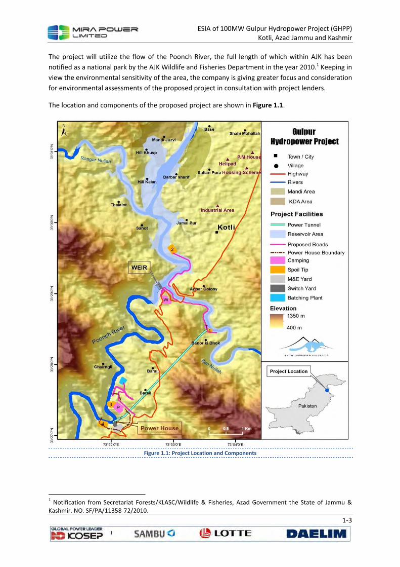
ESIA of 100MW Gulpur Hydropower Project (GHPP) Kotli, Azad Jammu and Kashmir
1-3
The project will utilize the flow of the Poonch River, the full length of which within AJK has been
notified as a national park by the AJK Wildlife and Fisheries Department in the year 2010.1 Keeping in
view the environmental sensitivity of the area, the company is giving greater focus and consideration
for environmental assessments of the proposed project in consultation with project lenders.
The location and components of the proposed project are shown in Figure 1.1.
Figure 1.1: Project Location and Components
1 Notification from Secretariat Forests/KLASC/Wildlife & Fisheries, Azad Government the State of Jammu &
Kashmir. NO. SF/PA/11358-72/2010.
ESIA of 100MW Gulpur Hydropower Project (GHPP) Kotli, Azad Jammu and Kashmir
1-4
1.3 Introduction of the ESIA
1.3.1 Objectives of the ESIA
The objective of the study is to assess the environmental and social impacts associated with the
construction and operation of the Gulpur Hydroelectric Power Project (hereafter described simply as
the ‘Gulpur Project’ or ‘the project’ or ‘GHPP’).
The objectives of this ESIA were to:
• Assess the existing environmental conditions in the project area, including the identification
of environmentally sensitive areas.
• Assess the proposed activities to identify their potential impacts, evaluate the impacts, and
determine their significance.
• Propose appropriate mitigation and monitoring measures that can be incorporated into the
design of the proposed activities to minimize any damaging effects or any lasting negative
consequences identified by the assessment.
• Assess the proposed activities and determine whether they comply with the relevant
environmental regulations in Pakistan and requirements of project lenders including ADB
and IFC.
• Prepare an ESIA report for submittal to the Azad Jammu & Kashmir Environmental
Protection Agency (AJK EPA), ADB and IFC.
The study will result in the following deliverables:
• Environmental and Social Impact Assessment (ESIA) Report; and a
• Environmental and Social Management and Monitoring Plan (ESMMP);
1.3.2 Approach and Methodology
The ESIA was performed in four main phases, which are described below.
1.3.2.1 Scoping
The key activities of this phase included:
Project Data Compilation: A generic description of the proposed activities relevant to environmental
assessment was compiled with the help of the proponent.
Published Literature Review: Secondary data on weather, soil, water resources, wildlife, and
vegetation were reviewed and compiled.
Legislative Review: Information on relevant legislation, regulations, guidelines, and standards was
reviewed and compiled.
Identification of Potential Impacts: The information collected in the previous steps was reviewed
and potential environmental issues identified.

ESIA of 100MW Gulpur Hydropower Project (GHPP) Kotli, Azad Jammu and Kashmir
1-5
1.3.2.2 Baseline Data Collection
No considerable amount of baseline information on the project area was available from existing
literature. Therefore a detailed field visit was conducted to collect primary data on the proposed site
and alternatives of the power plant.
1.3.2.3 Impact Assessment
The environmental, socio-economic, and project information collected was used to assess the
potential impacts of the proposed activities. The issues studied included potential project impacts
on:
• Land Resource and Geomorphology
• Groundwater and surface water quality
• Ambient air quality, greenhouse gas emissions and ambient noise levels
• The ecology of the area, including flora and fauna especially the aquatic ecosystem
• Local communities
• A rapid cumulative impact assessment of multiple hydroelectric projects in the catchment of
Poonch River.
Wherever possible and applicable, the discussion covers the following aspects:
• The present baseline conditions
• The potential change in environmental parameters likely to be effected by project related
activities
• The identification of potential impacts
• The evaluation of the likelihood and significance of potential impacts
• The defining of mitigation measures to reduce impacts to as low as practicable
• The prediction of any residual impacts, including all long-term and short-term, direct and
indirect, and beneficial and adverse impacts
• The monitoring of residual impacts.
1.3.2.4 Documentation
This report documents the ESIA process and results are prepared according to the relevant
guidelines set by the Environmental Protection Agency (EPA), ADB and IFC. A term of reference for
this study was developed and agreed jointly by the ADB, IFC and the Company. Two separate
assessments are to be incorporated with this report upon the finalization which includes: a critical
habitat assessment and a rapid cumulative impact assessment.
1.3.3 Organization of this Report
Section 2 (Policy, Statutory, and Institutional Framework) briefly discusses existing national policy
and resulting legislation for sustainable development and environmental protection, and then
presents the legislative requirements and the requirements of ADB and IFC that need to be followed
while conducting an ESIA.
Section 3 (Project Description) describes the proposed Project.
ESIA of 100MW Gulpur Hydropower Project (GHPP) Kotli, Azad Jammu and Kashmir
1-6
Section 4 to 6 (Description of the Environment) details the project area’s existing physical, biological,
and socioeconomic condition, including geomorphology and soils, water resources, and air quality,
flora and fauna, and demography.
Section 7 (Analyses of Alternatives) presents the project alternatives that were considered, and the
reasons for their selection or rejection.
Section 8 (Stakeholder Consultation) explains the process of public consultation and disclosure of
the report at the District Council Office as well as important public library(s). It makes this document
a legal public document.
Section 9 (Impacts Assessment and Mitigation) presents an assessment of the project’s impact and
their required mitigation measures to the physical, biological, and socioeconomic environment.
Section 10 (Traffic Assessment Study) reviews, assesses and proposes the existing and potential
traffic conditions of the road network available to the proposed project site.
Section 11 (Environmental and Social Management and Monitoring Plan) contains comprehensive
prescriptions regarding environmental and social impacts and their mitigation. This also includes
institutional arrangements and various monitoring, control and management plans.
ESIA of 100MW Gulpur Hydropower Project (GHPP) Kotli, Azad Jammu and Kashmir
2-1
2 POLICY, LEGAL AND ADMINISTRATIVE
FRAMEWORK
‘Sustainable Development’ is a concept that has emerged over the past three decades to describe a
new framework that aims at economic and social development, while maintaining the long-term
integrity of the ecological system. The principles of sustainable development are in the process of
being incorporated into national policies and legislation in Pakistan through various statutory
instruments. This chapter describes the current legal responsibilities of the proponent in the context
of the environment and sustainable development, and the requirements of the institutions that may
influence the environmental management of the proposed project.
2.1 National Policy and Administrative Framework
2.1.1 Overview
The Pakistan National Conservation Strategy (NCS) that was approved by the federal cabinet in
March 1992 is the principal policy document on environmental issues in the country as well as AJK
(EUAD/IUCN, 1992). The NCS outlines the country’s primary approach towards encouraging
sustainable development, conserving natural resources, and improving efficiency in the use and
management of resources. The NCS has 68 specific programs in 14 core areas in which policy
intervention is considered crucial for the preservation of Pakistan’s natural and physical
environment. The core areas that are relevant in the context of the proposed project are pollution
prevention and abatement, restoration of rangelands, increasing energy efficiency, conserving
biodiversity, supporting forestry and plantations, and the preservation of cultural heritage. The
Government of Pakistan promulgated “Pakistan Environmental Protection Act” in 1997. The same
was adopted by the Government of AJK. However, this act was adapted to meet the state’s
requirements and notified in 2000 as Azad Jammu and Kashmir Environmental Protection Act, 2000.
This was made effective with the establishment of the Environmental Protection Council (AJK-EPC)
which is the policy formulating body and Environmental Protection Agency (AJK- EPA), which is an
implementing agency. Prime Minister of AJK is the Chairman and the Minister of Environment is the
Vice Chairman of the AJK EPC. Environmental Protection Agency headed by a Director General has
the responsibility for establishing Biodiversity Action Plan.
Pakistan is a signatory to the Convention on Biological Diversity, and is thereby obligated to develop
a national strategy for the conservation of biodiversity. The Government of Pakistan has constituted
a Biodiversity Working Group under the auspices of the Ministry of Environment, Local Government
and Rural Development to develop a Biodiversity Action Plan for the country. After an extensive
consultative exercise, a draft Action Plan has been developed. The draft Plan2, which has been
designed to complement the NCS and the proposed provincial conservation strategies, identifies the
causes of biodiversity loss in Pakistan and suggests a series of proposals for action to conserve
biodiversity in the country.
2 The plan needs approval from the Ministry of Environment.

ESIA of 100MW Gulpur Hydropower Project (GHPP) Kotli, Azad Jammu and Kashmir
2-2
2.1.2 The AJK, Environmental Protection Act, 2000
The AJK, Environmental Protection Act, 2000 empowers the AJK –EPA to:
• Administer and implement the provisions of the Act and the rules and regulations made
there-under to comply with the environmental policies approved by the Council;
• Enforce the provisions of the Act through environmental protection orders and
environmental tribunals headed by magistrates with wide-ranging powers, including the
right to fine violators of the Act.
• Prepare or revise, and establish the Environmental Quality Standards with the approval of
the Council;
• Develop environmental emission standards for parameters such as air, water and land.
• Identify categories of projects to which the Initial Environment Examination (IEE) or
Environmental Impact Assessment (EIA) will apply.
• Develop guidelines for conducting initial environmental examinations (IEE) and EIA’s and
procedures for the submission, review and approval of the same.
• Review IEE or EIA with the objectives that these meet the requirements of the Act.
• Public participation shall be ensured during review process of IEE or EIA reports.
2.1.3 Regulations for Environmental Assessment
Under Section 11 of the 2000 Act, a project falling under any category (qualifying IEE or EIA) requires
the proponent to file IEE or EIA with the AJK-EPA. Within stipulated time the agency will confirm that
the document submitted is complete for the purpose of review. During this time, should the agency
require the proponent to submit any additional information, it will return the IEE or EIA to the
proponent for revision, clearly listing those aspects that need further discussion. Subsequently, the
agency shall make every effort to complete an IEE or EIA review within four months of filing the case.
2.1.4 Guidelines for Environmental Assessment
In the absence of AJK-EPA guidelines for environmental assessment, those laid down by Pak- EPA
have been followed.
The Pak-EPA has published a set of environmental guidelines for conducting environmental
assessments and the environmental management of different types of development projects. The
guidelines that are relevant to the proposed project are listed below, followed by comments on their
relevance to the proposed project:
A. GUIDELINES FOR THE PREPARATION AND REVIEW OF ENVIRONMENTAL REPORT:
The guidelines on the preparation and review of environmental reports target the project
proponents, and specify;
• The nature of the information to be included in environmental reports
• The minimum qualifications of the EIA team appointed.
• The need to incorporate suitable mitigation measures at every stage of project
implementation.
• The need to specify monitoring procedures.
ESIA of 100MW Gulpur Hydropower Project (GHPP) Kotli, Azad Jammu and Kashmir
2-3
• The terms of reference for the reports are to be prepared by the project proponents
themselves. The report must contain baseline data on the project area, detailed assessment
thereof, and mitigation measures.
B. GUIDELINES FOR PUBLIC CONSULTATION:
These guidelines deal with possible approaches to public consultation and techniques for designing
an effective program of consultation that reaches out to all major stakeholders and ensures that
their concerns are incorporated in any impact assessment study.
2.1.5 National Environmental Quality Standards (NEQS)
The National Environmental Quality Standards (NEQs) specify the following standards:
• Maximum allowable contamination of pollutants (32 parameters) in emission and liquid
industrial effluents discharged to inland water.
• Maximum allowable concentration of pollutant (16 parameters) in gaseous emission from
sources other than vehicles.
• Maximum allowable concentration of pollutants in gaseous emissions from vehicle exhaust
and noise emission from vehicles.
• Maximum allowable noise level from vehicles.
• Ambient noise standards
• Ambient air quality standards.
These standards apply to gaseous emissions and liquid effluents discharged by batching plants,
asphalt plants, camp sites, construction machinery, and vehicles. The standards for vehicle, noise
wastewater and drinking water will apply during the construction as well as operational phase of the
project.
These NEQS are presented in Table 2.2 to Table 2.10.
2.1.6 National Resettlement Policy and Ordinance
At this point, the only legislation relating to land acquisition and compensation is the Land
Acquisition Act (LAA) of 1894. The LAA is, however, limited to a cash compensation policy for the
acquisition of land and built-up property, and damage to other assets, such as crops, trees, and
infrastructure based on market prices. The LAA does not consider the rehabilitation and
resettlement of disrupted populations and the restoration of their livelihoods.
Experience with large-scale infrastructure development projects implemented by institutions such as
the Pakistan Water and Power Development Authority (WAPDA) has demonstrated the need for a
cohesive national policy for resettlement. In spite of the fact that a National Resettlement Policy and
related legislation has been drafted, it has not been officially notified. In the absence of this, the
safeguard policy of the World Bank as spelled out in OP/BP 4.12 will form the basis for managing the
resettlement needs arising from the project.
ESIA of 100MW Gulpur Hydropower Project (GHPP) Kotli, Azad Jammu and Kashmir
2-4
2.1.7 The Land Acquisition Act, 1894
The law deals with the matters related with acquisition of private land and other immovable
properties existing on the land required for the project. The public purpose, inter alia, includes the
construction of development projects including related roads, quarry areas, colonies, etc. For that
matter it may also be applicable at private level provided the public utility of the project is
established. As the land is a provincial subject, the proponent has to acquire the land for the project
through the provincial governments.
2.1.8 The Forest Act, 1927 and the Forest (Amendment) Act 2010
The Act, inter alia, deals with the matters related with protection and conservation of natural
vegetation/habitats. In that matter it empowers the concerned agency to declare protected and
reserved forest areas and maintaining these. In spite of the fact that it recognizes the right of people
for access to the natural resources for their household use, it prohibits unlawful cutting of trees and
other vegetation.
Therefore, for cutting trees for the construction purposes or otherwise, prior permission is required
from the forest department of the concerned province.
2.1.9 The Jammu and Kashmir Forest Regulations, 1930
The main legislation for management and protection of forest and rangeland in AJK is the Jammu
and Kashmir Forest Regulation of 1930 and its later amendments of 1973, 1976, 1977 and 1980. The
amendments are mostly related with penal provisions for forest offences. According to the AJK
Forest Regulations, the forests are designated as ‘Demarcated” or “Un-demarcated”. The former
forests, like Reserved Forests under Forest Act of 1927 that is in vogue in Pakistan, are under the
control of Forest Department, while the latter are under the control of Board of Revenue through
Deputy Commissioner. There are two other categories of forests in AJK denominated as “Village
Forests” and “Private Forests”. The former are established under Section 14 (a) of the AJK Forest
Regulations, while the latter are established under the Private Forest Rules of AJK Land Revenue Act
1955. Moreover, “Tree Plantation & Maintenance Act 1977 has been enacted to ensure planting and
maintenance of at least 3 trees per acre in farmland.
Under the provision of the forest related legislations there are regulations on usufruct right of the
communities or individual for using the area for grazing, acquiring wood for fuel wood or timber.
However, for cutting trees for the construction of a project special permission would be needed
from the Forest Department and Revenue Department/Local Administration depending upon the
type of forest encountered.
2.1.10 The AJK Wildlife (Protection, Preservation, Conservation and
Management) Act, 1975
In addition to empowering AJK wildlife department to establish game reserves, parks, and wildlife
sanctuaries, this Act regulates the hunting and disturbance of wildlife. While reviewing the ESIA, the
AJK-EPA may consult the AJK wildlife department in case the project has an impact on wildlife.
ESIA of 100MW Gulpur Hydropower Project (GHPP) Kotli, Azad Jammu and Kashmir
2-5
The AJK-EPA may require the proponent to coordinate with the AJK wildlife department for the
implementation of the project and monitoring activities during construction and operation of the
project.
2.1.11 Azad Jammu and Kashmir, Wildlife (Protection, Preservation,
Conservation and Management) Ordinance, 2012
The Chapter VI of the ordinance is on Protected Areas. Section 43 of the ordinance is covering
National parks. The department of wildlife and fisheries shall be responsible to ensure the
implementation of this ordinance as per rules of business. The section 43 of the ordinance of
National Park States that:
1. With a view to the protection and preservation of landscape, flora, fauna, geological
features of special significance and biological diversity in the natural state, the government
may, by notification in the official Gazette, declare any area to be a National Park and may
demarcate it in such a manner as may be prescribed.
2. A National Park shall be accessible to public for recreation; education and research purposes
subject to such restrictions as the government may impose.
3. The provision for access roads to and construction of rest houses, hostels and other
buildings in the national park along with amenities for public may be so made, as not to
impair the object of the establishment of the National Park.
4. Any facility provided under Sub-Sections (2) and (3) shall be in conformity with the
recommendations of the Environmental Impact Assessment or Initial Environmental
Examination under AJK Environment Protection Act, 2001 and amendments made
thereunder.
5. The following acts shall be prohibited in a National Park;
i. Hunting, shooting, trapping, killing or capturing of any wild animal;
ii. carrying of arms, pet animals, livestock, firing any gun or doing any other act which
may disturb any wild animal or doing any act which interferes with the serenity and
tranquility of the park and breeding places of wild animals;
iii. logging, felling, tapping, burning or in any way damaging or destroying, taking,
collecting or removing any plant or tree;
iv. grazing of livestock;
v. fishing;
vi. clearing or breaking up any land for cultivation; mining or quarrying of stones for any
other purpose;
vii. polluting or poisoning water flowing in and through the National Park;
viii. littering and dumping of waste;
ix. writing, in scripting, carving, disfiguring, defacing, painting, chalking, advertising;
x. use of vehicular transport except on recognized roads and routes;
xi. blowing of pressure horns within one kilometer radius of the park boundary; and
xii. playing music or using radios, or making noise.
6. The Department may, however for scientific purpose or betterment of the National Park or
for providing incentives or concessions to the communities for participatory management,
authorize doing of one or more acts mentioned in sub-Section (5) on an explicit written

ESIA of 100MW Gulpur Hydropower Project (GHPP) Kotli, Azad Jammu and Kashmir
2-6
request made to the Head of the Department justifying the need for such an action and
certifying that it does not impair the objectives of establishment of the park, in a specified
manner.
7. Whoever contravenes or fails to comply with any of the provisions of this Section or abets in
commission or furtherance of any such acts shall be punishable with imprisonment, which
shall not be less than six months and may extend to one year, or with fine which shall not be
less than rupees ten thousand and may extend to rupees thirty thousand, or with both, in
addition to such compensation as the convicting court may direct to be paid, which shall not
be less than the value of the damage assessed by the department.
8. In case offense is proved to be followed by award of punishment by the court, all animals,
tools, implements, carriages, including mechanically propelled vehicles, pack animal, arms,
ammunitions and other equipments and conveyances used in the commission or
furtherance of an offence shall stand confiscated in favor of the government, in addition to
the punishment awarded under this Section.
9. If a woman, is charged for any of the offense under this Ordinance, the court may, after the
reasons to be recorded in writing, dispense with her physical presence before the court
while permitting her to appear by an agent duly authorized in writing under the signature or
thumb-impression of such accused having woman, attested by a respectable person of the
area concerned.
2.1.12 The Antiquities Act, 1975
The Act deals with the matters relating to the protection, preservation and conservation of
archaeological/ historical sites and monuments. It prohibits construction (or any other damaging)
activity within 200 meters of such sites unless prior permission is obtained from the Federal
Department of Archaeology and Museums. Invariably, for the implementation of new projects an
archeological survey is required and in the light of this clearance is sought from the federal. In spite
of the fact that Provincial Archaeological Departments exists, the pertinent authority for issuing
clearance is the Federal Department.
2.1.13 The Motor Vehicles Ordinance, 1965, and Rules, 1969
The Motor Vehicles Ordinance, 1965, has been extended with effect from March 05, 1978, to the
whole of Pakistan. It deals with the licensing requirement for driving; powers of licensing authority,
Regional Transport Authority and those of Court vis-à-vis disqualification for license and registration
requirements to control road transport; compensations for the death of or injury to a passenger of
public carrier; powers of Road Transport Corporation; traffic rules, power to limit speed, weight, use
of vehicles; power to erect traffic signs; specific duties of drivers in case of accident and powers of
police officers to check and penalize traffic offenders.
2.1.14 The Factories Act, 1934
The pertinent clauses of the Act are those that deal with health, safety and welfare of the workers,
disposal of solid waste and effluent, and damage to private and public property. It also deals with
the regulations for handling and disposing of toxic and hazardous materials. As the construction
activity has also been classified as an ‘industry’, the regulations will be applicable to the Contractors.
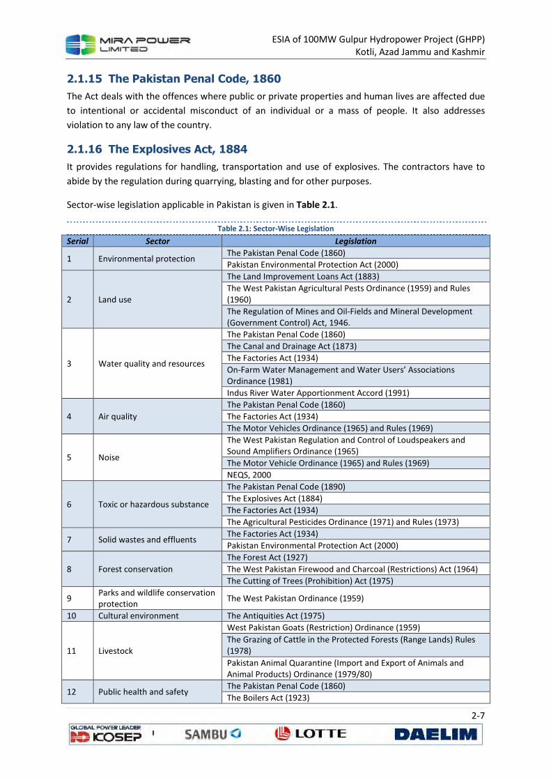
ESIA of 100MW Gulpur Hydropower Project (GHPP) Kotli, Azad Jammu and Kashmir
2-7
2.1.15 The Pakistan Penal Code, 1860
The Act deals with the offences where public or private properties and human lives are affected due
to intentional or accidental misconduct of an individual or a mass of people. It also addresses
violation to any law of the country.
2.1.16 The Explosives Act, 1884
It provides regulations for handling, transportation and use of explosives. The contractors have to
abide by the regulation during quarrying, blasting and for other purposes.
Sector-wise legislation applicable in Pakistan is given in Table 2.1.
Table 2.1: Sector-Wise Legislation
Serial Sector Legislation
1 Environmental protection The Pakistan Penal Code (1860)
Pakistan Environmental Protection Act (2000)
2 Land use
The Land Improvement Loans Act (1883)
The West Pakistan Agricultural Pests Ordinance (1959) and Rules (1960)
The Regulation of Mines and Oil-Fields and Mineral Development (Government Control) Act, 1946.
3 Water quality and resources
The Pakistan Penal Code (1860)
The Canal and Drainage Act (1873)
The Factories Act (1934)
On-Farm Water Management and Water Users’ Associations Ordinance (1981)
Indus River Water Apportionment Accord (1991)
4 Air quality
The Pakistan Penal Code (1860)
The Factories Act (1934)
The Motor Vehicles Ordinance (1965) and Rules (1969)
5 Noise
The West Pakistan Regulation and Control of Loudspeakers and Sound Amplifiers Ordinance (1965)
The Motor Vehicle Ordinance (1965) and Rules (1969)
NEQS, 2000
6 Toxic or hazardous substance
The Pakistan Penal Code (1890)
The Explosives Act (1884)
The Factories Act (1934)
The Agricultural Pesticides Ordinance (1971) and Rules (1973)
7 Solid wastes and effluents The Factories Act (1934)
Pakistan Environmental Protection Act (2000)
8 Forest conservation
The Forest Act (1927)
The West Pakistan Firewood and Charcoal (Restrictions) Act (1964)
The Cutting of Trees (Prohibition) Act (1975)
9 Parks and wildlife conservation protection
The West Pakistan Ordinance (1959)
10 Cultural environment The Antiquities Act (1975)
11 Livestock
West Pakistan Goats (Restriction) Ordinance (1959)
The Grazing of Cattle in the Protected Forests (Range Lands) Rules (1978)
Pakistan Animal Quarantine (Import and Export of Animals and Animal Products) Ordinance (1979/80)
12 Public health and safety The Pakistan Penal Code (1860)
The Boilers Act (1923)
ESIA of 100MW Gulpur Hydropower Project (GHPP) Kotli, Azad Jammu and Kashmir
2-8
Serial Sector Legislation
The Public Health (Emergency Provisions) Ordinance (1944)
The West Pakistan Factories Canteen Rules (1959)
The West Pakistan Epidemic Diseases Act (1979/80)
2.2 Interaction with other Agencies
The proponent is responsible for ensuring that the project complies with the laws and regulations
controlling the environmental concerns of dam construction and operation, and that all pre-
construction requisites, such as permits and clearances are met. This section describes the nature of
the relationship between the proponent and line departments.
2.2.1 AJK- EPA
The proponent is responsible for preparing the complete environmental documentation required by
the AJK-EPA and remain committed for getting clearance from it. Moreover, it is also desirable that
once clearance from AJK - EPA is obtained, the proponent should remain committed to the approved
project design. No deviation is permitted in design and scope of rehabilitation during project
implementation without the prior and explicit permission of the EPAs.
2.2.2 Revenue Departments of AJK
Under the national law, matters relating to land use and ownership are provincial subjects, and for
the purposes of this project, the respective Revenue Departments of AJK are empowered to carry
out the acquisition of private land or built-up property for public purposes. In order to depute land
acquisition collectors (LACs) and other revenue staff who will be responsible for handling matters
related to acquisition of land and the disbursement of compensation, the proponent must lodge
applications with the AJK government.
The proponent will provide logistical support and assist in preparing the documents necessary for
notification. It will also need to liaise with the departments of agriculture, horticulture, and forestry
in order to evaluate affected vegetation resources, such as trees and crops, etc., for compensation
purposes. Where public buildings/infrastructure is involved, the proponent will approach the
relevant departments for valuation of the affected building or infrastructure before removing the
facilities.
Likewise, the proponent will liaise with other relevant departments/agencies for relocation of public
facilities such as electricity and telephone poles, public water supply schemes, public buildings, etc.
2.2.3 AJK of Forestry and Wildlife Departments
The project is expected to involve clearing of vegetation and trees within the proposed project area.
The project contractor will be responsible for acquiring a ‘No-Objection Certificate’ (NOC) from the
respective Forest Departments and Local Administration depending upon the type of forest, viz.,
demarcated, un-demarcated or individual forests under threat. The application for an NOC will need
to be endorsed by the proponent.
ESIA of 100MW Gulpur Hydropower Project (GHPP) Kotli, Azad Jammu and Kashmir
2-9
Where construction is to be carried out in close proximity of protected forests and wildlife areas, the
proponent is required to coordinate with the departments to ensure that impacts on vegetation and
wildlife are minimized.
2.2.4 Local Government and Municipalities
The proponent and its contractors must ensure that the project meets the criteria of the
governments of AJK for the establishment of construction camps and plants, use of the water
resources and the safe disposal of wastewater, and toxic materials. These matters lie in the
jurisdiction of Local Governments. Therefore, the Contractor should liaise closely with the concerned
body. The project Proponent will coordinate and monitor environment-related issues.
The project proponent will liaise with local government/administration and municipalities on the
matters related to resettlement of squatters and removal of encroachments or sources of
congestion. In specific cases, the project proponent will enter into agreements with the municipality,
local government, or other service provider on the resettlement of displaced squatters.
2.3 Applicable International Conventions
Environmental problems which migrate beyond the jurisdiction (Trans-boundary) require power to
control such issues through international co-operation by either becoming a Contracting Party (CP)
i.e. ratifying treaties or as a signatory by officially signing the treaties and agreeing to carry out
provisions of various treaties on environment and social safeguards. The relevant international
conventions are as provided.
2.3.1 Montreal Protocol on Substances that Deplete the Ozone Layer
Pakistan ratified its accession of the Montreal Protocol along with its London Amendment on 18 Dec
1992 and also ratified the Copenhagen, Montreal and Beijing Amendments of 2003. The Montreal
Protocol on Substances that Deplete the Ozone Layer regulates many radioactively powerful
greenhouse gases for the primary purpose of lowering stratospheric chlorine and bromine
concentrations. These gases include the CFCs, HCFCs, chlorocarbons, bromocarbons and halons.
2.3.2 UN (Rio) Convention on Biological Diversity
Pakistan is a signatory to this convention since 5 June 1992 and ratified the convention on 26 July
1994. The Convention on Biological Diversity (CBD) entered into force on 29 December 1993. It has 3
main objectives: 1. the conservation of biological diversity, 2. the sustainable use of the components
of biological diversity and 3. The fair and equitable sharing of the benefits arising out of the
utilization of genetic resources
2.3.3 The Convention on Wetlands of International Importance
Especially as Waterfowl Habitat, 1971 (Ramsar Convention)
Pakistan ratified the Ramsar Convention in 1975 and there are currently 19 Ramsar sites in Pakistan,
covering an area of 1,343,627 hectares (3,320,170 acres). The convention requires protection of
identified wetlands of international importance as identified under Ramsar convention. The Ramsar
Convention (formally, the Convention on Wetlands of International Importance, especially as
ESIA of 100MW Gulpur Hydropower Project (GHPP) Kotli, Azad Jammu and Kashmir
2-10
Waterfowl Habitat) is an international treaty for the conservation and sustainable utilization of
wetlands.
2.3.4 Conventions on the Conservation of Migratory Species of Wild
Animals and Migratory Species
The Convention on the Conservation of Migratory Species of Wild Animals (also known as CMS or
Bonn Convention) aims to conserve terrestrial, aquatic and avian migratory species throughout their
range.
2.3.5 Convention on International Trade in Endangered Species of Wild
Fauna and Flora
Pakistan is a party to CITES, with the conventions implementation through “Pakistan Trade Control
of Wild Fauna and Flora Act (2012)”. CITES (the Convention on International Trade in Endangered
Species of Wild Fauna and Flora) is an international agreement between governments. Its aim is to
ensure that international trade in specimens of wild animals and plants does not threaten their
survival.
2.3.6 Kyoto Protocol
The Kyoto protocol was signed by Pakistan in 2005 and in February, 2006, the national CDM
operational strategy was approved. The convention pertains to the United Nations framework on
Climate Change. The 3rd Conference of the Parties to the Framework Convention on Climate Change
(FCCC) in Kyoto in December 1997 introduced the Clean Development Mechanism (CDM) as a new
concept for voluntary greenhouse-gas emission reduction agreements between industrialized and
developing countries on the project level.
2.3.7 The Rotterdam Convention on the Prior Informed Consent (PIC)
Procedure
Pakistan signed the Rotterdam Convention on the Prior Informed Consent (PIC) Procedure on 9
September 1999 and subsequently ratified the convention on 14 July 2005. The Rotterdam
Convention (formally, the Rotterdam Convention on the Prior Informed Consent Procedure for
Certain Hazardous Chemicals and Pesticides in International Trade) is a multilateral treaty to
promote shared responsibilities in relation to importation of hazardous chemicals. The convention
promotes open exchange of information and calls on exporters of hazardous chemicals to use proper
labeling, include directions on safe handling, and inform purchasers of any known restrictions or
bans. Signatory nations can decide whether to allow or ban the importation of chemicals listed in the
treaty, and exporting countries are obliged make sure that producers within their jurisdiction
comply.
2.3.8 International Labour Organization conventions
Pakistan has also ratified many of the International Labor Organization conventions that are relevant
to the Project including:
• C1 Hours of Work (Industry) Convention, 1919;
• C5 Minimum Age (Industry) Convention, 1919:
ESIA of 100MW Gulpur Hydropower Project (GHPP) Kotli, Azad Jammu and Kashmir
2-11
• C11 Right of Association (Agriculture) Convention, 1921:
• C14 Weekly Rest (Industry) Convention, 1921;
• C29 Forced Labor Convention, 1930 & C105 Abolition of Forced Labor Convention, 1957;
• C100 Equal Remuneration Convention, 1951;
• C107 Indigenous and Tribal Populations Convention, 1957
• C111 Discrimination (Employment and Occupation) Convention, 1958
2.4 IFC’s Requirements
IFC applies the Performance Standards to manage social and environmental risks and impacts and to
enhance development opportunities in its private sector financing in its member countries eligible
for financing. The Performance Standards may also be applied by other financial institutions electing
to apply them to projects in emerging markets. Together, the eight Performance Standards establish
standards that the client is to meet throughout the life of an investment by IFC or other relevant
financial institution:
• Performance Standard 1: Social and Environmental Assessment and Management System
• Performance Standard 2: Labor and Working Conditions
• Performance Standard 3: Pollution Prevention and Abatement
• Performance Standard 4: Community Health, Safety and Security
• Performance Standard 5: Land Acquisition and Involuntary Resettlement
• Performance Standard 6: Biodiversity Conservation and Sustainable Natural Resource
Management
• Performance Standard 7: Indigenous Peoples
• Performance Standard 8: Cultural Heritage
2.4.1 IFC's Performance Standards on Social and Environmental
Sustainability
International Finance Corporation applies the Performance Standards to manage social and
environmental risks and impacts and to enhance development opportunities in its private sector
financing in its member countries eligible for financing. Together, the eight Performance Standards
establish standards that the client is required to meet throughout the life by IFC or other relevant
financial institution.
PS 1 Social and Environmental Assessment and Management System- It establishes the importance
of integrated assessment to identify the social and environmental impacts, risks, and opportunities
in the project's area of influence. PS 1 requires Social and Environmental Assessment and
Management Systems for managing social and environmental performance throughout the life cycle
of this Project and runs through all subsequent PSs. The main elements of PS 1 includes following
elements: (i) Social and Environmental Assessment; (ii) Management program; (iii) organizational
capacity; (iv)training; (v) community engagement; (vi) monitoring; and (vii) reporting.
PS 2 Labor and working conditions- requires that worker-management relationship is established
and maintained, compliance with national labor and employment laws and safe and healthy working
conditions are ensured for the workers.

ESIA of 100MW Gulpur Hydropower Project (GHPP) Kotli, Azad Jammu and Kashmir
2-12
PS 3 Pollution prevention and Abatement- outlines approach to pollution prevention and
abatement in line with Internationally disseminated technologies and practices with objectives to a)
avoid or minimize adverse impacts on human health and the environment by avoiding or minimizing
pollution from activities; and b) promote the reduction of emissions that contribute to climate
change. It requires a project to avoid, minimize, or reduce adverse impacts on human health and the
environment by avoiding or minimizing pollution from project activities.
PS 4 Community health, safety and security- concentrates on the responsibility that must be
undertaken by the client to avoid or minimize the risks and impacts to the community's health,
safety and security that may arise from project activities.
PS 5 Land Acquisition and Involuntary Resettlement- This standard requires that project does not
result in involuntary resettlement or at least if unavoidable it is minimized by exploring alternative
project designs. Also the project will ensure that social and economic impacts from land acquisition
or restrictions on affected persons' use of land are mitigated.
PS 6 Biodiversity Conservation and Sustainable Natural Resource Management- aims at protecting
and conserving biodiversity, the variety of life in all its forms, including genetic, species and
ecosystem diversity and its ability to change and evolve, is fundamental to sustainable development.
This PS addresses how clients can avoid or mitigate threats to biodiversity arising from their
operations as well as incorporate sustainable management of renewable natural resources.
PS 7 Indigenous Peoples- acknowledges the possibility of vulnerability of indigenous people owing to
their culture, beliefs, institutions and living standards and that it may further get compromised by
one or other project activity throughout the life cycle of the project. The PS underlines the
requirement of minimizing adverse impacts an indigenous people in the project area, respecting the
local culture and customs, fostering good relationship and ensuring that development benefits are
provided to improve their standard of living and livelihoods.
PS 8 Cultural Heritage- aims to protect the irreplaceable cultural heritage and to guide clients on
protecting cultural heritage in the course of their business operations.
The applicability of these Performance Standards is established during the Social and Environmental
Impact Assessment process, while implementation of the actions is necessary to meet the
requirements of IFC, the Performance Standards are managed through the owner's Social and
Environmental Management System.
GHPP will have to follow all the Performance Standards of IFC for this project and should also ensure
that the contractors / subcontracts (subcontractors of the contracts) appointed by MPL all follow the
IFC performance standards on Environmental and Social Sustainability.
2.4.2 Environmental, Health and Safety General Guidelines
The EHS Guidelines are technical reference documents with general and industry-specific examples
of Good International Industry Practice (GIIP). The applicability of the EHS Guidelines should be
tailored to the hazards and risks established for each project on the basis of the results of an
environmental assessment in which site-specific variables, such as host country context, assimilative
ESIA of 100MW Gulpur Hydropower Project (GHPP) Kotli, Azad Jammu and Kashmir
2-13
capacity of the environment, and other project factors, are taken into account. The General EHS
Guidelines consist of the following components:
Environmental: This guideline applies to facilities or projects that generate emissions to air at any
stage of the project life-cycle. They also look into aspects of energy conservation, wastewater and
ambient water quality, water conservation, hazardous materials management, waste management,
noise and contaminated land.
Occupational Health and Safety: This section provides guidance and examples of reasonable
precautions to implement in managing principal risks to occupational health and safety. Although
the focus is placed on the operational phase of projects, much of the guidance also applies to
construction and decommissioning activities. This incorporates general facility design and operation,
communication and training, physical hazards, chemical hazards, biological hazards, radioactive
hazards, Personal Protective Equipment (PPE), special hazard environment and monitoring.
Community Health and Safety: This guidance complements the above two guidelines by specifically
addressing aspects of project activities which fall outside the traditional project boundaries but
which are related to the project operations as and when they occur.
Construction and Decommissioning: This section provides an additional and specific guidance to the
prevention and control of community health and safety impacts that may occur during new project
development, at the end of the project life-cycle or due to expansion or modification of existing
project facilities.
2.4.3 IFC's Environment, Health and Safety Guidelines for Electric Power
Transmission and Distribution
The EHS Guidelines for Electric Power Transmission and Distribution include information relevant to
power transmission between a generation facility and a substation located within an electricity grid,
in addition to power distribution from a substation to consumers located in residential, commercial,
and industrial areas. The various aspects comprising this guidance are industry specific impacts and
management and performance indicators and monitoring.
2.5 ADB Guidelines
The following ADB policies and guidelines shall be applicable to the proposed project:
• ADB Policies, Strategies and Operations Manuals including but not limited to:
o ADB’s 2009 Safeguard Policy Statement (SPS) – Safeguards Requirement (SR) 1 on
Environment, SR2 on Involuntary Resettlement (IR), and SR 3 on Indigenous Peoples
(IP)
o ADB Social Protection Strategy (2001);
o ADB Gender and Development Policy (1998);
o Public Communications Policy (2011); and
o Relevant ADB Operations Manual (OM) such as OMF1 for Safeguards Policy
Statement, OML3 for Public Communications, OMD10 for Non-sovereign
ESIA of 100MW Gulpur Hydropower Project (GHPP) Kotli, Azad Jammu and Kashmir
2-14
Operations, OMC3 for Incorporation of Social Dimensions into ADB Operations,
OMC2 for Gender and Development; 3
The ADB’s environmental policy is grounded in its Poverty Reduction Strategy and its Long-Terms
Strategic Framework. To ensure the reduction of poverty through environmentally sustainable
development, the ADB’s Environment Policy contains five main elements: (i) promoting environment
and natural resource management interventions to reduce poverty directly, (ii) assisting developing
member countries to mainstream environmental considerations in economic growth, (iii) helping
maintain global and regional life support systems that underpin future development prospects, (iv)
building partnerships to maximize the impact of ADB lending and non-lending activities, and (v)
integrating environmental considerations across all ADB operations.
Under the last element, the ADB pledges to address the environmental aspects of its operations
through the systematic application of procedures for (i) environmental analysis for country strategy
and programming; (ii) environmental assessment of project loans, program loans, sector loans, loans
involving financial intermediaries, and private sector loans; (iii) monitoring and evaluation of
compliance with environmental requirements of loans; and (iv) implementation of procedures for
environmentally responsible procurement. In the context of policy-based lending and policy
dialogue, the ADB will identify opportunities to introduce policy reforms that provide incentives to
improve environmental quality and enhance the sustainability of natural resource management.
ADB classifies projects into category A (with potentially significant environmental impact); category
B (with potentially less significant environmental impact); or, category C (unlikely to have significant
environmental impact).4 An IEE is required for category B projects and an ESIA, requiring greater
depth of analysis, for category A projects. No environmental assessment is required for category C
projects although their environmental implications nevertheless need to be reviewed. The proposed
project has been classified as a category A project for environment.
The ADB’s requirements for environmental assessment are specified in its Environmental
Assessment Guidelines. 5 The ADB requires that an environmental assessment report and a summary
ESIA report be prepared for a Category A project. Important considerations in preparing the
environmental assessment include assessing induced, indirect, and cumulative impact, examining
alternatives, achieving environmental standards, designing least-cost mitigation measures,
developing appropriate environmental management plans and monitoring requirements,
formulating institutional arrangements, and ensuring meaningful public consultation. The format of
the environment assessment report for program loans is flexible, but includes a matrix describing
the environmental consequences and mitigation measures for the policy actions underpinning the
program loan.
The ADB requires public consultation and access to information in the environment assessment
process. For a Category A project, it is required that the groups affected by the proposed project and
3 Available from http://www.adb.org/Documents/Manuals/Operations/default.asp
4 A fourth category, FI (credit line for subprojects through a financial intermediary, or equity investment in a
financial intermediary), requires that an appropriate environmental management system should be developed and assessment carried out. 5 ADB. 2003. Environmental Assessment Guidelines. Manila: ADB.
ESIA of 100MW Gulpur Hydropower Project (GHPP) Kotli, Azad Jammu and Kashmir
2-15
local NGOs be consulted at least twice: (i) once during the early stages of ESIA field work; and (ii)
once when the draft ESIA report is available, and prior to loan appraisal by the ADB. The public
consultation process needs to be described in the ESIA and summary ESIA reports.
The EMMP is a key component of the ESIA. The ADB places strong emphasis on the preparation of
EMMPs during project processing. The EMMP sets out conditions and targets to be met during
project implementation. It is also required to develop procedures and plans to ensure that the
mitigation measures and monitoring requirements approved during the environmental compliance
review will actually be carried out in subsequent stages of the project.
The ADB, however, recognizes that the specific construction and operational activities may not be
well enough defined at the feasibility stage of the project cycle to provide the details required for an
effective EMMP. The ADB therefore requires that the Borrower ensure that a revised EMMP be
prepared at the beginning of the implementation stage. The Company will be the project proponent
and will be responsible for preparing the revised EMMP.
2.5.1 ADB's Safeguard Policy Statement 2009
Built upon the three previous safeguard policies on the Involuntary Resettlement Policy (1995), the
Policy on Indigenous Peoples (1998) and the Environment Policy (2002), the Safeguard Policy
Statement was approved in 2009. The safeguard policies are operational policies that seek to avoid,
minimize or mitigate adverse environmental and social impacts including protecting the rights of
those likely to be affected or marginalized by the developmental process. ADB's safeguard policy
framework consists of three operational policies on the environment, indigenous peoples and
involuntary resettlement. A brief detail of all three operational policies have been mentioned below:
Environmental Safeguard: This safeguard is meant to ensure the environmental soundness and
sustainability of projects and to support the integration of environmental considerations into the
project decision making process.
Involuntary Resettlement Safeguard: This safeguard has been placed in order to avoid involuntary
resettlement whenever possible; to minimize involuntary resettlement by exploring project and
design alternatives; to enhance, or at least restore, the livelihoods of all displaced persons in real
terms relative to pre- project levels; and to improve the standards of living of the displaced poor and
other vulnerable groups.
Indigenous Peoples Safeguard: This safeguard looks at designing and implementing projects in a
way that fosters full respect for Indigenous Peoples' identity, dignity, human rights, livelihood
systems and cultural uniqueness as defined by the Indigenous Peoples themselves so that they
receive culturally appropriate social and economic benefits; do not suffer adverse impacts as a result
of projects; and participate actively in projects that affect them.
Information, Consultation and Disclosure: Consultation and participation are essential in achieving
the safeguard policy objectives. This implies that there is a need for prior and informed consultation
with affected persons and communities in the context of safeguard planning and for continued
consultation during project implementation to identify and help address safeguard issues that may
arise. The consultation process begins early in the project preparation stage and is carried out on an

ESIA of 100MW Gulpur Hydropower Project (GHPP) Kotli, Azad Jammu and Kashmir
2-16
ongoing basis throughout the project cycle. It provides timely disclosure of relevant and adequate
information that is understandable and readily accessible to affected people and is undertaken in an
atmosphere free of intimidation or coercion. In addition, it is gender inclusive and responsive and
tailored to the needs of disadvantaged and vulnerable groups and enables the incorporation of all
relevant views of affected people and other stakeholders into decision making. ADB requires the
borrowers/clients to engage with communities, groups or people affected by proposed projects and
with civil society through information disclosure, consultation and informed participation in a
manner commensurate with the risks to and impacts on affected communities. For projects with
significant adverse environmental, involuntary resettlement or Indigenous Peoples impacts, ADB
project teams will participate in consultation activities to understand the concerns of affected
people and ensure that such concerns are addressed in project design and safeguard plans.
2.5.2 Social Protection Requirements
ADB's Social Protection Strategy (2001 SPS) requires the Borrower to comply with applicable labor
laws in relation to the Project, and take the following measures to comply with the core labor
standards6 for the ADB financed portion of the Project:
a. carry out its activities consistent with the intent of ensuring legally permissible equal
opportunity, fair treatment and non-discrimination in relation to recruitment and hiring,
compensation, working conditions and terms of employment for its workers (including
prohibiting any form of discrimination against women during hiring and providing equal
work for equal pay for men and women engaged by the Borrower);
b. not restrict its workers from developing a legally permissible means of expressing their
grievances and protecting their rights regarding working conditions and terms of
employment;
c. engage contractors and other providers of goods and services:
(i) who do not employ child Iabor7 or forced labor;8
(ii) who have appropriate management systems that will allow them to operate in a
manner which is consistent with the intent of (A) ensuring legally permissible equal
opportunity and fair treatment and non-discrimination for their workers, and (B) not
restricting their workers from developing a legally permissible means of expressing
their grievances and protecting their rights regarding working conditions and terms
of employment; and
(iii) whose subcontracts contain provisions which are consistent with paragraphs (i) and
(ii) above.
6 the core labor standards are the elimination of all forms of forced or compulsory labor; the abolition of child
labor; elimination of discrimination in respect of employment and occupation; and freedom of association and the effective recognition of the right to collective bargaining, as per the relevant conventions of the International Labor Organization; 7 child labour means the employment of children whose age is below the statutory minimum age of
employment in the relevant country, or employment of children in contravention of International Labour Organization Convention No. 138 'Minimum Age Convention" (www.ioo.org) 8 forced labour means all work or services not voluntarily performed, that is, extracted from individuals under
threat of force or penalty
ESIA of 100MW Gulpur Hydropower Project (GHPP) Kotli, Azad Jammu and Kashmir
2-17
2.5.3 Public Communications Policy 2011
The Public Communications Policy (PCP) of ADB, originally formulated in 2005 and revised in 2011, is
aimed at promoting improved access to information about ADB's operations related to funded
projects. It endorses greater transparency and accountability to stakeholders involved in a project.
The PCP establishes the disclosure requirements for documents and information related to projects.
It mandates project-related documents normally produced during the project cycle to be posted on
the web.
2.5.4 Gender and Development Policy 1998
ADB's Gender and Development Policy (1998) adopts gender mainstreaming as a key strategy for
promoting gender equity, and for ensuring that women participate in and that their needs are
explicitly addressed in the decision-making process for development activities. The key elements of
ADBs gender policy are: (i) Gender sensitivity, to observe how the project affects women and men
differently and to take account of their different needs and perspectives in resettlement planning;
(ii) Gender analysis, which refers to the systematic assessment of the project impact on men and
women and on the economic and social relationships between them; (iii) Gender planning, which
refers to the formulation of specific strategies to bring about equal opportunities to men and
women; and (iv) Mainstreaming, to consider gender issues in all aspects of ADB operations,
accompanied by efforts to encourage women's participation in the decision-making process in
development activities.
The SPS and safeguards requirements also reiterate the importance of including gender issues in the
preparation of safeguards documents at all stages to ensure that gender concerns are incorporated,
including gender-specific consultation and information disclosure. This includes special attention to
guarantee women's assets, property, and land-use rights and restoration/improvement of their
living standards; and to ensure that women will receive project benefits.
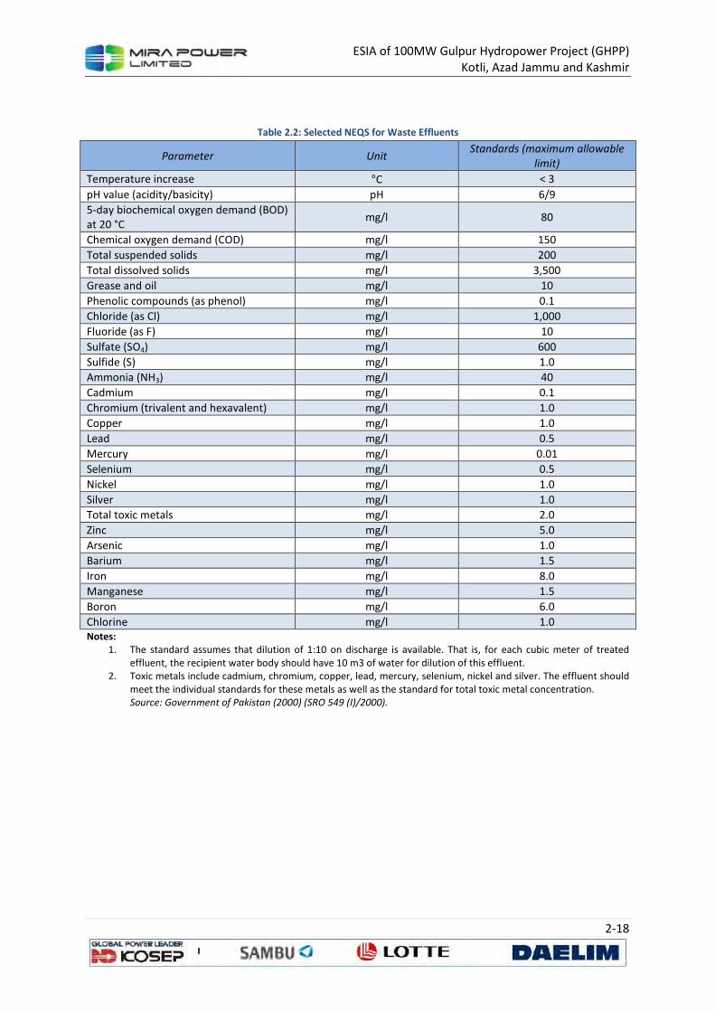
ESIA of 100MW Gulpur Hydropower Project (GHPP) Kotli, Azad Jammu and Kashmir
2-18
Table 2.2: Selected NEQS for Waste Effluents
Parameter Unit Standards (maximum allowable
limit)
Temperature increase °C < 3
pH value (acidity/basicity) pH 6/9
5-day biochemical oxygen demand (BOD) at 20 °C
mg/l 80
Chemical oxygen demand (COD) mg/l 150
Total suspended solids mg/l 200
Total dissolved solids mg/l 3,500
Grease and oil mg/l 10
Phenolic compounds (as phenol) mg/l 0.1
Chloride (as Cl) mg/l 1,000
Fluoride (as F) mg/l 10
Sulfate (SO4) mg/l 600
Sulfide (S) mg/l 1.0
Ammonia (NH3) mg/l 40
Cadmium mg/l 0.1
Chromium (trivalent and hexavalent) mg/l 1.0
Copper mg/l 1.0
Lead mg/l 0.5
Mercury mg/l 0.01
Selenium mg/l 0.5
Nickel mg/l 1.0
Silver mg/l 1.0
Total toxic metals mg/l 2.0
Zinc mg/l 5.0
Arsenic mg/l 1.0
Barium mg/l 1.5
Iron mg/l 8.0
Manganese mg/l 1.5
Boron mg/l 6.0
Chlorine mg/l 1.0 Notes:
1. The standard assumes that dilution of 1:10 on discharge is available. That is, for each cubic meter of treated effluent, the recipient water body should have 10 m3 of water for dilution of this effluent.
2. Toxic metals include cadmium, chromium, copper, lead, mercury, selenium, nickel and silver. The effluent should meet the individual standards for these metals as well as the standard for total toxic metal concentration. Source: Government of Pakistan (2000) (SRO 549 (I)/2000).
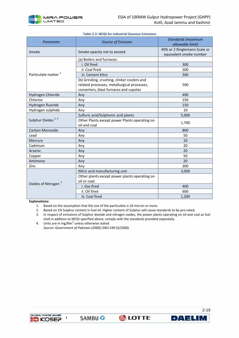
ESIA of 100MW Gulpur Hydropower Project (GHPP) Kotli, Azad Jammu and Kashmir
2-19
Table 2.3: NEQS for Industrial Gaseous Emissions
Parameter Source of Emission Standards (maximum
allowable limit)
Smoke Smoke opacity not to exceed 40% or 2 Ringlemann Scale or
equivalent smoke number
Particulate matter 1
(a) Boilers and furnaces:
i. Oil fired 300
ii. Coal fired 500
iii. Cement Kilns 300
(b) Grinding, crushing, clinker coolers and related processes, metallurgical processes, converters, blast furnaces and cupolas
500
Hydrogen Chloride Any 400
Chlorine Any 150
Hydrogen fluoride Any 150
Hydrogen sulphide Any 10
Sulphur Oxides 2, 3
Sulfuric acid/Sulphonic acid plants 5,000
Other Plants except power Plants operating on oil and coal
1,700
Carbon Monoxide Any 800
Lead Any 50
Mercury Any 10
Cadmium Any 20
Arsenic Any 20
Copper Any 50
Antimony Any 20
Zinc Any 200
Oxides of Nitrogen 3
Nitric acid manufacturing unit 3,000
Other plants except power plants operating on oil or coal:
i. Gas fired 400
ii. Oil fired 600
iii. Coal fired 1,200 Explanations:
1. Based on the assumption that the size of the particulate is 10 micron or more. 2. Based on 1% Sulphur content in fuel oil. Higher content of Sulphur will cause standards to be pro-rated. 3. In respect of emissions of Sulphur dioxide and nitrogen oxides, the power plants operating on oil and coal as fuel
shall in addition to NEQS specified above, comply with the standards provided separately. 4. Units are in mg/Nm
3 unless otherwise stated
Source: Government of Pakistan (2000) (SRO 549 (I)/2000).
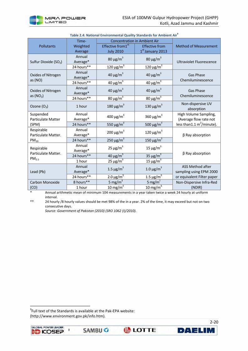
ESIA of 100MW Gulpur Hydropower Project (GHPP) Kotli, Azad Jammu and Kashmir
2-20
Table 2.4: National Environmental Quality Standards for Ambient Air9
Pollutants Time-
Weighted Average
Concentration in Ambient Air
Method of Measurement Effective from1st
July 2010
Effective from 1
st January 2013
Sulfur Dioxide (SO2)
Annual Average*
80 µg/m3 80 µg/m
3
Ultraviolet Fluorescence
24 hours** 120 µg/m3 120 µg/m
3
Oxides of Nitrogen as (NO)
Annual Average*
40 µg/m3 40 µg/m
3 Gas Phase
Chemiluminescence 24 hours** 40 µg/m
3 40 µg/m
3
Oxides of Nitrogen as (NO2)
Annual Average*
40 µg/m3 40 µg/m
3 Gas Phase
Chemiluminescence 24 hours** 80 µg/m
3 80 µg/m
3
Ozone (O3) 1 hour 180 µg/m3 130 µg/m
3
Non-dispersive UV absorption
Suspended Particulate Matter (SPM)
Annual Average*
400 µg/m3 360 µg/m
3
High Volume Sampling, (Average flow rate not
less than1.1 m3/minute). 24 hours** 550 µg/m
3 500 µg/m
3
Respirable Particulate Matter. PM10
Annual Average*
200 µg/m3 120 µg/m
3
β Ray absorption
24 hours** 250 µg/m3 150 µg/m
3
Respirable Particulate Matter. PM2.5
Annual Average*
25 µg/m3 15 µg/m
3
β Ray absorption 24 hours** 40 µg/m
3 35 µg/m
3
1 hour 25 µg/m3 15 µg/m
3
Lead (Pb)
Annual Average*
1.5 µg/m3 1.0 µg/m
3
ASS Method after sampling using EPM 2000 or equivalent Filter paper 24 hours** 2.0 µg/m
3 1.5 µg/m
3
Carbon Monoxide (CO)
8 hours** 5 mg/m3 5 mg/m
3 Non-Dispersive Infra-Red
(NDIR) 1 hour 10 mg/m3 10 mg/m
3
* Annual arithmetic mean of minimum 104 measurements in a year taken twice a week 24 hourly at uniform interval.
** 24 hourly /8 hourly values should be met 98% of the in a year. 2% of the time, it may exceed but not on two consecutive days. Source: Government of Pakistan (2010) (SRO 1062 (I)/2010).
9Full text of the Standards is available at the Pak-EPA website:
(http://www.environment.gov.pk/info.htm).
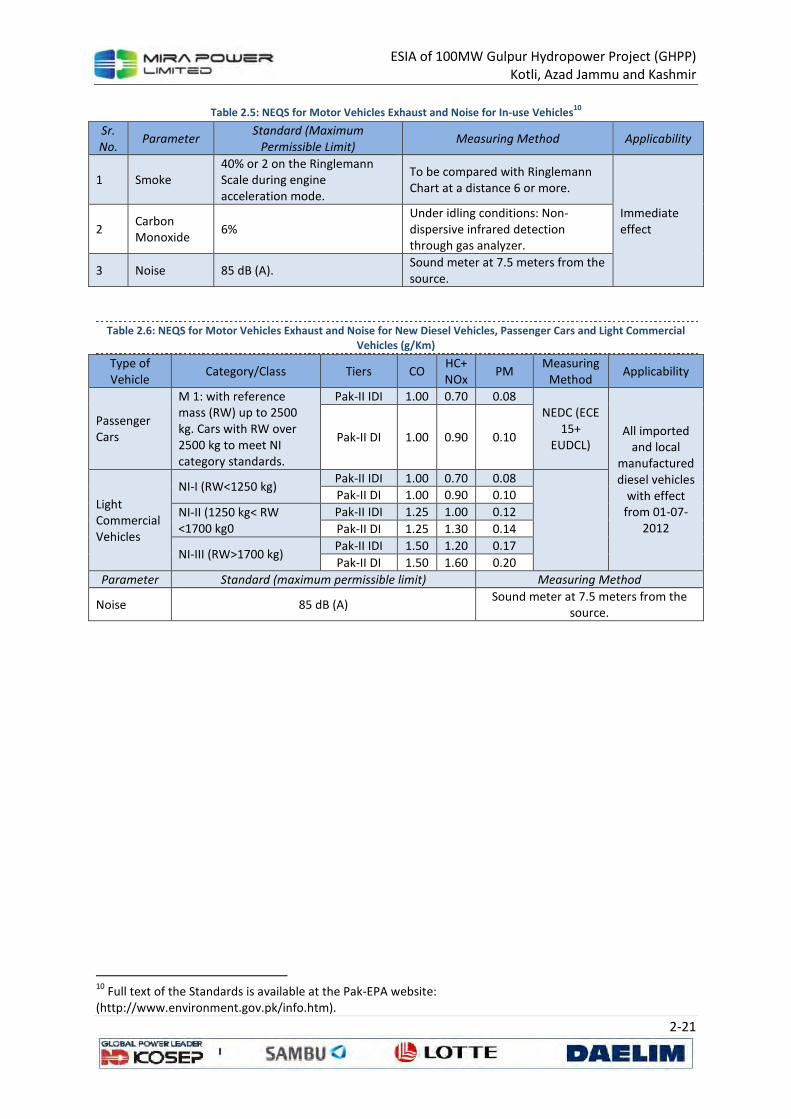
ESIA of 100MW Gulpur Hydropower Project (GHPP) Kotli, Azad Jammu and Kashmir
2-21
Table 2.5: NEQS for Motor Vehicles Exhaust and Noise for In-use Vehicles10
Sr.
No. Parameter
Standard (Maximum
Permissible Limit) Measuring Method Applicability
1 Smoke 40% or 2 on the Ringlemann Scale during engine acceleration mode.
To be compared with Ringlemann Chart at a distance 6 or more.
Immediate effect 2
Carbon Monoxide
6% Under idling conditions: Non-dispersive infrared detection through gas analyzer.
3 Noise 85 dB (A). Sound meter at 7.5 meters from the source.
Table 2.6: NEQS for Motor Vehicles Exhaust and Noise for New Diesel Vehicles, Passenger Cars and Light Commercial Vehicles (g/Km)
Type of Vehicle
Category/Class Tiers CO HC+ NOx
PM Measuring
Method Applicability
Passenger Cars
M 1: with reference mass (RW) up to 2500 kg. Cars with RW over 2500 kg to meet NI category standards.
Pak-II IDI 1.00 0.70 0.08 NEDC (ECE
15+ EUDCL)
All imported and local
manufactured diesel vehicles
with effect from 01-07-
2012
Pak-II DI 1.00 0.90 0.10
Light Commercial Vehicles
NI-I (RW<1250 kg) Pak-II IDI 1.00 0.70 0.08
Pak-II DI 1.00 0.90 0.10
NI-II (1250 kg< RW <1700 kg0
Pak-II IDI 1.25 1.00 0.12
Pak-II DI 1.25 1.30 0.14
NI-III (RW>1700 kg) Pak-II IDI 1.50 1.20 0.17
Pak-II DI 1.50 1.60 0.20
Parameter Standard (maximum permissible limit) Measuring Method
Noise 85 dB (A) Sound meter at 7.5 meters from the
source.
10
Full text of the Standards is available at the Pak-EPA website: (http://www.environment.gov.pk/info.htm).
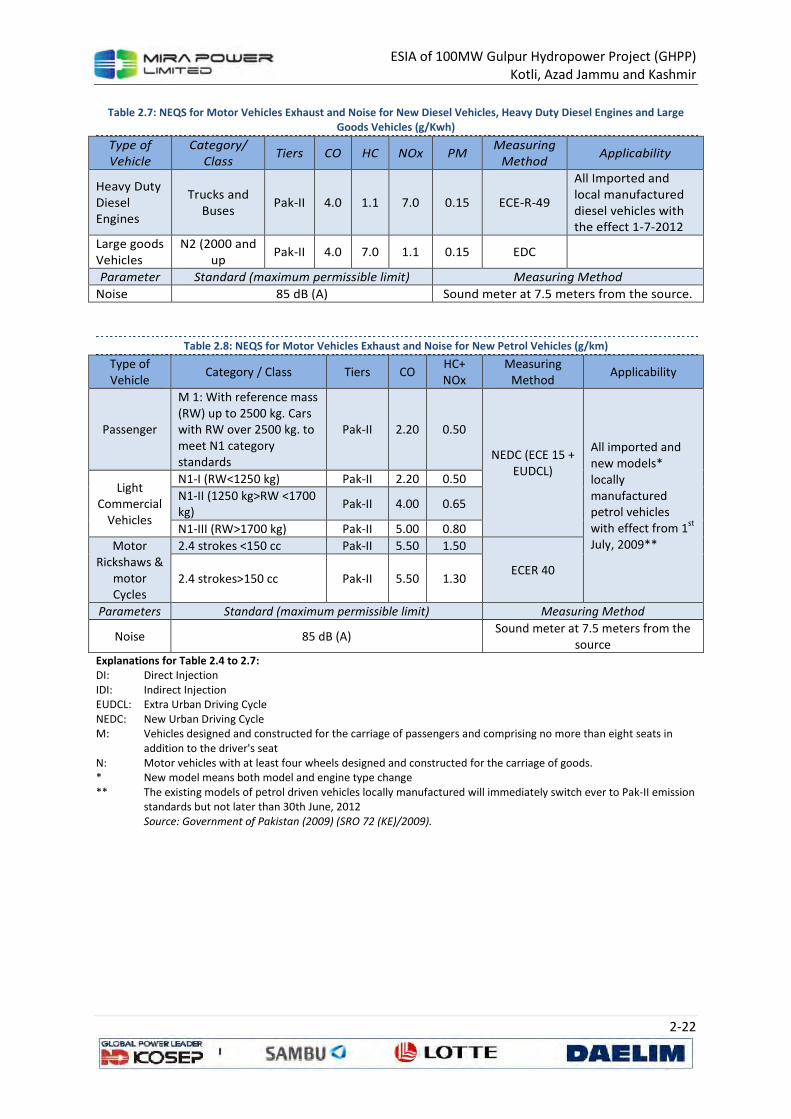
ESIA of 100MW Gulpur Hydropower Project (GHPP) Kotli, Azad Jammu and Kashmir
2-22
Table 2.7: NEQS for Motor Vehicles Exhaust and Noise for New Diesel Vehicles, Heavy Duty Diesel Engines and Large Goods Vehicles (g/Kwh)
Type of
Vehicle
Category/
Class Tiers CO HC NOx PM
Measuring
Method Applicability
Heavy Duty Diesel Engines
Trucks and Buses
Pak-II 4.0 1.1 7.0 0.15 ECE-R-49
All Imported and local manufactured diesel vehicles with the effect 1-7-2012
Large goods Vehicles
N2 (2000 and up
Pak-II 4.0 7.0 1.1 0.15 EDC
Parameter Standard (maximum permissible limit) Measuring Method
Noise 85 dB (A) Sound meter at 7.5 meters from the source.
Table 2.8: NEQS for Motor Vehicles Exhaust and Noise for New Petrol Vehicles (g/km)
Type of Vehicle
Category / Class Tiers CO HC+ NOx
Measuring Method
Applicability
Passenger
M 1: With reference mass (RW) up to 2500 kg. Cars with RW over 2500 kg. to meet N1 category standards
Pak-II 2.20 0.50
NEDC (ECE 15 + EUDCL)
All imported and new models* locally manufactured petrol vehicles with effect from 1
st
July, 2009**
Light Commercial
Vehicles
N1-I (RW<1250 kg) Pak-II 2.20 0.50
N1-II (1250 kg>RW <1700 kg)
Pak-II 4.00 0.65
N1-III (RW>1700 kg) Pak-II 5.00 0.80
Motor Rickshaws &
motor Cycles
2.4 strokes <150 cc Pak-II 5.50 1.50
ECER 40 2.4 strokes>150 cc Pak-II 5.50 1.30
Parameters Standard (maximum permissible limit) Measuring Method
Noise 85 dB (A) Sound meter at 7.5 meters from the
source Explanations for Table 2.4 to 2.7: DI: Direct Injection IDI: Indirect Injection EUDCL: Extra Urban Driving Cycle NEDC: New Urban Driving Cycle M: Vehicles designed and constructed for the carriage of passengers and comprising no more than eight seats in
addition to the driver's seat N: Motor vehicles with at least four wheels designed and constructed for the carriage of goods. * New model means both model and engine type change ** The existing models of petrol driven vehicles locally manufactured will immediately switch ever to Pak-II emission
standards but not later than 30th June, 2012 Source: Government of Pakistan (2009) (SRO 72 (KE)/2009).
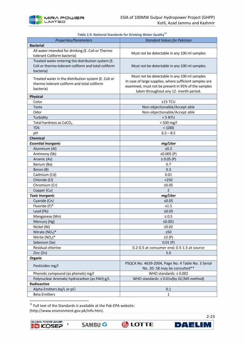
ESIA of 100MW Gulpur Hydropower Project (GHPP) Kotli, Azad Jammu and Kashmir
2-23
Table 2.9: National Standards for Drinking Water Quality11
Properties/Parameters Standard Values for Pakistan
Bacterial
All water intended for drinking (E. Coli or Thermo tolerant Coliform bacteria)
Must not be detectable in any 100 ml samples
Treated water entering the distribution system (E. Coli or thermo-tolerant coliform and total coliform bacteria)
Must not be detectable in any 100 ml samples
Treated water in the distribution system (E. Coli or thermo tolerant coliform and total coliform bacteria)
Must not be detectable in any 100 ml samples In case of large supplies, where sufficient samples are examined, must not be present in 95% of the samples
taken throughout any 12- month period.
Physical
Color ≤15 TCU
Taste Non-objectionable/Accept able
Odor Non-objectionable/Accept able
Turbidity < 5 NTU
Total hardness as CaCO3 < 500 mg/l
TDS < 1000
pH 6.5 – 8.5
Chemical
Essential Inorganic mg/Liter
Aluminum (Al) ≤0.2
Antimony (Sb) ≤0.005 (P)
Arsenic (As) ≤ 0.05 (P)
Barium (Ba) 0.7
Boron (B) 0.3
Cadmium (Cd) 0.01
Chloride (Cl) <250
Chromium (Cr) ≤0.05
Copper (Cu) 2
Toxic Inorganic mg/Liter
Cyanide (Cn) ≤0.05
Fluoride (F)* ≤1.5
Lead (Pb) ≤0.05
Manganese (Mn) ≤ 0.5
Mercury (Hg) ≤0.001
Nickel (Ni) ≤0.02
Nitrate (NO3)* ≤50
Nitrite (NO2)* ≤3 (P)
Selenium (Se) 0.01 (P)
Residual chlorine 0.2-0.5 at consumer end; 0.5-1.5 at source
Zinc (Zn) 5.0
Organic
Pesticides mg/l PSQCA No. 4639-2004, Page No. 4 Table No. 3 Serial
No. 20- 58 may be consulted**
Phenolic compound (as phenols) mg/l WHO standards: ≤ 0.002
Polynuclear Aromatic hydrocarbon (as PAH) g/L WHO standards: ≤ 0.01v(by GC/MS method)
Radioactive
Alpha Emitters bq/L or pCi 0.1
Beta Emitters 1
11
Full text of the Standards is available at the Pak-EPA website: (http://www.environment.gov.pk/info.htm).
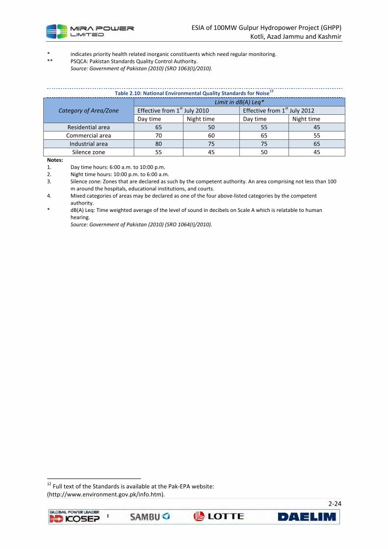
ESIA of 100MW Gulpur Hydropower Project (GHPP) Kotli, Azad Jammu and Kashmir
2-24
* indicates priority health related inorganic constituents which need regular monitoring. ** PSQCA: Pakistan Standards Quality Control Authority.
Source: Government of Pakistan (2010) (SRO 1063(I)/2010).
Table 2.10: National Environmental Quality Standards for Noise12
Category of Area/Zone
Limit in dB(A) Leq*
Effective from 1st
July 2010 Effective from 1st
July 2012
Day time Night time Day time Night time
Residential area 65 50 55 45
Commercial area 70 60 65 55
Industrial area 80 75 75 65
Silence zone 55 45 50 45 Notes: 1. Day time hours: 6:00 a.m. to 10:00 p.m. 2. Night time hours: 10:00 p.m. to 6:00 a.m. 3. Silence zone: Zones that are declared as such by the competent authority. An area comprising not less than 100
m around the hospitals, educational institutions, and courts. 4. Mixed categories of areas may be declared as one of the four above-listed categories by the competent
authority. * dB(A) Leq: Time weighted average of the level of sound in decibels on Scale A which is relatable to human
hearing. Source: Government of Pakistan (2010) (SRO 1064(I)/2010).
12
Full text of the Standards is available at the Pak-EPA website: (http://www.environment.gov.pk/info.htm).

ESIA of 100MW Gulpur Hydropower Project (GHPP) Kotli, Azad Jammu and Kashmir
3-1
3 PROJECT DESCRIPTION
The Gulpur Hydropower Project will exploit the water resources of the Poonch River for power
generation. It will comprise four main components, viz., Weir, Intake Structure, Power Tunnel and
Power House. The Weir will be located near Aghar Colony on the Poonch River at about 5 km
downstream of Kotli Town and about 250 m downstream of the confluence of Ban Nullah with the
river. The Intake Structure and intake portal of the Power Tunnel will be located on Ban Nullah about
2 km upstream of its confluence with the Poonch River. The Power House and outlet portal of the
Power Tunnel will be located on Poonch River about 6.5 km downstream of the Weir structure.
Figure 3.1 illustrates the layout plan of the Project.
Figure 3.1: Project General Layout Plan
The Normal Operating Level (NOL) of the Project shall be at El. 540 m. At present a freeboard of 2
meters is proposed for the land acquisition and resettlement. Figure 3.2 shows the inundation area
at El. 542.0 m.
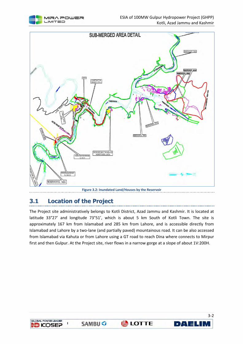
ESIA of 100MW Gulpur Hydropower Project (GHPP) Kotli, Azad Jammu and Kashmir
3-2
Figure 3.2: Inundated Land/Houses by the Reservoir
3.1 Location of the Project
The Project site administratively belongs to Kotli District, Azad Jammu and Kashmir. It is located at
latitude 33°27’ and longitude 73°51’, which is about 5 km South of Kotli Town. The site is
approximately 167 km from Islamabad and 285 km from Lahore, and is accessible directly from
Islamabad and Lahore by a two-lane (and partially paved) mountainous road. It can be also accessed
from Islamabad via Kahuta or from Lahore using a GT road to reach Dina where connects to Mirpur
first and then Gulpur. At the Project site, river flows in a narrow gorge at a slope of about 1V:200H.
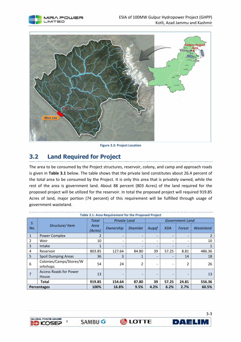
ESIA of 100MW Gulpur Hydropower Project (GHPP) Kotli, Azad Jammu and Kashmir
3-3
Figure 3.3: Project Location
3.2 Land Required for Project
The area to be consumed by the Project structures, reservoir, colony, and camp and approach roads
is given in Table 3.1 below. The table shows that the private land constitutes about 26.4 percent of
the total area to be consumed by the Project. It is only this area that is privately owned, while the
rest of the area is government land. About 88 percent (803 Acres) of the land required for the
proposed project will be utilized for the reservoir. In total the proposed project will required 919.85
Acres of land, major portion (74 percent) of this requirement will be fulfilled through usage of
government wasteland.
Table 3.1: Area Requirement for the Proposed Project
S.
No. Structure/ Item
Total
Area
(Acres)
Private Land Government Land
Ownership Shamilat Auqaf KDA Forest Wasteland
1 Power Complex 2 - - - - - 2
2 Weir 10 - - - - - 10
3 Intake 1 - - - - - 1
4 Reservoir 803.85 127.64 84.80 39 57.25 8.81 486.36
5 Spoil Dumping Areas 36 3 1 - - 14 18
6 Colonies/Camps/Stores/Workshops
54 24 2 - - 2 26
7 Access Roads for Power House
13 - - - - - 13
Total 919.85 154.64 87.80 39 57.25 24.81 556.36
Percentages 100% 16.8% 9.5% 4.2% 6.2% 2.7% 60.5%

ESIA of 100MW Gulpur Hydropower Project (GHPP) Kotli, Azad Jammu and Kashmir
3-4
3.3 Main Components of the Project
3.3.1 The Weir
The weir type has been determined as concrete gravity dam (CGD) with dimensions of W45.0 m ×
L237.0 m to prevent overflow even in case of probable maximum flood (PMF). 100-year frequency
flood (13,334 m3/s) has been applied to the spillway overflow section, and spillway type has been
determined as radial gate type in consideration of economic aspects, constructability, functionality
and Q&M. The discharge capacity of the spillway has been designed to maintain the normal
operation level (EL.540.0 m) in case of the 100-year frequency flood. Eight gates (W 11.5 m ×H 26.0
m EA) are installed inside the weir body to prevent overflowing the weir crest (El.545.0 m) even in
case of probable maximum flood (PMF). A 9.5 m wide roadway bridge with its crest at El. 545.0 m
will provide access from one bank to other bank of the river. Bridge shall also be used to operate
gate hosting equipment.
Ogee shaped crests for weir portion is connected to submerged roller bucket type energy dissipater
through concrete chutes. The project site displays an extremely high downstream level due to
relatively large amount of flow compared to the river width. It was observed that the downstream
level becomes higher than the water level after hydraulic jump in case of floods higher than 2- year
frequency flood (4,190 m3/s). Submerged roller bucket type has been chosen as a result due to
excessive excavation and absence of major structures at downstream.
Figure 3.4: Details of Weir Structure
ESIA of 100MW Gulpur Hydropower Project (GHPP) Kotli, Azad Jammu and Kashmir
3-5
3.3.2 Power Tunnel and Penstocks
The power tunnel off-takes from the left bank of Bann Nullah at a location about 2 km upstream of
its confluence with Poonch River. The tunnel will be concrete lined and circular in shape having a
total length of 3.04 Km. The invert of tunnel intake is kept at El. 523 m to avoid vortices and air
entrance. The intake structure will have a bell-mouthed entrance with trash-rack and a gate shaft. A
road along the left bank of Bann Nullah will be constructed for operation & maintenance of this
structure. The intake arrangements are shown on Figure 3.5 and Figure 3.6.
First part of the power tunnel is designed as a low pressure tunnel of 8.0 m dia, concrete lined,
almost bored straight in the hill up to a 62.64 m high surge shaft. Downstream of surge shaft, tunnel
will connect to a vertical pressure tunnel which will connect to an 8.0 m dia steel penstock which will
be divided into three steel penstocks each 3.75 m dia up to the powerhouse.
Hydraulic features of the power tunnel/penstocks are as given below:
Design discharge 198 cumecs
Shape and size of tunnel Circular, concrete lined, 8 m
Slope of tunnel invert 0.0025
Length of tunnel 3.04 km
Invert elevation
Upstream El. 523.0 m
Downstream El. 514.0 m
Size of penstock 8 m Ø, circular, steel pipe converted into 3.75 m pipe
Length of penstock 62 m
Head Loss
Tunnel 5.69 m
Penstocks 0.85 m
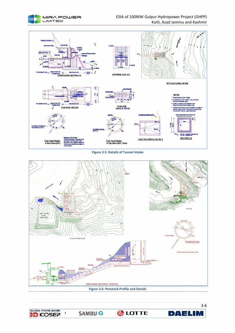
ESIA of 100MW Gulpur Hydropower Project (GHPP) Kotli, Azad Jammu and Kashmir
3-6
Figure 3.5: Details of Tunnel Intake
Figure 3.6: Penstock Profile and Details

ESIA of 100MW Gulpur Hydropower Project (GHPP) Kotli, Azad Jammu and Kashmir
3-7
3.3.3 Powerhouse
The priority for the horizontal alignment of the tunnel was to set the length as shortest as possible,
but a curvature was inevitable due to the relocation of the tunnel (84 m downstream from the
Feasibility Study location). The radius of the curvature has been determined as 300 m in order to
provide sufficient space additionally to the minimum turning radius required for the excavation
equipment and steel form (200 m). The tunnel alignment has been designed to cross where the
ground condition is sounder, and for the tunnel axis to intersect with major fault zones as
perpendicularly as possible. Sufficient cover thickness was also taken into account in case the tunnel
route crosses below gullies or valleys. Total installed capacity of the powerhouse is 100 MW and
power will be generated with the help of 3 vertical axis Francis turbines. The powerhouse is 80 m
long and 42.3 m wide. Water from draft tubes will be released back into the river with the help of a
tailrace channel. A retaining wall has been proposed to protect the powerhouse from high tailwater
level during floods.
The proposed powerhouse is a surface type and will be located on left bank of the river at a massive
bed of sandstone. Layout of the powerhouse is shown in Figure 3.7, Figure 3.8 and Figure 3.9. The
basic parameters are given below:
Power Station and Equipment
Structure
Powerhouse Surface type
Number of Units 3
Distance between centerline of units 15.0 m
Overall length 42.3 m
Width
Overall height 59.55 m
Turbines
Type Francis (Vertical Shaft)
Discharge at rated head 33~66 m3/s
Rated net head 55.8 MW
Output at rated net head 34.0 MW
Specific speed 227.3 rpm
Synchronize speed 187.5 rpm
Runaway speed
Runner diameter 3.0 m
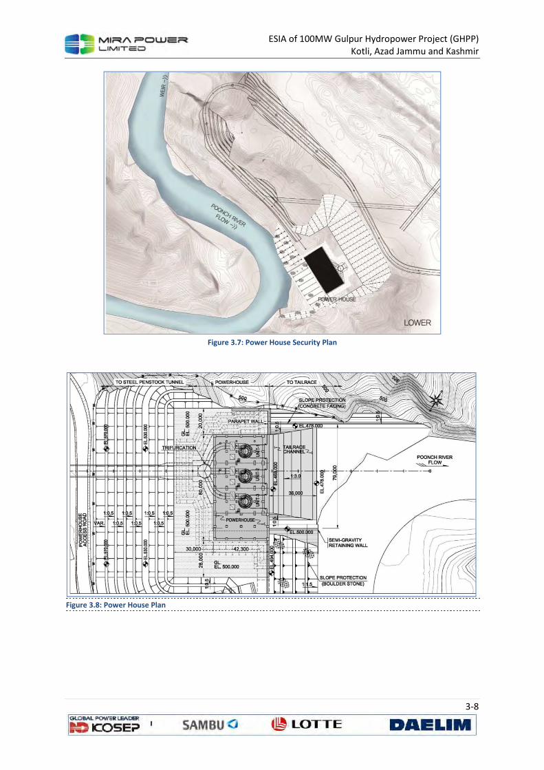
ESIA of 100MW Gulpur Hydropower Project (GHPP) Kotli, Azad Jammu and Kashmir
3-8
Figure 3.7: Power House Security Plan
Figure 3.8: Power House Plan
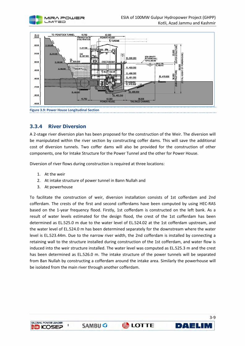
ESIA of 100MW Gulpur Hydropower Project (GHPP) Kotli, Azad Jammu and Kashmir
3-9
Figure 3.9: Power House Longitudinal Section
3.3.4 River Diversion
A 2-stage river diversion plan has been proposed for the construction of the Weir. The diversion will
be manipulated within the river section by constructing coffer dams. This will save the additional
cost of diversion tunnels. Two coffer dams will also be provided for the construction of other
components, one for Intake Structure for the Power Tunnel and the other for Power House.
Diversion of river flows during construction is required at three locations:
1. At the weir
2. At intake structure of power tunnel in Bann Nullah and
3. At powerhouse
To facilitate the construction of weir, diversion installation consists of 1st cofferdam and 2nd
cofferdam. The crests of the first and second cofferdams have been computed by using HEC-RAS
based on the 1-year frequency flood. Firstly, 1st cofferdam is constructed on the left bank. As a
result of water levels estimated for the design flood, the crest of the 1st cofferdam has been
determined as EL.525.0 m due to the water level of EL.524.02 at the 1st cofferdam upstream, and
the water level of EL.524.0 m has been determined separately for the downstream where the water
level is EL.523.44m. Due to the narrow river width, the 2nd cofferdam is installed by connecting a
retaining wall to the structure installed during construction of the 1st cofferdam, and water flow is
induced into the weir structure installed. The water level was computed as EL.525.3 m and the crest
has been determined as EL.526.0 m. The intake structure of the power tunnels will be separated
from Ban Nullah by constructing a cofferdam around the intake area. Similarly the powerhouse will
be isolated from the main river through another cofferdam.
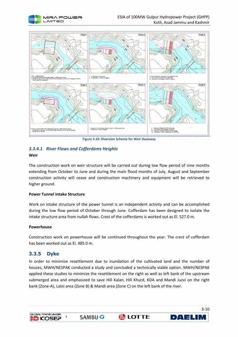
ESIA of 100MW Gulpur Hydropower Project (GHPP) Kotli, Azad Jammu and Kashmir
3-10
Figure 3.10: Diversion Scheme for Weir Sluesway
3.3.4.1 River Flows and Cofferdams Heights
Weir
The construction work on weir structure will be carried out during low flow period of nine months
extending from October to June and during the main flood months of July, August and September
construction activity will cease and construction machinery and equipment will be retrieved to
higher ground.
Power Tunnel Intake Structure
Work on intake structure of the power tunnel is an independent activity and can be accomplished
during the low flow period of October through June. Cofferdam has been designed to isolate the
intake structure area from nullah flows. Crest of the cofferdams is worked out as El. 527.0 m.
Powerhouse
Construction work on powerhouse will be continued throughout the year. The crest of cofferdam
has been worked out as El. 485.0 m.
3.3.5 Dyke
In order to minimize resettlement due to inundation of the cultivated land and the number of
houses, MWH/NESPAK conducted a study and concluded a technically viable option. MWH/NESPAK
applied these studies to minimize the resettlement on the right as well as left bank of the upstream
submerged area and emphasized to save Hill Kalan, Hill Khurd, KDA and Mandi Juzvi on the right
bank (Zone-A), Laloi area (Zone B) & Mandi area (Zone C) on the left bank of the river.
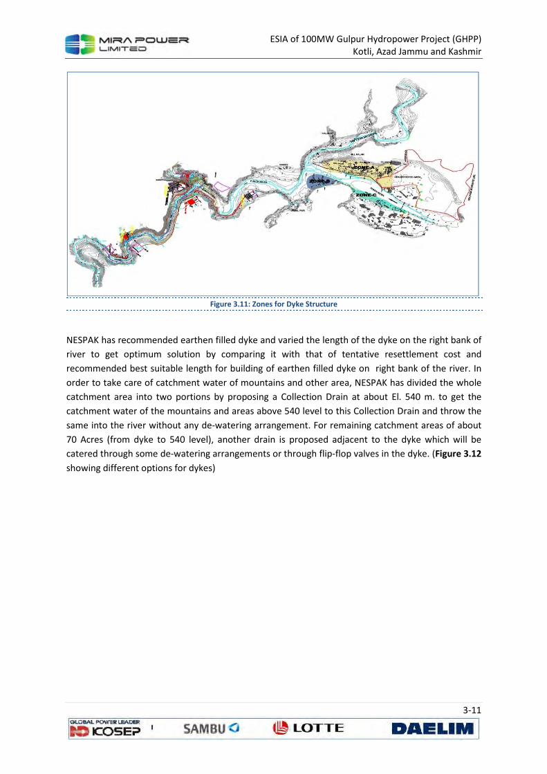
ESIA of 100MW Gulpur Hydropower Project (GHPP) Kotli, Azad Jammu and Kashmir
3-11
Figure 3.11: Zones for Dyke Structure
NESPAK has recommended earthen filled dyke and varied the length of the dyke on the right bank of
river to get optimum solution by comparing it with that of tentative resettlement cost and
recommended best suitable length for building of earthen filled dyke on right bank of the river. In
order to take care of catchment water of mountains and other area, NESPAK has divided the whole
catchment area into two portions by proposing a Collection Drain at about El. 540 m. to get the
catchment water of the mountains and areas above 540 level to this Collection Drain and throw the
same into the river without any de-watering arrangement. For remaining catchment areas of about
70 Acres (from dyke to 540 level), another drain is proposed adjacent to the dyke which will be
catered through some de-watering arrangements or through flip-flop valves in the dyke. (Figure 3.12
showing different options for dykes)
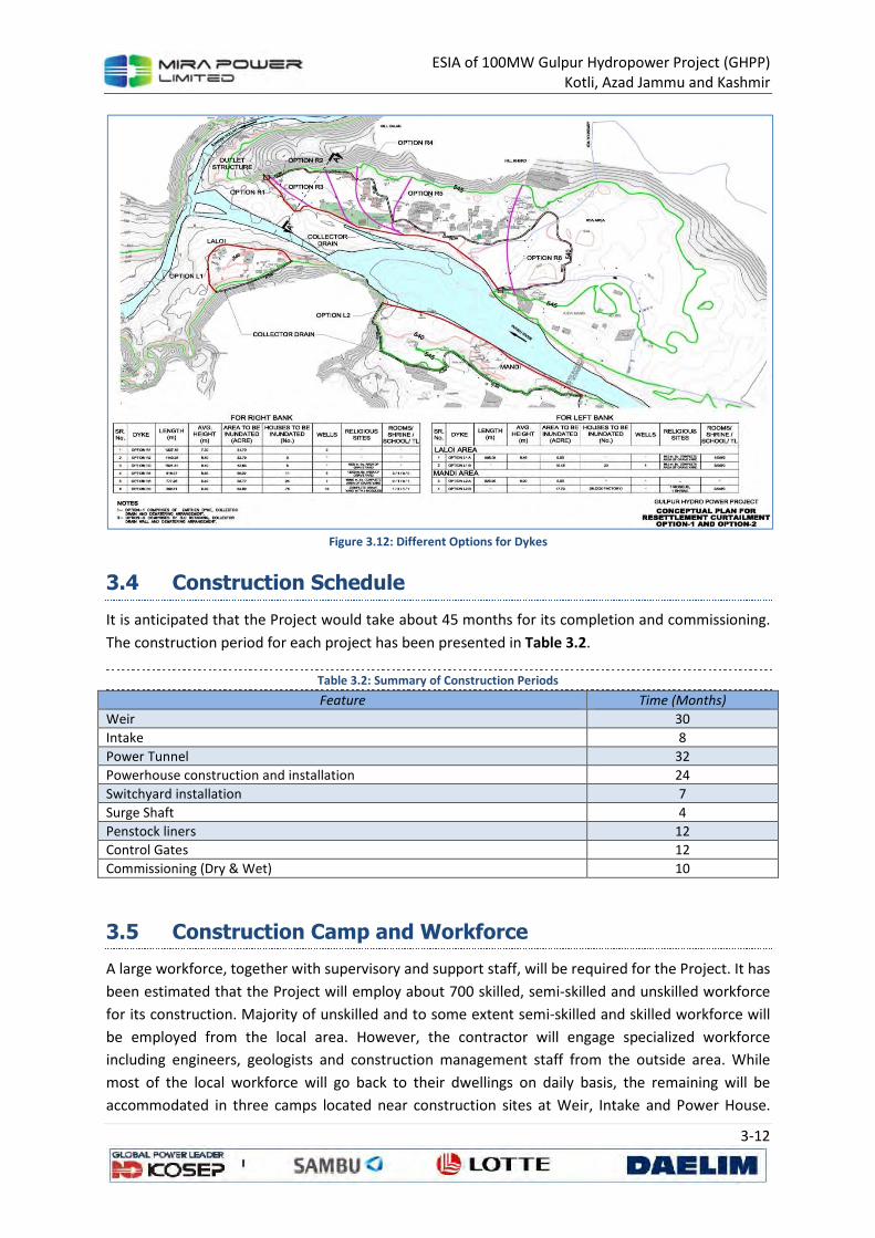
ESIA of 100MW Gulpur Hydropower Project (GHPP) Kotli, Azad Jammu and Kashmir
3-12
Figure 3.12: Different Options for Dykes
3.4 Construction Schedule
It is anticipated that the Project would take about 45 months for its completion and commissioning.
The construction period for each project has been presented in Table 3.2.
Table 3.2: Summary of Construction Periods
Feature Time (Months)
Weir 30
Intake 8
Power Tunnel 32
Powerhouse construction and installation 24
Switchyard installation 7
Surge Shaft 4
Penstock liners 12
Control Gates 12
Commissioning (Dry & Wet) 10
3.5 Construction Camp and Workforce
A large workforce, together with supervisory and support staff, will be required for the Project. It has
been estimated that the Project will employ about 700 skilled, semi-skilled and unskilled workforce
for its construction. Majority of unskilled and to some extent semi-skilled and skilled workforce will
be employed from the local area. However, the contractor will engage specialized workforce
including engineers, geologists and construction management staff from the outside area. While
most of the local workforce will go back to their dwellings on daily basis, the remaining will be
accommodated in three camps located near construction sites at Weir, Intake and Power House.
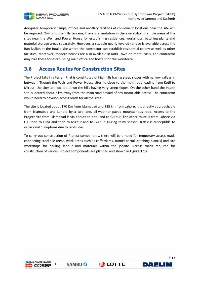
ESIA of 100MW Gulpur Hydropower Project (GHPP) Kotli, Azad Jammu and Kashmir
3-13
Adequate temporary camps, offices and ancillary facilities at convenient locations near the site will
be required. Owing to the hilly terrains, there is a limitation in the availability of ample areas at the
sites near the Weir and Power House for establishing residences, workshops, batching plants and
material storage areas separately. However, a sizeable nearly leveled terrace is available across the
Ban Nullah at the Intake site where the contractor can establish residential colony as well as other
facilities. Moreover, modern houses are also available in Kotli Town on rental basis. The contractor
may hire these for establishing main office and hostels for the workforce.
3.6 Access Routes for Construction Sites
The Project falls in a terrain that is constituted of high hills having steep slopes with narrow valleys in
between. Though the Weir and Power House sites lie close to the main road leading from Kotli to
Mirpur, the sites are located down the hills having very steep slopes. On the other hand the Intake
site is located about 2 km away from the main road devoid of any motor-able access. The contractor
would need to develop access roads for all the sites.
The site is located about 170 Km from Islamabad and 285 km from Lahore, it is directly approachable
from Islamabad and Lahore by a two-lane, all-weather paved mountainous road. Access to the
Project site from Islamabad is via Kahuta to Kotli and to Gulpur. The other route is from Lahore via
GT Road to Dina and then to Mirpur and to Gulpur. During rainy season, traffic is susceptible to
occasional disruptions due to landslides.
To carry out construction of Project components, there will be a need for temporary access roads
connecting stockpile areas, work areas such as cofferdams, tunnel portal, batching plant(s) and site
workshops for hauling labour and materials within the jobsite. Access roads required for
construction of various Project components are planned and shown in Figure 3.13.
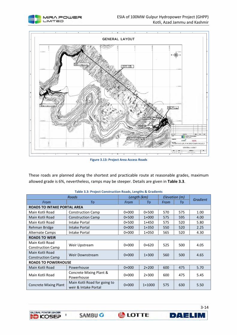
ESIA of 100MW Gulpur Hydropower Project (GHPP) Kotli, Azad Jammu and Kashmir
3-14
Figure 3.13: Project Area Access Roads
These roads are planned along the shortest and practicable route at reasonable grades, maximum
allowed grade is 6%, nevertheless, ramps may be steeper. Details are given in Table 3.3.
Table 3.3: Project Construction Roads, Lengths & Gradients
Roads Length (km) Elevation (m) Gradient
From To From To From To
ROADS TO INTAKE PORTAL AREA
Main Kotli Road Construction Camp 0+000 0+500 570 575 1.00
Main Kotli Road Construction Camp 0+500 1+000 575 595 4.00
Main Kotli Road Intake Portal 0+500 1+450 575 520 5.80
Rehman Bridge Intake Portal 0+000 1+350 550 520 2.25
Alternate Camps Intake Portal 0+000 1+050 565 520 4.30
ROADS TO WEIR
Main Kotli Road Construction Camp
Weir Upstream 0+000 0+620 525 500 4.05
Main Kotli Road Construction Camp
Weir Downstream 0+000 1+300 560 500 4.65
ROADS TO POWERHOUSE
Main Kotli Road Powerhouse 0+000 2+200 600 475 5.70
Main Kotli Road Concrete Mixing Plant & Powerhouse
0+000 2+300 600 475 5.45
Concrete Mixing Plant Main Kotli Road for going to weir & Intake Portal
0+000 1+1000 575 630 5.50
ESIA of 100MW Gulpur Hydropower Project (GHPP) Kotli, Azad Jammu and Kashmir
3-15
3.7 Construction Material
The materials used for the construction of the proposed project include coarse aggregates, fine
aggregates (sand), rock for stone pitching and riprap, earth, water, cement and steel. Tentative
quantities of various materials along with the source are depicted in Table 3.4:
Table 3.4: Quantities AND Sources OF Construction Material
Sr.
No. Item Quantity Source
1 Coarse Aggregate 300,000 cu m
The material will be borrowed from the following sources:
• River Bed boulders, gravels, cobles. Crushers are already in operation near Kotli and Gulpur Towns.
• Sandstone from excavation of weir, tunnel and power house areas
• Quarrying limestone from Sawar (22 km from Kotli on Kotli-Tatapani Road), Dandli (16 km from Kotli on Dandli-Ghoi Road), Jhanjora (34 km from Kotli on Tatapani-Ghoi Road) Small scale quarrying is already being done on these sites by a local contractor for road and building construction.
2 Fine Aggregate (Sand) 150,000 cu m
Sand is though available in the river bed, its quality is not suitable for the Project construction. Moreover its quantities are small. Therefore, it has to be either transported from Lawrencepur and Qibla Bandi located in Attock District about 200 km from Kotli or manufactured locally from limestone sources.
3 Rock Material for Stone pitching and Riprap
5,000 cu m
Rock material will generally be available from the excavation for the construction of weir, power house and tunnel.
4 Cement (including Portland (60,000 tonnes and Slag 30,000 tonnes)
90,000 tonnes
There is no cement factory in AJK. The Portland cement will be transported from Islamabad, Nowshera and Attock on the average located at a distance of 200 to 300 km from Kotli. Slag Cement will be transported from Karachi (about 1500 km from Kotli) through rail and road transportation. The road network is available from the factories up to construction sites. However, its transportation on large truck-trailers will be difficult as about 100 km of the road passes through hilly terrains, encountering very sharp turns and having rather steep gradients at places. Therefore, a caravan of about 30 trucks would be required to meet daily requirement of cement of about 300 tonnes.
5 Reinforcement Steel 15,000 tons
The steel of the desired specification will be transported from re-rolling mills located at Lahore and Rawalpindi.
6
Water (including concreting, water sprinkling, compaction of earth/rock fill for cofferdams)
100,000 cu m
The project area is almost devoid of groundwater source. Therefore, the Poonch River and Ban Nullah are the only sources for water. The water from the river and nullah would however need some sort of treatment to make it silt and sulphate free for its use in concreting.
3.8 Construction Machinery
The Project will deploy various types of machineries for construction purposes. These will include
bulldozers, excavators, shovels, tunneling machine, dumpers, batching plant, tankers, trucks, etc.
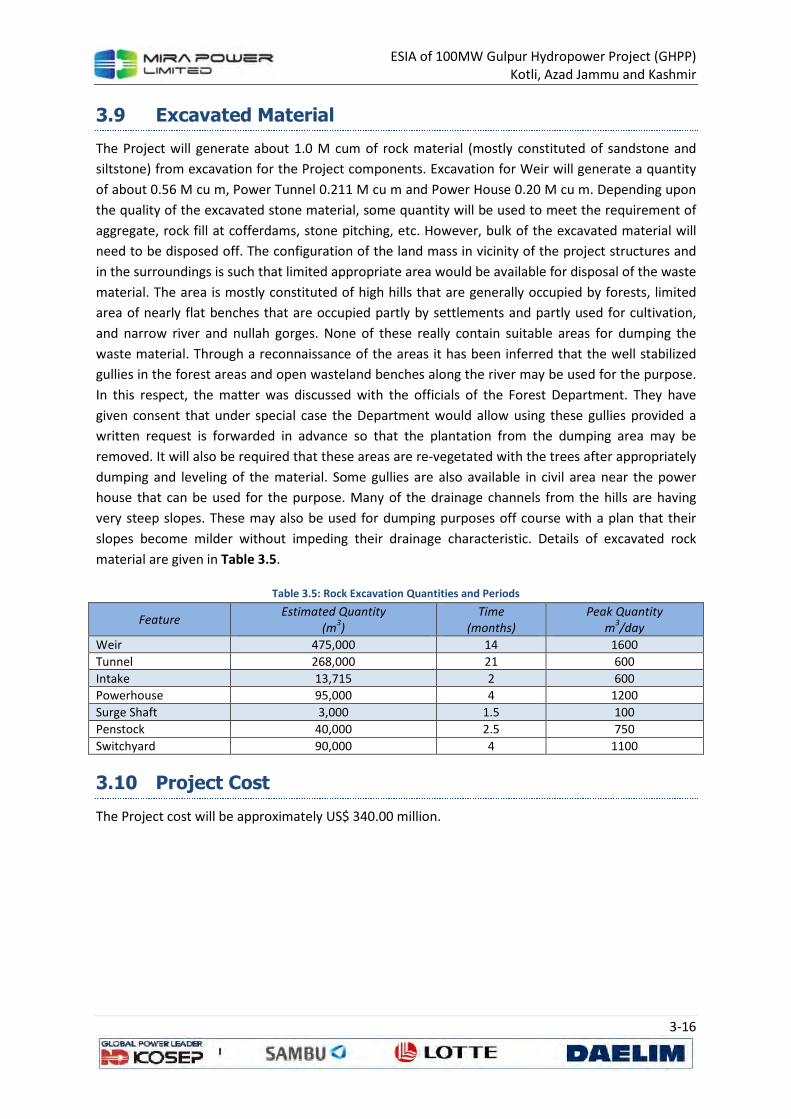
ESIA of 100MW Gulpur Hydropower Project (GHPP) Kotli, Azad Jammu and Kashmir
3-16
3.9 Excavated Material
The Project will generate about 1.0 M cum of rock material (mostly constituted of sandstone and
siltstone) from excavation for the Project components. Excavation for Weir will generate a quantity
of about 0.56 M cu m, Power Tunnel 0.211 M cu m and Power House 0.20 M cu m. Depending upon
the quality of the excavated stone material, some quantity will be used to meet the requirement of
aggregate, rock fill at cofferdams, stone pitching, etc. However, bulk of the excavated material will
need to be disposed off. The configuration of the land mass in vicinity of the project structures and
in the surroundings is such that limited appropriate area would be available for disposal of the waste
material. The area is mostly constituted of high hills that are generally occupied by forests, limited
area of nearly flat benches that are occupied partly by settlements and partly used for cultivation,
and narrow river and nullah gorges. None of these really contain suitable areas for dumping the
waste material. Through a reconnaissance of the areas it has been inferred that the well stabilized
gullies in the forest areas and open wasteland benches along the river may be used for the purpose.
In this respect, the matter was discussed with the officials of the Forest Department. They have
given consent that under special case the Department would allow using these gullies provided a
written request is forwarded in advance so that the plantation from the dumping area may be
removed. It will also be required that these areas are re-vegetated with the trees after appropriately
dumping and leveling of the material. Some gullies are also available in civil area near the power
house that can be used for the purpose. Many of the drainage channels from the hills are having
very steep slopes. These may also be used for dumping purposes off course with a plan that their
slopes become milder without impeding their drainage characteristic. Details of excavated rock
material are given in Table 3.5.
Table 3.5: Rock Excavation Quantities and Periods
Feature Estimated Quantity
(m3)
Time
(months)
Peak Quantity
m3/day
Weir 475,000 14 1600
Tunnel 268,000 21 600
Intake 13,715 2 600
Powerhouse 95,000 4 1200
Surge Shaft 3,000 1.5 100
Penstock 40,000 2.5 750
Switchyard 90,000 4 1100
3.10 Project Cost
The Project cost will be approximately US$ 340.00 million.
ESIA of 100MW Gulpur Hydropower Project (GHPP) Kotli, Azad Jammu and Kashmir
4-1
4 DESCRIPTION OF THE PHYSICAL
ENVIRONMENT
4.1 General
This chapter summarizes the available baseline data on physical environment within the principal
area of interest i.e. the area of project influence. Reconnaissance visits and physical field surveys
were carried out in August 2013. Validation of this information was done through the data from
secondary sources, satellite imagery study and published literature. The identification of physical
characteristics of the region and assessing their existing conditions is imperative to predict the
possible environmental impacts of the proposed hydropower project.
The baseline environmental data has been compiled to cover the following areas:
• Land;
• Climate and Meteorology;
• Water (water resources, water quality, source of pollution and hydrology);
• Air Quality and Noise (noise levels);
4.2 Area of Study
Gulpur Hydropower Project site is located on Poonch River, which is a left bank tributary of Jhelum
River. Four hydropower projects are planned along the Poonch River; Sehra, Kotali, Gulpur and
Rajdhani13 . In the vicinity of the project site, Poonch River flows through a deep gorge at a slope of
about 1V:200H. Mountains on both sides are more than 100 meter high; valley is narrow and banks
are steep. Width of the river varies from 60 to 90 m. Kotli-Gulpur road runs along the left bank at
about 60 to 80 m above the riverbed. Ranger Nullah on the right bank and Bann Nullah on the left
bank are two main perennial tributaries, which join the river downstream of Kotli Town. Several
villages are located on both banks of the river and along both nullahs. Majority of the settlements is
above El 540 m.
The site of Gulpur Hydropower Project is located downstream of Kotli and upstream of the proposed
Rajdhani Hydropower Project. Minimum tail water level of Kotli Hydropower Project is fixed at El 550
m. Whereas, maximum reservoir level of Rajdhani Hydropower Project is fixed at El 473.5 m.
Location and reservoir levels of these projects are shown in Figure 4.1.
13
P&D-AJK’s Year Book 2011.
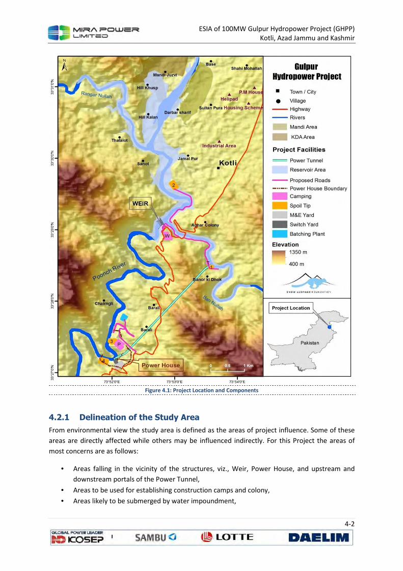
ESIA of 100MW Gulpur Hydropower Project (GHPP) Kotli, Azad Jammu and Kashmir
4-2
Figure 4.1: Project Location and Components
4.2.1 Delineation of the Study Area
From environmental view the study area is defined as the areas of project influence. Some of these
areas are directly affected while others may be influenced indirectly. For this Project the areas of
most concerns are as follows:
• Areas falling in the vicinity of the structures, viz., Weir, Power House, and upstream and
downstream portals of the Power Tunnel,
• Areas to be used for establishing construction camps and colony,
• Areas likely to be submerged by water impoundment,
ESIA of 100MW Gulpur Hydropower Project (GHPP) Kotli, Azad Jammu and Kashmir
4-3
• Areas likely to be used for dumping of spoil material from excavation of tunnel, weir and
power house,
• Areas to be used for developing haul tracks,
• Quarry areas,
• About 6.5 km stretch of the river reach from Weir up to the Power House that is going to be
deprived from the river flows during low-flow season for its diversion into the Power Tunnel
for power generation,
• Areas located on high-benches through which the Power Tunnel is going to be excavated.
These areas are not going to be directly affected, but it is likely that the settlements on these
benches may be disrupted due to vibrations from blasting and drilling at the Power Tunnel.
• Kotli Town is not going to be directly affected by the project; however, the area is likely to
have indirect effects of mixed type. Primarily, the induction of heavy machinery and
vehicles, particularly when transporting construction material from quarries falling on other
side of the town, will cause traffic congestions and hazards, while on the other hand the
induction of outside workforce will be beneficial in boosting the local business.
• The population residing on the right side of the Poonch River is dependent on Kotli for
business, service, shopping, etc is going to be affected due to break in the communication by
the creation of the reservoir.
Most of the potentially affected areas, except the ones related with the quarries, would fall within a
strip of about 4 km wide (on the average 2 km on either side of the Poonch River) and about 10 km
in length covering the river stretch from Kotli up to the Power House site. As such, the study area
comes to about 50 sq. km. The quarry sites have presently been excluded from the study area as the
sites indicated for quarrying are tentative and would be finalized when the contractor is mobilized
(Figure 4.2).
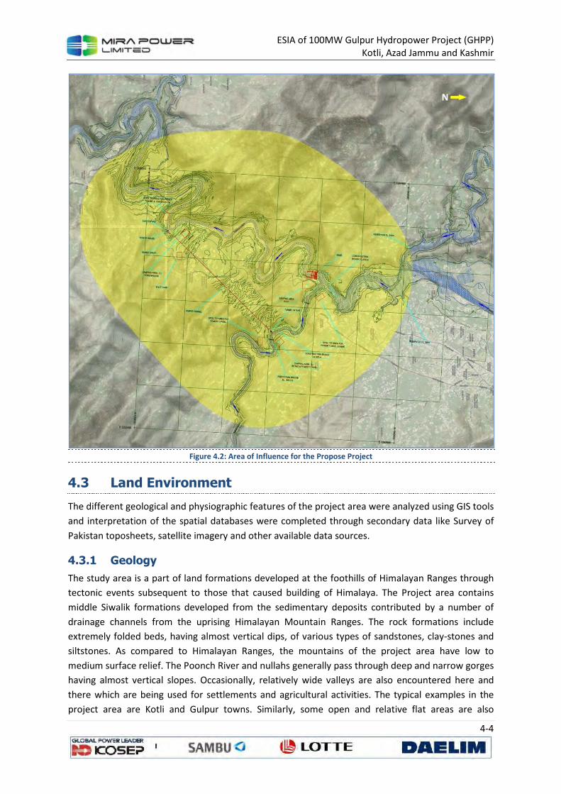
ESIA of 100MW Gulpur Hydropower Project (GHPP) Kotli, Azad Jammu and Kashmir
4-4
Figure 4.2: Area of Influence for the Propose Project
4.3 Land Environment
The different geological and physiographic features of the project area were analyzed using GIS tools
and interpretation of the spatial databases were completed through secondary data like Survey of
Pakistan toposheets, satellite imagery and other available data sources.
4.3.1 Geology
The study area is a part of land formations developed at the foothills of Himalayan Ranges through
tectonic events subsequent to those that caused building of Himalaya. The Project area contains
middle Siwalik formations developed from the sedimentary deposits contributed by a number of
drainage channels from the uprising Himalayan Mountain Ranges. The rock formations include
extremely folded beds, having almost vertical dips, of various types of sandstones, clay-stones and
siltstones. As compared to Himalayan Ranges, the mountains of the project area have low to
medium surface relief. The Poonch River and nullahs generally pass through deep and narrow gorges
having almost vertical slopes. Occasionally, relatively wide valleys are also encountered here and
there which are being used for settlements and agricultural activities. The typical examples in the
project area are Kotli and Gulpur towns. Similarly, some open and relative flat areas are also
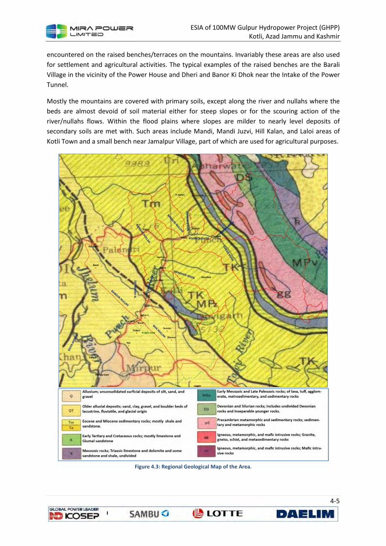
ESIA of 100MW Gulpur Hydropower Project (GHPP) Kotli, Azad Jammu and Kashmir
4-5
encountered on the raised benches/terraces on the mountains. Invariably these areas are also used
for settlement and agricultural activities. The typical examples of the raised benches are the Barali
Village in the vicinity of the Power House and Dheri and Banor Ki Dhok near the Intake of the Power
Tunnel.
Mostly the mountains are covered with primary soils, except along the river and nullahs where the
beds are almost devoid of soil material either for steep slopes or for the scouring action of the
river/nullahs flows. Within the flood plains where slopes are milder to nearly level deposits of
secondary soils are met with. Such areas include Mandi, Mandi Juzvi, Hill Kalan, and Laloi areas of
Kotli Town and a small bench near Jamalpur Village, part of which are used for agricultural purposes.
Figure 4.3: Regional Geological Map of the Area.
ESIA of 100MW Gulpur Hydropower Project (GHPP) Kotli, Azad Jammu and Kashmir
4-6
Major geological formations in the project area are;
4.3.1.1 Pliestocene and Recent Deposits Overburden
The overburden present in the area is river alluvial material and overburden on the terraces. River
alluvial material is present in the river bed, and along the slopes of the river valley. The thickness of
alluvial material in the river bed is between 3.0 m to 5.0 m. This material consists of sandy gravels,
cobbles and some boulders, which are rounded to sub-rounded, few sub-angular, semi spherical,
some platy and oblonged, generally of igneous and metamorphic origin, some sedimentary
(sandstone and limestone) origin are also present. The overburden on the terraces and especially
along the alignment of power tunnel and around the proposed portal consists of weathered clay and
siltstone with pieces of sandstone. The terraces in and around to Barali village area consist of sand,
gravel and silt.
4.3.1.2 Secree, Talus and Vegetation
Overburden on the slopes of the river valley is of detritus and detached blocks and boulders of
sandstone, at places mixed with weathered and eroded siltstone and claystones. The material is
mostly composed of different sizes of broken pieces of rocks due to weathering effect on parent
rock. The vegetation consists of self-grown plants and grass, thorny bushes and small trees planted
by WAPDA Watershed Management and Forest Department.
4.3.1.3 Classification of Rocks
Petrographically, this part of Nagri Stage of Siwaliks also has three main units of rocks which are:
a. Sandstones of various strength and cementation
b. Claystones
c. Siltstones
4.3.1.4 Sandstone
Sandstones of this part of Nagri (middle Siwaliks) have also been classified into three categories:
1. Sandstone-1 (Sst-1). This type of sandstone is always present in the form of ribs and
lenses in the main beds of sandstone-2.
2. Sandstone-2 (Sst-2). Moderately strong to strong, dirty greenish grey to light brownish
grey, medium to coarse grained, moderately to well cemented and cross bedded.
3. Sandstone-3 (Sst-3). Moderately weak to moderate strong, light brownish grey to grey,
fine grained, at places silty, slightly to moderately weathered, highly weathered at
places, thinly bedded, closely jointed and fractured generally present in thick beds of
clay and siltstone.
4.3.1.5 Claystone/Siltstone
Alternate beds of Cst/Mst of various shades vary in thickness from place to place. Siltstone is
moderately weak to moderate strong, various shades of brown and brownish grey, moderate thick
to thinly bedded partly laminated, moderately weathered at exposed surfaces, moderately to closely
jointed and moderate fractured.
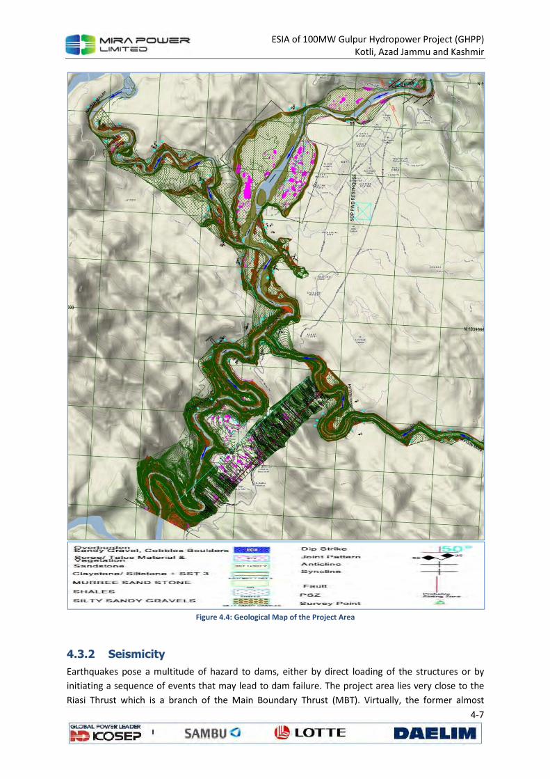
ESIA of 100MW Gulpur Hydropower Project (GHPP) Kotli, Azad Jammu and Kashmir
4-7
Figure 4.4: Geological Map of the Project Area
4.3.2 Seismicity
Earthquakes pose a multitude of hazard to dams, either by direct loading of the structures or by
initiating a sequence of events that may lead to dam failure. The project area lies very close to the
Riasi Thrust which is a branch of the Main Boundary Thrust (MBT). Virtually, the former almost
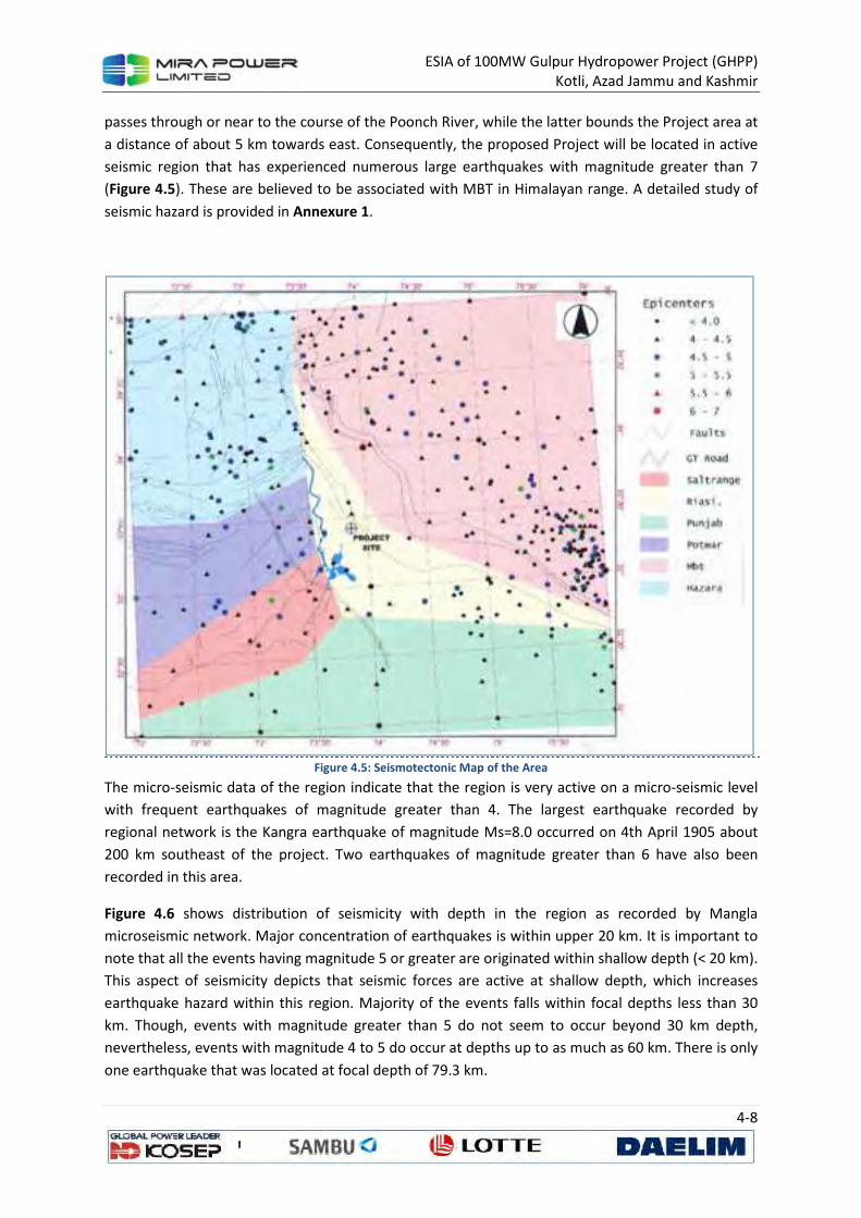
ESIA of 100MW Gulpur Hydropower Project (GHPP) Kotli, Azad Jammu and Kashmir
4-8
passes through or near to the course of the Poonch River, while the latter bounds the Project area at
a distance of about 5 km towards east. Consequently, the proposed Project will be located in active
seismic region that has experienced numerous large earthquakes with magnitude greater than 7
(Figure 4.5). These are believed to be associated with MBT in Himalayan range. A detailed study of
seismic hazard is provided in Annexure 1.
Figure 4.5: Seismotectonic Map of the Area
The micro-seismic data of the region indicate that the region is very active on a micro-seismic level
with frequent earthquakes of magnitude greater than 4. The largest earthquake recorded by
regional network is the Kangra earthquake of magnitude Ms=8.0 occurred on 4th April 1905 about
200 km southeast of the project. Two earthquakes of magnitude greater than 6 have also been
recorded in this area.
Figure 4.6 shows distribution of seismicity with depth in the region as recorded by Mangla
microseismic network. Major concentration of earthquakes is within upper 20 km. It is important to
note that all the events having magnitude 5 or greater are originated within shallow depth (< 20 km).
This aspect of seismicity depicts that seismic forces are active at shallow depth, which increases
earthquake hazard within this region. Majority of the events falls within focal depths less than 30
km. Though, events with magnitude greater than 5 do not seem to occur beyond 30 km depth,
nevertheless, events with magnitude 4 to 5 do occur at depths up to as much as 60 km. There is only
one earthquake that was located at focal depth of 79.3 km.
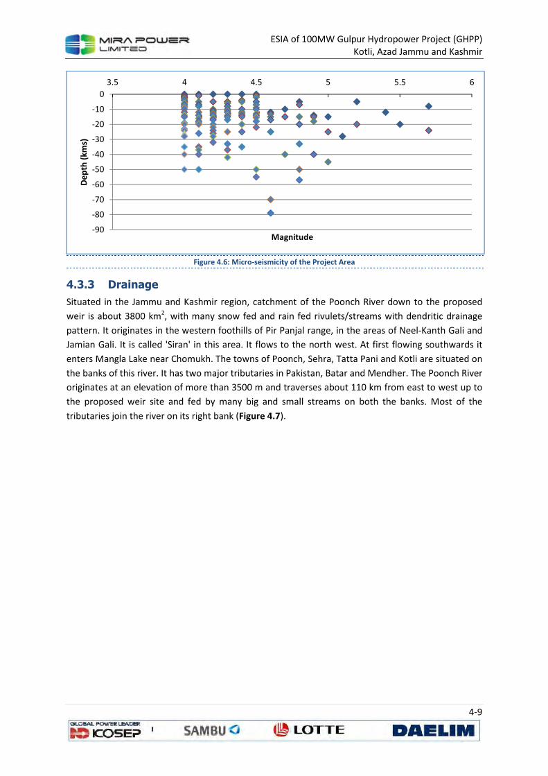
ESIA of 100MW Gulpur Hydropower Project (GHPP) Kotli, Azad Jammu and Kashmir
4-9
Figure 4.6: Micro-seismicity of the Project Area
4.3.3 Drainage
Situated in the Jammu and Kashmir region, catchment of the Poonch River down to the proposed
weir is about 3800 km2, with many snow fed and rain fed rivulets/streams with dendritic drainage
pattern. It originates in the western foothills of Pir Panjal range, in the areas of Neel-Kanth Gali and
Jamian Gali. It is called 'Siran' in this area. It flows to the north west. At first flowing southwards it
enters Mangla Lake near Chomukh. The towns of Poonch, Sehra, Tatta Pani and Kotli are situated on
the banks of this river. It has two major tributaries in Pakistan, Batar and Mendher. The Poonch River
originates at an elevation of more than 3500 m and traverses about 110 km from east to west up to
the proposed weir site and fed by many big and small streams on both the banks. Most of the
tributaries join the river on its right bank (Figure 4.7).
-90
-80
-70
-60
-50
-40
-30
-20
-10
0
3.5 4 4.5 5 5.5 6D
ep
th (
kms)
Magnitude
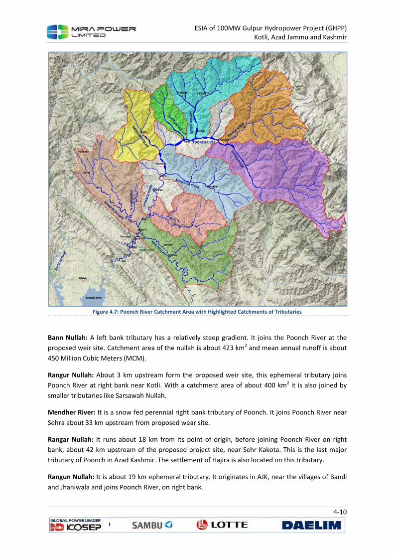
ESIA of 100MW Gulpur Hydropower Project (GHPP) Kotli, Azad Jammu and Kashmir
4-10
Figure 4.7: Poonch River Catchment Area with Highlighted Catchments of Tributaries
Bann Nullah: A left bank tributary has a relatively steep gradient. It joins the Poonch River at the
proposed weir site. Catchment area of the nullah is about 423 km2 and mean annual runoff is about
450 Million Cubic Meters (MCM).
Rangur Nullah: About 3 km upstream form the proposed weir site, this ephemeral tributary joins
Poonch River at right bank near Kotli. With a catchment area of about 400 km2 it is also joined by
smaller tributaries like Sarsawah Nullah.
Mendher River: It is a snow fed perennial right bank tributary of Poonch. It joins Poonch River near
Sehra about 33 km upstream from proposed wear site.
Rangar Nullah: It runs about 18 km from its point of origin, before joining Poonch River on right
bank, about 42 km upstream of the proposed project site, near Sehr Kakota. This is the last major
tributary of Poonch in Azad Kashmir. The settlement of Hajira is also located on this tributary.
Rangun Nullah: It is about 19 km ephemeral tributary. It originates in AJK, near the villages of Bandi
and Jhaniwala and joins Poonch River, on right bank.
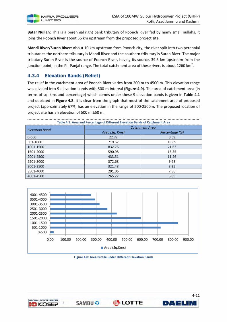
ESIA of 100MW Gulpur Hydropower Project (GHPP) Kotli, Azad Jammu and Kashmir
4-11
Batar Nullah: This is a perennial right bank tributary of Poonch River fed by many small nullahs. It
joins the Poonch River about 56 km upstream from the proposed project site.
Mandi River/Suran River: About 10 km upstream from Poonch city, the river split into two perennial
tributaries the northern tributary is Mandi River and the southern tributary is Suran River. The major
tributary Suran River is the source of Poonch River, having its source, 39.5 km upstream from the
junction point, in the Pir Panjal range. The total catchment area of these rivers is about 1260 km2.
4.3.4 Elevation Bands (Relief)
The relief in the catchment area of Poonch River varies from 200 m to 4500 m. This elevation range
was divided into 9 elevation bands with 500 m interval (Figure 4.9). The area of catchment area (in
terms of sq. kms and percentage) which comes under these 9 elevation bands is given in Table 4.1
and depicted in Figure 4.8. It is clear from the graph that most of the catchment area of proposed
project (approximately 67%) has an elevation in the range of 500-2500m. The proposed location of
project site has an elevation of 500 m ±50 m.
Table 4.1: Area and Percentage of Different Elevation Bands of Catchment Area
Elevation Band Catchment Area
Area (Sq. Kms) Percentage (%)
0-500 22.72 0.59
501-1000 719.57 18.69
1001-1500 832.76 21.63
1501-2000 590.98 15.35
2001-2500 433.51 11.26
2501-3000 372.68 9.68
3001-3500 321.48 8.35
3501-4000 291.06 7.56
4001-4500 265.27 6.89
Figure 4.8: Area Profile under Different Elevation Bands
0.00 100.00 200.00 300.00 400.00 500.00 600.00 700.00 800.00 900.00
0-500501-1000
1001-15001501-20002001-25002501-30003001-35003501-40004001-4500
Area (Sq.Kms)
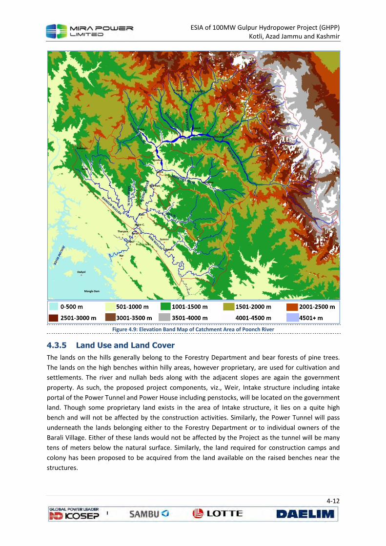
ESIA of 100MW Gulpur Hydropower Project (GHPP) Kotli, Azad Jammu and Kashmir
4-12
Figure 4.9: Elevation Band Map of Catchment Area of Poonch River
4.3.5 Land Use and Land Cover
The lands on the hills generally belong to the Forestry Department and bear forests of pine trees.
The lands on the high benches within hilly areas, however proprietary, are used for cultivation and
settlements. The river and nullah beds along with the adjacent slopes are again the government
property. As such, the proposed project components, viz., Weir, Intake structure including intake
portal of the Power Tunnel and Power House including penstocks, will be located on the government
land. Though some proprietary land exists in the area of Intake structure, it lies on a quite high
bench and will not be affected by the construction activities. Similarly, the Power Tunnel will pass
underneath the lands belonging either to the Forestry Department or to individual owners of the
Barali Village. Either of these lands would not be affected by the Project as the tunnel will be many
tens of meters below the natural surface. Similarly, the land required for construction camps and
colony has been proposed to be acquired from the land available on the raised benches near the
structures.
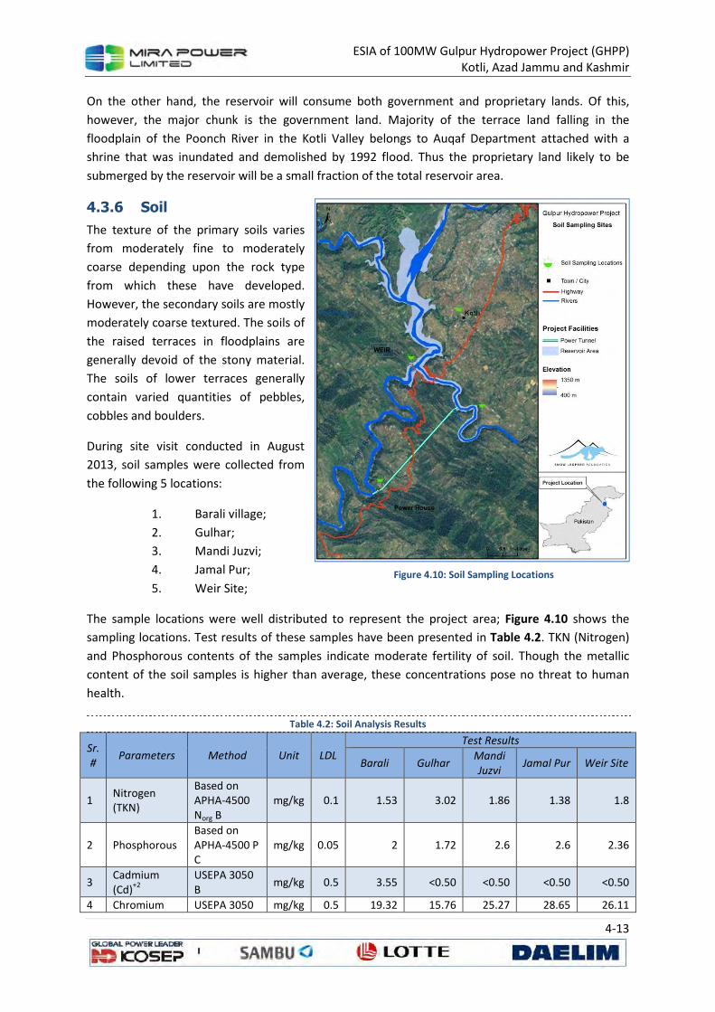
ESIA of 100MW Gulpur Hydropower Project (GHPP) Kotli, Azad Jammu and Kashmir
4-13
On the other hand, the reservoir will consume both government and proprietary lands. Of this,
however, the major chunk is the government land. Majority of the terrace land falling in the
floodplain of the Poonch River in the Kotli Valley belongs to Auqaf Department attached with a
shrine that was inundated and demolished by 1992 flood. Thus the proprietary land likely to be
submerged by the reservoir will be a small fraction of the total reservoir area.
4.3.6 Soil
The texture of the primary soils varies
from moderately fine to moderately
coarse depending upon the rock type
from which these have developed.
However, the secondary soils are mostly
moderately coarse textured. The soils of
the raised terraces in floodplains are
generally devoid of the stony material.
The soils of lower terraces generally
contain varied quantities of pebbles,
cobbles and boulders.
During site visit conducted in August
2013, soil samples were collected from
the following 5 locations:
1. Barali village;
2. Gulhar;
3. Mandi Juzvi;
4. Jamal Pur;
5. Weir Site;
The sample locations were well distributed to represent the project area; Figure 4.10 shows the
sampling locations. Test results of these samples have been presented in Table 4.2. TKN (Nitrogen)
and Phosphorous contents of the samples indicate moderate fertility of soil. Though the metallic
content of the soil samples is higher than average, these concentrations pose no threat to human
health.
Table 4.2: Soil Analysis Results
Sr.
# Parameters Method Unit LDL
Test Results
Barali Gulhar Mandi
Juzvi Jamal Pur Weir Site
1 Nitrogen (TKN)
Based on APHA-4500 Norg B
mg/kg 0.1 1.53 3.02 1.86 1.38 1.8
2 Phosphorous Based on APHA-4500 P C
mg/kg 0.05 2 1.72 2.6 2.6 2.36
3 Cadmium (Cd)
+2
USEPA 3050 B
mg/kg 0.5 3.55 <0.50 <0.50 <0.50 <0.50
4 Chromium USEPA 3050 mg/kg 0.5 19.32 15.76 25.27 28.65 26.11
Figure 4.10: Soil Sampling Locations
ESIA of 100MW Gulpur Hydropower Project (GHPP) Kotli, Azad Jammu and Kashmir
4-14
Sr.
# Parameters Method Unit LDL
Test Results
Barali Gulhar Mandi
Juzvi Jamal Pur Weir Site
(Cr) B
5 Lead (Pb)+2
USEPA 3050 B
mg/kg 0.5 75.16 95.19 77.76 100.9 76.69
6 Iron as (Fe)
+3/+2
USEPA 3050 B
mg/kg 0.02 27153.91 21934.86 25545.5 26119.6 25842.05
7 Aluminium (Al)
+2
USEPA 3050 B
mg/kg 0.5 <0.5 <0.5 <0.5 <0.5 <0.5
8 Sulfate (SO4)-2
In-House /Gravimetric
mg/kg 5 299.18 213.73 311.39 201.15 102.07
9 Total Dissolved Solids (TDS)
In-House /Gravimetric
mg/kg 5 989.70 1193.51 796.81 688.10 994.91
* Source, physical baseline survey, sampling, testing and analysis conducted in August 2013, (LDL: Lowest
Detection Limit <: Less Than)
4.4 Climate and Meteorology
There are number of meteorological stations within and in the vicinity of the catchment area where
data is available for meteorological parameters. These include Sehr Kakota, Plandari, Mangla, Bagh,
Rawalakot and Khandar. Kotli is the representative station for which meteorological parameters like
temperature, precipitation, humidity and evaporation are available. This part of the report will
provide a baseline of climate and meteorology of the area, for a detailed study refer to Annexure 2.
Generally, the project area falls in sub-humid and sub-tropical zone. It has moderate summer and
cold winter. The climate is greatly influenced by monsoon in the months of July and August and
snowcapped mountains of Pir Panjal Range. Consequently the weather is pleasant in the months of
March to May and August to October.
Winter Season: Though the duration of winter season depends on altitude, it generally lasts from
November to February in proposed project area. It is characterized by heavy frost in the lower areas
and some snowfall at higher elevation. Rain and snow during winter season come from north-
western air currents, and snowfall starts at higher elevations towards the end of November or early
in December
Spring Season: Though there is no characterized spring season in the area, but the weather is
pleasant in the months of March to April. This period is of intense phonological activity at the higher
elevations and can be termed as spring.
Summer Season: This is characterized by dry spells in April to June followed by frequent showers in
the moist or wet zone. At this time of the year the lower valleys are hot. Hot winds from Punjab and
sunny weather in arid and semi-arid parts cause intense summers.
Rainy Season: It starts with the advent of monsoons either towards the end of June or early in July
and lasts till middle or sometimes up to the end of September. The bulk of rainfall is received during
this period in the wet zone. After the rainy season, the sky becomes clear and there is very little rain,
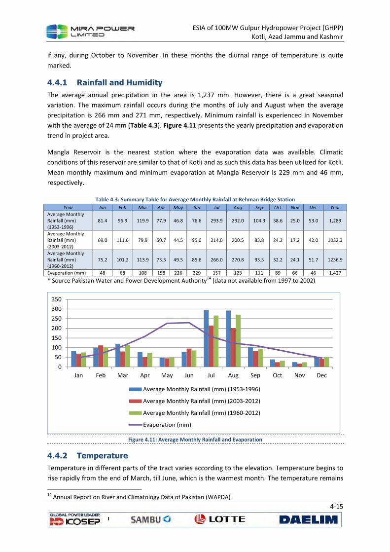
ESIA of 100MW Gulpur Hydropower Project (GHPP) Kotli, Azad Jammu and Kashmir
4-15
if any, during October to November. In these months the diurnal range of temperature is quite
marked.
4.4.1 Rainfall and Humidity
The average annual precipitation in the area is 1,237 mm. However, there is a great seasonal
variation. The maximum rainfall occurs during the months of July and August when the average
precipitation is 266 mm and 271 mm, respectively. Minimum rainfall is experienced in November
with the average of 24 mm (Table 4.3). Figure 4.11 presents the yearly precipitation and evaporation
trend in project area.
Mangla Reservoir is the nearest station where the evaporation data was available. Climatic
conditions of this reservoir are similar to that of Kotli and as such this data has been utilized for Kotli.
Mean monthly maximum and minimum evaporation at Mangla Reservoir is 229 mm and 46 mm,
respectively.
Table 4.3: Summary Table for Average Monthly Rainfall at Rehman Bridge Station
Year Jan Feb Mar Apr May Jun Jul Aug Sep Oct Nov Dec Year
Average Monthly Rainfall (mm) (1953-1996)
81.4 96.9 119.9 77.9 46.8 76.6 293.9 292.0 104.3 38.6 25.0 53.0 1,289
Average Monthly Rainfall (mm) (2003-2012)
69.0 111.6 79.9 50.7 44.5 95.0 214.0 200.5 83.8 24.2 17.2 42.0 1032.3
Average Monthly Rainfall (mm) (1960-2012)
75.2 101.2 113.9 73.3 49.5 85.6 266.0 270.8 93.5 32.2 24.1 51.7 1236.9
Evaporation (mm) 48 68 108 158 226 229 157 123 111 89 66 46 1,427
* Source Pakistan Water and Power Development Authority14
(data not available from 1997 to 2002)
Figure 4.11: Average Monthly Rainfall and Evaporation
4.4.2 Temperature
Temperature in different parts of the tract varies according to the elevation. Temperature begins to
rise rapidly from the end of March, till June, which is the warmest month. The temperature remains
14
Annual Report on River and Climatology Data of Pakistan (WAPDA)
0
50
100
150
200
250
300
350
Jan Feb Mar Apr May Jun Jul Aug Sep Oct Nov Dec
Average Monthly Rainfall (mm) (1953-1996)
Average Monthly Rainfall (mm) (2003-2012)
Average Monthly Rainfall (mm) (1960-2012)
Evaporation (mm)
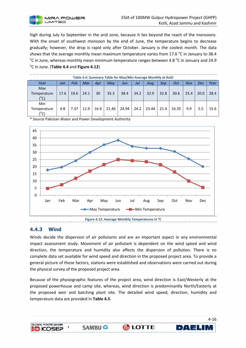
ESIA of 100MW Gulpur Hydropower Project (GHPP) Kotli, Azad Jammu and Kashmir
4-16
high during July to September in the arid zone, because it lies beyond the reach of the monsoons.
With the onset of southwest monsoon by the end of June, the temperature begins to decrease
gradually; however, the drop is rapid only after October. January is the coolest month. The data
shows that the average monthly mean maximum temperature varies from 17.6 oC in January to 38.4 oC in June, whereas monthly mean minimum temperature ranges between 4.8 oC in January and 24.9 oC in June. (Table 4.4 and Figure 4.12)
Table 4.4: Summary Table for Max/Min Average Monthly at Kotli
Year Jan Feb Mar Apr May Jun Jul Aug Sep Oct Nov Dec Year
Max Temperature
(oC)
17.6 19.6 24.1 30 35.3 38.4 34.2 32.9 32.8 30.6 25.4 20.0 28.4
Min Temperature
(oC)
4.8 7.37 11.9 16.9 21.46 24.94 24.2 23.44 21.4 16.35 9.9 5.5 15.6
* Source Pakistan Water and Power Development Authority
Figure 4.12: Average Monthly Temperatures in ºC
4.4.3 Wind
Winds decide the dispersion of air pollutants and are an important aspect in any environmental
impact assessment study. Movement of air pollutant is dependent on the wind speed and wind
direction, the temperature and humidity also affects the dispersion of pollution. There is no
complete data set available for wind speed and direction in the proposed project area. To provide a
general picture of these factors, stations were established and observations were carried out during
the physical survey of the proposed project area.
Because of the physiographic features of the project area, wind direction is East/Westerly at the
proposed powerhouse and camp site, whereas, wind direction is predominantly North/Easterly at
the proposed weir and batching plant site. The detailed wind speed, direction, humidity and
temperature data are provided in Table 4.5.
0
5
10
15
20
25
30
35
40
45
Jan Feb Mar Apr May Jun Jul Aug Sep Oct Nov Dec
Max Temperature Min Temperature
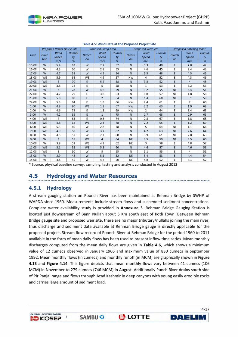
ESIA of 100MW Gulpur Hydropower Project (GHPP) Kotli, Azad Jammu and Kashmir
4-17
Table 4.5: Wind Data at the Proposed Project Site
Time
Proposed Power House Site Proposed Camp Area Proposed Weir Site Proposed Batching Plant
Direc
tion
Wind
Speed
Humidi
ty Directi
on
Wind
Speed
Humidi
ty Directi
on
Wind
Speed
Humidi
ty Directi
on
Wind
Speed
Humidi
ty
m/s % m/s % m/s % m/s %
15:00 W 5.4 63 W 2.7 52 N 5.3 40 E 2.8 42
16:00 W 4.3 60 W 2.8 55 N 4.6 45 E 2.4 43
17:00 W 4.7 58 W 4.5 54 N 5.5 48 E 4.5 45
18:00 WE 5.9 68 WE 4.9 57 NW 4 52 E 4.3 46
19:00 WE 5 70 E 5.2 58 N 3.8 52 E 4 48
20:00 WE 3.8 72 E 5 58 N 1 53 E 5.2 53
21:00 W 3 78 W 4.6 59 N 3.2 55 NE 5.4 56
22:00 W 4.7 79 E 3.8 63 N 1.8 57 NE 4.8 58
23:00 W 5.8 80 E 2 64 N 1.4 60 NE 3.1 59
24:00 W 5.3 84 E 1.8 66 NW 2.4 61 E 2 60
1:00 W 4.8 80 WE 1.8 67 NW 2.2 63 E 1.9 62
2:00 W 4.6 78 E 1.3 69 NW 2 64 E 1.4 63
3:00 W 4.2 65 E 1 75 N 1.7 68 E 0.9 65
4:00 WE 4 63 E 0.8 74 N 2.8 67 E 1.8 68
5:00 WE 4.8 62 WE 2.4 78 N 2.2 65 E 1.2 69
6:00 WE 5.3 60 W 2.8 78 N 5 64 NE 1.1 66
7:00 WE 4.9 58 W 3.7 82 N 4.2 63 NE 2.6 64
8:00 W 4.5 57 W 2.2 80 N 3.9 61 NE 2.8 63
9:00 W 3 55 WE 4 64 NE 3.5 59 NE 3.5 60
10:00 W 3.8 53 WE 4.3 62 NE 3 58 E 4.8 57
11:00 WE 3.1 52 WE 5.3 60 N 4.6 57 E 4.6 56
12:00 WE 3 50 W 5 55 N 5.1 55 E 4 55
13:00 W 2.9 48 W 5.1 52 NE 5.4 53 E 4.4 54
14:00 W 3.8 45 W 4.7 50 NE 4.8 52 E 4.1 52
* Source, physical baseline survey, sampling, testing and analysis conducted in August 2013
4.5 Hydrology and Water Resources
4.5.1 Hydrology
A stream gauging station on Poonch River has been maintained at Rehman Bridge by SWHP of
WAPDA since 1960. Measurements include stream flows and suspended sediment concentrations.
Complete water availability study is provided in Annexure 3. Rehman Bridge Gauging Station is
located just downstream of Bann Nullah about 5 Km south east of Kotli Town. Between Rehman
Bridge gauge site and proposed weir site, there are no major tributary/nullahs joining the main river,
thus discharge and sediment data available at Rehman Bridge gauge is directly applicable for the
proposed project. Stream flow record of Poonch River at Rehman Bridge for the period 1960 to 2011
available in the form of mean daily flows has been used to present inflow time series. Mean monthly
discharges computed from the mean daily flows are given in Table 4.6, which shows a minimum
value of 12 cumecs observed in January 1966 and maximum value of 830 cumecs in September
1992. Mean monthly flows (in cumecs) and monthly runoff (in MCM) are graphically shown in Figure
4.13 and Figure 4.14. This figure depicts that mean monthly flows vary between 41 cumecs (106
MCM) in November to 279 cumecs (746 MCM) in August. Additionally Punch River drains south side
of Pir Panjal range and flows through Azad Kashmir in deep canyons with young easily erodible rocks
and carries large amount of sediment load.

ESIA of 100MW Gulpur Hydropower Project (GHPP) Kotli, Azad Jammu and Kashmir
4-18
Table 4.6: Summary of Mean Monthly Flows of Punch River at Rehman Bridge (1960-2011)
Year Mean Monthly Flow (Cumecs) Annual Flow
Jan Feb Mar Apr May Jun Jul Aug Sep Oct Nov Dec Cumecs MCM (MAF)
Maximum 156 293 402 396 221 263 633 665 830 220 162 187 260 8215 6.66
Minimum 12 21 27 53 53 56 80 90 45 19 15 15 66 2086 1.69
Runoff 144 272 375 343 168 207 553 575 785 201 147 172 194 6129 4.97
Mean 53 100 177 165 119 116 225 264 141 57 41 47 126 3966 3.22
* Source Pakistan Water and Power Development Authority (Cumecs: Cubic Meters per Second MCM: Million
Cubic Meters MAF:Million Acre-Foot)
Figure 4.13: Monthly Flows and Runoff of Punch River
Figure 4.14: Mean Annual Flows of Punch River
4.5.2 Water Resources
4.5.2.1 Surface Water
The main surface water resource of the project area is the Poonch River, which flows along Kotli-
Mirpur Road and enters into Mangla Reservoir. Poonch River is a main tributary of Jhelum River. The
Project is going to utilize the flows of the Poonch River that initiates from the Indian Held Kashmir
0
100
200
300
400
500
600
700
800
900
1 2 3 4 5 6 7 8 9 10 11 12
Mea
n M
on
thly
Flo
w (
Cu
mec
s)
Maximum Minimum Runoff Mean
0
50
100
150
200
250
300
19
60
19
62
19
64
19
66
19
68
19
70
19
72
19
74
19
76
19
78
19
80
19
82
19
84
19
86
19
88
19
90
19
92
19
94
19
96
19
98
20
00
20
02
20
04
20
06
20
08
20
10
Year
ly F
low
(C
um
ecs)
Annual Flow Mean Flow for Last 50 Years Maximum Minimum
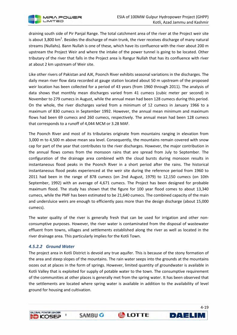
ESIA of 100MW Gulpur Hydropower Project (GHPP) Kotli, Azad Jammu and Kashmir
4-19
draining south side of Pir Panjal Range. The total catchment area of the river at the Project weir site
is about 3,800 km2. Besides the discharge of main trunk, the river receives discharge of many natural
streams (Nullahs). Bann Nullah is one of these, which have its confluence with the river about 200 m
upstream the Project Weir and where the intake of the power tunnel is going to be located. Other
tributary of the river that falls in the Project area is Rangur Nullah that has its confluence with river
at about 2 km upstream of Weir site.
Like other rivers of Pakistan and AJK, Poonch River exhibits seasonal variations in the discharges. The
daily mean river flow data recorded at gauge station located about 50 m upstream of the proposed
weir location has been collected for a period of 43 years (from 1960 through 2011). The analysis of
data shows that monthly mean discharges varied from 41 cumecs (cubic meter per second) in
November to 279 cumecs in August, while the annual mean had been 128 cumecs during this period.
On the whole, the river discharges varied from a minimum of 12 cumecs in January 1966 to a
maximum of 830 cumecs in September 1992. However, the annual mean minimum and maximum
flows had been 69 cumecs and 260 cumecs, respectively. The annual mean had been 128 cumecs
that corresponds to a runoff of 4,044 MCM or 3.28 MAF.
The Poonch River and most of its tributaries originate from mountains ranging in elevation from
3,000 m to 4,500 m above mean sea level. Consequently, the mountains remain covered with snow
cap for part of the year that contributes to the river discharges. However, the major contribution in
the annual flows comes from the monsoon rains that are spread from July to September. The
configuration of the drainage area combined with the cloud bursts during monsoon results in
instantaneous flood peaks in the Poonch River in a short period after the rains. The historical
instantaneous flood peaks experienced at the weir site during the reference period from 1960 to
2011 had been in the range of 878 cumecs (on 2nd August, 1979) to 12,150 cumecs (on 10th
September, 1992) with an average of 4,671 cumecs. The Project has been designed for probable
maximum flood. The study has shown that the figure for 100 year flood comes to about 13,340
cumecs, while the PMF has been estimated to be 21,640 cumecs. The combined capacity of the main
and undersluice weirs are enough to efficiently pass more than the design discharge (about 15,000
cumecs).
The water quality of the river is generally fresh that can be used for irrigation and other non-
consumptive purposes. However, the river water is contaminated from the disposal of wastewater
effluent from towns, villages and settlements established along the river as well as located in the
river drainage area. This particularly implies for the Kotli Town.
4.5.2.2 Ground Water
The project area in Kotli District is devoid any true aquifer. This is because of the stony formation of
the area and steep slopes of the mountains. The rain water seeps into the grounds at the mountains
oozes out at places in the form of springs. However, limited quantity of groundwater is available in
Kotli Valley that is exploited for supply of potable water to the town. The consumptive requirement
of the communities at other places is generally met from the spring water. It has been observed that
the settlements are located where spring water is available in addition to the availability of level
ground for housing and cultivation.
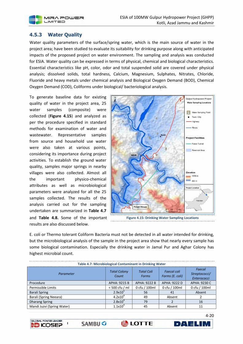
ESIA of 100MW Gulpur Hydropower Project (GHPP) Kotli, Azad Jammu and Kashmir
4-20
4.5.3 Water Quality
Water quality parameters of the surface/spring water, which is the main source of water in the
project area; have been studied to evaluate its suitability for drinking purpose along with anticipated
impacts of the proposed project on water environment. The sampling and analysis was conducted
for ESIA. Water quality can be expressed in terms of physical, chemical and biological characteristics.
Essential characteristics like pH, color, odor and total suspended solid are covered under physical
analysis; dissolved solids, total hardness, Calcium, Magnesium, Sulphates, Nitrates, Chloride,
Fluoride and heavy metals under chemical analysis and Biological Oxygen Demand (BOD), Chemical
Oxygen Demand (COD), Coliforms under biological/ bacteriological analysis.
To generate baseline data for existing
quality of water in the project area, 25
water samples (composite) were
collected (Figure 4.15) and analyzed as
per the procedure specified in standard
methods for examination of water and
wastewater. Representative samples
from source and household use water
were also taken at various points,
considering its importance during project
activities. To establish the ground water
quality, samples major springs in nearby
villages were also collected. Almost all
the important physico-chemical
attributes as well as microbiological
parameters were analyzed for all the 25
samples collected. The results of the
analysis carried out for the sampling
undertaken are summarized in Table 4.7
and Table 4.8. Some of the important
results are also discussed below.
E. coli or Thermo tolerant Coliform Bacteria must not be detected in all water intended for drinking,
but the microbiological analysis of the sample in the project area show that nearly every sample has
some biological contamination. Especially the drinking water in Jamal Pur and Aghar Colony has
highest microbial count.
Table 4.7: Microbiological Contaminant in Drinking Water
Parameter Total Colony
Count
Total Coli
Forms
Faecal coli
Forms (E. coli)
Faecal
Streptococci/
Enterococci
Procedure APHA: 9215 B APHA: 9222 B APHA: 9222 D APHA: 9230 C
Permissible Limits < 500 cfu / ml 0 cfu / 100ml 0 cfu / 100ml 0 cfu / 100ml
Barali Spring 2.9x10⁵ 56 41 Absent
Barali (Spring Neeara) 4.2x10⁴ 49 Absent 2
Dharang Spring 2.8x10⁴ 79 2 16
Mandi Juzvi (Spring Water) 1.1x10⁴ 45 Absent 11
Figure 4.15: Drinking Water Sampling Locations
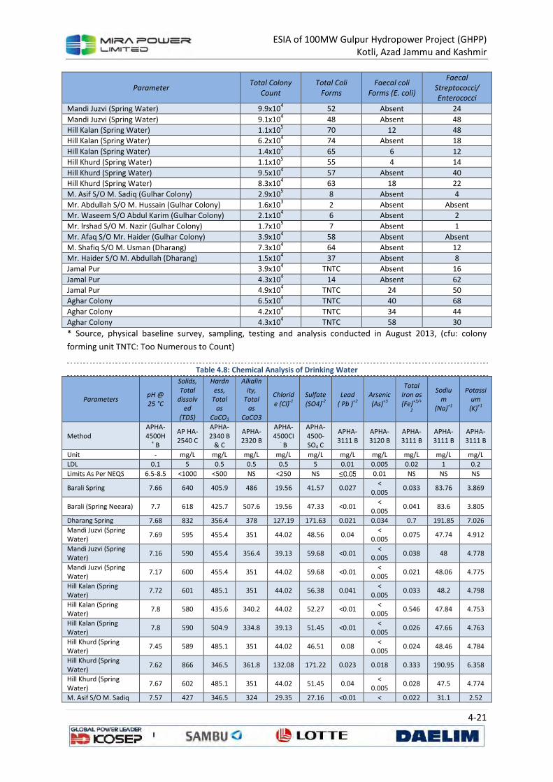
ESIA of 100MW Gulpur Hydropower Project (GHPP) Kotli, Azad Jammu and Kashmir
4-21
Parameter Total Colony
Count
Total Coli
Forms
Faecal coli
Forms (E. coli)
Faecal
Streptococci/
Enterococci
Mandi Juzvi (Spring Water) 9.9x10⁴ 52 Absent 24
Mandi Juzvi (Spring Water) 9.1x10⁴ 48 Absent 48
Hill Kalan (Spring Water) 1.1x10⁵ 70 12 48
Hill Kalan (Spring Water) 6.2x10⁴ 74 Absent 18
Hill Kalan (Spring Water) 1.4x10⁵ 65 6 12
Hill Khurd (Spring Water) 1.1x10⁵ 55 4 14
Hill Khurd (Spring Water) 9.5x10⁴ 57 Absent 40
Hill Khurd (Spring Water) 8.3x10⁴ 63 18 22
M. Asif S/O M. Sadiq (Gulhar Colony) 2.9x10⁵ 8 Absent 4
Mr. Abdullah S/O M. Hussain (Gulhar Colony) 1.6x10³ 2 Absent Absent
Mr. Waseem S/O Abdul Karim (Gulhar Colony) 2.1x10⁴ 6 Absent 2
Mr. lrshad S/O M. Nazir (Gulhar Colony) 1.7x10⁵ 7 Absent 1
Mr. Afaq S/O Mr. Haider (Gulhar Colony) 3.9x10⁴ 58 Absent Absent
M. Shafiq S/O M. Usman (Dharang) 7.3x10⁴ 64 Absent 12
Mr. Haider S/O M. Abdullah (Dharang) 1.5x10⁴ 37 Absent 8
Jamal Pur 3.9x10⁴ TNTC Absent 16
Jamal Pur 4.3x10⁴ 14 Absent 62
Jamal Pur 4.9x10⁴ TNTC 24 50
Aghar Colony 6.5x10⁴ TNTC 40 68
Aghar Colony 4.2x10⁴ TNTC 34 44
Aghar Colony 4.3x10⁴ TNTC 58 30
* Source, physical baseline survey, sampling, testing and analysis conducted in August 2013, (cfu: colony
forming unit TNTC: Too Numerous to Count)
Table 4.8: Chemical Analysis of Drinking Water
Parameters pH @
25 °C
Solids,
Total
dissolv
ed
(TDS)
Hardn
ess,
Total
as
CaCO3
Alkalin
ity,
Total
as
CaCO3
Chlorid
e (Cl)-1
Sulfate
(SO4)-2
Lead
( Pb )+2
Arsenic
(As)+3
Total
Iron as
(Fe)+3/+
2
Sodiu
m
(Na)+1
Potassi
um
(K)+1
Method APHA-4500H
+ B
AP HA-2540 C
APHA-2340 B
& C
APHA-2320 B
APHA-4500CI
- B
APHA-4500-SO4 C
APHA-3111 B
APHA-3120 B
APHA-3111 B
APHA-3111 B
APHA-3111 B
Unit - mg/L mg/L mg/L mg/L mg/L mg/L mg/L mg/L mg/L mg/L
LDL 0.1 5 0.5 0.5 0.5 5 0.01 0.005 0.02 1 0.2
Limits As Per NEQS 6.5-8.5 <1000 <500 NS <250 NS ≤0.05 0.01 NS NS NS
Barali Spring 7.66 640 405.9 486 19.56 41.57 0.027 <
0.005 0.033 83.76 3.869
Barali (Spring Neeara) 7.7 618 425.7 507.6 19.56 47.33 <0.01 <
0.005 0.041 83.6 3.805
Dharang Spring 7.68 832 356.4 378 127.19 171.63 0.021 0.034 0.7 191.85 7.026
Mandi Juzvi (Spring Water)
7.69 595 455.4 351 44.02 48.56 0.04 <
0.005 0.075 47.74 4.912
Mandi Juzvi (Spring Water)
7.16 590 455.4 356.4 39.13 59.68 <0.01 <
0.005 0.038 48 4.778
Mandi Juzvi (Spring Water)
7.17 600 455.4 351 44.02 59.68 <0.01 <
0.005 0.021 48.06 4.775
Hill Kalan (Spring Water)
7.72 601 485.1 351 44.02 56.38 0.041 <
0.005 0.033 48.2 4.798
Hill Kalan (Spring Water)
7.8 580 435.6 340.2 44.02 52.27 <0.01 <
0.005 0.546 47.84 4.753
Hill Kalan (Spring Water)
7.8 590 504.9 334.8 39.13 51.45 <0.01 <
0.005 0.026 47.66 4.763
Hill Khurd (Spring Water)
7.45 589 485.1 351 44.02 46.51 0.08 <
0.005 0.024 48.46 4.784
Hill Khurd (Spring Water)
7.62 866 346.5 361.8 132.08 171.22 0.023 0.018 0.333 190.95 6.358
Hill Khurd (Spring Water)
7.67 602 485.1 351 44.02 51.45 0.04 <
0.005 0.028 47.5 4.774
M. Asif S/O M. Sadiq 7.57 427 346.5 324 29.35 27.16 <0.01 < 0.022 31.1 2.52
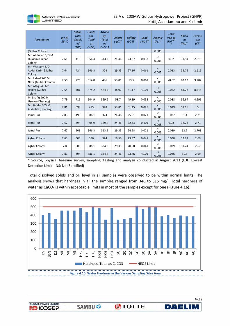
ESIA of 100MW Gulpur Hydropower Project (GHPP) Kotli, Azad Jammu and Kashmir
4-22
Parameters pH @
25 °C
Solids,
Total
dissolv
ed
(TDS)
Hardn
ess,
Total
as
CaCO3
Alkalin
ity,
Total
as
CaCO3
Chlorid
e (Cl)-1
Sulfate
(SO4)-2
Lead
( Pb )+2
Arsenic
(As)+3
Total
Iron as
(Fe)+3/+
2
Sodiu
m
(Na)+1
Potassi
um
(K)+1
(Gulhar Colony) 0.005
Mr. Abdullah S/O M. Hussain (Gulhar Colony)
7.61 410 356.4 313.2 24.46 23.87 0.037 <
0.005 0.02 31.94 2.515
Mr. Waseem S/O Abdul Karim (Gulhar Colony)
7.64 424 366.3 324 29.35 27.16 0.061 <
0.005 0.033 32.76 2.619
Mr. lrshad S/O M. Nazir (Gulhar Colony)
7.58 726 514.8 486 53.81 53.5 0.061 <
0.005 <0.02 82.12 9.282
Mr. Afaq S/O Mr. Haider (Gulhar Colony)
7.55 701 475.2 464.4 48.92 61.17 <0.01 <
0.005 0.052 81.28 8.716
M. Shafiq S/O M. Usman (Dharang)
7.79 716 504.9 399.6 58.7 49.39 0.052 <
0.005 0.038 56.64 4.995
Mr. Haider S/O M. Abdullah (Dharang)
7.81 698 495 378 53.81 51.45 0.025 <
0.005 0.029 57.06 5
Jamal Pur 7.83 498 386.1 324 24.46 25.51 0.021 <
0.005 0.027 31.1 2.71
Jamal Pur 7.52 494 405.9 329.4 24.46 22.63 0.101 <
0.005 0.03 32.28 2.71
Jamal Pur 7.67 508 366.3 313.2 29.35 24.28 0.021 <
0.005 0.039 32.2 2.708
Aghar Colony 7.63 508 396 324 19.56 23.87 0.041 <
0.005 0.038 33.92 2.69
Aghar Colony 7.8 506 386.1 334.8 29.35 20.58 0.041 <
0.005 0.029 31.24 2.67
Aghar Colony 7.81 494 386.1 334.8 24.46 23.46 <0.01 <
0.005 0.046 31.5 2.69
* Source, physical baseline survey, sampling, testing and analysis conducted in August 2013 (LDL: Lowest
Detection Limit NS: Not Specified)
Total dissolved solids and pH level in all samples were observed to be within normal limits. The
analysis shows that hardness in all the samples ranged from 346 to 515 mg/l. Total hardness of
water as CaCO3 is within acceptable limits in most of the samples except for one (Figure 4.16).
Figure 4.16: Water Hardness in the Various Sampling Sites Area
0
100
200
300
400
500
600
BS
BSN D
S
MJ
MJ
MJ
HK
L
HK
L
HK
L
HK
H
HK
H
HK
H
GC
GC
GC
GC
GC
DV
DV JP JP JP AC
AC
AC
Hardness, Total as CaCO3 NEQS Limit
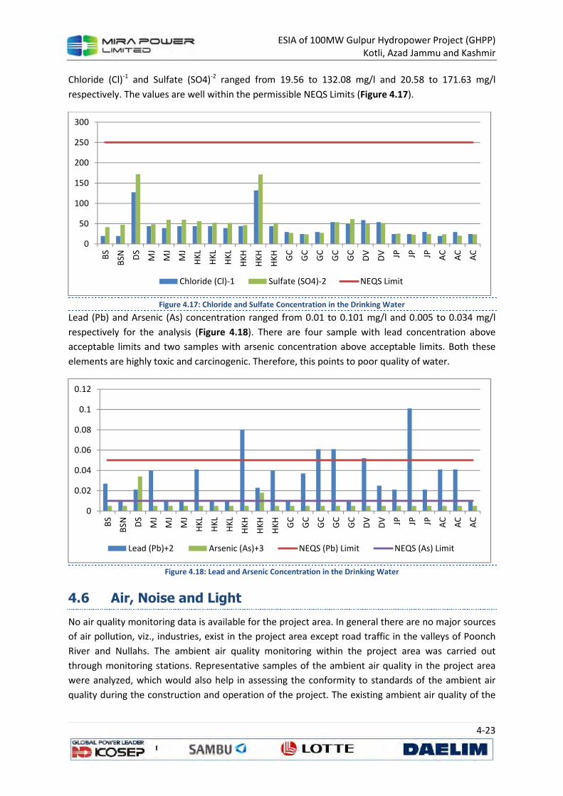
ESIA of 100MW Gulpur Hydropower Project (GHPP) Kotli, Azad Jammu and Kashmir
4-23
Chloride (Cl)-1 and Sulfate (SO4)-2 ranged from 19.56 to 132.08 mg/l and 20.58 to 171.63 mg/l
respectively. The values are well within the permissible NEQS Limits (Figure 4.17).
Figure 4.17: Chloride and Sulfate Concentration in the Drinking Water
Lead (Pb) and Arsenic (As) concentration ranged from 0.01 to 0.101 mg/l and 0.005 to 0.034 mg/l
respectively for the analysis (Figure 4.18). There are four sample with lead concentration above
acceptable limits and two samples with arsenic concentration above acceptable limits. Both these
elements are highly toxic and carcinogenic. Therefore, this points to poor quality of water.
Figure 4.18: Lead and Arsenic Concentration in the Drinking Water
4.6 Air, Noise and Light
No air quality monitoring data is available for the project area. In general there are no major sources
of air pollution, viz., industries, exist in the project area except road traffic in the valleys of Poonch
River and Nullahs. The ambient air quality monitoring within the project area was carried out
through monitoring stations. Representative samples of the ambient air quality in the project area
were analyzed, which would also help in assessing the conformity to standards of the ambient air
quality during the construction and operation of the project. The existing ambient air quality of the
0
50
100
150
200
250
300
BS
BSN D
S
MJ
MJ
MJ
HK
L
HK
L
HK
L
HK
H
HK
H
HK
H
GC
GC
GC
GC
GC
DV
DV JP JP JP AC
AC
AC
Chloride (Cl)-1 Sulfate (SO4)-2 NEQS Limit
0
0.02
0.04
0.06
0.08
0.1
0.12
BS
BSN D
S
MJ
MJ
MJ
HK
L
HK
L
HK
L
HK
H
HK
H
HK
H
GC
GC
GC
GC
GC
DV
DV JP JP JP AC
AC
AC
Lead (Pb)+2 Arsenic (As)+3 NEQS (Pb) Limit NEQS (As) Limit
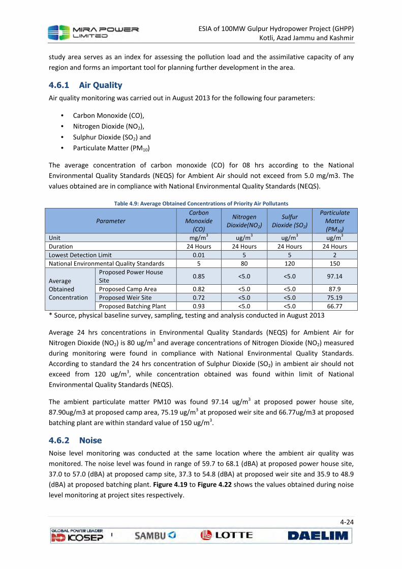
ESIA of 100MW Gulpur Hydropower Project (GHPP) Kotli, Azad Jammu and Kashmir
4-24
study area serves as an index for assessing the pollution load and the assimilative capacity of any
region and forms an important tool for planning further development in the area.
4.6.1 Air Quality
Air quality monitoring was carried out in August 2013 for the following four parameters:
• Carbon Monoxide (CO),
• Nitrogen Dioxide (NO2),
• Sulphur Dioxide (SO2) and
• Particulate Matter (PM10)
The average concentration of carbon monoxide (CO) for 08 hrs according to the National
Environmental Quality Standards (NEQS) for Ambient Air should not exceed from 5.0 mg/m3. The
values obtained are in compliance with National Environmental Quality Standards (NEQS).
Table 4.9: Average Obtained Concentrations of Priority Air Pollutants
Parameter
Carbon
Monoxide
(CO)
Nitrogen
Dioxide(NO2)
Sulfur
Dioxide (SO2)
Particulate
Matter
(PM10)
Unit mg/m3 ug/m
3 ug/m
3 ug/m
3
Duration 24 Hours 24 Hours 24 Hours 24 Hours
Lowest Detection Limit 0.01 5 5 2
National Environmental Quality Standards 5 80 120 150
Average Obtained Concentration
Proposed Power House Site
0.85 <5.0 <5.0 97.14
Proposed Camp Area 0.82 <5.0 <5.0 87.9
Proposed Weir Site 0.72 <5.0 <5.0 75.19
Proposed Batching Plant 0.93 <5.0 <5.0 66.77
* Source, physical baseline survey, sampling, testing and analysis conducted in August 2013
Average 24 hrs concentrations in Environmental Quality Standards (NEQS) for Ambient Air for
Nitrogen Dioxide (NO2) is 80 ug/m3 and average concentrations of Nitrogen Dioxide (NO2) measured
during monitoring were found in compliance with National Environmental Quality Standards.
According to standard the 24 hrs concentration of Sulphur Dioxide (SO2) in ambient air should not
exceed from 120 ug/m3, while concentration obtained was found within limit of National
Environmental Quality Standards (NEQS).
The ambient particulate matter PM10 was found 97.14 ug/m3 at proposed power house site,
87.90ug/m3 at proposed camp area, 75.19 ug/m3 at proposed weir site and 66.77ug/m3 at proposed
batching plant are within standard value of 150 ug/m3.
4.6.2 Noise
Noise level monitoring was conducted at the same location where the ambient air quality was
monitored. The noise level was found in range of 59.7 to 68.1 (dBA) at proposed power house site,
37.0 to 57.0 (dBA) at proposed camp site, 37.3 to 54.8 (dBA) at proposed weir site and 35.9 to 48.9
(dBA) at proposed batching plant. Figure 4.19 to Figure 4.22 shows the values obtained during noise
level monitoring at project sites respectively.
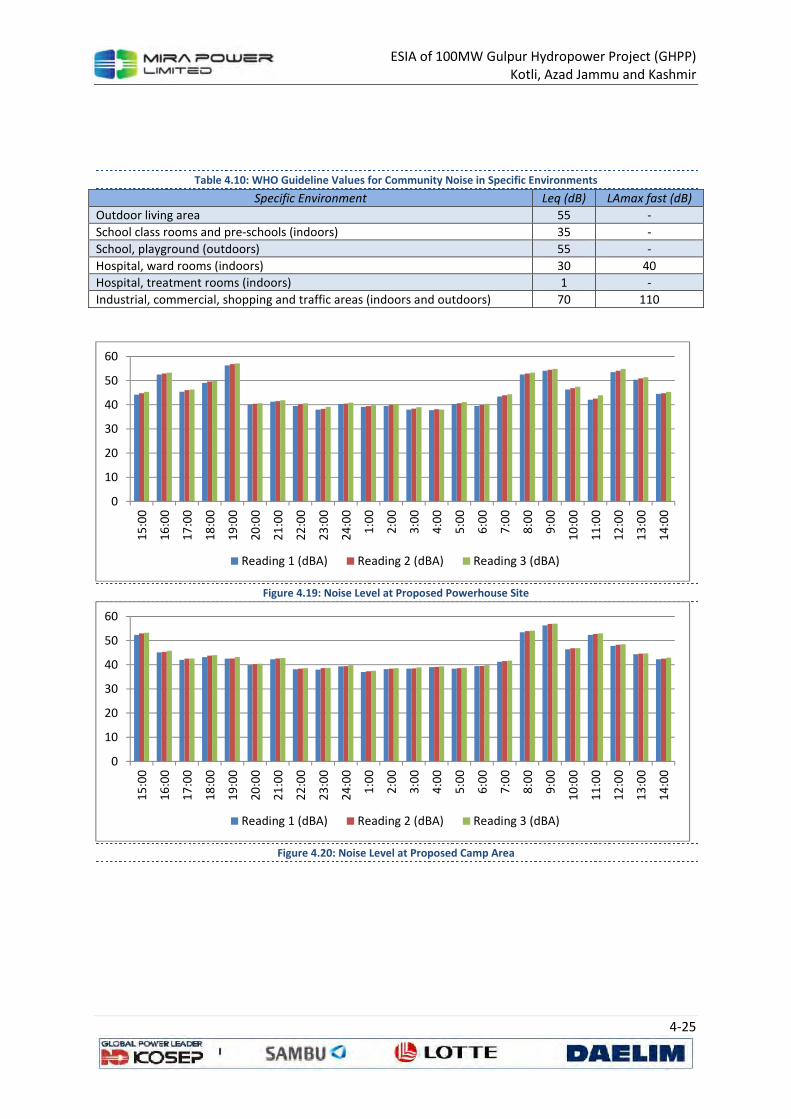
ESIA of 100MW Gulpur Hydropower Project (GHPP) Kotli, Azad Jammu and Kashmir
4-25
Table 4.10: WHO Guideline Values for Community Noise in Specific Environments
Specific Environment Leq (dB) LAmax fast (dB)
Outdoor living area 55 -
School class rooms and pre-schools (indoors) 35 -
School, playground (outdoors) 55 -
Hospital, ward rooms (indoors) 30 40
Hospital, treatment rooms (indoors) 1 -
Industrial, commercial, shopping and traffic areas (indoors and outdoors) 70 110
Figure 4.19: Noise Level at Proposed Powerhouse Site
Figure 4.20: Noise Level at Proposed Camp Area
0
10
20
30
40
50
60
15
:00
16
:00
17
:00
18
:00
19
:00
20
:00
21
:00
22
:00
23
:00
24
:00
1:0
0
2:0
0
3:0
0
4:0
0
5:0
0
6:0
0
7:0
0
8:0
0
9:0
0
10
:00
11
:00
12
:00
13
:00
14
:00
Reading 1 (dBA) Reading 2 (dBA) Reading 3 (dBA)
0
10
20
30
40
50
60
15
:00
16
:00
17
:00
18
:00
19
:00
20
:00
21
:00
22
:00
23
:00
24
:00
1:0
0
2:0
0
3:0
0
4:0
0
5:0
0
6:0
0
7:0
0
8:0
0
9:0
0
10
:00
11
:00
12
:00
13
:00
14
:00
Reading 1 (dBA) Reading 2 (dBA) Reading 3 (dBA)
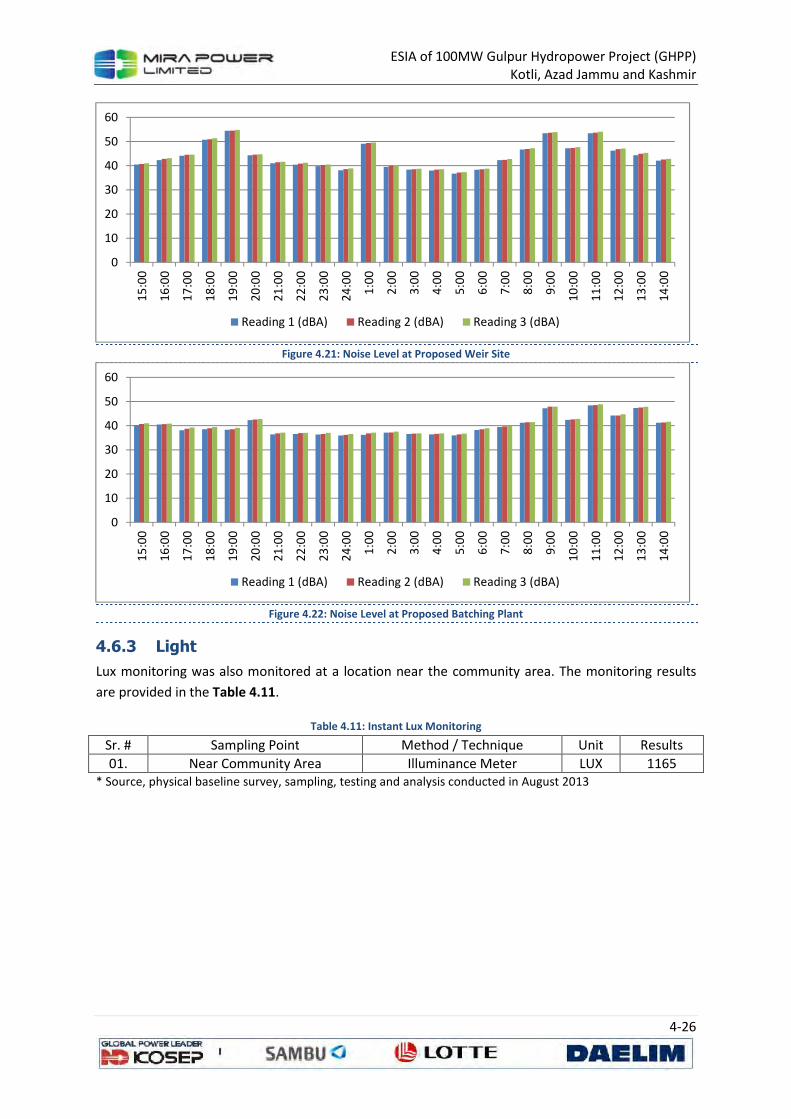
ESIA of 100MW Gulpur Hydropower Project (GHPP) Kotli, Azad Jammu and Kashmir
4-26
Figure 4.21: Noise Level at Proposed Weir Site
Figure 4.22: Noise Level at Proposed Batching Plant
4.6.3 Light
Lux monitoring was also monitored at a location near the community area. The monitoring results
are provided in the Table 4.11.
Table 4.11: Instant Lux Monitoring
Sr. # Sampling Point Method / Technique Unit Results
01. Near Community Area Illuminance Meter LUX 1165 * Source, physical baseline survey, sampling, testing and analysis conducted in August 2013
0
10
20
30
40
50
60
15
:00
16
:00
17
:00
18
:00
19
:00
20
:00
21
:00
22
:00
23
:00
24
:00
1:0
0
2:0
0
3:0
0
4:0
0
5:0
0
6:0
0
7:0
0
8:0
0
9:0
0
10
:00
11
:00
12
:00
13
:00
14
:00
Reading 1 (dBA) Reading 2 (dBA) Reading 3 (dBA)
0
10
20
30
40
50
60
15
:00
16
:00
17
:00
18
:00
19
:00
20
:00
21
:00
22
:00
23
:00
24
:00
1:0
0
2:0
0
3:0
0
4:0
0
5:0
0
6:0
0
7:0
0
8:0
0
9:0
0
10
:00
11
:00
12
:00
13
:00
14
:00
Reading 1 (dBA) Reading 2 (dBA) Reading 3 (dBA)
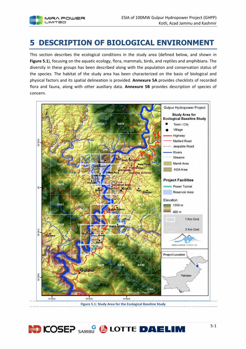
ESIA of 100MW Gulpur Hydropower Project (GHPP) Kotli, Azad Jammu and Kashmir
5-1
5 DESCRIPTION OF BIOLOGICAL ENVIRONMENT
This section describes the ecological conditions in the study area (defined below, and shown in
Figure 5.1), focusing on the aquatic ecology, flora, mammals, birds, and reptiles and amphibians. The
diversity in these groups has been described along with the population and conservation status of
the species. The habitat of the study area has been characterized on the basis of biological and
physical factors and its spatial delineation is provided. Annexure 5A provides checklists of recorded
flora and fauna, along with other auxiliary data. Annexure 5B provides description of species of
concern.
Figure 5.1: Study Area for the Ecological Baseline Study
ESIA of 100MW Gulpur Hydropower Project (GHPP) Kotli, Azad Jammu and Kashmir
5-2
5.1 Approach of the Ecological Study
The ecological baseline study focused on the following components:
• Assessment of vegetation and land cover classification
• A thorough investigation of aquatic ecology particularly fish and invertebrates
• Assessment of wildlife, on each of the following components;
o Large mammals (carnivores/ungulates)
o Small mammals
o Birds
o Reptiles and Amphibians
The field survey was carried around the project facilities, and a five-kilometer buffer was added to
explore status of ecological receptors on a broader area of about 228 km2 (Figure 5.1). In order to
systematically cover the area, 1-km grid around the project facilities and 2-km grid in rest of the area
was placed. At least one sample was taken in each grid, however fish and macro-invertebrate
sampling was limited to aquatic the habitat.
Specific methodology was adapted for each component of the study, which will appear in the
following sections.
5.2 Floral Diversity of the Area
The forests of the area are characterized by the presence of subtropical broad leaved vegetation
(Shaheen et al., 2011a) and is fundamentally Chirpine forest type (Malik & Malik, 2004). These
forests are mainly dominated by Pinus roxburghii in an altitudinal range of 700-1800m Ahmad et al.,
2012. Several environmental and anthropogenic factors regulate the composition and community
structure Doležal & Šrůtek, 2002. Malik & Malik, 2004 have reported seven plant communities in the
area viz, Adiantum olea, Acacia modesta, Dodonaea-Acacia- Themeda, Pinus-Themeda, Imperata-
Pinus, Pinus roxburghii and Pinus-Carissa-Themeda recognized in Kotli Hills during monsoon, 2000.
Nazir et al., 2012 have classified the vegetation of the area into tree layer consisting Ficus palmata,
Dalbergia sissoo, Acacia nilotica, Pinus roxburghii and Flacourtia indica; a shrub layer of Adhatoda
vasica, Dodonaea viscosa, Carissa opaca, Maytenus royleanus, Otostegia limbata, Punica granatum;
and herb layer dominated by Themeda anathera and Poa annua.
The sub-tropical forests of the area were mainly dominated by Pinus roxburghii Champion et al.,
1965. But present figures show that Pinus-Themeda community is becoming sparse which would
eventually transform the area into a degraded scrub-land. Now, the area is characterized by the
dominance of herb and shrub layer, comprising Themeda anathera, Poa annua, Carissa opaca and
Adhatoda vasica over Pinus roxburghii (Nazir et al., 2012). Radically, Pinus has a broad ecological
amplitude and specialized niche in the subtropical zone and therefore cannot be out-competed by
associated species. However the depletion of forest crown canopy over time as a consequence of
factors like deforestation, overgrazing and forest fires have resulted in the shift from Pinus to ground
and shrub flora (Ahmad, et al., 2012). Environmental factors such as low fertility (P and K) and soil
moisture have also contributed to the situation (Dasti & Malik, 2000).

ESIA of 100MW Gulpur Hydropower Project (GHPP) Kotli, Azad Jammu and Kashmir
5-3
There are a number of studies focusing indigenous knowledge of flora. The study conducted by
Ahmad, et al. (2012) of ethno botanical inventory about plants paves way to assess their usage and
impacts associated thereof. A total of 66 plant species are reported to be used as folk medicine for
curing different diseases in the village of Barali Kass and adjacent areas of District Kotli, AJK (Ur-
Rehman, 2006). Most of the population of the area dwells in remote areas that are not easily
accessible and thus left with no other option but to rely on medicinal plants for general treatment.
Notable among these floras are Justicia adhatoda, Acacia nilotica, Calotropis procera, Ricinus
communis, Morus nigra, Dodonaea viscosa, Achyranthes aspera, Ipomoea carnea, Taraxacum
officinale, Eriobotrya japonica, Cissus carnosa, Melia azedarach, Eucalyptus citriodora and Ficus
carica (Ahmad, et al., 2012). Pinus roxburghii is used as antiseptic, diaphoretic, diuretic, rubefacient,
tonic and vermifuge. It is also used as charcoal, pigment, herbicide, resin and wood (Muhammad et
al., 2012).
The data shows that these forests are faced with the problems of overgrazing and deforestation
(Malik & Malik, 2004). The factors like poverty, over population, lack of access to remote areas,
unavailability of alternates of energy sources are major causes for severe depletion of Himalayan
forests. The local communities use forest species as their main source of fuel wood, timber and
fodder. The simultaneous increase in the demand of forest products and population has not only
deteriorated the condition of these subtropical forests but also affected the species diversity and
community structure.
5.2.1 Methodology
Different vegetation types identified on the physiognomic basis were sampled using circular
quadrats of 100 m2 for trees, 25 m2 for shrubs and 1 m2 for herbaceous layer (Figure 5.2). The data
recorded within each quadrat included a complete inventory of vascular plants as well as visual
estimation of ground area covered by each species. Due to prevailing weather situation, only a
modest effort to sample each landcover type could be performed, mainly emphasizing project
components such as spoil tip areas, camping sites, and proposed new roads etc. as well as,
submersion zone of the reservoir.
The plant specimens were collected for identification and voucher numbers were added to facilitate
their identification as well as their geographic location was noted down using handheld GPS device.
The identification of flora was carried out with the help of published literature and identification
keys. The main sources of information included Flora of West Pakistan fascicles (Nasir et al., 1970),
online edition of the Flora of Pakistan (www.efloras.org). In addition, Jstor Plant Science archive was
also consulted (http://plants.jstor.org/).
5.2.1.1 Species diversity
The notes on distribution of plants were documented during transect walks at suitable locations
identified on the basis of change in habitat reflected by occurrence of new species. The association
of different species with a particular habitat type was tabulated and species diversity was calculated
for each of the habitat types using Shannon-Weaver diversity index (Hˊ) or simply Shannon index,
(Shannon & Weaver, 1948). It is calculated as:
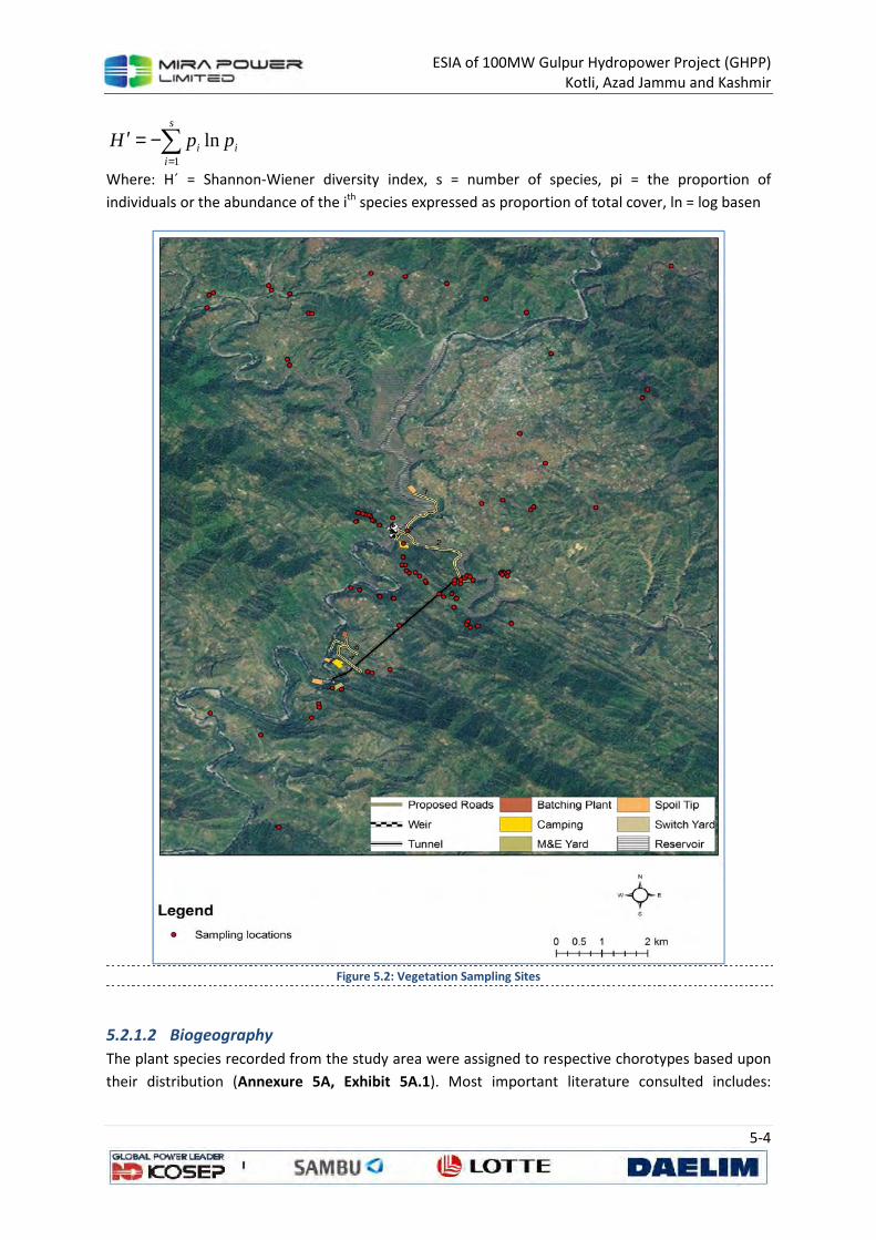
ESIA of 100MW Gulpur Hydropower Project (GHPP) Kotli, Azad Jammu and Kashmir
5-4
i
s
ii ppH ln
1∑
=
−=′
Where: Hˊ = Shannon-Wiener diversity index, s = number of species, pi = the proportion of
individuals or the abundance of the ith species expressed as proportion of total cover, ln = log basen
Figure 5.2: Vegetation Sampling Sites
5.2.1.2 Biogeography
The plant species recorded from the study area were assigned to respective chorotypes based upon
their distribution (Annexure 5A, Exhibit 5A.1). Most important literature consulted includes:
ESIA of 100MW Gulpur Hydropower Project (GHPP) Kotli, Azad Jammu and Kashmir
5-5
Dickoré, 1991; Dickore & Miehe, 2002; Dickoré & Nüsser, 2000; Hara, 1966; Meusel, 1972; Nasir, et
al., 1970; Nasir et al., 1972; Ohashi, 1975; Polunin et al., 1987; Rafiq, 1996.
5.2.1.3 Landcover Mapping
The landcover map was prepared using Landsat satellite image (path 150 row 037 dated June 15,
2011) and ancillary data, subset to the extent of project area and its immediate vicinities (30 m
resolution). The map was prepared using statistical modeling approach by including ancillary data
such as elevation, aspect and slope coupled with satellite derived indices. The quantitative analysis
of remotely sensed data in mountainous regions is often affected by topographic effects, thus land
surface reflectance in the image was corrected through Pixel-based Minnaert correction method (Lu
et al., 2008).
The statistical models were developed for each of the landcover classes subjectively defined during
the fieldwork. These classes were used as response variable in a statistical model against a predictor
dataset and the classes included: Agriculture (AGR), Riverine (RIV), Open areas (OPA), Settlements
(SET), Broadleaved and Conifer forests with Sparse (<30%), Medium (30-75%) and Dense (>75%)
crown cover. Notes on major floral associates of these landcover classes were also prepared.
The ground control points (GCP) for the areas representing particular landcover class were marked
during the field visits using handheld GPS receiver. Some additional locations were inferred by visual
interpretation of high resolution satellite imagery (Google Earth) supplemented with GPS labeled
photographic documentation and field sketches. The number of GCPs utilized to map the respective
landcover class has been provided in Annexure 5A.
The explanatory variable data including extracted from digital elevation model of the study area
(elevation, slope, aspect and topographic wetness index) and satellite image (normalized difference
vegetation index (NDVI), Tasseled cap greenness, and Soil brightness (Crist & Cicone, 1984))
corresponding to these locations were extracted in GIS and used to develop statistical model for
each of the landcover class. The satellite data that was used consisted of Landsat 5 scene (L1T
processed - radiometrically and geometrically correct) dated: 15th June 2010 (WRS II path 150, row
037) having <1% cloud cover for GHPP area. The image was obtained from Land Processes
Distributed Active Archive Center (LPDAAC) of National Aeronautics and Space Administration’s
(NASA) Earth Observing System (EOS) Data and Information System (EOSDIS). The necessary image
processing was done using ERDAS IMAGINE ® ver. 9.2 and elevation data in ArcGIS ver. 9.2.
The generalized additive models (GAM) were fitted for each of landcover using GRASP (Generalized
Regression Analysis and Spatial Prediction) package (Lehmann et al., 2002) in software S-PLUS ver. 8
and their accuracy was statistically tested using the area under the curve (AUC) of the Receiver
Operating Characteristic ROC (Fielding & Bell, 1997).
The fitted landcover models for each of the classes were exported as a ‘lookup tables’ from S-Plus
software and processed in ArcView GIS software ver. 3.1 (ESRI, 1992) with an Avenue script program
(GRASPIT - available with GRASP package) to produce landcover maps for individual categories.
These individual maps were then combined in a GIS to produce final landcover map based on
probability of occurrence of landcover classes.
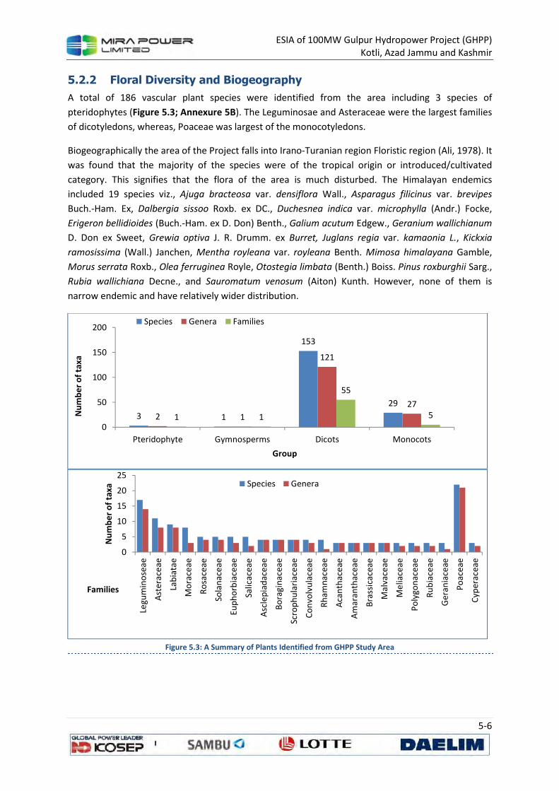
ESIA of 100MW Gulpur Hydropower Project (GHPP) Kotli, Azad Jammu and Kashmir
5-6
5.2.2 Floral Diversity and Biogeography
A total of 186 vascular plant species were identified from the area including 3 species of
pteridophytes (Figure 5.3; Annexure 5B). The Leguminosae and Asteraceae were the largest families
of dicotyledons, whereas, Poaceae was largest of the monocotyledons.
Biogeographically the area of the Project falls into Irano-Turanian region Floristic region (Ali, 1978). It
was found that the majority of the species were of the tropical origin or introduced/cultivated
category. This signifies that the flora of the area is much disturbed. The Himalayan endemics
included 19 species viz., Ajuga bracteosa var. densiflora Wall., Asparagus filicinus var. brevipes
Buch.-Ham. Ex, Dalbergia sissoo Roxb. ex DC., Duchesnea indica var. microphylla (Andr.) Focke,
Erigeron bellidioides (Buch.-Ham. ex D. Don) Benth., Galium acutum Edgew., Geranium wallichianum
D. Don ex Sweet, Grewia optiva J. R. Drumm. ex Burret, Juglans regia var. kamaonia L., Kickxia
ramosissima (Wall.) Janchen, Mentha royleana var. royleana Benth. Mimosa himalayana Gamble,
Morus serrata Roxb., Olea ferruginea Royle, Otostegia limbata (Benth.) Boiss. Pinus roxburghii Sarg.,
Rubia wallichiana Decne., and Sauromatum venosum (Aiton) Kunth. However, none of them is
narrow endemic and have relatively wider distribution.
Figure 5.3: A Summary of Plants Identified from GHPP Study Area
3 1
153
29
2 1
121
27
1 1
55
5
0
50
100
150
200
Pteridophyte Gymnosperms Dicots Monocots
Nu
mb
er
of
taxa
Group
Species Genera Families
0
5
10
15
20
25
Legu
min
ose
ae
Ast
erac
eae
Lab
iata
e
Mo
race
ae
Ro
sace
ae
Sola
nac
eae
Eup
ho
rbia
ceae
Salic
acea
e
Asc
lep
iad
ace
ae
Bo
ragi
nac
eae
Scro
ph
ula
riac
eae
Co
nvo
lvu
lace
ae
Rh
amn
acea
e
Aca
nth
ace
ae
Am
aran
thac
eae
Bra
ssic
acea
e
Mal
vace
ae
Me
liace
ae
Po
lygo
nac
eae
Ru
bia
ceae
Ger
ania
ceae
Po
ace
ae
Cyp
erac
eae
Nu
mb
er
of
taxa
Families
Species Genera
ESIA of 100MW Gulpur Hydropower Project (GHPP) Kotli, Azad Jammu and Kashmir
5-7
5.2.2.1 Rare Species
Fraxinus raiboearpa was the plant that is confined to few localities in north Pakistan and E
Afghanistan.
5.2.2.2 Threatened Species
World Conservation and Monitoring Centre (WCMC) and Species Survival Commission (SSC) of IUCN
has prepared a list of species with different categories of threats in their wild habitats. None of the
species found in GHPP study area is listed in the WCMC list in endangered categories.
There are several taxa for which sufficient information is not available but they are threatened or
vulnerable in other countries in their distribution range.
5.2.3 Vegetation Types
The project area lies in the humid subtropical zone influenced by monsoon Mediterranean
disturbances as well. The forests can be grouped into and Subtropical Broadleaved Forest, and
Subtropical Pine Forests.
5.2.3.1 Subtropical Broadleaved Forest
This is a scrub type forest with Olea ferruginea, Acacia modesta and Dalbergia sissoo as key species.
It occupies altitude ranging from 450 to c. El. 1000 m. Acacia dominates dry slopes whereas Olea
finds its space in moist depressions. Both species admix with each other in varying proportions,
depending upon site conditions. The principal associates include Adhatoda vasica, Mallotus
philippinensis, Dalbergia sissoo, Cassia fistula, Punica granatum, Ficus spp and Nerium odorum. Such
a kind of vegetation may transform into a Dodonaea viscosa type Scrub on the base of forest or
disturbed localities due to heavy cutting and grazing. The depressions and cool moist slopes may
dominate with Dalbergia sissoo. The broadleaved forest terminate into Chir pine forest above.
5.2.3.2 Subtropical Chir Pine Forest
The Pinus roxburghii stands occur singly or in groups with an irregular deciduous lower storey, often
best developed in depressions and on sheltered aspects. The main species associated with the pine
include Mallotus philippinensis, Pyrus sp, Ficus sp., Flacourtia sp., Berberis sp., Gymnosporia sp. and
Rubus.
The main habitat types zones that can be delimited in the study area may include:
• b : Broad leaved forest
o Fbl liana (woody climber)
o Fbo open space/forest clearing
o Fbr rock inside forest
o Fbs shady floor
• Fc : Coniferous forest
o Fcs shady floor
o Fco open space/forest clearing
o Fcl liana (woody climber)
• Fm : Mixed broad-leaved/coniferous
o Fms shady floor
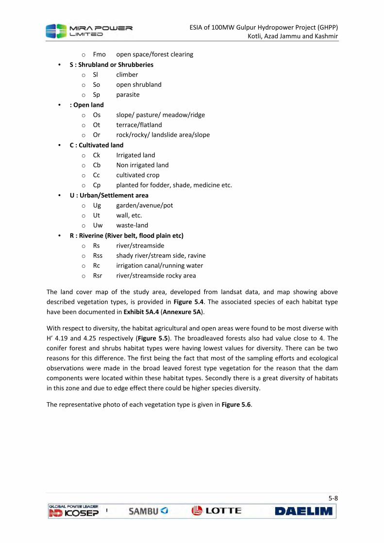
ESIA of 100MW Gulpur Hydropower Project (GHPP) Kotli, Azad Jammu and Kashmir
5-8
o Fmo open space/forest clearing
• S : Shrubland or Shrubberies
o Sl climber
o So open shrubland
o Sp parasite
• : Open land
o Os slope/ pasture/ meadow/ridge
o Ot terrace/flatland
o Or rock/rocky/ landslide area/slope
• C : Cultivated land
o Ck Irrigated land
o Cb Non irrigated land
o Cc cultivated crop
o Cp planted for fodder, shade, medicine etc.
• U : Urban/Settlement area
o Ug garden/avenue/pot
o Ut wall, etc.
o Uw waste-land
• R : Riverine (River belt, flood plain etc)
o Rs river/streamside
o Rss shady river/stream side, ravine
o Rc irrigation canal/running water
o Rsr river/streamside rocky area
The land cover map of the study area, developed from landsat data, and map showing above
described vegetation types, is provided in Figure 5.4. The associated species of each habitat type
have been documented in Exhibit 5A.4 (Annexure 5A).
With respect to diversity, the habitat agricultural and open areas were found to be most diverse with
H′ 4.19 and 4.25 respectively (Figure 5.5). The broadleaved forests also had value close to 4. The
conifer forest and shrubs habitat types were having lowest values for diversity. There can be two
reasons for this difference. The first being the fact that most of the sampling efforts and ecological
observations were made in the broad leaved forest type vegetation for the reason that the dam
components were located within these habitat types. Secondly there is a great diversity of habitats
in this zone and due to edge effect there could be higher species diversity.
The representative photo of each vegetation type is given in Figure 5.6.
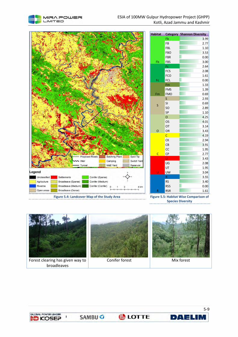
ESIA of 100MW Gulpur Hydropower Project (GHPP) Kotli, Azad Jammu and Kashmir
5-9
Figure 5.4: Landcover Map of the Study Area
Figure 5.5: Habitat Wise Comparison of
Species Diversity
Forest clearing has given way to
broadleaves
Conifer forest
Mix forest
Habitat Category Shannon Diversity
Fb 3.99
FB 2.77
FBL 1.10
FBO 3.53
FBR 0.00
FBS 3.00
Fc 2.64
FCS 2.08
FCO 1.61
FCL 0.00
Fm 1.33
FMS 1.39
FMO 0.69
S 2.93
SI 0.69
SO 2.89
SP 1.10
O 4.25
OS 4.01
OT 3.14
OR 3.43
C 4.19
CK 2.94
CB 3.91
CC 1.95
CP 2.77
U 3.43
UG 2.08
UT 1.95
UW 3.04
R 3.55
RS 3.40
RSS 0.00
RSR 1.61
U
R
Fb
Fc
Fm
S
O
C
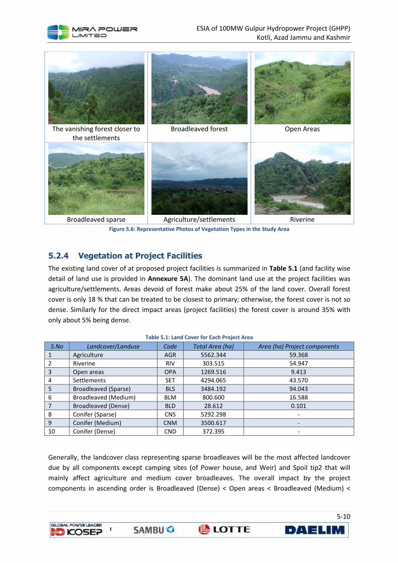
ESIA of 100MW Gulpur Hydropower Project (GHPP)
Kotli, Azad Jammu and Kashmir
5-10
The vanishing forest closer to
the settlements
Broadleaved forest
Open Areas
Broadleaved sparse
Agriculture/settlements
Riverine
Figure 5.6: Representative Photos of Vegetation Types in the Study Area
5.2.4 Vegetation at Project Facilities
The existing land cover of at proposed project facilities is summarized in Table 5.1 (and facility wise
detail of land use is provided in Annexure 5A). The dominant land use at the project facilities was
agriculture/settlements. Areas devoid of forest make about 25% of the land cover. Overall forest
cover is only 18 % that can be treated to be closest to primary; otherwise, the forest cover is not so
dense. Similarly for the direct impact areas (project facilities) the forest cover is around 35% with
only about 5% being dense.
Table 5.1: Land Cover for Each Project Area
S.No Landcover/Landuse Code Total Area (ha) Area (ha) Project components
1 Agriculture AGR 5562.344 59.368
2 Riverine RIV 303.515 54.947
3 Open areas OPA 1269.516 9.413
4 Settlements SET 4294.065 43.570
5 Broadleaved (Sparse) BLS 3484.192 94.043
6 Broadleaved (Medium) BLM 800.600 16.588
7 Broadleaved (Dense) BLD 28.612 0.101
8 Conifer (Sparse) CNS 5292.298 -
9 Conifer (Medium) CNM 3500.617 -
10 Conifer (Dense) CND 372.395 -
Generally, the landcover class representing sparse broadleaves will be the most affected landcover
due by all components except camping sites (of Power house, and Weir) and Spoil tip2 that will
mainly affect agriculture and medium cover broadleaves. The overall impact by the project
components in ascending order is Broadleaved (Dense) < Open areas < Broadleaved (Medium) <
ESIA of 100MW Gulpur Hydropower Project (GHPP)
Kotli, Azad Jammu and Kashmir
5-11
Settlements < Riverine < Agriculture < Broadleaved (Sparse). The breakup of area that will be
impacted by each component of the project is summarized in Exhibit 5A.5 (Annexure 5A).
5.3 Fish Fauna
The Poonch River originates in the western foothills of Pir Panjal Range, in the areas of Neel-Kanth
Gali and Jamian Gali. The steep slopes of the Pir Panjal form the upper catchment of this river. It is a
small gurgling water channel in this tract and descends along a very steep gradient until it reaches in
the foothill areas. The river widens as more and more tributaries from both sides enter into Main
River. The valley also opens up and Poonch River begins to flow in a leisurely manner in its middle
and lower reaches. The upper catchment is covered by dense forests while the vegetation of the
middle and lower region is under intense biotic pressure. Poonch River from the line of control to
Kotli town has steep slope (6.9-8.3 m/km) and the valley is narrow. Below Kotli, the river gradient is
relatively mild (3.7m/km). The river ultimately joins the Mangla Lake near Chomukh in Mirpur
district of Azad Jammu and Kashmir.
The Poonch is the warm water river and the water temperature approaches to 30o C during the
summer months. Water in the Jhelum River has the intermediate temperature and the reaching up
to 25o C during the summer months. Due to this temperature and topographical differences
between two rivers, fish fauna of the Poonch River is more representative of Mangla Reservoir than
that of Jhelum River. A reasonable number of riverine fish species found in the reservoir move
upstream on the onset of summer season for breeding and feeding and in the reservoir for
wintering.
5.3.1 Methodology
5.3.1.1 Selection of Sampling Stations
A general survey of the study area was conducted to identify sampling sites. The sampling sites were
selected keeping in mind the major activity areas of the Gulpur Hydropower Project. Special
concentration was paid on the sites where the Weir is going to be constructed, the downstream
areas of the Weir up to Gulpur and various nullahs (tributaries) meeting the river as they are major
breeding grounds of the fish of the Poonch River (Figure 5.7, shows locations of fish sampling sites).
5.3.1.2 Fish Sampling Strategy
Recognized techniques for fish surveys include bank-side counts, trapping, cast netting, seine
netting, gill netting, and electro-fishing. Bank–side counts are preferred on the banks of clear
shallow streams, and would not suitable given the torrential nature and turbidity of the water in the
Poonch River. Trapping is suitable for specific species using specific baits. Gill netting and seine
netting is mainly done in lakes, slow moving rivers or side pools along the river side. Electro–fishing
is suitable for shallow streams with limited width. Keeping in mind the constraints regarding
different sampling strategies, cast netting technique was used as it requires a minimum amount of
time with good results.
5.3.1.3 Cast Netting
The fish fauna in running waters was collected using cast with mesh sizes 2 x 2 cm, having a
circumference of 4m. The cast net had the lead weight so that it could not float with the fast flowing
ESIA of 100MW Gulpur Hydropower Project (GHPP)
Kotli, Azad Jammu and Kashmir
5-12
water. The net was not immediately dragged after cast but was delayed so that maximum fish could
be trapped in the pockets. One cast of net was made at about 10 meter apart from the first one. In
this way 10 casts of net were made along a length of 100 m, starting from downstream to upstream
to minimize the impact of adjacent netting. The cast nets which were entangled in the rocks or were
not cast in a proper way were not counted but the alternate net was cast at a distance of 10m
upstream as the net once cast, disturb the area and fish moves from that spot.
5.3.1.4 Specimens Handling
The specimens collected from each sampling point were collected in a bucket, and were
photographed and identified in the field. Number of specimens of each species was counted and
then released. The voucher specimens were preserved in 10% formaldehyde solution in the field.
Large specimens were given an incision in the belly to ensure proper preservation. All the specimen
data and the relevant auxiliary information were recorded in the data sheet specially designed for
these studies.
ESIA of 100MW Gulpur Hydropower Project (GHPP)
Kotli, Azad Jammu and Kashmir
5-13
Figure 5.7: Fish Sampling Locations
5.3.2 Fish Diversity of the Project Area
River Poonch is generally rich in fish diversity and even 21 fish species have been recorded from a
stretch of about 10 km (Figure 5.2). This diversity is quite high for this small river stretch. The reason
is generally prevailing topography and water temperature of the river Poonch. The Poonch flows
gently in a vast and flat valley which provides numerous breeding grounds for the reproduction of
fish. High temperature and gravely, rocky and the sandy riverbed of the river Poonch not only helps
for high river productivity but also enhance the breeding capacity of aquatic organisms and their
subsequent survival.
ESIA of 100MW Gulpur Hydropower Project (GHPP)
Kotli, Azad Jammu and Kashmir
5-14
Among the recorded species, majority of fish fauna belongs to the family Cyprinidae which is
comprised of 13 species. Other 8 species are divided among seven families in such a way that five
families are represented only by one species and the rest two each by two species. Among the fish
fauna of the project area, two species are endemic in Pakistan including AJK, one is endangered, two
are Vulnerable, and one is Near Threatened. Quite a good number of species are commercially
important. The species Tor putitora and Clupisoma garua are considered among the esteemed fishes
and have very high commercial value. The fishes Labeo dyocheilus, Cyprinus carpio, Cirrhinus reba,
Labeo dero, Ompok bimaculatus and Mastacembelus armatus are also quality food fishes. In
addition to the above documented 21 species, the field team collected another specimen, for which
identification is not clear at this stage. Additional field surveys and lab work will be required to
confirm identification of this species.
A detail description of species of concern is provided in Annexure 5B, whereas Figure 5.8 provides
photographs of important species and spatial pattern of their occurrence in the study area. Figure
5.9 shows spatial pattern of abundance of selective species in the study area. Species abundance is
expressed as netting success, defined as chance (%) of capturing a species per netting effort. This
statistics was calculated from a data of ten netting efforts at each sampling location. Species
captured at ≥5 locations are selected for spatial analysis of abundance. Inverse Distance Weighting
interpolation technique in Arc GIS 10 was used to generate maps of spatial abundance. A 250 m
buffer was added to river to improve visibility of the pattern.
Table 5.2: Fish Fauna recorded from the Gulpur Hydropower Project Area
Scientific Name Family Common
Name
English
Name
Distributional
status IUCN Status
Commercial
value
1 Securicula gora Cyprinidae Bidda Gora Chela Wide Least concerned (LC)
Low
2 Salmophasia
bacaila Cyprinidae Chal
Large razorbelly minnow
Wide LC Low
3 Aspidoparia
morar Cyprinidae Chilwa Aspidoparia Wide LC Low
4 Barilius
pakistanicus Cyprinidae Chal
Pakistani baril
Endemic Not determined (ND)
Low
5 Cirrhinus reba Cyprinidae Sunni Reba carp Wide LC Fairly good
6 Cyprinion
watsoni Cyprinidae Sabzal Cyprinion Wide ND Low
7 Labeo dero Cyprinidae Chali Kalbans Wide LC Fairly good
8 Labeo dyocheilus Cyprinidae Torki Pakistani Labeo
Wide LC High
9 Osteobrama
cotio Cyprinidae Palero Cotio Wide LC Low
10 Tor putitora Cyprinidae Mahasheer Mahaseer Wide Endangered Very high
11 Crossocheilus
latius Cyprinidae Chilwa
Gangetic latia
Wide LC Low
12 Garra gotyla Cyprinidae Pathar Chat Sucker head Wide LC Low
13 Cyprinus carpio Cyprinidae Carp Common carp
Exotic Vulnerable High
14 Acanthocobitis
botia Noemacheilidae Kangi
Mottled Loach
Wide LC Low
15 Schistura
punjabensis Noemacheilidae Loach
Hillstream loach
Endemic ND Low
ESIA of 100MW Gulpur Hydropower Project (GHPP)
Kotli, Azad Jammu and Kashmir
5-15
Scientific Name Family Common
Name
English
Name
Distributional
status IUCN Status
Commercial
value
16 Botia rostrata Cobitidae Loach Twin-banded
Loach Wide Vulnerable Low
17 Clupisoma garua Schilbeidae Jhalli Garua
bachwaa Wide LC Very high
18 Ompok
bimaculatus Siluridae Palu
Butter
catfish Wide
Near
threatened Low
19 Glyptothorax
pectinopterus Sisoridae Sangi
Flat head
catfish Wide LC Low
20 Mastacembelus
armatus Mastacembelidae Groje
Tire-track
spiny eel Wide LC High
21 Channa gachua Channidae Dola Dwarf
Snakehead Wide LC Low
Figure 5.8: Spatial Pattern of Occurrence of Species of Concern in the Study Area.
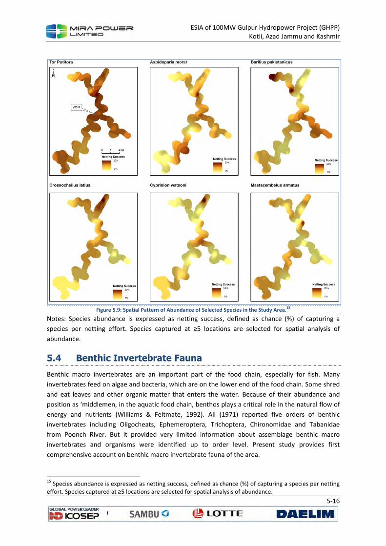
ESIA of 100MW Gulpur Hydropower Project (GHPP)
Kotli, Azad Jammu and Kashmir
5-16
Figure 5.9: Spatial Pattern of Abundance of Selected Species in the Study Area.
15
Notes: Species abundance is expressed as netting success, defined as chance (%) of capturing a
species per netting effort. Species captured at ≥5 locations are selected for spatial analysis of
abundance.
5.4 Benthic Invertebrate Fauna
Benthic macro invertebrates are an important part of the food chain, especially for fish. Many
invertebrates feed on algae and bacteria, which are on the lower end of the food chain. Some shred
and eat leaves and other organic matter that enters the water. Because of their abundance and
position as ‘middlemen, in the aquatic food chain, benthos plays a critical role in the natural flow of
energy and nutrients (Williams & Feltmate, 1992). Ali (1971) reported five orders of benthic
invertebrates including Oligocheats, Ephemeroptera, Trichoptera, Chironomidae and Tabanidae
from Poonch River. But it provided very limited information about assemblage benthic macro
invertebrates and organisms were identified up to order level. Present study provides first
comprehensive account on benthic macro invertebrate fauna of the area.
15
Species abundance is expressed as netting success, defined as chance (%) of capturing a species per netting effort. Species captured at ≥5 locations are selected for spatial analysis of abundance.
ESIA of 100MW Gulpur Hydropower Project (GHPP)
Kotli, Azad Jammu and Kashmir
5-17
5.4.1 Methodology
Sampling was conducted during the flood season. Locations of the sampling sites are shown in
Figure 5.7. The location of individual sampling sites was influenced by accessibility to the rivers, as
certain segments of the both rivers have steep banks, or are located at a distance from the access
road.
The sampling sites are representative for the river-segment (Frissell et al., 1986) and the purpose of
the study. Sampling was started at the downstream end of the stretch and progressed upstream.
The river section to be sampled was disturbed by physical contact. The sampling area of each
sampling unit was covered by a quadratic area in the front of the opening of the surber net (32.5
30.5 cm). When kick-sampling was necessary (e.g. in deep sections), the D frame dip net were held
vertically with the frame at a right angle to the current, downstream from sample collector boots
(991.25 cm2 sampling area), and the river/stream bed was disturbed vigorously by kicking or
rotating the heel of your boot to dislodge the substratum and the fauna.
After at least every three sampling units (or more frequently if necessary) collected material was
rinsed by running clean stream water through the surber of D frame dip net two to three times.
Sampling material was transferred into a large (white) tray or a bucket. The final multi-habitat
sample was comprised of 20 pooled sampling units. The samples were combined to obtain a single,
homogeneous sample at each sampling station. The sample was then transferred to white enamel
tray and thoroughly checked to remove large debris. The sample was then transferred to a container
and covered with 10% formalin.
In the laboratory, each sample was passed through a sieve of 500 m mesh size and rinsed with
running water (to remove traces of formalin). Macro-invertebrates were sorted out from the
samples and identified to family level using a Kyowa Stereozoom Microscope and the identification
keys given in (Edmondson 1959; Ali 1967, 1970, and 1971; Hartmann 2007; Khatoon & Ali 1975,
1976, and 1977; Bouchard 2004). The benthic macroinvertebrate data was presented in the form of
number of individuals per square meter. Organism’s pollution tolerance was taken from HKHbios
scoring list (Hindukush Himalayan Score Bioassessment, Hartmann et al., Deliverable 10).
5.4.2 Macro-invertebrates Diversity
Table 5.3 show the overall picture of macro-invertebrates families collected from six sampling
stations. Thirty one families of macro-invertebrates were identified from 546 benthic macro-
invertebrate individuals collected during the whole study period. Ali (1971) reported five orders of
benthic invertebrates including Oligocheats, Ephemeroptera, Trichoptera, Chironomidae and
Tabanidae from Poonch River, however the present documents higher diversity.
There was high flood in Poonch on 13th August 2013 due to monsoon rains, which resulted in bank
full flow in channel. Therefore no macroinvertebrate were recovered from samples collected on the
same day (station S1 & S2, Table 5.3). The number of benthic macroinvertebrates was comparatively
higher at S3 because of two reasons. First, sample was collected from standing water pool formed as
a result of River seepage water. Secondly, it is mostly populated by lentic ecosystem loving pollution
tolerant taxa including Culicidae, Chironomidae, Erpobdellidae and Ceratopogonidae etc. The
samples S4, S5 and S6 were collected from running water (stream & river). The number individuals

ESIA of 100MW Gulpur Hydropower Project (GHPP)
Kotli, Azad Jammu and Kashmir
5-18
were relatively lower at these stations because of recent flood in river. Floods usually dislodge the
habitat available to benthic macroinvertebrates during ordinary flow conditions. Results also
indicate that running water accommodate Neoperla, Acentrella, Rhithrogena, Atherix, Elmidae and
Scirtidae.
Among the documented benthic macro-invertebrate fauna:
• Culicidae (14% of total count) was most dominant genus followed by Chironomidae (8.4 % of
total count) and Hydropsyche sp. (7.9 % of total count) at Poonch River.
• Eight taxa including Neoperla (Plecoptera: Perlidae), Acentrella (Baetidae: Ephemeroptera),
Heptagenia, Rhithrogena (Heptageniidae: Ephemeroptera), Ephemera (Ephemeridae:
Ephemeroptera), Atherix (Athericidae: Diptera), Scirtidae (Coleoptera), Elmide (Coleoptera)
were highly sensitive to pollution and represent small proportion of the benthic invertebrate
population sampled at Poonch river. Highly pollution tolerant taxon was Culicidae,
Chironomidae, Planorbidae, Physidae and Ceratopogonidae which represent approximately
34 percent of the total count.
• Major functional feeding group was predators which were 28.7% followed by unknown
22.4%, and collector gatherers 17.3% of entire sample collected.
Table 5.3: Data regarding Number of Benthic Macro-invertebrate16
S.
No. Taxa (Family) Genus S1 S2 S3 S4 S5 S6
Total no. of
Individuals
Feeding
Habit
HKH Bios
pollution
tolerance
values
1 Perlidae Neoperla - - - - 6
(6.7)
10
(15.1) 16 (2.9) Predator 8
2 Baetidae Acentrella - - - 6
(11.1) - - 6 (1.1)
Collector
gatherer 8
3 Baetis - - 10
(18.5)
8
(8.9)
12
(18.2) 30 (5.5)
Collector
gatherer -
4 Centroptilum - - 29
(8.6)
4
(7.4) - - 33 (6.0)
Collector
gatherer -
5 Caenidae Caenis - - - 2
(3.7) - - 2 (0.4)
Collector
gatherer 7
6 Heptageniidae Heptagenia - - - 10
(18.5)
18
(20.2)
10
(15.1) 38 (6.9) Scraper 8
7 Rithrogena - - - - 7
(7.8) - 7 (1.3) Scraper 9
8 Leptophebiidae Choroterpes - - - 8
(14.8)
5
(5.6) - 13 (2.3)
Collector
gatherer 7
9 Ephemeridae Ephemera - - - 6
(11.1) - - 6 (1.1)
Collector
gatherer 8
10 Hydropsychidae Hydropsyche - - - - 15
(16.8)
28
(42.4) 43 (7.9)
Collector
filterer 7
11 Chironimidae - - - 54
(16.1) -
10
(11.2) - 64 (8.4) Unknown 1
12 Ceratopogonidae - - - 42
(12.5) - - - 42 (7.7) Predator 2
13 Tipulidae Antocha - - - 5
(9.2) - - 5 (0.9)
Collector
gatherer 7
14 Simulidae - - - 23
(6.8) - - - 23 (4.2)
Collector
filterer 7
15 Athericidae Atherix - - - - 9
(10.1) - 9 (1.1) Predator 9
16 Culicidae - - - 76 - - - 76 (14.0) Unknown 2
16
Benthic Macro-invertebrate individuals per 991.25 cm2 of Poonch River from different sampling stations
(data with in parenthesis indicate percent abundance).
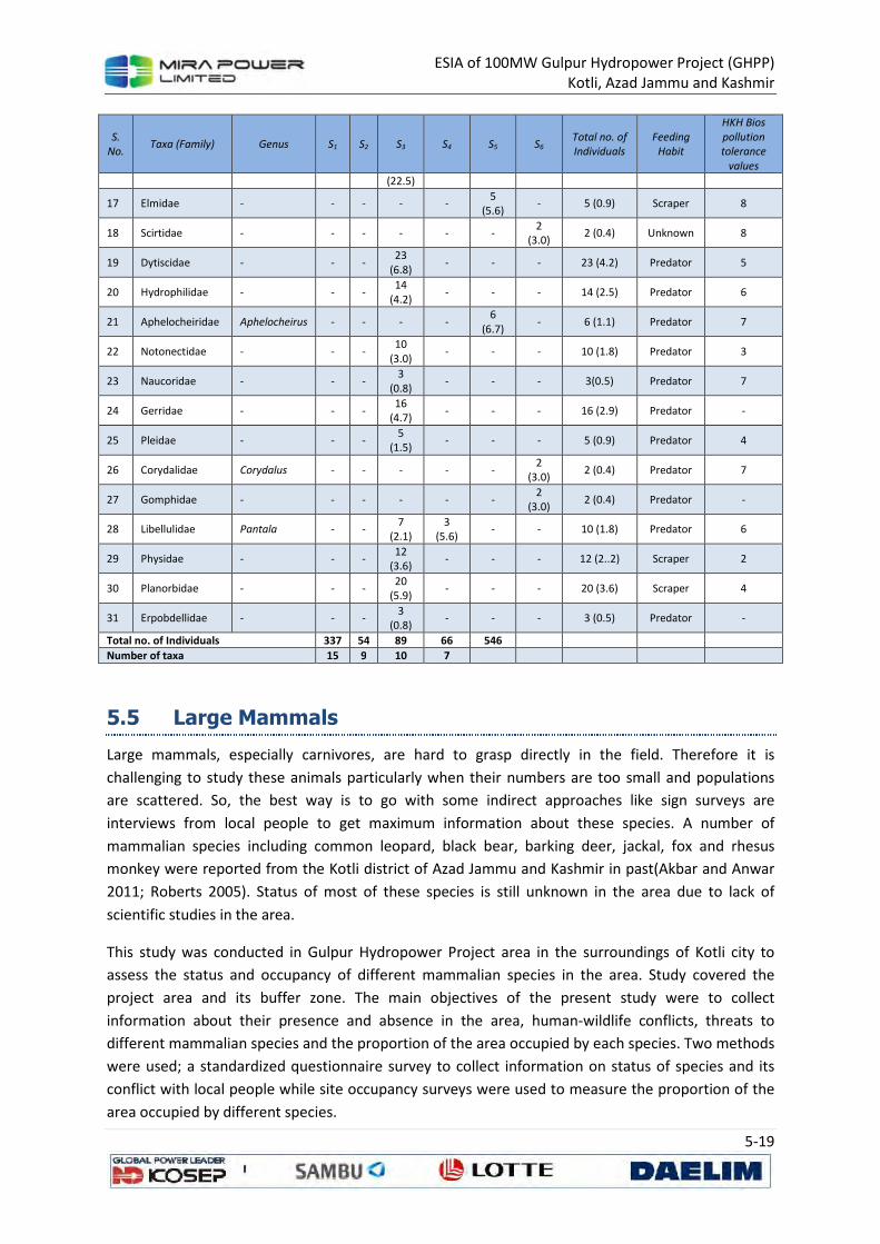
ESIA of 100MW Gulpur Hydropower Project (GHPP)
Kotli, Azad Jammu and Kashmir
5-19
S.
No. Taxa (Family) Genus S1 S2 S3 S4 S5 S6
Total no. of
Individuals
Feeding
Habit
HKH Bios
pollution
tolerance
values
(22.5)
17 Elmidae - - - - - 5
(5.6) - 5 (0.9) Scraper 8
18 Scirtidae - - - - - - 2
(3.0) 2 (0.4) Unknown 8
19 Dytiscidae - - - 23
(6.8) - - - 23 (4.2) Predator 5
20 Hydrophilidae - - - 14
(4.2) - - - 14 (2.5) Predator 6
21 Aphelocheiridae Aphelocheirus - - - - 6
(6.7) - 6 (1.1) Predator 7
22 Notonectidae - - - 10
(3.0) - - - 10 (1.8) Predator 3
23 Naucoridae - - - 3
(0.8) - - - 3(0.5) Predator 7
24 Gerridae - - - 16
(4.7) - - - 16 (2.9) Predator -
25 Pleidae - - - 5
(1.5) - - - 5 (0.9) Predator 4
26 Corydalidae Corydalus - - - - - 2
(3.0) 2 (0.4) Predator 7
27 Gomphidae - - - - - - 2
(3.0) 2 (0.4) Predator -
28 Libellulidae Pantala - - 7
(2.1)
3
(5.6) - - 10 (1.8) Predator 6
29 Physidae - - - 12
(3.6) - - - 12 (2..2) Scraper 2
30 Planorbidae - - - 20
(5.9) - - - 20 (3.6) Scraper 4
31 Erpobdellidae - - - 3
(0.8) - - - 3 (0.5) Predator -
Total no. of Individuals 337 54 89 66 546
Number of taxa 15 9 10 7
5.5 Large Mammals
Large mammals, especially carnivores, are hard to grasp directly in the field. Therefore it is
challenging to study these animals particularly when their numbers are too small and populations
are scattered. So, the best way is to go with some indirect approaches like sign surveys are
interviews from local people to get maximum information about these species. A number of
mammalian species including common leopard, black bear, barking deer, jackal, fox and rhesus
monkey were reported from the Kotli district of Azad Jammu and Kashmir in past(Akbar and Anwar
2011; Roberts 2005). Status of most of these species is still unknown in the area due to lack of
scientific studies in the area.
This study was conducted in Gulpur Hydropower Project area in the surroundings of Kotli city to
assess the status and occupancy of different mammalian species in the area. Study covered the
project area and its buffer zone. The main objectives of the present study were to collect
information about their presence and absence in the area, human-wildlife conflicts, threats to
different mammalian species and the proportion of the area occupied by each species. Two methods
were used; a standardized questionnaire survey to collect information on status of species and its
conflict with local people while site occupancy surveys were used to measure the proportion of the
area occupied by different species.

ESIA of 100MW Gulpur Hydropower Project (GHPP)
Kotli, Azad Jammu and Kashmir
5-20
The findings of the study will be helpful in future actions about different species and their
conservation in the area. It will also be helpful in measuring the impact of hydropower project on
existing wildlife of the area.
5.5.1 Methodology
5.5.1.1 Human-Carnivore Interaction Survey
Human-wildlife interaction surveys were conducted to measure the human conflict with large and
medium sized mammals like black bear, common leopard, jackal, fox, otter, rhesus monkey and
Indian wild boar. Whole area was considered as one unit. Thirty respondents, each representing a
separate household, were interviewed from different villages/localities. People were asked about
their previous record of sighting of different large mammals in five years, status of large mammals,
their perception about different species of large mammals, and intensity of danger of large
mammals according to them. Information on killings of livestock and poultry different by carnivores
for last five years (2008-2013), was also collected. Attacks of any large mammal species on human
and number of large mammals killed during past five years were also recorded. Respondents were
also asked for a guestimate of population of different large mammal species in their areas according
to their knowledge.
5.5.1.2 Site Occupancy Survey
Site occupancy surveys (MacKenzie and Nichols 2004) were conducted from August 12, 2013 to
August 19, 2013 to assess the occupancy of different medium and large sized mammalian species in
the surroundings of Kotli city. Global Information System (GIS) maps of the area were developed by
dividing the area into 2×2 km grid cells while Gulpur Hydropower Project area was further divided
into 1×1 km grid cells (Figure 5.10). Each grid was accessed by Global Positioning System (GPS) and
points (repeat surveys) were selected on the basis of favorable routs of different species, habitats
and topographic features. Different points were surveyed depending upon the accessibility,
settlements and disturbance. Total 43 grids were accessed by excluding settlements, and 2-10 points
were explored in different grids. Signs were searched along ridges, valleys, draws, cliff bases and
river banks. Signs of different mammalian species were recorded on data forms along with the
necessary information like species name, sign age (guessed by freshness of a sign), and substrate
type. Sign were categories in three age groups; “fresh”= < 10 days, “old”= <30 days and “very old”=
>30 days.
Detection or non-detection of species signs on each of the point was recorded as 1s and 0s in a
matrix of sites vs. replicates (points) (McKenzie et al. (2002). Survey covariates like terrain
brokenness (1-4), topography, habitat were also recorded during the survey while the Normalized
Difference Vegetation Index (NDVI), slope, altitude, distance from roads and distance from
settlements at site level, calculated from GIS, were used as site covariates .
After preparing data matrix for detection/non-detection and appropriate survey covariates and site
covariates, it was analyzed using software PRESENCE (Hines, 2006). Different combinations survey
and site covariates were compared to find the model that best explains the variation in probability of
detection and markability, and occupancy of the different species at the site level. The best fitting
model was determined using the Akaike Information Criteria (AIC). The model that has the best fit
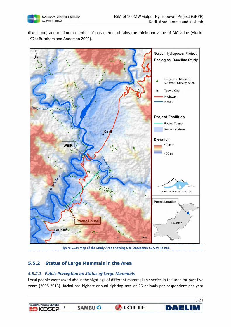
ESIA of 100MW Gulpur Hydropower Project (GHPP)
Kotli, Azad Jammu and Kashmir
5-21
(likelihood) and minimum number of parameters obtains the minimum value of AIC value (Akaike
1974; Burnham and Anderson 2002).
Figure 5.10: Map of the Study Area Showing Site Occupancy Survey Points.
5.5.2 Status of Large Mammals in the Area
5.5.2.1 Public Perception on Status of Large Mammals
Local people were asked about the sightings of different mammalian species in the area for past five
years (2008-2013). Jackal has highest annual sighting rate at 25 animals per respondent per year
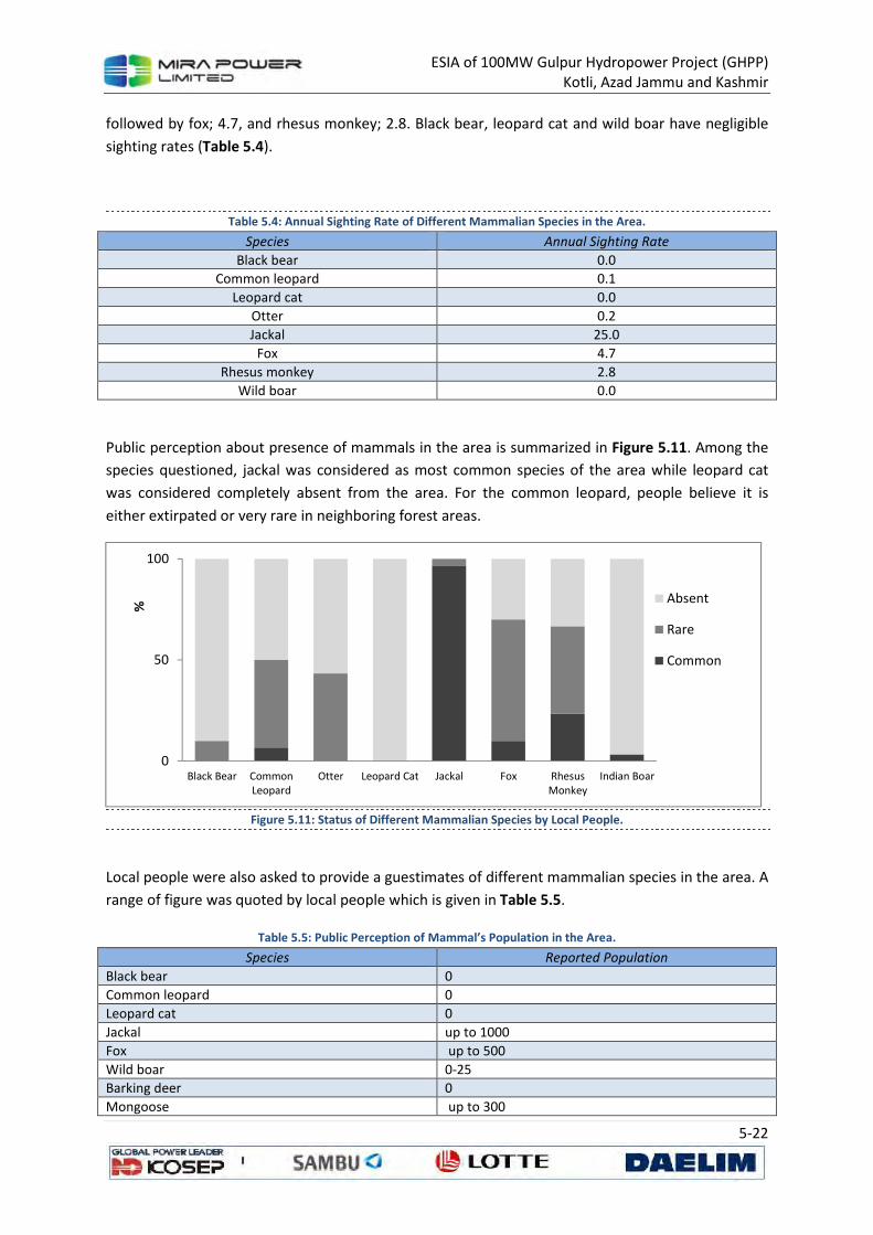
ESIA of 100MW Gulpur Hydropower Project (GHPP)
Kotli, Azad Jammu and Kashmir
5-22
followed by fox; 4.7, and rhesus monkey; 2.8. Black bear, leopard cat and wild boar have negligible
sighting rates (Table 5.4).
Table 5.4: Annual Sighting Rate of Different Mammalian Species in the Area.
Species Annual Sighting Rate
Black bear 0.0
Common leopard 0.1
Leopard cat 0.0
Otter 0.2
Jackal 25.0
Fox 4.7
Rhesus monkey 2.8
Wild boar 0.0
Public perception about presence of mammals in the area is summarized in Figure 5.11. Among the
species questioned, jackal was considered as most common species of the area while leopard cat
was considered completely absent from the area. For the common leopard, people believe it is
either extirpated or very rare in neighboring forest areas.
Figure 5.11: Status of Different Mammalian Species by Local People.
Local people were also asked to provide a guestimates of different mammalian species in the area. A
range of figure was quoted by local people which is given in Table 5.5.
Table 5.5: Public Perception of Mammal’s Population in the Area.
Species Reported Population
Black bear 0
Common leopard 0
Leopard cat 0
Jackal up to 1000
Fox up to 500
Wild boar 0-25
Barking deer 0
Mongoose up to 300
0
50
100
Black Bear CommonLeopard
Otter Leopard Cat Jackal Fox RhesusMonkey
Indian Boar
%
Absent
Rare
Common
ESIA of 100MW Gulpur Hydropower Project (GHPP)
Kotli, Azad Jammu and Kashmir
5-23
Species Reported Population
Flying Squirrel up to 200
Porcupine up to 250
5.5.2.2 Relative abundance through Sigh Surveys
Different types of signs belonging to different mammalian species were detected in the area but
signs frequencies were very low. Jackal was dominating in field signs, followed by fox. No reliable
sign or sighting of common leopard, black bear, leopard cat, rhesus monkey and wild boar was
recorded.
Occupancy analysis was done in Program PRESENCE (Hines, 2006) to find out the occupancy of
different mammalian species in the study area. Due to low sign detection for majority of the species,
estimates were possible for jackal and fox only. A summary of occupancy models tested for jackal
and fox is given in Exhibit 5A.8 and Exhibit 5A.9 (Annexure 5A). Figure 5.12 shows spatial pattern of
jackal and fox occupancy in the study area.
Occupancy of Jackal in the area
Naïve estimate for jackal was 0.3256 which showed an overall low sign detection of the animal in
area at that time. Among 43 surveyed sites 22 fresh signs of jackal were detected including feces and
pugmarks while total signs detected were 25 which by including old and very old signs. Sites
occupancy estimates (psi) were calculated by PRESENCE (Hines 2006) and found an estimate at an
average 0.6 ± 0.2135SE for top model; psi (road-qd), p (terr), which means almost 60% area was
occupied by the jackal at the time of survey. Various models were compared with different
combination of survey and site covariates (Exhibit 5A.8). No single model supported adequately to
estimate the occupancy of jackal therefore model averaging was used to get an averaged estimate of
different models at site level. Distance from the road and terrain brokenness affected the occupancy
and detection of signs. Terrain brokenness had a positive effect while distance from road had a
negative effect.
Occupancy of fox in the area
Signs detection for fox was much lower than that of jackal. Only 9 (both old and fresh) signs of fox
were detected in the study area among them 7 were fresh. Naive occupancy estimate was very low;
0.1163 due to low sign detections. Different models with different combinations of site and survey
covariates were used but none of them have enough weightage (Exhibit 5A.8). Top model was; psi
(.), p (terr) with constant occupancy (psi) and detection probability (p) was influenced by terrain
brokenness. The model gave an occupancy estimate of 0.2278 ± 0.1213SE which means that almost
23% area was occupied by the fox at the time of survey. To estimate the site level occupancy
estimate of fox, model averaging was used to get an average estimate of different models used.
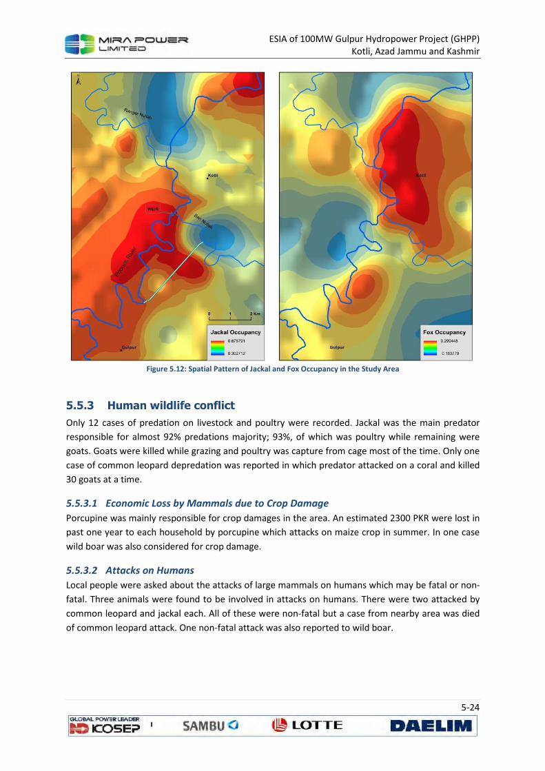
ESIA of 100MW Gulpur Hydropower Project (GHPP)
Kotli, Azad Jammu and Kashmir
5-24
Figure 5.12: Spatial Pattern of Jackal and Fox Occupancy in the Study Area
5.5.3 Human wildlife conflict
Only 12 cases of predation on livestock and poultry were recorded. Jackal was the main predator
responsible for almost 92% predations majority; 93%, of which was poultry while remaining were
goats. Goats were killed while grazing and poultry was capture from cage most of the time. Only one
case of common leopard depredation was reported in which predator attacked on a coral and killed
30 goats at a time.
5.5.3.1 Economic Loss by Mammals due to Crop Damage
Porcupine was mainly responsible for crop damages in the area. An estimated 2300 PKR were lost in
past one year to each household by porcupine which attacks on maize crop in summer. In one case
wild boar was also considered for crop damage.
5.5.3.2 Attacks on Humans
Local people were asked about the attacks of large mammals on humans which may be fatal or non-
fatal. Three animals were found to be involved in attacks on humans. There were two attacked by
common leopard and jackal each. All of these were non-fatal but a case from nearby area was died
of common leopard attack. One non-fatal attack was also reported to wild boar.
ESIA of 100MW Gulpur Hydropower Project (GHPP)
Kotli, Azad Jammu and Kashmir
5-25
5.5.3.3 Killings of Large Mammals by Local People
At least 95 jackals were killed by local people in past five years in different localities followed by 15
porcupines (Table 5.6). At least four common leopards were killed in the study area and two cubs of
common leopard were killed in the adjacent area (Annexure 5A).
Table 5.6: Spatial Pattern of Jackal and Fox Occupancy in the Study Area
Mammalian Species Killed in past five years
Black bear 0
Common leopard 04-07
Leopard cat 0
Jackal 95
Fox 09
Porcupine 15
5.5.4 Conclusion
Overall diversity of large mammals was much lower as compared to adjacent areas like Pir Lasura
National Park where 45 barking deer are residing (Zulfiqar et al. 2011) and frequent sightings of
yellow-throated marten, small Kashmiri flying squirrel and common leopard are reported (Manzoor
et al. 2013).
Both questionnaire survey and sign based site occupancy survey revealed the rarity of the most of
the species. Low sighting and sign detections were mainly because of small populations, and
disturbances imposed numerous human settlements in the area. Signs were destroyed due to
human and livestock movements, and weather conditions. Human-wildlife conflicts also make area
hostile for carnivores. Killings of large mammals especially of predators explain absence of majority
of large mammals.
Project area and its surroundings is dominated by adaptable species like fox and jack, while the
species which either pose danger (eg, leopard) or have economic value (ungulates) seems to be
locally extirpated. The species of large home ranges like common leopard gets killed if some
individuals enter into to the area while dispersing from main populations (Annexure 5A, Exhibit
5A.10)
5.6 Small Mammals
Nestled in the famous Siwalik Range of the Pir Panjal Hills, the project area has good biodiversity
with meager forests around. There is abundant aquatic vegetation mixed with agriculture fields on
the sides of both sides of the Poonch River having perennial and deciduous scrub forest on the
hillsides providing enough shelter and food to the terrestrial fauna.
As the area is thickly populated, the forest around the project area is over-exploited by livestock
grazing, firewood cutting and encroachment etc. which results in the depletion of suitable habitat
for wildlife, coupled with the indiscriminate killing of the animals. Most of the local people in vicinity
of project area keep fighting and hunting dogs and hunt animals mainly predator species like foxes,
rabbits and jackals just for fun.
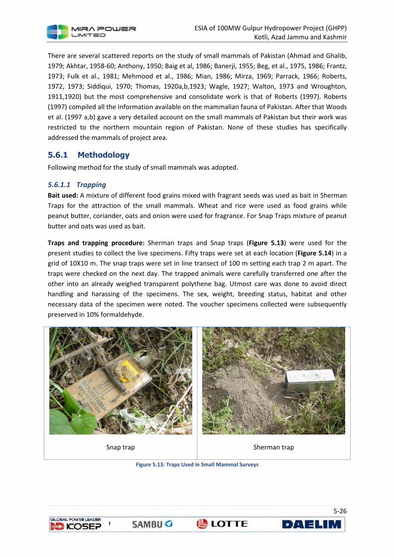
ESIA of 100MW Gulpur Hydropower Project (GHPP)
Kotli, Azad Jammu and Kashmir
5-26
There are several scattered reports on the study of small mammals of Pakistan (Ahmad and Ghalib,
1979; Akhtar, 1958-60; Anthony, 1950; Baig et al, 1986; Banerji, 1955; Beg, et al., 1975, 1986; Frantz,
1973; Fulk et al., 1981; Mehmood et al., 1986; Mian, 1986; Mirza, 1969; Parrack, 1966; Roberts,
1972, 1973; Siddiqui, 1970; Thomas, 1920a,b,1923; Wagle, 1927; Walton, 1973 and Wroughton,
1911,1920) but the most comprehensive and consolidate work is that of Roberts (1997). Roberts
(1997) compiled all the information available on the mammalian fauna of Pakistan. After that Woods
et al. (1997 a,b) gave a very detailed account on the small mammals of Pakistan but their work was
restricted to the northern mountain region of Pakistan. None of these studies has specifically
addressed the mammals of project area.
5.6.1 Methodology
Following method for the study of small mammals was adopted.
5.6.1.1 Trapping
Bait used: A mixture of different food grains mixed with fragrant seeds was used as bait in Sherman
Traps for the attraction of the small mammals. Wheat and rice were used as food grains while
peanut butter, coriander, oats and onion were used for fragrance. For Snap Traps mixture of peanut
butter and oats was used as bait.
Traps and trapping procedure: Sherman traps and Snap traps (Figure 5.13) were used for the
present studies to collect the live specimens. Fifty traps were set at each location (Figure 5.14) in a
grid of 10X10 m. The snap traps were set in line transect of 100 m setting each trap 2 m apart. The
traps were checked on the next day. The trapped animals were carefully transferred one after the
other into an already weighed transparent polythene bag. Utmost care was done to avoid direct
handling and harassing of the specimens. The sex, weight, breeding status, habitat and other
necessary data of the specimen were noted. The voucher specimens collected were subsequently
preserved in 10% formaldehyde.
Snap trap
Sherman trap
Figure 5.13: Traps Used in Small Mammal Surveys
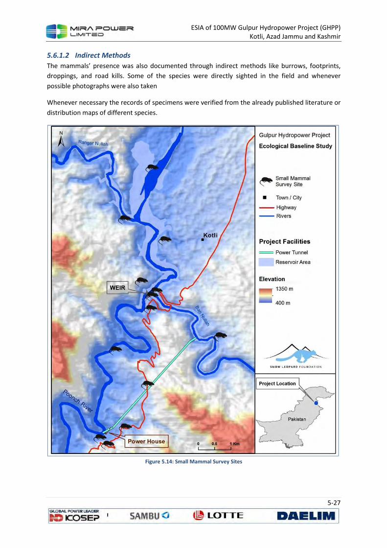
ESIA of 100MW Gulpur Hydropower Project (GHPP)
Kotli, Azad Jammu and Kashmir
5-27
5.6.1.2 Indirect Methods
The mammals’ presence was also documented through indirect methods like burrows, footprints,
droppings, and road kills. Some of the species were directly sighted in the field and whenever
possible photographs were also taken
Whenever necessary the records of specimens were verified from the already published literature or
distribution maps of different species.
Figure 5.14: Small Mammal Survey Sites
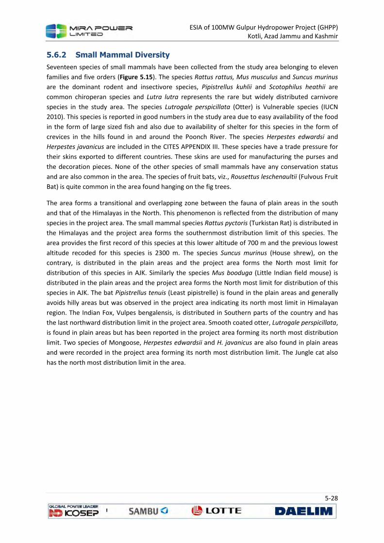
ESIA of 100MW Gulpur Hydropower Project (GHPP)
Kotli, Azad Jammu and Kashmir
5-28
5.6.2 Small Mammal Diversity
Seventeen species of small mammals have been collected from the study area belonging to eleven
families and five orders (Figure 5.15). The species Rattus rattus, Mus musculus and Suncus murinus
are the dominant rodent and insectivore species, Pipistrellus kuhlii and Scotophilus heathii are
common chiroperan species and Lutra lutra represents the rare but widely distributed carnivore
species in the study area. The species Lutrogale perspicillata (Otter) is Vulnerable species (IUCN
2010). This species is reported in good numbers in the study area due to easy availability of the food
in the form of large sized fish and also due to availability of shelter for this species in the form of
crevices in the hills found in and around the Poonch River. The species Herpestes edwardsi and
Herpestes javanicus are included in the CITES APPENDIX III. These species have a trade pressure for
their skins exported to different countries. These skins are used for manufacturing the purses and
the decoration pieces. None of the other species of small mammals have any conservation status
and are also common in the area. The species of fruit bats, viz., Rousettus leschenaultii (Fulvous Fruit
Bat) is quite common in the area found hanging on the fig trees.
The area forms a transitional and overlapping zone between the fauna of plain areas in the south
and that of the Himalayas in the North. This phenomenon is reflected from the distribution of many
species in the project area. The small mammal species Rattus pyctoris (Turkistan Rat) is distributed in
the Himalayas and the project area forms the southernmost distribution limit of this species. The
area provides the first record of this species at this lower altitude of 700 m and the previous lowest
altitude recoded for this species is 2300 m. The species Suncus murinus (House shrew), on the
contrary, is distributed in the plain areas and the project area forms the North most limit for
distribution of this species in AJK. Similarly the species Mus booduga (Little Indian field mouse) is
distributed in the plain areas and the project area forms the North most limit for distribution of this
species in AJK. The bat Pipistrellus tenuis (Least pipistrelle) is found in the plain areas and generally
avoids hilly areas but was observed in the project area indicating its north most limit in Himalayan
region. The Indian Fox, Vulpes bengalensis, is distributed in Southern parts of the country and has
the last northward distribution limit in the project area. Smooth coated otter, Lutrogale perspicillata,
is found in plain areas but has been reported in the project area forming its north most distribution
limit. Two species of Mongoose, Herpestes edwardsii and H. javanicus are also found in plain areas
and were recorded in the project area forming its north most distribution limit. The Jungle cat also
has the north most distribution limit in the area.
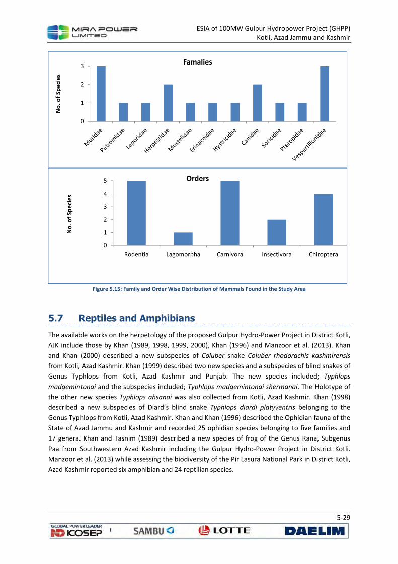
ESIA of 100MW Gulpur Hydropower Project (GHPP)
Kotli, Azad Jammu and Kashmir
5-29
Figure 5.15: Family and Order Wise Distribution of Mammals Found in the Study Area
5.7 Reptiles and Amphibians
The available works on the herpetology of the proposed Gulpur Hydro-Power Project in District Kotli,
AJK include those by Khan (1989, 1998, 1999, 2000), Khan (1996) and Manzoor et al. (2013). Khan
and Khan (2000) described a new subspecies of Coluber snake Coluber rhodorachis kashmirensis
from Kotli, Azad Kashmir. Khan (1999) described two new species and a subspecies of blind snakes of
Genus Typhlops from Kotli, Azad Kashmir and Punjab. The new species included; Typhlops
madgemintonai and the subspecies included; Typhlops madgemintonai shermanai. The Holotype of
the other new species Typhlops ahsanai was also collected from Kotli, Azad Kashmir. Khan (1998)
described a new subspecies of Diard’s blind snake Typhlops diardi platyventris belonging to the
Genus Typhlops from Kotli, Azad Kashmir. Khan and Khan (1996) described the Ophidian fauna of the
State of Azad Jammu and Kashmir and recorded 25 ophidian species belonging to five families and
17 genera. Khan and Tasnim (1989) described a new species of frog of the Genus Rana, Subgenus
Paa from Southwestern Azad Kashmir including the Gulpur Hydro-Power Project in District Kotli.
Manzoor et al. (2013) while assessing the biodiversity of the Pir Lasura National Park in District Kotli,
Azad Kashmir reported six amphibian and 24 reptilian species.
0
1
2
3N
o. o
f Sp
eci
es
Famalies
0
1
2
3
4
5
Rodentia Lagomorpha Carnivora Insectivora Chiroptera
No
. of
Spe
cie
s
Orders
ESIA of 100MW Gulpur Hydropower Project (GHPP)
Kotli, Azad Jammu and Kashmir
5-30
5.7.1 Methodology
The study area represents different types of habitats and terrains including cultivated lands, wild
lands, wetlands and forests. Similarly, some of the herpetological elements are nocturnal in feeding
habits whereas others are diurnal; therefore, different direct and indirect methods were applied to
study various groups of the herps in the study area. Field visits were carried out between 9:00 am to
4:00 pm for diurnal species and for two hours after dusk for the nocturnal species. Detailed
methodology applied for studying the herpetological diversity in the study area is given below.
Survey locations of Reptiles and Amphibians are shown in Figure 5.16.
5.7.1.1 Secondary Data
To record every possible species in the study area, the available literature was collected and
reviewed. The literature included published and unpublished reports and books of private and
government conservation organizations, gazetteers, research articles, popular articles and
newspapers. Based on the available literature, a checklist of different species was developed which
was confirmed through observing different species during the survey.
5.7.1.2 Interviews with Local Residents
Interviews with local residents are valuable not only for identifying the potential sites in the study
area but also a good source of primary data about the existing wildlife of an area. This method was
used for locating different amphibian and reptilian species in the study area. The relevant people in
the study area for the interviews included; field biologists, local hunters, local fishermen, fish
farmers, agriculturists and officials from fisheries, wildlife, forest and irrigation departments in the
study area. A questionnaire was also developed before interviewing different people for
herpetological survey. However, despite the effectiveness of this method, minimal emphasis was
placed on this source regarding the populations of different animals as it is assumed that the data
regarding the population estimates could be biased.
5.7.1.3 Amphibians’ Survey
Indirect Evidences
Since the survey was planned during the breeding season of amphibians (August), therefore
different indirect evidences of existence of different species were available in the study area
including amphibians’ eggs, tadpoles and their mating calls. To locate different amphibian species
and their identification at the project area, following indirect methods were be applied.
Amphibian Eggs: Amphibian eggs are the best indication of the presence of different species at a
particular site. Medium sized eggs of Fejervarya, Euphlyctis and Sphaeroteca are found in jelly
patches, normally floating at water surface. Large Hoplobatrachus eggs are mostly attached in 1-5s
to the submerged marginal grass blades. Much smaller, greenish-brown eggs of Uperodon and
Microhyla are about 1/4th of the size of that of other species, float in small patches of thick jelly at
water surface. Toads’ spawn of black eggs are strung in a double string of jelly, wound round
submerged vegetation. During the present survey, amphibian eggs were actively searched along
ponds, puddles and roadside water reservoirs in order to locate any amphibian species.
Amphibian Tadpoles: Temporal breeding sites of amphibians are the major source of bulk of
tadpoles and the tadpoles can also be an indication of different species. For example, dark brown to
ESIA of 100MW Gulpur Hydropower Project (GHPP)
Kotli, Azad Jammu and Kashmir
5-31
black Bufo and Pseudepidalea tadpoles are most common, usually fringe the marginal water. They
move in deeper water as they grow older and lighter in color. Schools of transparent Microhyla and
Uperodon tadpoles swim at mid-stream. While different species of Ranoid tadpoles occupy different
niches in the pond. Euphlyctis are confined to the bottom, Fejervarya under submerged vegetation;
Hoplobatrachus and Sphaerotheca keep to the marginal deep water. Of the mountain tadpoles;
Allopaa develop in pools in the course of streams, taking refuge among crevices and holes along
marginal stones, when the stream is in flood. Chrysopaa tadpoles remain in deep water pools
confined under floating algal sheets. During the present survey, amphibian tadpoles were actively
searched in ponds, puddles and roadside water reservoirs in order to locate any amphibian species.
Tadpoles of Euphlyctis cyanophlyctis, Hoplobatrachus tigerinus and Microhyla ornata were observed
at eight different locations in the study area.
Mating Calls: Amphibian species can also be identified through their mating calls during night and
this method was also applied during night search at four out of the 18 study sites in the project area.
Active Search
It is an effective way to search amphibians during the daytime. This method is equally applicable for
both nocturnal and diurnal species. The study area was actively searched for potential breeding
areas of amphibians like small water pools, water channels, roadside ponds and puddles and suitable
microhabitats for amphibians e.g. stones, pond bunds, crevices, leaf litter, debris, rotten log etc.
These places are deliberately uncovered to search the amphibians hiding under such covers. Active
searching was carried out at all the sites with focus on suitable microhabitats. Search for the
nocturnal amphibians was carried out in exposed areas of their potential habitats on the ground,
along the path or the pond or stream bank.
Amphibians were also observed during day time as well as at night around their feeding grounds i.e.
under light posts etc. and around breeding sites like ponds, puddles and streams where they
advertise their presence by their crocks. All the amphibian species found during the study, were
identified at the spot and photographed to record the evidences of their existence.
Collection and Preservation of Amphibians
Monsoon rains are the best time for study amphibians as they breed usually during monsoon when
water as a medium for their breeding is available easily. Amphibians are specialized vertebrates,
occupying special habitat in ecosystem where they forage, follow their breeding rituals, lay eggs and
where their tadpoles feed and develop. A few specimens were collected, preserved, tagged and
deposited/donated to the Pakistan Museum of Natural History as reference material for future
researchers.
To keep track of a preserved specimen and related field information, every collected specimen was
allotted a specific number written on a tag tied to the specimen. Tags were prepared by using water
/ formalin resistant paper, strung on a strong silken cord. The number was written on the tag with a
water / formalin resistant ink or with lead pencil. The prepared tag with number was then tied at
knee joint or around waist of the specimen. Field notes were taken and data was entered in the
notebook under each tag number. The field notes included; date of collection (day / month / year),
time of collection, name of the collector, name of the locality from where the specimen was

ESIA of 100MW Gulpur Hydropower Project (GHPP)
Kotli, Azad Jammu and Kashmir
5-32
collected including district, province and distance and direction from nearest town by using a
standard map and the ecological data including habitat, vegetation, temperature, humidity,
substratum and elevation from sea level.
Photography
A close up color photograph of the specimen in its natural habitat or a series of photographs or a
short movie can contribute to understand morphology, breeding, spawning and feeding habits of the
animal. Therefore, photographs of all the specimens were taken in their natural habitats not only for
their identification purposes but also as an evidence of their existence.
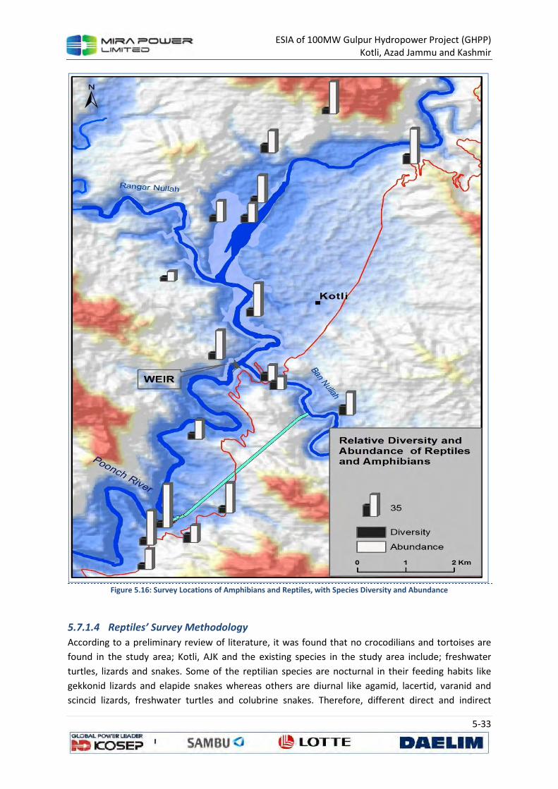
ESIA of 100MW Gulpur Hydropower Project (GHPP)
Kotli, Azad Jammu and Kashmir
5-33
Figure 5.16: Survey Locations of Amphibians and Reptiles, with Species Diversity and Abundance
5.7.1.4 Reptiles’ Survey Methodology
According to a preliminary review of literature, it was found that no crocodilians and tortoises are
found in the study area; Kotli, AJK and the existing species in the study area include; freshwater
turtles, lizards and snakes. Some of the reptilian species are nocturnal in their feeding habits like
gekkonid lizards and elapide snakes whereas others are diurnal like agamid, lacertid, varanid and
scincid lizards, freshwater turtles and colubrine snakes. Therefore, different direct and indirect
ESIA of 100MW Gulpur Hydropower Project (GHPP)
Kotli, Azad Jammu and Kashmir
5-34
methods were applied to study various groups of the reptilian fauna at the study area. Field visits
were carried out between 10:00 am to 3:00 pm for diurnal species and for 2-3 hours after dusk for
the nocturnal species.
Field Identification of Reptiles
Different habitats in the study area were searched for any reptilian species both during day time and
night. Stone turning, looking at and through bushes, searching basking agamas on stones and
boulders and walking along microhabitats were the means to find out all possible reptiles in the
study area. Freshwater turtles were observed from the banks of the water bodies. All the reptiles
encountered during the survey were photographed and field notes for each specimen were
recorded. However, the specimens that could not be identified on the spot or the specimens
identified but require detailed study for their confirmation as a sub-species were collected and
preserved for their identification in the lab. For the identification of different species, Amphibians
and Reptiles of Pakistan, by Khan (2006) was used.
Collection Methods for Reptiles
Hand picking through bare hands or with the help of long forceps or snake clutch has always been
the most efficient way of collecting different species of reptiles. The larger species like monitor lizard
and rock-agama, noose traps were used. For handling snakes, especially poisonous ones, snake
clutches / sticks were used. In addition to Hand picking, “Scoop nets” for shallow water and “cast
nets” in large water bodies were also used for aquatic reptiles. Fast moving Agamid and Lacertid
lizards were also collected by striking with stick. Some specimens were pulled out with the help of
long forceps from crevices in stones while a few were collected by hand from under the bushes.
Snakes were mostly collected using snake catcher and every snake being collected was considered as
poisonous in order to avoid any mishap.
The collected lizards were killed by injecting concentrated formalin at the site of heart and then the
formalin was injected in belly, neck, legs and tail for preservation. A tag number was allotted to each
specimen and tied with the left hind limb for identification and later detailed studies. Preserved
specimens were stored in 10% formalin in air-tight plastic jars.
5.7.2 Reptiles and Amphibians Diversity
A total 21 species of herps belonging to three orders, 13 families and 18 genera are found in the
study area including six amphibians and 15 reptiles. Amphibians included two toads and four frogs
whereas; reptiles included one turtle, nine lizard and five snake species (Annexure 5A). Two species
out of the five recorded snakes are poisonous rests all the amphibian and reptiles are non-
poisonous. According to a preliminary review of literature, no crocodilians and tortoises are found in
the study area.
Most of the species were observed directly whereas some were detected through indirect evidences
like tracks, burrows, molts and interviews with local residents. All the amphibians and lizards were
observed directly. The existence of five species including one turtle (Lissemys punctata andersoni)
and four snakes (Typhlops ductuliformes, Eryx johnii, Xenochrophis piscator and Naja oxiana) was
confirmed after interviewing a number of local residents including farmers, hunters and teachers.

ESIA of 100MW Gulpur Hydropower Project (GHPP)
Kotli, Azad Jammu and Kashmir
5-35
Common Krait (Bungarus
caeruleus )
Brown Cobra (Naja oxiana)
Checkered Keeled back
Snake (Xenochrophis
piscator)
Himalayan Rock Agama (Laudakia himalayana)
Tadpoles of Microhyla ornata
Figure 5.17: Photographs of Reptile and Amphibian Species Recorded in the Area
5.7.2.1 Conservation Status of the Recorded Species
All the species recorded during the survey were commonly found at all the study sites, with mostly
Not Evaluated species (52%) according to IUCN 2013 or having Least Concern status (42%) with
stable population trend (Table 5.7). Only one species, Brown Cobra (Naja oxiana) was found Data
Deficient with unknown population trend. None of the recorded species is protected under the AJK
Wildlife Act 1975 or AJK Wildlife Ordinance 2013.
Six of the recorded 21 species are CITES Species with one (Varanus bengalensis) enlisted in Appendix
I, four species (Hoplobatrachus tigerinus, Lissemys punctata, Eryx johnii, Naja oxiana) are enlisted in
Appendix II while one species (Xenochrophis piscator) is enlisted in Appendix III of the CITES category
2013.
Table 5.7: Conservation status of the reptile and amphibian species
Sr.
No. Zoological Name
Local
Status
CITES
Category
IUCN
Status(2013)
Population Trend IUCN,
2013
1 Bufo stomaticus Abundant - Least Concern Stable
2 Bufo melanostictus Rare - Least Concern Increasing
3 Microhyla ornata Fair - Least Concern Stable
4 Euphlyctis
cyanophlyctis Common - Least Concern Stable
5 Fejevarya limnocharis Rare - Not evaluated Not evaluated
6 Hoplobatrachus
tigerinus Common II Least Concern Stable
7 Lissemys punctata Occasional II Least Concern Unknown
8 Laudakia agrorensis Common - Not evaluated Not evaluated
9 Laudakia himalayana Common - Not evaluated Not evaluated
10 Eublepharis macularius Occasional - Least Concern Unknown
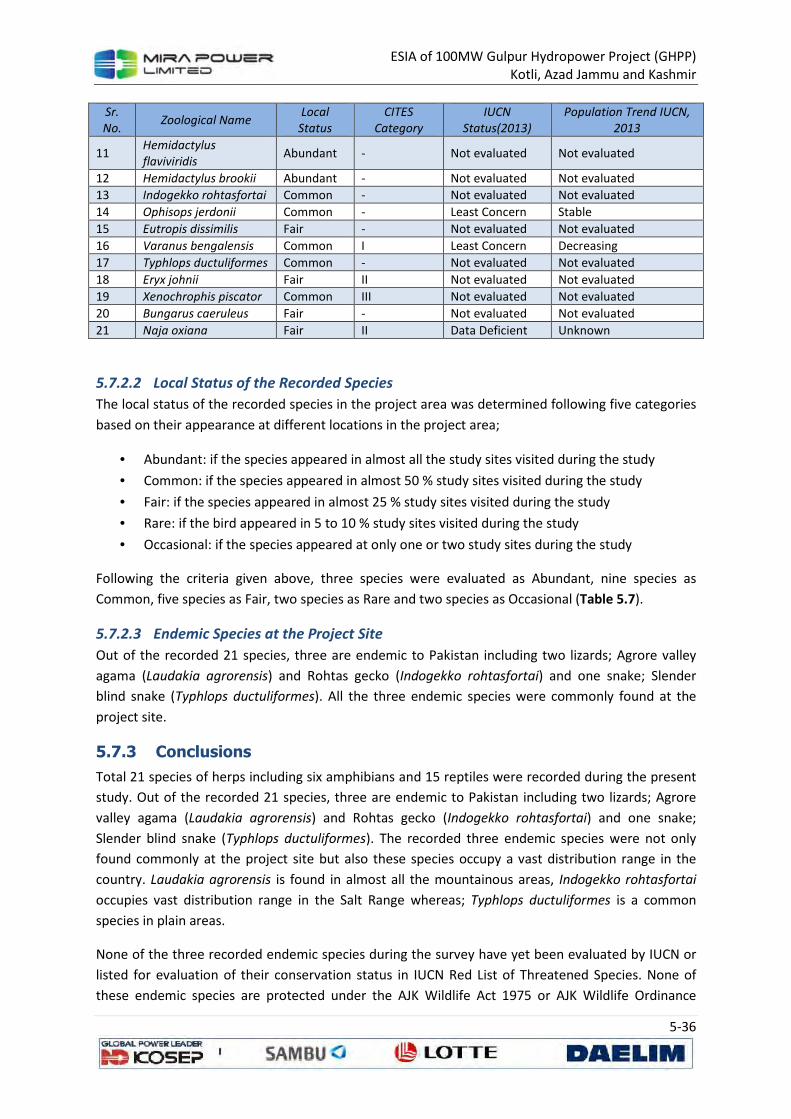
ESIA of 100MW Gulpur Hydropower Project (GHPP)
Kotli, Azad Jammu and Kashmir
5-36
Sr.
No. Zoological Name
Local
Status
CITES
Category
IUCN
Status(2013)
Population Trend IUCN,
2013
11 Hemidactylus
flaviviridis Abundant - Not evaluated Not evaluated
12 Hemidactylus brookii Abundant - Not evaluated Not evaluated
13 Indogekko rohtasfortai Common - Not evaluated Not evaluated
14 Ophisops jerdonii Common - Least Concern Stable
15 Eutropis dissimilis Fair - Not evaluated Not evaluated
16 Varanus bengalensis Common I Least Concern Decreasing
17 Typhlops ductuliformes Common - Not evaluated Not evaluated
18 Eryx johnii Fair II Not evaluated Not evaluated
19 Xenochrophis piscator Common III Not evaluated Not evaluated
20 Bungarus caeruleus Fair - Not evaluated Not evaluated
21 Naja oxiana Fair II Data Deficient Unknown
5.7.2.2 Local Status of the Recorded Species
The local status of the recorded species in the project area was determined following five categories
based on their appearance at different locations in the project area;
• Abundant: if the species appeared in almost all the study sites visited during the study
• Common: if the species appeared in almost 50 % study sites visited during the study
• Fair: if the species appeared in almost 25 % study sites visited during the study
• Rare: if the bird appeared in 5 to 10 % study sites visited during the study
• Occasional: if the species appeared at only one or two study sites during the study
Following the criteria given above, three species were evaluated as Abundant, nine species as
Common, five species as Fair, two species as Rare and two species as Occasional (Table 5.7).
5.7.2.3 Endemic Species at the Project Site
Out of the recorded 21 species, three are endemic to Pakistan including two lizards; Agrore valley
agama (Laudakia agrorensis) and Rohtas gecko (Indogekko rohtasfortai) and one snake; Slender
blind snake (Typhlops ductuliformes). All the three endemic species were commonly found at the
project site.
5.7.3 Conclusions
Total 21 species of herps including six amphibians and 15 reptiles were recorded during the present
study. Out of the recorded 21 species, three are endemic to Pakistan including two lizards; Agrore
valley agama (Laudakia agrorensis) and Rohtas gecko (Indogekko rohtasfortai) and one snake;
Slender blind snake (Typhlops ductuliformes). The recorded three endemic species were not only
found commonly at the project site but also these species occupy a vast distribution range in the
country. Laudakia agrorensis is found in almost all the mountainous areas, Indogekko rohtasfortai
occupies vast distribution range in the Salt Range whereas; Typhlops ductuliformes is a common
species in plain areas.
None of the three recorded endemic species during the survey have yet been evaluated by IUCN or
listed for evaluation of their conservation status in IUCN Red List of Threatened Species. None of
these endemic species are protected under the AJK Wildlife Act 1975 or AJK Wildlife Ordinance
ESIA of 100MW Gulpur Hydropower Project (GHPP)
Kotli, Azad Jammu and Kashmir
5-37
2013. The recorded endemic species are none CITES species i.e. none of these is enlisted in any
Appendix of CITES category 2013.
5.8 Avifauna
Birds are considered as important health indicators of the ecological conditions and productivity of
an ecosystem (Li and Mundkur, 2007). While addressing the environmental problems of an area,
birds can be used as very appropriate bio-indicators suggesting the status of biodiversity in general
(Bhatt and Joshi, 2011).
Of the total Pakistan’s bird species, 30% visit the country for a significant period of the year as long
distance migrants, 43% are either Palearctic species visiting Pakistan only for breeding and 28% are
regular winter visitors, which breed mainly in trans-Himalayan northern regions (Roberts, 1992). The
information about avian distribution across different habitats and Himalayan elevation zones across
the region is scarce, fragmented and preliminary (Ali & Ripley, 1998). The study area is unexplored in
terms of avifauna and old documentation of the bird diversity specific to the study area exist.
5.8.1 Methodology
The present study was carried out using 500 m transects, spread across the study area (Figure 5.18).
Transects were rightfully separated (about 400 m) to shun the double counting of birds. The other
most important aspect kept in consideration while surveying for the birds was the activity period of
birds. The peak activity of birds lasts for 1 or 2 hours after sunrise or before sunset, so recording of
birds were done either in early morning or late evening hours (Thakur et al., 2002). Survey was done
between 0530–1100 hrs and 1530–1830 hrs during the dusk and dawn, respectively. It helped to
note the movements and calls of the birds, which were noticed easily to draw data more accurately.
All birds seen while walking along transects, including those flying, were recorded. All observations
were made by using binocular and photographic documentation was done by using digital camera. In
the field, the birds were identified using an authentic field guide (Grimmett, et al., 2008). By using
Shannon's Diversity Index (H'), data was analyzed for species diversity and relative abundance.
Pi (Relative abundance) = ni /N H' (Shannon diversity index) = -Σ (pi*ln*pi) E (Evenness) = H'/LnS Whereas, Pi = relative abundance of species, i=1, ni = Number of individuals of species, N = total
number of individuals of all species, H'= the Shannon Diversity Index, S = Total number of species, Ln
= Log with base 'e' (Natural logarithm)
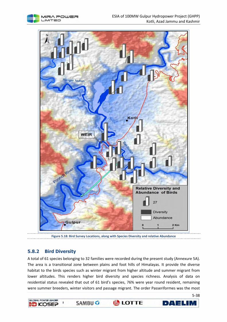
ESIA of 100MW Gulpur Hydropower Project (GHPP)
Kotli, Azad Jammu and Kashmir
5-38
Figure 5.18: Bird Survey Locations, along with Species Diversity and relative Abundance
5.8.2 Bird Diversity
A total of 61 species belonging to 32 families were recorded during the present study (Annexure 5A).
The area is a transitional zone between plains and foot hills of Himalayas. It provide the diverse
habitat to the birds species such as winter migrant from higher altitude and summer migrant from
lower altitudes. This renders higher bird diversity and species richness. Analysis of data on
residential status revealed that out of 61 bird’s species, 76% were year round resident, remaining
were summer breeders, winter visitors and passage migrant. The order Passeriformes was the most
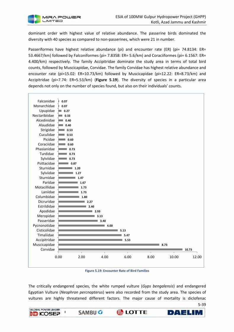
ESIA of 100MW Gulpur Hydropower Project (GHPP)
Kotli, Azad Jammu and Kashmir
5-39
dominant order with highest value of relative abundance. The passerine birds dominated the
diversity with 40 species as compared to non-passerines, which were 21 in number.
Passeriformes have highest relative abundance (pi) and encounter rate (ER) (pi= 74.8134: ER=
53.4667/km) followed by Falconiformes (pi= 7.8358: ER= 5.6/km) and Coraciiformes (pi= 6.1567: ER=
4.400/km) respectively. The family Accipitridae dominate the study area in terms of total bird
counts, followed by Muscicapidae, Corvidae. The family Corvidae has highest relative abundance and
encounter rate (pi=15.02: ER=10.73/km) followed by Muscicapidae (pi=12.22: ER=8.73/km) and
Accipitridae (pi=7.74: ER=5.53/km) (Figure 5.19). The diversity of species in a particular area
depends not only on the number of species found, but also on their individuals’ counts.
Figure 5.19: Encounter Rate of Bird Families
The critically endangered species, the white rumped vulture (Gyps bengalensis) and endangered
Egyptian Vulture (Neophron percnopterus) were also recorded from the study area. The species of
vultures are highly threatened different factors. The major cause of mortality is diclofenac
10.73
8.73
5.53
5.47
5.13
4.00
3.40
3.13
2.93
2.40
2.27
1.80
1.73
1.73
1.67
1.47
1.27
1.20
0.87
0.73
0.73
0.73
0.60
0.60
0.53
0.53
0.40
0.40
0.33
0.27
0.07
0.07
0.00 2.00 4.00 6.00 8.00 10.00 12.00
Corvidae
Muscicapidae
Accipitridae
Timaliidae
Cisticolidae
Pycnonotidae
Passeridae
Meropidae
Apodidae
Estrildidae
Dicruridae
Columbidae
Laniidae
Motacillidae
Paridae
Sturnidae
Sylviidae
Sturnidae
Psittacidae
Sylviidae
Turdidae
Phasianidae
Coraciidae
Picidae
Cuculidae
Strigidae
Alaudidae
Alcedinidae
Nectaribiidae
Upupidae
Monarchidae
Falconidae
ESIA of 100MW Gulpur Hydropower Project (GHPP)
Kotli, Azad Jammu and Kashmir
5-40
contamination of livestock carcasses (Green et al., 2006). The other causes such as habitat
destruction, food shortage, human persecution, poisoning and pesticide use may have caused a
gradual decline in vulture populations (Birdlife International, 2010). The abundance of Egyptian
Vulture, Black kite (Milvus migrans) and crow species was higher near the waste and garbage stored
land. The habitat overlapping of Jungle crow (Corvus macrorhynchos), Common raven (Corvus corax)
and House crow (Corvus splendens) was also observed in the study area with equally distribution
status of both species. The house crow proliferates in human settlements and disturbed habitats and
is especially suited to coastal settlements.
We also studied the species diversity in selected sites of study area. Irrespective of altitudinal
variation house sparrow was dominant species in urban areas. Similarly the Indian roller (Coracias
benghalensis), red vented bulbul (Pycnonotus cafer) and white cheeked bulbul (Pycnonotus
leucogenys) were also recorded across the study area. The two species of woodpecker, scaly bellied
woodpecker (Picus squamatus) and grey capped pygmy woodpecker (dendrocopos canicapillus) and
Jungle babbler (Turdoides striatus) dominated the forest area (dominated by chir pine). Green bee
eater (Merops orientalis), pied Cuckoo (Clamator jacobinus), rose ringed Parakeet (Psittacula
krameri), common myna (Acridotheres tristis), Brahminy starling (Sturnus pagodarum) and scaly
breasted munia (Lonchura punctulata) were dominated in the agricultural lands. A single sighting of
Asian paradise flycatcher (Terpsiphone paradisi) was also recorded while surveying the study area.
The transitional habitat between cultivated land and thick forest of chir pine dominated the diversity
of passerines birds such as the species of common stone chat, pied bush chat, Indian robin,
flycatcher and warbler. The species of wagtail were also recorded near the water resources. Rollers
inhabit scattered trees, scrublands, cultivated fields and urban parks or gardens. The main threats
include loss of suitable habitat due to changing agricultural practices, loss of nest sites and use of
pesticides (Kovacs et al., 2008).
In term of the abundance of recorded species, the undisturbed area depicted the higher diversity of
avian fauna. That was probably because forest areas with low human occupation provide breeding
ground and roosting places for various birds species.
The Habitat destruction, anthropogenic pressure in the form of tree cutting, firewood collection,
grass cutting, and cattle grazing were also observed in these study sites. At several locations, nests of
various bird species were observed on ground as well in bushes and on the other hand grazing
pressure and cutting of bushes was quite evident. This indicates a serious threat to the breeding
activity of birds in the area. The rivers and stream provide suitable habitat for grassland species as
well as stream dwellers and migratory water birds. These areas are open to human access and
interference. The human related threats in these areas include include water pollution by sewage
drainage, industrial waste, eutrophication caused by sewage effluent and agricultural seepage
carrying fertilizers and stone crushing.
Intensive biomass extraction (mainly through grazing and fuel wood collection) can bring change in
vegetation structure and composition of the forest, leading to changes in bird species composition
(Shahabuddin and Kumar 2005).

ESIA of 100MW Gulpur Hydropower Project (GHPP)
Kotli, Azad Jammu and Kashmir
5-41
5.9 Species OF Special Concern
Out of 21 species found in Poonch River, 12 species viz., Barilius pakistanicus, Schistura punjabensis,
Cirrhinus reba, Labeo dero, Labeo dyocheilus, Tor putitora, Cyprinus carpio, Botia rostrata, Clupisoma
garua, Ompok bimaculatus, Mastacembelus armatus are species of special importance (Table 5.8). A
detailed description of these species is provided in Annexure 5B. The species, Barilius pakistanicus
and Schistura punjabensis are endemic in Pakistan including AJK. Four species, Tor putitora
(Endangered), Cyprinus carpio (Vulnerable), Botia rostrata (Vulnerable), Ompok bimaculatus
(Vulnerable) and Ompok bimaculatus (Near Threatened) have special IUCN status. Out these, Tor
putitora, Cyprinus carpio and Ompok bimaculatus are commercially important. The other
commercially important species are Clupisoma garua, and Mastacembelus armatus.
Table 5.8: Species of Concern Found in the Gulpur Hydropower Project Area
Nos. Scientific Name Distributional
status IUCN Status
Commercial
value
Max.
Length (cm)
Max.
Weight (Kg)
1 Barilius pakistanicus Endemic - - - -
2 Schistura punjabensis Endemic - - - -
3 Cirrhinus reba - - Fairly good 30 0.3
4 Labeo dero - - Fairly good 75 0.2
5 Labeo dyocheilus - - High 90 5
6 Tor putitora - Endangered Very high 275 54
7 Cyprinus carpio - Vulnerable High 110 40.1
8 Botia rostrata - Vulnerable - - -
9 Clupisoma garua - - Very high 61 0.5
10 Ompok bimaculatus - Near
threatened Fairly good 45 0.2
11 Mastacembelus armatus - - High 90 0.5 g
ESIA of 100MW Gulpur Hydropower Project (GHPP)
Kotli, Azad Jammu and Kashmir
6-1
6 DESCRIPTION OF SOCIO-ECONOMIC
ENVIRONMENT
This section presents a description of the socioeconomic characteristics of the project area, and
where available utilizes national and regional level data for providing a more cogent understanding
of the context. This social baseline analysis is based on:
• primary data collected by conducting a systematic settlement survey targeting the project
area in the Kotli District AJK to supplement the available surveys and studies; and
• secondary data collated from previously published literature as well as national and regional
data.
The settlement survey was carried out over a period of ten days by two teams comprising a total of
four members. The methodology for the collection of primary data consisted of focus group
discussions and structured interviews in the villages listed below, geared to provide detailed
qualitative socio-economic data. The villages included in Table 6.1 are seen as those villages that will
be directly affected by the proposed project activities.
Focus group discussions and structured interviews were chosen as the methodology in order to,
provide detailed information rapidly; to provide information on the many non-measurable issues
(for example, access to natural resources or the structure of social institutions); and to ensure a
more inclusive, participatory approach than what would have been possible with individual
questionnaires.
The secondary data pertaining to the project area was drawn chiefly from the following sources:
• Environmental Statistics AJK, AJK-EPA 2008
• Data available from Population Census Organization - Islamabad
• Data available from Planning & Development Department - AJK
• Economic survey of Pakistan 2010-2011
Table 6.1: Villages/Settlements in the Project Area
Village Name Village Name
1. Aghar 5. Hill Kalan
2. Barali 6. Hill Khurd
3. Dharang 7. Jamal Pur
4. Gulhar 8. Mandi
6.1 Social Setting
Traditionally, the social set up of Kotli was largely based on kinship. The overall social arrangement
was based around different clans (baraderi). The composition of society remained intact for
centuries until the mid of last century when geo-political changes in the region brought about
changes in political set up, economy and society. In the decades of 1960-70s migration of people to
abroad for earning shifted the basis of economy. Forced from lack of economic activities in the past,
ESIA of 100MW Gulpur Hydropower Project (GHPP)
Kotli, Azad Jammu and Kashmir
6-2
the people of the area started migrating abroad for search of opportunities. With increasing
exposure to market forces and exogenous lifestyle the pattern of interface between different
communities also witnessed drastic changes. Despite modernization people still rely on pre-
modernization social structure and social interaction and politics is largely shaped by social dynamics
and power relationships. However, access of opportunities in the country and abroad enabled
people to find increasing role in the society.
6.2 Demography
The district Kotli is the second largest in terms of population in Azad Jammu and Kashmir. The
population of the district was 365,000 in 1981 and an increase of 54.37 percent was recorded over
the last seventeen (17) years i.e 1981-1998. According to 1998 census its total population of the
district is 0.563 million with a growth rate of 2.59%. The projected population is 0.69 million in 2006.
The average annual growth rate of population is 2.59% in the district during inter censual period
1981-1998. The population density is 370 persons per sq. km. The average household size is 7.3
persons, which is slightly lower than national which is 8.5, but slightly higher than AJK -7.2. The
demographic details are given in the table below:
Table 6.2: Demography of AJK
District Area (Sq.
Kms)
Population (Millions) Density In (2006)
(Persons/ Sq. Km )
Growth
Rate
House-Hold
Size 1998 2006
Muzaffarabad 2496 0.62 0.77 307 2.80% 7.1
Neelum 3621 0.126 0.159 42 2.80% 7.1
Mirpur 1010 0.334 0.395 391 2.09% 6.8
Bhimber 1516 0.302 0.37 244 2.60% 6.7
Kotli 1862 0.563 0.69 370 2.59% 7.3
Poonch 855 0.411 0.49 573 2.24% 7.6
Bagh 1368 0.393 0.46 336 2.00% 7.4
Sudhnuti 569 0.224 0.262 460 1.99% 7.3
Total 13297 2.973 3.596* 270 2.41% 7.2
The human habitation in district Kotli is predominantly determined by its topography as the hilly
mountainous terrain limits options for human habitation. Hence, most of the human habitation in
the project area is scattered. The field survey about the settlement pattern of the surveyed
communities shows that majority of the population (91.84 percent) resides in rural areas with some
urban pockets in few settlements.
According to survey findings 99% households are headed by men. 57% of the households are living in
a joint family system. In the project area average household comprises of 9.2 persons, which is
higher as compared to the average national household size of 7.3 persons per household in the
district.
Table 6.3: Population Data
Village/Settlement Number of
Households Population
Persons per
Household
% Male
Population
% Female
Population
Aghar 28 280 10.00 51.07 48.93
Barali 15 138 9.20 50.72 49.28
Dharang 33 288 8.73 50.69 49.31
ESIA of 100MW Gulpur Hydropower Project (GHPP)
Kotli, Azad Jammu and Kashmir
6-3
Village/Settlement Number of
Households Population
Persons per
Household
% Male
Population
% Female
Population
Gulhar 14 136 9.71 45.59 54.41
Hill Kalan 14 103 7.36 48.54 51.46
Hill Khurd 12 117 9.75 50.43 49.57
Jamal Pur 35 332 9.49 53.31 46.69
Mandi 22 209 9.50 48.33 51.67
Survey Area Total/Average
173 1,603 9.27 50.41 49.59
Kotli District Total/Average
94,521 690,000 7.30 50.62 49.38
AJK Total/Average 499,444 3,596,000 7.20 50.62 49.38
As per the results of this survey female and male is 49.38 and 50.62 respectively.
Table 6.4: Age Distribution in the Project Area
Village/Settl
ement
Total
Population
Children below
9yrs (%)
Youth 10-
17yrs (%)
Active population 18-
65yrs (%)
Aged population
above 65 (%)
Aghar 280 24.29 13.57 58.93 3.21
Barali 138 29.71 12.32 54.35 3.62
Dharang 288 19.44 17.36 58.68 4.51
Gulhar 136 13.97 19.85 61.76 4.41
Hill Kalan 103 27.18 18.45 51.46 2.91
Hill Khurd 117 20.51 24.79 50.43 4.27
Jamal Pur 332 25.00 18.67 53.92 2.41
Mandi 209 27.27 23.44 45.93 3.35
Total 1,603 23.46 18.15 54.90 3.49
The findings of survey show that 54.9% of the sampled population was between 18 and 65 years of
age, followed by 23.46% children. The percentage of those falling between 10 and 18 years is 18.15%
whereas 3.49 % of the population falls in the age slot of more than 65 years and above.
Figure 6.1: Age Distribution based on Gender in the Project Area
11.29
8.80
28.45
1.87
12.16
9.36
26.45
1.62
0.00 5.00 10.00 15.00 20.00 25.00 30.00
0-9 years
10-17 years
18-65 years
65+ years
% P
op
ula
tio
n
Female Male
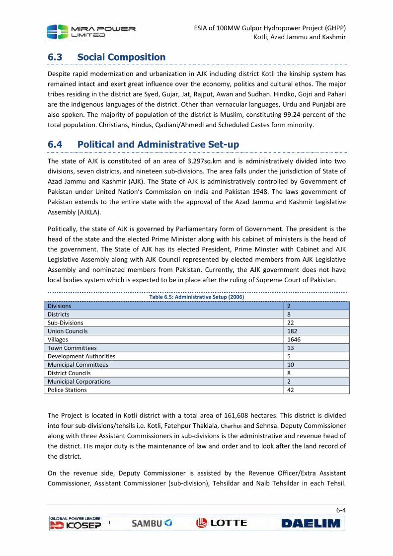
ESIA of 100MW Gulpur Hydropower Project (GHPP)
Kotli, Azad Jammu and Kashmir
6-4
6.3 Social Composition
Despite rapid modernization and urbanization in AJK including district Kotli the kinship system has
remained intact and exert great influence over the economy, politics and cultural ethos. The major
tribes residing in the district are Syed, Gujar, Jat, Rajput, Awan and Sudhan. Hindko, Gojri and Pahari
are the indigenous languages of the district. Other than vernacular languages, Urdu and Punjabi are
also spoken. The majority of population of the district is Muslim, constituting 99.24 percent of the
total population. Christians, Hindus, Qadiani/Ahmedi and Scheduled Castes form minority.
6.4 Political and Administrative Set-up
The state of AJK is constituted of an area of 3,297sq.km and is administratively divided into two
divisions, seven districts, and nineteen sub-divisions. The area falls under the jurisdiction of State of
Azad Jammu and Kashmir (AJK). The State of AJK is administratively controlled by Government of
Pakistan under United Nation’s Commission on India and Pakistan 1948. The laws government of
Pakistan extends to the entire state with the approval of the Azad Jammu and Kashmir Legislative
Assembly (AJKLA).
Politically, the state of AJK is governed by Parliamentary form of Government. The president is the
head of the state and the elected Prime Minister along with his cabinet of ministers is the head of
the government. The State of AJK has its elected President, Prime Minster with Cabinet and AJK
Legislative Assembly along with AJK Council represented by elected members from AJK Legislative
Assembly and nominated members from Pakistan. Currently, the AJK government does not have
local bodies system which is expected to be in place after the ruling of Supreme Court of Pakistan.
Table 6.5: Administrative Setup (2006)
Divisions 2
Districts 8
Sub-Divisions 22
Union Councils 182
Villages 1646
Town Committees 13
Development Authorities 5
Municipal Committees 10
District Councils 8
Municipal Corporations 2
Police Stations 42
The Project is located in Kotli district with a total area of 161,608 hectares. This district is divided
into four sub-divisions/tehsils i.e. Kotli, Fatehpur Thakiala, Charhoi and Sehnsa. Deputy Commissioner
along with three Assistant Commissioners in sub-divisions is the administrative and revenue head of
the district. His major duty is the maintenance of law and order and to look after the land record of
the district.
On the revenue side, Deputy Commissioner is assisted by the Revenue Officer/Extra Assistant
Commissioner, Assistant Commissioner (sub-division), Tehsildar and Naib Tehsildar in each Tehsil.
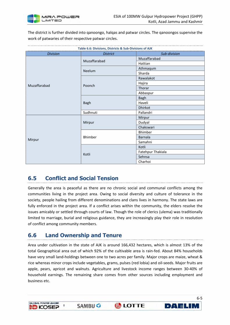
ESIA of 100MW Gulpur Hydropower Project (GHPP)
Kotli, Azad Jammu and Kashmir
6-5
The district is further divided into qanoongo, halqas and patwar circles. The qanoongos supervise the
work of patwaries of their respective patwar circles.
Table 6.6: Divisions, Districts & Sub-Divisions of AJK
Division District Sub-division
Muzaffarabad
Muzaffarabad Muzaffarabad
Hattian
Neelum Athmaqum
Sharda
Poonch
Rawalakot
Hajira
Thorar
Abbaspur
Bagh
Bagh
Haveli
Dhirkot
Sudhnuti Pallandri
Mirpur
Mirpur
Mirpur
Dudyal
Chakswari
Bhimber
Bhimber
Barnala
Samahni
Kotli
Kotli
Fatehpur Thakiala
Sehnsa
Charhoi
6.5 Conflict and Social Tension
Generally the area is peaceful as there are no chronic social and communal conflicts among the
communities living in the project area. Owing to social diversity and culture of tolerance in the
society, people hailing from different denominations and clans lives in harmony. The state laws are
fully enforced in the project area. If a conflict arises within the community, the elders resolve the
issues amicably or settled through courts of law. Though the role of clerics (ulema) was traditionally
limited to marriage, burial and religious guidance, they are increasingly play their role in resolution
of conflict among community members.
6.6 Land Ownership and Tenure
Area under cultivation in the state of AJK is around 166,432 hectares, which is almost 13% of the
total Geographical area out of which 92% of the cultivable area is rain-fed. About 84% households
have very small land-holdings between one to two acres per family. Major crops are maize, wheat &
rice whereas minor crops include vegetables, grams, pulses (red lobia) and oil-seeds. Major fruits are
apple, pears, apricot and walnuts. Agriculture and livestock income ranges between 30-40% of
household earnings. The remaining share comes from other sources including employment and
business etc.
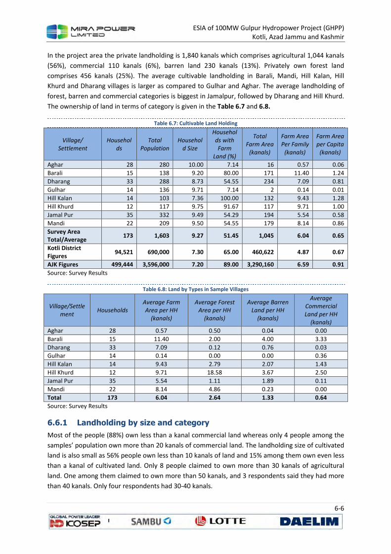
ESIA of 100MW Gulpur Hydropower Project (GHPP)
Kotli, Azad Jammu and Kashmir
6-6
In the project area the private landholding is 1,840 kanals which comprises agricultural 1,044 kanals
(56%), commercial 110 kanals (6%), barren land 230 kanals (13%). Privately own forest land
comprises 456 kanals (25%). The average cultivable landholding in Barali, Mandi, Hill Kalan, Hill
Khurd and Dharang villages is larger as compared to Gulhar and Aghar. The average landholding of
forest, barren and commercial categories is biggest in Jamalpur, followed by Dharang and Hill Khurd.
The ownership of land in terms of category is given in the Table 6.7 and 6.8.
Table 6.7: Cultivable Land Holding
Village/
Settlement
Househol
ds
Total
Population
Househol
d Size
Househol
ds with
Farm
Land (%)
Total
Farm Area
(kanals)
Farm Area
Per Family
(kanals)
Farm Area
per Capita
(kanals)
Aghar 28 280 10.00 7.14 16 0.57 0.06
Barali 15 138 9.20 80.00 171 11.40 1.24
Dharang 33 288 8.73 54.55 234 7.09 0.81
Gulhar 14 136 9.71 7.14 2 0.14 0.01
Hill Kalan 14 103 7.36 100.00 132 9.43 1.28
Hill Khurd 12 117 9.75 91.67 117 9.71 1.00
Jamal Pur 35 332 9.49 54.29 194 5.54 0.58
Mandi 22 209 9.50 54.55 179 8.14 0.86
Survey Area Total/Average
173 1,603 9.27 51.45 1,045 6.04 0.65
Kotli District Figures
94,521 690,000 7.30 65.00 460,622 4.87 0.67
AJK Figures 499,444 3,596,000 7.20 89.00 3,290,160 6.59 0.91
Source: Survey Results
Table 6.8: Land by Types in Sample Villages
Village/Settle
ment Households
Average Farm
Area per HH
(kanals)
Average Forest
Area per HH
(kanals)
Average Barren
Land per HH
(kanals)
Average
Commercial
Land per HH
(kanals)
Aghar 28 0.57 0.50 0.04 0.00
Barali 15 11.40 2.00 4.00 3.33
Dharang 33 7.09 0.12 0.76 0.03
Gulhar 14 0.14 0.00 0.00 0.36
Hill Kalan 14 9.43 2.79 2.07 1.43
Hill Khurd 12 9.71 18.58 3.67 2.50
Jamal Pur 35 5.54 1.11 1.89 0.11
Mandi 22 8.14 4.86 0.23 0.00
Total 173 6.04 2.64 1.33 0.64
Source: Survey Results
6.6.1 Landholding by size and category
Most of the people (88%) own less than a kanal commercial land whereas only 4 people among the
samples’ population own more than 20 kanals of commercial land. The landholding size of cultivated
land is also small as 56% people own less than 10 kanals of land and 15% among them own even less
than a kanal of cultivated land. Only 8 people claimed to own more than 30 kanals of agricultural
land. One among them claimed to own more than 50 kanals, and 3 respondents said they had more
than 40 kanals. Only four respondents had 30-40 kanals.
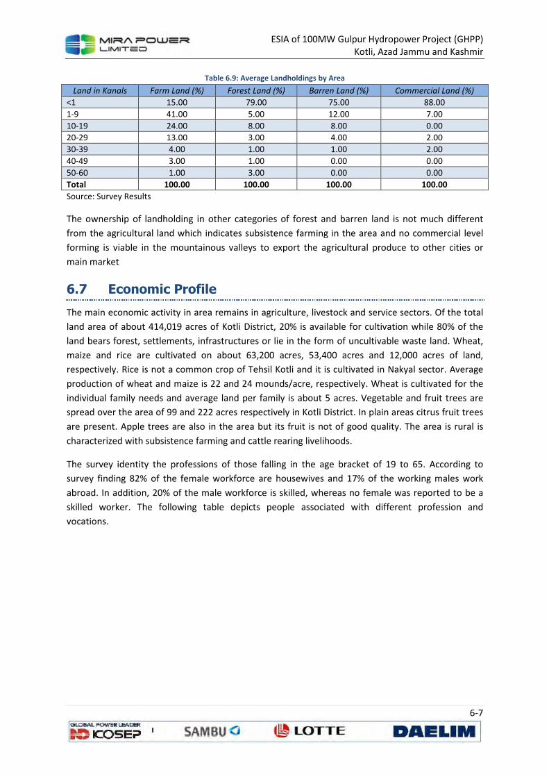
ESIA of 100MW Gulpur Hydropower Project (GHPP)
Kotli, Azad Jammu and Kashmir
6-7
Table 6.9: Average Landholdings by Area
Land in Kanals Farm Land (%) Forest Land (%) Barren Land (%) Commercial Land (%)
<1 15.00 79.00 75.00 88.00
1-9 41.00 5.00 12.00 7.00
10-19 24.00 8.00 8.00 0.00
20-29 13.00 3.00 4.00 2.00
30-39 4.00 1.00 1.00 2.00
40-49 3.00 1.00 0.00 0.00
50-60 1.00 3.00 0.00 0.00
Total 100.00 100.00 100.00 100.00
Source: Survey Results
The ownership of landholding in other categories of forest and barren land is not much different
from the agricultural land which indicates subsistence farming in the area and no commercial level
forming is viable in the mountainous valleys to export the agricultural produce to other cities or
main market
6.7 Economic Profile
The main economic activity in area remains in agriculture, livestock and service sectors. Of the total
land area of about 414,019 acres of Kotli District, 20% is available for cultivation while 80% of the
land bears forest, settlements, infrastructures or lie in the form of uncultivable waste land. Wheat,
maize and rice are cultivated on about 63,200 acres, 53,400 acres and 12,000 acres of land,
respectively. Rice is not a common crop of Tehsil Kotli and it is cultivated in Nakyal sector. Average
production of wheat and maize is 22 and 24 mounds/acre, respectively. Wheat is cultivated for the
individual family needs and average land per family is about 5 acres. Vegetable and fruit trees are
spread over the area of 99 and 222 acres respectively in Kotli District. In plain areas citrus fruit trees
are present. Apple trees are also in the area but its fruit is not of good quality. The area is rural is
characterized with subsistence farming and cattle rearing livelihoods.
The survey identity the professions of those falling in the age bracket of 19 to 65. According to
survey finding 82% of the female workforce are housewives and 17% of the working males work
abroad. In addition, 20% of the male workforce is skilled, whereas no female was reported to be a
skilled worker. The following table depicts people associated with different profession and
vocations.
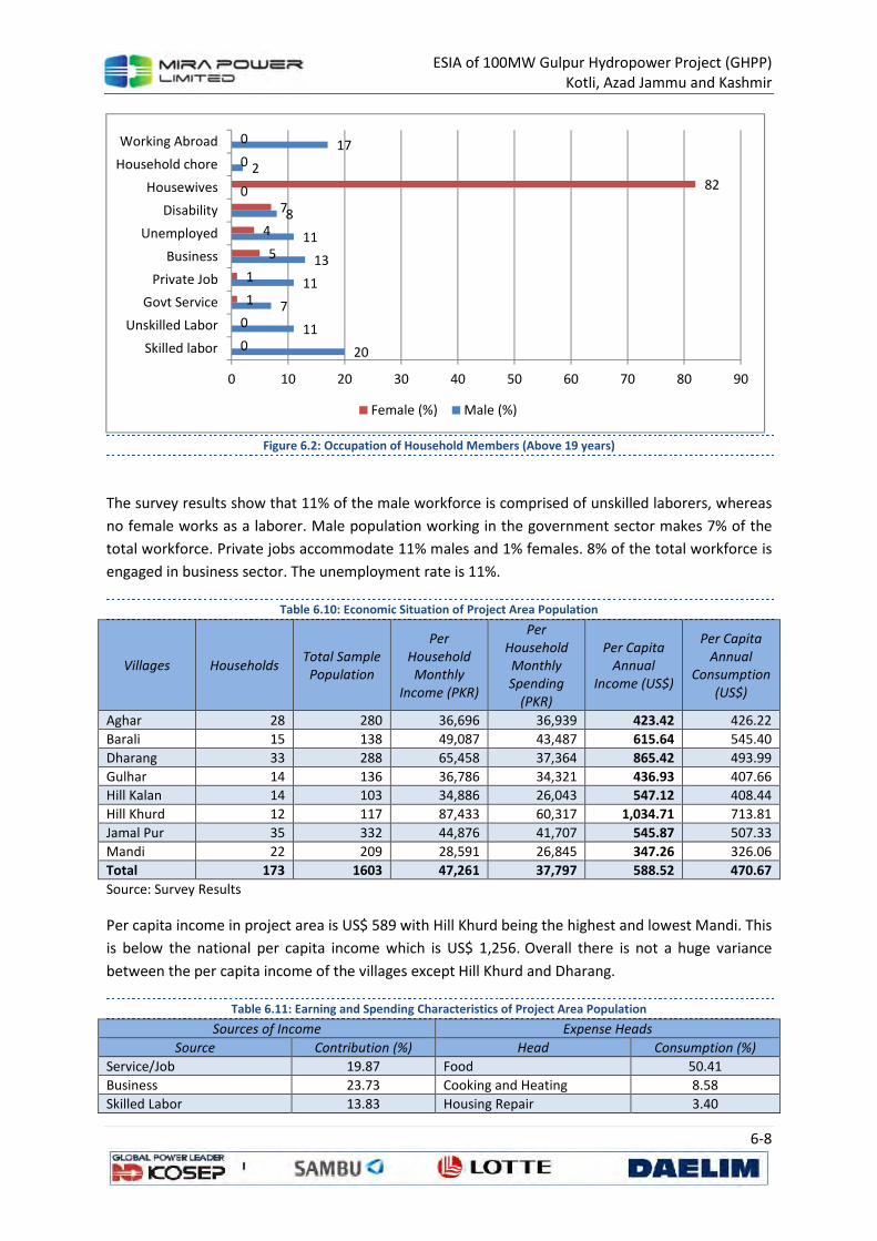
ESIA of 100MW Gulpur Hydropower Project (GHPP)
Kotli, Azad Jammu and Kashmir
6-8
Figure 6.2: Occupation of Household Members (Above 19 years)
The survey results show that 11% of the male workforce is comprised of unskilled laborers, whereas
no female works as a laborer. Male population working in the government sector makes 7% of the
total workforce. Private jobs accommodate 11% males and 1% females. 8% of the total workforce is
engaged in business sector. The unemployment rate is 11%.
Table 6.10: Economic Situation of Project Area Population
Villages Households Total Sample
Population
Per
Household
Monthly
Income (PKR)
Per
Household
Monthly
Spending
(PKR)
Per Capita
Annual
Income (US$)
Per Capita
Annual
Consumption
(US$)
Aghar 28 280 36,696 36,939 423.42 426.22
Barali 15 138 49,087 43,487 615.64 545.40
Dharang 33 288 65,458 37,364 865.42 493.99
Gulhar 14 136 36,786 34,321 436.93 407.66
Hill Kalan 14 103 34,886 26,043 547.12 408.44
Hill Khurd 12 117 87,433 60,317 1,034.71 713.81
Jamal Pur 35 332 44,876 41,707 545.87 507.33
Mandi 22 209 28,591 26,845 347.26 326.06
Total 173 1603 47,261 37,797 588.52 470.67
Source: Survey Results
Per capita income in project area is US$ 589 with Hill Khurd being the highest and lowest Mandi. This
is below the national per capita income which is US$ 1,256. Overall there is not a huge variance
between the per capita income of the villages except Hill Khurd and Dharang.
Table 6.11: Earning and Spending Characteristics of Project Area Population
Sources of Income Expense Heads
Source Contribution (%) Head Consumption (%)
Service/Job 19.87 Food 50.41
Business 23.73 Cooking and Heating 8.58
Skilled Labor 13.83 Housing Repair 3.40
20
11
7
11
13
11
8
0
2
17
0
0
1
1
5
4
7
82
0
0
0 10 20 30 40 50 60 70 80 90
Skilled labor
Unskilled Labor
Govt Service
Private Job
Business
Unemployed
Disability
Housewives
Household chore
Working Abroad
Female (%) Male (%)
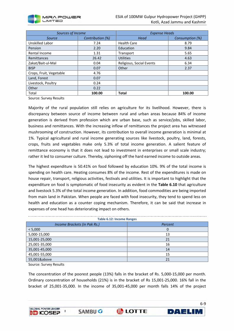
ESIA of 100MW Gulpur Hydropower Project (GHPP)
Kotli, Azad Jammu and Kashmir
6-9
Sources of Income Expense Heads
Source Contribution (%) Head Consumption (%)
Unskilled Labor 7.24 Health Care 8.79
Pension 2.20 Education 9.84
Rental Income 1.31 Transport 5.65
Remittances 26.42 Utilities 4.63
Zakat/Bait-ul-Mal 0.04 Religious, Social Events 6.34
BISP 0.07 Other 2.37
Crops, Fruit, Vegetable 4.76
Land, Forest 0.07
Livestock, Poultry 0.24
Other 0.22
Total 100.00 Total 100.00
Source: Survey Results
Majority of the rural population still relies on agriculture for its livelihood. However, there is
discrepancy between source of income between rural and urban areas because 84% of income
generation is derived from profession which are urban base, such as service/jobs, skilled labor,
business and remittances. With the increasing inflow of remittances the project area has witnessed
mushrooming of construction. However, its contribution to overall income generation is minimal at
1%. Typical agricultural and rural income generating sources like livestock, poultry, land, forests,
crops, fruits and vegetables make only 5.3% of total income generation. A salient feature of
remittance economy is that it does not lead to investment in enterprises or small scale industry;
rather it led to consumer culture. Thereby, siphoning off the hard earned income to outside areas.
The highest expenditure is 50.41% on food followed by education 10%. 9% of the total income is
spending on health care. Heating consumes 8% of the income. Rest of the expenditures is made on
house repair, transport, religious activities, festivals and utilities. It is important to highlight that the
expenditure on food is symptomatic of food insecurity as evident in the Table 6.10 that agriculture
and livestock 5.3% of the total income generation. In addition, food commodities are being imported
from main land in Pakistan. When people are faced with food insecurity, they tend to spend less on
health and education as a counter coping mechanism. Therefore, it can be said that increase in
expenses of one head has deteriorating impact on others.
Table 6.12: Income Ranges
Income Brackets (in Pak Rs.) Percent
< 5,000 0
5,000-15,000 13
15,001-25,000 21
25,001-35,000 16
35,001-45,000 14
45,001-55,000 15
55,001&above 21
Source: Survey Results
The concentration of the poorest people (13%) falls in the bracket of Rs. 5,000-15,000 per month.
Ordinary concentration of households (21%) is in the bracket of Rs 15,001-25,000. 16% fall in the
bracket of 25,001-35,000. In the income of 35,001-45,000 per month falls 14% of the project

ESIA of 100MW Gulpur Hydropower Project (GHPP)
Kotli, Azad Jammu and Kashmir
6-10
population. Those above 45,001 but below 55,000 make 15% of the population, whereas richest
concentration (21%) falls in the income bracket of Rs. 55,000 and above.
If different slots of income are divided between upper and lower incomes by attributing income
35,000 below and above respectively, then the ratio of people with lower and upper income remains
equal. Division of income slots into three categories of lower, middle and higher income provides
another perspective. If people with income of less than 25,000 per month are categorized as poor,
than they make 34% of the total, whereas people with middle income (above 25,000 and below
45,000) form 30% of the total. The remaining with income above 45,000 per month make majority
with 36% of the total. Cumulatively, both categories of middle and highest income make the bulk of
the population which is 66%.
6.8 Education
According to the information received from Department of Education AJK, apart from a campus of
University of Azad Jammu and Kashmir there is one post graduate college for men and 12 degree
colleges for men and women in the district. Total number of colleges in the district are given in Table
6.13.
Table 6.13: Educational Institutions in Kotli
Post Graduate Degree Inter Total
M F M F M F
1 0 6 6 8 11 32
Source: Survey Results and P&D AJK
The number of schools is 1028 according to Directorate of Schools AJK. The highest number of
Primary schools 478, followed by 279 mosque schools and 157 middle schools. Apart from the
government schools there are a number of private schools in the district.
Table 6.14: Schools and Education Facilities in Kotli
Mosque Primary Middle High Higher
Secondary
Indus
School
Village
Work Shop Total
276 478 157 108 6 2 1 1028
Source: Survey Results and P&D AJK
In the project area each settlement has primary level government schools for boys and girls within
an average distance of 2 km. However, the students after passing their middle class and
matriculation have to travel an average of 5 km to reach high schools or colleges in nearby town of
Kotli. For rural settlements the average distance to high schools is 5 to 10 km. The overall literacy in
the project area is as under:
Table 6.15: Literacy Level of Project Area Population
Level Male Female Total
Illiterate 20% 36% 27%
Basic Literacy 7% 2% 5%
Primary 17% 15% 16%
Middle 18% 20% 19%
Metric 21% 18% 19%
Intermediate 12% 7% 10%
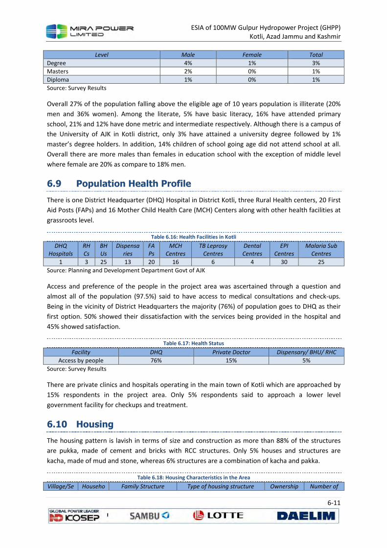
ESIA of 100MW Gulpur Hydropower Project (GHPP)
Kotli, Azad Jammu and Kashmir
6-11
Level Male Female Total
Degree 4% 1% 3%
Masters 2% 0% 1%
Diploma 1% 0% 1%
Source: Survey Results
Overall 27% of the population falling above the eligible age of 10 years population is illiterate (20%
men and 36% women). Among the literate, 5% have basic literacy, 16% have attended primary
school, 21% and 12% have done metric and intermediate respectively. Although there is a campus of
the University of AJK in Kotli district, only 3% have attained a university degree followed by 1%
master’s degree holders. In addition, 14% children of school going age did not attend school at all.
Overall there are more males than females in education school with the exception of middle level
where female are 20% as compare to 18% men.
6.9 Population Health Profile
There is one District Headquarter (DHQ) Hospital in District Kotli, three Rural Health centers, 20 First
Aid Posts (FAPs) and 16 Mother Child Health Care (MCH) Centers along with other health facilities at
grassroots level.
Table 6.16: Health Facilities in Kotli
DHQ
Hospitals
RH
Cs
BH
Us
Dispensa
ries
FA
Ps
MCH
Centres
TB Leprosy
Centres
Dental
Centres
EPI
Centres
Malaria Sub
Centres
1 3 25 13 20 16 6 4 30 25
Source: Planning and Development Department Govt of AJK
Access and preference of the people in the project area was ascertained through a question and
almost all of the population (97.5%) said to have access to medical consultations and check-ups.
Being in the vicinity of District Headquarters the majority (76%) of population goes to DHQ as their
first option. 50% showed their dissatisfaction with the services being provided in the hospital and
45% showed satisfaction.
Table 6.17: Health Status
Facility DHQ Private Doctor Dispensary/ BHU/ RHC
Access by people 76% 15% 5%
Source: Survey Results
There are private clinics and hospitals operating in the main town of Kotli which are approached by
15% respondents in the project area. Only 5% respondents said to approach a lower level
government facility for checkups and treatment.
6.10 Housing
The housing pattern is lavish in terms of size and construction as more than 88% of the structures
are pukka, made of cement and bricks with RCC structures. Only 5% houses and structures are
kacha, made of mud and stone, whereas 6% structures are a combination of kacha and pakka.
Table 6.18: Housing Characteristics in the Area
Village/Se Househo Family Structure Type of housing structure Ownership Number of
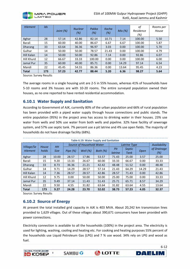
ESIA of 100MW Gulpur Hydropower Project (GHPP)
Kotli, Azad Jammu and Kashmir
6-12
ttlement lds
Joint (%) Nuclear
(%)
Pakka
(%)
Kacha
(%) Mix (%)
of
Residence
(%)
Rooms per
House
Aghar 28 57.14 42.86 82.14 10.71 7.14 100.00 5.50
Barali 15 60.00 40.00 86.67 6.67 6.67 100.00 5.87
Dharang 33 63.64 36.36 96.97 3.03 0.00 100.00 5.70
Gulhar 14 50.00 50.00 78.57 21.43 0.00 100.00 4.79
Hill Kalan 14 50.00 50.00 92.86 7.14 0.00 92.86 6.07
Hill Khurd 12 66.67 33.33 100.00 0.00 0.00 100.00 6.00
Jamal Pur 35 60.00 40.00 85.71 0.00 14.29 97.14 6.54
Mandi 22 45.45 54.55 86.36 0.00 13.64 95.45 4.23
Total 173 57.23 42.77 88.44 5.20 6.36 98.27 5.64
Source: Survey Results
The average rooms in a single housing unit are 2-5 in 55% houses, whereas 41% of households have
5-10 rooms and 3% houses are with 10-20 rooms. The entire surveyed population owned their
houses, as no one reported to have rented residential accommodation.
6.10.1 Water Supply and Sanitation
According to Government of AJK, currently 80% of the urban population and 66% of rural population
has been provided with a piped water supply through house connections and public stands. The
entire population (95%) in the project area has access to drinking water in their houses. 23% use
water from wells and 50% use water from both wells and pipeline. 32% have facility of sewerage
system, and 57% use septic tank. 7% percent use a pit latrine and 4% use open fields. The majority of
households do not have drainage facility (68%).
Table 6.19: Water Supply and Sanitation
Village/Se
ttlement
House
holds
HH
Size
Source of Household Water Latrine Type Availability
of Drainage
(%) Pipe (%) Well (%) Both (%)
Pit
latrine
Septic
Tank Open
Aghar 28 10.00 28.57 17.86 53.57 71.43 25.00 3.57 25.00
Barali 15 9.20 13.33 26.67 60.00 33.33 66.67 0.00 33.33
Dharang 33 8.73 36.36 21.21 42.42 48.48 51.52 0.00 48.48
Gulhar 14 9.71 14.29 28.57 57.14 21.43 64.29 14.29 21.43
Hill Kalan 14 7.36 28.57 28.57 42.86 28.57 71.43 0.00 42.86
Hill Khurd 12 9.75 0.00 50.00 50.00 25.00 75.00 0.00 33.33
Jamal Pur 35 9.49 37.14 11.43 51.43 25.71 65.71 8.57 34.29
Mandi 22 9.50 4.55 31.82 63.64 31.82 63.64 4.55 13.64
Total 173 9.27 24.28 23.70 52.02 38.73 57.23 4.05 32.37
Source: Survey Results
6.10.2 Source of Energy
At present the total installed grid capacity in AJK is 403 MVA. About 20,242 km transmission lines
provided to 1,629 villages. Out of these villages about 390,671 consumers have been provided with
power connections.
Electricity connection is available to all the households (100%) in the project area. The electricity is
used for lighting, washing, cooling and heating etc. For cooking and heating purposes 55% percent of
the households use Liquid Petroleum Gas (LPG) and 7 % use wood. 34% rely on LPG and wood as
fuel.
ESIA of 100MW Gulpur Hydropower Project (GHPP)
Kotli, Azad Jammu and Kashmir
6-13
Table 6.20: Sources of energy for cooking and heating
Energy Source LPG Wood Both
%age 55% 7% 34%
Source: Survey Results
6.11 Gender Issues
The women have no formal role in the authority structure of the nearby villages. They are about 48%
of the population in these villages; the literacy rate for above 10 years of female population is 67%
(80% for males). Apart from schools there are 6 degree colleges and 11 Intermediate colleges in the
whole district for female population. The traditional attitude of not sending the girls to school is
changing now, because the parents understand that the basic education is necessary for each
individual regardless of sex. Most of the women stay at home and only travel outside the village in
case of visiting to shrines, relatives, and going to weddings and hospitals in nearby towns.
• Local women pointed out the following major issues relating to this project activities;
• Working women (school teachers, lady health visitors & others) of the area will feel
uncomfortable for traveling/ mobility during the construction activities;
• The timing of construction activities and local population especially women and children
should be adjusted in view of their routine mobility/ schools timing and working/ jobs
timing;
• Local women mobility will be restricted because of construction activities along the
road.
• Construction should be done as fast as can be because in some emergencies women and
children will have to go hospitals for health care purposes;
• Waiting sheds may be constructed, including provision of drinking water, toilet facilities,
partition in waiting shed for females and males.
6.12 Vulnerable Groups
There is none falling under the category of ultra-poor as all the households have a monthly income
which is above PKR 5,000/- and expenditure accordingly. The high monthly income is because of the
remittance from abroad as every household has a family member or a closed relative working
abroad who support the families and their spouses living in the country.
No household was found to be headed by women or elderly as well as people with disabilities and
handicaps. Every household in the project area owns its own house for residence and there was no
household living in a rented home. All the households have access to basic social infrastructures like
schools, health facilities and roads in the area.
The project will have an overall positive impact on the living conditions of the local people as the
employment opportunities as well as business opportunities would be increased which will be
offered to local people as a priority. Moreover, the project Affected People will be compensated for
loss of their land and non-land assets according to a Land Acquisition and Resettlement Framework
which has been agreed by MPL and local communities. Under this LARF provisions the vulnerable
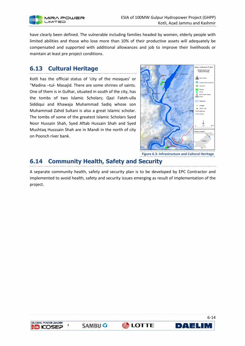
ESIA of 100MW Gulpur Hydropower Project (GHPP)
Kotli, Azad Jammu and Kashmir
6-14
have clearly been defined. The vulnerable including families headed by women, elderly people with
limited abilities and those who lose more than 10% of their productive assets will adequately be
compensated and supported with additional allowances and job to improve their livelihoods or
maintain at least pre project conditions.
6.13 Cultural Heritage
Kotli has the official status of ‘city of the mosques’ or
“Madina –tul- Masajid. There are some shrines of saints.
One of them is in Gulhar, situated in south of the city, has
the tombs of two Islamic Scholars; Qazi Fateh-ulla
Siddiqui and Khawaja Muhammad Sadiq whose son
Muhammad Zahid Sultani is also a great Islamic scholar.
The tombs of some of the greatest Islamic Scholars Syed
Noor Hussain Shah, Syed Aftab Hussain Shah and Syed
Mushtaq Husssain Shah are in Mandi in the north of city
on Poonch river bank.
6.14 Community Health, Safety and Security
A separate community health, safety and security plan is to be developed by EPC Contractor and
implemented to avoid health, safety and security issues emerging as result of implementation of the
project.
Figure 6.3: Infrastructure and Cultural Heritage
ESIA of 100MW Gulpur Hydropower Project (GHPP)
Kotli, Azad Jammu and Kashmir
7-1
7 ANALYSIS OF ALTERNATIVES
Alternatives are essentially, different ways through which the proponent can feasibly achieve
sustainable development by carrying out a different type of actions, choosing design alternatives or
adopting a different technology or design for the Project to create win-win scenario for all
stakeholders. At the more detailed level, alternatives merge into mitigating measure where specific
changes are made to the project design or to methods of construction or operation to avoid, reduce
or remedy environmental effects. All ESIA systems also require developers to consider mitigation
(i.e. measures to avoid, reduce and remedy significant adverse effects).
Alternatives and mitigation, therefore, cover a spectrum ranging from a high level to very detailed
aspects of project design. As an example they might range from:
• different strategies e.g. to manage demand or reduce losses rather than develop a new
resource;
• different sites or routes for all or part of the project;
• different technologies and raw materials e.g. construction of a thermal power plant rather
than a hydro power plant;
• altered layouts or designs e.g. locating noisy activities away from sensitive receptors;
• environmental measures incorporated into the project design e.g. construction of an
ecoduct to ensure safe passage of wildlife across a motorway rather than establishment of
compensatory habitat.
The “No Project” scenario must also be considered as the baseline against which the environmental
effects of the project should be considered. This may include changes from the present day situation
as a result of other developments taking place in the vicinity and changes in environmental
conditions. This section of the report presents the analysis of the alternatives considered for the
proposed project. The following scenarios have been considered:
• No Project Scenario;
• Alternate Methods of Power Generation;
• Alternate Location of the Project;
• Design Alternatives
• Selection of Access Roads & Alignment;
7.1 No Project Scenario
The “No Project” option is least considered option for Pakistan. The country is currently going
through the worse power crisis of the history. Energy crisis is considered as major development
hurdle in Pakistan and has resulted in formulation of the national energy policy in the recent past.
The energy crisis is being given utmost priority at the government level. The acute power shortage in
Pakistan has resulted in massive load shedding in the country hugely deteriorating the economic
development and growth.
ESIA of 100MW Gulpur Hydropower Project (GHPP)
Kotli, Azad Jammu and Kashmir
7-2
An analysis of electricity data for year 2012-13 reveal that the minimum shortfall was 1,141 MW,
while it touched the figured of 6,390 MW at one point in period under consideration. The average
shortfall over the year remained 3,886 MW which is around 26% of the average demand of
electricity during year.
The maximum generation during the year was 14,756 MW which is only 78% of the maximum
demand of electricity. Whereas the minimum generation during the year was 7,345 MW which is
65% of the minimum demand in the same period.
The total generation was 95,364 GWh during year 2011-12, however 2,382 GWh were consumed as
auxiliary load by power plants. As discussed above, this generation represents only 47% capacity
utilization. The extraordinary transmission and distribution losses (around 22%) have added to
catastrophe.
The No Project scenario is considered or adopted it would mean that the already power deficient
economy would suffer even more and at current rate if no power is added to the national grid
Currently, power outages are in the range of 12-14 hours daily for the rural areas and 8-10 hours for
the urban areas, while at the same time the industrial sector is also suffering huge financial losses
due to the power outages. Given the gravity of energy crisis and its repercussion on the economy,
Pakistan cannot afford to deprive itself of a major project of cheap source of electricity.
7.2 Alternate Methods of Power Generation
7.2.1 Electricity Generation Options
There are different options available to generate electricity which include but are not limited to
production using furnace oil, natural gas, coal, solar and hydel.
The root of all the devastation in power industry, other than crowning transmission and distribution
losses, is the unsolicited expensive energy mix. Out of total 22,797 MW installed capacity, only 6,556
MW is Hydel power. The rest of capacity is mostly thermal projects with little contribution of 3%
from nuclear production. Out of total 95,364 GWh produced during year 2011-12, only 30% has
been generated by Hydel resources, 29% has been produced using natural gas while the 35%
generation was dependable on expensive furnace oil. The nuclear energy contributed 5.5%, whereas
a minor part of energy also came through diesel and coal (see Table 7.1).
Average cost of the energy delivered to Discos was PKR 7.11 per kilowatt hour. The average cost of
delivery from furnace oil was PKR. 15.94. While the cost from coal generation came around PKR
3.18, the Hydel generation cost only PKR 0.16 per kilowatt hour (as most of the hydro plants have
already paid their debts and incurring nominal O&M cost).
The government plans to replace the expensive furnace oil projects with coal technology to reduce
the overall cost of production. On the other hand the power policy 2013 is focusing on the control of
inefficiencies in transmission and distribution infrastructure.
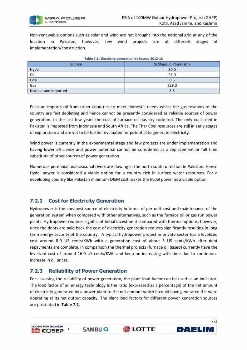
ESIA of 100MW Gulpur Hydropower Project (GHPP)
Kotli, Azad Jammu and Kashmir
7-3
Non-renewable options such as solar and wind are not brought into the national grid at any of the
location in Pakistan, however, few wind projects are at different stages of
implementation/construction.
Table 7.1: Electricity generation by Source 2012-13
Source % Share in Power Mix
Hydel 30.0
Oil 35.0
Coal 0.5
Gas 229.0
Nuclear and Imported 5.5
Pakistan imports oil from other countries to meet domestic needs whilst the gas reserves of the
country are fast depleting and hence cannot be presently considered as reliable sources of power
generation. In the last few years the cost of furnace oil has sky rocketed. The only coal used in
Pakistan is imported from Indonesia and South Africa. The Thar Coal resources are still in early stages
of exploration and are yet to be further evaluated for potential to generate electricity.
Wind power is currently in the experimental stage and few projects are under implementation and
having lower efficiency and power potential cannot be considered as a replacement or full time
substitute of other sources of power generation.
Numerous perennial and seasonal rivers are flowing in the north south direction in Pakistan. Hence
Hydel power is considered a viable option for a country rich in surface water resources. For a
developing country like Pakistan minimum O&M cost makes the hydel power as a viable option.
7.2.2 Cost for Electricity Generation
Hydropower is the cheapest source of electricity in terms of per unit cost and maintenance of the
generation system when compared with other alternatives, such as the furnace oil or gas run power
plants. Hydropower requires significant initial investment compared with thermal options, however,
once the debts are paid back the cost of electricity generation reduces significantly resulting in long
term energy security of the country. A typical hydropower project in private sector has a levelized
cost around 8-9 US cents/KWh with a generation cost of about 3 US cents/KWh after debt
repayments are complete. In comparison the thermal projects (furnace oil based) currently have the
levelized cost of around 16.0 US cents/KWh and keep on increasing with time due to continuous
increase in oil prices.
7.2.3 Reliability of Power Generation
For assessing the reliability of power generation, the plant load factor can be used as an indicator.
The load factor of an energy technology is the ratio (expressed as a percentage) of the net amount
of electricity generated by a power plant to the net amount which it could have generated if it were
operating at its net output capacity. The plant load factors for different power generation sources
are presented in Table 7.2.
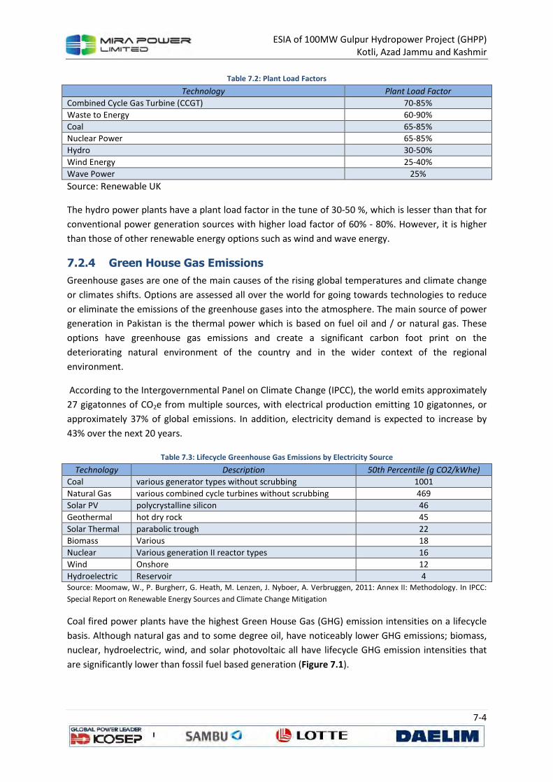
ESIA of 100MW Gulpur Hydropower Project (GHPP)
Kotli, Azad Jammu and Kashmir
7-4
Table 7.2: Plant Load Factors
Technology Plant Load Factor
Combined Cycle Gas Turbine (CCGT) 70-85%
Waste to Energy 60-90%
Coal 65-85%
Nuclear Power 65-85%
Hydro 30-50%
Wind Energy 25-40%
Wave Power 25%
Source: Renewable UK
The hydro power plants have a plant load factor in the tune of 30-50 %, which is lesser than that for
conventional power generation sources with higher load factor of 60% - 80%. However, it is higher
than those of other renewable energy options such as wind and wave energy.
7.2.4 Green House Gas Emissions
Greenhouse gases are one of the main causes of the rising global temperatures and climate change
or climates shifts. Options are assessed all over the world for going towards technologies to reduce
or eliminate the emissions of the greenhouse gases into the atmosphere. The main source of power
generation in Pakistan is the thermal power which is based on fuel oil and / or natural gas. These
options have greenhouse gas emissions and create a significant carbon foot print on the
deteriorating natural environment of the country and in the wider context of the regional
environment.
According to the Intergovernmental Panel on Climate Change (IPCC), the world emits approximately
27 gigatonnes of CO2e from multiple sources, with electrical production emitting 10 gigatonnes, or
approximately 37% of global emissions. In addition, electricity demand is expected to increase by
43% over the next 20 years.
Table 7.3: Lifecycle Greenhouse Gas Emissions by Electricity Source
Technology Description 50th Percentile (g CO2/kWhe)
Coal various generator types without scrubbing 1001
Natural Gas various combined cycle turbines without scrubbing 469
Solar PV polycrystalline silicon 46
Geothermal hot dry rock 45
Solar Thermal parabolic trough 22
Biomass Various 18
Nuclear Various generation II reactor types 16
Wind Onshore 12
Hydroelectric Reservoir 4 Source: Moomaw, W., P. Burgherr, G. Heath, M. Lenzen, J. Nyboer, A. Verbruggen, 2011: Annex II: Methodology. In IPCC:
Special Report on Renewable Energy Sources and Climate Change Mitigation
Coal fired power plants have the highest Green House Gas (GHG) emission intensities on a lifecycle
basis. Although natural gas and to some degree oil, have noticeably lower GHG emissions; biomass,
nuclear, hydroelectric, wind, and solar photovoltaic all have lifecycle GHG emission intensities that
are significantly lower than fossil fuel based generation (Figure 7.1).
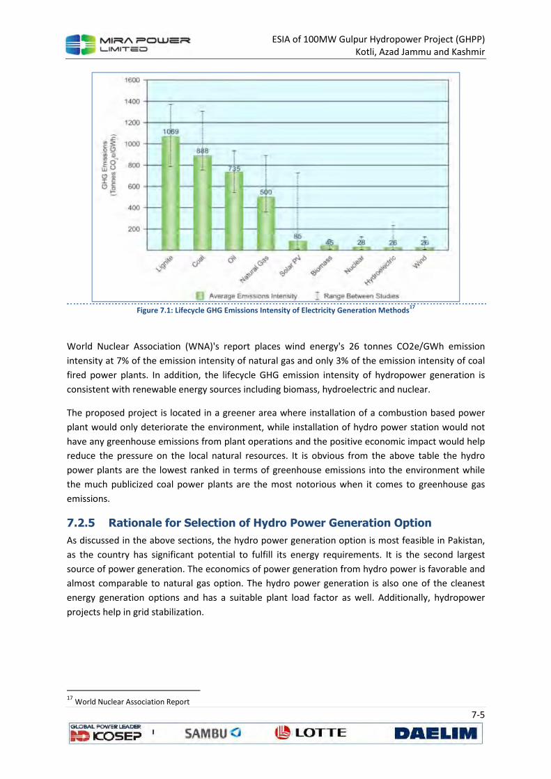
ESIA of 100MW Gulpur Hydropower Project (GHPP)
Kotli, Azad Jammu and Kashmir
7-5
Figure 7.1: Lifecycle GHG Emissions Intensity of Electricity Generation Methods
17
World Nuclear Association (WNA)'s report places wind energy's 26 tonnes CO2e/GWh emission
intensity at 7% of the emission intensity of natural gas and only 3% of the emission intensity of coal
fired power plants. In addition, the lifecycle GHG emission intensity of hydropower generation is
consistent with renewable energy sources including biomass, hydroelectric and nuclear.
The proposed project is located in a greener area where installation of a combustion based power
plant would only deteriorate the environment, while installation of hydro power station would not
have any greenhouse emissions from plant operations and the positive economic impact would help
reduce the pressure on the local natural resources. It is obvious from the above table the hydro
power plants are the lowest ranked in terms of greenhouse emissions into the environment while
the much publicized coal power plants are the most notorious when it comes to greenhouse gas
emissions.
7.2.5 Rationale for Selection of Hydro Power Generation Option
As discussed in the above sections, the hydro power generation option is most feasible in Pakistan,
as the country has significant potential to fulfill its energy requirements. It is the second largest
source of power generation. The economics of power generation from hydro power is favorable and
almost comparable to natural gas option. The hydro power generation is also one of the cleanest
energy generation options and has a suitable plant load factor as well. Additionally, hydropower
projects help in grid stabilization.
17
World Nuclear Association Report
ESIA of 100MW Gulpur Hydropower Project (GHPP)
Kotli, Azad Jammu and Kashmir
7-6
7.3 Alternate Location for the Project
The Gulpur Hydropower Project (GHPP) was first identified by GTZ/HEPO-WAPDA and presented in
their report “Comprehensive Planning of Hydropower Resources in Jhelum River Basin – Medium
Hydropower Projects in Poonch River Catchment”, Lahore – July 1992.
The study by GTZ/HEPO-WAPDA had identified following five locations for developing hydropower
potential in the Poonch River catchment:
1. Rajdhani Dam (10 Km from the end of Mangla Reservoir)
2. Gulpur Dam (28 Km from the end of Mangla Reservoir)
3. Barali Dam (37 Km from the end of Mangla Reservoir)
4. Kotli Dam (47 Km from the end of Mangla Reservoir)
5. Sehra Dam (67 Km from the end of Mangla Reservoir)
The possible Poonch River development, as suggested by GTZ-WAPDA, was to be carried out in two
main combinations. Combination-A comprised four sites, which include Sehra, Kotli, Barali and
Rajdhani dam sites whereas Combination-B consisted of three sites namely Sehra, Kotli and Gulpur
dam sites. GTZ proposed a 90 m high concrete gravity dam at Gulpur with an installed capacity of
116 MW; annual energy of project was estimated about 702 GWh.
AJK Hydroelectric Board in 1996 decided to get the previous studies reviewed and confirmed and
thus hired the services of the Korean consultants who made a field reconnaissance of the four sites
identified in the above-mentioned GTZ/HEPO-WAPDA report. After studying these sites, Koreans
identified a new site, which is located near Gulpur Village approximately 7 Km downstream of the
Barali dam site identified by GTZ/HEPO-WAPDA and at 18 Km downstream of Kotli city. Considering
its location, the Koreans have given this site the name of “Gulpur Hydroelectric Project” which is
obviously different from the Gulpur site identified by GTZ/HEPO-WAPDA. At this site, Korean
suggested a 57 m high concrete gravity dam with an installed capacity of 60 MW; annual energy of
project was estimated about 348 GWh. This site was assigned to the Consultants for the Feasibility
Study.
During the initial stages of the feasibility study, it was noticed that the reservoir level (El 475 m) of
proposed Rajdhani Hydropower Project would submerge the Gulpur site identified by the Korean.
After detailed survey of the river and discussion with AJK HEB, the site was shifted to an upstream
location above the reservoir level of Rajdhani Hydropower Project.
During Conceptual Stage, several locations were examined to find a suitable site where a high
storage dam could be built to maximize the power potential. The finally recommended site was
designated as Axis F-F. Project was conceived as of 120 MW installed capacity. The annual energy of
the Project was estimated at about 640 GWh, which was to be produced with the help of an 80 m
high Roller Compacted Concrete dam through an underground powerhouse to be located in the
right bank.
ESIA of 100MW Gulpur Hydropower Project (GHPP)
Kotli, Azad Jammu and Kashmir
7-7
After considering various design alternatives (as explained below in Section 1.4) the final site
location will ensure that the Kotli and Rajdhani Dam can also be constructed along with the Gulpur
Dam. To ensure the natural and social environment are not disturbed numerous tweak in the design
are included.
7.4 Design Alternatives
It is a general practice all over the world for dam engineering that reservoir rim periphery has to be
closed either through natural contours at dam crest elevation or by constructing a man-made
structures to avoid resettlement areas. Man-made structure can be earthen dyke, Roller Compacted
Concrete Embankment, Concrete retaining walls etc.
During the finalization of the feasibility study of the Project Consultants initially recommended the
normal operating level (NOL) of reservoir at El. 550 m. The Project layout involved submergence of
about 646 houses and 1800 acres of inhabited area affecting nearly 5,000 people.
However, in an effort to reduce the environmental and social impacts through limiting the
submergence of populated area by reservoir waters were further explored by the consultants upon
the requirement of proponent. It was concluded that dislocating and rehabilitation of the
inhabitants of the area would be problematic and require heavy expenditure with associated social
issues. It was found that submergence can be avoided, if the normal operating level (NOL) of
reservoir is lowered from El. 550 m to El. 540 m. The lowering of NOL does not affect the technical
viability of the Project.
Following three options described below were studied in the aforesaid context:
• Option 1: It is based on the earlier concept where a 75m high dam with NOL at El. 550 m and
an underground powerhouse was proposed.
• Option 2: This is essentially Option-1 but with a reduced dam height of 60 m and NOL at El.
535 m. In this option, submergence of villages will be avoided.
• Option 3: This option is based on the concept wherein the head is partly created by a weir
and partly by a tunnel utilizing the steep gradient of the river. The Project works consist: a 30
m high weir-cum-spillway to maintain the reservoir level at El. 540 m, an intake structure in
the Nullah to divert river flows through a 3.04 km long power tunnel, a surge shaft, steel
penstock and a surface powerhouse at the end of the tunnel.
Following the selection of Option 3 as the most viable option, further design optimization and
studies were based on such option under which maximum reservoir level was fixed at El. 540.0 m to
avoid submergence of surrounding villages and Project was conceived as run-of river with small
storage.
Option 3 has advantageous in respect of the following crucial aspects:
Significant reduction is resettlement which is further reduced by exercising the option of
construction earthen dyke is the resettled areas;
• Significant saving in rehabilitation cost
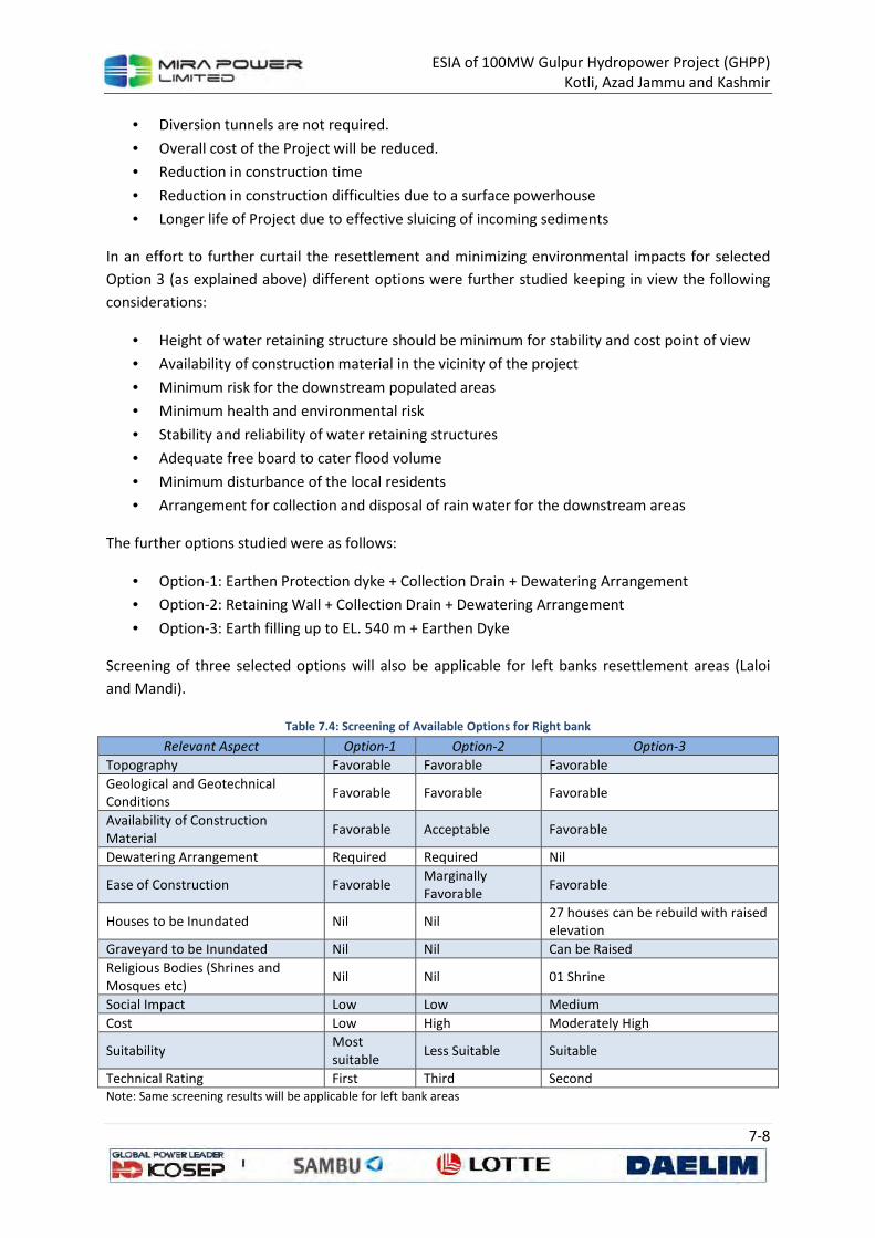
ESIA of 100MW Gulpur Hydropower Project (GHPP)
Kotli, Azad Jammu and Kashmir
7-8
• Diversion tunnels are not required.
• Overall cost of the Project will be reduced.
• Reduction in construction time
• Reduction in construction difficulties due to a surface powerhouse
• Longer life of Project due to effective sluicing of incoming sediments
In an effort to further curtail the resettlement and minimizing environmental impacts for selected
Option 3 (as explained above) different options were further studied keeping in view the following
considerations:
• Height of water retaining structure should be minimum for stability and cost point of view
• Availability of construction material in the vicinity of the project
• Minimum risk for the downstream populated areas
• Minimum health and environmental risk
• Stability and reliability of water retaining structures
• Adequate free board to cater flood volume
• Minimum disturbance of the local residents
• Arrangement for collection and disposal of rain water for the downstream areas
The further options studied were as follows:
• Option-1: Earthen Protection dyke + Collection Drain + Dewatering Arrangement
• Option-2: Retaining Wall + Collection Drain + Dewatering Arrangement
• Option-3: Earth filling up to EL. 540 m + Earthen Dyke
Screening of three selected options will also be applicable for left banks resettlement areas (Laloi
and Mandi).
Table 7.4: Screening of Available Options for Right bank
Relevant Aspect Option-1 Option-2 Option-3
Topography Favorable Favorable Favorable
Geological and Geotechnical Conditions
Favorable Favorable Favorable
Availability of Construction Material
Favorable Acceptable Favorable
Dewatering Arrangement Required Required Nil
Ease of Construction Favorable Marginally Favorable
Favorable
Houses to be Inundated Nil Nil 27 houses can be rebuild with raised elevation
Graveyard to be Inundated Nil Nil Can be Raised
Religious Bodies (Shrines and Mosques etc)
Nil Nil 01 Shrine
Social Impact Low Low Medium
Cost Low High Moderately High
Suitability Most suitable
Less Suitable Suitable
Technical Rating First Third Second Note: Same screening results will be applicable for left bank areas
ESIA of 100MW Gulpur Hydropower Project (GHPP)
Kotli, Azad Jammu and Kashmir
7-9
Conclusions drawn from the above comparison are as follows:
1. Option-1 is considered most suitable to the site specific conditions and thus is technically
rated as the first choice.
2. Option-2 is considered also suitable to the site specific conditions and is technically rated as
the third choice.
3. Option-3 is considered marginally suitable to the site specific conditions and thus is
technically rated as the second choice.
7.4.1 Option-1: Earthen Dyke with Collection Drain and Dewatering
7.4.1.1 For Right Bank Area
Further optimization of Option-1 has been carried out to arrive at most optimum solution with
respect to cost of land acquisition, resettlement and compensation. Main criteria for this
optimization were kept to reduce the cost of earthen dyke by reducing the length and height of
earthen dyke, which should be compared with the cost of resettlement to arrive at the most
optimum solution. Six scenarios of option-1 were plotted as conceptual layouts Figure 7.2.
Table 7.5 shows that with the reduction of dyke length by shifting it towards the uphill, cost for dyke
and other arrangement reduces. However, cost for resettlement, land acquisition and compensation
will increase.
7.4.1.2 For Left Bank Laloi Area
In Laloi area, total 10.48 acre land at EL. 542 m and 20 houses will be inundated, if no engineering
solution is provided for resettlement curtailment. With earthen protection dyke and associated
arrangement, land and houses can be saved for resettlement and compensation. Conceptual layout
and cross section of proposed engineering solution of earthen dyke and collection drain is shown in
Figure 7.2 along with tabular details.
7.4.1.3 For Left Bank Mani Area
In Mandi area, total 17.70 acre land at EL. 542 m, one shrine, one mosque, few rooms and private
crusher plant will need to be displaced or relocated, if no engineering solution is provided for
resettlement curtailment. With earthen protection dyke and collection drain, these structures can be
saved for resettlement and compensation. In this area most important structure is shrine. Actual
shrine has already been submerged in the river. Therefore, keeping in view the emotional and
religious affiliation of locals with the symbolic Shrine, it can be relocated at some higher elevation of
same area.
Conceptual layout for proposed engineering solution of earthen dyke and collection drain is shown
in Figure 7.2 along with Table 7.5.

ESIA of 100MW Gulpur Hydropower Project (GHPP)
Kotli, Azad Jammu and Kashmir
7-10
Table 7.5: Optimization of Option 1
Relevant Aspect Embankment Alignment Options
R 1 R 2 R 3 R 4 R 5 R 6
Length of Dyke or Retaining Wall (m) 1237 1150 1021 918 777 300
*Avg. Height (m) 7.3 6.8 6.4 5.8 5.4 5.6
Area to be Inundated (Acre) 31.7 32.79 42.65 50.22 58.77 94.09 (KDA)
Houses to be Inundated Nil 3 5 11 24 78
Area of graveyard to be inundated (Acre)
Total 4.12 Nil Nil 1.2 3 4 4.12
Other Structures (Rooms/Shrines/School) Nil Nil Nil 0/1/0 0/1/0 1/3/2001
Social Impact Low > > > > High
Cost High > > > > Low
Suitability Most
Suitable Suitable
Less Suitable
Technical Rating First Second Third Fourth Fifth Sixth *Crest of dykes (earthen embankment) is kept at EL. 545 m in accordance with main dam crest of EL. 545 m given in the
basic design report of the Gulpur Hydropower Project
7.4.2 Option-2: Concrete Retaining Wall with Collection Drain and
Very high cost was anticipated for dewatering arrangement in this option, therefore further working
and development of conceptual layouts and cross-sections have not been developed. However,
conceptual layout will generally be the same as of Option-1.
7.4.3 Option-3: Earthen Filling with Earthen Dyke and Collection Drain
In this option, area of about 54.44 acres up to EL 540.25 m has to be filled with common material
along with construction of earthen dyke up to EL. 545 m and collection drain. Run-off water will be
discharged into the lake at Normal Operation Level (NOL) of EL. 540 m through concrete outlet
structures and flap valves. During detailed studies, if reveals, one collection drain at EL. 542 m will be
provided to drain the catchment run-off into the lake. Pros and cons of this option are as follow:
• Pros:
o No pumping is required for dewatering
o No land acquisition is required, same land after raising to higher elevation of 545.25
m (average thickness of filling =1.5 to 2 m) will be used for cultivation.
o Only 16 houses will need to be either shifted or re-build at the same location
o Operation and maintenance cost is negligible
• Cons:
o High Cost
o Shifting of 16 houses
In this option, collection drain may be required, if hydrological studies confirm this. Conceptual
layout of Option-3 for the left and right bank resettlement curtailment is shown as Figure 7.3.
7.4.3.1 For Left Bank Laloi Area
In Laloi area, total 5.70 acre land at EL. 540.25 m will need to be filled with common material, for
which 27 houses will be either displaced to save location or re-build at same location at higher
elevation. Apparently, it seems that cost for earth filling along with cost of resettlement and
compensation will be much higher than Option-1 as described above.
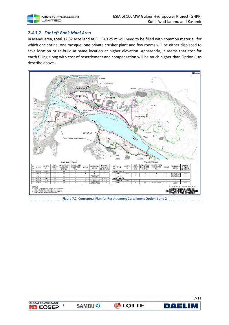
ESIA of 100MW Gulpur Hydropower Project (GHPP)
Kotli, Azad Jammu and Kashmir
7-11
7.4.3.2 For Left Bank Mani Area
In Mandi area, total 12.82 acre land at EL. 540.25 m will need to be filled with common material, for
which one shrine, one mosque, one private crusher plant and few rooms will be either displaced to
save location or re-build at same location at higher elevation. Apparently, it seems that cost for
earth filling along with cost of resettlement and compensation will be much higher than Option-1 as
describe above.
Figure 7.2: Conceptual Plan for Resettlement Curtailment Option 1 and 2
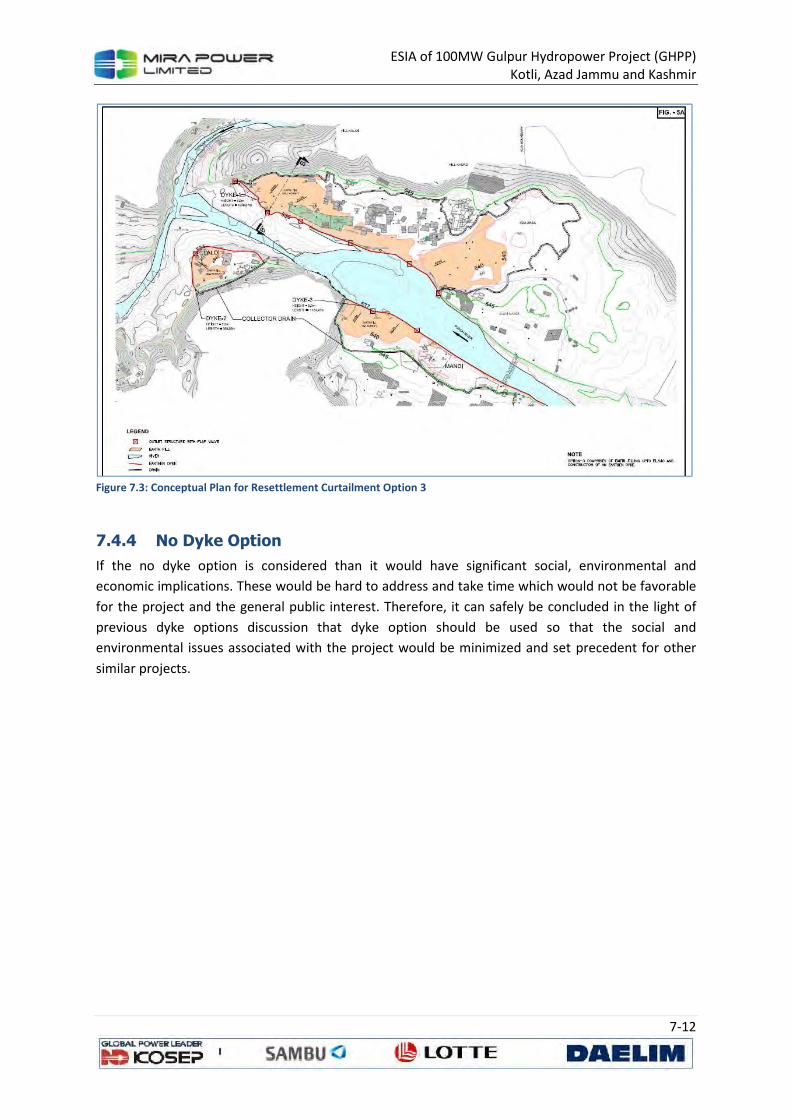
ESIA of 100MW Gulpur Hydropower Project (GHPP)
Kotli, Azad Jammu and Kashmir
7-12
Figure 7.3: Conceptual Plan for Resettlement Curtailment Option 3
7.4.4 No Dyke Option
If the no dyke option is considered than it would have significant social, environmental and
economic implications. These would be hard to address and take time which would not be favorable
for the project and the general public interest. Therefore, it can safely be concluded in the light of
previous dyke options discussion that dyke option should be used so that the social and
environmental issues associated with the project would be minimized and set precedent for other
similar projects.
ESIA of 100MW Gulpur Hydropower Project (GHPP)
Kotli, Azad Jammu and Kashmir
8-1
8 STAKEHOLDER CONSULTATIONS
8.1 General
This section describes the outcomes of the stakeholder consultation process as part of the ESIA. This
ensures that feedback from communities and other stakeholders directly or indirectly affected by
the project is collected so that it may be used to adjust and improve the project’s design, planning,
implementation and help structure ensuring that the project is both environmentally and socially
sound. The consultation process was carried out in accordance with the requirements of the ADB
and IFC and Government of AJK on public consultation.
The objectives of this process were:
• To disseminate information on the project and its expected impact, long-term as well as
short-term, among primary and secondary stakeholders,
• To gather information on relevant issues so that the feedback received could be used to
address these issues at an early stage,
• To determine the extent of the negative impacts of different project activities and suggest
appropriate mitigation measures.
8.2 Identification of Stakeholders
There are two types of stakeholders, i.e.
8.2.1 Primary stakeholders.
The primary stakeholders are the initial stakeholders, such as affected persons, general public and
women residing in the project area. Accordingly, the consultations/ focus group discussions were
made with all above primary stakeholders for sharing of information about the proposed project and
expected impacts and understanding about the concerns by category of stakeholders.
8.2.2 Secondary stakeholders
The secondary stakeholders are the representatives of Government Departments/Agencies involved
in the planning, design, implementation and operation of the project, including various government
departments such as District Administration, Revenue Department, WAPDA, Agriculture including
the Horticulture wing, Irrigation, Forest, PWD and other relevant departments.
8.3 Stakeholder Consultation Process
The overall strategy for stakeholder’s consultation is as follows:
Table 8.1: Process of stakeholder’s consultations
Stakeholders Purpose of consultations Methodology Stage
Primary Stakeholders
• Information gathering and data
collection.
• Information sharing about the project
(disclosure)
• FGDs
• Household surveys
• Formal and informal
Community meetings
• Base line
study
• Impact
assessment
ESIA of 100MW Gulpur Hydropower Project (GHPP)
Kotli, Azad Jammu and Kashmir
8-2
Stakeholders Purpose of consultations Methodology Stage
• Opinion seeking (concerns and expectations) • Grievance redress • Involvement of PAPs
• Inventory of Losses • Price fixation Discloser
Secondary Stakeholders
• Participation in the process • Information gathering • Authentication and validation of the processes verification of the record
• One on one meetings • In-depth interviews • Group meetings
• On need basis
Stakeholder consultation for this project was planned in two stages. The first stage was scoping,
which has already taken place, consisted of meetings with individuals, groups, relevant organizations
and government departments, which are in some way linked to the project and therefore considered
stakeholders. The meetings were conducted to inform stakeholders about the project and how it
may affect their lives/activities, and to record their concerns, whether real or perceived. Through the
use of various tools the study team tried to involve the stakeholders in active decision-making. The
results of this exercise are described below, where mitigation measures have been developed
addressing the pertinent stakeholder concerns.
The second stage of the stakeholders’ consultation was part of the separate study conducted for the
preparation land acquisition and resettlement framework of the project. The results of this study
and the proposed mitigation measures for potential social impacts will be documented separately
and will be included in the overall framework of the proposed project.
8.4 Primary Stakeholders Consultation
Apart from gathering of quantitative data through household survey of the area of influence of the
project and 100% survey of project affected people a total of 16 consultations (qualitative) were
conducted with the affected persons and other local community to share the information about the
project and record their concerns/ feedback associated with this project. In this context, APs shared
their view point regarding the assessment especially price assessment, method of payment of
compensation and procedure for entering their concerns/ grievances. A list of public consultations is
presented in the below table:
Table 8.2: List of Primary Stakeholder’s Consultations in the Project Area
No Date Location/Venue Name of Main Participants
1 21-06-2013 Hill Khurd
- Mr. Zulfiqar Hussain Shan - Mr. Adil Shah - Mr. Khalid Mehmood - Mr. Muhammad Hussain
2 22-06-2013 Hill Khurd
- Mr. Muhammad Dad - Mr. Talib Shah - Mr. Sadar Sharif - Mr. Mushtaq Shan - Mr. Yaqoob Shan - Mr. Sardar Azeem
ESIA of 100MW Gulpur Hydropower Project (GHPP)
Kotli, Azad Jammu and Kashmir
8-3
No Date Location/Venue Name of Main Participants
3 24-06-2013 Hill Khurd
- Mr. Sobidar Javed
- Mr. Ahmed Shah
- Mr. Abid Shah
- Mr. Rehmat Shah
- Mr. Sardar Shah
- Mr. Anwar Shah
4 25-06-2013 Hill Kalan
- Mr. Mohammad Khan
- Mr. Mohammad Shafiq
- Mr. Mohammad Shakeel
- Mr. Talib Hussain
- Mr. Khadim Hussain
- Chaudhray Azam
5 26-06-2013 Hill Kalan
- Mr. Mohammad Hussain
- Chaudhry Fazal
- Mr. Abdul Rehman
- Mr. Khadim Hussain Shah
- Chaudhry Talib
- Mr. Shafiq & others
6 27-06-2013 Hill Kalan
- Mr. Wazir Batt
- Mr. Akram Batt
- Mirza Bashrat
- Mr. Rehmatullah Batt
- Mr. Farqan Batt
- Mr. Mohammad Idress Batt
7 30-06-2013 Laloi
- Chaudhry Lal
- Mr. Abdul Majeed
- Mr. Abdul Haneef
- Mr. Abdul Hafeez
- Mr. Abdul Azeem
8 1-07-2013 Laloi
- Mr. Abdurashid
- Mr. M Riasat
- Mr. Abdul Qayyum
- Mr. Abdul Latif
9 2-07-2013 Laloi
- Mr. Aurangzeb
- Mr. M Azam
- Mr. M Mushtaq
10 4-07-2013 Laloi
- Mr. Atif Mushtaq
- Mr. M Azam
- Mr. M Ashi
11 5-07-2013 Banar - Mr. Sadiq Mehmood
12 7-07-2013 Rehmani Muhallah
- Mr. Mehboob Ali
- Mr. Abid Ali
- Mr. Sajid Ali
- Mr. M Younis
13 9-07-2013 Noshki - Mian Abdul Rehman
- Mr. Ghulam
14 30-06- 2013 Hill Kalan /Hill Khurd
- Gultraz Bukhari
- Khadim Hussain
- Syed Zahoor
- Syed Kazim Hussain
- Syed Zulfiqar
- M. Atif
ESIA of 100MW Gulpur Hydropower Project (GHPP)
Kotli, Azad Jammu and Kashmir
8-4
No Date Location/Venue Name of Main Participants
15 29-06-2013 Dharang/Jamal Pur
- Akarak Ali
- Raja Maqsood
- Shahid Javed
- Shehryaar Sabir
- Sahid Javed
- Rashid
16 28-06-2013 Barali
- Abdul Rehman
- Qamar Zaman
- M. Saleem
- Syed Naseem Hussain
- Muhammad Akarm
- Khalid Rashid
- Qurashi
- Iftikhar Ahmed
- M. Khalid
8.4.1 Topics for Discussion
The topics discussed in the consultations were
• Land acquisition and resettlement issues.
• Employment and livelihoods of communities.
• Gender and women issues
• Contractor’s camp and access
• Environmental issues
8.4.2 Outcomes of Consultations
• All actions associated with the project should be taken through proper consultations
• There should be a continuous community consultation program throughout the project
implementation period.
• There should be employment opportunities for skilled and unskilled local people, preference
should be given to the project affected persons.
• Vocation training/ educations needs to be provided to local women, so that they could be
able to support their families by supplementing their household income.
• Electricity and irrigation water and electric tube wells are needed for the increased
productions of crops.
• To include local people wherever possible in jobs during the construction of project. Thus,
income generating activity of the area will be enhanced.
• Chances of some environmental effects like noise/ vibration and dust emissions to the
nearby community.
• A large number of women are involved in working in agriculture fields, so that their routine
activities should not be disturbed.
• No major effect on land or crop will occur if the project is implemented after crop harvest.
• Overall the project is good for the villagers and the country.
• No serious concerns with the project because this project will increase the employment and
will reduce the load shedding issue of the country.
ESIA of 100MW Gulpur Hydropower Project (GHPP)
Kotli, Azad Jammu and Kashmir
8-5
8.4.3 Consultation Teams
There were 8 members team including two female enumerators for household surveys. A PRA
Specialist conducted the Focused Group Discussions (FGDs) with stakeholders, whereas an EIA
specialist supported by a field assistant conducted interviews and meetings with government
functionaries.
8.4.4 Future Consultations
The consultations will be continued with all stakeholders and especially with government regulatory
agencies like EPA, AJK and Deputy Commissioner, Kotli. A mechanism for consultations with local
communities is part of the LARP.
8.5 Land Acquisition and Resettlement–Related Concerns
The following issues and concerns were showed by the stakeholders regarding land acquisition and
resettlement.
• Compensation for loss due to the project should be provided based on market rates.
• Crops compensation should also be given in addition to land compensation
• Compensation of trees should also be given.
• There should be transparent and fair compensation methods/ procedures, so that the
entitled person could receive his payment.
• The most affected people in Hill Kalan and Hillahurd demanded that compensation of their
land/houses be provided on good market price and as the construction material
transportation cost for these villages is too high. The access is only through boat or lift
system and there is no any access road that can be used for material transportation in bulk.
• Moreover, the people in these areas are demanding that they must be provided same basic
facilities on alternate site where they may be shifted or settled.
• The market price of land in Banar village was very high. Therefore, APs demanded
compensation according to the current market rates.
8.6 Addressing Stakeholders Concerns
To address the issues and concerns raised by the stakeholders a mitigation plan has been developed
and made part of the ESIA.
8.7 Meetings with Secondary Stakeholders
The following stakeholders were consulted on different occasions to seek their inputs, feedback and
opinion on the design and scope of the project. The offices and Individuals who were consulted are
as follows:
i. Office of Deputy Commissioner Kotli
ii. Environment Protection Agency, AJK
iii. Chief Conservator Forests AJK
iv. Director Wildlife and Fisheries
v. Deputy director Wildlife and Fisheries AJK

ESIA of 100MW Gulpur Hydropower Project (GHPP)
Kotli, Azad Jammu and Kashmir
8-6
vi. AJK Rural Support Programme Kotli.
vii. World Wildlife Fund Pakistan (WWF-P)
viii. Leadership for Environment and Development Pakistan
ix. Pakistan Museum of Nature History
x. Snow Leopard Foundation Pakistan
The stakeholders supported the Gulpur Hydro Power project provided that environmental and issues
are addressed through mitigation measures. To address the issues an ESIA and Land Acquisition and
Resettlement Plan (LARP) are developed and shared with stakeholders for their feedback and
suggestions.
ESIA of 100MW Gulpur Hydropower Project (GHPP)
Kotli, Azad Jammu and Kashmir
9-1
9 IMPACT ASSESSMENT AND MITIGATION
This chapter discusses in detail any of the potential environmental and social impacts that may be
resultant of the project activities (Section 3) in the surrounding environment (Section 4 to 6) of the
project area.
An overview of the general approach for the impact assessment is discussed below so that it is not
repeated in each environmental component. In case, where specific mitigation measures have been
provided for an environmental component these are presented in the relevant section with
supplementary information.
9.1 Impact Assessment Methodology
9.1.1 Project Area
The project area is the site of the proposed project and the area of probable impact as the extent of
the area outside the project area that is likely to be directly or indirectly impacted by the proposed
project is been considered see Section 7.
9.1.2 Establishment of the Existing Environment
The baseline condition is the environmental conditions that would lie in the absence of the
construction and operation of the Project, and against which the potential environmental impacts of
the Project would be assessed. For the majority of the technical studies the baseline is the conditions
at the present time. Baseline information for the ESIA has been collected from published literatures,
desk studies, consultations with relevant stakeholders and data collected for this study during field
surveys.
9.1.3 Prediction / Evaluation of Impacts
The prediction and evaluation of impacts of the Project has been considered against the baseline in
the ESIA. The following impacts have been considered:
• Direct impacts – a primary impact of the Project.
• Indirect impacts – impacts that arise from activities not explicitly forming part of the Project.
• Permanent impacts – impacts that arise from an irreversible change to the baseline
environment or which persist for the foreseeable future.
• Temporary impacts – impacts that persist for a limited period only or can be reversible.
Where possible these will be classified as temporary, short-term, medium-term or long-
term.
Each of the environmental impact will be categorized in to the:
• Beneficial impacts – impacts that have a beneficial influence on environmental receptors
and resources.
• Adverse impacts – impacts that have an adverse influence on environmental receptors and
resources
ESIA of 100MW Gulpur Hydropower Project (GHPP)
Kotli, Azad Jammu and Kashmir
9-2
The impacts that will be evaluated to be beneficial will be further enhanced to benefit the
environment while those having adverse impact will be mitigated by proposing the required
mitigation measures.
9.1.3.1 Impact Evaluation and Description
Environmental impacts have been and will continue to be considered, eliminated or reduced
throughout the lifecycle of the Project. For the ESIA process Impact evaluation has been carried out
in compliance with the national and international legal requirements and guidelines. These
documents use various types of tools in an attempt to define a comprehensive and consistent
method to capture all potential impacts of a proposed Project.
A uniform system of impact description is used to enable the reviewers to understand how impacts
have been interpreted. The description of each impact will have the following features:
• A definition of the impact using an impact statement;
• The impact statement clearly identifying the project activity or activities that causes the
impact, the pathway or the environmental parameter that is changed by the activity, and the
potential receptors of the impact;
• Establishing the sensitivity of the receiving environment or receptors;
• Based on the stakeholder consultations undertaken, outlining of the level of public concern
regarding the specific impact;
• Rating of the significance of the impact;
• Description of the mitigation and management measures and the effectiveness of proposed
measures; and
• Characterization of the level of uncertainty in the impact assessment.
The significance of an impact is determined based on the product of the consequence of the impact
and the probability of its occurrence. The consequence of an impact, in turn, is a function primarily
of three impact characteristics: magnitude; spatial scale; and duration.
Magnitude is determined from quantitative or qualitative evaluation of a number of criteria
discussed further below. Where relevant, this includes comparison with standards or thresholds.
Examples of thresholds include:
• legal thresholds—established by law or regulation;
• functional thresholds—if exceeded, the impacts will disrupt the functioning of an ecosystem
sufficiently to destroy resources important to the nation or biosphere irreversibly and/or
irretrievably;
• normative thresholds—established by social norms, usually at the local or regional level and
often tied to social or economic concerns;
• preference thresholds—preferences for individuals, groups or organizations only, as distinct
from society at large; and
• reputational thresholds—the level of risk a company is willing to take when approaching or
exceeding the above thresholds.
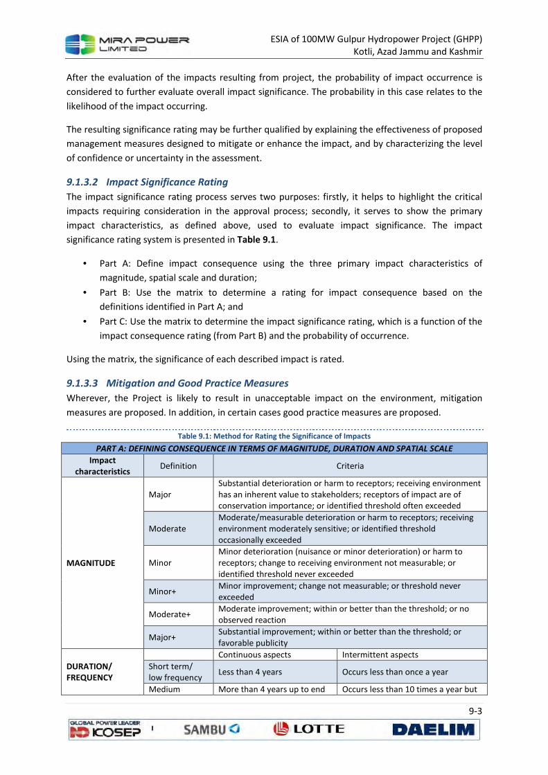
ESIA of 100MW Gulpur Hydropower Project (GHPP)
Kotli, Azad Jammu and Kashmir
9-3
After the evaluation of the impacts resulting from project, the probability of impact occurrence is
considered to further evaluate overall impact significance. The probability in this case relates to the
likelihood of the impact occurring.
The resulting significance rating may be further qualified by explaining the effectiveness of proposed
management measures designed to mitigate or enhance the impact, and by characterizing the level
of confidence or uncertainty in the assessment.
9.1.3.2 Impact Significance Rating
The impact significance rating process serves two purposes: firstly, it helps to highlight the critical
impacts requiring consideration in the approval process; secondly, it serves to show the primary
impact characteristics, as defined above, used to evaluate impact significance. The impact
significance rating system is presented in Table 9.1.
• Part A: Define impact consequence using the three primary impact characteristics of
magnitude, spatial scale and duration;
• Part B: Use the matrix to determine a rating for impact consequence based on the
definitions identified in Part A; and
• Part C: Use the matrix to determine the impact significance rating, which is a function of the
impact consequence rating (from Part B) and the probability of occurrence.
Using the matrix, the significance of each described impact is rated.
9.1.3.3 Mitigation and Good Practice Measures
Wherever, the Project is likely to result in unacceptable impact on the environment, mitigation
measures are proposed. In addition, in certain cases good practice measures are proposed.
Table 9.1: Method for Rating the Significance of Impacts
PART A: DEFINING CONSEQUENCE IN TERMS OF MAGNITUDE, DURATION AND SPATIAL SCALE
Impact characteristics
Definition Criteria
MAGNITUDE
Major
Substantial deterioration or harm to receptors; receiving environment
has an inherent value to stakeholders; receptors of impact are of
conservation importance; or identified threshold often exceeded
Moderate
Moderate/measurable deterioration or harm to receptors; receiving
environment moderately sensitive; or identified threshold
occasionally exceeded
Minor
Minor deterioration (nuisance or minor deterioration) or harm to
receptors; change to receiving environment not measurable; or
identified threshold never exceeded
Minor+ Minor improvement; change not measurable; or threshold never
exceeded
Moderate+ Moderate improvement; within or better than the threshold; or no
observed reaction
Major+ Substantial improvement; within or better than the threshold; or
favorable publicity
DURATION/ FREQUENCY
Continuous aspects Intermittent aspects
Short term/
low frequency Less than 4 years Occurs less than once a year
Medium More than 4 years up to end Occurs less than 10 times a year but
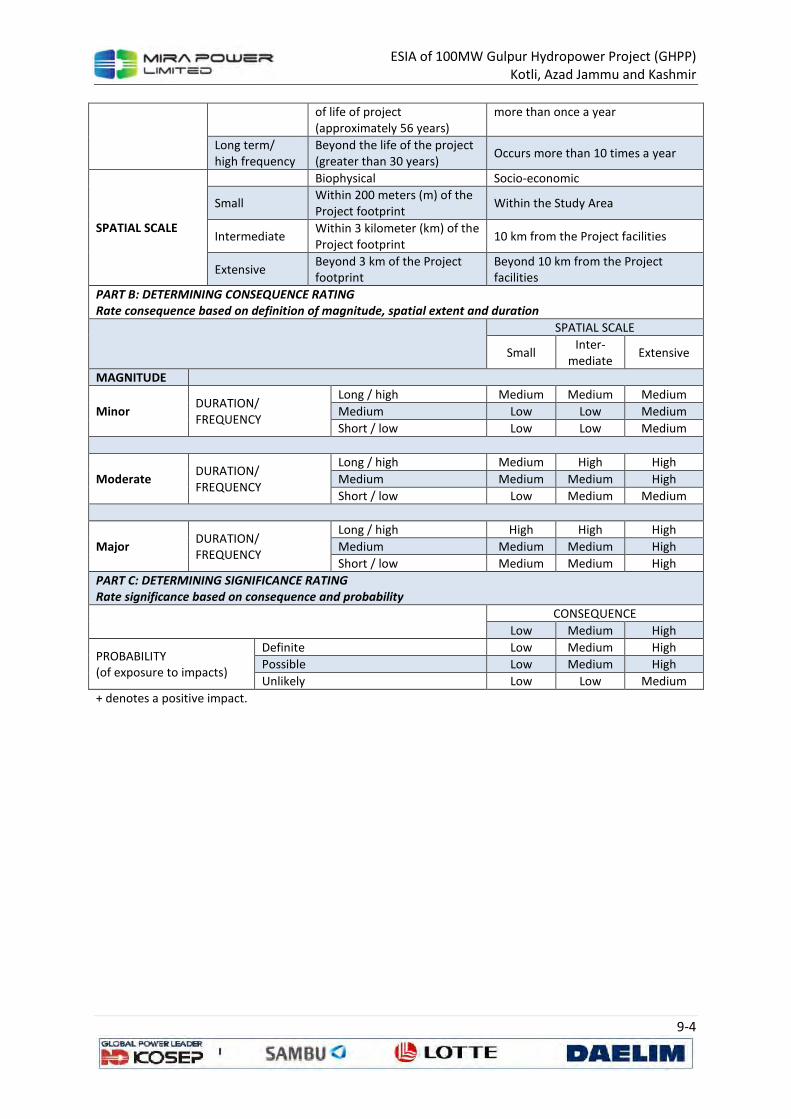
ESIA of 100MW Gulpur Hydropower Project (GHPP)
Kotli, Azad Jammu and Kashmir
9-4
of life of project
(approximately 56 years)
more than once a year
Long term/
high frequency
Beyond the life of the project
(greater than 30 years) Occurs more than 10 times a year
SPATIAL SCALE
Biophysical Socio-economic
Small Within 200 meters (m) of the Project footprint
Within the Study Area
Intermediate Within 3 kilometer (km) of the Project footprint
10 km from the Project facilities
Extensive Beyond 3 km of the Project footprint
Beyond 10 km from the Project facilities
PART B: DETERMINING CONSEQUENCE RATING
Rate consequence based on definition of magnitude, spatial extent and duration
SPATIAL SCALE
Small Inter-
mediate Extensive
MAGNITUDE
Minor DURATION/ FREQUENCY
Long / high Medium Medium Medium
Medium Low Low Medium
Short / low Low Low Medium
Moderate DURATION/ FREQUENCY
Long / high Medium High High
Medium Medium Medium High
Short / low Low Medium Medium
Major DURATION/ FREQUENCY
Long / high High High High
Medium Medium Medium High
Short / low Medium Medium High
PART C: DETERMINING SIGNIFICANCE RATING
Rate significance based on consequence and probability
CONSEQUENCE
Low Medium High
PROBABILITY (of exposure to impacts)
Definite Low Medium High
Possible Low Medium High
Unlikely Low Low Medium
+ denotes a positive impact.
ESIA of 100MW Gulpur Hydropower Project (GHPP)
Kotli, Azad Jammu and Kashmir
9-5
9.2 Impacts on Physical Environmental
The physical environmental aspects that may be affected by the project activities are following
• Noise and dust associated with construction and operations
• Use of water for Project activities
• Generation of waste by the Project activities during construction and operations
• Construction of an earthen dyke for flood protection and minimization of inundation area
Following are the potential impacts that may arise from the execution of the project activities:
• Impact PE1: Soil Contamination
• Impact PE2: Soil Erosion
• Impact PE3: Water Contamination
• Impact PE4: Change in Drainage Pattern due to Weir Construction
• Impact PE5: Water Resource Depletion
• Impact PE6: Fugitive Dust Emissions
• Impact PE7: Vehicular and Generator Exhaust Emissions
• Impact PE8: Damage to Infrastructure due to Blasting
• Impact PE9: Noise Nuisance due to Blasting, Drilling and Batching Plant
• Impact PE 10: Construction of Earthen Dyke
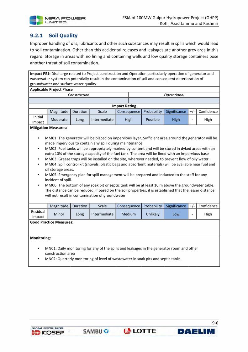
ESIA of 100MW Gulpur Hydropower Project (GHPP)
Kotli, Azad Jammu and Kashmir
9-6
9.2.1 Soil Quality
Improper handling of oils, lubricants and other such substances may result in spills which would lead
to soil contamination. Other than this accidental releases and leakages are another grey area in this
regard. Storage in areas with no lining and containing walls and low quality storage containers pose
another threat of soil contamination.
Impact PE1: Discharge related to Project construction and Operation particularly operation of generator and wastewater system can potentially result in the contamination of soil and consequent deterioration of groundwater and surface water quality
Applicable Project Phase
Construction Operational
Impact Rating
Magnitude Duration Scale Consequence Probability Significance +/- Confidence
Initial Impact
Moderate Long Intermediate High Possible High - High
Mitigation Measures:
• MM01: The generator will be placed on impervious layer. Sufficient area around the generator will be made impervious to contain any spill during maintenance
• MM02: Fuel tanks will be appropriately marked by content and will be stored in dyked areas with an extra 10% of the storage capacity of the fuel tank. The area will be lined with an impervious base
• MM03: Grease traps will be installed on the site, wherever needed, to prevent flow of oily water.
• MM04: Spill control kit (shovels, plastic bags and absorbent materials) will be available near fuel and oil storage areas.
• MM05: Emergency plan for spill management will be prepared and inducted to the staff for any incident of spill.
• MM06: The bottom of any soak pit or septic tank will be at least 10 m above the groundwater table. The distance can be reduced, if based on the soil properties, it is established that the lesser distance will not result in contamination of groundwater
Magnitude Duration Scale Consequence Probability Significance +/- Confidence
Residual Impact
Minor Long Intermediate Medium Unlikely Low - High
Good Practice Measures:
Monitoring:
• MN01: Daily monitoring for any of the spills and leakages in the generator room and other construction area
• MN02: Quarterly monitoring of level of wastewater in soak pits and septic tanks.
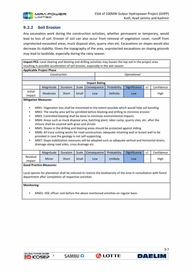
ESIA of 100MW Gulpur Hydropower Project (GHPP)
Kotli, Azad Jammu and Kashmir
9-7
9.2.2 Soil Erosion
Any excavation work during the construction activities, whether permanent or temporary, would
lead to loss of soil. Erosion of soil can also occur from removal of vegetation cover, runoff from
unprotected excavated areas, muck disposal sites, quarry sites etc. Excavations on slopes would also
decrease its stability. Given the topography of the area, unprotected excavations on sloping grounds
may lead to landslide, especially during the rainy season.
Impact PE2: Land clearing and blasting and drilling activities may loosen the top soil in the project area
resulting in possible acceleration of soil erosion, especially in the wet season
Applicable Project Phase
Construction Operational
Impact Rating
Magnitude Duration Scale Consequence Probability Significance +/- Confidence
Initial
Impact Moderate Short Small Low Definite Low - High
Mitigation Measures:
• MM1: Vegetation loss shall be minimized to the extent possible which would help soil bonding
• MM2: The nearby area will be sprinkled before blasting and drilling to minimize erosion
• MM3: Controlled blasting shall be done to minimize environmental impacts
• MM4: Areas such as muck disposal area, batching plant, labor camp, quarry sites, etc. after the
closure shall be covered with grass and shrubs
• MM5: Slopes in the drilling and blasting areas should be protected against sliding
• MM6: All trace cutting works for road construction, adequate retaining wall or breast wall to be
provided in case the geology is not self-supporting.
• MM7: Slope stabilization measures will be adopted such as adequate vertical and horizontal drains,
drainage along road sides, cross drainage etc.
Magnitude Duration Scale Consequence Probability Significance +/- Confidence
Residual
Impact Minor Short Small Low Unlikely Low - High
Good Practice Measures: Local species for plantation shall be selected to restore the biodiversity of the area in consultation with forest
department after completion of respective activities
Monitoring:
• MN01: HSE officer visit before the above mentioned activities on regular basis
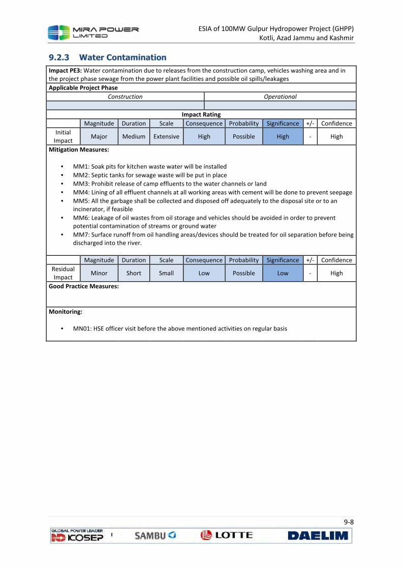
ESIA of 100MW Gulpur Hydropower Project (GHPP)
Kotli, Azad Jammu and Kashmir
9-8
9.2.3 Water Contamination
Impact PE3: Water contamination due to releases from the construction camp, vehicles washing area and in
the project phase sewage from the power plant facilities and possible oil spills/leakages
Applicable Project Phase
Construction Operational
Impact Rating
Magnitude Duration Scale Consequence Probability Significance +/- Confidence
Initial
Impact Major Medium Extensive High Possible High - High
Mitigation Measures:
• MM1: Soak pits for kitchen waste water will be installed
• MM2: Septic tanks for sewage waste will be put in place
• MM3: Prohibit release of camp effluents to the water channels or land
• MM4: Lining of all effluent channels at all working areas with cement will be done to prevent seepage
• MM5: All the garbage shall be collected and disposed off adequately to the disposal site or to an
incinerator, if feasible
• MM6: Leakage of oil wastes from oil storage and vehicles should be avoided in order to prevent
potential contamination of streams or ground water
• MM7: Surface runoff from oil handling areas/devices should be treated for oil separation before being
discharged into the river.
Magnitude Duration Scale Consequence Probability Significance +/- Confidence
Residual
Impact Minor Short Small Low Possible Low - High
Good Practice Measures:
Monitoring:
• MN01: HSE officer visit before the above mentioned activities on regular basis

ESIA of 100MW Gulpur Hydropower Project (GHPP)
Kotli, Azad Jammu and Kashmir
9-9
9.2.4 Change in Drainage Pattern
Construction of weir and creation of dam will change the flow regime of the existing river, which
may pose impacts on downstream and upstream ecology. Keeping in view the sensitivity of the issue
and project setting, a biodiversity assessment exercise will be carried out separately and made part
of the ESIA. Biodiversity study would aim at determining the ecological flow and the requirements of
releases to maintain that flow after the proposed development. Further options will be assessed to
incorporate positive impacts of the project in that area and specifically in the Poonch River. The
creation of dam will certainly enhance the aesthetic value of the locality and also provide
opportunities for eco-tourism. Another advantage would be the increased productivity of fish
harvest with the increase of water availability due to dam creation in that area.
The construction of access road for intake and quarrying of construction material may also alter the
drainage pattern of the area.
Impact PE4: Construction of weir may alter the drainage patterns of the area
Applicable Project Phase
Construction Operational
Impact Rating
Magnitude Duration Scale Consequence Probability Significance +/- Confidence
Initial
Impact Moderate Medium Intermediate Medium Possible Medium - High
Mitigation Measures:
• MM1: Results of the biodiversity assessment (ecological flow) be incorporated in implementation
plans.
• MM2: Surface runoff from oil handling areas/devices should be treated for oil separation before being
discharged into the river.
• MM3: The sand and gravel quarrying sites shall be selected keeping in view the impacts and
magnitude of change in surface water drainage patterns. Major changes in the landscape shall be
avoided.
• MM4: At the completion of activities the natural pattern shall be restored, to the extent possible.
Magnitude Duration Scale Consequence Probability Significance +/- Confidence
Residual
Impact Major Medium Intermediate Extensive Possible High - High
Good Practice Measures:
Monitoring:
• MN01: HSE officer visit before the above mentioned activities on regular basis
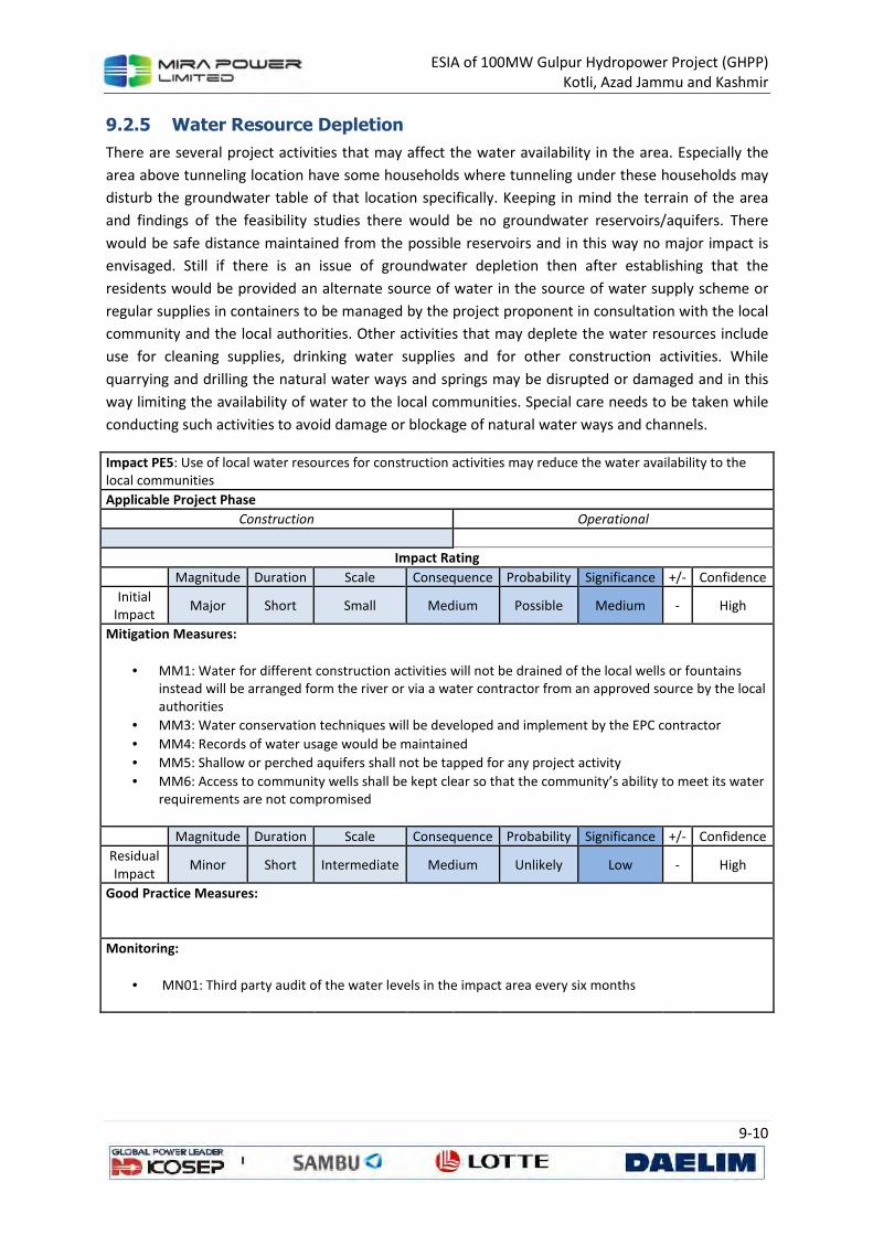
ESIA of 100MW Gulpur Hydropower Project (GHPP)
Kotli, Azad Jammu and Kashmir
9-10
9.2.5 Water Resource Depletion
There are several project activities that may affect the water availability in the area. Especially the
area above tunneling location have some households where tunneling under these households may
disturb the groundwater table of that location specifically. Keeping in mind the terrain of the area
and findings of the feasibility studies there would be no groundwater reservoirs/aquifers. There
would be safe distance maintained from the possible reservoirs and in this way no major impact is
envisaged. Still if there is an issue of groundwater depletion then after establishing that the
residents would be provided an alternate source of water in the source of water supply scheme or
regular supplies in containers to be managed by the project proponent in consultation with the local
community and the local authorities. Other activities that may deplete the water resources include
use for cleaning supplies, drinking water supplies and for other construction activities. While
quarrying and drilling the natural water ways and springs may be disrupted or damaged and in this
way limiting the availability of water to the local communities. Special care needs to be taken while
conducting such activities to avoid damage or blockage of natural water ways and channels.
Impact PE5: Use of local water resources for construction activities may reduce the water availability to the local communities
Applicable Project Phase
Construction Operational
Impact Rating
Magnitude Duration Scale Consequence Probability Significance +/- Confidence
Initial Impact
Major Short Small Medium Possible Medium - High
Mitigation Measures:
• MM1: Water for different construction activities will not be drained of the local wells or fountains instead will be arranged form the river or via a water contractor from an approved source by the local authorities
• MM3: Water conservation techniques will be developed and implement by the EPC contractor
• MM4: Records of water usage would be maintained
• MM5: Shallow or perched aquifers shall not be tapped for any project activity
• MM6: Access to community wells shall be kept clear so that the community’s ability to meet its water requirements are not compromised
Magnitude Duration Scale Consequence Probability Significance +/- Confidence
Residual Impact
Minor Short Intermediate Medium Unlikely Low - High
Good Practice Measures:
Monitoring:
• MN01: Third party audit of the water levels in the impact area every six months
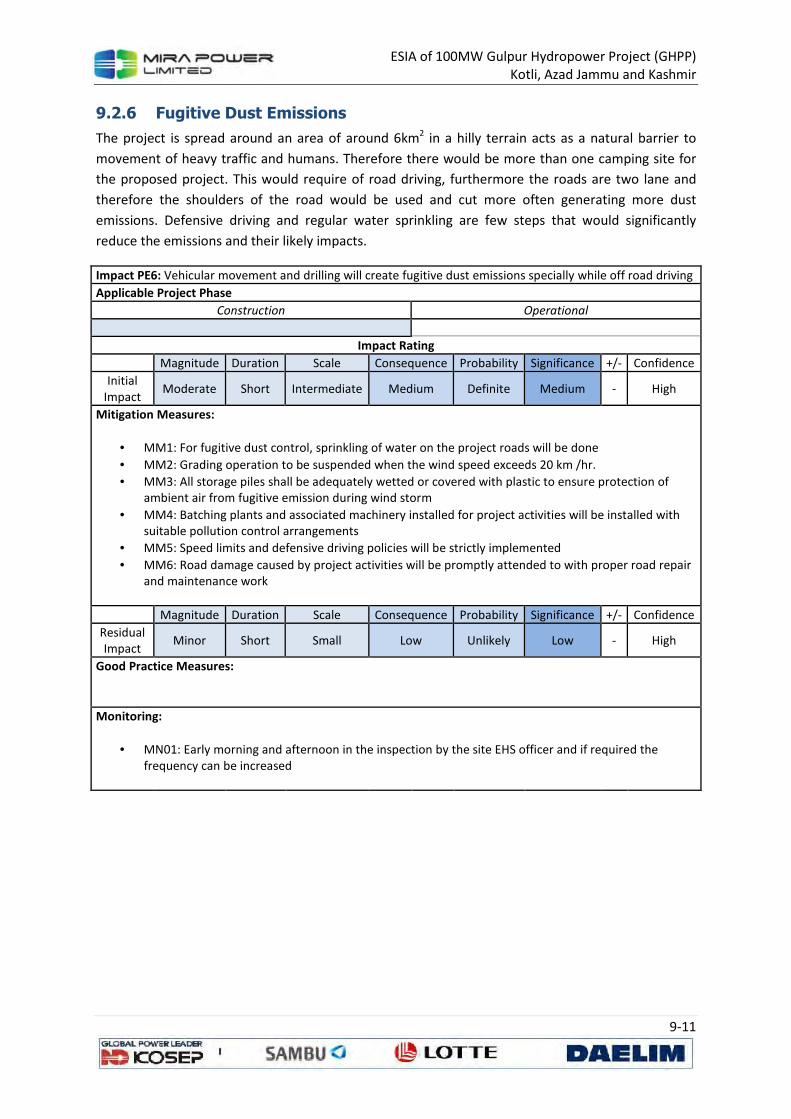
ESIA of 100MW Gulpur Hydropower Project (GHPP)
Kotli, Azad Jammu and Kashmir
9-11
9.2.6 Fugitive Dust Emissions
The project is spread around an area of around 6km2 in a hilly terrain acts as a natural barrier to
movement of heavy traffic and humans. Therefore there would be more than one camping site for
the proposed project. This would require of road driving, furthermore the roads are two lane and
therefore the shoulders of the road would be used and cut more often generating more dust
emissions. Defensive driving and regular water sprinkling are few steps that would significantly
reduce the emissions and their likely impacts.
Impact PE6: Vehicular movement and drilling will create fugitive dust emissions specially while off road driving
Applicable Project Phase
Construction Operational
Impact Rating
Magnitude Duration Scale Consequence Probability Significance +/- Confidence
Initial
Impact Moderate Short Intermediate Medium Definite Medium - High
Mitigation Measures:
• MM1: For fugitive dust control, sprinkling of water on the project roads will be done
• MM2: Grading operation to be suspended when the wind speed exceeds 20 km /hr.
• MM3: All storage piles shall be adequately wetted or covered with plastic to ensure protection of
ambient air from fugitive emission during wind storm
• MM4: Batching plants and associated machinery installed for project activities will be installed with
suitable pollution control arrangements
• MM5: Speed limits and defensive driving policies will be strictly implemented
• MM6: Road damage caused by project activities will be promptly attended to with proper road repair
and maintenance work
Magnitude Duration Scale Consequence Probability Significance +/- Confidence
Residual
Impact Minor Short Small Low Unlikely Low - High
Good Practice Measures:
Monitoring:
• MN01: Early morning and afternoon in the inspection by the site EHS officer and if required the
frequency can be increased
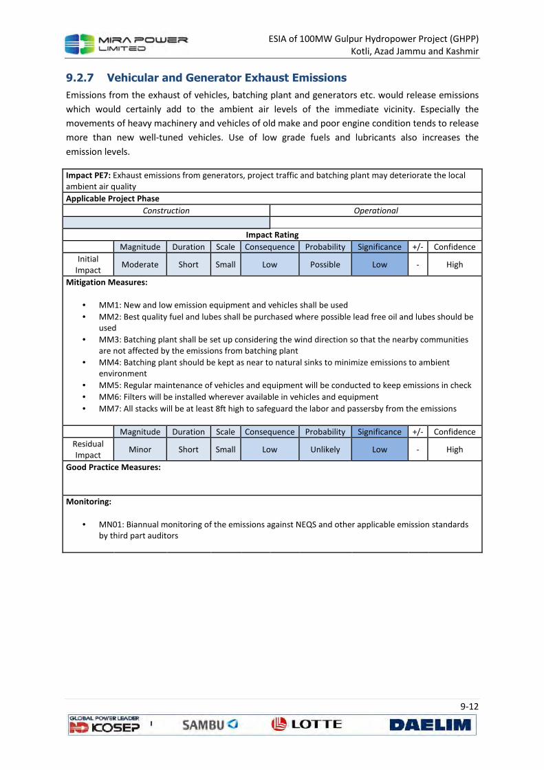
ESIA of 100MW Gulpur Hydropower Project (GHPP)
Kotli, Azad Jammu and Kashmir
9-12
9.2.7 Vehicular and Generator Exhaust Emissions
Emissions from the exhaust of vehicles, batching plant and generators etc. would release emissions
which would certainly add to the ambient air levels of the immediate vicinity. Especially the
movements of heavy machinery and vehicles of old make and poor engine condition tends to release
more than new well-tuned vehicles. Use of low grade fuels and lubricants also increases the
emission levels.
Impact PE7: Exhaust emissions from generators, project traffic and batching plant may deteriorate the local
ambient air quality
Applicable Project Phase
Construction Operational
Impact Rating
Magnitude Duration Scale Consequence Probability Significance +/- Confidence
Initial
Impact Moderate Short Small Low Possible Low - High
Mitigation Measures:
• MM1: New and low emission equipment and vehicles shall be used
• MM2: Best quality fuel and lubes shall be purchased where possible lead free oil and lubes should be
used
• MM3: Batching plant shall be set up considering the wind direction so that the nearby communities
are not affected by the emissions from batching plant
• MM4: Batching plant should be kept as near to natural sinks to minimize emissions to ambient
environment
• MM5: Regular maintenance of vehicles and equipment will be conducted to keep emissions in check
• MM6: Filters will be installed wherever available in vehicles and equipment
• MM7: All stacks will be at least 8ft high to safeguard the labor and passersby from the emissions
Magnitude Duration Scale Consequence Probability Significance +/- Confidence
Residual
Impact Minor Short Small Low Unlikely Low - High
Good Practice Measures:
Monitoring:
• MN01: Biannual monitoring of the emissions against NEQS and other applicable emission standards
by third part auditors
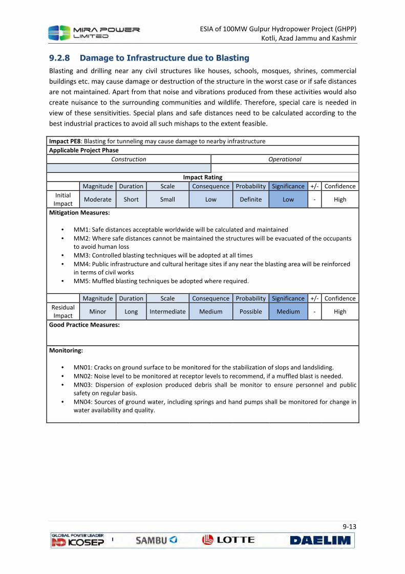
ESIA of 100MW Gulpur Hydropower Project (GHPP)
Kotli, Azad Jammu and Kashmir
9-13
9.2.8 Damage to Infrastructure due to Blasting
Blasting and drilling near any civil structures like houses, schools, mosques, shrines, commercial
buildings etc. may cause damage or destruction of the structure in the worst case or if safe distances
are not maintained. Apart from that noise and vibrations produced from these activities would also
create nuisance to the surrounding communities and wildlife. Therefore, special care is needed in
view of these sensitivities. Special plans and safe distances need to be calculated according to the
best industrial practices to avoid all such mishaps to the extent feasible.
Impact PE8: Blasting for tunneling may cause damage to nearby infrastructure
Applicable Project Phase
Construction Operational
Impact Rating
Magnitude Duration Scale Consequence Probability Significance +/- Confidence
Initial
Impact Moderate Short Small Low Definite Low - High
Mitigation Measures:
• MM1: Safe distances acceptable worldwide will be calculated and maintained
• MM2: Where safe distances cannot be maintained the structures will be evacuated of the occupants
to avoid human loss
• MM3: Controlled blasting techniques will be adopted at all times
• MM4: Public infrastructure and cultural heritage sites if any near the blasting area will be reinforced
in terms of civil works
• MM5: Muffled blasting techniques be adopted where required.
Magnitude Duration Scale Consequence Probability Significance +/- Confidence
Residual
Impact Minor Long Intermediate Medium Possible Medium - High
Good Practice Measures:
Monitoring:
• MN01: Cracks on ground surface to be monitored for the stabilization of slops and landsliding.
• MN02: Noise level to be monitored at receptor levels to recommend, if a muffled blast is needed.
• MN03: Dispersion of explosion produced debris shall be monitor to ensure personnel and public
safety on regular basis.
• MN04: Sources of ground water, including springs and hand pumps shall be monitored for change in
water availability and quality.
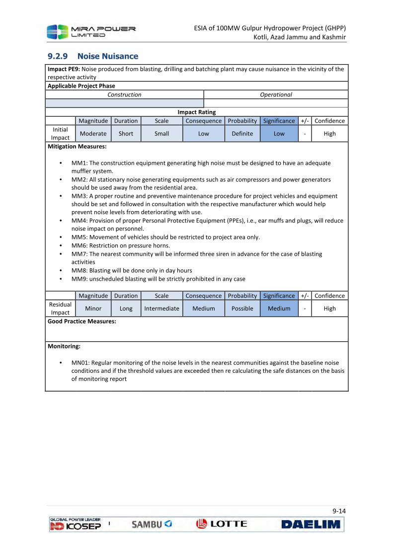
ESIA of 100MW Gulpur Hydropower Project (GHPP)
Kotli, Azad Jammu and Kashmir
9-14
9.2.9 Noise Nuisance
Impact PE9: Noise produced from blasting, drilling and batching plant may cause nuisance in the vicinity of the
respective activity
Applicable Project Phase
Construction Operational
Impact Rating
Magnitude Duration Scale Consequence Probability Significance +/- Confidence
Initial
Impact Moderate Short Small Low Definite Low - High
Mitigation Measures:
• MM1: The construction equipment generating high noise must be designed to have an adequate
muffler system.
• MM2: All stationary noise generating equipments such as air compressors and power generators
should be used away from the residential area.
• MM3: A proper routine and preventive maintenance procedure for project vehicles and equipment
should be set and followed in consultation with the respective manufacturer which would help
prevent noise levels from deteriorating with use.
• MM4: Provision of proper Personal Protective Equipment (PPEs), i.e., ear muffs and plugs, will reduce
noise impact on personnel.
• MM5: Movement of vehicles should be restricted to project area only.
• MM6: Restriction on pressure horns.
• MM7: The nearest community will be informed three siren in advance for the case of blasting
activities
• MM8: Blasting will be done only in day hours
• MM9: unscheduled blasting will be strictly prohibited in any case
Magnitude Duration Scale Consequence Probability Significance +/- Confidence
Residual
Impact Minor Long Intermediate Medium Possible Medium - High
Good Practice Measures:
Monitoring:
• MN01: Regular monitoring of the noise levels in the nearest communities against the baseline noise
conditions and if the threshold values are exceeded then re calculating the safe distances on the basis
of monitoring report
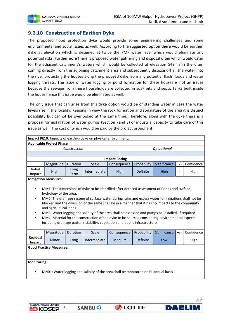
ESIA of 100MW Gulpur Hydropower Project (GHPP)
Kotli, Azad Jammu and Kashmir
9-15
9.2.10 Construction of Earthen Dyke
The proposed flood protection dyke would provide some engineering challenges and some
environmental and social issues as well. According to the suggested option there would be earthen
dyke at elevation which is designed at twice the PMF water level which would eliminate any
potential risks. Furthermore there is proposed water gathering and disposal drain which would cater
for the adjacent catchment’s waters which would be collected at elevation 542 m in the drain
coming directly from the adjoining catchment area and subsequently dispose off all the water into
the river protecting the houses along the proposed dyke from any potential flash floods and water
logging threats. The issue of water logging or pond formation for these houses is not an issues
because the sewage from these households are collected in soak pits and septic tanks built inside
the house hence this issue would be eliminated as well.
The only issue that can arise from this dyke option would be of standing water in case the water
levels rise in the locality. Keeping in view the rock formation and soil nature of the area it is distinct
possibility but cannot be overlooked at the same time. Therefore, along with the dyke there is a
proposal for installation of water pumps (Section 7and 3) of industrial capacity to take care of this
issue as well. The cost of which would be paid by the project proponent.
Impact PE10: Impacts of earthen dyke on physical environment.
Applicable Project Phase
Construction Operational
Impact Rating
Magnitude Duration Scale Consequence Probability Significance +/- Confidence
Initial
Impact High
Long
Term Intermediate High Definite High - High
Mitigation Measures:
• MM1: The dimensions of dyke to be identified after detailed assessment of floods and surface
hydrology of the area.
• MM2: The drainage system of surface water during rains and excess water for irrigations shall not be
blocked and the diversion of the same shall be in a manner that it has no impacts to the community
and agricultural lands.
• MM3: Water logging and salinity of the area shall be assessed and pumps be installed, if required.
• MM4: Material for the construction of the dyke to be sourced considering environmental aspects
including drainage pattern, stability, vegetation and public infrastructure.
Magnitude Duration Scale Consequence Probability Significance +/- Confidence
Residual
Impact Minor Long Intermediate Medium Definite Low - High
Good Practice Measures:
Monitoring:
• MN01: Water logging and salinity of the area shall be monitored on bi-annual basis.
ESIA of 100MW Gulpur Hydropower Project (GHPP)
Kotli, Azad Jammu and Kashmir
9-16
9.3 Impacts on Ecology and Biodiversity
The project area represents a human dominated landscape, and the vegetation has been subject to
human influence over a long period of time. The people depend entirely upon the forests for grazing,
fodder, timber and fuel. The heavily grazed areas near the town of Kotli show signs of extreme
denudation, with consequential adverse effects on the fertility of the soil. The southern and
southeastern slopes above thickly populated stretches are also suffering from similar damage.
Majority of the species recorded in the area were of the tropical origin or fall in
introduced/cultivated category, which signifies that the flora of the project area is much disturbed
and altered. In the adjacent forests, nineteen Himalayan endemic species were recorded. However,
none of them is narrow endemic and all have relatively wider distribution. There are no threatened
plant species found in the area. The dominant land use at the project facilities is
agriculture/settlements, and areas devoid of forest make about 25% of the land area.
Since the majority land impacted by the project will be either cultivated land or sparse broad leaf
forest which already have poor ground cover, impacts of the project on vegetation are anticipated to
be minor. Although one rare species (Fraxinus raiboearpa) exists in the area, its wide distribution
was recorded in dense forest areas, and it is not expected to occur in disturbed habitats in vicinity of
the project facilities. In conclusion, no loss of forest of conservation importance is anticipated either
upstream (reservoir) or downstream of the dam site near the power station and along access roads.
Vegetation clearing during the construction phase may lead to soil erosion. Erosion does not only
result in loss of valuable topsoil but also in leaching of soil nutrients and loss of organic matter.
Seventeen species of mammals were recorded in the study area, and most of them are common and
wide spread. The Eurasian Otter Lutra lutra is a rare but widely distributed carnivore species. It was
reported to be present in the area, however the survey team could not find any reliable evidence.
The Indian Grey Mongoose Herpestes edwardsi and the Small Asian Mongoose Herpestes javanicus
are included in the CITES APPENDIX III. These species have a trade pressure for their skins which are
exported to different countries. None of the small mammals found in the area are listed as
Threatened under IUCN Red List. Concerning large mammals, the project area and its surroundings
are dominated by adaptable species like fox and jackal, while the species which either pose danger
(eg, common leopard) or have economic value (ungulates) seems to be locally extirpated. The
species of large home ranges like common leopard gets killed if a vagrant individual enters into to
the area.
All the 21 species of reptiles recorded during the survey were commonly found at all the study sites,
and majority of them are either Not Evaluated species (52%) or have Least Concern status (42%),
according to IUCN 2013 Red List. Only one species, Brown Cobra (Naja oxiana) was found Data
Deficient with unknown population trend. None of the recorded species is protected under the AJK
Wildlife Act 1975 or AJK Wildlife Ordinance 2013. Six are CITES Species with one (Varanus
bengalensis) listed in Appendix I, four species (Hoplobatrachus tigerinus, Lissemys punctata, Eryx
johnii, Naja oxiana) are listed in Appendix II while one species (Xenochrophis piscator) is listed in
Appendix III of the CITES 2013.
ESIA of 100MW Gulpur Hydropower Project (GHPP)
Kotli, Azad Jammu and Kashmir
9-17
Most of the avifauna of the Project is very common. The endangered species, the White Rumped
Vulture (Gyps bengalensis) and endangered EGYPTIAN VULTURE (Neophron percnopterus) were also
recorded from the study area.
Out of 29 fish species found in Poonch River, 12 species viz., Barilius pakistanicus, Schistura
punjabensis, Cirrhinus reba, Labeo dero, Labeo dyocheilus, Tor putitora, Cyprinus carpio, Botia
rostrata, Clupisoma garua, Ompok bimaculatus, Mastacembelus armatus are species of special
importance. The species, Barilius pakistanicus and Schistura punjabensis are endemic in Pakistan
including AJK. Four species, Tor putitora (Endangered), Cyprinus carpio (Vulnerable), Botia rostrata
(Vulnerable), Ompok bimaculatus (Vulnerable) and Ompok bimaculatus (Near Threatened) have
special IUCN status. Out of these, Tor putitora, Cyprinus carpio and Ompok bimaculatus are
commercially important. The other commercially important species are Clupisoma garua, and
Mastacembelus armatus.
Based on the factors described above, following potential impacts were identified:
• Impact EC1: Land disturbance due to construction and operation of project facilities resulting
in disturbance, fragmentation, displacement and direct loss of animal, plants, reptiles,
amphibians and birds.
• Impact EC2: Deterioration of area’s water resources river if pollutants such as domestic
waste (sanitary and kitchen discharge) or oil and grease, and fuel from project related
machinery or equipment are mixed with surface runoff during rain, or if pollutants leach into
the ground or are carried to river.
• Impact EC3: Reduction in water flow beyond weir, which can alter ecology of the area and
lead to decline in abundance of fish, especially of Mahasher, results in habitat
fragmentation, or affects connectivity of Mangla Reservoirs fishes to Poonch River.
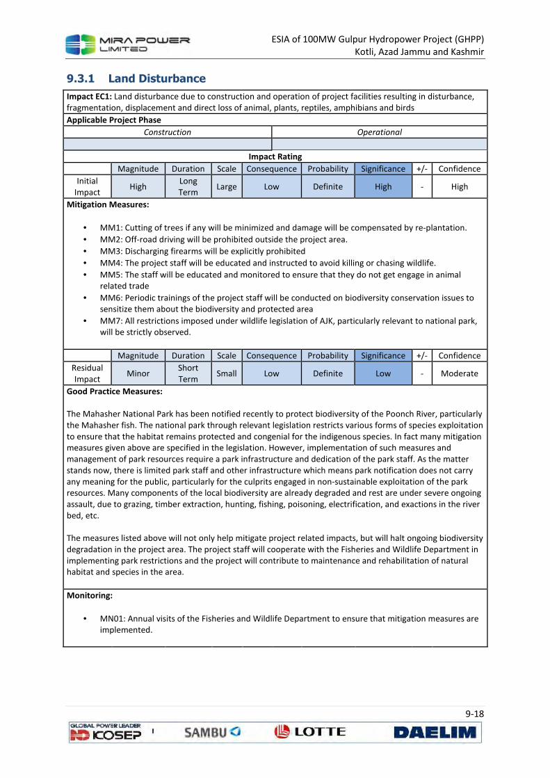
ESIA of 100MW Gulpur Hydropower Project (GHPP)
Kotli, Azad Jammu and Kashmir
9-18
9.3.1 Land Disturbance
Impact EC1: Land disturbance due to construction and operation of project facilities resulting in disturbance,
fragmentation, displacement and direct loss of animal, plants, reptiles, amphibians and birds
Applicable Project Phase
Construction Operational
Impact Rating
Magnitude Duration Scale Consequence Probability Significance +/- Confidence
Initial
Impact High
Long
Term Large Low Definite High - High
Mitigation Measures:
• MM1: Cutting of trees if any will be minimized and damage will be compensated by re-plantation.
• MM2: Off-road driving will be prohibited outside the project area.
• MM3: Discharging firearms will be explicitly prohibited
• MM4: The project staff will be educated and instructed to avoid killing or chasing wildlife.
• MM5: The staff will be educated and monitored to ensure that they do not get engage in animal related trade
• MM6: Periodic trainings of the project staff will be conducted on biodiversity conservation issues to sensitize them about the biodiversity and protected area
• MM7: All restrictions imposed under wildlife legislation of AJK, particularly relevant to national park, will be strictly observed.
Magnitude Duration Scale Consequence Probability Significance +/- Confidence
Residual Impact
Minor Short Term
Small Low Definite Low - Moderate
Good Practice Measures: The Mahasher National Park has been notified recently to protect biodiversity of the Poonch River, particularly the Mahasher fish. The national park through relevant legislation restricts various forms of species exploitation to ensure that the habitat remains protected and congenial for the indigenous species. In fact many mitigation measures given above are specified in the legislation. However, implementation of such measures and management of park resources require a park infrastructure and dedication of the park staff. As the matter stands now, there is limited park staff and other infrastructure which means park notification does not carry any meaning for the public, particularly for the culprits engaged in non-sustainable exploitation of the park resources. Many components of the local biodiversity are already degraded and rest are under severe ongoing assault, due to grazing, timber extraction, hunting, fishing, poisoning, electrification, and exactions in the river bed, etc. The measures listed above will not only help mitigate project related impacts, but will halt ongoing biodiversity degradation in the project area. The project staff will cooperate with the Fisheries and Wildlife Department in implementing park restrictions and the project will contribute to maintenance and rehabilitation of natural habitat and species in the area.
Monitoring:
• MN01: Annual visits of the Fisheries and Wildlife Department to ensure that mitigation measures are implemented.
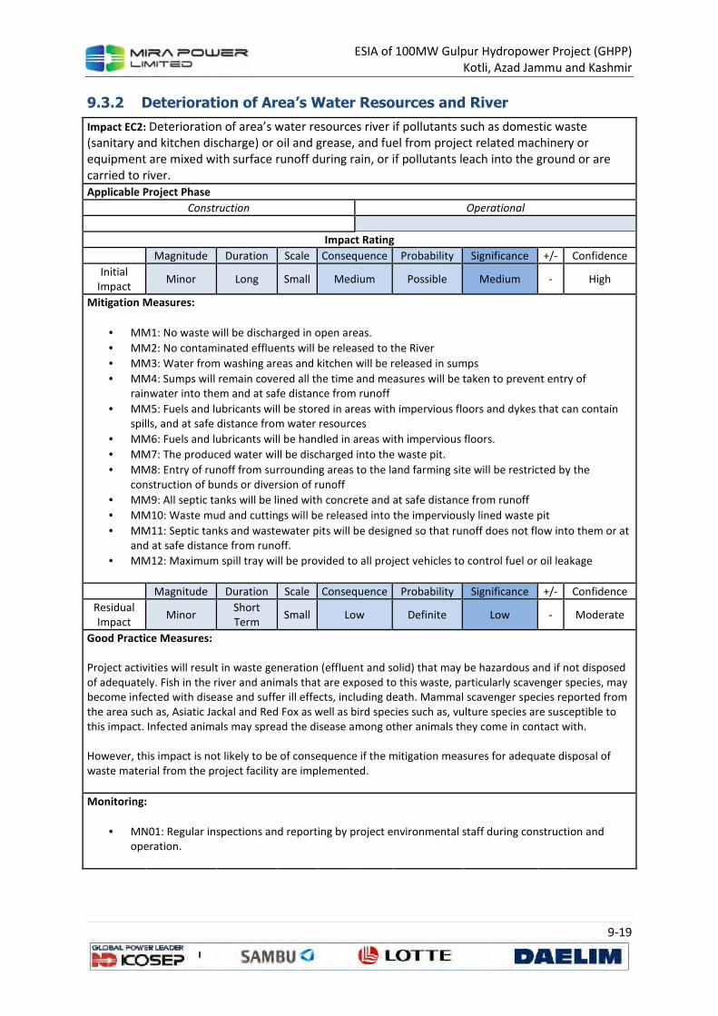
ESIA of 100MW Gulpur Hydropower Project (GHPP)
Kotli, Azad Jammu and Kashmir
9-19
9.3.2 Deterioration of Area’s Water Resources and River
Impact EC2: Deterioration of area’s water resources river if pollutants such as domestic waste
(sanitary and kitchen discharge) or oil and grease, and fuel from project related machinery or
equipment are mixed with surface runoff during rain, or if pollutants leach into the ground or are
carried to river.
Applicable Project Phase
Construction Operational
Impact Rating
Magnitude Duration Scale Consequence Probability Significance +/- Confidence
Initial
Impact Minor Long Small Medium Possible Medium - High
Mitigation Measures:
• MM1: No waste will be discharged in open areas.
• MM2: No contaminated effluents will be released to the River
• MM3: Water from washing areas and kitchen will be released in sumps
• MM4: Sumps will remain covered all the time and measures will be taken to prevent entry of
rainwater into them and at safe distance from runoff
• MM5: Fuels and lubricants will be stored in areas with impervious floors and dykes that can contain
spills, and at safe distance from water resources
• MM6: Fuels and lubricants will be handled in areas with impervious floors.
• MM7: The produced water will be discharged into the waste pit.
• MM8: Entry of runoff from surrounding areas to the land farming site will be restricted by the
construction of bunds or diversion of runoff
• MM9: All septic tanks will be lined with concrete and at safe distance from runoff
• MM10: Waste mud and cuttings will be released into the imperviously lined waste pit
• MM11: Septic tanks and wastewater pits will be designed so that runoff does not flow into them or at
and at safe distance from runoff.
• MM12: Maximum spill tray will be provided to all project vehicles to control fuel or oil leakage
Magnitude Duration Scale Consequence Probability Significance +/- Confidence
Residual
Impact Minor
Short
Term Small Low Definite Low - Moderate
Good Practice Measures: Project activities will result in waste generation (effluent and solid) that may be hazardous and if not disposed
of adequately. Fish in the river and animals that are exposed to this waste, particularly scavenger species, may
become infected with disease and suffer ill effects, including death. Mammal scavenger species reported from
the area such as, Asiatic Jackal and Red Fox as well as bird species such as, vulture species are susceptible to
this impact. Infected animals may spread the disease among other animals they come in contact with.
However, this impact is not likely to be of consequence if the mitigation measures for adequate disposal of
waste material from the project facility are implemented.
Monitoring:
• MN01: Regular inspections and reporting by project environmental staff during construction and
operation.
ESIA of 100MW Gulpur Hydropower Project (GHPP)
Kotli, Azad Jammu and Kashmir
9-20
9.3.3 Reduction in Water Flow beyond Weir
The project area enjoys following ecological significances, and ecological integrity of the system can
be compromised, if project is implemented without relevant mitigation measures.
• Important refugium for Mahasher Fish: Mahasher has been a widely distributed fish in
Pakistan during sixties and seventies. It was flourishing in the five rivers of Punjab and
breeding in the Himalayan foothill areas. Due to damming of the water bodies, ecological
fragmentation of the water bodies, pollution, water diversion, habitat destruction and
indiscriminate hunting, its population has been continuously declining. Its distribution range
in the country, therefore, continued squeezing and presently it is almost non-existent in the
rivers of Punjab. Recently, IUCN (2010) has declared it as an endangered species. The
Poonch River, however, still has a reasonably good population. It is successfully breeding in
Poonch River’s upper and middle reaches. The main centers of Mahasher breeding within
the project area are Bann Nullah, Rangar Nullah, Nail Nullah, Hajira Nullah, Meander Nullah
and the Titri Note area where river is wide to its maximum extant. It is the Poonch River
where anglers can still catch a fish of 100 cm weighing 10 Kgs. Efforts are required to save
this natural resource for our future generation. In case of a catastrophe for the Mahaseer
population in Poonch, this valuable species will be lost from the country. If the species
sustains, it can support poverty alleviation and promotion of eco-tourism.
• Breeding ground for the fish fauna of Mangla Reservoir: Poonch River serves as a breeding
ground for many of the fish fauna of the Mangla Reservoir which usually breed in flowing
water conditions. Most of the commercially important cyprinid species usually breed in
backwaters of the reservoir in the Poonch River. The side nullahs meeting to Poonch River
are the major breeding grounds for these fishes. These Nullahs may also serve as nursery
grounds for the breeding fishes.
• Natural reserve for twin-banded loach, Botia rostrata: Twin banded loach is a beautiful
aquarium fish. The fish has been quite common in the Himalayan foothill areas but presently
its population in the foothill areas is almost depleted or non-existent. The Poonch River has
a very good population of this loach and is a hot spot area for it.
• Supporting healthy population of Labeo dyocheilus: Poonch River holds a good population
of Labeo dyocheilus as compared to any other river in the country. This fish has maximum
size in this river and a fish weighing 3-4 kg is commonly caught in the nets.
• Supporting healthy population of Garra gotyla: The fish Garra gotyla is also a fish of
submountanous areas but it is also found in plains. Its population in plain areas has
decreased over the last 20 years and hardly one comes across any fish while sampling. In
past, it was very common in Potowar areas but it is no more seen in any of these areas
except a few localized places. Poonch River has very healthy population of this fish
throughout its length in AJK.
• Supporting high fish diversity as compared to its size: Poonch is the smallest river in AJK as
compared to other two rivers, the Jhelum and the Neelum. It, however, has a very good fish
diversity of 29 species as compared to 32 species in Jhelum and 12 species in Neelum. This is
mainly due to optimum water temperature, pristine breeding grounds, wide river valley, and
network of side nullahs with suitable physic-chemical environment.
ESIA of 100MW Gulpur Hydropower Project (GHPP)
Kotli, Azad Jammu and Kashmir
9-21
The lake developed after project completion will change the lotic ecosystem (running water) in to
lentic (standing water). This will cause a shift in benthic macro invertebrate fauna and it is likely to
be replaced by pollution tolerant taxa, similar to species observed at S3 (Table 5.3). If flow is not
available during the dry season, it may generate intermittent ponds in area downstream of weir. This
will also replace lotic ecosystem benthic macro-invertebrates with lentic benthic macro-
invertebrates. A regular flow would require for maintaining lotic ecosystem to the downstream of
weir.
Impact EC3: Reduction in water flow beyond weir, which can alter ecology of the area and lead to
decline in abundance of fish, especially of Mahasher, results in habitat fragmentation, or affects
connectivity of Mangla Reservoirs fishes to Poonch River.
Applicable Project Phase
Construction Operational
Impact Rating
Magnitude Duration Scale Consequence Probability Significance +/- Confidence
Initial
Impact Large Long Large High Definite High - High
Mitigation Measures:
• MM1: Species become more vulnerable due to the barrier of dam, therefore a management plan will
be developed for ensuring long-term survival of the species.
• MM2: Determination of Environmental/Ecological Flows: The rivers all over the world are increasingly
being altered through the construction of dams, diversions, and levees. More than half of the world's
large rivers are dammed and the number continues to increase. Dams and other river structures
change the downstream flow patterns and consequently affect water quality, temperature, sediment
movement and deposition, fish and wildlife, and the livelihoods of people who depend on healthy
river ecosystems. Environmental flows seek to maintain these river functions while at the same time
providing for traditional off stream benefits. Environmental flows describe the quantity, timing, and
quality of water flows required to sustain freshwater ecosystems and the human livelihoods and
wellbeing that depend on these ecosystems. Through implementation of environmental flows, water
managers strive to achieve a flow regime, or pattern, that maintains the essential processes required
to support healthy river ecosystems. Environmental flows do not necessarily require restoring the
natural, pristine flow patterns, instead, are intended to produce a broader set of values and benefits
from rivers rather than strictly focusing on water supply, energy, recreation, etc. Determination of
ecological flows is an essential measure that will be undertaken for maintaining healthy population of
the fauna and flora of the river in the downstream area of the Weir.
• MM3: Intensification of watch and ward services: The Poonch River and its tributaries provide a
breeding ground for many ecologically and commercially important fish species. The commercially
important fish fauna is being poached through illegal netting, use of illegal mesh size, fishing in
breeding season, fishing of migrating species, blasting, electro-fishing etc. A fleet of active guards
need to be appointed by the government to intensively protect the fish resources of the river. The
guards need to be provided with motorcycles, fuel, uniforms and torches for an effective patrolling of
the area to check any illegal fishing. These guards may be given special training for performing their
duties in a proper manner.
• MM4: Declaration of Weir to Power House Area as closed area for fishing: The area from Weir to
Power House will be the most vulnerable area for the fish species as it will have low water especially
during winter season. The area needs to be protected from overfishing. Declaration of this area as no
fishing zone will allow survival of the fish species in ecological flows determined for the river.
• MM5: Involvement of Community in Conservation: Communities living along the project area will be
involved in various eco-tourism activities to provide them an incentive for conservation of fish
resources of the area. They will be helpful in self-watch and ward activities and in control of activities
that are damaging to the fish fauna.
ESIA of 100MW Gulpur Hydropower Project (GHPP)
Kotli, Azad Jammu and Kashmir
9-22
• MM6: Involvement of Local Administration in Conservation Process: Involvement of local
administration and law enforcement agencies in the fisheries conservation process is important as
nothing happens without their will and commitment. Regular meetings with local deputy
commissioners, police officers and senior bureaucrats will be held to take them on board for
implementation and enforcement of law.
• MM7: Establishment of Mahasher Hatcheries: Two Mahasher hatcheries need to be established, one
upstream of the weir and the other downstream of the weir for recruiting the river and dam site for
compensation of any loss of Mahasher fish being caused by the project activities.
Magnitude Duration Scale Consequence Probability Significance +/- Confidence
Residual
Impact Minor
Short
Term Small Low Definite Low - Moderate
Good Practice Measures: Through the mitigation measures described above, a multi-prong approach has been adapted, which will
ensure a net gain in habitat and biodiversity. While maintaining ecological flow and recruiting Mahasher from
hatcheries, decline in Mahasher and other fish populations will be minimized. Intensive watch and ward, strict
protection, and engagement with the communities and administration will halt ongoing deterioration of the
ecosystem. In view of greater protection of the park for 30 years and availability of a vast habitat in the form of
water reservoir, following benefits for the park and biodiversity are anticipated:
• Enhanced habitat availability, habitat diversification and depth in the form of reservoir will help in
maintaining the species diversity. For example the Mangla Reservoir supports sixty fish species as
compared to about thirty in entire stretch of the Poonch River.
• The reservoir with vertical and seasonal variations in temperatures will provide wintering habitat to
fish species, and some species of cold water may also get established here.
• Fishes of commercial importance will get established, and fisheries will get developed in the area.
Fisheries market will grow, creating new jobs and valuable support for the local economy.
• Overall bird diversity and population will be enhanced, owing to diverse habitat.
• The area will serve as staging ground for migratory bird species.
• Ecotourism could be promoted, which is an important tool for environmental education and helpful in developing responsible attitudes towards nature
• With intensive watch and ward, poaching of terrestrial wildlife will be controlled, and species historically occurring in the area will have a chance to re-establish.
In view of above discussion, it is concluded that with strict mitigation measures in place, anticipated benefits to biodiversity will more than balance the expected loss, and the area may serve as an important hub for biodiversity in the province.
Monitoring:
• MN01: Regular monitoring of fish populations will be carried out to determine the changes in abundance and diversity of the fish species.
ESIA of 100MW Gulpur Hydropower Project (GHPP)
Kotli, Azad Jammu and Kashmir
9-23
9.4 Impacts on Socio-Economic Environment
Environmental and social impacts attributable to the project can broadly be classified into those
taking place during construction and those occurring during the operational phase. Some of these
impacts can be anticipated and avoided through appropriate adjustments / provisions in the project
design. Some can be mitigated by careful implementation of the project while some other can be
adjusted with by appropriately following the operational manual and an effective collaboration with
communities.
• Construction related impacts are heavily dependent on:
• The contractor’s work practices, especially those related to storage of construction materials
and cleanliness of work site;
• Cooperation between local communities and local authorities and the contractor and use of
public space and utilities;
• Project management’s enforcement of correct construction practices and standards;
• The incorporation of mitigation measures identified in the ESIA into the overall work
practices;
• An effective collaboration with local communities in evolving a workable project
implementation; and
• The quality of Monitoring and Reporting of ESMP implementation.
Operational impacts of the proposed project are associated with the movement of vehicular traffic
on it and allied activities. These include air and noise pollution, safety hazards and other similar
impacts.
Following are the potential socio-economic impacts that may arise from the execution of the project
activities:
• Impact SE1: The project will provide job opportunities for the local people in construction
and operation phases.
• Impact SE2: The local communities access to the health facilities.
• Impact SE3: Permanent acquisition of land and non-land assets for the project
• Impact SE4: Lose of livelihood.
• Impact SE5: Diseases incidences due to pollution and interaction with labor
• Impact SE6: The blockade of access of local community due construction activities
• Impact SE7: Privacy of local people to be disturbed because of contractor’s camp and
construction work.
• Impact SE8: Conflict between workers and local community to increase
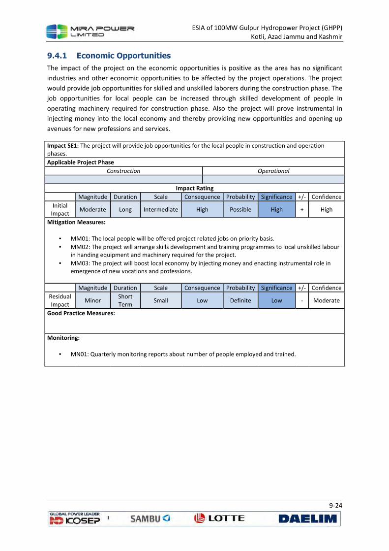
ESIA of 100MW Gulpur Hydropower Project (GHPP)
Kotli, Azad Jammu and Kashmir
9-24
9.4.1 Economic Opportunities
The impact of the project on the economic opportunities is positive as the area has no significant
industries and other economic opportunities to be affected by the project operations. The project
would provide job opportunities for skilled and unskilled laborers during the construction phase. The
job opportunities for local people can be increased through skilled development of people in
operating machinery required for construction phase. Also the project will prove instrumental in
injecting money into the local economy and thereby providing new opportunities and opening up
avenues for new professions and services.
Impact SE1: The project will provide job opportunities for the local people in construction and operation
phases.
Applicable Project Phase
Construction Operational
Impact Rating
Magnitude Duration Scale Consequence Probability Significance +/- Confidence
Initial
Impact Moderate Long Intermediate High Possible High + High
Mitigation Measures:
• MM01: The local people will be offered project related jobs on priority basis.
• MM02: The project will arrange skills development and training programmes to local unskilled labour
in handing equipment and machinery required for the project.
• MM03: The project will boost local economy by injecting money and enacting instrumental role in
emergence of new vocations and professions.
Magnitude Duration Scale Consequence Probability Significance +/- Confidence
Residual
Impact Minor
Short
Term Small Low Definite Low - Moderate
Good Practice Measures:
Monitoring:
• MN01: Quarterly monitoring reports about number of people employed and trained.
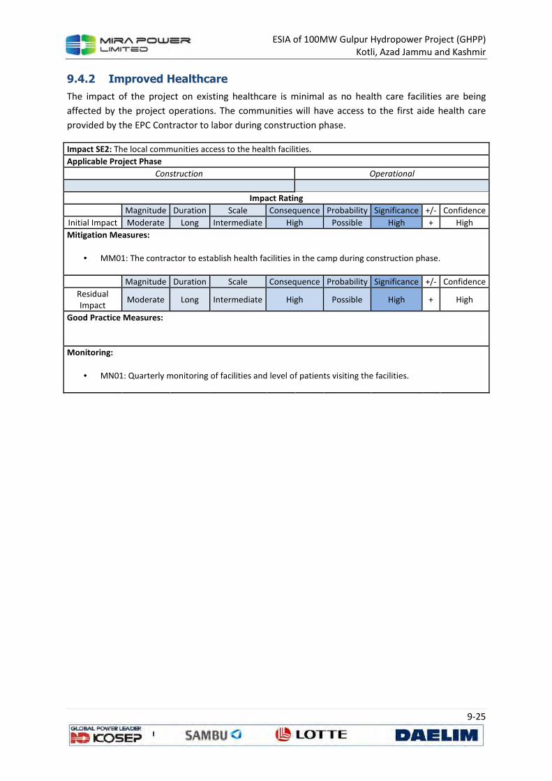
ESIA of 100MW Gulpur Hydropower Project (GHPP)
Kotli, Azad Jammu and Kashmir
9-25
9.4.2 Improved Healthcare
The impact of the project on existing healthcare is minimal as no health care facilities are being
affected by the project operations. The communities will have access to the first aide health care
provided by the EPC Contractor to labor during construction phase.
Impact SE2: The local communities access to the health facilities.
Applicable Project Phase
Construction Operational
Impact Rating
Magnitude Duration Scale Consequence Probability Significance +/- Confidence
Initial Impact Moderate Long Intermediate High Possible High + High
Mitigation Measures:
• MM01: The contractor to establish health facilities in the camp during construction phase.
Magnitude Duration Scale Consequence Probability Significance +/- Confidence
Residual
Impact Moderate Long Intermediate High Possible High + High
Good Practice Measures:
Monitoring:
• MN01: Quarterly monitoring of facilities and level of patients visiting the facilities.
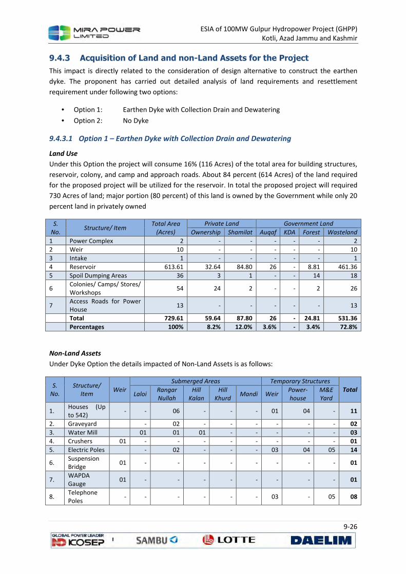
ESIA of 100MW Gulpur Hydropower Project (GHPP)
Kotli, Azad Jammu and Kashmir
9-26
9.4.3 Acquisition of Land and non-Land Assets for the Project
This impact is directly related to the consideration of design alternative to construct the earthen
dyke. The proponent has carried out detailed analysis of land requirements and resettlement
requirement under following two options:
• Option 1: Earthen Dyke with Collection Drain and Dewatering
• Option 2: No Dyke
9.4.3.1 Option 1 – Earthen Dyke with Collection Drain and Dewatering
Land Use
Under this Option the project will consume 16% (116 Acres) of the total area for building structures,
reservoir, colony, and camp and approach roads. About 84 percent (614 Acres) of the land required
for the proposed project will be utilized for the reservoir. In total the proposed project will required
730 Acres of land; major portion (80 percent) of this land is owned by the Government while only 20
percent land in privately owned
S.
No. Structure/ Item
Total Area
(Acres)
Private Land Government Land
Ownership Shamilat Auqaf KDA Forest Wasteland
1 Power Complex 2 - - - - - 2
2 Weir 10 - - - - - 10
3 Intake 1 - - - - - 1
4 Reservoir 613.61 32.64 84.80 26 - 8.81 461.36
5 Spoil Dumping Areas 36 3 1 - - 14 18
6 Colonies/ Camps/ Stores/ Workshops
54 24 2 - - 2 26
7 Access Roads for Power House
13 - - - - - 13
Total 729.61 59.64 87.80 26 - 24.81 531.36
Percentages 100% 8.2% 12.0% 3.6% - 3.4% 72.8%
Non-Land Assets
Under Dyke Option the details impacted of Non-Land Assets is as follows:
S.
No.
Structure/
Item Weir
Submerged Areas Temporary Structures
Total Laloi
Rangar
Nullah
Hill
Kalan
Hill
Khurd Mandi Weir
Power-
house
M&E
Yard
1. Houses (Up to 542)
- - 06 - - - 01 04 - 11
2. Graveyard - 02 - - - - - - 02
3. Water Mill 01 01 01 - - - - - 03
4. Crushers 01 - - - - - - - - 01
5. Electric Poles - 02 - - - 03 04 05 14
6. Suspension Bridge
01 - - - - - - - - 01
7. WAPDA Gauge
01 - - - - - - - - 01
8. Telephone Poles
- - - - - - 03 - 05 08
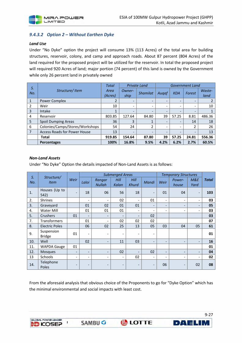
ESIA of 100MW Gulpur Hydropower Project (GHPP)
Kotli, Azad Jammu and Kashmir
9-27
9.4.3.2 Option 2 – Without Earthen Dyke
Land Use
Under “No Dyke” option the project will consume 13% (113 Acres) of the total area for building
structures, reservoir, colony, and camp and approach roads. About 87 percent (804 Acres) of the
land required for the proposed project will be utilized for the reservoir. In total the proposed project
will required 920 Acres of land; major portion (74 percent) of this land is owned by the Government
while only 26 percent land in privately owned
S.
No. Structure/ Item
Total
Area
(Acres)
Private Land Government Land
Owner-
ship Shamilat Auqaf KDA Forest
Waste-
land
1 Power Complex 2 - - - - - 2
2 Weir 10 - - - - - 10
3 Intake 1 - - - - - 1
4 Reservoir 803.85 127.64 84.80 39 57.25 8.81 486.36
5 Spoil Dumping Areas 36 3 1 - - 14 18
6 Colonies/Camps/Stores/Workshops 54 24 2 - - 2 26
7 Access Roads for Power House 13 - - - - - 13
Total 919.85 154.64 87.80 39 57.25 24.81 556.36
Percentages 100% 16.8% 9.5% 4.2% 6.2% 2.7% 60.5%
Non-Land Assets
Under “No Dyke” Option the details impacted of Non-Land Assets is as follows:
S.
No.
Structure/
Item Weir
Submerged Areas Temporary Structures
Total Laloi
Rangar
Nullah
Hill
Kalan
Hill
Khurd Mandi Weir
Power-
house
M&E
Yard
1. Houses (Up to 542)
- 18 06 56 18 - 01 04 - 103
2. Shrines - - 02 - 01 - - - 03
3. Graveyard 01 02 01 01 - - - - 05
4. Water Mill 01 01 01 - - - - - 03
5. Crushers 01 - - - - 02 03
7. Transformers 01 - 02 02 02 07
8. Electric Poles 06 02 25 13 05 03 04 05 61
9. Suspension Bridge
01 - - - - - 01
10. Well 02 - 11 03 - - - - 16
11. WAPDA Gauge 01 01
12. Mosques - - - 02 - 02 - - - 04
13 Schools - - - - 02 - - - - 02
14. Telephone Poles
- - - - - - 06 - 02 08
From the aforesaid analysis that obvious choice of the Proponents to go for “Dyke Option” which has
the minimal environmental and social impacts with least cost.
ESIA of 100MW Gulpur Hydropower Project (GHPP)
Kotli, Azad Jammu and Kashmir
9-28
9.4.3.3 Assessment framework for Permanent Acquisition of Land and Other Assets
For permanent acquisition/ loss of land and non-land assets the following framework will be
followed:
i. Loss of Agricultural Land
Agricultural land shall be directly acquired by the Government of AJK and shall be leased to the
Company for the term of the Project. For the legal title holders, customary or usufruct rights holders,
cash compensation of affected land would be paid on the basis of willing seller-willing buyer at the
mutually agreed market value of the acquired land. The tenants and sharecroppers (if any) will be
compensated for the un-expired duration of the lease. The vulnerable encroachers or squatters (if
any) will be compensated for affected structure at the replacement cost.
ii. Loss of Residential, Commercial or Institutional Land
The compensation entitlement in case of loss of residential, commercial or institutional land will
essentially be similar to the one for the loss of agricultural land, described above. The PAPs with
legal title holders, customary or usufruct rights will be compensated on the basis of willing seller-
willing buyer at the mutually agreed market value of the acquired land. The tenants will be
compensated for the un-expired duration of the lease. The vulnerable encroachers or squatters will
be compensated for affected structure at the replacement cost.
iii. Loss of Residential, Commercial or Institutional Structure
The owners of the affected structure, with or without legal title, will be entitled to cash
compensation at the replacement value (salvage value of the structure will not be deducted). In
addition, an allowance will also be paid to the owner for the repairs of the remaining structure, if
any.
iv. Loss of Common Resources and Facilities
In case of the loss of any common resources or facilities, the project will replace or restore the
affected facility or resource, in consultation with the affected community.
v. Loss of standing crops
The affected cultivators will be entitled to cash compensation for the damaged crops calculated on
the basis of market prices.
vi. Loss of Trees
The owners of the affected trees, with or without land title, will be paid cash compensation, on the
basis of market value of the trees according to the type, age, size and productivity of trees.
vii. Loss of Public Infrastructure
The project will pay cash compensation to the relevant agency based upon the replacement value of
the affected infrastructure. Alternatively, the project will replace or restore the damaged
infrastructure in the pre-project condition or better, in consultation with the concerned agency.
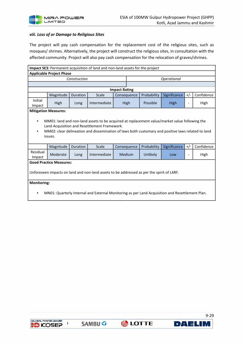
ESIA of 100MW Gulpur Hydropower Project (GHPP)
Kotli, Azad Jammu and Kashmir
9-29
viii. Loss of or Damage to Religious Sites
The project will pay cash compensation for the replacement cost of the religious sites, such as
mosques/ shrines. Alternatively, the project will construct the religious sites, in consultation with the
affected community. Project will also pay cash compensation for the relocation of graves/shrines.
Impact SE3: Permanent acquisition of land and non-land assets for the project
Applicable Project Phase
Construction Operational
Impact Rating
Magnitude Duration Scale Consequence Probability Significance +/- Confidence
Initial
Impact High Long Intermediate High Possible High - High
Mitigation Measures:
• MM01: land and non-land assets to be acquired at replacement value/market value following the
Land Acquisition and Resettlement Framework.
• MM02: clear delineation and dissemination of laws both customary and positive laws related to land
issues.
Magnitude Duration Scale Consequence Probability Significance +/- Confidence
Residual
Impact Moderate Long Intermediate Medium Unlikely Low - High
Good Practice Measures: Unforeseen impacts on land and non-land assets to be addressed as per the spirit of LARF.
Monitoring:
• MN01: Quarterly Internal and External Monitoring as per Land Acquisition and Resettlement Plan.
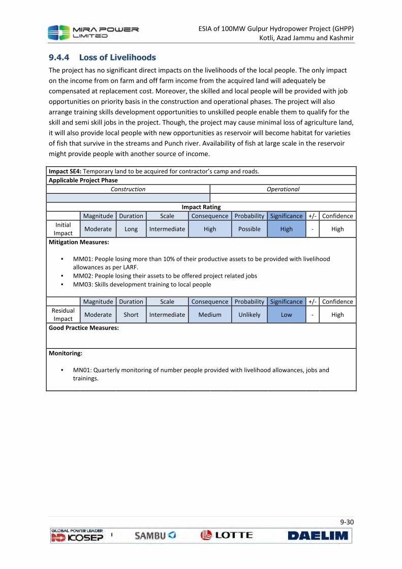
ESIA of 100MW Gulpur Hydropower Project (GHPP)
Kotli, Azad Jammu and Kashmir
9-30
9.4.4 Loss of Livelihoods
The project has no significant direct impacts on the livelihoods of the local people. The only impact
on the income from on farm and off farm income from the acquired land will adequately be
compensated at replacement cost. Moreover, the skilled and local people will be provided with job
opportunities on priority basis in the construction and operational phases. The project will also
arrange training skills development opportunities to unskilled people enable them to qualify for the
skill and semi skill jobs in the project. Though, the project may cause minimal loss of agriculture land,
it will also provide local people with new opportunities as reservoir will become habitat for varieties
of fish that survive in the streams and Punch river. Availability of fish at large scale in the reservoir
might provide people with another source of income.
Impact SE4: Temporary land to be acquired for contractor’s camp and roads.
Applicable Project Phase
Construction Operational
Impact Rating
Magnitude Duration Scale Consequence Probability Significance +/- Confidence
Initial
Impact Moderate Long Intermediate High Possible High - High
Mitigation Measures:
• MM01: People losing more than 10% of their productive assets to be provided with livelihood
allowances as per LARF.
• MM02: People losing their assets to be offered project related jobs
• MM03: Skills development training to local people
Magnitude Duration Scale Consequence Probability Significance +/- Confidence
Residual
Impact Moderate Short Intermediate Medium Unlikely Low - High
Good Practice Measures:
Monitoring:
• MN01: Quarterly monitoring of number people provided with livelihood allowances, jobs and
trainings.
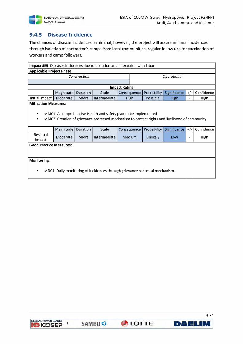
ESIA of 100MW Gulpur Hydropower Project (GHPP)
Kotli, Azad Jammu and Kashmir
9-31
9.4.5 Disease Incidence
The chances of disease incidences is minimal, however, the project will assure minimal incidences
through isolation of contractor’s camps from local communities, regular follow ups for vaccination of
workers and camp followers.
Impact SE5: Diseases incidences due to pollution and interaction with labor
Applicable Project Phase
Construction Operational
Impact Rating
Magnitude Duration Scale Consequence Probability Significance +/- Confidence
Initial Impact Moderate Short Intermediate High Possible High - High
Mitigation Measures:
• MM01: A comprehensive Health and safety plan to be implemented
• MM02: Creation of grievance redressed mechanism to protect rights and livelihood of community
Magnitude Duration Scale Consequence Probability Significance +/- Confidence
Residual
Impact Moderate Short Intermediate Medium Unlikely Low - High
Good Practice Measures:
Monitoring:
• MN01: Daily monitoring of incidences through grievance redressal mechanism.
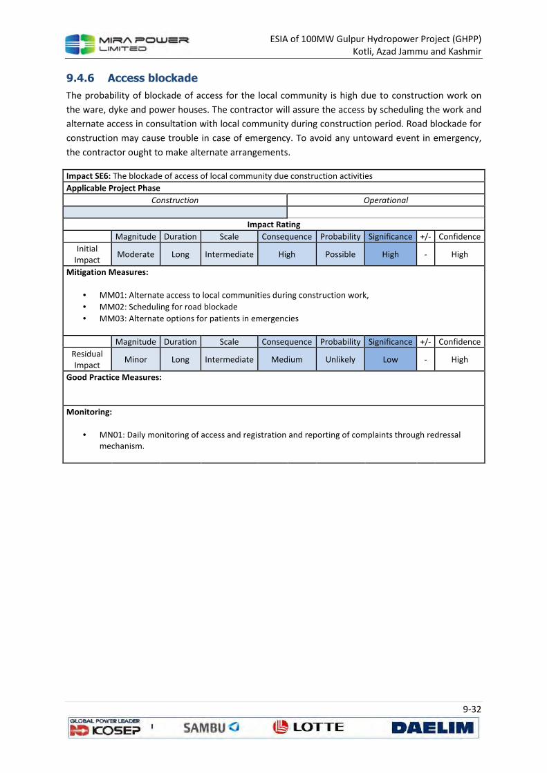
ESIA of 100MW Gulpur Hydropower Project (GHPP)
Kotli, Azad Jammu and Kashmir
9-32
9.4.6 Access blockade
The probability of blockade of access for the local community is high due to construction work on
the ware, dyke and power houses. The contractor will assure the access by scheduling the work and
alternate access in consultation with local community during construction period. Road blockade for
construction may cause trouble in case of emergency. To avoid any untoward event in emergency,
the contractor ought to make alternate arrangements.
Impact SE6: The blockade of access of local community due construction activities
Applicable Project Phase
Construction Operational
Impact Rating
Magnitude Duration Scale Consequence Probability Significance +/- Confidence
Initial
Impact Moderate Long Intermediate High Possible High - High
Mitigation Measures:
• MM01: Alternate access to local communities during construction work,
• MM02: Scheduling for road blockade
• MM03: Alternate options for patients in emergencies
Magnitude Duration Scale Consequence Probability Significance +/- Confidence
Residual
Impact Minor Long Intermediate Medium Unlikely Low - High
Good Practice Measures:
Monitoring:
• MN01: Daily monitoring of access and registration and reporting of complaints through redressal
mechanism.
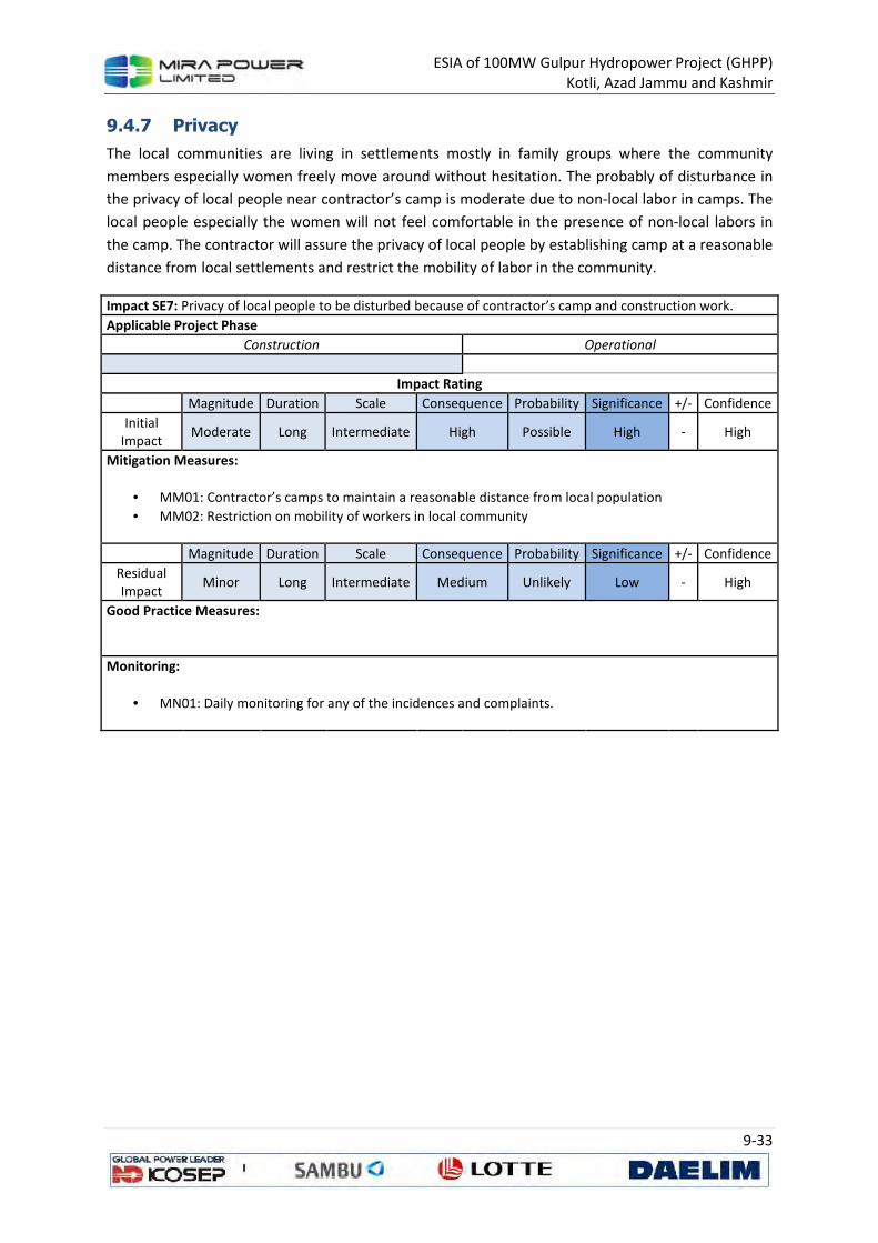
ESIA of 100MW Gulpur Hydropower Project (GHPP)
Kotli, Azad Jammu and Kashmir
9-33
9.4.7 Privacy
The local communities are living in settlements mostly in family groups where the community
members especially women freely move around without hesitation. The probably of disturbance in
the privacy of local people near contractor’s camp is moderate due to non-local labor in camps. The
local people especially the women will not feel comfortable in the presence of non-local labors in
the camp. The contractor will assure the privacy of local people by establishing camp at a reasonable
distance from local settlements and restrict the mobility of labor in the community.
Impact SE7: Privacy of local people to be disturbed because of contractor’s camp and construction work.
Applicable Project Phase
Construction Operational
Impact Rating
Magnitude Duration Scale Consequence Probability Significance +/- Confidence
Initial
Impact Moderate Long Intermediate High Possible High - High
Mitigation Measures:
• MM01: Contractor’s camps to maintain a reasonable distance from local population
• MM02: Restriction on mobility of workers in local community
Magnitude Duration Scale Consequence Probability Significance +/- Confidence
Residual
Impact Minor Long Intermediate Medium Unlikely Low - High
Good Practice Measures:
Monitoring:
• MN01: Daily monitoring for any of the incidences and complaints.
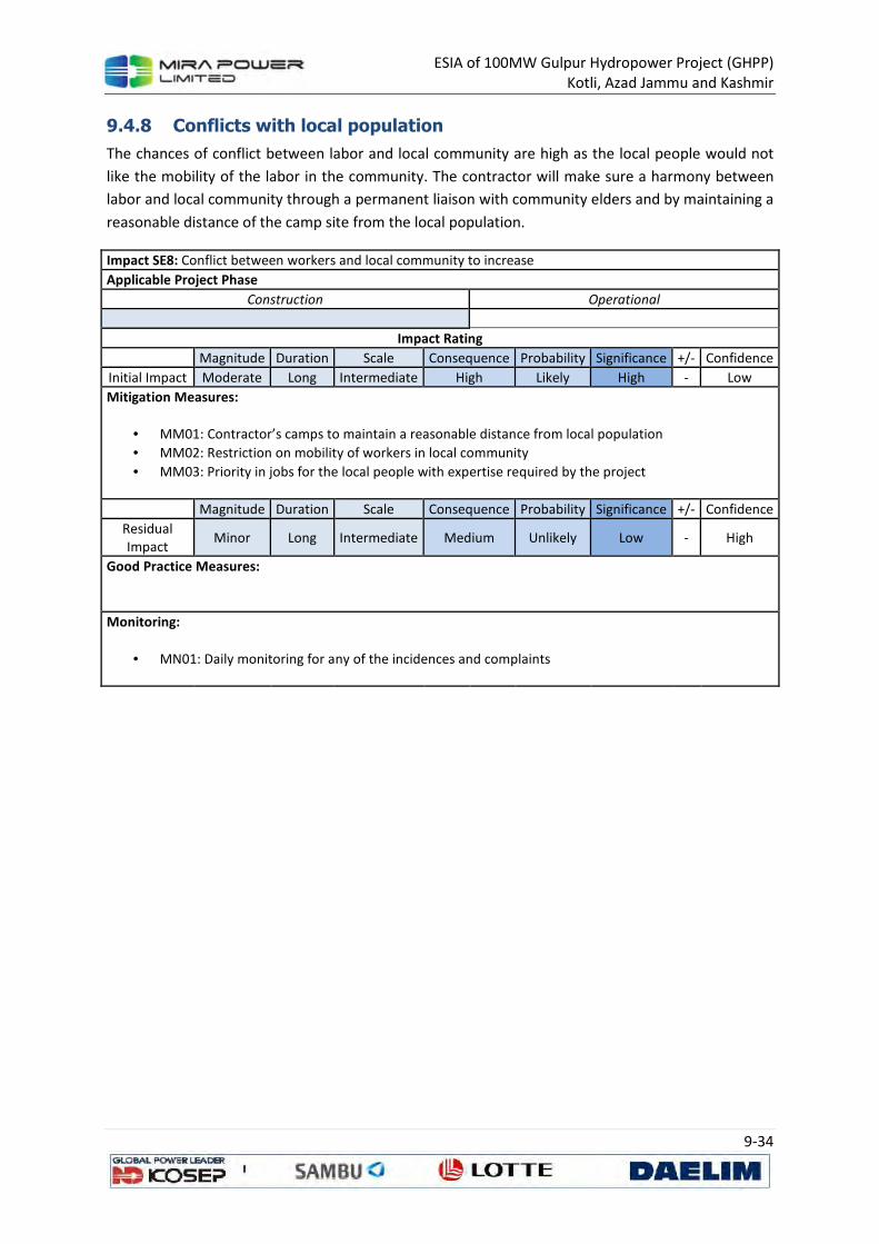
ESIA of 100MW Gulpur Hydropower Project (GHPP)
Kotli, Azad Jammu and Kashmir
9-34
9.4.8 Conflicts with local population
The chances of conflict between labor and local community are high as the local people would not
like the mobility of the labor in the community. The contractor will make sure a harmony between
labor and local community through a permanent liaison with community elders and by maintaining a
reasonable distance of the camp site from the local population.
Impact SE8: Conflict between workers and local community to increase
Applicable Project Phase
Construction Operational
Impact Rating
Magnitude Duration Scale Consequence Probability Significance +/- Confidence
Initial Impact Moderate Long Intermediate High Likely High - Low
Mitigation Measures:
• MM01: Contractor’s camps to maintain a reasonable distance from local population
• MM02: Restriction on mobility of workers in local community
• MM03: Priority in jobs for the local people with expertise required by the project
Magnitude Duration Scale Consequence Probability Significance +/- Confidence
Residual
Impact Minor Long Intermediate Medium Unlikely Low - High
Good Practice Measures:
Monitoring:
• MN01: Daily monitoring for any of the incidences and complaints
ESIA of 100MW Gulpur Hydropower Project (GHPP)
Kotli, Azad Jammu and Kashmir
10-1
10 TRAFFIC ASSESSMENT STUDY
10.1 Introduction
The proposed Gulpur Hydropower Project is located about 5km downstream of Kotli. The proposed
project can be approached by an all-weather road from Islamabad and on grand trunk (GT) road via
Mirpur. Currently the road(s) can cater for the needs of the traffic that is using these approach roads
but with the anticipated increase in heavy and light traffic there are likely to be impacts on the
existing road infrastructure. This study will mainly focus on the routes that may be used for project
related traffic and the likely impacts that may be caused due to the proposed project.
For this purpose the road was studied from satellite imagery and by travelling on the road. Traffic
count surveys were also conducted to assess the traffic load baseline before onset of the proposed
project.
10.2 Objectives
The main objectives of this study are as follows:
• to review the existing traffic conditions of the road network
• to appraise the potential traffic impact of the proposed development on the surrounding
road network
• to propose a feasible special traffic arrangement plan in peak erection and construction
activities.
10.3 Access Route Options
The site is located about 167 Km from Islamabad and 285 km from Lahore, it is directly approachable
from Islamabad and Lahore by a two-lane, all-weather paved road. Access to the Project site from
Islamabad is via Kahuta –Kotli to Gulpur. The other route is from Lahore via GT Road to Dina and
then to Gulpur via Mirpur. During rainy season, traffic is susceptible to occasional disruptions due to
landslides. Another option that may be considered to access the proposed site via Kalar Sayedan and
reach Kotli via Dodyal that would take car ride around 2.5 to 3 hours from Islamabad. All these three
options are shown in Figure 10.1.
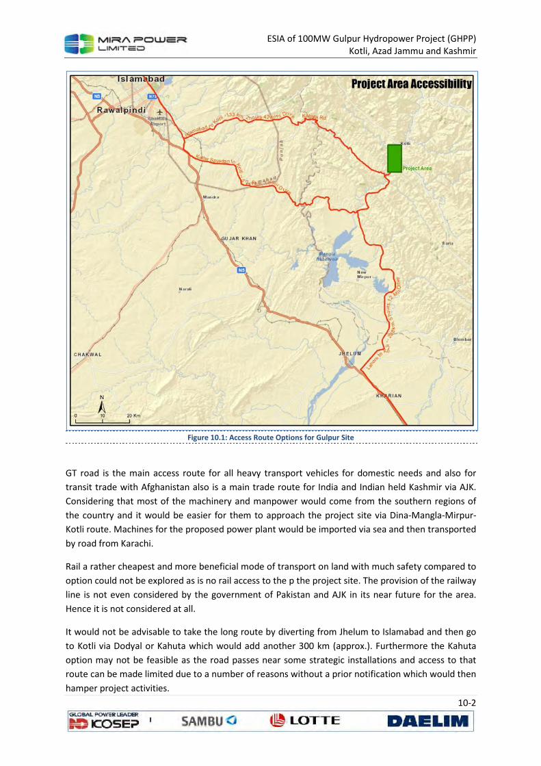
ESIA of 100MW Gulpur Hydropower Project (GHPP)
Kotli, Azad Jammu and Kashmir
10-2
Figure 10.1: Access Route Options for Gulpur Site
GT road is the main access route for all heavy transport vehicles for domestic needs and also for
transit trade with Afghanistan also is a main trade route for India and Indian held Kashmir via AJK.
Considering that most of the machinery and manpower would come from the southern regions of
the country and it would be easier for them to approach the project site via Dina-Mangla-Mirpur-
Kotli route. Machines for the proposed power plant would be imported via sea and then transported
by road from Karachi.
Rail a rather cheapest and more beneficial mode of transport on land with much safety compared to
option could not be explored as is no rail access to the p the project site. The provision of the railway
line is not even considered by the government of Pakistan and AJK in its near future for the area.
Hence it is not considered at all.
It would not be advisable to take the long route by diverting from Jhelum to Islamabad and then go
to Kotli via Dodyal or Kahuta which would add another 300 km (approx.). Furthermore the Kahuta
option may not be feasible as the road passes near some strategic installations and access to that
route can be made limited due to a number of reasons without a prior notification which would then
hamper project activities.
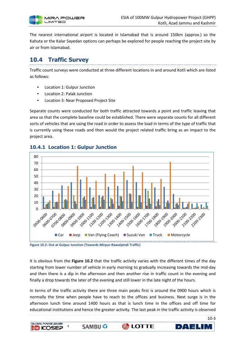
ESIA of 100MW Gulpur Hydropower Project (GHPP)
Kotli, Azad Jammu and Kashmir
10-3
The nearest international airport is located in Islamabad that is around 150km (approx.) so the
Kahuta or the Kalar Sayedan options can perhaps be explored for people reaching the project site by
air or from Islamabad.
10.4 Traffic Survey
Traffic count surveys were conducted at three different locations in and around Kotli which are listed
as follows:
• Location 1: Gulpur Junction
• Location 2: Palak Junction
• Location 3: Near Proposed Project Site
Separate counts were conducted for both traffic attracted towards a point and traffic leaving that
area so that the complete baseline could be established. There were separate counts for all different
sorts of vehicles that are using the road in order to assess the load in terms of the type of traffic that
is currently using these roads and then would the project related traffic bring as an impact to the
project area.
10.4.1 Location 1: Gulpur Junction
Figure 10.2: Out at Gulpur Junction (Towards Mirpur-Rawalpindi Traffic)
It is obvious from the Figure 10.2 that the traffic activity varies with the different times of the day
starting from lower number of vehicle in early morning to gradually increasing towards the mid-day
and then there is a dip in the afternoon and then another rise in traffic count in the evening and
finally a drop towards the later of the evening and still lower in the late night of the hours.
In terms of the traffic activity there are three main peaks first is around the 0900 hours which is
normally the time when people have to reach to the offices and business. Next surge is in the
afternoon lunch time around 1400 hours as that is lunch time in the offices and off time for
educational institutions and hence the greater activity. The last peak in the traffic activity is observed
0
10
20
30
40
50
60
70
80
Car Jeep Van (Flying Coach) Suzuki Van Truck Motorcycle
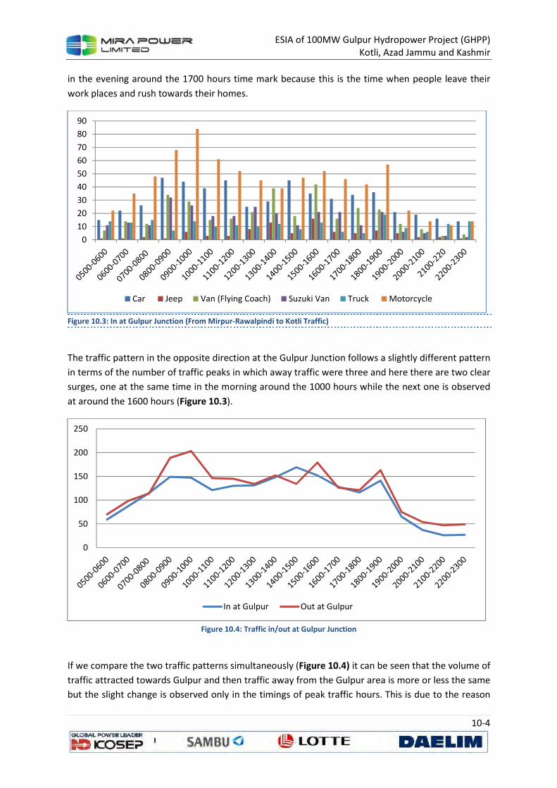
ESIA of 100MW Gulpur Hydropower Project (GHPP)
Kotli, Azad Jammu and Kashmir
10-4
in the evening around the 1700 hours time mark because this is the time when people leave their
work places and rush towards their homes.
Figure 10.3: In at Gulpur Junction (From Mirpur-Rawalpindi to Kotli Traffic)
The traffic pattern in the opposite direction at the Gulpur Junction follows a slightly different pattern
in terms of the number of traffic peaks in which away traffic were three and here there are two clear
surges, one at the same time in the morning around the 1000 hours while the next one is observed
at around the 1600 hours (Figure 10.3).
Figure 10.4: Traffic in/out at Gulpur Junction
If we compare the two traffic patterns simultaneously (Figure 10.4) it can be seen that the volume of
traffic attracted towards Gulpur and then traffic away from the Gulpur area is more or less the same
but the slight change is observed only in the timings of peak traffic hours. This is due to the reason
0
10
20
30
40
50
60
70
80
90
Car Jeep Van (Flying Coach) Suzuki Van Truck Motorcycle
0
50
100
150
200
250
In at Gulpur Out at Gulpur
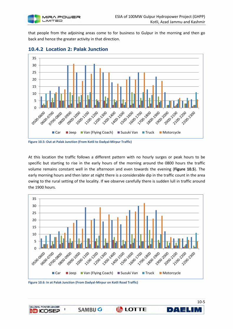
ESIA of 100MW Gulpur Hydropower Project (GHPP)
Kotli, Azad Jammu and Kashmir
10-5
that people from the adjoining areas come to for business to Gulpur in the morning and then go
back and hence the greater activity in that direction.
10.4.2 Location 2: Palak Junction
Figure 10.5: Out at Palak Junction (From Kotli to Dadyal-Mirpur Traffic)
At this location the traffic follows a different pattern with no hourly surges or peak hours to be
specific but starting to rise in the early hours of the morning around the 0800 hours the traffic
volume remains constant well in the afternoon and even towards the evening (Figure 10.5). The
early morning hours and then later at night there is a considerable dip in the traffic count in the area
owing to the rural setting of the locality. If we observe carefully there is sudden lull in traffic around
the 1900 hours.
Figure 10.6: In at Palak Junction (From Dadyal-Mirpur on Kotli Road Traffic)
0
5
10
15
20
25
30
35
Car Jeep Van (Flying Coach) Suzuki Van Truck Motorcycle
0
5
10
15
20
25
30
35
Car Jeep Van (Flying Coach) Suzuki Van Truck Motorcycle
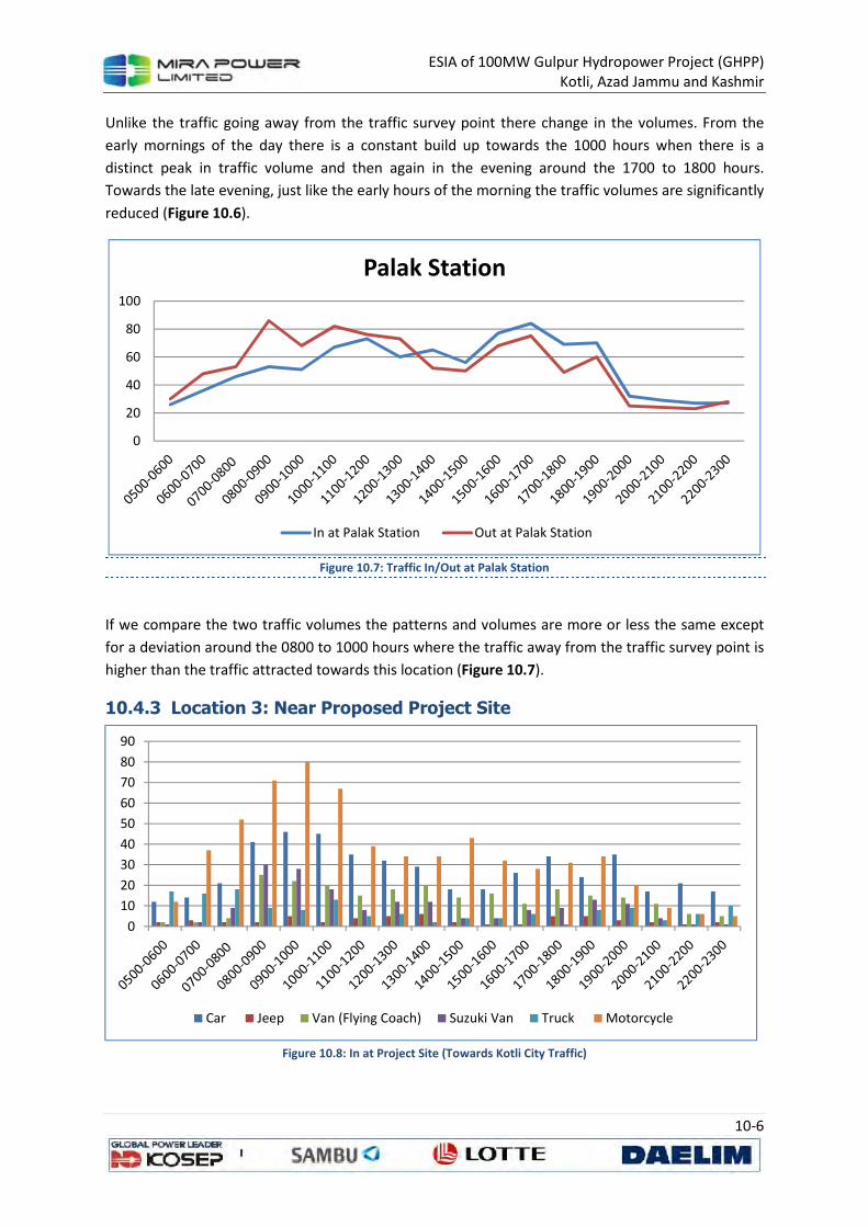
ESIA of 100MW Gulpur Hydropower Project (GHPP)
Kotli, Azad Jammu and Kashmir
10-6
Unlike the traffic going away from the traffic survey point there change in the volumes. From the
early mornings of the day there is a constant build up towards the 1000 hours when there is a
distinct peak in traffic volume and then again in the evening around the 1700 to 1800 hours.
Towards the late evening, just like the early hours of the morning the traffic volumes are significantly
reduced (Figure 10.6).
Figure 10.7: Traffic In/Out at Palak Station
If we compare the two traffic volumes the patterns and volumes are more or less the same except
for a deviation around the 0800 to 1000 hours where the traffic away from the traffic survey point is
higher than the traffic attracted towards this location (Figure 10.7).
10.4.3 Location 3: Near Proposed Project Site
Figure 10.8: In at Project Site (Towards Kotli City Traffic)
0
20
40
60
80
100
Palak Station
In at Palak Station Out at Palak Station
0
10
20
30
40
50
60
70
80
90
Car Jeep Van (Flying Coach) Suzuki Van Truck Motorcycle
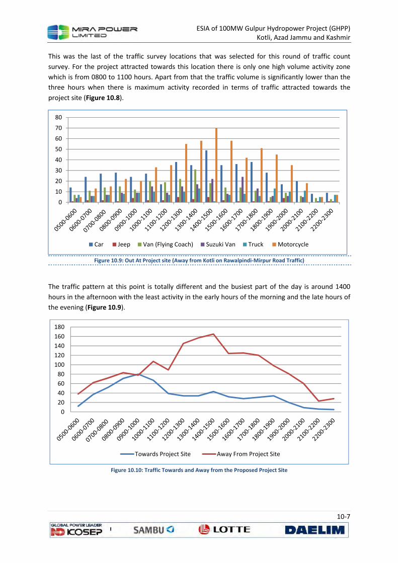
ESIA of 100MW Gulpur Hydropower Project (GHPP)
Kotli, Azad Jammu and Kashmir
10-7
This was the last of the traffic survey locations that was selected for this round of traffic count
survey. For the project attracted towards this location there is only one high volume activity zone
which is from 0800 to 1100 hours. Apart from that the traffic volume is significantly lower than the
three hours when there is maximum activity recorded in terms of traffic attracted towards the
project site (Figure 10.8).
Figure 10.9: Out At Project site (Away from Kotli on Rawalpindi-Mirpur Road Traffic)
The traffic pattern at this point is totally different and the busiest part of the day is around 1400
hours in the afternoon with the least activity in the early hours of the morning and the late hours of
the evening (Figure 10.9).
Figure 10.10: Traffic Towards and Away from the Proposed Project Site
0
10
20
30
40
50
60
70
80
Car Jeep Van (Flying Coach) Suzuki Van Truck Motorcycle
0
20
40
60
80
100
120
140
160
180
Towards Project Site Away From Project Site
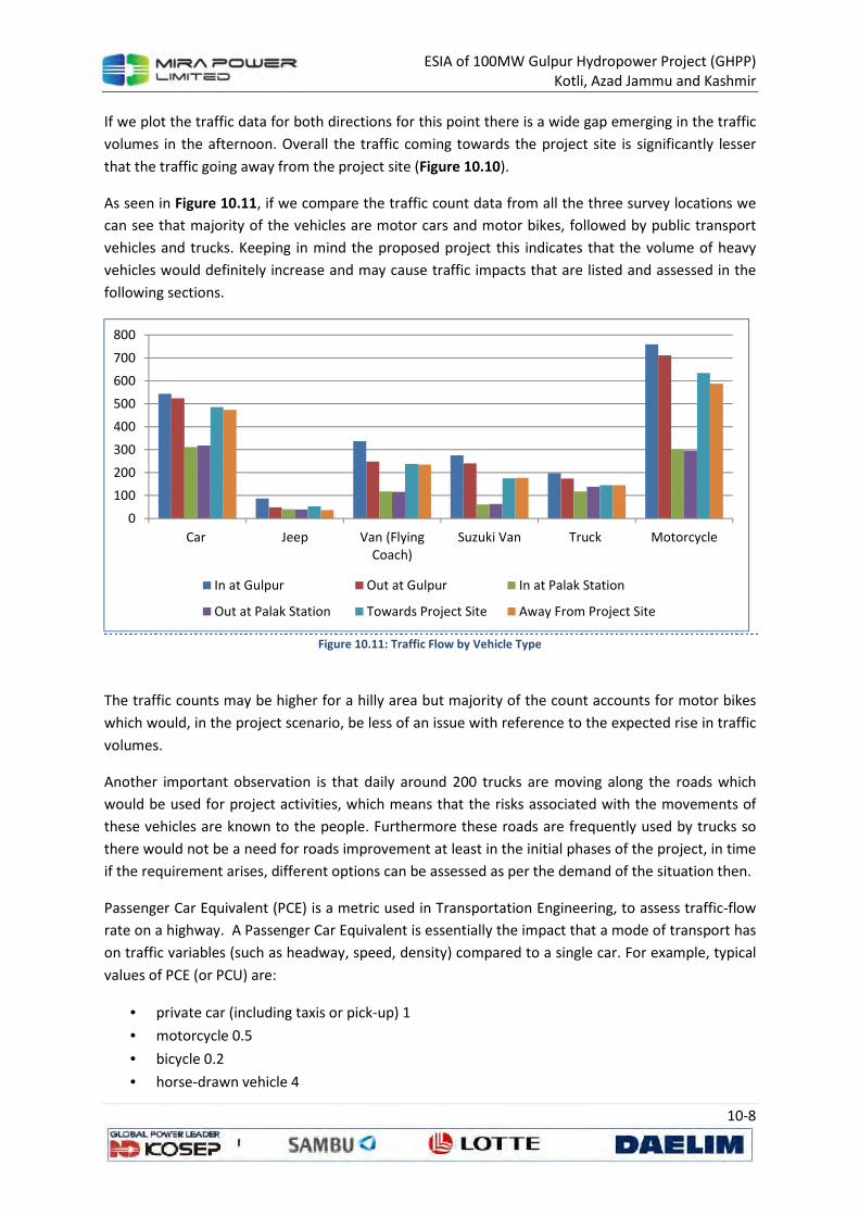
ESIA of 100MW Gulpur Hydropower Project (GHPP)
Kotli, Azad Jammu and Kashmir
10-8
If we plot the traffic data for both directions for this point there is a wide gap emerging in the traffic
volumes in the afternoon. Overall the traffic coming towards the project site is significantly lesser
that the traffic going away from the project site (Figure 10.10).
As seen in Figure 10.11, if we compare the traffic count data from all the three survey locations we
can see that majority of the vehicles are motor cars and motor bikes, followed by public transport
vehicles and trucks. Keeping in mind the proposed project this indicates that the volume of heavy
vehicles would definitely increase and may cause traffic impacts that are listed and assessed in the
following sections.
Figure 10.11: Traffic Flow by Vehicle Type
The traffic counts may be higher for a hilly area but majority of the count accounts for motor bikes
which would, in the project scenario, be less of an issue with reference to the expected rise in traffic
volumes.
Another important observation is that daily around 200 trucks are moving along the roads which
would be used for project activities, which means that the risks associated with the movements of
these vehicles are known to the people. Furthermore these roads are frequently used by trucks so
there would not be a need for roads improvement at least in the initial phases of the project, in time
if the requirement arises, different options can be assessed as per the demand of the situation then.
Passenger Car Equivalent (PCE) is a metric used in Transportation Engineering, to assess traffic-flow
rate on a highway. A Passenger Car Equivalent is essentially the impact that a mode of transport has
on traffic variables (such as headway, speed, density) compared to a single car. For example, typical
values of PCE (or PCU) are:
• private car (including taxis or pick-up) 1
• motorcycle 0.5
• bicycle 0.2
• horse-drawn vehicle 4
0
100
200
300
400
500
600
700
800
Car Jeep Van (FlyingCoach)
Suzuki Van Truck Motorcycle
In at Gulpur Out at Gulpur In at Palak Station
Out at Palak Station Towards Project Site Away From Project Site
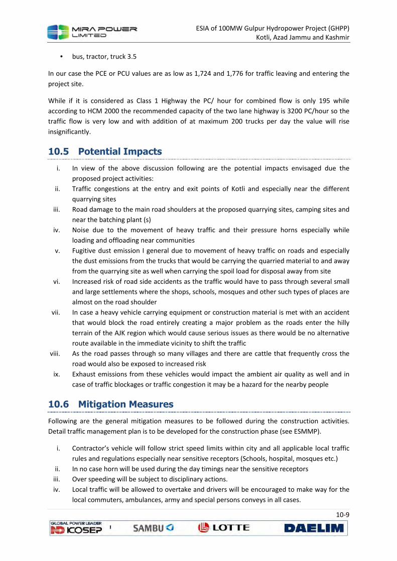
ESIA of 100MW Gulpur Hydropower Project (GHPP)
Kotli, Azad Jammu and Kashmir
10-9
• bus, tractor, truck 3.5
In our case the PCE or PCU values are as low as 1,724 and 1,776 for traffic leaving and entering the
project site.
While if it is considered as Class 1 Highway the PC/ hour for combined flow is only 195 while
according to HCM 2000 the recommended capacity of the two lane highway is 3200 PC/hour so the
traffic flow is very low and with addition of at maximum 200 trucks per day the value will rise
insignificantly.
10.5 Potential Impacts
i. In view of the above discussion following are the potential impacts envisaged due the
proposed project activities:
ii. Traffic congestions at the entry and exit points of Kotli and especially near the different
quarrying sites
iii. Road damage to the main road shoulders at the proposed quarrying sites, camping sites and
near the batching plant (s)
iv. Noise due to the movement of heavy traffic and their pressure horns especially while
loading and offloading near communities
v. Fugitive dust emission I general due to movement of heavy traffic on roads and especially
the dust emissions from the trucks that would be carrying the quarried material to and away
from the quarrying site as well when carrying the spoil load for disposal away from site
vi. Increased risk of road side accidents as the traffic would have to pass through several small
and large settlements where the shops, schools, mosques and other such types of places are
almost on the road shoulder
vii. In case a heavy vehicle carrying equipment or construction material is met with an accident
that would block the road entirely creating a major problem as the roads enter the hilly
terrain of the AJK region which would cause serious issues as there would be no alternative
route available in the immediate vicinity to shift the traffic
viii. As the road passes through so many villages and there are cattle that frequently cross the
road would also be exposed to increased risk
ix. Exhaust emissions from these vehicles would impact the ambient air quality as well and in
case of traffic blockages or traffic congestion it may be a hazard for the nearby people
10.6 Mitigation Measures
Following are the general mitigation measures to be followed during the construction activities.
Detail traffic management plan is to be developed for the construction phase (see ESMMP).
i. Contractor’s vehicle will follow strict speed limits within city and all applicable local traffic
rules and regulations especially near sensitive receptors (Schools, hospital, mosques etc.)
ii. In no case horn will be used during the day timings near the sensitive receptors
iii. Over speeding will be subject to disciplinary actions.
iv. Local traffic will be allowed to overtake and drivers will be encouraged to make way for the
local commuters, ambulances, army and special persons conveys in all cases.
ESIA of 100MW Gulpur Hydropower Project (GHPP)
Kotli, Azad Jammu and Kashmir
10-10
v. Contractor’s personnel will only use access routes assigned to them for project activities
which will be finalized during the kickoff meeting with representatives of client,
subcontractor and social receptors
vi. Trucks and vehicle will not be overload.
vii. Movement of contractor’s vehicles for transportation of material and wastes from and to
the site will be restricted to low traffic timings.
viii. A monitoring protocol will be implemented to track the vehicles
ix. Heavy traffic will only travel in the night time or a special permission from the district
administration be obtained.
x. Contractor’s vehicles and equipment will be parked at identified designated area.
xi. Vehicles and machinery should be appropriately parked/ placed to provide ample access to
local commuters/pedestrians
xii. Diversion plans will be developed to minimize disturbance to local population during
occasional high activity timings / days. These plans will be communicated to residents well in
advance and proper diversion signs will be placed to inform locals.
xiii. Prior communication to residents and safety signs will be installed well before the
commencement of any activity at site
xiv. The vehicles will be encouraged to leave the city area as quickly as possible after the delivery
of material to the project site.
10.7 Conclusions
The traffic baseline surveys and traffic assessment clearly suggest that the current road conditions
are appropriate for the project related traffic during the construction and operation. The traffic load
is also as calculated PCE values are very low in comparison to HCM 2000.
The social receptors are already experiencing the traffic flow on the current road so it is not
expected that they will be susceptible to project related traffic. With implementation of the
proposed mitigation measure and development and implementation of the project traffic
management plan the impact will be minimized.
ESIA of 100MW Gulpur Hydropower Project (GHPP)
Kotli, Azad Jammu and Kashmir
10-1
Environmental and
Social Management
and Monitoring Plan
(ESMMP)
Volume 2
100MW Gulpur Hydropower Project
Kotli, Azad Jammu and Kashmir - Pakistan
ESIA of 100MW Gulpur Hydropower Project (GHPP)
Kotli, Azad Jammu and Kashmir
Environmental and Social Management and Monitoring Plan (ESMMP)
of
100MW Gulpur Hydropower Project
Kotli, Azad Jammu and Kashmir, Pakistan
Volume 2
September, 2013
ESIA of 100MW Gulpur Hydropower Project (GHPP)
Kotli, Azad Jammu and Kashmir
11-1
11 ENVIRONMENTAL AND SOCIAL
MANAGEMENT AND MONITORING PLAN
This section comprises the Environmental and Social Management and Monitoring Plan (ESMMP) for
the ESIA for this Project. It summarizes the organizational requirements, management and
monitoring plans to ensure that the necessary measures are taken by MPL to avoid potentially
adverse effects and maximize potential benefits of the Project as identified in preceding section of
the ESIA and to operate in conformance with applicable laws and regulations of AJK, as well as the
policies of international financial organizations such as ADB and IFC.
The environmental and social management and monitoring plan (ESMMP) presented in this section
is a component of the overall environmental management that is particularly important with respect
to this ESIA report as it presents MPL’s commitments to address the impacts identified by the impact
assessment process.
The ESMMP is based on the baseline conditions and the impact assessment described in previous
chapters, plus the results of discussions with stakeholders. ESMMP is prepared for all the identified
environmental impacts during design, construction, and operation of various Project activities. The
methodology followed for preparing the ESMMP consists of the following steps:
• Deriving mitigation/protection measures for identified impacts using impact evaluation
methodology;
• Rationalize and combine series of mitigation, compensation and enhancement measures
from each identified impacts and risks to prepare overall measures;
• Developing a mechanism for monitoring the proposed mitigation measures;
• Estimating budget requirements for implementation mitigation and monitoring measures;
and
• Identifying responsibilities of various agencies involved in the Project for implementation
and monitoring of mitigation measures
The ESMP may be considered as a separate, stand-alone section within the suite of documents that
are being prepared as part of the ESIA process for this Project. This ESMMP due to its nature and
applicability will be further use for contractual purposes and will be included as a part of the bid
document for EPC contractor who have to coerce to it along with the regulatory requirement. The
strict implementation of the ESMMP and project management’s strict enforcement of the adequate
construction practices and standards will greatly reduce the negative impacts of the Project.
11.1 Institutional Implementation of ESMMP
Effective implementation and functioning of the ESMMP depends on adequate human and financial
resources, clearly defined responsibilities for environmental and social management, appropriate
training and good communication. An outline of how these features will be managed for the Project
is presented below
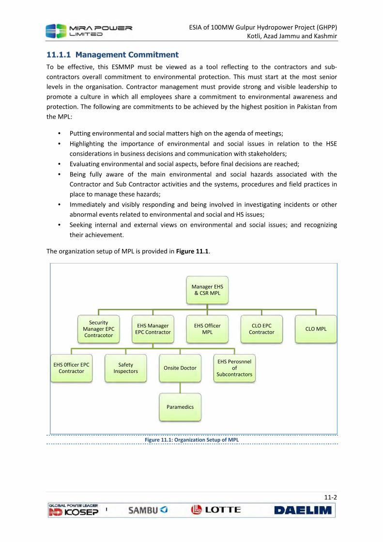
ESIA of 100MW Gulpur Hydropower Project (GHPP)
Kotli, Azad Jammu and Kashmir
11-2
11.1.1 Management Commitment
To be effective, this ESMMP must be viewed as a tool reflecting to the contractors and sub-
contractors overall commitment to environmental protection. This must start at the most senior
levels in the organisation. Contractor management must provide strong and visible leadership to
promote a culture in which all employees share a commitment to environmental awareness and
protection. The following are commitments to be achieved by the highest position in Pakistan from
the MPL:
• Putting environmental and social matters high on the agenda of meetings;
• Highlighting the importance of environmental and social issues in relation to the HSE
considerations in business decisions and communication with stakeholders;
• Evaluating environmental and social aspects, before final decisions are reached;
• Being fully aware of the main environmental and social hazards associated with the
Contractor and Sub Contractor activities and the systems, procedures and field practices in
place to manage these hazards;
• Immediately and visibly responding and being involved in investigating incidents or other
abnormal events related to environmental and social and HS issues;
• Seeking internal and external views on environmental and social issues; and recognizing
their achievement.
The organization setup of MPL is provided in Figure 11.1.
Figure 11.1: Organization Setup of MPL
Manager EHS & CSR MPL
Security Manager EPC Contracotor
EHS Manager EPC Contractor
EHS 0fficer EPC Contractor
Safety Inspectors
Onsite Doctor
Paramedics
EHS Perosnnel of
Subcontractors
EHS Officer MPL
CLO EPC Contractor
CLO MPL
ESIA of 100MW Gulpur Hydropower Project (GHPP)
Kotli, Azad Jammu and Kashmir
11-3
11.1.2 Roles and Responsibilities
11.1.2.1 Client
With overall responsibility for the Project, MPL will:
• Minimize any impact the Project may have on the environment through preparation of this
ESIA (as being carried out in the design stage)
• Appoint responsible contractors who will comply with this ESIA.
• Approve environmental safe materials for use on site in accordance with the ESIA.
• Ensure all relevant parties receive a copy of the approved ESIA and that it is incorporated
into all contractual documentation
• Obtain the relevant environmental permits, consents and authorizations prior to
commencing site works.
• Comply with all requirements of AJK EPA and obtain NOCs related to the Project.
11.1.2.2 Contractor
The Contractor’s general responsibilities will be to:
• Ensure the implementation of the ESIA/ESMMP throughout construction works by all
contractor personnel and subcontractors.
• Ensure that adequate resources are available to implement the requirements of this
ESMMP.
• Undertake quarterly environmental audits and report to MPL on regular basis.
• To coordinate with MPL for all correspondence to AJK EPA.
• Prepare a comprehensive legislation list and ensure compliance to these legislations.
11.1.2.3 Sub-Contractors
Any Sub Contractor hired directly or indirectly by the Contractor to carry out Project related tasks is
designated as a subcontractor. It is the responsibility of those sub-contractors, whose activities have
at least one interface with identified key environmental aspects, to comply with the ESIA at all times.
They must also designate sufficient competent resources to ensure all Sub-Contractor personnel
receive the required training. Sub-Contractors directly in charge of activities shall be registered and
approved. Registration documentation should be provided to the Client prior to commencement of
any activities. Sub-Contractors are expected to demonstrate a proactive behavior towards
environmental concerns. It is their responsibility to provide information requested by the Client with
regard to their scope of activities and to demonstrate compliance with the applicable environmental
requirements.
11.1.2.4 Personnel
Chief Executive Officer
The Chief Executive Officer (CEO) manages and superintends all head office and site activities for the
implementation of the Project. In relation to the ESIA and implementation of ESMMP, the CEO’s
responsibilities will include:
ESIA of 100MW Gulpur Hydropower Project (GHPP)
Kotli, Azad Jammu and Kashmir
11-4
• Overall responsibility for ensuring implementation of the ESMMP in compliance of all legal
matters regarding the Project.
• The development and establishment of adequate Environmental, Safety and Quality
Management teams, who will ensure the development, communication and implementation
of this ESIA across the entire project, including all activities being undertaken by
subcontractors and suppliers working on the site, and all personnel visiting the site.
• Ensure that an environmental representative is available on the Subcontractor part to
address environmental requirements in accordance with the ESIA.
• To develop and establish an organization structure adequate to oversee the whole of the
works, including overseeing the appointment of an appropriate qualified HSE Manager and
Environmental Manager.
• Ensure that adequate resources are available to implement the requirements of this ESIA.
• Ensure the ESIA is reviewed regularly to correspond with on-going construction activities.
• Coordinate with government agencies and bodies regularly to discuss the Project’s
construction environmental issues and requirements.
• Attend regular meetings with the Head Hydro Project, Construction Manager, HSE Manager
and Environmental Manager in order to discuss the site’s environmental issues and
requirements.
Chief Technical Officer
Responsibilities include:
• Taking primary responsibility for all activities on site, including those undertaken by direct or
indirectly employed personnel or agencies.
• Ensuring the issue of suitable procedures for the definition of working methods and site
regulations that take into consideration the requirements within the ESIA.
• Ensuring that construction and erection works are performed in respect of the ESIA
requirements.
• Attending regular meetings in order to discuss the site’s environmental issues and
requirements.
Manager EHS & CSR
The Manager EHS & CSR manages and supervises the Project activities relating to health, safety and
environment. The HSE Manager will be responsible for:
• The overall responsibility for the development and implementation of the Project HSE policy
/ philosophy.
• Coordinating weekly HSE meetings, during which any environmental issues will be discussed
and minuted.
• Reviewing and ensuring the implementation of Contingency and Emergency Response
Procedure.
• Providing specialized HSE input into engineering, construction and contracts, ensuring
requirements are properly integrated into project planning, design criteria, construction
plans and specifications and contracts
ESIA of 100MW Gulpur Hydropower Project (GHPP)
Kotli, Azad Jammu and Kashmir
11-5
• Supporting / leading incident investigations as per project procedure and report to all
concerned. Follow up and review the corrective and preventive action taken, and close-out
the incidences.
• Conducting HSE inspections of project construction activities and monitoring compliance
with requirements including contractual commitments, permits and projects HSE plan and
other applicable HSE requirements and ensure that the Project HSE inspection plan is
implemented.
• Ensuring that all internal as well as external incidents and complaints are appropriately
resolved with all applicable forms and records duly filled and maintained.
• Coordinating and organizing regular meetings with the Project Director, Construction
Manager and Environmental Manager in order to discuss the site’s HSE issues and
requirements.
• Coordinating the environmental activities with the higher management time to time.
• Coordinating with the AJK EPA, other regulatory authorities and stakeholders on
environmental issues related to construction of the Project.
• Monitoring construction activities and performance to ensure compliance with the ESIA and
effectiveness of control measures adopted.
• Ensuring that no works are carried out outside the construction corridor as defined in the
ESIA, especially within the protected areas (e.g. forests).
• Ensuring the issue and updating of the project’s environmental plans.
• Coordinating Project document review activities from an environmental standpoint, assuring
that the execution of these activities is compatible with development of the Project and
reporting any discrepancies between the environmental requirements and other Project
objectives to the Head Hydro Power and CEO.
• Supplying essential information for the preparation of the environmental control plan for
construction.
• Updating AJK EPA regularly on construction information.
• Coordinate the development of environmental monitoring data relevant to construction
activities.
• Performing environmental checks and monthly internal audits of onsite activities, in
coordination with the HSE Manager.
• Supporting the higher management in relations with the governmental agencies and with
the AJK EPA on environmental matters.
• Implementing the environmental requirements of the project management system including
inspection and reporting.
• Monitoring construction activities and performance to ensure compliance with the CEMP
and effectiveness of control measures adopted.
• Developing and implementing of the environmental training programme.
• Conducting staff environmental training, inductions and Tool Box Talks (TBT).
• Advise the Project Manager, or in his absence the relevant Construction Manager, to stop
work which could, or is, causing unacceptable environmental impacts.
• Communicate with internal and external parties as required.
ESIA of 100MW Gulpur Hydropower Project (GHPP)
Kotli, Azad Jammu and Kashmir
11-6
• Coordinating daily and weekly site inspections and approving the associated environmental
inspection report.
• Reviewing daily and weekly checklists to ensure that appropriate recording of site activities
and observations.
• Preparing of the monthly environmental reports, quarterly performance reports and
incident reports.
• Reporting of any environmental incidents to the higher management.
• Ensuring that major environmental incidents are reported to AJK EPA within a maximum of 3
days.
• Participating in environmental management reviews.
• Reviewing environmental monitoring data.
• Raise non-conformance and issue CAPs reports in coordination with the HSE Manager /
coordinator(s).
• Ascertaining that effective measures and relevant actions are undertaken to avoid or
minimize adverse environmental impacts.
• Attending regular meetings with the CEO, Head Hydro Power, PM, Construction Manager
and HSE Manager in order to discuss the site’s environmental issues and requirements.
• Ensuring that all internal as well as external environmental incidents, emergencies and
complaints are appropriately resolved with all applicable forms and records duly filled and
maintained.
• Regular reviewing of environmental plans and procedures to assess compliance and
recommend revisions, where required.
• Review quarterly audit reports and submit to AJK EPA with the quarterly performance
reports.
11.2 Mitigation and Management Plan
The plan prepared in accordance with the above framework is given below. The key components of
the plan are discussed in the following sections.
The environmental and social management plan includes the following:
• Impact reference – this specifies the impact/s which according to impact assessment
methodology followed for the project has potential influence either negative or positive and
needs to be mitigated by the proposed management measure influences as discussed in
earlier sections.
• Description of the impact – this briefly describe the potential impact which may arise from
the project activities and need a management measures
• Mitigation / Management measure – a description of the action, which will be clear, concise
and specific enough to enable execution of the action. Where relevant, targets, indicators,
trigger points and/or threshold levels will be incorporated into the management measure. If
a set of management actions is required to meet the objective, the ESMP will be simplified
by making a commitment to develop an appropriate supporting document in which the
detail will be provided.
• Project phase – Indicating the project phase/s when the management measure is applicable
ESIA of 100MW Gulpur Hydropower Project (GHPP)
Kotli, Azad Jammu and Kashmir
11-7
• Institutional Responsibilities –an indication of the roles and responsibilities for the concise
implementation of proposed management measures
• Targeted residual impact– an indication of how achievement of the management measure
will be assessed, which will be used to develop the monitoring, inspection or audit program
In addition to the above, specific management plans are developed which includes:
• Construction management Plan
• Air Pollution Control Plan
• Waste Management Plan
• Muck Disposal Plan
• Spill Contingency Plan
• Biodiversity Conservation and Management Plan
• Construction Labour Management Plan
• Traffic Management Plan
• Health and Safety Plan
• Emergency Preparedness Plan
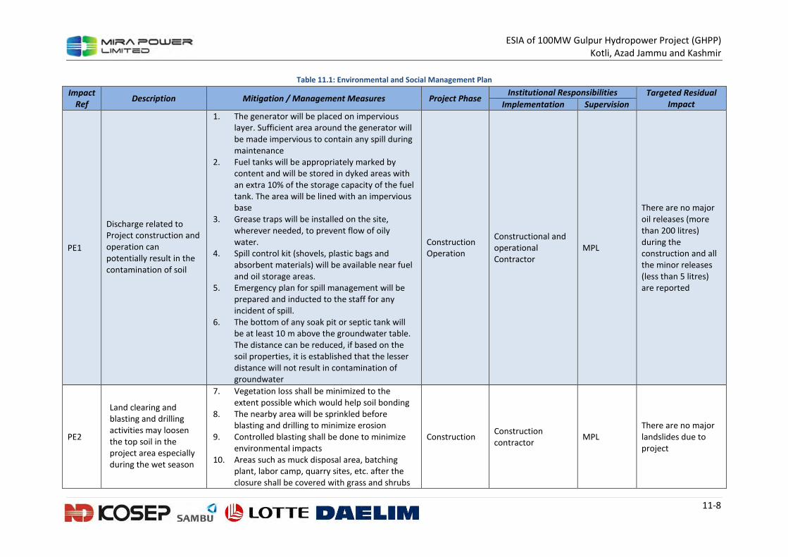
ESIA of 100MW Gulpur Hydropower Project (GHPP)
Kotli, Azad Jammu and Kashmir
11-8
Table 11.1: Environmental and Social Management Plan
Impact
Ref Description Mitigation / Management Measures Project Phase
Institutional Responsibilities Targeted Residual
Impact Implementation Supervision
PE1
Discharge related to
Project construction and
operation can
potentially result in the
contamination of soil
1. The generator will be placed on impervious
layer. Sufficient area around the generator will
be made impervious to contain any spill during
maintenance
2. Fuel tanks will be appropriately marked by
content and will be stored in dyked areas with
an extra 10% of the storage capacity of the fuel
tank. The area will be lined with an impervious
base
3. Grease traps will be installed on the site,
wherever needed, to prevent flow of oily
water.
4. Spill control kit (shovels, plastic bags and
absorbent materials) will be available near fuel
and oil storage areas.
5. Emergency plan for spill management will be
prepared and inducted to the staff for any
incident of spill.
6. The bottom of any soak pit or septic tank will
be at least 10 m above the groundwater table.
The distance can be reduced, if based on the
soil properties, it is established that the lesser
distance will not result in contamination of
groundwater
Construction
Operation
Constructional and operational Contractor
MPL
There are no major oil releases (more than 200 litres) during the construction and all the minor releases (less than 5 litres) are reported
PE2
Land clearing and blasting and drilling activities may loosen the top soil in the project area especially during the wet season
7. Vegetation loss shall be minimized to the extent possible which would help soil bonding
8. The nearby area will be sprinkled before blasting and drilling to minimize erosion
9. Controlled blasting shall be done to minimize environmental impacts
10. Areas such as muck disposal area, batching plant, labor camp, quarry sites, etc. after the closure shall be covered with grass and shrubs
Construction Construction contractor
MPL There are no major landslides due to project
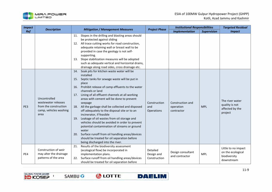
ESIA of 100MW Gulpur Hydropower Project (GHPP)
Kotli, Azad Jammu and Kashmir
11-9
Impact
Ref Description Mitigation / Management Measures Project Phase
Institutional Responsibilities Targeted Residual
Impact Implementation Supervision
11. Slopes in the drilling and blasting areas should
be protected against sliding
12. All trace cutting works for road construction,
adequate retaining wall or breast wall to be
provided in case the geology is not self-
supporting.
13. Slope stabilization measures will be adopted
such as adequate vertical and horizontal drains,
drainage along road sides, cross drainage etc.
PE3
Uncontrolled
wastewater releases
from the construction
camp, vehicles washing
area
14. Soak pits for kitchen waste water will be
installed
15. Septic tanks for sewage waste will be put in
place
16. Prohibit release of camp effluents to the water
channels or land
17. Lining of all effluent channels at all working
areas with cement will be done to prevent
seepage
18. All the garbage shall be collected and disposed
off adequately to the disposal site or to an
incinerator, if feasible
19. Leakage of oil wastes from oil storage and
vehicles should be avoided in order to prevent
potential contamination of streams or ground
water
20. Surface runoff from oil handling areas/devices
should be treated for oil separation before
being discharged into the river.
Construction
and
Operations
Construction and operation contractor
MPL
The river water quality is not affected by the project
PE4
Construction of weir may alter the drainage patterns of the area
21. Results of the biodiversity assessment (ecological flow) be incorporated in implementation plans.
22. Surface runoff from oil handling areas/devices should be treated for oil separation before
Detailed Design and Construction
Design consultant and contractor
MPL
Little to no impact on the ecological biodiversity downstream
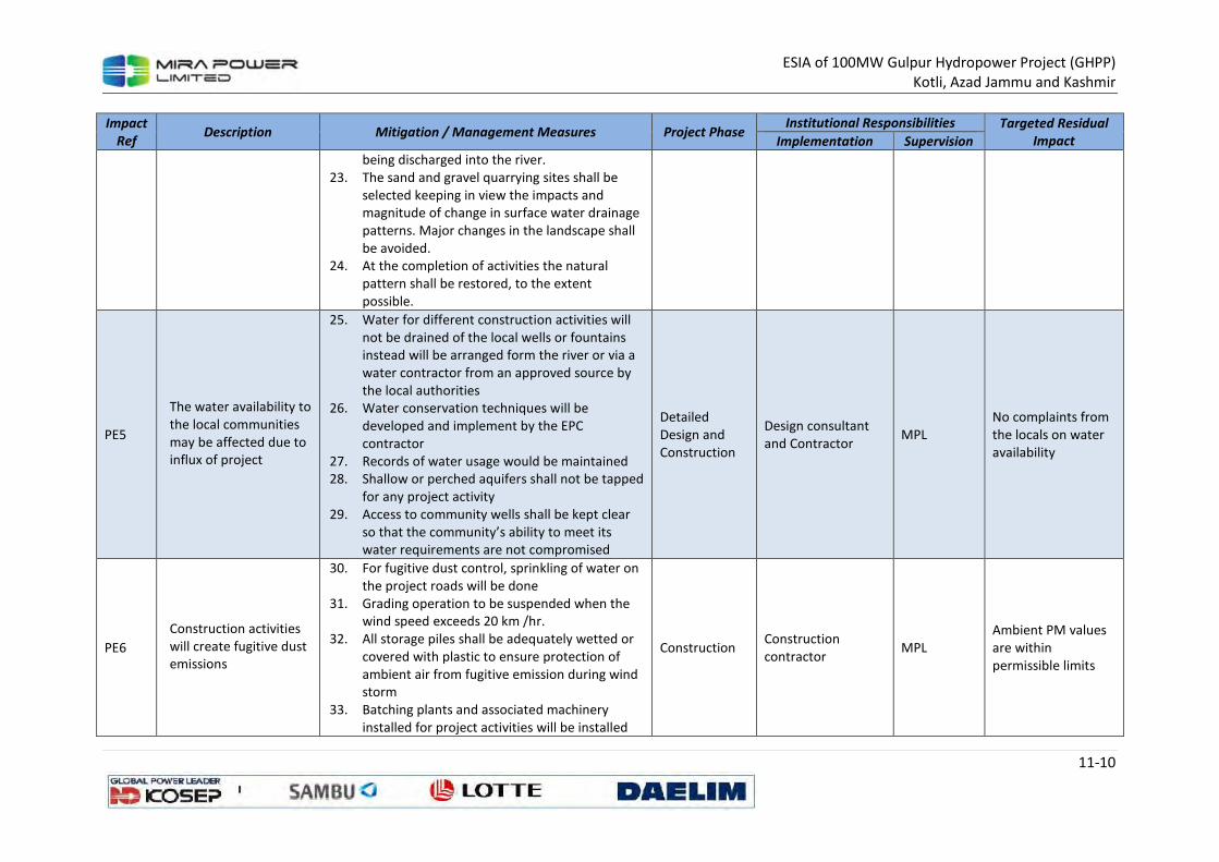
ESIA of 100MW Gulpur Hydropower Project (GHPP)
Kotli, Azad Jammu and Kashmir
11-10
Impact
Ref Description Mitigation / Management Measures Project Phase
Institutional Responsibilities Targeted Residual
Impact Implementation Supervision
being discharged into the river.
23. The sand and gravel quarrying sites shall be
selected keeping in view the impacts and
magnitude of change in surface water drainage
patterns. Major changes in the landscape shall
be avoided.
24. At the completion of activities the natural
pattern shall be restored, to the extent
possible.
PE5
The water availability to
the local communities
may be affected due to
influx of project
25. Water for different construction activities will
not be drained of the local wells or fountains
instead will be arranged form the river or via a
water contractor from an approved source by
the local authorities
26. Water conservation techniques will be
developed and implement by the EPC
contractor
27. Records of water usage would be maintained
28. Shallow or perched aquifers shall not be tapped
for any project activity
29. Access to community wells shall be kept clear
so that the community’s ability to meet its
water requirements are not compromised
Detailed
Design and
Construction
Design consultant
and Contractor MPL
No complaints from
the locals on water
availability
PE6
Construction activities
will create fugitive dust
emissions
30. For fugitive dust control, sprinkling of water on
the project roads will be done
31. Grading operation to be suspended when the
wind speed exceeds 20 km /hr.
32. All storage piles shall be adequately wetted or
covered with plastic to ensure protection of
ambient air from fugitive emission during wind
storm
33. Batching plants and associated machinery
installed for project activities will be installed
Construction Construction
contractor MPL
Ambient PM values
are within
permissible limits
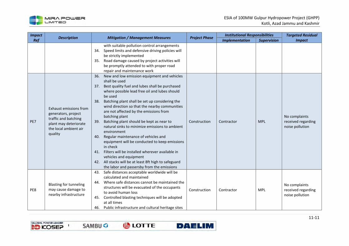
ESIA of 100MW Gulpur Hydropower Project (GHPP)
Kotli, Azad Jammu and Kashmir
11-11
Impact
Ref Description Mitigation / Management Measures Project Phase
Institutional Responsibilities Targeted Residual
Impact Implementation Supervision
with suitable pollution control arrangements
34. Speed limits and defensive driving policies will
be strictly implemented
35. Road damage caused by project activities will
be promptly attended to with proper road
repair and maintenance work
PE7
Exhaust emissions from
generators, project
traffic and batching
plant may deteriorate
the local ambient air
quality
36. New and low emission equipment and vehicles
shall be used
37. Best quality fuel and lubes shall be purchased
where possible lead free oil and lubes should
be used
38. Batching plant shall be set up considering the
wind direction so that the nearby communities
are not affected by the emissions from
batching plant
39. Batching plant should be kept as near to
natural sinks to minimize emissions to ambient
environment
40. Regular maintenance of vehicles and
equipment will be conducted to keep emissions
in check
41. Filters will be installed wherever available in
vehicles and equipment
42. All stacks will be at least 8ft high to safeguard
the labor and passersby from the emissions
Construction Contractor MPL
No complaints
received regarding
noise pollution
PE8
Blasting for tunneling
may cause damage to
nearby infrastructure
43. Safe distances acceptable worldwide will be
calculated and maintained
44. Where safe distances cannot be maintained the
structures will be evacuated of the occupants
to avoid human loss
45. Controlled blasting techniques will be adopted
at all times
46. Public infrastructure and cultural heritage sites
Construction Contractor MPL
No complaints
received regarding
noise pollution
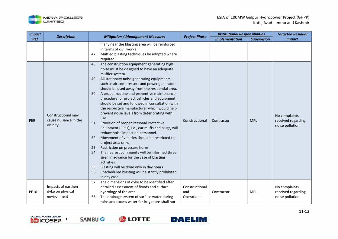
ESIA of 100MW Gulpur Hydropower Project (GHPP)
Kotli, Azad Jammu and Kashmir
11-12
Impact
Ref Description Mitigation / Management Measures Project Phase
Institutional Responsibilities Targeted Residual
Impact Implementation Supervision
if any near the blasting area will be reinforced
in terms of civil works
47. Muffled blasting techniques be adopted where
required.
PE9
Constructional may
cause nuisance in the
vicinity
48. The construction equipment generating high
noise must be designed to have an adequate
muffler system.
49. All stationary noise generating equipments
such as air compressors and power generators
should be used away from the residential area.
50. A proper routine and preventive maintenance
procedure for project vehicles and equipment
should be set and followed in consultation with
the respective manufacturer which would help
prevent noise levels from deteriorating with
use.
51. Provision of proper Personal Protective
Equipment (PPEs), i.e., ear muffs and plugs, will
reduce noise impact on personnel.
52. Movement of vehicles should be restricted to
project area only.
53. Restriction on pressure horns.
54. The nearest community will be informed three
siren in advance for the case of blasting
activities
55. Blasting will be done only in day hours
56. unscheduled blasting will be strictly prohibited
in any case
Constructional Contractor MPL
No complaints
received regarding
noise pollution
PE10
Impacts of earthen
dyke on physical
environment
57. The dimensions of dyke to be identified after
detailed assessment of floods and surface
hydrology of the area.
58. The drainage system of surface water during
rains and excess water for irrigations shall not
Constructional
and
Operational Contractor MPL
No complaints received regarding noise pollution
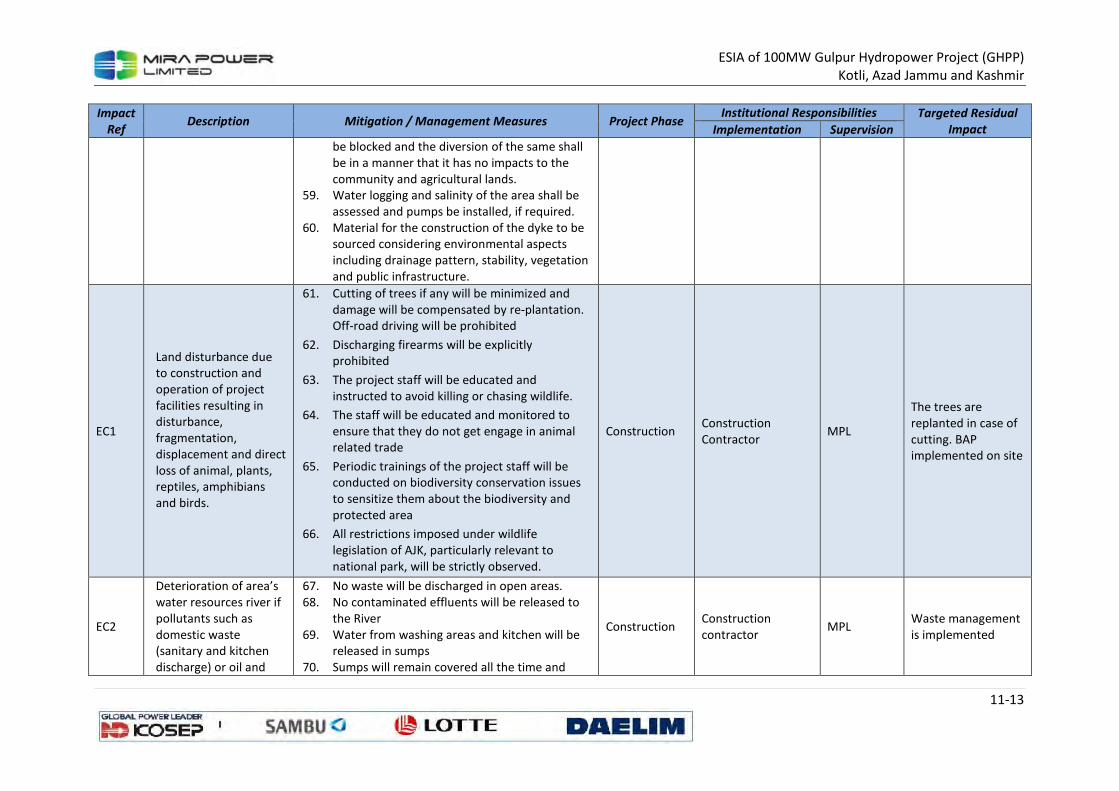
ESIA of 100MW Gulpur Hydropower Project (GHPP)
Kotli, Azad Jammu and Kashmir
11-13
Impact
Ref Description Mitigation / Management Measures Project Phase
Institutional Responsibilities Targeted Residual
Impact Implementation Supervision
be blocked and the diversion of the same shall
be in a manner that it has no impacts to the
community and agricultural lands.
59. Water logging and salinity of the area shall be
assessed and pumps be installed, if required.
60. Material for the construction of the dyke to be
sourced considering environmental aspects
including drainage pattern, stability, vegetation
and public infrastructure.
EC1
Land disturbance due
to construction and
operation of project
facilities resulting in
disturbance,
fragmentation,
displacement and direct
loss of animal, plants,
reptiles, amphibians
and birds.
61. Cutting of trees if any will be minimized and
damage will be compensated by re-plantation.
Off-road driving will be prohibited
62. Discharging firearms will be explicitly prohibited
63. The project staff will be educated and instructed to avoid killing or chasing wildlife.
64. The staff will be educated and monitored to ensure that they do not get engage in animal related trade
65. Periodic trainings of the project staff will be conducted on biodiversity conservation issues to sensitize them about the biodiversity and protected area
66. All restrictions imposed under wildlife legislation of AJK, particularly relevant to national park, will be strictly observed.
Construction Construction Contractor
MPL
The trees are replanted in case of cutting. BAP implemented on site
EC2
Deterioration of area’s water resources river if pollutants such as domestic waste (sanitary and kitchen discharge) or oil and
67. No waste will be discharged in open areas. 68. No contaminated effluents will be released to
the River 69. Water from washing areas and kitchen will be
released in sumps 70. Sumps will remain covered all the time and
Construction Construction contractor
MPL Waste management is implemented
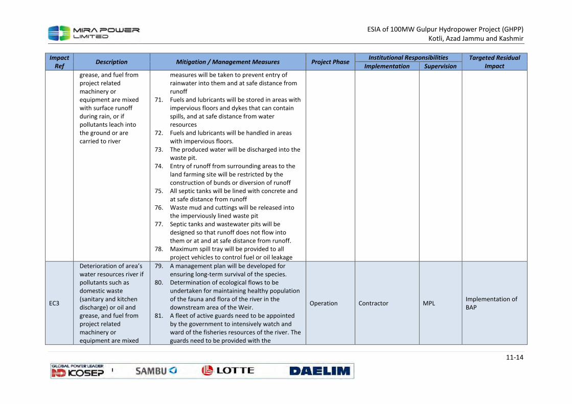
ESIA of 100MW Gulpur Hydropower Project (GHPP)
Kotli, Azad Jammu and Kashmir
11-14
Impact
Ref Description Mitigation / Management Measures Project Phase
Institutional Responsibilities Targeted Residual
Impact Implementation Supervision
grease, and fuel from
project related
machinery or
equipment are mixed
with surface runoff
during rain, or if
pollutants leach into
the ground or are
carried to river
measures will be taken to prevent entry of
rainwater into them and at safe distance from
runoff
71. Fuels and lubricants will be stored in areas with
impervious floors and dykes that can contain
spills, and at safe distance from water
resources
72. Fuels and lubricants will be handled in areas
with impervious floors.
73. The produced water will be discharged into the
waste pit.
74. Entry of runoff from surrounding areas to the
land farming site will be restricted by the
construction of bunds or diversion of runoff
75. All septic tanks will be lined with concrete and
at safe distance from runoff
76. Waste mud and cuttings will be released into
the imperviously lined waste pit
77. Septic tanks and wastewater pits will be
designed so that runoff does not flow into
them or at and at safe distance from runoff.
78. Maximum spill tray will be provided to all
project vehicles to control fuel or oil leakage
EC3
Deterioration of area’s
water resources river if
pollutants such as
domestic waste
(sanitary and kitchen
discharge) or oil and
grease, and fuel from
project related
machinery or
equipment are mixed
79. A management plan will be developed for
ensuring long-term survival of the species.
80. Determination of ecological flows to be
undertaken for maintaining healthy population
of the fauna and flora of the river in the
downstream area of the Weir.
81. A fleet of active guards need to be appointed
by the government to intensively watch and
ward of the fisheries resources of the river. The
guards need to be provided with the
Operation Contractor MPL Implementation of BAP
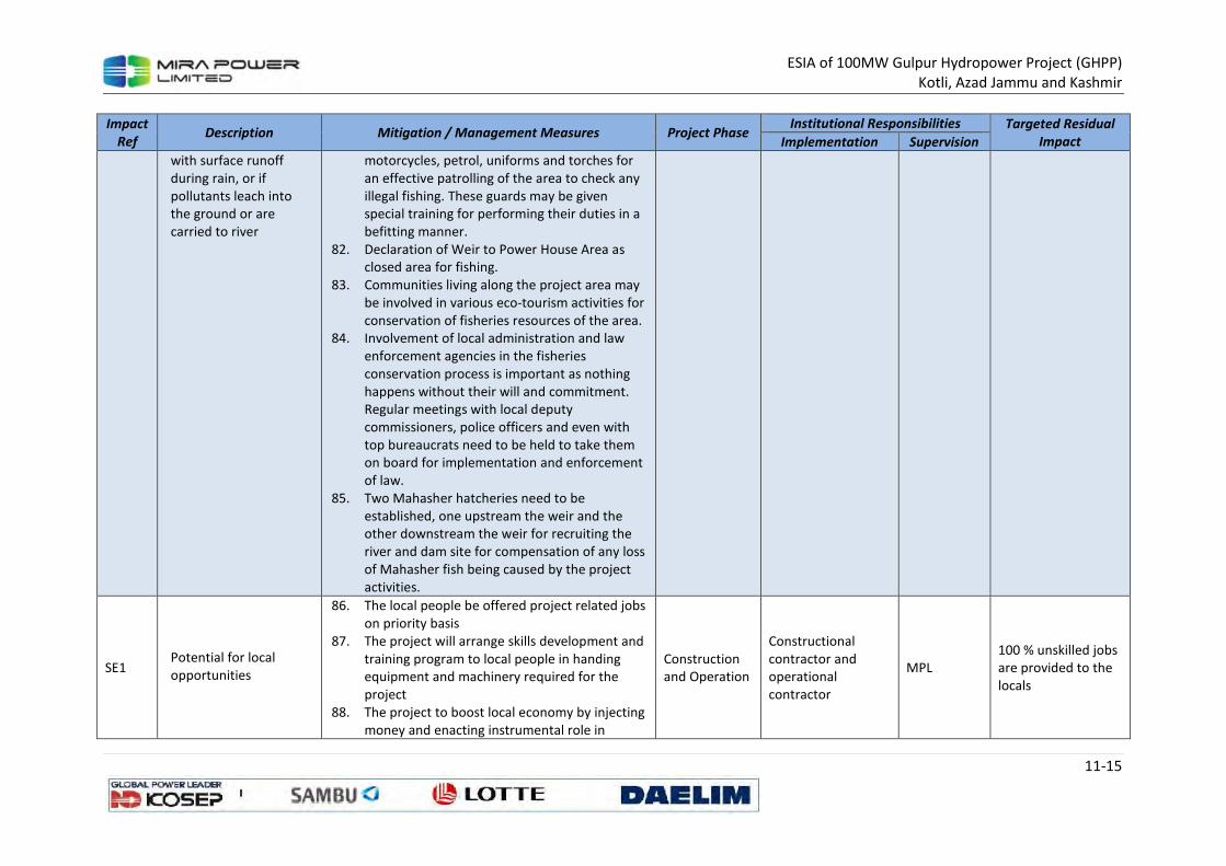
ESIA of 100MW Gulpur Hydropower Project (GHPP)
Kotli, Azad Jammu and Kashmir
11-15
Impact
Ref Description Mitigation / Management Measures Project Phase
Institutional Responsibilities Targeted Residual
Impact Implementation Supervision
with surface runoff
during rain, or if
pollutants leach into
the ground or are
carried to river
motorcycles, petrol, uniforms and torches for
an effective patrolling of the area to check any
illegal fishing. These guards may be given
special training for performing their duties in a
befitting manner.
82. Declaration of Weir to Power House Area as
closed area for fishing.
83. Communities living along the project area may
be involved in various eco-tourism activities for
conservation of fisheries resources of the area.
84. Involvement of local administration and law
enforcement agencies in the fisheries
conservation process is important as nothing
happens without their will and commitment.
Regular meetings with local deputy
commissioners, police officers and even with
top bureaucrats need to be held to take them
on board for implementation and enforcement
of law.
85. Two Mahasher hatcheries need to be
established, one upstream the weir and the
other downstream the weir for recruiting the
river and dam site for compensation of any loss
of Mahasher fish being caused by the project
activities.
SE1 Potential for local
opportunities
86. The local people be offered project related jobs
on priority basis
87. The project will arrange skills development and
training program to local people in handing
equipment and machinery required for the
project
88. The project to boost local economy by injecting
money and enacting instrumental role in
Construction
and Operation
Constructional contractor and operational contractor
MPL 100 % unskilled jobs are provided to the locals
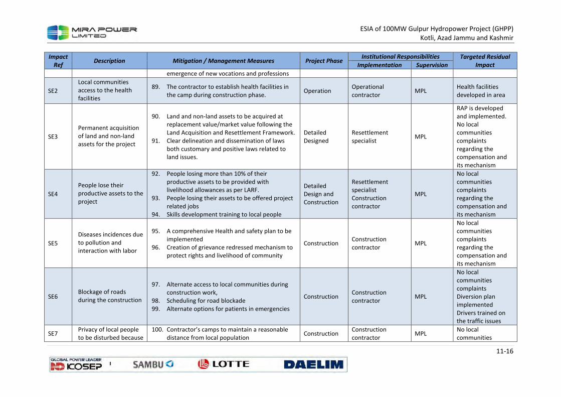
ESIA of 100MW Gulpur Hydropower Project (GHPP)
Kotli, Azad Jammu and Kashmir
11-16
Impact
Ref Description Mitigation / Management Measures Project Phase
Institutional Responsibilities Targeted Residual
Impact Implementation Supervision
emergence of new vocations and professions
SE2
Local communities
access to the health
facilities
89. The contractor to establish health facilities in
the camp during construction phase. Operation
Operational contractor
MPL Health facilities developed in area
SE3
Permanent acquisition of land and non-land assets for the project
90. Land and non-land assets to be acquired at replacement value/market value following the Land Acquisition and Resettlement Framework.
91. Clear delineation and dissemination of laws both customary and positive laws related to land issues.
Detailed Designed
Resettlement specialist
MPL
RAP is developed and implemented. No local communities complaints regarding the compensation and its mechanism
SE4
People lose their productive assets to the project
92. People losing more than 10% of their productive assets to be provided with livelihood allowances as per LARF.
93. People losing their assets to be offered project related jobs
94. Skills development training to local people
Detailed Design and Construction
Resettlement specialist Construction contractor
MPL
No local communities complaints regarding the compensation and its mechanism
SE5
Diseases incidences due to pollution and interaction with labor
95. A comprehensive Health and safety plan to be implemented
96. Creation of grievance redressed mechanism to protect rights and livelihood of community
Construction Construction contractor
MPL
No local communities complaints regarding the compensation and its mechanism
SE6 Blockage of roads during the construction
97. Alternate access to local communities during construction work,
98. Scheduling for road blockade 99. Alternate options for patients in emergencies
Construction Construction contractor
MPL
No local communities complaints Diversion plan implemented Drivers trained on the traffic issues
SE7 Privacy of local people to be disturbed because
100. Contractor’s camps to maintain a reasonable distance from local population
Construction Construction contractor
MPL No local communities
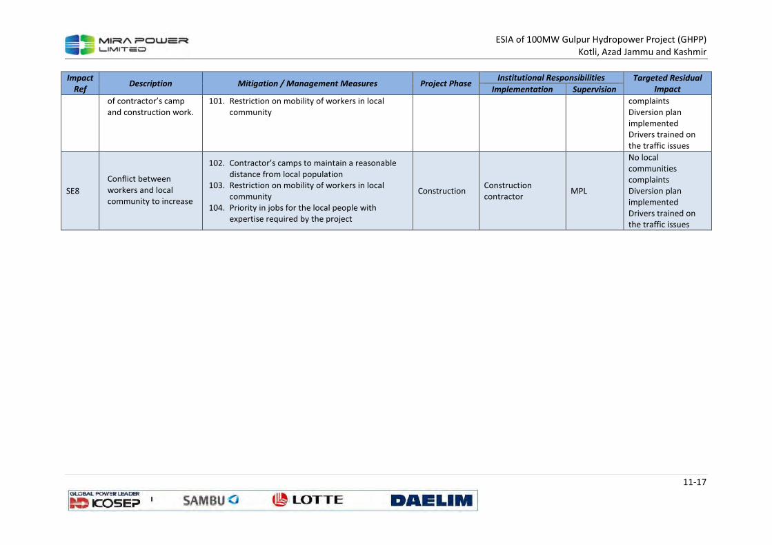
ESIA of 100MW Gulpur Hydropower Project (GHPP)
Kotli, Azad Jammu and Kashmir
11-17
Impact
Ref Description Mitigation / Management Measures Project Phase
Institutional Responsibilities Targeted Residual
Impact Implementation Supervision
of contractor’s camp
and construction work.
101. Restriction on mobility of workers in local
community
complaints
Diversion plan
implemented
Drivers trained on
the traffic issues
SE8
Conflict between
workers and local
community to increase
102. Contractor’s camps to maintain a reasonable
distance from local population
103. Restriction on mobility of workers in local
community
104. Priority in jobs for the local people with
expertise required by the project
Construction Construction
contractor MPL
No local
communities
complaints
Diversion plan
implemented
Drivers trained on
the traffic issues
ESIA of 100MW Gulpur Hydropower Project (GHPP)
Kotli, Azad Jammu and Kashmir
11-18
11.3 Monitoring Plan
Monitoring of environmental components and mitigation measures during implementation and
operation stages is a key component of the ESMMP to safeguard the protection of environment. The
objectives of the monitoring are to
i. manage environmental issues arising from construction works through closely monitoring
the environmental compliances
ii. monitor changes in the environment during various stages of the project life cycle with
respect to baseline conditions;
Monitoring program will includes regular monitoring of construction and commissioning activities
for their compliance with the environmental requirements as per relevant standards, specifications
and ESMMP. The purpose of such monitoring is to assess the performance of the undertaken
mitigation measures and to immediately formulate additional mitigation measures and/or modify
the existing ones aimed at meeting the environmental compliance as appropriate during
construction.
The monitoring programme will be coupled with a series of supporting procedures, yet to be
developed, covering:
• sample or data collection;
• sample handling, sample storage and preservation;
• sample or data documentation;
• quality control;
• data reliability (calibration of instruments, test equipment, and software and hardware
sampling);
• data storage and backup, and data protection;
• interpretation and reporting of results; and
• verification of monitoring information by qualified and experienced external experts.
Skeleton Environmental Monitoring Plan is provided in Table below. Data will be documented and
interpreted. Temporal and spatial trends in the data will be discerned and compliance with relevant
thresholds will be evaluated. Monitoring reports will be produced to meet internal and external
reporting requirements. If monitoring results indicate non-conformance with stipulated thresholds
or if a significant deteriorating trend is observed, it will be recorded as a non-conformance and
handled by the non-conformance and incident procedure.
11.3.1 Site inspections
Site inspections will be undertaken regularly in relevant areas of the Project. The inspections will
focus on compliance with the ESMMP. The inspections will play an important role in increasing
awareness of ESMMP.
Minor non-conformances will be discussed during the inspection and recorded as a finding in the
inspection report. Major non-conformances will be reported as incidents. Inspection results will be
disclosed at management meetings.

ESIA of 100MW Gulpur Hydropower Project (GHPP)
Kotli, Azad Jammu and Kashmir
11-19
11.3.2 Formal audits
Formal audits will be undertaken at planned intervals in accordance with the requirements of client
and regulatory authorities. Procedures for audits will be established, implemented and maintained.
These will cover the audit criteria, scope, frequency and methods, and will address the
responsibilities and requirements for planning and conducting audits, reporting results and retaining
associated records.
Any negative findings arising from an audit will be treated an incident and dealt with in accordance
with the non-conformance and incident procedure. Results from audits and evaluations of
compliance with legal requirements will be reported to site and senior management and subject to
management reviews. Usually environmental regulatory authorities require a quarterly audit report
for large scale projects.
11.3.3 Non-conformances and incidents
Non-conformances include the following:
• exceedances of relevant thresholds as identified during routine monitoring;
• non-conformances with the requirements of the ESMP or supporting documentation
identified during an internal inspection;
• non-conformances identified during an audit or by regulatory authorities;
• events, such as spills, resulting in potential or actual environmental harm;
• events that did or could result in injury to staff, visitors to site or surrounding communities;
and
• significant complaints or grievances received from any source.
Corrective and preventive actions will be identified and implemented in response to these non-
conformances. These actions will address the root cause of the non-conformance and will reduce or
prevent repeated non-conformances.
A process will be established for the identification, investigation and tracking of non-conformances,
including:
• prioritizing and classifying non-conformances based on the type and severity of the non-
conformance;
• recording of non-conformances and the results of corrective and/or preventive actions,
including the actions necessary to mitigate or remedy any associated impacts;
• defining results expected from the corrective and/or preventative actions;
• confirming the corrective and/or preventive actions taken to eliminate the causes of the
non-conformance are appropriate to the magnitude of problem and commensurate with the
impacts encountered;
• reviewing the effectiveness of the corrective and/or preventive actions taken; and
• implementing and recording required changes in the ESMP or monitoring programme
resulting from corrective and preventive action.
Serious non-conformances will be classified as incidents. Incidents will be promptly reported to
appropriate management. A guideline will be prepared on:
ESIA of 100MW Gulpur Hydropower Project (GHPP)
Kotli, Azad Jammu and Kashmir
11-20
• the types of incidents reportable to internal management at the site, Project and corporate
levels, as well as to regulatory authorities and other external stakeholders; and
• standards to be observed when reporting incidents.
During construction, environmental monitoring will ensure the protection of air and noise pollution,
community relations, and safety provisions. Post monitoring evaluation will be carried to evaluate
the impacts of the Project during first 3 years of operation of the Project. During operation,
emissions, air, noise, and waste water quality monitoring and greenbelt development around the
plant will be important parameter of the monitoring program.
The monitoring requirement can only be fulfilled by maintaining the proper documentation records
of the findings. Daily checklists, weekly reports and monthly audit will be taken in accordance with
construction management plan. Based on the ESIA approval a scheduled audit will be conducted by
the MPL and reports will be shared with the regulatory authority and funding agency if required.
11.3.4 Documentation and Record Keeping
Monitoring elements of the ESMMP will be documented and controlled in accordance with a
document control system. Records demonstrating compliance with legal requirements and
conformance with the ESMMP will also be maintained. Client will supervised, establish, implement
and maintain procedures:
Documentation and record keeping controls will include:
• measures to enable relevant documents and records to be readily available and identifiable
(labeled, dated and properly filed), legible and protected from damage;
• review, revision and approval of documents for adequacy by authorized personnel at least
once a year;
• establishment of the electronic document control version as the ‘authorized version’;
• making current versions of relevant documents available at locations where operations
essential to the effective functioning;
• suitably identifying obsolete documents retained for legal and knowledge preservation
purposes; and
• identification and segregation of confidential and privileged information.
11.3.5 Preliminary monitoring programmes
Preliminary monitoring program have been prepared in response to the ESMP (Table 11.1). These
provide a framework of monitoring to evaluate performance and assist in predicting and managing
impacts.
The frequencies and locations may need to be adjusted depending on final Project design and
ongoing review of results obtained by the monitoring programmes.
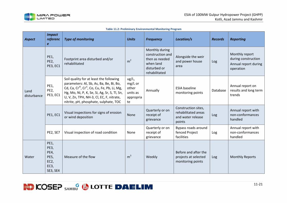
ESIA of 100MW Gulpur Hydropower Project (GHPP)
Kotli, Azad Jammu and Kashmir
11-21
Table 11.2: Preliminary Environmental Monitoring Program
Aspect
Impact
referenc
e
Type of monitoring Units Frequency Location/s Records Reporting
Land
disturbance
PE1,
PE2,
PE3, EC1
Footprint area disturbed and/or
rehabilitated m2
Monthly during
construction and
then as needed
when land
disturbed or
rehabilitated
Alongside the weir
and power house
area
Log
Monthly report
during construction
Annual report during
operation
PE1,
PE2,
PE3, EC1
Soil quality for at least the following
parameters: Al, Sb, As, Ba, Be, Bi, Bo,
Cd, Ca, CrIII, Criv, Co, Cu, Fe, Pb, Li, Mg,
Hg, Mo, Ni, P, K, Se, Si, Ag, Sr, S, Tl, Sn,
U, V, Zn, TPH, NH-3, Cl, EC, F, nitrate,
nitrite, pH, phosphate, sulphate, TOC
ug/L, mg/L or other units as appropriate
Annually ESIA baseline monitoring points
Database Annual report on results and long term trends
PE1, EC1 Visual inspections for signs of erosion or wind deposition
None Quarterly or on receipt of grievance
Construction sites, rehabilitated areas and water release points
Log Annual report with non-conformances handled
PE2, SE7 Visual inspection of road condition None Quarterly or on receipt of grievance
Bypass roads around fenced Project facilities
Log Annual report with non-conformances handled
Water
PE1, PE3, PE4, PE5, EC2, EC3, SE3, SE4
Measure of the flow m3 Weekly Before and after the projects at selected monitoring points
Log Monthly Reports
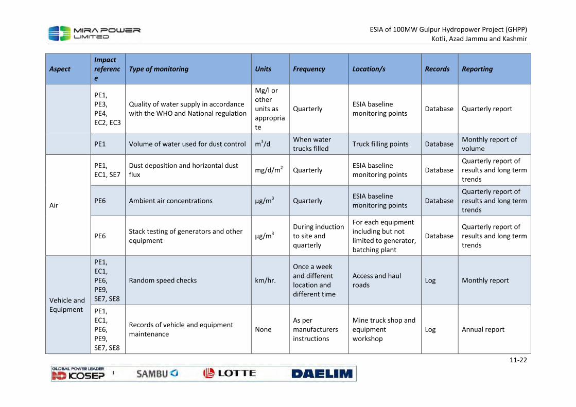
ESIA of 100MW Gulpur Hydropower Project (GHPP)
Kotli, Azad Jammu and Kashmir
11-22
Aspect
Impact
referenc
e
Type of monitoring Units Frequency Location/s Records Reporting
PE1,
PE3,
PE4,
EC2, EC3
Quality of water supply in accordance
with the WHO and National regulation
Mg/l or other units as appropriate
Quarterly ESIA baseline monitoring points
Database Quarterly report
PE1 Volume of water used for dust control m3/d When water trucks filled
Truck filling points Database Monthly report of volume
Air
PE1, EC1, SE7
Dust deposition and horizontal dust flux
mg/d/m2 Quarterly ESIA baseline monitoring points
Database Quarterly report of results and long term trends
PE6 Ambient air concentrations µg/m3 Quarterly ESIA baseline monitoring points
Database Quarterly report of results and long term trends
PE6 Stack testing of generators and other equipment
µg/m3 During induction to site and quarterly
For each equipment including but not limited to generator, batching plant
Database Quarterly report of results and long term trends
Vehicle and Equipment
PE1, EC1, PE6, PE9, SE7, SE8
Random speed checks km/hr.
Once a week and different location and different time
Access and haul roads
Log Monthly report
PE1, EC1, PE6, PE9, SE7, SE8
Records of vehicle and equipment maintenance
None As per manufacturers instructions
Mine truck shop and equipment workshop
Log Annual report
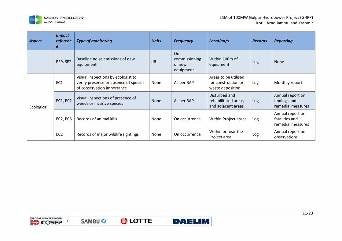
ESIA of 100MW Gulpur Hydropower Project (GHPP)
Kotli, Azad Jammu and Kashmir
11-23
Aspect
Impact
referenc
e
Type of monitoring Units Frequency Location/s Records Reporting
PE9, SE2 Baseline noise emissions of new
equipment dB
On commissioning of new equipment
Within 100m of equipment
Log None
Ecological
EC1 Visual inspections by ecologist to verify presence or absence of species of conservation importance
None As per BAP Areas to be utilised for construction or waste deposition
Log Monthly report
EC1, EC2 Visual inspections of presence of weeds or invasive species
None As per BAP Disturbed and rehabilitated areas, and adjacent areas
Log Annual report on findings and remedial measures
EC2, EC3 Records of animal kills None On occurrence Within Project areas Log Annual report on fatalities and remedial measures
EC2 Records of major wildlife sightings None On occurrence Within or near the Project area
Log Annual report on observations
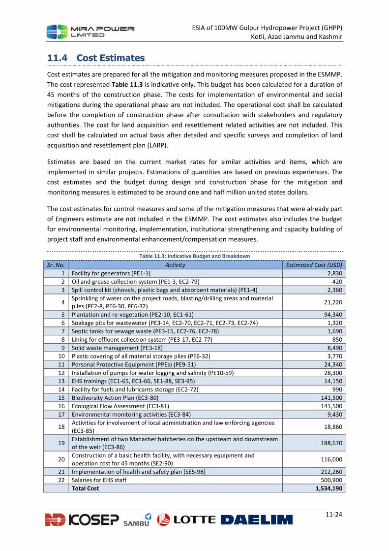
ESIA of 100MW Gulpur Hydropower Project (GHPP)
Kotli, Azad Jammu and Kashmir
11-24
11.4 Cost Estimates
Cost estimates are prepared for all the mitigation and monitoring measures proposed in the ESMMP.
The cost represented Table 11.3 is indicative only. This budget has been calculated for a duration of
45 months of the construction phase. The costs for implementation of environmental and social
mitigations during the operational phase are not included. The operational cost shall be calculated
before the completion of construction phase after consultation with stakeholders and regulatory
authorities. The cost for land acquisition and resettlement related activities are not included. This
cost shall be calculated on actual basis after detailed and specific surveys and completion of land
acquisition and resettlement plan (LARP).
Estimates are based on the current market rates for similar activities and items, which are
implemented in similar projects. Estimations of quantities are based on previous experiences. The
cost estimates and the budget during design and construction phase for the mitigation and
monitoring measures is estimated to be around one and half million united states dollars.
The cost estimates for control measures and some of the mitigation measures that were already part
of Engineers estimate are not included in the ESMMP. The cost estimates also includes the budget
for environmental monitoring, implementation, institutional strengthening and capacity building of
project staff and environmental enhancement/compensation measures.
Table 11.3: Indicative Budget and Breakdown
Sr. No. Activity Estimated Cost (USD)
1 Facility for generators (PE1-1) 2,830
2 Oil and grease collection system (PE1-3, EC2-79) 420
3 Spill control kit (shovels, plastic bags and absorbent materials) (PE1-4) 2,360
4 Sprinkling of water on the project roads, blasting/drilling areas and material piles (PE2-8, PE6-30, PE6-32)
21,220
5 Plantation and re-vegetation (PE2-10, EC1-61) 94,340
6 Soakage pits for wastewater (PE3-14, EC2-70, EC2-71, EC2-73, EC2-74) 1,320
7 Septic tanks for sewage waste (PE3-15, EC2-76, EC2-78) 1,690
8 Lining for effluent collection system (PE3-17, EC2-77) 850
9 Solid waste management (PE3-18) 8,490
10 Plastic covering of all material storage piles (PE6-32) 3,770
11 Personal Protective Equipment (PPEs) (PE9-51) 24,340
12 Installation of pumps for water logging and salinity (PE10-59) 28,300
13 EHS trainings (EC1-65, EC1-66, SE1-88, SE3-95) 14,150
14 Facility for fuels and lubricants storage (EC2-72) 990
15 Biodiversity Action Plan (EC3-80) 141,500
16 Ecological Flow Assessment (EC3-81) 141,500
17 Environmental monitoring activities (EC3-84) 9,430
18 Activities for involvement of local administration and law enforcing agencies (EC3-85)
18,860
19 Establishment of two Mahasher hatcheries on the upstream and downstream of the weir (EC3-86)
188,670
20 Construction of a basic health facility, with necessary equipment and operation cost for 45 months (SE2-90)
116,000
21 Implementation of health and safety plan (SE5-96) 212,260
22 Salaries for EHS staff 500,900
Total Cost 1,534,190
ESIA of 100MW Gulpur Hydropower Project (GHPP)
Kotli, Azad Jammu and Kashmir
11-25
11.5 Environmental Training
Personnel, including contractors’ personnel, working for or on behalf of the Project will be informed
of potential significant environmental and social impacts and risks associated with the Project by
means of awareness training. Visitors to Project sites will also receive awareness training as part of
site induction training.
Personnel, including contractors’ personnel, will be made aware of their specific environmental and
social management responsibilities. Training needs analyses will be undertaken and personnel will
be given adequate training to meet these responsibilities.
The training programme comprises the following elements:
• identification of training needs for all employees specific to their varying responsibilities;
• development of a training plan and schedule to address defined needs;
• verification of training programmes to confirm consistency with organizational
requirements;
• training of employees and documentation of training received;
• evaluation of training effectiveness; and
• review and modification of training programmes, as required.
Personnel with direct responsibility for implementation of the ESMMP and functioning of the will
have additional training to:
• provide them with the knowledge and skills necessary to perform their work;
• maintain their knowledge of relevant environmental and social obligations; and
• enable them to implement specific measures required under the ESMP in a competent and
efficient manner
11.6 Construction Management Plan
The construction contractor will develop a specific construction management plan (CMP) based on
the conceptual CMP included below. The CMP will be submitted to the client for approval.
The CMP will clearly identify all areas that will be utilized during construction for various purposes.
For example, on a plot plan of the construction site the following will be shown:
• Areas used for camp
• Storage areas for raw material and equipment
• Waste yard
• Location of any potentially hazardous material such as oil
• Parking area
• Loading and unloading of material
• Septic tanks
Every contractor should submit the CMP and get a prior approval from the client before the
commencement of any activity on the site.
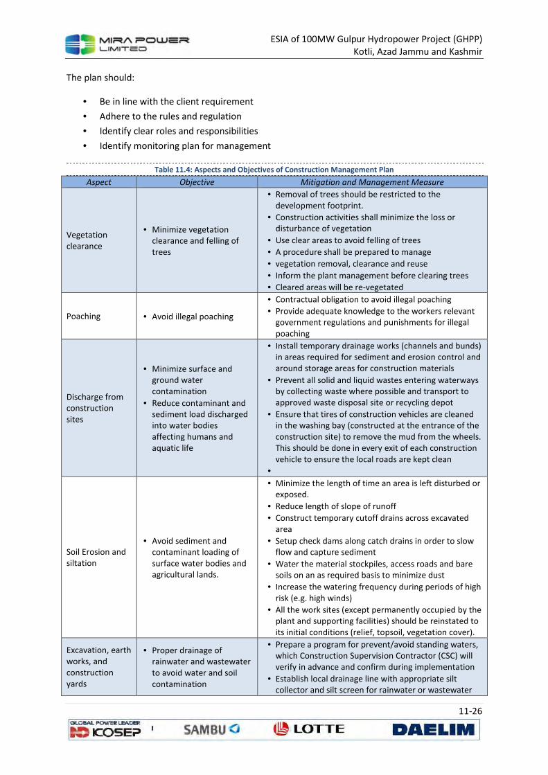
ESIA of 100MW Gulpur Hydropower Project (GHPP)
Kotli, Azad Jammu and Kashmir
11-26
The plan should:
• Be in line with the client requirement
• Adhere to the rules and regulation
• Identify clear roles and responsibilities
• Identify monitoring plan for management
Table 11.4: Aspects and Objectives of Construction Management Plan
Aspect Objective Mitigation and Management Measure
Vegetation
clearance
• Minimize vegetation
clearance and felling of
trees
• Removal of trees should be restricted to the
development footprint.
• Construction activities shall minimize the loss or
disturbance of vegetation
• Use clear areas to avoid felling of trees
• A procedure shall be prepared to manage
• vegetation removal, clearance and reuse
• Inform the plant management before clearing trees
• Cleared areas will be re-vegetated
Poaching • Avoid illegal poaching
• Contractual obligation to avoid illegal poaching
• Provide adequate knowledge to the workers relevant
government regulations and punishments for illegal
poaching
Discharge from
construction
sites
• Minimize surface and
ground water
contamination
• Reduce contaminant and
sediment load discharged
into water bodies
affecting humans and
aquatic life
• Install temporary drainage works (channels and bunds)
in areas required for sediment and erosion control and
around storage areas for construction materials
• Prevent all solid and liquid wastes entering waterways
by collecting waste where possible and transport to
approved waste disposal site or recycling depot
• Ensure that tires of construction vehicles are cleaned
in the washing bay (constructed at the entrance of the
construction site) to remove the mud from the wheels.
This should be done in every exit of each construction
vehicle to ensure the local roads are kept clean
•
Soil Erosion and
siltation
• Avoid sediment and
contaminant loading of
surface water bodies and
agricultural lands.
• Minimize the length of time an area is left disturbed or
exposed.
• Reduce length of slope of runoff
• Construct temporary cutoff drains across excavated
area
• Setup check dams along catch drains in order to slow
flow and capture sediment
• Water the material stockpiles, access roads and bare
soils on an as required basis to minimize dust
• Increase the watering frequency during periods of high
risk (e.g. high winds)
• All the work sites (except permanently occupied by the
plant and supporting facilities) should be reinstated to
its initial conditions (relief, topsoil, vegetation cover).
Excavation, earth
works, and
construction
yards
• Proper drainage of
rainwater and wastewater
to avoid water and soil
contamination
• Prepare a program for prevent/avoid standing waters,
which Construction Supervision Contractor (CSC) will
verify in advance and confirm during implementation
• Establish local drainage line with appropriate silt
collector and silt screen for rainwater or wastewater
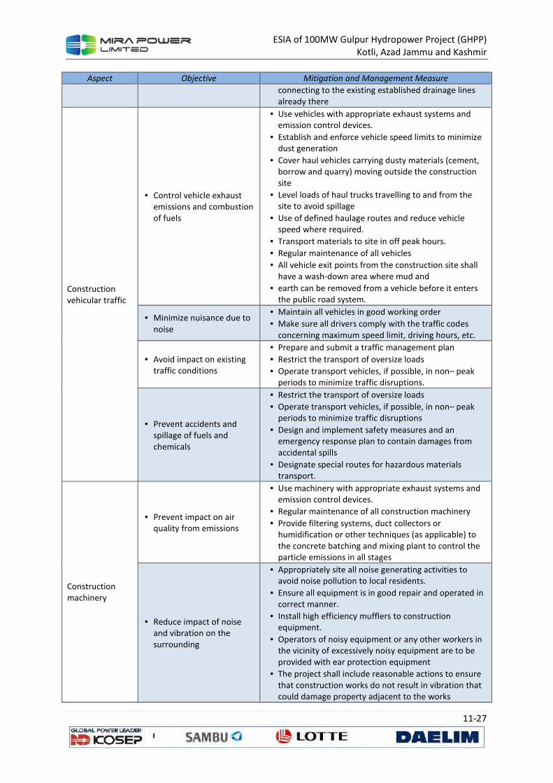
ESIA of 100MW Gulpur Hydropower Project (GHPP)
Kotli, Azad Jammu and Kashmir
11-27
Aspect Objective Mitigation and Management Measure
connecting to the existing established drainage lines
already there
Construction
vehicular traffic
• Control vehicle exhaust
emissions and combustion
of fuels
• Use vehicles with appropriate exhaust systems and
emission control devices.
• Establish and enforce vehicle speed limits to minimize
dust generation
• Cover haul vehicles carrying dusty materials (cement,
borrow and quarry) moving outside the construction
site
• Level loads of haul trucks travelling to and from the
site to avoid spillage
• Use of defined haulage routes and reduce vehicle
speed where required.
• Transport materials to site in off peak hours.
• Regular maintenance of all vehicles
• All vehicle exit points from the construction site shall
have a wash-down area where mud and
• earth can be removed from a vehicle before it enters
the public road system.
• Minimize nuisance due to
noise
• Maintain all vehicles in good working order
• Make sure all drivers comply with the traffic codes
concerning maximum speed limit, driving hours, etc.
• Avoid impact on existing
traffic conditions
• Prepare and submit a traffic management plan
• Restrict the transport of oversize loads
• Operate transport vehicles, if possible, in non– peak periods to minimize traffic disruptions.
• Prevent accidents and spillage of fuels and chemicals
• Restrict the transport of oversize loads
• Operate transport vehicles, if possible, in non– peak periods to minimize traffic disruptions
• Design and implement safety measures and an emergency response plan to contain damages from accidental spills
• Designate special routes for hazardous materials transport.
Construction machinery
• Prevent impact on air quality from emissions
• Use machinery with appropriate exhaust systems and emission control devices.
• Regular maintenance of all construction machinery
• Provide filtering systems, duct collectors or humidification or other techniques (as applicable) to the concrete batching and mixing plant to control the particle emissions in all stages
• Reduce impact of noise and vibration on the surrounding
• Appropriately site all noise generating activities to avoid noise pollution to local residents.
• Ensure all equipment is in good repair and operated in correct manner.
• Install high efficiency mufflers to construction equipment.
• Operators of noisy equipment or any other workers in the vicinity of excessively noisy equipment are to be provided with ear protection equipment
• The project shall include reasonable actions to ensure that construction works do not result in vibration that could damage property adjacent to the works
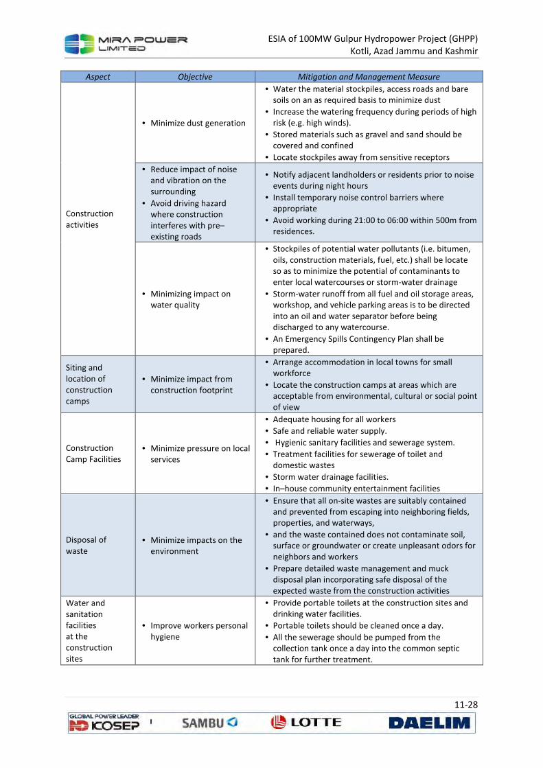
ESIA of 100MW Gulpur Hydropower Project (GHPP)
Kotli, Azad Jammu and Kashmir
11-28
Aspect Objective Mitigation and Management Measure
Construction
activities
• Minimize dust generation
• Water the material stockpiles, access roads and bare
soils on an as required basis to minimize dust
• Increase the watering frequency during periods of high
risk (e.g. high winds).
• Stored materials such as gravel and sand should be
covered and confined
• Locate stockpiles away from sensitive receptors
• Reduce impact of noise
and vibration on the
surrounding
• Avoid driving hazard
where construction
interferes with pre–
existing roads
• Notify adjacent landholders or residents prior to noise
events during night hours
• Install temporary noise control barriers where
appropriate
• Avoid working during 21:00 to 06:00 within 500m from
residences.
• Minimizing impact on
water quality
• Stockpiles of potential water pollutants (i.e. bitumen,
oils, construction materials, fuel, etc.) shall be locate
so as to minimize the potential of contaminants to
enter local watercourses or storm-water drainage
• Storm-water runoff from all fuel and oil storage areas,
workshop, and vehicle parking areas is to be directed
into an oil and water separator before being
discharged to any watercourse.
• An Emergency Spills Contingency Plan shall be
prepared.
Siting and
location of
construction
camps
• Minimize impact from
construction footprint
• Arrange accommodation in local towns for small
workforce
• Locate the construction camps at areas which are
acceptable from environmental, cultural or social point
of view
Construction
Camp Facilities
• Minimize pressure on local
services
• Adequate housing for all workers
• Safe and reliable water supply.
• Hygienic sanitary facilities and sewerage system.
• Treatment facilities for sewerage of toilet and
domestic wastes
• Storm water drainage facilities.
• In–house community entertainment facilities
Disposal of
waste
• Minimize impacts on the
environment
• Ensure that all on-site wastes are suitably contained
and prevented from escaping into neighboring fields,
properties, and waterways,
• and the waste contained does not contaminate soil,
surface or groundwater or create unpleasant odors for
neighbors and workers
• Prepare detailed waste management and muck
disposal plan incorporating safe disposal of the
expected waste from the construction activities
Water and
sanitation
facilities
at the
construction
sites
• Improve workers personal
hygiene
• Provide portable toilets at the construction sites and
drinking water facilities.
• Portable toilets should be cleaned once a day.
• All the sewerage should be pumped from the
collection tank once a day into the common septic
tank for further treatment.
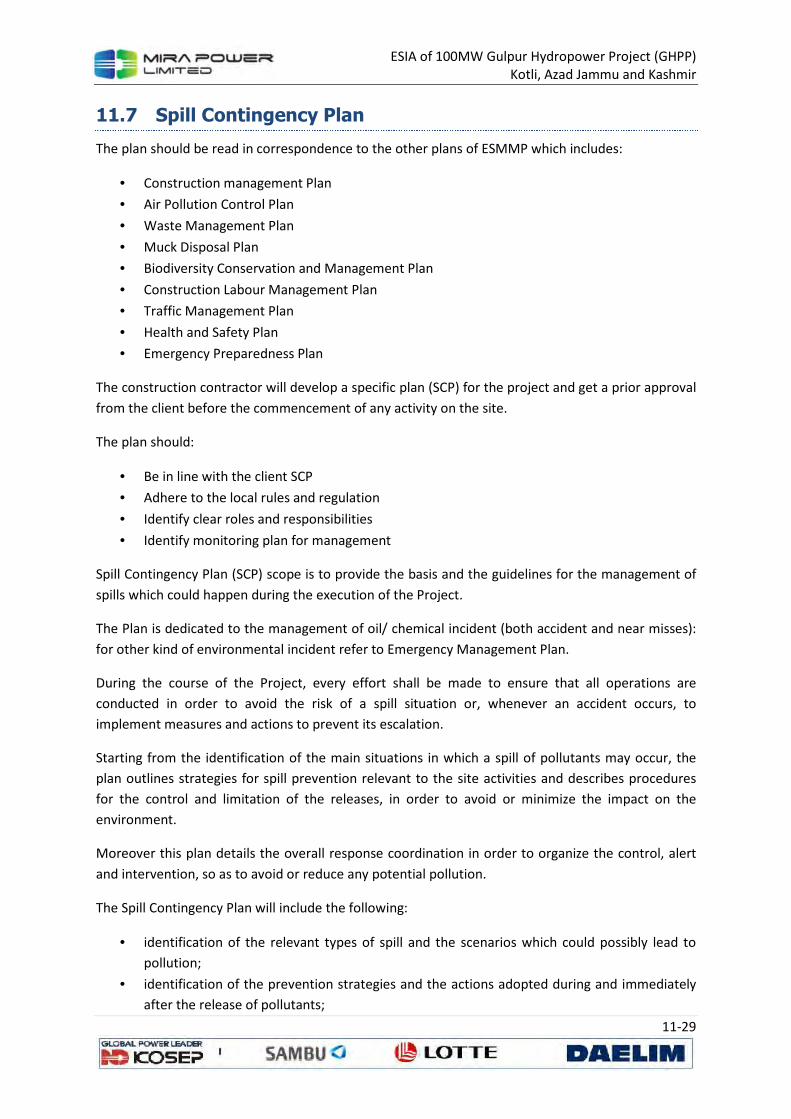
ESIA of 100MW Gulpur Hydropower Project (GHPP)
Kotli, Azad Jammu and Kashmir
11-29
11.7 Spill Contingency Plan
The plan should be read in correspondence to the other plans of ESMMP which includes:
• Construction management Plan
• Air Pollution Control Plan
• Waste Management Plan
• Muck Disposal Plan
• Biodiversity Conservation and Management Plan
• Construction Labour Management Plan
• Traffic Management Plan
• Health and Safety Plan
• Emergency Preparedness Plan
The construction contractor will develop a specific plan (SCP) for the project and get a prior approval
from the client before the commencement of any activity on the site.
The plan should:
• Be in line with the client SCP
• Adhere to the local rules and regulation
• Identify clear roles and responsibilities
• Identify monitoring plan for management
Spill Contingency Plan (SCP) scope is to provide the basis and the guidelines for the management of
spills which could happen during the execution of the Project.
The Plan is dedicated to the management of oil/ chemical incident (both accident and near misses):
for other kind of environmental incident refer to Emergency Management Plan.
During the course of the Project, every effort shall be made to ensure that all operations are
conducted in order to avoid the risk of a spill situation or, whenever an accident occurs, to
implement measures and actions to prevent its escalation.
Starting from the identification of the main situations in which a spill of pollutants may occur, the
plan outlines strategies for spill prevention relevant to the site activities and describes procedures
for the control and limitation of the releases, in order to avoid or minimize the impact on the
environment.
Moreover this plan details the overall response coordination in order to organize the control, alert
and intervention, so as to avoid or reduce any potential pollution.
The Spill Contingency Plan will include the following:
• identification of the relevant types of spill and the scenarios which could possibly lead to
pollution;
• identification of the prevention strategies and the actions adopted during and immediately
after the release of pollutants;
ESIA of 100MW Gulpur Hydropower Project (GHPP)
Kotli, Azad Jammu and Kashmir
11-30
• description of the project site organization, both during the prevention and emergency
intervention phases;
In pursuing this aim, the following actions shall be considered as priorities:
• carrying out all the necessary operations for the protection of the health and safety of all
people present where the spill occurs, both employees and others;
• minimization of the spill dimensions and protection of the main structures;
• minimization of environmental impact due to spill.
11.7.1 Identification of Potentially Polluting Substances and Pollution
Scenarios
This section provides an inventory of polluting substances present on site, indicates a possible
classification of spills by degree of severity, and identifies the various pollution scenarios.
11.7.1.1 Inventory of Potentially Polluting Substances
Potentially polluting substances have been identified by analyzing the main critical activities
performed during the Project. The detailed list of construction activities is provided in ESIA, Section
3.
An analysis of the above-mentioned activities shows that the most critical substances that may be
involved in spills are:
• diesel fuels;
• brake fluids;
• lubricants, such as engine and transmission fluids;
• solvents and chemicals;
• cement additives and residues;
• paints;
• battery acid;
• hazardous liquid wastes (e.g. used oil, spent paints and solvents, wastewater from washing
equipment facilities).
However, during the execution of the Project, only small quantities are typically involved in
incidents, with the possible exceptions of fuel transportation operations, breakdown of storage
tanks or of existing pipelines.
The following subsections outlines descriptions of the main identified hazardous substances that will
be possibly used throughout the PROJECT, and gives preliminary indications about their use and
storage.
11.7.1.2 Polluting Substances and Management Options
The following subsections outlines descriptions of the main identified hazardous substances that will
be possibly used throughout the project, and gives preliminary indications about their use and
storage.
Diesel fuels
ESIA of 100MW Gulpur Hydropower Project (GHPP)
Kotli, Azad Jammu and Kashmir
11-31
• The most of diesel fuels will be used for vehicles and equipment throughout the project
area.
• Designated refueling areas are classified for mobile machinery and equipment and semi-
permanent equipment installations. Vehicles and equipment that are difficult to move due
to their size or whose movement to the designated refueling areas may cause further
damage to the environment and create a road safety hazard shall be refueled by means of
mobile refueling vehicles.
• Diesel fuel will be stored in dedicated facilities protected by concrete retention bounds or
lined with plastic sheeting for spill containment.
Brake fluids
• Brake fluid is a specially formulated liquid used in the brake hydraulic system.
• Brake fluids will be stored in sealed containers within a designed and bounded area. The
storage in non-designated areas is forbidden. In addition, drip trays will be used during
maintenance activities.
Oil and Lubricants
• Oil and lubricants will be used for the maintenance of all vehicles, vessels and equipment,
usually during planned maintenance processes at the site maintenance facilities. However, it
is possible that machinery and equipment will have to be serviced or repaired outside of the
maintenance area: oil and lubricants may be de-canted from their storage drums and
transported for use to other areas of operation.
• Oil and lubricants shall be stored in sealed drums (150 – 200 L) within a designed secondary
containment area at the main camp facility designated maintenance and storage areas. The
storage in non-designated areas is forbidden.
Paints and Solvents/Chemicals
• Paints (used during painting activities) shall be stored in sealed drums in properly designated
areas with appropriate environmental and safety controls.
• Solvents and other chemicals shall be stored in sealed drums in properly designated areas
with appropriate environmental and safety controls.
• All solvents and chemicals shall be segregated as per their MSDS and stored separately
depending on their chemical reactivity and compatibility criteria.
• Chemicals shall be used, in any significant quantity, for maintenance in camp areas.
Cement Additives and Residues
• Cement additives will be used during the Construction activities and will be stored within the
cement production area in designated compounds.
• Cement residues may be arisen during cleaning operations involving cement trucks and
mixing facilities, when they are performed in-site. The residue shall be mixed with copious
amounts of water. An area for the cleaning of cement-contaminated equipment shall be
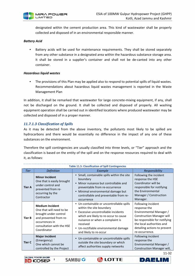
ESIA of 100MW Gulpur Hydropower Project (GHPP)
Kotli, Azad Jammu and Kashmir
11-32
designated within the cement production area. This kind of wastewater shall be properly
collected and disposed of in an environmental responsible manner.
Battery Acid
• Battery acids will be used for maintenance requirements. They shall be stored separately
from any other substance in a designated area within the hazardous substance storage area.
It shall be stored in a supplier’s container and shall not be de-canted into any other
container.
Hazardous liquid wastes
• The provisions of this Plan may be applied also to respond to potential spills of liquid wastes.
Recommendations about hazardous liquid wastes management is reported in the Waste
Management Plan
In addition, it shall be remarked that wastewater for large concrete-mixing equipment, if any, shall
not be discharged on the ground. It shall be collected and disposed of properly. All washing
equipment operation shall be carried out in identified locations where produced wastewater may be
collected and disposed of in a proper manner.
11.7.1.3 Classification of Spills
As it may be detected from the above inventory, the pollutants most likely to be spilled are
hydrocarbons and there would be essentially no difference in the impact of any one of these
substances on the environment.
Therefore the spill contingencies are usually classified into three levels, or “Tier” approach and the
classification is based on the entity of the spill and on the response resources required to deal with
it, as follows:
Table 11.5: Classification of Spill Contingencies
Tier Definition Example Responsibility
Tier A
Minor Incident One that is easily brought under control and prevented from re-occurring by the Contractor
• Small, containable spills within the site boundary
• Minor nuisance but controllable and preventable from re-occurrence
• Minimal environmental damage but controllable and preventable from re-occurrence
Following the incident response the HSE Coordinator will be responsible for notifying the Environmental Manager / Construction Manager.
Tier B
Medium Incident One that will need to be brought under control and prevented from re-occurrences in consultation with the HSE Coordinator
• Un-containable or uncontrollable spills within the site boundary
• Excessive uncontrollable incidents which are likely to re-occur to cause nuisance or when a complaint is received
• Un-rectifiable environmental damage and likely to re-occur
Following incident response the Environmental Manager / Construction Manager will be responsible for notifying the local authorities and detailing actions to prevent re-occurrence.
Tier C
Major Incident (Emergency) One which cannot be controlled by the Project
• Un-containable or uncontrollable spills outside the site boundary or which affect authorities supply networks
Following incident response the Environmental Manager / Construction Manager will,
ESIA of 100MW Gulpur Hydropower Project (GHPP)
Kotli, Azad Jammu and Kashmir
11-33
Tier Definition Example Responsibility
or that effects local
authorities or
independent parties
• Excessive uncontrollable incidents
which will re-occur to cause danger,
nuisance, numerous complaints or
significant impact to proponents
reputation and / or principles
• Massive environmental damage at the
site which will re-occur to cause long
term major impacts.
in agreement with
proponent, be responsible
for implementing the
relevant authority’s
response plans.
The classification is to be considered only as a general guideline: who is responsible for dealing with
the emergency shall decide, case by case, which actions are the most appropriate for the specific
spill occurred.
The potential severity of a spill may be reduced by the following actions:
• Ensure that in site there are appointed personnel with appropriate and sufficient skills and
information in order to mobilize promptly suitable resources;
• Allow rapid and orderly expansion of spill response by each Project areas as needed during a
declared emergency;
• Optimize use of project resources, and facilitates the interface among contractor,
Subcontractors, Government and their Agencies and others that could become involved in
an escalating spill response;
• Provide flexibility to address local, regional, countrywide emergencies, with a clear
understanding and devolution of responsibilities.
• As a spill evolves, its severity is continuously re-evaluated, and the level of response is
adjusted as appropriate.
For the Project activities, the most probably spills are of Tier A: in order to deal with them the
procedure explained in this plan will be applied.
11.7.1.4 Pollution Scenarios/Potential Incidents
Spills are usually related either to operator errors or to incidental events due to equipment failures.
Equipment failures include corrosion and leaking of pipes and tanks, valves failure, and sewer and
drain leaks. Many of these failures may be avoided through proper inspection and maintenance
procedures.
Operator errors include overfilling tanks and improper alignment of valves and piping. These and
other operator errors can properly be corrected through developing operating procedures, regular
training and testing of personnel, and systematic follow-up to assure that procedures are followed.
It is assumed that all personnel performing or supervising the various phases of work are familiar
with international and local standards and have gained sufficient operational experience to be able
to take preventive measures in all types of high-risk situations.
ESIA of 100MW Gulpur Hydropower Project (GHPP)
Kotli, Azad Jammu and Kashmir
11-34
Furthermore, those responsible for the various phases of the Project Execution shall ensure that all
vessels, vehicles, and equipment are kept in perfect working order and functioning efficiently. This
will reduce drastically the likelihood of spill due to both human errors and malfunction/breakdown.
In addition, it will be their responsibility to ensure that all controls and necessary maintenance work
are carried out correctly, so that the equipment in use is always in a perfect state.
Possible common incidents that may occur during site activities and may cause the release of
hazardous materials include the following:
• Spills during vehicle maintenance such as oil leaks while changing the oil, engine coolant
leaks while changing or adding coolant, and fuel leaks while refueling the vehicles. If these
spills occur, the quantities should be minimal;
• Oil/diesel spills due to improper handling of drums and improper storage of them (Tier A
expected – 200, 250 liters);
• Paint spills from painting and labeling equipment, oil and hydraulic fluid leaks from
machinery, and gas leaks from welding equipment. The severity of these spills will vary
depend upon spill detention and response (Mostly it is expected to be Tier A);
• In case of a vehicle overturning, the fuel tank may be damaged and a fuel spill occurs.
Furthermore, depending upon what the vehicle was transporting, other spills may occur in
conjunction with the fuel spill. The severity of these spill events is highly dependent upon
several factors such as the hazard degree of the substances transported, where the spill
occurred, and what, environmentally sensitive areas were affected, if any.
• Breakdown of storage tanks. The severity of these spills will vary depending upon the
quantity involved, expected to be quite high (it shall be noticed that if the release occurs in
the retention basin it is not to be considered as environmental accident, but a near miss).
• In case of spills as a result of a vehicle accident / collision the severity will vary depending
upon the quantity of vehicles involved and the severity of the incident.
11.7.2 Spill Prevention Strategies and General Response Action
Potential incidents are usually related either to operational/human errors or to unexpected
events/breakdown.
All personnel performing or supervising the various phases of work shall be familiar with
international and local standards and have gained sufficient operational experience to be able to
take preventive measures in all types of high-risk situations.
The purpose of this section is to describe the preventive and planning measures and the responding
procedures for dealing with spills of pollutant substances during the execution of the Project.
Specific responsibilities and procedures to be followed during prevention, planning, and spill
response activities are detailed in the following.
The review of the procedures of this Plan will be carried out by contractor on as-needed basis.
The main objective of the emergency procedures review is:
ESIA of 100MW Gulpur Hydropower Project (GHPP)
Kotli, Azad Jammu and Kashmir
11-35
• to determine if the procedures should be modified to prevent reoccurrence of similar
accidents;
• to improve preventive and response measures;
• to investigate the causes that led to the spill;
• to keep records of spills and actions undertaken to deal with the emergency.
11.7.2.1 Spill Prevention
The main objective of the prevention and planning phase is the implementation of all possible
measures to prevent any potential spill of polluting substances.
Prevention of spills shall be the prime objective and shall include operating practices (maintenance
to the construction equipment and tools), inspections and monitoring of facilities.
Personnel responsible for handling and storage of liquids which may be involved in spills shall
receive training on the best practices to be adopted in site.
In this phase, the resources appointed to manage the emergency arisen by the spill of pollutant
substances, has the following tasks:
• to identify all the hazardous materials, related to Project activities, that may produce a
health and safety risk for project employees and subcontractors and that may produce an
environmental impact;
• to make all personnel working on the project informed about environmental protection
concerned and to ensure that all workers are familiar with response procedures when a spill
occurs;
• to ensure that the activities carried out comply with the procedures, especially those
regarding prevention of spills into the environment of pollutant substances;
• to provide continuous training to enable workers to perform their work in a safe and healthy
manner.
For the particular activities potential source of incident, the general strategies described in the
following subsections shall be adopted in order to prevent the most critical spills.
The activities are:
• Chemicals and Hazardous materials handling and storage
• Oil changes
• Chemicals/fuel transfer
• Construction equipment operation
Chemicals and hazardous material handling and storage
Properly label containers;
• Keep an updated inventory of all chemicals and hazardous materials stored on site;
• Keep Material Safety Data Sheets (MSDSs) at storage areas: handling and storage shall
respect the recommendations defined in;

ESIA of 100MW Gulpur Hydropower Project (GHPP)
Kotli, Azad Jammu and Kashmir
11-36
• Use appropriate chemical segregation practices where any potentially toxic or hazardous
material will be stored;
• Manual handling of hazardous materials shall be minimized and the use of forklifts or cranes
with pallet loads shall be preferred;
• Storage areas of hazardous materials/chemicals shall be sheltered from the sun, provided
with a means to restrict access, located away from occupied buildings and work areas, and
properly sign posted (Figure 11.3) - eg. “no smoking”, “hazardous material storage area”,
etc”.
• All hazardous chemicals and materials will be stored in contained bounded areas with
impervious flooring, or according to the most conservative of relevant government
regulations and guidelines regarding safe handling, storage and transport;
• All chemicals storage tanks and drums shall be located on paved area or contained within a
suitably sized concrete retention bound. In this case the bound shall be provided with a
lockable valve. All drainage valves shall be kept closed. They shall be opened only after
checking the absence of chemicals in water to be discharged.
• Waste oils and other liquid wastes shall be stored in sealed drums within a designated
secondary containment area or in a temporary storage area consisting of an earth bound
lined with plastic sheeting;
• All fixed fuel storage tanks will be contained within a suitably sized concrete retention bund
(Figure 11.2);
Figure 11.2: Hazardous Storage Area and Diesel Tanks Containment Basin
• Stationary fuel storage tanks and dispensing areas will have a containment membrane
underneath and a bund around;
• In the event of a significant leakage from the fuel tanks in the bund retained fuel will be
pumped back into another tank or the repaired tank. Residual fuel on the bottom of the
bund will be soaked up using appropriate spill kits or sand and disposed of in compliance
with Waste Management Plan. This episode has to be considered a “near miss”;
• For transferring of fuel from a delivery tanker to a stationary storage tank:
o The hose coupling must be compatible,
o The use of improvised connections shall not be permitted,
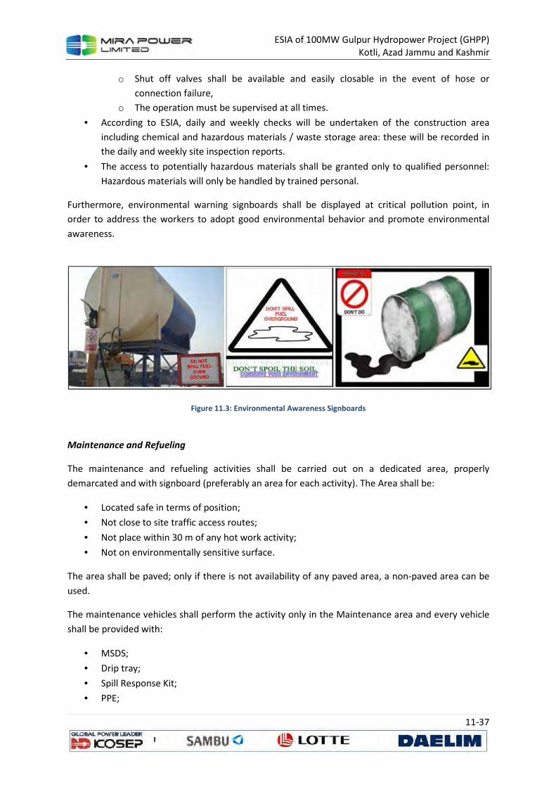
ESIA of 100MW Gulpur Hydropower Project (GHPP)
Kotli, Azad Jammu and Kashmir
11-37
o Shut off valves shall be available and easily closable in the event of hose or
connection failure,
o The operation must be supervised at all times.
• According to ESIA, daily and weekly checks will be undertaken of the construction area
including chemical and hazardous materials / waste storage area: these will be recorded in
the daily and weekly site inspection reports.
• The access to potentially hazardous materials shall be granted only to qualified personnel:
Hazardous materials will only be handled by trained personal.
Furthermore, environmental warning signboards shall be displayed at critical pollution point, in
order to address the workers to adopt good environmental behavior and promote environmental
awareness.
Figure 11.3: Environmental Awareness Signboards
Maintenance and Refueling
The maintenance and refueling activities shall be carried out on a dedicated area, properly
demarcated and with signboard (preferably an area for each activity). The Area shall be:
• Located safe in terms of position;
• Not close to site traffic access routes;
• Not place within 30 m of any hot work activity;
• Not on environmentally sensitive surface.
The area shall be paved; only if there is not availability of any paved area, a non-paved area can be
used.
The maintenance vehicles shall perform the activity only in the Maintenance area and every vehicle
shall be provided with:
• MSDS;
• Drip tray;
• Spill Response Kit;
• PPE;
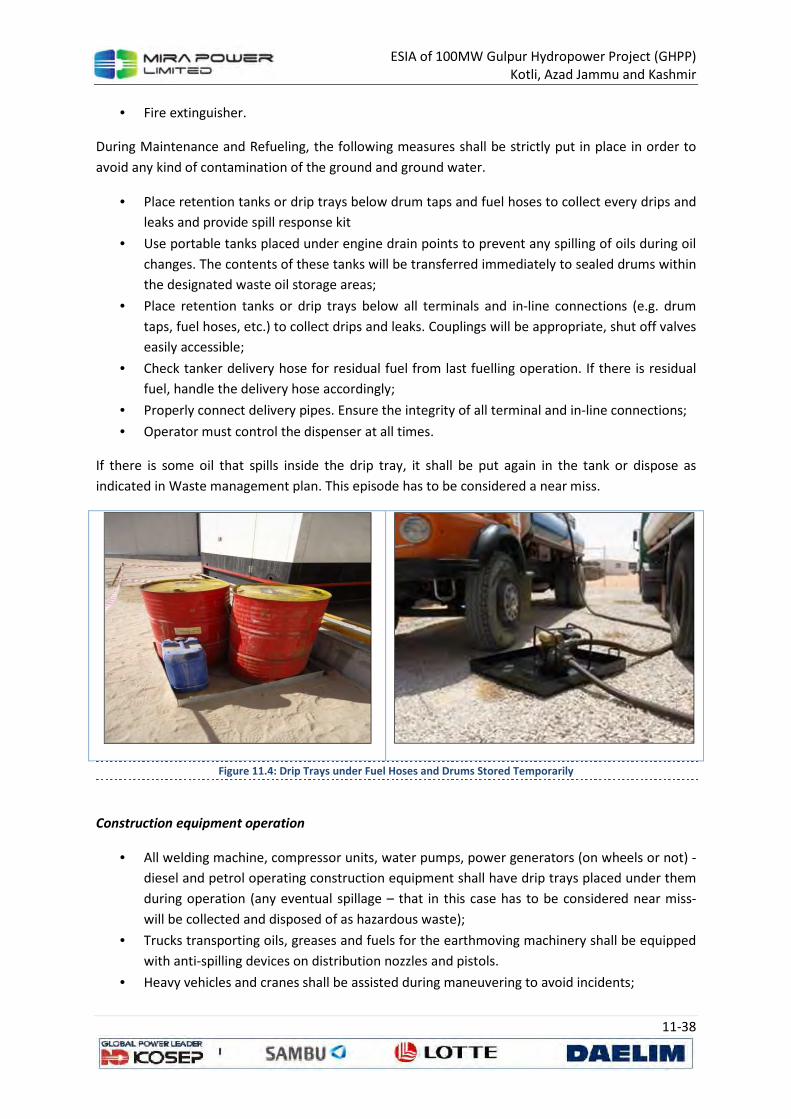
ESIA of 100MW Gulpur Hydropower Project (GHPP)
Kotli, Azad Jammu and Kashmir
11-38
• Fire extinguisher.
During Maintenance and Refueling, the following measures shall be strictly put in place in order to
avoid any kind of contamination of the ground and ground water.
• Place retention tanks or drip trays below drum taps and fuel hoses to collect every drips and
leaks and provide spill response kit
• Use portable tanks placed under engine drain points to prevent any spilling of oils during oil
changes. The contents of these tanks will be transferred immediately to sealed drums within
the designated waste oil storage areas;
• Place retention tanks or drip trays below all terminals and in-line connections (e.g. drum
taps, fuel hoses, etc.) to collect drips and leaks. Couplings will be appropriate, shut off valves
easily accessible;
• Check tanker delivery hose for residual fuel from last fuelling operation. If there is residual
fuel, handle the delivery hose accordingly;
• Properly connect delivery pipes. Ensure the integrity of all terminal and in-line connections;
• Operator must control the dispenser at all times.
If there is some oil that spills inside the drip tray, it shall be put again in the tank or dispose as
indicated in Waste management plan. This episode has to be considered a near miss.
Figure 11.4: Drip Trays under Fuel Hoses and Drums Stored Temporarily
Construction equipment operation
• All welding machine, compressor units, water pumps, power generators (on wheels or not) -
diesel and petrol operating construction equipment shall have drip trays placed under them
during operation (any eventual spillage – that in this case has to be considered near miss-
will be collected and disposed of as hazardous waste);
• Trucks transporting oils, greases and fuels for the earthmoving machinery shall be equipped
with anti-spilling devices on distribution nozzles and pistols.
• Heavy vehicles and cranes shall be assisted during maneuvering to avoid incidents;
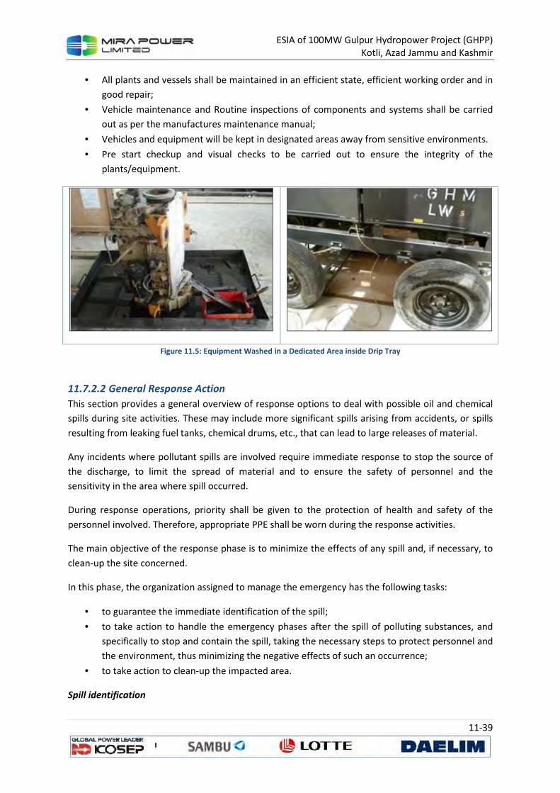
ESIA of 100MW Gulpur Hydropower Project (GHPP)
Kotli, Azad Jammu and Kashmir
11-39
• All plants and vessels shall be maintained in an efficient state, efficient working order and in
good repair;
• Vehicle maintenance and Routine inspections of components and systems shall be carried
out as per the manufactures maintenance manual;
• Vehicles and equipment will be kept in designated areas away from sensitive environments.
• Pre start checkup and visual checks to be carried out to ensure the integrity of the
plants/equipment.
Figure 11.5: Equipment Washed in a Dedicated Area inside Drip Tray
11.7.2.2 General Response Action
This section provides a general overview of response options to deal with possible oil and chemical
spills during site activities. These may include more significant spills arising from accidents, or spills
resulting from leaking fuel tanks, chemical drums, etc., that can lead to large releases of material.
Any incidents where pollutant spills are involved require immediate response to stop the source of
the discharge, to limit the spread of material and to ensure the safety of personnel and the
sensitivity in the area where spill occurred.
During response operations, priority shall be given to the protection of health and safety of the
personnel involved. Therefore, appropriate PPE shall be worn during the response activities.
The main objective of the response phase is to minimize the effects of any spill and, if necessary, to
clean-up the site concerned.
In this phase, the organization assigned to manage the emergency has the following tasks:
• to guarantee the immediate identification of the spill;
• to take action to handle the emergency phases after the spill of polluting substances, and
specifically to stop and contain the spill, taking the necessary steps to protect personnel and
the environment, thus minimizing the negative effects of such an occurrence;
• to take action to clean-up the impacted area.
Spill identification
ESIA of 100MW Gulpur Hydropower Project (GHPP)
Kotli, Azad Jammu and Kashmir
11-40
The first step after the occurrence of a spillage is the identification of its source. Once the spill has
been assessed, response measures shall be immediately selected and undertaken in order to
mitigate its effects. Any response action may depend on the spill severity.
Incident Evaluation
After spill identification, the severity of the spill shall be evaluated in order to select the proper
response strategies.
In addition, the situation shall be assessed to determine whether evacuation is required. If
necessary, traffic will also be re-routed.
Once these factors have been determined, the proper level of response will be determined. In any
case, after stopping the release of material to the environment, containment shall likely be the next
step of response process.
Spill Response Equipment
As rapid containment of any spill is desirable, the equipment for the clean – up shall be suitable for
adequately respond to the type of substance spilled.
In particular, according to CEMP, spill kits shall be provided in the construction site in the area where
a possible scenario of spill, as described, can occur.
Commercially are available different types of spill kit (Figure 11.6), fit for the purpose (i.e. volume of
spill, liquid involved, outdoor / indoor spill, etc). In the common spill kit the following items are
provided:
• Absorbent pillows and granulate;
• Polypropylene adsorbent pad;
• Containment drip pans;
• Shovels;
• Protective gloves;
• Goggles / safety glasses;
• Heavy duty oil resistant storage bags;
• Duct tape.
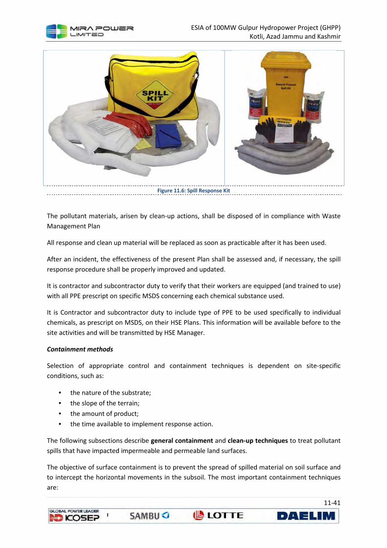
ESIA of 100MW Gulpur Hydropower Project (GHPP)
Kotli, Azad Jammu and Kashmir
11-41
Figure 11.6: Spill Response Kit
The pollutant materials, arisen by clean-up actions, shall be disposed of in compliance with Waste
Management Plan
All response and clean up material will be replaced as soon as practicable after it has been used.
After an incident, the effectiveness of the present Plan shall be assessed and, if necessary, the spill
response procedure shall be properly improved and updated.
It is contractor and subcontractor duty to verify that their workers are equipped (and trained to use)
with all PPE prescript on specific MSDS concerning each chemical substance used.
It is Contractor and subcontractor duty to include type of PPE to be used specifically to individual
chemicals, as prescript on MSDS, on their HSE Plans. This information will be available before to the
site activities and will be transmitted by HSE Manager.
Containment methods
Selection of appropriate control and containment techniques is dependent on site-specific
conditions, such as:
• the nature of the substrate;
• the slope of the terrain;
• the amount of product;
• the time available to implement response action.
The following subsections describe general containment and clean-up techniques to treat pollutant
spills that have impacted impermeable and permeable land surfaces.
The objective of surface containment is to prevent the spread of spilled material on soil surface and
to intercept the horizontal movements in the subsoil. The most important containment techniques
are:

ESIA of 100MW Gulpur Hydropower Project (GHPP)
Kotli, Azad Jammu and Kashmir
11-42
• surface containment: to prevent spread of substances on soil surface or substrate surface
and to prepare it for the recovery;
• sorbent barriers: to form a continuous barrier to limit spreading and collect the pollutant to
allow recovering by physical removal of spent sorbents or by pumping.
Surface Containment
The method for surface containment of fuels, solvents, chemicals, and other dangerous or hazardous
toxic materials on impermeable ground may consist of:
• block inlets/outlets to drains, pipes, sewage systems, and cable ducts to prevent explosion
risk or contamination of sewage treatment plants or water courses (if any in the area);
• use sorbents to limit spreading;
• concentrate the material by brushing it in to a collecting area, or by creating an absorbent
barrier that can be tightened around the pool, so that it can be transferred to a container.
In case of a spill directly to permeable ground or if spilled material escapes a bermed area, one of
the following approaches will be employed:
• for smaller spills, increase sorption capacity of surface layers by spreading absorbent
material;
• use absorbent barriers to contain the spill;
• for larger spills or where movement is an issue, construct barriers, such as berms, dams, and
trenches, to contain or divert the flow. These barriers can be constructed with readily
available tools and equipment, such as shovels, earth-moving equipment, and sorbents;
• block all inlets, except the oily water drains, and let the pollutant flow enter an oil
interceptor via the water drainage system and retain it there;
• in presence of oil spill, bulldoze or otherwise move any free oil and oil-saturated soil to the
nearest natural or artificial impermeable surface.
The confinement operations should be started immediately to limit the amount of penetration of
spilled material into the soil surface, thus containing the spill impacts.
The advantage of the containment methods is that confinement and damming can be achieved using
easily available materials and are suggested if the pollutant is to be pumped and/or sucked up.
Sorbent Barriers
Sorbent materials may be stacked or piled to form a continuous barrier across the entire leading
edge of the advancing pollutant mass to contain minor flow and recover a portion of the hazardous
substance. Collected pollutant is recovered by physical removal of spent sorbents or by vacuuming
or pumping when quantity exceeds absorption capabilities of the sorbents.
The application depends on the form of the sorbent; generally they are spread or applied over the
slick and, after absorption, they are collected by various methods.
Clean-up, Recovery and Removal Methods
ESIA of 100MW Gulpur Hydropower Project (GHPP)
Kotli, Azad Jammu and Kashmir
11-43
The appropriate clean-up technique to be used depends on the location of the incident, volume and
type of the pollutant involved, and the amount of soil that has to be removed. For smaller spills,
storage containers, such as lined drums or lined hauling trucks, will typically be sufficient for
collection and transport of the recovered and waste materials. For larger spills or if insufficient
storage containers are available, the removed material may be held, prior to disposal or treatment,
in a lined excavated ditch prepared using a bulldozer.
Depending on the specific circumstances of the spill, the choice on how to conduct recovery
depends on:
• the material spilled;
• the quantity spilled;
• the location of the spill and terrain of the surrounding area;
• potentially endangered resources;
• manpower and equipment resources available.
These factors define the possible impact of the spill and the options for cleanup. The expected
benefits from using a particular technique must be weighed against the potential impact to the
environment from the suitable clean-up techniques.
Possible recovery and removal strategies include:
• excavation;
• recovery pump system.
Excavation
It is used to remove impacted unsaturated soil and prevent contamination of the ground water.
Contaminated soil may be removed by mechanical excavation, using various types of earth-moving
equipment, to prevent the contamination of the groundwater.
The method should not be used:
• if excavation will disturb or penetrate an impermeable natural layer;
• if there is a risk of damaging underground utilities such as pipes and electric cables;
• for large spills, because there is a danger of causing more damage and costs also rise steeply
with increased depth: recovered material may cause disposal problems.
The advantage of the method is that early and successful excavation can save long-term recovery
operations and it may be the most economic method of recovering high viscosity substances (heavy
fuel oils, some crudes, etc), even though it may increase the volume of impacted materials for
disposal.
At the end of clean-up operations the stored material will be disposed in accordance with the Waste
Management Plan. Recovered waste materials will be collected and transported as specified in the
above mentioned specification.
ESIA of 100MW Gulpur Hydropower Project (GHPP)
Kotli, Azad Jammu and Kashmir
11-44
Recovery pump system
It is used to remove pollutant from the water table. This strategy is generally applied to a site when
the depth of the groundwater table is not significant.
11.8 Biodiversity Conservation and Management Plan
The biodiversity conservation and management Plan or which may refer to biodiversity action plan /
framework will be integral part of the ESMMP and ESIA. As part of the ESIA completion an ecology
survey of the project area has been conducted as discussed in baseline section which included:
• Qualitative and quantitative assessment of flora, mammals, reptiles and birds
• Identification of key species, their population and their conservation status in the area.
• Reports of wildlife sightings and fish captured in the area by the resident communities.
Data analysis to determine baseline biodiversity and to evaluate whether any potential critical
habitat and ecosystem services were present in the area
In the course of ESIA based on the literature review and detailed surveys in the environmental
setting of the project area (as discussed in baseline section) the need of consequent survey(s)
spanning to different seasons was observed.
The survey as have to spread to upcoming seasons the biodiversity conservation and management
plan is still in the process of finalization. The biodiversity conservation and management plan will be
included as part of the ESIA after its completion before commencement of activities on site.
It is the client commitment to implement the findings and proposed mitigation measures of the
biodiversity conservation and management plan. All the contractor and subcontractor will also be
obliged to follow it.
11.9 Air Pollution Control Plan
This Plan aims to reduce the sources and amounts of pollutants responsible for the loss of any air
quality, acidification and global warming and to improve the quality of life, protecting their health
risks from air pollution. This Plan has also been the initial commitment of client to reduce dust,
greenhouse gases (GHGs) emissions in a context of sustainable development with economic growth,
social cohesion and environmental protection at the project level. The plan should be considered in
accordance with the other plans which include:
• Construction management plan
• Water pollution control plan
• Waste management plan
• Muck disposal plan
• Biodiversity conservation and management plan
• Construction labour management plan
• Traffic management plan
• Health and safety plan
ESIA of 100MW Gulpur Hydropower Project (GHPP)
Kotli, Azad Jammu and Kashmir
11-45
• Emergency preparedness plan
The Contractor will devise the specific plan identifying the monitoring points and detail of the
monitoring location in accordance with the clients and regulatory requirements.
The strategic lines on which contractor should submit his detail plan is as follows:
Air quality:
• Having an optimal system of assessment and forecasting of air quality for monitoring PM10,
PM2,5, SO2, NOx, CO
• Water will be sprinkled regularly to suppress dust emissions
• Stock piles from leveling will be appropriately located and dampened to avoid dust
emissions
• All the equipment and machinery will be inspected regularly for any maintenance
• Contractor’s equipment and machinery will be properly maintained and provided with
necessary noise reduction and control equipments such as silencers and mufflers
• Regulate speed of construction vehicles
• Reduce the sources and amounts of pollutants responsible for the loss of urban ambient air
quality
• Achieve a level of air quality where concentrations of air pollutants do not pose a risk to
human health and the environment.
• Improving awareness and promote a change in consumption and mobility habits.
• Improve coordination, exchange information and implement joint work with other public
and private agencies related to air quality.
• Increasing transparency and keep the public informed about air quality.
Climate Change
• Maximize savings, energy efficiency and participation of renewables in the energy structure
at local and regional level.
• Reduce the sources and amounts of pollutants responsible for global warming with “Best
Available Technologies”, cleaner fuels and more sustainable mobility.
Specific Objectives
• Implementation of the mitigation measures related to the air pollution control as identified
in the ESIA.
• Reducing emissions of nitrogen oxides and volatile organic compounds during construction.
• Incorporation of energy efficiency and renewable energy measures
• Incorporation of Vapor Recovery Systems in Fuel Stations.
In addition the contractor need to identify the roles and responsibilities of the personnel(s) involved
for the proper management and implementation of the plans.
ESIA of 100MW Gulpur Hydropower Project (GHPP)
Kotli, Azad Jammu and Kashmir
11-46
11.10 Waste Management Plan
This is a project level plan for the waste management. The plan has been prepared to meet the Local
regulatory requirement, equator principle and EHS guideline of The World Bank. The contractor will
be asked to adhere to the plan and prepare and submit the more specific plan related to the
assigned activities to them.
The purpose of the present Plan is to provide effective guidance for the management of all the
Waste generated during Project execution.
The Plan lays down measures to protect the environment and human health by preventing or
reducing the adverse impacts of the generation and management of waste and by reducing the
overall impacts of resource use and improving the efficiency of such use. This Plan introduces an
approach that takes into account the whole life-cycle of products and processes and not only their
waste phase.
The scope of the present Plan is to:
• Describe the main principles of Waste Management strategy;
• Describe how client wishes to deals with wastes generated by its activities, products and
services (collection, handling, transportation, storage, treatment, disposal, records keeping,
auditing);
• Provide guidance to personnel and contractor for managing waste effectively and within the
requirements of the applicable waste Laws and Regulations.
11.10.1.1 Waste Management Strategy
Waste management includes the collection, temporary storage, transportation, recovery/recycle,
treatment and disposal of waste produced by activities in an effort to reduce their effects on human
health and environment throughout the entire cycle of life of their products or processes.
Contractor and its Subcontractor shall take the necessary measures to ensure that waste
management is carried out with the duty of care and without endangering human health, and
harming the environment. In particular risks to water, air, soil, plants and animals, and nuisance
through noise or odors shall be avoided.
The basic principles of waste management in activities are summarized as follow:
• Reduce
• Reuse
• Recycle
• Recovery (e.g. energy recovery)
• Responsible Disposal
This shall be considered as a hierarchy, which shall apply in a priority order in waste prevention
activities and management taking into account the Best Environmental Practicable Option (BPEO)
and Best Available Control Technology (BACT).
ESIA of 100MW Gulpur Hydropower Project (GHPP)
Kotli, Azad Jammu and Kashmir
11-47
At all levels everyone shall take measures, as appropriate, to promote the application of this
hierarchy in all activities.
11.10.1.2 Waste Minimization Strategy
Waste minimization (source reduction and reuse) helps to conserve resources and reduce pollution,
including greenhouse gases that contribute to global warming. Moreover, it reduces waste disposal
and handling costs, because it avoids the costs of recycling, municipal composting, landfilling, and
combustion.
Source reduction is the practice of designing, manufacturing, purchasing, or using materials (such as
products and packaging) in ways that reduce the amount and/or the toxicity of waste created. This
process include, e.g.:
• material elimination
• inventory control and management
• material substitution
• reduction in the consumption of natural resources.
• process modification
• improved housekeeping
Reuse (without any treatment) is the way to stop waste at the source because it delays or avoids
items entry in the waste collection and disposal system.
Client and contractor will dedicate all efforts dedicated towards minimizing waste generation at the
source, by preventing the generation of waste and by selecting product and raw material
alternatives of lesser damage to the environment.
Following some minimization actions that will be implemented:
• reduce the water consumption (and consequently the wastewater production) from
accommodation camps through personnel awareness campaign and with the use of taps
aerator and two-way flushing system
• reduce equipment and machinery wash water through awareness campaign of the involved
personnel
• reduce packaging and packing material buying in bulk. Packaging and packing material will
be reused for other purposes (shipping, etc.)
• used wooden planks will be reused for concrete formworks and scaffolds
• timber will be used for project sign boards, etc.
• empty drums will be used as waste bins
• metal scrap will be used for other purpose, as metal drip trays, etc.
• paper from office will be reduced with proper awareness campaign of the personnel (i.e.
avoid printing, two-side printing, etc.)
• the use of small water bottles will be limited and use of water dispenser and reusable
glasses will be enhanced, especially in offices. Water bottles may be refilled several times at
the water dispenser
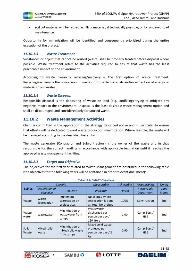
ESIA of 100MW Gulpur Hydropower Project (GHPP)
Kotli, Azad Jammu and Kashmir
11-48
• soil cut material will be reused as filling material, if technically possible, or for unpaved road
maintenance.
Opportunity for minimization will be identified and consequently prioritized during the entire
execution of the project.
11.10.1.3 Waste Treatment
Substances or object that cannot be reused (waste) shall be properly treated before disposal where
possible. Waste treatment refers to the activities required to ensure that waste has the least
practicable impact on the environment.
According to waste hierarchy recycling/recovery is the first option of waste treatment.
Recycling/recovery is the conversion of wastes into usable materials and/or extraction of energy or
materials from wastes.
11.10.1.4 Waste Disposal
Responsible disposal is the depositing of waste on land (e.g. landfilling) trying to mitigate any
negative impact to the environment. Disposal is the least desirable waste management option and
shall be discouraged, and considered only for unused waste.
11.10.2 Waste Management Activities
Client is committed in the application of the strategy described above and in particular to ensure
that efforts will be dedicated toward waste production minimization. Where feasible, the waste will
be managed according to the described hierarchy.
The waste generator (Contractor and Subcontractors) is the owner of the waste and in thus
responsible for the correct handling in accordance with applicable legislation until it reaches the
approved waste management facilities.
11.10.2.1 Target and Objective
The objectives for the first year related to Waste Management are described in the following table
(the objectives for the following years will be contained in other relevant document):
Table 11.6: SMART Objectives
Subject
Specific Measurable Achievable Responsibility Timely
Description of
objective Activity Indicator Target
Responsible
Department
Time
Frame
Waste Waste Segregation
Implement segregation on project sites
No of sites where segregation is done vs. total No of sites
100% Construction End
Waste water
Wastewater Minimization of wastewater from camps
Wastewater discharged per person per day / 160 liters
1,00 Camp Boss /
HSE End
Solid Waste
Mixed solid waste
Minimization of mixed solid waste from camps
Mixed solid waste produced per person per day / 2 kg
0,90 Camp Boss /
HSE End
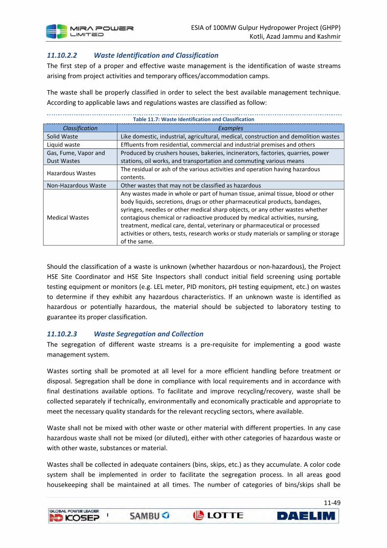
ESIA of 100MW Gulpur Hydropower Project (GHPP)
Kotli, Azad Jammu and Kashmir
11-49
11.10.2.2 Waste Identification and Classification
The first step of a proper and effective waste management is the identification of waste streams
arising from project activities and temporary offices/accommodation camps.
The waste shall be properly classified in order to select the best available management technique.
According to applicable laws and regulations wastes are classified as follow:
Table 11.7: Waste Identification and Classification
Classification Examples
Solid Waste Like domestic, industrial, agricultural, medical, construction and demolition wastes
Liquid waste Effluents from residential, commercial and industrial premises and others
Gas, Fume, Vapor and
Dust Wastes
Produced by crushers houses, bakeries, incinerators, factories, quarries, power
stations, oil works, and transportation and commuting various means
Hazardous Wastes The residual or ash of the various activities and operation having hazardous
contents.
Non-Hazardous Waste Other wastes that may not be classified as hazardous
Medical Wastes
Any wastes made in whole or part of human tissue, animal tissue, blood or other body liquids, secretions, drugs or other pharmaceutical products, bandages, syringes, needles or other medical sharp objects, or any other wastes whether contagious chemical or radioactive produced by medical activities, nursing, treatment, medical care, dental, veterinary or pharmaceutical or processed activities or others, tests, research works or study materials or sampling or storage of the same.
Should the classification of a waste is unknown (whether hazardous or non-hazardous), the Project
HSE Site Coordinator and HSE Site Inspectors shall conduct initial field screening using portable
testing equipment or monitors (e.g. LEL meter, PID monitors, pH testing equipment, etc.) on wastes
to determine if they exhibit any hazardous characteristics. If an unknown waste is identified as
hazardous or potentially hazardous, the material should be subjected to laboratory testing to
guarantee its proper classification.
11.10.2.3 Waste Segregation and Collection
The segregation of different waste streams is a pre-requisite for implementing a good waste
management system.
Wastes sorting shall be promoted at all level for a more efficient handling before treatment or
disposal. Segregation shall be done in compliance with local requirements and in accordance with
final destinations available options. To facilitate and improve recycling/recovery, waste shall be
collected separately if technically, environmentally and economically practicable and appropriate to
meet the necessary quality standards for the relevant recycling sectors, where available.
Waste shall not be mixed with other waste or other material with different properties. In any case
hazardous waste shall not be mixed (or diluted), either with other categories of hazardous waste or
with other waste, substances or material.
Wastes shall be collected in adequate containers (bins, skips, etc.) as they accumulate. A color code
system shall be implemented in order to facilitate the segregation process. In all areas good
housekeeping shall be maintained at all times. The number of categories of bins/skips shall be
ESIA of 100MW Gulpur Hydropower Project (GHPP)
Kotli, Azad Jammu and Kashmir
11-50
consistent with waste generated in the relevant areas. Clear signboards/placards shall be put on the
skips/bins in all the collection points, in order to help identifying appropriate waste type and
promote segregation.
11.10.2.4 Waste Storage
Specific areas for waste temporary storage shall be foreseen on construction sites and temporary
yards. Waste temporary storage areas will be located at main and satellite Construction Camps
Temporary waste storage shall be conducted in a way to prevent risks to the environment (water,
air, and soil) and public health, and without causing a nuisance through dust or odors. These
locations shall meet the most stringent safety and environmental conditions.
Temporary waste storage areas shall be well identified by clear signboards and properly fenced.
Waste removed from the various generation areas shall be collected, transferred and temporally
stored in this main collection points for a definite period, before being sent off site. A dedicated
competent person will be appointed to supervise the area in order to:
• Receiving wastes and ensuring they are placed in the correct area
• Ensuring all containers are properly marked with the relevant information
• Ensuring all wastes are properly packed/contained with adequate isle spacing between
containers for inspection and emergency exit
• Regular inspection of the area to ensure integrity of all waste storage containers
• Control over the removal of wastes from the area by contractors or others
• Ensuring all containers are securely covered except when waste is being added or removed
• Receiving and issuing waste transfer consignment notes
• Maintenance of waste transfer records
• Security and cleanliness of the storage area.
An up-to-date inventory of all wastes temporarily store on site must be maintained, together with
relevant health and safety information. Other kind of form, containing the same information may be
proposed by subcontractor.
Particular attention shall be given to hazardous waste storage area and collection. Hazardous waste
should be removed from sites/facilities as soon as practically possible and shall be handled by
competent persons. Bins/skips provided for hazardous waste collection shall be identified by labels
indicating the type of waste contained and shall be located in a paved area cover by a roof, if
necessary. The Hazardous wastes shall be collected and stored in compliance with applicable legal
requirements and recommendations of the relevant Material Safety Data Sheets (MSDSs), which
shall be available on site. Fire-fighting and spill response provision shall also be available on site.
Liquid contaminated/hazardous waste shall be stored in secure fenced areas, with impermeable
bounded base (covered by a roof). These areas shall have a suitable drainage control. Containers and
storage tanks shall be designed of suitable/compatible material to contain the waste. Fire-fighting
provision and spill response material shall be available on site.

ESIA of 100MW Gulpur Hydropower Project (GHPP)
Kotli, Azad Jammu and Kashmir
11-51
The following practical criteria shall be kept into consideration, particularly while handling
Hazardous Waste:
• Hazardous waste shall be stored in dedicated leak-proof containers provided with tight caps
and seals with appropriate capacity;
• Clear marks shall be placed on hazardous waste storage containers stating the contents and
indicating the hazards associated with handling and storage;
• Flammable substances must be kept separate from sources of ignition or oxidizing agents;
• Acids must be kept away from substances with which they may react, producing dangerous
compounds e.g. cyanide;
• Strong corrosive agents must be kept away from gas cylinders or other containers;
• Volatile liquid waste should be safely stored in closed drums in a dedicated open area;
• Pressurized aerosol cans must be collected separately in a single, suitably marked container;
• Hazardous waste containers shall not be located in public areas at any times.
Applicable local legislation does not indicate any time/quantity limit related to hazardous/non-
hazardous waste temporary storage area, anyway the maximum retention time for storage in site
may not exceed 3 months and 10 m3, according to the best practice. In any case, putrescible waste
shall be removed daily from the storage area.
11.10.2.5 Waste Transportation
Wastes produced during activities shall be treated or disposed to offsite facilities and areas.
No waste shall be given to a Third Party.
Competent appointed personnel shall check if subcontractor complies with the following
requirements:
• Any vehicle used to transport waste shall be constructed and maintained so as to prevent
spillage of waste and equipped with all safety equipment
• Any container used to transport the waste shall be secured safely on the vehicle used to
transport the waste
• Any vehicles used to transport waste shall be covered when loaded
• Any vehicles shall not overloaded
• Incompatible wastes shall not be mixed or transported together
• Any material segregated for recycling shall not be mixed with different waste during
transportation
• Any vehicles shall be driven by trained licensed drivers
• Any vehicles shall display clear marks indicating the extend of danger of their loads (if any),
and the best course of action in emergency cases.
To assure waste traceability, each shipment shall be documented as per local laws and regulations
Waste traceability shall be assured for all waste typology by Contractor and Subcontractors, even if
not specifically required by applicable law (log and register shall be used for all type of waste, the
use of WTN also for non-hazardous waste will be assessed, if feasible).

ESIA of 100MW Gulpur Hydropower Project (GHPP)
Kotli, Azad Jammu and Kashmir
11-52
11.10.2.6 Final Destination
In order to assure the proper management of waste treatment/disposal throughout all the waste
cycle all waste shall have proper authorization by Competent Authority and, as a minimum, comply
with applicable legislation for disposal site. Evidence of the NOC / permit shall be available to the
Environmental Manager prior of the waste transportation.
11.10.2.7 Medical Waste Management
Medical waste shall be properly segregated into the categories and disposed of only in proper
containers prepared to this purpose under the directions of the Ministry of Health.
11.10.3 Duty of Care
Everyone who produced, handles, stores, transports or disposes of waste has a duty of care to
ensure that:
• All reasonable steps are taken to ensure the waste is kept in a safe and secure state
• The waste does not cause pollution of the environment
• The waste does not harm people.
Duty of care process and parties responsibilities are summarized in Figure 11.7.
Figure 11.7: Process and Parties Responsibilities for Waste Management
WASTE
PRODUCER
WASTE
TRANSPORTER
WASTE
DISPOSAL
FACILITY
Implement the Waste Management Strategy
Identification and classification of Waste
Provide safe and secure storage
Ensure segregation and suitable packing
All step taken to prevent pollution
Must be licensed by competent authority
Waste trenasfer documents completed
Verify waste consignment matching
documentation
Issue final disposal certificate

ESIA of 100MW Gulpur Hydropower Project (GHPP)
Kotli, Azad Jammu and Kashmir
11-53
11.10.4 Training
At all level personnel shall receive proper information about waste management requirements, in
particular regarding waste prevention strategy and proper segregation.
Personnel involved with waste handling shall be provided with basic and/or specific information
about most significant issues related to waste management. Workers engaged in the handling and
management of the hazardous waste shall be properly trained (hazardous material handling) and
competency assurance shall be guaranteed.
11.10.5 Inspection and Audit
Environment Department will undertake periodic waste management site inspections. All sites shall
be duly inspected with reference to the generation, storage, transportation and disposal of all waste
types.
An Inspection schedule (Daily, Weekly and Monthly) will be implemented and proper check lists will
be prepared. Weekly inspection shall be undertaken on Temporary Waste Storage Areas.
Periodic Audit will be undertaken, and proper schedule will be prepared before commencement of
construction activities. Internal Audit will be performed monthly while annual corporate audit will be
also scheduled.
11.10.6 Reporting
Contactor and its subcontractors shall keep records or logs of waste produced, generation process
and amounts generated and transported to the waste treatment/storage facility. The records shall
include:
Full description of wastes showing their dangers and their physical and chemical characteristics
• Quantities
• Sources
• Collection rates and periods
• Transport means
• Treatment method
• The name of the contractor to which these wastes are delivered
The Environment department shall prepare a weekly waste management report and send it to the
Projects’ Corporate function, as required in the Contract. The report should include the following:
• Total quantities/volumes of hazardous and non-hazardous wastes sent to each disposal
facility;
• Total quantities/volumes of separated/recycled wastes;
• Sewage liquid quantity sent for disposal;
• Complaints received from the nearby sensitive receptors on odor or other nuisances as a
result of generated wastes; and
• A summary of any waste incidents/spills reported during the year.
ESIA of 100MW Gulpur Hydropower Project (GHPP)
Kotli, Azad Jammu and Kashmir
11-54
Contractor and its subcontractors shall prepare the monthly report
11.11 Muck Disposal Plan
This plan provides the disposal plan for the Muck which will be generated from the project activities.
It is expected that 1 million cubic meter of muck will be excavated for the project activities. The
details of the Muck excavation are provided in the Section 3. The plan should be considered in
accordance with the other plans which include:
• Construction management plan
• Water pollution control plan
• Air pollution control plan
• Waste management plan
• Biodiversity conservation and management plan
• Construction labour management plan
• Traffic management plan
• Health and safety plan
• Emergency preparedness plan
Key issues related to the muck disposal plan to be submitted by the contractor should include
• According to the waste management plan the producer has the responsibility of safe
disposal of any waste which makes the contractor responsible for the disposal of Muck.
• The muck disposal should be carried out in accordance with the client’s environmental policy
and legal requirement.
• The extent of possible reuse as fill material of the muck for the construction activity
• The location of the disposal point. The disposal point should be downwind to the habituation
and water bodies
• All the relevant permits and documentary proof be obtained from the relevant authorities
• Clear route for transportation of muck to the identified and approved sites be identified and
discussed in the plan
• Dust control measure identified in air pollution control plan be implemented and
documented
• Proper roles and responsibilities of the concerned be identified
11.12 Traffic Management Plan
Construction related traffic may pose a threat for the social receptors alongside the project area.
Section 3 has discussed in detail the proposed project activities which will result in in the increase of
the traffic on the existing road. A new access road is also included as the scope of the project to
overcome the local stress on the roads.
This traffic management plan should be considered in accordance with the other plans which
include:
ESIA of 100MW Gulpur Hydropower Project (GHPP)
Kotli, Azad Jammu and Kashmir
11-55
• Construction management plan
• Water pollution control plan
• Waste management plan
• Muck disposal plan
• Biodiversity conservation and management plan
• Construction labour management plan
• Health and safety plan
• Emergency preparedness plan
Every contractor should submit the traffic management plan and get a prior approval from the client
before the commencement of any activity on the site.
The traffic management plan should:
• Be in line with the client requirement on the traffic management
• Adhere to the local rules and regulation
• Identify clear roles and responsibilities
• Identify monitoring plan for management
The plan at minimum should include the following mitigation measures
• Contractor’s vehicle will follow strict speed limits within city and all applicable local traffic
rules and regulations
• Contractor’s personnel will only use access routes assigned to them for project activities
which will be finalized during the kickoff meeting with representatives of client,
subcontractor and social receptors
• Movement of contractor’s vehicles for transportation of material and wastes from and to
the site will be restricted to low traffic timings.
• Contractor’s vehicles and equipment will be parked at identified designated area. Vehicles
and machinery should be appropriately parked/ placed to provide ample access to local
commuters/pedestrians
• Diversion plans will be developed to minimize disturbance to local population during
occasional high activity timings / days. These plans will be communicated to residents well in
advance and proper diversion signs will be placed to inform locals.
• Prior communication to residents and safety signs will be installed well before the
commencement of any activity at site
11.13 Health and Safety Plan
Contractor will submit a detailed Health and Safety Plan. The plan is to be prepared in accordance
with client’s requirement, IFC Performance Standard 4 Community Health and Safety (Section 2.3),
which require that a plan is in place to effectively respond to emergencies associated with project
hazards and that local communities are involved in the planning process and World Bank Group
General EHS Guidelines, Volume 3 and other relevant of the EHS Guidelines relevant to the Project.
ESIA of 100MW Gulpur Hydropower Project (GHPP)
Kotli, Azad Jammu and Kashmir
11-56
11.14 Emergency Preparedness and Response Plan
The contractor will prepare and submit an Emergency Preparedness, Response and Recovery Plan
(EPRRP). The EPRRP will be prepared in accordance with IFC Performance Standard 4 Community
Health and Safety (Section 2.3), which require that a plan is in place to effectively respond to
emergencies associated with project hazards and that local communities are involved in the planning
process and World Bank Group General EHS Guidelines, Volume 3 and other relevant of the EHS
Guidelines relevant to the Project.
The EPRRP will at minimum contain the following elements:
• Planning and management commitment (Scope, Policy and regular update);
• Roles and Responsibilities;
• Internal Communication Protocol;
• Resources;
• Monitoring;
• Contingency Plan (in addition to shared SCP);
• Emergency response procedures for each emergency scenario;
• Mock emergency scenarios and drills schedule; and
• Review (to identify missing or weak elements, consistency with any regional and national
disasters plans and compliance with relevant legislation and codes).
ESIA of 100MW Gulpur Hydropower Project (GHPP)
Kotli, Azad Jammu and Kashmir
11-57
References and
Annexures
Volume 3
100MW Gulpur Hydropower Project
Kotli, Azad Jammu and Kashmir - Pakistan
ESIA of 100MW Gulpur Hydropower Project (GHPP)
Kotli, Azad Jammu and Kashmir
References and Annexures
of
100MW Gulpur Hydropower Project
Kotli, Azad Jammu and Kashmir, Pakistan
Volume 3
September, 2013
ESIA of 100MW Gulpur Hydropower Project (GHPP)
Kotli, Azad Jammu and Kashmir
1
REFERENCES
AJK-EPA (2008): Environmental Statistics of AJK
Asian Development Bank (2009): Policy Paper. Safeguard Policy Statement. Manila Philippines
Azad Government of the State of Jammu and Kashmir (2000): Azad Jammu and Kashmir
Environmental Protection Act, Muzaffarabad. 11 October 2000.
Ahmad, K. S., Kayani, W. K., Hameed, M., Ahmad, F., & Nawaz, T. (2012). FLORISTIC DIVERSITY AND
ETHNOBOTANY OF SENHSA, DISTRICT KOTLI, AZAD JAMMU & KASHMIR (PAKISTAN). Pakistan Journal
of Botany, 44, 195-201.
Ahmed, M.F. and S.A. Ghalib. (1979). A checklist of Mammals of Pakistan. Records of Zoological
Survey of Pakistan. 7:1-34.
Akaike, H. 1974. A new look at the statistical model identification. IEEE Transactions on Automatic
Control 19 (6): 716–723.
Akbar, G. and M. Anwar (Eds.). 2011. Wildlife of Western Himalayan Region of Pakistan (Northern
Mountains). ISBN:978-969-8283-67-4. 378 Pages.
AKHTAR, S. A. 1958-1960. The rodents of West Pakistan. Pakistan J. Sci., Pt. I, 10. (1): 5-18; Pt. II, 10
(2): 79-90; Pt. III, 10 (6): 269-290; Pt. IV, 12(1): 17-37.
Ali, S. (1978). The flora of Pakistan: Some general and analytical remarks. Notes Royal Botanical
Gardens Edinburgh, 36(2), 427-439.
Ali, S.R. 1967. The Mayflies (Order: Ephemeroptera) of Rawalpindi District. Pak. J. Sci. 19 (3): 73-86.
Ali, S.R. 1967. The Mayflies (Order: Ephemeroptera) of Rawalpindi District. Pak. J. Sci. 19 (3): 73-86.
Ali, S.R. 1970. Certain Mayflies of West Pakistan. Pak. J. Sci. 22 (3 & 4): 118-124.
Ali, S.R. 1971. Certain Mayflies of Swat and Azad Kashmir. Pak. J. Sci. 23 (5 & 6): 209-214.
Ali, S.R. 1982. Hydro biological studies of the Lakes of Punjab. Project Number: PSF/RES/PGC/ENVR
(23), Pakistan Science Foundation, Islamabad. 16pp & 39 tables.
Ali, S.R. and S.I. Hussain. 1968. Aquatic organisms used as food by freshwater fishes. Agriculture
Pakistan.. 19: 4, 725-732.
Anthony, H.E.,1950. The capture and preservation of small mammals for study. American Museum
of Natural History Science Guide No. 61, New York.
ASTER, G. (2009). Validation Team (2009) ASTER global DEM validation. Summary report. Prepared
by METI/ERSDAC, NASA/LPDAAC, USGS/EROS, June.
ESIA of 100MW Gulpur Hydropower Project (GHPP)
Kotli, Azad Jammu and Kashmir
2
Baidya AK, TB Gurung, B Shrestha (2000) Study on the propagation ot sahar (Tor putitora) in relation
to. hormones and nutritional management. In: Annual Technical Report ARS (Fishery), Pokhara 1999-
2000. Edited by TB Gurung, pp. 44-48.
Baig, K.J., Mehmood, A. & Arslan, M. 1986. Seasonal changes in reproductive organs and androgen
levels of the Musk Shrew, Suncus murinus. Pak. J. Zool., 18 (3): 229 237.
Banerji, Aruna (1955) ‘The family life of a Five-striped Squirrel (Funambulus pennanti),’JBNHS, Vol.
53, No 2, Misc. Notes No. 10, pp. 261-4.
Beg, M. A., S. Kausar, M. M. Hassan & A. A. Khan (1986) ‘Some Demographic and Reproductive
Parameters of the House Shrews in Punjab, Pakistan.’ Pak. Jour. Zool. Vol. 8, No. 2, pp. 201-208.
Beg, M.A., A. A. Khan, and R. Zaman (1975). ‘Age Determination in Indian Gerbil. Pakistan Jour.
Zool., Vol. 7 No. 1, pp. 93-96
Beg, Mirza, A. & Shahnaz, A. Rana. (1978) ‘ Ecology of Field Rat, Rattus meltada pallidior in Central
Punjab, Pakistan. Pakistan Jour, Zool., Vol. 10, No. 2 pp. 163-168.
Bouchard, R.W. Jr. 2004. Guide to Aquatic Macroinvertebrates of Upper Midwest. Water Resources
Center, University of Minnesota, St. Paul, Minnesota. 208pp.
Burnham, K. P. and Anderson, D. R. 2002. Model selection and inference – a practical information-
theoretic approach. Pp. 496
CAMP, IUCN (2003) Status and Red List of Pakistan’s Mammals
Camp Summeries, 1998. Camp summaries 1995-1998, Conservation assessment and Management
plan workshops. Zoo outreach organization and conservation breeding specialists
group, India.
Champion, S. H., Seth, S. K., & Khattak, G. (1965). Forest types of Pakistan. Forest types of Pakistan.
Chondar SL (1994) Induced carp breeding. CBS publishers and distributors, New Delhi, India. pp 1-
133.
Crist, E. P., & Cicone, R. C. (1984). Application of the tasseled cap concept to simulated Thematic
Mapper data. Photogrammetric Engineering & Remote Sensing, 50, 343-352.
Dar, Iftikhar Naeem. (2005): Implementation of International Convention on Biodiversity and
Habitat Conservation in Azad Jammu and Kashmir (AJK). Proceedings of National Consultative
Workshop on Implementation of C BD, C MS and Ramsar Convention in Pakistan, Islamabad.
Das, S.M. (1979) : CSIR Mahaseer Project Report, CSIR, New Delhi
Das, S.M. 1994. On the systematics and bioecology of Mahaseer fishes of India, with a discussion of
the problem of their rapid decline in western and central Himalaya, In: (Nath,S. ed.), Recent
advances in fish ecology, limnology and Eco-conservation. Daya Publishing House, Dehli.
Das, S.M.& S .S. Pathani (1978) : Proc. DST. Nat. Seminar on Natural Resources ,Dev, & Em’ 498499.
ESIA of 100MW Gulpur Hydropower Project (GHPP)
Kotli, Azad Jammu and Kashmir
3
Dasti, A., & Malik, S. (2000). A transect of vegetation and soils on the Indus Valley Slope, Pakistan.
Pakistan J. Pl. Sci, 4, 73-84.
Desai VR (1994) Ecostatus of Mahseer in river Narmada (Madhya Pradesh). In: Mahseer The game
tish (Natural History, status and conservation practices in India and Nepal, compiled and edited by P.
Nautiyal. Published by Rachna, Garhwal UP, India.
Dickoré, W. B. (1991). Zonation of flora and vegetation of the Northern declivity of the
Karakoram/Kunlun mountains (SW Xinjiang China). GeoJournal, 25(2), 265-284.
Dickore, W. B., & Miehe, G. (2002). Cold spots in the highest mountains of the world–diversity
patterns and gradients in the flora of the Karakorum. Mountain Biodiversity. A global assessment.–
London, New York, 129-147.
Dickoré, W. B., & Nüsser, M. (2000). Flora of Nanga Parbat (NW Himalaya, Pakistan): An Annotated
Inventory of Vascular Plants with Remarks on Vegetation Dynamics. Englera(19), 3-253.
Doležal, J., & Šrůtek, M. (2002). Altitudinal changes in composition and structure of mountain-
temperate vegetation: a case study from the Western Carpathians. Plant Ecology, 158(2), 201-221.
Dubey, G. P., 1985. Conservation of dying King Mahseer the mighty game fish and its future role in
reservoir fisheries. Punjab Fisheries Bulletin 9, No. 182.
Edmondson, W.T. 1959. Freshwater Biology. 2nd Edition. Jhon Wiley & Sons Inc., 1248pp.
EIAO Guidance Note No. 10/2004. Methodologies for Terrestrial and Freshwater Ecological Baseline
Surveys
ESRI. (1992). ArcView-GIS, ver. 3.1: Environmental Systems Research Institute Inc. (ESRI) Redlands,
CA, USA.
EUAD-IUCN (1991): Pakistan National Conservation Strategy. Government of Pakistan
Fielding, A. H., & Bell, J. F. (1997). A review of methods for the assessment of prediction errors in
conservation presence/absence models. [null]. Environmental Conservation, 24(01), 38-49.
Frantz, Stephen C. (1973) ‘Behavioural Ecology of the Lesser Bandicoot Rat, Bandicota bengalensis
(Gary) in Calcutta, John Hopkins University, Ph. D. Thesis, Baltimore, Maryland.
Fulk, G. W. and A. R. Khokhar. (1981) ‘ Movements of Bandicota bengalensis and Nesokia indica in
Rice Fields in SInd.’ JBNHS. Vol. 78 No. 1, pp. 107-112.
Fulk, G. W., S. B. Lathiya & A. R. Khokhar. (1981) ‘Rice Field Rate of Lower SInd: Abundance,
Reproduction and Diet.’ Journ. Zool. P. 193.
Geological Survey of Pakistan (1997) Atlas of Pakistan
GoP (1997a) Guidelines for the Preparation of Environmental Reports. Government of Pakistan,
November 1997 (http://www.environment.gov.pk/eia_pdf/D_rev_enReprt.pdf)

ESIA of 100MW Gulpur Hydropower Project (GHPP)
Kotli, Azad Jammu and Kashmir
4
GoP (1997b) Pakistan Sectoral Guidelines for Major Thermal Power Stations. Government of
Pakistan (http://www.environment.gov.pk/eia_pdf/h_Power.pdf)
GoP (2005) Pakistan Social and Living Standards Measurement (PSLM) Survey, 2004-5, Federal
Bureau of Statistics
GoP (2006) Pakistan Millennium Development Goals (PMDG) Report 2006. Government of Pakistan
GoP (2008) Labour Force Survey (2007 – 2008) Twenty seventh issue Government of Pakistan
Statistics Division, Federal Bureau of Statistics. December 2008.
GoP (2008) Quality Drinking Water Standards for Pakistan. Government of Pakistan
(http://www.environment.gov.pk/act-rules/DWQStd-MAY2007.pdf )
GoP (2011): Economic survey of Pakistan 2010-2011
Hammer, Ø., Harper, D.A.T., and P. D. Ryan, 2001. PAST: Paleontological Statistics Software
Packagefor Education and Data Analysis. Palaeontologia Electronica 4(1): 9pp. http://palaeo-
electronica.org/2001_1/past/issue1_01.htm
Hara, H. (1966). The flora of Eastern Himalaya: results of the Botanical Expedition to Eastern
Himalaya organized by the University of Tokyo 1960 and 1963 (Vol. 1): The University of Tokyo Press.
Hartmann, A., O. Moog, T. Ofenböck, T. Korte, S. Sharma and D. Hering. Deliverable No. 10.
ASSESS-HKH Methodology Manual describing fundamentals a& application of three approaches to
evaluate river quality based on benthic macroinvertebrates: HKH screening, HKH score
bioassessment & HKH multimatric bioassessment. 80pp. www.assess-hkh.at
Hines, J. E. 2006. PRESENCE version 5.7 – Software to estimate patch occupancy and related
parameters. USGS-PWRC. http://www.mbr-pwrc.usgs.gov/software/presence.html.
HMSO. 1996. Biodiversity Assessment. A Guide to Good Practice. HMSO, London
Hora, S.L. 1939b. The game fishes of India. VIII. The Mahseers or the large¬~scaled Barbels of India.
1. The Putitor mahseer, Barbus (Tor) putitora (Hamilton). J. Bombay nat. Hist. Soc., 41(2): 272-285.
Hora, S.L. and Mukeiji, D.D. 1936. Fish of the Eastern Doons, United Provinces. Rec. Indian Mus.,
38(2): 133-146.
IFC (2012): Performance Standards on Environmental and Social Sustainability
(http://www.ifc.org/wps/wcm/connect/115482804a0255db96fbffd1a5d13d27/PS_English_2012_Ful
l-Document.pdf?MOD=AJPERES)
IPIECA Report Series (2004) Guidelines for Oil Spill Waste Minimization and Management “Volume-
12”
IUCN Red List (2010) International Union for Conservation of Nature and Natural Resources Red List
of Threatened Species (http://www.iucnredlist.org/ )
Jhingran, V.G. (1975): “Fish and Fisheries of India” Hindustan Publ. Corp., Delhi.
ESIA of 100MW Gulpur Hydropower Project (GHPP)
Kotli, Azad Jammu and Kashmir
5
Jhingran, V.G. (1979): “Fish and Fisheries of India (3rd edition)” Hindustan Publ. Corp., Delhi.
Joshi CB (1994) Conservation of Tor putitora: Hatchery Practices Dl 5-D25. In: Mahseer, the game
fish (Natural History, status and conservation practices in India and Nepal, compiled and edited by P.
Nautiyal. Published by Rachna, Garhwal UP, India. Kashmir. Sci. Int. (Lahore), 6:187-189.
Khatoon S. & S.R. Ali. 1975 a. Aquatic Diptera of Pakistan-1. Bull. Hydrobiolo. Res. Gordon College.
Ser.1 (2): 6-14.
Khatoon S. & S.R. Ali. 1975 b. Aquatic Coleoptera of Pakistan-1. Bull. Hydrobiolo. Res. Gordon
College Ser. 1(8): 65-72.
Khatoon S. & S.R. Ali. 1975 c. Aquatic Hemiptera of Pakistan-1. Bull. Hydrobiolo. Res. Gordon
College Ser. 1(9): 83-94.
Khatoon S. & S.R. Ali. 1976 a. Aquatic Coleoptera of Pakistan-2. Bull. Hydrobiolo. Res. Gordon
College Ser. 1(12): 187-199.
Khatoon S. & S.R. Ali. 1976 b. Stonefly nymphs of Pakistan-1. Bull. Hydrobiolo. Res. Gordon College
Ser. 1(12): 151-162.
Khatoon S. & S.R. Ali. 1977 a. Aquatic Coleoptera of Pakistan-3. Bull. Hydrobiolo. Res. Gordon
College Ser. 1(14): 228-246.
Khatoon S. & S.R. Ali. 1977 b. Trichoptera (Caddiesfly) of Pakistan-1. Ibid No. 18: 386-417.
Kulkarni CV (1980) Eggs and early deyelopment of Tar tor mahseer. i. Born ‘Nat fist Soc 77: 70-75
Lehmann, A., Overton, J. M., & Leathwick, J. R. (2002). GRASP: generalized regression analysis and
spatial prediction. Ecological Modelling, 157(2-3), 189.
Lu, D., Ge, H., He, S., Xu, A., Zhou, G., & Du, H. (2008). Pixel-based Minnaert correction method for
reducing topographic effects on a Landsat 7 ETM+ image. Photogrammetric Engineering and Remote
Sensing, 74(11), 1343-1350.
MacDonald A. St. J (1948) Simple natural History of the Mahaseer. In: Circumventing the mahaseer
and other sporting fish in India and Burma, Natraj Publishers, Dehradun India. pp 16.
MacKenzie, D. I. and J. D. Nichols. 2004. Occupancy as a surrogate for abundance estimation.
Animal Biodiversity and Conservation. 27(1): 461-467.
MacKenzie, D. I., Nichols, J. D., Lachman, G. B., Droege, S., Royle, J. A. and Langtimm, C. A. 2002.
Estimating site occupancy rates when detection probabilities are less than one. Ecology. 83(8): 2248-
2255. Mahaseer Tor putitora, in Nayar river. J. Bombay Nat. Hist. Soc., 81: 642-647.
Malik, N., & Malik, Z. (2004). Present status of subtropical Chir-Pine vegetation of Kotli Hills, Azad
Jammu and Kashmir. Journal of Research Science, 5(1), 85-90.
Manzoor, M., A. Riaz, Z. Iqbal and A. Mian. 2013. Biodiversity of Pir Lasura National Park, Azad
Jammu and Kashmir, Pakistan. Sci., Tech. and Dev., 32 (2): 182-196.
ESIA of 100MW Gulpur Hydropower Project (GHPP)
Kotli, Azad Jammu and Kashmir
6
Masuda K, KR Bastola (1987) Breeding of Sahar (Tor pulitora. I Iamilton) using naturally matured
broods in Tadi River of Central Nepal. A report submitted to the Fisheries Development Division,
HMG/ Nepal.
Mehmood,A., Baig, K.J. & Arslan, M. 1986. Studies on seasonal changes in the reproductive tract of
female Musk Shrew, Suncus murinus. Pak. J. Zool., 18 (3) : 263 272.
Menon, A.G.K. 1974. A checklist of the fishes of himalayan and Indogangetic Plains. Inland Fisheries
Society of India, Special Publication No. 1.
Meusel, H. (1972). Semiarid elements in the flora and vegetation of Western Himalayas. In Rodin, L.
(Ed.), Ecophysiological foundation of ecosystems productivity in arid zone, Nauka, Moscow (pp. 226-
232). Nauka, Moscow.
Mian, Afsar (1986) Some Notes on Field Biology of Rhombomys opimus, Meriones persicus and Mus
musculus bartrianus with Reference to Orchards of Baluchistan, Pakistan. JBNHS. Vol. 83, No. 3, pp.
654-656.
Mirza, M.R. and Alam, M.K., 1994. A Checklist of the freshwater fishes of Pakistan and Azad
Mirza, Z. B. (1969) The Small Mammals of West Pakistan, Vol. 1, Rodentia, Chiroptera, Insectivora,
Lagomorpha, Primates and Pholidota, Central Urdu Board, Lahore (in urdu).
Morimoto N, K Sakai and S R Basnet (1995) Basic research study of mahaseer (Tar putitora) in
Pokhara Fisheries Research Center, Nepal, Natural Water Fisheries Development project, FRC,
Pokhara, ARCC, Pokhara, Nepal. pp. 1-30.
Muhammad, S., ZH, M., Malik, N., & Sadia, M. (2012). The position of Pinus roxburghii in the forests
of Kotli hills, Azad Jammu and Kashmir. African Journal of Plant Science, 6(3), 106-112.
MJV (2003): “Evaluation of PMF Mangla Dam Raising Project”, Mangla Joint Venture Report, August.
MJV (2004): “Sedimentation Studies - Mangla Dam Raising Project”, Mangla Joint Venture Report,
January.
Nasir, E., Ali, S., & Qaiser, M. (1970). Flora of west Pakistan. Karachi: Nazeer Printing Works.
Nasir, E., Ali, S., & Stewart, R. R. (1972). Flora of West Pakistan: an annotated catalogue of the
vascular plants of West Pakistan and Kashmir. Karachi: Fakhri Printing Press.
Nautiyal P (1994) Mahseer the game fish (Natural history, status and conservation practices in India
and Nepal. compiled and edited by Nautiyal P. Akashdcep Printers, Dehradun, India.
Nautiyal, P and Lal, M.S., 1982. Food and feeding habits of fingerlings and juveniles of
Nazir, A., Malik, R. N., & Ajaib, M. (2012). Phytosociological Studies of the vegetation of Sarsawa
Hills District Kotli, Azad Jammu & Kashmir. BIOLOGIA (PAKISTAN), 58(1&2), 123-133.
Negi, S. S., 1994. Himalayan fishes and fisheries, carps or cyprinoids.
ESIA of 100MW Gulpur Hydropower Project (GHPP)
Kotli, Azad Jammu and Kashmir
7
Ohashi, H. (1975). Flora of eastern Himalaya. University Mcaeum Bulletin, University of Tokyo, 8, 1-
458.
Parrack, D. W. (1966) ‘The Activity Cycle of the Lesser Bandicoot Rat (Bandicota bengalensis)’,
Current Sci., Vol. 35, No. 21.
Pathani 55 (1983) Studies on the spawning ecology of Kurnaun Mahsccr Tor tar and Tor putitora
(Ham), i Born Nat fist Soc 79 (3), 525-530.
Pathani S.S (1981) Fecundity of mahseer 7’orputitora. Proceeding ot the Indian Academy ot.
Sciences 90:253-260.
Polunin, O., Stainton, A., & Farrer, A. (1987). Concise flowers of the Himalaya: Oxford University
Press Oxford, United Kingdom:.
Rafiq, R. A. (1996). Taxonomical, Chlorological and Phytosociological studies on the vegetation of
Palas valley: Pakistan Agriculture Research Centre, Islamabad, Pakistan.
Planning & Development Department AJK (2011): AJK at a Glance, Figures and Statistics.
Population Census Organization - Islamabad (1998): 1998 Census Publications- Azad Kashmir and
Districts
Population Census Organisation (1998) District Census Report of Muzaffarabad, Statistics Division,
Government of Pakistan, Islamabad.
Roberts, T. J. (1972) ‘A brif Examination of Ecological changes in the province of Sind and their
consequences on the Wildlife Resources of the region’, Pakistan Journal of Forestry, Vol. 22, April,
pp. 33-6.
Roberts, T. J. (1973) ‘Conservation problems in Baluchistan with particular reference to wildlife
preservation’, Pakistan Journal of Forestry, Vol. 23, No. 2, pp. 117-27
Roberts, T. J. 2005. Field Guide to the Large and Medium-Sized Mammals of Pakistan. Oxford
University Press, 259 Pages.
Roberts, T. J. (1991) The Mammals of Pakistan. Oxford University Press, London, England.
Seeber, L., Jacob K.H. (1976) Micro earthquake survey of northern Pakistan, Preliminary results and
tectonic implications; Proc. Symp. on Himalayan Geology, CNRS, Paris
Sehgal. K. L., 1991. Artificial propagation of the golden mahseer Tar putitora (Ham.) in the
Himalayas. Sp. Publ. No. 2.
Shannon, C. E., & Weaver, W. (1948). The mathematical theory of communication. Bell Systems
Technical Journal, 27(1948), 379-423,623.
Shrestha 1K (1994) Development of Mahseer culture towards ranching D26-D4 I. In: Mahsccr The
game fish (Natural History, and conservation practices in India and Nepal, compiled and edited by P.
Nautiyal. Published by Rachua, Garhwal UP, India.
ESIA of 100MW Gulpur Hydropower Project (GHPP)
Kotli, Azad Jammu and Kashmir
8
Shrestha BC, AK Rai, TB Gurung and K. Mon (1990) Successful artificial induced spawning of
limalayan Mahascer (Thr putitora) in Pokhara Valley. Nepal. Edited by R II irano and II-Ianyu. The
Second Asian Fisheries Forum 99 I p. Asian Fisheries Society, Manila, Philipines.
Shrestha, T. K., 1997. Prospects of propagating the Mahseer in Phewa Lake of the Pokhara Valley.
The Mahseer: 70-71.
Shrestha, T.K. 1990. Rare fishes of Himalayan waters of Nepal. Journal of Fish Biology, London. 37
(supplement A), 213-216. pp. 213-216.
Siddiqui, M. S. U. (1970) ‘Notes on a Collection of some Shrews from West Pakistan) and Kashmir’,
Records-Zool. Survey of Paksitan, Vol. 2, No.1, Karachi.
Southwood, T.R.E. 1978. Ecological Methods with Particular Reference to the Study of Insect
Populations. Chapman & Hall, London.
Talwar,P.K and Jhingran, A. 1991. Inland fishes of India and adjacent countries. Oxford and IBH
publishing Co. New Delhi.
Thomas, O. (1920A) ‘Some new mammals from Baluchistan and north-west India’, Scientific Results
from the Mammal survey No. 21, JBNHS, Vol. 26, No.4, pp. 933-8.
Thomas, O. (1920B) ‘ A New Murine Genus and Species from Sind,’ JBNHS, Vol. 20, No. 4, pp 996-
1001.
Thomas, O. (1923) ‘The Distribution and Geographical Races of the Golundi Bush Rats (Golunda
ellioti)’, JBNHS, Vol. 29, No. 2, pp. 372-6.
Tripathi YR (1978) Artificial breeding of Tor putitora (Ham). J. Inland Fish Soc India 9:161.
The World Bank, Environment Department (1991): Environmental Assessment Sourcebook, Volume
I: Policies, Procedures and Cross-Sectoral Issues; Volume II: Sectoral Guidelines, Washington DC,
USA.
Ur-Rehman, E. (2006). Indigenous knowledge on medicinal plants, village Barali Kass and its allied
areas, District Kotli Azad Jammu & Kashmir, Pakistan. Ethnobotanical Leaflets, 2006(1), 27.
UN-Habitat (2010) Seismic Zoning Map Paksitan - UN-HABITAT Pakistan
(http://www.unhabitat.org.pk/Maps-updated/UNH-PAKOV_SZ_A3_02122010.pdf)
World Commission on Dams (2000): The Report of World Commission on Dams. Earth Scan
Publications Ltd, 120 Pentonville Road, London.
WBG (2007/2008) Environmental, Health and Safety General and Industry Sector Guidelines of the
World Bank Group. 2007 and 2008.
(http://www.ifc.org/ifcext/sustainability.nsf/Content/EHSGuidelines )
ESIA of 100MW Gulpur Hydropower Project (GHPP)
Kotli, Azad Jammu and Kashmir
9
WHO (1991) Guideline levels for methylmercury in fish. CAC/GL-7-1991. FAO/WHO Food tandards.
World Health Organization CODEX alimentarius.
(http://www.codexalimentarius.net/download/standards/21/CXG_007e.pdf )
WAPDA Pakistan (2012): Annual Report on River and Climatology Data of Pakistan
Wagle, P. V. (1927) ‘The Rice Rats of Lower Sind and their control’, JBNHS, Vol. 32, No. 2 pp. 330-8
Walton, G. M. & D. W. Walton (1973) ‘Notes on Hedgehogs of the Lower Indus Valley.’ Korean
Journ. Zoology. Vol. 16, pp. 161-170.
Wilson, D.E., F.R. Cole, J.D. Nichols, R. Rudran and M.S. Foster. 1996. Measuring and Monitoring
Biological Diversity: Standard Methods for Mammals. Smithsonian Institution Press, Washington.
Woods, C.A. and Kilpatrick (1997) Biodiversity of small mammalsin the mountains of Pakistan (high
or low): 437-467. In: Mufti, S. A., Woods, C.A. & S.A. Hasan (eds), Biodiversity of Pakistan. PMNH,
Islamabad (Pakistan) & FMNH, Gainesville (USA).
Woods, C.A., Kilpatrick, C.W., Rafique, A, Shah, M. and Khan, W. (1997) Biodiversity and
conservation of Deosai Plateau, northern areas, Pakistan: 33-61. In: Mufti, S. A., Woods, C.A. & S.A.
Hasan (eds), Biodiversity of Pakistan. PMNH, Islamabad (Pakistan) & FMNH, Gainesville (USA).
Wroughton, R. C. (1920) ‘Mammal Survey Report,’ No. 32, Baluchistan, JBNHS, Vol. 27, No 2, pp.
314-22 .
Wroughton, R.C. (1911) ‘ On a Small Collection of Rodents from Lower Sind.’ JBNHS. Vol. 20, No. 4,
pp. 1000-1001.
Zulfiqar, S., R. A. Minhas, M. S. Awan and U. Ali. 2011. Population and Conservation Status of
Barking Deer (Muntiacus muntjac) in Pir Lasorha National Park and Other Areas of District Kotli, Azad
Jammu and Kashmir, Pakistan. Pakistan J. Zool., 43(5): 993-997.
ESIA of 100MW Gulpur Hydropower Project (GHPP)
Kotli, Azad Jammu and Kashmir
I
ANNEXURES
Annexure 1: Seismic Hazard Study
General
The proposed Project site is located on the foothill of Himalayan range. It lies close to the Riasi thrust
which is a branch of Main Boundary Thrust (MBT). Numerous large earthquakes with magnitude
greater than VIII are believed to be associated with MBT in Himalayan range East of the Project site.
As the Project site is located in active seismic region, evaluation of realistic seismic design
parameters is therefore necessary to design the Project structures so that these can withstand the
expected ground motions due to earthquakes.
Methodology
The methodology adopted for the seismic hazard evaluation of Gulpur Hydropower Project is as
follows:
• Collection and review of the regional geology and tectonic setting in an area of 150 km
radius from the site. For this, the data available with WAPDA, Geological Survey of Pakistan,
Oil and Gas Development Corporation and various universities were collected and analyzed.
• Study of all available historical and instrumental earthquake data including data from
regional network as well as Mangla local network and development of comprehensive
earthquake catalogue.
• Study of existing faults of the area through satellite images and available geologic literature
and maps.
• On the basis of synthesis of tectonic and siesmological data obtained from the above
mentioned studies, development of a siesmotectonic map and evaluation of the active faults
for their capability to generate earthquakes.
• Carry on seismic hazard analysis by using probabilistic and deterministic approaches. EZ-
FRISK software was used for the probabilistic hazard analysis. For the deterministic analysis,
several faults and attenuation relationship were used to calculate the maximum horizontal
ground acceleration.
• Evaluation of OBE and MCE accelerations and selection of appropriate seismic design
parameters for the design of the Project structures.
Tectonic Setting
Regional Tectonic Setting
The geodynamic of Pakistan is characterized by the collision and coalescence of Eurasian and Indian
Continental Plates (Figure 1), which were once separated by oceanic domains. This process started
in the late Eocene to early Oligocene with formation of the Himalayan ranges18. It is however, also
18
Farah, A., De Jong, K.A; Geodynamics of Pakistan: An introduction; Geodynamics of Pakistan, Geological Survey of Pakistan (1979).
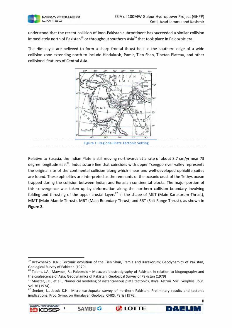
ESIA of 100MW Gulpur Hydropower Project (GHPP)
Kotli, Azad Jammu and Kashmir
II
understood that the recent collision of Indo-Pakistan subcontinent has succeeded a similar collision
immediately north of Pakistan19 or throughout southern Asia20 that took place in Paleozoic era.
The Himalayas are believed to form a sharp frontal thrust belt as the southern edge of a wide
collision zone extending north to include Hindukush, Pamir, Tien Shan, Tibetan Plateau, and other
collisional features of Central Asia.
Figure 1: Regional Plate Tectonic Setting
Relative to Eurasia, the Indian Plate is still moving northwards at a rate of about 3.7 cm/yr near 73
degree longitude east21. Indus suture line that coincides with upper Tsengpo river valley represents
the original site of the continental collision along which linear and well-developed ophiolite suites
are found. These ophiolites are interpreted as the remnants of the oceanic crust of the Tethys ocean
trapped during the collision between Indian and Eurasian continental blocks. The major portion of
this convergence was taken up by deformation along the northern collision boundary involving
folding and thrusting of the upper crustal layers22 in the shape of MKT (Main Karakorum Thrust),
MMT (Main Mantle Thrust), MBT (Main Boundary Thrust) and SRT (Salt Range Thrust), as shown in
Figure 2.
19
Kravchenko, K.N.; Tectonic evolution of the Tien Shan, Pamia and Karakorum; Geodynamics of Pakistan,
Geological Survey of Pakistan (1979) 20
Talent, J.A.; Mawson, R.; Paleozoic – Mesozoic biostratigraphy of Pakistan in relation to biogeography and
the coalescence of Asia; Geodynamics of Pakistan, Geological Survey of Pakistan (1979) 21
Minster, J.B., et el..; Numerical modeling of instantaneous plate tectonics, Royal Astron. Soc. Geophys. Jour.
Vol.36 (1974). 22
Seeber, L., Jacob K.H.; Micro earthquake survey of northern Pakistan, Preliminary results and tectonic
implications; Proc. Symp. on Himalayan Geology, CNRS, Paris (1976).

ESIA of 100MW Gulpur Hydropower Project (GHPP)
Kotli, Azad Jammu and Kashmir
III
Figure 2: Generalized Tectonic Map Northern Pakistan
The MKT separates rocks of Asian landmass from Kohistan island arc complex. The Kohistan island
arc is separated from the Indian plate by MMT. The MBT separates pre-collisional Paleozoic and
Mesozoic sedimentary rocks of the Indian plate from the younger post-collisional Himalayan molasse
sediments. A single detachment surface is believed to exist beneath the entire rocks south of MMT.
This surface extends southwards till it emerges out in the shape of Salt Range Thrust23.
Local Tectonic Setting
Project site is located close to Riasi thrust, which runs more than 200 km along the Himalayan range
and is considered as a main branch of the MBT. Towards East it joins MBT and towards West it
merges again into MBT at the axis of Hazara-Kashmir Syntaxial Bend, which is quite sharp near
Muzaffarabad towards North and becomes less sharp towards South. On the East of the Hazara-
Kashmir Syntaxial Axis, the geological features show predominantly northwest trend while their
trend change to northeast towards the West of the axis. The main tectonic features West of
Syntaxial Axis are Salt Range Thrust, Dil Jabba Thrust, Kahuta Fault and Riwat Fault (Fig-4.8). The
Syntaxial Axis itself is believed to run along a north-south running strike-slip fault called Jhelum
Fault. As many active tectonic features are present close to the Project site, therefore it is located
within highly active geotectonic environment.
23
Seeber L. et al; Seismicity and continental subduction in the Himalayan arc, in Zagros – Hindukush Himalayas; Geodynamics Evolution, A.G.U. Geodynamics Services, Vol.3 (1981).

ESIA of 100MW Gulpur Hydropower Project (GHPP)
Kotli, Azad Jammu and Kashmir
IV
Figure 3: Regional Geological Map
Quittmeyer et al.24 have classified whole of the area of Pakistan into fifteen seismotectonic
provinces (Figure 4). Gulpur Hydropower project is located near the following four distinct provinces
being discussed below:
a. Himalayas Province
b. Hazara Region Province
c. Salt Range Province and
d. Indus Basin Province
a) Himalayas Province
The Himalayas represent one of the primary compressional features that have resulted from the
collision of the Indo-Pakistan Continental Plate with Eurasian Plate. This zone of deformation is the
result of folding and thrusting associated with the development of large nappe structures and deep
crustal shortening25. The Himalayas trends in a southeasterly direction just east of the Hazara-
Kashmir syntaxis (Fig-4.7) where the project site is located.
Seismicity within this seismotectonic province is characterized as moderate to high level. Most
events are associated with the frontal zone of deformation. They are located parallel to and
northeast of the surface trace of the Main Frontal Thrust. One great earthquake, the 1905 Kangra
event with Ms=8.0 occurred within this zone, probably rupturing a 300 km portion along the Main
24
Quittmeyer, R.C., et al; Seismicity of Pakistan and its relation to surface faults; Geodynamics of Pakistan (1979). 25
Ganser, A.; Geology of the Himalayas: New York, Inter Science Publications (1964).
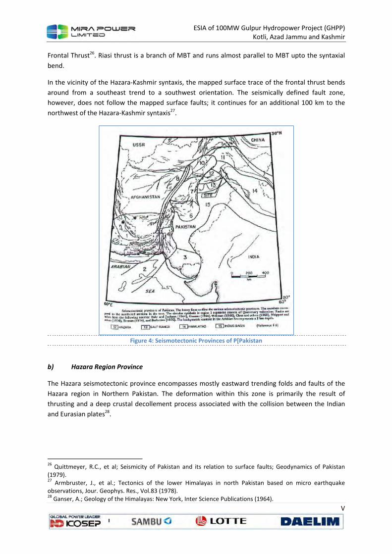
ESIA of 100MW Gulpur Hydropower Project (GHPP)
Kotli, Azad Jammu and Kashmir
V
Frontal Thrust26. Riasi thrust is a branch of MBT and runs almost parallel to MBT upto the syntaxial
bend.
In the vicinity of the Hazara-Kashmir syntaxis, the mapped surface trace of the frontal thrust bends
around from a southeast trend to a southwest orientation. The seismically defined fault zone,
however, does not follow the mapped surface faults; it continues for an additional 100 km to the
northwest of the Hazara-Kashmir syntaxis27.
Figure 4: Seismotectonic Provinces of P[Pakistan
b) Hazara Region Province
The Hazara seismotectonic province encompasses mostly eastward trending folds and faults of the
Hazara region in Northern Pakistan. The deformation within this zone is primarily the result of
thrusting and a deep crustal decollement process associated with the collision between the Indian
and Eurasian plates28.
26
Quittmeyer, R.C., et al; Seismicity of Pakistan and its relation to surface faults; Geodynamics of Pakistan
(1979). 27
Armbruster, J., et al.; Tectonics of the lower Himalayas in north Pakistan based on micro earthquake
observations, Jour. Geophys. Res., Vol.83 (1978). 28
Ganser, A.; Geology of the Himalayas: New York, Inter Science Publications (1964).
ESIA of 100MW Gulpur Hydropower Project (GHPP)
Kotli, Azad Jammu and Kashmir
VI
Seismic activity within this province has occurred at a low level29. Historical data however do indicate
moderate events causing significant damage in this region.
Shallow seismicity within the Hazara region occurs on perpendicular, steeply dipping faults
characterized by reverse and strike-slip faulting. The microseismicity data suggest that the Hazara
Thrust Fault may be related to a decollement surface identified at depth30. However, as the mapped
faults are dominantly of thrust nature, a narrow alignment of epicenters along these faults is not to
be expected. Furthermore, some activity is also associated with faults that are located below the
decollement surface, which do not have any surface expression. The broad band of activity following
the dominant structural trend, however, suggests that at least some of these earthquakes may be
related to the major mapped structures31.
c) Salt Range Province
The Salt Range is situated south of the Hazara seismotectonic province and extends from the
Sulaiman Range on the West to the Himalayas in the East (Fig-4.9). General orientation of this range
is east northeast, but prominent southeast trending transverse features offset parts of it (Fig-4.7). It
is composed of folded and faulted thrust sheets and represents thin-skinned internal deformation
within the Indian Plate resulting from its collision with Eurasia.
Although it is the frontal zone of deformation in this region, the Salt Range is characterized by a low
level seismic activity, in contrast to other parts of the frontal zone in Pakistan. It has limited known
history of moderate or large magnitude earthquake. Micro-earthquake studies, however, indicate
that at low magnitude levels (m<4), the entire Salt Range is active, especially along transverse faults
at points where it is offset. Cambrian salt deposits may provide an explanation for this aseismic
character of the Salt range. Deformation may result from aseismic slip along a decollement surface
mechanically detached by the salt32. The micro seismic activity may represent small readjustments
within the decollement sheets.
d) Indus Basin Province
The Indus Basin is located within the Indo-Pakistan Plate South and Southwest of the Himalayas and
Salt Range, and East of the predominantly northward trending mountain ranges of Pakistan (Fig-4.8).
This feature is a foredeep basin. The seismicity occurring within this zone is generally of low level.
Although infrequent, some events have caused considerable damage. Southwest of the Himalayas,
the events occur along a discontinuous, but nevertheless, linear trend about 200 km from the Main
Frontal Thrust33. This same trend parallels the Salt Range, but not at as great a distance. This activity
29
Seeber, L., Jacob K.H.; Micro earthquake survey of northern Pakistan, Preliminary results and tectonic
implications; Proc. Symp. on Himalayan Geology, CNRS, Paris (1976). 30
Seeber L. et al; Seismicity and continental subduction in the Himalayan arc, in Zagros – Hindukush
Himalayas; Geodynamics Evolution, A.G.U. Geodynamics Services, Vol.3 (1981). 31
Quittmeyer, R.C., et al; Seismicity of Pakistan and its relation to surface faults; Geodynamics of Pakistan
(1979). 32
Seeber, L., et al; Seismicity of the Hazara arc in northern Pakistan; Decollement vs. basement faulting;
Geodynamics of Pakistan (1979). 33
Menke, W., and Jacob, K.H.; Seismicity Patterns in Pakistan and north western India associated with
continental Collision: Seismol. Soc. America Bull; Vol.66 (1976).
ESIA of 100MW Gulpur Hydropower Project (GHPP)
Kotli, Azad Jammu and Kashmir
VII
within the Indus Basin may be related to bending of the lithosphere34, active basement faults
transverse to the fold and thrust belts35, and/or development of a new frontal thrust36. A focal
mechanism for one event near New Delhi showed normal faulting on one of two nodal planes
parallel to the Himalayas37.
Surface faults have not been mapped in the Indus Basin; the extensive alluvial cover has buried any
structural evidence of faulting on the surface. Inferences based on gravity data, however, indicate
basement faults may exist in some portions of the Indus Basin38.
Seismicity
General
Earthquakes pose a multitude of hazard to dams, either by direct loading of the structures or by
initiating a sequence of events that may lead to dam failure. For example, strong ground shaking or
fault offset at the dam foundation is a direct load on the structure while an upstream failure, seiche
or landslide into the reservoir are earthquake generated events that can lead to overtopping and
failure. Effects of ground shaking by earthquakes are also documented in terms of loss of free board
due to differential tectonic ground movements, slope failure, piping failure through cracks induced
by ground shaking, failure of spillway and outlet works39.
Earthquakes are generated by tectonic process in the upper part of the earth called lithosphere that
is divided into several rigid parts called as “Plates”. Due to movements along these plates, stress
build up takes place and results in the deformation of the crystal mass. This energy accumulation
gives birth to seismic events. The contact zones between adjacent plates are, therefore, considered
as most vulnerable parts from the seismic hazard point of view.
The project site is located near one of these contacts between Indian plate and Eurasian plate. This
contact represented by the Himalayas has always been generating moderate to large earthquakes
including Kangra (1905), Bihar-Nepal (1934) and Assam (1897) earthquakes that caused widespread
destruction and huge loss of life.
34
Molnar, P., et al; Fault plane solutions of shallow earthquakes and contemporary tectonics in Asia, Earth and
Planetary Science Letters, Vol.19 (1973). 35
Valdiya, K.S.; Himalayan Transverse faults and folds and their parallelism with subsurface structures of north
Indian plains, Tectonophysics, Vol.32 (1976). 36
Le Fort, P., Himalayas: The collided range. Present knowledge of the continental Arc: A.M. Jour Sci., Vol.275-
A (1975). 37
Molnar, P., et al; Fault plane solutions of shallow earthquakes and contemporary tectonics in Asia, Earth and
Planetary Science Letters, Vol.19 (1973). 38
Farah, A., et .el; Gravity field of the buried shield in the Punjab plain, Pakistan: Geol. Soc. America Bull.,
Vol.88 (1977). 39
Seed, H.B. “Earthquake resistant design of earth dams:, International Conference on Recent Advances in
Geotechnical Earthquake, Engineering and Soil Dynamics, Missouri, (1981).
ESIA of 100MW Gulpur Hydropower Project (GHPP)
Kotli, Azad Jammu and Kashmir
VIII
Historical Seismicity
The earthquakes originated before the advent of seismic recording instruments that have been
mentioned in the literature and were located within the Project region give mainly information
about the level of damage that this region has undergone historically. Though this information does
not give a conclusive account of their epicentral location, these do give an understanding about the
extent of structural damages and probable life loss in return. This non-instrumental data is solely
dependent upon human observation. In order to perform a quantitative analysis of the effects of an
earthquake, it is convenient to reduce the raw data to a more manageable form. For this purpose
intensity scales have been established which categorize the effects experienced by human being into
well defined level ranging from minimum sensations to catastrophic extremes. The historical / pre-
instrumental earthquake data was collected from Oldham40, Heuckroth et al.41, Ambraseys et al.42
and Quittmeyer et al.43 catalogues as the same source of information has been used in the
seismotectonic studies of other large projects in Pakistan (Tarbela dam, Mangla dam, etc.).
A brief description of the main historic events in the region under study is given below:
a) 4th Century B.C
The first known historical account of seismicity in this region was described in 4th Century B.C by
Aristobulus of Cassanderia. He accompanied Alexander on his expedition to India and pointed out
that the country above river Jhelum was subjected to earthquakes which caused the ground to open
up so much that even the river bed was changed.
b) Year 25 A.D
Another historical record of a destructive earthquake is available of Taxila event. This event was
located in the Hazara area and occurred in 25 A.D. Seismic intensity at Taxila was about X and felt
throughout the country. The damage effects are still witnessed in the remains of Jandial, Sirkap and
Dharmarajika around Taxila. After the earthquake, building methods had to be changed and height
of the buildings was reduced. It was also started to ensure that foundations of the new buildings are
more secure.
c) June 23, 1669
An earthquake with as much intensity as IX was felt at the city of Attock.
d) September 24, 1827
A destructive earthquake was felt in Lahore Region. The Fort Kolitaran near the city was destroyed.
About 1000 lives were lost. A hill was shaken down which fell into the River Ravi. Its maximum
intensity was estimated as VIII-IX.
40
Oldham, T.; A catalogue of Indian earthquakes, Mem. Geol. Survey India, Vol. 19 (1893) 41
Heuckroth, L. and Karim, R.: Earthquake history, seismicity and tectonics of the regions of Afghanistan, Seism. Centre, Kabul University (1970). 42
Ambraseys A. Lensen G., and Monifer A.; The Pattan earthquake of 28 December 1974, UNESCO Publication (1975) 43
Quittmeyer R.C and Jacob K.H; Historical and modern seismicity of Pakistan, Afghanistan, northwestern India and southeastern Iran ; Bull. Siesm. Soc. Am. Vol. 69, No.3 (1979)
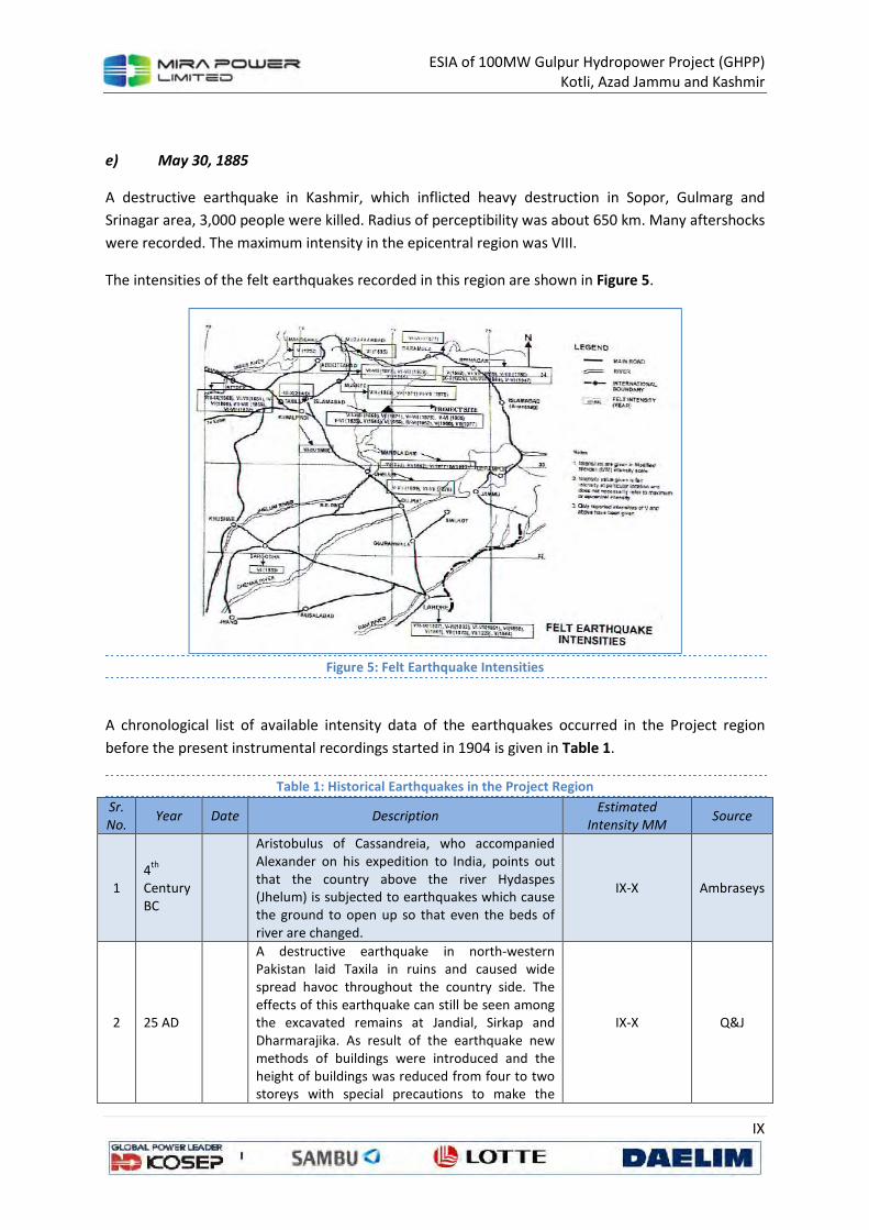
ESIA of 100MW Gulpur Hydropower Project (GHPP)
Kotli, Azad Jammu and Kashmir
IX
e) May 30, 1885
A destructive earthquake in Kashmir, which inflicted heavy destruction in Sopor, Gulmarg and
Srinagar area, 3,000 people were killed. Radius of perceptibility was about 650 km. Many aftershocks
were recorded. The maximum intensity in the epicentral region was VIII.
The intensities of the felt earthquakes recorded in this region are shown in Figure 5.
Figure 5: Felt Earthquake Intensities
A chronological list of available intensity data of the earthquakes occurred in the Project region
before the present instrumental recordings started in 1904 is given in Table 1.
Table 1: Historical Earthquakes in the Project Region
Sr.
No. Year Date Description
Estimated
Intensity MM Source
1
4th
Century
BC
Aristobulus of Cassandreia, who accompanied
Alexander on his expedition to India, points out
that the country above the river Hydaspes
(Jhelum) is subjected to earthquakes which cause
the ground to open up so that even the beds of
river are changed.
IX-X Ambraseys
2 25 AD
A destructive earthquake in north-western
Pakistan laid Taxila in ruins and caused wide
spread havoc throughout the country side. The
effects of this earthquake can still be seen among
the excavated remains at Jandial, Sirkap and
Dharmarajika. As result of the earthquake new
methods of buildings were introduced and the
height of buildings was reduced from four to two
storeys with special precautions to make the
IX-X Q&J
ESIA of 100MW Gulpur Hydropower Project (GHPP)
Kotli, Azad Jammu and Kashmir
X
Sr.
No. Year Date Description
Estimated
Intensity MM Source
foundation secure.
3 1669 4-
Jun Strongly felt in Mandra VI-X Q&J
4 1669 23-
Jun
An earthquake at Attock, a fissure 50 yards long
was formed in the ground. VIII-IX Q&J
5 1827 24-
Sep
Destructive in Lahore region. Fort Kolitaran near
city destroyed, about 1000 perished in ruins. A hill
shaken down, which fell into river Rowee (Ravi)
produced an inundation of 100 coss of land.
VIII-IX Q&J
6 1831
Peshawar & valley of Indus – Severe, extended
from Peshawar to Dera Ghazi Khan, felt most at
Dera bank (Darban); men and camels unable to
stand, rocks fell in many places, water forced
from crevices in the plains.
Daraban VIII-IX
Peshawar & D.G.
Khan IV-VI
Q&J
7 1832 22-
Jan
Near Lahore-violent, people all rushed out of
houses. V-VI
8 1832 21-
Feb
Lahore, valley of Badakhshan, N.W. India huge
masses of rock was thrown from the cliffs at many
places chocking up valleys. Great part of
population destroyed.
Lahore V-VI
Mangla V
9 1842 19-
Feb
Kabul, Peshawar. At Kabul said to have lasted for
3 minutes, several shocks, rocked the fouth in a
frightful manner. At Peshawar very destructive,
“earth-trembled like aspen leaf” several killed. At
Ferozpur severe. At Ludhiyana north south, the
hot springs of South (temp. 140 deg-110 deg)
become as cold as the ordinary wells, water
diminished greatly and at times the springs were
completely dry. These appearances continued for
25 days.
Kabul Q&J
VI-VII Peshawar VI
Ferozpur VI
10 1851 4-
Feb Lahore, appears to have extended all over Punjab. Lahore V-VI
11 1851 6-
Feb Lahore, appears to have extended all over Punjab. Lahore V-VI
12 1851 17-
Feb Strongly felt in Lahore, Multan Lahore V-VI
13 1853 Nov. Strongly felt in Attock VI Q&J
14 1858 29-
Aug Lahore-sharp shocks Lahore IV-V
15 1865 22-
Jan
Slight damage and great panic in Peshawar, long
duration. V-VII
16 1865 4-
Dec Lahore – tow smart shocks III-V
17 1867 10-
Nov Damaging in Bannu VII-VIII Q&J
18 1868 11-
Aug
Damaging in Peshawar, a portion of the fort was
shaken down (official record). VII-VIII Q&J
19 1868 12-
Nov
Violent shock felt in Lahore, Dera Ismail Khan and
Attock, followed by many aftershocks which were
felt throughout the Punjab.
Attock IV-VI & D.I.
Khan IV-VI Q&J
20 1869 24- Severe shock in the upper reaches of Jhelum V-VII Q&J

ESIA of 100MW Gulpur Hydropower Project (GHPP)
Kotli, Azad Jammu and Kashmir
XI
Sr.
No. Year Date Description
Estimated
Intensity MM Source
Mar
21 1869 25-
Mar
A large earthquake in the Hindukush, strongly felt
at Kohat, Lahore, Peshawar and at Khojend and
Tashkent; shocking lasting 20 seconds.
Kohat, Lahore &
Peshawar V NESPAK
22 1869 April Peshawar – Part of fort shaken down (official
record). VII-VIII Q&J
23 1869 20-
Dec
Rawalpindi – Shock said to have lasted for 1/2 a
minute; cracked walls and caused all people to
run out of houses. Attock – A series of shocks at
intervals of about 20 sec. Lawrencepur – Ist
shocks 15 sec others at 5 sec. interval.
Campbellpur – For half an hour; building much
damaged. Talagang – Not felt
VII-VIII Q&J
24 1871 April Severe at Rawalpindi and Murree; originating
from Kashmir
Rawalpindi &
Murree VI Q&J
25 1875 12-
Dec
Damaging in villages between Lahore and
Peshawar where a number of people were killed. VII-VIII Q&J
26 1878 2-
Mar
Damaging earthquake in the Punjab. At Kohat
several houses, public buildings and portion of the
wall of the fort fell. At Peshawar, it caused
damage to houses and city walls. Damaging at
Attock, Abbottabad, Rawalpindi, Jhelum, Murree.
Strongly felt at Bannu, Nowshera, Mardan, Lahore
and Simla. Many aftershocks.
Peshawar & Kohat
VII-VIII, Attock VI-
VII, Lahore VI
27 1883 April Damaging shock at Peshawar. VI-VIII Q&J
28 1885 30-
May
Destructive shock in Kashmir, Sopor, Gulmarg and
Srinagar about totally ruined and 3,000 people
killed. Heavy damage at Gurias and Punch:
Muzaffarabad heavily damaged. Felt in Peshawar,
Lahore, Simla, Leh, Kanpalu, and Gilgit. Radius of
perceptibility about 650 km. Many aftershocks.
Kashmir VIII,
Muzaffarabad VI-
VII, Peshawar IV
Q&J
29 1893 3-
Nov
Slight damage at Peshawar, Nowshera, felt
throughout the Punjab VI-VII Q&J
30 1905 4-
Apr
Kangra earthquake, in Rawalpindi few lofty
buildings cracked, some damage in Lahore.
Kangra VIII
Rawalpindi V-VI Q&J
31 1929 1-
Feb
Destructive earthquake, perhaps shallower than
calculated, ruin Skorzor and Drosh. Damage was
equally heavy in the USSR at Kulyab. It caused
substantial damage in Abbottabad, Peshawar,
Cherat, Gurez, Chitral and Dushambe. It was felt
within a radius area of 1,000 km.
Abbottabad &
Peshawar VI-VII NESPAK
32 1939 21-
Nov
Destructive in the Badakhshan area, the damage
extending to Srinagar, Rawalpindi and Kargil.
Drosh was seriously damaged. Felt within a radius
of 600 km.
Rawalpindi V-VI NESPAK
33 1945 27-
Jun Felt in Peshawar IV NESPAK
34 1945 22-
Jun
Destructive at Chamba and parts of Kahsmir.
Strongly felt at Rawalpindi, Peshawar, Lahore and
Simla.
Rawalpindi V NESPAK
35 1953 1-
Mar Slight damage in Cambellpur VI-VII Q&J
36 1956 16- Destructive in the Ghazi district in Afghanistan Rawalpindi V NESPAK
ESIA of 100MW Gulpur Hydropower Project (GHPP)
Kotli, Azad Jammu and Kashmir
XII
Sr.
No. Year Date Description
Estimated
Intensity MM Source
Sep where many villages were destroyed and animals
lost. The damage was equally serious at Said
Karem. Cause panic at Kohat. Strongly felt at
Parachinar, Parwan, Loger, Ghaiz, Nazerajat,
Beshud, Makur, Rawalpindi and Rawalpindi
Srinagar. Radius of perceptibility about 450 km.
37 1962 2-
Aug Felt at Rawalpindi IV-VI Q&J
38 1966 11-
Jan Felt at Risalpur IV NESPAK
39 1966 2-
Feb
Strongly felt around Abbottabad where it caused
minor damage at Havelian. Felt at Rawalpindi,
Islamabad, Abbottabad, Taxila. The shock was felt
at Muzaffarabad and Gujar Khan.
Abbottabad VI
Islamabad V Taxila
VI
Q&J
40 1977 14-
Feb
About 7 km northeast of Rawalpindi caused
damage in 20 villages. In villages Kuri, Malot and
Pindi Begwal around Nilour most of the “Katcha”
houses either collapsed or damaged. A few
houses built with dressed blocks of sandstone and
sand-cement mortar also developed extensive
cracks.
VII NESPAK
41 1978 7-
May
Felt widely at Punjab and NWFP Provinces. Some
damage at Peshawar and Chitral.
Mangla IV Tarbela
VI WAPDA
42 1980 12-
Feb Felt widely in the areas of Punjab and NWFP.
Mangla IV Tarbela
V WAPDA
43 1983 31-
Dec
Felt widely in the areas of Punjab and NWFP.
Damages at Peshawar, Chitral and many northern
areas. Some damage near Tarbela also. Felt in
parts of Afghanistan also.
Chitral VII
Peshawar VI
Rawalpindi V
Tarbela V Mangla
III
WAPDA
44 1996 4-
Apr
Felt widely in the areas of Punjab and NWFP.
Some damages at Peshawar, Chitral and Northern
Areas. Some damage near Tarbela also. Felt also
in parts of Afghanistan.
Chitral VI
Peshawar V
Rawalpindi IV
Mangla III Lahore
& Jhelum III
WAPDA
45 1999 17-
Feb
Epicenter near Mangla. Felt also in the adjoining
areas. Mangla IV WAPDA
Instrumental Seismicity
The instrumental recording of earthquakes started in 1904 but the number of seismic stations
remained small in South Asian Region until 1960 when the installation of high quality seismographs
under World Wide Standard Seismograph Network (WWSSN) increased the quality of earthquake
recording. In addition, local microseismic networks were also established at important dams and
other projects in Pakistan. In the present seismic studies, two classes of instrumental earthquake
data have been used. The first one is based upon earthquakes recorded by local seismic networks
and the other is compiled from regional data catalogues.
Seismicity Recorded by Local Networks
ESIA of 100MW Gulpur Hydropower Project (GHPP)
Kotli, Azad Jammu and Kashmir
XIII
Near the Project site, an independent telemetry microseismic network belonging to Mangla Dam
Project is functioning. Initially, it comprised of three stand-alone stations since 1966. However, in
1993, it was replaced with a more modern microseismic network having thirteen field seismic
stations out of which seven have been put to operation. The Central Recording Station (CRS) is
installed near the left abutment of the main embankment of Mangla dam. The microseismicity
recorded by Mangla Dam network is shown in Figure 6.
Figure 6: Microseismicity of the Project Region
Seismicity Recorded by Regional Networks
The regional seismic data catalogue being used in the study is compiled on the basis of seismic
events listed since 1904 by various agencies like British Association for the Advancement of Science
(BAAS), International Seismological Centre (ISC), International seismological summary (ISS), United
States Geological Survey (USGS) and others. It consists of a list of 594 earthquakes among which 331
earthquakes have magnitude more than or equal to 4 within a radius of about 200 km from project
site.
Composite Earthquake Catalogue
A composite list of earthquakes recorded within about 200 km of the Project site was prepared from
the data collected from regional as well as microseismic networks mentioned above. This list
contains all the earthquakes recorded in area between latitude 32.0o-35.0oN and longitude 72.0o-
76.0oE. This list is presented in Table 2. The epicenters of these earthquakes are plotted in Figure 7.
ESIA of 100MW Gulpur Hydropower Project (GHPP)
Kotli, Azad Jammu and Kashmir
XIV
Figure 7: Seismotectonic Map of the Project Region
Table 2: Composite List of Recorded Earthquake Data
Sr No
Date Time Latitude Longitude Depth Magnitude Source
Year Month Day GMT N E Km mb MS ML
1 1905 4 4 00:50:00.00 33.0000 76.0000 35 6.8 8.0
PAS
2 1928 11 14 04:33:09.00 35.0000 72.5000 110 5.6 6.0
PAS
3 1937 11 7 19:07:40.00 35.0000 73.0000 100 5.5 5.8
PAS
4 1945 6 22 18:00:57.00 32.5000 76.0000 60 5.9 6.5
PAS
5 1964 2 13 05:10:47.20 34.9900 72.7000 68 4.5
ISC
6 1964 7 3 14:10:27.80 34.1500 74.9100 33 4.9
ISC
7 1964 12 31 08:21:11.00 34.9000 73.0000 131 4.4
ISC
8 1965 10 9 04:34:22.00 32.3000 74.0000 79 4.5
USCGS
9 1965 11 8 21:23:09.40 34.6000 73.3000 65 4.6
USCGS
10 1966 2 2 09:20:09.30 33.8900 73.2000 37 5.1
ISC
11 1966 3 16 00:08:17.30 33.2300 75.9100 33 4.7
ISC
12 1966 4 6 01:51:53.20 34.9100 73.0600 54 5.1
ISC
13 1967 2 10 05:46:29.00 33.2800 75.2900 21 4.8
ISC
14 1967 2 20 14:23:48.70 33.6900 75.4200 38 4.8
ISC
15 1967 2 20 15:18:39.00 33.6300 75.3300 20 5.5
ISC
16 1967 2 20 15:39:54.40 33.4800 74.8300 96 4.0
ISC
17 1967 2 21 12:37:43.00 33.6500 75.4400 20 4.9
ISC
18 1967 2 24 00:17:38.80 33.5700 75.3900 32 4.6
ISC
19 1967 7 2 08:32:39.70 33.2100 75.7100 42 4.8
ISC
20 1968 3 3 09:31:21.60 34.7100 72.3600 43 5.0
ISC
21 1968 7 3 19:46:55.00 34.8000 74.6000 88 4.6
ISC
22 1969 1 23 20:01:21.00 32.1900 76.0000 64 3.9
ISC
23 1970 1 2 20:01:02.00 32.5000 76.0000 96 4.1
ISC
ESIA of 100MW Gulpur Hydropower Project (GHPP)
Kotli, Azad Jammu and Kashmir
XV
Sr No
Date Time Latitude Longitude Depth Magnitude Source
Year Month Day GMT N E Km mb MS ML
24 1970 4 28 14:12:32.00 32.8000 74.9000 116 4.5
ISC
25 1970 4 28 15:11:47.70 32.9000 74.7000 126 3.5
ISC
26 1970 4 30 03:24:54.30 33.2600 73.4300 33 4.8
ISC
27 1970 6 11 10:30:39.90 33.1100 75.0000 72 4.5
ISC
28 1970 9 7 21:19:09.00 33.0000 75.2000 54 4.6
ISC
29 1970 12 5 17:51:54.00 33.9000 74.5000 75 4.3
ISC
30 1971 4 28 15:12:42.62 34.4449 73.5973 43 4.8
ISC
31 1971 12 27 20:59:39.26 34.9776 73.0234 55 5.2
ISC
32 1972 1 8 01:30:35.00 34.7000 74.1000 96 4.0
ISC
33 1972 3 10 14:36:16.95 33.9073 72.7158 40 4.9
ISC
34 1972 4 17 02:24:50.14 33.9487 72.8622 52 4.8
ISC
35 1972 9 27 02:03:39.00 33.9910 72.6996 41 5.1
ISC
36 1973 1 16 21:31:25.86 33.2922 75.8320 39 5.1
ISC
37 1973 4 10 00:10:02.88 33.1703 75.7460 61 4.4
ISC
38 1973 7 13 22:03:38.06 33.1732 75.6747 48 4.8
ISC
39 1973 7 13 22:54:27.85 33.1819 75.7057 55 4.4
ISC
40 1973 10 24 05:23:51.34 33.1479 75.9166 37 5.3
ISC
41 1973 10 24 19:57:17.09 33.1167 75.9269 48 4.9
ISC
42 1973 12 16 19:09:46.94 34.2686 74.0466 40 5.1
ISC
43 1974 3 25 13:44:05.79 33.7003 72.6774 39 4.4
ISC
44 1974 3 26 04:45:54.73 33.8805 72.8457 72 4.1
ISC
45 1974 4 12 10:32:48.23 33.5311 73.8677 50 4.4
ISC
46 1974 5 20 17:39:19.59 34.5632 74.2327 49 4.8
ISC
47 1974 8 1 19:54:11.76 33.4410 74.5294 0 4.5
ISC
48 1974 8 11 17:21:00.02 34.8828 73.2713 33 4.1
ISC
49 1974 12 28 22:38:53.24 34.9946 73.1013 68 4.8
ISC
50 1975 1 20 09:28:00.68 34.9363 73.1054 63 4.6
ISC
51 1975 4 7 06:41:02.95 34.9085 72.9663 53 5.0
ISC
52 1975 10 17 10:46:09.30 34.2535 74.0640 77 4.1
ISC
53 1975 10 30 14:20:54.36 32.8923 75.7092 75 4.7
ISC
54 1975 10 30 14:36:44.40 32.9700 75.9583 45 4.8
ISC
55 1975 12 10 05:03:47.30 32.7871 75.9180 76 4.7
ISC
56 1976 1 9 23:50:16.49 32.7799 75.9813 96 4.5
ISC
57 1976 2 25 07:45:23.79 33.3444 74.8921 51 4.5
ISC
58 1976 5 22 18:32:53.58 33.0491 75.8290 71 4.4
ISC
59 1977 1 21 14:57:46.38 32.7601 75.9826 51 4.5
ISC
60 1977 2 14 00:22:37.80 33.5967 73.2669 27 5.2
ISC
61 1978 4 12 02:10:16.20 33.7184 75.4263 33 3.8
ISC
62 1978 4 27 18:12:24.79 35.0022 73.0280 58 4.9
ISC
63 1978 5 7 10:32:25.57 33.3964 73.6306 25 5.0 4.4
ISC
64 1978 5 16 06:31:57.14 33.1817 75.3309 96 4.1
ISC
65 1978 5 17 08:39:15.29 32.8934 75.7301 96 4.0
ISC
66 1978 11 18 01:35:00.00 32.8740 72.7513 39 4.6
ISC
67 1979 3 4 02:51:47.95 33.9436 73.1959 42 4.7
ISC
68 1979 7 2 16:27:04.29 34.7364 74.9361 74 4.4
ISC
69 1979 7 2 16:30:47.22 34.5062 74.3684 89 4.6
ISC
70 1979 12 4 04:05:42.07 34.1725 74.0963 33 4.7
ISC
71 1979 12 22 22:28:44.99 33.1078 75.8963 18 4.8 4.1
ISC
72 1980 2 5 20:17:56.85 33.2496 75.8083 33 4.2
ISC
73 1980 2 9 18:23:01.17 32.7900 72.5576 27 4.1
ISC
74 1980 3 29 02:02:53.68 32.7961 73.9736 18 4.7
ISC
75 1980 3 29 07:12:56.39 33.1427 73.2231 30 4.5
ISC
76 1980 5 1 05:43:10.65 33.0264 75.9745 18 4.9 3.8
ISC
77 1980 7 27 11:24:00.24 34.6240 72.0444 53 4.0
ISC
78 1980 8 23 21:36:49.04 32.9637 75.7509 3 5.2 4.9
ISC
79 1980 8 23 21:50:01.20 32.9023 75.7974 13 5.2 4.9
ISC
80 1980 10 5 10:47:18.67 34.6882 74.2892 33 4.1
ISC
ESIA of 100MW Gulpur Hydropower Project (GHPP)
Kotli, Azad Jammu and Kashmir
XVI
Sr No
Date Time Latitude Longitude Depth Magnitude Source
Year Month Day GMT N E Km mb MS ML
81 1981 2 6 09:54:01.40 34.3459 72.0258 263 3.8
ISC
82 1981 6 23 19:54:02.10 34.2608 74.8815 33 4.8
ISC
83 1981 7 4 03:49:25.77 34.3555 75.2542 209 3.7
ISC
84 1981 8 17 09:11:15.75 33.4165 75.6202 6 4.9 3.8
ISC
85 1981 9 27 11:10:42.48 33.2954 75.6352 33 4.5
ISC
86 1981 11 9 19:31:02.47 33.3267 75.8524 33 4.5
ISC
87 1981 12 14 18:25:39.23 33.1881 75.7226 21 4.5
ISC
88 1982 1 17 12:17:37.86 34.5236 73.9030 33 3.9
ISC
89 1982 4 3 22:39:21.98 33.3664 73.4204 3 4.1
ISC
90 1982 9 8 17:53:18.54 32.9277 75.4959 33 4.8
ISC
91 1982 10 25 08:16:27.39 34.0589 73.5200 83 4.3
ISC
92 1983 1 18 13:45:30.03 34.3461 74.2660 33 4.8
ISC
93 1983 5 30 08:39:49.37 32.7136 75.4850 41 4.6
ISC
94 1983 10 12 02:44:42.23 33.7596 75.7209 33 4.5
ISC
95 1984 2 18 07:08:56.67 34.3491 72.0208 33 4.1
ISC
96 1984 4 21 20:34:20.58 34.9902 73.6360 10 3.8
ISC
97 1984 5 23 03:14:17.66 33.1703 75.9302 14 4.8
ISC
98 1984 6 4 05:03:50.16 34.8752 73.0254 52 4.6
ISC
99 1984 8 15 05:31:04.62 34.9020 74.4680 53 4.5
ISC
100 1984 12 20 07:32:07.23 32.9495 72.6961 37 4.6
ISC
101 1984 12 27 20:22:05.91 32.9062 72.6691 22 4.6
ISC
102 1984 12 28 16:28:01.63 34.6108 73.6090 47 4.5
ISC
103 1985 2 25 18:56:07.72 34.2191 74.4430 44 4.6
ISC
104 1985 4 23 12:23:56.07 32.8225 73.2092 64 4.6
ISC
105 1985 8 10 12:56:13.90 33.8905 74.8008 41 4.6
ISC
106 1986 4 25 06:30:50.46 34.8207 73.5379 33 3.9
ISC
107 1986 5 16 05:16:13.70 34.0000 72.5800 15 4.3
4.0 ISC
108 1986 7 10 07:56:12.00 34.1500 72.6900 2 4.7
4.5 ISC
109 1986 7 30 04:03:27.18 33.0499 75.8544 61 4.6
ISC
110 1986 9 19 11:15:38.56 34.2749 73.0635 64 4.4
ISC
111 1987 3 16 06:09:36.61 34.8302 72.3380 212 3.7
ISC
112 1987 7 12 12:19:18.59 33.4897 73.5054 22 4.4 3.3
ISC
113 1988 1 9 01:16:12.48 34.4401 73.3257 95 4.4
ISC
114 1988 1 20 11:48:33.40 34.6956 74.6575 33 4.3
ISC
115 1988 1 21 10:26:48.69 34.7349 73.1783 33 3.4
ISC
116 1988 11 25 00:07:07.45 32.8931 75.8088 80 4.8
ISC
117 1988 12 7 21:13:54.99 33.9486 72.9770 50 4.4
ISC
118 1989 4 7 05:43:24.49 33.7463 73.2029 43 4.3
ISC
119 1989 5 7 10:19:33.68 32.2303 72.3548 33 3.9
ISC
120 1989 5 10 20:05:28.01 33.3402 75.6956 33 3.9
ISC
121 1989 5 10 20:19:21.56 33.3270 75.6545 37 4.7 4.0
ISC
122 1989 9 7 07:42:36.94 34.7668 74.2484 147 4.4
ISC
123 1989 12 5 02:46:11.18 34.8303 73.7770 33 4.2
ISC
124 1990 3 3 05:53:37.96 32.8660 74.1490 10 4.3
ISC
125 1990 3 6 14:43:08.50 33.2381 75.3939 10 3.8
ISC
126 1990 3 15 17:33:27.92 34.5038 74.0883 33 4.5
ISC
127 1990 4 26 15:39:18.31 34.5983 73.5383 33 4.2
ISC
128 1990 9 7 01:57:55.58 34.1017 73.1395 33 4.0
ISC
129 1990 10 9 21:56:38.54 34.0921 73.1564 33 4.4
ISC
130 1990 11 12 15:45:19.76 33.2544 75.8220 67 4.8
ISC
131 1990 12 20 05:46:48.57 34.4392 74.6409 33 4.3
ISC
132 1990 12 25 03:56:46.06 33.3059 75.7558 51 5.3 4.5
ISC
133 1991 1 10 01:33:22.37 34.0152 74.8202 33 3.9
ISC
134 1991 3 16 03:57:42.41 34.5221 72.6623 33 4.5
ISC
135 1991 5 17 17:04:30.87 34.9251 73.8863 33 3.9
ISC
136 1991 5 24 15:38:03.11 34.9778 72.2006 210 3.4
ISC
137 1991 12 18 14:17:21.95 32.8030 73.6496 42 4.2
ISC
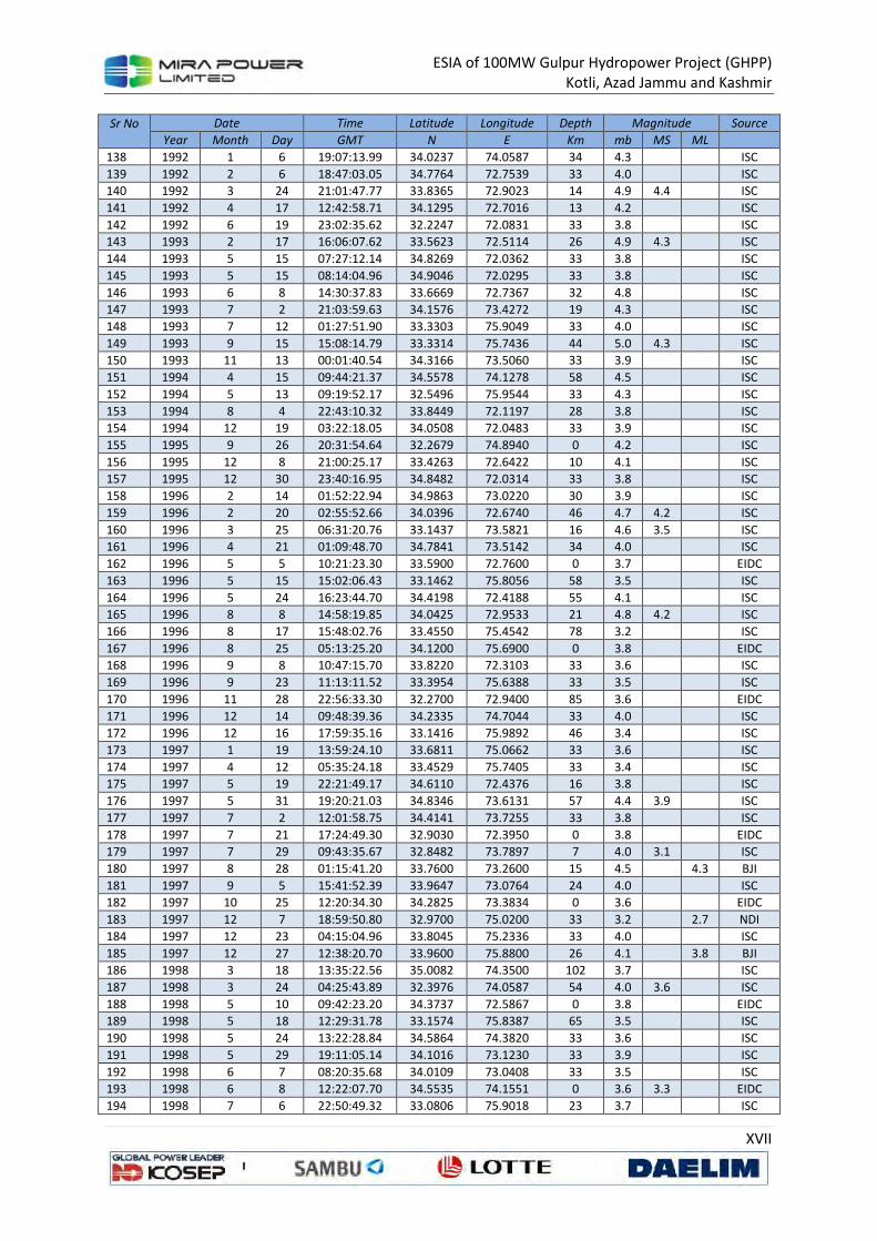
ESIA of 100MW Gulpur Hydropower Project (GHPP)
Kotli, Azad Jammu and Kashmir
XVII
Sr No
Date Time Latitude Longitude Depth Magnitude Source
Year Month Day GMT N E Km mb MS ML
138 1992 1 6 19:07:13.99 34.0237 74.0587 34 4.3
ISC
139 1992 2 6 18:47:03.05 34.7764 72.7539 33 4.0
ISC
140 1992 3 24 21:01:47.77 33.8365 72.9023 14 4.9 4.4
ISC
141 1992 4 17 12:42:58.71 34.1295 72.7016 13 4.2
ISC
142 1992 6 19 23:02:35.62 32.2247 72.0831 33 3.8
ISC
143 1993 2 17 16:06:07.62 33.5623 72.5114 26 4.9 4.3
ISC
144 1993 5 15 07:27:12.14 34.8269 72.0362 33 3.8
ISC
145 1993 5 15 08:14:04.96 34.9046 72.0295 33 3.8
ISC
146 1993 6 8 14:30:37.83 33.6669 72.7367 32 4.8
ISC
147 1993 7 2 21:03:59.63 34.1576 73.4272 19 4.3
ISC
148 1993 7 12 01:27:51.90 33.3303 75.9049 33 4.0
ISC
149 1993 9 15 15:08:14.79 33.3314 75.7436 44 5.0 4.3
ISC
150 1993 11 13 00:01:40.54 34.3166 73.5060 33 3.9
ISC
151 1994 4 15 09:44:21.37 34.5578 74.1278 58 4.5
ISC
152 1994 5 13 09:19:52.17 32.5496 75.9544 33 4.3
ISC
153 1994 8 4 22:43:10.32 33.8449 72.1197 28 3.8
ISC
154 1994 12 19 03:22:18.05 34.0508 72.0483 33 3.9
ISC
155 1995 9 26 20:31:54.64 32.2679 74.8940 0 4.2
ISC
156 1995 12 8 21:00:25.17 33.4263 72.6422 10 4.1
ISC
157 1995 12 30 23:40:16.95 34.8482 72.0314 33 3.8
ISC
158 1996 2 14 01:52:22.94 34.9863 73.0220 30 3.9
ISC
159 1996 2 20 02:55:52.66 34.0396 72.6740 46 4.7 4.2
ISC
160 1996 3 25 06:31:20.76 33.1437 73.5821 16 4.6 3.5
ISC
161 1996 4 21 01:09:48.70 34.7841 73.5142 34 4.0
ISC
162 1996 5 5 10:21:23.30 33.5900 72.7600 0 3.7
EIDC
163 1996 5 15 15:02:06.43 33.1462 75.8056 58 3.5
ISC
164 1996 5 24 16:23:44.70 34.4198 72.4188 55 4.1
ISC
165 1996 8 8 14:58:19.85 34.0425 72.9533 21 4.8 4.2
ISC
166 1996 8 17 15:48:02.76 33.4550 75.4542 78 3.2
ISC
167 1996 8 25 05:13:25.20 34.1200 75.6900 0 3.8
EIDC
168 1996 9 8 10:47:15.70 33.8220 72.3103 33 3.6
ISC
169 1996 9 23 11:13:11.52 33.3954 75.6388 33 3.5
ISC
170 1996 11 28 22:56:33.30 32.2700 72.9400 85 3.6
EIDC
171 1996 12 14 09:48:39.36 34.2335 74.7044 33 4.0
ISC
172 1996 12 16 17:59:35.16 33.1416 75.9892 46 3.4
ISC
173 1997 1 19 13:59:24.10 33.6811 75.0662 33 3.6
ISC
174 1997 4 12 05:35:24.18 33.4529 75.7405 33 3.4
ISC
175 1997 5 19 22:21:49.17 34.6110 72.4376 16 3.8
ISC
176 1997 5 31 19:20:21.03 34.8346 73.6131 57 4.4 3.9
ISC
177 1997 7 2 12:01:58.75 34.4141 73.7255 33 3.8
ISC
178 1997 7 21 17:24:49.30 32.9030 72.3950 0 3.8
EIDC
179 1997 7 29 09:43:35.67 32.8482 73.7897 7 4.0 3.1
ISC
180 1997 8 28 01:15:41.20 33.7600 73.2600 15 4.5
4.3 BJI
181 1997 9 5 15:41:52.39 33.9647 73.0764 24 4.0
ISC
182 1997 10 25 12:20:34.30 34.2825 73.3834 0 3.6
EIDC
183 1997 12 7 18:59:50.80 32.9700 75.0200 33 3.2
2.7 NDI
184 1997 12 23 04:15:04.96 33.8045 75.2336 33 4.0
ISC
185 1997 12 27 12:38:20.70 33.9600 75.8800 26 4.1
3.8 BJI
186 1998 3 18 13:35:22.56 35.0082 74.3500 102 3.7
ISC
187 1998 3 24 04:25:43.89 32.3976 74.0587 54 4.0 3.6
ISC
188 1998 5 10 09:42:23.20 34.3737 72.5867 0 3.8
EIDC
189 1998 5 18 12:29:31.78 33.1574 75.8387 65 3.5
ISC
190 1998 5 24 13:22:28.84 34.5864 74.3820 33 3.6
ISC
191 1998 5 29 19:11:05.14 34.1016 73.1230 33 3.9
ISC
192 1998 6 7 08:20:35.68 34.0109 73.0408 33 3.5
ISC
193 1998 6 8 12:22:07.70 34.5535 74.1551 0 3.6 3.3
EIDC
194 1998 7 6 22:50:49.32 33.0806 75.9018 23 3.7
ISC
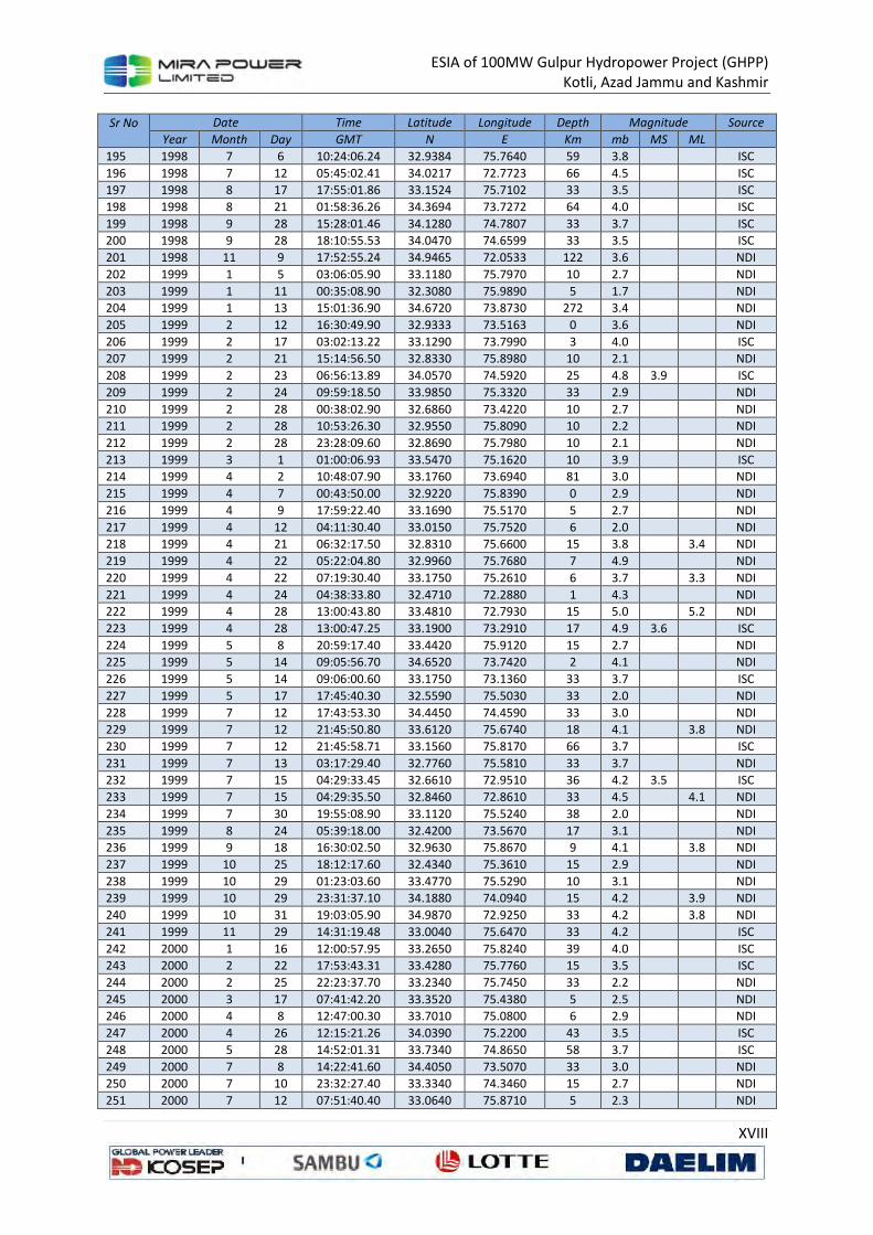
ESIA of 100MW Gulpur Hydropower Project (GHPP)
Kotli, Azad Jammu and Kashmir
XVIII
Sr No
Date Time Latitude Longitude Depth Magnitude Source
Year Month Day GMT N E Km mb MS ML
195 1998 7 6 10:24:06.24 32.9384 75.7640 59 3.8
ISC
196 1998 7 12 05:45:02.41 34.0217 72.7723 66 4.5
ISC
197 1998 8 17 17:55:01.86 33.1524 75.7102 33 3.5
ISC
198 1998 8 21 01:58:36.26 34.3694 73.7272 64 4.0
ISC
199 1998 9 28 15:28:01.46 34.1280 74.7807 33 3.7
ISC
200 1998 9 28 18:10:55.53 34.0470 74.6599 33 3.5
ISC
201 1998 11 9 17:52:55.24 34.9465 72.0533 122 3.6
NDI
202 1999 1 5 03:06:05.90 33.1180 75.7970 10 2.7
NDI
203 1999 1 11 00:35:08.90 32.3080 75.9890 5 1.7
NDI
204 1999 1 13 15:01:36.90 34.6720 73.8730 272 3.4
NDI
205 1999 2 12 16:30:49.90 32.9333 73.5163 0 3.6
NDI
206 1999 2 17 03:02:13.22 33.1290 73.7990 3 4.0
ISC
207 1999 2 21 15:14:56.50 32.8330 75.8980 10 2.1
NDI
208 1999 2 23 06:56:13.89 34.0570 74.5920 25 4.8 3.9
ISC
209 1999 2 24 09:59:18.50 33.9850 75.3320 33 2.9
NDI
210 1999 2 28 00:38:02.90 32.6860 73.4220 10 2.7
NDI
211 1999 2 28 10:53:26.30 32.9550 75.8090 10 2.2
NDI
212 1999 2 28 23:28:09.60 32.8690 75.7980 10 2.1
NDI
213 1999 3 1 01:00:06.93 33.5470 75.1620 10 3.9
ISC
214 1999 4 2 10:48:07.90 33.1760 73.6940 81 3.0
NDI
215 1999 4 7 00:43:50.00 32.9220 75.8390 0 2.9
NDI
216 1999 4 9 17:59:22.40 33.1690 75.5170 5 2.7
NDI
217 1999 4 12 04:11:30.40 33.0150 75.7520 6 2.0
NDI
218 1999 4 21 06:32:17.50 32.8310 75.6600 15 3.8
3.4 NDI
219 1999 4 22 05:22:04.80 32.9960 75.7680 7 4.9
NDI
220 1999 4 22 07:19:30.40 33.1750 75.2610 6 3.7
3.3 NDI
221 1999 4 24 04:38:33.80 32.4710 72.2880 1 4.3
NDI
222 1999 4 28 13:00:43.80 33.4810 72.7930 15 5.0
5.2 NDI
223 1999 4 28 13:00:47.25 33.1900 73.2910 17 4.9 3.6
ISC
224 1999 5 8 20:59:17.40 33.4420 75.9120 15 2.7
NDI
225 1999 5 14 09:05:56.70 34.6520 73.7420 2 4.1
NDI
226 1999 5 14 09:06:00.60 33.1750 73.1360 33 3.7
ISC
227 1999 5 17 17:45:40.30 32.5590 75.5030 33 2.0
NDI
228 1999 7 12 17:43:53.30 34.4450 74.4590 33 3.0
NDI
229 1999 7 12 21:45:50.80 33.6120 75.6740 18 4.1
3.8 NDI
230 1999 7 12 21:45:58.71 33.1560 75.8170 66 3.7
ISC
231 1999 7 13 03:17:29.40 32.7760 75.5810 33 3.7
NDI
232 1999 7 15 04:29:33.45 32.6610 72.9510 36 4.2 3.5
ISC
233 1999 7 15 04:29:35.50 32.8460 72.8610 33 4.5
4.1 NDI
234 1999 7 30 19:55:08.90 33.1120 75.5240 38 2.0
NDI
235 1999 8 24 05:39:18.00 32.4200 73.5670 17 3.1
NDI
236 1999 9 18 16:30:02.50 32.9630 75.8670 9 4.1
3.8 NDI
237 1999 10 25 18:12:17.60 32.4340 75.3610 15 2.9
NDI
238 1999 10 29 01:23:03.60 33.4770 75.5290 10 3.1
NDI
239 1999 10 29 23:31:37.10 34.1880 74.0940 15 4.2
3.9 NDI
240 1999 10 31 19:03:05.90 34.9870 72.9250 33 4.2
3.8 NDI
241 1999 11 29 14:31:19.48 33.0040 75.6470 33 4.2
ISC
242 2000 1 16 12:00:57.95 33.2650 75.8240 39 4.0
ISC
243 2000 2 22 17:53:43.31 33.4280 75.7760 15 3.5
ISC
244 2000 2 25 22:23:37.70 33.2340 75.7450 33 2.2
NDI
245 2000 3 17 07:41:42.20 33.3520 75.4380 5 2.5
NDI
246 2000 4 8 12:47:00.30 33.7010 75.0800 6 2.9
NDI
247 2000 4 26 12:15:21.26 34.0390 75.2200 43 3.5
ISC
248 2000 5 28 14:52:01.31 33.7340 74.8650 58 3.7
ISC
249 2000 7 8 14:22:41.60 34.4050 73.5070 33 3.0
NDI
250 2000 7 10 23:32:27.40 33.3340 74.3460 15 2.7
NDI
251 2000 7 12 07:51:40.40 33.0640 75.8710 5 2.3
NDI
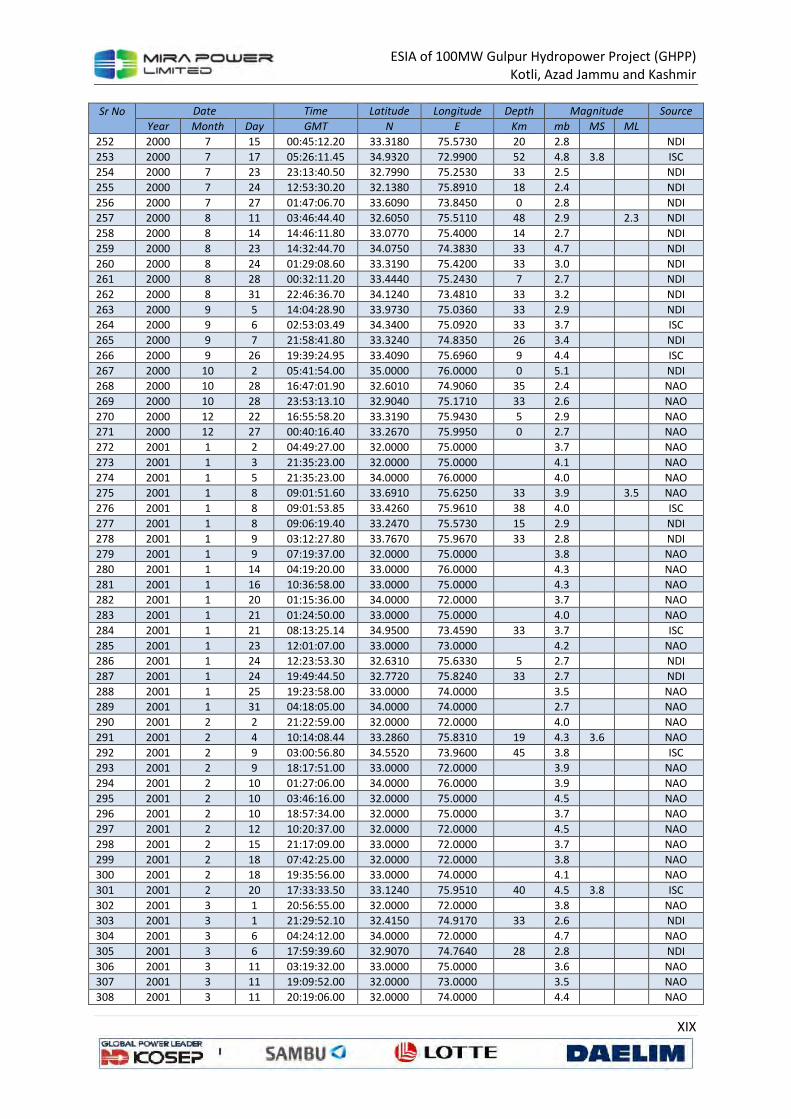
ESIA of 100MW Gulpur Hydropower Project (GHPP)
Kotli, Azad Jammu and Kashmir
XIX
Sr No
Date Time Latitude Longitude Depth Magnitude Source
Year Month Day GMT N E Km mb MS ML
252 2000 7 15 00:45:12.20 33.3180 75.5730 20 2.8
NDI
253 2000 7 17 05:26:11.45 34.9320 72.9900 52 4.8 3.8
ISC
254 2000 7 23 23:13:40.50 32.7990 75.2530 33 2.5
NDI
255 2000 7 24 12:53:30.20 32.1380 75.8910 18 2.4
NDI
256 2000 7 27 01:47:06.70 33.6090 73.8450 0 2.8
NDI
257 2000 8 11 03:46:44.40 32.6050 75.5110 48 2.9
2.3 NDI
258 2000 8 14 14:46:11.80 33.0770 75.4000 14 2.7
NDI
259 2000 8 23 14:32:44.70 34.0750 74.3830 33 4.7
NDI
260 2000 8 24 01:29:08.60 33.3190 75.4200 33 3.0
NDI
261 2000 8 28 00:32:11.20 33.4440 75.2430 7 2.7
NDI
262 2000 8 31 22:46:36.70 34.1240 73.4810 33 3.2
NDI
263 2000 9 5 14:04:28.90 33.9730 75.0360 33 2.9
NDI
264 2000 9 6 02:53:03.49 34.3400 75.0920 33 3.7
ISC
265 2000 9 7 21:58:41.80 33.3240 74.8350 26 3.4
NDI
266 2000 9 26 19:39:24.95 33.4090 75.6960 9 4.4
ISC
267 2000 10 2 05:41:54.00 35.0000 76.0000 0 5.1
NDI
268 2000 10 28 16:47:01.90 32.6010 74.9060 35 2.4
NAO
269 2000 10 28 23:53:13.10 32.9040 75.1710 33 2.6
NAO
270 2000 12 22 16:55:58.20 33.3190 75.9430 5 2.9
NAO
271 2000 12 27 00:40:16.40 33.2670 75.9950 0 2.7
NAO
272 2001 1 2 04:49:27.00 32.0000 75.0000
3.7
NAO
273 2001 1 3 21:35:23.00 32.0000 75.0000
4.1
NAO
274 2001 1 5 21:35:23.00 34.0000 76.0000
4.0
NAO
275 2001 1 8 09:01:51.60 33.6910 75.6250 33 3.9
3.5 NAO
276 2001 1 8 09:01:53.85 33.4260 75.9610 38 4.0
ISC
277 2001 1 8 09:06:19.40 33.2470 75.5730 15 2.9
NDI
278 2001 1 9 03:12:27.80 33.7670 75.9670 33 2.8
NDI
279 2001 1 9 07:19:37.00 32.0000 75.0000
3.8
NAO
280 2001 1 14 04:19:20.00 33.0000 76.0000
4.3
NAO
281 2001 1 16 10:36:58.00 33.0000 75.0000
4.3
NAO
282 2001 1 20 01:15:36.00 34.0000 72.0000
3.7
NAO
283 2001 1 21 01:24:50.00 33.0000 75.0000
4.0
NAO
284 2001 1 21 08:13:25.14 34.9500 73.4590 33 3.7
ISC
285 2001 1 23 12:01:07.00 33.0000 73.0000
4.2
NAO
286 2001 1 24 12:23:53.30 32.6310 75.6330 5 2.7
NDI
287 2001 1 24 19:49:44.50 32.7720 75.8240 33 2.7
NDI
288 2001 1 25 19:23:58.00 33.0000 74.0000
3.5
NAO
289 2001 1 31 04:18:05.00 34.0000 74.0000
2.7
NAO
290 2001 2 2 21:22:59.00 32.0000 72.0000
4.0
NAO
291 2001 2 4 10:14:08.44 33.2860 75.8310 19 4.3 3.6
NAO
292 2001 2 9 03:00:56.80 34.5520 73.9600 45 3.8
ISC
293 2001 2 9 18:17:51.00 33.0000 72.0000
3.9
NAO
294 2001 2 10 01:27:06.00 34.0000 76.0000
3.9
NAO
295 2001 2 10 03:46:16.00 32.0000 75.0000
4.5
NAO
296 2001 2 10 18:57:34.00 32.0000 75.0000
3.7
NAO
297 2001 2 12 10:20:37.00 32.0000 72.0000
4.5
NAO
298 2001 2 15 21:17:09.00 33.0000 72.0000
3.7
NAO
299 2001 2 18 07:42:25.00 32.0000 72.0000
3.8
NAO
300 2001 2 18 19:35:56.00 33.0000 74.0000
4.1
NAO
301 2001 2 20 17:33:33.50 33.1240 75.9510 40 4.5 3.8
ISC
302 2001 3 1 20:56:55.00 32.0000 72.0000
3.8
NAO
303 2001 3 1 21:29:52.10 32.4150 74.9170 33 2.6
NDI
304 2001 3 6 04:24:12.00 34.0000 72.0000
4.7
NAO
305 2001 3 6 17:59:39.60 32.9070 74.7640 28 2.8
NDI
306 2001 3 11 03:19:32.00 33.0000 75.0000
3.6
NAO
307 2001 3 11 19:09:52.00 32.0000 73.0000
3.5
NAO
308 2001 3 11 20:19:06.00 32.0000 74.0000
4.4
NAO
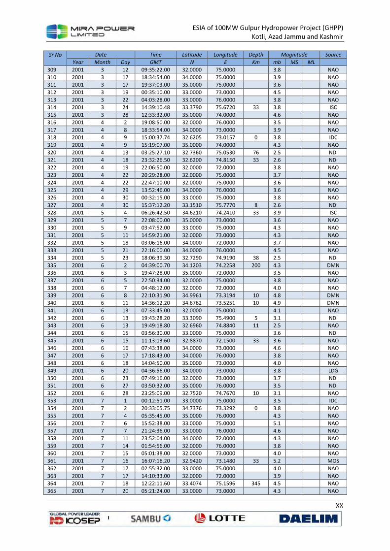
ESIA of 100MW Gulpur Hydropower Project (GHPP)
Kotli, Azad Jammu and Kashmir
XX
Sr No
Date Time Latitude Longitude Depth Magnitude Source
Year Month Day GMT N E Km mb MS ML
309 2001 3 12 09:35:22.00 32.0000 75.0000
3.8
NAO
310 2001 3 17 18:34:54.00 34.0000 75.0000
3.9
NAO
311 2001 3 17 19:37:03.00 35.0000 75.0000
3.6
NAO
312 2001 3 19 00:35:10.00 33.0000 73.0000
4.5
NAO
313 2001 3 22 04:03:28.00 33.0000 76.0000
3.8
NAO
314 2001 3 24 14:39:10.48 33.3790 75.6720 33 3.8
ISC
315 2001 3 28 12:33:32.00 35.0000 74.0000
4.6
NAO
316 2001 4 2 19:08:50.00 32.0000 76.0000
3.5
NAO
317 2001 4 8 18:33:54.00 34.0000 73.0000
3.9
NAO
318 2001 4 9 15:00:37.74 32.6205 73.0157 0 3.8
IDC
319 2001 4 9 15:19:07.00 35.0000 74.0000
4.3
NAO
320 2001 4 13 03:25:27.10 32.7360 75.0530 76 2.5
NDI
321 2001 4 18 23:32:26.50 32.6200 74.8150 33 2.6
NDI
322 2001 4 19 22:06:50.00 32.0000 72.0000
3.8
NAO
323 2001 4 22 20:29:28.00 32.0000 75.0000
3.7
NAO
324 2001 4 22 22:47:10.00 32.0000 75.0000
3.6
NAO
325 2001 4 29 13:52:46.00 34.0000 76.0000
3.6
NAO
326 2001 4 30 00:32:15.00 33.0000 75.0000
3.8
NAO
327 2001 4 30 15:37:12.20 33.1510 75.7770 8 2.6
NDI
328 2001 5 4 06:26:42.50 34.6210 74.2410 33 3.9
ISC
329 2001 5 7 22:08:00.00 35.0000 73.0000
3.6
NAO
330 2001 5 9 03:47:52.00 33.0000 75.0000
4.3
NAO
331 2001 5 11 14:59:21.00 32.0000 73.0000
4.3
NAO
332 2001 5 18 03:06:16.00 34.0000 72.0000
3.7
NAO
333 2001 5 21 22:16:00.00 34.0000 76.0000
4.5
NAO
334 2001 5 23 18:06:39.30 32.7290 74.9190 38 2.5
NDI
335 2001 6 2 04:39:00.70 34.1203 74.2258 200 4.3
DMN
336 2001 6 3 19:47:28.00 35.0000 72.0000
3.5
NAO
337 2001 6 5 22:50:34.00 32.0000 75.0000
3.8
NAO
338 2001 6 7 04:48:12.00 32.0000 72.0000
4.0
NAO
339 2001 6 8 22:10:31.90 34.9961 73.3194 10 4.8
DMN
340 2001 6 11 14:36:12.20 34.6762 73.5251 10 4.9
DMN
341 2001 6 13 07:33:45.00 32.0000 75.0000
4.1
NAO
342 2001 6 13 19:43:28.20 33.3090 75.4900 5 3.1
NDI
343 2001 6 13 19:49:18.80 32.6960 74.8840 11 2.5
NAO
344 2001 6 15 03:56:30.00 33.0000 75.0000
3.6
NDI
345 2001 6 15 11:13:13.60 32.8870 72.1500 33 3.6
NAO
346 2001 6 16 07:43:38.00 34.0000 73.0000
4.6
NAO
347 2001 6 17 17:18:43.00 34.0000 76.0000
3.8
NAO
348 2001 6 18 14:04:50.00 35.0000 73.0000
4.0
NAO
349 2001 6 20 04:36:56.00 34.0000 73.0000
3.8
LDG
350 2001 6 23 07:49:16.00 32.0000 73.0000
3.7
NDI
351 2001 6 27 03:50:32.00 35.0000 76.0000
3.5
NDI
352 2001 6 28 23:25:09.00 32.7520 74.7670 10 3.1
NAO
353 2001 7 1 00:12:51.00 33.0000 75.0000
3.5
IDC
354 2001 7 2 20:33:05.75 34.7376 73.3292 0 3.8
NAO
355 2001 7 4 05:35:45.00 35.0000 76.0000
4.3
NAO
356 2001 7 6 15:52:38.00 33.0000 75.0000
5.1
NAO
357 2001 7 7 21:24:36.00 33.0000 76.0000
4.6
NAO
358 2001 7 11 23:52:04.00 34.0000 72.0000
4.3
NAO
359 2001 7 14 01:54:56.00 32.0000 76.0000
3.8
NAO
360 2001 7 15 05:01:38.00 32.0000 73.0000
4.0
NAO
361 2001 7 16 16:07:16.20 32.9420 73.1480 33 5.2
MOS
362 2001 7 17 02:55:32.00 33.0000 75.0000
4.0
NAO
363 2001 7 17 14:10:33.00 32.0000 72.0000
3.9
NAO
364 2001 7 18 12:22:11.60 33.4074 75.1596 345 4.5
NAO
365 2001 7 20 05:21:24.00 33.0000 73.0000
4.3
NAO
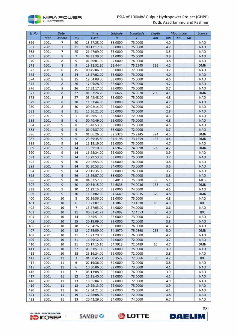
ESIA of 100MW Gulpur Hydropower Project (GHPP)
Kotli, Azad Jammu and Kashmir
XXI
Sr No
Date Time Latitude Longitude Depth Magnitude Source
Year Month Day GMT N E Km mb MS ML
366 2001 7 20 13:27:28.00 33.0000 75.0000
4.0
NAO
367 2001 7 21 00:17:17.00 33.0000 75.0000
4.7
NAO
368 2001 7 25 21:47:09.00 35.0000 73.0000
3.5
NAO
369 2001 8 7 08:31:39.00 34.0000 75.0000
3.9
NAO
370 2001 8 9 01:30:01.00 32.0000 74.0000
3.8
NAO
371 2001 8 9 19:32:32.80 33.4444 75.5545 336 4.2
DMN
372 2001 8 15 00:45:06.00 33.0000 72.0000
3.7
NAO
373 2001 8 24 18:57:02.00 33.0000 73.0000
4.0
NAO
374 2001 8 25 19:54:09.00 33.0000 75.0000
4.6
NAO
375 2001 8 26 17:05:28.00 33.0000 75.0000
4.2
NAO
376 2001 8 26 17:52:17.00 32.0000 75.0000
3.7
NAO
377 2001 8 27 01:57:26.20 33.6622 74.9070 200 4.1
DMN
378 2001 8 27 03:42:48.00 33.0000 75.0000
4.8
NAO
379 2001 8 28 11:33:44.00 33.0000 74.0000
4.7
NAO
380 2001 8 30 09:02:14.00 35.0000 76.0000
4.7
NAO
381 2001 8 31 15:36:21.00 35.0000 73.0000
2.8
NAO
382 2001 9 1 05:59:51.00 33.0000 72.0000
4.3
NAO
383 2001 9 6 00:40:49.00 33.0000 75.0000
4.8
NAO
384 2001 9 8 15:48:53.00 33.0000 75.0000
4.5
NAO
385 2001 9 9 01:04:37.00 33.0000 72.0000
3.7
NAO
386 2001 9 9 01:06:26.00 32.5326 75.9245 324 4.5
DMN
387 2001 9 9 23:39:35.50 34.5198 73.1259 133 4.4
DMN
388 2001 9 14 15:18:19.00 35.0000 73.0000
4.7
NAO
389 2001 9 14 15:39:10.80 34.5967 74.6998 300 4.7
DMN
390 2001 9 14 16:28:24.00 33.0000 73.0000
3.9
NAO
391 2001 9 14 18:29:53.00 33.0000 75.0000
3.7
NAO
392 2001 9 20 20:22:53.00 34.0000 76.0000
3.8
NAO
393 2001 9 24 05:30:53.00 34.0000 73.0000
3.6
NAO
394 2001 9 24 20:15:35.00 32.0000 76.0000
3.7
NAO
395 2001 9 26 15:29:57.00 33.0000 75.0000
3.8
NAO
396 2001 9 28 04:37:57.50 33.4010 75.8300 33 5.1
MOS
397 2001 9 30 00:54:15.90 34.6835 74.0036 133 4.7
DMN
398 2001 9 30 11:29:15.00 32.0000 74.0000
4.5
NAO
399 2001 9 30 11:31:02.80 34.5649 74.8615 320 4.8
DMN
400 2001 10 5 02:36:56.00 33.0000 75.0000
4.8
NAO
401 2001 10 6 19:21:07.30 34.1863 73.4330 10 4.9
IDC
402 2001 10 7 13:57:05.00 34.0000 74.0000
3.6
NAO
403 2001 10 11 06:01:41.72 34.6092 72.4553 0 4.0
IDC
404 2001 10 14 10:35:51.00 33.0000 73.0000
3.7
NAO
405 2001 10 15 20:18:09.00 33.0000 72.0000
3.8
NAO
406 2001 10 18 17:54:26.00 35.0000 76.0000
4.3
NAO
407 2001 10 18 17:55:59.00 34.3970 75.0860 268 5.0
DMN
408 2001 10 21 13:23:29.00 34.0000 76.0000
4.2
NAO
409 2001 10 21 14:29:12.00 34.0000 72.0000
3.7
NAO
410 2001 10 21 20:17:15.10 34.9918 72.0489 10 4.7
DMN
411 2001 10 27 03:53:51.00 32.0000 75.0000
3.9
NAO
412 2001 10 28 23:16:24.00 32.0000 72.0000
3.8
NAO
413 2001 11 3 04:50:45.71 33.1522 72.6066 0 4.2
IDC
414 2001 11 6 02:19:36.00 32.0000 72.0000
3.8
NAO
415 2001 11 6 10:50:06.00 32.0000 73.0000
4.1
NAO
416 2001 11 7 05:13:08.00 33.0000 76.0000
3.9
NAO
417 2001 11 12 22:21:40.00 32.0000 73.0000
4.2
NAO
418 2001 11 13 16:35:04.00 32.0000 72.0000
4.9
NAO
419 2001 11 13 19:29:13.00 33.0000 75.0000
3.9
NAO
420 2001 11 16 12:34:21.00 32.0000 75.0000
4.1
NAO
421 2001 11 19 17:58:08.00 32.0000 72.0000
3.8
NAO
422 2001 11 23 20:42:29.00 34.0000 74.0000
6.7
NAO

ESIA of 100MW Gulpur Hydropower Project (GHPP)
Kotli, Azad Jammu and Kashmir
XXII
Sr No
Date Time Latitude Longitude Depth Magnitude Source
Year Month Day GMT N E Km mb MS ML
423 2001 11 24 14:43:57.00 33.0000 74.0000
3.7
NAO
424 2001 12 9 12:08:57.00 33.0000 75.0000
4.0
NAO
425 2001 12 9 16:01:32.00 35.0000 73.0000
4.0
NAO
426 2001 12 16 05:32:32.00 33.0000 75.0000
3.5
NAO
427 2001 12 16 05:34:02.50 34.1263 73.7819 147 4.3
DMN
428 2001 12 21 20:06:41.00 33.0000 75.0000
4.2
NAO
429 2001 12 21 21:56:41.50 32.8733 74.4470 33 5.0
DMN
430 2001 12 22 03:39:13.00 34.0000 75.0000
5.0
NAO
431 2001 12 22 11:26:25.90 34.8174 72.3052 10 4.8
DMN
432 2001 12 22 12:06:59.10 34.6710 73.1330 33 4.3
MOS
433 2001 12 24 09:42:50.40 32.6147 75.2520 305 4.0
NAO
434 2001 12 28 20:58:48.75 34.6099 73.5547 0 3.8
3.1 IDC
435 2001 12 30 18:39:14.00 33.0000 75.0000
4.2
NAO
436 2001 12 31 22:20:24.00 33.0000 75.0000
5.1
NAO
437 2002 1 6 14:34:22.00 33.0000 74.0000
3.8
NAO
438 2002 1 7 13:04:18.24 33.6575 74.6155 61 3.6
IDC
439 2002 1 7 20:32:47.00 33.0000 74.0000
4.4
NAO
440 2002 1 11 01:24:49.00 34.0000 76.0000
4.4
NAO
441 2002 1 13 12:08:10.60 32.4450 75.9370 33 5.1
NAO
442 2002 1 13 12:08:35.19 34.9422 74.0524 33 4.6
MDD
443 2002 1 13 13:39:30.82 33.9197 75.5453 33 4.6
MDD
444 2002 1 19 04:38:04.00 33.0000 75.0000
3.8
NAO
445 2002 1 24 15:34:32.00 35.0000 72.0000
4.3
NAO
446 2002 2 5 05:35:56.00 32.0000 73.0000
5.1
NAO
447 2002 2 7 03:29:20.00 34.0000 72.0000
4.2
NAO
448 2002 2 8 04:02:14.00 32.0000 76.0000
3.8
NAO
449 2002 2 9 18:10:03.00 33.0000 76.0000
3.8
NAO
450 2002 2 12 23:13:56.00 33.0819 75.9476 0 3.4
2.9 IDC
451 2002 2 12 23:14:22.36 33.6144 75.8236 0 3.9
3.7 IDC
452 2002 2 14 23:44:02.00 32.0000 72.0000
4.6
NAO
453 2002 2 17 05:22:59.70 33.0400 75.8800 31 4.3
4.1 BJI
454 2002 2 18 22:33:31.00 32.0000 74.0000
4.4
NAO
455 2002 2 19 07:22:47.00 33.0000 72.0000
4.1
NAO
456 2002 2 20 01:37:50.00 35.0000 74.0000
4.0
NAO
457 2002 2 22 10:01:31.00 33.0000 75.0000
4.5
NAO
458 2002 2 22 17:27:02.00 33.0000 73.0000
4.0
NAO
459 2002 2 26 14:04:26.00 34.0000 76.0000
4.6
NAO
460 2002 3 3 12:07:11.00 32.0000 74.0000
4.7
NAO
461 2002 3 3 13:04:48.00 33.0000 75.0000
5.0
NAO
462 2002 3 3 16:31:37.00 32.0000 73.0000
3.9
NAO
463 2002 3 3 21:03:38.00 32.0000 75.0000
4.3
NAO
464 2002 3 5 14:15:03.00 33.0000 74.0000
4.0
NAO
465 2002 3 6 19:56:13.00 33.0000 75.0000
4.7
NAO
466 2002 3 7 16:59:46.00 33.0000 73.0000
3.9
NAO
467 2002 3 9 20:58:43.00 32.0000 75.0000
3.9
NAO
468 2002 3 14 10:45:36.00 33.0000 75.0000
3.8
NAO
469 2002 3 14 18:44:03.80 34.1600 75.9800 48 3.9
3.8 BJI
470 2002 3 18 04:29:14.40 32.9700 75.8900 57 4.1
4.5 NAO
471 2002 3 21 21:57:31.00 33.0000 72.0000
4.9
NAO
472 2002 3 24 10:18:09.70 32.2564 75.8423 0 3.7
3.8 IDC
473 2002 3 29 01:58:18.00 33.0000 73.0000
4.2
NAO
474 2002 3 30 21:13:21.00 32.0000 74.0000
3.8
NAO
475 2002 3 31 17:09:17.00 33.0000 75.0000
3.5
NAO
476 2002 4 3 02:23:09.00 34.0000 72.0000
4.6
NAO
477 2002 4 5 20:30:42.00 33.0000 74.0000
4.7
NAO
478 2002 4 11 16:05:58.00 33.0000 75.0000
3.9
NAO
479 2002 4 13 23:13:57.00 32.0000 75.0000
3.8
NAO
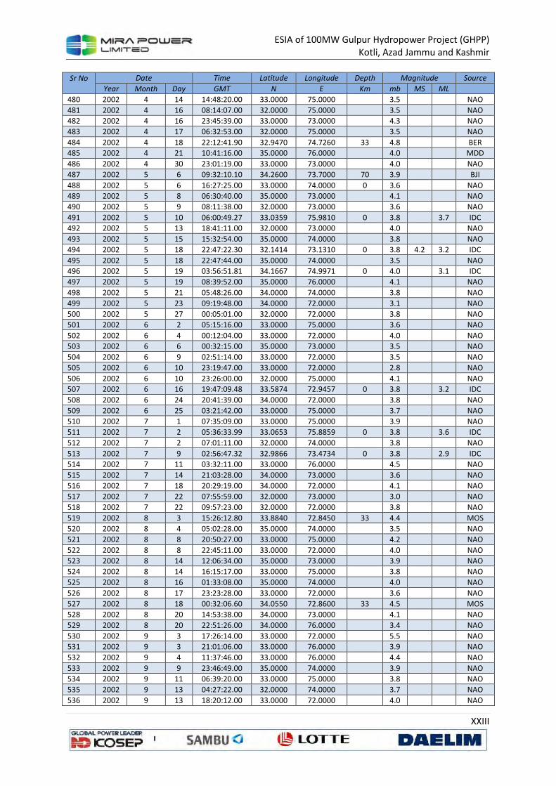
ESIA of 100MW Gulpur Hydropower Project (GHPP)
Kotli, Azad Jammu and Kashmir
XXIII
Sr No
Date Time Latitude Longitude Depth Magnitude Source
Year Month Day GMT N E Km mb MS ML
480 2002 4 14 14:48:20.00 33.0000 75.0000
3.5
NAO
481 2002 4 16 08:14:07.00 32.0000 75.0000
3.5
NAO
482 2002 4 16 23:45:39.00 33.0000 73.0000
4.3
NAO
483 2002 4 17 06:32:53.00 32.0000 75.0000
3.5
NAO
484 2002 4 18 22:12:41.90 32.9470 74.7260 33 4.8
BER
485 2002 4 21 10:41:16.00 35.0000 76.0000
4.0
MDD
486 2002 4 30 23:01:19.00 33.0000 73.0000
4.0
NAO
487 2002 5 6 09:32:10.10 34.2600 73.7000 70 3.9
BJI
488 2002 5 6 16:27:25.00 33.0000 74.0000 0 3.6
NAO
489 2002 5 8 06:30:40.00 35.0000 73.0000
4.1
NAO
490 2002 5 9 08:11:38.00 32.0000 73.0000
3.6
NAO
491 2002 5 10 06:00:49.27 33.0359 75.9810 0 3.8
3.7 IDC
492 2002 5 13 18:41:11.00 32.0000 73.0000
4.0
NAO
493 2002 5 15 15:32:54.00 35.0000 74.0000
3.8
NAO
494 2002 5 18 22:47:22.30 32.1414 73.1310 0 3.8 4.2 3.2 IDC
495 2002 5 18 22:47:44.00 35.0000 74.0000
3.5
NAO
496 2002 5 19 03:56:51.81 34.1667 74.9971 0 4.0
3.1 IDC
497 2002 5 19 08:39:52.00 35.0000 76.0000
4.1
NAO
498 2002 5 21 05:48:26.00 34.0000 74.0000
3.8
NAO
499 2002 5 23 09:19:48.00 34.0000 72.0000
3.1
NAO
500 2002 5 27 00:05:01.00 32.0000 72.0000
3.8
NAO
501 2002 6 2 05:15:16.00 33.0000 75.0000
3.6
NAO
502 2002 6 4 00:12:04.00 33.0000 72.0000
4.0
NAO
503 2002 6 6 00:32:15.00 35.0000 73.0000
3.5
NAO
504 2002 6 9 02:51:14.00 33.0000 72.0000
3.5
NAO
505 2002 6 10 23:19:47.00 33.0000 72.0000
2.8
NAO
506 2002 6 10 23:26:00.00 32.0000 75.0000
4.1
NAO
507 2002 6 16 19:47:09.48 33.5874 72.9457 0 3.8
3.2 IDC
508 2002 6 24 20:41:39.00 34.0000 72.0000
3.8
NAO
509 2002 6 25 03:21:42.00 33.0000 75.0000
3.7
NAO
510 2002 7 1 07:35:09.00 33.0000 75.0000
3.9
NAO
511 2002 7 2 05:36:33.99 33.0653 75.8859 0 3.8
3.6 IDC
512 2002 7 2 07:01:11.00 32.0000 74.0000
3.8
NAO
513 2002 7 9 02:56:47.32 32.9866 73.4734 0 3.8
2.9 IDC
514 2002 7 11 03:32:11.00 33.0000 76.0000
4.5
NAO
515 2002 7 14 21:03:28.00 34.0000 73.0000
3.6
NAO
516 2002 7 18 20:29:19.00 34.0000 72.0000
4.1
NAO
517 2002 7 22 07:55:59.00 32.0000 73.0000
3.0
NAO
518 2002 7 22 09:57:23.00 32.0000 72.0000
3.8
NAO
519 2002 8 3 15:26:12.80 33.8840 72.8450 33 4.4
MOS
520 2002 8 4 05:02:28.00 35.0000 74.0000
3.5
NAO
521 2002 8 8 20:50:27.00 33.0000 75.0000
4.2
NAO
522 2002 8 8 22:45:11.00 33.0000 72.0000
4.0
NAO
523 2002 8 14 12:06:34.00 35.0000 73.0000
3.9
NAO
524 2002 8 14 16:15:17.00 33.0000 75.0000
3.8
NAO
525 2002 8 16 01:33:08.00 35.0000 74.0000
4.0
NAO
526 2002 8 17 23:23:28.00 33.0000 72.0000
3.6
NAO
527 2002 8 18 00:32:06.60 34.0550 72.8600 33 4.5
MOS
528 2002 8 20 14:53:38.00 34.0000 73.0000
4.1
NAO
529 2002 8 20 22:51:26.00 34.0000 76.0000
3.4
NAO
530 2002 9 3 17:26:14.00 33.0000 72.0000
5.5
NAO
531 2002 9 3 21:01:06.00 33.0000 76.0000
3.9
NAO
532 2002 9 4 11:37:46.00 33.0000 76.0000
4.4
NAO
533 2002 9 9 23:46:49.00 35.0000 74.0000
3.9
NAO
534 2002 9 11 06:39:20.00 33.0000 75.0000
3.8
NAO
535 2002 9 13 04:27:22.00 32.0000 74.0000
3.7
NAO
536 2002 9 13 18:20:12.00 33.0000 72.0000
4.0
NAO
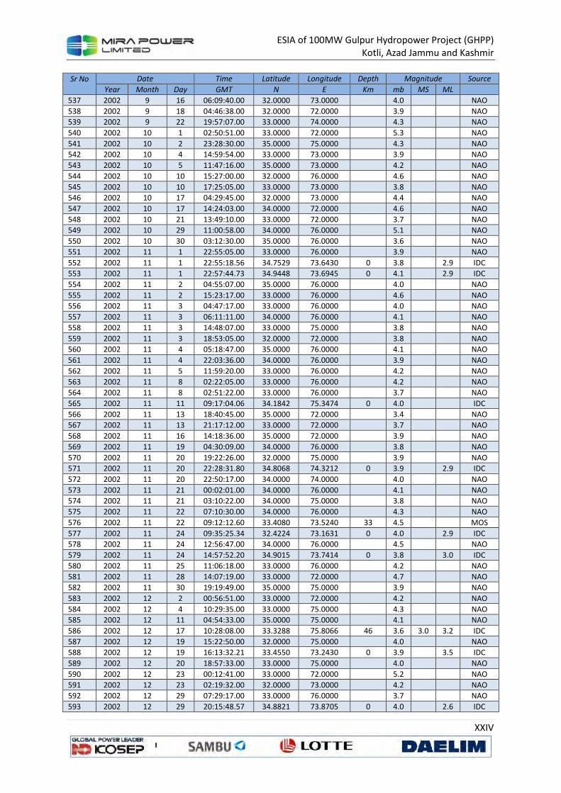
ESIA of 100MW Gulpur Hydropower Project (GHPP)
Kotli, Azad Jammu and Kashmir
XXIV
Sr No
Date Time Latitude Longitude Depth Magnitude Source
Year Month Day GMT N E Km mb MS ML
537 2002 9 16 06:09:40.00 32.0000 73.0000
4.0
NAO
538 2002 9 18 04:46:38.00 32.0000 72.0000
3.9
NAO
539 2002 9 22 19:57:07.00 33.0000 74.0000
4.3
NAO
540 2002 10 1 02:50:51.00 33.0000 72.0000
5.3
NAO
541 2002 10 2 23:28:30.00 35.0000 75.0000
4.3
NAO
542 2002 10 4 14:59:54.00 33.0000 73.0000
3.9
NAO
543 2002 10 5 11:47:16.00 35.0000 73.0000
4.2
NAO
544 2002 10 10 15:27:00.00 32.0000 76.0000
4.6
NAO
545 2002 10 10 17:25:05.00 33.0000 73.0000
3.8
NAO
546 2002 10 17 04:29:45.00 32.0000 73.0000
4.4
NAO
547 2002 10 17 14:24:03.00 34.0000 72.0000
4.6
NAO
548 2002 10 21 13:49:10.00 33.0000 72.0000
3.7
NAO
549 2002 10 29 11:00:58.00 34.0000 76.0000
5.1
NAO
550 2002 10 30 03:12:30.00 35.0000 76.0000
3.6
NAO
551 2002 11 1 22:55:05.00 33.0000 76.0000
3.9
NAO
552 2002 11 1 22:55:18.56 34.7529 73.6430 0 3.8
2.9 IDC
553 2002 11 1 22:57:44.73 34.9448 73.6945 0 4.1
2.9 IDC
554 2002 11 2 04:55:07.00 35.0000 76.0000
4.0
NAO
555 2002 11 2 15:23:17.00 33.0000 76.0000
4.6
NAO
556 2002 11 3 04:47:17.00 33.0000 76.0000
4.0
NAO
557 2002 11 3 06:11:11.00 34.0000 76.0000
4.1
NAO
558 2002 11 3 14:48:07.00 33.0000 75.0000
3.8
NAO
559 2002 11 3 18:53:05.00 32.0000 72.0000
3.8
NAO
560 2002 11 4 05:18:47.00 35.0000 76.0000
4.1
NAO
561 2002 11 4 22:03:36.00 34.0000 76.0000
3.9
NAO
562 2002 11 5 11:59:20.00 33.0000 76.0000
4.2
NAO
563 2002 11 8 02:22:05.00 33.0000 76.0000
4.2
NAO
564 2002 11 8 02:51:22.00 33.0000 76.0000
3.7
NAO
565 2002 11 11 09:17:04.06 34.1842 75.3474 0 4.0
IDC
566 2002 11 13 18:40:45.00 35.0000 72.0000
3.4
NAO
567 2002 11 13 21:17:12.00 33.0000 72.0000
3.7
NAO
568 2002 11 16 14:18:36.00 35.0000 72.0000
3.9
NAO
569 2002 11 19 04:30:09.00 34.0000 76.0000
3.8
NAO
570 2002 11 20 19:22:26.00 32.0000 75.0000
3.9
NAO
571 2002 11 20 22:28:31.80 34.8068 74.3212 0 3.9
2.9 IDC
572 2002 11 20 22:50:17.00 34.0000 74.0000
4.0
NAO
573 2002 11 21 00:02:01.00 34.0000 76.0000
4.1
NAO
574 2002 11 21 03:10:22.00 34.0000 75.0000
3.8
NAO
575 2002 11 22 07:10:30.00 34.0000 76.0000
4.3
NAO
576 2002 11 22 09:12:12.60 33.4080 73.5240 33 4.5
MOS
577 2002 11 24 09:35:25.34 32.4224 73.1631 0 4.0
2.9 IDC
578 2002 11 24 12:56:47.00 34.0000 76.0000
4.5
NAO
579 2002 11 24 14:57:52.20 34.9015 73.7414 0 3.8
3.0 IDC
580 2002 11 25 11:06:18.00 33.0000 76.0000
4.2
NAO
581 2002 11 28 14:07:19.00 33.0000 72.0000
4.7
NAO
582 2002 11 30 19:19:49.00 35.0000 75.0000
3.9
NAO
583 2002 12 2 00:56:51.00 33.0000 72.0000
4.2
NAO
584 2002 12 4 10:29:35.00 33.0000 75.0000
4.3
NAO
585 2002 12 11 04:54:33.00 35.0000 75.0000
4.1
NAO
586 2002 12 17 10:28:08.00 33.3288 75.8066 46 3.6 3.0 3.2 IDC
587 2002 12 19 15:22:50.00 32.0000 75.0000
4.0
NAO
588 2002 12 19 16:13:32.21 33.4550 73.2430 0 3.9
3.5 IDC
589 2002 12 20 18:57:33.00 33.0000 75.0000
4.0
NAO
590 2002 12 23 00:12:41.00 33.0000 72.0000
5.2
NAO
591 2002 12 23 02:19:32.00 32.0000 73.0000
4.2
NAO
592 2002 12 29 07:29:17.00 33.0000 76.0000
3.7
NAO
593 2002 12 29 20:15:48.57 34.8821 73.8705 0 4.0
2.6 IDC
ESIA of 100MW Gulpur Hydropower Project (GHPP)
Kotli, Azad Jammu and Kashmir
XXV
Sr No
Date Time Latitude Longitude Depth Magnitude Source
Year Month Day GMT N E Km mb MS ML
594 2002 12 31 01:07:45.00 33.0000 75.0000
3.7
NAO
Seismicity Pattern
The microseismic data of the region indicate that the region is very active on a microseismic level
with frequent earthquakes of magnitude greater than 4.
The largest earthquake recorded by regional network is the Kangra earthquake of magnitude Ms=8.0
occurred on 4th April 1905 about 200 km southeast of the project. Two earthquakes of magnitude
greater than 6 have also been recorded in this area.
Figure 8 shows distribution of seismicity with depth in the region as recorded by Mangla
microseismic network. Major concentration of earthquakes is within upper 20 km. It is important to
note that all the events having magnitude 5 or greater are originated within shallow depth (< 20 km).
This aspect of seismicity depicts that seismic forces are active at shallow depth, which increases
earthquake hazard within this region. Majority of the events falls within focal depths less than 30
km. Though, events with magnitude greater than 5 do not seem to occur beyond 30 km depth,
nevertheless, events with magnitude 4 to 5 do occur at depths upto as much as 60 km. There is only
one earthquake that was located at focal depth of 79.3 km.
From the spatial point of view, number of earthquakes is quite less south of latitude 32.5o. This low
level of seismicity may be true as no prominent causative seismotectonic feature is recognized in the
plain areas of Punjab due to thick alluvial cover. However, another factor for this reduced level could
be the fact that no local seismic network properly covers this area. Generally the spread of
earthquake epicentres seems to be random for magnitudes less than 4. However, for the events
having magnitudes more than 4, most of these show association with local tectonic features except
in Potwar and Punjab plain (Figure 8). The concentration of events in zone near latitude 34.0o and
longitude 72.75o may be associated with Tarbela reservoir induced effect. The concentration of
events west of Abbotabad appears to be partially associated with HLSZ (Hazara Lower Seismic Zone)
as suggested by Seeber et al.44 extending northwest-southeast from Hazara thrust system of faults
except the event of February 25, 1996 of magnitude 5.2 with focal depth of five kilometers located
only four kilometers downstream of Tarbela dam, which was an induced event. Lot of seismicity is
associated with MBT and other faults of the Hazara thrust system, which indicates that these faults
are active. In Salt Range, a lot of seismicity appears to be associated with Kahuta fault and Dil Jabba
thrust, therefore indicating these faults as seismically active. A concentration of seismic activity is
seen along river Jhelum north of Mangla. This could probably be associated with the mapped portion
of the Jhelum fault, which is also considered as a possible extension of Dil Jabba thrust along the axis
of the syntaxial bend, as suggested by the study of fault plane solutions of a few earthquakes in this
area. This association of seismicity suggests that this portion of Jhelum fault upto Kahuta may be
considered as active tectonic feature. Another concentration of epicenters is seen northeast of
Mangla, which could be associated with Riasi fault and a possible associated fault closer to Mangla.
44
Seeber, L., et al; Seismicity of the Hazara arc in northern Pakistan; Decollement vs. basement faulting; Geodynamics of Pakistan (1979).
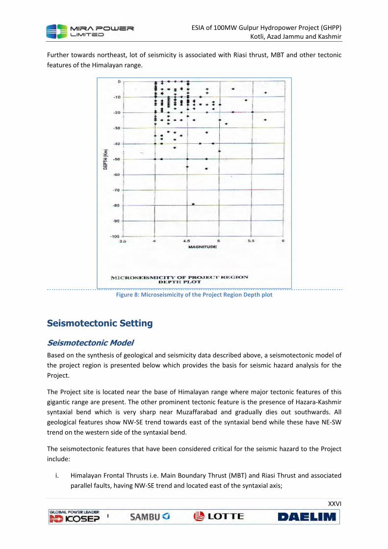
ESIA of 100MW Gulpur Hydropower Project (GHPP)
Kotli, Azad Jammu and Kashmir
XXVI
Further towards northeast, lot of seismicity is associated with Riasi thrust, MBT and other tectonic
features of the Himalayan range.
Figure 8: Microseismicity of the Project Region Depth plot
Seismotectonic Setting
Seismotectonic Model
Based on the synthesis of geological and seismicity data described above, a seismotectonic model of
the project region is presented below which provides the basis for seismic hazard analysis for the
Project.
The Project site is located near the base of Himalayan range where major tectonic features of this
gigantic range are present. The other prominent tectonic feature is the presence of Hazara-Kashmir
syntaxial bend which is very sharp near Muzaffarabad and gradually dies out southwards. All
geological features show NW-SE trend towards east of the syntaxial bend while these have NE-SW
trend on the western side of the syntaxial bend.
The seismotectonic features that have been considered critical for the seismic hazard to the Project
include:
i. Himalayan Frontal Thrusts i.e. Main Boundary Thrust (MBT) and Riasi Thrust and associated
parallel faults, having NW-SE trend and located east of the syntaxial axis;
ESIA of 100MW Gulpur Hydropower Project (GHPP)
Kotli, Azad Jammu and Kashmir
XXVII
ii. Jhelum Fault, trending N-S, and running along the axis of the syntaxial bend; and
iii. Dil Jabba thrust, Kahuta Fault and Salt Range Frontal Thrust, all have NE-SW trend and
located west of the axis of the syntaxis.
The entire region is dominated mainly by thrust type of faults that do have some strike- slip
component at places also. These faults are considered active because of association of observed
seismicity with these faults (Figure 7). The faults critical to the project are discussed below:
Project Area Faults
The main tectonic features controlling the seismic hazard for the Project are as follows:
a) Main Boundary Thrust
Main Boundary thrust is the main frontal thrust of the Himalayan range which runs along the
Himalayan arc for about 2500 km from Assam in the east to Kashmir in the west. Near the Project
site, it takes a northwest trend due to the syntaxial bend. Near it surface trace, it dips towards
northeast at steep angle but becomes sub-horizontal in the subsurface away from the surface trace.
Seeber et al.45 have shown that the series of large earthquakes which occurred along the Himalayan
range are probably related to slip along this sub-horizontal surface, termed as detachment. The MBT
is seismically active and have seismic potential to generate large earthquakes. The closest distance
of MBT from project site is 40 km towards northeast.
b) Riasi Thrust
Another important fault of the Himalayan front is the Riasi Thrust which is a branch of the MBT and
runs almost parallel to MBT for a distance of about 220 km. Lot of observed seismicity can be
associated with this fault. This fault passes at a distance of only 8 km northeast of the Project site.
Near the site, it has a trend of NW-SE, dipping towards northeast away from the site. Because of its
close association with the MBT and recorded seismicity, this fault is considered as an active tectonic
feature.
c) Jhelum Fault
This is a north-south trending left lateral strike-slip fault with steep dip towards east. Kazmi46 has
shown that this fault may extend from north of Muzaffarabad to near Jhelum towards south along
the axis of the syntaxial bend. The mapped length of this fault is, however, limited to about 20 km
only between Mangla and Kahuta (Figure 4). The alignment of observed seismicity along this fault
suggests that this fault may extend towards south up to the northeastern termination of Dil Jabba
thrust. A 50 km length of this fault is taken as active with nearest trace at 30 km west of the project
site.
45
Seeber L. et al; Seismicity and continental subduction in the Himalayan arc, in Zagros – Hindukush
Himalayas; Geodynamics Evolution, A.G.U. Geodynamics Services, Vol.3 (1981). 46
Farah, A., De Jong, K.A; Geodynamics of Pakistan: An introduction; Geodynamics of Pakistan, Geological
Survey of Pakistan (1979).
ESIA of 100MW Gulpur Hydropower Project (GHPP)
Kotli, Azad Jammu and Kashmir
XXVIII
d) Dil Jabba Thrust:
Dil Jabba Thrust is a north east trending fault present near the eastern side of Salt Range with a
surface trace 86 km long. This thrust dips towards northwest and terminates on the western side of
River Jhelum. Some disturbance of Quaternary deposits has been reported near the surface trace of
this fault and epicenters of many earthquakes can be associated with this fault, therefore indicating
that this fault is seismically active. Its eastern termination is at a distance of about 35 km from the
Project site.
e) Kahuta Fault:
This fault is present north of Dil Jabba Thrust and runs parallel to it. This fault starts northwest of GT
Road and terminates near the axis of the syntaxis. It length is about 50 km. Because of its similarity
with Dil Jabba Thrust and observed seismicity of the area, this fault is also taken as active.
Seismic Hazard Evaluation
Both probabilistic as well as deterministic hazard evaluation procedures were employed for seismic
hazard analysis of the project in accordance with the ICOLD guidelines47.
Probabilistic Approach
Methodology
In probabilistic hazard evaluation method, the seismic activity of seismic source (line or area) is
specified by a recurrence relationship, defing the cumulative number of events per year versus the
magnitude. Distribution of earthquake is assumed to be uniform within the source zone and
independent of time48.
The principle of the analysis is to evaluate at the site of interest the probability of exceedence of a
ground motion parameter (e.g. acceleration) due to the occurrence of a strong event, at a certain
distance from the site. This approach combines the probability of exceedence of the earthquake size
(recurrence relationship), and probability on the distance from the epicenter to the site.
Each source zone is split into elementary zones at a constant distance from the site. Integration is
carried out within each zone by summing the effects of the various elementary zones taking into
account the attenuation effect with distance. Total hazard is obtained by adding the influence of
various sources. The results are expressed in terms of a ground motion parameter associated to the
total number of expected events per year (i.e. the inverse of the return period), or in terms of annual
hazard.
A seismic hazard model is developed based on findings of the seismotectonic synthesis. The seismic
hazard model relies upon the concept of seismotectonic zones. Each zone is defined as a zone with
homogenous seismic and tectonic features, inferred from geological, tectonic and seismic data.
47
International Commission on Large Dams (ICOLD); Guidelines for selecting seismic parameters for large dams, Paris (1989). 48
Cornell, C.A.; Engineering seismic risk analysis, Bull. Seism. Soc .Am., Vol.58, No.5 (1968).
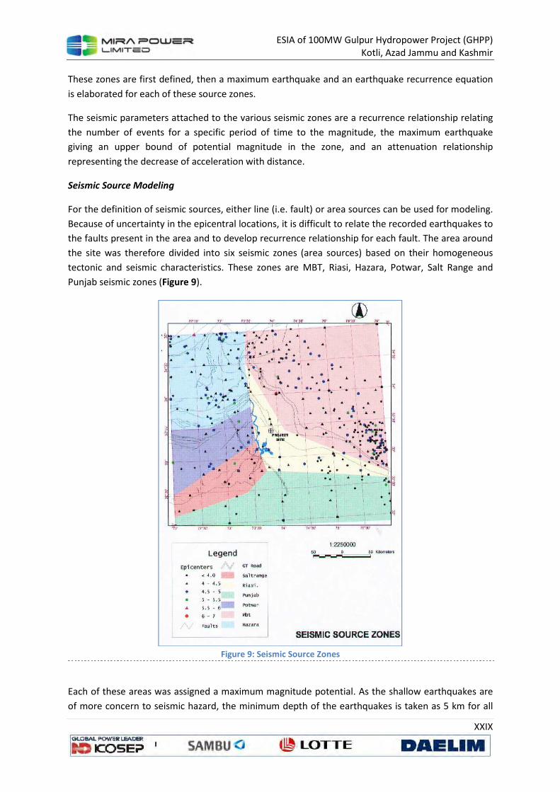
ESIA of 100MW Gulpur Hydropower Project (GHPP)
Kotli, Azad Jammu and Kashmir
XXIX
These zones are first defined, then a maximum earthquake and an earthquake recurrence equation
is elaborated for each of these source zones.
The seismic parameters attached to the various seismic zones are a recurrence relationship relating
the number of events for a specific period of time to the magnitude, the maximum earthquake
giving an upper bound of potential magnitude in the zone, and an attenuation relationship
representing the decrease of acceleration with distance.
Seismic Source Modeling
For the definition of seismic sources, either line (i.e. fault) or area sources can be used for modeling.
Because of uncertainty in the epicentral locations, it is difficult to relate the recorded earthquakes to
the faults present in the area and to develop recurrence relationship for each fault. The area around
the site was therefore divided into six seismic zones (area sources) based on their homogeneous
tectonic and seismic characteristics. These zones are MBT, Riasi, Hazara, Potwar, Salt Range and
Punjab seismic zones (Figure 9).
Figure 9: Seismic Source Zones
Each of these areas was assigned a maximum magnitude potential. As the shallow earthquakes are
of more concern to seismic hazard, the minimum depth of the earthquakes is taken as 5 km for all
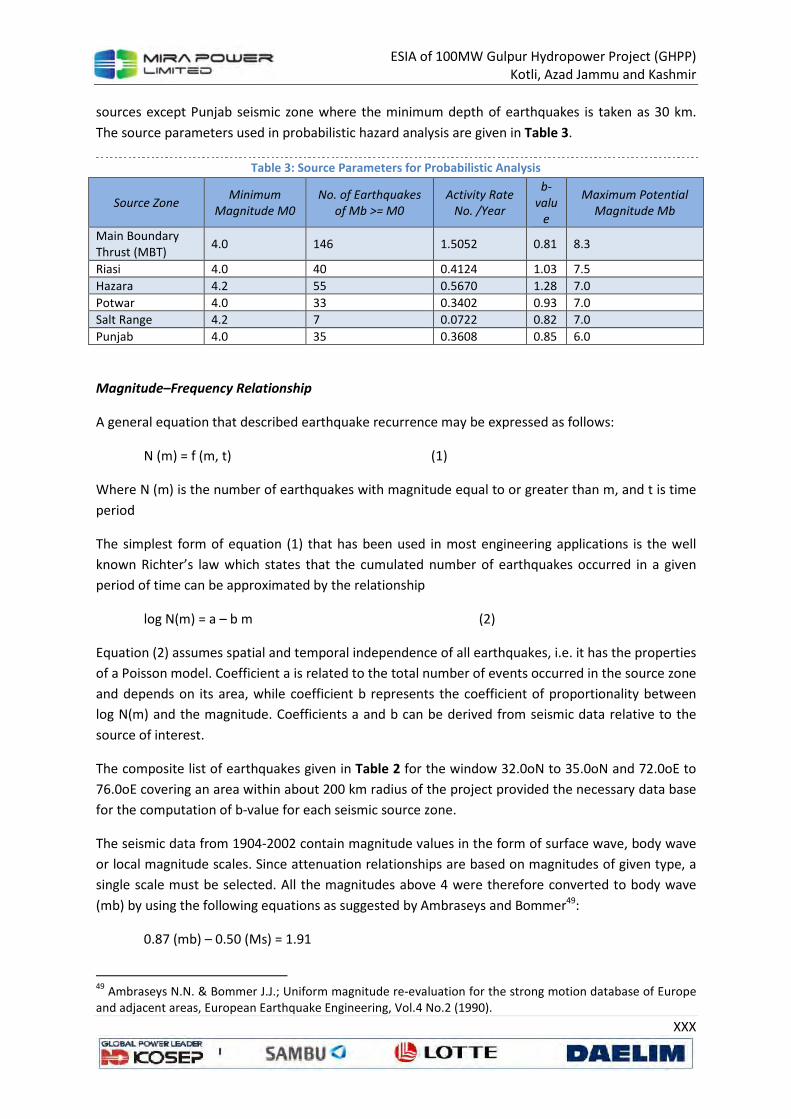
ESIA of 100MW Gulpur Hydropower Project (GHPP)
Kotli, Azad Jammu and Kashmir
XXX
sources except Punjab seismic zone where the minimum depth of earthquakes is taken as 30 km.
The source parameters used in probabilistic hazard analysis are given in Table 3.
Table 3: Source Parameters for Probabilistic Analysis
Source Zone Minimum
Magnitude M0
No. of Earthquakes
of Mb >= M0
Activity Rate
No. /Year
b-
valu
e
Maximum Potential
Magnitude Mb
Main Boundary
Thrust (MBT) 4.0 146 1.5052 0.81 8.3
Riasi 4.0 40 0.4124 1.03 7.5
Hazara 4.2 55 0.5670 1.28 7.0
Potwar 4.0 33 0.3402 0.93 7.0
Salt Range 4.2 7 0.0722 0.82 7.0
Punjab 4.0 35 0.3608 0.85 6.0
Magnitude–Frequency Relationship
A general equation that described earthquake recurrence may be expressed as follows:
N (m) = f (m, t) (1)
Where N (m) is the number of earthquakes with magnitude equal to or greater than m, and t is time
period
The simplest form of equation (1) that has been used in most engineering applications is the well
known Richter’s law which states that the cumulated number of earthquakes occurred in a given
period of time can be approximated by the relationship
log N(m) = a – b m (2)
Equation (2) assumes spatial and temporal independence of all earthquakes, i.e. it has the properties
of a Poisson model. Coefficient a is related to the total number of events occurred in the source zone
and depends on its area, while coefficient b represents the coefficient of proportionality between
log N(m) and the magnitude. Coefficients a and b can be derived from seismic data relative to the
source of interest.
The composite list of earthquakes given in Table 2 for the window 32.0oN to 35.0oN and 72.0oE to
76.0oE covering an area within about 200 km radius of the project provided the necessary data base
for the computation of b-value for each seismic source zone.
The seismic data from 1904-2002 contain magnitude values in the form of surface wave, body wave
or local magnitude scales. Since attenuation relationships are based on magnitudes of given type, a
single scale must be selected. All the magnitudes above 4 were therefore converted to body wave
(mb) by using the following equations as suggested by Ambraseys and Bommer49:
0.87 (mb) – 0.50 (Ms) = 1.91
49
Ambraseys N.N. & Bommer J.J.; Uniform magnitude re-evaluation for the strong motion database of Europe
and adjacent areas, European Earthquake Engineering, Vol.4 No.2 (1990).
ESIA of 100MW Gulpur Hydropower Project (GHPP)
Kotli, Azad Jammu and Kashmir
XXXI
0.82 (Ml) – 0.58 (Ms) = 1.20
Where mb is body–wave magnitude, Ms is surface-wave magnitude and Ml is local magnitude.
The converted body wave magnitudes values are given is Table 2. Separate list of earthquakes
occurring within each seismic zone was extracted from the composite list through GIS software.
Magnitude-frequency plot was then drawn and b-values were calculated for each zone through
regression analysis of data. The b–values and activity rate for the six seismic zones used in the
probabilistic analysis are shown in Table 3.
Attenuation Relationships
Because of lack of sufficient strong–motion data covering a larger range of magnitudes and
distances, attenuation relationships for the South Asian region could not be developed. For
probabilistic hazard analysis, the attenuation equations of Boore et al.50, Idriss51, Sadigh52 and
Abrahamson-Silva53 have been used. As the Project is founded on rock, the average shear wave
velocity up to 30 meters depth was taken as 800 m/sec, which was observed at proposed Kalabagh
damsite for similar rock formations.
Results of Peak Ground Acceleration (PGA)
The probabilistic hazard analysis was carried out by using EZ-FRISK software developed by Risk
Engineering Inc. of Colorado, USA. The parameters for all the six seismic zones (area sources) given
in Table 3 were fed to the software. The results of the hazard analysis are presented in Figure 10 in
the form of total hazard at the Project site in terms of annual frequency of exceedence of peak
horizontal ground acceleration.
50
Boore et al.; Equations for estimating horizontal response spectra and peak acceleration from western north
American earthquakes: A summary of recent work, Seism. Res. Letters, Vol. 68 (1997). 51
Idriss, I. M.; Procedure for selecting earthquakes ground motions at rock sites, National Institute of
Standards and Technology, NIST GCR 93-625 (1993). 52
Sadigh K. et al.; Attenuation relationships for shallow crustal earthquakes based on California strong motion
data, Seism. Res. Letters, Vol. 68 (1997). 53
Abrahamson, N.A. and Silva W.J.; Empirical response spectral attenuation relations for shallow crustal
earthquakes, Seism. Res. Letters, Vol. 68 (1997).
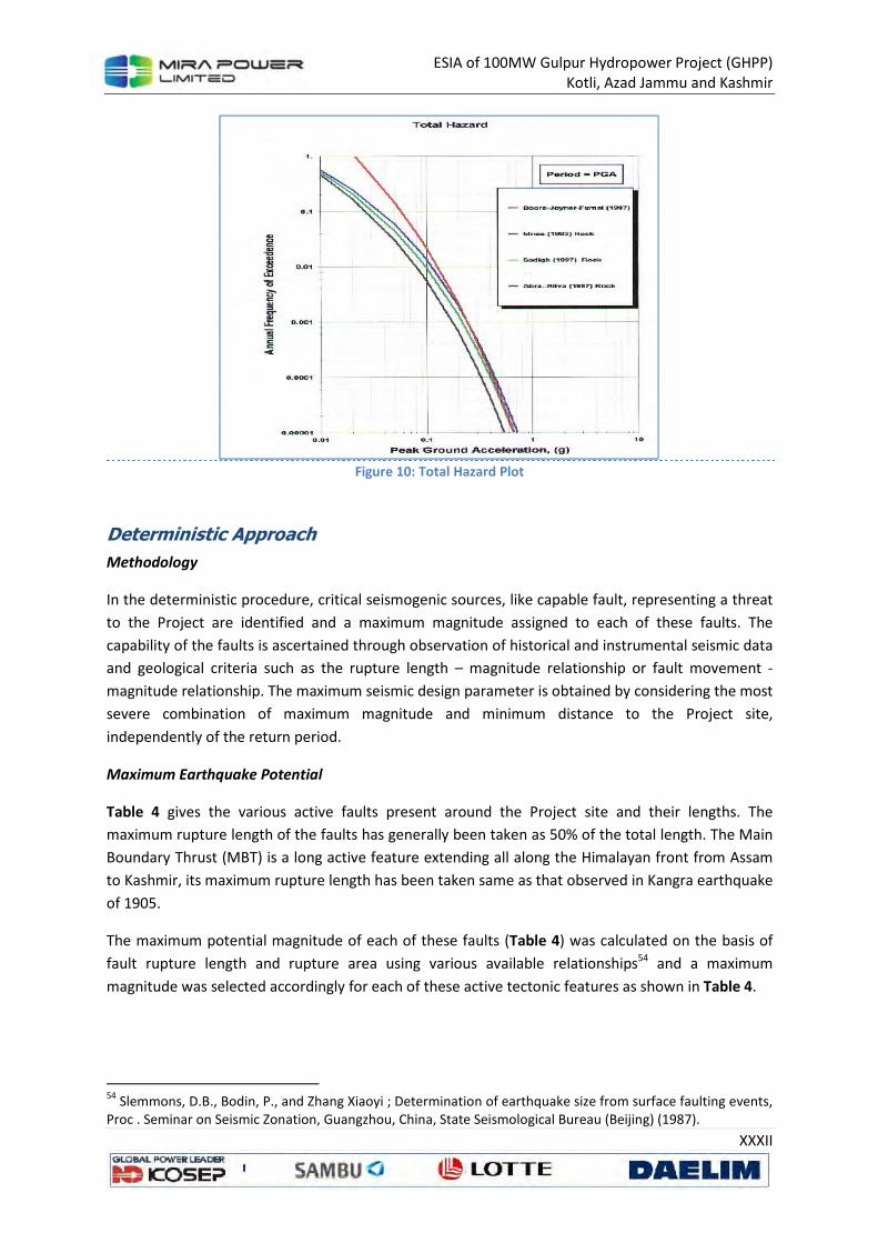
ESIA of 100MW Gulpur Hydropower Project (GHPP)
Kotli, Azad Jammu and Kashmir
XXXII
Figure 10: Total Hazard Plot
Deterministic Approach
Methodology
In the deterministic procedure, critical seismogenic sources, like capable fault, representing a threat
to the Project are identified and a maximum magnitude assigned to each of these faults. The
capability of the faults is ascertained through observation of historical and instrumental seismic data
and geological criteria such as the rupture length – magnitude relationship or fault movement -
magnitude relationship. The maximum seismic design parameter is obtained by considering the most
severe combination of maximum magnitude and minimum distance to the Project site,
independently of the return period.
Maximum Earthquake Potential
Table 4 gives the various active faults present around the Project site and their lengths. The
maximum rupture length of the faults has generally been taken as 50% of the total length. The Main
Boundary Thrust (MBT) is a long active feature extending all along the Himalayan front from Assam
to Kashmir, its maximum rupture length has been taken same as that observed in Kangra earthquake
of 1905.
The maximum potential magnitude of each of these faults (Table 4) was calculated on the basis of
fault rupture length and rupture area using various available relationships54 and a maximum
magnitude was selected accordingly for each of these active tectonic features as shown in Table 4.
54
Slemmons, D.B., Bodin, P., and Zhang Xiaoyi ; Determination of earthquake size from surface faulting events,
Proc . Seminar on Seismic Zonation, Guangzhou, China, State Seismological Bureau (Beijing) (1987).
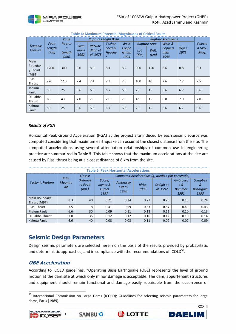
ESIA of 100MW Gulpur Hydropower Project (GHPP)
Kotli, Azad Jammu and Kashmir
XXXIII
Table 4: Maximum Potential Magnitudes of Critical Faults
Tectonic
Feature
Fault
Length
(Km)
Fault
Ruptur
e
Length
(Km)
Rupture Length Basis Rupture Area Basis
Selecte
d Max.
Mag.
Slem
mons
1982
Patwar
dhan et
al. 1975
Tocher,
Seed &
Housne
r
Wells
Coppe
rsmith
1994
Rupture Area Wells &
Coppers
mith
1994
Wyss
1979 Lgt.
(Km)
Wdt.
(Km)
Main
Boundar
y Thrust
(MBT)
1200 300 8.0 8.0 8.1 8.2 300 150 8.6 8.8 8.3
Riasi
Thrust 220 110 7.4 7.4 7.3 7.5 100 40 7.6 7.7 7.5
Jhelum
Fault 50 25 6.6 6.6 6.7 6.6 25 15 6.6 6.7 6.6
Dil Jabba
Thrust 86 43 7.0 7.0 7.0 7.0 43 15 6.8 7.0 7.0
Kahuta
Fault 50 25 6.6 6.6 6.7 6.6 25 15 6.6 6.7 6.6
Results of PGA
Horizontal Peak Ground Acceleration (PGA) at the project site induced by each seismic source was
computed considering that maximum earthquake can occur at the closest distance from the site. The
computed accelerations using several attenuation relationships of common use in engineering
practice are summarized in Table 5. This table shows that the maximum accelerations at the site are
caused by Riasi thrust being at a closest distance of 8 km from the site.
Table 5: Peak Horizontal Accelerations
Tectonic Feature
Max.
Magnitu
de
Closest
Distance
to Fault
(Km.)
Computed Accelerations (g) Median (50-percentile)
Boore,
Joyner &
Fumel
1997
Ambrasey
s et al.
1996
Idriss
1993
Sadigh et
al. 1997
Ambrasey
s &
Bommer
1991
Campbell
&
Bozorgnia
1993
Main Boundary
Thrust (MBT) 8.3 40 0.21 0.24 0.27 0.26 0.18 0.24
Riasi Thrust 7.5 8 0.41 0.59 0.53 0.57 0.49 0.43
Jhelum Fault 6.6 30 0.09 0.11 0.12 0.11 0.10 0.13
Dil Jabba Thrust 7.0 35 0.12 0.12 0.16 0.12 0.10 0.14
Kahuta Fault 6.6 40 0.08 0.08 0.11 0.09 0.07 0.09
Seismic Design Parameters
Design seismic parameters are selected herein on the basis of the results provided by probabilistic
and deterministic approaches, and in compliance with the recommendations of ICOLD55.
OBE Acceleration
According to ICOLD guidelines, “Operating Basis Earthquake (OBE) represents the level of ground
motion at the dam site at which only minor damage is acceptable. The dam, appurtenant structures
and equipment should remain functional and damage easily repairable from the occurrence of
55
International Commission on Large Dams (ICOLD); Guidelines for selecting seismic parameters for large dams, Paris (1989).

ESIA of 100MW Gulpur Hydropower Project (GHPP)
Kotli, Azad Jammu and Kashmir
XXXIV
earthquake shaking not exceeding the OBE”. Because of its definition, the OBE is best determined by
using probabilistic procedures, for instance, such as specifying a 50% probability of not being
exceeded in 100 years, the corresponding return period is equal to 144 years. In any case the OBE
accelerations are significantly lower than those for MCE.
Figure 10 shows the results of probabilistic analysis for Gulpur Hydropower project obtained through
EZ-FRISK software as total hazard in terms of annual frequency of proximity exceedence of peak
ground accelerations. The source contribution analysis shows that maximum contribution to total
hazard is from Riasi source zone. Keeping in view the proximity of the most critical tectonic feature,
the recommended OBE acceleration for the project structures is 0.24g with a return period of 1000
years.
MCE Acceleration
According to ICOLD guidelines, “the MCE is the largest reasonable conceivable earthquake that
appears possible along a recognized fault or within a geographically defined tectonic province, under
the presently known or presumed tectonic framework”. This definition is inspired by that of Seed56:
“the largest rationally conceivable event that could occur in the tectonics environment in which the
project is located”. The MCE can be evaluated through a deterministic or a probabilistic procedure. If
the probabilistic seismic hazard evaluation is used, the MCE is linked to a very long return period for
this event.
For Gulpur Hydropower Project, the most critical tectonic feature controlling the MCE is the Riasi
thrust which is causing maximum accelerations at the project site (Table 5). Various attenuation
relationships give peak horizontal accelerations ranging from 0.41g to 0.59g. For the peak horizontal
acceleration associated with MCE, an average value of 0.50g is selected. This value is conservative
but selected in view of the proximity of the most critical tectonic structure from the project.
Conclusions and Recommendations
The seismic hazard evaluation for Gulpur Hydropower Project was carried out on the basis of
understanding of local tectonic environment, desk studies of faults in the vicinity of the Project and
synthesis of available seismological and tectonic data to evaluate the capability of active tectonic
features and assigning ground motion associated with them. The main conclusions based on the
present study are as follows:
• The project site is located close to the Riasi Thrust which is a branch of MBT, the main source
of destructive earthquakes in the Himalayan region.
• The critical surface tectonic features around the Project site are MBT and Riasi thrusts
towards east and Dil Jabba Thrust, Kahuta Fault and Jhelum Fault towards west of the
Project.
• Historical record shows that earthquakes in this region have caused maximum intensity of
VIII-IX several times in the past. The instrumentally recorded seismicity shows that faults in
this area are seismically active. Several epicenters of recorded earthquakes can be
associated with the known faults of the area.
56
Seed, H. B.; The selection of design earthquake for critical structures. Bull. Seis. Soc. Am., Vol.72 (1982)

ESIA of 100MW Gulpur Hydropower Project (GHPP)
Kotli, Azad Jammu and Kashmir
XXXV
• Seismic hazard evaluation was carried out in accordance with the ICOLD guidelines for
selecting seismic design parameters using both probabilistic as well as deterministic
approaches.
• The probabilistic approach was used to select the Operating Basis Earthquake (OBE) using
the instrumentally recorded earthquake data for the last century. For the project life of 100
years, recommended OBE acceleration is 0.24g.
• Based upon the deterministic evaluation, peak horizontal ground acceleration of 0.50g
associated with Maximum Credible Earthquake (MCE) is recommended for the Project.
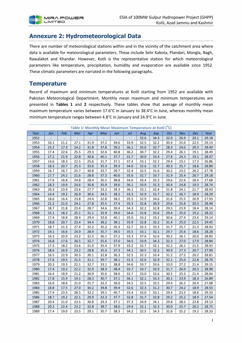
ESIA of 100MW Gulpur Hydropower Project (GHPP)
Kotli, Azad Jammu and Kashmir
I
Annexure 2: Hydrometeorological Data
There are number of meteorological stations within and in the vicinity of the catchment area where
data is available for meteorological parameters. These include Sehr Kakota, Plandari, Mangla, Bagh,
Rawalakot and Khandar. However, Kotli is the representative station for which meteorological
parameters like temperature, precipitation, humidity and evaporation are available since 1952.
These climatic parameters are narrated in the following paragraphs.
Temperature
Record of maximum and minimum temperatures at Kotli starting from 1952 are available with
Pakistan Meteorological Department. Monthly mean maximum and minimum temperatures are
presented in Tables 1 and 2 respectively. These tables show that average of monthly mean
maximum temperature varies between 17.6°C in January to 38.4°C in June, whereas monthly mean
minimum temperature ranges between 4.8°C in January and 24.9°C in June.
Table 1: Monthly Mean Maximum Temperature at Kotli (oC)
Year Jan Feb Mar Apr May Jun Jul Aug Sep Oct Nov Dec Year
1952 - - - - - - - 32.6 34.3 32.0 26.9 20.1 29.18
1953 16.1 21.2 27.1 31.9 37.2 39.6 33.9 32.5 32.2 30.4 25.0 22.5 29.13
1954 15.2 17.3 24.2 31.8 37.8 39.2 36.1 35.0 32.7 28.3 24.0 20.3 28.49
1955 17.4 22.6 25.5 29.3 32.6 40.8 36.2 30.7 32.2 29.4 26.1 19.1 28.49
1956 17.2 21.9 22.8 30.8 40.1 37.7 31.7 30.0 33.4 27.8 24.3 19.1 28.07
1957 14.6 18.3 22.5 25.6 31.7 37.1 37.4 33.1 32.2 29.4 23.1 17.3 26.86
1958 18.3 20.7 25.3 33.6 35.3 39.3 34.0 32.6 31.7 30.3 25.7 18.8 28.80
1959 16.7 16.7 25.7 30.8 33.7 39.7 32.4 32.5 31.6 30.2 23.2 20.2 27.78
1960 17.7 24.2 21.6 28.8 37.3 40.6 35.6 32.7 33.7 31.9 25.4 20.7 29.18
1961 17.6 16.8 24.8 28.4 35.5 38.8 34.0 33.4 32.3 29.6 22.6 18.4 27.68
1962 18.3 19.9 24.6 30.8 35.9 39.6 36.1 33.9 31.3 30.4 24.8 19.3 28.74
1963 20.3 23.9 23.6 27.7 33.2 39.3 36.1 33.1 32.4 31.8 24.1 21.7 28.93
1964 14.4 19.2 26.9 30.6 34.5 38.2 33.3 32.9 31.7 32.2 26.7 18.9 28.29
1965 18.6 16.4 23.8 24.4 32.8 38.2 35.5 32.9 34.6 31.6 25.5 20.9 27.93
1966 21.2 21.0 24.1 27.8 35.5 37.4 35.3 32.8 30.9 29.6 25.8 20.3 28.48
1967 18.7 21.8 23.4 28.7 34.6 39.4 34.3 32.2 32.8 29.5 23.9 18.4 28.14
1968 15.1 18.2 25.1 31.1 32.9 39.6 34.6 32.8 35.6 29.4 25.0 19.2 28.22
1969 17.4 18.8 28.4 29.4 32.8 40.1 35.0 33.2 33.2 30.6 27.4 23.4 29.14
1970 18.8 20.7 23.4 34.4 38.2 38.1 35.9 32.8 32.2 31.4 25.0 22.5 29.45
1971 18.7 21.3 27.4 32.2 35.2 35.3 32.7 32.3 33.3 31.7 25.7 21.3 28.93
1972 19.1 16.6 24.9 28.9 35.7 39.5 35.5 33.1 32.1 29.7 25.6 18.6 28.28
1973 16.3 20.9 23.2 32.5 36.1 37.2 33.3 37.6 32.6 30.2 26.1 20.0 28.83
1974 16.8 17.6 26.5 32.7 35.6 37.0 34.5 33.9 34.3 32.3 27.0 17.9 28.84
1975 17.3 18.2 23.6 31.0 35.4 37.9 33.2 32.7 32.1 32.2 26.1 21.5 28.43
1976 18.6 16.9 23.2 28.8 35.4 37.3 34.1 30.5 32.2 30.9 27.3 20.7 27.99
1977 16.5 22.9 30.3 30.1 32.8 36.3 32.5 32.3 33.4 31.2 27.2 20.2 28.81
1978 17.6 19.5 21.5 31.1 39.7 38.1 31.5 32.6 32.9 32.1 25.0 22.8 28.70
1979 20.3 19.3 22.1 32.7 33.1 38.8 34.6 33.7 33.6 33.0 27.2 21.4 29.15
1980 17.4 19.2 22.2 32.9 38.3 38.4 33.7 33.7 33.9 31.7 26.0 20.3 28.98
1981 16.4 18.9 21.2 30.9 35.6 38.0 32.7 33.0 32.6 30.5 25.3 21.4 28.04
1982 17.8 15.9 19.1 28.3 30.7 37.1 36.1 32.1 33.3 30.1 23.9 18.3 26.89
1983 16.0 18.6 21.0 25.7 32.2 36.0 34.5 32.5 32.5 29.4 26.2 20.4 27.08
1984 18.8 17.5 27.0 30.2 39.8 39.4 32.6 32.3 31.2 30.7 24.2 18.9 28.55
1985 17.4 23.3 28.5 32.2 39.1 40.7 33.4 33.0 33.1 29.4 23.3 18.6 29.33
1986 18.7 19.2 22.1 29.9 32.3 37.7 32.8 31.7 32.8 29.2 25.2 18.9 27.54
1987 20.4 21.0 23.5 30.8 29.3 37.1 37.3 34.9 34.1 29.8 28.5 22.8 29.13
1988 20.2 22.4 23.2 32.8 38.7 38.0 29.4 32.1 32.3 30.0 25.7 20.2 28.75
1989 17.4 19.0 23.5 29.1 35.7 38.3 34.2 32.5 34.3 31.6 25.2 19.2 28.33
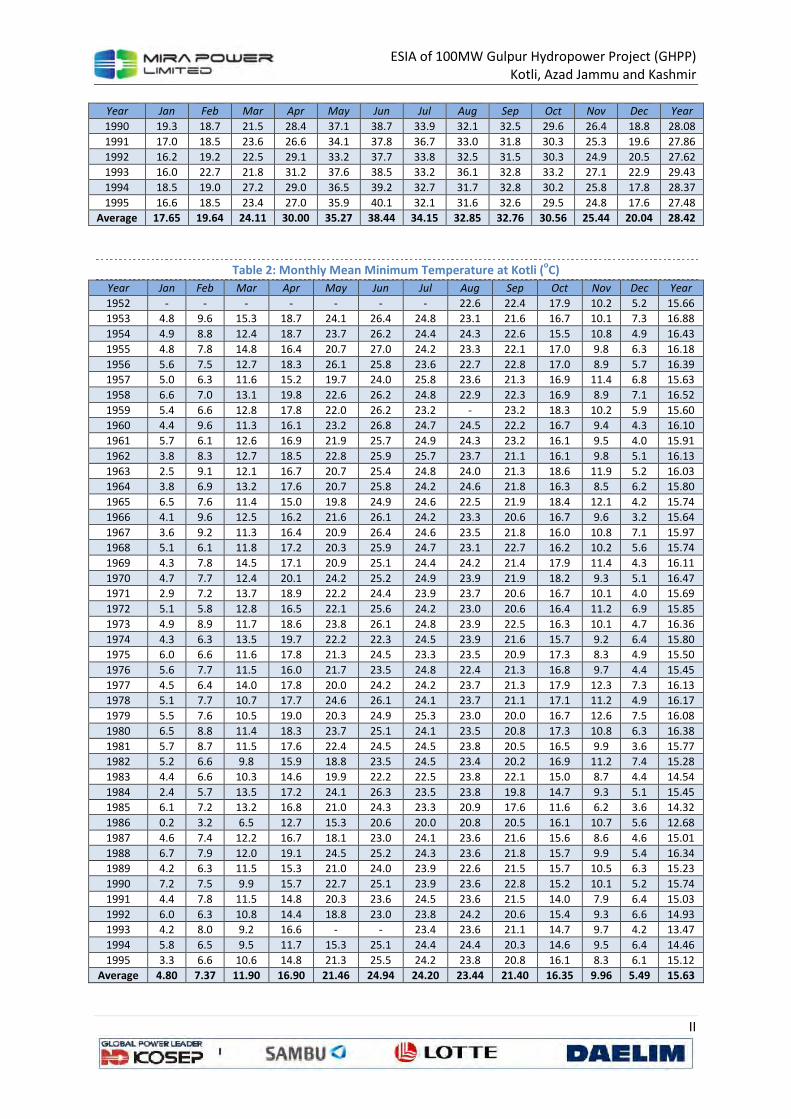
ESIA of 100MW Gulpur Hydropower Project (GHPP)
Kotli, Azad Jammu and Kashmir
II
Year Jan Feb Mar Apr May Jun Jul Aug Sep Oct Nov Dec Year
1990 19.3 18.7 21.5 28.4 37.1 38.7 33.9 32.1 32.5 29.6 26.4 18.8 28.08
1991 17.0 18.5 23.6 26.6 34.1 37.8 36.7 33.0 31.8 30.3 25.3 19.6 27.86
1992 16.2 19.2 22.5 29.1 33.2 37.7 33.8 32.5 31.5 30.3 24.9 20.5 27.62
1993 16.0 22.7 21.8 31.2 37.6 38.5 33.2 36.1 32.8 33.2 27.1 22.9 29.43
1994 18.5 19.0 27.2 29.0 36.5 39.2 32.7 31.7 32.8 30.2 25.8 17.8 28.37
1995 16.6 18.5 23.4 27.0 35.9 40.1 32.1 31.6 32.6 29.5 24.8 17.6 27.48
Average 17.65 19.64 24.11 30.00 35.27 38.44 34.15 32.85 32.76 30.56 25.44 20.04 28.42
Table 2: Monthly Mean Minimum Temperature at Kotli (oC)
Year Jan Feb Mar Apr May Jun Jul Aug Sep Oct Nov Dec Year
1952 - - - - - - - 22.6 22.4 17.9 10.2 5.2 15.66
1953 4.8 9.6 15.3 18.7 24.1 26.4 24.8 23.1 21.6 16.7 10.1 7.3 16.88
1954 4.9 8.8 12.4 18.7 23.7 26.2 24.4 24.3 22.6 15.5 10.8 4.9 16.43
1955 4.8 7.8 14.8 16.4 20.7 27.0 24.2 23.3 22.1 17.0 9.8 6.3 16.18
1956 5.6 7.5 12.7 18.3 26.1 25.8 23.6 22.7 22.8 17.0 8.9 5.7 16.39
1957 5.0 6.3 11.6 15.2 19.7 24.0 25.8 23.6 21.3 16.9 11.4 6.8 15.63
1958 6.6 7.0 13.1 19.8 22.6 26.2 24.8 22.9 22.3 16.9 8.9 7.1 16.52
1959 5.4 6.6 12.8 17.8 22.0 26.2 23.2 - 23.2 18.3 10.2 5.9 15.60
1960 4.4 9.6 11.3 16.1 23.2 26.8 24.7 24.5 22.2 16.7 9.4 4.3 16.10
1961 5.7 6.1 12.6 16.9 21.9 25.7 24.9 24.3 23.2 16.1 9.5 4.0 15.91
1962 3.8 8.3 12.7 18.5 22.8 25.9 25.7 23.7 21.1 16.1 9.8 5.1 16.13
1963 2.5 9.1 12.1 16.7 20.7 25.4 24.8 24.0 21.3 18.6 11.9 5.2 16.03
1964 3.8 6.9 13.2 17.6 20.7 25.8 24.2 24.6 21.8 16.3 8.5 6.2 15.80
1965 6.5 7.6 11.4 15.0 19.8 24.9 24.6 22.5 21.9 18.4 12.1 4.2 15.74
1966 4.1 9.6 12.5 16.2 21.6 26.1 24.2 23.3 20.6 16.7 9.6 3.2 15.64
1967 3.6 9.2 11.3 16.4 20.9 26.4 24.6 23.5 21.8 16.0 10.8 7.1 15.97
1968 5.1 6.1 11.8 17.2 20.3 25.9 24.7 23.1 22.7 16.2 10.2 5.6 15.74
1969 4.3 7.8 14.5 17.1 20.9 25.1 24.4 24.2 21.4 17.9 11.4 4.3 16.11
1970 4.7 7.7 12.4 20.1 24.2 25.2 24.9 23.9 21.9 18.2 9.3 5.1 16.47
1971 2.9 7.2 13.7 18.9 22.2 24.4 23.9 23.7 20.6 16.7 10.1 4.0 15.69
1972 5.1 5.8 12.8 16.5 22.1 25.6 24.2 23.0 20.6 16.4 11.2 6.9 15.85
1973 4.9 8.9 11.7 18.6 23.8 26.1 24.8 23.9 22.5 16.3 10.1 4.7 16.36
1974 4.3 6.3 13.5 19.7 22.2 22.3 24.5 23.9 21.6 15.7 9.2 6.4 15.80
1975 6.0 6.6 11.6 17.8 21.3 24.5 23.3 23.5 20.9 17.3 8.3 4.9 15.50
1976 5.6 7.7 11.5 16.0 21.7 23.5 24.8 22.4 21.3 16.8 9.7 4.4 15.45
1977 4.5 6.4 14.0 17.8 20.0 24.2 24.2 23.7 21.3 17.9 12.3 7.3 16.13
1978 5.1 7.7 10.7 17.7 24.6 26.1 24.1 23.7 21.1 17.1 11.2 4.9 16.17
1979 5.5 7.6 10.5 19.0 20.3 24.9 25.3 23.0 20.0 16.7 12.6 7.5 16.08
1980 6.5 8.8 11.4 18.3 23.7 25.1 24.1 23.5 20.8 17.3 10.8 6.3 16.38
1981 5.7 8.7 11.5 17.6 22.4 24.5 24.5 23.8 20.5 16.5 9.9 3.6 15.77
1982 5.2 6.6 9.8 15.9 18.8 23.5 24.5 23.4 20.2 16.9 11.2 7.4 15.28
1983 4.4 6.6 10.3 14.6 19.9 22.2 22.5 23.8 22.1 15.0 8.7 4.4 14.54
1984 2.4 5.7 13.5 17.2 24.1 26.3 23.5 23.8 19.8 14.7 9.3 5.1 15.45
1985 6.1 7.2 13.2 16.8 21.0 24.3 23.3 20.9 17.6 11.6 6.2 3.6 14.32
1986 0.2 3.2 6.5 12.7 15.3 20.6 20.0 20.8 20.5 16.1 10.7 5.6 12.68
1987 4.6 7.4 12.2 16.7 18.1 23.0 24.1 23.6 21.6 15.6 8.6 4.6 15.01
1988 6.7 7.9 12.0 19.1 24.5 25.2 24.3 23.6 21.8 15.7 9.9 5.4 16.34
1989 4.2 6.3 11.5 15.3 21.0 24.0 23.9 22.6 21.5 15.7 10.5 6.3 15.23
1990 7.2 7.5 9.9 15.7 22.7 25.1 23.9 23.6 22.8 15.2 10.1 5.2 15.74
1991 4.4 7.8 11.5 14.8 20.3 23.6 24.5 23.6 21.5 14.0 7.9 6.4 15.03
1992 6.0 6.3 10.8 14.4 18.8 23.0 23.8 24.2 20.6 15.4 9.3 6.6 14.93
1993 4.2 8.0 9.2 16.6 - - 23.4 23.6 21.1 14.7 9.7 4.2 13.47
1994 5.8 6.5 9.5 11.7 15.3 25.1 24.4 24.4 20.3 14.6 9.5 6.4 14.46
1995 3.3 6.6 10.6 14.8 21.3 25.5 24.2 23.8 20.8 16.1 8.3 6.1 15.12
Average 4.80 7.37 11.90 16.90 21.46 24.94 24.20 23.44 21.40 16.35 9.96 5.49 15.63
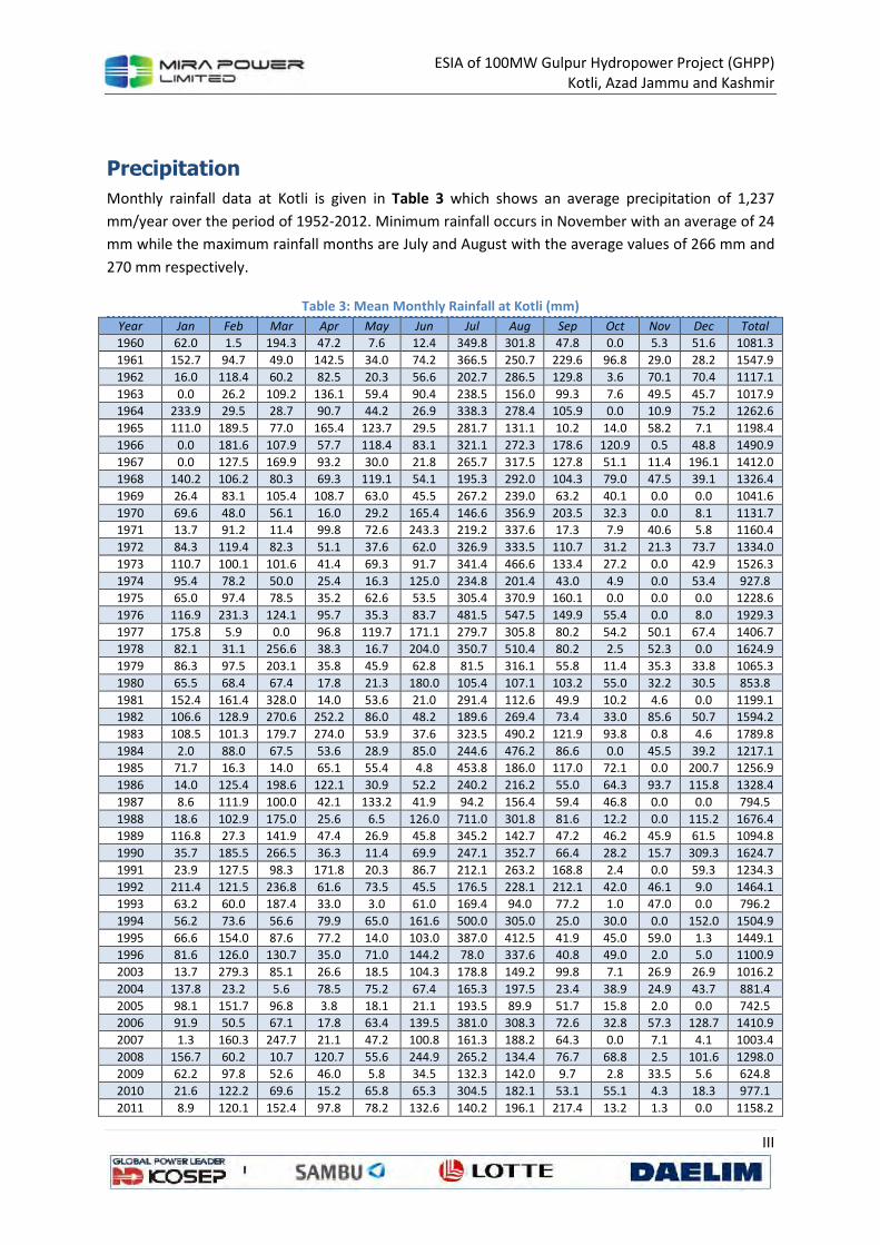
ESIA of 100MW Gulpur Hydropower Project (GHPP)
Kotli, Azad Jammu and Kashmir
III
Precipitation
Monthly rainfall data at Kotli is given in Table 3 which shows an average precipitation of 1,237
mm/year over the period of 1952-2012. Minimum rainfall occurs in November with an average of 24
mm while the maximum rainfall months are July and August with the average values of 266 mm and
270 mm respectively.
Table 3: Mean Monthly Rainfall at Kotli (mm)
Year Jan Feb Mar Apr May Jun Jul Aug Sep Oct Nov Dec Total
1960 62.0 1.5 194.3 47.2 7.6 12.4 349.8 301.8 47.8 0.0 5.3 51.6 1081.3
1961 152.7 94.7 49.0 142.5 34.0 74.2 366.5 250.7 229.6 96.8 29.0 28.2 1547.9
1962 16.0 118.4 60.2 82.5 20.3 56.6 202.7 286.5 129.8 3.6 70.1 70.4 1117.1
1963 0.0 26.2 109.2 136.1 59.4 90.4 238.5 156.0 99.3 7.6 49.5 45.7 1017.9
1964 233.9 29.5 28.7 90.7 44.2 26.9 338.3 278.4 105.9 0.0 10.9 75.2 1262.6
1965 111.0 189.5 77.0 165.4 123.7 29.5 281.7 131.1 10.2 14.0 58.2 7.1 1198.4
1966 0.0 181.6 107.9 57.7 118.4 83.1 321.1 272.3 178.6 120.9 0.5 48.8 1490.9
1967 0.0 127.5 169.9 93.2 30.0 21.8 265.7 317.5 127.8 51.1 11.4 196.1 1412.0
1968 140.2 106.2 80.3 69.3 119.1 54.1 195.3 292.0 104.3 79.0 47.5 39.1 1326.4
1969 26.4 83.1 105.4 108.7 63.0 45.5 267.2 239.0 63.2 40.1 0.0 0.0 1041.6
1970 69.6 48.0 56.1 16.0 29.2 165.4 146.6 356.9 203.5 32.3 0.0 8.1 1131.7
1971 13.7 91.2 11.4 99.8 72.6 243.3 219.2 337.6 17.3 7.9 40.6 5.8 1160.4
1972 84.3 119.4 82.3 51.1 37.6 62.0 326.9 333.5 110.7 31.2 21.3 73.7 1334.0
1973 110.7 100.1 101.6 41.4 69.3 91.7 341.4 466.6 133.4 27.2 0.0 42.9 1526.3
1974 95.4 78.2 50.0 25.4 16.3 125.0 234.8 201.4 43.0 4.9 0.0 53.4 927.8
1975 65.0 97.4 78.5 35.2 62.6 53.5 305.4 370.9 160.1 0.0 0.0 0.0 1228.6
1976 116.9 231.3 124.1 95.7 35.3 83.7 481.5 547.5 149.9 55.4 0.0 8.0 1929.3
1977 175.8 5.9 0.0 96.8 119.7 171.1 279.7 305.8 80.2 54.2 50.1 67.4 1406.7
1978 82.1 31.1 256.6 38.3 16.7 204.0 350.7 510.4 80.2 2.5 52.3 0.0 1624.9
1979 86.3 97.5 203.1 35.8 45.9 62.8 81.5 316.1 55.8 11.4 35.3 33.8 1065.3
1980 65.5 68.4 67.4 17.8 21.3 180.0 105.4 107.1 103.2 55.0 32.2 30.5 853.8
1981 152.4 161.4 328.0 14.0 53.6 21.0 291.4 112.6 49.9 10.2 4.6 0.0 1199.1
1982 106.6 128.9 270.6 252.2 86.0 48.2 189.6 269.4 73.4 33.0 85.6 50.7 1594.2
1983 108.5 101.3 179.7 274.0 53.9 37.6 323.5 490.2 121.9 93.8 0.8 4.6 1789.8
1984 2.0 88.0 67.5 53.6 28.9 85.0 244.6 476.2 86.6 0.0 45.5 39.2 1217.1
1985 71.7 16.3 14.0 65.1 55.4 4.8 453.8 186.0 117.0 72.1 0.0 200.7 1256.9
1986 14.0 125.4 198.6 122.1 30.9 52.2 240.2 216.2 55.0 64.3 93.7 115.8 1328.4
1987 8.6 111.9 100.0 42.1 133.2 41.9 94.2 156.4 59.4 46.8 0.0 0.0 794.5
1988 18.6 102.9 175.0 25.6 6.5 126.0 711.0 301.8 81.6 12.2 0.0 115.2 1676.4
1989 116.8 27.3 141.9 47.4 26.9 45.8 345.2 142.7 47.2 46.2 45.9 61.5 1094.8
1990 35.7 185.5 266.5 36.3 11.4 69.9 247.1 352.7 66.4 28.2 15.7 309.3 1624.7
1991 23.9 127.5 98.3 171.8 20.3 86.7 212.1 263.2 168.8 2.4 0.0 59.3 1234.3
1992 211.4 121.5 236.8 61.6 73.5 45.5 176.5 228.1 212.1 42.0 46.1 9.0 1464.1
1993 63.2 60.0 187.4 33.0 3.0 61.0 169.4 94.0 77.2 1.0 47.0 0.0 796.2
1994 56.2 73.6 56.6 79.9 65.0 161.6 500.0 305.0 25.0 30.0 0.0 152.0 1504.9
1995 66.6 154.0 87.6 77.2 14.0 103.0 387.0 412.5 41.9 45.0 59.0 1.3 1449.1
1996 81.6 126.0 130.7 35.0 71.0 144.2 78.0 337.6 40.8 49.0 2.0 5.0 1100.9
2003 13.7 279.3 85.1 26.6 18.5 104.3 178.8 149.2 99.8 7.1 26.9 26.9 1016.2
2004 137.8 23.2 5.6 78.5 75.2 67.4 165.3 197.5 23.4 38.9 24.9 43.7 881.4
2005 98.1 151.7 96.8 3.8 18.1 21.1 193.5 89.9 51.7 15.8 2.0 0.0 742.5
2006 91.9 50.5 67.1 17.8 63.4 139.5 381.0 308.3 72.6 32.8 57.3 128.7 1410.9
2007 1.3 160.3 247.7 21.1 47.2 100.8 161.3 188.2 64.3 0.0 7.1 4.1 1003.4
2008 156.7 60.2 10.7 120.7 55.6 244.9 265.2 134.4 76.7 68.8 2.5 101.6 1298.0
2009 62.2 97.8 52.6 46.0 5.8 34.5 132.3 142.0 9.7 2.8 33.5 5.6 624.8
2010 21.6 122.2 69.6 15.2 65.8 65.3 304.5 182.1 53.1 55.1 4.3 18.3 977.1
2011 8.9 120.1 152.4 97.8 78.2 132.6 140.2 196.1 217.4 13.2 1.3 0.0 1158.2
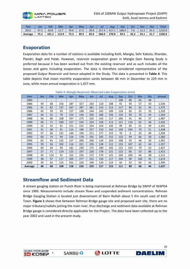
ESIA of 100MW Gulpur Hydropower Project (GHPP)
Kotli, Azad Jammu and Kashmir
IV
Year Jan Feb Mar Apr May Jun Jul Aug Sep Oct Nov Dec Total
2012 97.3 50.8 11.7 79.0 17.5 39.9 217.4 417.1 168.9 7.6 12.2 91.5 1210.9
Average 75.2 101.2 113.9 73.3 49.5 85.6 266.0 270.8 93.5 32.2 24.1 51.7 1236.9
Evaporation
Evaporation data for a number of stations is available including Kotli, Mangla, Sehr Kakota, Khandar,
Plandri, Bagh and Palak. However, reservoir evaporation given in Mangla Dam Raising Study is
preferred because it has been worked out from the existing reservoir and as such includes all the
losses and gains including evaporation. The data is therefore considered representative of the
proposed Gulpur Reservoir and hence adopted in the Study. This data is presented in Table 4. This
table depicts that mean monthly evaporation varies between 46 mm in December to 229 mm in
June, while mean annual evaporation is 1,427 mm.
Table 4: Mangla Reservoir Observed Lake Evaporation (mm)
Year Jan Feb Mar Apr May Jun Jul Aug Sep Oct Nov Dec Annual
1983 - - - - - - - - 108 86 65 48 -
1984 59 68 150 187 327 242 110 108 91 93 57 43 1,534
1985 41 82 137 167 287 281 153 113 117 90 62 45 1,575
1986 45 59 93 157 198 244 142 109 118 82 55 33 1,333
1987 44 55 79 154 144 205 186 156 124 94 70 44 1,354
1988 56 80 108 197 275 232 142 117 106 91 46 37 1,487
1989 46 71 100 157 234 224 156 113 121 110 62 36 1,432
1990 52 52 91 151 215 224 154 120 99 85 61 39 1,341
1991 41 58 91 115 190 227 210 142 130 104 70 51 1,428
1992 57 66 131 144 194 211 177 153 76 0 45 40 1,294
1993 60 74 94 126 178 191 165 152 123 94 66 58 1,382
1994 62 65 125 157 209 260 134 103 108 92 46 29 1,391
1995 39 56 102 116 221 235 128 112 133 107 62 44 1,357
1996 60 64 94 181 230 175 180 105 115 103 70 52 1,427
1997 37 71 119 125 197 220 178 121 123 85 53 86 1,415
1998 45 114 91 152 235 272 170 125 104 100 66 38 1,511
1999 38 57 117 203 277 252 156 117 104 90 160 45 1,614
2000 39 62 116 201 226 196 130 119 92 92 65 54 1,390
Average 48 68 108 158 226 229 157 123 111 89 66 46 1,427
Streamflow and Sediment Data
A stream gauging station on Punch River is being maintained at Rehman Bridge by SWHP of WAPDA
since 1960. Measurements include stream flows and suspended sediment concentrations. Rehman
Bridge Gauging Station is located just downstream of Bann Nullah about 5 Km south east of Kotli
Town. Figure 1 shows that between Rehman Bridge gauge site and proposed weir site, there are no
major tributary/nallahs joining the main river, thus discharge and sediment data available at Rehman
Bridge gauge is considered directly applicable for the Project. The data have been collected up to the
year 2002 and used in the present study.
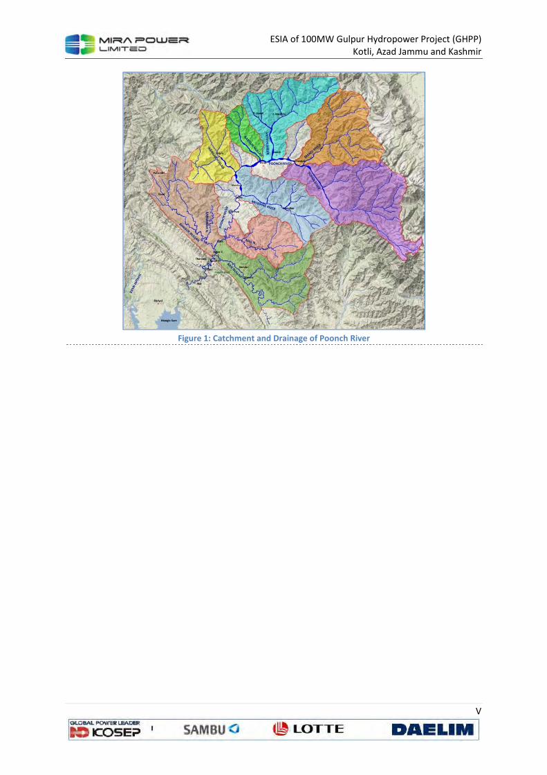
ESIA of 100MW Gulpur Hydropower Project (GHPP)
Kotli, Azad Jammu and Kashmir
V
Figure 1: Catchment and Drainage of Poonch River
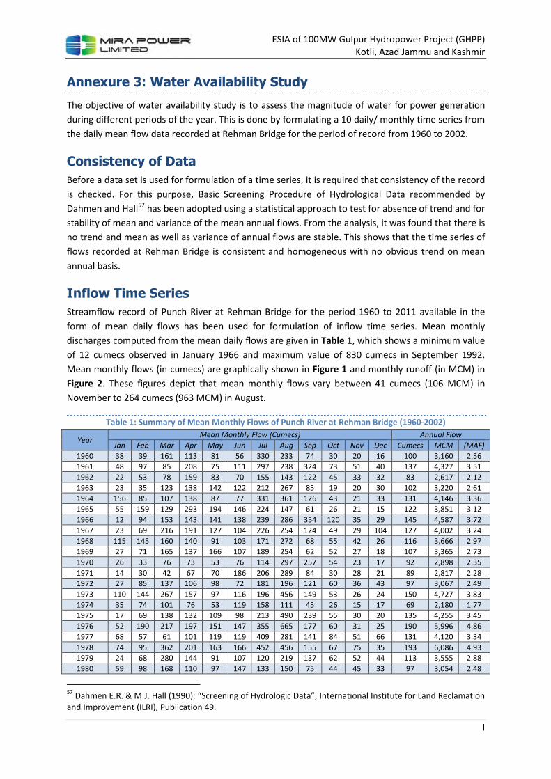
ESIA of 100MW Gulpur Hydropower Project (GHPP)
Kotli, Azad Jammu and Kashmir
I
Annexure 3: Water Availability Study
The objective of water availability study is to assess the magnitude of water for power generation
during different periods of the year. This is done by formulating a 10 daily/ monthly time series from
the daily mean flow data recorded at Rehman Bridge for the period of record from 1960 to 2002.
Consistency of Data
Before a data set is used for formulation of a time series, it is required that consistency of the record
is checked. For this purpose, Basic Screening Procedure of Hydrological Data recommended by
Dahmen and Hall57 has been adopted using a statistical approach to test for absence of trend and for
stability of mean and variance of the mean annual flows. From the analysis, it was found that there is
no trend and mean as well as variance of annual flows are stable. This shows that the time series of
flows recorded at Rehman Bridge is consistent and homogeneous with no obvious trend on mean
annual basis.
Inflow Time Series
Streamflow record of Punch River at Rehman Bridge for the period 1960 to 2011 available in the
form of mean daily flows has been used for formulation of inflow time series. Mean monthly
discharges computed from the mean daily flows are given in Table 1, which shows a minimum value
of 12 cumecs observed in January 1966 and maximum value of 830 cumecs in September 1992.
Mean monthly flows (in cumecs) are graphically shown in Figure 1 and monthly runoff (in MCM) in
Figure 2. These figures depict that mean monthly flows vary between 41 cumecs (106 MCM) in
November to 264 cumecs (963 MCM) in August.
Table 1: Summary of Mean Monthly Flows of Punch River at Rehman Bridge (1960-2002)
Year Mean Monthly Flow (Cumecs) Annual Flow
Jan Feb Mar Apr May Jun Jul Aug Sep Oct Nov Dec Cumecs MCM (MAF)
1960 38 39 161 113 81 56 330 233 74 30 20 16 100 3,160 2.56
1961 48 97 85 208 75 111 297 238 324 73 51 40 137 4,327 3.51
1962 22 53 78 159 83 70 155 143 122 45 33 32 83 2,617 2.12
1963 23 35 123 138 142 122 212 267 85 19 20 30 102 3,220 2.61
1964 156 85 107 138 87 77 331 361 126 43 21 33 131 4,146 3.36
1965 55 159 129 293 194 146 224 147 61 26 21 15 122 3,851 3.12
1966 12 94 153 143 141 138 239 286 354 120 35 29 145 4,587 3.72
1967 23 69 216 191 127 104 226 254 124 49 29 104 127 4,002 3.24
1968 115 145 160 140 91 103 171 272 68 55 42 26 116 3,666 2.97
1969 27 71 165 137 166 107 189 254 62 52 27 18 107 3,365 2.73
1970 26 33 76 73 53 76 114 297 257 54 23 17 92 2,898 2.35
1971 14 30 42 67 70 186 206 289 84 30 28 21 89 2,817 2.28
1972 27 85 137 106 98 72 181 196 121 60 36 43 97 3,067 2.49
1973 110 144 267 157 97 116 196 456 149 53 26 24 150 4,727 3.83
1974 35 74 101 76 53 119 158 111 45 26 15 17 69 2,180 1.77
1975 17 69 138 132 109 98 213 490 239 55 30 20 135 4,255 3.45
1976 52 190 217 197 151 147 355 665 177 60 31 25 190 5,996 4.86
1977 68 57 61 101 119 119 409 281 141 84 51 66 131 4,120 3.34
1978 74 95 362 201 163 166 452 456 155 67 75 35 193 6,086 4.93
1979 24 68 280 144 91 107 120 219 137 62 52 44 113 3,555 2.88
1980 59 98 168 110 97 147 133 150 75 44 45 33 97 3,054 2.48
57
Dahmen E.R. & M.J. Hall (1990): “Screening of Hydrologic Data”, International Institute for Land Reclamation
and Improvement (ILRI), Publication 49.
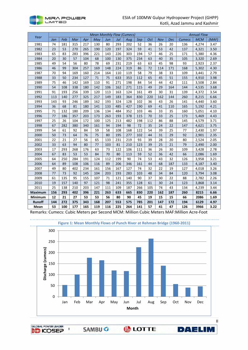
ESIA of 100MW Gulpur Hydropower Project (GHPP)
Kotli, Azad Jammu and Kashmir
II
Year Mean Monthly Flow (Cumecs) Annual Flow
Jan Feb Mar Apr May Jun Jul Aug Sep Oct Nov Dec Cumecs MCM (MAF)
1981 74 181 315 217 130 80 293 202 52 36 26 20 136 4,274 3.47
1982 23 53 270 265 190 120 197 324 59 41 53 42 137 4,321 3.50
1983 65 83 283 396 221 143 226 303 194 57 46 25 171 5,380 4.36
1984 20 30 57 104 68 100 130 375 234 63 40 35 105 3,320 2.69
1985 49 54 56 80 78 69 231 219 63 63 45 98 93 2,923 2.37
1986 46 99 304 257 169 148 224 319 86 72 114 171 168 5,302 4.30
1987 70 94 169 160 214 164 110 119 58 79 38 33 109 3,441 2.79
1988 33 50 234 127 71 75 633 353 112 65 45 51 155 4,910 3.98
1989 75 46 142 169 110 91 271 198 84 54 44 42 111 3,508 2.84
1990 54 108 338 180 142 106 162 271 115 49 29 164 144 4,535 3.68
1991 91 193 256 339 120 113 163 124 161 49 30 31 139 4,372 3.54
1992 113 140 277 325 217 149 183 364 830 220 162 144 260 8,215 6.66
1993 143 93 246 189 162 193 324 128 102 36 43 26 141 4,440 3.60
1994 36 68 81 180 141 133 485 427 190 69 41 110 165 5,192 4.21
1995 71 132 180 209 136 134 484 352 103 46 33 35 160 5,051 4.10
1996 77 186 357 203 173 263 193 378 115 70 33 25 173 5,469 4.43
1997 25 26 104 172 100 125 213 482 198 112 86 88 145 4,579 3.71
1998 67 282 380 340 161 94 194 98 72 35 24 22 147 4,621 3.75
1999 54 61 92 84 59 58 108 168 122 54 39 25 77 2,430 1.97
2000 50 73 64 76 75 80 195 277 102 44 31 29 92 2,901 2.35
2001 22 21 27 56 65 133 231 219 93 39 28 20 80 2,524 2.05
2002 33 63 94 80 77 103 81 210 123 39 25 21 79 2,490 2.00
2003 17 293 268 176 63 73 122 106 111 36 26 30 109 3,428 2.78
2004 67 83 53 53 84 70 80 113 59 52 36 42 66 2,086 1.69
2005 64 250 284 191 124 112 199 90 74 53 43 32 126 3,958 3.21
2006 64 89 108 106 116 89 206 346 161 44 68 187 133 4,187 3.40
2007 49 80 402 234 161 156 167 127 74 32 22 19 127 4,018 3.26
2008 77 73 92 145 104 203 193 283 103 48 34 84 120 3,794 3.08
2009 61 135 95 155 107 71 121 140 90 37 30 22 88 2,782 2.26
2010 19 157 140 97 121 98 241 355 128 61 30 24 123 3,868 3.14
2011 25 138 210 203 147 111 109 187 266 105 74 43 134 4,239 3.44
Maximum 156 293 402 396 221 263 633 665 830 220 162 187 260 8215 6.66
Minimum 12 21 27 53 53 56 80 90 45 19 15 15 66 2086 1.69
Runoff 144 272 375 343 168 207 553 575 785 201 147 172 194 6129 4.97
Mean 53 100 177 165 119 116 225 264 141 57 41 47 126 3966 3.22
Remarks: Cumecs: Cubic Meters per Second MCM: Million Cubic Meters MAF:Million Acre-Foot
Figure 1: Mean Monthly Flows of Punch River at Rehman Bridge (1960-2011)
0
50
100
150
200
250
300
Jan Feb Mar Apr May Jun Jul Aug Sep Oct Nov Dec
Dis
char
ge (
cum
ecs
)
Month

ESIA of 100MW Gulpur Hydropower Project (GHPP)
Kotli, Azad Jammu and Kashmir
III
Figure 2: Mean Monthly Runoff of Punch River at Rehman Bridge (1960-2011)
Figure 3: Mean Annual Flows of Punch River at Rehman Bridge (1960-2011)
Mean annual flows also presented in Table 1 and Figure 3 show mean annual value of 128 cumecs
with corresponding runoff of 4,044 MCM (3.28 MAF). The minimum mean annual flow of 69 cumecs
(2,180 MCM) was recorded in 1974 while the maximum mean annual flow of 260 cumecs (8,215
MCM) observed in 1992.
Flow Duration Curve
For possible capacity sizing of a power plant a flow duration data is required to represent time
variability of water discharge. A flow duration curve represents relationship between magnitude and
frequency of daily, 10 daily or monthly stream flows for a particular river basin at a particular
0
100
200
300
400
500
600
700
800
900
Jan Feb Mar Apr May Jun Jul Aug Sep Oct Nov Dec
Ru
no
ff (
cum
ecs
)
Month
0
50
100
150
200
250
300
19
60
19
62
19
64
19
66
19
68
19
70
19
72
19
74
19
76
19
78
19
80
19
82
19
84
19
86
19
88
19
90
19
92
19
94
19
96
19
98
20
00
20
02
20
04
20
06
20
08
20
10
Year
ly F
low
(C
um
ecs)
Annual Flow Mean Flow for Last 50 Years Maximum Minimum
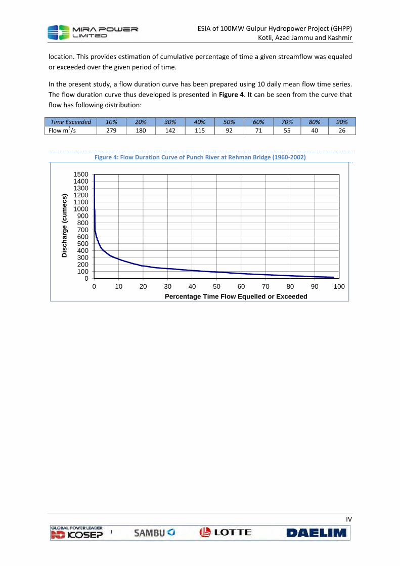
ESIA of 100MW Gulpur Hydropower Project (GHPP)
Kotli, Azad Jammu and Kashmir
IV
location. This provides estimation of cumulative percentage of time a given streamflow was equaled
or exceeded over the given period of time.
In the present study, a flow duration curve has been prepared using 10 daily mean flow time series.
The flow duration curve thus developed is presented in Figure 4. It can be seen from the curve that
flow has following distribution:
Time Exceeded 10% 20% 30% 40% 50% 60% 70% 80% 90%
Flow m3/s 279 180 142 115 92 71 55 40 26
Figure 4: Flow Duration Curve of Punch River at Rehman Bridge (1960-2002)
0100200300400500600700800900
100011001200130014001500
0 10 20 30 40 50 60 70 80 90 100
Dis
char
ge (
cum
ecs)
Percentage Time Flow Equelled or Exceeded
ESIA of 100MW Gulpur Hydropower Project (GHPP)
Kotli, Azad Jammu and Kashmir
I
Annexure 4: Environmental Monitoring Report
1. Introduction
Sustainable Solutions Pvt. Ltd hired the services of SGS Pakistan (Pvt.) Ltd. to conduct an
environmental monitoring at its project sites Azad Jammu & Kashmir. A comprehensive
environmental monitoring was conducted at mutually agreed sampling points in the project area.
This report is prepared on the basis of assessment conducted at project site. Field survey was carried
out on August 26-30, 2013 for ambient air quality monitoring, meteorological conditions, noise level
monitoring, lux monitoring and sampling & analysis of drinking water & soil samples from mutually
agreed sampling points.
1.1 Study Objectives
The objective of the study is to:
• Comply with the regulatory requirements of the project;
• Monitor air, water, soil, noise level and lux at periodic intervals in project area;
• Ensure effective implementation of EMP.
1.2 Scope of Services
Scope of services covered following main components:
• Ambient Air Quality Monitoring
• Weather Conditions
• Noise Level Monitoring
• Lux Monitoring
• Drinking Water & Soil Sampling & Analysis
1.2.1 Ambient Air Quality Monitoring
In accordance to USEPA National Ambient Air Quality standards (NAAQS) the following priority
pollutants were monitored in the ambient air.
• Carbon Monoxide (CO)
• Oxides of Nitrogen (NOX)
• Sulphur Dioxide (SO2)
• Particulate Matter (PM10)
In addition to above mentioned parameters, the meteorological conditions were also monitored in
order to interpret ambient air quality. For the purpose following parameters would be monitored:
• Ambient Temperature
• Relative Humidity
• Barometric Pressure
• Wind Direction
• Wind Velocity
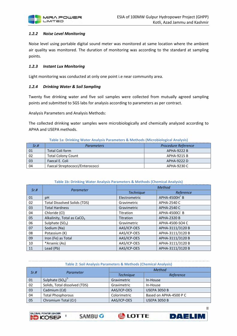
ESIA of 100MW Gulpur Hydropower Project (GHPP)
Kotli, Azad Jammu and Kashmir
II
1.2.2 Noise Level Monitoring
Noise level using portable digital sound meter was monitored at same location where the ambient
air quality was monitored. The duration of monitoring was according to the standard at sampling
points.
1.2.3 Instant Lux Monitoring
Light monitoring was conducted at only one point i.e near community area.
1.2.4 Drinking Water & Soil Sampling
Twenty five drinking water and five soil samples were collected from mutually agreed sampling
points and submitted to SGS labs for analysis according to parameters as per contract.
Analysis Parameters and Analysis Methods:
The collected drinking water samples were microbiologically and chemically analyzed according to
APHA and USEPA methods.
Table 1a: Drinking Water Analysis Parameters & Methods (Microbiological Analysis)
Sr.# Parameters Procedure Reference
01 Total Coli form APHA-9222 B
02 Total Colony Count APHA-9215 B
03 Faecal E. Coli APHA-9222 D
04 Faecal Streptococci/Enterococci APHA-9230 C
Table 1b: Drinking Water Analysis Parameters & Methods (Chemical Analysis)
Sr.# Parameter Method
Technique Reference
01 pH Electrometric APHA-4500H+ B
02 Total Dissolved Solids (TDS) Gravimetric APHA-2540 C
03 Total Hardness Gravimetric APHA-2540 C
04 Chloride (Cl) Titration APHA-4500CI- B
05 Alkalinity, Total as CaCO3 Titration APHA-2320 B
06 Sulphate (SO4) Gravimetric APHA-4500-SO4 C
07 Sodium (Na) AAS/ICP-OES APHA-3111/3120 B
08 Potassium (K) AAS/ICP-OES APHA-3111/3120 B
09 Iron (Fe) as Total AAS/ICP-OES APHA-3111/3120 B
10 *Arsenic (As) AAS/ICP-OES APHA-3111/3120 B
11 Lead (Pb) AAS/ICP-OES APHA-3111/3120 B
Table 2: Soil Analysis Parameters & Methods (Chemical Analysis)
Sr.# Parameter Method
Technique Reference
01 Sulphate (SO4)2-
Gravimetric In-House
02 Solids, Total dissolved (TDS) Gravimetric In-House
03 Cadmium (Cd) AAS/ICP-OES USEPA 3050 B
04 Total Phosphorous Colorimetric Based on APHA-4500 P C
05 Chromium Total (Cr) AAS/ICP-OES USEPA 3050 B
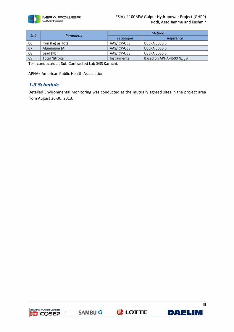
ESIA of 100MW Gulpur Hydropower Project (GHPP)
Kotli, Azad Jammu and Kashmir
III
Sr.# Parameter Method
Technique Reference
06 Iron (Fe) as Total AAS/ICP-OES USEPA 3050 B
07 Aluminium (Al) AAS/ICP-OES USEPA 3050 B
08 Lead (Pb) AAS/ICP-OES USEPA 3050 B
09 Total Nitrogen Instrumental Based on APHA-4500 Norg B
Test conducted at Sub Contracted Lab SGS Karachi.
APHA= American Public Health Association
1.3 Schedule
Detailed Environmental monitoring was conducted at the mutually agreed sites in the project area
from August 26-30, 2013.
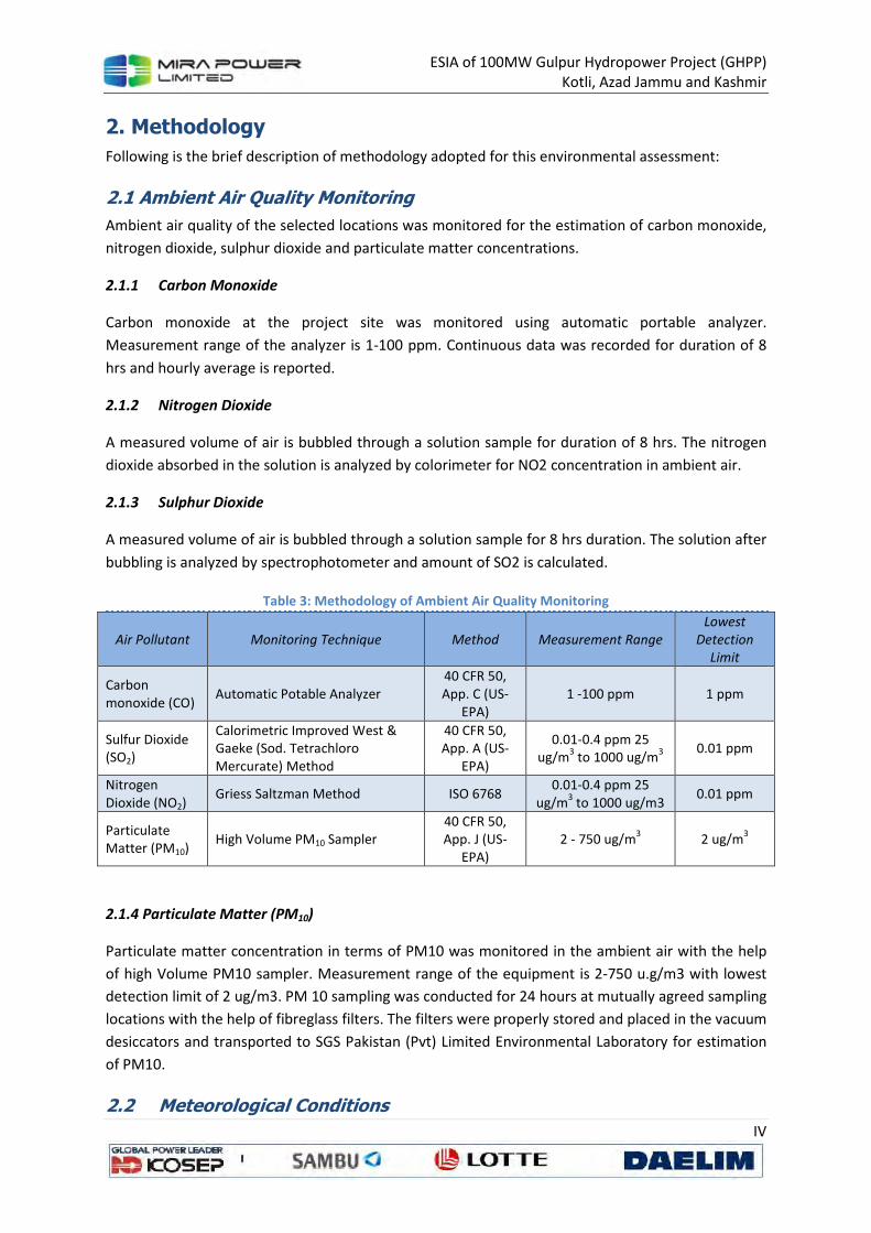
ESIA of 100MW Gulpur Hydropower Project (GHPP)
Kotli, Azad Jammu and Kashmir
IV
2. Methodology
Following is the brief description of methodology adopted for this environmental assessment:
2.1 Ambient Air Quality Monitoring
Ambient air quality of the selected locations was monitored for the estimation of carbon monoxide,
nitrogen dioxide, sulphur dioxide and particulate matter concentrations.
2.1.1 Carbon Monoxide
Carbon monoxide at the project site was monitored using automatic portable analyzer.
Measurement range of the analyzer is 1-100 ppm. Continuous data was recorded for duration of 8
hrs and hourly average is reported.
2.1.2 Nitrogen Dioxide
A measured volume of air is bubbled through a solution sample for duration of 8 hrs. The nitrogen
dioxide absorbed in the solution is analyzed by colorimeter for NO2 concentration in ambient air.
2.1.3 Sulphur Dioxide
A measured volume of air is bubbled through a solution sample for 8 hrs duration. The solution after
bubbling is analyzed by spectrophotometer and amount of SO2 is calculated.
Table 3: Methodology of Ambient Air Quality Monitoring
Air Pollutant Monitoring Technique Method Measurement Range
Lowest
Detection
Limit
Carbon monoxide (CO)
Automatic Potable Analyzer 40 CFR 50, App. C (US-
EPA) 1 -100 ppm 1 ppm
Sulfur Dioxide (SO2)
Calorimetric Improved West & Gaeke (Sod. Tetrachloro Mercurate) Method
40 CFR 50, App. A (US-
EPA)
0.01-0.4 ppm 25 ug/m
3 to 1000 ug/m
3
0.01 ppm
Nitrogen Dioxide (NO2)
Griess Saltzman Method ISO 6768 0.01-0.4 ppm 25
ug/m3 to 1000 ug/m3
0.01 ppm
Particulate Matter (PM10)
High Volume PM10 Sampler 40 CFR 50, App. J (US-
EPA) 2 - 750 ug/m
3 2 ug/m
3
2.1.4 Particulate Matter (PM10)
Particulate matter concentration in terms of PM10 was monitored in the ambient air with the help
of high Volume PM10 sampler. Measurement range of the equipment is 2-750 u.g/m3 with lowest
detection limit of 2 ug/m3. PM 10 sampling was conducted for 24 hours at mutually agreed sampling
locations with the help of fibreglass filters. The filters were properly stored and placed in the vacuum
desiccators and transported to SGS Pakistan (Pvt) Limited Environmental Laboratory for estimation
of PM10.
2.2 Meteorological Conditions
ESIA of 100MW Gulpur Hydropower Project (GHPP)
Kotli, Azad Jammu and Kashmir
V
In addition to the mutually agreed parameters for ambient air quality, weather conditions were also
monitored continuously for 24 hours with the help of mobile weather station. Selection of sampling
points was made considering the wind direction at the mutually agreed sampling site.
2.3 Noise Level Monitoring
24 hours noise level monitoring was conducted at mutually agreed locations using portable Digital
Sound Meter. Sound Pressure Level (SPL) measurements (in dB) were performed utilizing Sound
Level Meter (European Class 1 Standard) complying with standards IEC60051 TYPE 1 IE60804 TYPE 1
JIS C 1505 in accordance to SGS Standard Operating Procedures (SOP).The Noise level monitoring
was conducted at mutually agreed monitoring points.
2.4 Instant Lux Monitoring
Instant Lux level using digital lux meter was monitored at mutually agreed sampling point Instant Lux
level measurement was performed according to standard operating procedures and obtained results
are attached as Annexure-IV of the report.
2.5 Water
Following methodology was adopted for water sampling and analysis:
2.4.1 Sample Collection and Preservation
The water samples were collected from mutually agreed sampling points based on the sampling
technique in accordance to the SOP based on the recognized methods of United State
Environmental Protection Agency (USEPA) and American Public Health Association (APHA) for water
sampling and analysis. The collected water samples were preserved in appropriate containers as per
APHA Guidelines. A shipping container (Ice box with eutectic cold packs instead of ice) with
maintained temperature of 4° C ±5 °C was used for transporting the samples from the collection site
to the SGS environmental laboratory.
2.4.2 Sample Identification and Chain of Custody
The collected samples were labelled and assigned a unique sample identification number, sampling
date and time of collection. All the relevant information (sample location, time of collection, sample
identification, temperature, pH, collected by, preservation techniques etc) was recorded
immediately on the Chain of Custody form signed by SGS field Analyst.
2.4.3 Analysis Methods
Water & soil samples were collected from mutually agreed locations and were analyzed for
parameters using APHA and USEPA methods for water analysis. Detail of parameters and analysis
methods are described in 1.2.4 section of the report.
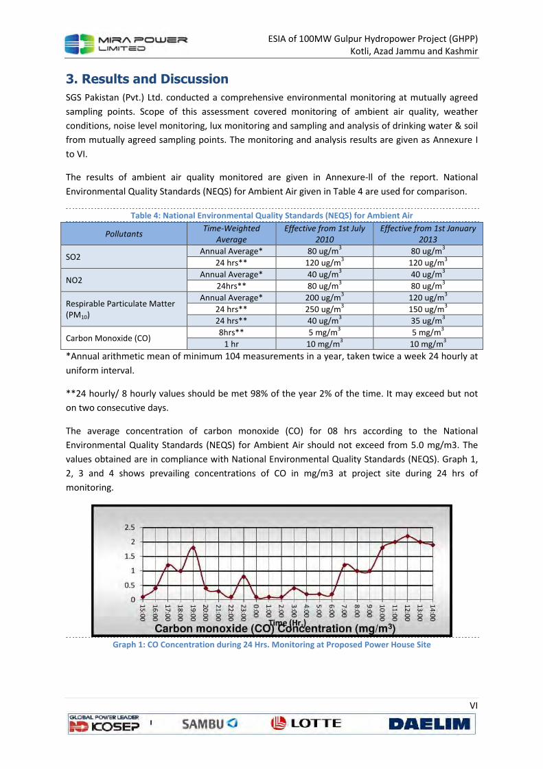
ESIA of 100MW Gulpur Hydropower Project (GHPP)
Kotli, Azad Jammu and Kashmir
VI
3. Results and Discussion
SGS Pakistan (Pvt.) Ltd. conducted a comprehensive environmental monitoring at mutually agreed
sampling points. Scope of this assessment covered monitoring of ambient air quality, weather
conditions, noise level monitoring, lux monitoring and sampling and analysis of drinking water & soil
from mutually agreed sampling points. The monitoring and analysis results are given as Annexure I
to VI.
The results of ambient air quality monitored are given in Annexure-ll of the report. National
Environmental Quality Standards (NEQS) for Ambient Air given in Table 4 are used for comparison.
Table 4: National Environmental Quality Standards (NEQS) for Ambient Air
Pollutants Time-Weighted
Average
Effective from 1st July
2010
Effective from 1st January
2013
SO2 Annual Average* 80 ug/m
3 80 ug/m
3
24 hrs** 120 ug/m3 120 ug/m
3
NO2 Annual Average* 40 ug/m
3 40 ug/m
3
24hrs** 80 ug/m3 80 ug/m
3
Respirable Particulate Matter (PM10)
Annual Average* 200 ug/m3 120 ug/m
3
24 hrs** 250 ug/m3 150 ug/m
3
24 hrs** 40 ug/m3 35 ug/m
3
Carbon Monoxide (CO) 8hrs** 5 mg/m
3 5 mg/m
3
1 hr 10 mg/m3 10 mg/m
3
*Annual arithmetic mean of minimum 104 measurements in a year, taken twice a week 24 hourly at
uniform interval.
**24 hourly/ 8 hourly values should be met 98% of the year 2% of the time. It may exceed but not
on two consecutive days.
The average concentration of carbon monoxide (CO) for 08 hrs according to the National
Environmental Quality Standards (NEQS) for Ambient Air should not exceed from 5.0 mg/m3. The
values obtained are in compliance with National Environmental Quality Standards (NEQS). Graph 1,
2, 3 and 4 shows prevailing concentrations of CO in mg/m3 at project site during 24 hrs of
monitoring.
Graph 1: CO Concentration during 24 Hrs. Monitoring at Proposed Power House Site
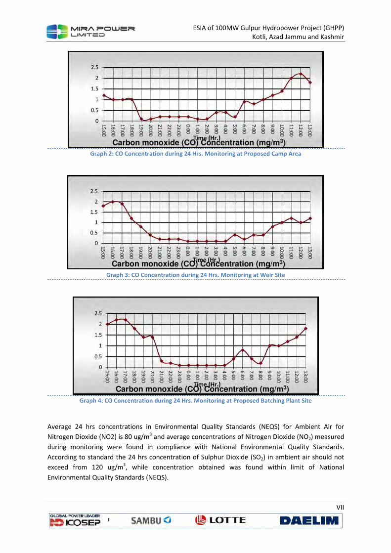
ESIA of 100MW Gulpur Hydropower Project (GHPP)
Kotli, Azad Jammu and Kashmir
VII
Graph 2: CO Concentration during 24 Hrs. Monitoring at Proposed Camp Area
Graph 3: CO Concentration during 24 Hrs. Monitoring at Weir Site
Graph 4: CO Concentration during 24 Hrs. Monitoring at Proposed Batching Plant Site
Average 24 hrs concentrations in Environmental Quality Standards (NEQS) for Ambient Air for
Nitrogen Dioxide (NO2) is 80 ug/m3 and average concentrations of Nitrogen Dioxide (NO2) measured
during monitoring were found in compliance with National Environmental Quality Standards.
According to standard the 24 hrs concentration of Sulphur Dioxide (SO2) in ambient air should not
exceed from 120 ug/m3, while concentration obtained was found within limit of National
Environmental Quality Standards (NEQS).
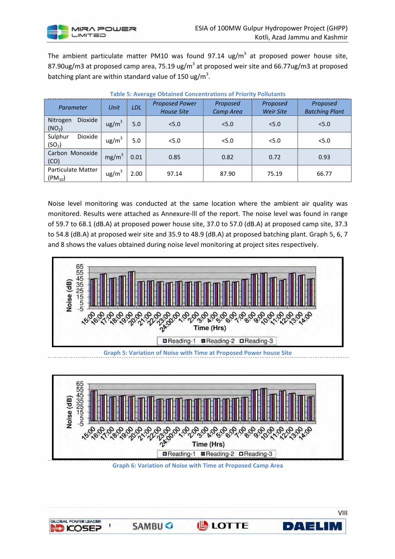
ESIA of 100MW Gulpur Hydropower Project (GHPP)
Kotli, Azad Jammu and Kashmir
VIII
The ambient particulate matter PM10 was found 97.14 ug/m3 at proposed power house site,
87.90ug/m3 at proposed camp area, 75.19 ug/m3 at proposed weir site and 66.77ug/m3 at proposed
batching plant are within standard value of 150 ug/m3.
Table 5: Average Obtained Concentrations of Priority Pollutants
Parameter Unit LDL Proposed Power
House Site
Proposed
Camp Area
Proposed
Weir Site
Proposed
Batching Plant
Nitrogen Dioxide
(NO2) ug/m
3 5.0 <5.0 <5.0 <5.0 <5.0
Sulphur Dioxide (SO2)
ug/m3 5.0 <5.0 <5.0 <5.0 <5.0
Carbon Monoxide (CO)
mg/m3 0.01 0.85 0.82 0.72 0.93
Particulate Matter (PM10)
ug/m3 2.00 97.14 87.90 75.19 66.77
Noise level monitoring was conducted at the same location where the ambient air quality was
monitored. Results were attached as Annexure-lll of the report. The noise level was found in range
of 59.7 to 68.1 (dB.A) at proposed power house site, 37.0 to 57.0 (dB.A) at proposed camp site, 37.3
to 54.8 (dB.A) at proposed weir site and 35.9 to 48.9 (dB.A) at proposed batching plant. Graph 5, 6, 7
and 8 shows the values obtained during noise level monitoring at project sites respectively.
Graph 5: Variation of Noise with Time at Proposed Power house Site
Graph 6: Variation of Noise with Time at Proposed Camp Area
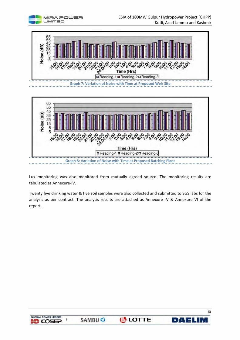
ESIA of 100MW Gulpur Hydropower Project (GHPP)
Kotli, Azad Jammu and Kashmir
IX
Graph 7: Variation of Noise with Time at Proposed Weir Site
Graph 8: Variation of Noise with Time at Proposed Batching Plant
Lux monitoring was also monitored from mutually agreed source. The monitoring results are
tabulated as Annexure-IV.
Twenty five drinking water & five soil samples were also collected and submitted to SGS labs for the
analysis as per contract. The analysis results are attached as Annexure -V & Annexure VI of the
report.
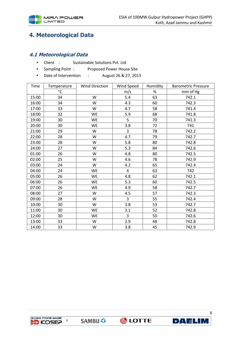
ESIA of 100MW Gulpur Hydropower Project (GHPP)
Kotli, Azad Jammu and Kashmir
X
4. Meteorological Data
4.1 Meteorological Data
• Client : Sustainable Solutions Pvt. Ltd
• Sampling Point : Proposed Power House Site
• Date of Intervention : August 26 & 27, 2013
Time Temperature Wind Direction Wind Speed Humidity Barometric Pressure
°C m/s % mm of Hg
15:00 34 W 5.4 63 742.1
16:00 34 W 4.3 60 742.3
17:00 33 W 4.7 58 741.4
18:00 32 WE 5.9 68 741.8
19:00 30 WE 5 70 741.3
20:00 30 WE 3.8 72 741
21:00 29 W 3 78 742.2
22:00 28 W 4.7 79 742.7
23:00 28 W 5.8 80 742.8
24:00 27 W 5.3 84 742.6
01:00 26 W 4.8 80 742.5
02:00 25 W 4.6 78 742.9
03:00 24 W 4.2 65 742.4
04:00 24 WE 4 63 742
05:00 26 WE 4.8 62 742.1
06:00 26 WE 5.3 60 742.5
07:00 26 WE 4.9 58 742.7
08:00 27 W 4.5 57 742.3
09:00 28 W 3 55 742.4
10:00 30 W 3.8 53 742.7
11:00 30 WE 3.1 52 742.8
12:00 30 WE 3 50 742.6
13:00 33 W 2.9 48 742.8
14:00 33 W 3.8 45 742.9
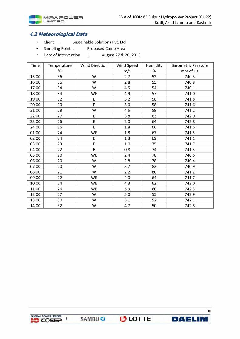
ESIA of 100MW Gulpur Hydropower Project (GHPP)
Kotli, Azad Jammu and Kashmir
XI
4.2 Meteorological Data
• Client : Sustainable Solutions Pvt. Ltd
• Sampling Point : Proposed Camp Area
• Date of Intervention : August 27 & 28, 2013
Time Temperature Wind Direction Wind Speed Humidity Barometric Pressure
°C m/s % mm of Hg
15:00 36 W 2.7 52 740.3
16:00 36 W 2.8 55 740.8
17:00 34 W 4.5 54 740.1
18:00 34 WE 4.9 57 741.0
19:00 32 E 5.2 58 741.8
20:00 30 E 5.0 58 741.6
21:00 28 W 4.6 59 741.2
22:00 27 E 3.8 63 742.0
23:00 26 E 2.0 64 742.8
24:00 26 E 1.8 66 741.6
01:00 24 WE 1.8 67 741.5
02:00 24 E 1.3 69 741.1
03:00 23 E 1.0 75 741.7
04:00 22 E 0.8 74 741.3
05:00 20 WE 2.4 78 740.6
06:00 20 W 2.8 78 740.4
07:00 20 W 3.7 82 740.9
08:00 21 W 2.2 80 741.2
09:00 22 WE 4.0 64 741.7
10:00 24 WE 4.3 62 742.0
11:00 26 WE 5.3 60 742.3
12:00 27 W 5.0 55 742.9
13:00 30 W 5.1 52 742.1
14:00 32 W 4.7 50 742.8
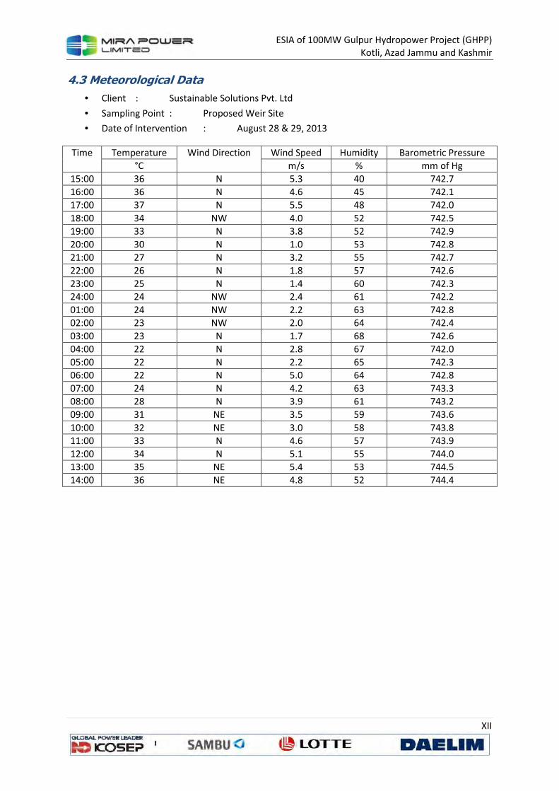
ESIA of 100MW Gulpur Hydropower Project (GHPP)
Kotli, Azad Jammu and Kashmir
XII
4.3 Meteorological Data
• Client : Sustainable Solutions Pvt. Ltd
• Sampling Point : Proposed Weir Site
• Date of Intervention : August 28 & 29, 2013
Time Temperature Wind Direction Wind Speed Humidity Barometric Pressure
°C m/s % mm of Hg
15:00 36 N 5.3 40 742.7
16:00 36 N 4.6 45 742.1
17:00 37 N 5.5 48 742.0
18:00 34 NW 4.0 52 742.5
19:00 33 N 3.8 52 742.9
20:00 30 N 1.0 53 742.8
21:00 27 N 3.2 55 742.7
22:00 26 N 1.8 57 742.6
23:00 25 N 1.4 60 742.3
24:00 24 NW 2.4 61 742.2
01:00 24 NW 2.2 63 742.8
02:00 23 NW 2.0 64 742.4
03:00 23 N 1.7 68 742.6
04:00 22 N 2.8 67 742.0
05:00 22 N 2.2 65 742.3
06:00 22 N 5.0 64 742.8
07:00 24 N 4.2 63 743.3
08:00 28 N 3.9 61 743.2
09:00 31 NE 3.5 59 743.6
10:00 32 NE 3.0 58 743.8
11:00 33 N 4.6 57 743.9
12:00 34 N 5.1 55 744.0
13:00 35 NE 5.4 53 744.5
14:00 36 NE 4.8 52 744.4

ESIA of 100MW Gulpur Hydropower Project (GHPP)
Kotli, Azad Jammu and Kashmir
XIII
4.4 Meteorological Data
• Client : Sustainable Solutions Pvt. Ltd
• Sampling Point : Proposed Batching Plant
• Date of Intervention : August 29 & 30, 2013
Time Temperature Wind Direction Wind Speed Humidity Barometric Pressure
°C m/s % mm of Hg
15:00 37 E 2.8 42 740.8
16:00 36 E 2.4 43 740.0
17:00 36 E 4.5 45 740.4
18:00 33 E 4.3 46 741.0
19:00 30 E 4.0 48 741.3
20:00 29 E 5.2 53 741.9
21:00 28 NE 5.4 56 740.7
22:00 26 NE 4.8 58 740.8
23:00 25 NE 3.1 59 740.6
24:00 24 E 2.0 60 740.9
01:00 23 E 1.9 62 740.2
02:00 22 E 1.4 63 740.5
03:00 21 E 0.9 65 742.8
04:00 20 E 1.8 68 742.3
05:00 22 E 1.2 69 742.7
06:00 24 NE 1.1 66 742.0
07:00 25 NE 2.6 64 741.9
08:00 28 NE 2.8 63 741.8
09:00 29 NE 3.5 60 741.6
10:00 29 E 4.8 57 741.7
11:00 30 E 4.6 56 741.5
12:00 32 E 4.0 55 741.9
13:00 34 E 4.4 54 741.4
14:00 34 E 4.1 52 741.8
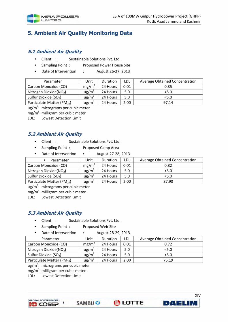
ESIA of 100MW Gulpur Hydropower Project (GHPP)
Kotli, Azad Jammu and Kashmir
XIV
5. Ambient Air Quality Monitoring Data
5.1 Ambient Air Quality
• Client : Sustainable Solutions Pvt. Ltd.
• Sampling Point : Proposed Power House Site
• Date of Intervention : August 26-27, 2013
Parameter Unit Duration LDL Average Obtained Concentration
Carbon Monoxide (CO) mg/m3 24 Hours 0.01 0.85
Nitrogen Dioxide(NO2) ug/m3 24 Hours 5.0 <5.0
Sulfur Dioxide (SO2) ug/m3 24 Hours 5.0 <5.0
Particulate Matter (PM10) ug/m3 24 Hours 2.00 97.14
ug/m3: micrograms per cubic meter mg/m3: milligram per cubic meter LDL: Lowest Detection Limit
5.2 Ambient Air Quality
• Client : Sustainable Solutions Pvt. Ltd.
• Sampling Point : Proposed Camp Area
• Date of Intervention : August 27-28, 2013
• Parameter Unit Duration LDL Average Obtained Concentration
Carbon Monoxide (CO) mg/m3 24 Hours 0.01 0.82
Nitrogen Dioxide(NO2) ug/m3 24 Hours 5.0 <5.0
Sulfur Dioxide (SO2) ug/m3 24 Hours 5.0 <5.0
Particulate Matter (PM10) ug/m3 24 Hours 2.00 87.90
ug/m3: micrograms per cubic meter mg/m3: milligram per cubic meter LDL: Lowest Detection Limit
5.3 Ambient Air Quality
• Client : Sustainable Solutions Pvt. Ltd.
• Sampling Point : Proposed Weir Site
• Date of Intervention : August 28-29, 2013
Parameter Unit Duration LDL Average Obtained Concentration
Carbon Monoxide (CO) mg/m3 24 Hours 0.01 0.72
Nitrogen Dioxide(NO2) ug/m3 24 Hours 5.0 <5.0
Sulfur Dioxide (SO2) ug/m3 24 Hours 5.0 <5.0
Particulate Matter (PM10) ug/m3 24 Hours 2.00 75.19
ug/m3: micrograms per cubic meter mg/m3: milligram per cubic meter LDL: Lowest Detection Limit
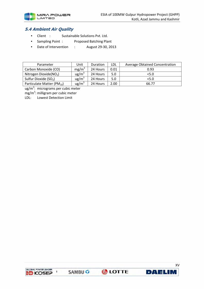
ESIA of 100MW Gulpur Hydropower Project (GHPP)
Kotli, Azad Jammu and Kashmir
XV
5.4 Ambient Air Quality
• Client : Sustainable Solutions Pvt. Ltd.
• Sampling Point : Proposed Batching Plant
• Date of Intervention : August 29-30, 2013
Parameter Unit Duration LDL Average Obtained Concentration
Carbon Monoxide (CO) mg/m3 24 Hours 0.01 0.93
Nitrogen Dioxide(NO2) ug/m3 24 Hours 5.0 <5.0
Sulfur Dioxide (SO2) ug/m3 24 Hours 5.0 <5.0
Particulate Matter (PM10) ug/m3 24 Hours 2.00 66.77
ug/m3: micrograms per cubic meter mg/m3: milligram per cubic meter LDL: Lowest Detection Limit
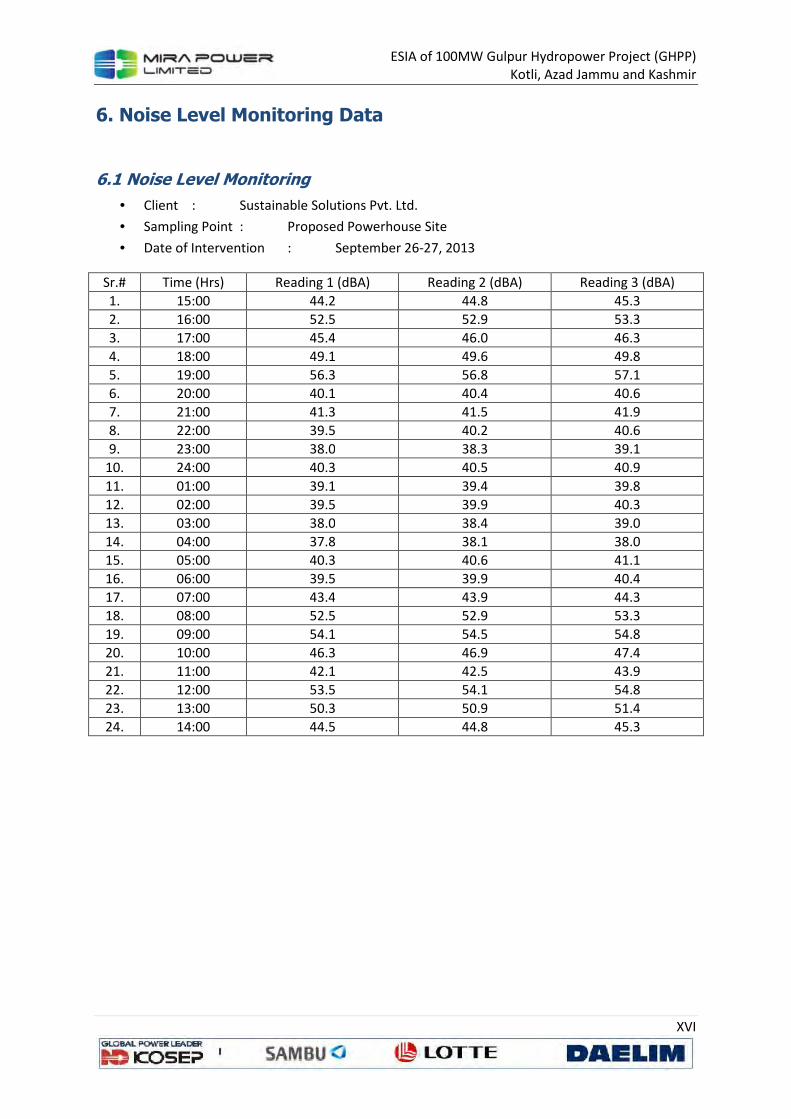
ESIA of 100MW Gulpur Hydropower Project (GHPP)
Kotli, Azad Jammu and Kashmir
XVI
6. Noise Level Monitoring Data
6.1 Noise Level Monitoring
• Client : Sustainable Solutions Pvt. Ltd.
• Sampling Point : Proposed Powerhouse Site
• Date of Intervention : September 26-27, 2013
Sr.# Time (Hrs) Reading 1 (dBA) Reading 2 (dBA) Reading 3 (dBA)
1. 15:00 44.2 44.8 45.3
2. 16:00 52.5 52.9 53.3
3. 17:00 45.4 46.0 46.3
4. 18:00 49.1 49.6 49.8
5. 19:00 56.3 56.8 57.1
6. 20:00 40.1 40.4 40.6
7. 21:00 41.3 41.5 41.9
8. 22:00 39.5 40.2 40.6
9. 23:00 38.0 38.3 39.1
10. 24:00 40.3 40.5 40.9
11. 01:00 39.1 39.4 39.8
12. 02:00 39.5 39.9 40.3
13. 03:00 38.0 38.4 39.0
14. 04:00 37.8 38.1 38.0
15. 05:00 40.3 40.6 41.1
16. 06:00 39.5 39.9 40.4
17. 07:00 43.4 43.9 44.3
18. 08:00 52.5 52.9 53.3
19. 09:00 54.1 54.5 54.8
20. 10:00 46.3 46.9 47.4
21. 11:00 42.1 42.5 43.9
22. 12:00 53.5 54.1 54.8
23. 13:00 50.3 50.9 51.4
24. 14:00 44.5 44.8 45.3

ESIA of 100MW Gulpur Hydropower Project (GHPP)
Kotli, Azad Jammu and Kashmir
XVII
6.2 Noise Level Monitoring
• Client : Sustainable Solutions Pvt. Ltd.
• Sampling Point : Proposed Camp Area
• Date of Intervention : September 27-28, 2013
Sr.# Time (Hrs) Reading 1 (dBA) Reading 2 (dBA) Reading 3 (dBA)
1. 15:00 52.4 53.0 53.2
2. 16:00 45.1 45.3 45.8
3. 17:00 42.0 42.5 42.6
4. 18:00 43.1 43.8 44.0
5. 19:00 42.5 42.6 43.2
6. 20:00 39.8 40.2 40.4
7. 21:00 42.3 42.6 42.8
8. 22:00 38.1 38.4 38.6
9. 23:00 38.0 38.6 38.7
10. 24:00 39.3 39.4 39.8
11. 01:00 37.0 37.3 37.5
12. 02:00 38.2 38.4 38.6
13. 03:00 38.4 38.5 38.9
14. 04:00 39.0 39.1 39.3
15. 05:00 38.4 38.6 38.8
16. 06:00 39.4 39.5 39.8
17. 07:00 41.2 41.5 41.7
18. 08:00 53.4 53.9 54.1
19. 09:00 56.3 56.9 57.0
20. 10:00 46.4 46.8 46.9
21. 11:00 52.4 52.7 53.0
22. 12:00 47.8 48.3 48.5
23. 13:00 44.3 44.6 44.7
24. 14:00 42.3 42.5 42.9
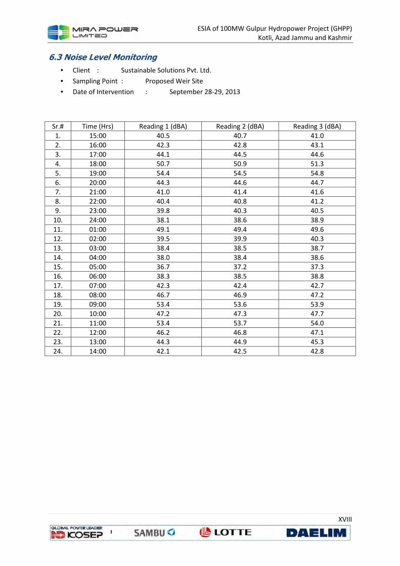
ESIA of 100MW Gulpur Hydropower Project (GHPP)
Kotli, Azad Jammu and Kashmir
XVIII
6.3 Noise Level Monitoring
• Client : Sustainable Solutions Pvt. Ltd.
• Sampling Point : Proposed Weir Site
• Date of Intervention : September 28-29, 2013
Sr.# Time (Hrs) Reading 1 (dBA) Reading 2 (dBA) Reading 3 (dBA)
1. 15:00 40.5 40.7 41.0
2. 16:00 42.3 42.8 43.1
3. 17:00 44.1 44.5 44.6
4. 18:00 50.7 50.9 51.3
5. 19:00 54.4 54.5 54.8
6. 20:00 44.3 44.6 44.7
7. 21:00 41.0 41.4 41.6
8. 22:00 40.4 40.8 41.2
9. 23:00 39.8 40.3 40.5
10. 24:00 38.1 38.6 38.9
11. 01:00 49.1 49.4 49.6
12. 02:00 39.5 39.9 40.3
13. 03:00 38.4 38.5 38.7
14. 04:00 38.0 38.4 38.6
15. 05:00 36.7 37.2 37.3
16. 06:00 38.3 38.5 38.8
17. 07:00 42.3 42.4 42.7
18. 08:00 46.7 46.9 47.2
19. 09:00 53.4 53.6 53.9
20. 10:00 47.2 47.3 47.7
21. 11:00 53.4 53.7 54.0
22. 12:00 46.2 46.8 47.1
23. 13:00 44.3 44.9 45.3
24. 14:00 42.1 42.5 42.8
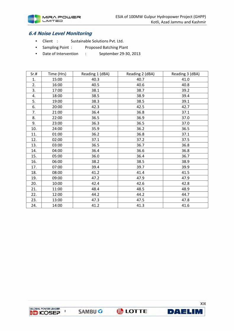
ESIA of 100MW Gulpur Hydropower Project (GHPP)
Kotli, Azad Jammu and Kashmir
XIX
6.4 Noise Level Monitoring
• Client : Sustainable Solutions Pvt. Ltd.
• Sampling Point : Proposed Batching Plant
• Date of Intervention : September 29-30, 2013
Sr.# Time (Hrs) Reading 1 (dBA) Reading 2 (dBA) Reading 3 (dBA)
1. 15:00 40.3 40.7 41.0
2. 16:00 40.5 40.6 40.8
3. 17:00 38.1 38.7 39.2
4. 18:00 38.5 38.9 39.4
5. 19:00 38.3 38.5 39.1
6. 20:00 42.3 42.5 42.7
7. 21:00 36.4 36.8 37.1
8. 22:00 36.5 36.9 37.0
9. 23:00 36.3 36.5 37.0
10. 24:00 35.9 36.2 36.5
11. 01:00 36.2 36.8 37.1
12. 02:00 37.1 37.2 37.5
13. 03:00 36.5 36.7 36.8
14. 04:00 36.4 36.6 36.8
15. 05:00 36.0 36.4 36.7
16. 06:00 38.2 38.5 38.9
17. 07:00 39.4 39.7 39.9
18. 08:00 41.2 41.4 41.5
19. 09:00 47.2 47.9 47.9
20. 10:00 42.4 42.6 42.8
21. 11:00 48.4 48.5 48.9
22. 12:00 44.2 44.2 44.7
23. 13:00 47.3 47.5 47.8
24. 14:00 41.2 41.3 41.6

ESIA of 100MW Gulpur Hydropower Project (GHPP)
Kotli, Azad Jammu and Kashmir
XX
7. Instant Lux Monitoring
7.1 Light Monitoring Report
• Client : Sustainable Solutions Pvt. Ltd.
• Monitoring Date : August 30, 2013
• Place of Intervention : Kotli Azad Jammu & Kashmir
Sr. # Sampling Point Method / Technique Unit Results
01. Near Community Area Illuminance Meter LUX 1165
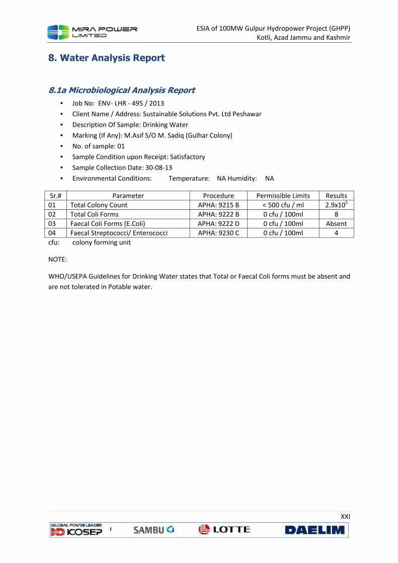
ESIA of 100MW Gulpur Hydropower Project (GHPP)
Kotli, Azad Jammu and Kashmir
XXI
8. Water Analysis Report
8.1a Microbiological Analysis Report
• Job No: ENV- LHR - 495 / 2013
• Client Name / Address: Sustainable Solutions Pvt. Ltd Peshawar
• Description Of Sample: Drinking Water
• Marking (If Any): M.Asif S/O M. Sadiq (Gulhar Colony)
• No. of sample: 01
• Sample Condition upon Receipt: Satisfactory
• Sample Collection Date: 30-08-13
• Environmental Conditions: Temperature: NA Humidity: NA
Sr.# Parameter Procedure Permissible Limits Results
01 Total Colony Count APHA: 9215 B < 500 cfu / ml 2.9x10⁵
02 Total Coli Forms APHA: 9222 B 0 cfu / 100ml 8
03 Faecal Coli Forms (E.Coli) APHA: 9222 D 0 cfu / 100ml Absent
04 Faecal Streptococci/ Enterococci APHA: 9230 C 0 cfu / 100ml 4
cfu: colony forming unit
NOTE:
WHO/USEPA Guidelines for Drinking Water states that Total or Faecal Coli forms must be absent and
are not tolerated in Potable water.

ESIA of 100MW Gulpur Hydropower Project (GHPP)
Kotli, Azad Jammu and Kashmir
XXII
8.1b Chemical Laboratory Test Report
• Job No: ENV - LHR - 495 / 2013
• Client Name / Address: Sustainable Solutions Pvt. Ltd Peshawar
• Description of Sample: Drinking Water
• Marking (If Any): M.Asif S/O M. Sadiq (Gulhar Colony)
• No. of sample: 01
• Sample Condition upon Receipt: Satisfactory
• Sample Collection Date: 30-08-13
• Environmental Conditions: Temperature: NA Humidity: NA
Sr. #
Parameters Method Unit LDL Test Results
Limits As Per NEQS
01 pH @ 25 °C APHA-4500H+ B - 0.1 7.57 6.5-8.5
02 Solids, Total dissolved (TDS)
APHA-2540 C mg/L 5.0 427.0 <1000
03 Hardness, Total as CaCO3 APHA-2340 B & C
mg/L 0.5 346.5 <500
04 Alkalinity, Total as CaCO3 APHA-2320 B mg/L 0.5 324.0 NS
05 Chloride (Cl)-1 APHA-4500CI- B mg/L 0.5 29.35 <250
06 Sulfate (SO4)-2 APHA-4500-SO4 C
mg/L 5.0 27.16 NS
07 Lead ( Pb )+2 APHA-3111 B mg/L 0.01 <0.01 ≤0.05
08 Arsenic (As)+3 APHA-3120 B mg/L 0.005 < 0.005 0.01
09 Total Iron as (Fe)+3/+2 APHA-3111 B mg/L 0.02 0.022 NS
10 Sodium (Na)+1 APHA-3111 B mg/L 1.0 31.10 NS
11 Potassium (K)+1 APHA-3111 B mg/L 0.2 2.52 NS
REMARKS: LDL: Lowest Detection Limit NS: Not Specified
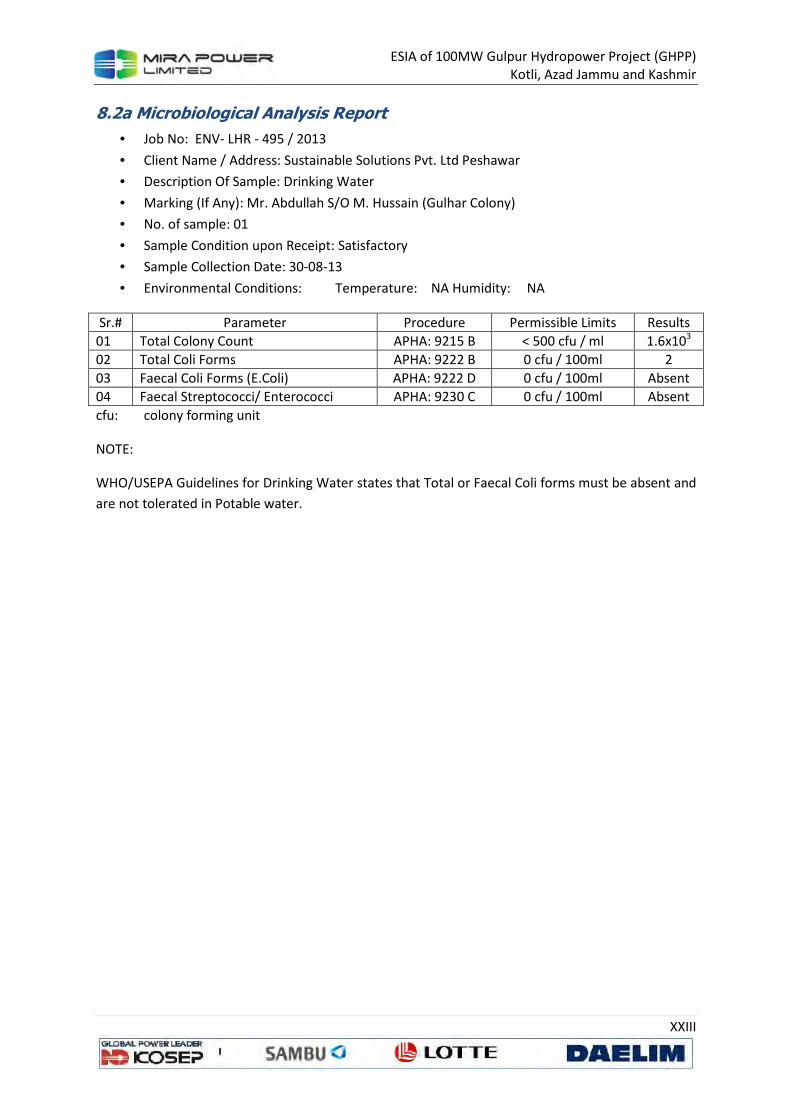
ESIA of 100MW Gulpur Hydropower Project (GHPP)
Kotli, Azad Jammu and Kashmir
XXIII
8.2a Microbiological Analysis Report
• Job No: ENV- LHR - 495 / 2013
• Client Name / Address: Sustainable Solutions Pvt. Ltd Peshawar
• Description Of Sample: Drinking Water
• Marking (If Any): Mr. Abdullah S/O M. Hussain (Gulhar Colony)
• No. of sample: 01
• Sample Condition upon Receipt: Satisfactory
• Sample Collection Date: 30-08-13
• Environmental Conditions: Temperature: NA Humidity: NA
Sr.# Parameter Procedure Permissible Limits Results
01 Total Colony Count APHA: 9215 B < 500 cfu / ml 1.6x10³
02 Total Coli Forms APHA: 9222 B 0 cfu / 100ml 2
03 Faecal Coli Forms (E.Coli) APHA: 9222 D 0 cfu / 100ml Absent
04 Faecal Streptococci/ Enterococci APHA: 9230 C 0 cfu / 100ml Absent
cfu: colony forming unit
NOTE:
WHO/USEPA Guidelines for Drinking Water states that Total or Faecal Coli forms must be absent and
are not tolerated in Potable water.

ESIA of 100MW Gulpur Hydropower Project (GHPP)
Kotli, Azad Jammu and Kashmir
XXIV
8.2b Chemical Laboratory Test Report
• Job No: ENV - LHR - 495 / 2013
• Client Name / Address: Sustainable Solutions Pvt. Ltd Peshawar
• Description of Sample: Drinking Water
• Marking (If Any): Mr. Abdullah S/O M. Hussain (Gulhar Colony)
• No. of sample: 01
• Sample Condition upon Receipt: Satisfactory
• Sample Collection Date: 30-08-13
• Environmental Conditions: Temperature: NA Humidity: NA
Sr. #
Parameters Method Unit LDL Test Results
Limits As Per NEQS
01 pH @ 25 °C APHA-4500H+ B - 0.1 7.61 6.5-8.5
02 Solids, Total dissolved (TDS)
APHA-2540 C mg/L 5.0 410.0 <1000
03 Hardness, Total as CaCO3 APHA-2340 B & C
mg/L 0.5 356.4 <500
04 Alkalinity, Total as CaCO3 APHA-2320 B mg/L 0.5 313.2 NS
05 Chloride (Cl)-1 APHA-4500CI- B mg/L 0.5 24.46 <250
06 Sulfate (SO4)-2 APHA-4500-SO4 C
mg/L 5.0 23.87 NS
07 Lead ( Pb )+2 APHA-3111 B mg/L 0.01 0.037 ≤0.05
08 Arsenic (As)+3 APHA-3120 B mg/L 0.005 < 0.005 0.01
09 Total Iron as (Fe)+3/+2 APHA-3111 B mg/L 0.02 0.02 NS
10 Sodium (Na)+1 APHA-3111 B mg/L 1.0 31.94 NS
11 Potassium (K)+1 APHA-3111 B mg/L 0.2 2.515 NS
REMARKS: LDL: Lowest Detection Limit NS: Not Specified
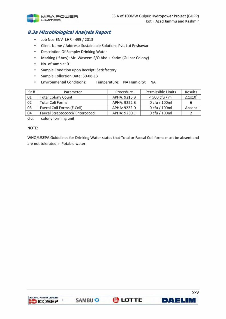
ESIA of 100MW Gulpur Hydropower Project (GHPP)
Kotli, Azad Jammu and Kashmir
XXV
8.3a Microbiological Analysis Report
• Job No: ENV- LHR - 495 / 2013
• Client Name / Address: Sustainable Solutions Pvt. Ltd Peshawar
• Description Of Sample: Drinking Water
• Marking (If Any): Mr. Waseem S/O Abdul Karim (Gulhar Colony)
• No. of sample: 01
• Sample Condition upon Receipt: Satisfactory
• Sample Collection Date: 30-08-13
• Environmental Conditions: Temperature: NA Humidity: NA
Sr.# Parameter Procedure Permissible Limits Results
01 Total Colony Count APHA: 9215 B < 500 cfu / ml 2.1x10⁴
02 Total Coli Forms APHA: 9222 B 0 cfu / 100ml 6
03 Faecal Coli Forms (E.Coli) APHA: 9222 D 0 cfu / 100ml Absent
04 Faecal Streptococci/ Enterococci APHA: 9230 C 0 cfu / 100ml 2
cfu: colony forming unit
NOTE:
WHO/USEPA Guidelines for Drinking Water states that Total or Faecal Coli forms must be absent and
are not tolerated in Potable water.
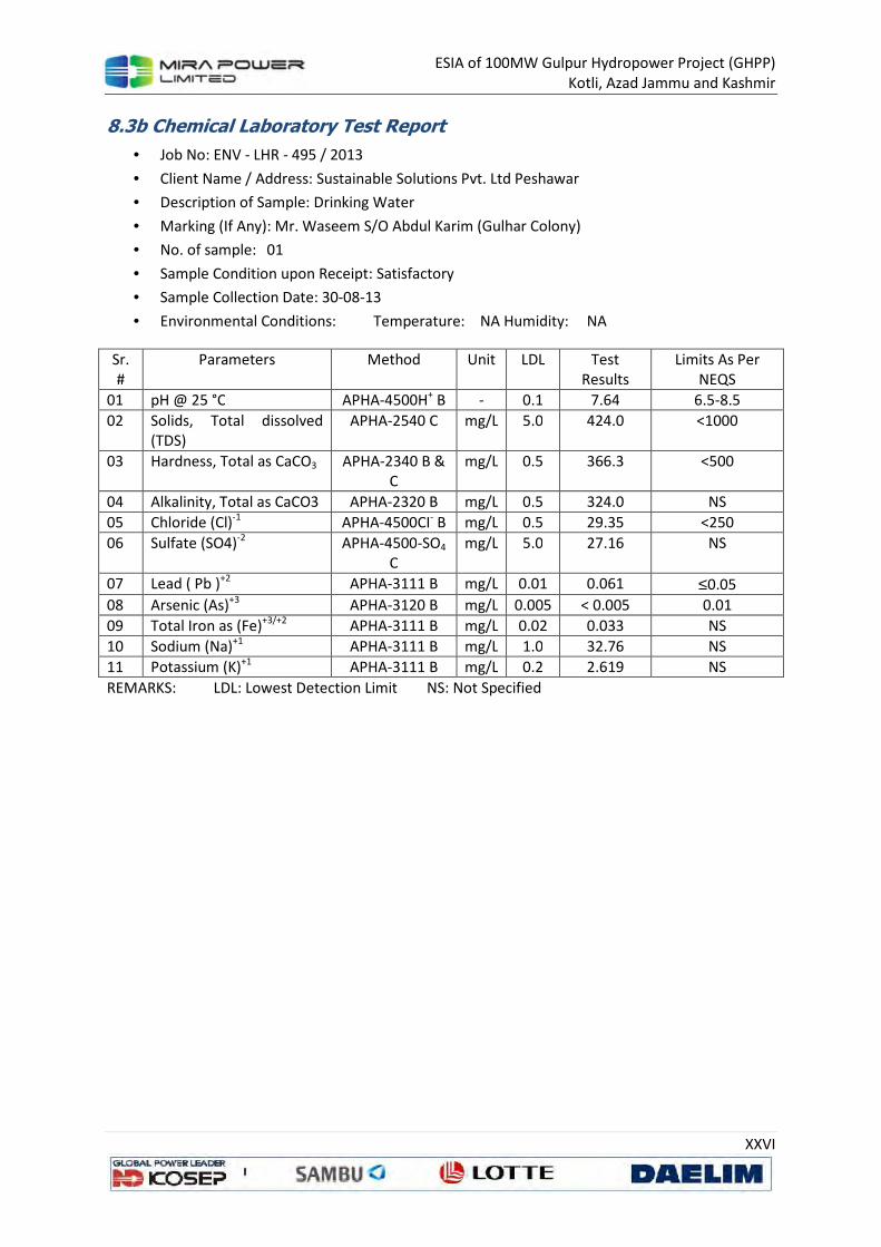
ESIA of 100MW Gulpur Hydropower Project (GHPP)
Kotli, Azad Jammu and Kashmir
XXVI
8.3b Chemical Laboratory Test Report
• Job No: ENV - LHR - 495 / 2013
• Client Name / Address: Sustainable Solutions Pvt. Ltd Peshawar
• Description of Sample: Drinking Water
• Marking (If Any): Mr. Waseem S/O Abdul Karim (Gulhar Colony)
• No. of sample: 01
• Sample Condition upon Receipt: Satisfactory
• Sample Collection Date: 30-08-13
• Environmental Conditions: Temperature: NA Humidity: NA
Sr. #
Parameters Method Unit LDL Test Results
Limits As Per NEQS
01 pH @ 25 °C APHA-4500H+ B - 0.1 7.64 6.5-8.5
02 Solids, Total dissolved (TDS)
APHA-2540 C mg/L 5.0 424.0 <1000
03 Hardness, Total as CaCO3 APHA-2340 B & C
mg/L 0.5 366.3 <500
04 Alkalinity, Total as CaCO3 APHA-2320 B mg/L 0.5 324.0 NS
05 Chloride (Cl)-1 APHA-4500CI- B mg/L 0.5 29.35 <250
06 Sulfate (SO4)-2 APHA-4500-SO4 C
mg/L 5.0 27.16 NS
07 Lead ( Pb )+2 APHA-3111 B mg/L 0.01 0.061 ≤0.05
08 Arsenic (As)+3 APHA-3120 B mg/L 0.005 < 0.005 0.01
09 Total Iron as (Fe)+3/+2 APHA-3111 B mg/L 0.02 0.033 NS
10 Sodium (Na)+1 APHA-3111 B mg/L 1.0 32.76 NS
11 Potassium (K)+1 APHA-3111 B mg/L 0.2 2.619 NS
REMARKS: LDL: Lowest Detection Limit NS: Not Specified

ESIA of 100MW Gulpur Hydropower Project (GHPP)
Kotli, Azad Jammu and Kashmir
XXVII
8.4a Microbiological Analysis Report
• Job No: ENV- LHR - 495 / 2013
• Client Name / Address: Sustainable Solutions Pvt. Ltd Peshawar
• Description Of Sample: Drinking Water
• Marking (If Any): Mr. lrshad S/O M. Nazir (Gulhar Colony)
• No. of sample: 01
• Sample Condition upon Receipt: Satisfactory
• Sample Collection Date: 30-08-13
• Environmental Conditions: Temperature: NA Humidity: NA
Sr.# Parameter Procedure Permissible Limits Results
01 Total Colony Count APHA: 9215 B < 500 cfu / ml 1.7x10⁵
02 Total Coli Forms APHA: 9222 B 0 cfu / 100ml 7
03 Faecal Coli Forms (E.Coli) APHA: 9222 D 0 cfu / 100ml Absent
04 Faecal Streptococci/ Enterococci APHA: 9230 C 0 cfu / 100ml 1
cfu: colony forming unit
NOTE:
WHO/USEPA Guidelines for Drinking Water states that Total or Faecal Coli forms must be absent and
are not tolerated in Potable water.

ESIA of 100MW Gulpur Hydropower Project (GHPP)
Kotli, Azad Jammu and Kashmir
XXVIII
8.4b Chemical Laboratory Test Report
• Job No: ENV - LHR - 495 / 2013
• Client Name / Address: Sustainable Solutions Pvt. Ltd Peshawar
• Description of Sample: Drinking Water
• Marking (If Any): Mr. lrshad S/O M. Nazir (Gulhar Colony)
• No. of sample: 01
• Sample Condition upon Receipt: Satisfactory
• Sample Collection Date: 30-08-13
• Environmental Conditions: Temperature: NA Humidity: NA
Sr. #
Parameters Method Unit LDL Test Results
Limits As Per NEQS
01 pH @ 25 °C APHA-4500H+ B - 0.1 7.58 6.5-8.5
02 Solids, Total dissolved (TDS)
APHA-2540 C mg/L 5.0 726.0 <1000
03 Hardness, Total as CaCO3 APHA-2340 B & C
mg/L 0.5 514.8 <500
04 Alkalinity, Total as CaCO3 APHA-2320 B mg/L 0.5 486.0 NS
05 Chloride (Cl)-1 APHA-4500CI- B mg/L 0.5 53.81 <250
06 Sulfate (SO4)-2 APHA-4500-SO4 C
mg/L 5.0 53.50 NS
07 Lead ( Pb )+2 APHA-3111 B mg/L 0.01 0.061 ≤0.05
08 Arsenic (As)+3 APHA-3120 B mg/L 0.005 < 0.005 0.01
09 Total Iron as (Fe)+3/+2 APHA-3111 B mg/L 0.02 <0.02 NS
10 Sodium (Na)+1 APHA-3111 B mg/L 1.0 82.12 NS
11 Potassium (K)+1 APHA-3111 B mg/L 0.2 9.282 NS
REMARKS: LDL: Lowest Detection Limit NS: Not Specified

ESIA of 100MW Gulpur Hydropower Project (GHPP)
Kotli, Azad Jammu and Kashmir
XXIX
8.5a Microbiological Analysis Report
• Job No: ENV- LHR - 495 / 2013
• Client Name / Address: Sustainable Solutions Pvt. Ltd Peshawar
• Description Of Sample: Drinking Water
• Marking (If Any): Mr. Afaq S/O Mr. Haider (Gulhar Colony)
• No. of sample: 01
• Sample Condition upon Receipt: Satisfactory
• Sample Collection Date: 30-08-13
• Environmental Conditions: Temperature: NA Humidity: NA
Sr.# Parameter Procedure Permissible Limits Results
01 Total Colony Count APHA: 9215 B < 500 cfu / ml 3.9x10⁴
02 Total Coli Forms APHA: 9222 B 0 cfu / 100ml 58
03 Faecal Coli Forms (E.Coli) APHA: 9222 D 0 cfu / 100ml Absent
04 Faecal Streptococci/ Enterococci APHA: 9230 C 0 cfu / 100ml Absent
cfu: colony forming unit
NOTE:
WHO/USEPA Guidelines for Drinking Water states that Total or Faecal Coli forms must be absent and
are not tolerated in Potable water.
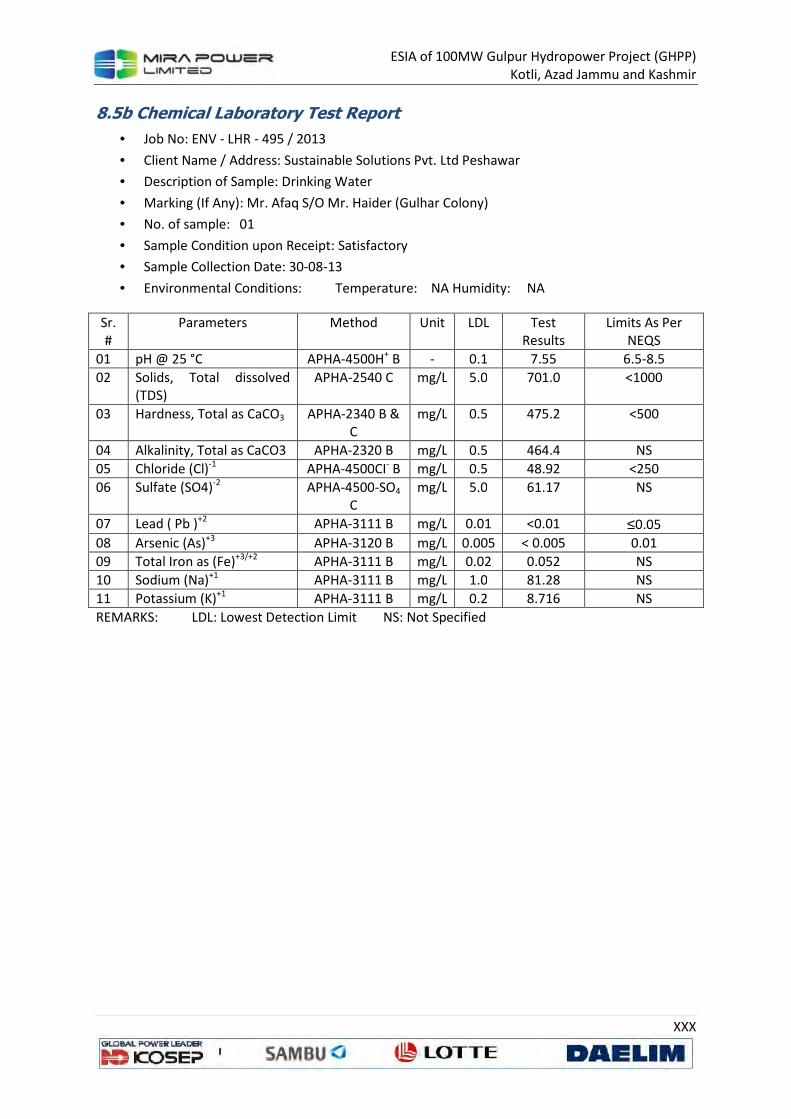
ESIA of 100MW Gulpur Hydropower Project (GHPP)
Kotli, Azad Jammu and Kashmir
XXX
8.5b Chemical Laboratory Test Report
• Job No: ENV - LHR - 495 / 2013
• Client Name / Address: Sustainable Solutions Pvt. Ltd Peshawar
• Description of Sample: Drinking Water
• Marking (If Any): Mr. Afaq S/O Mr. Haider (Gulhar Colony)
• No. of sample: 01
• Sample Condition upon Receipt: Satisfactory
• Sample Collection Date: 30-08-13
• Environmental Conditions: Temperature: NA Humidity: NA
Sr. #
Parameters Method Unit LDL Test Results
Limits As Per NEQS
01 pH @ 25 °C APHA-4500H+ B - 0.1 7.55 6.5-8.5
02 Solids, Total dissolved (TDS)
APHA-2540 C mg/L 5.0 701.0 <1000
03 Hardness, Total as CaCO3 APHA-2340 B & C
mg/L 0.5 475.2 <500
04 Alkalinity, Total as CaCO3 APHA-2320 B mg/L 0.5 464.4 NS
05 Chloride (Cl)-1 APHA-4500CI- B mg/L 0.5 48.92 <250
06 Sulfate (SO4)-2 APHA-4500-SO4 C
mg/L 5.0 61.17 NS
07 Lead ( Pb )+2 APHA-3111 B mg/L 0.01 <0.01 ≤0.05
08 Arsenic (As)+3 APHA-3120 B mg/L 0.005 < 0.005 0.01
09 Total Iron as (Fe)+3/+2 APHA-3111 B mg/L 0.02 0.052 NS
10 Sodium (Na)+1 APHA-3111 B mg/L 1.0 81.28 NS
11 Potassium (K)+1 APHA-3111 B mg/L 0.2 8.716 NS
REMARKS: LDL: Lowest Detection Limit NS: Not Specified
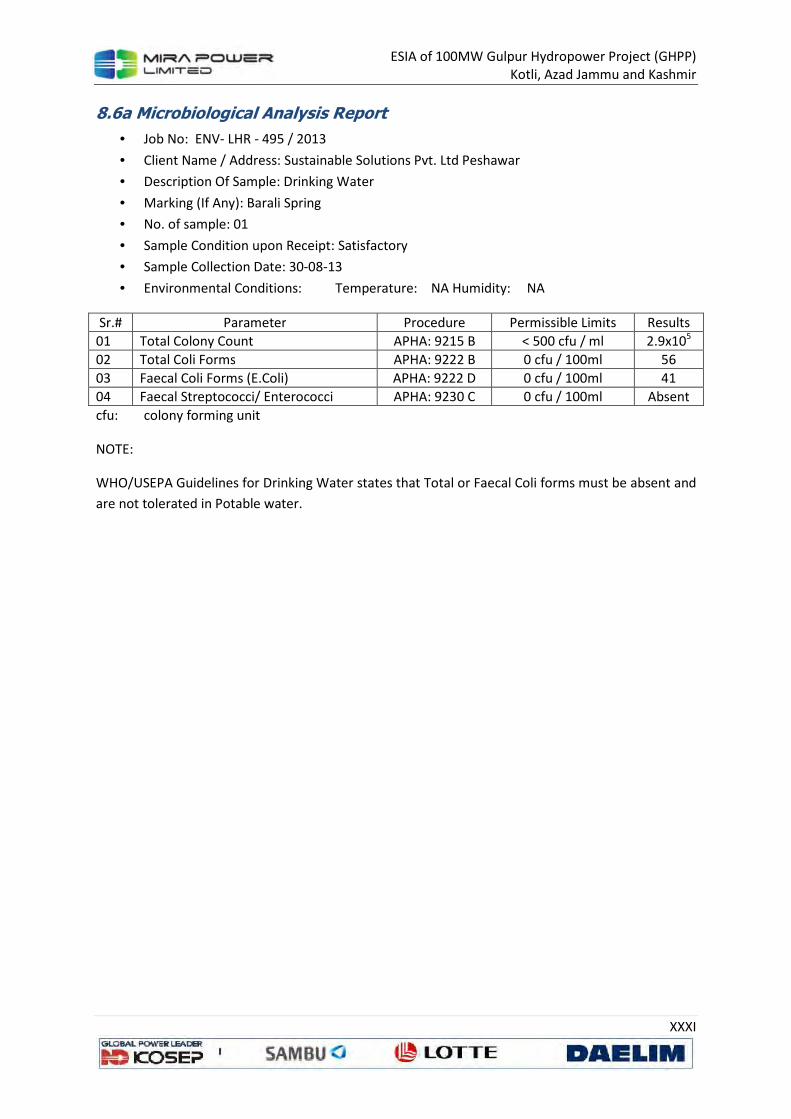
ESIA of 100MW Gulpur Hydropower Project (GHPP)
Kotli, Azad Jammu and Kashmir
XXXI
8.6a Microbiological Analysis Report
• Job No: ENV- LHR - 495 / 2013
• Client Name / Address: Sustainable Solutions Pvt. Ltd Peshawar
• Description Of Sample: Drinking Water
• Marking (If Any): Barali Spring
• No. of sample: 01
• Sample Condition upon Receipt: Satisfactory
• Sample Collection Date: 30-08-13
• Environmental Conditions: Temperature: NA Humidity: NA
Sr.# Parameter Procedure Permissible Limits Results
01 Total Colony Count APHA: 9215 B < 500 cfu / ml 2.9x10⁵
02 Total Coli Forms APHA: 9222 B 0 cfu / 100ml 56
03 Faecal Coli Forms (E.Coli) APHA: 9222 D 0 cfu / 100ml 41
04 Faecal Streptococci/ Enterococci APHA: 9230 C 0 cfu / 100ml Absent
cfu: colony forming unit
NOTE:
WHO/USEPA Guidelines for Drinking Water states that Total or Faecal Coli forms must be absent and
are not tolerated in Potable water.

ESIA of 100MW Gulpur Hydropower Project (GHPP)
Kotli, Azad Jammu and Kashmir
XXXII
8.6b Chemical Laboratory Test Report
• Job No: ENV - LHR - 495 / 2013
• Client Name / Address: Sustainable Solutions Pvt. Ltd Peshawar
• Description of Sample: Drinking Water
• Marking (If Any): Barali Spring
• No. of sample: 01
• Sample Condition upon Receipt: Satisfactory
• Sample Collection Date: 30-08-13
• Environmental Conditions: Temperature: NA Humidity: NA
Sr.
#
Parameters Method Unit LDL Test
Results
Limits As Per
NEQS
01 pH @ 25 °C APHA-4500H+ B - 0.1 7.66 6.5-8.5
02 Solids, Total dissolved
(TDS)
APHA-2540 C mg/L 5.0 640.0 <1000
03 Hardness, Total as CaCO3 APHA-2340 B & C
mg/L 0.5 405.9 <500
04 Alkalinity, Total as CaCO3 APHA-2320 B mg/L 0.5 486.0 NS
05 Chloride (Cl)-1 APHA-4500CI- B mg/L 0.5 19.56 <250
06 Sulfate (SO4)-2 APHA-4500-SO4 C
mg/L 5.0 41.57 NS
07 Lead ( Pb )+2 APHA-3111 B mg/L 0.01 0.027 ≤0.05
08 Arsenic (As)+3 APHA-3120 B mg/L 0.005 < 0.005 0.01
09 Total Iron as (Fe)+3/+2 APHA-3111 B mg/L 0.02 0.033 NS
10 Sodium (Na)+1 APHA-3111 B mg/L 1.0 83.76 NS
11 Potassium (K)+1 APHA-3111 B mg/L 0.2 3.869 NS
REMARKS: LDL: Lowest Detection Limit NS: Not Specified
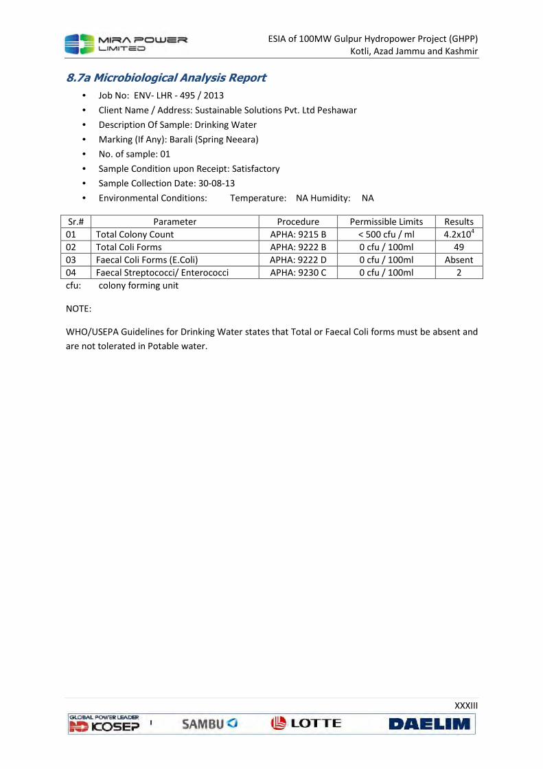
ESIA of 100MW Gulpur Hydropower Project (GHPP)
Kotli, Azad Jammu and Kashmir
XXXIII
8.7a Microbiological Analysis Report
• Job No: ENV- LHR - 495 / 2013
• Client Name / Address: Sustainable Solutions Pvt. Ltd Peshawar
• Description Of Sample: Drinking Water
• Marking (If Any): Barali (Spring Neeara)
• No. of sample: 01
• Sample Condition upon Receipt: Satisfactory
• Sample Collection Date: 30-08-13
• Environmental Conditions: Temperature: NA Humidity: NA
Sr.# Parameter Procedure Permissible Limits Results
01 Total Colony Count APHA: 9215 B < 500 cfu / ml 4.2x10⁴
02 Total Coli Forms APHA: 9222 B 0 cfu / 100ml 49
03 Faecal Coli Forms (E.Coli) APHA: 9222 D 0 cfu / 100ml Absent
04 Faecal Streptococci/ Enterococci APHA: 9230 C 0 cfu / 100ml 2
cfu: colony forming unit
NOTE:
WHO/USEPA Guidelines for Drinking Water states that Total or Faecal Coli forms must be absent and
are not tolerated in Potable water.

ESIA of 100MW Gulpur Hydropower Project (GHPP)
Kotli, Azad Jammu and Kashmir
XXXIV
8.7b Chemical Laboratory Test Report
• Job No: ENV - LHR - 495 / 2013
• Client Name / Address: Sustainable Solutions Pvt. Ltd Peshawar
• Description of Sample: Drinking Water
• Marking (If Any): Barali (Spring Neeara)
• No. of sample: 01
• Sample Condition upon Receipt: Satisfactory
• Sample Collection Date: 30-08-13
• Environmental Conditions: Temperature: NA Humidity: NA
Sr.
#
Parameters Method Unit LDL Test
Results
Limits As Per
NEQS
01 pH @ 25 °C APHA-4500H+ B - 0.1 7.70 6.5-8.5
02 Solids, Total dissolved
(TDS)
APHA-2540 C mg/L 5.0 618.0 <1000
03 Hardness, Total as CaCO3 APHA-2340 B & C
mg/L 0.5 425.7 <500
04 Alkalinity, Total as CaCO3 APHA-2320 B mg/L 0.5 507.6 NS
05 Chloride (Cl)-1 APHA-4500CI- B mg/L 0.5 19.56 <250
06 Sulfate (SO4)-2 APHA-4500-SO4 C
mg/L 5.0 47.33 NS
07 Lead ( Pb )+2 APHA-3111 B mg/L 0.01 <0.01 ≤0.05
08 Arsenic (As)+3 APHA-3120 B mg/L 0.005 < 0.005 0.01
09 Total Iron as (Fe)+3/+2 APHA-3111 B mg/L 0.02 0.041 NS
10 Sodium (Na)+1 APHA-3111 B mg/L 1.0 83.60 NS
11 Potassium (K)+1 APHA-3111 B mg/L 0.2 3.805 NS
REMARKS: LDL: Lowest Detection Limit NS: Not Specified
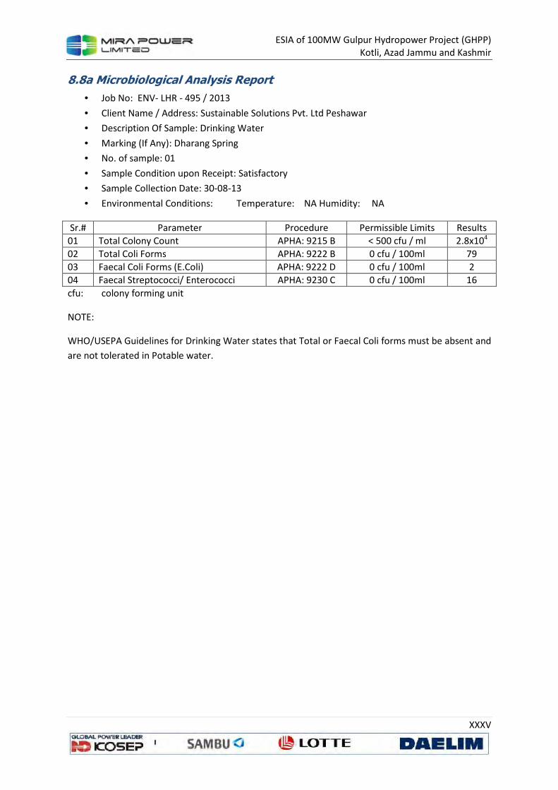
ESIA of 100MW Gulpur Hydropower Project (GHPP)
Kotli, Azad Jammu and Kashmir
XXXV
8.8a Microbiological Analysis Report
• Job No: ENV- LHR - 495 / 2013
• Client Name / Address: Sustainable Solutions Pvt. Ltd Peshawar
• Description Of Sample: Drinking Water
• Marking (If Any): Dharang Spring
• No. of sample: 01
• Sample Condition upon Receipt: Satisfactory
• Sample Collection Date: 30-08-13
• Environmental Conditions: Temperature: NA Humidity: NA
Sr.# Parameter Procedure Permissible Limits Results
01 Total Colony Count APHA: 9215 B < 500 cfu / ml 2.8x10⁴
02 Total Coli Forms APHA: 9222 B 0 cfu / 100ml 79
03 Faecal Coli Forms (E.Coli) APHA: 9222 D 0 cfu / 100ml 2
04 Faecal Streptococci/ Enterococci APHA: 9230 C 0 cfu / 100ml 16
cfu: colony forming unit
NOTE:
WHO/USEPA Guidelines for Drinking Water states that Total or Faecal Coli forms must be absent and
are not tolerated in Potable water.
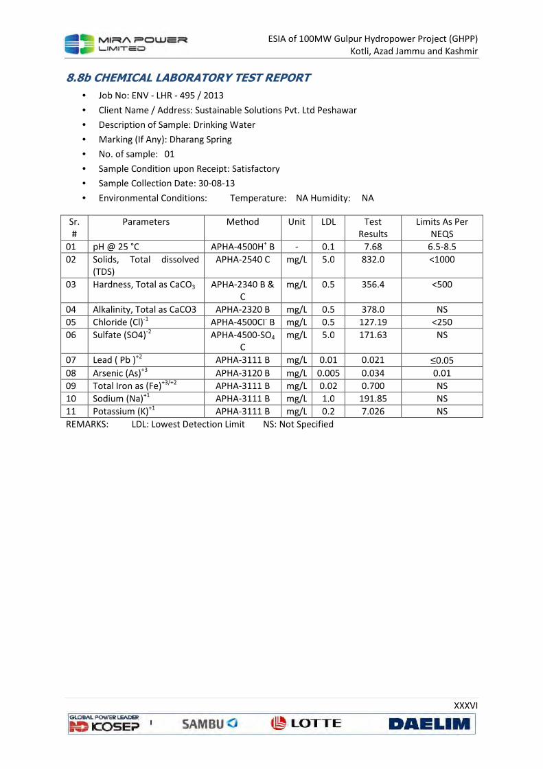
ESIA of 100MW Gulpur Hydropower Project (GHPP)
Kotli, Azad Jammu and Kashmir
XXXVI
8.8b CHEMICAL LABORATORY TEST REPORT
• Job No: ENV - LHR - 495 / 2013
• Client Name / Address: Sustainable Solutions Pvt. Ltd Peshawar
• Description of Sample: Drinking Water
• Marking (If Any): Dharang Spring
• No. of sample: 01
• Sample Condition upon Receipt: Satisfactory
• Sample Collection Date: 30-08-13
• Environmental Conditions: Temperature: NA Humidity: NA
Sr.
#
Parameters Method Unit LDL Test
Results
Limits As Per
NEQS
01 pH @ 25 °C APHA-4500H+ B - 0.1 7.68 6.5-8.5
02 Solids, Total dissolved
(TDS)
APHA-2540 C mg/L 5.0 832.0 <1000
03 Hardness, Total as CaCO3 APHA-2340 B & C
mg/L 0.5 356.4 <500
04 Alkalinity, Total as CaCO3 APHA-2320 B mg/L 0.5 378.0 NS
05 Chloride (Cl)-1 APHA-4500CI- B mg/L 0.5 127.19 <250
06 Sulfate (SO4)-2 APHA-4500-SO4 C
mg/L 5.0 171.63 NS
07 Lead ( Pb )+2 APHA-3111 B mg/L 0.01 0.021 ≤0.05
08 Arsenic (As)+3 APHA-3120 B mg/L 0.005 0.034 0.01
09 Total Iron as (Fe)+3/+2 APHA-3111 B mg/L 0.02 0.700 NS
10 Sodium (Na)+1 APHA-3111 B mg/L 1.0 191.85 NS
11 Potassium (K)+1 APHA-3111 B mg/L 0.2 7.026 NS
REMARKS: LDL: Lowest Detection Limit NS: Not Specified

ESIA of 100MW Gulpur Hydropower Project (GHPP)
Kotli, Azad Jammu and Kashmir
XXXVII
8.9a Microbiological Analysis Report
• Job No: ENV- LHR - 495 / 2013
• Client Name / Address: Sustainable Solutions Pvt. Ltd Peshawar
• Description Of Sample: Drinking Water
• Marking (If Any): M. Shafiq S/O M. Usman (Dharang)
• No. of sample: 01
• Sample Condition upon Receipt: Satisfactory
• Sample Collection Date: 30-08-13
• Environmental Conditions: Temperature: NA Humidity: NA
Sr.# Parameter Procedure Permissible Limits Results
01 Total Colony Count APHA: 9215 B < 500 cfu / ml 7.3x10⁴
02 Total Coli Forms APHA: 9222 B 0 cfu / 100ml 64
03 Faecal Coli Forms (E.Coli) APHA: 9222 D 0 cfu / 100ml Absent
04 Faecal Streptococci/ Enterococci APHA: 9230 C 0 cfu / 100ml 12
cfu: colony forming unit
NOTE:
WHO/USEPA Guidelines for Drinking Water states that Total or Faecal Coli forms must be absent and
are not tolerated in Potable water.
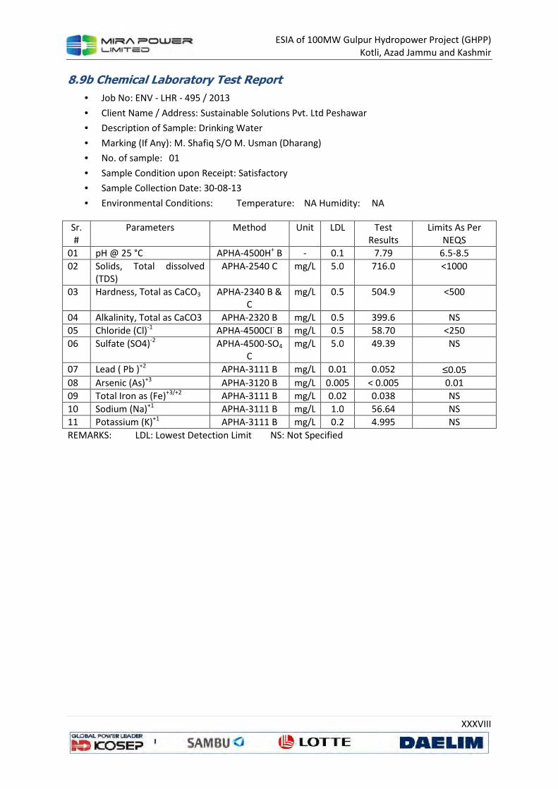
ESIA of 100MW Gulpur Hydropower Project (GHPP)
Kotli, Azad Jammu and Kashmir
XXXVIII
8.9b Chemical Laboratory Test Report
• Job No: ENV - LHR - 495 / 2013
• Client Name / Address: Sustainable Solutions Pvt. Ltd Peshawar
• Description of Sample: Drinking Water
• Marking (If Any): M. Shafiq S/O M. Usman (Dharang)
• No. of sample: 01
• Sample Condition upon Receipt: Satisfactory
• Sample Collection Date: 30-08-13
• Environmental Conditions: Temperature: NA Humidity: NA
Sr. #
Parameters Method Unit LDL Test Results
Limits As Per NEQS
01 pH @ 25 °C APHA-4500H+ B - 0.1 7.79 6.5-8.5
02 Solids, Total dissolved (TDS)
APHA-2540 C mg/L 5.0 716.0 <1000
03 Hardness, Total as CaCO3 APHA-2340 B & C
mg/L 0.5 504.9 <500
04 Alkalinity, Total as CaCO3 APHA-2320 B mg/L 0.5 399.6 NS
05 Chloride (Cl)-1 APHA-4500CI- B mg/L 0.5 58.70 <250
06 Sulfate (SO4)-2 APHA-4500-SO4 C
mg/L 5.0 49.39 NS
07 Lead ( Pb )+2 APHA-3111 B mg/L 0.01 0.052 ≤0.05
08 Arsenic (As)+3 APHA-3120 B mg/L 0.005 < 0.005 0.01
09 Total Iron as (Fe)+3/+2 APHA-3111 B mg/L 0.02 0.038 NS
10 Sodium (Na)+1 APHA-3111 B mg/L 1.0 56.64 NS
11 Potassium (K)+1 APHA-3111 B mg/L 0.2 4.995 NS
REMARKS: LDL: Lowest Detection Limit NS: Not Specified
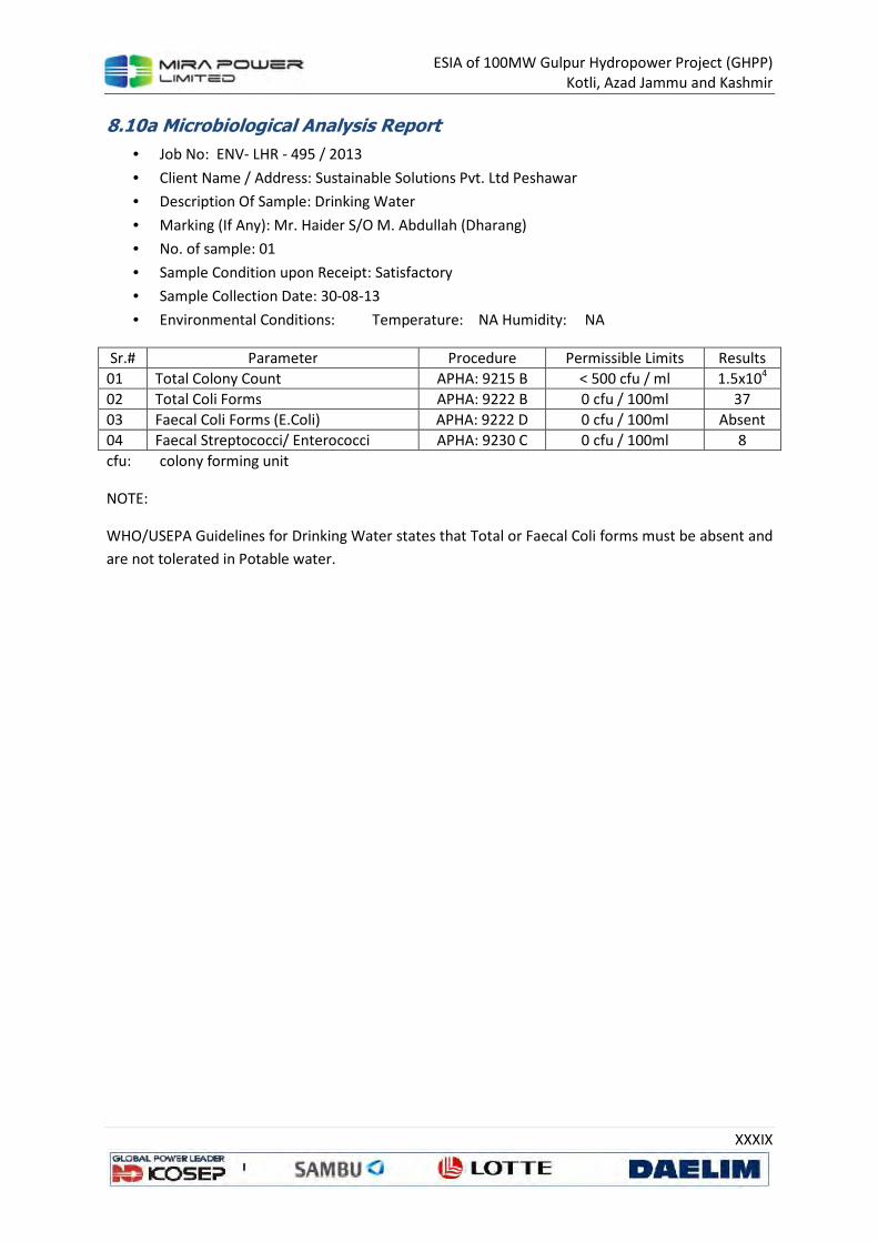
ESIA of 100MW Gulpur Hydropower Project (GHPP)
Kotli, Azad Jammu and Kashmir
XXXIX
8.10a Microbiological Analysis Report
• Job No: ENV- LHR - 495 / 2013
• Client Name / Address: Sustainable Solutions Pvt. Ltd Peshawar
• Description Of Sample: Drinking Water
• Marking (If Any): Mr. Haider S/O M. Abdullah (Dharang)
• No. of sample: 01
• Sample Condition upon Receipt: Satisfactory
• Sample Collection Date: 30-08-13
• Environmental Conditions: Temperature: NA Humidity: NA
Sr.# Parameter Procedure Permissible Limits Results
01 Total Colony Count APHA: 9215 B < 500 cfu / ml 1.5x10⁴
02 Total Coli Forms APHA: 9222 B 0 cfu / 100ml 37
03 Faecal Coli Forms (E.Coli) APHA: 9222 D 0 cfu / 100ml Absent
04 Faecal Streptococci/ Enterococci APHA: 9230 C 0 cfu / 100ml 8
cfu: colony forming unit
NOTE:
WHO/USEPA Guidelines for Drinking Water states that Total or Faecal Coli forms must be absent and
are not tolerated in Potable water.
ESIA of 100MW Gulpur Hydropower Project (GHPP)
Kotli, Azad Jammu and Kashmir
XL
8.10b Chemical Laboratory Test Report
• Job No: ENV - LHR - 495 / 2013
• Client Name / Address: Sustainable Solutions Pvt. Ltd Peshawar
• Description of Sample: Drinking Water
• Marking (If Any): Mr. Haider S/O M. Abdullah (Dharang)
• No. of sample: 01
• Sample Condition upon Receipt: Satisfactory
• Sample Collection Date: 30-08-13
• Environmental Conditions: Temperature: NA Humidity: NA
Sr. #
Parameters Method Unit LDL Test Results
Limits As Per NEQS
01 pH @ 25 °C APHA-4500H+ B - 0.1 7.81 6.5-8.5
02 Solids, Total dissolved (TDS)
APHA-2540 C mg/L 5.0 698.0 <1000
03 Hardness, Total as CaCO3 APHA-2340 B & C
mg/L 0.5 495.0 <500
04 Alkalinity, Total as CaCO3 APHA-2320 B mg/L 0.5 378.0 NS
05 Chloride (Cl)-1 APHA-4500CI- B mg/L 0.5 53.81 <250
06 Sulfate (SO4)-2 APHA-4500-SO4 C
mg/L 5.0 51.45 NS
07 Lead ( Pb )+2 APHA-3111 B mg/L 0.01 0.025 ≤0.05
08 Arsenic (As)+3 APHA-3120 B mg/L 0.005 < 0.005 0.01
09 Total Iron as (Fe)+3/+2 APHA-3111 B mg/L 0.02 0.029 NS
10 Sodium (Na)+1 APHA-3111 B mg/L 1.0 57.06 NS
11 Potassium (K)+1 APHA-3111 B mg/L 0.2 5.00 NS
REMARKS: LDL: Lowest Detection Limit NS: Not Specified

ESIA of 100MW Gulpur Hydropower Project (GHPP)
Kotli, Azad Jammu and Kashmir
XLI
8.11a Microbiological Analysis Report
• Job No: ENV- LHR - 495 / 2013
• Client Name / Address: Sustainable Solutions Pvt. Ltd Peshawar
• Description Of Sample: Drinking Water
• Marking (If Any): Mandi Juzvi (Spring Water)
• No. of sample: 01
• Sample Condition upon Receipt: Satisfactory
• Sample Collection Date: 30-08-13
• Environmental Conditions: Temperature: NA Humidity: NA
Sr.# Parameter Procedure Permissible Limits Results
01 Total Colony Count APHA: 9215 B < 500 cfu / ml 1.1x10⁴
02 Total Coli Forms APHA: 9222 B 0 cfu / 100ml 45
03 Faecal Coli Forms (E.Coli) APHA: 9222 D 0 cfu / 100ml Absent
04 Faecal Streptococci/ Enterococci APHA: 9230 C 0 cfu / 100ml 11
cfu: colony forming unit
NOTE:
WHO/USEPA Guidelines for Drinking Water states that Total or Faecal Coli forms must be absent and
are not tolerated in Potable water.

ESIA of 100MW Gulpur Hydropower Project (GHPP)
Kotli, Azad Jammu and Kashmir
XLII
8.11b Chemical Laboratory Test Report
• Job No: ENV - LHR - 495 / 2013
• Client Name / Address: Sustainable Solutions Pvt. Ltd Peshawar
• Description of Sample: Drinking Water
• Marking (If Any): Mandi Juzvi (Spring Water)
• No. of sample: 01
• Sample Condition upon Receipt: Satisfactory
• Sample Collection Date: 30-08-13
• Environmental Conditions: Temperature: NA Humidity: NA
Sr.
#
Parameters Method Unit LDL Test
Results
Limits As Per
NEQS
01 pH @ 25 °C APHA-4500H+ B - 0.1 7.69 6.5-8.5
02 Solids, Total dissolved
(TDS)
APHA-2540 C mg/L 5.0 595.0 <1000
03 Hardness, Total as CaCO3 APHA-2340 B & C
mg/L 0.5 455.4 <500
04 Alkalinity, Total as CaCO3 APHA-2320 B mg/L 0.5 351.0 NS
05 Chloride (Cl)-1 APHA-4500CI- B mg/L 0.5 44.02 <250
06 Sulfate (SO4)-2 APHA-4500-SO4 C
mg/L 5.0 48.56 NS
07 Lead ( Pb )+2 APHA-3111 B mg/L 0.01 0.040 ≤0.05
08 Arsenic (As)+3 APHA-3120 B mg/L 0.005 < 0.005 0.01
09 Total Iron as (Fe)+3/+2 APHA-3111 B mg/L 0.02 0.075 NS
10 Sodium (Na)+1 APHA-3111 B mg/L 1.0 47.74 NS
11 Potassium (K)+1 APHA-3111 B mg/L 0.2 4.912 NS
REMARKS: LDL: Lowest Detection Limit NS: Not Specified

ESIA of 100MW Gulpur Hydropower Project (GHPP)
Kotli, Azad Jammu and Kashmir
XLIII
8.12a Microbiological Analysis Report
• Job No: ENV- LHR - 495 / 2013
• Client Name / Address: Sustainable Solutions Pvt. Ltd Peshawar
• Description Of Sample: Drinking Water
• Marking (If Any): Mandi Juzvi (Spring Water)
• No. of sample: 01
• Sample Condition upon Receipt: Satisfactory
• Sample Collection Date: 30-08-13
• Environmental Conditions: Temperature: NA Humidity: NA
Sr.# Parameter Procedure Permissible Limits Results
01 Total Colony Count APHA: 9215 B < 500 cfu / ml 9.9x10⁴
02 Total Coli Forms APHA: 9222 B 0 cfu / 100ml 52
03 Faecal Coli Forms (E.Coli) APHA: 9222 D 0 cfu / 100ml Absent
04 Faecal Streptococci/ Enterococci APHA: 9230 C 0 cfu / 100ml 24
cfu: colony forming unit
NOTE:
WHO/USEPA Guidelines for Drinking Water states that Total or Faecal Coli forms must be absent and
are not tolerated in Potable water.

ESIA of 100MW Gulpur Hydropower Project (GHPP)
Kotli, Azad Jammu and Kashmir
XLIV
8.12b Chemical Laboratory Test Report
• Job No: ENV - LHR - 495 / 2013
• Client Name / Address: Sustainable Solutions Pvt. Ltd Peshawar
• Description of Sample: Drinking Water
• Marking (If Any): Mandi Juzvi (Spring Water)
• No. of sample: 01
• Sample Condition upon Receipt: Satisfactory
• Sample Collection Date: 30-08-13
• Environmental Conditions: Temperature: NA Humidity: NA
Sr.
#
Parameters Method Unit LDL Test
Results
Limits As Per
NEQS
01 pH @ 25 °C APHA-4500H+ B - 0.1 7.16 6.5-8.5
02 Solids, Total dissolved
(TDS)
APHA-2540 C mg/L 5.0 590.0 <1000
03 Hardness, Total as CaCO3 APHA-2340 B & C
mg/L 0.5 455.4 <500
04 Alkalinity, Total as CaCO3 APHA-2320 B mg/L 0.5 356.4 NS
05 Chloride (Cl)-1 APHA-4500CI- B mg/L 0.5 39.13 <250
06 Sulfate (SO4)-2 APHA-4500-SO4 C
mg/L 5.0 59.68 NS
07 Lead ( Pb )+2 APHA-3111 B mg/L 0.01 <0.01 ≤0.05
08 Arsenic (As)+3 APHA-3120 B mg/L 0.005 < 0.005 0.01
09 Total Iron as (Fe)+3/+2 APHA-3111 B mg/L 0.02 0.038 NS
10 Sodium (Na)+1 APHA-3111 B mg/L 1.0 48.0 NS
11 Potassium (K)+1 APHA-3111 B mg/L 0.2 4.778 NS
REMARKS: LDL: Lowest Detection Limit NS: Not Specified

ESIA of 100MW Gulpur Hydropower Project (GHPP)
Kotli, Azad Jammu and Kashmir
XLV
8.13a Microbiological Analysis Report
• Job No: ENV- LHR - 495 / 2013
• Client Name / Address: Sustainable Solutions Pvt. Ltd Peshawar
• Description Of Sample: Drinking Water
• Marking (If Any): Mandi Juzvi (Spring Water)
• No. of sample: 01
• Sample Condition upon Receipt: Satisfactory
• Sample Collection Date: 30-08-13
• Environmental Conditions: Temperature: NA Humidity: NA
Sr.# Parameter Procedure Permissible Limits Results
01 Total Colony Count APHA: 9215 B < 500 cfu / ml 9.1x10⁴
02 Total Coli Forms APHA: 9222 B 0 cfu / 100ml 48
03 Faecal Coli Forms (E.Coli) APHA: 9222 D 0 cfu / 100ml Absent
04 Faecal Streptococci/ Enterococci APHA: 9230 C 0 cfu / 100ml 48
cfu: colony forming unit
NOTE:
WHO/USEPA Guidelines for Drinking Water states that Total or Faecal Coli forms must be absent and
are not tolerated in Potable water.

ESIA of 100MW Gulpur Hydropower Project (GHPP)
Kotli, Azad Jammu and Kashmir
XLVI
8.13b Chemical Laboratory Test Report
• Job No: ENV - LHR - 495 / 2013
• Client Name / Address: Sustainable Solutions Pvt. Ltd Peshawar
• Description of Sample: Drinking Water
• Marking (If Any): Mandi Juzvi (Spring Water)
• No. of sample: 01
• Sample Condition upon Receipt: Satisfactory
• Sample Collection Date: 30-08-13
• Environmental Conditions: Temperature: NA Humidity: NA
Sr.
#
Parameters Method Unit LDL Test
Results
Limits As Per
NEQS
01 pH @ 25 °C APHA-4500H+ B - 0.1 7.17 6.5-8.5
02 Solids, Total dissolved
(TDS)
APHA-2540 C mg/L 5.0 600.0 <1000
03 Hardness, Total as CaCO3 APHA-2340 B & C
mg/L 0.5 455.4 <500
04 Alkalinity, Total as CaCO3 APHA-2320 B mg/L 0.5 351.0 NS
05 Chloride (Cl)-1 APHA-4500CI- B mg/L 0.5 44.02 <250
06 Sulfate (SO4)-2 APHA-4500-SO4 C
mg/L 5.0 59.68 NS
07 Lead ( Pb )+2 APHA-3111 B mg/L 0.01 <0.01 ≤0.05
08 Arsenic (As)+3 APHA-3120 B mg/L 0.005 < 0.005 0.01
09 Total Iron as (Fe)+3/+2 APHA-3111 B mg/L 0.02 0.021 NS
10 Sodium (Na)+1 APHA-3111 B mg/L 1.0 48.06 NS
11 Potassium (K)+1 APHA-3111 B mg/L 0.2 4.775 NS
REMARKS: LDL: Lowest Detection Limit NS: Not Specified

ESIA of 100MW Gulpur Hydropower Project (GHPP)
Kotli, Azad Jammu and Kashmir
XLVII
8.14a Microbiological Analysis Report
• Job No: ENV- LHR - 495 / 2013
• Client Name / Address: Sustainable Solutions Pvt. Ltd Peshawar
• Description Of Sample: Drinking Water
• Marking (If Any): Hill Kalan (Spring Water)
• No. of sample: 01
• Sample Condition upon Receipt: Satisfactory
• Sample Collection Date: 30-08-13
• Environmental Conditions: Temperature: NA Humidity: NA
Sr.# Parameter Procedure Permissible Limits Results
01 Total Colony Count APHA: 9215 B < 500 cfu / ml 1.1x10⁵
02 Total Coli Forms APHA: 9222 B 0 cfu / 100ml 70
03 Faecal Coli Forms (E.Coli) APHA: 9222 D 0 cfu / 100ml 12
04 Faecal Streptococci/ Enterococci APHA: 9230 C 0 cfu / 100ml 48
cfu: colony forming unit
NOTE:
WHO/USEPA Guidelines for Drinking Water states that Total or Faecal Coli forms must be absent and
are not tolerated in Potable water.

ESIA of 100MW Gulpur Hydropower Project (GHPP)
Kotli, Azad Jammu and Kashmir
XLVIII
8.14b Chemical Laboratory Test Report
• Job No: ENV - LHR - 495 / 2013
• Client Name / Address: Sustainable Solutions Pvt. Ltd Peshawar
• Description of Sample: Drinking Water
• Marking (If Any): Hill Kalan (Spring Water)
• No. of sample: 01
• Sample Condition upon Receipt: Satisfactory
• Sample Collection Date: 30-08-13
• Environmental Conditions: Temperature: NA Humidity: NA
Sr.
#
Parameters Method Unit LDL Test
Results
Limits As Per
NEQS
01 pH @ 25 °C APHA-4500H+ B - 0.1 7.72 6.5-8.5
02 Solids, Total dissolved
(TDS)
APHA-2540 C mg/L 5.0 601.0 <1000
03 Hardness, Total as CaCO3 APHA-2340 B & C
mg/L 0.5 485.10 <500
04 Alkalinity, Total as CaCO3 APHA-2320 B mg/L 0.5 351.0 NS
05 Chloride (Cl)-1 APHA-4500CI- B mg/L 0.5 44.02 <250
06 Sulfate (SO4)-2 APHA-4500-SO4 C
mg/L 5.0 56.38 NS
07 Lead ( Pb )+2 APHA-3111 B mg/L 0.01 0.041 ≤0.05
08 Arsenic (As)+3 APHA-3120 B mg/L 0.005 < 0.005 0.01
09 Total Iron as (Fe)+3/+2 APHA-3111 B mg/L 0.02 0.033 NS
10 Sodium (Na)+1 APHA-3111 B mg/L 1.0 48.20 NS
11 Potassium (K)+1 APHA-3111 B mg/L 0.2 4.798 NS
REMARKS: LDL: Lowest Detection Limit NS: Not Specified
ESIA of 100MW Gulpur Hydropower Project (GHPP)
Kotli, Azad Jammu and Kashmir
XLIX
8.15a Microbiological Analysis Report
• Job No: ENV- LHR - 495 / 2013
• Client Name / Address: Sustainable Solutions Pvt. Ltd Peshawar
• Description Of Sample: Drinking Water
• Marking (If Any): Hill Kalan (Spring Water)
• No. of sample: 01
• Sample Condition upon Receipt: Satisfactory
• Sample Collection Date: 30-08-13
• Environmental Conditions: Temperature: NA Humidity: NA
Sr.# Parameter Procedure Permissible Limits Results
01 Total Colony Count APHA: 9215 B < 500 cfu / ml 6.2x10⁴
02 Total Coli Forms APHA: 9222 B 0 cfu / 100ml 74
03 Faecal Coli Forms (E.Coli) APHA: 9222 D 0 cfu / 100ml Absent
04 Faecal Streptococci/ Enterococci APHA: 9230 C 0 cfu / 100ml 18
cfu: colony forming unit
NOTE:
WHO/USEPA Guidelines for Drinking Water states that Total or Faecal Coli forms must be absent and
are not tolerated in Potable water.
ESIA of 100MW Gulpur Hydropower Project (GHPP)
Kotli, Azad Jammu and Kashmir
L
8.15b Chemical Laboratory Test Report
• Job No: ENV - LHR - 495 / 2013
• Client Name / Address: Sustainable Solutions Pvt. Ltd Peshawar
• Description of Sample: Drinking Water
• Marking (If Any): Hill Kalan (Spring Water)
• No. of sample: 01
• Sample Condition upon Receipt: Satisfactory
• Sample Collection Date: 30-08-13
• Environmental Conditions: Temperature: NA Humidity: NA
Sr.
#
Parameters Method Unit LDL Test
Results
Limits As Per
NEQS
01 pH @ 25 °C APHA-4500H+ B - 0.1 7.80 6.5-8.5
02 Solids, Total dissolved
(TDS)
APHA-2540 C mg/L 5.0 580.0 <1000
03 Hardness, Total as CaCO3 APHA-2340 B & C
mg/L 0.5 435.6 <500
04 Alkalinity, Total as CaCO3 APHA-2320 B mg/L 0.5 340.2 NS
05 Chloride (Cl)-1 APHA-4500CI- B mg/L 0.5 44.02 <250
06 Sulfate (SO4)-2 APHA-4500-SO4 C
mg/L 5.0 52.27 NS
07 Lead ( Pb )+2 APHA-3111 B mg/L 0.01 <0.01 ≤0.05
08 Arsenic (As)+3 APHA-3120 B mg/L 0.005 < 0.005 0.01
09 Total Iron as (Fe)+3/+2 APHA-3111 B mg/L 0.02 0.546 NS
10 Sodium (Na)+1 APHA-3111 B mg/L 1.0 47.84 NS
11 Potassium (K)+1 APHA-3111 B mg/L 0.2 4.753 NS
REMARKS: LDL: Lowest Detection Limit NS: Not Specified

ESIA of 100MW Gulpur Hydropower Project (GHPP)
Kotli, Azad Jammu and Kashmir
LI
8.16a Microbiological Analysis Report
• Job No: ENV- LHR - 495 / 2013
• Client Name / Address: Sustainable Solutions Pvt. Ltd Peshawar
• Description Of Sample: Drinking Water
• Marking (If Any): Hill Kalan (Spring Water)
• No. of sample: 01
• Sample Condition upon Receipt: Satisfactory
• Sample Collection Date: 30-08-13
• Environmental Conditions: Temperature: NA Humidity: NA
Sr.# Parameter Procedure Permissible Limits Results
01 Total Colony Count APHA: 9215 B < 500 cfu / ml 1.4x10⁵
02 Total Coli Forms APHA: 9222 B 0 cfu / 100ml 65
03 Faecal Coli Forms (E.Coli) APHA: 9222 D 0 cfu / 100ml 6
04 Faecal Streptococci/ Enterococci APHA: 9230 C 0 cfu / 100ml 12
cfu: colony forming unit
NOTE:
WHO/USEPA Guidelines for Drinking Water states that Total or Faecal Coli forms must be absent and
are not tolerated in Potable water.

ESIA of 100MW Gulpur Hydropower Project (GHPP)
Kotli, Azad Jammu and Kashmir
LII
8.16b Chemical Laboratory Test Report
• Job No: ENV - LHR - 495 / 2013
• Client Name / Address: Sustainable Solutions Pvt. Ltd Peshawar
• Description of Sample: Drinking Water
• Marking (If Any): Hill Kalan (Spring Water)
• No. of sample: 01
• Sample Condition upon Receipt: Satisfactory
• Sample Collection Date: 30-08-13
• Environmental Conditions: Temperature: NA Humidity: NA
Sr.
#
Parameters Method Unit LDL Test
Results
Limits As Per
NEQS
01 pH @ 25 °C APHA-4500H+ B - 0.1 7.80 6.5-8.5
02 Solids, Total dissolved
(TDS)
APHA-2540 C mg/L 5.0 590.0 <1000
03 Hardness, Total as CaCO3 APHA-2340 B & C
mg/L 0.5 504.9 <500
04 Alkalinity, Total as CaCO3 APHA-2320 B mg/L 0.5 334.8 NS
05 Chloride (Cl)-1 APHA-4500CI- B mg/L 0.5 39.13 <250
06 Sulfate (SO4)-2 APHA-4500-SO4 C
mg/L 5.0 51.45 NS
07 Lead ( Pb )+2 APHA-3111 B mg/L 0.01 <0.01 ≤0.05
08 Arsenic (As)+3 APHA-3120 B mg/L 0.005 < 0.005 0.01
09 Total Iron as (Fe)+3/+2 APHA-3111 B mg/L 0.02 0.026 NS
10 Sodium (Na)+1 APHA-3111 B mg/L 1.0 47.66 NS
11 Potassium (K)+1 APHA-3111 B mg/L 0.2 4.763 NS
REMARKS: LDL: Lowest Detection Limit NS: Not Specified
ESIA of 100MW Gulpur Hydropower Project (GHPP)
Kotli, Azad Jammu and Kashmir
LIII
8.17a Microbiological Analysis Report
• Job No: ENV- LHR - 495 / 2013
• Client Name / Address: Sustainable Solutions Pvt. Ltd Peshawar
• Description Of Sample: Drinking Water
• Marking (If Any): Hill Khurd (Spring Water)
• No. of sample: 01
• Sample Condition upon Receipt: Satisfactory
• Sample Collection Date: 30-08-13
• Environmental Conditions: Temperature: NA Humidity: NA
Sr.# Parameter Procedure Permissible Limits Results
01 Total Colony Count APHA: 9215 B < 500 cfu / ml 1.1x10⁵
02 Total Coli Forms APHA: 9222 B 0 cfu / 100ml 55
03 Faecal Coli Forms (E.Coli) APHA: 9222 D 0 cfu / 100ml 4
04 Faecal Streptococci/ Enterococci APHA: 9230 C 0 cfu / 100ml 14
cfu: colony forming unit
NOTE:
WHO/USEPA Guidelines for Drinking Water states that Total or Faecal Coli forms must be absent and
are not tolerated in Potable water.

ESIA of 100MW Gulpur Hydropower Project (GHPP)
Kotli, Azad Jammu and Kashmir
LIV
8.17b Chemical Laboratory Test Report
• Job No: ENV - LHR - 495 / 2013
• Client Name / Address: Sustainable Solutions Pvt. Ltd Peshawar
• Description of Sample: Drinking Water
• Marking (If Any): Hill Khurd (Spring Water)
• No. of sample: 01
• Sample Condition upon Receipt: Satisfactory
• Sample Collection Date: 30-08-13
• Environmental Conditions: Temperature: NA Humidity: NA
Sr.
#
Parameters Method Unit LDL Test
Results
Limits As Per
NEQS
01 pH @ 25 °C APHA-4500H+ B - 0.1 7.45 6.5-8.5
02 Solids, Total dissolved
(TDS)
APHA-2540 C mg/L 5.0 589.0 <1000
03 Hardness, Total as CaCO3 APHA-2340 B & C
mg/L 0.5 485.10 <500
04 Alkalinity, Total as CaCO3 APHA-2320 B mg/L 0.5 351.0 NS
05 Chloride (Cl)-1 APHA-4500CI- B mg/L 0.5 44.02 <250
06 Sulfate (SO4)-2 APHA-4500-SO4 C
mg/L 5.0 46.51 NS
07 Lead ( Pb )+2 APHA-3111 B mg/L 0.01 0.080 ≤0.05
08 Arsenic (As)+3 APHA-3120 B mg/L 0.005 < 0.005 0.01
09 Total Iron as (Fe)+3/+2 APHA-3111 B mg/L 0.02 0.024 NS
10 Sodium (Na)+1 APHA-3111 B mg/L 1.0 48.46 NS
11 Potassium (K)+1 APHA-3111 B mg/L 0.2 4.784 NS
REMARKS: LDL: Lowest Detection Limit NS: Not Specified

ESIA of 100MW Gulpur Hydropower Project (GHPP)
Kotli, Azad Jammu and Kashmir
LV
8.18a Microbiological Analysis Report
• Job No: ENV- LHR - 495 / 2013
• Client Name / Address: Sustainable Solutions Pvt. Ltd Peshawar
• Description Of Sample: Drinking Water
• Marking (If Any): Hill Khurd (Spring Water)
• No. of sample: 01
• Sample Condition upon Receipt: Satisfactory
• Sample Collection Date: 30-08-13
• Environmental Conditions: Temperature: NA Humidity: NA
Sr.# Parameter Procedure Permissible Limits Results
01 Total Colony Count APHA: 9215 B < 500 cfu / ml 9.5x10⁴
02 Total Coli Forms APHA: 9222 B 0 cfu / 100ml 57
03 Faecal Coli Forms (E.Coli) APHA: 9222 D 0 cfu / 100ml Absent
04 Faecal Streptococci/ Enterococci APHA: 9230 C 0 cfu / 100ml 40
cfu: colony forming unit
NOTE:
WHO/USEPA Guidelines for Drinking Water states that Total or Faecal Coli forms must be absent and
are not tolerated in Potable water.

ESIA of 100MW Gulpur Hydropower Project (GHPP)
Kotli, Azad Jammu and Kashmir
LVI
8.18b Chemical Laboratory Test Report
• Job No: ENV - LHR - 495 / 2013
• Client Name / Address: Sustainable Solutions Pvt. Ltd Peshawar
• Description of Sample: Drinking Water
• Marking (If Any): Hill Khurd (Spring Water)
• No. of sample: 01
• Sample Condition upon Receipt: Satisfactory
• Sample Collection Date: 30-08-13
• Environmental Conditions: Temperature: NA Humidity: NA
Sr.
#
Parameters Method Unit LDL Test
Results
Limits As Per
NEQS
01 pH @ 25 °C APHA-4500H+ B - 0.1 7.62 6.5-8.5
02 Solids, Total dissolved
(TDS)
APHA-2540 C mg/L 5.0 866.0 <1000
03 Hardness, Total as CaCO3 APHA-2340 B & C
mg/L 0.5 346.50 <500
04 Alkalinity, Total as CaCO3 APHA-2320 B mg/L 0.5 361.8 NS
05 Chloride (Cl)-1 APHA-4500CI- B mg/L 0.5 132.08 <250
06 Sulfate (SO4)-2 APHA-4500-SO4 C
mg/L 5.0 171.22 NS
07 Lead ( Pb )+2 APHA-3111 B mg/L 0.01 0.023 ≤0.05
08 Arsenic (As)+3 APHA-3120 B mg/L 0.005 0.018 0.01
09 Total Iron as (Fe)+3/+2 APHA-3111 B mg/L 0.02 0.333 NS
10 Sodium (Na)+1 APHA-3111 B mg/L 1.0 190.95 NS
11 Potassium (K)+1 APHA-3111 B mg/L 0.2 6.358 NS
REMARKS: LDL: Lowest Detection Limit NS: Not Specified

ESIA of 100MW Gulpur Hydropower Project (GHPP)
Kotli, Azad Jammu and Kashmir
LVII
8.19a Microbiological Analysis Report
• Job No: ENV- LHR - 495 / 2013
• Client Name / Address: Sustainable Solutions Pvt. Ltd Peshawar
• Description Of Sample: Drinking Water
• Marking (If Any): Hill Khurd (Spring Water)
• No. of sample: 01
• Sample Condition upon Receipt: Satisfactory
• Sample Collection Date: 30-08-13
• Environmental Conditions: Temperature: NA Humidity: NA
Sr.# Parameter Procedure Permissible Limits Results
01 Total Colony Count APHA: 9215 B < 500 cfu / ml 8.3x10⁴
02 Total Coli Forms APHA: 9222 B 0 cfu / 100ml 63
03 Faecal Coli Forms (E.Coli) APHA: 9222 D 0 cfu / 100ml 18
04 Faecal Streptococci/ Enterococci APHA: 9230 C 0 cfu / 100ml 22
cfu: colony forming unit
NOTE:
WHO/USEPA Guidelines for Drinking Water states that Total or Faecal Coli forms must be absent and
are not tolerated in Potable water.

ESIA of 100MW Gulpur Hydropower Project (GHPP)
Kotli, Azad Jammu and Kashmir
LVIII
8.19b Chemical Laboratory Test Report
• Job No: ENV - LHR - 495 / 2013
• Client Name / Address: Sustainable Solutions Pvt. Ltd Peshawar
• Description of Sample: Drinking Water
• Marking (If Any): Hill Khurd (Spring Water)
• No. of sample: 01
• Sample Condition upon Receipt: Satisfactory
• Sample Collection Date: 30-08-13
• Environmental Conditions: Temperature: NA Humidity: NA
Sr.
#
Parameters Method Unit LDL Test
Results
Limits As Per
NEQS
01 pH @ 25 °C APHA-4500H+ B - 0.1 7.67 6.5-8.5
02 Solids, Total dissolved
(TDS)
APHA-2540 C mg/L 5.0 602.0 <1000
03 Hardness, Total as CaCO3 APHA-2340 B & C
mg/L 0.5 485.10 <500
04 Alkalinity, Total as CaCO3 APHA-2320 B mg/L 0.5 351.0 NS
05 Chloride (Cl)-1 APHA-4500CI- B mg/L 0.5 44.02 <250
06 Sulfate (SO4)-2 APHA-4500-SO4 C
mg/L 5.0 51.45 NS
07 Lead ( Pb )+2 APHA-3111 B mg/L 0.01 0.040 ≤0.05
08 Arsenic (As)+3 APHA-3120 B mg/L 0.005 < 0.005 0.01
09 Total Iron as (Fe)+3/+2 APHA-3111 B mg/L 0.02 0.028 NS
10 Sodium (Na)+1 APHA-3111 B mg/L 1.0 47.50 NS
11 Potassium (K)+1 APHA-3111 B mg/L 0.2 4.774 NS
REMARKS: LDL: Lowest Detection Limit NS: Not Specified

ESIA of 100MW Gulpur Hydropower Project (GHPP)
Kotli, Azad Jammu and Kashmir
LIX
8.20a Microbiological Analysis Report
• Job No: ENV- LHR - 495 / 2013
• Client Name / Address: Sustainable Solutions Pvt. Ltd Peshawar
• Description Of Sample: Drinking Water
• Marking (If Any): Jamal Pur
• No. of sample: 01
• Sample Condition upon Receipt: Satisfactory
• Sample Collection Date: 30-08-13
• Environmental Conditions: Temperature: NA Humidity: NA
Sr.# Parameter Procedure Permissible Limits Results
01 Total Colony Count APHA: 9215 B < 500 cfu / ml 3.9x10⁴
02 Total Coli Forms APHA: 9222 B 0 cfu / 100ml TNTC
03 Faecal Coli Forms (E.Coli) APHA: 9222 D 0 cfu / 100ml Absent
04 Faecal Streptococci/ Enterococci APHA: 9230 C 0 cfu / 100ml 16
cfu: colony forming unit TNTC: Too Numerous To Count
NOTE:
WHO/USEPA Guidelines for Drinking Water states that Total or Faecal Coli forms must be absent and
are not tolerated in Potable water.

ESIA of 100MW Gulpur Hydropower Project (GHPP)
Kotli, Azad Jammu and Kashmir
LX
8.20b Chemical Laboratory Test Report
• Job No: ENV - LHR - 495 / 2013
• Client Name / Address: Sustainable Solutions Pvt. Ltd Peshawar
• Description of Sample: Drinking Water
• Marking (If Any): Jamal Pur
• No. of sample: 01
• Sample Condition upon Receipt: Satisfactory
• Sample Collection Date: 30-08-13
• Environmental Conditions: Temperature: NA Humidity: NA
Sr.
#
Parameters Method Unit LDL Test
Results
Limits As Per
NEQS
01 pH @ 25 °C APHA-4500H+ B - 0.1 7.83 6.5-8.5
02 Solids, Total dissolved
(TDS)
APHA-2540 C mg/L 5.0 498.0 <1000
03 Hardness, Total as CaCO3 APHA-2340 B & C
mg/L 0.5 386.10 <500
04 Alkalinity, Total as CaCO3 APHA-2320 B mg/L 0.5 324.0 NS
05 Chloride (Cl)-1 APHA-4500CI- B mg/L 0.5 24.46 <250
06 Sulfate (SO4)-2 APHA-4500-SO4 C
mg/L 5.0 25.51 NS
07 Lead ( Pb )+2 APHA-3111 B mg/L 0.01 0.021 ≤0.05
08 Arsenic (As)+3 APHA-3120 B mg/L 0.005 < 0.005 0.01
09 Total Iron as (Fe)+3/+2 APHA-3111 B mg/L 0.02 0.027 NS
10 Sodium (Na)+1 APHA-3111 B mg/L 1.0 31.10 NS
11 Potassium (K)+1 APHA-3111 B mg/L 0.2 2.710 NS
REMARKS: LDL: Lowest Detection Limit NS: Not Specified

ESIA of 100MW Gulpur Hydropower Project (GHPP)
Kotli, Azad Jammu and Kashmir
LXI
8.21a Microbiological Analysis Report
• Job No: ENV- LHR - 495 / 2013
• Client Name / Address: Sustainable Solutions Pvt. Ltd Peshawar
• Description Of Sample: Drinking Water
• Marking (If Any): Jamal Pur
• No. of sample: 01
• Sample Condition upon Receipt: Satisfactory
• Sample Collection Date: 30-08-13
• Environmental Conditions: Temperature: NA Humidity: NA
Sr.# Parameter Procedure Permissible Limits Results
01 Total Colony Count APHA: 9215 B < 500 cfu / ml 4.3x10⁴
02 Total Coli Forms APHA: 9222 B 0 cfu / 100ml 14
03 Faecal Coli Forms (E.Coli) APHA: 9222 D 0 cfu / 100ml Absent
04 Faecal Streptococci/ Enterococci APHA: 9230 C 0 cfu / 100ml 62
cfu: colony forming unit
NOTE:
WHO/USEPA Guidelines for Drinking Water states that Total or Faecal Coli forms must be absent and
are not tolerated in Potable water.

ESIA of 100MW Gulpur Hydropower Project (GHPP)
Kotli, Azad Jammu and Kashmir
LXII
8.21b Chemical Laboratory Test Report
• Job No: ENV - LHR - 495 / 2013
• Client Name / Address: Sustainable Solutions Pvt. Ltd Peshawar
• Description of Sample: Drinking Water
• Marking (If Any): Jamal Pur
• No. of sample: 01
• Sample Condition upon Receipt: Satisfactory
• Sample Collection Date: 30-08-13
• Environmental Conditions: Temperature: NA Humidity: NA
Sr.
#
Parameters Method Unit LDL Test
Results
Limits As Per
NEQS
01 pH @ 25 °C APHA-4500H+ B - 0.1 7.52 6.5-8.5
02 Solids, Total dissolved
(TDS)
APHA-2540 C mg/L 5.0 494.0 <1000
03 Hardness, Total as CaCO3 APHA-2340 B & C
mg/L 0.5 405.9 <500
04 Alkalinity, Total as CaCO3 APHA-2320 B mg/L 0.5 329.4 NS
05 Chloride (Cl)-1 APHA-4500CI- B mg/L 0.5 24.46 <250
06 Sulfate (SO4)-2 APHA-4500-SO4 C
mg/L 5.0 22.63 NS
07 Lead ( Pb )+2 APHA-3111 B mg/L 0.01 0.101 ≤0.05
08 Arsenic (As)+3 APHA-3120 B mg/L 0.005 < 0.005 0.01
09 Total Iron as (Fe)+3/+2 APHA-3111 B mg/L 0.02 0.030 NS
10 Sodium (Na)+1 APHA-3111 B mg/L 1.0 32.28 NS
11 Potassium (K)+1 APHA-3111 B mg/L 0.2 2.710 NS
REMARKS: LDL: Lowest Detection Limit NS: Not Specified

ESIA of 100MW Gulpur Hydropower Project (GHPP)
Kotli, Azad Jammu and Kashmir
LXIII
8.22a Microbiological Analysis Report
• Job No: ENV- LHR - 495 / 2013
• Client Name / Address: Sustainable Solutions Pvt. Ltd Peshawar
• Description Of Sample: Drinking Water
• Marking (If Any): Jamal Pur
• No. of sample: 01
• Sample Condition upon Receipt: Satisfactory
• Sample Collection Date: 30-08-13
• Environmental Conditions: Temperature: NA Humidity: NA
Sr.# Parameter Procedure Permissible Limits Results
01 Total Colony Count APHA: 9215 B < 500 cfu / ml 4.9x10⁴
02 Total Coli Forms APHA: 9222 B 0 cfu / 100ml TNTC
03 Faecal Coli Forms (E.Coli) APHA: 9222 D 0 cfu / 100ml 24
04 Faecal Streptococci/ Enterococci APHA: 9230 C 0 cfu / 100ml 50
cfu: colony forming unit TNTC: Too Numerous To Count
NOTE:
WHO/USEPA Guidelines for Drinking Water states that Total or Faecal Coli forms must be absent and
are not tolerated in Potable water.

ESIA of 100MW Gulpur Hydropower Project (GHPP)
Kotli, Azad Jammu and Kashmir
LXIV
8.22b Chemical Laboratory Test Report
• Job No: ENV - LHR - 495 / 2013
• Client Name / Address: Sustainable Solutions Pvt. Ltd Peshawar
• Description of Sample: Drinking Water
• Marking (If Any): Jamal Pur
• No. of sample: 01
• Sample Condition upon Receipt: Satisfactory
• Sample Collection Date: 30-08-13
• Environmental Conditions: Temperature: NA Humidity: NA
Sr.
#
Parameters Method Unit LDL Test
Results
Limits As Per
NEQS
01 pH @ 25 °C APHA-4500H+ B - 0.1 7.67 6.5-8.5
02 Solids, Total dissolved
(TDS)
APHA-2540 C mg/L 5.0 508.0 <1000
03 Hardness, Total as CaCO3 APHA-2340 B & C
mg/L 0.5 366.30 <500
04 Alkalinity, Total as CaCO3 APHA-2320 B mg/L 0.5 313.2 NS
05 Chloride (Cl)-1 APHA-4500CI- B mg/L 0.5 29.35 <250
06 Sulfate (SO4)-2 APHA-4500-SO4 C
mg/L 5.0 24.28 NS
07 Lead ( Pb )+2 APHA-3111 B mg/L 0.01 0.021 ≤0.05
08 Arsenic (As)+3 APHA-3120 B mg/L 0.005 < 0.005 0.01
09 Total Iron as (Fe)+3/+2 APHA-3111 B mg/L 0.02 0.039 NS
10 Sodium (Na)+1 APHA-3111 B mg/L 1.0 32.20 NS
11 Potassium (K)+1 APHA-3111 B mg/L 0.2 2.708 NS
REMARKS: LDL: Lowest Detection Limit NS: Not Specified

ESIA of 100MW Gulpur Hydropower Project (GHPP)
Kotli, Azad Jammu and Kashmir
LXV
8.23a Microbiological Analysis Report
• Job No: ENV- LHR - 495 / 2013
• Client Name / Address: Sustainable Solutions Pvt. Ltd Peshawar
• Description Of Sample: Drinking Water
• Marking (If Any): Aghar Colony
• No. of sample: 01
• Sample Condition upon Receipt: Satisfactory
• Sample Collection Date: 30-08-13
• Environmental Conditions: Temperature: NA Humidity: NA
Sr.# Parameter Procedure Permissible Limits Results
01 Total Colony Count APHA: 9215 B < 500 cfu / ml 6.5x10⁴
02 Total Coli Forms APHA: 9222 B 0 cfu / 100ml TNTC
03 Faecal Coli Forms (E.Coli) APHA: 9222 D 0 cfu / 100ml 40
04 Faecal Streptococci/ Enterococci APHA: 9230 C 0 cfu / 100ml 68
cfu: colony forming unit TNTC: Too Numerous To Count
NOTE:
WHO/USEPA Guidelines for Drinking Water states that Total or Faecal Coli forms must be absent and
are not tolerated in Potable water.
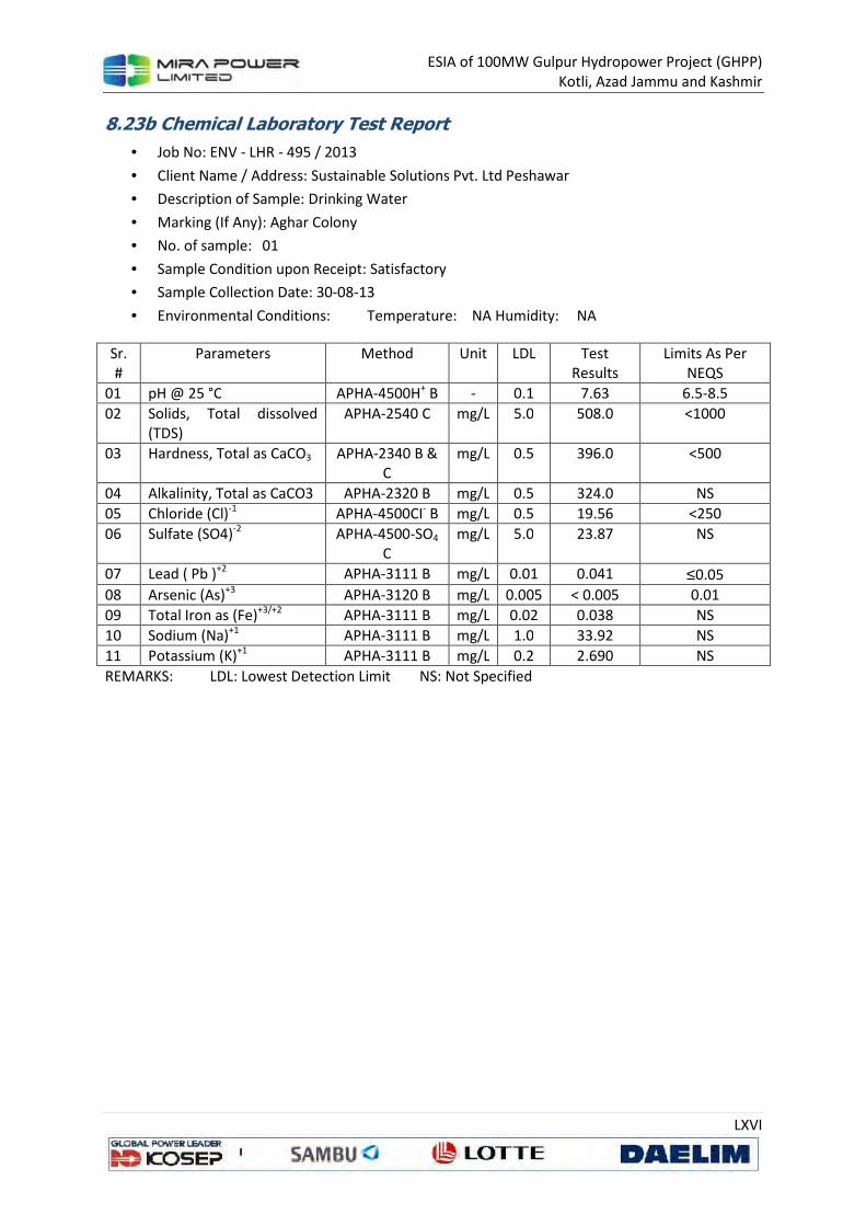
ESIA of 100MW Gulpur Hydropower Project (GHPP)
Kotli, Azad Jammu and Kashmir
LXVI
8.23b Chemical Laboratory Test Report
• Job No: ENV - LHR - 495 / 2013
• Client Name / Address: Sustainable Solutions Pvt. Ltd Peshawar
• Description of Sample: Drinking Water
• Marking (If Any): Aghar Colony
• No. of sample: 01
• Sample Condition upon Receipt: Satisfactory
• Sample Collection Date: 30-08-13
• Environmental Conditions: Temperature: NA Humidity: NA
Sr.
#
Parameters Method Unit LDL Test
Results
Limits As Per
NEQS
01 pH @ 25 °C APHA-4500H+ B - 0.1 7.63 6.5-8.5
02 Solids, Total dissolved
(TDS)
APHA-2540 C mg/L 5.0 508.0 <1000
03 Hardness, Total as CaCO3 APHA-2340 B & C
mg/L 0.5 396.0 <500
04 Alkalinity, Total as CaCO3 APHA-2320 B mg/L 0.5 324.0 NS
05 Chloride (Cl)-1 APHA-4500CI- B mg/L 0.5 19.56 <250
06 Sulfate (SO4)-2 APHA-4500-SO4 C
mg/L 5.0 23.87 NS
07 Lead ( Pb )+2 APHA-3111 B mg/L 0.01 0.041 ≤0.05
08 Arsenic (As)+3 APHA-3120 B mg/L 0.005 < 0.005 0.01
09 Total Iron as (Fe)+3/+2 APHA-3111 B mg/L 0.02 0.038 NS
10 Sodium (Na)+1 APHA-3111 B mg/L 1.0 33.92 NS
11 Potassium (K)+1 APHA-3111 B mg/L 0.2 2.690 NS
REMARKS: LDL: Lowest Detection Limit NS: Not Specified
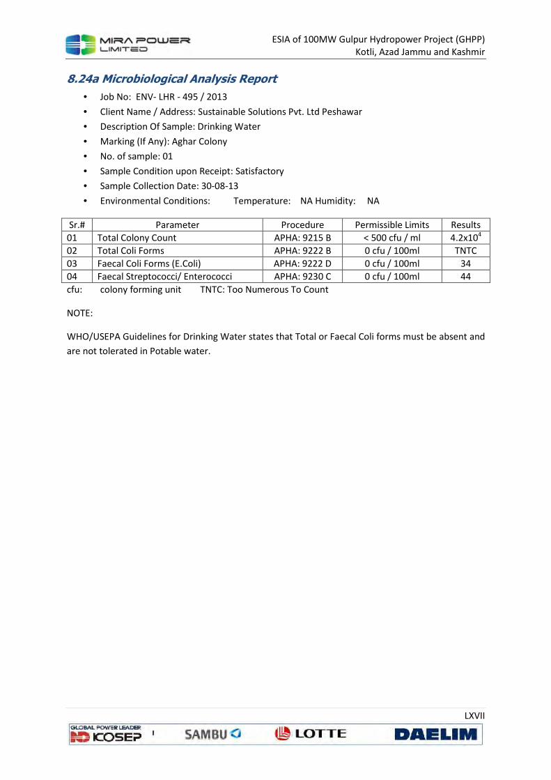
ESIA of 100MW Gulpur Hydropower Project (GHPP)
Kotli, Azad Jammu and Kashmir
LXVII
8.24a Microbiological Analysis Report
• Job No: ENV- LHR - 495 / 2013
• Client Name / Address: Sustainable Solutions Pvt. Ltd Peshawar
• Description Of Sample: Drinking Water
• Marking (If Any): Aghar Colony
• No. of sample: 01
• Sample Condition upon Receipt: Satisfactory
• Sample Collection Date: 30-08-13
• Environmental Conditions: Temperature: NA Humidity: NA
Sr.# Parameter Procedure Permissible Limits Results
01 Total Colony Count APHA: 9215 B < 500 cfu / ml 4.2x10⁴
02 Total Coli Forms APHA: 9222 B 0 cfu / 100ml TNTC
03 Faecal Coli Forms (E.Coli) APHA: 9222 D 0 cfu / 100ml 34
04 Faecal Streptococci/ Enterococci APHA: 9230 C 0 cfu / 100ml 44
cfu: colony forming unit TNTC: Too Numerous To Count
NOTE:
WHO/USEPA Guidelines for Drinking Water states that Total or Faecal Coli forms must be absent and
are not tolerated in Potable water.

ESIA of 100MW Gulpur Hydropower Project (GHPP)
Kotli, Azad Jammu and Kashmir
LXVIII
8.24b Chemical Laboratory Test Report
• Job No: ENV - LHR - 495 / 2013
• Client Name / Address: Sustainable Solutions Pvt. Ltd Peshawar
• Description of Sample: Drinking Water
• Marking (If Any): Aghar Colony
• No. of sample: 01
• Sample Condition upon Receipt: Satisfactory
• Sample Collection Date: 30-08-13
• Environmental Conditions: Temperature: NA Humidity: NA
Sr.
#
Parameters Method Unit LDL Test
Results
Limits As Per
NEQS
01 pH @ 25 °C APHA-4500H+ B - 0.1 7.80 6.5-8.5
02 Solids, Total dissolved
(TDS)
APHA-2540 C mg/L 5.0 506.0 <1000
03 Hardness, Total as CaCO3 APHA-2340 B & C
mg/L 0.5 386.10 <500
04 Alkalinity, Total as CaCO3 APHA-2320 B mg/L 0.5 334.8 NS
05 Chloride (Cl)-1 APHA-4500CI- B mg/L 0.5 29.35 <250
06 Sulfate (SO4)-2 APHA-4500-SO4 C
mg/L 5.0 20.58 NS
07 Lead ( Pb )+2 APHA-3111 B mg/L 0.01 0.041 ≤0.05
08 Arsenic (As)+3 APHA-3120 B mg/L 0.005 < 0.005 0.01
09 Total Iron as (Fe)+3/+2 APHA-3111 B mg/L 0.02 0.029 NS
10 Sodium (Na)+1 APHA-3111 B mg/L 1.0 31.24 NS
11 Potassium (K)+1 APHA-3111 B mg/L 0.2 2.670 NS
REMARKS: LDL: Lowest Detection Limit NS: Not Specified

ESIA of 100MW Gulpur Hydropower Project (GHPP)
Kotli, Azad Jammu and Kashmir
LXIX
8.25a Microbiological Analysis Report
• Job No: ENV- LHR - 495 / 2013
• Client Name / Address: Sustainable Solutions Pvt. Ltd Peshawar
• Description Of Sample: Drinking Water
• Marking (If Any): Aghar Colony
• No. of sample: 01
• Sample Condition upon Receipt: Satisfactory
• Sample Collection Date: 30-08-13
• Environmental Conditions: Temperature: NA Humidity: NA
Sr.# Parameter Procedure Permissible Limits Results
01 Total Colony Count APHA: 9215 B < 500 cfu / ml 4.3x10⁴
02 Total Coli Forms APHA: 9222 B 0 cfu / 100ml TNTC
03 Faecal Coli Forms (E.Coli) APHA: 9222 D 0 cfu / 100ml 58
04 Faecal Streptococci/ Enterococci APHA: 9230 C 0 cfu / 100ml 30
cfu: colony forming unit TNTC: Too Numerous To Count
NOTE:
WHO/USEPA Guidelines for Drinking Water states that Total or Faecal Coli forms must be absent and
are not tolerated in Potable water.

ESIA of 100MW Gulpur Hydropower Project (GHPP)
Kotli, Azad Jammu and Kashmir
LXX
8.25b Chemical Laboratory Test Report
• Job No: ENV - LHR - 495 / 2013
• Client Name / Address: Sustainable Solutions Pvt. Ltd Peshawar
• Description of Sample: Drinking Water
• Marking (If Any): Aghar Colony
• No. of sample: 01
• Sample Condition upon Receipt: Satisfactory
• Sample Collection Date: 30-08-13
• Environmental Conditions: Temperature: NA Humidity: NA
Sr.
#
Parameters Method Unit LDL Test
Results
Limits As Per
NEQS
01 pH @ 25 °C APHA-4500H+ B - 0.1 7.81 6.5-8.5
02 Solids, Total dissolved
(TDS)
APHA-2540 C mg/L 5.0 494.0 <1000
03 Hardness, Total as CaCO3 APHA-2340 B & C
mg/L 0.5 386.10 <500
04 Alkalinity, Total as CaCO3 APHA-2320 B mg/L 0.5 334.8 NS
05 Chloride (Cl)-1 APHA-4500CI- B mg/L 0.5 24.46 <250
06 Sulfate (SO4)-2 APHA-4500-SO4 C
mg/L 5.0 23.46 NS
07 Lead ( Pb )+2 APHA-3111 B mg/L 0.01 <0.01 ≤0.05
08 Arsenic (As)+3 APHA-3120 B mg/L 0.005 < 0.005 0.01
09 Total Iron as (Fe)+3/+2 APHA-3111 B mg/L 0.02 0.046 NS
10 Sodium (Na)+1 APHA-3111 B mg/L 1.0 31.50 NS
11 Potassium (K)+1 APHA-3111 B mg/L 0.2 2.69 NS
REMARKS: LDL: Lowest Detection Limit NS: Not Specified
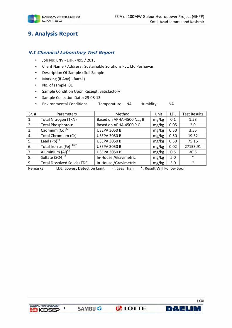
ESIA of 100MW Gulpur Hydropower Project (GHPP)
Kotli, Azad Jammu and Kashmir
LXXI
9. Analysis Report
9.1 Chemical Laboratory Test Report
• Job No: ENV - LHR - 495 / 2013
• Client Name / Address : Sustainable Solutions Pvt. Ltd Peshawar
• Description Of Sample : Soil Sample
• Marking (If Any): (Barali)
• No. of sample: 01
• Sample Condition Upon Receipt: Satisfactory
• Sample Collection Date: 29-08-13
• Environmental Conditions: Temperature: NA Humidity: NA
Sr. # Parameters Method Unit LDL Test Results
1. Total Nitrogen (TKN) Based on APHA-4500 Norg B mg/kg 0.1 1.53
2. Total Phosphorous Based on APHA-4500 P C mg/kg 0.05 2.0
3. Cadmium (Cd)+2 USEPA 3050 B mg/kg 0.50 3.55
4. Total Chromium (Cr) USEPA 3050 B mg/kg 0.50 19.32
5. Lead (Pb)+2 USEPA 3050 B mg/kg 0.50 75.16
6. Total Iron as (Fe)+3/+2 USEPA 3050 B mg/kg 0.02 27153.91
7. Aluminium (Al)+2 USEPA 3050 B mg/kg 0.5 <0.5
8. Sulfate (SO4)-2 In-House /Gravimetric mg/kg 5.0 *
9. Total Dissolved Solids (TDS) In-House /Gravimetric mg/kg 5.0 *
Remarks: LDL: Lowest Detection Limit <: Less Than. *: Result Will Follow Soon

ESIA of 100MW Gulpur Hydropower Project (GHPP)
Kotli, Azad Jammu and Kashmir
LXXII
9.2 Chemical Laboratory Test Report
• Job No: ENV - LHR - 495 / 2013
• Client Name / Address : Sustainable Solutions Pvt. Ltd Peshawar
• Description Of Sample : Soil Sample
• Marking (If Any): (Gulhar)
• No. of sample: 01
• Sample Condition Upon Receipt: Satisfactory
• Sample Collection Date: 29-08-13
• Environmental Conditions: Temperature: NA Humidity: NA
Sr. # Parameters Method Unit LDL Test Results
1. Total Nitrogen (TKN) Based on APHA-4500 Norg B mg/kg 0.1 3.02
2. Total Phosphorous Based on APHA-4500 P C mg/kg 0.05 1.72
3. Cadmium (Cd)+2 USEPA 3050 B mg/kg 0.50 <0.50
4. Total Chromium (Cr) USEPA 3050 B mg/kg 0.50 15.76
5. Lead (Pb)+2 USEPA 3050 B mg/kg 0.50 95.19
6. Total Iron as (Fe)+3/+2 USEPA 3050 B mg/kg 0.02 21934.86
7. Aluminium (Al)+2 USEPA 3050 B mg/kg 0.5 <0.5
8. Sulfate (SO4)-2 In-House /Gravimetric mg/kg 5.0 *
9. Total Dissolved Solids (TDS) In-House /Gravimetric mg/kg 5.0 *
Remarks: LDL: Lowest Detection Limit <: Less Than. *: Result Will Follow Soon

ESIA of 100MW Gulpur Hydropower Project (GHPP)
Kotli, Azad Jammu and Kashmir
LXXIII
9.3 Chemical Laboratory Test Report
• Job No: ENV - LHR - 495 / 2013
• Client Name / Address : Sustainable Solutions Pvt. Ltd Peshawar
• Description Of Sample : Soil Sample
• Marking (If Any): (Mandi Juzvi)
• No. of sample: 01
• Sample Condition Upon Receipt: Satisfactory
• Sample Collection Date: 29-08-13
• Environmental Conditions: Temperature: NA Humidity: NA
Sr. # Parameters Method Unit LDL Test Results
1. Total Nitrogen (TKN) Based on APHA-4500 Norg B mg/kg 0.1 1.86
2. Total Phosphorous Based on APHA-4500 P C mg/kg 0.05 2.60
3. Cadmium (Cd)+2 USEPA 3050 B mg/kg 0.50 <0.50
4. Total Chromium (Cr) USEPA 3050 B mg/kg 0.50 25.27
5. Lead (Pb)+2 USEPA 3050 B mg/kg 0.50 77.76
6. Total Iron as (Fe)+3/+2 USEPA 3050 B mg/kg 0.02 25545.50
7. Aluminium (Al)+2 USEPA 3050 B mg/kg 0.5 <0.5
8. Sulfate (SO4)-2 In-House /Gravimetric mg/kg 5.0 *
9. Total Dissolved Solids (TDS) In-House /Gravimetric mg/kg 5.0 *
Remarks: LDL: Lowest Detection Limit <: Less Than. *: Result Will Follow Soon

ESIA of 100MW Gulpur Hydropower Project (GHPP)
Kotli, Azad Jammu and Kashmir
LXXIV
9.4 Chemical Laboratory Test Report
• Job No: ENV - LHR - 495 / 2013
• Client Name / Address : Sustainable Solutions Pvt. Ltd Peshawar
• Description Of Sample : Soil Sample
• Marking (If Any): (Jamal Pur)
• No. of sample: 01
• Sample Condition Upon Receipt: Satisfactory
• Sample Collection Date: 29-08-13
• Environmental Conditions: Temperature: NA Humidity: NA
Sr. # Parameters Method Unit LDL Test Results
1. Total Nitrogen (TKN) Based on APHA-4500 Norg B mg/kg 0.1 1.38
2. Total Phosphorous Based on APHA-4500 P C mg/kg 0.05 2.60
3. Cadmium (Cd)+2 USEPA 3050 B mg/kg 0.50 <0.50
4. Total Chromium (Cr) USEPA 3050 B mg/kg 0.50 28.65
5. Lead (Pb)+2 USEPA 3050 B mg/kg 0.50 100.90
6. Total Iron as (Fe)+3/+2 USEPA 3050 B mg/kg 0.02 26119.6
7. Aluminium (Al)+2 USEPA 3050 B mg/kg 0.5 <0.5
8. Sulfate (SO4)-2 In-House /Gravimetric mg/kg 5.0 *
9. Total Dissolved Solids (TDS) In-House /Gravimetric mg/kg 5.0 *
Remarks: LDL: Lowest Detection Limit <: Less Than. *: Result Will Follow Soon
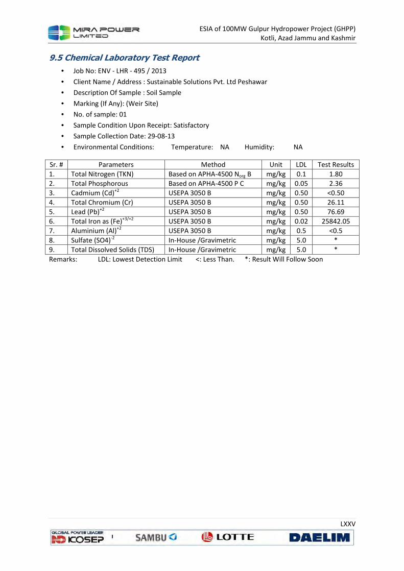
ESIA of 100MW Gulpur Hydropower Project (GHPP)
Kotli, Azad Jammu and Kashmir
LXXV
9.5 Chemical Laboratory Test Report
• Job No: ENV - LHR - 495 / 2013
• Client Name / Address : Sustainable Solutions Pvt. Ltd Peshawar
• Description Of Sample : Soil Sample
• Marking (If Any): (Weir Site)
• No. of sample: 01
• Sample Condition Upon Receipt: Satisfactory
• Sample Collection Date: 29-08-13
• Environmental Conditions: Temperature: NA Humidity: NA
Sr. # Parameters Method Unit LDL Test Results
1. Total Nitrogen (TKN) Based on APHA-4500 Norg B mg/kg 0.1 1.80
2. Total Phosphorous Based on APHA-4500 P C mg/kg 0.05 2.36
3. Cadmium (Cd)+2 USEPA 3050 B mg/kg 0.50 <0.50
4. Total Chromium (Cr) USEPA 3050 B mg/kg 0.50 26.11
5. Lead (Pb)+2 USEPA 3050 B mg/kg 0.50 76.69
6. Total Iron as (Fe)+3/+2 USEPA 3050 B mg/kg 0.02 25842.05
7. Aluminium (Al)+2 USEPA 3050 B mg/kg 0.5 <0.5
8. Sulfate (SO4)-2 In-House /Gravimetric mg/kg 5.0 *
9. Total Dissolved Solids (TDS) In-House /Gravimetric mg/kg 5.0 *
Remarks: LDL: Lowest Detection Limit <: Less Than. *: Result Will Follow Soon
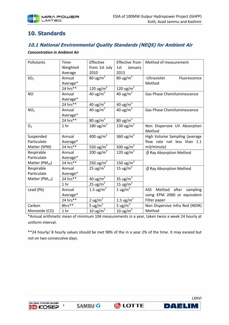
ESIA of 100MW Gulpur Hydropower Project (GHPP)
Kotli, Azad Jammu and Kashmir
LXXVI
10. Standards
10.1 National Environmental Quality Standards (NEQS) for Ambient Air
Concentration in Ambient Air
Pollutants Time-
Weighted
Average
Effective
from 1st July
2010
Effective from
1st January
2013
Method of measurement
SO2 Annual Average*
80 ug/m3 80 ug/m3 -Ultraviolet Fluorescence Method
24 hrs** 120 ug/m3 120 ug/m3
NO Annual Average*
40 ug/m3 40 ug/m3 Gas Phase Chemiluminescence
24 hrs** 40 ug/m3 40 ug/m3
NO2 Annual Average*
40 ug/m3 40 ug/m3 Gas Phase Chemiluminescence
24 hrs** 80 ug/m3 80 ug/m3
O3 1 hr 180 ug/m3 130 ug/m3 Non Dispersive UV Absorption Method
Suspended Particulate Matter (SPM)
Annual Average*
400 ug/m3 360 ug/m3 High Volume Sampling (average flow rate not less than 1.1 m3/minute) 24 hrs** 550 ug/m3 500 ug/m3
Respirable Particulate Matter (PM10)
Annual Average*
200 ug/m3 120 ug/m3 -β Ray Absorption Method
24 hrs** 250 ug/m3 150 ug/m3
Respirable Particulate Matter (PM2.5)
Annual Average*
25 ug/m3 15 ug/m3 -β Ray Absorption Method
24 hrs** 40 ug/m3 35 ug/m3
1 hr 25 ug/m3 15 ug/m3
Lead (Pb) Annual Average*
1.5 ug/m3 1 ug/m3 ASS Method after sampling using EPM 2060 or equivalent Filter paper 24 hrs** 2 ug/m3 1.5 ug/m3
Carbon Monoxide (CO)
8hrs** 5 ug/m3 5 ug/m3 Non Dispersive Infra Red (NDIR) Method 1 hr 10 ug/m3 10 ug/m3
*Annual arithmetic mean of minimum 104 measurements in a year, taken twice a week 24 hourly at
uniform interval.
**24 hourly/ 8 hourly values should be met 98% of the in a year 2% of the time. It may exceed but
not on two consecutive days.
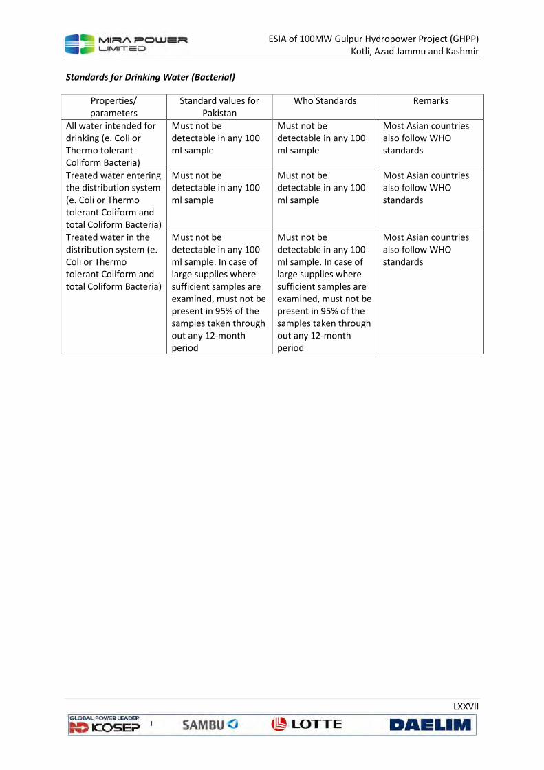
ESIA of 100MW Gulpur Hydropower Project (GHPP)
Kotli, Azad Jammu and Kashmir
LXXVII
Standards for Drinking Water (Bacterial)
Properties/
parameters
Standard values for
Pakistan
Who Standards Remarks
All water intended for
drinking (e. Coli or
Thermo tolerant
Coliform Bacteria)
Must not be
detectable in any 100
ml sample
Must not be
detectable in any 100
ml sample
Most Asian countries
also follow WHO standards
Treated water entering the distribution system (e. Coli or Thermo tolerant Coliform and total Coliform Bacteria)
Must not be detectable in any 100 ml sample
Must not be detectable in any 100 ml sample
Most Asian countries also follow WHO standards
Treated water in the distribution system (e. Coli or Thermo tolerant Coliform and total Coliform Bacteria)
Must not be detectable in any 100 ml sample. In case of large supplies where sufficient samples are examined, must not be present in 95% of the samples taken through out any 12-month period
Must not be detectable in any 100 ml sample. In case of large supplies where sufficient samples are examined, must not be present in 95% of the samples taken through out any 12-month period
Most Asian countries also follow WHO standards
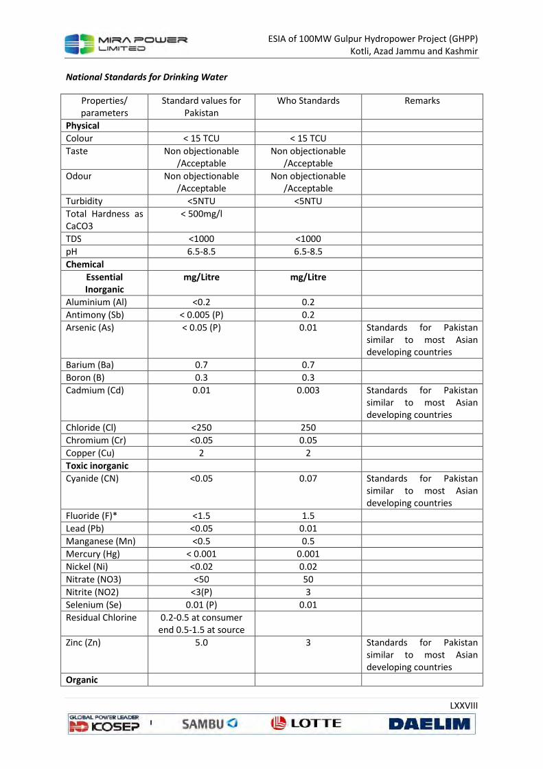
ESIA of 100MW Gulpur Hydropower Project (GHPP)
Kotli, Azad Jammu and Kashmir
LXXVIII
National Standards for Drinking Water
Properties/
parameters
Standard values for
Pakistan
Who Standards Remarks
Physical
Colour < 15 TCU < 15 TCU
Taste Non objectionable
/Acceptable
Non objectionable
/Acceptable
Odour Non objectionable /Acceptable
Non objectionable /Acceptable
Turbidity <5NTU <5NTU
Total Hardness as CaCO3
< 500mg/l
TDS <1000 <1000
pH 6.5-8.5 6.5-8.5
Chemical
Essential Inorganic
mg/Litre mg/Litre
Aluminium (Al) <0.2 0.2
Antimony (Sb) < 0.005 (P) 0.2
Arsenic (As) < 0.05 (P) 0.01 Standards for Pakistan similar to most Asian developing countries
Barium (Ba) 0.7 0.7
Boron (B) 0.3 0.3
Cadmium (Cd) 0.01 0.003 Standards for Pakistan similar to most Asian developing countries
Chloride (Cl) <250 250
Chromium (Cr) <0.05 0.05
Copper (Cu) 2 2
Toxic inorganic
Cyanide (CN) <0.05 0.07 Standards for Pakistan similar to most Asian developing countries
Fluoride (F)* <1.5 1.5
Lead (Pb) <0.05 0.01
Manganese (Mn) <0.5 0.5
Mercury (Hg) < 0.001 0.001
Nickel (Ni) <0.02 0.02
Nitrate (NO3) <50 50
Nitrite (NO2) <3(P) 3
Selenium (Se) 0.01 (P) 0.01
Residual Chlorine 0.2-0.5 at consumer end 0.5-1.5 at source
Zinc (Zn) 5.0 3 Standards for Pakistan similar to most Asian developing countries
Organic

ESIA of 100MW Gulpur Hydropower Project (GHPP)
Kotli, Azad Jammu and Kashmir
LXXIX
Pesticides mg/L PSQCA No. 4639-2004.
Page No. 4 Table No. 3
Serial No. 20-58 may
be Consulted***
Annex II
Penolic
Compounds (as
Phenols) mg/L
< 0.002
Polynuclear
aromatic
hydrocarbons (as
PAH) g/L
0.01 (by GC/MS
method)
Radio Active
Alpha Emitters
bq/L or pCi
0.1 0.1
Beta Emitters 1 1
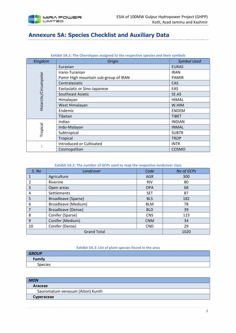
ESIA of 100MW Gulpur Hydropower Project (GHPP)
Kotli, Azad Jammu and Kashmir
I
Annexure 5A: Species Checklist and Auxiliary Data
Exhibit 5A.1: The Chorotypes assigned to the respective species and their symbols
Kingdom Origin Symbol Used
Ho
larc
tic/
Cir
cum
po
lar
Eurasian EURAS
Irano-Turanian
Pamir High mountain sub-group of IRAN
IRAN
PAMIR
Centralasiatic CAS
Eastasiatic or Sino-Japanese EAS
Southeast Asiatic SE.AS
Himalayan HIMAL
West Himalayan W.HIM
Endemic ENDEM
Tibetan TIBET
Tro
pic
al Indian INDIAN
Indo-Malayan INMAL
Subtropical SUBTR
Tropical TROP
-- Introduced or Cultivated INTR
Cosmopolitan COSMO
Exhibit 5A.2: The number of GCPs used to map the respective landcover class
S. No Landcover Code No of GCPs
1 Agriculture AGR 300
2 Riverine RIV 80
3 Open areas OPA 68
4 Settlements SET 87
5 Broadleave (Sparse) BLS 182
6 Broadleave (Medium) BLM 78
7 Broadleave (Dense) BLD 39
8 Conifer (Sparse) CNS 123
9 Conifer (Medium) CNM 34
10 Conifer (Dense) CND 29
Grand Total 1020
Exhibit 5A.3: List of plant species found in the area
GROUP
Family
Species
MON
Araceae
Sauromatum venosum (Aiton) Kunth
Cyperaceae
ESIA of 100MW Gulpur Hydropower Project (GHPP)
Kotli, Azad Jammu and Kashmir
II
Cyperus niveus Retz.
Cyperus rotundus L.
Eriophorum comosum (Wallich) Nees
Liliaceae
Agave cantula Roxb.
Asparagus adscendens Roxb.
Orchidaceae
Harbennaria digitata Lidle.
Poaceae
Apluda mutica var. mutica L.
Arundo donax L.
Bothriochloa pertusa (L.) A. Camus
Brachiaria ramosa (Linn) Stapf
Cenchrus ciliaris L.
Cenchrus pennisetiformis Hochst & Steud
Chrysopogan serrulatus Trin
Cynodon dactylon (L.) Pers.
Desmostachya bipinnata (L.) Stapf
Dichanthium annulatum (Forssk.) Stapf
Digitaria bicornis (Lamk.) Roem & Schult. ex Loud
Echinochloa colona (L.) Link
Eragrostis poaeoides Beauvois
Heteropogon contortus (L.) Beauvois ex Roemer & Schultes
Imperata cylindrica var. cylindrica (L.) Beauvois
Paspalidium flavidum (Retz.) A. Camus
Phragmites karka (Retz.) Trin. ex Steudel
Poa annua L.
Polypogon monspeliensis (L.) Desf.
Setaria glauca (L.) Beauvois
Sorghum halepense (L.) Beauvois
Zea mays L.
ANG
Acanthaceae
Barleria cristata L.
Dicliptera roxburghiana Nees in Wall.
Justicia adhatoda L.
Amaranthaceae
Achyranthes aspera L.
Amaranthus viridis L.
Pupalia lappacea (Linn.) Juss.
Anacardiaceae
Mangifera indica L.
Apiaceae
Unknown 1
Unknown 2
Apocynaceae
Carissa opaca Stapf ex. Haines
Nerium indicum Miller
Asclepiadaceae
ESIA of 100MW Gulpur Hydropower Project (GHPP)
Kotli, Azad Jammu and Kashmir
III
Calotropis procera (Aiton) Dryand.
Cynanchum atratum Bunge
Periploca aphylla subsp. aphylla Decne.
Tylophora hirsuta (Wall.) Wight
Asteraceae
Artemisia scoparia Besser
Bidens bipinnata L.
Conyza bonariensis (L.) Cronq.
Conyza canadensis (L.) Cronq.
Conyza japonica L.
Conyza stricta Willd.
Erigeron belloides Benth. ex Clarke.
Parthenium hysterophorus L.
Sonchus arvensis L.
Taraxacum officinale Wigg.
Xanthium strumarium L.
Bombacaceae
Bombax ceiba L.
Boraginaceae
Cynoglossum lanceolatum Forssk.
Heliotropium europaeum L
Lithospermum arvense L.
Trichodesma indicum (L.) R. Br.
Brassicaceae
Capsella bursa-pastoris (L.) Medic
Cardamine impatiens L.
Lepidium sativum L.
Cannabiaceae
Cannabis sativa L.
Celasteraceae
Gymnosporia royleana (Wall.) ex Laws
Celtaceae
Celtis australis L.
Chenopodiaceae
Chenopodium album subsp. album L.
Commelinaceae
Commelina benghalensis L.
Convolvulaceae
Convolvulus arvensis L.
Evolvulus alsinoides (Linn.) Linn.
Ipomoea carnea subsp. fistulosa Jacquem
Ipomoea purpurea (L.) Roth.
Cuscutaceae
Cuscuta reflexa var. reflexa Roxb.
Ebenaceae
Diospyros lotus L.
Euphorbiaceae
Euphorbia hirta L.
Euphorbia indica Lam.
ESIA of 100MW Gulpur Hydropower Project (GHPP)
Kotli, Azad Jammu and Kashmir
IV
Euphorbia prostrata Ait.
Mallotus philippensis (Lam.) Muell.-Arg.
Phyllanthus amarus Schum. & Thonn.
Flacourtiaceae
Flacourtia indica (Burm.) Merrill
Geraniaceae
Geranium nepalense Sweet
Geranium rotundifolium L.
Geranium wallichianum D. Don ex Sweet
Juglandaceae
Juglans regia L.
Labiatae
Ajuga bracteosa var. bracteosa Wall.
Ajuga bracteosa var. densiflora Wall.
Calamintha umbrosa (M. Bieb.) Fisch. & Mey
Colebrookea oppositifolia Smith
Mentha royleana Benth.
Micromeria biflora var. biflora (Buch.-Ham. ex D. Don) Benth.
Otostegia limbata (Benth.) Boiss.
Plectranthus rugosus Wall. ex. Bth.
Salvia sp.
Leguminoseae
Acacia modesta Wall.
Acacia nilotica subsp. indica (L.) Willd.
Albizia lebbeck (L.) Benth.
Astragalus leucocephalus Grah. ex Benth.
Cassia fistula L.
Cassia obtusifolia Linn.
Cassia occidentalis L.
Dalbergia sissoo Roxb. ex DC.
Desmodium monotorium (Houtt) Merril
Dumasia villosa var. villosa DC.
Indigofera linifolia (Linn.f.) Retz.
Lespedeza juncea (L. f.) Pers.
Medicago sativa L.
Melilotus parviflora Desf.
Mimosa himalayana Gamble
Rynchosia minima (L.) DC.
Uraria picta (Jacquin) Desv. ex DC.
Lytheraceae
Woodfordia fruticosa (L.) Kurz.
Malvaceae
Hibiscus trionum Linn.
Malvastrum coromandelianum (L.) Garcke
Sida cordifolia L.
Martyniaceaae
Martynia annua Linn.
Meliaceae
Cedrela serrata Royle.
ESIA of 100MW Gulpur Hydropower Project (GHPP)
Kotli, Azad Jammu and Kashmir
V
Cedrela toona Roxb. ex Wild
Melia azedarach L.
Menispermaceae
Cissampelos pareira var. hirsuta L.
Tinospora cordifolia (DC.) Miers.
Moraceae
Broussonetia papyrifera (L.) L'H {rit. ex Vent.
Ficus auriculata Lour.
Ficus benghalensis L.
Ficus carica subsp. carica L.
Ficus religiosa L.
Morus alba L.
Morus nigra L.
Morus serrata Roxb.
Muscaceae
Musca sapientum L.
Myrsinaceae
Myrsine africana L.
Myrtaceae
Eucalyptus camaldulensis Dehnh
Nyctaginaceae
Alternanthera pungens Kunth
Boerhavia procumbens (Roxb.) Hk.F
Oleaceae
Olea ferruginea Royle
Onagraceae
Oenothera rosea L’H rit. ex Aiton
Oxalidaceae
Oxalis corniculata L.
Palmaceae
Phoenix sylvestris Roxb.
Polygalaceae
Polygala abyssinica R. Br. ex Fresen.
Polygonaceae
Polygonum plebejum R.Br
Polygonum sp.
Rumex chalepensis D. Don
Punicaceae
Punica granatum L.
Ranunculaceae
Thalictrum javanicum Bl.
Rhamnaceae
Zizyphus jujuba Lam.
Zizyphus mauritiana Lam.
Zizyphus nummularia (Burm. f.) Wight & Arn.
Zizyphus oxyphylla Edgew.
Rosaceae
Duchesnea indica var. microphylla (Andr.) Focke
Fragaria nubicola Lindl. ex Lacaita
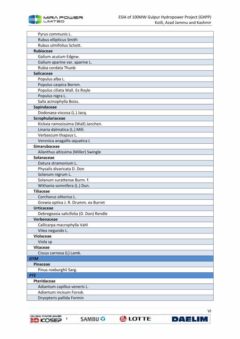
ESIA of 100MW Gulpur Hydropower Project (GHPP)
Kotli, Azad Jammu and Kashmir
VI
Pyrus communis L.
Rubus ellipticus Smith
Rubus ulmifolius Schott.
Rubiaceae
Galium acutum Edgew.
Galium aparine var. aparine L.
Rubia cordata Thunb
Salicaceae
Populus alba L.
Populus caspica Bornm.
Populus ciliata Wall. Ex Royle
Populus nigra L.
Salix acmophylla Boiss.
Sapindaceae
Dodonaea viscosa (L.) Jacq.
Scrophulariaceae
Kickxia ramosissima (Wall) Janchen.
Linaria dalmatica (L.) Mill.
Verbascum thapsus L.
Veronica anagallis-aquatica L
Simarubaceae
Ailanthus altissima (Miller) Swingle
Solanaceae
Datura stramonium L.
Physalis divaricata D. Don
Solanum nigrum L.
Solanum surattense Burm. f.
Withania somnifera (L.) Dun.
Tiliaceae
Corchorus olitorius L.
Grewia optiva J. R. Drumm. ex Burret
Urticaceae
Debregeasia salicifolia (D. Don) Rendle
Verbenaceae
Callicarpa macrophylla Vahl
Vitex negundo L.
Violaceae
Viola sp
Vitaceae
Cissus carnosa (L) Lamk.
GYM
Pinaceae
Pinus roxburghii Sarg.
PTE
Pteridaceae
Adiantum capillus-veneris L.
Adiantum incisum Forssk.
Dryopteris pallida Formin
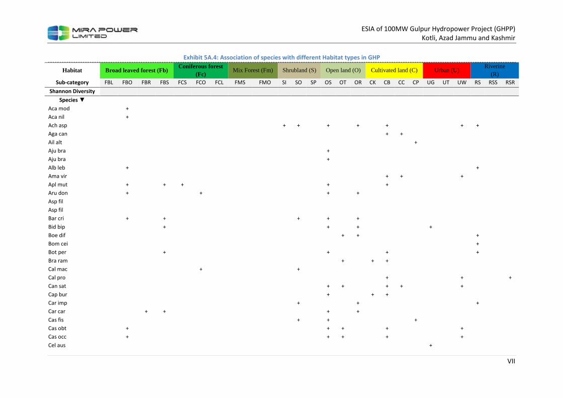
ESIA of 100MW Gulpur Hydropower Project (GHPP)
Kotli, Azad Jammu and Kashmir
VII
Exhibit 5A.4: Association of species with different Habitat types in GHP
Habitat Broad leaved forest (Fb) Coniferous forest
(Fc) Mix Forest (Fm) Shrubland (S) Open land (O) Cultivated land (C) Urban (U)
Riverine (R)
Sub-category FBL FBO FBR FBS FCS FCO FCL FMS FMO SI SO SP OS OT OR CK CB CC CP UG UT UW RS RSS RSR
Shannon Diversity
Species ▼
Aca mod
+
Aca nil
+
Ach asp
+ +
+
+
+
+ +
Aga can
+ +
Ail alt
+
Aju bra
+
Aju bra
+
Alb leb
+
+
Ama vir
+ +
+
Apl mut
+
+ +
+
+
Aru don
+
+
+
+
Asp fil
Asp fil
Bar cri
+
+
+
+
+
Bid bip
+
+
+
+
Boe dif
+ +
+
Bom cei
+
Bot per
+
+
+
+
Bra ram
+
+ +
Cal mac
+
+
Cal pro
+
+
+
Can sat
+ +
+ +
+
Cap bur
+
+ +
Car imp
+
+
+
Car car
+ +
+
+
Cas fis
+
+
+
Cas obt
+
+ +
+
+
Cas occ
+
+ +
+
+
Cel aus
+

ESIA of 100MW Gulpur Hydropower Project (GHPP)
Kotli, Azad Jammu and Kashmir
VIII
Habitat Broad leaved forest (Fb) Coniferous forest
(Fc) Mix Forest (Fm) Shrubland (S) Open land (O) Cultivated land (C) Urban (U)
Riverine (R)
Sub-category FBL FBO FBR FBS FCS FCO FCL FMS FMO SI SO SP OS OT OR CK CB CC CP UG UT UW RS RSS RSR
Shannon Diversity
Species ▼
Che alb
+
+ +
+ +
Cis par
+
+
+
Cis adn +
Col opp
+
+
+
Com ben
+
+ +
+
Con arv
+ + +
+
+
+
Con bon
+ +
+
Con can
+
+
+
Con jap
+
+
+
Con str
+
+ +
Cus ref
+
Cyn aur
+
+
Cyn dac
+ +
+ +
+
Cyn lan
+ +
+
Cyp niv
+
+
+
+
+
Cyp rot
+
+ +
+ +
Dal sis
+
+
Dat str
+
+
+
Deb sal
+
+
+
+
Des ele
+
+
+
+
+
Des bip
+
+
+
Dic ann
+ +
+ +
Dio lot
Dum vil
+
+
Ech col
+
+ +
+
Eri bel
+
+
+
Eri com
+
+
Euc cam
+
Eup hir
+
+
+ + +
+
+

ESIA of 100MW Gulpur Hydropower Project (GHPP)
Kotli, Azad Jammu and Kashmir
IX
Habitat Broad leaved forest (Fb) Coniferous forest
(Fc) Mix Forest (Fm) Shrubland (S) Open land (O) Cultivated land (C) Urban (U)
Riverine (R)
Sub-category FBL FBO FBR FBS FCS FCO FCL FMS FMO SI SO SP OS OT OR CK CB CC CP UG UT UW RS RSS RSR
Shannon Diversity
Species ▼
Eup pro
+
+
+
+
Evo als
+ +
+
+
+
Fic aur
+
+
Fic ben
+
Fic rel
+
+
Fla ind
Fra nub
+
+
Gal acu
+
Gal apa
+ +
+
+
Ger nep
+
+ +
+
Ger wal
+
+
+ +
+
Gre opt
+
Hab dig
+
Het con
+
+
+ +
+
Imp cyl
+ +
+ +
+ +
+
Ind lin
+ +
+
+
+
Ipo car
+
+
+
Ipo pur
+
+
+
Jug reg
+
+
Jus adh
+
+
+
+
Kic ram
+
Lep sat
+ +
Les jun
+
Lit arv
+
+
Mal phi
+
Man ind
+
Mar ann
+
+
+
+
Med sat
+
+
Mel aze
+ +
+
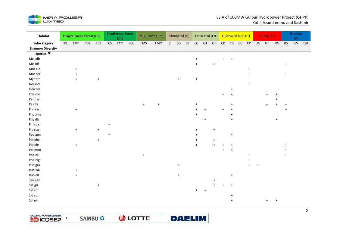
ESIA of 100MW Gulpur Hydropower Project (GHPP)
Kotli, Azad Jammu and Kashmir
X
Habitat Broad leaved forest (Fb) Coniferous forest
(Fc) Mix Forest (Fm) Shrubland (S) Open land (O) Cultivated land (C) Urban (U)
Riverine (R)
Sub-category FBL FBO FBR FBS FCS FCO FCL FMS FMO SI SO SP OS OT OR CK CB CC CP UG UT UW RS RSS RSR
Shannon Diversity
Species ▼
Mel alb
+
+ +
Mic bif
+
+
+
Mor alb
+
+
Mor ser
+
+
+
Myr afr
+
+
+
+
Ner ind
+
Oen ros
+
Oxa cor
+ +
+ +
Par hys
+
Pas fla
+ +
+
+
+ + +
Phr kar
+
+ +
+ +
+
Phy ama
+
+
Phy div
+
+
+
Pin rox
+
Ple rug
+
+
+
+
Poa ann
+
+
+
Pol aby
+
+
+
Pol ple
+
+
+ + +
+
Pol mon
+ +
+
Pop cil
+
+
+
Pop nig
+
Pun gra
+
+ +
Rub wal
+
Rub ell
+
+
+
Sau ven
+
Set gla
+
+ + +
Sid cor
+ +
Sid cor
+
Sol nig
+
+ +
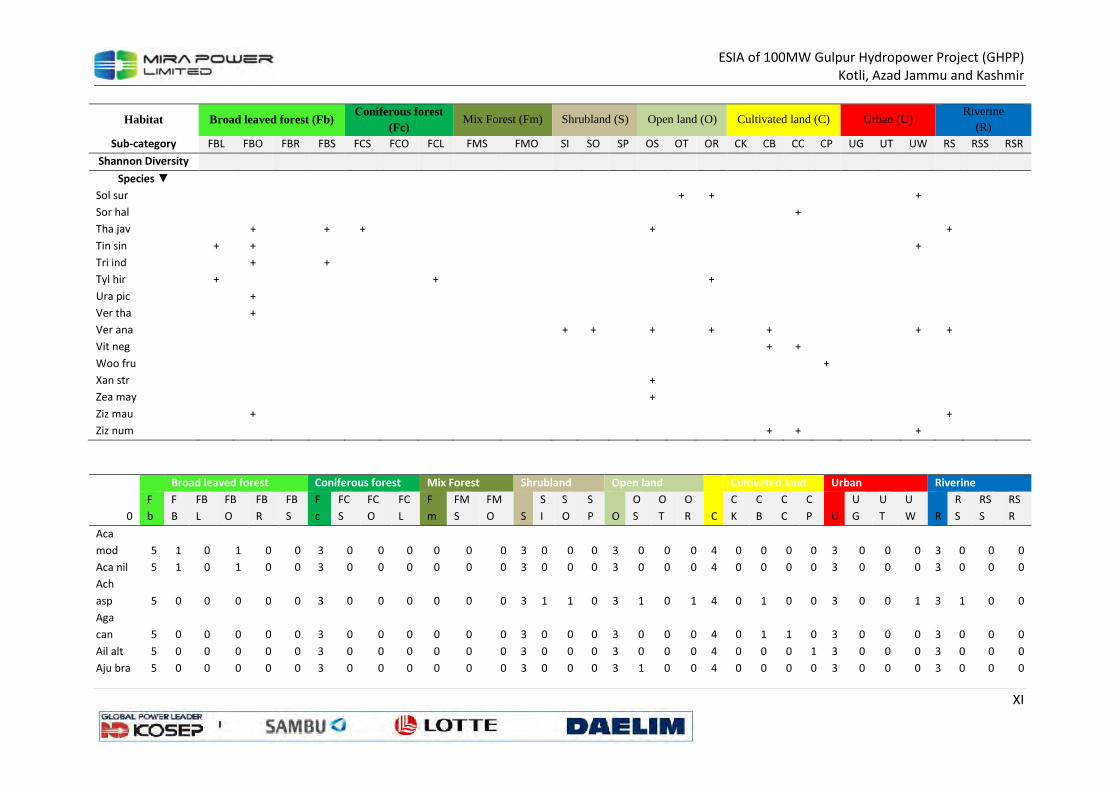
ESIA of 100MW Gulpur Hydropower Project (GHPP)
Kotli, Azad Jammu and Kashmir
XI
Habitat Broad leaved forest (Fb) Coniferous forest
(Fc) Mix Forest (Fm) Shrubland (S) Open land (O) Cultivated land (C) Urban (U)
Riverine (R)
Sub-category FBL FBO FBR FBS FCS FCO FCL FMS FMO SI SO SP OS OT OR CK CB CC CP UG UT UW RS RSS RSR
Shannon Diversity
Species ▼
Sol sur
+ +
+
Sor hal
+
Tha jav
+
+ +
+
+
Tin sin + +
+
Tri ind
+
+
Tyl hir +
+
+
Ura pic
+
Ver tha
+
Ver ana
+ +
+
+
+
+ +
Vit neg
+ +
Woo fru
+
Xan str
+
Zea may
+
Ziz mau
+
+
Ziz num
+ +
+
Broad leaved forest Coniferous forest Mix Forest Shrubland Open land Cultivated land Urban Riverine
0
F
b
F
B
FB
L
FB
O
FB
R
FB
S
F
c
FC
S
FC
O
FC
L
F
m
FM
S
FM
O S
S
I
S
O
S
P O
O
S
O
T
O
R C
C
K
C
B
C
C
C
P U
U
G
U
T
U
W R
R
S
RS
S
RS
R
Aca
mod 5 1 0 1 0 0 3 0 0 0 0 0 0 3 0 0 0 3 0 0 0 4 0 0 0 0 3 0 0 0 3 0 0 0
Aca nil 5 1 0 1 0 0 3 0 0 0 0 0 0 3 0 0 0 3 0 0 0 4 0 0 0 0 3 0 0 0 3 0 0 0
Ach
asp 5 0 0 0 0 0 3 0 0 0 0 0 0 3 1 1 0 3 1 0 1 4 0 1 0 0 3 0 0 1 3 1 0 0
Aga
can 5 0 0 0 0 0 3 0 0 0 0 0 0 3 0 0 0 3 0 0 0 4 0 1 1 0 3 0 0 0 3 0 0 0
Ail alt 5 0 0 0 0 0 3 0 0 0 0 0 0 3 0 0 0 3 0 0 0 4 0 0 0 1 3 0 0 0 3 0 0 0
Aju bra 5 0 0 0 0 0 3 0 0 0 0 0 0 3 0 0 0 3 1 0 0 4 0 0 0 0 3 0 0 0 3 0 0 0
ESIA of 100MW Gulpur Hydropower Project (GHPP)
Kotli, Azad Jammu and Kashmir
XII
Broad leaved forest Coniferous forest Mix Forest Shrubland Open land Cultivated land Urban Riverine
0
F
b
F
B
FB
L
FB
O
FB
R
FB
S
F
c
FC
S
FC
O
FC
L
F
m
FM
S
FM
O S
S
I
S
O
S
P O
O
S
O
T
O
R C
C
K
C
B
C
C
C
P U
U
G
U
T
U
W R
R
S
RS
S
RS
R
Aju bra 5 0 0 0 0 0 3 0 0 0 0 0 0 3 0 0 0 3 1 0 0 4 0 0 0 0 3 0 0 0 3 0 0 0
Alb leb 5 1 0 1 0 0 3 0 0 0 0 0 0 3 0 0 0 3 0 0 0 4 0 0 0 0 3 0 0 0 3 1 0 0
Ama
vir 5 0 0 0 0 0 3 0 0 0 0 0 0 3 0 0 0 3 0 0 0 4 0 1 1 0 3 0 0 1 3 0 0 0
Apl
mut 5 0 0 1 0 1 3 1 0 0 0 0 0 3 0 0 0 3 1 0 0 4 0 1 0 0 3 0 0 0 3 0 0 0
Aru
don 5 0 0 1 0 0 3 0 1 0 0 0 0 3 0 0 0 3 1 0 1 4 0 0 0 0 3 0 0 0 3 0 0 0
Asp fil 5 0 0 0 0 0 3 0 0 0 0 0 0 3 0 0 0 3 0 0 0 4 0 0 0 0 3 0 0 0 3 0 0 0
Asp fil 5 0 0 0 0 0 3 0 0 0 0 0 0 3 0 0 0 3 0 0 0 4 0 0 0 0 3 0 0 0 3 0 0 0
Bar cri 5 0 0 1 0 1 3 0 0 0 0 0 0 3 0 1 0 3 1 0 1 4 0 0 0 0 3 0 0 0 3 0 0 0
Bid bip 5 0 0 0 0 1 3 0 0 0 0 0 0 3 0 0 0 3 1 0 1 4 0 0 0 0 3 1 0 0 3 0 0 0
Boe dif 5 0 0 0 0 0 3 0 0 0 0 0 0 3 0 0 0 3 0 1 1 4 0 0 0 0 3 0 0 0 3 1 0 0
Bom
cei 5 1 0 0 0 0 3 0 0 0 0 0 0 3 0 0 0 3 0 0 0 4 0 0 0 0 3 0 0 0 3 1 0 0
Bot per 5 0 0 0 0 1 3 0 0 0 0 0 0 3 0 0 0 3 1 0 0 4 0 1 0 0 3 0 0 0 3 1 0 0
Bra
ram 5 0 0 0 0 0 3 0 0 0 0 0 0 3 0 0 0 3 0 1 0 4 1 1 0 0 3 0 0 0 3 0 0 0
Cal
mac 5 0 0 0 0 0 3 0 1 0 0 0 0 3 0 1 0 3 0 0 0 4 0 0 0 0 3 0 0 0 3 0 0 0
Cal pro 5 0 0 0 0 0 3 0 0 0 0 0 0 3 0 0 0 3 0 0 0 4 0 1 0 0 3 0 0 1 3 0 0 1
Can sat 5 0 0 0 0 0 3 0 0 0 0 0 0 3 0 0 0 3 1 1 0 4 0 1 1 0 3 0 0 1 3 0 0 0
Cap
bur 5 0 0 0 0 0 3 0 0 0 0 0 0 3 0 0 0 3 1 0 0 4 1 1 0 0 3 0 0 0 3 0 0 0
Car
imp 5 0 0 0 0 0 3 0 0 0 0 0 0 3 0 1 0 3 0 0 1 4 0 0 0 0 3 0 0 0 3 1 0 0
Car car 5 0 0 0 1 1 3 0 0 0 0 0 0 3 0 0 0 3 1 0 1 4 0 0 0 0 3 0 0 0 3 0 0 0
Cas fis 5 1 0 0 0 0 3 0 0 0 0 0 0 3 0 1 0 3 1 0 0 4 0 0 0 1 3 0 0 0 3 0 0 0
Cas obt 5 0 0 1 0 0 3 0 0 0 0 0 0 3 0 0 0 3 1 1 0 4 0 1 0 0 3 0 0 1 3 0 0 0
Cas occ 5 0 0 1 0 0 3 0 0 0 0 0 0 3 0 0 0 3 1 1 0 4 0 1 0 0 3 0 0 1 3 0 0 0
Cel aus 5 0 0 0 0 0 3 0 0 0 0 0 0 3 0 0 0 3 0 0 0 4 0 0 0 0 3 1 0 0 3 0 0 0

ESIA of 100MW Gulpur Hydropower Project (GHPP)
Kotli, Azad Jammu and Kashmir
XIII
Broad leaved forest Coniferous forest Mix Forest Shrubland Open land Cultivated land Urban Riverine
0
F
b
F
B
FB
L
FB
O
FB
R
FB
S
F
c
FC
S
FC
O
FC
L
F
m
FM
S
FM
O S
S
I
S
O
S
P O
O
S
O
T
O
R C
C
K
C
B
C
C
C
P U
U
G
U
T
U
W R
R
S
RS
S
RS
R
Che alb 5 0 0 0 0 0 3 0 0 0 0 0 0 3 0 0 0 3 1 0 0 4 0 1 1 0 3 0 0 1 3 1 0 0
Cis par 5 0 0 1 0 0 3 0 0 0 0 0 0 3 0 0 1 3 0 0 1 4 0 0 0 0 3 0 0 0 3 0 0 0
Cis adn 5 0 1 0 0 0 3 0 0 0 0 0 0 3 0 0 0 3 0 0 0 4 0 0 0 0 3 0 0 0 3 0 0 0
Col
opp 5 0 0 1 0 0 3 0 0 0 0 0 0 3 0 1 0 3 1 0 0 4 0 0 0 0 3 0 0 0 3 0 0 0
Com
ben 5 0 0 0 0 1 3 0 0 0 0 0 0 3 0 0 0 3 0 0 0 4 1 1 0 0 3 0 0 0 3 0 1 0
Con
arv 5 0 0 0 0 0 3 0 0 0 0 0 0 3 1 1 1 3 0 0 1 4 0 1 0 0 3 0 1 0 3 0 0 0
Con
bon 5 0 0 0 0 0 3 0 0 0 0 0 0 3 0 0 0 3 1 1 0 4 0 1 0 0 3 0 0 0 3 0 0 0
Con
can 5 0 0 0 0 0 3 0 0 0 0 0 0 3 0 0 0 3 1 0 0 4 0 1 0 0 3 0 0 0 3 1 0 0
Con jap 5 0 0 1 0 0 3 0 0 0 0 0 0 3 0 0 0 3 1 0 1 4 0 0 0 0 3 0 0 0 3 0 0 0
Con str 5 0 0 0 0 0 3 0 0 0 0 0 0 3 0 0 0 3 1 0 0 4 1 1 0 0 3 0 0 0 3 0 0 0
Cus ref 5 0 0 0 0 0 3 0 0 0 0 0 0 3 0 0 1 3 0 0 0 4 0 0 0 0 3 0 0 0 3 0 0 0
Cyn
aur 5 0 0 0 0 0 3 0 0 0 0 0 0 3 0 1 0 3 0 0 0 4 0 0 0 0 3 0 0 0 3 0 0 1
Cyn
dac 5 0 0 0 0 0 3 0 0 0 0 0 0 3 0 0 0 3 1 1 0 4 1 1 0 0 3 1 0 0 3 0 0 0
Cyn lan 5 0 0 0 0 0 3 0 0 0 0 0 0 3 0 0 0 3 1 1 0 4 0 1 0 0 3 0 0 0 3 0 0 0
Cyp niv 5 0 0 1 0 1 3 0 0 0 0 0 0 3 0 0 0 3 1 0 1 4 0 1 0 0 3 0 0 0 3 0 0 0
Cyp rot 5 0 0 0 0 0 3 0 0 0 0 0 0 3 0 0 0 3 0 1 0 4 1 1 0 0 3 0 0 1 3 1 0 0
Dal sis 5 1 0 0 0 0 3 0 0 0 0 0 0 3 0 0 0 3 0 0 0 4 0 0 0 1 3 0 0 0 3 1 0 0
Dat str 5 0 0 0 0 0 3 0 0 0 0 0 0 3 0 0 0 3 0 1 0 4 0 1 0 0 3 0 0 1 3 0 0 0
Deb sal 5 1 0 1 0 0 3 1 0 0 0 0 0 3 0 0 0 3 1 0 1 4 0 0 0 0 3 0 0 0 3 0 0 0
Des ele 5 1 0 1 0 0 3 0 1 0 0 0 0 3 0 1 0 3 1 0 0 4 0 0 0 0 3 0 0 0 3 0 0 1
Des bip 5 0 0 0 0 1 3 0 0 0 0 0 0 3 0 0 0 3 0 1 0 4 0 0 0 0 3 0 0 0 3 1 0 0
Dic ann 5 0 0 0 0 0 3 0 0 0 0 0 0 3 0 0 0 3 1 1 0 4 1 1 0 0 3 0 0 0 3 0 0 0
Dio lot 5 1 0 0 0 0 3 0 0 0 0 0 0 3 0 0 0 3 0 0 0 4 0 0 0 0 3 0 0 0 3 0 0 0
Dum 5 0 0 1 0 1 3 0 0 0 0 0 0 3 0 0 0 3 0 0 0 4 0 0 0 0 3 0 0 0 3 0 0 0
ESIA of 100MW Gulpur Hydropower Project (GHPP)
Kotli, Azad Jammu and Kashmir
XIV
Broad leaved forest Coniferous forest Mix Forest Shrubland Open land Cultivated land Urban Riverine
0
F
b
F
B
FB
L
FB
O
FB
R
FB
S
F
c
FC
S
FC
O
FC
L
F
m
FM
S
FM
O S
S
I
S
O
S
P O
O
S
O
T
O
R C
C
K
C
B
C
C
C
P U
U
G
U
T
U
W R
R
S
RS
S
RS
R
vil
Ech col 5 0 0 0 0 0 3 0 0 0 0 0 0 3 0 0 0 3 1 0 0 4 1 1 0 0 3 0 0 0 3 1 0 0
Eri bel 5 0 0 0 0 0 3 0 0 0 0 0 0 3 0 0 0 3 1 0 1 4 0 1 0 0 3 0 0 0 3 0 0 0
Eri com 5 0 0 0 0 0 3 0 0 0 0 0 0 3 0 0 0 3 1 0 1 4 0 0 0 0 3 0 0 0 3 0 0 0
Euc
cam 5 0 0 0 0 0 3 0 0 0 0 0 0 3 0 0 0 3 0 0 0 4 0 0 0 0 3 1 0 0 3 0 0 0
Eup hir 5 0 0 1 0 0 3 0 0 0 0 0 0 3 0 0 0 3 1 0 1 4 1 1 0 0 3 0 1 0 3 0 0 1
Eup
pro 5 0 0 0 0 0 3 0 0 0 0 0 0 3 0 0 0 3 1 0 1 4 0 0 0 0 3 0 1 0 3 1 0 0
Evo als 5 0 0 0 0 1 3 1 0 0 0 0 0 3 0 1 0 3 1 0 1 4 0 0 0 0 3 0 0 0 3 0 0 0
Fic aur 5 1 0 0 0 0 3 0 0 0 0 0 0 3 0 0 0 3 0 0 1 4 0 0 0 1 3 0 0 0 3 0 0 0
Fic ben 5 0 0 0 0 0 3 0 0 0 0 0 0 3 0 0 0 3 0 0 0 4 0 0 0 1 3 0 0 0 3 0 0 0
Fic rel 5 0 0 0 0 0 3 0 0 0 0 0 0 3 0 0 0 3 0 0 0 4 0 0 0 1 3 0 1 0 3 0 0 0
Fla ind 5 1 0 0 0 0 3 0 0 0 0 0 0 3 0 0 0 3 0 0 0 4 0 0 0 0 3 0 0 0 3 0 0 0
Fra
nub 5 0 0 0 0 0 3 0 0 0 0 0 0 3 0 1 0 3 1 0 0 4 0 0 0 0 3 0 0 0 3 0 0 0
Gal acu 5 0 0 0 0 0 3 0 0 0 0 0 0 3 0 0 0 3 1 0 0 4 0 0 0 0 3 0 0 0 3 0 0 0
Gal apa 5 0 0 0 0 1 3 1 0 0 1 1 0 3 0 0 0 3 1 0 0 4 0 0 0 0 3 0 0 0 3 0 0 0
Ger
nep 5 0 0 1 0 0 3 0 0 0 0 0 0 3 0 0 0 3 1 1 0 4 0 1 0 0 3 0 0 0 3 0 0 0
Ger
wal 5 0 0 1 0 0 3 0 1 0 2 1 1 3 0 1 0 3 0 0 0 4 0 0 0 0 3 0 0 0 3 0 0 0
Gre
opt 5 1 0 1 0 0 3 0 0 0 0 0 0 3 0 0 0 3 0 0 0 4 0 0 0 0 3 0 0 0 3 0 0 0
Hab
dig 5 0 0 0 0 1 3 0 0 0 0 0 0 3 0 0 0 3 0 0 0 4 0 0 0 0 3 0 0 0 3 0 0 0
Het
con 5 0 0 1 0 0 3 0 0 0 0 0 0 3 0 0 0 3 1 0 1 4 1 0 0 0 3 0 0 0 3 1 0 0
Imp cyl 5 0 0 0 0 1 3 1 0 0 0 0 0 3 0 0 0 3 1 1 0 4 1 1 0 0 3 1 0 0 3 0 0 0
Ind lin 5 0 0 0 0 0 3 0 0 0 0 0 0 3 0 0 0 3 0 1 1 4 0 1 0 0 3 0 0 0 3 1 0 1
Ipo car 5 0 0 0 0 1 3 0 0 0 0 0 0 3 0 0 0 3 0 0 0 4 0 0 0 1 3 0 0 1 3 0 0 0
ESIA of 100MW Gulpur Hydropower Project (GHPP)
Kotli, Azad Jammu and Kashmir
XV
Broad leaved forest Coniferous forest Mix Forest Shrubland Open land Cultivated land Urban Riverine
0
F
b
F
B
FB
L
FB
O
FB
R
FB
S
F
c
FC
S
FC
O
FC
L
F
m
FM
S
FM
O S
S
I
S
O
S
P O
O
S
O
T
O
R C
C
K
C
B
C
C
C
P U
U
G
U
T
U
W R
R
S
RS
S
RS
R
Ipo pur 5 0 0 0 0 0 3 0 0 0 0 0 0 3 0 0 0 3 0 0 0 4 0 1 0 0 3 1 0 1 3 0 0 0
Jug reg 5 1 0 0 0 0 3 0 0 0 0 0 0 3 0 0 0 3 0 0 0 4 0 0 0 1 3 0 0 0 3 1 0 0
Jus adh 5 0 0 0 0 0 3 0 0 0 0 0 0 3 0 1 0 3 1 0 0 4 0 0 0 1 3 0 0 1 3 0 0 0
Kic ram 5 0 0 0 0 0 3 0 0 0 0 0 0 3 0 0 0 3 1 0 0 4 0 0 0 0 3 0 0 0 3 0 0 0
Lep sat 5 0 0 0 0 0 3 0 0 0 0 0 0 3 0 0 0 3 0 0 0 4 1 1 0 0 3 0 0 0 3 0 0 0
Les jun 5 0 0 0 0 0 3 0 0 0 0 0 0 3 0 0 0 3 0 0 0 4 0 0 0 0 3 0 0 0 3 1 0 0
Lit arv 5 0 0 0 0 0 3 0 0 0 0 0 0 3 0 0 0 3 0 0 1 4 0 1 0 0 3 0 0 0 3 0 0 0
Mal
phi 5 1 0 0 0 0 3 0 0 0 0 0 0 3 0 1 0 3 0 0 0 4 0 0 0 0 3 0 0 0 3 0 0 0
Man
ind 5 0 0 0 0 0 3 0 0 0 0 0 0 3 0 0 0 3 0 0 0 4 0 1 0 0 3 0 0 0 3 0 0 0
Mar
ann 5 0 0 1 0 0 3 0 0 0 0 0 0 3 0 1 0 3 0 1 0 4 0 0 0 0 3 0 0 0 3 1 0 0
Med
sat 5 0 0 0 0 0 3 0 0 0 0 0 0 3 0 0 0 3 0 0 0 4 1 0 1 0 3 0 0 0 3 0 0 0
Mel
aze 5 0 0 0 0 0 3 0 0 0 0 0 0 3 0 0 0 3 0 0 0 4 0 0 0 1 3 1 0 0 3 1 0 0
Mel alb 5 0 0 0 0 0 3 0 0 0 0 0 0 3 0 0 0 3 1 0 0 4 1 1 0 0 3 0 0 0 3 0 0 0
Mic bif 5 0 0 0 0 0 3 0 0 0 0 0 0 3 0 0 0 3 1 0 1 4 0 0 0 0 3 0 0 0 3 1 0 0
Mor
alb 5 0 0 1 0 0 3 0 0 0 0 0 0 3 0 0 0 3 0 0 0 4 0 0 0 1 3 0 0 0 3 0 0 0
Mor
ser 5 1 0 1 0 0 3 0 0 0 0 0 0 3 0 0 0 3 0 0 0 4 0 0 0 1 3 0 0 0 3 1 0 0
Myr afr 5 0 0 1 0 1 3 0 0 0 0 0 0 3 0 1 0 3 1 0 0 4 0 0 0 0 3 0 0 0 3 0 0 0
Ner ind 5 0 0 0 0 0 3 0 0 0 0 0 0 3 0 0 0 3 0 0 0 4 0 0 0 1 3 0 0 0 3 0 0 0
Oen
ros 5 0 0 0 0 0 3 0 0 0 0 0 0 3 0 0 0 3 0 0 0 4 0 1 0 0 3 0 0 0 3 0 0 0
Oxa
cor 5 0 0 0 0 0 3 0 0 0 0 0 0 3 0 0 0 3 0 0 0 4 1 1 0 0 3 0 1 1 3 0 0 0
Par hys 5 0 0 0 0 0 3 0 0 0 0 0 0 3 0 0 0 3 0 0 0 4 0 0 0 0 3 0 0 1 3 0 0 0
Pas fla 5 0 0 0 0 0 3 0 0 0 2 1 1 3 0 0 0 3 1 0 0 4 0 1 0 0 3 0 1 1 3 1 0 0
ESIA of 100MW Gulpur Hydropower Project (GHPP)
Kotli, Azad Jammu and Kashmir
XVI
Broad leaved forest Coniferous forest Mix Forest Shrubland Open land Cultivated land Urban Riverine
0
F
b
F
B
FB
L
FB
O
FB
R
FB
S
F
c
FC
S
FC
O
FC
L
F
m
FM
S
FM
O S
S
I
S
O
S
P O
O
S
O
T
O
R C
C
K
C
B
C
C
C
P U
U
G
U
T
U
W R
R
S
RS
S
RS
R
Phr kar 5 0 0 1 0 0 3 0 0 0 0 0 0 3 0 0 0 3 1 1 0 4 1 1 0 0 3 0 0 0 3 1 0 0
Phy
ama 5 0 0 0 0 0 3 0 0 0 0 0 0 3 0 0 0 3 1 0 0 4 0 1 0 0 3 0 0 0 3 0 0 0
Phy div 5 0 0 0 0 0 3 0 0 0 0 0 0 3 0 0 0 3 0 1 0 4 0 1 0 0 3 0 0 1 3 0 0 0
Pin rox 5 0 0 0 0 0 3 1 0 0 0 0 0 3 0 0 0 3 0 0 0 4 0 0 0 0 3 0 0 0 3 0 0 0
Ple rug 5 0 0 1 0 1 3 0 0 0 0 0 0 3 0 0 0 3 1 0 1 4 0 0 0 0 3 0 0 0 3 0 0 0
Poa
ann 5 0 0 0 0 0 3 1 0 0 0 0 0 3 0 0 0 3 1 0 0 4 0 1 0 0 3 0 0 0 3 0 0 0
Pol aby 5 0 0 0 0 1 3 0 0 0 0 0 0 3 0 0 0 3 1 0 1 4 0 0 0 0 3 0 0 0 3 0 0 0
Pol ple 5 0 0 1 0 0 3 0 0 0 0 0 0 3 0 0 0 3 1 0 1 4 1 1 0 0 3 0 0 0 3 1 0 0
Pol
mon 5 0 0 0 0 0 3 0 0 0 0 0 0 3 0 0 0 3 0 0 0 4 1 1 0 0 3 0 0 0 3 1 0 0
Pop cil 5 1 0 0 0 0 3 0 0 0 1 1 0 3 0 0 0 3 0 0 0 4 0 0 0 1 3 0 0 0 3 1 0 0
Pop nig 5 0 0 0 0 0 3 0 0 0 0 0 0 3 0 0 0 3 0 0 0 4 0 0 0 1 3 0 0 0 3 0 0 0
Pun
gra 5 0 0 0 0 0 3 0 0 0 0 0 0 3 0 1 0 3 0 0 0 4 0 0 0 1 3 1 0 0 3 0 0 0
Rub
wal 5 0 0 1 0 0 3 0 0 0 0 0 0 3 0 0 0 3 0 0 0 4 0 0 0 0 3 0 0 0 3 0 0 0
Rub ell 5 0 0 1 0 0 3 0 0 0 0 0 0 3 0 1 0 3 0 0 0 4 0 1 0 0 3 0 0 0 3 0 0 0
Sau
ven 5 0 0 0 0 0 3 0 0 0 0 0 0 3 0 0 0 3 0 0 1 4 0 0 0 0 3 0 0 0 3 0 0 0
Set gla 5 0 0 0 0 1 3 0 0 0 0 0 0 3 0 0 0 3 0 0 1 4 1 1 0 0 3 0 0 0 3 0 0 0
Sid cor 5 0 0 0 0 0 3 0 0 0 0 0 0 3 0 0 0 3 1 1 0 4 0 0 0 0 3 0 0 0 3 0 0 0
Sid cor 5 0 0 0 0 0 3 0 0 0 0 0 0 3 0 0 0 3 0 0 0 4 0 1 0 0 3 0 0 0 3 0 0 0
Sol nig 5 0 0 0 0 0 3 0 0 0 0 0 0 3 0 0 0 3 0 0 0 4 0 1 0 0 3 0 1 1 3 0 0 0
Sol sur 5 0 0 0 0 0 3 0 0 0 0 0 0 3 0 0 0 3 0 1 1 4 0 0 0 0 3 0 0 1 3 0 0 0
Sor hal 5 0 0 0 0 0 3 0 0 0 0 0 0 3 0 0 0 3 0 0 0 4 0 0 1 0 3 0 0 0 3 0 0 0
Tha jav 5 0 0 1 0 1 3 1 0 0 0 0 0 3 0 0 0 3 1 0 0 4 0 0 0 0 3 0 0 0 3 1 0 0
Tin sin 5 0 1 1 0 0 3 0 0 0 0 0 0 3 0 0 0 3 0 0 0 4 0 0 0 0 3 0 0 1 3 0 0 0
Tri ind 5 0 0 1 0 1 3 0 0 0 0 0 0 3 0 0 0 3 0 0 0 4 0 0 0 0 3 0 0 0 3 0 0 0
Tyl hir 5 0 1 0 0 0 3 0 0 1 0 0 0 3 0 0 0 3 0 0 1 4 0 0 0 0 3 0 0 0 3 0 0 0
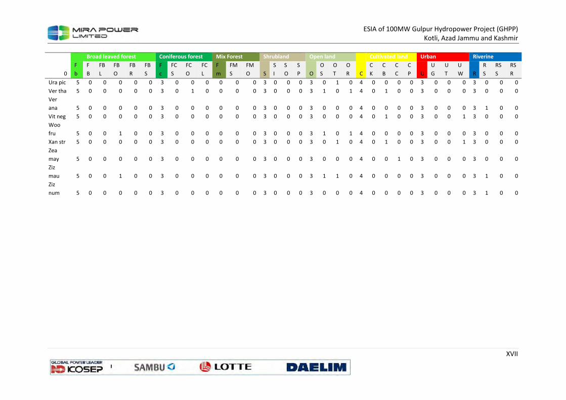
ESIA of 100MW Gulpur Hydropower Project (GHPP)
Kotli, Azad Jammu and Kashmir
XVII
Broad leaved forest Coniferous forest Mix Forest Shrubland Open land Cultivated land Urban Riverine
0
F
b
F
B
FB
L
FB
O
FB
R
FB
S
F
c
FC
S
FC
O
FC
L
F
m
FM
S
FM
O S
S
I
S
O
S
P O
O
S
O
T
O
R C
C
K
C
B
C
C
C
P U
U
G
U
T
U
W R
R
S
RS
S
RS
R
Ura pic 5 0 0 0 0 0 3 0 0 0 0 0 0 3 0 0 0 3 0 1 0 4 0 0 0 0 3 0 0 0 3 0 0 0
Ver tha 5 0 0 0 0 0 3 0 1 0 0 0 0 3 0 0 0 3 1 0 1 4 0 1 0 0 3 0 0 0 3 0 0 0
Ver
ana 5 0 0 0 0 0 3 0 0 0 0 0 0 3 0 0 0 3 0 0 0 4 0 0 0 0 3 0 0 0 3 1 0 0
Vit neg 5 0 0 0 0 0 3 0 0 0 0 0 0 3 0 0 0 3 0 0 0 4 0 1 0 0 3 0 0 1 3 0 0 0
Woo
fru 5 0 0 1 0 0 3 0 0 0 0 0 0 3 0 0 0 3 1 0 1 4 0 0 0 0 3 0 0 0 3 0 0 0
Xan str 5 0 0 0 0 0 3 0 0 0 0 0 0 3 0 0 0 3 0 1 0 4 0 1 0 0 3 0 0 1 3 0 0 0
Zea
may 5 0 0 0 0 0 3 0 0 0 0 0 0 3 0 0 0 3 0 0 0 4 0 0 1 0 3 0 0 0 3 0 0 0
Ziz
mau 5 0 0 1 0 0 3 0 0 0 0 0 0 3 0 0 0 3 1 1 0 4 0 0 0 0 3 0 0 0 3 1 0 0
Ziz
num 5 0 0 0 0 0 3 0 0 0 0 0 0 3 0 0 0 3 0 0 0 4 0 0 0 0 3 0 0 0 3 1 0 0
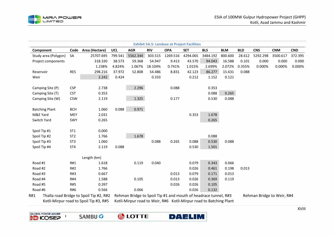
ESIA of 100MW Gulpur Hydropower Project (GHPP)
Kotli, Azad Jammu and Kashmir
XVIII
Exhibit 5A.5: Landuse at Project Facilities
R#1 Thalla road Bridge to Spoil Tip #2, R#2 Rehman Bridge to Spoil Tip #1 and mouth of headrace tunnel, R#3 Rehman Bridge to Weir, R#4
Kotli-Mirpur road to Spoil Tip #3, R#5 Kotli-Mirpur road to Weir, R#6 Kotli-Mirpur road to Batching Plant
Component Code Area (Hectare) UCL AGR RIV OPA SET BLS BLM BLD CNS CNM CND
Study area (Polygon) SA 25707.695 799.541 5562.344 303.515 1269.516 4294.065 3484.192 800.600 28.612 5292.298 3500.617 372.395
Project components
318.330 38.573 59.368 54.947 9.413 43.570 94.043 16.588 0.101 0.000 0.000 0.000
1.238% 4.824% 1.067% 18.104% 0.741% 1.015% 2.699% 2.072% 0.355% 0.000% 0.000% 0.000%
Reservoir RES 298.216 37.972 52.808 54.486 8.831 42.123 86.277 15.631 0.088
Weir
2.242 0.424
0.333
0.212 1.152 0.121
Camping Site (P) CSP 2.738
2.296
0.088
0.353
Camping Site (T) CST 0.353
0.088 0.265
Camping Site (W) CSW 2.119
1.325
0.177
0.530 0.088
Batching Plant BCH 1.060 0.088 0.971
M&E Yard MEY 2.031
0.353 1.678
Switch Yard SWY 0.265
0.265
Spoil Tip #1 ST1 0.000
Spoil Tip #2 ST2 1.766
1.678
0.088
Spoil Tip #3 ST3 1.060
0.088 0.265 0.088 0.530 0.088
Spoil Tip #4 ST4 2.119 0.088
0.530 1.501
Length (km)
Road #1 R#1 1.618
0.119 0.040
0.079 0.343 0.066
Road #2 R#2 1.766
0.026 0.461 0.198 0.013
Road #3 R#3 0.667
0.013 0.079 0.171 0.013
Road #4 R#4 1.588
0.105
0.013 0.026 0.369 0.119
Road #5 R#5 0.397
0.026 0.026 0.105
Road #6 R#6 0.566
0.066
0.026 0.132
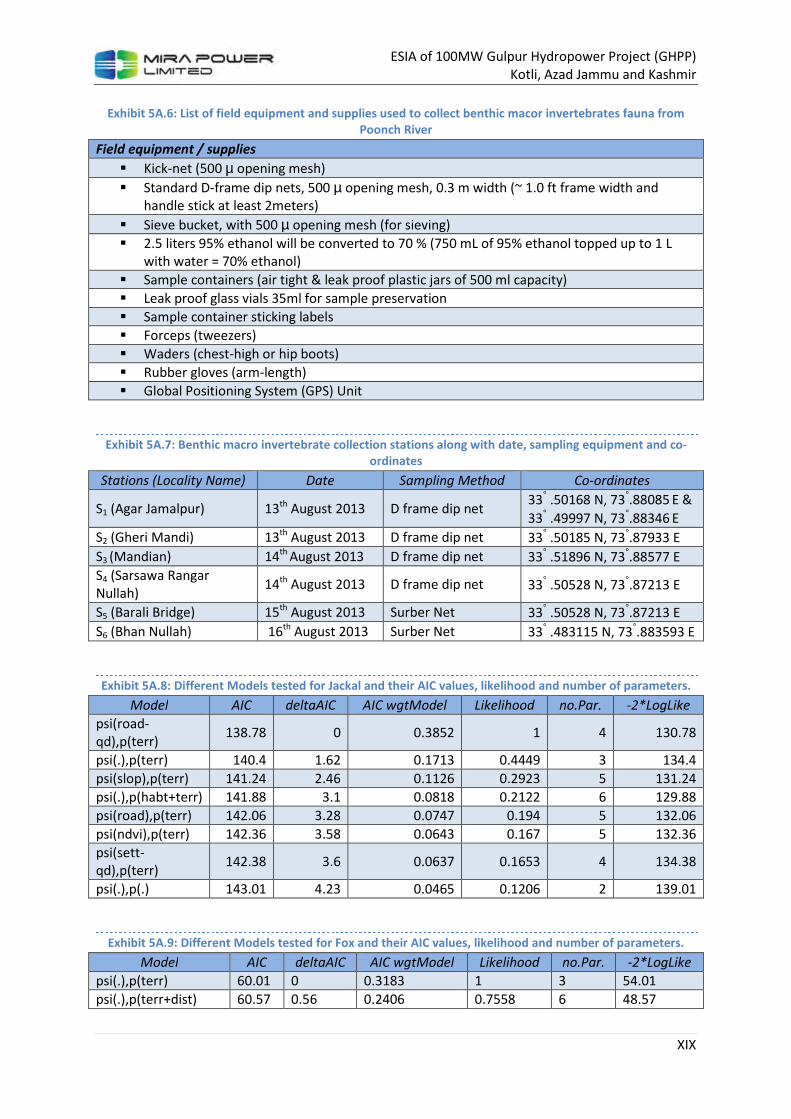
ESIA of 100MW Gulpur Hydropower Project (GHPP)
Kotli, Azad Jammu and Kashmir
XIX
Exhibit 5A.6: List of field equipment and supplies used to collect benthic macor invertebrates fauna from Poonch River
Field equipment / supplies
� Kick-net (500 µ opening mesh)
� Standard D-frame dip nets, 500 µ opening mesh, 0.3 m width (~ 1.0 ft frame width and
handle stick at least 2meters)
� Sieve bucket, with 500 µ opening mesh (for sieving)
� 2.5 liters 95% ethanol will be converted to 70 % (750 mL of 95% ethanol topped up to 1 L
with water = 70% ethanol)
� Sample containers (air tight & leak proof plastic jars of 500 ml capacity)
� Leak proof glass vials 35ml for sample preservation
� Sample container sticking labels
� Forceps (tweezers)
� Waders (chest-high or hip boots)
� Rubber gloves (arm-length)
� Global Positioning System (GPS) Unit
Exhibit 5A.7: Benthic macro invertebrate collection stations along with date, sampling equipment and co-ordinates
Stations (Locality Name) Date Sampling Method Co-ordinates
S1 (Agar Jamalpur) 13th August 2013 D frame dip net 33° .50168 N, 73°.88085 E &
33° .49997 N, 73°.88346 E
S2 (Gheri Mandi) 13th August 2013 D frame dip net 33° .50185 N, 73°.87933 E
S3 (Mandian) 14th August 2013 D frame dip net 33° .51896 N, 73°.88577 E
S4 (Sarsawa Rangar
Nullah) 14th August 2013 D frame dip net 33° .50528 N, 73°.87213 E
S5 (Barali Bridge) 15th August 2013 Surber Net 33° .50528 N, 73°.87213 E
S6 (Bhan Nullah) 16th August 2013 Surber Net 33° .483115 N, 73°.883593 E
Exhibit 5A.8: Different Models tested for Jackal and their AIC values, likelihood and number of parameters.
Model AIC deltaAIC AIC wgtModel Likelihood no.Par. -2*LogLike
psi(road-
qd),p(terr) 138.78 0 0.3852 1 4 130.78
psi(.),p(terr) 140.4 1.62 0.1713 0.4449 3 134.4
psi(slop),p(terr) 141.24 2.46 0.1126 0.2923 5 131.24
psi(.),p(habt+terr) 141.88 3.1 0.0818 0.2122 6 129.88
psi(road),p(terr) 142.06 3.28 0.0747 0.194 5 132.06
psi(ndvi),p(terr) 142.36 3.58 0.0643 0.167 5 132.36
psi(sett-
qd),p(terr) 142.38 3.6 0.0637 0.1653 4 134.38
psi(.),p(.) 143.01 4.23 0.0465 0.1206 2 139.01
Exhibit 5A.9: Different Models tested for Fox and their AIC values, likelihood and number of parameters.
Model AIC deltaAIC AIC wgtModel Likelihood no.Par. -2*LogLike
psi(.),p(terr) 60.01 0 0.3183 1 3 54.01
psi(.),p(terr+dist) 60.57 0.56 0.2406 0.7558 6 48.57
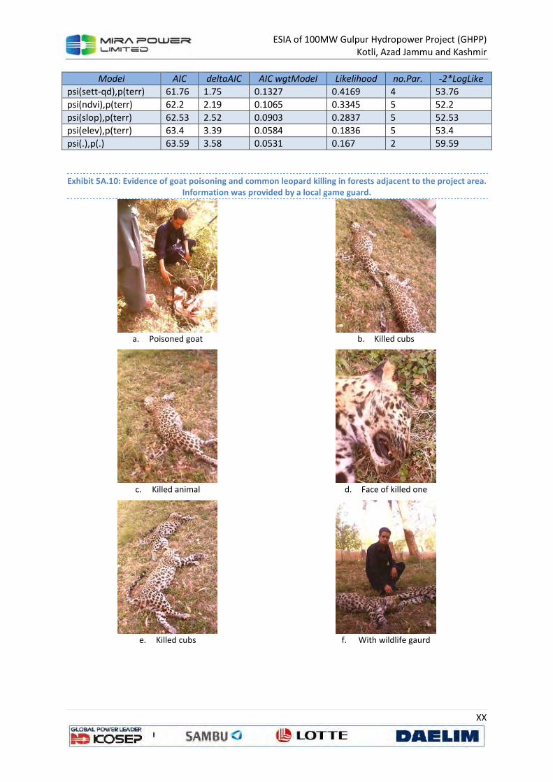
ESIA of 100MW Gulpur Hydropower Project (GHPP)
Kotli, Azad Jammu and Kashmir
XX
Model AIC deltaAIC AIC wgtModel Likelihood no.Par. -2*LogLike
psi(sett-qd),p(terr) 61.76 1.75 0.1327 0.4169 4 53.76
psi(ndvi),p(terr) 62.2 2.19 0.1065 0.3345 5 52.2
psi(slop),p(terr) 62.53 2.52 0.0903 0.2837 5 52.53
psi(elev),p(terr) 63.4 3.39 0.0584 0.1836 5 53.4
psi(.),p(.) 63.59 3.58 0.0531 0.167 2 59.59
Exhibit 5A.10: Evidence of goat poisoning and common leopard killing in forests adjacent to the project area. Information was provided by a local game guard.
a. Poisoned goat b. Killed cubs
c. Killed animal d. Face of killed one
e. Killed cubs f. With wildlife gaurd
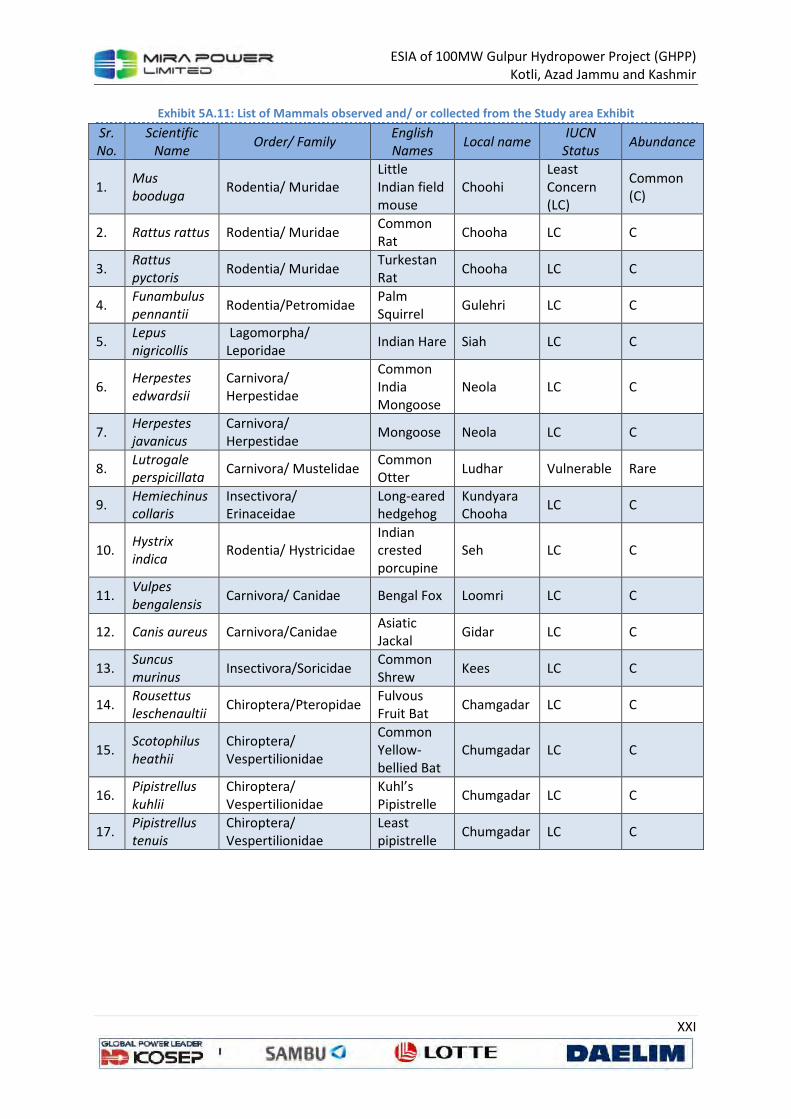
ESIA of 100MW Gulpur Hydropower Project (GHPP)
Kotli, Azad Jammu and Kashmir
XXI
Exhibit 5A.11: List of Mammals observed and/ or collected from the Study area Exhibit
Sr.
No.
Scientific
Name Order/ Family
English
Names Local name
IUCN
Status Abundance
1. Mus
booduga Rodentia/ Muridae
Little
Indian field
mouse
Choohi
Least
Concern
(LC)
Common
(C)
2. Rattus rattus Rodentia/ Muridae Common
Rat Chooha LC C
3. Rattus
pyctoris Rodentia/ Muridae
Turkestan
Rat Chooha LC C
4. Funambulus
pennantii Rodentia/Petromidae
Palm
Squirrel Gulehri LC C
5. Lepus
nigricollis
Lagomorpha/
Leporidae Indian Hare Siah LC C
6. Herpestes
edwardsii
Carnivora/
Herpestidae
Common
India
Mongoose
Neola LC C
7. Herpestes
javanicus
Carnivora/
Herpestidae Mongoose Neola LC C
8. Lutrogale
perspicillata Carnivora/ Mustelidae
Common
Otter Ludhar Vulnerable Rare
9. Hemiechinus
collaris
Insectivora/ Erinaceidae
Long-eared hedgehog
Kundyara Chooha
LC C
10. Hystrix
indica Rodentia/ Hystricidae
Indian crested porcupine
Seh LC C
11. Vulpes
bengalensis Carnivora/ Canidae Bengal Fox Loomri LC C
12. Canis aureus Carnivora/Canidae Asiatic Jackal
Gidar LC C
13. Suncus
murinus Insectivora/Soricidae
Common Shrew
Kees LC C
14. Rousettus
leschenaultii Chiroptera/Pteropidae
Fulvous Fruit Bat
Chamgadar LC C
15. Scotophilus
heathii
Chiroptera/ Vespertilionidae
Common Yellow-bellied Bat
Chumgadar LC C
16. Pipistrellus
kuhlii
Chiroptera/ Vespertilionidae
Kuhl’s Pipistrelle
Chumgadar LC C
17. Pipistrellus
tenuis Chiroptera/ Vespertilionidae
Least pipistrelle
Chumgadar LC C
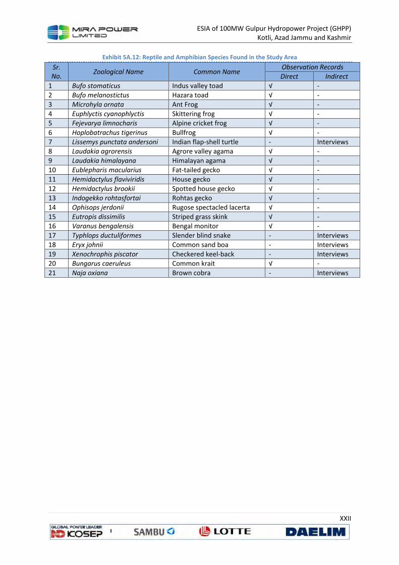
ESIA of 100MW Gulpur Hydropower Project (GHPP)
Kotli, Azad Jammu and Kashmir
XXII
Exhibit 5A.12: Reptile and Amphibian Species Found in the Study Area
Sr.
No. Zoological Name Common Name
Observation Records
Direct Indirect
1 Bufo stomaticus Indus valley toad √ -
2 Bufo melanostictus Hazara toad √ -
3 Microhyla ornata Ant Frog √ -
4 Euphlyctis cyanophlyctis Skittering frog √ -
5 Fejevarya limnocharis Alpine cricket frog √ -
6 Hoplobatrachus tigerinus Bullfrog √ -
7 Lissemys punctata andersoni Indian flap-shell turtle - Interviews
8 Laudakia agrorensis Agrore valley agama √ -
9 Laudakia himalayana Himalayan agama √ -
10 Eublepharis macularius Fat-tailed gecko √ -
11 Hemidactylus flaviviridis House gecko √ -
12 Hemidactylus brookii Spotted house gecko √ -
13 Indogekko rohtasfortai Rohtas gecko √ -
14 Ophisops jerdonii Rugose spectacled lacerta √ -
15 Eutropis dissimilis Striped grass skink √ -
16 Varanus bengalensis Bengal monitor √ -
17 Typhlops ductuliformes Slender blind snake - Interviews
18 Eryx johnii Common sand boa - Interviews
19 Xenochrophis piscator Checkered keel-back - Interviews
20 Bungarus caeruleus Common krait √ -
21 Naja oxiana Brown cobra - Interviews
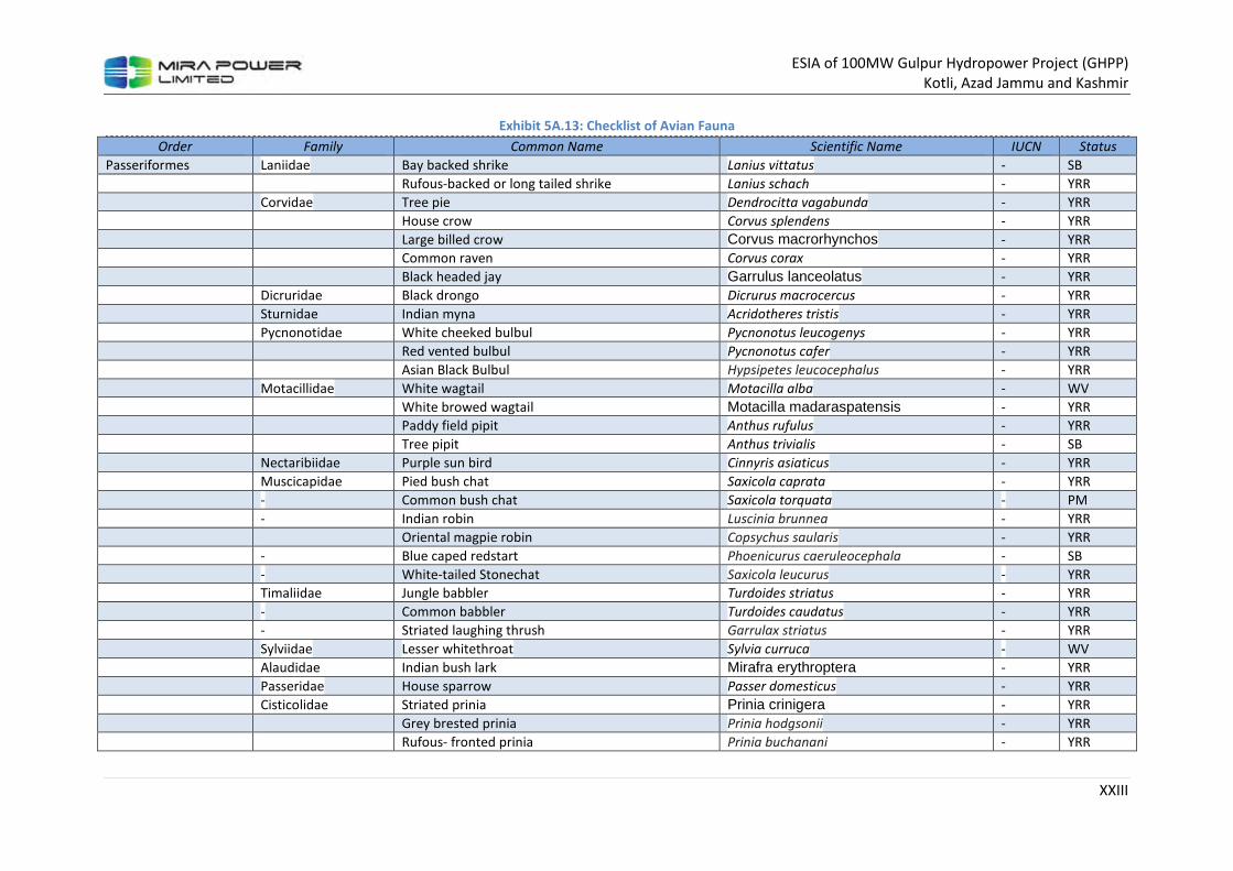
ESIA of 100MW Gulpur Hydropower Project (GHPP)
Kotli, Azad Jammu and Kashmir
XXIII
Exhibit 5A.13: Checklist of Avian Fauna
Order Family Common Name Scientific Name IUCN Status
Passeriformes Laniidae Bay backed shrike Lanius vittatus - SB
Rufous-backed or long tailed shrike Lanius schach - YRR
Corvidae Tree pie Dendrocitta vagabunda - YRR
House crow Corvus splendens - YRR
Large billed crow Corvus macrorhynchos - YRR
Common raven Corvus corax - YRR
Black headed jay Garrulus lanceolatus - YRR
Dicruridae Black drongo Dicrurus macrocercus - YRR
Sturnidae Indian myna Acridotheres tristis - YRR
Pycnonotidae White cheeked bulbul Pycnonotus leucogenys - YRR
Red vented bulbul Pycnonotus cafer - YRR
Asian Black Bulbul Hypsipetes leucocephalus - YRR
Motacillidae White wagtail Motacilla alba - WV
White browed wagtail Motacilla madaraspatensis - YRR
Paddy field pipit Anthus rufulus - YRR
Tree pipit Anthus trivialis - SB
Nectaribiidae Purple sun bird Cinnyris asiaticus - YRR
Muscicapidae Pied bush chat Saxicola caprata - YRR
- Common bush chat Saxicola torquata - PM
- Indian robin Luscinia brunnea - YRR
Oriental magpie robin Copsychus saularis - YRR
- Blue caped redstart Phoenicurus caeruleocephala - SB
- White-tailed Stonechat Saxicola leucurus - YRR
Timaliidae Jungle babbler Turdoides striatus - YRR
- Common babbler Turdoides caudatus - YRR
- Striated laughing thrush Garrulax striatus - YRR
Sylviidae Lesser whitethroat Sylvia curruca - WV
Alaudidae Indian bush lark Mirafra erythroptera - YRR
Passeridae House sparrow Passer domesticus - YRR
Cisticolidae Striated prinia Prinia crinigera - YRR
Grey brested prinia Prinia hodgsonii - YRR
Rufous- fronted prinia Prinia buchanani - YRR
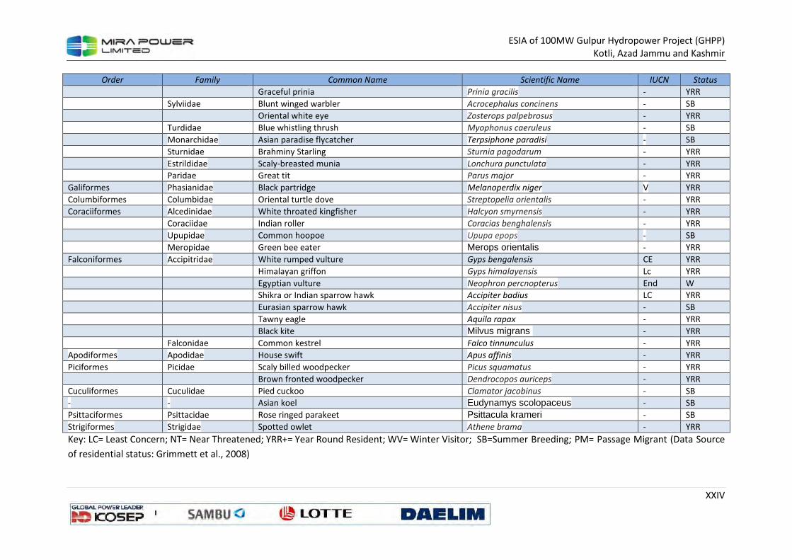
ESIA of 100MW Gulpur Hydropower Project (GHPP)
Kotli, Azad Jammu and Kashmir
XXIV
Order Family Common Name Scientific Name IUCN Status
Graceful prinia Prinia gracilis - YRR
Sylviidae Blunt winged warbler Acrocephalus concinens - SB
Oriental white eye Zosterops palpebrosus - YRR
Turdidae Blue whistling thrush Myophonus caeruleus - SB
Monarchidae Asian paradise flycatcher Terpsiphone paradisi - SB
Sturnidae Brahminy Starling Sturnia pagodarum - YRR
Estrildidae Scaly-breasted munia Lonchura punctulata - YRR
Paridae Great tit Parus major - YRR
Galiformes Phasianidae Black partridge Melanoperdix niger V YRR
Columbiformes Columbidae Oriental turtle dove Streptopelia orientalis - YRR
Coraciiformes Alcedinidae White throated kingfisher Halcyon smyrnensis - YRR
Coraciidae Indian roller Coracias benghalensis - YRR
Upupidae Common hoopoe Upupa epops - SB
Meropidae Green bee eater Merops orientalis - YRR
Falconiformes Accipitridae White rumped vulture Gyps bengalensis CE YRR
Himalayan griffon Gyps himalayensis Lc YRR
Egyptian vulture Neophron percnopterus End W
Shikra or Indian sparrow hawk Accipiter badius LC YRR
Eurasian sparrow hawk Accipiter nisus - SB
Tawny eagle Aquila rapax - YRR
Black kite Milvus migrans - YRR
Falconidae Common kestrel Falco tinnunculus - YRR
Apodiformes Apodidae House swift Apus affinis - YRR
Piciformes Picidae Scaly billed woodpecker Picus squamatus - YRR
Brown fronted woodpecker Dendrocopos auriceps - YRR
Cuculiformes Cuculidae Pied cuckoo Clamator jacobinus - SB
- - Asian koel Eudynamys scolopaceus - SB
Psittaciformes Psittacidae Rose ringed parakeet Psittacula krameri - SB
Strigiformes Strigidae Spotted owlet Athene brama - YRR
Key: LC= Least Concern; NT= Near Threatened; YRR+= Year Round Resident; WV= Winter Visitor; SB=Summer Breeding; PM= Passage Migrant (Data Source
of residential status: Grimmett et al., 2008)
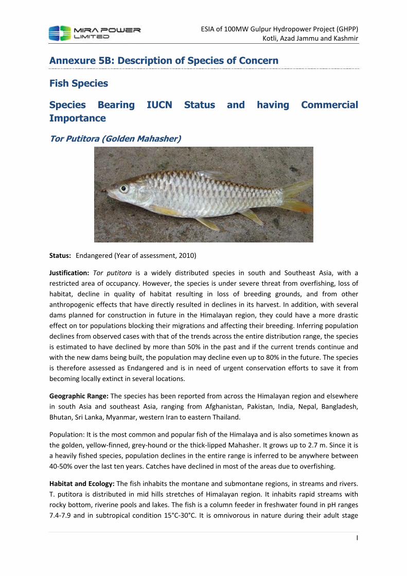
ESIA of 100MW Gulpur Hydropower Project (GHPP)
Kotli, Azad Jammu and Kashmir
I
Annexure 5B: Description of Species of Concern
Fish Species
Species Bearing IUCN Status and having Commercial
Importance
Tor Putitora (Golden Mahasher)
Status: Endangered (Year of assessment, 2010)
Justification: Tor putitora is a widely distributed species in south and Southeast Asia, with a
restricted area of occupancy. However, the species is under severe threat from overfishing, loss of
habitat, decline in quality of habitat resulting in loss of breeding grounds, and from other
anthropogenic effects that have directly resulted in declines in its harvest. In addition, with several
dams planned for construction in future in the Himalayan region, they could have a more drastic
effect on tor populations blocking their migrations and affecting their breeding. Inferring population
declines from observed cases with that of the trends across the entire distribution range, the species
is estimated to have declined by more than 50% in the past and if the current trends continue and
with the new dams being built, the population may decline even up to 80% in the future. The species
is therefore assessed as Endangered and is in need of urgent conservation efforts to save it from
becoming locally extinct in several locations.
Geographic Range: The species has been reported from across the Himalayan region and elsewhere
in south Asia and southeast Asia, ranging from Afghanistan, Pakistan, India, Nepal, Bangladesh,
Bhutan, Sri Lanka, Myanmar, western Iran to eastern Thailand.
Population: It is the most common and popular fish of the Himalaya and is also sometimes known as
the golden, yellow-finned, grey-hound or the thick-lipped Mahasher. It grows up to 2.7 m. Since it is
a heavily fished species, population declines in the entire range is inferred to be anywhere between
40-50% over the last ten years. Catches have declined in most of the areas due to overfishing.
Habitat and Ecology: The fish inhabits the montane and submontane regions, in streams and rivers.
T. putitora is distributed in mid hills stretches of Himalayan region. It inhabits rapid streams with
rocky bottom, riverine pools and lakes. The fish is a column feeder in freshwater found in pH ranges
7.4-7.9 and in subtropical condition 15°C-30°C. It is omnivorous in nature during their adult stage

ESIA of 100MW Gulpur Hydropower Project (GHPP)
Kotli, Azad Jammu and Kashmir
II
and feed on periphytic algae and diatoms in juvenile stage. The feeding and breeding habitats are
lost almost throughout their distributional range.
Major Threat(s): The population of the fish is fast depleting and at present is chiefly localized to
certain major river systems (Poonch River and Lower Swat River in Pakistan) and is fast approaching
extinction in the streams and lakes of Himalayas. Large fishes are only found in some of the
perennial pools. This species is declining from its natural habitat due to urbanization, illegal
encroachment, over fishing and chemical and physical alterations of their natural habitats. The stress
on the population is not only due to its over exploitation, but also due to the rise in developmental
activities, especially the growing number of hydroelectric and irrigation projects which have
fragmented and deteriorated its natural habitat.
Commercial Importance: It is the most common Mahasher of the Himalayas. It has afforded lucrative
source of sport for the anglers all along the Himalayas since long. It grows up to 2.7m and weighs up
to 54 Kg. The commercial fishery of Putitor Mahasher consists largely of individuals either ascending
streams for breeding or the spent ones returning to perennial reservoirs. The population of this fish
is fast depleting and at present is chiefly localized to certain rivers only. This most attractive sport
fish with excellent food value is fast approaching extinction in the streams and lakes of Pakistan and
India.
Cyprinus carpio (Common Carp)
Status: Vulnerable A2ce (Year of assessment, 2008)
Justification: The native populations are slowly but continuously declining due to river regulation.
Also hybridization with domesticated introduced stocks, East Asian congeners and their hybrids is a
serious long term threat for the species. However, superficially pure carp are still abundant in the
lower parts of rivers within its native range. Very few stocks remain genetically unpolluted as a result
of this long lasting process. The average age of the spawners is estimated to be between 20-25
years, as they are a long lived species (up to 50 years). Although no population data exists, it is
suspected that in the past 60 to 75 years within the species native range, a population decline of
over 30% has occurred due to hybridization with introduced stock and river channelization and dams
impacting the species as they need flooded areas at very specific times to successfully spawn.
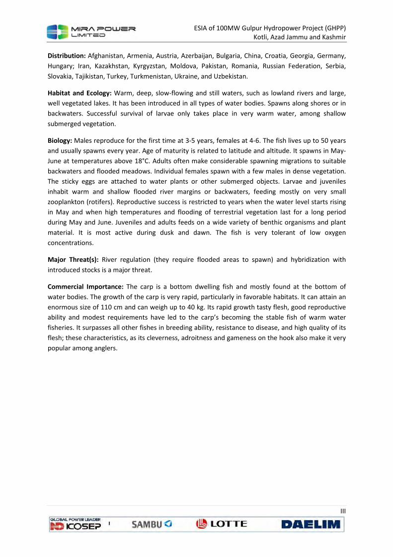
ESIA of 100MW Gulpur Hydropower Project (GHPP)
Kotli, Azad Jammu and Kashmir
III
Distribution: Afghanistan, Armenia, Austria, Azerbaijan, Bulgaria, China, Croatia, Georgia, Germany,
Hungary; Iran, Kazakhstan, Kyrgyzstan, Moldova, Pakistan, Romania, Russian Federation, Serbia,
Slovakia, Tajikistan, Turkey, Turkmenistan, Ukraine, and Uzbekistan.
Habitat and Ecology: Warm, deep, slow-flowing and still waters, such as lowland rivers and large,
well vegetated lakes. It has been introduced in all types of water bodies. Spawns along shores or in
backwaters. Successful survival of larvae only takes place in very warm water, among shallow
submerged vegetation.
Biology: Males reproduce for the first time at 3-5 years, females at 4-6. The fish lives up to 50 years
and usually spawns every year. Age of maturity is related to latitude and altitude. It spawns in May-
June at temperatures above 18°C. Adults often make considerable spawning migrations to suitable
backwaters and flooded meadows. Individual females spawn with a few males in dense vegetation.
The sticky eggs are attached to water plants or other submerged objects. Larvae and juveniles
inhabit warm and shallow flooded river margins or backwaters, feeding mostly on very small
zooplankton (rotifers). Reproductive success is restricted to years when the water level starts rising
in May and when high temperatures and flooding of terrestrial vegetation last for a long period
during May and June. Juveniles and adults feeds on a wide variety of benthic organisms and plant
material. It is most active during dusk and dawn. The fish is very tolerant of low oxygen
concentrations.
Major Threat(s): River regulation (they require flooded areas to spawn) and hybridization with
introduced stocks is a major threat.
Commercial Importance: The carp is a bottom dwelling fish and mostly found at the bottom of
water bodies. The growth of the carp is very rapid, particularly in favorable habitats. It can attain an
enormous size of 110 cm and can weigh up to 40 kg. Its rapid growth tasty flesh, good reproductive
ability and modest requirements have led to the carp’s becoming the stable fish of warm water
fisheries. It surpasses all other fishes in breeding ability, resistance to disease, and high quality of its
flesh; these characteristics, as its cleverness, adroitness and gameness on the hook also make it very
popular among anglers.

ESIA of 100MW Gulpur Hydropower Project (GHPP)
Kotli, Azad Jammu and Kashmir
IV
Botia rostrata (Twin-banded Loach)
Status: Vulnerable A2cd (Year of assessment, 2010)
Justification: Botia rostrata is widespread in the hill streams across its range but faces threats such
from destructive fishing practices and from the ornamental trade and habitat destruction due to
sand and boulder mining. Population estimates of this species records a decline of more than 60% in
five years. In some other areas, it is inferred that the species may have undergone more than 30%
decline in its entire population. It is therefore assessed as Vulnerable.
Range Description: The species is recorded from the Brahmaputra basin in India and Bangladesh and
the Indus drainage from Pakistan.
Population: Population estimates of this species were carried out in different parts of its distribution
range. Catch frequency of Botia rostrata was 60% during 2004 but during 2009 it came down to 20%
probably because it is a much sought after species firstly due to its good taste and secondly due to
its ornamental value.
Habitat and Ecology: This species is reported to live in medium to fast current waters.
Commercial Importance: This fish carries no any importance as food fish but it is an ornamental fish
and being exploited for aquarium trade.
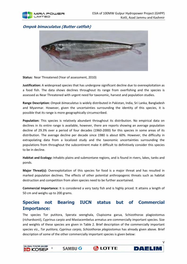
ESIA of 100MW Gulpur Hydropower Project (GHPP)
Kotli, Azad Jammu and Kashmir
V
Ompok bimaculatus (Butter catfish)
Status: Near Threatened (Year of assessment, 2010)
Justification: A widespread species that has undergone significant decline due to overexploitation as
a food fish. The data shows declines throughout its range from overfishing and the species is
assessed as Near Threatened with urgent need for taxonomic, harvest and population studies.
Range Description: Ompok bimaculatus is widely distributed in Pakistan, India, Sri Lanka, Bangladesh
and Myanmar. However, given the uncertainties surrounding the identity of this species, it is
possible that its range is more geographically circumscribed.
Population: This species is relatively abundant throughout its distribution. No empirical data on
declines in its entire range is available, however, there are reports showing an average population
decline of 29.3% over a period of four decades (1960-2000) for this species in some areas of its
distribution. The average decline per decade since 1980 is about 60%. However, the difficulty in
extrapolating data from a localized study and the taxonomic uncertainties surrounding the
populations from throughout the subcontinent make it difficult to definitively consider this species
to be in decline.
Habitat and Ecology: Inhabits plains and submontane regions, and is found in rivers, lakes, tanks and
ponds.
Major Threat(s): Overexploitation of this species for food is a major threat and has resulted in
marked population declines. The effects of other potential anthropogenic threats such as habitat
destruction and competition from alien species need to be further ascertained.
Commercial Importance: It is considered a very tasty fish and is highly priced. It attains a length of
50 cm and weighs up to 200 grams.
Species not Bearing IUCN status but of Commercial
Importance:
The species Tor putitora, Sperata seenghala, Clupisoma garua, Schizothorax plagiostomus
(richardsonii), Cyprinus carpio and Mastacembelus armatus are commercially important species. Size
and weights of these species are given in Table 2. Brief description of the commercially important
species viz., Tor putitora, Cyprinus carpio, Schizothorax plagiostomus has already given above. Brief
description of some of the other commercially important species is given below:

ESIA of 100MW Gulpur Hydropower Project (GHPP)
Kotli, Azad Jammu and Kashmir
VI
Clupisoma garua (Garua Bachwa)
Brief Description: Body elongate and compressed, abdominal edge keeled between pelvic fin and
vent. Mouth is subterminal and teeth in villiform bands on jaws. Barbels in four pairs, the nasal
barbells not reaching the eye while maxillary barbells extending o base of pelvic fins. Adipose fin is
absent in adults.
Commercial importance: This fish is common in the rivers of Indus plain and grows to 60 cm and
having a weight up to 500 grams. It is considered a good tasty food fish throughout its range. It is
popular among the people who relish fishes without bones and so it fetches a good price. It is,
however, not a good game fish as it is animal feeder.
Distribution: It is found in Pakistan, India, Bangladesh, and Nepal.
Biology: It inhabits large fresh water and tidal rivers. Feeds on insects, shrimps, other crustaceans
and small fish.
Labeo dyocheilus (Dhi, Torki)
Brief Description: Body elongated and snout projecting beyond mouth with distinct lateral lobes.
Mouth is wide and inferior with thick lips. Lower lip with an interrupted fold joined to isthmus by a
narrow bridge. Barbels one short maxillary pair.
Commercial importance: This is a medium sized fish. It grows up to 90 cm and attains a weight of 5
kg. It is common species of Himalayas.
Distribution: Found in Pakistan, India, Bangladesh, Nepal, and Mekong basins.
Biology: Lives in clear active currents of large rivers. A migratory species spending winters in lower
reaches of the Himalayan rivers while migrates upstream for breeding and feeding.
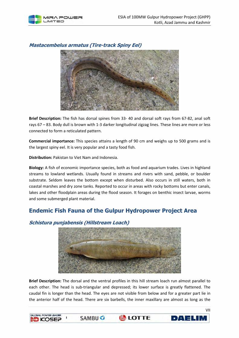
ESIA of 100MW Gulpur Hydropower Project (GHPP)
Kotli, Azad Jammu and Kashmir
VII
Mastacembelus armatus (Tire-track Spiny Eel)
Brief Description: The fish has dorsal spines from 33- 40 and dorsal soft rays from 67-82, anal soft
rays 67 – 83. Body dull is brown with 1-3 darker longitudinal zigzag lines. These lines are more or less
connected to form a reticulated pattern.
Commercial importance: This species attains a length of 90 cm and weighs up to 500 grams and is
the largest spiny eel. It is very popular and a tasty food fish.
Distribution: Pakistan to Viet Nam and Indonesia.
Biology: A fish of economic importance species, both as food and aquarium trades. Lives in highland
streams to lowland wetlands. Usually found in streams and rivers with sand, pebble, or boulder
substrate. Seldom leaves the bottom except when disturbed. Also occurs in still waters, both in
coastal marshes and dry zone tanks. Reported to occur in areas with rocky bottoms but enter canals,
lakes and other floodplain areas during the flood season. It forages on benthic insect larvae, worms
and some submerged plant material.
Endemic Fish Fauna of the Gulpur Hydropower Project Area
Schistura punjabensis (Hillstream Loach)
Brief Description: The dorsal and the ventral profiles in this hill stream loach run almost parallel to
each other. The head is sub-triangular and depressed; its lower surface is greatly flattened. The
caudal fin is longer than the head. The eyes are not visible from below and for a greater part lie in
the anterior half of the head. There are six barbells, the inner maxillary are almost as long as the
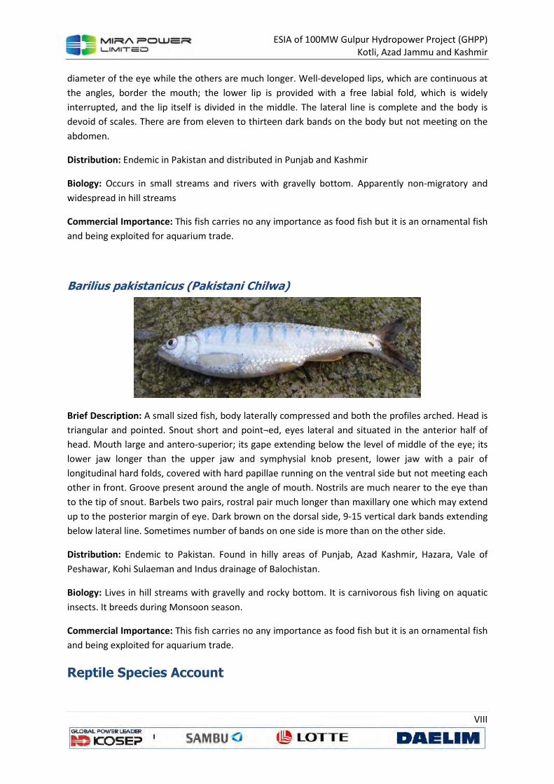
ESIA of 100MW Gulpur Hydropower Project (GHPP)
Kotli, Azad Jammu and Kashmir
VIII
diameter of the eye while the others are much longer. Well-developed lips, which are continuous at
the angles, border the mouth; the lower lip is provided with a free labial fold, which is widely
interrupted, and the lip itself is divided in the middle. The lateral line is complete and the body is
devoid of scales. There are from eleven to thirteen dark bands on the body but not meeting on the
abdomen.
Distribution: Endemic in Pakistan and distributed in Punjab and Kashmir
Biology: Occurs in small streams and rivers with gravelly bottom. Apparently non-migratory and
widespread in hill streams
Commercial Importance: This fish carries no any importance as food fish but it is an ornamental fish
and being exploited for aquarium trade.
Barilius pakistanicus (Pakistani Chilwa)
Brief Description: A small sized fish, body laterally compressed and both the profiles arched. Head is
triangular and pointed. Snout short and point¬ed, eyes lateral and situated in the anterior half of
head. Mouth large and antero-superior; its gape extending below the level of middle of the eye; its
lower jaw longer than the upper jaw and symphysial knob present, lower jaw with a pair of
longitudinal hard folds, covered with hard papillae running on the ventral side but not meeting each
other in front. Groove present around the angle of mouth. Nostrils are much nearer to the eye than
to the tip of snout. Barbels two pairs, rostral pair much longer than maxillary one which may extend
up to the posterior margin of eye. Dark brown on the dorsal side, 9-15 vertical dark bands extending
below lateral line. Sometimes number of bands on one side is more than on the other side.
Distribution: Endemic to Pakistan. Found in hilly areas of Punjab, Azad Kashmir, Hazara, Vale of
Peshawar, Kohi Sulaeman and Indus drainage of Balochistan.
Biology: Lives in hill streams with gravelly and rocky bottom. It is carnivorous fish living on aquatic
insects. It breeds during Monsoon season.
Commercial Importance: This fish carries no any importance as food fish but it is an ornamental fish
and being exploited for aquarium trade.
Reptile Species Account
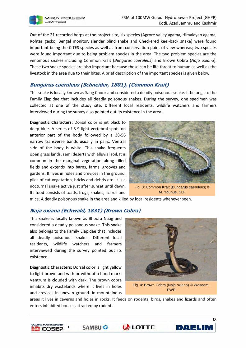
ESIA of 100MW Gulpur Hydropower Project (GHPP)
Kotli, Azad Jammu and Kashmir
IX
Out of the 21 recorded herps at the project site, six species (Agrore valley agama, Himalayan agama,
Rohtas gecko, Bengal monitor, slender blind snake and Checkered keel-back snake) were found
important being the CITES species as well as from conservation point of view whereas; two species
were found important due to being problem species in the area. The two problem species are the
venomous snakes including Common Krait (Bungarus caeruleus) and Brown Cobra (Naja oxiana).
These two snake species are also important because these can be life threat to human as well as the
livestock in the area due to their bites. A brief description of the important species is given below.
Bungarus caeruleus (Schneider, 1801), (Common Krait)
This snake is locally known as Sang Choor and considered a deadly poisonous snake. It belongs to the
Family Elapidae that includes all deadly poisonous snakes. During the survey, one specimen was
collected at one of the study site. Different local residents, wildlife watchers and farmers
interviewed during the survey also pointed out its existence in the area.
Diagnostic Characters: Dorsal color is jet black to
deep blue. A series of 3-9 light vertebral spots on
anterior part of the body followed by a 38-56
narrow transverse bands usually in pairs. Ventral
side of the body is white. This snake frequents
open grass lands, semi deserts with alluvial soil. It is
common in the marginal vegetation along tilled
fields and extends into barns, farms, grooves and
gardens. It lives in holes and crevices in the ground,
piles of cut vegetation, bricks and debris etc. It is a
nocturnal snake active just after sunset until dawn.
Its food consists of toads, frogs, snakes, lizards and
mice. A deadly poisonous snake in the area and killed by local residents whenever seen.
Naja oxiana (Echwald, 1831) (Brown Cobra)
This snake is locally known as Bhoora Naag and
considered a deadly poisonous snake. This snake
also belongs to the Family Elapidae that includes
all deadly poisonous snakes. Different local
residents, wildlife watchers and farmers
interviewed during the survey pointed out its
existence.
Diagnostic Characters: Dorsal color is light yellow
to light brown and with or without a hood mark.
Ventrum is clouded with dark. The brown cobra
inhabits dry wastelands where it lives in holes
and crevices in uneven ground. In mountainous
areas it lives in caverns and holes in rocks. It feeds on rodents, birds, snakes and lizards and often
enters inhabited houses attracted by rodents.
Fig. 3: Common Krait (Bungarus caeruleus) © M. Younus, SLF
Fig. 4: Brown Cobra (Naja oxiana) © Waseem, PWF
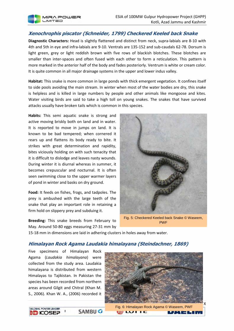
ESIA of 100MW Gulpur Hydropower Project (GHPP)
Kotli, Azad Jammu and Kashmir
X
Xenochrophis piscator (Schneider, 1799) Checkered Keeled back Snake
Diagnostic Characters: Head is slightly flattened and distinct from neck, supra-labials are 8-10 with
4th and 5th in eye and infra-labials are 9-10. Ventrals are 135-152 and sub-caudals 62-78. Dorsum is
light green, grey or light reddish brown with five rows of blackish blotches. These blotches are
smaller than inter-spaces and often fused with each other to form a reticulation. This pattern is
more marked in the anterior half of the body and fades posteriorly. Ventrum is white or cream color.
It is quite common in all major drainage systems in the upper and lower indus valley.
Habitat: This snake is more common in large ponds with thick emergent vegetation. It confines itself
to side pools avoiding the main stream. In winter when most of the water bodies are dry, this snake
is helpless and is killed in large numbers by people and other animals like mongoose and kites.
Water visiting birds are said to take a high toll on young snakes. The snakes that have survived
attacks usually have broken tails which is common in this species.
Habits: This semi aquatic snake is strong and
active moving briskly both on land and in water.
It is reported to move in jumps on land. It is
known to be bad tempered; when cornered it
rears up and flattens its body ready to bite. It
strikes with great determination and rapidity,
bites viciously holding on with such tenacity that
it is difficult to dislodge and leaves nasty wounds.
During winter it is diurnal whereas in summer, it
becomes crepuscular and nocturnal. It is often
seen swimming close to the upper warmer layers
of pond in winter and basks on dry ground.
Food: It feeds on fishes, frogs, and tadpoles. The
prey is ambushed with the large teeth of the
snake that play an important role in retaining a
firm hold on slippery prey and subduing it.
Breeding: This snake breeds from February to
May. Around 50-80 eggs measuring 27-31 mm by
15-18 mm in dimensions are laid in adhering clusters in holes away from water.
Himalayan Rock Agama Laudakia himalayana (Steindachner, 1869)
Five specimens of Himalayan Rock
Agama (Laudakia himalayana) were
collected from the study area. Laudakia
himalayana is distributed from western
Himalayas to Tajikistan. In Pakistan the
species has been recorded from northern
areas around Gilgit and Chitral (Khan M.
S., 2006). Khan W. A., (2006) recorded it
Fig. 5: Checkered Keeled back Snake © Waseem, PWF
Fig. 6: Himalayan Rock Agama © Waseem, PWF

ESIA of 100MW Gulpur Hydropower Project (GHPP)
Kotli, Azad Jammu and Kashmir
XI
from Qarchenai, Dhee and Shimshal valleys and also from Aagh, Zoi Saam, Toghraqeen, Padekishk
and Arbab Kook nullahs at different elevations from 3000 m to 4000 m in Karakorum mountain
ranges.
Diagnostic Characters: Laudakia himalayana is a diurnal and herbivore lizard. It breeds during May
and June and juveniles can be seen by July and August. During the present study apart from adult
individuals several juveniles were also observed. A grayish dorsal color was observed with light spots
in large numbers without any specific sequence. Posterior side of head and neck was bearing small
spinose scales. Tail was dorso-ventrally flattened at its base while rounded along rest of the part.